Architectural Review Committee of the Historic Preservation ...
244
San Francisco 1 DATE: March 1, 2017 TO: Architectural Review Committee of the Historic Preservation Commission FROM: Marcelle Boudreaux, Preservation Planner, (415) 575-9140 Jenny Delumo, Environmental Planner, (415) 575-9146 REVIEWED BY: Tina Tam, Senior Preservation Planner, (415) 558-6325 RE: Review and Comment for 450 O’Farrell Street Preservation Alternatives for Draft EIR Case No. 2013.1535ENV The Planning Department (“Department”) and the Project Sponsor (“Sponsor”) are requesting review and comment before the Architectural Review Committee (ARC) regarding the proposed Preservation Alternatives for the project at 450 O’Farrell Street, 474-480 O’Farrell Street and 530-534 Jones Street (generally known as 450 O’Farrell Street, “the Project”). On March 18, 2015, the Historic Preservation Commission adopted Resolution No. 0746 (attached) to clarify expectations for the evaluation of significant impacts to historical resource and the preparation of preservation alternatives in Environmental Impact Reports. Although the resolution does not specify ARC review of proposed preservation alternatives, the HPC, in their discussions during preparation of the resolution, expressed a desire to provide feedback earlier in the environmental review process – prior to publication of the Draft EIR – particularly for large projects. In response to the resolution, the subject Project is being brought to the ARC for feedback as the Department and Project Sponsor develop preservation alternatives to address the anticipated significant impact to the Uptown Tenderloin National Register Historic District (“NRHD”) and to the individual resource at 450 O’Farrell Street (Fifth Church of Christ, Scientist). The Planning Department is in the process of preparing a focused Environmental Impact Report (EIR) to evaluate the physical environmental effects of the proposed project. It is anticipated that the EIR will be a focused EIR to address the environmental topic of land use and historic architecture resources. The proposed Preservation Alternatives are being brought to the ARC for comment prior to review by the HPC of the Draft EIR. The Draft EIR is estimated to be brought to the HPC in summer of 2017. BUILDINGS AND PROPERTY DESCRIPTION Located in the Downtown/Civic Center neighborhood in San Francisco, 450 and 474-480
-
Upload
khangminh22 -
Category
Documents
-
view
0 -
download
0
Transcript of Architectural Review Committee of the Historic Preservation ...

San Francisco
1
DATE: March 1, 2017
TO: Architectural Review Committee of the Historic Preservation Commission
FROM: Marcelle Boudreaux, Preservation Planner, (415) 575-9140 Jenny Delumo, Environmental Planner, (415) 575-9146 REVIEWED BY: Tina Tam, Senior Preservation Planner, (415) 558-6325
RE: Review and Comment for 450 O’Farrell Street Preservation Alternatives for Draft EIR Case No. 2013.1535ENV
The Planning Department (“Department”) and the Project Sponsor (“Sponsor”) are requesting review and comment before the Architectural Review Committee (ARC) regarding the proposed Preservation Alternatives for the project at 450 O’Farrell Street, 474-480 O’Farrell Street and 530-534 Jones Street (generally known as 450 O’Farrell Street, “the Project”). On March 18, 2015, the Historic Preservation Commission adopted Resolution No. 0746 (attached) to clarify expectations for the evaluation of significant impacts to historical resource and the preparation of preservation alternatives in Environmental Impact Reports. Although the resolution does not specify ARC review of proposed preservation alternatives, the HPC, in their discussions during preparation of the resolution, expressed a desire to provide feedback earlier in the environmental review process – prior to publication of the Draft EIR – particularly for large projects. In response to the resolution, the subject Project is being brought to the ARC for feedback as the Department and Project Sponsor develop preservation alternatives to address the anticipated significant impact to the Uptown Tenderloin National Register Historic District (“NRHD”) and to the individual resource at 450 O’Farrell Street (Fifth Church of Christ, Scientist). The Planning Department is in the process of preparing a focused Environmental Impact Report (EIR) to evaluate the physical environmental effects of the proposed project. It is anticipated that the EIR will be a focused EIR to address the environmental topic of land use and historic architecture resources. The proposed Preservation Alternatives are being brought to the ARC for comment prior to review by the HPC of the Draft EIR. The Draft EIR is estimated to be brought to the HPC in summer of 2017. BUILDINGS AND PROPERTY DESCRIPTION Located in the Downtown/Civic Center neighborhood in San Francisco, 450 and 474-480
2
O’Farrell Street are surrounded by brick or concrete apartment buildings, hotels and commercial buildings which exhibit a wide variety of architectural styles – Beaux Arts, Classical, Renaissance, Gothic, and Baroque revivals, and Moderne. The buildings on the block are mostly multi-story (five to seven stories high), except four one-story commercial buildings including 474-480 O’Farrell and 530-532 Jones Street. The neighboring blocks are similar in terms of architectural style, building height, and construction dates. 450 and 474-480 O’Farrell Street are located on the north side of O’Farrell Street between Jones Street to the west and Shannon Street to the east. The two-story plus basement church at 450 O’Farrell Street covers most of the 96 feet wide by 137.5 feet deep lot, leaving a 15 by 70 foot strip vacant at the north. This area and the vacant lot to the north are currently used as a parking lot. The church is at the corner of O’Farrell and Shannon Streets and can be accessed from both streets. The Fifth Church of Christ, Scientist at 450 O’Farrell is a two-story plus basement steel and reinforced concrete building with a stucco façade and a low-pitched hipped roof. It is rectangular in plan, built in temple composition with the Greek Tuscan order and Greek classical ornamentation.
The one-story retail building at 474-480 O’Farrell Street sits on a 57.5 foot wide by 112.5 foot deep lot. The property has a 30 feet deep yard at the back. 474-480 O’Farrell Street is a one story plus basement brick building with stucco façade. The front (south) elevation is entirely boarded up today but has galvanized sheet metal pilasters, tile bulkheads with decorative tile vents (visible on the eastern half), and display windows with wood transoms. There are four storefronts of equal width with recessed entries, two of them (474 and 476) combined with a single entrance.
The one-story mixed-use building at 530-532 Jones Street sits on a 27 foot wide by 137.5 foot deep lot. The property has a 5 feet wide passageway along the south lot line providing access to five apartments and a 25 feet deep rear yard on the east. 530-532 Jones Street is a one story reinforced concrete frame building with painted concrete masonry unit walls. The asymmetrical front (west) elevation has a recessed main entry and a green terrazzo vestibule. The overscaled blade sign on the roof, which used to be a neon sign depicting a cocktail glass and reading “LYNCH’S,” reads “SHALIMAR” today. Additional description of the existing buildings can be found in the attached Historic Resource Evaluation, Part 1, prepared by Carey and Co. Inc. (“Carey and Co.”). CEQA HISTORICAL RESOURCE(S) EVALUATION The subject properties are considered Known Historic Resources, as the three properties are located within and contribute to the Uptown Tenderloin National Register Historic District. The District was listed on the National Register in 2009 under Criteria A and C. Specifically, the District is significant under Criterion A, for its association with the development of hotel and apartment life in San Francisco during a critical period of change (period of significance: 1906-1957) and under Criterion C, as a distinctive mix of predominantly hotels and apartments, and includes non-residential building types, that served a new urban population of office and retail workers (period of significance: 1906-1931). In addition, the Department concurs with Carey and Co.’s findings that the church building at 450 O’Farrell Street is eligible individually for listing in the California Register of Historic

3
Resources (CRHR) under Criterion 3, for architecture. Designed by master architect Carl Werner, 450 O’Farrell Street is a notable structure embodying characteristics of the Neoclassical style of its period as evidenced by its tri-partite vertical composition, Tuscan columns, decorative friezes, stucco pilasters, projected cornice, and usage of clathri. Werner worked on other large-scale buildings in San Francisco including the Fourth Church of Christ Scientist and the Scottish Rite Temple (Regency Theater). Although the Historic Resource Evaluation is still in draft form, the Department concurs with Carey and Co.’s findings regarding historic significance, eligibility, and character-defining features for the Historic District and for the individual resource at 450 O’Farrell Street. Additional information regarding historic significance and the eligibility determination can be found in the attached Historic Resource Evaluation prepared by Carey and Co. INTEGRITY The Department concurs with Carey and Co.’s finding that the Fifth Church of Christ, Scientist at 450 O’Farrell Street retains its integrity from its period of significance (1923) of location, association, design, workmanship, setting, feeling, and materials, and retains sufficient integrity as a contributor to the Uptown Tenderloin NRHD. The Department also concurs with Carey and Co.’s finding that the Uptown Tenderloin Historic District retains a good degree of integrity. Further, the Department concurs that the two other resources at 474-480 O’Farrell Street and 530-534 Jones Street, which are contributors to the Uptown Tenderloin NRHD retain sufficient integrity since the District’s listing in the National Register in 2009. See the attached Historic Resource Evaluation by Carey and Co. for further details regarding individual and district integrity.
CHARACTER-DEFINING FEATURES Character-defining features of the 450 O’Farrell Street building are listed below: Exterior
• Massive form • Symmetrical tri-partite fac ̧ade design with smooth wall surfaces • Classical Tuscan order columns (fluted shafts, simple capitals and bases) • Vestibule with ornamental plaster ceiling and panels • Cornice and centered, projecting akroterion crowning the parapet • Bronze doors with decorative plaster on the south and east elevations • Windows with clathri
Interior
• Two-story sanctuary space with balcony • Stained glass windows and stained glass oculus skylight of the sanctuary • Decorative plaster work in the lobby and the sanctuary • Raised stage of the sanctuary • Clathri grillwork in front of the organ pipes
Character-defining features of the Uptown Tenderloin NRHD are listed below:
• Three- to-seven-story building height

4
• Multi-unit apartments, hotels, or apartment-hotels, as well as other building types that support residential life (including institutional and commercial uses)
• Constructed of brick or reinforced concrete • Bay windows on street facades, double-hung windows in the earlier buildings,
casement windows with transoms in later buildings • Flat roofs with parapets providing compositional space for decorative cornices • Decorative features: brick or stucco facings with molded galvanized iron, terra
cotta, or cast concrete; deep set windows in brick walls with segmental arches or iron lintels; decorative quoins; sandstone or terra cotta rusticated bases, columns, sills, lintels, quoins, entry arches, keystones, string courses (concrete, stucco or galvanized iron also used to imitate these architectural features)
• Buildings occupy the entire width of the lot creating continuous street walls • Elaborately detailed residential entrances • Two- or three-part vertical building composition for apartment and hotel
buildings, one- or two-part commercial composition for non-residential and small residential buildings,
• Engraved or painted signs, bronze plaques and neon signs Character-defining features of the 474-480 O’Farrell are listed below:
• One-part commercial composition • Tile bulkheads with decorative tile vents • Wood transoms • Display windows • Galvanized sheet metal pilasters • Recessed entries
Character-defining features of the 530-532 Jones Street are listed below:
• Plain, asymmetrical façade design • Vestibule with green terrazzo paving • Triangular concrete canopy • Blade neon sign on roof
The Department concurs with the character-defining features identified by Carey and Co. PROJECT DESCRIPTION The proposed project would involve demolition of the existing Fifth Church of Christ Scientist building, the vacant retail building along O’Farrell Street, and the restaurant building along Jones Street, and the merging of three lots. The church façade would be retained including several columns forming a colonnade entrance. The new building would be a 13-story, 130-foot-tall, mixed-use building with up to 176 dwelling units, restaurant/retail space on the ground floor and a replacement church incorporated into the ground and two upper levels. The project would construct a total of approximately 237,353 sf of development including up to 187,640 sf of residential use, 6,200 sf of restaurant and or retail (restaurant/retail) use, 13,595 sf for religious institution use (i.e., replacement of the existing church), 8,398 sf of open space (288 sf of private open space and 8,110 sf of common open space), and 21,070 sf of below-grade parking in one building.

5
For additional information about the proposed Project, see the attached Initial Study in preparation for an Environmental Impact Report (EIR), and attached Project plans. PROJECT IMPACTS Project impacts have not yet been fully analyzed; this analysis is underway. However, due to the proposed impacts of demolition of three district contributors, including one that is also determined individually eligible for listing in the CRHR and is a substantial architectural and physical feature in the District, the project is anticipated to result in a significant impact to the identified historical resources of the Uptown Tenderloin NRHD and of 450 O’Farrell Street. PRESERVATION ALTERNATIVES As the proposed project is anticipated to result in a significant impact on a historical resource due to demolition, the EIR will consider alternatives to the project. Alternatives considered under CEQA do not need to meet all project objectives; however, they should fully preserve the features of the resource that convey its significance while still meeting most of the basic objectives of the project. The project objectives are included in the attached letter from Sponsor. Department staff and the project team have identified the following preservation alternatives: No Project Alternative, Full Preservation Alternative, and Partial Preservation Alternative. The Full and Partial Preservation Alternatives are depicted in the attached plan and massing studies. No Project Alternative The no project alternative would not include new construction or any demolition. The congregation would still use the existing church. The building at 474-480 O’Farrell Street would remain; its current status is vacant. The building would remain, with restaurant use, at 530 Jones Street. This no project alternative would not result in the loss of historic resources. The No Project Alternative does not meet the objectives of the project. Full Preservation Alternative The proposed full preservation alternative includes a new church (10,666 sf), 70 new residential units (53,600 sf), one new retail space (800 sf), 28 parking spaces and the retention and rehabilitation of the existing church with a public (interior) recreational space. The proposed project maintains, in place, the existing building although the existing church use would move to another area of the project site. All the character-defining features of the Fifth Church of Christ, Scientist at 450 O’Farrell Street, would be retained, including; its massive form, symmetrical tri-partite façade, Tuscan columns, exterior vestibule with ornamental plaster ceiling and panels, cornice, akroterion, bronze doors, all windows, two-story sanctuary space with sloped floor and curving balcony, all stained glass, oculus skylight, raised stage of sanctuary, and clathri grillwork in front of the organ. The organ would be carefully removed and reinstalled in the new church. New work in the interior of the church would be required due to new uses, and would include potentially small-scale retail not to exceed 15% of the interior volume and a public recreational space. The building is in fair condition. Some modifications are required due to the Americans with Disabilities Act, and both interior and exterior finishes and decorative features would

6
need to be repaired and repainted. All work would be in conformance with the Secretary of the Interior’s Standards for Rehabilitation. Demolition of both 474-480 O’Farrell and of 530-534 Jones is proposed. At the O’Farrell site adjacent to the retained historic church building, an approximately 80-foot-tall replacement structure would include one level of church use at ground level with six stories of residential above. At the Jones Street site, the proposed new construction would have no front setback at the streetwall property line, retail at the ground floor level and seven floors of new residential units. The height of the new construction at the streetwall property line would rise to 80 feet tall, and then the mass would increase two additional stories (to a maximum of 120 feet high) forty feet from the front streetwall property line, and extend to Shannon Street behind the existing church. Both structures would exhibit characteristics of the Uptown Tenderloin NRHD.
The Full Preservation Alternative preserves the church building at 450 O’Farrell, which is a substantial architectural and physical presence on the block and in the District, and would lessen the impact of demolition on historic architectural resources. In this alternative, two contributing resources to the Uptown Tenderloin NRHD are demolished and anticipated to be replaced with compatible replacement structures. Staff believes that this alternative would avoid a significant impact on the historic resource and the District. The Full Preservation Alternative meets or partially meets some of the objectives of the project. Partial Preservation Alternative The proposed partial preservation alternative includes a new church (10,666 sf), 106 residential units (87,086 sf), and new retail spaces (26,920 sf). The proposed project maintains, in place, the existing structure all the character defining features of the front twenty feet of depth and the entire Shannon Street façade of the Fifth Church of Christ, Scientist at 450 O’Farrell including; its symmetrical tri-partite façade, Tuscan columns, exterior vestibule with ornamental plaster ceiling and panels, cornice, akroterion, bronze doors, interior lobby, some of the stained glass windows. The organ, oculus, and some of the stained glass windows would be carefully removed and reinstalled in the new church on another area of the project site. The proposed new construction above the existing church building would be four new residential floors above the current roof of the existing church at the front at a setback of 20 feet, stepping up to twelve total stories at 130 feet high at the rear sixty feet of depth. Approximately 35 feet of the rear of the Shannon Street church elevation would be removed to allow for light for the residential units. New work in the interior of the existing church building would be converted to retail use in the front half and residential use in the rear. Interior work would seek to retain as much of the remaining interior features and finishes as possible. The building is in fair condition. Some modifications are required due to the Americans with Disabilities Act, and both interior and exterior finishes and decorative features would need to be repaired and repainted. All work would be in conformance with the Secretary of the Interior’s Standards for Rehabilitation. The Partial Preservation alternative maintains, in place, all the character defining features of the front twenty feet of depth of the building at 474-480 O’Farrell including; its one-story rectangular building facade, stucco finish, and storefronts with bulkheads. Behind the restored

7
façade and within the original building space would be a new church. The structure is in poor condition with water and pest-caused damage. At the exterior, the stucco would be repaired and the missing cornices would be recreated. The storefronts would be repaired, rebuilt and reglazed. All work would be in conformance with the Secretary of the Interior’s Standards for Rehabilitation. The proposed eleven stories of new residential construction would be setback twenty feet from the streetwall property line and extend up to 130 feet tall. The Partial Preservation alternative demolishes the building at 530-534 Jones Street. The proposed new construction would have no front setback at the streetwall property line, retail at the ground floor level and seven floors of new residential units. The height of the new construction at the streetwall property line on this parcel would extend to 80 feet tall. The mass would then increase two additional stories (to a maximum of 120 feet high) at a depth forty feet from the front property line, and extend to Shannon Street behind the existing church. New construction would exhibit characteristic features of the Uptown Tenderloin NRHD. Although this alternative would preserve portions of the existing buildings thus retaining the street presence of the historic church building and of 474-480 O’Farrell, the proposed additions with minimal setback would be highly visible from the public right-of-way (O’Farrell Street) and would alter the existing massing and scale of the building. For these reasons, staff believes that the Partial Preservation Alternative will reduce but not eliminate the significant impact on the historic resource and District. The Partial Preservation Alternative meets or partially meets many of the objectives of the project.
REQUESTED ACTION Specifically, the Department seeks comments on the adequacy of the proposed Preservation Alternatives. ATTACHMENTS -HPC Resolution No. 0746 -Historic Resource Evaluation – Part 1, prepared by Carey and Co. Inc. (July 6, 2016). Appendix including Building permit history available upon request. -Initial Study in Preparation of an EIR for 450 O’Farrell Street project -Sponsor letter including Project Goals and Objectives -Assessor’s Map with property identification -Table of Preservation Alternatives Comparison -Full Preservation Alternative, Partial Preservation Alternative, No Project and Project, prepared by Kwan Henmi (2016)

www.sfplanning.org
Historic Preservation Commission Resolution No. 0746
HEARING DATE: MARCH 18, 2015 ADOPTION OF A POLICY STATEMENT TO CLARIFY HISTORIC PRESERVATION COMMISSION EXPECTATIONS FOR THE DEVELOPMENT AND EVALUATION OF PRESERVATION ALTERNATIVES IN ENVIRONMENTAL IMPACT REPORTS FOR THE PURPOSES OF THE CALIFORNIA ENVIRONMENTAL QUALITY ACT. WHEREAS, the loss of historical resources through demolition or adverse impacts from alteration should be avoided whenever possible and historic preservation should be used as a key strategy in achieving the City’s environmental sustainability goals through the restoration, rehabilitation, and adaptive reuse of historic buildings; and
WHEREAS, an environmental impact report (EIR) is required under the California Environmental Quality Act (CEQA) when proposed projects would cause a significant impact to historical resources that cannot feasibly be mitigated to a less-than-significant level; and
WHEREAS, an EIR is integral to providing the public and decision-makers with an in-depth review of a project’s environmental impacts, feasible mitigation measures, and alternatives that would reduce or eliminate those impacts; and
WHEREAS, the requirement of CEQA to consider alternatives to projects that would entail significant impacts to historical resources, either through demolition or other alterations, is an opportunity for analysis and consideration of the potential feasibility of accomplishing a project while reducing significant environmental impacts to historic resources; and
WHEREAS, the EIR process is an opportunity for members of the public to participate in the development and consideration of alternatives to demolition and project proposals that would result in significant impacts to historical resources; and
WHEREAS, CEQA requires that an EIR describe a range of reasonable alternatives to the project that would feasibly attain most of the basic objectives of the project; would avoid or substantially lessen any of the significant effects of the project; and evaluate the comparative merits of the alternatives; and
WHEREAS, when an EIR studies a potentially feasible alternative to demolition of an historical resource, the lead agency and the public have the opportunity to discuss and consider changes or alternatives to the project that would reduce or eliminate its impact to historical resources; and
WHEREAS, the Historic Preservation Commission (HPC) supports the Planning Department’s efforts to provide a robust consideration of preservation alternatives in EIRs to satisfy the requirements of CEQA; and

Resolution No. 0746 March 18, 2015
2
EIR Preservation Alternatives Policy
WHEREAS, the Planning Department, acting as the CEQA lead agency for projects in the City and County of San Francisco, distributes draft EIRs for public review generally for a period of 45 days; and
WHEREAS, the Planning Commission conducts public hearings on draft EIRs during the public review period to solicit public comment on the adequacy and accuracy of information presented in the draft EIRs; and
WHEREAS, the HPC has the authority to review and provide comments to the Planning Department on draft EIRs for projects that may result in a significant impact on historical resources; and
WHEREAS, the HPC conducts public hearings on such draft EIRs during the public review period for the purpose of formulating the HPC’s written comments, if any, to be submitted to the Planning Department for response in Responses to Comments documents;
WHEREAS, the Planning Department prepares Responses to Comments documents in order to respond in writing to comments on environmental issues provided orally and in writing during the draft EIR public review period; and
Now therefore be it RESOLVED that the Commission hereby ADOPTS the following policy to clarify its expectations for the evaluation of significant impacts to historical resources under CEQA in EIRs under its purview as identified in Section 4.135 of the City Charter:
1. Preservation Alternatives. If a proposed project would result in a significant impact on historical resources due to demolition or alteration of an historical resource, the EIR should consider an alternative to the proposed project. Alternatives considered under CEQA do not need to meet all project objectives; however, they should fully preserve the features of the resource that convey its historic significance while still meeting most of the basic objectives of the project. The analysis of historical resources impacts in the EIR should clearly distinguish between impacts to individually significant resources (which should be reviewed for their impact to the resource itself) and impacts to contributory resources within a historic district (which should be reviewed for their impacts to the historic district as a whole).
2. Partial Preservation Alternatives. The HPC recognizes that preservation options for some project sites and programs may be limited. For this reason, it may be appropriate for the EIR to include analysis of a Partial Preservation Alternative that would preserve as many features of the resource that convey its historic significance as possible while taking into account the potential feasibility of the proposed alternative and the project objectives. In many cases, retention of a historic facade alone may not eliminate or sufficiently reduce a significant impact for CEQA purposes. Therefore, facade retention alone generally is not an appropriate Partial Preservation Alternative. However, depending on the particular project, and in combination with other proposed features, retaining a facade facing the public right-of-way and incorporating setbacks to allow for an understanding of the overall height and massing of the historic resource may be a useful
Resolution No. 0746 March 18, 2015
3
EIR Preservation Alternatives Policy
feature of a Partial Preservation Alternative on a case-by-case basis as part of the preparation of the Draft EIR.
3. Labeling of Alternatives. An alternative should be labeled a “Preservation Alternative” only if it would avoid a significant impact to the historical resource. An alternative that would result in a reduced, but still significant, impact to the historical resource is more appropriately labeled a “Partial Preservation Alternative.”
4. Graphic Materials and Analysis Included in the EIR. The detailed description of all preservation alternatives should include graphic representations sufficient to illustrate adequately the features of the alternative(s), especially design elements that would avoid or lessen the significant impact to the historical resource. The graphic representations may include legible plans, elevations, sections determined sufficient to adequately depict the scope of the alternatives, and renderings.
5. Written Analysis Included in the EIR. The EIR should include a detailed explanation of how the preservation alternative(s) were formulated, as well as other preservation alternatives that were considered but rejected.
6. Distribution of Documents to the HPC. The HPC requests that the Planning Department distribute draft EIRs for projects that would result in a significant impact to historical resources to the HPC at the start of the public review period. In addition, the HPC requests that the Planning Department distribute background studies pertaining to the EIR’s evaluation of historical resources, such as historic resources evaluations, historic resource evaluation responses, and preservation alternatives memoranda, to the HPC at the same time as the draft EIR distribution.
7. Presentation before the HPC. During the HPC’s hearing to formulate written comments, if any, on the draft EIR, the HPC requests a presentation highlighting information contained within the draft EIR regarding the analysis of historical resources. Planning Department staff should lead the presentation and ensure that it outlines the following information:
a. The eligibility and integrity of those resources identified and under study within the EIR;
b. A summary of the potential impacts to the historical resources identified in the EIR; and,
c. An explanation of the formulation of the preservation alternative(s) and the potential feasibility of the proposed alternative(s) relative to the project objectives.
Should the HPC identify the need for substantial clarification, elaboration, or correction of information contained within the draft EIR, the HPC will provide comments in writing to the Planning Department for response in the Responses to Comments document; the Planning Department generally will not respond at the HPC hearing.

Resolution No. 0746 March 18, 2015
4
EIR Preservation Alternatives Policy
The HPC will remind the public of the Planning Commission hearing dates and public review periods for draft EIRs brought before the HPC and will clarify public comments at HPC hearings will not be considered as official comments on draft EIRs, nor will they be responded to in Responses to Comments documents.
I hereby certify that the foregoing Resolution was adopted by the Commission at its meeting on March 18, 2015.
Jonas P. Ionin
Commission Secretary
AYES: K. Hasz, A. Wolfram, A. Hyland, J. Pearlman, D. Matsuda, R. Johns NAYS: ABSENT: E. Jonck ADOPTED: March 18, 2015

July 6, 2016
450 and 474-480 O’Farrell Street 530-532 Jones Street
San Francisco, California
HISTORIC RESOURCE EVALUATION
PART 1: SIGNIFICANCE EVALUATION INTRODUCTION
A proposed project will impact the buildings at 450 and 474-480 O’Farrell Street (Block 0317; Lots 007 and 009) and 532 Jones Street (Lot 011) in the Downtown/Civic Center neighborhood of San Francisco. All properties are located in Zoning District RC-4. The church at 450 O’Farrell Street was built in 1923, on a 96 feet by 137.5 feet lot. The commercial building at 474-480 O’Farrell Street was built in 1913 on a 57.50 feet by 112.50 feet lot. Both buildings are located on the northern side of O’Farrell Street, between Jones and Shannon Streets.1 The construction of the mixed-use building at 530-532 Jones Street was completed in 1950. The one-story structure is located on the eastern side of Jones Street, between Geary and O’Farrell Streets. The lot is 25 feet by 137.5 feet.2 450 O’Farrell Street was listed as a contributor to the Uptown Tenderloin Historic District but determined ineligible for listing for the National Register individually (February 5, 2009). The property was surveyed as part of the San Francisco Architectural Heritage Survey in 1978 and rated “B – Major Importance.” 450 O’Farrell Street was also assessed by the 1976 Department of City Planning Architectural Quality Survey and assigned a rating of “3” on a scale of -2 to 5, with 5 being the highest rating.3 474-480 O’Farrell Street was listed as a contributor to the Uptown Tenderloin Historic District (February 5, 2009). The property was surveyed as part of the San Francisco Architectural Heritage Survey in 1978 and rated “C – Contextual Importance.”4 530 Jones Street was listed as a contributor to the Uptown Tenderloin Historic District (February 5, 2009). The property was assessed by the 1976 Department of City Planning 1 San Francisco Planning Department, San Francisco Property Information Map – 450 O’Farrell Street, 474 O’Farrell Street, http://propertymap.sfplanning.org/?dept=planning (accessed March 26, 2015). 2 San Francisco Planning Department, San Francisco Property Information Map – 532 Jones Street, http://propertymap.sfplanning.org/?dept=planning (accessed September 3, 2015). 3 Ibid., 450 O’Farrell Street. 4 Ibid., 474 O’Farrell Street.
450 and 474-480 O’Farrell Street July 6, 2016 530-532 Jones Street Historic Resource Evaluation
Carey & Co. Inc. 2
Architectural Quality Survey and assigned a rating of “2” on a scale of -2 to 5, with 5 being the highest rating.5 Currently all three properties are identified as historic resources by the Planning Department. To meet the City Planning Department’s project review procedures for properties over fifty years old, the project sponsor requested the preparation of a Historic Resource Evaluation. This report is an evaluation of the properties’ potential eligibility to be individually listed in the California Register of Historical Resources (CRHR). METHODOLOGY
Carey & Co. conducted two site visits, on April 23 2015, September 16, 2015, and July 5, 2016 to evaluate the existing conditions, historic features, and architectural significance of the properties. Additional research was completed including consultation of block books, Assessor/Recorder’s sales ledgers, all available building permits, the San Francisco Public Library Historical Photograph Collection, Sanborn Fire Insurance maps, San Francisco Chronicle and Examiner newspaper indexes, the San Francisco History Room biography card file, and San Francisco City Directories. The first part of this report includes: Building and Property Description/Site History Neighborhood Context Owner/Occupant History Architect/Builder Information California Register Significance Evaluation Integrity Evaluation Character Defining Features Bibliography Appendix containing buildings permits, Sanborn and Block Book maps
SUMMARY OF FINDINGS
The building at 450 O’Farrell Street is a contributor to the Uptown Tenderloin Historic District and it also appears eligible for individual listing in the CRHR under Criterion 3 (Architecture) for displaying the characteristics of the Neoclassical architectural style and for being a significant example of master architect Carl Werner’s work. The property also retains its integrity of location, association, design, workmanship, setting, feeling, and materials. The buildings at 474-480 O’Farrell Street and 530-532 Jones Street do not appear eligible for individual listing in the CRHR. No historic events or individuals of particular significance are associated with the properties. Although 474-480 O’Farrell Street is the work of a master architect, Charles Peter Weeks, both properties fail to be distinctive examples of a style, or architecturally significant in any other respect. There is no indication that the properties have the potential to yield information important to the prehistory or history of the local area, 5 Ibid., 532 Jones Street.

450 and 474-480 O’Farrell Street July 6, 2016 530-532 Jones Street Historic Resource Evaluation
Carey & Co. Inc. 3
California, or the nation. While not individually eligible for the California Register, both 474-480 O’Farrell Street and 530-532 Jones Street are currently considered contributors to the National Register-listed Uptown Tenderloin Historic District. BUILDING AND PROPERTY DESCRIPTION / SITE HISTORY
Neighborhood Setting Located in the Downtown/Civic Center neighborhood in San Francisco, 450 and 474-480 O’Farrell Street are surrounded by brick or concrete apartment buildings, hotels and commercial buildings which exhibit a wide variety of architectural styles – Beaux Arts, Classical, Renaissance, Gothic, and Baroque revivals, and Moderne. The buildings on the block are mostly multi-story (five to seven stories high), except four one-story commercial buildings including 474-480 O’Farrell and 530-532 Jones Street. The neighboring blocks are similar in terms of architectural style, building height, and construction dates.
Figure 1. Aerial view of 530-532 Jones Street (top left), 474-480 O’Farrell Street (bottom left), and 450
O’Farrell Street (bottom right), marked by red arrows (Bing Maps, accessed on April 13, 2015).
Site 450 and 474-480 O’Farrell Street are located on the north side of O’Farrell Street between Jones Street to the west and Shannon Street to the east (Figure 1). The two-story plus basement church at 450 O’Farrell Street covers most of the 96 feet wide by 137.5 feet deep lot, leaving a 15 by 70 foot strip vacant at the north. This area and the vacant lot to the north are currently used as a parking lot. The church is at the corner of O’Farrell and Shannon Streets and can be accessed from both streets. The one-story retail building at 474-480 O’Farrell Street sits on a 57.5 foot wide by 112.5 foot deep lot. The property has a 30 feet deep yard at the back.
450 and 474-480 O’Farrell Street July 6, 2016 530-532 Jones Street Historic Resource Evaluation
Carey & Co. Inc. 4
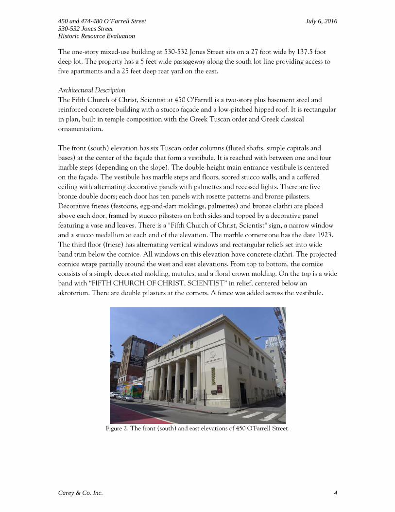
The one-story mixed-use building at 530-532 Jones Street sits on a 27 foot wide by 137.5 foot deep lot. The property has a 5 feet wide passageway along the south lot line providing access to five apartments and a 25 feet deep rear yard on the east. Architectural Description The Fifth Church of Christ, Scientist at 450 O’Farrell is a two-story plus basement steel and reinforced concrete building with a stucco façade and a low-pitched hipped roof. It is rectangular in plan, built in temple composition with the Greek Tuscan order and Greek classical ornamentation. The front (south) elevation has six Tuscan order columns (fluted shafts, simple capitals and bases) at the center of the façade that form a vestibule. It is reached with between one and four marble steps (depending on the slope). The double-height main entrance vestibule is centered on the façade. The vestibule has marble steps and floors, scored stucco walls, and a coffered ceiling with alternating decorative panels with palmettes and recessed lights. There are five bronze double doors; each door has ten panels with rosette patterns and bronze pilasters. Decorative friezes (festoons, egg-and-dart moldings, palmettes) and bronze clathri are placed above each door, framed by stucco pilasters on both sides and topped by a decorative panel featuring a vase and leaves. There is a "Fifth Church of Christ, Scientist" sign, a narrow window and a stucco medallion at each end of the elevation. The marble cornerstone has the date 1923. The third floor (frieze) has alternating vertical windows and rectangular reliefs set into wide band trim below the cornice. All windows on this elevation have concrete clathri. The projected cornice wraps partially around the west and east elevations. From top to bottom, the cornice consists of a simply decorated molding, mutules, and a floral crown molding. On the top is a wide band with “FIFTH CHURCH OF CHRIST, SCIENTIST” in relief, centered below an akroterion. There are double pilasters at the corners. A fence was added across the vestibule.
Figure 2. The front (south) and east elevations of 450 O’Farrell Street.
450 and 474-480 O’Farrell Street July 6, 2016 530-532 Jones Street Historic Resource Evaluation
Carey & Co. Inc. 5
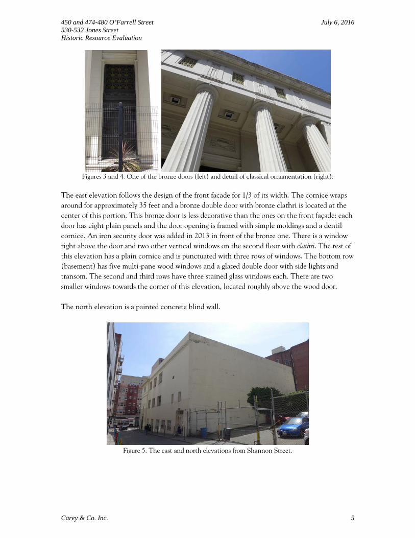
Figures 3 and 4. One of the bronze doors (left) and detail of classical ornamentation (right).
The east elevation follows the design of the front facade for 1/3 of its width. The cornice wraps around for approximately 35 feet and a bronze double door with bronze clathri is located at the center of this portion. This bronze door is less decorative than the ones on the front façade: each door has eight plain panels and the door opening is framed with simple moldings and a dentil cornice. An iron security door was added in 2013 in front of the bronze one. There is a window right above the door and two other vertical windows on the second floor with clathri. The rest of this elevation has a plain cornice and is punctuated with three rows of windows. The bottom row (basement) has five multi-pane wood windows and a glazed double door with side lights and transom. The second and third rows have three stained glass windows each. There are two smaller windows towards the corner of this elevation, located roughly above the wood door. The north elevation is a painted concrete blind wall.
Figure 5. The east and north elevations from Shannon Street.

450 and 474-480 O’Farrell Street July 6, 2016 530-532 Jones Street Historic Resource Evaluation
Carey & Co. Inc. 6
Figure 6. The west elevation partially seen from O’Farrell Street.
The west elevation is similar to the east. The cornice wraps around for 20 feet on this side. Fenestration includes a vertical window with clathri below the cornice, and two rows of stained glass windows, three per row. The northwest corner is set back slightly at the basement level and has three wood windows identical to the ones on the east. The interior of the Fifth Church of Christ, Scientist at 450 O’Farrell Street houses two main functions: the sanctuary and the Sunday school. The vast but modest entrance lobby has marble floors, scored stucco walls, square columns, and painted moldings. The backs of five bronze double doors, which are simple paneled wood, face the lobby; with the center door articulated by a contemporary enclosed vestibule containing glazed double doors. Hanging from the ceiling are brass and glass octagonal pendants. Two staircases on east and west provide access to the sanctuary. The two-story high sanctuary is rectangular in plan with chamfered corners and a U-shaped balcony. The sanctuary features carpeted floors and plaster walls. On the main level, the space is divided into three sections of wood pews facing north. The balcony has rows of pews facing north, east and west. At the front of the sanctuary is the raised stage with a wood podium. The keyboard, foot pedals and a short wood-panel partition is at center stage on the sanctuary floor level. Above the platform are the organ pipes concealed behind the clathri. Double doors on both sides of the stage provide access to the small rooms behind the auditorium. The sanctuary is somewhat austere, with only a few decorative elements, including stained glass windows, clathri, a multi-rank pipe organ, and reliefs with a vase motif along the balcony edge. There are no overt religious symbols; the decorations have either geometric or natural patterns. The existing stained glass windows on the east and west walls are signed by the “Cummings Studio-S.F.” These three-part fixed Medieval-style stained glass windows are located both on the lower and upper levels of the sanctuary. The windows mainly have diamond-shaped linear decorations, central medallions, and a blue border with small flowers. The first floor windows have biblical quotations at the bottom. Centered in the ceiling is a flat dome with a stained glass oculus skylight: the simple decorations of the skylight include a geometrical border and a rosette with an eight-arm star. The oculus is framed by plaster molding with floral decorations and embedded lights.

450 and 474-480 O’Farrell Street July 6, 2016 530-532 Jones Street Historic Resource Evaluation
Carey & Co. Inc. 7
Figure 7. The entrance lobby.
Figures 8 and 9. The sanctuary.
Figures 10 and 11. The stained glass windows (left) and the oculus skylight (right).
450 and 474-480 O’Farrell Street July 6, 2016 530-532 Jones Street Historic Resource Evaluation
Carey & Co. Inc. 8
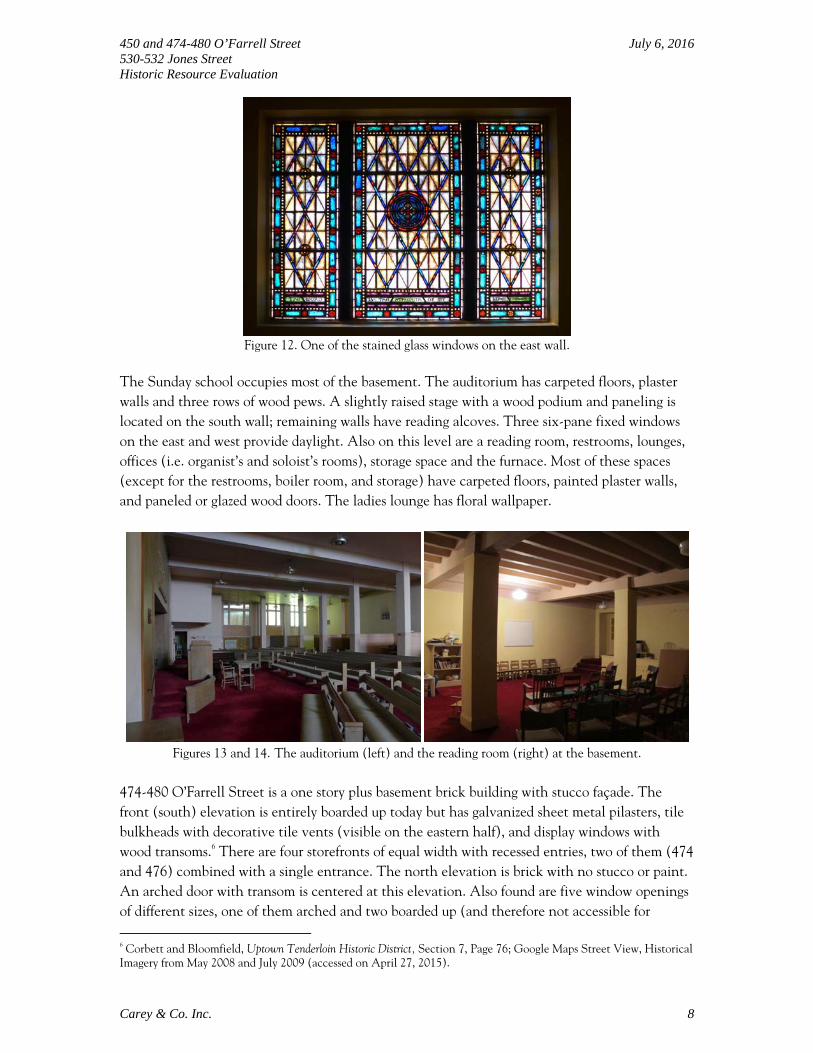
Figure 12. One of the stained glass windows on the east wall.
The Sunday school occupies most of the basement. The auditorium has carpeted floors, plaster walls and three rows of wood pews. A slightly raised stage with a wood podium and paneling is located on the south wall; remaining walls have reading alcoves. Three six-pane fixed windows on the east and west provide daylight. Also on this level are a reading room, restrooms, lounges, offices (i.e. organist’s and soloist’s rooms), storage space and the furnace. Most of these spaces (except for the restrooms, boiler room, and storage) have carpeted floors, painted plaster walls, and paneled or glazed wood doors. The ladies lounge has floral wallpaper.
Figures 13 and 14. The auditorium (left) and the reading room (right) at the basement.
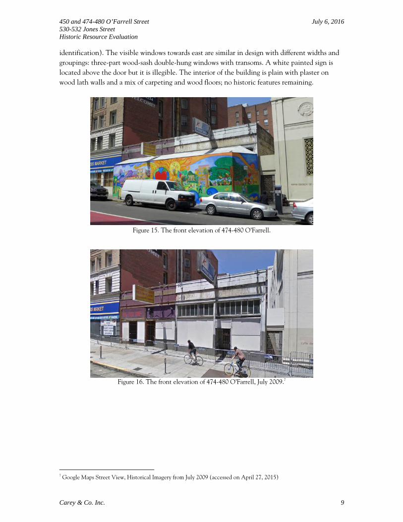
474-480 O’Farrell Street is a one story plus basement brick building with stucco façade. The front (south) elevation is entirely boarded up today but has galvanized sheet metal pilasters, tile bulkheads with decorative tile vents (visible on the eastern half), and display windows with wood transoms.6 There are four storefronts of equal width with recessed entries, two of them (474 and 476) combined with a single entrance. The north elevation is brick with no stucco or paint. An arched door with transom is centered at this elevation. Also found are five window openings of different sizes, one of them arched and two boarded up (and therefore not accessible for
6 Corbett and Bloomfield, Uptown Tenderloin Historic District, Section 7, Page 76; Google Maps Street View, Historical Imagery from May 2008 and July 2009 (accessed on April 27, 2015).
450 and 474-480 O’Farrell Street July 6, 2016 530-532 Jones Street Historic Resource Evaluation
Carey & Co. Inc. 9
identification). The visible windows towards east are similar in design with different widths and groupings: three-part wood-sash double-hung windows with transoms. A white painted sign is located above the door but it is illegible. The interior of the building is plain with plaster on wood lath walls and a mix of carpeting and wood floors; no historic features remaining.
Figure 15. The front elevation of 474-480 O’Farrell.
Figure 16. The front elevation of 474-480 O’Farrell, July 2009.7
7 Google Maps Street View, Historical Imagery from July 2009 (accessed on April 27, 2015)

450 and 474-480 O’Farrell Street July 6, 2016 530-532 Jones Street Historic Resource Evaluation
Carey & Co. Inc. 10
Figures 17, 18, and 19. The storefront in July 2016.
Figure 20. The north elevation of 474-480 O’Farrell.
Figures 21, 22, and 23. The interior of 474-480 O’Farrell.

450 and 474-480 O’Farrell Street July 6, 2016 530-532 Jones Street Historic Resource Evaluation
Carey & Co. Inc. 11
530-532 Jones Street is a one story reinforced concrete frame building with painted concrete masonry unit walls. The asymmetrical front (west) elevation has a recessed main entry and a green terrazzo vestibule. An aluminum-sash glazed door with sidelight and transom opens to a restaurant (532 Jones Street). A secondary wood panel door with security bars opens to the passageway on south, leading to the apartments behind (530 Jones Street). A fixed two-part aluminum corner window and a three-part ribbon window above are located at the chamfered north corner of the entry. A former planter box—now blocked by panels—cascades at the south. The main entrance is sheltered by a triangular concrete canopy. The building ends with parapet walls, a simple coping and a flat roof. The overscaled blade sign on the roof, which used to be a neon sign depicting a cocktail glass and reading “LYNCH’S,” reads “SHALIMAR” today.
Figure 24. The west elevation of 530-532 Jones Street.
Figures 25 and 26. The south elevation of 530-532 Jones Street: upper level (left) and basement level
(right).
The south elevation of 530-532 Jones Street has a 5 feet wide raised walkway that runs along the entire length of the elevation to the east where steel stairs descend to the partial basement. Single wood panel doors of three apartments and sliding vinyl windows with wood casings are located on the upper level of this elevation. The lower level has aluminum-sash sliding windows,
450 and 474-480 O’Farrell Street July 6, 2016 530-532 Jones Street Historic Resource Evaluation
Carey & Co. Inc. 12
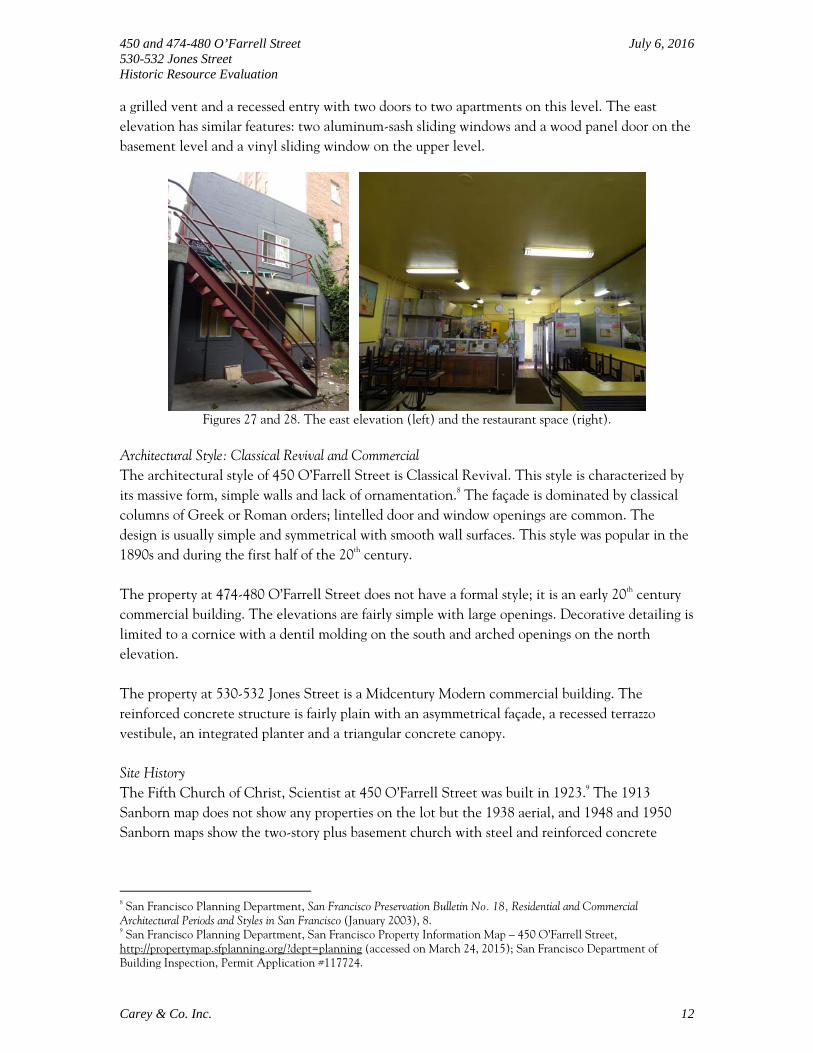
a grilled vent and a recessed entry with two doors to two apartments on this level. The east elevation has similar features: two aluminum-sash sliding windows and a wood panel door on the basement level and a vinyl sliding window on the upper level.
Figures 27 and 28. The east elevation (left) and the restaurant space (right).
Architectural Style: Classical Revival and Commercial The architectural style of 450 O’Farrell Street is Classical Revival. This style is characterized by its massive form, simple walls and lack of ornamentation.8 The façade is dominated by classical columns of Greek or Roman orders; lintelled door and window openings are common. The design is usually simple and symmetrical with smooth wall surfaces. This style was popular in the 1890s and during the first half of the 20th century. The property at 474-480 O’Farrell Street does not have a formal style; it is an early 20th century commercial building. The elevations are fairly simple with large openings. Decorative detailing is limited to a cornice with a dentil molding on the south and arched openings on the north elevation. The property at 530-532 Jones Street is a Midcentury Modern commercial building. The reinforced concrete structure is fairly plain with an asymmetrical façade, a recessed terrazzo vestibule, an integrated planter and a triangular concrete canopy. Site History The Fifth Church of Christ, Scientist at 450 O’Farrell Street was built in 1923.9 The 1913 Sanborn map does not show any properties on the lot but the 1938 aerial, and 1948 and 1950 Sanborn maps show the two-story plus basement church with steel and reinforced concrete
8 San Francisco Planning Department, San Francisco Preservation Bulletin No. 18, Residential and Commercial Architectural Periods and Styles in San Francisco (January 2003), 8. 9 San Francisco Planning Department, San Francisco Property Information Map – 450 O’Farrell Street, http://propertymap.sfplanning.org/?dept=planning (accessed on March 24, 2015); San Francisco Department of Building Inspection, Permit Application #117724.

450 and 474-480 O’Farrell Street July 6, 2016 530-532 Jones Street Historic Resource Evaluation
Carey & Co. Inc. 13
construction (Figures 29 to 32).10 The church was designed by architect Carl Werner and built by John Mortar. The building had experienced minor alterations including adding or removing partitions at the basement level, bracing the center ornament, installing a fence, and repairing plastering, parapet, roof and cornice; all of which are listed in detail below. More recently, a fence was added in front of the vestibule (date unknown) and an iron security door was installed in front of the bronze gate (2013) for security. The one-story brick commercial building at 474-480 O’Farrell Street was built in 1913; it was designed by Charles Peter Weeks.11 The 1913 Sanborn map shows five separate stores in the building, one of which was a very small corner store.12 The 1948 and 1950 Sanborn maps show four equal-sized spaces used as restaurants at 474 and 478, and stores at 476 and 480.13 A residence with two rooms and a bath was built at 476 O’Farrell in 1926 and at 478 O’Farrell in 1927.14 The storefront of 478 O’Farrell was altered by moving the door to the west of the store in 1930. The storefront of 474 O’Farrell was altered in 1933 and 1938.15 In 1971, two stores at 474 and 476 O’Farrell were connected from inside and the storefronts were altered to have one entrance.16 The original cornice of the building (seen in Figure 35) was removed, date unknown. Other minor additions and alterations regarding partitions, signs, and awnings are listed below in the construction chronology. The one-story plus basement commercial building at 530-532 Jones Street was completed in 1951. It was designed by architect Harold C. Dow and built as a cocktail lounge and three apartments.17 In 1971, a permit application was filed by G. P. Baglietto, the owner, to add two new studio apartments in the basement.18 The building housed a bar, real estate office and three apartments and the basement was vacant at the time. The construction was completed in 1977. In 1982, a building permit was issued to convert the bar area to a massage parlor with six rooms.19 The demolished bar was rebuilt in 1984; the building permit lists five apartments in addition to the bar.20 In 1995, 532 Jones Street was repurposed as restaurant: it went through some repairs that did not change the exterior and a fire system was installed in the kitchen.21 The steel-sash windows were replaced by aluminum-sash on the west elevation and vinyl-sash on the south. The neon tubing of the blade sign was removed and it was painted a solid color, probably in the 1990s (Figures 36 and 37). The original green terrazzo vestibule remains.
10 Harrison Ryker, San Francisco Aerial Views, David Rumsey Historical Map Collection, August 1938, http://www.davidrumsey.com/ (accessed on March 24, 2015); Sanborn Fire Insurance Map, San Francisco 1913 updated 1915, Volume 1, Sheet 76; Sanborn Fire Insurance Map, San Francisco 1913 updated 1949, Volume 1, Sheet 76; Sanborn Fire Insurance Map, San Francisco 1913 updated 1950, Volume 1, Sheet 76. 11 Corbett and Bloomfield, Uptown Tenderloin Historic District, Section 7, Page 76. 12 Sanborn Fire Insurance Map, San Francisco 1913 updated 1915, Volume 1, Sheet 76. 13 Sanborn Fire Insurance Map, San Francisco 1913 updated 1949, Volume 1, Sheet 76; Sanborn Fire Insurance Map, San Francisco 1913 updated 1950, Volume 1, Sheet 76. 14 San Francisco Department of Building Inspection, Permit Application #147028 and #157867. 15 San Francisco Department of Building Inspection, Permit Application #1209 and #34339. 16 San Francisco Department of Public Works, Permit Application #400685. 17 San Francisco Department of Building Inspection, Permit Application #116116. 18 San Francisco Department of Building Inspection, Permit Application #401768. 19 San Francisco Department of Building Inspection, Permit Application #08209531. 20 San Francisco Department of Building Inspection, Permit Application #08410568. 21 San Francisco Department of Building Inspection, Permit Application #9500689 and 09506291.

450 and 474-480 O’Farrell Street July 6, 2016 530-532 Jones Street Historic Resource Evaluation
Carey & Co. Inc. 14
Construction Chronology – 450 O’Farrell Street
June 20, 1923 Application for building permit to erect a one story over basement reinforced concrete church; owner Fifth Church of Christ, Scientist, Architect Carl Werner (906 Santa Fe Building), Builder John Mortar (Balboa Building).22
January 8, 1934 Application for building permit to install lattice fence on west side of church between church and vacant lot.23
October 15, 1936 The center ornament at front wall was braced.24
August 15, 1938 A partition with a door opening was built.25
February 28, 1952 Sunday school rooms were remodeled.26
November 4, 1954 New gate and steel framework for entrance were constructed at west side of building.27
September 27, 1954 Loose cement plastering was removed and replaced on three street fronts; steel scaffolding was erected on O’Farrell St and alley.28
July 3, 1958 A non-bearing partition was installed in the church restroom and two door openings were moved about three feet.29
June 18, 1968 The parking area of 450 O’Farrell Street (fronting on Shannon Street) was improved by installing a catch basin and paving the area with asphaltic concrete.30
July 25, 1968 A bundle chute from the side entry wall--street level to basement mail room--was installed at the southwest corner of the building; existing nonbearing plaster partitions were removed at the basement; and a T-bar noncombustible suspended ceiling was installed over the new mail room area.31
January 7, 1975 An access opening (2x5 feet) was cut in the floor at organ loft and a 1-hour UL labeled access door was installed.32
July 16, 1978 An accessible ramp was installed.33
22 San Francisco Department of Building Inspection, Permit Application #117724. 23 San Francisco Department of Building Inspection, Permit Application #5020. 24 San Francisco Department of Building Inspection, Permit Application #22324. 25 San Francisco Department of Building Inspection, Permit Application #37199. 26 San Francisco Department of Building Inspection, Permit Application #144160. 27 San Francisco Department of Building Inspection, Permit Application #170019. 28 San Francisco Department of Building Inspection, Permit Application #168901. 29 San Francisco Department of Building Inspection, Permit Application #212517. 30 San Francisco Department of Building Inspection, Permit Application #358380. 31 San Francisco Department of Building Inspection, Permit Application #359778. 32 San Francisco Department of Building Inspection, Permit Application #442126.
450 and 474-480 O’Farrell Street July 6, 2016 530-532 Jones Street Historic Resource Evaluation
Carey & Co. Inc. 15
February 16, 1982 Parapet reinforcing and remedial roof repairs.34
March 20, 1990 Loose cornice work was removed, scaffolding was set up at the sidewalk for the work.35
November 8, 2010 The existing roof was taken off to the deck and a 4 ply cap sheet built up roof was installed.36
May-November 2013 An iron security door was installed in front of the east bronze door sometime between May and November of 2013.37
Construction Chronology – 474-480 O’Farrell Street
March 6, 1913 A concrete retaining wall was constructed under the curb at the north side of O’Farrell and 97’-6” east of Jones Street at 472 O’Farrell.38
1913 A one story brick building was built to be used as stores.39
October 26, 1916 A small partition was removed at 474 O’Farrell.40
July 29, 1921 Sidewalk lights in front of building 472 to 480 O’Farrell Street were repaired.41
January 28, 1926 A partition was installed in the rear of the vacant store at 476 O’Farrell to provide living quarters including two rooms and bath.42
January 25, 1927 A two room with bath apartment was built in the rear of the store at 478 O’Farrell.43
October 30, 1929 Alterations and repairs to sidewalk lights in front of 474 O’Farrell.44
May 22, 1930 The storefront at 478 O’Farrell was changed by shifting the door from the center of the front to the west side of the front.45
April 17, 1933 The storefront at 474 O’Farrell was changed.46
33 San Francisco Department of Building Inspection, Permit Application #7806423. 34 San Francisco Department of Building Inspection, Permit Application #08201124. 35 San Francisco Department of Building Inspection, Permit Application #09005338. 36 San Francisco Department of Building Inspection, Permit Application #201011084508. 37 Google Maps Street View, Historical Imagery from May 2013 and November 2013 (accessed on April 28, 2015). 38 San Francisco Department of Building Inspection, Permit Application #48020. 39 Sanborn Fire Insurance Map, San Francisco 1913 updated 1915, Volume 1, Sheet 76; Corbett and Bloomfield, Uptown Tenderloin Historic District, Section 7, Page 76. 40 San Francisco Department of Building Inspection, Permit Application #42884. 41 San Francisco Department of Building Inspection, Permit Application #100445. 42 San Francisco Department of Building Inspection, Permit Application #147028. 43 San Francisco Department of Building Inspection, Permit Application #157867. 44 San Francisco Department of Building Inspection, Permit Application #182289. 45 San Francisco Department of Building Inspection, Permit Application #186126. 46 San Francisco Department of Building Inspection, Permit Application #1209.

450 and 474-480 O’Farrell Street July 6, 2016 530-532 Jones Street Historic Resource Evaluation
Carey & Co. Inc. 16
March 5, 1935 The sign was removed from 474 O’Farrell, repainted and rehung in exactly the same place. This sign was originally hung on May 6, 1933.47
March 26, 1938 A two face neon sign was erected at 480 O’Farrell.48
March 26, 1938 A two face neon sign was erected at 478 O’Farrell.49
April 13, 1938 A rough partition in the basement between stores at 474 and 476 O’Farrell Street was installed. A stairway at the rear of the store at 476 O’Farrell Street was installed.50
April 14, 1938 A window was changed and a counter and balcony were added inside 474 O’Farrell.51
May 16, 1946 A double faced horizontal neon sign was installed at 478 O’Farrell.52
June 20, 1946 A double faced horizontal neon sign was installed at 476 O’Farrell.53
July 15, 1959 The existing neon sign from 224 Ellis Street was moved to its new location at 474 O’Farrell.54
April 11, 1966 Standard pipe and canvas type awnings, frames and covers were installed at 476 O’Farrell.55
April 22, 1966 A standard pipe and canvas awning (2’-10” high, 15’-0” wide, 6’-0” projection) was installed at 474 O’Farrell.56
October 26, 1966 Standard pipe and canvas awning (6’-0” high, 13’-7” wide, 2’-8” projection) was installed at 478 O’Farrell.57
January 7, 1968 Repairs to the top edge of the cornice (app. 2’-0” x 36’-0”) at 474 O’Farrell: existing tar and ply were removed and new 3 ply and tar was installed.58
August 24, 1971 The front entrance of 476 O’Farrell was closed with glass window and tile; two openings were made between the two stores at 474 and 476 O’Farrell.59
47 San Francisco Department of Building Inspection, Permit Application #10830. 48 San Francisco Department of Building Inspection, Permit Application #33858. 49 San Francisco Department of Building Inspection, Permit Application #33856. 50 San Francisco Department of Building Inspection, Permit Application #34297. 51 San Francisco Department of Building Inspection, Permit Application #34339. 52 San Francisco Department of Building Inspection, Permit Application #88842. 53 San Francisco Department of Building Inspection, Permit Application #89709. 54 San Francisco Department of Public Works, Permit Application #226004. 55 San Francisco Department of Public Works, Permit Application #328401. 56 San Francisco Department of Building Inspection, Permit Application #328861. 57 San Francisco Department of Building Inspection, Permit Application #336159. 58 San Francisco Department of Public Works, Permit Application #352291. 59 San Francisco Department of Public Works, Permit Application #400685.

450 and 474-480 O’Farrell Street July 6, 2016 530-532 Jones Street Historic Resource Evaluation
Carey & Co. Inc. 17
September 21, 1971 Awnings, frame of steel tubing, and cover of approved canvas were installed at 474 O’Farrell.60
November 15, 1974 A double faced, projecting neon sign was installed at 478 O’Farrell.61
May 12, 1981 Parapet correction work was completed at 474 O’Farrell.62
December 27, 1995 Interior tenant improvements at 480 O’Farrell for a new meat market.63
March 20, 2001 A new walk-in cooler box was put in and the old one was removed at 480 O’Farrell.64
Construction Chronology – 530-532 Jones Street
April l5, 1949 Dennis Lynch filed a permit application to erect a one-story plus basement building at 530-532 Jones Street that would include a cocktail lounge and three apartments. The permit notes that two more stories would be added later. The application names Harold C. Dow as the architect, George D. Lodvick as the engineer, and Harry C. Knight and Sons as the contractor.65
September 21, 1971 G. P. Baglietto filed a permit application to install two new studio apartments in basement in addition to existing three apartments. “The existing improvements are to a one-story building containing a bar, real estate office and three apartments with a basement at the rear of the lot and a passageway approximately five feet wide at the southerly side lot line providing access to the dwelling units. The basement, which is vacant, opens into a rear yard (…). The subject proposal is to convert the basement area into two studio apartments. No one has rented the basement area during the eight years of the present ownership.”66
November 17, 1982 A permit application was filed to build 8-foot high partitions to have six massage rooms. The existing use was noted as bar with no dwelling units and the proposed use was massage parlor.67
October 1, 1984 A permit application to rebuild demolished bar and paint interior. Present and proposed use were both noted as bar and five apartments.68
60 San Francisco Department of public Works, Permit Application #101773. 61 San Francisco Department of Public Works, Permit Application #441303. 62 San Francisco Department of Public Works, Permit Application #08104351. 63 San Francisco Department of Building Inspection, Permit Application #09521603. 64 San Francisco Department of Building Inspection, Permit Application #200103204772. 65 San Francisco Department of Building Inspection, Permit Application #116116. 66 San Francisco Department of Building Inspection, Permit Application #401768. 67 San Francisco Department of Building Inspection, Permit Application #08209531. 68 San Francisco Department of Building Inspection, Permit Application #08410568.
450 and 474-480 O’Farrell Street July 6, 2016 530-532 Jones Street Historic Resource Evaluation
Carey & Co. Inc. 18
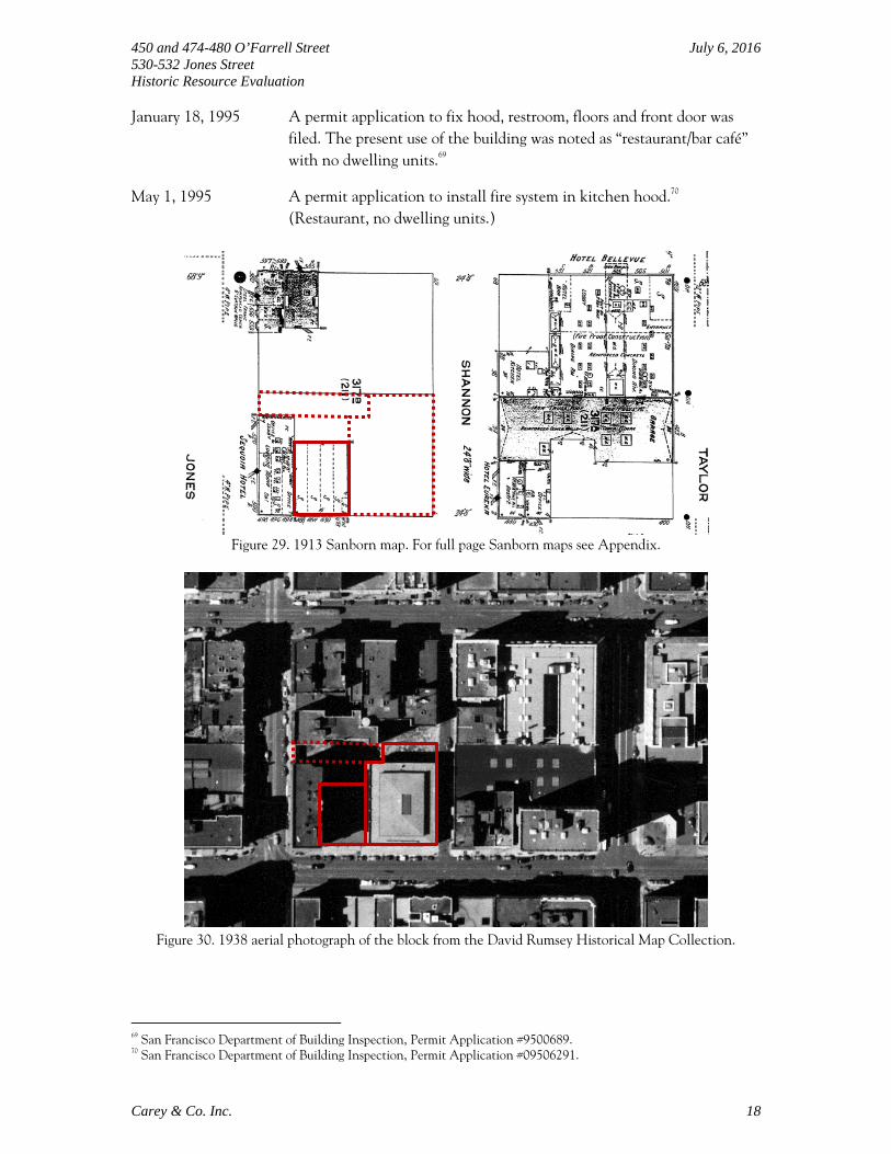
January 18, 1995 A permit application to fix hood, restroom, floors and front door was filed. The present use of the building was noted as “restaurant/bar café” with no dwelling units.69
May 1, 1995 A permit application to install fire system in kitchen hood.70 (Restaurant, no dwelling units.)
Figure 29. 1913 Sanborn map. For full page Sanborn maps see Appendix.
Figure 30. 1938 aerial photograph of the block from the David Rumsey Historical Map Collection.
69 San Francisco Department of Building Inspection, Permit Application #9500689. 70 San Francisco Department of Building Inspection, Permit Application #09506291.

450 and 474-480 O’Farrell Street July 6, 2016 530-532 Jones Street Historic Resource Evaluation
Carey & Co. Inc. 19
Figure 31. 1948 Sanborn map. For full page Sanborn maps see Appendix.
Figure 32. 1950 Sanborn map. For full page Sanborn maps see Appendix.

450 and 474-480 O’Farrell Street July 6, 2016 530-532 Jones Street Historic Resource Evaluation
Carey & Co. Inc. 20
Figures 33 and 34. Fifth Church of Christ, Scientist in 1930 (left) and in 1964 (right).71
Figure 35. 474-480 O’Farrell Street, between 1962 and 1964 (San Francisco Assessor's Office Negative
Collection, San Francisco Public Library).
Figures 36 and 37. 530-532 Jones Street in 1976 (left) and in 1985 (right).72
71 “Fifth Church of Christ Scientist, 450 O'Farrell Street,” AAB-1099, http://sflib1.sfpl.org:82/record=b1006148; “Fifth Church of Christ Scientist, 450 O'Farrell Street,” AAB-1098, http://sflib1.sfpl.org:82/record=b1006147 from San Francisco Historical Photograph Collection, San Francisco Public Library (accessed on March 24, 2015).

450 and 474-480 O’Farrell Street July 6, 2016 530-532 Jones Street Historic Resource Evaluation
Carey & Co. Inc. 21
HISTORIC CONTEXT: CHURCH OF CHRIST, SCIENTIST73
Mary Baker Eddy founded the Christian Science Church in 1866 after recovering from chronic illness and an injury through spiritual meditation. Based on her recovery through a religious experience, Eddy published a book on spirituality and healing, Science and Health with Key to the Scriptures, in 1875. By 1879, Eddy had acquired a following through her findings on religious healing and founded “The Church of Christ, Scientist” in Lynn, Massachusetts, a suburb of Boston. Christian Scientists were known for their unified approach to church architecture. Typically, the urban Christian Science church was a Neoclassical style, central-plan building with a pedimented porch. Although the Christian Scientist Congregation was formally established in San Francisco on October 1, 1892, at 702 Powell Street, the First Church of Christ, Scientist was not constructed until 1912, and was located at 1700 Franklin Street. By 1914 the San Francisco community of Christian Scientists had grown significantly enough to warrant the need for the Second Church, which was completed in 1917. Before the Second Church had been completed, however, preparations were already underway for the Third Church building, completed in 1918. In 1923, the Fourth, Fifth, and Sixth Churches were built as the community expanded. Five more Churches of Christian Science were founded in the following decades. Many of the churches were built in the Neoclassical style. Today, only three churches remain in use as active Christian Science churches: the First, Fifth (the subject property) and Ninth.
Table 1. Christian Scientist Churches in San Francisco.74
Name Address Date Built Architect Architectural
Style Historic Resource
Status
First Church 1700 Franklin St 1912 Edgar A. Mathews
Romanesque Revival
Appears eligible for NR individually
Second Church
651 Dolores St 1917 William Crim, Jr.
Neoclassical Appears eligible for NR individually
Third Church 1250 Haight St 1918 Edgar A. Mathews
Romanesque Revival
Contributor to the CR Buena Vista North Historic District
Fourth Church
300 Funston Ave 1923 Carl Werner Neoclassical Appears eligible for CR individually
Fifth Church 450 O’Farrell St 1923 Carl Werner Neoclassical
Contributor to the NR Uptown Tenderloin Historic District
72 San Francisco Planning Department, 1976 Architectural Survey Form for 530 Jones Street, http://propertymap.sfplanning.org/?&search=532%20jones (accessed September 17, 2015); “3D Lynchs Neon Sign 532 Jones St,” https://www.flickr.com/photos/21895107@N07/4474887101 (accessed September 3, 2015). 73 Excerpted from San Francisco Planning Department, 651 Dolores Street – Second Church of Christ, Scientist, Draft Environmental Impact Report, Case No.2006.0144.E, October 2008, III.B-2 and III.B-3. 74 San Francisco Planning Department Property Information Map and Archives; Page & Turnbull, Second Church of Christ, Scientist, San Francisco, California Historic Resource Evaluation, July 3, 2006, 29.

450 and 474-480 O’Farrell Street July 6, 2016 530-532 Jones Street Historic Resource Evaluation
Carey & Co. Inc. 22
Name Address Date Built Architect Architectural
Style Historic Resource
Status
Sixth Church 2899 Clay St 1923 Crim & Murdock
Neoclassical None
Seventh Church
532-536 Sutter St 1910 MacDonald & Applegarth
Neoclassical Appears eligible for NR individually
Eight Church 1984 Great Hwy 1906 Fred C. Jones Bungalow Appears eligible for NR individually
Ninth Church
175 Junipero Serra Blvd
1941 Henry H. Gutterson
Spanish Colonial Revival
Contributor to the CR Balboa Terrace Historic District
Tenth Church
2246 Lombard St N/A - N/A None
Eleventh Church
3030 Judah St 1947 - Spanish Colonial Revival
None
Twelfth Church
60 Onondaga Ave
N/A - N/A None
Christian Science Church Architecture The Christian Science building movement adopted the Classical style, especially in urban settings, for its churches because of its association with contemporary movements such as reform, city beautification, and renewal of urban life. Christian Scientists often located their churches in emerging residential districts or near newly expanding civic centers:
Typically, the urban Christian Science branch church was a central-plan building with a pedimented porch…The porch was frequently made of fine materials such as marble or terra-cotta. The building was often crowned by a low dome centered over an auditorium. There were usually three to five doors giving access to the interior. The typical interior was also classical in detailing and consisted of a large foyer created to foster sociability among church members, with at least three main entrances to the auditorium; a Sunday school underneath the auditorium, and offices for church business. The heaviness and authority of the exterior contrasted with the lightness and comfort in the domed auditorium…Christian Science continued much of the iconoclasm associated with the Puritan’s rejection of symbols and other decoration in churches. Christian Science interiors were less elaborate and less ornamented than the interiors of the buildings of many Protestant denominations. …In classical churches, the large dome, often fitted with beautiful stained glass, dominated the experience of the worship space…The readers’ platform, often framed by a decorative screen hiding organ pipes, was often adorned with cut flowers or potted plants rather than with Christian symbols.”75
75 Paul Eli Ivey, Prayers in Stone: Christian Science Architecture in the United States, 1894-1930 (Urbana: University of Illinois Press, 1999), 3-4.

450 and 474-480 O’Farrell Street July 6, 2016 530-532 Jones Street Historic Resource Evaluation
Carey & Co. Inc. 23
Four Neoclassical Christian Science church buildings remain in San Francisco: the Second (adapted for residential use), Fourth (adapted for library/museum use), Fifth, and Sixth (currently Church of Christ-Iglesia Ni Cristo).76 The decorations of these churches mostly follow the subtle, floral or geometrical approach of the Christian Science churches. Decorative plaster work on the ceiling and around windows, decorative screens in front of the organ pipes, and stained glass windows are common in all four churches. Both the Second and the Fourth churches have arched leaded glass windows and oculi with a band of intricate floral motives in yellow, green and brown hues. In terms of stained glass, the Fifth Church features the most elaborate and colorful designs, especially on the east and west windows. OWNER/OCCUPANT HISTORY77 Ownership History of Lot 7 (450 O’Farrell Street) Dates of Ownership Owner Occupation
… - February 6, 1919 Leonora Mayer Widow of Charles Jr, music teacher78
February 6, 1919 - April 3, 1919
W. F. and L. Hampel William: secretary to manager at Simmons Co. (furniture manufacturer)79
April 3, 1919 - February 6, 1920
Andrew and Herminie Rudgear
Andrew: vice president at Simmons Co.80
February 6, 1920 - … P. S. Scales Secretary at Real Property Investment Co.81
... - June 17, 1921 The First National Bank of San Francisco82
June 17, 1921 - November 4, 1922
William F. Dunn Partner at Dunn Williams Co., real estate83
November 4, 1922 - Present Fifth Church of Christ, Scientist84
76 Although the Seventh Church is Neoclassical, it was originally constructed as a commercial building; it was adapted to be used as a Christ Scientist church in the 1940s and vacated ca. 1975. 77 The occupant and address information for the subject properties were cross-referenced with the Gay Inc., Gay San Francisco Business Directory (2006) at the San Francisco Public Library; none of the occupants or the businesses were listed. 78 San Francisco Assessor’s Office – Sales Ledgers, H. S. Crocker Co., Inc., Crocker-Langley San Francisco City Directory, San Francisco: H.S. Crocker Co., 1918-1920. 79 San Francisco Assessor’s Office – Sales Ledgers, H. S. Crocker Co., Inc., Crocker-Langley San Francisco City Directory, San Francisco: H.S. Crocker Co., 1919. 80 San Francisco Assessor’s Office – Sales Ledgers, H. S. Crocker Co., Inc., Crocker-Langley San Francisco City Directory, San Francisco: H.S. Crocker Co., 1919-1920. 81 San Francisco Assessor’s Office – Sales Ledgers, H. S. Crocker Co., Inc., Crocker-Langley San Francisco City Directory, San Francisco: H.S. Crocker Co., 1920. 82 San Francisco Assessor’s Office – Sales Ledgers. 83 San Francisco Assessor’s Office – Sales Ledgers, H. S. Crocker Co., Inc., Crocker-Langley San Francisco City Directory, San Francisco: H.S. Crocker Co., 1919-1922. 84 San Francisco Assessor’s Office – Sales Ledgers.
450 and 474-480 O’Farrell Street July 6, 2016 530-532 Jones Street Historic Resource Evaluation
Carey & Co. Inc. 24
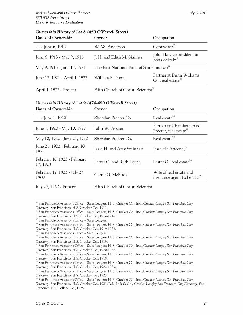
Ownership History of Lot 8 (450 O’Farrell Street) Dates of Ownership Owner Occupation
… - June 6, 1913 W. W. Anderson Contractor85
June 6, 1913 - May 9, 1916 J. H. and Edith M. Skinner John H.: vice president at Bank of Italy86
May 9, 1916 - June 17, 1921 The First National Bank of San Francisco87
June 17, 1921 - April 1, 1922 William F. Dunn Partner at Dunn Williams Co., real estate88
April 1, 1922 - Present Fifth Church of Christ, Scientist89
Ownership History of Lot 9 (474-480 O’Farrell Street) Dates of Ownership Owner Occupation
… - June 1, 1920 Sheridan Procter Co. Real estate90
June 1, 1920 - May 10, 1922 John W. Procter Partner at Chamberlain & Procter, real estate91
May 10, 1922 - June 21, 1922 Sheridan Procter Co. Real estate92
June 21, 1922 - February 10, 1923
Jesse H. and Amy Steinhart Jesse H.: Attorney93
February 10, 1923 - February 17, 1923
Lester G. and Ruth Loupe Lester G.: real estate94
February 17, 1923 - July 27, 1960
Carrie G. McElroy Wife of real estate and insurance agent Robert D.95
July 27, 1960 - Present Fifth Church of Christ, Scientist
85 San Francisco Assessor’s Office – Sales Ledgers, H. S. Crocker Co., Inc., Crocker-Langley San Francisco City Directory, San Francisco: H.S. Crocker Co., 1913. 86 San Francisco Assessor’s Office – Sales Ledgers, H. S. Crocker Co., Inc., Crocker-Langley San Francisco City Directory, San Francisco: H.S. Crocker Co., 1914-1916. 87 San Francisco Assessor’s Office – Sales Ledgers. 88 San Francisco Assessor’s Office – Sales Ledgers, H. S. Crocker Co., Inc., Crocker-Langley San Francisco City Directory, San Francisco: H.S. Crocker Co., 1919-1922. 89 San Francisco Assessor’s Office – Sales Ledgers. 90 San Francisco Assessor’s Office – Sales Ledgers; H. S. Crocker Co., Inc., Crocker-Langley San Francisco City Directory, San Francisco: H.S. Crocker Co., 1919. 91 San Francisco Assessor’s Office – Sales Ledgers; H. S. Crocker Co., Inc., Crocker-Langley San Francisco City Directory, San Francisco: H.S. Crocker Co., 1920-1922. 92 San Francisco Assessor’s Office – Sales Ledgers; H. S. Crocker Co., Inc., Crocker-Langley San Francisco City Directory, San Francisco: H.S. Crocker Co., 1919. 93 San Francisco Assessor’s Office – Sales Ledgers; H. S. Crocker Co., Inc., Crocker-Langley San Francisco City Directory, San Francisco: H.S. Crocker Co., 1922-1923. 94 San Francisco Assessor’s Office – Sales Ledgers; H. S. Crocker Co., Inc., Crocker-Langley San Francisco City Directory, San Francisco: H.S. Crocker Co., 1923. 95 San Francisco Assessor’s Office – Sales Ledgers; H. S. Crocker Co., Inc., Crocker-Langley San Francisco City Directory, San Francisco: H.S. Crocker Co., 1923; R.L. Polk & Co., Crocker-Langley San Francisco City Directory, San Francisco: R.L. Polk & Co., 1925.

450 and 474-480 O’Farrell Street July 6, 2016 530-532 Jones Street Historic Resource Evaluation
Carey & Co. Inc. 25
Occupant History of 474 O’Farrell Street 96 Dates of Occupancy Occupant
1913 - 1916 Laundry (Mrs. Rose Jochumsen)
1917 - 1929 Laundry (Jean/John Victor)
1934 - 1935 Restaurant Mrs. Ann L. Williams
1936 - 1937 Restaurant (Harold Yee)
1941 Laundry (Albert Lee)
1945 - 1946 Florist (John M. Kurtnsy)
1948 - 1949 Real Estate (John M. Kurtnys)
1953 - 1954 Royal Flocking Company
1955 - 1959 Vacant
1960 - 1961 T&S Tackle Repair Shop
1962 - 1965 Vacant
1966 - 1982 Firenze Furniture Occupant History of 476 O’Farrell Street 97 Dates of Occupancy Occupant
1914 Milliner (Alexander Gladstone)
1916 Milliner (Mrs. Berry Schmersahl)
1917 - 1918 Milliner (Mrs. B. Berny)
1920 - 1923 Men’s Furnishing Goods-Retail (Jacob Seeman)
1928 - 1930 Restaurant (Samuel Rocco)
1934 - 1940 Embroidery, Hemstitching (George Hein)
1941 Bookseller (C. A. Johnstone)
1945 - 1946 Gift shop (Mrs. Eva Zabel)
1948 Cleaner (R. L. Patton)
1953 - 1959 Personal Service Cleaners
1960 - 1962 Vacant
1963 Espinoza Jerry, insurance general, Lambert Realty Co.
1965 - 1965 Vacant
1966 - 1973 Rinks Theresa Salon
1974 - 1982 Firenze Furniture 96 San Francisco City Directories, 1913-1982; Ancestry Website, http://www.ancestry.com/ (accessed June 29, 2016). 97 San Francisco City Directories, 1914-1982; Ancestry Website, http://www.ancestry.com/ (accessed June 29, 2016).

450 and 474-480 O’Farrell Street July 6, 2016 530-532 Jones Street Historic Resource Evaluation
Carey & Co. Inc. 26
Occupant History of 478 O’Farrell Street 98 Dates of Occupancy Occupant
1918 - 1925 Jeweler (George Hein)
1926 Hemstitching (George & Matilda Hein)
1932 Restaurant (S. Edward Williams)
1933 - 1935 Restaurant (Antone Koutoulogenis)
1936 Restaurant (Alfred O. Ellison)
1937 Restaurant (Bernard Kiem)
1938 - 1946 Restaurant (Carl L. Cavallo)
1948-49 Shanghai Cafe
1953 - 1961 Joe’s Cafe
1962 Lily’s Café Restaurant
1963 - 1982 O’Farrell Café Restaurant Occupant History of 480 O’Farrell Street 99 Dates of Occupancy Occupant
1916 - 1917 Restaurant (K. E. Smith)
1919 - 1921 Art goods (John Schramm)
1922 - 1929 Milliner (Louise Pfeffer) and Furrier (Jennie Nerler, 1922)
1932 Hat cleaner (George Canellos), shoe shiner (J. Ganarakos)
1933 Shoe repairer and shiner (Nisam Kacherian, John Rokos)
1934 - 1935 Clothes cleaner (K. Hirota)
1937 - 1939 Clothes cleaner (H. Hiyeda)
1940 - 1942 Clothes cleaner (S. and F. Ikeda)
1943 - 1944 Sang Lung Laundry
1945 - 1949 Laundry (Hing Bow Yee)
1953 - 1971 San Lung Steam Laundry
1972 - 1973 Vacant
1974 - 1982 Rinks Theresa Salon
98 San Francisco City Directories, 1918-1982; Ancestry Website, http://www.ancestry.com/ (accessed June 29, 2016). 99 San Francisco City Directories, 1916-1982; Ancestry Website, http://www.ancestry.com/ (accessed June 29, 2016).
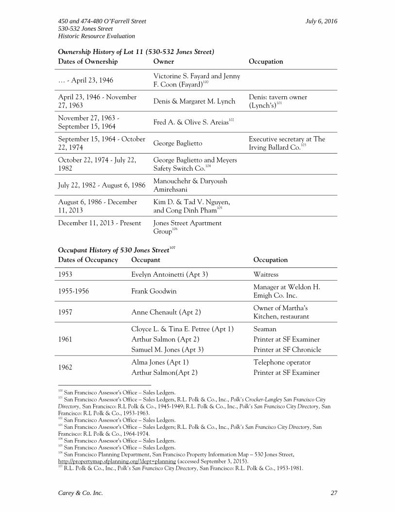
450 and 474-480 O’Farrell Street July 6, 2016 530-532 Jones Street Historic Resource Evaluation
Carey & Co. Inc. 27
Ownership History of Lot 11 (530-532 Jones Street) Dates of Ownership Owner Occupation
… - April 23, 1946 Victorine S. Fayard and Jenny F. Coon (Fayard)100
April 23, 1946 - November 27, 1963
Denis & Margaret M. Lynch Denis: tavern owner (Lynch’s)101
November 27, 1963 - September 15, 1964
Fred A. & Olive S. Areias102
September 15, 1964 - October 22, 1974
George Baglietto Executive secretary at The Irving Ballard Co.103
October 22, 1974 - July 22, 1982
George Baglietto and Meyers Safety Switch Co.104
July 22, 1982 - August 6, 1986 Manouchehr & Daryoush Amirehsani
August 6, 1986 - December 11, 2013
Kim D. & Tad V. Nguyen, and Cong Dinh Pham105
December 11, 2013 - Present Jones Street Apartment Group106
Occupant History of 530 Jones Street107 Dates of Occupancy Occupant Occupation
1953 Evelyn Antoinetti (Apt 3) Waitress
1955-1956 Frank Goodwin Manager at Weldon H. Emigh Co. Inc.
1957 Anne Chenault (Apt 2) Owner of Martha’s Kitchen, restaurant
1961 Cloyce L. & Tina E. Petree (Apt 1) Arthur Salmon (Apt 2) Samuel M. Jones (Apt 3)
Seaman Printer at SF Examiner Printer at SF Chronicle
1962 Alma Jones (Apt 1) Arthur Salmon(Apt 2)
Telephone operator Printer at SF Examiner
100 San Francisco Assessor’s Office – Sales Ledgers. 101 San Francisco Assessor’s Office – Sales Ledgers, R.L. Polk & Co., Inc., Polk’s Crocker-Langley San Francisco City Directory, San Francisco: R.L Polk & Co., 1945-1949; R.L. Polk & Co., Inc., Polk’s San Francisco City Directory, San Francisco: R.L Polk & Co., 1953-1963. 102 San Francisco Assessor’s Office – Sales Ledgers. 103 San Francisco Assessor’s Office – Sales Ledgers; R.L. Polk & Co., Inc., Polk’s San Francisco City Directory, San Francisco: R.L Polk & Co., 1964-1974. 104 San Francisco Assessor’s Office – Sales Ledgers. 105 San Francisco Assessor’s Office – Sales Ledgers. 106 San Francisco Planning Department, San Francisco Property Information Map – 530 Jones Street, http://propertymap.sfplanning.org/?dept=planning (accessed September 3, 2015). 107 R.L. Polk & Co., Inc., Polk’s San Francisco City Directory, San Francisco: R.L. Polk & Co., 1953-1981.

450 and 474-480 O’Farrell Street July 6, 2016 530-532 Jones Street Historic Resource Evaluation
Carey & Co. Inc. 28
Doris Smith (Apt 3) Waitress
1967 Marie Brenick
1977-1983 Charles R. Ingbritsen (Apt 1a) Clerk at El Cortez Hotel
1981 Sue Ann Lee (Apt 3) Dan Ryan (Apt 5)
Occupant History of 532 Jones108 Dates of Occupancy Occupant
1953 - 1963 Lynch’s, tavern (Denis, Mitch and Timothy Lynch)
1964 - 1966 Lynch’s, tavern (William D. and Ova V. Prideaux)
1967 - 1970 Lynch’s, tavern (Fidel Sanchez)
1971 - 1976 Lynch’s, tavern (Sydney and Marie Lipton)
197 - 1982 Lynch’s, tavern (Charlene Gustis)
1983 - 1985 Vacant
1986 Bit of Paradise [Massage parlor]
1987 - 1994 Ritz Bar
1995 Vacant
1996 - Present Shalimar Restaurant ARCHITECT/ARTIST
The original building permit identifies Carl Werner as the architect of 450 O’Farrell Street.109 Carl Werner (1875-1943) came to the Bay Area from Philadelphia at the age of twelve. A graduate of MIT in 1898, he worked for several years in the office of Julius Krafft who designed such San Francisco mansions as the Flood House at 2120 Broadway (now the Hamlin School) and the Heller Place at 2020 Jackson. From 1903 to 1914 Werner was the junior partner of Mathew O’Brien and their work received considerable attention in the architectural press. San Francisco’s Scottish Rite Temple at Sutter and Van Ness, later the Regency Theater, was a product of O’Brien and Werner. Thereafter he practiced alone and designed Scottish Rite or Masonic temples in Oakland, San Jose, Petaluma, Santa Rosa, South San Francisco, Stockton, Santa Barbara, Fresno, and Bakersfield. He also designed the YMCA Building (1924) on San Francisco’s Embarcadero, a Colonial Revival City Hall for South San Francisco, and seven Christian Science churches in Oakland and San Francisco including the still standing Fourth Church at 300 Funston Avenue and the Fifth Church, the subject property. St. Anthony (Stanford) Apartments at 795 Geary Street is another contributing building in the Uptown
108 San Francisco City Directories, 1953-1996. 109 San Francisco Department of Building Inspection, Permit Application #117724. Following text about Carl Werner is summarized from Anne Bloomfield, Kit Haskell, and Arthur Bloomfield, Gables and fables: a portrait of San Francisco's Pacific Heights (Berkeley, Calif: Heyday Books, 2007), 27-29.

450 and 474-480 O’Farrell Street July 6, 2016 530-532 Jones Street Historic Resource Evaluation
Carey & Co. Inc. 29
Tenderloin Historic District designed by Werner in cooperation with O’Brien [not specified which O’Brien brother].110 The commercial building at 474-480 O’Farrell Street was designed by Charles Peter Weeks.111 Architect Charles Peter Weeks (1870-1928) attended the Ecole des Beaux-Arts in Paris, where he trained in the atelier of Victor Laloux, one of the most prominent French architects of the time and the most popular mentor among American architects studying in Paris. In 1902, Weeks joined John Galen Howard, a fellow student of Laloux, in the New York firm of Howard & Cauldwell. Weeks then followed Howard to Berkeley in 1903/04 to assist with the design of the new campus for the University of California, the largest Beaux-Arts project in the United States. Weeks next joined San Francisco architect Albert Sutton in 1903 to form Sutton & Weeks. After Sutton moved to Oregon in 1910, Weeks worked independently until joining forces with William Peyton Day in 1916. With Day, Weeks later designed Shriner’s Hospital (1923), the Huntington Hotel (1924), and the Mark Hopkins Hotel (1925). There are seven other contributing buildings—mostly apartment buildings and hotels—in the Uptown Tenderloin Historic District that were designed by Weeks during his solo period and his partnerships.112 The original building permit of 1949 names Harold C. Dow of San Francisco as the architect of the property at 530-532 Jones Street.113 Harold C. Dow designed houses in the Bay Area and California. He partnered with Bernard Sabaroff from 1953 to 1958.114 Harold W. “Pat” Cummings (1897-1962) was born in Hampton, Iowa, and studied electrical engineering at Iowa State College. He moved to San Francisco and started his studio in 1923. The studio was listed as the Western Art Glass Studios, “art glasses for churches, mausoleums, residences and public buildings,” in the city directories from 1923 to 1929. The name of the business was changed to Cumming Studios in 1930.115 As one of the well-known stained glass studios in the United States, Cummings and his staff (including resident designers) worked on stained glass windows in the Temple Methodist Episcopal Church, the Presidio Chapel, St. Ignatius Church, the Fifth Church of Christ, Scientist in San Francisco as well as the Robert Dollar Memorial Chapel in San Rafael, the First Church of Christ, Scientist in Belvedere, the Third Brigade Chapel at Fort Ord, and the Morris Chapel at the University of the Pacific in
110 Corbett and Bloomfield, Uptown Tenderloin Historic District, Section 7, page 40. 111 Corbett and Bloomfield, Uptown Tenderloin Historic District, Section 7, pages 3-4 and 76. Following text about Charles Peter Weeks is excerpted from Carey & Co., Draft National Register Nomination for Port of San Francisco Union Iron Works/Bethlehem Steel Historic District – Pier 70, June 2013, Section 8, page 43. 112 Contributing buildings designed by Charles Peter Weeks: 431-439 Jones Street, 765 Geary Street, 474-480 O’Farrell Street, 580 O’Farrell Street, 134 Golden Gate Avenue (with William Peyton Day), as well as 450 Jones Street, 401-411 O’Farrell Street, and 415-421 O’Farrell Street (with Albert Sutton). 113 San Francisco Department of Building Inspection, Permit Application #116116. 114 The AIA Historical Directory of American Architects, s.v. “Sabaroff, Bernard J.,” (ahd1038830), http://public.aia.org/sites/hdoaa/wiki/Wiki%20Pages/ahd1038830.aspx (accessed September 14, 2015). 115 H.S. Crocker Co., Inc, Crocker-Langley San Francisco City Directory, 1923-1929; R.L. Polk & Co., Polk’s Crocker-Langley San Francisco City Directory, 1930.

450 and 474-480 O’Farrell Street July 6, 2016 530-532 Jones Street Historic Resource Evaluation
Carey & Co. Inc. 30
Stockton.116 Cummings passed away in 1962 and his son Harold W. “Bill” Cummings took over. The Cummings Studio moved to North Adams, Massachusetts in 1977.117 REGULATORY CONTEXT
California Environmental Quality Act When a proposed project may adversely affect a historical resource, California Environmental Quality Act (CEQA) requires a city or county to carefully consider the possible impacts before proceeding (Public Resources Code Sections 21084 and 21084.1). CEQA equates a substantial adverse change in the significance of a historical resource with a significant effect on the environment (Section 21084.1). The Act explicitly prohibits the use of a categorical exemption within the CEQA Guidelines for projects which may cause such a change (Section 21084). For the purposes of CEQA (Guidelines Section 15064.5), the term “historical resources” shall include the following:
1. A resource listed in, or determined to be eligible by the State Historical Resources Commission, for listing in, the CRHR (Pub. Res. Code §5024.1, Title 14 CCR, Section 4850 et seq.).
2. A resource included in a local register of historical resources, as defined in Section 5020.1(k) of the Public Resources Code or identified as significant in an historical resource survey meeting the requirements of Section 5024.1(g) of the Public Resources Code, shall be presumed to be historically or culturally significant. Public agencies must treat any such resource as significant unless the preponderance of evidence demonstrates that it is not historically or culturally significant.
3. Any object, building, structure, site, area, place, record, or manuscript which a lead agency determines to be historically significant or significant in the architectural, engineering, scientific, economic, agricultural, educational, social, political, military, or cultural annals of California, may be considered to be an historical resource, provided the lead agency’s determination is supported by substantial evidence in light of the whole record. Generally, a resource shall be considered by the lead agency to be “historically significant” if the resource meets the criteria for listing in the CRHR, including the following:
A. Is associated with events that have made a significant contribution to the broad patterns of California’s history and cultural heritage;
B. Is associated with the lives of persons important in our past; C. Embodies the distinctive characteristics of a type, period, region, or method of
construction, or represents the work of an important creative individual, or possesses high artistic values; or
116 Carolyn Anspacher, “Reviving Old Art,” San Francisco Chronicle, August 3, 1936; “A break with tradition: S.F. artist ‘sculptures’ stained glass,” San Francisco Chronicle, June 8, 1958; “Harold Cummings,” San Francisco Chronicle, October 31, 1962. 117 Vivian and Harold W. Cummings, “Cummings Stained Glass Studio,” an oral history conducted by Suzanne B. Riess in 1984, in Renaissance of Religious Art and Architecture in the San Francisco Bay Area, 1946-1968, Regional Oral History Office, the Bancroft Library, University of California, Berkeley, 1985.

450 and 474-480 O’Farrell Street July 6, 2016 530-532 Jones Street Historic Resource Evaluation
Carey & Co. Inc. 31
D. Has yielded, or may be likely to yield, information important in prehistory or history.
4. The fact that a resource is not listed in, or determined to be eligible for listing in the California Register of Historical Resources, not included in a local register of historical resources (pursuant to section 5020.1(k) of the Public Resources Code), or identified in an historical resources survey (meeting the criteria in section 5024.1(g) of the Public Resources Code) does not preclude a lead agency from determining that the resource may be an historical resource as defined in Public Resources Code sections 5020.1(j) or 5024.1.118
Federal (National Register) Criteria National Register Bulletin Number 15, How to Apply the National Register Criteria for Evaluation, describes the Criteria for Evaluation as being composed of two factors. First, the property must be “associated with an important historic context.”119 The National Register identifies four possible context types, of which at least one must be applicable at the national, state, or local level. These are:
A. Property is associated with events that have made a significant contribution to the broad patterns of our history.
B. Property is associated with the lives of persons significant in our past.
C. Property embodies the distinctive characteristics of a type, period, or method of construction or represents the work of a master, or possesses high artistic values, or represents a significant and distinguishable entity whose components lack individual distinction.
D. Property has yielded, or is likely to yield, information important to prehistory or history.120
Second, for a property to qualify under the National Register’s Criteria for Evaluation, it must also retain “historic integrity of those features necessary to convey its significance.”121 While a property’s significance relates to its role within a specific historic context, its integrity refers to “a property’s physical features and how they relate to its significance.”122 To determine if a property retains the physical characteristics corresponding to its historic context, the National Register has identified seven aspects of integrity:
Location is the place where the historic property was constructed or the place where the historic event occurred.
Design is the combination of elements that create the form, plan, space, structure, and style of a property.
118 CEQA Guidelines, Article 5, Section 15064.5. 119 National Park Service, National Register Bulletin 15, 3. 120 National Park Service, National Register Bulletin 16A, 75. 121 National Register Bulletin 15, page 3. 122 Ibid., 44.

450 and 474-480 O’Farrell Street July 6, 2016 530-532 Jones Street Historic Resource Evaluation
Carey & Co. Inc. 32
Setting is the physical environment of a historic property.
Materials are the physical elements that were combined or deposited during a particular period of time and in a particular pattern or configuration to form a historic property.
Workmanship is the physical evidence of the crafts of a particular culture or people during any given period in history or prehistory.
Feeling is a property’s expression of the aesthetic or historic sense of a particular period of time.
Association is the direct link between an important historic event or person and a historic property.123
Since integrity is based on a property’s significance within a specific historic context, an evaluation of a property’s integrity can only occur after historic significance has been established.124 State of California Criteria The California Office of Historic Preservation’s Technical Assistance Series #6, California Register and National Register: A Comparison, outlines the differences between the federal and state processes. The criteria to be used when establishing the significance of a property for listing on the California Register of Historical Resources (CRHR) are very similar, with emphasis on local and state significance. They are:
1. It is associated with events that have made a significant contribution to the
broad patterns of local or regional history, or the cultural heritage of California or the United States; or
2. It is associated with the lives of persons important to local, California, or
national history; or 3. It embodies the distinctive characteristics of a type, period, or method of
construction or represents the work of a master, or possesses high artistic values; or
4. It has yielded, or is likely to yield, information important to prehistory or history
of the local area, California, or the nation.125 The CRHR requires the establishment of historic significance before integrity is considered. California’s integrity threshold is slightly lower than the federal level. As a result, some resources
123 Ibid., 44-45. 124 Ibid.. 125 California Office of Historic Preservation, California Register and National Register: A Comparison, Technical Assistance Series 6, (Sacramento, 2001), 1.
450 and 474-480 O’Farrell Street July 6, 2016 530-532 Jones Street Historic Resource Evaluation
Carey & Co. Inc. 33
that are historically significant but do not meet National Register of Historic Places (NRHP) integrity standards may be eligible for listing on the CRHR.126 California’s list of special considerations is shorter and more lenient than the NRHP. It includes some allowances for moved buildings, structures, or objects, as well as lower requirements for proving the significance of resources that are less than 50 years old and a more elaborate discussion of the eligibility of reconstructed buildings.127 In addition to separate evaluations for eligibility for the CRHR, the state automatically lists on the CRHR resources that are listed or determined eligible for the NRHP through a complete evaluation process.128 Integrity Second, for a property to qualify under the CRHR’s Criteria for Evaluation, it must also retain “historic integrity of those features necessary to convey its significance.”129 While a property’s significance relates to its role within a specific historic context, its integrity refers to “a property’s physical features and how they relate to its significance.”130 To determine if a property retains the physical characteristics corresponding to its historic context, the NRHP has identified seven aspects of integrity, which the CRHR closely follows: 131
Location is the place where the historic property was constructed or the place where the historic event occurred. Design is the combination of elements that create the form, plan, space, structure, and style of a property. Setting is the physical environment of a historic property. Materials are the physical elements that were combined or deposited during a particular period of time and in a particular pattern or configuration to form a historic property. Workmanship is the physical evidence of the crafts of a particular culture or people during any given period in history or prehistory.
126 Ibid. 127 Ibid., 2. 128 All State Historical Landmarks from number 770 onward are also automatically listed on the California Register. California Office of Historic Preservation, California Register of Historical Resources: The Listing Process, Technical Assistance Series 5, (Sacramento, n.d.) 1. 129 United States Department of the Interior, How to Apply the National Register Criteria for Evaluation, National Register Bulletin, No. 15, (Washington, D.C., 1997): 3. 130 United States, How to Apply the National Register Criteria for Evaluation: 44. 131 United States, How to Apply the National Register Criteria for Evaluation: 1.

450 and 474-480 O’Farrell Street July 6, 2016 530-532 Jones Street Historic Resource Evaluation
Carey & Co. Inc. 34
Feeling is a property’s expression of the aesthetic or historic sense of a particular period of time. Association is the direct link between an important historic event or person and a historic property.132
Since integrity is based on a property’s significance within a specific historic context, an evaluation of a property’s integrity can only occur after historic significance has been established. EVALUATION
California Register Evaluation – Individual Significance Criterion 1 – Association with significant events 450 O’Farrell Street was constructed in 1923, a time when Uptown Tenderloin was developing as a distinctive residential area. The church is a contributor to the National Register listed Historic District which possesses a high degree of integrity for the period 1906-1931 but it is not associated with the residential history of the Tenderloin in an individually significant way. Also built to house the growing Christian Science congregation in the city, the Fifth Church of Christ Scientist at 450 O’Farrell is one of the remaining extant Christian Science churches in San Francisco. However, the property did not play a significant role in the history of the congregation. Therefore, 450 O’Farrell Street is not eligible for listing in the CRHR under Criterion 1. 474-480 O’Farrell Street was also constructed during the construction boom happening at Uptown Tenderloin and is a contributor to the National Register listed Historic District. However, the property is not associated with the history of the era in an individually significant way. Therefore, it is not eligible for listing in the CRHR under Criterion 1. 530-532 Jones Street is a contributor to the Uptown National Register listed Historic District. The mixed-use building with a tavern and apartments was built in 1950 when the hotel and apartment life of the city was developing in the Tenderloin. The residential life was associated with commercial activity and entertainment of which 530-532 Jones Street was a part. However, the property is not associated with the history of the era in an individually significant way. Therefore, it is not eligible for listing in the CRHR under Criterion 1. Criterion 2 – Persons There is no indication that 450 O’Farrell, 474-480 O’Farrell or 530-532 Jones Street were associated with significant persons. Therefore, none appears to be eligible under Criterion 2. Criterion 3 – Architecture and Construction Designed by master architect Carl Werner, 450 O’Farrell Street is a notable structure embodying characteristics of the Neoclassical style of its period as evidenced by its tri-partite vertical composition, Tuscan columns, decorative friezes, stucco pilasters, projected cornice, and usage of
132 United States, How to Apply the National Register Criteria for Evaluation: 44-45.
450 and 474-480 O’Farrell Street July 6, 2016 530-532 Jones Street Historic Resource Evaluation
Carey & Co. Inc. 35
clathiri. Werner worked on other large-scale buildings in San Francisco including the Fourth Church of Christ Scientist and the Scottish Rite Temple (Regency Theater). Therefore, the subject property appears eligible for listing under Criterion 3. 474-480 O’Farrell was designed by Charles Peter Weeks who is considered a master architect. Within the Uptown Tenderloin Historic District, Weeks mostly designed high-style apartment and hotel buildings with Renaissance/Baroque or Spanish Renaissance ornamentation. This building’s modest scale and more utilitarian commercial design do not represent the best work of Weeks. The building also is not an exemplary representative of a type, period, or a method of construction; therefore, it does not appear eligible for listing under Criterion 3. 530-532 Jones Street was designed by Harold C. Dow whose residential work was featured in trade periodicals. The building does not represent the work of a master, embody characteristics of an architectural style or possess high artistic value. Therefore, it does not appear eligible for listing under Criterion 3. Criterion 4 – Information Potential Archival research provided no indication that these buildings have the potential to yield information important to the prehistory or history of the local area, California, or the nation. The properties do not appear eligible for listing in the CRHR under Criterion 4. Uptown Tenderloin Historic District133 The Uptown Tenderloin Historic District is located at the center of the Downtown/Civic Center neighborhood and bounded roughly by Mason and Taylor Streets to the east, Geary Street to the north, Larkin Street to the west, and Golden Gate Avenue and McAllister Street to the south. The Uptown Tenderloin is a largely intact, visually consistent, inner-city high-density residential area constructed during the years between the earthquake and fire of 1906 and the Great Depression. It comprises 18 whole and 15 partial city blocks in the zone where the city has required fire-resistant construction since 1906. The district is formed around its predominant building type: a 3- to 7- story, multi-unit apartment, hotel, or apartment-hotel constructed of brick or reinforced concrete. On the exteriors, sometimes only signage clearly distinguishes between these related building types. A limited number of architects, builders, and clients produced a harmonious group of structures that share a single, classically oriented visual imagery using similar materials and details. Mixed in among the predominantly residential buildings are examples of other building types that support residential life, including churches, stores, garages, a YMCA complex, and a bathhouse. In addition there are a few building types that are not directly related to the residential neighborhood - machine shops, office buildings, union halls, and film exchanges. 133 This section is excerpted from the Uptown Tenderloin Historic District National Register Form. (Michael R. Corbett and Anne Bloomfield, National Register of Historic Places Registration Form – Uptown Tenderloin Historic District, May 5, 2008, Section 7, 3-4 and Section 8, 3-37).

450 and 474-480 O’Farrell Street July 6, 2016 530-532 Jones Street Historic Resource Evaluation
Carey & Co. Inc. 36
The district possesses a high degree of integrity for the period 1906-1931 in terms of location, design, setting, materials, workmanship, feeling, and association. The Uptown Tenderloin is significant: Under Criterion A in the area of Social History for its association with the development
of hotel and apartment life in San Francisco during a critical period of change. As a distinctive residential area it is also associated with commercial activity, entertainment, and vice. The district is significant under Criterion A at the local level for the period 1906-1957.
Under Criterion C in the area of Architecture for its distinctive mix of building types that served a new urban population of office and retail workers. Predominantly hotels and apartments, the district also includes non-residential building types associated with life in the neighborhood. The district is significant under Criterion C at the local level for the period 1906-1931.
Integrity The Uptown Tenderloin Historic District retains a good degree of integrity. The majority of the individual properties dates from the period of significance (1906-1957) and retains sufficient individual integrity to be contributors. Constructed of brick or reinforced concrete, apartment and hotel buildings comprise the majority of the district. Some buildings have received additions or alterations including security gates/grilles or storefront remodels, but in many cases this work does not detract from the building’s contributory status. The setting is mostly intact despite the new development on the east edge of the district. Overall, the Uptown Tenderloin Historic District retains the aspects of location, design, setting, materials, workmanship, feeling, and workmanship. The Fifth Church of Christ, Scientist at 450 O’Farrell Street retains its integrity of location, association, design, workmanship, setting, feeling, and materials. The church has undergone a few alterations and has been owned by the congregation since its construction. It has continued its original use as a worship hall. Known changes include adding or removing partitions at the basement level, and installing a fence and security gates. These changes are relatively minor and do not affect the major character-defining features of the building. As such, the building retains sufficient physical integrity to convey its architectural significance. The building has a high integrity and retains much of the original building fabric. The period of significance under Criterion 3 (Architecture) is 1923, the year of construction. 474-480 O’Farrell Street retains its integrity of location, association, setting, and feeling. The building has undergone a number of alterations and the front elevation was boarded up first partially ca. 2005, and then entirely ca. November 2013. Changes to the original front elevation design include cornice removal, security gate additions, and eastern storefront alterations; however, the original transoms and pilasters remain. The north (rear) elevation, not visible from public right-of-way, retains its original design and materials. As such, the building retains sufficient physical integrity to convey its significance as a district contributor.

450 and 474-480 O’Farrell Street July 6, 2016 530-532 Jones Street Historic Resource Evaluation
Carey & Co. Inc. 37
530-532 Jones Street retains its integrity of location, association, design, workmanship, setting, feeling, and materials. The building has undergone a few alterations including new apartments at the basement, major interior remodels, and window replacements; however, the building’s form and major character-defining features remain. As such, the building retains sufficient physical integrity to convey its significance as a district contributor. Character-Defining Features of the Uptown Tenderloin Historic District Three- to-seven-story building height Multi-unit apartments, hotels, or apartment-hotels, as well as other building types that
support residential life (including institutional and commercial uses) Constructed of brick or reinforced concrete Bay windows on street facades, double-hung windows in the earlier buildings, casement
windows with transoms in later buildings Flat roofs with parapets providing compositional space for decorative cornices Prominent fire escapes Decorative features: brick or stucco facings with molded galvanized iron, terra cotta, or
cast concrete; deep set windows in brick walls with segmental arches or iron lintels; decorative quoins; sandstone or terra cotta rusticated bases, columns, sills, lintels, quoins, entry arches, keystones, string courses (concrete, stucco or galvanized iron also used to imitate these architectural features)
Buildings occupy the entire width of the lot creating continuous street walls Elaborately detailed residential entrances Two- or three-part vertical building composition for apartment and hotel buildings, one-
or two-part commercial composition for non-residential and small residential buildings, Engraved or painted signs, bronze plaques and neon signs
Character-Defining Features of 450 O’Farrell Street Exterior: Massive form Symmetrical tri-partite façade design with smooth wall surfaces Classical Tuscan order columns (fluted shafts, simple capitals and bases) Vestibule with ornamental plaster ceiling and panels Cornice and centered, projecting akroterion crowning the parapet Bronze doors with decorative plaster on the south and east elevations Windows with clathri
Interior: Two-story sanctuary space with balcony Stained glass windows and stained glass oculus skylight of the sanctuary Decorative plaster work in the lobby and the sanctuary Raised stage of the sanctuary Clathri grillwork in front of the organ pipes

450 and 474-480 O’Farrell Street July 6, 2016 530-532 Jones Street Historic Resource Evaluation
Carey & Co. Inc. 38
Character-Defining Features of 474-480 O’Farrell Street One-part commercial composition Tile bulkheads with decorative tile vents Wood transoms Display windows Galvanized sheet metal pilasters Recessed entries
Character-Defining Features of 530-532 Jones Street Plain, asymmetrical façade design Vestibule with green terrazzo paving Triangular concrete canopy Blade neon sign on roof
CONCLUSION
The property at 450 O’Farrell Street appears eligible for individual listing in the CRHR under Criterion 3 (Architecture) for displaying the characteristics of the Neoclassical architectural style and for being a significant example of master architect Carl Werner’s work. The property also retains its integrity of location, association, design, workmanship, setting, feeling, and materials. 474-480 O’Farrell Street and 530-532 Jones Street do not appear eligible for individual CRHR listing as they do not meet any eligibility criteria. No historic events or no persons important to our past are associated with properties. Although 474-480 O’Farrell Street is the work of a master architect, Charles Peter Weeks, both buildings fail to be distinctive examples of a style, or architecturally significant in any other respect. Both buildings are currently considered contributors to the National Register Uptown Historic District.

450 and 474-480 O’Farrell Street July 6, 2016 530-532 Jones Street Historic Resource Evaluation
Carey & Co. Inc. 39
BIBLIOGRAPHY “3D Lynchs Neon Sign 532 Jones St.” Flickr. Accessed on September 3, 2015.
https://www.flickr.com/photos/21895107@N07/4474887101. “A break with tradition: S.F. artist ‘sculptures’ stained glass.” San Francisco Chronicle, June 8,
1958. Anspacher, Carolyn. “Reviving Old Art.” San Francisco Chronicle, August 3, 1936. The AIA Historical Directory of American Architects. s.v. “Sabaroff, Bernard J.” (ahd1038830).
Accessed September 14, 2015. http://public.aia.org/sites/hdoaa/wiki/Wiki%20Pages/ahd1038830.aspx.
Bloomfield, Anne, Kit Haskell, and Arthur Bloomfield. Gables and fables: a portrait of San
Francisco's Pacific Heights. Berkeley, Calif: Heyday Books, 2007. California Office of Historic Preservation, California Register and National Register: A Comparison,
Technical Assistance Series 6, (Sacramento, 2001). California Office of Historic Preservation, California Register of Historical Resources: The Listing
Process, Technical Assistance Series 5, (Sacramento, n.d.). Carey & Co. Draft National Register Nomination for Port of San Francisco Union Iron
Works/Bethlehem Steel Historic District – Pier 70. June 2013. CEQA Guidelines, Article 5, Section 15064.5. Corbett, Michael R. and Anne Bloomfield. National Register Nomination Form – Uptown
Tenderloin Historic District. May 5, 2008. Cummings, Vivian and Harold W. “Cummings Stained Glass Studio.” An oral history conducted
by Suzanne B. Riess in 1984. In Renaissance of Religious Art and Architecture in the San Francisco Bay Area, 1946-1968, Regional Oral History Office, the Bancroft Library, University of California, Berkeley, 1985.
Google Maps Street View, Historical Imagery of 450 and 474 O’Farrell Street, 2008-2013.
Accessed April 27, 2015. https://www.google.com/maps. Haines & Co. Haines San Francisco Criss-Cross City Directory. San Francisco, CA: Haines & Co.
1982-1996. “Harold Cummings.” San Francisco Chronicle, October 31, 1962. H. S. Crocker Co., Inc. Crocker-Langley San Francisco City Directory. San Francisco: H.S.
Crocker Co., 1913-1925.

450 and 474-480 O’Farrell Street July 6, 2016 530-532 Jones Street Historic Resource Evaluation
Carey & Co. Inc. 40
Ivey, Paul Eli. Prayers in Stone: Christian Science Architecture in the United States, 1894-1930. Urbana: University of Illinois Press, 1999.
Page & Turnbull, Second Church of Christ, Scientist, San Francisco, California Historic Resource
Evaluation, July 3, 2006. R.L. Polk & Co. Polk’s Crocker-Langley San Francisco City Directory. San Francisco: R.L. Polk &
Co., 1945-1949. R.L. Polk & Co. Polk’s San Francisco City Directory. San Francisco: R.L. Polk & Co., 1953-1982. Ryker, Harrison. San Francisco Aerial Views. David Rumsey Historical Map Collection, August
1938. Accessed March 24, 2015. http://www.davidrumsey.com/. San Francisco Assessor’s Office – Sales Ledgers 1914-2014. San Francisco Department of Building Inspection. San Francisco Department of Public Works. San Francisco Historical Photograph Collection, San Francisco Public Library. San Francisco Planning Department. 651 Dolores Street – Second Church of Christ, Scientist, Draft
Environmental Impact Report, Case No.2006.0144.E. October 2008. San Francisco Planning Department, San Francisco Preservation Bulletin No. 18, Residential and
Commercial Architectural Periods and Styles in San Francisco (January 2003). San Francisco Planning Department. San Francisco Property Information Map – 450 O’Farrell
Street. Accessed March 26, 2015. http://propertymap.sfplanning.org/?dept=planning. San Francisco Planning Department. San Francisco Property Information Map – 474 O’Farrell
Street. Accessed March 26, 2015. http://propertymap.sfplanning.org/?dept=planning. San Francisco Planning Department. San Francisco Property Information Map – 532 Jones
Street. Accessed September 3, 2015. http://propertymap.sfplanning.org/?dept=planning. San Francisco Public Library, San Francisco Historical Photograph Collection. Sanborn Fire Insurance Map, San Francisco 1913 updated 1915, Volume 1, Sheet 76. Sanborn Fire Insurance Map, San Francisco 1913 updated 1949, Volume 1, Sheet 76. Sanborn Fire Insurance Map, San Francisco 1913 updated 1950, Volume 1, Sheet 76.

450 and 474-480 O’Farrell Street July 6, 2016 530-532 Jones Street Historic Resource Evaluation
Carey & Co. Inc. 41
United States Department of the Interior, How to Apply the National Register Criteria for Evaluation, National Register Bulletin, No. 15, (Washington, D.C., 1997).
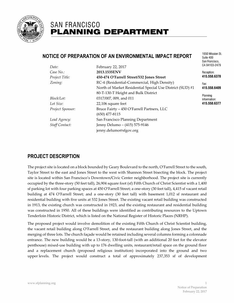
www.sfplanning.org 1
Notice of Preparation
February 22, 2017
NOTICE OF PREPARATION OF AN ENVIRONMENTAL IMPACT REPORT
Date: February 22, 2017
Case No.: 2013.1535ENV
Project Title: 450-474 O’Farrell Street/532 Jones Street
Zoning: RC‐4 (Residential-Commercial, High Density)
North of Market Residential Special Use District (SUD) #1
80-T-130-T Height and Bulk District
Block/Lot: 0317/007, 009, and 011
Lot Size: 22,106 square feet
Project Sponsor: Bruce Fairty – 450 O’Farrell Partners, LLC
(650) 477-8115
Lead Agency: San Francisco Planning Department
Staff Contact: Jenny Delumo – (415) 575-9146
PROJECT DESCRIPTION
The project site is located on a block bounded by Geary Boulevard to the north, O’Farrell Street to the south,
Taylor Street to the east and Jones Street to the west with Shannon Street bisecting the block. The project
site is located within San Francisco’s Downtown/Civic Center neighborhood. The project site is currently
occupied by the three-story (50 feet tall), 26,904 square foot (sf) Fifth Church of Christ Scientist with a 1,400
sf parking lot with four parking spaces at 450 O’Farrell Street; a one-story (30 feet tall), 4,415 sf vacant retail
building at 474 O’Farrell Street; and a one-story (30 feet tall) with basement 1,012 sf restaurant and
residential building with five units at 532 Jones Street. The existing vacant retail building was constructed
in 1913, the existing church was constructed in 1923, and the existing restaurant and residential building
was constructed in 1950. All of these buildings were identified as contributing resources to the Uptown
Tenderloin Historic District, which is listed on the National Register of Historic Places (NRHP).
The proposed project would involve demolition of the existing Fifth Church of Christ Scientist building,
the vacant retail building along O’Farrell Street, and the restaurant building along Jones Street, and the
merging of three lots. The church façade would be retained including several columns forming a colonnade
entrance. The new building would be a 13-story, 130‐foot‐tall (with an additional 20 feet for the elevator
penthouse) mixed-use building with up to 176 dwelling units, restaurant/retail space on the ground floor
and a replacement church (proposed religious institution) incorporated into the ground and two
upper levels. The project would construct a total of approximately 237,353 sf of development
Notice of Preparation of an EIR Case No. 2013.1535ENV February 22, 2017 450-474 O’Farrell Street/532 Jones Street Project
www.sfplanning.org 2 Notice of Preparation
February 22, 2017
including up to 187,640 sf of residential use, 6,200 sf of restaurant and/or retail (restaurant/retail) use,1 13,595 sf for religious institution use (i.e., replacement of the existing church), 8,398 sf of open space (288 sf of private open space and 8,110 sf of common open space), and 21,070 sf of below-‐‑grade parking in one building. The same church would continue to operate on the project site after project completion. Of the 176 units, five of the proposed units would be below-‐‑market-‐‑rate (BMR) units to replace the existing units in the 532 Jones Street building. The restaurant/retail space would be in two areas: one space accessed from Jones Street and one space accessed from O’Farrell Street. A single basement-‐‑level parking garage with access from Shannon Street would provide 41 off-‐‑street vehicle parking spaces for building tenants and religious institution use and 125 Class 1 (bicycle locker or space in a secure room) kept on the basement and first levels. The project would also provide 21 Class 2 (publicly accessible bicycle rack) bicycle parking spaces, 16 on O’Farrell Street and five on Jones Street. The project would incorporate common open space in three areas: on level one in a portion of the open area behind the church façade within the colonnade, on level three in an interior courtyard, and above level 13 in a roof deck. The religious institution and residential building entrances would be located along O’Farrell Street.
The proposed project would entail excavation to a depth of approximately 16 feet below grade (approximately 8,900 cubic yards of excavation) to accommodate the underground parking level for vehicles and bicycles.
FINDING
This project may have a significant effect on the environment and an Environmental Impact Report (EIR) is required. This determination is based upon the criteria of the State California Environmental Quality Act (CEQA) Guidelines, Sections 15063 (Initial Study), 15064 (Determining Significant Effect), and 15065 (Mandatory Findings of Significance), and for the reasons documented in the Environmental Evaluation (Initial Study) for the project, which is attached. The purpose of the EIR will be to provide information about potential significant physical environmental impacts of the proposed project and variant, identify possible ways to minimize the potentially significant impacts, and describe and analyze possible alternatives to the proposed project and variant. Publication of a Notice of Preparation, Initial Study or EIR does not indicate a decision by the City to approve or disapprove a proposed project. However, before making any such decision, the decision makers must review and consider the EIR.
ALTERNATIVES
Alternatives to be considered for this project will include, but not be limited to, the No Project Alternative and one or more alternatives that preserve all or most of the historic resources at 450-‐‑474 O’Farrell Street/532 Jones Street. This determination is based upon the criteria of the State CEQA Guidelines, Section 15126.6 (Consideration and Discussion of Alternatives to the Proposed Project).
PUBLIC SCOPING PROCESS
Written comments concerning the scope of the EIR will be accepted until 5:00 p.m. on March 24, 2017. Written comments should be sent to Lisa M. Gibson, San Francisco Planning Department, 1650 Mission Street, Suite 400, San Francisco, CA 94103.
1 The project sponsor proposes to develop a mix of restaurant and retail uses. The exact mix is unknown at this time; the
analysis assumes restaurant uses as the restaurant uses generate a greater number of trips, with greater effect on the environment.

Notice of Preparation of an EIRFebruary 22, 2017
Case No. 2013.1535ENV450-474 O'Farzell StreeU532 Jones Street Project
If you work for a responsible State agency, we need to know the views of your agency regarding the
scope and content of the environmental information that is germane to your agency's statutory
responsibilities in connection with the proposed project. Your agency may need to use the EIR when
considering a permit or other approval for this project. Please include the name of a contact person in
your agency.
Members of the public are not required to provide personal identifying information when they
communicate with the Planning Commission or the Planning Department. All written or oral
communications, including submitted personal contact information, may be made available to the public
for inspection and copying upon request and may appear on the Department's website or in other public
documents.
Date Lisa M. Gibson
Acting Environmental Review Officer
~ti~t1 ~a .slalariiiirlg.t~r~;
~~,tice of t'r~~pir~tii<}rt
f̀ C~~P"LI it P\' ~Z. fit)C

Case No. 2013.1535ENV i 450-474 O’Farrell Street/532 Jones Street Project
INITIAL STUDY 450-474 O’Farrell Street/532 Jones Street
Project Planning Department Case No. 2013.1535ENV
TABLE OF CONTENTS
Section Page
A. Project Description ............................................................................................................................................. 1
B. Project Setting .................................................................................................................................................... 21
C. Compatibility with Existing Zoning and Plans .......................................................................................... 26
D. Summary of Environmental Effects .............................................................................................................. 33
E. Evaluation of Environmental Effects ............................................................................................................ 33 1. Land Use and Land Use Planning ............................................................................................................ 37 2. Population and Housing ............................................................................................................................ 41 3. Cultural Resources ...................................................................................................................................... 46 4. Transportation and Circulation ................................................................................................................ 51 5. Noise ............................................................................................................................................................. 69 6. Air Quality ................................................................................................................................................... 76 7. Greenhouse Gas Emissions ....................................................................................................................... 93 8. Wind and Shadow ...................................................................................................................................... 96 9. Recreation .................................................................................................................................................. 101 10. Utilities and Service Systems .................................................................................................................. 104 11. Public Services ........................................................................................................................................... 108 12. Biological Resources ................................................................................................................................. 111 13. Geology and Soils ..................................................................................................................................... 113 14. Hydrology and Water Quality ................................................................................................................ 120 15. Hazards and Hazardous Materials ........................................................................................................ 123 16. Mineral and Energy Resources ............................................................................................................... 128 17. Agriculture and Forest Resources ........................................................................................................... 131 18. Mandatory Findings of Significance ...................................................................................................... 132
F. Mitigation Measures and Improvement Measures .................................................................................. 133
G. Determination .................................................................................................................................................. 139
H. Initial Study Preparers ................................................................................................................................... 140

February 22, 2017 Initial Study
Case No. 2013.1535ENV ii 450-474 O’Farrell Street/532 Jones Street Project
List of Figures
Figure 1 Project Location .......................................................................................................................................2 Figure 2 Site Plan ....................................................................................................................................................5 Figure 3 Parking Level Plan (Basement) .............................................................................................................6 Figure 4 Level 1 Ground Floor Plan ....................................................................................................................7 Figure 5 Level 2 Second Floor Plan .....................................................................................................................8 Figure 6 Level 3 Third Floor Plan ........................................................................................................................9 Figure 7 Level 4 Fourth Floor Plan ....................................................................................................................10 Figure 8 Level 5 Fifth Floor Plan ........................................................................................................................11 Figure 9 Level 6 Sixth Floor Plan .......................................................................................................................12 Figure 10 Level 7 Seventh Floor Plan ..................................................................................................................13 Figure 11 Typical Floor Plan, Levels 8 through 9 ..............................................................................................14 Figure 12 Typical Floor Plan, Levels 10 through 13 ..........................................................................................15 Figure 13 Roof Plan ................................................................................................................................................16 Figure 14 O’Farrell Street Elevation .....................................................................................................................17 Figure 15 Shannon Street Elevation .....................................................................................................................18 Figure 16 Jones Street Elevation ...........................................................................................................................19 Figure 17 Cumulative Projects .............................................................................................................................23 Figure 18 Existing Transit Network ....................................................................................................................52
List of Tables
Table 1 Project Characteristics ............................................................................................................................4 Table 2 Cumulative Projects within ¼ mile of Project Site ...........................................................................24 Table 3 Proposed Project Net-‐‑new Daily and PM Peak Hour Person Trip Generation ...........................53 Table 4 Proposed Project Net-‐‑new Trip Generation by Mode Weekday PM Peak Hour ........................53 Table 5 Proposed Project Net-‐‑new Delivery/Service Vehicle-‐‑Trips and Loading Space Demand .........54 Table 6 Typical Noise Levels of Construction Equipment ...........................................................................71 Table 7 Long-‐‑Term Noise Measurements Results .........................................................................................72 Table 8 Criteria Air Pollutant Significance Thresholds ................................................................................77 Table 9 Comparison of Proposed Project to BAAQMD Criteria Air Pollutants and Precursors
Construction and Operational Screening Level Criteria ................................................................84 Table 10 Off-‐‑Road Equipment Compliance Step-‐‑down Schedule ................................................................87 Table 11 Geologic Units and Paleontological Sensitivity in the Project Area ............................................115 Table 12 Off-‐‑Road Equipment Compliance Step-‐‑down Schedule ..............................................................135

Case No. 2013.1535ENV 1 450-474 O’Farrell Street/532 Jones Street Project
INITIAL STUDY 450-474 O’Farrell Street/532 Jones Street
Project Planning Department Case No. 2013.1535ENV
A. PROJECT DESCRIPTION The proposed project is located at 450-‐‑474 O’Farrell Street/532 Jones Street and would involve demolition of the existing Fifth Church of Christ Scientist, the vacant retail building along O’Farrell Street, and the restaurant and residential building with five units along Jones Street, and the merging of three lots. The new building would be a 13-‐‑story, 130-‐‑foot-‐‑tall (with an additional 20 feet for the elevator penthouse), mixed-‐‑use building with up to 176 dwelling units with restaurant/retail space and a replacement church (proposed religious institution) incorporated into the ground and two upper levels. The proposed project would retain the church façade. The project would construct a total of approximately 237,353 square feet (sf) of development including up to 187,640 sf of residential use, 6,200 sf of restaurant/retail use, 13,595 sf of religious institution use, 8,398 square feet of open space (288 sf of private open space and 8,110 of common open space), and 21,070 sf of below-‐‑grade parking in one building.
Project Location and Site Characteristics The approximately 22,106 sf (0.5-‐‑acre) project site is located on a block bounded by Geary Boulevard to the north, O’Farrell Street to the south, Taylor Street to the east, and Jones Street to the west, with Shannon Street bisecting the block, parallel to Jones and Taylor Streets. The site slopes down gently to the southeast such that access to the Jones Street frontage is one floor above the O’Farrell Street frontage. The project site consists of three parcels: Assessor’s block/lot 0317/007, 0317/009, and 0317/011. The project site is within the Downtown/Civic Center neighborhood and three blocks west of Union Square (see Figure 1). The project site is located in the RC-‐‑4 (Residential-‐‑Commercial, High Density) Zoning District; North of Market Residential Special Use District (North of Market SUD) No. 1; the 80-‐‑T-‐‑130-‐‑T Height and Bulk District; and within the Uptown Tenderloin National Register Historic District, which is listed on the National Register of Historic Places (NRHP).
The project site is currently occupied by the three-‐‑story (50 feet tall), 26,904 sf Fifth Church of Christ Scientist building with a rear 1,400 sf parking lot containing four parking spaces at 450 O’Farrell Street; a one-‐‑story (30 feet tall), 4,415-‐‑sf vacant retail building at 474 O’Farrell Street; and a one-‐‑story (30 feet tall) with basement 1,012-‐‑sf restaurant and residential building with five units at 532 Jones Street. The existing units are currently rented to employees of the Shalimar restaurant located on the ground floor of the 532 Jones Street building. The existing retail building was constructed in 1913, the existing church was constructed in 1923, and the existing restaurant and residential building was constructed in 1950. All of these buildings are identified as contributing resources to the Uptown Tenderloin National Register Historic District, which was listed on the NRHP in 2009. The building at 450 O’Farrell Street appears eligible for individual listing in the California Register of Historical Resources (CRHR) under Criterion 3 (Architecture).
The project site is made up of three rectangular parcels that would be merged to form a single lot with frontages on O’Farrell, Jones and Shannon Streets. The project site has a 153-‐‑foot, 6-‐‑inch frontage along O’Farrell Street; a 137-‐‑foot, 6-‐‑inch frontage along Shannon Street; a 25-‐‑foot-‐‑long frontage along Jones Street; and a 193-‐‑foot, 6-‐‑inch frontage abutting a seven-‐‑story (90-‐‑foot-‐‑tall) mixed-‐‑use building to the north. There is one street tree in front of the existing restaurant and residential building along Jones Street; there are no existing trees on O’Farrell Street or Shannon Street. The site is completely impervious (paved).

Figure 1Project Location
K:\Los Angeles\Projects\450_OFarrell\00028_16\mapdoc\Fig01_Proj_Loc.mxd Date: 2/13/2017 24991
±Source: Kwan Henmi, 2015Base map: Image: Google Inc. 2015. Google Earth Pro, Version 7.1. Mountain View, CA.
Geary St
Jones St
Shannon St
O'Farrell St
Taylor St
Mason St
Post St
Leavenworth St
Ellis St
Eddy St
450 O'Farrell StreetCase No. 2013.1535ENV

February 22, 2017 Initial Study
Case No. 2013.1535ENV 3 450-474 O’Farrell Street/532 Jones Street Project
Project Characteristics The project would include construction of a single 13-‐‑story, 130-‐‑foot-‐‑tall (with an additional 20 feet for the elevator penthouse) building. The project would construct a total of approximately 237,353 sf of development, including up to 187,640 sf of residential use (up to 176 dwelling units), 6,200 sf of restaurant/retail use, 13,595 sf for the religious institution use, and 21,070 sf of below-‐‑grade parking. The project would also include 8,398 sf of open space (288 sf of private open space, 8,110 sf of common open space). The religious institution and some of the restaurant/retail would be accessible from O’Farrell Street; a second restaurant/retail use would be accessible from Jones Street. The religious institution space would replace the church currently on the project site, and would be smaller than the existing facility. A single basement level beneath the building with access from Shannon Street would provide for 41 off-‐‑street vehicle parking spaces for building tenants and religious institution use and 125 Class 1 (bicycle locker or space in a secure room) kept on the basement and first levels. The project would also provide 21 Class 2 (publicly accessible bicycle rack) bicycle parking spaces, 16 on O’Farrell Street and five on Jones Street. The 176 dwelling units would be made up of 22 studios, 95 one-‐‑bedroom units, 55 two-‐‑bedroom units, and 4 three-‐‑bedroom units (see Table 1, below). The project would incorporate common open space in three areas: on level one in the open area behind the church façade within the colonnade, on level three in an interior courtyard, and above level 13 in a roof deck. The religious institution would have 200 seats on the ground floor and other uses on two upper levels. The new religious institution entrance and a reading room would be located along O’Farrell Street, while restaurant/retail spaces would be accessed from O’Farrell and Jones Streets. The leasing office and amenity space would be accessible from the O’Farrell Street entrance (see Table 1 and Figures 2 through 13, pp. 5 through 16).
The proposed building would be a concrete frame building constructed using conventional spread footings or concrete piers as foundations. The existing church façade would be retained along O’Farrell Street with a small return on Shannon Street. Along the primary façades on O’Farrell Street and Shannon Street, the proposed design would differentiate the restaurant/retail uses from the residential uses above (see Figures 14 through 16, pp. 17 through 19).
New construction in San Francisco must meet all applicable California codes, provide on-‐‑site facilities for recycling and composting, and meet the City’s Green Building Code requirements tied to the LEED and GreenPoint Rated green building rating systems. In accordance with these regulations, the proposed building would be GreenPoint Rated.
Parking, Loading, and Bicycle Facilities The project site currently contains four off-‐‑street parking spaces accessed from a 12-‐‑foot-‐‑wide curb cut along Shannon Street. The proposed project would retain the existing curb cut on Shannon Street in order to access to the garage entry ramp leading to the proposed below-‐‑grade garage. The proposed project would be required to provide one off-‐‑street loading space for the residential use; however, as the project does not propose any off-‐‑street loading spaces, a modification through the Planned Unit Development (PUD) process would be sought. The proposed project would convert one of the three existing general on-‐‑street metered parking spaces on O’Farrell Street adjacent to the project site to a metered commercial loading space, and would request from the San Francisco Municipal Transportation Agency (SFMTA) that the hours of operation of the existing two-‐‑vehicle passenger loading/unloading zone adjacent to the project site be revised from only during church service to all-‐‑day passenger loading/unloading, with an exception during the tow-‐‑away peak periods. The conversion of one general on-‐‑street metered parking space to a metered commercial loading space, and extension of the hours of operation of the passenger loading/unloading zone would require approval at a public hearing of the SFMTA.
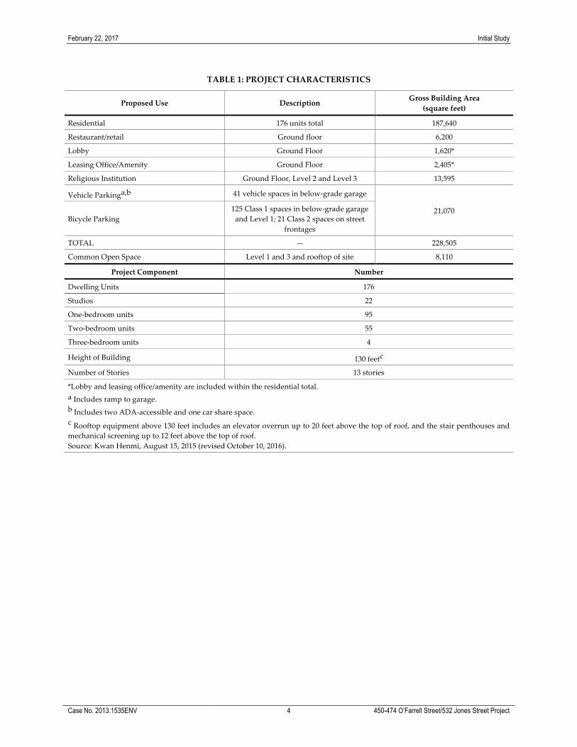
February 22, 2017 Initial Study
Case No. 2013.1535ENV 4 450-474 O’Farrell Street/532 Jones Street Project
TABLE 1: PROJECT CHARACTERISTICS
Proposed Use Description Gross Building Area (square feet)
Residential 176 units total 187,640
Restaurant/retail Ground floor 6,200
Lobby Ground Floor 1,620*
Leasing Office/Amenity Ground Floor 2,405*
Religious Institution Ground Floor, Level 2 and Level 3 13,595
Vehicle Parkinga,b 41 vehicle spaces in below-‐‑grade garage
21,070 Bicycle Parking
125 Class 1 spaces in below-‐‑grade garage and Level 1; 21 Class 2 spaces on street
frontages
TOTAL — 228,505
Common Open Space Level 1 and 3 and rooftop of site 8,110
Project Component Number
Dwelling Units 176
Studios 22
One-‐‑bedroom units 95
Two-‐‑bedroom units 55
Three-‐‑bedroom units 4
Height of Building 130 feetc
Number of Stories 13 stories
*Lobby and leasing office/amenity are included within the residential total. a Includes ramp to garage. b Includes two ADA-‐‑accessible and one car share space. c Rooftop equipment above 130 feet includes an elevator overrun up to 20 feet above the top of roof, and the stair penthouses and mechanical screening up to 12 feet above the top of roof. Source: Kwan Henmi, August 15, 2015 (revised October 10, 2016).

450 O'Farrell Street Case No. 2013.1535ENV
Figure 2Site Plan
Source: Kwan Henmi, 2016
6


450 O'Farrell StreetCase No. 2013.1535ENV
Figure 4Level 1 Ground Floor Plan
Source: Kwan Henmi, 2016
3 3

450 O'Farrell StreetCase No. 2013.1535ENV
Figure 5Level 2 Second Floor Plan
Source: Kwan Henmi, 2016
3 3

450 O'Farrell StreetCase No. 2013.1535ENV
Figure 6Level 3 Third Floor Plan
Source: Kwan Henmi, 2016
3 3
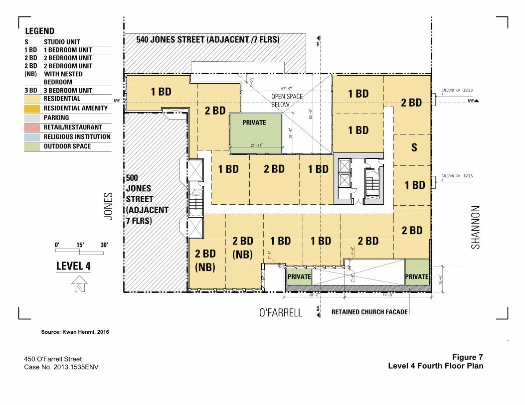
450 O'Farrell StreetCase No. 2013.1535ENV
Figure 7Level 4 Fourth Floor Plan
Source: Kwan Henmi, 2016
3 3
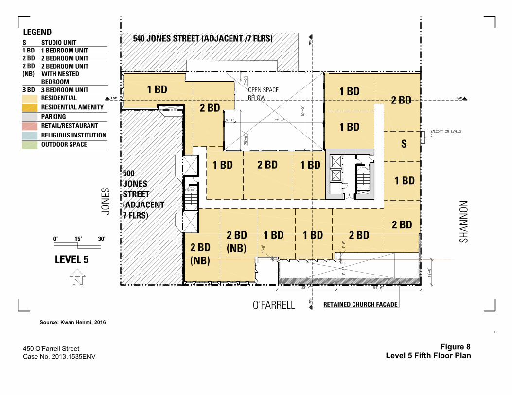
450 O'Farrell StreetCase No. 2013.1535ENV
Figure 8Level 5 Fifth Floor Plan
Source: Kwan Henmi, 2016
3 3
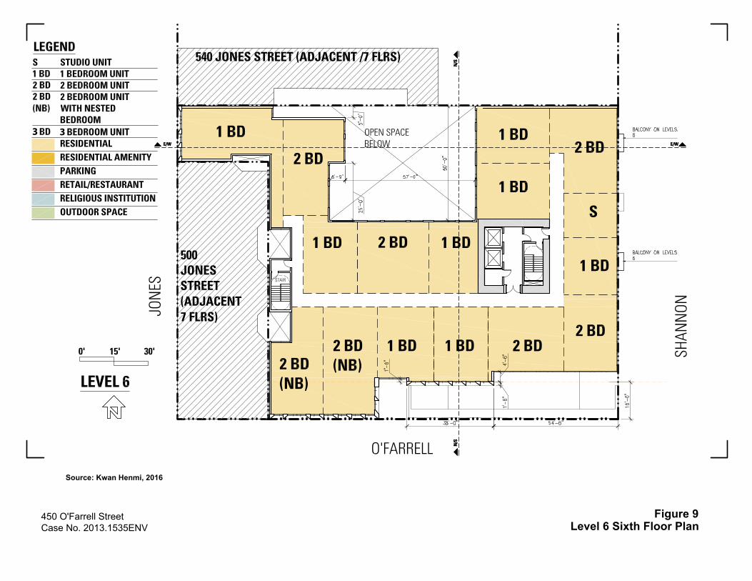
450 O'Farrell StreetCase No. 2013.1535ENV
Figure 9Level 6 Sixth Floor Plan
Source: Kwan Henmi, 2016
3 3
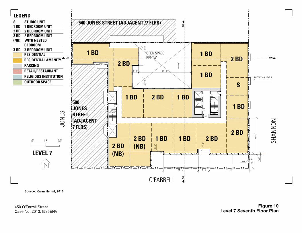
450 O'Farrell StreetCase No. 2013.1535ENV
Figure 10Level 7 Seventh Floor Plan
Source: Kwan Henmi, 2016
3 3

450 O'Farrell StreetCase No. 2013.1535ENV
Figure 11Typical Floor Plan, Levels 8 through 9
Source: Kwan Henmi, 2016
3 3
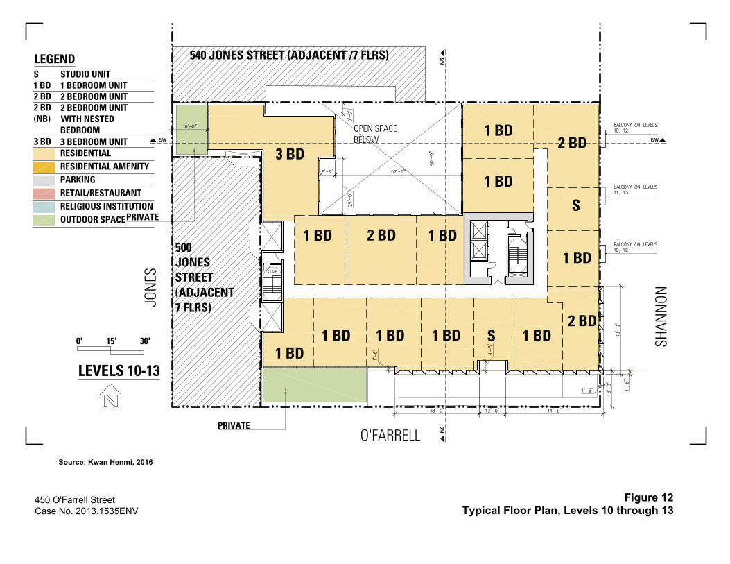
450 O'Farrell StreetCase No. 2013.1535ENV
Figure 12Typical Floor Plan, Levels 10 through 13
Source: Kwan Henmi, 2016
3 3
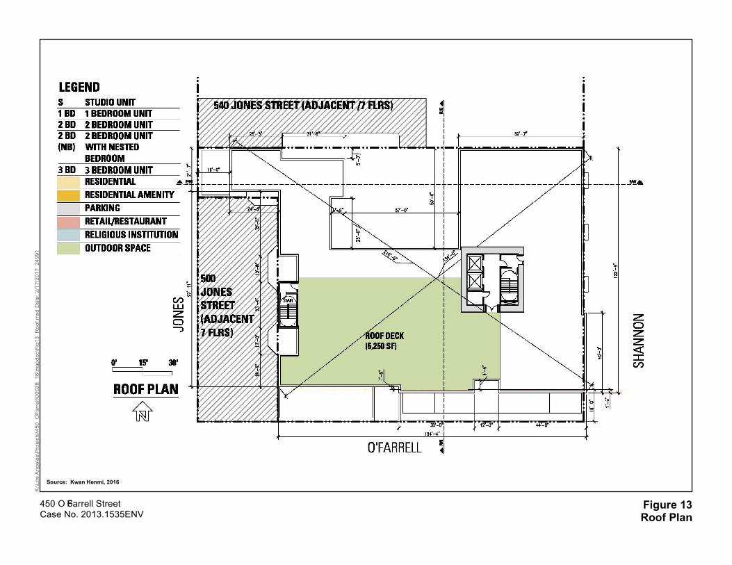
Figure 13Roof Plan
K:\Los Angeles\Projects\450_OFarrell\00028_16\mapdoc\Fig13_Roof.mxd Date: 2/17/2017 24991
450 O’Farrell StreetCase No. 2013.1535ENV
Source: Kwan Henmi, 2016

450 O'Farrell Street Case No. 2013.1535ENV
Figure 14O’Farrell Street Elevation
Source: Kwan Henmis, 2016
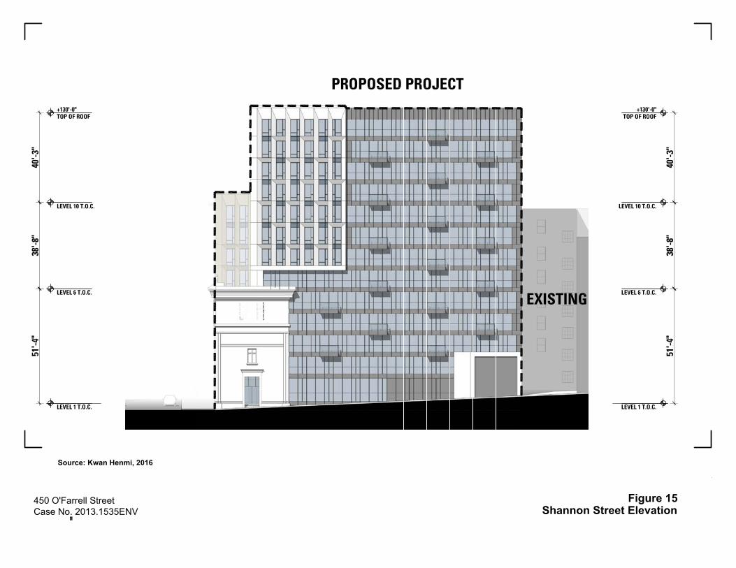
450 O'Farrell Street Case No. 2013.1535ENV
Figure 15Shannon Street Elevation
Source: Kwan Henmi, 2016
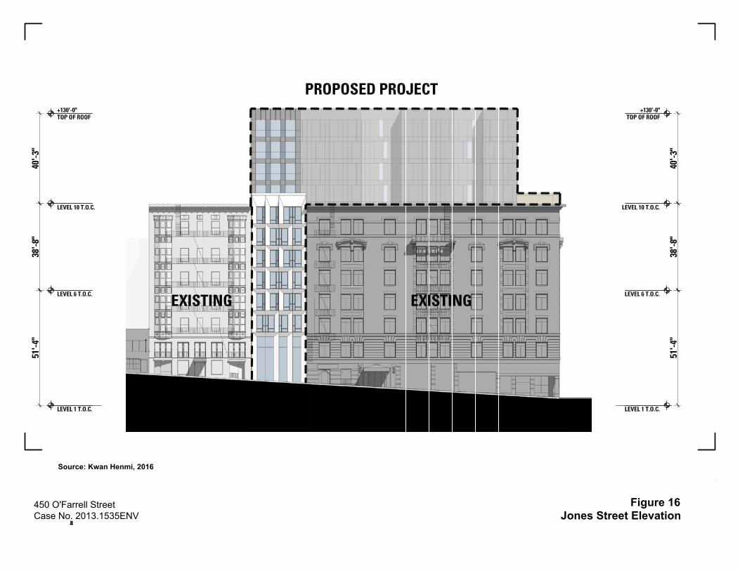
450 O'Farrell Street Case No. 2013.1535ENV
Figure 16Jones Street Elevation
Source: Kwan Henmi, 2016

February 22, 2017 Initial Study
Case No. 2013.1535ENV 20 450-474 O’Farrell Street/532 Jones Street Project
The below-‐‑grade garage would contain 41 parking spaces, including two ADA-‐‑accessible parking spaces and one car-‐‑share space. Ten vehicle spaces would be reserved for the religious institution use on Wednesday evenings and Sunday mornings when services are held. In addition, 125 Class 1 (bicycle locker or space in a secure room) kept on the basement and first levels. The project would also provide 21 Class 2 (publicly accessible bicycle rack) bicycle parking spaces, 16 on O’Farrell Street and five on Jones Street. The Class 1 bicycle parking spaces would be available to dwelling unit residents, non-‐‑residential occupants, and employees. The Class 2 bicycle spaces would be available for transient and short-‐‑term use by visitors, guests, and patrons of the residential, restaurant/retail and religious institution uses.
During construction of the proposed project, worker parking would occur off site. No designated parking for construction workers would be provided and they would be expected to park on the street or in nearby garages, or use transit.
Landscaping One existing tree is located on Jones Street, in front of the existing restaurant and residential building. As part of the proposed project, the existing street tree would be retained and eight new trees would be planted along the project sidewalks on O’Farrell Street and Shannon Street, in accordance with Planning Code Section 138.1(c)(1), as set forth in Article 16, Sections 805(a) and (d) and 806(d) of the Public Works Code.
Foundation and Excavation The project would entail excavation to a depth of approximately 16 feet below grade (8,900 cubic yards of excavation) to accommodate the underground parking level for vehicles and bicycles. The project sponsor proposes underpinning of adjacent buildings, shoring along street property lines, and conventional spread footings or concrete piers as foundations.
Construction Schedule Demolition and construction of the proposed project are estimated to take approximately 18 months from groundbreaking, which is anticipated to occur in 2018. Demolition would require about 1 month, with excavation the following month. Month 3 would include primarily shoring activities. Months 4 through 11 would include erecting the structure. Months 10 to 15 would include façade construction; and months 12 through 18 would be for interior construction. Pile-‐‑driving would not be necessary and is not proposed.
Project Approvals Planning Commission
The conditionally permitted uses in the RC-‐‑4 District include PUD, pursuant to Planning Code Section 304. A PUD is a special type of Conditional Use Authorization that allows the Planning Commission to modify or waive certain Planning Code requirements applicable to sites at least 0.5 acre in size, in accordance with the provisions of Section 303 of the Planning Code.
Implementation of the proposed project would require the authorization, modification or waiver of the following Planning Code requirements through the approval of a PUD, as discussed below:
• The project sponsor would seek additional authorizations from the Planning Commission under Planning Code Section 317(g)(5) for demolition of existing residential units; Section 253(b) for new construction over 40 feet in height, for a building street frontage greater than 50 feet; Section 263.7 for

February 22, 2017 Initial Study
Case No. 2013.1535ENV 21 450-474 O’Farrell Street/532 Jones Street Project
an exception to the 80-‐‑foot base height limit in the North of Market Residential Special Use District No. 1; Section 271 for exceptions to Section 270 governing the bulk of the building; and Section 303 for the new religious institution (church) use.
• As proposed, the configuration of the rear yard of the project does not meet code requirements of Planning Code Section 134(g). Some dwelling units do not meet the technical requirements of Section 140 for dwelling unit exposure, some architectural projections do meet the requirements of Section 136 for permitted obstructions over public right of way, and the project lacks one off-‐‑street loading space for residential use as required by Section 152. Therefore, the project would, as part of the PUD process, request modifications of these requirements.
Actions by Other City Departments
• Approval of a site permit (Planning Department and Department of Building Inspection).
• Approval of demolition, grading, and building permits (Planning Department and Department of Building Inspection).
• Approval of a lot merger and tentative subdivision maps; recommendation to the Board of Supervisors for approval of final subdivision maps (San Francisco Public Works).
• Approval of permits for streetscape improvements in the public right-‐‑of-‐‑way, including a curb cut on Shannon Street (San Francisco Public Works).
• Approval of a request for curb cut, color curb, and on-‐‑street parking changes on O’Farrell Street and Shannon Street (San Francisco Municipal Transportation Agency).
• Approval of project compliance with the Stormwater Design Guidelines (San Francisco Public Utilities Commission).
• Approval of a Stormwater Control Plan (San Francisco Public Utilities Commission).
• Issuance of a certification of registration for a diesel backup generator (San Francisco Department of Public Health).
• Approval of a Site Mitigation Plan pursuant to the Maher Ordinance prior to the commencement of any excavation work and approval of a Soil Mitigation Plan and Dust Control Plan prior to construction-‐‑period activities (San Francisco Department of Public Health).
• Approval of an Article 38 ventilation plan prior to submitting plans for a mechanical permit (San Francisco Department of Public Health and Department of Building Inspection).
Actions by Other Government Agencies
• Approval of permit for installation, operation, and testing of diesel backup generator (Bay Area Air Quality Management District).
B. PROJECT SETTING
As noted above, the project site is within the Downtown/Civic Center neighborhood, within the area governed by San Francisco’s Downtown Plan. The project site is bounded by Shannon Street to the east, O’Farrell Street to the south, Jones Street to the west, and two existing buildings abutting the lot line on the southwest and north sides of the building. Geary Street is to the north.

February 22, 2017 Initial Study
Case No. 2013.1535ENV 22 450-474 O’Farrell Street/532 Jones Street Project
Surrounding the project site, land uses consist primarily of neighborhood-‐‑serving retail, office, and restaurant uses on the ground level with high-‐‑density residences above or hotels to the east towards Union Square. O’Farrell Street, six blocks to the west and four blocks to the east, consists mostly of four-‐‑ to 12-‐‑story (60 to 140 feet tall) hotel or residential buildings with commercial and restaurant uses on the ground level. The 19-‐‑story (488 feet tall) Hilton is one block east at O’Farrell Street and Taylor Street. Along O’Farrell Street, land uses on the project block include two hotels, a massage parlor, and a market, with residences above the commercial uses. Across the street from the project site on O’Farrell Street, land uses include ground-‐‑floor markets, a smoke shop, several small restaurants, a live music theater, a gallery space, a hostel, several hotels, a senior center, and senior housing with residences above those uses. Land uses along Jones Street are mostly two-‐‑ to six-‐‑story (40 to 80 feet tall) hotel or residential buildings with ground-‐‑level restaurants, parking and commercial uses. On the west side of Jones Street, land uses include several ground-‐‑floor restaurants, two hotels, a massage parlor, a parking structure, with residences above some of the commercial uses.
Similar ground-‐‑floor commercial uses and upper-‐‑floor residential units are also along Geary Street, including a smoke shop, several restaurants, a nail spa, and hotel. Along Geary Street, three blocks to the west and three blocks to the east, buildings are typically six stories (80 feet tall) in this area; with the exception of the Hotel California and Hotel Adagio at 13 and 15 stories tall (150 and 170 feet tall), respectively, at Geary Street between Jones and Shannon Streets. There are also two small theaters on Geary Street. Glide Memorial Church is located one block south of the project site at Taylor and Ellis Streets. Shannon Street is a north-‐‑south alley that runs between Post and O’Farrell Streets; between O’Farrell and Geary Streets, Shannon Street is one-‐‑way southbound, with a 4-‐‑foot-‐‑wide sidewalk on the west side of the street, a 15-‐‑foot, 4-‐‑inch roadway, and a 5-‐‑feet, 4-‐‑inch-‐‑wide sidewalk on the east side of the street. Union Square, a public open space, is located two and a half blocks to the east of the project site. Buildings in the project vicinity vary widely in height, ranging from a handful of single-‐‑story (30 feet tall) retail buildings to 30-‐‑story (about 400 feet tall) hotels along Geary Street, such as The Westin St. Francis Hotel located two blocks northeast of the project site. Most structures nearby, however, are two to seven stories in height, or about 40 to 90 feet tall, and nearly all extend to the lot line with no front setbacks. Vegetation in the area is generally limited to street trees. Nearby public parks and open spaces, in addition to Union Square, include Boeddeker Park, about two blocks south of the project site; the Tenderloin Children’s Playground, two blocks southwest; and Macaulay Park, three blocks west.
A mid-‐‑block bus stop is located on the south side of O’Farrell Street, across from Shannon Street. At this location, a transit bulb is provided within the parking lane and buses stop within the transit-‐‑only lane. A transit-‐‑only lane is provided on eastbound O’Farrell Street (for the 27 Bryant, 38 Geary and 38R Geary Rapid routes adjacent to the project site) and on westbound Geary Street (for the 38 Geary and 38R Geary Rapid routes in the project vicinity). The closest state highway to the project site is U.S. Route 101/Van Ness Avenue, five blocks west of the project site. The Powell Street San Francisco Municipal Railway (Muni) and Bay Area Rapid Transit (BART) station is located about four blocks south. Five blocks south of the project site lies the South of Market neighborhood. Lastly, the project site is situated within the Uptown Tenderloin National Register Historic District, which was listed as a historic district in the NRHP in 2009.
Cumulative Setting Reasonably foreseeable cumulative development projects within a 0.25-‐‑mile radius of the project site are shown in Figure 17 and listed below in Table 2. As of January 2017, there were several active development, renovation, and/or change-‐‑of-‐‑use projects surrounding the project site.

450 O'Farrell StreetCase No. 2013.1535ENV

February 22, 2017 Initial Study
Case No. 2013.1535ENV 24 450-474 O’Farrell Street/532 Jones Street Project
TABLE 2: CUMULATIVE PROJECTS WITHIN ¼ MILE OF PROJECT SITE
Figure No.
Address/Proximity to Project Site Case File No. Project Status
Construction Timeline
(approximate)
Dwelling Units
Height (stories)
Hospital/ Medical Office (sf)
Hotel Rooms
Retail/ Commercial
(gsf)
Non-‐‑Profit
Arts (gsf)
1 651–655 Geary Street (1 block) 2014.0482ENV
Environmental review complete 18 months 47 13 n/a n/a 738 n/a
2 519 Ellis Street (2 blocks) 2014.0506E Environmental review under
way Unknown 21 8 n/a n/a 5,624 n/a
3 469 Eddy Street (3 blocks) 2014.0562E Environmental review complete 21 months 29 8 n/a n/a 2,600 n/a
4 719 Larkin Street (3 blocks)a 2015.005329ENV Environmental review under
way 12 months 40 8 n/a n/a 2,083 n/a
5 430 Eddy Street (3 blocks) 2014.0400E Environmental review complete 15–18 months 23 8 n/a n/a 1,000 n/a
6 850 Bush Street (4 blocks)a 2015-‐‑005983ENV Environmental review under
way Unknown 20 6 n/a n/a 2,200 n/a
7
California Pacific Medical Center (CPMC) Van Ness Avenue between Geary and Sutter Streets (5 blocks)a,b
2005.0555E Environmental review complete
Hospital construction complete in mid-‐‑2018;
medical office building (MOB)
construction complete in early 2019
n/a 12
274 beds for acute care/
253,000 gsf MOB
n/a n/a n/a
8 1001 Van Ness Avenue (5 blocks)
2014.1305E Environmental review complete
24 months; demolition and construction to begin in spring
2017 and complete in mid-‐‑2019
239 7 n/a n/a 5,100 n/a

February 22, 2017 Initial Study
Case No. 2013.1535ENV 25 450-474 O’Farrell Street/532 Jones Street Project
Figure No.
Address/Proximity to Project Site
Case File No. Project Status Construction Timeline
(approximate)
Dwelling Units
Height (stories)
Hospital/ Medical Office (sf)
Hotel Rooms
Retail/ Commercial
(gsf)
Non-‐‑Profit
Arts (gsf)
9 181 Turk Street/180 Jones Street (3 blocks)a 2005.0267E
Environmental review complete
Approvals extended to Sept 2015
32 8 n/a n/a 2,700 n/a
10 950-‐‑974 Market Street (3 blocks) 2013.1049E
Environmental review complete 27 months 242 12 n/a 232 16,600 65,000
11 229 Ellis Street (3 blocks) 2016.007593ENV Environmental review complete
Unknown 50c 5 n/a n/a 310 n/a
TOTAL 743 274 beds, 253,000 gsf 232
38,955
65,000
a Outside the ¼-‐‑mile buffer but included because could have a potential cumulative impact to historic resources b Outside the ¼-‐‑mile buffer but included because could have a potential cumulative impact on traffic c 50 group housing rooms
February 22, 2017 Initial Study
Case No. 2013.1535ENV 26 450-474 O’Farrell Street/532 Jones Street Project
Of the active Planning Department cases and active building permits within the area, one proposed project is four blocks north and two proposed projects are five blocks west. The majority of the proposed projects are one to three blocks to the southwest, south and southeast. The closest proposed project is one block northwest. Table 2, above, provides the address, proposed uses, proximity to the site, and construction timeline of these projects, if known.
C. COMPATIBILITY WITH EXISTING ZONING AND PLANS
Applicable Not Applicable
Discuss any variances, special authorizations, or changes proposed to the Planning Code or Zoning Map, if applicable.
Discuss any conflicts with any adopted plans and goals of the City or Region, if applicable.
Discuss any approvals and/or permits from City departments other than the Planning Department or the Department of Building Inspection, or from Regional, State, or Federal Agencies.
San Francisco Planning Code The San Francisco Planning Code (Planning Code), which incorporates by reference the City’s Zoning Maps, governs permitted uses, densities and the configuration of buildings in San Francisco. Permits to construct new buildings (or to alter or demolish existing ones) may not be issued unless either the proposed action conforms to the Planning Code, or an exception is granted pursuant to provisions of the Planning Code.
Land Use Controls The proposed project would be located in the RC-‐‑4 (Residential-‐‑Commercial, High Density) Zoning District and the North of Market Residential SUD #1. As stated in Planning Code Section 209.3, the RC-‐‑4 Zoning District is composed of high-‐‑density dwellings, with compatible commercial uses on the ground floor to protect and enhance neighborhoods with mixed use character.
The requirements associated with the RC-‐‑4 Zoning District are described in Section 209.3 of the Planning Code with references to other applicable articles of the Planning Code as necessary (for example, for provisions concerning parking, rear yards, height and bulk limits, etc.).
Within the RC-‐‑4 Zoning District, retail uses on the ground floor with residential uses above, as proposed by the project, are principally permitted; new religious institutions (church) are a conditionally permitted use.
The project sponsor would seek additional authorization through the Planned Unit Development process from the Planning Commission under Planning Code Section 253(b)(1) for new construction of a building over 50 feet in height, with street frontage greater than 50 feet; Section 263.7 for an exception to the 80-‐‑foot base height limit in the North of Market Residential Special Use District No. 1; and Section 271 for exceptions to Section 270 governing the bulk of the building.

February 22, 2017 Initial Study
Case No. 2013.1535ENV 27 450-474 O’Farrell Street/532 Jones Street Project
Affordable Housing The proposed project would comply with the City’s Residential Inclusionary Affordable Housing Program requirements (City Planning Code Sections 415, et seq.), by including the applicable required number of units per current legislation. At this time, the requirement is 24 below-‐‑market-‐‑rate (BMR) units on site, or 13.5 percent of the total number of units, as required by Planning Code Section 415 et seq. In addition, there are five rent-‐‑controlled units in the 532 Jones Street building. These units would be replaced and provided as BMR units as part of the proposed project.
Height and Bulk Controls The project site is within an 80-‐‑T130-‐‑T Height and Bulk District. This district allows for an 80-‐‑foot base height limit, with special exceptions from the base height of 80 feet up to 130 feet. The proposed project would be 130 feet high, measured from top of curb to the top of the roof. Various rooftop elements would extend from the rooftop including an elevator overrun up to 20 feet above the top of the roof. The stair penthouses and mechanical screening would be extended up to 12 feet above the top of the roof. Mechanical screening and rooftop elements are exempt from the building height limit per Section 260(b)(1)(B) of the Planning Code. The project would be reviewed by the Planning Commission for a Conditional Use Authorization for height greater than 80 feet on the condition that the applicant pays a fee to the City Controller, which shall be deposited in the North of Market Affordable Housing Fund.
Within the 80-‐‑T-‐‑130-‐‑T Height and Bulk District, the bulk of the building above a base height of no more than 80 feet must be sculpted as prescribed by Planning Code Section 270. Above the base height, buildings with a “T” bulk designation shall have a maximum plan length of 110 feet and maximum diagonal dimension of 125 feet. The proposed project would have a plan length of 154 feet, 4 inches on O’Farrell, and would exceed the maximum plan length by 44 feet, 4 inches. The proposed project diagonal dimension would be 216 feet, 9 inches and would exceed the maximum diagonal dimension by 91 feet, 9 inches. The project would be reviewed by the Planning Commission for a Conditional Use Authorization for exceedance of the maximum bulk limits.
Street Trees Planning Code Section 138.1(c)(1) requires that the Project Sponsor shall plant and maintain street trees as set forth in Article 16, Sections 805(a) and (d) and 806(d) of the Public Works Code. Sections 805(a) and (d) and 806(d) require that for every 20 feet of property frontage along each street, one 24-‐‑inch box tree be planted, with any remaining fraction of 10 feet or more of frontage requiring an additional tree. The project site has a 153-‐‑foot, 6-‐‑inch-‐‑long frontage along O’Farrell Street; a 137-‐‑foot, 6-‐‑inch-‐‑long frontage along Shannon Street; a 25-‐‑foot long frontage along Jones Street; and a 193-‐‑foot, 6-‐‑inch-‐‑long width abutting a seven-‐‑story mixed-‐‑use building to the north. The proposed project would comply with Section 138.1(c)(1) by retaining the one existing tree along Jones Street and planting eight new street trees along the project sidewalks on O’Farrell Street and Shannon Street.
Rear Yard and Open Space Requirements Planning Code Section 134 requires a rear yard equivalent to 25 percent of total lot depth at all residential levels; however, Section 134(g) permits a reduction in rear yard requirements in the North of Market if the open space can be provided elsewhere on site and if the new structure will not impede the midblock open space pattern. The proposed project would not provide a rear yard meeting the technical
February 22, 2017 Initial Study
Case No. 2013.1535ENV 28 450-474 O’Farrell Street/532 Jones Street Project
requirements of Code. Therefore, the project applicant is requesting a reduction of the rear yard requirements per Planning Code Section 134(g), as a modification through the PUD process, to allow for open space in a configuration other than a rear yard and a reduced rear yard.
Planning Code Section 135 requires either 36 sf of private open space per unit or 1.33 times the amount of private open space required as common open space. The proposed project would be required to provide 6,336 sf of private open space or 8,427 sf of common open space, or a combination thereof. The proposed project would provide private open space for 8 dwelling units in the form of private decks or balconies on Levels 4, 10, 11, 12, and 13. The common open space requirement is 8,064 sf. Common open space is provided in the form of approximately 635 sf open space on the first floor, a 2,225 sf courtyard on the third floor that would be open to the sky, and approximately 5,250 sf for a rooftop deck, for a total of 8,110 sf.
Parking and Loading According to Planning Code Section 151.1, one off-‐‑street parking space is permitted for every four dwelling units. As the proposed project includes up to 176 dwelling units, the project would be allowed to provide 45 off-‐‑street parking spaces for residential use. Religious institution uses are permitted one off-‐‑street parking space for every 20 seats; as the proposed project would include 200 seats in the religious institution, the project would be allowed to provide 10 off-‐‑street parking spaces for the religious institution use. The religious institution parking of ten spaces would be dedicated for church use and would not allow utilization by the restaurant/retail or residential uses of the project. The proposed below-‐‑grade garage would provide 41 vehicle parking spaces, consisting of 30 spaces for residential uses, 10 spaces for the religious institution use, and one car-‐‑share space, which would comply with Planning Code Section 151.1. Two of the spaces would be ADA-‐‑accessible.
Planning Code Section 155.2 requires, for new residential buildings containing more than 100 dwelling units, one secure (Class 1) bicycle parking space be provided for each unit for the first 100 units and one secure space for each four units above that, along with one Class 2 space for each 20 units. Therefore, the proposed 176 residential units would require 119 Class 1 spaces and nine Class 2 spaces. Section 155.2 also requires five Class 1 spaces for religious facilities with a capacity of fewer than 500 guests and one Class 2 space for every 500 seats, equaling five Class 1 and four Class 2 bicycle parking spaces for the religious institution use. Section 155.2 also requires one Class 1 space for each 7,500 occupied sf of restaurant space and one Class 2 space for each 750 occupied sf of restaurant space with a minimum of two spaces; as the project includes a maximum of 6,200 sf of restaurant,2 one Class 1 and eight Class 2 spaces are required for the proposed restaurant use. The total requirement would, therefore, be 125 Class 1 spaces and 21 Class 2 spaces (racks). The project would provide 125 Class 1 (bicycle locker or space in a secure room) kept on the basement and first levels. The project would also provide 21 Class 2 (publicly accessible bicycle rack) bicycle parking spaces, 16 on O’Farrell Street and five on Jones Street.
Planning Code Section 152 requires off-‐‑street freight loading for residential buildings of 100,000 sf or more, or for retail and restaurant uses of 10,000 sf or more. The proposed project would be required to provide one off-‐‑street loading space for the up to 187,640 sf of residential uses; no off-‐‑street loading would be required for the restaurant/retail uses, as they do not exceed 10,000 sf. As previously noted, the project proposes to convert one existing metered parking space to a metered commercial loading space and would expand the hours of operation for the two-‐‑vehicle passenger loading zone, subject to approval by
2 The 6,200 sf of restaurant/retail is evaluated as restaurant use because this use generates the greater amount of trips and
requirements for bicycle parking.
February 22, 2017 Initial Study
Case No. 2013.1535ENV 29 450-474 O’Farrell Street/532 Jones Street Project
the SFMTA. These commercial and passenger loading zones would be on O’Farrell Street, adjacent to the building’s frontage, and would provide loading for the project’s proposed religious institution and restaurant/retail uses. The project sponsor would seek a modification through the PUD process from this Planning Code requirement, as the project would not include an off-‐‑street loading space.
Plans and Policies
San Francisco General Plan In addition to the Planning Code and its land use zoning requirements, the project site is subject to the San Francisco General Plan (General Plan). The General Plan provides general policies and objectives to guide land use decisions. The General Plan contains 10 elements (Commerce and Industry, Recreation and Open Space, Housing, Community Facilities, Urban Design, Environmental Protection, Transportation, Air Quality, Community Safety, and Arts) that set forth goals, policies, and objectives for the physical development of the City.
The 2014 Housing Element seeks to ensure adequate housing for current and future San Franciscans through objectives and policies that address the city’s growing housing demand, focusing on strategies that can be accomplished with the city’s limited land supply. In general, the Housing Element supports projects that increase the City’s housing supply (both market-‐‑rate and affordable housing), especially in areas that are close to the City’s job centers and are well-‐‑served by transit. The proposed project, which is a mixed-‐‑use residential project with up to 176 residential units, would not conflict with any objectives or policies in the Housing Element.
One General Plan element expressly applicable to planning considerations associated with the proposed project is the Urban Design Element. Objectives of the General Plan’s Urban Design Element that are applicable to the proposed project include emphasis of the characteristic pattern which gives to the City and its neighborhood an image, sense of purpose, and a means of orientation; conservation of resources which provide a sense of nature, continuity with the past, and freedom from overcrowding and; moderating major new development to complement the City pattern, the resources to be conserved, and the neighborhood environment.
The proposed project would include the demolition of the three existing buildings at 450 O’Farrell Street, 474 O’Farrell Street, and 532 Jones Street. All three building are considered historic architectural resources because they are contributors to the Uptown Tenderloin National Register Historic District. The church at 450 O’Farrell Street is individually eligible for the CRHR. For these reasons, the proposed project may be inconsistent with Policy 2.4 of the Urban Design Element, which calls for the preservation of notable landmarks and areas of historic, architectural, or aesthetic value. The physical environmental impacts that could result from this conflict will be discussed in the EIR, which will evaluate impacts to historic architectural resources.
The General Plan also includes area plans that outline goals and objectives for specific geographic planning areas, such as the greater Downtown, policies for which are contained in the Downtown Area Plan (Downtown Plan), an area plan within the General Plan. The project site is located within the area covered by the Downtown Plan. The aim of the Downtown Plan is to encourage business activity and promote economic growth downtown, while improving the quality of place and providing necessary supporting amenities. Centered on Market Street, the Plan covers an area roughly bounded by Van Ness Avenue to the west, Steuart Street to the east, Folsom Street to the south, and Market Street, Sutter Street
February 22, 2017 Initial Study
Case No. 2013.1535ENV 30 450-474 O’Farrell Street/532 Jones Street Project
and Washington Street to the north. The Downtown Plan contains objectives and policies that address commerce, housing, and open space; preservation; urban form; and transportation. The proposed project would not obviously conflict with most of the objectives or policies in the Downtown Plan that encourage utilizing underused sites, relating new buildings with existing building patterns and articulation, by providing housing, bicycle parking, and ground floor activity. However, the project site is within the Uptown Tenderloin Historic District and adjacent to the Kearny-‐‑Market-‐‑Mason-‐‑Sutter Conservation District, and the three existing buildings at the project site are considered historic architectural resources as contributors to the Uptown Tenderloin National Register Historic District. Thus, the proposed demolition of these buildings could be inconsistent with Objective 12 to conserve resources that provide continuity with San Francisco’s past, specifically the following policy of the Downtown Plan:
• Policy 12.1 -‐‑ Preserve notable landmarks and areas of historic, architectural, or aesthetic value, and promote the preservation of other buildings and features that provide continuity with past development; and
The demolition of these buildings and the physical environmental impacts that could result from this conflict will be discussed in the EIR.
A conflict between a proposed project and a General Plan policy does not, in itself, indicate a significant effect on the environment within the context of CEQA. Any physical environmental impacts that could result from such conflicts are analyzed in this Initial Study (or will be analyzed in the EIR). In general, potential conflicts with the General Plan are considered by the decisions-‐‑makers (normally the Planning Commission) independently of the environmental review process. Thus, in addition to considering inconsistencies that affect environmental issues, the Planning Commission considers other potential inconsistencies with the General Plan, independent of the environmental review process, as part of the decision to approve or disapprove a proposed project. Any potential conflict not identified in this environmental document would be considered in that context and would not alter the physical environmental effects of the proposed project that are analyzed in this Initial Study.
Priority Policies In November 1986, the voters of San Francisco approved Proposition M, the Accountable Planning Initiative, which added Section 101.1 to the Planning Code to establish eight Priority Policies. These policies, and the subsection of Section E of this Initial Study addressing the environmental issues associated with the policies, are: (1) preservation and enhancement of neighborhood-‐‑serving retail uses; (2) protection of neighborhood character; (3) preservation and enhancement of affordable housing (Topic 2, Population and Housing, Question 2b, with regard to housing supply and displacement issues); (4) discouragement of commuter automobiles (Topic 4, Transportation and Circulation, Questions 4a, 4b, and 4f); (5) protection of industrial and service land uses from commercial office development and enhancement of resident employment and business ownership; (6) maximization of earthquake preparedness (Topic 13, Geology and Soils, Questions 13a through 13d); (7) landmark and historic building preservation (Topic 3, Cultural Resources, Question 3a); and (8) protection of open space (Topic 8, Wind and Shadow, Questions 8a and 8b; and Topic 9, Recreation, Questions 9a and 9c).
Prior to issuing a permit for any project that requires an Initial Study under CEQA; prior to issuing a permit for any demolition, conversion, or change of use; and prior to taking any action that requires a finding of consistency with the General Plan, the City is required to find that the proposed project or legislation is consistent with the Priority Policies. As noted above, the consistency of the proposed project with the environmental topics associated with the Priority Policies is discussed in Section E, Evaluation of

February 22, 2017 Initial Study
Case No. 2013.1535ENV 31 450-474 O’Farrell Street/532 Jones Street Project
Environmental Effects, of this Initial Study, providing information for use in the case report for the proposed project. The case report and approval motions for the project will contain the Department’s comprehensive analysis and findings regarding consistency of the proposed project with the Priority Policies.
The proposed project could result in impacts to cultural resources as a result of the demolition of the 1923 Fifth Church of Christ, the 1913 retail building and the 1950 restaurant building, all identified as contributing resources to the Uptown Tenderloin National Register Historic District. The project proposes to retain the church façade. The church has also been determined as individually eligible for listing on the CRHR. For purposes of this Initial Study, impacts to historic architectural resources are identified as potentially significant. Project effects on historic resources and consistency with Priority Policy No. 7, landmark and historic building preservation, will be analyzed in the EIR, which will determine the significance of the project’s impacts on historic resources. Mitigation measures and alternatives will be developed, as feasible, to reduce impacts that are found to be significant.
Other Local Plans and Policies In addition to the General Plan, the Planning Code and Zoning Maps, and the Accountable Planning Initiative, other local plans and policies that are relevant to the proposed project are discussed below.
• The San Francisco Sustainability Plan is a blueprint for achieving long-‐‑term environmental sustainability by addressing specific environmental issues including, but not limited to, air quality, climate change, energy, ozone depletion, and transportation. The goal of the San Francisco Sustainability Plan is to enable the people of San Francisco to meet their present needs without sacrificing the ability of future generations to meet their own needs.
• The Climate Action Plan for San Francisco: Local Actions to Reduce Greenhouse Emissions is a local action plan that examines the causes of global climate change and the human activities that contribute to global warming, provides projections of climate change impacts on California and San Francisco based on recent scientific reports, presents estimates of San Francisco’s baseline greenhouse gas emissions inventory and reduction targets, and describes recommended actions for reducing the City’s greenhouse gas emissions. The 2013 Climate Action Strategy is an update to this plan.
• The Transit First Policy (City Charter, Section 8A.115) is a set of principles that underscore the City’s commitment to prioritizing travel by transit, bicycle, and on foot over travel by private automobile. These principles are embodied in the objectives and policies of the Transportation Element of the General Plan. All City boards, commissions, and departments are required by law to implement Transit First principles in conducting the City’s affairs.
• The San Francisco Bicycle Plan is a citywide bicycle transportation plan that identifies short-‐‑term, long-‐‑term, and other minor improvements to San Francisco’s bicycle route network. The overall goal of the San Francisco Bicycle Plan is to make bicycling an integral part of daily life in San Francisco.
• The San Francisco Better Streets Plan consists of illustrative typologies, standards, and guidelines for the design of San Francisco’s pedestrian environment, with the central focus of enhancing the livability of the City’s streets.
• Transportation Sustainability Fee Ordinance requires that development projects that filed environmental review applications prior to July 21, 2015, but have not yet received approval, pay 50 percent of the applicable Transportation Sustainability Fee (TSF). TSF funds may be used to improve transit services and pedestrian and bicycle facilities.

February 22, 2017 Initial Study
Case No. 2013.1535ENV 32 450-474 O’Farrell Street/532 Jones Street Project
The proposed project has been reviewed in the context of these local plans and policies and would not obviously or substantially conflict with them. Staff reports and approval motions prepared for the decision-‐‑makers would include a comprehensive project analysis and findings regarding the consistency of the proposed project with applicable local plans and policies.
Regional Plans and Policies There are several regional planning agencies whose environmental, land use, and transportation plans and policies consider the growth and development of the nine-‐‑county San Francisco Bay Area. Some of these plans and policies are advisory, and some include specific goals and provisions that must be considered when evaluating a project under CEQA. The regional plans and policies that are relevant to the proposed project are discussed below. • The principal regional planning documents and the agencies that guide planning in the nine-‐‑county
Bay Area include Plan Bay Area, the region’s first Sustainable Communities Strategy, developed in accordance with Senate Bill 375 and adopted jointly by the Association of Bay Area Governments (ABAG) and the Metropolitan Transportation Commission (MTC) on July 18, 2013. Plan Bay Area is a long-‐‑range land use and transportation plan that covers the period from 2010 to 2040. Plan Bay Area calls for concentrating housing and job growth around transit corridors, particularly within areas identified by local jurisdictions as Priority Development Areas. In addition, Plan Bay Area specifies strategies and investments for maintaining, managing, and improving the region’s multi-‐‑modal transportation network and proposes transportation projects and programs to be implemented with reasonably anticipated revenue. Plan Bay Area will be updated every four years;
• Plan Bay Area includes the population and employment forecasts from ABAG’s Projections 2013, which is an advisory policy document used to assist in the development of local and regional plans and policy documents, and MTC’s 2040 Regional Transportation Plan, which is a policy document that outlines transportation projects for highway, transit, rail, and related uses through 2040 for the nine Bay Area counties;
• The Regional Housing Needs Plan for the San Francisco Bay Area: 2014–2022 reflects projected future population growth in the Bay Area region as determined by ABAG and addresses housing needs across income levels for each jurisdiction in California. All of the Bay Area’s 101 cities and nine counties are given a share of the Bay Area’s total regional housing need. The Bay Area’s regional housing need is allocated to each jurisdiction by the California Department of Housing and Community Development (HCD) and finalized though negotiations with ABAG;
• The Bay Area Air Quality Management District (BAAQMD)’s 2010 Clean Air Plan updates the Bay Area 2005 Ozone Strategy, in accordance with the requirements of the California Clean Air Act (CCAA), to implement feasible measures to reduce ozone and provide a control strategy to reduce ozone, particulate matter (PM), air toxics, and greenhouse gas emissions throughout the region; and
• The San Francisco Regional Water Quality Control Board’s Water Quality Control Plan for the San Francisco Bay Basin (Basin Plan) is a master water quality control planning document. It designates beneficial uses and water quality objectives for waters of the state, including surface waters and groundwater, and includes implementation programs to achieve water quality objectives.
The proposed project has been reviewed against these regional plans and policies. Due to the relatively small size and infill nature of the proposed project, there would be no anticipated conflicts with regional plans. Therefore, the proposed project would not obviously or substantially conflict with regional plans or policies.

February 22, 2017 Initial Study
Case No. 2013.1535ENV 33 450-474 O’Farrell Street/532 Jones Street Project
D. SUMMARY OF ENVIRONMENTAL EFFECTS
The proposed project could affect the environmental factor(s) checked below. The following pages present a more detailed checklist and discussion of each environmental factor.
Land Use Air Quality Biological Resources
Aesthetics Greenhouse Gas Emissions Geology & Soils
Population & Housing Wind & Shadow Hydrology & Water Quality
Cultural Resources Recreation Hazards/Hazardous Materials
Transportation & Circulation Utilities & Service Systems Mineral/Energy Resources
Noise Public Services Agricultural/Forest Resources
Mandatory Findings of Significance
E. EVALUATION OF ENVIRONMENTAL EFFECTS
All items on the Initial Study Checklist that have been checked “Less than Significant with Mitigation Incorporated,” “Less-‐‑than-‐‑Significant Impact,” “No Impact” or “Not Applicable” indicate that, upon evaluation, staff has determined that the proposed project could not have a significant adverse environmental effect relating to that topic. A discussion is included for those issues checked “Less than Significant with Mitigation Incorporated” and “Less-‐‑than-‐‑Significant Impact” and for most items checked “No Impact” or “Not Applicable.” For all of the items checked “Not Applicable” or “No Impact” without discussion, the conclusions regarding potential significant adverse environmental effects are based upon field observation, staff experience and expertise on similar projects, and/or standard reference material available within the Planning Department, such as the Department’s Transportation Impact Analysis Guidelines for Environmental Review, or the California Natural Diversity Data Base and maps, published by the California Department of Fish and Wildlife. Items on the Initial Study Checklist that have been checked “Potentially Significant” will be discussed in an EIR to be prepared for this project. For each checklist item, the evaluation has considered the impacts of the proposed project both individually and cumulatively.
Effects Found to Be Potentially Significant This Initial Study evaluates the proposed 450 O’Farrell Street project to determine whether it would result in significant environmental impacts. The following potential individual and cumulative environmental effects for the topics below were determined to be “Potentially Significant.”
• Cultural Resources (historical architectural resources only)
• Land Use (conflict with plans or policies)
These environmental topics will be analyzed in greater depth in an EIR prepared for the proposed project.
Effects Found to Not Be Significant or Not Significant with Identified Mitigation Measures The following potential individual and cumulative environmental effects were determined to be less than significant, would be reduced to less than significant with mitigation measures identified in this Initial Study and agreed upon by the project sponsor, or result in no physical environmental impact.

February 22, 2017 Initial Study
Case No. 2013.1535ENV 34 450-474 O’Farrell Street/532 Jones Street Project
• Land Use and Land Use Planning (physical division of an established community)
• Population and Housing (all topics)
• Cultural Resources (archaeological resources, human remains, tribal cultural resources)
• Transportation and Circulation (all topics)
• Noise (all topics)
• Air Quality (all topics)
• Greenhouse Gas Emissions (all topics)
• Wind and Shadow (all topics)
• Recreation (all topics)
• Utilities and Service Systems (all topics)
• Public Services (all topics)
• Biological Resources (all topics)
• Geology and Soils (all topics)
• Hydrology and Water Quality (all topics)
• Hazards and Hazardous Materials (all topics)
• Mineral and Energy Resources (all topics)
• Agricultural and Forest Resources (all topics)
Senate Bill 743 and Public Resources Code Section 21099 On September 27, 2013, Governor Brown signed Senate Bill (SB) 743, which became effective on January 1, 2014.3 Among other provision, SB 743 amends CEQA by adding Public Resources Code Section 21099 regarding analysis of aesthetics and parking impacts for urban infill projects.4 The project is identified as an urban infill project.5
Aesthetics and Parking Analysis Public Resources Code Section 21099(d), effective January 1, 2014, states, “Aesthetic and parking impacts of a residential, mixed-‐‑ use residential, or employment center project on an infill site located within a transit priority area shall not be considered significant impacts on the environment.”6 Accordingly, aesthetics and parking are no longer to be considered in determining if a project has the potential to result in significant environmental effects for projects that meet all of the following three criteria:
3 SB 743 can be found on-‐‑line at: http://leginfo.legislature.ca.gov/faces/billNavClient.xhtml?bill_id=201320140SB743. 4 See Public Resources Code Section 21099(d). 5 San Francisco Planning Department. Eligibility Checklist: CEQA Section 21099 – Modernization of Transportation Analysis
for 405-‐‑474 O’Farrell Street/532 Jones Street, November 14, 2016. This document (and all other documents cited in this initial study, unless otherwise noted) is available for review at the San Francisco Planning Department, 1650 Mission Street, Suite 400 as part of Case File No. 2013.1535E.
6 Public Resources Code Section 21099(d)(1).

February 22, 2017 Initial Study
Case No. 2013.1535ENV 35 450-474 O’Farrell Street/532 Jones Street Project
a) The project is in a transit priority area,7
b) The project is on an infill site,8
c) The project is residential, mixed-‐‑use residential, or an employment center.9
The proposed project meets each of the above three criteria because it: (1) is located within one-‐‑half mile of several rail and bus transit routes, including the BART and MUNI Powell Street Station, (2) is located on an infill site that is already developed with a church, restaurant, and vacated retail building, and is surrounded by other urban development, and (3) would be a mixed-‐‑use residential project with ground-‐‑floor restaurant/retail space. Thus, this Initial Study and the EIR do not consider aesthetics and the adequacy of parking in determining the significance of project impacts under CEQA.
Public Resources Code Section 21099(e) states that a Lead Agency maintains the authority to consider aesthetic impacts pursuant to local design review ordinances or other discretionary powers and that aesthetics impacts do not include impacts on historical or cultural resources. As such, there will be no change in the Planning Department’s analysis methodology related to design and historic review.
The Planning Department recognizes that the public and decision-‐‑makers nonetheless may be interested in information pertaining to the aesthetic effects of a proposed project and may desire that such information be provided as part of the environmental review process. Therefore, some of the information that would have otherwise been provided in an aesthetics section of an Initial Study or EIR (such as project renderings and photo simulations) is included in the Project Description. However, this information is provided solely for informational purposes and is not used to determine the significance of the environmental impacts of the project, pursuant to CEQA.
Cumulative Impact Analysis CEQA Guidelines require that the environmental document disclose the cumulative impacts of a project. Furthermore, CEQA Guidelines Section 15355 defines cumulative impacts in the following way:
“Cumulative Impacts” refers to two or more individual effects which, when considered together, are considerable or which compound or increase other environmental impacts. The individual effects may be changes resulting from a single project or number of separate projects. The cumulative impact from several projects is the change in the environment which results from the incremental impact of the project when added to other closely related past, present, and reasonably foreseeable probable future projects. Cumulative impacts can result from individually minor but collectively significant projects taking place over a period of time.
7 Public Resources Code Section 21099(a) defines a “transit priority area” as an area within one-‐‑half mile of an existing or
planned major transit stop. A "ʺmajor transit stop"ʺ is defined in Section 21064.3 of the California Public Resources Code as a rail transit station, a ferry terminal served by either a bus or rail transit service, or the intersection of two or more major bus routes with a frequency of service interval of 15 minutes or less during the morning and afternoon peak commute periods.
8 Public Resources Code Section 21099(a) defines an “infill site” as a lot located within an urban area that has been previously developed, or a vacant site where at least 75 percent of the perimeter of the site adjoins, or is separated only by an improved public right-‐‑of-‐‑way from, parcels that are developed with qualified urban uses.
9 Public Resources Code Section 21099(a) defines an “employment center” as a project located on property zoned for commercial uses with a floor area ratio of no less than 0.75 and located within a transit priority area.

February 22, 2017 Initial Study
Case No. 2013.1535ENV 36 450-474 O’Farrell Street/532 Jones Street Project
The discussion of cumulative impacts should reflect the severity of impact and their likelihood of occurrence, but the discussion need not provide as great detail as is provided for effects attributable to the project alone (CEQA Guidelines, Section 15130 (b)). The discussion of cumulative impacts should be guided by the standards of practicality and reasonableness and should focus on the cumulative impacts to which the identified other projects contribute, rather than the attributes of other project which do not contribute to the cumulative impact.
In this Initial Study, cumulative impacts are analyzed for each environmental topic and the proposed project’s contribution to a cumulative impact, if any, is discussed. Cumulative impact analysis in San Francisco generally may employ a list-‐‑based approach or a projections approach, depending on which approach best suits the individual resource topic being analyzed.
A list-‐‑based approach refers to “a list of past, present, and probable future projects producing related or cumulative impacts, including, if necessary, those projects outside of the control of the agency” (CEQA Guidelines, Section 15130(b)(1)(A)). For topics such as shadow and wind, the analysis typically considers large, individual projects that are anticipated in the project area and the extent of the affected setting where possible similar impacts may arise and combine with those of the proposed project. The cumulative analyses in the Wind and Shadow sections each use a different list of nearby projects that is appropriately tailored to the particular environmental topic based on the potential for combined localized environmental impacts.
A projections-‐‑based approach refers to “a summary of projections contained in an adopted local, regional or statewide plan, or related planning document, that describes or evaluates conditions contributing to the cumulative effect. Such plans may include: a general plan, regional transportation plan, or plans for the reduction of greenhouse gas emissions” (CEQA Guidelines, Section 15130(b)(1)(B)). The transportation analysis relies on a citywide growth projection model that also encompasses many individual development and transportation projects anticipated in the project vicinity. The projections model includes many of the larger, individual projects listed in Table 2 (see Cumulative Setting [page 22]) and applies a quantitative growth factor to account for other growth that may occur in the area.
The analysis of cumulative impacts involves the following steps: determining the cumulative context or geographic scope and location of the cumulative projects relative to the affected resource’s setting (see Table 2); assessing the potential for project impacts to combine with those of other projects, including the consideration of the nature of the impacts and the timing and duration of implementation of the proposed and cumulative projects; a determination of the significance of the cumulative impact; and an assessment as to whether the project’s contribution to a significant cumulative effect is considerable. CEQA does not prescribe the use of one specific approach to analyzing cumulative impacts. The rationale used to determine an appropriate list of projects or projection considered in an individual project’s cumulative analysis is explained in the discussion of cumulative impacts for each environmental topic in this Initial Study.

February 22, 2017 Initial Study
Case No. 2013.1535ENV 37 450-474 O’Farrell Street/532 Jones Street Project
LAND USE AND LAND USE PLANNING
Topics:
Potentially Significant
Impact
Less than Significant
with Mitigation
Incorporated
Less-than-Significant
Impact No
Impact Not
Applicable
1. LAND USE AND LAND USE PLANNING— Would the project:
a) Physically divide an established community?
b) Conflict with any applicable land use plan, policy, or regulation of an agency with jurisdiction over the project (including, but not limited to the general plan, specific plan, local coastal program, or zoning ordinance) adopted for the purpose of avoiding or mitigating an environmental effect?
Impact LU-‐‑1: The proposed project would not physically divide an established community. (Less than Significant)
As discussed in the Section A, Project Description, the 22,106 sf project site is located on a block bounded by Geary Street to the north, O’Farrell Street to the south, Shannon Street to the east and Jones Street to the west. The site is within San Francisco’s Downtown/Civic Center neighborhood (see Figure 1). The project site is currently occupied by an existing three-‐‑story (50 feet tall), 26,904 sf Fifth Church of Christ Scientist; a one-‐‑story (30 feet tall) with basement 4,415 sf vacant retail building; a one-‐‑story (30 feet tall) 1,012 sf restaurant and a 1,400 sf parking lot. The site slopes southeast and the Jones Street ground floor is one floor above the O’Farrell Street entrance.
The 450-‐‑474 O’Farrell Street/532 Jones Street project would create a new home for the Fifth Church of Christ Scientist while integrating new housing, restaurant and retail uses in the Downtown/Civic Center neighborhood. At the corner of O’Farrell and Shannon Streets the project sponsor proposes restaurant/retail space. This space, extending along much of the building’s length along Shannon Street, is intended to bring active use to this currently underutilized frontage. Shannon Street is currently a two-‐‑block-‐‑long service street (alley) between Post Street and O’Farrell Street. The sidewalks are narrow (2 feet on the east side of the street and 4 feet on the west side of the street). The proposed project would add active uses to Shannon Street.
The project would also provide restaurant/retail fronting on Jones Street. The existing building houses the Shalimar restaurant as well as five residential units. The residential units would be replaced with five BMR units and similar restaurant use at the ground floor would be retained. The upper floors would house new residential uses. The residential and ground-‐‑floor restaurant would be compatible with other restaurant and retail along Jones Street. At Jones, the first ten stories are proposed at the streetwall with no setback.
The proposed project would include the demolition of the existing church and a replacement religious institution incorporated into the ground level and two upper floors. The church façade would be retained and a portion of the area behind the colonnade would be dedicated to common residential open space. The existing church façade is three stories, or about 50 feet tall and is at the streetwall; the proposed new
February 22, 2017 Initial Study
Case No. 2013.1535ENV 38 450-474 O’Farrell Street/532 Jones Street Project
facade at O’Farrell includes a three-‐‑story segment adjacent to the existing church façade and a ten-‐‑story segment both at the streetwall. The upper levels of the proposed building would have a setback of between 16 feet and 17 feet 6 inches from the streetwall along O’Farrell Street; part of this would be the open space behind the church façade and part of this would be a private roof deck at level 10, or at about 90 feet. This would provide continuity in the roofline between the existing 500 O’Farrell Street building (corner building) and this portion of the proposed project façade.
Beyond the setback on O’Farrell Street, the proposed mixed-‐‑use structure would be approximately 130 feet from top of curb to the roofline. The elevator overrun would extend up to 20 feet above the top of roof, and the stair penthouses and mechanical screening would extend up to 12 feet above the top of roof (both exempt from the height limits).
The existing buildings contain a vacant commercial space, a church, a restaurant, and residential space. The proposed project would intensify the use of the project site, but would not alter the general land use pattern of the immediate area, which already includes nearby buildings with commercial uses on the ground floor and residential uses above. Buildings along O’Farrell Street are mostly four-‐‑ to 12-‐‑story (60 to 140 feet tall) hotel or residential buildings with commercial uses on the ground level. The 19-‐‑story (488 feet tall) Hilton is one block east at O’Farrell Street and Taylor Street. The proposed building massing, with the majority of the building at 13 stories and with a setback at the tenth story (90 feet from top of curb) for a depth of 18 feet on Jones Street and O’Farrell Street, would be in keeping with the existing six-‐‑ and seven-‐‑story (90 feet tall) buildings immediately east and west of the project site as well as with the 12-‐‑ to 19-‐‑story (130 to 348 feet tall) buildings approximately one block east and west of the project site along O’Farrell Street.
Land use impacts are considered to be significant if the proposed project would physically divide an established community. The proposed project would be developed within the established street plan and would not create an impediment to the passage of persons or vehicles. Accordingly, the proposed project would not disrupt or divide the physical arrangement of the existing neighborhood. Because the proposed project would establish a mixed-‐‑use building in proximity to other similar mixed-‐‑use structures and would not introduce an incompatible land use to the area, the project would not divide an established community. Therefore, the proposed project would result in less-‐‑than-‐‑significant impacts related to physically dividing an established community, and no mitigation measures are necessary. This topic will not be discussed in the EIR.
Impact LU-‐‑2: The proposed project could conflict with applicable land use plans, policies or regulations of an agency with jurisdiction over the project adopted for the purpose of avoiding or mitigating an environmental effect. (Significant)
Land use impacts are also considered to be significant if the proposed project would conflict with any plan, policy, or regulation adopted for the purpose of avoiding or mitigating an environmental effect. Environmental plans and policies are those, like the BAAQMD 2010 Clean Air Plan, which directly address environmental issues and/or contain targets or standards that must be met in order to preserve or improve characteristics of the City’s physical environment. The proposed project would not obviously or substantially conflict with any goals, policies, or objectives of the 2010 Clean Air Plan.
The proposed project would include the demolition of the three existing buildings at 450 O’Farrell Street, 474 O’Farrell Street, and 532 Jones Street. All three building are considered historic architectural resources because they are contributors to the Uptown Tenderloin National Register Historic District. The church at 450 O’Farrell Street is individually eligible for the CRHR. For these reasons, the proposed project may be

February 22, 2017 Initial Study
Case No. 2013.1535ENV 39 450-474 O’Farrell Street/532 Jones Street Project
inconsistent with Policy 2.4 of the Urban Design Element, which calls for the preservation of notable landmarks and areas of historic, architectural, or aesthetic value. The physical environmental impacts that could result from this conflict will be discussed in the EIR.
The General Plan also includes area plans that outline goals and objectives for specific geographic planning areas, such as the greater Downtown, policies which are contained in the Downtown Area Plan (Downtown Plan), an area plan within the General Plan. The project site is located within the area covered by the Downtown Plan. The aim of the Downtown Plan is to encourage business activity and promote economic growth downtown, while improving the quality of place and providing necessary supporting amenities. Centered on Market Street, the Plan covers an area roughly bounded by Van Ness Avenue to the west, Steuart Street to the east, Folsom Street to the south, and Market Street, Sutter Street and Washington Street to the north. The Downtown Plan contains objectives and policies that address commerce, housing, and open space; preservation; urban form; and transportation. The proposed project would not obviously conflict with most of the objectives or policies in the Downtown Plan that encourage utilizing underused sites, relating new buildings with existing building patterns and articulation, by providing housing, bicycle parking, and ground floor activity. However, the project site is within the Uptown Tenderloin National Register Historic District and adjacent to the Kearny-‐‑Market-‐‑Mason-‐‑Sutter Conservation District, and the three existing buildings at the project site are considered historic architectural resources as contributors to the Uptown Tenderloin National Register Historic District. Thus, the proposed demolition of these buildings could be inconsistent with Objective 12 to conserve resources that provide continuity with San Francisco’s past, specifically the following policy of the Downtown Plan:
• Policy 12.1 – Preserve notable landmarks and areas of historic, architectural, or aesthetic value, and promote the preservation of other buildings and features that provide continuity with past development; and
The demolition of these buildings and the physical environmental impacts that could result from this conflict will be discussed in the EIR.
The proposed project would not conflict with any other plans adopted for the purpose of mitigating an environmental effect.
As discussed above, applicable plans, policies, and regulations adopted for the purpose of mitigating an environmental effect and result in an adverse physical change to the environment. The demolition of three buildings on the project site and the physical environmental impacts that could result would conflict with policies in the Urban Design Element and the Downtown Plan. The physical impacts resulting from this policy conflict will be discussed in the EIR, and there are no other policy conflicts identified.
Impact C-‐‑LU: The proposed project could make a considerable contribution to cumulative significant land use impacts. (Significant)
Section B. Project Setting, Cumulative Setting provides a discussion of the cumulative projects within ¼ mile of the proposed project. It includes a list of active development, renovation, and/or change of use projects surrounding the project site. The geographic context for land use impacts for the proposed project is the relevant plan areas within which the project site resides.
Because the project would not physically divide an established community, no impact would occur and no cumulative analysis is required.
February 22, 2017 Initial Study
Case No. 2013.1535ENV 40 450-474 O’Farrell Street/532 Jones Street Project
The proposed project would conflict with applicable plans and policies adopted to avoid or mitigate environment effects, including the Urban Design Element (i.e., preservation of notable landmarks and areas of historic, architectural, or aesthetic value) and the Downtown Plan (i.e., preserve notable landmarks, areas of historic, architectural, or aesthetic value, and other buildings and features that provide continuity with past development).
As described in Table 2, the cumulative projects are generally residential infill projects, ranging from 18 to 47 units, and heights ranging from six-‐‑ to 13-‐‑stories or 80 to 150 feet. The majority of existing buildings in this area are similar hotel or mixed-‐‑use residential over ground floor retail or restaurant. Many surrounding buildings are historic resources, as they are contributors to the Uptown Tenderloin National Register District or rated buildings within the boundaries of the Kearny-‐‑Market-‐‑Mason-‐‑Sutter Conservation District. Related development could have cumulative policy conflicts if other projects would demolish historic resources. In this case, the proposed project would result in a considerable contribution to this cumulative impact because the project would include demolition of three buildings that are contributors to the Uptown Tenderloin National Register Historic District. Since policy conflicts, in and of themselves, do not constitute physical impacts on the environment, but could result in secondary physical effects, this cumulative impact will be fully disclosed in the EIR.
No other potential conflicts with policies adopted for the purpose of mitigating an environmental effect have been identified. In summary, the proposed project in combination with other foreseeable projects would result in a cumulative historic resource impact that would conflict with historic resource policies of the General Plan and Downtown Plan.
February 22, 2017 Initial Study
Case No. 2013.1535ENV 41 450-474 O’Farrell Street/532 Jones Street Project
Population and Housing
Topics:
Potentially Significant
Impact
Less than Significant
with Mitigation
Incorporated
Less-than-Significant
Impact No
Impact Not
Applicable
2. POPULATION AND HOUSING— Would the project:
a) Induce substantial population growth in an area, either directly (for example, by proposing new homes and businesses) or indirectly (for example, through extension of roads or other infrastructure)?
b) Displace substantial numbers of existing housing units or create demand for additional housing, necessitating the construction of replacement housing?
c) Displace substantial numbers of people, necessitating the construction of replacement housing elsewhere?
Impact PH-‐‑1: The proposed project would not induce substantial population growth either directly or indirectly. (Less than Significant)
As noted above, Plan Bay Area contains housing and employment projections anticipated to occur in San Francisco through 2040. Plan Bay Area calls for an increasing percentage of Bay Area growth to occur as infill development in areas with good transit access and where services necessary to daily living are provided in proximity to housing and jobs. With its abundant transit service and mixed-‐‑use neighborhoods, San Francisco is expected to accommodate an increasing share of future regional growth. In the last few years the supply of housing has not met the demand for housing within San Francisco. In July 2013, ABAG projected regional housing needs in the Regional Housing Need Plan for the San Francisco Bay Area: 2014–2022. ABAG’s projected housing need in San Francisco for 2014–2022 is 28,869 dwelling units, consisting of 6,234 dwelling units within the very low income level (0–50 percent), 4,639 within the low income level (51–80 percent), 5,460 within the moderate income level (81-‐‑120 percent), and 12,536 within the above-‐‑moderate income level (120 percent plus).10 As part of the planning process for Plan Bay Area, San Francisco identified Priority Development Areas, which are existing neighborhoods near transit that are appropriate places to concentrate future growth, and the project site is in the Downtown-‐‑Van Ness-‐‑Geary Priority Development Area.11
10 ABAG, Regional Housing Need Plan for the San Francisco Bay Area: 2014–2022. Available online at http://planbayarea.org/
pdf/final_supplemental_reports/Final_Bay_Area_2014-‐‑2022_RHNA_Plan.pdf, accessed December 15, 2016. 11 ABAG, Plan Bay Area, Priority Development Area Showcase. Available online at http://gis.abag.ca.gov/website/
PDAShowcase/, accessed December 15, 2016.

February 22, 2017 Initial Study
Case No. 2013.1535ENV 42 450-474 O’Farrell Street/532 Jones Street Project
In general, a project would be considered growth-‐‑inducing if its implementation would result in substantial population increases and/or new development that might not occur if the project were not approved and implemented. The proposed 176 dwelling units would provide housing for 405 persons,12 and would help meet the demand for housing and would not induce substantial population growth.
The proposed project would include demolition of an existing three-‐‑story, 26,904 sf Fifth Church of Christ Scientist, a one-‐‑story with basement 4,415 sf vacant retail building and a one-‐‑story 1,012 sf restaurant and residential building with five units currently housing approximately 10 residents. The proposed project would include the construction of up to 176 dwelling units, approximately 6,200 sf of restaurant/retail space, and 13,595 sf of religious institution space. The existing retail building is currently vacant and the church structure use is limited. The restaurant along Jones Street is still active, and the rent-‐‑controlled units are occupied. Together the church and restaurant employ 13 or fewer employees.13 The proposed project would accommodate the need for housing in the local area and City. It would intensify use on the site by developing 171 net new units (176 units minus the five existing units) and would replace ground-‐‑floor uses that currently exist (the restaurant at 532 Jones Street). It would add new restaurant and retail uses.
The addition of the new residential units (171 net new) would increase the residential population on the site by approximately 405 persons. While the addition of 405 residents would be noticeable to residents of immediately adjacent properties, this increase would not result in a substantial increase to the population of the larger neighborhood or the City and County of San Francisco. The 2010 U.S. Census indicates that the residential population in Census Tract 123.02 is approximately 3,073 persons.14 The proposed project would increase the population within Tract 123.02 by approximately 3 percent.15 The population of San Francisco is projected to increase by approximately 280,490 persons for a total of 1,085,725 persons by 2040.16 The residential population introduced as a result of the proposed project would constitute approximately 0.14 percent of projected city-‐‑wide growth. This population increase would be accommodated within the planned growth for San Francisco. Overall, implementation of the proposed project would not directly induce substantial population growth.
The existing church has one employee, the existing restaurant employs 12 people and, as it has been vacant for more than ten years, the existing commercial space does not have any employees. Thus, the existing uses on the project site employ 13 people. The project proposes to replace the church structure within a smaller facility, resulting in no permanent change in employment associated with this use. The project also proposes to construct 6,200 sf of restaurant and or retail uses, replacing an active 1,012 sf
12 The project site is located in Census Tract 123.02, which is generally bounded by Post Street to the north, O’Farrell
Street to the south, Powell Street to the east and Leavenworth Street to the west. The population calculation is based on Census 2010 data. While the census data estimates 1.46 persons per household in Census Tract 123.02, the citywide average of 2.3 persons per household is used for this analysis as it is a conservative estimate (i.e., provides a higher estimate of impacts).
13 The restaurant employs five or six employees per shift, resulting in about 12 or fewer employees. The church employs one part-‐‑time employee, the rest of the church work is done by volunteers.
14 The population estimate is based on data from the 2010 Census for Census Tract 123.02. 15 According to the U.S. Census Bureau’s most recent American Community Survey (2009-‐‑2013), the City and County of San
Francisco has a population of about 817,500 residents. U.S. Census Bureau, 2009-‐‑2013 5-‐‑Year American Community Survey, San Francisco County, American Community Survey Demographic and Housing Estimates. Available online at http://factfinder. census.gov/faces/tableservices/jsf/pages/productview.xhtml?fpt=table. Accessed October 4, 2016.
16 ABAG, Plan Bay Area, p. 40. Available online at http://files.mtc.ca.gov/pdf/Plan_Bay_Area_FINAL/Plan_Bay_Area.pdf, accessed December 15, 2016.

February 22, 2017 Initial Study
Case No. 2013.1535ENV 43 450-474 O’Farrell Street/532 Jones Street Project
restaurant and 4,415 sf of vacant commercial space. Based on the total size of the proposed restaurant/retail uses on the project site, the new businesses would employ approximately 18 full-‐‑time employees, since restaurant and retail uses generate the same amount of associated employment. An additional three employees would staff the leasing office.17 The proposed project would result in 22 employees on the project site (one for the church use, 18 for restaurant/retail uses and three for the leasing office), representing a net increase of nine employees at the project site. The proposed project’s residential, retail, and restaurant uses would not likely offer sufficiently high wages such that they would be anticipated to attract new employees to San Francisco or nearby communities. Therefore, it can be anticipated that most of the employees would already live in San Francisco (or nearby communities), and that the project would not generate demand for new housing as a result of the new residential uses or from the potential retail employees. San Francisco’s employment base is projected to increase from approximately 617,420 in 2015 to approximately 759,500 in 2040, for a total estimated increase of 142,080 employees.18 Even if the all of the 22 employees associated with the proposed project were conservatively assumed to be new to the City, the project-‐‑related employment growth would represent a negligible proportion (less than one percent) of the city-‐‑wide estimated job growth. Thus, the proposed project would not induce substantial population growth due to the increase of employees on the project site.
The proposed project also would not indirectly induce substantial population growth in the project area because it would be located on an infill site in an urbanized area and would not involve any extensions to area roads or other infrastructure that could enable additional development in currently undeveloped areas.
In light of the above, the additional population and employees associated with the project would have a less-‐‑than-‐‑significant impact related to population growth, both directly and indirectly. This topic will not be discussed in the EIR.
Impact PH-‐‑2: The proposed project would not displace a substantial number of existing housing units, people, or employees, or create demand for additional housing elsewhere. (Less than Significant)
The proposed project would impact employees in the existing church and employees and residents in the existing restaurant building; the retail building is currently vacant. The restaurant currently employs 12 people and the church employs one person. The restaurant employees would be displaced (potentially only temporarily since they could be reemployed at the new restaurant and retail uses proposed for the project site). The church employee would be only temporarily displaced during construction, as the same church would continue to operate on the project site after project completion. Thus the proposed project would result in displacement of 12 employees, and one employee only temporarily. However, an estimated 22 jobs would be created with the establishment of approximately 6,200 sf of restaurant/retail uses on the project site, the residential leasing office, and the replacement church. With the temporary loss of 13 jobs, the proposed project would result in nine net new permanent jobs. As discussed above, it is anticipated that people employed by the restaurant/retail operators, residential leasing office and church would already live within the City or in nearby communities, and thus would not generate demand for additional housing elsewhere. 17 The estimated number of employees is based on Planning Department Transportation Impact Analysis Guidelines for Environmental Review (October 2002) (SF Guidelines) and assumes an average of one employee per 350 square feet of retail/restaurant, yielding approximately 18 employees. The employee generation rate for office use is one employee per 276 square feet. The employee generation rate for restaurant and for retail is the same.
18 Projections 2013, p. 75.
February 22, 2017 Initial Study
Case No. 2013.1535ENV 44 450-474 O’Farrell Street/532 Jones Street Project
There are currently approximately ten residents in the five rent-‐‑controlled residential units (two persons per unit) in the restaurant building who would be displaced by the proposed project. The project proposes to replace these units with five BMR units, displacing these residents. The existing residents would not be offered first right of refusal for the new BMR units.
The number of people currently residing in the five units on the project site is not substantial and would not necessitate construction of replacement housing elsewhere, as the proposed project would provide 171 net new units on site. Thus, the proposed project would not permanently displace existing units. For these reasons, the proposed project would have a less-‐‑than-‐‑significant impact related to the displacement of housing or employees. This topic will not be discussed in the EIR.
Impact C-‐‑PH: The proposed project would not make a considerable contribution to any cumulative significant effects related to population or housing. (Less than Significant)
As noted above, Plan Bay Area is the current regional transportation plan and Sustainable Communities Strategy that was adopted by MTC and ABAG in July 2013, and contains housing and employment projections anticipated to occur in San Francisco through 2040. Plan Bay Area projections provide the context for the population and housing cumulative analysis.
As described above, the proposed project would not induce substantial direct or indirect population growth or displace a substantial number of existing housing units, people, or employees, or create demand for additional housing elsewhere.
The past, present, and reasonably foreseeable projects within a ¼-‐‑mile radius of the proposed project, identified in Table 2, would add approximately 1,64419 new residents in 693 dwelling units and 50 group housing rooms into the area, and, with the proposed project, would add 2,049 new residents in 869 dwelling units and 50 new group housing rooms within a ¼-‐‑mile radius of and including the project site. For comparison purposes, the eight-‐‑block census tract containing the project site contains approximately 3,073 residents. These projects would be required to pay an affordable housing in-‐‑lieu fee or provide the required percentage of on-‐‑site below-‐‑market-‐‑rate units (12 or 13.5 percent of the total number of residential units) or off-‐‑site below-‐‑market-‐‑rate units (20 percent of the total number of residential units).
In addition, past, present, and reasonably foreseeable future projects would add up to approximately 38,955 gross sf of commercial and retail space 65,000 gross sf of nonprofit arts-‐‑related uses, and 232 hotel rooms to the project area. The CPMC project would add an additional 274 acute-‐‑care beds and a 253,000 sf medical office building. The addition of employment-‐‑generating square footage could result in approximately 556 new employees as follows: 111 from commercial/retail uses, 236 from non-‐‑profit arts-‐‑related uses, and 209 from hotel uses.20 Based on the conservative assumption that all new employees would be new San Francisco residents and the conversion and demolition of existing buildings for the cumulative projects would not result in employment decreases, an estimated 578 new employees (including new employees associated with the proposed project) would be added within a ¼-‐‑mile radius
19 Assuming 2.3 persons per unit provides 1,594 persons from 693 dwelling units; group housing rooms are assumed to have
one person per room. 20 The estimated number of employees is based on Planning Department Transportation Impact Analysis Guidelines for
Environmental Review (October 2002) (SF Guidelines) and assumes an average of one employee per 350 sf of retail/restaurant. Hotel employees are estimated at 0.9 per hotel room. Non-‐‑Profit Arts employees are estimated at one per every 276 sf.

February 22, 2017 Initial Study
Case No. 2013.1535ENV 45 450-474 O’Farrell Street/532 Jones Street Project
of the project site. The 578 new employees would generate a potential demand for approximately 455 new dwelling units.21 The proposed project and nearby cumulative development projects would add to the City’s housing stock and could accommodate some of the new employment-‐‑related housing demand.
Based on information in ABAG’s Projections 2013, the proposed project and nearby cumulative development projects could accommodate employment-‐‑related housing demand. The City’s projected housing growth between 2015 and 2040 is 84,910 units. In combination with the past, present, and reasonably foreseeable projects, the estimated demand for housing associated with the proposed project and cumulative projects within ¼ mile of the project site would account for approximately 0.5, or less than 1 percent, of projected citywide household growth.22
Recently, the supply of housing has not met the demand for housing within San Francisco. Therefore, as noted above, San Francisco identified Priority Development Areas as part of the planning process for Plan Bay Area to identify existing neighborhoods near transit that are appropriate places to concentrate future growth, such as the Downtown-‐‑Van Ness-‐‑Geary Priority Development Area in which the project site is located. As such, although the proposed project, in combination with other past, present, and reasonably foreseeable future projects, would increase the population in the ¼-‐‑mile radius of the project site. The increase would not constitute substantial unplanned growth. This population growth has been anticipated and accounted for in ABAG’s and the City’s projections and, therefore, would accommodate planned population growth that, in and of itself, would not result in a significant impact on the physical environment. Other sections of this document that address physical environmental impacts related to cumulative growth with regard to specific resources can be found in Section E, Topic 4—Transportation and Circulation; Topic 5—Noise; Topic 6—Air Quality; Topic 9—Recreation; Topic 10—Utilities and Service Systems; and Topic 11—Public Services. Therefore, although the proposed project, in combination with other past, present, and reasonably foreseeable future projects would increase the population and employment in the area, it would not induce substantial population and employment growth, as this growth has been anticipated. No permanent impact would occur with regard to displacement of housing units or employees and, as such, the project would not result in a cumulative contribution to displacement-‐‑related cumulative impacts. For these reasons, the proposed project in combination with other past, present, and reasonably foreseeable future projects would not result in a cumulatively considerable population and housing impact. This topic will not be discussed in the EIR.
21 Assumes the ABAG 2013 Projections figure of 1.27 workers per household for San Francisco. 22 San Francisco’s employment base is projected to increase approximately 142,080, from about 617,420 total jobs in 2015 to
approximately 759,500 in 2040. ABAG, Projections 2013, p. 75.
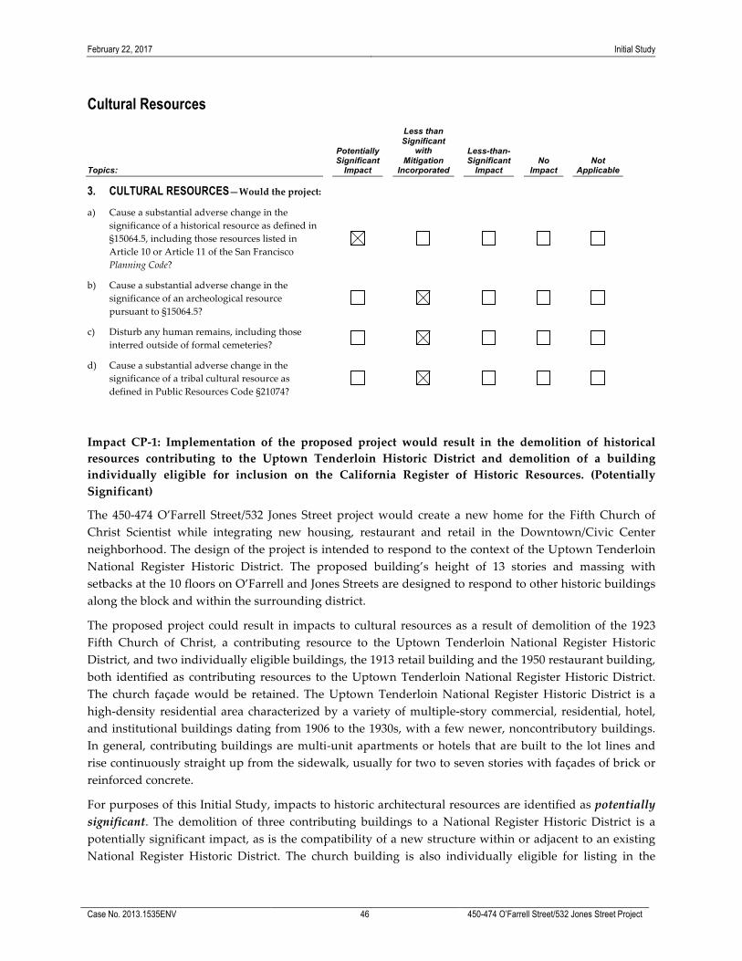
February 22, 2017 Initial Study
Case No. 2013.1535ENV 46 450-474 O’Farrell Street/532 Jones Street Project
Cultural Resources
Topics:
Potentially Significant
Impact
Less than Significant
with Mitigation
Incorporated
Less-than-Significant
Impact No
Impact Not
Applicable
3. CULTURAL RESOURCES—Would the project: a) Cause a substantial adverse change in the
significance of a historical resource as defined in §15064.5, including those resources listed in Article 10 or Article 11 of the San Francisco Planning Code?
b) Cause a substantial adverse change in the significance of an archeological resource pursuant to §15064.5?
c) Disturb any human remains, including those interred outside of formal cemeteries?
d) Cause a substantial adverse change in the significance of a tribal cultural resource as defined in Public Resources Code §21074?
Impact CP-‐‑1: Implementation of the proposed project would result in the demolition of historical resources contributing to the Uptown Tenderloin Historic District and demolition of a building individually eligible for inclusion on the California Register of Historic Resources. (Potentially Significant)
The 450-‐‑474 O’Farrell Street/532 Jones Street project would create a new home for the Fifth Church of Christ Scientist while integrating new housing, restaurant and retail in the Downtown/Civic Center neighborhood. The design of the project is intended to respond to the context of the Uptown Tenderloin National Register Historic District. The proposed building’s height of 13 stories and massing with setbacks at the 10 floors on O’Farrell and Jones Streets are designed to respond to other historic buildings along the block and within the surrounding district.
The proposed project could result in impacts to cultural resources as a result of demolition of the 1923 Fifth Church of Christ, a contributing resource to the Uptown Tenderloin National Register Historic District, and two individually eligible buildings, the 1913 retail building and the 1950 restaurant building, both identified as contributing resources to the Uptown Tenderloin National Register Historic District. The church façade would be retained. The Uptown Tenderloin National Register Historic District is a high-‐‑density residential area characterized by a variety of multiple-‐‑story commercial, residential, hotel, and institutional buildings dating from 1906 to the 1930s, with a few newer, noncontributory buildings. In general, contributing buildings are multi-‐‑unit apartments or hotels that are built to the lot lines and rise continuously straight up from the sidewalk, usually for two to seven stories with façades of brick or reinforced concrete.
For purposes of this Initial Study, impacts to historic architectural resources are identified as potentially significant. The demolition of three contributing buildings to a National Register Historic District is a potentially significant impact, as is the compatibility of a new structure within or adjacent to an existing National Register Historic District. The church building is also individually eligible for listing in the
February 22, 2017 Initial Study
Case No. 2013.1535ENV 47 450-474 O’Farrell Street/532 Jones Street Project
CRHR. To evaluate the proposed project’s potential impacts to a historical resource, a Historic Resources Evaluation will be prepared by a qualified consultant and the City will prepare a Historic Resources Evaluation Response, which will be summarized in the EIR. The EIR will determine the significance of the project’s impacts on cultural resources and develop mitigation measures and alternatives, as feasible, to reduce those impacts found to be significant.
Impact CP-‐‑2: Construction activities for the proposed project could result in a substantial adverse change in the significance of as-‐‑yet unknown archaeological resources, should such resources exist beneath the project site. (Less than Significant with Mitigation)
The proposed project would require excavation for a single level of below-‐‑grade parking. The proposed structure would be supported on a spread-‐‑type foundation consisting of isolated footings interconnected with grade beams or a mat. The following information is based on the Preliminary Archeological Review (PAR) prepared by the San Francisco Planning Department23 and the Geotechnical Investigations prepared by Langan Treadwell Rollo.24 The PAR concluded that the accidental discovery of archaeological resources could occur at the project site. Accordingly, in order to reduce potential impacts on archaeological resources, the project sponsor has agreed to comply with Mitigation Measure M-‐‑CP-‐‑2: Accidental Discovery. The mitigation measure is required to avoid any potential adverse effect from the proposed project on accidentally discovered buried or submerged historical resources as defined in CEQA Guidelines Section 15064.5(a) and (c).
Mitigation Measure M-‐‑CP-‐‑2: Accidental Discovery
The project sponsor shall distribute the Planning Department archeological resource “ALERT” sheet to the project prime contractor; to any project subcontractor (including demolition, excavation, grading, foundation, etc. firms); or utilities firm involved in soils disturbing activities within the project site. Prior to any soils disturbing activities being undertaken; each contractor is responsible for ensuring that the “ALERT” sheet is circulated to all field personnel including, machine operators, field crew, supervisory personnel, etc. The project sponsor shall provide the Environmental Review Officer (ERO) with a signed affidavit from the responsible parties (prime contractor, subcontractor(s), and utilities firm) to the ERO confirming that all field personnel have received copies of the Alert Sheet.
Should any indication of an archeological resource be encountered during any soil-‐‑disturbing activity of the project, the project Head Foreman and/or project sponsor shall immediately notify the ERO and shall immediately suspend any soils disturbing activities in the vicinity of the discovery until the ERO has determined what additional measures should be undertaken.
If the ERO determines that an archeological resource may be present within the project site, the project sponsor shall retain the services of an archaeological consultant from the pool of qualified archaeological consultants maintained by the Planning Department archaeologist. The archeological consultant shall advise the ERO as to whether the discovery is an archeological resource, retains sufficient integrity, and is of potential scientific/historical/cultural significance. If an archeological resource is present, the archeological consultant shall identify and evaluate the
23 San Francisco Planning Department, Preliminary Archeological Review 450 O’Farrell Street/532 Jones Street, January 7, 2016. 24 Langan Treadwell Rollo Preliminary Geotechnical Study 450-‐‑474 O’Farrell Street, San Francisco, California, September 8,
2014; Langan Treadwell Rollo Preliminary Geotechnical Study 532 Jones Street, San Francisco, California, April 13, 2015.

February 22, 2017 Initial Study
Case No. 2013.1535ENV 48 450-474 O’Farrell Street/532 Jones Street Project
archeological resource. The archeological consultant shall make a recommendation as to what action, if any, is warranted. Based on this information, the ERO may require, if warranted, specific additional measures to be implemented by the project sponsor.
Measures might include: preservation in situ of the archeological resource; an archaeological monitoring program; or an archeological testing program. If an archeological monitoring program or archeological testing program is required, it shall be consistent with the Environmental Planning (EP) division guidelines for such programs. The ERO may also require that the project sponsor immediately implement a site security program if the archeological resource is at risk from vandalism, looting, or other damaging actions.
The project archeological consultant shall submit a Final Archeological Resources Report (FARR) to the ERO that evaluates the historical significance of any discovered archeological resource and describing the archeological and historical research methods employed in the archeological monitoring/data recovery program(s) undertaken. Information that may put at risk any archeological resource shall be provided in a separate removable insert within the final report.
Copies of the Draft FARR shall be sent to the ERO for review and approval. Once approved by the ERO, copies of the FARR shall be distributed as follows: California Archaeological Site Survey Northwest Information Center (NWIC) shall receive one (1) copy and the ERO shall receive a copy of the transmittal of the FARR to the NWIC. The Environmental Planning division of the Planning Department shall receive one bound copy, one unbound copy, and one unlocked, searchable PDF copy on CD of the FARR along with copies of any formal site recordation forms (CA DPR 523 series) and/or documentation for nomination to the National Register of Historic Places/California Register of Historical Resources. In instances of high public interest or interpretive value, the ERO may require a different final report content, format, and distribution than that presented above.
With implementation of Mitigation Measure M-‐‑CP-‐‑2: Accidental Discovery, project construction would have a less-‐‑than-‐‑significant impact on prehistoric or historical archaeological resources, and this topic will not be discussed in the EIR.
Impact CP-‐‑3: Construction activities for the proposed project could result in the disturbance of human remains, including those interred outside of formal cemeteries, should such remains exist beneath the project site. (Less than Significant with Mitigation)
In the unlikely event that human remains are encountered during construction, any inadvertent damage to human remains would be considered a significant impact. Accordingly, in order to reduce this potential impact to a less-‐‑than-‐‑significant level, the project sponsor has agreed to comply with Mitigation Measure M-‐‑CP-‐‑3: Human Remains, which includes the required procedures for the treatment of human remains.
Mitigation Measure M-‐‑CP-‐‑3: Human Remains
The treatment of human remains and of associated or unassociated funerary objects discovered during any soils disturbing activity shall comply with applicable State and Federal laws along with the following procedures. This shall include immediate notification of the Coroner of the City and County of San Francisco and the ERO. In the event of the Coroner’s determination that the human remains are Native American remains, notification of the California State Native American Heritage Commission (NAHC) who shall appoint a Most Likely Descendant (MLD)

February 22, 2017 Initial Study
Case No. 2013.1535ENV 49 450-474 O’Farrell Street/532 Jones Street Project
(Pub. Res. Code Sec. 5097.98). The archeological consultant, as required under M-‐‑CP-‐‑2, project sponsor, ERO, and MLD shall have up to but not beyond six days of discovery to make all reasonable efforts to develop an agreement for the treatment of human remains and associated or unassociated funerary objects with appropriate dignity (CEQA Guidelines. Sec. 15064.5(d)). The agreement should take into consideration the appropriate excavation, removal, recordation, analysis, custodianship, curation, and final disposition of the human remains and associated or unassociated funerary objects. Nothing in existing State regulations or in this mitigation measure compels the project sponsor and the ERO to accept recommendations of an MLD. The archeological consultant shall retain possession of any Native American human remains and associated or unassociated burial objects until completion of any scientific analyses of the human remains or objects as specified in the treatment agreement if such as agreement has been made or, otherwise, as determined by the archeological consultant and the ERO.
With implementation of Mitigation Measure M-‐‑CP-‐‑3: Human Remains, project construction would have a less-‐‑than-‐‑significant impact on prehistoric or historical archaeological resources, and this topic will not be discussed in the EIR.
Impact CP-‐‑4: Construction activities for the proposed project could result in the disturbance of tribal cultural resources, should such resources exist beneath the project site. (Less than Significant with Mitigation)
Tribal cultural resources are those resources that meet the definitions in Public Resources Code Section 21074. Tribal cultural resources are defined as sites, features, places, cultural landscapes, sacred places, and objects with cultural value to a California Native American tribe that are also either (a) included or determined to be eligible for inclusion in the CRHR or (b) included in a local register of historical resources as defined in Public Resources Code Section 5020.1(k). Based on discussions with Native American tribal representatives in San Francisco, prehistoric archeological resources are presumed to be potential tribal cultural resources. A tribal cultural resource is adversely affected when a project impacts its significance.
Pursuant to Assembly Bill 52, effective July 1, 2015, within 14 days of a determination that an application for a project is complete or a decision by a public agency to undertake a project, the lead agency is required to contact the Native American tribes that are culturally or traditionally affiliated with the geographic area in which the project is located. Notified tribes have 30 days to request consultation with the lead agency to discuss potential impacts on tribal cultural resources and measures for addressing those impacts.
On April 6, 2016, the Planning Department mailed a “Tribal Notification Regarding Tribal Cultural Resources and CEQA” to the appropriate Native American tribal representatives who have requested notification. During the 30-‐‑day comment period, no Native American tribal representatives contacted the Planning Department to request consultation. Furthermore, as discussed above under Impact CP-‐‑2 and Impact CP-‐‑3, the proposed project would have a less-‐‑than-‐‑significant impact related to the potential disturbance of historic and prehistoric archeological resources and human remains with implementation of Mitigation Measure M-‐‑CP-‐‑22 and M-‐‑CP-‐‑33. These mitigation measures would be sufficient to reduce impacts to tribal cultural resource should they occur. Therefore, this topic will not be discussed in the EIR.

February 22, 2017 Initial Study
Case No. 2013.1535ENV 50 450-474 O’Farrell Street/532 Jones Street Project
Impact C-‐‑CP-‐‑1: The proposed project, in combination with past, present, and reasonably foreseeable future projects in the site vicinity could result in cumulative impacts to historic architectural resources (Potentially Significant)
The geographic context for an analysis of cumulative impacts to historic resources would be the Uptown Tenderloin National Register Historic District. Historic resources are a finite resource and cannot be replaced once demolished. Past development has resulted in a diminution of historic resources. Present and future development would be required to comply with city, state, and federal regulations concerning preservation of historic resources, but further reduction in these resources could occur with future development. The proposed project would result in demolition of three identified historic resources that contribute to the Uptown Tenderloin National Register Historic District. This impact has been identified as potentially significant and will be analyzed in the EIR. Similarly, the project’s contribution to cumulative impacts on historic resources will be analyzed in the EIR.
Impact C-‐‑CP-‐‑2: The proposed project, in combination with past, present, and reasonably foreseeable future projects in the vicinity, would not cause a substantial adverse change in the significance of an archeological or tribal cultural resource nor disturb human remains. (Less than Significant)
Project-‐‑related impacts on these resources are site-‐‑specific and generally limited to the project’s construction area. The geographic context for archaeological, tribal cultural resource and human remains impacts is the City of San Francisco. Cumulative development projects throughout the City could result in substantial adverse changes in the significance of an archaeological or tribal cultural resource and may also disturb human remains. Preservation of significant historic and cultural properties is an important aspect of planning in San Francisco. Development projects in the City are subject to historic, archaeological, and cultural resource investigations, and standard mitigation measures are implemented to insure that, in the event cultural resources are discovered during construction, the artifacts or human remains are properly handled and not further disturbed.
It is not likely that these resources will be unearthed, as the PAR for the proposed project did not find evidence for potential sites. For these reasons, the proposed project, in combination with other past, present, and reasonably foreseeable future projects, would not result in a cumulatively considerable impact on archeological resources, human remains, or tribal cultural resources. This topic will not be discussed in the EIR.

February 22, 2017 Initial Study
Case No. 2013.1535ENV 51 450-474 O’Farrell Street/532 Jones Street Project
Transportation and Circulation
Topics:
Potentially Significant
Impact
Less than Significant
with Mitigation
Incorporated
Less-than-Significant
Impact No
Impact Not
Applicable
4. TRANSPORTATION AND CIRCULATION— Would the project:
a) Conflict with an applicable plan, ordinance or policy establishing measures of effectiveness for the performance of the circulation system, taking into account all modes of transportation including mass transit and non-‐‑motorized travel and relevant components of the circulation system, including but not limited to intersections, streets, highways and freeways, pedestrian and bicycle paths, and mass transit?
b) Conflict with an applicable congestion management program, including but not limited to level of service standards and travel demand measures, or other standards established by the county congestion management agency for designated roads or highways?
c) Result in a change in air traffic patterns, including either an increase in traffic levels or a change in location that results in substantial safety risks?
d) Substantially increase hazards due to a design feature (e.g., sharp curves or dangerous intersections) or incompatible uses?
e) Result in inadequate emergency access?
f) Conflict with adopted policies, plans, or programs regarding public transit, bicycle, or pedestrian facilities, or otherwise decrease the performance or safety of such facilities?
The proposed project would not be located within an airport land use plan area or in the vicinity of a private airstrip. Therefore, Question 4c is not applicable to the project.
This analysis is based on the 450 O’Farrell Street Transportation Impact Study (TIS)25 prepared for the proposed project by LCW Consulting in February 2017. According to the TIS, because the proposed project would replace the existing church within a smaller facility, it is not anticipated that the proposed project would result in an increase in travel demand for the religious institution use. Church services are currently held on Wednesday evenings at 7 p.m. and on Sundays at 11 a.m., and they are not anticipated to change. Any travel demand associated with the existing church use during the PM peak hour is reflected in the existing conditions. The existing transit network is shown in Figure 18.
25 LCW Consulting, Traffic Impact Study for 450-‐‑474 O’Farrell Street and 572 Jones Street, San Francisco, California, February 15,
2017.

Figure 18Existing Transit Network
K:\Los Angeles\Projects\450_OFarrell\00028_16\mapdoc\Fig18_Exist_Transit_Network.mxd Date: 1/27/2017 24991
450 O'Farrell StreetCase No. 2013.1535ENV

February 22, 2017 Initial Study
Case No. 2013.1535ENV 53 450-474 O’Farrell Street/532 Jones Street Project
Project Travel Demand Table 3 summarizes the weekday daily and PM peak hour trip generation for the proposed project by proposed land uses. A credit for the person trips associated with the existing restaurant use is also presented. The existing restaurant trips are subtracted from the overall trips associated with the project to identify the net new trips. As a conservative assumption, the travel demand associated with the five residential units within the existing 532 Jones Street building was not subtracted from the proposed project travel demand. Because these five units are currently rented to employees of the Shalimar restaurant on the ground floor of the building, the existing travel demand is less than that for a typical residential unit, as the “work to home” trips occur within the same building. Overall, the proposed project would generate about 4,810 net-‐‑new daily person trips, and about 704 net-‐‑new PM peak hour person trips.
TABLE 3: PROPOSED PROJECT NET-‐‑NEW DAILY AND PM PEAK HOUR PERSON TRIP GENERATION
Land Use1 Size Daily Person Trip
Generation PM Peak Hour Person Trip
Generation
Residential (176 units) 187,640 gsf 1,468 253
Restaurant/Retail 6,200 gsf 3,720 502
193,840 gsf 5,188 755
Credit for Existing Restaurant 378 51
Net-‐‑new Project Trips 4,810 704
Note: 1. The church is an existing use that would be maintained within a smaller facility. The travel demand associated with the church use is not anticipated to substantially change from existing conditions. Church services are held on Wednesday evenings and on Sunday mornings. The church services would not generate new trips during the weekday PM peak hour of analysis. Source: SF Guidelines, LCW Consulting.
Table 4 summarizes the weekday PM peak hour trip generation by mode for the proposed project. The credit for the existing restaurant uses on the project site that would be displaced is also presented. During the weekday PM peak hour, about 28 percent of the net-‐‑new person-‐‑trips would be by auto, 28 percent by transit, 44 percent by walking and other modes (including bicycling). During the PM peak hour, the proposed project would generate about 98 net-‐‑new vehicle-‐‑trips, of which 50 vehicle-‐‑trips would be inbound to the project site, and 45 vehicle-‐‑trips would be outbound from the project site.
TABLE 4: PROPOSED PROJECT NET-‐‑NEW TRIP GENERATION BY MODE WEEKDAY PM PEAK HOUR
Land Use Person-‐‑Trips Vehicle
Trips Auto Transit Walk Other1 Total
Residential 38 120 74 21 253 29
Restaurant/Retail 180 86 175 61 502 76
218 206 249 82 755 105
Credit for Existing Restaurant 18 8 18 7 51 7
Net-‐‑new Project Trips 200 198 231 75 704 98
Notes: 1 “Other” mode includes bicycles, motorcycles, and taxis/Transportation Network Company vehicles. Source: SF Guidelines, LCW Consulting.

February 22, 2017 Initial Study
Case No. 2013.1535ENV 54 450-474 O’Farrell Street/532 Jones Street Project
As shown in Table 5, the residential and restaurant/retail uses associated with the proposed project would generate about 24 net-‐‑new delivery and service-‐‑vehicle trips to the project site per day. Overall this corresponds to a demand for less than 1.5 loading spaces during the peak and average hours of loading activities. It is anticipated that most of the delivery and service vehicles that would be generated by the proposed project would consist primarily of small trucks and vans. The residential uses would also generate a demand for large and small moving vans.
TABLE 5: PROPOSED PROJECT NET-‐‑NEW DELIVERY/SERVICE VEHICLE-‐‑TRIPS AND LOADING SPACE DEMAND
Land Use Daily Truck Trip Generation
Peak Hour Loading Space Demand
Average Hour Loading Space Demand
Residential 5.6 0.33 0.26
Restaurant/Retail1 18.7 1.08 0.86
Total Proposed Project 24.3 1.41 1.12
Note: 1 Restaurant truck trip generation and loading space demand includes a credit for the existing 1,012 gsf of restaurant uses. Source: SF Guidelines, LCW Consulting.
Background on Vehicle Miles Traveled in San Francisco and Bay Area Many factors affect travel behavior. These factors include density, diversity of land uses, design of the transportation network, access to regional destinations, distance to high-‐‑quality transit, development scale, demographics, and transportation demand management. Typically, low-‐‑density development at great distance from other land uses, located in areas with poor access to non-‐‑private vehicular modes of travel, generate more automobile travel compared to development located in urban areas, where a higher density, mix of land uses, and travel options other than private vehicles are available.
Given these travel behavior factors, San Francisco has a lower vehicle miles traveled (VMT) ratio than the nine-‐‑county San Francisco Bay Area region. In addition, some areas of the city have lower VMT ratios than other areas of the City. These areas of the City can be expressed geographically through transportation analysis zones (TAZs). TAZs are used in transportation planning models for transportation analysis and other planning purposes. The zones vary in size from single city blocks in the downtown core, multiple blocks in outer neighborhoods, to even larger zones in historically industrial areas such as the Hunters Point Shipyard.
The San Francisco County Transportation Authority (Transportation Authority) uses the San Francisco Chained Activity Model Process (SF-‐‑CHAMP) to estimate VMT by private automobiles and taxis for different land use types. Travel behavior in SF-‐‑CHAMP is calibrated based on observed behavior from the California Household Travel Survey 2010-‐‑2012, Census data regarding automobile ownership rates and county-‐‑to-‐‑county worker flows, and observed vehicle counts and transit boardings. SF-‐‑CHAMP uses a synthetic population, which is a set of individual actors that represents the Bay Area’s actual population, who make simulated travel decisions for a complete day. The Transportation Authority uses tour-‐‑based analysis for office and residential uses, which examines the entire chain of trips over the course of a day, not just trips to and from the project. For retail uses, the Transportation Authority

February 22, 2017 Initial Study
Case No. 2013.1535ENV 55 450-474 O’Farrell Street/532 Jones Street Project
uses trip-‐‑based analysis, which counts VMT from individual trips to and from the project (as opposed to an entire chain of trips). A trip-‐‑based approach, as opposed to a tour-‐‑based approach, is necessary for retail projects because a tour is likely to consist of trips stopping in multiple locations, and the summarizing of tour VMT to each location would over-‐‑estimate VMT.26,27
Existing plus Project Impacts Impact TR-‐‑1: The proposed project would not conflict with an applicable plan, ordinance or policy establishing measures of effectiveness for the performance of the circulation system, taking into account all modes of transportation including mass transit and non-‐‑motorized travel and relevant components of the circulation system, including but not limited to intersections, streets, highways and freeways, pedestrian and bicycle paths, and mass transit. (Less than Significant)
Introduction. CEQA Section 21099(b)(1) requires that the State Office of Planning and Research (OPR) develop revisions to CEQA Guidelines establishing criteria for determining the significance of transportation impacts of projects that “promote the reduction of greenhouse gas emissions, the development of multimodal transportation networks, and a diversity of land uses.” CEQA Section 21099(b)(2) states that upon certification of the revised guidelines for determining transportation impacts pursuant to Section 21099(b)(1), automobile delay, as described solely by level of service (LOS) or similar measures of vehicular capacity or traffic congestion shall not be considered a significant impact on the environment under CEQA.
In January 2016, OPR published for public review and comment a Revised Proposal on Updates to CEQA Guidelines on Evaluating Transportation Impacts in CEQA28 (proposed transportation impact guidelines) recommending that transportation impacts for projects be measured using a vehicle miles traveled (VMT) metric. VMT measures the amount and distance that a project might cause people to drive, accounting for the number of passengers within a vehicle. OPR’s proposed transportation impact guidelines provides substantial evidence that VMT is an appropriate standard to use in analyzing transportation impacts to protect environmental quality and a better indicator of greenhouse gas, air quality, and energy impacts than automobile delay. Acknowledging this, San Francisco Planning Commission Resolution 19579, adopted on March 3, 2016:
• Found that automobile delay, as described solely by LOS or similar measures of vehicular capacity or traffic congestion, shall no longer be considered a significant impact on the environment pursuant to CEQA, because it does not measure environmental impacts and therefore it does not protect environmental quality.
• Directed the Environmental Review Officer to remove automobile delay as a factor in determining significant impacts pursuant to CEQA for all guidelines, criteria, and list of exemptions, and to update the Transportation Impact Analysis Guidelines for Environmental Review and Categorical Exemptions from CEQA to reflect this change.
26 To state another way: a tour-‐‑based assessment of VMT at a retail site would consider the VMT for all trips in the tour, for any
tour with a stop at the retail site. If a single tour stops at two retail locations, for example, a coffee shop on the way to work and a restaurant on the way back home, then both retail locations would be allotted the total tour VMT. A trip-‐‑based approach allows us to apportion all retail-‐‑related VMT to retail sites without double-‐‑counting.
27 San Francisco Planning Department, Executive Summary: Resolution Modifying Transportation Impact Analysis, Appendix F, Attachment A, March 3, 2016.
28 This document is available online at: https://www.opr.ca.gov/s_sb743.php.

February 22, 2017 Initial Study
Case No. 2013.1535ENV 56 450-474 O’Farrell Street/532 Jones Street Project
• Directed the Environmental Planning Division and Environmental Review Officer to replace automobile delay with VMT criteria which promote the reduction of greenhouse gas emissions, the development of multimodal transportation networks, and a diversity of land uses; and consistent with proposed and forthcoming changes to CEQA Guidelines by OPR.
Planning Commission Resolution 19579 became effective immediately for all projects that have not received a CEQA determination and all projects that have previously received CEQA determinations, but require additional environmental analysis.
VMT Analysis. Land use projects may cause substantial additional VMT. The following identifies thresholds of significance and screening criteria used to determine if a land use project would result in significant impacts under the VMT metric.
For residential projects, a project would generate substantial additional VMT if it exceeds the regional household VMT per capita minus 15 percent.29 For office projects, a project would generate substantial additional VMT if it exceeds the regional VMT per employee minus 15 percent. As documented in the proposed transportation impact guidelines, a 15 percent threshold below existing development is “both reasonably ambitious and generally achievable.”30 For retail projects, the Planning Department uses a VMT efficiency metric approach for retail projects: a project would generate substantial additional VMT if it exceeds the regional VMT per retail employee minus 15 percent. This approach is consistent with CEQA Section 21099 and the thresholds of significance for other land uses recommended in OPR’s proposed transportation impact guidelines. For mixed-‐‑use projects, each proposed land use is evaluated independently, per the significance criteria described above.
OPR’s proposed transportation impact guidelines provides screening criteria to identify types, characteristics, or locations of land use projects that would not exceed these VMT thresholds of significance. OPR recommends that if a project or land use proposed as part of the project meets any of the below screening criteria, then VMT impacts are presumed to be less than significant for that land use and a detailed VMT analysis is not required. These screening criteria and how they are applied in San Francisco are described below:
• Map-‐‑Based Screening for Residential, Office, and Retail Projects. OPR recommends mapping areas that exhibit where VMT is less than the applicable threshold for that land use. Accordingly, the Transportation Authority has developed maps depicting existing VMT levels in San Francisco for residential, office, and retail land uses based on the SF-‐‑CHAMP 2012 base-‐‑year model run. The Planning Department uses these maps and associated data to determine whether a proposed project is located in an area of the City that is below the VMT threshold.
• Small Projects – OPR recommends that lead agencies may generally assume that a project would not have significant VMT impacts if the project would either: (1) generate fewer trips than the level required for studying consistency with the applicable congestion management program or (2) where the applicable congestion management program does not provide such a level, fewer than 100 vehicle
29 OPR’s proposed transportation impact guidelines state a project would cause substantial additional VMT if it exceeds
both the existing City household VMT per capita minus 15 percent and existing regional household VMT per capita minus 15 percent. In San Francisco, the City’s average VMT per capita is lower (8.4) than the regional average (17.2). Therefore, the City average is irrelevant for the purposes of the analysis.
30 Governor’s Office of Planning and Research, Revised Proposal on Updates to CEQA Guidelines on Evaluating Transportation Impacts in CEQA, January 20, 2016, p. III:20. This document is available online at: https://www.opr.ca.gov/s_sb743.php.
February 22, 2017 Initial Study
Case No. 2013.1535ENV 57 450-474 O’Farrell Street/532 Jones Street Project
trips per day. The Transportation Authority’s 2015 San Francisco Congestion Management Program does not include a trip threshold for studying consistency. Therefore, the Planning Department uses the 100 vehicle trip per day screening criterion as a level generally where projects would not generate a substantial increase in VMT.
• Proximity to Transit Stations. OPR recommends that residential, retail, and office projects, as well projects that are a mix of these uses, proposed within ½ mile of an existing major transit stop (as defined by CEQA Section 21064.3) or an existing stop along a high quality transit corridor (as defined by CEQA Section 21155) would not result in a substantial increase in VMT. However, this presumption would not apply if the project would: (1) have a floor area ratio31 of less than 0.75; (2) include more parking for use by residents, customers, or employees of the project than required or allowed, without a conditional use; or (3) is inconsistent with the applicable Sustainable Communities Strategy.32
The existing average daily VMT per capita for the transportation analysis zone the project site is located in, TAZ 711, is below the existing regional average daily VMT.
• For residential uses, the average daily VMT per capita is 2.3, which is about 87 percent below the existing regional average daily VMT per capita of 17.2.
• For retail/commercial uses, the average daily VMT per employee is 7.1, which is about 52 percent below the existing regional average daily VMT per employee of 14.9.
Thus, as described above, the project site is located within an area of the City where the existing VMT is more than 15 percent below the regional VMT, and the proposed project land uses would not generate substantial additional VMT.33 Furthermore, the project site meets the Proximity to Transit Stations screening criterion, which also indicates the proposed project’s uses would not cause substantial additional VMT.34
While the Proposed Project’s impacts related to VMT and induced automobile travel would be less than significant, Improvement Measure I-‐‑TR-‐‑1: Transportation Demand Management (TDM) Plan, would further reduce the less-‐‑than-‐‑significant impacts related to VMT and would encourage sustainable travel modes. Implementation of a TDM Program would increase travel options and provide incentives and information to encourage and help individuals modify their travel behavior.
The project applicant has agreed to implement the following improvement measure to further reduce the proposed project’s less-‐‑than-‐‑significant VMT-‐‑related impacts. 31 Floor area ratio means the ratio of gross building area of the development, excluding structured parking areas, proposed for
the project divided by the net lot area. 32 A project is considered to be inconsistent with the Sustainable Communities Strategy if development is located outside of
areas contemplated for development in the Sustainable Communities Strategy. 33 The Map-‐‑Based Screening for Residential, Office, and Retail Projects was applied to the proposed project. The project site is
located within TAZ 711, which is within an area of the City where the existing VMT is more than 15 percent below the regional VMT thresholds, as documented in Executive Summary Resolution Modifying Transportation Impact Analysis, Attachment F (Methodologies, Significance Criteria. Thresholds of Significance, and Screening Criteria for Vehicle Miles Traveled and Induced Automobile Travel Impacts), Appendix A (SFCTA Memo), March 3, 2016. Available online at http://commissions.sfplanning.org/cpcpackets/Align-‐‑CPC%20exec%20summary_20160303_Final.pdf. Accessed March 21, 2016.
34 San Francisco Planning Department. Eligibility Checklist: CEQA Section 21099 – Modernization of Transportation Analysis for 1500 Mission.

February 22, 2017 Initial Study
Case No. 2013.1535ENV 58 450-474 O’Farrell Street/532 Jones Street Project
Improvement Measure I-‐‑TR-‐‑1: Transportation Demand Management (TDM) Plan
As an improvement measure to encourage the use of sustainable modes, the project sponsor and subsequent property owners, should develop and implement a TDM Plan. The scope and number of TDM measures included in the TDM Plan should be in accordance with the Planning Commission Standards for the TDM Program (TDM Program) for the type of development proposed.35 The proposed project’s TDM Plan should conform to the most recent version of the TDM Program Standards available at the time of the project’s approval. The Planning Department should review and approve the TDM Plan, as well as any subsequent revisions to the TDM Plan, pursuant to the TDM Program Standards. The TDM Plan should target a reduction in the vehicle miles traveled (VMT) rate (e.g., VMT per capita), monitor and evaluate project performance (actual VMT), and adjust TDM measures over time to attempt to meet VMT target reduction.
The TDM Plan may include, but is not limited to, the types of measures summarized below for explanatory example purposes. Actual TDM measures selected should include those from the TDM Program Standards which describe the scope and applicability of candidate measures in detail and include:
1. Active Transportation: Provision of streetscape improvements to encourage walking, secure bicycle parking, shower and locker facilities for cyclists, subsidized bike share memberships for project occupants, bicycle repair and maintenance services, and other bicycle-‐‑related services
2. Car-‐‑Share: Provision of car-‐‑share parking spaces and subsidized memberships for project occupants
3. Delivery: Provision of amenities and services to support delivery of goods to project occupants
4. Family-‐‑Oriented Measures: Provision of on-‐‑site childcare and other amenities to support the use of sustainable transportation modes by families
5. High-‐‑Occupancy Vehicles: Provision of carpooling/vanpooling incentives and shuttle bus service
6. Information and Communications: Provision of multimodal wayfinding signage, transportation information displays, and tailored transportation marketing services
7. Land Use: Provision of on-‐‑site affordable housing and healthy food retail services in underserved areas
8. Parking: Provision of unbundled parking, short term daily parking provision, parking cash out offers, and reduced off-‐‑street parking supply.
Traffic Hazards Pursuant to recent revisions to CEQA Guidelines by OPR, in March 2016, the San Francisco Planning Department adopted the OPR recommendations to use a VMT metric instead of automobile delay to evaluate the transportation impacts of projects. Therefore, vehicle delay (i.e., intersection LOS) is no longer used as a significance criterion in San Francisco, and traffic impacts were assessed based on whether the Proposed Project would cause traffic hazards.
35 San Francisco Planning Department, Draft TDM Program Standards, July 2016 are available online at: http://sf-‐‑
planning.org/tdm-‐‑materials-‐‑and-‐‑resources.
February 22, 2017 Initial Study
Case No. 2013.1535ENV 59 450-474 O’Farrell Street/532 Jones Street Project
Vehicular access to the proposed project’s residential building garage would be via a 12-‐‑foot-‐‑wide driveway on Shannon Street (approximately 140 feet south of Geary Street, and 130 feet north of O’Farrell Street). The residential building garage driveway would be 20 feet wide at the property line. The driveway access ramp to the below-‐‑grade level would be about 110 feet in length, which would accommodate about five vehicles on the ramp. The residential building garage would be gated and accessed remotely. Due to the generally limited number of vehicle parking spaces (30 parking spaces for the 176 residential units, 10 spaces dedicated for the religious institution use only, one car-‐‑share space, and no parking spaces for the restaurant/retail use), it is not anticipated that queues entering the garage would exceed the five vehicles that can be accommodated on the access ramp. Therefore, garage operations are not anticipated to affect Shannon Street traffic flow (traffic volumes on Shannon Street are low – about 40 vehicles during the PM peak hour). In summary, the proposed project would not cause traffic hazards, and therefore, proposed project impacts related to traffic would be less than significant.
Although the proposed project’s impacts related to traffic hazards are expected to be less than significant, the project applicant has agreed to implement the following improvement measure, which may be recommended for consideration by City decision makers, to further reduce the proposed project’s less-‐‑than-‐‑significant impacts related to traffic hazards.
Improvement Measure I-‐‑TR-‐‑2: Monitoring and Abatement of Queues
To reduce the potential for queuing of vehicles accessing the project site, it should be the responsibility of the project sponsor to ensure that recurring vehicle queues or vehicle conflicts do not occur on Shannon Street. A vehicle queue is defined as one or more vehicles (destined to the parking garage) blocking any portion of the Shannon Street sidewalk or travel lanes for a consecutive period of three minutes or longer on a daily and/or weekly basis.
If the Planning Director, or his or her designee, suspects that a recurring queue or conflict is present, the Planning Department should notify the project sponsor in writing. Upon request, the owner/operator should hire a qualified transportation consultant to evaluate the conditions at the site for no less than seven days. The consultant should prepare a monitoring report to be submitted to the Planning Department for review. If the Planning Department determines that a recurring queue or conflict does exist, the project sponsor should have 90 days from the date or the written determination to abate the recurring queue or conflict.
Transit There are no bus stops adjacent to the project site on either the north side of O’Farrell Street or the east side of Jones Street. On the south side of O’Farrell Street there is a midblock bus stop approximately across from Shannon Street. At this location, a transit bulb is provided within the parking lane and buses stop within the transit-‐‑only lane. A transit-‐‑only lane is provided on eastbound O’Farrell Street (for the 27 Bryant, 38 Geary and 38R Geary Rapid routes adjacent to the project site) and on westbound Geary Street (for the 38 Geary and 38R Geary Rapid routes in the project vicinity). Taxis are also permitted to use the transit-‐‑only lane. At intersections where right turns are permitted (e.g., eastbound O’Farrell at Jones and Mason Streets), vehicles must travel across the transit-‐‑only lane to access the curbside right-‐‑turn pocket.
The majority of the transit trips generated by the Proposed Project during the PM peak hour would be inbound (returning home) to the site. During the PM peak hour, the Proposed Project would generate about 198 net-‐‑new transit trips (113 inbound to the project site and 85 outbound from the project site). Of
February 22, 2017 Initial Study
Case No. 2013.1535ENV 60 450-474 O’Farrell Street/532 Jones Street Project
the 198 net-‐‑new transit trips, 156 trips would be to and from locations within San Francisco, and 42 trips would be to and from locations in the East Bay, North Bay, and South Bay. Transit trips to and from the Proposed Project would utilize the nearby Muni routes and transfer to other Muni bus and light rail lines, or to regional transit providers. With the addition of the project-‐‑generated riders to the Muni downtown and regional screenlines,36 the capacity utilization would remain similar to existing conditions. The proposed project would not contribute riders to Muni screenlines currently operating at more than Muni’s 85 percent capacity utilization standard. In addition, the proposed project’s contribution to regional screenlines would be minimal, including the BART East Bay screenline which currently operates at more than BART’s 100 percent capacity utilization standard. The proposed project’s ridership contribution the BART East Bay screenline during the PM peak hour would be less than 1 percent. For transit screenlines that already operate above the utilization standard during the peak hour, a project would have a significant effect on the transit provider if project-‐‑related transit trips were more than five percent of total transit trips during the peak hour. Therefore, the contribution to the PM peak hour regional screenlines would not be considered a significant impact. Overall, the proposed project would not conflict with, nor substantially affect the capacity utilization of local and regional transit routes.
The proposed project does not include any driveways on O’Farrell Street, and would not conflict with the existing 27 Bryant, 38 Geary, and 38R Geary Rapid routes operating within the eastbound transit-‐‑only lane on O’Farrell Street. Because the transit-‐‑only lane is located adjacent to the parking lane on the south side of the street (i.e., across the street from the project site), vehicles exiting Shannon Street would not need to cross the transit-‐‑only lane to enter the eastbound mixed-‐‑flow travel lane. The westbound transit-‐‑only lane on Geary Street is located adjacent to the parking lane on the north side of the street, and, similarly, westbound vehicles turning left onto Shannon Street from Geary Street would not need to cross the transit-‐‑only lane to access southbound Shannon Street.
The proposed project would be subject to the Transportation Sustainability Fee, which is assessed on residential and non-‐‑residential development to help fund improvements to transit capacity and reliability, as well as bicycle and pedestrian improvements.
Overall, for the reasons described above, the Proposed Project would not substantially affect the capacity utilization of the local and regional transit routes, and would not affect the operations of the adjacent Muni bus routes, and transit impacts of the Proposed Project would be less than significant.
Bicycles There are no bicycle racks on the sidewalks adjacent to the project site on O’Farrell, Shannon, or Jones Streets. On the east sidewalk of Jones Street there are two bicycle racks north of the project site, and one bicycle rack south of the project site. The closest bicycle routes are westbound along Sutter Street, eastbound on Post Street, northbound/southbound on Polk Street. The garage curb cut is not on a bicycle route. Bicycle counts were conducted as part of the PM peak hour intersection traffic volume counts in April 2015. Bicycle volumes on the streets in the immediate vicinity of the project site during the PM peak hour range from 10 to 15 bicyclists on O’Farrell (eastbound), Jones (southbound) Taylor (northbound), and Mason (southbound) Streets, 1 bicyclist on Shannon Street (southbound), and between 25 and 35
36 The concept of screenlines is used to describe the magnitude of travel to or from the greater downtown area, and to compare
estimated transit ridership to available capacities. Screenlines are hypothetical lines that would be crossed by persons traveling between downtown and its vicinity and other parts of San Francisco and the region.

February 22, 2017 Initial Study
Case No. 2013.1535ENV 61 450-474 O’Farrell Street/532 Jones Street Project
bicyclists on Geary Street (westbound). The project site is located within convenient bicycling distance of office and retail buildings in the downtown and Union Square area. Although the proposed project would result in an increase in the number of vehicles and bicycles in the vicinity of the project site, the increase would not be substantial enough to affect bicycle travel or facilities in the area. Therefore, impacts to bicyclists would be less than significant.
Pedestrians Pedestrian volumes in the project vicinity vary, but generally are low to moderate. During the PM peak hour there were 190 pedestrians walking on the sidewalk (125 westbound and 65 eastbound). Pedestrian volumes in the crosswalks at intersections in the project vicinity generally range between 150 and 400 pedestrians per hour during the PM peak hour. During field observations, crosswalks and sidewalks in the project vicinity were observed to be operating at generally unconstrained conditions; at normal walking speeds and with freedom to bypass other pedestrians.
The existing sidewalk width on O’Farrell Street currently meets the minimum and recommended sidewalk width in the Better Streets Plan (minimum width of 12 feet, and recommended width of 15 feet), while the sidewalk width on Jones Street meets the minimum sidewalk width in the Better Streets Plan. The existing 5-‐‑foot 4-‐‑inch-‐‑wide sidewalk (east and west sides) on Shannon Street do not meet the Better Streets Plan minimum width of 6 feet for an alley (nor the recommended width of 9 feet). The east and west sidewalks on Shannon Street north of O’Farrell Street have bollards at the curb (for about 150 feet north of O’Farrell Street) to prevent vehicles from parking on the sidewalks (on-‐‑street parking is not permitted on either side of Shannon Street). Adjacent to the project site, there is a continental crosswalk across Shannon Street, and a red curb approximately 25 feet to the west of Shannon Street that allows for vehicles exiting Shannon Street to see approaching vehicles on eastbound O’Farrell Street without encroaching into the crosswalk.
Pedestrian trips generated by the proposed project would include walk trips to and from the new uses, plus walk trips to and from the bus stops and the BART/Muni Powell station. During the weekday PM peak hour, the new uses would add about 404 net-‐‑new pedestrian trips to the sidewalks and crosswalks in the vicinity of the Proposed Project (including about 198 trips destined to and from the transit lines and 306 walk/other trips). Although the addition of project-‐‑generated pedestrian trips would incrementally increase pedestrian volumes on adjacent streets, additional pedestrian trips generated from the project would not substantially affect sidewalk conditions or pedestrian flow in the project vicinity. Therefore, impacts on pedestrians would be less than significant.
Loading The Proposed Project would not provide an on-‐‑site off-‐‑street truck loading space. Instead, the loading demand generated by the Proposed Project is anticipated to primarily be accommodated within the five existing on-‐‑street commercial loading spaces on the north side of O’Farrell Street between Jones and Taylor Streets (including one space adjacent to the project site). In addition, the project sponsor would request that one of the three existing general on-‐‑street metered parking spaces adjacent to the project site be converted to a metered commercial loading space. The existing passenger loading/unloading zone (accommodating two vehicles) adjacent to the project site serving the church uses during services would be maintained as part of the Proposed Project, however, the hours of operation would be revised from only during church service to all day passenger loading/unloading, with the exception during the tow-‐‑away peak periods between 7 and 9 AM and between 4 and 6 PM. Conversion to all day passenger

February 22, 2017 Initial Study
Case No. 2013.1535ENV 62 450-474 O’Farrell Street/532 Jones Street Project
loading/unloading would remove two general metered parking spaces. The conversion of one general on-‐‑street metered parking space to a metered commercial loading space, and extension of the hours of operation of the passenger loading/unloading zone would require approval at a public hearing through the SFMTA.
The residential and restaurant/retail uses associated with the Proposed Project would generate about 24 net-‐‑new delivery/service vehicle-‐‑trips to the project site per day, which correspond to a demand for about 1.5 loading spaces during the peak and average hours of loading activities. The loading demand would be accommodated within the four existing (three spaces) and one proposed on-‐‑street commercial loading spaces on the north side of O’Farrell Street between Jones and Shannon Streets, and within the two commercial loading spaces on the north side of O’Farrell Street between Shannon and Taylor Streets. In addition, there is one on-‐‑street commercial loading space on the east side of Jones Street immediately south of Geary Street.
As noted above, the project sponsor would request that one general vehicle parking space adjacent to the project site be converted to a commercial loading space, which would further accommodate the proposed project’s loading demand. The project sponsor request that the existing passenger loading/unloading zone adjacent to the project site be converted to an all-‐‑day passenger loading/unloading zone would accommodate the proposed residential and existing church uses.
Construction Construction staging would occur on-‐‑site and on the sidewalks adjacent to the project site (i.e., O’Farrell, Shannon, and Jones Streets). The sidewalks adjacent to the project site on O’Farrell Street would be closed for the duration of the construction period, and protected pedestrian walkways would be provided in the adjacent parking lane. Because the north curb of O’Farrell Street is subject to tow-‐‑away regulations during the AM and PM peak periods to provide additional vehicular capacity, the SFMTA may require that the protected pedestrian walkway be provided on the O’Farrell Street sidewalk. It is not anticipated that complete sidewalk closures would be required on Jones Street, although closure of a portion of the sidewalk may be required.
Prior to construction, the project sponsor and construction contractor(s) would be required to meet with Public Works and SFMTA staff to develop and review truck routing plans for demolition, disposal of excavated materials, materials delivery and storage, as well as staging for construction vehicles. Additionally, any proposed vehicle lane and sidewalk closures, and other temporary traffic and transportation changes are subject to review by the SFMTA’s Interdepartmental Staff Committee on Traffic and Transportation (ISCOTT) and would require approval at a public meeting. ISCOTT is an interdepartmental committee that includes representatives from the Public Works, SFMTA, Police Department, Fire Department, and the Planning Department. The construction contractor would be required to comply with the Blue Book requirements, including those regarding sidewalk and lane closures. In addition to the regulations in the Blue Book, the contractor would be responsible for complying with all city, state and federal codes, rules and regulations.
In light of the above, construction-‐‑related impacts related to the proposed project would be less than significant. The project applicant has agreed to implementation of Improvement Measure I-‐‑TR-‐‑3: Construction Management Plan and Public Updates (below), which would further reduce the magnitude of the Proposed Project’s less than significant construction-‐‑related transportation impact.

February 22, 2017 Initial Study
Case No. 2013.1535ENV 63 450-474 O’Farrell Street/532 Jones Street Project
Improvement Measure I-‐‑TR-‐‑3: Construction Management Plan and Public Updates
Construction Coordination – To reduce potential conflicts between construction activities and pedestrians, bicyclists, transit and vehicles at the project site, the project sponsor should require that the contractor prepare a Construction Management Plan for the project construction period. The preparation of a Construction Management Plan could be a requirement included in the construction bid package. Prior to finalizing the Plan, the project sponsor/ construction contractor(s) should meet with San Francisco Public Works (Public Works), SFMTA, the Fire Department, Muni Operations and other City agencies to coordinate feasible measures to include in the Construction Management Plan to reduce traffic congestion, including measures to reduce potential traffic, bicycle, and transit disruption and pedestrian circulation effects during construction of the proposed project. This review should consider other ongoing construction in the project vicinity. As determined necessary by the SFMTA to minimize the potential for impacting vehicle and transit traffic on O’Farrell Street, the Construction Management Plan could include restrictions on travel lane closures or construction truck deliveries or materials removal during the AM (7 to 9 AM) and PM (3 to 7 PM) peak periods when tow-‐‑away regulations are in effect on O’Farrell Street.
Carpool, Bicycle, Walk and Transit Access for Construction Workers – To minimize parking demand and vehicle trips associated with construction workers, the construction contractor could include as part of the Construction Management Plan methods to encourage carpooling, bicycle, walk and transit access to the project site by construction workers (such as providing transit subsidies to construction workers, providing secure bicycle parking spaces, participating in free-‐‑to-‐‑employee ride matching program from www.511.org, participating in emergency ride home program through the City of San Francisco (www.sferh.org), and providing transit information to construction workers.
Construction Worker Parking Plan – As part of the Construction Management Plan that could be developed by the construction contractor, the location of construction worker parking could be identified as well as the person(s) responsible for monitoring the implementation of the proposed parking plan. The use of on-‐‑street parking to accommodate construction worker parking could be discouraged. All construction bid documents could include a requirement for the construction contractor to identify the proposed location of construction worker parking. If on-‐‑site, the location, number of parking spaces, and area where vehicles would enter and exit the site could be required. If off-‐‑site parking is proposed to accommodate construction workers, the location of the off-‐‑site facility, number of parking spaces retained, and description of how workers would travel between an off-‐‑site facility and the project site could be required.
Project Construction Updates for Adjacent Businesses and Residents – To minimize construction impacts on access to nearby institutions and businesses, the project sponsor could provide nearby residences and adjacent businesses with regularly-‐‑updated information regarding project construction, including construction activities, peak construction vehicle activities (e.g., concrete pours), travel lane closures, and parking lane and sidewalk closures. A regular email notice could be distributed by the project sponsor that would provide current construction information of interest to neighbors, as well as contact information for specific construction inquiries or concerns.
February 22, 2017 Initial Study
Case No. 2013.1535ENV 64 450-474 O’Farrell Street/532 Jones Street Project
Impact TR-‐‑2: The proposed project would not substantially increase hazards due to a design feature (e.g., sharp curves or dangerous intersections) or incompatible uses. (Less than Significant)
Vehicle access to the garage would be provided via a driveway on Shannon Street, which would be located about 130 feet north of O’Farrell Street and 140 feet south of Geary Street. The residential building garage driveway would be 12 feet wide at the property line. The driveway access ramp to the below-‐‑grade level would be about 110 feet in length, which would accommodate about five vehicles on the ramp. The residential building garage would be gated and accessed remotely. Due to the generally limited number of vehicle parking spaces (41 parking spaces), it is not anticipated that queues entering the garage would exceed the five vehicles that can be accommodated on the access ramp, and no hazards would occur due to the curb design. The proposed project would not include hazardous design features, nor would it result in a dangerous intersection. Thus, the project would have a less-‐‑than-‐‑significant impact on hazards due to design features or incompatible uses.
Impact TR-‐‑3: The proposed project would not result in inadequate emergency access. (Less than Significant)
Emergency vehicle access to the project site would remain unchanged from existing conditions, and the proposed project would not change adjacent travel lanes. Emergency service providers would continue to be able to pull up to the project site, as well as to other buildings on the project block primarily from O’Farrell and Jones Streets, but could also occur via Shannon Street. Although the proposed project would result in additional vehicles on the adjacent streets, because multiple travel lanes are provided in each direction on most streets in the vicinity of the project site, the increases in vehicle traffic would not impede or hinder emergency vehicle travel. Therefore, impacts on emergency vehicle access would be less than significant.
Impact TR-‐‑4: The proposed project would not conflict with adopted policies, plans, or programs regarding public transit, bicycle, or pedestrian facilities, or otherwise decrease the performance or safety of such facilities. (Less than Significant)
As discussed under Impact TR-‐‑1, although the proposed project would result in an increase in the number of vehicles and bicycles in the vicinity of the project site, the increase would not be substantial enough to affect bicycle travel or facilities in the area. Therefore, impacts to bicyclists would be less than significant.
Similarly, although the addition of project-‐‑generated pedestrian trips would incrementally increase pedestrian volumes on adjacent streets, additional pedestrian trips and transit trips generated from the project would not substantially affect sidewalk conditions or pedestrian flow in the project vicinity. Therefore, impacts on pedestrians would be less than significant.
Overall, as discussed above, the proposed project would not conflict with any applicable plan, ordinance or policy establishing measures of effectiveness for the performance of the circulation system; would not substantially increase hazards due to a design feature; would not result in inadequate emergency access; and would not conflict with any adopted policies, plans, or programs regarding public transit, bicycle, or pedestrian facilities. Thus impacts are less than significant. These topics will not be discussed in the EIR.
Impact C-‐‑TR: The proposed project, in combination with past, present and reasonably foreseeable projects, would not result in cumulative transportation impacts. (Less than Significant)
The geographic context for the analysis of cumulative transportation impacts includes the sidewalks and roadways adjacent to the project site, and the local roadway and transit network in the vicinity of the project site. The discussion of cumulative transportation impacts assesses the degree to which the

February 22, 2017 Initial Study
Case No. 2013.1535ENV 65 450-474 O’Farrell Street/532 Jones Street Project
Proposed Project would affect the transportation network in conjunction with overall citywide growth and other reasonably foreseeable projects. Examples of reasonably foreseeable development projects that were considered in the 2040 Cumulative analysis include those listed in Table 2. In addition, the cumulative analysis considers planned transportation network changes, including:
• Muni’s Transit Effectiveness Project (TEP) -‐‑ Aimed at improving reliability, reducing travel times, providing more frequent service and updating Muni bus routes and rail lines to better match current travel patterns
• Van Ness Bus Rapid Transit Project -‐‑ Program to improve Muni bus service along Van Ness Avenue between Mission and Lombard Streets through the implementation of operational improvements and physical improvements
• Geary Corridor Bus Rapid Transit Project -‐‑ program to improve Muni bus service along the Geary corridor between the new Transbay Transit Center (under construction) and the Pacific Ocean through the implementation of operational improvements and physical improvements
• Polk Street Improvement Project -‐‑ The SFMTA is finalizing design of streetscape improvements on Polk Street between Union and McAllister Streets to create a thriving and active corridor, enhance the pedestrian experience, complement bicycle and transit mobility, and support commercial activities
• Better Market Street Project -‐‑ Proposes to redesign and provide various transportation and streetscape improvements to the 2.2-‐‑mile segment of Market Street between Octavia Boulevard and The Embarcadero, and potentially to the 2.3-‐‑mile segment of Mission Street between Valencia Street and The Embarcadero, as well as Valencia Street between McCoppin and Market Streets, and 10th Street between Market and Mission Streets
The TIS includes further details of the reasonably foreseeable nearby development projects and transportation network changes.
VMT San Francisco 2040 cumulative VMT conditions were projected using a SF-‐‑CHAMP model run, which included residential and job growth estimates and reasonably foreseeable transportation investments through 2040.
The TIS analysis projected San Francisco 2040 cumulative conditions using a SF-‐‑CHAMP model run, using the same methodology as outlined for existing conditions, but includes residential and job growth estimates and reasonably foreseeable transportation investments through 2040. This analysis finds:
• Projected 2040 average daily VMT per capita for residential land uses is 1.9 for the transportation analysis zone the project site is located in, TAZ 711. This is 88 percent below the 2040 projected regional average daily VMT per capita of 16.1.
• Projected 2040 average daily VMT per employee for the retail use is 7.0 for TAZ 711. This is 52 percent below the 2040 projected regional average daily VMT per employee of 14.6.
Overall, because the project site is located in an area where VMT is greater than 15 percent below the projected 2040 regional average, the proposed project’s residential, and retail//restaurant uses would not result in substantial additional VMT. Therefore, the proposed project would not contribute considerably to cumulative increases in VMT.
February 22, 2017 Initial Study
Case No. 2013.1535ENV 66 450-474 O’Farrell Street/532 Jones Street Project
Traffic Hazards A number of cumulative transportation network projects are currently underway, planned, or proposed that would enhance the transportation network in the project vicinity, particularly for pedestrians and bicyclists. These include the SFMTA Polk Street Improvement Project and the Better Market Street project, among others that are targeted at reducing existing hazards. Cumulative transportation projects, would not introduce unusual design features, and these projects would be designed to meet City, NACTO, and FHWA standards, as appropriate. Other development projects proposing street changes in the area would be subject to these requirements as well. Increases in vehicle, pedestrian and bicycle travel associated with cumulative development, including the proposed project, could result in the potential for increased vehicle-‐‑pedestrian and vehicle-‐‑bicycle conflicts, but the increased potential for conflicts would not be considered new or substantial worsening of a traffic hazard. Therefore, the Proposed Project, in combination with past, present, and reasonably foreseeable development projects, would result in less-‐‑than-‐‑significant cumulative traffic hazards impacts.
Transit The 2040 cumulative transit screenline analysis accounts for ridership and/or capacity changes associated with such projects as the Muni Forward (formerly Muni Transit Effectiveness Project, or Muni TEP), the Van Ness BRT, Central Subway Project (which is scheduled to open in 2019), the new Transbay Transit Center, the electrification of Caltrain, and expanded WETA ferry service. Under 2040 cumulative conditions, selected corridors/operators on the Muni downtown and regional screenlines are projected to operate over the capacity utilization standard (i.e., at more than 85 percent for Muni and 100 percent for the regional operators). For transit screenlines that already operate above the utilization standard during the peak hour, or are projected to operate above the capacity utilization standard under cumulative conditions, a project would have a significant effect on the transit provider if project-‐‑ related transit trips were more than five percent of total transit trips during the peak hour. The proposed project would contribute to transit riders on these screenlines and thereby contribute to these cumulative impacts; however, the project would contribute less than five percent of transit riders to those screenlines. Therefore, the proposed project would not contribute considerably to significant cumulative transit impacts.
Pedestrians Pedestrian circulation impacts, unless directly adjacent to the project site, are by their nature site-‐‑specific and generally do not contribute to impacts from other development projects. The Proposed Project would not result in overcrowding of sidewalks or create new potentially hazardous conditions for pedestrians under existing or cumulative conditions. The SFMTA has recently implemented a number of projects in the vicinity to enhance pedestrian safety at intersections in the project vicinity, including daylighting (i.e., restricting parking adjacent to corners to enhance visibility for pedestrians and drivers at the intersection) at the corners of intersections, continental crosswalks, and leading pedestrian intervals for pedestrians crossing at signalized intersections. In addition, future development projects would be required to meet the Better Streets Plan requirements, which would further enhance the pedestrian environment in the project vicinity. The number of pedestrians on sidewalks in the project vicinity may increase between the completion of the Proposed Project and the 2040 Cumulative conditions due to growth in the project vicinity. At most of the study intersections, there is a projected increase in background vehicle traffic between Existing plus Project and 2040 Cumulative conditions, although the increase in vehicles is

February 22, 2017 Initial Study
Case No. 2013.1535ENV 67 450-474 O’Farrell Street/532 Jones Street Project
anticipated to be minimal in the project vicinity. The overall increase in traffic volumes under 2040 Cumulative conditions would result in an increase in the potential for vehicle-‐‑pedestrian conflicts at intersections in the study area. While this general increase in vehicle traffic that is expected through the future 2040 Cumulative conditions, the Proposed Project would not create potentially hazardous conditions for pedestrians, or otherwise interfere with pedestrian accessibility to the site and adjoining areas. For the above reasons, the Proposed Project, in combination with past, present and reasonably foreseeable development in San Francisco, would result in less-‐‑than-‐‑significant cumulative pedestrian impacts.
Bicycles The Proposed Project would not significantly contribute to cumulative bicycle circulation or conditions in the area, although some of the project travel demand would occur by bicycle. Bicycling trips in the area may increase between the completion of the project and the cumulative scenario due general growth in the area. Implementation of the proposed Polk Street Improvement Project by SFMTA would enhance conditions for bicyclists on the segment of Polk Street between Union and McAllister Streets. As noted above, designs of the improvements are currently being finalized, and construction of the improvements will begin in 2018. There are no San Francisco Bicycle Plan projects planned on streets in the vicinity of the project site. The Better Market Street project, if implemented, would improve the Class II bicycle facilities to the south of the project site on Market Street and/or Mission Street, depending on the alternative selected for implementation.
As noted above, under 2040 Cumulative conditions, there is a projected increase in vehicles at many of the study intersections in the vicinity of the Proposed Project, which may result in an increase in vehicle-‐‑bicycle conflicts at intersections and driveways in the study area. While there would be a general increase in vehicle traffic that is expected through the future 2040 Cumulative conditions, the Proposed Project would not create potentially hazardous conditions for bicycles, or otherwise interfere with bicycle accessibility to the site and adjoining areas. Therefore, for the above reasons, the Proposed Project, in combination with past, present and reasonably foreseeable development in San Francisco, would result in less-‐‑than-‐‑significant cumulative impacts on bicyclists.
Loading Loading impacts, like pedestrian impacts, are by their nature localized and site-‐‑specific, and generally would not contribute to impacts from other development projects near the project site. Moreover, the Proposed Project would not result in significant loading impacts on O’Farrell, Jones, or Shannon Streets, as the estimated loading demand would be within the existing on-‐‑street commercial and passenger loading spaces available on O’Farrell and Jones Streets. Therefore, for the above reasons, the Proposed Project, in combination with past, present and reasonably foreseeable development in San Francisco, would result in less-‐‑than-‐‑significant cumulative loading impacts.
Emergency Vehicle Access The Proposed Project would not significantly contribute to cumulative emergency vehicle access conditions in the area. With implementation of the Proposed Project, emergency vehicle access to the project site would be maintained. Therefore, the Proposed Project, in combination with past, present and reasonably foreseeable development in San Francisco, would result in less-‐‑than-‐‑significant cumulative emergency vehicle access impacts.
February 22, 2017 Initial Study
Case No. 2013.1535ENV 68 450-474 O’Farrell Street/532 Jones Street Project
Construction The construction of the proposed project may overlap with the construction of other projects, although the majority of the projects are currently undergoing environmental review and the timing of construction is not currently known. However, the CPMC hospital and medical office building on Van Ness Avenue at Geary Street is currently under construction and will be completed in 2019. Overall, localized cumulative construction-‐‑related transportation impacts could occur as a result of cumulative projects that generate increased traffic at the same time and on the same roads as the proposed project. The construction manager for each project would be required to work with the various departments of the City to develop a detailed and coordinated plan that would address construction vehicle routing, traffic control, and pedestrian movement adjacent to the construction area for the duration of any overlap in construction activity.
The cumulative impacts of multiple nearby construction projects would not be cumulatively considerable, as the construction would be of temporary duration, and the project sponsor would be required to coordinate with various City departments such as SFMTA and Public Works, and through the ISCOTT (for temporary sidewalk and travel lane closures) to develop coordinated plans that would address construction-‐‑related vehicle routing and pedestrian movements adjacent to the construction area for the duration of construction overlap. Therefore, for the above reasons, the Proposed Project, in combination with past, present and reasonably foreseeable development in San Francisco, would result in less-‐‑than-‐‑significant cumulative construction-‐‑related transportation impacts.
Overall, as discussed above, under 2040 cumulative conditions, the proposed project, in combination with past, present and reasonably foreseeable development in San Francisco, would not result in cumulative traffic, pedestrian, bicycle, loading, emergency vehicle access, and construction-‐‑related transportation impacts, and would not contribute considerably to cumulative transit impacts. These topics will not be discussed in the EIR.

February 22, 2017 Initial Study
Case No. 2013.1535ENV 69 450-474 O’Farrell Street/532 Jones Street Project
Noise
Topics:
Potentially Significant
Impact
Less than Significant
with Mitigation
Incorporated
Less-than-Significant
Impact No
Impact Not
Applicable
5. NOISE—Would the project: a) Result in exposure of persons to or generation of
noise levels in excess of standards established in the local general plan or noise ordinance, or applicable standards of other agencies?
b) Result in exposure of persons to or generation of excessive ground-‐‑borne vibration or ground-‐‑borne noise levels?
c) Result in a substantial permanent increase in ambient noise levels in the project vicinity above levels existing without the project?
d) Result in a substantial temporary or periodic increase in ambient noise levels in the project vicinity above levels existing without the project?
e) For a project located within an airport land use plan area, or, where such a plan has not been adopted, in an area within two miles of a public airport or public use airport, would the project expose people residing or working in the area to excessive noise levels?
f) For a project located in the vicinity of a private airstrip, would the project expose people residing or working in the project area to excessive noise levels?
g) Be substantially affected by existing noise levels?
The project site is not within an airport land use plan area, nor is it in the vicinity of a private airstrip. Therefore, Questions 5e and 5f are not applicable.
The proposed project would involve demolition of the existing Fifth Church of Christ Scientist building, and of the vacant retail building on O’Farrell Street, and the restaurant and residential building on Jones Street. Project development would include the construction of residential use, restaurant and or retail use, religious institution use, and below-‐‑grade parking.
Noise Noise is a category of sound that annoys or disturbs people and potentially causes an adverse psychological or physiological effect on human health. Sound is mechanical energy (vibration) transmitted by pressure waves over a medium such as air or water. Sound is characterized by various parameters, including the rate of oscillation of sound waves (frequency), the speed of propagation, and the pressure level or energy content (amplitude). In particular, the sound pressure level is the most
February 22, 2017 Initial Study
Case No. 2013.1535ENV 70 450-474 O’Farrell Street/532 Jones Street Project
common descriptor for characterizing the loudness of an ambient (existing) sound level. A decibel (dB) is a unit of sound energy intensity. Sound waves, traveling outward from a source, exert a sound pressure level (commonly called "ʺsound level"ʺ), which is measured in dB.
Although the dB scale, a logarithmic scale, is used to quantify sound intensity, it does not accurately describe how sound intensity is perceived by humans. The human ear is not equally sensitive to all frequencies in the entire spectrum, so noise measurements are weighted more heavily for frequencies to which humans are sensitive in a process called A-‐‑weighting, written as dBA and referred to as A-‐‑weighted decibels. Equivalent Sound Level (Leq) is the equivalent steady-‐‑state sound level that, in a stated period of time, would contain the same acoustical energy. The 1 hour A-‐‑weighted equivalent sound level (Leq 1h) is the energy average of A-‐‑weighted sound levels occurring during a 1-‐‑hour period. The maximum sound level (Lmax) is the maximum sound level measured during a given measurement period.
In typical noisy environments, changes in noise of 1 to 2 dB are generally not perceptible. However, it is widely accepted that people are able to begin to detect sound level increases of 3 dB in typical noisy environments. Further, an increase of 5 dB is generally perceived as a distinctly noticeable increase, and an increase of 10 dB is generally perceived as a doubling of loudness.
Vibration Construction activity can result in varying degrees of ground vibration depending on the equipment and method used. Equipment such as air compressors, light trucks, and hydraulic loaders generate little or no ground vibration. Dynamic construction equipment such as pile drivers can create vibrations that radiate along the surface and downward into the earth. These surface waves can be felt as ground-‐‑borne vibration. Vibration can result in effects ranging from annoying people to damaging structures. Variations in geology and distance result in different vibration levels comprising different frequencies and displacements. In all cases, vibration amplitudes will decrease with increasing distance from the vibration source.
Noise Compatibility The U.S. Department of Housing and Urban Development (HUD) has developed minimum national noise standards for land use compatibility. HUD considers noise levels below 65 dB to be generally “acceptable,” between 65 dB and 75 dB “normally unacceptable,” and in excess of 75 dB “considered unacceptable” for residential land uses. The California State Office of Planning and Research (OPR) has developed similar statewide guidelines that have largely been incorporated into the Land Use Compatibility Guidelines for Community Noise within the Environmental Protection Element of the General Plan. In addition, Title 24 (Part 2, Volume 1) of the California Code of Regulations requires interior noise levels that are attributable to exterior noise sources to have a day-‐‑night average sound level (Ldn) of 45 or less in any habitable room.
Impact NO-‐‑1: The proposed project would not result in exposure of persons to or generation of noise levels in excess of standards established in the local general plan or noise ordinance, or applicable standards of other agencies. (Less than Significant)
Construction Residential development in urban environments could expose sensitive receptors to noise levels that would be in excess of established noise standards.
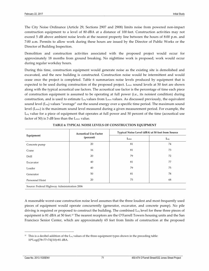
February 22, 2017 Initial Study
Case No. 2013.1535ENV 71 450-474 O’Farrell Street/532 Jones Street Project
The City Noise Ordinance (Article 29, Sections 2907 and 2908) limits noise from powered non-‐‑impact construction equipment to a level of 80 dBA at a distance of 100 feet. Construction activities may not exceed 5 dB above ambient noise levels at the nearest property line between the hours of 8:00 p.m. and 7:00 a.m. Permits to allow work during these hours are issued by the Director of Public Works or the Director of Building Inspection.
Demolition and construction activities associated with the proposed project would occur for approximately 18 months from ground breaking. No nighttime work is proposed; work would occur during regular workday hours.
During this time, construction equipment would generate noise as the existing site is demolished and excavated, and the new building is constructed. Construction noise would be intermittent and would cease once the project is completed. Table 6 summarizes noise levels produced by equipment that is expected to be used during construction of the proposed project. Lmax sound levels at 50 feet are shown along with the typical acoustical use factors. The acoustical use factor is the percentage of time each piece of construction equipment is assumed to be operating at full power (i.e., its noisiest condition) during construction, and is used to estimate Leq values from Lmax values. As discussed previously, the equivalent sound level (Leq) values “average” out the sound energy over a specific time period. The maximum sound level (Lmax) is the maximum sound level measured during a given measurement period. For example, the Leq value for a piece of equipment that operates at full power and 50 percent of the time (acoustical use factor of 50) is 3 dB less than the Lmax value.
TABLE 6: TYPICAL NOISE LEVELS OF CONSTRUCTION EQUIPMENT
Equipment Acoustical Use Factor (percent)
Typical Noise Level (dBA) at 50 feet from Source
Lmax Leq
Concrete pump 20 81 74
Crane 16 81 73
Drill 20 79 72
Excavator 40 81 77
Loader 40 79 75
Generator 50 81 78
Personnel Hoist 20 75 68
Source: Federal Highway Administration 2006
A reasonable worst-‐‑case construction noise level assumes that the three loudest and most frequently used pieces of equipment would operate concurrently (generator, excavator, and concrete pump). No pile driving is required or proposed to construct the building. The combined Leq level for these three pieces of equipment is 81 dBA at 50 feet.37 The nearest receptors are the O’Farrell Towers housing units and the San Francisco Senior Center, which are approximately 65 feet from limits of construction at the proposed
37 This is a decibel addition of the Leq values of the three equipment types shown in the preceding table:
10*Log([78+77+74]/10)=81 dBA.
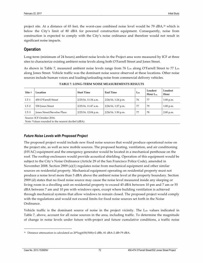
February 22, 2017 Initial Study
Case No. 2013.1535ENV 72 450-474 O’Farrell Street/532 Jones Street Project
project site. At a distance of 65 feet, the worst-‐‑case combined noise level would be 79 dBA,38 which is below the City’s limit of 80 dBA for powered construction equipment. Consequently, noise from construction is expected to comply with the City’s noise ordinance and therefore would not result in significant noise impacts.
Operation Long-‐‑term (minimum of 24 hours) ambient noise levels in the Project area were measured by ICF at three sites to characterize existing ambient noise levels along both O’Farrell Street and Jones Street.
As shown in Table 7, measured ambient noise levels range from 76 Ldn along O’Farrell Street to 77 Ldn along Jones Street. Vehicle traffic was the dominant noise source observed at these locations. Other noise sources include human voices and loading/unloading noise from commercial delivery vehicles.
TABLE 7. LONG-‐‑TERM NOISE MEASUREMENTS RESULTS
Site # Location Start Time End Time Ldn Loudest Hour Leq
Loudest Hour
LT-‐‑1 450 O’Farrell Street 2/25/16, 11:34 a.m. 2/26/16, 1:24 p.m. 76 77 1:00 p.m.
LT-‐‑2 538 Jones Street 2/25/16, 11:47 a.m. 2/26/16, 1:27 p.m. 77 79 1:00 p.m.
LT-‐‑3 Jones Street/Steveloe Place 2/25/16, 12:04 p.m. 2/26/16, 1:30 p.m. 77 78 2:00 p.m.
Source: ICF October 2016. Note: Values rounded to the nearest decibel (dBA).
Future Noise Levels with Proposed Project The proposed project would include new fixed noise sources that would produce operational noise on the project site, as well as new mobile sources. The proposed heating, ventilation, and air conditioning (HVAC) equipment and the emergency generator would be located in a mechanical penthouse on the roof. The rooftop enclosures would provide acoustical shielding. Operation of this equipment would be subject to the City’s Noise Ordinance (Article 29 of the San Francisco Police Code), amended in November 2008. Section 2909 (a)(1) regulates noise from mechanical equipment and other similar sources on residential property. Mechanical equipment operating on residential property must not produce a noise level more than 5 dBA above the ambient noise level at the property boundary. Section 2909 (d) states that no fixed noise source may cause the noise level measured inside any sleeping or living room in a dwelling unit on residential property to exceed 45 dBA between 10 pm and 7 am or 55 dBA between 7 am and 10 pm with windows open, except where building ventilation is achieved through mechanical systems that allow windows to remain closed. The proposed project would comply with the regulations and would not exceed limits for fixed noise sources set forth in the Noise Ordinance.
Vehicle traffic is the dominant source of noise in the project vicinity. The Ldn values indicated in Table 7, above, account for all noise sources in the area, including traffic. To determine the magnitude of change in noise levels under future with-‐‑project and future cumulative conditions, a traffic noise
38 Distance attenuation is calculated as 20*log(65ft/50ft)=2 dBb, 81 dBA-‐‑2 dB=79 dBA.

February 22, 2017 Initial Study
Case No. 2013.1535ENV 73 450-474 O’Farrell Street/532 Jones Street Project
analysis was conducted, based on future project trip generation (i.e., existing plus Project) and 2040 cumulative traffic volumes. Operation of the Project is expected to generate 299 daily net new vehicle trips from the residential and restaurant/retail uses of the project. According to calculations from the Federal Highway Administration’s Traffic Noise Model (Version 2.5) (2004), this volume of project-‐‑related traffic is predicted to result in a noise level of 50 Ldn. Adding the project noise contribution to measured ambient noise levels at each location in Table 7 would result in an increase of less than one-‐‑tenth of 1 dB at all three locations, which is not a substantial increase in traffic noise levels relative to existing conditions. Additionally, to comply with Title 24 standards for proposed residential uses, attenuation from window and wall assemblies should be rated at an outdoor-‐‑indoor transmission class (OITC) of 33 or higher. As discussed in the noise analysis, areas of outdoor use within the proposed project including courtyards would be shielded by project buildings and thus outside noise levels would not be considered annoying or disruptive. Therefore, the proposed project would not generate noise levels that would exceed City standards. This impact is considered to be less than significant. This topic will not be discussed in the EIR.
Impact NO-‐‑2: The proposed project would not result in exposure of persons to, or generation of, excessive ground-‐‑borne vibration or ground-‐‑borne noise levels. (Less than Significant)
The proposed project would not include activities that would result in the exposure of persons to, or generation of, excessive ground-‐‑borne vibration or ground-‐‑borne noise levels. Construction activities may result in ground vibration that may be intermittently perceptible within buildings up to 50 feet away from vibration-‐‑producing equipment. Vibration from demolition, excavation, and building construction would not require high-‐‑impact activities, such as pile driving. Perceptible vibration from construction would be temporary, and would cease once construction is complete. Because vibration from non-‐‑impact construction equipment is typically below the threshold of perception at a distance greater than 50 feet, and because construction activity would not involve high-‐‑impact equipment and would be short-‐‑term in nature, people living in the project vicinity are not expected to be exposed to excessive ground-‐‑borne vibration or noise levels. Therefore, impacts due to ground-‐‑borne vibration or ground-‐‑borne noise generated by the proposed project are considered to be less than significant. This topic will not be discussed in the EIR.
Impact NO-‐‑3: The proposed project would not result in a substantial permanent increase in ambient noise levels in the project vicinity above levels existing without the project. (Less than Significant)
The proposed project would introduce noise from residential and commercial uses, and generate traffic entering and leaving the building site. However, operations would be in compliance with the San Francisco Noise Ordinance and would not significantly increase ambient noise levels in the project vicinity above existing levels without the proposed project as discussed in impact NO-‐‑1. Operation of the proposed project may result in a traffic noise level increase of less than 1 dB, which would not be perceptible compared to existing ambient levels. In addition, operation of HVAC equipment would be subject to the City’s Noise Ordinance (Article 29 of the San Francisco Police Code). This would ensure the project would not result in a substantial permanent increase in ambient noise levels in the project vicinity above existing levels. Therefore, this impact is considered to be less than significant. This topic will not be discussed in the EIR.

February 22, 2017 Initial Study
Case No. 2013.1535ENV 74 450-474 O’Farrell Street/532 Jones Street Project
Impact NO-‐‑4: The proposed project would not result in a substantial temporary or periodic increase in ambient noise levels in the project vicinity above levels existing without the project. (Less than Significant)
As described above under NO-‐‑1, construction noise would be intermittent and would cease once the project is complete. Noise levels during construction are expected to comply with the City noise ordinance. Worst-‐‑case noise level from construction may be as high as 79 dBA at the nearest noise-‐‑sensitive receptors. Noise from construction may intermittently be perceptible above ambient levels, but given that noise levels are in the range of 76 to 77 Ldn under existing conditions, primarily due to local traffic, noise from construction would not result in a substantial temporary or periodic increase in ambient noise levels in the project vicinity. This impact is therefore considered to be less than significant. This topic will not be discussed in the EIR.
Impact NO-‐‑5: The proposed project would not be substantially affected by existing noise levels. (Less than Significant)
This impact is only to be analyzed if the proposed project would exacerbate the existing noise environment. As Impacts NO-‐‑1 through NO-‐‑4 concluded the proposed project would not result in a significant noise impact; therefore, this impact need not be analyzed and will not be discussed in the EIR. However, the following is provided for informational purposes.
Vehicle traffic is the dominant source of noise at the O’Farrell Street noise monitoring location. Other sources of ambient noise include people and vehicles associated with daily activity at residential uses, commercial uses, health and social services, government buildings, and parks. Land uses including fire and police stations, hospitals, airports, train stations, rail lines, concert halls, music venues, scrap yards, machine shops, or other industrial uses which are expected to generate high noise levels are not existent within two blocks of the project site nor within a direct line of sight to the project site. Building design and materials for the proposed project are expected to comply with Title 24 standards which states that interior noise levels attributable to exterior sources shall not exceed 45 dBA (Ldn) in any habitable room of new dwellings, and elements of the project with mechanical systems would comply with the San Francisco Noise Ordinance. Therefore, the proposed project would not be substantially affected by existing ambient noise levels
Impact C-‐‑NO: The proposed project, in combination with past, present, and reasonably foreseeable future development in the project area, would contribute to cumulative noise impacts but would not result in a cumulatively considerable contribution to a cumulative impact. (Less than Significant)
The geographic context for an analysis of cumulative impacts related to noise is the immediate project area. During construction, if construction of related projects occurs concurrently, the noise levels would be additive and could increase the ambient noise levels temporarily and intermittently in the project area to a significant level. As noted, above, the City Noise Ordinance (Article 29, Sections 2907 and 2908) limits noise from powered non-‐‑impact construction equipment to a level of 80 dBA at a distance of 100 feet. Construction activities may not exceed 5 dB above ambient noise levels at the nearest property line between the hours of 8:00 p.m. and 7:00 a.m. No nighttime construction is anticipated; in the event nighttime construction does occur, the proposed project and related projects would be required to obtain construction permits from the City Permits to allow work during these hours and would be evaluated on a case-‐‑by-‐‑case basis. Construction noise would be temporary and intermittent, and it is not likely that all related projects would be under construction at the same time so as to result in a significant, though

February 22, 2017 Initial Study
Case No. 2013.1535ENV 75 450-474 O’Farrell Street/532 Jones Street Project
temporary, increase in ambient noise. As the noise from construction would be temporary, and regulated by the City Noise Ordinance, the proposed project would not make a cumulatively considerable contribution to construction noise impacts.
The proposed project would include new fixed noise sources that would produce operational noise on the project site, as well as new mobile sources. Similar new fixed noise sources would produce noise for projects within ¼-‐‑mile radius of the project site. This could result in a permanent increase in ambient noise above levels existing without the projects. Operation of all mechanical equipment would be subject to the City’s Noise Ordinance (Article 29 of the San Francisco Police Code), amended in November 2008. Section 2909 (a)(1) regulates noise from mechanical equipment and other similar sources on residential property. Mechanical equipment operating on residential property must not produce a noise level more than 5 dBA above the ambient noise level at the property boundary. Section 2909 (d) states that no fixed noise source may cause the noise level measured inside any sleeping or living room in a dwelling unit on residential property to exceed 45 dBA between 10 pm and 7 am or 55 dBA between 7 am and 10 pm with windows open, except where building ventilation is achieved through mechanical systems that allow windows to remain closed. The proposed project and reasonably foreseeable projects would comply with the regulations and would not exceed limits for fixed noise sources set forth in the Noise Ordinance. Thus, cumulative long-‐‑term noise impacts from fixed noise sources would be less than significant.
As noted, vehicle traffic is the dominant source of noise in the project vicinity. Related projects would be expected to add additional vehicular trips, increasing the level of ambient noise potentially to a cumulatively significant level. However, the analysis above indicates that adding the proposed project’s noise contribution to measured ambient noise levels would result in an increase of less than one-‐‑tenth of 1 dB at all three measurement locations, which is not a substantial increase in traffic noise levels relative to existing conditions. In addition, the project’s contribution of 1 dB would represent an even smaller fraction of the cumulative increase to traffic noise. Thus, even if the proposed project in combination past, present, and reasonably foreseeable projects resulted in cumulative vehicle traffic noise in the vicinity reaching a significant level, the project-‐‑related contribution to traffic noise under cumulative conditions would not be considerable because it would represent a minor proportion of the overall traffic volume in the site vicinity and traffic noise from the project would not be perceptible.
Additionally, to comply with Title 24 standards for proposed residential uses, attenuation from window and wall assemblies should be rated at OITC 33 or higher. Related projects would also be required to implement noise attenuation features in all residential development and each of the related projects would require evaluation of the outdoor noise levels and to implement appropriate shielding to meet Title 24 standards
In light of the above, when considered in combination with past, present, and reasonably foreseeable projects, the proposed project’s contribution to noise impacts would not be cumulatively considerable, and, therefore, the cumulative impact is less than significant. This topic will not be discussed in the EIR.

February 22, 2017 Initial Study
Case No. 2013.1535ENV 76 450-474 O’Farrell Street/532 Jones Street Project
Air Quality
Topics:
Potentially Significant
Impact
Less than Significant
with Mitigation
Incorporated
Less-than-Significant
Impact No
Impact Not
Applicable
6. AIR QUALITY—Would the project:
a) Conflict with or obstruct implementation of the applicable air quality plan?
b) Violate any air quality standard or contribute substantially to an existing or projected air quality violation?
c) Result in a cumulatively considerable net increase of any criteria pollutant for which the project region is non-‐‑attainment under an applicable federal, state, or regional ambient air quality standard (including releasing emissions that exceed quantitative thresholds for ozone precursors)?
d) Expose sensitive receptors to substantial pollutant concentrations?
e) Create objectionable odors affecting a substantial number of people?
Setting
Overview The Bay Area Air Quality Management District (BAAQMD) is the regional agency with jurisdiction over the nine-‐‑county San Francisco Bay Area Air Basin (SFBAAB), which includes San Francisco, Alameda, Contra Costa, Marin, San Mateo, Santa Clara, and Napa Counties and portions of Sonoma and Solano Counties. The BAAQMD is responsible for attaining and maintaining air quality in the SFBAAB within federal and state air quality standards, as established by the federal Clean Air Act (CAA) and the California Clean Air Act (CCAA), respectively. Specifically, the BAAQMD has the responsibility to monitor ambient air pollutant levels throughout the SFBAAB and to develop and implement strategies to attain the applicable federal and state standards. The CAA and the CCAA require plans to be developed for areas that do not meet air quality standards, generally. The most recent air quality plan, the 2010 Clean Air Plan, was adopted by the BAAQMD on September 15, 2010. The 2010 Clean Air Plan updates the Bay Area 2005 Ozone Strategy in accordance with the requirements of the CCAA to implement all feasible measures to reduce ozone; provide a control strategy to reduce ozone, particulate matter, air toxics, and greenhouse gases in a single, integrated plan; and establish emission control measures to be adopted or implemented. The 2010 Clean Air Plan contains the following primary goals:
• Attain air quality standards;
• Reduce population exposure and protect public health in the San Francisco Bay Area; and
• Reduce greenhouse gas emissions and protect the climate.
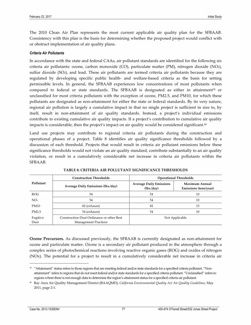
February 22, 2017 Initial Study
Case No. 2013.1535ENV 77 450-474 O’Farrell Street/532 Jones Street Project
The 2010 Clean Air Plan represents the most current applicable air quality plan for the SFBAAB. Consistency with this plan is the basis for determining whether the proposed project would conflict with or obstruct implementation of air quality plans.
Criteria Air Pollutants
In accordance with the state and federal CAAs, air pollutant standards are identified for the following six criteria air pollutants: ozone, carbon monoxide (CO), particulate matter (PM), nitrogen dioxide (NO2), sulfur dioxide (SO2), and lead. These air pollutants are termed criteria air pollutants because they are regulated by developing specific public health-‐‑ and welfare-‐‑based criteria as the basis for setting permissible levels. In general, the SFBAAB experiences low concentrations of most pollutants when compared to federal or state standards. The SFBAAB is designated as either in attainment39 or unclassified for most criteria pollutants with the exception of ozone, PM2.5, and PM10, for which these pollutants are designated as non-‐‑attainment for either the state or federal standards. By its very nature, regional air pollution is largely a cumulative impact in that no single project is sufficient in size to, by itself, result in non-‐‑attainment of air quality standards. Instead, a project’s individual emissions contribute to existing cumulative air quality impacts. If a project’s contribution to cumulative air quality impacts is considerable, then the project’s impact on air quality would be considered significant.40
Land use projects may contribute to regional criteria air pollutants during the construction and operational phases of a project. Table 8 identifies air quality significance thresholds followed by a discussion of each threshold. Projects that would result in criteria air pollutant emissions below these significance thresholds would not violate an air quality standard, contribute substantially to an air quality violation, or result in a cumulatively considerable net increase in criteria air pollutants within the SFBAAB.
TABLE 8: CRITERIA AIR POLLUTANT SIGNIFICANCE THRESHOLDS
Pollutant Construction Thresholds Operational Thresholds
Average Daily Emissions (lbs./day) Average Daily Emissions
(lbs./day) Maximum Annual Emissions (tons/year)
ROG 54 54 10
NOx 54 54 10
PM10 82 (exhaust) 82 15
PM2.5 54 (exhaust) 54 10
Fugitive Dust
Construction Dust Ordinance or other Best Management Practices
Not Applicable
Ozone Precursors. As discussed previously, the SFBAAB is currently designated as non-‐‑attainment for ozone and particulate matter. Ozone is a secondary air pollutant produced in the atmosphere through a complex series of photochemical reactions involving reactive organic gases (ROG) and oxides of nitrogen (NOx). The potential for a project to result in a cumulatively considerable net increase in criteria air
39 “Attainment” status refers to those regions that are meeting federal and/or state standards for a specified criteria pollutant. “Non-‐‑
attainment” refers to regions that do not meet federal and/or state standards for a specified criteria pollutant. “Unclassified” refers to regions where there is not enough data to determine the region’s attainment status for a specified criteria air pollutant.
40 Bay Area Air Quality Management District (BAAQMD), California Environmental Quality Act Air Quality Guidelines, May 2011, page 2-‐‑1.
February 22, 2017 Initial Study
Case No. 2013.1535ENV 78 450-474 O’Farrell Street/532 Jones Street Project
pollutants, which may contribute to an existing or projected air quality violation, are based on the state and federal Clean Air Acts emissions limits for stationary sources. To ensure that new stationary sources do not cause or contribute to a violation of an air quality standard, BAAQMD Regulation 2, Rule 2 requires that any new source that emits criteria air pollutants above a specified emissions limit must offset those emissions. For ozone precursors ROG and NOx, the offset emissions level is an annual average of 10 tons per year (or 54 pounds (lbs.) per day).41 These levels represent emissions below which new sources are not anticipated to contribute to an air quality violation or result in a considerable net increase in criteria air pollutants.
Although this regulation applies to new or modified stationary sources, land use development projects result in ROG and NOx emissions as a result of increases in vehicle trips, architectural coating and construction activities. Therefore, the above thresholds can be applied to the construction and operational phases of land use projects and those projects that result in emissions below these thresholds, would not be considered to contribute to an existing or projected air quality violation or result in a considerable net increase in ROG and NOx emissions. Due to the temporary nature of construction activities, only the average daily thresholds are applicable to construction phase emissions.
Particulate Matter (PM10 and PM2.5).42 The BAAQMD has not established an offset limit for PM2.5. However, the emissions limit in the federal NSR for stationary sources in nonattainment areas is an appropriate significance threshold. For PM10 and PM2.5, the emissions limit under NSR is 15 tons per year (82 lbs. per day) and 10 tons per year (54 lbs. per day), respectively. These emissions limits represent levels below which a source is not expected to have an impact on air quality.43 Similar to ozone precursor thresholds identified above, land use development projects typically result in particulate matter emissions as a result of increases in vehicle trips, space heating and natural gas combustion, landscape maintenance, and construction activities. Therefore, the above thresholds can be applied to the construction and operational phases of a land use project. Again, because construction activities are temporary in nature, only the average daily thresholds are applicable to construction-‐‑phase emissions.
Fugitive Dust. Fugitive dust emissions are typically generated during construction phases. Studies have shown that the application of best management practices (BMPs) at construction sites significantly control fugitive dust44 and individual measures have been shown to reduce fugitive dust by anywhere from 30 to 90 percent.45 The BAAQMD has identified a number of BMPs to control fugitive dust emissions from construction activities.46 The City’s Construction Dust Control Ordinance (Ordinance 176-‐‑08, effective July 30, 2008) requires a number of measures to control fugitive dust and the BMPs employed in compliance with the City’s Construction Dust Control Ordinance is an effective strategy for controlling construction-‐‑related fugitive dust.
41 BAAQMD, Revised Draft Options and Justification Report, California Environmental Quality Act Thresholds of Significance, October
2009, page 17. 42 PM10 is often termed “coarse” particulate matter and is made of particulates that are 10 microns in diameter or smaller.
PM2.5, termed “fine” particulate matter, is composed of particles that are 2.5 microns or less in diameter. 43 BAAQMD, Revised Draft Options and Justification Report, California Environmental Quality Act Thresholds of Significance, October
2009, page 16. 44 Western Regional Air Partnership. 2006. WRAP Fugitive Dust Handbook. September 7, 2006. This document is available online
at http://www.wrapair.org/forums/dejf/fdh/content/FDHandbook_Rev_06.pdf, accessed February 16, 2012. 45 BAAQMD, Revised Draft Options and Justification Report, California Environmental Quality Act Thresholds of Significance, October
2009, page 27. 46 BAAQMD, CEQA Air Quality Guidelines, May 2011.

February 22, 2017 Initial Study
Case No. 2013.1535ENV 79 450-474 O’Farrell Street/532 Jones Street Project
Other Criteria Pollutants. Regional concentrations of CO in the Bay Area have not exceeded the state standards in the past 11 years and SO2 concentrations have never exceeded the standards. The primary source of CO emissions from development projects is vehicle traffic. Construction-‐‑related SO2 emissions represent a negligible portion of the total basin-‐‑wide emissions and construction-‐‑related CO emissions represent less than five percent of the Bay Area total basin-‐‑wide CO emissions. As discussed previously, the Bay Area is in attainment for both CO and SO2. Furthermore, the BAAQMD has demonstrated, based on modeling, that in order to exceed the California ambient air quality standard of 9.0 ppm (8-‐‑hour average) or 20.0 ppm (1-‐‑hour average) for CO, project traffic in addition to existing traffic would need to exceed 44,000 vehicles per hour at affected intersections (or 24,000 vehicles per hour where vertical and/or horizontal mixing is limited). Therefore, given the Bay Area’s attainment status and the limited CO and SO2 emissions that could result from a development projects, development projects would not result in a cumulatively considerable net increase in CO or SO2, and quantitative analysis is not required.
Local Health Risks and Hazards
In addition to criteria air pollutants, individual projects may emit toxic air contaminants (TACs). TACs collectively refer to a diverse group of air pollutants that are capable of causing chronic (i.e., of long-‐‑duration) and acute (i.e., severe but short-‐‑term) adverse effects to human health, including carcinogenic effects. Human health effects of TACs include birth defects, neurological damage, cancer, and mortality. There are hundreds of different types of TACs with varying degrees of toxicity. Individual TACs vary greatly in the health risk they present; at a given level of exposure, one TAC may pose a hazard that is many times greater than another.
Unlike criteria air pollutants, TACs do not have ambient air quality standards but are regulated by the BAAQMD using a risk-‐‑based approach to determine which sources and pollutants to control as well as the degree of control. A health risk assessment is an analysis in which human health exposure to toxic substances is estimated, and considered together with information regarding the toxic potency of the substances, to provide quantitative estimates of health risks.47
Air pollution does not affect every individual in the population in the same way, and some groups are more sensitive to adverse health effects than others. Land uses such as residences, schools, children’s day care centers, hospitals, and nursing and convalescent homes are considered to be the most sensitive to poor air quality because the population groups associated with these uses have increased susceptibility to respiratory distress or, as in the case of residential receptors, their exposure time is greater than that for other land uses. Therefore, these groups are referred to as sensitive receptors. Exposure assessment guidance typically assumes that residences would be exposed to air pollution 24 hours per day, 350 days per year, for 30 years. Therefore, assessments of air pollutant exposure to residents typically result in the greatest adverse health outcomes of all population groups.
47 In general, a health risk assessment is required if the BAAQMD concludes that projected emissions of a specific air toxic
compound from a proposed new or modified source suggest a potential public health risk. The applicant is then subject to a health risk assessment for the source in question. Such an assessment generally evaluates chronic, long-‐‑term effects, estimating the increased risk of cancer as a result of exposure to one or more TACs.
February 22, 2017 Initial Study
Case No. 2013.1535ENV 80 450-474 O’Farrell Street/532 Jones Street Project
Exposures to fine particulate matter (PM2.5) are strongly associated with mortality, respiratory diseases, and lung development in children, and other endpoints such as hospitalization for cardiopulmonary disease.48 In addition to PM2.5, diesel particulate matter (DPM) is also of concern. The California Air Resources Board (ARB) identified DPM as a TAC in 1998, primarily based on evidence demonstrating cancer effects in humans.49 The estimated cancer risk from exposure to diesel exhaust is much higher than the risk associated with any other TAC routinely measured in the region.
In an effort to identify areas of San Francisco most adversely affected by sources of TACs, San Francisco partnered with the BAAQMD to conduct a citywide health risk assessment based on an inventory and assessment of air pollution and exposures from mobile, stationary, and area sources within San Francisco. Areas with poor air quality, termed the “Air Pollutant Exposure Zone,” were identified based on health-‐‑protective criteria that considers estimated cancer risk, exposures to fine particulate matter, proximity to freeways, and locations with particularly vulnerable populations. Each of the Air Pollutant Exposure Zone criteria is discussed below.
Excess Cancer Risk. The Air Pollutant Exposure Zone includes all areas where excess cancer risk from known sources exceeds 100 per one million persons. This criterion is based on United States Environmental Protection Agency (USEPA) guidance for conducting air toxic analyses and making risk management decisions at the facility and community-‐‑scale level.50 As described by the BAAQMD, the USEPA considers a cancer risk of 100 per million to be within the “acceptable” range of cancer risk. Furthermore, in the 1989 preamble to the benzene National Emissions Standards for Hazardous Air Pollutants (NESHAP) rulemaking,51 the USEPA states that it “…strives to provide maximum feasible protection against risks to health from hazardous air pollutants by (1) protecting the greatest number of persons possible to an individual lifetime risk level no higher than approximately one in one million and (2) limiting to no higher than approximately one in ten thousand [100 in one million] the estimated risk that a person living near a plant would have if he or she were exposed to the maximum pollutant concentrations for 70 years.” The 100 per one million excess cancer cases is also consistent with the ambient cancer risk in the most pristine portions of the Bay Area based on BAAQMD regional modeling.52
Fine Particulate Matter. In April 2011, the USEPA published Policy Assessment for the Particulate Matter Review of the National Ambient Air Quality Standards, “Particulate Matter Policy Assessment.” In this document, USEPA staff concludes that the then current federal annual PM2.5 standard of 15 µμg/m3 should be revised to a level within the range of 13 to 11 µμg/m3, with evidence strongly supporting a standard within the range of 12 to 11 µμg/m3. The Air Pollutant Exposure Zone for San Francisco is based on the health protective PM2.5 standard of 11 µμg/m3, as supported by the USEPA’s Particulate Matter Policy Assessment, although lowered to 10 µμg/m3 to account for uncertainty in accurately predicting air pollutant concentrations using emissions modeling programs.
48 SFDPH, Assessment and Mitigation of Air Pollutant Health Effects from Intra-‐‑Urban Roadways: Guidance for Land Use Planning and Environmental Review, May 2008.
49 California Air Resources Board (ARB), Fact Sheet, “The Toxic Air Contaminant Identification Process: Toxic Air Contaminant Emissions from Diesel-‐‑fueled Engines,” October 1998.
50 BAAQMD, Revised Draft Options and Justification Report, California Environmental Quality Act Thresholds of Significance, October 2009, page 67.
51 54 Federal Register 38044, September 14, 1989. 52 BAAQMD, Revised Draft Options and Justification Report, California Environmental Quality Act Thresholds of Significance, October
2009, page 67.

February 22, 2017 Initial Study
Case No. 2013.1535ENV 81 450-474 O’Farrell Street/532 Jones Street Project
Proximity to Freeways. According to ARB, studies have shown an association between the proximity of sensitive land uses to freeways and a variety of respiratory symptoms, asthma exacerbations, and decreases in lung function in children. Siting sensitive uses in close proximity to freeways increases both exposure to air pollution and the potential for adverse health effects. As evidence shows that sensitive uses in an area within a 500-‐‑foot buffer of any freeway are at an increased health risk from air pollution,53 lots that are within 500 feet of freeways are included in the Air Pollutant Exposure Zone.
Health Vulnerable Locations. Based on the BAAQMD’s evaluation of health vulnerability in the Bay Area, those zip codes (94102, 94103, 94105, 94124, and 94130) in the worst quintile of Bay Area Health vulnerability scores as a result of air pollution-‐‑related causes were afforded additional protection by lowering the standards for identifying lots in the Air Pollutant Exposure Zone to: (1) an excess cancer risk greater than 90 per one million persons exposed, and/or (2) PM2.5 concentrations in excess of 9 µμg/m3.54
The above citywide health risk modeling was also used as the basis in approving a series of amendments to the San Francisco Building and Health Codes, generally referred to as the Enhanced Ventilation Required for Urban Infill Sensitive Use Developments or Health Code, Article 38 (Ordinance 224-‐‑14, effective December 8, 2014) (Article 38). The purpose of Article 38 is to protect the public health and welfare by establishing an Air Pollutant Exposure Zone and imposing an enhanced ventilation requirement for all urban infill sensitive use development within the Air Pollutant Exposure Zone. In addition, projects within the Air Pollutant Exposure Zone require special consideration to determine whether the project’s activities would add a substantial amount of emissions to areas already adversely affected by poor air quality. The project site is located within the Air Pollutant Exposure Zone.55
Construction Air Quality Impacts Project-‐‑related air quality impacts fall into two categories: short-‐‑term impacts from construction and long-‐‑term impacts from project operation. The following addresses construction-‐‑related air quality impacts resulting from the proposed project.
Impact AQ-‐‑1: The proposed project’s construction activities would generate fugitive dust and criteria air pollutants, but would not violate an air quality standard, contribute substantially to an existing or projected air quality violation, or result in a cumulatively considerable net increase in criteria air pollutants. (Less than Significant)
Construction activities (short-‐‑term) typically result in emissions of ozone precursors and PM in the form of dust (fugitive dust) and exhaust (e.g., vehicle tailpipe emissions). Emissions of ozone precursors and PM are primarily a result of the combustion of fuel from on-‐‑road and off-‐‑road vehicles. However, ROGs are also emitted from activities that involve painting, other types of architectural coatings, or asphalt paving. The proposed project includes demolition of the existing 26,904 sf Fifth Church of Christ Scientist
53 California Air Resources Board, Air Quality and Land Use Handbook: A Community Health Perspective. April 2005. Available
online at: http://www.arb.ca.gov/ch/landuse.htm. 54 San Francisco Planning Department and San Francisco Department of Public Health, 2014 Air Pollutant Exposure Zone Map (Memo and Map), April 9, 2014. These documents are part of San Francisco Board of Supervisors File No. 14806, Ordinance No. 224-‐‑14, Amendment to Health Code Article 38.
55 San Francisco Planning Department. San Francisco Property Information Map, Version 3.4.4 Map. 2016. Available at: http://propertymap.sfplanning.org/?dept=planning, Accessed on February 25, 2016.

February 22, 2017 Initial Study
Case No. 2013.1535ENV 82 450-474 O’Farrell Street/532 Jones Street Project
building and adjoining 1,400 sf surface parking lot, 4,415 sf vacant retail building, and 1,012 sf restaurant and residential building with five units. The church façade would be retained. Development of the 22,106 sf project site includes construction of a new building. The building would be a 13-‐‑story, 130-‐‑foot-‐‑tall mixed-‐‑use building containing approximately up to 176 dwelling units, with 6,200 sf of restaurant/retail space and a 13,595 sf replacement religious institution incorporated into the ground level. The project would also construct one level of subterranean parking containing 41 parking spaces. The total proposed project would include up to 187,640 sf of residential use and leasing office/amenity space, 6,200 sf of restaurant/retail space, and 21,070 sf of parking. During the proposed project’s approximately 18-‐‑month construction period, construction activities would have the potential to result in emissions of ozone precursors and PM, as discussed below.
Fugitive Dust
Project-‐‑related demolition, excavation, grading, and other construction activities may cause wind-‐‑blown dust that could contribute particulate matter into the local atmosphere. Although there are federal standards for air pollutants and implementation of state and regional air quality control plans, air pollutants continue to have impacts on human health throughout the country. California has found that particulate matter exposure can cause health effects at lower levels than national standards. The current health burden of particulate matter demands that, where possible, public agencies take feasible available actions to reduce sources of particulate matter exposure. According to the ARB, reducing particulate matter PM2.5 concentrations to state and federal standards of 12 µμg/m3 in the San Francisco Bay Area would prevent between 200 and 1,300 premature deaths.56
Dust can be an irritant causing watering eyes or irritation to the lungs, nose, and throat. Demolition, excavation, grading, and other construction activities can cause wind-‐‑blown dust that adds particulate matter to the local atmosphere. Depending on exposure, adverse health effects can occur due to this particulate matter in general and also due to specific contaminants such as lead or asbestos that may be constituents of soil.
In response, the San Francisco Board of Supervisors approved a series of amendments to the San Francisco Building and Health Codes generally referred hereto as the Construction Dust Control Ordinance (Ordinance 176-‐‑08, effective July 30, 2008) with the intent of reducing the quantity of dust generated during site preparation, demolition and construction work in order to protect the health of the general public and of onsite workers, minimize public nuisance complaints, and to avoid orders to stop work by the Department of Building Inspection (DBI).
The Ordinance requires that all site preparation work, demolition, or other construction activities within San Francisco that have the potential to create dust or to expose or disturb more than 10 cubic yards or 500 square feet of soil comply with specified dust control measures whether or not the activity requires a permit from DBI. The Director of DBI may waive this requirement for activities on sites less than one half-‐‑acre that are unlikely to result in any visible wind-‐‑blown dust.
In compliance with the Construction Dust Control Ordinance, the project sponsor and the contractor responsible for construction activities at the project site would be required to use the following practices to control construction dust on the site or other practices that result in equivalent dust control that are
56 ARB, Methodology for Estimating Premature Deaths Associated with Long-‐‑term Exposure to Fine Airborne Particulate Matter in California, Staff Report, Table 4c, October 24, 2008.
February 22, 2017 Initial Study
Case No. 2013.1535ENV 83 450-474 O’Farrell Street/532 Jones Street Project
acceptable to the Director. Dust suppression activities may include watering all active construction areas sufficiently to prevent dust from becoming airborne; increased watering frequency may be necessary whenever wind speeds exceed 15 miles per hour. During excavation and dirt-‐‑moving activities, contractors shall wet sweep or vacuum the streets, sidewalks, paths, and intersections where work is in progress at the end of the workday. Inactive stockpiles (where no disturbance occurs for more than seven days) greater than 10 cubic yards or 500 square feet of excavated material, backfill material, import material, gravel, sand, road base, and soil shall be covered with a 10 mil (0.01 inch) polyethylene plastic (or equivalent) tarp, braced down, or use other equivalent soil stabilization techniques. City and County of San Francisco Ordinance 175-‐‑91 restricts the use of potable water for soil compaction and dust control activities undertaken in conjunction with any construction or demolition project occurring within the boundaries of San Francisco, unless permission is obtained from the San Francisco Public Utilities Commission (SFPUC). Non-‐‑potable water must be used for soil compaction and dust control activities during project construction and demolition. The SFPUC operates a recycled water truck-‐‑fill station at the Southeast Water Pollution Control Plant that provides recycled water for these activities at no charge.
The site-‐‑specific Dust Control Plan required by the Dust Control Ordinance would require the project sponsor to: submit of a map to the Director of Public Health showing all sensitive receptors within 1,000 feet of the site; wet down areas of soil at least three times per day; provide an analysis of wind direction and install upwind and downwind particulate dust monitors; record particulate monitoring results; hire an independent, third-‐‑party to conduct inspections and keep a record of those inspections; establish shut-‐‑down conditions based on wind, soil migration, etc.; establish a hotline for surrounding community members who may be potentially affected by project-‐‑related dust; limit the area subject to construction activities at any one time; install dust curtains and windbreaks on the property lines, as necessary; limit the amount of soil in hauling trucks to the size of the truck bed and securing with a tarpaulin; enforce a 15 mph speed limit for vehicles entering and exiting construction areas; sweep affected streets with water sweepers at the end of the day; install and utilize wheel washers to clean truck tires; terminate construction activities when winds exceed 25 miles per hour; apply soil stabilizers to inactive areas; and sweep off adjacent streets to reduce particulate emissions. The project sponsor would be required to designate an individual to monitor compliance with these dust control requirements. Compliance with the regulations and procedures set forth by the San Francisco Dust Control Ordinance would ensure that potential dust-‐‑related air quality impacts would be reduced to a less-‐‑than-‐‑significant level. This topic will not be discussed in the EIR.
Criteria Air Pollutants
As discussed above, construction activities would result in emissions of criteria air pollutants from the use of off-‐‑ and on-‐‑road vehicles and equipment. To assist lead agencies in determining whether short-‐‑term construction-‐‑related air pollutant emissions require further analysis as to whether the project may exceed the criteria air pollutant significance thresholds shown in Table 8, above, the BAAQMD, in its CEQA Air Quality Guidelines (May 2011), developed screening criteria. If a proposed project meets the screening criteria, then construction of the project would result in less-‐‑than-‐‑significant criteria air pollutant impacts. A project that exceeds the screening criteria may require a detailed air quality assessment to determine whether criteria air pollutant emissions would exceed significance thresholds. The CEQA Air Quality Guidelines note that the screening levels are generally representative of new

February 22, 2017 Initial Study
Case No. 2013.1535ENV 84 450-474 O’Farrell Street/532 Jones Street Project
development on greenfield57 sites without any form of mitigation measures taken into consideration. In addition, the screening criteria do not account for project design features, attributes, or local development requirements that could also result in lower emissions.
The proposed project includes up to 187,640 sf of residential use and office/amenity space, 6,200 sf of restaurant/retail space, and 21,070 sf of parking. As shown in Table 9, the size of proposed construction activities would be below the criteria air pollutant screening sizes for the land use types associated with the project and identified in the BAAQMD’s CEQA Air Quality Guidelines. Project-‐‑specific construction data was also provided by the project sponsor58. While multiple construction phases are anticipated to occur simultaneously during the year 2018 only two pieces of diesel powered construction equipment would operate concurrently during this period of construction phase overlap. Total soil export quantities expected for the project total 8,900 cubic yards of material to be exported. This amount of material transport is not anticipated to require a significant amount of haul truck activity. Thus, quantification of construction-‐‑related criteria air pollutant emissions is not required and the proposed project’s construction activities would result in a less-‐‑than-‐‑significant criteria air pollutant impact. This topic will not be discussed in the EIR.
TABLE 9: COMPARISON OF PROPOSED PROJECT TO BAAQMD CRITERIA AIR POLLUTANTS AND PRECURSORS CONSTRUCTION AND OPERATIONAL SCREENING LEVEL CRITERIA
Land Use Type Operational Criteria
Pollutant Screening Size Construction Criteria Pollutant
Screening Size Project Components
Apartment, high-‐‑rise 510 dwelling units 249 dwelling units up to 176 dwelling units
High turnover restaurant 33,000 sf 277,000 sf 6,200 sf
Impact AQ-‐‑2: The proposed project’s construction activities would generate toxic air contaminants, including diesel particulate matter, exposing sensitive receptors to substantial pollutant concentrations. (Less than Significant with Mitigation)
The project site is located within the Air Pollutant Exposure Zone as described above. Sensitive receptors are located in close proximity to the project site, including high density residences, a hostel, a senior center, and senior housing.
With regards to construction emissions, off-‐‑road equipment (which includes construction-‐‑related equipment) is a large contributor to DPM emissions in California, although since 2007, the ARB has found the emissions to be substantially lower than previously expected.59 Newer and more refined emission inventories have substantially lowered the estimates of DPM emissions from off-‐‑road equipment such
57 A greenfield site refers to agricultural or forest land or an undeveloped site earmarked for commercial, residential, or
industrial projects. 58 450 O’Farrell Partners, 2016. Project Description Information for Air Quality Analysis. May 9. 59 ARB, Staff Report: Initial Statement of Reasons for Proposed Rulemaking, Proposed Amendments to the Regulation for In-‐‑Use Off-‐‑Road Diesel-‐‑Fueled Fleets and the Off-‐‑Road Large Spark-‐‑Ignition Fleet Requirements, p.1 and p. 13 (Figure 4), October 2010.
February 22, 2017 Initial Study
Case No. 2013.1535ENV 85 450-474 O’Farrell Street/532 Jones Street Project
that off-‐‑road equipment is now considered the sixth largest source of DPM emissions in California.60 For example, revised PM emission estimates for the year 2010, which DPM is a major component of total PM, have decreased by 83 percent from previous 2010 emissions estimates for the SFBAAB.61 Approximately half of the reduction in emissions can be attributed to the economic recession and half to updated methodologies used to better assess construction emissions.62 Additionally, a number of federal and state regulations are requiring cleaner off-‐‑road equipment. Specifically, both the USEPA and California have set emissions standards for new off-‐‑road equipment engines, ranging from Tier 1 to Tier 4. Tier 1 emission standards were phased in between 1996 and 2000 and Tier 4 Interim and Final emission standards for all new engines were phased in between 2008 and 2015. To meet the Tier 4 emission standards, engine manufacturers will be required to produce new engines with advanced emission-‐‑control technologies. Although the full benefits of these regulations will not be realized for several years, the USEPA estimates that by implementing the federal Tier 4 standards, NOx and PM emissions will be reduced by more than 90 percent.63
In addition, construction activities do not lend themselves to analysis of long-‐‑term health risks because of their temporary and variable nature. As explained in the BAAQMD’s CEQA Air Quality Guidelines:
Due to the variable nature of construction activity, the generation of TAC emissions in most cases would be temporary, especially considering the short amount of time such equipment is typically within an influential distance that would result in the exposure of sensitive receptors to substantial concentrations. Concentrations of mobile-‐‑source diesel PM emissions are typically reduced by 70 percent at a distance of approximately 500 feet (ARB 2005). In addition, current models and methodologies for conducting health risk assessments are associated with longer-‐‑term exposure periods of 9, 40, and 70 years, which do not correlate well with the temporary and highly variable nature of construction activities. This results in difficulties with producing accurate estimates of health risk.64
Therefore, project-‐‑level analyses of construction activities have a tendency to produce overestimated assessments of long-‐‑term health risks. However, within the Air Pollutant Exposure Zone, as discussed above, additional construction activity may adversely affect populations that are already at a higher risk for adverse long-‐‑term health risks from existing sources of air pollution.
The proposed project would require construction activities for the approximate 18-‐‑month construction period. Project construction activities would result in short-‐‑term emissions of DPM and other TACs. The project site is located in an area that already experiences poor air quality and project construction activities would generate additional air pollution, affecting nearby sensitive receptors and resulting in a significant impact. Implementation of Mitigation Measure M-‐‑AQ-‐‑2, Construction Air Quality, would reduce the magnitude of this impact to a less-‐‑than-‐‑significant level. While emission reductions from limiting idling, educating workers and the public and properly maintaining equipment are difficult to quantify, other measures, specifically the requirement for equipment with Tier 2 engines and Level 3
60 ARB, Staff Report: Initial Statement of Reasons for Proposed Rulemaking, Proposed Amendments to the Regulation for In-‐‑Use Off-‐‑Road Diesel-‐‑Fueled Fleets and the Off-‐‑Road Large Spark-‐‑Ignition Fleet Requirements, October 2010.
61 ARB, “In-‐‑Use Off-‐‑Road Equipment, 2011 Inventory Model,” Query accessed online, April 2, 2012, http://www.arb.ca.gov/msei/categories.htm#inuse_or_category.
62 ARB, Staff Report: Initial Statement of Reasons for Proposed Rulemaking, Proposed Amendments to the Regulation for In-‐‑Use Off-‐‑Road Diesel-‐‑Fueled Fleets and the Off-‐‑Road Large Spark-‐‑Ignition Fleet Requirements, October 2010.
63 USEPA, “Clean Air Nonroad Diesel Rule: Fact Sheet,” May 2004. 64 BAAQMD, CEQA Air Quality Guidelines, May 2011, page 8-‐‑6.
February 22, 2017 Initial Study
Case No. 2013.1535ENV 86 450-474 O’Farrell Street/532 Jones Street Project
Verified Diesel Emission Control Strategy (VDECS) can reduce construction emissions by 89 to 94 percent compared to equipment with engines meeting no emission standards and without a VDECS.65 Emissions reductions from the combination of Tier 2 equipment with level 3 VDECS is almost equivalent to requiring only equipment with Tier 4 Final engines. Therefore, compliance with Mitigation Measure M-‐‑AQ-‐‑2 would reduce construction emissions impacts on nearby sensitive receptors to a less-‐‑than-‐‑significant level. This topic will not be discussed in the EIR.
Mitigation Measure M-‐‑AQ-‐‑2: Construction Air Quality
The project sponsor or the project sponsor’s Contractor shall comply with the following:
A. Engine Requirements.
1. All off-‐‑road equipment greater than 25 hp and operating for more than 20 total hours over the entire duration of construction activities shall have engines that meet or exceed either U.S. Environmental Protection Agency (USEPA) or California Air Resources Board (ARB) Tier 2 off-‐‑road emission standards, and have been retrofitted with an ARB Level 3 Verified Diesel Emissions Control Strategy. Equipment with engines meeting Tier 4 Interim or Tier 4 Final off-‐‑road emission standards automatically meet this requirement.
2. Where access to alternative sources of power are available, portable diesel engines shall be prohibited.
3. Diesel engines, whether for off-‐‑road or on-‐‑road equipment, shall not be left idling for more than two minutes, at any location, except as provided in exceptions to the applicable state regulations regarding idling for off-‐‑road and on-‐‑road equipment (e.g., traffic conditions, safe operating conditions). The Contractor shall post legible and visible signs in English, Spanish, and Chinese, in designated queuing areas and at the construction site to remind operators of the two-‐‑minute idling limit.
4. The Contractor shall instruct construction workers and equipment operators on the maintenance and tuning of construction equipment, and require that such workers and operators properly maintain and tune equipment in accordance with manufacturer specifications.
65 PM emissions benefits are estimated by comparing off-‐‑road PM emission standards for Tier 2 with Tier 1 and 0. Tier 0 off-‐‑
road engines do not have PM emission standards, but the United States Environmental Protection Agency’s Exhaust and Crankcase Emissions Factors for Nonroad Engine Modeling – Compression Ignition has estimated Tier 0 engines between 50 hp and 100 hp to have a PM emission factor of 0.72 g/hp-‐‑hr and greater than 100 hp to have a PM emission factor of 0.40 g/hp-‐‑hr. Therefore, requiring off-‐‑road equipment to have at least a Tier 2 engine would result in between a 25 percent and 63 percent reduction in PM emissions, as compared to off-‐‑road equipment with Tier 0 or Tier 1 engines. The 25 percent reduction comes from comparing the PM emission standards for off-‐‑road engines between 25 hp and 50 hp for Tier 2 (0.45 g/bhp-‐‑hr) and Tier 1 (0.60 g/bhp-‐‑hr). The 63 percent reduction comes from comparing the PM emission standards for off-‐‑road engines above 175 hp for Tier 2 (0.15 g/bhp-‐‑hr) and Tier 0 (0.40 g/bhp-‐‑hr). In addition to the Tier 2 requirement, ARB Level 3 VDECSs are required and would reduce PM by an additional 85 percent. Therefore, the mitigation measure would result in between an 89 percent (0.0675 g/bhp-‐‑hr) and 94 percent (0.0225 g/bhp-‐‑hr) reduction in PM emissions, as compared to equipment with Tier 1 (0.60 g/bhp-‐‑hr) or Tier 0 engines (0.40 g/bhp-‐‑hr).

February 22, 2017 Initial Study
Case No. 2013.1535ENV 87 450-474 O’Farrell Street/532 Jones Street Project
B. Waivers.
1. The Planning Department’s Environmental Review Officer or designee (ERO) may waive the alternative source of power requirement of Subsection (A)(2) if an alternative source of power is limited or infeasible at the project site. If the ERO grants the waiver, the Contractor must submit documentation that the equipment used for onsite power generation meets the requirements of Subsection (A)(1).
2. The ERO may waive the equipment requirements of Subsection (A)(1) if a particular piece of off-‐‑road equipment with an ARB Level 3 VDECS is technically not feasible, the equipment would not produce desired emissions reduction due to expected operating modes, installation of the equipment would create a safety hazard or impaired visibility for the operator, or there is a compelling emergency need to use off-‐‑road equipment that is not retrofitted with an ARB Level 3 VDECS. If the ERO grants the waiver, the Contractor must use the next-‐‑cleanest piece of off-‐‑road equipment, according to Table 10.
TABLE 10: OFF-‐‑ROAD EQUIPMENT COMPLIANCE STEP-‐‑DOWN SCHEDULE
Compliance Alternative
Engine Emission Standard Emissions Control
1 Tier 2 ARB Level 2 VDECS
2 Tier 2 ARB Level 1 VDECS
3 Tier 2 Alternative Fuel*
** Alternative fuels are not a VDECS.
C. Construction Emissions Minimization Plan. Before starting on-‐‑site construction activities, the Contractor shall submit a Construction Emissions Minimization Plan (Plan) to the ERO for review and approval. The Plan shall state, in reasonable detail, how the Contractor will meet the requirements of Section A.
1. The Plan shall include estimates of the construction timeline by phase, with a description of each piece of off-‐‑road equipment required for every construction phase. The description may include, but is not limited to: equipment type, equipment manufacturer, equipment identification number, engine model year, engine certification (Tier rating), horsepower, engine serial number, and expected fuel usage and hours of operation. For VDECS installed, the description may include: technology type, serial number, make, model, manufacturer, ARB verification number level, and installation date and hour meter reading on installation date. For off-‐‑road equipment using alternative fuels, the description shall also specify the type of alternative fuel being used.
2. The project sponsor shall ensure that all applicable requirements of the Plan have been incorporated into the contract specifications. The Plan shall include a certification statement that the Contractor agrees to comply fully with the Plan.
3. The Contractor shall make the Plan available to the public for review on-‐‑site during working hours. The Contractor shall post at the construction site a legible and visible sign summarizing the Plan. The sign shall also state that the public may ask to inspect

February 22, 2017 Initial Study
Case No. 2013.1535ENV 88 450-474 O’Farrell Street/532 Jones Street Project
the Plan for the project at any time during working hours and shall explain how to request to inspect the Plan. The Contractor shall post at least one copy of the sign in a visible location on each side of the construction site facing a public right-‐‑of-‐‑way.
D. Monitoring. After the start of Construction Activities, the Contractor shall submit quarterly reports to the ERO documenting compliance with the Plan. After completion of construction activities and prior to receiving a final certificate of occupancy, the project sponsor shall submit to the ERO a final report summarizing construction activities, including the start and end dates and duration of each construction phase, and the specific information required in the Plan.
Operational Air Quality Impacts Land use projects typically result in emissions of criteria air pollutants and toxic air contaminants primarily from an increase in motor vehicle trips. However, land use projects may also result in criteria air pollutants and toxic air contaminants from combustion of natural gas, landscape maintenance, use of consumer products, and architectural coating. The following addresses air quality impacts resulting from operation of the proposed project.
Impact AQ-‐‑3: During project operations, the proposed project would result in emissions of criteria air pollutants, but not at levels that would violate an air quality standard, contribute to an existing or projected air quality violation, or result in a cumulatively considerable net increase in criteria air pollutants. (Less than Significant)
As discussed above in Impact AQ-‐‑1, the BAAQMD, in its CEQA Air Quality Guidelines (May 2011), has developed screening criteria to determine whether a project requires an analysis of project-‐‑generated criteria air pollutants. If all the screening criteria are met by a proposed project, then the lead agency or applicant does not need to perform a detailed air quality assessment.
The proposed project includes up to 176 residential dwelling units, of which 117 units would be studio/one bedroom and 59 units would be two or greater bedrooms. The proposed project also includes 6,200 sf of restaurant/retail space. The land uses associated with the project would generate 299 net new vehicle trips. However, as indicated in Table 9, the proposed project would be below the criteria air pollutant screening sizes identified in the BAAQMD’s CEQA Air Quality Guidelines. Thus, quantification of project-‐‑generated criteria air pollutant emissions is not required, and the proposed project would not exceed any of the significance thresholds for criteria air pollutants, and would result in less-‐‑than-‐‑significant impact with respect to criteria air pollutants. This topic will not be discussed in the EIR.
Impact AQ-‐‑4: The proposed project would generate toxic air contaminants, including diesel particulate matter, exposing sensitive receptors to substantial air pollutant concentrations. (Less than Significant with Mitigation)
The project site is located within the Air Pollutant Exposure Zone as described above. Sensitive receptors are located in close proximity to the project site, including high density residences, a hostel, a senior center, and senior housing.
Sources of Toxic Air Contaminants
Individual projects result in emissions of toxic air contaminants primarily as a result of an increase in vehicle trips. The BAAQMD considers roads with fewer than 10,000 vehicles per day “minor, low-‐‑impact” sources that do not pose a significant health impact, even in combination with other nearby
February 22, 2017 Initial Study
Case No. 2013.1535ENV 89 450-474 O’Farrell Street/532 Jones Street Project
sources, and recommends that these sources be excluded from the environmental analysis. The proposed project’s 299 vehicle trips would be well below this level and distributed among the local roadway network, therefore an assessment of project-‐‑generated TACs resulting from vehicle trips is not required and the proposed project would not generate a substantial amount of TAC emissions that could affect nearby sensitive receptors.
The proposed project would also include a backup emergency generator. Emergency generators are regulated by the BAAQMD through their New Source Review (Regulation 2, Rule 5) permitting process. The project applicant would be required to obtain applicable permits to operate an emergency generator from the BAAQMD. Although emergency generators are intended only to be used in periods of power outages, monthly testing of the generator would be required. The BAAQMD limit testing to no more than 50 hours per year. Additionally, as part of the permitting process, the BAAQMD would limit the excess cancer risk from any facility to no more than ten per one million population and requires any source that would result in an excess cancer risk greater than one per one million population to install Best Available Control Technology for Toxics (TBACT). However, because the project site is located in an area that already experiences poor air quality, the proposed emergency back-‐‑up generator has the potential to expose sensitive receptors to substantial concentrations of diesel emissions, a known TAC, resulting in a significant air quality impact. Implementation of Mitigation Measure AQ-‐‑4, Best Available Control Technology for Diesel Generators, would reduce the magnitude of this impact to a less-‐‑than-‐‑significant level by reducing emissions by 89 to 94 percent compared to equipment with engines that do not meet any emission standards and without a VDECS. Therefore, although the proposed project would add a new source of TACs within an area that already experiences poor air quality, implementation of M-‐‑AQ-‐‑4 would reduce this impact to a less-‐‑than-‐‑significant level. This topic will not be discussed in the EIR.
Mitigation Measure M-‐‑AQ-‐‑4: Best Available Control Technology for Diesel Generators
The project sponsor shall ensure that the backup diesel generator meet or exceed one of the following emission standards for particulate matter: (1) Tier 4 certified engine, or (2) Tier 2 or Tier 3 certified engine that is equipped with a California Air Resources Board (ARB) Level 3 Verified Diesel Emissions Control Strategy (VDECS). A non-‐‑verified diesel emission control strategy may be used if the filter has the same particulate matter reduction as the identical ARB verified model and if the Bay Area Air Quality Management District (BAAQMD) approves of its use. The project sponsor shall submit documentation of compliance with the BAAQMD New Source Review permitting process (Regulation 2, Rule 2, and Regulation 2, Rule 5) and the emission standard requirement of this mitigation measure to the Planning Department for review and approval prior to issuance of a permit for a backup diesel generator from any City agency.
Siting Sensitive Land Uses
The proposed project would include development of up to 176 high-‐‑rise apartment residential dwelling units and is considered a sensitive land use for purposes of air quality evaluation. For sensitive-‐‑use projects within the Air Pollutant Exposure Zone as defined by Article 38, such as the proposed project, Article 38 requires that the project sponsor submit an Enhanced Ventilation Proposal for approval by the Department of Public Health (DPH) that achieves protection from PM2.5 (fine particulate matter) equivalent to that associated with a Minimum Efficiency Reporting Value 13 MERV filtration. DBI will not issue a building permit without written notification from the Director of Public Health that the applicant has an approved Enhanced Ventilation Proposal.

February 22, 2017 Initial Study
Case No. 2013.1535ENV 90 450-474 O’Farrell Street/532 Jones Street Project
In compliance with Article 38, the project sponsor has submitted an initial application to DPH.66 The regulations and procedures set forth by Article 38 would protect sensitive receptors occupying the proposed residential units. This topic will not be discussed in the EIR.
Impact AQ-‐‑5: The proposed project would not conflict with, or obstruct implementation of, the 2010 Clean Air Plan. (Less than Significant).
The most recently adopted air quality plan for the SFBAAB is the 2010 Clean Air Plan. The 2010 Clean Air Plan is a road map that demonstrates how the San Francisco Bay Area will achieve compliance with the state ozone standards as expeditiously as practicable and how the region will reduce the transport of ozone and ozone precursors to neighboring air basins. In determining consistency with the 2010 Clean Air Plan (CAP), this analysis considers whether the project would: (1) support the primary goals of the CAP, (2) include applicable control measures from the CAP, and (3) avoid disrupting or hindering implementation of control measures identified in the CAP.
The primary goals of the CAP are to: (1) reduce emissions and decrease concentrations of harmful pollutants, (2) safeguard the public health by reducing exposure to air pollutants that pose the greatest health risk, and (3) reduce greenhouse gas emissions. To meet the primary goals, the CAP recommends specific control measures and actions. These control measures are grouped into various categories and include stationary and area source measures, mobile source measures, transportation control measures, land use measures, and energy and climate measures. The CAP recognizes that to a great extent, community design dictates individual travel mode, and that a key long-‐‑term control strategy to reduce emissions of criteria pollutants, air toxics, and greenhouse gases from motor vehicles is to channel future Bay Area growth into vibrant urban communities where goods and services are close at hand, and people have a range of viable transportation options. To this end, the 2010 Clean Air Plan includes 55 control measures aimed at reducing air pollution in the SFBAAB.
The measures most applicable to the proposed project are transportation control measures and energy and climate control measures. The proposed project’s impact with respect to GHGs are discussed in Section 7, Greenhouse Gas Emissions, which demonstrates that the proposed project would comply with the applicable provisions of the City’s Greenhouse Gas Reduction Strategy.
The compact development of the proposed project and high availability of viable transportation options ensure that residents could bicycle, walk, and ride transit to and from the project site instead of taking trips via private automobile. These features ensure that the project would avoid substantial growth in automobile trips and vehicle miles traveled. The proposed project’s anticipated 299 net new vehicle trips would result in a negligible increase in air pollutant emissions. Furthermore, the proposed project would be generally consistent with the San Francisco General Plan except with regard to preservation of historic resources, as discussed in Section C, Transportation control measures that are identified in the 2010 Clean Air Plan are implemented by the San Francisco General Plan and the Planning Code, for example, through the City’s Transit First Policy, bicycle parking requirements, and transit impact development fees. Compliance with these requirements would ensure the project includes relevant transportation control measures specified in the 2010 Clean Air Plan. Therefore, the proposed project would include applicable control measures identified in the CAP to the meet the CAP’s primary goals.
66 Article 38 Application for 450-‐‑474 O’Farrell Street/532 Jones Street Project, July 26, 2016. This document is available for
review at the San Francisco Planning Department, 1650 Mission Street, Suite 400, as part of Case File No 2013.1535E.
February 22, 2017 Initial Study
Case No. 2013.1535ENV 91 450-474 O’Farrell Street/532 Jones Street Project
Examples of a project that could cause the disruption or delay of Clean Air Plan control measures are projects that would preclude the extension of a transit line or bike path, or projects that propose excessive parking beyond parking requirements. The project would construct a total of approximately 237,353 sf of development, including up to 187,640 sf of residential use, 6,200 sf of restaurant and or retail (restaurant/retail), 13,595 sf for religious institution use, 8,398 sf of open space (288 sf of private open space, 8,110 sf of common open space), and 21,070 sf of below-‐‑grade parking in one building. The project would be constructed in a dense, walkable urban area near a concentration of regional and local transit service. It would not preclude the extension of a transit line or a bike path or any other transit improvement, and thus would not disrupt or hinder implementation of control measures identified in the CAP.
For the reasons described above, the proposed project would not interfere with implementation of the 2010 Clean Air Plan, and because the proposed project would be consistent with the applicable air quality plan that demonstrates how the region will improve ambient air quality and achieve the state and federal ambient air quality standards, this impact would be less than significant. This topic will not be discussed in the EIR.
Impact AQ-‐‑6: The proposed project would not create objectionable odors that would affect a substantial number of people. (Less than Significant)
Typical odor sources of concern include wastewater treatment plants, sanitary landfills, transfer stations, composting facilities, petroleum refineries, asphalt batch plants, chemical manufacturing facilities, fiberglass manufacturing facilities, auto body shops, rendering plants, and coffee roasting facilities. During construction, diesel exhaust from construction equipment would generate some odors. However, construction-‐‑related odors would be temporary and would not persist upon project completion. Observation indicates that the project site is not substantially affected by sources of odors67. Additionally, the proposed project includes up to 187,640 sf of residential use, 6,200 sf of retail/restaurant use, and 21,070 sf of parking, and would not create a significant source of new odors. Therefore, odor impacts would be less than significant. This topic will not be discussed in the EIR.
Impact C-‐‑AQ: The proposed project, in combination with past, present, and reasonably foreseeable future development in the project area, would contribute to cumulative air quality impacts but would not result in a cumulatively considerable contribution to a cumulative impact. (Less than Significant with Mitigation)
The geographic context for an evaluation of cumulative air quality impacts is the SFBAAB, as governed by the BAAQMD. As discussed above, regional air pollution is by its very nature largely a cumulative impact. Emissions from past, present, and future projects contribute to the region’s adverse air quality on a cumulative basis. No single project by itself would be sufficient in size to result in regional nonattainment of ambient air quality standards. Instead, a project’s individual emissions contribute to existing cumulative adverse air quality impacts.68 The project-‐‑level thresholds for criteria air pollutants are based on levels by which new sources are not anticipated to contribute to an air quality violation or result in a considerable net increase in criteria air pollutants. Therefore, because the proposed project’s construction (Impact AQ-‐‑1) and operational (Impact AQ-‐‑3) emissions would not exceed the project-‐‑level thresholds for criteria air pollutants, the proposed project would not be considered to result in a cumulatively considerable contribution to regional air quality impacts. 67 Project site was visited in February, 2016. 68 BAAQMD, CEQA Air Quality Guidelines, May 2011, page 2-‐‑1.

February 22, 2017 Initial Study
Case No. 2013.1535ENV 92 450-474 O’Farrell Street/532 Jones Street Project
As discussed above, the project site is located in an area that already experiences poor air quality. The project would add DPM during construction and other TACs associated with the 299 new vehicle trips as well as an emergency generator within an area already adversely affected by air quality, resulting in a considerable contribution to cumulative health risk impacts on nearby sensitive receptors. This would be a significant cumulative impact. The proposed project would be required to implement Mitigation Measure M-‐‑AQ-‐‑2: Construction Air Quality, which could reduce construction period emissions by as much as 94 percent and Mitigation Measure M-‐‑AQ-‐‑4: Best Available Control Technology for Diesel Generators, which requires best available control technology to limit emissions from the project’s emergency back-‐‑up generator. Implementation of these mitigation measures would reduce the project’s contribution to cumulative air quality impacts to a less-‐‑than-‐‑significant level.

February 22, 2017 Initial Study
Case No. 2013.1535ENV 93 450-474 O’Farrell Street/532 Jones Street Project
Greenhouse Gas Emissions
Topics:
Potentially Significant
Impact
Less than Significant
with Mitigation
Incorporated
Less-than-Significant
Impact No
Impact Not
Applicable
7. GREENHOUSE GAS EMISSIONS— Would the project:
a) Generate greenhouse gas emissions, either directly or indirectly, that may have a significant impact on the environment?
b) Conflict with any applicable plan, policy, or regulation of an agency adopted for the purpose of reducing the emissions of greenhouse gases?
Greenhouse gas (GHG) emissions and global climate change represent cumulative impacts. GHG emissions cumulatively contribute to the significant adverse environmental impacts of global climate change. No single project could generate enough GHG emissions to noticeably change the global average temperature; instead, the combination of GHG emissions from past, present, and future projects have contributed and will continue to contribute to global climate change and its associated environmental impacts.
The BAAQMD has prepared guidelines and methodologies for analyzing GHGs. These guidelines are consistent with CEQA Guidelines Sections 15064.4 and 15183.5 which address the analysis and determination of significant impacts from a proposed project’s GHG emissions. CEQA Guidelines Section 15064.4 allows lead agencies to rely on a qualitative analysis to describe GHG emissions resulting from a project. CEQA Guidelines Section 15183.5 allows for public agencies to analyze and mitigate GHG emissions as part of a larger plan for the reduction of GHGs and describes the required contents of such a plan. Accordingly, San Francisco has prepared Strategies to Address Greenhouse Gas Emissions69 which presents a comprehensive assessment of policies, programs, and ordinances that collectively represent San Francisco’s qualified GHG reduction strategy in compliance with CEQA guidelines. These GHG reduction actions have resulted in a 23.3 percent reduction in GHG emissions in 2012 compared to 1990 levels,70 exceeding the year 2020 reduction goals outlined in the BAAQMD’s Bay Area 2010 Clean Air Plan, Executive Order (EO) S-‐‑3-‐‑05, and Assembly Bill (AB) 32 (also known as the Global Warming Solutions Act).71 Senate Bill (SB) 32 sets an overarching climate pollution reduction target of 80 percent below 1990 levels by 2050.72 Given that the City has met the State and region’s 2020 GHG reduction targets and
69 San Francisco Planning Department, Strategies to Address Greenhouse Gas Emissions in San Francisco, 2010. This document is
available online at: http://www.sf-‐‑planning.org/index.aspx?page=2627. 70 ICF International, Technical Review of the 2012 Community-‐‑wide GHG Inventory for the City and County of San Francisco, January
21, 2015. Available at http://sfenvironment.org/sites/default/files/fliers/files/icf_verificationmemo_2012sfecommunityinventory_2015-‐‑01-‐‑21.pdf, accessed March 16, 2015.
71 Executive Order S-‐‑3-‐‑05, Assembly Bill 32, and the Bay Area 2010 Clean Air Plan set a target of reducing GHG emissions to below 1990 levels by year 2020.
72 SB 32, Climate Pollution Reduction Beyond 2020, sets a climate pollution reduction target of 80 percent below 1990 levels by 2050.
February 22, 2017 Initial Study
Case No. 2013.1535ENV 94 450-474 O’Farrell Street/532 Jones Street Project
San Francisco’s GHG reduction goals are consistent with, or more aggressive than, the long-‐‑term goals established under EO S-‐‑3-‐‑0573 and EO B-‐‑30-‐‑15,74,75 the City’s GHG reduction goals are consistent with EO S-‐‑3-‐‑05, EO B-‐‑30-‐‑15, AB 32, SB 32, and the Bay Area 2010 Clean Air Plan. Therefore, proposed projects that are consistent with the City’s GHG reduction strategy would be consistent with the aforementioned GHG reduction goals, would not conflict with these plans or result in significant GHG emissions, and would therefore not exceed San Francisco’s applicable GHG threshold of significance.
The following analysis of the proposed project’s impact on climate change focuses on the project’s contribution to cumulatively significant GHG emissions. Because no individual project could emit GHGs at a level that could result in a significant impact on the global climate, this analysis is in a cumulative context, and this section does not include an individual project-‐‑specific impact statement.
Impact C-‐‑GG-‐‑1: The proposed project would generate greenhouse gas emissions, but not at levels that would result in a significant impact on the environment or conflict with any policy, plan, or regulation adopted for the purpose of reducing greenhouse gas emissions. (Less than Significant)
Individual projects contribute to the cumulative effects of climate change by directly or indirectly emitting GHGs during construction and operational phases. Direct operational emissions include GHG emissions from new vehicle trips and area sources (natural gas combustion). Indirect emissions include emissions from electricity providers; energy required to pump, treat, and convey water; and emissions associated with waste removal, disposal, and landfill operations.
The proposed project would increase the intensity of use of the site by replacing two single story (30 feet tall) buildings (retail and restaurant) and a three story (50 feet tall) church with a single 13-‐‑story (130 feet tall) mixed use residential building. Net new employment would increase by 9 employees, and net new residents would increase by 293 persons. Therefore, the proposed project would contribute to annual long-‐‑term increases in GHGs as a result of increased vehicle trips (mobile sources) and residential and commercial operations that result in an increase in energy use, water use, wastewater treatment, and solid waste disposal. Construction activities would also result in temporary increases in GHG emissions.
The proposed project would be subject to regulations adopted to reduce GHG emissions as identified in the GHG reduction strategy. As discussed below, compliance with the applicable regulations would reduce the project’s GHG emissions related to transportation, energy use, waste disposal, wood burning, and use of refrigerants.
73 Office of the Governor, Executive Order S-‐‑3-‐‑05, June 1, 2005. Available at
http://www.pcl.org/projects/2008symposium/proceedings/Coatsworth12.pdf, accessed March 16, 2016. Executive Order S-‐‑3-‐‑05 sets forth a series of target dates by which statewide emissions of GHGs need to be progressively reduced, as follows: by 2010, reduce GHG emissions to 2000 levels (approximately 457 million metric tons of carbon dioxide equivalents (MTCO2E)); by 2020, reduce emissions to 1990 levels (approximately 427 million MTCO2E); and by 2050 reduce emissions to 80 percent below 1990 levels (approximately 85 million MTCO2E). Because of the differential heat absorption potential of various GHGs, GHG emissions are frequently measured in “carbon dioxide-‐‑equivalents,” which present a weighted average based on each gas’s heat absorption (or “global warming”) potential.
74 Office of the Governor, Executive Order B-‐‑30-‐‑15, April 29, 2015. Available at https://www.gov.ca.gov/news.php?id=18938, accessed March 3, 2016. Executive Order B-‐‑30-‐‑15, issued on April 29, 2015, sets forth a target of reducing GHG emissions to 40 percent below 1990 levels by 2030 (estimated at 2.9 million MTCO2E).
75 San Francisco’s GHG reduction goals are codified in Section 902 of the Environment Code and include: (i) by 2008, determine City GHG emissions for year 1990; (ii) by 2017, reduce GHG emissions by 25 percent below 1990 levels; (iii) by 2025, reduce GHG emissions by 40 percent below 1990 levels; and by 2050, reduce GHG emissions by 80 percent below 1990 levels.
February 22, 2017 Initial Study
Case No. 2013.1535ENV 95 450-474 O’Farrell Street/532 Jones Street Project
Compliance with the City’s Commuter Benefits Program, transportation management programs, Transportation Sustainability Fee, Jobs-‐‑Housing Linkage Program, bicycle parking requirements, low-‐‑emission car parking requirements, and car sharing requirements would reduce the proposed project’s transportation-‐‑related emissions. These regulations reduce GHG emissions from single-‐‑occupancy vehicles by promoting the use of alternative transportation modes with zero or lower GHG emissions on a per capita basis.
The proposed project would be required to comply with the energy efficiency requirements of the City’s Green Building Code, Stormwater Management Ordinance, Water Conservation and Irrigation ordinances, and Energy Conservation Ordinance, which would promote energy and water efficiency, thereby reducing the proposed project’s energy-‐‑related GHG emissions.76
The proposed project’s waste-‐‑related emissions would be reduced through compliance with the City’s Recycling and Composting Ordinance, Construction and Demolition Debris Recovery Ordinance, and Green Building Code requirements. These regulations reduce the amount of materials sent to a landfill, reducing GHGs emitted by landfill operations. These regulations also promote reuse of materials, conserving their embodied energy77 and reducing the energy required to produce new materials.
Compliance with the City’s Street Tree Planting requirements would serve to increase carbon sequestration. Other regulations, including those limiting refrigerant emissions and the Wood Burning Fireplace Ordinance would reduce emissions of GHGs and black carbon, respectively. Regulations requiring low-‐‑emitting finishes would reduce volatile organic compounds (VOCs).78 Thus, the proposed project was determined to be consistent with San Francisco’s GHG reduction strategy.79
The project sponsor is required to comply with these regulations, which have proven effective as San Francisco’s GHG emissions have measurably decreased when compared to 1990 emissions levels, demonstrating that the City has met and exceeded EO S-‐‑3-‐‑05, AB 32, and the Bay Area 2010 Clean Air Plan GHG reduction goals for the year 2020. Other existing regulations, such as those implemented through AB 32 and SB 32, will continue to reduce a proposed project’s contribution to climate change. In addition, San Francisco’s local GHG reduction targets are consistent with the long-‐‑term GHG reduction goals of EO S-‐‑3-‐‑05, EO B-‐‑30-‐‑15, AB 32, SB 32 and the Bay Area 2010 Clean Air Plan. Therefore, because the proposed project is consistent with the City’s GHG reduction strategy, it is also consistent with the GHG reduction goals of EO S-‐‑3-‐‑05, EO B-‐‑30-‐‑15, AB 32, SB 32 and the Bay Area 2010 Clean Air Plan, would not conflict with these plans, and would therefore not exceed San Francisco’s applicable GHG threshold of significance. As such, the proposed project would result in a less-‐‑than-‐‑significant impact with respect to GHG emissions. This topic will not be addressed in the EIR.
76 Compliance with water conservation measures reduce the energy (and GHG emissions) required to convey, pump and treat
water required for the project. 77 Embodied energy is the total energy required for the extraction, processing, manufacture and delivery of building materials
to the building site. 78 While not a GHG, VOCs are precursor pollutants that form ground level ozone. Increased ground level ozone is an
anticipated effect of future global warming that would result in added health effects locally. Reducing VOC emissions would reduce the anticipated local effects of global warming.
79 San Francisco Planning Department, Greenhouse Gas Analysis: Compliance Checklist for 450-‐‑474 O’Farrell Street/532 Jones Street Project, June 10, 2016.

February 22, 2017 Initial Study
Case No. 2013.1535ENV 96 450-474 O’Farrell Street/532 Jones Street Project
Wind and Shadow
Topics:
Potentially Significant
Impact
Less than Significant
with Mitigation
Incorporated
Less-than-Significant
Impact No
Impact Not
Applicable
8. WIND AND SHADOW—Would the project: a) Alter wind in a manner that substantially affects
public areas?
b) Create new shadow in a manner that substantially affects outdoor recreation facilities or other public areas?
The proposed project would include the construction of a 13-‐‑story mixed-‐‑use building. The proposed mixed-‐‑use structure would be approximately 130 feet from top of curb to the roofline, with an additional approximately 10 to 20 feet in height for proposed rooftop elements (elevator shaft, staircase return, mechanical screening). The proposed building is tall enough that it could affect ground-‐‑level wind currents on and around the project site.
Wind This discussion is based on the Screening–Level Wind Analysis Report, prepared by Rowan William Davies Inc. in May 2016.80 The report uses a qualitative approach to provide a screening-‐‑level estimation of the potential wind impact of the proposed project.
Existing Climate and Wind Conditions The difference in atmospheric pressure between two points on the earth causes air masses to move from the area of higher pressure to the area of lower pressure. This movement of air masses results in wind currents. Meteorological data from the United States Weather Bureau and the BAAQMD show that winds from the northwest, west-‐‑northwest, west, and west-‐‑southwest, reflecting the persistence of sea breezes, are the most prevalent in San Francisco. Average wind speeds are highest during the summer and lowest during the winter, with the strongest peak winds occurring in the winter. Typically, the highest wind speeds occur during the mid-‐‑afternoon, and the lowest wind speeds occur during the early morning.
Buildings and Wind Speed The direction and speed of wind currents can be altered by natural features of the land or by buildings and structures. Groups of buildings clustered together tend to act as obstacles that reduce wind speeds; the heights, massing, and orientations or profiles of the buildings are some of the factors that can affect wind speeds. When a building is much taller than those around it, rather than a similar height, it can intercept and redirect winds downward that might otherwise flow overhead. The massing of a building can affect wind speeds. In general, slab-‐‑shaped buildings have the greatest potential to accelerate ground-‐‑level winds, while buildings that have unusual shapes or are more geometrically complex tend to have
80 Rowan William Davies, Inc. Screening-‐‑Level Wind Analysis, May 2016.

February 22, 2017 Initial Study
Case No. 2013.1535ENV 97 450-474 O’Farrell Street/532 Jones Street Project
lesser effects. The orientation or profile of a building is another factor that can affect wind speeds. When the wide face of a building, as opposed to its narrow face, is oriented toward the prevailing wind direction, the building has more surface area to intercept and redirect winds down to ground level.
Wind Speed and Pedestrian Comfort The comfort of pedestrians varies under different conditions of sun exposure, temperature, clothing, and wind speed. Winds up to 4 mph have no noticeable effect on pedestrian comfort. With winds from 4 to 8 mph, wind is felt on the face. Winds from 8 to 13 mph will disturb hair, cause clothing to flap, and extend a light flag mounted on a pole. Winds from 13 to 19 mph will raise loose paper, dust, and dry soil, and will disarrange hair. With winds from 19 to 26 mph, the force of the wind will be felt on the body. With 26-‐‑ to 34-‐‑mph winds, umbrellas are used with difficulty, hair is blown straight, walking steadily is difficult, and wind noise is unpleasant. Winds over 34 mph increase difficulty with balance, and gusts can be hazardous and can blow people over.
The San Francisco Planning Code Section 148, Reduction of Ground-‐‑level Wind Currents in C-‐‑3 Districts, requires buildings to be shaped so as not to cause ground-‐‑level wind currents to exceed defined comfort and hazard criteria. The comfort criteria are that wind speeds will not exceed, more than 10% of the time, 11 mph in substantial pedestrian use areas, and 7 mph in public seating areas. Similarly, the hazard criterion of the Code requires that buildings not cause equivalent wind speeds to reach or exceed the hazard level of 26 mph as averaged from a single full hour of the year. The hazard criterion is based on winds that are measured for one hour and averaged corresponding to a one-‐‑minute average of 36 mph, to distinguish between the wind comfort conditions and hazardous winds.
The Planning Code defines these wind speeds in terms of equivalent wind speeds, which are average wind speed (mean velocity), adjusted to include the level of gustiness and turbulence. These wind requirements are often used for other zoning districts in San Francisco. For the purposes of evaluating wind impacts under CEQA, this analysis uses the wind hazard criterion to determine if the proposed project would have significant impacts.
Impact WS-‐‑1: The proposed project would not alter wind in a manner that would substantially affect public areas (Less than Significant)
The project site is in an RC-‐‑4 zoning district. Thus, it is not subject to San Francisco Planning Code Section 148, which applies to C-‐‑3 Districts. However, as noted above, the proposed project would have a significant impact on wind should it exceed the wind hazard criterion of Planning Code Section 148.
A screening level wind analysis was conducted to evaluate the potential for the proposed project to affect wind conditions on surrounding sidewalks.81 Surrounding the project site, land uses consist primarily of neighborhood-‐‑serving retail, office, and restaurant uses on the ground level with high-‐‑density residences above or hotels to the east towards Union Square. O’Farrell Street, six blocks to the west and four blocks to the east, consists mostly of four-‐‑ to 12-‐‑story (60 to 140 feet tall) hotel or residential buildings with commercial and restaurant uses on the ground level. The 19-‐‑story (488 feet tall) Hilton is one block east at O’Farrell Street and Taylor Street. The results of the screening level wind analysis indicate that considering the relatively low height of the existing buildings on the site (30 to 50 feet tall) and taller surrounding buildings of 90 feet in height, the existing wind conditions on the site are expected to be within the established criteria throughout the year at building entrances and along sidewalks.
81 Rowan Williams Davies & Irwin Inc. Screening-‐‑Level Wind Analysis, May 16, 2016.

February 22, 2017 Initial Study
Case No. 2013.1535ENV 98 450-474 O’Farrell Street/532 Jones Street Project
The proposed project would consist of a new 13-‐‑story, approximately 130-‐‑foot-‐‑-‐‑foot-‐‑tall (with an additional 20 feet for the elevator penthouse) residential tower. Given the size and location of the proposed project, it is unlikely that the project would cause any significant wind impact on surrounding public areas. Sidewalks along O’Farrell Street, as well as building entrances, would be generally protected from approaching winds by the proposed building itself. The entrance to the restaurant/retail on Jones Street may experience higher wind speeds, and thus a recessed position of the entrance would protect the area, creating suitable wind conditions. Exceedance of the wind hazard criterion is not expected at any of the building entrances, adjacent sidewalks, and other surrounding public areas. Winds might accelerate through the gap between the existing building to the west and the project building, intercept the tall building to the south of the project building, and accelerate along O’Farrell Street, resulting in higher wind speeds along O’Farrell Street sidewalks. However, the project design eliminates the gap between the adjacent buildings. Trees along the south side of O’Farrell Street are expected to improve these wind conditions as well. Exceedance of the wind hazard criterion is not expected to occur along sidewalks adjacent to the project site.
Increased wind speeds may also occur at the upper courtyard of the proposed project (level 3), which would be located in the center of the building. The screening analysis determined that the proposed project would not significantly increase wind conditions in the courtyard area so as to decrease occupant comfort.
Because the proposed project would not result in any new increases of the wind hazard criterion, the proposed project would not alter wind in a matter that substantially affects public areas. Thus, impacts are considered less than significant. This topic will not be discussed in the EIR.
Shadow This discussion is based on the Shadow Report, prepared by CADP in January 2016.82 The report uses a quantitative approach to provide an assessment of the potential shadow impacts of the proposed project.
Planning Code Section 295 was adopted in 1985 in response to voter-‐‑approved Proposition K which required Planning Commission disapproval of any structure greater than 40 feet in height that cast a shadow on property under the jurisdiction of the Recreation and Park Department, unless the Planning Commission found the shadow would not be significant. To implement Planning Code Section 295 and Proposition K, the Planning Commission and Recreation and Park Commission in 1989 jointly adopted a memorandum establishing qualitative criteria for evaluating shadow impacts as well as Absolute Cumulative Limits (“ACLs”) for certain parks. ACLs are “shadow” budgets that establish absolute cumulative limits for additional shadows expressed as a percentage of Theoretically Available Annual Sunlight (“TAAS”) on a park with no adjacent structures present. To date, ACL standards have been established for fourteen (14) downtown parks.
The 1989 Memorandum sets forth qualitative criteria to determine when a shadow would be substantial, in terms of Planning Code Section 295 compliance as well as information on how to quantitatively measure shadow impacts. Qualitatively, shadow impacts, per Section 295, are evaluated based on (1) existing shadow profiles, (2) important times of day, (3) important seasons in the year, (4) location of the new shadow, (5) size and duration of new shadows, and (6) the public good served by buildings casting a new shadow. Quantitatively, new shadows are to be measured by the additional annual amount of shadow-‐‑square foot-‐‑hours as a percent of TAAS.
82 CADP, Shadow Analysis, January 10, 2017.

February 22, 2017 Initial Study
Case No. 2013.1535ENV 99 450-474 O’Farrell Street/532 Jones Street Project
Where an ACL has not been adopted for a park, the Planning Commission’s decision under Section 295, on whether a structure has a significant impact on property under the jurisdiction of the Recreation and Park Department is based on a review of qualitative and quantitative factors. Where an ACL has been adopted for a park, the Planning Commission must, upon recommendation of the General Manager of the Recreation and Park Department and in consultation with the Recreation and Park Commission, adopt a resolution raising the ACL for additional shadow on the park. A determination to raise an ACL for a park is also based on qualitative factors and whether the additional shadow cast would have an adverse impact on the park.
Impact WS-‐‑2: The proposed project would not create new shadow in a manner that would substantially affect outdoor recreation facilities or other public areas. (Less than Significant)
The proposed project would include the construction of a 13-‐‑story multi-‐‑family residential building. The proposed mixed-‐‑use structure would be approximately 130 feet from top of curb to the roofline, with an additional approximately 10 to 20 feet in height for proposed rooftop elements including the elevator overrun, stairway penthouse and mechanical screening.
Because the proposed project exceeds 40 feet in height, Planning Code Section 295 requires that a shadow analysis measure and quantify any potential shadow impact of the proposed project on properties under the jurisdiction of, or designated to be acquired by, the San Francisco Recreation and Parks Department (RPD). The San Francisco Planning Department prepared an initial shadow fan that indicated the proposed project may cast a shadow on Boeddeker Park and the Tenderloin Recreation Center, both of which fall under the jurisdiction of the RPD.
For the shadow analysis, the proposed building additions were modeled as a detailed massing large enough to contain all potential shadow casting elements. The analysis was based on a June 21 start date that ran through December 20 to provide a sample of representative sun angles throughout the solar year. Sun angles during the “other” side of the calendar year (December 21 through June 20) mirror the sun angles presented during the sample time frame. A multiplier is used to put the sample results into calendar year units, which does not change the percentages. For the purposes of the analysis, time was measured in decimal hours at 15 minute intervals from sunrise plus one hour to sunset less one hour. The results indicated that the proposed project would add no new square foot hours of shadow on either the Tenderloin Recreation Center or Boeddeker Park.
The proposed project would add new shade to surrounding sidewalks and properties. However, because of the configuration of buildings in the project vicinity, the net new shading that would result from the project’s construction would be limited in scope, and would not increase the total amount of shading above levels that are common in urban areas. Due to the dense urban fabric of the City, including the densely built Tenderloin district, the loss of sunlight on private residences or surrounding property is rarely considered to be a significant environmental impact. Furthermore, the limited increase in shading as a result in the proposed project would not be considered a significant impact under CEQA. Therefore, the proposed project would not result in new shadows in a manner that substantially affects outdoor recreation facilities or other public areas, and thus this impact would be less than significant. This topic will not be discussed in the EIR.
February 22, 2017 Initial Study
Case No. 2013.1535ENV 100 450-474 O’Farrell Street/532 Jones Street Project
Impact C-‐‑WS-‐‑1: The proposed project, in combination with past, present, and reasonably foreseeable future development in the project area, would result in less-‐‑than-‐‑significant impacts related to wind. (Less than Significant)
The geographic context for an analysis of cumulative analysis of wind impacts would be the immediate vicinity of the proposed project site, as wind effects are localized and site-‐‑specific. Past and present development has not resulted in a significant wind impacts in the project area. There are no related projects in the immediate vicinity of the proposed project that could combine with the project’s effects to result in significant cumulative wind impacts.
As noted, the proposed project would not result in any new increases of the wind hazard or comfort criteria that would substantially affect outdoor recreation facilities or other public areas. Therefore, the cumulative impact of the proposed project on wind would be less than significant. This topic will not be discussed in the EIR.
Impact C-‐‑WS-‐‑2: New shadow from the proposed project, in combination with new shadow from reasonably foreseeable future projects, would not create new shadow that would substantially affect outdoor recreation facilities or other public areas. (No Impact)
The geographic context for an analysis of shadow impacts is the project vicinity, as shadow impacts are localized and site-‐‑specific. Two public open spaces have been identified in the project vicinity, Tenderloin Recreation Center and Boeddeker Park. Based on the information provided above, the proposed project would not cast any net new shadow on nearby public open spaces under the jurisdiction of the Recreation and Parks Commission or other City agencies. All other reasonably foreseeable projects within a ¼-‐‑mile radius of the project site and subject to Planning Code Section 295 and other controls would have to undergo a shadow analysis to determine potential shadow effects on parks protected under Section 295. As the shadow analysis determined that the proposed project would have no impact on Tenderloin Recreation Center or Boeddeker Park or other parks and public open spaces, the proposed project would not make a considerable contribution to any significant cumulative impacts on shadow. Thus, the proposed project, in combination with other past, present, and reasonably foreseeable future projects in the vicinity, would not result in a cumulative shadow impact on public open spaces in the project vicinity. This topic will not be discussed in the EIR.

February 22, 2017 Initial Study
Case No. 2013.1535ENV 101 450-474 O’Farrell Street/532 Jones Street Project
Recreation
Topics:
Potentially Significant
Impact
Less than Significant
with Mitigation
Incorporated
Less-than-Significant
Impact No
Impact Not
Applicable
9. RECREATION—Would the project: a) Increase the use of existing neighborhood and
regional parks or other recreational facilities such that substantial physical deterioration of the facilities would occur or be accelerated?
b) Include recreational facilities or require the construction or expansion of recreational facilities that might have an adverse physical effect on the environment?
c) Physically degrade existing recreational resources?
The proposed project would develop approximately 6,200 sf of restaurant/retail uses and 176 residential units on multiple parcels that currently contain a three-‐‑story church, one-‐‑story with basement vacant retail building, and a one-‐‑story restaurant and residential building. As described in Section E.2, Population and Housing, implementation of the proposed project would add approximately 393 new residents to the project area. This would represent an approximately 11 percent increase over the existing population of 3,073 in Census Tract 123.02. In addition, San Francisco’s population is projected to reach 1,085,725 persons by 2040, and the estimated 405 new residents would represent approximately 0.14 percent of that growth. The new residents of the proposed project would be served by the San Francisco Recreation and Parks Department (SFRPD), which administers more than 220 parks, playgrounds, and open spaces throughout the City, as well as recreational facilities including recreation centers, swimming pools, golf courses, and athletic fields, tennis courts, and basketball courts.83 The project site is in an intensely developed urban neighborhood, and does not contain large regional park facilities, but includes a number of neighborhood parks and open spaces, as well as other recreational facilities.
There are several facilities managed by the SFRPD within a ¼-‐‑mile radius of the project site:
• Father Alfred E. Boeddeker Park (at the intersection of Eddy and Jones Streets): An approximately 0.97-‐‑acre park containing a basketball half-‐‑court, swings, slide and play structures as well as a community clubhouse, located two blocks south of the project site.
• Tenderloin Children’s Playground (at Ellis Street and Leavenworth Street): An approximately 0.61-‐‑acre public open space containing a play structure and a multipurpose court, located adjacent to the Tenderloin Recreation Center, approximately two blocks southwest of the project site.
• Sergeant John Macaulay Park (at the intersection of Larkin Street and O’Farrell Street): An approximately 0.21-‐‑acre mini park containing a play structure, located approximately three blocks west of the project site.
83 San Francisco Recreation and Parks Department. Available online at: sfrecpark.org. Accessed October 21, 2015.

February 22, 2017 Initial Study
Case No. 2013.1535ENV 102 450-474 O’Farrell Street/532 Jones Street Project
• Union Square, an approximately 2.6-‐‑acre open space bordered by Post Street to the north, Geary Boulevard to the south, Stockton Street to the east, and Powell Street to the west, is located three blocks to the northeast of the project site. Union Square contains landscaped areas and seating used primarily for passive recreation, in addition to holding events such as art galleries, live music, and holiday festivals.
The April 2014 San Francisco General Plan’s Recreation and Open Space Element (ROSE) provides a 20-‐‑year vision for open spaces in the City, and includes objectives and policies about accessing, acquiring, funding, and managing open spaces in San Francisco. The ROSE includes a map (Map 7: High Needs Areas: Priority Acquisition & Renovation Area)84 that identifies priority acquisition and renovation areas for recreation facilities by identifying five categories of need ranging from greater need to lesser need. According to the map, the project site and the larger area bounded by Larkin Street to the west, Sutter Street to the north, Mason Street to the east and Market Street to the south is not within an area in moderate need of new public open space.
Impact RE-‐‑1: The proposed project would not result in substantial increase in the use of existing parks and recreational facilities, the deterioration of such facilities, or include recreation facilities, or require the expansion of recreational facilities, or physically degrade existing recreational resources. (Less than Significant)
Planning Code Section 135 requires the project to provide approximately 8,427 sf of common open space. The proposed project would provide 8,110 sf of passive recreational uses onsite for the residents, including approximately 635 sf of open space on the first floor, a 2,225 sf courtyard on the third floor, and a 5,250 sf rooftop deck above level 13. The proposed project would not meet open space code criteria, and must seek a modification through the PUD process for this requirement. Residents of the proposed residential units would be within walking distance of the above-‐‑noted public open spaces and parks. These recreational spaces provide a variety of sports courts, play structures, and other landscaped and green areas for community gathering. While the building would not meet the code requirement, the provision of private balconies and common open space on the project site, and the presence of other nearby open space and parks would provide adequate open space and recreation facilities to serve the increase in residents and would not accelerate the use of existing recreational resources such that new facilities would be required to be built.
Although the proposed project would introduce a new permanent population (approximately 393 net new residents) to the project site, the number of new residents projected would not be large enough so as to substantially increase demand for, or use of, either neighborhood parks and recreational facilities (discussed above) or citywide facilities, such as Golden Gate Park, such that substantial physical deterioration would be expected. Furthermore, the increase in demand would not be greater than that expected, provided for, or planned for the project area and the City as a whole. Thus, the permanent residential population on the site and the incremental on-‐‑site daytime population growth that would result from the proposed restaurant/retail and religious institution uses would not require the construction of new recreational facilities or the expansion of existing facilities. Therefore, the project would have a less-‐‑than-‐‑significant effect on existing recreational facilities. This topic will not be discussed in the EIR.
84 San Francisco, San Francisco General Plan: Recreation and Open Space Element, Map 7, p. 24. Available online at http://www.sf-‐‑
planning.org/ftp/General_Plan/Recreation_OpenSpace_Element_ADOPTED.pdf, accessed January 6, 2017.
February 22, 2017 Initial Study
Case No. 2013.1535ENV 103 450-474 O’Farrell Street/532 Jones Street Project
Impact C-‐‑RE: The proposed project, in combination with other past, present, or reasonably foreseeable projects would contribute to cumulative recreational resource impacts but would not result in a cumulatively considerable contribution to a cumulative impact. (Less than Significant)
The geographic context for analysis of cumulative impacts to recreational resources consists of the Downtown/Civic Center neighborhood and the recreational facilities within it. These include parks, recreation centers, dog play areas, basketball court, and tennis courts. As noted, this area has been identified as an area in moderate need of new public open space. Past, present, and reasonably foreseeable cumulative development in this area would result in greater demand for recreational resources, and could introduce increases in population that would result in deterioration of existing resources, a potentially significant impact. A number of recreational facilities exist in the neighborhood, as noted above. Recreational facility use in the project area would likely increase with the development of the proposed project in combination with other reasonably foreseeable residential and mixed-‐‑use development projects in the vicinity listed in Table 2.
As noted, implementation of the proposed project would result in the introduction of approximately 405 new residents to the project area, which would incrementally increase demand for open space and recreation facilities in the project area and the City generally. The proposed project would provide approximately 8,110 square feet of passive recreational uses onsite for the residents, including a courtyard on level three and a roof deck that would be accessible to building residents only. Private balconies on levels four, 10, 11, 12, and 13 would provide additional open space. The common open space provided in the proposed project would not meet the Planning Code requirement of 8,427 square feet of common open space and a modification from the Planning Code will be required. While this could result in greater deficiency in existing recreational facilities and deterioration of existing facilities the proposed open space on the project provides would partially meet the demand for recreation facilities in the project vicinity. Future residents of cumulative development projects would use some of the same public parks, open spaces, and recreation facilities as the residents of the proposed project. However, similar to the proposed project, any future residential development would be required to provide common and or private open space, as defined in the Planning Code. Furthermore, the additional population that would be added to the project area as a result of project implementation would represent a very small proportion of the residents of the Downtown/Civic Center neighborhood, and implementation of the policies included in the ROSE would address long-‐‑term needs associated with population increase in the project vicinity. Therefore, the proposed project would not make a cumulatively considerable contribution to cumulative impacts on recreational resources, and the impact would be less than significant. This topic will not be discussed in the EIR.
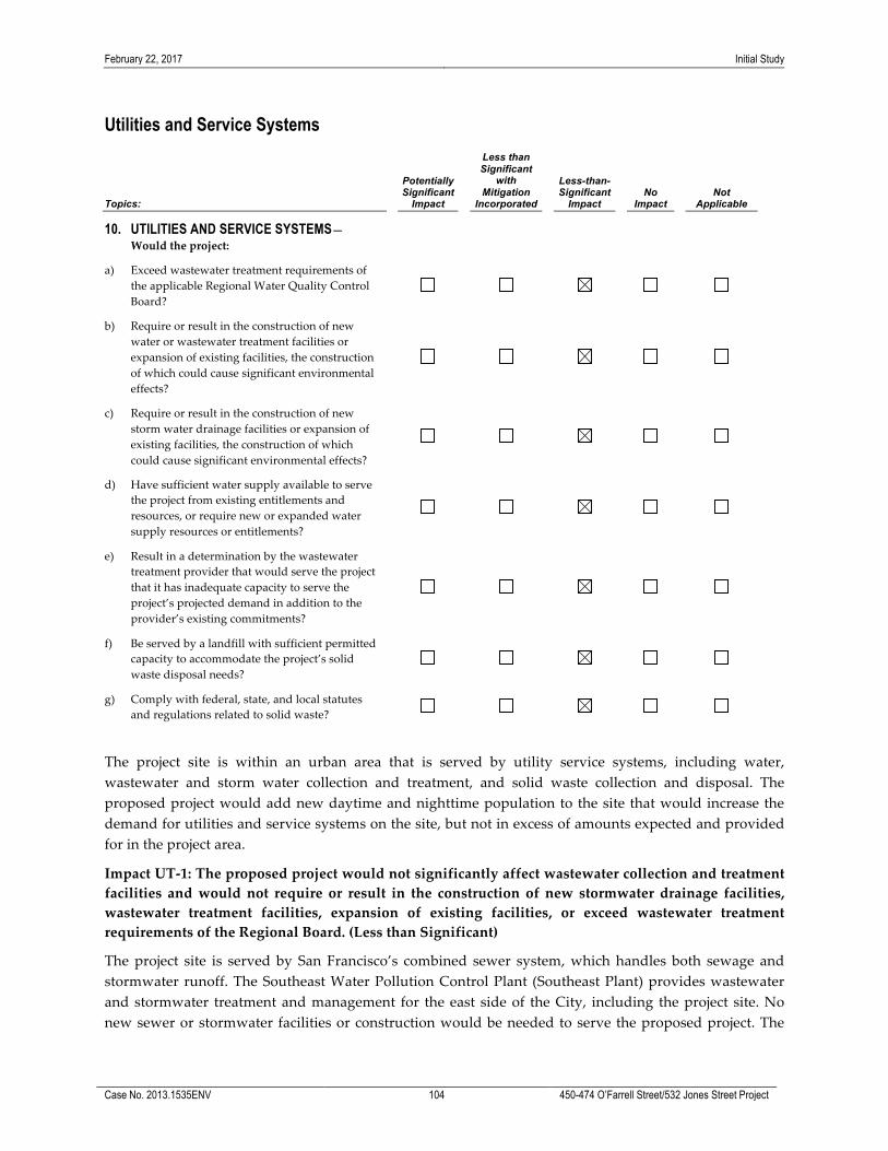
February 22, 2017 Initial Study
Case No. 2013.1535ENV 104 450-474 O’Farrell Street/532 Jones Street Project
Utilities and Service Systems
Topics:
Potentially Significant
Impact
Less than Significant
with Mitigation
Incorporated
Less-than-Significant
Impact No
Impact Not
Applicable
10. UTILITIES AND SERVICE SYSTEMS— Would the project:
a) Exceed wastewater treatment requirements of the applicable Regional Water Quality Control Board?
b) Require or result in the construction of new water or wastewater treatment facilities or expansion of existing facilities, the construction of which could cause significant environmental effects?
c) Require or result in the construction of new storm water drainage facilities or expansion of existing facilities, the construction of which could cause significant environmental effects?
d) Have sufficient water supply available to serve the project from existing entitlements and resources, or require new or expanded water supply resources or entitlements?
e) Result in a determination by the wastewater treatment provider that would serve the project that it has inadequate capacity to serve the project’s projected demand in addition to the provider’s existing commitments?
f) Be served by a landfill with sufficient permitted capacity to accommodate the project’s solid waste disposal needs?
g) Comply with federal, state, and local statutes and regulations related to solid waste?
The project site is within an urban area that is served by utility service systems, including water, wastewater and storm water collection and treatment, and solid waste collection and disposal. The proposed project would add new daytime and nighttime population to the site that would increase the demand for utilities and service systems on the site, but not in excess of amounts expected and provided for in the project area.
Impact UT-‐‑1: The proposed project would not significantly affect wastewater collection and treatment facilities and would not require or result in the construction of new stormwater drainage facilities, wastewater treatment facilities, expansion of existing facilities, or exceed wastewater treatment requirements of the Regional Board. (Less than Significant)
The project site is served by San Francisco’s combined sewer system, which handles both sewage and stormwater runoff. The Southeast Water Pollution Control Plant (Southeast Plant) provides wastewater and stormwater treatment and management for the east side of the City, including the project site. No new sewer or stormwater facilities or construction would be needed to serve the proposed project. The

February 22, 2017 Initial Study
Case No. 2013.1535ENV 105 450-474 O’Farrell Street/532 Jones Street Project
proposed project would meet the wastewater pre-‐‑treatment requirements of the SFPUC, as required by the San Francisco Industrial Waste Ordinance in order to meet Regional Water Quality Control Board requirements (see Impact HYD-‐‑1a for discussion of additional stormwater management requirements).85
The proposed project would add residential units and restaurant/retail uses to the project site, which would incrementally increase the demand for wastewater and stormwater treatment services, but not in excess of amounts expected and provided for in the project area.
The project site is currently covered with impervious surfaces and the proposed project would not create any additional impervious surfaces, resulting in little effect on the total stormwater volume discharged through the combined sewer system. While the proposed project would add to sewage flows in the area, it would not cause collection treatment capacity of the sewer system in the City to be exceeded. In light of the above, the proposed project would not exceed wastewater treatment requirements of the Regional Water Quality Control Board and would not require the construction of new wastewater/storm water treatment facilities or expansion of existing ones. Because the project site is fully developed at present, new development could not result in an increase in stormwater runoff. However, the project would be required to comply with the City’s Stormwater Design Guidelines, and thus would be required to reduce the total stormwater runoff volume and peak stormwater runoff rate, compared to existing conditions, through the use of Low Impact Design approaches and BMPs such as rainwater reuse, landscape planters, rain gardens, and green roofs. The SFPUC would review and approve the project’s stormwater compliance strategy. Therefore, the proposed project would not substantially increase the demand for wastewater and would result in a less-‐‑than-‐‑significant impact on wastewater treatment and storm drainage facilities. This topic will not be discussed in the EIR.
Impact UT-‐‑2: The proposed project would not require expansion or construction of new water supply or treatment facilities. (Less than Significant)
The proposed project would add residential units and restaurant/retail uses to the project site, which would increase the demand for water on the site, but not in excess of amounts expected and provided for in the project area.
Although the proposed project would incrementally increase the demand for water in San Francisco, the estimated increase in demand could be accommodated within anticipated water use and supply for San Francisco.86 The proposed project would also be designed to incorporate water-‐‑conserving measures, such as low-‐‑flush toilets and urinals, as required by the San Francisco Green Building Ordinance. The project site is not located within a designated recycled water use area, as defined in the Recycled Water Ordinance 390-‐‑91 and 393-‐‑94; thus, the project is not required to install a recycled water system. Since the proposed project’s water demand could be accommodated by the existing and planned supply anticipated under the SFPUC’s 2010 Urban Water Management Plan (UWMP), as updated by the SFPUC’s 2013 Water Availability Study, the proposed project would result in less-‐‑than-‐‑significant water supply impacts. This topic will not be discussed in the EIR.
85 City and County of San Francisco, Ordinance No. 19-‐‑92, San Francisco Municipal Code (Public Works), Part II, Chapter X,
Article 4.1 (amended), January 13, 1992. 86 San Francisco Public Utilities Commission (SFPUC), 2010 Urban Water Management Plan, which includes county-‐‑wide
demand projections through the year 2035, and compares water supply and demand. Available online at: http://www.sfwater.org/Modules/ShowDocument.aspx?documentID=1055, accessed October 21, 2015; and SFPUC, 2013 Water Availability Study for the City and County of San Francisco. Available online at: http://www.sfwater.org/modules/showdocument.aspx?documentid=4168. Accessed October 21, 2015.

February 22, 2017 Initial Study
Case No. 2013.1535ENV 106 450-474 O’Farrell Street/532 Jones Street Project
Impact UT-‐‑3: The proposed project would be served by a landfill with sufficient permitted capacity to accommodate the project’s solid waste disposal needs, and construction and operation of the proposed project would comply with all applicable statutes and regulations related to solid waste. (Less than Significant)
In September, 2015, the City approved an Agreement with Recology, Inc., for the transport and disposal of the City’s municipal solid waste at the Recology Hay Road Landfill in Solano County. The City began disposing its municipal solid waste at Recology Hay Road Landfill in January, 2016, and that practice is anticipated to continue for approximately nine years, with an option to renew the Agreement thereafter for an additional six years. Reports filed by the San Francisco Department of the Environment show that the City generated approximately 870,000 tons of waste material in 2000. By 2010, that figured decreased to approximately 455,000 tons. Waste diverted from landfills is defined as recycled or composted. San Francisco has a goal of 75 percent landfill diversion by 2010, and 100 percent by 2020.87 As of 2012, 80 percent of San Francisco’s solid waste was being diverted from landfills, indicating that San Francisco met the 2010 diversion target.88. San Francisco Ordinance No. 27-‐‑06 requires mixed construction and demolition debris be transported by a Registered Transporter and taken to a Registered Facility that must recover for reuse or recycling and divert from landfill at least 65 percent of all received construction and demolition debris. The San Francisco Green Building Code also requires certain projects to submit a Recovery Plan to the Department of the Environment demonstrating recovery or diversion of at least 75 percent of all demolition debris. San Francisco’s Mandatory Recycling and Composting Ordinance No. 100-‐‑09 requires all properties and everyone in the City to separate their recyclables, compostables, and landfill trash.
Although the proposed project would incrementally increase total waste generation from the City, the increasing rate of diversion through recycling and other methods would result in a decreasing share of total waste that requires deposition into the landfill. Given this, and given the City’s recent agreement for disposal of municipal solid waste at the Recology Hay Road Landfill in Solano County, the solid waste generated by project construction and operation would not result in the landfill exceeding its permitted capacity.
The California Integrated Waste Management Act of 1989 (AB 939) requires municipalities to adopt an Integrated Waste Management Plan (IWMP) to establish objectives, policies, and programs relative to waste disposal, management, source reduction, and recycling. The proposed project would be required to comply with the San Francisco Construction and Demolition Recovery Ordinance, which requires a minimum of 65 percent of all construction and demolition debris to be recycles and diverted from landfills, thereby meeting both the construction and demolition debris diversion rate. The project would also be subject to the requirements of the Mandatory Recycling and Composting Ordinance, which requires all persons in San Francisco to separate recyclables, compostables and landfilled trash and participate in recycling and composting programs. Therefore, solid waste generated from the project’s construction and operation would comply with statutes and regulations for solid waste disposal and no associated impacts related to compliance with solid waste regulations would occur.
87 San Francisco Department of the Environment, Zero Waste Frequently Asked Questions (FAQs). Available online at:
http://sfenvironment.org/article/zero-‐‑waste-‐‑frequently-‐‑asked-‐‑questions-‐‑faqs. Accessed January 6, 2017. 88 Office of the Mayor, Mayor Lee Announces San Francisco Reaches 80 Percent Landfill Waste Diversion, October 2012. Available
online at: http://www.sfmayor.org/index.aspx?recordid=113&page=846. Accessed January 6, 2017.

February 22, 2017 Initial Study
Case No. 2013.1535ENV 107 450-474 O’Farrell Street/532 Jones Street Project
Based on the foregoing, the proposed project would comply with all applicable local, state, and federal laws and regulations pertaining to solid waste, and the project’s impact on solid waste generation would be less than significant. This topic will not be discussed in the EIR.
Impact C-‐‑UT: The proposed project in combination with reasonably foreseeable cumulative development would not result in any significant effects related to utilities or service systems. (Less than Significant)
The geographic context for cumulative impacts on utilities and service systems is the service area for Recology, the City’s municipal solid waste handler. Cumulative development in the project site vicinity would incrementally increase demand on citywide utilities and service systems, but not beyond levels anticipated and planned for by public service providers. Future development projects in the site vicinity would be subject to the same water conservation, wastewater discharge, construction demolition and debris, and recycling and composting regulations applicable to the proposed project. Thus, no cumulative impact related to solid waste disposal or compliance with solid waste regulations would occur. Therefore, impacts to utilities and service systems from the proposed project, in combination with past, present and reasonably foreseeable future projects, would not result in cumulative significant impacts. This topic will not be discussed in the EIR.

February 22, 2017 Initial Study
Case No. 2013.1535ENV 108 450-474 O’Farrell Street/532 Jones Street Project
Public Services
Topics:
Potentially Significant
Impact
Less than Significant
with Mitigation
Incorporated
Less-than-Significant
Impact No
Impact Not
Applicable
11. PUBLIC SERVICES— Would the project: a) Result in substantial adverse physical impacts
associated with the provision of, or the need for, new or physically altered governmental facilities, the construction of which could cause significant environmental impacts, in order to maintain acceptable service ratios, response times, or other performance objectives for any public services such as fire protection, police protection, schools, parks, or other services?
The proposed project’s impacts to parks are discussed in Section E.9 Recreation. Impacts to other public services are discussed below.
Impact PS-‐‑1: The proposed project would not increase the demand for police service, and would not result in substantial adverse impacts associated with the provision of such services. (Less than Significant)
The proposed project would result in more intensive use of the project site than currently exists, and thus would likely incrementally increase police service calls in the project area. Police protection is provided by the Tenderloin Police Station located at 301 Eddy Street, approximately two blocks south of the project site. Although the proposed project could increase the number of calls received from the area or the level of regulatory oversight that must be provided as a result of the increased concentration of activity on site, the increase in service calls would not be substantial in light of the existing demand for police protection services. The Tenderloin Police Station would be able to provide the necessary police services and crime prevention in the area. Meeting the additional service demand of the project would not require the construction of new police facilities. Hence, the proposed project would have a less-‐‑than-‐‑significant impact on police services. This topic will not be discussed in the EIR.
Impact PS-‐‑2: The proposed project would not increase demand for fire protection services, and would not result in substantial adverse impacts associated with the provision of such service. (Less than Significant)
The proposed project would result in more intensive use of the project site than currently exists, and thus, as with police service calls, would likely incrementally increase fire service calls in the project area. The project site receives fire protection services from the San Francisco Fire Department (SFFD). Fire stations located nearby include Station 3 at 1067 Post Street (at the corner of Polk and Post Streets, approximately four blocks northwest of the project site) and Station 1 at 935 Folsom (at Fifth Street approximately seven long blocks southeast of the project site). Although the proposed project would increase the number of calls received from the area, the increase in service calls would not be substantial in light of existing demand for fire protection services. Furthermore, the proposed project would be required to comply with all applicable building and fire codes, which establish requirements pertaining to fire protection systems, including, but not limited to, the provision of state-‐‑mandated smoke alarms, fire alarm and sprinkler systems, fire extinguishers, required number and location of egress with appropriate distance separation,

February 22, 2017 Initial Study
Case No. 2013.1535ENV 109 450-474 O’Farrell Street/532 Jones Street Project
and emergency response notification systems. Since the proposed project would be required to comply with all applicable building and fire codes, and the proposed project would result in an incremental increase in demand for service and oversight, it would not result in the need for new fire protection facilities, and would therefore not result in significant impacts to the physical environment. Hence, the proposed project would have a less-‐‑than-‐‑significant impact on fire protection services. This topic will not be discussed in the EIR.
Impact PS-‐‑3: The proposed project would generate school students, but would not result in a substantial adverse impact associated with the provision of school services, and there would be a less-‐‑than-‐‑significant impact on existing school facilities. (Less than Significant)
A decade-‐‑long decline in San Francisco Unified School District (SFUSD) enrollment ended in the 2008–2009 school year, and total enrollment in the SFUSD has increased from approximately 55,000 in 2007-‐‑2008 to above 58,800 in the 2015-‐‑2016 school year.89 According to a 2010 SFUSD enrollment study, new market-‐‑rate condominium units in San Francisco generate very few public school students. In projecting enrollment through 2035, the study used a mix of enrollment factors; for the Market and Octavia and Transbay areas combined, the overall weighted student generation rate was 0.19 Kindergarten through 12th grade students per unit. Applying that rate to the proposed project’s 176 dwelling units would result in an enrollment increase in the SFUSD of approximately 34 students.
The Tenderloin Community School, at 627 Turk Street (about six blocks southwest of the project site), Bessie Carmichael School, at 375 Seventh Street (about half a mile southeast of the project site), and Redding, at 1421 Pine Street (about eight blocks northwest of the project site) are the nearest public elementary schools to the project site. The closest middle schools are Everett, about two miles southwest, and Francisco, about 1.5 miles north. Galileo and Stuart Hall high schools are both about two miles from the site. Nearby private schools include the following: DeMarillac Academy, at 175 Golden Gate Avenue (about four blocks southwest of the project site), and the San Francisco City Academy, at 230 Jones Street (just over two blocks south of the project site). The proposed project, a mix of commercial and residential uses, would incrementally increase the number of school-‐‑aged children that would attend public schools, by a total of about 34 students, as noted above.90 However, this increase would not exceed the projected student capacities that are expected and provided for by the San Francisco Unified School District as well as private schools in the project area. Therefore, implementation of the proposed project would not necessitate the need for new or physically altered schools.
In addition, the proposed project would be subject to a citywide development impact fee, which requires a payment of $2.91 per square foot of assessable space for residential development and $0.243 per square foot of covered and enclosed space for commercial/industrial development applicable to the “retail and services” constructed within the SFUSD to be paid to the district.91
89 California Department of Education, Data Reporting Office, San Francisco Unified School District, K-‐‑12 Public School
Enrollment, Time Series, 1996-‐‑2015. Available on the internet at: http://dq.cde.ca.gov/dataquest/DQ/EnrTimeRpt.aspx? Level=District&cYear=2013-‐‑14&cname=San%20Francisco%20Unified&cCode=3868478. Reviewed December 14, 2016.
90 San Francisco Unified School District uses an internal school choice system whereby students submit an application listing their school choices. Students will not necessarily attend school in their neighborhood.
91 San Francisco Unified School District, Developer Impact Fee Annual and Five Year Reports for the Fiscal Year Ending June 30 2015, December 8, 2015. Available online at http://www.sfusd.edu/assets/sfusd-‐‑staff/_site-‐‑wide/files/SFUSD_AnnualFiveYearReports_FY1415.pdf. Accessed December 14, 2016.

February 22, 2017 Initial Study
Case No. 2013.1535ENV 110 450-474 O’Farrell Street/532 Jones Street Project
In summary, the proposed project would not result in a substantially increased demand for school facilities, and would not require new or expanded school facilities. The proposed project would thus result in a less-‐‑than-‐‑significant impact on school facilities. This topic will not be discussed in the EIR.
Impact PS-‐‑4: The proposed project would not substantially increase demand for government services, and there would be no adverse impact on government facilities. (Less than Significant)
The proposed project would incrementally increase demand for governmental services and facilities such as libraries; however, the project would not be of such a magnitude that the demand could not be accommodated without the need to construct or physically alter these existing facilities. The San Francisco Public Library (SFPL) provides library services throughout the city through 28 neighborhood branches and mobile outreach services. The project site is served by the Main Library (at 100 Larkin Street) and the Chinatown Branch (at 1135 Powell Street), both of which are within one mile of the site. Thus, the existing SFPL system would be able to accommodate the increase in demand for library services generated by the project’s future residents, and it is anticipated that this population increase could be accommodated by other government services. Therefore, the proposed project would have less-‐‑than-‐‑significant impacts on governmental services. This topic will not be discussed in the EIR.
Impact C-‐‑PS: The proposed project, combined with past, present, and reasonably foreseeable future projects in the vicinity, would have a less than significant cumulative impact on public services. (Less than Significant)
The geographic context for an analysis of cumulative impacts on public services includes the service areas of the service providers. For police and fire, this would comprise the service area of the Tenderloin Police Station and Fire Station 3. For schools, the context is the catchment area of the San Francisco Unified School District. Each of these service providers, through the annual budgeting process, assesses the adequacy of levels of service and provides for needed expansion, equipment, or school facilities. The proposed project is not expected to significantly increase demand for public services beyond levels anticipated and planned for by public service providers. Additionally, police and fire services are provided on a cooperative basis; i.e., other stations can respond to calls for service if needed and service would not be restricted to the local police and fire stations. For schools, the San Francisco Unified School District operates on a lottery system and students may attend schools outside their local geographic boundaries; therefore, additional students generated by cumulative development, including the proposed project, would be distributed over the entire district and would be within student capacity projections. Cumulative development in the project area would incrementally increase demand for public services, but not beyond levels anticipated and planned for by public service providers. As discussed in Section E.2, Population and Housing, implementation of the proposed project and reasonably foreseeable development project would not exceed growth projections for San Francisco. Thus, cumulative impacts on public services would be less than significant. This topic will not be discussed in the EIR.
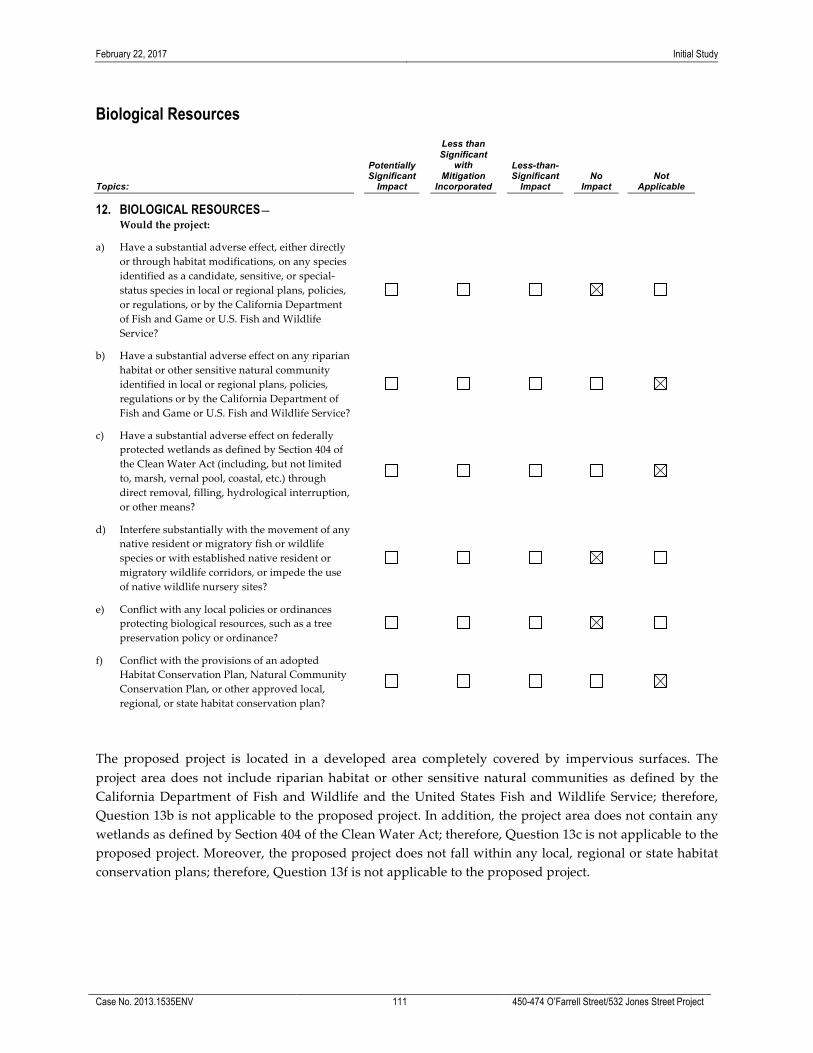
February 22, 2017 Initial Study
Case No. 2013.1535ENV 111 450-474 O’Farrell Street/532 Jones Street Project
Biological Resources
Topics:
Potentially Significant
Impact
Less than Significant
with Mitigation
Incorporated
Less-than-Significant
Impact No
Impact Not
Applicable
12. BIOLOGICAL RESOURCES— Would the project:
a) Have a substantial adverse effect, either directly or through habitat modifications, on any species identified as a candidate, sensitive, or special-‐‑status species in local or regional plans, policies, or regulations, or by the California Department of Fish and Game or U.S. Fish and Wildlife Service?
b) Have a substantial adverse effect on any riparian habitat or other sensitive natural community identified in local or regional plans, policies, regulations or by the California Department of Fish and Game or U.S. Fish and Wildlife Service?
c) Have a substantial adverse effect on federally protected wetlands as defined by Section 404 of the Clean Water Act (including, but not limited to, marsh, vernal pool, coastal, etc.) through direct removal, filling, hydrological interruption, or other means?
d) Interfere substantially with the movement of any native resident or migratory fish or wildlife species or with established native resident or migratory wildlife corridors, or impede the use of native wildlife nursery sites?
e) Conflict with any local policies or ordinances protecting biological resources, such as a tree preservation policy or ordinance?
f) Conflict with the provisions of an adopted Habitat Conservation Plan, Natural Community Conservation Plan, or other approved local, regional, or state habitat conservation plan?
The proposed project is located in a developed area completely covered by impervious surfaces. The project area does not include riparian habitat or other sensitive natural communities as defined by the California Department of Fish and Wildlife and the United States Fish and Wildlife Service; therefore, Question 13b is not applicable to the proposed project. In addition, the project area does not contain any wetlands as defined by Section 404 of the Clean Water Act; therefore, Question 13c is not applicable to the proposed project. Moreover, the proposed project does not fall within any local, regional or state habitat conservation plans; therefore, Question 13f is not applicable to the proposed project.

February 22, 2017 Initial Study
Case No. 2013.1535ENV 112 450-474 O’Farrell Street/532 Jones Street Project
Impact BI-‐‑1: The proposed project would have no substantial impact on special status species, including avian species. (No Impact)
The project site is mostly covered with impervious surfaces and does not provide habitat for any rare or endangered plant or animal species. Thus, the proposed project would not adversely affect or substantially diminish plant or animal habitats. The proposed project would not interfere with any resident or migratory species, nor affect any rare, threatened or endangered species. The proposed project would not interfere with species movement or migratory corridors.
Migrating birds do pass through San Francisco, but the project site does not contain habitat to support migrating birds. Nesting birds, their nests, and eggs are fully protected by Fish and Game Code (Sections 3503, 3503.5) and the federal Migratory Bird Treaty Act (MBTA). Although the proposed project would be subject to the MBTA, the site does not contain habitat supporting migratory birds; therefore, the project would have no impact to nesting birds.
The proposed project would not conflict with any local policies or ordinances directed at protecting biological resources,, and would have no impact on special status species. This topic will not be discussed in the EIR.
Impact BI-‐‑2: The proposed project would not conflict with the City’s local tree ordinance. (No Impact)
The City’s Urban Forestry Ordinance, Public Works Code Sections 801 et seq., requires a permit from San Francisco Public Works to remove any protected trees. One existing tree is located on the Jones Street frontage, in front of the existing building. As part of the proposed project, the existing street tree would be retained. Planning Code Section 138.1(c)(1) requires that for every 20 feet of property frontage along each street, one 24-‐‑inch box tree be planted, with any remaining fraction of 10 feet or more of frontage requiring an additional tree. The project site has a 153 foot, 6-‐‑inch-‐‑long frontage along O’Farrell Street; a 137-‐‑foot, 6 inch-‐‑long frontage along Shannon Street; a 25-‐‑foot-‐‑long frontage along Jones Street. The proposed project would comply with Section 138.1(c)(1) by retaining the existing tree along Jones Street and planting eight new street trees along O’Farrell Street and Shannon Street. Because the proposed project would not conflict with the City’s local tree ordinance, no impact would occur. This topic will not be discussed in the EIR.
As there are no impacts to biological resources, no cumulative impacts could occur.
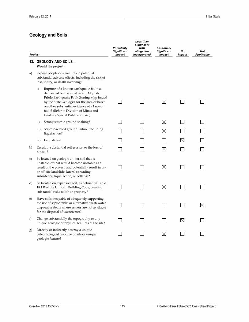
February 22, 2017 Initial Study
Case No. 2013.1535ENV 113 450-474 O’Farrell Street/532 Jones Street Project
Geology and Soils
Topics:
Potentially Significant
Impact
Less than Significant
with Mitigation
Incorporated
Less-than-Significant
Impact No
Impact Not
Applicable
13. GEOLOGY AND SOILS— Would the project:
a) Expose people or structures to potential substantial adverse effects, including the risk of loss, injury, or death involving:
i) Rupture of a known earthquake fault, as delineated on the most recent Alquist-‐‑Priolo Earthquake Fault Zoning Map issued by the State Geologist for the area or based on other substantial evidence of a known fault? (Refer to Division of Mines and Geology Special Publication 42.)
ii) Strong seismic ground shaking?
iii) Seismic-‐‑related ground failure, including liquefaction?
iv) Landslides?
b) Result in substantial soil erosion or the loss of topsoil?
c) Be located on geologic unit or soil that is unstable, or that would become unstable as a result of the project, and potentially result in on-‐‑ or off-‐‑site landslide, lateral spreading, subsidence, liquefaction, or collapse?
d) Be located on expansive soil, as defined in Table 18 1 B of the Uniform Building Code, creating substantial risks to life or property?
e) Have soils incapable of adequately supporting the use of septic tanks or alternative wastewater disposal systems where sewers are not available for the disposal of wastewater?
f) Change substantially the topography or any unique geologic or physical features of the site?
g) Directly or indirectly destroy a unique paleontological resource or site or unique geologic feature?

February 22, 2017 Initial Study
Case No. 2013.1535ENV 114 450-474 O’Farrell Street/532 Jones Street Project
The project site would be connected to the existing sewer system and would not require use of septic systems. Therefore, Question 13e would not be applicable to the project site.
This section describes the geology, soils, and seismicity characteristics of the project area as they relate to the proposed project. Responses in this section rely on the information and findings provided in the Preliminary Geotechnical Investigations prepared by Langan Treadwell Rollo92 for the project site. The studies relied on available geotechnical data from the surrounding area to develop preliminary conclusions and recommendations.
The report identifies that the proposed structure can be supported on a spread-‐‑type foundation consisting of isolated footings interconnected with grade beams or a mat. For construction of the basement and to prevent movement, the perimeter of the excavation and adjacent buildings and streets should be supported. The most common shoring system consists of soldier piles and wood lagging. This shoring system consists of steel piles that are placed in predrilled holes; the annulus between the piles and the sides of the hole are backfilled with concrete. Wood lagging is placed between the soldier piles as excavation proceeds. Seven-‐‑story (90 feet tall) structures are present west and north of the site. These buildings may be supported on spread-‐‑type foundations. These structures should be underpinned. Hand-‐‑excavated, end-‐‑bearing piers are the most appropriate underpinning system for this project. The piers are generally installed by excavating 3-‐‑foot by 5-‐‑foot rectangular shafts down to bearing layer. The underpinning piers are constructed with reinforcing steel and backfilled with structural concrete. The shafts should be contiguous but constructed in phases. Each shaft is shored with timber lagging as it is excavated. Because loose sand is present, the shafts should be shored with every foot of excavation. The resistance to lateral loads can be provided by tiebacks or internal bracings, if required.
The site is likely underlain by several feet of fill. In general, fill encountered in this area consists mainly of loose to medium dense sand with occasional debris and rubble with varying amounts of silt, although abandoned foundation elements and construction debris are also commonly found in the fill. The fill is underlain by loose to very dense, fine-‐‑ grained sand (Dune sand), to a depth of 20 to 30 feet below ground surface (bgs). The Dune sand is underlain by the Colma formation, which consists of dense to very dense sand and stiff to hard sandy clay. The Colma formation is underlain by bedrock of the Franciscan formation at a depth of approximately 100 feet bgs. Groundwater levels in the site vicinity were generally reported at depths of approximately 50 feet bgs and excavation would be to a depth of 16 feet; therefore, dewatering would not be required.
These geologic units present at the project site, their paleontological sensitivity, and information about the age of each geologic unit are shown in Table 11. Paleontological sites are defined by the entire extent (both areal and stratigraphic) of a unit or formation. In other words, once a unit is identified as containing vertebrate fossils, or other rare fossils, the entire unit is a potential paleontological site.93 For this reason, the paleontological sensitivity of geologic units is described and analyzed broadly rather than within the context of a specific site.
92 Langan Treadwell Rollo Preliminary Geotechnical Study 450-‐‑474 O’Farrell Street, San Francisco, California, September 8,
2014; Langan Treadwell Rollo Preliminary Geotechnical Study 532 Jones Street, San Francisco, California, April 13, 2015. 93 Society of Vertebrate Paleontology. 2010. Standard Procedures for the Assessment and Mitigation of Adverse Impacts to Paleontological Resources. Impact Mitigation Guidelines Revision Committee. Available: http://vertpaleo.org/The-‐‑Society/Governance-‐‑Documents/SVP_Impact_Mitigation_Guidelines.aspx. Accessed: May, 2016.

February 22, 2017 Initial Study
Case No. 2013.1535ENV 115 450-474 O’Farrell Street/532 Jones Street Project
TABLE 11: GEOLOGIC UNITS AND PALEONTOLOGICAL SENSITIVITY IN THE PROJECT AREA
Age Geologic Unita,b Paleontological Sensitivityc
Holocene Dune Sand Undetermined
Pleistocene Colma Formation High
Cretaceous-‐‑Jurassic Franciscan Formation High
Notes: a. Langan Treadwell Rollo Preliminary Geotechnical Study 450-‐‑474 O’Farrell Street, San Francisco, California, September 8,
2014; Langan Treadwell Rollo Preliminary Geotechnical Study 532 Jones Street, San Francisco, California, April 13, 2015. b. Rodda, P.U., and N. Baghai. 1993. Late Pleistocene Vertebrates from Downtown San Francisco, California. Journal of
Paleontology 67:1,058–1,063. c. The fossil-‐‑yielding potential of geologic units in a particular area depends on the geologic age and origin of the underlying
rocks as well as on the processes that the rocks have undergone, both geologic and anthropogenic. The Impact Mitigation Guidelines Revisions Committee of the Society of Vertebrate Paleontology (SVP) has published Standard Guidelines. The Standard Guidelines include procedures for the investigation, collection, preservation, and cataloging of fossil-‐‑bearing sites. The Standard Guidelines identify the two key phases of paleontological resource protection: (1) assessment and (2) implementation. Assessment involves identifying the potential for a project site or area to contain significant nonrenewable paleontological resources that could be damaged or destroyed by project excavation or construction. Implementation involves formulating and applying measures to reduce such adverse effects. The SVP defines the level of potential as one of four sensitivity categories for sedimentary rocks: High, Undetermined, Low, and No Potential as defined below. • High Potential. Assigned to geologic units from which vertebrate or significant invertebrate, plant, or trace fossils have
been recovered and sedimentary rock units that are suitable for the preservation of fossils (e.g., middle Holocene and older fine-‐‑grained fluvial sandstones, fine-‐‑grained marine sandstones, etc.). Paleontological potential is the potential for yielding abundant fossils, a few significant fossils, or recovered evidence for new and significant taxonomic, phylogenetic, paleoecologic, taphonomic, biochronologic, or stratigraphic data.
• Undetermined Potential. Assigned to geologic units for which little information is available concerning their paleontological content, geologic age, and depositional environment. In cases where no subsurface data already exist, paleontological potential can sometimes be assessed by subsurface site investigations.
• Low Potential. Field surveys or paleontological research may allow a determination that a geologic unit has low potential for yielding significant fossils (e.g., basalt flows). Mitigation is generally not required to protect fossils.
• No Potential. Some geologic units have no potential for containing significant paleontological resources, such as high-‐‑grade metamorphic rocks (e.g., gneisses and schists) and plutonic igneous rocks (e.g., granites and diorites). Mitigation is not required.
The Colma Formation consists of moderately sorted fine to medium fine sand with small to moderate amounts of silt and clay.94 The origin of the materials is terrestrial deposition associated with the onset of Wisconsin glaciation.95 The age is approximately 83,000 to 120,000 years.96 Vertebrate fossils documented from the Colma Formation approximately 1 mile from the project site include Mammuthus Columbia and Bison laitrons.97
94 Schlocker, J. 1974. Geology of the San Francisco North Quadrangle, California. (Geological Survey Professional Paper 782.)
Washington, DC: United States Printing Office. Available: http://pubs.usgs.gov/pp/0782/report.pdf. Accessed: May, 2016. 95 Simpson, L.A., and G.E. Treadwell & Rollo Inc. 2006. Case Studies in Mission Bay, San Francisco: Deep Foundations in
Challenging Soil Conditions. In DFI Proceedings of the 31st Annual Conference on Deep Foundations. Washington, D.C. 96 Caskey, S.J., K. Grove, C. Li, and G. Berger. 2004. Constraints on Late Pleistocene and Active Uplift Rates along the Serra Fault and the Timing of Late Pleistocene Transpressional Deformation along the San Andreas Fault, Northern San Francisco Peninsula. (U.S. Geological Survey award number 04HQGR0024.) Available: http://earthquake.usgs.gov/research/external/reports/04HQGR0024.pdf. Accessed: May, 2016.
97 Rodda, P.U., and N. Baghai. 1993. Late Pleistocene Vertebrates from Downtown San Francisco, California. Journal of Paleontology 67:1,058–1,063.

February 22, 2017 Initial Study
Case No. 2013.1535ENV 116 450-474 O’Farrell Street/532 Jones Street Project
The Franciscan Formation consists of sandstone, shale, siltstone, chert, and other oceanic deposits and ultramafic volcanic rock in the California Coast Ranges. In the San Francisco North quadrangle, the formation is characterized by 80 percent greywacke sandstone, 10 percent shale and siltstone, 6 percent mafic volcanic rocks, 3 percent radiolarian chert, and less than 1 percent conglomerate, limestone, and glocophane schist. Ultramafic rock, principally serpentine, has intruded all of these deposits. The origin of the materials is oceanic deposits. The age is approximately 150 to 66 million years (Ma).98 Although vertebrate fossils in Franciscan Formation are rare, documented instances include three aquatic reptiles.99
Data from the University of California Museum of Paleontology database were analyzed to assign each geologic unit in the study area a paleontological sensitivity category, according to the Society of Vertebrate Paleontology’s (SVP) Standard Guidelines. To identify and evaluate impacts on paleontologically sensitive geologic units resulting from project and program actions, the depth of ground disturbance was assessed, with consideration of the location of geologic units with high potential and undetermined potential.
Impact GE-‐‑1: The proposed project would not result in exposure of people and structures to potential substantial adverse effects, including the risk of loss, injury, or death involving rupture of a known earthquake fault, seismic ground-‐‑shaking, liquefaction, lateral spreading, or landslides. (Less than Significant)
With respect to potential rupture of a known earthquake fault, published data indicate that neither known active faults nor extensions of active faults exist beneath the project site. Therefore, the potential of surface rupture occurring at the site is very low at the site.
In terms of the potential for strong seismic ground shaking, the site is located within a 50-‐‑kilometer radius of several major active faults, including the San Andreas (12 km), Hayward (17 km), and San Gregorio (18 km). According to U.S. Geological Survey, the overall probability of moment magnitude 6.7 or greater earthquake to occur in the San Francisco Bay Region during the next thirty years is 63 percent. Therefore, there is potential that a strong to very strong earthquake would affect the project during its lifetime.
The Association of Bay Area Governments (ABAG) has classified the Modified Mercalli Intensity Shaking Severity Level of ground shaking in the proposed project vicinity due to an earthquake on the North San Andreas Fault as “VIII-‐‑Very Strong.”100 Very strong shaking would result in damage to some masonry buildings, fall of stucco and some masonry walls, fall of chimneys and elevated tanks, and shifting of unbolted wood frame structures off their foundations. Design and construction of the proposed project would be in accordance with the provisions of the 2013 California Building Code. With implementation of these recommendations, and compliance with the San Francisco Building Code, the proposed project would not be expected to expose persons or structures to substantial adverse effects from ground shaking in the event of an earthquake, and the impact would be less than significant.
98 Schlocker, J. 1974. Geology of the San Francisco North Quadrangle, California. (Geological Survey Professional Paper 782.)
Washington, DC: United States Printing Office. Available: http://pubs.usgs.gov/pp/0782/report.pdf. Accessed: May, 2016. 99 Hilton, R.P. 2003. Dinosaurs and Other Mesozoic Reptiles of California. University of California Press. Appendix: Summary
of the Mesozoic Reptilian Fossils of California. 100 Association of Bay Area Governments. Resilience Program: Earthquakes http://resilience.abag.ca.gov/earthquakes/.
Accessed on October 22, 2015.

February 22, 2017 Initial Study
Case No. 2013.1535ENV 117 450-474 O’Farrell Street/532 Jones Street Project
Liquefaction and lateral spreading of soils can occur when ground shaking causes saturated soils to lose strength due to an increase in pore pressure. In terms of seismic-‐‑related ground failure, including liquefaction, the site is not within a designated liquefaction hazard zone as shown on the seismic hazard zone map for the City and County of San Francisco, prepared by the California Division of Mines and Geology, dated November 17, 2001. Groundwater levels encountered in the vicinity of the site were generally deeper than 50 feet bgs, and therefore the potential for liquefaction and lateral spreading at the site is very low. With compliance with the San Francisco Building Code, the impacts to the proposed project due to strong seismic ground shaking would not be expected to increase effects from liquefaction and lateral spreading in the event of an earthquake, and the impact would be less than significant.
With respect to landslides, based on the San Francisco General Plan, the project site is relatively level and is not located within a mapped landslide zone.101 The site is not within a designated earthquake-‐‑induced landslide zone as shown on the California Geological Survey seismic hazard zone map for the area. Therefore, the proposed project would have a less-‐‑than-‐‑significant impact with respect to potential for landslides. This topic will not be discussed in the EIR.
Impact GE-‐‑2: The proposed project would not result in substantial loss of topsoil or erosion. (Less than Significant)
The project site slopes southeast so that the Jones Street frontage is one floor above the O’Farrell Street frontage. The project site is entirely covered with impervious surfaces. The proposed project would not substantially change the general topography of the site or any unique geologic or physical features of the site. The project would require excavation for the construction of the proposed building and removal of approximately 8,900 cubic yards of soil. The project site size of 22,106 sf (0.5 acre) would be under the 1-‐‑acre threshold for a National Pollutant Discharge Elimination System (NPDES) General Construction Permit.
The project sponsor and its contractor would be required to implement an erosion and sediment control plan for construction activities, in accordance with Article 4.1 of the San Francisco Public Works Code, to address sediment-‐‑laden construction-‐‑site stormwater runoff. The SFPUC must review and approve the erosion and sediment control plan prior to the plan’s implementation, and the SFPUC would inspect the project site periodically to ensure compliance with the plan. These erosion and sedimentation control measures would reduce short-‐‑term construction-‐‑related erosion impacts to less-‐‑than-‐‑significant levels. This topic will not be discussed in the EIR.
Impact GE-‐‑3: The proposed project would not be located on a geologic unit or soil that is unstable, or that would become unstable as a result of the project, and potentially result in on-‐‑ or off-‐‑site landslide, lateral spreading, subsidence, liquefaction, or collapse. (Less than Significant)
The area around the project site does not include hills or cut slopes likely to be subject to landslide. Improvements proposed as part of the project include one-‐‑story basement below grade, which would require excavation to a maximum of approximately 16 feet bgs. According to the preliminary geotechnical study, the site is underlain by several feet of fill (consisting mainly of poorly graded fine-‐‑grained sand with occasional debris and rubble), with Dune sand extending down 20 to 30 feet beneath the fill. Groundwater levels in the site vicinity were generally reported at depths of approximately 50 feet bgs.
101 San Francisco General Plan, Community Safety Element, Map 4. Available online at: http://www.sf-‐‑planning.org/ftp/General_Plan/Community_Safety_Element_2012.pdf. Accessed on October 22, 2015.
February 22, 2017 Initial Study
Case No. 2013.1535ENV 118 450-474 O’Farrell Street/532 Jones Street Project
During construction, excavation of the existing surface fill materials and Dune sand would be necessary to construct the proposed basement level of the structure. The Preliminary Geotechnical Study included specific recommendations to be implemented during construction to support the sides of the excavation and adjacent buildings, and foundation support for the building. Excavation activities would require the use of shoring and underpinning in accordance with the recommendations of the geotechnical report and San Francisco Building Code requirements. DBI would review background information, including geotechnical and structural engineering reports, to ensure the suitability of the soils on the project site for development of the proposed project. San Francisco Building Code requirements would ensure that the project applicant include analysis of the potential for unstable soil impacts and inclusion of recommendations to address unstable soils as part of the design-‐‑level geotechnical investigation prepared for the proposed project; therefore, potential impacts of unstable soils would be less than significant. This topic will not be discussed in the EIR.
Impact GE-‐‑4: The proposed project could be located on expansive soil, as defined in Table 18 1 B of the Uniform Building Code, but would not create substantial risks to life or property. (Less than Significant)
Expansive soils expand and contract in response to changes in soil moisture, most notably when near surface soils change from saturated to a low-‐‑moisture content condition, and back again. The presence of expansive soils is typically determined on site-‐‑specific data. As noted above, the site is likely underlain by several feet of fill. Anticipated excavation of the basement garage and foundation is expected to remove the majority of existing fill materials at the site, leaving mostly the underlying Dune sands. Due to the low clay content within the Dune sands, there would have a low likelihood for expansion. However, areas not excavated, including sidewalks and other adjacent improvements, may be affected by expansive soils, if present. Due to the San Francisco Building Code requirement that the project applicant include analysis of the potential for soil expansion impacts and inclusion of recommendations to address expansive soils as part of the design-‐‑level geotechnical investigation prepared for the proposed project, potential impacts related to expansive soils would be less than significant. This topic will not be discussed in the EIR.
Impact GE-‐‑5: The proposed project would not substantially change the topography or any unique geologic or physical features of the site. (No Impact)
The existing project site is already developed. The proposed project would not substantially change the topography of the site, with the exception of excavation for the underground garage. There are no unique geologic or physical features on the site. Therefore, no impact would occur to topographic or unique geologic or physical features. This topic will not be discussed in the EIR.
Impact GE-‐‑6: The proposed project would not directly or indirectly destroy a unique paleontological resource or site or unique geologic feature. (Less than Significant)
Paleontological resources, or fossils, are the remains, imprints, or traces of animals, plants, and invertebrates, including their imprints, from a previous geological period. Collecting localities and the geologic formations containing those localities are also considered paleontological resources, representing a limited, nonrenewable resource. Once destroyed, they cannot be replaced.
The potential to affect fossils varies with the depth of disturbance and previous disturbance. The logistics of excavation also affect the possibility of recovering scientifically significant fossils because information regarding location, vertical elevation, geologic unit of origin, and other aspects of context is critical to the significance of any paleontological discovery.

February 22, 2017 Initial Study
Case No. 2013.1535ENV 119 450-474 O’Farrell Street/532 Jones Street Project
The Colma formation, which underlies the project site, has high paleontological sensitivity. The Colma formation is known to have yielded vertebrate fossils of large mammals approximately 1 mile from the Project site. Based on geologic studies of nearby sites, the Colma formation likely underlies the Quaternary dune sand at a depth of approximately 30 feet below ground surface. Project activities involve excavation to a depth of 16 feet below ground surface. Thus, project excavation would not encounter the Colma formation and would not disturb, damage, or destroy paleontological resources. This constitutes a less-‐‑than-‐‑significant impact, and this topic will not be discussed in the EIR.
Impact C-‐‑GE: The proposed project combined with past, present, and reasonably foreseeable future projects in the vicinity, would not result in a cumulative significant effect related to geology or soils. (Less than Significant)
The geographic context for cumulative analysis of impacts on geology and soils is site-‐‑specific and comprises the project site and immediately adjacent properties. Past, present, and foreseeable cumulative projects could require various levels of excavation or cut-‐‑and-‐‑fill, which could affect local geologic conditions. The Building Code regulates construction in the City of San Francisco, and all development projects would be required to comply with its requirements to ensure maximum feasible seismic safety and minimize geologic impacts. Site-‐‑specific mitigation measures would also be implemented as site conditions warrant to reduce any potential impacts from unstable soils, ground shaking, liquefaction, or lateral spreading. The project would entail excavation to a depth of approximately 16 feet below grade (requiring 8,900 cubic yards of excavation) to accommodate the underground parking level for vehicles and bicycles. Given that the church building contains an existing basement, the proposed project would not result in a large degree of excavation. The project would require adequate underpinning of adjacent structures so that excavation would not affect nearby buildings. Nearby reasonably foreseeable future projects from Table 2 would be subject to the same seismic safety standards and design review procedures applicable to the proposed project. Compliance with the seismic safety standards and the design review procedures would ensure that the effects from nearby cumulative projects would be reduced to less-‐‑than-‐‑significant levels. Thus, the proposed project’s impacts related to geology and soils, both individually and cumulatively, would be less than significant. This topic will not be discussed in the EIR.

February 22, 2017 Initial Study
Case No. 2013.1535ENV 120 450-474 O’Farrell Street/532 Jones Street Project
Hydrology and Water Quality
Topics:
Potentially Significant
Impact
Less than Significant
with Mitigation
Incorporated
Less-than-Significant
Impact No
Impact Not
Applicable
14. HYDROLOGY AND WATER QUALITY— Would the project:
a) Violate any water quality standards or waste discharge requirements?
b) Substantially deplete groundwater supplies or interfere substantially with groundwater recharge such that there would be a net deficit in aquifer volume or a lowering of the local groundwater table level (e.g., the production rate of pre-‐‑existing nearby wells would drop to a level which would not support existing land uses or planned uses for which permits have been granted)?
c) Substantially alter the existing drainage pattern of the site or area, including through the alteration of the course of a stream or river, in a manner that would result in substantial erosion of siltation on-‐‑ or off-‐‑site?
d) Substantially alter the existing drainage pattern of the site or area, including through the alteration of the course of a stream or river, or substantially increase the rate or amount of surface runoff in a manner that would result in flooding on-‐‑ or off-‐‑site?
e) Create or contribute runoff water which would exceed the capacity of existing or planned stormwater drainage systems or provide substantial additional sources of polluted runoff?
f) Otherwise substantially degrade water quality?
g) Place housing within a 100-‐‑year flood hazard area as mapped on a federal Flood Hazard Boundary or Flood Insurance Rate Map or other authoritative flood hazard delineation map?
h) Place within a 100-‐‑year flood hazard area structures that would impede or redirect flood flows?
i) Expose people or structures to a significant risk of loss, injury or death involving flooding, including flooding as a result of the failure of a levee or dam?
j) Expose people or structures to a significant risk of loss, injury or death involving inundation by seiche, tsunami, or mudflow?

February 22, 2017 Initial Study
Case No. 2013.1535ENV 121 450-474 O’Farrell Street/532 Jones Street Project
The project is not located in an area identified as subject to seiche or potential inundation in the event of a tsunami along the San Francisco coast, based on the Community Safety Element of the San Francisco General Plan. In addition, the developed area of the project site would not be subject to mudflow. Thus, Question 14j does not apply.
Impact HY-‐‑1: The proposed project would not violate any water quality standards or waste discharge requirements and would result in less-‐‑than-‐‑significant impacts to water quality. (Less than Significant)
During operation of the proposed project, as discussed in the utilities and services section, wastewater and stormwater from the project site would continue to flow into the City’s combined stormwater and sewer system and would be treated to the standards contained in the City’s National Pollutant Discharge Elimination System (NPDES) Permit for the Southeast Water Pollution Control Plant, prior to discharge into the San Francisco Bay. Treatment would be provided pursuant to the effluent discharge standards contained in the City’s NPDES permit for the plant.
As new construction, the proposed project would be required to meet the standards for stormwater management identified in the San Francisco Stormwater Management Ordinance (SFSMO) and meet SFPUC stormwater management requirements per the Stormwater Design Guidelines. The project sponsor would be required to submit and have approved by the SFPUC a Stormwater Control Plan (SCP) that complies with the City’s Stormwater Design Guidelines using a variety of BMPs. For a project that would disturb over 5,000 square feet of ground surface (the project would excavate 8,900 cubic yards of soil and disturb 21,070 square feet of ground surface) and that is located in the combined sewer system, the BMPs must meet the SFPUC performance requirements equivalent to LEED 6.1 and reduce the total stormwater runoff volume and peak runoff rate from the project site. The SFPUC emphasizes the use of low-‐‑cost, low impact BMPs to meet this requirement. Implementation of the SCP would ensure that the project meets performance measures set by the SFPUC related to stormwater runoff rate and volume. Construction Best Management Practices (BMP) would be implemented to ensure compliance with water quality and waste discharge requirements. In addition, wastewater is treated per requirements of the RWQCB before discharge to the San Francisco Bay. Groundwater encountered during construction of the proposed project would be subject to requirements of the Article 4.1 of the Public Works Code, Industrial Waste, requiring that groundwater meet specified water quality standards before it may be discharged into the sewer system. These measures would ensure protection of water quality during construction of the proposed project. Therefore, the proposed project would not substantially degrade water quality and water quality standards or waste discharge requirements would not be violated. Thus, the project would have a less-‐‑than-‐‑significant impact on water quality. This topic will not be discussed in the EIR.
Impact HY-‐‑2: The proposed project would not substantially deplete groundwater supplies or interfere with groundwater recharge, or otherwise substantially alter the existing drainage pattern of the site resulting in erosion or flooding on-‐‑ or off-‐‑site. (Less than Significant)
Construction of the proposed project would not increase the amount of impervious surface as the site is completely impervious; therefore, the project would not result in any change in infiltration or runoff. As noted above, groundwater was encountered at about 50 feet bgs. Groundwater is not used as a drinking water supply in San Francisco. As noted above, improvements proposed as part of the project would require excavation to approximately 16 feet below the ground surface, which would be approximately 30 feet above the groundwater table. However, if groundwater were encountered on-‐‑site, then dewatering activities would be necessary. The Bureau of Systems Planning, Environment, and Compliance of the
February 22, 2017 Initial Study
Case No. 2013.1535ENV 122 450-474 O’Farrell Street/532 Jones Street Project
SFPUC must be notified of projects necessitating dewatering. The SFPUC may require water analysis before discharge to the combined sewer system. The project would be required to obtain a Batch Wastewater Discharge Permit from the SFPUC Wastewater Enterprise Collection System Division (WWE/CSD) prior to any dewatering activities. Since the project site and project vicinity are completely covered by impervious surfaces, the proposed project would not alter drainage patterns in a manner that would result in substantial erosion, siltation, or flooding. Runoff from the project site would drain into the City’s combined stormwater/sewer system. Therefore, groundwater resources would not be substantially degraded or depleted, and the proposed project would not substantially alter the existing drainage pattern of the site resulting in erosion or flooding on-‐‑ or off-‐‑site. Thus, the proposed project would have a less-‐‑than-‐‑significant impact on groundwater supplies and recharge and would not result in erosion or flooding on-‐‑ or off-‐‑site. This topic will not be discussed in the EIR.
Impact HY-‐‑3: The proposed project would not result in an increase in risks from flooding. (Less than Significant)
The project site is not located within a Special Flood Hazard Area identified on San Francisco’s Interim Floodplain Map.102 According to SFPUC’s areas of inundation maps, the project site is not located in an area subject to permanent or temporary inundation as a result of a 100-‐‑year storm surge in addition to projected water level increases as a result of sea level rise.103 For these reasons, the project would not place housing or structures in a flood zone or impede or redirect flood flows within a 100-‐‑year flood hazard area. Therefore, impacts related to placement of housing within a 100-‐‑year flood zone and impedance or redirection of flood flows would be less than significant. This topic will not be discussed in the EIR.
Impact C-‐‑HY: The proposed project, in combination with other past, present, or reasonably foreseeable projects, would result in less-‐‑than-‐‑significant hydrology and water quality cumulative impacts. (Less than Significant)
The geographic context for an analysis of cumulative impacts to hydrology and water quality consists of the service area of the Southeast Water Pollution Control Plant. Cumulative development in this service area would result in intensification of land uses, as well as anticipated increases in water consumption and wastewater generation. Future development could increase the overall amount of impervious surface and result in increased discharge to the San Francisco Bay. The SFPUC has accounted for population growth in its service projections. Nearby reasonably foreseeable projects would be subject to the same water conservation, stormwater management, and wastewater discharge ordinances applicable to the proposed project. All development projects would be required to implement construction BMPs to ensure compliance with water quality and waste discharge requirements. In addition, the Public Works Code requires that ground water meet specified water quality before it may be discharged. Therefore, it is not anticipated that cumulative development would result in violation of water quality standards or waste discharge requirements. Construction BMPs would also be implemented to avoid or minimize dewatering that could deplete groundwater supplies. Cumulative development could also alter the existing drainage patterns. Implementation of construction BMPs would ensure that there would not be significant impacts related to erosion, siltation, or flooding on or off site. Therefore, cumulative hydrology and water quality impacts would be less than significant. This topic will not be discussed in the EIR.
102 City and County of San Francisco, San Francisco Interim Floodplain Map, Northeast. Final Draft July, 2008. 103 City and County of San Francisco, Sea Level Rise Vulnerability Zone Map Plus 100 Year Storm. Available at
http://onesanfrancisco.org/staff-‐‑resources/sea-‐‑level-‐‑rise-‐‑guidance/. Reviewed October 23, 2015.

February 22, 2017 Initial Study
Case No. 2013.1535ENV 123 450-474 O’Farrell Street/532 Jones Street Project
Hazards and Hazardous Materials
Topics:
Potentially Significant
Impact
Less than Significant
with Mitigation
Incorporated
Less-than-Significant
Impact No
Impact Not
Applicable
15. HAZARDS AND HAZARDOUS MATERIALS—Would the project:
a) Create a significant hazard to the public or the environment through the routine transport, use, or disposal of hazardous materials?
b) Create a significant hazard to the public or the environment through reasonably foreseeable upset and accident conditions involving the release of hazardous materials into the environment?
c) Emit hazardous emissions or handle hazardous or acutely hazardous materials, substances, or waste within one-‐‑quarter mile of an existing or proposed school?
d) Be located on a site which is included on a list of hazardous materials sites compiled pursuant to Government Code Section 65962.5 and, as a result, would it create a significant hazard to the public or the environment?
e) For a project located within an airport land use plan or, where such a plan has not been adopted, within two miles of a public airport or public use airport, would the project result in a safety hazard for people residing or working in the project area?
f) For a project within the vicinity of a private airstrip, would the project result in a safety hazard for people residing or working in the project area?
g) Impair implementation of or physically interfere with an adopted emergency response plan or emergency evacuation plan?
h) Expose people or structures to a significant risk of loss, injury or death involving fires?
The project site is not located within an airport land use plan area or in the vicinity of a private airstrip. Therefore, Questions 15e and 15f are not applicable.
Impact HZ-‐‑1: The proposed project would not create a significant hazard to the public or the environment through the routine transport, use, or disposal of hazardous materials. (Less than Significant)
For buildings constructed prior to 1980, the Code of Federal Regulations (29 CFR 1926.1101) states that all thermal system insulation and surface materials must be designated as “presumed asbestos-‐‑containing material” (PACM) unless proven otherwise through sampling in accordance with the standards of the Asbestos Hazard Emergency Response Act. All of the existing buildings on the project site were constructed prior to 1980. Demolition of the existing buildings and removal of construction debris from

February 22, 2017 Initial Study
Case No. 2013.1535ENV 124 450-474 O’Farrell Street/532 Jones Street Project
the project site could release asbestos into the air. All demolition and construction activities that could disturb PACM are required to comply with federal, state, and local regulations related to the removal and disposal of PACM. For buildings constructed prior to 1978, it is highly likely that lead-‐‑based paint was used in their construction. Demolition of the existing buildings and removal of construction debris from the project site could release lead into the air. All demolition and construction activities that could disturb lead-‐‑based paint are required to comply with the provisions of San Francisco Building Code Section 3407, which regulates the removal and disposal of building materials that contain lead-‐‑based paint.
There also may be hazardous materials stored on site during construction such as fuel for construction equipment, paints, solvents, and other types of construction materials that may contain hazardous ingredients. Transportation of hazardous materials to and from the project site would occur on designated hazardous materials routes, by licensed hazardous materials handlers, as required, and would be subject to regulation by the California Highway Patrol and the California Department of Transportation. This oversight would reduce any risk from the routine transport, use, or disposal of hazardous materials to less than significant.
Operation of the project would likely result in use of common types of hazardous materials typically associated with retail and residential uses, such as cleaning products and disinfectants. These products are labeled to inform users of their potential risks and to instruct them in appropriate handling procedures. Most of these materials are consumed through use, resulting in relatively little waste. The use and storage of these typical hazardous materials would comply with San Francisco Health Code Article 21, which implements the hazardous materials requirements of the California Health and Safety Code and provides for the safe handling of hazardous materials in the City. Any person or business that handles, sells, stores, or otherwise uses hazardous materials in quantities exceeding specified threshold amounts would be required to obtain and keep a current hazardous materials certificate of registration and to implement a hazardous materials business plan submitted with the business license application. Businesses are required by law to ensure employee safety by identifying hazardous materials in the workplace, providing safety information to workers who handle hazardous materials, and adequately training workers. For these reasons, hazardous materials used during project operation would not pose any substantial public health or safety hazards. In addition, the California Highway Patrol and the California Department of Transportation regulate the transportation of hazardous materials. Due to the small quantities of hazardous materials expected to be used and/or generated on the project site, the proposed project would not routinely transport hazardous materials. Compliance with local and State regulations would ensure that impacts related to the routine transport, use, or disposal of hazardous materials would not create a significant hazard to the public or the environment. This impact would be less than significant. This topic will not be discussed in the EIR.
Impact HZ-‐‑2: The proposed project would not create a significant hazard to the public or the environment through reasonably foreseeable conditions involving the release of hazardous materials into the environment. (Less than Significant)
The proposed project site is located in an area of San Francisco governed by Article 22A of the Health Code, also known as the Maher Ordinance and projects excavating more than 50 cubic yards of soil also are subject to the Maher Ordinance.104 San Francisco Department of Public Health (SFDPH) requires soil
104 City and County of San Francisco Planning Department, “Expanded Maher Area” Map, March 2015. Available: http://www.sf-‐‑
planning.org/ftp/files/publications_reports/library_of_cartography/Maher%20Map.pdf. Accessed: October 23, 2015.
February 22, 2017 Initial Study
Case No. 2013.1535ENV 125 450-474 O’Farrell Street/532 Jones Street Project
sampling if a project requires excavation. The Project Sponsor submitted a Maher Application and Work Plan to the SFDPH in accordance with Article 22A105, and the SFDPH will make a determination if a complete Phase II Site Characterization and Work Plan should be submitted once onsite buildings have been demolished. The Project Sponsor would also be required to submit a site mitigation plan (SMP) to SFDPH or other appropriate state or federal agencies, and to remediate any site contamination in accordance with an approved SMP prior to the issuance of the building permit. Because the aforementioned documents would be prepared, and remediation activities if necessary would be conducted at the site, the proposed project would not result in a significant hazard to the public or environment from site contamination, and the impact would be less than significant.
Phase I ESA has been prepared for the project site to assess the potential for site contamination. The Phase I ESA included: (1) a reconnaissance-‐‑level site visit to look for evidence of the release(s) of hazardous materials and petroleum products; (2) inquiries by telephone, visit, online databases, and/or written correspondence to regulatory agencies regarding building or environmental permits, environmental violations, incidents and/or status of enforcement actions at the project site; (3) review local, state, and federal records pertinent to a Phase I ESA; (4) review of relevant documents and maps regarding local geologic and hydrogeologic conditions; and (5) review of historical documents including aerial photographs and topographical maps.
According to historic sources, the earliest recorded land uses in the immediate area were residential and retail. Based on land use history research, a bakery with upstairs living quarters and seven one-‐‑ to three-‐‑story brick residences occupied the site from at least 1886 to 1906, when the San Francisco Earthquake and Fire destroyed the site and surrounding areas. A four-‐‑unit commercial building was constructed in 1913 and a church in 1923 on the 450-‐‑474 O’Farrell parcel. A one-‐‑story commercial building was constructed in 1950 on the 532 Jones Street parcel. Since the 1950’s, there has been no identifiable changes in configuration to the present.
No observed evidence of any significant staining, spillage, and/or ponded liquids or unconfined solids was discovered on the project site during site reconnaissance. No recognized environmental conditions associated with the storage of hazardous materials at the project site were observed. No potential underground storage tanks (USTs), fill ports, or groundwater monitoring wells were noted at adjacent properties. No apparent signs of chemical releases or leaks were noted at any of the nearby facilities.
As noted in the Phase I, a regulatory agency database report (EDR Report) indicates that facilities of environmental concern in the vicinity of the project site had no violations, were closed by the regulatory agency, were hydrologically cross-‐‑gradient or down-‐‑gradient, or were determined to be a significant distance (greater than ¼ mile) from the project site. As a result, these listings are not expected to pose an environmental risk to the project site and are not discussed. The project site itself was not listed on any of the regulatory databases.
Overall, the documented nearby off-‐‑site sources that could affect environmental conditions at the project is judged to be unlikely. Although several neighboring properties were identified as potential sources of activities involving hazardous substances or petroleum products, there is no available evidence that these facilities have affected the environmental conditions of the project site. 105 RGA Environmental. Maher Ordinance Application and Work Plan for Maher Ordinance Subsurface Investigation. March
11, 2016.
February 22, 2017 Initial Study
Case No. 2013.1535ENV 126 450-474 O’Farrell Street/532 Jones Street Project
Based on the information and conclusions from the Phase I, and because of required compliance with Article 22A, the proposed project would not result in a significant hazard to the public or environment from contaminated soil and/or groundwater and the proposed project would result in a less-‐‑than-‐‑significant impact. This topic will not be discussed in the EIR.
Impact HZ-‐‑3: The proposed project would not emit hazardous emissions or handle hazardous or acutely hazardous materials, substances, or waste within a quarter-‐‑mile of an existing or proposed school. (Less than Significant)
There is one school located within a quarter-‐‑mile of the project site. The San Francisco City Academy, at 230 Jones Street, is about 0.1 mile south of the project site. The proposed project would not store, handle, or dispose of significant quantities of hazardous materials and would not otherwise include any uses that would include emissions of hazardous substances. As identified previously, the proposed emergency back-‐‑up generator has the potential to expose sensitive receptors to substantial concentrations of diesel emissions, a known TAC, resulting in a significant air quality impact. The project sponsor has agreed to implement Mitigation Measure AQ-‐‑4a: Best Available Control Technology for Diesel Generators, which would reduce the magnitude of this impact to a less-‐‑than-‐‑significant level by reducing emissions by 89 to 94 percent compared to equipment with engines that do not meet any emission standards and without a VDECS. Thus, with implementation of Mitigation Measure AQ-‐‑4a, the proposed project would have a less-‐‑than-‐‑significant impact related to emitting or handling hazardous materials within a quarter mile of a school. This topic will not be discussed in the EIR.
Impact HZ-‐‑4: The proposed project is not included on a list of hazardous materials sites compiled pursuant to Government Code Section 65962.5. (No Impact)
The project site is not on any available environmental databases as compiled by the California Department of Toxic Substances Control (DTSC) or the State Water Resources Control Board pursuant to Government Code Section 65962.5. The project site is not listed in database reports from state and federal regulatory agencies that identify businesses and properties that handle or have released hazardous materials or waste.106 The proposed project would have no impact related to this criterion. This topic will not be discussed in the EIR.
Impact HZ-‐‑5: The proposed project would not expose people or structures to a significant risk of loss, injury or death involving fires, nor interfere with the implementation of an emergency response plan. (Less than Significant)
San Francisco ensures fire safety primarily through provisions of the Building and Fire Codes. Final building plans are reviewed by the San Francisco Fire Department (as well as the Department of Building Inspection), to ensure conformance with these provisions. In this way, potential fire hazards, including those associated with hydrant water pressures and emergency access, would be addressed during the permit review process.
The implementation of the proposed project could add incrementally to congested traffic conditions in the immediate area in the event of an emergency evacuation. However, the proposed project would be relatively insignificant within the dense urban setting of the project site and it is expected that traffic would be dispersed within the existing street grid such that there would be no significant adverse
106 RGA Environmental. Phase I Environmental Site Assessment Report, 450 and 474 O’Farrell Street, San Francisco, CA,
September 11, 2014. RGA Environmental. Phase I Environmental Site Assessment Report, 532 Jones Street, San Francisco, CA, April 29, 2015.
February 22, 2017 Initial Study
Case No. 2013.1535ENV 127 450-474 O’Farrell Street/532 Jones Street Project
effects on nearby traffic conditions. Therefore, the proposed project would not impair implementation of, or physically interfere with, an adopted emergency response plan or emergency evacuation plan and this impact would be less than significant. This topic will not be discussed in the EIR.
Impact C-‐‑HZ: The proposed project, in combination with other past, present, and reasonably foreseeable projects, would result in less-‐‑than-‐‑significant cumulative effects related to hazardous materials. (Less than Significant)
The geographic context for an analysis of cumulative impacts related to handling of hazardous materials is site-‐‑specific. The geographic context is broader for transportation and disposal of hazardous materials, as these are transported to and from project sites on designated hazardous materials routes throughout the City. Impacts from hazardous materials are generally site-‐‑specific and typically do not result in cumulative impacts. Any hazards at nearby sites would be subject to the same safety or remediation requirements discussed for the proposed project, which would reduce any hazard effects to less-‐‑than-‐‑significant levels. As such, the proposed project’s impacts related to hazardous materials, both individually and cumulatively, would be less than significant.
February 22, 2017 Initial Study
Case No. 2013.1535ENV 128 450-474 O’Farrell Street/532 Jones Street Project
Mineral and Energy Resources
Topics:
Potentially Significant
Impact
Less than Significant
with Mitigation
Incorporated
Less-than-Significant
Impact No
Impact Not
Applicable
16. MINERAL AND ENERGY RESOURCES—Would the project:
a) Result in the loss of availability of a known mineral resource that would be of value to the region and the residents of the state?
b) Result in the loss of availability of a locally-‐‑important mineral resource recovery site delineated on a local general plan, specific plan or other land use plan?
c) Encourage activities that result in the use of large amounts of fuel, water, or energy, or use these in a wasteful manner?
Impact ME-‐‑1: The proposed project would have no impact on mineral resources. (No Impact)
All land in the City of San Francisco, including the project site, is designated by the California Geological Survey as Mineral Resource Zone Four (MRZ-‐‑4) under the Surface Mining and Reclamation Act of 1975. The MRZ-‐‑4 designation indicates that adequate information does not exist to assign the area to any other MRZ; thus, the area is not one designated to have significant mineral deposits. The project site has previously been developed, and future evaluations of the presence of minerals at this site would therefore not be affected by the proposed project. Further, the development and operation of the proposed project would not have an impact on any off-‐‑site operational mineral resource recovery sites. In addition, because the site has been designated as having no known mineral deposits, the proposed project would not result in the loss of availability of a locally or regionally important mineral resource, and would have no impact on mineral resources. This topic will not be discussed in the EIR.
Impact ME-‐‑2: The proposed project would result in increased energy consumption, but not in large amounts or in a wasteful manner. (Less than Significant)
The proposed project would add new restaurant/retail and residential uses, and an increased intensity of use, to the project site, although, not to an extent that exceeds anticipated growth in the area. As a new building in San Francisco, the proposed project would be subject to the energy conservation standards included in the San Francisco Green Building Ordinance, which would require the project to meet a number of conservation standards. Documentation showing compliance with the San Francisco Green Building Ordinance would be submitted with the application of the building permit, and would be enforced by the Department of Building Inspection.
In summary, the proposed project would not cause a wasteful use of energy, and effects related to use of fuel, water, or energy would be less than significant. This topic will not be discussed in the EIR.
February 22, 2017 Initial Study
Case No. 2013.1535ENV 129 450-474 O’Farrell Street/532 Jones Street Project
Impact C-‐‑ME: The proposed project, in combination with other past, present or reasonably foreseeable projects, would not result in a cumulative impact on mineral and energy resources. (Less than Significant)
The geographic context for an analysis of cumulative impacts to mineral resources and energy resources varies depending on the resource. For mineral resources, the context could be assumed to be nationwide, as mineral resources are a dwindling resource as mineral extraction becomes costlier and less feasible. With regard to energy use, the geographic context would be the area served by Pacific Gas & Electric. All of the City of San Francisco falls within MRZ-‐‑4, as described above, which indicate that insufficient information exists to determine the presence of significant mineral deposits. There are no mineral extraction areas in the City and the City is completely urbanized. Therefore, cumulative development would not affect known mineral resources and there would be no cumulative impact. No known minerals exist on the project site or in the vicinity and the proposed project would result in a less-‐‑than-‐‑significant cumulative impact.
Title 24 of the California Code of Regulations, known as the California Building Standards Code (CBC) contains the regulations that govern the construction of buildings in California. The CBC contains general building design and construction requirements relating to fire and life safety, structural safety, and access compliance. CBC provisions provide minimum standards to safeguard life or limb, health, property and public welfare by regulating and controlling the design, construction, quality of materials, use and occupancy, location and maintenance of all buildings and structures and certain equipment. Part 6 of the CBC is the California Energy Code and contains energy conservation standards (Building Energy Efficiency Standards) applicable to all residential and non-‐‑residential buildings throughout California, including schools and community colleges. The standards contain energy and water efficiency requirements (and indoor air quality requirements) for newly constructed buildings, additions to existing buildings, and alterations to existing buildings.107 These standards are updated every three years; the most recent update went into effect on January 1, 2017. The 2016 update to the Building Energy Efficiency Standards focuses on several key areas to improve the energy efficiency of newly constructed buildings and additions and alterations to existing buildings. The most significant efficiency improvements to the residential Standards include improvements for attics, walls, water heating, and lighting. The most significant efficiency improvements to the nonresidential Standards include alignment with the ASHRAE 90.1 2013 national standards. New efficiency requirements for elevators and direct digital controls are included in the nonresidential Standards. Public Resources Code Section 25402.1 also requires the Energy Commission to support the performance standards with compliance tools for builders and building designers.
The proposed project and nearby residential and nonresidential cumulative development projects would be required by the DBI to conform to current state and local energy conservation standards, including Title 24 of the California Code of Regulations. As a result, the proposed project, in combination with other reasonably foreseeable projects, would not cause a wasteful use of energy or other non-‐‑renewable natural resources. The project-‐‑generated demand for electricity would be negligible in the context of overall demand within San Francisco, the greater Bay Area, and the State, and would not in and of itself require any expansion of power facilities. The City plans to reduce GHG emissions to 25 percent below 1990 levels by the year 2017 and ultimately reduce GHG emission to 80 percent below 1990 levels by 2050, which would be achieved through a number of different strategies, including energy efficiency. As
107 Public Resources Code Sections 25402 subdivisions (a)-‐‑(b) and 25402.

February 22, 2017 Initial Study
Case No. 2013.1535ENV 130 450-474 O’Farrell Street/532 Jones Street Project
discussed in Section 4.7, Greenhouse Gas Emissions, the proposed project would be would be consistent with the City’s GHG reduction strategy. Therefore, the energy demand associated with the proposed project would not substantially contribute to a cumulative impact on existing or proposed energy supplies or resources.
Based on the foregoing, the proposed project in combination with reasonably foreseeable projects in the project vicinity would not cause a significant cumulative impact on mineral and energy resources. This topic will not be discussed in the EIR.
February 22, 2017 Initial Study
Case No. 2013.1535ENV 131 450-474 O’Farrell Street/532 Jones Street Project
Agriculture and Forest Resources
Topics:
Potentially Significant
Impact
Less than Significant
with Mitigation
Incorporated
Less-than-Significant
Impact No
Impact Not
Applicable
17. AGRICULTURE AND FOREST RESOURCES: In determining whether impacts to agricultural resources are significant environmental effects, lead agencies may refer to the California Agricultural Land Evaluation and Site Assessment Model (1997) prepared by the California Dept. of Conservation as an optional model to use in assessing impacts on agriculture and farmland. In determining whether impacts to forest resources, including timberland, are significant environmental effects, lead agencies may refer to information compiled by the California Department of Forestry and Fire Protection regarding the state’s inventory of forest land, including the Forest and Range Assessment Project and the Forest Legacy Assessment project; and forest carbon measurement methodology provided in Forest Protocols adopted by the California Air Resources Board. —Would the project
a) Convert Prime Farmland, Unique Farmland, or Farmland of Statewide Importance, as shown on the maps prepared pursuant to the Farmland Mapping and Monitoring Program of the California Resources Agency, to non-‐‑agricultural use?
b) Conflict with existing zoning for agricultural use, or a Williamson Act contract?
c) Conflict with existing zoning for, or cause rezoning of, forest land (as defined in Public Resources Code Section 12220(g)) or timberland (as defined by Public Resources Code Section 4526)?
d) Result in the loss of forest land or conversion of forest land to non-‐‑forest use?
e) Involve other changes in the existing environment that, due to their location or nature, could result in conversion of Farmland to non-‐‑agricultural use or forest land to non-‐‑forest use?
Impact AF-‐‑1: The proposed project would not convert farmland, conflict with existing zoning for agricultural uses or forest land, and would not result in the loss or conversion of forest land. (No Impact)
The project site is located within an urbanized area of San Francisco. No land in San Francisco County has been designated by the California Department of Conservation’s Farmland Mapping and Monitoring Program as agricultural land. Because the project site does not contain agricultural uses and is not zoned for such uses, the proposed project would not require the conversion of any land designated as prime farmland, unique farmland, or Farmland of Statewide Importance to non-‐‑agricultural use. The proposed project would not conflict with any existing agricultural zoning or Williamson Act contracts.108 No land in San Francisco is designated as forest land or timberland by the State Public Resource Code. Therefore, the proposed project would not conflict with zoning for forest land, cause a loss of forest land, or convert forest land to a different use. The proposed project would therefore have no impact on agricultural and forest resources. This topic will not be discussed in the EIR.
As there are no impacts to agricultural and forest resources, no cumulative impacts could occur.
108 San Francisco is identified as “Urban and Built-‐‑Up Land” on the California Department of Conservation Important
Farmland in California Map, 2008. Available online at http://www.conservation.ca.gov. Accessed on October 22, 2015.

February 22, 2017 Initial Study
Case No. 2013.1535ENV 132 450-474 O’Farrell Street/532 Jones Street Project
Mandatory Findings of Significance
Topics:
Potentially Significant
Impact
Less than Significant
with Mitigation
Incorporated
Less-than-Significant
Impact No
Impact Not
Applicable
18. MANDATORY FINDINGS OF SIGNIFICANCE—Would the project:
a) Have the potential to degrade the quality of the environment, substantially reduce the habitat of a fish or wildlife species, cause a fish or wildlife population to drop below self-‐‑sustaining levels, threaten to eliminate a plant or animal community, reduce the number or restrict the range of a rare or endangered plant or animal, or eliminate important examples of the major periods of California history or prehistory?
b) Have impacts that would be individually limited, but cumulatively considerable? (“Cumulatively considerable” means that the incremental effects of a project are considerable when viewed in connection with the effects of past projects, the effects of other current projects, and the effects of probable future projects.)
c) Have environmental effects that would cause substantial adverse effects on human beings, either directly or indirectly?
The foregoing analysis identifies potentially significant impacts to cultural resources, which would be further analyzed in the EIR.
a) As discussed in the various topics in this Initial Study, the proposed project is anticipated to have less-‐‑than-‐‑significant impacts on the environmental topics discussed in this Initial Study. The project, however, could have potentially significant impacts resulting from impacts to historic architectural resources, including the demolition of three contributors, one of which is individually eligible for the CRHR, to a National Register listed historic district. These impacts will be further discussed in the EIR.
b) The proposed project, in combination with the past, present and foreseeable projects as described in Section E, would not result in cumulative impacts with mitigation to land use, aesthetics, population and housing, transportation and circulation, noise, air quality, wind and shadow, GHG emissions, recreation, utilities and service systems, public services, biological resources, geology and soils, hydrology and water quality, hazards and hazardous materials, mineral and energy resources, and agricultural and forest resources. However, the proposed project in combination with the past, present and foreseeable projects could result in cumulative impacts to historic architectural resources, which will be further analyzed in the EIR.
c) The proposed project, as discussed above, would result in significant air quality impacts to human beings; however, these impacts would be reduced to less than significant with implementation of the identified mitigation. No further analysis will be required in the EIR.

February 22, 2017 Initial Study
Case No. 2013.1535ENV 133 450-474 O’Farrell Street/532 Jones Street Project
F. MITIGATION MEASURES AND IMPROVEMENT MEASURES
The following mitigation measures have been adopted by the project sponsor and are necessary to reduce the potentially significant environmental impacts of the proposed project to less-‐‑than-‐‑significant levels. In addition, improvement measures have been agreed-‐‑upon to by the project sponsor to further reduce less-‐‑than-‐‑significant impacts.
Mitigation Measures
Mitigation Measure M-‐‑CP-‐‑2: Accidental Discovery
The project sponsor shall distribute the Planning Department archeological resource “ALERT” sheet to the project prime contractor; to any project subcontractor (including demolition, excavation, grading, foundation, etc. firms); or utilities firm involved in soils disturbing activities within the project site. Prior to any soils disturbing activities being undertaken each contractor is responsible for ensuring that the “ALERT” sheet is circulated to all field personnel including, machine operators, field crew, supervisory personnel, etc. The project sponsor shall provide the Environmental Review Officer (ERO) with a signed affidavit from the responsible parties (prime contractor, subcontractor(s), and utilities firm) to the ERO confirming that all field personnel have received copies of the Alert Sheet.
Should any indication of an archeological resource be encountered during any soil-‐‑disturbing activity of the project, the project Head Foreman and/or project sponsor shall immediately notify the ERO and shall immediately suspend any soils disturbing activities in the vicinity of the discovery until the ERO has determined what additional measures should be undertaken.
If the ERO determines that an archeological resource may be present within the project site, the project sponsor shall retain the services of an archaeological consultant from the pool of qualified archaeological consultants maintained by the Planning Department archaeologist. The archeological consultant shall advise the ERO as to whether the discovery is an archeological resource, retains sufficient integrity, and is of potential scientific/historical/cultural significance. If an archeological resource is present, the archeological consultant shall identify and evaluate the archeological resource. The archeological consultant shall make a recommendation as to what action, if any, is warranted. Based on this information, the ERO may require, if warranted, specific additional measures to be implemented by the project sponsor.
Measures might include: preservation in situ of the archeological resource; an archaeological monitoring program; or an archeological testing program. If an archeological monitoring program or archeological testing program is required, it shall be consistent with the Environmental Planning (EP) division guidelines for such programs. The ERO may also require that the project sponsor immediately implement a site security program if the archeological resource is at risk from vandalism, looting, or other damaging actions.
The project archeological consultant shall submit a Final Archeological Resources Report (FARR) to the ERO that evaluates the historical significance of any discovered archeological resource and describing the archeological and historical research methods employed in the archeological monitoring/data recovery program(s) undertaken. Information that may put at risk any archeological resource shall be provided in a separate removable insert within the final report.

February 22, 2017 Initial Study
Case No. 2013.1535ENV 134 450-474 O’Farrell Street/532 Jones Street Project
Copies of the Draft FARR shall be sent to the ERO for review and approval. Once approved by the ERO, copies of the FARR shall be distributed as follows: California Archaeological Site Survey Northwest Information Center (NWIC) shall receive one (1) copy and the ERO shall receive a copy of the transmittal of the FARR to the NWIC. The Environmental Planning division of the Planning Department shall receive one bound copy, one unbound copy, and one unlocked, searchable PDF copy on CD of the FARR along with copies of any formal site recordation forms (CA DPR 523 series) and/or documentation for nomination to the National Register of Historic Places/California Register of Historical Resources. In instances of high public interest or interpretive value, the ERO may require a different final report content, format, and distribution than that presented above.
Mitigation Measure M-‐‑CP-‐‑3: Human Remains
Human Remains and Associated or Unassociated Funerary Objects. The treatment of human remains and of associated or unassociated funerary objects discovered during any soils disturbing activity shall comply with applicable State and Federal laws along with the following procedures. This shall include immediate notification of the Coroner of the City and County of San Francisco and the ERO. In the event of the Coroner’s determination that the human remains are Native American remains, notification of the California State Native American Heritage Commission (NAHC) who shall appoint a Most Likely Descendant (MLD) (Pub. Res. Code Sec. 5097.98). The archeological consultant, as required under M-‐‑CP-‐‑3, the project sponsor, ERO, and MLD shall have up to but not beyond six days of discovery to make all reasonable efforts to develop an agreement for the treatment of human remains and associated or unassociated funerary objects with appropriate dignity (CEQA Guidelines. Sec. 15064.5(d)). The agreement should take into consideration the appropriate excavation, removal, recordation, analysis, custodianship, curation, and final disposition of the human remains and associated or unassociated funerary objects. Nothing in existing State regulations or in this mitigation measure compels the project sponsor and the ERO to accept recommendations of an MLD. The archeological consultant shall retain possession of any Native American human remains and associated or unassociated burial objects until completion of any scientific analyses of the human remains or objects as specified in the treatment agreement if such as agreement has been made or, otherwise, as determined by the archeological consultant and the ERO.
Mitigation Measure M-‐‑AQ-‐‑2: Construction Air Quality
The project sponsor or the project sponsor’s Contractor shall comply with the following
A. Engine Requirements.
1. All off-‐‑road equipment greater than 25 hp and operating for more than 20 total hours over the entire duration of construction activities shall have engines that meet or exceed either U.S. Environmental Protection Agency (USEPA) or California Air Resources Board (ARB) Tier 2 off-‐‑road emission standards, and have been retrofitted with an ARB Level 3 Verified Diesel Emissions Control Strategy. Equipment with engines meeting Tier 4 Interim or Tier 4 Final off-‐‑road emission standards automatically meet this requirement.
2. Where access to alternative sources of power are available, portable diesel engines shall be prohibited.

February 22, 2017 Initial Study
Case No. 2013.1535ENV 135 450-474 O’Farrell Street/532 Jones Street Project
3. Diesel engines, whether for off-‐‑road or on-‐‑road equipment, shall not be left idling for more than two minutes, at any location, except as provided in exceptions to the applicable state regulations regarding idling for off-‐‑road and on-‐‑road equipment (e.g., traffic conditions, safe operating conditions). The Contractor shall post legible and visible signs in English, Spanish, and Chinese, in designated queuing areas and at the construction site to remind operators of the two-‐‑minute idling limit.
4. The Contractor shall instruct construction workers and equipment operators on the maintenance and tuning of construction equipment, and require that such workers and operators properly maintain and tune equipment in accordance with manufacturer specifications.
B. Waivers.
1. The Planning Department’s Environmental Review Officer or designee (ERO) may waive the alternative source of power requirement of Subsection (A)(2) if an alternative source of power is limited or infeasible at the project site. If the ERO grants the waiver, the Contractor must submit documentation that the equipment used for onsite power generation meets the requirements of Subsection (A)(1).
2. The ERO may waive the equipment requirements of Subsection (A)(1) if a particular piece of off-‐‑road equipment with an ARB Level 3 VDECS is technically not feasible, the equipment would not produce desired emissions reduction due to expected operating modes, installation of the equipment would create a safety hazard or impaired visibility for the operator, or there is a compelling emergency need to use off-‐‑road equipment that is not retrofitted with an ARB Level 3 VDECS. If the ERO grants the waiver, the Contractor must use the next-‐‑cleanest piece of off-‐‑road equipment, according to Table 12.
TABLE 12: OFF-‐‑ROAD EQUIPMENT COMPLIANCE STEP-‐‑DOWN SCHEDULE
Compliance Alternative Engine Emission Standard Emissions Control
1 Tier 2 ARB Level 2 VDECS
2 Tier 2 ARB Level 1 VDECS
3 Tier 2 Alternative Fuel*
** Alternative fuels are not a VDECS.
C. Construction Emissions Minimization Plan. Before starting on-‐‑site construction activities, the Contractor shall submit a Construction Emissions Minimization Plan (Plan) to the ERO for review and approval. The Plan shall state, in reasonable detail, how the Contractor will meet the requirements of Section A.
1. The Plan shall include estimates of the construction timeline by phase, with a description of each piece of off-‐‑road equipment required for every construction phase. The description may include, but is not limited to: equipment type, equipment manufacturer, equipment identification number, engine model year, engine certification (Tier rating), horsepower, engine serial number, and expected fuel usage and hours of operation. For VDECS installed, the description may include: technology type, serial number, make,
February 22, 2017 Initial Study
Case No. 2013.1535ENV 136 450-474 O’Farrell Street/532 Jones Street Project
model, manufacturer, ARB verification number level, and installation date and hour meter reading on installation date. For off-‐‑road equipment using alternative fuels, the description shall also specify the type of alternative fuel being used.
2. The project sponsor shall ensure that all applicable requirements of the Plan have been incorporated into the contract specifications. The Plan shall include a certification statement that the Contractor agrees to comply fully with the Plan.
3. The Contractor shall make the Plan available to the public for review on-‐‑site during working hours. The Contractor shall post at the construction site a legible and visible sign summarizing the Plan. The sign shall also state that the public may ask to inspect the Plan for the project at any time during working hours and shall explain how to request to inspect the Plan. The Contractor shall post at least one copy of the sign in a visible location on each side of the construction site facing a public right-‐‑of-‐‑way.
D. Monitoring. After start of Construction Activities, the Contractor shall submit quarterly reports to the ERO documenting compliance with the Plan. After completion of construction activities and prior to receiving a final certificate of occupancy, the project sponsor shall submit to the ERO a final report summarizing construction activities, including the start and end dates and duration of each construction phase, and the specific information required in the Plan.
Mitigation Measure M-‐‑AQ-‐‑4: Best Available Control Technology for Diesel Generators
The project sponsor shall ensure that the backup diesel generator meet or exceed one of the following emission standards for particulate matter: (1) Tier 4 certified engine, or (2) Tier 2 or Tier 3 certified engine that is equipped with a California Air Resources Board (ARB) Level 3 Verified Diesel Emissions Control Strategy (VDECS). A non-‐‑verified diesel emission control strategy may be used if the filter has the same particulate matter reduction as the identical ARB verified model and if the Bay Area Air Quality Management District (BAAQMD) approves of its use. The project sponsor shall submit documentation of compliance with the BAAQMD New Source Review permitting process (Regulation 2, Rule 2, and Regulation 2, Rule 5) and the emission standard requirement of this mitigation measure to the Planning Department for review and approval prior to issuance of a permit for a backup diesel generator from any City agency.
Improvement Measures
Improvement Measure I-‐‑TR-‐‑1: Transportation Demand Management (TDM) Plan
As an improvement measure to encourage the use of sustainable modes, the project sponsor and subsequent property owners, should develop and implement a TDM Plan. The scope and number of TDM measures included in the TDM Plan should be in accordance with the Planning Commission Standards for the TDM Program (TDM Program) for the type of development proposed.109 The proposed project’s TDM Plan should conform to the most recent version of the TDM Program Standards available at the time of the project’s approval. The Planning
109 San Francisco Planning Department, Draft TDM Program Standards, July 2016 are available online at: http://sf-‐‑
planning.org/tdm-‐‑materials-‐‑and-‐‑resources.
February 22, 2017 Initial Study
Case No. 2013.1535ENV 137 450-474 O’Farrell Street/532 Jones Street Project
Department should review and approve the TDM Plan, as well as any subsequent revisions to the TDM Plan, pursuant to the TDM Program Standards. The TDM Plan should target a reduction in the vehicle miles traveled (VMT) rate (e.g., VMT per capita), monitor and evaluate project performance (actual VMT), and adjust TDM measures over time to attempt to meet VMT target reduction.
The TDM Plan may include, but is not limited to, the types of measures summarized below for explanatory example purposes. Actual TDM measures selected should include those from the TDM Program Standards which describe the scope and applicability of candidate measures in detail and include:
1. Active Transportation: Provision of streetscape improvements to encourage walking, secure bicycle parking, shower and locker facilities for cyclists, subsidized bike share memberships for project occupants, bicycle repair and maintenance services, and other bicycle-‐‑related services
2. Car-‐‑Share: Provision of car-‐‑share parking spaces and subsidized memberships for project occupants
3. Delivery: Provision of amenities and services to support delivery of goods to project occupants
4. Family-‐‑Oriented Measures: Provision of on-‐‑site childcare and other amenities to support the use of sustainable transportation modes by families
5. High-‐‑Occupancy Vehicles: Provision of carpooling/vanpooling incentives and shuttle bus service
6. Information and Communications: Provision of multimodal wayfinding signage, transportation information displays, and tailored transportation marketing services
7. Land Use: Provision of on-‐‑site affordable housing and healthy food retail services in underserved areas
8. Parking: Provision of unbundled parking, short term daily parking provision, parking cash out offers, and reduced off-‐‑street parking supply.
Improvement Measure I-‐‑TR-‐‑2: Monitoring and Abatement of Queues
To reduce the potential for queuing of vehicles accessing the project site, it should be the responsibility of the project sponsor to ensure that recurring vehicle queues or vehicle conflicts do not occur on Shannon Street. A vehicle queue is defined as one or more vehicles (destined to the parking garage) blocking any portion of the Shannon Street sidewalk or travel lanes for a consecutive period of three minutes or longer on a daily and/or weekly basis.
If the Planning Director, or his or her designee, suspects that a recurring queue or conflict is present, the Planning Department should notify the project sponsor in writing. Upon request, the owner/operator should hire a qualified transportation consultant to evaluate the conditions at the site for no less than seven days. The consultant should prepare a monitoring report to be submitted to the Planning Department for review. If the Planning Department determines that a recurring queue or conflict does exist, the project sponsor should have 90 days from the date or the written determination to abate the recurring queue or conflict.

February 22, 2017 Initial Study
Case No. 2013.1535ENV 138 450-474 O’Farrell Street/532 Jones Street Project
Improvement Measure I-‐‑TR-‐‑3: Construction Management Plan and Public Updates
Construction Coordination – To reduce potential conflicts between construction activities and pedestrians, bicyclists, transit and vehicles at the project site, the project sponsor should require that the contractor prepare a Construction Management Plan for the project construction period. The preparation of a Construction Management Plan could be a requirement included in the construction bid package. Prior to finalizing the Plan, the project sponsor/ construction contractor(s) should meet with San Francisco Public Works (Public Works), San Francisco Municipal Transportation Agency (SFMTA),), the Fire Department, Muni Operations and other City agencies to coordinate feasible measures to include in the Construction Management Plan to reduce traffic congestion, including measures to reduce potential traffic, bicycle, and transit disruption and pedestrian circulation effects during construction of the proposed project. This review should consider other ongoing construction in the project vicinity. As determined necessary by the SFMTA to minimize the potential for impacting vehicle and transit traffic on O’Farrell Street, the Construction Management Plan could include restrictions on travel lane closures or construction truck deliveries or materials removal during the AM (7 to 9 AM) and PM (3 to 7 PM) peak periods when tow-‐‑away regulations are in effect on O’Farrell Street.
Carpool, Bicycle, Walk and Transit Access for Construction Workers – To minimize parking demand and vehicle trips associated with construction workers, the construction contractor could include as part of the Construction Management Plan methods to encourage carpooling, bicycle, walk and transit access to the project site by construction workers (such as providing transit subsidies to construction workers, providing secure bicycle parking spaces, participating in free-‐‑to-‐‑employee ride matching program from www.511.org, participating in emergency ride home program through the City of San Francisco (www.sferh.org), and providing transit information to construction workers.
Construction Worker Parking Plan – As part of the Construction Management Plan that could be developed by the construction contractor, the location of construction worker parking could be identified as well as the person(s) responsible for monitoring the implementation of the proposed parking plan. The use of on-‐‑street parking to accommodate construction worker parking could be discouraged. All construction bid documents could include a requirement for the construction contractor to identify the proposed location of construction worker parking. If on-‐‑site, the location, number of parking spaces, and area where vehicles would enter and exit the site could be required. If off-‐‑site parking is proposed to accommodate construction workers, the location of the off-‐‑site facility, number of parking spaces retained, and description of how workers would travel between an off-‐‑site facility and the project site could be required.
Project Construction Updates for Adjacent Businesses and Residents – To minimize construction impacts on access to nearby institutions and businesses, the project sponsor could provide nearby residences and adjacent businesses with regularly-‐‑updated information regarding project construction, including construction activities, peak construction vehicle activities (e.g., concrete pours), travel lane closures, and parking lane and sidewalk closures. A regular email notice could be distributed by the project sponsor that would provide current construction information of interest to neighbors, as well as contact information for specific construction inquiries or concerns.
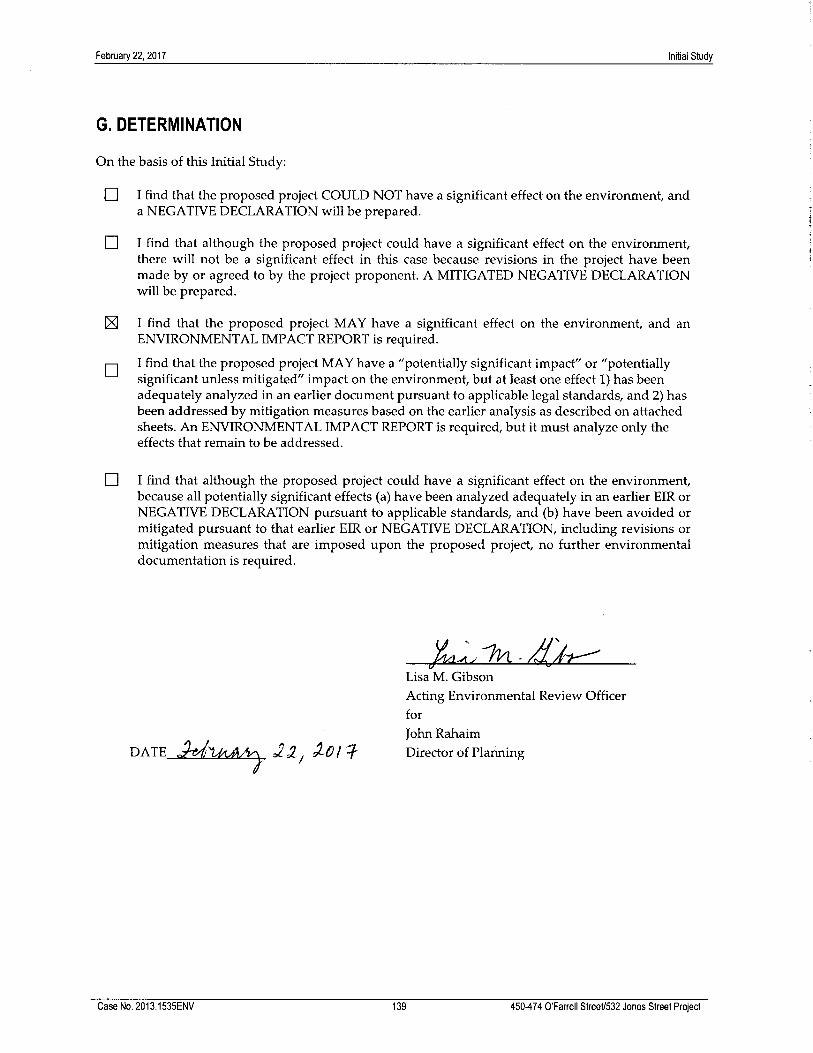
zz, zon
G. DETERMINATION
On the basis of this Initial Study:
Initial Study
❑ I find that the proposed project COULD NOT have a significant effect on the environment, anda NEGATIVE DECLARATION will be prepared.
❑ I find that although the proposed project could have a significant effect on the environment,there will not be a significant effect in this case because revisions in the project have beenmade by or agreed to by the project proponent. A MITIGATED NEGATIVE DECLARATIONwill be prepared.
~ I find that the proposed project MAY have a significant effect on the environment, and anENVIRONMENTAL IMPACT REPORT is required.
~ I find that the proposed project MAY have a "potentially significant impact" or "potentiallysignificant unless mitigated" impact on the environment, but at least one effect 1) has beenadequately analyzed in an earlier document pursuant to applicable legal standards, and 2) hasbeen addressed by mitigation measures based on the earlier analysis as described on attachedsheets. An ENVIRONMENTAL IMPACT REPORT is required, but it must analyze only theeffects that remain to be addressed.
❑ I find that although the proposed project could have a significant effect on the environment,because all potentially significant effects (a) have been analyzed adequately in an earlier EIR orNEGATIVE DECLARATION pursuant to applicable standards, and (b) have been avoided ormitigated pursuant to that earlier EIR or NEGATIVE DECLARATION, including revisions ormitigation measures that are imposed upon the proposed project, no further environmentaldocumentation is required.
DATE ~ ,Z,' ~ o~-Dl ~'-
-~ ~. - ~-~Lisa M. Gibson
Acting Environmental Review Officer
for
John Rahaim
Director of Planning
Case No. 2013.1535ENV 139 450-474 O'Farrell StreeU532 Jones Street Project

February 22, 2017 Initial Study
Case No. 2013.1535ENV 140 450-474 O’Farrell Street/532 Jones Street Project
H. INITIAL STUDY PREPARERS
San Francisco Planning Department Environmental Planning Division 1650 Mission Street, Suite 400 San Francisco, CA 94103
Acting Environmental Review Officer: Lisa M. Gibson
Lead Reviewer: Jenny Delumo
Senior Reviewer: Jessica Range
Preservation Planners: Pilar LaValley and Marcelle Boudreaux
Archeologist: Randall Dean
Shadows: Erika Jackson
Environmental Consultant ICF 601 West 5th Street, Suite 900 Los Angeles, CA 90071
Kim Avila, Project Director
Tamseel Mir, Project Manager
Colleen Davis, Architectural Historian
Aisha Fike, Architectural Historian
Susan Lassell, Senior Reviewer (Architectural History)
Andrew Johnson, Environmental Planner
Rusty Whisman, Environmental Planner
Brittany Hoedemaker, Environmental Planner
Shannon Hatcher, Air Quality Specialist
Darrin Trageser, Air Quality Specialist
Jason Volk, Noise Specialist
Diana Roberts, Paleontological Resources Specialist
Alison Rondone, QA/QC
Erin Efner, QA/QC
John Mathias, Editor
February 22, 2017 Initial Study
Case No. 2013.1535ENV 141 450-474 O’Farrell Street/532 Jones Street Project
Carey & Co, Inc. (Historic Resources) Old Engine Co. No. 2 460 Bush Street San Francisco, CA 94108
Aysem Kilinc, Preservation Consultant
Nancy Goldberg, Principal Architect, Architectural Historian
LCW Consulting (Traffic) 3990 20th Street San Francisco, CA 94114
Luba C. Wyznyckyj, AICP, Owner
Rowan Williams Davies & Irwin Inc. (Wind) 650 Woodlawn Road West Guelph, Ontario, Canada N1K 1B8
Saba Saneinejd, Technical Coordinator
Frank Kriksic, Project Manager
Hanqing Wu, Technical Director
CADP (Shadow) 34 Corte Madera Avenue Mill Valley, CA 94941
Adam B. Noble, President
Project Sponsor 450 O’Farrell Partners, LLC 39 Forrest Street, Suite 201 Mill Valley, CA 94941
Bruce Fairty
Tyler Evje
Stephanie Hill
Karolina Bufka
Project Architect Kwan Henmi Architecture & Planning, Inc. 456 Montgomery Street, Suite 300 San Francisco, CA 94104
Dan Moberly, Designer
Neil Peralta, Associate LEED AP
Johanna Street, Architect [email protected]

February 22, 2017 Initial Study
Case No. 2013.1535ENV 142 450-474 O’Farrell Street/532 Jones Street Project
Project Counsel Jeffer Mangels Butler & Mitchell LLP Two Embarcadero Center, 5th Floor San Francisco, CA 94111
David Cincotta, Counsel
Jodi Smith, Of Counsel
Christine Chen, Associate


Com
paris
on o
f Pre
serv
atio
n Al
tern
ativ
es 4
50 O
’Far
rell
Proj
ect
Pr
opos
ed P
roje
ct
No
Proj
ect
Full
Pres
erva
tion
Part
ial P
rese
rvat
ion
A
ltern
ativ
e A
ltern
ativ
e A
ltern
ativ
e
[a
ssum
es n
o
chan
ge to
th
e si
te]
Des
crip
tion
The
450
O’F
arre
ll St
reet
ch
urch
bui
ldin
g w
ould
be
reta
ined
as
a p
ublic
spa
ce,
with
a p
lay
area
, caf
é, a
nd
othe
r com
mun
ity u
ses.
No
chan
ges
Reh
abilit
ate
hist
oric
ch
urch
. Dem
olis
h 47
4 O
’Far
rell
and
530
Jone
s, re
plac
emen
t st
ruct
ures
on
both
site
s. R
etai
n an
d re
habi
litat
e 47
4 an
d 45
0 O
’ Far
rell
Stre
et,
addi
tions
to b
oth.
Dem
olis
h 53
0 Jo
nes,
repl
acem
ent
stru
ctur
e on
site
Hei
ght
13-s
tory
(130
foot
tall,
20
feet
ele
vato
r).
Thre
e (E
) bui
ldin
gs –
50
, 30
and
30 fe
et.
At s
treet
wal
l pro
perty
lin
e 80
feet
hig
h,
incr
easi
ng to
a
max
imum
of 1
30 fe
et
Hei
ght 8
0 fe
et a
t the
fron
t, st
eppi
ng u
p to
130
feet
hig
h at
the
rear
.
Num
ber o
f Sto
ries
13
3/1/
1 12
12
N
umbe
r of R
esid
entia
l Uni
ts
176
5
70
106
G
SF b
y U
se
Res
iden
tial
187,
640
gsf
53
,600
gsf
87
,086
gsf
R
etai
l/Res
taur
ant
6,20
0 gs
f 5,
427
800
gsf
26,9
20 g
sf
Leas
ing
Offi
ce/L
obby
/Am
enity
4,
025
60
0 gs
f 60
0 gs
f
Chu
rch
13,5
95 g
sf
26,9
04 g
sf
21,6
00 g
sf (e
xist
ing)
10
,666
gsf
(new
) 1,
150
gsf (
exis
ting)
10
,666
gsf
(new
)
Com
mon
Ope
n Sp
ace
8,11
0
2,27
1 gs
f 26
,920
gsf
Be
low
Gra
de P
arki
ng, B
uild
ing
Stor
age,
Bic
ycle
Sto
rage
, M
echa
nica
l, an
d C
ircul
atio
n Sp
ace
21,5
20 g
sf
Non
e 28
par
king
spa
ces
in
bel
owgr
ound
par
king
28
par
king
spa
ces
in
belo
wgr
ound
par
king
To
tal G
SF
237,
353
gsf
32,3
31 g
sf
89,5
34 g
sf
153,
342
gsf
Sou
rce:
Joh
anna
Stre
et A
rchi
tect
and
Kw
an H
enm
i Arc
hite
cts,
201
7.

NO PROJECT

KHDE
SIGN
STU
DY -
27JU
L201
6EL
EVAT
ION
- EX
ISTI
NG
mboudrea
Text Box
NO PROJECT - EXISTING CONDITIONS
mboudrea
Text Box
474-480 O'Farrell (one-story)
mboudrea
Text Box
building in rear
mboudrea
Text Box
450 O'Farrell
mboudrea
Text Box
building in rear
mboudrea
Text Box
Shannon Street
mboudrea
Text Box
Jones Street
mboudrea
Text Box
NOT PART OF PROJECT

KHDE
SIGN
STU
DY -
27JU
L201
6PE
RSPE
CTIV
E - E
XIST
ING
mboudrea
Text Box
NO PROJECT - EXISTING CONDITIONS
mboudrea
Text Box
450 O'Farrell
mboudrea
Text Box
474-480 O'Farrell (one-story)
mboudrea
Line
mboudrea
Line
mboudrea
Text Box
NOT PART OF PROJECT
mboudrea
Line

KHDE
SIGN
STU
DY -
27JU
L201
6PE
RSPE
CTIV
E - E
XIST
ING
mboudrea
Text Box
NO PROJECT - EXISTING CONDITIONS
mboudrea
Text Box
474-480 O'Farrell
mboudrea
Text Box
450 O'Farrell
mboudrea
Line
mboudrea
Line
mboudrea
Text Box
NOT PART OF PROJECT
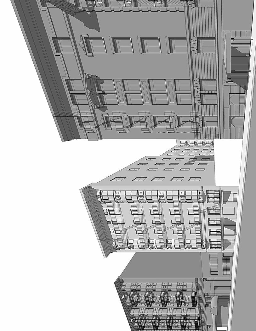
mboudrea
Text Box
NOT PART OF PROJECT
mboudrea
Text Box
NOT PART OF PROJECT
mboudrea
Text Box
530-532 Jones Street
mboudrea
Line
mboudrea
Text Box
NO PROJECT - EXISTING CONDITIONS

PARTIAL PRESERVATION

KHJO
HAN
NA
STRE
ETAR
CHIT
ECT
PART
IAL
PRES
ERVA
TION
ALT
ERN
ATIV
E- 1
0FEB
2017
450
O’F
ARR
ELL
STRE
ETPA
RTIA
L PR
ESER
VATI
ON A
LTER
NAT
IVE
10FE
B201
7
KHJO
HAN
NA
STRE
ETAR
CHIT
ECT
PART
IAL
PRES
ERVA
TION
ALT
ERN
ATIV
E- 1
0FEB
2017
PRES
ERVA
TIO
N A
LT 2
- PE
RSPE
CTIV
E
RETA
IN A
ND
RE
HA
BIL
ITAT
E EX
ISTI
NG
BU
ILD
ING
S AT
474
AN
D 4
80
O’F
ARR
ELL
(20’
)
RETA
IN A
ND
RE
HA
BIL
ITAT
E EX
ISTI
NG
CH
URC
H
BU
ILD
ING
(20’
)
mboudrea
Text Box
VIEW FROM O'FARRELL: 474-480 O'FARRELL: RETAINED AND REHABILITATED, (N) MASSING SETBACK 20 FT
mboudrea
Text Box
VIEW FROM O'FARRELL: 450 O'FARRELL (CHURCH): TO BE RETAINED & REHABILITATED, (N) MASSING SETBACK 20 FT
mboudrea
Text Box
530-532 JONES NEW MASSING EXTENDING BEHIND (E) CHURCH/PARKING LOT TO SHANNON STREET
mboudrea
Line
mboudrea
Text Box
NOT PART OF PROJECT
KHJO
HAN
NA
STRE
ETAR
CHIT
ECT
PART
IAL
PRES
ERVA
TION
ALT
ERN
ATIV
E- 1
0FEB
2017
PRES
ERVA
TIO
N A
LT 2
- PE
RSPE
CTIV
E
mboudrea
Text Box
VIEW FROM SHANNON STREET: 530-532 JONES NEW MASSING EXTENDING BEHIND (E) CHURCH/PARKING LOT TO SHANNON STREET
mboudrea
Text Box
VIEW FROM SHANNON STREET: 450 O'FARRELL (CHURCH): TO BE RETAINED & REHABILITATED, (N) MASSING SETBACK 20 FT FROM O'FARRELL
mboudrea
Line
mboudrea
Line

KHJO
HAN
NA
STRE
ETAR
CHIT
ECT
PART
IAL
PRES
ERVA
TION
ALT
ERN
ATIV
E- 1
0FEB
2017
PRES
ERVA
TIO
N A
LT 2
- PE
RSPE
CTIV
E
mboudrea
Text Box
VIEW FROM JONES STREET: 530-532 JONES NEW MASSING EXTENDING BEHIND (E) CHURCH/PARKING LOT TO SHANNON STREET
mboudrea
Line
mboudrea
Text Box
NOT PART OF PROJECT
mboudrea
Text Box
NOT PART OF PROJECT
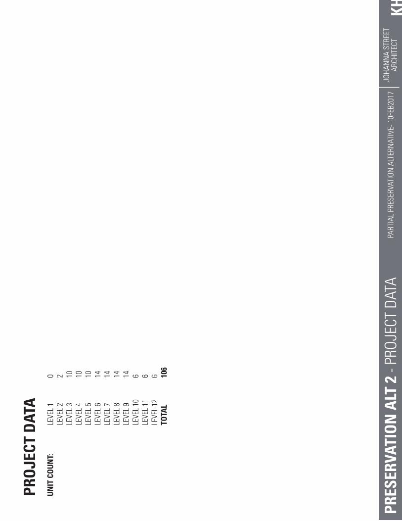
KHJO
HAN
NA
STRE
ETAR
CHIT
ECT
PART
IAL
PRES
ERVA
TION
ALT
ERN
ATIV
E- 1
0FEB
2017
PRES
ERVA
TIO
N A
LT 2
- PR
OJEC
T DA
TA
PRO
JECT
DAT
AU
NIT
CO
UN
T:
LE
VEL
1
0
LEVE
L 2
2
LE
VEL
3
10
LEVE
L 4
10
LE
VEL
5
10
LEVE
L 6
14
LE
VEL
7
14
LEVE
L 8
14
LE
VEL
9
14
LEVE
L 10
6
LE
VEL
11
6
LEVE
L 12
6
TO
TAL
10
6

KHJO
HAN
NA
STRE
ETAR
CHIT
ECT
PART
IAL
PRES
ERVA
TION
ALT
ERN
ATIV
E- 1
0FEB
2017
PRES
ERVA
TIO
N A
LT 2
- LE
VEL
P1
PARK
ING
PARK
ING
RA
MP

KHJO
HAN
NA
STRE
ETAR
CHIT
ECT
PART
IAL
PRES
ERVA
TION
ALT
ERN
ATIV
E- 1
0FEB
2017
PRES
ERVA
TIO
N A
LT 2
- LE
VEL
1
RETA
IL
RES.
LO
BB
Y(U
NEX
CAVA
TED
)
NEW
CHU
RCH
RETA
IN A
ND
RE
HA
BIL
ITAT
E EX
ISTI
NG
BU
ILD
ING
S AT
474
AN
D 4
80
O’F
ARR
ELL
RETA
IN A
ND
RE
HA
BIL
ITAT
E EX
ISTI
NG
CH
URC
H
BU
ILD
ING

KHJO
HAN
NA
STRE
ETAR
CHIT
ECT
PART
IAL
PRES
ERVA
TION
ALT
ERN
ATIV
E- 1
0FEB
2017
PRES
ERVA
TIO
N A
LT 2
- LE
VEL
2
RETA
IL
NEW
CHU
RCH
(OPE
N T
OB
ELO
W)
RETA
IN A
ND
RE
HA
BIL
ITAT
E EX
ISTI
NG
BU
ILD
ING
S AT
474
AN
D 4
80
O’F
ARR
ELL
RETA
IN A
ND
RE
HA
BIL
ITAT
E EX
ISTI
NG
CH
URC
H
BU
ILD
ING
RETA
IL
RES.
RETA
IN
FACA
DE
ON
LY
RES.

KHJO
HAN
NA
STRE
ETAR
CHIT
ECT
PART
IAL
PRES
ERVA
TION
ALT
ERN
ATIV
E- 1
0FEB
2017
PRES
ERVA
TIO
N A
LT 2
- LE
VEL
3-5
20’ S
ETB
ACK
RETA
IL(L
v 3
ON
LY)
COU
RTYA
RD@
LEV
EL 3
RETA
IN A
ND
RE
HA
BIL
ITAT
E EX
ISTI
NG
CH
URC
H
BU
ILD
ING
RES.
RES.
RES.
RES.
RES.
RES.
RES.
RES.
RES.
RES.
RETA
IN
FACA
DE
ON
LY

KHJO
HAN
NA
STRE
ETAR
CHIT
ECT
PART
IAL
PRES
ERVA
TION
ALT
ERN
ATIV
E- 1
0FEB
2017
PRES
ERVA
TIO
N A
LT 2
- LE
VELS
6-9
20’ S
ETB
ACK
20’
SETB
ACK
RES.
RES.
RES.
RES.
RES.
RES.
RES.
RES.
RES.
RES.
RES.
RES.
RES.
RES.
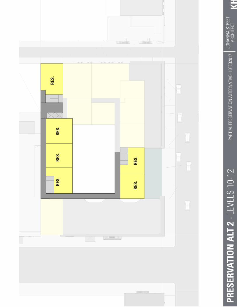
KHJO
HAN
NA
STRE
ETAR
CHIT
ECT
PART
IAL
PRES
ERVA
TION
ALT
ERN
ATIV
E- 1
0FEB
2017
PRES
ERVA
TIO
N A
LT 2
- LE
VELS
10-
12
RES.
RES.
RES.
RES.
RES.
RES.

FULL PRESERVATION
KHJO
HAN
NA
STRE
ETAR
CHIT
ECT
FULL
PRE
SERV
ATIO
N A
LTER
NAT
IVE
- 12S
EP20
16
450
O’F
ARR
ELL
STRE
ETFU
LL P
RESE
RVAT
ION
ALT
ERN
ATIV
E12
SEP
201
6
KHJO
HAN
NA
STRE
ETAR
CHIT
ECT
FULL
PRE
SERV
ATIO
N A
LTER
NAT
IVE
- 12S
EP20
16PR
ESER
VATI
ON
ALT
1 -
PERS
PECT
IVE
CHU
RCH
TO
BE
REH
AB
ILIT
ATED
mboudrea
Text Box
VIEW FROM O'FARRELL: 450 O'FARRELL (CHURCH) TO BE REHABILITATED
mboudrea
Text Box
VIEW FROM O'FARRELL: 474-480 O'FARRELL NEW MASSING (8-STORY)
mboudrea
Text Box
530-532 JONES NEW MASSING EXTENDING BEHIND (E) CHURCH/PARKING LOT TO SHANNON STREET
mboudrea
Line
mboudrea
Line
mboudrea
Text Box
NOT PART OF PROJECT
KHJO
HAN
NA
STRE
ETAR
CHIT
ECT
FULL
PRE
SERV
ATIO
N A
LTER
NAT
IVE
- 12S
EP20
16PR
ESER
VATI
ON
ALT
1 -
PERS
PECT
IVE
mboudrea
Text Box
VIEW FROM SHANNON STREET: 530-532 JONES NEW MASSING EXTENDING BEHIND (E) CHURCH/PARKING LOT TO SHANNON STREET
mboudrea
Line
mboudrea
Text Box
VIEW FROM SHANNON STREET: 450 O'FARRELL (CHURCH) TO BE RETAINED & REHABILITATED
mboudrea
Line

KHJO
HAN
NA
STRE
ETAR
CHIT
ECT
FULL
PRE
SERV
ATIO
N A
LTER
NAT
IVE
- 12S
EP20
16PR
ESER
VATI
ON
ALT
1 -
PERS
PECT
IVE
mboudrea
Text Box
VIEW FROM JONES STREET: 530-532 JONES NEW MASSING EXTENDING BEHIND (E) CHURCH/PARKING LOT TO SHANNON STREET
mboudrea
Line
mboudrea
Text Box
NOT PART OF PROJECT
mboudrea
Text Box
NOT PART OF PROJECT

KHJO
HAN
NA
STRE
ETAR
CHIT
ECT
FULL
PRE
SERV
ATIO
N A
LTER
NAT
IVE
- 12S
EP20
16PR
ESER
VATI
ON
ALT
1 -
PROJ
ECT
DATA
PRO
JECT
DAT
AU
NIT
CO
UN
T:
LE
VEL
1
0
LEVE
L 2
2
LE
VEL
3
8
LEVE
L 4
8
LE
VEL
5
8
LEVE
L 6
8
LE
VEL
7
8
LEVE
L 8
8
LE
VEL
9
8
LEVE
L 10
4
LE
VEL
11
4
LEVE
L 12
4
TO
TAL
70
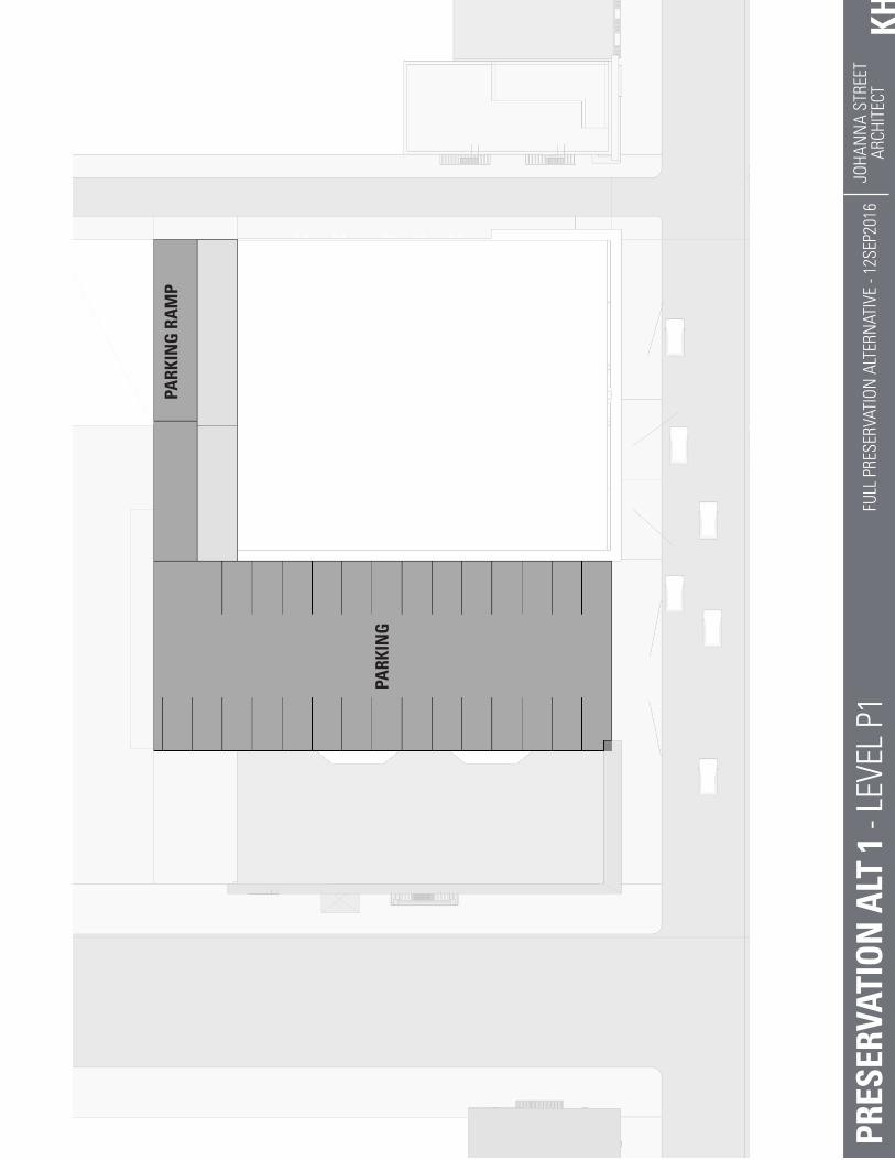
KHJO
HAN
NA
STRE
ETAR
CHIT
ECT
FULL
PRE
SERV
ATIO
N A
LTER
NAT
IVE
- 12S
EP20
16PR
ESER
VATI
ON
ALT
1 -
LEVE
L P1
PARK
ING
PARK
ING
RA
MP
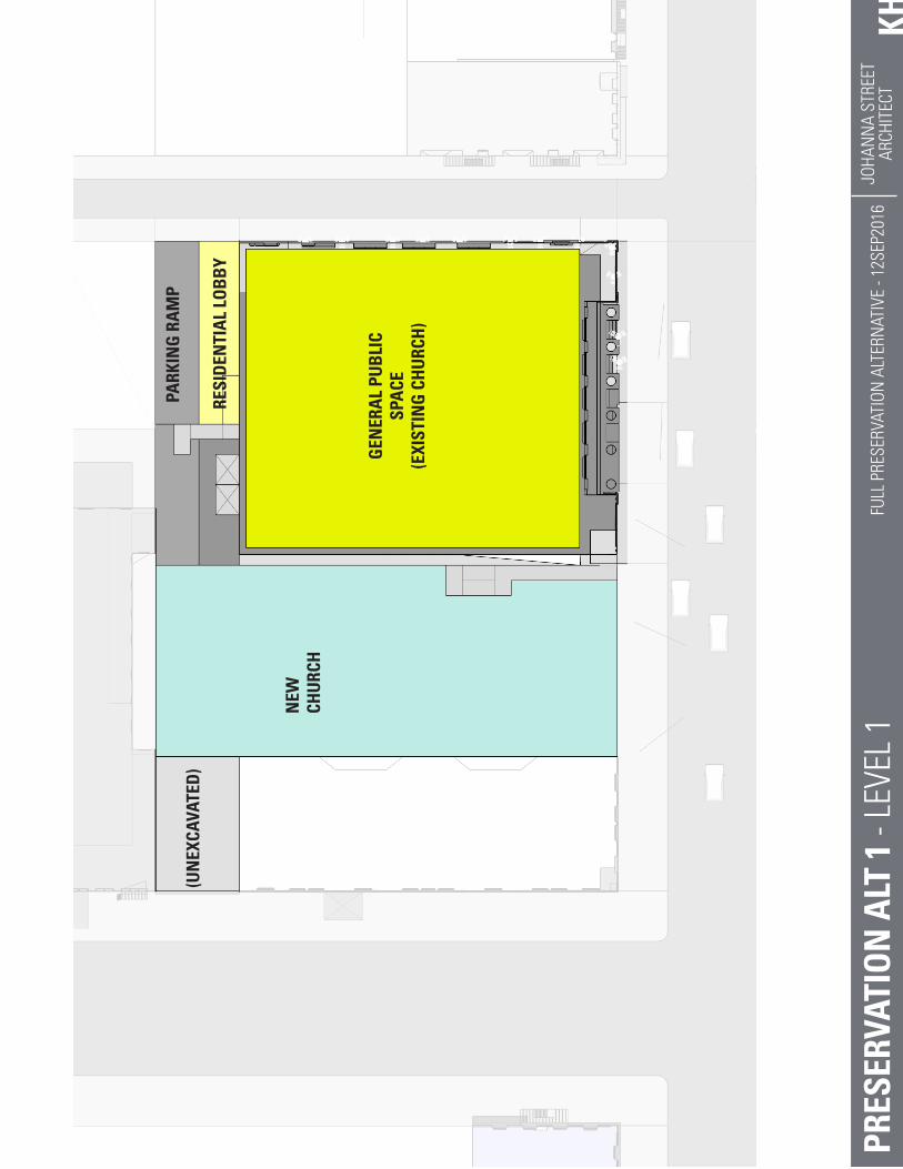
KHJO
HAN
NA
STRE
ETAR
CHIT
ECT
FULL
PRE
SERV
ATIO
N A
LTER
NAT
IVE
- 12S
EP20
16PR
ESER
VATI
ON
ALT
1 -
LEVE
L 1
(UN
EXCA
VATE
D)
RESI
DEN
TIA
L LO
BB
Y
NEW
CHU
RCH
PARK
ING
RA
MP
GEN
ERA
L PU
BLI
C SP
ACE
(EXI
STIN
G C
HU
RCH
)

KHJO
HAN
NA
STRE
ETAR
CHIT
ECT
FULL
PRE
SERV
ATIO
N A
LTER
NAT
IVE
- 12S
EP20
16PR
ESER
VATI
ON
ALT
1 -
LEVE
L 2N
EW C
HU
RCH
MEZ
ZAN
INE
RES.
RES.
NEW
CHU
RCH
(OPE
N T
OB
ELO
W)
(OPE
N T
OB
ELO
W)
RETA
IL

KHJO
HAN
NA
STRE
ETAR
CHIT
ECT
FULL
PRE
SERV
ATIO
N A
LTER
NAT
IVE
- 12S
EP20
16PR
ESER
VATI
ON
ALT
1 -
LEVE
LS 3
-5
RES.
RES.
RES.
RES.
RES.
RES.
RES.
(OPE
N T
OB
ELO
W)
RES.

KHJO
HAN
NA
STRE
ETAR
CHIT
ECT
FULL
PRE
SERV
ATIO
N A
LTER
NAT
IVE
- 12S
EP20
16PR
ESER
VATI
ON
ALT
1 -
LEVE
LS 6
-9
RES.
RES.
RES.
RES.
RES.
RES.
RES.
RES.
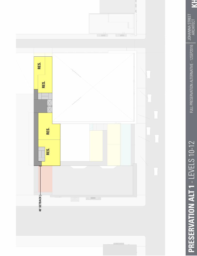
KHJO
HAN
NA
STRE
ETAR
CHIT
ECT
FULL
PRE
SERV
ATIO
N A
LTER
NAT
IVE
- 12S
EP20
16PR
ESER
VATI
ON
ALT
1 -
LEVE
LS 1
0-12
RES.
RES.
RES.
RES.
40’ S
ETB
ACK

PROPOSED PROJECT
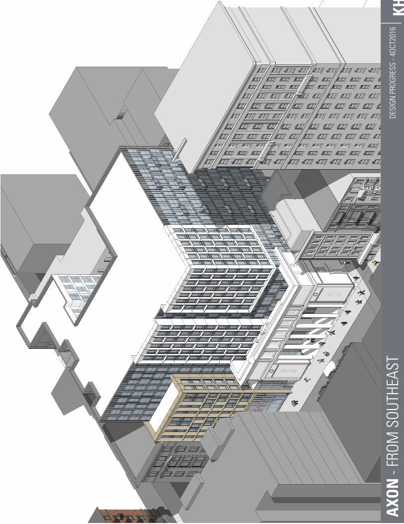
KHDE
SIGN
PRO
GRES
S - 4
OCT2
016
AXO
N -
FROM
SOU
THEA
ST
mboudrea
Text Box
PROPOSED PROJECT
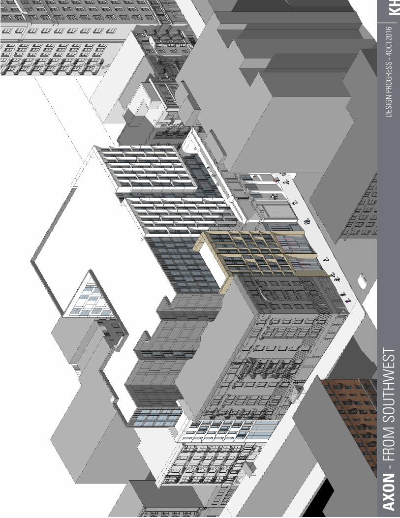
KHDE
SIGN
PRO
GRES
S - 4
OCT2
016
AXO
N -
FROM
SOU
THW
EST
mboudrea
Text Box
PROPOSED PROJECT

mboudrea
Text Box
PROPOSED PROJECT
mboudrea
Text Box
PROPOSED PROJECT

mboudrea
Text Box
PROPOSED PROJECT
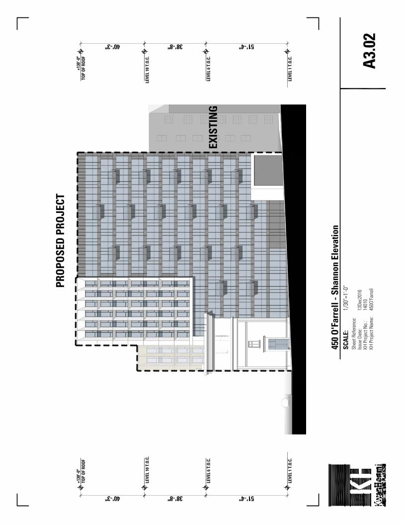
mboudrea
Text Box
PROPOSED PROJECT
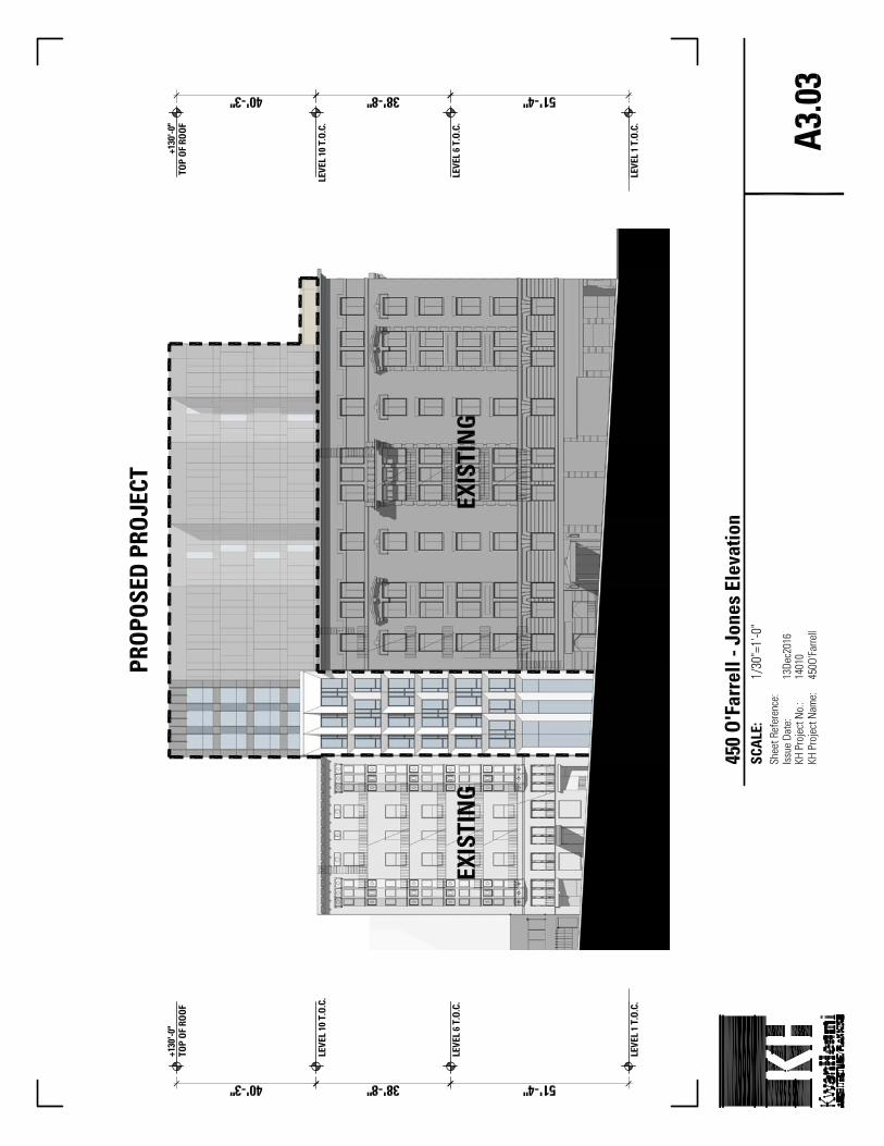
mboudrea
Text Box
PROPOSED PROJECT