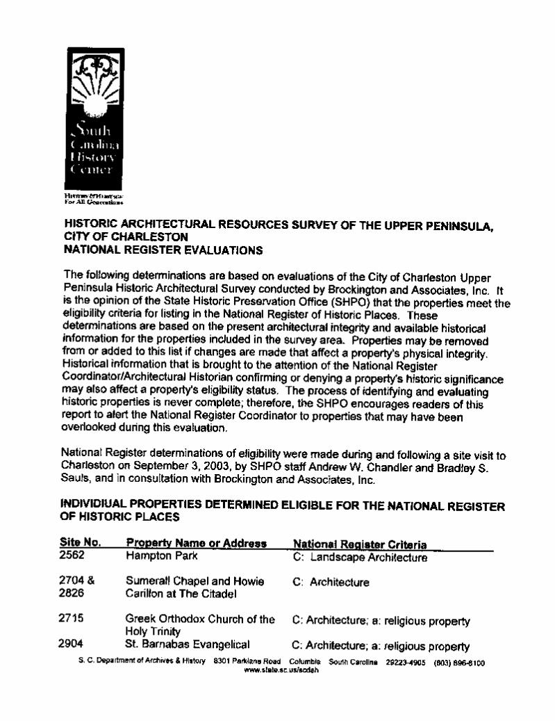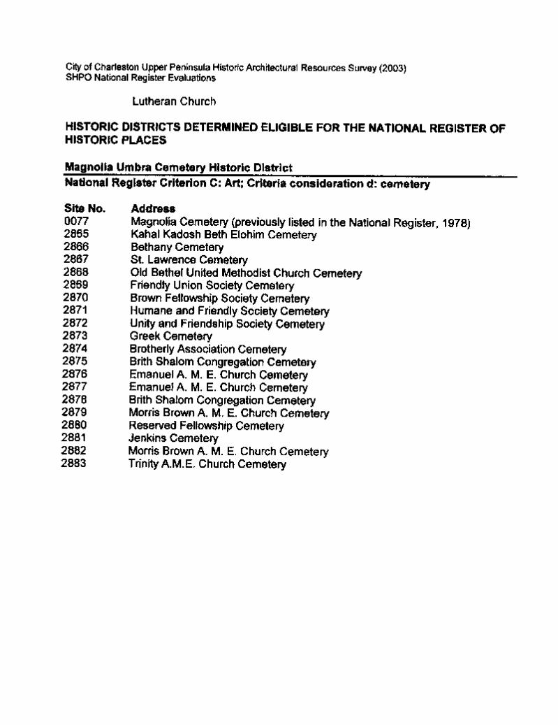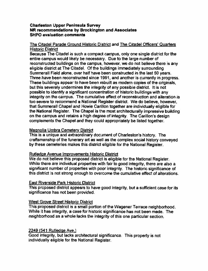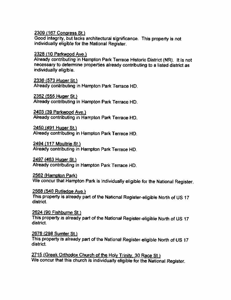
Historic Architectural Resources Survey of the Upper ...
269
-
Upload
khangminh22 -
Category
Documents
-
view
0 -
download
0
Transcript of Historic Architectural Resources Survey of the Upper ...
A Historic Architectural Resources Survey of theUpper Peninsula
Charleston, South Carolina
Final Report
Prepared for
City of Charleston Design, Development and Preservation DepartmentCharleston, South Carolina
Prepared by
John BeatyArchitectural Historian
and
Ralph Bailey
Principal Investigator
Brockington and Associates, Inc.Atlanta Charleston Raleigh
January 2004
ii
Acknowledgments
In completing this survey of the Upper Peninsula, we were fortunate to have the help of many
people. Lissa Felzer with the City of Charleston Design, Development, and Preservation Department
provided a great deal of logistical support and a constant supply of useful questions and
encouragement. Eddie Bello and Yvonne Fortenberry, also with the Design, Development, and
Preservation Department, provided insight, information, and public meeting support. Greg Felzer
provided the boat and piloting skills. Finally, the staff at the South Carolina Department of Archives
and History, including Brad Sauls, was very helpful and accommodating.
The activity that is the subject of this report has been financed in part with Federal funds
from the National Park Service, US Department of the Interior. However, the contents and opinions
do not necessarily reflect the views or policies of the Department of the Interior.
This program receives Federal financial assistance for identification and protection of historic
properties. Under Title VI of the Civil Rights Act of 1964, Section 504 of the Rehabilitation Act of
1973, and the Age Discrimination Act of 1975, as amended, the US Department of the Interior
prohibits discrimination on the basis of race, color, national origin, disability or age in its federally
assisted programs. If you believe you have been discriminated against in any program, activity, or
facility as described above, or if you desire further information, please write to: Office of Equal
Opportunity, National Park Service, 1849 C Street, NW, Washington, DC, 20240.
iii
Table of Contents
Page
Section I. Introduction . . . . . . . . . . . . . . . . . . . . . . . . . . . . . . . . . . . . . . . . . . . . . . . . . . . . . . 1Name of Project . . . . . . . . . . . . . . . . . . . . . . . . . . . . . . . . . . . . . . . . . . . . . 1Boundaries of Project . . . . . . . . . . . . . . . . . . . . . . . . . . . . . . . . . . . . . . . . . 1Number of Properties . . . . . . . . . . . . . . . . . . . . . . . . . . . . . . . . . . . . . . . . . 1Geographical Area . . . . . . . . . . . . . . . . . . . . . . . . . . . . . . . . . . . . . . . . . . . 1Survey Staff . . . . . . . . . . . . . . . . . . . . . . . . . . . . . . . . . . . . . . . . . . . . . . . . 3Beginning and End Dates of the Survey . . . . . . . . . . . . . . . . . . . . . . . . . . 3Objective of Survey . . . . . . . . . . . . . . . . . . . . . . . . . . . . . . . . . . . . . . . . . . 3Method of Survey . . . . . . . . . . . . . . . . . . . . . . . . . . . . . . . . . . . . . . . . . . . 4
Historic Architectural Resources Survey . . . . . . . . . . . . . . . . . . . . 4NRHP Assessment of Cultural Resources . . . . . . . . . . . . . . . . . . . 6Charleston Architectural Ranking . . . . . . . . . . . . . . . . . . . . . . . . . 9
Section II. Overview of the Historic Settlement of the Upper Peninsula . . . . . . . . . . . . . . . 11A Brief Overview of European Settlement in and around Charleston . . . 11
The Protohistoric Period . . . . . . . . . . . . . . . . . . . . . . . . . . . . . . . 11Early European Explorations . . . . . . . . . . . . . . . . . . . . . . . . . . . . 12English Colonial Occupation . . . . . . . . . . . . . . . . . . . . . . . . . . . . 13The Revolutionary War . . . . . . . . . . . . . . . . . . . . . . . . . . . . . . . . 17Antebellum Period . . . . . . . . . . . . . . . . . . . . . . . . . . . . . . . . . . . . 19Postbellum Period . . . . . . . . . . . . . . . . . . . . . . . . . . . . . . . . . . . . 22
Overview of the Upper Peninsula . . . . . . . . . . . . . . . . . . . . . . . . . . . . . . 24Early Settlement . . . . . . . . . . . . . . . . . . . . . . . . . . . . . . . . . . . . . . 24Antebellum Development . . . . . . . . . . . . . . . . . . . . . . . . . . . . . . 28Post-War Development . . . . . . . . . . . . . . . . . . . . . . . . . . . . . . . . 38Twentieth Century Development . . . . . . . . . . . . . . . . . . . . . . . . . 46Summary of the Upper Peninsula Settlement History . . . . . . . . . 69
Section III. Previously Identified Historic Architectural Resources . . . . . . . . . . . . . . . . . . . . 70Properties Listed on the NRHP . . . . . . . . . . . . . . . . . . . . . . . . . . . . . . . . 70Properties that are Eligible/Potentially Eligible for the NRHP . . . . . . . . 70Previous Architecture Surveys within the Survey Universe . . . . . . . . . . 71
An Architectural, Archaeological, and Historical Survey of Selected Portions of Charleston and Mt. Pleasant: Grace Memorial Bridge Replacement, Charleston,South Carolina . . . . . . . . . . . . . . . . . . . . . . . . . . . . . . . . . 71
Phase II Archaeological, Historical, and Architectural Investigations in the Grace and New Market Alignments:Grace Memorial Bridge Replacement,Charleston, South Carolina . . . . . . . . . . . . . . . . . . . . . . . 71
iv
Page
Additional Archaeological and Architectural Investigationsfor the Grace Memorial Bridge Replacement,Charleston, South Carolina . . . . . . . . . . . . . . . . . . . . . . . 73
Cultural Resource Assessment and Assessment of Effects Pursuant to 36 CFR 800 for the Replacementof the Bridges on US 17 over the Cooper River andTown Creek, Charleston County, South Carolina . . . . . . 73
Intensive Cultural Resources Survey and Documentationof the Proposed Cooper River Bridge ApproachesCharleston County, South Carolina . . . . . . . . . . . . . . . . . 73
Section IV. Survey Results . . . . . . . . . . . . . . . . . . . . . . . . . . . . . . . . . . . . . . . . . . . . . . . . . . . 75Residential Resources . . . . . . . . . . . . . . . . . . . . . . . . . . . . . . . . . . . . . . . 76
National Styles . . . . . . . . . . . . . . . . . . . . . . . . . . . . . . . . . . . . . . . 76Folk House Types . . . . . . . . . . . . . . . . . . . . . . . . . . . . . . . . . . . . 89
Commercial Resources . . . . . . . . . . . . . . . . . . . . . . . . . . . . . . . . . . . . . . 91Institutional Resources . . . . . . . . . . . . . . . . . . . . . . . . . . . . . . . . . . . . . . . 92Transportation Resources . . . . . . . . . . . . . . . . . . . . . . . . . . . . . . . . . . . . . 97Manufacturing Resources . . . . . . . . . . . . . . . . . . . . . . . . . . . . . . . . . . . . 98Data Gaps . . . . . . . . . . . . . . . . . . . . . . . . . . . . . . . . . . . . . . . . . . . . . . . . . 98
Section V. Recommendations . . . . . . . . . . . . . . . . . . . . . . . . . . . . . . . . . . . . . . . . . . . . . . . . 99National Register Listed Properties . . . . . . . . . . . . . . . . . . . . . . . . . . . . . 99
The Hampton Park Terrace Historic District . . . . . . . . . . . . . . . . 99Lowndes Grove (Resource 0073.00) . . . . . . . . . . . . . . . . . . . . . . 99The Enston Home (Resource 0075) . . . . . . . . . . . . . . . . . . . . . . . 99Magnolia Cemetery (Resource 0077.00) . . . . . . . . . . . . . . . . . . . 99The Florence Crittenton Home (Resource 0104) . . . . . . . . . . . . 100
National Register Eligible Properties . . . . . . . . . . . . . . . . . . . . . . . . . . . 100The North of 17 Historic District . . . . . . . . . . . . . . . . . . . . . . . . 100The Carondolet Street Historic District . . . . . . . . . . . . . . . . . . . 100The Dingle Street Historic District . . . . . . . . . . . . . . . . . . . . . . 101The North Tracy Street Historic District . . . . . . . . . . . . . . . . . . 10174 Fishburne Street (Resource 2065) . . . . . . . . . . . . . . . . . . . . . 101The Colin McKissick Grant Home (Resource 2810) . . . . . . . . . 101The Immigration Center (Resource 2809) . . . . . . . . . . . . . . . . . 102The Charleston Railway Bus Barn (Resource 2830) . . . . . . . . . 102The Charleston Fire Department Engine
Number Eight Building (Resource 2888) . . . . . . . . . . . 102Districts Recommended Eligible . . . . . . . . . . . . . . . . . . . . . . . . . . . . . . 102
The Citadel Parade Ground Historic District . . . . . . . . . . . . . . . 104The Citadel Officers’ Quarters Historic District . . . . . . . . . . . . 105The Magnolia Umbra Cemetery District . . . . . . . . . . . . . . . . . . 105The Rutledge Avenue Improvement Historic District . . . . . . . . 107
v
Page
The East Riverside Park Historic District . . . . . . . . . . . . . . . . . 108The West Grove Street Historic District . . . . . . . . . . . . . . . . . . 109
Individual Resources Recommended Eligible . . . . . . . . . . . . . . . . . . . . 110541 Rutledge Avenue (Resource 2249) . . . . . . . . . . . . . . . . . . . 110167 Congress Street (Resource 2309) . . . . . . . . . . . . . . . . . . . . 11110 Parkwood Avenue (Resource 2328) . . . . . . . . . . . . . . . . . . . 112573 Huger Street (Resource 2336) . . . . . . . . . . . . . . . . . . . . . . . 112555 Huger Street (Resource 2352) . . . . . . . . . . . . . . . . . . . . . . . 11339 Parkwood Avenue (Resource 2403) . . . . . . . . . . . . . . . . . . . 114491 Huger Street (Resource 2450) . . . . . . . . . . . . . . . . . . . . . . . 115117 Moultrie Street (Resource 2494) . . . . . . . . . . . . . . . . . . . . . 116463 Huger Street (Resource 2497) . . . . . . . . . . . . . . . . . . . . . . . 117Hampton Park (Resource 2562) . . . . . . . . . . . . . . . . . . . . . . . . . 118540 Rutledge Avenue (Resource 2568) . . . . . . . . . . . . . . . . . . . 11890 Fishburne Street (Resource 2624) . . . . . . . . . . . . . . . . . . . . . 119298 Sumter Street (Resource 2678) . . . . . . . . . . . . . . . . . . . . . . 120The Greek Orthodox Church (Resource 2715) . . . . . . . . . . . . . 120Bethany Cemetery (Resource 2866.00) . . . . . . . . . . . . . . . . . . . 122Saint Lawrence Cemetery (Resource 2867) . . . . . . . . . . . . . . . . 122Saint Barnabas Evangelical Lutheran Church
(Resource 2904) . . . . . . . . . . . . . . . . . . . . . . . . . . . . . . . 123County Hall (Resource 2964) . . . . . . . . . . . . . . . . . . . . . . . . . . 124981 King Street (Resource 2967) . . . . . . . . . . . . . . . . . . . . . . . . 125807 Rutledge Avenue (Resource 3061) . . . . . . . . . . . . . . . . . . . 125809 Rutledge Avenue (Resource 3062) . . . . . . . . . . . . . . . . . . . 1261126 King Street (Resource 3125) . . . . . . . . . . . . . . . . . . . . . . . 12728 Maple Street (Resource 3136) . . . . . . . . . . . . . . . . . . . . . . . . 12960 Poplar Street (Resource 3154) . . . . . . . . . . . . . . . . . . . . . . . 129842 Rutledge Avenue (Resource 3160) . . . . . . . . . . . . . . . . . . . 13031 Cypress Street (Resource 3212) . . . . . . . . . . . . . . . . . . . . . . 131887 Rutledge Avenue (Resource 3297) . . . . . . . . . . . . . . . . . . . 13166 Sans Souci Street (Resource 3340) . . . . . . . . . . . . . . . . . . . . 132164 Maple Street (Resource 3632) . . . . . . . . . . . . . . . . . . . . . . . 133165 Maple Street (Resource 3641) . . . . . . . . . . . . . . . . . . . . . . . 133187 Grove Street (Resource 3932) . . . . . . . . . . . . . . . . . . . . . . . 134308 Grove Street (Resource 4091) . . . . . . . . . . . . . . . . . . . . . . . 135
Recommendations for Future Consideration . . . . . . . . . . . . . . . . . . . . . 136Endangered Areas . . . . . . . . . . . . . . . . . . . . . . . . . . . . . . . . . . . 136Areas that may be Eligible in the Future . . . . . . . . . . . . . . . . . . 137Areas that may Warrant Protection of Special Attention . . . . . . 138
Survey Summary . . . . . . . . . . . . . . . . . . . . . . . . . . . . . . . . . . . . . . . . . . 138
vi
Page
References Cited . . . . . . . . . . . . . . . . . . . . . . . . . . . . . . . . . . . . . . . . . . . . . . . . . . . . . . . . . . . . 140
Appendix A. Inventory of Surveyed Resources . . . . . . . . . . . . . . . . . . . . . . . . . . . . . . . . . . A-1
Appendix B. Location of Surveyed Resources, County Tax Maps . . . . . . . . . . . . . . . . . . . . . B-1
Appendix C. SHPO Determination of NRHP Eligibility Letter . . . . . . . . . . . . . . . . . . . . . . . C-1
Attachment. Detailed Map of the Upper Peninsula Survey Universe (oversize)
vii
List of Figures
Page
Figure 1. Location of the Survey Universe (USGS 1983 Charleston, SC quadrangle) . . . . . 2
Figure 2. A 1780 map of Charleston showing multiple plantation settlements aboveLine Street (Clinton 1780) . . . . . . . . . . . . . . . . . . . . . . . . . . . . . . . . . . . . . . . . . . 26
Figure 3. A map of eighteenth century plantations in the Upper Peninsula (Smith 1988) . . . . . . . . . . . . . . . . . . . . . . . . . . . . . . . . . . . . . . . . . . . . . . . . . . . . 27
Figure 4. A portion of an 1852 map of Charleston showing the project area (Bridgensand Allen 1852) . . . . . . . . . . . . . . . . . . . . . . . . . . . . . . . . . . . . . . . . . . . . . . . . . . 29
Figure 5. An 1835 plat showing the plantation of J. S. Payne (McCrady Plat 8025,SCDAH, Columbia . . . . . . . . . . . . . . . . . . . . . . . . . . . . . . . . . . . . . . . . . . . . . . . 31
Figure 6. An 1884 plat showing the proposed Cool Blow Village (CCPB C:44) . . . . . . . . 32
Figure 7. An 1857 plat showing the proposed Cool Blow Village (CCPB A:142) . . . . . . 33
Figure 8. An 1850 plan of Magnolia Cemetery (National Register nomination form,SCDAH, Columbia) . . . . . . . . . . . . . . . . . . . . . . . . . . . . . . . . . . . . . . . . . . . . . . . 35
Figure 9. An 1879 map of Charleston showing the limited development in the UpperPeninsula (Walker et al. 1879) . . . . . . . . . . . . . . . . . . . . . . . . . . . . . . . . . . . . . . . 40
Figure 10. A portion of an 1883 map of Charleston showing the limited development inthe Upper Peninsula (Courtenay 1883) . . . . . . . . . . . . . . . . . . . . . . . . . . . . . . . . 41
Figure 11. A portion of an 1855 map of Charleston showing the project area (Walker etal. 1855) . . . . . . . . . . . . . . . . . . . . . . . . . . . . . . . . . . . . . . . . . . . . . . . . . . . . . . . . 42
Figure 12. A portion of an 1872 Bird’s Eye View of Charleston showing a portion ofthe Survey Universe (Drie 1872) . . . . . . . . . . . . . . . . . . . . . . . . . . . . . . . . . . . . . 43
Figure 13. An 1893 plat of the Sophia Wilson Tract (CCPB B:161) . . . . . . . . . . . . . . . . . . 44
Figure 14. A plan of the Enston Home complex (National Register nomination form(SCDAH, Columbia) . . . . . . . . . . . . . . . . . . . . . . . . . . . . . . . . . . . . . . . . . . . . . . 46
Figure 15. View of the Exposition’s Ivory City (Chibbaro 2001:42) . . . . . . . . . . . . . . . . . . 48
viii
Page
Figure 16. An aerial view of the Citadel campus taken in the late 1920s (CitadelArchives, Charleston) . . . . . . . . . . . . . . . . . . . . . . . . . . . . . . . . . . . . . . . . . . . . . 51
Figure 17. A 1959 map of the Citadel’s campus (Citadel Archives, Charleston) . . . . . . . . . 52
Figure 18. A 1912 plat of the western portion of Hampton Park Terrace(CCPB D:200) . . . . . . . . . . . . . . . . . . . . . . . . . . . . . . . . . . . . . . . . . . . . . . . . . . . 53
Figure 19. A 1912 plat of the eastern portion of Hampton Park Terrace (CCPB D:200) . . . . . . . . . . . . . . . . . . . . . . . . . . . . . . . . . . . . . . . . . . . . . . . . . . . 54
Figure 20. A 1918 plat of Wagener Terrace (CCPB C:147) . . . . . . . . . . . . . . . . . . . . . . . . . 57
Figure 21. A 1936 aerial photo showing Wagener Terrace (Citadel Archives,Charleston) . . . . . . . . . . . . . . . . . . . . . . . . . . . . . . . . . . . . . . . . . . . . . . . . . . . . . . 58
Figure 22. An 1895 plat of a subdivision between King Street and Rutledge Avenue(CCPB E:203) . . . . . . . . . . . . . . . . . . . . . . . . . . . . . . . . . . . . . . . . . . . . . . . . . . . 60
Figure 23. A 1913 plat of the Rutledge Avenue Improvements Company tract (CCPBC:88) . . . . . . . . . . . . . . . . . . . . . . . . . . . . . . . . . . . . . . . . . . . . . . . . . . . . . . . . . . 62
Figure 24. A 1918 plat of the Carolina Florida Realty Company subdivision (CCPBC:128) . . . . . . . . . . . . . . . . . . . . . . . . . . . . . . . . . . . . . . . . . . . . . . . . . . . . . . . . . 63
Figure 25. An 1894 plat of the City of Charleston Potter’s Field (City Engineers’ Mapand Plats, City of Charleston Archives and Records, Charleston) . . . . . . . . . . . . 64
Figure 26. A 1941 map of Johnson Hagood Stadium (City Engineers’ Maps and Plats,City of Charleston Archives and Records, Charleston) . . . . . . . . . . . . . . . . . . . . 65
Figure 27. A 1917 plat of Riverside Park (CCPB C:156) . . . . . . . . . . . . . . . . . . . . . . . . . . . 67
Figure 28. A 1936 plat of Subdivision D, Mt. Pleasant Farm (CCPB F:61) . . . . . . . . . . . . . 69
Figure 29. The location of previously recorded eligible/potentially eligible and listedarchitectural resources in the Survey Universe (USGS 1983 Charleston, SCquadrangle) . . . . . . . . . . . . . . . . . . . . . . . . . . . . . . . . . . . . . . . . . . . . . . . . . . . . . 72
Figure 30. Lowndes Grove (Resource 0073.00), southeast facade, an example ofthe Federal style. . . . . . . . . . . . . . . . . . . . . . . . . . . . . . . . . . . . . . . . . . . . . . . . . . 77
Figure 31. Resource 2188, east facade, an example of the Greek Revival style . . . . . . . . . . 78
ix
Page
Figure 32. Resource 2657, northwest facade, showing Italianate details. . . . . . . . . . . . . . . . 78
Figure 33. Resource 3136, southwest facade, an example of the Queen Anne Revival style 79
Figure 34. Enston Home Cottage #1 (Resource 0075.01), northeast facade, an exampleof the Romanesque Revival style. . . . . . . . . . . . . . . . . . . . . . . . . . . . . . . . . . . . . 80
Figure 35. Resource 2624, southwest facade, an example of the Folk Victorian style. . . . . 81
Figure 36. Resource 3160, northwest facade, an example of the Colonial Revival style. . . 82
Figure 37. Resource 2770, southwest facade, an example of the Colonial Revival style. . . 82
Figure 38. Resource 3632, southwest facade, an example of the Neoclassical Revival style.83.Figure 39. Resource 4098, northwest facade, showing elements of
the Tudor Revival style. . . . . . . . . . . . . . . . . . . . . . . . . . . . . . . . . . . . . . . 84
Figure 40. Resource 2328, southwest facade, an example of the Craftsman style. . . . . . . . . 85
Figure 41. Resource 3340, southwest facade, an example of the Craftsman style. . . . . . . . . 85
Figure 42. Resource 2450, northwest facade, an example of the Asian-influencedCraftsman style. . . . . . . . . . . . . . . . . . . . . . . . . . . . . . . . . . . . . . . . . . . . . . . . . . . 86
Figure 43. Resource 3297, east facade, an example of the Prairie style. . . . . . . . . . . . . . . . 86
Figure 44. The Grant Home (Resource 2810.01), northeast facade, an example of theItalian Renaissance style. . . . . . . . . . . . . . . . . . . . . . . . . . . . . . . . . . . . . . . . . . . . 87
Figure 45. Resource 3933, northeast facade, an example of the Spanish Colonial Revivalstyle. . . . . . . . . . . . . . . . . . . . . . . . . . . . . . . . . . . . . . . . . . . . . . . . . . . . . . . . . . . . 88
Figure 46. Resource 3503, south facade, and example of the International style. . . . . . . . . 88
Figure 47. Resource 3566, southwest facade, an example of the Minimal Traditional style. . . . . . . . . . . . . . . . . . . . . . . . . . . . . . . . . . 89
Figure 48. Sacred Heart Church (Resource 2811), northwest elevation . . . . . . . . . . . . . . . . 93
Figure 49. Rutledge Avenue Baptist Church (Resource 2630), southwest elevation . . . . . . 93
Figure 50. Hampton Park (Resource 2562), facing north . . . . . . . . . . . . . . . . . . . . . . . . . . . 95
x
Page
Figure 51. Engine Number 8 Building (Resource 2888), southeast elevation . . . . . . . . . . . 95
Figure 52. Immigration Center (Resource 2809), northwest elevation . . . . . . . . . . . . . . . . . 96
Figure 53. County Hall (Resource 2964), southwest elevation . . . . . . . . . . . . . . . . . . . . . . . 97
Figure 54. City Railway Car House (Resource 2830), northeast elevation . . . . . . . . . . . . . . 98
Figure 55. Location of the proposed and previously recorded historic districts in theSurvey Universe (USGS 1983 Charleston, SC quadrangle) . . . . . . . . . . . . . . . 103
Figure 56. Citadel Parade Ground Historic District (Parade Ground) facing north . . . . . . 104
Figure 57. Citadel Officers’ Quarters Historic District (Hammond Avenue) facingnortheast. . . . . . . . . . . . . . . . . . . . . . . . . . . . . . . . . . . . . . . . . . . . . . . . . . . . . . . 105
Figure 58. Magnolia Umbra Cemetery District (Lemon Street) facing northeast . . . . . . . . 106
Figure 59. Rutledge Avenue Improvements District (Maple Street) facing east. . . . . . . . . 107
Figure 60. East Riverside Park Historic District (Ashley Avenue) facing south. . . . . . . . . 108
Figure 61. West Grove Street Historic District (Grove Street) facing east . . . . . . . . . . . . . 109
Figure 62. 541 Rutledge Avenue (Resource 2249), northeast elevation . . . . . . . . . . . . . . . 110
Figure 63. 167 Congress Street (Resource 2309), northwest elevation . . . . . . . . . . . . . . . 111
Figure 64. 573 Huger Street (Resource 2336), northwest elevation . . . . . . . . . . . . . . . . . . 113
Figure 65. 555 Huger Street (Resource 2352), northwest elevation. . . . . . . . . . . . . . . . . . 114
Figure 66. 39 Parkwood Avenue (Resource 2403), southeast elevation . . . . . . . . . . . . . . . 115
Figure 67. 117 Moultrie Street (Resource 2494), northeast elevation . . . . . . . . . . . . . . . . 116
Figure 68. 463 Huger Street (Resource 2497), northwest elevation . . . . . . . . . . . . . . . . . . 117
Figure 69. 540 Rutledge Avenue (Resource 2568), northwest elevation . . . . . . . . . . . . . . 119
Figure 70. 298 Sumter Street (Resource 2678), southwest elevation . . . . . . . . . . . . . . . . . 121
Figure 71. Greek Orthodox Church (Resource 2715), south elevation. . . . . . . . . . . . . . . . 121
xi
Page
Figure 72. Bethany Cemetery (Resource 2866.00) facing east . . . . . . . . . . . . . . . . . . . . . . 122
Figure 73. Saint Lawrence Cemetery (Resource 2867) facing northwest . . . . . . . . . . . . . . 123
Figure 74. St. Barnabas Lutheran Church (Resource 2904), northeast elevation . . . . . . . 124
Figure 75. 981 King Street (Resource 2967), southeast elevation . . . . . . . . . . . . . . . . . . . 126
Figure 76. 807 Rutledge Avenue (Resource 3061), east elevation . . . . . . . . . . . . . . . . . . . 127
Figure 77. 809 Rutledge Avenue (Resource 3062), southeast elevation . . . . . . . . . . . . . . . 128
Figure 78. 1126 King Street (Resource 3125), southwest elevation . . . . . . . . . . . . . . . . . . 128
Figure 79. 60 Poplar Street (Resource 3154), southwest elevation . . . . . . . . . . . . . . . . . . . 130
Figure 80. 31 Cypress Street (Resource 3212), northwest elevation . . . . . . . . . . . . . . . . . 132
Figure 81. 165 Maple Street (Resource 3641), northwest elevation . . . . . . . . . . . . . . . . . . 134
Figure 82. 187 Grove Street (Resource 3932), northeast elevation . . . . . . . . . . . . . . . . . . 135
Figure 83. 308 Grove Street (Resource 4091), south elevation . . . . . . . . . . . . . . . . . . . . . 136
List of Tables
Page
Table 1. Historic Architectural Resources Identified by Reed et al. (1988 and 1992) . . . 71
Table 2. Historic Architectural Resources in the New Cooper River Bridge Project . . . . 74
Table 3. Construction Dates of Dwellings by Decade . . . . . . . . . . . . . . . . . . . . . . . . . . . . 76
1
Section I: Introduction
Name of Project
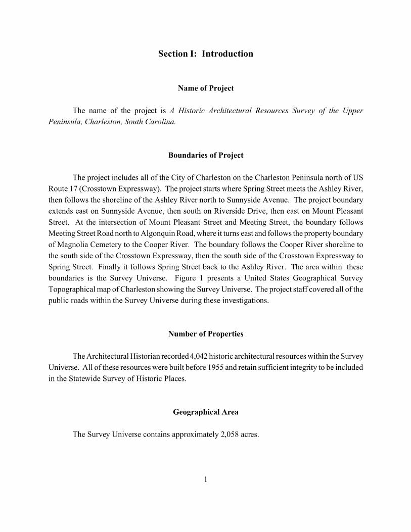
The name of the project is A Historic Architectural Resources Survey of the Upper
Peninsula, Charleston, South Carolina.
Boundaries of Project
The project includes all of the City of Charleston on the Charleston Peninsula north of US
Route 17 (Crosstown Expressway). The project starts where Spring Street meets the Ashley River,
then follows the shoreline of the Ashley River north to Sunnyside Avenue. The project boundary
extends east on Sunnyside Avenue, then south on Riverside Drive, then east on Mount Pleasant
Street. At the intersection of Mount Pleasant Street and Meeting Street, the boundary follows
Meeting Street Road north to Algonquin Road, where it turns east and follows the property boundary
of Magnolia Cemetery to the Cooper River. The boundary follows the Cooper River shoreline to
the south side of the Crosstown Expressway, then the south side of the Crosstown Expressway to
Spring Street. Finally it follows Spring Street back to the Ashley River. The area within these
boundaries is the Survey Universe. Figure 1 presents a United States Geographical Survey
Topographical map of Charleston showing the Survey Universe. The project staff covered all of the
public roads within the Survey Universe during these investigations.
Number of Properties
The Architectural Historian recorded 4,042 historic architectural resources within the Survey
Universe. All of these resources were built before 1955 and retain sufficient integrity to be included
in the Statewide Survey of Historic Places.
Geographical Area
The Survey Universe contains approximately 2,058 acres.

0 0.2 0.4 Miles
0 0.3 0.6 Kilometers
North
SouthCarolina
Quadrangle Location
Survey Universe
Figure 1. Location of the Survey Universe (USGS 1983 Charleston, SC quadrangle).
2
Charleston,
3
Survey Staff
The survey was conducted by Brockington and Associates, Inc., located in Mt. Pleasant,
South Carolina. Ralph Bailey, the company’s Mt. Pleasant Office Manager, served as the Principal
Investigator and Historian for the project. John M. Beaty, the company’s Architectural Historian,
conducted the field survey including architectural descriptions and photography. Bruce G. Harvey
assisted in starting and organizing the project and provided information about the Charleston
Exposition. Pat Hendrix conducted historical research. Susannah Munson organized and labeled
photographs with assistance from Mallory Chambliss. Inna Burns created all of the project maps
and graphics presented in the report. Carol Poplin edited and produced the report.
Beginning and End Dates of the Survey
Survey planning meetings, background research and public meetings for the survey started
in February 2003. Intensive survey fieldwork started in March 2003 and ended in June 2003. Final
survey products will be submitted by 30 September 2003.
Objective of the Survey
The objective of this survey is to identify all above ground historic architectural resources
in the Survey Universe that retain sufficient integrity to be included in the Statewide Survey of
Historic Places. These resources include buildings, structures, objects, districts, and landscapes that
have architectural or historical significance. We conducted this research and field work with several
goals in mind. First, the project can provide information for public officials in the City of Charleston
to allow them to make informed decisions regarding the impact of development and other public
activities on the Upper Peninsula’s cultural resources, and to set priorities for the protection and use
of these resources. Second, because the Upper Peninsula’s resources are overshadowed by
Charleston’s original historic districts, we hope that this project will generate additional public
awareness of the significance of cultural resources in the area and their value to the community. The
historical overview contained in this report can provide an appreciation and understanding of these
resources. The results of this survey can serve as an archival record of the Upper Peninsula’s historic
resources at the time of the survey; this report contains an inventory of every site recorded during
the fieldwork.
4
This project is part of the Statewide Survey of Historic Places, a program coordinated by the
South Carolina State Historic Preservation Office (SHPO). The purpose of this statewide program
is to identify all cultural resources in the state, and to highlight those that are eligible for the National
Register of Historic Places (NRHP) and for local designation. The Federal government has
recommended this process of documentation through the National Historic Preservation Act of 1966
as amended. The Statewide Survey of Historic Places provides the SHPO with information that
enables it to review the impact of projects with Federal components on resources eligible for the
NRHP. Federal projects require environmental and cultural review permits to proceed, which in turn
requires review by the SHPO. In addition, some Federal grants for cultural resources and certain
Federal tax incentives for rehabilitation of historic buildings require a determination of NRHP status.
The information developed through the Historic Architectural Resources Survey of the Upper
Peninsula gives the SHPO a basis for making these determinations.
The City of Charleston has well-known and well-developed procedures for protecting historic
resources. This report is designed to integrate with these procedures. Therefore, this report offers
recommendations for areas that warrant extra protection or areas that might be endangered. This
report also offers suggestions for areas that might become significant in the future as they age.
These recommendations are not meant to suggest a course of action, but instead to help the city and
its citizens decide on a course of action that is most advantageous for the whole community.
Method of Survey
Historic Architectural Resources Survey
This intensive architectural survey of the Upper Peninsula followed guidelines established
by the SHPO and included in the Scope of Work. The project consisted of several parts, which are
outlined below.
The project began with brief background research regarding the historical development of
the City of Charleston, especially the Upper Peninsula. This research helped to identify, assess, and
interpret the aboveground historical resources within the Survey Universe, as well as to develop the
various historic contexts for the survey area. The background research consisted mostly of archival
research. The survey team placed particular emphasis on sources that documented the physical
growth of the Upper Peninsula, with a special focus on maps and plats, as well as research that has
already been conducted regarding the Upper Peninsula’s historic buildings.
5
This background research led to completion of a historical overview that identified important
themes and patterns in the Upper Peninsula’s historical development. The overview serves two
important ends. First, it is an introduction to Charleston’s history for the general reader. Second,
it provides a context within which to identify and assess the significance of the Upper Peninsula’s
historic architectural resources; eligibility for inclusion in the NRHP and for local designation rests
to a large extent on the relations between a historic architectural resource and its historical context.
This historical context also allowed the field surveyors to predict and to be alert to the presence of
certain types of historic resources, and to understand their significance in the field.
The field survey began while the historic research was ongoing. The historian conducted
additional research on individual properties during and after the fieldwork. A preliminary public
meeting provided a base for identifying properties and individuals knowledgeable about these
properties, while the surveyor attempted to talk to owners or residents regarding particular properties
during the fieldwork. In addition, we conducted research on selected properties at the Charleston
County Register of Mesne Conveyance in Charleston, the South Carolina Historical Society in
Charleston, and at the Charleston County Library, and used this information to supplement the
historical overview and to provide historical background information on the survey forms.
Field survey methods complied with current State and Federal guidelines for conducting
architectural surveys (Parker 1985, Vivian 2002). In accordance with the scope of work and
standard South Carolina Department of Archives and History (SCDAH) statewide survey practice,
the architectural historian drove every street and road in the Survey Universe, and conducted a
pedestrian inspection of all potential historic architectural resources.
All historic architectural resources that retained sufficient integrity to be included in the
South Carolina Statewide Survey (SCSS) were recorded on SCSS site forms in digital format using
Microsoft Access 2000 database application. At least one black and white photograph was taken of
each resource. The location of each historic architectural resource was recorded on Charleston
County planning maps. The completed forms, including the various maps and photographs, were
prepared for the SCDAH for review.
The principal criterion used to define historic architectural resources is the 50-year minimum
age recommended for inclusion on the NRHP and the SCSS. In addition, certain other classes of
architectural resources are eligible for intensive survey. These include historic architectural
resources built within the past 50 years that have exceptional architectural significance or historical
associations, natural landscapes that have cultural associations, and properties that are already listed
on the NRHP.
6
The integrity of a historic architectural resource is a primary consideration for inclusion in
the SCSS, as well as in the NRHP. According to the SHPO’s recent survey manual:
A property that retains its historic appearance and character is considered to possessa high degree of integrity. Such a property conveys a strong feeling of the period inhistory during which it achieved significance. Integrity is the composite of sevenqualities: location, design, setting, materials, workmanship, feeling, and association.To have a reasonable degree of integrity, a property must possess several of thesequalities (Vivian 2002: 5).
While in the field, the architectural historian evaluated the integrity of each identified historic
architectural resource. Resources exhibiting poor integrity were not recorded. For the purpose of
this project, four levels of architectural integrity were employed. These include:
Excellent - All original construction materials and design remain intact andunchanged.
Good - The majority of original construction materials remain intact andunchanged except for roofing and other renewable elements.
Fair - A substantial number of original architectural elements have beenaltered, such as the installation of aluminum, asbestos, or vinylsiding, the substitution of historic doors and windows with non-historic replacements, and the construction of non-historic additions.
Poor - Has been radically altered from its original design by non-historicrenovations and/or additions.
References consulted for architectural style and architectural type descriptions include Blumenson
(1977), Longstreth (1987), McAlester and McAlester (1984), Poppeliers et al. (1983), and Whiffen
(1981).
NRHP Assessment of Cultural Resources
We evaluated the historic architectural resources in the Survey Universe for listing on the
NRHP. Federal guidelines allow four broad evaluative criteria for determining the significance of
a particular resource and its eligibility for the NRHP. Any resource (building, structure, site, object,
or district) may be eligible for the NRHP if it:
7
A. is associated with events that have made a significant contribution to thebroad pattern of history;
B. is associated with the lives of persons significant in the past;
C. embodies the distinctive characteristics of a type, period, or method ofconstruction, or represents the work of a master, possesses high artistic value,or represents a significant and distinguishable entity whose components maylack individual distinction; or
D. has yielded, or is likely to yield, information important to history orprehistory.
A resource may be eligible under one or more of these criteria. Criteria A, B, and C are most
frequently applied to historic buildings, structures, objects, non-archaeological sites (e.g.,
battlefields, natural features, designed landscapes, or cemeteries), or districts. The eligibility of
archaeological sites is most frequently considered with respect to Criterion D. Also, a general guide
of 50 years of age is employed to define “historic” in the NRHP evaluation process. That is, all
properties greater than 50 years of age may be considered. However, more recent properties may
be considered if they display “exceptional” significance (Sherfy and Luce).
Following National Register Bulletin: How to Apply the National Register Criteria for
Evaluation, evaluation of any resource requires a twofold process (Savage and Pope 1998). First,
the resource must be associated with an important historic context. If this association is
demonstrated, the integrity of the resource must be evaluated to ensure that it conveys the
significance of its context. The applications of both of these steps are discussed in more detail
below.
Determining the association of a resource with a historic context involves five steps. First,
the resource must be associated with a particular facet of local, regional (state), or national history.
Secondly, one must determine the significance of the identified historical facet/context with
respect to the resource under evaluation. Any particular historical facet/context becomes significant
for the development of the project area only if the project area contains resources that were
constructed or gained their significance during that time. For example, the Antebellum era historic
context would be significant for the development of a project area only if the project area contained
buildings that were either built or gained their significance during the early nineteenth century.
Similarly, the use of contexts associated with the Pre-Contact Native American use of a region
would require the presence of Pre-Contact archaeological sites within the Survey Universe.
8
The third step is to demonstrate the ability of a particular resource to illustrate the context.
A resource should be a component of the locales and features created or used during the historical
period in question. For example, early nineteenth century farm houses, the ruins of African
American slave settlements from 1820s, and/or field systems associated with particular antebellum
plantations in the region would illustrate various aspects of the agricultural development of the
region prior to the Civil War. Conversely, contemporary churches or road networks used during this
time period may not reflect the agricultural practices suggested by the other kinds of resources.
The fourth step involves determining the specific association of a resource with aspects of
the significant historic context. The National Register has defined how one should consider a
resource under each of the four criteria of significance. Under Criterion A, a resource must have
existed at the time that a particular event or pattern of events occurred and activities associated with
the event(s) must have occurred at the site. In addition, this association must be of a significant
nature, not just a casual occurrence. Under Criterion B, the resource must be associated with
historically important individuals. Again, this association must relate to the period or events that
convey historical significance to the individual, not just that this person was present at this locale.
Under Criterion C, a resource must possess physical features or traits that reflect a style, type, period,
or method of construction; display high artistic value; or, represent the work of a master (an
individual whose work can be distinguished from others and possesses recognizable greatness).
Under Criterion D, a resource must possess sources of information that can address specific
important research questions (Savage and Pope 1998). These questions must generate information
that is important in reconstructing or interpreting the past (Butler 1987, Sprinkle and Knoerl 1993).
For archaeological sites, recoverable data must be able to address specific research questions.
After a resource is specifically associated with a significant historic context, one must
determine what physical features of the resource are necessary to reflect its significance. One should
consider the types of resources that may be associated with the context, how these resources
represent the theme, and which aspects of integrity apply to the resource in question. As in the
example given above, a variety of resources may reflect the antebellum context (farm houses, ruins
of slave settlements, field systems, etc.). One must demonstrate how these resources reflect the
context. The farm houses represent the residences of the landowners who implemented the
agricultural practices during the antebellum era. The slave settlements housed the workers who did
the daily tasks necessary to plant, harvest, process, and market crops.
Once the above steps are completed and association with a historically significant context
is demonstrated, one must consider the aspects of integrity applicable to a resource. Integrity is
defined in seven aspects of a resource; one or more may be applicable depending on the nature of
9
the resource under evaluation. These aspects are location, design, setting, materials, workmanship,
feeling, and association. If a resource does not possess integrity with respect to these aspects, it
cannot adequately reflect or represent its associated historically significant context. Therefore, it
cannot be eligible for the NRHP. To be considered eligible under Criteria A and B, a resource must
retain its essential physical characteristics that were present during the event(s) with which it is
associated. Under Criterion C, a resource must retain enough of its physical characteristics to reflect
the style, type, etc., or work of the artisan that it represents. Under Criterion D, a resource must be
able to generate data that can address specific research questions that are important in reconstructing
or interpreting the past.
Charleston Architectural Ranking
In order to provide compatibility with previous historic architecture surveys in other parts
of Charleston, each resource was given an Architectural Rating. The Rating system was developed
in 1973 by Dr. William Murtaugh, Bernard Lemann, Carl Feiss, and Russell Wright. According to
this system, resources were rated and placed into one of four groups with qualifiers:
GROUP 1: ExceptionalBuildings of the highest architectural design quality. Well proportioned, sophisticated useof architectural features–doors, window, classical orders or other period designs, chimneys,verandahs, massing, materials, textures, refined detail, craftsmanship, elegant and innovative.To be preserved and protected in situ at all costs.
GROUP 2: ExcellentHigh style regional architecture–fine “Charleston Style”–well designed andproportioned–good detail–spirited, dignified, frequently innovative, rare, and alwaysattractive and interesting. Of irreplaceable importance, to be preserved in situ at all costs.
GROUP 3 SignificantGood architectural quality. Vernacular. Of less sophistication and refinement than“Excellent.” Modest, appealing, curious, interesting. To be retained and protected.
GROUP 4 ContributoryBuildings of architectural value without which the character of those buildings rated inGroups 1-3 would be lessened. To be preserved and retained.
In addition to the four groups outlined above, two qualifying symbols were used in theevaluation: a property marked with an (*) after its numerical score should be furtherresearched, including interiors, with the (*) indicating that the score might be upgraded ifnew research uncovers data warranting such action; other scores include a minus sign (-),
10
which indicates that adverse changes to the fabric of the building under study have takenplace. To remove the minus, these buildings will have to be rehabilitated.
In this survey, the architectural historian interpreted this 30-year rating system for the context
of an area that developed mostly in the twentieth century. The following explains the interpretation
as it was used for this survey.
A rating of 1 (Exceptional) was given only to buildings of transcendent significance, i.e.,
these resources would be important anywhere. A rating of 1- means equal importance with some
changes to the original fabric.
A rating of 2 (Excellent) was given to resources of high significance, but not of transcendent
importance, or to buildings that once were transcendent but have some changes to their original
fabric. A rating of 2- was given to a building of high significance with some alterations to its
original fabric. Ratings of 2- or higher were only given to resources that are listed in or individually
eligible for the NRHP or contributing to a listed or eligible NRHP district.
A rating of 3 (Significant) was given to resources that might have a high level of integrity,
but lack a high level of architectural significance. A rating of 3 might also be given to a resource
that has some architectural significance but has a low level of integrity. A rating of 3- was given to
resources of less importance than a 3 because of alterations.
A rating of 4 (Contributory) is more altered than a rating 4(*), but the buildings still
contribute positively to the character of their surroundings. A rating of 4- represents the lowest level
of resources surveyed. These resources are heavily altered from their original form and materials.
With further alterations, these resources might lack sufficient integrity to be included in the SCSS.
Resources considered not eligible for the NRHP were given ratings of 3* or below. Also, a resource
that contributed to a listed or eligible NRHP district could be given a rating of 3(*) or lower if it had
multiple alterations.
One resource was given a rating of 0. This resource was surveyed initially, but later research
revealed heavy alterations. It was not removed from the survey in order to maintain the SCSS
numeric continuity.
11
Section II. Overview of the Historic Settlement of the Upper Peninsula
The purpose of this section is to provide a context for the results of the survey. A
comprehensive history of Charleston, many of which have been written, is outside the scope of this
report. This context instead focuses on the development of the Upper Peninsula.
A Brief Overview of European Settlement in and around Charleston
The City of Charleston lies on a peninsula formed by the confluence of the Cooper and
Ashley Rivers. Historically, this tip of the peninsula was farther north; however, land was made by
filling the marsh and small creeks to create more usable land in the developing City of Charleston.
The Survey Universe (Upper Peninsula) lies approximately 1.5 miles above the confluence of the
Ashley and Cooper Rivers. This above discussion draws upon earlier works which provide a great
deal of description and analysis of the physical development of the Upper Peninsula. These studies,
however, have focused primarily on the portion of Charleston immediately adjacent to and south of
what is now the Crosstown Expressway (US Route 17). A discussion focused on the Upper
Peninsula in particular follows this general overview.
The Protohistoric Period
The first Spanish explorations into the region began in the 1520s. Native American groups
encountered by the European explorers and settlers probably lived in a manner quite similar to the
Mississippian groups identified in archaeological sites throughout the Southeast. Indeed, the highly
structured Indian society of Cofitachequi, formerly located in central South Carolina and visited by
De Soto in 1540, is an excellent example of the Mississippian social organizations present
throughout southeastern North America during the late Pre-Contact period (Anderson 1985).
However, the initial European forays into the Southeast contributed to the disintegration and collapse
of the aboriginal Mississippian social structures; disease, warfare, and European Slave raids all
contributed to the rapid decline of the regional Native populations during the sixteenth century
(Dobyns 1983; Ramenofsky 1982; Smith 1984). By the late seventeenth century, Native groups in
coastal South Carolina apparently lived in small politically and socially autonomous semi-sedentary
groups (Waddell 1980). By the middle eighteenth century, very few Natives remained in the region;
all were displaced or annihilated by the ever-expanding English colonial settlement of the Carolinas
(Bull 1770, cited in Anderson and Logan 1981:24-25).
12
The ethnohistoric record from coastal South Carolina suggests that the Protohistoric groups
of the region followed a seasonal pattern that included summer aggregation in villages for planting
and harvesting crops, and dispersal into one to three family settlements for the remainder of the year
(Rogel 1570 [in Waddell 1980:147-151]). This coastal Protohistoric adaptation apparently is similar
to the Guale pattern of the Georgia coast, as reconstructed by Crook (1986:18). Specific accounts
of the Protohistoric groups of the region, the Sewee and the Santee, are summarized by Waddell
(1980). It appears that both groups included horticultural production within their seasonal round,
but did not have permanent, year round villages. Trinkley (1981) suggests that a late variety of Pee
Dee ceramics was produced by Sewee groups in the region; his late variety may correspond to the
Ashley ware initially described by South (1973), and later by Anderson et al. (1982).
Waddell (1980) identified 19 distinct groups between the mouth of the Santee River and the
mouth of the Savannah River in the middle of the sixteenth century. Anderson and Logan (1981:29)
suggest that many of these groups probably were controlled by Cofitachequi, the dominant
Mississippian center/polity in South Carolina, prior to its collapse. By the seventeenth century, all
were independently organized. These groups included the Coosaw, Kiawah, Etiwan, and Seewee
“tribes” near the Charleston peninsula. The Coosaw inhabited the area to the north and west along
the Ashley River. The Kiawah apparently resided at Albemarle Point and along the lower reaches
of the Ashley River in 1670, but gave their settlement to the English colonists and moved to Kiawah
Island; in the early eighteenth century they moved south of Combahee River (Swanton 1952:96).
The Etiwans were mainly settled on or near Daniel Island to the northeast of Charleston, but their
range extended to the head of the Cooper River. The territory of the Seewee met the territory of the
Etiwan high up the Cooper, and extended to the north as far as the Santee River (Orvin 1973:14).
Moll’s map of Carolina, prepared in 1715, shows the Sampa Indians between the Cooper and Wando
Rivers, and the Wando Indians and Sewel [sic] Indian Fort east of the Wando River.
Early European Explorations
Spanish exploration on the South Carolina coast began as early as 1514, and a landing party
went ashore in the Port Royal vicinity (now Beaufort County) in 1520 at a spot they named Santa
Elena (Hoffman 1983:64; Rowland 1985:1). From that time on, the Port Royal area was of great
interest to both the Spanish and the French. This was not a permanent settlement, however. San
Miguel de Gualdape led the first Spanish attempt at a permanent settlement on the South Carolina
coast in 1526. This settlement appears to have been in the Winyah Bay area, near Georgetown
(Quattlebaum 1956). The French, under Jean Ribault, also attempted to establish a settlement on
13
the South Carolina coast in 1562. This settlement, on Parris Island, was called Charlesfort, and also
was unsuccessful.
French presence on the South Carolina coast drew the Spanish back to protect their original
interest. Spanish forces attacked Charlesfort and established their own settlement of Santa Elena in
1566. Recent archaeological evidence indicates that the Spanish built their new settlement of Santa
Elena on top of the destroyed French settlement (DePratter et al. 1997). Local Indians, the Cusabo,
were less than friendly, but despite numerous attacks and several burnings, the Spanish settlers did
not abandon Santa Elena until 1587 (Lyon 1984; Rowland 1978:25-57). The Spanish maintained
their interest in Santa Elena as part of a series of missions on the Sea Islands from St. Augustine,
Florida, through Georgia, and into South Carolina; Spanish friars were at “St. Ellens” when William
Hilton visited the area in 1663 (Covington 1978:8-9; Hilton 1664). During its twenty-year existence,
Santa Elena served as the base for the first serious explorations into the interior of the state.
English Colonial Occupation
The English were the first Europeans to establish permanent colonies. In 1663, King Charles
II made a proprietary grant to a group of powerful English courtiers who had supported his return
to the throne in 1660, and who sought to profit from the sale of the new lands. These Lords
Proprietors, including Sir John Colleton, Sir William Berkeley, and Sir Anthony Ashley Cooper,
provided the basic rules of governance for the new colony. They also sought to encourage settlers,
many of whom came from the overcrowded island of Barbados in the early years. These Englishmen
from Barbados first settled at Albemarle Point on the west bank of the Ashley River in 1670. By
1680, they moved their town down the river to Oyster Point, the present location of Charleston, and
called it Charles Towne. These initial settlers, and more who followed them, quickly spread along
the central South Carolina coast. By the second decade of the eighteenth century, they had
established settlements from the Port Royal Harbor in Beaufort County, northward to the Santee
River in Georgetown County.
Settlers in the Carolina Lowcountry were caught up in and were integral parts of wide-
ranging disputes and rivalries among the English, Spanish, Indians, and African slaves. These
disputes and rivalries encompassed nearly all of the Lowcountry, an area that spanned hundreds of
miles from Georgetown, South Carolina, to northern Florida. The Spanish had routed the French
in East Florida in 1565, and established a settlement at what is now St. Augustine. This Spanish
presence was a continual threat to the English settlers, particularly after the 1670s, when Spain
learned of the Charles Towne settlement.
14
The English colony’s early settlements grew slowly, and despite its geographic spread, the
South Carolina Lowcountry contained only around 5,000 European and African-American
inhabitants in 1700. The earliest South Carolina economy centered around the naval stores industry,
beef and pork production, and the deer trade with the Native American populations. However, by
the end of the seventeenth century the colonists began to experiment with rice cultivation. The
regular flood conditions of the immediate tidal area proved valuable, and production for export
increased rapidly. By 1715, Charles Towne exported more than 8,000 barrels of rice annually; this
number increased to 40,000 by the 1730s. In the 1740s, residents in the Lowcountry began to
experiment with growing and processing indigo, a blue dye that was very popular in Europe and
which became one of South Carolina's principal exports during the eighteenth century. Both indigo
and rice were labor-intensive, and laid the basis for South Carolina’s dependence on African slave
labor, much as tobacco had done in the Virginia colony (Coclanis 1989; Wood 1974).
One of the important commercial ventures in the early settlements of the Lowcountry was
the raising of cattle. The climate in South Carolina allowed year-round grazing, and the many necks
of land surrounded by rivers and creeks along the coast provided naturally bounded cowpens that
allowed the cattle to range freely. Cattle ranching was a low-capital industry, with a natural market
in the West Indies sugar plantations. Cattle ranching in South Carolina began in the late seventeenth
century in the Charleston area, and by the early eighteenth century had extended into what is now
Colleton County, between the Edisto and Combahee rivers (Rowland et al. 1996: 85-88).
While cattle ranching was an ideal frontier industry, it required great amounts of open land.
Large purchases of land throughout the Lowcountry created problems between the white settlers and
the Yamasee Indians, whose lands were steadily and rapidly encroached upon. Angered by
mistreatment from traders and encroachments on their land, the Indians attacked in the Yamasee War
in 1715 but did not succeed in dislodging the English (Covington 1978: 12). While the Yamasee
staged a number of successful raids through the 1720s, by 1728 the English had routed them and
made the area more accessible for renewed English settlement.
With the rapidly increasing wealth in the South Carolina Lowcounty, and with the Yamasee
War largely behind them, the population began to swell. By 1730 the colony had 30,000 residents,
at least half of whom were black slaves. It has been estimated that South Carolina residents had
imported more than 32,000 slaves by 1723 (Wood 1974:151). The growing population increased
pressure for territorial expansion, which was compounded by the growing black majority in the
Lowcountry. Fears of a slave rebellion, along with fears of attack from the Native Americans such
as the Yamasee in 1715, led Charles Towne residents to encourage settlement in the backcountry.
15
The capacity of the Lords Proprietors to govern the colony effectively declined in the early
years of the eighteenth century. Governance under the Lords Proprietors became increasingly
arbitrary, while wars with the Natives arose and the colonial currency went into steep depreciation.
According to one recent historian of colonial South Carolina, “proprietary attitudes and behavior .
. . convinced many of the dissenters—who at one time had composed the most loyal faction—that
the crown was a more reliable source of protection against arbitrary rule” (Weir 1983:94). South
Carolina’s legislature sent a petition to Parliament in 1719, requesting that royal rule supplant that
of the Lords Proprietors. After several years in limbo, South Carolinians received a degree of
certainty in 1729 when the crown purchased the Proprietors’ interests, and in 1730 when the new
royal governor, Robert Johnson, arrived in the colony.
Johnson arrived with a plan to create townships throughout the colony, as a way to ensure
the orderly settlement of the backcountry. His scheme originally included nine townships, primarily
along the major rivers in the colony. Johnson permitted the settlement of these areas on the
headright system, which apportioned 50 acres of land to every individual who settled there. Many
of these settlers established plantations that were directed toward the production of cash crops. Main
plantation residences and facilities were established on the low bluffs of the rivers and readily
accessible river landings. However, settlement proceeded slowly until the 1750s when the South
Carolina backcountry population was approximately 20,000, about one-third of the total Lowcountry
population (Wallace 1961).
Many of the early settlements and plantations in the area focused on the Cooper and Wando
Rivers. These waterways provided the best opportunity for profitable agricultural production (i.e.,
rice cultivation) as well as the best avenues of transportation to Charleston or other settlements in
the region (South and Hartley 1985). Evidence of the many plantations along these rivers remains
today primarily as archaeological sites, although some, like Rice Hope Plantation near Moncks
Corner, are still occupied.
The early history of the City of Charleston and its physical development may be found in a
number of published works, from the succinct delineations of various neighborhoods provided in
Hudgins et al. (1994) and Stoney (1990), to the historical narratives written by Rogers (1980) and
Fraser (1989), and the extensive studies of the East Side by Rosengarten (1987) and Grimes and
Zierden (1988). The following overview of Charleston’s early history synthesizes these earlier
works.
By 1704, Charleston had become a walled port, bounded on the west by Meeting Street, to
the south by Water Street, to the north by Cumberland Street, and to the east by the waters, creeks,
16
and marshes of the Cooper River. The walls were partially destroyed by hurricanes in 1713 and
1714, and were dismantled (in 1717 or 1718) after the successful conclusion of the Yemassee Indian
War (Coclanis 1989:5, 179-180; Rogers 1980:56). In 1739, the town line was moved northward to
the vicinity of present day Beaufain and Hasell Streets. By the next year, the city’s population had
increased 500 percent since 1700, and its areal size had almost doubled. The number of wharves
along the Cooper River, or “bridges” as they were called locally, had increased from two in 1704 to
eight in 1740.
The city’s first suburb was developed in 1747. Ansonborough was named for British Navy
commander George Anson who served on the Carolina Station from 1724-1735. Anson acquired
the land in 1726. By the mid-1760s, this area was well established as a middle class neighborhood
from Hasell Street northward to George Street. In 1769, the suburb's northern boundary - and
ultimately that of the city until the mid-nineteenth century - was established by the creation of
Boundary Street. This new avenue was 70 feet wide, just two feet narrower than Broad Street, the
city’s widest boulevard. Boundary Street (presently Calhoun Street) ran from the “Broad Path,” or
present day King Street, east to Scarborough (now Anson) Street.
In the 1760s, two smaller subdivisions were opened adjacent to Ansonborough, toward the
river and to the north and east but still south of Boundary Street. These were the lands of Henry
Laurens (on the south) and Christopher Gadsden (on the north). Boundary Creek flowed eastward
into the Cooper River from the foot of Boundary Street and north of Gadsden's property; marsh cut
into the peninsula as far as the eastern end of the hornwork and present day Meeting Street. Beyond
Boundary Creek lay the area known as the Charleston “Neck,” a term which had come to identify
the peninsula north of the burgeoning city. [NOTE: The term now refers to the area much further
north between Heriot Street and the North Charleston City line. In this discussion, the term Neck
will be used in its historic context to define the area north of Calhoun Street].
A wide band of property stretching from river to river, and between present day Calhoun and
Line Streets, had been granted to Richard Cole in the earliest years of the settlement. In 1677, this
tract was regranted to Richard Batten. It was subsequently subdivided, with a large portion east of
the “Broad Path” becoming the property of the Wragg family. Another section, just across Boundary
Creek from Ansonborough and Gadsdsen's Middlesex development, was the property of the
Mazycks. The Village of Hampstead, a block of land belonging to Henry Laurens, was located along
Town Creek just beyond present day Mary Street. In the late 1760s, Laurens attempted to develop
the area along the lines of an English village, but the project failed to grow. Thus, the countryside
that characterized the Neck immediately above present Calhoun Street and lands further north were
open, thinly populated, pasture land for most of the eighteenth century.
17
Although the early colonists considered the soils on either side of the Ashley River not
favorable for agriculture, the direct access to Charleston provided by the river made the area
desirable for settlement by some of the wealthiest people in the region. The settlements typically
were located on bluffs within a few hundred yards of the river. A 1775 map of the region shows the
grand plantation settlements that existence along the banks of the Ashley and Cooper Rivers from
the early 1700s to the end of the Civil War. The advent of tidal rice agriculture in the mid-1700s
made the land favorable for cash crop agriculture.
The Revolutionary War
The American colonies declared their independence from Britain in 1776, following several
years of increasing tension due to unfair taxation and trade restrictions imposed on them by the
British Parliament. South Carolinians were divided during the war, although most citizens
ultimately supported the American cause. Those individuals who remained loyal to the British
government tended to reside in Charleston or in certain enclaves within the interior of the province.
Britain’s Royal Navy attacked Fort Sullivan (later renamed Fort Moultrie) near Charleston
in 1776. The British failed to take the fort, and the defeat bolstered the morale of American
revolutionaries throughout the colonies. The British military then turned their attention northward.
They returned in 1778, however, besieging and capturing Savannah late in December. A major
British expeditionary force landed on Seabrook Island in the winter of 1780, and then marched north
and east to invade Charleston from its landward approaches (Lumpkin 1981:42-46). Charleston was
able to offer few defenses.
With the termination of hostilities associated with the French and Indian War in 1763, the
project to build defenses across the Charleston Neck had been discontinued, and the cannons on the
existing hornwork dismounted (Merrens 1972:262). In 1765, two years after the war, a northern
visitor described this work on “The Path” as “mounds thrown up and ditches round the back part of
the town but all ruinous and nearly useless” (Merrens 1972:220). Likewise, a British informant in
1774 declared these land defenses as one of “3 apologies for fortifications belonging to Charles
Town . . . no gates have been hung nor guns mounted upon it and what is built of it is now rather a
nuisance [sic] than otherwise” (Merrens 1972:283).
At the beginning of the American Revolution, attention turned again to the incomplete line
of defenses on the Neck. In1776 however, the commissioners responsible for fortifying the town
halted this work in favor reinforcing the harbor defenses, especially the palmetto log fort on
18
Sullivan’s Island. In the winter of 1778, the city was “entirely enclosed with a breast work, with
small fortifications at proper distances,” but the breastwork was decaying. Vague references indicate
that a new fortification was being erected in the rear of town (Merrens 1972:185). The next year,
work continued on the defenses as the British attempted to take Charleston during a small campaign
from Savannah. Two French engineers attached to the Continental Army (Col. Jean Baptiste Joseph,
chevalier de Laumoy and Lt. Col. Louis Antoine Jean Baptist, chevalier de Cambray-Digny) were
sent south early in 1779 to supervise the construction of the defenses. After the unsuccessful British
attempt on the town that year, Lt. Col. de Cambray was congratulated by the state legislature and
promoted in recognition of his service (Hemphill et al. 1970:205-206, 357; Williams 1975:49-50).
However, it was not until the American General in charge of the city, Benjamin Lincoln
learned of the departure of a large British amphibious force from New York in the winter, that
reinforcement of the Neck defenses began in earnest (Murdoch 1966:144). On 3 February 1780, the
South Carolina House of Representatives passed a resolution requesting that the Governor order out
one third of the militia of Charleston and the surrounding area to “assist in the fatigue duty wherein
the North Carolina Militia are now employed on Charles Town Neck” (Hemphill et al. 1970:272,
276).
The British moved slowly and deliberately toward Charleston from their landing on the North
Edisto River behind Seabrook Island. Advance units crossed the Ashley River at Drayton Hall on
20 March 1780. Nine days later, the main army crossed over the river to Charleston Neck, several
miles above town. Then, on 1 April, Major James Moncrieff, chief engineer for the British Army
and a veteran of several British colonial wars including the sieges of St. Augustine and Louisburg,
directed the excavation of the enemy’s first siege parallel 800 yards from the American works
(Lumpkin 1981:42-46). Within a week of taking the city, Major Moncrieff employed more than 300
slaves and was rapidly covering the siege trenches (McCowen 1972; Murdoch 1966:152; Uhlendorf
1968). The rebel South Carolinians were not prepared for an attack in this direction. They were
besieged and entirely captured in May after offering a weak defense. Charleston subsequently
became a base of operations for British campaigns into the interior of South Carolina, Georgia, and
North Carolina. However, the combined American and French victory over Lord Cornwallis at
Yorktown in 1782 effectively destroyed British military activity in the south and forced negotiated
peace (Lumpkin 1981). The 13 colonies gained full independence, and the English-evacuated
Charleston in December 1782.
The Revolutionary War marks the beginning of a long period of decline for the once grand
Colonial plantations on the Charleston’ Upper Peninsula. Rice and cotton agriculture continued to
play a role in the economy of Charleston’s Upper Peninsula during the first half of the nineteenth
century, but at a much lower extent they did in the eighteenth century, especially before the
19
Revolutionary War. Income likely was generated from cutting the timber lands on the interior
portions of the property, with provisions and cotton produced on portions of the upland fields near
the river. Cattle were raised and pastured freely in the woods.
Antebellum Period
In 1783, the year the Treaty of Paris was signed ending the war with Britain, the City of
Charleston was incorporated and the city limit moved north to Boundary Street. The city’s name
was also changed from “Charles Town” to Charleston. As the city grew in the closing years of the
eighteenth century, so did development on the Neck. In 1785, both Meeting and King Streets were
extended up the peninsula. Mazykborough was laid out in 1786, bounded by the Cooper River to
the east, Chapel Street to the North, Elizabeth Street to west, and Boundary Street to the south.
Between 1801 and 1806, Wraggborough was developed, defined by Mazyckborough and the river
on the east, Boundary Street on the south, Meeting Street to the east, and Mary Street on the north.
Across Meeting Street, the City and the State exchanged the blocks on which the eighteenth century
defenses had been located at present day Marion Square), a portion of it becoming the site of a
tobacco inspection facility by 1790, and 35 years later, the site of the Citadel. North of Hutson
Street to Mary Street, the block between King and Meeting Streets was subdivided between the heirs
of John Wragg, one of whom was Christopher Gadsden.
Through the onset of the Civil War in 1861, the developed portions of the Charleston Neck
lay south of Line Street, which is now immediately south of the Crosstown Expressway. A lightly
developed area lay north of Line Street on the west side of King Street, leading up to the Washington
Race Course, what is now Hampton Park. With exception of this scatter of houses, the Upper
Peninsula was still largely plantation acreage.
While the eighteenth century proprietors may have envisioned their property as future sites
of comfortable country seats, subsequent surveys and the actual evolution of the area suggests their
heirs intended to turn a quick profit. As a result, the area’s development has a distinct speculative
character. Some wealthy merchants and professional Charlestonians, like Joseph Manigualt,
William Aiken, and Joseph T. Weyman, did make the new neighborhoods their homes and built
mansions on the wide, spacious lots (Lerski 1983:222-223; Stoney 1990:66, 80). But, the Neck
increasingly became the home of the less affluent, like the large number of African Americans,
whether free (or hoping to pass as free), or slaves “working out,” or servants connected to the
domestic entourage of the wealthy white households. Likewise, it was an attractive place for
immigrants to settle, particularly for the waves of Irish and Germans who arrived after 1840.
20
There were several reasons for the Neck’s popularity with the lower classes. Police
surveillance was minimal, an important consideration to African Americans, both slave and free, and
others seeking expansion of their personal freedom. Due to the lax law enforcement, grog shops and
gambling establishments abounded, and the streets of the Neck were generally known as rough and
tumble, vile and boisterous crime areas. Prior to 1832, the area was policed by citizen patrols. After
the establishment of the Citadel, the Citadel Guard was responsible for maintaining order, which it
did with only limited success (Pease and Pease 1986:101, 105, 165-166; Rosengarten 1987:20).
Thus, it is not surprising that the Neck played an important role in both the Denmark Vesey revolt
in 1822, and an aborted black insurrection one hundred and two years earlier (Fraser 1989:45, 200-
202).
On the Neck rents were lower, and real estate was plentiful and readily available. On the
Neck, homes could be built of wood (and therefore were cheaper), something not possible within
the city limits. The city building codes stipulated that homes were to be built of brick to reduce the
threat of large scale fires that periodically swept the city. The fires in the lower city, like the one
which destroyed much of Ansonborough in 1838, prompted large numbers of citizens to move north
of Boundary Street, since the cost of rebuilding was cheaper outside of the city (Pease and Pease
1986:166).
Similarly, strict city ordinances fostered the Neck’s early development as a home for the
“dangerous, malodorous, or sprawling” occupations and industries, such as tanneries, butcher shops,
tallow chandleries, and dairies (Rosengarten 1987:21). As King Street expanded up the Neck, the
retail trade followed close behind. The street remained the city's major north/south transportation
corridor, having built up a thriving commerce surrounding the needs of the carrying trade in the
eighteenth century. By the 1770s, several thousand wagons a year arrived in Charleston from the
hinterland. In the 1820s, 40 percent of the port city’s retail concerns had a King Street address.
Compared with the strictly retail nature of King Street, adjacent Meeting Street was host to only 10
percent of the city's commercial addresses. Historically, the Meeting Street blocks between Mary
and Calhoun Streets displayed a mixed composition of residential dwellings, small business
enterprises (particularly groceries), industries, and religious institutions. Often the residential and
commercial functions were housed in the same building, with the living quarters over a first floor
shop space.
The area’s ethnic and racial composition was mixed as well. Initially, Wraggborough and
Mazyckborough were settled by wealthy whites seeking to escape the city, while the Hampstead area
above Mary Street and the interior blocks away from the major streets, like Meeting, were
strongholds of African American settlement. Blocks closer to the labor intensive water-front and
21
railroad facilities also tended to have a greater proportion of free African American residents. This
pattern may be seen on the northeast side of the intersection of Mary and Meeting Streets, and on
either side of John Street, west of Meeting. The block bounded by Meeting Street on the west,
Calhoun (Boundary) to the south, Elizabeth to the east and Charlotte to the north formed one of the
area’s larger concentrations of free African Americans, as was eastern Boundary (Calhoun) Street
(particularly the south side) down to the water-front (Rosengarten 1987:76).
When the South Carolina Railroad Company laid its tracks down the center of the narrow
strip of high ground between King and Meeting Streets in the 1830s, Meeting Street (and the Neck
in general) took on a more industrial appearance. This was definitely the case by the 1850s after the
line’s completion of its multiple depot and warehouse complex on the west side of Meeting Street.
Nor was this the only industry in the area. By the second quarter of nineteenth century, a rice mill
operated on Meeting Street near Ann Street, and a grist mill and hay market were located at the east
end of Boundary (Calhoun) Street (Rosengarten 1987:22). Down on the docks at the end of
Boundary Street, on what was formerly Gadsden's enormous quay, another rice mill was in
operation, as was a small foundry that produced steam engines for the lumber industry. By mid-
century, this cluster of wharves was home to the East Point Rice Mill, a shipyard, and a turpentine
factory that was the center of a thriving naval stores trade factory. A cooperage was located nearby
at the northwest corner of Inspection and Wharf Streets.
Reflecting the area’s growing importance, the City of Charleston annexed the Neck in 1849,
abolishing the old parish and creating four new upper wards. The blocks east of King Street, north
of Boundary (renamed Calhoun the next year), and south of Mary Street composed Ward 5.
Annexation had been a sore point for well over a decade. In 1837, the Charleston Neck Association
was formed to initiate stricter police surveillance through citizens vigilante organizations and
stepped up militia activity, all with the ultimate view of creating an independent metropolitan area
of Upper Charleston. Other Neck residents pushed for annexation, since they owned property and
businesses in the city, and participated in the city elections. However, they enjoyed few of the
municipal services.
The state government rejected both plans. At one point, the state legislature approved a city
income tax levied on non-residents for all income earned within the city limits, which city officials
believed would encourage annexation. Instead, the plan fueled the counterdrive for independent
incorporation. Yet, the effort failed since Neck residents preferred low taxes to increased services
(Pease and Pease 1986:106-107, 166). In any event, the Neck experienced a spurt of growth in
1850s after annexation finally occurred (Rosengarten 1987:25).
22
Despite the physical growth and population increase that fueled the development of
Charleston Neck and the East Side, the city as a whole was stagnating when compared with the other
major ports and cities of the east coast. Charleston fell from being the fourth largest city in British
North America throughout the eighteenth century, to fifth (behind Philadelphia, New York,
Baltimore, and Boston) in 1800. And though the city’s population roughly doubled between 1800
to 1860, this was not enough to keep Charleston from falling into twenty-second place among U.S.
cities in 1860. By the turn of the twentieth century, the city was the sixty-eighth largest in the nation
(Coclanis 1989:114-115).
Postbellum Period
The Civil War brought hardships to the Neck residents, as it did to all Charlestonians, but
the area emerged from the war with a new importance. The Union bombardment of the city had not
devastated the Neck as it had the lower wards. In fact, it was fairly late in the war before shells fell
on the area above Calhoun Street. As a result, citizens swarmed into the upper wards seeking shelter
and new homes. A number of wayside hospitals and other relief facilities were located there, as were
prisoner of war camps. The railroad and wharf installations remained operable until Confederate
troops abandoned the city in mid February of 1865. Thus, physical damage to the Neck as a result
of the war was slight.
The immediate postwar effect on the East Side was a population boom. The population of
the entire city grew as freed slaves flocked to the city. Most of these African Americans gravitated
toward the East Side. Ward 5 reported an African American population of 65 percent in 1870
compared with a total black population of 52 percent in 1860 (Rosengarten 1987:144). This pattern
of African American domination of the East Side wards continues today. Exemplary of these newly
freed Charlestonians was blacksmith Peter Simmons, mentor of Philip Simmons, the current dean
of Charleston blacksmiths. When Peter opened his first shop on eastern Calhoun Street in 1890, his
was one of nine African American owned smiths in the city, and one of four in a five block area
along the water-front. He presumably worked out of the yard behind his simple two-story wood
frame dwelling at 37 Calhoun Street, on the south side of the block between East Bay and
Washington Streets. By the time young Philip Simmons had apprenticed himself to Peter, the shop
had relocated to the foot of Calhoun Street near the river's edge. Peter performed all aspects of
blacksmith work including repairing wagons, wagon wheels, truck parts, farming implements, coal
buckets used on the Johnson Coal Company's wharf, and making boat iron and drays used to hoist
ships' cargos (Vlach 1992).
23
In many ways, the East Side in the 1870s and 1880s resembled not only its prewar
appearance, but that of the older portions of the city as well. Spatial patterns on the Neck resembled
those found in Charleston's southern neighborhoods, even though the original plans for the northern
subdivisions were conscious efforts to relieve the congestion common in the older sections. Lot
sizes on the Neck in 1800 were larger than those in the older sections of the city; but by 1880, they
had been subdivided to such an extent that they were smaller on the average. The overall range of
lot sizes and spatial configuration of structures within the lots was similar above and below Calhoun
(Boundary) Street. The typical dwelling on the Neck was a multistory wooden single house located
on a lot configuration similar to those found in the older portions of the city. By 1880, a variant
residence type appeared: a one story, single house with few architectural flourishes (Rosengarten
1987:29-34). There were also many smaller dwellings, dependencies that served as servants
quarters, and employee housing for railroad hands and industrial operatives (Rosengarten 1987).
From the late nineteenth century until World War II, the City’s Neck and East Side continued
to be characterized by a mixed pattern of residential and industrial properties, principally dominated
by the railroad and shipping industry. A zoning map of Charleston business properties, published
by the News and Courier on 1 February 1931 indicates that Meeting Street retained its mixed use
character, while King Street continued to be completely dominated by retail businesses, just as it had
been a century earlier. Yet, the more things stay the same the more they change. The map also
shows that Meeting Street had four “Gasoline Service Stations” and four “Public Garages,” a sign
of the city's adaptation to the automobile and perhaps a portent of the late twentieth century tourism
industry.
But the modernity implied by the automobile service facilities mapped in 1931, belied the
city’s backward housing conditions. A federal survey in 1934, declared Charleston’s housing
facilities to be the worst in the nation. Of 22,369 housing units surveyed, 21.7 percent had no
running water, compared with a nation average of five per cent. Nearly half (48.9 percent) had no
indoor toilets (the national average for no indoor plumbing was 17.9 percent), and one quarter (25.8
percent) were without electricity (8.1 percent was the national average in this category). As a result
of this report, a number of federally funded housing projects were built. The first such project in
Charleston, Meeting Street Manor-Cooper River Court, was constructed in 1933 under the New
Deal’s Public Works Program. Located in the northeastern section of the city, Meeting Street Manor
was composed of 75 white only units; Cooper River Court had 137 black only units. The ensuing
projects were funded by the federal government, but constructed and owned by the Housing
Authority of the City of Charleston. In 1938, the United States Housing Authority granted the City
of Charleston an additional $2,000,000 for black housing projects. The appropriation was timely
due to the destruction caused by several tornados in September of that year, causing 32 deaths and
24
several million dollars worth of property damage. This intensified the already serious housing
shortage. The next year ground was broken for two East Side projects, Anson Borough Homes and
Wragg Borough Homes.
Housing was not Charleston’s only problem during the 1930s. The city, like the rest of South
Carolina, was hard hit by the Great Depression. Shortly after Congress established the Federal
Emergency Relief Administration in May 1933, a quarter of the state’s population was receiving
relief in the form of work, clothing, and food. Charleston’s unemployment rate rose to 20 percent.
During the Depression, South Carolina received over $400,000,000 in federal aid, of which
$34,780,966 was earmarked for Charleston (Edgar 1992:71, 74; Fraser 1989:380). An additional
$6.6 million was spent on the Charleston Navy Yard between 1933 and 1939.
The outbreak of World War II, and the expansion of the Charleston Navy Yard, proved the
city’s salvation from the ravages of the Great Depression. In 1941, 80 percent of the $136.8 million
allocated to South Carolina by the federal defense program went to the Charleston Area (Fraser
1989:387). In Charleston, the average per capita income rose to $856.60, nearly three times the
average for the rest of the state (Fraser 1989:387).
Overview of the Upper Peninsula
The present overview draws primarily on plats and maps from the late eighteenth through
the early twentieth centuries. Its purpose is to provide a brief overview of the chronology and
location of developments in the Upper Charleston Peninsula, principally north of the Crosstown
Expressway.
The two prepotent facts of this area are its rural nature, which continued into the late
nineteenth century, and its marshy nature, which was drained and filled during the late nineteenth
and early twentieth centuries. Through the onset of the Civil War in 1861, the developed portions
of the Charleston peninsula principally lay south of Line Street, which is now immediately south of
the Crosstown Expressway.
Early Settlement
On the same day that a warrant to lay out modern Charleston was issued, the land of the
Upper Peninsula was warranted to individuals by the Lord’s Proprietors. This land was given in
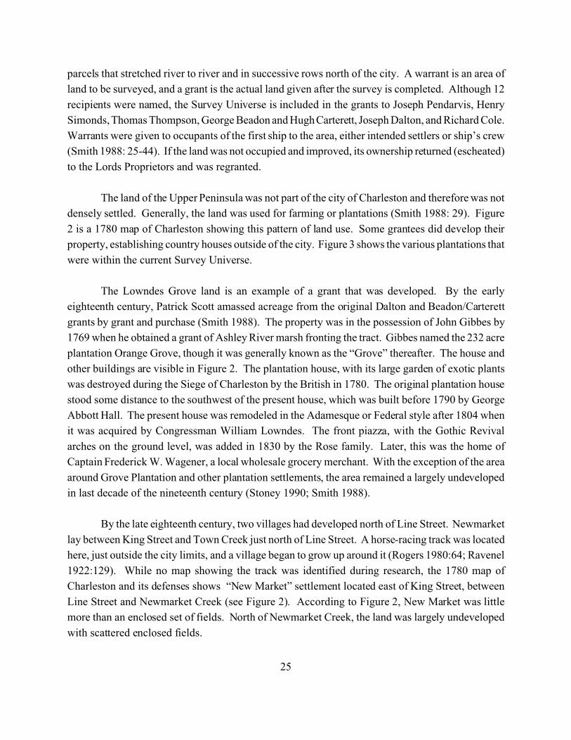
25
parcels that stretched river to river and in successive rows north of the city. A warrant is an area of
land to be surveyed, and a grant is the actual land given after the survey is completed. Although 12
recipients were named, the Survey Universe is included in the grants to Joseph Pendarvis, Henry
Simonds, Thomas Thompson, George Beadon and Hugh Carterett, Joseph Dalton, and Richard Cole.
Warrants were given to occupants of the first ship to the area, either intended settlers or ship’s crew
(Smith 1988: 25-44). If the land was not occupied and improved, its ownership returned (escheated)
to the Lords Proprietors and was regranted.
The land of the Upper Peninsula was not part of the city of Charleston and therefore was not
densely settled. Generally, the land was used for farming or plantations (Smith 1988: 29). Figure
2 is a 1780 map of Charleston showing this pattern of land use. Some grantees did develop their
property, establishing country houses outside of the city. Figure 3 shows the various plantations that
were within the current Survey Universe.
The Lowndes Grove land is an example of a grant that was developed. By the early
eighteenth century, Patrick Scott amassed acreage from the original Dalton and Beadon/Carterett
grants by grant and purchase (Smith 1988). The property was in the possession of John Gibbes by
1769 when he obtained a grant of Ashley River marsh fronting the tract. Gibbes named the 232 acre
plantation Orange Grove, though it was generally known as the “Grove” thereafter. The house and
other buildings are visible in Figure 2. The plantation house, with its large garden of exotic plants
was destroyed during the Siege of Charleston by the British in 1780. The original plantation house
stood some distance to the southwest of the present house, which was built before 1790 by George
Abbott Hall. The present house was remodeled in the Adamesque or Federal style after 1804 when
it was acquired by Congressman William Lowndes. The front piazza, with the Gothic Revival
arches on the ground level, was added in 1830 by the Rose family. Later, this was the home of
Captain Frederick W. Wagener, a local wholesale grocery merchant. With the exception of the area
around Grove Plantation and other plantation settlements, the area remained a largely undeveloped
in last decade of the nineteenth century (Stoney 1990; Smith 1988).
By the late eighteenth century, two villages had developed north of Line Street. Newmarket
lay between King Street and Town Creek just north of Line Street. A horse-racing track was located
here, just outside the city limits, and a village began to grow up around it (Rogers 1980:64; Ravenel
1922:129). While no map showing the track was identified during research, the 1780 map of
Charleston and its defenses shows “New Market” settlement located east of King Street, between
Line Street and Newmarket Creek (see Figure 2). According to Figure 2, New Market was little
more than an enclosed set of fields. North of Newmarket Creek, the land was largely undeveloped
with scattered enclosed fields.
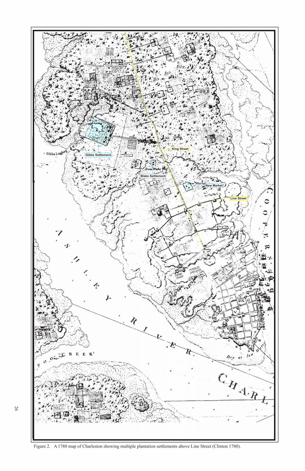
26
Figure 2. A 1780 map of Charleston showing multiple plantation settlements above Line Street (Clinton 1780).
King Street
Line Street
New Market
Blake Settlement
Gibbs Settlement
Figure 3. A map of eighteenth century plantations in the Upper Peninsula (Smith 1988).
27
Survey Universe
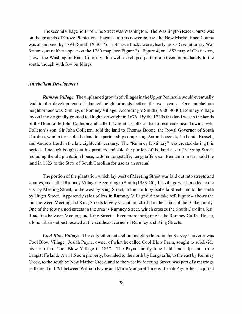
28
The second village north of Line Street was Washington. The Washington Race Course was
on the grounds of Grove Plantation. Because of this newer course, the New Market Race Course
was abandoned by 1794 (Smith 1988:37). Both race tracks were clearly post-Revolutionary War
features, as neither appear on the 1780 map (see Figure 2). Figure 4, an 1852 map of Charleston,
shows the Washington Race Course with a well-developed pattern of streets immediately to the
south, though with few buildings.
Antebellum Development
Rumney Village. The unplanned growth of villages in the Upper Peninsula would eventually
lead to the development of planned neighborhoods before the war years. One antebellum
neighborhood was Rumney, or Romney Village. According to Smith (1988:38-40), Romney Village
lay on land originally granted to Hugh Cartwright in 1676. By the 1730s this land was in the hands
of the Honorable John Colleton and called Exmouth; Colleton had a residence near Town Creek.
Colleton’s son, Sir John Colleton, sold the land to Thomas Boone, the Royal Governor of South
Carolina, who in turn sold the land to a partnership comprising Aaron Loocock, Nathaniel Russell,
and Andrew Lord in the late eighteenth century. The “Rumney Distillery” was created during this
period. Loocock bought out his partners and sold the portion of the land east of Meeting Street,
including the old plantation house, to John Langstaffe; Langstaffe’s son Benjamin in turn sold the
land in 1823 to the State of South Carolina for use as an arsenal.
The portion of the plantation which lay west of Meeting Street was laid out into streets and
squares, and called Rumney Village. According to Smith (1988:40), this village was bounded to the
east by Meeting Street, to the west by King Street, to the north by Isabella Street, and to the south
by Huger Street. Apparently sales of lots in Rumney Village did not take off; Figure 4 shows the
land between Meeting and King Streets largely vacant, much of it in the hands of the Blake family.
One of the few named streets in the area is Rumney Street, which crosses the South Carolina Rail
Road line between Meeting and King Streets. Even more intriguing is the Rumney Coffee House,
a lone urban outpost located at the southeast corner of Rumney and King Streets.
Cool Blow Village. The only other antebellum neighborhood in the Survey Universe was
Cool Blow Village. Josiah Payne, owner of what he called Cool Blow Farm, sought to subdivide
his farm into Cool Blow Village in 1857. The Payne family long held land adjacent to the
Langstaffe land. An 11.5 acre property, bounded to the north by Langstaffe, to the east by Romney
Creek, to the south by New Market Creek, and to the west by Meeting Street, was part of a marriage
settlement in 1791 between William Payne and Maria Margaret Touens. Josiah Payne then acquired
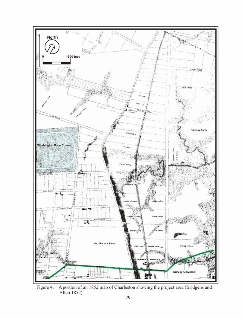
0 1500 feet
North
Figure 4. A portion of an 1852 map of Charleston showing the project area (Bridgens and Allen 1852).
29
Grove Street
Rumney Street
Rumney Farm
Washington Race Course
Huger Street
Congress Street
Race Street
Mr. Wilson’s Farm
Line Street
Me
etin
g S
tre
et
Kin
g Stree
t
Rutle
dge A
ve
Pringle Street
Pine Street
Moultrie Street
Survey Universe
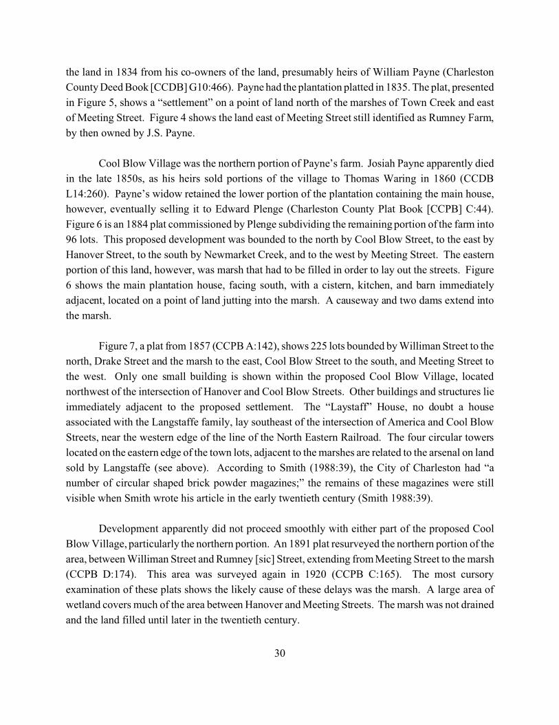
30
the land in 1834 from his co-owners of the land, presumably heirs of William Payne (Charleston
County Deed Book [CCDB] G10:466). Payne had the plantation platted in 1835. The plat, presented
in Figure 5, shows a “settlement” on a point of land north of the marshes of Town Creek and east
of Meeting Street. Figure 4 shows the land east of Meeting Street still identified as Rumney Farm,
by then owned by J.S. Payne.
Cool Blow Village was the northern portion of Payne’s farm. Josiah Payne apparently died
in the late 1850s, as his heirs sold portions of the village to Thomas Waring in 1860 (CCDB
L14:260). Payne’s widow retained the lower portion of the plantation containing the main house,
however, eventually selling it to Edward Plenge (Charleston County Plat Book [CCPB] C:44).
Figure 6 is an 1884 plat commissioned by Plenge subdividing the remaining portion of the farm into
96 lots. This proposed development was bounded to the north by Cool Blow Street, to the east by
Hanover Street, to the south by Newmarket Creek, and to the west by Meeting Street. The eastern
portion of this land, however, was marsh that had to be filled in order to lay out the streets. Figure
6 shows the main plantation house, facing south, with a cistern, kitchen, and barn immediately
adjacent, located on a point of land jutting into the marsh. A causeway and two dams extend into
the marsh.
Figure 7, a plat from 1857 (CCPB A:142), shows 225 lots bounded by Williman Street to the
north, Drake Street and the marsh to the east, Cool Blow Street to the south, and Meeting Street to
the west. Only one small building is shown within the proposed Cool Blow Village, located
northwest of the intersection of Hanover and Cool Blow Streets. Other buildings and structures lie
immediately adjacent to the proposed settlement. The “Laystaff” House, no doubt a house
associated with the Langstaffe family, lay southeast of the intersection of America and Cool Blow
Streets, near the western edge of the line of the North Eastern Railroad. The four circular towers
located on the eastern edge of the town lots, adjacent to the marshes are related to the arsenal on land
sold by Langstaffe (see above). According to Smith (1988:39), the City of Charleston had “a
number of circular shaped brick powder magazines;” the remains of these magazines were still
visible when Smith wrote his article in the early twentieth century (Smith 1988:39).
Development apparently did not proceed smoothly with either part of the proposed Cool
Blow Village, particularly the northern portion. An 1891 plat resurveyed the northern portion of the
area, between Williman Street and Rumney [sic] Street, extending from Meeting Street to the marsh
(CCPB D:174). This area was surveyed again in 1920 (CCPB C:165). The most cursory
examination of these plats shows the likely cause of these delays was the marsh. A large area of
wetland covers much of the area between Hanover and Meeting Streets. The marsh was not drained
and the land filled until later in the twentieth century.
Meeting Street
Settlement
Landing
Newmarket Creek
Town Creek
Figure 5. An 1835 plat showing the plantation of J. S. Payne (McCrady No. 8025, SCDAH, Columbia).
31
No Scale
North
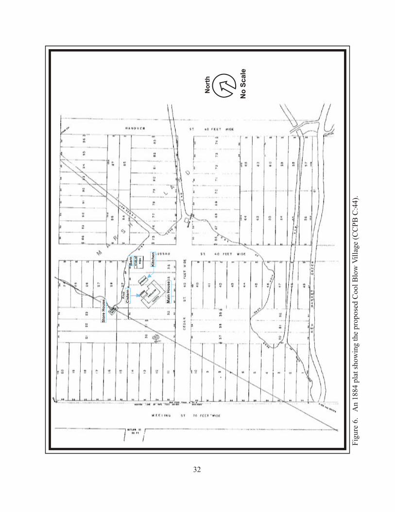
Fig
ure
6.
An
1884
pla
t sh
owin
g th
e pr
opos
ed C
ool
Blo
w V
illa
ge (
CC
PB
C:4
4).
32
No
rth
No
Sc
ale
Cis
tern
Kit
ch
en
Main
Ho
use
Sto
re H
ou
se
Barn
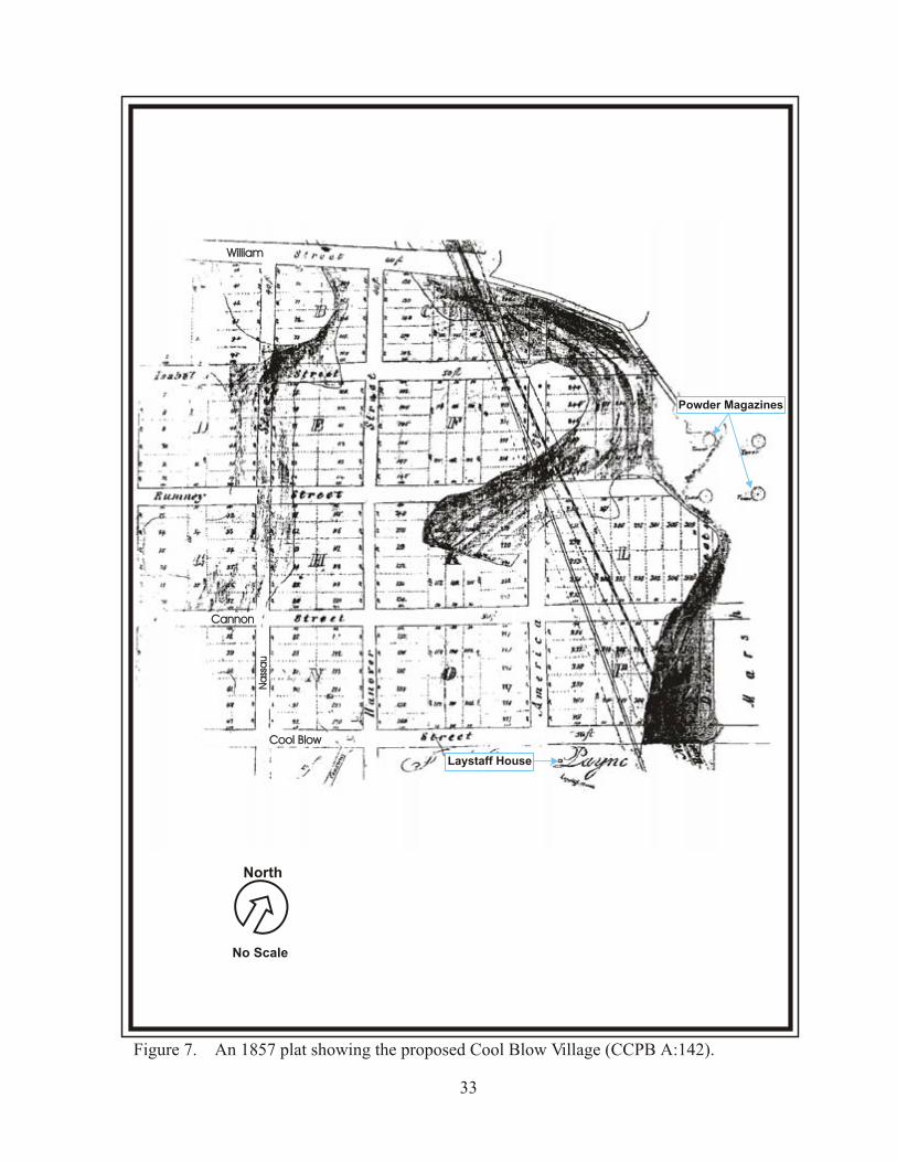
Figure 7. An 1857 plat showing the proposed Cool Blow Village (CCPB A:142).
33
Cool BlowCool Blow
CannonCannon
WilliamWilliamN
ass
au
Na
ssa
u
Laystaff House
Powder Magazines
No Scale
North
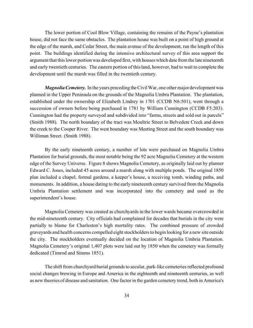
34
The lower portion of Cool Blow Village, containing the remains of the Payne’s plantation
house, did not face the same obstacles. The plantation house was built on a point of high ground at
the edge of the marsh, and Cedar Street, the main avenue of the development, ran the length of this
point. The buildings identified during the intensive architectural survey of this area support the
argument that this lower portion was developed first, with houses which date from the late nineteenth
and early twentieth centuries. The eastern portion of this land, however, had to wait to complete the
development until the marsh was filled in the twentieth century.
Magnolia Cemetery. In the years preceding the Civil War, one other major development was
planned in the Upper Peninsula on the grounds of the Magnolia Umbra Plantation. The plantation,
established under the ownership of Elizabeth Lindrey in 1701 (CCDB N6:501), went through a
succession of owners before being purchased in 1781 by William Cunnington (CCDB F5:203).
Cunnington had the property surveyed and subdivided into “farms, streets and sold out in parcels”
(Smith 1988). The north boundary of the tract was Moultrie Street to Belvedere Creek and down
the creek to the Cooper River. The west boundary was Meeting Street and the south boundary was
Williman Street. (Smith 1988).
By the early nineteenth century, a number of lots were purchased on Magnolia Umbra
Plantation for burial grounds, the most notable being the 92 acre Magnolia Cemetery at the western
edge of the Survey Universe. Figure 8 shows Magnolia Cemetery, as originally laid out by planner
Edward C. Jones, included 45 acres around a marsh along with multiple ponds. The original 1850
plan included a chapel, formal gardens, a keeper’s house, a receiving tomb, winding paths, and
monuments. In addition, a house dating to the early nineteenth century survived from the Magnolia
Umbria Plantation settlement and was incorporated into the cemetery and used as the
superintendent’s house.
Magnolia Cemetery was created as churchyards in the lower wards became overcrowded in
the mid-nineteenth century. City officials had complained for decades that burials in the city were
partially to blame for Charleston’s high mortality rates. The combined pressure of crowded
graveyards and health concerns compelled eight stockholders to begin looking for a new site outside
the city. The stockholders eventually decided on the location of Magnolia Umbria Plantation.
Magnolia Cemetery’s original 1,407 plots were laid out by 1850 when the cemetery was formally
dedicated (Timrod and Simms 1851).
The shift from churchyard burial grounds to secular, park-like cemeteries reflected profound
social changes brewing in Europe and America in the eighteenth and nineteenth centuries, as well
as new theories of disease and sanitation. One factor in the garden cemetery trend, both in America's
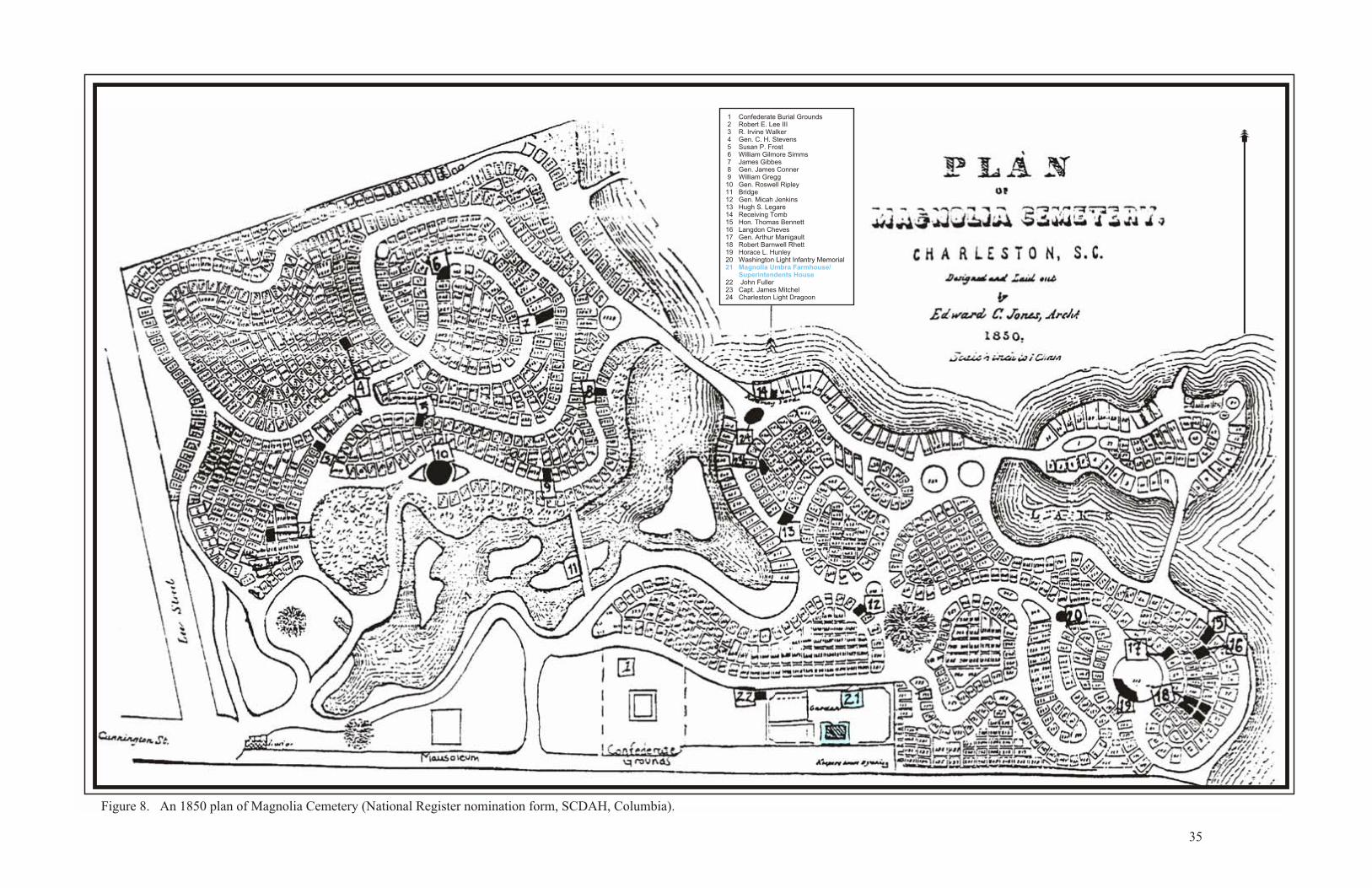
Figure 8. An 1850 plan of Magnolia Cemetery (National Register nomination form, SCDAH, Columbia).
35
1 Confederate Burial Grounds 2 Robert E. Lee III 3 R. Irvine Walker 4 Gen. C. H. Stevens 5 Susan P. Frost 6 William Gilmore Simms 7 James Gibbes 8 Gen. James Conner 9 William Gregg10 Gen. Roswell Ripley11 Bridge12 Gen. Micah Jenkins13 Hugh S. Legare14 Receiving Tomb15 Hon. Thomas Bennett16 Langdon Cheves17 Gen. Arthur Manigault18 Robert Barnwell Rhett19 Horace L. Hunley20 Washington Light Infantry Memorial
22 John Fuller23 Capt. James Mitchel 24 Charleston Light Dragoon
21 Magnolia Umbra Farmhouse/ Superintendents House
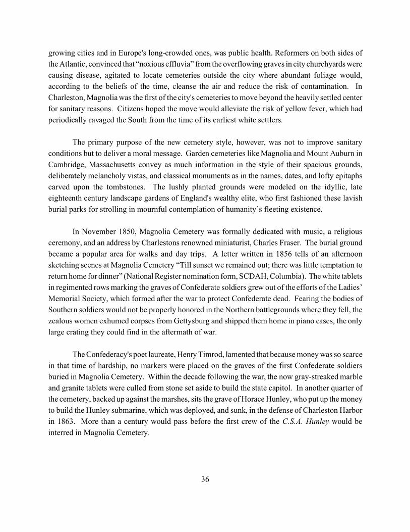
36
growing cities and in Europe's long-crowded ones, was public health. Reformers on both sides of
the Atlantic, convinced that “noxious effluvia” from the overflowing graves in city churchyards were
causing disease, agitated to locate cemeteries outside the city where abundant foliage would,
according to the beliefs of the time, cleanse the air and reduce the risk of contamination. In
Charleston, Magnolia was the first of the city's cemeteries to move beyond the heavily settled center
for sanitary reasons. Citizens hoped the move would alleviate the risk of yellow fever, which had
periodically ravaged the South from the time of its earliest white settlers.
The primary purpose of the new cemetery style, however, was not to improve sanitary
conditions but to deliver a moral message. Garden cemeteries like Magnolia and Mount Auburn in
Cambridge, Massachusetts convey as much information in the style of their spacious grounds,
deliberately melancholy vistas, and classical monuments as in the names, dates, and lofty epitaphs
carved upon the tombstones. The lushly planted grounds were modeled on the idyllic, late
eighteenth century landscape gardens of England's wealthy elite, who first fashioned these lavish
burial parks for strolling in mournful contemplation of humanity’s fleeting existence.
In November 1850, Magnolia Cemetery was formally dedicated with music, a religious
ceremony, and an address by Charlestons renowned miniaturist, Charles Fraser. The burial ground
became a popular area for walks and day trips. A letter written in 1856 tells of an afternoon
sketching scenes at Magnolia Cemetery “Till sunset we remained out; there was little temptation to
return home for dinner” (National Register nomination form, SCDAH, Columbia). The white tablets
in regimented rows marking the graves of Confederate soldiers grew out of the efforts of the Ladies’
Memorial Society, which formed after the war to protect Confederate dead. Fearing the bodies of
Southern soldiers would not be properly honored in the Northern battlegrounds where they fell, the
zealous women exhumed corpses from Gettysburg and shipped them home in piano cases, the only
large crating they could find in the aftermath of war.
The Confederacy's poet laureate, Henry Timrod, lamented that because money was so scarce
in that time of hardship, no markers were placed on the graves of the first Confederate soldiers
buried in Magnolia Cemetery. Within the decade following the war, the now gray-streaked marble
and granite tablets were culled from stone set aside to build the state capitol. In another quarter of
the cemetery, backed up against the marshes, sits the grave of Horace Hunley, who put up the money
to build the Hunley submarine, which was deployed, and sunk, in the defense of Charleston Harbor
in 1863. More than a century would pass before the first crew of the C.S.A. Hunley would be
interred in Magnolia Cemetery.
37
The remains of Charleston native J. Waties Waring, who died in 1968, lie beside those of his
wife on a shady spot farther down the lagoon. Waring, the first federal judge to rule against the
segregationist “separate but equal” doctrine, was a mentor to Supreme Court Justice Thurgood
Marshall.
Several other contiguous cemeteries were established around Magnolia Cemetery. Many of
these cemeteries were founded by fellowship societies representing African Americans. Fellowship
societies were established in Charleston for several purposes. A recurring theme found in the
fellowships and often reflected in their names is “unity.” In the years following emancipation, one
of the stated goals of the black church was to create a feeling of unity. From black churches
spawned educational institutions to teach blacks to read thereby opening up a new world of
economic opportunities. A variety of societies were formed within the church to provide assistance
to the black population. Burial societies became insurance companies and cemetery associations
became mortuaries. These societies and associations were extensions of the church and were
intended to provide opportunity, independence and dignity.
Perhaps the most notable of these groups, though perhaps the last to bury on the Upper
Peninsula, was the Brown Fellowship Society. It was founded in 1790 by free African Americans
and racially mixed men that were members of St. Philip's Episcopal Church. While they were not
considered slaves, they were at the same time denied many other rights and privileges of the white
members of the church. One of the denied privileges was the right to be buried in St. Phillip's
cemeteries. The Rector of St. Phillips, Thomas Frost, persuaded these free “brown” parishioners to
organize themselves, buy some property for a burial ground, and build a meeting house to transact
their business. In addition, the Brown Fellowship Society provided support for needy orphans and
adults. Land for a hall was purchased in 1794, and a cemetery was consecrated on the grounds the
same year. The chosen site for the meeting house was on Liberty Street. The site chosen for the
burial ground was located between Boundary (now Calhoun), Pitt, Coming, and Bull Streets. A
contract to erect a brick building on the site was signed in 1804. The Society, which changed its
name to the Century Fellowship Society in 1890, ceased regular meetings in 1916.
In 1843, Thomas Smalls, a free black man, applied for membership in the society and was
turned down because of the darkness of his skin, apparently not able to prove adequate European
ancestry. Smalls, a member of the Circular Congregational Church, organized his own group calling
it “The Society for Free Blacks of Dark Complexion” and later renamed the Brotherly Society.
Obviously annoyed by his rejection, Smalls purchased property adjacent to the Brown Fellowship
Graveyard and named the burial ground MacPhelah. To be a member of this society and to be buried
38
in the graveyard members had to be of pure African descent. Thomas Smalls also opened another
cemetery for the black members of the Circular Congregational Church and named it, Ephrath.
In 1943, an ordinance was passed prohibiting private organizations from maintaining
graveyards in the city. In 1945, two elderly descendants of the Century Fellowship (formerly The
Brown Fellowship) sold the Calhoun Street graveyard property to the Catholic Diocese. In 1957,
Bishop England Secondary School expanded and paved over the graveyard. Bodies were never
removed; only three large obelisk stones and several other larger stones were moved and placed in
one of the fellowship graveyards on the Upper Peninsula. In recent years, many of these bodies were
discovered during the construction of the College of Charleston’s library and were subsequently
reconsecrated on upper Meeting Street.
The burial grounds that were founded around Magnolia Cemetery were not exclusively for
African Americans. Beginning in the mid-nineteenth century, St. Lawrence Catholic Church buried
a large number of Irish immigrants on the Upper Peninsula. One those immigrants was Brent
Holcomb, who resided at 66 Calhoun Street. Michael Patrick O’Connor (1831-1881) was a first
generation South Carolinian who served as delegate to the Democratic National Convention in 1876
and in the United States House of Representatives. He was the Second District predecessor of
Christopher Columbus Bowen, a Rhode Island Republican and leader in the Reconstruction
Government. Despite their divergent political views, both Democrats and Republicans were buried
as Catholics at St. Lawrence Cemetery.
St. Matthews Lutheran Church originally founded Bethany Cemetery as the burial ground
of families of German ancestry, particularly those who migrated from Hanover during the 1880s.
One of those buried in Bethany Cemetery was Hanche Wayne Gissell, who served in the South
Carolina First Regiment during the Civil War. The Jewish community founded the Congregational
Brith Sholom Magnolia Cemetery in 1856. The burial ground replaced the Jewish cemetery at 189
Coming Street, America’s largest colonial Jewish cemetery.
Post-War Development
The end of hostilities found lower Charleston heavily damaged. However, the city turned
its attention to rebuilding, and offered low-interest loans for buildings constructed of brick in the
bombed and burned lower wards (Fraser 1989:282). This focus limited growth in the Upper
Peninsula, which was still largely undeveloped. Figures 9 and 10 are maps from the late 1870s and
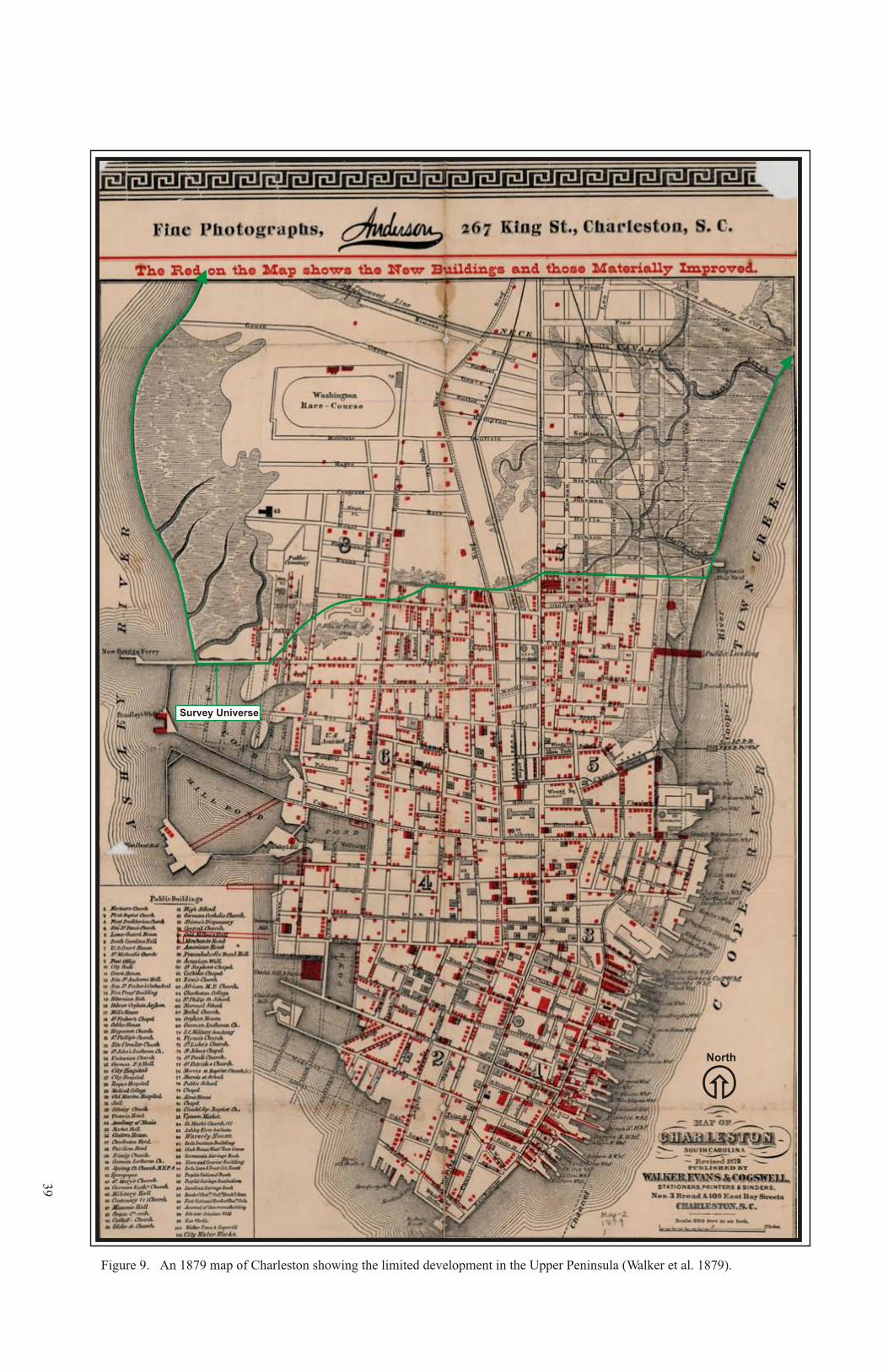
39
Figure 9. An 1879 map of Charleston showing the limited development in the Upper Peninsula (Walker et al. 1879).
Survey Universe
North

40
Figure 10. A portion of an 1883 map of Charleston showing the limited development in the Upper Peninsula (Courtenay 1883).
Survey Universe
41
early 1880s, respectively, showing the absence of development in the Survey Universe compared
to the area of the peninsula immediately south of the Survey Universe.
The block bordered by Fishburne Street, St. Philips Street, Carolina Street, and King Street
was once part of a larger block bordered by Shepard Street, Rutledge Avenue, Race Street, and King
Street, remained undeveloped into the late nineteenth century. This appears to have been something
of a rural outpost surrounded by suburban developments; the lone development was Christ Church
on the east side of Rutledge Avenue. Figure 11 shows the church at the intersection of Mount Street
in the mid 1850s. Figure 12, a Bird’s Eye View map of Charleston, shows the undeveloped state of
this block in 1872.
An 1852 map of Charleston (see Figure 4) identifies this large block as “Mrs. Wilson’s
Farm.” The farm remained undeveloped into the early 1890s, when Simons & Holmes platted a tract
of land “Formerly of Mrs. Sophia F.S. Wilson” (Figure 13). Development of the land apparently
was uneven; Joseph Barnwell forced the sale of a portion of her property in 1902 (CCDB F23:333).
At the same time, the Equitable Real Estate Company re-platted the lots facing King Street between
Shepard and Race Streets, and the lots facing Rutledge Avenue between Sheppard and Sumter
Streets (CCPB D:187).
According to the 1902 plat of the Equitable Real Estate Company’s property, the western half
of the lot bordered by Fishburne Street, St. Philip Street, Sheppard Street, and King Street, remained
in Joseph Barnwell’s ownership. By 1903, a number of bungalows and Charleston single houses of
modest construction were built by working class African Americans (Reed et al. 1992:80-89).
African American immigration into Charleston dramatically increased as mechanization in
agriculture forced laborers into industry on Charleston’s Upper Peninsula.
The Enston Home Complex. The area north of the Wilson Farm Tract was developed by
the City of Charleston in the last decade of the nineteenth century. The facility was funded by
William Enston, who wished “to make old age comfortable” (National Register nomination form,
SCDAH, Columbia). Enston made his fortune in the furniture business and his association with a
steamship company that operated between Charleston and New York. He bequeathed funds to the
city, and nineteen cottages were constructed and furnished on upper King Street for whites
“advanced in age” (Fraser 1989). Additional structures were constructed in 1893, 1927 and 1933.
Figure 14 is a modern plan of the Enston Home taken from the National Register nomination form
(SCDAH, Columbia).
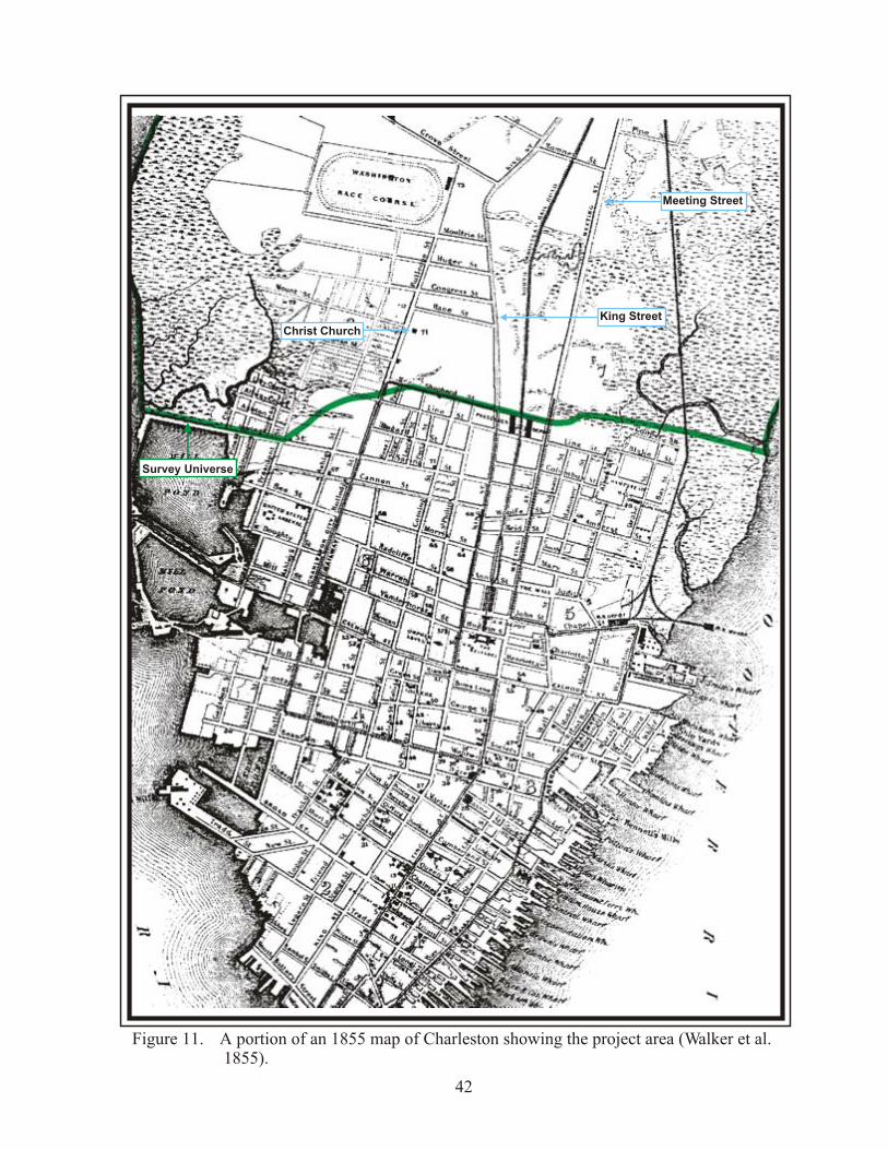
Figure 11. A portion of an 1855 map of Charleston showing the project area (Walker et al. 1855).
42
Meeting Street
King Street
Christ Church
Survey Universe
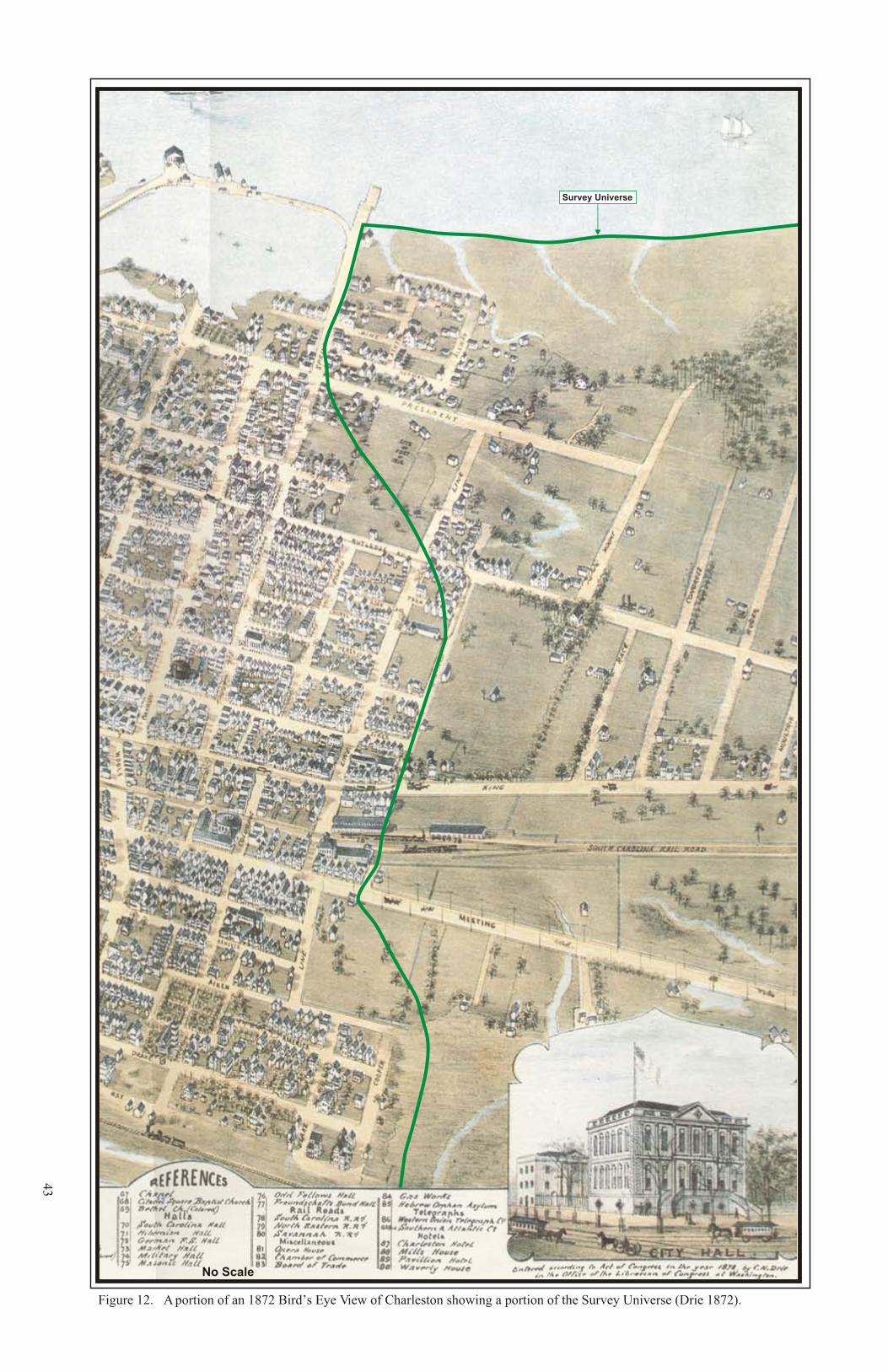
43
Figure 12. A portion of an 1872 Bird’s Eye View of Charleston showing a portion of the Survey Universe (Drie 1872).
No Scale
Survey Universe
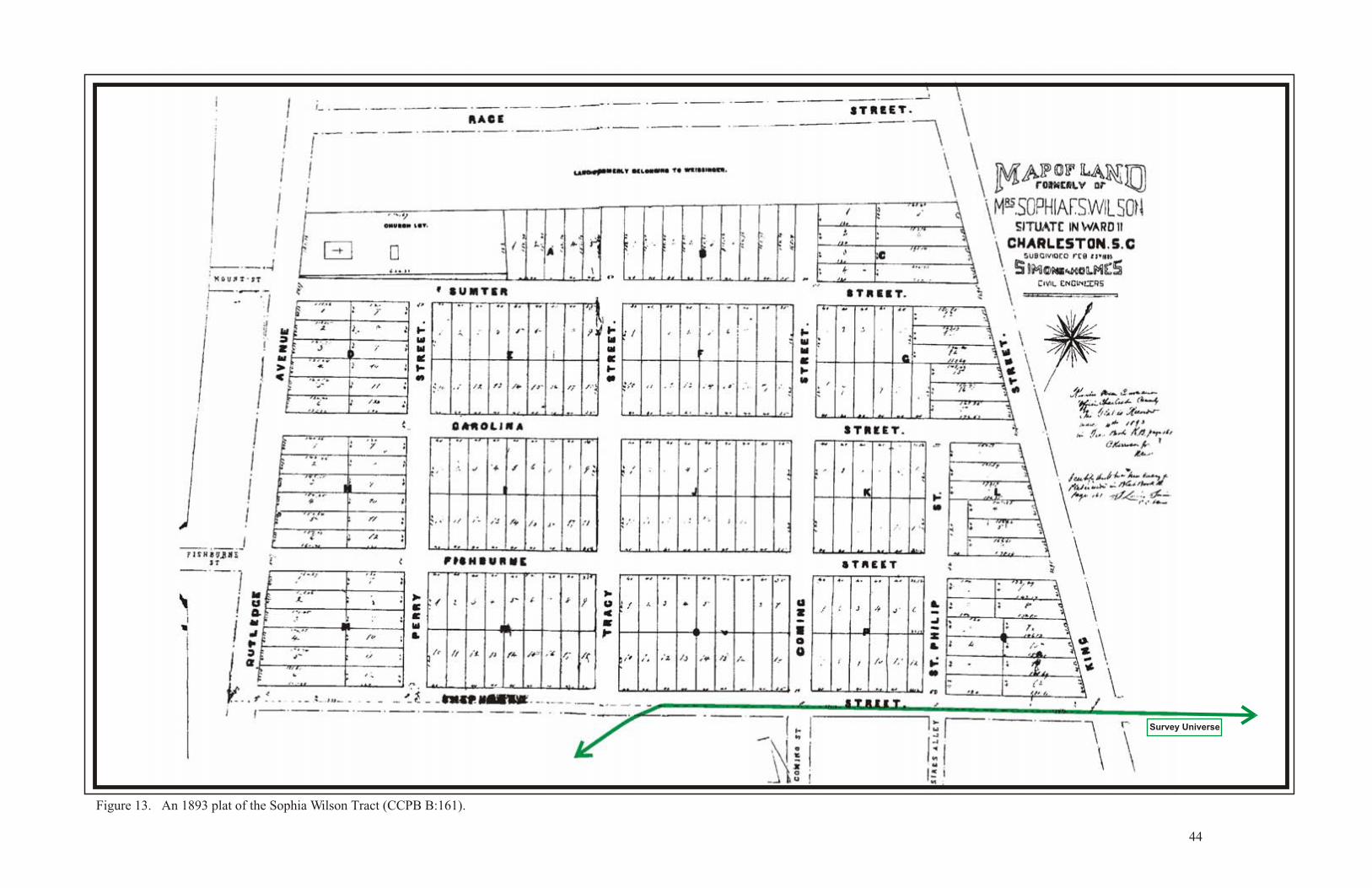
Figure 13. An 1893 plat of the Sophia Wilson Tract (CCPB B:161).
44
Survey Universe
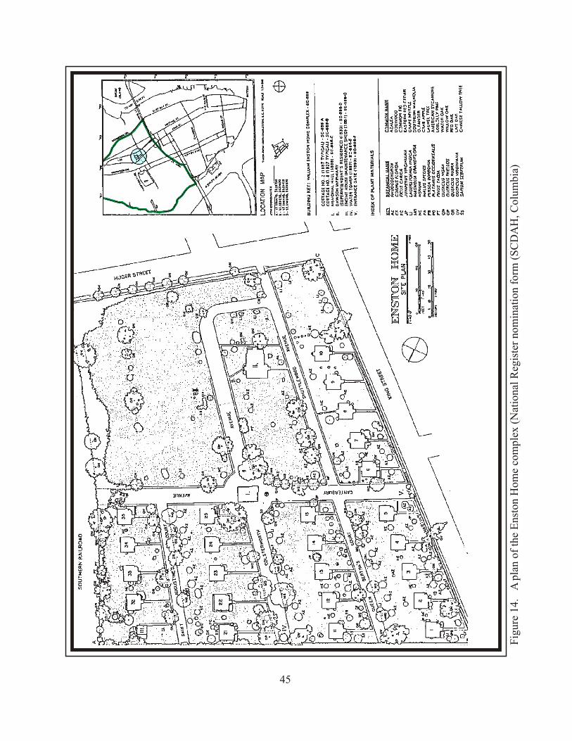
Fig
ure
14.
A p
lan
of t
he E
nsto
n H
ome
com
plex
(N
atio
nal
Reg
iste
r no
min
atio
n fo
rm (
SC
DA
H, C
olum
bia)
45
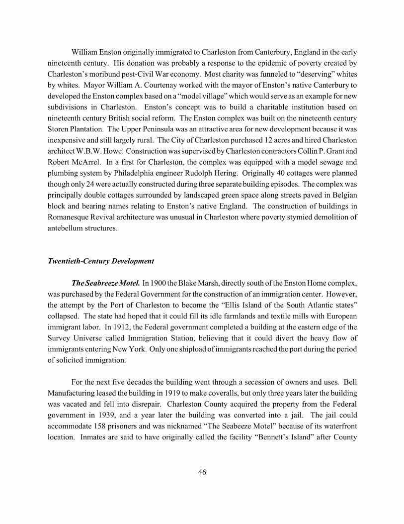
46
William Enston originally immigrated to Charleston from Canterbury, England in the early
nineteenth century. His donation was probably a response to the epidemic of poverty created by
Charleston’s moribund post-Civil War economy. Most charity was funneled to “deserving” whites
by whites. Mayor William A. Courtenay worked with the mayor of Enston’s native Canterbury to
developed the Enston complex based on a “model village” which would serve as an example for new
subdivisions in Charleston. Enston’s concept was to build a charitable institution based on
nineteenth century British social reform. The Enston complex was built on the nineteenth century
Storen Plantation. The Upper Peninsula was an attractive area for new development because it was
inexpensive and still largely rural. The City of Charleston purchased 12 acres and hired Charleston
architect W.B.W. Howe. Construction was supervised by Charleston contractors Collin P. Grant and
Robert McArrel. In a first for Charleston, the complex was equipped with a model sewage and
plumbing system by Philadelphia engineer Rudolph Hering. Originally 40 cottages were planned
though only 24 were actually constructed during three separate building episodes. The complex was
principally double cottages surrounded by landscaped green space along streets paved in Belgian
block and bearing names relating to Enston’s native England. The construction of buildings in
Romanesque Revival architecture was unusual in Charleston where poverty stymied demolition of
antebellum structures.
Twentieth-Century Development
The Seabreeze Motel. In 1900 the Blake Marsh, directly south of the Enston Home complex,
was purchased by the Federal Government for the construction of an immigration center. However,
the attempt by the Port of Charleston to become the “Ellis Island of the South Atlantic states”
collapsed. The state had hoped that it could fill its idle farmlands and textile mills with European
immigrant labor. In 1912, the Federal government completed a building at the eastern edge of the
Survey Universe called Immigration Station, believing that it could divert the heavy flow of
immigrants entering New York. Only one shipload of immigrants reached the port during the period
of solicited immigration.
For the next five decades the building went through a secession of owners and uses. Bell
Manufacturing leased the building in 1919 to make coveralls, but only three years later the building
was vacated and fell into disrepair. Charleston County acquired the property from the Federal
government in 1939, and a year later the building was converted into a jail. The jail could
accommodate 158 prisoners and was nicknamed “The Seabeeze Motel” because of its waterfront
location. Inmates are said to have originally called the facility “Bennett’s Island” after County
47
Sheriff Harold Bennett. In order to transport prisoners back and forth to the property a new road was
constructed across the marsh using dredge spoil, rocks and other types of fill.
The South Carolina Interstate and West Indian Exposition. By 1900, Charleston’s
businessmen were looking for some way to revitalize the deteriorating economy through expositions,
festivals, conventions, and a national advertising campaign. Chairman Samuel H. Wilson looked
at several options and settled on a plan incorporating the old Washington Race Course, recently sold
by the South Carolina Jockey Club to the Charleston Library Society, and the adjacent farm of
Exposition President, F.W. Wagener (Harvey 1998). Wagener generously allowed the Exposition
Company to have unlimited access to his land, including the Grove Plantation house. Bradford L.
Gilbert of New York was chosen as the chief architect for the Exposition and was given broad
authority in its design (Chibbaro 2001).
The buildings which he designed were a blending of the Colonial South and avaguely Spanish baroque theme, drawing on the West Indian concept of the fairitself.
Gilbert’s plan separated the large 250 acre plot into two roughly equal areasthat met at a small neck, forming a figure eight-like pattern. The main entrance waslocated at the neck, and from there visitors would be able to enter either of the twoaforementioned areas (Chibbaro 2001)
The Grove house was used as the Women's Building by the Daughters of the American
Revolution and the Colonial Dames, who served Summerville tea. President Theodore Roosevelt
had dinner here, during his visit to the Exposition. With funds provided by the state, Frederick W.
Wagener and a few other community leaders organized the South Carolina Interstate and West
Indian Exposition, which opened in December 1901 (Chibbaro 2001).
Figure 15 shows the Exposition’s “Ivory City.” It was built around a man-made lake, named
Juanita Lake, that was created by the construction of a dike that sealed off a cove of the Ashley
River. The Exposition site occupied about 160 acres of land on the bank of the Ashley River, with
a frontage of 2,000 feet along the river (Chibbaro 2001). The architecture of the buildings followed
closely the styles introduced at the Chicago World's Fair. The Philadelphia Public Ledger declared:
“There are many picturesque features, and the mild and equable climate beckons to thedwellers in the North. The Spanish style of architecture, the red tiles, the skillful use ofbright colors, and the sunken gardens with flowers and foliage in bloom, make the ‘IvoryCity’ a pleasing picture, and the Southern people, Southern ways, the horse-races on thegrounds, the barbecues, and characteristic features of the Southland Exposition are likely togive it a peculiar charm” (Harvey 1998).
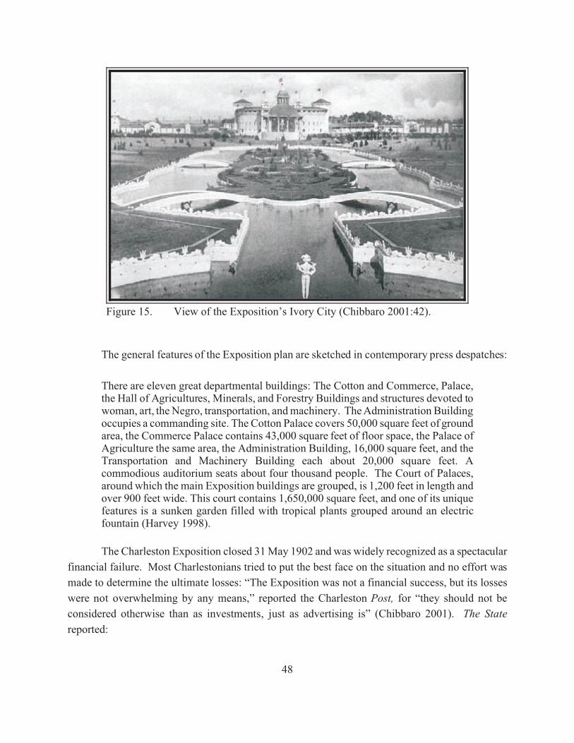
48
Figure 15. View of the Exposition’s Ivory City (Chibbaro 2001:42).
The general features of the Exposition plan are sketched in contemporary press despatches:
There are eleven great departmental buildings: The Cotton and Commerce, Palace,the Hall of Agricultures, Minerals, and Forestry Buildings and structures devoted towoman, art, the Negro, transportation, and machinery. The Administration Buildingoccupies a commanding site. The Cotton Palace covers 50,000 square feet of groundarea, the Commerce Palace contains 43,000 square feet of floor space, the Palace ofAgriculture the same area, the Administration Building, 16,000 square feet, and theTransportation and Machinery Building each about 20,000 square feet. Acommodious auditorium seats about four thousand people. The Court of Palaces,around which the main Exposition buildings are grouped, is 1,200 feet in length andover 900 feet wide. This court contains 1,650,000 square feet, and one of its uniquefeatures is a sunken garden filled with tropical plants grouped around an electricfountain (Harvey 1998).
The Charleston Exposition closed 31 May 1902 and was widely recognized as a spectacular
financial failure. Most Charlestonians tried to put the best face on the situation and no effort was
made to determine the ultimate losses: “The Exposition was not a financial success, but its losses
were not overwhelming by any means,” reported the Charleston Post, for “they should not be
considered otherwise than as investments, just as advertising is” (Chibbaro 2001). The State
reported:
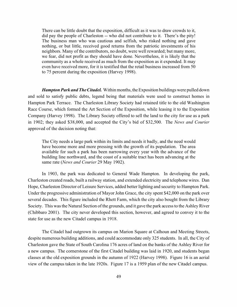
49
There can be little doubt that the exposition, difficult as it was to draw crowds to it,did pay the people of Charleston -- who did not contribute to it. There’s the pity!The business man who was cautious and selfish, who risked nothing and gavenothing, or but little, received good returns from the patriotic investments of hisneighbors. Many of the contributors, no doubt, were well rewarded; but many more,we fear, did not profit as they should have done. Nevertheless, it is likely that thecommunity as a whole received as much from the exposition as it expended. It mayeven have received more, for it is testified that the retail business increased from 50to 75 percent during the exposition (Harvey 1998).
Hampton Park and The Citadel. Within months, the Exposition buildings were pulled down
and sold to satisfy public debts, legend being that materials were used to construct homes in
Hampton Park Terrace. The Charleston Library Society had retained title to the old Washington
Race Course, which formed the Art Section of the Exposition, while leasing it to the Exposition
Company (Harvey 1998). The Library Society offered to sell the land to the city for use as a park
in 1902; they asked $38,000, and accepted the City’s bid of $32,500. The News and Courier
approved of the decision noting that:
The City needs a large park within its limits and needs it badly, and the need wouldhave become more and more pressing with the growth of its population. The areaavailable for such a park has been narrowing every year with the advance of thebuilding line northward, and the coast of a suitable tract has been advancing at thesame rate (News and Courier 29 May 1902).
In 1903, the park was dedicated to General Wade Hampton. In developing the park,
Charleston created roads, built a railway station, and extended electricity and telephone wires. Dan
Hope, Charleston Director of Leisure Services, added better lighting and security to Hampton Park.
Under the progressive administration of Mayor John Grace, the city spent $42,000 on the park over
several decades. This figure included the Rhett Farm, which the city also bought from the Library
Society. This was the Natural Section of the grounds, and it gave the park access to the Ashley River
(Chibbaro 2001). The city never developed this section, however, and agreed to convey it to the
state for use as the new Citadel campus in 1918.
The Citadel had outgrown its campus on Marion Square at Calhoun and Meeting Streets,
despite numerous building additions, and could accommodate only 325 students. In all, the City of
Charleston gave the State of South Carolina 176 acres of land on the banks of the Ashley River for
a new campus. The cornerstone of the first Citadel building was laid in 1920, and students began
classes at the old exposition grounds in the autumn of 1922 (Harvey 1998). Figure 16 is an aerial
view of the campus taken in the late 1920s. Figure 17 is a 1959 plan of the new Citadel campus.
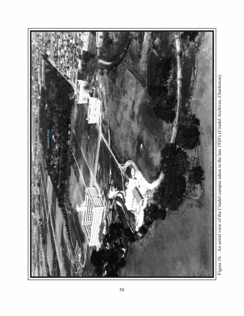
Fig
ure
16.
An
aeri
al v
iew
of
the
Cit
adel
cam
pus
take
n in
the
lat
e 19
20’s
(C
itad
el A
rchi
ves,
Cha
rles
ton)
.
50
Ham
pto
n P
ark
Fig
ure
17.
A 1
959
map
of
the
Cit
adel
’s c
ampu
s (C
itad
el A
rchi
ves,
Cha
rles
ton)
.
51
52
Hampton Park Terrace. Less than decade after the exposition’s failure, neighborhoods were
constructed around Hampton Park. The first to be built was Hampton Park Terrace subdivision
constructed primarily between 1910 and 1945; approximately 200 buildings were erected between
1914 and 1922. An additional 30 buildings were constructed between 1922 and 1930, and less 10
were constructed since 1945. Figure 18 shows Hampton Park Terrace as it was laid out in 1912;
advertising actually began one year earlier. In December 1911, W. C. Wilbur and Company offered
“150 home sites, 10' higher than the Boulevard and never overflowed by tides. . .The ideal home site
overlooking both river and park” (Fick 1997).
Marketing appealed to the burgeoning middle class tired of Charleston’s decaying lower
wards: “It’s just a step - from the noise of the city, from its confinement, its crowds and bad air - to
the open fresh beauty of Hampton Park Terrace” (Fick 1997). Covenant’s included in the deeds
indicate that segregation played a role in the development of the neighborhood. Dwellings were
required to cost at least $1,800 and there would be no sale or rental of property to “persons of
African descent” (Fick 1997). Figure 19 indicates that new streets were created between Rutledge
Avenue, Congress Street, Huger Street, and President Street to create rectangular blocks. Covenants
included in the original deeds “required houses to be built with a minimum setback from the street”
and prohibited commercial development (Fick 1997). Construction companies often sold the lots
and could plan, finance, and even construct the dwellings (Fick 1997).
The two primary developers of Hampton Park Terrace were James Allan and W. C. Wilbur
and Company. The Allan family, owners of the jewelry business James Allan & Company, owned
considerable acreage within the proposed subdivision. James Allan and W. C. Wilbur entered into
a partnership to acquire and develop the remaining property in Hampton Park Terrace under the
names Charleston Building and Investment, Hampton Park Terrace Inc., and W. C. Wilbur and
Company. Both families eventually moved to the neighborhood: James Allan lived at 497 Huger
Street, then 20 Kenilworth Avenue; Richard H. Allan lived at 429 Huger Street; W. C. Wilbur lived
at 518 Huger Street; and T.S. Wilbur at 56 Parkwood Avenue (Fick 1997).
The Allan and Wilbur partnership did not include construction; building construction was
done principally by Greg T. Trescott and Fred J. H. Haesloop. Trescott was involved in real estate
and construction and is credited with construction of 600 houses in Charleston. George and Esther
Trescott moved to Hampton Park Terrace in 1914. Fred Haesloop was owner of Palace Stables and
also worked as a US Mail contractor. By 1921, Haesloop appears to have concentrated on
construction and real estate. During the peak years of construction in Hampton Park Terrace,
Haesloop moved his family from Calhoun Street to a new residence at 531 Huger Street (Fick 1997).
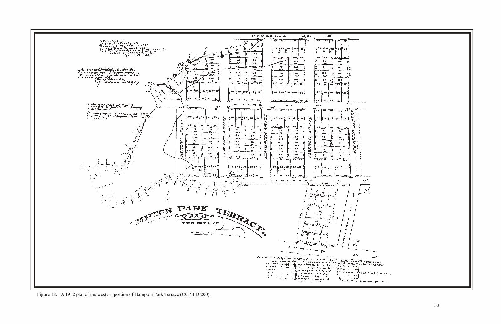
Figure 18. A 1912 plat of the western portion of Hampton Park Terrace (CCPB D:200).
53
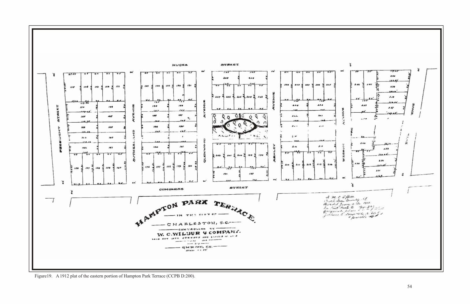
Figure19. A 1912 plat of the eastern portion of Hampton Park Terrace (CCPB D:200).
54
55
Among those to purchase homes in Hampton Park Terrace was Gus Rittenburg who owned
a grocery in St. Stephens, South Carolina. Though he was killed in automobile accident in 1924, the
Rittenburg family held onto the house for another 50 years. Their neighbor at 518 Huger Street was
the Reverend Wallace R. Rogers, a pastor of Citadel Square Church in the 1950s. Recent arrivals
from northern states also found Hampton Park Terrace an attractive place to live. James and
Margaret Mahoney of Boston moved to Charleston in 1924 and remained for the rest of their lives.
Mr. Mahoney became director of the South Carolina National Bank and the Fort Sumter Hotel and
the Seaboard Air Line. He was on the Board of Commissioners for the Charleston Orphan House,
served as president of the Charleston Chamber of Commerce, and was elected to the Board of
Directors for SCE&G in 1952.
Perhaps the best known Charlestonian to choose Hampton Park Terrace as his home was
Mayor Thomas P. Stoney. Elected mayor in 1922, Stoney was the youngest person to serve in that
office and remained for two terms. Stoney took an active interest in Charleston’s Upper Peninsula,
committing large public expenditures in the beautification of Hampton Park, construction of Johnson
Hagood Stadium, Harmon Field and the Charleston Industrial Fair Building. After serving as mayor,
he remained the dominate political adviser in Charleston until his death in 1973. Thomas and
Beverly Stoney lived for 30 years at 573 Huger Street in house that is now used as the Citadel
Placement Office (Brenner and Brenner 2000).
Due to covenants concerning lot size and building placement, Hampton Park Terrace was
almost entirely residential. The two exceptions are the First Church of Christ, Scientist, built 1955
on Moultrie Street, and a grocery at the corner of President and Congress Streets. In 1931, Harold
Jacobs began selling flavored snow balls, bread, milk and kerosene on this corner in a modest wood
frame building. He named the operation Harold’s Cabin. In the first years, Jacobs relied on his
mother to operate the store in the afternoons while he finished high school. Jacobs rebuilt the aging
building and added a living space above the store for he and his wife, Lillian. Over the next two
decades, the couple steadily increased their business and added gourmet items to the selection.
Because they stayed open on Sunday afternoons, the store was frequented by the Upper Peninsula’s
sizable Jewish community. Jacobs eventually relocated his business to a new building at 84
Wentworth Street. Later, this was the home of Captain Frederick W. Wagener, a local wholesale
grocery merchant, who maintained his own race course on Grove Plantation.
Wagener Terrace. Another neighborhood founded at the conclusion of the Exposition was
Wagener Terrace. The Wagener Farm was acquired in 1917 by James Sottile who developed it into
building lots and streets, leaving the Grove House within an entire block of grounds. Figure 20
indicates that James Sottile platted the area under the name Wagener Terrace in 1918. The first
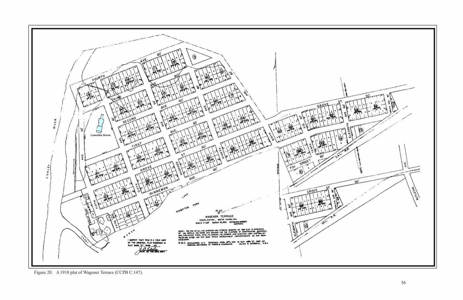
Figure 20. A 1918 plat of Wagener Terrace (CCPB C:147).
56
Lowndes Grove
57
houses were not built until the early 1920s, well after Hampton Park Terrace was established. This
was due primarily to the fact that large wetlands covered the northern sections of the proposed
subdivision. The slow but steady development continued for thirty years. Figure 21 is a 1936 aerial
photograph of the area showing several houses in Wagener Terrace.
Among the first buildings to be constructed in Wagener Terrace was the Florence Crittenton
Home on 19 St. Margaret Street. Set among a few residences, the Florence Crittenton Home was
established to provide support for unmarried expectant mothers. The mission originally operated
from a building on Washington Street and was supported by the city and private donations. After
using the Washington Street house for two decades, the stewards of the Florence Crittenton Home
purchased a “large suburban lot” in Wagener Terrace and hired architect John D. Newcomer to
design a new building. The building was constructed opposite a St. Margaret’s Home, a sanitarium
for the terminally ill built in 1910.
In 1923, the contract to build the Florence Crittenton Home was awarded to Leonard D. Long
Construction Company. Construction was delayed by a downturn in the economy and the building
sat unfinished while the mission raised funds. The work was resumed on a piecemeal basis by
General Contractor, M. L. Stephenson. The home officially opened in April 1932 and was praised
as “a beautiful structure, modern in every particular” (National Register nomination form, SCDAH,
Columbia).
One of the primary builders in Wagener Terrace was James Charles “J. C.” Long. Long is
best known in the Charleston area as the founder of The Beach Company, created when he purchased
the Isle of Palms in 1945 and oversaw its planning and development as a residential community and
family vacation destination. In addition, Long developed Ashley Forest, one of the first Charleston
communities west of the Ashley River, and the Sergeant Jasper high rise, a well-known landmark
on Charleston’s lower west side. Before the end of his career, Long was one of the largest property
owners and taxpayers in South Carolina.
Most of the people who bought houses in Wagener Terrace were middle class whites that
worked on the Peninsula. Outside Protestant whites, members of the Greek and Jewish communities
tended to move to Wagener Terrace in the most significant numbers. Among the early residents of
the subdivision was William J. Kangeter, a longtime detective with the Charleston Police
Department who built a house at 110 Grove Street sometime before 1940. His wife, Carrie Axson
Kangeter, lived in Wagener Terrace until 1960. Their neighbors, Jesse and Ruth Orvin, built a house
at 118 Grove Street sometime during the 1930s. Jesse W. Orvin moved to Charleston in 1925 and
co-founded the Atlantic Coast Life Insurance Company and served as an alderman in the Maybank
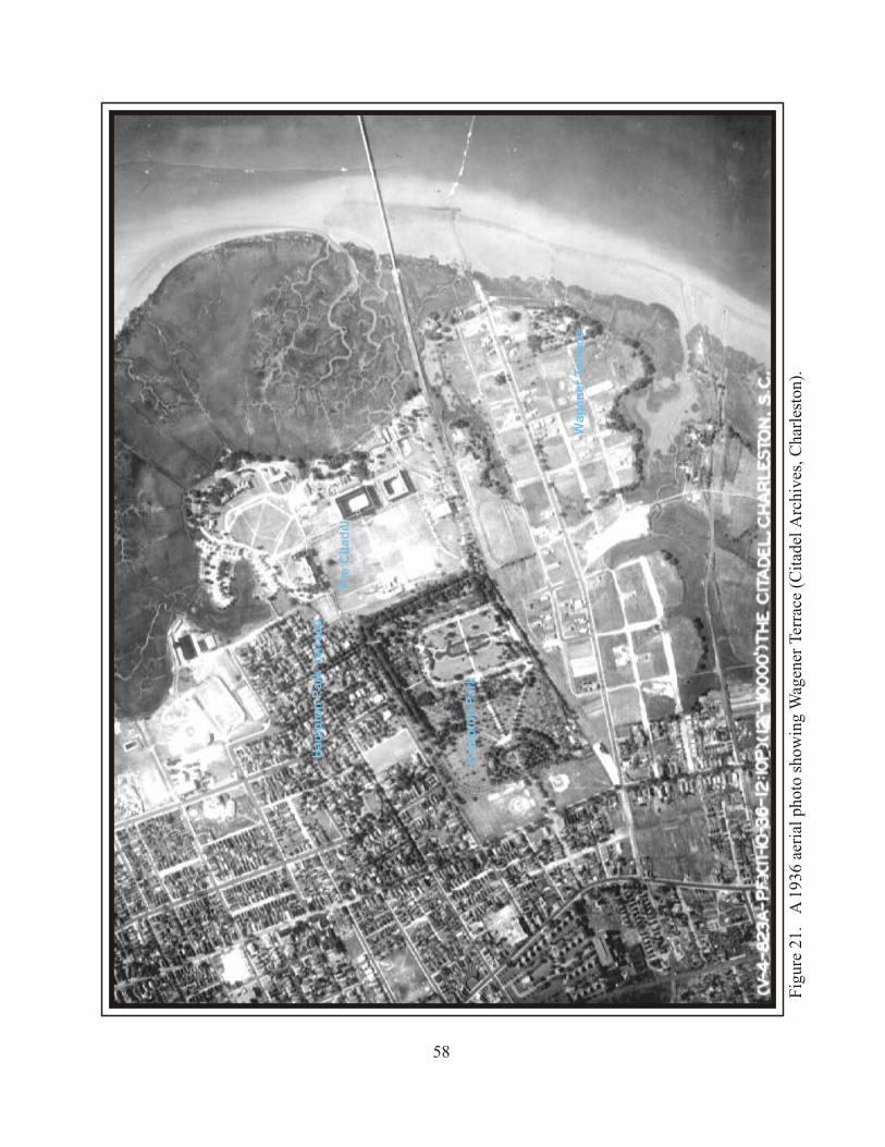
Fig
ure
21.
A 1
936
aeri
al p
hoto
sho
win
g W
agen
er T
erra
ce (
Cit
adel
Arc
hive
s, C
harl
esto
n).
58
Ham
pto
n P
ark
Terr
ace
Ham
pto
n P
ark
Th
e C
itad
el
Wag
en
er
Terr
ac
e
59
Administration. Another resident in Wagner Terrace was Emerson Rabon who lived at 227 Grove
Street. After a stint in the Navy during World War II, Rabon became a hair stylist and owner of
several beauty salons on King Street. His wife was a local artist and taught at the local YMCA.
They sold their house after a few years to George S. Croffead, a popular ophthalmologist and leader
in the Greek Orthodox Church.
Maverick Street Neighborhood. Another area developed out of the Grove Plantation acreage
was the block between King Street and Rutledge Avenue, including Oswego, Francis, Maverick and
Cleveland Streets. Figure 22 shows that the western portion of the plantation was subdivided by
Frederick J. Smith in 1893, though construction appears to have come slowly over the next 20 years.
The area was settled primarily by African Americans.
Among those to make this area their home was Julia and T.M. Boyce who operated Harkans
Liquor Store at 1 Cleveland Street. Martin Middleton built a house at the corner of Oswego and
Cleveland Streets before 1920. Middleton was a foreman for Henry Oliver, a building contractor
who was the great grandfather of Mayor Joseph P. Riley. He was born in Chester County at the
conclusion of the Civil War and moved to Charleston where he met his wife Caroline Julia Parker.
They lived at 26 Cleveland Street for over 40 years when the house passed to his daughter Helen
Middleton. She was a graduate of the Avery Institute and Duquesne University and lived for two
decades in Washington DC. She returned to Charleston at age 56 and operated a real estate business
in the house on Cleveland Street.
The Rutledge Avenue Improvements Neighborhood. The areas on either side of King Street
between Cypress Street to the north, the railroad line to the east, Romney Street to the south, and
Rutledge Avenue to the west were subdivided separately but at roughly the same time. The Rutledge
Avenue Improvements Company subdivided 146 lots on the west side of King Street in 1912. The
Carolina Florida Realty Company subdivided 92 lots on the east side of King Street in 1918. Figures
23 and 24 respectively show these subdivisions. Because of their geographic and temporal
proximity, these two subdivisions merged into a single community.
The Johnson Hagood Stadium Area. The area directly south of the Exposition site had
contained a retirement facility, then referred to as the Ashley River Asylum (ca. 1850), and a scatter
of homes along Mount Street (now Congress Street) and Rutledge Avenue. Figure 25 is a plat made
in 1894 showing the retirement community (labeled “Old Folks Home”), “Potters Field,” and
“Sailors Burying Ground.” When South Carolina seceded from the Union, the Charleston Mariner’s
home donated its burial ground to the state for use as a military cemetery. It was used in that
capacity until 1865, when the war ended. The Naval and Marine Cemetery was maintained by the
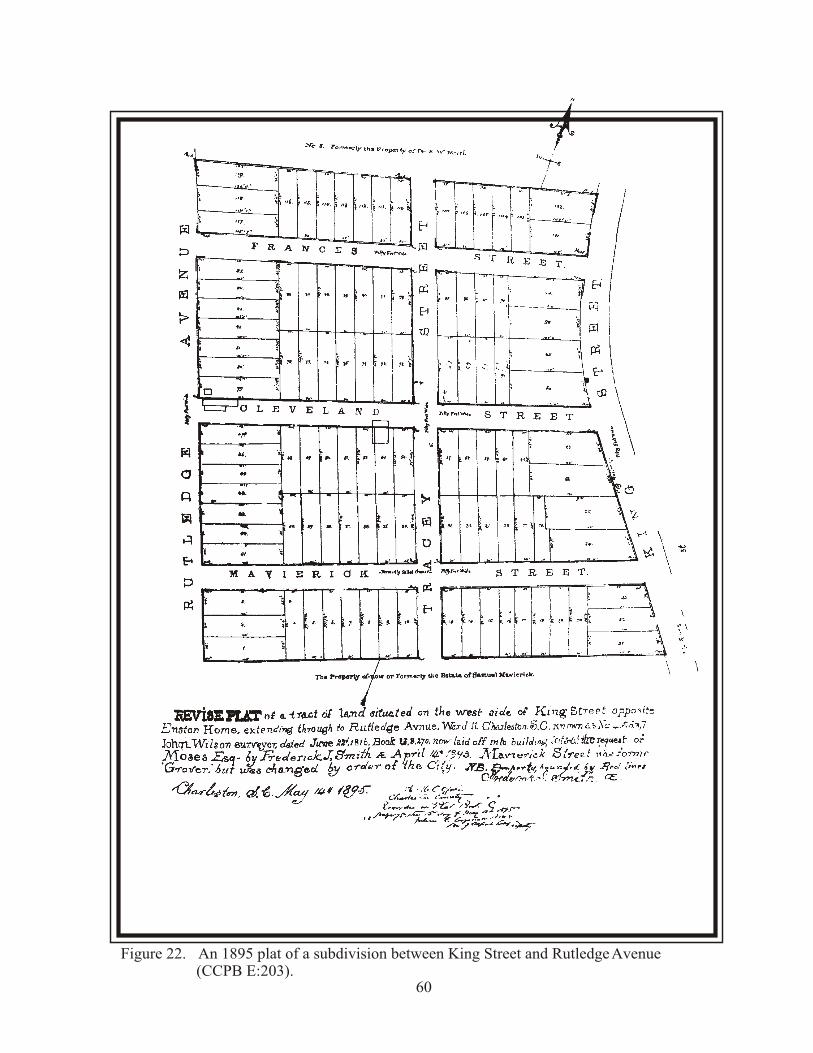
Figure 22. An 1895 plat of a subdivision between King Street and Rutledge Avenue (CCPB E:203).
60
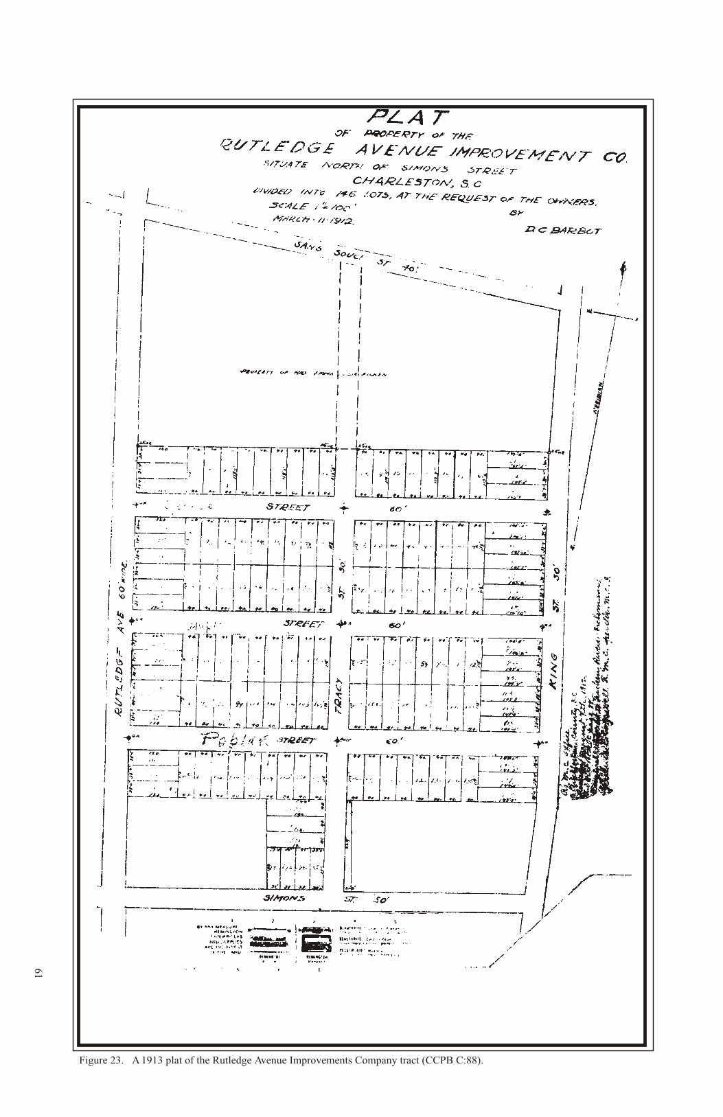
61
Figure 23. A 1913 plat of the Rutledge Avenue Improvements Company tract (CCPB C:88).
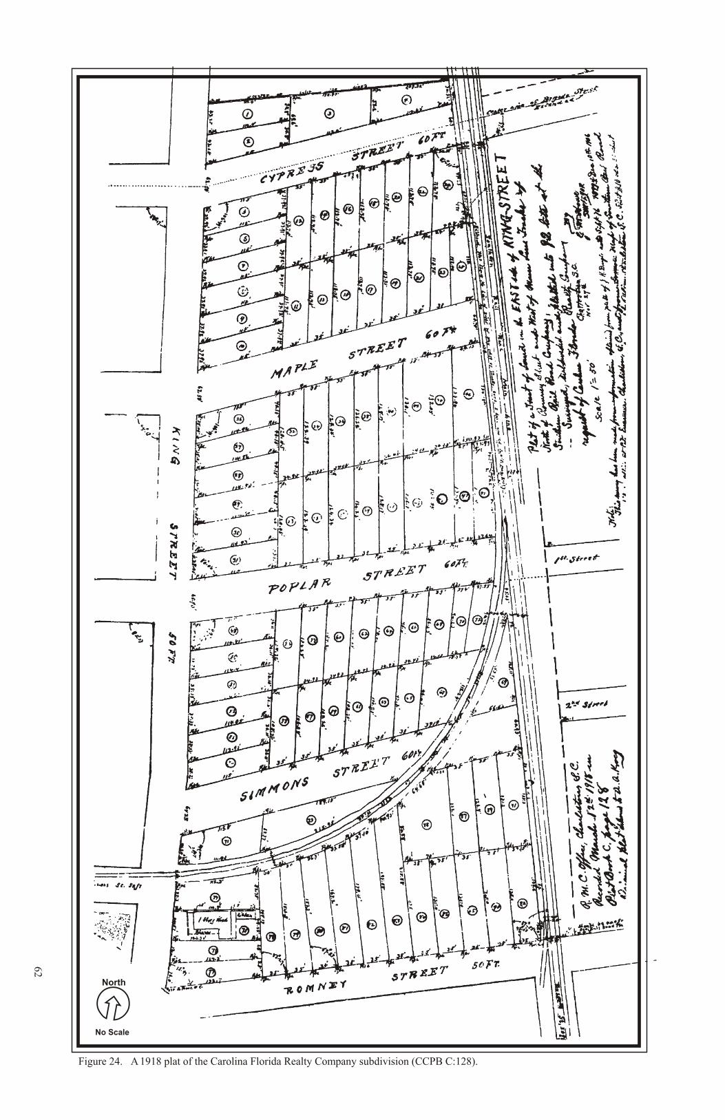
62
Figure 24. A 1918 plat of the Carolina Florida Realty Company subdivision (CCPB C:128).
No Scale
North
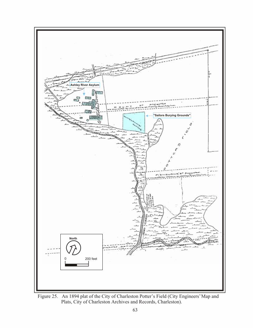
Figure 25. An 1894 plat of the City of Charleston Potter’s Field (City Engineers’ Map and Plats, City of Charleston Archives and Records, Charleston).
63
0 200 feet
North
Ashley River Asylum
"Sailors Burying Grounds"
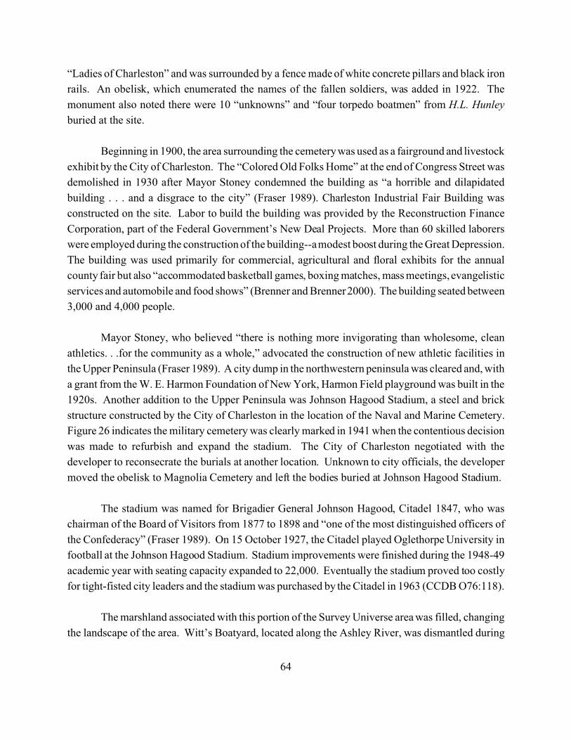
64
“Ladies of Charleston” and was surrounded by a fence made of white concrete pillars and black iron
rails. An obelisk, which enumerated the names of the fallen soldiers, was added in 1922. The
monument also noted there were 10 “unknowns” and “four torpedo boatmen” from H.L. Hunley
buried at the site.
Beginning in 1900, the area surrounding the cemetery was used as a fairground and livestock
exhibit by the City of Charleston. The “Colored Old Folks Home” at the end of Congress Street was
demolished in 1930 after Mayor Stoney condemned the building as “a horrible and dilapidated
building . . . and a disgrace to the city” (Fraser 1989). Charleston Industrial Fair Building was
constructed on the site. Labor to build the building was provided by the Reconstruction Finance
Corporation, part of the Federal Government’s New Deal Projects. More than 60 skilled laborers
were employed during the construction of the building--a modest boost during the Great Depression.
The building was used primarily for commercial, agricultural and floral exhibits for the annual
county fair but also “accommodated basketball games, boxing matches, mass meetings, evangelistic
services and automobile and food shows” (Brenner and Brenner 2000). The building seated between
3,000 and 4,000 people.
Mayor Stoney, who believed “there is nothing more invigorating than wholesome, clean
athletics. . .for the community as a whole,” advocated the construction of new athletic facilities in
the Upper Peninsula (Fraser 1989). A city dump in the northwestern peninsula was cleared and, with
a grant from the W. E. Harmon Foundation of New York, Harmon Field playground was built in the
1920s. Another addition to the Upper Peninsula was Johnson Hagood Stadium, a steel and brick
structure constructed by the City of Charleston in the location of the Naval and Marine Cemetery.
Figure 26 indicates the military cemetery was clearly marked in 1941 when the contentious decision
was made to refurbish and expand the stadium. The City of Charleston negotiated with the
developer to reconsecrate the burials at another location. Unknown to city officials, the developer
moved the obelisk to Magnolia Cemetery and left the bodies buried at Johnson Hagood Stadium.
The stadium was named for Brigadier General Johnson Hagood, Citadel 1847, who was
chairman of the Board of Visitors from 1877 to 1898 and “one of the most distinguished officers of
the Confederacy” (Fraser 1989). On 15 October 1927, the Citadel played Oglethorpe University in
football at the Johnson Hagood Stadium. Stadium improvements were finished during the 1948-49
academic year with seating capacity expanded to 22,000. Eventually the stadium proved too costly
for tight-fisted city leaders and the stadium was purchased by the Citadel in 1963 (CCDB O76:118).
The marshland associated with this portion of the Survey Universe area was filled, changing
the landscape of the area. Witt’s Boatyard, located along the Ashley River, was dismantled during
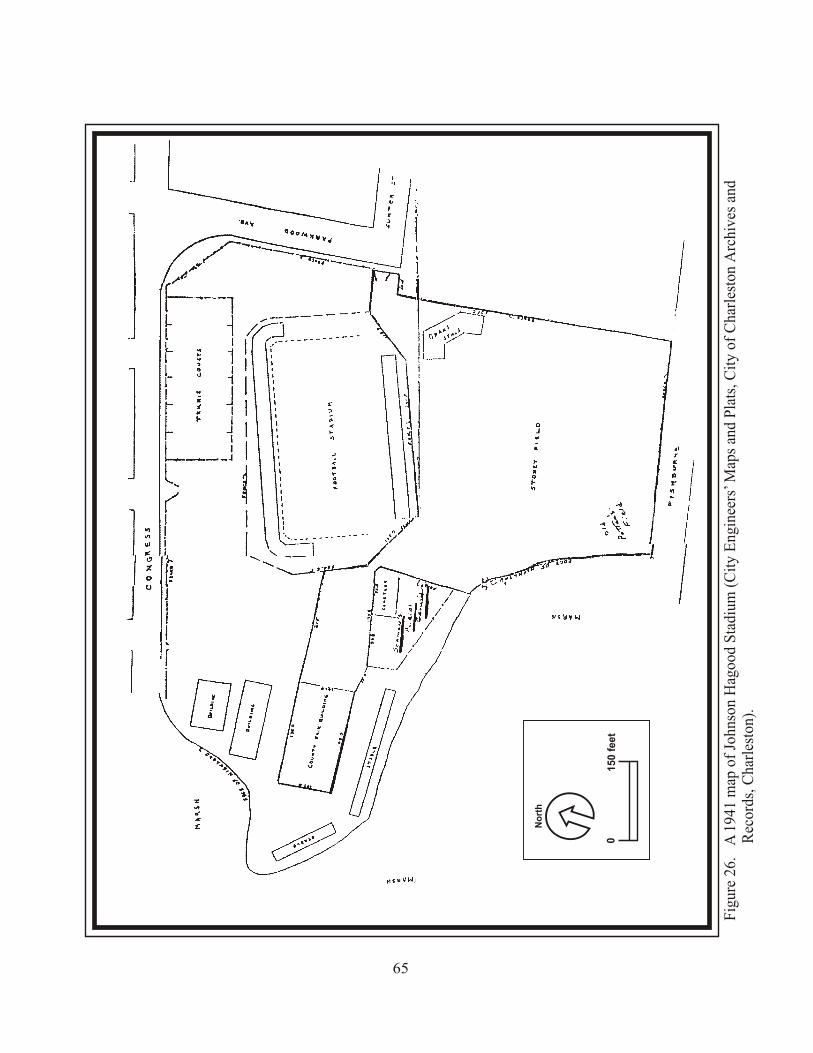
Fig
ure
26.
A 1
941
map
of
John
son
Hag
ood
Sta
dium
(C
ity
Eng
inee
rs’ M
aps
and
Pla
ts, C
ity
of C
harl
esto
n A
rchi
ves
and
Rec
ords
, Cha
rles
ton)
.
65
01
50
fe
et
No
rth
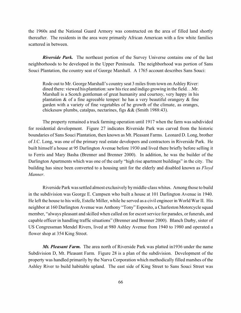
66
the 1960s and the National Guard Armory was constructed on the area of filled land shortly
thereafter. The residents in the area were primarily African American with a few white families
scattered in between.
Riverside Park. The northeast portion of the Survey Universe contains one of the last
neighborhoods to be developed in the Upper Peninsula. The neighborhood was portion of Sans
Souci Plantation, the country seat of George Marshall. A 1765 account describes Sans Souci:
Rode out to Mr. George Marshall’s country seat 3 miles from town on Ashley River:dined there: viewed his plantation: saw his rice and indigo growing in the field. . .Mr.Marshall is a Scotch gentleman of great humanity and courtesy, very happy in hisplantation & of a fine agreeable temper: he has a very beautiful orangery & finegarden with a variety of fine vegetables of he growth of the climate, as oranges,chickesaw plumbs, catalpas, nectarines, figs && (Smith 1988:43).
The property remained a truck farming operation until 1917 when the farm was subdivided
for residential development. Figure 27 indicates Riverside Park was carved from the historic
boundaries of Sans Souci Plantation, then known as Mt. Pleasant Farms. Leonard D. Long, brother
of J.C. Long, was one of the primary real estate developers and contractors in Riverside Park. He
built himself a house at 95 Darlington Avenue before 1930 and lived there briefly before selling it
to Ferris and Mary Basha (Brenner and Brenner 2000). In addition, he was the builder of the
Darlington Apartments which was one of the early “high rise apartment buildings” in the city. The
building has since been converted to a housing unit for the elderly and disabled known as Floyd
Manner.
Riverside Park was settled almost exclusively by middle-class whites. Among those to build
in the subdivision was George E. Campsen who built a house at 101 Darlington Avenue in 1940.
He left the house to his wife, Estelle Miller, while he served as a civil engineer in World War II. His
neighbor at 160 Darlington Avenue was Anthony “Tony” Esposito, a Charleston Motorcycle squad
member, “always pleasant and skilled when called on for escort service for parades, or funerals, and
capable officer in handling traffic situations” (Brenner and Brenner 2000). Blanch Darby, sister of
US Congressman Mendel Rivers, lived at 980 Ashley Avenue from 1940 to 1980 and operated a
flower shop at 354 King Street.
Mt. Pleasant Farm. The area north of Riverside Park was platted in1936 under the name
Subdivision D, Mt. Pleasant Farm. Figure 28 is a plan of the subdivision. Development of the
property was handled primarily by the Narva Corporation which methodically filled marshes of the
Ashley River to build habitable upland. The east side of King Street to Sans Souci Street was
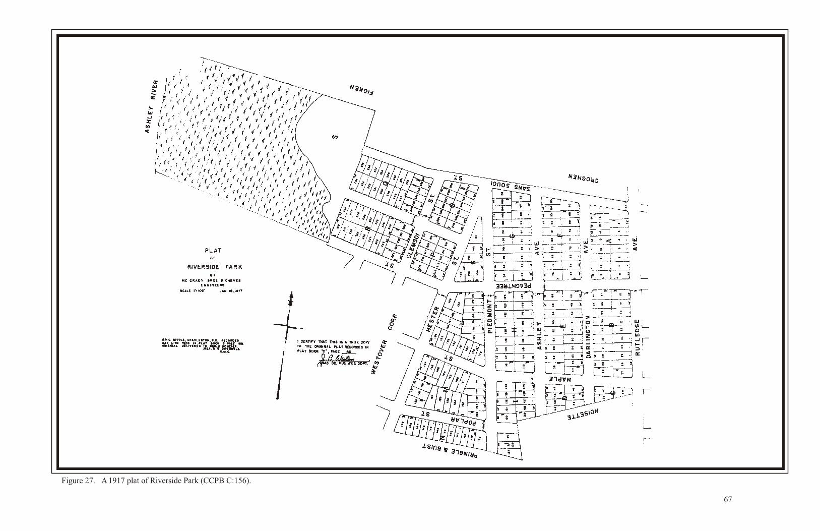
Figure 27. A 1917 plat of Riverside Park (CCPB C:156).
67
Figure 28. A 1936 plat of Subdivision D, Mt. Pleasant Farm (CCPB F:61).
68
69
subdivided and sold by Thetis and Garner Real Estate. Devereaux Street was perhaps the last road
to be laid out in the area. George M. Hughes was the first to build along Devereaux Street in the
1940s. Hughes operated a trucking company that specialized in petroleum, fruit, and ammunition
during the second World War.
Summary of the Upper Peninsula Settlement History
The Survey Universe remained rural and largely undeveloped throughout the eighteenth and
nineteenth centuries. With the exception of a few plantation/farm settlements the area was devoid
of residences during this period. A few industrials sites, including an arsenal and barrel factory, and
cemeteries dotted the landscape.
Development of the Upper Peninsula began in earnest in the early twentieth century and
continued through the mid-twentieth century. Residential neighborhoods were conceived, and the
roads and lots were drawn, marked on the ground, and then developed. The Citadel, Magnolia
Cemetery, and a few light industrial sites along Meeting Street are the extent of the non-residential
components of the Upper Peninsula.
70
Section III. Previously Identified Historic Architectural Resources
Properties Listed on the NRHP
The Survey Universe currently contains one historic district and four individual resources
listed on the NRHP. The Hampton Park Terrace Historic District lies just south of Hampton Park
and was listed on the NRHP in 1997 (Fick 1997). The district contains approximately 282
contributing buildings including outbuildings, one contributing site, and 88 non-contributing
buildings. The four individual resources include Lowndes Grove, the Enston Home, Magnolia
Cemetery, and the Florence Crittenton Home. Lowndes Grove (Resource 0073), is an antebellum
plantation house at the western end of St. Margaret Street, and was listed in 1978. The Enston Home
(Resource 0075), is a home designed originally for aging Presbyterians. It consists of 24 cottages
and five related buildings and structures at the intersection of King and Huger Streets. Magnolia
Cemetery (Resource 0077) is a large cemetery on the Cooper River east of Hugenin Street. It was
listed in 1978 and contains about 92 acres. Finally, the Florence Crittenton Home (Resource 0104),
a home for unwed mothers at the eastern end of St. Margaret Street, was listed in 1997. All of these
resources are discussed in detail in Section IV.
Properties that are Eligible/Potentially Eligible for the NRHP
The South Carolina State Historic Preservation Office (SHPO) determined that five
individual resources within the Survey Universe are eligible for the NRHP. The first is the
Immigration Center (Resource 2809) on Immigration Street. The second is the Colin McKissick
Grant Home (Resource 2810), a collection of six buildings for the aged. The third resource is the
Charleston Fire Department Engine Number 8 Building (Resource 2888). The fourth resource is the
Street Car Barn near the west end of Cool Blow Street. The fifth Resource is located at 74 Fishburne
Street (Resource 2065). In addition, the SHPO determined that four districts within the Survey
Universe are potentially eligible for the NRHP. The first district is the North of 17 District which
is roughly bounded by the Crosstown Expressway to the south, Perry Street to the west, the houses
on the north side of Sumter Street to the north, and King Street to the east. The other three districts
are one block districts that include all houses facing the one block. These blocks are Carondolet,
Dingle, and North Tracy Streets. These four individual resources and the four potential historic
districts within the Survey Universe are discussed in detail in Section IV.
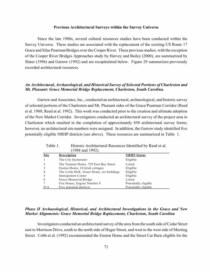
71
Site Description NRHP Status
1 The City Incinerator Eligib le
2 The Tennent Hom e, 729 East Bay Street Listed3 Enston Home, 24 brick cottages Eligib le4 The Colin McK. Grant Home, six buildings Eligib le5 Immigration Center Eligib le6 Grace Memorial Bridge Listed7 Fire House, Engine Num ber 8 Potentially eligibleN/A Five potential distric ts Potentially eligible
Table 1. Historic Architectural Resources Identified by Reed et al.(1988 and 1992).
Previous Architectural Surveys within the Survey Universe
Since the late 1980s, several cultural resources studies have been conducted within the
Survey Universe. These studies are associated with the replacement of the existing US Route 17
Grace and Silas Pearman Bridges over the Cooper River. These previous studies, with the exception
of the Cooper River Bridges Approaches study by Harvey and Bailey (2000), are summarized by
Slater (1996) and Garrow (1992) and are recapitulated below. Figure 29 summarizes previously
recorded architectural resources.
An Architectural, Archaeological, and Historical Survey of Selected Portions of Charleston andMt. Pleasant: Grace Memorial Bridge Replacement, Charleston, South Carolina.
Garrow and Associates, Inc., conducted an architectural, archaeological, and historic survey
of selected portions of the Charleston and Mt. Pleasant sides of the Grace/Pearman Corridor (Reed
et al. 1988; Reed at al. 1992). This work was conducted prior to the creation and ultimate adoption
of the New Market Corridor. Investigators conducted an architectural survey of the project area in
Charleston which resulted in the completion of approximately 850 architectural survey forms;
however, no architectural site numbers were assigned. In addition, the Garrow study identified five
potentially eligible NRHP districts (see above). These resources are summarized in Table 1.
Phase II Archaeological, Historical, and Architectural Investigations in the Grace and NewMarket Alignments: Grace Memorial Bridge Replacement, Charleston, South Carolina
Investigators conducted an architectural survey of the area from the south side of Cedar Street
east to Morrison Drive, south to the north side of Huger Street, and west to the west side of Meeting
Street. Cobb et al. (1992) recommended the Enston Home and the Street Car Barn eligible for the
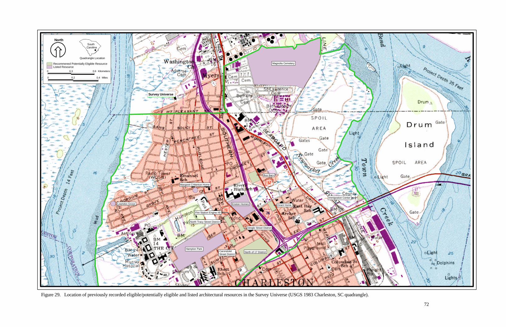
North
Quadrangle Location
South Carolina
Listed ResourceRecommened Potentially Eligible ResourceProjectarea27.shp
0 0.3 0.6 Kilometers
0 0.2 0.4 Miles
Figure 29. Location of previously recorded eligible/potentially eligible and listed architectural resources in the Survey Universe (USGS 1983 Charleston, SC quadrangle).
72
Magnolia Cemetery
Bus Barn
Grant Home
Immigration Center
North of 17 DistrictHampton Park
North Tracy Street District
Carondolet Street District
Fire Station Engine #8
Dingle Street District
Enston HomesLowndes Grove
Margaret Crittenton Home
Survey Universe
73
NRHP, but stated that there would likely be no effect to either property by the project as currently
designed.
Additional Archaeological and Architectural Investigations for the Grace Memorial BridgeReplacement, Charleston, South Carolina
Architectural investigations conducted by Cassedy et al. (1992) consisted of architectural
survey and evaluation of the Colin McKissick Grant Home and the Immigration Center/County Jail.
Investigators recommended the Grant Home complex eligible for the NRHP, but noted there would
be no effect as a result of construction and use of the approaches to the New Market Corridor
(Cassedy et al. 1992:77-78). Investigators recommended the Immigration Center/County Jail not
eligible for the NRHP (Cassedy et al. 1992:77); however, the property is considered eligible for the
NRHP by the SHPO (Chandler 1999).
Cultural Resource Assessment and Assessment of Effects Pursuant to 36 CFR 800 for theReplacement of the Bridges on US 17 over the Cooper River and Town Creek, Charleston County,South Carolina
In addition to summarizing the previous investigations for the Cooper River bridge
replacement project, Slater (1996) conducted an assessment of effects to the historic properties that
lay within the APE of exit ramps at the proposed new intersection of I-26 and the Cooper River
Bridge.
Based on a review of previous investigations and additional work on properties
recommended eligible or potentially eligible for the NRHP, Slater (1996) provides a list of NRHP
listed or eligible properties within the areas of potential effect.
Intensive Cultural Resources Survey and Documentation of the Proposed Cooper River BridgeApproaches Charleston County, South Carolina
Brockington and Associates, Inc., conducted an intensive cultural resources survey of the
proposed Cooper River Bridge approaches in the City of Charleston (Harvey and Bailey 2002). The
Architectural Historian identified 27 historic architectural resources, eight of which were previously
identified by Reed et al. (1992). Five documented buildings were determined to contribute to an
NRHP eligible historic district. Table 2 summarizes the historic architectural resources recorded in
the Survey Universe.
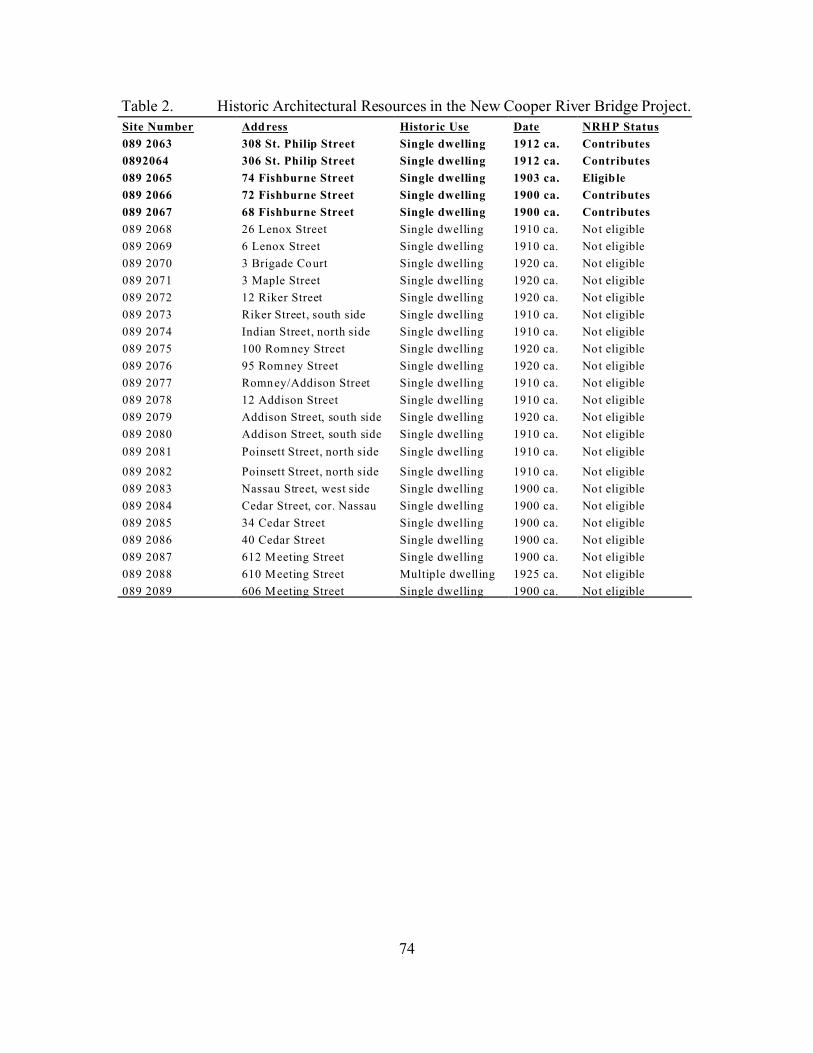
74
Site Number Address Historic Use Date NRHP Status
089 2063 308 St. Philip Street Single dwelling 1912 ca. Contributes
0892064 306 St. Philip Street Single dwelling 1912 ca. Contributes
089 2065 74 Fishburne Street Single dwelling 1903 ca. Eligible
089 2066 72 Fishburne Street Single dwelling 1900 ca. Contributes
089 2067 68 Fishburne Street Single dwelling 1900 ca. Contributes
089 2068 26 Lenox Street Single dwelling 1910 ca. Not eligible
089 2069 6 Lenox Street Single dwelling 1910 ca. Not eligible
089 2070 3 Brigade Court Single dwelling 1920 ca. Not eligible
089 2071 3 Maple Street Single dwelling 1920 ca. Not eligible
089 2072 12 Riker Street Single dwelling 1920 ca. Not eligible
089 2073 Riker Street, south side Single dwelling 1910 ca. Not eligible
089 2074 Indian Street, north side Single dwelling 1910 ca. Not eligible
089 2075 100 Rom ney Street Single dwelling 1920 ca. Not eligible
089 2076 95 Romney Street Single dwelling 1920 ca. Not eligible
089 2077 Romney/Addison Street Single dwelling 1910 ca. Not eligible
089 2078 12 Addison Street Single dwelling 1910 ca. Not eligible
089 2079 Addison Street, south side Single dwelling 1920 ca. Not eligible
089 2080 Addison Street, south side Single dwelling 1910 ca. Not eligible
089 2081 Poinsett Street, north side Single dwelling 1910 ca. Not eligible
089 2082 Poinsett Street, north side Single dwelling 1910 ca. Not eligible
089 2083 Nassau Street, west side Single dwelling 1900 ca. Not eligible
089 2084 Cedar Street, cor. Nassau Single dwelling 1900 ca. Not eligible
089 2085 34 Cedar Street Single dwelling 1900 ca. Not eligible
089 2086 40 Cedar Street Single dwelling 1900 ca. Not eligible
089 2087 612 Meeting Street Single dwelling 1900 ca. Not eligible
089 2088 610 Meeting Street Multiple dwelling 1925 ca. Not eligible
089 2089 606 Meeting Street Single dwelling 1900 ca. Not eligible
Table 2. Historic Architectural Resources in the New Cooper River Bridge Project.
75
Section IV: Survey Results
The Architectural Historian identified 2,042 historic architectural resources in the Survey
Universe. These resources include buildings, structures, objects, and sites. The identified historic
architectural resources are dispersed throughout the Survey Universe. These resources are presented
on Charleston County tax maps in Appendix B. We assessed all of the historic buildings that we
included in the survey of the Upper Peninsula for NRHP eligibility and for the Charleston
Architectural Rating system discussed above.
The Upper Peninsula’s architectural resources can be divided into several different
categories. Residences, both grand and modest, are only one among many types of historic buildings
found in the Upper Peninsula. Other resources included sites, structures, and objects. Within these
types, variations in function, material, and style account for varying visual qualities. An examination
of the Upper Peninsula’s historic resources in reference to these types will provide the best basis for
understanding the significance of the resources that remain. Relatively few buildings identified in
this survey could be clearly assigned a stylistic label such as Federal, Craftsman, or Italianate. Even
those “folk” buildings that have no identifiable academic style, however, can still be usefully
categorized according to plan and the external clues as to how the interior space of the building is
organized.
Many of the houses defy the nomenclature of style. This survey uses the descriptive
terminology recommended by McAlester and McAlester (McAlester 1988:88-101) to include these
buildings in an analysis of the historic architectural resources in the Upper Peninsula. These types
include front gable, gable front and wing, massed plan side gable, hall and parlor, I-house, and
pyramidal. This approach, which relies principally on plan rather than style, permits organization
and categorization, and thus comparison, which is not possible with a reliance either on academic
styles; an analysis based on style would result either in most of these buildings being left out, or in
the use of vernacular terminology, which would be so inclusive as to become meaningless. The
principal differences among the buildings are in plan and form, not in style. The comparisons that
this approach allows will make possible future inquiries in the search for meaning to these
differences.
The remainder of this section discusses the range of above-ground historic resources that we
identified in the survey of the Upper Peninsula. It is organized by building type, or function. Within
the types, the discussion is organized both chronologically and, where applicable, by style or plan.
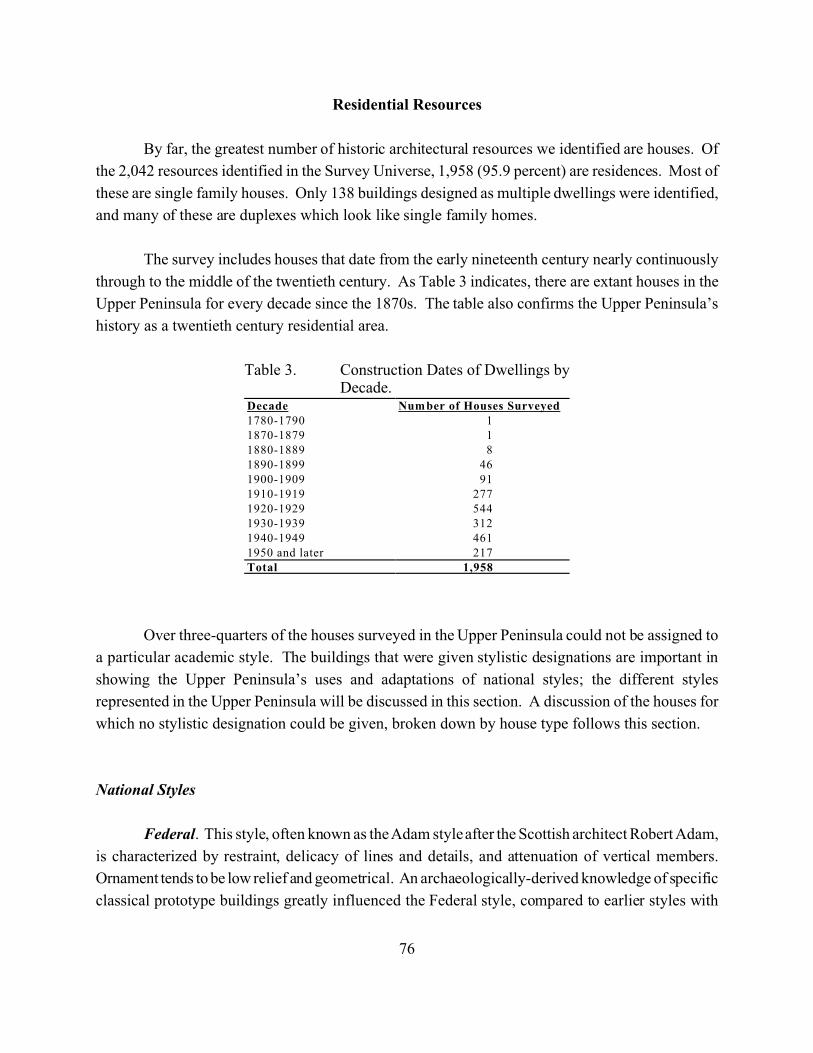
76
Decade Number of Houses Surveyed1780-1790 11870-1879 11880-1889 81890-1899 461900-1909 911910-1919 2771920-1929 5441930-1939 3121940-1949 4611950 and later 217Total 1,958
Table 3. Construction Dates of Dwellings byDecade.
Residential Resources
By far, the greatest number of historic architectural resources we identified are houses. Of
the 2,042 resources identified in the Survey Universe, 1,958 (95.9 percent) are residences. Most of
these are single family houses. Only 138 buildings designed as multiple dwellings were identified,
and many of these are duplexes which look like single family homes.
The survey includes houses that date from the early nineteenth century nearly continuously
through to the middle of the twentieth century. As Table 3 indicates, there are extant houses in the
Upper Peninsula for every decade since the 1870s. The table also confirms the Upper Peninsula’s
history as a twentieth century residential area.
Over three-quarters of the houses surveyed in the Upper Peninsula could not be assigned to
a particular academic style. The buildings that were given stylistic designations are important in
showing the Upper Peninsula’s uses and adaptations of national styles; the different styles
represented in the Upper Peninsula will be discussed in this section. A discussion of the houses for
which no stylistic designation could be given, broken down by house type follows this section.
National Styles
Federal. This style, often known as the Adam style after the Scottish architect Robert Adam,
is characterized by restraint, delicacy of lines and details, and attenuation of vertical members.
Ornament tends to be low relief and geometrical. An archaeologically-derived knowledge of specific
classical prototype buildings greatly influenced the Federal style, compared to earlier styles with
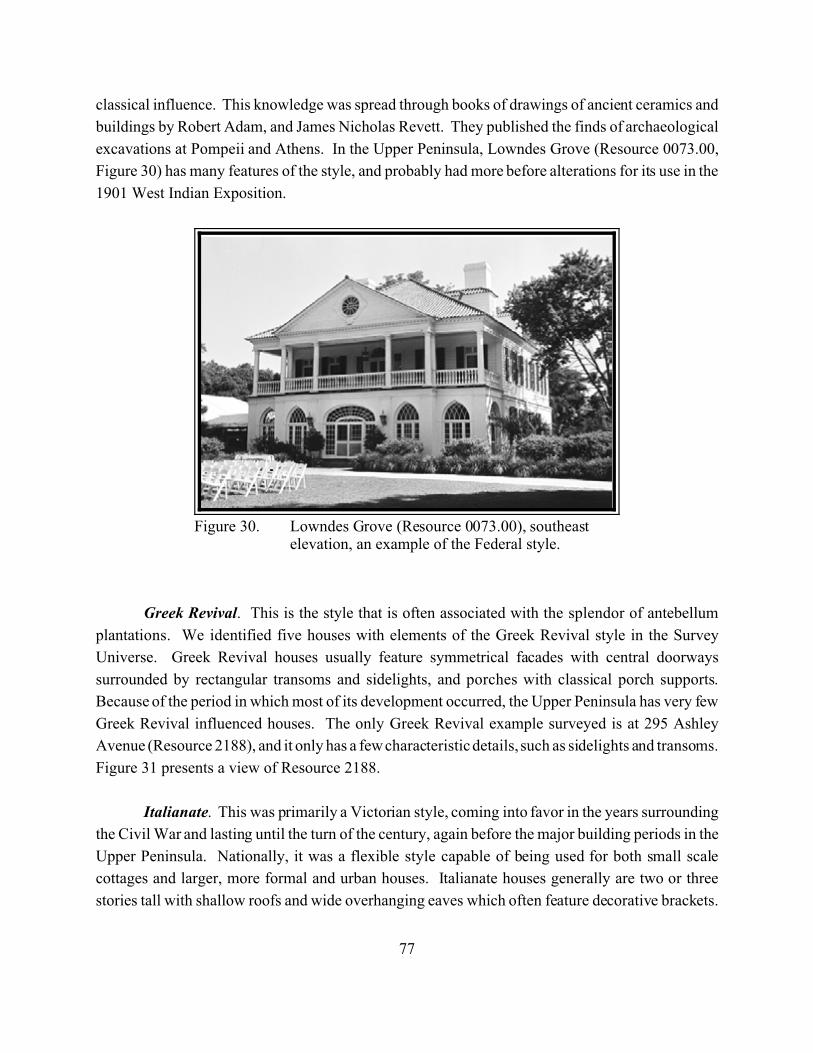
77
Figure 30. Lowndes Grove (Resource 0073.00), southeastelevation, an example of the Federal style.
classical influence. This knowledge was spread through books of drawings of ancient ceramics and
buildings by Robert Adam, and James Nicholas Revett. They published the finds of archaeological
excavations at Pompeii and Athens. In the Upper Peninsula, Lowndes Grove (Resource 0073.00,
Figure 30) has many features of the style, and probably had more before alterations for its use in the
1901 West Indian Exposition.
Greek Revival. This is the style that is often associated with the splendor of antebellum
plantations. We identified five houses with elements of the Greek Revival style in the Survey
Universe. Greek Revival houses usually feature symmetrical facades with central doorways
surrounded by rectangular transoms and sidelights, and porches with classical porch supports.
Because of the period in which most of its development occurred, the Upper Peninsula has very few
Greek Revival influenced houses. The only Greek Revival example surveyed is at 295 Ashley
Avenue (Resource 2188), and it only has a few characteristic details, such as sidelights and transoms.
Figure 31 presents a view of Resource 2188.
Italianate. This was primarily a Victorian style, coming into favor in the years surrounding
the Civil War and lasting until the turn of the century, again before the major building periods in the
Upper Peninsula. Nationally, it was a flexible style capable of being used for both small scale
cottages and larger, more formal and urban houses. Italianate houses generally are two or three
stories tall with shallow roofs and wide overhanging eaves which often feature decorative brackets.
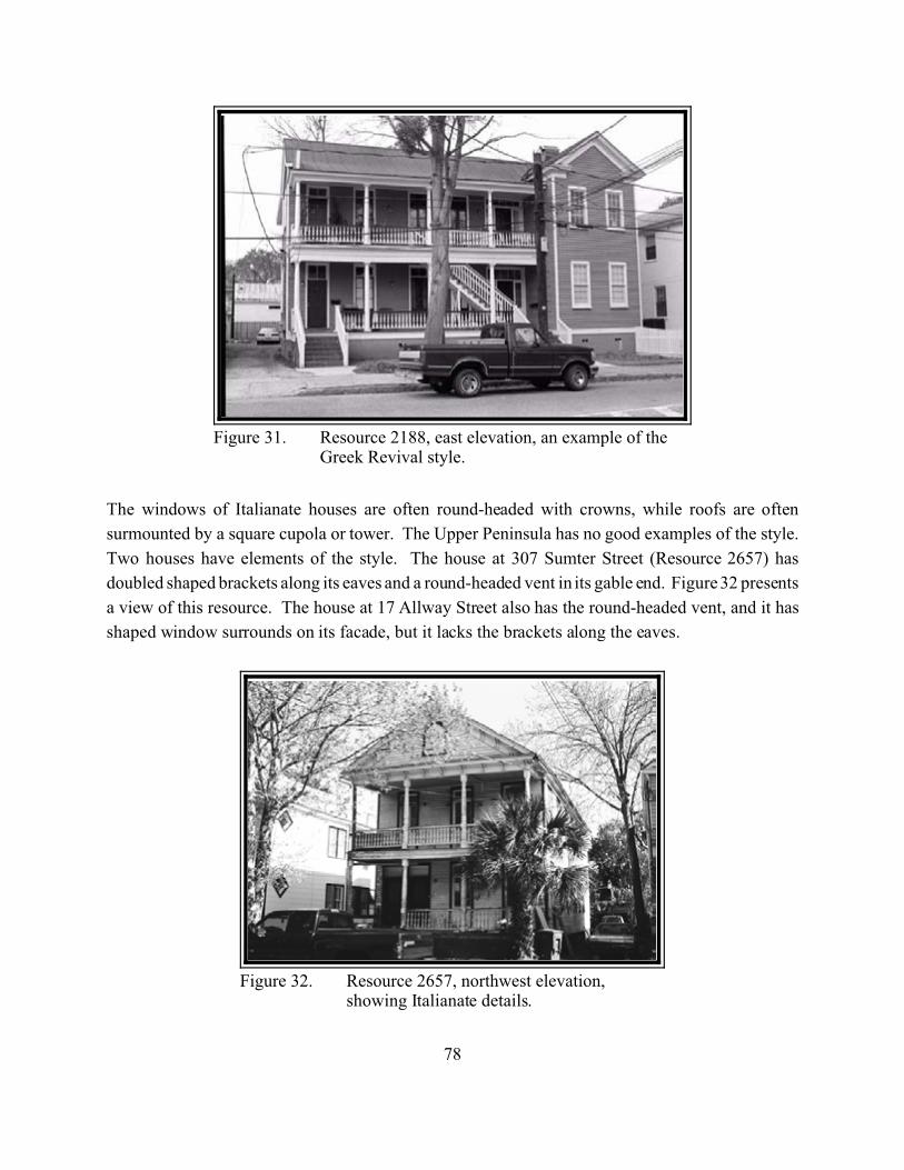
78
Figure 31. Resource 2188, east elevation, an example of theGreek Revival style.
Figure 32. Resource 2657, northwest elevation,showing Italianate details.
The windows of Italianate houses are often round-headed with crowns, while roofs are often
surmounted by a square cupola or tower. The Upper Peninsula has no good examples of the style.
Two houses have elements of the style. The house at 307 Sumter Street (Resource 2657) has
doubled shaped brackets along its eaves and a round-headed vent in its gable end. Figure 32 presents
a view of this resource. The house at 17 Allway Street also has the round-headed vent, and it has
shaped window surrounds on its facade, but it lacks the brackets along the eaves.
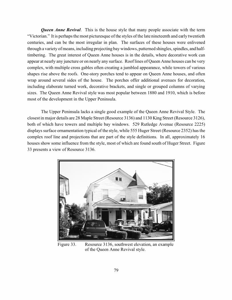
79
Figure 33. Resource 3136, southwest elevation, an exampleof the Queen Anne Revival style.
Queen Anne Revival. This is the house style that many people associate with the term
“Victorian.” It is perhaps the most picturesque of the styles of the late nineteenth and early twentieth
centuries, and can be the most irregular in plan. The surfaces of these houses were enlivened
through a variety of means, including projecting bay windows, patterned shingles, spindles, and half-
timbering. The great interest of Queen Anne houses is in the details, where decorative work can
appear at nearly any juncture or on nearly any surface. Roof lines of Queen Anne houses can be very
complex, with multiple cross gables often creating a jumbled appearance, while towers of various
shapes rise above the roofs. One-story porches tend to appear on Queen Anne houses, and often
wrap around several sides of the house. The porches offer additional avenues for decoration,
including elaborate turned work, decorative brackets, and single or grouped columns of varying
sizes. The Queen Anne Revival style was most popular between 1880 and 1910, which is before
most of the development in the Upper Peninsula.
The Upper Peninsula lacks a single good example of the Queen Anne Revival Style. The
closest in major details are 28 Maple Street (Resource 3136) and 1130 King Street (Resource 3126),
both of which have towers and multiple bay windows. 529 Rutledge Avenue (Resource 2225)
displays surface ornamentation typical of the style, while 555 Huger Street (Resource 2352) has the
complex roof line and projections that are part of the style definitions. In all, approximately 16
houses show some influence from the style, most of which are found south of Huger Street. Figure
33 presents a view of Resource 3136.
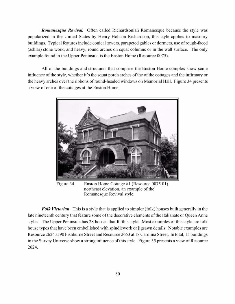
80
Figure 34. Enston Home Cottage #1 (Resource 0075.01),northeast elevation, an example of theRomanesque Revival style.
Romanesque Revival. Often called Richardsonian Romanesque because the style was
popularized in the United States by Henry Hobson Richardson, this style applies to masonry
buildings. Typical features include conical towers, parapeted gables or dormers, use of rough-faced
(ashlar) stone work, and heavy, round arches on squat columns or in the wall surface. The only
example found in the Upper Peninsula is the Enston Home (Resource 0075).
All of the buildings and structures that comprise the Enston Home complex show some
influence of the style, whether it’s the squat porch arches of the of the cottages and the infirmary or
the heavy arches over the ribbons of round-headed windows on Memorial Hall. Figure 34 presents
a view of one of the cottages at the Enston Home.
Folk Victorian. This is a style that is applied to simpler (folk) houses built generally in the
late nineteenth century that feature some of the decorative elements of the Italianate or Queen Anne
styles. The Upper Peninsula has 28 houses that fit this style. Most examples of this style are folk
house types that have been embellished with spindlework or jigsawn details. Notable examples are
Resource 2624 at 90 Fishburne Street and Resource 2653 at 18 Carolina Street. In total, 15 buildings
in the Survey Universe show a strong influence of this style. Figure 35 presents a view of Resource
2624.
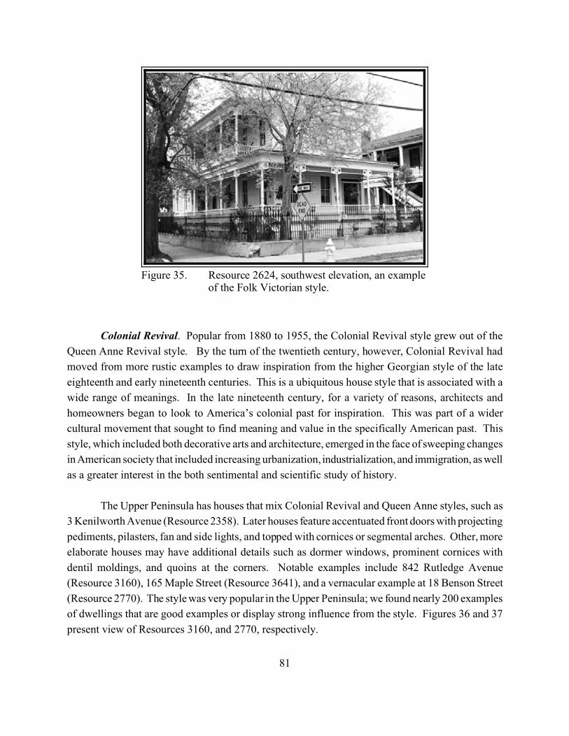
81
Figure 35. Resource 2624, southwest elevation, an exampleof the Folk Victorian style.
Colonial Revival. Popular from 1880 to 1955, the Colonial Revival style grew out of the
Queen Anne Revival style. By the turn of the twentieth century, however, Colonial Revival had
moved from more rustic examples to draw inspiration from the higher Georgian style of the late
eighteenth and early nineteenth centuries. This is a ubiquitous house style that is associated with a
wide range of meanings. In the late nineteenth century, for a variety of reasons, architects and
homeowners began to look to America’s colonial past for inspiration. This was part of a wider
cultural movement that sought to find meaning and value in the specifically American past. This
style, which included both decorative arts and architecture, emerged in the face of sweeping changes
in American society that included increasing urbanization, industrialization, and immigration, as well
as a greater interest in the both sentimental and scientific study of history.
The Upper Peninsula has houses that mix Colonial Revival and Queen Anne styles, such as
3 Kenilworth Avenue (Resource 2358). Later houses feature accentuated front doors with projecting
pediments, pilasters, fan and side lights, and topped with cornices or segmental arches. Other, more
elaborate houses may have additional details such as dormer windows, prominent cornices with
dentil moldings, and quoins at the corners. Notable examples include 842 Rutledge Avenue
(Resource 3160), 165 Maple Street (Resource 3641), and a vernacular example at 18 Benson Street
(Resource 2770). The style was very popular in the Upper Peninsula; we found nearly 200 examples
of dwellings that are good examples or display strong influence from the style. Figures 36 and 37
present view of Resources 3160, and 2770, respectively.
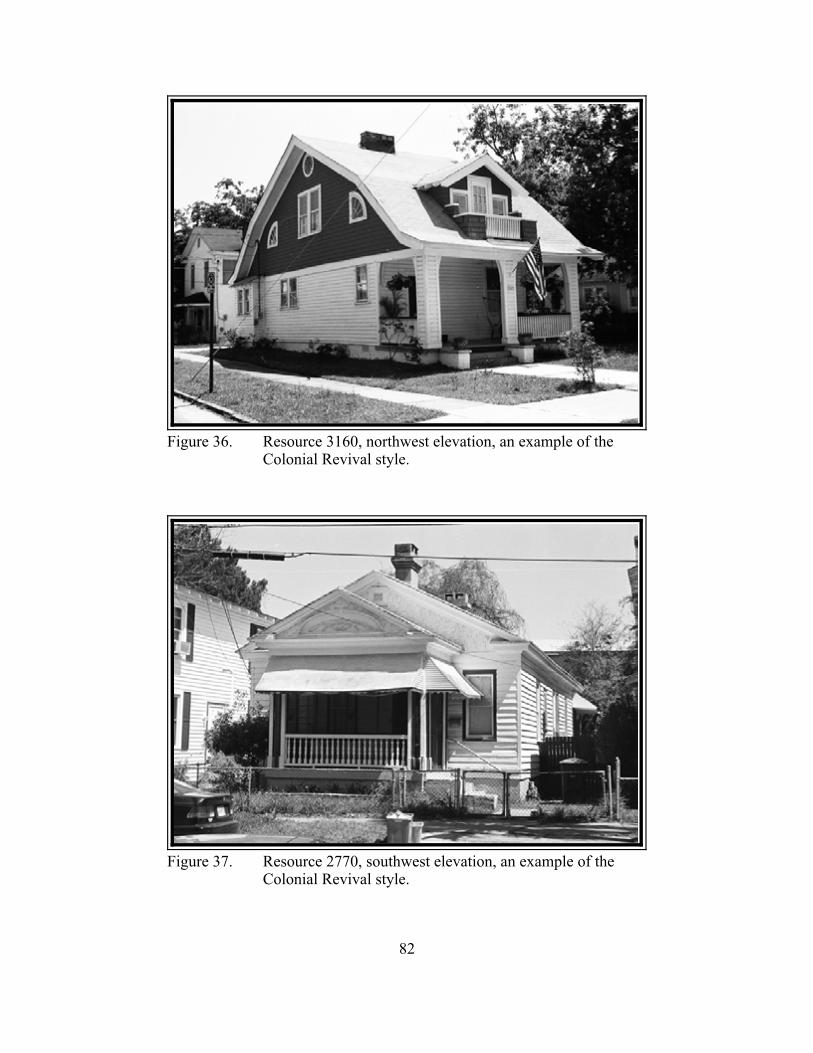
82
Figure 36. Resource 3160, northwest elevation, an example of theColonial Revival style.
Figure 37. Resource 2770, southwest elevation, an example of theColonial Revival style.
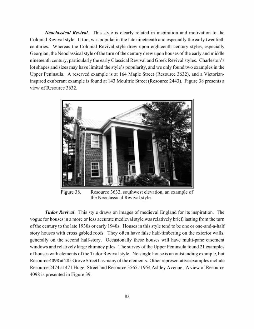
83
Figure 38. Resource 3632, southwest elevation, an example ofthe Neoclassical Revival style.
Neoclassical Revival. This style is clearly related in inspiration and motivation to the
Colonial Revival style. It too, was popular in the late nineteenth and especially the early twentieth
centuries. Whereas the Colonial Revival style drew upon eighteenth century styles, especially
Georgian, the Neoclassical style of the turn of the century drew upon houses of the early and middle
nineteenth century, particularly the early Classical Revival and Greek Revival styles. Charleston’s
lot shapes and sizes may have limited the style’s popularity, and we only found two examples in the
Upper Peninsula. A reserved example is at 164 Maple Street (Resource 3632), and a Victorian-
inspired exuberant example is found at 143 Moultrie Street (Resource 2443). Figure 38 presents a
view of Resource 3632.
Tudor Revival. This style draws on images of medieval England for its inspiration. The
vogue for houses in a more or less accurate medieval style was relatively brief, lasting from the turn
of the century to the late 1930s or early 1940s. Houses in this style tend to be one or one-and-a-half
story houses with cross gabled roofs. They often have false half-timbering on the exterior walls,
generally on the second half-story. Occasionally these houses will have multi-pane casement
windows and relatively large chimney piles. The survey of the Upper Peninsula found 21 examples
of houses with elements of the Tudor Revival style. No single house is an outstanding example, but
Resource 4098 at 285 Grove Street has many of the elements. Other representative examples include
Resource 2474 at 471 Huger Street and Resource 3565 at 954 Ashley Avenue. A view of Resource
4098 is presented in Figure 39.

84
Figure 39. Resource 4098, northwest elevation, showing elements of theTudor Revival style.
Craftsman. Craftsman style houses drew inspiration from the Arts and Crafts movement of
the late nineteenth century. Occasionally they are mistaken for simple front or side gable folk
houses. The difference is the presence of visible architectural details. These houses feature such
elements as low-pitched roofs, often with overhanging eaves and exposed rafters and occasionally
with decorative brackets or beams. Generally, these houses have projecting porches supported by
wooden posts on brick or masonry piers. Most Craftsman houses are surmounted by either side or
front gabled roofs; occasionally, there are hip or cross gable roofs. The vogue for this style lasted
from about 1900 to the early 1930s.
The Survey Universe contains approximately 150 houses that display elements of this style.
These houses were built between c. 1905 and the early 1940s. Resource 2328 at 10 Parkwood
Avenue has almost all of the defining details of the style; a view of this residence is presented in
Figure 40. Other very good examples can be found at 7 Elmwood Avenue (Resource 2333) and 66
Sans Souci Street (Resource 3340). Figure 41 presents a view of Resource 3440. Many practitioners
of the Craftsman style were greatly influenced by the arts of Asia, particularly Japan. Resource 2450
at 491 Huger Street (Figure 42) provides a good example of this variant; a view of this resource is
presented in Figure 42.
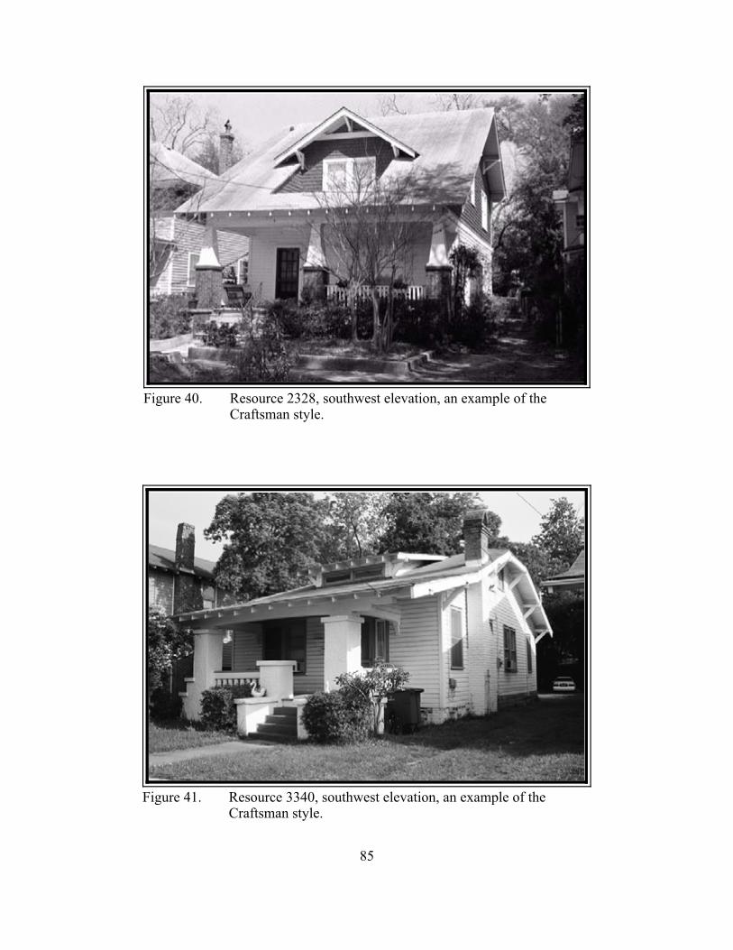
85
Figure 40. Resource 2328, southwest elevation, an example of theCraftsman style.
Figure 41. Resource 3340, southwest elevation, an example of theCraftsman style.
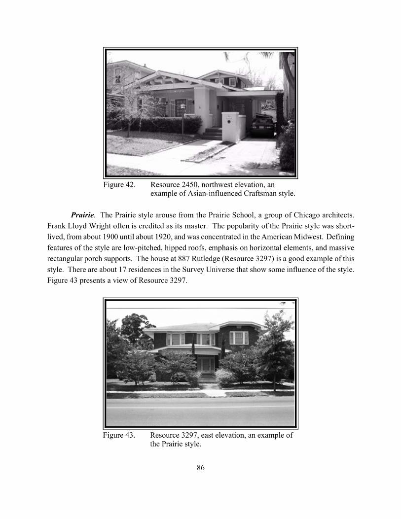
86
Figure 42. Resource 2450, northwest elevation, anexample of Asian-influenced Craftsman style.
Figure 43. Resource 3297, east elevation, an example ofthe Prairie style.
Prairie. The Prairie style arouse from the Prairie School, a group of Chicago architects.
Frank Lloyd Wright often is credited as its master. The popularity of the Prairie style was short-
lived, from about 1900 until about 1920, and was concentrated in the American Midwest. Defining
features of the style are low-pitched, hipped roofs, emphasis on horizontal elements, and massive
rectangular porch supports. The house at 887 Rutledge (Resource 3297) is a good example of this
style. There are about 17 residences in the Survey Universe that show some influence of the style.
Figure 43 presents a view of Resource 3297.
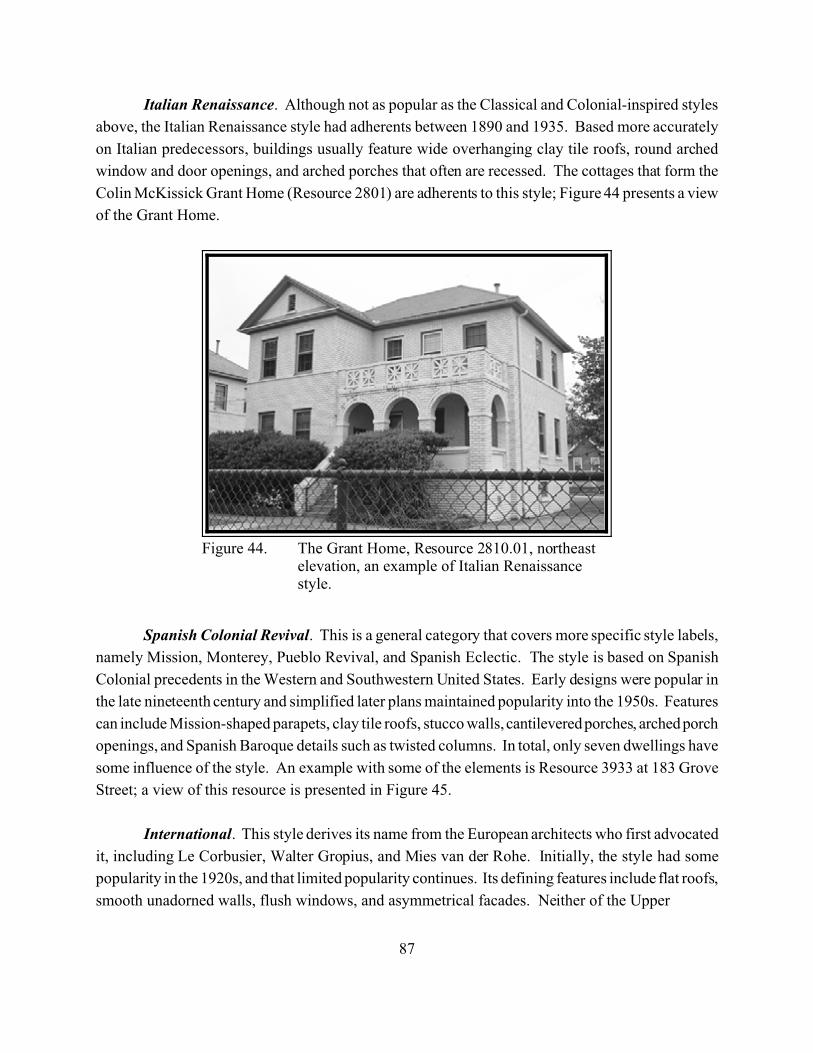
87
Figure 44. The Grant Home, Resource 2810.01, northeastelevation, an example of Italian Renaissancestyle.
Italian Renaissance. Although not as popular as the Classical and Colonial-inspired styles
above, the Italian Renaissance style had adherents between 1890 and 1935. Based more accurately
on Italian predecessors, buildings usually feature wide overhanging clay tile roofs, round arched
window and door openings, and arched porches that often are recessed. The cottages that form the
Colin McKissick Grant Home (Resource 2801) are adherents to this style; Figure 44 presents a view
of the Grant Home.
Spanish Colonial Revival. This is a general category that covers more specific style labels,
namely Mission, Monterey, Pueblo Revival, and Spanish Eclectic. The style is based on Spanish
Colonial precedents in the Western and Southwestern United States. Early designs were popular in
the late nineteenth century and simplified later plans maintained popularity into the 1950s. Features
can include Mission-shaped parapets, clay tile roofs, stucco walls, cantilevered porches, arched porch
openings, and Spanish Baroque details such as twisted columns. In total, only seven dwellings have
some influence of the style. An example with some of the elements is Resource 3933 at 183 Grove
Street; a view of this resource is presented in Figure 45.
International. This style derives its name from the European architects who first advocated
it, including Le Corbusier, Walter Gropius, and Mies van der Rohe. Initially, the style had some
popularity in the 1920s, and that limited popularity continues. Its defining features include flat roofs,
smooth unadorned walls, flush windows, and asymmetrical facades. Neither of the Upper

88
Figure 45. Resource 3933, northeast elevation, an example ofthe Spanish Colonial Revival style.
Figure 46. Resource 3503, south elevation, and example of theInternational style.
Peninsula’s two examples are strong adherents of the style, but the house at 186 Sans Souci Street
(Resource 3503) is more strongly influenced by the style; Figure 46 presents a view of this resource.
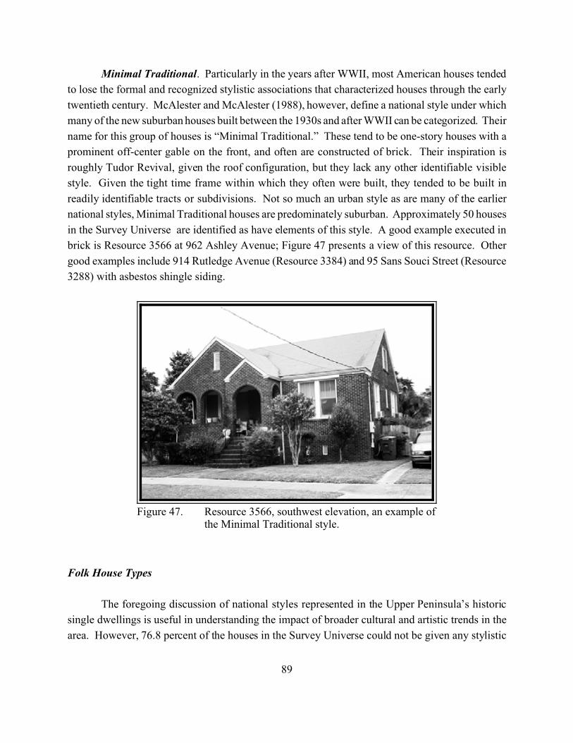
89
Figure 47. Resource 3566, southwest elevation, an example ofthe Minimal Traditional style.
Minimal Traditional. Particularly in the years after WWII, most American houses tended
to lose the formal and recognized stylistic associations that characterized houses through the early
twentieth century. McAlester and McAlester (1988), however, define a national style under which
many of the new suburban houses built between the 1930s and after WWII can be categorized. Their
name for this group of houses is “Minimal Traditional.” These tend to be one-story houses with a
prominent off-center gable on the front, and often are constructed of brick. Their inspiration is
roughly Tudor Revival, given the roof configuration, but they lack any other identifiable visible
style. Given the tight time frame within which they often were built, they tended to be built in
readily identifiable tracts or subdivisions. Not so much an urban style as are many of the earlier
national styles, Minimal Traditional houses are predominately suburban. Approximately 50 houses
in the Survey Universe are identified as have elements of this style. A good example executed in
brick is Resource 3566 at 962 Ashley Avenue; Figure 47 presents a view of this resource. Other
good examples include 914 Rutledge Avenue (Resource 3384) and 95 Sans Souci Street (Resource
3288) with asbestos shingle siding.
Folk House Types
The foregoing discussion of national styles represented in the Upper Peninsula’s historic
single dwellings is useful in understanding the impact of broader cultural and artistic trends in the
area. However, 76.8 percent of the houses in the Survey Universe could not be given any stylistic
90
designation. Thus, the majority of the dwellings in the Upper Peninsula are left out of a stylistic
analysis. In order to bring these houses into the analysis of the County’s historic architecture, the
survey team drew upon folk housing types elaborated by McAlester and McAlester (1988). A
discussion of these types is presented below.
Front gable. These houses can have one or two stories with one to three bays across the
facade. Craftsman and bungalow-influenced houses are the most prominent twentieth century
examples of this pervasive type Unlike the buildings described in the Craftsman section above,
however, many of these buildings lack architectural details and therefore are included in this folk
section. Based on the survey findings, front gable houses were a popular form of folk housing in the
Upper Peninsula. We found 637 examples of the form ranging in dates from the 1890s to the 1950s.
Massed plan side gabled. These houses, which are at least two rooms wide and two rooms
deep, became popular as a folk form after the Civil War. These houses gained popularity after light
weight roof framing could span houses that were more than two rooms deep (McAlester 1988: 28).
Historically, this form is very popular. The Upper Peninsula has 388 surviving examples. The
houses range in date from the 1890s to the 1950s.
Gable front and wing. These houses feature a front gable section with a side gabled wing
at a right angle. A shed or hip roof porch often was added to the junction of the two wings. While
these houses appear to have been altered over the years, the cross gable sections often were built as
a unit. We identified 220 examples of the gable front and wing plan in the Upper Peninsula, ranging
in age from approximately 1870 to approximately 1955.
I-house. This house type also was a popular folk form throughout the nineteenth and early
twentieth century. These side gable houses were two rooms wide with a central hallway, and one
room deep. Houses of this sort were quite popular throughout the South, and drew upon notions of
balance and symmetry from the eighteenth and early nineteenth century. Charleston and the South
Carolina coast interpreted this form for use on narrow lots. Called the Single House, it is an I-House
turned sideways on its lot so that its gabled side faces the street. The Upper Peninsula has 111
examples of I-Houses, of which 109 are Single Houses. These range in age from approximately
1885 to approximately 1930.
Hall and parlor. This type includes houses that have a simple side gabled roof covering a
plan that is two rooms wide and one room deep. This was a traditional British form that was an early
implant in the American colonies. This plan remained the basic housing form throughout the
southeast into the early twentieth century. Like the Single House mentioned above, coastal South
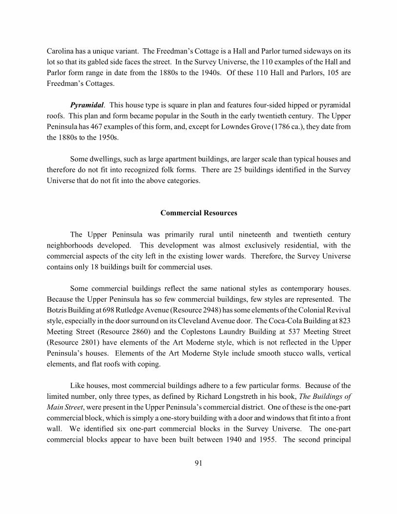
91
Carolina has a unique variant. The Freedman’s Cottage is a Hall and Parlor turned sideways on its
lot so that its gabled side faces the street. In the Survey Universe, the 110 examples of the Hall and
Parlor form range in date from the 1880s to the 1940s. Of these 110 Hall and Parlors, 105 are
Freedman’s Cottages.
Pyramidal. This house type is square in plan and features four-sided hipped or pyramidal
roofs. This plan and form became popular in the South in the early twentieth century. The Upper
Peninsula has 467 examples of this form, and, except for Lowndes Grove (1786 ca.), they date from
the 1880s to the 1950s.
Some dwellings, such as large apartment buildings, are larger scale than typical houses and
therefore do not fit into recognized folk forms. There are 25 buildings identified in the Survey
Universe that do not fit into the above categories.
Commercial Resources
The Upper Peninsula was primarily rural until nineteenth and twentieth century
neighborhoods developed. This development was almost exclusively residential, with the
commercial aspects of the city left in the existing lower wards. Therefore, the Survey Universe
contains only 18 buildings built for commercial uses.
Some commercial buildings reflect the same national styles as contemporary houses.
Because the Upper Peninsula has so few commercial buildings, few styles are represented. The
Botzis Building at 698 Rutledge Avenue (Resource 2948) has some elements of the Colonial Revival
style, especially in the door surround on its Cleveland Avenue door. The Coca-Cola Building at 823
Meeting Street (Resource 2860) and the Coplestons Laundry Building at 537 Meeting Street
(Resource 2801) have elements of the Art Moderne style, which is not reflected in the Upper
Peninsula’s houses. Elements of the Art Moderne Style include smooth stucco walls, vertical
elements, and flat roofs with coping.
Like houses, most commercial buildings adhere to a few particular forms. Because of the
limited number, only three types, as defined by Richard Longstreth in his book, The Buildings of
Main Street, were present in the Upper Peninsula’s commercial district. One of these is the one-part
commercial block, which is simply a one-story building with a door and windows that fit into a front
wall. We identified six one-part commercial blocks in the Survey Universe. The one-part
commercial blocks appear to have been built between 1940 and 1955. The second principal
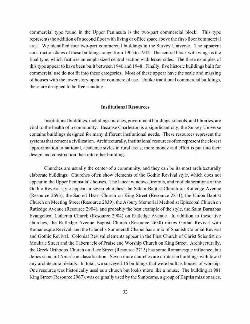
92
commercial type found in the Upper Peninsula is the two-part commercial block. This type
represents the addition of a second floor with living or office space above the first-floor commercial
area. We identified four two-part commercial buildings in the Survey Universe. The apparent
construction dates of these buildings range from 1905 to 1942. The central block with wings is the
final type, which features an emphasized central section with lesser sides. The three examples of
this type appear to have been built between 1940 and 1948. Finally, five historic buildings built for
commercial use do not fit into these categories. Most of these appear have the scale and massing
of houses with the lower story open for commercial use. Unlike traditional commercial buildings,
these are designed to be free standing.
Institutional Resources
Institutional buildings, including churches, government buildings, schools, and libraries, are
vital to the health of a community. Because Charleston is a significant city, the Survey Universe
contains buildings designed for many different institutional needs. These resources represent the
systems that cement a civilization. Architecturally, institutional resources often represent the closest
approximation to national, academic styles in rural areas; more money and effort is put into their
design and construction than into other buildings.
Churches are usually the center of a community, and they can be its most architecturally
elaborate buildings. Churches often show elements of the Gothic Revival style, which does not
appear in the Upper Peninsula’s houses. The lancet windows, trefoils, and roof elaborations of the
Gothic Revival style appear in seven churches: the Salem Baptist Church on Rutledge Avenue
(Resource 2693), the Sacred Heart Church on King Street (Resource 2811), the Union Baptist
Church on Meeting Street (Resource 2839), the Asbury Memorial Methodist Episcopal Church on
Rutledge Avenue (Resource 2904), and probably the best example of the style, the Saint Barnabas
Evangelical Lutheran Church (Resource 2904) on Rutledge Avenue. In addition to these five
churches, the Rutledge Avenue Baptist Church (Resource 2630) mixes Gothic Revival with
Romanesque Revival, and the Citadel’s Summerall Chapel has a mix of Spanish Colonial Revival
and Gothic Revival. Colonial Revival elements appear in the First Church of Christ Scientist on
Moultrie Street and the Tabernacle of Praise and Worship Church on King Street. Architecturally,
the Greek Orthodox Church on Race Street (Resource 2715) has some Romanesque influence, but
defies standard American classification. Seven more churches are utilitarian buildings with few if
any architectural details. In total, we surveyed 16 buildings that were built as houses of worship.
One resource was historically used as a church but looks more like a house. The building at 981
King Street (Resource 2967), was originally used by the Sunbeams, a group of Baptist missionaries,
93
Figure 48. Sacred Heart Church (Resource 2811), northwestelevation.
Figure 49. Rutledge Avenue Baptist Church (Resource2630), southwest elevation.
and it has elements of the Tudor Revival and Craftsman styles. Figures 48 and 49 present views of
Resources 2811 and 2630 respectively.
94
Cemeteries, often related to churches, are an important community tie to its personal history.
We found 21 historic cemeteries in the Survey Universe. The Wilson Family Cemetery (Resource
2691) behind the Salem Baptist Church is the oldest (ca. 1808). The remaining cemeteries are all
clustered at the northwest corner of the Survey Universe on land once belonging to Magnolia Umbra
Plantation. These cemeteries (Resource 0077 and Resources 2865-2883) are both large and small
and range in opening dates from the 1850s to the 1950s. They include: African American cemeteries
not associated with particular churches such as the Brotherly Association Cemetery (Resource 2874);
African Methodist Episcopal Church cemeteries such as the Morris Brown A.M.E. Church Cemetery
(Resource 2882); Jewish Cemeteries; a Catholic Cemetery; a German Protestant Cemetery; a Greek
Cemetery; and a western-European Protestant Cemetery. This large collection of cemeteries in one
area reflects Charleston’s development and the desire to locate burials away from the city for
sanitary reasons.
Schools ensure continuity of knowledge from one generation to the next. Nine buildings and
one structure are related to education. The Rivers High School (Resource 2966), the James Simons
Elementary School (Resource 2907) which has elements of the Tudor Revival Style, and the Henry
P. Archer School (Resource 3408) which is a good example of Colonial Revival, are all public
schools. The Charleston Catholic School (Resource 2812) is a private school with elements of Tudor
Revival. Three buildings and a structure on The Citadel’s campus all feature the Citadel’s trademark
Gothic Revival elements. These buildings and structure are Bond Hall (Resource 2699), Capers Hall
(Resource 2700), LeTellier Hall (Resource 2703), and Howie Carillon (Resource 2826). Finally,
two small buildings, one on Cleveland Street (Resource 2560) and one on Sheppard Street (Resource
2565) are associated with nearby playgrounds.
Hampton Park (Resource 2562)is an important landscape. It was originally designed as a
race course in the eighteenth century. Later, it was used for the West Indian Exposition and had
hardwood allees and an artificial lake added; Figure 50 presents a view of Hampton Park. We
identified two other significant landscapes in the Upper Peninsula. The Citadel Parade Ground
(Resource 2561) is a rectangular ground framed by scattered hardwoods along its fringe. It is the
center of the Citadel Campus and is surrounded by the Citadel’s buildings. Allen Park (Resource
3409) was designed in the early twentieth century as part of the Hampton Park Terrace
neighborhood. It has diagonal walks, a center fountain, and oak trees scattered throughout.
We identified two fire stations in the Survey Universe. The Engine Number Eight building
(Resource 2888) at 370 Huger Street takes the form of a two-part commercial block. The other fire
station at 1095 King Street (Resource 2809) is no longer used by the Fire Department. One other
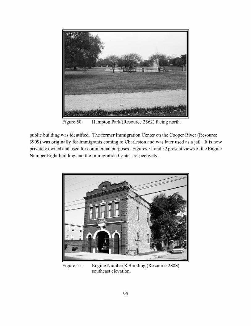
95
Figure 50. Hampton Park (Resource 2562) facing north.
Figure 51. Engine Number 8 Building (Resource 2888),southeast elevation.
public building was identified. The former Immigration Center on the Cooper River (Resource
3909) was originally for immigrants coming to Charleston and was later used as a jail. It is now
privately owned and used for commercial purposes. Figures 51 and 52 present views of the Engine
Number Eight building and the Immigration Center, respectively.
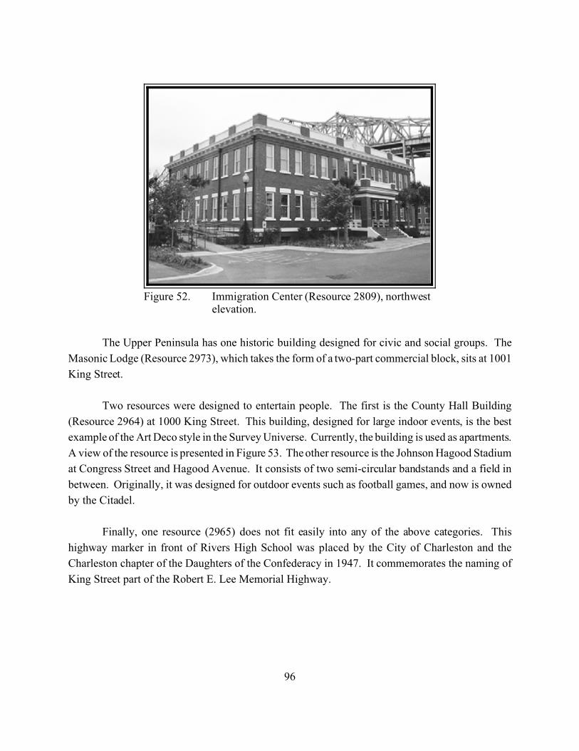
96
Figure 52. Immigration Center (Resource 2809), northwestelevation.
The Upper Peninsula has one historic building designed for civic and social groups. The
Masonic Lodge (Resource 2973), which takes the form of a two-part commercial block, sits at 1001
King Street.
Two resources were designed to entertain people. The first is the County Hall Building
(Resource 2964) at 1000 King Street. This building, designed for large indoor events, is the best
example of the Art Deco style in the Survey Universe. Currently, the building is used as apartments.
A view of the resource is presented in Figure 53. The other resource is the Johnson Hagood Stadium
at Congress Street and Hagood Avenue. It consists of two semi-circular bandstands and a field in
between. Originally, it was designed for outdoor events such as football games, and now is owned
by the Citadel.
Finally, one resource (2965) does not fit easily into any of the above categories. This
highway marker in front of Rivers High School was placed by the City of Charleston and the
Charleston chapter of the Daughters of the Confederacy in 1947. It commemorates the naming of
King Street part of the Robert E. Lee Memorial Highway.

97
Figure 53. County Hall (Resource 2964), southwestelevation.
Transportation Resources
The Upper Peninsula has always served as a connection between the City and Port of
Charleston and the interior of South Carolina. This leads to the obvious development of roads and
railroads. Architecturally, there are few buildings historically associated with transportation above
US Highway 17. The most significant is the Charleston City Railway Car House (Resource 2830).
This two-story brick building was built in 1897; a view of the resource is presented in Figure 54.
Currently, the building is not used. At the easternmost part of the Survey Universe, the Seaboard
Coastline Trestle (Resource 4138) extends into Town Creek. Abandoned, it is mostly intact and still
has an associated building (Resource 4139). Just to the south stand three buildings (Resources 4140-
4142), also abandoned. One appears large enough to be a small warehouse, the other two are
smaller. They appear to be buildings related to river trade on the peninsula. Two other remaining
historic resources (Resources 3364 and 3369) appear to be free-standing former automobile garages
that have been converted into houses.
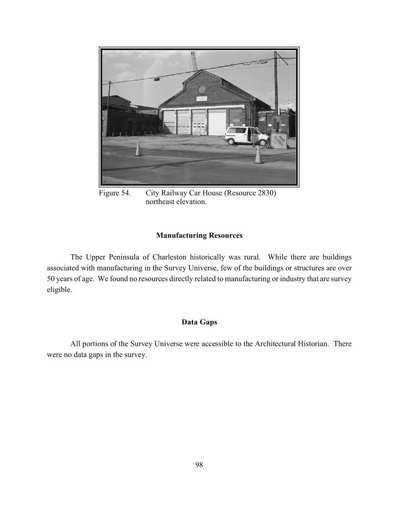
98
Figure 54. City Railway Car House (Resource 2830)northeast elevation.
Manufacturing Resources
The Upper Peninsula of Charleston historically was rural. While there are buildings
associated with manufacturing in the Survey Universe, few of the buildings or structures are over
50 years of age. We found no resources directly related to manufacturing or industry that are survey
eligible.
Data Gaps
All portions of the Survey Universe were accessible to the Architectural Historian. There
were no data gaps in the survey.
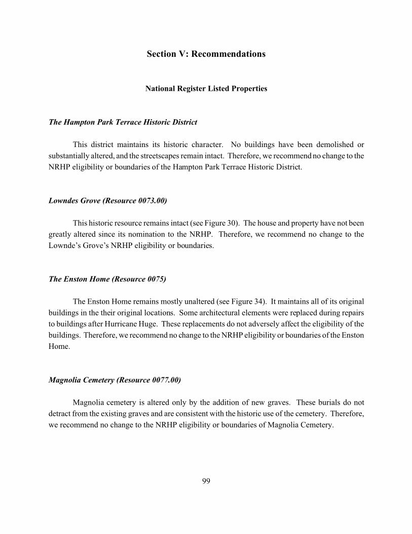
99
Section V: Recommendations
National Register Listed Properties
The Hampton Park Terrace Historic District
This district maintains its historic character. No buildings have been demolished or
substantially altered, and the streetscapes remain intact. Therefore, we recommend no change to the
NRHP eligibility or boundaries of the Hampton Park Terrace Historic District.
Lowndes Grove (Resource 0073.00)
This historic resource remains intact (see Figure 30). The house and property have not been
greatly altered since its nomination to the NRHP. Therefore, we recommend no change to the
Lownde’s Grove’s NRHP eligibility or boundaries.
The Enston Home (Resource 0075)
The Enston Home remains mostly unaltered (see Figure 34). It maintains all of its original
buildings in the their original locations. Some architectural elements were replaced during repairs
to buildings after Hurricane Huge. These replacements do not adversely affect the eligibility of the
buildings. Therefore, we recommend no change to the NRHP eligibility or boundaries of the Enston
Home.
Magnolia Cemetery (Resource 0077.00)
Magnolia cemetery is altered only by the addition of new graves. These burials do not
detract from the existing graves and are consistent with the historic use of the cemetery. Therefore,
we recommend no change to the NRHP eligibility or boundaries of Magnolia Cemetery.
100
The Florence Crittenton Home (Resource 0104)
This historic resource has not been altered since its recent nomination to the NRHP.
Therefore, we recommend no change to the NRHP eligibility or boundaries of the Florence
Crittenton Home.
National Register Eligible Properties
The North of 17 Historic District
This district maintains its historic character and streetscapes (see Figure 29). We recommend
the following changes. First, because the name is ambiguous, we recommend changing the name
to The Sophia Wilson Historic District. Second, we recommend modification of the southern
boundary to exclude the school at the intersection of Fishburne and Perry Streets, and extension of
the western boundary to Rutledge Avenue. The Sophia Wilson Historic District is a very late
nineteenth century to early twentieth century residential neighborhood. This area originally was
owned by Sophia Wilson; it was subdivided in 1893. Although the original plat included one more
road to the south, the boundaries for the recommended district are Rutledge Avenue on the west,
King Street on the east, the lots on the south side of Fishburne Street on the south, and the lots on
the north side of Sumter Street on the north. Generally, the neighborhood is characterized by two-
story houses, a 10 to 15 foot setback, closely spaced houses, and some street trees. It is a good
example of a Charleston neighborhood in the transition between the nineteenth and twentieth
centuries. Therefore, we recommend the Sophia Wilson Historic District remains eligible for the
NRHP under Criterion C.
The Carondolet Street Historic District
This district contains approximately 12 houses (see Figure 29). During the present survey,
we found only two houses (Resources 2728 and 2729) that retain sufficient integrity to be included
in the SCSS. In addition, a newer apartment building occupies the southeastern fourth of the district.
Because of the modern intrusion and the few historic architectural resources, we recommend the
Carondolet Historic District not eligible for the NRHP.
101
The Dingle Street Historic District
This district contains 14 houses (see Figure 29). During the present survey we found only
seven houses (Resources 2784-2790) that retain sufficient integrity to be included in the SCSS.
Three of these seven houses have low levels of integrity (below a rating of 3-). Because there are
so few historic architectural resources that could contribute to the district, we recommend the Dingle
Street Historic District not eligible for the NRHP.
The North Tracy Street Historic District
This district contains 16 houses (see Figure 29). During the present survey, we found only
eight houses (Resources 2891-2898) that retain sufficient integrity to be included in the SCSS.
Three-quarters of the houses on the eastern side of North Tracy Street were not included because of
inappropriate alterations. Three of the eight historic architectural resources surveyed have low levels
of integrity (below a rating of 3-). With minimal restoration, most houses on North Tracy Street
could contribute to a district. However, because only half of the houses currently contribute, we
recommend the North Tracy Street Historic District not eligible for the NRHP.
74 Fishburne Street (Resource 2065)
The resource at 74 Fishburne Street is a two-story frame house built around 1903 (see Figure
29). This house’s windows have been covered with plywood, but it has no other recent alterations.
It retains a high level of integrity. Therefore, we recommend that 74 Fishburne Street remains
eligible for the NRHP.
The Colin McKissick Grant Home (Resource 2810)
The Grant Home is a collection of six identical multiple-dwellings lined up along Meeting
Street at its intersection with Huger Street (see Figures 29 and 44). Additionally, an arched gate
stands on the Meeting Street side of the buildings. The buildings retain a high level of integrity and
have few alterations. Recently, six small cottages have been built behind the houses, but they are
small, designed like Freedman’s Cottages, and have no adverse affect on the Resource 2810.
Therefore, we recommend that the Colin McKissick Grant Home remains eligible for the NRHP
under Criterion C.
102
The Immigration Center (Resource 2809)
The Immigration Center is a two story masonry building used briefly for immigration, later
for a jail and a warehouse, and currently for commercial purposes (see Figures 29 and 52). This
building has been altered from its original use, and all of its windows have been replaced. However,
the building is in its original location and it still has most of its historic fabric. The building has
historical interest because of its multiple uses in the past. Therefore, we recommend that the
Immigration Center remains eligible for the NRHP under Criteria A and C.
The Charleston Railway Bus Barn (Resource 2830)
The Charleston Railway Bus Barn is a two-story brick building built in 1897 to house
Charleston’s street cars (see Figure 29). Currently abandoned, it has some additions and alterations,
mostly historic, and it has sustained some damage. However, the building’s original form is still
apparent and it maintains most of its original fabric. Therefore, we recommend that the Charleston
Railway Bus Barn remains eligible for the NRHP under Criteria A and C.
The Charleston Fire Department Engine Number Eight Building (Resource 2888)
The Engine Number 8 Building is a two-story brick building that takes the form of a two-part
commercial block (see Figure 29). It has almost no alterations and retains many architectural details.
Therefore, we recommend that the Engine Number Eight building remain eligible for the NRHP
under Criterion C.
Districts Recommended Eligible
During the present survey, we encountered areas that are concentrations of significant historic
architectural resources. Sometimes, these areas coincide with designed spaces or neighborhoods,
and sometimes they are small parts of larger wholes. We defined boundaries for these districts to
include all of the linked resources while excluding intrusions as much as possible. We found six
districts that we recommend eligible for the NRHP. These districts are shown in Figure 55. In many
cases, the SHPO did not concur with our NRHP recommendations for districts or individual
properties made in the draft report and repeated here. Readers should refer to the SHPO
determination of eligibility letter presented in Appendix C.
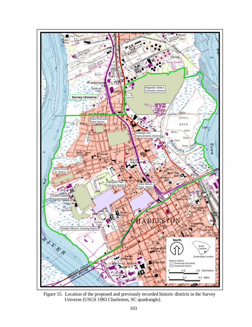
Rutledge Ave. Improvements District
West Grove St. District
Citadel Parade Ground District
Citadel Officers' Housing District
Hampton Park Terrace District
East Riverside Park District
Sofia Wilson Tract District
Magnolia Umbra Cemetery District
0 0.2 0.4 Miles
0 0.3 0.6 Kilometers
Historic DistrictPreviously RecordedProposed District
Projectarea27.shp
North
SouthCarolina
Quadrangle Location
103
Figure 55. Location of the proposed and previously recorded historic districts in the Survey Universe (USGS 1983 Charleston, SC quadrangle).
Survey Universe
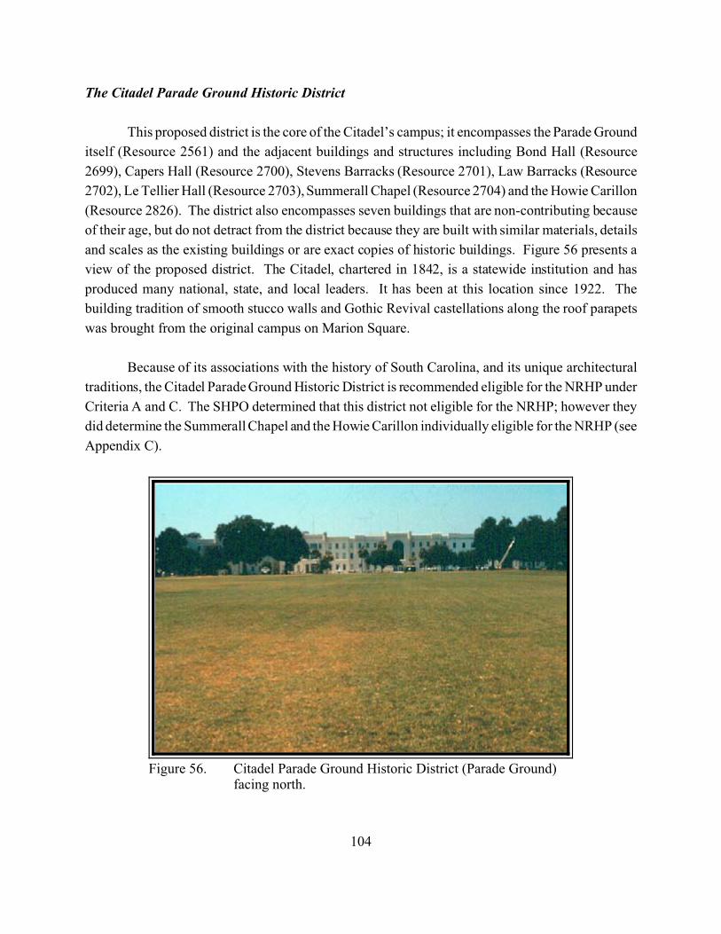
104
Figure 56. Citadel Parade Ground Historic District (Parade Ground)facing north.
The Citadel Parade Ground Historic District
This proposed district is the core of the Citadel’s campus; it encompasses the Parade Ground
itself (Resource 2561) and the adjacent buildings and structures including Bond Hall (Resource
2699), Capers Hall (Resource 2700), Stevens Barracks (Resource 2701), Law Barracks (Resource
2702), Le Tellier Hall (Resource 2703), Summerall Chapel (Resource 2704) and the Howie Carillon
(Resource 2826). The district also encompasses seven buildings that are non-contributing because
of their age, but do not detract from the district because they are built with similar materials, details
and scales as the existing buildings or are exact copies of historic buildings. Figure 56 presents a
view of the proposed district. The Citadel, chartered in 1842, is a statewide institution and has
produced many national, state, and local leaders. It has been at this location since 1922. The
building tradition of smooth stucco walls and Gothic Revival castellations along the roof parapets
was brought from the original campus on Marion Square.
Because of its associations with the history of South Carolina, and its unique architectural
traditions, the Citadel Parade Ground Historic District is recommended eligible for the NRHP under
Criteria A and C. The SHPO determined that this district not eligible for the NRHP; however they
did determine the Summerall Chapel and the Howie Carillon individually eligible for the NRHP (see
Appendix C).
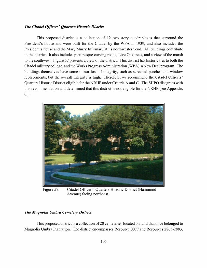
105
Figure 57. Citadel Officers’ Quarters Historic District (HammondAvenue) facing northeast.
The Citadel Officers’ Quarters Historic District
This proposed district is a collection of 12 two story quadraplexes that surround the
President’s house and were built for the Citadel by the WPA in 1939, and also includes the
President’s house and the Mary Murry Infirmary at its northwestern end. All buildings contribute
to the district. It also includes picturesque curving roads, Live Oak trees, and a view of the marsh
to the southwest. Figure 57 presents a view of the district. This district has historic ties to both the
Citadel military college, and the Works Progress Administration (WPA), a New Deal program. The
buildings themselves have some minor loss of integrity, such as screened porches and window
replacements, but the overall integrity is high. Therefore, we recommend the Citadel Officers’
Quarters Historic District eligible for the NRHP under Criteria A and C. The SHPO disagrees with
this recommendation and determined that this district is not eligible for the NRHP (see Appendix
C).
The Magnolia Umbra Cemetery District
This proposed district is a collection of 20 cemeteries located on land that once belonged to
Magnolia Umbra Plantation. The district encompasses Resource 0077 and Resources 2865-2883,
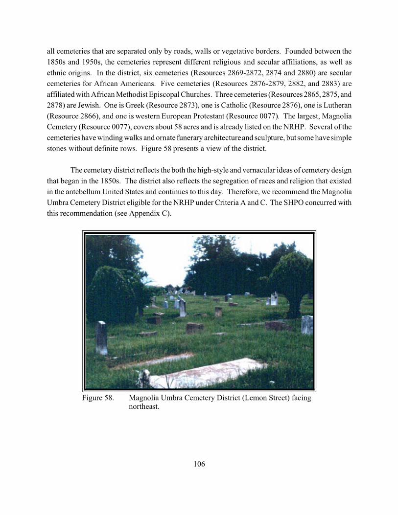
106
Figure 58. Magnolia Umbra Cemetery District (Lemon Street) facingnortheast.
all cemeteries that are separated only by roads, walls or vegetative borders. Founded between the
1850s and 1950s, the cemeteries represent different religious and secular affiliations, as well as
ethnic origins. In the district, six cemeteries (Resources 2869-2872, 2874 and 2880) are secular
cemeteries for African Americans. Five cemeteries (Resources 2876-2879, 2882, and 2883) are
affiliated with African Methodist Episcopal Churches. Three cemeteries (Resources 2865, 2875, and
2878) are Jewish. One is Greek (Resource 2873), one is Catholic (Resource 2876), one is Lutheran
(Resource 2866), and one is western European Protestant (Resource 0077). The largest, Magnolia
Cemetery (Resource 0077), covers about 58 acres and is already listed on the NRHP. Several of the
cemeteries have winding walks and ornate funerary architecture and sculpture, but some have simple
stones without definite rows. Figure 58 presents a view of the district.
The cemetery district reflects the both the high-style and vernacular ideas of cemetery design
that began in the 1850s. The district also reflects the segregation of races and religion that existed
in the antebellum United States and continues to this day. Therefore, we recommend the Magnolia
Umbra Cemetery District eligible for the NRHP under Criteria A and C. The SHPO concurred with
this recommendation (see Appendix C).
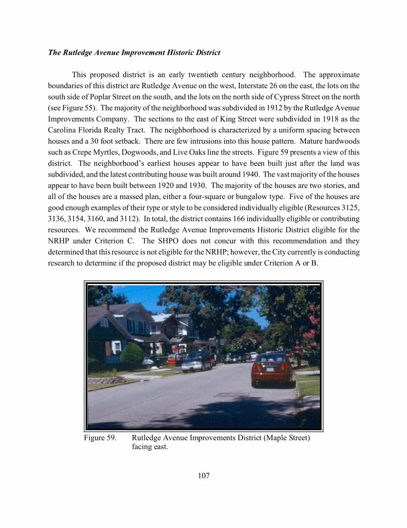
107
Figure 59. Rutledge Avenue Improvements District (Maple Street)facing east.
The Rutledge Avenue Improvement Historic District
This proposed district is an early twentieth century neighborhood. The approximate
boundaries of this district are Rutledge Avenue on the west, Interstate 26 on the east, the lots on the
south side of Poplar Street on the south, and the lots on the north side of Cypress Street on the north
(see Figure 55). The majority of the neighborhood was subdivided in 1912 by the Rutledge Avenue
Improvements Company. The sections to the east of King Street were subdivided in 1918 as the
Carolina Florida Realty Tract. The neighborhood is characterized by a uniform spacing between
houses and a 30 foot setback. There are few intrusions into this house pattern. Mature hardwoods
such as Crepe Myrtles, Dogwoods, and Live Oaks line the streets. Figure 59 presents a view of this
district. The neighborhood’s earliest houses appear to have been built just after the land was
subdivided, and the latest contributing house was built around 1940. The vast majority of the houses
appear to have been built between 1920 and 1930. The majority of the houses are two stories, and
all of the houses are a massed plan, either a four-square or bungalow type. Five of the houses are
good enough examples of their type or style to be considered individually eligible (Resources 3125,
3136, 3154, 3160, and 3112). In total, the district contains 166 individually eligible or contributing
resources. We recommend the Rutledge Avenue Improvements Historic District eligible for the
NRHP under Criterion C. The SHPO does not concur with this recommendation and they
determined that this resource is not eligible for the NRHP; however, the City currently is conducting
research to determine if the proposed district may be eligible under Criterion A or B.
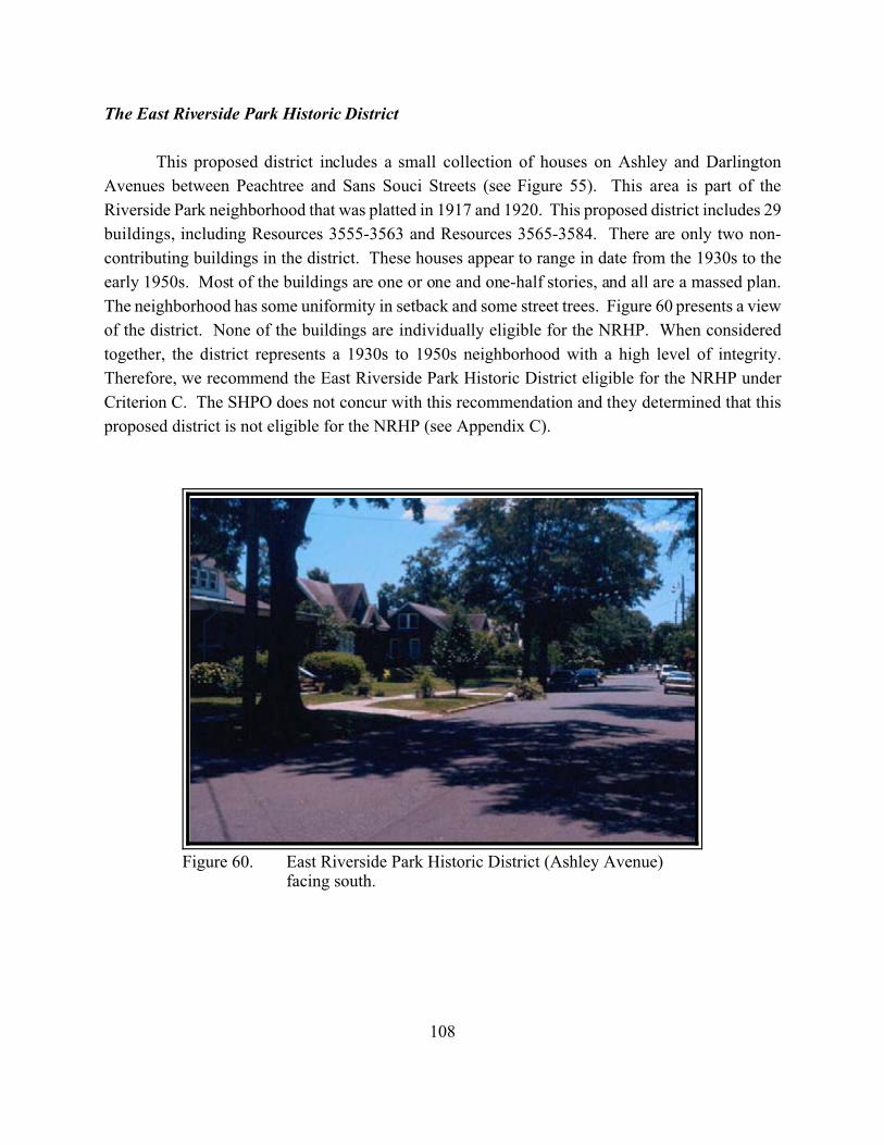
108
Figure 60. East Riverside Park Historic District (Ashley Avenue)facing south.
The East Riverside Park Historic District
This proposed district includes a small collection of houses on Ashley and Darlington
Avenues between Peachtree and Sans Souci Streets (see Figure 55). This area is part of the
Riverside Park neighborhood that was platted in 1917 and 1920. This proposed district includes 29
buildings, including Resources 3555-3563 and Resources 3565-3584. There are only two non-
contributing buildings in the district. These houses appear to range in date from the 1930s to the
early 1950s. Most of the buildings are one or one and one-half stories, and all are a massed plan.
The neighborhood has some uniformity in setback and some street trees. Figure 60 presents a view
of the district. None of the buildings are individually eligible for the NRHP. When considered
together, the district represents a 1930s to 1950s neighborhood with a high level of integrity.
Therefore, we recommend the East Riverside Park Historic District eligible for the NRHP under
Criterion C. The SHPO does not concur with this recommendation and they determined that this
proposed district is not eligible for the NRHP (see Appendix C).
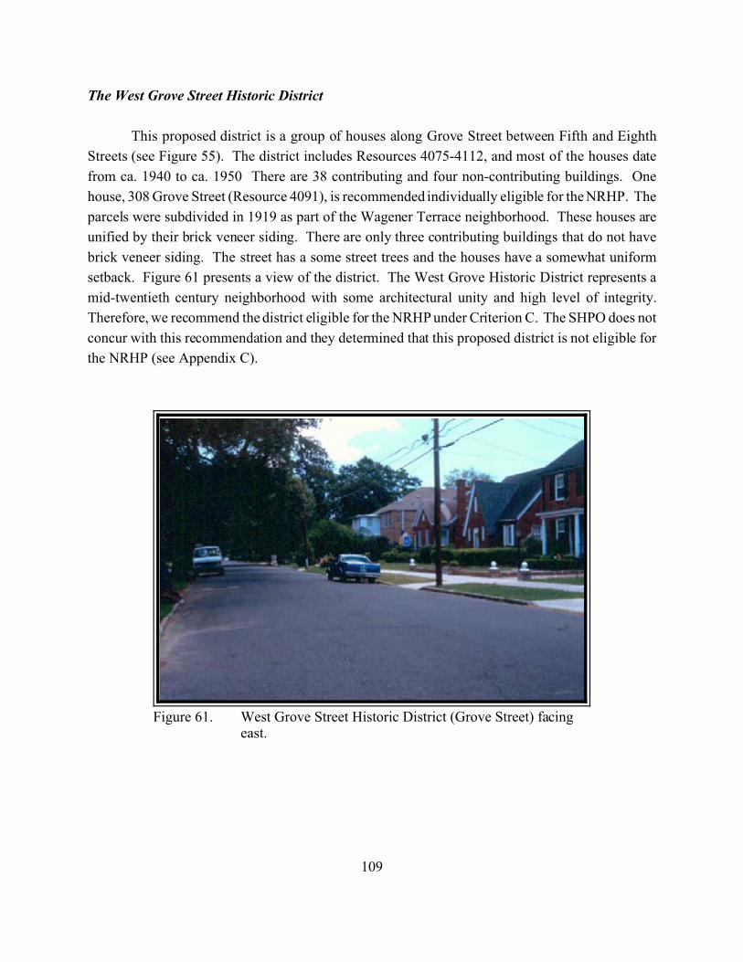
109
Figure 61. West Grove Street Historic District (Grove Street) facingeast.
The West Grove Street Historic District
This proposed district is a group of houses along Grove Street between Fifth and Eighth
Streets (see Figure 55). The district includes Resources 4075-4112, and most of the houses date
from ca. 1940 to ca. 1950 There are 38 contributing and four non-contributing buildings. One
house, 308 Grove Street (Resource 4091), is recommended individually eligible for the NRHP. The
parcels were subdivided in 1919 as part of the Wagener Terrace neighborhood. These houses are
unified by their brick veneer siding. There are only three contributing buildings that do not have
brick veneer siding. The street has a some street trees and the houses have a somewhat uniform
setback. Figure 61 presents a view of the district. The West Grove Historic District represents a
mid-twentieth century neighborhood with some architectural unity and high level of integrity.
Therefore, we recommend the district eligible for the NRHP under Criterion C. The SHPO does not
concur with this recommendation and they determined that this proposed district is not eligible for
the NRHP (see Appendix C).
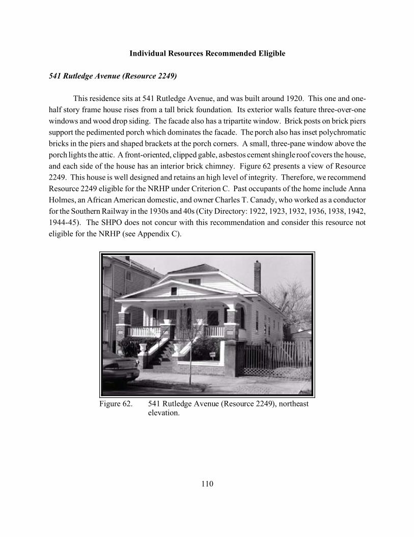
110
Figure 62. 541 Rutledge Avenue (Resource 2249), northeastelevation.
Individual Resources Recommended Eligible
541 Rutledge Avenue (Resource 2249)
This residence sits at 541 Rutledge Avenue, and was built around 1920. This one and one-
half story frame house rises from a tall brick foundation. Its exterior walls feature three-over-one
windows and wood drop siding. The facade also has a tripartite window. Brick posts on brick piers
support the pedimented porch which dominates the facade. The porch also has inset polychromatic
bricks in the piers and shaped brackets at the porch corners. A small, three-pane window above the
porch lights the attic. A front-oriented, clipped gable, asbestos cement shingle roof covers the house,
and each side of the house has an interior brick chimney. Figure 62 presents a view of Resource
2249. This house is well designed and retains an high level of integrity. Therefore, we recommend
Resource 2249 eligible for the NRHP under Criterion C. Past occupants of the home include Anna
Holmes, an African American domestic, and owner Charles T. Canady, who worked as a conductor
for the Southern Railway in the 1930s and 40s (City Directory: 1922, 1923, 1932, 1936, 1938, 1942,
1944-45). The SHPO does not concur with this recommendation and consider this resource not
eligible for the NRHP (see Appendix C).
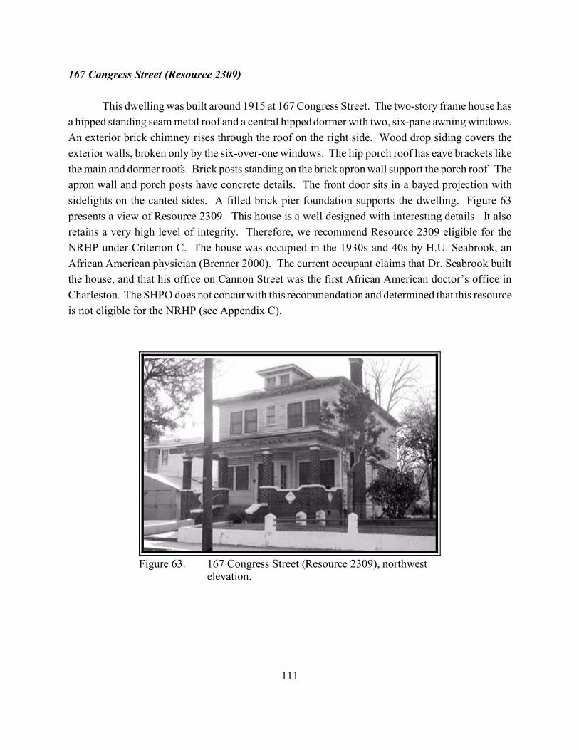
111
Figure 63. 167 Congress Street (Resource 2309), northwestelevation.
167 Congress Street (Resource 2309)
This dwelling was built around 1915 at 167 Congress Street. The two-story frame house has
a hipped standing seam metal roof and a central hipped dormer with two, six-pane awning windows.
An exterior brick chimney rises through the roof on the right side. Wood drop siding covers the
exterior walls, broken only by the six-over-one windows. The hip porch roof has eave brackets like
the main and dormer roofs. Brick posts standing on the brick apron wall support the porch roof. The
apron wall and porch posts have concrete details. The front door sits in a bayed projection with
sidelights on the canted sides. A filled brick pier foundation supports the dwelling. Figure 63
presents a view of Resource 2309. This house is a well designed with interesting details. It also
retains a very high level of integrity. Therefore, we recommend Resource 2309 eligible for the
NRHP under Criterion C. The house was occupied in the 1930s and 40s by H.U. Seabrook, an
African American physician (Brenner 2000). The current occupant claims that Dr. Seabrook built
the house, and that his office on Cannon Street was the first African American doctor’s office in
Charleston. The SHPO does not concur with this recommendation and determined that this resource
is not eligible for the NRHP (see Appendix C).
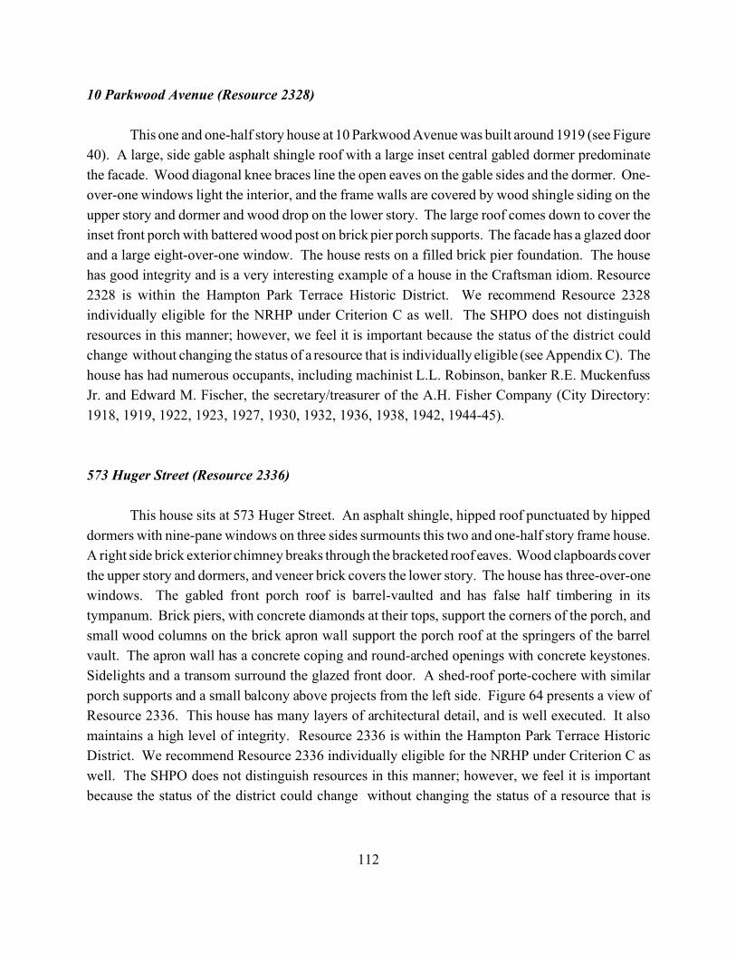
112
10 Parkwood Avenue (Resource 2328)
This one and one-half story house at 10 Parkwood Avenue was built around 1919 (see Figure
40). A large, side gable asphalt shingle roof with a large inset central gabled dormer predominate
the facade. Wood diagonal knee braces line the open eaves on the gable sides and the dormer. One-
over-one windows light the interior, and the frame walls are covered by wood shingle siding on the
upper story and dormer and wood drop on the lower story. The large roof comes down to cover the
inset front porch with battered wood post on brick pier porch supports. The facade has a glazed door
and a large eight-over-one window. The house rests on a filled brick pier foundation. The house
has good integrity and is a very interesting example of a house in the Craftsman idiom. Resource
2328 is within the Hampton Park Terrace Historic District. We recommend Resource 2328
individually eligible for the NRHP under Criterion C as well. The SHPO does not distinguish
resources in this manner; however, we feel it is important because the status of the district could
change without changing the status of a resource that is individually eligible (see Appendix C). The
house has had numerous occupants, including machinist L.L. Robinson, banker R.E. Muckenfuss
Jr. and Edward M. Fischer, the secretary/treasurer of the A.H. Fisher Company (City Directory:
1918, 1919, 1922, 1923, 1927, 1930, 1932, 1936, 1938, 1942, 1944-45).
573 Huger Street (Resource 2336)
This house sits at 573 Huger Street. An asphalt shingle, hipped roof punctuated by hipped
dormers with nine-pane windows on three sides surmounts this two and one-half story frame house.
A right side brick exterior chimney breaks through the bracketed roof eaves. Wood clapboards cover
the upper story and dormers, and veneer brick covers the lower story. The house has three-over-one
windows. The gabled front porch roof is barrel-vaulted and has false half timbering in its
tympanum. Brick piers, with concrete diamonds at their tops, support the corners of the porch, and
small wood columns on the brick apron wall support the porch roof at the springers of the barrel
vault. The apron wall has a concrete coping and round-arched openings with concrete keystones.
Sidelights and a transom surround the glazed front door. A shed-roof porte-cochere with similar
porch supports and a small balcony above projects from the left side. Figure 64 presents a view of
Resource 2336. This house has many layers of architectural detail, and is well executed. It also
maintains a high level of integrity. Resource 2336 is within the Hampton Park Terrace Historic
District. We recommend Resource 2336 individually eligible for the NRHP under Criterion C as
well. The SHPO does not distinguish resources in this manner; however, we feel it is important
because the status of the district could change without changing the status of a resource that is
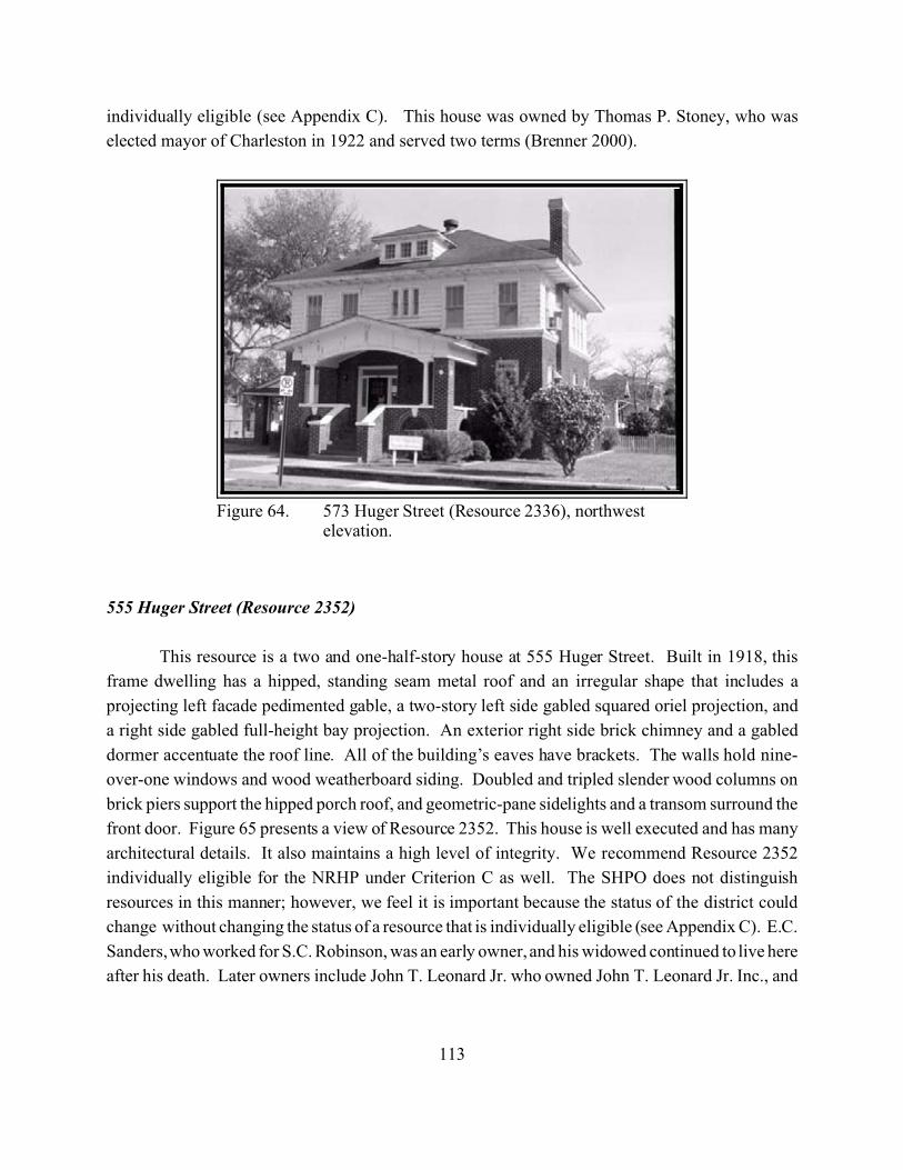
113
Figure 64. 573 Huger Street (Resource 2336), northwestelevation.
individually eligible (see Appendix C). This house was owned by Thomas P. Stoney, who was
elected mayor of Charleston in 1922 and served two terms (Brenner 2000).
555 Huger Street (Resource 2352)
This resource is a two and one-half-story house at 555 Huger Street. Built in 1918, this
frame dwelling has a hipped, standing seam metal roof and an irregular shape that includes a
projecting left facade pedimented gable, a two-story left side gabled squared oriel projection, and
a right side gabled full-height bay projection. An exterior right side brick chimney and a gabled
dormer accentuate the roof line. All of the building’s eaves have brackets. The walls hold nine-
over-one windows and wood weatherboard siding. Doubled and tripled slender wood columns on
brick piers support the hipped porch roof, and geometric-pane sidelights and a transom surround the
front door. Figure 65 presents a view of Resource 2352. This house is well executed and has many
architectural details. It also maintains a high level of integrity. We recommend Resource 2352
individually eligible for the NRHP under Criterion C as well. The SHPO does not distinguish
resources in this manner; however, we feel it is important because the status of the district could
change without changing the status of a resource that is individually eligible (see Appendix C). E.C.
Sanders, who worked for S.C. Robinson, was an early owner, and his widowed continued to live here
after his death. Later owners include John T. Leonard Jr. who owned John T. Leonard Jr. Inc., and
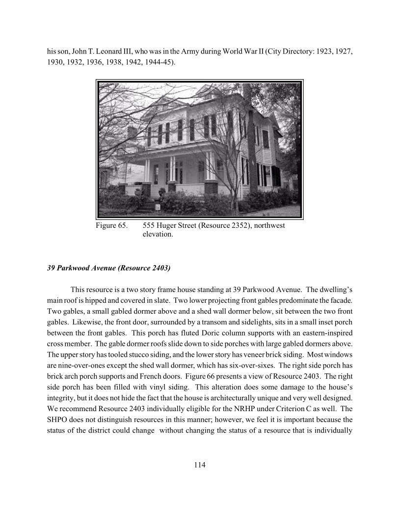
114
Figure 65. 555 Huger Street (Resource 2352), northwestelevation.
his son, John T. Leonard III, who was in the Army during World War II (City Directory: 1923, 1927,
1930, 1932, 1936, 1938, 1942, 1944-45).
39 Parkwood Avenue (Resource 2403)
This resource is a two story frame house standing at 39 Parkwood Avenue. The dwelling’s
main roof is hipped and covered in slate. Two lower projecting front gables predominate the facade.
Two gables, a small gabled dormer above and a shed wall dormer below, sit between the two front
gables. Likewise, the front door, surrounded by a transom and sidelights, sits in a small inset porch
between the front gables. This porch has fluted Doric column supports with an eastern-inspired
cross member. The gable dormer roofs slide down to side porches with large gabled dormers above.
The upper story has tooled stucco siding, and the lower story has veneer brick siding. Most windows
are nine-over-ones except the shed wall dormer, which has six-over-sixes. The right side porch has
brick arch porch supports and French doors. Figure 66 presents a view of Resource 2403. The right
side porch has been filled with vinyl siding. This alteration does some damage to the house’s
integrity, but it does not hide the fact that the house is architecturally unique and very well designed.
We recommend Resource 2403 individually eligible for the NRHP under Criterion C as well. The
SHPO does not distinguish resources in this manner; however, we feel it is important because the
status of the district could change without changing the status of a resource that is individually
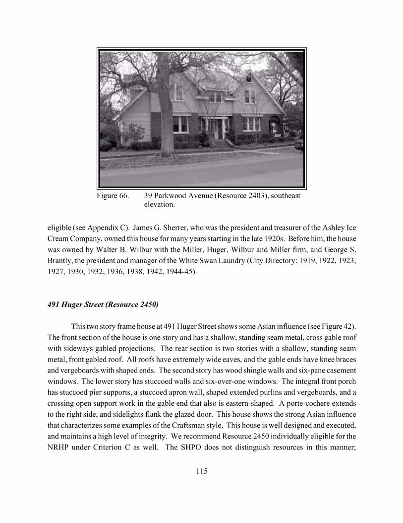
115
Figure 66. 39 Parkwood Avenue (Resource 2403), southeastelevation.
eligible (see Appendix C). James G. Sherrer, who was the president and treasurer of the Ashley Ice
Cream Company, owned this house for many years starting in the late 1920s. Before him, the house
was owned by Walter B. Wilbur with the Miller, Huger, Wilbur and Miller firm, and George S.
Brantly, the president and manager of the White Swan Laundry (City Directory: 1919, 1922, 1923,
1927, 1930, 1932, 1936, 1938, 1942, 1944-45).
491 Huger Street (Resource 2450)
This two story frame house at 491 Huger Street shows some Asian influence (see Figure 42).
The front section of the house is one story and has a shallow, standing seam metal, cross gable roof
with sideways gabled projections. The rear section is two stories with a shallow, standing seam
metal, front gabled roof. All roofs have extremely wide eaves, and the gable ends have knee braces
and vergeboards with shaped ends. The second story has wood shingle walls and six-pane casement
windows. The lower story has stuccoed walls and six-over-one windows. The integral front porch
has stuccoed pier supports, a stuccoed apron wall, shaped extended purlins and vergeboards, and a
crossing open support work in the gable end that also is eastern-shaped. A porte-cochere extends
to the right side, and sidelights flank the glazed door. This house shows the strong Asian influence
that characterizes some examples of the Craftsman style. This house is well designed and executed,
and maintains a high level of integrity. We recommend Resource 2450 individually eligible for the
NRHP under Criterion C as well. The SHPO does not distinguish resources in this manner;
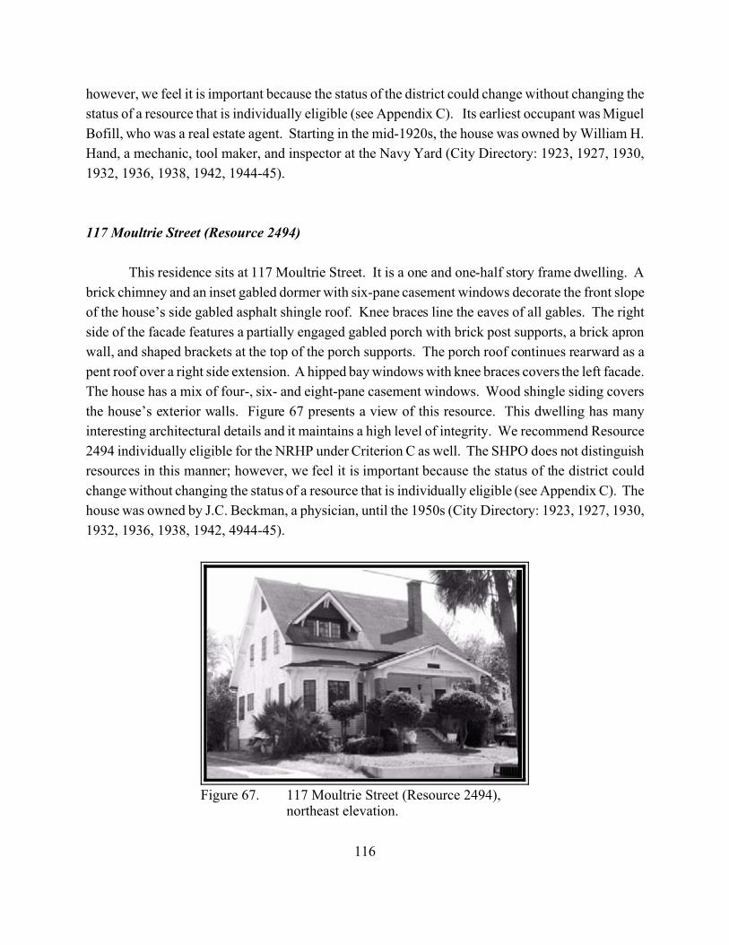
116
Figure 67. 117 Moultrie Street (Resource 2494),northeast elevation.
however, we feel it is important because the status of the district could change without changing the
status of a resource that is individually eligible (see Appendix C). Its earliest occupant was Miguel
Bofill, who was a real estate agent. Starting in the mid-1920s, the house was owned by William H.
Hand, a mechanic, tool maker, and inspector at the Navy Yard (City Directory: 1923, 1927, 1930,
1932, 1936, 1938, 1942, 1944-45).
117 Moultrie Street (Resource 2494)
This residence sits at 117 Moultrie Street. It is a one and one-half story frame dwelling. A
brick chimney and an inset gabled dormer with six-pane casement windows decorate the front slope
of the house’s side gabled asphalt shingle roof. Knee braces line the eaves of all gables. The right
side of the facade features a partially engaged gabled porch with brick post supports, a brick apron
wall, and shaped brackets at the top of the porch supports. The porch roof continues rearward as a
pent roof over a right side extension. A hipped bay windows with knee braces covers the left facade.
The house has a mix of four-, six- and eight-pane casement windows. Wood shingle siding covers
the house’s exterior walls. Figure 67 presents a view of this resource. This dwelling has many
interesting architectural details and it maintains a high level of integrity. We recommend Resource
2494 individually eligible for the NRHP under Criterion C as well. The SHPO does not distinguish
resources in this manner; however, we feel it is important because the status of the district could
change without changing the status of a resource that is individually eligible (see Appendix C). The
house was owned by J.C. Beckman, a physician, until the 1950s (City Directory: 1923, 1927, 1930,
1932, 1936, 1938, 1942, 4944-45).
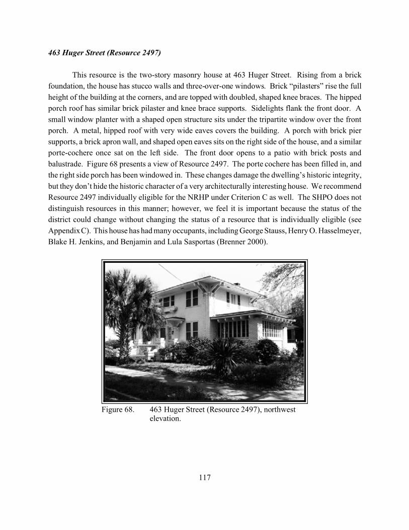
117
Figure 68. 463 Huger Street (Resource 2497), northwestelevation.
463 Huger Street (Resource 2497)
This resource is the two-story masonry house at 463 Huger Street. Rising from a brick
foundation, the house has stucco walls and three-over-one windows. Brick “pilasters” rise the full
height of the building at the corners, and are topped with doubled, shaped knee braces. The hipped
porch roof has similar brick pilaster and knee brace supports. Sidelights flank the front door. A
small window planter with a shaped open structure sits under the tripartite window over the front
porch. A metal, hipped roof with very wide eaves covers the building. A porch with brick pier
supports, a brick apron wall, and shaped open eaves sits on the right side of the house, and a similar
porte-cochere once sat on the left side. The front door opens to a patio with brick posts and
balustrade. Figure 68 presents a view of Resource 2497. The porte cochere has been filled in, and
the right side porch has been windowed in. These changes damage the dwelling’s historic integrity,
but they don’t hide the historic character of a very architecturally interesting house. We recommend
Resource 2497 individually eligible for the NRHP under Criterion C as well. The SHPO does not
distinguish resources in this manner; however, we feel it is important because the status of the
district could change without changing the status of a resource that is individually eligible (see
Appendix C). This house has had many occupants, including George Stauss, Henry O. Hasselmeyer,
Blake H. Jenkins, and Benjamin and Lula Sasportas (Brenner 2000).
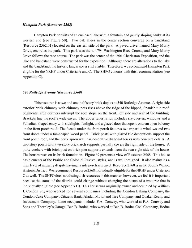
118
Hampton Park (Resource 2562)
Hampton Park consists of an enclosed lake with a fountain and gently sloping banks at its
western end (see Figure 50). Two oak allees in the center section converge on a bandstand
(Resource 2562.01) located on the eastern side of the park. A paved drive, named Mary Murry
Drive, encircles the park. This park was the c. 1794 Washington Race Course, and Mary Murry
Drive follows the race course. The park was the center of the 1901 Charleston Exposition, and the
lake and bandstand were constructed for the exposition. Although there are alterations to the lake
and the bandstand, the historic landscape is still visible. Therefore, we recommend Hampton Park
eligible for the NRHP under Criteria A and C. The SHPO concurs with this recommendation (see
Appendix C).
540 Rutledge Avenue (Resource 2568)
This resource is a two and one-half story brick duplex at 540 Rutledge Avenue. A right side
exterior brick chimney with chimney pots rises above the ridge of the hipped, Spanish tile roof.
Segmental arch dormers interrupt the roof slope on the front, left side and rear of the building.
Brackets line the roof’s wide eaves. The upper fenestration includes six-over-six windows and a
Palladian-shaped entry with sidelights, fanlight, and a glazed door that opens onto an open balcony
on the front porch roof. The facade under the front porch features two tripartite windows and two
front doors under a fan-shaped wood panel. Brick posts with glazed tile decorations support the
front porch roof, and the brick apron wall has decorative diagonal bricks with concrete details. A
two-story porch with two-story brick arch supports partially covers the right side of the house. A
porte-cochere with brick post on brick pier supports extends from the rear right side of the house.
The houses rests on its brick foundation. Figure 69 presents a view of Resource 2568. This house
has elements of the Prairie and Colonial Revival styles, and is well designed. It also maintains a
high level of integrity despite having its side porch screened. Resource 2568 is in the Sophia Wilson
Historic District. We recommend Resource 2568 individually eligible for the NRHP under Criterion
C as well. The SHPO does not distinguish resources in this manner; however, we feel it is important
because the status of the district could change without changing the status of a resource that is
individually eligible (see Appendix C). This house was originally owned and occupied by William
J. Condon Sr., who worked for several companies including the Condon Baking Company, the
Condon Cake Company, Citizens Bank, Aladan Motor and Tire Company, and Quaker Realty and
Investment Company. Later occupants include: F.A. Conway, who worked at F.A. Conway and
Sons and Thornley’s Garage; Ben B. Bodne, who worked at Ben B. Bodne Coal Company, Bodne
119
Figure 69. 540 Rutledge Avenue (Resource 2568),northwest elevation.
and Sons Service Station, and Bodne’s Truck Terminal; Isadore Lesser, who worked at I. Lesser and
Company and Lesser’s Credit Jewelry; and Arthur B. Foreman who was in the US Army (City
Directory: 1922, 1923, 1927, 1930, 1936, 1938, 1942, 1944-45).
90 Fishburne Street (Resource 2624)
This dwelling, built around 1890, sits at 90 Fishburne Street (see Figure 35). Its two-story
frame rises from a filled brick pier foundation. The front porch wraps around the left side of the
house and features turned post supports, a turned balustrade and a frieze consisting of jig-sawn
shamrock designs at the posts and a beaded spandrel between. The facade has two-over-two
windows and a transom and sidelights bordering the glazed double entry doors. A leaded, stained
glass window on the dwelling’s right side lights the room behind the entry doors. Another porch sits
above the main porch on the left side of the house. A front gabled, standing seam metal roof with
cornice returns and a right slope brick chimney surmounts the house. This house is a good example
of a vernacular house type with Victorian wood detailing. Its details are intact and it retains a high
level of integrity. Resource 2624 is located in the Sophia Wilson Historic District. We recommend
Resource 2568 individually eligible for the NRHP under Criterion C as well. The SHPO does not
distinguish resources in this manner; however, we feel it is important because the status of the
district could change without changing the status of a resource that is individually eligible (see
Appendix C). This house appears to have been rented for many years and has had many past
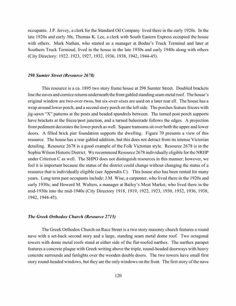
120
occupants. J.P. Jervey, a clerk for the Standard Oil Company lived there in the early 1920s. In the
late 1920s and early 30s, Thomas K. Lee, a clerk with South Eastern Express occupied the house
with others. Mark Nathan, who started as a manager at Bodne’s Truck Terminal and later at
Southern Truck Terminal, lived in the house in the late 1930s and early 1940s along with others
(City Directory: 1922. 1923, 1927, 1932, 1936, 1938, 1942, 1944-45).
298 Sumter Street (Resource 2678)
This resource is a ca. 1895 two story frame house at 298 Sumter Street. Doubled brackets
line the eaves and cornice returns underneath the front gabled standing seam metal roof. The house’s
original window are two-over-twos, but six-over-sixes are used on a later rear ell. The house has a
wrap around lower porch, and a second story porch on the left side. The porches feature friezes with
jig-sawn “X” patterns at the posts and beaded spandrels between. The turned post porch supports
have brackets at the frieze/post junction, and a turned balustrade follows the edges. A projection
front pediment decorates the lower porch as well. Square transoms sit over both the upper and lower
doors. A filled brick pier foundation supports the dwelling. Figure 70 presents a view of this
resource. The house has a rear gabled addition, but this does not detract from its intense Victorian
detailing. Resource 2678 is a good example of the Folk Victorian style. Resource 2678 is in the
Sophia Wilson Historic District. We recommend Resource 2678 individually eligible for the NRHP
under Criterion C as well. The SHPO does not distinguish resources in this manner; however, we
feel it is important because the status of the district could change without changing the status of a
resource that is individually eligible (see Appendix C). This house also has been rented for many
years. Long term past occupants include: J.M. Wise, a carpenter, who lived there in the 1920s and
early 1930s; and Howard M. Walters, a manager at Bailey’s Meat Market, who lived there in the
mid-1930s into the mid-1940s (City Directory 1918, 1919, 1922, 1923, 1930, 1932, 1936, 1938,
1942, 1944-45).
The Greek Orthodox Church (Resource 2715)
The Greek Orthodox Church on Race Street is a two story masonry church features a round
nave with a set-back second story and a large, standing seam metal dome roof. Two octagonal
towers with dome metal roofs stand at either side of the flat-roofed narthex. The narthex parapet
features a concrete plaque with Greek writing above the triple, round-headed doorways with heavy
concrete surrounds and fanlights over the wooden double doors. The two towers have small first
story round-headed windows, but they are the only windows on the front. The first story of the nave
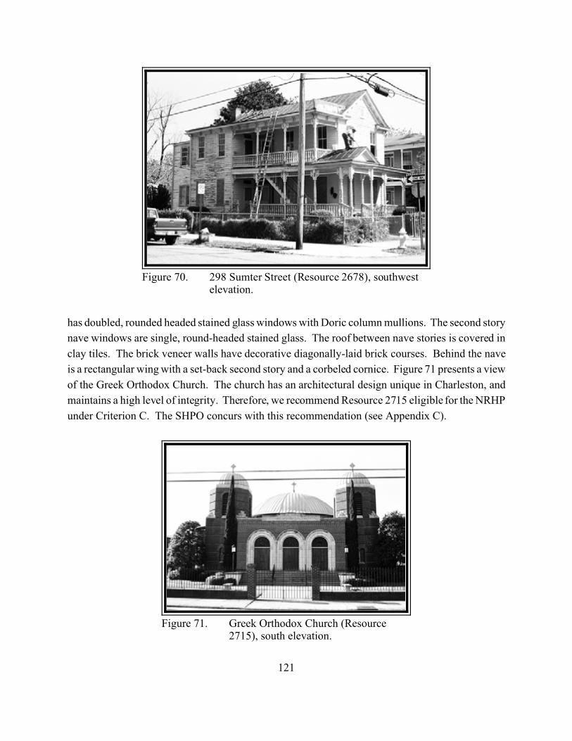
121
Figure 70. 298 Sumter Street (Resource 2678), southwestelevation.
Figure 71. Greek Orthodox Church (Resource2715), south elevation.
has doubled, rounded headed stained glass windows with Doric column mullions. The second story
nave windows are single, round-headed stained glass. The roof between nave stories is covered in
clay tiles. The brick veneer walls have decorative diagonally-laid brick courses. Behind the nave
is a rectangular wing with a set-back second story and a corbeled cornice. Figure 71 presents a view
of the Greek Orthodox Church. The church has an architectural design unique in Charleston, and
maintains a high level of integrity. Therefore, we recommend Resource 2715 eligible for the NRHP
under Criterion C. The SHPO concurs with this recommendation (see Appendix C).
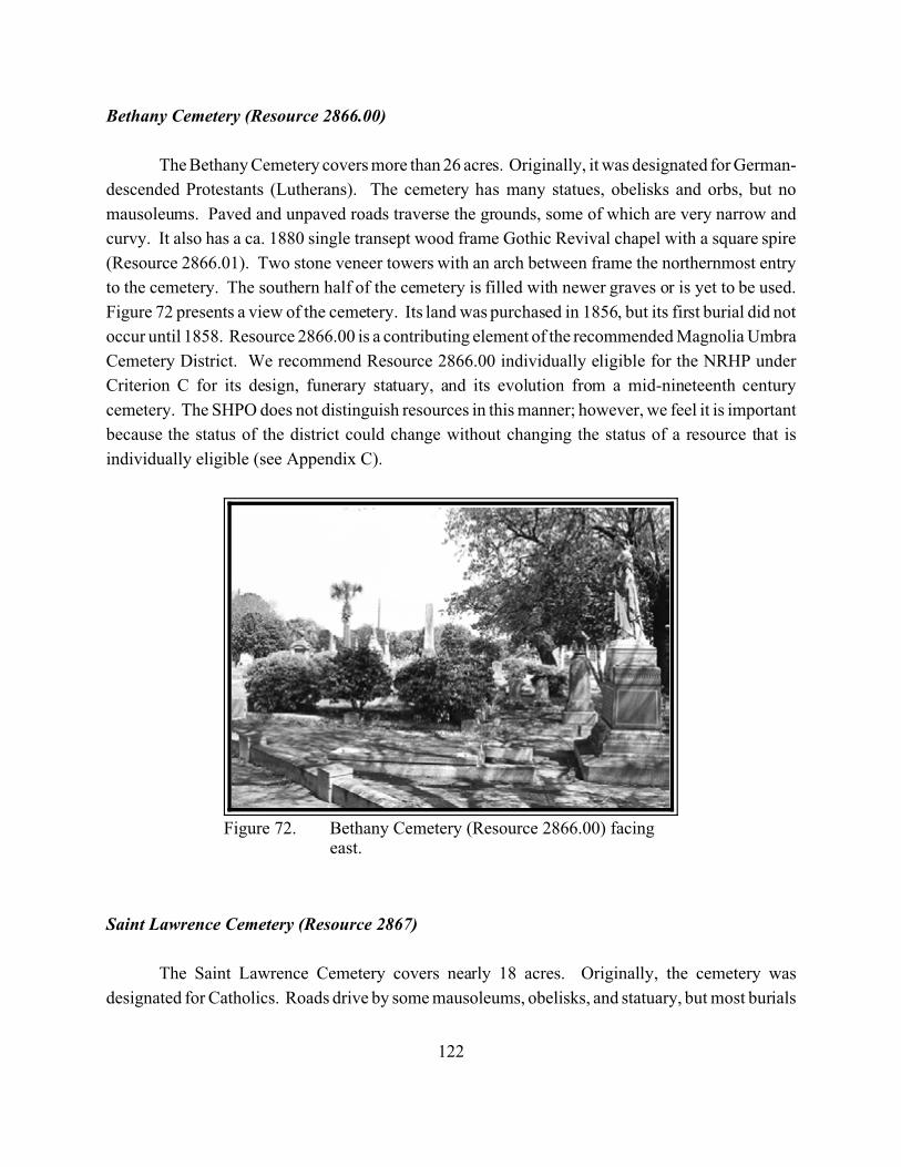
122
Figure 72. Bethany Cemetery (Resource 2866.00) facingeast.
Bethany Cemetery (Resource 2866.00)
The Bethany Cemetery covers more than 26 acres. Originally, it was designated for German-
descended Protestants (Lutherans). The cemetery has many statues, obelisks and orbs, but no
mausoleums. Paved and unpaved roads traverse the grounds, some of which are very narrow and
curvy. It also has a ca. 1880 single transept wood frame Gothic Revival chapel with a square spire
(Resource 2866.01). Two stone veneer towers with an arch between frame the northernmost entry
to the cemetery. The southern half of the cemetery is filled with newer graves or is yet to be used.
Figure 72 presents a view of the cemetery. Its land was purchased in 1856, but its first burial did not
occur until 1858. Resource 2866.00 is a contributing element of the recommended Magnolia Umbra
Cemetery District. We recommend Resource 2866.00 individually eligible for the NRHP under
Criterion C for its design, funerary statuary, and its evolution from a mid-nineteenth century
cemetery. The SHPO does not distinguish resources in this manner; however, we feel it is important
because the status of the district could change without changing the status of a resource that is
individually eligible (see Appendix C).
Saint Lawrence Cemetery (Resource 2867)
The Saint Lawrence Cemetery covers nearly 18 acres. Originally, the cemetery was
designated for Catholics. Roads drive by some mausoleums, obelisks, and statuary, but most burials
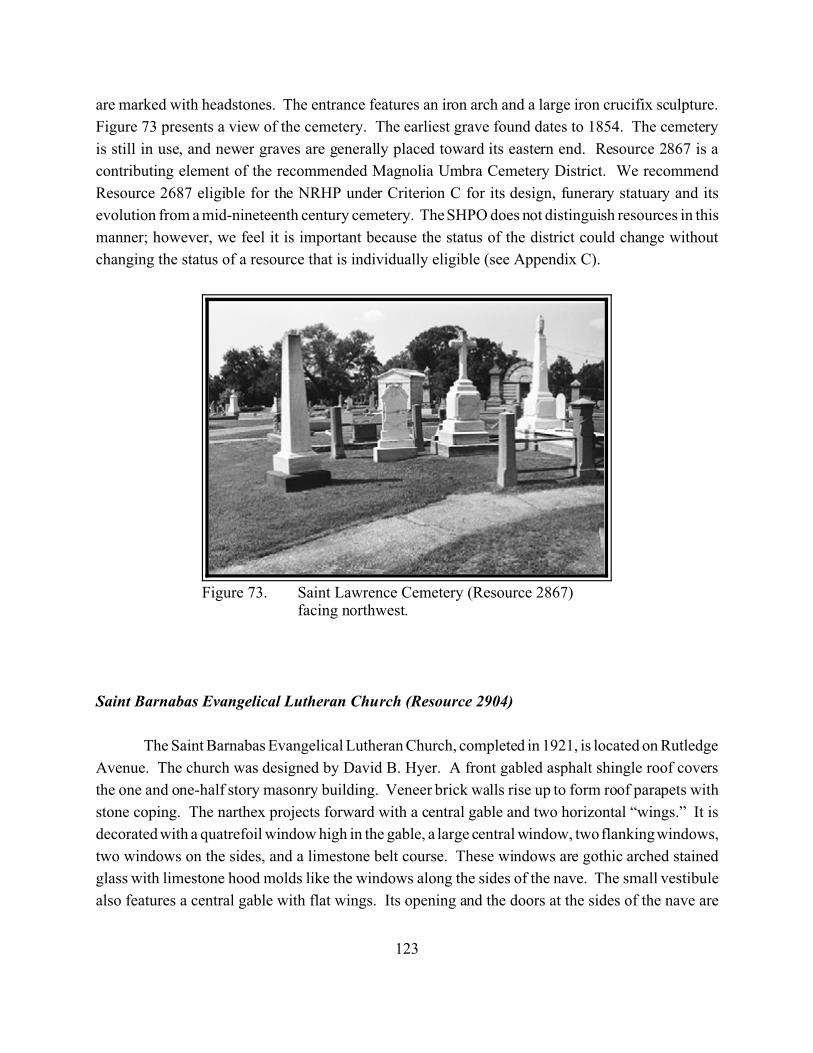
123
Figure 73. Saint Lawrence Cemetery (Resource 2867)facing northwest.
are marked with headstones. The entrance features an iron arch and a large iron crucifix sculpture.
Figure 73 presents a view of the cemetery. The earliest grave found dates to 1854. The cemetery
is still in use, and newer graves are generally placed toward its eastern end. Resource 2867 is a
contributing element of the recommended Magnolia Umbra Cemetery District. We recommend
Resource 2687 eligible for the NRHP under Criterion C for its design, funerary statuary and its
evolution from a mid-nineteenth century cemetery. The SHPO does not distinguish resources in this
manner; however, we feel it is important because the status of the district could change without
changing the status of a resource that is individually eligible (see Appendix C).
Saint Barnabas Evangelical Lutheran Church (Resource 2904)
The Saint Barnabas Evangelical Lutheran Church, completed in 1921, is located on Rutledge
Avenue. The church was designed by David B. Hyer. A front gabled asphalt shingle roof covers
the one and one-half story masonry building. Veneer brick walls rise up to form roof parapets with
stone coping. The narthex projects forward with a central gable and two horizontal “wings.” It is
decorated with a quatrefoil window high in the gable, a large central window, two flanking windows,
two windows on the sides, and a limestone belt course. These windows are gothic arched stained
glass with limestone hood molds like the windows along the sides of the nave. The small vestibule
also features a central gable with flat wings. Its opening and the doors at the sides of the nave are
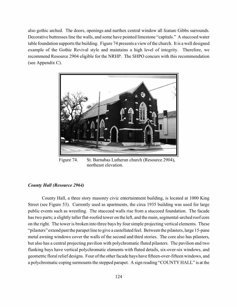
124
Figure 74. St. Barnabas Lutheran church (Resource 2904),northeast elevation.
also gothic arched. The doors, openings and narthex central window all feature Gibbs surrounds.
Decorative buttresses line the walls, and some have pointed limestone “capitals.” A stuccoed water
table foundation supports the building. Figure 74 presents a view of the church. It is a well designed
example of the Gothic Revival style and maintains a high level of integrity. Therefore, we
recommend Resource 2904 eligible for the NRHP. The SHPO concurs with this recommendation
(see Appendix C).
County Hall (Resource 2964)
County Hall, a three story masonry civic entertainment building, is located at 1000 King
Street (see Figure 53). Currently used as apartments, the circa 1935 building was used for large
public events such as wrestling. The stuccoed walls rise from a stuccoed foundation. The facade
has two parts; a slightly taller flat-roofed tower on the left, and the main, segmental-arched roof core
on the right. The tower is broken into three bays by four simple projecting vertical elements. These
“pilasters” extend past the parapet line to give a castellated feel. Between the pilasters, large 15-pane
metal awning windows cover the walls of the second and third stories. The core also has pilasters,
but also has a central projecting pavilion with polychromatic fluted pilasters. The pavilion and two
flanking bays have vertical polychromatic elements with fluted details, six-over-six windows, and
geometric floral relief designs. Four of the other facade bays have fifteen-over-fifteen windows, and
a polychromatic coping surmounts the stepped parapet. A sign reading “COUNTY HALL” is at the
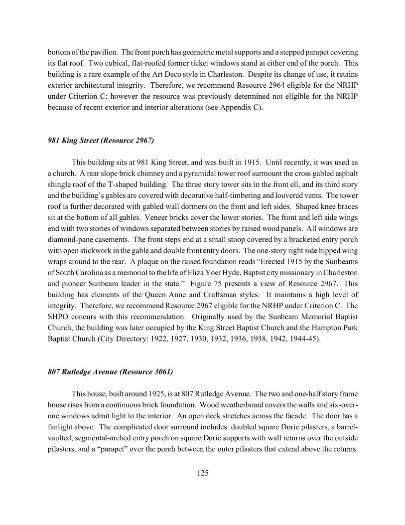
125
bottom of the pavilion. The front porch has geometric metal supports and a stepped parapet covering
its flat roof. Two cubical, flat-roofed former ticket windows stand at either end of the porch. This
building is a rare example of the Art Deco style in Charleston. Despite its change of use, it retains
exterior architectural integrity. Therefore, we recommend Resource 2964 eligible for the NRHP
under Criterion C; however the resource was previously determined not eligible for the NRHP
because of recent exterior and interior alterations (see Appendix C).
981 King Street (Resource 2967)
This building sits at 981 King Street, and was built in 1915. Until recently, it was used as
a church. A rear slope brick chimney and a pyramidal tower roof surmount the cross gabled asphalt
shingle roof of the T-shaped building. The three story tower sits in the front ell, and its third story
and the building’s gables are covered with decorative half-timbering and louvered vents. The tower
roof is further decorated with gabled wall dormers on the front and left sides. Shaped knee braces
sit at the bottom of all gables. Veneer bricks cover the lower stories. The front and left side wings
end with two stories of windows separated between stories by raised wood panels. All windows are
diamond-pane casements. The front steps end at a small stoop covered by a bracketed entry porch
with open stickwork in the gable and double front entry doors. The one-story right side hipped wing
wraps around to the rear. A plaque on the raised foundation reads “Erected 1915 by the Sunbeams
of South Carolina as a memorial to the life of Eliza Yoer Hyde, Baptist city missionary in Charleston
and pioneer Sunbeam leader in the state.” Figure 75 presents a view of Resource 2967. This
building has elements of the Queen Anne and Craftsman styles. It maintains a high level of
integrity. Therefore, we recommend Resource 2967 eligible for the NRHP under Criterion C. The
SHPO concurs with this recommendation. Originally used by the Sunbeam Memorial Baptist
Church, the building was later occupied by the King Street Baptist Church and the Hampton Park
Baptist Church (City Directory: 1922, 1927, 1930, 1932, 1936, 1938, 1942, 1944-45).
807 Rutledge Avenue (Resource 3061)
This house, built around 1925, is at 807 Rutledge Avenue. The two and one-half story frame
house rises from a continuous brick foundation. Wood weatherboard covers the walls and six-over-
one windows admit light to the interior. An open deck stretches across the facade. The door has a
fanlight above. The complicated door surround includes: doubled square Doric pilasters, a barrel-
vaulted, segmental-arched entry porch on square Doric supports with wall returns over the outside
pilasters, and a “parapet” over the porch between the outer pilasters that extend above the returns.
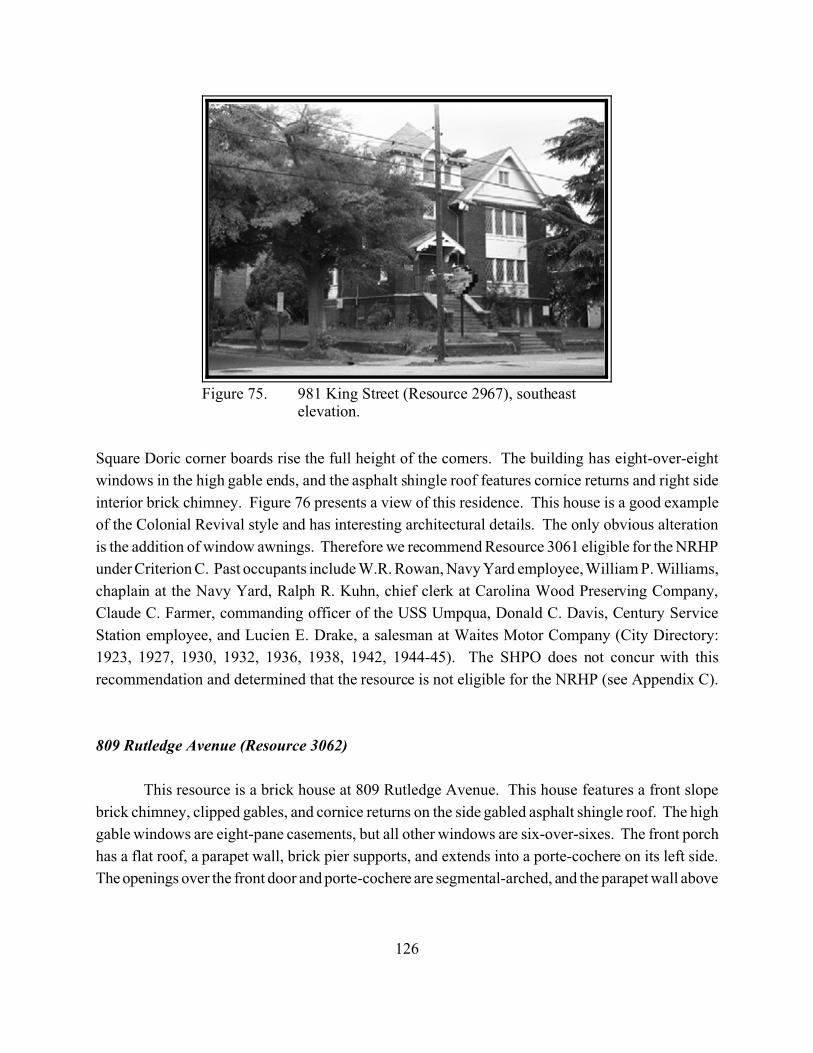
126
Figure 75. 981 King Street (Resource 2967), southeastelevation.
Square Doric corner boards rise the full height of the corners. The building has eight-over-eight
windows in the high gable ends, and the asphalt shingle roof features cornice returns and right side
interior brick chimney. Figure 76 presents a view of this residence. This house is a good example
of the Colonial Revival style and has interesting architectural details. The only obvious alteration
is the addition of window awnings. Therefore we recommend Resource 3061 eligible for the NRHP
under Criterion C. Past occupants include W.R. Rowan, Navy Yard employee, William P. Williams,
chaplain at the Navy Yard, Ralph R. Kuhn, chief clerk at Carolina Wood Preserving Company,
Claude C. Farmer, commanding officer of the USS Umpqua, Donald C. Davis, Century Service
Station employee, and Lucien E. Drake, a salesman at Waites Motor Company (City Directory:
1923, 1927, 1930, 1932, 1936, 1938, 1942, 1944-45). The SHPO does not concur with this
recommendation and determined that the resource is not eligible for the NRHP (see Appendix C).
809 Rutledge Avenue (Resource 3062)
This resource is a brick house at 809 Rutledge Avenue. This house features a front slope
brick chimney, clipped gables, and cornice returns on the side gabled asphalt shingle roof. The high
gable windows are eight-pane casements, but all other windows are six-over-sixes. The front porch
has a flat roof, a parapet wall, brick pier supports, and extends into a porte-cochere on its left side.
The openings over the front door and porte-cochere are segmental-arched, and the parapet wall above
127
Figure 76. 807 Rutledge Avenue (Resource 3061), eastelevation.
is topped with concrete “pediments.” Wood Greek key patterns are set in the parapet wall between
the segmental openings. The fanlight tops the glazed front door and the sidelights. Figure 77
presents a view of this residence. Because it maintains a high level of integrity and its unique
interpretations on Colonial Revival detailing, we recommend Resource 3062 eligible for the NRHP
under Criterion C. J.T. Baugh, a crane engineer at Consumers Coal Company lived in the house in
the early 1930s. Allen M. Lawhorn, a master machinist for Southern Railway, lived here in the late
30s. During World War II, the house was occupied by Mike Xidas, who worked for the consolidated
fruit store, and his wife Theresa and daughters Mitsa and Mary (City Directory: 1923, 1927, 1930,
1932, 1936, 1938, 1942, 1944-45). The SHPO does not concur with this recommendation and
determined that the resource is not eligible for the NRHP (see Appendix C).
1126 King Street (Resource 3125)
This house, sitting at 1126 King Street, was built around 1925. A cross-gabled asphalt
shingle roof covers the house. Wood knee braces line the roof’s open eaves. The front porch gable
is covered with wood shingles and is supported by brick pier porch supports. Wood drop covers the
rest of the frame walls. The frame walls have wood drop siding and hold one-over-one windows.
A hipped bay window projects from the right side of the house. Figure 78 presents a view of
Resource 3125. The only obvious alteration is the filling of the brick pier foundation. This house
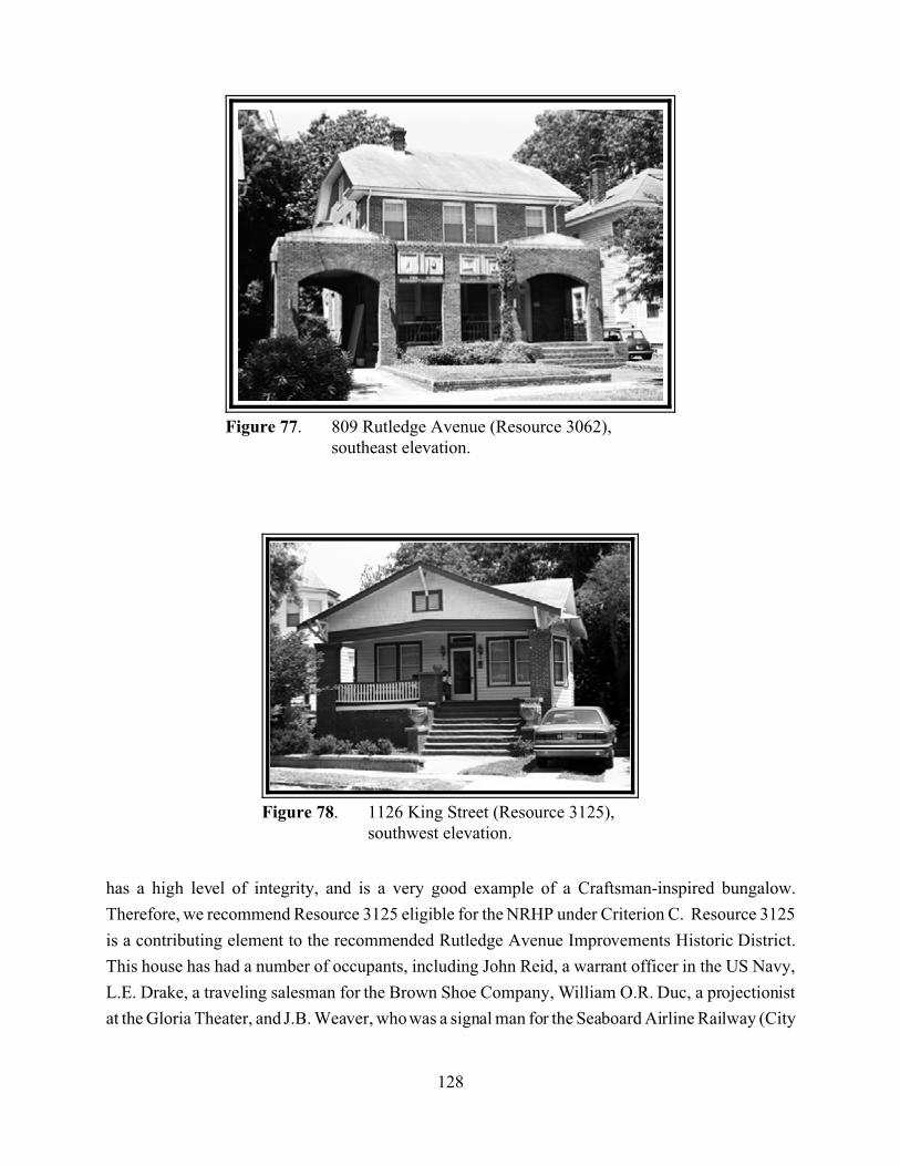
128
Figure 77. 809 Rutledge Avenue (Resource 3062),southeast elevation.
Figure 78. 1126 King Street (Resource 3125),southwest elevation.
has a high level of integrity, and is a very good example of a Craftsman-inspired bungalow.
Therefore, we recommend Resource 3125 eligible for the NRHP under Criterion C. Resource 3125
is a contributing element to the recommended Rutledge Avenue Improvements Historic District.
This house has had a number of occupants, including John Reid, a warrant officer in the US Navy,
L.E. Drake, a traveling salesman for the Brown Shoe Company, William O.R. Duc, a projectionist
at the Gloria Theater, and J.B. Weaver, who was a signal man for the Seaboard Airline Railway (City
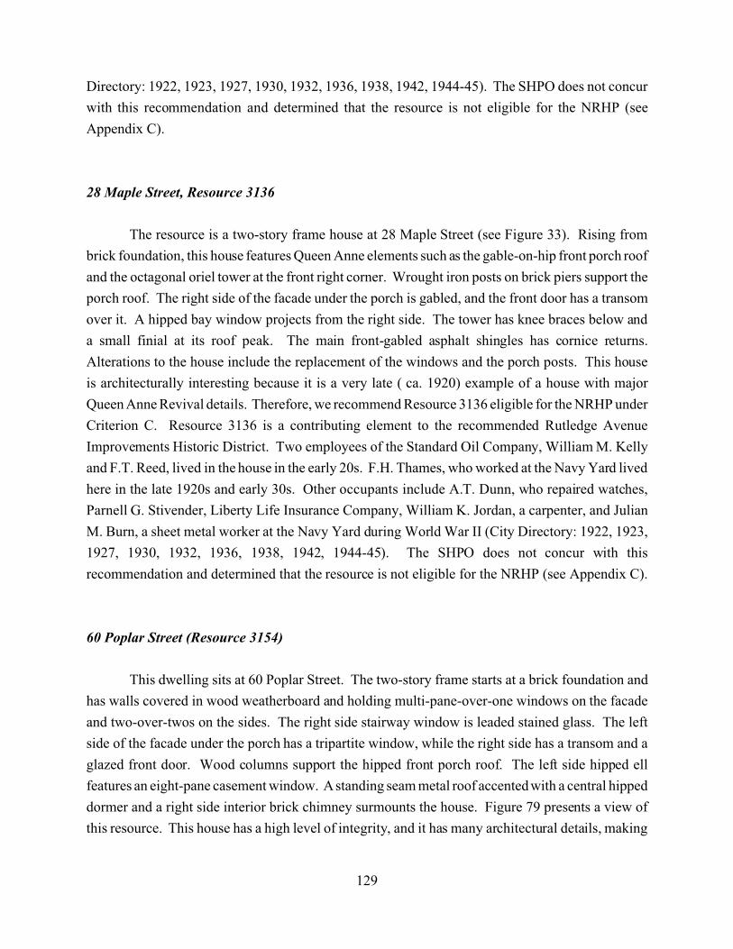
129
Directory: 1922, 1923, 1927, 1930, 1932, 1936, 1938, 1942, 1944-45). The SHPO does not concur
with this recommendation and determined that the resource is not eligible for the NRHP (see
Appendix C).
28 Maple Street, Resource 3136
The resource is a two-story frame house at 28 Maple Street (see Figure 33). Rising from
brick foundation, this house features Queen Anne elements such as the gable-on-hip front porch roof
and the octagonal oriel tower at the front right corner. Wrought iron posts on brick piers support the
porch roof. The right side of the facade under the porch is gabled, and the front door has a transom
over it. A hipped bay window projects from the right side. The tower has knee braces below and
a small finial at its roof peak. The main front-gabled asphalt shingles has cornice returns.
Alterations to the house include the replacement of the windows and the porch posts. This house
is architecturally interesting because it is a very late ( ca. 1920) example of a house with major
Queen Anne Revival details. Therefore, we recommend Resource 3136 eligible for the NRHP under
Criterion C. Resource 3136 is a contributing element to the recommended Rutledge Avenue
Improvements Historic District. Two employees of the Standard Oil Company, William M. Kelly
and F.T. Reed, lived in the house in the early 20s. F.H. Thames, who worked at the Navy Yard lived
here in the late 1920s and early 30s. Other occupants include A.T. Dunn, who repaired watches,
Parnell G. Stivender, Liberty Life Insurance Company, William K. Jordan, a carpenter, and Julian
M. Burn, a sheet metal worker at the Navy Yard during World War II (City Directory: 1922, 1923,
1927, 1930, 1932, 1936, 1938, 1942, 1944-45). The SHPO does not concur with this
recommendation and determined that the resource is not eligible for the NRHP (see Appendix C).
60 Poplar Street (Resource 3154)
This dwelling sits at 60 Poplar Street. The two-story frame starts at a brick foundation and
has walls covered in wood weatherboard and holding multi-pane-over-one windows on the facade
and two-over-twos on the sides. The right side stairway window is leaded stained glass. The left
side of the facade under the porch has a tripartite window, while the right side has a transom and a
glazed front door. Wood columns support the hipped front porch roof. The left side hipped ell
features an eight-pane casement window. A standing seam metal roof accented with a central hipped
dormer and a right side interior brick chimney surmounts the house. Figure 79 presents a view of
this resource. This house has a high level of integrity, and it has many architectural details, making
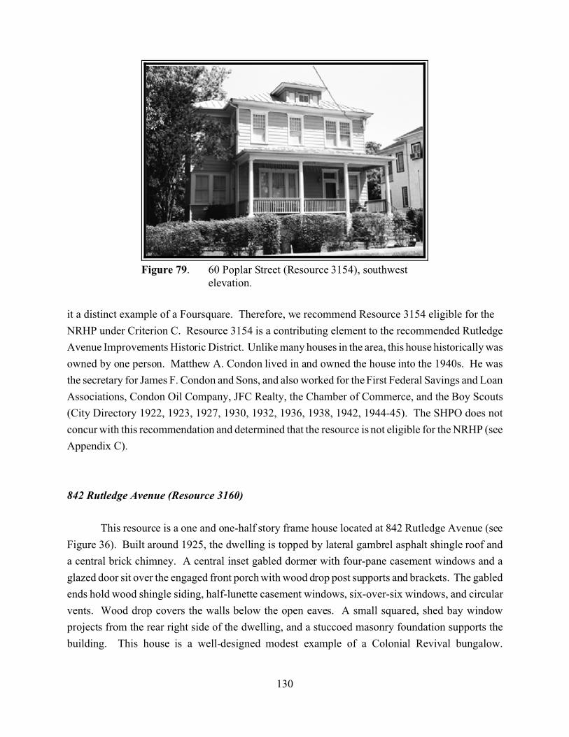
130
Figure 79. 60 Poplar Street (Resource 3154), southwestelevation.
it a distinct example of a Foursquare. Therefore, we recommend Resource 3154 eligible for the
NRHP under Criterion C. Resource 3154 is a contributing element to the recommended Rutledge
Avenue Improvements Historic District. Unlike many houses in the area, this house historically was
owned by one person. Matthew A. Condon lived in and owned the house into the 1940s. He was
the secretary for James F. Condon and Sons, and also worked for the First Federal Savings and Loan
Associations, Condon Oil Company, JFC Realty, the Chamber of Commerce, and the Boy Scouts
(City Directory 1922, 1923, 1927, 1930, 1932, 1936, 1938, 1942, 1944-45). The SHPO does not
concur with this recommendation and determined that the resource is not eligible for the NRHP (see
Appendix C).
842 Rutledge Avenue (Resource 3160)
This resource is a one and one-half story frame house located at 842 Rutledge Avenue (see
Figure 36). Built around 1925, the dwelling is topped by lateral gambrel asphalt shingle roof and
a central brick chimney. A central inset gabled dormer with four-pane casement windows and a
glazed door sit over the engaged front porch with wood drop post supports and brackets. The gabled
ends hold wood shingle siding, half-lunette casement windows, six-over-six windows, and circular
vents. Wood drop covers the walls below the open eaves. A small squared, shed bay window
projects from the rear right side of the dwelling, and a stuccoed masonry foundation supports the
building. This house is a well-designed modest example of a Colonial Revival bungalow.
131
Therefore, we recommend Resource 3160 eligible for the NRHP under Criterion C. Resource 3160
is a contributing element to the recommended Rutledge Avenue Improvements Historic District.
This house was occupied for many years by the family of William Brown, the foreman in the pipe
shop at Standard Oil Company, which included his wife, Amanda, son John, also employed by
Standard Oil, and grandson John L. Brown, Jr., a marine during World War II. However, by 1944,
William C. Stauss, who worked at Hanover Beer Parlor, occupied the house (City Directory: 1927,
1930, 1932, 1936, 1938, 1942, 1944-45). The SHPO does not concur with this recommendation and
determined that the resource is not eligible for the NRHP (see Appendix C).
31 Cypress Street (Resource 3212)
This residence, located at 31 Cypress Street, was built around 1925. Rising from a filled
brick pier foundation, the two-story frame walls have wood drop siding and four-over-two windows.
A unique, gambrel front porch highlights the facade. Its framework is open, with extended purlins,
queen posts, and sunburst supports in the gable. Twinned square posts on brick piers support the
porch lintel, which is three parts with shaped ends. The facade around front door is slightly inset.
Paralleling the porch, a gambrel wall dormer defines the front eave lines. Wood knee braces line the
wide eaves of the side-gabled, asphalt shingle roof. A left side exterior brick chimney transcends
the roof surface. Figure 80 provides a view of this dwelling. Resource 3212 has many interesting
architectural features and retains a high level of integrity. Therefore, we recommend Resource 3212
eligible for the NRHP under Criterion C. Resource 3212 is a contributing element to the
recommended Rutledge Avenue Improvements Historic District. As a rental property, this house
has had many different tenants. They include John Strobel and Robert J. Wailer, who worked at the
Navy Yard, J.F. Hass and D.A. Tyler, who worked at Standard Oil Company, James Griffin, a
salesman for Charleston Oil Company, Archie L. Moore, a route driver for the Southern Ice
Company, and many others (City Directory: 1922, 1923, 1927, 1930, 1932, 1936, 1938, 1942, 1944-
45). The SHPO does not concur with this recommendation and determined that the resource is not
eligible for the NRHP (see Appendix C).
887 Rutledge Avenue (Resource 3297)
This resource is a circa 1925 two-story, brick veneer house at 887 Rutledge Avenue (see
Figure 43). Exterior chimneys on either side of the house top the hipped, asphalt shingle roof. The
front gabled projection at the house’s left facade is clipped. All eaves are boxed and extremely wide.
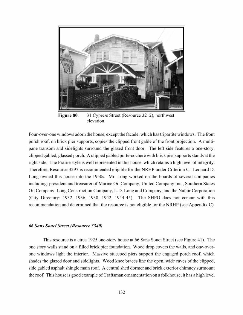
132
Figure 80. 31 Cypress Street (Resource 3212), northwestelevation.
Four-over-one windows adorn the house, except the facade, which has tripartite windows. The front
porch roof, on brick pier supports, copies the clipped front gable of the front projection. A multi-
pane transom and sidelights surround the glazed front door. The left side features a one-story,
clipped gabled, glassed porch. A clipped gabled porte-cochere with brick pier supports stands at the
right side. The Prairie style is well represented in this house, which retains a high level of integrity.
Therefore, Resource 3297 is recommended eligible for the NRHP under Criterion C. Leonard D.
Long owned this house into the 1950s. Mr. Long worked on the boards of several companies
including: president and treasurer of Marine Oil Company, United Company Inc., Southern States
Oil Company, Long Construction Company, L.D. Long and Company, and the Nafair Corporation
(City Directory: 1932, 1936, 1938, 1942, 1944-45). The SHPO does not concur with this
recommendation and determined that the resource is not eligible for the NRHP (see Appendix C).
66 Sans Souci Street (Resource 3340)
This resource is a circa 1925 one-story house at 66 Sans Souci Street (see Figure 41). The
one story walls stand on a filled brick pier foundation. Wood drop covers the walls, and one-over-
one windows light the interior. Massive stuccoed piers support the engaged porch roof, which
shades the glazed door and sidelights. Wood knee braces line the open, wide eaves of the clipped,
side gabled asphalt shingle main roof. A central shed dormer and brick exterior chimney surmount
the roof. This house is good example of Craftsman ornamentation on a folk house, it has a high level
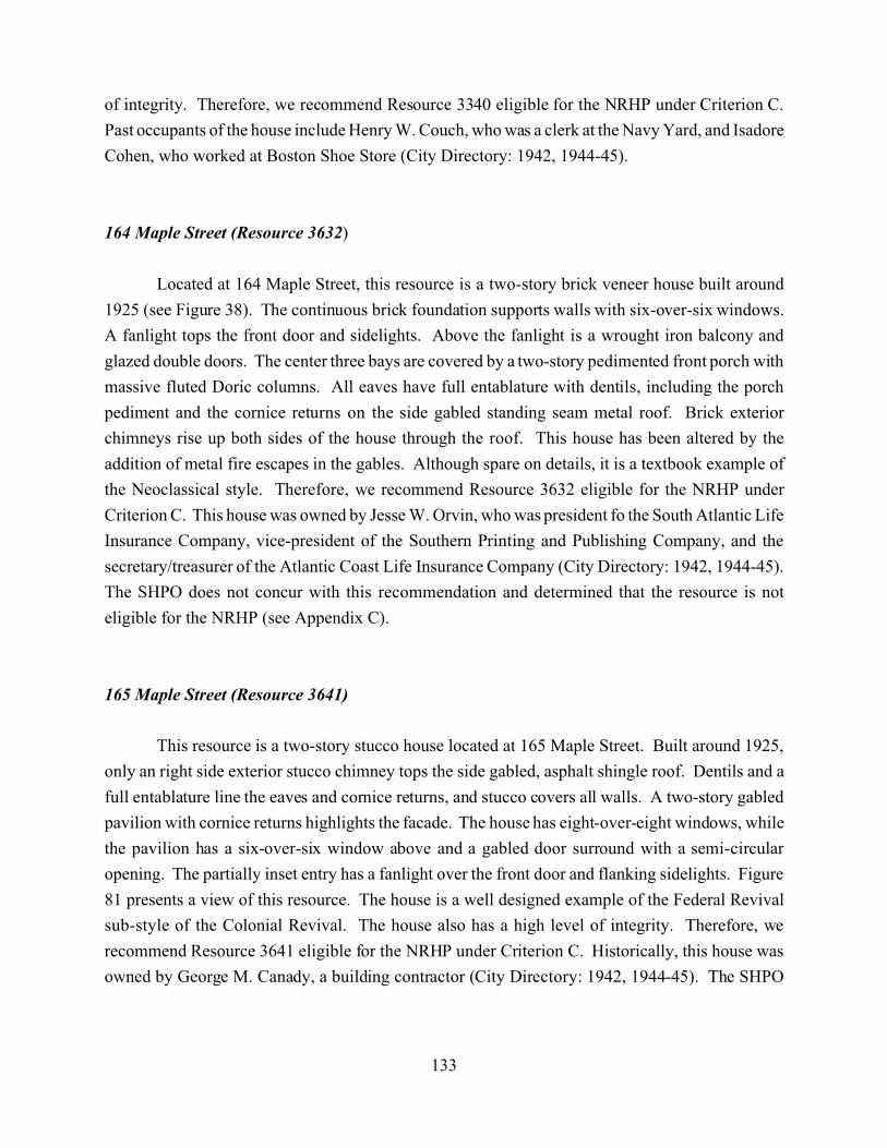
133
of integrity. Therefore, we recommend Resource 3340 eligible for the NRHP under Criterion C.
Past occupants of the house include Henry W. Couch, who was a clerk at the Navy Yard, and Isadore
Cohen, who worked at Boston Shoe Store (City Directory: 1942, 1944-45).
164 Maple Street (Resource 3632)
Located at 164 Maple Street, this resource is a two-story brick veneer house built around
1925 (see Figure 38). The continuous brick foundation supports walls with six-over-six windows.
A fanlight tops the front door and sidelights. Above the fanlight is a wrought iron balcony and
glazed double doors. The center three bays are covered by a two-story pedimented front porch with
massive fluted Doric columns. All eaves have full entablature with dentils, including the porch
pediment and the cornice returns on the side gabled standing seam metal roof. Brick exterior
chimneys rise up both sides of the house through the roof. This house has been altered by the
addition of metal fire escapes in the gables. Although spare on details, it is a textbook example of
the Neoclassical style. Therefore, we recommend Resource 3632 eligible for the NRHP under
Criterion C. This house was owned by Jesse W. Orvin, who was president fo the South Atlantic Life
Insurance Company, vice-president of the Southern Printing and Publishing Company, and the
secretary/treasurer of the Atlantic Coast Life Insurance Company (City Directory: 1942, 1944-45).
The SHPO does not concur with this recommendation and determined that the resource is not
eligible for the NRHP (see Appendix C).
165 Maple Street (Resource 3641)
This resource is a two-story stucco house located at 165 Maple Street. Built around 1925,
only an right side exterior stucco chimney tops the side gabled, asphalt shingle roof. Dentils and a
full entablature line the eaves and cornice returns, and stucco covers all walls. A two-story gabled
pavilion with cornice returns highlights the facade. The house has eight-over-eight windows, while
the pavilion has a six-over-six window above and a gabled door surround with a semi-circular
opening. The partially inset entry has a fanlight over the front door and flanking sidelights. Figure
81 presents a view of this resource. The house is a well designed example of the Federal Revival
sub-style of the Colonial Revival. The house also has a high level of integrity. Therefore, we
recommend Resource 3641 eligible for the NRHP under Criterion C. Historically, this house was
owned by George M. Canady, a building contractor (City Directory: 1942, 1944-45). The SHPO
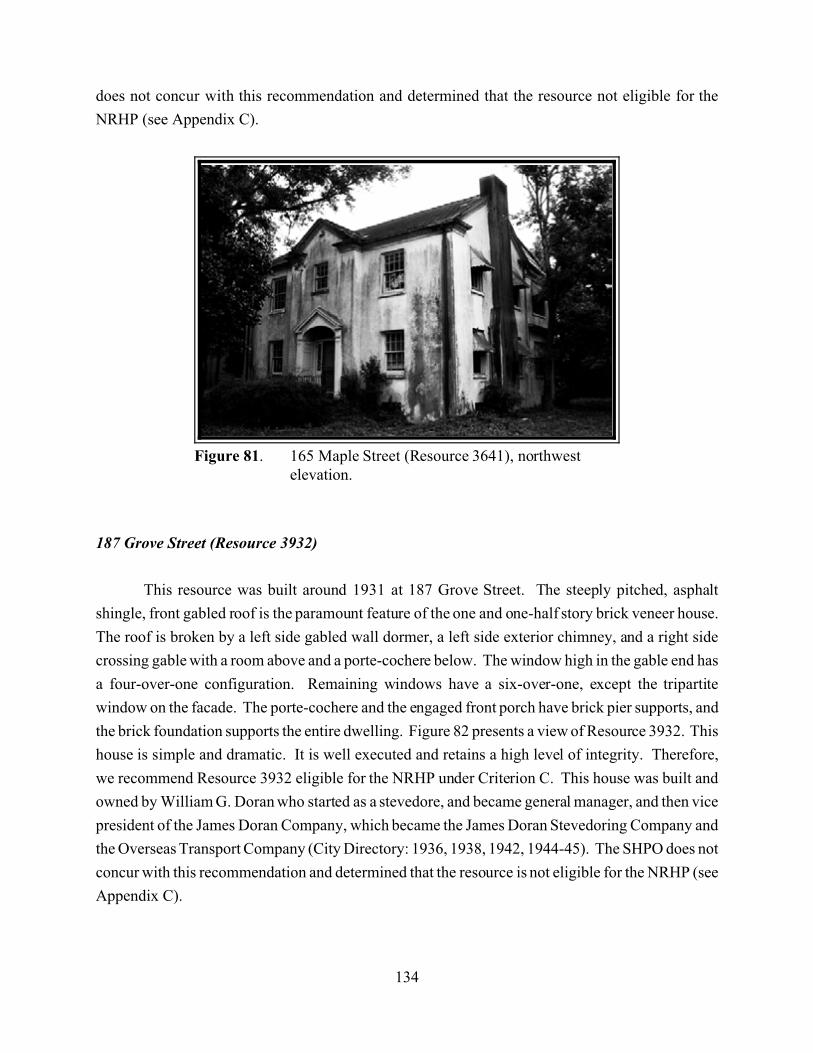
134
Figure 81. 165 Maple Street (Resource 3641), northwestelevation.
does not concur with this recommendation and determined that the resource not eligible for the
NRHP (see Appendix C).
187 Grove Street (Resource 3932)
This resource was built around 1931 at 187 Grove Street. The steeply pitched, asphalt
shingle, front gabled roof is the paramount feature of the one and one-half story brick veneer house.
The roof is broken by a left side gabled wall dormer, a left side exterior chimney, and a right side
crossing gable with a room above and a porte-cochere below. The window high in the gable end has
a four-over-one configuration. Remaining windows have a six-over-one, except the tripartite
window on the facade. The porte-cochere and the engaged front porch have brick pier supports, and
the brick foundation supports the entire dwelling. Figure 82 presents a view of Resource 3932. This
house is simple and dramatic. It is well executed and retains a high level of integrity. Therefore,
we recommend Resource 3932 eligible for the NRHP under Criterion C. This house was built and
owned by William G. Doran who started as a stevedore, and became general manager, and then vice
president of the James Doran Company, which became the James Doran Stevedoring Company and
the Overseas Transport Company (City Directory: 1936, 1938, 1942, 1944-45). The SHPO does not
concur with this recommendation and determined that the resource is not eligible for the NRHP (see
Appendix C).
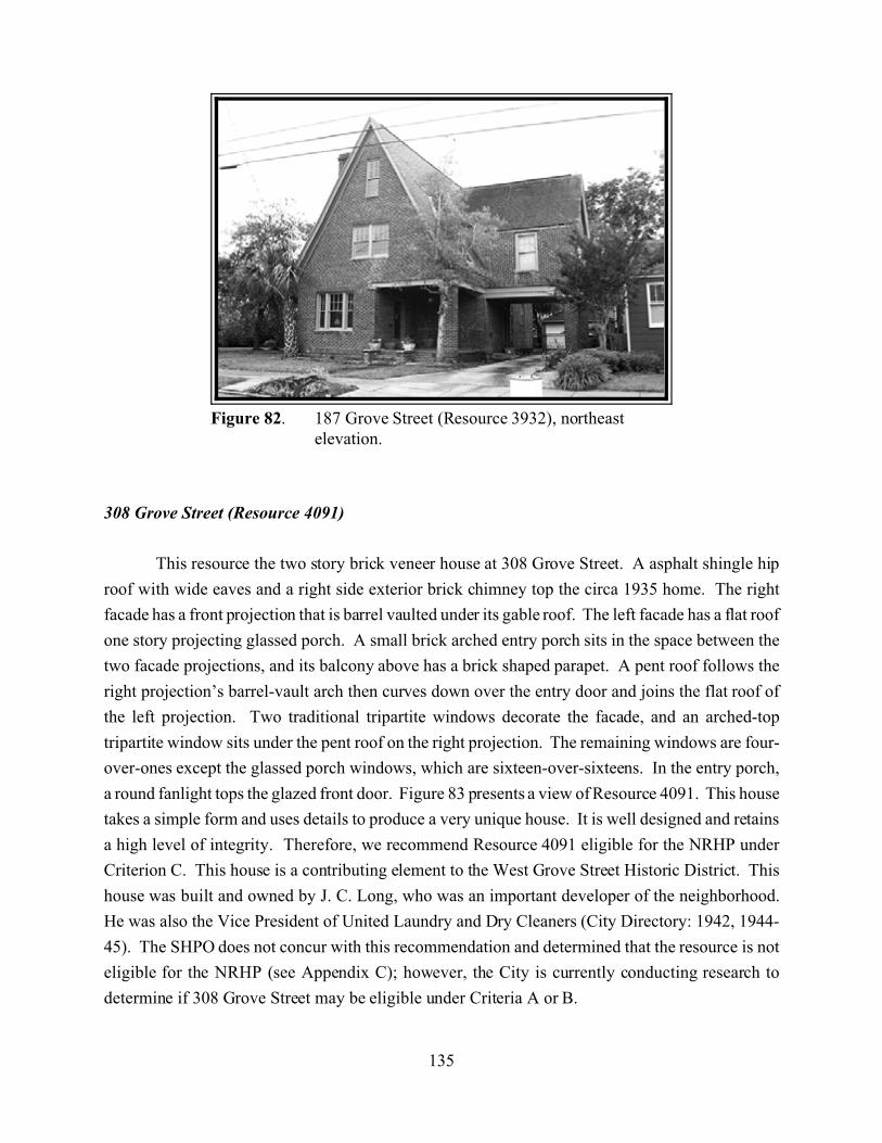
135
Figure 82. 187 Grove Street (Resource 3932), northeastelevation.
308 Grove Street (Resource 4091)
This resource the two story brick veneer house at 308 Grove Street. A asphalt shingle hip
roof with wide eaves and a right side exterior brick chimney top the circa 1935 home. The right
facade has a front projection that is barrel vaulted under its gable roof. The left facade has a flat roof
one story projecting glassed porch. A small brick arched entry porch sits in the space between the
two facade projections, and its balcony above has a brick shaped parapet. A pent roof follows the
right projection’s barrel-vault arch then curves down over the entry door and joins the flat roof of
the left projection. Two traditional tripartite windows decorate the facade, and an arched-top
tripartite window sits under the pent roof on the right projection. The remaining windows are four-
over-ones except the glassed porch windows, which are sixteen-over-sixteens. In the entry porch,
a round fanlight tops the glazed front door. Figure 83 presents a view of Resource 4091. This house
takes a simple form and uses details to produce a very unique house. It is well designed and retains
a high level of integrity. Therefore, we recommend Resource 4091 eligible for the NRHP under
Criterion C. This house is a contributing element to the West Grove Street Historic District. This
house was built and owned by J. C. Long, who was an important developer of the neighborhood.
He was also the Vice President of United Laundry and Dry Cleaners (City Directory: 1942, 1944-
45). The SHPO does not concur with this recommendation and determined that the resource is not
eligible for the NRHP (see Appendix C); however, the City is currently conducting research to
determine if 308 Grove Street may be eligible under Criteria A or B.

136
Figure 83. 308 Grove Street (Resource 4091), south elevation.
Recommendations for Future Consideration
Endangered Areas
When considering dangers to the historic character of a neighborhood or an area, three basic
threats must be considered. The most obvious is demolition of existing historic architectural
resources. Destruction of historic buildings or their removal from an area removes character and
leaves only voids. The second threat is construction of new structures that are visually incompatible
with existing resources. These intrusions stand out in stark contrast to the historic character of the
streets on which they are built. The third and least obvious threat comes from historically
inappropriate alterations and additions to historic architectural resources. Often small, these changes
eventually can completely change a building and obscure its historic qualities. When enough
historic resources are destroyed or altered, an area’s historic character is lost.
Three areas appear to be endangered by demolition and incompatible new construction. The
most endangered area is east of Interstate 26. Except for the area west of Meeting Street, this area
has lost most of its once-residential character. Many small islands of houses have become isolated.
Much of the land has been converted to commercial and light industrial uses, and many large new
137
buildings have been built. Many of the remaining houses are heavily altered or abandoned, and
some are nearing structural failure.
The King Street corridor is also endangered by the development of new commercial
buildings. These new buildings require demolition of existing structures and often their design is
not compatible with the surrounding neighborhoods.
The land along the Ashley River may be endangered by the high value of waterfront
property. Recent development at the western end of Sunnyside Avenue and the development of the
Longborough Neighborhood requiring removal of many houses along Alberta, Amelia, and
Deveraux Avenues reflect this danger.
The threat of inappropriate alterations and additions is a general danger throughout the Upper
Peninsula. Because of the rising property values in Charleston, there is a strong pressure to
maximize interior space in existing houses. This pressure can lead to inappropriate additions and
enclosure of porches. New owners, especially those seeking to rent properties, are especially
susceptible to this as they seek maximum property value on recent purchases.
Areas that May Be Eligible in the Future
In this report, we did not recommend certain areas eligible either because of alterations that
adversely affect the historic character or because the area is not of sufficient age at this time.
Changes to historic character usually occur as a result of the three threats listed above, but these
changes can be reversed. Enclosed porches can be opened, synthetic sidings can be removed, and
new construction can be compatible with existing designs. An area that currently lacks sufficient
historic character to be eligible could become eligible in the future. Also, as a neighborhood grows
older, its historic character becomes more significant simply because of its age.
The North Tracy Street Historic District is an example of an area that has lost eligibility
because of substantial alterations to the historic fabric of the buildings. It could regain its eligibility
if minor restorations are performed in the block, especially on the houses on the eastern side of the
street. Minor restoration could include re-opening porches and removing inappropriate siding. Also,
its boundaries could be expanded to include parts of Moultrie Street, Homel Place, and Rutledge
Avenue, which also have historic houses that are of similar scale and time period. This new
boundary could increase the number of houses that contribute to the district.
138
Another area that could regain its historic character is a large block of houses bounded by
St. Margaret Street on the north, Rutledge Avenue on the east, Dunnemann Avenue on the South,
and Tenth Street on the west. The area contains a large number of houses in relatively good
condition. Although not architecturally or historically unified, the houses retain respectable
integrity. This area may gain significance if houses that are substantially altered are restored and no
new intrusions are built in the area.
Much of the Survey Universe was built later in the twentieth century. The historic value of
these neighborhoods and houses will continue to increase with time. For this reason, much of the
Riverside Park neighborhood could be on the cusp of eligibility; especially the area north of
Peachtree Street, south of Mount Pleasant Street, and west of Darlington Avenue.
Areas that may Warrant Protection or Special Attention
Some areas that we surveyed have retained their historic character despite the threats outlined
above. The current homeowners appear to want to protect the historic character of their
neighborhoods. Two neighborhoods, the Hampton Park Terrace neighborhood, and the
neighborhood that we defined as the Sophia Wilson Historic District, retain their respective historic
characters despite recent changes in property values and population. Threats to these neighborhoods
likely will increase as new homeowners come into these neighborhoods. The city should consider
attempting to protect these neighborhoods from intrusive commercial development and homeowners
who neglect or abandon property.
Survey Summary
During the course of the survey, we identified 2,042 historic architectural resources, of which
1,958 are houses or apartments. Four of these resources are listed in the NRHP. The Hampton Park
Historic District contains eight recommended individually eligible resources and 211 contributing
resources. The previously identified Sophia Wilson Historic District (North of 17 Historic District)
contains one eligible resource, three recommended individually eligible resources and 128
contributing resources. The recommended Citadel Parade Ground Historic District contains eight
contributing resources. The recommended Citadel Officers’ Quarters Historic District contains one
contributing resource. The recommended Magnolia Umbra Cemetery Historic District contains one
resource listed on the NRHP, two recommended individually eligible resources, and 17 contributing
139
resources. The recommended Rutledge Avenue Improvements District contains four recommended
individually eligible resources and 160 contributing resources. The recommended East Riverside
Park Historic District contains 29 contributing resources. The recommended West Grove Street
Historic District contains one recommended individually eligible resource and 37 contributing
resources. In addition, 18 resources that are not part of any district are eligible or recommended
individually eligible. The remaining 1,410 resources are not eligible for the NRHP. The SHPO does
not concur with many of these recommendations. The reader is directed to Appendix C for specific
SHPO determinations of eligibility.
140
References Cited
Anderson, David G., Charles E. Cantley, and A. Lee Novick1982 The Mattasee Lake Sites: Archaeological Investigations Along the Lower Santee River
in the Coastal Plain of South Carolina. US Department of the Interior- Park Service,Southeast Region Office, Atlanta.
Anderson, David G.1985 The Internal Organization and Operation of Chiefdom Level Societies on the
Southeastern Atlantic Slope: An Explanation of Ethnohistoric Sources. South CarolinaAntiquities 17:35-69.
Anderson, David G., and Patricia A. Logan1981 Francis Marion National Forest Cultural Resources Overview. US Department of
Agriculture- Forest Service, Columbia, South Carolina.
Baldwin City Directory Company, pub.1936 Baldwin and Southern’s Charleston, South Carolina City Directory, Master Edition
1936. Baldwin Directory Company, Inc., and Southern Printing and Publishing Company,Charleston.
1938 Baldwin and Southern’s Charleston, South Carolina City Directory, Master Edition1938. Master Edition. Baldwin Directory Company, Inc., and Southern Printing andPublishing Company, Charleston.
1942 Baldwin and Southern’s Charleston, South Carolina City Directory, Master Edition1942. Baldwin Directory Company, Inc., and Southern Printing and Publishing Company,Charleston.
1945 Baldwin and Southern’s Charleston, South Carolina City Directory, Master Edition1944-45. Baldwin Directory Company, Inc., Charleston.
1948 Baldwin and Southern’s Charleston, South Carolina City Directory, Master Edition1948. Baldwin Directory Company, Inc., Charleston.
Brenner, Betty and J. Francis Brenner2000 The Old Codgers’ Charleston Address Book: 1900-1999, vols 1-5. The Old Codgers,
Inc., Charleston, South Carolina.
Bridgens, R.P. and Robert Allen1852 An Original Map of the City of Charleston. Sarony and Major, New York.

141
Blumenson, John. Identifying American Architecture. Nashville, TN: American Association forState and Local History, 1977.
Cassedy, Daniel F., Patrick H. Garrow, Jeffrey L. Holland, and Edward F. Turberg1992 Additional Archaeological and Architectural Investigations for the Grace Memorial
Bridge Replacement, Charleston, South Carolina. Prepared for Parsons Brinckerhoff Quadeand Douglas, Inc. Raleigh, North Carolina.
Chandler, Andrew W.1999 Letter to Mr. Charles Edwin Chase, Preservation Officer, City of Charleston, Department
of Planning and Urban Development, Charleston. May 3, 1999. On file at the SouthCarolina Department of Archives and History State Historic Preservation Office, Columbia.
Chibbaro, Anthony2001 The Charleston Exposition. Arcadia Press, Charleston, South Carolina.
Clinton, Henry1780 A Sketch of the Operations Before Charlestown the Capital of South Carolina. South
Caroliniana Library, Columbia.
Cobb, Charles R., Jeffrey Holland, and Eugene A Burr1992 Phase II Archaeological, Historical, and Architectural Investigations in the Grace and
New Market Alignments: Grace Memorial Bridge Replacement, Charleston, South Carolina.Prepared for Parsons Brinckerhoff Quade and Douglas, Inc. Raleigh, North Carolina.
Coclanis, Peter A.1989 The Shadow of a Dream: Economic Life and Death in the South Carolina Low Country,
1670-1920. Oxford University Press, New York.
Courtenay, Mayor1883 Map of Charleston and Its Vicinity Showing the Original Settlement of 1670 at
Albermarle Point and Oyster Point Settlement of 1672, and Subsequent extensions of1783 and 1849. South Caroliniana Library, Columbia.
Covington, James W.1978 Stuart's Town: The Yemassee Indians and Spanish Florida. The Florida Anthropologist
21:8-13.
Crook, Morgan R., Jr.1986 Mississippi Period Archaeology of the Georgia Coastal Zone. The University of Georgia
Laboratory of Archaeology, Georgia Archaeological Research Design Papers 1. Athens.
142
DePratter, Chester B., Stanley South, and James Legg1997 The Discovery of French Charlesfort (1562-1563). Paper presented at the 30th
Conference on Historical and Underwater Archaeology, Corpus Christi, TX.
Dobyns, Henry F.1983 Their Number Become Thinned: Native American Population Dynamics in Eastern North
America. University of Tennessee Press, Knoxville.
Drie, C.1872 Bird’s Eye View of the City of Charleston, South Carolina. Historic Urban Plans, Ithica,
New York.
Edgar, Walter B.1992 South Carolina in the Modern Age. University of South Carolina Press, Columbia.
Fick, Sarah1997 Hampton Park Terrace National Register Nomination. On file, South Carolina
Department of Archives and History, Columbia.
Fraser, Walter J., Jr.1989 Charleston! Charleston!: The History of a Southern City. University of South Carolina
Press, Columbia.
Garrow, Patrick H.1992 Summary of the Cultural Resources Investigations Conducted on the Grace Memorial
Bridge Replacement Project, Charleston, South Carolina. Prepared for ParsonsBrinckerhoff Quade and Douglas, Inc. Raleigh, North Carolina.
Harvey, Bruce G.1998 World’s Fairs in a Southern Accent: Atlanta, Nashville, Charleston, 1895-1902. Ph.D
dissertation, Vanderbilt University, Nashville, Tennessee.
Harvey, Bruce G. and Ralph Bailey2000 Intensive Cultural Resources Survey and Documentation of the Proposed Cooper River
Bridge Approaches. Charleston County, South Carolina. Prepared for Wilbur SmithAssociates, Inc. and the South Carolina Department of Transportation, Columbia.
Hill Directory Company, pub..1932 Hill’s Charleston City Directory, 1932. Hill Directory Company, Richmond, Virginia.
Hoffman, Paul E.1983 Legend, Religious Idealism, and Colonies: The Point of Santa Elena in History, 1552-
1556. The South Carolina Historical Magazine 84:59-71.
143
Longstreth, Richard. The Buildings of Main Street: A Guide to American Commercial Architecture.Washington, DC: The Preservation Press, 1987.
Lucas and Richardson Company, pub.1898 Directory of the City of Charleston, South Carolina. Lucas and Richardson Company,
Charleston.
Lumpkin, Henry1981 From Savannah to Yorktown: The American Revolution in the South. University of
South Carolina Press, Columbia.
Lyon, Eugene1984 Santa Elena: A Brief History of the Colony, 1566-1587. South Carolina Institute of
Archaeology and Anthropology Research Manuscript Series 193, Columbia.
McAlester, Virginia and Lee McAlester. A Field Guide to American Houses. New York: AlfredA. Knopf, 1984.
Merrens, H. Roy1972 A View of Coastal South Carolina in 1778: The Journal of Ebenezer Hazard. The South
Carolina Historical Magazine 73:183,185.
News and Courier1902, 29 May 1902. Charleston County Library, Main Branch, Charleston.
Orvin, Maxwell C.1973 Historic Berkeley County, South Carolina (1671-1900). Comprint, Charleston, South
Carolina.
Parker, Patricia L. Guidelines for Local Surveys: A Basis for Preservation Planning. NationalRegister Bulletin 24. Washington, DC: US Department of the Interior, Park Service,Interagency Resources Division, 1985.
Pease, William H., and Jane H. Pease1986 The Web of Progress: Private Values and Public Styles in Boston and Charleston, 1828-
1843. Oxford University Press, New York.
Poppeliers, John C., S. Allen Chambers, Jr., Nancy B. Schwartz. What Style Is It? A Guide toAmerican Architecture. Washington, DC: Preservation Press, 1983.
Quattlebaum, Paul1956 The Land Called Chicora, the Carolinas Under Spanish Rule with French Intrusions,
1520-1670. The University of Florida Press, Gainesville.
144
Ramenofsky, Anne P.1982 The Archaeology of Population Collapse: Native American Response to the Introduction
of Infectious Disease. Ph.D. dissertation, Department of Anthropology, University ofWashington, Seattle.
Ravenel, Mrs. St. Julien1922 Charleston: The Place and the People. The Macmillan Company, New York.
Reed, Mary Beth, Patrick H. Garrow, Gordon P. Watts, and J.W. Joseph1988 An Architectural, Archaeological, and Historical Survey of Selected Portions of
Charleston and Mount Pleasant: Grace Memorial Bridge Replacement, Charleston, SouthCarolina. Prepared for Parsons Brinckerhoff Quade and Douglas, Inc. Raleigh, NorthCarolina.
1992 An Architectural, Archaeological, and Historical Survey of Selected Portions ofCharleston and Mount Pleasant: Grace Memorial Bridge Replacement, Charleston, SouthCarolina. Prepared for Parson Brickerhoff Quade and Douglas, Inc., Raleigh, NorthCarolina.
Rogers, George C., Jr.1980 Charleston in the Age of the Pinckneys. University of South Carolina Press, Columbia.
Rosengarten, Dale 1987 Between the Tracks: Charleston's East Side During the Nineteenth Century. The
Charleston Museum and Avery Research Center, Charleston.
Rowland, Lawrence S.1978 Eighteenth Century Beaufort: A Study of South Carolina's Southern Parishes1800. Ph.D.
dissertation, Department of History, University of South Carolina, Columbia.
1985 Alone on the River: The Rise and Fall of the Savannah River Rice Plantations of St.Peter’s Parish, South Carolina. The South Carolina Historical Magazine, April.
Rowland, Lawrence S., Alexander Moore, and George C. Rogers, Jr.1996 The History of Beaufort County, South Carolina. Volume 1, 1514-1861. University of
South Carolina Press, Columbia.
Sholes and Company, pub.1882 Sholes’ Directory of the City of Charleston 1882. Sholes and Company.
1883 Sholes’ Directory of the City of Charleston 1883. Sholes and Company.
145
Slater, Margaret1996 Cultural Resource Assessment and Assessment of Effect Pursuant to 36 CFR 800 for the
Replacement of the Bridges on US 17 over the Cooper River and Town Creek, CharlestonCounty, South Carolina. Prepared for the South Carolina Department if Transportation andFederal Highway Administration, Columbia.
Smith, H.A.M1988 Rivers and Regions of South Carolina. The Reprint Company, Spartanburg, South
Carolina.
Smith, Julia Floyd1984 Slavery and Rice Culture in Low Country Georgia, 1750-1860. The University of
Tennessee Press, Knoxville.
South, Stanley A. and Michael Hartley1985 Deep Water and High Ground: Seventeenth Century Low Country Settlement. In
Structure and Process in Southeastern Archaeology, edited by Roy S. Dickens, Jr. and H.Trawick Ward, pp. 263-286. University of Alabama Press, University, Alabama.
South, Stanley1973 The Indian Pottery Taxonomy for the South Carolina Coast. The University of South
Carolina Institute of Archaeology and Anthropology Notebook 5:54-55. Columbia.
Southern Directory and Publishing Company, pub.1888 The Charleston City Directory 1888. Southern Directory and Publishing Company.
1889 The Charleston City Directory 1889. Southern Directory and Publishing Company.
1891 The Charleston City Directory 1891. Southern Directory and Publishing Company,Charleston.
Southern Printing and Publishing Company, pub.1927 Walsh’s 1927 Charleston, South Carolina City Directory. Southern Printing and
Publishing Company, Charleston.
1930 Walsh’s 1930 Charleston, South Carolina City Directory. Southern Printing andPublishing Company, Charleston.
1934 Charleston City Directory 1934. Southern Printing and Publishing Company, Charleston.
Stoney, Samuel Gaillard1990 This is Charleston: A Survey of the Architectural Heritage of A Unique American City.
Revised edition. The Carolina Art Association, Charleston.
146
Swanton, John R.1952 The Indian Tribes of North America. Bureau of American Ethnology Bulletin 145.
Smithsonian Institution, Government Printing Office, Washington, DC.
Timrod, Henry and William Gilmore Simms1851 Magnolia Cemetery: The Proceedings at the dedication of the Grounds, To Which are
Appended the Rules, Regulations and Charter of the Company, with a List of Officers andMembers of the Board. Steam Power Press of Walker and James, Charleston, SouthCarolina.
Trinkley, Michael1981 Archaeological Testing of the Awendaw Shell Midden, Charleston County. USDepartment of Agriculture- Forest Service, Columbia, South Carolina.
Vivian, Daniel J. Survey Manual: South Carolina Statewide Survey of Historic Properties.Columbia: State Historic Preservation Office, South Carolina Department of Archives andHistory, 2002.
Waddell, Eugene1980 Indians of the South Carolina Low Country, 1562-1751. The Reprint Company,
Spartanburg, South Carolina.
Walker, Evans, and Cogswell1855 The City of Charleston, South Carolina. South Caroliniana Library, Columbia.
1879 Map of Charleston, South Carolina. South Caroliniana Library, Columbia.
Wallace, David Duncan1961 South Carolina - A Short History, 1540-1940. University of North Carolina Press,
Chapel Hill.
W. H. Walsh Directory Company, pub.1902 Walsh’s Charleston, South Carolina City Directory for 1902. W.H Walsh Directory
Company, Charleston.
1903 Walsh’s Charleston, South Carolina City Directory for 1903. W.H Walsh DirectoryCompany, Charleston.
1908 Walsh’s Charleston, South Carolina City Directory for 1908. W.H Walsh DirectoryCompany, Charleston.
1909 Walsh’s Charleston, South Carolina City Directory for 1909. W.H Walsh DirectoryCompany, Charleston.
147
1912 Walsh’s Charleston, South Carolina City Directory for 1912. W.H Walsh DirectoryCompany, Charleston.
1913 Walsh’s Charleston, South Carolina City Directory for 1913. W.H Walsh DirectoryCompany, Charleston.
1917 Walsh’s Charleston, South Carolina City Directory for 1917. W.H Walsh DirectoryCompany, Charleston.
1918 Walsh’s Charleston, South Carolina City Directory for 1918. W.H Walsh DirectoryCompany, Charleston.
1919 Walsh’s Charleston, South Carolina City Directory for 1919. W.H Walsh DirectoryCompany, Charleston.
1922 Walsh’s Charleston, South Carolina City Directory for 1922. W.H Walsh DirectoryCompany, Charleston.
1923 Walsh’s Charleston, South Carolina City Directory for 1923. W.H Walsh DirectoryCompany, Charleston.
Weir, Robert M.1983 Colonial South Carolina: A History. KTO Press, Millwood, New York.
Whiffen, Marcus. American Architecture Since 1780: A Guide to the Styles. Cambridge, MA:M.I.T. Press, 1981.
Wood, Peter H.1974 Black Majority, Negroes in Colonial South Carolina from 1670 through the Stono
Rebellion. Norton and Company, New York.

Appendix A.
Inventory of Surveyed Resources
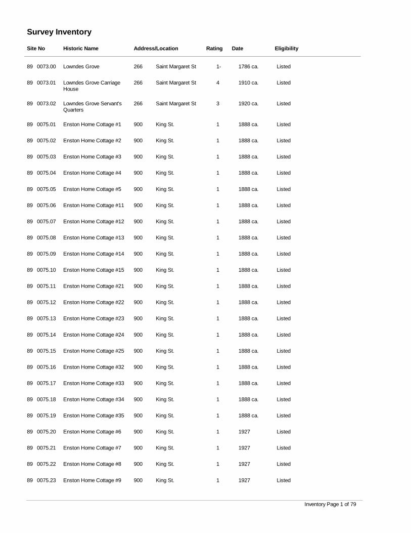
Survey Inventory
Site No Historic Name Address/Location Rating Date Eligibility
0073.00 Lowndes Grove Saint Margaret St 1- 1786 ca. Listed89 266
0073.01 Lowndes Grove Carriage House
Saint Margaret St 4 1910 ca. Listed89 266
0073.02 Lowndes Grove Servant's Quarters
Saint Margaret St 3 1920 ca. Listed89 266
0075.01 Enston Home Cottage #1 King St. 1 1888 ca. Listed89 900
0075.02 Enston Home Cottage #2 King St. 1 1888 ca. Listed89 900
0075.03 Enston Home Cottage #3 King St. 1 1888 ca. Listed89 900
0075.04 Enston Home Cottage #4 King St. 1 1888 ca. Listed89 900
0075.05 Enston Home Cottage #5 King St. 1 1888 ca. Listed89 900
0075.06 Enston Home Cottage #11 King St. 1 1888 ca. Listed89 900
0075.07 Enston Home Cottage #12 King St. 1 1888 ca. Listed89 900
0075.08 Enston Home Cottage #13 King St. 1 1888 ca. Listed89 900
0075.09 Enston Home Cottage #14 King St. 1 1888 ca. Listed89 900
0075.10 Enston Home Cottage #15 King St. 1 1888 ca. Listed89 900
0075.11 Enston Home Cottage #21 King St. 1 1888 ca. Listed89 900
0075.12 Enston Home Cottage #22 King St. 1 1888 ca. Listed89 900
0075.13 Enston Home Cottage #23 King St. 1 1888 ca. Listed89 900
0075.14 Enston Home Cottage #24 King St. 1 1888 ca. Listed89 900
0075.15 Enston Home Cottage #25 King St. 1 1888 ca. Listed89 900
0075.16 Enston Home Cottage #32 King St. 1 1888 ca. Listed89 900
0075.17 Enston Home Cottage #33 King St. 1 1888 ca. Listed89 900
0075.18 Enston Home Cottage #34 King St. 1 1888 ca. Listed89 900
0075.19 Enston Home Cottage #35 King St. 1 1888 ca. Listed89 900
0075.20 Enston Home Cottage #6 King St. 1 1927 Listed89 900
0075.21 Enston Home Cottage #7 King St. 1 1927 Listed89 900
0075.22 Enston Home Cottage #8 King St. 1 1927 Listed89 900
0075.23 Enston Home Cottage #9 King St. 1 1927 Listed89 900
Inventory Page 1 of 79
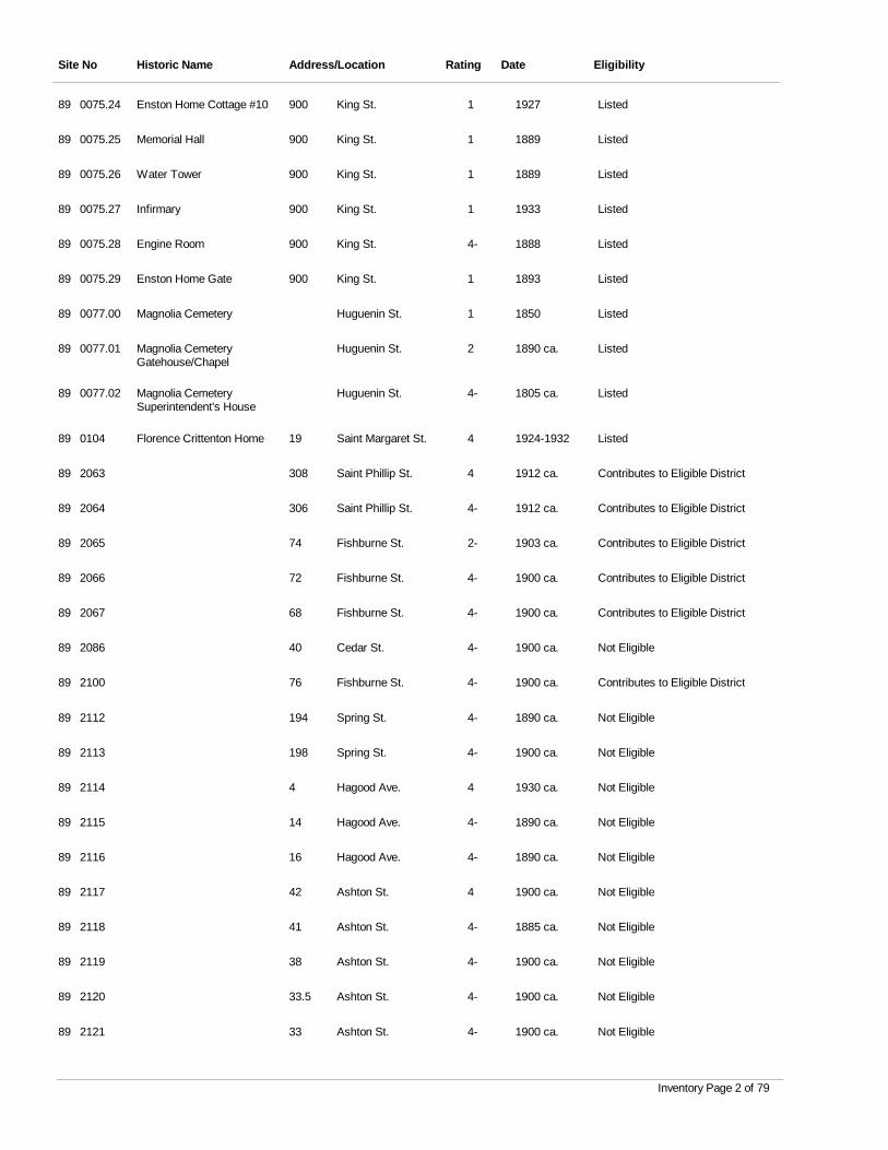
Site No Historic Name Address/Location Rating Date Eligibility
0075.24 Enston Home Cottage #10 King St. 1 1927 Listed89 900
0075.25 Memorial Hall King St. 1 1889 Listed89 900
0075.26 Water Tower King St. 1 1889 Listed89 900
0075.27 Infirmary King St. 1 1933 Listed89 900
0075.28 Engine Room King St. 4- 1888 Listed89 900
0075.29 Enston Home Gate King St. 1 1893 Listed89 900
0077.00 Magnolia Cemetery Huguenin St. 1 1850 Listed89
0077.01 Magnolia Cemetery Gatehouse/Chapel
Huguenin St. 2 1890 ca. Listed89
0077.02 Magnolia Cemetery Superintendent's House
Huguenin St. 4- 1805 ca. Listed89
0104 Florence Crittenton Home Saint Margaret St. 4 1924-1932 Listed89 19
2063 Saint Phillip St. 4 1912 ca. Contributes to Eligible District89 308
2064 Saint Phillip St. 4- 1912 ca. Contributes to Eligible District89 306
2065 Fishburne St. 2- 1903 ca. Contributes to Eligible District89 74
2066 Fishburne St. 4- 1900 ca. Contributes to Eligible District89 72
2067 Fishburne St. 4- 1900 ca. Contributes to Eligible District89 68
2086 Cedar St. 4- 1900 ca. Not Eligible89 40
2100 Fishburne St. 4- 1900 ca. Contributes to Eligible District89 76
2112 Spring St. 4- 1890 ca. Not Eligible89 194
2113 Spring St. 4- 1900 ca. Not Eligible89 198
2114 Hagood Ave. 4 1930 ca. Not Eligible89 4
2115 Hagood Ave. 4- 1890 ca. Not Eligible89 14
2116 Hagood Ave. 4- 1890 ca. Not Eligible89 16
2117 Ashton St. 4 1900 ca. Not Eligible89 42
2118 Ashton St. 4- 1885 ca. Not Eligible89 41
2119 Ashton St. 4- 1900 ca. Not Eligible89 38
2120 Ashton St. 4- 1900 ca. Not Eligible89 33.5
2121 Ashton St. 4- 1900 ca. Not Eligible89 33
Inventory Page 2 of 79
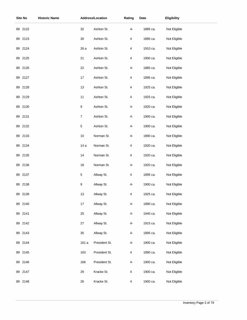
Site No Historic Name Address/Location Rating Date Eligibility
2122 Ashton St. 4- 1885 ca. Not Eligible89 32
2123 Ashton St. 4 1895 ca. Not Eligible89 30
2124 Ashton St. 4 1910 ca. Not Eligible89 26 a
2125 Ashton St. 4 1900 ca. Not Eligible89 21
2126 Ashton St. 4- 1885 ca. Not Eligible89 22
2127 Ashton St. 4 1895 ca. Not Eligible89 17
2128 Ashton St. 4 1925 ca. Not Eligible89 13
2129 Ashton St. 4 1925 ca. Not Eligible89 11
2130 Ashton St. 4- 1920 ca. Not Eligible89 9
2131 Ashton St. 4- 1900 ca. Not Eligible89 7
2132 Ashton St. 4- 1900 ca. Not Eligible89 5
2133 Norman St. 4- 1890 ca. Not Eligible89 10
2134 Norman St. 4 1920 ca. Not Eligible89 14 a
2135 Norman St. 4 1920 ca. Not Eligible89 14
2136 Norman St. 4- 1920 ca. Not Eligible89 18
2137 Allway St. 4 1895 ca. Not Eligible89 5
2138 Allway St. 4- 1900 ca. Not Eligible89 9
2139 Allway St. 4 1925 ca. Not Eligible89 13
2140 Allway St. 4- 1890 ca. Not Eligible89 17
2141 Allway St. 4- 1940 ca. Not Eligible89 25
2142 Allway St. 4- 1915 ca. Not Eligible89 27
2143 Allway St. 4- 1895 ca. Not Eligible89 35
2144 President St. 4- 1900 ca. Not Eligible89 161 a
2145 President St. 4 1890 ca. Not Eligible89 163
2146 President St. 4- 1900 ca. Not Eligible89 166
2147 Kracke St. 4 1900 ca. Not Eligible89 29
2148 Kracke St. 4 1900 ca. Not Eligible89 26
Inventory Page 3 of 79
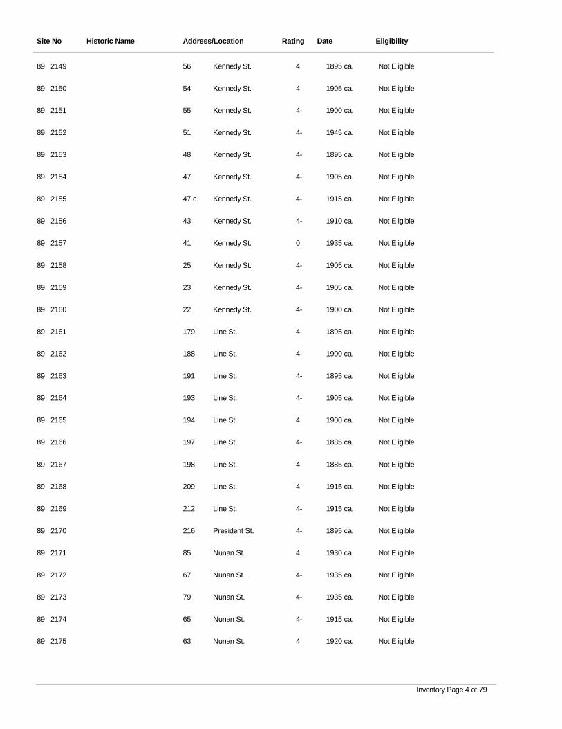
Site No Historic Name Address/Location Rating Date Eligibility
2149 Kennedy St. 4 1895 ca. Not Eligible89 56
2150 Kennedy St. 4 1905 ca. Not Eligible89 54
2151 Kennedy St. 4- 1900 ca. Not Eligible89 55
2152 Kennedy St. 4- 1945 ca. Not Eligible89 51
2153 Kennedy St. 4- 1895 ca. Not Eligible89 48
2154 Kennedy St. 4- 1905 ca. Not Eligible89 47
2155 Kennedy St. 4- 1915 ca. Not Eligible89 47 c
2156 Kennedy St. 4- 1910 ca. Not Eligible89 43
2157 Kennedy St. 0 1935 ca. Not Eligible89 41
2158 Kennedy St. 4- 1905 ca. Not Eligible89 25
2159 Kennedy St. 4- 1905 ca. Not Eligible89 23
2160 Kennedy St. 4- 1900 ca. Not Eligible89 22
2161 Line St. 4- 1895 ca. Not Eligible89 179
2162 Line St. 4- 1900 ca. Not Eligible89 188
2163 Line St. 4- 1895 ca. Not Eligible89 191
2164 Line St. 4- 1905 ca. Not Eligible89 193
2165 Line St. 4 1900 ca. Not Eligible89 194
2166 Line St. 4- 1885 ca. Not Eligible89 197
2167 Line St. 4 1885 ca. Not Eligible89 198
2168 Line St. 4- 1915 ca. Not Eligible89 209
2169 Line St. 4- 1915 ca. Not Eligible89 212
2170 President St. 4- 1895 ca. Not Eligible89 216
2171 Nunan St. 4 1930 ca. Not Eligible89 85
2172 Nunan St. 4- 1935 ca. Not Eligible89 67
2173 Nunan St. 4- 1935 ca. Not Eligible89 79
2174 Nunan St. 4- 1915 ca. Not Eligible89 65
2175 Nunan St. 4 1920 ca. Not Eligible89 63
Inventory Page 4 of 79
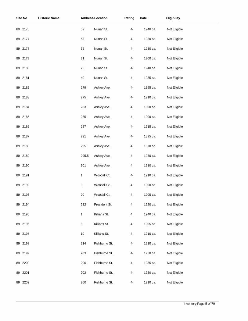
Site No Historic Name Address/Location Rating Date Eligibility
2176 Nunan St. 4- 1940 ca. Not Eligible89 59
2177 Nunan St. 4- 1930 ca. Not Eligible89 58
2178 Nunan St. 4- 1930 ca. Not Eligible89 35
2179 Nunan St. 4- 1900 ca. Not Eligible89 31
2180 Nunan St. 4- 1940 ca. Not Eligible89 25
2181 Nunan St. 4- 1935 ca. Not Eligible89 40
2182 Ashley Ave. 4- 1895 ca. Not Eligible89 279
2183 Ashley Ave. 4- 1910 ca. Not Eligible89 275
2184 Ashley Ave. 4- 1900 ca. Not Eligible89 283
2185 Ashley Ave. 4- 1900 ca. Not Eligible89 285
2186 Ashley Ave. 4- 1915 ca. Not Eligible89 287
2187 Ashley Ave. 4- 1895 ca. Not Eligible89 291
2188 Ashley Ave. 4- 1870 ca. Not Eligible89 295
2189 Ashley Ave. 4 1930 ca. Not Eligible89 295.5
2190 Ashley Ave. 4 1910 ca. Not Eligible89 301
2191 Woodall Ct. 4- 1910 ca. Not Eligible89 1
2192 Woodall Ct. 4- 1900 ca. Not Eligible89 9
2193 Woodall Ct. 4- 1905 ca. Not Eligible89 20
2194 President St. 4 1920 ca. Not Eligible89 232
2195 Killians St. 4 1940 ca. Not Eligible89 1
2196 Killians St. 4- 1905 ca. Not Eligible89 8
2197 Killians St. 4- 1910 ca. Not Eligible89 10
2198 Fishburne St. 4- 1910 ca. Not Eligible89 214
2199 Fishburne St. 4- 1950 ca. Not Eligible89 203
2200 Fishburne St. 4- 1935 ca. Not Eligible89 206
2201 Fishburne St. 4- 1930 ca. Not Eligible89 202
2202 Fishburne St. 4- 1910 ca. Not Eligible89 200
Inventory Page 5 of 79
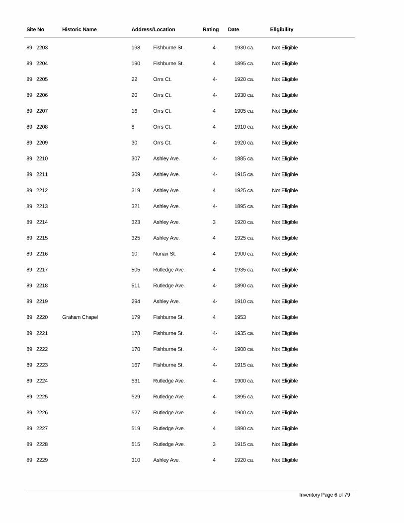
Site No Historic Name Address/Location Rating Date Eligibility
2203 Fishburne St. 4- 1930 ca. Not Eligible89 198
2204 Fishburne St. 4 1895 ca. Not Eligible89 190
2205 Orrs Ct. 4- 1920 ca. Not Eligible89 22
2206 Orrs Ct. 4- 1930 ca. Not Eligible89 20
2207 Orrs Ct. 4 1905 ca. Not Eligible89 16
2208 Orrs Ct. 4 1910 ca. Not Eligible89 8
2209 Orrs Ct. 4- 1920 ca. Not Eligible89 30
2210 Ashley Ave. 4- 1885 ca. Not Eligible89 307
2211 Ashley Ave. 4- 1915 ca. Not Eligible89 309
2212 Ashley Ave. 4 1925 ca. Not Eligible89 319
2213 Ashley Ave. 4- 1895 ca. Not Eligible89 321
2214 Ashley Ave. 3 1920 ca. Not Eligible89 323
2215 Ashley Ave. 4 1925 ca. Not Eligible89 325
2216 Nunan St. 4 1900 ca. Not Eligible89 10
2217 Rutledge Ave. 4 1935 ca. Not Eligible89 505
2218 Rutledge Ave. 4- 1890 ca. Not Eligible89 511
2219 Ashley Ave. 4- 1910 ca. Not Eligible89 294
2220 Graham Chapel Fishburne St. 4 1953 Not Eligible89 179
2221 Fishburne St. 4- 1935 ca. Not Eligible89 178
2222 Fishburne St. 4- 1900 ca. Not Eligible89 170
2223 Fishburne St. 4- 1915 ca. Not Eligible89 167
2224 Rutledge Ave. 4- 1900 ca. Not Eligible89 531
2225 Rutledge Ave. 4- 1895 ca. Not Eligible89 529
2226 Rutledge Ave. 4- 1900 ca. Not Eligible89 527
2227 Rutledge Ave. 4 1890 ca. Not Eligible89 519
2228 Rutledge Ave. 3 1915 ca. Not Eligible89 515
2229 Ashley Ave. 4 1920 ca. Not Eligible89 310
Inventory Page 6 of 79
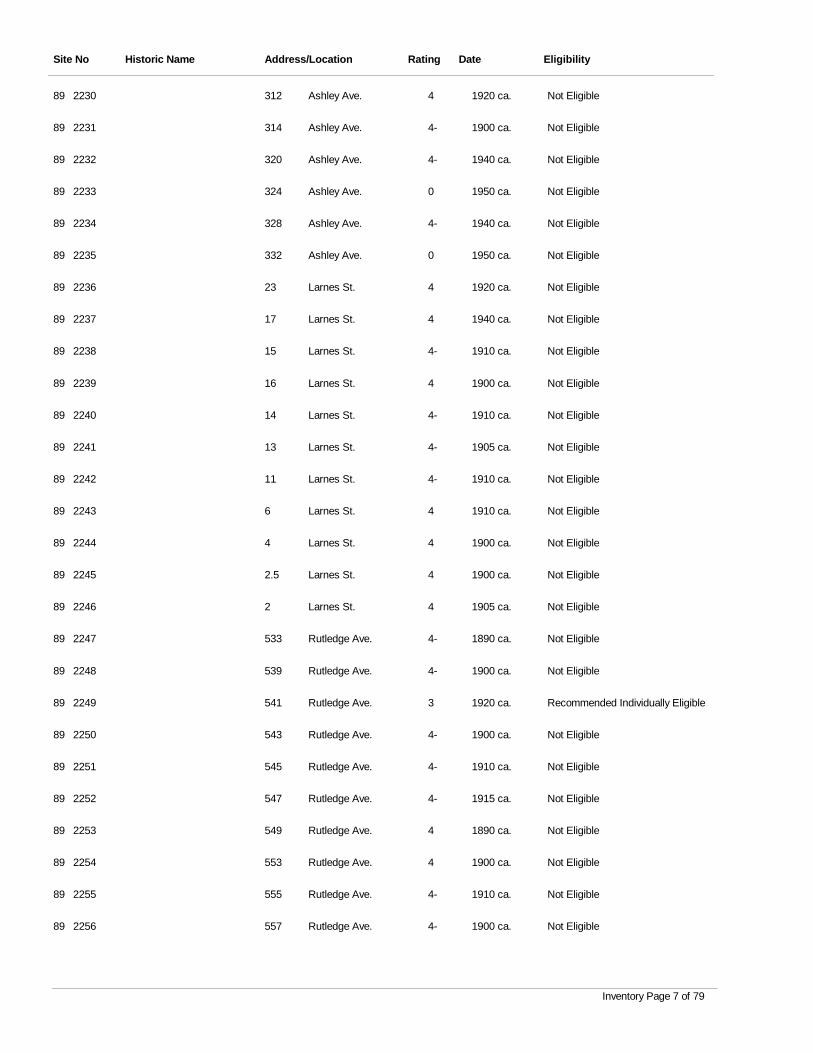
Site No Historic Name Address/Location Rating Date Eligibility
2230 Ashley Ave. 4 1920 ca. Not Eligible89 312
2231 Ashley Ave. 4- 1900 ca. Not Eligible89 314
2232 Ashley Ave. 4- 1940 ca. Not Eligible89 320
2233 Ashley Ave. 0 1950 ca. Not Eligible89 324
2234 Ashley Ave. 4- 1940 ca. Not Eligible89 328
2235 Ashley Ave. 0 1950 ca. Not Eligible89 332
2236 Larnes St. 4 1920 ca. Not Eligible89 23
2237 Larnes St. 4 1940 ca. Not Eligible89 17
2238 Larnes St. 4- 1910 ca. Not Eligible89 15
2239 Larnes St. 4 1900 ca. Not Eligible89 16
2240 Larnes St. 4- 1910 ca. Not Eligible89 14
2241 Larnes St. 4- 1905 ca. Not Eligible89 13
2242 Larnes St. 4- 1910 ca. Not Eligible89 11
2243 Larnes St. 4 1910 ca. Not Eligible89 6
2244 Larnes St. 4 1900 ca. Not Eligible89 4
2245 Larnes St. 4 1900 ca. Not Eligible89 2.5
2246 Larnes St. 4 1905 ca. Not Eligible89 2
2247 Rutledge Ave. 4- 1890 ca. Not Eligible89 533
2248 Rutledge Ave. 4- 1900 ca. Not Eligible89 539
2249 Rutledge Ave. 3 1920 ca. Recommended Individually Eligible89 541
2250 Rutledge Ave. 4- 1900 ca. Not Eligible89 543
2251 Rutledge Ave. 4- 1910 ca. Not Eligible89 545
2252 Rutledge Ave. 4- 1915 ca. Not Eligible89 547
2253 Rutledge Ave. 4 1890 ca. Not Eligible89 549
2254 Rutledge Ave. 4 1900 ca. Not Eligible89 553
2255 Rutledge Ave. 4- 1910 ca. Not Eligible89 555
2256 Rutledge Ave. 4- 1900 ca. Not Eligible89 557
Inventory Page 7 of 79
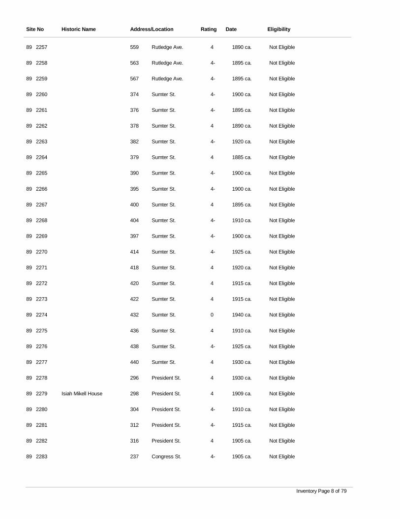
Site No Historic Name Address/Location Rating Date Eligibility
2257 Rutledge Ave. 4 1890 ca. Not Eligible89 559
2258 Rutledge Ave. 4- 1895 ca. Not Eligible89 563
2259 Rutledge Ave. 4- 1895 ca. Not Eligible89 567
2260 Sumter St. 4- 1900 ca. Not Eligible89 374
2261 Sumter St. 4- 1895 ca. Not Eligible89 376
2262 Sumter St. 4 1890 ca. Not Eligible89 378
2263 Sumter St. 4- 1920 ca. Not Eligible89 382
2264 Sumter St. 4 1885 ca. Not Eligible89 379
2265 Sumter St. 4- 1900 ca. Not Eligible89 390
2266 Sumter St. 4- 1900 ca. Not Eligible89 395
2267 Sumter St. 4 1895 ca. Not Eligible89 400
2268 Sumter St. 4- 1910 ca. Not Eligible89 404
2269 Sumter St. 4- 1900 ca. Not Eligible89 397
2270 Sumter St. 4- 1925 ca. Not Eligible89 414
2271 Sumter St. 4 1920 ca. Not Eligible89 418
2272 Sumter St. 4 1915 ca. Not Eligible89 420
2273 Sumter St. 4 1915 ca. Not Eligible89 422
2274 Sumter St. 0 1940 ca. Not Eligible89 432
2275 Sumter St. 4 1910 ca. Not Eligible89 436
2276 Sumter St. 4- 1925 ca. Not Eligible89 438
2277 Sumter St. 4 1930 ca. Not Eligible89 440
2278 President St. 4 1930 ca. Not Eligible89 296
2279 Isiah Mikell House President St. 4 1909 ca. Not Eligible89 298
2280 President St. 4- 1910 ca. Not Eligible89 304
2281 President St. 4- 1915 ca. Not Eligible89 312
2282 President St. 4 1905 ca. Not Eligible89 316
2283 Congress St. 4- 1905 ca. Not Eligible89 237
Inventory Page 8 of 79
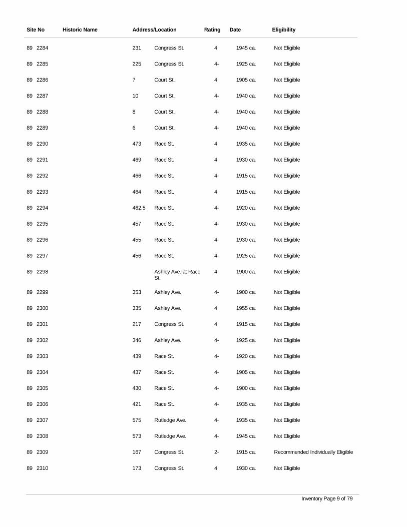
Site No Historic Name Address/Location Rating Date Eligibility
2284 Congress St. 4 1945 ca. Not Eligible89 231
2285 Congress St. 4- 1925 ca. Not Eligible89 225
2286 Court St. 4 1905 ca. Not Eligible89 7
2287 Court St. 4- 1940 ca. Not Eligible89 10
2288 Court St. 4- 1940 ca. Not Eligible89 8
2289 Court St. 4- 1940 ca. Not Eligible89 6
2290 Race St. 4 1935 ca. Not Eligible89 473
2291 Race St. 4 1930 ca. Not Eligible89 469
2292 Race St. 4- 1915 ca. Not Eligible89 466
2293 Race St. 4 1915 ca. Not Eligible89 464
2294 Race St. 4- 1920 ca. Not Eligible89 462.5
2295 Race St. 4- 1930 ca. Not Eligible89 457
2296 Race St. 4- 1930 ca. Not Eligible89 455
2297 Race St. 4- 1925 ca. Not Eligible89 456
2298 Ashley Ave. at Race St.
4- 1900 ca. Not Eligible89
2299 Ashley Ave. 4- 1900 ca. Not Eligible89 353
2300 Ashley Ave. 4 1955 ca. Not Eligible89 335
2301 Congress St. 4 1915 ca. Not Eligible89 217
2302 Ashley Ave. 4- 1925 ca. Not Eligible89 346
2303 Race St. 4- 1920 ca. Not Eligible89 439
2304 Race St. 4- 1905 ca. Not Eligible89 437
2305 Race St. 4- 1900 ca. Not Eligible89 430
2306 Race St. 4- 1935 ca. Not Eligible89 421
2307 Rutledge Ave. 4- 1935 ca. Not Eligible89 575
2308 Rutledge Ave. 4- 1945 ca. Not Eligible89 573
2309 Congress St. 2- 1915 ca. Recommended Individually Eligible89 167
2310 Congress St. 4 1930 ca. Not Eligible89 173
Inventory Page 9 of 79
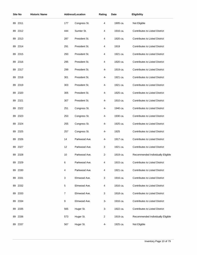
Site No Historic Name Address/Location Rating Date Eligibility
2311 Congress St. 4 1905 ca. Not Eligible89 177
2312 Sumter St. 4 1916 ca. Contributes to Listed District89 444
2313 President St. 4 1920 ca. Contributes to Listed District89 287
2314 President St. 4 1919 Contributes to Listed District89 291
2315 President St. 4 1921 ca. Contributes to Listed District89 293
2316 President St. 4 1920 ca. Contributes to Listed District89 295
2317 President St. 4- 1919 ca. Contributes to Listed District89 299
2318 President St. 4- 1921 ca. Contributes to Listed District89 301
2319 President St. 4- 1921 ca. Contributes to Listed District89 303
2320 President St. 4- 1925 ca. Contributes to Listed District89 305
2321 President St. 4- 1910 ca. Contributes to Listed District89 307
2322 Congress St. 4- 1940 ca. Contributes to Listed District89 251
2323 Congress St. 4- 1930 ca. Contributes to Listed District89 253
2324 Congress St. 4- 1925 ca. Contributes to Listed District89 255
2325 Congress St. 4- 1925 Contributes to Listed District89 257
2326 Parkwood Ave. 4- 1917 ca. Contributes to Listed District89 14
2327 Parkwood Ave. 3 1921 ca. Contributes to Listed District89 12
2328 Parkwood Ave. 2- 1919 ca. Recommended Individually Eligible89 10
2329 Parkwood Ave. 4 1915 ca. Contributes to Listed District89 6
2330 Parkwood Ave. 4 1921 ca. Contributes to Listed District89 4
2331 Elmwood Ave. 3 1916 ca. Contributes to Listed District89 3
2332 Elmwood Ave. 4 1916 ca. Contributes to Listed District89 5
2333 Elmwood Ave. 3 1918 ca. Contributes to Listed District89 7
2334 Elmwood Ave. 3- 1916 ca. Contributes to Listed District89 9
2335 Huger St. 3- 1922 ca. Contributes to Listed District89 565
2336 Huger St. 2 1919 ca. Recommended Individually Eligible89 573
2337 Huger St. 4- 1925 ca. Not Eligible89 567
Inventory Page 10 of 79
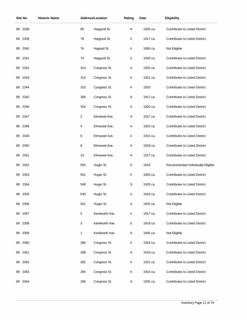
Site No Historic Name Address/Location Rating Date Eligibility
2338 Haygood St. 4- 1925 ca. Contributes to Listed District89 80
2339 Haygood St. 4 1917 ca. Contributes to Listed District89 78
2340 Hagood St. 4 1950 ca. Not Eligible89 76
2341 Haygood St. 3 1930 ca. Contributes to Listed District89 74
2342 Congress St. 4- 1925 ca. Contributes to Listed District89 314
2343 Congress St. 4 1921 ca. Contributes to Listed District89 312
2344 Congress St. 4 1920 Contributes to Listed District89 310
2345 Congress St. 4- 1917 ca. Contributes to Listed District89 306
2346 Congress St. 4- 1920 ca. Contributes to Listed District89 304
2347 Elmwood Ave. 4- 1917 ca. Contributes to Listed District89 2
2348 Elmwood Ave. 4- 1920 ca. Contributes to Listed District89 4
2349 Elmwood Ave. 4 1915 ca. Contributes to Listed District89 6
2350 Elmwood Ave. 4- 1918 ca. Contributes to Listed District89 8
2351 Elmwood Ave. 4- 1917 ca. Contributes to Listed District89 10
2352 Huger St. 2- 1918 Recommended Individually Eligible89 555
2353 Huger St. 4 1920 ca. Contributes to Listed District89 551
2354 Huger St. 3- 1925 ca. Contributes to Listed District89 549
2355 Huger St. 4- 1916 ca. Contributes to Listed District89 545
2356 Huger St. 4- 1925 ca. Not Eligible89 541
2357 Kenilworth Ave. 2 1917 ca. Contributes to Listed District89 5
2358 Kenilworth Ave. 3 1916 ca. Contributes to Listed District89 3
2359 Kenilworth Ave. 4- 1905 ca. Not Eligible89 1
2360 Congress St. 4 1919 ca. Contributes to Listed District89 286
2361 Congress St. 4- 1916 ca. Contributes to Listed District89 288
2362 Congress St. 4 1921 ca. Contributes to Listed District89 292
2363 Congress St. 4 1916 ca. Contributes to Listed District89 294
2364 Congress St. 4- 1935 ca. Contributes to Listed District89 296
Inventory Page 11 of 79
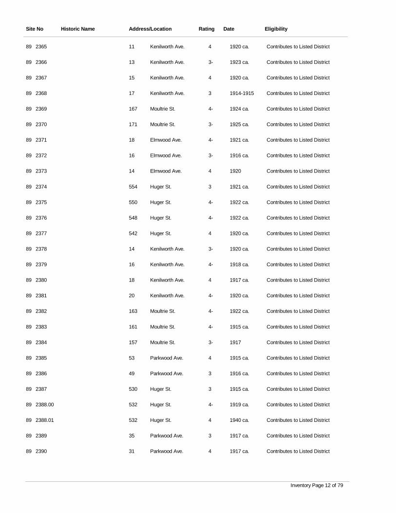
Site No Historic Name Address/Location Rating Date Eligibility
2365 Kenilworth Ave. 4 1920 ca. Contributes to Listed District89 11
2366 Kenilworth Ave. 3- 1923 ca. Contributes to Listed District89 13
2367 Kenilworth Ave. 4 1920 ca. Contributes to Listed District89 15
2368 Kenilworth Ave. 3 1914-1915 Contributes to Listed District89 17
2369 Moultrie St. 4- 1924 ca. Contributes to Listed District89 167
2370 Moultrie St. 3- 1925 ca. Contributes to Listed District89 171
2371 Elmwood Ave. 4- 1921 ca. Contributes to Listed District89 18
2372 Elmwood Ave. 3- 1916 ca. Contributes to Listed District89 16
2373 Elmwood Ave. 4 1920 Contributes to Listed District89 14
2374 Huger St. 3 1921 ca. Contributes to Listed District89 554
2375 Huger St. 4- 1922 ca. Contributes to Listed District89 550
2376 Huger St. 4- 1922 ca. Contributes to Listed District89 548
2377 Huger St. 4 1920 ca. Contributes to Listed District89 542
2378 Kenilworth Ave. 3- 1920 ca. Contributes to Listed District89 14
2379 Kenilworth Ave. 4- 1918 ca. Contributes to Listed District89 16
2380 Kenilworth Ave. 4 1917 ca. Contributes to Listed District89 18
2381 Kenilworth Ave. 4- 1920 ca. Contributes to Listed District89 20
2382 Moultrie St. 4- 1922 ca. Contributes to Listed District89 163
2383 Moultrie St. 4- 1915 ca. Contributes to Listed District89 161
2384 Moultrie St. 3- 1917 Contributes to Listed District89 157
2385 Parkwood Ave. 4 1915 ca. Contributes to Listed District89 53
2386 Parkwood Ave. 3 1916 ca. Contributes to Listed District89 49
2387 Huger St. 3 1915 ca. Contributes to Listed District89 530
2388.00 Huger St. 4- 1919 ca. Contributes to Listed District89 532
2388.01 Huger St. 4 1940 ca. Contributes to Listed District89 532
2389 Parkwood Ave. 3 1917 ca. Contributes to Listed District89 35
2390 Parkwood Ave. 4 1917 ca. Contributes to Listed District89 31
Inventory Page 12 of 79
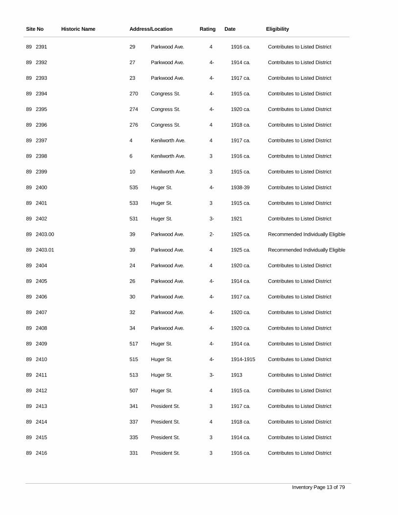
Site No Historic Name Address/Location Rating Date Eligibility
2391 Parkwood Ave. 4 1916 ca. Contributes to Listed District89 29
2392 Parkwood Ave. 4- 1914 ca. Contributes to Listed District89 27
2393 Parkwood Ave. 4- 1917 ca. Contributes to Listed District89 23
2394 Congress St. 4- 1915 ca. Contributes to Listed District89 270
2395 Congress St. 4- 1920 ca. Contributes to Listed District89 274
2396 Congress St. 4 1918 ca. Contributes to Listed District89 276
2397 Kenilworth Ave. 4 1917 ca. Contributes to Listed District89 4
2398 Kenilworth Ave. 3 1916 ca. Contributes to Listed District89 6
2399 Kenilworth Ave. 3 1915 ca. Contributes to Listed District89 10
2400 Huger St. 4- 1938-39 Contributes to Listed District89 535
2401 Huger St. 3 1915 ca. Contributes to Listed District89 533
2402 Huger St. 3- 1921 Contributes to Listed District89 531
2403.00 Parkwood Ave. 2- 1925 ca. Recommended Individually Eligible89 39
2403.01 Parkwood Ave. 4 1925 ca. Recommended Individually Eligible89 39
2404 Parkwood Ave. 4 1920 ca. Contributes to Listed District89 24
2405 Parkwood Ave. 4- 1914 ca. Contributes to Listed District89 26
2406 Parkwood Ave. 4- 1917 ca. Contributes to Listed District89 30
2407 Parkwood Ave. 4- 1920 ca. Contributes to Listed District89 32
2408 Parkwood Ave. 4- 1920 ca. Contributes to Listed District89 34
2409 Huger St. 4- 1914 ca. Contributes to Listed District89 517
2410 Huger St. 4- 1914-1915 Contributes to Listed District89 515
2411 Huger St. 3- 1913 Contributes to Listed District89 513
2412 Huger St. 4 1915 ca. Contributes to Listed District89 507
2413 President St. 3 1917 ca. Contributes to Listed District89 341
2414 President St. 4 1918 ca. Contributes to Listed District89 337
2415 President St. 3 1914 ca. Contributes to Listed District89 335
2416 President St. 3 1916 ca. Contributes to Listed District89 331
Inventory Page 13 of 79
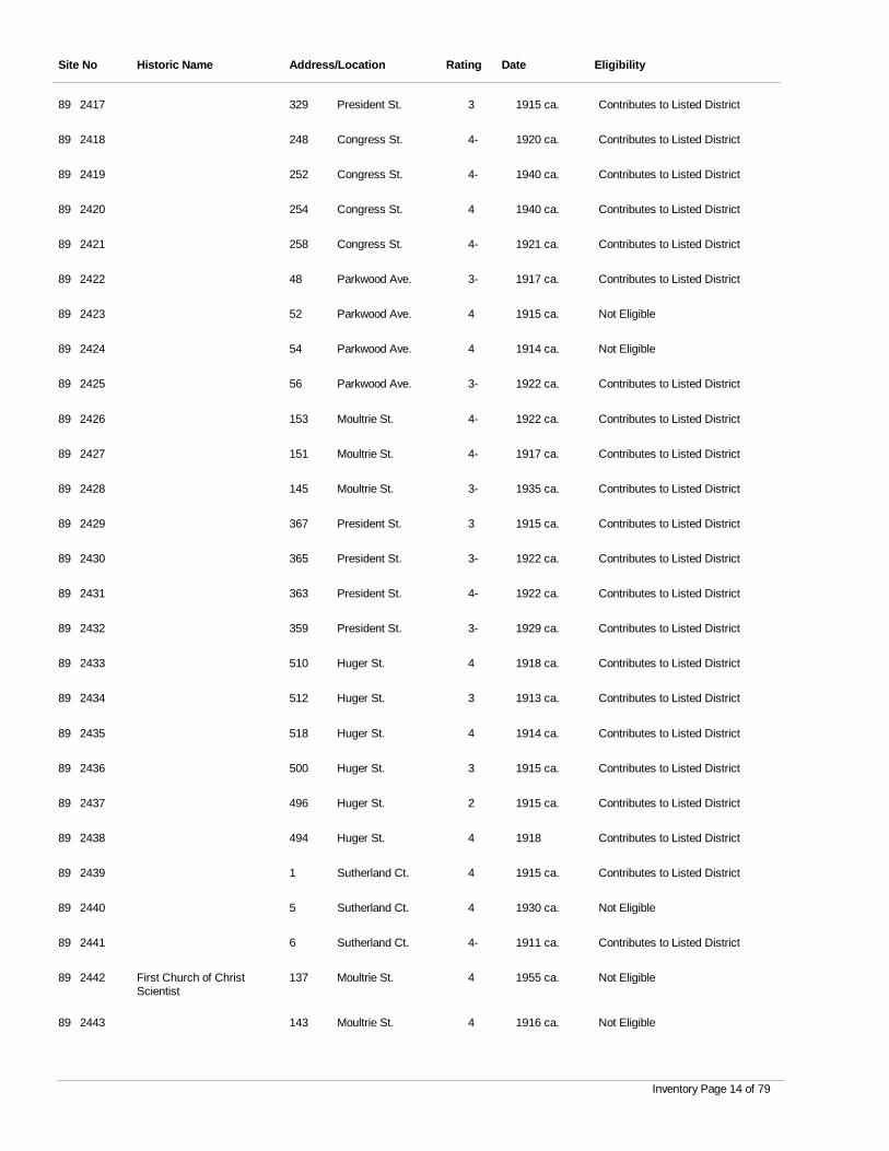
Site No Historic Name Address/Location Rating Date Eligibility
2417 President St. 3 1915 ca. Contributes to Listed District89 329
2418 Congress St. 4- 1920 ca. Contributes to Listed District89 248
2419 Congress St. 4- 1940 ca. Contributes to Listed District89 252
2420 Congress St. 4 1940 ca. Contributes to Listed District89 254
2421 Congress St. 4- 1921 ca. Contributes to Listed District89 258
2422 Parkwood Ave. 3- 1917 ca. Contributes to Listed District89 48
2423 Parkwood Ave. 4 1915 ca. Not Eligible89 52
2424 Parkwood Ave. 4 1914 ca. Not Eligible89 54
2425 Parkwood Ave. 3- 1922 ca. Contributes to Listed District89 56
2426 Moultrie St. 4- 1922 ca. Contributes to Listed District89 153
2427 Moultrie St. 4- 1917 ca. Contributes to Listed District89 151
2428 Moultrie St. 3- 1935 ca. Contributes to Listed District89 145
2429 President St. 3 1915 ca. Contributes to Listed District89 367
2430 President St. 3- 1922 ca. Contributes to Listed District89 365
2431 President St. 4- 1922 ca. Contributes to Listed District89 363
2432 President St. 3- 1929 ca. Contributes to Listed District89 359
2433 Huger St. 4 1918 ca. Contributes to Listed District89 510
2434 Huger St. 3 1913 ca. Contributes to Listed District89 512
2435 Huger St. 4 1914 ca. Contributes to Listed District89 518
2436 Huger St. 3 1915 ca. Contributes to Listed District89 500
2437 Huger St. 2 1915 ca. Contributes to Listed District89 496
2438 Huger St. 4 1918 Contributes to Listed District89 494
2439 Sutherland Ct. 4 1915 ca. Contributes to Listed District89 1
2440 Sutherland Ct. 4 1930 ca. Not Eligible89 5
2441 Sutherland Ct. 4- 1911 ca. Contributes to Listed District89 6
2442 First Church of Christ Scientist
Moultrie St. 4 1955 ca. Not Eligible89 137
2443 Moultrie St. 4 1916 ca. Not Eligible89 143
Inventory Page 14 of 79
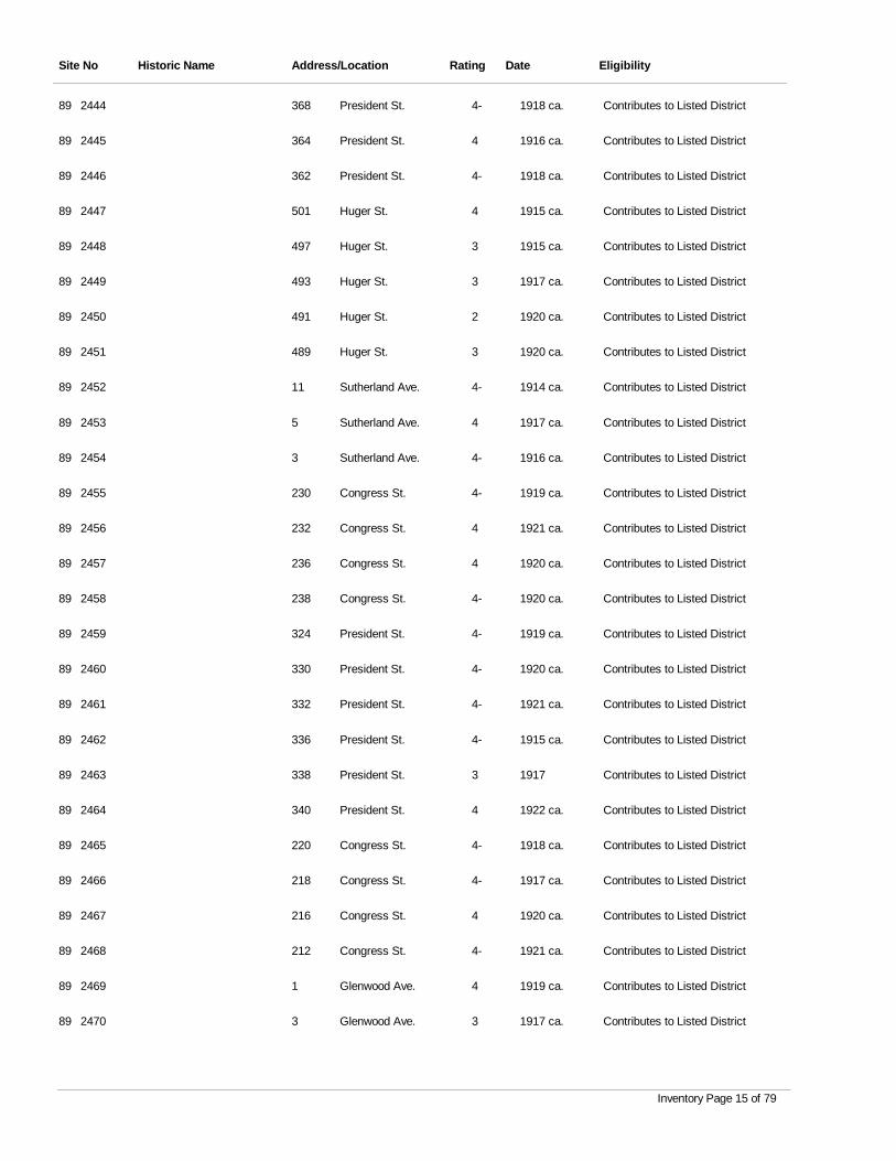
Site No Historic Name Address/Location Rating Date Eligibility
2444 President St. 4- 1918 ca. Contributes to Listed District89 368
2445 President St. 4 1916 ca. Contributes to Listed District89 364
2446 President St. 4- 1918 ca. Contributes to Listed District89 362
2447 Huger St. 4 1915 ca. Contributes to Listed District89 501
2448 Huger St. 3 1915 ca. Contributes to Listed District89 497
2449 Huger St. 3 1917 ca. Contributes to Listed District89 493
2450 Huger St. 2 1920 ca. Contributes to Listed District89 491
2451 Huger St. 3 1920 ca. Contributes to Listed District89 489
2452 Sutherland Ave. 4- 1914 ca. Contributes to Listed District89 11
2453 Sutherland Ave. 4 1917 ca. Contributes to Listed District89 5
2454 Sutherland Ave. 4- 1916 ca. Contributes to Listed District89 3
2455 Congress St. 4- 1919 ca. Contributes to Listed District89 230
2456 Congress St. 4 1921 ca. Contributes to Listed District89 232
2457 Congress St. 4 1920 ca. Contributes to Listed District89 236
2458 Congress St. 4- 1920 ca. Contributes to Listed District89 238
2459 President St. 4- 1919 ca. Contributes to Listed District89 324
2460 President St. 4- 1920 ca. Contributes to Listed District89 330
2461 President St. 4- 1921 ca. Contributes to Listed District89 332
2462 President St. 4- 1915 ca. Contributes to Listed District89 336
2463 President St. 3 1917 Contributes to Listed District89 338
2464 President St. 4 1922 ca. Contributes to Listed District89 340
2465 Congress St. 4- 1918 ca. Contributes to Listed District89 220
2466 Congress St. 4- 1917 ca. Contributes to Listed District89 218
2467 Congress St. 4 1920 ca. Contributes to Listed District89 216
2468 Congress St. 4- 1921 ca. Contributes to Listed District89 212
2469 Glenwood Ave. 4 1919 ca. Contributes to Listed District89 1
2470 Glenwood Ave. 3 1917 ca. Contributes to Listed District89 3
Inventory Page 15 of 79
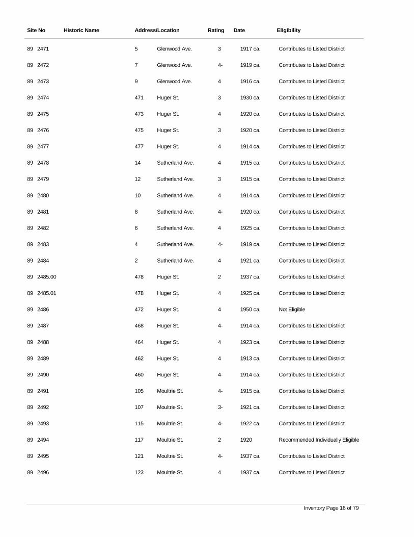
Site No Historic Name Address/Location Rating Date Eligibility
2471 Glenwood Ave. 3 1917 ca. Contributes to Listed District89 5
2472 Glenwood Ave. 4- 1919 ca. Contributes to Listed District89 7
2473 Glenwood Ave. 4 1916 ca. Contributes to Listed District89 9
2474 Huger St. 3 1930 ca. Contributes to Listed District89 471
2475 Huger St. 4 1920 ca. Contributes to Listed District89 473
2476 Huger St. 3 1920 ca. Contributes to Listed District89 475
2477 Huger St. 4 1914 ca. Contributes to Listed District89 477
2478 Sutherland Ave. 4 1915 ca. Contributes to Listed District89 14
2479 Sutherland Ave. 3 1915 ca. Contributes to Listed District89 12
2480 Sutherland Ave. 4 1914 ca. Contributes to Listed District89 10
2481 Sutherland Ave. 4- 1920 ca. Contributes to Listed District89 8
2482 Sutherland Ave. 4 1925 ca. Contributes to Listed District89 6
2483 Sutherland Ave. 4- 1919 ca. Contributes to Listed District89 4
2484 Sutherland Ave. 4 1921 ca. Contributes to Listed District89 2
2485.00 Huger St. 2 1937 ca. Contributes to Listed District89 478
2485.01 Huger St. 4 1925 ca. Contributes to Listed District89 478
2486 Huger St. 4 1950 ca. Not Eligible89 472
2487 Huger St. 4- 1914 ca. Contributes to Listed District89 468
2488 Huger St. 4 1923 ca. Contributes to Listed District89 464
2489 Huger St. 4 1913 ca. Contributes to Listed District89 462
2490 Huger St. 4- 1914 ca. Contributes to Listed District89 460
2491 Moultrie St. 4- 1915 ca. Contributes to Listed District89 105
2492 Moultrie St. 3- 1921 ca. Contributes to Listed District89 107
2493 Moultrie St. 4- 1922 ca. Contributes to Listed District89 115
2494 Moultrie St. 2 1920 Recommended Individually Eligible89 117
2495 Moultrie St. 4- 1937 ca. Contributes to Listed District89 121
2496 Moultrie St. 4 1937 ca. Contributes to Listed District89 123
Inventory Page 16 of 79
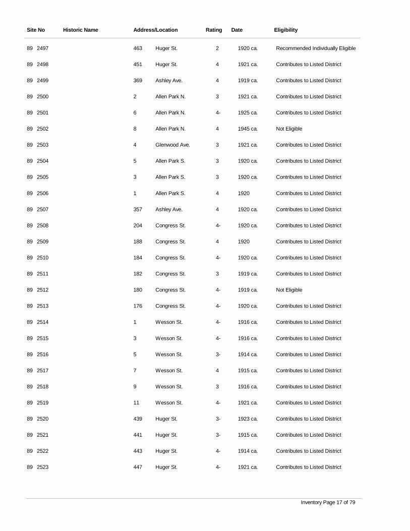
Site No Historic Name Address/Location Rating Date Eligibility
2497 Huger St. 2 1920 ca. Recommended Individually Eligible89 463
2498 Huger St. 4 1921 ca. Contributes to Listed District89 451
2499 Ashley Ave. 4 1919 ca. Contributes to Listed District89 369
2500 Allen Park N. 3 1921 ca. Contributes to Listed District89 2
2501 Allen Park N. 4- 1925 ca. Contributes to Listed District89 6
2502 Allen Park N. 4 1945 ca. Not Eligible89 8
2503 Glenwood Ave. 3 1921 ca. Contributes to Listed District89 4
2504 Allen Park S. 3 1920 ca. Contributes to Listed District89 5
2505 Allen Park S. 3 1920 ca. Contributes to Listed District89 3
2506 Allen Park S. 4 1920 Contributes to Listed District89 1
2507 Ashley Ave. 4 1920 ca. Contributes to Listed District89 357
2508 Congress St. 4- 1920 ca. Contributes to Listed District89 204
2509 Congress St. 4 1920 Contributes to Listed District89 188
2510 Congress St. 4- 1920 ca. Contributes to Listed District89 184
2511 Congress St. 3 1919 ca. Contributes to Listed District89 182
2512 Congress St. 4- 1919 ca. Not Eligible89 180
2513 Congress St. 4- 1920 ca. Contributes to Listed District89 176
2514 Wesson St. 4- 1916 ca. Contributes to Listed District89 1
2515 Wesson St. 4- 1916 ca. Contributes to Listed District89 3
2516 Wesson St. 3- 1914 ca. Contributes to Listed District89 5
2517 Wesson St. 4 1915 ca. Contributes to Listed District89 7
2518 Wesson St. 3 1916 ca. Contributes to Listed District89 9
2519 Wesson St. 4- 1921 ca. Contributes to Listed District89 11
2520 Huger St. 3- 1923 ca. Contributes to Listed District89 439
2521 Huger St. 3- 1915 ca. Contributes to Listed District89 441
2522 Huger St. 4- 1914 ca. Contributes to Listed District89 443
2523 Huger St. 4- 1921 ca. Contributes to Listed District89 447
Inventory Page 17 of 79
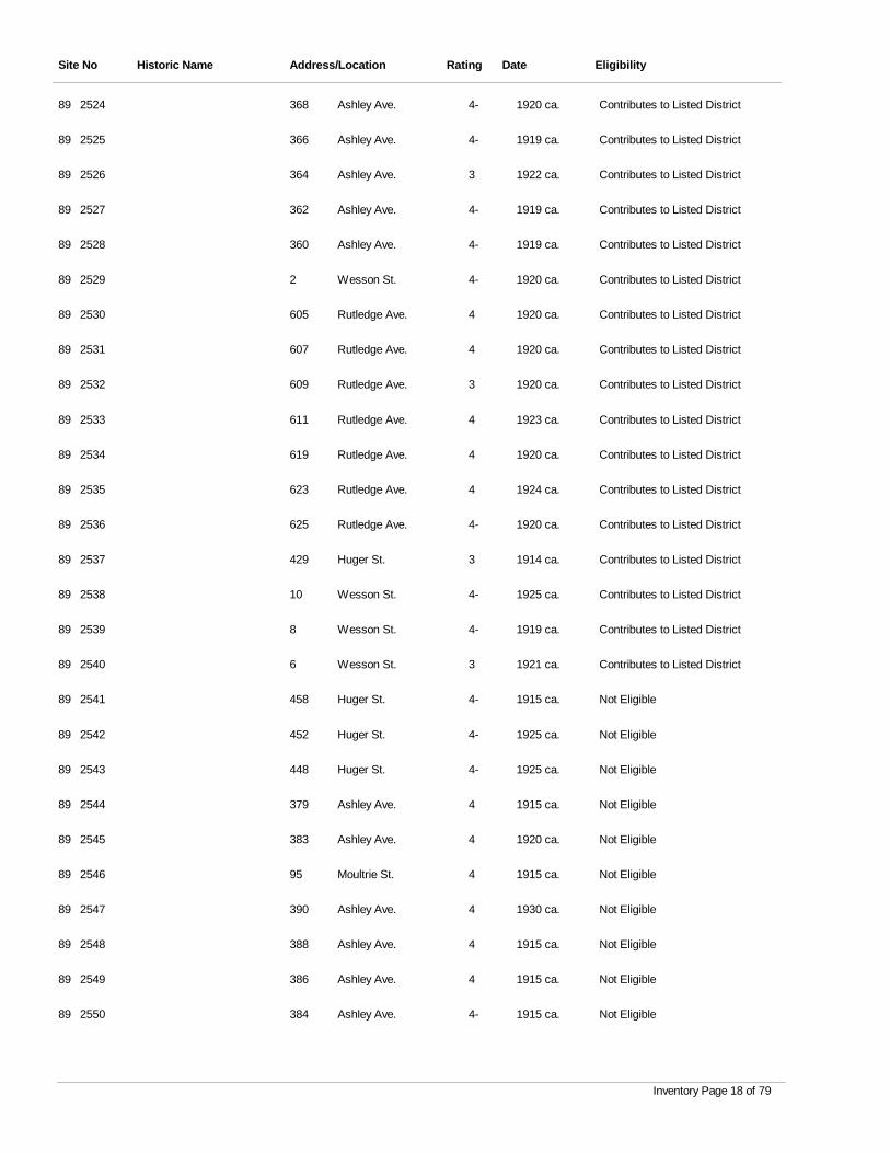
Site No Historic Name Address/Location Rating Date Eligibility
2524 Ashley Ave. 4- 1920 ca. Contributes to Listed District89 368
2525 Ashley Ave. 4- 1919 ca. Contributes to Listed District89 366
2526 Ashley Ave. 3 1922 ca. Contributes to Listed District89 364
2527 Ashley Ave. 4- 1919 ca. Contributes to Listed District89 362
2528 Ashley Ave. 4- 1919 ca. Contributes to Listed District89 360
2529 Wesson St. 4- 1920 ca. Contributes to Listed District89 2
2530 Rutledge Ave. 4 1920 ca. Contributes to Listed District89 605
2531 Rutledge Ave. 4 1920 ca. Contributes to Listed District89 607
2532 Rutledge Ave. 3 1920 ca. Contributes to Listed District89 609
2533 Rutledge Ave. 4 1923 ca. Contributes to Listed District89 611
2534 Rutledge Ave. 4 1920 ca. Contributes to Listed District89 619
2535 Rutledge Ave. 4 1924 ca. Contributes to Listed District89 623
2536 Rutledge Ave. 4- 1920 ca. Contributes to Listed District89 625
2537 Huger St. 3 1914 ca. Contributes to Listed District89 429
2538 Wesson St. 4- 1925 ca. Contributes to Listed District89 10
2539 Wesson St. 4- 1919 ca. Contributes to Listed District89 8
2540 Wesson St. 3 1921 ca. Contributes to Listed District89 6
2541 Huger St. 4- 1915 ca. Not Eligible89 458
2542 Huger St. 4- 1925 ca. Not Eligible89 452
2543 Huger St. 4- 1925 ca. Not Eligible89 448
2544 Ashley Ave. 4 1915 ca. Not Eligible89 379
2545 Ashley Ave. 4 1920 ca. Not Eligible89 383
2546 Moultrie St. 4 1915 ca. Not Eligible89 95
2547 Ashley Ave. 4 1930 ca. Not Eligible89 390
2548 Ashley Ave. 4 1915 ca. Not Eligible89 388
2549 Ashley Ave. 4 1915 ca. Not Eligible89 386
2550 Ashley Ave. 4- 1915 ca. Not Eligible89 384
Inventory Page 18 of 79
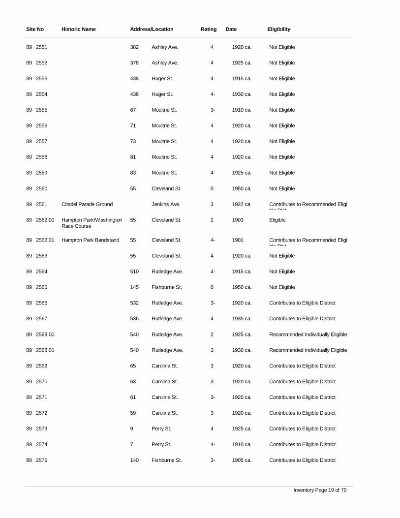
Site No Historic Name Address/Location Rating Date Eligibility
2551 Ashley Ave. 4 1920 ca. Not Eligible89 382
2552 Ashley Ave. 4 1925 ca. Not Eligible89 378
2553 Huger St. 4- 1915 ca. Not Eligible89 438
2554 Huger St. 4- 1930 ca. Not Eligible89 436
2555 Moultrie St. 3- 1910 ca. Not Eligible89 67
2556 Moultrie St. 4 1920 ca. Not Eligible89 71
2557 Moultrie St. 4 1920 ca. Not Eligible89 73
2558 Moultrie St. 4 1920 ca. Not Eligible89 81
2559 Moultrie St. 4- 1925 ca. Not Eligible89 83
2560 Cleveland St. 0 1950 ca. Not Eligible89 55
2561 Citadel Parade Ground Jenkins Ave. 3 1922 ca Contributes to Recommended Eligible Dist
89
2562.00 Hampton Park/Washington Race Course
Cleveland St. 2 1903 Eligible89 55
2562.01 Hampton Park Bandstand Cleveland St. 4- 1901 Contributes to Recommended Eligible Dist
89 55
2563 Cleveland St. 4 1920 ca. Not Eligible89 55
2564 Rutledge Ave. 4- 1915 ca. Not Eligible89 510
2565 Fishburne St. 0 1950 ca. Not Eligible89 145
2566 Rutledge Ave. 3- 1920 ca. Contributes to Eligible District89 532
2567 Rutledge Ave. 4 1935 ca. Contributes to Eligible District89 536
2568.00 Rutledge Ave. 2 1925 ca. Recommended Individually Eligible89 540
2568.01 Rutledge Ave. 3 1930 ca. Recommended Individually Eligible89 540
2569 Carolina St. 3 1920 ca. Contributes to Eligible District89 65
2570 Carolina St. 3 1920 ca. Contributes to Eligible District89 63
2571 Carolina St. 3- 1920 ca. Contributes to Eligible District89 61
2572 Carolina St. 3 1920 ca. Contributes to Eligible District89 59
2573 Perry St. 4 1925 ca. Contributes to Eligible District89 9
2574 Perry St. 4- 1910 ca. Contributes to Eligible District89 7
2575 Fishburne St. 3- 1905 ca. Contributes to Eligible District89 140
Inventory Page 19 of 79
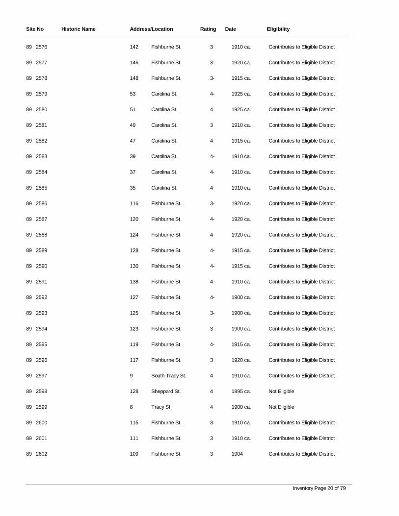
Site No Historic Name Address/Location Rating Date Eligibility
2576 Fishburne St. 3 1910 ca. Contributes to Eligible District89 142
2577 Fishburne St. 3- 1920 ca. Contributes to Eligible District89 146
2578 Fishburne St. 3- 1915 ca. Contributes to Eligible District89 148
2579 Carolina St. 4- 1925 ca. Contributes to Eligible District89 53
2580 Carolina St. 4 1925 ca. Contributes to Eligible District89 51
2581 Carolina St. 3 1910 ca. Contributes to Eligible District89 49
2582 Carolina St. 4 1915 ca. Contributes to Eligible District89 47
2583 Carolina St. 4- 1910 ca. Contributes to Eligible District89 39
2584 Carolina St. 4- 1910 ca. Contributes to Eligible District89 37
2585 Carolina St. 4 1910 ca. Contributes to Eligible District89 35
2586 Fishburne St. 3- 1920 ca. Contributes to Eligible District89 116
2587 Fishburne St. 4- 1920 ca. Contributes to Eligible District89 120
2588 Fishburne St. 4- 1920 ca. Contributes to Eligible District89 124
2589 Fishburne St. 4- 1915 ca. Contributes to Eligible District89 128
2590 Fishburne St. 4- 1915 ca. Contributes to Eligible District89 130
2591 Fishburne St. 4- 1910 ca. Contributes to Eligible District89 138
2592 Fishburne St. 4- 1900 ca. Contributes to Eligible District89 127
2593 Fishburne St. 3- 1900 ca. Contributes to Eligible District89 125
2594 Fishburne St. 3 1900 ca. Contributes to Eligible District89 123
2595 Fishburne St. 4- 1915 ca. Contributes to Eligible District89 119
2596 Fishburne St. 3 1920 ca. Contributes to Eligible District89 117
2597 South Tracy St. 4 1910 ca. Contributes to Eligible District89 9
2598 Sheppard St. 4 1895 ca. Not Eligible89 128
2599 Tracy St. 4 1900 ca. Not Eligible89 8
2600 Fishburne St. 3 1910 ca. Contributes to Eligible District89 115
2601 Fishburne St. 3 1910 ca. Contributes to Eligible District89 111
2602 Fishburne St. 3 1904 Contributes to Eligible District89 109
Inventory Page 20 of 79
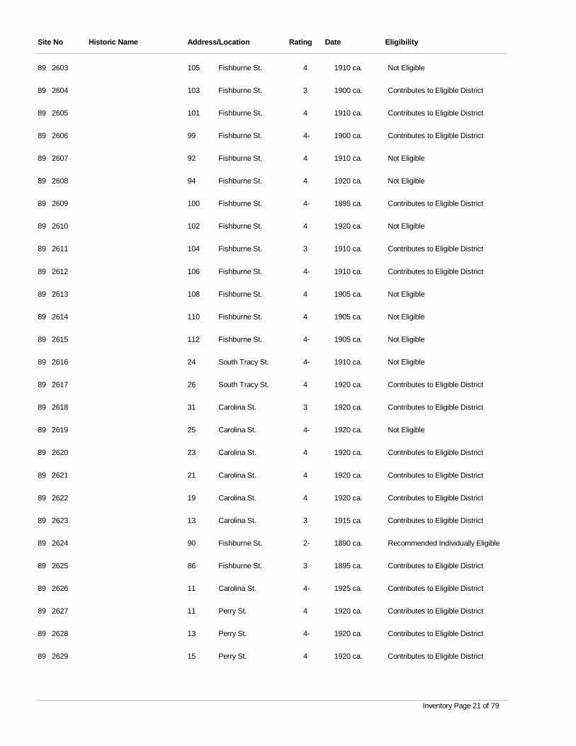
Site No Historic Name Address/Location Rating Date Eligibility
2603 Fishburne St. 4 1910 ca. Not Eligible89 105
2604 Fishburne St. 3 1900 ca. Contributes to Eligible District89 103
2605 Fishburne St. 4 1910 ca. Contributes to Eligible District89 101
2606 Fishburne St. 4- 1900 ca. Contributes to Eligible District89 99
2607 Fishburne St. 4 1910 ca. Not Eligible89 92
2608 Fishburne St. 4 1920 ca. Not Eligible89 94
2609 Fishburne St. 4- 1895 ca. Contributes to Eligible District89 100
2610 Fishburne St. 4 1920 ca. Not Eligible89 102
2611 Fishburne St. 3 1910 ca. Contributes to Eligible District89 104
2612 Fishburne St. 4- 1910 ca. Contributes to Eligible District89 106
2613 Fishburne St. 4 1905 ca. Not Eligible89 108
2614 Fishburne St. 4 1905 ca. Not Eligible89 110
2615 Fishburne St. 4- 1905 ca. Not Eligible89 112
2616 South Tracy St. 4- 1910 ca. Not Eligible89 24
2617 South Tracy St. 4 1920 ca. Contributes to Eligible District89 26
2618 Carolina St. 3 1920 ca. Contributes to Eligible District89 31
2619 Carolina St. 4- 1920 ca. Not Eligible89 25
2620 Carolina St. 4 1920 ca. Contributes to Eligible District89 23
2621 Carolina St. 4 1920 ca. Contributes to Eligible District89 21
2622 Carolina St. 4 1920 ca. Contributes to Eligible District89 19
2623 Carolina St. 3 1915 ca. Contributes to Eligible District89 13
2624 Fishburne St. 2- 1890 ca. Recommended Individually Eligible89 90
2625 Fishburne St. 3 1895 ca. Contributes to Eligible District89 86
2626 Carolina St. 4- 1925 ca. Contributes to Eligible District89 11
2627 Perry St. 4 1920 ca. Contributes to Eligible District89 11
2628 Perry St. 4- 1920 ca. Contributes to Eligible District89 13
2629 Perry St. 4 1920 ca. Contributes to Eligible District89 15
Inventory Page 21 of 79

Site No Historic Name Address/Location Rating Date Eligibility
2630 Rutledge Avenue Baptist Church
Rutledge Ave. 2 1917 Contributes to Eligible District89 554
2631 Carolina St. 4 1920 ca. Contributes to Eligible District89 54
2632 Carolina St. 4 1920 ca. Contributes to Eligible District89 50
2633 Carolina St. 4- 1925 ca. Contributes to Eligible District89 48
2634 Carolina St. 4 1915 ca. Contributes to Eligible District89 40
2635 Carolina St. 4 1915 ca. Contributes to Eligible District89 38
2636 Carolina St. 4- 1915 ca. Contributes to Eligible District89 36
2637 Carolina St. 3 1925 ca. Contributes to Eligible District89 34
2638 South Tracy St. 4- 1915 ca. Contributes to Eligible District89 39
2639 Sumter St. 4 1920 ca. Contributes to Eligible District89 325
2640 Sumter St. 4- 1915 ca. Contributes to Eligible District89 327
2641 Sumter St. 4 1925 ca. Contributes to Eligible District89 333
2642 Sumter St. 4 1920 ca. Contributes to Eligible District89 337
2643 Sumter St. 4 1915 ca. Contributes to Eligible District89 339
2644 Sumter St. 4 1910 ca. Contributes to Eligible District89 341
2645 Sumter St. 3- 1915 ca. Contributes to Eligible District89 343
2646 Sumter St. 3- 1920 ca. Contributes to Eligible District89 345
2647 Perry St. 3 1915 ca. Contributes to Eligible District89 12
2648 Carolina St. 3 1915 ca. Contributes to Eligible District89 32
2649 Carolina St. 3- 1915 ca. Contributes to Eligible District89 30
2650 Carolina St. 4- 1920 ca. Contributes to Eligible District89 28
2651 Carolina St. 4 1905 ca. Contributes to Eligible District89 22
2652 Carolina St. 4 1905 ca. Contributes to Eligible District89 20
2653 Carolina St. 4- 1895 ca. Contributes to Eligible District89 18
2654 Coming St. 4- 1900 ca. Contributes to Eligible District89 289
2655 Sumter St. 4- 1915 ca. Contributes to Eligible District89 299
2656 Sumter St. 4- 1925 ca. Contributes to Eligible District89 305
Inventory Page 22 of 79
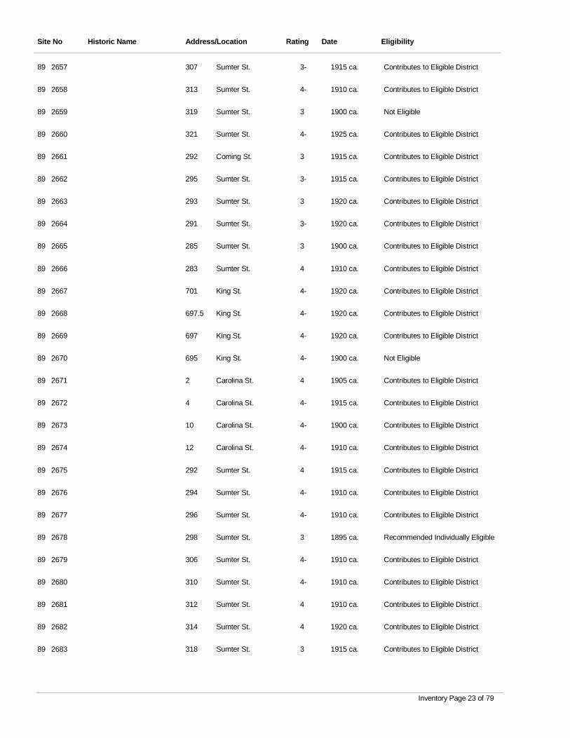
Site No Historic Name Address/Location Rating Date Eligibility
2657 Sumter St. 3- 1915 ca. Contributes to Eligible District89 307
2658 Sumter St. 4- 1910 ca. Contributes to Eligible District89 313
2659 Sumter St. 3 1900 ca. Not Eligible89 319
2660 Sumter St. 4- 1925 ca. Contributes to Eligible District89 321
2661 Coming St. 3 1915 ca. Contributes to Eligible District89 292
2662 Sumter St. 3- 1915 ca. Contributes to Eligible District89 295
2663 Sumter St. 3 1920 ca. Contributes to Eligible District89 293
2664 Sumter St. 3- 1920 ca. Contributes to Eligible District89 291
2665 Sumter St. 3 1900 ca. Contributes to Eligible District89 285
2666 Sumter St. 4 1910 ca. Contributes to Eligible District89 283
2667 King St. 4- 1920 ca. Contributes to Eligible District89 701
2668 King St. 4- 1920 ca. Contributes to Eligible District89 697.5
2669 King St. 4- 1920 ca. Contributes to Eligible District89 697
2670 King St. 4- 1900 ca. Not Eligible89 695
2671 Carolina St. 4 1905 ca. Contributes to Eligible District89 2
2672 Carolina St. 4- 1915 ca. Contributes to Eligible District89 4
2673 Carolina St. 4- 1900 ca. Contributes to Eligible District89 10
2674 Carolina St. 4- 1910 ca. Contributes to Eligible District89 12
2675 Sumter St. 4 1915 ca. Contributes to Eligible District89 292
2676 Sumter St. 4- 1910 ca. Contributes to Eligible District89 294
2677 Sumter St. 4- 1910 ca. Contributes to Eligible District89 296
2678 Sumter St. 3 1895 ca. Recommended Individually Eligible89 298
2679 Sumter St. 4- 1910 ca. Contributes to Eligible District89 306
2680 Sumter St. 4- 1910 ca. Contributes to Eligible District89 310
2681 Sumter St. 4 1910 ca. Contributes to Eligible District89 312
2682 Sumter St. 4 1920 ca. Contributes to Eligible District89 314
2683 Sumter St. 3 1915 ca. Contributes to Eligible District89 318
Inventory Page 23 of 79
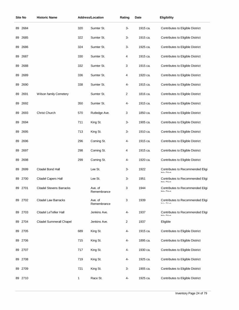
Site No Historic Name Address/Location Rating Date Eligibility
2684 Sumter St. 3- 1915 ca. Contributes to Eligible District89 320
2685 Sumter St. 3- 1915 ca. Contributes to Eligible District89 322
2686 Sumter St. 3- 1925 ca. Contributes to Eligible District89 324
2687 Sumter St. 4 1915 ca. Contributes to Eligible District89 330
2688 Sumter St. 3 1915 ca. Contributes to Eligible District89 332
2689 Sumter St. 4 1920 ca. Contributes to Eligible District89 336
2690 Sumter St. 4- 1915 ca. Contributes to Eligible District89 338
2691 Wilson family Cemetery Sumter St. 2 1816 ca. Contributes to Eligible District89
2692 Sumter St. 4- 1915 ca. Contributes to Eligible District89 350
2693 Christ Church Rutledge Ave. 3 1850 ca. Contributes to Eligible District89 570
2694 King St. 3- 1905 ca. Contributes to Eligible District89 711
2695 King St. 3- 1910 ca. Contributes to Eligible District89 713
2696 Coming St. 4- 1915 ca. Contributes to Eligible District89 296
2697 Coming St. 4 1915 ca. Contributes to Eligible District89 298
2698 Coming St. 4- 1920 ca. Contributes to Eligible District89 299
2699 Citadel Bond Hall Lee St. 3- 1922 Contributes to Recommended Eligible Dist
89
2700 Citadel Capers Hall Lee St. 3- 1951 Contributes to Recommended Eligible Dist
89
2701 Citadel Stevens Barracks Ave. of Remembrance
3 1944 Contributes to Recommended Eligible Dist
89
2702 Citadel Law Barracks Ave. of Remembrance
3 1939 Contributes to Recommended Eligible Dist
89
2703 Citadel LeTellier Hall Jenkins Ave. 4- 1937 Contributes to Recommended Eligible Dist
89
2704 Citadel Summerall Chapel Jenkins Ave. 2 1937 Eligible89
2705 King St. 4- 1915 ca. Contributes to Eligible District89 689
2706 King St. 4- 1895 ca. Contributes to Eligible District89 715
2707 King St. 4- 1930 ca. Contributes to Eligible District89 717
2708 King St. 4- 1925 ca. Contributes to Eligible District89 719
2709 King St. 3- 1905 ca. Contributes to Eligible District89 721
2710 Race St. 4- 1925 ca. Contributes to Eligible District89 1
Inventory Page 24 of 79
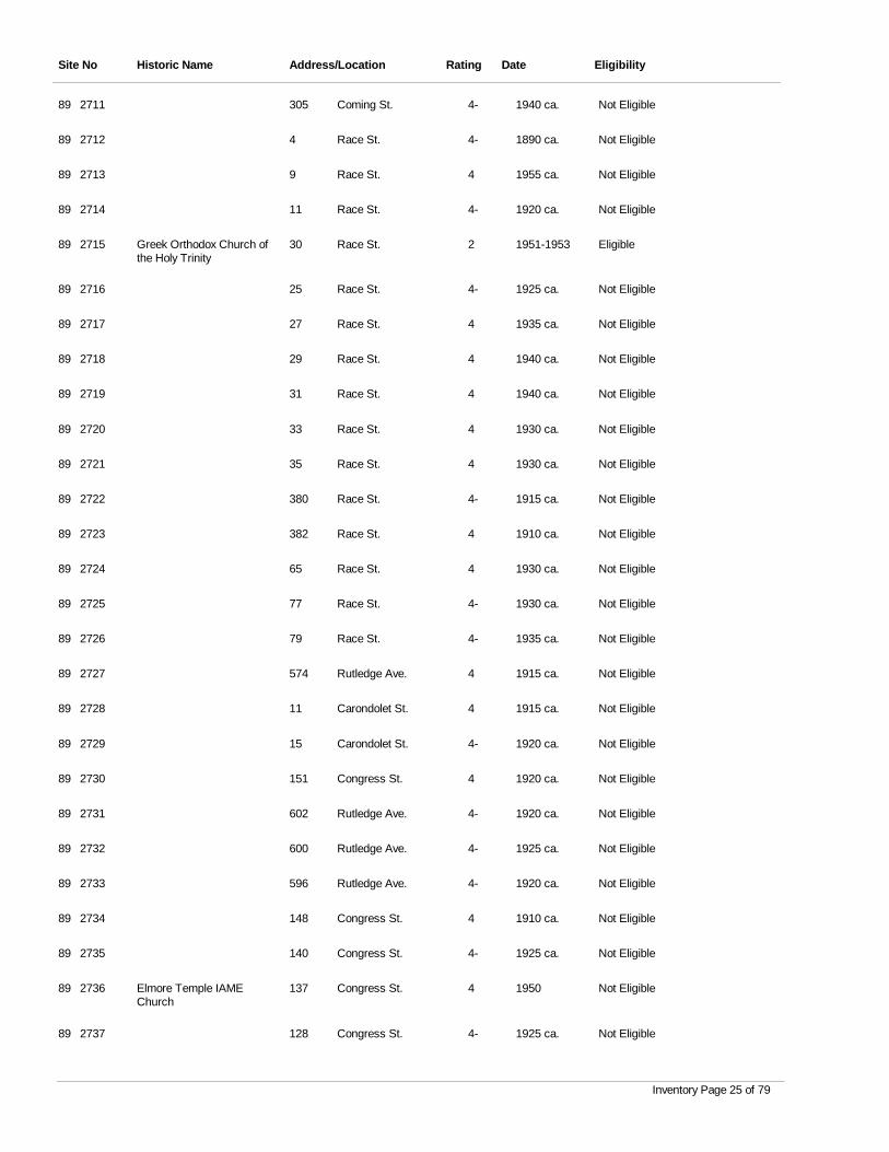
Site No Historic Name Address/Location Rating Date Eligibility
2711 Coming St. 4- 1940 ca. Not Eligible89 305
2712 Race St. 4- 1890 ca. Not Eligible89 4
2713 Race St. 4 1955 ca. Not Eligible89 9
2714 Race St. 4- 1920 ca. Not Eligible89 11
2715 Greek Orthodox Church of the Holy Trinity
Race St. 2 1951-1953 Eligible89 30
2716 Race St. 4- 1925 ca. Not Eligible89 25
2717 Race St. 4 1935 ca. Not Eligible89 27
2718 Race St. 4 1940 ca. Not Eligible89 29
2719 Race St. 4 1940 ca. Not Eligible89 31
2720 Race St. 4 1930 ca. Not Eligible89 33
2721 Race St. 4 1930 ca. Not Eligible89 35
2722 Race St. 4- 1915 ca. Not Eligible89 380
2723 Race St. 4 1910 ca. Not Eligible89 382
2724 Race St. 4 1930 ca. Not Eligible89 65
2725 Race St. 4- 1930 ca. Not Eligible89 77
2726 Race St. 4- 1935 ca. Not Eligible89 79
2727 Rutledge Ave. 4 1915 ca. Not Eligible89 574
2728 Carondolet St. 4 1915 ca. Not Eligible89 11
2729 Carondolet St. 4- 1920 ca. Not Eligible89 15
2730 Congress St. 4 1920 ca. Not Eligible89 151
2731 Rutledge Ave. 4- 1920 ca. Not Eligible89 602
2732 Rutledge Ave. 4- 1925 ca. Not Eligible89 600
2733 Rutledge Ave. 4- 1920 ca. Not Eligible89 596
2734 Congress St. 4 1910 ca. Not Eligible89 148
2735 Congress St. 4- 1925 ca. Not Eligible89 140
2736 Elmore Temple IAME Church
Congress St. 4 1950 Not Eligible89 137
2737 Congress St. 4- 1925 ca. Not Eligible89 128
Inventory Page 25 of 79
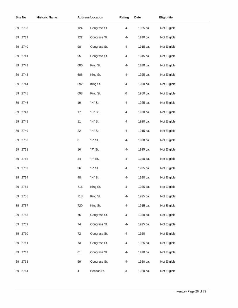
Site No Historic Name Address/Location Rating Date Eligibility
2738 Congress St. 4- 1925 ca. Not Eligible89 124
2739 Congress St. 4- 1920 ca. Not Eligible89 122
2740 Congress St. 4 1915 ca. Not Eligible89 98
2741 Congress St. 4 1945 ca. Not Eligible89 95
2742 King St. 4- 1880 ca. Not Eligible89 680
2743 King St. 4- 1925 ca. Not Eligible89 686
2744 King St. 4 1900 ca. Not Eligible89 692
2745 King St. 0 1950 ca. Not Eligible89 698
2746 "H" St. 4- 1925 ca. Not Eligible89 19
2747 "H" St. 4 1930 ca. Not Eligible89 17
2748 "H" St. 4 1920 ca. Not Eligible89 11
2749 "H" St. 4 1915 ca. Not Eligible89 22
2750 "F" St. 4- 1908 ca. Not Eligible89 8
2751 "F" St. 4- 1915 ca. Not Eligible89 16
2752 "F" St. 4- 1920 ca. Not Eligible89 34
2753 "F" St. 4 1935 ca. Not Eligible89 36
2754 "H" St. 4- 1920 ca. Not Eligible89 48
2755 King St. 4 1935 ca. Not Eligible89 716
2756 King St. 4- 1925 ca. Not Eligible89 718
2757 King St. 4- 1915 ca. Not Eligible89 720
2758 Congress St. 4- 1930 ca. Not Eligible89 76
2759 Congress St. 4- 1925 ca. Not Eligible89 74
2760 Congress St. 4 1920 Not Eligible89 72
2761 Congress St. 4- 1925 ca. Not Eligible89 73
2762 Congress St. 4- 1920 ca. Not Eligible89 61
2763 Congress St. 4- 1930 ca. Not Eligible89 59
2764 Benson St. 3 1920 ca. Not Eligible89 4
Inventory Page 26 of 79
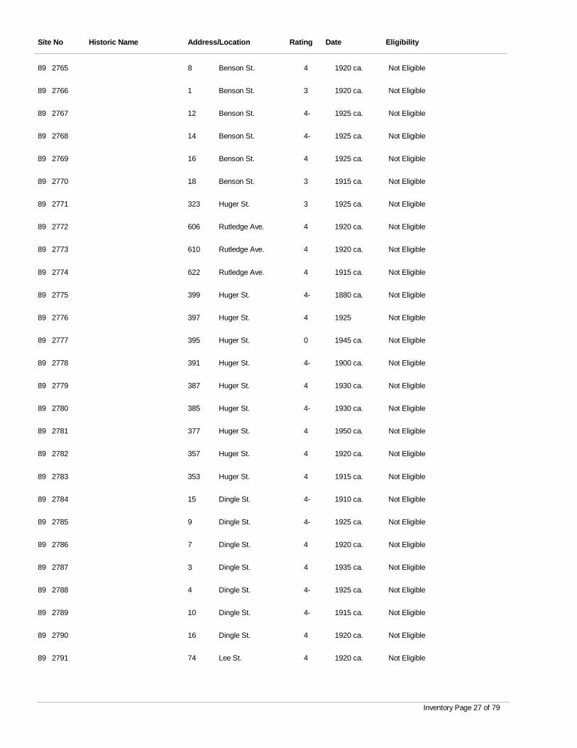
Site No Historic Name Address/Location Rating Date Eligibility
2765 Benson St. 4 1920 ca. Not Eligible89 8
2766 Benson St. 3 1920 ca. Not Eligible89 1
2767 Benson St. 4- 1925 ca. Not Eligible89 12
2768 Benson St. 4- 1925 ca. Not Eligible89 14
2769 Benson St. 4 1925 ca. Not Eligible89 16
2770 Benson St. 3 1915 ca. Not Eligible89 18
2771 Huger St. 3 1925 ca. Not Eligible89 323
2772 Rutledge Ave. 4 1920 ca. Not Eligible89 606
2773 Rutledge Ave. 4 1920 ca. Not Eligible89 610
2774 Rutledge Ave. 4 1915 ca. Not Eligible89 622
2775 Huger St. 4- 1880 ca. Not Eligible89 399
2776 Huger St. 4 1925 Not Eligible89 397
2777 Huger St. 0 1945 ca. Not Eligible89 395
2778 Huger St. 4- 1900 ca. Not Eligible89 391
2779 Huger St. 4 1930 ca. Not Eligible89 387
2780 Huger St. 4- 1930 ca. Not Eligible89 385
2781 Huger St. 4 1950 ca. Not Eligible89 377
2782 Huger St. 4 1920 ca. Not Eligible89 357
2783 Huger St. 4 1915 ca. Not Eligible89 353
2784 Dingle St. 4- 1910 ca. Not Eligible89 15
2785 Dingle St. 4- 1925 ca. Not Eligible89 9
2786 Dingle St. 4 1920 ca. Not Eligible89 7
2787 Dingle St. 4 1935 ca. Not Eligible89 3
2788 Dingle St. 4- 1925 ca. Not Eligible89 4
2789 Dingle St. 4- 1915 ca. Not Eligible89 10
2790 Dingle St. 4 1920 ca. Not Eligible89 16
2791 Lee St. 4 1920 ca. Not Eligible89 74
Inventory Page 27 of 79
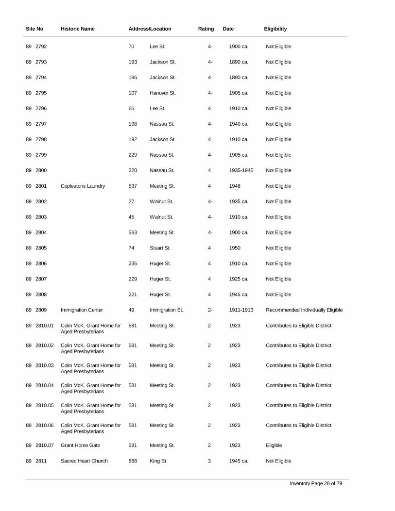
Site No Historic Name Address/Location Rating Date Eligibility
2792 Lee St. 4- 1900 ca. Not Eligible89 70
2793 Jackson St. 4- 1890 ca. Not Eligible89 193
2794 Jackson St. 4- 1890 ca. Not Eligible89 195
2795 Hanover St. 4- 1905 ca. Not Eligible89 107
2796 Lee St. 4 1910 ca. Not Eligible89 66
2797 Nassau St. 4- 1940 ca. Not Eligible89 198
2798 Jackson St. 4 1910 ca. Not Eligible89 192
2799 Nassau St. 4- 1905 ca. Not Eligible89 229
2800 Nassau St. 4 1935-1945 Not Eligible89 220
2801 Coplestons Laundry Meeting St. 4 1948 Not Eligible89 537
2802 Walnut St. 4- 1935 ca. Not Eligible89 27
2803 Walnut St. 4- 1910 ca. Not Eligible89 45
2804 Meeting St. 4- 1900 ca. Not Eligible89 563
2805 Stuart St. 4 1950 Not Eligible89 74
2806 Huger St. 4 1910 ca. Not Eligible89 235
2807 Huger St. 4 1925 ca. Not Eligible89 229
2808 Huger St. 4 1945 ca. Not Eligible89 221
2809 Immigration Center Immigration St. 2- 1911-1913 Recommended Individually Eligible89 49
2810.01 Colin McK. Grant Home for Aged Presbyterians
Meeting St. 2 1923 Contributes to Eligible District89 581
2810.02 Colin McK. Grant Home for Aged Presbyterians
Meeting St. 2 1923 Contributes to Eligible District89 581
2810.03 Colin McK. Grant Home for Aged Presbyterians
Meeting St. 2 1923 Contributes to Eligible District89 581
2810.04 Colin McK. Grant Home for Aged Presbyterians
Meeting St. 2 1923 Contributes to Eligible District89 581
2810.05 Colin McK. Grant Home for Aged Presbyterians
Meeting St. 2 1923 Contributes to Eligible District89 581
2810.06 Colin McK. Grant Home for Aged Presbyterians
Meeting St. 2 1923 Contributes to Eligible District89 581
2810.07 Grant Home Gate Meeting St. 2 1923 Eligible89 581
2811 Sacred Heart Church King St. 3 1945 ca. Not Eligible89 888
Inventory Page 28 of 79
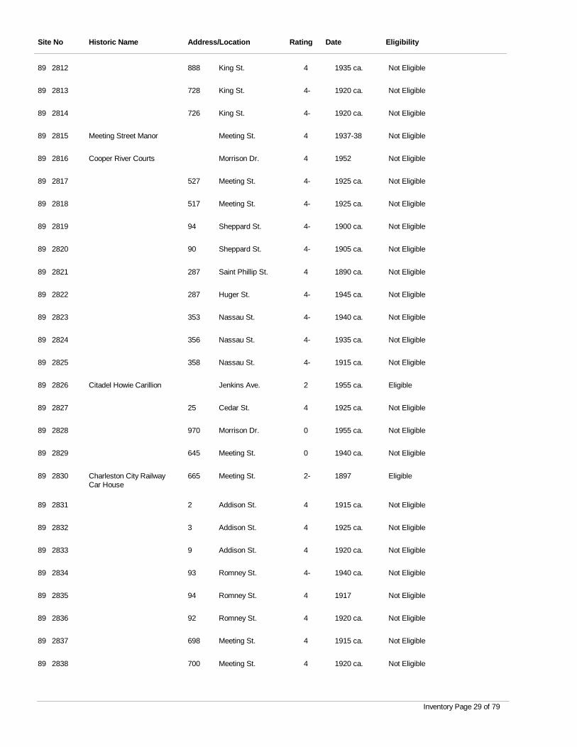
Site No Historic Name Address/Location Rating Date Eligibility
2812 King St. 4 1935 ca. Not Eligible89 888
2813 King St. 4- 1920 ca. Not Eligible89 728
2814 King St. 4- 1920 ca. Not Eligible89 726
2815 Meeting Street Manor Meeting St. 4 1937-38 Not Eligible89
2816 Cooper River Courts Morrison Dr. 4 1952 Not Eligible89
2817 Meeting St. 4- 1925 ca. Not Eligible89 527
2818 Meeting St. 4- 1925 ca. Not Eligible89 517
2819 Sheppard St. 4- 1900 ca. Not Eligible89 94
2820 Sheppard St. 4- 1905 ca. Not Eligible89 90
2821 Saint Phillip St. 4 1890 ca. Not Eligible89 287
2822 Huger St. 4- 1945 ca. Not Eligible89 287
2823 Nassau St. 4- 1940 ca. Not Eligible89 353
2824 Nassau St. 4- 1935 ca. Not Eligible89 356
2825 Nassau St. 4- 1915 ca. Not Eligible89 358
2826 Citadel Howie Carillion Jenkins Ave. 2 1955 ca. Eligible89
2827 Cedar St. 4 1925 ca. Not Eligible89 25
2828 Morrison Dr. 0 1955 ca. Not Eligible89 970
2829 Meeting St. 0 1940 ca. Not Eligible89 645
2830 Charleston City Railway Car House
Meeting St. 2- 1897 Eligible89 665
2831 Addison St. 4 1915 ca. Not Eligible89 2
2832 Addison St. 4 1925 ca. Not Eligible89 3
2833 Addison St. 4 1920 ca. Not Eligible89 9
2834 Romney St. 4- 1940 ca. Not Eligible89 93
2835 Romney St. 4 1917 Not Eligible89 94
2836 Romney St. 4 1920 ca. Not Eligible89 92
2837 Meeting St. 4 1915 ca. Not Eligible89 698
2838 Meeting St. 4 1920 ca. Not Eligible89 700
Inventory Page 29 of 79
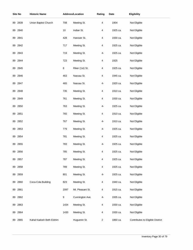
Site No Historic Name Address/Location Rating Date Eligibility
2839 Union Baptist Church Meeting St. 4 1904 Not Eligible89 708
2840 Indian St. 4 1925 ca. Not Eligible89 10
2841 Hanover St. 4 1930 ca. Not Eligible89 428
2842 Meeting St. 4 1925 ca. Not Eligible89 717
2843 Meeting St. 4- 1925 ca. Not Eligible89 719
2844 Meeting St. 4 1925 Not Eligible89 723
2845 Riker (1st) St. 4 1925 ca. Not Eligible89 8
2846 Nassau St. 4 1945 ca. Not Eligible89 463
2847 Nassau St. 4- 1920 ca. Not Eligible89 465
2848 Meeting St. 4 1910 ca. Not Eligible89 735
2849 Meeting St. 4 1930 ca. Not Eligible89 761
2850 Meeting St. 4- 1925 ca. Not Eligible89 763
2851 Meeting St. 4 1910 ca. Not Eligible89 765
2852 Meeting St. 4- 1910 ca. Not Eligible89 767
2853 Meeting St. 4- 1925 ca. Not Eligible89 779
2854 Meeting St. 4 1925 ca. Not Eligible89 781
2855 Meeting St. 4- 1925 ca. Not Eligible89 783
2856 Meeting St. 4 1925 ca. Not Eligible89 785
2857 Meeting St. 4 1925 ca. Not Eligible89 787
2858 Meeting St. 4 1925 ca. Not Eligible89 789
2859 Meeting St. 4- 1925 ca. Not Eligible89 801
2860 Coca-Cola Building Meeting St. 4 1940 ca. Not Eligible89 823
2861 Mt. Pleasant St. 4 1915 ca. Not Eligible89 2097
2862 Cunnington Ave. 4- 1935 ca. Not Eligible89 9
2863 Meeting St. 4 1930 ca. Not Eligible89 1434
2864 Meeting St. 4 1930 ca. Not Eligible89 1430
2865 Kahal Kadosh Beth Elohim Huguenin St. 2 1860 ca. Contributes to Eligible District89
Inventory Page 30 of 79
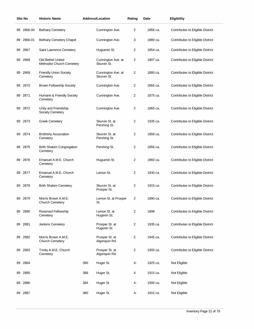
Site No Historic Name Address/Location Rating Date Eligibility
2866.00 Bethany Cemetery Cunnington Ave. 2 1856 ca. Contributes to Eligible District89
2866.01 Bethany Cemetery Chapel Cunnington Ave. 3 1880 ca. Contributes to Eligible District89
2867 Saint Lawrence Cemetery Huguenin St. 2 1854 ca. Contributes to Eligible District89
2868 Old Bethel United Methodist Church Cemetery
Cunnington Ave. at Skurvin St.
2 1807 ca. Contributes to Eligible District89
2869 Friendly Union Society Cemetery
Cunnington Ave. at Skurvin St.
2 1880 ca. Contributes to Eligible District89
2870 Brown Fellowship Society Cunnington Ave. 2 1865 ca. Contributes to Eligible District89
2871 Humane & Friendly Society Cemetery
Cunnington Ave. 2 1875 ca. Contributes to Eligible District89
2872 Unity and Friendship Society Cemetery
Cunnington Ave. 2 1865 ca. Contributes to Eligible District89
2873 Greek Cemetery Skurvin St. at Pershing St.
2 1935 ca. Contributes to Eligible District89
2874 Brotherly Association Cemetery
Skurvin St. at Pershing St.
2 1856 ca. Contributes to Eligible District89
2875 Brith Shalom Congregation Cemetery
Pershing St. 2 1856 ca. Contributes to Eligible District89
2876 Emanuel A.M.E. Church Cemetery
Huguenin St. 2 1860 ca. Contributes to Eligible District89
2877 Emanuel A.M.E. Church Cemetery
Lemon St. 2 1930 ca. Contributes to Eligible District89
2878 Brith Shalom Cemetery Skurvin St. at Prosper St.
2 1915 ca. Contributes to Eligible District89
2879 Morris Brown A.M.E. Church Cemetery
Lemon St. at Prosper St.
2 1890 ca. Contributes to Eligible District89
2880 Reserved Fellowship Cemetery
Lemon St. at Hugenin St.
2 1898 Contributes to Eligible District89
2881 Jenkins Cemetery Prosper St. at Hugenin St.
2 1935 ca. Contributes to Eligible District89
2882 Morris Brown A.M.E. Church Cemetery
Prosper St. at Algonquin Rd.
2 1945 ca. Contributes to Eligible District89
2883 Trinity A.M.E. Church Cemetery
Prosper St. at Algonquin Rd.
2 1900 ca. Contributes to Eligible District89
2884 Huger St. 4- 1925 ca. Not Eligible89 390
2885 Huger St. 4 1915 ca. Not Eligible89 388
2886 Huger St. 4- 1900 ca. Not Eligible89 384
2887 Huger St. 4- 1915 ca. Not Eligible89 380
Inventory Page 31 of 79
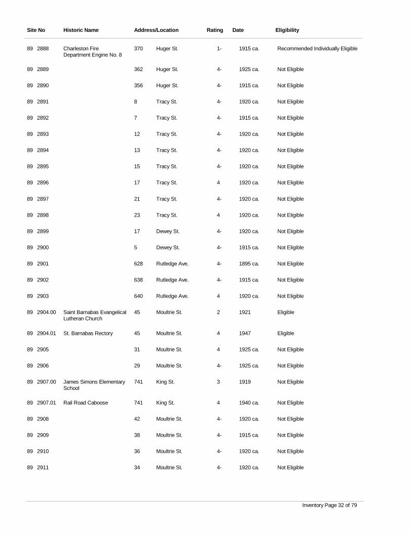
Site No Historic Name Address/Location Rating Date Eligibility
2888 Charleston Fire Department Engine No. 8
Huger St. 1- 1915 ca. Recommended Individually Eligible89 370
2889 Huger St. 4- 1925 ca. Not Eligible89 362
2890 Huger St. 4- 1915 ca. Not Eligible89 356
2891 Tracy St. 4- 1920 ca. Not Eligible89 8
2892 Tracy St. 4- 1915 ca. Not Eligible89 7
2893 Tracy St. 4- 1920 ca. Not Eligible89 12
2894 Tracy St. 4- 1920 ca. Not Eligible89 13
2895 Tracy St. 4- 1920 ca. Not Eligible89 15
2896 Tracy St. 4 1920 ca. Not Eligible89 17
2897 Tracy St. 4- 1920 ca. Not Eligible89 21
2898 Tracy St. 4 1920 ca. Not Eligible89 23
2899 Dewey St. 4- 1920 ca. Not Eligible89 17
2900 Dewey St. 4- 1915 ca. Not Eligible89 5
2901 Rutledge Ave. 4- 1895 ca. Not Eligible89 628
2902 Rutledge Ave. 4- 1915 ca. Not Eligible89 638
2903 Rutledge Ave. 4 1920 ca. Not Eligible89 640
2904.00 Saint Barnabas Evangelical Lutheran Church
Moultrie St. 2 1921 Eligible89 45
2904.01 St. Barnabas Rectory Moultrie St. 4 1947 Eligible89 45
2905 Moultrie St. 4 1925 ca. Not Eligible89 31
2906 Moultrie St. 4- 1925 ca. Not Eligible89 29
2907.00 James Simons Elementary School
King St. 3 1919 Not Eligible89 741
2907.01 Rail Road Caboose King St. 4 1940 ca. Not Eligible89 741
2908 Moultrie St. 4- 1920 ca. Not Eligible89 42
2909 Moultrie St. 4- 1915 ca. Not Eligible89 38
2910 Moultrie St. 4- 1920 ca. Not Eligible89 36
2911 Moultrie St. 4- 1920 ca. Not Eligible89 34
Inventory Page 32 of 79
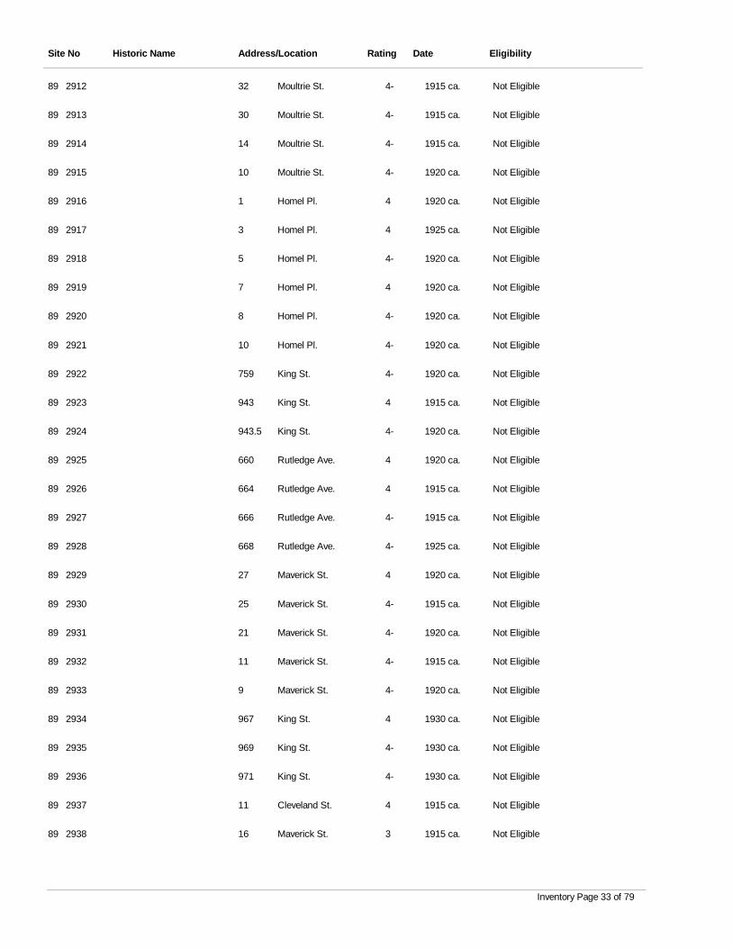
Site No Historic Name Address/Location Rating Date Eligibility
2912 Moultrie St. 4- 1915 ca. Not Eligible89 32
2913 Moultrie St. 4- 1915 ca. Not Eligible89 30
2914 Moultrie St. 4- 1915 ca. Not Eligible89 14
2915 Moultrie St. 4- 1920 ca. Not Eligible89 10
2916 Homel Pl. 4 1920 ca. Not Eligible89 1
2917 Homel Pl. 4 1925 ca. Not Eligible89 3
2918 Homel Pl. 4- 1920 ca. Not Eligible89 5
2919 Homel Pl. 4 1920 ca. Not Eligible89 7
2920 Homel Pl. 4- 1920 ca. Not Eligible89 8
2921 Homel Pl. 4- 1920 ca. Not Eligible89 10
2922 King St. 4- 1920 ca. Not Eligible89 759
2923 King St. 4 1915 ca. Not Eligible89 943
2924 King St. 4- 1920 ca. Not Eligible89 943.5
2925 Rutledge Ave. 4 1920 ca. Not Eligible89 660
2926 Rutledge Ave. 4 1915 ca. Not Eligible89 664
2927 Rutledge Ave. 4- 1915 ca. Not Eligible89 666
2928 Rutledge Ave. 4- 1925 ca. Not Eligible89 668
2929 Maverick St. 4 1920 ca. Not Eligible89 27
2930 Maverick St. 4- 1915 ca. Not Eligible89 25
2931 Maverick St. 4- 1920 ca. Not Eligible89 21
2932 Maverick St. 4- 1915 ca. Not Eligible89 11
2933 Maverick St. 4- 1920 ca. Not Eligible89 9
2934 King St. 4 1930 ca. Not Eligible89 967
2935 King St. 4- 1930 ca. Not Eligible89 969
2936 King St. 4- 1930 ca. Not Eligible89 971
2937 Cleveland St. 4 1915 ca. Not Eligible89 11
2938 Maverick St. 3 1915 ca. Not Eligible89 16
Inventory Page 33 of 79
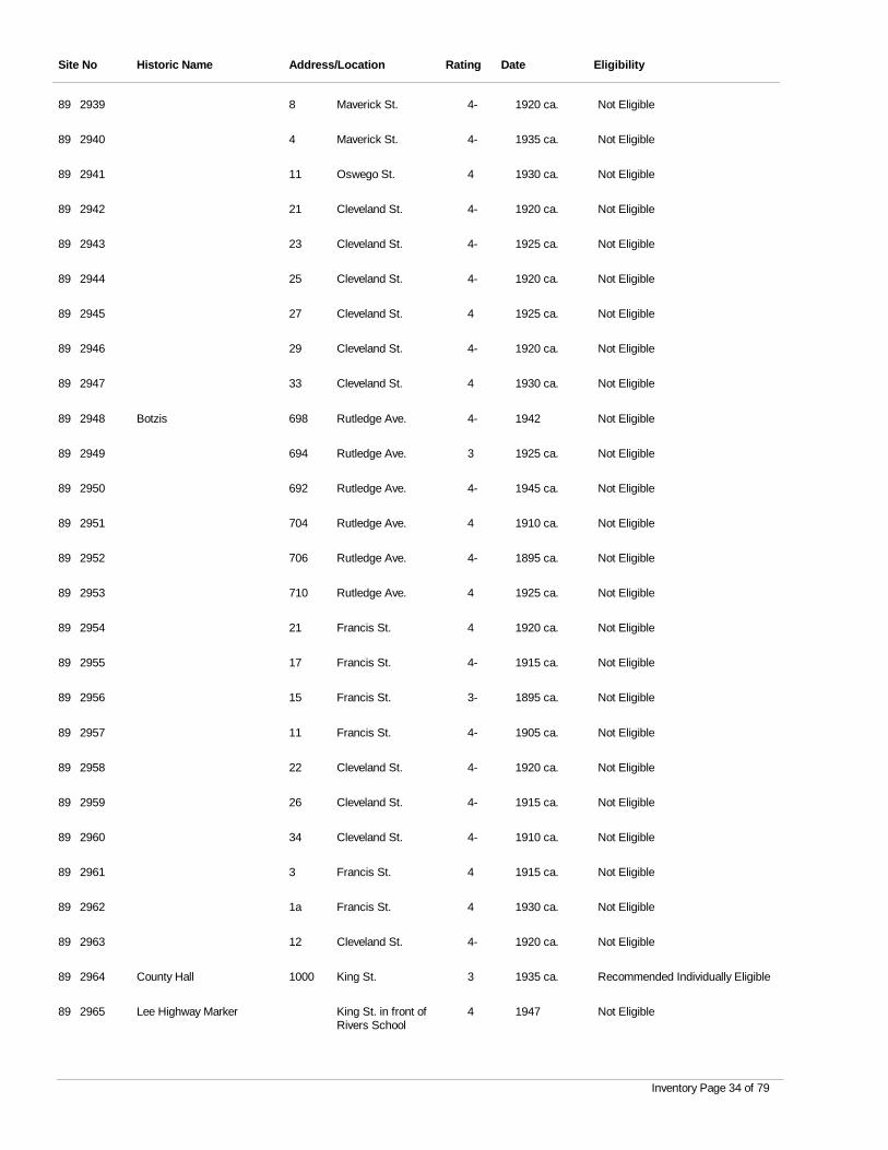
Site No Historic Name Address/Location Rating Date Eligibility
2939 Maverick St. 4- 1920 ca. Not Eligible89 8
2940 Maverick St. 4- 1935 ca. Not Eligible89 4
2941 Oswego St. 4 1930 ca. Not Eligible89 11
2942 Cleveland St. 4- 1920 ca. Not Eligible89 21
2943 Cleveland St. 4- 1925 ca. Not Eligible89 23
2944 Cleveland St. 4- 1920 ca. Not Eligible89 25
2945 Cleveland St. 4 1925 ca. Not Eligible89 27
2946 Cleveland St. 4- 1920 ca. Not Eligible89 29
2947 Cleveland St. 4 1930 ca. Not Eligible89 33
2948 Botzis Rutledge Ave. 4- 1942 Not Eligible89 698
2949 Rutledge Ave. 3 1925 ca. Not Eligible89 694
2950 Rutledge Ave. 4- 1945 ca. Not Eligible89 692
2951 Rutledge Ave. 4 1910 ca. Not Eligible89 704
2952 Rutledge Ave. 4- 1895 ca. Not Eligible89 706
2953 Rutledge Ave. 4 1925 ca. Not Eligible89 710
2954 Francis St. 4 1920 ca. Not Eligible89 21
2955 Francis St. 4- 1915 ca. Not Eligible89 17
2956 Francis St. 3- 1895 ca. Not Eligible89 15
2957 Francis St. 4- 1905 ca. Not Eligible89 11
2958 Cleveland St. 4- 1920 ca. Not Eligible89 22
2959 Cleveland St. 4- 1915 ca. Not Eligible89 26
2960 Cleveland St. 4- 1910 ca. Not Eligible89 34
2961 Francis St. 4 1915 ca. Not Eligible89 3
2962 Francis St. 4 1930 ca. Not Eligible89 1a
2963 Cleveland St. 4- 1920 ca. Not Eligible89 12
2964 County Hall King St. 3 1935 ca. Recommended Individually Eligible89 1000
2965 Lee Highway Marker King St. in front of Rivers School
4 1947 Not Eligible89
Inventory Page 34 of 79
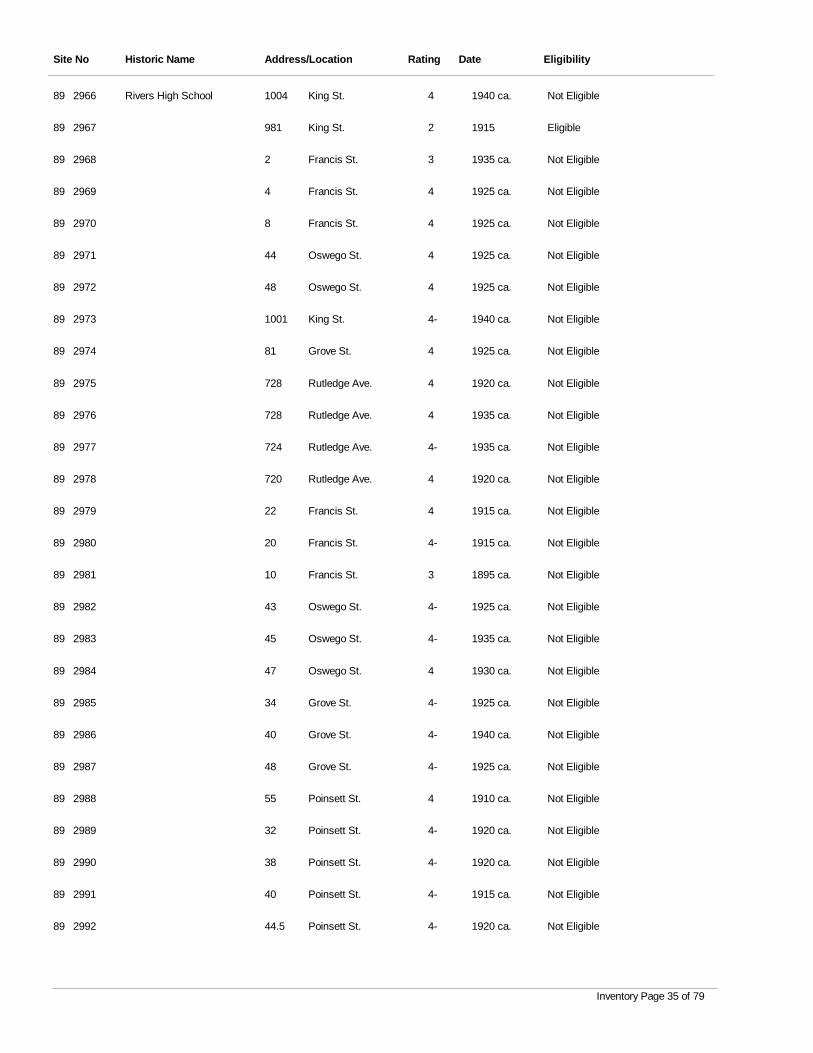
Site No Historic Name Address/Location Rating Date Eligibility
2966 Rivers High School King St. 4 1940 ca. Not Eligible89 1004
2967 King St. 2 1915 Eligible89 981
2968 Francis St. 3 1935 ca. Not Eligible89 2
2969 Francis St. 4 1925 ca. Not Eligible89 4
2970 Francis St. 4 1925 ca. Not Eligible89 8
2971 Oswego St. 4 1925 ca. Not Eligible89 44
2972 Oswego St. 4 1925 ca. Not Eligible89 48
2973 King St. 4- 1940 ca. Not Eligible89 1001
2974 Grove St. 4 1925 ca. Not Eligible89 81
2975 Rutledge Ave. 4 1920 ca. Not Eligible89 728
2976 Rutledge Ave. 4 1935 ca. Not Eligible89 728
2977 Rutledge Ave. 4- 1935 ca. Not Eligible89 724
2978 Rutledge Ave. 4 1920 ca. Not Eligible89 720
2979 Francis St. 4 1915 ca. Not Eligible89 22
2980 Francis St. 4- 1915 ca. Not Eligible89 20
2981 Francis St. 3 1895 ca. Not Eligible89 10
2982 Oswego St. 4- 1925 ca. Not Eligible89 43
2983 Oswego St. 4- 1935 ca. Not Eligible89 45
2984 Oswego St. 4 1930 ca. Not Eligible89 47
2985 Grove St. 4- 1925 ca. Not Eligible89 34
2986 Grove St. 4- 1940 ca. Not Eligible89 40
2987 Grove St. 4- 1925 ca. Not Eligible89 48
2988 Poinsett St. 4 1910 ca. Not Eligible89 55
2989 Poinsett St. 4- 1920 ca. Not Eligible89 32
2990 Poinsett St. 4- 1920 ca. Not Eligible89 38
2991 Poinsett St. 4- 1915 ca. Not Eligible89 40
2992 Poinsett St. 4- 1920 ca. Not Eligible89 44.5
Inventory Page 35 of 79
Site No Historic Name Address/Location Rating Date Eligibility
2993 Poinsett St. 4- 1930 ca. Not Eligible89 44
2994 Poinsett St. 4- 1945 ca. Not Eligible89 52
2995 King St. 4- 1945 ca. Not Eligible89 1054
2996 Romney St. 4- 1935 ca. Not Eligible89 121
2997 Romney St. 4 1950 ca. Not Eligible89 119
2998 Romney St. 4- 1925 ca. Not Eligible89 113
2999 Romney St. 4 1925 ca. Not Eligible89 128
3000 Romney St. 4 1925 ca. Not Eligible89 130
3001 King St. 0 1940 ca. Not Eligible89 1077
3002 Romney St. 4- 1920 ca. Not Eligible89 167
3003 Romney St. 4- 1925 ca. Not Eligible89 183
3004 Romney St. 4 1925 ca. Not Eligible89 203
3005 Romney St. 4- 1925 ca. Not Eligible89 205
3006 King St. 4- 1920 ca. Not Eligible89 1106
3007 Simmons St. 4 1930 ca. Not Eligible89 21
3008 Simmons St. 4- 1930 ca. Not Eligible89 19
3009 Simmons St. 3 1925 ca. Not Eligible89 10
3010 Simmons St. 4- 1920 ca. Not Eligible89 16
3011 Simmons St. 4- 1920 ca. Not Eligible89 18
3012 Simmons St. 4 1920 ca. Not Eligible89 20
3013 King St. 4 1920 ca. Not Eligible89 1110
3014 King St. 4 1935 ca. Not Eligible89 1112
3015 King St. 4 1915 ca. Contributes to Recommended Eligible Dist
89 1114
3016 King St. 4 1920 ca. Contributes to Recommended Eligible Dist
89 1116
3017 Simmons St. 4 1920 ca. Not Eligible89 57
3018 Simmons St. 4- 1915 ca. Not Eligible89 93
3019 Simmons St. 4- 1930 ca. Not Eligible89 95
Inventory Page 36 of 79
Site No Historic Name Address/Location Rating Date Eligibility
3020 Simmons St. 4- 1930 ca. Not Eligible89 76
3021 Simmons St. 4- 1920 ca. Not Eligible89 50
3022 King St. 4 1925 ca. Not Eligible89 1095
3023 King St. 4- 1920 ca. Not Eligible89 1107
3024 Field's Pl. 4- 1920 ca. Not Eligible89 1
3025 Field's Pl. 4 1930 ca. Not Eligible89 3
3026 Field's Pl. 4 1920 ca. Not Eligible89 6
3027 King St. 4- 1925 ca. Contributes to Recommended Eligible Dist
89 1113
3028 Enston Ave. 4- 1925 ca. Not Eligible89 13
3029 Enston Ave. 4- 1930 ca. Not Eligible89 11
3030 Enston Ave. 4 1930 ca. Not Eligible89 7
3031 Enston Ave. 4- 1920 ca. Not Eligible89 6
3032 Enston Ave. 4- 1920 ca. Not Eligible89 12
3033 Rutledge Ave. 3 1935 ca. Not Eligible89 800
3034 Rutledge Ave. 4 1935 ca. Not Eligible89 798
3035 Rutledge Ave. 4 1936 Not Eligible89 794
3036 Rutledge Ave. 4- 1930 ca. Not Eligible89 788
3037 Rutledge Ave. 4 1935 ca. Not Eligible89 786
3038 Rutledge Ave. 4 1925 ca. Not Eligible89 782
3039 Rutledge Ave. 4- 1925 ca. Not Eligible89 778
3040 Rutledge Ave. 4 1930 ca. Not Eligible89 774
3041 Rutledge Ave. 4 1925 ca. Not Eligible89 772
3042 Rutledge Ave. 4- 1925 ca. Not Eligible89 768
3043 Rutledge Ave. 4- 1935 ca. Not Eligible89 764
3044 Rutledge Ave. 4 1920 ca. Not Eligible89 766
3045 Rutledge Ave. 4- 1920 ca. Not Eligible89 762
3046.00 Asbury Memorial M.E. Church South
Rutledge Ave. 3 1935 Not Eligible89 754
Inventory Page 37 of 79
Site No Historic Name Address/Location Rating Date Eligibility
3046.01 Rutledge Ave. 4 1928 Not Eligible89 754
3047 Rutledge Ave. 4 1895 ca. Not Eligible89 744
3048 Rutledge Ave. 4 1900 ca. Not Eligible89 742
3049 Rutledge Ave. 4 1915 ca. Not Eligible89 740
3050 Rutledge Ave. 4 1930 ca. Not Eligible89 738
3051 Rutledge Ave. 4 1930 ca. Not Eligible89 765
3052 Rutledge Ave. 4- 1925 ca. Not Eligible89 767
3053 Rutledge Ave. 4 1920 ca. Not Eligible89 771
3054 Rutledge Ave. 4- 1920 ca. Not Eligible89 779
3055 Rutledge Ave. 4- 1925 ca. Not Eligible89 781
3056 Rutledge Ave. 4 1925 ca. Not Eligible89 783
3057 Rutledge Ave. 4- 1930 ca. Not Eligible89 791
3058 Rutledge Ave. 4 1930 ca. Not Eligible89 793
3059 Rutledge Ave. 4- 1935 ca. Not Eligible89 795
3060 Rutledge Ave. 4 1940 ca. Not Eligible89 797
3061 Rutledge Ave. 2- 1925 ca. Recommended Individually Eligible89 807
3062 Rutledge Ave. 2- 1930 ca. Recommended Individually Eligible89 809
3063 Rutledge Ave. 4 1925 ca. Not Eligible89 813
3064 Rutledge Ave. 4 1920 ca. Not Eligible89 815
3065 Rutledge Ave. 4- 1930 ca. Not Eligible89 829
3066 Rutledge Ave. 4 1925 ca. Not Eligible89 831
3067 Rutledge Ave. 4 1925 ca. Not Eligible89 833
3068 Rutledge Ave. 4 1930 ca. Not Eligible89 835
3069 Rutledge Ave. 3- 1930 ca. Not Eligible89 837
3070 Rutledge Ave. 4- 1910 ca. Not Eligible89 839
3071 Rutledge Ave. 4- 1935 ca. Not Eligible89 814
3072 Rutledge Ave. 4 1945 ca. Not Eligible89 810
Inventory Page 38 of 79
Site No Historic Name Address/Location Rating Date Eligibility
3073 Rutledge Ave. 3 1915 ca. Not Eligible89 806
3074 Poplar St. 4- 1930 ca. Contributes to Recommended Eligible Dist
89 67
3075 Poplar St. 4- 1925 ca. Contributes to Recommended Eligible Dist
89 71
3076 Poplar St. 4- 1935 ca. Contributes to Recommended Eligible Dist
89 59
3077 Poplar St. 4 1930 ca. Contributes to Recommended Eligible Dist
89 57
3078 Poplar St. 4- 1925 ca. Contributes to Recommended Eligible Dist
89 53
3079 Poplar St. 4- 1925 ca. Contributes to Recommended Eligible Dist
89 51
3080 Poplar St. 4- 1925 ca. Contributes to Recommended Eligible Dist
89 49
3081 Poplar St. 4- 1930 ca. Contributes to Recommended Eligible Dist
89 45
3082 Poplar St. 4- 1925 ca. Contributes to Recommended Eligible Dist
89 43
3083 Poplar St. 3 1940 ca. Contributes to Recommended Eligible Dist
89 41
3084 Poplar St. 4- 1925 ca. Contributes to Recommended Eligible Dist
89 39
3085 Poplar St. 4 1920 ca. Contributes to Recommended Eligible Dist
89 37
3086 Poplar St. 4- 1930 ca. Contributes to Recommended Eligible Dist
89 35
3087 Poplar St. 4- 1920 ca. Contributes to Recommended Eligible Dist
89 33
3088 Poplar St. 4 1925 ca. Contributes to Recommended Eligible Dist
89 31
3089 King St. 4 1920 ca. Contributes to Recommended Eligible Dist
89 1118
3090 Poplar St. 4- 1925 ca. Contributes to Recommended Eligible Dist
89 17
3091 Poplar St. 4- 1925 ca. Contributes to Recommended Eligible Dist
89 15
3092 Poplar St. 4 1925 ca. Contributes to Recommended Eligible Dist
89 13
3093 Poplar St. 4 1925 ca. Contributes to Recommended Eligible Dist
89 11
3094 Poplar St. 4 1925 ca. Contributes to Recommended Eligible Dist
89 9
3095 Poplar St. 4- 1935 ca. Contributes to Recommended Eligible Dist
89 4
3096 Poplar St. 4 1925 ca. Contributes to Recommended Eligible Dist
89 6
3097 Poplar St. 4- 1925 ca. Contributes to Recommended Eligible Dist
89 8
3098 Poplar St. 3- 1925 ca. Contributes to Recommended Eligible Dist
89 10
3099 Poplar St. 3 1925 ca. Contributes to Recommended Eligible Dist
89 12
Inventory Page 39 of 79
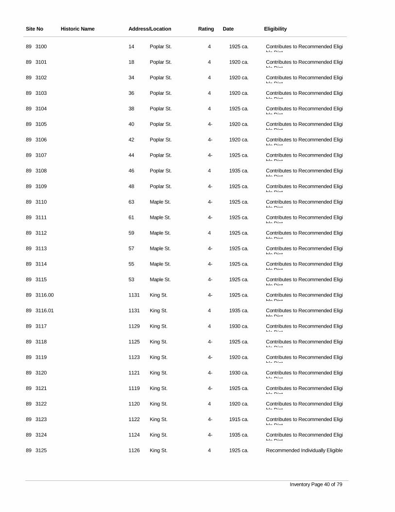
Site No Historic Name Address/Location Rating Date Eligibility
3100 Poplar St. 4 1925 ca. Contributes to Recommended Eligible Dist
89 14
3101 Poplar St. 4 1920 ca. Contributes to Recommended Eligible Dist
89 18
3102 Poplar St. 4 1920 ca. Contributes to Recommended Eligible Dist
89 34
3103 Poplar St. 4 1920 ca. Contributes to Recommended Eligible Dist
89 36
3104 Poplar St. 4 1925 ca. Contributes to Recommended Eligible Dist
89 38
3105 Poplar St. 4- 1920 ca. Contributes to Recommended Eligible Dist
89 40
3106 Poplar St. 4- 1920 ca. Contributes to Recommended Eligible Dist
89 42
3107 Poplar St. 4- 1925 ca. Contributes to Recommended Eligible Dist
89 44
3108 Poplar St. 4 1935 ca. Contributes to Recommended Eligible Dist
89 46
3109 Poplar St. 4- 1925 ca. Contributes to Recommended Eligible Dist
89 48
3110 Maple St. 4- 1925 ca. Contributes to Recommended Eligible Dist
89 63
3111 Maple St. 4- 1925 ca. Contributes to Recommended Eligible Dist
89 61
3112 Maple St. 4 1925 ca. Contributes to Recommended Eligible Dist
89 59
3113 Maple St. 4- 1925 ca. Contributes to Recommended Eligible Dist
89 57
3114 Maple St. 4- 1925 ca. Contributes to Recommended Eligible Dist
89 55
3115 Maple St. 4- 1925 ca. Contributes to Recommended Eligible Dist
89 53
3116.00 King St. 4- 1925 ca. Contributes to Recommended Eligible Dist
89 1131
3116.01 King St. 4 1935 ca. Contributes to Recommended Eligible Dist
89 1131
3117 King St. 4 1930 ca. Contributes to Recommended Eligible Dist
89 1129
3118 King St. 4- 1925 ca. Contributes to Recommended Eligible Dist
89 1125
3119 King St. 4- 1920 ca. Contributes to Recommended Eligible Dist
89 1123
3120 King St. 4- 1930 ca. Contributes to Recommended Eligible Dist
89 1121
3121 King St. 4- 1925 ca. Contributes to Recommended Eligible Dist
89 1119
3122 King St. 4 1920 ca. Contributes to Recommended Eligible Dist
89 1120
3123 King St. 4- 1915 ca. Contributes to Recommended Eligible Dist
89 1122
3124 King St. 4- 1935 ca. Contributes to Recommended Eligible Dist
89 1124
3125 King St. 4 1925 ca. Recommended Individually Eligible89 1126
Inventory Page 40 of 79
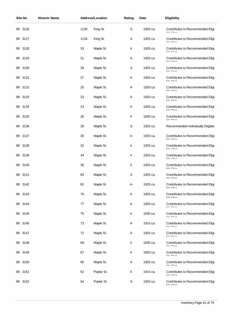
Site No Historic Name Address/Location Rating Date Eligibility
3126 King St. 3- 1920 ca. Contributes to Recommended Eligible Dist
89 1130
3127 King St. 4- 1925 ca. Contributes to Recommended Eligible Dist
89 1134
3128 Maple St. 4 1935 ca. Contributes to Recommended Eligible Dist
89 33
3129 Maple St. 4- 1920 ca. Contributes to Recommended Eligible Dist
89 31
3130 Maple St. 3- 1925 ca. Contributes to Recommended Eligible Dist
89 29
3131 Maple St. 4- 1920 ca. Contributes to Recommended Eligible Dist
89 27
3132 Maple St. 4- 1920 ca. Contributes to Recommended Eligible Dist
89 25
3133 Maple St. 4- 1920 ca. Contributes to Recommended Eligible Dist
89 23
3134 Maple St. 4- 1925 ca. Contributes to Recommended Eligible Dist
89 24
3135 Maple St. 4 1930 ca. Contributes to Recommended Eligible Dist
89 26
3136 Maple St. 3- 1920 ca. Recommended Individually Eligible89 28
3137 Maple St. 4- 1920 ca. Contributes to Recommended Eligible Dist
89 30
3138 Maple St. 4 1925 ca. Contributes to Recommended Eligible Dist
89 32
3139 Maple St. 4 1920 ca. Contributes to Recommended Eligible Dist
89 34
3140 Maple St. 4 1920 ca. Contributes to Recommended Eligible Dist
89 36
3141 Maple St. 4- 1925 ca. Contributes to Recommended Eligible Dist
89 83
3142 Maple St. 4- 1925 ca. Contributes to Recommended Eligible Dist
89 81
3143 Maple St. 4- 1925 ca. Contributes to Recommended Eligible Dist
89 79
3144 Maple St. 4- 1920 ca. Contributes to Recommended Eligible Dist
89 77
3145 Maple St. 4 1930 ca. Contributes to Recommended Eligible Dist
89 75
3146 Maple St. 4- 1915 ca. Contributes to Recommended Eligible Dist
89 73
3147 Maple St. 4- 1925 ca. Contributes to Recommended Eligible Dist
89 71
3148 Maple St. 4 1930 ca. Contributes to Recommended Eligible Dist
89 69
3149 Maple St. 4 1920 ca. Contributes to Recommended Eligible Dist
89 67
3150 Maple St. 4- 1925 ca. Contributes to Recommended Eligible Dist
89 65
3151 Poplar St. 4 1915 ca. Contributes to Recommended Eligible Dist
89 52
3152 Poplar St. 3- 1920 ca. Contributes to Recommended Eligible Dist
89 54
Inventory Page 41 of 79
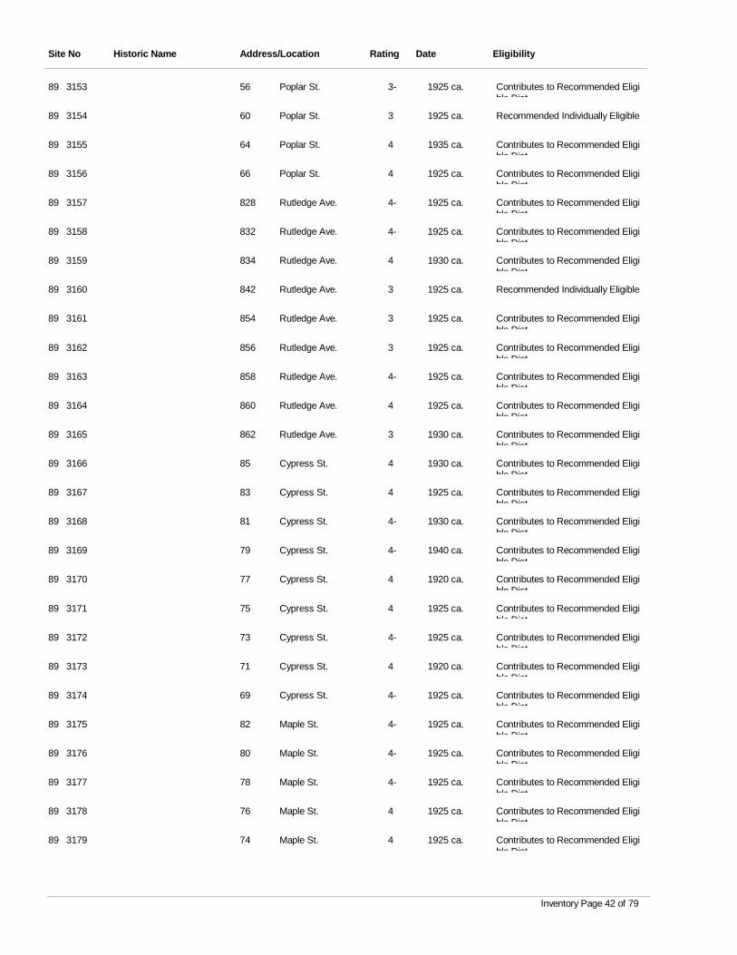
Site No Historic Name Address/Location Rating Date Eligibility
3153 Poplar St. 3- 1925 ca. Contributes to Recommended Eligible Dist
89 56
3154 Poplar St. 3 1925 ca. Recommended Individually Eligible89 60
3155 Poplar St. 4 1935 ca. Contributes to Recommended Eligible Dist
89 64
3156 Poplar St. 4 1925 ca. Contributes to Recommended Eligible Dist
89 66
3157 Rutledge Ave. 4- 1925 ca. Contributes to Recommended Eligible Dist
89 828
3158 Rutledge Ave. 4- 1925 ca. Contributes to Recommended Eligible Dist
89 832
3159 Rutledge Ave. 4 1930 ca. Contributes to Recommended Eligible Dist
89 834
3160 Rutledge Ave. 3 1925 ca. Recommended Individually Eligible89 842
3161 Rutledge Ave. 3 1925 ca. Contributes to Recommended Eligible Dist
89 854
3162 Rutledge Ave. 3 1925 ca. Contributes to Recommended Eligible Dist
89 856
3163 Rutledge Ave. 4- 1925 ca. Contributes to Recommended Eligible Dist
89 858
3164 Rutledge Ave. 4 1925 ca. Contributes to Recommended Eligible Dist
89 860
3165 Rutledge Ave. 3 1930 ca. Contributes to Recommended Eligible Dist
89 862
3166 Cypress St. 4 1930 ca. Contributes to Recommended Eligible Dist
89 85
3167 Cypress St. 4 1925 ca. Contributes to Recommended Eligible Dist
89 83
3168 Cypress St. 4- 1930 ca. Contributes to Recommended Eligible Dist
89 81
3169 Cypress St. 4- 1940 ca. Contributes to Recommended Eligible Dist
89 79
3170 Cypress St. 4 1920 ca. Contributes to Recommended Eligible Dist
89 77
3171 Cypress St. 4 1925 ca. Contributes to Recommended Eligible Dist
89 75
3172 Cypress St. 4- 1925 ca. Contributes to Recommended Eligible Dist
89 73
3173 Cypress St. 4 1920 ca. Contributes to Recommended Eligible Dist
89 71
3174 Cypress St. 4- 1925 ca. Contributes to Recommended Eligible Dist
89 69
3175 Maple St. 4- 1925 ca. Contributes to Recommended Eligible Dist
89 82
3176 Maple St. 4- 1925 ca. Contributes to Recommended Eligible Dist
89 80
3177 Maple St. 4- 1925 ca. Contributes to Recommended Eligible Dist
89 78
3178 Maple St. 4 1925 ca. Contributes to Recommended Eligible Dist
89 76
3179 Maple St. 4 1925 ca. Contributes to Recommended Eligible Dist
89 74
Inventory Page 42 of 79
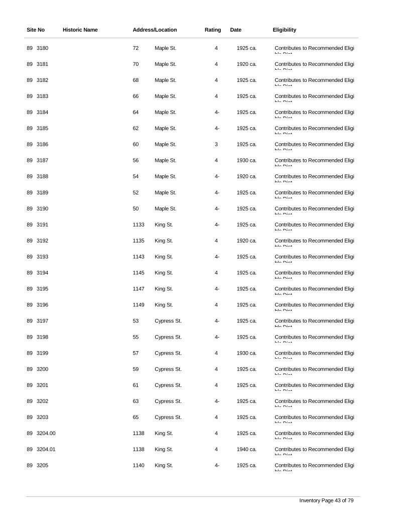
Site No Historic Name Address/Location Rating Date Eligibility
3180 Maple St. 4 1925 ca. Contributes to Recommended Eligible Dist
89 72
3181 Maple St. 4 1920 ca. Contributes to Recommended Eligible Dist
89 70
3182 Maple St. 4 1925 ca. Contributes to Recommended Eligible Dist
89 68
3183 Maple St. 4 1925 ca. Contributes to Recommended Eligible Dist
89 66
3184 Maple St. 4- 1925 ca. Contributes to Recommended Eligible Dist
89 64
3185 Maple St. 4- 1925 ca. Contributes to Recommended Eligible Dist
89 62
3186 Maple St. 3 1925 ca. Contributes to Recommended Eligible Dist
89 60
3187 Maple St. 4 1930 ca. Contributes to Recommended Eligible Dist
89 56
3188 Maple St. 4- 1920 ca. Contributes to Recommended Eligible Dist
89 54
3189 Maple St. 4- 1925 ca. Contributes to Recommended Eligible Dist
89 52
3190 Maple St. 4- 1925 ca. Contributes to Recommended Eligible Dist
89 50
3191 King St. 4- 1925 ca. Contributes to Recommended Eligible Dist
89 1133
3192 King St. 4 1920 ca. Contributes to Recommended Eligible Dist
89 1135
3193 King St. 4- 1925 ca. Contributes to Recommended Eligible Dist
89 1143
3194 King St. 4 1925 ca. Contributes to Recommended Eligible Dist
89 1145
3195 King St. 4- 1925 ca. Contributes to Recommended Eligible Dist
89 1147
3196 King St. 4 1925 ca. Contributes to Recommended Eligible Dist
89 1149
3197 Cypress St. 4- 1925 ca. Contributes to Recommended Eligible Dist
89 53
3198 Cypress St. 4- 1925 ca. Contributes to Recommended Eligible Dist
89 55
3199 Cypress St. 4 1930 ca. Contributes to Recommended Eligible Dist
89 57
3200 Cypress St. 4 1925 ca. Contributes to Recommended Eligible Dist
89 59
3201 Cypress St. 4 1925 ca. Contributes to Recommended Eligible Dist
89 61
3202 Cypress St. 4- 1925 ca. Contributes to Recommended Eligible Dist
89 63
3203 Cypress St. 4 1925 ca. Contributes to Recommended Eligible Dist
89 65
3204.00 King St. 4 1925 ca. Contributes to Recommended Eligible Dist
89 1138
3204.01 King St. 4 1940 ca. Contributes to Recommended Eligible Dist
89 1138
3205 King St. 4- 1925 ca. Contributes to Recommended Eligible Dist
89 1140
Inventory Page 43 of 79
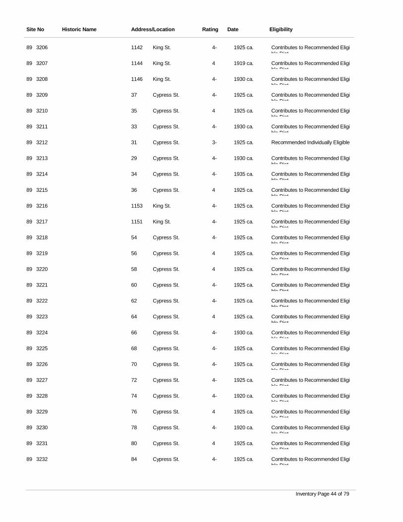
Site No Historic Name Address/Location Rating Date Eligibility
3206 King St. 4- 1925 ca. Contributes to Recommended Eligible Dist
89 1142
3207 King St. 4 1919 ca. Contributes to Recommended Eligible Dist
89 1144
3208 King St. 4- 1930 ca. Contributes to Recommended Eligible Dist
89 1146
3209 Cypress St. 4- 1925 ca. Contributes to Recommended Eligible Dist
89 37
3210 Cypress St. 4 1925 ca. Contributes to Recommended Eligible Dist
89 35
3211 Cypress St. 4- 1930 ca. Contributes to Recommended Eligible Dist
89 33
3212 Cypress St. 3- 1925 ca. Recommended Individually Eligible89 31
3213 Cypress St. 4- 1930 ca. Contributes to Recommended Eligible Dist
89 29
3214 Cypress St. 4- 1935 ca. Contributes to Recommended Eligible Dist
89 34
3215 Cypress St. 4 1925 ca. Contributes to Recommended Eligible Dist
89 36
3216 King St. 4- 1925 ca. Contributes to Recommended Eligible Dist
89 1153
3217 King St. 4- 1925 ca. Contributes to Recommended Eligible Dist
89 1151
3218 Cypress St. 4- 1925 ca. Contributes to Recommended Eligible Dist
89 54
3219 Cypress St. 4 1925 ca. Contributes to Recommended Eligible Dist
89 56
3220 Cypress St. 4 1925 ca. Contributes to Recommended Eligible Dist
89 58
3221 Cypress St. 4- 1925 ca. Contributes to Recommended Eligible Dist
89 60
3222 Cypress St. 4- 1925 ca. Contributes to Recommended Eligible Dist
89 62
3223 Cypress St. 4 1925 ca. Contributes to Recommended Eligible Dist
89 64
3224 Cypress St. 4- 1930 ca. Contributes to Recommended Eligible Dist
89 66
3225 Cypress St. 4- 1925 ca. Contributes to Recommended Eligible Dist
89 68
3226 Cypress St. 4- 1925 ca. Contributes to Recommended Eligible Dist
89 70
3227 Cypress St. 4- 1925 ca. Contributes to Recommended Eligible Dist
89 72
3228 Cypress St. 4- 1920 ca. Contributes to Recommended Eligible Dist
89 74
3229 Cypress St. 4 1925 ca. Contributes to Recommended Eligible Dist
89 76
3230 Cypress St. 4- 1920 ca. Contributes to Recommended Eligible Dist
89 78
3231 Cypress St. 4 1925 ca. Contributes to Recommended Eligible Dist
89 80
3232 Cypress St. 4- 1925 ca. Contributes to Recommended Eligible Dist
89 84
Inventory Page 44 of 79
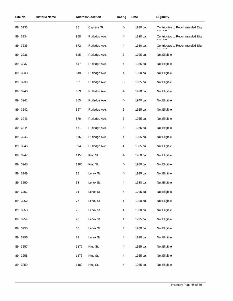
Site No Historic Name Address/Location Rating Date Eligibility
3233 Cypress St. 4- 1930 ca. Contributes to Recommended Eligible Dist
89 86
3234 Rutledge Ave. 4- 1930 ca. Contributes to Recommended Eligible Dist
89 868
3235 Rutledge Ave. 4 1930 ca. Contributes to Recommended Eligible Dist
89 872
3236 Rutledge Ave. 3 1925 ca. Not Eligible89 845
3237 Rutledge Ave. 4 1935 ca. Not Eligible89 847
3238 Rutledge Ave. 4- 1930 ca. Not Eligible89 849
3239 Rutledge Ave. 3- 1925 ca. Not Eligible89 851
3240 Rutledge Ave. 4- 1930 ca. Not Eligible89 853
3241 Rutledge Ave. 4- 1940 ca. Not Eligible89 855
3242 Rutledge Ave. 3 1925 ca. Not Eligible89 857
3243 Rutledge Ave. 3 1935 ca. Not Eligible89 879
3244 Rutledge Ave. 3 1935 ca. Not Eligible89 881
3245 Rutledge Ave. 4- 1935 ca. Not Eligible89 876
3246 Rutledge Ave. 4 1935 ca. Not Eligible89 874
3247 King St. 4- 1950 ca. Not Eligible89 1156
3248 King St. 4- 1930 ca. Not Eligible89 1166
3249 Lenox St. 4- 1925 ca. Not Eligible89 35
3250 Lenox St. 4 1930 ca. Not Eligible89 33
3251 Lenox St. 4- 1925 ca. Not Eligible89 31
3252 Lenox St. 4- 1930 ca. Not Eligible89 27
3253 Lenox St. 4- 1930 ca. Not Eligible89 25
3254 Lenox St. 4 1925 ca. Not Eligible89 28
3255 Lenox St. 4 1930 ca. Not Eligible89 30
3256 Lenox St. 4 1930 ca. Not Eligible89 32
3257 King St. 4- 1925 ca. Not Eligible89 1176
3258 King St. 4 1935 ca. Not Eligible89 1178
3259 King St. 4 1935 ca. Not Eligible89 1182
Inventory Page 45 of 79
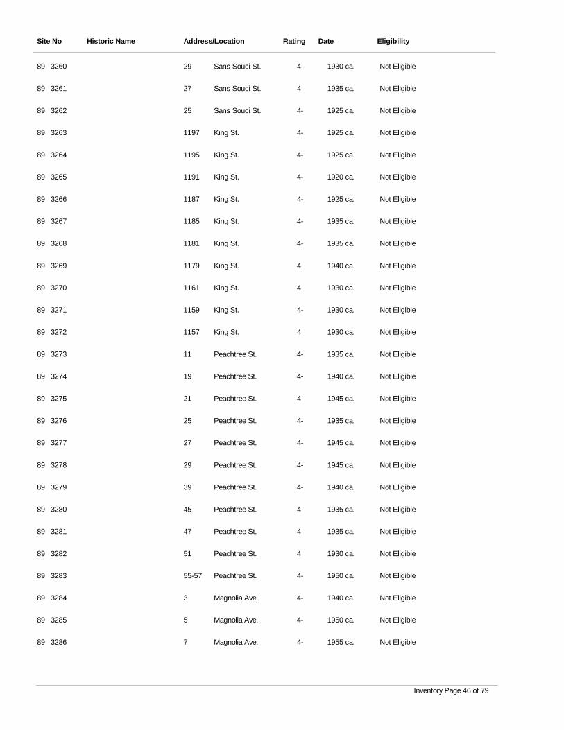
Site No Historic Name Address/Location Rating Date Eligibility
3260 Sans Souci St. 4- 1930 ca. Not Eligible89 29
3261 Sans Souci St. 4 1935 ca. Not Eligible89 27
3262 Sans Souci St. 4- 1925 ca. Not Eligible89 25
3263 King St. 4- 1925 ca. Not Eligible89 1197
3264 King St. 4- 1925 ca. Not Eligible89 1195
3265 King St. 4- 1920 ca. Not Eligible89 1191
3266 King St. 4- 1925 ca. Not Eligible89 1187
3267 King St. 4- 1935 ca. Not Eligible89 1185
3268 King St. 4- 1935 ca. Not Eligible89 1181
3269 King St. 4 1940 ca. Not Eligible89 1179
3270 King St. 4 1930 ca. Not Eligible89 1161
3271 King St. 4- 1930 ca. Not Eligible89 1159
3272 King St. 4 1930 ca. Not Eligible89 1157
3273 Peachtree St. 4- 1935 ca. Not Eligible89 11
3274 Peachtree St. 4- 1940 ca. Not Eligible89 19
3275 Peachtree St. 4- 1945 ca. Not Eligible89 21
3276 Peachtree St. 4- 1935 ca. Not Eligible89 25
3277 Peachtree St. 4- 1945 ca. Not Eligible89 27
3278 Peachtree St. 4- 1945 ca. Not Eligible89 29
3279 Peachtree St. 4- 1940 ca. Not Eligible89 39
3280 Peachtree St. 4- 1935 ca. Not Eligible89 45
3281 Peachtree St. 4- 1935 ca. Not Eligible89 47
3282 Peachtree St. 4 1930 ca. Not Eligible89 51
3283 Peachtree St. 4- 1950 ca. Not Eligible89 55-57
3284 Magnolia Ave. 4- 1940 ca. Not Eligible89 3
3285 Magnolia Ave. 4- 1950 ca. Not Eligible89 5
3286 Magnolia Ave. 4- 1955 ca. Not Eligible89 7
Inventory Page 46 of 79
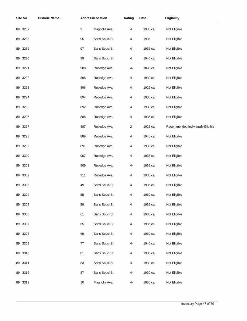
Site No Historic Name Address/Location Rating Date Eligibility
3287 Magnolia Ave. 4 1935 ca. Not Eligible89 9
3288 Sans Souci St. 4 1935 Not Eligible89 95
3289 Sans Souci St. 4 1935 ca. Not Eligible89 97
3290 Sans Souci St. 4 1940 ca. Not Eligible89 99
3291 Rutledge Ave. 4- 1890 ca. Not Eligible89 900
3292 Rutledge Ave. 4- 1930 ca. Not Eligible89 898
3293 Rutledge Ave. 4 1925 ca. Not Eligible89 896
3294 Rutledge Ave. 4 1930 ca. Not Eligible89 894
3295 Rutledge Ave. 4 1930 ca. Not Eligible89 892
3296 Rutledge Ave. 4 1935 ca. Not Eligible89 888
3297 Rutledge Ave. 2 1925 ca. Recommended Individually Eligible89 887
3298 Rutledge Ave. 4 1945 ca. Not Eligible89 889
3299 Rutledge Ave. 4 1935 ca. Not Eligible89 891
3300 Rutledge Ave. 4 1935 ca. Not Eligible89 907
3301 Rutledge Ave. 4- 1935 ca. Not Eligible89 909
3302 Rutledge Ave. 4 1935 ca. Not Eligible89 911
3303 Sans Souci St. 4 1935 ca. Not Eligible89 49
3304 Sans Souci St. 4 1950 ca. Not Eligible89 55
3305 Sans Souci St. 4 1935 ca. Not Eligible89 59
3306 Sans Souci St. 4 1935 ca. Not Eligible89 61
3307 Sans Souci St. 4 1935 ca. Not Eligible89 65
3308 Sans Souci St. 4 1950 ca. Not Eligible89 69
3309 Sans Souci St. 4- 1940 ca. Not Eligible89 77
3310 Sans Souci St. 4 1930 ca. Not Eligible89 81
3311 Sans Souci St. 4- 1930 ca. Not Eligible89 83
3312 Sans Souci St. 4- 1930 ca. Not Eligible89 87
3313 Magnolia Ave. 4- 1930 ca. Not Eligible89 10
Inventory Page 47 of 79
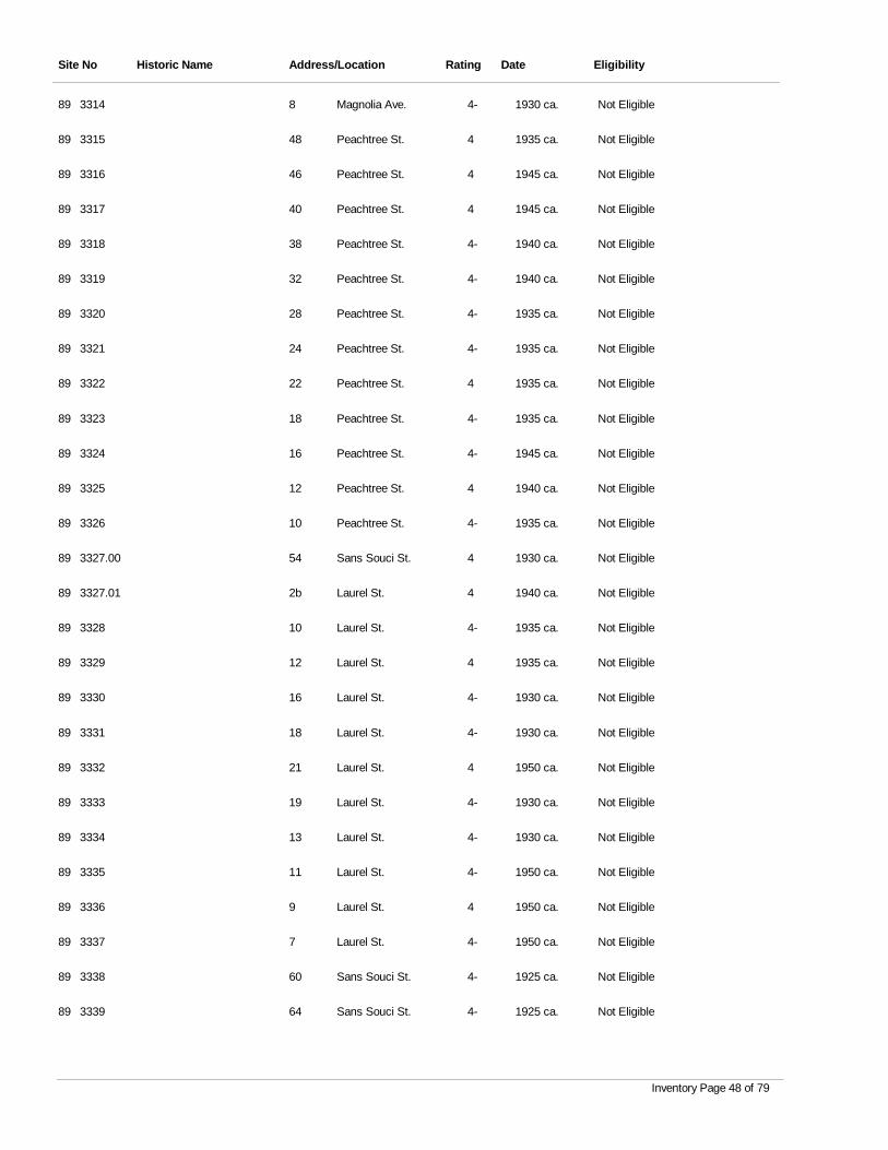
Site No Historic Name Address/Location Rating Date Eligibility
3314 Magnolia Ave. 4- 1930 ca. Not Eligible89 8
3315 Peachtree St. 4 1935 ca. Not Eligible89 48
3316 Peachtree St. 4 1945 ca. Not Eligible89 46
3317 Peachtree St. 4 1945 ca. Not Eligible89 40
3318 Peachtree St. 4- 1940 ca. Not Eligible89 38
3319 Peachtree St. 4- 1940 ca. Not Eligible89 32
3320 Peachtree St. 4- 1935 ca. Not Eligible89 28
3321 Peachtree St. 4- 1935 ca. Not Eligible89 24
3322 Peachtree St. 4 1935 ca. Not Eligible89 22
3323 Peachtree St. 4- 1935 ca. Not Eligible89 18
3324 Peachtree St. 4- 1945 ca. Not Eligible89 16
3325 Peachtree St. 4 1940 ca. Not Eligible89 12
3326 Peachtree St. 4- 1935 ca. Not Eligible89 10
3327.00 Sans Souci St. 4 1930 ca. Not Eligible89 54
3327.01 Laurel St. 4 1940 ca. Not Eligible89 2b
3328 Laurel St. 4- 1935 ca. Not Eligible89 10
3329 Laurel St. 4 1935 ca. Not Eligible89 12
3330 Laurel St. 4- 1930 ca. Not Eligible89 16
3331 Laurel St. 4- 1930 ca. Not Eligible89 18
3332 Laurel St. 4 1950 ca. Not Eligible89 21
3333 Laurel St. 4- 1930 ca. Not Eligible89 19
3334 Laurel St. 4- 1930 ca. Not Eligible89 13
3335 Laurel St. 4- 1950 ca. Not Eligible89 11
3336 Laurel St. 4 1950 ca. Not Eligible89 9
3337 Laurel St. 4- 1950 ca. Not Eligible89 7
3338 Sans Souci St. 4- 1925 ca. Not Eligible89 60
3339 Sans Souci St. 4- 1925 ca. Not Eligible89 64
Inventory Page 48 of 79
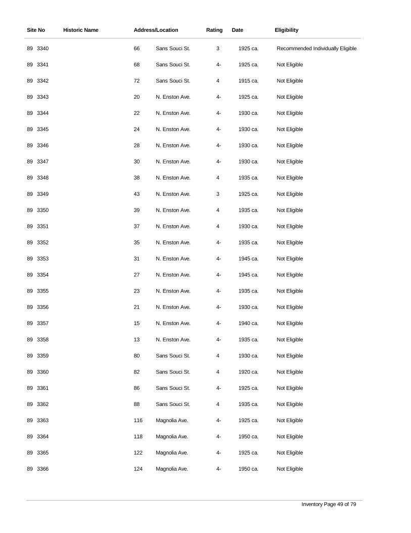
Site No Historic Name Address/Location Rating Date Eligibility
3340 Sans Souci St. 3 1925 ca. Recommended Individually Eligible89 66
3341 Sans Souci St. 4- 1925 ca. Not Eligible89 68
3342 Sans Souci St. 4 1915 ca. Not Eligible89 72
3343 N. Enston Ave. 4- 1925 ca. Not Eligible89 20
3344 N. Enston Ave. 4- 1930 ca. Not Eligible89 22
3345 N. Enston Ave. 4- 1930 ca. Not Eligible89 24
3346 N. Enston Ave. 4- 1930 ca. Not Eligible89 28
3347 N. Enston Ave. 4- 1930 ca. Not Eligible89 30
3348 N. Enston Ave. 4 1935 ca. Not Eligible89 38
3349 N. Enston Ave. 3 1925 ca. Not Eligible89 43
3350 N. Enston Ave. 4 1935 ca. Not Eligible89 39
3351 N. Enston Ave. 4 1930 ca. Not Eligible89 37
3352 N. Enston Ave. 4- 1935 ca. Not Eligible89 35
3353 N. Enston Ave. 4- 1945 ca. Not Eligible89 31
3354 N. Enston Ave. 4- 1945 ca. Not Eligible89 27
3355 N. Enston Ave. 4- 1935 ca. Not Eligible89 23
3356 N. Enston Ave. 4- 1930 ca. Not Eligible89 21
3357 N. Enston Ave. 4- 1940 ca. Not Eligible89 15
3358 N. Enston Ave. 4- 1935 ca. Not Eligible89 13
3359 Sans Souci St. 4 1930 ca. Not Eligible89 80
3360 Sans Souci St. 4 1920 ca. Not Eligible89 82
3361 Sans Souci St. 4- 1925 ca. Not Eligible89 86
3362 Sans Souci St. 4 1935 ca. Not Eligible89 88
3363 Magnolia Ave. 4- 1925 ca. Not Eligible89 116
3364 Magnolia Ave. 4- 1950 ca. Not Eligible89 118
3365 Magnolia Ave. 4- 1925 ca. Not Eligible89 122
3366 Magnolia Ave. 4- 1950 ca. Not Eligible89 124
Inventory Page 49 of 79
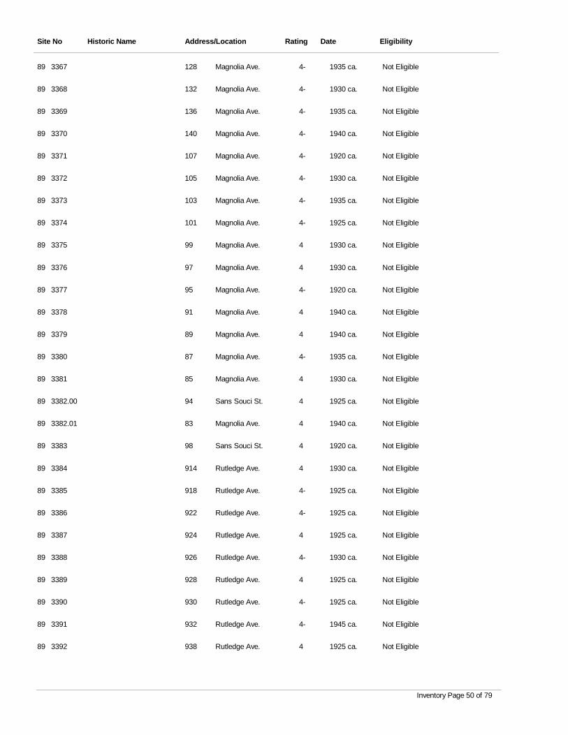
Site No Historic Name Address/Location Rating Date Eligibility
3367 Magnolia Ave. 4- 1935 ca. Not Eligible89 128
3368 Magnolia Ave. 4- 1930 ca. Not Eligible89 132
3369 Magnolia Ave. 4- 1935 ca. Not Eligible89 136
3370 Magnolia Ave. 4- 1940 ca. Not Eligible89 140
3371 Magnolia Ave. 4- 1920 ca. Not Eligible89 107
3372 Magnolia Ave. 4- 1930 ca. Not Eligible89 105
3373 Magnolia Ave. 4- 1935 ca. Not Eligible89 103
3374 Magnolia Ave. 4- 1925 ca. Not Eligible89 101
3375 Magnolia Ave. 4 1930 ca. Not Eligible89 99
3376 Magnolia Ave. 4 1930 ca. Not Eligible89 97
3377 Magnolia Ave. 4- 1920 ca. Not Eligible89 95
3378 Magnolia Ave. 4 1940 ca. Not Eligible89 91
3379 Magnolia Ave. 4 1940 ca. Not Eligible89 89
3380 Magnolia Ave. 4- 1935 ca. Not Eligible89 87
3381 Magnolia Ave. 4 1930 ca. Not Eligible89 85
3382.00 Sans Souci St. 4 1925 ca. Not Eligible89 94
3382.01 Magnolia Ave. 4 1940 ca. Not Eligible89 83
3383 Sans Souci St. 4 1920 ca. Not Eligible89 98
3384 Rutledge Ave. 4 1930 ca. Not Eligible89 914
3385 Rutledge Ave. 4- 1925 ca. Not Eligible89 918
3386 Rutledge Ave. 4- 1925 ca. Not Eligible89 922
3387 Rutledge Ave. 4 1925 ca. Not Eligible89 924
3388 Rutledge Ave. 4- 1930 ca. Not Eligible89 926
3389 Rutledge Ave. 4 1925 ca. Not Eligible89 928
3390 Rutledge Ave. 4- 1925 ca. Not Eligible89 930
3391 Rutledge Ave. 4- 1945 ca. Not Eligible89 932
3392 Rutledge Ave. 4 1925 ca. Not Eligible89 938
Inventory Page 50 of 79
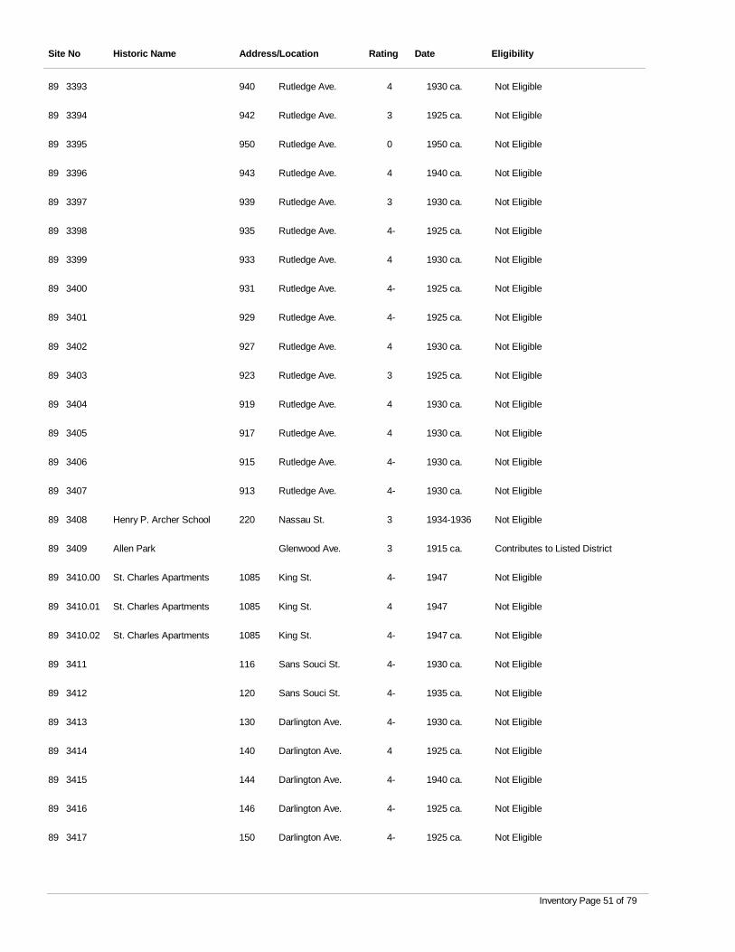
Site No Historic Name Address/Location Rating Date Eligibility
3393 Rutledge Ave. 4 1930 ca. Not Eligible89 940
3394 Rutledge Ave. 3 1925 ca. Not Eligible89 942
3395 Rutledge Ave. 0 1950 ca. Not Eligible89 950
3396 Rutledge Ave. 4 1940 ca. Not Eligible89 943
3397 Rutledge Ave. 3 1930 ca. Not Eligible89 939
3398 Rutledge Ave. 4- 1925 ca. Not Eligible89 935
3399 Rutledge Ave. 4 1930 ca. Not Eligible89 933
3400 Rutledge Ave. 4- 1925 ca. Not Eligible89 931
3401 Rutledge Ave. 4- 1925 ca. Not Eligible89 929
3402 Rutledge Ave. 4 1930 ca. Not Eligible89 927
3403 Rutledge Ave. 3 1925 ca. Not Eligible89 923
3404 Rutledge Ave. 4 1930 ca. Not Eligible89 919
3405 Rutledge Ave. 4 1930 ca. Not Eligible89 917
3406 Rutledge Ave. 4- 1930 ca. Not Eligible89 915
3407 Rutledge Ave. 4- 1930 ca. Not Eligible89 913
3408 Henry P. Archer School Nassau St. 3 1934-1936 Not Eligible89 220
3409 Allen Park Glenwood Ave. 3 1915 ca. Contributes to Listed District89
3410.00 St. Charles Apartments King St. 4- 1947 Not Eligible89 1085
3410.01 St. Charles Apartments King St. 4 1947 Not Eligible89 1085
3410.02 St. Charles Apartments King St. 4- 1947 ca. Not Eligible89 1085
3411 Sans Souci St. 4- 1930 ca. Not Eligible89 116
3412 Sans Souci St. 4- 1935 ca. Not Eligible89 120
3413 Darlington Ave. 4- 1930 ca. Not Eligible89 130
3414 Darlington Ave. 4 1925 ca. Not Eligible89 140
3415 Darlington Ave. 4- 1940 ca. Not Eligible89 144
3416 Darlington Ave. 4- 1925 ca. Not Eligible89 146
3417 Darlington Ave. 4- 1925 ca. Not Eligible89 150
Inventory Page 51 of 79
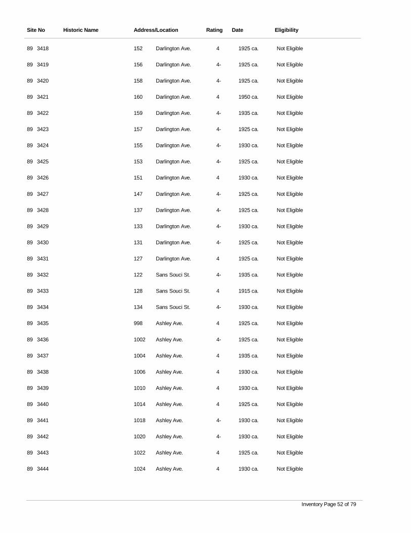
Site No Historic Name Address/Location Rating Date Eligibility
3418 Darlington Ave. 4 1925 ca. Not Eligible89 152
3419 Darlington Ave. 4- 1925 ca. Not Eligible89 156
3420 Darlington Ave. 4- 1925 ca. Not Eligible89 158
3421 Darlington Ave. 4 1950 ca. Not Eligible89 160
3422 Darlington Ave. 4- 1935 ca. Not Eligible89 159
3423 Darlington Ave. 4- 1925 ca. Not Eligible89 157
3424 Darlington Ave. 4- 1930 ca. Not Eligible89 155
3425 Darlington Ave. 4- 1925 ca. Not Eligible89 153
3426 Darlington Ave. 4 1930 ca. Not Eligible89 151
3427 Darlington Ave. 4- 1925 ca. Not Eligible89 147
3428 Darlington Ave. 4- 1925 ca. Not Eligible89 137
3429 Darlington Ave. 4- 1930 ca. Not Eligible89 133
3430 Darlington Ave. 4- 1925 ca. Not Eligible89 131
3431 Darlington Ave. 4 1925 ca. Not Eligible89 127
3432 Sans Souci St. 4- 1935 ca. Not Eligible89 122
3433 Sans Souci St. 4 1915 ca. Not Eligible89 128
3434 Sans Souci St. 4- 1930 ca. Not Eligible89 134
3435 Ashley Ave. 4 1925 ca. Not Eligible89 998
3436 Ashley Ave. 4- 1925 ca. Not Eligible89 1002
3437 Ashley Ave. 4 1935 ca. Not Eligible89 1004
3438 Ashley Ave. 4 1930 ca. Not Eligible89 1006
3439 Ashley Ave. 4 1930 ca. Not Eligible89 1010
3440 Ashley Ave. 4 1925 ca. Not Eligible89 1014
3441 Ashley Ave. 4- 1930 ca. Not Eligible89 1018
3442 Ashley Ave. 4- 1930 ca. Not Eligible89 1020
3443 Ashley Ave. 4 1925 ca. Not Eligible89 1022
3444 Ashley Ave. 4 1930 ca. Not Eligible89 1024
Inventory Page 52 of 79
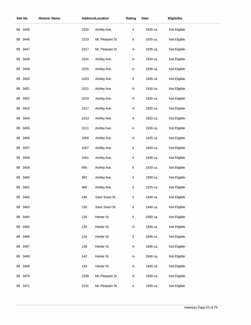
Site No Historic Name Address/Location Rating Date Eligibility
3445 Ashley Ave. 4 1925 ca. Not Eligible89 1032
3446 Mt. Pleasant St. 4 1925 ca. Not Eligible89 2219
3447 Mt. Pleasant St. 4- 1935 ca. Not Eligible89 2217
3448 Ashley Ave. 4- 1920 ca. Not Eligible89 1031
3449 Ashley Ave. 4- 1935 ca. Not Eligible89 1025
3450 Ashley Ave. 4 1945 ca. Not Eligible89 1023
3451 Ashley Ave. 4- 1930 ca. Not Eligible89 1021
3452 Ashley Ave. 4- 1925 ca. Not Eligible89 1019
3453 Ashley Ave. 4- 1925 ca. Not Eligible89 1017
3454 Ashley Ave. 4- 1920 ca. Not Eligible89 1013
3455 Ashley Ave. 4 1930 ca. Not Eligible89 1011
3456 Ashley Ave. 4- 1925 ca. Not Eligible89 1009
3457 Ashley Ave. 4 1940 ca. Not Eligible89 1007
3458 Ashley Ave. 4 1935 ca. Not Eligible89 1001
3459 Ashley Ave. 4 1920 ca. Not Eligible89 995
3460 Ashley Ave. 4 1930 ca. Not Eligible89 993
3461 Ashley Ave. 4 1925 ca. Not Eligible89 989
3462 Sans Souci St. 4 1940 ca. Not Eligible89 146
3463 Sans Souci St. 4 1940 ca. Not Eligible89 150
3464 Hester St. 4 1950 ca. Not Eligible89 126
3465 Hester St. 4- 1945 ca. Not Eligible89 130
3466 Hester St. 4 1945 ca. Not Eligible89 134
3467 Hester St. 4- 1945 ca. Not Eligible89 138
3468 Hester St. 4- 1940 ca. Not Eligible89 142
3469 Hester St. 4- 1940 ca. Not Eligible89 144
3470 Mt. Pleasant St. 4- 1930 ca. Not Eligible89 2235
3471 Mt. Pleasant St. 4 1945 ca. Not Eligible89 2231
Inventory Page 53 of 79
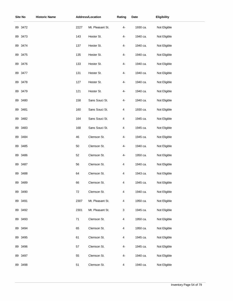
Site No Historic Name Address/Location Rating Date Eligibility
3472 Mt. Pleasant St. 4- 1930 ca. Not Eligible89 2227
3473 Hester St. 4- 1940 ca. Not Eligible89 143
3474 Hester St. 4- 1940 ca. Not Eligible89 137
3475 Hester St. 4- 1940 ca. Not Eligible89 135
3476 Hester St. 4- 1940 ca. Not Eligible89 133
3477 Hester St. 4- 1940 ca. Not Eligible89 131
3478 Hester St. 4- 1940 ca. Not Eligible89 127
3479 Hester St. 4- 1940 ca. Not Eligible89 121
3480 Sans Souci St. 4- 1940 ca. Not Eligible89 158
3481 Sans Souci St. 4 1930 ca. Not Eligible89 160
3482 Sans Souci St. 4 1945 ca. Not Eligible89 164
3483 Sans Souci St. 4 1945 ca. Not Eligible89 168
3484 Clemson St. 4- 1945 ca. Not Eligible89 46
3485 Clemson St. 4- 1940 ca. Not Eligible89 50
3486 Clemson St. 4- 1950 ca. Not Eligible89 52
3487 Clemson St. 4 1940 ca. Not Eligible89 56
3488 Clemson St. 4 1943 ca. Not Eligible89 64
3489 Clemson St. 4 1945 ca. Not Eligible89 66
3490 Clemson St. 4 1940 ca. Not Eligible89 72
3491 Mt. Pleasant St. 4 1950 ca. Not Eligible89 2307
3492 Mt. Pleasant St. 3 1945 ca. Not Eligible89 2301
3493 Clemson St. 4 1950 ca. Not Eligible89 71
3494 Clemson St. 4 1950 ca. Not Eligible89 65
3495 Clemson St. 4 1945 ca. Not Eligible89 61
3496 Clemson St. 4- 1945 ca. Not Eligible89 57
3497 Clemson St. 4- 1940 ca. Not Eligible89 55
3498 Clemson St. 4 1940 ca. Not Eligible89 51
Inventory Page 54 of 79
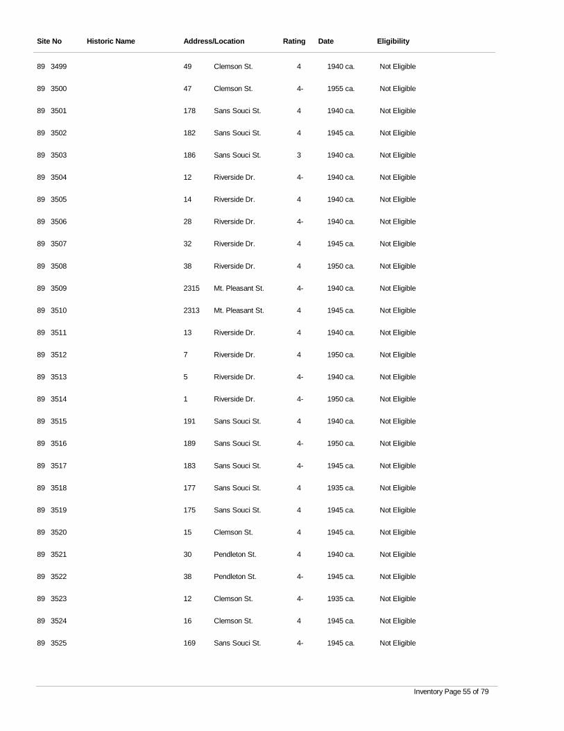
Site No Historic Name Address/Location Rating Date Eligibility
3499 Clemson St. 4 1940 ca. Not Eligible89 49
3500 Clemson St. 4- 1955 ca. Not Eligible89 47
3501 Sans Souci St. 4 1940 ca. Not Eligible89 178
3502 Sans Souci St. 4 1945 ca. Not Eligible89 182
3503 Sans Souci St. 3 1940 ca. Not Eligible89 186
3504 Riverside Dr. 4- 1940 ca. Not Eligible89 12
3505 Riverside Dr. 4 1940 ca. Not Eligible89 14
3506 Riverside Dr. 4- 1940 ca. Not Eligible89 28
3507 Riverside Dr. 4 1945 ca. Not Eligible89 32
3508 Riverside Dr. 4 1950 ca. Not Eligible89 38
3509 Mt. Pleasant St. 4- 1940 ca. Not Eligible89 2315
3510 Mt. Pleasant St. 4 1945 ca. Not Eligible89 2313
3511 Riverside Dr. 4 1940 ca. Not Eligible89 13
3512 Riverside Dr. 4 1950 ca. Not Eligible89 7
3513 Riverside Dr. 4- 1940 ca. Not Eligible89 5
3514 Riverside Dr. 4- 1950 ca. Not Eligible89 1
3515 Sans Souci St. 4 1940 ca. Not Eligible89 191
3516 Sans Souci St. 4- 1950 ca. Not Eligible89 189
3517 Sans Souci St. 4- 1945 ca. Not Eligible89 183
3518 Sans Souci St. 4 1935 ca. Not Eligible89 177
3519 Sans Souci St. 4 1945 ca. Not Eligible89 175
3520 Clemson St. 4 1945 ca. Not Eligible89 15
3521 Pendleton St. 4 1940 ca. Not Eligible89 30
3522 Pendleton St. 4- 1945 ca. Not Eligible89 38
3523 Clemson St. 4- 1935 ca. Not Eligible89 12
3524 Clemson St. 4 1945 ca. Not Eligible89 16
3525 Sans Souci St. 4- 1945 ca. Not Eligible89 169
Inventory Page 55 of 79

Site No Historic Name Address/Location Rating Date Eligibility
3526 Sans Souci St. 4- 1940 ca. Not Eligible89 163
3527 Sans Souci St. 4 1955 ca. Not Eligible89 157
3528 Hester St. 4- 1945 ca. Not Eligible89 103
3529 Pendleton St. 4 1940 ca. Not Eligible89 2
3530 Hester St. 4- 1942 ca. Not Eligible89 83
3531 Hester St. 4- 1950 ca. Not Eligible89 81
3532 Hester St. 4- 1950 ca. Not Eligible89 79
3533 Peachtree St. 4 1945 ca. Not Eligible89 122
3534 Peachtree St. 4 1940 ca. Not Eligible89 136
3535 Clemson St. 4- 1950 ca. Not Eligible89 8
3536 Clemson St. 4- 1950 ca. Not Eligible89 10
3537 Pendleton St. 3 1940 ca. Not Eligible89 41
3538 Pendleton St. 4 1955 ca. Not Eligible89 29
3539 Clemson St. 4 1950 ca. Not Eligible89 9
3540 Clemson St. 4- 1955 ca. Not Eligible89 5
3541 Peachtree St. 4 1955 ca. Not Eligible89 164
3542 Peachtree St. 4- 1955 ca. Not Eligible89 176
3543 Peachtree St. 4 1955 ca. Not Eligible89 118
3544 Peachtree St. 4- 1945 ca. Not Eligible89 114
3545 Peachtree St. 4- 1940 ca. Not Eligible89 112
3546 Piedmont Ave. 4- 1940 ca. Not Eligible89 51
3547 Piedmont Ave. 4- 1950 ca. Not Eligible89 53
3548 Piedmont Ave. 4- 1945 ca. Not Eligible89 40
3549 Piedmont Ave. 4- 1940 ca. Not Eligible89 42
3550 Piedmont Ave. 4- 1940 ca. Not Eligible89 44
3551 Piedmont Ave. 4- 1945 ca. Not Eligible89 46
3552 Piedmont Ave. 4 1955 ca. Not Eligible89 48
Inventory Page 56 of 79
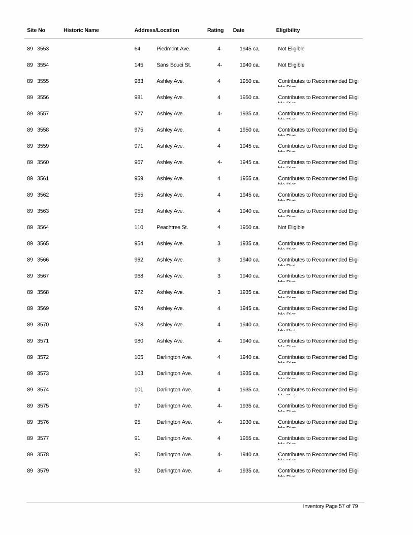
Site No Historic Name Address/Location Rating Date Eligibility
3553 Piedmont Ave. 4- 1945 ca. Not Eligible89 64
3554 Sans Souci St. 4- 1940 ca. Not Eligible89 145
3555 Ashley Ave. 4 1950 ca. Contributes to Recommended Eligible Dist
89 983
3556 Ashley Ave. 4 1950 ca. Contributes to Recommended Eligible Dist
89 981
3557 Ashley Ave. 4- 1935 ca. Contributes to Recommended Eligible Dist
89 977
3558 Ashley Ave. 4 1950 ca. Contributes to Recommended Eligible Dist
89 975
3559 Ashley Ave. 4 1945 ca. Contributes to Recommended Eligible Dist
89 971
3560 Ashley Ave. 4- 1945 ca. Contributes to Recommended Eligible Dist
89 967
3561 Ashley Ave. 4 1955 ca. Contributes to Recommended Eligible Dist
89 959
3562 Ashley Ave. 4 1945 ca. Contributes to Recommended Eligible Dist
89 955
3563 Ashley Ave. 4 1940 ca. Contributes to Recommended Eligible Dist
89 953
3564 Peachtree St. 4 1950 ca. Not Eligible89 110
3565 Ashley Ave. 3 1935 ca. Contributes to Recommended Eligible Dist
89 954
3566 Ashley Ave. 3 1940 ca. Contributes to Recommended Eligible Dist
89 962
3567 Ashley Ave. 3 1940 ca. Contributes to Recommended Eligible Dist
89 968
3568 Ashley Ave. 3 1935 ca. Contributes to Recommended Eligible Dist
89 972
3569 Ashley Ave. 4 1945 ca. Contributes to Recommended Eligible Dist
89 974
3570 Ashley Ave. 4 1940 ca. Contributes to Recommended Eligible Dist
89 978
3571 Ashley Ave. 4- 1940 ca. Contributes to Recommended Eligible Dist
89 980
3572 Darlington Ave. 4 1940 ca. Contributes to Recommended Eligible Dist
89 105
3573 Darlington Ave. 4 1935 ca. Contributes to Recommended Eligible Dist
89 103
3574 Darlington Ave. 4- 1935 ca. Contributes to Recommended Eligible Dist
89 101
3575 Darlington Ave. 4- 1935 ca. Contributes to Recommended Eligible Dist
89 97
3576 Darlington Ave. 4- 1930 ca. Contributes to Recommended Eligible Dist
89 95
3577 Darlington Ave. 4 1955 ca. Contributes to Recommended Eligible Dist
89 91
3578 Darlington Ave. 4- 1940 ca. Contributes to Recommended Eligible Dist
89 90
3579 Darlington Ave. 4- 1935 ca. Contributes to Recommended Eligible Dist
89 92
Inventory Page 57 of 79
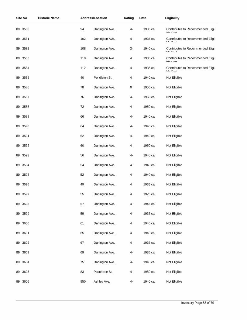
Site No Historic Name Address/Location Rating Date Eligibility
3580 Darlington Ave. 4- 1935 ca. Contributes to Recommended Eligible Dist
89 94
3581 Darlington Ave. 4 1935 ca. Contributes to Recommended Eligible Dist
89 102
3582 Darlington Ave. 3- 1940 ca. Contributes to Recommended Eligible Dist
89 108
3583 Darlington Ave. 4 1935 ca. Contributes to Recommended Eligible Dist
89 110
3584 Darlington Ave. 4 1935 ca. Contributes to Recommended Eligible Dist
89 112
3585 Pendleton St. 4 1940 ca. Not Eligible89 40
3586 Darlington Ave. 0 1955 ca. Not Eligible89 78
3587 Darlington Ave. 4- 1950 ca. Not Eligible89 76
3588 Darlington Ave. 4- 1950 ca. Not Eligible89 72
3589 Darlington Ave. 4- 1940 ca. Not Eligible89 66
3590 Darlington Ave. 4- 1940 ca. Not Eligible89 64
3591 Darlington Ave. 4- 1940 ca. Not Eligible89 62
3592 Darlington Ave. 4 1950 ca. Not Eligible89 60
3593 Darlington Ave. 4- 1940 ca. Not Eligible89 56
3594 Darlington Ave. 4- 1940 ca. Not Eligible89 54
3595 Darlington Ave. 4- 1940 ca. Not Eligible89 52
3596 Darlington Ave. 4 1935 ca. Not Eligible89 49
3597 Darlington Ave. 4 1925 ca. Not Eligible89 55
3598 Darlington Ave. 4- 1945 ca. Not Eligible89 57
3599 Darlington Ave. 4- 1935 ca. Not Eligible89 59
3600 Darlington Ave. 4 1940 ca. Not Eligible89 61
3601 Darlington Ave. 4 1940 ca. Not Eligible89 65
3602 Darlington Ave. 4 1935 ca. Not Eligible89 67
3603 Darlington Ave. 4- 1935 ca. Not Eligible89 69
3604 Darlington Ave. 4- 1940 ca. Not Eligible89 75
3605 Peachtree St. 4- 1950 ca. Not Eligible89 83
3606 Ashley Ave. 4- 1940 ca. Not Eligible89 950
Inventory Page 58 of 79
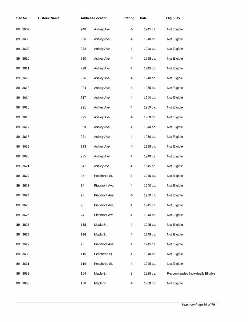
Site No Historic Name Address/Location Rating Date Eligibility
3607 Ashley Ave. 4- 1945 ca. Not Eligible89 940
3608 Ashley Ave. 4- 1940 ca. Not Eligible89 936
3609 Ashley Ave. 4- 1940 ca. Not Eligible89 932
3610 Ashley Ave. 4- 1955 ca. Not Eligible89 930
3611 Ashley Ave. 4 1945 ca. Not Eligible89 928
3612 Ashley Ave. 4- 1940 ca. Not Eligible89 926
3613 Ashley Ave. 4 1955 ca. Not Eligible89 924
3614 Ashley Ave. 4 1940 ca. Not Eligible89 917
3615 Ashley Ave. 4 1950 ca. Not Eligible89 921
3616 Ashley Ave. 4- 1950 ca. Not Eligible89 925
3617 Ashley Ave. 4- 1940 ca. Not Eligible89 929
3618 Ashley Ave. 4- 1950 ca. Not Eligible89 931
3619 Ashley Ave. 4- 1955 ca. Not Eligible89 933
3620 Ashley Ave. 4 1940 ca. Not Eligible89 935
3621 Ashley Ave. 4- 1945 ca. Not Eligible89 941
3622 Peachtree St. 4- 1955 ca. Not Eligible89 97
3623 Piedmont Ave. 4 1940 ca. Not Eligible89 34
3624 Piedmont Ave. 4- 1950 ca. Not Eligible89 28
3625 Piedmont Ave. 4 1945 ca. Not Eligible89 26
3626 Piedmont Ave. 4- 1940 ca. Not Eligible89 24
3627 Maple St. 4- 1945 ca. Not Eligible89 138
3628 Maple St. 4- 1945 ca. Not Eligible89 136
3629 Piedmont Ave. 4 1945 ca. Not Eligible89 25
3630 Peachtree St. 4- 1940 ca. Not Eligible89 115
3631 Peachtree St. 4- 1945 ca. Not Eligible89 119
3632 Maple St. 3 1925 ca. Recommended Individually Eligible89 164
3633 Maple St. 4- 1950 ca. Not Eligible89 156
Inventory Page 59 of 79
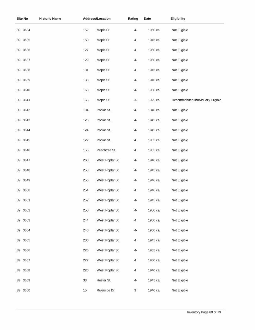
Site No Historic Name Address/Location Rating Date Eligibility
3634 Maple St. 4- 1950 ca. Not Eligible89 152
3635 Maple St. 4 1945 ca. Not Eligible89 150
3636 Maple St. 4 1950 ca. Not Eligible89 127
3637 Maple St. 4- 1950 ca. Not Eligible89 129
3638 Maple St. 4 1945 ca. Not Eligible89 131
3639 Maple St. 4- 1940 ca. Not Eligible89 133
3640 Maple St. 4- 1950 ca. Not Eligible89 163
3641 Maple St. 3- 1925 ca. Recommended Individually Eligible89 165
3642 Poplar St. 4- 1940 ca. Not Eligible89 194
3643 Poplar St. 4- 1945 ca. Not Eligible89 126
3644 Poplar St. 4- 1945 ca. Not Eligible89 124
3645 Poplar St. 4 1955 ca. Not Eligible89 122
3646 Peachtree St. 4 1955 ca. Not Eligible89 155
3647 West Poplar St. 4- 1940 ca. Not Eligible89 260
3648 West Poplar St. 4- 1945 ca. Not Eligible89 258
3649 West Poplar St. 4- 1940 ca. Not Eligible89 256
3650 West Poplar St. 4 1940 ca. Not Eligible89 254
3651 West Poplar St. 4- 1945 ca. Not Eligible89 252
3652 West Poplar St. 4- 1950 ca. Not Eligible89 250
3653 West Poplar St. 4 1950 ca. Not Eligible89 244
3654 West Poplar St. 4- 1950 ca. Not Eligible89 240
3655 West Poplar St. 4 1945 ca. Not Eligible89 230
3656 West Poplar St. 4- 1955 ca. Not Eligible89 226
3657 West Poplar St. 4 1950 ca. Not Eligible89 222
3658 West Poplar St. 4 1940 ca. Not Eligible89 220
3659 Hester St. 4- 1945 ca. Not Eligible89 33
3660 Riverside Dr. 3 1940 ca. Not Eligible89 15
Inventory Page 60 of 79
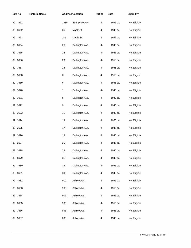
Site No Historic Name Address/Location Rating Date Eligibility
3661 Sunnyside Ave. 4- 1935 ca. Not Eligible89 2335
3662 Maple St. 4- 1945 ca. Not Eligible89 85
3663 Maple St. 4 1955 ca. Not Eligible89 101
3664 Darlington Ave. 4- 1945 ca. Not Eligible89 26
3665 Darlington Ave. 4- 1935 ca. Not Eligible89 24
3666 Darlington Ave. 4- 1950 ca. Not Eligible89 20
3667 Darlington Ave. 4- 1945 ca. Not Eligible89 18
3668 Darlington Ave. 4 1955 ca. Not Eligible89 8
3669 Darlington Ave. 4 1955 ca. Not Eligible89 6
3670 Darlington Ave. 4- 1940 ca. Not Eligible89 1
3671 Darlington Ave. 4- 1940 ca. Not Eligible89 5
3672 Darlington Ave. 4 1945 ca. Not Eligible89 9
3673 Darlington Ave. 4- 1940 ca. Not Eligible89 11
3674 Darlington Ave. 4 1955 ca. Not Eligible89 13
3675 Darlington Ave. 4- 1945 ca. Not Eligible89 17
3676 Darlington Ave. 4 1940 ca. Not Eligible89 19
3677 Darlington Ave. 4 1945 ca. Not Eligible89 25
3678 Darlington Ave. 4 1940 ca. Not Eligible89 29
3679 Darlington Ave. 4 1945 ca. Not Eligible89 31
3680 Darlington Ave. 4- 1955 ca. Not Eligible89 33
3681 Darlington Ave. 4- 1940 ca. Not Eligible89 39
3682 Ashley Ave. 4 1935 ca. Not Eligible89 910
3683 Ashley Ave. 4- 1955 ca. Not Eligible89 908
3684 Ashley Ave. 4 1945 ca. Not Eligible89 906
3685 Ashley Ave. 4- 1950 ca. Not Eligible89 900
3686 Ashley Ave. 4- 1945 ca. Not Eligible89 898
3687 Ashley Ave. 4 1945 ca. Not Eligible89 890
Inventory Page 61 of 79
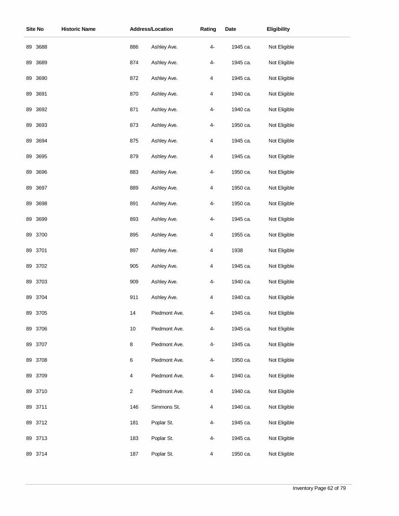
Site No Historic Name Address/Location Rating Date Eligibility
3688 Ashley Ave. 4- 1945 ca. Not Eligible89 886
3689 Ashley Ave. 4- 1945 ca. Not Eligible89 874
3690 Ashley Ave. 4 1945 ca. Not Eligible89 872
3691 Ashley Ave. 4 1940 ca. Not Eligible89 870
3692 Ashley Ave. 4- 1940 ca. Not Eligible89 871
3693 Ashley Ave. 4- 1950 ca. Not Eligible89 873
3694 Ashley Ave. 4 1945 ca. Not Eligible89 875
3695 Ashley Ave. 4 1945 ca. Not Eligible89 879
3696 Ashley Ave. 4- 1950 ca. Not Eligible89 883
3697 Ashley Ave. 4 1950 ca. Not Eligible89 889
3698 Ashley Ave. 4- 1950 ca. Not Eligible89 891
3699 Ashley Ave. 4- 1945 ca. Not Eligible89 893
3700 Ashley Ave. 4 1955 ca. Not Eligible89 895
3701 Ashley Ave. 4 1938 Not Eligible89 897
3702 Ashley Ave. 4 1945 ca. Not Eligible89 905
3703 Ashley Ave. 4- 1940 ca. Not Eligible89 909
3704 Ashley Ave. 4 1940 ca. Not Eligible89 911
3705 Piedmont Ave. 4- 1945 ca. Not Eligible89 14
3706 Piedmont Ave. 4- 1945 ca. Not Eligible89 10
3707 Piedmont Ave. 4- 1945 ca. Not Eligible89 8
3708 Piedmont Ave. 4- 1950 ca. Not Eligible89 6
3709 Piedmont Ave. 4- 1940 ca. Not Eligible89 4
3710 Piedmont Ave. 4 1940 ca. Not Eligible89 2
3711 Simmons St. 4 1940 ca. Not Eligible89 146
3712 Poplar St. 4- 1945 ca. Not Eligible89 181
3713 Poplar St. 4- 1945 ca. Not Eligible89 183
3714 Poplar St. 4 1950 ca. Not Eligible89 187
Inventory Page 62 of 79
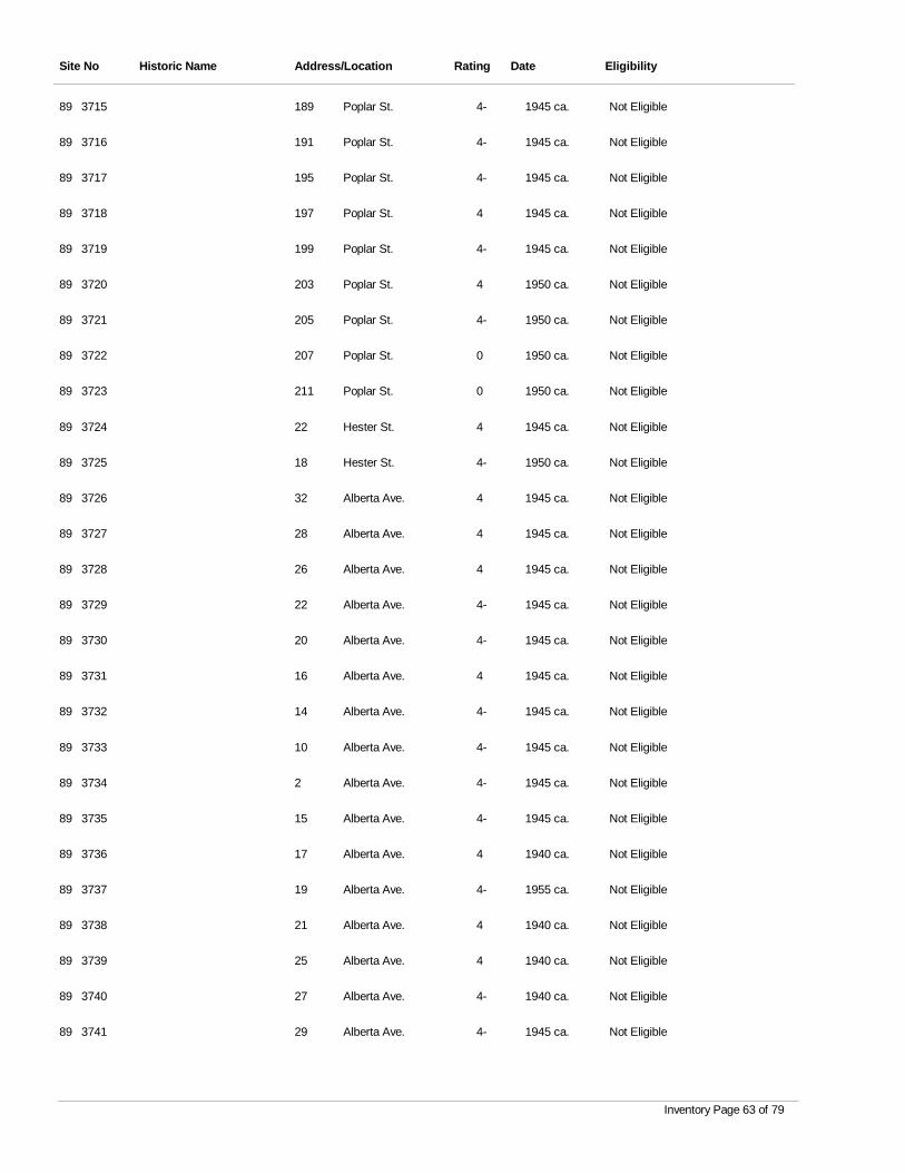
Site No Historic Name Address/Location Rating Date Eligibility
3715 Poplar St. 4- 1945 ca. Not Eligible89 189
3716 Poplar St. 4- 1945 ca. Not Eligible89 191
3717 Poplar St. 4- 1945 ca. Not Eligible89 195
3718 Poplar St. 4 1945 ca. Not Eligible89 197
3719 Poplar St. 4- 1945 ca. Not Eligible89 199
3720 Poplar St. 4 1950 ca. Not Eligible89 203
3721 Poplar St. 4- 1950 ca. Not Eligible89 205
3722 Poplar St. 0 1950 ca. Not Eligible89 207
3723 Poplar St. 0 1950 ca. Not Eligible89 211
3724 Hester St. 4 1945 ca. Not Eligible89 22
3725 Hester St. 4- 1950 ca. Not Eligible89 18
3726 Alberta Ave. 4 1945 ca. Not Eligible89 32
3727 Alberta Ave. 4 1945 ca. Not Eligible89 28
3728 Alberta Ave. 4 1945 ca. Not Eligible89 26
3729 Alberta Ave. 4- 1945 ca. Not Eligible89 22
3730 Alberta Ave. 4- 1945 ca. Not Eligible89 20
3731 Alberta Ave. 4 1945 ca. Not Eligible89 16
3732 Alberta Ave. 4- 1945 ca. Not Eligible89 14
3733 Alberta Ave. 4- 1945 ca. Not Eligible89 10
3734 Alberta Ave. 4- 1945 ca. Not Eligible89 2
3735 Alberta Ave. 4- 1945 ca. Not Eligible89 15
3736 Alberta Ave. 4 1940 ca. Not Eligible89 17
3737 Alberta Ave. 4- 1955 ca. Not Eligible89 19
3738 Alberta Ave. 4 1940 ca. Not Eligible89 21
3739 Alberta Ave. 4 1940 ca. Not Eligible89 25
3740 Alberta Ave. 4- 1940 ca. Not Eligible89 27
3741 Alberta Ave. 4- 1945 ca. Not Eligible89 29
Inventory Page 63 of 79
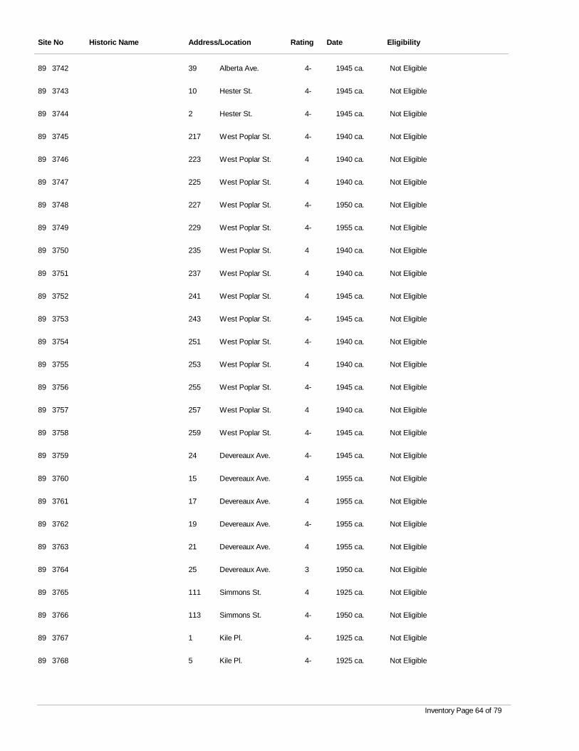
Site No Historic Name Address/Location Rating Date Eligibility
3742 Alberta Ave. 4- 1945 ca. Not Eligible89 39
3743 Hester St. 4- 1945 ca. Not Eligible89 10
3744 Hester St. 4- 1945 ca. Not Eligible89 2
3745 West Poplar St. 4- 1940 ca. Not Eligible89 217
3746 West Poplar St. 4 1940 ca. Not Eligible89 223
3747 West Poplar St. 4 1940 ca. Not Eligible89 225
3748 West Poplar St. 4- 1950 ca. Not Eligible89 227
3749 West Poplar St. 4- 1955 ca. Not Eligible89 229
3750 West Poplar St. 4 1940 ca. Not Eligible89 235
3751 West Poplar St. 4 1940 ca. Not Eligible89 237
3752 West Poplar St. 4 1945 ca. Not Eligible89 241
3753 West Poplar St. 4- 1945 ca. Not Eligible89 243
3754 West Poplar St. 4- 1940 ca. Not Eligible89 251
3755 West Poplar St. 4 1940 ca. Not Eligible89 253
3756 West Poplar St. 4- 1945 ca. Not Eligible89 255
3757 West Poplar St. 4 1940 ca. Not Eligible89 257
3758 West Poplar St. 4- 1945 ca. Not Eligible89 259
3759 Devereaux Ave. 4- 1945 ca. Not Eligible89 24
3760 Devereaux Ave. 4 1955 ca. Not Eligible89 15
3761 Devereaux Ave. 4 1955 ca. Not Eligible89 17
3762 Devereaux Ave. 4- 1955 ca. Not Eligible89 19
3763 Devereaux Ave. 4 1955 ca. Not Eligible89 21
3764 Devereaux Ave. 3 1950 ca. Not Eligible89 25
3765 Simmons St. 4 1925 ca. Not Eligible89 111
3766 Simmons St. 4- 1950 ca. Not Eligible89 113
3767 Kile Pl. 4- 1925 ca. Not Eligible89 1
3768 Kile Pl. 4- 1925 ca. Not Eligible89 5
Inventory Page 64 of 79
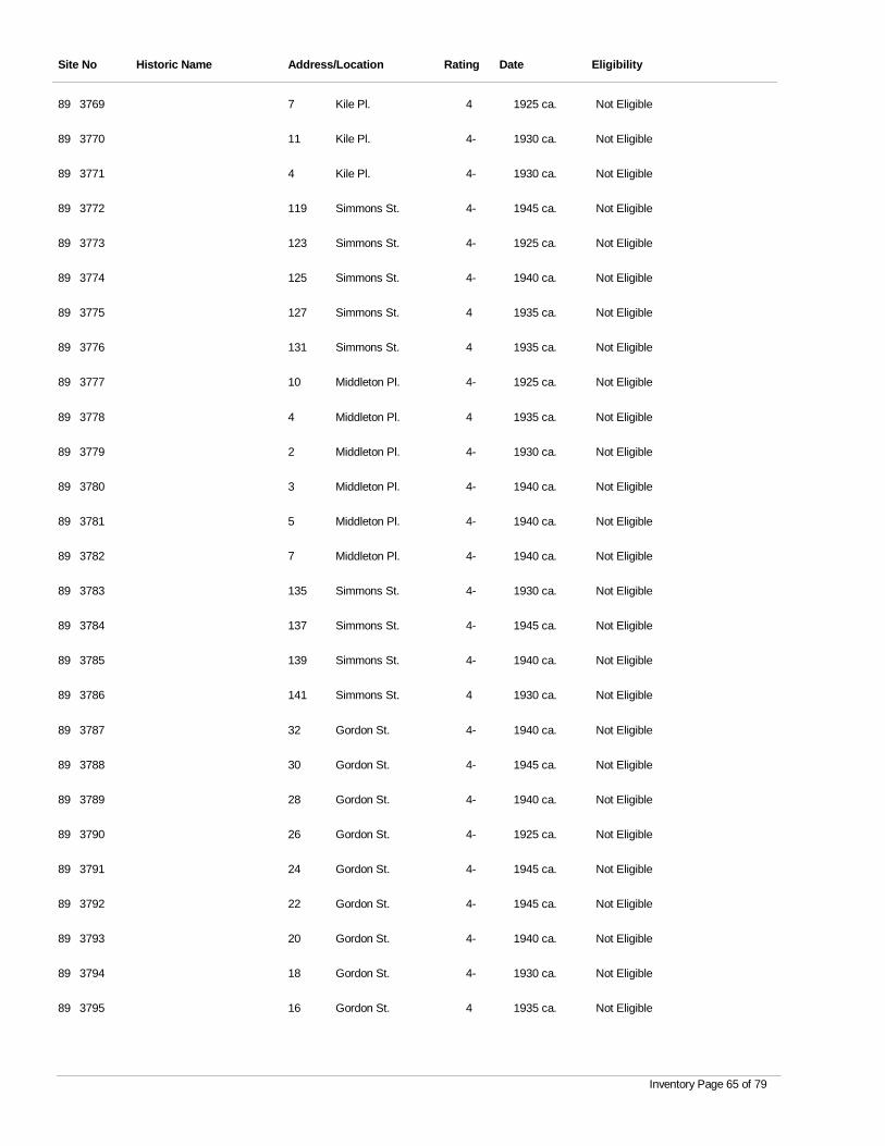
Site No Historic Name Address/Location Rating Date Eligibility
3769 Kile Pl. 4 1925 ca. Not Eligible89 7
3770 Kile Pl. 4- 1930 ca. Not Eligible89 11
3771 Kile Pl. 4- 1930 ca. Not Eligible89 4
3772 Simmons St. 4- 1945 ca. Not Eligible89 119
3773 Simmons St. 4- 1925 ca. Not Eligible89 123
3774 Simmons St. 4- 1940 ca. Not Eligible89 125
3775 Simmons St. 4 1935 ca. Not Eligible89 127
3776 Simmons St. 4 1935 ca. Not Eligible89 131
3777 Middleton Pl. 4- 1925 ca. Not Eligible89 10
3778 Middleton Pl. 4 1935 ca. Not Eligible89 4
3779 Middleton Pl. 4- 1930 ca. Not Eligible89 2
3780 Middleton Pl. 4- 1940 ca. Not Eligible89 3
3781 Middleton Pl. 4- 1940 ca. Not Eligible89 5
3782 Middleton Pl. 4- 1940 ca. Not Eligible89 7
3783 Simmons St. 4- 1930 ca. Not Eligible89 135
3784 Simmons St. 4- 1945 ca. Not Eligible89 137
3785 Simmons St. 4- 1940 ca. Not Eligible89 139
3786 Simmons St. 4 1930 ca. Not Eligible89 141
3787 Gordon St. 4- 1940 ca. Not Eligible89 32
3788 Gordon St. 4- 1945 ca. Not Eligible89 30
3789 Gordon St. 4- 1940 ca. Not Eligible89 28
3790 Gordon St. 4- 1925 ca. Not Eligible89 26
3791 Gordon St. 4- 1945 ca. Not Eligible89 24
3792 Gordon St. 4- 1945 ca. Not Eligible89 22
3793 Gordon St. 4- 1940 ca. Not Eligible89 20
3794 Gordon St. 4- 1930 ca. Not Eligible89 18
3795 Gordon St. 4 1935 ca. Not Eligible89 16
Inventory Page 65 of 79
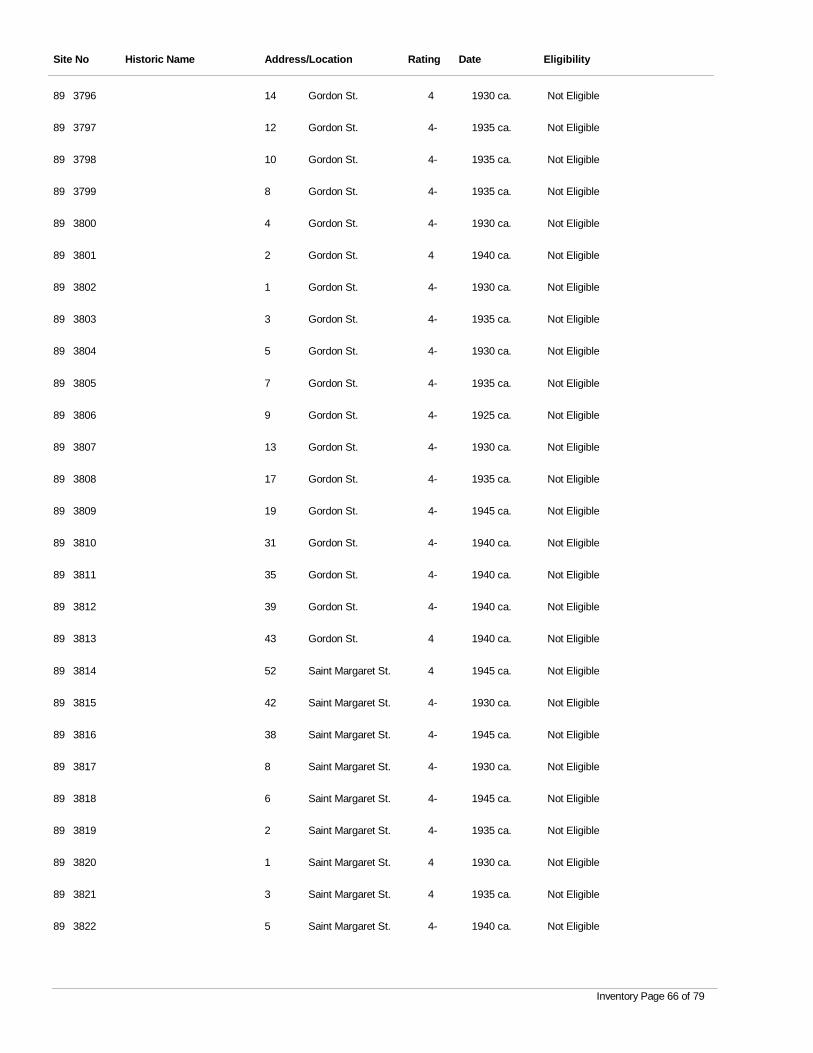
Site No Historic Name Address/Location Rating Date Eligibility
3796 Gordon St. 4 1930 ca. Not Eligible89 14
3797 Gordon St. 4- 1935 ca. Not Eligible89 12
3798 Gordon St. 4- 1935 ca. Not Eligible89 10
3799 Gordon St. 4- 1935 ca. Not Eligible89 8
3800 Gordon St. 4- 1930 ca. Not Eligible89 4
3801 Gordon St. 4 1940 ca. Not Eligible89 2
3802 Gordon St. 4- 1930 ca. Not Eligible89 1
3803 Gordon St. 4- 1935 ca. Not Eligible89 3
3804 Gordon St. 4- 1930 ca. Not Eligible89 5
3805 Gordon St. 4- 1935 ca. Not Eligible89 7
3806 Gordon St. 4- 1925 ca. Not Eligible89 9
3807 Gordon St. 4- 1930 ca. Not Eligible89 13
3808 Gordon St. 4- 1935 ca. Not Eligible89 17
3809 Gordon St. 4- 1945 ca. Not Eligible89 19
3810 Gordon St. 4- 1940 ca. Not Eligible89 31
3811 Gordon St. 4- 1940 ca. Not Eligible89 35
3812 Gordon St. 4- 1940 ca. Not Eligible89 39
3813 Gordon St. 4 1940 ca. Not Eligible89 43
3814 Saint Margaret St. 4 1945 ca. Not Eligible89 52
3815 Saint Margaret St. 4- 1930 ca. Not Eligible89 42
3816 Saint Margaret St. 4- 1945 ca. Not Eligible89 38
3817 Saint Margaret St. 4- 1930 ca. Not Eligible89 8
3818 Saint Margaret St. 4- 1945 ca. Not Eligible89 6
3819 Saint Margaret St. 4- 1935 ca. Not Eligible89 2
3820 Saint Margaret St. 4 1930 ca. Not Eligible89 1
3821 Saint Margaret St. 4 1935 ca. Not Eligible89 3
3822 Saint Margaret St. 4- 1940 ca. Not Eligible89 5
Inventory Page 66 of 79
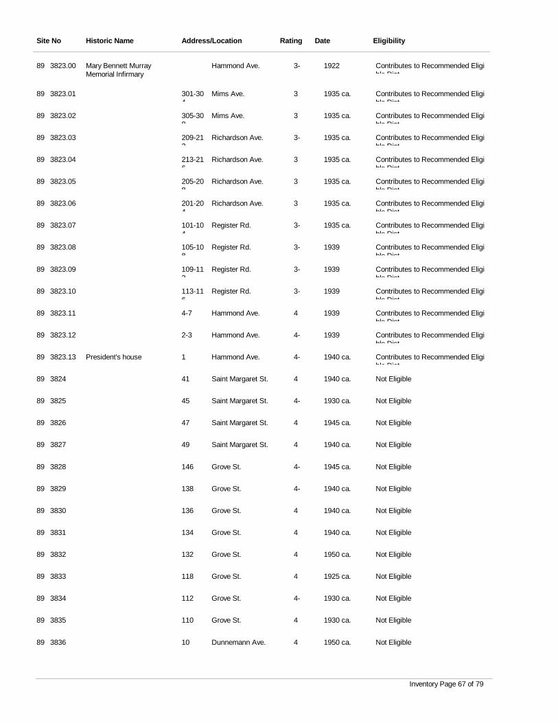
Site No Historic Name Address/Location Rating Date Eligibility
3823.00 Mary Bennett Murray Memorial Infirmary
Hammond Ave. 3- 1922 Contributes to Recommended Eligible Dist
89
3823.01 Mims Ave. 3 1935 ca. Contributes to Recommended Eligible Dist
89 301-304
3823.02 Mims Ave. 3 1935 ca. Contributes to Recommended Eligible Dist
89 305-308
3823.03 Richardson Ave. 3- 1935 ca. Contributes to Recommended Eligible Dist
89 209-212
3823.04 Richardson Ave. 3 1935 ca. Contributes to Recommended Eligible Dist
89 213-216
3823.05 Richardson Ave. 3 1935 ca. Contributes to Recommended Eligible Dist
89 205-208
3823.06 Richardson Ave. 3 1935 ca. Contributes to Recommended Eligible Dist
89 201-204
3823.07 Register Rd. 3- 1935 ca. Contributes to Recommended Eligible Dist
89 101-104
3823.08 Register Rd. 3- 1939 Contributes to Recommended Eligible Dist
89 105-108
3823.09 Register Rd. 3- 1939 Contributes to Recommended Eligible Dist
89 109-112
3823.10 Register Rd. 3- 1939 Contributes to Recommended Eligible Dist
89 113-116
3823.11 Hammond Ave. 4 1939 Contributes to Recommended Eligible Dist
89 4-7
3823.12 Hammond Ave. 4- 1939 Contributes to Recommended Eligible Dist
89 2-3
3823.13 President's house Hammond Ave. 4- 1940 ca. Contributes to Recommended Eligible Dist
89 1
3824 Saint Margaret St. 4 1940 ca. Not Eligible89 41
3825 Saint Margaret St. 4- 1930 ca. Not Eligible89 45
3826 Saint Margaret St. 4 1945 ca. Not Eligible89 47
3827 Saint Margaret St. 4 1940 ca. Not Eligible89 49
3828 Grove St. 4- 1945 ca. Not Eligible89 146
3829 Grove St. 4- 1940 ca. Not Eligible89 138
3830 Grove St. 4 1940 ca. Not Eligible89 136
3831 Grove St. 4 1940 ca. Not Eligible89 134
3832 Grove St. 4 1950 ca. Not Eligible89 132
3833 Grove St. 4 1925 ca. Not Eligible89 118
3834 Grove St. 4- 1930 ca. Not Eligible89 112
3835 Grove St. 4 1930 ca. Not Eligible89 110
3836 Dunnemann Ave. 4 1950 ca. Not Eligible89 10
Inventory Page 67 of 79
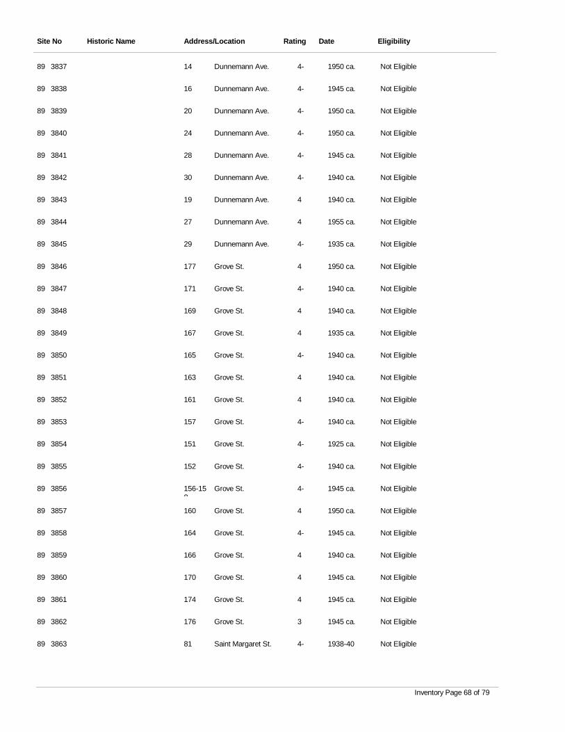
Site No Historic Name Address/Location Rating Date Eligibility
3837 Dunnemann Ave. 4- 1950 ca. Not Eligible89 14
3838 Dunnemann Ave. 4- 1945 ca. Not Eligible89 16
3839 Dunnemann Ave. 4- 1950 ca. Not Eligible89 20
3840 Dunnemann Ave. 4- 1950 ca. Not Eligible89 24
3841 Dunnemann Ave. 4- 1945 ca. Not Eligible89 28
3842 Dunnemann Ave. 4- 1940 ca. Not Eligible89 30
3843 Dunnemann Ave. 4 1940 ca. Not Eligible89 19
3844 Dunnemann Ave. 4 1955 ca. Not Eligible89 27
3845 Dunnemann Ave. 4- 1935 ca. Not Eligible89 29
3846 Grove St. 4 1950 ca. Not Eligible89 177
3847 Grove St. 4- 1940 ca. Not Eligible89 171
3848 Grove St. 4 1940 ca. Not Eligible89 169
3849 Grove St. 4 1935 ca. Not Eligible89 167
3850 Grove St. 4- 1940 ca. Not Eligible89 165
3851 Grove St. 4 1940 ca. Not Eligible89 163
3852 Grove St. 4 1940 ca. Not Eligible89 161
3853 Grove St. 4- 1940 ca. Not Eligible89 157
3854 Grove St. 4- 1925 ca. Not Eligible89 151
3855 Grove St. 4- 1940 ca. Not Eligible89 152
3856 Grove St. 4- 1945 ca. Not Eligible89 156-158
3857 Grove St. 4 1950 ca. Not Eligible89 160
3858 Grove St. 4- 1945 ca. Not Eligible89 164
3859 Grove St. 4 1940 ca. Not Eligible89 166
3860 Grove St. 4 1945 ca. Not Eligible89 170
3861 Grove St. 4 1945 ca. Not Eligible89 174
3862 Grove St. 3 1945 ca. Not Eligible89 176
3863 Saint Margaret St. 4- 1938-40 Not Eligible89 81
Inventory Page 68 of 79
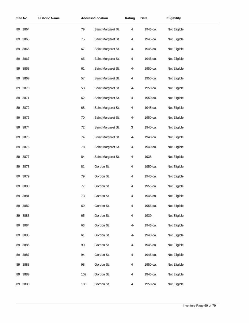
Site No Historic Name Address/Location Rating Date Eligibility
3864 Saint Margaret St. 4 1945 ca. Not Eligible89 79
3865 Saint Margaret St. 4 1945 ca. Not Eligible89 75
3866 Saint Margaret St. 4- 1945 ca. Not Eligible89 67
3867 Saint Margaret St. 4 1945 ca. Not Eligible89 65
3868 Saint Margaret St. 4- 1950 ca. Not Eligible89 61
3869 Saint Margaret St. 4 1950 ca. Not Eligible89 57
3870 Saint Margaret St. 4- 1950 ca. Not Eligible89 58
3871 Saint Margaret St. 4 1950 ca. Not Eligible89 62
3872 Saint Margaret St. 4- 1945 ca. Not Eligible89 68
3873 Saint Margaret St. 4- 1950 ca. Not Eligible89 70
3874 Saint Margaret St. 3 1940 ca. Not Eligible89 72
3875 Saint Margaret St. 4- 1940 ca. Not Eligible89 74
3876 Saint Margaret St. 4- 1940 ca. Not Eligible89 78
3877 Saint Margaret St. 4- 1938 Not Eligible89 84
3878 Gordon St. 4 1950 ca. Not Eligible89 81
3879 Gordon St. 4 1940 ca. Not Eligible89 79
3880 Gordon St. 4 1955 ca. Not Eligible89 77
3881 Gordon St. 4 1945 ca. Not Eligible89 73
3882 Gordon St. 4 1955 ca. Not Eligible89 69
3883 Gordon St. 4 1939. Not Eligible89 65
3884 Gordon St. 4- 1945 ca. Not Eligible89 63
3885 Gordon St. 4- 1940 ca. Not Eligible89 61
3886 Gordon St. 4- 1945 ca. Not Eligible89 90
3887 Gordon St. 4- 1945 ca. Not Eligible89 94
3888 Gordon St. 4 1950 ca. Not Eligible89 98
3889 Gordon St. 4 1945 ca. Not Eligible89 102
3890 Gordon St. 4 1950 ca. Not Eligible89 106
Inventory Page 69 of 79
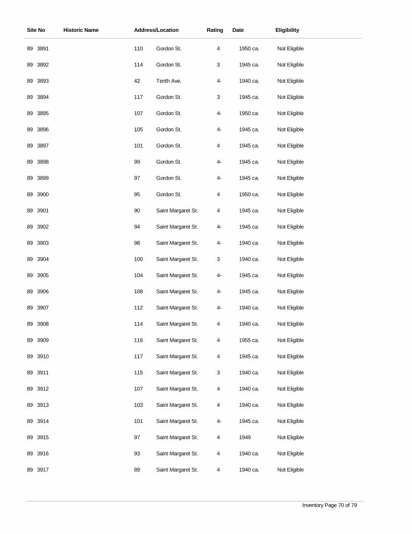
Site No Historic Name Address/Location Rating Date Eligibility
3891 Gordon St. 4 1950 ca. Not Eligible89 110
3892 Gordon St. 3 1945 ca. Not Eligible89 114
3893 Tenth Ave. 4- 1940 ca. Not Eligible89 42
3894 Gordon St. 3 1945 ca. Not Eligible89 117
3895 Gordon St. 4- 1950 ca. Not Eligible89 107
3896 Gordon St. 4- 1945 ca. Not Eligible89 105
3897 Gordon St. 4 1945 ca. Not Eligible89 101
3898 Gordon St. 4- 1945 ca. Not Eligible89 99
3899 Gordon St. 4- 1945 ca. Not Eligible89 97
3900 Gordon St. 4 1950 ca. Not Eligible89 95
3901 Saint Margaret St. 4 1945 ca. Not Eligible89 90
3902 Saint Margaret St. 4- 1945 ca. Not Eligible89 94
3903 Saint Margaret St. 4- 1940 ca. Not Eligible89 98
3904 Saint Margaret St. 3 1940 ca. Not Eligible89 100
3905 Saint Margaret St. 4- 1945 ca. Not Eligible89 104
3906 Saint Margaret St. 4- 1945 ca. Not Eligible89 108
3907 Saint Margaret St. 4- 1940 ca. Not Eligible89 112
3908 Saint Margaret St. 4 1940 ca. Not Eligible89 114
3909 Saint Margaret St. 4 1955 ca. Not Eligible89 116
3910 Saint Margaret St. 4 1945 ca. Not Eligible89 117
3911 Saint Margaret St. 3 1940 ca. Not Eligible89 115
3912 Saint Margaret St. 4 1940 ca. Not Eligible89 107
3913 Saint Margaret St. 4 1940 ca. Not Eligible89 103
3914 Saint Margaret St. 4- 1945 ca. Not Eligible89 101
3915 Saint Margaret St. 4 1949 Not Eligible89 97
3916 Saint Margaret St. 4 1940 ca. Not Eligible89 93
3917 Saint Margaret St. 4 1940 ca. Not Eligible89 89
Inventory Page 70 of 79
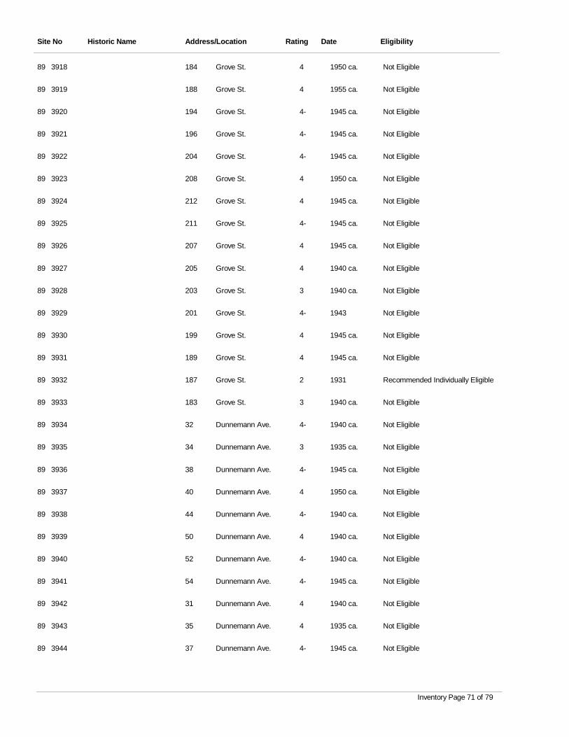
Site No Historic Name Address/Location Rating Date Eligibility
3918 Grove St. 4 1950 ca. Not Eligible89 184
3919 Grove St. 4 1955 ca. Not Eligible89 188
3920 Grove St. 4- 1945 ca. Not Eligible89 194
3921 Grove St. 4- 1945 ca. Not Eligible89 196
3922 Grove St. 4- 1945 ca. Not Eligible89 204
3923 Grove St. 4 1950 ca. Not Eligible89 208
3924 Grove St. 4 1945 ca. Not Eligible89 212
3925 Grove St. 4- 1945 ca. Not Eligible89 211
3926 Grove St. 4 1945 ca. Not Eligible89 207
3927 Grove St. 4 1940 ca. Not Eligible89 205
3928 Grove St. 3 1940 ca. Not Eligible89 203
3929 Grove St. 4- 1943 Not Eligible89 201
3930 Grove St. 4 1945 ca. Not Eligible89 199
3931 Grove St. 4 1945 ca. Not Eligible89 189
3932 Grove St. 2 1931 Recommended Individually Eligible89 187
3933 Grove St. 3 1940 ca. Not Eligible89 183
3934 Dunnemann Ave. 4- 1940 ca. Not Eligible89 32
3935 Dunnemann Ave. 3 1935 ca. Not Eligible89 34
3936 Dunnemann Ave. 4- 1945 ca. Not Eligible89 38
3937 Dunnemann Ave. 4 1950 ca. Not Eligible89 40
3938 Dunnemann Ave. 4- 1940 ca. Not Eligible89 44
3939 Dunnemann Ave. 4 1940 ca. Not Eligible89 50
3940 Dunnemann Ave. 4- 1940 ca. Not Eligible89 52
3941 Dunnemann Ave. 4- 1945 ca. Not Eligible89 54
3942 Dunnemann Ave. 4 1940 ca. Not Eligible89 31
3943 Dunnemann Ave. 4 1935 ca. Not Eligible89 35
3944 Dunnemann Ave. 4- 1945 ca. Not Eligible89 37
Inventory Page 71 of 79
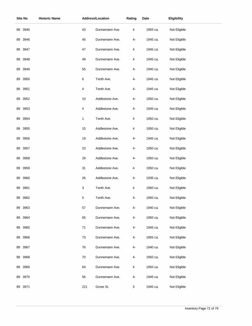
Site No Historic Name Address/Location Rating Date Eligibility
3945 Dunnemann Ave. 4 1955 ca. Not Eligible89 43
3946 Dunnemann Ave. 4- 1945 ca. Not Eligible89 45
3947 Dunnemann Ave. 4 1945 ca. Not Eligible89 47
3948 Dunnemann Ave. 4 1945 ca. Not Eligible89 49
3949 Dunnemann Ave. 4- 1940 ca. Not Eligible89 55
3950 Tenth Ave. 4- 1945 ca. Not Eligible89 6
3951 Tenth Ave. 4- 1945 ca. Not Eligible89 4
3952 Addlestone Ave. 4- 1950 ca. Not Eligible89 10
3953 Addlestone Ave. 4- 1945 ca. Not Eligible89 4
3954 Tenth Ave. 4 1950 ca. Not Eligible89 1
3955 Addlestone Ave. 4 1950 ca. Not Eligible89 15
3956 Addlestone Ave. 4- 1945 ca. Not Eligible89 19
3957 Addlestone Ave. 4- 1950 ca. Not Eligible89 23
3958 Addlestone Ave. 4- 1950 ca. Not Eligible89 29
3959 Addlestone Ave. 4 1950 ca. Not Eligible89 31
3960 Addlestone Ave. 4- 1935 ca. Not Eligible89 26
3961 Tenth Ave. 4 1950 ca. Not Eligible89 3
3962 Tenth Ave. 4- 1950 ca. Not Eligible89 5
3963 Dunnemann Ave. 4- 1940 ca. Not Eligible89 57
3964 Dunnemann Ave. 4- 1950 ca. Not Eligible89 65
3965 Dunnemann Ave. 4- 1945 ca. Not Eligible89 71
3966 Dunnemann Ave. 4- 1955 ca. Not Eligible89 73
3967 Dunnemann Ave. 4- 1940 ca. Not Eligible89 76
3968 Dunnemann Ave. 4- 1950 ca. Not Eligible89 70
3969 Dunnemann Ave. 4 1950 ca. Not Eligible89 64
3970 Dunnemann Ave. 4- 1945 ca. Not Eligible89 56
3971 Grove St. 3 1945 ca. Not Eligible89 221
Inventory Page 72 of 79
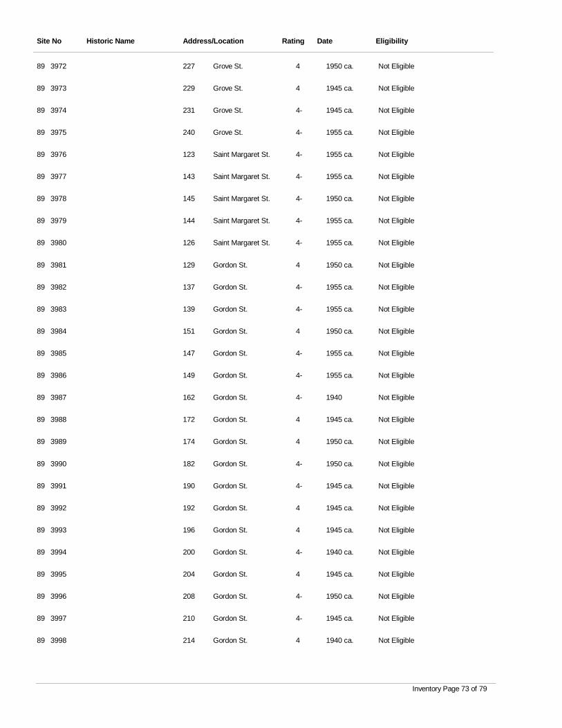
Site No Historic Name Address/Location Rating Date Eligibility
3972 Grove St. 4 1950 ca. Not Eligible89 227
3973 Grove St. 4 1945 ca. Not Eligible89 229
3974 Grove St. 4- 1945 ca. Not Eligible89 231
3975 Grove St. 4- 1955 ca. Not Eligible89 240
3976 Saint Margaret St. 4- 1955 ca. Not Eligible89 123
3977 Saint Margaret St. 4- 1955 ca. Not Eligible89 143
3978 Saint Margaret St. 4- 1950 ca. Not Eligible89 145
3979 Saint Margaret St. 4- 1955 ca. Not Eligible89 144
3980 Saint Margaret St. 4- 1955 ca. Not Eligible89 126
3981 Gordon St. 4 1950 ca. Not Eligible89 129
3982 Gordon St. 4- 1955 ca. Not Eligible89 137
3983 Gordon St. 4- 1955 ca. Not Eligible89 139
3984 Gordon St. 4 1950 ca. Not Eligible89 151
3985 Gordon St. 4- 1955 ca. Not Eligible89 147
3986 Gordon St. 4- 1955 ca. Not Eligible89 149
3987 Gordon St. 4- 1940 Not Eligible89 162
3988 Gordon St. 4 1945 ca. Not Eligible89 172
3989 Gordon St. 4 1950 ca. Not Eligible89 174
3990 Gordon St. 4- 1950 ca. Not Eligible89 182
3991 Gordon St. 4- 1945 ca. Not Eligible89 190
3992 Gordon St. 4 1945 ca. Not Eligible89 192
3993 Gordon St. 4 1945 ca. Not Eligible89 196
3994 Gordon St. 4- 1940 ca. Not Eligible89 200
3995 Gordon St. 4 1945 ca. Not Eligible89 204
3996 Gordon St. 4- 1950 ca. Not Eligible89 208
3997 Gordon St. 4- 1945 ca. Not Eligible89 210
3998 Gordon St. 4 1940 ca. Not Eligible89 214
Inventory Page 73 of 79
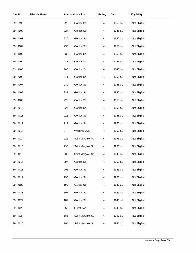
Site No Historic Name Address/Location Rating Date Eligibility
3999 Gordon St. 4- 1950 ca. Not Eligible89 222
4000 Gordon St. 4- 1945 ca. Not Eligible89 224
4001 Gordon St. 4- 1950 ca. Not Eligible89 230
4002 Gordon St. 4- 1950 ca. Not Eligible89 236
4003 Gordon St. 4 1950 ca. Not Eligible89 238
4004 Gordon St. 4- 1945 ca. Not Eligible89 246
4005 Gordon St. 4 1945 ca. Not Eligible89 245
4006 Gordon St. 4 1950 ca. Not Eligible89 241
4007 Gordon St. 4 1945 ca. Not Eligible89 239
4008 Gordon St. 4- 1945 ca. Not Eligible89 237
4009 Gordon St. 4 1950 ca. Not Eligible89 229
4010 Gordon St. 4- 1950 ca. Not Eligible89 227
4011 Gordon St. 4- 1945 ca. Not Eligible89 223
4012 Gordon St. 4 1950 ca. Not Eligible89 219
4013 Wagener Ave. 4- 1950 ca. Not Eligible89 37
4014 Saint Margaret St. 4- 1955 ca. Not Eligible89 226
4015 Saint Margaret St. 4 1950 ca. Not Eligible89 236
4016 Saint Margaret St. 4 1945 ca. Not Eligible89 238
4017 Gordon St. 4- 1950 ca. Not Eligible89 207
4018 Gordon St. 4- 1945 ca. Not Eligible89 205
4019 Gordon St. 4- 1950 ca. Not Eligible89 195
4020 Gordon St. 4- 1945 ca. Not Eligible89 193
4021 Gordon St. 4- 1945 ca. Not Eligible89 191
4022 Gordon St. 4 1945 ca. Not Eligible89 187
4023 Eighth Ave. 4 1945 ca. Not Eligible89 25
4024 Saint Margaret St. 4 1950 ca. Not Eligible89 188
4025 Saint Margaret St. 4- 1945 ca. Not Eligible89 194
Inventory Page 74 of 79
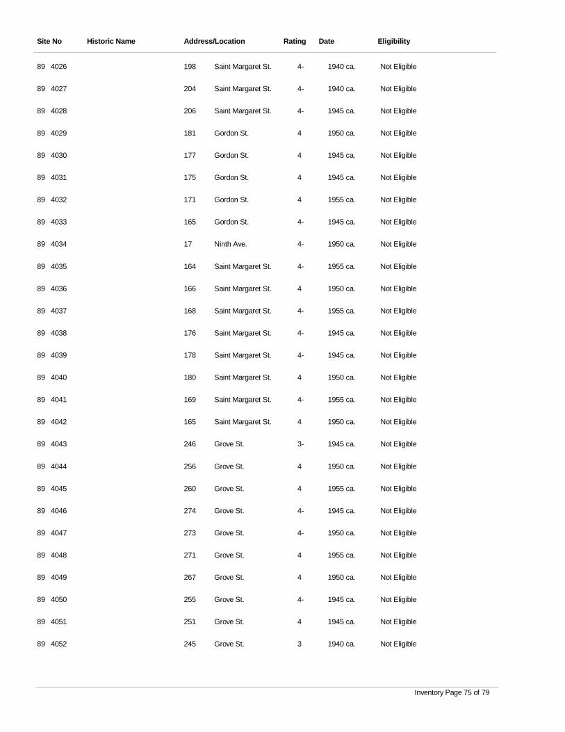
Site No Historic Name Address/Location Rating Date Eligibility
4026 Saint Margaret St. 4- 1940 ca. Not Eligible89 198
4027 Saint Margaret St. 4- 1940 ca. Not Eligible89 204
4028 Saint Margaret St. 4- 1945 ca. Not Eligible89 206
4029 Gordon St. 4 1950 ca. Not Eligible89 181
4030 Gordon St. 4 1945 ca. Not Eligible89 177
4031 Gordon St. 4 1945 ca. Not Eligible89 175
4032 Gordon St. 4 1955 ca. Not Eligible89 171
4033 Gordon St. 4- 1945 ca. Not Eligible89 165
4034 Ninth Ave. 4- 1950 ca. Not Eligible89 17
4035 Saint Margaret St. 4- 1955 ca. Not Eligible89 164
4036 Saint Margaret St. 4 1950 ca. Not Eligible89 166
4037 Saint Margaret St. 4- 1955 ca. Not Eligible89 168
4038 Saint Margaret St. 4- 1945 ca. Not Eligible89 176
4039 Saint Margaret St. 4- 1945 ca. Not Eligible89 178
4040 Saint Margaret St. 4 1950 ca. Not Eligible89 180
4041 Saint Margaret St. 4- 1955 ca. Not Eligible89 169
4042 Saint Margaret St. 4 1950 ca. Not Eligible89 165
4043 Grove St. 3- 1945 ca. Not Eligible89 246
4044 Grove St. 4 1950 ca. Not Eligible89 256
4045 Grove St. 4 1955 ca. Not Eligible89 260
4046 Grove St. 4- 1945 ca. Not Eligible89 274
4047 Grove St. 4- 1950 ca. Not Eligible89 273
4048 Grove St. 4 1955 ca. Not Eligible89 271
4049 Grove St. 4 1950 ca. Not Eligible89 267
4050 Grove St. 4- 1945 ca. Not Eligible89 255
4051 Grove St. 4 1945 ca. Not Eligible89 251
4052 Grove St. 3 1940 ca. Not Eligible89 245
Inventory Page 75 of 79
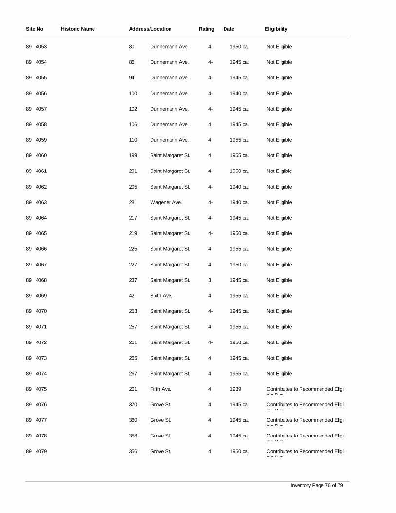
Site No Historic Name Address/Location Rating Date Eligibility
4053 Dunnemann Ave. 4- 1950 ca. Not Eligible89 80
4054 Dunnemann Ave. 4- 1945 ca. Not Eligible89 86
4055 Dunnemann Ave. 4- 1945 ca. Not Eligible89 94
4056 Dunnemann Ave. 4- 1940 ca. Not Eligible89 100
4057 Dunnemann Ave. 4- 1945 ca. Not Eligible89 102
4058 Dunnemann Ave. 4 1945 ca. Not Eligible89 106
4059 Dunnemann Ave. 4 1955 ca. Not Eligible89 110
4060 Saint Margaret St. 4 1955 ca. Not Eligible89 199
4061 Saint Margaret St. 4- 1950 ca. Not Eligible89 201
4062 Saint Margaret St. 4- 1940 ca. Not Eligible89 205
4063 Wagener Ave. 4- 1940 ca. Not Eligible89 28
4064 Saint Margaret St. 4- 1945 ca. Not Eligible89 217
4065 Saint Margaret St. 4- 1950 ca. Not Eligible89 219
4066 Saint Margaret St. 4 1955 ca. Not Eligible89 225
4067 Saint Margaret St. 4 1950 ca. Not Eligible89 227
4068 Saint Margaret St. 3 1945 ca. Not Eligible89 237
4069 Sixth Ave. 4 1955 ca. Not Eligible89 42
4070 Saint Margaret St. 4- 1945 ca. Not Eligible89 253
4071 Saint Margaret St. 4- 1955 ca. Not Eligible89 257
4072 Saint Margaret St. 4- 1950 ca. Not Eligible89 261
4073 Saint Margaret St. 4 1945 ca. Not Eligible89 265
4074 Saint Margaret St. 4 1955 ca. Not Eligible89 267
4075 Fifth Ave. 4 1939 Contributes to Recommended Eligible Dist
89 201
4076 Grove St. 4 1945 ca. Contributes to Recommended Eligible Dist
89 370
4077 Grove St. 4 1945 ca. Contributes to Recommended Eligible Dist
89 360
4078 Grove St. 4 1945 ca. Contributes to Recommended Eligible Dist
89 358
4079 Grove St. 4 1950 ca. Contributes to Recommended Eligible Dist
89 356
Inventory Page 76 of 79
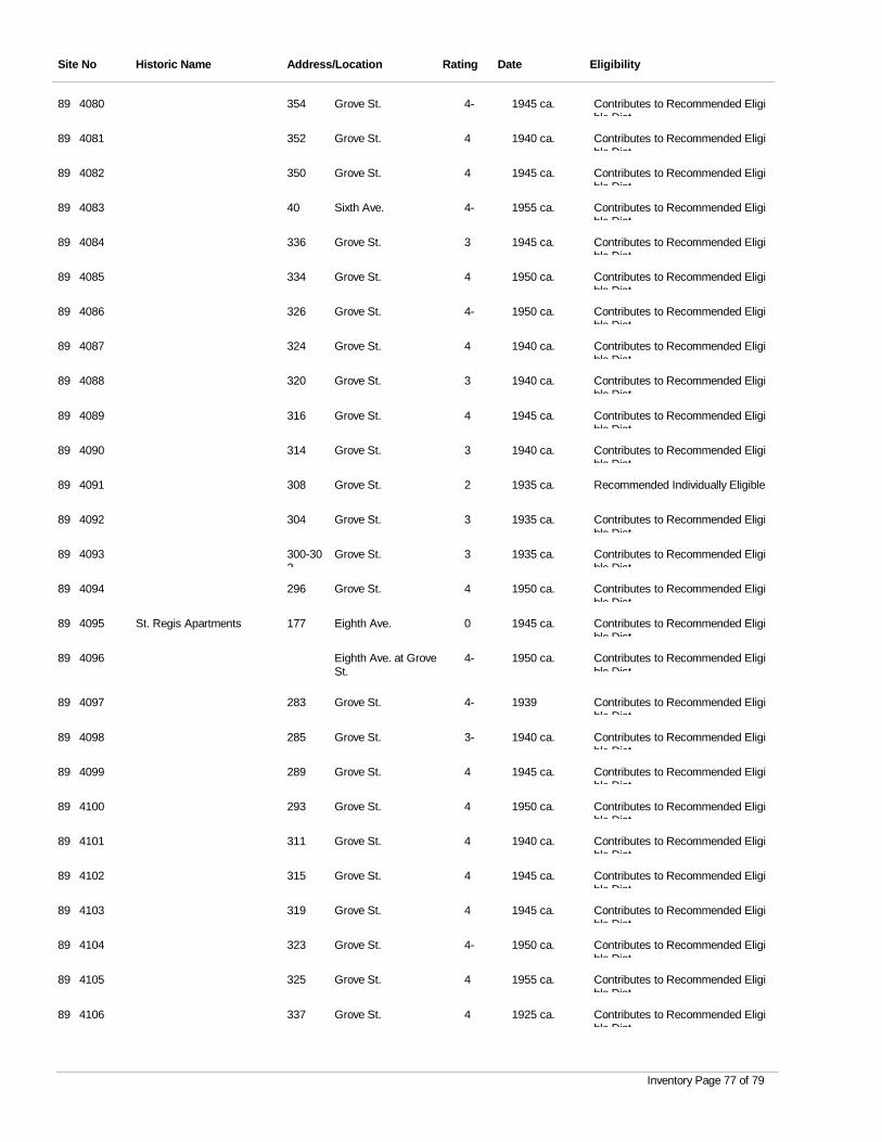
Site No Historic Name Address/Location Rating Date Eligibility
4080 Grove St. 4- 1945 ca. Contributes to Recommended Eligible Dist
89 354
4081 Grove St. 4 1940 ca. Contributes to Recommended Eligible Dist
89 352
4082 Grove St. 4 1945 ca. Contributes to Recommended Eligible Dist
89 350
4083 Sixth Ave. 4- 1955 ca. Contributes to Recommended Eligible Dist
89 40
4084 Grove St. 3 1945 ca. Contributes to Recommended Eligible Dist
89 336
4085 Grove St. 4 1950 ca. Contributes to Recommended Eligible Dist
89 334
4086 Grove St. 4- 1950 ca. Contributes to Recommended Eligible Dist
89 326
4087 Grove St. 4 1940 ca. Contributes to Recommended Eligible Dist
89 324
4088 Grove St. 3 1940 ca. Contributes to Recommended Eligible Dist
89 320
4089 Grove St. 4 1945 ca. Contributes to Recommended Eligible Dist
89 316
4090 Grove St. 3 1940 ca. Contributes to Recommended Eligible Dist
89 314
4091 Grove St. 2 1935 ca. Recommended Individually Eligible89 308
4092 Grove St. 3 1935 ca. Contributes to Recommended Eligible Dist
89 304
4093 Grove St. 3 1935 ca. Contributes to Recommended Eligible Dist
89 300-302
4094 Grove St. 4 1950 ca. Contributes to Recommended Eligible Dist
89 296
4095 St. Regis Apartments Eighth Ave. 0 1945 ca. Contributes to Recommended Eligible Dist
89 177
4096 Eighth Ave. at Grove St.
4- 1950 ca. Contributes to Recommended Eligible Dist
89
4097 Grove St. 4- 1939 Contributes to Recommended Eligible Dist
89 283
4098 Grove St. 3- 1940 ca. Contributes to Recommended Eligible Dist
89 285
4099 Grove St. 4 1945 ca. Contributes to Recommended Eligible Dist
89 289
4100 Grove St. 4 1950 ca. Contributes to Recommended Eligible Dist
89 293
4101 Grove St. 4 1940 ca. Contributes to Recommended Eligible Dist
89 311
4102 Grove St. 4 1945 ca. Contributes to Recommended Eligible Dist
89 315
4103 Grove St. 4 1945 ca. Contributes to Recommended Eligible Dist
89 319
4104 Grove St. 4- 1950 ca. Contributes to Recommended Eligible Dist
89 323
4105 Grove St. 4 1955 ca. Contributes to Recommended Eligible Dist
89 325
4106 Grove St. 4 1925 ca. Contributes to Recommended Eligible Dist
89 337
Inventory Page 77 of 79
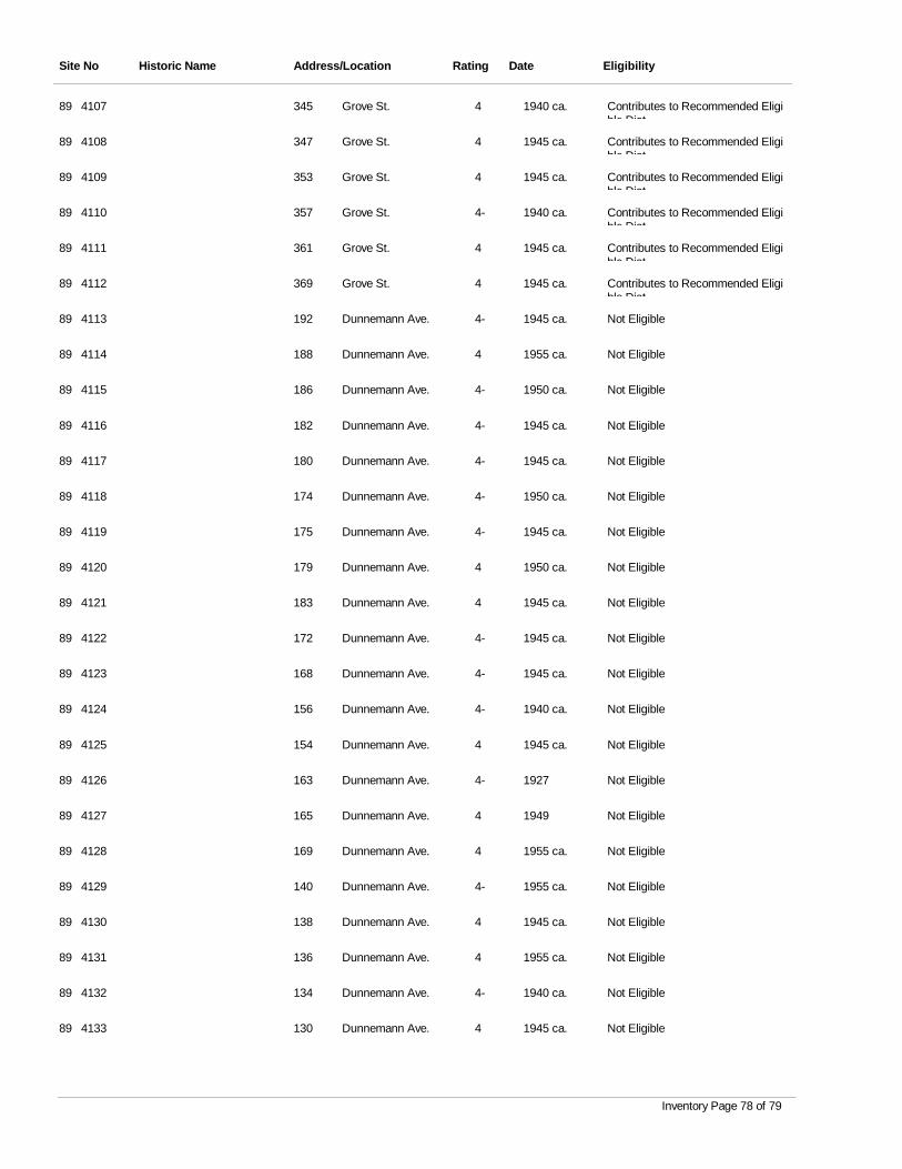
Site No Historic Name Address/Location Rating Date Eligibility
4107 Grove St. 4 1940 ca. Contributes to Recommended Eligible Dist
89 345
4108 Grove St. 4 1945 ca. Contributes to Recommended Eligible Dist
89 347
4109 Grove St. 4 1945 ca. Contributes to Recommended Eligible Dist
89 353
4110 Grove St. 4- 1940 ca. Contributes to Recommended Eligible Dist
89 357
4111 Grove St. 4 1945 ca. Contributes to Recommended Eligible Dist
89 361
4112 Grove St. 4 1945 ca. Contributes to Recommended Eligible Dist
89 369
4113 Dunnemann Ave. 4- 1945 ca. Not Eligible89 192
4114 Dunnemann Ave. 4 1955 ca. Not Eligible89 188
4115 Dunnemann Ave. 4- 1950 ca. Not Eligible89 186
4116 Dunnemann Ave. 4- 1945 ca. Not Eligible89 182
4117 Dunnemann Ave. 4- 1945 ca. Not Eligible89 180
4118 Dunnemann Ave. 4- 1950 ca. Not Eligible89 174
4119 Dunnemann Ave. 4- 1945 ca. Not Eligible89 175
4120 Dunnemann Ave. 4 1950 ca. Not Eligible89 179
4121 Dunnemann Ave. 4 1945 ca. Not Eligible89 183
4122 Dunnemann Ave. 4- 1945 ca. Not Eligible89 172
4123 Dunnemann Ave. 4- 1945 ca. Not Eligible89 168
4124 Dunnemann Ave. 4- 1940 ca. Not Eligible89 156
4125 Dunnemann Ave. 4 1945 ca. Not Eligible89 154
4126 Dunnemann Ave. 4- 1927 Not Eligible89 163
4127 Dunnemann Ave. 4 1949 Not Eligible89 165
4128 Dunnemann Ave. 4 1955 ca. Not Eligible89 169
4129 Dunnemann Ave. 4- 1955 ca. Not Eligible89 140
4130 Dunnemann Ave. 4 1945 ca. Not Eligible89 138
4131 Dunnemann Ave. 4 1955 ca. Not Eligible89 136
4132 Dunnemann Ave. 4- 1940 ca. Not Eligible89 134
4133 Dunnemann Ave. 4 1945 ca. Not Eligible89 130
Inventory Page 78 of 79
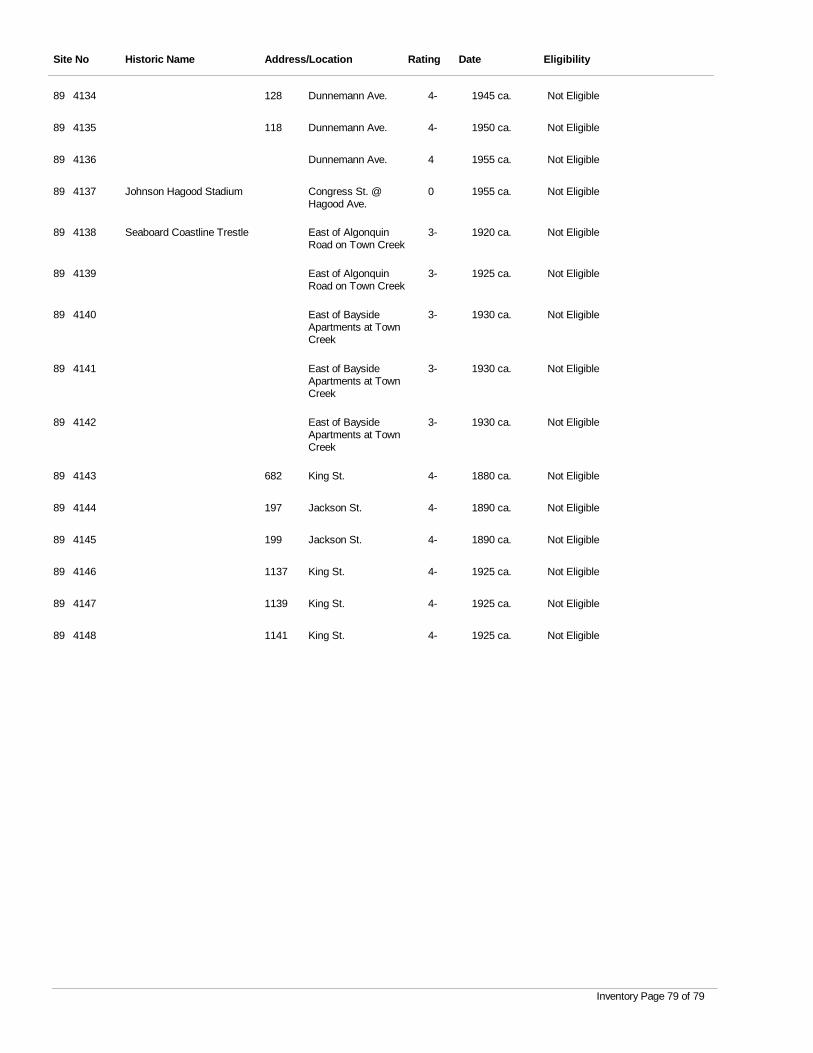
Site No Historic Name Address/Location Rating Date Eligibility
4134 Dunnemann Ave. 4- 1945 ca. Not Eligible89 128
4135 Dunnemann Ave. 4- 1950 ca. Not Eligible89 118
4136 Dunnemann Ave. 4 1955 ca. Not Eligible89
4137 Johnson Hagood Stadium Congress St. @ Hagood Ave.
0 1955 ca. Not Eligible89
4138 Seaboard Coastline Trestle East of Algonquin Road on Town Creek
3- 1920 ca. Not Eligible89
4139 East of Algonquin Road on Town Creek
3- 1925 ca. Not Eligible89
4140 East of Bayside Apartments at Town Creek
3- 1930 ca. Not Eligible89
4141 East of Bayside Apartments at Town Creek
3- 1930 ca. Not Eligible89
4142 East of Bayside Apartments at Town Creek
3- 1930 ca. Not Eligible89
4143 King St. 4- 1880 ca. Not Eligible89 682
4144 Jackson St. 4- 1890 ca. Not Eligible89 197
4145 Jackson St. 4- 1890 ca. Not Eligible89 199
4146 King St. 4- 1925 ca. Not Eligible89 1137
4147 King St. 4- 1925 ca. Not Eligible89 1139
4148 King St. 4- 1925 ca. Not Eligible89 1141
Inventory Page 79 of 79
Appendix B.
Location of Surveyed Resources, County Tax Maps
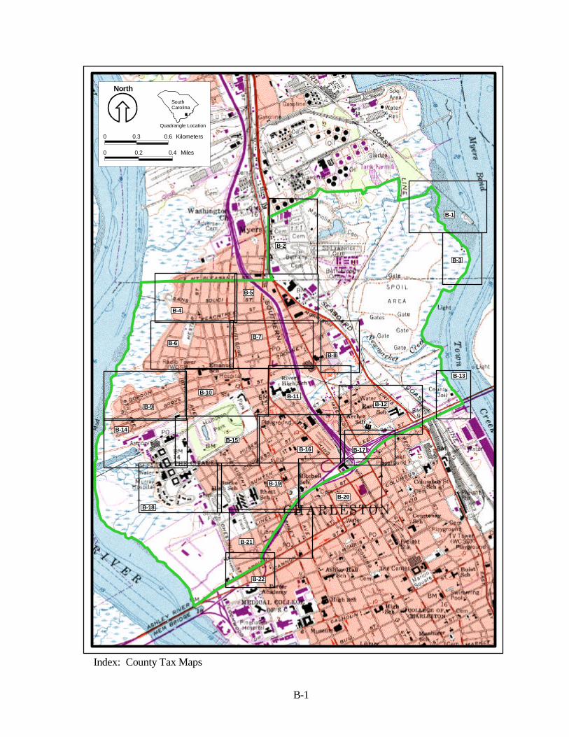
0 0.2 0.4 Miles
0 0.3 0.6 Kilometers
North
SouthCarolina
Quadrangle Location
B-1
Index: County Tax Maps
B-1
B-2
B-3
B-4
B-5
B-6B-7
B-8
B-9
B-10B-11
B-12
B-13
B-14
B-15B-16 B-17
B-18
B-19
B-20
B-21
B-22
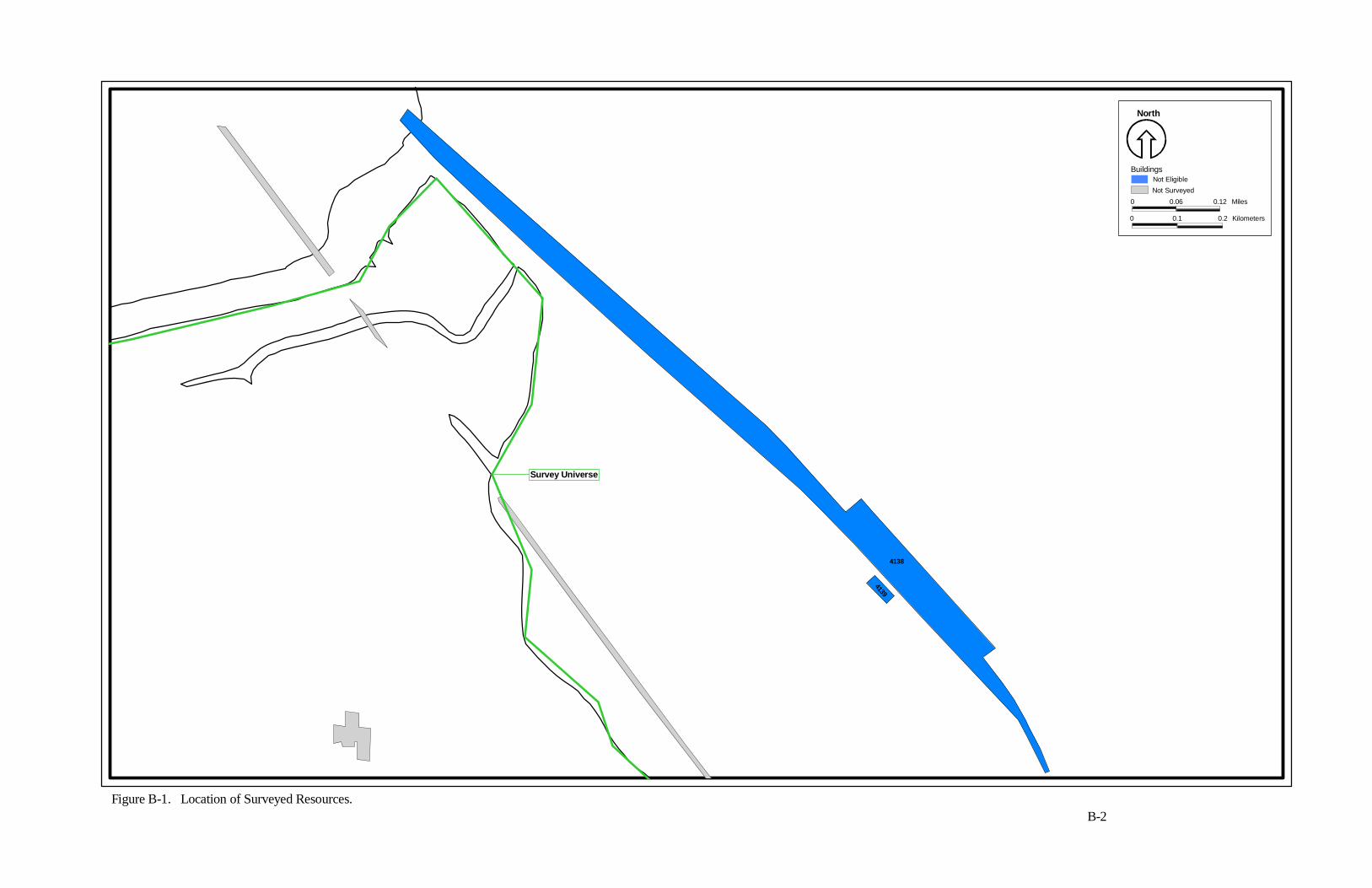
Figure B-1. Location of Surveyed Resources.B-2
4139
4138
North
0 0.06 0.12 Miles
0 0.1 0.2 Kilometers
BuildingsNot EligibleNot Surveyed
Survey Universe
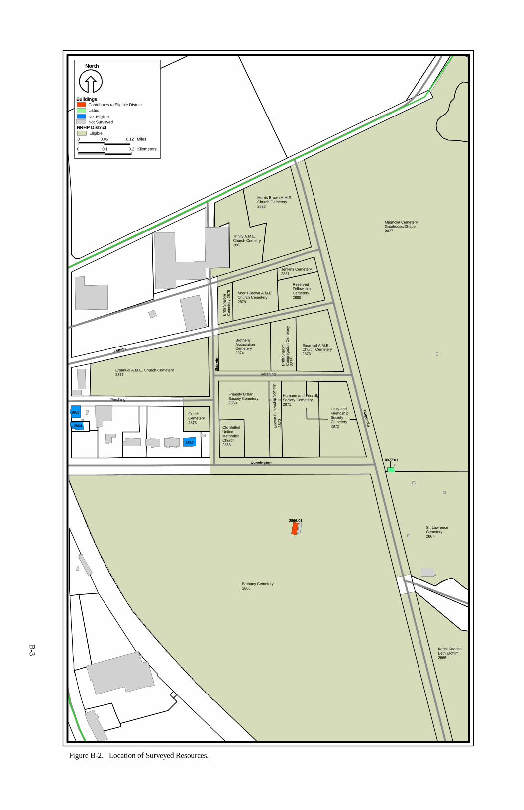
Cunnington
Lemon
Sku
rvi n
Huguenin
Pershing
Pershing
0077.01
2866.01
2862
2864
2863
Emanuel A.M.E. Church Cemetery2877
Greek Cemetery2873
Old Bethel United Methodist Church2868
Friendly Urban Society Cemetery2869
Bro
wn
Fello
wsh
ip S
ocie
ty28
70
Humane and Friendly Society Cemetery2871
Unity and Friendship Society Cemetery2872
St. Lawrence Cemetery2867
Magnolia Cemetery Gatehouse/Chapel0077
Brotherly Association Cemetery2874
Brit
h S
halo
m
Con
greg
atio
n C
emet
ery
2875
Emanuel A.M.E. Church Cemetery2876
Brit
h S
halo
m
Cem
eter
y 28
78 Morris Brown A.M.E. Church Cemetery2879
Reserved Fellowship Cemetery2880
Jenkins Cemetery2881
Trinity A.M.E. Church Cemetry2883
Morris Brown A.M.E. Church Cemetery2882
Bethany Cemetery2866
Kahal Kadosh Beth Elohim2865
B-3
Figure B-2. Location of Surveyed Resources.
North
0 0.06 0.12 Miles
0 0.1 0.2 Kilometers
Buildings
NRHP District
Contributes to Eligible DistrictListed
Not Eligible
Eligible
Not Surveyed
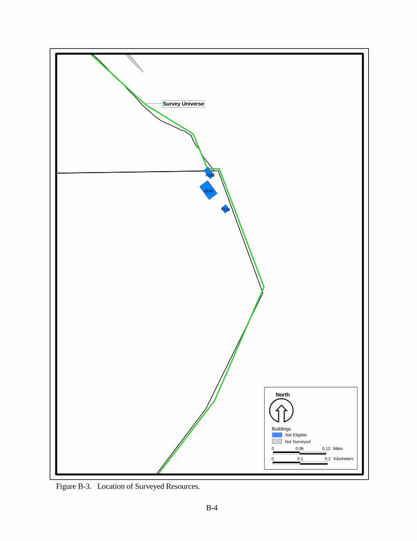
4141
4140
4142
North
0 0.06 0.12 Miles
0 0.1 0.2 Kilometers
BuildingsNot EligibleNot Surveyed
B-4
Survey Universe
Figure B-3. Location of Surveyed Resources.
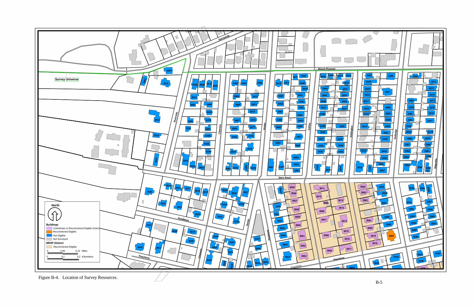
Sans SouciR
iver
side
Cle
mso
n
Hes
ter
Sunnyside
Mount Pleasant
Ash
ley
Dar
l ingt
on
Rut
l edg
e
Hes
ter
Pied
mon
t
Pendleton
Cle
mso
n
PeachtreePeachtree
Ma g
noli a
PeachtPeachtree
3235
3246
32833245
3243
3244
3586
3605
35633564
354535443543
35463531
353235
33
3534
35413542
3559
3560
35613549
3548 3562
3565
3566
3567
3568
3569
3570
3571
3572
3573
3574
3575
3576
3577
3578
3579
3580
3581
3582
3583
3584 3302
3301
3300
3299
3298
3297 3296
3295
3284
3285
3294
3293
32863292
3291 3287
3288
32893290
3382.00
338333843406
3407
3411
3412
34323433
3434
3461
346034623463
3558
3557
3556
35553554
3553
3552
3551
3550
35473530
3535
3536
3540
35393538
35373529
3523
35283524
352735263525
3480
34813482348335013502
3503
3520
3519351835173516
35213522
3515
3585
3514
3513
3661
3660
3511
3512
3500
3494
3495
3496
3497
3498
3499
3504
3505
3506
3507
3508 3509 35103493
3484
3485
3486
3487
3488
3489
3490 3491 3492
3473
3474
3475
3476
3477
3478
3479
3459
34583464
3457
34563465
3466 3455
34543467
3453
34523468
3469 3451
3450
34493470 3471
3472 3448
3435
3436
3437
3438
3439
3440
3441
3442
3443
3444
3445 3446 3447 3422
3423
3424
3425
3426
3427
3428
3429
3430
3431
3414
3415
3416
3417
3418
3419
3420
3421 3396
3397
3398
3399
3400
3401
3402
3403
3413 3404
34053382.01
3385
3386
3387
3388
3389
3390
3391
3392
3393
3394
3395
3381
3380
3379
3378
3377
3376
3375
3374
3373
3372
3371
Figure B-4. Location of Survey Resources.B-5
Survey Universe
North
0 0.06 0.12 Miles
0 0.1 0.2 Kilometers
Buildings
NRHP District
Contributes to Recommened Eligible DistrictRecommened Eligible
Not Eligible
Recommened Eligible
Not Surveyed
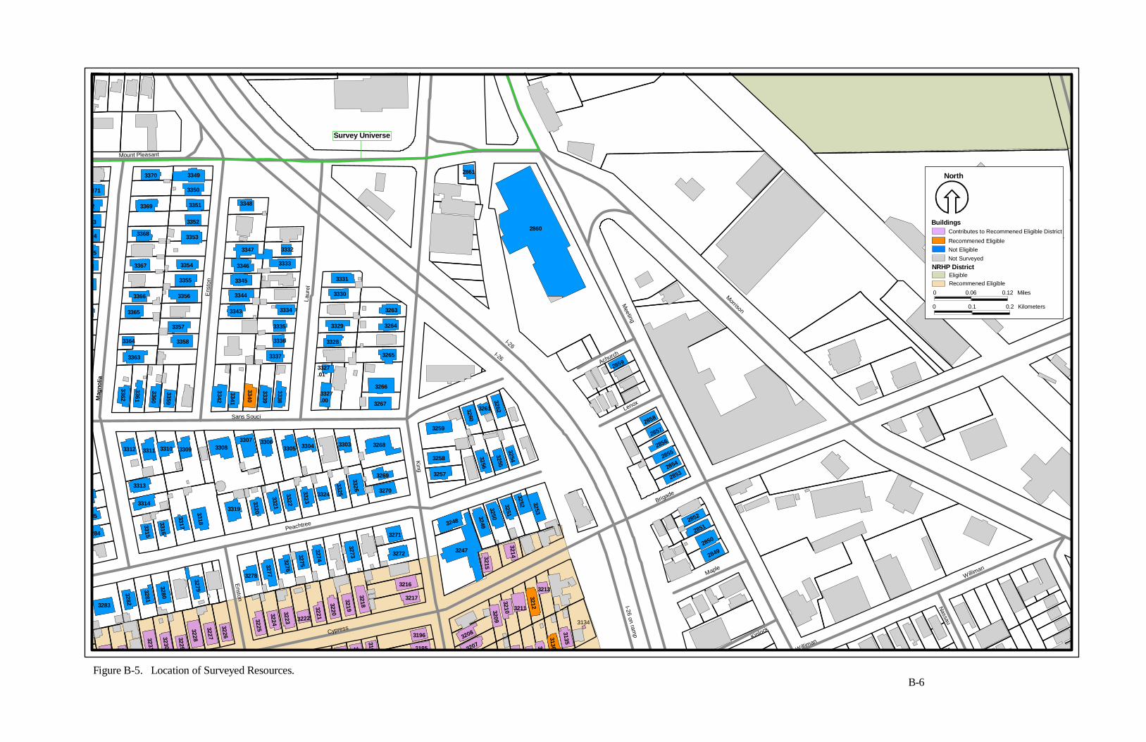
Ma g
noli a
Mount Pleasant
Ens
t on
Laur
e l
I-26I-26
Sans Souci
King
Peachtree
Enston
I-26 on ramp
Kinlock
Maple
Brigade
Lenox
Achurch
Meeting
Morrison
Williman
Nassau
Cypress
Williman
7
323
3134
3231
3230
3229
3228
3227
3226
3
3225
3224
3223 3222
3221
3220
31
3197 3195
3196
28492850
28512852
3135
3136313332073208
3213
32123211
32103209
32143215
3219
3218
3217
3216
3248
3247
32493250
3251
3252 3253
28532854
28552856
28572858
2859
3254
3255
3256
3257
3258
326232613260
3259
3283
3340
3282
3281
3280
3279
3278
3277
3276
3275
3274
3273 3272
3271
33253324
3323
3322
3321
332033193318
3317
3316
3315
3314
3313
3312 3311 3310 3309 33083307 3306
3305 3304 3303
3326 3270
3269
3268
3267
3327.01
3327.00
3338
3339
3341
3342
3359
3360
3361
3362
284
85
3266
3337
3336
3335
3333
3332
33343343
3344
3345
3346
3347
3348
3358
3357
3356
3355
3354
3353
3352
3351
3350
33493370
3369
3368
3367
3366
3365
3364
3363
8
6
75
74
73
2
371
3265
3264
3263
3328
3329
3330
3331
2861
2860
Figure B-5. Location of Surveyed Resources.B-6
Survey Universe
North
0 0.06 0.12 Miles
0 0.1 0.2 Kilometers
Buildings
NRHP District
Contributes to Recommened Eligible District
Recommened EligibleNot Eligible
EligibleRecommened Eligible
Not Surveyed
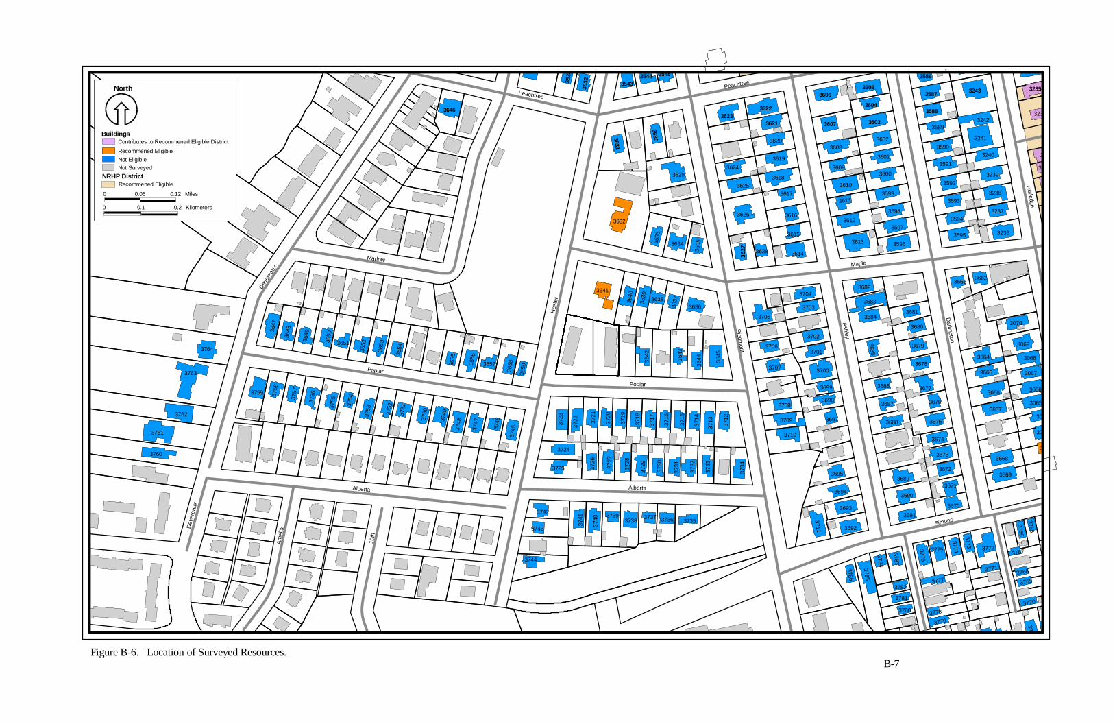
3627
Peachtree
Peachtree
Deve
reau
x
Marlow
Poplar
Alberta
Dev
erea
ux
Am
elia
10th
Hes
ter
Poplar
Alberta
Maple
Piedm
ont
Ashley
Darli ngton
Rutledge
Simons3739
3740
3741
3744
3743
37423738
3737 3736 3735 3711 3692
3693
3694
3695
3
3786
3785
3784
3783
3782
3781
3780
37793778
3777
3776
3775
3774
3773
3771
3772
3765
3766
3767
3768
3769
3770
380
3801
3670
3691
3690
3671
3672
3664
3665
3666
3667
3668
3669
3
30
306
3065
3066
3067
3068
3069
3070
36623663
3689
3673
3674
3675
3678
3677
3676
3688
3687
3686
3685
3679
3680
36813684
3683
36823704
3703
3702
3701
3700
3699
3698
3697
3710
3709
3708
3707
3706
3705
3731
3730
37293728
3727
3726
3725
3724
3732
3733
3734
3712
3713
3714
3715
3716
3717
3718
3719
3720
3721
3722
3723
3642
3643
3644 36
45
36363637363836
39
3640
3641
3747
374837
49
375037
51
3752
3753
3754
375537
56375737
58
3759
3746
3745
365936
5836573656
3655
365436
53
3652365136
50
364936
483647
3760
3761
3762
3763
3764
3632
3635363436
33
36293624
3625
3626
3627 3628 3614
3615
3616
3617
3618
3619
36203608
3609
3610
3611
3612
3613 3596
3597
3598
3599
3600
3601
3602
3589
3590
3591
3592
3593
3594
3595 3236
3237
3238
3239
3240
3241
3242
31
3
323
3235
3246
3588
32433587
3586
3603
3604
3605
36073621
3606
36223623
363 0363 1
354535443543
3 5323 5
33
3646
Figure B-6. Location of Surveyed Resources.B-7
North
0 0.06 0.12 Miles
0 0.1 0.2 Kilometers
Buildings
NRHP DistrictRecommened Eligible
Not Surveyed
Contributes to Recommened Eligible District
Recommened EligibleNot Eligible
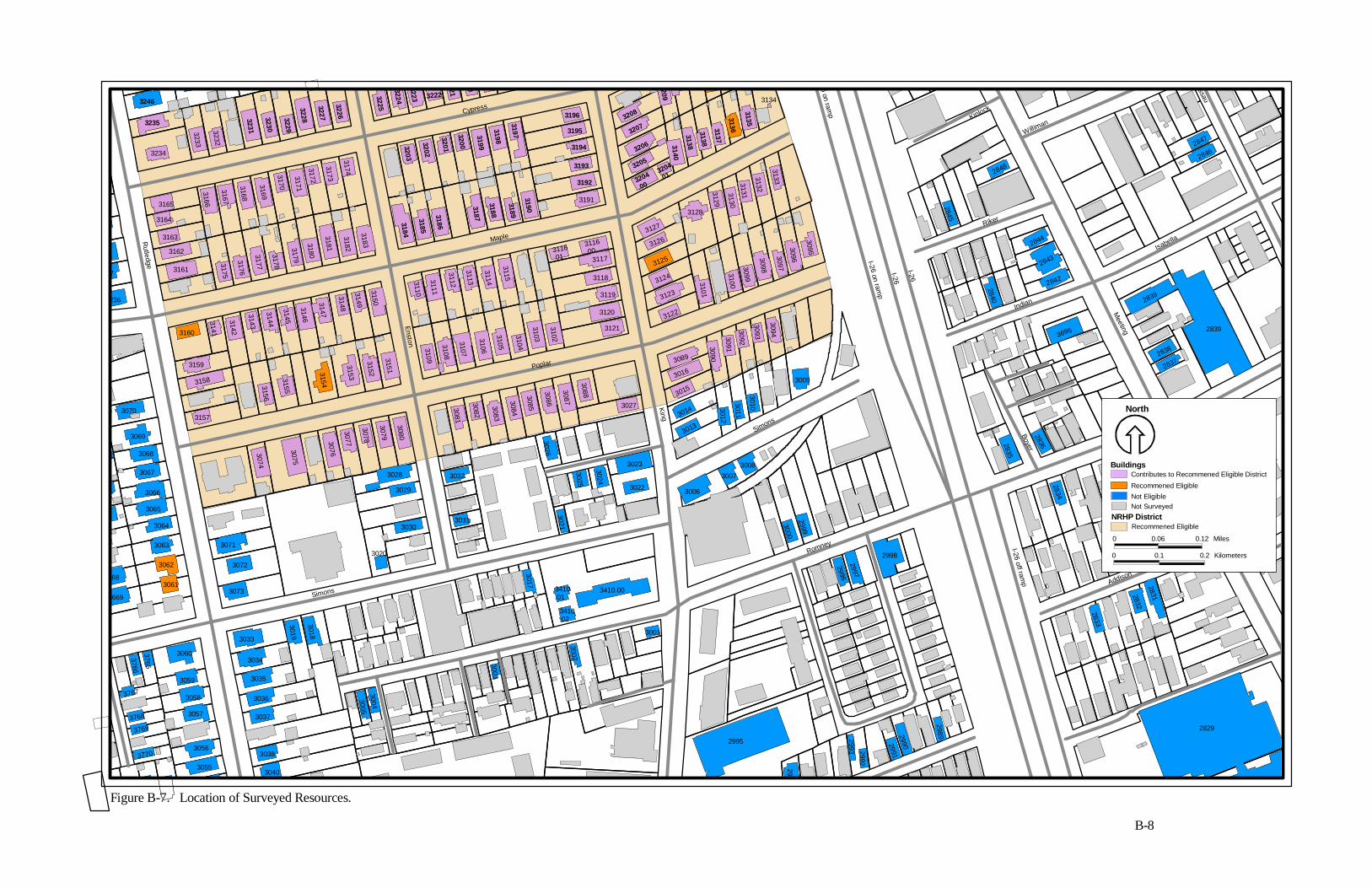
6 on ramp
Kinlock
assau
Rutledge
Cypress
Maple
Enston
Poplar
Simons
King
Simons
Romney I-26 off ramp Addison
Romney
Conroy
Boyer
Indian
Riker
Isabella
Meeting
Williman
I-26 on ramp
I-26
I-26
3090
28482846
2847
28372838
2839
2839
28362835
3696
2842
2843
2844
2840
2845
2834
2833
2832
2831
2829
3765
3766
3767
3768
3769
3770
3055
3056
3057
3058
3059
3060
3040
3038
3037
3036
3035
3034
3033
3019
3018
30053004
3003
3002
29892990299129922993
299
2995
3001
2998
2997
2996
3000
2999
30083007
3006
3016
3015
3014
3013
3012
3011
3010
3009
3094
3093
3092
3091
3089
3410.00
3410.02
3410.01
3017
3031
3021
3025
3024
3022
3023
3026
3027
30883087
3086
3085
3084
3083
3082
3081
3032
3020
3030
3029
3028
3074
3075
3076
3077
3078
3079
3080
3152
31533154
31553156
3157
3158
3071
3072
3073
7
668
3669
3061
3062
3063
3064
3065
3066
3067
3068
3069
3070
236
7
8
3151
3109
3108
3107
3106
3105
3104
3103
3102
3121
3159
3160
3141
3142
31433177
3176
31753161
3162
3163
3164
3165
3166
3167
3168
3232
3233
3234
3134
3095
3144
3145
3146
3147
3148
3149
3150
3183
3182
31813180
3179
3178
3169
3170
3171
3172
3173
3174
3110
3111
3112
3113
3114
3115 3100
3099
3098
3097
3096
31333132
31313130
3129
3128
3101
3122
3123
3124
3125
31263127
3120
3119
3118
31173116.01
3116.00
3191
3231
3230
3229
3228
3227
3226
3184
3185
3186
3187
3188
3189
3190
3200
3201
3202
3203
3225
3224
3223 3222
21
03199
3198
3197
3192
3193
3194
3195
3196
3135
31363137
3138
31383140
3204
.013204
.00
3205
3206
32073208
3209
3235
3246
Figure B-7. Location of Surveyed Resources.
B-8
North
0 0.06 0.12 Miles
0 0.1 0.2 Kilometers
Buildings
NRHP DistrictRecommened Eligible
Not Surveyed
Contributes to Recommened Eligible District
Recommened EligibleNot Eligible
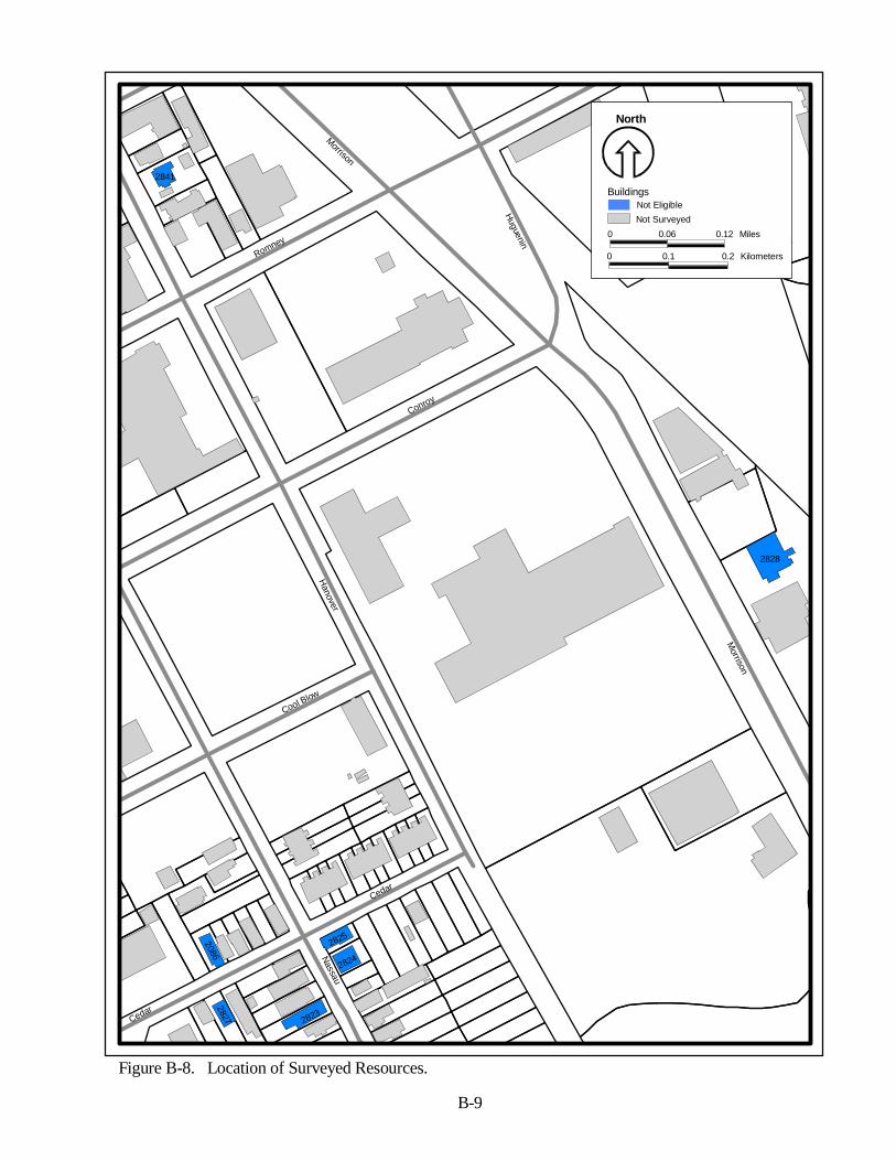
Cedar
Nassau
Conroy
Hanover
Cool Blow
Romney
MorrisonM
orrison
Cedar
Huguenin
2841
2086
2825
2828
2824
2823
2827
North
0 0.06 0.12 Miles
0 0.1 0.2 Kilometers
BuildingsNot EligibleNot Surveyed
Figure B-8. Location of Surveyed Resources.
B-9
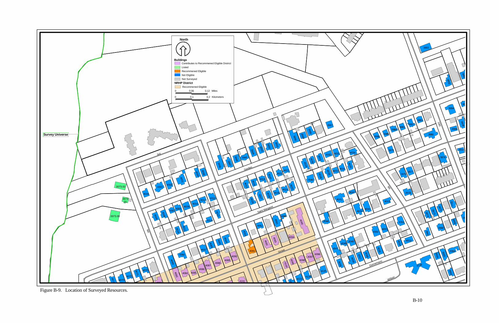
3rd
6th
Gordon
Saint Margaret
Grove
Dunnemann
Wilson
9th
10th
3960
4136
40584059
4046
4100
4099
40984097
4096
4135
4134413341344101
40884087
408640854084
4083
4074 40734072
4071
4070
4082
0073.00
0073 .01
0073.02
40894090
4069
4068
4015
4016
4005
4006
40074008
40094010
4000
4004
40034002
4001
3999
40114012
4013
4014
4067
4066
4065
4064
4091
4063
4062
4092
4093
4094
4061
4060
4095
3998
3997
3996
3995
3994
402240214020
40194018
4017
4028
4027
4026
40254024
4023
403840394040
4029
4030
4031
4032 4033
4047
40484049
4057
4056
4055
40504051
4052
4054
4053
39673974
3973
3972
3976
3975
39773978
4043
40444045
4042
4041
40374036
40354034
3979
39643965
3966
3968
39693971
39
3910
3909
3908
389
3894
3891
3892
3980
3981
39823983
3984
39853986
3987
39883989
3990
3991
39923993
3893
B-10
Figure B-9. Location of Surveyed Resources.
Survey Universe
North
0 0.06 0.12 Miles
0 0.1 0.2 Kilometers
Buildings
NRHP District
Contributes to Recommened Eligible DistrictListedRecommened EligibleNot Eligible
Recommened Eligible
Not Surveyed

Gordon
12th
11th
Dunnemann
10th
Mary Murray
Cleveland
Maverick
Francis
Rutledge
Grove
2944
3961
3970
3963
3962
39533952
3951
3950
3949
3948
3947
3946
3945
3944
39433935
39363937
39383939
3940
3941
3925
3926
3927
3928
3929
3930
3931
3932
39183919
3920392139223923
3924
3933
39343942
3845
3844
3843
3836
3837
3838
3839
3840
3841
38423846
3847
3848
3849
3850
3851
3852 3853
3854
2563
2929294529462947
2950
2949
2948
2952
2951 2960
29582959
2957
29562955
2954
2953
2980
2979
2978
2977
29432942
2941
2930
2931
29192920
2921
292939
29382937
2963
2961
2962
2967
2973
2981
2970
2969
2968
2971
2972
2982
2983
29842974
29762975
3050
3049
3048
3047
3835
38343833
383238313830
382938283855
38563868
3869
3827
3826
3825
3824
0104
3822
3821
3820
3051
3052
3819
3818
3817
38163815
3814
3862
3861
3860
3859
3858
3857
3867
3866
3874
3873
3872 38713870
38853884388338823881
38803879
3878
3877
3876
3875
38653864
3863391739163915
39143913
3912
39113910
3908
3907
3906 39053904
39033902
3901
3900
38993898
38973896
3895
38903891
3889
3888
3887
3886 3813
3787
3053
3812
3811
3810
3809
3808 3807
3806
3805
3804
3803
3802
3799
3798
3797
3796
3795
3794
3793
3792
3791
3790
3789
3788
3780
37793778
3800
3801 3054
3055
3044
3046.013046.00
3045
3043
3042
3041
3040
3040
B-11
Figure B-10. Location of Surveyed Resources.
North
0 0.06 0.12 Miles
0 0.1 0.2 Kilometers
BuildingsListedEligibleRecommened EligibleNot EligibleNot Surveyed
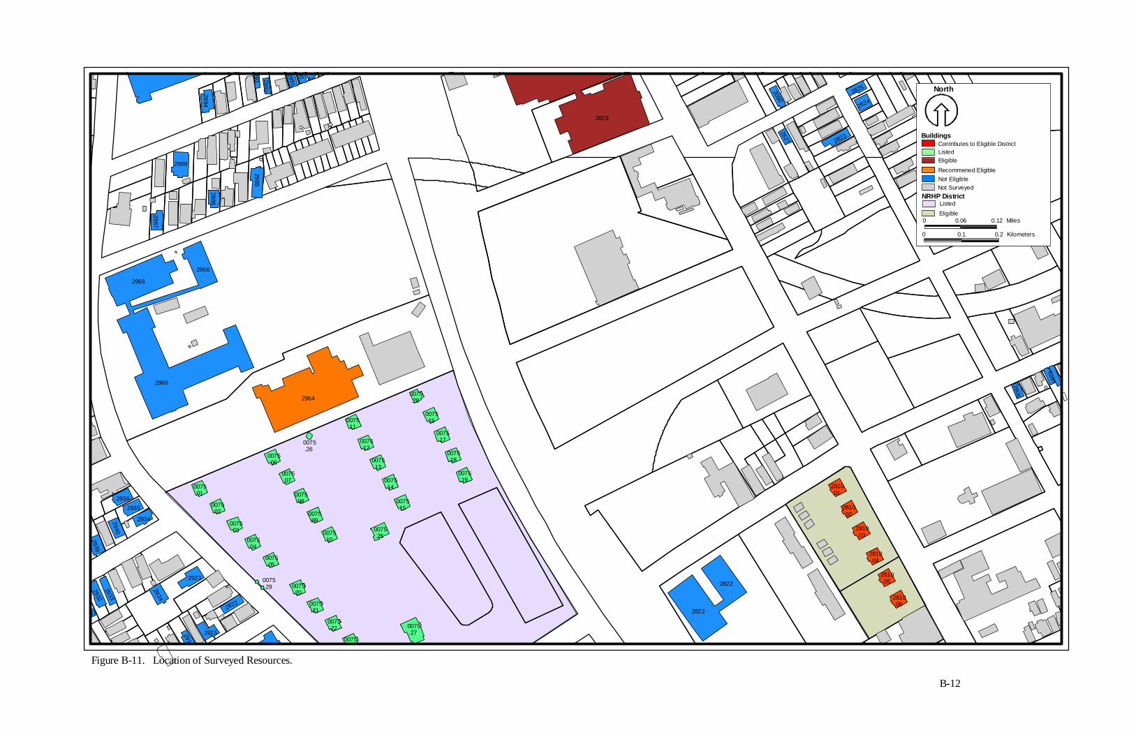
2086
2825
2824
2823
2827
28292806
2807
2810 .06
2810 .05
2810 .04
2810 .03
2810 .02
2810 .01
2822
2822
2922
29152914
921
29322933
2924
2923
2934
29352936
2940
2939
0075 .23
0075 .27
0075 .22
0075 .01
0075 .02
0075 .03
0075 .04
0075 .05
0075 .29
0075 .21
0075 .20
0075 .250075
.10
0075 .09
0075 .08
0075 .07
0075 .06
0075 .26
0075 .12
0075 .13
0075 .14
0075 .15
0075 .19
0075 .18
0075 .17
0075 .16
0075 .28
0075 .11
2964
2966
2966
2966
2987
2988
2986
2985
9902991
2992993
2994
2995
B-12
Figure B-11. Location of Surveyed Resources.
North
0 0.06 0.12 Miles
0 0.1 0.2 Kilometers
Buildings
NRHP District
Listed
Recommened EligibleNot Eligible
Listed
Not Surveyed
Contributes to Eligible District
Eligible
Eligible
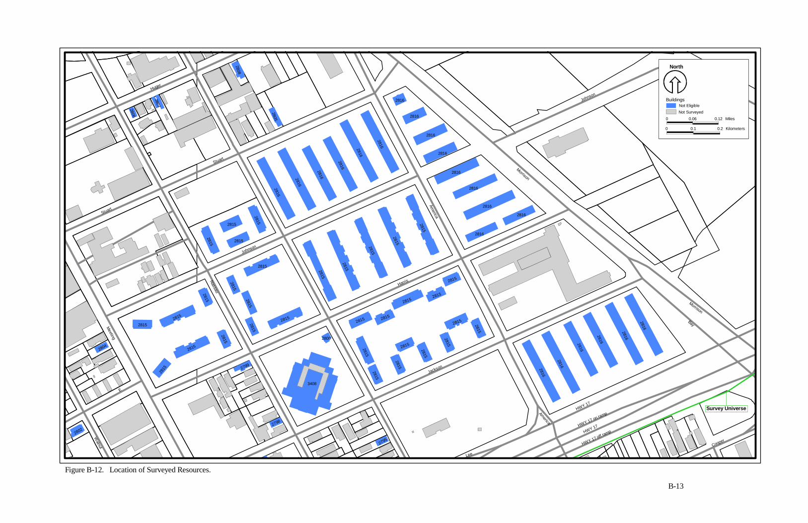
2815
2815
2816
2816
2816
2816
2816
2816
2
2795
3408
2815
2815
2815
28152800
2815 2815
2815
2815
2799
2815
2815
2815
2798
2815
2804
2802
28152815
2815
2815
2815
2815
2815
2815
2815
2815
2815
2815
2815
28152815
2815
2816
2816
2816
2816
2816
2815
2815
2815
2816
2816
2816
2816
28162816
2816
2807
2808
2805
28162816
2816
2806
Stuart
nut
Huger
Stuart
Nassau
Johnson
Meeting
E
Walnut
Harris
Jackson
Lee
HWY 17
HWY 17 on ramp
HWY 17
HWY 17 off ramp
America
Cooper
Morrison
Bay
America
Morrison
Johnson
North
0 0.06 0.12 Miles
0 0.1 0.2 Kilometers
BuildingsNot EligibleNot Surveyed
B-13
Figure B-12. Location of Surveyed Resources.
Survey Universe
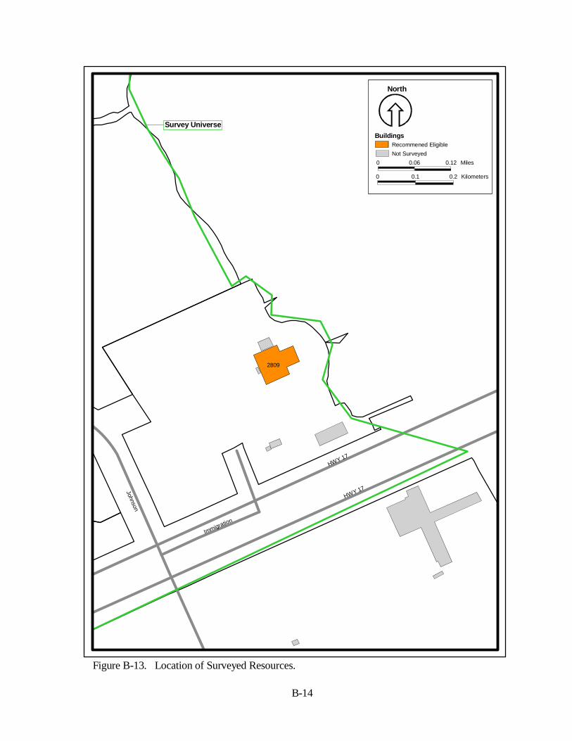
Johnson
Immigration
HWY 17
HWY 17
2809
Figure B-13. Location of Surveyed Resources.
B-14
Survey Universe
North
0 0.06 0.12 Miles
0 0.1 0.2 Kilometers
BuildingsRecommened EligibleNot Surveyed
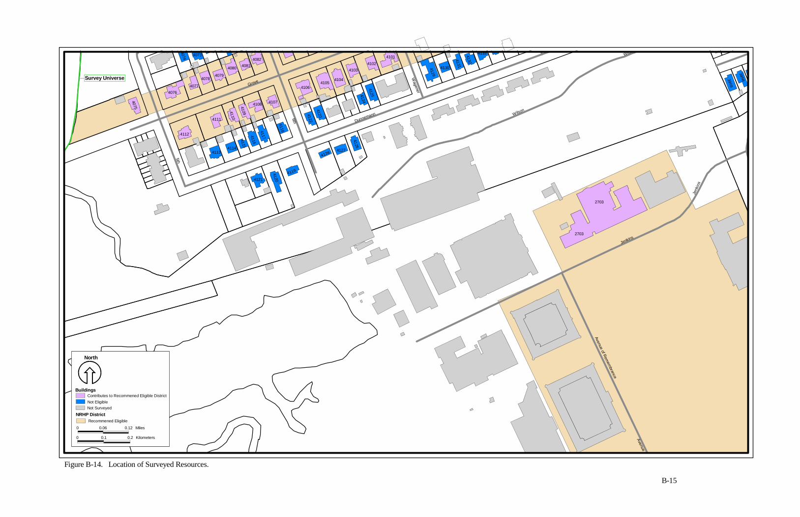
Wilson
5th
Dunnemann
Grove
6th
Wagener
Wilson
Jenkins
Avenue of Rem
embrance
Jenk
ins
Avenue of
4121
4120
2703
2703
3959
3958413341324131
41304129
4119
41284127
4126
41254124
41234122
41054104
41034102
4101
4106
4115
4116
4117
4118
4107410841094110
41144113
4111
4112
4074 40734082
40814080
40794078
40774076
4075
Survey Universe
Figure B-14. Location of Surveyed Resources.
B-15
North
0 0.06 0.12 Miles
0 0.1 0.2 Kilometers
Buildings
NRHP District
Contributes to Recommened Eligible DistrictNot Eligible
Recommened Eligible
Not Surveyed
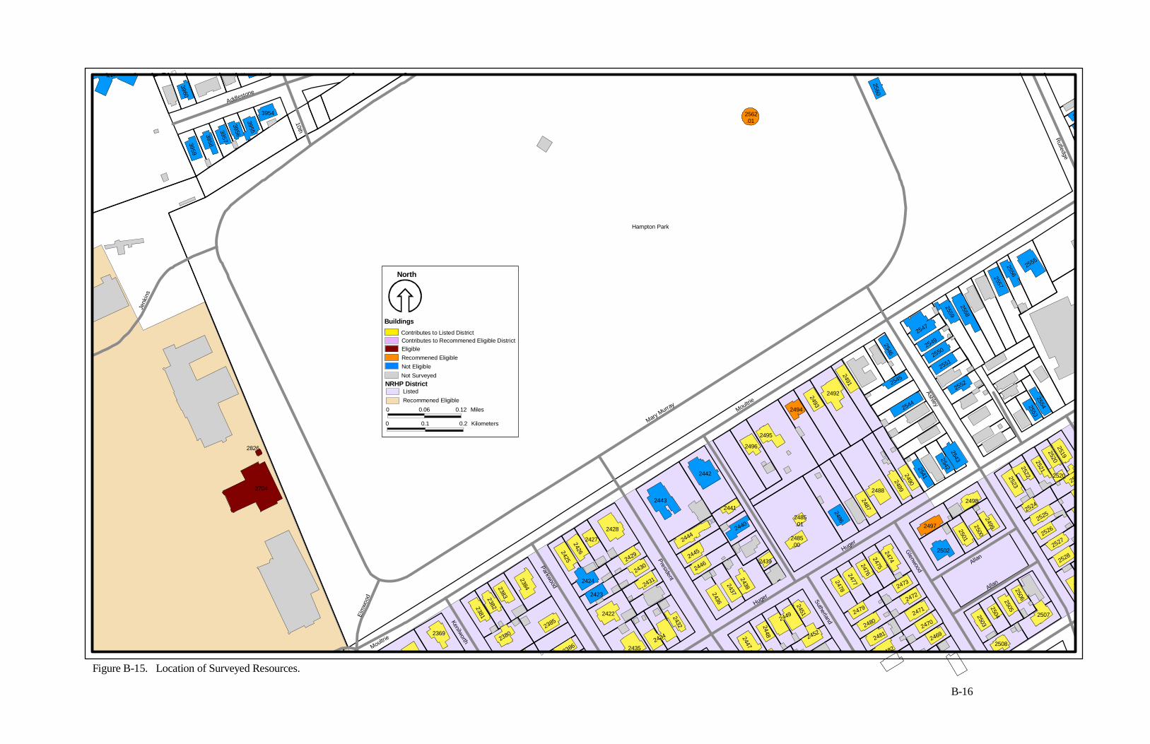
Addlestone
10th
Jenk
ins
Elm
wood
Kenilworth
Parkwood
President
Moultrie
Mary Murray
Huger
Sutherland
Ashley
Glenwood
Allan
Allan
Rutledge
Moultrie
Huger
2448
2469
23862380
2370
2369
24352434
2432
24522447
2482
2481
2508
24802479
24702471
24722473
25032504
25052506
2507
250
2553
2
2528
25272526
25252524
2512520
25192520252125222523
24992500
2501
2502
2498
2497
25432542254124902489
2544
24742475247624772478
2451
2449
2486
2487
2488
2493
2494
2495
2496
2485 .01
2485 .00
2436
24372438
2439
2440
2441
2442
2443
2444
2445
2446
2422
24312430
2429
2423
2424
2428
242724262425
23852384238323822381
2704
2826
2492
2491
2554
2546
2545
2552
25512550
25492547
2559
2558
25572556
2555
29
2560
2562 .01
3959
3958
3957
3956
3955
3954
3961
3960
4136
Hampton Park
North
0 0.06 0.12 Miles
0 0.1 0.2 Kilometers
Buildings
NRHP District
Contributes to Listed DistrictContributes to Recommened Eligible DistrictEligibleRecommened EligibleNot Eligible
ListedRecommened Eligible
Not Surveyed
Figure B-15. Location of Surveyed Resources.
B-16
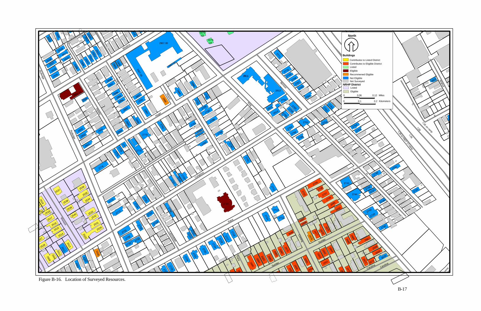
2811
Rutledge
Moultrie
Rutledge
Dewey
Tracy
Shand
Huger
King
Benson
Congress
Wesson
Race
Carondolet
TracySumter
Coming
H
F
I
C
E
Walnut
I-26
I-26
I-26 to HWY 17 ram
p
I-26 on ramp
Sumter
CarolinaCarolina
17 ra
mp
2669
2
2803
2654
2309
2310
2311
27212724
27252726
26572
2686
2685
26842683
2682
2656
2655
2661
26622663
26732674
2672 26712670
2668
2667
2664
26652666
2742
27432743
2748
2750
2751
2749
27472746
2744
2745
2677
26762675
26942695
27062707
27082709
2710
2697
2696
2678
2698
26812680
2679
2712
2711
2713
2714
2716271727182719
2720
2737
27382739
2715
27222723
2736
2735
2734
2728
2729
2730
2733
2733
2732
2731
2772
2773
277727762775
2774
2509
2509
25112512
2513
2529
25292531
25322533
25342535
2536
2540
2539
2538
2537
2517
2516
2515
2514
2528
2527
6
25182520
25192520
2899
2901
2903
29022900
2884
2885
2892
28942895
2896
2888
2893
2891
2887
2886
2778
2779
2781
2784
2785
2786
2787
2741
2740
2788
2789
27902790
2782
2783
2889
27522753
2764
27632762
27542761
27552756
2757
276027592758
2813
2814
2766
27652767
27682769
2770
2771
2812
2811
2890
0075 .24
2904.00
28972898
29052906
2907.01
2907.00
291329122911291029092908
29162917
2918
29252926
29272928
2929
2930
31
29192920
2907.00
2914 0075 .23
Figure B-16. Location of Surveyed Resources.
B-17
North
0 0.06 0.12 Miles
0 0.1 0.2 Kilometers
Buildings
NRHP District
Contributes to Listed DistrictContributes to Eligible DistrictListedEligibleRecommened EligibleNot Eligible
ListedEligible
Not Surveyed
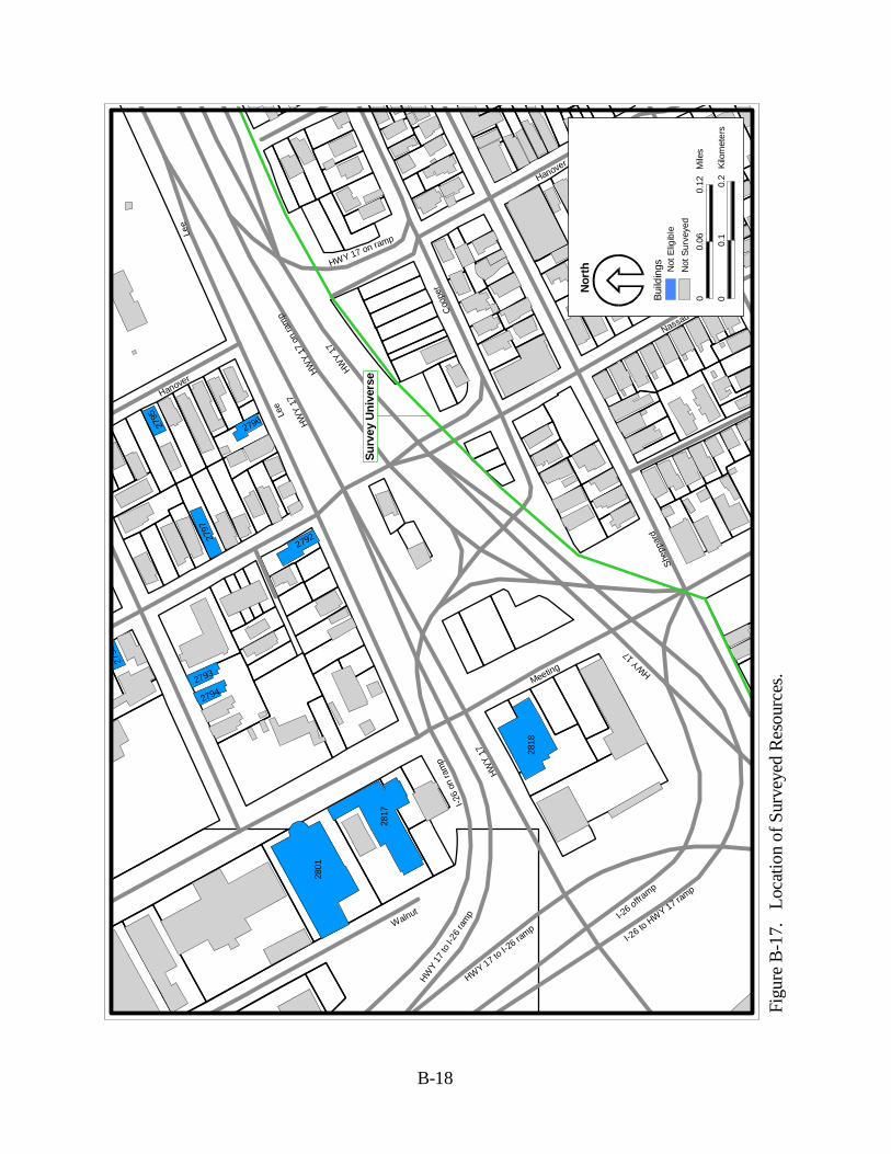
Lee
7
I-26 to
HWY 17 ramp
I-26 offra
mp
p
Shep
pard
Lee
HWY
17
HWY
17 o
n ra
mp
HWY
17
I-26
on ra
mp
HWY
17 to
I-26
ram
p
Walnut
HWY 17
HWY
17
HWY 17 to I-2
6 ramp
Meeting
Nassau
Hanover
Coo
per
Line
HWY 17 on ramp
Hanover
2798
2795
2797
2793
2794
2792
2796
2801
2817
2818
Figu
re B
-17.
Lo
catio
n of
Sur
veye
d R
esou
rces
.
B-18
Nor
th
00.
060.
12M
iles
00.
10.
2K
ilom
eter
s
Bui
ldin
gs Not
Elig
ible
Not
Sur
veye
d
Sur
vey
Uni
vers
e
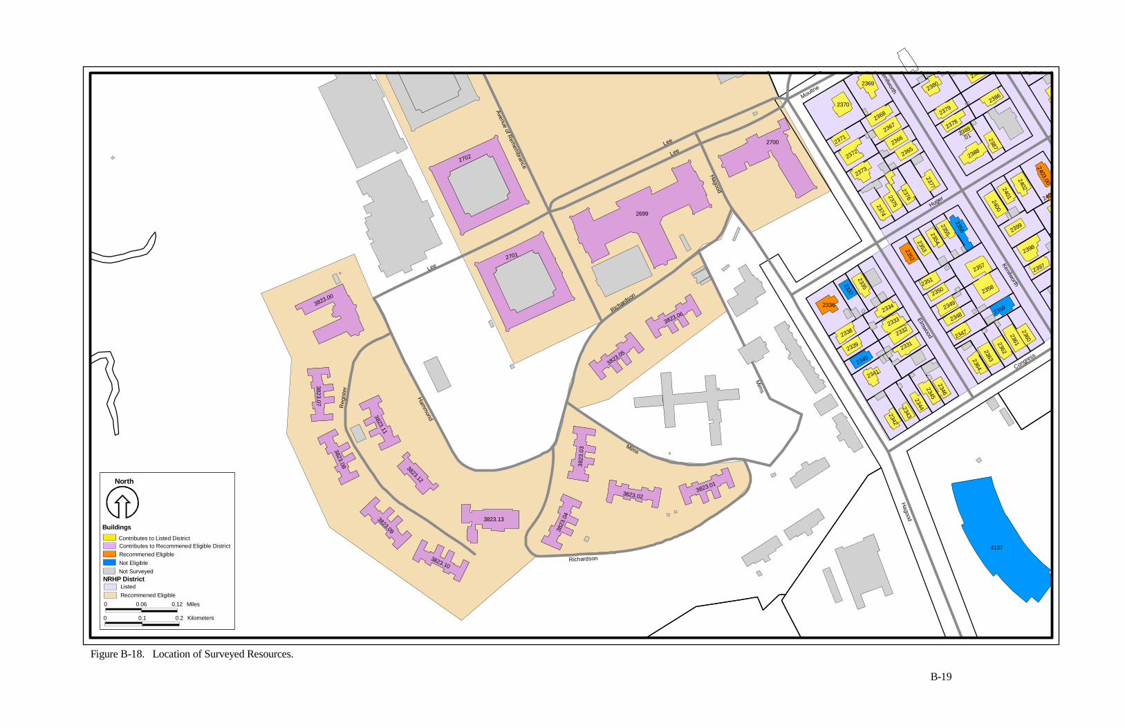
Kenilworth
Avenue of Rem
embrance
Lee
Lee
Lee
Reg
iste
r
Ham
mond
Richardson
Mims
Mim
s
Richardson
Hagood
Hagood
Huger
Congress
Elmwood
Kenilworth
Moultrie
2401
3823
.04
3823.13
3823.10
3823.09
4137
2360
2361236223632364
2359
2347
23482349
2334
2333
2332
2331
2346
2345234423432342
2341
2340
2339
2338
2336
3823.013823.02
3823.06
3823.05
3823
. 03
3823.12
3823.11
3823.08
3823.07
3823.00
2701
2702
2699
2700
2337
2335
23502351
23522353
23542355
2356
2358
2357
2400
2386
2387
2388
2388
.01
23782379
2380
2368
2367
2366
2365
2377
237623752374
2373
2372
2371
2370
2369
2397
2398
2399
2402
2403.00
2403.
2
2385
Figure B-18. Location of Surveyed Resources.
B-19
North
0 0.06 0.12 Miles
0 0.1 0.2 Kilometers
Buildings
NRHP District
Contributes to Listed DistrictContributes to Recommened Eligible DistrictRecommened EligibleNot Eligible
ListedRecommened Eligible
Not Surveyed
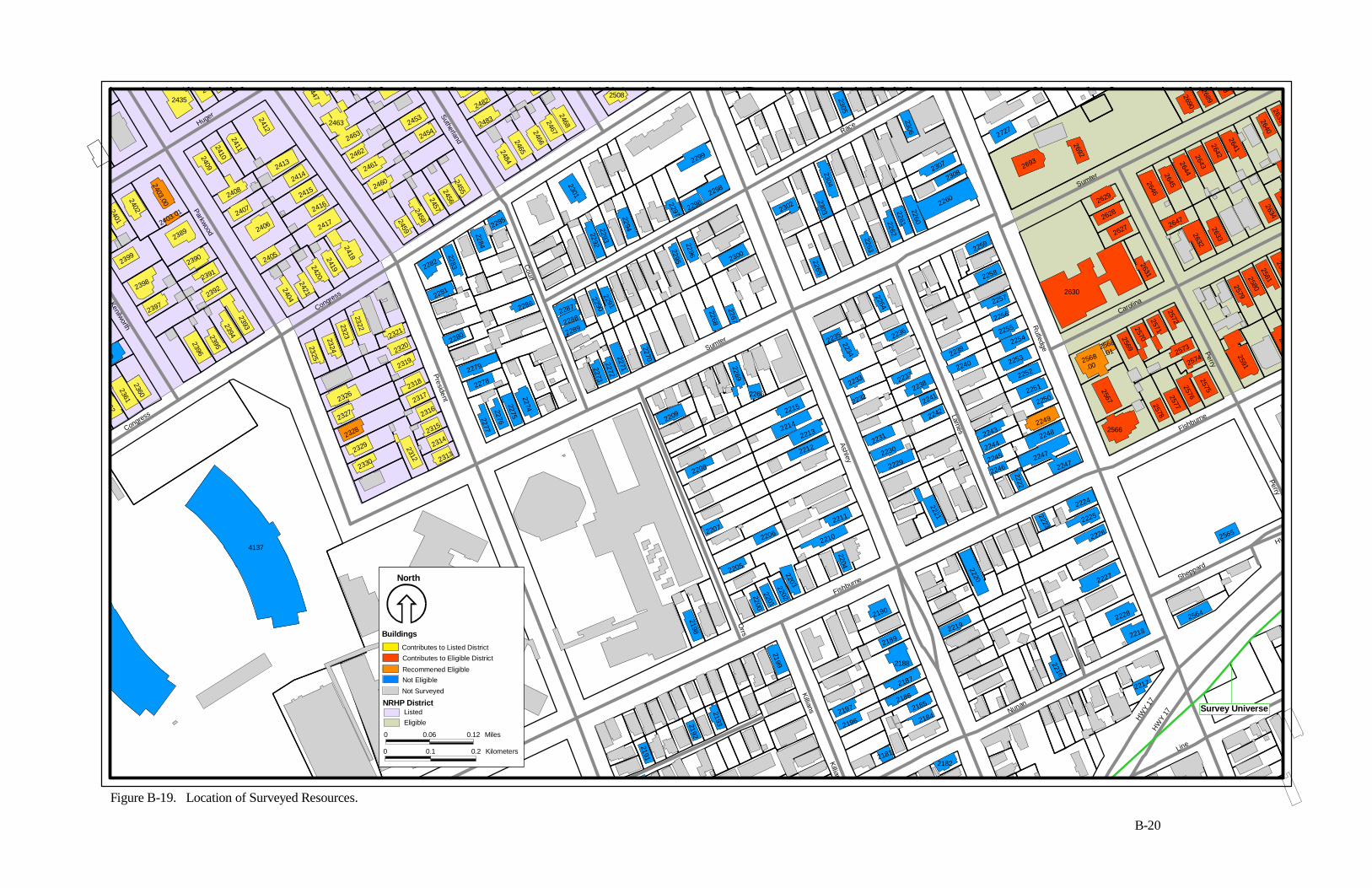
Congress
Kenilworth
Parkwood
Congress
Huger
PresidentSutherland
Court
Sumter
Race
Ashley
Larnes
Rutledge
Carolina
Sumter
Fishburne
Perry
Sheppard
Fishburne
Killians
Orrs
Nunan
HWY
17HW
Y 17
Perry
HWKillians
Line
2580
2288
2401
8
2469
2182
7
94
4137
2181
21842196
2197
2191
2192
2193
2199
2198
2210
220322022201
2200
2205
2204
21852186
2187
2188
2189
2190
2216
2219
2220
2226
2227
2228
2218
2217
2564
2565
2590
25912579
2567
2566
25782577
25762575
25742573
25722571257025692568
.012568
.00
2630
2225
2224
2223
22472247
22482249
22502251
22522253
22542255
2256
2257
2239
2240
2243
2244
2245
2246
2222
2221
22422241
22382237
2236
2264
2235
2234
2233
2232
2231
2230
2229
2211
22062207
2212
22132214
2215
2208
2209
2269
2266
2267
2268
22702271
2272
2273
22742275
22762277
22782279
22802321
2320
2319
2318
2317
2316
2315
2314
2313
2312
2330
23292328
2327
2326
2325
2324
2396
2395
2360
23612362
59
0
6
2291
2290
2289
22872286
2285
2284
2283
2281
2282
23222323
2394
2397
2398
2399
2402
2403.00
2403.01
2389
2390
2391
2392
2393
24042421
24202419
2418
2417
2416
2405
2406
24152414
2407
2408
2413
2412
241124102409
24352434
24542453
2452447
2463
2463
2462
2461
2460
24592458
24572456
2455
24682467246624652484
2483
2482
2481
2508
2301
22922293
2294
2299
2297 22982298
22952296
2300
2265
2302
23032304
2305
26312627
2628
2629
2258
2259
2263
226222612260
2260
23082307
2306
2727
2693
2692
25812582
2632634
26332632
2647
2
26392640
264126422643264426452646
2690
2689
688
Figure B-19. Location of Surveyed Resources.
B-20
Survey Universe
North
0 0.06 0.12 Miles
0 0.1 0.2 Kilometers
Buildings
NRHP District
Contributes to Listed DistrictContributes to Eligible District
Recommened EligibleNot Eligible
ListedEligible
Not Surveyed
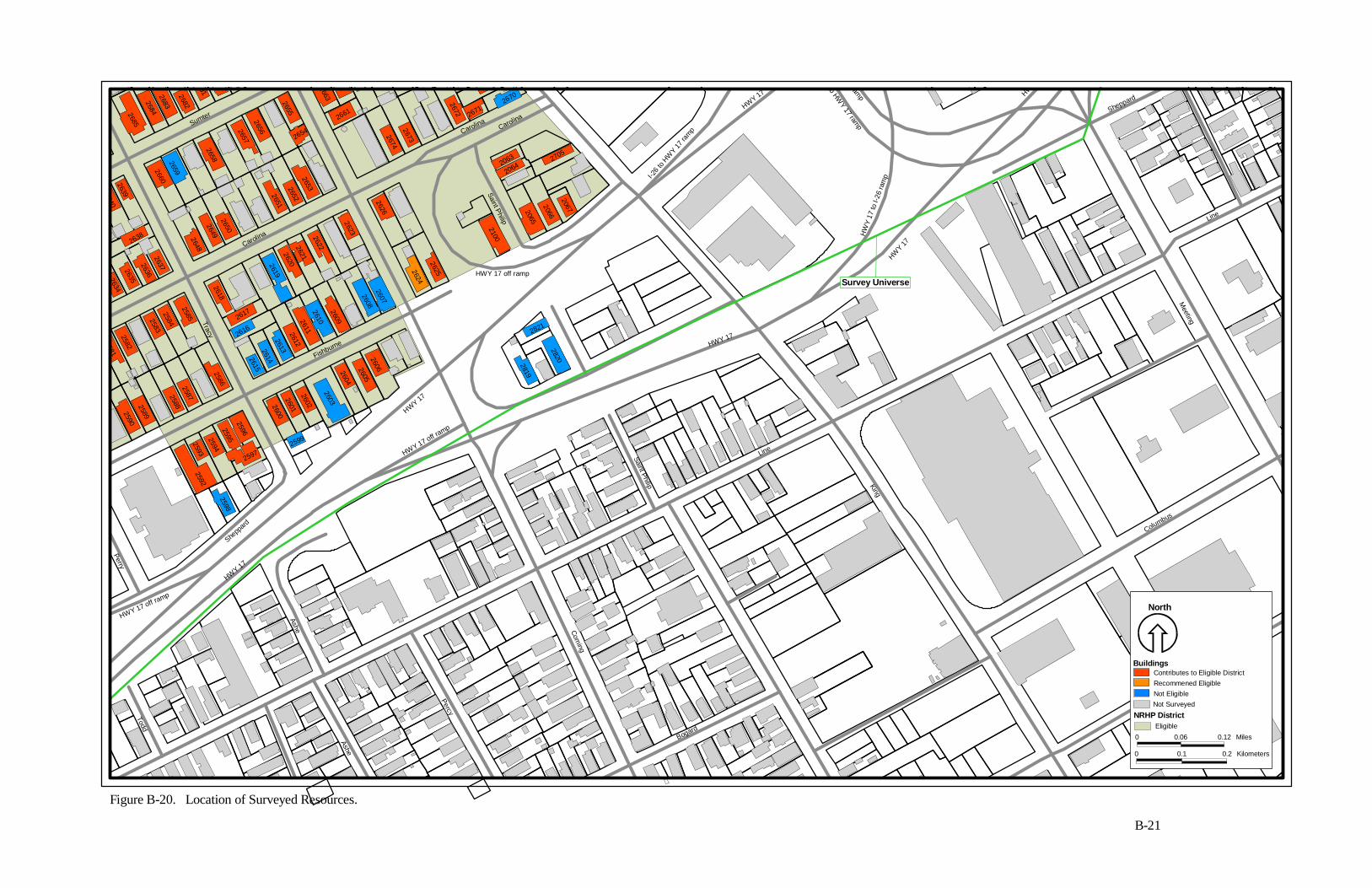
Sumter
Carolina
CarolinaCarolina
HWY 17 off ramp
Saint Philip
Tracy
Fishburne
Sheppa
rd
Perry
HWY 17 off ramp
HWY 17
HWY 17
HWY 17 off ramp
Todd
Ashe
Percy
Ashe
Coming
Bogard
Line
King
HWY 17
I-26 t
o HW
Y 17 ra
mp
HWY 17
6 to HWY 17 ram
pffram
p
HW
Y 17
to I-
26 ra
mp
HWY 17
Sheppard
Line
Meeting
Columbus
Spring
Saint Philip
HWY
26152614
266
2820
2821
2819
26062605
2604
2599
2603
2602
26012600
2598
25922593
25942595
2597
2596
2586
2587258825892590
2654
25812582
25832584
2585
26132612
2616
2618
2617
2657
265826592660
2650
26492648
2637263626352634
2638
26392640
2685
26842683
2682
2607
2608
2609
26102611
26192620
2621
2622
2623
265326522651
2656
2655
2661
622663
26732674
2626
2624
2625
2100
20672066
2065
2705
20642063
2672 26712670
681
0
Survey Universe
B-21
Figure B-20. Location of Surveyed Resources.
North
0 0.06 0.12 Miles
0 0.1 0.2 Kilometers
Buildings
NRHP District
Contributes to Eligible DistrictRecommened EligibleNot Eligible
Eligible
Not Surveyed
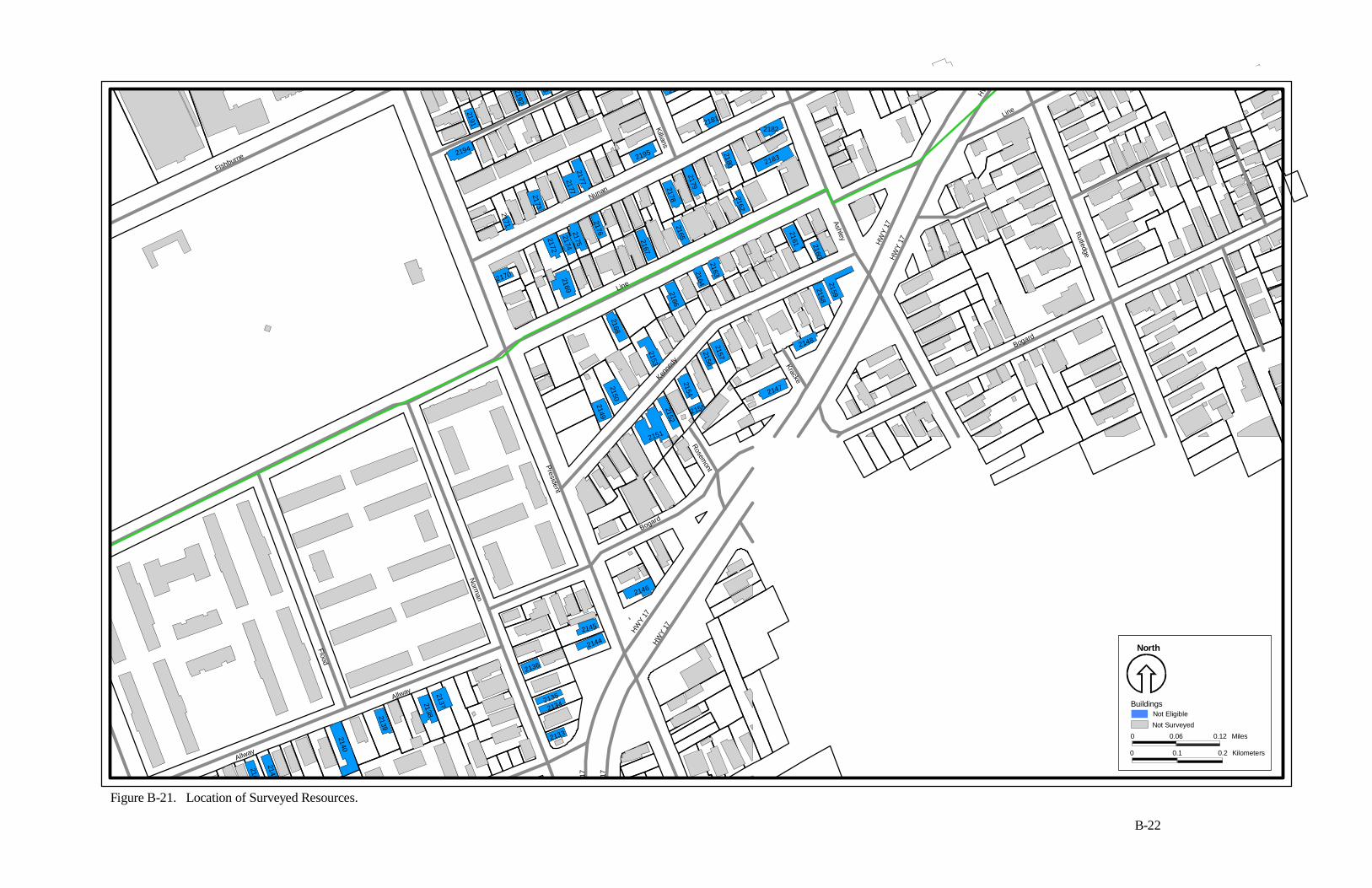
H
HWY
Fishburne
Killians
Nunan
Line
Kenne
dy
President
Rosemont
Bogard
Norm
an
Flood
Allway
HWY
17HW
Y 17
Kracke
Ashley
HW
Y 17
HW
Y 17
Bogard
Rutledge
Line
Y 1
7
Y 1
7
Allway
2144
2145
2133
21342135
2136
213721382139
2140
2141
2142
2146
2147
2154
21552152
2151
21492150
21562157
2148
21582159
2160
2161
21632164
2166
2153
2168
2170 2169
2172
21742175
2176
2167
2165
2178
2179
2162
2180 2183
2182
2195
217721772173
2171
2194
2181
21842196
2191
2192
193
North
0 0.06 0.12 Miles
0 0.1 0.2 Kilometers
BuildingsNot EligibleNot Surveyed
B-22
Figure B-21. Location of Surveyed Resources.
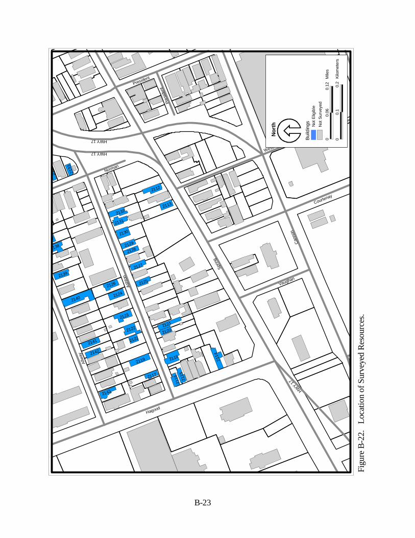
Sprin
g
Can
non
Wescott
Asht
on
Hagood
Vaughan
Courtenay
East
Cot
tPres
iden
t
Norman
HWY 17
HWY 17
PresidentAl
lway
HWY 17
2114
2133
2134
2112
2113
2132
2131
2130
2129
2128
2127
2125
2121
2120
2118
2115
21162117
2119
2122
2122
2123
2124
2126
37
2138
2139
2140
2141
2142
2143
Figu
re B
-22.
Lo
catio
n of
Sur
veye
d R
esou
rces
.
B-23
Nor
th
00.
060.
12M
iles
00.
10.
2K
ilom
eter
s
Bui
ldin
gs Not
Elig
ible
Not
Sur
veye
d
Appendix C.
SHPO Determination of NRHP Eligibility Letter