Archaeological investigations on the territories of Rác bath and the late La Tene period pottery...
22
Régészeti kutatások Magyarországon 2005 Archaeological Investigations in Hungary 2005 Budapest, 2006
-
Upload
independent -
Category
Documents
-
view
3 -
download
0
Transcript of Archaeological investigations on the territories of Rác bath and the late La Tene period pottery...

Régészeti kutatások Magyarországon 2005
Archaeological Investigations in Hungary 2005
Budapest, 2006

Régészeti kutatások Magyarországon 2005Archaeological Investigations in Hungary 2005
Budapest 2006
Az elsõ borítón: x (Fotó: x)
Front cover: x (Photo: x)
A hátsó borítón: x (Fotó: x)Back cover: x (Photo: x)
A szerkesztôbizottság tagjai:
Editorial Board:
Bencze Zoltán
Lôrinczy Gábor
Mráv Zsolt
Rezi Kató Gábor (elnök)
Tomka Gábor
Wollák Katalin
Szerkesztô: Kisfaludi Júlia
Edited by Júlia Kisfaludi
Fordítás: Simán Katalin
Translated by Katalin Simán
© Kulturális Örökségvédelmi Hivatal és a Magyar Nemzeti Múzeum 2006
Felelôs kiadó: Dr. Varga Kálmán
ISSN 0133-6746
Tördelés: Kaposvári Franciska
Megjelent 36,75 (A/5) ív terjedelemben
Készült a CIER-PRINT Bt. nyomdájában

Régészeti kutatások Magyarországon 2005
�
Tartalom l Contents
x:
x . . . . . . . . . . . . . . . . . . . . . . . . . . . . . . . . . . . . . . . . . . . . . . . . . . . . . . . . . . . . . . . . . . . . . . . . . . . . . . . . . . . . . . . . . . . . . . . . . .5
x . . . . . . . . . . . . . . . . . . . . . . . . . . . . . . . . . . . . . . . . . . . . . . . . . . . . . . . . . . . . . . . . . . . . . . . . . . . . . . . . . . . . . . . . . . . . . . . . . . .5
Rövid jelentések /Short Reports . . . . . . . . . . . . . . . . . . . . . . . . . . . . . . . . . . . . . . . . . . . . . . . . . . . . . . . . . . . . . . . . . . . . . . . x
Korszakmutató /Index of Periods . . . . . . . . . . . . . . . . . . . . . . . . . . . . . . . . . . . . . . . . . . . . . . . . . . . . . . . . . . . . . . . . . . . . . . x
Szerzôk névmutatója /Index of Authors . . . . . . . . . . . . . . . . . . . . . . . . . . . . . . . . . . . . . . . . . . . . . . . . . . . . . . . . . . . . . . . . . x
Térképek /Maps . . . . . . . . . . . . . . . . . . . . . . . . . . . . . . . . . . . . . . . . . . . . . . . . . . . . . . . . . . . . . . . . . . . . . . . . . . . . . . . . . . . . . x


Régészeti kutatások Magyarországon 2005
5
Maráz Borbála – Papp Adrienn
Régészeti kutatások a Rác fürdô és a tabáni késô La Tène kori fazekastelep területén
2005. május 5-én megelôzô régészeti feltárást kezdtünk a Rác fürdô rekonstrukciója és az ehhez kapcsolódó beruházások nyomán. A feltárásokat az év végéig folya-matosan végeztük, befejezésükre 2006. tavaszán kerül sor. Az ásatások a török fürdô és késôbbi épületrészeinek a területére, valamint az egykori Tabán nevû városrész lebontott házainak a helyére terjedtek ki (Budapest, I. Hadnagy u. 8–10., hrsz.: 5973, 6006/2) (1. kép).
A tabáni késô La Tène kori településA török fürdô régészeti kutatása és az új szálloda építé-se miatt szükségessé vált megelôzô feltárás során lehetô-ség nyílott arra, hogy a már régrôl ismert és fontos késô La Tène kori lelôhely, az ún. tabáni fazekastelep kiterje-désére, topográiai elhelyezkedésére vonatkozóan is újabb adatokat nyerhessünk és további részleteit is feltárhassuk.
A Duna jobb partján, a budai Várhegy és a Gellért-hegy között elterülô Ördög-árok völgyében létesült a késôi középkorban a Tabán nevû városrész. Régi házai-nak elbontása során, az 1935–36-ban a Fôvárosi Régé-szeti Intézet Nagy Lajos, Garády Sándor és Szilágyi János vezetésével végzett a területen ásatásokat. Az – egyéb korok emlékei mellett – itt elôkerült késô La Tène kori település maradványairól több elôzetes közlemény jelent meg.1 A késô LaTène-kori település további részletének feltárását 1950-ben B. Bónis Éva végezte. A minden fellelhetô adatot és a teljes leletanyagot közreadó feldol-gozást pedig B. Bónis Éva monográiája tartalmazza.2 Ugyancsak ez az ásatás eredményezte a tabáni kelta te-lepülés kiterjedésére és topográiai elhelyezkedésére vonatkozó azon adatokat is, amelyek egy része csak az ásatás kéziratos dokumentációjában lelhetô fel.3 A kéz-iratos dokumentáció ásatási térképvázlata, valamint a lelôhelyrôl megjelent összefoglaló térképek,� és Buda 1873. évi kataszteri felvétele5 alapján rajzoltuk meg a tabáni késô kelta település és lelôhely eddig feltárt és megismert részletének térképét (3. kép).6
Az 1950-ben megtalált jobb parti településrészhez tartoznak azok az objektumok, amelyek a mostani ása-tások alkalmával kerültek elô. A 2005. évi ásatások során a Rác fürdô török kori épületétôl kb. �0–�5 m-re a Duna
1 Garády 1943, 1945; Nagy 1936, 1942.2 Bónis 1969.3 BTM Adattár, Bónis-hagyaték, lt. sz.: 992-2001.� Garády 1943, 1. kép; Bónis 1969, Abb. 2, 43.5 Buda sz. kir. Fôváros egész határának másolati térképe 1873.
Fôvárosi Levéltár B. átt. 5.6 A térkép elkészítését Ecsedy Annának köszönöm.
Borbála Maráz – Adrienn Papp
Archaeological investigations on the territories of Rác bath and the late La Tène period pottery workshop of Tabán
Archaeological excavations were started preceding the reconstruction of Rác bath and the connected invest-ments on May 5, 2005. The excavations were continu-ously carried on until the end of the year and they will be inished in the spring of 2006. The excavations encom-passed the territory of the Turkish bath and the later annexed parts of the building and the area of the demol-ished houses of the former Tabán district (Budapest, I, 8–10. Hadnagy Street, lrn: 5973, 6006/2) (Fig. 1).
Late La Tène settlement in TabánThe archaeological investigation of the Turkish bath and the excavations preceding the construction of a new hotel offered an opportunity to collect new data on the extent and topographic location of the long known and important late La Tène site the so-called pottery workshop of Tabán and to uncover new parts in it.
The district called Tabán was established in the Ördög-árok valley between the Castle Hill of Buda and Gellért hill on the right side of the Danube in the Late Middle Ages. After the old houses had been pulled down, the Archaeological Institute of the Capital conducted excavations in 1935–36 under Lajos Nagy, Sándor Garády and János Szilágyi’s direction. Numerous preliminary reports have been published of the late La Tène period settlement uncovered here together with the remains of other periods.1 Éva B. Bónis conducted the excavation of further details of the late La Tène period settlement in 1950and her monograph contains all the data and the analysis of the entire ind material.2 The data on the extent and the topographic location of the Celtic settle-ment of Tabán, some of which can only be found in the manuscript form of the excavation documentation, were the results of the same excavation.3 The manuscript plan of the excavation in the documentation, the complex maps published about the site� and the cadastre map of Buda from 18735 were the sources after which the map of the unearthed and investigated territory of the late Celtic settlement of Tabán was drawn (Fig. 3).6
The features uncovered this year belonged to the right-bank settlement fragment discovered in 1950. The
1 Garády 1943, 1945; Nagy 1936, 19422 Bónis 19693 BTM Archives, Bónis-legacy, inv. no.: 992-2001� Garády 1943, ig. 1; Bónis 1969, Abb. 2, 435 Copy of the entire territory of Buda Royal Capital 1873. Budapest
Archives B. átt. 56 I am grateful to Anna Ecsedy for the compilation of the map.

Régészeti kutatások Magyarországon 2005
�
irányában elôkerült tárolóverem (50. objektum) a faze-kastelep eddig megismert legkeletibb pontját jelenti. Nyugati irányban pedig az egész Hegyalja út alatti sáv – a telepjelenségek alapján ítélve – a Bónis Éva által feltárt településrészig (az egykori Fehér Sas térig) a késô La Tène korban intenzíven lakott terület volt. A tabáni késô kelta telep nyugati irányban való kiterjedését még nem ismerjük.
A szóban forgó késô LaTène-kori telep objektumai a budai Várhegy DK-i lejtôje, a Duna jobb part és a Gell-érthegy között elterülô területen kerültek elô, ahol egykor a Tabán néven ismert újkori városrész állt. Ma itt, a felszín alatt, csatornává alakítva ömlik a Dunába a budai hegyek-bôl érkezô Ördög-árok, amelynek alsó szakaszát az árvizek ellen már a középkorban gátak közé szorították. A közép-kori támfal részletét és egy híd maradványát Garády S. feltárásainak köszönhetôen ismerjük.7
Az Ördög-árok vagy más néven Nagykovácsi-patak a Duna egyik legjelentôsebb jobb parti mellékfolyója volt Budapest területén: 17. századi, Buda látképét megjelenítô metszeteken, térképeken és a Buda 1686. évi visszafoglalását ábrázoló rézkarcokon is szerepel.8 A 18–19. századi Budát ábrázoló térképek szintén feltün-tetik az Ördög-árkot,9 amelynek tabáni szakaszán a török kiûzése után rácok telepedtek meg. Az ekkor már szûk mederben folyó Ördög-árok még egy 1870-es évek elején készült fényképen is látható.10 1878 után viszont a fô-város budai oldalának csatornázásakor a patak a Duná-ba való torkolatától egészen a Városmajorig a föld alá került. Az 1950. évi ásatáskor megigyelt rétegek erôs lejtése a csatorna irányába egyértelmûen jelezte az egy-kori patakmedret.
Az Ördög-árok a Gellérthegy és a Várhegy közti völgyben, a Várhegy lejtôcsúcsát megkerülve torkollott a Dunába, és alkotott egyúttal természetes választóvona-lat is a 235 m tszf. magasságú Gellérthegy északi meredek oldala és a Gellérthegynél kb. 100 méterrel alacsonyabb Várhegy lejtôje között11, amelyek mindegyike késô kelta lelôhely is (2. kép).12 A késô La Tène korban az Ördög-ároknak a Várhegy lejtôcsúcsát megkerülô kanyarulatá-ban, a Duna-torkolattól kissé beljebb jött létre az a tele-pülés, amelynek részletei Garády S., Nagy L. és Bónis É. ásatásainak köszönhetôen váltak ismertté. Az Ördög-árok nem képezte a kelta település határát, annak objektumai a patak mindkét partjára kiterjedtek.
A megelôzô ásatások során a késô La Tène kori ta-báni fazekastelepnek összesen 130 objektumát sikerült
7 Garády 1945, 411–415., 23–24. kép.8 Rózsa 1963, 105., 126., 218–222., 262–263., X, XXI, XLVIII, LII.
táblák: W. Dilich rézkarcai 1600. és 1602., G. A. Bosio rézmetszete 1684., rézmetszet L. N. Hallart rajza után 1686.
9 Holló 1994, 15., 18–19., 36–37.10 Jalsovszky–Tomsics 2003, 31., 28. kép.11 Pécsi 1958, 135–145., 462–471.; Horusitzky 1935; 1938.12 A térkép elkészítéséért Csernus Erzsébet graikusnak tartozom
köszönettel.
storage pit (feature no. 50) found about �0–�5 m toward the Danube from the Turkish period building of Rác bath in 2005 marks the easternmost point of the settle-ment as we know it to date. In a westerly direction, the entire zone under Hegyalja Road until the settlement fragment unearthed by Éva Bónis (former Fehér Sas Square) was an intensively inhabited are in the late La Tène period according to the settlement phenomena. The western extension of the late Celtic settlement is not yet known.
The features of the late La Tène period settlement were uncovered on the territory enclosed by the SE slope of the Castle Hill, the right bank of the Danube and the Gellért hill, where the district called Tabán used to stand in the modern period. To date, Ördög-árok runs here from the Buda hills to the Danube in an under-ground channel. Its lower stretch was banked against looding already in the Middle Ages. We know a frag-ment of the medieval retaining wall and the remains of a bridge from S. Garády’s excavations.7
Ördög-árok or Nagykovácsi Stream was one of the largest right-side tributaries of the Danube on the ter-ritory of Budapest: it can be found in the 17th century engravings and maps showing the view of Buda and in the copper engraving that illustrates the recapture of Buda in 1686.8 The maps of Buda of the 18th–19th cen-turies also marked Ördög-árok.9 After the Turks had been expelled, Serbs settled along the Tabán stretch of the stream. At that time, Ördög-árok was already con-ined to a narrow basin as it can be seen in a photo taken at the beginning of the 1870’s.10 After 1878 ca-nalisation started on the Buda side of the capital and the stream was led into an underground canal from the Városmajor to the point where it mouthed into the Danube. The strong sloping of the layers toward the canal observed at the excavation in 1950 obviously in-dicated the former stream basin.
Ördög-árok reached the Danube through the valley between the Gellért hill and the Castle Hill running around the tip of the slope of the Castle Hill. It also acted as a natural boundary between the northern steep side of the 235 m (a.s.l.) Gellért hill and the slope of the Castle Hill, which was about 100 m lower than the Gel-lért hill.11 Both hills are also late Celtic sites (Fig. 2).12 The late La Tène settlement, the fragments of which were uncovered by S. Garády, L. Nagy and É. Bónis, was
7 Garády 1945, 411–415, ig. 23–248 Rózsa 1963, 105., 126., 218–222., 262–263, Pl. X, XXI, XLVIII and
LII: W. Dilich’s copper engravings 1600 and 1602., G. A. Bosio’s copper engraving 1684, copper engraving after L. N. Hallart’s drawing 1686
9 Holló 1994, 15, 18–19., 36–3710 Jalsovszky–tomsics 2003, 31, ig. 2811 Pécsi 1958, 135–145., 462–471.; Horusitzky 1935; 193812 I am grateful to Ezsébet Csernus graphic artist for the drawing
of the map.

Régészeti kutatások Magyarországon 2005
�
feltárnunk az Ördög-árok jobb partján. Az újkori épüle-tek és pincék létesítésekor a késô kelta településmarad-ványok közül sokat – részben vagy egészben – megboly-gattak, ezért a teljes településszerkezetet már nem lehet rekonstruálni. A megmaradt és feltárt objektumok ill. azok leletanyaga azonban így is jelentôs adatokat szol-gáltatnak a késô kelta telep eddigieknél teljesebb meg-ismeréséhez és településtörténeti értékeléséhez.
Az elôkerült két késô kelta háznak sekély földbe mélyített része és tapasztott padlója volt. Tájolásuk K–Ny ill. É–D. Tetôszerkezetüket földbe ásott oszlopok tartották; lekerekített sarkú téglalap alaprajzúak voltak, de az újko-ri bolygatás miatt teljes méretüket nem lehetett megál-lapítani. A 2. sz. ház (22�. objektum) földbe mélyített hosszanti oldala deszkával volt kibélelve, hasonlóan a gellérthegyi 10. sz. épülethez.13 Mindkét ház tapasztott padlója alatt a késô La Tène kori település korábbi peri-ódusához tartozó hulladékgödrök kerültek elô; az 1. sz. ház (181. objektum) Ny-i rövidebb oldalán lévô cölöplyuk pedig egy korábbi kelta gödörbe mélyedt.
A tûzhelyek közül egy az 1. sz. ház belsejében került elô; a többi a település egyéb objektumai között elhe-lyezkedô szabadtéri tûzhelyek ill. kerámiatöredékekkel alapozott sütôkemencék maradványai volt.
Az objektumok zöme méhkas alakú tárolóverem és hulladékgödör volt. A bennük talált kerámiaanyag tipo-lógiai öszetétele hasonló, mint az elôzô ásatásokon elôkerült leletanyagé (a festett kerámia mennyisége most is számottevô), és a Kr. e. 1. századra keltezhetô. Említést érdemelnek az egyik nagyméretû gödörben talált, félig kész malomkövek és egy graitos öntôtégely. A fémanyag száma csekély, egy késô LT típusú bronz-ibula és egy szárazd-regölyi típusú bronzibula hasonló datálást tesz lehetôvé, mint amelyet Bónis Éva a régeb-bi ásatások kapcsán kifejtett.1�
Az eddig feltárt 130 késô kelta objektum leletanya-gában – a korábbi ásatásokkal ellentétben – feltûnô je-lenség a császárkori sigillata-töredékek elenyészô száma és a LT C2/D átmeneti periódusra jellemzô kerámiatí-pusok elôfordulása.
Nagy Lajos 19�2-ben, a Budapest története I. kötet-ében a tabáni fazekastelepet csak ideiglenes átmeneti jellegûnek határozta meg.15 Ettôl kezdve a régészeti szakirodalom a gellérthegyi oppidumot a tabáni telep refugiumaként, ill. a tabáni telepet az oppidum ideigle-nes jelleggel lakott iparos negyedeként tartja számon.16 Bónis É. a gellérthegyi oppidumot szintén a tabáni fa-zekastelep refugiumaként határozta meg, és ezt a kap-csolatot olyan szorosnak és állandónak feltételezte, hogy a két település szerinte egybe tartozott.17 Hasonló kap-
13 Bónis 1950, 340.1� Bónis 1969, 194–197.15 Nagy 1942, 236–237.16 Hunyadi 1957, 62–64.; Petres 1976, 57–59.17 Bónis 1969, 206.
established at the bend of the Ördög-árok around the tip of the slope of the Castle Hill somewhat farther from the mouth. Ördög-árok was not a boundary of the Celtic settlement: its features were found on both sides of the stream.
During the excavations precedingivestment, 130 features of the late La Tène pottery workshop of Tabán were unearthed on the right side of Ördög-árok. Many of the Celtic settlement remains were partly or entirely disturbed at the establishment of modern buildings and cellars, so the entire settlement pattern could not be reconstructed. Nevertheless, the remaining features and their inds provide signiicant data to draw more com-plex picture of the late Celtic settlement and to its evaluation from a settlement historical aspect.
The two uncovered late Celtic houses were slightly sunk into the earth and they had plastered loors. Their orientation was E–W and N–S respectively. Props dug into the earth supported the roof construction. They were oblong-shaped with rounded corners although the exact measurements could not be determined because of modern disturbances. The sunken longitudinal walls of house no. 2 (feature no. 22�) were lined with planks similarly to house no. 10 on Gellért Hill.13 Refuse pits of an earlier phase of the late La Tène period settlement were found under the plastered loors of both houses. The posthole on the W shorter side of house no. 1 (fea-ture no. 181) was dug into an earlier Celtic pit.
One of the ovens was found inside house no. 1, while the rest of the ovens were outdoor ovens standing be-tween the features of the settlement and the remains of baking ovens with pottery shards in their foundations.
The majority of the features were beehive-shaped storage pits and refuse pits. The typological composition of the inds recovered from them was similar to the mate-rial uncovered during the former excavations (the quan-tity of painted ceramics remained signiicant) and they can be dated from the 1st century BC. Half inished querns and a graphitic smelting pot found in a large pit deserve mentioning. There were very few metal inds. A late LT type bronze brooch and a bronze brooch of a Szárazd-Regöly type afford a dating similar to the one É. Bónis suggested from the materials of earlier excavations.1�
The minimal number of Imperial Period Samian ware fragments and the occurrence of ceramic types characteristic of the LT C2/D transitional period were remarkable novelties in the ind material of the un-earthed 130 late Celtic features as compared to the inds of the former excavations.
Lajos Nagy determined the pottery workshop of Tabán as a temporary settlement in volume I of Buda-pest története in 19�2.15 Since then archaeological lit-
13 Bónis 1950, 3401� Bónis 1969, 194–19715 Nagy 1942, 236–237
Régészeti kutatások Magyarországon 2005
�
csolatot tételezett fel Mócsy András is a két telep között, de szerinte a gellérthegyi oppidum egy kényszerbôl, veszély idején létrejött menedék volt mindössze, amely az ugyancsak ideiglenesen használt tabáni telep lakos-sága számára is védelmül szolgált.18
Meg kell azonban jegyezni, hogy mind a Gellérthe-gyen, mind pedig a Tabánban most feltárt objektumok jellege (lakóházak, kemencék, mûhelyek) és leletanyaga ellentmond az „ideiglenes”, „átmeneti” meghatározás-nak, a leletanyag kronológiai helyzete pedig az egyidejûségnek. Ugyanakkor az együvé tartozás másik alapvetô kritériuma, a két lelôhely topográiai azonos-sága ill. kiterjedésének területi összefüggése sem áll fenn a Gellérthegy és a Tabán esetében. Az Ördög-árok pedig nem volt része a gellérthegyi oppidum védelmének, északi oldalán a védelmet sánc szolgálta,19 amelyen kí-vül, nagy távolságban és kb. 120 m szintkülönbségben helyezkedik el az Ördög-árok mindkét partjára települt tabáni fazekastelep.
A Rác fürdô körzetében 2005–2006-ban feltárt kelta objektumokat tehát (a korábbi ásatások során elô-került településrészekkel együtt) egy önálló folyóparti vicushoz tartozóknak tekintjük, és a tabáni késô La Tène kori fazekastelep névvel jelöljük, amely az újonnan feltárt leletanyag alapján a késôbbiekben a gellérthegyi oppi-dumtól különválasztva, önálló értékelést igényel.
A Rác fürdô és a török kori TabánA török korhoz kapcsolódó feltárások egyrészt épületku-tatást, másrészt az egykori település kutatását foglalták magukban. Az egyik legfontosabb feladat a török fürdô alaprajzának tisztázása volt, a fürdôt övezô feltárások pedig képet adtak a török kori Tabán egy kis szeletérôl.
A felújítás elôtt álló fürdô csak torzója a 19. század-ra kiépült fürdôkomplexumnak.20 A világháborúban jelentôsen sérült, nagyobb épületrészek elbontása csak a Hegyalja út építéséhez kapcsolódó területrendezéshez köthetô. A bontási és felújítási munkák során 1958-ban Gerô Gyôzônek nyílt lehetôsége kutatásokat végezni.21 Már az ô kutatásai nyomán egyértelmûvé vált, hogy a Rác fürdô központi magját alkotó török fürdô meglepô épségben túlélte az elmúlt századok pusztításait. A mos-tani kutatás során pedig kiderült, hogy az egész török fürdô megtalálható az épületben: az elôcsarnoknak és a magánfürdônek a boltozata hiányzik, míg a medence-tér teljesen ép.
A Rác fürdô építtetôjét nem ismerjük, az írott for-rásokban szereplô elsô említése alapján tudjuk, hogy 1572-ben már állt a fürdô. Legkésôbb az 1570-es években
18 Mócsy 1968, 275.19 Nováki–Petô 1988; Petô 1993; Barral 1998; Barral 2000.20 Rövid ismertetôt közöl a fürdô történetérôl Molnár József a
Mûemlékvédelem c. folyóiratban (Molnár 1973, 27–29.), a Bu-dapest Mûemlékei I. kötetben a mûemléképületrôl találhatunk összefoglalót.
21 Gerô 1980, 96–98.
erature has regarded the oppidum on the Gellért hill as a refuge of the Tabán settlement, or the Tabán settle-ment as the temporarily inhabited industrial district of the oppidum.16 É. Bónis also determined the oppidum as the refuge of the potters’ settlement of Tabán and supposed that this link had been so strong and perma-nent that the two settlements had quasi represented a unity.17 András Mócsy also supposed a similar connec-tion between the two settlements, although he added that the oppidum on the Gellért hill was a refuge estab-lished under stress at the time of threatening danger, which offered refuge to the population of the also tem-porarily inhabited Tabán settlement as well. 18
It should be remarked, however, that the types of the features (dwelling houses, ovens and workshops) and the inds we have unearthed both on the Gellért Hill and in the Tabán contradicts the “temporary”, “provisional” determination and the chronological posi-tion of the inds refute simultaneity. The other deter-minant criterion of relatedness the topographic iden-tity or a territorial connection of the two settlements does not exist either in the case of Gellért hill and Tabán. Ördög-árok was not an element of the defence works of the opidum: a rampart defended it on the northern side,19 while the pottery workshop of Tabán was estab-lished outside it, at a signiicant distance and 120 m deeper on both sides of Ördög-árok. Thus the Celtic features uncovered in the region of Rác bath in 2005-2006 (together with the settlement fragments uncovered during the former excavations) seem to have belonged to an independent vicus on the bank of the stream. We have named it late La Tène period pottery workshop of Tabán, which, according to the recently unearthed ind material, needs to be evaluated separately from the oppidum on the Gellért hill.
Rác bath and Tabán in the Turkish periodThe excavations concerning the Turkish period in-cluded the investigation of the building and the former settlement. One of the major tasks was the clariication of the ground plan of the Turkish bath, while the exca-vations around the bath drew the picture of a small area of Tabán in the Turkish period.
The bath to be reconstructed is only a fragment of the bath complex completed by the 19th century.20 The building parts that had been signiicantly damaged dur-ing World War II were demolished during the landscap-ing at the time of the construction of Hegyalja Road.
16 Hunyadi 1957, 62–64.; Petres 1976, 57–5917 Bónis 1969, 20618 Mócsy 1968, 27519 Nováki–Petô 1988; Petô 1993; Barral 1998; Barral 200020 József Molnár published the short history of the bath in the
periodical Mûemlékvédelem (Molnár 1973, 27–29.), and we can ind a short summary of the monument in volume I of Budapest Mûemlékei.

Régészeti kutatások Magyarországon 2005
�
a korszak jelentôs személyisége, Szokollu Musztafa pasa22 vásárolta meg Pest kádijától. Méretét tekintve lényegesen kisebb a Szokollu pasa által építtetett Rudas ill. Császár fürdônél. Lehet, hogy erre utal a fürdô egyik török elnevezése is: a Küçük ılıca Kis fürdôt jelent, for-rásokban felbukkanó másik török neve (Tabahane ılıcası) a fürdô elhelyezkedést jelöli meg.23
A visszafoglaló háborúk után a fürdô tovább mûkö-dött, és ahogy a bôvítések során megjelentek körülötte az újabb épületrészek, egyre nagyobb fürdôkomplexum-má vált (4. kép). A 19. sz. végére éte el legnagyobb ki-terjedését, melyet a mostani felújítás során próbálnak visszaállítani.
Az elmúlt századok szintemelkedése miatt a török fürdô a jelenlegi épület pinceszintjén helyezkedik el (5. kép). A fürdôt a Gellérthegy lejtôje és az Ördög-árok között mesterségesen kialakított bevágásban építették fel, helyét az itt található, ma Nagy forrásnak nevezett természetes forráshasadék határozta meg. A forrás sziklahasadéka kb. 12 m hosszan húzódik az épület alatt, forrásfoglalását még a 16. században készítették el, és azóta is innen látják el termálvízzel a fürdôt (6. kép). A folyamatos használat és vélhetôen a vízszigetelés megoldási kísérletei nyomán nagy felületen beton köpenyezést kapott, és ma a födéme is vasbeton. A hasadék felett visszabontott áthidaló szer-kezet látszik, aminek az alsó áthidaló eleme egy vörös-márvány reneszánsz párkánykô.
A fürdô legjobban sérült része az elôcsarnok, melyet 18–19. századi falak osztanak kisebb helyiségekre. Az újonnan kialakított kisebb terekbe belehelyezett meden-cék nagy felületen megsemmisítették a török márvány-padlót, ÉK-i sarkát sajnos a háborús sérülések nyomán bontották vissza. A mai átriumos helyiségben és az el-bontott kazánház területén sikerült feltárni a márvány-padló részleteit. Az átriumban az egykori márványtömbök a vízmozgás miatt mozaikosan darabokra hullottak.
A török fürdôk elôcsarnokának fontos dísze a helyi-ség közepén elhelyezett kút, amit már a foglalás után nem sokkal eltávolíthattak a fürdôbôl: a török padlót fedô és a falakhoz illesztett barokk padló már teljes-ségében fedi a török elôcsarnok roncsolt közepét. Egy kis kutacska azonban fennmaradt a ráépített barokk fal alatt (7.kép). Ez a kis kút nem a megszokott helyen (azaz a terem közepén) helyezkedik el, hanem a forrásfoglalás közvetlen közelében. A kettô pontos viszonyának tisz-tázására eddig a betonköpenyezés és betonfödém miatt nem volt lehetôség.
A török fürdô következô egysége, az átmeneti he-lyiség (ılıklık) két részbôl áll, egy nagyobb és egy kisebb dongaboltozatos térbôl, melyeket ma egy nagy boltív kapcsol össze. A falak és a boltozatok is a török épület épen megôrzött részei. A két helyiséget a török korban lényegesen kisebb ajtó kötötte össze. Feltételezésem
22 1566–1578-ig budai pasa23 Az írott forrásokat részletesen közli Sudár Balázs (Sudár 2003)
Gyôzô Gerô had the opportunity to conduct investiga-tions during the demolishing and the reconstruction works in 1958.21 It was evident even then that the Turk-ish bath in the centre of the Rác bath survived the devastations of the past centuries in an astonishingly intact condition. The actual investigations have revealed that the entire Turkish bath can be found in the building: the vault of the vestibule and the private bath are miss-ing, while the basin area has been perfectly preserved.
We do not know who had the Rác bath built. The irst mentioning in written sources tells that the bath already existed in 1572. Pasha Sokollu Mustafa an emi-nent personality of the period22 bought it from the cadi of Pest in the 1570’s the latest. Regarding its measure-ments, it is signiicantly smaller than the Rudas or Császár bath that Pasha Sokollu had built. The Turkish name of the bath Küçük ılıca, Small bath, may refer to this fact. The other Turkish name (Tabahane ılıcası) that can often be met in the sources marks its location.23
The bath continued working after the reoccupation of the country, and it became a larger and larger bath complex as new annexes appeared around it (Fig. 4). It reached its largest extent by the end of the 19th century, which the actual reconstructions intend to restore.
Owing to the elevation of the ground level in the past centuries, the Turkish bath can be found in the cellar level of the actually standing building (Fig. 5). The bath was built in the artiicial depression between the slope of the Gellért hill and Ördög-árok. Its place was determined by the natural spring issure called to date Nagy [Large] Spring. The issure of the spring runs in a length of about 12 m under the building. The spring capture was made in the 16th century, and thermal water has been supplied to the bath from here ever since (Fig. 6). A concrete apron was built on a large surface because of the continuous use and to solve water insu-lation and the rooing is also reinforced concrete to date. The remains of a demolished bridging construction can be seen above the issure, the lower bridging element of which is a red marble renaissance trim-stone.
The most damaged part of the bath is the vestibule, which is divided into smaller rooms by walls from the 18th–19th centuries. The basins built in these smaller rooms destroyed the Turkish marble loor on a large surface. The NE corner of the loor was taken up because of war damage. The fragments of the marble loor could be unearthed in the modern atrium hall and on the territory of the demolished boiler-house. In the atrium, the marble blocks fell to small pieces in consequence of lowing water.
21 Gerô 1980, 96–9822 Pasha of Buda between 1566 and 157823 Balázs Sudár (Sudár 2003) published the written sources in
details.

Régészeti kutatások Magyarországon 2005
10
szerint a kisebb helyiségben helyezhették el a mellék-helyiségeket, azonban az újkori medencék és vízelvezetô csatornák építése során teljesen elbontották az eredeti padlószintet, több méteres mélységig ma is mûködô csatornákat találunk. Hasonlóan alakult a nagyobb don-gaboltozatos helyiség sorsa is: kismedencék tagolják az egykor medence nélküli teret. A padló kis részlete a keleti fal mellett ôrzôdött meg.
A helyiség nyugati falát a medencetérbe vezetô ajtó két oldalán elhelyezett egy-egy fülke díszíti (8. kép). A sokszögletû fülkék két török periódusa török kori át-építésre utal. A falakban lokalizáltuk a vízvezetékcsövek helyét, de jelenleg nem mindenhol a török kerámiacsö-veket, hanem a 18. századi, szintén kerámiából készült csöveket is megtalálhatjuk a falban. A visszafoglalás után is mûködô fürdôben a török kori nyomvonalon vezették a csöveket. A török korban a vízvezetékcsövek a fülkékhez is eljuttatták a vizet, fali csorgókutakat tápláltak, ezeket a visszafoglaló háborúk után már nem használták.
A legépebben a medencés kupolatér (sıcaklık) tárult fel (9. kép). Már Gerô Gyôzô megállapította, hogy a kupola eredeti török, melybe a 19. sz. folyamán nyitot-tak egy nagy opeiont.
A sıcaklık alaprajzilag a csillag alakú típusba sorolha-tó,2� a nyolcszögletes tér közepén nyolcszög alakú meden-ce található. A helyiség külsô kontúrja négyzet, míg a belsô kontúrja nyolcszög alakú. A nyolcszög minden olda-la egy-egy a falsíkba bemélyített szamárhátíves fülke, ahol minden, a külsô sarok felé nézô kissé mélyebb (10. kép).
A kupolatérbe belépve, a szemközti (Ny-i) falon szép elrendezésû hármas fülkekompozíció fogadja a vendéget (11. kép). A középsô fülkébe helyezték a me-dence betöltô vezetékét, a korabeli ábrázolásokon25 egy viszonylag egyszerû csô látszik. A két oldalsó fülke más-más történetû. A déli fülke sokszögalaprajzú, belsô ol-dalát a már ismert vörösesbarna vakolat borítja. Az északi fülke ennél összetettebb: két periódusa van a török korban és még egy az újkorban. Eredetileg mind a három fülkeként funkcionált, vélhetôen a déli és az északi szinte egyforma volt. Azonban késôbb az északit átjáróvá alakították át. Ezen az ajtón keresztül lehetett átmenni a kupolatérhez nyugatról csatlakozó magán-fürdôbe. Ez azt feltételezi, hogy a magánfürdôt késôbb építették a fürdôhöz. Sajnos a magánfürdô és a kupola-tér falcsatlakozása nem vizsgálható. Az újkorban az átjárót megszüntették, újra fülkévé alakították, és az új vakolatkialakítással a déli és az északi fülke is félköríves alaprajzú fülkévé vált. Ekkor a török magánfürdôt nem lehetett a kupolatérbôl megközelíteni.
Az újkori burkolat alatt a szinte teljesen ép török kôpadló is felszínre került: mind a medencében, mind a medence körüli területen. Csak az északi és nyugati fal-mélyedésben alakítottak ki az újkorban kismedencéket.
2� Semavi Eyice tipológiája szerint (Eyice 1960, 110–111.)25 Marsigli ábrázolását közli Molnár. (Molnár 1973, 28.)
The well in the centre was an important ornament of the vestibules of Turkish baths. It was probably re-moved soon after the reoccupation of the town: The baroque loor that covered the Turkish one ran from wall to wall and completely covered the damaged cen-tral part of the Turkish vestibule. The small well, how-ever, was preserved under the baroque wall built over the Turkish one (Fig. 7). This small well stood not in the usual place (i.e. the centre of the room) but next to the spring capture. The connection between the two could not yet been clariied because of the concrete apron and the concrete looring.
The next unit of the Turkish bath the transitional room (ılıklık) consisted of two parts, a larger and a smaller barrel vaulted room, which are connected to date with a large vault. The walls and the vaults are the intact elements of the Turkish building. A signiicantly smaller door connected the two rooms in the Turkish period. I think that the smaller room contained the conveniences. The original loor level was, however, totally destroyed at the building of the modern basins and the drain pipes, and actually working pipes can be found to a depth of several metres. The situation was the same in the larger barrel vaulted room: small basins segment the area where there was no basin at the begin-ning. A small fragment of the loor was preserved at the eastern wall.
Each a niche decorates the western wall of the room on two sides of the door opening to the basin area (Fig. 8). The two Turkish periods of the multiangular niches indicate reconstruction in the Turkish period. The places of the water pipes were found in the walls, al-though some of the Turkish ceramic pipes were replaced by also ceramic pipes in the 18th century. The water pipes were laid along the same track as in the Turkish period in the bath that continued working after the reoccupation. The water pipes carried water to the niches as well where they fed wall fountains, which were no longer used after the reoccupation.
The domed hall (sıcaklık) with the basin was pre-served in the best condition (Fig. 9). Gyôzô Gerô already established that the dome was an original Turkish con-struction, in which a large opeion was opened in the 19th century.
Regarding its ground plan, the sıcaklık belonged into the star-shaped type2� and an octagonal basin can be found in the centre of the octagonal space. The ex-terior contour of the room is a square, while the inte-rior one is octagonal. Each side of the octagon is a ogee-arched niche, where the ones facing the exterior corners are somewhat deeper (Fig. 10).
On entering the domed hall, a inely arranged triple niche composition greets the guest on the opposite W wall (Fig. 11). The inlet pipe of the basin was placed in
2� According to Semavi Eyice’s typology (Eyice 1960, 110–111.)

Régészeti kutatások Magyarországon 2005
11
A medence ürítôcsatornája a helyiség keleti falmé-lyedése alatt halad és szállítja a vizet az Ördög-árok felé. A medence padlóját a csatorna irányába lejtették, és a lépcsô alsó fokában oldották meg az ürítô nyílást. Sajnos ennek részletei az újkorban megsemmisültek, mert természetesen a török csatornát használják a mai napig a medence kiürítésére és a lépcsôt ezen a helyen teljes keresztmetszetében és magasságában átvágták.
A medence aljáról számozva felszedtük a köveket, hogy a tervezett gépészet megépíthetô legyen. A padló köveit törtköves, meszes ültetôhabarcsba rakták. Az ültetôhabarcs alatt pedig egy drén-rendszert találtunk (12. kép), mely teljesen függetlenül a medencét meg-töltô víztôl a hegyrôl leérkezô vizeket (és esetlegesen a medencébôl szivárgó vizet) vezette el az Ördög-árok felé. Háromágú facsatornát alakítottak ki, melynek a tetejét kôlapokkal fedték le, oldalát szintén kövekkel erôsítették meg.
A falakban a vízvezetékcsövek változó állapotban maradtak fenn. A kupolatér déli falában 18. századi csöveket találtunk, melyeket a török csövek helyére raktak. Ezeken a csöveken keresztül, a török rendszernek megfelelôen töltötték fel a medencét vízzel. Egy török fürdônek elengedhetetlen részét képezik a fali csorgó-kutak, melyek közül egyet vagy kettôt minden fülkében elhelyeztek. A csorgókutak táplálásához a teljes kupo-latéren végig kellett vezetniük a vízvezetékcsöveket, az északi oldalon sérült állapotban, de megmaradtak a török kerámiacsövek. Az eredetei kôpadló lenyomatban megôrizte számunkra a kurnák helyét: a lecsorgó víz nyomán képzôdô vízkô egyértelmûen kirajzolja alakju-kat a padlón. Így azokon a helyeken is lokalizálni tudtuk a csorgókutakat, ahol a cserélt vízvezetékcsövek erre már nem nyújtottak lehetôséget. A DNy-i fülke ennél még több adattal is szolgált. A török padló feletti feltöl-tés és a megemelt újkori padlószint lehetôvé tette, hogy ugyan csak 20–30 cm magasságig, de az eredeti vakolat is megmaradjon. Ugyanazt a barnásvörös színû, anya-gában színezett vakolatot találtuk a falakon, mint a Rudas fürdôben. Az érdekesség az volt, hogy ez a színe-zett vakolat ráfordult a kurnára is, sôt többszöri meg-újítását is megigyelhettük. A teljes kurna külsô színe-zését valószínûsíti, hogy a vízkô által kirajzolt lenyomat belsô oldalán szintén a fenti színezett vakolat nyomait találtuk meg.
A két kismedencét magába foglaló É-i és Ny-i fül-kében a padlót elbontották, a Ny-i fülkéhez tartozó falban a vízvezetékcsöveket kicserélték. A leírások és az alaprajzi párhuzamok alapján feltételezhetjük, hogy minden fülke közepén 1-1 csorgókút helyezkedett el, és néhány esetben a sarokba még egyet-egyet elhelyezhet-tek. Egyértelmû példát erre a DNy-i fülkében láttunk, ahol az egyik sarokban meg is találtuk a vízkô által ki-rajzolt kurna-lenyomatot.
Az É-i fülkébe az újkorban épített és többszörösen átalakított, a rekonstrukció megkezdéséig is használatos kismedencét építettek. A kismedence teljes szerkezete
the central niche. A relatively simple pipe can be seen in the contemporary repreentations.25 The two lateral niches have diverse histories. The southern niche has a polyhedral ground plan and the interior walls are cov-ered with the well-known reddish brown plaster. The northern niche is more complex: it had two phases in the Turkish period and yet another one in the modern period. Originally, all three of them functioned as niches, and the southern and the northern ones were probably nearly identical. Later, however, the northern one was transformed into a passage. This door led from to the private bath adjoining the domed hall in the west. It supposes that the private bath was later added to the bath. Regrettably the wall jointing of the private bath and the domed hall cannot be examined. The passage was blocked reconstructed into a niche in the modern period and with the new plaster coating both the south-ern and the northern niches got a semicircular ground plan. At that time, the Turkish private bath could not be entered from the domed hall.
The nearly intact Turkish stone pavement was found under the modern loor both in the basin and around it. Small basins were built only in the northern and the western niches in the modern period.
The drain pipe of the basin ran under the eastern niche of the room and it carried the water toward Ördög-árok. The loor of the basin sloped toward the canal and the drain hole opened in the lowermost stair. Regret-tably, its details were destroyed in the modern period because, naturally, the Turkish pipe has drained the basin to our days and the stairs were cut here all across in the entire height.
The stones were numbered and taken up one by one so that the planned mechanic design could be solved. The stones of the pavement were laid in limy foundation mortar mixed with rubble. A drain system was found under the foundation mortar (Fig. 12), which, irrespective of the water that illed the basin, carried the water arriving from the hill (perhaps also the water that seeped from the basin) toward Ördög-árok. The wooden channel divided into three branches was con-structed. It was covered with stone slabs and the walls were also reinforced with stones.
The water pipes were preserved in the walls in di-verse conditions. Pipes from the 18th century replaced the Turkish ones in the southern wall of he domed hall. The basin was illed in with water through these pipes according to the Turkish system. Wall fountains were indispensable elements of a Turkish bath. One or two of them were placed in each niche. The water pipes had to be led all around the domed hall to feed these wall fountains. The Turkish ceramic pipes were preserved in a damaged condition on the northern side. The original stone pavement has preserved the imprints of
25 Molnár published Marsigli’s picture. (Molnár 1973, 28.)
Régészeti kutatások Magyarországon 2005
12
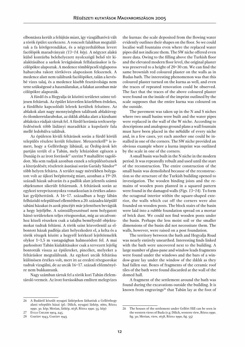
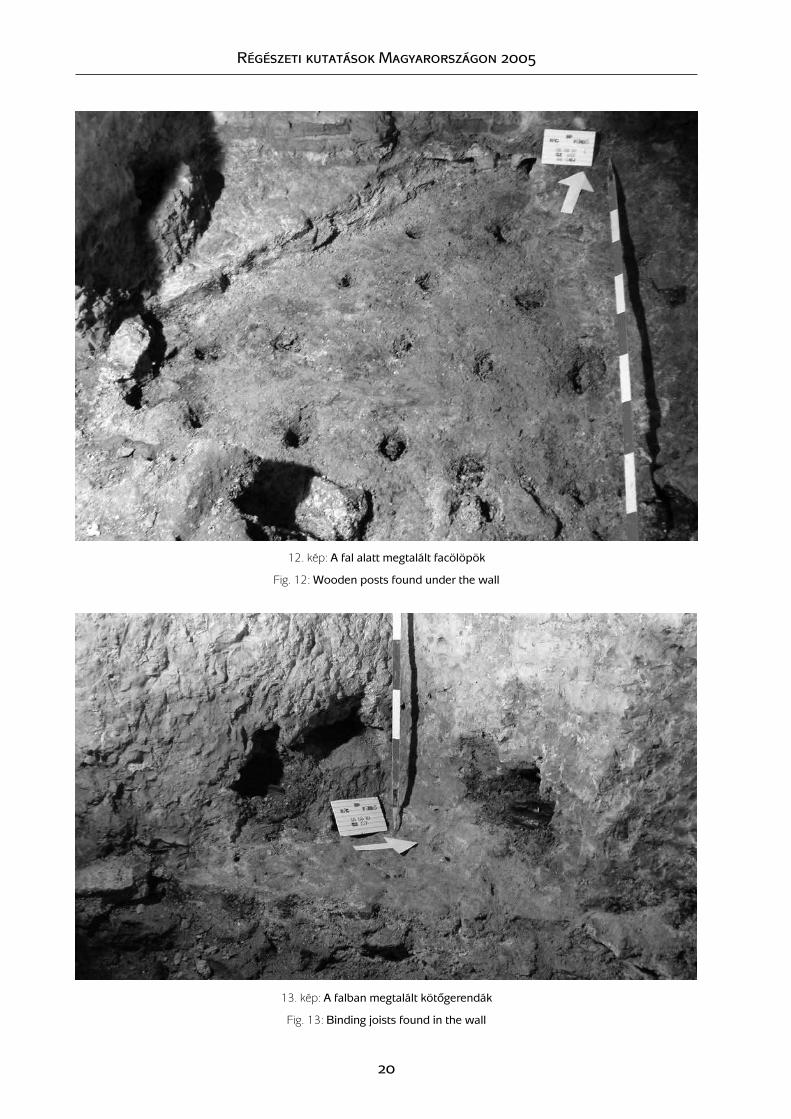
elbontásra került a felújítás miatt, így vizsgálhatóvá vált a török épület szerkezete. A roncsolt falakban megtalál-tuk a fa kötôgerendákat, és a négyzethálóban levert facölöpök maradványait (13–14. kép). A négyzet alakú külsô kontúrba belehelyezett nyolcszögû belsô tér ki-alakításához a sarkok levágásának felfalazásakor is fa-cölöpökre alapoztak. A medence tömblépcsôi téglaporos habarcsba rakott törtköves alapozáson fekszenek. A medence alatt nem találtunk facölöpöket, talán a kevés-bé vizes talaj, és a medence kisebb fesztávolsága nem tette szükségessé a használatukat, a falakat azonban már cölöpökre alapozták.
A fürdô és a Hegyalja út közötti területet szinte tel-jesen feltártuk. Az épület közvetlen közelében érdekes, a fürdôhöz kapcsolódó leletek kerültek felszínre. Az ablakok alatt nagy mennyiségben találtunk ablaküveg- és ólomkeretdarabokat, az ılıklık ablaka alatt a kizuhant ablakrács rúdjait tártuk fel. A fürdô kerámia tetôcserép-fedésének több ládányi maradékát a kupolatér fala mellé ledobálva találtuk.
Az épületen kívüli feltárások során a fürdô körüli település részlete került felszínre. Metszetekrôl26 is is-mert, hogy a Gellérthegy lábánál, az Ördög-árok két partján terült el a Tabán, mely lehúzódott egészen a Dunáig és az írott források27 szerint 9 mahallére tagoló-dott. Ma sem tudjuk azonban ennek a településrésznek a kiterjedését; részleteit ásatásai során Garády Sándor28 több helyen feltárta. A terület nagy mértékben bolyga-tott volt az újkori beépítettség miatt, azonban a 19–20. századi házak udvarán és a padlók alatt jelentôs számú objektumot sikerült feltárnunk. A feltárások során az egykori terepviszonyokra vonatkozóan is értékes adato-kat gyûjthettünk. A 16–17. században a hegy lábán felhúzódó településsel ellentétben a 20. századra kiépülô tabáni házakat és azok pincéjét már jelentôsen bevágták a hegy lejtôjébe. A szintsüllyesztéssel nem bolygatott hátsó területeken teljes rétegsorokat, míg az utcafront-hoz közeli részeken csak a talajba bemélyedô objektu-mokat tudtuk feltárni. A török szint közvetlenül az el-bontott házak padlója alatt helyezkedett el, a kelta és a török rétegek között a hegyrôl leérkezô lejtôtörmelék olykor 1–1,5 m vastagságban halmozódott fel. A mai parkosított Tabán kialakításakor csak a tervezett lejtôig bontották vissza az épületeket, pincéket, melyeket a feltáráskor megtaláltunk. Az egykori utcák feltárása különösen értékes volt, mert itt az eredeti rétegsorokat tudtuk vizsgálni, de az utcák 16–17. századi elôzményé-re nem bukkantunk.
Nagy számban tártuk fel a török kori Tabán élelem-tároló vermeit. Az írott forrásokban említett melegvizes
26 A Budáról készült nyugati látképeken láthatóak a Gellérthegy alatti település házai (pl.: Dilich, nyugati látkép, 1660, Rózsa 1990. 30. kép; Merian, látkép, 1638, Rózsa 1990. 55. kép)
27 Evlia Cselebi 1904, 245.28 Garády 1943, Garády 1945
the kurnas: the scale deposited from the lowing water evidently outlines their shapes on the loor. So we could localise wall fountains even where the replaced water pipes did not indicate them. The SW niche offered even more data. Owing to the illing above the Turkish loor and the elevated modern loor level, the original plaster was preserved to a height of 20–30 cm. We can ind the same brownish red coloured plaster on the walls as in Rudas bath. The interesting phenomenon was that this coloured plaster turned on the kurna as well, and even the traces of repeated renovation could be observed. The fact that the traces of the above coloured plaster were found on the inside of the imprint outlined by the scale supposes that the entire kurna was coloured on the outside.
The pavement was taken up in the N and S niches where two small basins were built and the water pipes were replaced in the wall of the W niche. According to descriptions and analogous ground plans a wall fountain must have been placed in the m8iddle of every niche and, in a few cases, yet each another one could be in-stalled in one of the corners. The SW niche provided an obvious example where a kurna imprint was outlined by the scale in one of the corners.
A small basin was built in the N niche in the modern period. It was repeatedly rebuilt and used until the start of the reconstruction. The entire construction of the small basin was demolished because of the reconstruc-tion so the structure of the Turkish building opened to investigation. The wooden binding joists and the re-mains of wooden posts planted in a squared pattern were found in the damaged walls (Figs. 13–14). To form the octagonal interior within the square-shaped exte-rior, the walls which cut off the corners were also founded on wooden posts. The block stairs of the basin were laid into a rubble foundation spread on a mortar of brick dust. We could not ind wooden posts under the basin. Perhaps the less moist soil or the smaller dimensions of the basin did not necessitate them. The walls, however, were raised on a post foundation.
The territory between the bath and Hegyalja Road was nearly entirely unearthed. Interesting inds linked with the bath were uncovered next to the building. A large number of glass-pane and window leads fragments were found under the windows and the bars of a win-dow-grate lay under the window of the ılıklık as they had fallen out. Boxes of fragments of the ceramic roof tiles of the bath were found discarded at the wall of the domed hall.
A fragment of the settlement around the bath was found during the excavations outside the building. It is known from engravings26 that Tabán lay at the foot of
26 The houses of the settlement under Gellért Hill can be seen in the western views of Buda (e.g. Dilich, western view, Rózsa 1990. ig. 30; Merian, view, 1638, Rózsa 1990, ig. 55)

Régészeti kutatások Magyarországon 2005
1�
kutakat egyértelmûen nem tudtuk azonosítani, mert egyik feltárt gödörben/veremben sem jelent meg a víz. Ismert, hogy a 20. sz. második felében folytatott ipari bányamûvelés miatt a Gellérthegy forrásainak vízhoza-ma és vízszintje is csökkent, de néhány éve megfordult ez a tendencia és újra elkezdett emelkedni. Elképzelhetô, hogy a ma száraz, mély gödrök egykor vizet adtak.
A leletanyagban a díszkerámiát a sgrafitos tálak képviselik, izniki fajanszoknak csak nagyon kisméretû töredékekeit találtuk. Érdekes késôi leletegyüttest rejtett a 30�. sz. objektum, amelybôl több talpas tál mellett habán edények is felszínre kerültek.
A leletanyag elôzetes áttekintése és a rétegviszonyok alapján megállapítható, hogy a településrész csak a fürdô megépítését követôen épült ki a kutatott területen, középkori elôzmény nélkül.
Gellért Hill on both sides of Ördög-árok and it extended to the Danube. According to written sources,27 it was divided into 9 malhalles. We do not know the extent of this part of the settlement. S. Garády28 unearthed its fragments at several places. The area was seriously disturbed by modern constructions, yet a signiicant number of features could be uncovered in the yards and under the loors of houses of the 19th–20th centuries. We could also collect important data on the contemporary geographical setting. Unlike in the 16th–17th centuries when the settlement had stretched to the foot of the hill, the houses that were raised in Tabán in the 20th century and their cellars were already cut deep into the slope of the hill. We could observe complete layer se-quences at the back of the houses, where the surface was not disturbed with the sinking of the surface, while only features dug into the soil could be uncovered closer to the street front. The Turkish level appeared just under the loors of the demolished buildings and the piedmont deposit sometimes accumulated in a thickness of 1–1.5 m between the Celtic and the Turkish layers. The buildings and the cellars were pulled down only to the planned slope when the modern parked Tabán was developed, and they were found during the excavations. The excavation of the one-time streets was especially interesting since we could examine the origi-nal layer sequences. However, we did not ind the ante-cedents of the streets from the 16th–17th centuries.
A large number of food storage pits of the Turkish period Tabán were unearthed. The hot-water wells men-tioned in the written sources could not evidently be identiied since no water appeared in any of the un-earthed pits. It is well-known that the water output and the level of the springs of Gellért Hill sank in consequence of the industrial mining in the second half of the 20th century. A few years ago, however, this trend reversed and the water level started to rise. It is possible that the dry and deep pits were once illed in with water.
Graphitic bowls represent the ornamental ceramics in the ind material, while only very tiny fragments were found from Iznik faience wares. Feature no. 30� con-tained an interesting late ind assemblage, from which a number of pedestalled bowls and Habán wares were recovered.
It can be ascertained from the preliminary analysis of the inds and the layer sequence that the settlement fragment was built only after the construction of the bath and it did not have medieval antecedents.
27 Evlia Cselebi 1904, 24528 Garády 1943, Garády 1945

Régészeti kutatások Magyarországon 2005
14
Irodalom l References
Bónis 1950 B. Bónis É.: Jelentés a Fôvárosi Régészeti Intézet 19�6–�7. évi gellérthegyi ásatásairól. BudRég 15 (1950) 335–351.
Bónis 1969 B. Bónis, É.: Die spätkeltische Siedlung Gellérthegy-Tabán in Budapest. ArchHung �7 (1969)
Bónis 1971 B. Bónis, É.: Die chronologische Einreihung der spätlatènezeitlichen Siedlung Buda-pest-Gellérthegy. In: Actes du VIIe Congrès ... Prague 1966. Red.: J. Filip (Prague 1971) Vol. 2. 905–907.
Budapest Mûemlékei I. Budapest Mûemlékei I., szerk.: Pogány Frigyes, Budapest 1955. 73�–738.Evlia Cselebi Evlia Cselebi török világutazó magyarországi utazásai 1660–166�. ford.: Karácson
Imre, Budapest 190�.Eyice 1960 Eyice, S.: Iznik’de „Büyük hamam” ve Osmanlı devri hamamları hakkında bir dene-
me. Tarih Dergisi 1960. 99–120.Garády 1943 Garády S.: Jelentés az 1936–�2 évben végzett ásatásokról. BudRég XIII (19�3) �03–�38.Garády 1945 Garády S.: Budapest területén végzett középkori ásatások összefoglaló ismertetése
1931–�1. II. rész. BudRég XIV (19�5) 397–��8.Gerô 1980 Gerô Gy.: Az Oszmán-török építészet Magyarországon. Budapest, 1980, 96–98.Holló 1994 Holló Sz.: Budapest régi térképeken. (Budapest 199�)Horusitzky1935 Horusitzky F.: Adatok az Ördögárok-völgy krisztinavárosi - tabáni szakaszának hidro-
lógiájához. Hidr. Közl. (1935)Jalsovszky–tomsics 2003 Jalsovszky K. – Tomsics E.: Budapest az ikerfôváros 1860–1890. (Budapest, Helikon
2003)Molnár 1973 Molnár J.: A budai Rác-gyógyfürdô. Mûemlékvédelem 1973 1. sz. 27–29.Mócsy 1968 Mócsy A.: A gellérthegy - tabáni telep és az eraviszkuszok problémája. AntTan 15
(1968) 275–279.Nagy 1936 Nagy L.: Tabán a régészeti ásatások világában. Elôzetes jelentés az 193�–35. évi ása-
tásokról. TBM � (1936) 18–29.Nagy 1942 Nagy L.: Az eraviszkusz kultúra emlékei Budapest környékén. In: Budapest története
I. (Budapest 19�2) 236–265.Pécsi 1958 Pécsi M. (szerk.): Budapest természeti képe. (Budapest, 1958)Rózsa 1963 Rózsa Gy.: Budapest régi látképei (1�93–1800). Budapest, 1963.Rózsa 1990 Rózsa Gy.: Budapest régi látképei (1�93–1800). Budapest, 1990.Sudár 2003 Sudár B.: Török fürdôk a hódoltságban. Történelmi Szemle XLIV (2003) 3–�, 213–
263.

Régészeti kutatások Magyarországon 2005
15
1. kép: Budapest, Rác fürdô – az ásatás helyszínrajza
Fig. 1: Budapest, Rác bath – plan of the excavation

Régészeti kutatások Magyarországon 2005
1�
2. kép: Budapest, Tabán, késô La Tène kori telep és környékének rekonstruált domborzati és ôsvízrajzi térképe. 1: tabáni fazekastelep, 2: gellérthegyi oppidum, 3: Várhegy, késô La Tène kori magaslati telep nyomai.
Fig. 2: Budapest, Tabán, the reconstructed geographical and palaeohydological map of the late La Tène period settlement and its environment. 1: pottery workshop of Tabán, 2: oppidum on Gellért Hill,
3: Castle Hill, traces of the late La Tène hill settlement.
3. kép: A tabáni késô La Tène kori település helyszínrajza Budapest 1873. évi kataszteri felmérésén. 1: az 1935–36-ban feltárt kelta objektumok; 2: Bónis É. 1950. évi ásatásának helye; 3: a 2005–2006. évi ásatások során elôkerült településrész.
Fig. 3: Map of the late La Tène period settlement on the cadastre survey of Budapest from 1873. 1: Celtic features unearthed in 1935-36, 2: the site of É. Bónis’ excavation in 1950, 3: settlement fragment uncovered in 2005-2006.

Régészeti kutatások M
agyarországon 2005
1�
4. kép: A török fürdô alaprajzi elhelyezkedése a mai épületben, a török kori falak jelölésével
Fig. 4: The position of the Turkish bath in the ground plan of the modern building with the indication of the Turkish period walls

Régészeti kutatások Magyarországon 2005
1�
5. kép: A forrás sziklahasadéka, kétoldalt a török forrás-foglalás falai látszanak
Fig. 5: The rock issure of the spring with the walls of the Turkish spring capture on the two sides
6. kép: Török falfülke, törökkori vakolatmaradvánnyal
Fig. 6: Turkish niche with the remains of Turkish period plaster
7. kép: Török kutacska, elôtte a török padló részletével
Fig. 7: Small Turkish well with a fragment of the Turkish pavement in front of it

Régészeti kutatások Magyarországon 2005
1�
8. kép: A sıcaklık épen felszínre került török kôpadlója
Fig. 8: The intact Turkish stone pavement of the sıcaklık
9. kép: A sıcaklık nyolcszög alaprajzú, a nyolcszög minden oldalánál egy-egy szamárhátíves fülke található
Fig. 9: The octagonal sıcaklık with an ogee-arched niche at each side of the octagon
10. kép: A sıcaklık bejáratával szemben látható fülkekompozíció: a középsôben helyezték el a medence
betöltésére szolgáló csövet
Fig. 10: Niche composition facing the entrance of the sıcaklık: the pipe that carried water to the basin was laid
in the central one.
11. kép: A medence alatt feltárt csatornarendszer, melyet kôbôl és fából készítettek
Fig. 11: Stone and wooden canal system unearthed under the basin
HA RÖVIDÍTENÉNK A 9-10. KÉP ALÁÍRÁSAIT, TÖBB FÉRNE BE A
KÉPEKBŐL, ÉS JOBBAN EL LEHETNE RENDEZNI ŐKET
Régészeti kutatások Magyarországon 2005
20
12. kép: A fal alatt megtalált facölöpök
Fig. 12: Wooden posts found under the wall
13. kép: A falban megtalált kötôgerendák
Fig. 13: Binding joists found in the wall

Régészeti kutatások Magyarországon 2005
21
14. kép: A 304. objektum az alján megtalált kerámiákkal
Fig. 14: Feature no. 304 with the ceramics found on the bottom

Régészeti kutatások Magyarországon 2005
22