Archaeological Investigations of the Site of Nokonoko (2-NOK-009), District of Nokonoko, Fiji...
98
Archaeological Investigations of the Site of Nokonoko (2-NOK-009), District of Nokonoko, Nadrogā Province, Fiji Islands By Julie S. Field 1 Report prepared for the Immigration Department, Fiji Islands, the Fiji Museum, and the Nadrogā / Navosa Provincial Office 1 Department of Anthropology, University of Hawai‘i, Manoa Honolulu, USA December 1st, 2003
Transcript of Archaeological Investigations of the Site of Nokonoko (2-NOK-009), District of Nokonoko, Fiji...

Archaeological Investigations of the Site of
Nokonoko (2-NOK-009),
District of Nokonoko, Nadrogā Province, Fiji Islands
By
Julie S. Field1
Report prepared for the Immigration Department, Fiji Islands, the Fiji Museum,
and the Nadrogā / Navosa Provincial Office
1Department of Anthropology, University of Hawai‘i, Manoa
Honolulu, USA
December 1st, 2003

ii
Acknowledgements
Funding for this research was provided by the National Science Foundation
(Dissertation Improvement Grant # BCS-0106221), the University of Hawai‘i Space
Grant College (Fellowship 1997-1998), the Honolulu Branch of the American
Association of University Women (Pacific Fellowship, 2001), and the Waikato
Radiocarbon Dating Laboratory (Waikato Archaeological Dating Fund, 2002). Special
thanks must go to the Roko Tui of the Nadrogā/Navosa Provincial Office, Lote
Naikasewa, for permitting archaeological research in Nadrogā and Navosa from August
2001 to March of 2002. Research permits and advising were provided by the Fiji
Museum, and my sincere thanks go to the Director, Sagale Buadromo, past director,
Tarisi Sorovi-Vunidilo, and also the Archaeology Department, in particular Jone
Naucabalavu and Sepeti Matararaba. Use of a 4WD vehicle was permitted by Australian
National University, and my gratitude goes out to Drs. Geoff Hope (ANU) and Paddy
Nunn (USP), and also Lyndall Fisher (FASANOC).
Research at Nokonoko would not have been possible without the blessing of
Naduri village, Nadrogā. My special thanks go to the Tui Tabanivono, Ratu Jone
Ulunisau, and also the Turaga ni Koro of Naduri village, Neipote Namoqe. The results of
the excavations at the site have provided important cultural and historical information
concerning the prehistory of Fiji, and I must express my immense gratitude for the
opportunity to investigate the site further. The village of Nakalavo also played an
essential role in the work conducted at Nokonoko, and I am grateful to the Turaga ni
Koro, Epi Kunavore, for his aid and hospitality. In addition, survey, excavation, and

iii
pony transport at the site of Nokonoko was expertly conducted by Iliki Naliolali and Peni
Tanoa. My thanks go to them for their diligent and careful work at the site, without
which this project would have suffered greatly.

iv
Abstract
This report describes a series of excavations performed upon the site of Nokonoko
located within the district of Nokonoko, Nadrogā Province, Fiji. The investigation of the
site was part of a larger research project that explored the emergence and consequences
of competitive and cooperative strategies in Fijian prehistory. Excavation of ten test units
indicate that the fortification was first established ca. AD 560-645, and continuously
occupied from this period to the 19th century. The age of the site, as well as its location
atop a mountain peak, suggests the earliest establishment of a territorial stronghold in the
Sigatoka Valley. Its location also suggests an association with large expanses of
agricultural land in the valley bottom.
Environmental analyses are also compared to the archaeological record for other
sites in the Sigatoka Valley, and used to determine the presence of three modes of
habitation/subsistence: territorial strongholds, remote refuges, and agricultural production
sites. Archaeological testing of these classes in tandem with GIS-based environmental
research indicate that the Sigatoka Valley was initially occupied between Cal BC 20 –
Cal AD 80, in association with dense and predictable resources. Fortifications that
utilized natural topography, and also remote refuges, were established ca. AD 700, and
remained in use throughout the prehistoric period. Environmental refuges associated
with the effects of the LCO/LIA transition were established ca. AD 1300-1500.
Constructed fortifications that utilized an annular ditch, and which were located in the
valley bottom, appeared ca. AD 1700 – 1850.

v
Fijian Language Abstract
NA VEIKA E KUNE ENA VAKADIKEVI NI KORO MAKAWA KO NOKONOKO. Oqo nai vakamacala ni veika e kunei ena vakadidike ni kelikeli ka a vakayacori ena yavu ni koro makawa ko Nokonoko.ka rawa ni kunei ena tikina ko Nokonoko ,ena Yasana ko Nadroga,ena noda vanua ko Viti.Na vakadidike oqo e tiki ga ni dua na vakadidike levu me vakadikevi kina na veika e curu mai ka mai vakavuna na kena dikevi me macala ka vakadeitaka nai tukutukume rau vakaduavatataki ka vakatautauvatani kei nai tukutuku makawa kei Viti.Na kena mai vakadikevi na veika e a kunei (tikitiki ni kuro qele,qa ni vivili,kei na qilaiso)ena tini na qara (test pits)ka a keli ena dela ni yavu ni koro makawa oqo e kunei ni a sa tauyavutaki taumada ena yabaki AD 560 ki na 645 ka a vakayagataki ka tawani tiko me yacova sara mai nai ka 19 ni senituri.Na yabaki kei na vanua e dabe koto kina ena dua na delana cere e vakaraitaka ni oqo edua na nodrai tikotiko kai drodro ena gauna e yaco kina edua na tiko yavavala se mera sa valuti ko ira na vakaitikotiko ena bucabuca e na Sigatoka.Na vanua tale ga e koto kina e rawa ni vakadeitaka ni dua na koro era dau mai tawana ena gauna ni nodra teivaka na qele bulabula ena bucabuca. Na kena vakadikevi na veikabula e vakavolivolita e vakatautauvatataki kei na veika e kunei ena vakadidike ni kelikeli ka volai tukutukutaki tu me baleta na veikoro makawa ena bucabuca e Sigatoka ka vakadeitaki kina e tolu na ka ,e dusia na tawani kei na ka era bula kina ,na vanua era dau taqomaki se vakarurugi kina kei na veika e era teivaka.E vakadeitaka talega ni veika e kunei ena kelikeli ena kenai vakatagedegedeka muria ga na kena vakadeitaki ena misini ka vakatokai na GIS.kei na veika e vakavolivoliti ira e vakaraitaka ni asa tawani taumada na bucabuca e Sigatoka ena maliwa ni gauna mai na 20BC ki na80AD. Na veikoro ni valu ka vakayagataki kina na veidelana kei na veibucabuca me bai ni valu kai vakaruru ena gauna ni tiko yavavala era a tauyavutaki ni rauta na yabaki 700AD, ka ra a tu mera vakayagataka ena loma ni gauna taucoko ni nodra bula ni se bera ni cabe na lotu.Na kena vakayagataki na veikaga e tu vakavolivoliti ira e a tauyavutaki mai na yabaki AD 1300 ki na 1500.Na kena kelivaki nai keli me bai ni koro ena veibucabuca se ena veivanua lolovira e a mai tauyavutaki ena yabaki AD 1700 ki na 1850.

vi
Table of Contents
Acknowledgments………………………………………………………………………ii Abstract…………………………………………………………………………………iv List of Tables……………………………………………………………………………vii List of Figures…………………………………………………………………………...viii Research in the Sigatoka Valley, Fiji Islands……………..…………………………… 1 Nokonoko (2-NOK-009): Site Description and History………………………….…… 4 Subsurface Investigation………………………………………………………………. 12 Subsurface Investigation: Coring……………………………………………… 12 Test Unit 1: Summary of Deposits…………………………………..………… 14 Test Unit 1: Description of Artifacts…………..………………….…………… 18 Test Unit 1: Features……..……………………………………………………. 23 Test Unit 1: AMS Dating Results……………………………………………… 26 Feature 1: Artifact Descriptions………………………………………………... 26 Test Unit 2: Summary of Deposits…………………………………………….. 30 Test Unit 3: Summary of Deposits…………………………………………….. 30 Test Unit 3: AMS Dating Results……………………………………………… 32 Test Unit 4: Summary of Deposits…………………………………………….. 33 Test Unit 5: Summary of Deposits…………………………………………….. 32 Test Unit 5: Artifact Descriptions……………………………………………… 35 Test Unit 5: AMS Dating Results……………………………………………… 36 Test Unit 6: Summary of Deposits……………………………………………. 37 Test Unit 6: Feature 1…………………………………………………………. 39 Test Unit 6: Artifact Descriptions……………………………………………… 40 Test Unit 6: AMS Dating Results……………………………………………… 41 Test Unit 7: Summary of Deposits…………………………………………… 41 Test Unit 7: Artifact Descriptions……………………………………………… 47 Test Unit 7: AMS Dating Results………………………………………..…… 51 Test Unit 8: Summary of Deposits……………………………………………. 51 Test Unit 9: Summary of Deposits…………………………………………… 52 Test Unit 9: Artifact Descriptions……………………………………………… 54 Test Unit 10: Summary of Deposits……………………………………………. 55 Test Unit 10: Artifact Descriptions…………………………………………… 58 Test Unit 10: AMS Dating Results…………………………………………… 58 The Chronology of Nokonoko……………..………………………….……………… 59 GIS-based Environmental Analyses in the Sigatoka Valley………………………….. 60 Nokonoko: Site Function and Placement within the Sigatoka Valley Chronology… 64 The Establishment of Territorial Fortifications and Refuges………………… 69 Relocation to Environmental Refuges During Periods of Disturbance………….70 Constructed Fortifications and Undefended Production Sites…………………. 72 Conclusion……………………………………………………………………………… 73 Appendix A: Flora and Fauna of Nokonoko……...…..…………………………….…. 75 Appendix B: Ceramics of Nokonoko…..…………………………………….……….. 77 References……………………………………………………………………………….86

vii
List of Tables
Table 1.1. List of artifacts recovered from the coring…………………………………. 13
Table 1.2. List of Artifacts for Test Unit 1, 0-85cmbs………………………………. 17
Table 1.3. List of human remains recovered from Test Unit 1, 0-85 cmbs………… 19
Table 1.4. List of AMS dates for the site of Nokonoko………………………………. 27
Table 1.5. Artifacts recovered from Test Unit 5…………………………………….… 34
Table 1.6. Artifacts from Test Unit 6……………..…………………………………… 38
Table 1.7. Artifacts of Test Unit 7……………..…………………………………….. 45
Table. 1.8. Faunal remains from Test Unit 7…………………………………………. 48
Table 1.9. List of artifacts from Test Unit 9…………………………………………. 53
Table 1.10. Artifacts of Test Unit 10…………………………………………………. 57
Table 2.1. List of decorative attributes recorded for the lips and rims of ceramic vessels from Nokonoko………………………………………………………………. 80 Table 2.2. Temper types and variations in density and grain-size recorded in the classification of ceramic vessels for Nokonoko………………………………………. 81 Table 2.3. Summary of vessel attributes for all vessels recovered from Nokonoko… 83

viii
List of Figures
Figure 1.1. Archaeological sites of the Sigatoka Valley…………………………… 2
Figure 1.2. Agricultural features of the Sigatoka Valley……………………………… 3
Figure 1.3. Map of the district of Nokonoko, Nadrogā Province.………..….……….. 8
Figure 1.4. Aerial photo of the site of Nokonoko……………………………………. 9
Figure 1.5. Topographical map of the site of Nokonoko…………...……………….… 10
Figure 1.6. Map of Nokonoko, based upon original map by Palmer and Clunie (1972) 11
Figure 1.7a. The surface of Test Unit 1 at 10 cmbs……………..………..…………… 15
Figure 1.7b. Test Unit 1 at 30 cmbs…………………………………………………… 15
Figure 1.8. Profile of the west wall of Test Unit 1…………………………………… 16
Figure 1.9. Lithics of Test Unit 1……………..……………………………………… 21
Figure 1.10. Bowls of Test Unit 1, 0-85 cmbs………………………………………. 21
Figure 1.11. Example of decorated ceramics from Test Unit 1……………………… 22
Figure 1.12. Diagram of the features and burials of Test Unit 1……………………… 24
Figure 1.13. Diagram of the possible construction sequence for Mound 2…………… 28
Figure 1.14. Profile drawing of Test Unit 3…………………………………………… 31
Figure 1.15. Profile of west wall of Test Unit 5……………………………………… 34
Figure 1.16. Parallel-paddle impressed ceramic fragment, Test Unit 5……………… 36
Figure 1.17. Test Unit 6, showing upper layer of hearth feature at 20 cmbs………… 39
Figure 1.18. Profile of stratigraphy in Test Unit 6, view to the north………………… 40
Figure 1.19a. Bowls and jars of TU 6, 0-30 cmbs…………………………………… 42
Figure 1.19b. Jars of TU 6, 30-40 cmbs……………………………………………… 43
Figure 1.20. Floor of Test Unit 7 showing bottom of hearth feature………………… 46

ix
Figure 1.21. Profile of Test Unit 7……………..……………………………………… 46
Figure 1.22a. The morphology of bowls from Test Unit 7…………..……………… 48
Figure 1.22b. Jars of Test Unit 7, 0-40 cmbs………………………………………… 50
Figure 1.22c. Jars of Test Unit 7, 40-50 cmbs………………………………………… 51
Figure 1.23. Stratigraphic layer of Test Unit 9……………………………………… 54
Figure 1.24. Bowl and jars of Test Unit 9…………..………………………………… 56
Figure 1.25. Profile of east wall stratigraphy, Test Unit 10…………………………… 57
Figure 1.26. Vessels of Test Unit 10……………...…………………………………… 59
Figure 1.27. Environmental zones of the Sigatoka Valley…………………………….. 62
Figure 1.28. Comparison of the environmental zones identified by soil/topographic analyses……………………………………………………………………………….. 65 Figure 1.29. Calibrated ages for the 2001-2002 Sigatoka Valley excavations……… 67 Figure 1.30. The distribution of earliest occupations for each excavated site according to temporal period…………………………………………………………… 68 Figure 2.1. Diagram of a ceramic jar………………………………………………… 78
Figure 2.2. Coded classification for the non-metric morphological attributes recorded for the ceramic assemblage of Nokonoko………………………………….. 79

1
Research in the Sigatoka Valley, Fiji Islands
Fiji is famous for its fortifications. Their ubiquitous presence throughout the
archipelago has led archaeologists and historians to privilege raiding and conflict as the
causal mechanism behind the development of Fijian society and history (e.g., Clunie
1977; Frost 1974; Green 1967). However, the causes of conflict have not been fully
investigated. Recent research in Fiji (e.g., Parry 1997; Nunn and Britton 2001, Nunn
2003) has suggested that environmental variations, including droughts related to the El
Niño Southern Oscillation (ENSO), and the transition between the Little Climatic
Optimum (LCO) and the Little Ice Age (LIA) ca. AD 1300 played a primary role in the
development of competitive settlement strategies in Fijian prehistory.
The research reported herein describes the archaeological investigation of
competition and conflict in Fijian prehistory. This research is focused upon the Sigatoka
Valley, located in the southwestern corner of the island of Viti Levu, Fiji.
Archaeological excavations at the mouth of the Sigatoka River in the 1960s by Birks
(1973) yielded evidence of the colonization of the region by 2640 ± 90 BP (GaK 946). In
addition, an excavation performed within the valley interior in 1972 has produced a
single radiocarbon date, that of 1000 ± 70 BP (GaK 4311) for a fortified occupation
(Palmer n.d., in Parry 1987:31). Geographical studies of fortified sites in the region were
also completed by Parry (1987), which provided the basis for subsequent work using
aerial photos, satellite imagery, and geographic information systems by the author (Field
1998, 2002, 2003). To date, this research has identified over 700 archaeological features
in the valley, ranging from fortified hill-top and lowland occupations, open villages, and
irrigated agricultural terraces (Figures 1.1 and 1.2). Given its large size, diverse

2
Figu
re 1
.1.
Arc
haeo
logi
cal s
ites o
f the
Sig
atok
a V
alle
y.

3
Figu
re 1
.2.
Agr
icul
tura
l fea
ture
s of t
he S
igat
oka
Val
ley.

4
environmental zones, and the quantity and richness of the archaeological record, the
Sigatoka Valley provides an excellent opportunity to investigate prehistoric settlement
patterns, social units, and the effects of environmental variability on the development and
persistence of warfare and conflict.
This research incorporates two bodies of data: GIS-based environmental analyses,
and archaeological excavations. Excavations were performed between August 2001 and
March 2002 at 12 sites: Korokune (Conua District, Nadrogā), Bātiri (Sigatoka District,
Nadrogā), Nokonoko (Nokonoko District, Nadrogā), Korovatuma, Bukusia, Korohewa
(Mavua District, Nadrogā), Qoroqorovakatini (Qalimare District, Nadrogā), Vitogo
(Bemana District, Nadrogā), Tatuba Cave (Namataku District, Navosa), Malua (Noikoro
District, Navosa), Nadrogā (Noikoro District, Navosa), and Madraya (Noikoro District,
Navosa). The goal of excavation was to obtain samples for radiometric dating, and thus
determine the age of fortified and unfortified settlements in the Sigatoka Valley. The
results from the excavation of Nokonoko (2-NOK-009) are the focus of this report. The
place of Nokonoko in the prehistory of the Sigatoka Valley, and the role it may have
played in the development of Fijian culture, are also discussed herein.
Nokonoko (2-NOK-009): Site Description and History
One of the largest hilltop fortifications in the lower portion of the Sigatoka Valley
is the site of Nokonoko. The site number (2-NOK-009) refers to its location in the
province of Nadrogā (Province 2), district of Nokonoko (NOK), and it is the 9th
archaeological site, out of a total of 21, to have been identified in the district. Located
atop a 280 m-forested peak with large ridges extending to the east and west, this site

5
towers over all others in the lower valley. This site is shown on British Admiralty charts
from the 1870s, and is also present on Gordon’s sketch map of the Sigatoka Valley from
his 1876 military campaign. However, Nokonoko is not mentioned in Gordon’s journals
as an occupied village during that period, and it is likely that it had been abandoned prior
to the 1870s. According to Gordon’s notes, the people of western side of the Lower
Valley were Christians that had rejected the traditional practices of warfare and
cannibalism, and supported the newly established colonial government. Knowledge that
Nokonoko had once been an important fortification was retained by the local inhabitants
however, and in later decades Nokonoko was used as a burial site for the lineage of the
Tui Tabanivono, the traditional chiefs for the district of Nokonoko, and the villages of
Naduri, Nakalavo, Qereqere, Nakubuta, Lawai, Vunatovau, and Tilivalevu. The
grandfather of the current Tui Tabanivono (Ratu Jone Ulunisau), is reported to be buried
under the highest mound of Nokonoko (sister of Ratu Jone, personal communication).
In the 1960s, the site was surveyed and mapped by Palmer as part of the Sigatoka
Valley Archaeological project. Palmer collected incised and impressed ceramic
fragments from the surface of the site, and speculated that they may be representative of
the late Navatu phase, ca. AD 1100. He also noted the great number of yavu at the site
(50+), many of which were round or oval in shape, in addition to the more typical square,
rectangular, or sub-rectangular shaped mounds. Although oval mounds are typically
associated with the Tongan house-building tradition, Palmer argued that the presence of
oval and round mounds on large sites in the high hills of the Sigatoka Valley in
conjunction with more antique ceramic forms suggested that rounded yavu design had a
much longer history in Fiji than previously suspected (Palmer 1967:6). In addition, he

6
noted that the distribution of yavu shape varied throughout the Valley, with square and
rectangular mounds predominating in the upper valley, while the middle valley
represented a transitional zone in which all types occurred in varying proportions.
Importantly, he noted that known “late” sites in the upper valley were populated
exclusively with either square or rectangular mounds, while the yavutu sites (the site
retained in oral histories as the site where the yavusa originated, or was founded)
contained a mixture of mound forms. Therefore, Palmer concluded that the oval or round
yavu form represents the earliest style, and the square or rectangular form was the result
of the influx of intrusive populations (Palmer n.d.).
With its large size and diverse archaeological features, Nokonoko has a great
potential for providing chronological indicators for the development of competition and
fortifications in the lower Sigatoka Valley. Although it is within 2 km of prime arable
land in the valley bottom, Nokonoko is located atop a steep complex of ridges, has
limited access to water, and very little arable land in its immediate surroundings. Thus,
Nokonoko was a defensive site, and its inhabitants would have been required to make the
arduous trek to and from the village in order to obtain supplies. The goal of
archaeological testing at Nokonoko was to obtain chronological data that indicated when
this site was first occupied, and whether or not the shapes of the yavu corresponded to
earlier or later temporal periods, which may be linked to changing frequencies of
interaction or warfare throughout the Sigatoka Valley.
Nokonoko is located at 1870.900 easting, and 3879.780 northing on the 1992 Fiji
Map Series, Sheet L29 (1:50,000). It is reached most easily from the village of
Nakalavo, which is located approximately 8 km north of Sigatoka Town, along the

7
Sigatoka Valley Road (Figure 1.3). A steep trail leads up the ridge behind the north side
of the village, and it bends slowly to the west as it climbs approximately 260m up to the
forest that covers the site. The track is not easy, and eroded and broken ridge-cuts
suggest that portions of the trail may have been fortified in ancient times with ditches and
embankments. Ceramics and fragments of shell (Batissa violacea) (Appendix A) are
evident along the trail, especially as it approaches the northeastern side of the site.
Figures 1.4, 1.5, and 1.6 detail the many features of Nokonoko, most of which were
placed on the map during Palmer’s 1965 survey. The site is roughly U-shaped, with three
prominent peaks that were cut and sculpted into tiered mounds. The mounds on the
western side of the site (Mounds 1 and 2) are round, with rounded platforms at their
bases. The eastern mound is rectangular with a sub-rectangular base supporting it.
Connecting the peaks are three rārā (flattened open space used for social events), two of
which are lined with rows of yavu. Three ridges extend downhill from the tiered peaks,
and these areas are also clustered with yavu and architectural terraces. Nokonoko has an
extensive view in nearly every direction, especially of the alluvial terraces surrounding
Nawamagi and Naduri villages.
Excavations were conducted at the site during September 2001. As this site is
extensive in size and diversity of features, testing was expanded to include as many
features as possible. Five cores and 10 test excavation units completed, and over 95 kg of
ceramics, shell, lithics, bone, and other materials were collected. In addition, five
charcoal samples and one riparian shell sample were collected from the excavations and
submitted for AMS dating. Any additional archaeological features that were absent from
Palmer’s original map were surveyed and sketched in.

8
Figure 1.3. Map of the district of Nokonoko, Nadrogā Province. The location of the site of Nokonoko (2-NOK-009) is indicated near the center of the image. Villages mentioned in the text are also listed.

9
Figure 1.4. Aerial photo of the site of Nokonoko, with Nakalavo village in background. Photo details the major features of the site, and also the trail that leads to the site.

10
Figure 1.5. Topographical map of the site of Nokonoko. Degree of shading indicates the changes in elevation. The locations of yavu and test excavations are also shown.

11
Figure 1.6. Map of Nokonoko, based upon original map by Palmer and Clunie (1972). Map indicates location of yavu, large mounds, and Test Units 1-10.

12
Subsurface Investigation: Coring
Coring at Nokonoko utilized a 3” bucket auger, and was focused on large mounds
and yavu that occur in both the upper and lower portions of the site. The materials that
were recovered during coring are summarized in Table 1.1. Core A was located on the
south side of the high burial mound that tops Mound 2. This mound is approximately 6
m in diameter and 3 m high, with very steep sides. The top of the mound is capped with
a thick iron panel of unknown origin and function, but which probably marks the
gravesite of one of the Tui Taba ni Vono that were buried here in either the proto-historic
or historic era. The iron panel is known locally as “Na Lali”, which refers to a time when
the panel was beaten to produce a loud, resonant sound. Elders from Nakalavo recall the
terrifying sound of the lali of Nokonoko being beaten in their youths (Tai Kara, Nayawa
Village, personal communication).
Coring of the mound produced a dark brown silty deposit within the first 40 cmbs.
All the deposits brought up in the core were screened, and 1 pottery sherd was
encountered. At 80 centimeters below the surface (cmbs), small fragments of human ribs
and charcoal were recovered. Additional fragments of human remains, charcoal, and
some shell were recovered at all depths until a blockage was reached at a depth of 178
cmbs.
Core B was located in the southwestern quadrant of Mound 1, which lies at the
extreme west end of Nokonoko. Mound 1 is quite large (10 m in diameter) and
approximately 1m high, with a flat upper surface and stone facing on the northeastern
side. Most likely this mound is actually a yavu, as four large depressions (30cm
diameter, and approx. 30 cm deep) are located along the edge of the feature in the

13
Table 1.1. List of artifacts recovered from the coring of mounds and yavu at Nokonoko.
Unit Location Max. Depth Artifact Weight (cmbs) Description (g) Core A Mound 2 0-178 human bone misc. shell charcoal ceramic 15.9 Core B Mound 1 0-85 charcoal 0.2 Core C Yavu 7 0-100 charcoal 0.3 misc. shell Core D Yavu 14 0-56 charcoal 0.4 misc. shell Core E Mound 28 0-52 charcoal 0.2
northeast and southwestern quadrants. The size and position of these depressions suggest
that they once held the wooden beams for the structure that stood upon the yavu. Coring
encountered dark brown silty sediment with clay lump inclusions, but no artifacts other
than a few fragments of charcoal. The core reached a maximum depth of 85 cmbs before
striking a rocky substratum.
Core C was positioned on top of Yavu 7, a round raised yavu located to the south
of a large tree with extensive roots. This core recovered light brown silty sediment with
charcoal inclusions from 0-40 cmbs. Between 40 and 70 cmbs, the core recovered a
bright orange oxidized sediment, with some fragments of riparian shell inside. At 1 m
depth, the core was recovering sterile sediment.
Core D was positioned on top of Yavu 14, a large (6 m diameter) round yavu that
was located on the southern edge of the First Rārā. Like Core C, this core recovered
brown silty sediment between 0 and 40 cmbs, and this deposit contained fragments of

14
riparian shell and charcoal. Past 40 cmbs the core struck a bright orange oxidized layer
that contained no artifacts, and this layer reached a maximum depth of 56cmbs before
reaching the rocky substratum.
The last coring was located on top of Mound 28, a large sub-rectangular mound
which rises approximately 1.5 m above a sub-rectangular terrace. Mound 28 is flat on
top, and a few small trees and shrubs growing on its surface. Core E was located near the
center of the mound, but did not produce any definably cultural material. A dark brown
silty layer was encountered at the surface, but this graded to an orange oxidized layer at
20cmbs, which continued to a depth of 52 cmbs. Small fragments of charcoal were
recovered from the core.
Test Unit 1: Summary of Deposits
Test Unit 1 began as a 2 x 1 m unit located on top of Mound 2. Care was taken to
place the excavation unit to the southeast of the metal panel that marks the historic
gravesite of one of the previous Tui Tabanivono. The purpose of excavating in this area
was to determine whether the highest burial mound indeed dated to the historic period, or
if it was used in prior centuries as a yavu site. Unit 1 was oriented at 60°
(northeast/southwest), and its surface was covered with thick grass and a scattering of
large cobbles that had slid down from the peak of the mound (Figure 1.7a, b).
The sediment did not demonstrate any layering, and throughout the excavation the
fill remained a dark brown (10YR 3/3) silty clay loam with red and yellow clay mottles.
Between the surface and 90 cmbs there were no discernable cultural features, although
artifact frequencies generally increased with depth (Figure 1.8) (Table 1.2). Ceramics,

15
Figure 1.7a. Test Unit 1, atop Mound 2. Excavation level at 10 cmbs
Figure 1.7b. Test Unit 1. Excavation was discontinued in the southern half of the unit after 20 cmbs, and TU1 was transformed into a 1 x 1 m unit.

16
Figure 1.8. Photo of fill of Mound 2, seen in the west wall of TU1. Depth 90 cmbs.
charcoal, riparian shell, mammal bone, and fragments of human bone were all present in
modest amounts. Fragments of stone adzes were recovered from between 74 and 84
cmbs, and 3 fragments of green bottle glass were recovered from a depth of 45 cmbs.
The general homogeneity of the deposits, as well as the occurrence of historic glass
suggests that the upper 90 cm of the mound represents a single construction event,
perhaps dating to the mid 19th century. However, a fragment of charcoal from the
deepest feature (a human burial, at 95-104 cmbs) dates to the 14th century AD. This
earlier feature suggests that the mound has been used for several burials over the
centuries, and has subsequently been enlarged and capped following each subsequent
inhumation. More detailed information concerning the artifacts recovered from the
general deposits of the mound are provided below.

17
Table 1.2. List of Artifacts for Test Unit 1, 0-85 cmbs.
Layer Level Depth Artifact Description Weight (cmbs) (g) I 1 0-20 charcoal 17.2 I 1 0-20 misc. shell 3 I 1 0-20 human bone fish bone unidentified mammal bone 33 I 1 0-20 ceramic 138.3 I 2 20-33 misc. shell 46.6 I 2 20-33 human bone 13.3 unidentified mammal bone I 2 20-33 charcoal 24.1 I 2 20-33 ceramic 71.4 I 3 33-44 misc. shell 133 I 3 33-44 charcoal 31.6 I 3 33-44 ceramic 83 I 3 33-44 human bone human teeth unidentified mammal bone 17.1 I 4 45 glass 8.3 I 4 44-54 charcoal 44.9 I 4 44-54 lithic flake 0.8 I 4 44-54 ceramic 113.6 I 4 44-54 misc. shell 283.9 I 4 44-54 pig (Sus scrofa) tooth unidentified mammal bone 8.7 I 5 54-62 human bone
human teeth pig (Sus scrofa) teeth 19.6 I 5 54-62 adze fragment 5.5 I 5 54-62 misc. shell 261.5 I 5 54-62 glass 18.7 I 5 54-62 charcoal 44.3 I 5 54-62 ceramic 88.9 I 6 62-74 adze/pounder fragment 9.5 I 6 62-74 misc. shell 138.3 I 6 62-74 charcoal 74.6 I 6 62-74 human bone human teeth unidentified mammal bone 39.9 I 6 62-74 ceramic 125.5 I 7 74-84 ceramic 46.8 I 7 74-84 charcoal 41 I 7 74-84 human bone

18
Layer Level Depth Artifact Description Weight (cmbs) (g) Pig (Sus scrofa) tooth unidentified mammal bone 39.9 I 7 74-84 adze fragment 1.8 I 7 74-84 misc. shell 73.3
Test Unit 1: Description of Artifacts
Human Remains
Table 1.3. details the number, weight, and kinds of human remains that were
encountered in the general fill of the mound. The remains were from several individuals
of various ages, and most likely represent a secondary deposit (i.e., the remains were
probably buried in some other part of Nokonoko, and were redeposited as fill when the
mound was made or re-capped with additional soil). The remains include rib fragments,
cranium fragments, burned long-bone fragments, several teeth, and also the mental
protuberance (chin) of a child’s mandible. There was also a great deal of fractured bone
that was not unidentifiable, but may have also been human. Several of the long bone
fragments had been burned.
Faunal Remains
Very small amounts of faunal remains were found amongst the fill of the mound.
A single unidentified fish bone was recovered from between 0-20 cmbs, and throughout
the rest of the deposits the remains consisted of the teeth and leg bones of pig (Sus
scrofa) (Appendix A). Other crushed and broken bones that were found in the mound
deposits may also have been fractured pig bones, however they were two fragmentary to

19
Table 1.3. List of human remains recovered from Test Unit 1, 0-85 cmbs.
Layer Level Depth Number of Elements Age Sex cmbs I 1 0-20 1 rib fragment adult unknown 2 crania (skull) fragments adult unknown I 2 20-33 4 crania (skull) fragments adult unknown 4 long bone fragments (burned) adult unknown I 3 33-44 1 rib fragment (proximal tip) adult unknown 1 molar adult unknown 1 crania (skull) fragment adult unknown 5 rib fragments adult unknown I 5 54-62 1 mandible (jaw) fragment child 1-3 years unknown (mental protuberance, with incisors) 2 deciduous incisors child 1-3 years unknown 1 premolar, heavily worn elderly adult unknown 1 molar adult unknown 2 crania (skull) fragments adult unknown I 6 62-74 1 molar (burned) adult unknown 2 premolars adult unknown 4 crania (skull) fragments adult unknown 4 metatarsals (foot) adult unknown 6 rib fragments adult unknown I 7 74-84 1 rib fragment adult unknown 1 crania (skull) fragment adult unknown 1 mandible (jaw) fragment adult unknown 1 molar fragment adult unknown
be identified. Riparian (freshwater) molluscs were also found throughout the deposits,
and consisted of the locally available river clam, (Batissa violacea), and also the river
snails sici moto (Melanoides spp.), and takau (Neritina spp.) (Appendix A). Some
fragments of unidentified land snails were also recovered.

20
Lithics
Several fragments of stone adzes and pounders were recovered from the general
deposits of Test Unit 1. At 44-54 cmbs, a single flake of basalt was encountered.
Between 54 and 84 cmbs, 3 fragments of either adzes or hammerstones were recovered.
All were composed of rough grey basalt, which was occasionally flecked with pyroxene
(Figure 1.9).
Ceramics
The ceramics that were recovered from the fill deposit are typical of the late-
prehistoric bowl and jar styles that were common throughout Fiji in the 18th and 19th
centuries. One hundred and thirty-nine ceramic fragments were recovered from between
the surface and 85 cmbs, and show a continuous distribution of approximately 20 sherds
per 10 cm. Of the entire assemblage between 0 and 85 cmbs, 6 were fragments of the
rims or necks of vessels. Two fragments were complete enough to reconstruct the
morphology of the original vessels (#s 54, 55) (Apendix B.). Both of these vessels are
bowls, one of which has a decorated rim (Figure 1.10). Both of these vessels have square
lips, and are of sizes that are similar to modern dari, which are used for serving yaqona.
Six sherds were recovered that were also decorated, and all of these were either
body or neck fragments. Decorations included incising, wiping, parallel paddle
impressing, and end-tool impressing (Figure 1.11). These fragments were recovered
from throughout the fill deposit.

21
Figure 1.9. Lithics of Test Unit 1. A: 44-54 cmbs; B: 54-62 cmbs; C: 62-74 cmbs; D: 74-84 cmbs; E: 84-95 cmbs.
Bowl # 54, TU1, 20-30 cmbs Temper Class: 1
Bowl # 55, TU1, 2-30 cmbs Temper Class: 1
Figure 1.10. Bowls of Test Unit 1, 0-85 cmbs.

22
Figure 1.11. Example of decorated ceramics from Test Unit 1. A: incised rim; B: end-tool impressed rim; C: wiped neck; D: parallel paddle impressed.
Historic Items
A handful of historic items were recovered from the mound fill at depths of 45
cmbs. These consisted of 3 glass bottle fragments, most likely from 19th century
imported whisky bottles. The fragments recovered were portions of square-sided bottle
bases. A single fragment of the shoulder of a similar bottle was recovered from between
54 and 62 cmbs.

23
Test Unit 1: Features
Several features related to human burials and a possible pit feature were
encountered in the deposits between 95 and 105 cmbs. At 95 cmbs, a concentration of
human bone fragments and a pit feature was encountered in the southeast quadrant of
TU1. The pit feature (Feature 1) consisted of a 10 cm lens of soft dark reddish brown
silty clay loam (5YR 3/2) that was approximately 19 cm in diameter with a thick layer of
charcoal around the edge. This feature was potentially a small hearth that was
constructed prior to the creation of the mound, or the location of an object that was
burned in situ. It seems unlikely that this feature represents the base of a house post, as
there is no indication for the presence of a vertical post in the deposits above this feature
(Figure 1.12).
Also in context with the pit/hearth feature was a concentration of human bone
fragments (Burial 1). These remains were located immediately to the north of Feature 1,
and consisted of an infant burial, with the rib cage, spinal column, and several long bones
intact and in anatomical position. This feature was pedastalled for documentation but
was accidentally removed by excavators prior to in-situ photo. However, the fragments
of bone were collected, and upon analysis revealed to be the remains of a young child,
perhaps younger than 2 years of age. The remains were in good condition, and there was
no evidence of burning or cut-marks. Clustered amongst the remains were several adult
phalanges (6 distal phalanges (finger tips), and also a single 3rd phalanx), and a fragment
of a pig tooth. The child’s cranium was absent from the burial, although it is possible this
element did not preserve. The presence of human phalanges amongst the concentration
suggests the practices of lolokunimate, in which the relatives of the deceased amputated

24
Figure 1.12. Diagram of the features and burials of Test Unit 1, between 95 and 105 cmbs.
all or portions of their fingers as an act of mourning, and buried the fingers with the
remains of their relative (Williams 1884:169).Following the removal of the contents of
Feature 1 and Burial 1, the excavation continued into the deposits between 95 and 105
cmbs. At 104 cmbs,a portion of an articulated human skeleton was encountered in the
eastern portion of the unit (Burial 2). The remains consisted of an adult that had been

25
positioned on his/ her right side, facing downhill from the mound with his/her legs
extended to the north. The left femur, pelvis, and ribs from the left side of the individual
were clearly visible in the eastern half of Test Unit 1, although they were extremely
fragmented, and in a poor state of preservation. Samples of the femur, pelvis, and ribs
were collected for study. Unfortunately, the fragmented nature of the remains did not
allow for the determination of the sex of the individual. However, the remains are
definitely those of an adult, and the size of the remains is indicative of a female.
Immediately to the west of the remains was a large burned surface, which contained
fragments of burned wood and toto nutshell (Aleurites moluccana), but no ash. This
hearth (Feature 2) appears to have been placed atop the pelvis/lower back area of the
Burial 2, and the remains appear to have been slightly disturbed by the intrusion of this
feature. However, there is no evidence that the remains were burned or altered by the
heat of the fire, which may suggest that the hearth was only used temporarily. Its surface
was roughly 20 x 20 cm in size, and approximately 2 cm thick.
Excavation in the southwestern portion of the unit encountered a deposit of rocky
clay at 105 cmbs, which may be the remains of the original hilltop sediment. Excavation
to a similar depth in the northwest corner of the unit encountered a fragment of green
glass amongst additional fill deposits. The presence of glass and continued fill in this
portion of the unit indicates that the fill of the burial mound may be deepest at its center.
However, due to time constraints the excavation of Test Unit 1 was halted at 105 cmbs.
The lack of stratigraphy, and also the presence of historic artifacts, indicates that the
upper 95 cm of Mound 2 was the result of a single construction event, most likely related
to the burial of one of the previous chiefs of Nokonoko. However, Burials 1 and 2 and

26
Feature 2 may not be related to this event, and may in fact predate the construction of the
mound by several centuries.
Test Unit 1: AMS Dating Results
A sample of wood charcoal from Feature 2 was submitted for AMS dating as
sample AA50283. The resulting date of 1311 ± 39 BP indicates that the earliest deposits
encountered in the mound significantly pre-date the historic period (Table 1.4). At 2σ,
the charcoal sample has a 95.4% probability of originating from between Cal AD 650 and
860. This date suggests that the charcoal of Feature 2, and most likely the remains in
Burial 2, were deposited sometime between the 7th and 9th centuries AD. The close
proximity of the Burial 1 may also indicate that the interment of the child occurred during
the same period.
However, the presence of historic bottle glass in the mixed fill deposits in the 95
cm above these burials and features suggests that Mound 2 was raised to its present
height sometime in the 18th or 19th century. The previous mound, which may have been
the foundation of a yavu that was built sometime before AD 650 AD, was modified and
capped with 1 meter of sediment as part of the interment of a high ranking individual,
most likely one of the chiefs of the Tui Tabanivono lineage (Figure 1.13).
Feature 1: Artifact Descriptions
Faunal Material
The deposits immediately surrounding Burials 1 and 2 and Features 1 and 2
contained a moderate amount of riparian snail and clamshell. Between 84 and 95 cmbs,

27
Table 1.4. List of AMS dates for the site of Nokonoko.
Lab No. Provenience Material Measured 13C/12C Calibrated Age Range
Calibrated Age Range
14C Age BP Ratio Probability Probability
Distributions (1σ)* Distributions (2σ)*
AA50287 TU 5, Wood 1492 ± 43 -26.7 Cal AD 560 - 645 Cal AD 460 - 670
20-30cmbs Charcoal
AA50283 TU 1 Wood 1311 ± 39 -25 Cal AD 685 - 775 Cal AD 650 - 860
95-105cmbs Charcoal
AA50284 TU 3 Riparian 674 ± 37 -8.7 Cal AD 1295 - 1390 Cal AD 1280 - 1400
10-20cmbs Shell
AA50288 TU 6 Wood 212 ± 37 -24.5 Cal AD 1660 - 1950 Cal AD 1640 - 1960
30-40cmbs Charcoal
AA50299 TU 7 Wood 185 ± 62 27.4 Cal AD 1660 - 1950 Cal AD 1650 - 1960
30-40cmbs Charcoal
AA50289 TU 10 Wood 135 ± 31 -24.9 Cal AD 1690 - 1920 Cal AD 1670 - 1960
10-20cmbs Charcoal
* All determinations were calibrated using the terrestrial calibration curve of Stuiver et al. (1998), with 27± 5 years subtracted from the CRA to account for the southern hemisphere offset in 14C (McCormac et al. 1998).

28
Figure 1.13. Diagram of the possible construction sequence for Mound 2. The original surface may have been formed into a yavu (A), which was later the site of Burials 1 and 2 (shown inside diagram for Test Unit 1), ca. AD 650 AD. Later a second burial (B) was placed inside the yavu, and large mound erected over it (C), ca. AD 1800. This mound was capped with stones and an iron panel. Not to scale.

29
approximately 58 g of river clamshell (Batissa violacea) and sici moto snail shell
(Melanoides spp.) was recovered, along with a few fragments of unidentified terrestrial
snail shell. Nearly double this amount was recovered between 95 and 105 cmbs, and the
assemblage also included fragments of the takau river snail (Neritina spp.).
Ceramics
Thirty-two ceramic fragments were recovered from between 84 and 105 cmbs.
Two of the fragments were from the necks of jars, and a single fragment came from the
rim of a decorated bowl (Figure 1.11, example A). This bowl has the square lip that is
typical of late-prehistoric dari (yaqona serving bowl), and it is also decorated along the
lip with an incised triangular design. This decoration technique and design also indicates
that this bowl was manufactured in late-prehistoric times, and most likely was deposited
during the final phase of mound construction at Nokonoko.
Historic Artifacts
As mentioned, a single fragment of green bottle glass was recovered form
between 95 and 100 cmbs in the northwestern portion of Test Unit 1. In addition, a
single metal fragment was recovered from between 84 and 95 cmbs. Although heavily
corroded, the object appears to be the broken blade of a metal knife. The blade is
approximately 5 cm long, and 1.5 cm wide.
Lithics
Lastly, a single fragment of a stone adze was recovered from between 84-95
cmbs. This fragment appears to be of the same material as the adze fragment recovered
from between 74-84 cmbs; a rough basalt with pyroxene inclusions. Both fragments are
pictured in Figure 1.9.

30
Test Unit 2: Summary of Deposits
Following the completion of excavations at Mound 2, the next three test units
consisted of 50 x 50 cm excavations that were focused on testing the deposits of the
surface and yavu of the Second Rārā, which is located to the northwest of the Mound 2
complex (Figure 1.6). The goal of these excavations was to obtain chronological data
that was derived from the occupation of the site, either before or after the construction of
Mound 2. Test Unit 2 was oriented at 213° and located atop a square, 15 cm high
platform that appeared to be a very eroded yavu (Yavu 3). However, upon excavation it
was determined that this feature was natural, and its shape was due to erosion caused by
wandering livestock. A single plain ceramic fragment and 4 g of riparian clamshell
(Batissa violacea) were recovered in the first 10 cm, below which lay yellow sandstone
bedrock. Excavation was terminated at 10 cmbs.
Test Unit 3: Summary of Deposits
Test Unit 3 was oriented at 117° and located on the surface of the northern edge
of the Second Rārā (Figure 1.6). This unit was also 50 x 50 cm square, and the
uppermost layer (Layer I) consisted of a dark yellowish-brown silty clay loam (10YR
3/4), at the bottom of which was a thin layer of riparian clamshells and a single ceramic
fragment (Figure 1.14). This thin layer appeared to mark an older surface of the rārā.
Approximately 70 g of the shells (Batissa violacea) were recovered at a depth of 15
cmbs, and a single fragment was submitted for AMS dating as sample AA50284. Below
this layer the deposits transitioned into an oxidized “B” horizon (Layer II), which

31
Photo of Test Unit 3, detailing west wall and shell layer.
Figure 1.14. Profile drawing of Test Unit 3. Roman numerals refer to stratigraphic layers mentioned in text.

32
consisted of a dry, friable clay. No features or artifacts were recovered in this deposit,
and excavation was terminated at 30 cmbs.
Test Unit 3: AMS Dating Results
The results of the AMS dating indicate that the shell (and consequently the
surface of the rārā upon which the shell lay) dates to 674 ± 37 BP (Table 1.4). After
calibration, this result suggests an age for the occupation of the rārā surface to between
Cal AD 1280 and 1400 (at 2σ). This date is significant, as it indicates that Nokonoko
was occupied as a habitation (complete with food refuse) between the 13th and 14th
centuries, which is in addition to the evidence for late prehistoric and historic occupation,
and the use of the site for burials and/or habitation in the 7th and 8th centuries AD.
Test Unit 4: Summary of Deposits
Test Unit 4 was also located on the Second Rārā, at 183° and atop a large round
yavu (Yavu 8) (Figure 1.6) that was positioned at the extreme north of the site, the south
side of which was flush with ground level. The shape of this yavu was evidently created
by cutting away the sloping ridge material that lay around the mound, and the top may
have also been scraped and flattened for the placement of the structure upon it. The
subsurface deposits encountered in the 50 x 50 cm excavation unit were very shallow,
with friable sandstone gravel reached at 3-4 cmbs. A single fragment of green bottle
glass and 2 g of riparian clamshell (Batissa violacea) were encountered in the surface
deposits. No datable material was obtained.

33
Test Unit 5: Summary of Deposits
Test Units 5 through 7 were located along the slopes that lay below and to the east
of the Second Rārā (Figure 1.6). The surface of these slopes contained abundant shell
and ceramic refuse, most of which had probably eroded or was thrown downslope from
the occupations above. This is especially true of Test Unit 5, which was located along a
steep (40°) slope that connects the First and Second Rārā’s, and which is also studded
with several yavu. This unit was also 50 x 50 cm square, and oriented to 271°. Its
surface layer consisted of a reddish brown silty clay colluvium with strong ped structure
and grade (Figure 1.15).
Below this layer was a thick midden deposit (Layer II) consisting of dark reddish
brown clay with abundant riparian clamshells (Batissa violacea). The bottom of this
deposit has an irregular boundary, sinking as deep as 30 cmbs near the center of the unit.
Approximately 4 kg of shell was recovered from this layer, as well as 122 ceramic
fragments (Table 1.5). Ninety-five percent of the ceramics were body sherds, and seven
were recovered that were decorated; 1 with parallel paddle-impressed markings, 1 with
crossed paddle-impressed markings, 2 with incising, and 3 with wiped necks.
Excavation of likely earlier layers in Test Unit 5 continued to a maximum depth
of 55 cmbs. Layer III consisted of a deposit of dark reddish brown silty clay (identical to
the matrix of layer II), but lacked the large amounts of shell inclusions. Upon excavation
of this layer, several instances of ceramics lying in a vertical position were encountered,
possibly the result of their being dumped down the embankment from the habitations
upslope. Thirty-four fragments were recovered from this layer, all of which were plain.
Two were rim fragments, and one was a base fragment. A small amount (2.7g) of

34
Figure 1.15. Profile of west wall of Test Unit 5. Roman numerals refer to stratigraphic layers mentioned in text.
Table 1.5. Artifacts recovered from Test Unit 5.
Layer Level Depth Artifact Weight cmbs Description (g) I 1 0-10 adze fragment 1.9 I 1 0-10 ceramic 101 I 1 0-10 misc. shell 2300 II 2 10-20 misc. shell 50.3 II 2 10-20 ceramic 79.7 II 3 20-30 ceramic 103.8 II 3 20-30 misc. shell 6.9 II 3 20-30 charcoal 2.6 III 4 30-35 charcoal 0.1 III 4 30-35 ceramic 53.3 III 4 30-35 misc. shell 9.4

35
charcoal was recovered from this layer. The basal layer of TU 5 consisted of a sterile
pre-occupation deposit. This layer was a silty clay with a high proportion of yellow sub-
angular mottles.
Test Unit 5: Artifact Descriptions
Faunal Material
All of the faunal material recovered from Test Unit 5 consisted of riparian
clamshell (Batissa violacea). The uppermost 10 cm contained the most fragments, as this
level cut into both Layers I and II. As mentioned, 2.3 kg of clamshell was recovered.
The number and weight of shells diminished as the excavation continued. Between 10
and 20 cmbs, only 50 g of shell were recovered, and between 20 and 40 cmbs the amount
dropped to 16 g.
Ceramics
Although ceramics were abundant in Test Unit 5, none of the fragments were
complete enough to allow the determination of the full morphology of the vessels. Five
fragments came from the necks of jars, however these were missing the rim portions that
are necessary for the analysis of vessel orientation and diameter. However, as was
previously mentioned, several body fragments were recovered from Layer II that were
decorated with parallel and crossed-paddle impressions (Figure 1.16). Throughout Fiji,
these designs are suggestive of pre-AD 1000 occupations.

36
Figure 1.16. Parallel-paddle impressed ceramic fragment, Test Unit 5.
Lithics
A single fragment of a stone adze was recovered from between 0 and 10 cmbs.
This fragment has been ground smooth on one side, and is composed of dense grey
basalt.
Test Unit 5: AMS Dating Results
The decorated ceramics suggest that Layer II of Test Unit 5 is of some antiquity.
A sample of wood charcoal was recovered from this layer and submitted for AMS dating
in order to test this proposition. Upon analysis, sample AA50287 provided the result of
1492 ± 43 BP (Table 1.4). This result indicates that the deposits of Layer II date to
between Cal AD 560 and and 645 (1σ). There is also a 95% probability that the results
lie in a range between 460 and 670 Cal AD (2σ). As these dates are similar to the age of
Feature 2 and Burial 2 of Test Unit 1, and they are also associated with paddle-impressed
ceramics, it appears most probable that the deposits of Test Unit 5 are derived from the

37
earliest occupations at Nokonoko. Perhaps more significantly, the dates and food refuse
(riparian clamshells) from the earliest deposits of Test Unit 1 and Test Unit 5 suggest that
that the site of Nokonoko was occupied as a habitation site as early as the 5th century AD.
The fact that the site is located atop a high and steep peak further indicates the need for
defense, even at this early stage in prehistory.
Test Unit 6: Summary of Deposits
Test Unit 6 was located on top of Yavu 33, which is located on a small terrace
approximately 60 m southwest and below the First Rārā, just slightly above a small
drainage that runs south of the site of Nokonoko (Figure 1.6). All the yavu on this terrace
consist of partially raised, rounded platforms that share their northwestern edges with the
surface of the slope behind them. TU 6 was located near the center of Yavu 33, and was
a 50 x 50 cm unit oriented at 261°. The surface layer of TU6 consisted of approximately
20 cm of very dark gray (10YR 3/2) silty clay colluvium, which contained some yellow
sandstone mottles and a moderate grade and ped structure. Approximately 447 g of
riparian clamshell (Batissa violacea) were recovered in this colluvium, as were
approximately 5 g of the riparian snail sici moto (Melanoides spp.). Fifty-one
undecorated ceramic body and rim fragments were also recovered from this layer, as was
a single fragment of unidentified mammal bone and 20 g of charcoal (Table 1.6). A
small (15 cm diameter) lens of darker colored silty clay occurred between 10 and 15
cmbs in the northwest corner of the unit, but contained no artifacts.
At 21 cmbs, the amount of sandstone pebbles increases in the deposit matrix,
thereby marking the upper boundary of Layer II. Several large ceramic fragments occur

38
Table 1.6. Artifacts from Test Unit 6.
Layer Level Depth Artifact Description Weight cmbs (g) I 1 0-10 ceramic 119.7 I 1 0-10 misc. shell 82.2 I 1 0-10 charcoal 4.4 I 2 10-20 unident. mammal bone 0.2 I 2 10-20 misc. shell 365 I 2 10-20 charcoal 15.7 I 2 10-20 ceramic 30 I 3 20-30 ceramic 207 I 3 20-30 misc. shell 254 I 3 20-30 unident. mammal bone 0.7 I 3 20-30 charcoal 14.1 Feature 1 none 30-40 misc. shell 32.7 charcoal 0.3 ceramic 229.9 I 4 30-40 ceramic 15 I 4 30-40 misc. shell 230.3 I 4 30-40 hammerstone fragment 8.5 I 4 30-40 unident. mammal bone 0.4 I 4 30-40 charcoal 2.7 I 5 40-50 misc. shell 0.3 I 5 40-50 charcoal 0.2
in this layer, and protruded partially from the western wall at a depth of 25 cmbs.
Twenty-six total fragments were recovered from between 20 and 30 cmbs in Layer II,
one of which was decorated with incising, and two others with neck wiping. Two
hundred grams of riparian clamshell, as well as a few grams of riparian snailshell were
also recovered in the deposit. Near its base, a lens of ash occurred in the northeast corner
of the unit at 20 cmbs, and by 28 cmbs this lens extended across most of the unit. This
appeared to be the upper portion of a hearth deposit, Feature 1.
39
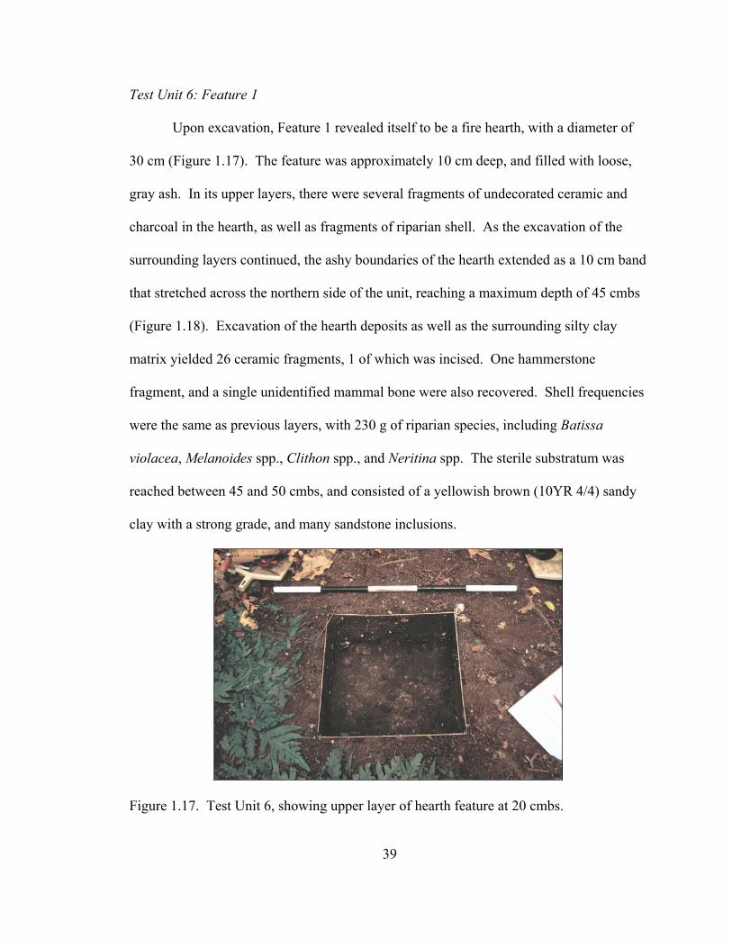
Test Unit 6: Feature 1
Upon excavation, Feature 1 revealed itself to be a fire hearth, with a diameter of
30 cm (Figure 1.17). The feature was approximately 10 cm deep, and filled with loose,
gray ash. In its upper layers, there were several fragments of undecorated ceramic and
charcoal in the hearth, as well as fragments of riparian shell. As the excavation of the
surrounding layers continued, the ashy boundaries of the hearth extended as a 10 cm band
that stretched across the northern side of the unit, reaching a maximum depth of 45 cmbs
(Figure 1.18). Excavation of the hearth deposits as well as the surrounding silty clay
matrix yielded 26 ceramic fragments, 1 of which was incised. One hammerstone
fragment, and a single unidentified mammal bone were also recovered. Shell frequencies
were the same as previous layers, with 230 g of riparian species, including Batissa
violacea, Melanoides spp., Clithon spp., and Neritina spp. The sterile substratum was
reached between 45 and 50 cmbs, and consisted of a yellowish brown (10YR 4/4) sandy
clay with a strong grade, and many sandstone inclusions.
Figure 1.17. Test Unit 6, showing upper layer of hearth feature at 20 cmbs.

40
Figure 1.18. Profile of stratigraphy in Test Unit 6, view to the north.
Test Unit 6: Artifact Descriptions
Faunal Remains
As mentioned, shell remains were abundant amongst the deposits of Test Unit 6.
Batissa violacea was the most common, and occurred in similar frequencies throughout
the cultural deposits, although in limited number in the actual hearth feature itself. Small
amounts of freshwater snail shells occurred at all levels. Three fragments of unidentified
mammal bone were also encountered in the deposits.

41
Ceramics
Of the 116 ceramic sherds recovered from Test Unit 6, nine were portions of rims
and necks that were complete enough to reveal the morphology of the original vessels.
One of these fragments was the rim of a bowl (# 77) that was recovered from between 10
and 20 cmbs. This vessel has very thin walls, and most likely expanded to a diameter of
over 40 cm. The remaining vessels were all jars, and most likely were used for cooking.
Figure 1.19a,b, reveals the shapes of the rims and necks of these vessels throughout the
deposits of Test Unit 1. For the most part all of the rims are straight in profile, and have
square lips. Vessel orifices ranged in size from 26 to 40 cm in diameter.
A few of the vessel fragments are also decorated, as mentioned above. Four of
the jar necks have wiped surfaces, which were created when the wet clay was smoothed
with a rough fabric prior to the final drying of the vessel. A single fragment has a single
incised line running diagonally across its surface.
Lithics
As mentioned, a single fragment of hammerstone (used for pounding, or making
other stone tools) was recovered from between 30 and 40 cmbs. This artifact weighs 8.5
grams, and is made of an unidentified material.
Test Unit 6: AMS Dating Results
A few grams of charcoal were recovered from Feature 1, and a single sample was
submitted for AMS dating as sample AA50288 (Table 1.4). The results indicate that the

42
Bowl # 77, TU 6, 10-20 cmbs Temper Class: 1
Jar # 76, TU 6, 10-20 cmbs Temper Class: 1
Jar # 78, TU 6, 10-20 cmbs Temper Class: 1
Jar # 79, TU 6, 10-20 cmbs Temper Class: 9
Jar # 80, TU 6, 20-30 cmbs Temper Class: 1
Figure 1.19a. Bowls and jars of TU 6, 0-30 cmbs.

43
Jar # 82, TU6, 30-40 cmbs Temper Class: 2
Jar # 83, TU 6, 30-40 cmbs
Temper Class: 2
Jar # 84, TU 6, 30-40 cmbs Temper Class: 1
Jar # 85, TU 6, 30-40 cmbs Temper Class: 2
Figure 1.19b. Jars of TU 6, 30-40 cmbs.
materials burned in the hearth dated to 212 ± 37 BP. Calibration of the results indicate
that at 1σ, the sample dates to between Cal AD 1660 – 1950 (1σ). Both the calibrations
within the 1 and 2σ for the calibration suggest that the hearth deposit dates to the late pre-
historic or historic periods. Therefore, Yavu 33 was likely constructed during this period,
and used as a habitation.

44
Test Unit 7: Summary of Deposits
Test Unit 7 was located atop Yavu 34, which like Yavu 33 is located on a small
terrace approximately 60 m southwest and below the First Rārā, just slightly above a
small drainage that runs south of the site of Nokonoko (Figure 1.4). This yavu is also a
partially raised, rounded platform that shares its northwestern edge with the surface of the
slope behind it. The surface of Yavu 34 was covered with degrading leaves and toto
nutshells, from nearby Aleurites moluccana trees. The colluvium of the surface layer was
approximately 7 cm thick, and consisted of a brown silty clay loam (7.5 YR 3/2) with a
moderate grade and a few yellow sandstone mottles. Light riparian shells occurred in the
deposit at a depth of 5 cmbs. Twenty-four ceramic fragments were recovered from Layer
I, including one with incising and one with parallel paddle-impressed decorations. A
single lithic fragment and 1.3 g of charcoal were also recovered (Table 1.7).
As in TU 6, Layer II in this excavation was hallmarked by the more frequent
occurrence of yellow sandstone mottle inclusions, occurring at a depth of 10 cmbs. The
frequency of shell, ceramics, and charcoal increases in this layer as well. Layer II was
approximately 20 cm thick, and reached a maximum depth of 28 cmbs. Five hundred and
eighty-six grams of riparian clamshells were recovered, as well as 4 lithic fragments, 34 g
of charcoal, and a single pig (Sus scrofa) tooth. Twenty fragments of undecorated body
sherds were recovered from the upper (10-20) portion of Layer II, while 54 fragments
were recovered from the lower portion (20-30), which lay directly atop an ashy layer.
One fragment each was decorated with parallel paddle-impressed decorations, end-tool
designs, and wiped surfaces.

45
Table 1.7. Artifacts of Test Unit 7.
Layer Level Depth Artifact Weight (cmbs) Description (g) I 1 0-10 ceramic 157.2 misc. shell 97.8 charcoal 1.3 I 2 10-20 misc. shell 261.3 ceramic 189.1 charcoal 2.8 I 3 20-30 ceramic 200 misc. shell 325 charcoal 31.3 pig tooth (Sus scrofa) 2.2 II 4 30-40 charcoal 1.4 misc. shell 110.4 ceramic 200 III 5 40-50 charcoal 5.8 misc. shell 422 ceramic 23.7
Layer III consisted of a layer of ash that was approximately 10 cm thick, and
contained moderate amounts of charcoal chunks, shell, and ceramics. The ash layer was
likely the ancient hearth of the structure that once stood upon Yavu 34 (Feature 1), and
the bottom of this hearth consisted of an oxidized yellow clay (likely due to heat damage)
that was irregularly pocked with several cobble-sized depressions (Figure 1.20). Most
likely these depressions represent the bases for stone supports (sue) that probably stood
upright in the hearth and served as pot stands for cooking. Fifty-three ceramic fragments
were recovered from the ash deposit that resided within the hearth. Five of these
fragments were rims and necks, and four of these demonstrated wiped surfaces. A single
body fragment exhibited parallel paddle-impressed decorations. In addition to ceramics,

46
Figure 1.20. Floor of Test Unit 7 showing bottom of hearth feature. Depressions were probably once held hearth stones (sue) for cooking.
Figure 1.21. Profile of Test Unit 7.

47
110 g of riparian clamshell, and 2 lithic fragments were recovered. A single gram of
charcoal were recovered from the hearth feature, which extended as a band at the bottom
of the hearth layer, and along the surface of what may have been the floor of the feature
(Figure 1.21).
Lastly, Layer IV lay directly beneath the hearth feature, and consisted of soft
brown silty clay that has light shell and charcoal content, and which likely represents the
original ground surface that existed prior to the construction of the yavu (but which
contains cultural deposits that were part of the erosion of colluvium downslope in
previous decades or centuries). Four hundred and twenty grams of riparian shell and 5.8
g of charcoal were recovered from this deposit, however excavation was terminated at a
maximum depth of 50 cmbs. Cultural deposits may have continued to deeper levels.
Test Unit 7: Artifact Descriptions
Faunal Remains
Table 1.8 indicates the number and weight of faunal materials that were recovered
from Test Unit 7. The riparian clam, Batissa violacea, is the most common,
and it occurs in the most amounts between the hearth deposit (Layer III) and the
subsequent deposits. A few fragments of land and riparian snail shell were recovered
from the lowest layer, which probably represent the original terrace surface that existed
prior to the construction of Yavu 34.
Ceramics
Figure 1.22a details the morphology of the bowl vessels that could be
reconstructed for Test Unit 7. A single bowl was decorated with a tool impressed lip and

48
Table. 1.8. Faunal remains from Test Unit 7.
Layer Level Depth Molluscan Mammalian Number Weight (cmbs) Species Species (g) I 1 0-10 Batissa violacea 60 97.8 I 2 10-20 Batissa violacea 150 261.3 I 3 20-30 Batissa violacea 200 325 Sus scrofa (tooth) 1 2.2 II 4 30-40 Batissa violacea 75 110.4 III 5 40-50 Batissa violacea 200 420 Melanoides spp. 3 1 Land snail 3 1
Bowl # 95, TU 7, 20-30 cmbs Temper Class: 2
Bowl # 101, TU 7, 30-40 cmbs Temper Class: 4
Figure 1.22a. The morphology of bowls from Test Unit 7.
flaring rim (# 95). This vessel fragment was recovered from between 20 and 30 cmbs. A
second bowl (# 101) is more typical of plain dari bowls, and was recovered from between
30 and 40 cmbs.

49
A diverse array of jars were represented by the fragments within Test Unit 7
(Figure 1.22b, c). A single jar (#92) had very thick walls, and a heavy inverted rim.
Most likely this vessel was used for storage, as opposed to cooking, as its thick walls and
narrow orifice would have made it slow to heat and awkward for food preparation. This
vessel was recovered from between 10 and 20 cmbs. At deeper levels, the jar vessels
were more typical of late-prehistoric cooking pots. Between 20 and 30 cmbs, the jars
were predominantly thin walled, with straight rim profiles and square lips. This includes
the fragments of three cooking vessels that were recovered from the hearth deposit (#s
102, 103, 104). A single vessel rim was reconstructed for the deposits between 40 and 50
cmbs, and this container had a curved rim profile (# 105). In general, the jars and bowls
of Test Unit 7 are typical of late-prehistoric and historic vessel forms.
As mentioned, several sherds were recovered that had paddle impressed, incised, and
end-tool designs upon their surfaces. These fragments were uncommon but scattered
throughout the deposits of Test Unit 7.
Lithics
Fragments of stone tools were also found throughout the deposits of Test Unit 7.
A single flake of unknown material was recovered from 0-10cmbs, and three flakes that
may have been broken off of pounding tools were recovered from between 10 and 20
single primary flake with cortex, and a single secondary flake, were recovered from
beneath the hearth deposit, at a depth of 45 cmbs.

50
Jar # 92, TU 7, 10-20 cmbs Temper Class: 2
Jar # 96, TU 7, 20-30 cmbs Temper Class: 3
Jar # 97, TU 7, 20-30 cmbs Temper Class: 1
Jar # 102, TU7, 30-40 cmbs Temper Class: 3
Jar # 103, TU7, 30-40 cmbs Temper Class: 3
Jar # 104, TU7, 30-40 cmbs Temper Class: 3
Figure 1.22b. Jars of Test Unit 7, 0-40 cmbs.

51
Jar # 105, TU7, 40-50 cmbs Temper Class: 1
Figure 1.22c. Jars of Test Unit 7, 40-50 cmbs. Test Unit 7: AMS Dating Results
A single sample of charcoal was collected from the hearth deposit of Test Unit 7
and submitted for AMS dating as sample AA50299 (Table 1.4). Radiometric age
determination for this sample indicated a date of 185 ± 62 BP, which upon calibration at
2σ suggests a 95.4% probability for a range of between Cal AD 1650 and 1960. As this
date is statistically identical to results generated for sample AA50288, it can be assumed
that the occupations atop Yavu 33 and 34 were contemporaneous, and represent one of
the locales of occupation at Nokonoko during the decades between the late pre-historic
and historic period, between AD 1650 and 1875.
Test Unit 8: Summary of Deposits
The remaining three test excavations were focused on the large rectangular
stepped mound on the eastern side of the site (Mound 28), and the sequence of
rectangular platforms that extended to the south along the eastern ridgeline. Test Unit 8
was located along the eastern side of Mound 28, a large (15 x 10 m) rectangular mound
with 1 m high earthen sides. Below mound 28 is a second sub-rectangular terrace that
surrounded the mound, and which serves as the foundation for three yavu (Yavu 36, 37,

52
and 38) and also a single historic grave with a stone boundary. Mound 28 and the yavu
are very prominent at Nokonoko, and lie approximately 4 meters above the surface of the
First Rārā, and outside the cover of the trees. Thus, the surface of Mound 28 and its
associated yavu are covered with shrubs and grass.
Test Unit 8 measured 50 x 50 cm, and was oriented to 84° atop Mound 28 (Figure
1.6). The surface layer was very thin, and within 10cm transitioned into sterile sandy
clay with a high incidence of clay pebble inclusions. As this excavation was located on
the top of the mound, it became apparent that the mound had been constructed by cutting
back the soil of the pre-existing promontory. Thus, the deposits on the top of the mound
are very deflated, and lack the deep accumulations associated with mounds that are
constructed be the manual redeposition of fill materials. No cultural items other than
fragments of charcoal were encountered, and excavation at TU 8 was terminated at 25
cmbs.
Test Unit 9: Summary of Deposits
Test Unit 9 was located along the slope that lays directly below and to the
southwest of the sub-rectangular terrace that surrounds Mound 28 (Figure 1.6). TU 9 was
also a 50 x 50 cm unit, and was oriented to 29°. The deposits of TU 9 were very
homogeneous, and varied most in the frequency of yellow sandstone mottles. The
surface colluvium consisted of a dark grayish brown clay with few yellow sandstone
inclusions. This layer was 5-8 cm thick, and contained some charcoal flecks, and 71 g of
ceramics, that consisted of 17 undecorated body sherds, and a single undecorated rim
sherd (Table 1.9). Below the surface colluvium lay two nearly identical layers of dark

53
Table 1.9. List of artifacts from Test Unit 9.
Layer Level Depth Artifact Weight (cmbs) Description (g) I 1 0-10 ceramic 71.7 I 1 0-10 charcoal 0.7 I 2 10-20 ceramic 75.5 I 2 10-20 charcoal 3.2 I 3 20-30 ceramic 76.5 I 3 20-30 charcoal 1.3 I 4 30-40 pig teeth (Sus scrofa) 5.4 I 4 30-40 charcoal 1.6 I 4 30-40 ceramic 33 I 5 40-50 ceramic 1.7 I 5 40-50 charcoal 0.6
grayish brown clay with frequent pebble-sized yellow sandstone inclusions. The upper
layer (layer II) was approximately 30 cm thick, and its lower boundary slopes gradually
downhill (Figure 1.23). Layer III contained an identical matrix and formation but
contained a higher frequency of small sandstone pebbles. The lower boundary of this
layer lay atop the sterile basal layer.
The artifact concentrations were the most dense in the upper levels of layer II.
One hundred and fifty-one grams of ceramics were recovered from between 10 and 30
cmbs, as were 4.4 g of charcoal. The ceramics consisted of 56 undecorated body
fragments. Between 30 and 50 cmbs, the ceramic frequency dropped to 34 g, with only
18 fragments recovered. However, only 14 of these were plain body fragments, and four
fragments of necks and rims were recovered, 2 with incised designs. In addition, 2 pig
teeth and 2 g of charcoal were recovered from the deposits between 30 and 50 cmbs. At
40 cmbs, the sterile basal layer began to emerge, and by 50 cmbs it extended across the
bottom of the unit. This deposit consisted of bright red sandy clay (7.5 YR 6/8), that was

54
Figure 1.23. Stratigraphic layer of Test Unit 9. Roman numerals refer to layers discussed in text.
very dense and with frequent sandstone inclusions. Excavation was terminated at 50
cmbs. None of the charcoal samples from this unit were submitted for radiometric or
AMS dating.
Test Unit 9: Artifact Descriptions
Ceramics
Of the 93 ceramic fragments recovered from the deposits of Test Unit 9, three
fragments were complete enough to allow the reconstruction of the morphologies of the

55
parent vessels. A single small bowl was recovered from 10-20 cmbs (# 107) (Figure
1.24). This vessel had a diameter of approximately 20 cm, and was most likely used for
food service or eating. Two jars were also reconstructed for the deposits of Test Unit 9.
Both were recovered from between 30-40 cmbs, although they vary greatly in form
(Figure 1.24). Jar # 110 has a tall curving neck, which ends in a square lip. In contrast,
jar # 109 has a very short, straight neck, and a slightly contracting square lip. Both
vessels were most likely used for cooking. As mentioned above, only 2 fragments were
recovered that were decorated. Theses ceramic fragments were decorated with a series of
incised lines, which were probably once encircled the neck of a jar vessel.
Test Unit 10: Summary of Deposits
Test Unit 10 was located atop Yavu 31, the last to occur along the southeastern
ridgeline of Nokonoko (Figure 1.6). This yavu appears to have been constructed by
cutting back and flattening the ridge, as its most northerly boundary was flush with the
surface of the ridge. The yavu is roughly sub-rectangular in shape, and its southern
boundary is raised approximately 30 cm above the natural surface of the ridge. Test Unit
10 was located near the center of the yavu, and oriented to 45°. Upon excavation, a layer
of colluvium was encountered at the surface that consisted of dark reddish brown loam
clay with frequent clay pebble inclusions. This layer was approximately 10 cm thick, and
contained 106 g of ceramics, 547 g of riparian clam and snail shell (Batissa violacea and
Melanoides spp.), and .6 g of charcoal (Table 1.10). The ceramics were unusual in that
most of them originated from a small 2 cm thick lens that was located at 10 cmbs along
the western side of TU 10 (Figure 1.25). Within this lens were the fragments of a flat

56
Bowl # 107, TU 9, 10-20 cmbs Temper Class: 1
Jar # 110, TU 9, 30-40 cmbs Temper Class: 2
Jar # 109, TU9, 30-40 cmbs Temper Class: 1
Figure 1.24. Bowl and jars of Test Unit 9.
tray-vessel. In total 89 tray and jar fragments were recovered, and of those, 83 were
undecorated body fragments. Three rim fragments were recovered, one of which was
decorated with incising. Three neck fragments were also recovered, and 2 showed
evidence of wiping.
At 10 cmbs two layers became apparent. Layer II consisted of a strong brown
silty clay loam (7.5 YR 4/6) that had no shells or artifacts present. This layer extended
northward from the “downhill” side of the unit, and was intersected by the occurrence of
Layer III. Layer III consisted of a sandy clay (10YR 4/4) with a high content of yellow

57
Figure 1.25. Profile of east wall stratigraphy, Test Unit 10. Roman numerals refer to layers mentioned in text.
Table 1.10. Artifacts of Test Unit 10.
Layer Level Depth Artifact Weight (cmbs) Description (g) I 1 0-10 ceramic 105.8 I 1 0-10 misc. shell 547 I 1 0-10 charcoal 0.6 I 2 10-20 ceramic 14.9 I 2 10-20 charcoal 0.3
sandstone pebbles and light amounts of cultural materials, which was located along the
northern edge of the unit. This layer extended to a depth of 20 cmbs, where it
transitioned into the yellow sterile substrata. Upon excavation, Layer III contained 6
undecorated ceramic body fragments, as well as .3 grams of charcoal.

58
Test Unit 10: Artifact Descriptions
Ceramics
In addition to the remnants of the flat tray, a single bowl (#118) and a single jar
(#117) could be reconstructed from the deposits of Test Unit 10 (Figure 1.26). Both were
recovered from between the surface and 10 cmbs, and both were unusually small in size.
The bowl had a diameter of approximately 25 cm, and also had thin walls and very sharp
square lip. The jar also was small and thin, and had an identical sharp lip. The co-
occurrence of these vessels in Test Unit 10 suggests they were manufactured by the same
potter, who was very skilled in producing thin-bodied vessels, and who also preferred to
include a sharp lip on the exterior portion of each vessel.
Test Unit 10: AMS Dating Results
A charcoal sample from the lowest cultural layer of Test Unit 10 was submitted
for AMS dating as sample AA50289, and the resulting age determination indicated a
deposition date of 135 ± 31 BP. Calibration of the sample produced similar results to the
dates for Test Units 6 and 7: at both 1σ and 2σ, the sample ranged in age from Cal AD
1690 to 1960 (Table 1.4). The subdivision of probabilities suggest that the later decades,
perhaps those after AD 1790, were the most likely ages for the sample. This suggests
that the construction of Yavu 31 and possibly 28-30 as well, date to the latest period of
occupation at Nokonoko.

59
Bowl # 118, TU 10, 0-10cmbs Temper Class: 1
Jar # 117, TU 10, 0-10cmbs Temper Class: 1
Figure 1.26. Vessels of Test Unit 10.
The Chronology of Nokonoko
As indicated in Table 1.4, there is ample evidence for the use of Nokonoko as a
habitation, and its history stretches back to 1500 years ago. Undoubtedly, this site has
served as a fortification in even its earliest period, as it is located atop a high, remote
peak. Life at Nokonoko would have been difficult—water must have been transported to
the site, along with all of the sustenance the people needed. One can imagine the arduous
daily treks of the ancient people of Nokonoko, who had to carry heavy baskets of tave,
dalo, and uvi, as well as bamboo filled with water. However, the great number of yavu,
and deep middens of clamshell and ceramics suggest that Nokonoko was occupied as a
village year round, and not merely a temporary remote refuge. The results of excavations
suggest that the highest portion of Nokonoko, which includes the land surrounding
Mound 2 and also the extent of the 2nd Rārā, is the oldest portion of the site. This area
was occupied as early as the 7th century AD, and only in subsequent centuries did the
village grow and extend downhill to the 1st and 3rd rārā. Nokonoko probably reached its

60
maximum size sometime in the early 1700’s, when Mounds 1, 2, and 28 were
constructed. The age and size of these mounds suggests that the inhabitants did not
choose to invest in monumental architecture until the latest phase of prehistory.
GIS-based Environmental Analyses in the Sigatoka Valley
Land classifications performed by the Fijian Dept. of Agriculture indicate that
most of the soils of the valley exist on steep and mountainous slopes, although the upper
reaches of the drainage are considerably more rugged than the Sigatoka delta. The river
has carved a variety of geological formations through the valley’s interior, including
raised planation surfaces in the upper valley, and expanses of alluvial terraces in the
lower valley. Much of the vegetation of the region consists of grasses and shrubs,
although pockets of forest exist in the drainages, and atop limestone peaks.
In prehistoric times, the inhabitants of the Sigatoka Valley subsisted on
hydrophilic crops (plants that grow in partially submerged conditions) such as dalo
(Colocasia esculenta) and via kana ‘giant swamp taro’ (Cyrtosperma chamissonis), and
dryland crops such as uvi (Dioscorea spp.), and dryland taro (Barrau 1961; Kirch 1994;
Spriggs 1982). These crops require particular conditions for high yield cultivation. With
adequate amounts of moisture and silty soils, dalo can yield approximately 20+
tons/hectare/year, and can be planted year round, and harvested every 8-10 months
(Brookfield 1979, in Spriggs 1984:129). Earthworks, such as ponded-fields (vuci) and
terraces with irrigation (tabawai) provided by nearby streams, were often installed to take
advantage of naturally productive environments and encourage vibrant growth. In
contrast, uvi and other dryland crops were cultivated in swiddens (slash and burn

61
gardens) that were well-drained and occasionally terraced to retard erosion. With
adequate amounts of rainfall, uvi and dryland taro yield between 5-15 tons/hectare/year
(Kirch 1994:8; Tindall 1983:203). However, unlike dalo, uvi are only planted at the
beginning of the wet season, and can be harvested 7-9 months later.
Sedimentological analyses of the Sigatoka Valley indicate that most soils would
have provided enough nutrients to allow for cultivation of both uvi and dalo. However,
the severity of slope, in particular the higher elevations and portions of the upper valley,
would have significantly reduced the amount of land available for cultivation. In
addition, the effects of the dry season would have made the cultivation of dalo impossible
in all but the most well-watered portions of the valley. Figure 1.27 provides a summary
image of the environmental zones of the Sigatoka Valley, based upon soil fertility and
dry season intensity. These data also suggest the existence of three zones of productivity
and agricultural risk: Zone 1) lands suited to dryland cultivation, and which also
experienced shortfalls due to severe dry seasons; Zone 2) lands suited to mixed wetland
and dryland cultivation, and which also experienced mild shortfalls due to moderate dry
seasons; and Zone 3) lands suited to wetland cultivation, and which also experienced
minimal shortfalls due to weak dry seasons.
In the short view, the results of these analyses simply suggest that the inhabitants
of the valley must have privileged one mode of cultivation over the other. However, it
also suggests that portions of the Sigatoka Valley were more restricted in terms of
cultivation strategies, and more at risk from severe, long-term droughts. These results
suggest that Zones 2 and 3 would have allowed for more temporally stable forms of
agricultural production, and Zone 1 would have been more susceptible to episodic

62
Figu
re 1
.27.
Env
ironm
enta
l zon
es o
f the
Sig
atok
a V
alle
y, a
s ide
ntifi
ed b
y so
il fe
rtilit
y an
d se
verit
y of
dry
se
ason
.

63
environment-based shortfalls. This variation is particularly important in light of recent
observations of global climatic phenomena, in particular the El Niño Southern Oscillation
(ENSO). Archaeological and historical investigations from other parts of the world (e.g.,
South America, the Middle East) have traced ENSO-related events to as early as 6000
BP, and suggest that frequencies assumed essentially modern ranges ca. 3000 BP.
(Caviedes 2001; Sandweiss 2002). According to climatologists (e.g., Nichols and Wong
1990; Salinger et al. 1995) Fiji is strongly affected by ENSO-related disturbances, and
modern droughts and cyclones (such as the 1982/83 and 1997/98 seasons) provide
models for the severity of ENSO cycles in prehistory. During these periods, rainfall was
22-42% of normal, and national production loss for sugarcane was 50%. Economic
analyses also suggest that the average income for subsistence farmers dropped from
F$3500 to F%1500 per annum (Kaloumaira 2000). If modern experienced serves as any
guide, the Sigatoka Valley (in particular Zone 1) was subject to devastation during a
severe ENSO episode. The antiquity of ENSO in the Pacific further suggests that this
cycle of devastation repeated itself throughout Fijian prehistory, providing the impetus
for human conflict over resources.
Paloeclimatic data from New Zealand caves as well as shell conglomerates in
Fijian shorelines indicate that dramatic environmental perturbations occurred in Fiji
approximately 700 years ago. These events mark the transition period between the
warmer Little Climatic Optimum (1250-700 BP) and cooler Little Ice Age (700-200 BP).
According to recent analyses in Fiji and Niue by Nunn and others (Nunn 2000a, 2000b,
2003; Nunn et al. 2003; Nunn and Britton 2001), the disturbances of the transition were

64
quite dramatic, and were marked by cooler weather and sea temperatures, and a rapid
lowering of sea level by over one meter between 730-525 BP. Nunn and Britton
proposes that these changes were devastating for both coastal and interior populations:
sea-level fall would have converted embayments to brackish wetlands, and also caused
the submersion of groundwater for the interiors of the Fiji Islands. Extensive incising of
the riverbeds and streambeds, as well as decreased soil moisture levels in many of the
alluvial terraces that supported uvi cultivation, would have resulted in dramatic reduction
of uvi yields in the lowlands. Torrential rains and floods may have also occurred in the
higher elevations.
Figure 1.28 combines the results of the analyses described above and allow for the
formulation of the following conclusions: 1) Zone 1 would have experienced the most
severe effects of ENSO-related droughts and floods, and also suffered from sea-level fall
during the LCO/LIA transition; 2) Zone 2 would have experienced moderate ENSO-
related droughts, and been affected to a limited degree by the landslides and erosion
associated with the LCO/LIA transition; and 3) Zone 3 would have only been weakly
affected by ENSO-related droughts or floods, and experienced a high/moderate amount
of erosion during the LCO/LIA transition.
Nokonoko: Site Function and Placement within the Sigatoka Valley Chronology
GIS-based analyses of the topography and agricultural resources that surround
Nokonoko suggest that production in the immediate area surrounding the site would have
poor, and allowed for only low yields of dryland crops. However, the large size and long

65
Figure 1.28. Comparison of the environmental zones identified by soil/topographic analyses with the extent of disturbance related to ENSO and the LCO/LIA transition. would have experienced severe ENSO-related droughts.

66
chronology of this village suggests that Nokonoko was associated with both defense and
production, and not purely defensive as was suggested from the analyses of Chapter 4.
As Nokonoko is within 2 km of the large alluvial expanses of the valley bottom, it is
more accurate to suggest that like Tatuba Cave, the site was established as a fortification
in association with distant (e.g., 2-3 km) production areas. However, Nokonoko’s
position on the landscape, and also the extensive nature of the arable land in the valley
bottom, indicates that the site meets the evolutionary ecology expectations outlined for
the establishment of territories: association with dense and predictable resources.
Nokonoko is also located along the boundary between Zones 1 and 2. GIS-based
analyses of the effects of ENSO and the LCO/LIA transition indicate that the arable land
in Zone 1 would have been severely impacted by floods and drought. In addition, the
drop in sea-level projected for the region ca. AD 1300 would have also damaged
cultivation. Although the site is located above the extent of damage, the episodic nature
of disturbances would have strongly affected the resource base for this region, and served
to perpetuate the use of Nokonoko as a defensive settlement. In sum, the age of the
earliest occupations on Nokonoko suggests that warfare and competition for access to
prime agricultural land existed early in prehistory (i.e., 7th century AD, or perhaps
earlier), and remained at a high level for many centuries.
Figure 1.29 displays the range of dates associated with the 12 other sites
excavated in the Sigatoka Valley. Four temporal periods are identified: T1 (2000-1500
BP), T2 (1500-1000 BP), T3 (1000-500 BP), and T4 (500-150 BP). The period proposed
for the transition between the Little Climatic Optimum (LCO) and the Little Ice Age

67
Figure 1.29. Calibrated ages for the 2001-2002 Sigatoka Valley excavations. Temporal periods T1-T4 and the position of the LCO/LIA transition are indicated. All determinations were calibrated using the terrestrial calibration curve of Stuiver et al. (1998), with 27 ± 5 years subtracted from the CRA to account for the southern hemisphere offset in 14C (McCormac et al. 1998).

68
Figu
re 1
.30.
The
dis
tribu
tion
of e
arlie
st o
ccup
atio
ns fo
r eac
h ex
cava
ted
site
acc
ordi
ng to
tem
pora
l per
iod.

69
(LIA) is also indicated in the diagram. The location of these sites in the Sigatoka Valley,
and their placement into one of four temporal categories, is indicated in Figure 1.30. In
brief, the results of archaeological investigations and environmental analyses suggest the
following chronology for the Sigatoka Valley.
The Establishment of Territorial Fortifications and Refuges
The earliest occupation in the Sigatoka Valley occurred at Tatuba Cave between
Cal BC 20 and Cal AD 80. GIS-based environmental analyses demonstrate that Tatuba
Cave is located within a region that had moderately high soil fertility, and which also
experienced a moderate dry season. In addition, Tatuba Cave had immediate access to
small tracts of land suited to dryland cultivation, and was also within a few kilometers of
much larger expanses of alluvial terraces suitable for vuci construction and dalo
cultivation. Of note, the site is located within Zone 2, but a substantial portion of its
resource base is located in Zone 1. Although Zone 1 would have been susceptible to
flooding and drought during severe ENSO cycles, the surrounding region was generally
buffered against extreme climatic phenomena. The size of the entire Tatuba Cave locale
(area, and also number of yavu and architectural features) also suggests that the area
remained desirable as an occupation site during the following two millennia (T1-T4), and
the strategy of territorialism persisted in the region.
Similarly, the sites of Nokonoko and Qoroqorovakatini suggest an association
between the founding of territorial strongholds and refuges as a response to dense and
predictable resources and environmental shortfalls. Both of these sites consist of remote
and naturally defended peaks that are over 240 m above the valley bottom, and contain

70
complex archaeological features and deposits of substantial antiquity. Nokonoko was
established as early as the 6th century AD (1492 ± 43 years BP, or T1) and
Qoroqorovakatini was constructed several centuries later (974 ± 43 years BP, or T2). In
the case of Nokonoko, the range of dates, the high frequency of yavu, and also the deep
middens of clamshell and ceramics suggest that the site was occupied throughout the
prehistoric period. Thus, this site most closely represents a territorial stronghold that was
occupied year-round. In contrast, Qoroqorovakatini contains deposits that indicate
episodic occupations, hence the site may represent a combination of remote refuge and
territorial stronghold. However, the long chronologies of Nokonoko and
Qoroqorovakatini reflect the persistence of a territorial and refuge strategy through all
temporal periods (T2-T4) relating to environmental limitations and climatic perturbations
in Fiji. Of note, the site of Korokune reflects a similar adherence to the strategy of
territorial stronghold, although this site was not established until the third temporal
period.
Relocation to Environmental Refuges During Periods of Disturbance
Four of the 12 excavated sites were established during the third temporal period
(1000-500 BP), and also within the period proposed for the transition between the
LittleClimatic Optimum and Little Ice Age (1250 – 700 BP). The increase in site
frequency during this period suggests significant population growth between periods T1
and T3. More importantly, the location of three newly founded habitations in Zones 2
and 3 suggests the development of a new strategy of habitation and subsistence that is
directly related to environmental disturbance. In particular, the environmental conditions
71
surrounding these sites, their topographic positions in remote drainages, and also the
presence of faunal material indicating a diversified resource base, are suggestive of a
distinctive and new settlement pattern focused on environmental buffering.
Malua, and Korovatuma (and perhaps also Bukusia) are emblematic of this new
trend. Both were established between AD 1300-1630, and are located atop dramatic
outcrops that provided natural defense. The surrounding lands were of moderate quality
but extraordinarily rugged. Cultivation of dalo was certainly possible, but the arable land
was restricted to ‘pocket gardens,’ (i.e., small isolated patches along minor creeks).
Neither site had access to the large tracts of alluvial deposits that were available in earlier
periods (e.g., Nokonoko, Tatuba Cave, and Qoroqorovakatini). However, environmental
analyses place these sites within Zone 2, which indicates that the resource base
surrounding these sites would not have been affected by severe drought or a reduction of
soil moisture due to sea-level fall predicted for the LCO/LIA transition. Unlike
significant portions of the valley bottom (Zone 1), cultivation of dalo and uvi in Zones 2
and 3 would have continued as normal. The timing of the founding of the sites, as well as
quality of the surrounding environment, strongly suggest that these new habitations
represent a strategy of environmental refuge relating to the effects of the LCO/LIA
transition. Cumulatively, these data suggest that the LCO/LIA transition encouraged
populations to optimize in a new way: 1) less investment in large but risk-laden
agricultural surplus, and increased focus on temporally stable resources; 2) variable
patterns of population aggregation and dispersal, perhaps coupled with mobility; 3)
diversification of the resource base; and 4) exchange or travel for non-local food items.

72
Constructed Fortifications and Undefended Production Sites
The final phase of Sigatoka Valley prehistory (period T4) witnessed the
persistence of previously established strategies (territorial strongholds, remote refuges,
and environmental refuges), and also the emergence of a new form of fortification on the
valley bottom: villages surrounded by a constructed moat and ditch. The sudden
appearance of this kind of fortification suggests the diffusion of new ideas concerning
defensive construction, and also an increasingly large population. The sites of Vitogo
and Bātiri are a case in point. Both of these sites were constructed between 260-150 BP
and are of the ‘ring-ditch’ type; (i.e., protected with an annular ditch, bank, and palisade).
Unlike previous centuries, these villages did not make use of any topographical features
for defense, but were located within swampy, riparian environments that would have
been prime locations for growing dalo. The size of annular ditch and bank construction
for these sites suggests a significant investment and labor pool: in the case of Bātiri, the
ditch was 10 m wide with a circumference of 390 m. This is a marked difference from
the fortifications of previous centuries, which employed naturally fortified positions that
required minimal initial investment, and which also did not require a sizeable population
for defense or construction tasks. Therefore, the restriction of manufactured fortifications
in the latest period is almost certainly a factor of population size, and perhaps also related
to the transmission of this innovative design throughout Fiji in the late prehistoric period.
The emergence of undefended habitation sites in the valley bottom may also be
related to population growth, and perhaps the integration of small communities with
larger territorial strongholds. The sites of Nadrogā and Korohewa are representative of
this strategy. These habitations were of small size, late age, and were located on the

73
valley bottom. No visible defenses were encountered at Korohewa, and only a modest
wall unrelated to defense was present at Nadrogā. The lack of defenses at these sites
breaks nearly two millennia of tradition for the Sigatoka Valley; for the first time,
villages did not employ topography as the first line of defense against invaders. This
omission strongly suggests that these populations were integrated with regional centers,
or were protected by another form of defense-- armed warriors. Moreover, the presence
of undefended habitation sites may be related to cooperative strategies that were
established during the establishment LCO/LIA transition. In this case, undefended
settlements may have been linked to fortifications maintained by close relatives.
Conclusion
In conclusion, the results of analyses in the Sigatoka Valley suggest that: 1)
fortifications are the result of competitive strategies that originated early in Fijian
prehistory (ca. AD 700) as a response to spatio-temporal environmental variability,
specifically the effects of the El Niño Southern Oscillation; 2) fortifications utilized
natural topography from the earliest period onwards, and this pattern persisted throughout
all temporal periods, with annular ditch style fortifications only occurring in the latest
temporal period (ca. AD 1700); 3) changes in settlement patterns ca. AD 1300 can be
linked to the LCO/LIA transition, as opposed to the influx of migrants (cf. Frost 1974).
The analytical capabilities of a GIS, in particular the analysis of landscapes via slope,
aspect, and viewshed, are shown in this research to have particular value to spatial
analysis, and can be modified to incorporate a temporal aspect. When coupled with
archaeological investigations, this approach allows for extensive analyses of the variables

74
that impinge upon subsistence and habitation. Increasing resolution of the data involved
in these kinds of analyses will undoubtedly multiply the analytical potential for
archaeological studies, and contribute more to studies of Fijian prehistory.

75
Appendix A: Flora and Fauna of Nokonoko (2-NOK-009), Fiji
The following is a list of species and identifying photos for the floral and faunal
remains recovered from the excavations at Nokonoko. All photos were taken by the
author unless otherwise specified. Descriptions of molluscan characteristics were
obtained from Haynes (2001), and identifications were aided in part by Parkinson (1982).
Information pertaining to indigenous Fijian trees was provided by the Fijian Department
of Forestry (1996).
Mollusca
Common Name: Tave or Kai waidranu (Fijian) Scientific Name: Batissa violacea Family: Unionidae Adult Size: 30-90mm Depth: brackish and freshwater Location: Common in the lower Sigatoka, Rewa, Ba, Nadi, Navua, Korovou, Dreketi, Labasa, and Waikoro rivers. Common Name: Takau or sici bolo (Fijian) Scientific Name: Clithon spp. Family: Neritidae Adult Size: 2cm Depth: 2-4 feet Location: Freshwater streams with rocky bottoms.
Common Name: Sici moto (Fijian) Scientific Name: Melanoides spp. Family: Thiaridae Adult Size: 50mm Depth: 2-4 feet Location: Freshwater streams, sandy to rocky

76
Common Name: Takau or sici bolo (Fijian) Scientific Name: Neritina spp. Family: Neritidae Adult Size: 2cm Depth: 2-4 feet Location: Freshwater streams with rocky bottoms.
Mammalia
Common Name: Domesticated Pig (Asian) Scientific Name: Sus scrofa Adult Size: 1.5 meters Environment: Forrest and open land, or confined in pens Location: distributed throughout the Indo-Pacific and Asia
Flora
Common Name: Toto or Lauci (Fijian) Scientific Name: Aleurites moluccana Tree Description: 10-25m high, with ovate-oblong dark green leaves. Fruit has fleshy green outer skin, and a woody-shelled seed with an oily center. Distribution: Indo-Pacific, introduced to Fiji in ancient times. Found in most environmental zones.

77
Appendix B - Ceramics of Nokonoko (2-NOK-009) Fiji
Ceramic Classification
The ceramics recovered from the excavations at Nokonoko were analyzed with a
system that has been developed by previous researchers in Fiji (e.g., Best 1984, Clark
1999, Crosby 1988, Hunt 1980). This classification relies upon the identification of
decorative and morphological attributes of ceramic vessels. It also allows for the
separation of vessels into at least four categories: jars, bowls, trays, and vessels of
unknown form. As outlined in Figures 2.1 and 2.2, the classification records the presence
and morphology of diagnostic features, including rim orientation and rim-body contour
(which indicate the overall form of the vessel as either inverted or everted bowls and
jars), rim course, rim profile, and lip shape (which indicate the morphology of the rim),
rim orientation angle, neck inclination angle, rim height (which describe the morphology
of jar forms), and rim thickness, orifice diameter, and temper type (which indicate the
overall size, fabric, and coarseness of the vessel). Although the latter classes are metric
measurements, numeric codes representing their variability were substituted in the
classification. In addition, the presence or absence of a variety of surface decorations, as
well as their positions on either the lip, rim, or body of the vessel, were included in the
classification (Table 2.1).
When possible, the orientation of the vessel was determined by placing the
fragment on its rim atop a white piece of paper, and then using a bright light to aid the
angling of the sherd (indicated by the presence or loss of light under the rim) until the
correct orientation of the rim could be determined (e.g., Joukowsky 1980:423). All of

78
Figure 2.1. Diagram of a ceramic jar, detailing the morphological features (metric only) that were recorded for the ceramic assemblage of Nokonoko.

79
Figure 2.2. Coded classification for the non-metric morphological attributes recorded for the ceramic assemblage of Nokonoko.

80
Table 2.1. List of decorative attributes recorded for the lips and rims of ceramic vessels from Nokonoko.
Decoration - Lip CodePlain 0 End-tool, in rows 73 Appliqué 100 Incised design 101 Decoration – Rim CodePlain 0 Carved paddle, diamond 64 Carved paddle, square 65 Carved paddle, parallel 66 End-tool, in rows 73 Finger-nail impression 77 Side-tool notch 86 Incised design, lines 90 Appliqué 100 Finger-gouge/pinch 106 Grass-impressed 107 Wiped 108 Shell-end impressed 109
the diagnostic sherds were drawn in profile, and the measurement of rim orientation and
neck angles was performed upon the drawings with a compass. Sherds that were
incomplete were excluded from this analysis. Sherd thicknesses and rim heights were
measured with vernier calipers, and vessel diameters were determined by comparison of
rim curvatures to a rim diameter chart. Sherd cross-sections were also examined with a
10x hand-lens, and the size, type, and density of temper grains recorded. Descriptions of
the recognized tempers and included in Table 2.2. A list of the morphological and
decorative attributes for all the vessels recovered from Nokonoko is included in Table
2.3.

81
Table 2.2. Temper types and variations in density and grain-size recorded in the classification of ceramic vessels for Nokonoko.
Temper type, Density, and Grain-size Code Alluvial, 10-20%, 1-2mm 1 Alluvial, 10-20%, 2-4mm 2 Alluvial, 20+%, 1-2mm 3 Alluvial, 20+%, 2-4mm 4 Pyroxene 5 Alluvial mixed with beach sand 6 Alluvial mixed with limestone 7


83
Table 2.3. Summary of vessel attributes for all vessels recovered from Nokonoko.
Vessel Unit Depth Vessel Portion Rim Rim- Rim Rim Lip Dec. Dec. Dec. Rim Rim Rim Neck Orifice Temper# (cmbs) Form Orient. Body Course Profile Shape Lip Rim Body Orient. Thick. Ht. Incl. Diam. Group Contour Angle Angle 054 TU 1 20-30 bowl rim 17 23 26 30 39 73 0 0 0 0.9 0 0 0 1 055 TU 1 20-30 bowl rim 17 23 26 30 40 0 0 0 0 0.44 0 0 38 1 056 TU 1 20-30 jar neck 17 24 27 30 0 0 0 0 24 0 0 110 0 1 057 TU 1 30-40 unknown rim 0 0 0 0 0 0 90 0 0 0 0 0 0 1 058 TU 1 50-60 unknown body 0 0 0 0 0 0 0 108 0 0 0 0 0 2 059 TU 1 60-70 unknown body 0 0 0 0 0 0 0 66 0 0 0 0 0 2 060 TU 1 60-70 unknown body 0 0 0 0 0 0 0 90 0 0 0 0 0 2 061 TU 1 70-80 jar neck 0 0 0 0 0 0 0 108 0 0 0 0 0 3 062 TU 1 80-90 jar body 17 24 0 0 0 0 0 0 0 0 0 0 0 2 063 TU 1 80-90 jar neck 17 24 0 0 0 0 108 0 0 0 0 0 0 2 064 TU 1 90-100 bowl rim 17 23 26 30 39 90 0 0 0 0.94 0 0 30 2 065 TU 5 0-10 jar neck 17 24 0 0 0 0 0 0 0 1 0 0 0 2 066 TU 5 0-10 unknown neck 17 24 0 0 0 0 0 0 0 0.9 0 0 0 3 067 TU 5 0-10 jar neck 17 24 0 0 0 0 0 0 0 0 0 0 0 1 068 TU 5 10-20 unknown body 0 0 0 0 0 0 0 66 0 0 0 0 0 1 069 TU 5 10-20 unknown body 0 0 0 0 0 0 0 65 0 0 0 0 0 1 070 TU 5 10-20 unknown body 0 0 0 0 0 0 0 90 0 0 0 0 0 1 071 TU 5 10-20 unknown neck 0 0 0 0 0 0 0 0 0 0 0 0 0 1 072 TU 5 30-40 jar neck 17 24 26 30 0 0 0 0 0 0.58 0 0 42 1 073 TU 5 30-40 jar neck 17 23 27 0 0 0 0 0 0 0.7 0 0 0 1 074 TU 6 0-10 unknown neck 0 0 0 0 0 0 0 0 0 0 0 0 0 2 075 TU 6 0-10 jar neck 17 24 0 0 0 0 0 0 0 0 0 0 0 1 076 TU 6 10-20 jar rim 17 24 26 30 39 0 0 0 0 0.47 0 0 44 1 077 TU 6 10-20 bowl rim 17 23 0 0 0 0 0 0 0 0.5 0 0 48 1

84
Vessel Unit Depth Vessel Portion Rim Rim- Rim Rim Lip Dec. Dec. Dec. Rim Rim Rim Neck Orifice Temper# (cmbs) Form Orient. Body Course Profile Shape Lip Rim Body Orient. Thick. Ht. Incl. Diam. Group Contour Angle Angle 078 TU 6 10-20 jar rim 17 24 26 30 40 0 0 0 0 0.5 0 0 40 1 079 TU 6 20-30 jar neck 17 24 26 30 39 0 0 0 0 0.6 0 0 42 2 080 TU 6 20-30 jar rim/neck 17 24 26 35 39 0 0 0 30 0.43 2.6 120 28 1 081 TU 6 20-30 unknown body 0 0 0 0 0 0 0 90 0 0 0 0 0 1 082 TU 6 30-40 jar rim 17 24 26 30 39 0 0 0 0 0.6 0 0 0 2 083 TU 6 30-40 jar rim 17 24 26 30 39 0 0 0 0 0.51 0 0 26 2 084 TU 6 30-40 jar rim 17 23 26 30 39 0 0 0 0 0.5 0 0 40 1 085 TU 6 30-40 jar rim 17 24 26 30 39 0 0 0 0 0.5 0 0 28 2 086 TU 6 30-40 unknown body 0 0 0 0 0 0 0 108 0 0 0 0 0 2 087 TU 6 30-40 unknown body 0 0 0 0 0 0 0 108 0 0 0 0 0 1 088 TU 7 0-10 jar neck 17 24 0 0 0 0 0 0 0 0 0 0 0 1 089 TU 7 0-10 jar neck 0 0 0 0 0 0 0 0 0 0 0 0 0 1 090 TU 7 0-10 unknown body 0 0 0 0 0 0 0 66 0 0 0 0 0 2 091 TU 7 0-10 unknown neck 0 0 0 0 0 0 90 0 0 0 0 0 0 1 092 TU 7 10-20 jar rim/neck 19 24 29 35 50 0 0 0 1 1.8 3.8 125 24 2 093 TU 7 20-30 unknown body 0 0 0 0 0 0 0 90 0 0 0 0 0 4 094 TU 7 20-30 unknown body 0 0 0 0 0 0 0 66 0 0 0 0 0 1 095 TU 7 20-30 bowl rim 17 23 28 32 38 73 0 0 0 1.34 0 0 0 2 096 TU 7 20-30 jar rim 17 24 28 35 39 0 108 0 0 0.7 0 0 0 3 097 TU 7 20-30 jar rim 17 24 26 30 39 0 0 0 0 0.56 0 0 0 1 098 TU 7 30-40 unknown body 0 0 0 0 0 0 0 66 0 0 0 0 0 1 099 TU 7 30-40 unknown body 0 0 0 0 0 0 0 108 0 0 0 0 0 4 100 TU 7 30-40 unknown body 0 0 0 0 0 0 0 66 0 0 0 0 0 1 101 TU 7 30-40 bowl rim 17 24 26 35 40 0 0 0 0 0.89 0 0 38 4 102 TU 7 30-40 jar rim 17 24 26 30 39 0 0 0 0 0.65 0 0 16 3 103 TU 7 30-40 jar rim 17 24 26 30 39 0 0 0 0 0.55 0 0 40 3 104 TU 7 30-40 jar rim 17 24 26 30 39 0 0 0 0 0.6 0 0 30 3

85
Vessel Unit Depth Vessel Portion Rim Rim- Rim Rim Lip Dec. Dec. Dec. Rim Rim Rim Neck Orifice Temper# (cmbs) Form Orient. Body Course Profile Shape Lip Rim Body Orient. Thick. Ht. Incl. Diam. Group Contour Angle Angle 105 TU 7 40-50 jar rim/neck 17 24 27 30 39 0 0 0 40 0.75 3.35 95 22 1 106 TU 9 0-10 jar neck 17 24 0 0 0 0 0 0 0 0 0 0 0 1 107 TU 9 10-20 bowl rim 17 23 27 35 44 0 0 0 0 0.49 0 0 20 1 108 TU 9 10-20 unknown body 0 0 0 0 0 0 0 90 0 0 0 0 0 1 109 TU 9 30-40 jar rim 17 24 26 35 39 0 0 0 30 0.42 1.85 103 50 1 110 TU 9 30-40 jar rim/neck 17 24 27 35 40 0 0 0 0 0.5 0 0 30 2 111 TU 9 30-40 unknown body 0 0 0 0 0 0 0 90 0 0 0 0 0 1 112 TU 10 0-10 unknown body 0 0 0 0 0 0 0 90 0 0 0 0 0 1 113 TU 10 0-10 unknown body 0 0 0 0 0 0 0 90 0 0 0 0 0 2 114 TU 10 0-10 jar neck 17 24 0 0 0 0 0 0 0 0 0 0 0 1 115 TU 10 0-10 unknown neck 0 0 0 0 0 0 0 0 0 0 0 0 0 1 116 TU 10 0-10 jar neck 17 24 0 0 0 0 0 0 0 0 0 0 0 1 117 TU 10 0-10 jar rim 17 24 28 32 42 0 0 0 0 0.49 0 0 0 1 118 TU 10 0-10 bowl rim 17 23 26 30 39 0 0 0 0 0.42 0 0 0 1

86
References Barrau, J. 1961 Subsistence Agriculture in Polynesia and Micronesia. Bernice P. Bishop Museum Publication 219. Bishop Museum Press, Honolulu. Best, S. 1984 Lakeba: The Prehistory of a Fijian Island. Unpublished PhD thesis, University of Auckland. Birks, L. 1973 Archaeological Excavations at Sigatoka Dune Site, Fiji. Bulletin of the Fiji Museum No. 1. The Fiji Museum, Suva. Brewster, A. B. 1922 The Hill Tribes of Fiji. Seeley Service and Co., London. Brookfield, H. C. 1979 Lakeba: Environmental Change, Population Dynamics and Resource Use. The UNESCO/UNFPA. Population and Environment Project in the Eastern Islands of Fiji, Island Reports No. 5. Australian National University Press, Canberra. Caviedes, C. N. 2001 El Niño in History: Storming Through the Ages. University Press of Florida, Gainsville. Clark, G. R. 1999b Post-Lapita Fiji: Cultural Transformation in the Mid-Sequence. Unpublished PhD thesis, Australian National University, Canberra. Clunie, F. 1977 Fijian Weapons and Warfare. Bulletin of the Fiji Museum, No. 2. The Fiji Museum, Suva. Crosby, A. 1988 Beqa: Archaeology, Structure, and History of Fiji. Unpublished MA thesis, University of Auckland, Auckland. Field, J. S. 1998 Natural and Constructed Defenses in Fijian Fortifications. Asian Perspectives

87
37: 32-58. 2002 GIS-based Analyses of Agricultural Production and Habitation in the Sigatoka Valley, Fiji. In Pacific Landscapes: Archaeological Approaches, edited by T. Ladefoged and M.W. Graves, pp. 97-124. Easter Island Foundation Press, Los Osos. 2003 The Evolution of Competition and Cooperation in Fijian Prehistory: Archaeological Research in the Sigatoka Valley, Fiji. Unpublished PhD dissertation. University of Hawai‘i, Manoa. Fijian Dept. of Forestry 1996 A Guide to Some Indigenous Fijian Trees. Department of Forestry, Suva, Fiji. Fowler, H. W. 1955 Archaeological Fishbones Collected by E. W. Gifford in Fiji. Bulletin of the Bernice P. Bishop Museum, No. 214. BPBM, Honolulu. Frost, E. L. 1974 Archaeological Excavations of Fortified Sites on Taveuni, Fiji. Asian and Pacific Archaeology Series No. 6, University of Hawai‘i Press, Honolulu. Gifford, E. W. 1952 Tribes of Viti Levu and their Origin Places. Anthropological Records 13(5):337-341. University of California Press, Berkeley and Lost Angeles. Gordon, A. 1879 Letters and Notes Written During the Disturbances in the Highlands (known as the ‘devil country’) of Viti Levu, Fiji, 1876. R. and R. Clark, Edinburgh. Green, R. 1967 Fortifications in Other Parts of Tropical Polynesia. New Zealand Archaeological Newsletter, 10:96-113. Haynes, A. 2001 Freshwater Snails of the Tropical Pacific Islands. Institute of Applied Sciences, University of the South Pacific, Suva. Hunt, T. L. 1980 Toward Fiji's Past: Archaeological Research on Southwestern Viti Levu. Unpublished MA thesis, University of Auckland, New Zealand. Joukowsky, M.

88
1980 A Complete Manual of Field Archaeology. Tools and Techniques of Field Work for Archaeologists. Prentice Hall, New Jersey. Kaloumaira, A. 2000 Reducing the Impact of Environmental Emergencies Through Early Warning and Preparedness- The case of El Niño-Southern Oscillation (ENSO). South Pacific Applied Geosciences Commission < http://www.esig.ucar.edu/un/fiji.html (June 16th, 2003). Kirch, P. V. 1994 The Wet and the Dry: Irrigation and Agricultural Intensification in Polynesia. The University of Chicago Press, Chicago. McCormac, F. G. A. G. Hogg, T. F. G. Higham, J. Lynch-Steiglitz, W. S. Broeker, M. G. L. Baille, J. G. Palmer, L. Xiong, J. R. Pilcher, D. Brown, and S. T. Hooper. 1998 Temporal Variation in the Interhemisphere 14C Offset. Geophysical Research Letters 25(9):1321-4. Nichols, N. and K. K. Wong 1990 Dependence of Rainfall Variability on Mean Rainfall, Latitude, and the Southern Oscillation. Journal of Climate 3:163-170. Nunn, P. D. 2000a Environmental Catastrophe in the Pacific Islands about AD 1300. Geoarchaeology 15: 715-740. 2000b Illuminating Sea-Level Fall around AD 1220-1510 (730-440 cal yr BP) in the Pacific Islands: Implications for Environmental Change and Cultural Transformation. New Zealand Geographer 56:46-54. 2003 Revising Ideas About Environmental Determinism: Human-Environment Relations in the Pacific Islands. Asia Pacific Viewpoint 44, 63-72. Nunn, P., J. Britton 2001 Human-Environmental Relationships in the Pacific Islands around A.D. 1300. Environment and History 7, 3-22. Nunn, P., J. Stone, and R. Kumar 2003 Corroborating the ‘AD-1300 sea-level fall’ in the South Pacific: New Dates from Niue and Fiji. South Pacific Journal of Natural Science 20: in press. Parkinson, B. J. 1982 The Specimen Shell Resources of Fiji. South Pacific Commission, Noumea.

89
Parry, J. 1987 The Sigatoka Valley- Pathways into Prehistory. Fiji Museum Bulletin No. 9. The Fiji Museum, Suva. 1997 The North Coast of Viti Levu Bā to Rā: Air Photo Archaeology and Ethnohistory. Bulletin of the Fiji Museum, No. 10. The Fiji Museum, Suva. Salinger, M. J., R. Basher, B. Fitzharris, J. Hay, P. Jones, J. McVeigh, and I. Schmidely-Leleu. 1995 Climate Trends in the South-West Pacific. International Journal of Climatology 15: 285-302. Sandweiss, D. H. 2002 The Prehistory of El Nino: An Archaeological Perspective. Presented at the Smithsonian Tropical Research Institute Annual meeting for the Association for Tropical Biology, Panama City, Panama. Severns, M. 2000 Hawaiian Seashells. Island Heritage Publishing, Aiea. Spriggs, M. 1982 Taro Cropping Systems in the Southeast Asian-Pacific Region. Archaeology in Oceania 17: 7-15. 1984 Taro Irrigation Techniques in the Pacific. In Edible Aroids, edited by S. Chandra, pp. 123-55. Clarendon Press, Oxford. Stuiver M., P. Reimer, E. Bard, J. Beck, G. Burr, K. Hughen, B. Kromer, G. McCormac, J. van der Plicht, and M. Spurk 1998 INTCAL98 Radiocarbon Age Calibration, 24000-0 Cal BP. Radiocarbon 40: 1041-1083. Thomson, B. H. 1908 The Fijians: A Study of the Decay of Custom. Heinemann, London. Tindall, H. D. 1983 Vegetables in the Tropics. The Macmillan Press, Ltd., New Hampshire. Williams, T. 1860. Fiji and the Fijians. Reprinted by the Fiji Museum, Suva (1982).