Archaeological Investigations of the site of Batiri (2-SIG-005), District of Sigatoka, Nadroga...
68
Archaeological Investigations of the Site of Bātiri (2-SIG-005), District of Sigatoka, Nadrogā Province, Fiji Islands By Julie S. Field 1 Report prepared for the Immigration Department, Fiji Islands, the Fiji Museum, and the Nadrogā / Navosa Provincial Office 1 Department of Anthropology, University of Hawai‘i, Manoa Honolulu, USA December 1st, 2003
Transcript of Archaeological Investigations of the site of Batiri (2-SIG-005), District of Sigatoka, Nadroga...

Archaeological Investigations of the Site of
Bātiri (2-SIG-005),
District of Sigatoka, Nadrogā Province, Fiji Islands
By
Julie S. Field1
Report prepared for the Immigration Department, Fiji Islands, the Fiji Museum,
and the Nadrogā / Navosa Provincial Office
1Department of Anthropology, University of Hawai‘i, Manoa
Honolulu, USA
December 1st, 2003

ii
Acknowledgements
Funding for this research was provided by the National Science Foundation
(Dissertation Improvement Grant # BCS-0106221), the University of Hawai‘i Space
Grant College (Fellowship 1997-1998), the Honolulu Branch of the American
Association of University Women (Pacific Fellowship, 2001), and the Waikato
Radiocarbon Dating Laboratory (Waikato Archaeological Dating Fund, 2002). Special
thanks must go to the Roko Tui of the Nadrogā/Navosa Provincial Office, Lote
Naikasewa, for permitting archaeological research in Nadrogā and Navosa from August
2001 to March of 2002. Research permits and advising were provided by the Fiji
Museum, and my sincere thanks go to the Director, Sagale Buadromo, past director,
Tarisi Sorovi-Vunidilo, and also the Archaeology Department, in particular Jone
Naucabalavu and Sepeti Matararaba. Use of a 4WD vehicle was permitted by Australian
National University, and my gratitude goes out to Drs. Geoff Hope (ANU) and Paddy
Nunn (USP), and also Lyndall Fisher (FASANOC).
Research at Bātiri would not have been possible without the blessing of Nayawa
village, Nadrogā. The results of the excavations at the site have provided important
cultural and historical information concerning the prehistory of Fiji, and I must express
my immense gratitude for the opportunity to investigate the site further. Survey and
excavation at the site of Bātiri was also assisted by several individuals from Nayawa
village, including the Turaga ni Koro, Manoa Tamaya and family, Soro and family, and
Akuila Dakua.
iii
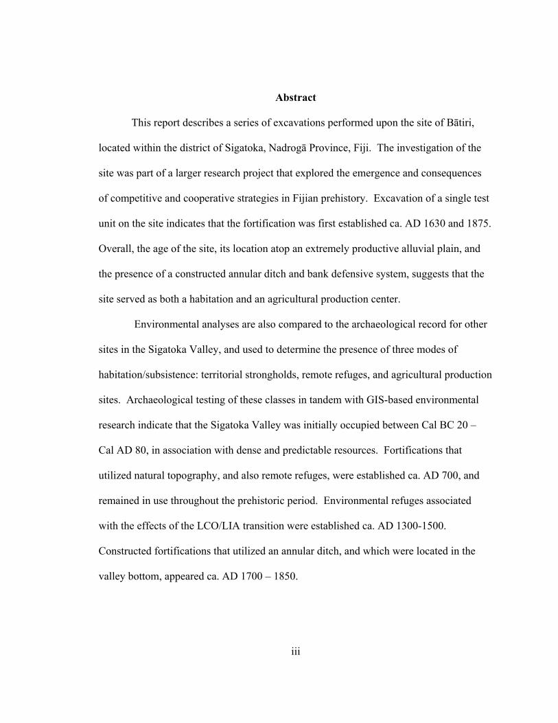
Abstract
This report describes a series of excavations performed upon the site of Bātiri,
located within the district of Sigatoka, Nadrogā Province, Fiji. The investigation of the
site was part of a larger research project that explored the emergence and consequences
of competitive and cooperative strategies in Fijian prehistory. Excavation of a single test
unit on the site indicates that the fortification was first established ca. AD 1630 and 1875.
Overall, the age of the site, its location atop an extremely productive alluvial plain, and
the presence of a constructed annular ditch and bank defensive system, suggests that the
site served as both a habitation and an agricultural production center.
Environmental analyses are also compared to the archaeological record for other
sites in the Sigatoka Valley, and used to determine the presence of three modes of
habitation/subsistence: territorial strongholds, remote refuges, and agricultural production
sites. Archaeological testing of these classes in tandem with GIS-based environmental
research indicate that the Sigatoka Valley was initially occupied between Cal BC 20 –
Cal AD 80, in association with dense and predictable resources. Fortifications that
utilized natural topography, and also remote refuges, were established ca. AD 700, and
remained in use throughout the prehistoric period. Environmental refuges associated
with the effects of the LCO/LIA transition were established ca. AD 1300-1500.
Constructed fortifications that utilized an annular ditch, and which were located in the
valley bottom, appeared ca. AD 1700 – 1850.

iv
Fijian Language Abstract
NA VEIKA E KUNE ENA VAKADIKEVI NI KORO MAKAWA KO BATIRI. Oqo nai vakamacala ni veika e kunei ena vakadidike ni kelikeli ka a vakayacori ena yavu ni koro makawa ko Batiri,ka rawa ni kunei ena tikina ko Sigatoka ena Yasana ko Nadroga ena noda vanua ko Viti .Na vakadidike oqo e tiki ga ni dua na vakadidike levu me vakadikevi kina na veika e curu mai ka mai vakavuna na kena dikevi me macala ka vakadeitaka nai tukutuku me rau vakaduavatataki ka vakatautauvatani kei nai tukutuku makawa kei Viti.Na kena mai vakadikevi na veika e a kunei (tikitiki ni kuro qele ,qa ni kai ,kei na qilaiso) ena dua na qara (test pit)ka a keli ena dela ni yavu ni koro makawa oqo e kunei ni a sa tauyavutaki ka tawani tu mai ena yabaki AD 1630 ki na 1875 Ni laurai vakarabailevu na yabaki ni kena tawani kei na vanua e davo koto kina ena dela ni bucabuca bulabula kei na kena laurai tu nai keli bai ni valu mei tataqomaki e rawa ni da kila kina ni koro makawa oqo e a vakayagataki mera tawana ka ra vakayagataka tale ga ena gauna ni nodra teivaka na vanua . Na kena vakadikevi na veikabula e vakavolivolita e vakatautauvatataki kei na veika e kunei ena vakadidike ni kelikeli ka volai tukutukutaki tu me baleta na veikoro makawa ena bucabuca e Sigatoka ka vakadeitaki kina e tolu na ka ,e dusia na tawani kei na ka era bula kina ,na vanua era dau taqomaki se vakarurugi kina kei na veika era teivaka.E vakadeitaka talega ni veika e kunei ena kelikeli ena kenai vakatagedegede ka muria ga na kena vakadeitaki ena misini ka vakatokai na GIS.kei na veika e vakavolivoliti ira e vakaraitaka ni a sa tawani taumada na bucabuca e Sigatoka ena maliwa ni gauna mai na 20BC ki na 80BC. Na veikoro ni valu ka vakayagataki kina na veidelana kei na veibucabuca me bai ni valu kai vakaruru ena gauna ni tiko yavavala era a tauyavutaki ni rauta na yabaki 700AD,ka ra a tu mera vakayagataka ena loma ni gauna taucoko ni nodra bula ni se bera ni cabe na lotu.Na kena vakayagataki na veikaga e tu vakavolivoliti ira e a tauyavutaki mai na yabaki AD 1300 ki na 1500.Na kena kelivaki nai keli me bai ni koro ena veibucabuca se ena veivanua lolovira e a mai tauyavutaki ena yabaki AD 1700 ki na 1850.

v
Table of Contents
Acknowledgments………………………………………………………………………..ii Abstract…………………………………………………………………………………..iii List of Tables……………………………………………………………………………..v List of Figures………………………………………………………………………….…vi Research in the Sigatoka Valley, Fiji Islands……………..……………………………...1 Bātiri (2-SIG-005): Site Description and History…………………………………….….4 Subsurface Investigation…………………………………………………………………11 Test Unit 1: Summary of Deposits…………………………………………...….11 Test Unit 1: Feature 1…………..………………………………………………..15 Test Unit 1: Artifact Descriptions……..………………………………………...17 Test Unit 1: AMS Dating Results……………………………………………….26 The Chronology of Bātiri……………………………………………………………..…29 GIS-based Environmental Analyses in the Sigatoka Valley………………………….…30 Bātiri: Site Function and Placement within the Sigatoka Valley Chronology…………..34 The Establishment of Territorial Fortifications and Refuges……………………36 Relocation to Environmental Refuges During Periods of Disturbance………….40 Constructed Fortifications and Undefended Production Sites…………………...41 Conclusion……………………………………………………………………………….43 Appendix A: Flora and Fauna of Bātiri……...…..………………………………………44 Appendix B: Ceramics of Bātiri…..…………………………………………………….51 References…………………………………………………………………………….....59

vi
List of Tables
Table 1.1. List of artifacts and weights recovered from Test Unit 1, Bātiri…………….14
Table 1.2. List of faunal remains from TU1, Bātiri……………………………………..18
Table 1.3. Frequency of decorated ceramic sherds from Test Unit 1…………………...27
Table 1.4. AMS date for Feature 1, Bātiri………………………………………………29
Table 2.1. List of decorative attributes recorded for the lips and rims of ceramic vessels from Bātiri………………..……………………………………………..………55 Table 2.2. Temper types and variations in density and grain-size recorded in the classification of ceramic vessels for Bātiri……………..………………………...……...56 Table 2.3. Morphological and decorative attributes for the ceramic vessels of Bātiri….57

vii
List of Figures
Figure 1.1. Archaeological sites of the Sigatoka Valley……………………………….....2
Figure 1.2. Agricultural features of the Sigatoka Valley………………………………....3
Figure 1.3. Map of the Sigatoka District, Nadrogā Province……………………………..5
Figure 1.4. Aerial photo of the site of Bātiri…..……………...……………….……….....7
Figure 1.5. Topographical map of the site of Bātiri……………...…………………….…9
Figure 1.6. Map of Bātiri with cultural features shown in detail………………...…...…10
Figure 1.7. The surface of TU1, and also at 30cmbs……...……………..……………...12
Figure 1.8. Profile of the west wall of Test Unit 1……………………………………...16
Figure 1.9. Bowls of Test Unit 1, Bātiri…………………………………………...……22
Figure 1.10a. Jars of Bātiri, TU1, between 0 and 30 cmbs……………………………...23
Figure 1.10b. Jars of Bātiri, TU1, 30-60 cmbs……………………………………….....24
Figure 1.11. Fragments of the flat tray vessel…………………………………………..25
Figure 1.12. Examples of decorated sherds from Bātiri………………………………...28
Figure 1.13. Environmental zones of the Sigatoka Valley……………………………...32
Figure 1.14. Comparison of the environmental zones identified by soil/topographic analyses…………………………………………………………………………………..35 Figure 1.15. Calibrated ages for the 2001-2002 Sigatoka Valley excavations………….37 Figure 1.16. The distribution of earliest occupations for each excavated site according to temporal period…………………………………………………………….38 Figure 2.1. Diagram of a ceramic jar……………………………………………………52
Figure 2.2. Coded classification for the non-metric morphological attributes recorded for the ceramic assemblage of Bātiri………………………………………..…53

1
Research in the Sigatoka Valley, Fiji Islands
Fiji is famous for its fortifications. Their ubiquitous presence throughout the
archipelago has led archaeologists and historians to privilege raiding and conflict as the
causal mechanism behind the development of Fijian society and history (e.g., Clunie
1977; Frost 1974; Green 1967). However, the causes of conflict have not been fully
investigated. Recent research in Fiji (e.g., Parry 1997; Nunn and Britton 2001, Nunn
2003) has suggested that environmental variations, including droughts related to the El
Niño Southern Oscillation (ENSO), and the transition between the Little Climatic
Optimum (LCO) and the Little Ice Age (LIA) ca. AD 1300 played a primary role in the
development of competitive settlement strategies in Fijian prehistory.
The research reported herein describes the archaeological investigation of
competition and conflict in Fijian prehistory. This research is focused upon the Sigatoka
Valley, located in the southwestern corner of the island of Viti Levu, Fiji.
Archaeological excavations at the mouth of the Sigatoka River in the 1960s by Birks
(1973) yielded evidence of the colonization of the region by 2640 ± 90 BP (GaK 946). In
addition, an excavation performed within the valley interior in 1972 has produced a
single radiocarbon date, that of 1000 ± 70 BP (GaK 4311) for a fortified occupation
(Palmer n.d., in Parry 1987:31). Geographical studies of fortified sites in the region were
also completed by Parry (1987), which provided the basis for subsequent work using
aerial photos, satellite imagery, and geographic information systems by the author (Field
1998, 2002, 2003). To date, this research has identified over 700 archaeological features
in the valley, ranging from fortified hill-top and lowland occupations, open villages, and
irrigated agricultural terraces (Figures 1.1. and 1.2). Given its large size, diverse

2
Figu
re 1
.1.
Arc
haeo
logi
cal s
ites o
f the
Sig
atok
a V
alle
y.

3
Figu
re 1
.2.
Agr
icul
tura
l fea
ture
s of t
he S
igat
oka
Val
ley.

4
environmental zones, and the quantity and richness of the archaeological record, the
Sigatoka Valley provides an excellent opportunity to investigate prehistoric settlement
patterns, social units, and the effects of environmental variability on the development and
persistence of warfare and conflict.
This research incorporates two bodies of data: GIS-based environmental analyes,
and archaeological excavations. Excavations were performed between August 2001 and
March 2002 at 12 sites: Korokune (Conua District, Nadrogā), Bātiri (Sigatoka District,
Nadrogā), Nokonoko (Nokonoko District, Nadrogā), Korovatuma, Bukusia, Korohewa
(Mavua District, Nadrogā), Qoroqorovakatini (Qalimare District, Nadrogā), Vitogo
(Bemana District, Nadrogā), Tatuba Cave (Namataku District, Navosa), Malua (Noikoro
District, Navosa), Nadrogā (Noikoro District, Navosa), and Madraya (Noikoro District,
Navosa). The goal of excavation was to obtain samples for radiometric dating, and thus
determine the age of fortified and unfortified settlements in the Sigatoka Valley. The
results from the excavation of Bātiri (2-SIG-005) are the focus of this report. The place
of Bātiri in the prehistory of the Sigatoka Valley, and the role it may have played in the
development of Fijian culture, are also discussed herein.
Bātiri (2-SIG-005): Site Description and History
The site of Bātiri is located within a small tributary valley that is known locally as
Olo Olo, which lies directly east of Nayawa Village. The site number (2-SIG-005) refers
to its location in the province of Nadrogā (Province 2), district of Sigatoka (SIG), and it is
the 5th archaeological site, out of a total of 48, to have been identified in the district
(Figure 1.3). This valley is approximately 1.5 km2 in size, and is drained by the Caluwe

5
Figure 1.3. Map of the Sigatoka District, Nadrogā Province. The location of the site of Bātiri is shown at the center of the map.

6
Creek. The site lies atop a thick layer of alluvium that is today used for cultivating
sugarcane, dalo, and other vegetables. Steep grassy hillsides flank the valley of Olo Olo,
and the ancient fortress of Vatuvoko lies above its eastern termination. The site of Bātiri
lies at an elevation of 20m above sea level, and can be plotted on the 1992 edition of the
Fiji Map Series (1:50,000, sheet L29) at 1869.765 Easting, and 3872.447 Northing.
The site of Bātiri, as well as the neighboring site of Lomaloma, are known from
the 19th century journal of Arthur Gordon (1879), in which he described the villages of
this region belonged to “the Bātiri Christians” (1879:I, xi-xiii). Early contact with
Europeans and missionaries in the 19th century had led to the adoption of Christianity by
many of the populations of the Lower Sigatoka, as well as some of the highland tribes.
However, outbreaks of measles throughout Fiji, as well as the formation of a new
colonial government in 1875 exacerbated tensions between the Christian and non-
Christian highland populations. Gordon’s “Little War” sought to pacify rebellious
highland tribes following a series of attacks on the Christianized populations of the
Sigatoka Valley, including the site of Bātiri. In 1876, Gordon led a small military force
into the Sigatoka Valley, which succeeded in routing the rebellious tribes and
establishing the colonial government of Fiji as the supreme power in the interior.
Thus, according to historical documents the sites of Bātiri and nearby Lomaloma
were destroyed in 1875, and populations resettled elsewhere. Later, these populations
founded the modern village of Nayawa. Both Bātiri and Lomaloma were fortified sites,
with large annular ditches and palisades. Bātiri was a koro waiwai, or ring-ditch site, and
the faint remainder of the ditch that surrounded Bātiri is visible in modern aerial photos
(Figure 1.4). Based upon the size of this and other village sites in the Olo Olo tributary

7
Figure 1.4. Aerial photo of the site of Bātiri. The excavated ditch that encircled and protected the site is clearly visible. The site of Lomaloma lies to the northeast, and is covered with several modern houses.
valley, Parry calculated that the Bātiri district likely contained approximately 1000
people during the 19th century (Parry 1987).
Archaeological investigation of Bātiri in 2001 was focused on determining the
earliest occupation date for the historic site of Bātiri, and also examining the deposits for
evidence of early prehistoric occupations. Although the date for the abandonment of this
site is known, the age of its establishment is not. This site was surveyed in 1999, and the
density and diversity of archaeological materials visible on the surface of this site

8
suggested that it might contain extensive prehistoric components, and be of great
significance to understanding the prehistory of this region.
The site is located to the south of the Olo Olo road, at approximately 500m east of
the intersection of Olo Olo and Queens Road. A small dirt driveway leads to the site of a
modern Indo-Fijian farm, which was constructed atop the ancient site of Bātiri in the 20th
century. The upper surface of the site has been under cultivation for many years, and
repeated plowing has obliterated any sign of prehistoric or historic yavu. However, the
depressed ground of the surrounding annular ditch, as well as ample amounts of artifacts,
are visible on the surface of the site. The site of Lomaloma lays 200 m to the northeast of
Bātiri, and consists of several sets of architectural terraces that currently support modern
houses. The most prominent visible cultural feature of Bātiri is its annular ditch, which is
roughly circular in shape (Figure 1.5, 1.6). The ditch is first encountered along the east
and west as it encircles the site, and has been moderately disturbed by cultivation and
animals. It ditch is shallow and saturated with water, and ranges from 2 to 12 m in width,
and averages 8 m. It surrounds the entire site of Bātiri, making the site 125 m long, and
100 m wide. The interior portion of the site thus comprises approximately 7850 m2. The
western half of the site was undergoing cultivation during the 2001 field season, but it is
likely that the eastern half of the site was also plowed and cultivated in previous decades.
A small farmhouse set on pylons and a scattering of associated outbuildings is
located in the northeastern section of the site. A front-yard and parking area fronts the
house, and also contains a very large Rain Tree and several smaller trees. West of the
house is a large plowed field, which is approximately 85 m long and 36 m wide.

9
Figure 1.5. Topographical map of the site of Bātiri. Key indicates meters above sea level.

10
Figure 1.6. Map of Bātiri with cultural features shown in detail.

11
In the 2001 season, the surface of this field contained large amounts of artifacts, primarily
ceramics, riparian and marine shell, and lithics. The distribution of artifacts appeared to
be the densest in the northeast corner of the plowed field. Beyond the field and to the
southeast of the house, the surface of the site is covered with light grass and shrubs, and
is moderately flat. A cluster of mixed trees and historic debris (bottles, tins) is located
along the inner edge of the ditch in the northwest corner of the site, and a second Rain
Tree is located on the outside of the ditch in the southwest corner of the site.
Subsurface Investigation
Subsurface investigation of Bātiri began with a series of auger corings. An east-
west line set at 261° was established in the yard fronting the house, and cores were taken
every 5 m. There were six total cores, and most reached a maximum depth of 90-100 cm.
All the sediment brought up in the auger buckets were sieved through 1/8th inch mesh,
and the archaeological materials were collected. Ceramic fragments were recovered from
nearly every coring, but increased in frequency at the western end of the core line (Cores
A5 and A6). As a result of the coring, Test Unit 1 was located near the northwestern
edge of the plowed field.
Test Unit 1: Summary of Deposits
Test Unit 1 consisted of a 1 x 1 meter unit, which was oriented on 0°. According
to the landowners, the site of Bātiri had been plowed by both a gas tractor and an oxen-
drawn plow. Upon excavation, it was revealed that the plow zone extends to between 15

12
Test Unit 1, Surface
Figure 1.7. The surface of TU1, and also at 30 cmbs. Upper 20 cm is well mixed.

13
and 20 cm below the surface (Figure 1.7). The sedimentary deposits of the plow zone
was a dark grayish brown (10YR 3/2) clay, that was lightly marbled with red streaking
(Layer I). This clay was very hard when dry, and was fractured into large cobble-sized
peds on the surface due to harrowing with an oxen team. Below the surface, the clay was
very dense and with few inclusions. The excavation of the first 20 cm yielded a great
amount of material that had been crushed and disturbed by the plowing process: 2.5 kg of
ceramics, 56 g of shell, and 2 g of charcoal (Table 1.1). Excavation continued past the
end of the plow zone, which appeared around 20 cmbs. At 21 cmbs, a midden or hearth
deposit was encountered in the southern portion of TU 1. This deposit (Feature 1)
appeared as a lens of lightly colored clay and ash that was densely packed with shell and
ceramics. The deposits immediately surrounding the feature between 20 and 30 cmbs
contained similar frequencies of artifacts as the layers above: 1.45 kg of ceramics, 844 g
of shell, 13.4 g of charcoal, and 3.1 g of unidentified mammal bone (Table 1.1).
In the rest of Test Unit 1, the frequency of ceramics, shell, and other artifacts
began to drop markedly after 30 cmbs. Between 30 and 40 cmbs, the fill deposit changes
in color from dark grayish brown to yellowish brown, with dark mottles from either
worm or root activity (Layer II). Larger splotches and bands in the clay suggest the
location of tree roots in the unit, although the clay remained firm and sticky, suggesting a
low energy environment was responsible for its deposition. Between 30 and 40 cmbs,
215 g of ceramics, 20 g of shell, 8 g of charcoal, and .1 g of burned toto nutshell
(Aleurites moluccana) were recovered. All of the shell fragments were from the riparian
bivalve, (Batissa violacea). The ceramics were unlike those of the previous levels and
Feature 1; 80 fragments were recovered, and 61 were body fragments from a flat ceramic

14
Table 1.1. List of artifacts and weights recovered from Test Unit 1, Bātiri.
Layer Level Depth Artifact Weight cmbs Description (g) I 1 0 ceramic 800 I 1 0-10 misc. shell 29.5 I 1 0-10 charcoal 0.7 I 2 10-20 charcoal 1.2 I 2 10-20 misc. shell 25.7 I 2 10-20 ceramic 1750 I 3 20-30 misc. shell 844 I 3 20-30 charcoal 13.4 I 3 20-30 mammal bone 3.1 I 3 20-30 ceramic 1450 Feature 1 none 30-55 misc. shell 1750 Feature 1 none 30-55 charcoal 28 Feature 1 none 30-55 pig/dog bone fish bone 50.5 Feature 1 none 30-55 ceramic 675 I 4 30-40 charcoal 8 I 4 30-40 misc. shell 20.5 I 4 30-40 ceramic 215.1 II 5 40-50 mammal bone 0.1 II 5 40-50 charcoal 0.7 II 5 40-50 ceramic 110.5 II 5 40-50 misc. shell 67.2 II 6 50-60 charcoal 4.7 II 6 50-60 ceramic 115.7 II 6 50-60 misc. shell 246.4 I 4 30-40 toto nut shell 0.1
tray with very thin (3 mm) walls. Over half of these fragments were encrusted with
carbonized food remains, thus this flat tray was likely used for frying or cooking
over a flame. The other 19 sherds were from regular jar vessels, two of which showed
evidence of wiping.
At 60 cmbs, Layer III was encountered. This deposit consisted of dark grayish
brown clay that was devoid of artifacts and features. The auger was used to core the
deposits that lay immediately below where Feature 1 had been located. The core reached

15
a maximum depth of 120 cmbs, but did not encounter any further cultural deposits or
features. The clay substratum appeared to continue past the depth of 120 cmbs.
Test Unit 1: Feature 1
The hearth or midden deposit that comprised Feature 1 was 98 cm in length, and
42 cm in width at its maximum extent into TU 1. Feature 1 was excavated separately
from the other arbitrary levels in the unit, and reached a maximum depth of 55 cmbs.
There were several lenses of ash in the deposit, the most prominent occurring at 40 cmbs,
and extending laterally across the feature. Figure 1.8 reveals the profile of Feature 1 as it
extended across the south wall of TU 1, and shows the ash and shell lenses very distinctly
near the bottom of the feature. The sediment within Feature 1 was a dark grayish brown
clay with a crumbly ped structure and moderate grade. Charcoal fragments were
abundant, and a total of 28 g were collected. A large fragment from the deepest ash lens
shell were also densely packed in the feature.
Of the ceramics, 675 g were collected from Feature 1, comprising 62 large sherds,
3 of which were decorated with either wiping or incising. Eight-five percent of the
ceramics from Feature 1 were body fragments, and 12% were either neck or rim
fragments. Feature 1 also contained 1.75 kg of shell, 70% of which was marine shell.
Trochus niloticus and Turbo marmoratus were the most abundant in terms of weight and
number, although the diversity of species is similar to the types encountered in the
previous levels. Several other unidentified variants of Nerita polita as well as specimens
of Turridae spp. and perhaps Black lipped-pearl oyster (Pinctada margaritifera) were

16
Photo of Test Unit 1, showing Feature 1. View to the south.
Figure 1.8. Photo and profile drawing of Feature 1, Test Unit 1. Roman numerals refer to the sedimentary layers mentioned in the text.

17
collected from the feature. The remaining 30% of the shell material was freshwater
bivalve. Fifty grams of mammal (25 g), and fish bone (25 g) were also recovered from
the depths of Feature 1. As mentioned, a lower lens of Feature 1 was encountered
between 40 and 60 cmbs. It extends 50 cm to the north, and was missed during the initial
Feature 1 excavation. Approximately 225 g of ceramics, 313 g of shell, 5 g of charcoal,
and .1 g of bone were recovered from this portion of Feature 1, between 45 and 55 cmbs.
The ceramics in this deposit consist of 18 fragments, 4 of which are fragments of a flat
ceramic tray. The other fragments consist of 13 body sherds and 1in the feature was
submitted for AMS dating as sample AA50282. Ceramics, bone, and rim, all of which
are undecorated. The shell fragments contain both marine and riparian species, the bulk
of which are the riparian bivalve clam, Batissa violacea.
Test Unit 1: Artifact Descriptions
Faunal Material
Test Unit 1 contained a diverse assemblage of marine and riparian shell and
animal bone. This assemblage undoubtedly represents a portion of the wide array of
terrestrial, riparian, and marine resources that were available to coastal populations in Fiji
in prehistory. The shell remains are the most diverse, but predominantly represent
species that are intertidal. In the first 0-20 cmbs, the shell remains are predominantly
marine species. Fragments included Turbinidae, Trochidae, Strombidae, and some
bivalves such as Veneridae (Table 1.2, and Appendix A). Fragments of the riparian clam
(Batissa violacea) were recovered from the deeper portion of the plow zone.

18
Table 1.2 List of Faunal Remains, TU1, Bātiri.
Unit Layer Level Depth Molluscan GenusMammalian
Genus Piscean Genus No. Wt. cmbs and Species and Species and Species (g) Name Name Name
Core 0-30 Nerita polita 2 1 A3 Turbo marmoratus 2 1 Trochus niloticus 1 1 *Batissa violacea 1 1 Core 0-30 Turbo marmoratus 2 1 A6 TU 1 I 1 0-10 Turbo marmoratus 9 12 Tridacna spp. 1 5 Trochus spp. 3 1.5 Strombus spp. 2 1 *Batissa violacea 6 9 Unidentified shell 1 1 TU 1 I 2 10-20 Turbo marmoratus 7 10 Trochus niloticus 8 4 *Batissa violacea 19 7.7 Codakia punctata 1 2 TU 1 I 3 20-30 Cypraea spp. 10 20 Tridacna spp. 1 10 Periglypta retic. 7 10 Trochus niloticus 42 150 Trochus spp. 12 25 Turbo marmoratus 22 150 *Batissa violacea 400 400 Purpura aperta 3 25 *Melanoides spp. 7 5 Nerita polita 7 10 Littoraria scabra 1 0.1 Strombus spp. 1 0.1 Conus spp. 1 0.2 Rock oyster 1 2 Unidentified shell 1 0.5 Mugil spp. (mullet) 2 1 Unidentified bone 2 2
Unidentified fish bone 3 1
TU 1 Feat. 1 30-55 Trochus niloticus 217 560 Trochus spp. 17 25 Rock oyster 45 20 Cypraea spp. 7 20 Turbo marmoratus 23 410 Conus bandanus 1 20 Conus spp. 2 3

19
Unit Layer Level Depth Molluscan GenusMammalian
Genus Piscean Genus No. Wt. cmbs and Species and Species and Species (g) Name Name Name
Turridrupa spp. 7 75 Purpura aperta 3 35 Nerita polita 32 54 *Melanoides spp. 30 26
Periglypta reticulata 6 25
Unidentified mussell 15 5
Pinctada marg. 1 1 Strombus spp. 4 1 Unidentified shell 1 1 Sus scrofa or Canis 2 25
Epinephelus spp. (Grouper) 2 4
Unidentified fish bone 79 21
TU 1 I 4 30-40 *Batissa violacea 24 21 TU 1 II 5 40-50 Nerita polita 2 2.2 Turbo marmoratus 1 20 Cypraea spp. 2 5 Trochus niloticus 3 20 Conus textile 1 10 *Batissa violacea 80 60 Tellina scobinata 2 5 Unidentified shell 2 5
Unidentified fish bone 1 0.1
TU 1 II 6 50-60 Nerita polita 9 50 Cypraea spp. 2 10 Conus spp. 1 10 Trochus niloticus 8 80 Turbo marmoratus 2 80 *Melanoides spp. 1 3.2 Costellaria spp. 1 3.2 *Batissa violacea 90 110 Unidentified shell 4 10 * Riparia n species

20
Between 20-30 cmbs, the diversity of marine shell types increased in the level to include
Cypraeidae, Thaididae, Littorinidae, and an unidentified rock oyster. The river clams
also increase in weight and frequency, and between 30-40 cmbs all of the shell fragments
were from the riparian bivalve, (Batissa violacea). Between 40-60 cmbs, the shell
fragments again contained both marine and riparian species, the bulk of which were
Batissa violacea. Marine species such as Neritidae, Conidae, Turbinidae, Trochidae,
Cypraeidae, Costellariidae, and Tellinidae make up the rest of the sample. A few
fragments of riparian snails (Melanoides spp.) were also recovered.
Feature 1 contained 1.75 kg of shell, 70% of which was marine shell. Very large
(10 cm+) Trochus niloticus and Turbo marmoratus were the most abundant in terms of
weight and number, although the diversity of other species is similar to the types
encountered in the previous levels. As mentioned, several other unidentified varieties of
Nerita polita, as well as specimens of the Turridae family were collected from the
feature. The remaining 30% of the shell material was the freshwater bivalve, Batissa
violacea. Test Unit 1 also contained a variety of animal bones. Between 20 and 30
cmbs, two fish mandibles likely from mullets (Mugil spp.) as well as 3 other unidentified
fish bones were recovered. Two other unknown mammal bones (most likely pig (Sus
scrofa) or dog (Canis familiaris), were recovered. An additional 50 g of bone was
recovered from within Feature 1. These included 2 vertebrae from pig or dog, two fish
mandibles (Epinephelus spp.) (grouper) and 79 other unidentified fish parts including
vertebrae, ribs, and spines. Lastly, a single unidentified fish bone weighing less than 1 g
was recovered from between 40 and 50 cmbs.

21
Ceramics- Vessel Forms
The ceramics of Test Unit 1 also demonstrate a great deal of diversity in both
form and decoration styles. Unfortunately, the plowing of the site has broken many of
the ceramic fragments into very small pieces, which made identification and
classification difficult. However, the morphology of a number of bowls and jars could be
reconstructed for Bātiri.
Five hundred and sixty-five fragments were recovered from between 0 and 20
cmbs, 96% of which were undecorated body sherds. Seventeen fragments of vessel rims
and necks were recovered, six of which were complete enough for reconstruction of the
original vessel. Figure 1.9 illustrates the morphology of the bowls. Most are wide (20
cm+ diameter) bowls, and have either square or rounded lips. These vessels are
reminiscent of modern dari, which are used for drinking yaqona. A single bowl of
smaller size, with higher sides and a decorated exterior (# 7) may have been used for
serving food. A single large jar could also be reconstructed from the ceramics recovered
from 0-20 cmbs. This vessel had a wide diameter (30 cm +) and thin walls, and a
rounded lip. This jar was most likely used for cooking or storage.
Between 20 and 30 cmbs, vessels in the form of jars become much more common.
90% of the 220 fragments recovered from this depth were body sherds, and 10% (19)
were fragments of either the necks, rims, or bases of vessels. A single reconstructed bowl
(# 37) is typical of the dari vessels recovered from the later deposits. Figure 1.10a and
1.10b illustrate the four jars reconstructed for this level. Vessel #32 is unique in the
group, as it has very thick walls and a heavy, rounded lip, and an orifice diameter of only
12 cm. It is unlikely that this jar was used for cooking (due to the small opening), thus it

22
Bowl # 17, TU1, 0-20 cmbs
Temper Class: 1
Bowl # 22, TU1, 0-20 cmbs
Temper Class: 1
Bowl # 23, TU1, 0-20 cmbs
Temper Class: 2
Bowl # 25, TU1, 0-20 cmbs
Temper Class: 1
Bowl # 26, TU1, 0-20 cmbs Temper Class: 1
Bowl # 37, TU1, 20-30 cmbs Temper Class: 2
Figure 1.9. Bowls of Test Unit 1, Bātiri.

23
Jar # 24, TU1, 0-20 cmbs Temper Class: 1
Jar # 32, TU1, 20-30 cmbs Temper Class: 4
Jar # 33, TU1, 20-30 cmbs Temper Class: 1
Jar # 39, TU1, 20-30 cmbs Temper Class: 4
Jar # 41, TU1, 20-30 cmbs Temper Class: 1
Figure 1.10a. Jars of Bātiri, TU1, between 0 and 30 cmbs.

24
Jar # 47, TU1, Feature 1 Temper Class: 2
Jar # 48, TU1, Feature 1 Temper Class: 3
Jar # 53, TU1, 50-60 cmbs Temper Class: 4
Figure 1.10b. Jars of Bātiri, TU1, 30-60 cmbs. may have been used for storage of either food or water. The other vessels are more
typical of cooking vessels—thin walls, wide flaring mouths (20 cm+), and square lips. A
single vessel (#33) is also decorated with a notched lip. As mentioned previously, the
ceramics recovered from between 30 and 40 cmbs were unlike those of the previous
levels. Eighty fragments were recovered, 19 of which were from regular jar vessels, two
of which showed evidence of wiped necks. The 61 other sherds were body fragments
from a flat ceramic tray with very thin walls (3 mm) (Figure 1.11). Over half of these
fragments were encrusted with carbonized food remains, thus this flat tray was likely
used for frying or cooking over a flame. This vessel appears to unlike the trays described

25
Figure 1.11. Fragments of the flat tray vessel recovered from between 30-40 cmbs.
for the Sigatoka Dunes, which were oval or round in shape, and with thick bottoms.
Birks (1973) and others have suggested that these trays were used for
the manufacture of salt. The tray fragments encountered at Bātiri are from a vessel of
unknown size and shape, but undoubtedly were used for cooking due to the presence of
carbonized food.
Six hundred and seventy-five grams of ceramics were collected from Feature 1.
Eight-five percent of these were body fragments, and 12% were either neck or rim
fragments. Two jars (#s 47, 48) could be reconstructed from the fragments (Figure
1.10b). These jars are also similar to those from later deposits, although #48 is

26
substantially thicker than most vessels, and has a lip reminiscent of jar # 32. It is possible
that this may have been a storage, as opposed to cooking, vessel. This vessel also had a
wiped neck.
Lastly, the single rim recovered from between 50-60 cmbs could be reconstructed,
and is illustrated in Figure 1.10b. This vessel had a widely flaring rim and a contracting
square lip.
Ceramics- Decoration
Table 1.3 details the frequency of decorated ceramics that were recovered from
Test Unit 1 of Bātiri. The assemblage is broadly typical of late-period decorations—
incising, end-tool impressing, appliqué, side-notching, finger-gouging, and wiping
(Figure 1.12). The decorations were present on ceramics from throughout the deposit,
although there were a few more instances of wiping on the fragments from Feature 1.
Test Unit 1: AMS Dating Results
A large fragment of charcoal from the deepest ash lens in Feature 1 was submitted
for AMS dating as sample AA50282. The results indicate an age range of Cal AD 1650
to 1950 within 1σ, and a range of Cal AD 1630 to 1960 within 2σ (Table 1.4). Although
this broad range suggests that this site dates to within the most recent 500 years, most
likely the site dates from between AD 1630 and 1875.

27
Unit Lev. Lay. Depth Total App. Paddle Paddle Paddle Incis. End Fing. Shell Side Wiped Fing. Grass Total cmbs Sherds Imp. Imp. Imp. Tool Nail Tool Goug. Imp. Dec. Para. Cross Diam. Imp. Notch
Core 0-10 3 0 0 0 0 0 0 0 0 0 0 0 0 0A1 Core 0-10 4 0 0 0 0 0 0 0 0 0 0 0 0 0A2 Core 0-30 9 0 0 0 0 0 0 0 0 0 0 0 0 0A3 Core 0-30 13 0 0 0 0 0 0 0 0 0 0 0 0 0A5 Core 0-30 8 1 0 0 0 0 0 0 0 0 0 0 0 1A6 TU 1 I 1 0-10 258 0 0 0 0 1 1 0 0 0 0 0 0 3TU 1 I 2 10-20 307 0 0 0 0 0 0 0 0 0 0 0 0 0TU 1 I 3 20-30 220 0 0 0 0 0 0 0 0 1 1 1 0 3Feat. 1 30-55 62 0 0 0 0 1 0 0 0 0 2 0 0 3TU 1 I 4 30-40 80 0 0 0 0 0 0 0 0 0 2 0 0 2TU 1 II 5 40-50 10 0 0 0 0 0 0 0 0 0 0 0 0 0TU 1 II 6 50-60 8 0 0 0 0 0 0 0 0 0 0 0 0 0
Table 1.3. Frequency of decorated ceramic sherds from Test Unit 1

28
Figure 1.12. Examples of decorated sherds from Bātiri. A: end-tool impressing; B: finger-gouging; C: incising; D: side-notching; E: wiping, and F: appliqué.

29
Table 1.4. AMS date for Feature 1, Bātiri.
Lab No. Provenience Material Measured 13C/12C Calibrated Age Range Calibrated Age Range
14C Age BP Ratio Probability Probability
Distributions (1σ)* Distributions (2σ)*
AA50282 Feature 1 Wood 233 ± 38 -25.3 Cal AD 1650 - 1950 Cal AD 1630 - 1960 30-55 cmbs charcoal * All determinations were calibrated using the terrestrial calibration curve of Stuiver et al. (1998), with 27± 5 years subtracted from the CRA to account for the southern hemisphere offset in 14C (McCormac et al. 1998). The Chronology of Bātiri
Although plowing has destroyed the occupational features of the site, it can be
assumed that the hearth feature encountered in Test Unit 1 once lay atop a yavu, the
outline of which was obliterated following the transition of the site into agricultural land.
The drop in artifact frequency after 30 cmbs (the upper horizon of the hearth) indicates
that the deeper deposits represent yavu fill material that slightly predates the deposition of
materials in the hearth. The results of AMS dating for the hearth feature in Test Unit 1
indicate an age range of 1630 to 1960 Cal AD within 2σ. This date concurs with
historical data that indicate that the site was inhabited by Christianized Fijians in the mid-
19th century, and destroyed by rebel forces in 1875. Thus, the hearth deposit encountered
in Feature 1 may have been established in the 1700’s following a few years of occupation
at the site. The richer deposits that lie immediately around and above the hearth feature
probably amount to cooking refuse that accumulated as the hearth was used, and which
was later scattered by the plow. Although there are no dated samples for the ditch that
surrounds the site, it is likely that it too dates to between AD 1650 and 1875.

30
GIS-based Environmental Analyses in the Sigatoka Valley
Land classifications performed by the Fijian Dept. of Agriculture indicate that
most of the soils of the valley exist on steep and mountainous slopes, although the upper
reaches of the drainage are considerably more rugged than the Sigatoka delta. The river
has carved a variety of geological formations through the valley’s interior, including
raised planation surfaces in the upper valley, and expanses of alluvial terraces in the
lower valley. Much of the vegetation of the region consists of grasses and shrubs,
although pockets of forest exist in the drainages, and atop limestone peaks.
In prehistoric times, the inhabitants of the Sigatoka Valley subsisted on
hydrophilic crops (plants that grow in partially submerged conditions) such as dalo
(Colocasia esculenta) and via kana ‘giant swamp taro’ (Cyrtosperma chamissonis), and
dryland crops such as uvi (Dioscorea spp.), and dryland taro (Barrau 1961; Kirch 1994;
Spriggs 1982). These crops require particular conditions for high yield cultivation. With
adequate amounts of moisture and silty soils, dalo can yield approximately 20+
tons/hectare/year, and can be planted year round, and harvested every 8-10 months
(Brookfield 1979, in Spriggs 1984:129). Earthworks, such as ponded-fields (vuci) and
terraces with irrigation (tabawai) provided by nearby streams, were often installed to take
advantage of naturally productive environments and encourage vibrant growth. In
contrast, uvi and other dryland crops were cultivated in swiddens (slash and burn
gardens) that were well-drained and occasionally terraced to retard erosion. With
adequate amounts of rainfall, uvi and dryland taro yield between 5-15 tons/hectare/year
(Kirch 1994:8; Tindall 1983:203). However, unlike dalo, uvi are only planted at the
beginning of the wet season, and can be harvested 7-9 months later.

31
Sedimentological analyses of the Sigatoka Valley indicate that most soils would
have provided enough nutrients to allow for cultivation of both uvi and dalo. However,
the severity of slope, in particular the higher elevations and portions of the upper valley,
would have significantly reduced the amount of land available for cultivation. In
addition, the effects of the dry season would have made the cultivation of dalo impossible
in all but the most well-watered portions of the valley. Figure 1.13 provides a summary
image of the environmental zones of the Sigatoka Valley, based upon soil fertility and
dry season intensity. These data also suggest the existence of three zones of productivity
and agricultural risk: Zone 1) lands suited to dryland cultivation, and which also
experienced shortfalls due to severe dry seasons; Zone 2) lands suited to mixed wetland
and dryland cultivation, and which also experienced mild shortfalls due to moderate dry
seasons; and Zone 3) lands suited to wetland cultivation, and which also experienced
minimal shortfalls due to weak dry seasons.
In the short view, the results of these analyses simply suggest that the inhabitants
of the valley must have privileged one mode of cultivation over the other. However, it
also suggests that portions of the Sigatoka Valley were more restricted in terms of
cultivation strategies, and more at risk from severe, long-term droughts. These results
suggest that Zones 2 and 3 would have allowed for more temporally stable forms of
agricultural production, and Zone 1 would have been more susceptible to episodic
environment-based shortfalls. This variation is particularly important in light of recent
observations of global climatic phenomena, in particular the El Niño Southern Oscillation
(ENSO). Archaeological and historical investigations from other parts of the world (e.g.,
South America, the Middle East) have traced ENSO-related events to as early as 6000

32
Figu
re 1
.13.
Env
ironm
enta
l zon
es o
f the
Sig
atok
a V
alle
y, a
s ide
ntifi
ed b
y so
il fe
rtilit
y an
d se
verit
y of
dry
se
ason
.

33
BP, and suggest that frequencies assumed essentially modern ranges ca. 3000 BP.
(Caviedes 2001; Sandweiss 2002). According to climatologists (e.g., Nichols and Wong
1990; Salinger et al. 1995) Fiji is strongly affected by ENSO-related disturbances, and
modern droughts and cyclones (such as the 1982/83 and 1997/98 seasons) provide
models for the severity of ENSO cycles in prehistory. During these periods, rainfall was
22-42% of normal, and national production loss for sugarcane was 50%. Economic
analyses also suggest that the average income for subsistence farmers dropped from
F$3500 to F%1500 per annum (Kaloumaira 2000). If modern experienced serves as any
guide, the Sigatoka Valley (in particular Zone 1) was subject to devastation during a
severe ENSO episode. The antiquity of ENSO in the Pacific further suggests that this
cycle of devastation repeated itself throughout Fijian prehistory, providing the impetus
for human conflict over resources.
Paloeclimatic data from New Zealand caves as well as shell conglomerates in
Fijian shorelines indicate that dramatic environmental perturbations occurred in Fiji
approximately 700 years ago. These events mark the transition period between the
warmer Little Climatic Optimum (1250-700 BP) and cooler Little Ice Age (700-200 BP).
According to recent analyses in Fiji and Niue by Nunn and others (Nunn 2000a, 2000b,
2003; Nunn et al. 2003; Nunn and Britton 2001), the disturbances of the transition were
quite dramatic, and were marked by cooler weather and sea temperatures, and a rapid
lowering of sea level by over one meter between 730-525 BP. Nunn and Britton
proposes that these changes were devastating for both coastal and interior populations:
sea-level fall would have converted embayments to brackish wetlands, and also caused

34
the submersion of groundwater for the interiors of the Fiji Islands. Extensive incising of
the riverbeds and streambeds, as well as decreased soil moisture levels in many of the
alluvial terraces that supported uvi cultivation, would have resulted in dramatic reduction
of uvi yields in the lowlands. Torrential rains and floods may have also occurred in the
higher elevations.
Figure 1.14 combines the results of the analyses described above and allow for the
formulation of the following conclusions: 1) Zone 1 would have experienced the most
severe effects of ENSO-related droughts and floods, and also suffered from sea-level fall
during the LCO/LIA transition; 2) Zone 2 would have experienced moderate ENSO-
related droughts, and been affected to a limited degree by the landslides and erosion
associated with the LCO/LIA transition; and 3) Zone 3 would have only been weakly
affected by ENSO-related droughts or floods, and experienced a high/moderate amount
of erosion during the LCO/LIA transition.
Bātiri: Site Function and Placement within the Sigatoka Valley Chronology
GIS-based analyses of the features and landscape associated with Bātiri indicate
that this site served both the function of production and defense. As described, the site
was located atop a flat alluvial plain, and protected with a large constructed ditch. The
contents of the excavation suggest that the inhabitants had access to both riparian and
marine resources, and faunal remains suggest the consumption of large pelagic fish, and
also pig. Analyses of the topography and nutrient status of the local soil suggest that the
site could have produced high yields of dryland crops, and wetland crops may have been

35
Figure 1.14. Comparison of the environmental zones identified by soil/topographic analyses with the extent of disturbance related to ENSO and the LCO/LIA transition. would have experienced severe ENSO-related droughts. If the site had been occupied

36
possible if Caluwe creek was fitted for irrigation. However, the site is located within
Zone 1, and its low elevation may have put it at risk for cyclone-related floods. It also
during the LCO/LIA transition, the land in the immediate vicinity may have fared
moderately well, as the dense clay of Olo Olo valley would have retained moisture for a
longer period.
Figure 1.15 displays the range of dates associated with the 12 other sites
excavated in the Sigatoka Valley. Four temporal periods are identified: T1 (2000-1500
BP), T2 (1500-1000 BP), T3 (1000-500 BP), and T4 (500-150 BP). The period proposed
for the transition between the Little Climatic Optimum (LCO) and the Little Ice Age
(LIA) is also indicated in the diagram. The location of these sites in the Sigatoka Valley,
and their placement into one of four temporal categories, is indicated in Figure 1.16. In
brief, the results of archaeological investigations and environmental analyses suggest the
following chronology for the Sigatoka Valley.
The Establishment of Territorial Fortifications and Refuges
The earliest occupation in the Sigatoka Valley occurred at Tatuba Cave between
Cal BC 20 and Cal AD 80. GIS-based environmental analyses demonstrate that Tatuba
Cave is located within a region that had moderately high soil fertility, and which also
experienced a moderate dry season. In addition, Tatuba Cave had immediate access to
small tracts of land suited to dryland cultivation, and was also within a few kilometers of
much larger expanses of alluvial terraces suitable for vuci construction and dalo
cultivation. Of note, the site is located within Zone 2, but a substantial portion of its
resource base is located in Zone 1. Although Zone 1 would have been susceptible to

37
Figure 1.15. Calibrated ages for the 2001-2002 Sigatoka Valley excavations. Temporal periods T1-T4 and the position of the LCO/LIA transition are indicated. All determinations were calibrated using the terrestrial calibration curve of Stuiver et al. (1998), with 27 ± 5 years subtracted from the CRA to account for the southern hemisphere offset in 14C (McCormac et al. 1998).

38
Figu
re 1
.16.
The
dis
tribu
tion
of e
arlie
st o
ccup
atio
ns fo
r eac
h ex
cava
ted
site
acc
ordi
ng to
tem
pora
l per
iod.

39
flooding and drought during severe ENSO cycles, the surrounding region was generally
buffered against extreme climatic phenomena. The size of the entire Tatuba Cave locale
(area, and also number of yavu and architectural features) also suggests that the area
remained desirable as an occupation site during the following two millennia (T1-T4), and
the strategy of territorialism persisted in the region.
Similarly, the sites of Nokonoko and Qoroqorovakatini suggest an association
between the founding of territorial strongholds and refuges as a response to dense and
predictable resources and environmental shortfalls. Both of these sites consist of remote
and naturally defended peaks that are over 240 m above the valley bottom, and contain
complex archaeological features and deposits of substantial antiquity. Nokonoko was
established as early as the 6th century AD (1492 ± 43 years BP, or T1) and
Qoroqorovakatini was constructed several centuries later (974 ± 43 years BP, or T2). In
the case of Nokonoko, the range of dates, the high frequency of yavu, and also the deep
middens of clamshell and ceramics suggest that the site was occupied throughout the
prehistoric period. Thus, this site most closely represents a territorial stronghold that was
occupied year-round. In contrast, Qoroqorovakatini contains deposits that indicate
episodic occupations, hence the site may represent a combination of remote refuge and
territorial stronghold. However, the long chronologies of Nokonoko and
Qoroqorovakatini reflect the persistence of a territorial and refuge strategy through all
temporal periods (T2-T4) relating to environmental limitations and climatic perturbations
in Fiji. Of note, the site of Korokune reflects a similar adherence to the strategy of

40
territorial stronghold, although this site was not established until the third temporal
period.
Relocation to Environmental Refuges During Periods of Disturbance
Four of the 12 excavated sites were established during the third temporal period
(1000-500 BP), and also within the period proposed for the transition between the
LittleClimatic Optimum and Little Ice Age (1250 – 700 BP). The increase in site
frequency during this period suggests significant population growth between periods T1
and T3. More importantly, the location of three newly founded habitations in Zones 2
and 3 suggests the development of a new strategy of habitation and subsistence that is
directly related to environmental disturbance. In particular, the environmental conditions
surrounding these sites, their topographic positions in remote drainages, and also the
presence of faunal material indicating a diversified resource base, are suggestive of a
distinctive and new settlement pattern focused on environmental buffering.
Malua, and Korovatuma (and perhaps also Bukusia) are emblematic of this new
trend. Both were established between AD 1300-1630, and are located atop dramatic
outcrops that provided natural defense. The surrounding lands were of moderate quality
but extraordinarily rugged. Cultivation of dalo was certainly possible, but the arable land
was restricted to ‘pocket gardens,’ (i.e., small isolated patches along minor creeks).
Neither site had access to the large tracts of alluvial deposits that were available in earlier
periods (e.g., Nokonoko, Tatuba Cave, and Qoroqorovakatini). However, environmental
analyses place these sites within Zone 2, which indicates that the resource base
surrounding these sites would not have been affected by severe drought or a reduction of

41
soil moisture due to sea-level fall predicted for the LCO/LIA transition. Unlike
significant portions of the valley bottom (Zone 1), cultivation of dalo and uvi in Zones 2
and 3 would have continued as normal. The timing of the founding of the sites, as well as
quality of the surrounding environment, strongly suggest that these new habitations
represent a strategy of environmental refuge relating to the effects of the LCO/LIA
transition. Cumulatively, these data suggest that the LCO/LIA transition encouraged
populations to optimize in a new way: 1) less investment in large but risk-laden
agricultural surplus, and increased focus on temporally stable resources; 2) variable
patterns of population aggregation and dispersal, perhaps coupled with mobility; 3)
diversification of the resource base; and 4) exchange or travel for non-local food items.
Constructed Fortifications and Undefended Production Sites
The final phase of Sigatoka Valley prehistory (period T4) witnessed the
persistence of previously established strategies (territorial strongholds, remote refuges,
and environmental refuges), and also the emergence of a new form of fortification on the
valley bottom: villages surrounded by a constructed moat and ditch. The sudden
appearance of this kind of fortification suggests the diffusion of new ideas concerning
defensive construction, and also an increasingly large population. The sites of Vitogo
and Bātiri are a case in point. Both of these sites were constructed between 260-150 BP
and are of the ‘ring-ditch’ type; (i.e., protected with an annular ditch, bank, and palisade).
Unlike previous centuries, these villages did not make use of any topographical features
for defense, but were located within swampy, riparian environments that would have
been prime locations for growing dalo. The size of annular ditch and bank construction

42
for these sites suggests a significant investment and labor pool: in the case of Bātiri, the
ditch was 10 m wide with a circumference of 390 m. This is a marked difference from
the fortifications of previous centuries, which employed naturally fortified positions that
required minimal initial investment, and which also did not require a sizeable population
for defense or construction tasks. Therefore, the restriction of manufactured fortifications
in the latest period is almost certainly a factor of population size, and perhaps also related
to the transmission of this innovative design throughout Fiji in the late prehistoric period.
The emergence of undefended habitation sites in the valley bottom may also be
related to population growth, and perhaps the integration of small communities with
larger territorial strongholds. The sites of Nadrogā and Korohewa are representative of
this strategy. These habitations were of small size, late age, and were located on the
valley bottom. No visible defenses were encountered at Korohewa, and only a modest
wall unrelated to defense was present at Nadrogā. The lack of defenses at these sites
breaks nearly two millennia of tradition for the Sigatoka Valley; for the first time,
villages did not employ topography as the first line of defense against invaders. This
omission strongly suggests that these populations were integrated with regional centers,
or were protected by another form of defense-- armed warriors. Moreover, the presence
of undefended habitation sites may be related to cooperative strategies that were
established during the establishment LCO/LIA transition. In this case, undefended
settlements may have been linked to fortifications maintained by close relatives.

43
Conclusion
In conclusion, the results of analyses in the Sigatoka Valley suggest that: 1)
fortifications are the result of competitive strategies that originated early in Fijian
prehistory (ca. AD 700) as a response to spatio-temporal environmental variability,
specifically the effects of the El Niño Southern Oscillation; 2) fortifications utilized
natural topography from the earliest period onwards, and this pattern persisted throughout
all temporal periods, with annular ditch style fortifications only occurring in the latest
temporal period (ca. 1700 AD); 3) changes in settlement patterns ca. AD 1300 can be
linked to the LCO/LIA transition, as opposed to the influx of migrants (cf. Frost 1974).
The analytical capabilities of a GIS, in particular the analysis of landscapes via slope,
aspect, and viewshed, are shown in this research to have particular value to spatial
analysis, and can be modified to incorporate a temporal aspect. When coupled with
archaeological investigations, this approach allows for extensive analyses of the variables
that impinge upon subsistence and habitation. Increasing resolution of the data involved
in these kinds of analyses will undoubtedly multiply the analytical potential for
archaeological studies, and contribute more to studies of Fijian prehistory.

44
Appendix A: Flora and Fauna of Bātiri (2-SIG-005), Fiji The following is a list of species and identifying photos for the floral and faunal
remains recovered from the excavations at Bātiri. All photos were taken by the author
unless otherwise specified. Descriptions of molluscan characteristics were obtained from
Severns (2000) and Haynes (2001), and identifications were aided in part by Parkinson
(1982). Fish identification was derived from Fowler (1955). Information pertaining to
indigenous Fijian trees was provided by the Fijian Department of Forestry (1996).
Mollusca
Common Name: Tave or Kai waidranu (Fijian) Scientific Name: Batissa violacea Family: Unionidae Adult Size: 30-90mm Depth: brackish and freshwater Location: Common in the lower Sigatoka, Rewa, Ba, Nadi, Navua, Korovou, Dreketi, Labasa, and Waikoro rivers. Common Name: Punctate Saucer Scientific Name: Codakia punctata Family: Lucinidae Adult Size: 50mm Depth: 2-45 feet Location: On sand
Common Name: Banded Cone Scientific Name: Conus bandanus Family: Conidae Adult Size: 132 mm Depth: 15-300 feet Location: On sand

45
Common Name: Cone Shell Scientific Name: Conus spp. Family: Conidae Adult Size: 5- 150mm Depth: intertidal to 300 ft Location: Sand, rocks, reef
Common Name: Textile Cone Scientific Name: Conus textile Family: Conidae Adult Size: 124mm Depth: 5-120 feet Location: Sand and coral
Common Name: Ribbed Miter Family: Costellariidae Adult Size: 12-28mm Depth: 20-300 feet Location: In sand
Common Name: Cowrie Shell Scientific Name: Cypraea spp. Family: Cypraeidae Adult Size: 20-60mm Depth: Intertidal to 300 feet Location: Under rocks

46
Common Name: Rough Periwinkle Scientific Name: Littoraria scabra Family: Littorinidae Adult Size: 30mm Depth: Supratidal Location: Above water line on rocks and vegetation
Common Name: Black-lipped Pearl Oyster Scientific Name: Pinctada margaritifera Family: Pteriidae Adult Size: 290mm Depth: 2-60 feet Location: Attached to rocks or corals
Common Name: Sici moto (Fijian) Scientific Name: Melanoides spp. Family: Thiaridae Adult Size: 50mm Depth: 2-4 feet Location: Freshwater streams, sandy to rocky
Common Name: Polished Nerite Scientific Name: Nerita polita Family: Neritidae Adult Size: 30mm Depth: Intertidal to 6 feet Location: On sand

47
Common Name: Reticulated Venus Clam Scientific Name: Periglypta reticulata Family: Veneridae Adult Size: 65mm Depth: 5-60 feet Location: In sand
Common Name: Open Dye Shell Scientific Name: Purpura aperta Family: Thaididae Adult Size: 70mm Depth: Intertidal to 5 feet Location: Rocks in surge area
Common Name: True Conchs Scientific Name: Strombus spp. Family: Strombidae Adult Size: 23-120mm Depth: intertidal to 300 feet Location: In sand
Common Name: Rock Oyster Scientific Name: Unknown Adult Size: 30mm Depth: Unknown Location: Unknown

48
Common Name: Rasp Tellin Scientific Name: Tellina scobinata Family: Tellinidae Adult Size: 60mm Depth: 30-50 feet Location: In sand
Common Name: Giant Clam Scientific Name: Tridacna spp. Family: Tridacnidae Adult Size: 20 – 50cm Depth: 30-60 feet Location: On reefs
Common Name: Top Shell Scientific Name: Trochus niloticus Family: Trochidae Adult Size: 50-100mm Depth: intertidal to 40 feet Location: In rubble and coral
Common Name: Top Shell Scientific Name: Trochus spp. Family: Trochidae Adult Size: 1-100mm Depth: intertidal to 1000 feet Location: In rubble and coral

49
Common Name: Green Snail Scientific Name: Turbo marmoratus Family: Turbinidae/Phasianellidae Adult Size:50-90mm Depth: marine intertidal Location: Fiji and western Pacific
Common Name: Turrid Scientific Name: Turridrupa spp. Family: Turridae/Clavinidae Adult Size: 17 – 48mm Depth: intertidal to 600 feet Location: In sand and rubble
Mammalia and Piscea Common Name: Domesticated Pig (Asian) Scientific Name: Sus scrofa Adult Size: 1.5 meters Environment: Forrest and open land, or confined in pens Location: distributed throughout the Indo-Pacific and Asia
Common Name: Mullet Scientific Name: Mugil spp. Adult Size: 200mm Environment: shallow water, reef zone

50
Common Name: Grouper Scientific Name: Epinephelus spp. Adult Size: 20cm to 1m Environment: Reef, rocky areas, intertidal to 200 feet
Flora
Common Name: Toto or Lauci (Fijian) Scientific Name: Aleurites moluccana Tree Description: 10-25m high, with ovate-oblong dark green leaves. Fruit has fleshy green outer skin, and a woody-shelled seed with an oily center. Distribution: Indo-Pacific, introduced to Fiji in ancient times. Found in most environmental zones.

51
Appendix B - Ceramics of Bātiri (2-SIG-005) Fiji
Ceramic Classification
The ceramics recovered from the excavations at Bātiri were analyzed with a
system that has been developed by previous researchers in Fiji (e.g., Best 1984, Clark
1999, Crosby 1988, Hunt 1980). This classification relies upon the identification of
decorative and morphological attributes of ceramic vessels. It also allows for the
separation of vessels into at least four categories: jars, bowls, trays, and vessels of
unknown form. As outlined in Figures 2.1 and 2.2, the classification records the presence
and morphology of diagnostic features, including rim orientation and rim-body contour
(which indicate the overall form of the vessel as either inverted or everted bowls and
jars), rim course, rim profile, and lip shape (which indicate the morphology of the rim),
rim orientation angle, neck inclination angle, rim height (which describe the morphology
of jar forms), and rim thickness, orifice diameter, and temper type (which indicate the
overall size, fabric, and coarseness of the vessel). Although the latter classes are metric
measurements, numeric codes representing their variability were substituted in the
classification. In addition, the presence or absence of a variety of surface decorations, as
well as their positions on either the lip, rim, or body of the vessel, were included in the
classification (Table 2.1).
When possible, the orientation of the vessel was determined by placing the
fragment on its rim atop a white piece of paper, and then using a bright light to aid the
angling of the sherd (indicated by the presence or loss of light under the rim) until the

52
Figure 2.1. Diagram of a ceramic jar, detailing the morphological features (metric only) that were recorded for the ceramic assemblage of Bātiri.

53
Figure 2.2. Coded classification for the non-metric morphological attributes recorded for the ceramic assemblage of Bātiri.

54
Table 2.1. List of decorative attributes recorded for the lips and rims of ceramic vessels from Bātiri.
Decoration - Lip CodePlain 0 End-tool, in rows 73 Appliqué 100 Incised design 101 Decoration – Rim CodePlain 0 Carved paddle, diamond 64 Carved paddle, square 65 Carved paddle, parallel 66 End-tool, in rows 73 Finger-nail impression 77 Side-tool notch 86 Incised design, lines 90 Appliqué 100 Finger-gouge/pinch 106 Grass-impressed 107 Wiped 108 Shell-end impressed 109
correct orientation of the rim could be determined (e.g., Joukowsky 1980:423). All of the
diagnostic sherds were drawn in profile, and the measurement of rim orientation and neck
angles was performed upon the drawings with a compass. Sherds that were incomplete
were excluded from this analysis. Sherd thicknesses and rim heights were measured with
vernier calipers, and vessel diameters were determined by comparison of rim curvatures
to a rim diameter chart. Sherd cross-sections were also examined with a 10x hand-lens,
and the size, type, and density of temper grains recorded. Descriptions of the recognized
tempers and included in Table 2.2. A list of the morphological and decorative attributes
for all the vessels recovered from Bātiri is included in Table 2.3.

55
Table 2.2. Temper types and variations in density and grain-size recorded in the classification of ceramic vessels for Bātiri.
Temper type, Density, and Grain-size Code Alluvial, 10-20%, 1-2mm 1 Alluvial, 10-20%, 2-4mm 2 Alluvial, 20+%, 1-2mm 3 Alluvial, 20+%, 2-4mm 4 Pyroxene 5 Alluvial mixed with beach sand 6 Alluvial mixed with limestone 7

56
Table 2.3. Morphological and decorative attributes for the ceramic vessels of Bātiri.
Vessel Depth Vessel Portion Rim Rim- Rim Rim Lip Dec. Dec. Dec. Rim- Rim Rim Neck Orifice TemperNumber cmbs Form Orient. Body Course Profile Shape Lip Rim Body Orient. Thick. Height Incl. Diam. Group Contour Angle 016 0-10 unknown neck 0 0 0 0 0 0 0 0 0 0.6 0 0 0 1 017 0-10 bowl rim/neck 17 23 29 30 40 0 73 0 0 0.39 0 0 0 1 018 0-10 unknown rim/neck 0 0 0 0 0 0 90 0 0 0.52 0 0 0 1 019 0-10 unknown neck 0 0 0 0 0 0 0 0 0 0.35 0 0 0 1 020 0-10 jar neck 17 24 26 35 0 0 0 0 0 0.79 0 0 0 4 021 0-10 unknown rim 0 0 0 30 39 0 0 0 0 0.32 0 0 30 1 022 0-10 bowl rim 0 0 27 30 40 0 0 0 0 0.5 0 0 20 1 023 0-10 bowl rim 17 23 26 30 39 0 0 0 0 0.57 0 0 18 2 024 0-10 jar rim/neck 17 24 27 31 40 0 0 0 0 2 2.2 120 0 1 025 0-10 bowl rim 17 23 26 31 39 0 0 0 0 0.61 0 0 28 1 026 0-10 bowl rim 17 23 26 30 39 0 0 0 0 0.57 0 0 0 1 027 0-10 unknown neck 0 0 0 0 0 0 0 0 0 0.9 0 0 0 2 028 0-10 unknown neck 0 0 0 0 0 0 0 0 0 0 0 0 0 4 029 10-20 jar neck 17 24 27 35 0 0 0 0 0 0 0 0 0 2 030 10-20 jar neck 17 24 0 0 0 0 0 0 0 0 0 0 0 2 031 10-20 jar neck 17 24 0 0 0 0 0 0 0 0 0 0 0 4 032 20-30 jar rim/neck 17 24 26 32 45 0 0 0 0 1.55 2.5 86 12 4 033 20-30 jar rim/neck 17 24 26 30 39 73 0 0 2 0.74 2.05 115 16 1 034 20-30 unknown body 0 0 0 0 0 0 0 0 0 0 0 0 0 1 035 20-30 unknown body 0 0 0 0 0 0 0 0 0 0 0 0 0 4

57
Vessel Depth Vessel Portion Rim Rim- Rim Rim Lip Dec. Dec. Dec. Rim- Rim Rim Neck Orifice TemperNumber cmbs Form Orient. Body Course Profile Shape Lip Rim Body Orient. Thick. Height Incl. Diam. Group Contour Angle 036 20-30 jar neck 17 24 27 0 0 0 0 0 0 0.7 0 0 0 1 037 20-30 bowl rim 17 23 26 35 39 0 0 0 0 0.6 0 0 40 2 038 20-30 unknown neck 0 0 0 0 0 0 0 0 0 0 0 0 0 2 039 20-30 jar rim/neck 17 24 27 35 40 0 0 0 25 0.55 3 112 16 4 040 20-30 unknown body 0 0 0 0 0 0 0 0 0 0 0 0 0 4 041 20-30 jar rim/neck 17 24 27 30 39 0 0 0 11 0.65 2.15 140 0 1 042 20-30 unknown body 0 0 0 0 0 0 0 0 0 0 0 0 0 2 043 50-60 unknown body 0 0 0 0 0 0 0 90 0 0 0 0 0 2 044 40-50 unknown rim 0 0 26 30 40 0 0 0 0 0.6 0 0 0 1 045 40-50 unknown body 0 0 0 0 0 0 0 0 0 0 0 0 0 2 046 40-50 jar neck 17 24 0 0 0 0 0 0 0 0 0 0 0 4 047 40-50 jar rim/neck 17 24 26 30 40 0 108 0 0 0 0 0 0 2 048 40-50 jar rim/neck 17 24 28 32 42 0 0 0 15 1.6 4 110 0 3 049 40-50 jar neck 17 24 27 0 0 0 0 0 30 0 0 100 0 2 050 40-50 jar neck 17 24 0 0 0 0 0 0 0 0 0 0 0 4 051 40-50 jar neck 17 24 0 0 0 0 0 0 0 0 0 0 0 4 052 30-40 tray body 0 0 0 0 0 0 0 0 0 0 0 0 0 1 053 50-60 jar rim 17 24 26 30 39 0 0 0 13 0.59 2.55 108 26 4

58
References Barrau, J. 1961 Subsistence Agriculture in Polynesia and Micronesia. Bernice P. Bishop Museum Publication 219. Bishop Museum Press, Honolulu. Best, S. 1984 Lakeba: The Prehistory of a Fijian Island. Unpublished PhD thesis, University of Auckland. Birks, L. 1973 Archaeological Excavations at Sigatoka Dune Site, Fiji. Bulletin of the Fiji Museum No. 1. The Fiji Museum, Suva. Brewster, A. B. 1922 The Hill Tribes of Fiji. Seeley Service and Co., London. Brookfield, H. C. 1979 Lakeba: Environmental Change, Population Dynamics and Resource Use. The UNESCO/UNFPA. Population and Environment Project in the Eastern Islands of Fiji, Island Reports No. 5. Australian National University Press, Canberra. Caviedes, C. N. 2001 El Niño in History: Storming Through the Ages. University Press of Florida, Gainsville. Clark, G. R. 1999b Post-Lapita Fiji: Cultural Transformation in the Mid-Sequence. Unpublished PhD thesis, Australian National University, Canberra. Clunie, F. 1977 Fijian Weapons and Warfare. Bulletin of the Fiji Museum, No. 2. The Fiji Museum, Suva. Crosby, A. 1988 Beqa: Archaeology, Structure, and History of Fiji. Unpublished MA thesis, University of Auckland, Auckland. Field, J. S. 1998 Natural and Constructed Defenses in Fijian Fortifications. Asian Perspectives 37: 32-58. 2002 GIS-based Analyses of Agricultural Production and Habitation in the Sigatoka Valley, Fiji. In Pacific Landscapes: Archaeological Approaches, edited by

59
T. Ladefoged and M.W. Graves, pp. 97-124. Easter Island Foundation Press, Los Osos. 2003 The Evolution of Competition and Cooperation in Fijian Prehistory: Archaeological Research in the Sigatoka Valley, Fiji. Unpublished PhD dissertation. University of Hawai‘i, Manoa. Fijian Dept. of Forestry 1996 A Guide to Some Indigenous Fijian Trees. Department of Forestry, Suva, Fiji. Fowler, H. W. 1955 Archaeological Fishbones Collected by E. W. Gifford in Fiji. Bulletin of the Bernice P. Bishop Museum, No. 214. BPBM, Honolulu. Frost, E. L. 1974 Archaeological Excavations of Fortified Sites on Taveuni, Fiji. Asian and Pacific Archaeology Series No. 6, University of Hawai‘i Press, Honolulu. Gifford, E. W. 1952 Tribes of Viti Levu and their Origin Places. Anthropological Records 13(5):337-341. University of California Press, Berkeley and Lost Angeles. Gordon, A. 1879 Letters and Notes Written During the Disturbances in the Highlands (known as the ‘devil country’) of Viti Levu, Fiji, 1876. R. and R. Clark, Edinburgh. Green, R. 1967 Fortifications in Other Parts of Tropical Polynesia. New Zealand Archaeological Newsletter, 10:96-113. Haynes, A. 2001 Freshwater Snails of the Tropical Pacific Islands. Institute of Applied Sciences, University of the South Pacific, Suva. Hunt, T. L. 1980 Toward Fiji's Past: Archaeological Research on Southwestern Viti Levu. Unpublished MA thesis, University of Auckland, New Zealand. Joukowsky, M. 1980 A Complete Manual of Field Archaeology. Tools and Techniques of Field Work for Archaeologists. Prentice Hall, New Jersey. Kaloumaira, A. 2000 Reducing the Impact of Environmental Emergencies Through Early Warning

60
and Preparedness- The case of El Niño-Southern Oscillation (ENSO). South Pacific Applied Geosciences Commission < http://www.esig.ucar.edu/un/fiji.html (June 16th, 2003). Kirch, P. V. 1994 The Wet and the Dry: Irrigation and Agricultural Intensification in Polynesia. The University of Chicago Press, Chicago. McCormac, F. G. A. G. Hogg, T. F. G. Higham, J. Lynch-Steiglitz, W. S. Broeker, M. G. L. Baille, J. G. Palmer, L. Xiong, J. R. Pilcher, D. Brown, and S. T. Hooper. 1998 Temporal Variation in the Interhemisphere 14C Offset. Geophysical Research Letters 25(9):1321-4. Nichols, N. and K. K. Wong 1990 Dependence of Rainfall Variability on Mean Rainfall, Latitude, and the Southern Oscillation. Journal of Climate 3:163-170. Nunn, P. D. 2000a Environmental Catastrophe in the Pacific Islands about AD 1300. Geoarchaeology 15: 715-740. 2000b Illuminating Sea-Level Fall around AD 1220-1510 (730-440 cal yr BP) in the Pacific Islands: Implications for Environmental Change and Cultural Transformation. New Zealand Geographer 56:46-54. 2003 Revising Ideas About Environmental Determinism: Human-Environment Relations in the Pacific Islands. Asia Pacific Viewpoint 44, 63-72. Nunn, P., J. Britton 2001 Human-Environmental Relationships in the Pacific Islands around A.D. 1300. Environment and History 7, 3-22. Nunn, P., J. Stone, and R. Kumar 2003 Corroborating the ‘AD-1300 sea-level fall’ in the South Pacific: New Dates from Niue and Fiji. South Pacific Journal of Natural Science 20: in press. Parkinson, B. J. 1982 The Specimen Shell Resources of Fiji. South Pacific Commission, Noumea. Parry, J. 1987 The Sigatoka Valley- Pathways into Prehistory. Fiji Museum Bulletin No. 9. The Fiji Museum, Suva. 1997 The North Coast of Viti Levu Bā to Rā: Air Photo Archaeology and Ethnohistory. Bulletin of the Fiji Museum, No. 10. The Fiji Museum, Suva. Salinger, M. J., R. Basher, B. Fitzharris, J. Hay, P. Jones, J. McVeigh, and I. Schmidely-Leleu.

61
1995 Climate Trends in the South-West Pacific. International Journal of Climatology 15: 285-302. Sandweiss, D. H. 2002 The Prehistory of El Nino: An Archaeological Perspective. Presented at the Smithsonian Tropical Research Institute Annual meeting for the Association for Tropical Biology, Panama City, Panama. Severns, M. 2000 Hawaiian Seashells. Island Heritage Publishing, Aiea. Spriggs, M. 1982 Taro Cropping Systems in the Southeast Asian-Pacific Region. Archaeology in Oceania 17: 7-15. 1984 Taro Irrigation Techniques in the Pacific. In Edible Aroids, edited by S. Chandra, pp. 123-55. Clarendon Press, Oxford. Stuiver M., P. Reimer, E. Bard, J. Beck, G. Burr, K. Hughen, B. Kromer, G. McCormac, J. van der Plicht, and M. Spurk 1998 INTCAL98 Radiocarbon Age Calibration, 24000-0 Cal BP. Radiocarbon 40: 1041-1083. Thomson, B. H. 1908 The Fijians: A Study of the Decay of Custom. Heinemann, London. Tindall, H. D. 1983 Vegetables in the Tropics. The Macmillan Press, Ltd., New Hampshire.