Aquifer Storage and Recovery and applicability to Algarve (Portugal
10
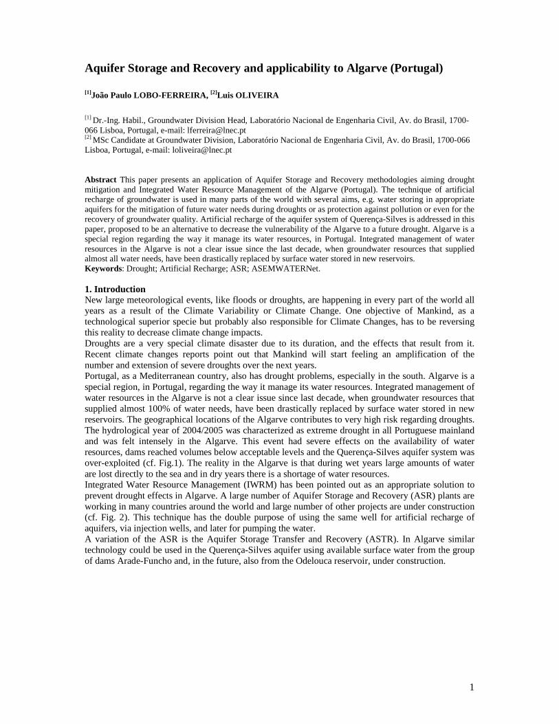
1 Aquifer Storage and Recovery and applicability to Algarve (Portugal) [1] João Paulo LOBO-FERREIRA, [2] Luis OLIVEIRA [1] Dr.-Ing. Habil., Groundwater Division Head, Laboratório Nacional de Engenharia Civil, Av. do Brasil, 1700- 066 Lisboa, Portugal, e-mail: [email protected] [2] MSc Candidate at Groundwater Division, Laboratório Nacional de Engenharia Civil, Av. do Brasil, 1700-066 Lisboa, Portugal, e-mail: [email protected] Abstract This paper presents an application of Aquifer Storage and Recovery methodologies aiming drought mitigation and Integrated Water Resource Management of the Algarve (Portugal). The technique of artificial recharge of groundwater is used in many parts of the world with several aims, e.g. water storing in appropriate aquifers for the mitigation of future water needs during droughts or as protection against pollution or even for the recovery of groundwater quality. Artificial recharge of the aquifer system of Querença-Silves is addressed in this paper, proposed to be an alternative to decrease the vulnerability of the Algarve to a future drought. Algarve is a special region regarding the way it manage its water resources, in Portugal. Integrated management of water resources in the Algarve is not a clear issue since the last decade, when groundwater resources that supplied almost all water needs, have been drastically replaced by surface water stored in new reservoirs. Keywords: Drought; Artificial Recharge; ASR; ASEMWATERNet. 1. Introduction New large meteorological events, like floods or droughts, are happening in every part of the world all years as a result of the Climate Variability or Climate Change. One objective of Mankind, as a technological superior specie but probably also responsible for Climate Changes, has to be reversing this reality to decrease climate change impacts. Droughts are a very special climate disaster due to its duration, and the effects that result from it. Recent climate changes reports point out that Mankind will start feeling an amplification of the number and extension of severe droughts over the next years. Portugal, as a Mediterranean country, also has drought problems, especially in the south. Algarve is a special region, in Portugal, regarding the way it manage its water resources. Integrated management of water resources in the Algarve is not a clear issue since last decade, when groundwater resources that supplied almost 100% of water needs, have been drastically replaced by surface water stored in new reservoirs. The geographical locations of the Algarve contributes to very high risk regarding droughts. The hydrological year of 2004/2005 was characterized as extreme drought in all Portuguese mainland and was felt intensely in the Algarve. This event had severe effects on the availability of water resources, dams reached volumes below acceptable levels and the Querença-Silves aquifer system was over-exploited (cf. Fig.1). The reality in the Algarve is that during wet years large amounts of water are lost directly to the sea and in dry years there is a shortage of water resources. Integrated Water Resource Management (IWRM) has been pointed out as an appropriate solution to prevent drought effects in Algarve. A large number of Aquifer Storage and Recovery (ASR) plants are working in many countries around the world and large number of other projects are under construction (cf. Fig. 2). This technique has the double purpose of using the same well for artificial recharge of aquifers, via injection wells, and later for pumping the water. A variation of the ASR is the Aquifer Storage Transfer and Recovery (ASTR). In Algarve similar technology could be used in the Querença-Silves aquifer using available surface water from the group of dams Arade-Funcho and, in the future, also from the Odelouca reservoir, under construction.
-
Upload
independent -
Category
Documents
-
view
1 -
download
0
Transcript of Aquifer Storage and Recovery and applicability to Algarve (Portugal
1
Aquifer Storage and Recovery and applicability to Algarve (Portugal) [1]João Paulo LOBO-FERREIRA, [2]Luis OLIVEIRA
[1] Dr.-Ing. Habil., Groundwater Division Head, Laboratório Nacional de Engenharia Civil, Av. do Brasil, 1700-066 Lisboa, Portugal, e-mail: [email protected]
[2] MSc Candidate at Groundwater Division, Laboratório Nacional de Engenharia Civil, Av. do Brasil, 1700-066 Lisboa, Portugal, e-mail: [email protected]
Abstract This paper presents an application of Aquifer Storage and Recovery methodologies aiming drought mitigation and Integrated Water Resource Management of the Algarve (Portugal). The technique of artificial recharge of groundwater is used in many parts of the world with several aims, e.g. water storing in appropriate aquifers for the mitigation of future water needs during droughts or as protection against pollution or even for the recovery of groundwater quality. Artificial recharge of the aquifer system of Querença-Silves is addressed in this paper, proposed to be an alternative to decrease the vulnerability of the Algarve to a future drought. Algarve is a special region regarding the way it manage its water resources, in Portugal. Integrated management of water resources in the Algarve is not a clear issue since the last decade, when groundwater resources that supplied almost all water needs, have been drastically replaced by surface water stored in new reservoirs. Keywords: Drought; Artificial Recharge; ASR; ASEMWATERNet. 1. Introduction New large meteorological events, like floods or droughts, are happening in every part of the world all years as a result of the Climate Variability or Climate Change. One objective of Mankind, as a technological superior specie but probably also responsible for Climate Changes, has to be reversing this reality to decrease climate change impacts. Droughts are a very special climate disaster due to its duration, and the effects that result from it. Recent climate changes reports point out that Mankind will start feeling an amplification of the number and extension of severe droughts over the next years. Portugal, as a Mediterranean country, also has drought problems, especially in the south. Algarve is a special region, in Portugal, regarding the way it manage its water resources. Integrated management of water resources in the Algarve is not a clear issue since last decade, when groundwater resources that supplied almost 100% of water needs, have been drastically replaced by surface water stored in new reservoirs. The geographical locations of the Algarve contributes to very high risk regarding droughts. The hydrological year of 2004/2005 was characterized as extreme drought in all Portuguese mainland and was felt intensely in the Algarve. This event had severe effects on the availability of water resources, dams reached volumes below acceptable levels and the Querença-Silves aquifer system was over-exploited (cf. Fig.1). The reality in the Algarve is that during wet years large amounts of water are lost directly to the sea and in dry years there is a shortage of water resources. Integrated Water Resource Management (IWRM) has been pointed out as an appropriate solution to prevent drought effects in Algarve. A large number of Aquifer Storage and Recovery (ASR) plants are working in many countries around the world and large number of other projects are under construction (cf. Fig. 2). This technique has the double purpose of using the same well for artificial recharge of aquifers, via injection wells, and later for pumping the water. A variation of the ASR is the Aquifer Storage Transfer and Recovery (ASTR). In Algarve similar technology could be used in the Querença-Silves aquifer using available surface water from the group of dams Arade-Funcho and, in the future, also from the Odelouca reservoir, under construction.
2
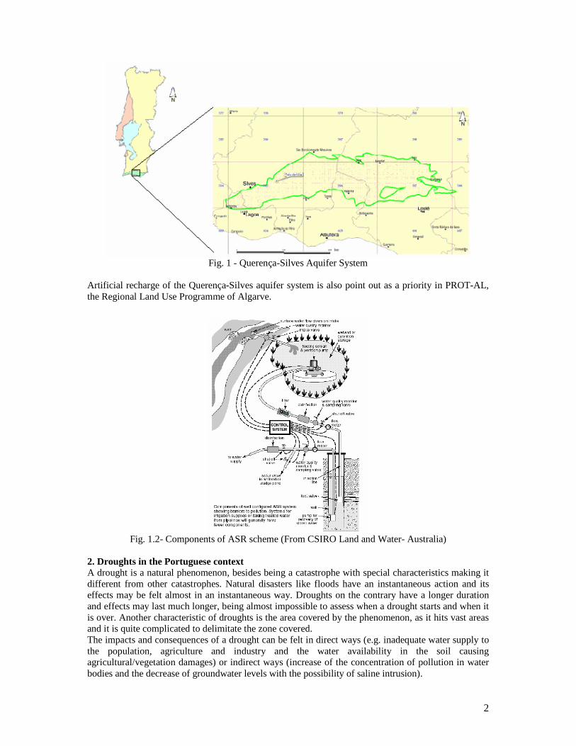
Fig. 1 - Querença-Silves Aquifer System
Artificial recharge of the Querença-Silves aquifer system is also point out as a priority in PROT-AL, the Regional Land Use Programme of Algarve.
Fig. 1.2- Components of ASR scheme (From CSIRO Land and Water- Australia)
2. Droughts in the Portuguese context A drought is a natural phenomenon, besides being a catastrophe with special characteristics making it different from other catastrophes. Natural disasters like floods have an instantaneous action and its effects may be felt almost in an instantaneous way. Droughts on the contrary have a longer duration and effects may last much longer, being almost impossible to assess when a drought starts and when it is over. Another characteristic of droughts is the area covered by the phenomenon, as it hits vast areas and it is quite complicated to delimitate the zone covered. The impacts and consequences of a drought can be felt in direct ways (e.g. inadequate water supply to the population, agriculture and industry and the water availability in the soil causing agricultural/vegetation damages) or indirect ways (increase of the concentration of pollution in water bodies and the decrease of groundwater levels with the possibility of saline intrusion).

3
In a common sense droughts are defined as “lack of water”. However its definition is much more complicated than that. It is important to state that there is no universal definition of drought. Its definition depends on the technical speciality and on the geographical location of the person that is defining it, e.g. drought definition of a meteorologist is different from that of an agro-specialist. Scarcity of water instead, is a characteristic of several areas and can be influenced by humans, in a temporary or permanent occurrence, being divided in four types as presented in the Table 1.
Table 1 – Conceptual types of scarcity of water Origin
Scarcity of Water Natural Anthropogenic Permanent Aridity Desertification Time of
occurrence Temporary Drought Lack of water available
A drought occurs when the natural event of scarcity of water is temporary (yet for a long period). A bad water management can result in lack of water availability for water users. A determinant is a variable that establish the type of analysis that should be made to the drought (Santos, 1981). Several authors divide drought in three types according to its determinant, Meteorological Drought (determinants are, for example, temperature or precipitation), Agricultural Drought (determinants are, for example, humidity in soil or piezometric level) and Urban Drought (the determinant is the volume of water available in structures with the purpose of water supply). The product of the probability of a natural disaster by the vulnerability of the region, gives the risk of the society to the adversity. Regional characteristics can be more or less amplified by humans (e.g. the retention time of water in the area can be enlarged after the construction of a dam). There is a huge difficulty in avoiding or predicting droughts so, it seams advisable to the authors, to fulfil the objective of the society in minimizing the risk of droughts, to concentrate in enforcing risk plans that aim reducing the vulnerability of the region to droughts. 2.1 Drought indices 2.1.1. Standardized Precipitation Index (SPI) The most used index in Portugal is the Standardized Precipitation Index (SPI) created by McKee et al. (1993), based on the Palmer Drought Severity Index (PDSI). The index is the standardization of the precipitation using the ratio between the deviations of the values of precipitation and an average value in a reference period of time with the standard-deviation of the reference period of time. It was design to operate in different time scales, 1, 2, 3, 6, 9, 12... 24 months. Table 2 presents the SPI intervals and the respective drought classification.
Table 2- Standardized Precipitation Index and drought severity SPI Severity of drought 0.99 to -0.99 Near normal
-1.00 to -1.49 Moderately dry
-1.50 to -1.99 Severely dry
≤ 2.00 Extremely dry
2.2. Portugal and droughts In Portugal the characterization of droughts is made since 1942 using precipitation data. Using the SPI-12 it is possible to see in Table 3 that since the agricultural year (September to August) of 1943/1944 there have been five years considered as drought in the all country, being two years extreme droughts (Domingos, 2006). Another example of such characterizations can be seen in Figure 3. In this figure SPI-12 index was computed for the Northern coastal zone and interior regions of Portugal as well as for the Southern region (columns represent municipalities and rows the years 1969-2005).

4
Table 3 – Droughts in Portugal according to the Standardized Precipitation Index- 12 months
Agricultural year Affected Territory Severity of d rought (SPI-12)
1943/44 All country Moderate to Severe
1944/45 All country Moderate to Severe
1980/81 All country Moderate to Extreme
1998/99 All country Moderate to Severe
2004/05 All country Moderate to Extreme
Figure 3 – SPI-12 values computed for selected municipalities (columns) from 1969-2005 for the
Northern coastal zone and interior regions of Portugal as well as for the Southern region 3. Techniques for artificial recharge 3.1. Infiltration basins There are several techniques to artificially recharge of aquifers. The choice of the adequate technique depends of several factors such as natural characteristics of the aquifer, proximity to the water source or the objective of the artificial recharge. Infiltration basins for artificial recharge consist, basically, in increasing natural infiltration to the aquifer. Technically there is a change in the ground above the aquifer (to a more permeable soil) in a way that the recharge water percolates easily from the surface, through the unsaturated zone to the water table level, therefore recharging the aquifer system. This is the easiest and oldest technique of artificial recharge. The infiltration basins are the preferential techniques when large open areas are available. 3.2. Injection wells – Aquifer Storage and Recovery When the area available is an obstacle or the water table is really deep the alternative is to inject directly water into the aquifer using wells.
5
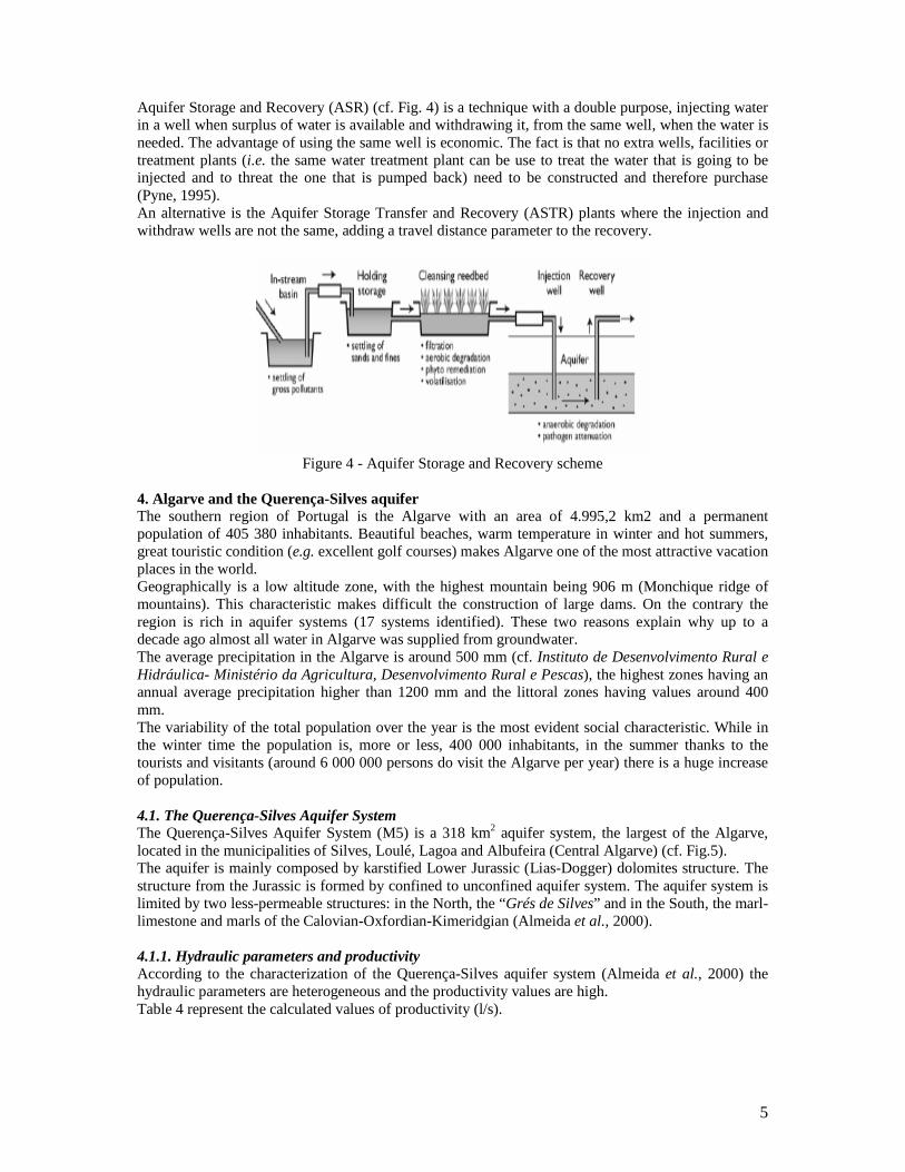
Aquifer Storage and Recovery (ASR) (cf. Fig. 4) is a technique with a double purpose, injecting water in a well when surplus of water is available and withdrawing it, from the same well, when the water is needed. The advantage of using the same well is economic. The fact is that no extra wells, facilities or treatment plants (i.e. the same water treatment plant can be use to treat the water that is going to be injected and to threat the one that is pumped back) need to be constructed and therefore purchase (Pyne, 1995). An alternative is the Aquifer Storage Transfer and Recovery (ASTR) plants where the injection and withdraw wells are not the same, adding a travel distance parameter to the recovery.
Figure 4 - Aquifer Storage and Recovery scheme
4. Algarve and the Querença-Silves aquifer The southern region of Portugal is the Algarve with an area of 4.995,2 km2 and a permanent population of 405 380 inhabitants. Beautiful beaches, warm temperature in winter and hot summers, great touristic condition (e.g. excellent golf courses) makes Algarve one of the most attractive vacation places in the world. Geographically is a low altitude zone, with the highest mountain being 906 m (Monchique ridge of mountains). This characteristic makes difficult the construction of large dams. On the contrary the region is rich in aquifer systems (17 systems identified). These two reasons explain why up to a decade ago almost all water in Algarve was supplied from groundwater. The average precipitation in the Algarve is around 500 mm (cf. Instituto de Desenvolvimento Rural e Hidráulica- Ministério da Agricultura, Desenvolvimento Rural e Pescas), the highest zones having an annual average precipitation higher than 1200 mm and the littoral zones having values around 400 mm. The variability of the total population over the year is the most evident social characteristic. While in the winter time the population is, more or less, 400 000 inhabitants, in the summer thanks to the tourists and visitants (around 6 000 000 persons do visit the Algarve per year) there is a huge increase of population. 4.1. The Querença-Silves Aquifer System The Querença-Silves Aquifer System (M5) is a 318 km2 aquifer system, the largest of the Algarve, located in the municipalities of Silves, Loulé, Lagoa and Albufeira (Central Algarve) (cf. Fig.5). The aquifer is mainly composed by karstified Lower Jurassic (Lias-Dogger) dolomites structure. The structure from the Jurassic is formed by confined to unconfined aquifer system. The aquifer system is limited by two less-permeable structures: in the North, the “Grés de Silves” and in the South, the marl-limestone and marls of the Calovian-Oxfordian-Kimeridgian (Almeida et al., 2000). 4.1.1. Hydraulic parameters and productivity According to the characterization of the Querença-Silves aquifer system (Almeida et al., 2000) the hydraulic parameters are heterogeneous and the productivity values are high. Table 4 represent the calculated values of productivity (l/s).
6
Table 4 – Statistics of the productivity of the Querença-Silves aquifer system Average Standard Deviation Minimum Q1 Median Q3 Maximum 12.2 9.8 0.0 5.8 11.1 16.6 83.3
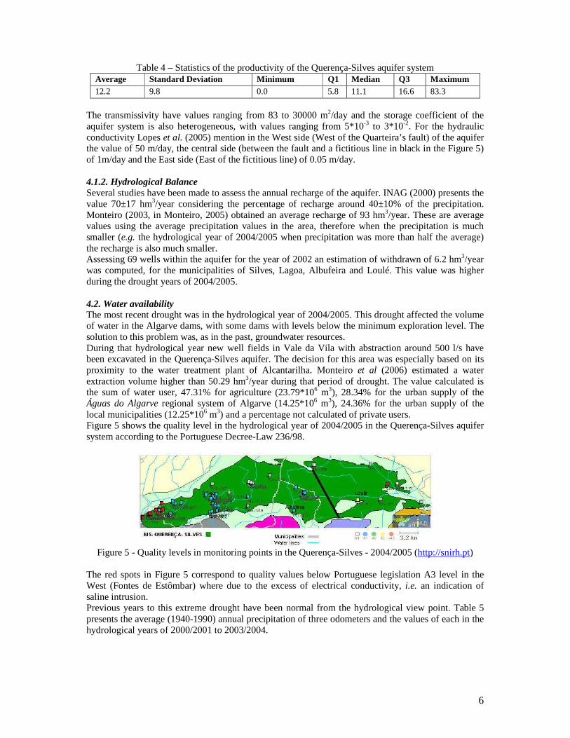
The transmissivity have values ranging from 83 to 30000 m2/day and the storage coefficient of the aquifer system is also heterogeneous, with values ranging from 5*10-3 to 3*10-2. For the hydraulic conductivity Lopes et al. (2005) mention in the West side (West of the Quarteira’s fault) of the aquifer the value of 50 m/day, the central side (between the fault and a fictitious line in black in the Figure 5) of 1m/day and the East side (East of the fictitious line) of 0.05 m/day. 4.1.2. Hydrological Balance Several studies have been made to assess the annual recharge of the aquifer. INAG (2000) presents the value 70±17 hm3/year considering the percentage of recharge around 40±10% of the precipitation. Monteiro (2003, in Monteiro, 2005) obtained an average recharge of 93 hm3/year. These are average values using the average precipitation values in the area, therefore when the precipitation is much smaller (e.g. the hydrological year of 2004/2005 when precipitation was more than half the average) the recharge is also much smaller. Assessing 69 wells within the aquifer for the year of 2002 an estimation of withdrawn of 6.2 hm3/year was computed, for the municipalities of Silves, Lagoa, Albufeira and Loulé. This value was higher during the drought years of 2004/2005. 4.2. Water availability The most recent drought was in the hydrological year of 2004/2005. This drought affected the volume of water in the Algarve dams, with some dams with levels below the minimum exploration level. The solution to this problem was, as in the past, groundwater resources. During that hydrological year new well fields in Vale da Vila with abstraction around 500 l/s have been excavated in the Querença-Silves aquifer. The decision for this area was especially based on its proximity to the water treatment plant of Alcantarilha. Monteiro et al (2006) estimated a water extraction volume higher than 50.29 hm3/year during that period of drought. The value calculated is the sum of water user, 47.31% for agriculture (23.79*106 m3), 28.34% for the urban supply of the Águas do Algarve regional system of Algarve (14.25*106 m3), 24.36% for the urban supply of the local municipalities (12.25*106 m3) and a percentage not calculated of private users. Figure 5 shows the quality level in the hydrological year of 2004/2005 in the Querença-Silves aquifer system according to the Portuguese Decree-Law 236/98.
Figure 5 - Quality levels in monitoring points in the Querença-Silves - 2004/2005 (http://snirh.pt)
The red spots in Figure 5 correspond to quality values below Portuguese legislation A3 level in the West (Fontes de Estômbar) where due to the excess of electrical conductivity, i.e. an indication of saline intrusion. Previous years to this extreme drought have been normal from the hydrological view point. Table 5 presents the average (1940-1990) annual precipitation of three odometers and the values of each in the hydrological years of 2000/2001 to 2003/2004.
7
Table 5 - Values of precipitation in three odometers (from http://snirh.pt)
BARRAGEM DO ARADE (30G/03C)
SÃO BARTOLOMEU DE MESSINES (30H/03UG)
PADERNE (30H/05UG)
Precipitation (mm/year) Precipitation (mm/year) Precipitation (mm/year)
Average 603.5 699.3 671.6
2000/2001 814.8 898.4 702.8
2001/2002 678.0 642.1 -
2002/2003 492.3 636.4 -
2003/2004 524.6 - 440.8
2004/2005 273.8 248.0 248.5
As can be seen in Table 5 the five previous hydrological years to the drought year were almost normal (compared to the average 1940-1990). What is important to analyse is that the Arade dam odometer had two years with annual precipitation higher than the average, i.e. in five hydrological years there was one drought and two years with values above the average precipitation. It is normal to conclude that in the year of 2000/2001 there was discharge in the Arade’s river dams. Table 6 presents the peak discharges of the Arade dam in the year of 2000/2001.
Table 6- Peak discharge of the Arade dam in the hydrological year of 2000/2001
Dam Depth discharge (*103 m3) Surface discharge (103 m3) Total discharge (*103 m3) ARADE 37 499.20 19 256.70 56 755.90
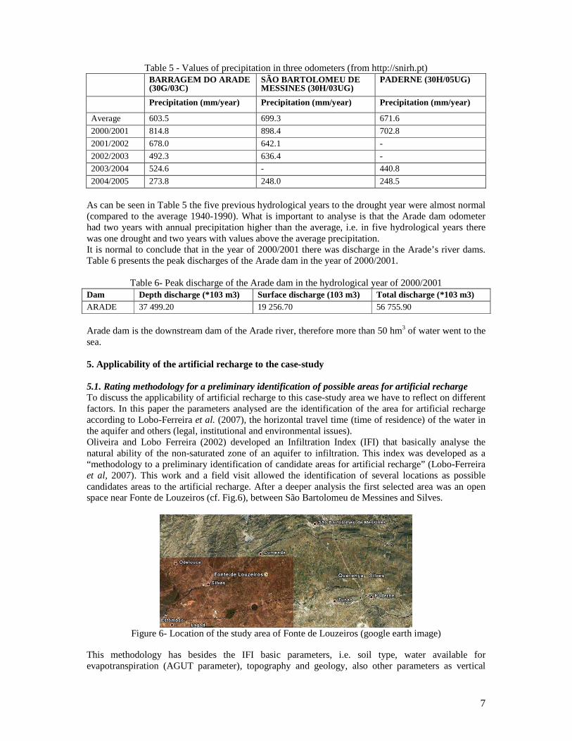
Arade dam is the downstream dam of the Arade river, therefore more than 50 hm3 of water went to the sea. 5. Applicability of the artificial recharge to the case-study 5.1. Rating methodology for a preliminary identification of possible areas for artificial recharge To discuss the applicability of artificial recharge to this case-study area we have to reflect on different factors. In this paper the parameters analysed are the identification of the area for artificial recharge according to Lobo-Ferreira et al. (2007), the horizontal travel time (time of residence) of the water in the aquifer and others (legal, institutional and environmental issues). Oliveira and Lobo Ferreira (2002) developed an Infiltration Index (IFI) that basically analyse the natural ability of the non-saturated zone of an aquifer to infiltration. This index was developed as a “methodology to a preliminary identification of candidate areas for artificial recharge” (Lobo-Ferreira et al, 2007). This work and a field visit allowed the identification of several locations as possible candidates areas to the artificial recharge. After a deeper analysis the first selected area was an open space near Fonte de Louzeiros (cf. Fig.6), between São Bartolomeu de Messines and Silves.
Figure 6- Location of the study area of Fonte de Louzeiros (google earth image)
This methodology has besides the IFI basic parameters, i.e. soil type, water available for evapotranspiration (AGUT parameter), topography and geology, also other parameters as vertical
8
hydraulic conductivity in saturated conditions (K), depth to the water table (D), excavation depth (E), distance to the water source (O), land use (L) and vertical time of travel in saturated conditions, given by the relation D/K (tt). Since the area around Fonte de Louzeiros is a karst formation, the local IFI value corresponds to the maximum value (30). Other advantages of the area are the proximity to the water source (Arade dam), about 7 km by road, and land use is appropriate as abandoned agricultural areas seams to be available. The depth to the water table is expected to be higher than 40-50 m, and so parameter D value is advantageous as available unsaturated zone will allow for extra recharge water to be incorporated into the aquifer reserves. Also the fact that the zone is a karst one allow a quicker vertical travel time (tt). Algarve has a large amount of traditional large diameter wells (“noras”) for water withdraws. Nowadays these traditional wells are almost in disuse and many are abandoned. Another aim of this study is to use these, already existing, wells to inject water and recharge the aquifer, avoiding the problem of the vertical travel time and the need to excavate or construct wells. 5.2. Water available to recharge and time of residence in the aquifer system Other two parameters necessary to be analysed are the amount of water available for artificial recharge and the time of residence of water within the aquifer before arriving to a spring or river. As analysed before, in the year of 2000/2001 more than 56 hm3 (that by coincidence is a similar volume to the pumping from Querença-Silves in 2004/2005) was discharge from the Arade dam to the Arade river and consequently to the sea. Similar situation happened in the past, e.g. before the drought of 1998/99 the dam of Arade had a total peak discharge of 246 hm3, from 1995/96 to 1997/98. This “not used or lost” water together with similar volumes of water from the future Odelouca dam is more than enough for the artificial recharge of Querença-Silves aquifer. After this conclusion we have to address the question: How long will the injected water reside in the aquifer? Answering the question requires the analysis of the horizontal travel time. A simple assessment method for the horizontal travel velocity is using Darcy law. There are some discussion on the conceptual model of this aquifer system but almost all authors agree that in the West side of the Querença-Silves aquifer system the direction of the flow is E-W. The analysis of the hydraulic gradient in this area gives the information that for 5000 m the piezometric level decrease (from East to West) around 5 m. So a very low slope of 1*10-3 is obtained. Since the Querença-Silves aquifer system is a karstic aquifer, the average hydraulic conductivity is superior to the real hydraulic conductivity (it is necessary to consider the fractures). Therefore with an average hydraulic conductivity of 50 m/day and an effective porosity of 2*10-2, the horizontal travel velocity obtain is of 250 cm/day i.e. if the aquifer was recharge in Fonte de Louzeiros and the pumping back was made in Silves (10 km distance) the time of residence of the water would be around 10 years (more than the 6 years of sequence of droughts in Portugal, cf. Figure 3). Even if we considered that with the artificial recharge the hydraulic gradient increases, e.g. a decrease of 10 m per 5 km, the horizontal travel velocity is 500 cm/day, i.e. a time of residence of 2000 days (around 5 years) per 10 km. Another strengthens to this proposes is the fact that this aquifer, even with high horizontal velocities, has a high inter-annual storage capacity. These contradictions are explained due the flow complexity of the Querença-Silves aquifer system. 5.3. Environmental analysis Different aspects may be considered in the environmental analysis: the vulnerability of the aquifer, the possibility of creation of an artificial wet area due to excess of recharge, protected areas, saline intrusion and the quality of the water that is used for artificial recharge. The fact that the area considered for the artificial recharge has a large depth to the water table situates the aquifer not in such vulnerability conditions to pollution (even been in a highly karstified zone). The vulnerability analysis was made using the DRASTIC method and the values computed weren’t as high as expected. This characteristic also ensures the natural capabilities of the aquifer for its protection against pollution. Protected areas are also not a problem in this case-study since the closer areas considered protected are the “Rocha da Pena”, north of Benafim, the “Fonte de Benémola” and the “Ria Formosa” in Faro.

9
The potential problem of saline intrusion with water from the Arade river estuary due to over-exploitation and low recharge of the aquifer (a normal situation in drought conditions) could be solved with the reuse (for injection) of treated waste water in the East of Silves creating a barrier to the brackish water intrusion. The required quality of the water for artificial recharge is a legal issue under analysis in the next section. 5.4. Other factors From the possible other factors that could influence the applicability of artificial recharge to the Querença-Silves aquifer this paper focus on the analysis of available areas, institutional issues and legal issues. In Gabardine, a successful on-going EU FP6 sponsoring artificial recharge research by LNEC (cf. http://www.dha.lnec.pt/nas/pdf/Projecto_Gabardine_ing.pdf), experimental tests made in Campina de Faro aquifer system (Algarve) (cf. Diamantino et al. (2007) paper to Lisbon’s 2007 IAH Congress) allowed the quantification of infiltration values ca. 150 m3/day in infiltration basins with areas 100 m2
large and, up to 480 m3/day in the traditional “noras” (infiltration area of 20 m2). It is possible to consider that in the Querença-Silves the values are higher since it is a karstified aquifer. Using values of infiltration 40% above for the Querença-Silves aquifer we obtain 210 m3/day per infiltration basin and 670 m3/day per “nora”. Observing these values it is important to conclude that is would be advisable to consider also additional basins for the retention and storage of extra water for recharge. An institutional problem is the fact that this proposal and its project may eventually collide with interests of different institutions involved in water management issues in the area. We do hope that the recently created Regional Administrations for Water Resources in Portugal (ARHs) may help decreasing the possibility of conflicts. Considering other legal issues, focus should be made on the new Portuguese Water Law (Decreto-Lei nº 58/2005 of 29 December 2005) where it is mentioned that “controls, including a requirement for prior authorization of artificial recharge or augmentation of groundwater bodies. The water used may be derived from any surface water or groundwater, provided that the use of the source does not compromise the achievement of the environmental objectives established for the source or the recharged or augmented body of groundwater”. 6. Final conclusion As preliminary conclusion the authors believe that artificial recharge is a good solution deserving to be researched and applied to the Algarve. If Gabardine project research experiments are successful we are sure that this will be an important tool to be incorporated in Algarve drought risk plans. Further research is also welcome, involving more comprehensive economical and social factors and actors. Acknowledgments The authors do acknowledge the support of the European Commission for ASEMWATERNET (http://www.dha.lnec.pt/nas/pdf/ASEMWATERNet_Project_Summary_en.pdf) FP6 Coordination Action “Multi-Stakeholder Platform for ASEM S&T Cooperation on Sustainable Water Use”, under INCO-CT2005-510897 contract, as well as Laboratório Nacional de Engenharia Civil and Instituto Superior Técnico of the Technical of University of Lisbon, in Portugal, for the Master-Degree support of co-author Luis Oliveira. References Almeida, C.; Mendonça, J.L.; Jesus, M.R.; Gomes, A.J. (2000) Sistemas Aquíferos de Portugal Continental,
Relatório. INAG, Instituto da Água. Lisboa. Electr. Doc., CD-ROM CSIRO Land and Water- Australia webpage. http://www.clw.csiro.au/ Diamantino, C.; Lobo Ferreira, JP; Leitão, T. (2007) - Artificial aquifer recharge experiments in the Portuguese
Campina de Faro Case-study area. 35th Congress of IAH Groundwater and Ecosystems Lisbon, Sept. 2007.
Domingos, S.I.S. (2006) Análise do índice de seca Standardized Precipitation Índex (SPI) em Portugal Continental e sua comparação com o Palmer Drought Severity Index (PDSI), Thesis submitted for the Degree of Master. Lisboa
Instituto de Desenvolvimento Rural e Hidráulica- Ministério da Agricultura, Desenvolvimento Rural e Pescas webpage. http://www.idrha.min-agricultura.pt/

10
Lobo-Ferreira, J.P.C.; OLIVEIRA, M.M.; DIAMANTINO, C. (2007) GABARDINE project: Portuguese test site contribution to D24. Lisboa, Maio, 16 pp.
Lopes, A; Rodrigues, R.; Orlando, M.(2005) O Aproveitamento Sustentável dos Recursos Hídricos Subterrâneos do Sistema Aquífero Querença-Silves na Seca de 2004/2005. INAG, Instituto da Água. Direcção de Serviços de Recursos Hídricos. Technical Report. Lisboa.
Mckee, T.B., Doesken, N.J. e Kleist, J. (1993) The relationship of drought frequency and duration to the time scales. 8th Conference on Applied Climatology, pp.179-184
Monteiro, J.P.; Vieira, J.; Nunes, L.; Younes, F. (2006) Inverse Calibration of a Regional Flow Model for the Querença-Silves Aquifer System (Algarve-Portugal). Integrated Water Resources Management and Challenges of the Sustainable Development. International Association of Hydrogeologists, IAH. Marrakech. pp 44, doc. Elect. CD-ROM - 6pp.
Monteiro, J.P. (2005) A importância do Dimensionamento de Captações de Águas Subterrâneas no Algarve - Passado, Presente e Futuro, Manual Técnico de Engenharia, Águas Subterrâneas e Efluentes Tratados da GRUNDFOS, Lisboa, Expresso Gráfico.
Oliveira, M.M., Lobo-Ferreira, J.P. (2002) “Proposta de uma Metodologia para a Definição de Áreas de Infiltração Máxima”. Associação Portuguesa dos Recursos Hídricos, Revista Recursos Hídricos, Vol. 23 n.º 1, May 2002 pp. 63-74
Pyne, R.D.G. (1995) Groundwater recharge and wells- A guide to Aquifer Storage Recovery. Lewis Publishers, A CRC Press Company.
Santos, M.A.B.A. (1981) On the stochastic characterization of regional droughts. Specialist Thesis. Laboratório de Engenharia Civil. Lisboa