APPLICATION SPECIAL EXCEPTION WALLER SOLAR PROJECT ...
22
` APPLICATION FOR SPECIAL EXCEPTION FOR THE WALLER SOLAR PROJECT LANCASTER COUNTY, VIRGINIA July 1, 2021 Prepared by: Waller Solar I, LLC 1105 Navasota Street Austin, TX 78702 Contact: Craig Adair Tel: (512) 297-6611 With Assistance From: The Timmons Group 1001 Boulders Parkway, Suite 300 Richmond, VA 23225 Contact: Rick Thomas Tel: (804) 200-6446
-
Upload
khangminh22 -
Category
Documents
-
view
4 -
download
0
Transcript of APPLICATION SPECIAL EXCEPTION WALLER SOLAR PROJECT ...

`
APPLICATION
FOR
SPECIAL EXCEPTION
FOR THE
WALLER SOLAR PROJECT
LANCASTER COUNTY, VIRGINIA
July 1, 2021
Prepared by: Waller Solar I, LLC 1105 Navasota Street Austin, TX 78702 Contact: Craig Adair Tel: (512) 297-6611
With Assistance From:
The Timmons Group 1001 Boulders Parkway, Suite 300 Richmond, VA 23225 Contact: Rick Thomas Tel: (804) 200-6446

i
Table of Contents
I. Summary .............................................................................................................. 1
II. Project Description ............................................................................................... 2
A. Project Components .................................................................................. 2
B. Project Location and Setbacks .................................................................. 3
C. Low Visibility .............................................................................................. 5
D. Development Plans .................................................................................. 10
III. Decommissioning ............................................................................................... 12
IV. Project Benefits .................................................................................................. 13
A. Minimal Use of County Services .............................................................. 13
B. New County Revenue .............................................................................. 14
C. Lancaster’s Contribution to Clean Energy................................................ 15
V. Other Regulations and Permits........................................................................... 16
A. Site Plan .................................................................................................. 16
B. Erosion Control and Stormwater Management ........................................ 16
C. State Solar Approval ................................................................................ 17
VI. Satisfaction of Special Exception Criteria ........................................................... 17
A. Conformance with Land Use Plan ........................................................... 18
B. Public Health, Safety, Morals and General Welfare ................................. 18
C. Utilities and Off-Street Parking ................................................................. 19
D. Surrounding Property, Persons and Neighborhood Values ..................... 19
E. Applicant’s Proposed Conditions ............................................................. 19

ii
Exhibits
Exhibit 1 Description of Project Components
Exhibit 2 Typical Solar Fields from Different Heights
Exhibit 3 Project Area Map
Exhibit 4 List of Participating Properties
Exhibit 5 Participating Properties Map
Exhibit 6 Zoning Overlay Districts Map
Exhibit 7a General Development Plan: Zoning & Setback Map
Exhibit 7b General Development Plan: Environmental Features Map
Exhibit 7c General Development Plan: Conceptual Layout
Exhibit 7d General Development Plan: Landscaping Map
Exhibit 8 Preliminary Decommissioning Plan
Exhibit 9 Economic & Fiscal Impact Report - Executive Summary
Exhibit 10 Preliminary Emergency Response Plan
Exhibit 11 Evidence of Applicant’s Right to Use the Property
Exhibit 12 Applicant’s Proposed Conditions
1
I. Summary
This Application for a Special Exception for the Waller Solar Project (“Application”)
is submitted to Lancaster County, Virginia (“County”) by Waller Solar I, LLC (“Applicant”)
to construct, operate and decommission the Waller Solar Project (“Project”). The Project
will fully comply with the County’s recently-adopted ordinance for utility-scale solar
facilities, new Article 28 of the Land Development Code, which becomes effective July 1,
2021 (“Solar Ordinance”). The Application provides the information needed for the County
to issue a Special Exception (“SE”) for the Project.
The Project will be a solar electric generation facility with the capacity to deliver up
to 131 megawatts (“MW”) of electricity to the existing transmission system. It will consist
of a series of separately-fenced fields of ground-mounted solar panels connected by
buried cables and access roads to a new point of interconnection on the County’s primary
transmission line. The Project will generate electricity with virtually no light, noise, odor,
dust or traffic, and it will not produce any air pollution, water pollution or waste or use any
pipelines or fuel.
Most of the Project will consist of open space between and around the solar panels.
Within the Project’s fence lines, the ground surface will be planted with native turf grass
that will preserve the soil, minimize erosion, and improve water quality. The Project will
require relatively few changes to the land, with topsoil remaining at the Project and few
underground foundations. At the end of the useful life of the solar panels, the equipment
will be removed and the land can again be used for forestry or farming (or other uses).
As a highly passive use, the Project compliments the rural character of the area.
The solar panels will have a low and consistent visual profile and the Project’s perimeter
will include substantial setbacks from parcel lines and public roads, which will contain
landscaping consisting of retained existing timber, planted vegetation, or a naturally-
grown buffer. The Project will be monitored remotely with workers visiting different areas
of the Project only as needed to perform inspections, maintenance and repairs, grounds
maintenance, and to occasionally clean the solar panels of accumulated dust and dirt.
The Project will provide at least $15 million in new revenue to the County over its
40-year life. It also will boost economic activity in the form of additional local spending
during construction. Most of the land for the Project will be leased, and the participating

2
families will earn steady revenue for decades, much of which may be spent and
reinvested locally.
II. Project Description
A. Project Components
The Project will consist of long rows (also called “arrays”) of solar panels mounted
on metal posts in open fields that are connected with electric cables. The power from
each solar panel will be combined, converted from direct current (“DC”) to alternating
current (“AC”), and its voltage increased to match that of the existing “Garner DP-
Lancaster 115 kV” transmission line (“Transmission Line”), to which the Project will
connect. The Project will include the following primary components:
Component Description
Solar Panels Devices that generate low-voltage electricity using the photovoltaic effect
Racking Metal frames to which solar panels and electrical cables are attached
Piles Metal posts driven into the ground and to which racking is attached
Inverters Metal cabinets with equipment that converts DC to AC, increases voltage and performs related functions
Collection Lines Electrical and communication cables either mounted on racking or buried
Substation A facility that gathers electricity from the inverters, increases the voltage, and delivers it to the transmission system. The Project will have two Substations, a project-owned “Collector Substation” and a utility-owned “Switchyard”
SCADA
“Supervisory Control and Data Acquisition” system that allows for remote monitoring and control of trackers, inverters, and other components
Roads Unpaved roads, grassy driving aisles, and entrances to the Project from public roads
Pyranometers Instruments that measure solar energy and weather conditions
Fencing Metal fencing that meets applicable electric codes and insurance standards
Stormwater controls
Ponds, level spreaders and other structures that manage stormwater run-off
3
Each of these primary components is described in greater detail and with illustrative
photographs in Exhibit 1.
Roughly 60-70% of the ground surface within each solar field will be open space.
Space is needed between and around the arrays for vehicles and workers to perform
inspections, maintenance and repairs and to occasionally clean the solar panels of
accumulated dust and dirt.1 Relatively wide corridors between arrays are needed to
prevent them from shading each other, and the open space between the arrays will be
wider than the arrays themselves. The series of images included as Exhibit 2 shows an
operating solar project in Virginia and illustrates how most of the land will remain open.
In accordance with the Solar Ordinance (Section 28-5-6), the surface in each solar
field—including almost all of the area below the solar panels themselves—will be planted
with a robust, low-growing seed mix, primarily native grasses and other low-maintenance
varieties. This ground cover will be maintained with regular mowing and supplemented
with approved herbicides. The vegetative cover will absorb precipitation, provide wildlife
habitat, and improve water quality by filtering stormwater and reducing the use of farm-
related pesticides and herbicides. Because it will remain in place at all times, the ground
cover also will reduce erosion, run-off and nutrient loss.
B. Project Location and Setbacks
The Project Area (not including buried collection lines and connecting roads) is
comprised of approximately 1,400 acres of private land, consisting of medium- to large-
sized timber tracts and farm fields in the general vicinity of Alfonso and Lively, surrounded
by areas of relatively low population density. The current land uses in the Project Area
are predominately timber and agriculture. Solar panels generally must avoid steep slopes
and water features such as streams, wetlands and floodplains, and the Project Area
readily accommodates the Project because it contains sufficient dry and relatively level
upland areas.
A key reason for the Project’s location and size is its proximity to the Transmission
Line. In the vicinity of Project, the Transmission Line travels parallel to and just east of
Route 3. Studies conducted by the manager of the multi-state electrical grid show that the
1 This “soiling” of solar panels reduces the amount of energy they produce. Typical rainfall in the County should be sufficient to clean the solar panels, but occasional cleaning with soap and water may occur.
4
Project can deliver its power at this location in a cost-effective manner.2 A map of the
County depicting the location of the Project Area and the Transmission Line is provided
in Exhibit 3.
The Project Area consists of 19 parcels owned by 8 different families. A list of
participating properties is provided in Exhibit 4, and a map of the participating properties
is provided in Exhibit 5. As required under Section 28-5-2(H) of the Solar Ordinance,
evidence of Applicant’s right to use the subject property is provided in Exhibit 11. Nearly
all of the parcels are located within the A-1 or A-2, Agricultural Districts, in which solar
projects are permitted with a SE.3 As shown in the map in Exhibit 6, the Project is in the
vicinity of, but does not overlap with, the Waterfront Overlay District or the Highway
Corridor Overlay District. Except for limited access road crossings, all above-ground
infrastructure for the Project will avoid water-related features in the area, including
wetlands, floodplains and the Resource Protection Area (“RPA”). A map showing various
environmental features in the vicinity of the Project is included in the General
Development Plan in Exhibit 7.
The Project will adhere to the setbacks specified in the Solar Ordinance (Section
28-5-2(C)), which are the following as measured from any above-ground infrastructure
(i.e., the fence for the Project):
1. Property Line Setbacks. 50 feet from property lines, except 100 feet for residential districts.
2. Road Setbacks. 75 feet from public road rights-of-way, except 250 feet from Route 200, 354 or 3.
In accordance with the above requirements, the Project will include 50-foot
setbacks between the fence and parcel lines of adjacent parcels, except in the few
locations where Project parcels abut residential districts and the setback therefore will be
2 See the study results available from PJM Interconnection for new generation request nos. AD2-074 and AF1-042 at https://pjm.com/planning/services-requests/interconnection-queues.aspx.
3 As of the date this Application was submitted, two parcels (6-47 and 13-160) are zoned R-1, Residential General. The property owner, with assistance from Applicant, plans to submit an application to the Board of Supervisors to rezone these two parcels to one of the Agricultural Districts. Applicant and owner anticipate that the rezoning will be approved prior to the Board’s consideration of this Application. In the event the re-zoning applications are not approved, these two parcels will be removed from the Project Area and withdrawn from this Application.
5
100 feet. The Project also will incorporate a 75-foot setback between the fence and the
edge of the right-of-way of public roads, except for a small portion along Route 3, where
the setback will be 250 feet.
C. Low Visibility
Owing to the nature and location of the Project, solar development “best practices,”
and the County’s comprehensive Solar Ordinance, the Project will have very low to
virtually no visual impact on surrounding residents and landowners. It will have even less
visibility to the general public, including the travelling public.
First, the Project is located in an area of the County with relatively low population
density. Within this larger area, the individual solar fields themselves are mostly removed
from roads and homes. As a general rule, the Project components are “out of sight, out
of mind.”
Second, as noted above, the Project will incorporate substantial setbacks between
all above-ground components and neighboring land, residential districts, and roads.
These include a very substantial setback (250 feet) from Route 3. These robust setbacks
will reduce the visual impact of Project infrastructure by moving it further away from
neighbors, area residents, and visitors.
Third, per the Solar Ordinance, the Project will incorporate robust, 40-foot-wide
vegetative buffering along its entire perimeter. Specifically, the Project will comply with
the highly-detailed vegetative buffer requirements of the Solar Ordinance (Section 28-45-
2(D). It provides for these three types of buffer:
1. Planted Buffer. 4 parallel rows (8 to 10 feet apart) consisting of medium-to-large shrubs (planted at least 12 inches high and 3 to 4 feet apart) and evergreen trees (planted at least 4 feet high and 10 feet apart).
2. Existing Vegetation. Existing vegetation or forest that is functionally equivalent to a Planted Buffer.
3. Natural Buffer. At locations that are at least 1,000 feet from homes, the cessation of mowing and natural recruitment of shrubs and trees that reach at least 10 feet high in 24 months/2 seasons.
Like much of the Northern Neck, the Project Area is heavily forested. In accordance with
the Solar Ordinance (Section 28-5-3), the maximum height of all of the equipment within

6
a given solar field (solar panels, inverters and pyranometers) will be 15 feet. The relatively
low profile of the equipment combined with significant existing vegetation means that
most of the Project will be naturally obscured from view even without a Planted Buffer.
Finally, the Project will include, as required by the Solar Ordinance, a number of
other features to further reduce its visibility. These include minimization of any glare
(Section 28-5-2(E)), limited signage (Section 28-5-4), and limited and controlled lighting
(Section 28-5-5).
Taken together, these factors mean that the Project will only modestly affect the
scenic quality of the rural landscape, mainly by adding vegetation where there traditionally
has been none. This will be especially true for neighboring homes and busy roads. There
are relatively few homes along substantial portions of the Project’s perimeter. Those
along the perimeter tend to cluster along Route 600 (Lara Road), Route 617 (Alfonso
Road), Route 622 (Morattico Road), and Route 3 (Mary Ball Road) with a few along Route
201 (Courthouse Road). Existing timber, vegetation on neighboring parcels, and other
existing homes and structures will largely obscure views of the solar panels from most
occupied locations.
As discussed above and as depicted in the General Development Plan, the
Applicant anticipates that most of the Project will be naturally obscured from view by
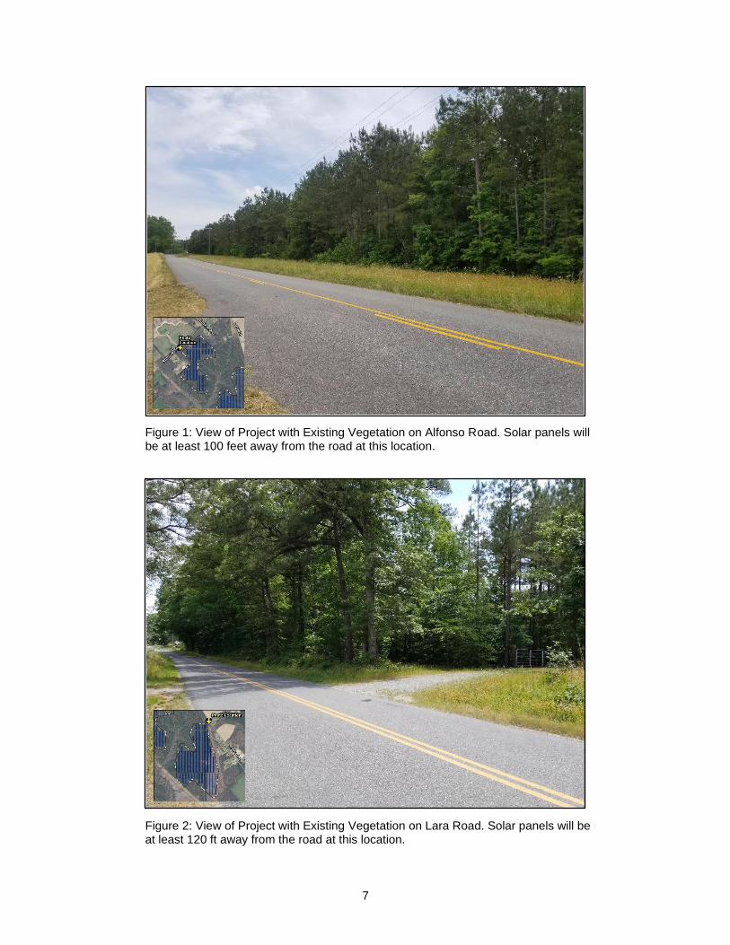
existing vegetation and tree stands. Below are two examples of locations along public
roads where the Applicant anticipates that the Project will be largely or entirely obscured
from view by existing vegetation.
7
Figure 1: View of Project with Existing Vegetation on Alfonso Road. Solar panels will be at least 100 feet away from the road at this location.
Figure 2: View of Project with Existing Vegetation on Lara Road. Solar panels will be at least 120 ft away from the road at this location.
8
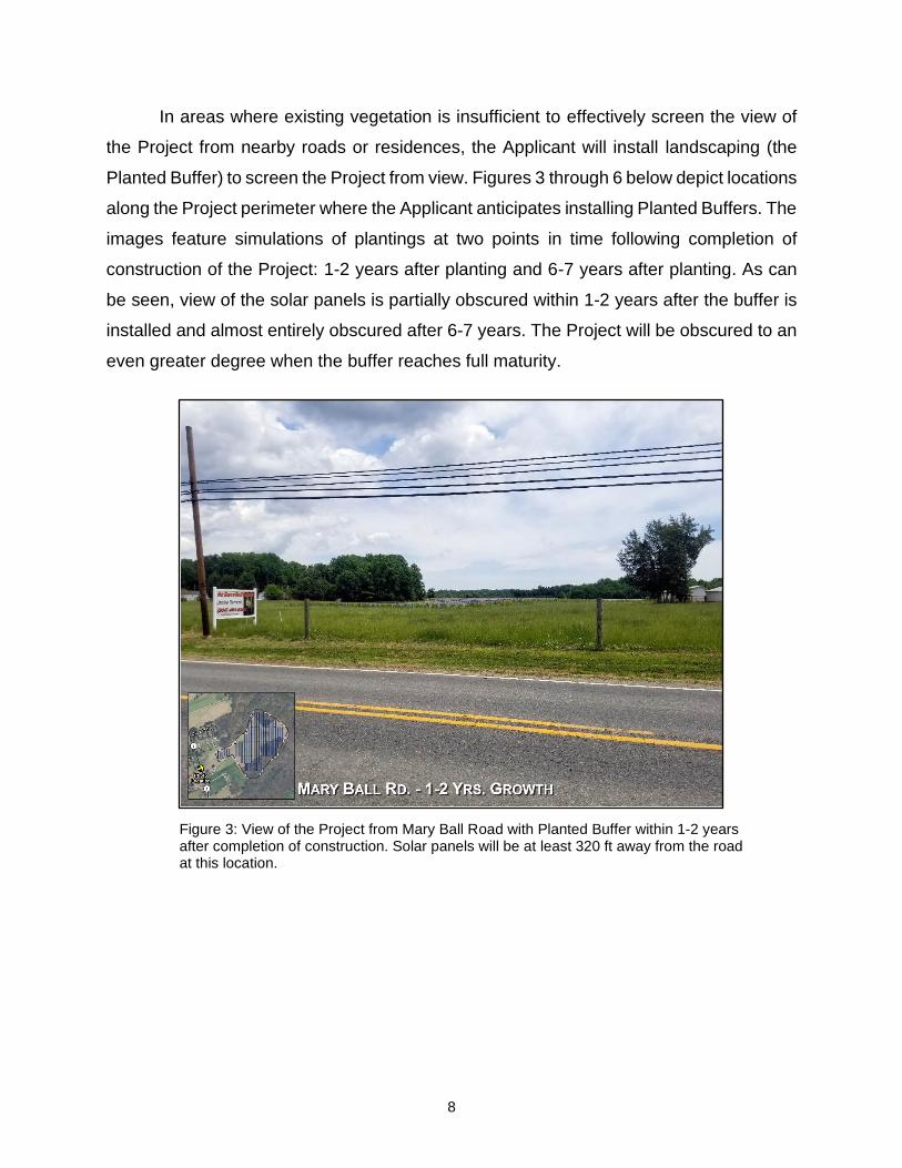
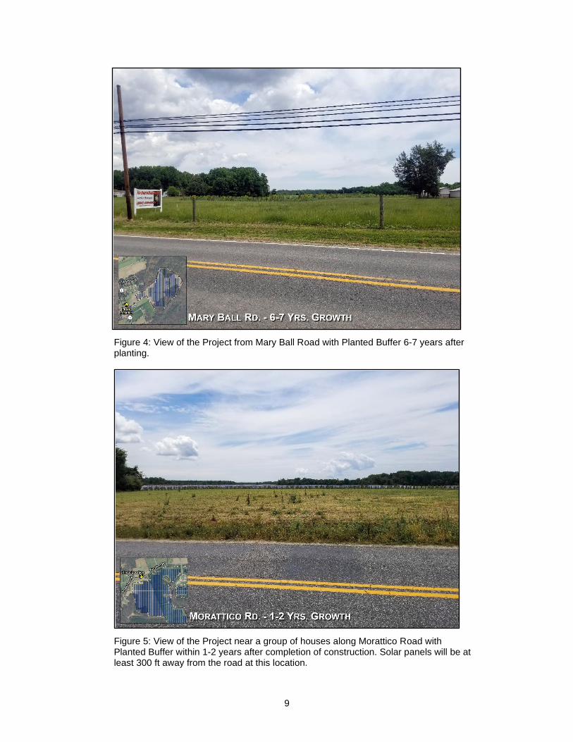
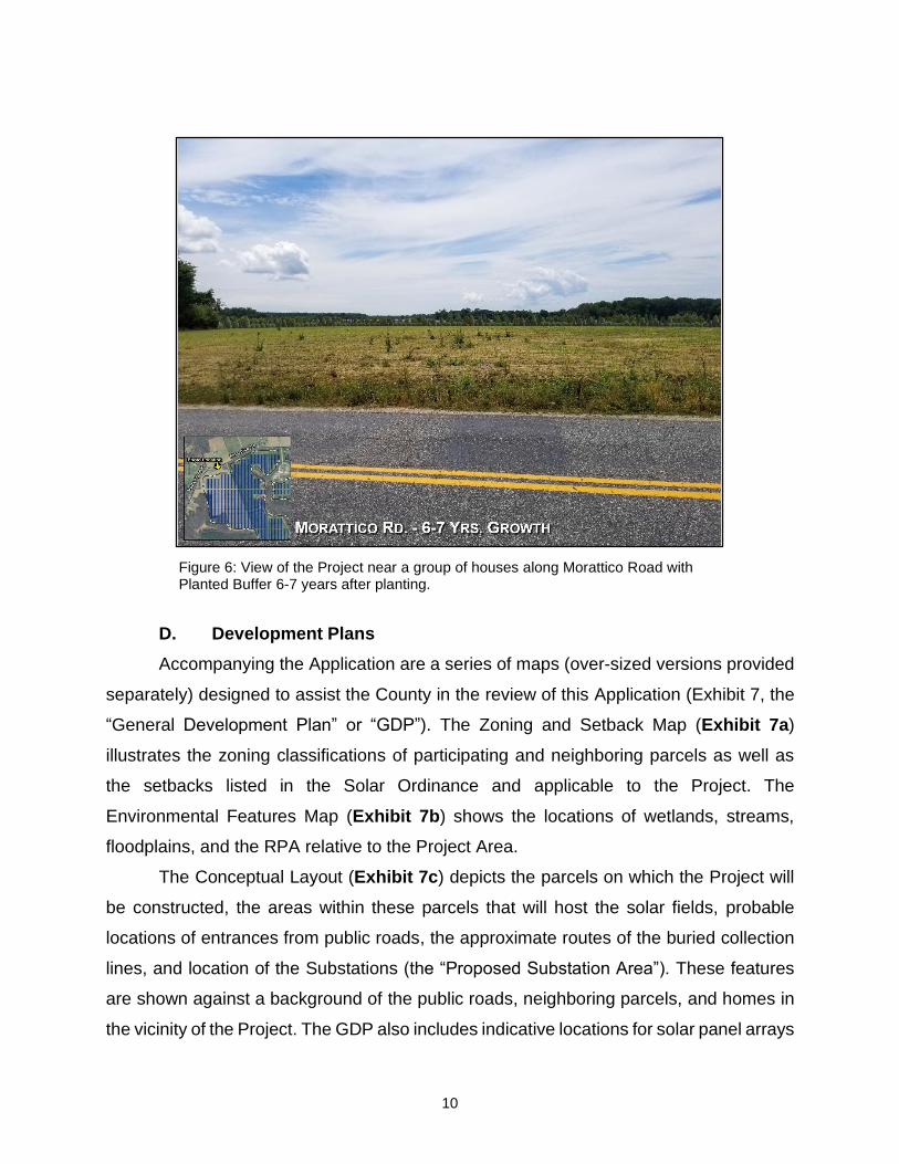
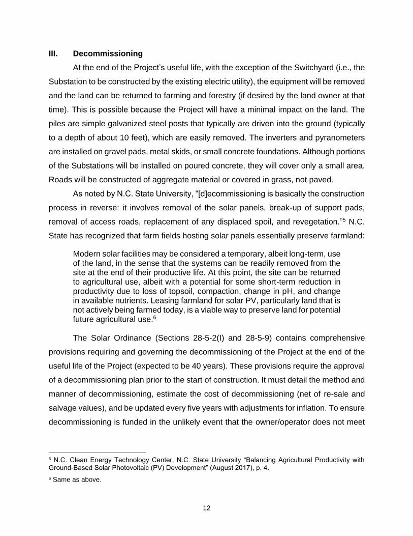
In areas where existing vegetation is insufficient to effectively screen the view of
the Project from nearby roads or residences, the Applicant will install landscaping (the
Planted Buffer) to screen the Project from view. Figures 3 through 6 below depict locations
along the Project perimeter where the Applicant anticipates installing Planted Buffers. The
images feature simulations of plantings at two points in time following completion of
construction of the Project: 1-2 years after planting and 6-7 years after planting. As can
be seen, view of the solar panels is partially obscured within 1-2 years after the buffer is
installed and almost entirely obscured after 6-7 years. The Project will be obscured to an
even greater degree when the buffer reaches full maturity.
Figure 3: View of the Project from Mary Ball Road with Planted Buffer within 1-2 years after completion of construction. Solar panels will be at least 320 ft away from the road at this location.
9
Figure 4: View of the Project from Mary Ball Road with Planted Buffer 6-7 years after planting.
Figure 5: View of the Project near a group of houses along Morattico Road with Planted Buffer within 1-2 years after completion of construction. Solar panels will be at least 300 ft away from the road at this location.
10
Figure 6: View of the Project near a group of houses along Morattico Road with Planted Buffer 6-7 years after planting.
D. Development Plans
Accompanying the Application are a series of maps (over-sized versions provided
separately) designed to assist the County in the review of this Application (Exhibit 7, the
“General Development Plan” or “GDP”). The Zoning and Setback Map (Exhibit 7a)
illustrates the zoning classifications of participating and neighboring parcels as well as
the setbacks listed in the Solar Ordinance and applicable to the Project. The
Environmental Features Map (Exhibit 7b) shows the locations of wetlands, streams,
floodplains, and the RPA relative to the Project Area.
The Conceptual Layout (Exhibit 7c) depicts the parcels on which the Project will
be constructed, the areas within these parcels that will host the solar fields, probable
locations of entrances from public roads, the approximate routes of the buried collection
lines, and location of the Substations (the “Proposed Substation Area”). These features
are shown against a background of the public roads, neighboring parcels, and homes in
the vicinity of the Project. The GDP also includes indicative locations for solar panel arrays

11
and indicative fence lines inside which the panels, inverters, and other surface equipment
will be located.4 Note that the Project Area (the area within the “Project Boundary”) shown
on the GDP encompasses approximately 1,400 acres, whereas the indicative fence line
(the area likely to be encompassed within the eventual Site Plan) encompasses
considerably less: about 1,029 acres.
All of these features in the GDP plus considerable additional detail will be included
in the preliminary and final site plans that will be submitted for review and approval prior
to construction by the Zoning Administrator under Article 22 (“Site Plan”). The Site Plan
will depict the various components of the Project within the solar fields, including the
arrays, inverters, roads, and pyranometers. The precise number and location of these
components will be based on final engineering and design using the model of each type
of component selected. In contrast to the Site Plan, the GDP shows for purposes of the
SE the “buildable area” that will contain all above-ground equipment and, therefore,
shows the Project’s “maximum extent” relative to the public. The only features of the
Project outside this buildable area will be the driveways from the public roads to the gates,
access roads connecting panel array areas, buried collection lines, and vegetative
buffering.
The 40-foot-wide perimeter landscaping buffer shown on the Landscaping Map
(Exhibit 7d) is color-coded to distinguish between areas designed for a Planted Buffer,
Existing Vegetation, or Natural Buffer. As noted above, under the Solar Ordinance an
applicant for a solar facility may propose to establish a Natural Buffer where the nearest
home is 1,000 feet or more away (more than the length of three football fields) from the
facility. For the Project, in those locations along the fence of a solar field where the
establishment of a Natural Buffer is indicated, the nearest home shown on the GDP is at
least 1,000 feet away. The locations of the various buffers and the type of deployed in
each area depicted in Exhibit 7d are based on existing site conditions and the final buffer
type in each area will be determined based on site conditions at the time of Site Plan
Approval.
4 The locations of panels and fences in the GDP are for illustrative purposes only. Panel arrays and other surface equipment may be located anywhere within the project boundary.
12
III. Decommissioning
At the end of the Project’s useful life, with the exception of the Switchyard (i.e., the
Substation to be constructed by the existing electric utility), the equipment will be removed
and the land can be returned to farming and forestry (if desired by the land owner at that
time). This is possible because the Project will have a minimal impact on the land. The
piles are simple galvanized steel posts that typically are driven into the ground (typically
to a depth of about 10 feet), which are easily removed. The inverters and pyranometers
are installed on gravel pads, metal skids, or small concrete foundations. Although portions
of the Substations will be installed on poured concrete, they will cover only a small area.
Roads will be constructed of aggregate material or covered in grass, not paved.
As noted by N.C. State University, “[d]ecommissioning is basically the construction
process in reverse: it involves removal of the solar panels, break-up of support pads,
removal of access roads, replacement of any displaced spoil, and revegetation.”5 N.C.
State has recognized that farm fields hosting solar panels essentially preserve farmland:
Modern solar facilities may be considered a temporary, albeit long-term, use of the land, in the sense that the systems can be readily removed from the site at the end of their productive life. At this point, the site can be returned to agricultural use, albeit with a potential for some short-term reduction in productivity due to loss of topsoil, compaction, change in pH, and change in available nutrients. Leasing farmland for solar PV, particularly land that is not actively being farmed today, is a viable way to preserve land for potential future agricultural use.6 The Solar Ordinance (Sections 28-5-2(I) and 28-5-9) contains comprehensive
provisions requiring and governing the decommissioning of the Project at the end of the
useful life of the Project (expected to be 40 years). These provisions require the approval
of a decommissioning plan prior to the start of construction. It must detail the method and
manner of decommissioning, estimate the cost of decommissioning (net of re-sale and
salvage values), and be updated every five years with adjustments for inflation. To ensure
decommissioning is funded in the unlikely event that the owner/operator does not meet
5 N.C. Clean Energy Technology Center, N.C. State University “Balancing Agricultural Productivity with Ground-Based Solar Photovoltaic (PV) Development” (August 2017), p. 4.
6 Same as above.
13
its obligations, the plan must include financial surety that complies with State law, is in a
form acceptable to the County, and is from an issuer with a sufficient credit rating.
A draft plan for decommissioning the Project consistent with the above
requirements is included in Exhibit 8 (“Preliminary Decommissioning Plan”). It outlines
the responsible parties, methodologies, regulatory framework, and financial assurance
for decommissioning the Project and restoring the area to substantially its pre-
construction condition. The Preliminary Decommissioning Plan provides for the safe
removal and sale, re-deployment, recycling, or proper disposal of all components of the
Project, including components containing rare or valuable materials.7 Restoration will
include decompaction of soil, and seeding with an appropriate, low-growing vegetative
cover to stabilize the soil and increase its fertility. The final Decommissioning Plan with
detailed procedures, timelines, and projected costs will be submitted, along with the
building permit application under Article 22, for review and approval by the Zoning
Administrator prior to construction.
IV. Project Benefits
A. Minimal Use of County Services
Many types of new development, such residential subdivisions or road-side strips
of commercial establishments, bring economic and fiscal benefits but also can stress local
services and resources, and therefore fiscal resources. A uniquely positive feature of the
Project relative to most other kinds of development is that it will require no taxpayer-
supported services and will have minimal-to-no impact on existing service levels. The
Project will not use any public water, require any extension of sewer, or upon completion
of construction activities, add to the daily traffic load. The only County-supplied services
needed are coordination with fire and rescue personnel to ensure the proper response in
7 The Preliminary Decommissioning Plan prioritizes reuse and recycling over disposal. Reuse may be an option because solar panels typically are warranted to produce about 80% of their original power after 25 years. Recycling also is an option because most of the materials making up a solar project are recyclable; solar panels themselves are comprised mostly of commonly-recycled materials such as glass and aluminum. Although there has been little recycling to date in the U.S. due to the relative youth of the industry, the Solar Energy Industry Association launched a program in 2016 to develop a national recycling program with the ultimate goal of making the entire U.S. solar industry landfill-free. Even if the solar panels are not fully recyclable in 40 years, it is highly unlikely that they would present any disposal concerns because the vast majority of models now qualify as non-hazardous waste eligible for disposal in municipal landfills.

14
the unlikely event of an emergency.8 A sample Emergency Response Plan is provided in
Exhibit 9.
B. New County Revenue
The Project will represent a total investment of approximately $145-160 million and
will make very significant revenue contributions to the County over its 40-year life:
approximately $13.9 million.9 Pursuant to the County’s “revenue share” ordinance, the
county will assess annual payments of $1,400 per MW (131 MW for the Project x $1,400
= $183,400 in the first year of operation). The fiscal benefits to the County will be 35 to
40 times more than the approximately $400,000 in taxes that are expected to be paid for
the unimproved properties over the same 40-year period. 10
To determine the economic and fiscal benefits that the County and its taxpayers
will receive from this investment, the Applicant commissioned a study from Virginia-based
Mangum Economics.11 A copy of the Executive Summary of Mangum’s report is attached
as Exhibit 10. The Mangum study found that, in addition to the $14 million in new County
revenue, the Project will result in the creation of approximately 139 jobs from the one-
time “pulse” of economic activity during construction of the Project and 4 permanent jobs
during the operations phase of the Project.
The Project also offers a unique opportunity for participating families to diversify
their land use and secure a robust and stable long-term source of revenue for a portion
of their land. The long-term operating costs of solar facilities can be estimated with
confidence because the amount of solar energy that can be produced by a particular area
is a known amount (both now and in the future), and because there is no fuel price
8 The Project would be served by the Upper Lancaster Volunteer Fire Department and the Upper Lancaster Volunteer Rescue Squad.
9 This revenue estimate assumes the County elects to assess payments pursuant to the “Revenue Share for Solar Energy Projects and Energy Storage Systems,” approved by the Board of Supervisors on June 24, 2021, in lieu of the traditional “machinery and tools” (M&T) taxation.
10 These figures are conservative since they do not include additional, voluntary payments that Applicant could be in a position to make to the County under a “solar siting agreement” authorized under recent state legislation.
11 Mangum has decades of experience assessing the economic consequences of proposed regulations and government policies, economic impact assessment, workforce issues and economic development. The firm’s principal serves on the Governor’s and General Assembly’s Joint Advisory Board of Economists and is past president of the Virginia Association of Economists.
15
volatility (the only “fuel” is the sun). This predictability enables participating land owners
to be paid fixed amounts over decades. In contrast to farm and timber income, which can
variable significantly based on weather, commodity prices and tariffs, this certainty of
income allows participating families to manage their land and revenue-producing activities
over a generation.
C. Lancaster’s Contribution to Clean Energy
In response to concerns about worsening air pollution and the climate, the Virginia
General Assembly recently declared that “it shall be the policy of the Commonwealth to .
. . [p]romote the use of . . . renewable energy sources . . . [and] . . . the generation of
electricity through technologies that do not contribute to greenhouse gases and global
warming.”12 This policy reflects and advances a national trend toward clean energy,
primarily wind and solar energy, as power plants using older technology retire.13 In
Virginia, the clean energy trend consists primarily of new solar facilities. Although only a
small fraction of Virginia’s energy currently comes from renewable sources, a number of
solar energy facilities have been commissioned and many more are being developed.
The Project would represent a significant contribution by the County to this
statewide goal. The Project will generate roughly the same the amount of power
consumed by the County.14 It will have significant environmental benefits because “[e]ven
when considering lifecycle greenhouse gas emissions—those that occur from
12 Va. Code Ann. § 67-102.A.
13 The U.S. Environmental Protection Agency reports that electricity generation is currently the largest industrial source of air emissions in the country. Emissions of carbon dioxide, nitrogen oxides, and sulfur dioxide contribute to the formation of smog and haze, and are associated with a variety of health problems. Greenhouse gases, such as carbon dioxide, increase the risk of climate change. National Renewable Energy Lab, “Energy, Economic, and Environmental Benefits of the Solar America Initiative” NREL/SR-640-41998 (August 2007), p. 21.
14 Conservatively, one MW of electricity can power 164 average homes. https://www.seia.org/initiatives/whats-megawatt. Thus, using 131 MW, the Project will produce enough energy for 21,484 homes (164 x 131 = 21,484). The County’s population is about 12,000, and so conservatively assuming two persons per home, it has about 6,000 homes. Generally homes use about one-third of electricity for any given area, with another one-third used by commercial establishments and one-third used by industry. Thus, the County’s total electrical usage can roughly be calculated as the equivalent used by about 18,000 homes.
16
manufacturing, operation and maintenance and decommissioning of solar facilities—solar
generation produces less than one twentieth of the emissions of coal generation.”15
V. Other Regulations and Permits
A. Site Plan
After the SE process and after final design and engineering is complete, but before
construction begins, Applicant will submit to the Zoning Administrator for review and
approval a Site Plan pursuant to Article 22 of the Land Development Code. Section 28-
5-2 of Solar Ordinance reiterates this requirement and adds certain solar-specific
information that must be provided in the Site Plan. Thus, the Site Plan submitted by
Applicant will build on the GDP, incorporate all the requirements of the Solar Ordinance,
and meet all the usual specifications of Article 22.
B. Erosion Control and Stormwater Management
The Project will disturb a significant amount of land surface over the period of
construction, but Applicant appreciates the importance of being a good steward of the soil
and area streams and will submit for approval the final design for Erosion and Sediment
Control to either the County or DEQ, as applicable. The plan will conform to the Virginia
Erosion and Sedimentation Control Regulations and the Virginia Erosion and
Sedimentation Control Handbook (3rd Ed. 1992). Stormwater Management design will be
approved by DEQ and the approved design and plan will be reflected in Site Plan.
Construction will start only after the posting of surety to guarantee performance of the
required control measures and a land-disturbing permit has been issued.
For permanent storm-water controls during operations of the Project, Applicant
also will obtain, prior to construction, a Virginia Stormwater Management Program Permit
from the Virginia Department of Environmental Quality (“DEQ”). This state-issued permit,
which typically takes solar facilities the size of the Project 8 to 10 months to obtain, will
be based on near-final engineering and design and involves detailed computer modeling
of potential future stormwater flows. The state permit builds on the Erosion and Sediment
Control approvals by the County to ensure that the Project is designed to protect area
water resources from stormwater.
15 Southern Environmental Law Center, “The Environmental Review of Solar Farms in the Southeast U.S.” (March 2017), p. 6, citing studies published in 2012 by the National Renewable Energy Laboratory.
17
Although the Project will entail substantial ground disturbance, erosion
management during construction will be facilitated by several factors. First, solar arrays
do not require perfectly flat land; the rows of solar panels can be constructed so as to
conform to modest slopes (5%-10%), thereby reducing the scope of earth-moving
activities. Second, the vast majority of the racking used to support the panels will be
secured to posts that are merely driven down through the existing surface, without
excavation. Also, Applicant will not remove any topsoil from the Project Area, but will use
it to expeditiously establish ground cover.
C. State Solar Approval
In addition to the above, the Project will require either approval by the State
Corporation Commission (“SCC”) or the DEQ under a regulatory program the General
Assembly has put in place for solar generation facilities called the “permit-by-rule” or PBR
program. The requirements of the SCC and PBR processes are extensive. They relate
to a variety of subjects, including studies and approvals for interconnection to the electric
grid, confirmation of maximum generating capacity, and the results of studies regarding
air quality, wildlife, wetlands, other natural resources, and historic resources. These
processes require that the proponent of the project make all these relevant studies and
materials about the project available for public review and comment. Only if all of these
requirements of the program are satisfied will the project will obtain the necessary
clearance to proceed.
VI. Satisfaction of Special Exception Criteria
Applicant believes that the Project satisfies all of the County’s criteria for a SE.
Section 13-3 of the Zoning Ordinance provides that a SE shall be approved only if:
▪ The location is appropriate and not in conflict with the land use plan
▪ The public health, safety, morals and general welfare will not be adversely
affected
▪ Adequate utilities and off-street parking facilities will be provided; and
▪ Necessary safeguards will be provided for the protection of surrounding
property, persons, and neighborhood values
Each of these elements is discussed below.
18
A. Conformance with Land Use Plan
In addition to this Application, the Applicant is requesting a determination that the
Project is “substantially in accord” (“SIA”) with the County’s Comprehensive Plan under
Va. Code § 15.2-2232 (“2232”). Because of the similarity between the standard provided
in Section 2232 and the Comprehensive Plan element of Section 13-1 of the County’s
Land Development Code, the Applicant is addressing the Comprehensive Plan solely in
the SIA request. That discussion in the SIA request is incorporated by reference in this
Application.
B. Public Health, Safety, Morals and General Welfare
The Project will not adversely affect the public health, safety, morals and general
welfare of the County.
The only aspect of construction that needs to be managed for public safety is
construction traffic. Construction is expected to take 12-15 months and may be
inconvenient at times to area residents, but is expected to have only very modest impacts
on traffic and roads in the community. Although there will be a number of component-
related deliveries, almost all of these will be by conventional road trucks, not over-sized
vehicles. There will be a substantial increase in worker-related traffic during the
construction period, but not so much as to cause significant adverse effects in the area
as a whole. Construction traffic will be manageable and can readily be addressed by
Applicant in cooperation with VDOT and the County.
With regard to operations, solar energy is based on well-established technology
developed in the 1950s and is safe. Solar panels are made mostly of metal, glass, and
plastic. Within these common materials, a thin layer of solid-state semi-conducting
material is encapsulated within a water-tight envelope (to avoid air moisture from
adversely affecting the function and warranty of the solar panels). Even if a solar panel is
broken open, and the semi-conducting material exposed, which is very difficult to do,
there are no liquids that can spill. A recent study from N.C. State University concluded as
follows: “Photovoltaic (PV) technologies and solar inverters are not known to pose any
significant health dangers to their neighbors.”16 Virginia-based Southern Environmental
16 N.C. Clean Energy Technology Center, N.C. State University “Health and Safety Impacts of Solar Photovoltaics” (May 2017), p. 3.

19
Law Center has noted that “[t]here are no confirmed public health impacts from solar
panels at levels encountered by the public.”17
C. Utilities and Off-Street Parking
Adequate utilities and off-street parking will be provided for the Project with no
burden on the County. With the exception of obtaining distribution-level electric power
from the existing electric utility for the SCADA facility, the Project will require no utilities.
It will not require County-supplied water or sewer. All parking will be provided for within
the footprint of the Project itself and, during operations, needed parking will be almost
negligible as there will be no office or retail or other operations open to the public.
D. Surrounding Property, Persons and Neighborhood Values
By complying with the Solar Ordinance, the Project will include the necessary
safeguard to protect surrounding property, persons, and neighborhood values. As noted
above, the Project will generate electricity with virtually no light, noise, odor, dust or traffic,
and it will not produce any air pollution, water pollution or waste. To further protect
neighbors and minimize adverse impacts, the Solar Ordinance requires perimeter-wide
setbacks and vegetative buffering. It also minimizes off-site noise during construction and
operation, limits construction hours, requires an emergency response plan that is
coordinated with local emergency responders and is regularly updated, and requires
liability insurance.
E. Applicant’s Proposed Conditions
Based on Applicant’s discussions with staff during its pre-application meeting on
June 3, Applicant proposes conditions for consideration by the Board of Supervisors. The
proposed conditions are included in Exhibit 12.
***
17 Southern Environmental Law Center, “The Environmental Review of Solar Farms in the Southwest U.S.” (March 2017), p. 6.