Application Checklist for New Detached Accessory Buildings ...
32
Community and Economic Development Department 1525 BROADWAY ST | PO BOX 128 | Longview, WA 98632 360-442-5086 | mylongview.com Application Checklist for New Detached Accessory Buildings Over 200SF (Garage, Shop, etc.) Permit/Plan Review Application (Master Permit Application) Application included in this packet or can be found online here: https://www.mylongview.com/170/Forms-Handouts Residential Site/Plot Plan (See Specifications for Right-of-Way Permit Application) Specifications can be found on cover sheet of “Residential Plot Plan” document included in this packet or found online here: https://www.mylongview.com/170/Forms-Handouts Stormwater Submittal Form/Worksheet Form located within this packet Use the worksheet to determine project category: Minor, Small or Major Stormwater Project Form for the Appropriate Project Category Category is determined by using the Stormwater Submittal Form/Worksheet Minor Project Form (500sf-1,999sf new/replaced impervious surface) Small Project Form (2,000sf-4,999sf new/replaced impervious surface) Major Project (5,000sf+ new/replaced impervious surface; No form – engineering will be required) Minor Project Form and Small Project Form included in this packet; You will only need to submit one of the two forms as determined by the Stormwater Submittal Form/Worksheet. 2 Sets of Full-Size Plans with Engineering (as required) Details about specific plans which may be required can be viewed on PAGE 2 of the Residential Submittal FAQ & Guidelines document which is included in this packet and can also be found online here: https://www.mylongview.com/170/Forms-Handouts *Washington State Energy Code Prescriptive Worksheet* *Not typically required unless building is to be heated, contact us for more info* Can be printed onto the plans or provided separately Worksheet and instructions can be found here: http://www.energy.wsu.edu/buildingefficiency/energycode.aspx
-
Upload
khangminh22 -
Category
Documents
-
view
3 -
download
0
Transcript of Application Checklist for New Detached Accessory Buildings ...

Community and Economic Development Department 1525 BROADWAY ST | PO BOX 128 | Longview, WA 98632
360-442-5086 | mylongview.com
Application Checklist for New Detached Accessory Buildings Over 200SF (Garage, Shop, etc.)
Permit/Plan Review Application (Master Permit Application)
Application included in this packet or can be found online here:
https://www.mylongview.com/170/Forms-Handouts
Residential Site/Plot Plan (See Specifications for Right-of-Way Permit Application)
Specifications can be found on cover sheet of “Residential Plot Plan” document
included in this packet or found online here:
https://www.mylongview.com/170/Forms-Handouts
Stormwater Submittal Form/Worksheet
Form located within this packet
Use the worksheet to determine project category: Minor, Small or Major
Stormwater Project Form for the Appropriate Project Category
Category is determined by using the Stormwater Submittal Form/Worksheet
Minor Project Form (500sf-1,999sf new/replaced impervious surface)
Small Project Form (2,000sf-4,999sf new/replaced impervious surface)
Major Project (5,000sf+ new/replaced impervious surface; No form –
engineering will be required)
Minor Project Form and Small Project Form included in this packet; You will only
need to submit one of the two forms as determined by the Stormwater
Submittal Form/Worksheet.
2 Sets of Full-Size Plans with Engineering (as required)
Details about specific plans which may be required can be viewed on PAGE 2 of
the Residential Submittal FAQ & Guidelines document which is included in this
packet and can also be found online here:
https://www.mylongview.com/170/Forms-Handouts
*Washington State Energy Code Prescriptive Worksheet*
*Not typically required unless building is to be heated, contact us for more info*
Can be printed onto the plans or provided separately
Worksheet and instructions can be found here:
http://www.energy.wsu.edu/buildingefficiency/energycode.aspx

Permit/Plan Review Application
Building/Plumbing/Mechanical/Electrical/Fire Life Safety
Community Development Department, 1525 Broadway, P.O. Box 128, Longview, WA 98632 360.442.5086/Fax 360.442.5953
All Applicable Blanks Must Be Filled In. Use INK OR TYPE – DO NOT USE PENCIL PROPERTY INFORMATION
Project Address: Suite # Parcel #:
APPLICANT INFORMATION (info for person signing application)
Applicant/Authorized Agent: Email Address:
Mailing Address: City: State: Zip:
Daytime Phone: Cell/Alternate Phone:
PROJECT PROPERTY OWNER INFORMATION
Property Owner: Email Address:
Mailing Address: City: State: Zip:
Daytime Phone: Cell/Alternate Phone:
CONTRACTOR INFORMATION OR OWNER AS CONTRACTOR–Note licensed contractor’s info or state if owner is to do work.
Contractor’s Name or Owner: Email Address:
Mailing Address: City: State: Zip:
Daytime Phone: Cell/Alternate Phone:
City Business License # UBI# State Contractor License # Exp. Date:
TYPE OF PERMIT ‐ Check the type or types of permits you are applying for: RESIDENTIAL Building FIRE/LIFE SAFETY
COMMERCIAL Electrical * Fire Sprinkler
Plumbing # fixtures__________ Fire Alarm
Mechanical # of units ________
Other
DETAILED DESCRIPTION OF PROJECT (Details/specifics about what you want to build, plumb, wire, install, etc.)
Water Provided By: City of LV_____ PUD_____ Other______ Sewage Disposal: City of LV______ BHSD_______ Septic_______
Will any work be done in the public right‐of‐way: (circle one) YES NO # sets of plans submitted: ________
PROJECT INFORMATION
Valuation of Complete Project (Pre‐ Tax) $ Square Footage: Number of Stories:
Amount of Cubic Yards of Grading/Filling Associated with Project: # New/added Parking Spaces:
Existing Amount (sq ft) of Impervious Surface: New Amount: Total Amount:
I hereby certify that I have read and examined this application and know the same to be true, accurate and complete under penalty of perjury by the laws of the State of Washington.
APPLICAN’TS SIGNATURE _______ ___ PRINTED NAME______ _______ __________ DATE _______ _ _ Master Appl.June 2014
*Theelectricalpermitcanbeissuedonlytothepersondoingtheelectricalwork.

Residential Building Residential Building Residential Building Residential Building PPPPermitsermitsermitsermits
Community Development Department ���� 1525 Broadway, P.O. Box 128 ���� Longview, WA 98632 ���� 360.442.5086/Fax 360.442.5953
RESIDENTIAL BUILDING PERMITS – FREQUENTLY ASKED QUESTIONS
Why do I need a permit? The purpose of a permit is to ensure that your structure will be built in a safe manner and in accordance with the requirements of the Building and Zoning Codes. This provides you with a reasonable assurance that the building will be safe for all who will use the structure now and in the future.
Do I need more than one permit? Separate permits will be required for connections to utilities and work in the public right-of-way (sidewalks and curb cuts for driveways). Separate permits may also be needed for electrical work, mechanical work and plumbing work if that work is not combined with the building permit.
How long will it take to have my permit approved? Permit approval usually takes about two weeks. Times may vary depending upon the complexity of the project and time of year.
How long is my permit good for? Permits will expire if work is not started within 180 days after the issuance of the permit or if no inspections are requested for a period of 180 days. If you are unable to keep the progress of your project going you may submit a written extension request.
What inspections will be required? Some of the typical inspections that are required for a project are: sewer line, footings, foundation wall, underfloor, shearwall, rough-in plumbing, rough-in mechanical, rough in electrical, electrical service, framing, insulation, sheetrock nailing and a final inspection.
How do I schedule an inspection? Call the Inspection Request Line at 360-442-5090. You will be asked for the address of your project, the permit number, type of inspection and contact information. Typically requests made prior to 8:30 AM can be done that same day.
What codes does the City of Longview use? • Longview Municipal Code Title 16 – Building and Construction
• International Residential Code, Uniform Plumbing Code, National Electrical Code Washington State Energy Code, Washington State Indoor Air Quality Code
• Longview Municipal Code Title 19 – Zoning
What do I do if I have questions about the code? Inspectors are generally available in the office for questions from 8:00AM to 8:30AM, 1:00PM to1:30PM and 4:30PM to 5:00 PM. You may also contact our inspectors by phone and leave a message if they are not available. We try to return all phone calls within 1 business day.
Do I need an architect or engineer to design my plans? Not if you can meet the prescriptive requirements of the code. Buildings that exceed the prescriptive limitations will need to be designed by an architect or an engineer. In addition, some site conditions may require engineering of the site and/or foundations to ensure that the structure is situated on the site in a safe manner.
Rev. 5/08
Do not submit with application, for information only
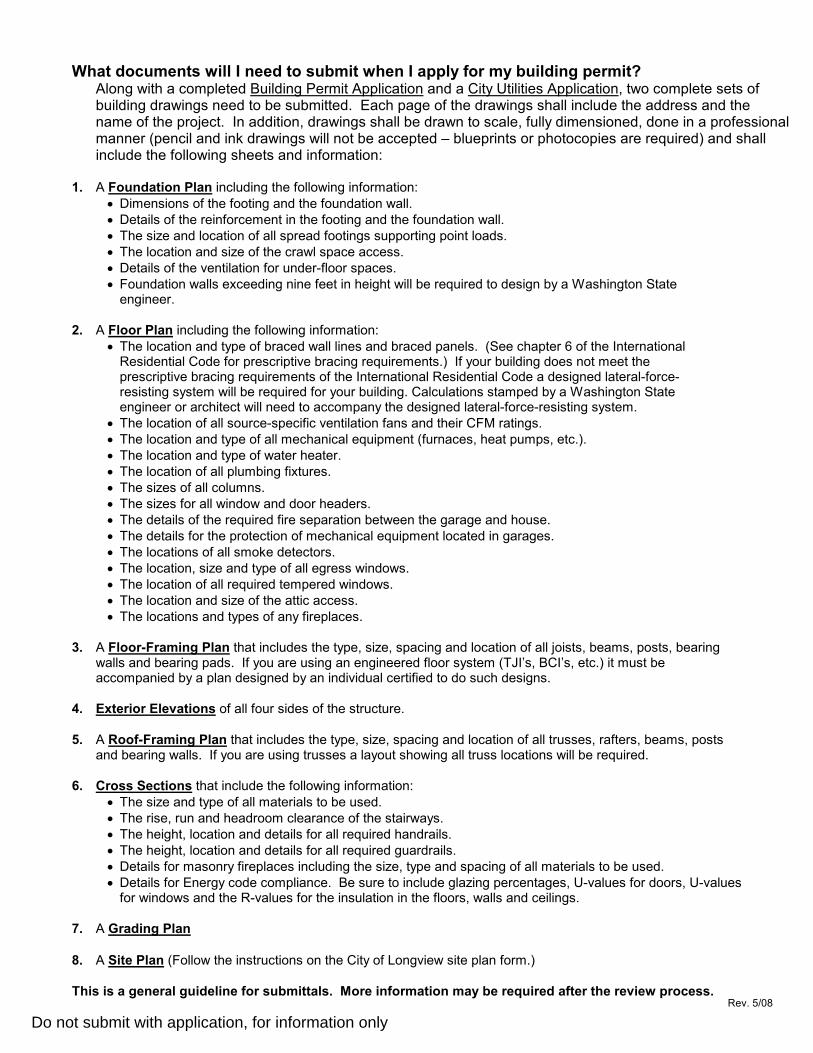
What documents will I need to submit when I apply for my building permit? Along with a completed Building Permit Application and a City Utilities Application, two complete sets of building drawings need to be submitted. Each page of the drawings shall include the address and the name of the project. In addition, drawings shall be drawn to scale, fully dimensioned, done in a professional manner (pencil and ink drawings will not be accepted – blueprints or photocopies are required) and shall include the following sheets and information:
1. A Foundation Plan including the following information:
• Dimensions of the footing and the foundation wall.
• Details of the reinforcement in the footing and the foundation wall.
• The size and location of all spread footings supporting point loads.
• The location and size of the crawl space access.
• Details of the ventilation for under-floor spaces.
• Foundation walls exceeding nine feet in height will be required to design by a Washington State engineer.
2. A Floor Plan including the following information:
• The location and type of braced wall lines and braced panels. (See chapter 6 of the International Residential Code for prescriptive bracing requirements.) If your building does not meet the prescriptive bracing requirements of the International Residential Code a designed lateral-force-resisting system will be required for your building. Calculations stamped by a Washington State engineer or architect will need to accompany the designed lateral-force-resisting system.
• The location of all source-specific ventilation fans and their CFM ratings.
• The location and type of all mechanical equipment (furnaces, heat pumps, etc.).
• The location and type of water heater.
• The location of all plumbing fixtures.
• The sizes of all columns.
• The sizes for all window and door headers.
• The details of the required fire separation between the garage and house.
• The details for the protection of mechanical equipment located in garages.
• The locations of all smoke detectors.
• The location, size and type of all egress windows.
• The location of all required tempered windows.
• The location and size of the attic access.
• The locations and types of any fireplaces.
3. A Floor-Framing Plan that includes the type, size, spacing and location of all joists, beams, posts, bearing walls and bearing pads. If you are using an engineered floor system (TJI’s, BCI’s, etc.) it must be accompanied by a plan designed by an individual certified to do such designs.
4. Exterior Elevations of all four sides of the structure.
5. A Roof-Framing Plan that includes the type, size, spacing and location of all trusses, rafters, beams, posts and bearing walls. If you are using trusses a layout showing all truss locations will be required.
6. Cross Sections that include the following information:
• The size and type of all materials to be used.
• The rise, run and headroom clearance of the stairways.
• The height, location and details for all required handrails.
• The height, location and details for all required guardrails.
• Details for masonry fireplaces including the size, type and spacing of all materials to be used.
• Details for Energy code compliance. Be sure to include glazing percentages, U-values for doors, U-values for windows and the R-values for the insulation in the floors, walls and ceilings.
7. A Grading Plan
8. A Site Plan (Follow the instructions on the City of Longview site plan form.)
This is a general guideline for submittals. More information may be required after the review process. Rev. 5/08
Do not submit with application, for information only

1. The property owner’s name and phonenumber, the property’s legal description(plat, lot, block),and the site’s address.
2. The map scale whenever possible. Ascale of 1” = 20’ is typical, but others 1/8” =1’ for example, is also acceptable.
3. A north arrow indicating the northerlydirection.
4. All property lines, all right-of-ways,all easements (utilities, access, etc.),and site dimensions. Show the distancesbetween buildings, and from buildingsto all property lines.
5. All streets and alleys, with street names.Show all existing and/or proposeddriveways. Include surface types (asphalt,concrete, chipseal, gravel) and drivewaywidth at curb and right-of-way.
6. Identify each building by its use (garage,residence, etc.). Include decks, retainingwalls, and the like.
7. Show clear distinction between the existing building & driveways and any proposed addition/changes. Show all curbs, sidewalks and drainage facilities. Also show any buildings to be demolished.
8. Show all power poles, fire hydrants, trees, shrubs, landscaping, mail boxes, water meters, catch basins, sewer laterals, transformers, roof drains, vaults, utility pedestals, street lights (water, sewer, gas, power, phone and cable locations, and any other above groundutilities/features.
9. For for utility locates, call811 to have utility owners locate under-groundfacilities.
10. Show method of storm water disposal including roof run-off and slope of large paved areas.
11. All surface water (creeks, sloughs, drainage ditches, etc.) on or adjacent to the property.
RESIDENTIALPLOT PLAN
RESIDENTIAL PLOT PLAN GENERAL REQUIREMENTS Many different permits require a plot plan (sometimes called a “site” plan), which is a detailed and
accurate map of the project’s property. A complete and accurate plot plan is important to avoid delays in the review and approval of your project. A complete plot plan will include all the site features and information (depending on your site, of course) listed below. Attached to this sheet are typical plot plan examples.
Community and Economic Development Department | Phone 360.442.5086 Public Works and Engineering Department | Phone 360.442.5200
1525 Broadway, P.O. Box 128, Longview, WA, 98632
Do not submit with application, for information only

PL PL
PL
ProposedOut Building
ProposedHouse
ProposedGarage
Proposed Roof Drain
Proposed Widthof Driveway
Residential Plot Plan
P.U.D.PhoneCable
Gas
serv
ice
5' Utility Easement(Where Applicable)
R/W R/W
Sewer LateralProposed
Water MeterProposed
Sidewalk
Street Light
TreeStreet Light PowerCurb
Hydrant
Curb
Storm Line
Center Line Street
Asphalt street
Scale: 1" = 10'
PARK STREET
OutClean
Prop
erty
Lin
e
Prop
erty
Lin
e
Property Line( 50' )
( 50' )
( 120
' )
( 120
' )
CatchBasin
Owner/Applicant:Legal Description:Lot: Block:Plat:
Phone Number:Project Address:Parcel Number:
Project Description: (new house, replace driveway, new sidewalk, new garage, new water service, new sewer service, etc.)
1234 Park Street(360) 555-1234
05324
John & Jane Doe
Building New house w/ attached garage, new driveway, new water service, new sewerservice, new sidewalk, new garden shed (10 x 12)
5 8Longview #3
2006\troys\plot plan.dwgrevised: 3-2015
EXAMPLE - FOR REFERENCE ONLY
Do not submit with application
AutoCAD SHX Text
TRAN
AutoCAD SHX Text
TEL
AutoCAD SHX Text
TV
AutoCAD SHX Text
CO

RESIDENTIAL PLOT PLAN
Owner/Applicant: Daytime Phone Number:
Project Address: , Longview, WA
Legal Descr: Lot # Block # Plat Parcel #
Project Description (eg.,Construct new house, addition to house, new garage, shed, fence, etc.):

Stormwater Plan Review Submittal Form (Mar 2018)
STORMWATER
P l an R ev i ew
Submittal Form
Public Works / Stormwater Division 1525 Broadway, P.O. Box 128 Longview, WA 98632 360.442.5209 / Fax 360.442.5953
Per Longview Municipal Code 17.80.070, all development projects are to provide stormwater submittals
at the time of permit application. Please use the worksheet on Page 2 to determine the project category
and ensure your application stormwater submittal includes all of the applicable items listed below.
APPLICANT/PROJECT ADDRESS
Applicant Name:
Project Address:
Phone Number: Email:
Staff Use Only: Meritage #: ____________________ Stormwater Project #: ____________________
PROJECT CATEGORY: MINOR PROJECT SMALL PROJECT MAJOR PROJECT
REQUIRED STORMWATER SUBMITTALS
Minor Project
Minor Project Stormwater Form
Small Project
Small Project Abbreviated Stormwater Site Plan
Source Control Worksheet (non-residential projects only)
Major Project
Stormwater management site plan narrative and technical report describing how the proposed project will address stormwater Minimum Requirements #1 through 9
Stormwater management construction plan sheet(s)
Draft maintenance agreement
APPLICATION CERTIFICATION
I hereby certify that I have read and examined this form and all attachments and know the same to be
true, accurate and complete under penalty of perjury by the laws of the State of Washington.
_______________________________ _______________________________ ______ __________________
APPLICANT’S SIGNATURE PRINTED NAME DATE

City of Longview / Stormwater Plan Review Submittal Form (Mar 2018) Page 2 of 2
PROJECT CATEGORY WORKSHEET
PROPOSED LAND DISTURBANCE
Estimated total land disturbance area including clearing, grubbing, stripping, grading, filling and excavation:
square feet
PROPOSED HARD SURFACES (NEW PLUS REPLACED)
A. New hard surfaces: square feet
B. Replaced hard surfaces: square feet
Total new and replaced hard surfaces [add A + B above]: square feet
Hard surfaces are defined as any impervious surface, a permeable pavement or a vegetated (green) roof
PROPOSED LAND COVER CHANGES
Native vegetation (including pasture) converted to lawn/landscaped areas:
acres
Native vegetation converted to pasture: acres
CRITERIA PROJECT CATEGORY
Less than 5,000 square feet of land disturbance Less than 500 square feet of new+replaced hard surfaces
No submittals required
Must control erosion & sediment during construction and meet
City drainage provisions
5,000 - 6,999 square feet of land disturbance and/or 500 - 1,999 square feet of new+replaced hard surfaces
MINOR PROJECT
7,000 - 43,559 square feet of land disturbance and/or 2,000 - 4,999 square feet of new+replaced hard surfaces Less than 0.75 acres of native vegetation converted to lawn
SMALL PROJECT
1.0 acre or more of land disturbance and/or 5,000 square feet of new+replaced hard surfaces* 0.75 acres or more of native vegetation converted to lawn 2.5 acres or more of native vegetation converted to pasture
MAJOR PROJECT
* Major redevelopment projects (i.e. site with existing hard surface coverage of 35% or more) proposing less than
5,000 square feet of new hard surfaces and a total project cost that does not exceed 50% of the assessed property value,
are only required to address Minimum Requirements #1 through 5 in their stormwater management site plan and report.
Small Project Stormwater Site Plan (Dec 2017)
M i n o r P r o j e c t
Stormwater Form
Public Works / Stormwater Division 1525 Broadway, P.O. Box 128 Longview, WA 98632 360.442.5209 / Fax 360.442.5953
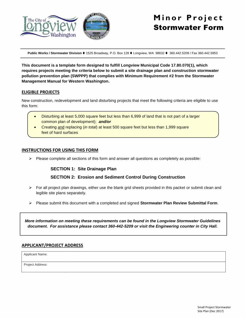
This document is a template form designed to fulfill Longview Municipal Code 17.80.070(1), which
requires projects meeting the criteria below to submit a site drainage plan and construction stormwater
pollution prevention plan (SWPPP) that complies with Minimum Requirement #2 from the Stormwater
Management Manual for Western Washington.
ELIGIBLE PROJECTS
New construction, redevelopment and land disturbing projects that meet the following criteria are eligible to use
this form:
Disturbing at least 5,000 square feet but less than 6,999 of land that is not part of a larger
common plan of development); and/or
Creating and replacing (in total) at least 500 square feet but less than 1,999 square
feet of hard surfaces
INSTRUCTIONS FOR USING THIS FORM
Please complete all sections of this form and answer all questions as completely as possible:
SECTION 1: Site Drainage Plan
SECTION 2: Erosion and Sediment Control During Construction
For all project plan drawings, either use the blank grid sheets provided in this packet or submit clean and
legible site plans separately.
Please submit this document with a completed and signed Stormwater Plan Review Submittal Form.
More information on meeting these requirements can be found in the Longview Stormwater Guidelines
document. For assistance please contact 360-442-5209 or visit the Engineering counter in City Hall.
APPLICANT/PROJECT ADDRESS
Applicant Name:
Project Address:

City of Longview / Small Project Abbreviated Stormwater Site Plan (Dec 2017) Page 2 of 8
SECTION 1: SITE DRAINAGE PLAN
DRAINAGE DESIGN GUIDELINES
Check each box to certify that the following drainage guidelines and standards will be met on the project:
☐ Applicable setbacks for all drainage system components and stormwater management practices
☐ Minimum final grade (slope) of 2% away from building foundations
☐ Existing natural drainage patterns and outfalls preserved to the maximum extent practicable
☐ No increase in existing runoff sheet flow or concentrated flow discharges, or new runoff discharges, onto
adjacent properties, unless a drainage easement is obtained and recorded with the adjacent property.
☐ An approved point of discharge (e.g. curb cut/street gutter, storm drain, roadside ditch, swale, or open water
drain or ditch*, etc.) for all drainage collection and conveyance systems to ensure that they will not create a
public nuisance, safety hazard or harm adjacent properties
* Note: A permit is required to discharge to a Consolidated Diking Improvement District #1 (CDID#1) waterway
(open water ditch or drain). Contact CDID#1 at 360-423-2493 or see www.cdid1.org for more information.
SITE DRAINAGE PLAN
On the next page or submitted separately, provide a drawing of the site showing the final proposed layout
of the project to include the following items (this may be drawn by hand or drafted electronically):
Location and footprint of all proposed impervious hard surfaces including structures, driveways, parking
pads, sidewalks, decks, patios and accessory buildings
Location of any retaining walls and embankments
Proposed drainage collection and conveyance systems including roof downspouts, area drains, french
drains, hard drainage pipes, sump pump discharges and open ditches/swales
Drainage flow paths (shown with arrows) from roof downspouts and other hard surface areas (driveways,
patios, etc.) to the eventual point of discharge from the project site.

City of Longview / Small Project Abbreviated Stormwater Site Plan (Dec 2017) Page 3 of 8
SITE DRAINAGE PLAN DRAWING

City of Longview / Small Project Abbreviated Stormwater Site Plan (Dec 2017) Page 4 of 8
SECTION 2: EROSION AND SEDIMENT CONTROL DURING CONSTRUCTION
CONSTRUCTION EROSION AND SEDIMENT CONTROL MEASURES
For each topic below, select at least one erosion and sediment control measure that will be used on the project
during the construction phase to reduce the potential for soil erosion and transport of sediment and pollutants
from the site. If the item is not applicable to the site, check “Not applicable” and provide a rationale.
The numbers in parentheses reference the Best Management Practice (BMP) section in the Stormwater
Management Manual for Western Washington, Volume II, where additional guidance and information on these
measures can be obtained. Other approved measures not listed may be specified in the blanks provided; designs
that involve engineering calculations should be prepared by a licensed engineer.
NOTE: This section will serve as the project’s Construction Stormwater Pollution Prevention Plan.
The erosion and sediment control measures identified below may need to be supplemented as on-site
conditions dictate in order to effectively address erosion and sediment control for the project.
Prior to land disturbance, a pre-construction inspection is required to ensure that all BMPs are in place
and the site conforms to the plan.
A. Preserve Vegetation and Mark Clearing Limits
Requirement: Retain topsoil and natural vegetation in an undisturbed state to the maximum extent
practicable. Mark all clearing limits, sensitive areas and their buffers, and any trees that will be preserved.
Limits shall be marked in such a way that any trees or vegetation to remain will not be harmed.
Applicable erosion and sediment control measures (check all that will be used):
☐ Preserving Native Vegetation (C101) ☐ Buffer Zones (C102)
☐ High Visibility Plastic Fence (C103) ☐ (Sediment) Fence – orange only (C233)
☐ Other ________________________
☐ not applicable – please explain why_________________________________________
B. Construction Access
Requirement: Prevent vehicles from tracking soil from the site onto streets or neighboring properties by
stabilizing the entrance with a rock pad. If possible, place the entrance where a future driveway will be
located, as it may be possible to use the rock as a driveway base material. If sediment is tracked offsite,
sweep or shovel it from the paved surface immediately.
Applicable erosion and sediment control measures (check all that will be used):
☐ Stabilized Construction Entrance (C105) ☐ Other ________________________
☐ Not applicable – please explain why_________________________________________

City of Longview / Small Project Abbreviated Stormwater Site Plan (Dec 2017) Page 5 of 8
C. Control Stormwater Runoff Flow Rates
Requirement: Protect properties and waterways downstream of the construction site from erosion by slowing
down stormwater runoff from the site as much as possible.
Applicable erosion and sediment control measures (check all that will be used):
☐ Interceptor Swales & Dikes (C200) ☐ Check Dams (C207)
☐ Wattles (C235) ☐ Other ________________________
☐ Not applicable – please explain why_________________________________________
D. Sediment Controls
Requirement: Runoff from disturbed areas must pass through a sediment removal device. Sediment barriers
are typically used to slow sheet flow of stormwater and allow the sediment to settle out behind the barrier.
Applicable erosion and sediment control measures (check all that will be used):
☐ Silt (Sediment) Fence (C233) ☐ Vegetated Strip (C234)
☐ Wattles (C235) ☐ Sidewalk Subgrade Curb Barrier
☐ Other ________________________
☐ Not applicable – please explain why _____________________________________________
E. Stabilize Soils
Requirement: Protect exposed soils and stockpiles from rain, flowing water, and wind by covering them or
planting grass.
During the wet season from October 1 through April 30, no soils or stockpiles shall remain exposed or
unworked for more than 2 days. From May 1 to September 30, no soils or stockpiles shall remain exposed
and unworked for more than 7 days.
Applicable erosion and sediment control measures (check all that will be used):
☐ Mulching (C121) ☐ Plastic Covering (C123)
☐ Compost (C125) ☐ Other ________________________
☐ Not applicable – please explain why _____________________________________________
F. Protect Slopes
Requirement: Protect slopes by diverting water away from the top of the slope and establishing vegetation on
slopes.
Applicable erosion and sediment control measures (check all that will be used):
☐ Nets & Blankets (C122) ☐ C130 Surface Roughening (C130)
☐ Pipe Slope Drain (C204) ☐ Other ________________________
☐ Element is not applicable – please explain why _____________________________________________

City of Longview / Small Project Abbreviated Stormwater Site Plan (Dec 2017) Page 6 of 8
G. Protect Drain Inlets
Requirement: Protect all storm drain inlets during construction so that site runoff does not enter the inlets
without first being filtered to remove sediment. Install catch basin protection on all catch basins within 500 feet
downstream of the project. Once the site is fully stabilized, catch basin protection must be removed.
Applicable erosion and sediment control measures (check all that will be used):
☐ Storm Drain Inlet Protection (C220) ☐ Other ________________________
☐ Element is not applicable – please explain why _____________________________________________
H. Stabilize Channels and Outlets
Requirement: Stabilize all temporary and permanent conveyance channels and their outlets.
Applicable erosion and sediment control measures (check all that will be used):
☐ Nets & Blankets (C122) ☐ Check Dams (C207)
☐ Outlet Protection (C209) ☐ Other ________________________
☐ Element is not applicable – please explain why _____________________________________________
I. Control Pollutants
Requirement: Handle and dispose of all pollutants, such as chemicals, paint, petroleum products, and
concrete (wet and dry) to keep them out of rain and stormwater. Provide cover and containment for liquid
materials and handle all concrete and concrete waste appropriately
Applicable erosion and sediment control measures (check all that will be used):
☐ Materials on Hand (C150) ☐ Concrete Handling (C151)
☐ Material Delivery, Storage and Containment (C153)
☐ Other ________________________
☐ Element is not applicable – please explain why _____________________________________________
J. Control Dewatering
Requirement: If dewatering is needed, assess the condition of the pumped water. Clean, non-turbid
dewatering water, such as groundwater, can be discharged to the stormwater system as long as it does not
cause downstream erosion or flooding. Dirty or contaminated dewatering water must be filtered or may be
discharged to the local sanitary sewer, if permitted.
Applicable erosion and sediment control measures (check all that will be used):
☐ Dewatering Plan (approved by Public Works Department)
☐ Element is not applicable – please explain why _____________________________________________

City of Longview / Small Project Abbreviated Stormwater Site Plan (Dec 2017) Page 7 of 8
K. Maintain Erosion and Sediment Control Measures
Requirement: Maintain and repair erosion and sediment control measures as needed. Inspect all measures
at least weekly and after every storm event. Keep an erosion control inspection log on site and available for
review by City staff at all times. Remove all temporary erosion and sediment control measures within 30 days
after final site stabilization or if the measure is no longer needed.
Applicable erosion and sediment control measures (check all that will be used):
☐ Materials on Hand (C150) ☐ Certified Erosion and Sediment Control Lead [CESCL] (C160)
☐ Other ________________________
L. Manage the Project
Requirement: Coordinate all work before initial construction with subcontractors and other utilities to ensure
no areas are prematurely worked. Designate an erosion control inspector for the construction site. The
Certified Erosion and Sediment Control Lead (CESCL) or inspector must have the skills to assess site
conditions and construction activities that could impact the quality of stormwater discharges and the
effectiveness of erosion and sediment control measures used to control them. The erosion control inspector
must be on the site or on-call 24 hours a day.
Applicable erosion and sediment control measures (check all that will be used):
☐ Certified Erosion & Sediment Control Lead (C160) Name: ________________________
☐ Non-CESCL designated inspector Name: ________________________
M. Protect Low Impact Development Practices
Requirement: Protect the proposed permanent Low Impact Development (LID) practices and areas
(identified in Section 2) from compaction and damage from erosion and sediment during construction.
Applicable erosion and sediment control measures (check all that will be used):
☐ Buffer Zone (C102) ☐ High Visibility Plastic Fence (C103)
☐ Check Dams (C207) ☐ Triangular Silt Dike (C208)
☐ Brush Barrier (C231) ☐ Silt Fence (C233)
☐ Vegetated Strip (C234) ☐ Other ________________________
☐ Element is not applicable – please explain why _____________________________________________
CONSTRUCTION EROSION AND SEDIMENT CONTROL SITE PLAN
On the next page or submitted separately, provide a drawing of the site showing the construction phase of
the project to include the following items (this may be drawn by hand or drafted electronically):
All areas to be cleared and graded, including cut and fill areas if applicable
Boundary limits of existing trees and vegetation to be protected
Location of all erosion and sediment control measures selected for topics A-M
City of Longview / Small Project Abbreviated Stormwater Site Plan (Dec 2017) Page 8 of 8
CONSTRUCTION EROSION AND SEDIMENT CONTROL SITE PLAN DRAWING

Small Project Stormwater Site Plan (Dec 2017)
S m a l l P r o j e c t
ABBREVIATED
Stormwater Site Plan
Public Works / Stormwater Division 1525 Broadway, P.O. Box 128 Longview, WA 98632 360.442.5209 / Fax 360.442.5953
This document is a template form designed to fulfill Longview Municipal Code 17.80.070(2), which
requires projects meeting the criteria below to submit a stormwater site plan that complies with Minimum
Requirements #1 through #5 from the Stormwater Management Manual for Western Washington.
ELIGIBLE PROJECTS
New construction, redevelopment and land disturbing projects that meet the following criteria are eligible to use
this form:
Disturbing at least 7,000 square feet but less than 43,560 square feet (1 acre) of land that is
not part of a larger common plan of development); and/or
Creating and replacing (in total) at least 2,000 square feet but less than 5,000 square
feet of hard surfaces; and
Converting less than 0.75 acre of natural vegetation to lawn or landscape area
INSTRUCTIONS FOR USING THIS FORM
Please complete all sections of this form and answer all questions as completely as possible:
SECTION 1: Project Location and Existing Site Conditions
SECTION 2: Proposed On-Site Stormwater Management
SECTION 3: Soil Quality and Depth
SECTION 4: Drainage and Stormwater Management Plan
SECTION 5: Erosion and Sediment Control During Construction
For all project plan drawings, either use the blank grid sheets provided in this packet or submit clean and
legible site plans separately.
Please submit this document with a completed and signed Stormwater Plan Review Submittal Form.
More information on meeting these requirements can be found in the Longview Stormwater Guidelines
document. For assistance please contact 360-442-5209 or visit the Engineering counter in City Hall.
APPLICANT/PROJECT ADDRESS
Applicant Name:
Project Address:

City of Longview / Small Project Abbreviated Stormwater Site Plan (Dec 2017) Page 2 of 15
SECTION 1: PROJECT LOCATION AND EXISTING SITE CONDITIONS
PROJECT LOCATION (see map below)
☐ Valley (South of Ditch #6) ☐ Hillside (North of Ditch #6)
Ditch #6 lies south of Pacific Way (north of John Null Park), Cascade Way, Castleman Drive and Fishers Lane
EXISTING CONDITIONS SUMMARY
Describe the existing site conditions by answering the questions below.
1) What is the existing ground cover (check all that apply):
☐ Forest ☐ Pasture ☐ Trees ☐ Lawn/Landscaping
☐ Gravel ☐ Pavement ☐ Building(s) ☐ Other ___________________
2) What is the topography (slope) of the site? (please reference the Longview/Kelso Urban Area
Stormwater LID Feasibility – Slope Map):
☐ Flat to Gradual Slopes (0 – 8%) ☐ Moderate Slopes (9 – 15%) ☐ Steep Slopes ( > 15%)
3) What is the annual minimum depth to groundwater on the site? (please reference the Longview/Kelso
Urban Area Stormwater LID Feasibility – Depth to Groundwater Map):
☐ 0 to 3 feet ☐ 3 to 6 feet ☐ more than 6 feet
Ditch #6
City of Longview / Small Project Abbreviated Stormwater Site Plan (Dec 2017) Page 3 of 15
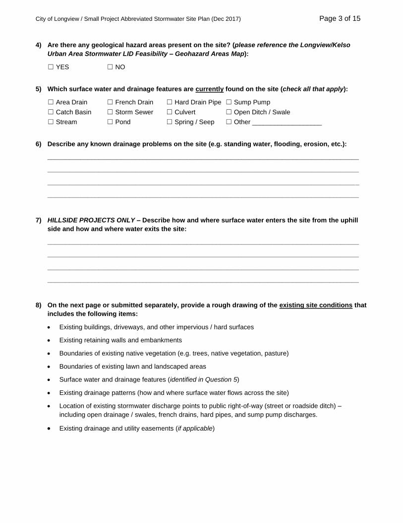
4) Are there any geological hazard areas present on the site? (please reference the Longview/Kelso
Urban Area Stormwater LID Feasibility – Geohazard Areas Map):
☐ YES ☐ NO
5) Which surface water and drainage features are currently found on the site (check all that apply):
☐ Area Drain ☐ French Drain ☐ Hard Drain Pipe ☐ Sump Pump
☐ Catch Basin ☐ Storm Sewer ☐ Culvert ☐ Open Ditch / Swale
☐ Stream ☐ Pond ☐ Spring / Seep ☐ Other ___________________
6) Describe any known drainage problems on the site (e.g. standing water, flooding, erosion, etc.):
_____________________________________________________________________________________
_____________________________________________________________________________________
_____________________________________________________________________________________
_____________________________________________________________________________________
7) HILLSIDE PROJECTS ONLY – Describe how and where surface water enters the site from the uphill
side and how and where water exits the site:
_____________________________________________________________________________________
_____________________________________________________________________________________
_____________________________________________________________________________________
_____________________________________________________________________________________
8) On the next page or submitted separately, provide a rough drawing of the existing site conditions that
includes the following items:
Existing buildings, driveways, and other impervious / hard surfaces
Existing retaining walls and embankments
Boundaries of existing native vegetation (e.g. trees, native vegetation, pasture)
Boundaries of existing lawn and landscaped areas
Surface water and drainage features (identified in Question 5)
Existing drainage patterns (how and where surface water flows across the site)
Location of existing stormwater discharge points to public right-of-way (street or roadside ditch) –
including open drainage / swales, french drains, hard pipes, and sump pump discharges.
Existing drainage and utility easements (if applicable)

City of Longview / Small Project Abbreviated Stormwater Site Plan (Dec 2017) Page 4 of 15
EXISTING CONDITIONS SITE DRAWING

City of Longview / Small Project Abbreviated Stormwater Site Plan (Dec 2017) Page 5 of 15
SECTION 2: PROPOSED ON-SITE STORMWATER MANAGEMENT
STORMWATER LOW IMPACT DEVELOPMENT (LID) PRACTICES
Beginning July 1, 2017, all development projects adding or replacing at least 2,000 square feet of hard surfaces
are required to utilize Low Impact Development (LID) stormwater management practices to infiltrate, disperse and
retain stormwater runoff on-site to the extent feasible without causing flooding, erosion or geohazard impacts.
The LID practices to be considered vary depending on the runoff source (rooftop drainage vs. stormwater from
other hard surfaces) and whether the project is in the Valley or Hillside:
LIST 1A -- VALLEY LIST 1B -- HILLSIDE
Runoff from Roofs Runoff from Other
Hard Surfaces
Runoff from Roofs Runoff from Other
Hard Surfaces
Downspout Full Infiltration –or– Concentrated Flow
Dispersion –or–
Full Dispersion –or– Full Dispersion
Downspout Dispersion System –or–
Downspout Full Infiltration
Rain Garden –or–
Perforated Stub-out Connection
Sheet Flow Dispersion Rain Garden Permeable Pavement
Downspout
Dispersion System Concentrated Flow Dispersion –or–
Perforated Stub-out
Connection Sheet Flow Dispersion
Use the appropriate worksheet on the following pages (Worksheet A for Valley projects; Worksheet B for Hillside
projects) to determine the preliminary feasibility for each of the LID practices. Based upon the feasibility analysis,
select the practices for use on the project as follows:
For VALLEY projects, select the preferred feasible practices from List 1A that are applicable for the
site/project for areas of roof runoff and runoff from other sources. You can choose to use more than one
applicable practice for each source of runoff.
For HILLSIDE projects, use the first feasible practice(s) in numeric order from LIST 1B for areas of
roof runoff and runoff from other sources.
Check the stormwater LID practices being proposed for the project (select all that will be applied):
Roof Areas Other Hard Surfaces
☐ Downspout Full Infiltration (T5.10A) ☐ Concentrated Flow Dispersion (T5.11)
☐ Downspout Dispersion Systems (T5.10B) ☐ Sheet Flow Dispersion (T5.12)
☐ Perforated Stub-out Connections (T5.10C) ☐ Full Dispersion (T5.30)
☐ Full Dispersion (T5.30) ☐ Rain Garden (T5.14A)
☐ Rain Garden (T5.14A) ☐ Permeable Pavement (T5.15)
☐ project has no roof areas ☐ project has no other source areas
Numbers refer to the applicable BMP from the Stormwater Management Manual for Western Washington, Volume V

City of Longview / Small Project Abbreviated Stormwater Site Plan (Dec 2017) Page 6 of 15
Worksheet A – VALLEY Small Projects: Low Impact Development Practice Preliminary Feasibility
LID Practice Feasibility Questions Yes No
3 feet or less from finished grade to seasonal high water table? ☐ ☐
1 feet or less vertical separation from bottom of dry well or trench to seasonal high water table? ☐ ☐
Setbacks of less than 10 feet from structure or property line? ☐ ☐
Vegetated flow path of less than less than 50 feet? ☐ ☐
Setbacks of less than 5 feet from structure or property line? ☐ ☐
3 feet or less from finished grade to seasonal high water table? ☐ ☐
1 feet or less vertical separation from bottom of dry well or trench to seasonal high water table? ☐ ☐
Setbacks of less than 10 feet from structure or property line? ☐ ☐
LID Practice Feasibility Questions Yes No
Vegetated flow path of less than less than 50 feet? ☐ ☐
Setbacks of less than 5 feet from structure or property line? ☐ ☐
Sufficient vegetated buffer area for dispersion? (minimum 12 foot buffer area for up to 20 feet of
hard surface, plus 10 feet for each additional 20 feet of hard surface or fraction thereof)☐ ☐
* Review expanded feasibility checklist and requirements -- Consult City stormwater staff for more information
Runoff from Roof Areas
Runoff from Other Hard Surfaces
Perforated
Stub-out
Connections
(T5.10C)
Concentrated
Flow Dispersion
(T5.11)
Sheet Flow
Dispersion
(T5.12)
☐ Infeasible (YES to any question) ☐ More review required* (NO to all questions)
☐ Infeasible (YES to any question) ☐ More review required* (NO to all questions)
☐ Infeasible (YES to any question) ☐ More review required* (NO to all questions)
☐ Infeasible (YES to any question) ☐ More review required* (NO to all questions)
☐ Infeasible (YES to any question) ☐ More review required* (NO to all questions)
Downspout
Dispersion
Systems
(T5.10B)
Downspout Full
Infiltration
(T5.10A)

City of Longview / Small Project Abbreviated Stormwater Site Plan (Dec 2017) Page 7 of 15
Worksheet B – HILLSIDE Small Projects: Low Impact Development Practice Preliminary Feasibility
RoofsOther Hard
Surfaces
Within 50 feet of geological hazard area? ☐ ☐
Slope greater than 15%? ☐ ☐
Project area ratio of native vegetation to impervious less than 6.5:1? ☐ ☐
Dispersion flow path (through native vegetation) less than 100 ft? ☐ ☐
Within 50 feet of geological hazard area? ☐ ☐
Slope greater than 15%? ☐ ☐
3 feet or less from finished grade to seasonal high water table? ☐ ☐
Setbacks of less than 10 feet from structure or property line? ☐ ☐
Within 50 feet of geological hazard area or slopes greater than 20%? ☐ ☐
Slopes greater than 8% at location of rain garden? ☐ ☐
1 feet or less vertical separation from bottom of facility to bedrock or
seasonal high water table?☐ ☐
Setbacks of less than 10 feet from structure or property line? ☐ ☐
Within 50 feet of geological hazard area or slopes greater than 20%? ☐ ☐
Slope greater than 5% (for porous asphalt), 10% (for pervious
concrete) or 12% (for permeable interlocking concrete pavers)?☐ ☐
Downslope of steep, erosion prone areas? ☐ ☐
Threatens existing below-grade basement, utilities, adjacent parcels? ☐ ☐
Within 50 feet of geological hazard area or slopes greater than 15%? ☐ ☐
Vegetated flow path of less than less than 25 feet? ☐ ☐
Setbacks of less than 5 feet from structure or property line? ☐ ☐
Within 50 feet of geological hazard area or slopes greater than 15%? ☐ ☐
Vegetated flow path of less than less than 50 feet ? ☐ ☐
Setbacks of less than 5 feet from structure or property line? ☐ ☐
Within 50 feet of geological hazard area or slopes greater than 20%? ☐ ☐
Slope greater than 15%? ☐ ☐
Sufficient vegetated buffer area for dispersion? ** ☐ ☐
Within 50 feet of geological hazard area or slopes greater than 20%? YES NO
Slope greater than 15%? ☐ ☐
3 feet or less from finished grade to seasonal high water table? ☐ ☐
Setbacks of less than 10 feet from structure or property line? ☐ ☐
* Review expanded feasibility checklist and requirements -- Consult City stormwater staff for more information
** minimum 12 foot buffer area for up to 20 feet of hard surface, plus 10 feet for each additional 20 feet of hard surface or fraction thereof
Sheet Flow
Dispersion
(T5.12)
Perforated
Stub-out
Connections
(T5.10C)
Rain Gardens
(T5.14A)
Permeable
Pavement
(T5.15)
Downspout
Dispersion
Systems
(T5.10B)
Concentrated
Flow Dispersion
(T5.11)
NO
☐ Infeasible (YES to any question) ☐ More review required* (NO to all questions)
YES
YESNO
YES
☐ Infeasible (YES to any question) ☐ More review required* (NO to all questions)
☐ Infeasible (YES to any question) ☐ More review required* (NO to all questions)
LID Practice
Full Dispersion
(T5.30)
Downspout Full
Infiltration
(T5.10A)
No
☐ Infeasible (YES to any question) ☐ More review required* (NO to all questions)
☐ Infeasible (YES to any question) ☐ More review required* (NO to all questions)
Feasibility Questions
Applicable for:
YES YES
YES NO
Yes
☐ Infeasible (YES to any question) ☐ More review required* (NO to all questions)
☐ Infeasible (YES to any question) ☐ More review required* (NO to all questions)
☐ Infeasible (YES to any question) ☐ More review required* (NO to all questions)
YES
YES NO
NO
YES
NOYES

City of Longview / Small Project Abbreviated Stormwater Site Plan (Dec 2017) Page 8 of 15
SECTION 3: SOIL QUALITY AND DEPTH
SOIL QUALITY AND DEPTH OPTIONS FOR DISTURBED SOIL AREAS
All projects meeting the threshold for this form with disturbed soil areas (to be replanted with landscaping, lawn
or native vegetation) are required to meet minimum soil quality and depth criteria.
See the Longview Stormwater Guidelines for more information on soil quality and depth requirements.
Select the option to be used for the project:
Soil Quality and Depth Option Soil Quality and Depth Criteria
☐ OPTION A: Amend existing topsoil or subsoil in place
Scarify or till subgrade to 9 inches depth (or to depth needed to achieve a total depth of 12 inches of uncompacted soil after calculated amount of amendment is added). Entire surface should be disturbed by scarification. Do not scarify within drip line of existing trees to be retained. Amend soil to meet required organic content.
Planting Beds
Place 3 inches of composted material and rototill into 5 inches of soil (a total amended depth of about 9.5 inches, for a settled depth of 8 inches).
Turf Areas
Place 1.75 inches of composted material and rototill into 6.25 inches of soil (a total amended depth of about 9.5 inches, for a settled depth of 8 inches).
☐ OPTION B: Stockpile existing topsoil during grading. Replace before planting
Stockpile and cover soil with weed barrier material that sheds moisture yet allows air transmission, in approved location, prior to grading. Replace stockpiled topsoil prior to planting. Amend if needed to meet required organic content. NOTE: If placed topsoil plus compost or other organic material will amount to less than 12 inches: Scarify or till subgrade to depth needed to achieve 12 inches of loosened soil after topsoil and amendment are placed. Entire surface should be disturbed by scarification. Do not scarify within drip line of existing trees to be retained.
☐ OPTION C: Import topsoil mix of sufficient organic content and depth to meet the requirements
Scarify or till subgrade in two directions to 6 inches depth. Entire surface should be disturbed by scarification. Do not scarify within drip line of existing trees to be retained.
Planting Beds: Topsoil mix containing 10% organic matter (typically around 40% compost).
Turf Areas: Topsoil mix containing 5% organic matter (typically around 25% compost).
Place 3 inches of imported topsoil mix on surface and till into 2 inches of soil.
Place second lift of 3 inches topsoil mix on surface.

City of Longview / Small Project Abbreviated Stormwater Site Plan (Dec 2017) Page 9 of 15
SECTION 4: STORMWATER MANAGEMENT AND DRAINAGE PLAN
DRAINAGE DESIGN GUIDELINES
Check each box to certify that the following drainage guidelines and standards will be met on the project:
☐ Applicable setbacks for all drainage system components and stormwater management practices
☐ Minimum final grade (slope) of 2% away from building foundations
☐ Existing natural drainage patterns and outfalls preserved to the maximum extent practicable
☐ No increase in existing runoff sheet flow or concentrated flow discharges, or new runoff discharges, onto
adjacent properties, unless a drainage easement is obtained and recorded with the adjacent property.
☐ An approved point of discharge (e.g. curb cut/street gutter, storm drain, roadside ditch, swale, or open water
drain or ditch*, etc.) for all drainage collection and conveyance systems to ensure that they will not create a
public nuisance, safety hazard or harm adjacent properties
* Note: A permit is required to discharge to a Consolidated Diking Improvement District #1 (CDID#1) waterway
(open water ditch or drain). Contact CDID#1 at 360-423-2493 or see www.cdid1.org for more information.
STORMWATER MANAGEMENT AND DRAINAGE PLAN
On the next page or submitted separately, provide a drawing of the site showing the final proposed layout
of the project to include the following items (this may be drawn by hand or drafted electronically):
Location and footprint of all proposed impervious hard surfaces including structures, driveways, parking
pads, sidewalks, decks, patios and accessory buildings
Location of any retaining walls and embankments
Proposed site grading and contours (Hillside projects only)
Proposed drainage collection and conveyance systems including roof downspouts, area drains, french
drains, hard drainage pipes, sump pump discharges and open ditches/swales
Location of stormwater LID practices (identified in Section 2) including:
Downspout Full Infiltration
Downspout Dispersion Systems
Perforated Stub-out Connections
Full Dispersion
Concentrated Flow Dispersion
Sheet Flow Dispersion
Rain Garden
Permeable Pavement
Areas of disturbed soils to be amended using method identified in Section 3
Drainage flow paths (shown with arrows) from roof downspouts and other hard surface areas (driveways,
patios, etc.) to LID practices (if applicable) and the eventual point of discharge from the project site.
Attach applicable construction details (drawings) for each stormwater LID practice to this short form (stock
details are acceptable).

City of Longview / Small Project Abbreviated Stormwater Site Plan (Dec 2017) Page 10 of 15
STORMWATER MANAGEMENT AND DRAINAGE PLAN DRAWING
City of Longview / Small Project Abbreviated Stormwater Site Plan (Dec 2017) Page 11 of 15
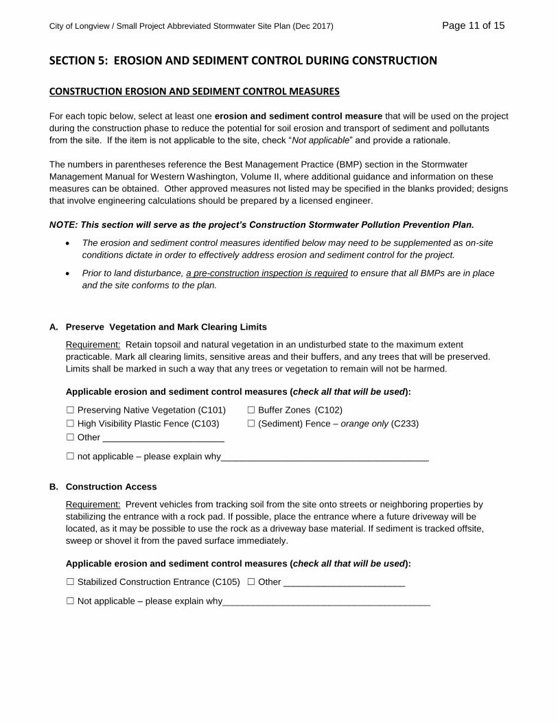
SECTION 5: EROSION AND SEDIMENT CONTROL DURING CONSTRUCTION
CONSTRUCTION EROSION AND SEDIMENT CONTROL MEASURES
For each topic below, select at least one erosion and sediment control measure that will be used on the project
during the construction phase to reduce the potential for soil erosion and transport of sediment and pollutants
from the site. If the item is not applicable to the site, check “Not applicable” and provide a rationale.
The numbers in parentheses reference the Best Management Practice (BMP) section in the Stormwater
Management Manual for Western Washington, Volume II, where additional guidance and information on these
measures can be obtained. Other approved measures not listed may be specified in the blanks provided; designs
that involve engineering calculations should be prepared by a licensed engineer.
NOTE: This section will serve as the project’s Construction Stormwater Pollution Prevention Plan.
The erosion and sediment control measures identified below may need to be supplemented as on-site
conditions dictate in order to effectively address erosion and sediment control for the project.
Prior to land disturbance, a pre-construction inspection is required to ensure that all BMPs are in place
and the site conforms to the plan.
A. Preserve Vegetation and Mark Clearing Limits
Requirement: Retain topsoil and natural vegetation in an undisturbed state to the maximum extent
practicable. Mark all clearing limits, sensitive areas and their buffers, and any trees that will be preserved.
Limits shall be marked in such a way that any trees or vegetation to remain will not be harmed.
Applicable erosion and sediment control measures (check all that will be used):
☐ Preserving Native Vegetation (C101) ☐ Buffer Zones (C102)
☐ High Visibility Plastic Fence (C103) ☐ (Sediment) Fence – orange only (C233)
☐ Other ________________________
☐ not applicable – please explain why_________________________________________
B. Construction Access
Requirement: Prevent vehicles from tracking soil from the site onto streets or neighboring properties by
stabilizing the entrance with a rock pad. If possible, place the entrance where a future driveway will be
located, as it may be possible to use the rock as a driveway base material. If sediment is tracked offsite,
sweep or shovel it from the paved surface immediately.
Applicable erosion and sediment control measures (check all that will be used):
☐ Stabilized Construction Entrance (C105) ☐ Other ________________________
☐ Not applicable – please explain why_________________________________________

City of Longview / Small Project Abbreviated Stormwater Site Plan (Dec 2017) Page 12 of 15
C. Control Stormwater Runoff Flow Rates
Requirement: Protect properties and waterways downstream of the construction site from erosion by slowing
down stormwater runoff from the site as much as possible.
Applicable erosion and sediment control measures (check all that will be used):
☐ Interceptor Swales & Dikes (C200) ☐ Check Dams (C207)
☐ Wattles (C235) ☐ Other ________________________
☐ Not applicable – please explain why_________________________________________
D. Sediment Controls
Requirement: Runoff from disturbed areas must pass through a sediment removal device. Sediment barriers
are typically used to slow sheet flow of stormwater and allow the sediment to settle out behind the barrier.
Applicable erosion and sediment control measures (check all that will be used):
☐ Silt (Sediment) Fence (C233) ☐ Vegetated Strip (C234)
☐ Wattles (C235) ☐ Sidewalk Subgrade Curb Barrier
☐ Other ________________________
☐ Not applicable – please explain why _____________________________________________
E. Stabilize Soils
Requirement: Protect exposed soils and stockpiles from rain, flowing water, and wind by covering them or
planting grass.
During the wet season from October 1 through April 30, no soils or stockpiles shall remain exposed or
unworked for more than 2 days. From May 1 to September 30, no soils or stockpiles shall remain exposed
and unworked for more than 7 days.
Applicable erosion and sediment control measures (check all that will be used):
☐ Mulching (C121) ☐ Plastic Covering (C123)
☐ Compost (C125) ☐ Other ________________________
☐ Not applicable – please explain why _____________________________________________
F. Protect Slopes
Requirement: Protect slopes by diverting water away from the top of the slope and establishing vegetation on
slopes.
Applicable erosion and sediment control measures (check all that will be used):
☐ Nets & Blankets (C122) ☐ C130 Surface Roughening (C130)
☐ Pipe Slope Drain (C204) ☐ Other ________________________
☐ Element is not applicable – please explain why _____________________________________________

City of Longview / Small Project Abbreviated Stormwater Site Plan (Dec 2017) Page 13 of 15
G. Protect Drain Inlets
Requirement: Protect all storm drain inlets during construction so that site runoff does not enter the inlets
without first being filtered to remove sediment. Install catch basin protection on all catch basins within 500 feet
downstream of the project. Once the site is fully stabilized, catch basin protection must be removed.
Applicable erosion and sediment control measures (check all that will be used):
☐ Storm Drain Inlet Protection (C220) ☐ Other ________________________
☐ Element is not applicable – please explain why _____________________________________________
H. Stabilize Channels and Outlets
Requirement: Stabilize all temporary and permanent conveyance channels and their outlets.
Applicable erosion and sediment control measures (check all that will be used):
☐ Nets & Blankets (C122) ☐ Check Dams (C207)
☐ Outlet Protection (C209) ☐ Other ________________________
☐ Element is not applicable – please explain why _____________________________________________
I. Control Pollutants
Requirement: Handle and dispose of all pollutants, such as chemicals, paint, petroleum products, and
concrete (wet and dry) to keep them out of rain and stormwater. Provide cover and containment for liquid
materials and handle all concrete and concrete waste appropriately
Applicable erosion and sediment control measures (check all that will be used):
☐ Materials on Hand (C150) ☐ Concrete Handling (C151)
☐ Material Delivery, Storage and Containment (C153)
☐ Other ________________________
☐ Element is not applicable – please explain why _____________________________________________
J. Control Dewatering
Requirement: If dewatering is needed, assess the condition of the pumped water. Clean, non-turbid
dewatering water, such as groundwater, can be discharged to the stormwater system as long as it does not
cause downstream erosion or flooding. Dirty or contaminated dewatering water must be filtered or may be
discharged to the local sanitary sewer, if permitted.
Applicable erosion and sediment control measures (check all that will be used):
☐ Dewatering Plan (approved by Public Works Department)
☐ Element is not applicable – please explain why _____________________________________________

City of Longview / Small Project Abbreviated Stormwater Site Plan (Dec 2017) Page 14 of 15
K. Maintain Erosion and Sediment Control Measures
Requirement: Maintain and repair erosion and sediment control measures as needed. Inspect all measures
at least weekly and after every storm event. Keep an erosion control inspection log on site and available for
review by City staff at all times. Remove all temporary erosion and sediment control measures within 30 days
after final site stabilization or if the measure is no longer needed.
Applicable erosion and sediment control measures (check all that will be used):
☐ Materials on Hand (C150) ☐ Certified Erosion and Sediment Control Lead [CESCL] (C160)
☐ Other ________________________
L. Manage the Project
Requirement: Coordinate all work before initial construction with subcontractors and other utilities to ensure
no areas are prematurely worked. Designate an erosion control inspector for the construction site. The
Certified Erosion and Sediment Control Lead (CESCL) or inspector must have the skills to assess site
conditions and construction activities that could impact the quality of stormwater discharges and the
effectiveness of erosion and sediment control measures used to control them. The erosion control inspector
must be on the site or on-call 24 hours a day.
Applicable erosion and sediment control measures (check all that will be used):
☐ Certified Erosion & Sediment Control Lead (C160) Name: ________________________
☐ Non-CESCL designated inspector Name: ________________________
M. Protect Low Impact Development Practices
Requirement: Protect the proposed permanent Low Impact Development (LID) practices and areas
(identified in Section 2) from compaction and damage from erosion and sediment during construction.
Applicable erosion and sediment control measures (check all that will be used):
☐ Buffer Zone (C102) ☐ High Visibility Plastic Fence (C103)
☐ Check Dams (C207) ☐ Triangular Silt Dike (C208)
☐ Brush Barrier (C231) ☐ Silt Fence (C233)
☐ Vegetated Strip (C234) ☐ Other ________________________
☐ Element is not applicable – please explain why _____________________________________________
CONSTRUCTION EROSION AND SEDIMENT CONTROL SITE PLAN
On the next page or submitted separately, provide a drawing of the site showing the construction phase of
the project to include the following items (this may be drawn by hand or drafted electronically):
All areas to be cleared and graded, including cut and fill areas if applicable
Boundary limits of existing trees and vegetation to be protected
Location of all erosion and sediment control measures selected for topics A-M

City of Longview / Small Project Abbreviated Stormwater Site Plan (Dec 2017) Page 15 of 15
CONSTRUCTION EROSION AND SEDIMENT CONTROL SITE PLAN DRAWING