Appendix E Coalition of Community Groups, Businesses ...
208
SAN BERNARDINO COUNTYWIDE PLAN FINAL PROGRAM EIR COUNTY OF SAN BERNARDINO Appendices August 2020 Appendix E Coalition of Community Groups, Businesses, Organizations and Individuals in the High Desert of San Bernardino County – Full Letter
-
Upload
khangminh22 -
Category
Documents
-
view
0 -
download
0
Transcript of Appendix E Coalition of Community Groups, Businesses ...

S A N B E R N A R D I N O C O U N T Y W I D E P L A N F I N A L P R O G R A M E I R C O U N T Y O F S A N B E R N A R D I N O
Appendices
August 2020
Appendix E Coalition of Community Groups, Businesses, Organizations and Individuals in the High Desert of San Bernardino County – Full Letter

S A N B E R N A R D I N O C O U N T Y W I D E P L A N F I N A L P R O G R A M E I R C O U N T Y O F S A N B E R N A R D I N O
Appendices
PlaceWorks
This page intentionally left blank.

1
August 14, 2019
Ms. Linda Mawby (By Email: [email protected])
Senior Planner
Mr. Jerry Blum (By Email: [email protected])
Countywide Plan Coordinator
County of San Bernardino Land Use Services Department – Planning Division
385 North Arrowhead Avenue, First Floor
San Bernardino, CA 92415-0187
Re: Draft Environmental Impact Report (State Clearinghouse No.
2017101033 (June 2019)
Dear Ms. Mawby and Mr. Blum:
We are a coalition made up of the following community groups, businesses, agencies and
individuals: Lucerne Valley Economic Development Association (LVEDA), Johnson Valley
Improvement Association, Homestead Valley Community Council, Oak Hills Property Owners
Association, Newberry Springs Chamber of Commerce, Newberry Springs Economic
Development Association, Morongo Basin Conservation Association, Church of Our Lord and
Savior (Lucerne Valley), Lucerne Valley Market/Hardware, Newberry Springs Community
Alliance, Lucerne Valley Realty, Expert Appliance Service, Alliance for Desert Preservation,
Mojave Communities Conservation Collaborative, Friends of Big Morongo Canyon Preserve, Newberry Springs Property Owners Association, Landers Community Association, Brian
Hammer, Sue Hammer, Dennis Morrison, Pat Flanagan, Ruth Rieman, Marina West, Randy
West, Barbara LaGrange, John Smith, Barbara Smith, George Stone, Gail Stone, Robert L.
Berkman, Randy Polumbo, Larry Lane, Ted Stimpfel, Roger Peterson, Annie Lancaster, Allan
Raish, Kathryn Anema, Teresa Reyes, Ann Garry, Dave Garry, Sarah Kennington, Dennis
Schwander, David S. Miller, Thomas P. Maloney, Neil Nadler, Sheila Bowers, Lorraine Cross,
Dixie Coutant, Kerry Puckett, Laraine Turk, Elizabeth Stewart, Matthew McCarthy, Terry
Taylor, Kenneth D. Lair, Jackie R. Lindgren, Louis Kannenberg, Gregg Hallam, Gene Parsons,
Star Decker, Susan Blair, Barry Blair, Brad Berger, Rick Sayers, Meg Foley, Jenny Wilder,
Norma Joyce, Sara Fairchild, Michael Nance, Robert Shaw, Renee Lynn, Mike Lipsitz, Vickie
Paulsen, Floy Creveling, Gary Creveling, Sharon Dove, Brian Fisher, Coralene Fisher, John
Jones, Bobbie Jones, Sarah McKee and Gaye Burch. Together, we represent a broad spectrum of
residents, businesses, organizations, recreationists and conservationists in the High Desert of San
Bernardino County.
Our coalition has been active in providing comments regarding deficiencies in the
proposed “Countywide Continuum,” and in the proposed drafts of the Countywide Plan, the
E-1

2
Community Action Guides, the County Policy Plan and the Land Use Map (and related Tables).1
The verbal and written comments that we have provided are summarized below in Section 10 of
this letter.
We are writing now in order to comment on the Draft Environmental Impact Report
(State Clearinghouse No. 2017101033 (June 2019), which we will refer to below as the “PEIR”
(which is the acronym used in the document itself). It is our understanding that the PEIR is
based on the latest draft of the proposed CWP, which is dated “May 2019.”
1. The PEIR Did Not Consider Any of the Environmental Impacts that Would
Arise From the CWP’s Designation of a New “RLM” Zone as One in Which
Utility-Scale Energy Projects are Deemed to Be “Typical Uses.”
A. Designating Utility-Scale as a Typical RLM Use Would Encourage an
Influx of Utility-Scale Projects in the RLM Zone.
The currently published draft of the “Land Use Categories Map,” and its companion
“Table LU-1” (entitled “Land Use Categories”), would create a new “Resource/Land
Management” (“RLM”) land use category in the CWP. Table LU-1 lists, under its column for
“Description of Typical Uses” for the RLM zone, “community-scale and utility-scale energy
facilities.” The “Table LU-1 Notes” confirm that the “typical uses” list carries significant legal
import, by specifying that the list is “intended to further clarify the purpose of each land use
category.” This would be an unmistakable affirmation that an express purpose of the RLM zone
is to accommodate utility-scale projects. If ensconced in the CWP – which is being formulated
to guide this entire County’s land use planning for the “next 20 or more years” (PEIR, p. 5.10-
16) -- this designation would greatly impact human and natural communities by encouraging the
proliferation of both renewable and non-renewable utility-scale energy projects throughout the
RLM zone (which will be referred to simply as the “RLM” in the remainder of this letter).
The Land Use Services Dept. (the “LUSD”) attempted, in a June 7, 2019 letter from Jerry
L. Blum (its Countywide Planning Coordinator), to explain away this “typical use” designation
as nothing more than a bland and innocuous statement of the obvious. According to Mr. Blum’s
letter, it would mean only that “it is conceivable that they [utility-scale projects] could be located
in other outlying RLM areas with proper permits, public review and consistency with other
related goals and policies.”
In reality, this designation would be cited by developers as an affirmation, or as a pre-
determination, by the County that the RLM is open for utility-scale business. While applications
for individual utility-scale projects would be subject to all of the siting and other criteria found in
applicable law, such as the County’s Renewable Energy and Conservation Element (the
“RECE”), its Solar Ordinance, the CWP and (when it comes to public lands) the Desert
1 The latest released May 2019 draft of the proposed Countywide Plan, the Community
Action Guides, the County Policy Plan and the Land Use Map (and related Tables, such as Table
LU-1, and “Table Notes”), will be referred to collectively in this letter as the “CWP.”
E-2

3
Renewable Energy and Conservation Report (the “DRECP”), developers would contend that
“typical use” designation means, at the very least, that utility-scale projects – both renewable and
non-renewable -- are presumptively appropriate throughout the RLM. This would cause the
RLM to become a breeding ground for such projects.
The RLM, as proposed in the CWP, would be incredibly vast; it would be the CWP’s
single biggest land use category/planning zone in the largest county in the United States. The
RLM would comprise 5,808,833 acres out of the County’s total 12,263,271 acres (p. 3-13),
having (according to Table LU-2’s “Land Use Category/Zoning Equivalency Matrix”) subsumed
all areas in the County currently zoned AG (Agriculture) and RC (Resource Conservation). So
opening the RLM to utility-scale industrialization would fundamentally, and irreversibly,
transform a truly enormous territory, and seriously degrade the human and environmentally-
sensitive natural communities in the North and East Desert areas (as will be discussed further
below in Sections 1(B) and 3 of this letter).
Utility-scale facilities consume a great deal of acreage. According to the PEIR (p. 5.18-
79), they require 7.1 acres per MW for solar projects, and 40 acres per MW for wind projects.
And there are existing state and federal mandates that already encourage a proliferation of utility-
scale renewable energy projects in the County (this will be discussed further below in Section
1(B) of this letter). There are already approximately 6,000 acres of utility-scale projects aimed at
north Lucerne Valley alone, and a 3,400-acre solar project proposed for the Daggett/Newberry
Springs area, that may have been grandfathered in past the ban on new projects found in Policy
4.10 of the RECE (Policy 4.10 is quoted below in Fn. 4). Utility-scale facilities, in turn, require
acreage-consuming new infrastructure, such as generation tie and transmission lines, energy
storage facilities, electrical substations, a network of service/access roads, storage sites and the
like.
In short, the PEIR did not take into consideration that, if utility-scale is designated as a
typical RLM use, the resulting buildout would consume many tens of thousands of acres of land,
primarily in the County’s North and East Desert regions.
B. The PEIR Did Not Consider Any of the Environmental Impacts
That Would Result From Designating Utility-Scale as a Typical
RLM Use.
The PEIR declined to consider the environmental effects of future utility-scale energy
development in the County based on the following two propositions:
1. “[t]he RECE will be incorporated into the Countywide Plan after the Countywide Plan
is adopted. Therefore, renewable energy developments are not part of this Project [the CWP]
and are not addressed in the PEIR. Individual, future renewable energy development projects,
however, would be subject to environmental review under CEQA [(at p. 2-37)];”
2. the RECE “is not being updated through the Countywide Plan [p. 2-37],” therefore (p.
5.18-79) “[t]he development of renewable energy projects on private lands would proceed in line
with the Countywide Plan policies in the RECE.”
E-3

4
In other words, according to the PEIR, the RECE is the last word when it comes to the
siting of utility-scale projects in the County’s unincorporated areas, and the CWP would add
nothing --- above and beyond that which is already found in the already thoroughly vetted RECE
– that would hasten or encourage the construction of such projects; hence the PEIR need not
assess the impacts that might arise from future utility-scale development on a programmatic
level.
But this entire premise is incorrect. If the final version of the CWP designates utility-
scale as a typical RLM use, it would amount to a de facto amendment of the RECE, because
nowhere in the RECE is the RLM given any such designation; in fact, the RECE makes no
mention of the RLM.2 By effectively amending the RECE by calling utility-scale a typical RLM
use, the CWP would encourage the siting of utility-scale projects in the RLM. Section 15126 of
the CEQA Guidelines requires that EIRs thoroughly and comprehensively assess all aspects of a
project when evaluating its environmental impacts, and the PEIR was remiss in declining to
assess the impacts that would arise from designating utility-scale as a typical RLM use.3
The need for a thorough environmental assessment is underscored by the fact that the
“typical use” designation would introduce a glaring inconsistency into the CWP: designating
utility-scale as a typical RLM use would mean that, outside the RLM, the siting and
development of utility-scale projects would be governed solely by the RECE, whereas, inside the
RLM – other than in the Community Plan and Rural Living-zoned areas expressly protected
2 The RECE was intended by the County’s decision-makers and the public to be the last
word on the siting of utility-scale projects, having been vetted, debated and amended during an
extended, arduous and highly contentious approval process. Had community participants been
informed, at the August 8, 2017 and at the February 28, 2019 Board of Supervisors hearings on
the RECE and Policy 4.10 (or during the debate preceding their adoption), that a de facto utility-
scale RLM would later be created, this would have brought out intense community opposition,
and formulation of the RECE would have taken a much different turn.
Adopting a utility-scale-friendly RLM, after the fact, would radically and belatedly re-
write the RECE, and dramatically and undemocratically undercut Policy 4.10’s outright ban on
utility-scale projects in community plan areas. Nevertheless, because CEQA compliance is now
at issue, that point will not be further discussed in this letter.
3 The PEIR is also incorrect in stating that it need not assess the impact of future utility-
scale development because that can be done when individual projects come to the fore. The
whole purpose for the PEIR is to thoroughly assess such impacts now on a programmatic level.
E-4

5
from new utility-scale development by the RECE’s Policy 4.104 – the proliferation of such
projects would be governed by both the RECE and the designation of utility-scale in the CWP as
a typical RLM use.
This would have serious impacts on the County because the Community Plan and Rural
Living areas protected by Policy 4.10 total only 633,416 acres (p. 3-13), which is small in
comparison to the 5,808,833-acre region comprising the RLM. These Community Plan and
Rural Living zones would be effectively rendered “islands” in the midst of an otherwise
degraded, industrialized desert landscape in the RLM because tracts of land in the RLM that are
outside of Community Plan and Rural Living zones would be rendered vulnerable to utility-scale
industrialization. This would include large portions of land between the western boundary of the
Lucerne Valley Community Plan area and Apple Valley/Hesperia -- among which is a large
section of the Granite Mountains (which is protected as an Area of Critical Environmental
Concern under the DRECP and by the Multiple Habitat Conservation Plan (“MSHCP”) and
Natural Community Conservation Plan (“NCCP”) being jointly developed by the County and the
Town of Apple Valley5) -- immense tracts in Johnson Valley and most of the region between the
Lucerne Valley Community Plan area and Barstow. This was not the result contemplated by the
RECE.
4 Policy 4.10 prohibits “utility-oriented RE projects in the Rural Living land use districts
throughout the County [Policy 4.10.1]” and “within the boundaries of existing community plans,
which at the time of adoption of this element [the Renewable Energy and Conservation Element
(the “RECE”)] are the Bloomington, Muscoy, Bear Valley, Crest Forest, Hilltop, Lake
Arrowhead, Lytle Creek, Oak Glen, Homestead Valley, Joshua Tree, Lucerne Valley, Morongo
Valley, Oak Hills and Phelan/Pinion Hills Community Plans [Policy 4.10.2].” Policy 4.10.3
states: “Establish exclusion areas in the Development Code Regulations for renewable energy
development, beginning with the prohibitions in Policies 4.10.1 and 4.10.2 and provide for
additional exclusion areas, such as new community plan areas, to be designated by amendment to
the Development Code.”
The Table LU-1 Notes in the CWP state, next to its description of utility-scale as a
typical RLM use, that “[t]he list of typical uses is also subject to and limited by policies in this
and other elements of the County Policy Plan. Policy 4.10 of the Renewable Energy and
Conservation Element, for example, prohibits utility-oriented renewable energy projects in the
Rural Living land use districts and any land use district within the boundaries of multiple
community planning areas.”
5 Hence the PEIR is incorrect in asserting (at p. 1-31) that the proposed CWP would not
conflict with any MSHCP. The Town has been proactive in publishing its plans and the
underlying data, including the submittal to the DRECP of detailed scoping, protest and comment
letters going back to 2011. Moreover, the Town, as the lead agency, has been developing and
ground-truthing this plan for at least six years, and, at this point it is a highly evolved, very
detailed plan, with design overlays designed to link up with and complement adjacent, vital
wildlife corridors and habitats (for, among other animals, bighorn sheep, the golden eagle and
desert tortoise).
E-5

6
The industrialization that the CWP would introduce into the vast RLM would constitute a
significant and irreversible environmental change, one which should have been assessed under
Section 15126.2(c) of the CEQA Guidelines, but the PEIR skirted the issue entirely. Instead, the
PEIR claimed (at p. 5.4-57) that the RLM would constitute a positive land use change in terms of
preserving the environment, i.e., that the impact of the CWP buildout on USFWS Critical Habitat
will be lessened to the extent that it is found “within proposed conserved land uses such as
Resource Land Management . . .” But the RLM would not really be a “conserved land use”
given that it would effectively displace such habitat by inviting in utility-scale projects.
The PEIR acknowledged (at p. 9-2) that the future residential and employment
development that the CWP contemplates is “a long-term irreversible commitment of vacant
parcels of land or redevelopment of existing developed land in the unincorporated areas of the
County” -- and that, “[g]iven the low likelihood that the land would revert to lower intensity uses
or to its current form, the proposed Project [the CWP] would generally commit future
generations to these environmental changes” – but the PEIR made no similar assessment with
respect to anticipated utility-scale development, even though the referenced utility-scale-friendly
designation for the RLM would encourage such projects and have a whole host of growth-
inducing and other consequential environmental impacts far beyond those contemplated under
the RECE.
Section 15126 of the CEQA Guidelines requires that an EIR examine ways in which a
proposed project could foster, either directly or indirectly, further construction projects which
could affect the environment, individually or cumulatively. Potential growth-inducing effects
are to be examined through an analysis of, among other things, the question of whether a project
would remove obstacles to growth (e.g., through, for example, changes in existing regulations
pertaining to land development) and the question of whether a project would involve some
precedent-setting action that might encourage and facilitate other activities that could
significantly affect the environment. Designating utility-scale as a typical RLM use would most
certainly constitute a growth-inducing action, for purposes of Section 15126, because it would
effectively revise the RECE, thereby removing an obstacle to the growth of large-scale facilities
in a vast County region, which would thereby encourage and facilitate their siting in the RLM
(this will be discussed further below in Section 4).
Moreover, the development of new utility-scale facilities in the RLM would require
acreage-consuming new infrastructure, such as generation tie and transmission lines, electrical
substations, energy storage facilities, networks of service and access roads, storage sites and the
like. The PEIR does not, however, discuss any of these growth-inducing effects or the resulting
environmental impacts.
The PEIR claims that it lacks the tools to make a projection of future utility-scale growth,
contending that there are no forecasts regarding the number or magnitude of future renewable
energy projects in the County (at p. 5.18-71). But this is incorrect. The development goals set in
the following state and federal renewable energy mandates provided a more than adequate
starting point for such a forecast:
E-6

7
1. the California Renewable Energy Standard (the “RPS”) – the PEIR cites the
2030 RPS (p. 5.18-7), acknowledging that, because the PEIR is to guide the County for the next
20 years (p. 5.10-16), the PEIR needs to assess the growth in renewable energy as per the 2040
RPS standard. But the PEIR did not include SB 100 in its analysis; SB 100 requires that
California be carbon-free by 2045; at 50% renewable energy by 2026 and at 60% renewable
energy by 2030;
2. the DRECP calls for the creation of 20,000 MWs of new utility-scale
renewable energy projects on public land in the County’s deserts; the BLM’s “Executive
Summary for the Record of Decision” for the DRECP confirms (at p. ES-6) that “the 388,000
acres of DFAs are capable of providing enough area for approximately 27,000 MWs of
renewable energy generation capacity using current technology” (the BLM reaffirmed this in its
September 14, 2016 news release (issued upon adoption of the DRECP). Another 419,000 acres
of General Public and 40,000 acres of Variance Lands designated by the DRECP are potentially
available for utility-scale development; and
3. California’s RETI 2.0 planning initiative, which created Transmission
Assessment Focus Areas (“TAFAs”) for various regions in the County for which goals/forecasts
of future utility-scale renewable energy development are stated; the “Victorville/Barstow” TAFA
alone has a 5,000 MW goal/forecast for future utility-scale development.
The PEIR notes (at p. 5.18-79) that 7.1 acres are required to generate one MW of utility-
scale solar and that 40 acres are required to generate one MW of utility-scale wind. Clearly there
were more than ample resources available with which future utility-scale growth could have been
forecast over the next couple of decades. Given that the above-cited mandates place the County
under enormous pressure to host utility-scale renewable energy projects, it is clear that, if utility-
scale is labeled in the CWP as a typical RLM use, tens of thousands of acres of land throughout
the County, primarily in its desert regions, will be forever industrialized.6
The PEIR should have forecast such development both as if utility-scale is designated in
the RLM as a “typical use,” and as if it is not so designated, and the PEIR should have compared
the results in order to project how much more utility-scale development would be ushered into
the County should that designation be included in the final CWP. Then the PEIR should have
made a studied assessment of the degree to which added utility-scale industrialization
engendered by the CWP would impact the County’s wildlands, open space and communities.
6 The PEIR cites (at p. 5.18-78 and p. 79) a DRECP forecast, for BLM land in the County,
that “3,887 MW of renewable energy capacity could be developed in the ecoregion subunits in
and overlapping San Bernardino County, requiring approximately 59,445 acres” by 2040,
without reconciling this with the DRECP’s 20,000 MW goal.
The PEIR also notes (at p. 9-7) that 391 MWs of solar utility-scale has been permitted in
the County, and that another 1,664 MWs of solar facilities were under review as of March 26,
2018. At 7.1 acres per MW, that could amount to 14,591 acres of industrialized desert land.
E-7

8
But the PEIR did not do any of this, and instead concluded (at p. 1-13, et seq., in its
“Summary of Environmental Impacts, Mitigation Measures and Levels of Significance After
Mitigation,” and Chapt. 8 (p. 8-1, et seq.)) that the proposed CWP would have “less than
significant” aesthetic, soils, groundwater, cultural, archeological, paleontological and land use
impacts; it finds that development pursuant to the CWP would have a potentially significant and
unavoidable impact on the loss of special-status vegetation species, on wildlife movement
corridors and on GHG emissions.7
The PEIR arrived at those conclusions by assessing “projected buildout” – the amount of
growth in the County that would result from adoption of the CWP – and the associated impacts,
solely in terms of residential and employment growth, concluding (at pp. 1-7 – 1-9, Table 1-1,
and 5.18-10) that “[l]ittle or no growth is projected” for “unincorporated area[s]” other than
residential development in the Bloomington community, future master planned areas of the
Town of Apple Valley SOI, the Fontana SOI and the East Valley Area Plan in the Valley
Region,” and that employment growth will be focused “in the unincorporated portions of the
Valley region.” The PEIR forecasted (p. 5.1-25) that the “projected buildout” would include 663
million square feet of new “nonresidential building” that “would be concentrated in a small
number of growth areas” (p. 5.1-18), but that is the extent of its analysis concerning such
development, and its environmental impacts are not specifically and meaningfully assessed in the
PEIR.
The PEIR concluded (p. 9-4) that “[b]uildout of the proposed CWP would increase
employment in the unincorporated County by 12,546 jobs. Impacts of the increase in job-
generating land uses and employment are analyzed through Chapter 5 of the PEIR. No
additional impacts would occur.” (Emphasis added.) The PEIR ignored the fact that
implementation of the CWP, as currently drafted, would result in a proliferation of utility-scale
projects in the County.
In summary, the PEIR has not considered any of the serious, far-reaching and irreversible
environmental impacts that would result from designating utility-scale as a typical RLM use,
which means that the PEIR is not CEQA-compliant. This will be further discussed below in
Section 3 of this letter.
2. The PEIR Did Not Consider the Environmental Impacts That Would Result
from Eliminating the Land Use Protections Provided by the Current
Community Plans.
The proposed CWP calls for the currently existing versions of the Community Plans to be
discarded in favor of Community Action Guides. But the current Community Plans are co-equal
7 The PEIR disclaims any ability to determine the amount of construction fugitive dust that
would be released (p. 2-36), when such an estimate was required of it by CEQA.
E-8

9
and fully-formed elements of the County’s General Plan,8 and effectively prohibit development
that would detract from the unique character of each rural mountain and desert community.
By contrast, the proposed Community Action Guides would not have any real legal status
under the County Policy Plan, inasmuch as they would not be considered as part of the County’s
General Plan or, in the terminology employed in the CWP, as part of the County’s Policy Plan.
In fact, all the proposed Community Action Guides would do is supposedly tell members of rural
communities how, at the grass-roots level, they can fend for themselves when threatened with
unwanted development.9 In the language of the PEIR (p. 1-6), the CWP intends to “replace
existing community plans with a greater focus on community self-reliance, grass roots action,
and implementation,” i.e., with Community Action Guides comprised of “a set of potential tools
and action plans framed in a set of community-driven values and aspirations.” 10
The Community Plans’ strongly-worded goals and objectives -- which have been, and
will continue to be, crucial to preserving the unique rural characteristics of the County’s various
desert and mountain communities – would be lost forever if replaced with ineffectual
Community Action Guides. In short, tried and true legal protections under the Community Plans
– ones which have been carefully tailored to reflect the unique aspects of each individual
community -- are to be jettisoned in favor of a set of aspiration-driven “tools.” The CWP
proposes to replace our rural communities’ legal protection against unwanted development with
a guidebook on how residents can go about pleading with the County for that same protection on
an ad hoc, project-by-project basis.
This approach would dilute (if not do away with) community members’ protection
against large-scale residential, commercial and industrial development within and near
Community Plan areas that is inconsistent with the rural character of their communities and with
the environmental well-being of nearby wildlands. This would run counter to the current,
fundamental direction of this County’s land use policies (as will be discussed below in Section 5
of this letter), and would be inconsistent with rural residents’ strong desire, as expressed at the
above-mentioned “Countywide Continuum” meetings in 2017 and 2018, at the Planning
8 As correctly noted in the PEIR (at p. 1-5), the fourteen existing Community plans
“contain goals and policies that augment the 2007 General Plan and address unique issues and
concerns for each community.”
9 And they are currently being threatened by unwanted development that is inimical to
their rural character. There are approximately 6,000 acres of new utility-scale projects under
application for Lucerne Valley, and another application for a 3,400-acre utility-scale project
aimed at the Daggett/Newberry Springs area, all of which pre-date the adoption of Policy 4.10.
10 While not directly relevant to this CEQA-oriented letter, we note that the draft
Community Action Guide for Lucerne Valley is not, as stated therein, “written in the words of
those participating in the public engagement process,” nor does it accurately reflect community
aspirations.
E-9

10
Commission meeting on September 21, 2017, and in their November 21, 2017, October 19, 2018
and May 19, 2019 letters, to retain – and build on – their current Community Plans.
The PEIR and CWP speak as if the goals, policies and objectives stated in the
Community Plans had for the most part been relocated to the CWP’s Policy Plan, but this is not
the case. Pivotal goals, policies and objectives from the various Community Plans have not been
imported and preserved in the CWP’s Policy Plan. Our October 19, 2018 letter (a copy of which
is attached) discusses this (at pp. 8 – 17) as it concerns the Lucerne Valley Community Plan, and
that discussion is incorporated herein by this reference (it remains applicable because the May
2019 revision of the Policy Plan did not materially amend the relevant goal statements).
In short, the Community Plan’s goals, policies and objectives governing land use,
industrial growth, water issues and dust control issues did not make it into the CWP’s Policy
Plan, or were revised beyond all recognition in the Policy Plan. In still other cases, the Policy
Plan undercuts its own proposed goals and policies. Moreover, the Policy Plan omits the
Community Plan’s highly specific descriptions of Lucerne Valley’s rural character and
development aims.11
The PEIR did not contain the requisite statement of overriding considerations, but it
posed (p. 1-11 – 1-12) the following question: “2. Whether the benefits of the Project override
those environmental impacts which cannot be feasibly avoided or mitigated to a level of
insignificance.” The PEIR does not provide a specific answer to the question, and none of the
justifications for dispensing with the Community Plans, as stated in the “Transition from
Community Plans to Community Action Guides” section of the Matrix, would permit that
question to be legitimately answered in the affirmative. Those justifications consist of the
following:
1. elimination of the Community Plans would do away with a “substantial
amount of redundancy and resolve[d] consistency issues by consolidating all goals and polices
into one Policy Plan.”
This rationale lacks merit because any so-called redundancy as among the goals and
objectives in the various Community Plans would arise naturally from the fact that some rural
mountain and desert communities share common characteristics, and because such
“redundancies” do not in any way detract from the viability or enforceability of the Community
Plans. Any differences as among various communities’ goals and objectives simply reflect the
fact that each community has a unique character, and none of these differences – which the
11 There are policies in the Community Plan, in addition to the ones called out in our
October 19, 2018 letter, that were similarly omitted or denatured beyond recognition in the
Policy Plan, such as Goals CO-1.1, OS 1.4 and OS 1.5, which, in terms of preserving existing
topography, scenic views, native vegetation, open space, corridor linkages and wildlife
movement, commence with (or incorporate) strong imprecations like “require,” “use,”
“preserve” and “shall.” By contrast, the Policy Plan goals that, according to the CWP’s “2007
Community Plan Goals and Policies Matrix” (the “Matrix”), correspond with CO-1.1, OS 1.4
and OS 1.5, consist of equivocations commencing with phrases such as “we consider,” “we
regulate,” and “we coordinate,” and bear little or no resemblance to CO-1.1, OS 1.4 and OS 1.5.
E-10

11
Matrix mislabels as inconsistencies – would detract from the viability or enforceability of the
Community Plans because they govern separate communities and do not overlap with each other
in any way;
2. some of the goals and objectives in the Community Plans have been
“incorporated into the OTHER POTENTIAL ACTIONS section of the CAG [which is an
acronym used in the PEIR for the Community Action Guides; emphasis is in the original].”
This rationale lacks merit because transferring goals and policies from the Community
Plans to the Community Action Guides would, as discussed above, render such goals and
policies legally ineffective and irrelevant for all practical purposes;
3. the County needs to economize. In that regard, the Matrix states that:
“. . . the County determined that it does not have the financial resources to implement
many of the policies in the current Community Plans without potentially compromising
existing local and regional levels of service.”
This rationale lacks merit because the prohibitions in the Community Plans against
destructive development do not cost the County anything, and wind up being enforced by
community members on a project-by-project basis. By strongly discouraging applications for
development which is inconsistent with the rural character of our communities and with the
environmental well-being of surrounding wildlands, such prohibitions actually save the County
the costs associated with project review and with proceedings in which governmental
discretionary approvals are sought for inappropriate development projects. Moreover, by
discouraging new development, the Community Plans reduce the County’s outlays for fire, life,
safety, police and other services in its unincorporated regions.
The PEIR should have – but did not – forecast future large-scale commercial, industrial
and residential development as if the well-drafted, specifically-tailored, time-tested and legally
enforceable protections against inappropriate development in the existing Community Plans had
been retained in the CWP, and compare it to a large-scale growth projection premised as if those
protections had been cast aside.12 Only then could the PEIR have, as required by CEQA,
meaningfully assessed the resulting environmental impacts on the County’s wildlands, open
space and communities that would be occasioned by casting the existing Community Plans aside
(those impacts will be discussed further below in Section 3 of this letter).
12 The PEIR was willing to assess the impacts of CWP-driven residential development only
(at p. 1-13, et seq., in its “Summary of Environmental Impacts, Mitigation Measures and Levels
of Significance After Mitigation),” concluding that it would have potentially significant and
unavoidable impact on the loss of special-status vegetation species, on wildlife movement
corridors and on GHG emissions.
E-11

12
3. The PEIR Did Not Address the Array of Environmental Impacts That Would
Result from Designating Utility-Scale as a Typical RLM Use and from
Discarding the Existing Community Plans, Including (But Not Limited to)
Resulting Impacts on Air Quality/Health, Aesthetics, Biological Resources, Soils
and Groundwater Basins.
The discussion below does not analyze each of the many environmental impacts that
would result from implementation of the CWP as currently formulated, and is intended only to
illustrate the degree to which the PEIR has fallen short of fulfilling CEQA’s mandates.
A. Dust/Health Impacts.
Utility-scale solar renewable energy projects require a great deal of soil disturbance.
Solar panel installation and construction of buildings and inverter pads require the grading and
scraping of the desert crust with heavy equipment. Such grading and scraping would also be
required in order to build the honeycomb of roads needed for construction, maintenance and
cleaning of vast complexes of solar panels and trackers, for the installation and maintenance of
poles for collector lines (and gen-tie lines), for installation of perimeter security fences and for
extensive trenching for subsurface lines.
There are already approximately 6,000 acres of new utility-scale renewable energy
projects under application for North Lucerne Valley, along Highway 247, and a 3,400-acre solar
project aimed at the Daggett/Newberry Springs area, along with a major new proposed substation
(the Calcite Substation) in North Lucerne Valley, all of which would entail an extensive array of
new transmission lines and access/service roads. The proposed utility-scale projects consist of
the Aurora Solar Project, the Calcite Solar Project, the Ord Mountain Solar Project (which has
been placed on an indefinite hold, but which has not been withdrawn) and Sienna Solar (North,
South, East and West) and Daggett Solar (these solar projects, along with a proposed Calcite
Substation, will be referred to as the “Cumulative Projects”). The proposed Calcite and Sienna
Solar projects would be spread out over nine non-contiguous sites, and degrade all interstitial
lands. The Cumulative Projects would have a combined effective footprint of approximately
7,312 acres, according to figures supplied by Brian Hammer (a GIS professional and adjunct
professor at Victor Valley College), which amounts to approximately 11.4 square miles.
Add to that the potential that tens of thousands of acres of additional solar projects would
be aimed at the RLM, should utility-scale be designated as a typical RLM use. If so, the Lucerne
Valley Community Plan area could wind up ringed with utility-scale development around its
perimeter, with a swath of utility-scale development, i.e., the Cumulative Projects, running
through that Community Plan area along Highway 247. This was not the result contemplated by
the RECE.
The North and East Desert Regions are areas of high wind erosion potential, according to
the “Soil sensitivity factors for the DRECP” map and the “Confidence levels for sensitive soil
factor maps for the DRECP.” Because the contemplated construction of the Cumulative
Projects, and the additional solar projects that would be ushered into the RLM should utility-
scale be deemed a “typical use,” would disturb tens of thousands of acres of desert soil and
E-12

13
eliminate vegetation that would otherwise anchor soil with a high aeolian dust potential (PM 10
and PM 2.5), it would lead to the release of large and unhealthy volumes of dust into the local
environment and surrounding communities. In order to make a valid assessment in that regard,
the PEIR needed to have determined exactly how much vegetation would be removed (and die)
as a result of construction activities, and exactly how much grading would be required, and
incorporate long-term PM 10 and PM 2.5 monitoring.
The PEIR should have also considered that other utility-scale solar projects in the desert
region have proven to be particularly bad neighbors, and have failed to live up to their
developers’ promises.13
Only by developing, assessing and reporting such information, would the PEIR have a
basic predicate for making an informed assessment concerning fugitive dust. But, in order to do
so, the PEIR would also need a valid baseline for dust emissions for North Lucerne Valley.
Unfortunately, the Mojave Desert Air Quality Management District (the “District”), which
covers 20,000 square miles of desert terrain in the County and in Riverside County, cannot
13 The Soltec PV project in Newberry Springs has received a lot of negative attention. The
developer reportedly promised that it would not scrape vast tracts of land, that the project would
have minimal impact on vegetation and wildlife, and that mitigation measures (such as soils
stabilization) would be implemented. None of this came to pass, and it has also become apparent
that an unduly low estimate was presented, during the application phase, of the amount of water
the project would consume.
The Agincourt and Lone Valley Solar projects in Lucerne Valley (on Camp Rock Rd.) –
now known as “Lone Valley Solar” -- have been spewing dust, despite applying much more
water than the developers projected.
Joshua Tree has not fared any better with three nearby utility-scale solar projects:
Cascade Solar, SEPV8 Solar (Lear Avenue) and Indian Trail Solar. Once vegetation was
removed to construct them, soils became unstable and dust and sand began blowing. Dust
storms are now a regular feature during high wind events. Prescribed mitigation measures -- like
watering exposed soil and ceasing construction if the winds exceed a certain level -- have proven
completely ineffectual, if implemented at all.
Antelope Valley Solar Ranch, located in Lancaster, near Route 138, was built by First
Solar, which seems to be the contractor of choice for many solar photovoltaic projects. The
AVAQMD cited First Solar for violations of air quality standards on at least two separate
occasions. The AVAQMD was quoted as saying that there was “a myriad of things [First Solar]
could have done that we didn't think they were doing to prevent the violations."
These examples demonstrate that approving a utility-scale project based on even the most
stringent-appearing criteria – such as a developer’s pledge to use "best available practices" to
achieve "mitigation" after the project is built – simply does not work. This underscores just how
important it is that the EIR undertake a truly independent analysis on the subject.
E-13

14
provide such a baseline, because the District does not have enough air quality monitoring
stations and because of where they are located.14
The only way that the PEIR could have made a valid and independent assessment would
have been to commission its own air quality/dust monitoring, and readings would have had to be
taken during a representative array of wind speeds/directions and meteorological conditions.
Otherwise, the PEIR’s findings on dust emissions would amount to little more than poorly-
educated guesswork.
The PEIR’s analysis did not include any assessment of the extent to which Valley Fever
spores are present in the various soils comprising the RLM, spores that could become wind-
blown due to construction and operational activities.
Finally, the PEIR did not concern itself with the degree to which utility-scale
development would kill plants living above the desert surface, or the extent to which
construction and operation activities associated with such facilities would, merely by disturbing
desert soils, destroy below-the-surface communities of tiny, delicate, carbon-retaining plants and
organisms.15 The PEIR did not take into consideration that root systems are bound together
underground and that associated fungi hold soils together that would otherwise produce fugitive
dust.
In conclusion, the PEIR did not conduct a meaningful, CEQA-compliant analysis of
windblown dust and soil erosion, nor did it incorporate and investigate any of the other concerns
noted above.
14
The Victorville station, which is located on asphalt and is 300 feet from a road that has
an average annual daily traffic count of 1,000 vehicles, monitors a 0.3 to 3.5 square mile area
with a relatively uniform land use. Hence it is no surprise that the station’s monitoring records
show zero (0.0) days above the 24-hour federal and state PM10 standards.
The technical information in this letter regarding the District’s monitoring program is
drawn from a meticulously researched March 22, 2017 article in the Desert Report (which is a
publication of the Sierra Club), entitled “The Perfect (Dust) Storm – Fugitive Dust and the
Morongo Basin Community of Desert Heights.” Its author, naturalist Pat Flanagan, is a board
member of the Morongo Basin Conservation Association.
15 This merits serious study. Microbiologists discovered in desert soil a unique, never-
before-seen class of antibiotics – called malacidin -- that have great promise for stopping what
the Center for Disease Control calls the “slow catastrophe” occurring in medicine where each
year 23,000 people die due to drug-resistant bacterial infections. This is reflected in a Los
Angeles Times article, dated February 23, 2018, entitled “In soil, a new weapon against
superbugs.”
This discovery strongly reaffirms the rich biological value of the desert, which scientists
are really only beginning to study.
E-14

15
B. Aesthetics/Viewshed
Solar renewable energy projects, and attendant energy storage facility and substation
facilities have an enormous impact on viewshed. For instance, according to the DEIR for the
Calcite Solar Project, that facility would include thousands of 12-foot high solar panels covering
five separate sites totaling 664 acres, 12-foot high inverter stations, 45- to 60-foot tall poles for
the collector lines, an on-site collector substation consisting of components up to 55 feet in
height, a gen-tie line to the proposed Calcite Substation, a transmission tower “not to exceed 100
feet in height,” access roads 20 to 26 feet wide (and composed of aggregate base) and 6-foot high
chain-link fences topped with 3-strand barbed wire.
In short, solar utility-scale projects are massive developments that would industrialize
beautiful, essentially undeveloped natural desert landscapes. But the PEIR did not analyze the
extent to which utility-scale development triggered by the CWP would impinge on and reduce
scenic vistas, even though they would clearly cause substantial damage to scenic resources and
substantial degradation of the existing visual character and quality of their surroundings.
Similarly, the PEIR did not consider the effect that such utility-scale development could have on
scenic routes designated by the County, such as Highway 247 – by occluding motorists’ views of
dramatic and appealing desert landscapes and visual features. As per General Plan (Policy OS
5.3), the County’s designation of a roadway as a scenic highway means that it “has scenic and
aesthetic qualities that over time have been found to add beauty to the County” and that this
designation “applies all applicable policies to development on these routes . . .” The PEIR did
not take into consideration the fact that utility-scale development triggered by the CWP would
conflict with the County’s scenic route designation.16
The PEIR did not address the fact that such utility-scale development would conflict
with the state’s declaration that certain roadways in the County, such as the entire length of
Highway 247, are part of the State Scenic Highway System and eligible for official inclusion
therein (and that Highway 247 is currently under consideration for designation as an official
State Scenic Highway), which was the result of the state’s determination that, “based on the
amount of natural landscape visible by motorists, the scenic quality of the landscape, and the
extent to which development intrudes upon the motorist’s enjoyment of the view,” the region has
high scenic value. The ongoing effort to get Highway 247 recognition as an official state Scenic
Highway would be greatly complicated should CWP-driven utility-scale development impinge
on that roadway.
C. The PEIR Did Not Consider the Substantial Adverse Effects that Utility-
Scale Development Triggered by the CWP Would Have on Natural
Communities and Biological Resources.
16 According to Item X(b) of Pa. G to the CEQA Guidelines, EIRs must address the
following question: “[does the proposed project] conflict with any applicable land use plan,
policy, or regulation of an agency with jurisdiction over the project . . .”
E-15

16
As noted above, the PEIR declined to consider the environmental effects of future utility-
scale development in the County. Hence it has no discussion as to the extent to which utility-
scale development triggered by the CWP would have adverse effects, through habitat
modifications or otherwise, on sensitive or special status species, sensitive natural communities
identified in any local or regional plans and federally protected wetlands. No biological
observations were conducted under the PEIR, nor did the PEIR determine whether anticipated
utility-scale development would impinge on any “Areas of Critical Environmental Concern” (as
designated by the DRECP in the BLM LUPA), or on any scientifically-recognized -- and
federally and state-sanctioned -- wildlife corridors and linkages, even though all this could have
been ascertained by reference to the following nationally-recognized scientific studies and maps:
1. The SC Wildlands “California Desert Project” (Penrod et al. 2012), which depicts
the “Desert Linkage Network,” and SC Wildlands “California Desert
Connectivity Project” (Penrod et al. 2012) – which is lauded in the draft DRECP
as providing “a comprehensive and detailed habitat connectivity analysis for the
California deserts” (App. Q (Sections 3.4.1 and 3.4.2)) – and depicts the “Desert
Linkage Network.” This linkage network reflects the interconnections between
individuals of a species and among species, with a focus on how they subsist,
migrate and procreate over time as part of a desert knit together by connectivity
corridors; 17
2. Ms. Penrod’s report for the Alliance for Desert Preservation, which embodied her
comments on the draft DRECP (a copy of which is attached to this letter),
expanded the linkage network depicted in the above-referenced publication;
3. “Desert Bighorn Sheep Intermountain; Unfiltered Core Habitat, DRECP” map,
prepared by the California Dept. of Fish and Wildlife,18 which are considered to
have a “Very High” to “Moderately High” habitat on the Granite Mountain and
Ord Mountain ACEC;
17 SC Wildlands also prepared written comments on the DEIR for the proposed Ord
Mountain Solar Project, by way of a letter, dated November 16, 2018, which is attached hereto.
SC Wildlands’ letter commenting on the Draft EIR/EIS for the DRECP, dated February
19, 2015 (a copy of which is attached), includes maps and tables depicting the focal plant and
animal species in the Desert Linkage Network.
18 This map, and the others referred to below in this section, are datasets on the DRECP
Data Basin, and can be accessed through DRECP.databasin.org.
E-16

17
4. “Golden Eagle Nest Occurrences, DRECP map,” prepared by the California Dept.
of Fish and Wildlife, and “DRECP Species Distribution Map for Golden Eagles,
DRECP map,” prepared by Conservation Biology Institute (CBI);19
5. “Wildlife Allocation (WA) and Areas of Critical Concern (ACEC) Designations,
DRECP and Final EIS, LUPA, Final map, prepared by the California Energy
Commission, the BLM, the California Dept. of Fish and Wildlife and U.S. Fish
and Wildlife Service;” and
6. “Desert Tortoise TCA Habitat Linkages, DRECP” map, prepared by the U.S. Fish
and Wildlife Service. Also, the USFWS has done an extensive study of desert
tortoise linkages in the Ord-Rodman area, and identified the valley area as vitally
important to maintaining intact linkages.
The PEIR did not discuss or apply any of these studies or maps, which make it clear that
the County’s North and Eastern Desert regions are part of an intact, living and breathing biome
that emphatically deserves the County’s protection, nor did the PEIR consider the dire
environmental consequences that would arise if wildlife is kept from using natural features for
passage, forage and living habitat.
The PEIR concludes (p. 5.4-57) that:
“implementation of the proposed CWP policies as well as compliance with regulatory
requirements would avoid, minimize and/or mitigate impacts to special-status species by
requiring the protection and preservation of such resources. Absent implementation of
CWP polices, potential impacts to special-status species from implementation of the
proposed CWP would be significant.”
In other words, according to the PEIR, the CWP must be implemented to save the County
from the severe impacts that the CWP itself would inflict on it, and that assertion, dubious as it
19 Golden eagles (aquila chrysaetos) need ample foraging areas around their nests, and the
Proposed Project would markedly reduce such areas and threaten their survival. According to
the Conservation Biology Institute and the California Natural Diversity Database (CNDDB) –
which is a product of the California Department of Fish and Wildlife's Biogeographic Data
Branch (BDB) – a foraging area with a ten-mile radius (from a given nest) is required. (The
CNDDB is a computerized library of the status and locations of California's rare species and
natural community types, and includes in its data all federally and state listed plant and animal
species that are species of special concern or considered "sensitive" by government agencies and
the conservation community, as well as candidates for such status.)
The referenced DRECP map was created by merging the
DRAFT__BRC__EagleNest__Data and Golden Eagle__DFG layers provided by the BLM. This
data reflects nest locations recorded by various state agencies and their contractors during,
among other time periods, 2008, 2010 and 2012.
E-17

18
is, is based only on a consideration of the minor CWP-driven growth in population and jobs
projected under the PEIR over the next two decades. The PEIR concluded (p. 5.4-72) that the
CWP’s conservation policies “would contribute to minimizing potential cumulative impacts to
biological resources,” and that hence (p. 5.4-75) there would be less than significant impacts
after mitigation to special-status communities and wildlife corridors. The PEIR could not have
legitimately reached this conclusion if utility-scale and other large-scale development
encouraged by the CWP had been included in its analysis.
The PEIR also concluded (p. 5.4-57), with respect to the “Desert Region,” that “adverse
modification to Critical Habitat would depend on the presence/absence of species constituent
elements within specific buildout areas and would be analyzed on a project-specific level as
identified in CWP policy NR-5.7.” But the PEIR cannot purport to provide a CEQA-compliant
analysis of the CWP’s impacts on a landscape, programmatic level, while deferring meaningful
consideration of biological impacts until specific project applications come up for consideration.
The PEIR asserts that the RLM would itself mitigate environmental effects of the CWP
buildout. In that regard, the PEIR states (p. 5.4-57) that “USFWS Critical Habitat” might avoid
adverse modification by development under the CWP to the extent that it lies “within proposed
conserved land uses such as” the RLM. But this is incorrect because, whatever the CWP’s Table
LU-1 Notes has to say about the RLM’s conservationist purposes is undercut by the designation
of utility-scale as a typical RLM use (this is discussed further below in Section 6 of this letter).
There is, in the North and Eastern Desert regions, a confluence of high wind erosion
potential and erosive soils. Disturbance of topsoil, and destruction of vegetation that would
otherwise anchor it, would produce a great deal of dust – dust that would essentially eliminate
large foraging areas for a number of special status species (including birds and bats). None of
this is addressed in the PEIR, nor does it discuss the fact that, as discussed above, blowing dust
has, unfortunately, been a frequent by-product of utility-scale projects in the County.
The PEIR did not address the fact that glare coming off vast arrays of solar panels would
also affect bird and bat species in the area, as would noise emitted during construction,
maintenance and operation. As noted above, the desert region is extremely quiet (readings of 22
decibels are not unheard of), and that quiet would most certainly be shattered by the
construction, maintenance and operation of industrial-scale projects.
To summarize, in light of the confluence of factors cited above, the County’s desert
habitat is just about the last place that large industrial generation facilities should be constructed
and operated. This, and the fact that utility-scale projects would invite a parade of additional
nearby utility-scale and transmission projects, create a number of extremely troubling
consequences in terms of biological resources, but the PEIR did not analyze any of the
consequences that would result from the utility-scale projects installed in the County as a result
of implementation of the CWP. In order to comply with CEQA, the PEIR should have analyzed
each of the highly significant impacts mentioned above, and determined whether an influx of
such utility-scale projects in the RLM would inflict substantial and unavoidable biological
impacts that could not be mitigated away.
E-18

19
D. The DEIR Did Not Examine the Amount of Water Required for the
Construction, Operation and Maintenance (including Ongoing Dust
Suppression) of the Utility-Scale Projects That Would Proliferate Due to
Implementation of the CWP, as Well as the Impact of Such Projects on
the County’s Finite Groundwater Resources.
The PEIR did not provide any such analysis with respect to the utility-scale projects that
would be fostered by the CWP. The PEIR did not even cite any studies of the impact that such
projects would have on local aquifers. The PEIR should have undertaken a meaningful
groundwater analysis, especially given that water is an irreplaceable resource that is this
County’s lifeblood, and that it is subject to prolonged drought. It is also jeopardized by 20,000
MWs in total, according to the draft DRECP (with a portion of that on BLM lands as per the
final BLM LUPA), of new utility-scale renewable energy that the DRECP plans for the
California desert. Such data as we have on the subject – which comes chiefly from the DRECP
itself – should have been considered in the PEIR.20
While the draft DRECP did not conduct a meaningful analysis of groundwater baseline
data, it nevertheless made valuable observations about the tenuous state of the desert’s
groundwater basins. For instance, the draft DRECP acknowledged that its DFAs would be
located primarily on already overdrafted groundwater basins from which the enormous volumes
of water needed -- for the construction, maintenance and operations of large-scale generation
facilities -- would have to be drawn. In that regard, it conceded (at IV.6-24) that “[d]evelopment
would occur in 35 groundwater basins,” that 14 of them are stressed or in “overdraft or stressed,”
that “[m]ost (97%) of the developed area is within four ecoregion subareas [the High Desert
areas of Los Angeles and San Bernardino Counties and the Imperial Valley]” -- which are the
20 The DRECP water data and findings continue to be relevant, notwithstanding the 2016 –
2017 and 2018-2019 rains. The jury is still very much out on whether and to what extent
California’s prolonged drought has been broken in arid regions such as the Mojave Desert.
Statements made by the State Water Resources Control Board (the “SWRCB”), in its comment
letter regarding the DRECP, suggest that the drought would persist there despite the recent rains.
The SWRCB comment letter states that the preponderance of groundwater in the Basins and
Ranges hydrologic province is thousands of years old (i.e., it takes thousands of years for
groundwater to travel from the point of recharge to the point of discharge). According to the
SWRCB comment letter, our aquifers represent a closed system where 66% of the groundwater
is between 100 and 33,000 years old with the only “young” recharge coming from the mountains
[p. 18]. On a related note, the SWRCB states that, “[i]n most areas of the desert, deeper, older
groundwater is saline. Excessive pumping will likely cause migration of saline water into fresh
water aquifers [p. 11].”
E-19

20
most populated areas of the California desert21 -- and that “increased groundwater use in these
sensitive basins can adversely affect water supplies and exacerbate impacts associated with
overdraft conditions and declining groundwater levels.”
The draft DRECP also stated that the total estimated water use for the new projects it
sought to foster would be 91,000 acre-feet per year (IV.6-24), and that the “[r]enewable energy
facilities permitted under the DRECP could influence the quantity and timing of groundwater
recharge because construction would include grading the land surface, removing vegetation,
altering the conveyance and control of runoff and floods, or covering the land with impervious
surfaces that alter the relationships between rainfall, runoff, infiltration and transpiration [IV.25-
45].” Solar energy – which was the renewable technology preferred in the DRECP -- “would
result in the largest amount of grading so it would have the largest impact on groundwater
recharge among the renewable technologies permitted under the DRECP [IV.25-45].”
According to the vastly understated language of the draft DRECP, the “use of
groundwater for renewable facilities permitted under the DRECP would combine with [other
uses of groundwater] . . . to result in a cumulative lowering of groundwater levels affecting basin
water supplies and groundwater [IV.25-46].”
The draft DRECP also took note (IV.25-45) of the “[p]opulation growth and anticipated
development summarized in Section IV.25.2.2” -- including “future residential development that
would also use a large amount of groundwater continuously [IV.25-46]” and that would result
from anticipated renewable energy and other projects -- as further contributing to the drawdown
of desert groundwater basins.
Even more ominously, the draft DRECP noted that the proposed renewable energy
projects would result in “compression [of groundwater basins that would reduce] the volume of
sediment beds and lower land surface elevations, which can damage existing structures, roads,
and pipelines; reverse flow in sanitary sewer systems and water delivery canals; alter the
magnitude and extent of flooding along creeks and lakes. This compression of clay beds [that
make up groundwater basins] also represents a permanent reduction in storage capacity”
[IV.25-47]. (Emphasis added.) The proposed renewable energy plants and transmission
facilities “could also cause water-level declines in the same groundwater basins and contribute to
the migration of the saline areas of groundwater basins” [IV.25-47].
21 When the draft DRECP’s map of the Preferred Alternative DFAs (which, along with
transmission corridors, was to entail approximately 177,000 acres of “ground disturbance” (IV.7-
215)) is superimposed on top of the DRECP’s Overdraft Groundwater Basins map, one sees that
(with small exceptions) all of the High Desert DFAs – from the Antelope Valley east to the
Johnson Valley -- were located within the boundaries of already overdrafted groundwater basins.
Indeed, the DRECP conceded: “[u]nder the Preferred Alternative, development in BLM lands
can affect groundwater in 12 basins characterized as either in overdraft or stressed” [Section IV.6
of the DRECP].
E-20

21
In terms of construction usage, the 550 MW Desert Sunlight 250 project (on 4,400 acres
of land) – and the 1,550 acre-feet of water allocated to its construction – can be used as a metric.
Forty projects of that size would produce just over the DRECP’s targeted 20,000 MWs in
renewable energy. Assuming that those forty projects would use a similar amount of water
during their construction, construction of 20,000 MWs of new renewable energy projects would
consume 620,000 acre-feet, which equates with approximately 20 billion gallons of water.
In their maintenance and operations, the utility-scale solar projects in the Lucerne Valley
DFA would, according to data from the draft DRECP, consume almost 1,000 acre-feet of water
per year, which is enough water to fill four Rose Bowls to the brim. On a DRECP-wide basis, if
all 20,000 MWs of generation were to come from the least water-intensive generation method –
which is solar PV (as opposed to solar thermal, which requires many multiples more water in
cleaning, as well as a great deal of additional water for cooling operations) – and the PV panels
were washed only six times per year, the cleaning of the panels alone would consume .15 acre-
feet per year per megawatt of generation, which would amount to a total water expenditure of
approximately 3,000 acre-feet per year (20,000 times .15 = 3,000).
Projects on the BLM land will be drawing from the same groundwater basins that the rest
of the County relies on – in effect, public and private “straws” will all be drawing from the same
figurative milkshake.
This put the onus on the PEIR to conduct a far-reaching – and independent22 -- analysis
of the cumulative effects that the projects fostered by the CWP (and the Cumulative Projects)
22 Developers routinely underestimate the amount of water required for utility-scale
projects.
At the onset of the Agincourt and Marathon solar projects (now known as Lone Valley
Solar), the proponents agreed to purchase from the Mojave Water Agency 10 acre-feet of water;
instead, according to our information, they wound up using more than 50 acre-feet (10 acre-feet
came directly from the Morongo Basin pipeline, and the other 40 acre-feet were purchased from
a local farmer). And these projects have been spewing tons of dust. The same thing has
occurred with respect to the Soltec PV project in Newberry Springs.
The Desert Sunlight Solar PV facility in Riverside County was approved based on the
promise of its proponents to limit themselves to 1,400 acre-feet of groundwater during
construction. But, after they broke ground, they said they would need 1,500 acre-feet of water
(which they later increased by another 50 acre-feet). The developers took all of that water from
an aquifer that has not gotten any re-charge in hundreds of years, according to a U.S. Geological
Service survey.
Antelope Valley Solar Ranch, located in Lancaster, near Route 138, was built by First
Solar, which seems to be the contractor of choice for many solar photovoltaic projects. The
AVAQMD cited First Solar for violations of air quality standards on at least two separate
occasions. The AVAQMD was quoted as saying that there was “a myriad of things [First Solar]
could have done that we didn't think they were doing to prevent the violations."
E-21

22
would have on our inter-connected aquifer systems, particularly given that the proliferation of
large-scale, water-thirsty projects, like the Cadiz Valley Water Conservation and Storage Project,
the Eagle Mountain Pumped Storage Hydroelectric Project (1,300 MWs) and any major efforts
to remediate the Salton Sea, will stress already fragile water reserves.
Hence the PEIR was required to: (1) conduct and incorporate a comprehensive
assessment as to how the siting of new utility-scale projects – in combination with other factors,
including the plethora of utility-scale and transmission projects that will be developed on public
land under the BLM LUPA -- affect relevant groundwater basins, i.e., to what degree would their
sustainability be threatened; and (2) conduct a baseline study as to the current status of each
affected aquifer – how much potable and non-potable water is each such groundwater basin
currently holding? How much water is being pumped out of each basin by the residents and
businesses currently relying upon them? How much water can be expected to recharge the
basins, either from natural sources or from the State Water Project? Are the groundwater basins
sustainable in view of the demands currently being made on them (including the demands that
would be made on them by the Proposed Project and substation), and in view of their recharge
rates, or are these basins approaching collapse, i.e., what are their tipping points? What is the
likely effect of ongoing drought on our groundwater basins?
Even at that, such an analysis would provide a very limited, snapshot-in-time
prognostication that may not accurately portray our groundwater basins’ future sustainability. At
the meeting of the BLM’s Desert Advisory Committee on September 27, 2014, in Pahrump,
Nevada, Peter Godfrey, a BLM water specialist who was one of the authors of the groundwater
portions of the draft DRECP, stated that, in order to assess our aquifers’ future sustainability, a
long-term time horizon of as much as 30 years is required, In other words, we won’t really know
whether these projects have compromised our groundwater basins until after they have passed
the point of no return. The PEIR should have factored into its analysis that it may be impossible,
given practical temporal limitations, to determine with any real degree of certainty whether the
utility-scale projects triggered by implementation of the CWP, and the Cumulative Projects, will
debilitate local groundwater basins, which strongly suggests that a “no action” alternative
merited extraordinary attention in the PEIR.
The PEIR did not provide an assessment of the amount of water that would be sufficient
to prevent fugitive dust from new utility-scale projects, nor did it assess whether any amount of
water would -- after a particular site is seriously disturbed through construction, operation and
maintenance of the two proposed projects – keep it from plaguing an entire region. D/CO 1.4 of
the County’s General Plan’s Conservation Element, which sets out the requirement to “[r]educe
disturbances to fragile desert soils as much as practicable in order to reduce fugitive dust . . .”
The PEIR did not analyze whether prevailing soil types would be conducive to fugitive
dust blown off a de-vegetated site over the years by prevailing desert winds. Such an analysis
would be critical in determining how much water new utility-scale projects would really
consume, especially given that construction and operational activities would reduce the
permeability of the soil.
E-22

23
Also missing from the PEIR is any meaningful attention to the issue of Valley Fever, and
to well-known facts about how disruption of the desert soil stirs up the microscopic spores that
cause Valley Fever which can travel on the wind as far as 75 miles. The PEIR needed to have
addressed, in assessing environmental impact in terms of Valley Fever causation and
dissemination, that: (1) soil disturbance in the Western Antelope Valley resulting from large-
scale renewable energy development, and from construction of SCE’s grid line and power station
infrastructure, is suspected of causing a recent outbreak of Valley Fever in that region; and (2)
any water that would be used to temporarily suppress dust would, unfortunately, cause Valley
Fever spores to reproduce, because they thrive on alternating periods of extreme wetness and
extreme dryness.
In short, the PEIR did not critically and adequately address the groundwater issue, nor did
it incorporate a comprehensive and cumulative study of the impacts on groundwater reserves that
renewable energy projects would have, with an emphasis on establishing the crucial “trigger
points” at which groundwater pumping would render specific affected groundwater basins
unable to meet the needs of the County’s residents and businesses.
4. The PEIR Did Not Consider the “Indirect and Secondary Effects,”
“Growth-Inducing Impacts” and Overall “Cumulative Effects” that Would
Result from Implementation of the CWP.
Under Section 15358(a)(2) of the CEQA Guidelines, indirect or secondary effects “may
include growth-inducing effects and other effects related to induced changes in the pattern of
land use…and related effects on air and water and other natural systems, including ecosystems.”
The CEQA Guidelines further note that indirect or secondary effects include “an indirect
physical change in the environment...which is not immediately related to the project, but which is
caused indirectly by the project.” (Section 15064 (d)(2)).
Further, CEQA requires that an EIR give full consideration to “growth-inducing
impacts.” Specifically, CEQA Guidelines, Section 15126.2(d), says that environmental
documents must “. . . discuss the ways in which the project could foster economic or population
growth, or the construction of additional housing, either directly or indirectly in the surrounding
environment . . .” Included in this analysis is the following question: would the utility-scale and
other large-scale development fostered by implementation of the CWP – by the designation of
utility-scale as a typical RLM use and by discarding the legal protections afforded to rural
residents by their existing Community Plans -- encourage and facilitate other activities that could
significantly affect the environment, either individually or cumulatively?
Still further, CEQA mandates a consideration of “cumulative effects” of a proposed
project. Section 15355(b) of the CEQA Guidelines says that “the cumulative impact from
several projects is the change in the environment which results from the incremental impact of
the project when added to other closely related past, present, and reasonably foreseeable
probable future projects.”
E-23

24
Section 15131(a) states that an “EIR may trace a chain of cause and effect from a
proposed decision on a project through anticipated social changes resulting from the project to
physical changes caused in turn by the economic or social changes.” As stated in Section
15131(b), “[e]conomic or social effects of a proposed project may be used to determine the
significance of physical changes caused by the project.”
The PEIR did not include a discussion of the many direct, or indirect or secondary,
growth-inducing – or cumulative – effects that would result from implementation of the CWP as
currently formulated.
A. The Proliferation of Utility-Scale Projects Fostered by the CWP Will Be
Used to Validate the Proposed Calcite Substation, Which Could, in Turn,
Be Cited as Justifying the Revival of the Coolwater-Lugo Transmission
Project.
Southern California Edison (“Edison”) has proposed putting a new substation – the
above-referenced Calcite Substation – in an ecologically fragile portion of North Lucerne Valley,
citing the Cumulative Projects proposed there as justification for a new substation. Edison touts
the Calcite Substation as the linchpin for many additional generating projects in the area.
Edison’s website makes no bones at all about why it thinks a new Calcite Substation
should be established in Lucerne Valley: “[t]he project will connect [i.e., encourage the
proliferation of] new renewable generation projects in the San Bernardino County High Desert to
the transmission grid.”
The new utility-scale projects that would be fostered by the CWP would be cited as
justifying the Calcite Substation, and the Calcite Substation would, in turn, be cited as justifying
still more utility-scale projects in the RLM, as well as the solar facilities referred to in this letter
as the Cumulative Projects.
With a bevy of new utility-scale projects in the pipeline all clustered in North Lucerne
Valley around a Calcite substation, and with additional such projects established in the
surrounding RLM, Edison may well attempt a revival of the highly controversial, intensely
opposed Coolwater-Lugo Transmission Project, which proffered – as one of its chief
justifications – the dubious proposition that new transmission would be needed to interconnect
anticipated new renewable energy projects.
In short, implementation of the CWP would have an enormous “growth-inducing
impact.” The County is lead agency, and its job was to thoroughly analyze the impact of
Coolwater-Lugo, and to discuss alternatives that do not open the floodgates to more industrial-
scale development. The PEIR did not do that.
E-24

25
B. Each New Utility-Scale Project Fostered in the RLM by Implementation
of the CWP Would Have the “Secondary Effect” of Creating a “Beach-
Head” for the Proliferation of Other Such Projects, All of Which
Incrementally Industrialize Hitherto Intact Desert Parcels, Thereby
Creating Classic “Induced Changes in the Pattern of Land Use.”
Desert areas, wild or rural in character, have little attraction for industrial-scale renewable
energy facilities, so long as no means exist to deliver the electricity to the grid. Hence,
proponents of new renewable energy projects seek to site them next to substations (either those
which are in existence or which are predicated on approval of one or more utility-scale projects),
or next to other existing renewable energy facilities in order to “piggy-back” on transmission
lines connecting their neighbors’ renewable projects to the grid. Hence approval of one utility-
scale renewable project in the desert has the “secondary effect” of creating a “beach-head” for
the proliferation of other such projects in its immediate vicinity, all of which incrementally
industrializes hitherto intact desert parcels, thereby creating classic “induced changes in the
pattern of land use.”
Such projects, because they result in profound and permanent destruction of the natural
environs, are often posited as rendering the surrounding desert lands “disturbed,” i.e., these
parcels are mischaracterized as biologically-defunct, “damaged goods” no longer possessing
environmental, aesthetic and recreational worth. Therefore, they are often mistakenly deemed
ripe for more large-scale commercial development, regardless of their existing rural desert
designation and irrespective of the above-referenced land use policies dedicated to protecting
that character.
There are still further “secondary” and “growth-inducing” effects. Once utility-scale
renewable projects begin to move in, rural residents move out; this is true because such projects
have historically made bad neighbors. The exodus of rural residents would, in turn, accelerate
the process of industrialization as renewable project proponents seek to develop former, so-
called “disturbed” home-sites.
Attention should also have been given in the PEIR to the growth-inducing effects in the
arena of inter-connection and transmission, and the ensuing “closed loop” effect, in which a
remotely-located generating project is used as a justification for the construction of extensive,
environmentally-threatening transmission facilities, which in turn become a justification for
more generation plants, and so on. CEQA requires an analysis of such secondary effects and
growth-inducing impacts, because otherwise these very real consequences grow and multiply “in
the cracks” between one project and the next, never undergoing direct scrutiny.
In short, the enabling of new utility-scale renewable projects, which, in turn, enable new
transmission infrastructure projects like a Calcite substation (that, in turn, beget even further
renewable projects), would have an obvious “secondary effect” and an “induced change in the
pattern of land use.” (Section 15358(a)(2)). The environmental impact of each new generating
plant on the desert is large and enduring. Thus the enabling of utility-scale renewable energy
projects causes “an indirect physical change in the environment . . . which is not immediately
E-25

26
related to the project, but which is caused indirectly by the project.” (Section 15064 (d)(2)). But
the PEIR did not discuss these crucial factors and their implications.
Moreover, as part of an “Environmental Justice” analysis (which is more fully addressed
below in Section 9), the PEIR should have addressed the long-term and short-term effects that a
proliferation of centralized energy generation facilities would have on the economic welfare of
the County’s residents. The County’s economy is heavily dependent on tourism. It has been
estimated at $1 Billion per year according to a University of Idaho study discussed in Basin
Energy Assessment Team’s “Renewable Energy Analysis” (October 2013). As part of an effort
to promote tourism, Hwy. 247 has been proposed as (and is under consideration for) designation
as an official state scenic highway; filling adjacent desert lands with vast new solar fields and
transmission would create visual blight that will detract from that effort.
Utility-scale projects require extensive scraping, grading, excavation for trenches, as well
as the cutting, trimming and flattening of on-site vegetation. This intensive and obtrusive
activity destroys desert soil, which results in permanent loss of a fragile mini-ecosystem, and the
loss of carbon dioxide sequestration capability, which in this desert happens below the surface.23
Moreover, the required grading and trenching destroys the desert’s vital caliche surface layer and
the micro-biologically-rich subsurface. The desert has been likened to a “reverse rain forest,”
where the most biologically productive systems – the root systems – are underground.
Hence in order to comply with CEQA, the PEIR was required to assess, in terms of
cumulative effects, the degree to which implementation of the CWP would lead to a release,
rather than a reduction, of greenhouse gases, and these offsetting negative effects should have
been carefully quantified in the PEIR (and, as noted above, the capacity of utility-scale to release
dust, Valley Fever spores and fine particulates, among other things, should have also been
addressed in the PEIR).
Another effect of utility-scale development is that the network of perimeter and service
roads such facilities require would invite and enable OHV use on the adjacent open desert. The
PEIR did not address this issue.
23 In order to be CEQA-compliant, the PEIR should have included in its analysis a study of
the degree to which the desert’s natural ability to sequester carbon would be lost. See “Solar
Power in the Desert: Are the current large-scale solar developments really improving
California’s environment?” UC Riverside. The authors of this article, Michael F. Allen and
Alan McHughen, point out in their study, among many other things, that the benefits of reduced
GHG emissions from a large-scale solar project are finite, because the project has a limited life,
whereas the detriments caused by the destruction of soils entailed by the building and
maintenance of the power plant and the related transmission facilities are extremely long-term.
“Understanding the lifespans of the solar plants, compared with this long-term slow C [carbon]
balance is a critical need for determining if these solar developments represent a net long-term
reduction in greenhouse gases.” The article concludes that solar projects represent a net loss in
that respect.
E-26

27
5. The PEIR Did Not Include a Complete and Comprehensive Assessment as to the
Extent to Which the Utility-Scale Projects Fostered by the CWP Would Conflict
with the Planning Goals and Policies Enunciated by the County.
According to California Code of Regulations Section 15125(d), an “EIR shall discuss any
inconsistencies between the proposed project and applicable general plans, specific plans and
regional plans.” More specifically, according to Item X(b) of Pa. G to the CEQA Guidelines,
EIRs must address the following question: “[does the proposed project] conflict with any
applicable land use plan, policy, or regulation of an agency with jurisdiction over the project
(including, but not limited to the general plan, specific plan, local coastal program, or zoning
ordinance) adopted for the purpose of avoiding or mitigating an environmental effect?”
Our State’s General Plan Guidelines require (at p. 22) that “[e]ach element’s data,
analyses, goals, policies, and implementation programs must be consistent with and complement
one another,” and that “[a]ll principles, goals, objectives, policies, and plan proposals set forth in
the area or community plan must be consistent with the overall general plan.” The PEIR did not
consider the extent of the internal inconsistencies that would be created in the CWP by
designating utility-scale as a typical RLM use and by dispensing with the land use protections
found in the existing Community Plans.
A. The RECE.
The PEIR did not address the conflict between fostering an influx of utility-scale projects,
through implementation of the CWP, and the policies and goals – the “core values” -- reflected
in the pending RECE. This is a striking omission, especially given that these policies and goals
embody a hard-won, all but set-in-concrete consensus between the County’s populace and its
governing bodies, one that was forged over many arduous years of public meetings – in the
Countywide SPARC, REVEAL and Community Plan processes -- regarding how the County’s
planning vision should be cast.24 This is confirmed in the discussion appended to subsection (d)
of CEQA Regs. 15125, which states, in relevant part – while referring to regional plans
developed “as a way of dealing with large-scale environmental problems” -- that “[w]here
individual projects would run counter to the efforts identified as desirable or approved by
agencies in the regional plans, the Lead Agency should address the inconsistency between the
project plans and the regional plans.” (Emphasis added.)
The policies and goals embodied in the RECE are discussed below.
24 To show just how far we have come in reaching this consensus, one need only look at the
County’s February 24, 2015 Renewable Energy and Conservation Element Framework:
Purpose, Values and Standards, which commenced with the ominous assertion that the State’s
renewable (RPS) energy mandates have “major implications for [the County] and its people.”
The Framework’s basic thrust was that, in order to comply with those mandates, vast areas of the
County would -- subject to some ameliorating siting standards -- have to be sacrificed to utility-
scale development. By way of contrast, the RECE calls for confining them to five specified
fairly remote areas (this point will be discussed below).
E-27

28
The RECE clearly evinces an intention by the County to foster community-oriented solar
and to all but ban further utility-scale solar projects. In so doing, the RECE cites the many
virtues of community-oriented solar: it promotes energy independence, reduction of the need for
new transmission, the sustaining of sensitive natural resources and habitats and local economic
growth. In that regard, the RECE promotes as a primary “core value” the need to maintain a
“high quality of life for residents of the County,” as well as the need to bar renewable energy
projects that “substantially conflict with surrounding land uses, especially existing communities
or residential areas where residents object to the visual character of RE projects.”
Reflecting the County's strong bent against utility-scale generation, the RECE sets out
strict siting criteria for such facilities; in fact, they are so strict --- when it comes to areas like
Lucerne Valley – that they de facto banish utility-scale projects from them. RE Policy 5.2 of the
RECE, as well as Policy 5.4, strongly encourage utility-scale generation on the five areas
identified in the Resolution. Policy 5.4 makes it clear that utility-scale development elsewhere
will be required to meet a higher standard of evaluation for appropriate site selection, and that a
“two-step application process” will be required in order to evaluate site selection early in the
process. If the Proposed Project application were run through that two-stage process, it would
never pass the first stage in view of the RECE’s stringent site selection criteria. Policy 4.10
outright bans applications for new utility-scale projects in Community Plan areas and in Rural
Living zones.
The DRECP, RETI 2.0, the IEPR and REVEAL/SPARC make the achievement of
federal and state renewable energy mandates their paramount consideration. Under them,
landscape-level siting criteria are to be created that allows for the fast-tracking of utility-scale
renewable projects into the County's rural regions. The underlying, unstated assumption has
been that the County’s rural communities and wildlands would have to bear the brunt of this
initiative and that the primary goal is getting lots of projects up and running fast where the land
is relatively cheap, where the sun shines and where the wind blows.
But County government has declined to follow this approach, as demonstrated by the
Board of Supervisor’s adoption of a “County of San Bernardino Position Paper on the Draft
Desert Renewable Energy Conservation Plan,” dated February 3, 2015, and of a February 17,
2016 Resolution, both of which will be discussed further below.25
25 For instance, the Supervisors issued:
(a) a “County of San Bernardino Position Paper on the Draft Desert Renewable
Energy Conservation Plan,” dated February 3, 2015, stating that the communities of Lucerne
Valley, Newberry Springs, Stoddard Valley, Johnson Valley and Apple Valley are not
appropriate for Development Focus Areas, which are places in which the DRECP would allow
utility-scale renewable energy projects to be established; and
(b) a February 17, 2016 Resolution designating five sites -- which are seriously
degraded, away from Lucerne Valley and other rural communities, and relatively close to
existing transmission – as the only places that utility-scale can go, subject to the project’s
otherwise satisfying the County’s criteria.
E-28

29
The adoption of Policy 4.10 by the Board of Supervisors, on February 28, 2019,
represented a decisive rejection of this planning paradigm, and a strong statement that this
County’s priority, when it comes to setting land use policy, is protection and preservation of
rural communities, open space and natural habitats.
The introduction of new utility-scale projects in the RLM, through implementation of the
CWP, would compromise the County’s above-referenced “core values.” If utility-scale
renewable energy projects are allowed to invade a rich and living desert biome like the one
established in the County’s deserts and mountains, a welter of renewable energy projects could
be ushered in that end up being inimical to the letter and spirit of the goals and policies stated in
the RECE. And piecemeal, inconsistent renewable energy development could ultimately defeat
the central purpose behind formulating the RECE, which is to create and implement a
comprehensive planning vision for renewable energy development that serves the needs of all
businesses and residents of this County.
The PEIR nevertheless omitted an assessment of the degree to which the implementation
of the CWP – the degree to which new utility-scale projects would be fostered by designating
utility-scale projects as a typical RLM use and by jettisoning the protections against
inappropriate development found in the current Community Plans -- would conflict with the
policies and goals stated in the RECE. Hence the PEIR lacks a CEQA-compliant conflict
analysis. Fundamental to such analysis would have been the following over-arching principle in
the County’s land use regime: in view of the harm that industrial operations visit on the visual
integrity, economy, social ecology and environmental health of rural residents, they do not make
good neighbors.
B. The Supervisors’ February 17, 2016 Resolution.
The PEIR is deficient because it did not consider the conflict between implementation of
the CWP and the land use policies and goals stated in the February 17, 2016 Resolution of the
County’s Board of Supervisors (the “Resolution”), which designated five sites -- which are
seriously degraded, away from Lucerne Valley and other population centers, and relatively close
to existing transmission – as the only places that utility-scale should go, subject to the project’s
otherwise satisfying the County’s criteria.
In order to comply with Section 15125(d) of CEQA, the PEIR should have specifically
addressed the inconsistency between each of the above-referenced conservation-oriented land
use policies and goals and the increase in utility-scale projects fostered by implementation of the
CWP. In order to pass muster under the CEQA – and in view of the fact that such
implementation would industrialize a large portion of the County’s rural areas – it was especially
crucial that a forthright, in-depth and meaningful analysis be supplied, but none was provided in
the PEIR.
In the Resolution – which is entitled “Establishing the County’s Position” -- the County’s
Board of Supervisors designated five sites -- which are seriously degraded, away from
population centers, and relatively close to existing transmission – as the places that utility-scale
should go, subject to the projects otherwise satisfying the County’s criteria. The Resolution was
adopted by a unanimous vote.
E-29

30
Note that the purpose of the Resolution was to concentrate utility-scale projects in
specified areas, instead of allowing them to proliferate throughout the County, as would be the
case if utility-scale is designated in the CWP as a typical RLM use.
In selecting those areas most amenable to utility-scale projects, the Board of Supervisors
gave attention to such important factors as close access to transmission, no adjacent human
communities and the prevalence of severely degraded biomes. The Supervisors quickly
eliminated Lucerne Valley and the other North Slope communities because of high conflicts with
these factors. The Supervisors were undoubtedly also influenced by these two sets of maps:
(1) a map included in Kristeen Penrod’s above-mentioned (SC Wildlands)
“California Desert Connectivity Project” (Penrod et al. 2012); and
(2) DRECP Databasin maps showing: (a) the DRECP’s DFAs, Variance Lands
and Unallocated Lands overlaid on the Desert Tortoise TCA Habitat Linkages; (b) the ACECs
(Areas of Critical Ecological Concern) and NLCS (National Landscape Conservation System)
areas under the DRECP where utility-scale would be prohibited; (c) Overdraft Groundwater
Basins in the County; (d) Conservation Values; (e) Special Recreation Management
Areas/Extensive Recreation Management Areas; and (f) existing transmission.
Those maps – and the fact that Lucerne Valley, Apple Valley, Johnson Valley and
Morongo Basin, among others, host well-established towns and dispersed desert rural
communities that would be negatively impacted by industrial-scale renewables (among many
other considerations, utility-scale facilities draw from already overdrafted groundwater basins) –
compelled the conclusion, through a simple process of elimination, that the County’s north and
eastern slope valley areas must be kept off-limits to such large-scale development; they also
confirm that there are highly degraded, transmission-adjacent, former and current industrial,
mine and brownfield sites further north -- near Trona, Hinckley, North of Kramer Junction, El
Mirage and Amboy -- where such development could be permitted, i.e., the five sites designated
in the Resolution.26
Opening the entire RLM region to utility-scale energy development – and turning those
communities and towns into small, non-industrial “islands” (which would, when enveloped with
utility-scale development, inevitably wither away) -- would create obvious and unavoidable
conflicts with the County's planning preferences and priorities, as expressed in the Resolution,
but the PEIR did not address this conflict.
26 The five sites also have the virtue of being located: (1) over ample groundwater supplies
(moreover, the groundwater underlying the Trona, Hinckley and Amboy sites is non-potable, and
can only be put to industrial uses); (2) outside of any military flight corridors; (3) on land that
has a flat enough gradient to host utility-scale solar development; and (4) away from
communities affected by utility-scale development.
E-30

31
C. The Lucerne Valley Community Plan.
The PEIR did not assess the conflict between the CWP’s pro-utility-scale policies and the
current Lucerne Valley Community Plan (the “Community Plan”), which has long been part of
the current version of the County’s General Plan.27
The Community Plan identifies: (1) as “Unique Characteristics” (LV1.3.1) that
“Lucerne Valley offers a rural lifestyle, characterized by the predominance of large lots, limited
commercial development and the prevalence of agricultural and animal raising uses in the area.
The desert landscape and natural resources further define the rural character of the community;”
and (2) as a chief concern (LV1.3.2) of residents that growth pressures will “threaten the features
of their rural community,” including its “natural beauty [which is] characterized by an abundance
of open space and scenic vistas . . .”
Further, as one of its primary “Community Priorities,” the Community Plan specifies
(LV1.3.3) the need to “[r]etain the rural character of the community by maintaining low density
residential development and commercial development that serves the needs of local residents”
(emphasis added); as well as the need to maintain (LV/LU 1.1) “strict adherence to the Land
Use Policy Map unless proposed changes are clearly demonstrated to be consistent with the
community character” (emphasis added).
Most significantly, the Community Plan, in its Goal LV/LU-1, states its primary land use
goal as follows: “Retain the existing rural desert character of the community.”
The PEIR did not analyze the conflict that implementation of the CWP would have with
the Community Plan, or the fact that opening the RLM area around the Lucerne Valley
Community Plan area to utility-scale development would represent an abrupt and pronounced
departure from the rural desert character of the surrounding area and would incrementally
advance the industrialization of the desert, all of which would encourage further consumption of
irreplaceable, community-defining natural open space and scarce resources like water.
D. The County Development Code and General Plan.
The DEIR did not consider the extent to which the proliferation of utility-scale projects --
as a result of the CWP’s implementation -- would conflict with various portions of the current
Development Code and General Plan, including (but not limited to) the following;
1. Policy LU 1.2 (ensure compatibility of new development with “adjacent land uses
and community character”);
2. Policy LU 1.4 (“[e]ncourage preservation of the unique aspects of the rural
communities and their rural character”);
27 According to the Lucerne Valley Community Plan, it is “an integral part of the overall
General Plan,” and it is “to provide goals and policies that address the unique land use issues of
the Community Plan area that are not included in the Countywide General Plan.”
E-31

32
3. Policy CO 8.1 (maximize beneficial effects and minimize adverse effects
associated with the siting of major energy facilities and avoid inappropriately burdening certain
communities);
4. Policy D/CO 1.2 (development must be compatible with existing topography and
scenic vistas, and protect natural vegetation);
5. Policy D/CO 3.1 and 3.2 (protect the night sky);
6. the County Development Code: Section 82.19.40 of the County Development
Code (development criteria within scenic areas); Section 84.29.035 (required findings for
approval of commercial solar facilities) and Section 84.29.040;
7. Goal CO 5 (the County will protect and preserve water resources for the
maintenance, enhancement and restoration of environmental resources); and
8. Goal S1 (“The County will minimize the potential risks resulting from exposure
of County Residents to natural and man-made hazards….”).
E. The California Protected Areas Database (CPAD).28
The PEIR did not consider the direct conflict between the open space designation
accorded by CPAD and the intensive re-purposing of the RLM that would be occasioned by
implementation of the CWP.
6. The PEIR Did Not Consider How Designating Utility-Scale as a Typical RLM
Use Would Render the CWP Internally Inconsistent.
According to the CWP’s Table LU-1 Notes, the RLM is intended to protect
environmental assets, and to minimize “expansion of development outside of existing
communities.” In that regard, the Table LU-1 Notes state that the “Primary Purpose” of the
RLM is to:
“▪ Manage, preserve, and protect natural resources such as agricultural/grazing lands,
watersheds, minerals, and wildlife habitat areas, as well as open space areas not otherwise
protected or preserved
▪ Provide areas for military operations and training while minimizing impacts on and
from surrounding civilian uses
28 CPAD is, according to the state’s official website, a “GIS dataset depicting lands that are
owned in fee and protected for open space purposes by over 1,000 public agencies or non-profit
organizations. CPAD depicts the wide diversity of parks and open spaces in California, ranging
from our largest National Forests and Parks to neighborhood pocket parks.”
E-32

33
▪ Allow for limited rural development while minimizing the expansion of development
outside of existing communities.”
The “Description of Typical Uses” in the CWP’s Table LU-1 Notes is perfectly
consistent with that conservationist/preservationist statement of purpose, with the one glaring
exception highlighted below:
“▪ Natural resource conservation, such as watersheds, habitat areas and corridors,
wilderness study areas, areas of critical environmental concern, and national conservation lands
▪ Mineral resource extraction and processing, commercial agriculture and grazing
▪ Military facilities, operations, and training areas
▪ Recreation areas
▪ Community-scale and utility-scale energy facilities (see note 3 on limitations [which
is quoted in Fn. 4 above])
▪ Single family homes on very large parcels
▪ Limited and low density commercial development.
▪ Lands under the control of the state or federal government or tribal entities.”
Inviting utility-scale development into the RLM zone – by calling it a typical use there --
would serve only to steadily deplete the very natural resources that the RLM land use category is
intended to protect and preserve, and to undercut its stated conservationist/preservationist
purposes.
The PEIR did not take this inconsistency into account, nor did it assess the resulting
environmental impacts.
7. The PEIR Did Not Meaningfully Consider All Reasonable Project Alternatives:
Nowhere Did It Consider One Based on Dropping the Designation of Utility-
Scale as a Typical RLM Use or on Retaining the Existing Community Plans.
Section 15126.6(a) of the CEQA Guidelines requires that an EIR describe a range of
reasonable alternatives to a proposed project, or a range of reasonable alternatives to the location
of the project, that could feasibly attain the basic objectives of the project. An EIR does not need
to consider every conceivable alternative project, but it does have to consider a range of
potentially feasible alternatives necessary to permit a reasoned choice that will avoid or lessen
impacts.
E-33

34
The PEIR claimed (in Chapter 7) that it developed and considered meaningful
alternatives by designing them “to identify suitable sites to accommodate the net unincorporated
housing growth of approximately 18,000 units projected in SCAG’s 2016 RTP/SCS [a
population growth projection under the auspices of the Southern California Association of
Governments].”
The PEIR considered (in its Chapter 7): a “No Project” alternative (which assumed that
the existing General Plan would remain in place in its entirety, with no new CWP),” a “Master
Planned Development” alternative (which assumed unincorporated residential growth in new
master-planned communities in the North and East Desert regions, where master developers
would be responsible for ensuring adequate water supply as well as the development and
maintenance of all new infrastructure), a “Concentrated Suburban Growth” alternative (which
mirrored the proposed CWP, with limited changes to land use designations in the Apple Valley
SOI and Bloomington community, land use changes to reduce potential housing growth and
reduction of retail and public employment growth in the Apple Valley SOI to reflect lower levels
of housing growth), and a “Dispersed Rural Growth” alternative (under which low density,
dispersed rural growth with few environmental constraints is assumed). The PEIR discarded the
last alternative listed above and purported to evaluate the others, ultimately rejecting each of
them.
None of these alternatives considered the extent to which they would encourage utility-
scale development or large-scale commercial and industrial development in the County. And
missing from the PEIR are any alternatives based on, or that include as variants, dropping the
designation of utility-scale as a typical RLM use under the CWP, or retaining the existing
Community Plans (in lieu of replacing them with the ineffectual Community Action Guides).
We will refer to those two alternatives/variants as the “No Designation” and the “Community
Plan Retention” alternatives/variants.
Both the No Designation and Community Plan Retention alternatives/variants would be,
in the words of Section 15126.6[b], “capable of avoiding or substantially lessening” significant
effects of the Project, which effects would include significantly increased large-scale
development in the County occasioned by opening the RLM to utility-scale development and by
eliminating important and legally enforceable development-curbing protections in the existing
Community Plans.
Section 15126.6[b] requires that alternatives be considered even if they “would impede
to some degree the attainment of the project objectives,” but the No Designation and the
Community Plan Retention alternatives/variants would actually promote the preservationist goals
and planning ethos underlying the RECE and Policy 4.10 because adoption of those
alternatives//variants would enhance the ability of the County and its communities to control and
limit large-scale development which is inconsistent with the rural and natural character of its
desert and mountain regions. The PEIR should have considered that, in the absence of the No
Designation and Community Plan Retention alternatives/variants, control over large-scale
development would be surrendered to developers intent on deriving profit by industrializing the
County’s wildlands and open space.
E-34

35
Section 15126.6[b] requires that alternatives be considered even if they “would be more
costly.” But it is far from clear that adopting the No Designation and Community Plan Retention
alternatives/variants would increase costs for the County, since this could be accomplished with
the stroke of a pen. The PEIR should have studied whether and to what extent adopting the two
referenced alternatives/variants would save the County money, perhaps by reducing the time and
resources that County staff and decision-making bodies would otherwise have to devote to
consideration of an influx of utility-scale applications in the RLM. The PEIR should have also
considered whether their adoption might reduce the cost of providing fire, life, police and other
associated County services.
The PEIR should have also examined whether and to what extent retaining the existing
Community Plans would reduce costs for the County, perhaps by reducing the time and
resources that it would have to devote to projects that would otherwise be barred by the
Community Plans.
Because the PEIR did not consider the No Designation and Community Plan Retention
alternatives/variants, it did not comply with Section 15126.6 of the CEQA Guidelines.
8. The PEIR Did Not Meaningfully Consider Significant, Unavoidable and
Irreversible Adverse Impacts Arising from the Designation of Utility-Scale as a
Typical RLM Use or from Discarding the Existing Community Plans.
Section 15126.2(b) of the CEQA Guidelines requires that an EIR discuss significant
impacts associated with a project that cannot be avoided, even with the implementation of
feasible mitigation measures. Section 15126.2(c) requires that an EIR meaningfully assess any
irreversible changes that might be occasioned by a proposed project.
The PEIR made no assessment of the extent to which designating utility-scale as a typical
RLM use, and jettisoning of the current Community Plans, would encourage large-scale
residential, commercial and industrial development, including (but not limited to) a proliferation
of utility-scale projects, that would seriously, inevitably and permanently degrade the
environment.
The PEIR did not assess the cascade of significant and unavoidable impacts that would be
unleashed across the board on, among other things, air quality/health, aesthetics, biological
resources (i.e., the destruction of recognized wildlife corridors and species collapse among local
flora and fauna), soils and the viability of local groundwater basins. Moreover, the PEIR did not
take into consideration that future generations would be committed by the CWP to transforming
the RLM into a utility-scale industrial zone, and would inflict large-scale development of varying
types within and adjacent to Community Plan areas.
In fact, the only “significant irreversible changes” that the PEIR points to (p. 9-1, et seq.)
are that a “buildout” in accord with the CWP would cause increased residential development
(that would require the commitment of vacant unincorporated land for the construction of
E-35

36
structures), which would in turn require increased social and public maintenance services,
increased traffic and increased energy use, which is deemed less than significant.
The only “significant unavoidable adverse impacts” identified (p. 6-1, et seq.) are that
buildout of the CWP would generate a net population increase of 49,680 and 12,546 more jobs,
which would result in an increase in impacts on air quality, the loss of special status vegetation
communities, GHG emissions, increased wildfire risk, the loss of mineral resources and
increased construction and traffic noise.
No assessment, let alone mention, was made in the PEIR of the degree to which the
erosion of protections afforded by the RECE and the Community Plans, as proposed by the
CWP, would irrevocably industrialize a vast RLM region, and negatively impact the quality of
life within the Community Plan areas.
9. The PEIR Lacks an In-Depth Study of the Array of Environmental Justice29
Impacts that Would Arise from Implementation of the CWP.
Environmental Justice (“EJ”) concerns are accorded an immense amount of focus and
weight in this state, and all social, economic and physical impacts that a proposed project would
impose on the surrounding communities must be analyzed as part of an EIR.
Under CEQA, impacts to the environment are not limited to the natural environment, but
also include “substantial adverse effects on human beings, either directly or indirectly.” CEQA
Guidelines, Section 15065(d). Along those same lines, the official website for the California
Office of Attorney General (oag.ca.gov) states, in an attachment to its “CEQA and General
Planning” section – entitled “Environmental Justice at the Local and Regional Level Legal
Background” (the “EJ Guidelines”) – that:
“Human beings are an integral part of the ‘environment.’ An agency is required to find
that a “project may have a ‘significant effect on the environment’ if, among other
things, ‘[t]he environmental effects of a project will cause substantial adverse effects
on human beings, either directly or indirectly[.]” (Pub. Res. Code, § 21083, subd.
(b)(3); see also CEQA Guidelines, § 15126.2 [noting that a project may cause a
significant effect by bringing people to hazards].”
The EJ Guidelines also state that: (1) a “local lead agency [is required] to determine
whether pollution from a proposed project will have significant effects on any nearby
communities, when considered together with any pollution burdens those communities already
are bearing, or may bear from probable future projects;” and (2) “economic and social effects
may be relevant in determining significance under CEQA in two ways . . . First, as the CEQA
29 Environmental Justice is defined by the Environmental Protection Agency as “the fair
treatment and meaningful involvement of all people regardless of race, color, national origin, or
income with respect to the development, implementation, and enforcement of environmental
laws, regulations, and policies.”
E-36

37
Guidelines note, social or economic impacts may lead to physical changes to the environment
that are significant . . . Second, the economic and social effects of a physical change to the
environment may be considered in determining whether that physical change is significant
[citations to legal authorities were omitted for purposes of brevity].” See also Section 15131(b),
which states that “[e]conomic or social effects of a proposed project may be used to determine
the significance of physical changes caused by the project.”
In line with the above-cited EJ Guidelines and CEQA statutes, the following EJ concerns
would be triggered by implementation of the CWP as presently formulated:
A. Rural Communities Would Not Reap Any Benefits from the Large-
Scale Development that Would Be Encouraged by Designating
Utility-Scale as a Typical RLM Use and by Dispensing with the Legal
Protections Found in the Existing Community Plans.
The PEIR should have considered whether and to what extent large-scale energy
generation and transmission would place burdens on rural communities -- some of which are
considered disadvantaged communities30 -- such as having to give up rural lifestyles, direct
access to nature and unimpeded natural views; possible reductions in home values should have
also been studied. At the same time, the PEIR should have considered whether rural
communities would derive any benefit from industrialization, taking into consideration that the
power generated would be exported to the grid for use outside the County, and that profits would
go to the developers.31
30 Lucerne Valley is, in fact, a Disadvantaged Community (2012-16 American
Survey/Census) Census Designated Place (CDP), with a median income which is roughly half of
the state’s median income. The EIR with respect to the Proposed Project must give serious
consideration to the Proposed Project’s likely effects on the people who would be living in its
proximity.
31 California has such a glut of renewable energy that, for eight days in January and nine in
February of 2017, the state had to pay Arizona to take all the surplus, even as natural gas power
plants – eight such plants are being refurbished – continued to generate, according to a June 22,
2017 Los Angeles Times article, entitled “California has invested heavily in solar power. Now
there’s so much that other states are sometimes paid to take it.” It also reports that curtailments
of solar and wind power production for the first quarter of 2017 were more than double the same
period in the previous year, and the surge in solar power could push the number even higher in
the future. Because of this surplus, existing power plants run, on average, at slightly less than
one-third of capacity. And some plants are being closed decades earlier than planned. But the
overbuilding of new plants and transmission continues apace because – according to industry
insiders cited in the article – such construction receives a “lopsided incentive”: “utilities can
build in the construction costs into the amount that the utility can charge electricity users – no
matter how much or how little is used.” In other words, such charges include a guaranteed rate
of return, i.e., profit, for the utilities.
E-37

38
B. Rural Communities Would Directly Suffer All of the Substantial
Downsides Generated by Such Development.
Dust, noise32 and intrusion from heavy equipment (and hundreds of workers) is an
inevitable by-product of the construction and operation of utility-scale facilities. Local
communities would certainly bear the brunt of this. The PEIR failed to analyze how much dust,
noise and intrusion would likely result, what the health effects would be or what the situation
would be if utility-scale is not designated as a typical RLM use.
The PEIR did not assess whether and to what extent dust plumes would be unleashed
during the operational life of the projects, particularly given the strong prevailing desert winds,
nor did the PEIR consider that, if the appeal of rural communities were to be destroyed by
industrialization, the value of the homes in them might decline, all of which could result in some
homes being abandoned. If so, rural communities would sink into blight and become derelict
communities, and, instead of the current, vibrant human communities that exist side-by-side with
thriving natural communities, there could be tens of thousands of solar panels left silently
pivoting in the degraded landscape. Again, the PEIR was remiss for not having considered any
of these potential impacts.
C. The CWP Would Create a Proliferation of Additional Utility-Scale
Projects, Imposing Additional Ill Effects on Community Members.
This proliferation of utility-scale projects would put rural communities at the epicenter of
tens of thousands of dust (and Valley Fever spore)-spewing industrialized acres, thereby making
their residents the focus of an undue and highly disproportionate amount of health-compromising
fugitive particulates and other pollutants.33
Each of the EJ considerations discussed above should have been, but were not, addressed
in the PEIR.
10. The PEIR Did Not, as Required by Section 15123(b)(2) of the CEQA Guidelines,
Identify Areas of Controversy Known to the Lead Agency, Including Issues
Raised by the Public.
The PEIR makes the following assertion (p. 1-12):
32 This would include the crackle and hum put out by new high tension lines that would
need to be installed to service utility-scale projects.
33 The EJ Guidelines cite Gov. Code, § 65040.12, subd. (e), which states that “[f]airness in
this context means that the benefits of a healthy environment should be available to everyone,
and the burdens of pollution should not be focused on sensitive populations or on communities
that already are experiencing its adverse effects.”
E-38

39
“There are no specific areas of known controversy concerning the proposed Project.
Although the County has no knowledge of expressed opposition to the Project, numerous
comments have been received related to potential Project impacts associated with the
implementation of the proposed CWP . . .”
In reality, members of our coalition34 have, on multiple occasions over a course of years
– both in public comments and in correspondence -- pronounced themselves fundamentally
opposed to many aspects of the proposed CWP, including (but not by any means limited to) its
designation of utility-scale energy projects as a typical RLM use and its proposed elimination of
the legal protections afforded by the existing Community Plans. We have not simply quibbled
with potential impacts that the CWP might engender.
In that regard, we have:
1. provided the County with a comment letter, dated November 21, 2017,
regarding the shortcomings found in the “Countywide Continuum” that
rendered it unacceptable;
2. participated in the September 21, 2017 Planning Commission meeting
regarding such shortcomings in the “Countywide Continuum;”
3. participated in October 2017 open house meetings to address such
shortcomings in the “Countywide Continuum;”
4. participated in the September 2018 “Regional Meetings” to discuss the reasons
why we opposed the then current draft of the CWP – one such meeting was the
September 12, 2018 Lucerne Valley “Regional Meeting” at which
representatives of PlaceWorks, the Project consultant, and of the Land Use
Services Dept. (the “LUSD”), were present (we sharply criticized many aspects
of the CWP at the Lucerne Valley meeting, and a PlaceWorks representative,
Colin Drukker, took physical notes concerning our comments);
5. submitted an October 19, 2018 letter to the County in opposition to the then
current draft of the CWP;
6. exchanged (through Chuck Bell, of LVEDA) emails with the LUSD requesting
sweeping revisions to the CWP; and
7. submitted a May 19, 2019 letter to the County in opposition to the then current
draft of the CWP, which drew a June 7, 2019 rebuttal letter from Jerry L.
Blum, LUSD’s Countywide Planning Coordinator.
34 Other concerned members of the public, including scientists, community leaders and
environmentalists have also commented on the CWP.
E-39

40
Each criticism of the CWP stated in this letter has already been made by us at in the
meetings and letters referenced above (true and correct copies of which are attached to this
letter). Because the PEIR did not address our verbal and written opposition, it has not complied
with Section 15123(b)(2) of the CEQA Guidelines, which required the PEIR to identify areas of
controversy known to the lead agency, including issues raised by the public.
11. Conclusion.
Section 15123(b)(3) of the CEQA Guidelines requires that an EIR include and discuss
issues to be resolved, including the choice among alternatives and whether or how to mitigate
significant impacts. The major questions to be resolved, as stated in the PEIR (p. 1-11 – 1-12),
are set out in quotes below, and are followed (in the indented and italicized sections below) by
what we believe are the correct responses to those questions:
“1. Whether this PEIR adequately describes the environmental impacts of the Project.”
The PEIR did not address environmental impacts arising from the designation of
utility-scale as a typical RLM use and from replacing the existing Community
Plans with Community Action Guides, so the PEIR did not adequately describe
the environmental impacts that would be occasioned by the implementation of
the CWP.
“2. Whether the benefits of the Project override those environmental impacts which
cannot be feasibly avoided or mitigated to a level of insignificance.”
The PEIR did not identify any benefits that would arise from designating utility-
scale as a typical RLM use, or from replacing the existing Community Plans with
Community Action Guides. The inclusion of those two features in the CWP
would harm the County, its residents and the natural environment by increasing
large-scale development, including utility-scale development, all of which would
have an array of significant, irreversible and unacceptable environmental
impacts. Despite this, the PEIR did not discuss whether or not such impacts
could be avoided by eliminating those two features from the CWP, even though it
is clear that their elimination would obviate all such impacts.
“3. Whether the proposed land use changes are compatible with the character of the
existing area.”
Designating utility-scale as a typical RLM use and replacing the existing
Community Plans would, as stated above in this letter, potentially conflict with
the character of the existing rural areas of the County. Currently, most of the
desert has a well-established, dispersed rural population which successfully
coexists with an intact natural environment. This unique, and delicate, balance
between human and natural communities would not be compatible with – and
E-40

41
would be potentially destroyed by -- large-scale development, including utility-
scale renewable energy projects.
“4. Whether the identified goals, policies, or mitigation measures should be adopted or
modified.”
The PEIR did not identify any benefits that would arise from designating utility-
scale in the CWP as a typical RLM use, or from discarding the existing
Community Plans. In point of fact, adding those two measures to the CWP
would cause an environmentally-sensitive desert landscape to be degraded, and
it would ruin rural communities. Nevertheless, the PEIR did not consider
adoption of a CWP in which those two features are eliminated.
“5. Whether there are other mitigation measures that should be applied to the Project
besides the Mitigation Measures identified in the PEIR.”
The PEIR did not posit any measures that would mitigate the effects of
designating utility-scale as a typical RLM use or of discarding the existing
Community Plan; indeed, the PEIR did not address such effects.
“6. Whether there are any alternatives to the Project that would substantially lessen any
of the significant impacts of the proposed Project and achieve most of the basic
Project objectives.”
As noted above in Section 7 of this letter, the PEIR did not discuss the No
Designation or Community Plan Retention alternatives/variants, adoption of
which would substantially lessen significant impacts of the CWP without
compromising the CWP’s basic objectives.
In short, because the PEIR did not address the array of environmental impacts that would
flow from the designation of utility-scale as a typical RLM use and from doing away with the
existing Community Plans, it did not provide CEQA-compliant responses to any of the questions
posed above.
We welcome the opportunity to comment on the PEIR, and look forward to continuing
participation in this process.
Very truly yours,
Community Associations, Businesses and Organizations:
E-41

42
LUCERNE VALLEY ECONOMIC
DEVELOPMENT ASSOCIATION
Chuck Bell, President
JOHNSON VALLEY IMPROVEMENT
ASSOCIATION
Betty Munson, Secretary
HOMESTEAD VALLEY COMMUNITY
COUNCIL
Jim Harvey, President
OAK HILLS PROPERTY OWNERS
ASSOCIATION
Lynn Buehler, President
MORONGO BASIN CONSERVATION
ASSOCIATION
Steve Bardwell, President
NEWBERRY SPRINGS CHAMBER OF
COMMERCE
Paula Deel, Board Member
NEWBERRY SPRINGS COMMUNITY
ALLIANCE
Robert Shaw, President
NEWBERRY SPRINGS ECONOMIC
DEVELOPMENT ASSOCIATION
Paul Deel, President
MOJAVE COMMUNITIES
CONSERVATION COLLABORATIVE
Lorrie L. Steely, Founder
CHURCH OF OUR LORD AND SAVIOR
(LUCERNE VALLEY)
Bill Lembright, President
LUCERNE VALLEY MARKET/
HARDWARE
Linda Gommel, Chief Executive Officer
LUCERNE VALLEY REALTY
Martha Lynn, Owner
ALLIANCE FOR DESERT
PRESERVATION
Richard Ravana, President
FRIENDS OF BIG MORONGO CANYON
PRESERVE
David S. Miller, President
E-42

43
EXPERT APPLIANCE SERVICE
Bill Peterson and Alyn Peterson, Proprietors
(and residents of Lucerne Valley)
NEWBERRY SPRINGS PROPERTY
OWNERS ASSOCIATION
Robert Shaw, President
LANDERS COMMUNITY
ASSOCIATION
Roxanna Shamry, President
Individual Community Members:
Brian Hammer, Analyst and Adjunct Professor
(owner of home in Lucerne Valley)
Sue Hammer (owner of home in Lucerne
Valley)
Renee Lynn (resident of Lucerne Valley) Barbara LaGrange (resident of Lucerne Valley)
Pat Flanagan (resident of Twentynine Palms)
Ruth Rieman (resident of Flamingo Heights)
Larry Lane (resident of Joshua Tree)
Kathryn Anema (resident of Lucerne Valley)
John Smith (resident of Apple Valley)
Barbara Smith (resident of Apple Valley)
George Stone (resident of Apple Valley)
Gail Stone (resident of Apple Valley)
Robert L. Berkman (resident of Daggett) Randy Polumbo (resident of Joshua Tree)
Ted Stimpfel (resident of Newberry Springs)
Marina West (resident of Landers)
Randy West (resident of Landers) Roger Peterson (resident of Lucerne Valley)
Allan Raish (resident of Milpas Highlands
(Apple Valley))
Annie Lancaster (resident of Milpas Highlands
(Apple Valley))
Teresa Reyes (resident of Lucerne Valley)
Dennis Morrison (resident of Lucerne Valley)
Ann Garry (resident of Pioneertown) Dave Garry (resident of Pioneertown)
E-43
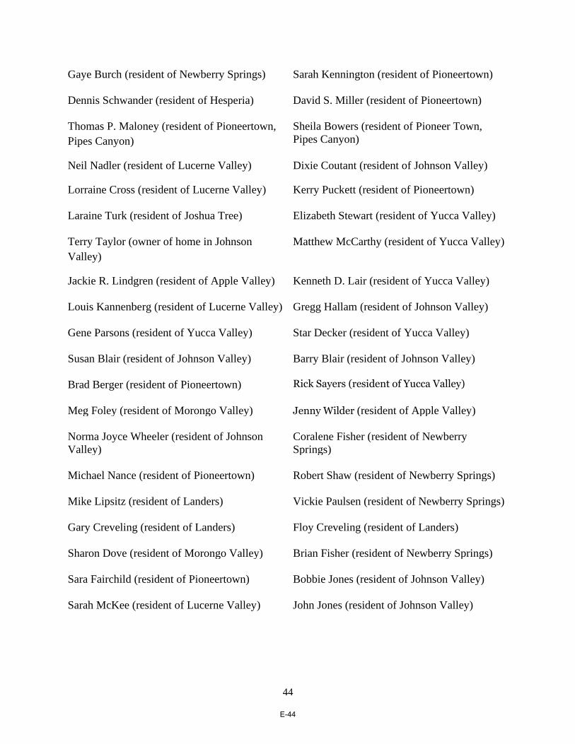
44
Gaye Burch (resident of Newberry Springs) Sarah Kennington (resident of Pioneertown)
Dennis Schwander (resident of Hesperia) David S. Miller (resident of Pioneertown)
Thomas P. Maloney (resident of Pioneertown,
Pipes Canyon)
Sheila Bowers (resident of Pioneer Town,
Pipes Canyon)
Neil Nadler (resident of Lucerne Valley) Dixie Coutant (resident of Johnson Valley)
Lorraine Cross (resident of Lucerne Valley) Kerry Puckett (resident of Pioneertown)
Laraine Turk (resident of Joshua Tree) Elizabeth Stewart (resident of Yucca Valley)
Terry Taylor (owner of home in Johnson
Valley)
Matthew McCarthy (resident of Yucca Valley)
Jackie R. Lindgren (resident of Apple Valley) Kenneth D. Lair (resident of Yucca Valley)
Louis Kannenberg (resident of Lucerne Valley) Gregg Hallam (resident of Johnson Valley)
Gene Parsons (resident of Yucca Valley) Star Decker (resident of Yucca Valley)
Susan Blair (resident of Johnson Valley) Barry Blair (resident of Johnson Valley)
Brad Berger (resident of Pioneertown) Rick Sayers (resident of Yucca Valley)
Meg Foley (resident of Morongo Valley) Jenny Wilder (resident of Apple Valley)
Norma Joyce Wheeler (resident of Johnson
Valley)
Coralene Fisher (resident of Newberry
Springs)
Michael Nance (resident of Pioneertown) Robert Shaw (resident of Newberry Springs)
Mike Lipsitz (resident of Landers) Vickie Paulsen (resident of Newberry Springs)
Gary Creveling (resident of Landers)
Floy Creveling (resident of Landers)
Sharon Dove (resident of Morongo Valley) Brian Fisher (resident of Newberry Springs)
Sara Fairchild (resident of Pioneertown) Bobbie Jones (resident of Johnson Valley)
Sarah McKee (resident of Lucerne Valley) John Jones (resident of Johnson Valley)
E-44

45
CCs:
Robert Lovingood (Chairperson and First District Supervisor; [email protected])
Janice Rutherford (Second District Supervisor; [email protected])
Dawn Rowe (Vice-Chairperson and Third District Supervisor; [email protected])
Curt Hagman (Fourth District Supervisor;
Josie Gonzales (Fifth District Supervisor; [email protected])
Colin Drukker (PlaceWorks; [email protected])
E-45

Coalition Letter Re
Community Plan Continuum
dated October 19, 2018
E-46

1
October 19, 2018
Ms. Linda Mawby (By Email: [email protected])
Senior Planner
County of San Bernardino Land Use Services Department – Planning Division
385 North Arrowhead Avenue, First Floor
San Bernardino, CA 92415-0187
Re: “Community Plan Continuum” for San Bernardino County
Dear Ms. Mawby:
We are a coalition made up of the following community groups, businesses, agencies and
individuals: Lucerne Valley Economic Development Association (LVEDA), Lucerne Valley-
Johnson Valley Municipal Advisory Council, Johnson Valley Improvement Association,
Homestead Valley Community Council, Oak Hills Property Owners Association, Newberry
Springs Chamber of Commerce, Newberry Springs Economic Development Association,
Newberry-Harvard Property Owners, Morongo Basin Conservation Association, Church of Our
Lord and Savior (Lucerne Valley), Lucerne Valley Market/Hardware, Newberry Springs
Community Alliance, Lucerne Valley Realty, Expert Appliance Service, Jubilee Mutual Water
Company, Inc., Alliance for Desert Preservation, Mojave Communities Conservation
Collaborative, Brian Hammer, Sue Hammer, Bradley R. Hicks, Dennis Morrison, Pat Flanagan,
Ruth Rieman, Marina West, Randy West, Barbara LaGrange, John Smith, Barbara Smith, Aaron
Idouchi, Barbara Idouchi, George Stone, Gail Stone, Robert L. Berkman, Ray Gagne, Randy
Polumbo, Jim Johnson, Ellen Johnson, Ted Stimpfel, Deborah Myers, Owen Myers, Roger
Peterson, Annie Lancaster, Allan Raish, Sara Tambellini, Russell Scott, Lakey Kolb, Stephen
Andrews, Kathryn Anema, Kathy Spindler, Teresa Reyes, Rachael Buettell, Ann Garry, Dave
Garry, Diana Bork, Sarah Kennington, Steve Bardwell, Dennis Schwander and Peter
Quintin Pena. Together, we represent a broad spectrum of residents, businesses, organizations,
recreationists and conservationists in the High Desert of San Bernardino County.
We are writing to you, as head of the Countywide Plan initiative, to point out
shortcomings in certain portions of the draft Countywide Plan (which were released in August
2018): the Community Action Guides, the County Policy Plan and the Land Use Map (and
related Tables). We will incorporate in this letter what we have learned regarding the
Countywide Plan and its constituent parts at the 2016 workshops on the Community Plans, at the
E-47

2
September 21, 2017 Planning Commission meeting on the “Countywide Continuum,” at the
October 2017 open house meetings and at the recent September 2018 “Regional Meetings.” For
the sake of convenience, we will refer to the referenced meetings collectively as “the Community
Plan Meetings.” This letter will also reference, and incorporate, the letter that our coalition sent
you regarding the “Community Plan Continuum,” dated November 21, 2017 (the “November 21,
2017 Letter”).
In terms of the recently-released Community Action Guides, this letter will, in order to
better illustrate our points, concentrate most of its analysis on the “Draft Lucerne Valley
Community Action Guide,” even though most defects found in that draft are present in the draft
Community Action Guides for other regions.
1. Under The Countywide Plan, Ineffectual Action Guides Would Replace
Community Plans That Provide Rural Residents with Strong Land Use
Protections, Even as Over 5,000 Acres of Utility-Scale Projects Threaten
to Industrialize Lucerne Valley.
The Countywide Plan calls for the 2007 versions of the Community Plans to be discarded
in favor of Action Guides. The Community Plans are part of the County’s General Plan -- and
call for preservation of the existing rural character of desert and mountain communities -- while
the Action Guides would supposedly tell members of rural communities how, at the grass-roots
level, they can fend for themselves when unwanted development threatens.
In an attempt to placate the County’s rural communities – which have long wanted to
retain their Community Plans -- the County Land Use Services Dept. (the “LUSD”) has
contended, at least until the August 2018 draft documents were released, that the Community
Plans currently in place are merely being re-named as “Community Action Guides,” and that the
latter would be the functional equivalent of the former. More than once, during its September
21, 2017 presentation before the Planning Commission, the LUSD represented that “nothing
would be lost” at the regional or community level under the new Countywide Plan set-up, and
that the LUSD was merely “changing terminology” in proposing that Action Guides be adopted
in place of the current Community Plans.
But, as will be discussed below, this is most certainly not the case, and considerable land
use protections would be lost if the Community Plans are replaced with “Action Guides.”
(a) The Community Plans Are Crucial to Preserving the Unique Rural
Characteristics of the County’s Desert and Mountain
Communities.
The Community Plans currently in place -- the 2007 versions -- are co-equal and fully-
formed elements of the County's General Plan, while the Action Guides would not have any real
legal status under the County Policy Plan (which would essentially be the same as a General Plan
E-48

3
in terms of land use planning). Hence the Community Plans’ strongly-worded goals and
objectives -- which are crucial to preserving the unique desert and mountain rural characteristics
of the County’s communities – would be lost forever if replaced with Action Guides.1
Rural residents expressed a strong desire, at the Community Plan Meetings and in their
November 21, 2017 Letter, to retain – and build on – their current Community Plans because, in
large part, they provide important protections against utility-scale industrialization. The central
theme of the comments made by participants at the Community Plan Meetings – and at all the
proceedings regarding the DRECP, REVEAL, SPARC and Policy 4.10 (this policy would, if
enacted, outright bar utility-scale projects from community plan areas, among other areas) – was
that utility-scale development is not wanted in or near the County's rural desert and mountain
communities.
The County’s Planning Commission and Board of Supervisors have made several
pronouncements that echo – and amplify on – this viewpoint:
(1) the Planning Commission’s unanimous (5-0) recommendation, at a May 24,
2018 hearing, that the County’s Board of Supervisors adopt Policy 4.10 as part of the County’s
Renewable Energy and Conservation Element (the “RECE”);
(2) the Board of Supervisors’ issuance of its February 17, 2016 Resolution (the
“Resolution”), which designated five sites -- which are seriously degraded, away from Lucerne
Valley and other rural communities, and relatively close to existing transmission – as the only
places that utility-scale can go, subject to the project’s otherwise satisfying the County’s criteria;
and
(3) the “County of San Bernardino Position Paper on the Draft Desert Renewable
Energy Conservation Plan,” dated February 3, 2015, in which the County stated that the
communities of Lucerne Valley, Newberry Springs, Stoddard Valley, Johnson Valley and Apple
1 For example, the current Lucerne Valley Community plan: (1) identifies, as one of
Lucerne Valley's “Unique Characteristics” (LV1.3.1), that it “offers a rural lifestyle,
characterized by the predominance of large lots, limited commercial development and the
prevalence of agricultural and animal raising uses in the area. The desert landscape and natural
resources further define the rural character of the community;” (2) states that a chief concern
(LV1.3.2) of residents is that growth pressures will “threaten the features of their rural
community,” including its “natural beauty [which is] characterized by an abundance of open
space and scenic vistas . . .;” and (3) specifies that, among the primary “Community Priorities”
for Lucerne Valley (LV1.3.3) are the need to “[r]etain the rural character of the community by
maintaining low density residential development and commercial development that serves the
needs of local residents” (emphasis added) and the need to maintain (LV/LU 1.1) “strict
adherence to the Land Use Policy Map unless proposed changes are clearly demonstrated to be
consistent with the community character” (emphasis added).
E-49

4
Valley are not appropriate for Development Focus Areas, which are places in which the DRECP
would allow utility-scale renewable energy projects to be established.
So why is it now being proposed that the Community Plans – with all their protections
against large-scale development -- be replaced by legally ineffectual Action Guides, particularly
when over 5,000 acres of new utility-scale projects are being aimed at Lucerne Valley?2
2 Lucerne Valley is under a determined siege from a development threat that was not even
on the horizon when the 2007 version was formulated: 5,000 acres (and counting) of proposed
utility-scale renewable energy and related transmission projects, as well as a proposed new
Southern California Edison substation, which include:
(1) A 484-acre, 60 MW solar PV project called Ord Mountain Solar, which is
proposed to be built along Highway 247 on highly erosive soil just north of Lucerne Dry Lake,
directly in the center of an established residential community of 54 homes within a half-mile of
the project boundaries (at least 33 of them are occupied by their owners or, as is the case with
Rivers Edge Ranch, under active operation);
(2) A 2,850-acre, 200 MW solar PV project called Aurora Sorrel, which is
proposed to be built along Highway 247, south of Stoddard Ridge;
(3) A 990-acre, 300 MW, 8 Minute Energy solar PV project (now called
“Sienna”), which is proposed to be built directly on top of the Lucerne Valley Dry Lake bed –
this would actually be two separate projects built on two non-contiguous parcels;
(4) A 622-acre, 100 MW solar PV project called Calcite Solar 1, which is
proposed to be built south of the proposed Ord Mountain Solar site – this would actually be four
separate projects on four non-contiguous parcels; and
(5) A 13-acre Southern California Edison “Calcite Substation,” which is
proposed to be built along Highway 247 -- across from the proposed Ord Mountain Solar site --
in order to connect the above-mentioned utility-scale projects (as well as others) to the electric
transmission grid; an extensive maze of distribution lines and access roads would have to be
constructed to hook up all these projects to the proposed substation, which would multiply the
environmental damage and scenic losses wrought by those projects.
The November 21, 2017 Letter carefully catalogues the manner in which these proposed
projects would, if built, forever decimate the area’s human and natural communities.
E-50

5
The LUSD appears to have recently dropped the pretense that Action Guides equate with
Community Plans – it no longer titles the Action Guides as “Community Plans.”3 And, indeed,
the goals, policies and objectives found in the Lucerne Valley Community Plan – which are the
heart and soul of proper general plan elements according to Govt. Code Section 65302 (which
requires that “the general plan shall consist of a statement of development policies and shall
include a diagram or diagrams and text setting forth objectives, principles, standards, and plan
proposals”) – are nowhere to be found in the 2017 version of the “Lucerne Valley Community
Plan,” in the August 2018 version of the proposed “Lucerne Valley Action Guide” or, as will be
discussed below in Section 3, in the recently released draft of the County Policy Plan.
Community participants roundly criticized the Action Guides at the September 21, 2017
Planning Commission meeting, in subsequent Community Plan Meetings and in their November
17, 2017 Letter, noting that, under the Action Guides, the communities’ stated land use priorities
would no longer be given voice or legal effect, i.e., that the Action Guides do nothing more than
leave it to community residents to fend for themselves in the face of an ongoing utility-scale
“gold rush.” Abandoning the Community Plans would sound the death knell for community-
oriented land use planning, and usher in an era of top-down goal-making, in which a
community's only real role would be figuring out how to survive under a land use vision that is
not its own.
Unless the County steps in to keep the Community Plans in place, the rural desert
character and natural beauty of the High Desert will be stolen from its inhabitants, and from the
many others who so greatly appreciate it and depend on it, economically and otherwise, all for
the benefit of those who would profit from exporting electrical power for use outside the County.
The entire North Slope region needs far more protection against rampant development than it did
when the 2007 versions were enacted, especially given that it is one of the special regions of the
County that, if sacrificed, will have ripple effect consequences countywide in terms of the
County’s long-term identity and economic well-being.
(b) The Action Guides Are Not, as Stated Therein, “Written in the
Words of Those Participating in the Public Engagement Process.”
The new Action Guides identify a set of pro-development goals and objectives that are
diametrically opposed to community members’ stated desires, which does great long-term
damage to the credibility and legitimacy of the LUSD and the County government as a whole.
3 The 2017 draft plan for Lucerne Valley was called the “Lucerne Valley Community
Plan,” while the 2018 version is called the “Lucerne Valley Community Action Guide.” (The
differences between the 2017 and 2018 drafts, and the implications of those differences, are
discussed below in Section 2(b) of this letter.)
Still, the “countywideplan.com” website continues to send a decidedly mixed message on
the subject by referring to the Action Guides as “Community Plan/Action Guides.”
E-51

6
Making matters worse, the new Action guides make a false bid for legitimacy by claiming that
they faithfully reflect community wishes. In that regard, the Lucerne Valley Action Guide
misrepresents that it is:
“. . . written in the words of those participating in the public engagement process.
Therefore, the Community Action Guide retains the voice and future image of the
community members participating in the public engagement process.”
How could the Action Guides be said to represent the communities' consensus as to what their
“future images” should look like – and to reflect the participants' own words – when (as noted above)
those same participants clearly rejected the Action Guides (while expressing a strong desire to retain their
Community Plans)? Further, as will be discussed in Subsection 2 below, the Action Guides are
worded in a way that completely ignores the comments made by community participants.
2. The Draft Community “Action Guide” for Lucerne Valley Throws Out
the Welcome Mat to Utility-Scale Renewable Energy Projects, Even
Though the Community Has Strongly and Frequently Objected to Such
Development Anywhere in the Plan Area.
While the Action Guides are, as discussed above, legally and practically ineffectual – and
must be discarded in favor of retaining the current Community Plans, the serious disconnect
between the language of the Lucerne Valley Action Guide – and the community’s stated desire
to retain its rural desert character – is, as noted in the previous paragraph, symptomatic of a
political and planning process that has gone awry to such a degree that its legitimacy is in serious
doubt. Again, if the LUSD and County are adamantly opposed to the communities’ desire to
maintain their rural character, then county government has a duty to explain why. To pretend
that the County is making policy in accord with its communities’ stated wishes – while actually
doing quite the opposite -- is how it is done in banana republics, which surely is not the model of
governance that the County wants to emulate.
(a) The 2017 Draft of the “Lucerne Valley Community Plan” (the
“2017 Draft”).
The 2017 Draft stated, in its “Action Statement A.1,” that:
(1) Lucerne Valley “[a]spire[s] to be a model renewable energy community with a
principal focus on point-of-use, rooftop solar;”
Comment: The above-quoted assertion is inaccurate. Participants in the
Community Plan meetings never said that they wanted to become a “model
renewable energy community.” Instead, they were steadfast in insisting that
utility-scale should be kept out of the plan area entirely. How did this clearly
articulated vision get transmogrified into a desire to become a “model
E-52

7
community” for the very type of development that was being so adamantly
opposed?
With a word cloud (in the 2017 Draft) in which the most prominent phrases are
“Natural Beauty,” “Desert Environment,” and “Open Space” -- and a
“Community Focus Statement A” citing the need to “[m]aintain the rural
character of the community” -- how was it concluded in the 2017 Draft that the
community wants to open its doors to utility-scale industrialization?
In any event, the County cannot “maintain the rural character of the community,”
as provided in Community Focus Statement A, by calling for the introduction of
renewable energy facilities in the community as per Action Statement A.1. The
latter is completely inimical to the former.
(2) “utility-scale solar and wind projects” should “only be permitted in designated
areas such as Tamarisk Flats to minimize the visual impact on the landscape (emphasis added).”
Comment. This highlighted phrase suggests that utility-scale projects can be
placed in Lucerne Valley in Tamarisk Flats, whatever that is, as well as in any
other arguably similar area, which would throw open the entire region to
potential large-scale renewable energy development.
(3) the 2017 Draft acknowledges that, due to its “large size and scale,” utility-
scale development can “degrade visual character or quality.” But then the 2017 Draft undercuts
that cautionary note by stating the utility-scale projects must be “carefully evaluated and sited.”
Comment. This sends the message that utility-scale projects, if “carefully
evaluated and sited,” would be supported by the community, but this is not the
case (with the possible exception of projects sited in the five areas mentioned in
the Resolution).
(b) The 2018 Draft of the “Lucerne Valley Action Guide” (the “2018
Draft”)
What did the County do in response to the criticism leveled against the 2017 Draft? It
merely excised, in the 2018 Draft, all direct references in “Action Statement A.1” to utility-scale
projects and otherwise reiterated the language of the 2017 Draft (with some superficial changes
in the “Benchmark” and “Champion” sections), including the ones referenced in the previous
subsection of this letter.
But this did not take care of the problem, because the 2018 Draft continues to misstate
that Lucerne Valley “aspires[s] to be a model renewable energy community with a principal
focus on point-of-use, rooftop solar (emphasis added)” – which implies that the community
would also be amenable to other forms of renewable energy, including utility-scale -- even
E-53

8
though the community has made it crystal clear that the only renewable energy it wants would be
rooftop and small, community-oriented solar.
The Lucerne Valley Community Plan -- if (as requested by the community) it is retained
in its current form -- would render the Action Guide totally superfluous. But, if the County were
to insist that an Action Guide also be put in place, the one for Lucerne Valley would, at the very
minimum, need to be revised to: (1) drop any reference to a purported desire to become a
“model renewable energy community,” (2) state that the community is opposed to utility-scale
anywhere in the Lucerne Valley CSA, and that the only forms of renewable energy that it is
willing to accept are rooftop solar and microgrids (ones that provide direct interconnection and
benefit to the community), and (3) fully describe how the harmful effects of utility-scale
development in a rural desert environment would defeat the “Community Focus Statement A”
goal of “[m]aintain[ing] the rural character of the community.”4
It goes without saying that the unique, desert rural quality of life in Lucerne Valley
cannot be maintained at the same time as the door is held open to a succession of utility-scale
projects.
3. Pivotal Goals, Policies and Objectives of the Lucerne Valley Community
Plan Are Not Included in the Recently Released Draft of the County
Policy Plan.
As referenced above in Fn. 1, the current Lucerne Valley Community Plan contains goals,
policies and objectives that are integral to the community's effort to protect itself from being
industrialized by utility-scale development, none of which were carried forward in any
meaningful way into the proposed County Policy Plan.
Colin Drukker, of Planworks (the County's consultant with respect to the development of
the Countywide Plan), insisted otherwise at the September 12, 2018 Lucerne Valley “Regional
Meeting.” In support of his position, Mr. Drukker cited the County's recently-published “2007
Community Plan Goals and Policies Matrix” (the “Matrix”), which he said shows where the
Community Plans’ goals, policies and objectives have been “addressed” in the County Policy
Plan. But, as will be discussed below, crucial goals, policies and objectives in the Lucerne
Valley Community Plan – specifically, those governing land use, industrial growth, water issues
4 The LUSD took the position, at the September 21, 2017 Planning Commission meeting,
that it would not be appropriate for (what the LUSD then called) the “Community Plans” to
address renewable energy issues – because those issues should supposedly only be dealt with in
the RECE – but the 2017 Draft did just that. So why not reference the community’s desire to
exclude utility-scale altogether? In any event, with an onslaught of some 5,000 acres of new
utility-scale projects in the planning pipeline – for Lucerne Valley alone (as was discussed
above) – what possible justification could there be for turning a blind eye in the Action Guide on
the region's number one development threat?
E-54

9
and dust control issues -- did not make it into the Policy Plan, or were revised beyond all
recognition in the Policy Plan. In still other cases, the Policy Plan undercuts its own proposed
goals and policies.5
Moreover, the Policy Plan omits the Lucerne Valley Community Plan’s highly specific
descriptions of Lucerne Valley’s rural character and development aims. For example, the
Community Plan identifies, as one of Lucerne Valley's “Unique Characteristics” (LV1.3.1), that
it “offers a rural lifestyle, characterized by the predominance of large lots, limited commercial
development and the prevalence of agricultural and animal raising uses in the area. The desert
landscape and natural resources further define the rural character of the community.” In its
“Community Priorities” section, the Community Plan states that one such priority is to “[r]etain
the rural character of the community. . .”
The Community Plan also states, in its “Issues and Concerns” section, that a chief
concern (LV1.3.2) of residents is that growth pressures will “threaten the features of their rural
community,” including its “natural beauty [which is] characterized by an abundance of open
space and scenic vistas . . .” The quoted descriptions provide much-needed context for
interpretation and implementation of the land use goals and policies concerning the community.
(a) Goal LU 1 of the Lucerne Valley Community Plan – “Retain the
existing rural desert character of the community” – Is Not Found
Anywhere in the County Policy Plan.
The above-quoted Goal LU 1 of the Community Plan would – if properly interpreted – all
but ban any new development, such as utility-scale projects, that would industrialize Lucerne
Valley, yet this pivotal goal is nowhere to be found in the County Policy Plan.6
The Matrix represents, under its “[w]here it will be addressed” column, that Community
Goal LU 1 is carried forward in two new goals found in the Policy Plan: “[Policy] Goal LU-2
Land Use Mix and Compatibility” and “[Policy] Goal LU-4 Community Design.” As will be
explained below, this is not at all the case.
5 Due to the size and scope of the Policy Plan, the discussion in this letter will focus on
goals/policies pertaining to land use, environmental issues, dust control and water that bear
directly on utility-scale renewable energy development. Chuck Bell emailed an extensive and
excellent memo to the County, on September 10, 2018, that analyzes the rest of the Policy Plan
and points out many instances in which it requires significant revision. 6 To make the discussion easier to follow, references to goals found in the current Lucerne
Valley Community Plan will begin with the word “Community” and be placed in bold font, so
that, by way of an example, its Goal LU 1 will be called “Community Goal LU 1.” In similar
fashion, goals and policies cited from the County Policy Plan will be preceded by the word
“Policy” and italicized.
E-55

10
Community Goal LU 1 provides a strong bulwark against all projects that would
industrialize Lucerne Valley. In stark contrast, Policy Goal LU-2 calls for “[a]n arrangement of
land uses that balances the lifestyle of existing residents, the needs of future generations,
opportunities for commercial and industrial development, and the value of the natural
environment.” (Emphasis added.) As written, Policy Goal LU-2 would allow the County to
approve any proposed new project – even one that would degrade the “existing rural desert
character of the community” – so long as the County determines that the “needs of future
generations” and the value of “commercial and industrial development” outweigh the value of
preserving “the lifestyle of existing residents” and the “natural environment.”
Hence Policy Goal LU-2 runs directly counter to the letter and spirit of Community
Goal LU 1. So, not only is Policy Goal LU-2 not the equivalent of Community Goal LU 1, it
would facilitate the rapid industrialization of Lucerne Valley and hence must be eliminated from
the Policy Plan. There can be no “balancing” when it comes to development, such as utility-
scale projects, that would fundamentally degrade the rural desert character of the community.
The Matrix suggests that “[Policy] Goal LU-4 Community Design” is analogous to
Community Goal LU 1, but it is not. Policy Goal LU-4 calls for the use of community design
elements -- in the “preservation and enhancement of unique community identities” -- but you
cannot design away all the many deleterious effects that utility-scale projects impose on human
and natural desert communities. Hence, while Policy Goal LU-4 might be quite effective in
maintaining the harmonious visual aesthetic of the community’s various structures, it would be
totally inadequate in terms of preserving the rural desert character of the community and the
surrounding environment.
The Matrix also cites the Action Guide's “Focus Statement A” – “Maintain the rural
character of the community” – and “Focus Statement B” – “Promote responsible and sustainable
development consistent with Lucerne Valley's rural character.” But, as discussed above, the
Action Guide would be nothing more than an ineffectual playbook for how, at the grass-roots
level, community members might undertake self-help measures.
Worse yet, the Action Guide calls for implementing “Focus Statement A” by, according
to “Action Statement A-1,” turning Lucerne Valley into a “model renewable energy
community,” which would be inimical to any effort to preserve the community’s “rural desert
character” in the face of industrialization.
Clearly, Community Goal LU 1 – one of the most important goals in the entire
E-56
11
Community Plan – was not carried forward into the proposed Policy Plan.7
(b) Community Goal LU 1.1 – “Require strict adherence to the land
use policy map unless proposed changes are clearly demonstrated
to be consistent with the community character” – Is Not Found
Anywhere in the County Policy Plan.
The Matrix equates “Policy LU-4.5 Community identity – We require that new
development be consistent with and reinforce the physical and historical character and identity
of our unincorporated communities” – with Community Goal LU 1.1. But the bland, one-size-
fits-all policy language of Policy LU-4.5 would not begin to provide the comprehensive
protection against unwanted development that is afforded by Community Goal LU 1.1,
especially given that Policy LU-4.5 would neither require “strict adherence to the land use policy
map,” nor require that developers “clearly demonstrate” that a proposed change would be
“consistent with the community character,” as does Community Goal LU 1.1.
In any event, Policy LU-4.5 – indeed, all goals stated in the Policy Plan that would
ostensibly address industrial development in Lucerne Valley -- is rendered meaningless by: (1)
Policy Goal LU-2, which, as discussed above, allows development any time the County
determines that a balancing of competing interests supposedly favors a project; and (2) Policy
Goal LU-2.11, which says that “[w]e allow new office and industrial uses in unincorporated
Mountain/Desert regions in order to meet the service, employment, and support needs of
7 The current version of the County’s General Plan contains land use goals that are written
in much stronger and more affirmative language -- in terms of protecting the rural character and
quality of life enjoyed by desert residents – than are the goals stated in the Policy Plan. To wit,
the current General Plan states the following goals:
(1) “maintain land use patterns in the Desert Region that enhance the rural
environment and preserve the quality of life of the residents of the region (Goal D/LU 1);”
(2) “ensure that commercial and industrial development within the region is
compatible with the rural desert character and meets the needs of local residents (D/LU 3);” and
(3) “preserve the unique environmental features and natural resources of the
Desert Region, including native wildlife, vegetation, water and scenic vistas” (Goal D/CO 1 of
the General Plan’s Open Space element).
Why is it that with each new version of the County’s land use documents the protections
for the desert are progressively weakened? The desert needs more protection than ever in view
of the 5,000 acre + utility-scale invasion being aimed at it.
E-57

12
unincorporated areas.”8 Policy Goals LU-2 and LU-2.11 must be eliminated from the Policy
Plan.
The Matrix claims that “Policy LU-2.8 Rural lifestyle Mountain/Desert regions” is
analogous to Community Goal LU 1.1, but Policy LU-2.8 applies only to “new residential
development” and would have no effect on proposed projects, like utility-scale projects, that
would industrialize desert and mountain communities.
The Matrix also attempts to equate the Policy Plan's “LU 4.1 Context sensitive design in
the Mountain/Desert regions” with Community Goal LU 1.1, but the former, because it calls
for discernment in the use of “site and building design techniques” and in the choice of proper
building materials, has no relevance to stopping utility-scale projects.
Finally, the Matrix cites the Action Guide's “Action Statement A3,” but, as stated above,
the Action Guide would be legally and practically ineffectual.
(c) Community Goal LU 2 – “Ensure that commercial and industrial
development within the plan area is compatible with the rural
desert character and meets the needs of local residents” – Is Not
Found Anywhere in the County Policy Plan.
All the Matrix offers on this score is a reference to Policy Goal LU-2 – which, as
discussed above, embodies an unacceptable and potentially pro-utility-scale “balancing
principle,” and to the “community design” standard stated in Policy Goal LU-4.
For the reasons discussed above, neither of these Policy Plan goals is at all analogous to
Community Plan goals, such as Community Goal LU 2, that embody and actualize the
community's desire to maintain its rural desert character. Moreover, neither Policy Goal LU-2
nor Policy Goal LU-4 say anything about the need to restrict commercial and industrial
development to that which “meets the needs of local residents,” which is a vital and
irreplaceable component of Community Goal LU-2 (emphasis added.)
Why is the above-quoted language of Community Goal LU 2 so important? Because
utility-scale projects by definition do not meet the needs of local residents given that these
projects export power and profits out of the County, while leaving behind decimated human and
natural communities. Hence Community Goal LU 2 – with its requirement that industrial
8 Moreover, as will be discussed below, the proposed Land Use Map calls utility-scale
projects “typical uses” in a vast new “Resource/Land Management” zone that comprises the
greater part of Lucerne Valley, and would include all land that is currently zoned for agriculture
and “open space.”
E-58
13
development meet the needs of local residents -- represents a very significant barrier to large-
scale renewable energy projects that we cannot afford to abandon.
(d) Community Goal LU 2.4 – “Require adequate buffering between
Industrial and non-industrial land uses” – Is Not Adequately
Embodied in the County Policy Plan.
The Matrix cites Policy LU-2.1 as being analogous, but, while it does require that new
development be “scaled, buffered, and designed” in a way that is compatible with existing uses,
that would be done only to “minimize negative impacts.” (Emphasis added.) By contrast,
Community Goal LU 2.4 specifically requires buffering – not scaling or design -- that would
eliminate negative impacts that industrial development has on the community. This represents
another significant barrier to utility-scale development because there are rural residents and
population centers scattered throughout Lucerne Valley.
On a related note, utility-scale development causes an array of harm to human and natural
communities on a regional basis, including the release of dust as a result of the destruction of
“fragile desert soils” (this is addressed in Community Goal CO 1.3.). Policy “HZ-1.8 Wind
erosion hazards” would be, as written, inadequate to the task of preventing fugitive, wind-blown
dust from being disseminated from utility-scale projects; it would merely require new
development “in medium-high or high wind erosion hazard areas to protect structures from
wind-blown soil through building and design features . . . (emphasis added),” and thus has a
misplaced emphasis on protecting structures, instead of human and environmental health. Policy
HZ-1.8 would need to be strengthened considerably.
(e) Community Goal OS 1 – “Preserve open space lands to ensure
that the rural desert character of the community is maintained” –
Is Not Adequately Embodied in the County Policy Plan.
The Matrix cites Policy NR-3 as supposedly analogous to Community Goal OS 1, but
this is not the case. Policy NR-3 calls for “[a] system of well-planned and maintained parks,
trails, and open space that provides recreation opportunities for residents, attracts visitors from
across the region and around the country, and preserves the natural environment.”
While Policy NR-3 would serve a laudatory purpose, its emphasis and orientation are
markedly different than that of Community Goal OS 1. In the former, open space is to be
preserved in order to provide recreation, attract tourist dollars and protect the environment,
while, in the latter, open space is to be preserved in order to “ensure that the rural desert
character of the community is maintained.” This is a crucial distinction. Policy NR-3, while
certainly well-intentioned, does not provide the strongly worded protection for “open space” that
Community Goal OS 1 does.
E-59

14
Community Goal OS 1.5 states that “[t]he foothills of the San Bernardino Mountains are
recognized as an important open space area that provides wildlife movement and other important
linkage values. Projects shall be designed to minimize impacts to wildlife movement in this
area.” The Matrix offers Policy NR-3.3 as an analogous provision, but it offers only to
coordinate with various agencies to “sustainably manage and conserve land within or adjacent to
locally-, state-, or federally–designated open space or resource conservation areas.” Policy NR-
3.3 lacks Community Goal OS 1.5’s specific acknowledgment of the ecological significance of
the North Slope region, and hence offers it greatly reduced protection against development-
driven damage.
(f) Community Goal Cl 4.1 – “Through the development review
process, permit new development only when adequate water
supply exists or can be assured” – Is Not Found Anywhere in the
County Policy Plan.
The Matrix claims that “Policy IU-1.1 Water Supply” is analogous to Community Goal
CI 4.1, but all Policy IU-1.1 says is that “[w]e require that new development be connected to a
public water system or a County-approved well to ensure a clean and resilient supply of potable
water . . .” Utility-scale projects do not require piped in potable water for their construction,
operation or maintenance; and a typical project has large volumes of non-potable water delivered
to it by truck from whatever County sub-basins the project’s water purveyor is allowed to draw
on. Clearly Policy IU-1.1 applies only to residential and commercial development – which, by
contrast, does require immediate connection to potable water, while Community Goal CI 4.1
would ban all development unless it can be established that a proposed project would not
compromise the County’s water supply.
The Matrix also cites “Policy IU 1.8 Groundwater management coordination,” which
would require that the County coordinate with various agencies, governmental and non-
governmental, to “ensure [that] groundwater basins are being sustainably managed.” This is a
good policy statement as far as it goes, but then Policy IU 1.8 adds that “[w]e discourage new
development when it would create or aggravate groundwater overdraft conditions, land
subsidence, or other ‘undesirable results’ . . .” (Emphasis added.) Hence Policy IU 1.8 calls
only for a governmental frown to be cast in the direction of groundwater-threatening projects,
while leaving the door open for their approval. This makes Policy IU 1.8 wholly different from
Community Goal CI 4.1, which would ban such projects. In any event, if it is determined that
new development would be detrimental to our groundwater supply – an irreplaceable resource
that is this County’s lifeblood -- why hold the door open even a crack to it?
And it is beyond dispute that the County’s groundwater supply is endangered by
prolonged drought and existing usages. It is also jeopardized by 20,000 MWs in total, according
to the DRECP (with a portion of that on BLM lands as per the final BLM LUPA), of new utility-
scale renewable energy that the DRECP plans for the California desert. Such data as we have on
the subject – which comes chiefly from the DRECP itself – must be considered.
E-60

15
While the draft DRECP did not conduct a meaningful analysis of groundwater baseline
data, it nevertheless made valuable observations about the tenuous state of the desert’s
groundwater basins. For instance, the draft DRECP acknowledged that its DFAs would be
located primarily on already overdrafted County groundwater basins from which the enormous
volumes of water needed -- for the construction, maintenance and operations of large-scale
generation facilities -- would have to be drawn. In that regard, it conceded (at IV.6-24) that
“[d]evelopment would occur in 35 groundwater basins,” that 14 of them are stressed or in
“overdraft or stressed,” that “[m]ost (97%) of the developed area is within four ecoregion
subareas [the High Desert areas of Los Angeles and San Bernardino Counties and the Imperial
Valley]” -- which are the most populated areas of the California desert9 -- and that “increased
groundwater use in these sensitive basins can adversely affect water supplies and exacerbate
impacts associated with overdraft conditions and declining groundwater levels.”
The draft DRECP also stated that the total estimated water use for the new projects it
sought to foster would be 91,000 acre-feet per year (IV.6-24), and that the “[r]enewable energy
facilities permitted under the DRECP could influence the quantity and timing of groundwater
recharge because construction would include grading the land surface, removing vegetation,
altering the conveyance and control of runoff and floods, or covering the land with impervious
surfaces that alter the relationships between rainfall, runoff, infiltration and transpiration [IV.25-
45].” Solar energy – which was the renewable technology preferred in the DRECP -- “would
result in the largest amount of grading so it would have the largest impact on groundwater
recharge among the renewable technologies permitted under the DRECP [IV.25-45].”
According to the vastly understated language of the draft DRECP, the “use of
groundwater for renewable facilities permitted under the DRECP would combine with [other
uses of groundwater] . . . to result in a cumulative lowering of groundwater levels affecting basin
water supplies and groundwater [IV.25-46].”
The draft DRECP also took note (IV.25-45) of the “[p]opulation growth and anticipated
development summarized in Section IV.25.2.2” -- including “future residential development that
would also use a large amount of groundwater continuously [IV.25-46]” and that would result
from anticipated renewable energy and other projects -- as further contributing to the drawdown
of desert groundwater basins.
9 When the draft DRECP’s map of the Preferred Alternative DFAs (which, along with
transmission corridors, was to entail approximately 177,000 acres of “ground disturbance” (IV.7-
215)) is superimposed on top of the DRECP’s Overdraft Groundwater Basins map, one sees that
(with small exceptions) all of the High Desert DFAs – from the Antelope Valley east to the
Johnson Valley -- were located within the boundaries of already overdrafted groundwater basins.
Indeed, the DRECP conceded: “[u]nder the Preferred Alternative, development in BLM lands
can affect groundwater in 12 basins characterized as either in overdraft or stressed” [Section IV.6
of the DRECP].
E-61

16
Even more ominously, the draft DRECP noted that the proposed renewable energy
projects would result in “compression [of groundwater basins that would reduce] the volume of
sediment beds and lower land surface elevations, which can damage existing structures, roads,
and pipelines; reverse flow in sanitary sewer systems and water delivery canals; alter the
magnitude and extent of flooding along creeks and lakes. This compression of clay beds [that
make up groundwater basins] also represents a permanent reduction in storage capacity”
[IV.25-47]. (Emphasis added.) The proposed renewable energy plants and transmission
facilities “could also cause water-level declines in the same groundwater basins and contribute to
the migration of the saline areas of groundwater basins” [IV.25-47]. 10
In terms of construction usage, the 550 MW Desert Sunlight 250 project (on 4,400 acres
of land) – and the 1,550 acre feet of water allocated to its construction – can be used as a metric.
Forty projects of that size would produce just over the DRECP’s targeted 20,000 MWs in
renewable energy. Assuming that those forty projects would use a similar amount of water
during their construction, construction of 20,000 MWs of new renewable energy projects would
consume 620,000 acre feet, which equates with approximately 20 billion gallons of water.
In their maintenance and operations, the utility-scale solar projects in the Lucerne Valley
DFA would, according to data from the draft DRECP, consume almost 1,000 acre-feet of water
per year, which is enough water to fill four Rose Bowls to the brim. On a DRECP-wide basis, if
all 20,000 MWs of generation were to come from the least water-intensive generation method –
which is solar PV (as opposed to solar thermal, which requires many multiples more water in
cleaning, as well as a great deal of additional water for cooling operations) – and the PV panels
were washed only six times per year, the cleaning of the panels alone would consume .15 acre
feet per year per megawatt of generation, which would amount to a total water expenditure of
approximately 3,000 acre feet per year (20,000 times .15 = 3,000).
Projects on the BLM land will be drawing from the same groundwater basins that the rest
of the County relies on – in effect, public and private “straws” will all be drawing from the same
figurative milkshake. Nevertheless, the draft DRECP made no study of the impact on the
desert’s aquifers of siting 20,000 MWs of new generation facilities, nor did the draft DRECP
10 The DRECP water data and findings continue to be relevant, notwithstanding the 2016 –
2017 rains, which did not by any means break California’s prolonged drought in arid regions
such as the Mojave Desert. Statements made by the State Water Resources Control Board (the
“SWRCB”), in its comment letter regarding the DRECP, suggests that the drought would persist
there despite the recent rains. The SWRCB comment letter states that the preponderance of
groundwater in the Basins and Ranges hydrologic province is thousands of years old (i.e., it takes
thousands of years for groundwater to travel from the point of recharge to the point of
discharge). According to the SWRCB comment letter, our aquifers represent a closed system
where 66% of the groundwater is between 100 and 33,000 years old with the only “young”
recharge coming from the mountains [p. 18]. On a related note, the SWRCB states that, “[i]n
most areas of the desert, deeper, older groundwater is saline. Excessive pumping will likely
cause migration of saline water into fresh water aquifers [p. 11].”
E-62

17
include any real baseline data concerning the health or sustainability of those basins under
current demands, or when the effects of an ongoing drought of historic proportions is factored in.
The “San Bernardino Countywide Vision” website sounds its own carefully modulated,
yet unmistakable, note of alarm, stating that a “group made up of the county’s water agencies,
business representatives and other stakeholders” determined that “acting separately, the county
would not have enough water through 2035 . . .” The website goes on to say that there would be
enough water to go around “when the water agencies’ resources are combined,” but “only if
water users step-up [sic] conservation efforts and the public and local government leaders are
willing to invest in projects that will store and protect additional water supplies.” We are not
aware of any new investment of that sort being proposed.
Clearly, proposed Policy IU-1.1 is inadequate to the task of preserving our precious
groundwater supply, while a properly applied Community Goal LU-1.1 – if retained in a true
Community Plan and reiterated (and perhaps strengthened) in the Policy Plan – would greatly
assist in doing just that.
4. The Proposed Land Use Map Would Create a New “Resource/Land
Management” Zone – the Single Largest One in the Lucerne Valley CSA
-- in Which Utility-Scale Development Would Be Expressly Designated as
a “Typical Use.”
The new proposed Land Use Map, and its companion “Table LU-1” (entitled “Land Use
Categories”) -- which were released in August 2018 – create a new “Resource/Land
Management” (“RLM”) land use category. Table LU-1 lists, under its column for “Description
of Typical Uses,” “community-scale and utility-scale energy facilities.” This reference to utility-
scale facilities is neither accidental nor incidental. According to the “Table LU-1 Notes,” the list
of typical uses is “intended to further clarify the purpose of each land use category.”
(Emphasis added.) This is a bold and unmistakable statement that an express purpose of the
RLM zone is to accommodate utility-scale projects.
This would be particularly detrimental to Lucerne Valley because the RLM zone would
cover most of the vast Lucerne Valley CSA, comprising all areas currently zoned AG
(Agriculture) and RC (Resource Conservation) according to Table LU – 2 (“Land Use
Category/Zoning Equivalency Matrix”). In fact, the RLM zone would be the single biggest land
use category specified in the proposed Land Use Map. Raising the stakes considerably is that
this new zone would include the entire AG area in north Lucerne Valley in which the Ord
Mountain and other nearby utility-scale projects under application are proposed to be located (as
referenced in Fn. 3), and presumably ease the way for approval of those projects.
Setting aside this immense region as a breeding ground for new utility-scale development
– in the face of a flood of proposed utility-scale projects – would devastate the human and
natural communities in Lucerne Valley, and run counter to the community’s – and County
government’s -- strongly expressed desire to retain the area's rural desert character.
E-63

18
It would also run counter to the position taken by the LUSD at the August 8, 2017 Board
of Supervisors hearing at which the RECE was adopted, and during the long run-up to that
hearing. Various LUSD representatives strongly opposed using what they referred to as a
“mapping approach” in formulating the RECE, under which mapped regions would be made
either off-limits or available to utility-scale development; the LUSD advocated a “standards-
based” approach under which utility-scale developers would have to make various showings, on
a project-by-project basis, in order to obtain needed approvals. The latter approach was the one
ultimately embraced by the Board of Supervisors in adopting the RECE.
Had community participants been informed, at the August 8, 2017 Board of Supervisors
hearing on the RECE (or during the intense and heated debate preceding its adoption) that a de
facto utility-scale RLM zone would be created after its adoption, this would have brought out
intense community opposition, and formulation of the RECE would have taken a much different
turn. Adopting a utility-scale-friendly RLM zone, after the fact, would radically and belatedly
re-write the RECE, and dramatically undercut Policy 4.10’s outright ban on utility-scale projects
in community plan areas.
Designating the vast RLM as available to industrial renewable energy development
would also conflict with the express purpose for RLM zoning, which, according to the Table LU-
1, is as follows:
◼ “Manage, preserve, and protect natural resources such as agriculture/grazing
lands, watersheds, minerals, and wildlife habitat areas, as well as open space
areas not otherwise protected or preserved
◼ Provide areas for military operations, and training, while monitoring impacts on
and from surrounding civilian uses
◼ Allow for limited rural development while minimizing expansion of
development outside of existing communities.”
Obviously, inviting utility-scale development in the RLM zone – by calling it a “Typical
Use” there -- would serve only to steadily deplete the very natural resources that the RLM land
use category is intended to protect and preserve, as well as to degrade Lucerne Valley's human
communities.
The reference to utility-scale as a “Typical Use” in the RLM zone must be excised from
the Land Use Map and related Tables ultimately adopted in the Countywide Plan. Otherwise,
they would become vehicles for accomplishing, through back-handed and undemocratic means,
what couldn’t be accomplished in a straightforward, politically above-board manner through the
RECE approval process, and in effect constitute an unauthorized amendment of the RECE that
E-64

19
would effectively undercut Policy 4.10.11
5. The Renewable Energy Element Ultimately Adopted in the Proposed
County Policy Plan Must Be Identical to the RECE adopted on August 8,
2017.
The proposed County Policy Plan – the one published in August 2018 – included a rather
oddly drafted “Renewable Energy and Conservation Element” (the “Policy Plan RE Element”)
which purported to modify the RECE. The Policy Plan RE Element claimed that these
modifications were made only “to match the writing style of other Countywide Plan goals and
policies,” but they went much further than that. In fact, the Policy Plan RE Element extensively
re-wrote the RECE by leaving out all of its explanatory paragraphs, by re-formulating many of
the RECE’s goals and by eliminating all of the RECE’s “Objectives” and sub-policies.
Community members raised strong objections to this at the September 12, 2018 Lucerne
Valley “Regional Meeting,” among other places. Terri Rahhal, the LUSD’s director, represented
that the re-formulation of the RECE had been a mistake and that it would be corrected in a
revised iteration of the Policy Plan RE Element.
Sometime after the September 12, 2018 Lucerne Valley “Regional Meeting,” a revised
Policy Plan RE Element was published. The revised version recites that it is just a placeholder
for the RECE and that the RECE will be incorporated in its entirety into the Countywide Plan.
The revised version also represents as follows:
11 The “Table LU-1 Notes” attempt to remedy this inconsistency by stating that “[t]he list
of typical uses is also subject to and limited by policies in this and other elements of the County
Policy Plan. A pending recommendation from the County Planning Commission to revise Policy
4.10 of the Renewable Energy and Conservation Element, for example, would prohibit utility-
oriented renewable energy projects in the Rural Living land use districts and any land use district
within the boundaries of existing community plans (and potentially other community planning
areas).”
But Policy 4.10 could, if adopted, rescue from the pro-utility-scale RLM zone only those
areas that 4.10 specifically covers, such as the community plan areas. This means that the RECE
would remain upended, and totally preempted, everywhere outside the sway of Policy 4.10.
Clearly, the only proper and straightforward way of addressing this irreconcilable conflict
would be to eliminate utility-scale as a “typical” RLM use.
E-65
20
“On May 24, 2018, the County of San Bernardino Planning Commission voted (5 – 0) to
make a recommendation to the Board of Supervisors to amend Policy 4.10 to read as
shown below [the full text of Policy 4.10 in the form it was approved that day is stated
therein]. This page will be updated upon direction from the Board of Supervisors.”
This is erroneous. The Planning Commission did not recommend on May 24, 2018 that
the Supervisors “amend Policy 4.10.” Instead, the Commissioners recommended that the
Supervisors amend the RECE to incorporate Policy 4.10 in its original form. The
Commissioners did not approve any amendment of Policy 4.10.12 This error must be corrected
in another iteration of the Policy Plan RE Element.
Moreover, the Policy Plan RE Element ultimately adopted in the County Policy Plan
must be exactly the same as the RECE in its final form.
6. The Countywide Plan Further Flouts the Community’s Wishes By Calling
For a Tiered and Streamlined CEQA Process for Future Development
Projects, All of Which Are to be Enabled by a Programmatic EIR.
The website for the Countywide Plan indicates that another of its components would be
“[a] programmatic environmental impact report that facilitates tiering and streamlining for future
development projects that are consistent with the Countywide Plan.”
If all this sounds eerily reminiscent of the DRECP, RETI 2.0 and the IEPR, it is because
each of those renewable energy and transmission planning processes espouses the use of
landscape-level planning to streamline and fast-track development projects into the High Desert.
But why in the world would a community that is already in the cross-hairs of those overbearing
development processes – and fighting tooth and nail against over 5,000 acres of utility-scale
industrialization in a dogged effort to retain its rural character – want to have its CEQA rights,
and its right to challenge projects at the County level, “streamlined” away in the General Plan?
Why would any of the County’s desert and mountain communities want this?
In reality, none of them do. And none of them has ever requested that the County
emulate the BLM or the California Energy Commission by getting into the game of picking, on a
landscape-level basis, “best-fit/least-conflict” lands for large-scale development projects of any
sort. Instead, our communities have been fairly begging the County to step in to help preserve
their rural character by limiting industrial-scale development.
We request that the County abandon any notion of introducing streamlining, tiering or
programmatic land use planning anywhere in the Countywide Plan or in any of its components.
12 The LUSD proposed an extensive re-write of Policy 4.10, but it was rejected by the
Planning Commission at the May 24, 2018 hearing.
E-66

21
7. Conclusion.
We welcome the opportunity to comment on the Countywide Plan and its recently
published components, and look forward to continuing participation.
Very truly yours,
Community Associations, Businesses and Organizations:
LUCERNE VALLEY ECONOMIC
DEVELOPMENT ASSOCIATION
Chuck Bell, President
JOHNSON VALLEY IMPROVEMENT
ASSOCIATION
Betty Munson, Secretary
LUCERNE VALLEY-JOHNSON
VALLEY MUNICIPAL ADVISORY
COUNCIL
Roger Peterson, Chairman HOMESTEAD VALLEY COMMUNITY
COUNCIL
Rick Sayers, Vice President
MORONGO BASIN CONSERVATION
ASSOCIATION
Steve Bardwell, Treasurer
NEWBERRY SPRINGS COMMUNITY
ALLIANCE
Ted Stimpfel, President
OAK HILLS PROPERTY OWNERS
ASSOCIATION
Lynn Buehler, President
NEWBERRY SPRINGS CHAMBER OF
COMMERCE
Paula Deel, Board Member
NEWBERRY SPRINGS ECONOMIC
DEVELOPMENT ASSOCIATION
Paul Deel, President
NEWBERRY-HARVARD PROPERTY
OWNERS
Robert Vasseur, President
E-67

22
MOJAVE COMMUNITIES
CONSERVATION COLLABORATIVE
Lorrie L. Steely, Founder
LUCERNE VALLEY MARKET/
HARDWARE
Linda Gommel, Chief Executive Officer
ALLIANCE FOR DESERT
PRESERVATION
Richard Ravana, President
CHURCH OF OUR LORD AND SAVIOR
(LUCERNE VALLEY)
Bill Lembright, President
LUCERNE VALLEY REALTY
Martha Lynn, Owner
JUBILEE MUTUAL WATER COMPANY,
INC.
Raymond M. Gagne, Jr., General Manager
EXPERT APPLIANCE SERVICE
Bill Peterson and Alyn Peterson, Proprietors
(and residents of Lucerne Valley)
Individual Community Members:
Brian Hammer, Analyst and Adjunct Professor
(owner of home in Lucerne Valley)
Bradley R. Hicks (resident of Lucerne Valley)
Sue Hammer (owner of home in Lucerne
Valley)
Barbara LaGrange (resident of Lucerne Valley)
Renee Lynn (resident of Lucerne Valley) Ruth Rieman (resident of Flamingo Heights)
Pat Flanagan (resident of Twentynine Palms)
Deborah Myers (resident of Lucerne Valley)
Barbara A. “Rusty” LaGrange (resident of
Lucerne Valley)
Owen Myers (resident of Lucerne Valley)
E-68

23
John Smith (resident of Apple Valley)
Kathryn Anema (resident of Lucerne Valley)
Barbara Smith (resident of Apple Valley) George Stone (resident of Apple Valley)
Aaron Idouchi (resident of Milpas Highlands
(Apple Valley))
Gail Stone (resident of Apple Valley)
Barbara Idouchi (resident of Milpas Highlands
(Apple Valley))
Randy Polumbo (resident of Lucerne Valley)
Robert L. Berkman (resident of Daggett) Ellen Johnson (resident of Newberry Springs)
Ray Gagne (resident of Lucerne Valley)
Marina West (resident of Landers)
Jim Johnson (resident of Newberry Springs)
Roger Peterson (resident of Lucerne Valley)
Ted Stimpfel (resident of Newberry Springs)
Annie Lancaster (resident of Milpas Highlands
(Apple Valley))
Randy West (resident of Landers) Dennis Morrison (resident of Lucerne Valley)
Allan Raish (resident of Milpas Highlands
(Apple Valley))
Sara Tambellini (resident of Pioneertown)
Russell Scott (resident of Pioneertown) Lakey Kolb (resident of Pioneertown (Pipes
Canyon))
Stephen Andrews (resident of Pioneertown
(Pipes Canyon))
Kathy Spindler (resident of Hesperia)
Teresa Reyes (resident of Lucerne Valley)
Rachael Buettell (resident of Yucca Valley)
Ann Garry (resident of Pioneertown) Diana Bork (resident of Helendale)
Dave Garry (resident of Pioneertown Sarah Kennington (resident of Pioneertown)
Steve Bardwell (resident of Pioneertown) Peter Quintin Pena (resident of Lucerne
Valley)
Dennis Schwander (resident of Hesperia)
E-69
24
CCs:
Robert Lovingood (Chairperson and First District Supervisor;
James Ramos (Vice-Chairperson and Third District Supervisor; [email protected])
Janice Rutherford (Second District Supervisor; [email protected])
Curt Hagman (Fourth District Supervisor; [email protected])
Josie Gonzales (Fifth District Supervisor; [email protected])
Colin Drukker (Placeworks; [email protected])
E-70

SC Wildlands’ Letter Comments on the DEIR
for the Proposed Ord Mountain Solar Project,
dated November 16, 2018
E-71

SC Wildlands Science & Collaboration for Connected Wildlands
P.O. Box 1052, Fair Oaks, CA 95628 (877) Wildland www.scwildlands.org
Members of the Board
Laura Berglan The Shanker Law Firm, P.L.C. Paul Edelman Santa Monica Mountains Conservancy Amy Golden Virginia Department of Transportation Jun Onaka Onaka Planning & Economics E.J. Remson The Nature Conservancy Dr. Seth Riley National Park Service
Dr. Esther Rubin Cave Creek, Arizona Cam Tredennick River Partners Our Mission is to protect and restore systems of connected wildlands that support native wildlife and the ecosystems upon which they depend.
November 16, 2018 Mr. Chris Warrick, Senior Planner San Bernardino County Land Use Services Dept. 385 North Arrowhead Ave., First Floor San Bernardino, Calif. 92415 Submitted via email: [email protected] Subject: Comments Ord Mountain Solar and Energy Storage Project DEIR Dear Mr. Warrick, Thank you for the opportunity to comment on the Proposed Ord Mountain Solar and Energy Storage Project Draft Environmental Impact Report (DEIR). SC Wildlands was alerted to the Proposed Ord Mountain Solar Project by Neil Nadler because of the Proposed Project’s impacts to wildlife movement corridors and habitat linkages. SC Wildlands’ mission is to protect and restore systems of connected wildlands that support native species and the ecosystems upon which they rely. As such, our comments on the DEIR largely focus on the inadequacy of the analysis of potential impacts to wildlife movement corridors and habitat linkages. A Linkage Network for the California Deserts (Penrod et al. 2012), commissioned by the Bureau of Land Management and The Wildlands Conservancy, was intended to provide more information to natural resource agencies, environmental consulting firms, and the general public concerning where and how to maintain connectivity and sustain ecological functions in a changing climate. Penrod et al.’s (2012) study area encompassed the entire Desert Renewable Energy Conservation Plan (DRECP) area with a buffer into the neighboring Sierra Nevada and South Coast Ecoregions, and was a key input to the reserve design of the DRECP. The Desert Linkage Network was designed to help meet Goal L1 of the DRECP, “Create a Plan-wide reserve design consisting of a mosaic of natural communities with habitat linkages that is adaptive to changing conditions and includes temperature and precipitation gradients, elevation gradients, and a diversity of geological facets that provide for movement and gene flow and accommodate range shifts and expansions in response to climate change”. Evidently, the Consultant who completed the DEIR was unaware of Penrod et al.’s (2012) A Linkage Network for the California Deserts, as it was not used in any analyses evaluating impacts to wildlife movement corridors and habitat linkages.
E-72

The Desert Linkage Network (Penrod et al. 2012) was developed in part based on the habitat and movement requirements of 44 different focal species that are sensitive to habitat loss and fragmentation. These focal species were selected to represent a diversity of ecological interactions and are intended to serve as an umbrella for all native species and ecological processes of interest in the region. These 44 focal species capture a diversity of movement needs and ecological requirements and include area-sensitive species, barrier-sensitive species, less mobile species or corridor-dwellers, habitat specialists, and ecological indicator species. Eight of these focal species are also Covered Species under the DRECP, including Bighorn sheep, Mohave ground squirrel, pallid bat, burrowing owl, LeConte’s thrasher, Bendire’s thrasher, desert tortoise and Mojave fringe-toed lizard, and 3 of these species (bighorn sheep, desert tortoise and Mohave ground squirrel) were also used as “Reserve Drivers” in the DRECP. Six of the 8 special status animal species with the potential to occur (Table 3.3-3 of the DEIR) were also focal species in Penrod et al. 2012, with the exception of the golden eagle and prairie falcon. The ‘analysis’ of the Proposed Project’s impacts to Wildlife Corridors and Habitat Linkages is entirely inadequate and incomplete. The Consultant who completed the DEIR did not do a complete review of the DRECP Gateway (DRECP 2017), as indicated on page 3.3-2, at least not as it relates to habitat connectivity. The majority of the discussion on Wildlife Corridors and Habitat Linkages in the Biological Resources section of the DEIR (pages 3.3-14 to 3.3-15) focused on semi-accurate definitions of wildlife corridors and habitat linkages. The entire ‘analysis’ of the Proposed Project’s impacts to Wildlife Corridors and Habitat Linkages was three measly sentences, “The project site is within a DRECP linkage area for desert tortoise, but outside the Desert Tortoise Conservation Area. The DRECP identified potential areas used by golden eagles for nesting and foraging, and the project site lies entirely within the Golden Eagle Conservation Area. The project site is outside any areas defined as wildlife corridors by the DRECP. See Exhibit 3.3-3, DRECP Wildlife Corridors and Habitat Linkages” (page 3.3-
15). First, the “DRECP linkage area for desert tortoise” is a key component of the Desert Tortoise Conservation Areas, as indicated in the legend for Exhibit 3.3-3, which is included as an image here for reference. Second, the Project Site IS within areas “defined as wildlife corridors by the
DRECP”, including the Desert Linkage Network (Penrod et al. 2012; Figure 1), Bighorn Sheep Intermountain Habitat (California Department of Fish and Wildlife 2013; Figure 2), and Desert Tortoise TCA Habitat Linkages (Averill‐Murray et al. 2013; Exhibit 3.3-3 of the DEIR). A more recent connectivity analysis for desert tortoise (Gray et al. 2018), A range-wide model of omnidirectional connectivity for the Mojave desert tortoise (Gopherus agassizii), also shows the Proposed Project Site is important to desert tortoise movements. Furthermore, the boundaries for the Proposed Ord Mountain Solar Project and Calcite Substation nearly touch the Final Granite Mountain Wildlife Linkage Area of Critical Environmental Concern (ACEC), at the northeast and southwest corner of the proposed project (Figures 1 &2). The DRECP’s Relevance and Importance Criteria for this ACEC states, “the area is critical for bighorn sheep, golden eagles, desert tortoise and prairie falcons and several other species. Additionally, numerous rare and sensitive plants have major populations here, making the area regionally important”. Goals: “Protect biological values including habitat quality, populations of sensitive species, and landscape connectivity while providing for compatible public uses”. One of the Objectives of this ACEC is to “protect and enhance sensitive wildlife habitat” with the following species listed: desert tortoise, LeConte’s thrasher, San Diego pocket mouse, prairie falcon, golden eagle, and Mohave ground squirrel. In addition, a number of focal species for the Desert Linkage Network are expected to be served by this linkage, including: puma, badger, kit fox, bighorn sheep, mule deer, little pocket mouse, southern grasshopper mouse, pallid bat, burrowing owl, loggerhead shrike, Bendire’s
E-73

Fry
Moun
ta ins
NewberryMountains
RodmanMountains
S a n B e r n a r d i n o M o u n t a i n s
¬«247
Proposed Ord Mountain Solar & Calcite SubstationDesert Linkage Network (Penrod et al. 2012)Development Focus Areas (Final Record of Decision)Wilderness AreasAreas of Critical Environmental ConcernCalifornia Desert National Conservation LandsCA Protected Areas Database 0 1 2 3 40.5
Kilometers
Figure 1. Ord Mountain Solar Project in Linkage Network for California Deserts
Map Produced by SC WildlandsMap Produced by SC WildlandsE-74

Fry
Moun
ta ins
NewberryMountains
RodmanMountains
S a n B e r n a r d i n o M o u n t a i n s
¬«247
Proposed Ord Mountain Solar & Calcite SubstationCalifornia Desert Bighorn Sheep Intermountain HabitatCalifornia Desert Bighorn Sheep Mountain HabitatWilderness AreasAreas of Critical Environmental ConcernCalifornia Desert National Conservation LandsDevelopment Focus Areas (Final Record of Decision)CA Protected Areas Database 0 1 2 3 40.5
Kilometers
Figure 2. Ord Mountain Solar Project in Bighorn Sheep Intermountain Habitat
Map Produced by SC WildlandsMap Produced by SC WildlandsE-75

thrasher, crissal thrasher, cactus wren, greater roadrunner, chuckwalla, desert night lizard, desert spiny lizard, Great Basin collared lizard, rosy boa, speckled rattlesnake, Mojave rattlesnake, Bernardino dotted blue, desert green hairstreak, desert metalmark, and yucca moth. One of the primary goals for the Desert Tortoise TCA Linkages (Goal DETO2 of the DRECP) is to “Maintain functional linkages between Tortoise Conservation Areas to provide for long-term genetic exchange, demographic stability, and population viability within Tortoise Conservation Areas. Emphasize inclusion of high value contiguous habitats pursuant to Nussear et al. (2001) and avoidance of disturbance in habitat with high desert tortoise habitat potential. Nussear et al. (2009) identifies virtually all of the Proposed Ord Mountain Solar and Energy Storage Project Site as medium to highly suitable habitat for tortoise (Figure 3). Furthermore, the analyses conducted by USFWS (Averill-Murray et al. 2013) indicate that the Proposed Project Site is relatively permeable to tortoise movement. This area of the Desert Tortoise TCA Habitat Linkage should not be developed for solar energy, especially since one of the overarching Biological Goals of the DRECP is to, “Preserve, restore, and enhance natural communities and ecosystems including those that support Covered Species within the Plan Area”. Sazaki et al. (1995) estimated dispersal distance for pre-breeding male tortoises to be between 6.21-9.32 miles. Forcing desert tortoises to go around the fenced perimeter of the entire 558 acres would create a significant barrier to movement of desert tortoises, especially dispersing juveniles, which could not be mitigated to a threshold that is less than significant. The DEIR states, “Impacts to special-status vegetation communities, plants, wildlife species, and jurisdictional waters, including wetlands, must be quantified and analyzed to determine whether such impacts are significant under CEQA (Page 3.3-31). Yet, no quantitative analyses of impacts to sensitive plant and wildlife species were conducted; only shoddy qualitative assessments were included in the DEIR. In order to fully and accurately disclose impacts, quantitative analyses for each special status species are required. For example, how much of the 558-acre Project Site is potential habitat for desert tortoise? How many acres of desert tortoise habitat would be lost due to the proposed project? How many of these acres are within the Desert Tortoise TCA habitat linkages? How would the project constrict the linkage (i.e., measure the width of the tortoise linkage with and without the project)? In addition, the DEIR used outdated recorded occurrences of sensitive and listed species from the California Natural Diversity Database (CNDDB) from 2016 (page 3.3-2). It is 2018, and all of the recorded occurrences of the other surrounding proposed and approved solar projects likely added countless recorded occurrences to the CNDDB, or should have! The DEIR is full of contradictions. Table 3.3-3 Special Status Animal Species Potential to Occur of the DEIR, has the following for desert tortoise, “Low potential to occur on both project sites. There are no recent observations. Sites are far from typically occupied habitat and Critical Habitat. Focused surveys were negative; one potential burrow was located at Calcite Substation”. Page 3.3-33 of the DEIR states, “No desert tortoises were detected on the project site during the protocol-level surveys conducted in 2016 and 2017. However, tortoise occur in low densities in the general project vicinity. The DRECP distribution data shows that desert tortoise may occur on the project site, and there is nearby suitable habitat; see Exhibit 3.3-5, Biological Resources Impacts, and Exhibit 3.3-6, Desert Tortoise Distribution and Occurrence. Therefore, there is the potential for desert tortoise to traverse onto the project site”. Environmental Intelligence, LLC was retained by Southern California Edison (SCE) to conduct a focused survey for desert tortoise in support of the proposed Calcite Substation Project in June of 2017, which is included as an appendix to Appendix D of the DEIR. In direct contradiction to the above statements in the body of the DEIR, Environmental Intelligence (2017), states, “A total of two (2) live desert tortoises were observed within the Survey Area during the protocol survey. An additional (1) sub-adult was incidentally observed within the Survey Area during another biological survey for the Project. The three (3) live tortoises observed within Survey Area included one (1) adult tortoise with a maximum
E-76

Fry
Moun
ta ins
NewberryMountains
RodmanMountains
S a n B e r n a r d i n o M o u n t a i n s
¬«247
Proposed Ord Mountain Solar & Calcite SubstationDesert tortoise Maxent Model (Nussear et al. 2009)
High : 1
Low : 0 0 1 2 3 40.5Kilometers
Figure 3. Ord Mountain Solar Project in Highly Suitable Desert Tortoise Habitat
Map Produced by SC WildlandsMap Produced by SC Wildlands
E-77

carapace length (MCL) greater than 210mm and two (2) juvenile tortoise with a MCL less than or equal to 160mm. Other desert tortoise sign observed included nineteen (19) tortoise burrows, two (2) tortoise pallets, four (4) tortoise scat, and six (6) tortoise carcasses”. In another appendix to Appendix D of the DEIR that addresses desert tortoise, sub-consultant BRC Equals 3 (August 2016), identified the entire Proposed Project Site as medium to high probability of tortoise occurrence, with the majority of the site ranked as having a high probability of tortoise occurrence (Figure 3). These inconsistencies must be addressed. Several of the sub-consultants technical reports also contradict one another. For example, SWCA Environmental Consultants (2010) had this to say about the Relationship of the Project Parcel to Wildlife Movement Corridors (7.5.2): On a regional level, the project site is located within the northern portion of the Lucerne Valley and it is 1.2 miles north of Lucerne Lake, 1.5 miles east of the Granite Mountains, and 1.4 miles south of the Ord Mountains. The dry, barren interior of Lucerne Lake and the steep slopes of the Granite and Ord Mountains create natural barriers for wildlife species associated with creosote bush scrub and saltbush scrub found within Lucerne Valley. This limits movement for these species to disperse and move into other areas of the Mojave Desert that support similar habitats. Creosote bush scrub is contiguous to the north and east of the project site, which allows movement of wildlife between the northern and eastern portions of Lucerne Valley. On a local level, the project site's use by wildlife as a movement corridor is limited due to alterations incurred from historic land uses. Agricultural practices have either removed the natural vegetation communities, as found in much of the northern portion of the site, or substantially altered them, as found in the southern portion, limiting the quality and availability of habitat for wildlife. The areas that are almost denuded of vegetation lack the refugia and cover typically sought by wildlife. The land use (transportation, residential, and agricultural) of areas adjacent to the project site also limit the value to wildlife of the habitat in the vicinity. While, the 2017 report by Environmental Intelligence, states, “due to the large expanse of undisturbed desert habitat and connectivity within Lucerne Valley, the natural history of burrowing owls, and BRC’s findings of burrowing Owl pellets within the Project boundaries in 2016, burrowing owls have the potential to occur within the Project and vicinity”. Furthermore, several of the Plant compendiums have over 100 plant species recorded on site, and only about a half dozen of these plants are non-native species. The floral diversity of the site is in direct contradiction to the suggestion by SWCA (2010) that the site is substantially altered with limited habitat for wildlife. The DEIR states, “Dudek biologists and subconsultants completed multiple biological surveys at the site to gain a clear understanding of natural resources present”. A table as included in section 3.3 that includes the day, time, field personnel for all of the surveys. There were 2 days of Jurisdictional Resource Evaluation, Vegetation Mapping, and Rare Plant Survey; 2 days Rare Plant Surveys; 7 days Desert Tortoise Protocol-Level Surveys; 11 days Burrowing Owl Protocol Surveys; and 2 days Golden Eagle Protocol Surveys. This amount of field time with so few field personnel does not seem sufficient to survey roughly 558 acres. Further, evidently some of the surveys, including focused surveys, were conducted concurrently with other surveys, which kind of defeat the purpose of a focused survey. A review of the various survey results included as appendices to Appendix D of the DEIR indicate that many of the Protocol-Level Surveys for listed species (i.e., desert tortoise, burrowing owl, and Mohave ground squirrel) were only conducted on the Calcite Substation Site to the west of State Route 247. It is our understanding that the U.S. Fish and Wildlife Service requires two consecutive years of focused surveys of the ENTIRE Project Site for species listed under the Endangered Species Act. This severe failure of the DEIR must be rectified. The DEIR includes the following summary for impacts to wildlife movement and concludes that the impacts would be less than significant with mitigation:
Impact 3.3-4 The project would potentially interfere substantially with the movement of any native resident or migratory fish or wildlife species or with established native resident or
INTERFERE SUBSTANTIALLY WITH THE MOVEMENT OF ANY NATIVE RESIDENT OR MIGRATORY FISH OR W S E N R M W
E-78

migratory wildlife corridors, or impede the use of native wildlife nursery sites. Impacts would be less than significant with mitigation. There are no wildlife corridors traversing the project site, but the project site is within a habitat linkage for desert tortoise. Due to the lack of desert tortoise observations and suitable habitat on the project site, and given that the extent of the project site does not block the connection between the larger adjacent open spaces or habitat areas, the project would not prevent desert tortoise from using the habitat linkage; see Exhibit 3.3-7, Habitat Linkages. Additionally, the project site is within a Golden Eagle Conservation Area, and golden eagles’ nests do occur in the project vicinity; see Exhibit 3.3-8, Golden Eagle Protocol-Level Survey Results. In addition, the project site may feature bird nests. Also see discussion in Impact 3.3-4 regarding these topics. Mitigation measure have been recommended to address potential impacts to desert tortoise, golden eagle, and other nesting birds, and would serve to reduce impacts to wildlife movement and nursery sites to less than significant.
Mitigation Measures: The following mitigation measures are recommended: Ord Mountain Solar Energy and Storage project: BIO-2 Desert Tortoise, BIO-3 Burrowing Owl, BIO-4 Golden Eagle Nests, BIO-5 Nesting Birds, and BIO-7 Worker Response Reporting System Calcite Substation project: BIO-1 Indirect Impacts to Special-Status Resources, BIO-2 Desert Tortoise, BIO-4 Golden Eagle Nests, BIO-5 Nesting Birds, and BIO-6 Mohave Ground Squirrel Level of Significance: Less than significant with mitigation. All of the proposed mitigation for listed and sensitive wildlife species is based on avoidance and minimization. Appallingly, some of the mitigation measures only require notification of take to the agencies. How exactly does that reduce impacts to these species to “less than significant”? Mitigation Proposed for the desert tortoise in the DEIR (BIO-2 Desert Tortoise) is woefully inadequate. Avoidance and minimization measures proposed for impacts to desert tortoise and its habitat include: environmental awareness training, pre-activity surveys, biological monitor, perimeter fence with desert tortoise exclusion mesh around perimeter of project, under vehicle checks, trash disposal, pets prohibited, vehicle speed 20 mph. The DEIR must disclose how much habitat would be lost for each special status species, either through direct habitat removal or complete exclusion from the desert tortoise proof perimeter fence. None of the proposed mitigation measures for the listed and sensitive species, or nesting birds directly address wildlife movement and thus these measures are NOT sufficient to reduce the impact to wildlife corridors and habitat linkages to less than significant. Cumulative Impacts were not properly analyzed, at least as they relate to wildlife corridors and habitat linkages. A list of proposed and approved solar projects and their associated acreages and dots on a map are not sufficient to evaluate cumulative impacts to wildlife movement. The boundaries for each approved and proposed project should be included on a map and measurements should be taken and disclosed for how these projects further constrain wildlife movement corridors and habitat linkages. Compensatory mitigation, acquisition of land capable of supporting live-in and move-through habitat for multiple native species, is essential to reduce impacts. Thank you for the opportunity to comment. Please feel free to contact me with any questions or requests for more data or information. E-79

Respectfully submitted,
Kristeen Penrod Director SC Wildlands Direct 206-285-1916 Cell 626-497-6492
Literature Cited: Averill‐Murray, R.C., C.R. Darst, N. Strout, and M. Wong. 2013. Conserving population linkages for the Mojave desert tortoise (Gopherus agassizii). Herpetological Conservation and Biology 8(1):1‐15. California Department of Fish and Wildlife, April 2013 Draft, A Conservation Plan for Desert Bighorn Sheep in California Gray, M.E., B.G. Dickson, and B. Wallace. 2018. A range-wide model of omnidirectional connectivity for the Mojave desert tortoise (Gopherus agassizii). Conservation Science Partners, Truckee, CA. Nussear, K.E., T.C. Esque, R.D. Inman, L. Gass, K.A. Thomas, C.S.A. Wallace, J.B. Blainey, D.M. Miller, and R.H.Webb. 2009. Modeling habitat of the desert tortoise (Gopherus agassizii) in the Mojave and parts of the Sonoran Deserts of California, Nevada, Utah, and Arizona. U.S. Geological Survey Open‐File Report 2009‐1102. Penrod, K., P. Beier, E. Garding, and C. Cabañero. 2012. A Linkage Network for the California Deserts. Produced for the Bureau of Land Management and The Wildlands Conservancy. Produced by Science and Collaboration for Connected Wildlands, Fair Oaks, CA www.scwildlands.org and Northern Arizona University, Flagstaff, Arizona http://oak.ucc.nau.edu/pb1/.
E-80

SC Wildlands’ Letter Commenting on the
Draft EIR/EIS for the DRECP,
dated February 19, 2015
E-81

SC Wildlands Comments on Draft EIR/EIS for DRECP Page 1
SC Wildlands Science & Collaboration for Connected Wildlands
P.O. Box 1052, Fair Oaks, CA 95628
(877) Wildland www.scwildlands.org Via email only February 19, 2015 California Energy Commission Dockets Office, MS-4, Docket No. 09-RENEW EO-01 1516 Ninth Street Sacramento, CA 95814-5512 [email protected] RE: SC Wildlands’ comments on the Draft EIR/EIS for the DRECP SC Wildlands’ mission is to protect and restore systems of connected wildlands that support native species and the ecosystems upon which they rely. SC Wildlands was engaged by the Alliance for Desert Preservation to review, critique and comment on the DRECP and to make recommendations for improvements to the Reserve Design specifically in the Pinto Lucerne Valley and Eastern Slopes Ecoregion. Comments herein are focused on the Preferred Alternative. Enhancing connectivity and linking natural landscapes has been identified as the single most important adaptation strategy to conserve biodiversity during climate change (Heller and Zavaleta 2009). All of California’s climate adaptation strategies (CNRA 2009, 2014), frameworks (Gov. Brown, CEPA, ARB 2014), and action plans (CDFG 2011; CNRA, CDFA, CEPA 2014) identify maintaining connectivity as one of the most important adaptation strategies to conserve biodiversity and support ecological functions during climate change, with statutory authority and legislative intent found in AB 2785 (2008). Meeting renewable energy production goals is essential to help combat climate change, but the vast scale of Development Focus Areas (DFA) being proposed for renewable energy developments in the California deserts are likely to impact habitat connectivity, alter essential ecosystem functions, and eliminate opportunities for species to shift their ranges in response to climate change. The potential impacts, specifically to wildlife and their ability to move across the landscape, are enormous. Strategically conserving and restoring functional connections between habitat areas is an effective countermeasure to the adverse effects of habitat loss and fragmentation, and it is an essential mitigation measure for climate change. A Linkage Network for the California Deserts (Penrod et al. 2012), commissioned by the Bureau of Land Management and The Wildlands Conservancy, was intended to provide more information to natural resource agencies and the general public concerning where and how to maintain connectivity and sustain ecological functions in a changing climate. The study area encompassed the entire DRECP planning area with a buffer into the neighboring Sierra Nevada and South Coast Ecoregions. The Desert Linkage Network was designed to help meet the following Biological Goals and Objectives of the DRECP “At the landscape-level, the Plan-wide
E-82

SC Wildlands Comments on Draft EIR/EIS for DRECP Page 2
BGOs address creating a DRECP-wide, connected, landscape-scale reserve system consisting of large habitat blocks of all constituent natural communities. The reserve system maintains ecological integrity, ecosystem function and biological diversity, maintains natural patterns of genetic diversity, allows adaptation to changing conditions (including activities that are not covered by the Plan), and includes temperature and precipitation gradients, elevation gradients, and a diversity of geological facets to accommodate range contractions and expansions of species adapting to climate change”. The Desert Linkage Network (Penrod et al. 2012) was developed in part based on the habitat and movement requirements of 44 different focal species (Table 1) that are sensitive to habitat loss and fragmentation. These focal species were selected to represent a diversity of ecological interactions and are intended to serve as an umbrella for all native species and ecological processes of interest in the region. These 44 focal species capture a diversity of movement needs and ecological requirements and include area-sensitive species, barrier-sensitive species, less mobile species or corridor-dwellers, habitat specialists, and ecological indicator species. Seven of these focal species are also Covered Species under the DRECP, including Bighorn sheep, Mohave ground squirrel, pallid bat, burrowing owl, Bendire’s thrasher, desert tortoise and Mojave fringe-toed lizard, and 3 of these species (bighorn sheep, desert tortoise and Mohave ground squirrel) were also used as “Reserve Drivers”. In addition to linkages designed for focal species, the Desert Linkage Network (Penrod et al. 2012) was also designed to be robust to climate change. As climate changes the focal species’ distributions and the land cover map is likely to change; indeed it is likely that many land cover types (vegetation communities) will cease to exist as the plant species that define today’s vegetation communities shift their geographic ranges in idiosyncratic ways (Hunter et al. 1988). We used the land facet
Mountain lion Puma concolor
Badger Taxidea taxus
Kit fox Vulpes macrotis
Bighorn sheep Ovis canadensis
Mule deer Odocoileus hemionus
Ringtail Bassariscus astutus
Mojave ground squirrel Spermophilus mohavensis
Round-tailed ground squirrel Spermophilus tereticaudus
Desert pocket mouse Chaetodipus penicillatus
Little pocket mouse Perognathus longimembris
Southern grasshopper mouse Onychomys torridus
Pallid Bat Antrozus pallidus
Burrowing owl Athene cunicularia
Loggerhead shrike Lanius ludovicianus
Cactus wren Campylorhynchus brunneicapillus
Black-tailed gnatcatcher Polioptila melanura
LeConte's thrasher Toxostoma lecontei
Bendire's thrasher Toxostoma bendirei
Crissal thrasher Toxostoma crissale
Greater roadrunner Geococcyx californianus
Desert Tortoise Gopherus agassizii
Chuckwalla Sauromalus obesus obesus
Rosy boa Lichanura trivirgata
Speckled ratt lesnake Crotalus mitchellii
Mojave ratt lesnake Crotalus scutulatus
Mojave fringe-toed lizard Uma scoparia
Collared lizard Crotaphytus bicinctores
Desert spiny lizard Sceloperus magister
Desert night lizard Xantusia vigilis
Red spotted toad Anaxyrus punctatus
Joshua tree Yucca brevifolia
Blackbrush Coleogyne ramosissima
Desert willow Chilopsis linearis
Arrowweed Pluchea sericea
Cat claw acacia Acacia greggii
Mesquite Prosopis glandulosa
Mojave yucca Yucca schidigera
Big galleta grass Pleuraphis rigida
Paperbag bush Salazaria mexicana
Yucca moth Tegeticula synthetica
Desert green hairstreak Callophrys comstocki
Bernardino dotted blue Euphilotes bernardino
Desert ("Sonoran") metalmark Apodemia mejicanus
Ford's swallowtail Papilo indra fordi
Mammals
Birds
Herpetofauna
Plants
Invertebrates
Table 1. Desert Linkage Network Focal Species (Penrod et al. 2012)
E-83

SC Wildlands Comments on Draft EIR/EIS for DRECP Page 3
approach (Brost and Beier 2010) to design climate-robust linkages. A land facet linkage consists of a corridor for each land facet, plus a corridor for high diversity of land facets. Each land facet corridor is intended to support occupancy and between-block movement by species associated with that land facet in periods of climate quasi-equilibrium. The high-diversity corridor is intended to support short distance shifts (e.g. from low to high elevation), species turnover, and other ecological processes relying on interaction between species and environments. The focal species linkages and land facet linkages were combined and then refined (e.g., adding riparian connections, removing redundant strands) to delineate the final Desert Linkage Network.
The Desert Linkage Network encompasses 4,229,184 acres. At the time the report was released in 2012, approximately 68% (2,932,291 acres) of the linkage network enjoyed some level of conservation protection (Table 2) mostly in land overseen by the Bureau of Land Management, National Park Service, California State Lands Commission, California Department of Fish and Wildlife, US Fish and Wildlife Service, and The Wildlands Conservancy. An additional 9% (366,394 ac) of the Linkage Network is administered by the Department of Defense, providing some level of conservation for these lands, though not included in DRECP. Thus, the Linkage Network includes substantial (78%) public ownership under the No Action Alternative. We applaud the DRECP for delineating 1,804,000 acres of the Desert Linkage Network as BLM LUPA Conservation Designations (ACEC, NLCS, or Wildlife
Allocation; Table IV.7-71) under the Preferred Alternative, which together with the Existing Conservation Areas and Conservation Planning Areas, would conserve 71% (2,612,000 acres) of Total Available Lands (3,682,000) in the Desert Linkage Network. However, we firmly believe that the other 1,070,000 acres of the Desert Linkage Network is essential to achieving Goal L1: Create a Plan-wide reserve design consisting of a mosaic of natural communities with habitat linkages that is adaptive to changing conditions and includes temperature and precipitation gradients, elevation gradients, and a diversity of geological facets that provide for movement and gene flow and accommodate range shifts and expansions in response to climate change. The first page of the Executive Summary uses the word “transparent” to describe the DRECP’s approach but the document is chock full of black box assumptions and analyses that fail to fully and accurately disclose impacts. Section I.3.4.4.3 says, “the reserve design envelope was
Table 2. Land Ownership in the Linkage Network (Penrod et al. 2012) Acres Bureau of Land Management 2,663,847 Department of Defense 366,394 National Park Service 109,475 California State Lands Commission 82,517 California Department of Fish and Game 19,664 United States Fish and Wildlife Service 16,322 The Wildlands Conservancy 13,894 California Department of Parks and Recreation 9,943 United States Forest Service 8,801 Special Districts 3,230 Other Federal 2,148 Cities 1,076 Friends of the Desert Mountains 818 Riverside Land Conservancy 313 Counties 242 Private Lands 930,500 Total Desert Linkage Network 4,229,184
E-84

SC Wildlands Comments on Draft EIR/EIS for DRECP Page 4
developed from a systematic and objective approach (Margules and Pressey 2000; Carroll et al. 2003; Moilanen et al. 2009) using several independent methods that were iteratively evaluated and refined”. The Evaluation and Refinement is described as “exhaustive interactive GIS comparisons in collaborative mapping sessions,” which isn’t too terribly systematic or objective. This section also says that, “Important areas for desert tortoise, Mohave ground squirrel, and bighorn sheep were based on REAT agency interpretations of the species distribution models and recent occurrence data for these species, which correspond to the BGOs for these species”; also not systematic or objective, especially since most occurrence data is gathered when developments are proposed and thus cover only a portion of these species ranges. This section also says that “quantitative GIS analyses were conducted periodically throughout the evaluation and refinement process to quantitatively track and assess the capture of the species, natural communities, and landscape elements/processes”. In order to fully and accurately disclose impacts, the actual results of those GIS analyses should be in Volume IV rather than after the results have been put through the mysterious acreage calculator. The Impact Analyses and reported acreages are completely nebulous. As described in Section IV.7.1.1, “the reported impact acreage (e.g., acres of impact to natural communities or Covered Species habitat) is based on the overlap of the DFAs and the resource (e.g., mapped natural community or modeled Covered Species habitat) times the proportion of the impacts from Covered Activity development anticipated with the DFA”. The results of the impact analyses are reported in an onerous number of tables with relatively meaningless acreages based on assumptions about proportions of DFAs that will actually be impacted. There are NO maps showing the overlap of the DFA’s and the resource (e.g., mapped natural community or modeled Covered Species habitat). In Volume IV: Environmental Consequences/Effects Analysis, Section IV.07 Biological Resources, there is only ONE Figure, Figure IV.7-1 Subunits, in the entire section. While there is a whopping total of 311 tables associated with this same section, Tables IV.7-1 through IV.7-311. These 311 tables slice and dice the “Conservation Analyses” and “Impact Analyses” in various ways, generally starting with Plan-Wide and then breaking it down by BLM LUPA, NCCP, GCP, Subregions, Covered Species, etc. The various Conservation Analysis tables report actual acreages while the Impact Analysis tables report Total Impact Acres generated by the mysterious black box. For example, the Plan Wide Preferred Alternative includes 2,024,000 acres of DFAs and transmission corridors but says only about 177,000 acres will actually be impacted. Nowhere does the document report actual acreages of how the 2,024,000 acres of DFAs and transmission corridors in the Preferred Alternative overlap for example, habitat for the 37 Covered Species or the Desert Linkage Network. Instead, all of the impact analysis tables associated with the Preferred Alternative relate to the 177,000 acres of reported “Total Impact Acreage”. All tables in Volume IV should add a column to report actual acreage of DFA overlap with resources alongside the reported “Total Impact Acreages”. Maps must be included to show where the DFAs coincide with these resources. And, please do not answer in the Response to Comments that the Data Basin Gateway is serving this purpose. The DRECP approach to impact analysis is anything but transparent. Section I.3.4.4.3 says the Desert Linkage Network was one of several inputs to a focal species, natural communities, and processes approach, which created “an initial reserve design envelope using better information with less uncertainty”. Section I.3.4.4.3 (I.3-26 ) Reserve Design Methods and Appendix D, D.3.6., refers to a composite map of KEY covered species, natural
E-85
SC Wildlands Comments on Draft EIR/EIS for DRECP Page 5
communities and processes as “reserve drivers” (i.e., desert tortoise, Mohave ground squirrel, bighorn sheep, microphyll woodland, dunes and sand resources, flat-tailed horned lizard, hydrologic features, and West Mojave corridors, rare natural communities, and environmental gradients), which were selected because they are “important to the overall DRECP conservation strategy and generally occur across a range of ecoregion subareas and habitats of the Plan Area, such that conserving the areas important for the reserve drivers would also conserve areas important for the other Covered Species and natural communities”. There is no figure for this “Composite Map of Key Reserve Drivers” in the document and it is NOT one of the 500+ data layers available for public review on the Data Basin Gateway. While it is clear from ES Figure 5 that landscape connectivity was one of the reserve drivers for many of the conservation designations, Table D-2 in Appendix D Reserve Design Development Process and Methods, indicates that the data generated by Penrod et al. (2012) was only used as a “Reserve Driver” in the Western Mojave, which is ironic because the Western Mojave is particularly hard hit with DFAs that could sever connectivity or significantly reduce functional habitat connectivity. The 37 Covered Species were selected (Appendix B) because they are ALL “important to the overall DRECP conservation strategy. How well do the “Reserve Drivers” (I.3.4.4.3 Reserve Design Methods and Appendix D, D.3.6) capture modeled habitat for all of the “Covered Species”? A quick review of the species distribution models in relation to the Development Focus Areas (DFA) show that several covered species are NOT so well covered by the Key Reserve Drivers (e.g., gila woodpecker, greater sandhill crane, mountain plover, tricolored blackbird, Swainson’s hawk, willow flycatcher, Yuma clapper rail, Alkali mariposa lily). For example, a quick GIS analysis for tricolored blackbird revealed that 60% of its habitat falls within DFAs. Further, another 9% of the tricolored blackbird modeled habitat is Undesignated and available for “disposal (Table 3). This analysis did not even factor in transmission lines. Maps should be included for each of the 37 Covered Species showing their modeled habitat, recorded occurrences and when applicable designated critical habitat in relation to DFAs, FAAs, Table 3. Tricolored blackbird habitat overlap with integrated Preferred Alternative Designation - Preferred Alt Integrated Acres % BLM ACECs 7,910.17 3% BLM ACECs and NLCS 2,243.56 1% BLM Wildlife Allocation 2,694.56 1% Conservation Planning Areas 47,566.51 17% Development Focus Areas 165,526.27 60%Future Assessment Areas 114.79 0% Impervious and Urban Built-up Land 8,361.00 3% Legislatively and Legally Protected Areas 11,525.35 4% Military 6,597.31 2% Military Expansion Mitigation Lands 133.95 0% Open OHV Areas 34.64 0% Tribal Lands 40.09 0% Undesignated 25,125.55 9% Total Modeled Tricolored Blackbird Habitat 277,873.76 100%
E-86
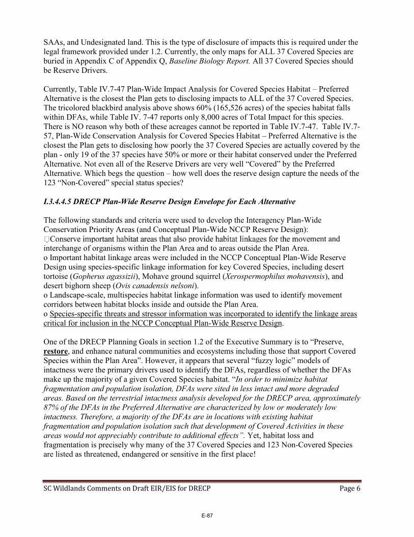
SC Wildlands Comments on Draft EIR/EIS for DRECP Page 6
SAAs, and Undesignated land. This is the type of disclosure of impacts this is required under the legal framework provided under 1.2. Currently, the only maps for ALL 37 Covered Species are buried in Appendix C of Appendix Q, Baseline Biology Report. All 37 Covered Species should be Reserve Drivers. Currently, Table IV.7-47 Plan-Wide Impact Analysis for Covered Species Habitat – Preferred Alternative is the closest the Plan gets to disclosing impacts to ALL of the 37 Covered Species. The tricolored blackbird analysis above shows 60% (165,526 acres) of the species habitat falls within DFAs, while Table IV. 7-47 reports only 8,000 acres of Total Impact for this species. There is NO reason why both of these acreages cannot be reported in Table IV.7-47. Table IV.7-57, Plan-Wide Conservation Analysis for Covered Species Habitat – Preferred Alternative is the closest the Plan gets to disclosing how poorly the 37 Covered Species are actually covered by the plan - only 19 of the 37 species have 50% or more or their habitat conserved under the Preferred Alternative. Not even all of the Reserve Drivers are very well “Covered” by the Preferred Alternative. Which begs the question – how well does the reserve design capture the needs of the 123 “Non-Covered” special status species? I.3.4.4.5 DRECP Plan-Wide Reserve Design Envelope for Each Alternative The following standards and criteria were used to develop the Interagency Plan-Wide Conservation Priority Areas (and Conceptual Plan-Wide NCCP Reserve Design):
ment and interchange of organisms within the Plan Area and to areas outside the Plan Area. o Important habitat linkage areas were included in the NCCP Conceptual Plan-Wide Reserve Design using species-specific linkage information for key Covered Species, including desert tortoise (Gopherus agassizii), Mohave ground squirrel (Xerospermophilus mohavensis), and desert bighorn sheep (Ovis canadensis nelsoni). o Landscape-scale, multispecies habitat linkage information was used to identify movement corridors between habitat blocks inside and outside the Plan Area. o Species-specific threats and stressor information was incorporated to identify the linkage areas critical for inclusion in the NCCP Conceptual Plan-Wide Reserve Design. One of the DRECP Planning Goals in section 1.2 of the Executive Summary is to “Preserve, restore, and enhance natural communities and ecosystems including those that support Covered Species within the Plan Area”. However, it appears that several “fuzzy logic” models of intactness were the primary drivers used to identify the DFAs, regardless of whether the DFAs make up the majority of a given Covered Species habitat. “In order to minimize habitat fragmentation and population isolation, DFAs were sited in less intact and more degraded areas. Based on the terrestrial intactness analysis developed for the DRECP area, approximately 87% of the DFAs in the Preferred Alternative are characterized by low or moderately low intactness. Therefore, a majority of the DFAs are in locations with existing habitat fragmentation and population isolation such that development of Covered Activities in these areas would not appreciably contribute to additional effects”. Yet, habitat loss and fragmentation is precisely why many of the 37 Covered Species and 123 Non-Covered Species are listed as threatened, endangered or sensitive in the first place!
E-87

SC Wildlands Comments on Draft EIR/EIS for DRECP Page 7
The California Desert Connectivity Project (Penrod et al. 2012) is briefly described in III.7.7-246. This is the ONLY place in the entire document that refers to “23 crucial linkage planning areas within the Plan Area”. Actually, there were 22 linkage planning areas but nowhere are the 22 crucial linkages actually identified by name. And, nowhere are the 22 crucial linkages actually analyzed by linkage. Instead, baseline conditions of the Desert Linkage Network and impacts to the linkage network are analyzed by fictitious Ecoregion Subareas, which is relatively meaningless in the context of landscape connectivity since several of the 22 linkages span more than one Ecoregion Subarea. The DRECP repeatedly refers readers to Penrod et al. 2012 but that document is organized by linkage NOT invented Ecoregion Subareas, so it is impossible to evaluate and compare baseline conditions or impacts to the Desert Linkage Network. The discussion in Vol. III Pages 7-248 through 7-271 provides virtually NO information beyond what is already summarized in Tables III.7-69, 7-82, and 7-96 other than vague geographical references, like “providing connectivity between mountain ranges within the ecoregion subarea” which was copy/pasted in several of the descriptions. Further, none of the Figures III.7-26 through 7-36 label any of the Landscape Blocks intended to be served by the 22 crucial linkages. Of particular note, is that none of the targeted Landscape Blocks outside of the Plan Area (e.g., Sierra Nevada, San Gabriel Mountains, San Bernardino Mountains) are labeled or depicted in Figure III.7-26 or in the subareas maps, or any other maps in the entire document. Yet, several areas of the DRECP refer to the importance of maintaining connectivity beyond the Plan boundary! Weren’t PhDs, Cartographers and Copy Editors employed to develop this Plan? The ENTIRE Section, III.7.8 Landscape Habitat Linkages and Wildlife Movement Corridors (III.7 7-245 to 7-248), is VERBATIM to what is provided in Appendix Q on this topic. There is a serious overuse of the Copy/Paste function throughout the document. Typically, an Appendix provides the reader with more relevant information related to the topic being discussed, beyond just the literature cited section. This section of the DRECP alone refers to Appendix Q 23 times! Why not just include the references within the section and consolidate the numerous literature cited sections? The Preferred Alternative estimates a Plan-Wide Total Impact Area for the Desert Linkage Network of 28,000 acres (Table IV. 7-52) based on the overlap of the DFAs with the Desert Linkage Network times the proportion of the impacts from Covered Activity development anticipated with the DFA (IV.7-263). However, based on a GIS analysis of the overlap of the Integrated Preferred Alternative with the Desert Linkage Network, the actual acreage of the DFAs that overlap the Desert Linkage Network is 205,650 acres – which must be disclosed! There is also an additional 198,177 acres in the Linkage Network identified as Undesignated in the Preferred Alternative. Undesignated areas are described in the glossary as BLM-administered lands that do not have an existing or proposed land allocation or designation. These areas would be open to renewable energy applications but would not benefit from the streamlining or CMA certainty of the DFAs. Page II.3-381 under II.3.2.3.4.2 states: “In non-designated lands (i.e. lands not covered by the specific CMAs below), make lands available for disposal through exchange or land sale”. Does this mean that nearly 200,000 acres of the Desert Linkage Network would be “available for disposal”? Shouldn’t this be factored into the “Impact Analysis”? And fully disclosed in the Total Impact Acreage? Additionally, Future Assessment Areas cover 37,377 acres and Special Analysis Areas cover another 29,342 acres of the Desert Linkage Network.
E-88

SC Wildlands Comments on Draft EIR/EIS for DRECP Page 8
Between the DFAs, Undesignated, FAAs and SAAs areas, over 470,547 acres of the Desert Linkage Network could be open to renewable energy applications. There are NO maps that show how the DFAs, FAAs, SAAs, Variance Lands, or Undesignated Lands in the Preferred Alternative coincide with the Desert Linkage Network, not to mention transmission corridors! Volume IV is the Environmental Consequences / Affects Analysis yet this section repeatedly refers to maps in Volume III, “Affected Environment Figures III.7-26 through III.7-36 in Chapter III.7 of Volume III shows the desert linkage network for the Plan Area and in each ecoregion subarea”. Maps must be included in Vol. IV for the entire Desert Linkage Network and each of the six subareas that would be impacted. As Figure 1 shows, several linkages are completely severed or severely constrained by DFAs, FAAs and Undesignated land. Undesignated Lands: II.3-9 Table II.3-1 Interagency DRECP Plan-Wide Preferred Alternative identifies 1,323,000 acres of Undesignated lands (i.e., BLM Unallocated Land), 709,000 acres of which is within BLM LUPA (Table II.3-42). This 1.3 million acres of BLM land is NOT clearly depicted in FIGURE II.3-1 Interagency Preferred Alternative but instead appears to be lumped with Impervious and Urban Built-up Land (5,547,000 acres in Table II.3-1), which the legend describes as “Existing Developed Areas”. This is EXTREMELY misleading. These Undesignated lands overlap several areas of high conservation value, including but not limited to habitat for Covered Species, “Reserve Drivers” (e.g., bighorn sheep mountain habitat, bighorn sheep intermountain habitat, desert tortoise intact habitat and fragmented habitat in the Desert Tortoise TCA Habitat Linkages), and numerous areas of the Desert Linkage Network. Further, while much of the Mojave River itself is designated as Conservation Planning Areas in the Preferred Alternative, Undesignated lands or DFAs are located in the uplands along most of the Mojave River. II.3-381 One of the bullets under II.3.2.3.4.2 Conservation and Management Actions states: “In non-designated lands (i.e. lands not covered by the specific CMAs below), make lands available for disposal through exchange or land sale”. Is Undesignated, BLM Unallocated and “non-designated lands” synonymous? Does this mean that over 1.3 million acres of existing public land administered by BLM will be available for “disposal”? Where is the impact analysis regarding these lands? There is no mention of Undesignated, BLM Unallocated, or Non-designated lands in Volume III Environmental Setting/Affected Environment, not in III.13 BLM Lands and Realty - Land Use Authorizations and Land Tenure or III.7 Biological Resources. This is a serious oversight that MUST be addressed. IV.7-281 is the only place that mentions Undesignated Areas, “Approximately 471,000 acres were not designated as Reserve Design Lands under the Preferred Alternative that were identified in the conceptual reserve envelope, which is primarily comprised of BLM-administered lands in the Plan Area without BLM LUPA conservation designations over them”. What about the other 852,000 acres of Undesignated lands mentioned in Table II.3-1? IV.13 only mentions Undesignated Lands in reference to FAA, SAA, and DRECP Variance lands but Undesignated Lands cover a far greater area than what is included in these designations. Maps must be included in Volumes III and IV that clearly depict ALL Undesignated lands. The entire discussion describing the six different subareas of the Desert Linkage Network that “could be adversely impacted in DFAs and transmission corridors” is inadequate (IV.7-264 and 7-265). Each subarea is allocated one poorly written paragraph that vaguely describes impacts,
E-89

CALIFORNIA DESERT CONNECTIVITY PROJECTCALIFORNIA DESERT CONNECTIVITY PROJECT
0 30 60Miles
0 25 50 75Kilometers
1:2,138,961Ü
Figure 1. Desert Linkage Network Conflicts
Desert Linkage Network (Penrod et al. 2012)
Previous Linkage Designs (SC Wildlands)
Targeted Wildland Blocks
Preferred Alternative IntegratedDevelopment Focus Areas
Future Assessment Areas
Special Analysis Areas
Undesignated
E-90

SC Wildlands Comments on Draft EIR/EIS for DRECP Page 9
e.g., “there are DFAs in a portion of the desert linkage network”. Impacts should be analyzed and described in reference to the 22 crucial linkages delineated by Penrod et al. (2012) and further evaluated by the focal species and land facet linkage networks, rather than fictitious ecoregional subareas. The DRECP should disclose where DFAs completely sever or significantly constrain a linkage. As the lead author in Penrod et al. (2012), I should not have difficulty deciphering the descriptions of impacts to the linkage network. Further, this entire discussion is meaningless without MAPS that include detailed annotation of all the areas referenced in the text. Geographical and locational references in the text should be included on the maps (see bold type in following paragraph). Typically, zoomed in maps have more annotation. The maps must clearly and accurately show where DFAs, FAAs, SAAs, Variance Lands and Undesignated lands and Transmission Corridors coincide with the Desert Linkage Network. This is an example of one of the six poorly written paragraphs allocated to discussing Plan-Wide conservation of and impacts to the Desert Linkage Network (IV.7-264), “In the Pinto Lucerne Valley and Eastern Slopes subarea, there are DFAs in a portion of the desert linkage network that connects the Grapevine Canyon Recreation Lands to the Granite Mountains in Lucerne Valley; however, no DFAs are located in the habitat linkage between the Ord Mountains and the Granite Mountains across the Highway 18 east of Apple Valley. There are also DFAs in the linkage that connects Black Mountain to the Mojave River. DFAs under the Preferred Alternative are sited to avoid and minimize impacts to wildlife movement in this subarea by maintaining movement corridors between the San Bernardino Mountains and the Mojave Desert, including in the Ord Mountains to Granite Mountains linkage area and in the Bighorn Mountain area that connects to Johnson Valley and the Morongo Basin. General terrestrial wildlife movement may be affected locally by the development of Covered Activities in these DFAs; however, the siting of DFAs, the reserve design, and the CMAs related to wildlife movement and Covered Species would offset the impacts on general terrestrial wildlife movement”. The linkages in the Desert Linkage Network in the vicinity of the Apple Valley and Lucerne Valley DFAs are the Twentynine Palms Newberry Rodman-San Bernardino Connection and the Twentynine Palms Newberry Rodman-San Gabriel Connection (Penrod et al. 2012), incorrectly described above as “connects Grapevine Canyon Recreation Lands to the Granite Mountains in Lucerne Valley”. These connections connect the San Bernardino and San Gabriel Mountains of the South Coast Ecoregion to the Newberry Rodman Mountains in the Mojave, not Grapevine Canyon to Granite Mountains, which is only a portion of those linkages. Then it says, “No DFAs are located in the habitat linkage between the Ord Mountains and the Granite Mountains” but the DRECP neglects to say that this linkage, which most closely resembles the San Bernardino-Granite Connection (Penrod et al. 2005) is entirely encompassed within the landscape level connection described in the first part of that sentence! Penrod et al. (2005) was a focal species based connectivity assessment and the Desert Linkage Network used improved methods to make the linkages robust to climate change (i.e., land facet analyses). As currently proposed, the Granite Mountain Corridor ACEC is not sufficiently wide to provide live-in and move-through habitat for the target species or support range shifts in response to climate change. Disruption of landscape connections for species movements and range changes is one of the greatest stressors to ecosystems, especially under climate change. In order to achieve Goal L1 - NO DFAs should be sited within the Desert linkage Network, desert tortoise linkages, bighorn sheep intermountain habitat and Mohave ground squirrel linkages. All of these species-specific
E-91

SC Wildlands Comments on Draft EIR/EIS for DRECP Page 10
linkages and landscape linkages should automatically be included in the Reserve Design, either as ACEC, NLCS, Conservation Planning Areas, or SAAs. No Undesignated (i.e., BLM Unallocated) land within these linkages should be “disposed of” but should also be automatically included as ACEC, NLCS, SAAs, or Conservation Planning Areas in the Reserve Design.
Objective L1.1: Conserve Covered Species habitat, natural communities, and ecological processes of the Mojave and Sonoran deserts in each ecoregional subarea in the Plan Area in an interconnected DRECP reserve. COMMENT: Must include desert tortoise Ord-Rodman to Joshua Tree and Fremont Kramer Linkages. Objective L1.2: Design landscape linkage corridors to be 3 miles wide where feasible, and at least 1.2 miles wide where a greater width is not feasible. COMMENT: It is feasible and desirable to design a linkage more than 1.2 miles wide for the proposed Granite Mountain Wildlife Linkage ACEC with revisions to the Apple Valley and Lucerne Valley DFAs.
Objective L1.3: Protect and maintain the permeability of landscape connections between neighboring mountain ranges to allow passage of resident wildlife by protecting key movement corridors or reducing barriers to movement within intermountain connections, including: o Chuckwalla-Little Chuckwalla-Palen connections o Bristol-Marble-Ship-Old Woman connections o Old Woman-Turtle-Whipple connections o Bullion-Sheephole-Coxcomb connections o Clark-Mesquite-Kingston connections o Big Maria-Little Maria-McCoy connections o Soda-Avawatz-Ord-Funeral connections o Clark-Mesquite-Kingston-Nopah-Funeral connections o Rosa-Vallecitos-Coyote connections o Panamint-Argus connection o Palo Verde-Mule-Little Chuckwalla connections o Palo Verde-Mule-McCoy connections o Chuckwalla-Eagle-Coxcomb connections o Eagle-Granite-Palen-Little Maria connections o Granite-Iron-Old Woman connections o Big Maria-Little Maria-Turtle connections o Northeast slope of the San Bernardino Mountains between Arrastre Creek and Furnace Canyon, including Arctic and Cushenbury canyons, Terrace and Jacoby springs, along Nelson Ridge. COMMENT: Why is this objective restricted to the list of “connections” above? The majority of the mountain ranges listed above are in the Eastern Mojave and Sonoran regions and therefore not consistent with creating a Plan-wide reserve design (Goal L1). These are not the landscape linkages identified in the Desert Linkage Network (Penrod et al. 2012), nor are they the desert tortoise linkages identified in Figure C-34. Where did this list come from? I did not see it referenced in the document. Feature Landscape stressors and threats: Goal L3: Reduce, relative to existing conditions, adverse impacts from human activities to natural communities and Covered Species in the Plan Area.
E-92

SC Wildlands Comments on Draft EIR/EIS for DRECP Page 11
Step-Down Biological Objective L3-A: Through the DRECP planning process, establish Development Focus Areas (DFAs) for Covered Activities in locations that would not disrupt or degrade the function of habitat linkages. COMMENT: Figure 1 clearly shows that DFAs would completely sever and disrupt and degrade the function of several linkages. Please see recommended revisions to the Reserve Design for the Pinto Lucerne Eastern Slopes below. I WISH I had time to conduct this level of detailed review for the entire Desert Linkage Network! H.2.3 Wildlife Linkages and Connectivity: Figures (H-1 & H-2) depict the wildlife linkages where Covered Activities will be configured to avoid and minimize adverse effects to wildlife connectivity and the function of the wildlife linkage. These areas are referenced in the Section II.3.1.2.5.3, Landscape-Level Avoidance and Minimization CMAs, under the CMA AM-LL-1. Figure H-2 Landscape-level Linkage CMA depicts the ENTIRE Desert Linkage Network and SCML Linkages that fall within the DRECP boundary.
AM-LL-1: The siting of projects along the edges of the linkages identified in Appendix H (Figures H-1 and H-2) will be configured (1) to maximize the retention of microphyll woodlands and their constituent natural communities and inclusion of other physical and biological features conducive to species’ dispersal, and (2) informed by existing available information on modeled Covered Species habitat and element occurrence data, mapped delineations of natural communities, and based on available empirical data collected under the MAMP or other sources, including radio telemetry, wildlife tracking sign, and road-kill information. Additionally, Covered Activities will be sited and designed to maintain the function of Covered Species connectivity and their associated habitats in the following linkage and connectivity areas: o Within a 5-mile-wide linkage across Interstate 10 centered on Wiley’s Well Road to connect the Mule and McCoy mountains. o Within a 3-mile-wide linkage across Interstate 10 to connect the Chuckwalla and Palen mountains. o Within a 1.5-mile-wide linkage across Interstate 10 to connect the Chuckwalla Mountains to the Chuckwalla Valley east of Desert Center. o The confluence of Milpitas Wash and Colorado River floodplain within 2 miles of California State Route 78. In addition to these specific landscape linkages identified above, the Riparian and Wetland Natural Communities and Covered Species CMAs will contribute to maintaining and promoting habitat connectivity and wildlife movement (see RIPWET under Section II.3.1.2.5.4). The Covered Species CMAs provide additional avoidance and minimization actions for important species-specific habitat linkages (see Section II.3.1.2.5.4). This CMA must be implemented throughout the Desert Linkage Network! A Conservation Alternative for the Pinto Lucerne Valley and Eastern Slopes Conservation Values are particularly high in the Pinto Lucerne Valley and Eastern Slopes Subarea along the Mojave River, through the linkage, and all along the slopes of the San Bernardino Mountains (Figure 2). The Conservation Values Model available on the Data Basin Gateway aggregated several biological themes including natural community diversity, rare species concentrations, concentrations of Covered Species modeled distributions, concentrations of Non-Covered Species modeled distributions, and relative quality of identified wildlife
E-93

Bullion Mountains
San Bernardino Mountains
¬«247
0 1 2 3 40.5Kilometers
1:309,144
Apple Valley
Lucerne Valley
DFAs GeneralizedVery HighHighModerately HighModerately LowLowVery LowSan Bernardino National ForestHydrology
Ord-Rodman DWMAOrd-Rodman DWMA
S a n B e r n a r d i n o S a n B e r n a r d i n o N a t i o n a l F o r e s tN a t i o n a l F o r e s t
Johnson Valley
Figure 2. Coservation Values are High in the Pinto Lucerne Valley Eastern Slopes Ecoregion Subarea
E-94

SC Wildlands Comments on Draft EIR/EIS for DRECP Page 12
linkages. Virtually all of the proposed Apple Valley, Lucerne Valley and Johnson Valley DFAs scored Moderately High to Very High with very few pixels scoring Moderately Low and no pixels scoring Low or Very Low. Section (II.3, Page 347), describes the Pinto Lucerne Valley and Eastern Slopes Subarea as, “some of the most diverse and threatened habitats in the California desert”. The following section suggests refinements to the current designations in the Preferred Alternative for the Pinto Lucerne Valley and Eastern Slopes subarea and justification for these recommended improvements. As currently proposed the Reserve Design doesn’t capture landscape linkages wide enough to support viable populations of the species they are intended to serve or the full diversity of land facets needed to make the linkages robust to climate change. Maintaining and restoring landscape level connectivity is essential to day-to-day movements of individuals seeking food and water, shelter or mates; dispersal of offspring to new home areas; seasonal migration; recolonization of unoccupied habitat after a local population goes extinct; and for species to shift their range in response to global climate change. Plant and animal distributions are predicted to shift (generally northwards or upwards in elevation in California) due to global warming (Field et al. 1999). Full shifts in vegetation communities are expected as a result of climate change (Notaro et al. 2012). The Pinto Lucerne Valley and Eastern Slopes Subarea “spans diverse landscapes of the south-central Mojave Desert and the San Bernardino Mountains, from 1,000 feet to over 6,000 feet in elevation”. The northern slopes and foothills of the San Bernardino Mountains contain many springs and seeps, several riparian drainages, and the headwaters of the Mojave River. Riparian systems will be especially important to allow species to respond and adapt to climate change because they provide connectivity between habitats and across elevational zones (Seavy et al. 2009). Thus, linkages must be sufficiently wide to cover an ecologically meaningful range of elevations as well as a diversity of microhabitats that allow species to colonize new areas. While the Mojave Riverbed itself is identified as a Conservation Planning Area for much of its length, virtually all of the uplands are proposed as either DFAs or Undesignated land that could be available for “disposal” The Mojave River flows from the South Coast Ecoregion through much of the Mojave Ecoregion. It is one of three major rivers in the desert and the only one that traverses from the West to the East Mojave, covering a distance of roughly 80 miles - it is a key wildlife movement corridor. The Mojave River is also essential habitat for several listed and sensitive species with portions of the river designated as critical habitat for southwestern willow flycatcher. According to the USFWS (1986), over 200 species of migratory birds have been recorded in the Mojave River, near the Mojave River Forks Dam Water Conservation Project. These hundreds of migratory bird species use the Mojave River, Deep Creek, mountain lakes, riparian drainages and seeps and springs throughout desert facing slopes of the San Bernardino and San Gabriel Ranges. No DFAs should be sited within the 500 year flood plain and all Undesignated areas along the Mojave River should be included in the Reserve Design to ensure wildlife have access to this essential resource, which will be even more indispensible with climate change. The hydrology of the northern slopes of the San Bernardino Mountains is not just an essential resource for the flora and fauna. It is also extremely important to recharging groundwater basins in Apple, Lucerne and Johnson Valleys. Massive renewable energy projects use enormous
E-95

SC Wildlands Comments on Draft EIR/EIS for DRECP Page 13
amounts of water both in construction and maintenance, which could further exacerbate already severely distressed overdraft conditions in these groundwater basins. As currently proposed the Apple Valley, Lucerne Valley and Johnson Valley DFAs present significant conflicts with habitat and climate change connectivity for Reserve Drivers such as bighorn sheep, desert tortoise, Mojave fringe-toed lizard and the Desert Linkage Network, as well as several other Covered Species, in addition to 31of the 44 focal species addressed by Penrod et al. (2012). There is an approximately 7 mile wide Conservation Planning Area designated between the San Gabriel Mountains and Edwards Air Force Base (AFB), though Military lands are NOT specifically covered by the DRECP. The essential ecoregional connection between the south-central Mojave Desert and the San Bernardino Mountains (i.e., connectivity to areas outside the plan area) warrants the same consideration, especially since this linkage serves to connect vast areas with conservation designations (e.g., NLCS, ACEC and USFS). It is feasible and desirable to conserve functional landscape-level connectivity here. Here we suggest refinements to the Apple Valley and Lucerne Valley DFAs and complete removal for the Johnson Valley DFA. We created our own Composite Map of Key Reserve Drivers, referred to but not provided in I.3.4.4.3 and Appendix D, D.3.6. The primary data used to create this composite map of Key Reserve Drivers include Desert Tortoise TCA and Linkages (Averill‐Murray et al. 2013), Bighorn sheep mountain habitat and intermountain habitat (CDFW 2013), Mohave ground squirrel (Inman et al. 2013, UCSB 2013), and the Desert Linkage Network (Penrod et al. 2012), which were used to make proposed refinements to the Reserve Design (Figure 3). We queried the areas removed from the Apple Valley and Lucerne Valley DFAs and the Johnson Valley DFA using the Site Survey Composite for the Preferred Alternative (i.e., DRECP_Composite_Ecological _Basline_Preferred_Alternative_v5, GIS data downloaded from Data Basin) to identify other Covered Species that would benefit from the proposed changes to the Reserve Design (Table 4). In addition to providing essential habitat for these Reserve Drivers, several other Covered Species will benefit from these refinements including Bendire’s thrasher, burrowing owl, golden eagle, Swainson’s hawk, least Bell’s vireo, southwestern willow flycatcher, yellow-billed cuckoo, tricolored blackbird, mountain plover, pallid bat, Townsend’s big-eared bat, alkali mariposa lily, Little San Bernardino linanthus, Mojave monkeyflower, and Parish’s daisy. These refinements would benefit 18 of the Covered Species. According to the DRECP Composite Ecological Baseline, each pixel in the refinements to the Apple Valley DFA (573 pixels) benefit 4 to 11 Covered Species (MEAN 6.9 species), with a total species count of 3,959 in the 573 pixels. Each pixel in the refinements to the Lucerne Valley DFA (787 pixels) benefit 2 to 10 Covered Species (MEAN 6.45 species), with a total species count of 5,080 in the 787 pixels. Each pixel in the Johnson Valley DFA (428 pixels) benefit 4 to 7 Covered Species (MEAN 5.48 species), with a total species count of 2,346 in the 428 pixels. Natural communities in the areas removed from the Apple and Lucerne Valley DFAs and the Johnson Valley DFA are extremely diverse and include but are not limited to, Californian montane conifer forest, Central and South Coastal Californian coastal sage scrub, Great Basin Pinyon /Juniper Woodland, Inter-Mountain Dry Shrubland, Intermontane deep or well-drained
E-96

Bullion Mountains
San Bernardino Mountains
¬«247
0 1 2 3 40.5Kilometers
1:309,144
Apple Valley
Lucerne Valley
DFAs GeneralizedDFAs RevisedDesert Tortoise TCA Habitat LinkagesBighorn Sheep Intermountain HabitatMGS stable range (UCSB model)Desert Linkage Network
Ord-Rodman DWMA
S a n B e r n a r d i n o N a t i o n a l F o r e s t
Johnson Valley
Complete Removal
Figure 3. Refinements to and Removal of DFAs in the Pinto Lucerne Valley and Eastern Slopes Subarea
E-97
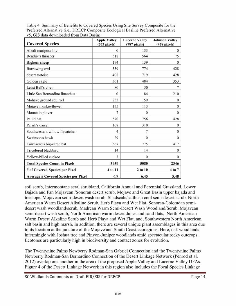
SC Wildlands Comments on Draft EIR/EIS for DRECP Page 14
Table 4. Summary of Benefits to Covered Species Using Site Survey Composite for the Preferred Alternative (i.e., DRECP Composite Ecological Basline Preferred Alternative v5, GIS data downloaded from Data Basin).
Covered Species Apple Valley (573 pixels)
Lucerne Valley (787 pixels)
Johnson Valley (428 pixels)
Alkali mariposa lily 0 133 0 Bendire's thrasher 518 564 75 Bighorn sheep 194 139 0 Burrowing owl 559 774 428 desert tortoise 408 719 428 Golden eagle 361 484 353 Least Bell's vireo 80 50 7 Little San Bernardino linanthus 0 84 210 Mohave ground squirrel 253 159 0 Mojave monkeyflower 155 113 0 Mountain plover 7 0 0 Pallid bat 570 756 428 Parish's daisy 108 310 0 Southwestern willow flycatcher 4 7 0 Swainson's hawk 29 0 0 Townsend's big-eared bat 567 775 417 Tricolored blackbird 14 14 0
Yellow-billed cuckoo 3 0 0
Total Species Count in Pixels 3959 5080 2346 # of Covered Species per Pixel 4 to 11 2 to 10 4 to 7
Average # Covered Species per Pixel 6.9 6.45 5.48 soil scrub, Intermontane seral shrubland, California Annual and Perennial Grassland, Lower Bajada and Fan Mojavean /Sonoran desert scrub, Mojave and Great Basin upper bajada and toeslope, Mojavean semi-desert wash scrub, Shadscale/saltbush cool semi-desert scrub, North American Warm Desert Alkaline Scrub, Herb Playa and Wet Flat, Sonoran-Coloradan semi-desert wash woodland/scrub, Madrean Warm Semi-Desert Wash Woodland/Scrub, Mojavean semi-desert wash scrub, North American warm desert dunes and sand flats, North American Warm Desert Alkaline Scrub and Herb Playa and Wet Flat, and, Southwestern North American salt basin and high marsh. In addition, there are several unique plant assemblages in this area due to its location at the juncture of the Mojave and South Coast ecoregions. Here, oak woodlands intermingle with Joshua tree and Pinyon-Juniper woodlands amid spectacular rocky outcrops. Ecotones are particularly high in biodiversity and contact zones for evolution. The Twentynine Palms Newberry Rodman-San Gabriel Connection and the Twentynine Palms Newberry Rodman-San Bernardino Connection of the Desert Linkage Network (Penrod et al. 2012) overlap one another in the area of the proposed Apple Valley and Lucerne Valley DFAs. Figure 4 of the Desert Linkage Network in this region also includes the Focal Species Linkage
E-98
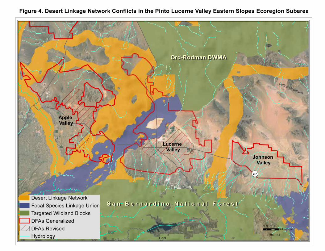
Bullion Mountains
San Bernardino Mountains
¬«247
0 1 2 3 40.5Kilometers
1:309,144
Apple Valley
Lucerne Valley
Desert Linkage NetworkFocal Species Linkage UnionTargeted Wildland BlocksDFAs GeneralizedDFAs RevisedHydrology
Ord-Rodman DWMAOrd-Rodman DWMA
S a n B e r n a r d i n o N a t i o n a l F o r e s tS a n B e r n a r d i n o N a t i o n a l F o r e s t
Johnson Valley
Figure 4. Desert Linkage Network Conflicts in the Pinto Lucerne Valley Eastern Slopes Ecoregion Subarea
E-99

SC Wildlands Comments on Draft EIR/EIS for DRECP Page 15
Union (blue) to show the area of the linkage network that was delineated by the land facet analyses (orange). The Proposed Granite Mountain Wildlife Linkage ACEC was designed to connect SBNF with the Bendire’s Thrasher ACEC, while the Northern Lucerne Wildlife Linkage is expected to connect the Bendire’s Thrasher ACEC to Ord-Rodman DWMA. As proposed, the Granite Mountain Wildlife Linkage ACEC is reduced to about 1.2 miles wide for much of its length south of State Route 18 and more closely follows the linkage design for the San Bernardino-Granite Connection (Penrod et al. 2005), which did not include land facet analyses. Several land facets corridors were delineated between these ranges (see Figures 18 and 19 in Penrod et al. 2012), which are expected to support species movements during periods of climate instability. DFAs are proposed to either side of these proposed ACECs that would constrain the linkage for a distance of roughly 20 miles. Species are then expected to make a hard right to follow Stoddard Ridge around the arm of the DFA proposed in the Northern Lucerne Valley. Objective L1.2 is to “Design landscape linkage corridors to be 3 miles wide where feasible, and at least 1.2 miles wide where a greater width is not feasible”. We believe that a greater width is feasible and desirable for the proposed Granite Mountain Wildlife Linkage ACEC. No DFAs should be sited within these areas. The northern arm of the Lucerne Valley DFA bisects both the focal species and land facet linkage and should be reconfigured to avoid the Desert Linkage Network through this area. The FAA should be included as part of the Newberry Rodman ACEC and NLCS due to its high conservation value (e.g., landscape connectivity, bighorn sheep, intact desert tortoise habitat). In fact, 31 of the 44 focal species evaluated by the Desert Linkage Network are expected to be served by this linkage. The westernmost strand of the Desert Linkage Network that follows the Mojave River for a distance and then arcs to the east toward Newberry Rodman is the corridor with high interspersion of land facets which is expected support species movements during periods of climate instability. The northern part of the Apple Valley DFA bisects this part of the linkage between the Mojave River and the Silver Mountains area of a proposed ACEC and should be included in that ACEC and removed from the DFA. Figure 5a depicts Desert Bighorn Sheep - Intermountain & Unfiltered Core Habitat (California Department of Fish and Wildlife, April 2013 Draft, A Conservation Plan for Desert Bighorn Sheep in California) in relation to the Preferred Alternative in this subarea. The Desert Bighorn Sheep Mountain Habitat identifies historic, current, and potential core habitat, while the Intermountain Habitat represents the intermountain, lower slope, valley bottom habitat used by desert bighorn sheep to move between mountain habitat. CDFW, also the lead agency on the NCCP, mapped an intermountain connection between San Bernardino National Forest (SBNF) and Ord-Rodman that has a minimum width of roughly 7.8 miles. Bighorn sheep mountain habitat and intermountain habitat largely overlap with the Desert Linkage Network. The upper arm of the Lucerne Valley DFA disrupts intermountain bighorn habitat and should be reconfigured. Further the FAA includes bighorn sheep mountain habitat in close proximity to mountain habitat in the Granite Mountain Linkage and should be included in the Newberry Rodman ACEC and NLCS. Finally, several areas of bighorn sheep mountain habitat are identified as Undesignated and available for “disposal”. Bighorn mountain habitat along the perimeter of the proposed Granite Mountain and Northern Lucerne Wildlife Linkage ACECs should be included in the Reserve Design. Further, Undesignated land on the Ridgeline and slopes of the San Bernardino Mountains between the Juniper Flats NLCS and the Carbonate
E-100

!(!(
!(
!(
!(!(
!(!(
!(
!(!(
!(!(!(
!( !(!(!(
!(!(!( !(
!( !(!(!(!( !(!(
!( !(!(!(!(!( !(!(!(!( !(!( !(!( !(!( !( !(!(!(!(!( !(!(!( !( !(!( !(!( !(!(!(!( !( !(!(
!(
!(!(
!(!(
!(!(
!( !(!(
!(
!(!(!(!(!( !(!(
!(
!(
!(
!(
!(!(!(!(
!(
!(!(
!(
Bullion Mountains
San Bernardino Mountains
¬«247
0 1 2 3 40.5Kilometers
1:309,144
Apple Valley
Lucerne Valley
Bighorn Sheep Mountain HabitatBighorn Sheep Intermountain Habitat
!( Springs and Seeps, DRECPFuture Assessment AreasUndesignatedDFAs GeneralizedDFAs Revised
Ord-Rodman DWMAOrd-Rodman DWMA
S a n B e r n a r d i n o N a t i o n a l F o r e s tS a n B e r n a r d i n o N a t i o n a l F o r e s t
Johnson Valley
Figure 5a. Bighorn Sheep Conflicts in the Pinto Lucerne Valley Eastern Slopes Ecoregion Subarea
E-101

SC Wildlands Comments on Draft EIR/EIS for DRECP Page 16
Endemic Plants NLCS (roughly 15 additional miles is the Grapevine Canyon Recreation Area also known as Juniper Flats by the BLM) should also be included in the Reserve Design (Figure 5b), consistent with Step-Down Biological Objective DBSH-B and because there are many springs, seeps, significant riparian canyons, alluvial fans (i.e. rare piedmont fans), and washes in this area essential for bighorn sheep and numerous other species. This area is currently designated as Undesignated in the Preferred Alternative. This land known as the Juniper Flats subregion by the BLM stretches from the Mojave River to the Cushenbury Grade (Figure 5b). The area is continuous with the San Bernardino National Forest, which encompasses over 600,000 acres and boasts over 600 significant cultural sites. There are several unusual and unique plant assemblages here, with oak woodlands intermixed with pinyon-juniper and Joshua trees and spectacular rock outcroppings. The area is extremely close to the Pacific Crest National Scenic Trail and Deep Creek, which has been nominated as a National Wild and Scenic river as part of the Feinstein Bill. The Juniper Flats area has been submitted to the BLM for consideration for NLCS designation and over 25 NGO’s and individuals have endorsed this effort. SC Wildlands strongly supports an NLCS designation for this remarkable area. Goal DBSH1: Conserve the desert bighorn sheep Sonoran–Mojave desert metapopulation) across the DRECP area within well-distributed habitat areas in mountain ranges and intermountain linkages. Emphasize conservation in areas where herds are most likely to be adaptive and resilient in response to the effects of changes within their metapopulations, including, range shifts, contractions, expansions, local extirpation, and recolonization, as well as environmental changes in climate, temperature, and precipitation. Comment: We expect that the Twentynine Palms Newberry Rodman-San Bernardino Connection will be especially important to the Cushenberry Herd of bighorn sheep in a warming climate for access to water resources (e.g., seeps, springs, riparian habitats). Step-Down Biological Objective DBSH-B: Protect, maintain, and manage for the duration of the NCCP on BLM LUPA conservation designation lands and prioritize for conservation on non-BLM lands substantial representative desert bighorn sheep habitat in the following areas: o Newberry, Ord, and Rodman Mountains o North San Bernardino Mountains o El Paso Mountains o Corridors between the North San Bernardino Mountains and Newberry Mountains o Corridors between the San Gorgonio Wilderness Area and the western extremity of the Little San Bernardino Mountains o Portions of the valley habitats between the Palen-McCoy Mountains, Chuckwalla Valley between the Eagle Mountains and the Chuckwalla Mountains o Portions of the valley habitats between the Little Chuckwalla Mountains, Palo Verde Mountains, McCoy Mountains, Mule Mountains Comment: The Granite Mountains Wildlife Linkage ACEC as currently proposed is a “corridor” to the south of SR-18 but with our proposed modifications to the DFAs it will be a landscape-level linkage.
E-102

Bullion Mountains
San Bernardino Mountains
¬«247
0 1 2 3 40.5Kilometers
1:309,144
Apple Valley
Lucerne Valley
Juniper Flats SubareaDesert Linkage NetworkBighorn Sheep Intermountain HabitatDesert Tortoise TCA Habitat LinkagesMGS stable range (UCSB model)DFAs GeneralizedDFAs Revised
Ord-Rodman DWMA
S a n B e r n a r d i n o N a t i o n a l F o r e s t
Johnson Valley
Complete Removal
Figure 5b. Juniper Flats Proposed NLCS in Relation to Composite of Key Drivers
Bighorn MountainWilderness
E-103

SC Wildlands Comments on Draft EIR/EIS for DRECP Page 17
Conservation and Management Actions for bighorn sheep are pretty slim and the DRECP says, “Within DFAs on BLM-administered lands Desert Bighorn Sheep CMAs would be implemented to the extent feasible and allowable under existing permits, leases, and allotment plans”. Why only to “the extent feasible” rather than to the maximum extent possible? Does this mean CMAs would not be implemented on lands not administered by BLM within the DFAs?
AM-DFA-ICS-34: Access to, and use of, designated water sources will not be affected by Covered Activities in designated and new utility corridors.
AM-DFA-ICS-35: Transmission projects and new utility corridors will minimize effects on access to, and use of, designated water sources. The proposed Granite Mountain Wildlife Linkage ACEC is described in Appendix L. The Relevance and Importance Criteria states, “the area is critical for bighorn sheep, golden eagles, desert tortoise and prairie falcons and several other species. Additionally, numerous rare and sensitive plants have major populations here, making the area regionally important”. Goals: “Protect biological values including habitat quality, populations of sensitive species, and landscape connectivity while providing for compatible public uses”. One of the Objectives is to “protect and enhance sensitive wildlife habitat” with the following species listed: desert tortoise, LeConte’s thrasher, San Diego pocket mouse, prairie falcon, golden eagle, and Mohave ground squirrel. All species listed in Table 4 should be included here (e.g., least Bell’s vireo, southwestern willow flycatcher). In addition, a number of focal species selected for the Desert Linkage Network are expected to be served by this linkage and should be included in this list: puma, badger, kit fox, bighorn sheep, mule deer, little pocket mouse, southern grasshopper mouse, pallid bat, burrowing owl, loggerhead shrike, Bendire’s thrasher, crissal thrasher, cactus wren, greater roadrunner, chuckwalla, desert night lizard, desert spiny lizard, Great Basin collared lizard, rosy boa, speckled rattlesnake, Mojave rattlesnake, Bernardino dotted blue, desert green hairstreak, desert metalmark, and yucca moth. These would be good candidate species for monitoring wildlife movement and habitat linkage function for the MAMP’s Landscape and Ecological Processes Effectiveness Monitoring. Another Objective is to “protect populations of sensitive plants”; the following species should be added to the 4 existing plant species currently on the list: Canbya candida, Sidalcea neomexicana, Plagiobothrys parishii, Phacelia parishii, Puccinellia parishii, Mimulus mohavensis, Leymus salinus ssp. mojavensis, Eriophyllum mohavense, and Calochortus striatus. In addition, two focal species, Yucca brevifolia and Yucca schidigera, from Penrod et al. (2012) should be included. One of the primary goals for the Desert Tortoise Linkages (Goal DETO2) is to “Maintain functional linkages between Tortoise Conservation Areas to provide for long-term genetic exchange, demographic stability, and population viability within Tortoise Conservation Areas. Emphasize inclusion of high value contiguous habitats pursuant to Nussear et al. (2001) and avoidance of disturbance in habitat with high desert tortoise habitat potential (see Figure C-35)”. It is Nussear et al. 2009, not 2001! Nussear et al. (2009) identifies much of the Apple Valley, Lucerne Valley and Johnson Valley DFAs as highly suitable habitat for tortoise (Figure 6). There are several areas where the Lucerne Valley and Johnson Valley DFAs conflict with two desert tortoise linkages in the Western Mojave Recovery Unit, Fremont-Kramer to Ord-Rodman Linkage and the Ord-Rodman to Joshua Tree linkage (Figure 7). The upper arm of the Lucerne Valley DFA coincides with intact desert tortoise habitat in the Fremont Kramer to Ord-Rodman
E-104

Bullion Mountains
San Bernardino Mountains
¬«247
0 1 2 3 40.5Kilometers
1:309,144
Apple Valley
Lucerne Valley
Desert Tortoise Maxent Model 1 High Value
0 Low Value
Tortoise Recorded Occurrences (CNDDB)Tortoise Recorded Occurrences (CNDDB)DFAs Generalized
Ord-Rodman DWMAOrd-Rodman DWMA
S a n B e r n a r d i n o S a n B e r n a r d i n o N a t i o n a l F o r e s tN a t i o n a l F o r e s t
Johnson Valley
Figure 6. High Value Desert Tortoise Habitat in the Pinto Lucerne Valley Eastern Slopes (Nussear et al. 2009)
E-105

Bullion Mountains
¬«247
0 1 2 3 40.5Kilometers
1:300,000
Apple Valley
Lucerne Valley
Desert Tortoise TCA Habitat LinkagesAverill-Murray et al. 2013
Tortoise Conservation Area (TCA)Intact Desert Tortoise HabitatFragmented Desert Tortoise HabitatNot Habitat Dune SandNot Habitat PlayaOHV Impacts to Tortoise HabitatTortoise Recorded Occurrences (CNDDB)
Preferred Alternative IntegratedFuture Assessment AreasOpen OHV AreasUndesignatedDFAs GeneralizedDFAs Revised
Ord-Rodman DWMAOrd-Rodman DWMA
S a n B e r n a r d i n o N a t i o n a l F o r e s tS a n B e r n a r d i n o N a t i o n a l F o r e s t
Johnson Valley DFAComplete Removal
Figure 7. Desert Tortoise TCA Linkage Conflicts in the Pinto Lucerne Valley Eastern Slopes
E-106

SC Wildlands Comments on Draft EIR/EIS for DRECP Page 18
Linkage and the FAA that is sandwiched between this DFA and the Ord-Rodman TCA is made up almost entirely of intact desert tortoise. This area of the Lucerne Valley DFA and the FAA is also in conflict with the Desert Linkage Network, Bighorn sheep intermountain habitat, and other Covered Species (e.g., Bendire’s thrasher, burrowing owl, golden eagle). In addition, the Lucerne Valley DFA as currently proposed completely severs the northern segment of the Ord-Rodman to Joshua Tree Linkage and would severely compromise the function of this linkage (See AM-DFA-ICS-6 Comment). The great majority of the Johnson Valley DFA is also intact desert tortoise habitat that falls within the Ord-Rodman to Joshua Tree Linkage. These DFAs must be reconfigured to AVOID these Desert Tortoise Linkages. In addition, the southern segment of the Ord-Rodman to Joshua Tree Linkage to the southeast of the Johnson Valley DFA is also identified as “Fragmented Desert Tortoise Habitat” (Figures C-35 and C-36) and much of it is delineated as “Undesignated” land, which would be available for “disposal”. While there are ACEC and NLCS lands proposed on the western fringe of the desert tortoise linkage, these proposed designations do not capture the most permeable route for the tortoise. While the raster data for the least-cost corridor analyses was not available on Data Basin as part of the Desert Tortoise TCA and Linkages data, I know this analysis well enough to know how it looks when converted to a shapefile. BLM has checkerboard ownership in this segment of the linkage and several of the adjacent parcels are NOT developed that would allow for the design and implementation of a “landscape linkage corridor…at least 1.2 miles wide” (Objective L1.2). As such, this segment of the linkage should be identified as a Conservation Planning Area. All desert tortoise linkages should be included in the Reserve Design in order to achieve Goal DETO2 (Desert Tortoise Linkages), “Maintain functional linkages between Tortoise Conservation Areas to provide for long-term genetic exchange, demographic stability, and population viability within Tortoise Conservation Areas”. The Western Mojave Recovery Unit and the associated linkages may be especially important to allow the tortoise to adapt to climate change, as indicated in Section III.7.4, “According to climate change models, conditions currently present in parts of the Colorado/Sonoran Desert are expected to expand to other parts of the Plan Area (Allen 2012), with an associated shift in vegetation (Notaro et al. 2012). AM-DFA-ICS-5 Comment: If “Covered Activities, except for transmission projects in existing transmission corridors, will avoid the desert tortoise conservation areas (TCAs) and the desert tortoise linkages identified in Appendix H”, why are ANY DFAs sited in TCAs and linkages? Further, why are any areas of the tortoise linkages “Undesignated” and therefore “available for disposal”? As one of the Reserve Drivers, all desert tortoise TCAs and linkages in ALL Recovery Units should be included in the Reserve Design! AM-DFA-ICS-6 Comment (1): A population viability analysis (PVA) should have been conducted Plan-Wide for desert tortoise as part of the DRECP process. This information should have been presented in Vol. III to assess existing recovery efforts under baseline conditions and in Vol. IV to compare the potential impacts of habitat loss proposed under each Alternative. AM-DFA-IC-6 refers to “the maintenance of long term viable desert tortoise populations within the affected linkage”. While each of the desert tortoise linkages identified in Figure H-7 provide live-in and move-through habitat, these linkage are intended to provide connectivity between the TCAs to maintain the viability of the entire population. As stated in Section III.7.6.1.1, “ Linkage habitat are important areas identified by Recovery Implementation Teams, such as
E-107
SC Wildlands Comments on Draft EIR/EIS for DRECP Page 19
important genetic linkages identified by Hagerty et al. 2010 (cited in USFWS 2011a) that are important to maintaining the species’ distribution throughout its range”. A PVA for a “linkage population” doesn’t make sense. AM-DFA-ICS-6 Comment (2): “Covered Activities that would compromise the viability of a linkage population or the function of the linkage, as determined by the DRECP Coordination Group, are prohibited and would require reconfiguration or re-siting”. AM-DFA-ICS-7: Covered Activities will be sited in lower quality desert tortoise habitat in desert tortoise linkages and the Ord-Rodman TCA, identified in Appendix H. COMMENT: Identified where? Figure H-6 Desert Tortoise Survey Areas? Figure H-7? Neither of these maps depict “lower quality desert tortoise habitat”. If Figure H-6, is the “lower quality desert tortoise habitat in the “No Survey Areas” identified in the legend, or in the “No Survey Areas” and “Clearance Survey Only Areas”. If so, that would imply that the “Protocol Survey Areas” are higher quality desert tortoise habitat, which would reinforce comments made above for AM-DFA-ICS-5 and AM-DFA-ICS-6. Figure H-7, Desert Tortoise Conservation Areas, identifies the majority of the Apple, Lucerne, Johnson Valley DFAs as Protocol Survey Areas with some smaller areas identified as Clearance Survey Areas. The Lucerne Valley DFA as currently proposed completely severs the northern segment of the Ord-Rodman to Joshua Tree Linkage (Figure 8) and would severely compromise the function of this linkage (AM-DFA-ICS-6). The analyses conducted by USFWS (Averill-Murray et al. 2013) indicate that this area is relatively permeable to tortoise movement and this entire area is identified as highly suitable in the desert tortoise Maxent model (Nussear et al.2009). This area of the linkage is identified as Fragmented Desert Tortoise Habitat in Attachment B to Appendix D but an evaluation of aerial imagery in this area reveals that existing rural development here is relatively sparse and the majority of residential properties in this area are unfenced. This area of the linkage should not be written off, especially since one of the overarching Biological Goals is to, “Preserve, restore, and enhance natural communities and ecosystems including those that support Covered Species within the Plan Area”. The distance between the Ord-Rodman TCA and the Intact Desert Tortoise Habitat in the Old Woman Springs Wildlife Linkage ACEC is roughly 7 miles, fully within the movement capability of an individual tortoise. Sazaki et al. (1995) estimated dispersal distance for pre-breeding male tortoises to be between 6.21-9.32 miles. This DFA must be reconfigured to completely avoid this linkage. Further, the playa habitat to the west of the tortoise linkage, although not tortoise habitat, could buffer the tortoise linkage from Covered Activities in the remaining DFA, while also providing habitat for other Covered Species (e.g., burrowing owl, pallid bat, Townsend’s big-eared bat) . The Johnson Valley DFA as currently proposed (Figures 7 and 8) would severely compromise the function of the Or-Rodman to Joshua Tree linkage. This proposed DFA is roughly 27,258 acres, much of it Intact Desert Tortoise Habitat as identified in Attachment B to Appendix D and Figures C-35 and C-36. The area of intact habitat in the linkage currently ranges in width from roughly 5 to 8 miles wide. The proposed Johnson Valley DFA would reduce the width of the linkage to about 3 miles wide in this stretch of the linkage. The average home range size for desert tortoise in the Western Mojave Recovery Unit is 125 acres (USFWS 1994, Boarman 2002). Would this significant reduction of intact habitat allow for “the maintenance of long-term
E-108

Bullion Mountains
¬«247
0 0.7 1.4 2.1 2.80.35Kilometers
1:183,282
Lucerne Valley
Desert Tortoise TCA Habitat LinkagesAverill-Murray et al. 2013
Tortoise Conservation Area (TCA)Intact Desert Tortoise HabitatFragmented Desert Tortoise HabitatNot Habitat Dune SandNot Habitat PlayaOHV Impacts to Tortoise Habitat
Preferred Alternative IntegratedFuture Assessment AreasOpen OHV AreasUndesignatedDFAs GeneralizedDFAs Revised
Ord-Rodman DWMAOrd-Rodman DWMA
Johnson Valley DFAComplete Removal
Figure 8. Desert Tortoise Ord-Rodman to Joshua Tree Linkage Conflicts
E-109

SC Wildlands Comments on Draft EIR/EIS for DRECP Page 20
viable desert tortoise populations within the affected linkage (AM-DFA-ICS-6)”? This entire DFA is identified as highly suitable in the desert tortoise Maxent model (Nussear et al.2009) and the great majority of it is BLM land. This linkage must not be written off, especially since one of the overarching Biological Goals is to, “Preserve, restore, and enhance natural communities and ecosystems including those that support Covered Species within the Plan Area”. We recommend complete removal of this DFA to avoid this linkage in order to “maintain functional linkages between Tortoise Conservation Areas to provide for long-term genetic exchange, demographic stability, and population viability within Tortoise Conservation Areas” and meet the intent of Goal DETO2 (Desert Tortoise Linkages).
Objective DETO2.1a (Desert Tortoise Linkages): Protect, manage and acquire desert tortoise habitat within the following linkages (see Figure C-34) with special emphasis placed on areas of high habitat potential and areas identified as integral to the establishment and protection of a viable linkage network (see Figure C-36). Ensure the long-term connectivity of Tortoise Conservation Areas by maintaining desert tortoise habitat that is of sufficient size and contiguity for maintenance of viable populations within each linkage. o Ord-Rodman to Superior-Cronese to Mojave National Preserve o Superior-Cronese to Mojave National Preserve to Shadow Valley to Death Valley National Park Linkage o Joshua Tree National Park and Pinto Mountains Desert Wildlife Management Area (DWMA) to Chemehuevi Linkage o Death Valley National Park to Nevada Test Site DETO2.1a COMMENT: Figure C-34 depicts 9 different desert tortoise linkages yet only 4 are listed here, all of which occur in the Eastern Mojave Recovery Unit and the Colorado Desert Recovery Unit. Why are none of the linkages associated with the Western Mojave Recovery Unit included here? For example, the Ord-Rodman to Joshua Tree Linkage includes a contiguous, fairly wide strand that is either intact desert tortoise habitat or fragmented tortoise habitat with High Habitat Potential (C-36). As a “Reserve Driver” Covered Species and Non-Covered but Addressed Species associated with the Western Mojave are reliant and at the mercy of the agencies to create a VIABLE PLAN-WIDE Linkage Network for ALL native species and ecological process of interest in the DRECP Region.
Objective DETO2.1b (Desert Tortoise Linkages): Protect, maintain, and acquire all remaining desert tortoise habitat within linkages already severely compromised, specifically the following (see Figure C-34): o Ivanpah Valley Linkage o Chemehuevi to Chuckwalla Linkage o Pinto Wash Linkage DETO2.1b COMMENT: Why is the Ord-Rodman to Joshua Tree Linkage not included here? Or, the Fremont Kramer to Ord-Rodman Linkage? This objective should read: Protect, maintain and restore all remaining desert tortoise habitat within linkages already severely compromised, specifically the following (see Figure C-34 through C-36): o Ivanpah Valley Linkage o Chemehuevi to Chuckwalla Linkage
E-110
SC Wildlands Comments on Draft EIR/EIS for DRECP Page 21
o Pinto Wash Linkage *ADD Ord-Rodman to Joshua Tree Linkage *ADD Fremont Kramer to Ord-Rodman Linkage
Objective DETO2.1c (Desert Tortoise Linkages): Protect intact habitat (see Figure C-35) within the following linkages to enhance the population viability of the Ord-Rodman Tortoise Conservation Area. o Ord-Rodman to Joshua Tree Linkage o Fremont Kramer to Ord-Rodman Linkage DETO2.1c COMMENT: The DRECP refers the reader to Figure C-35 Desert Tortoise Biological Goals and Objectives but the LEGEND on this map refers to Objective DETO2.1d in relation to the Ord-Rodman to Joshua Tree Linkage and the Fremont Kramer to Ord-Rodman Linkage but DETO2.1d doesn’t exist under Goal DETO2 (Desert Tortoise Linkages). However, Figure C-36 Desert Tortoise Biological Goals and Objectives and Habitat Potential does identify DETO2.1c for these two desert tortoise linkages. There is no explanation for the legend in Figure C-36 but one must assume that the High and Low following the BGOs relate to High Habitat Potential and Low Habitat Potential. The “Fragmented Habitat” in both of these linkages identified in Figure C-35 is also identified as having High Habitat Potential in Figure C-36. Protecting only “intact habitat” in the Ord-Rodman to Joshua Tree Linkage will do nothing to enhance the population viability of the Ord-Rodman Tortoise Conservation Area if ALL of the habitat within the linkage between the TCA and the intact habitat is entirely within a DFA! Shouldn’t the tortoise linkages enhance the population viability of all of the TCAs (e.g., Joshua Tree, Fremont Kramer)? Step-Down Biological Objective DETO-B: Protect, maintain, and manage for the duration of the NCCP on BLM LUPA conservation designation lands and prioritize for conservation on non-BLM lands substantial representative areas of desert tortoise habitat in the following areas: O Desert Tortoise Research Natural Area O Fremont-Kramer Desert Wildlife Management Area and Critical Habitat Unit O Ord-Rodman Desert Wildlife Management Area and Critical Habitat Unit o Portions of the Superior-Cronese Desert Wildlife Management Area and Critical Habitat Unit o Portions of the Chuckwalla Desert Wildlife Management Area and Critical Habitat Unit o Portions of intact desert tortoise habitat in the Colorado Desert o Fremont Kramer to Ord-Rodman Linkage o Chemehuevi to Chuckwalla Linkage o Portions of the Ord-Rodman to Joshua Tree Linkage – WHY only portions? Step-Down Biological Objective DETO-C: Establish long-term conservation to protect, manage, and enhance habitat value for 266,000 acres of desert tortoise habitat that contributes to the DRECP NCCP reserve design in and around the following areas: Desert Tortoise Research Natural Area, Fremont-Kramer Desert Wildlife Management Area and Critical Habitat Unit, Ord-Rodman to Joshua Tree Linkage, Fremont Kramer to Ord-Rodman Linkage, Pinto Wash Linkage, and Chemehuevi to Chuckwalla Linkage. COMMENT: FAA just outside of Ord-Rodman ACEC/NLCS is intact desert tortoise habitat, mountain and intermountain habitat for bighorn sheep, part of land facet linkages and habitat for numerous focal species in the Desert
E-111

SC Wildlands Comments on Draft EIR/EIS for DRECP Page 22
linkage Network, and other Covered Species (e.g., golden eagle, burrowing owl). In the Overview of the Preferred Alternative II.3.1.1., it says “The current known value of these areas for ecological conservation is moderate to low”. Please! The current known value of this FAA for ecological conservation is very high.
Step-Down Biological Objective DETO-D: Maintain and manage for resource values on BLM LUPA conservation designation lands habitat for desert tortoise in the following areas: o Remainder of the Ord-Rodman to Joshua Tree Linkage o Fremont Kramer to Ord-Rodman Linkage
Figure 9 shows areas of the Apple and Lucerne Valley DFAs that conflict with the Mohave ground squirrel. While the Pinto Lucerne Valley and Eastern Slopes Subarea is outside of the Mohave Ground Squirrel Conservation Area, there are historical recorded occurrences in this subarea and specifically in the Apple Valley and Lucerne Valley DFAs. This subarea lies at the southernmost extent of this species distributional range (Inman et al. 2013) and several areas in this subregion are expected to remain relatively stable (Davis et al. in press) under an uncertain climate. We trust that the above discussion of Reserve Drivers provides sufficient evidence and justification for modification to the Reserve Design in the Pinto Lucerne Valley and East Slopes Ecoregion Subarea. We have also included a composite figure for the other species listed in Table 4 that are also expected to benefit from these modifications to the Apple and Lucerne Valley DFAs and the removal of the Johnson Valley DFA (Figures 10). Summary: Under the current pace of development, natural resource agencies need to make near-term decisions in the face of existing land use pressures as well as long-term change. The one thing that is certain about climate change is that it is highly uncertain. Penrod et al. (2012) did not design corridors using complex models of future climate and biotic responses to climate change. Such an approach uses 4 models, with outputs of each model used as input to the next model. Specifically modeled future emissions of CO2 (1st model) drive global circulation models (2nd) which are then downscaled using regional models (3rd) to predict future climate. Then climate envelope models (4th) are used to produce maps of the expected future distribution of species. We avoided this approach for two reasons: (1) Each of the 4 models involves too much uncertainty, which is compounded from model to model and from one predicted decade to the next. In 1999 the IPCC developed 7 major scenarios of possible CO2 emissions during 2000-2011. The total emissions over the century vary by a factor of 6 among scenarios. Actual emissions during 2000-2010 were higher than the most pessimistic scenario. For a single emission scenario, different air-ocean global circulation models produce markedly different climate projections (Raper & Giorgi 2005). Finally climate envelope models may perform no better than chance (Beale et al. 2008). Because these sophisticated models have not simulated the large shifts during the last 100,000 years of glacial oscillations, Overpeck et al. (2005:99) conclude the “lesson for conservationists is not to put too much faith in simulations of future regional climate change” in designing robust conservation strategies. (2) These models produce outputs at a spatial resolution too coarse to support decision making in the California desert. The downscaled climate projections have minimum cells sizes measured in square kilometers. Penrod et al. (2012) used an alternative “land facets” approach to design climate-robust linkages that maximize continuity of the enduring features (topographic elements such as sunny lowland flats,
E-112

Bullion Mountains
¬«247
0 1 2 3 40.5Kilometers
1:300,000
Apple Valley
Lucerne Valley
MGS stable range (Davis et al. in press)MGS USGS Maxent Model (Inman et al. 2013)MGS Recorded Occurrences (CNDDB)
Preferred Alternative IntegratedFuture Assessment AreasOpen OHV AreasUndesignatedDFAs GeneralizedDFAs Revised
Ord-Rodman DWMAOrd-Rodman DWMA
S a n B e r n a r d i n o N a t i o n a l F o r e s tS a n B e r n a r d i n o N a t i o n a l F o r e s t
Johnson Valley DFAComplete Removal
Figure 9. Mohave Ground Squirrel Conflicts in the Pinto Lucerne Valley Eastern Slopes
E-113

Bullion Mountains
¬«247
0 1 2 3 40.5Kilometers
1:307,380
Apple Valley
Lucerne Valley
DRECP Ecological Baseline CompositeSpeciesCount
0 - 34 - 567 - 910 - 14TES Species Occurrences (CNDDB)
Preferred Alternative IntegratedFuture Assessment AreasUndesignatedDFAs RevisedDFAs Generalized
Ord-Rodman DWMAOrd-Rodman DWMA
S a n B e r n a r d i n o N a t i o n a l F o r e s tS a n B e r n a r d i n o N a t i o n a l F o r e s t
Johnson Valley Complete Removal
Figure 10. Covered Species Count in the Pinto Lucerne Valley Eastern Slopes
E-114

SC Wildlands Comments on Draft EIR/EIS for DRECP Page 23
or steep north-facing slopes) that will interact with future climate to support future biotic communities. Enduring features reflect the stable state factors, namely topography, geology, and time. The uncertainties of the land facets approach are almost certainly less than the 6-fold uncertainty in emission scenarios multiplied by the uncertainty in general circulation models multiplied by the uncertainty in regional downscaling multiplied by the uncertainty in climate envelope models. The Desert Linkage Network (Penrod et al. 2012) was designed to accommodate species movements, range shifts, and continued ecological functions during climate change. The Plan Wide Preferred Alternative includes 2,024,000 acres of DFAs and transmission corridors but says only about 177,000 acres will actually be impacted. If 177,000 acres is all that is truly needed to meet renewable energy goals, then ALL areas of the Desert Linkage Network (Penrod et al. 2012), Desert Tortoise TCA and Linkages (Averill‐Murray et al. 2013), Bighorn sheep mountain habitat and intermountain habitat (CDFW 2013), and Mohave ground squirrel important habitat (Inman et al. 2013, UCSB 2013) should be included in the Reserve Design. Strategically conserving and restoring functional connections between large wildlands is an effective countermeasure to the adverse affects of habitat loss and fragmentation, and it is an essential mitigation measure for climate change. In Volume 1 Chapter 1.2, Legal Framework, the DRECP says, “To approve the DRECP as an NCCP, CDFW must find, based upon substantial evidence in the record, that the NCCP:
4. Develops reserve systems and conservation measures in the Plan Area that provide for, as needed for the conservation of species, all of the following: (a) conserving, restoring, and managing representative natural and seminatural landscapes to maintain the ecological integrity of large habitat blocks, ecosystem function, and biological diversity; (b) establishing one or more reserves or other measures that provide equivalent conservation of Covered Species within the Plan Area and linkages between them and adjacent habitat areas outside of the Plan Area; (c) protecting and maintaining habitat areas large enough to support sustainable populations of Covered Species; (d) incorporating a range of environmental gradients (such as slope, elevation, and aspect) and high habitat diversity to provide for shifting species distributions due to changed circumstances; and (e) sustaining the effective movement and interchange of organisms between habitat areas in a manner that maintains the ecological integrity of the habitat areas within the Plan Area”. CDFW cannot approve the DRECP as an NCCP because there is NOT substantial evidence in the record that “ALL” of the above conditions have been met. Thank you for the opportunity to provide comments on the DRAFT EIR/EIS for the DRECP. SC Wildlands is available to consult with the natural resource agencies to ensure that connectivity is adequately and accurately addressed in the DRECP. Respectfully Submitted, Kristeen Penrod Director, SC Wildlands [email protected] Direct line: 206/285-1916
E-115

SC Wildlands Comments on Draft EIR/EIS for DRECP Page 24
Literature Cited
Averill‐Murray, R.C., C.R. Darst, N. Strout, and M. Wong. 2013. Conserving population linkages for the Mojave desert tortoise (Gopherus agassizii). Herpetological Conservation and Biology 8(1):1‐15. Beale, C. M., J. J. Lennon, and A. Gimona. 2008. Opening the climate envelope reveals no macroscale associations with climate in European birds. Proceedings of the National Academy of Sciences 105:14908-14912. Beier, P., and B. Brost. 2010. Use of land facets to plan for climate change: conserving the arenas, not the actors. Conservation Biology 24:701-710.
Boarman, W. I. 2002. Desert tortoise (Gopherus agassizii). In Boarman, W. I. and K. Beaman (eds), The sensitive plant and animal species of the Western Mojave Desert. U. S. Geological Survey, Western Ecological Research Center, Sacramento, Ca. California Department of Fish and Wildlife, April 2013 Draft, A Conservation Plan for Desert Bighorn Sheep in California
California Natural Resources Agency. 2014. Safeguarding California: Reducing Climate Risk An update to the 2009 California Climate Adaptation Strategy. California Natural Resources Agency. 2009. 2009 California Adaptation Strategy: A Report to the Governor of the State of California in Response to Executive Order S-13-2008 Davis, F. et al. In Press. Cumulative Biological Impacts Framework for Solar Energy in the California Desert. Field, C.B., G.C. Daily, S. Gaines, P.A. Matson, J. Melack, and N.L. Miller. 1999. Confronting climate change in California: ecological impacts on the Golden State. Union of Concerned Scientists and Ecological Society of America, Washington D.C. Heller, N. E. and E. S. Zavaleta. 2009. Biodiversity management in the face of climate change: a review of 22 years of recommendations. Biological Conservation 142:14-32. Hunter, Jr., M. L., G. L. Jacobson, Jr., and T.Webb, III. 1988. Paleoecology and the coarse-filter approach to maintaining biological diversity. Conservation Biology 2:375-385.
Inman, RD, Esque TC, Nussear KE, Leitner P, Matocq MD, Weisberg PJ, Diltd TE, Vandergast AG. 2013. Is there room for all of us? Renewable energy and Xerospermophilus mohavensis. Endang Species Res 20:1-18.
Notaro, M., A. Mauss, and J.W. Williams. 2012. “Projected Vegetation Changes for the American Southwest: Combined Dynamic Modeling and Bioclimatic-Envelope Approach.” Ecological Applications 22:1365–1388.
E-116

SC Wildlands Comments on Draft EIR/EIS for DRECP Page 25
Nussear, K.E., T.C. Esque, R.D. Inman, L. Gass, K.A. Thomas, C.S.A. Wallace, J.B. Blainey, D.M. Miller, and R.H.Webb. 2009. Modeling habitat of the desert tortoise (Gopherus agassizii) in the Mojave and parts of the Sonoran Deserts of California, Nevada, Utah, and Arizona. U.S. Geological Survey Open‐File Report 2009‐1102. Overpeck, J., J. Cole, and P. Bartlein. 2005. A ‘paleoperspective’ on climate variability and change. Pages 91-108 in T. E. Lovejoy and L. Hanna, editors. Climate change and biodiversity. Yale University Press, New Haven, Connecticut. Penrod, K., P. Beier, E. Garding, and C. Cabañero. 2012. A Linkage Network for the California Deserts. Produced for the Bureau of Land Management and The Wildlands Conservancy. Produced by Science and Collaboration for Connected Wildlands, Fair Oaks, CA www.scwildlands.org and Northern Arizona University, Flagstaff, Arizona http://oak.ucc.nau.edu/pb1/.
Penrod, K., C. Cabañero, P. Beier, C. Luke, W. Spencer, and E. Rubin. 2005. South Coast Missing Linkages Project: A Linkage Design for the San Bernardino-Granite Connection. South Coast Wildlands, Idyllwild, CA. www.scwildlands.org.
Raper, S. C. B., and F. Giorgi. 2005 Climate change projections and models. Pages 199-210 in T. E. Lovejoy and L. Hanna, editors. Climate change and biodiversity. Yale University Press, New Haven, Connecticut. Sazaki, M., W. I. Boarman, G. Goodlet, and T. Okamoto. 1995. Risk associated with long distance movements by desert tortoises. Proceedings of the 1994 Desert Tortoise Council Symposium 1995:33-48.
Seavy, N.E., T. Gardali, G.H. Golet, F.T. Griggs, C.A. Howell, R. Kelsey, S.L. Small, J.H. Viers and J.F. Weigand. 2009. Why Climate Change Makes Riparian Restoration More Important than Ever: Recommendations for Practices and Research. Ecological Restoration 27(3): 330-338.
U.S. Fish and Wildlife Service. 1994. Desert tortoise (Mojave population) recovery plan. Portland, Oregon. UCSB. 2013. Mojave ground squirrel Species Distribution Models.
DRECP APPROACH Margules and Pressey 2000; Carroll et al. 2003; Moilanen et al. 2009
U.S. Fish and Wildlife Service. 2011. Revised recovery plan for the Mojave population of the desert tortoise (Gopherus agassizii). U.S. Fish and Wildlife Service, Pacific Southwest Region, Sacramento, California. 222pp.
1986. USFWS. Fish and Wildlife Coordination Act Report Mojave River Forks Dam Water Conservation Project. Prepared for Army Corps of Engineers. Prepared by Ray Bransfield, US Fish and Wildlife Service.
E-117

SC Wildlands’ Report for the
Alliance for Desert Preservation,
dated February 23, 2015
E-118

SC Wildlands Comments on Draft EIR/EIS for DRECP Page 1
SC Wildlands Science & Collaboration for Connected Wildlands
P.O. Box 1052, Fair Oaks, CA 95628
(877) Wildland www.scwildlands.org Via email only February 23, 2015
California Energy Commission
Dockets Office, MS-4, Docket No. 09-RENEW EO-01
1516 Ninth Street
Sacramento, CA 95814-5512
RE: SC Wildlands’ comments on the Draft EIR/EIS for the DRECP
SC Wildlands’ mission is to protect and restore systems of connected wildlands that support
native species and the ecosystems upon which they rely. SC Wildlands was engaged by the
Alliance for Desert Preservation to review, critique and comment on the DRECP and to make
recommendations for improvements to the Reserve Design specifically in the Pinto Lucerne
Valley and Eastern Slopes Ecoregion. Comments herein are focused on the Preferred Alternative.
Enhancing connectivity and linking natural landscapes has been identified as the single most
important adaptation strategy to conserve biodiversity during climate change (Heller and
Zavaleta 2009). All of California’s climate adaptation strategies (CNRA 2009, 2014),
frameworks (Gov. Brown, CEPA, ARB 2014), and action plans (CDFG 2011; CNRA, CDFA,
CEPA 2014) identify maintaining connectivity as one of the most important adaptation strategies
to conserve biodiversity and support ecological functions during climate change, with statutory
authority and legislative intent found in AB 2785 (2008).
Meeting renewable energy production goals is essential to help combat climate change, but the
vast scale of Development Focus Areas (DFA) being proposed for renewable energy
developments in the California deserts are likely to impact habitat connectivity, alter essential
ecosystem functions, and eliminate opportunities for species to shift their ranges in response to
climate change. The potential impacts, specifically to wildlife and their ability to move across the
landscape, are enormous. Strategically conserving and restoring functional connections between
habitat areas is an effective countermeasure to the adverse effects of habitat loss and
fragmentation, and it is an essential mitigation measure for climate change.
A Linkage Network for the California Deserts (Penrod et al. 2012), commissioned by the Bureau
of Land Management and The Wildlands Conservancy, was intended to provide more
information to natural resource agencies and the general public concerning where and how to
maintain connectivity and sustain ecological functions in a changing climate. The study area
encompassed the entire DRECP planning area with a buffer into the neighboring Sierra Nevada
and South Coast Ecoregions. The Desert Linkage Network was designed to help meet the
following Biological Goals and Objectives of the DRECP “At the landscape-level, the Plan-wide
E-119

SC Wildlands Comments on Draft EIR/EIS for DRECP Page 2
BGOs address creating a DRECP-wide,
connected, landscape-scale reserve system
consisting of large habitat blocks of all constituent
natural communities. The reserve system maintains
ecological integrity, ecosystem function and
biological diversity, maintains natural patterns of
genetic diversity, allows adaptation to changing
conditions (including activities that are not
covered by the Plan), and includes temperature
and precipitation gradients, elevation gradients,
and a diversity of geological facets to
accommodate range contractions and expansions
of species adapting to climate change”.
The Desert Linkage Network (Penrod et al. 2012)
was developed in part based on the habitat and
movement requirements of 44 different focal
species (Table 1) that are sensitive to habitat loss
and fragmentation. These focal species were
selected to represent a diversity of ecological
interactions and are intended to serve as an
umbrella for all native species and ecological
processes of interest in the region. These 44 focal
species capture a diversity of movement needs and
ecological requirements and include area-sensitive
species, barrier-sensitive species, less mobile
species or corridor-dwellers, habitat specialists,
and ecological indicator species. Seven of these
focal species are also Covered Species under the
DRECP, including Bighorn sheep, Mohave ground
squirrel, pallid bat, burrowing owl, Bendire’s
thrasher, desert tortoise and Mojave fringe-toed
lizard, and 3 of these species (bighorn sheep, desert
tortoise and Mohave ground squirrel) were also
used as “Reserve Drivers”.
In addition to linkages designed for focal species,
the Desert Linkage Network (Penrod et al. 2012)
was also designed to be robust to climate change.
As climate changes the focal species’ distributions
and the land cover map is likely to change; indeed
it is likely that many land cover types (vegetation
communities) will cease to exist as the plant
species that define today’s vegetation communities
shift their geographic ranges in idiosyncratic ways
(Hunter et al. 1988). We used the land facet
Mountain lion Puma concolor
Badger Taxidea taxus
Kit fox Vulpes macrotis
Bighorn sheep Ovis canadensis
Mule deer Odocoileus hemionus
Ringtail Bassariscus astutus
Mojave ground squirrel Spermophilus mohavensis
Round-tailed ground squirrel Spermophilus tereticaudus
Desert pocket mouse Chaetodipus penicillatus
Little pocket mouse Perognathus longimembris
Southern grasshopper mouse Onychomys torridus
Pallid Bat Antrozus pallidus
Burrowing owl Athene cunicularia
Loggerhead shrike Lanius ludovicianus
Cactus wren Campylorhynchus brunneicapillus
Black-tailed gnatcatcher Polioptila melanura
LeConte's thrasher Toxostoma lecontei
Bendire's thrasher Toxostoma bendirei
Crissal thrasher Toxostoma crissale
Greater roadrunner Geococcyx californianus
Desert Tortoise Gopherus agassizii
Chuckwalla Sauromalus obesus obesus
Rosy boa Lichanura trivirgata
Speckled ratt lesnake Crotalus mitchellii
Mojave ratt lesnake Crotalus scutulatus
Mojave fringe-toed lizard Uma scoparia
Collared lizard Crotaphytus bicinctores
Desert spiny lizard Sceloperus magister
Desert night lizard Xantusia vigilis
Red spotted toad Anaxyrus punctatus
Joshua tree Yucca brevifolia
Blackbrush Coleogyne ramosissima
Desert willow Chilopsis linearis
Arrowweed Pluchea sericea
Cat claw acacia Acacia greggii
Mesquite Prosopis glandulosa
Mojave yucca Yucca schidigera
Big galleta grass Pleuraphis rigida
Paperbag bush Salazaria mexicana
Yucca moth Tegeticula synthetica
Desert green hairstreak Callophrys comstocki
Bernardino dotted blue Euphilotes bernardino
Desert ("Sonoran") metalmark Apodemia mejicanus
Ford's swallowtail Papilo indra fordi
Mammals
Birds
Herpetofauna
Plants
Invertebrates
Table 1. Desert Linkage Network Focal Species (Penrod et al. 2012)
E-120

SC Wildlands Comments on Draft EIR/EIS for DRECP Page 3
approach (Brost and Beier 2010) to design climate-robust linkages. A land facet linkage consists
of a corridor for each land facet, plus a corridor for high diversity of land facets. Each land facet
corridor is intended to support occupancy and between-block movement by species associated
with that land facet in periods of climate quasi-equilibrium. The high-diversity corridor is
intended to support short distance shifts (e.g. from low to high elevation), species turnover, and
other ecological processes relying on interaction between species and environments. The focal
species linkages and land facet linkages were combined and then refined (e.g., adding riparian
connections, removing redundant strands) to delineate the final Desert Linkage Network.
The Desert Linkage Network encompasses
4,229,184 acres. At the time the report was
released in 2012, approximately 68%
(2,932,291 acres) of the linkage network
enjoyed some level of conservation
protection (Table 2) mostly in land
overseen by the Bureau of Land
Management, National Park Service,
California State Lands Commission,
California Department of Fish and
Wildlife, US Fish and Wildlife Service,
and The Wildlands Conservancy. An
additional 9% (366,394 ac) of the Linkage
Network is administered by the
Department of Defense, providing some
level of conservation for these lands,
though not included in DRECP. Thus, the
Linkage Network includes substantial
(78%) public ownership under the No
Action Alternative.
We applaud the DRECP for delineating
1,804,000 acres of the Desert Linkage
Network as BLM LUPA Conservation Designations (ACEC, NLCS, or Wildlife Allocation;
Table IV.7-71) under the Preferred Alternative, which together with the Existing Conservation
Areas and Conservation Planning Areas, would conserve 71% (2,612,000 acres) of Total
Available Lands (3,682,000) in the Desert Linkage Network. However, we firmly believe that
the other 1,070,000 acres of the Desert Linkage Network is essential to achieving Goal L1:
“Create a Plan-wide reserve design consisting of a mosaic of natural communities with habitat
linkages that is adaptive to changing conditions and includes temperature and precipitation
gradients, elevation gradients, and a diversity of geological facets that provide for movement and
gene flow and accommodate range shifts and expansions in response to climate change”.
The first page of the Executive Summary uses the word “transparent” to describe the DRECP’s
approach but the document is chock full of black box assumptions and analyses that fail to fully
and accurately disclose impacts. Section I.3.4.4.3 says, “the reserve design envelope was
developed from a systematic and objective approach (Margules and Pressey 2000; Carroll et al.
Table 2. Land Ownership in the Linkage
Network (Penrod et al. 2012) Acres
Bureau of Land Management 2,663,847
Department of Defense 366,394
National Park Service 109,475
California State Lands Commission 82,517
California Department of Fish and Game 19,664
United States Fish and Wildlife Service 16,322
The Wildlands Conservancy 13,894
California Department of Parks and
Recreation 9,943
United States Forest Service 8,801
Special Districts 3,230
Other Federal 2,148
Cities 1,076
Friends of the Desert Mountains 818
Riverside Land Conservancy 313
Counties 242
Private Lands 930,500
Total Desert Linkage Network 4,229,184
E-121

SC Wildlands Comments on Draft EIR/EIS for DRECP Page 4
2003; Moilanen et al. 2009) using several independent methods that were iteratively evaluated
and refined”. The Evaluation and Refinement is described as “exhaustive interactive GIS
comparisons in collaborative mapping sessions,” which isn’t too terribly systematic or objective.
This section also says that, “Important areas for desert tortoise, Mohave ground squirrel, and
bighorn sheep were based on REAT agency interpretations of the species distribution models and
recent occurrence data for these species, which correspond to the BGOs for these species”; also
not systematic or objective, especially since most occurrence data is gathered when
developments are proposed and thus cover only a portion of these species ranges. This section
also says that “quantitative GIS analyses were conducted periodically throughout the evaluation
and refinement process to quantitatively track and assess the capture of the species, natural
communities, and landscape elements/processes”. In order to fully and accurately disclose
impacts, the actual results of those GIS analyses should be in Volume IV rather than after the
results have been put through the mysterious acreage calculator.
The Impact Analyses and reported acreages are completely nebulous. As described in Section
IV.7.1.1, “the reported impact acreage (e.g., acres of impact to natural communities or Covered
Species habitat) is based on the overlap of the DFAs and the resource (e.g., mapped natural
community or modeled Covered Species habitat) times the proportion of the impacts from
Covered Activity development anticipated with the DFA”. The results of the impact analyses are
reported in an onerous number of tables with relatively meaningless acreages based on
assumptions about proportions of DFAs that will actually be impacted. There are NO maps
showing the overlap of the DFA’s and the resource (e.g., mapped natural community or modeled
Covered Species habitat). In Volume IV: Environmental Consequences/Effects Analysis,
Section IV.07 Biological Resources, there is only ONE Figure, Figure IV.7-1 Subunits, in the
entire section. While there is a whopping total of 311 tables associated with this same section,
Tables IV.7-1 through IV.7-311. These 311 tables slice and dice the “Conservation Analyses”
and “Impact Analyses” in various ways, generally starting with Plan-Wide and then breaking it
down by BLM LUPA, NCCP, GCP, Subregions, Covered Species, etc. The various Conservation
Analysis tables report actual acreages while the Impact Analysis tables report Total Impact Acres
generated by the mysterious black box. For example, the Plan Wide Preferred Alternative
includes 2,024,000 acres of DFAs and transmission corridors but says only about 177,000 acres
will actually be impacted. Nowhere does the document report actual acreages of how the
2,024,000 acres of DFAs and transmission corridors in the Preferred Alternative overlap for
example, habitat for the 37 Covered Species or the Desert Linkage Network. Instead, all of the
impact analysis tables associated with the Preferred Alternative relate to the 177,000 acres of
reported “Total Impact Acreage”. All tables in Volume IV should add a column to report actual
acreage of DFA overlap with resources alongside the reported “Total Impact Acreages”. Maps
must be included to show where the DFAs coincide with these resources. And, please do not
answer in the Response to Comments that the Data Basin Gateway is serving this purpose; it is
an excellent supplemental resource but should not replace basic disclosure of impacts. As
currently written, the DRECP approach to impact analysis is anything but transparent.
Section I.3.4.4.3 says the Desert Linkage Network was one of several inputs to a focal species,
natural communities, and processes approach, which created “an initial reserve design envelope
using better information with less uncertainty”. Section I.3.4.4.3 (I.3-26 ) Reserve Design
Methods and Appendix D, D.3.6., refers to a composite map of KEY covered species, natural
E-122

SC Wildlands Comments on Draft EIR/EIS for DRECP Page 5
communities and processes as “reserve drivers” (i.e., desert tortoise, Mohave ground squirrel,
bighorn sheep, microphyll woodland, dunes and sand resources, flat-tailed horned lizard,
hydrologic features, and West Mojave corridors, rare natural communities, and environmental
gradients), which were selected because they are “important to the overall DRECP conservation
strategy and generally occur across a range of ecoregion subareas and habitats of the Plan
Area, such that conserving the areas important for the reserve drivers would also conserve areas
important for the other Covered Species and natural communities”. There is no figure for this
“Composite Map of Key Reserve Drivers” in the document and it is NOT one of the 500+ data
layers available for public review on the Data Basin Gateway. While it is clear from ES Figure 5
that landscape connectivity was one of the reserve drivers for many of the conservation
designations, Table D-2 in Appendix D Reserve Design Development Process and Methods,
indicates that the data generated by Penrod et al. (2012) was only used as a “Reserve Driver” in
the Western Mojave, which is ironic because the Western Mojave is particularly hard hit with
DFAs that could sever connectivity or significantly reduce functional habitat connectivity.
The 37 Covered Species were selected (Appendix B) because they are ALL “important to the
overall DRECP conservation strategy. How well do the “Reserve Drivers” (I.3.4.4.3 Reserve
Design Methods and Appendix D, D.3.6) capture modeled habitat for all of the “Covered
Species”? A quick review of the species distribution models in relation to the Development
Focus Areas (DFA) show that several covered species are NOT so well covered by the Key
Reserve Drivers (e.g., gila woodpecker, greater sandhill crane, mountain plover, tricolored
blackbird, Swainson’s hawk, willow flycatcher, Yuma clapper rail, Alkali mariposa lily). For
example, a quick GIS analysis for tricolored blackbird revealed that 60% of its habitat falls
within DFAs. Further, another 9% of the tricolored blackbird modeled habitat is Undesignated
and available for “disposal (Table 3). This analysis did not even factor in transmission lines.
Maps should be included for each of the 37 Covered Species showing their modeled habitat,
recorded occurrences and when applicable designated critical habitat in relation to DFAs, FAAs,
Table 3. Tricolored blackbird habitat overlap with integrated Preferred Alternative
Designation - Preferred Alt Integrated Acres %
BLM ACECs 7,910.17 3%
BLM ACECs and NLCS 2,243.56 1%
BLM Wildlife Allocation 2,694.56 1%
Conservation Planning Areas 47,566.51 17%
Development Focus Areas 165,526.27 60%
Future Assessment Areas 114.79 0%
Impervious and Urban Built-up Land 8,361.00 3%
Legislatively and Legally Protected Areas 11,525.35 4%
Military 6,597.31 2%
Military Expansion Mitigation Lands 133.95 0%
Open OHV Areas 34.64 0%
Tribal Lands 40.09 0%
Undesignated 25,125.55 9%
Total Modeled Tricolored Blackbird Habitat 277,873.76 100%
E-123

SC Wildlands Comments on Draft EIR/EIS for DRECP Page 6
SAAs, and Undesignated land. This is the type of disclosure of impacts this is required under the
legal framework provided under 1.2. Currently, the only maps for ALL 37 Covered Species are
buried in Appendix C to Appendix Q, Baseline Biology Report. All 37 Covered Species should
be Reserve Drivers.
Currently, Table IV.7-47 Plan-Wide Impact Analysis for Covered Species Habitat – Preferred
Alternative is the closest the Plan gets to disclosing impacts to ALL of the 37 Covered Species.
The tricolored blackbird analysis above shows 60% (165,526 acres) of the species habitat falls
within DFAs, while Table IV. 7-47 reports only 8,000 acres of Total Impact for this species.
There is NO reason why both of these acreages cannot be reported in Table IV.7-47. Table IV.7-
57, Plan-Wide Conservation Analysis for Covered Species Habitat – Preferred Alternative is the
closest the Plan gets to disclosing how poorly the 37 Covered Species are actually covered by the
plan - only 19 of the 37 species have 50% or more or their habitat conserved under the Preferred
Alternative. Not even all of the Reserve Drivers are very well “Covered” by the Preferred
Alternative. Which begs the question – how well does the reserve design capture the needs of the
123 “Non-Covered” special status species?
I.3.4.4.5 DRECP Plan-Wide Reserve Design Envelope for Each Alternative
The following standards and criteria were used to develop the Interagency Plan-Wide
Conservation Priority Areas (and Conceptual Plan-Wide NCCP Reserve Design):
tant habitat areas that also provide habitat linkages for the movement and
interchange of organisms within the Plan Area and to areas outside the Plan Area.
o Important habitat linkage areas were included in the NCCP Conceptual Plan-Wide Reserve
Design using species-specific linkage information for key Covered Species, including desert
tortoise (Gopherus agassizii), Mohave ground squirrel (Xerospermophilus mohavensis), and
desert bighorn sheep (Ovis canadensis nelsoni).
o Landscape-scale, multispecies habitat linkage information was used to identify movement
corridors between habitat blocks inside and outside the Plan Area.
o Species-specific threats and stressor information was incorporated to identify the linkage areas
critical for inclusion in the NCCP Conceptual Plan-Wide Reserve Design.
One of the DRECP Planning Goals in section 1.2 of the Executive Summary is to “Preserve,
restore, and enhance natural communities and ecosystems including those that support Covered
Species within the Plan Area”. However, it appears that several “fuzzy logic” models of
intactness were the primary drivers used to identify the DFAs, regardless of whether the DFAs
make up the majority of a given Covered Species habitat. “In order to minimize habitat
fragmentation and population isolation, DFAs were sited in less intact and more degraded
areas. Based on the terrestrial intactness analysis developed for the DRECP area, approximately
87% of the DFAs in the Preferred Alternative are characterized by low or moderately low
intactness. Therefore, a majority of the DFAs are in locations with existing habitat
fragmentation and population isolation such that development of Covered Activities in these
areas would not appreciably contribute to additional effects”. Yet, habitat loss and
fragmentation is precisely why many of the 37 Covered Species and 123 Non-Covered Species
are listed as threatened, endangered or sensitive in the first place!
E-124
SC Wildlands Comments on Draft EIR/EIS for DRECP Page 7
The California Desert Connectivity Project (Penrod et al. 2012) is briefly described in III.7.7-
246. This is the ONLY place in the entire document that refers to “23 crucial linkage planning
areas within the Plan Area”. Actually, there were 22 linkage planning areas but nowhere are
these crucial linkages actually identified by name. And nowhere are the 22 crucial linkages
actually analyzed by linkage. Instead, baseline conditions of the Desert Linkage Network and
impacts to the linkage network are analyzed by Ecoregion Subareas, which is relatively
meaningless in the context of landscape connectivity since several of the linkages span more than
one Ecoregion Subarea. Further, Figures III.7-26 through 7-36 do not label any of the Landscape
Blocks intended to be served by the 22 crucial linkages. The discussion in Vol. III Pages 7-248
through 7-271 provides virtually NO information beyond what is already summarized in Tables
III.7-69, 7-82, and 7-96 other than vague geographical references, like “providing connectivity
between mountain ranges within the ecoregion subarea”. Of particular note, is that none of the
targeted Landscape Blocks outside of the Plan Area (e.g., Sierra Nevada, San Gabriel Mountains,
San Bernardino Mountains) are labeled or depicted in Figure III.7-26 or in the subareas maps, or
in any other maps in the entire document. Yet, several areas of the DRECP refer to the
importance of maintaining connectivity beyond the Plan boundary. The DRECP repeatedly refers
readers to Penrod et al. 2012 but that document was analyzed and organized by linkage not
Ecoregion Subareas, so it is impossible to evaluate and compare baseline conditions or impacts
as described in the DRECP to the Desert Linkage Network.
The ENTIRE Section, III.7.8 Landscape Habitat Linkages and Wildlife Movement Corridors
(III.7 7-245 to 7-248), is VERBATIM to what is provided in Appendix Q on this topic. There is
a serious overuse of the Copy/Paste function throughout the document. Typically, an Appendix
provides the reader with more relevant information related to the topic being discussed, beyond
just the literature cited section. This section of the DRECP alone refers to Appendix Q 23 times!
Why not just include the references within the section and consolidate the numerous literature
cited sections?
The Preferred Alternative estimates a Plan-Wide Total Impact Area for the Desert Linkage
Network of 28,000 acres (Table IV. 7-52) based on the overlap of the DFAs with the Desert
Linkage Network times the proportion of the impacts from Covered Activity development
anticipated with the DFA (IV.7-263). However, based on a GIS analysis of the overlap of the
Integrated Preferred Alternative with the Desert Linkage Network, the actual acreage of the
DFAs that overlap the Desert Linkage Network is 205,650 acres – which must be disclosed!
There is also an additional 198,177 acres in the Linkage Network identified as Undesignated in
the Preferred Alternative. Undesignated areas are described in the glossary as BLM-administered
lands that do not have an existing or proposed land allocation or designation. These areas would
be open to renewable energy applications but would not benefit from the streamlining or CMA
certainty of the DFAs. Page II.3-381 under II.3.2.3.4.2 states: “In non-designated lands (i.e. lands
not covered by the specific CMAs below), make lands available for disposal through exchange
or land sale”. Does this mean that nearly 200,000 acres of the Desert Linkage Network would be
“available for disposal”? Shouldn’t this be factored into the “Impact Analysis”? And fully
disclosed in the Total Impact Acreage? Additionally, Future Assessment Areas cover 37,377
acres and Special Analysis Areas cover another 29,342 acres of the Desert Linkage Network.
Between the DFAs, Undesignated, FAAs and SAAs areas, over 470,547 acres of the Desert
Linkage Network could be open to renewable energy applications. There are NO maps that show
E-125

SC Wildlands Comments on Draft EIR/EIS for DRECP Page 8
how the DFAs, FAAs, SAAs, Variance Lands, or Undesignated Lands in the Preferred
Alternative coincide with the Desert Linkage Network, not to mention transmission corridors!
Volume IV is the Environmental Consequences / Affects Analysis yet this section repeatedly
refers to maps in Volume III, “Affected Environment Figures III.7-26 through III.7-36 in
Chapter III.7 of Volume III shows the desert linkage network for the Plan Area and in each
ecoregion subarea”. Maps must be included in Vol. IV for the entire Desert Linkage Network
and each of the six subareas that would be impacted. As Figure 1 shows, several linkages are
completely severed or severely constrained by DFAs, FAAs and Undesignated land.
Undesignated Lands: II.3-9 Table II.3-1 Interagency DRECP Plan-Wide Preferred Alternative
identifies 1,323,000 acres of Undesignated lands (i.e., BLM Unallocated Land), 709,000 acres of
which is within BLM LUPA (Table II.3-42). This 1.3 million acres of BLM land is NOT clearly
depicted in FIGURE II.3-1 Interagency Preferred Alternative but instead appears to be lumped
with Impervious and Urban Built-up Land (5,547,000 acres in Table II.3-1), which the legend
describes as “Existing Developed Areas”. This is EXTREMELY misleading. These
Undesignated lands overlap several areas of high conservation value, including but not limited to
habitat for Covered Species, “Reserve Drivers” (e.g., bighorn sheep mountain habitat, bighorn
sheep intermountain habitat, desert tortoise intact habitat and fragmented habitat in the Desert
Tortoise TCA Habitat Linkages), and numerous areas of the Desert Linkage Network. Further,
while much of the Mojave River itself is designated as Conservation Planning Areas in the
Preferred Alternative, Undesignated lands or DFAs are located in the uplands along most of the
Mojave River. II.3-381 One of the bullets under II.3.2.3.4.2 Conservation and Management
Actions states: “In non-designated lands (i.e. lands not covered by the specific CMAs below),
make lands available for disposal through exchange or land sale”. Is Undesignated, BLM
Unallocated and “non-designated lands” synonymous? Does this mean that over 1.3 million
acres of existing public land administered by BLM will be available for “disposal”? Where is the
impact analysis regarding these lands?
There is no mention of Undesignated, BLM Unallocated, or Non-designated lands in Volume III
Environmental Setting/Affected Environment, not in III.13 BLM Lands and Realty - Land Use
Authorizations and Land Tenure or III.7 Biological Resources. This is a serious oversight that
must be addressed. IV.7-281 is the only place that mentions Undesignated Areas, “Approximately 471,000 acres were not designated as Reserve Design Lands under the Preferred Alternative that were identified in the conceptual reserve envelope, which is primarily comprised of BLM-administered lands in the Plan Area without BLM LUPA conservation designations over them”. What about the other 852,000 acres of Undesignated
lands mentioned in Table II.3-1? IV.13 only mentions Undesignated Lands in reference to FAA,
SAA, and DRECP Variance lands but Undesignated Lands cover a far greater area than what is
included in these designations. Maps must be included in Volumes III and IV that clearly depict
ALL Undesignated lands. The entire discussion describing the six different subareas of the Desert Linkage Network that
“could be adversely impacted in DFAs and transmission corridors” is inadequate (IV.7-264 and
7-265). Each subarea is allocated one poorly written paragraph that vaguely describes impacts,
e.g., “there are DFAs in a portion of the desert linkage network”. Impacts should be analyzed and
described in reference to the 22 crucial linkages delineated by Penrod et al. (2012) and further
E-126

CALIFORNIA DESERT CONNECTIVITY PROJECTCALIFORNIA DESERT CONNECTIVITY PROJECT
0 30 60Miles
0 25 50 75Kilometers
1:2,138,961Ü
Figure 1. Desert Linkage Network Conflicts
Desert Linkage Network (Penrod et al. 2012)Previous Linkage Designs (SC Wildlands)Targeted Wildland Blocks
Preferred Alternative IntegratedDevelopment Focus AreasFuture Assessment AreasSpecial Analysis AreasUndesignated
E-127

SC Wildlands Comments on Draft EIR/EIS for DRECP Page 9
evaluated by the focal species and land facet linkage networks, rather than ecoregional subareas.
The DRECP should disclose where DFAs completely sever or significantly constrain a linkage,
not just provide acreages and describe proportions of subareas. As the lead author in Penrod et al.
(2012), I should not have difficulty deciphering the descriptions of impacts to the linkage
network. Further, this entire discussion is meaningless without maps that include detailed
annotation of all the areas referenced in the text. Lead biologists, Cartographers and Copy
Editors should work together to ensure that geographical and locational references in the text are
included on the maps (see bold type in following paragraph). Typically, zoomed in maps have
more annotation. The maps must clearly and accurately show where DFAs, FAAs, SAAs,
Variance Lands and Undesignated lands and Transmission Corridors coincide with the Desert
Linkage Network.
This is an example of one of the six poorly written paragraphs allocated to discussing Plan-Wide
conservation of and impacts to the Desert Linkage Network (IV.7-264), “In the Pinto Lucerne
Valley and Eastern Slopes subarea, there are DFAs in a portion of the desert linkage network
that connects the Grapevine Canyon Recreation Lands to the Granite Mountains in Lucerne
Valley; however, no DFAs are located in the habitat linkage between the Ord Mountains and the
Granite Mountains across the Highway 18 east of Apple Valley. There are also DFAs in the
linkage that connects Black Mountain to the Mojave River. DFAs under the Preferred
Alternative are sited to avoid and minimize impacts to wildlife movement in this subarea by
maintaining movement corridors between the San Bernardino Mountains and the Mojave
Desert, including in the Ord Mountains to Granite Mountains linkage area and in the Bighorn
Mountain area that connects to Johnson Valley and the Morongo Basin. General terrestrial
wildlife movement may be affected locally by the development of Covered Activities in these
DFAs; however, the siting of DFAs, the reserve design, and the CMAs related to wildlife
movement and Covered Species would offset the impacts on general terrestrial wildlife
movement”. The linkages in the Desert Linkage Network in the vicinity of the Apple Valley and
Lucerne Valley DFAs are the Twentynine Palms Newberry Rodman-San Bernardino Connection
and the Twentynine Palms Newberry Rodman-San Gabriel Connection (Penrod et al. 2012),
incorrectly described above as “connects Grapevine Canyon Recreation Lands to the Granite
Mountains in Lucerne Valley”. These connections connect the San Bernardino and San Gabriel
Mountains of the South Coast Ecoregion to the Newberry Rodman Mountains in the Mojave, not
Grapevine Canyon to Granite Mountains, which is only a portion of those linkages. Then it says,
“No DFAs are located in the habitat linkage between the Ord Mountains and the Granite
Mountains” but the DRECP neglects to say that this linkage, which most closely resembles the
San Bernardino-Granite Connection (Penrod et al. 2005) is entirely encompassed within the
landscape level connection described in the first part of that sentence! Penrod et al. (2005) was a
focal species based connectivity assessment and the Desert Linkage Network (Penrod et al.
2012) used improved methods to make the linkages robust to climate change (i.e., land facet
analyses). As currently proposed, the Granite Mountain Corridor ACEC is not sufficiently wide
to provide live-in and move-through habitat for the target species or support range shifts in
response to climate change.
Disruption of landscape connections for species movements and range changes is one of the
greatest stressors to ecosystems, especially under climate change. In order to achieve Goal L1 -
NO DFAs should be sited within the Desert linkage Network, desert tortoise linkages, bighorn
E-128
SC Wildlands Comments on Draft EIR/EIS for DRECP Page 10
sheep intermountain habitat and Mohave ground squirrel linkages. All of these species-specific
linkages and landscape linkages should automatically be included in the Reserve Design, either
as ACEC, NLCS, Conservation Planning Areas, or SAAs. No Undesignated (i.e., BLM
Unallocated) land within these linkages should be “disposed of” but should also be automatically
included as ACEC, NLCS, SAAs, or Conservation Planning Areas in the Reserve Design.
Objective L1.1: Conserve Covered Species habitat, natural communities, and ecological
processes of the Mojave and Sonoran deserts in each ecoregional subarea in the Plan Area in an
interconnected DRECP reserve. COMMENT: Must include desert tortoise Ord-Rodman to
Joshua Tree and Fremont Kramer Linkages.
Objective L1.2: Design landscape linkage corridors to be 3 miles wide where feasible, and at
least 1.2 miles wide where a greater width is not feasible. COMMENT: Several landscape
linkages designed by Penrod et al. 2012 are greater than 3 miles wide and viable. For instance, it
is feasible and desirable to design a linkage more than 1.2 miles wide for the proposed Granite
Mountain Wildlife Linkage ACEC with revisions to the Apple Valley and Lucerne Valley DFAs.
Objective L1.3: Protect and maintain the permeability of landscape connections between
neighboring mountain ranges to allow passage of resident wildlife by protecting key movement
corridors or reducing barriers to movement within intermountain connections, including:
o Chuckwalla-Little Chuckwalla-Palen connections
o Bristol-Marble-Ship-Old Woman connections
o Old Woman-Turtle-Whipple connections
o Bullion-Sheephole-Coxcomb connections
o Clark-Mesquite-Kingston connections
o Big Maria-Little Maria-McCoy connections
o Soda-Avawatz-Ord-Funeral connections
o Clark-Mesquite-Kingston-Nopah-Funeral connections
o Rosa-Vallecitos-Coyote connections
o Panamint-Argus connection
o Palo Verde-Mule-Little Chuckwalla connections
o Palo Verde-Mule-McCoy connections
o Chuckwalla-Eagle-Coxcomb connections
o Eagle-Granite-Palen-Little Maria connections
o Granite-Iron-Old Woman connections
o Big Maria-Little Maria-Turtle connections
o Northeast slope of the San Bernardino Mountains between Arrastre Creek and Furnace
Canyon, including Arctic and Cushenbury canyons, Terrace and Jacoby springs, along Nelson
Ridge. COMMENT: Why is this objective restricted to the list of “connections” above? The
majority of the mountain ranges listed above are in the Eastern Mojave and Sonoran regions and
therefore not consistent with creating a Plan-wide reserve design (Goal L1). These are not the
landscape linkages identified in the Desert Linkage Network (Penrod et al. 2012), nor are they
the desert tortoise linkages identified in Figure C-34. Where did this list come from? I did not see
it referenced in the document.
E-129

SC Wildlands Comments on Draft EIR/EIS for DRECP Page 11
Feature Landscape stressors and threats: Goal L3: Reduce, relative to existing conditions,
adverse impacts from human activities to natural communities and Covered Species in the Plan
Area.
Step-Down Biological Objective L3-A: Through the DRECP planning process, establish
Development Focus Areas (DFAs) for Covered Activities in locations that would not disrupt or
degrade the function of habitat linkages. COMMENT: Figure 1 clearly shows that DFAs would
completely sever and disrupt and degrade the function of several linkages. Please see
recommended revisions to the Reserve Design for the Pinto Lucerne Eastern Slopes below. I
wish I had time to conduct this level of detailed review for the entire Desert Linkage Network!
H.2.3 Wildlife Linkages and Connectivity: Figures (H-1 & H-2) depict the wildlife linkages
where Covered Activities will be configured to avoid and minimize adverse effects to wildlife
connectivity and the function of the wildlife linkage. Figure H-2 Landscape-level Linkage CMA
depicts the ENTIRE Desert Linkage Network and SCML Linkages that fall within the DRECP
boundary and we wholeheartedly agree that Covered Activities should avoid and minimize
impacts to these linkage. Figure H-2 is specifically referenced in the Section II.3.1.2.5.3,
Landscape-Level Avoidance and Minimization CMAs, under the CMA AM-LL-1.
AM-LL-1: The siting of projects along the edges of the linkages identified in Appendix H
(Figures H-1 and H-2) will be configured (1) to maximize the retention of microphyll woodlands
and their constituent natural communities and inclusion of other physical and biological features
conducive to species’ dispersal, and (2) informed by existing available information on modeled
Covered Species habitat and element occurrence data, mapped delineations of natural
communities, and based on available empirical data collected under the MAMP or other sources,
including radio telemetry, wildlife tracking sign, and road-kill information. Additionally,
Covered Activities will be sited and designed to maintain the function of Covered Species
connectivity and their associated habitats in the following linkage and connectivity areas:
o Within a 5-mile-wide linkage across Interstate 10 centered on Wiley’s Well Road
to connect the Mule and McCoy mountains.
o Within a 3-mile-wide linkage across Interstate 10 to connect the Chuckwalla and
Palen mountains.
o Within a 1.5-mile-wide linkage across Interstate 10 to connect the Chuckwalla
Mountains to the Chuckwalla Valley east of Desert Center.
o The confluence of Milpitas Wash and Colorado River floodplain within 2 miles of
California State Route 78.
In addition to these specific landscape linkages identified above, the Riparian and Wetland
Natural Communities and Covered Species CMAs will contribute to maintaining and promoting
habitat connectivity and wildlife movement (see RIPWET under Section II.3.1.2.5.4). The
Covered Species CMAs provide additional avoidance and minimization actions for important
species-specific habitat linkages (see Section II.3.1.2.5.4).
The DFA configuration of the Preferred Alternative should avoid landscape linkages (Penrod et
al. 2012) and species-specific linkages all together in order to minimize impacts to Covered
Species under existing habitat conditions and provide ample landscape level connectivity in an
uncertain climate. This CMA must be implemented throughout the Desert Linkage Network!
E-130

SC Wildlands Comments on Draft EIR/EIS for DRECP Page 12
A Conservation Alternative for the Pinto Lucerne Valley and Eastern Slopes
Conservation Values are particularly high in the Pinto Lucerne Valley and Eastern Slopes
Subarea along the Mojave River, through the linkage, and all along the slopes of the San
Bernardino Mountains (Figure 2). The Conservation Values Model available on the Data Basin
Gateway aggregated several biological themes including natural community diversity, rare
species concentrations, concentrations of Covered Species modeled distributions, concentrations
of Non-Covered Species modeled distributions, and relative quality of identified wildlife
linkages. Virtually all of the proposed Apple Valley, Lucerne Valley and Johnson Valley DFAs
scored Moderately High to Very High with very few pixels scoring Moderately Low and no
pixels scoring Low or Very Low. Section (II.3, Page 347), describes the Pinto Lucerne Valley
and Eastern Slopes Subarea as, “some of the most diverse and threatened habitats in the
California desert”.
The following section suggests refinements to the current designations in the Preferred
Alternative for the Pinto Lucerne Valley and Eastern Slopes subarea and justification for these
recommended improvements. As currently proposed the Reserve Design doesn’t capture
landscape linkages wide enough to support viable populations of the species they are intended to
serve or the full diversity of land facets needed to make the linkages robust to climate change.
Maintaining and restoring landscape level connectivity is essential to day-to-day movements of
individuals seeking food and water, shelter or mates; dispersal of offspring to new home areas;
seasonal migration; recolonization of unoccupied habitat after a local population goes extinct;
and for species to shift their range in response to global climate change. Plant and animal
distributions are predicted to shift (generally northwards or upwards in elevation in California)
due to global warming (Field et al. 1999). Full shifts in vegetation communities are expected as a
result of climate change (Notaro et al. 2012). The Pinto Lucerne Valley and Eastern Slopes
Subarea “spans diverse landscapes of the south-central Mojave Desert and the San Bernardino
Mountains, from 1,000 feet to over 6,000 feet in elevation”. The northern slopes and foothills of
the San Bernardino Mountains contain many springs and seeps, several riparian drainages, and
the headwaters of the Mojave River. Riparian systems will be especially important to allow
species to respond and adapt to climate change because they provide connectivity between
habitats and across elevational zones (Seavy et al. 2009). Thus, linkages must be sufficiently
wide to cover an ecologically meaningful range of elevations as well as a diversity of
microhabitats that allow species to colonize new areas.
While the Mojave Riverbed itself is identified as a Conservation Planning Area for much of its
length, virtually all of the uplands are proposed as either DFAs or Undesignated land that could
be available for “disposal” The Mojave River flows from the South Coast Ecoregion through
much of the Mojave Ecoregion. It is one of three major rivers in the desert and the only one that
traverses from the West to the East Mojave, covering a distance of roughly 80 miles - it is a key
wildlife movement corridor. The Mojave River is also essential habitat for several listed and
sensitive species with portions of the river designated as critical habitat for southwestern willow
flycatcher. According to the USFWS (1986), over 200 species of migratory birds have been
recorded in the Mojave River, near the Mojave River Forks Dam Water Conservation Project.
These hundreds of migratory bird species use the Mojave River, Deep Creek, mountain lakes,
riparian drainages and seeps and springs throughout desert facing slopes of the San Bernardino
E-131

Bullion Mountains
San Bernardino Mountains
¬«247
0 1 2 3 40.5Kilometers
1:309,144
Apple Valley
Lucerne Valley
DFAs GeneralizedVery HighHighModerately HighModerately LowLowVery LowSan Bernardino National ForestHydrology
Ord-Rodman DWMAOrd-Rodman DWMA
S a n B e r n a r d i n o S a n B e r n a r d i n o N a t i o n a l F o r e s tN a t i o n a l F o r e s t
Johnson Valley
Figure 2. Coservation Values are High in the Pinto Lucerne Valley Eastern Slopes Ecoregion Subarea
E-132

SC Wildlands Comments on Draft EIR/EIS for DRECP Page 13
and San Gabriel Ranges. No DFAs should be sited within the 500 year flood plain and all
Undesignated areas along the Mojave River should be included in the Reserve Design to ensure
wildlife have access to this essential resource, which will be even more indispensible with
climate change.
The hydrology of the northern slopes of the San Bernardino Mountains is not just an essential
resource for the flora and fauna. It is also extremely important to recharging groundwater basins
in Apple, Lucerne and Johnson Valleys. Massive renewable energy projects use enormous
amounts of water both in construction and maintenance, which could further exacerbate already
severely distressed overdraft conditions in these groundwater basins.
As currently proposed the Apple Valley, Lucerne Valley and Johnson Valley DFAs present
significant conflicts with habitat and climate change connectivity for Reserve Drivers such as
bighorn sheep, desert tortoise, Mojave fringe-toed lizard and the Desert Linkage Network, as
well as several other Covered Species, in addition to 31of the 44 focal species addressed by
Penrod et al. (2012). There is an approximately 7 mile wide Conservation Planning Area
designated between the San Gabriel Mountains and Edwards Air Force Base (AFB), though
Military lands are not specifically covered by the DRECP. The essential ecoregional connection
between the south-central Mojave Desert and the San Bernardino Mountains (i.e., connectivity to
areas outside the plan area) warrants the same consideration, especially since this linkage serves
to connect vast areas with conservation designations (e.g., NLCS, ACEC and USFS). It is
feasible and desirable to conserve functional landscape-level connectivity here.
Here we suggest refinements to the Apple Valley and Lucerne Valley DFAs and complete
removal for the Johnson Valley DFA. We created our own Composite Map of Key Reserve
Drivers, referred to but not provided in I.3.4.4.3 and Appendix D, D.3.6. The primary data used
to create this composite map of Key Reserve Drivers include Desert Tortoise TCA and Linkages
(Averill‐Murray et al. 2013), Bighorn sheep mountain habitat and intermountain habitat (CDFW
2013), Mohave ground squirrel (Inman et al. 2013, UCSB 2013), and the Desert Linkage
Network (Penrod et al. 2012), which were used to make proposed refinements to the Reserve
Design (Figure 3). We queried the areas removed from the Apple Valley and Lucerne Valley
DFAs and the Johnson Valley DFA using the Site Survey Composite for the Preferred
Alternative (i.e., DRECP_Composite_Ecological _Basline_Preferred_Alternative_v5, GIS data
downloaded from Data Basin) to identify other Covered Species that would benefit from the
proposed changes to the Reserve Design (Table 4). In addition to providing essential habitat for
these Reserve Drivers, several other Covered Species will benefit from these refinements
including Bendire’s thrasher, burrowing owl, golden eagle, Swainson’s hawk, least Bell’s vireo,
southwestern willow flycatcher, yellow-billed cuckoo, tricolored blackbird, mountain plover,
pallid bat, Townsend’s big-eared bat, alkali mariposa lily, Little San Bernardino linanthus,
Mojave monkeyflower, and Parish’s daisy.
These refinements would benefit 18 of the Covered Species. According to the DRECP
Composite Ecological Baseline, each pixel in the refinements to the Apple Valley DFA (573
pixels) benefit 4 to 11 Covered Species (MEAN 6.9 species), with a total species count of 3,959
in the 573 pixels. Each pixel in the refinements to the Lucerne Valley DFA (787 pixels) benefit 2
to 10 Covered Species (MEAN 6.45 species), with a total species count of 5,080 in the 787
E-133

Bullion Mountains
San Bernardino Mountains
¬«247
0 1 2 3 40.5Kilometers
1:309,144
Apple Valley
Lucerne Valley
DFAs GeneralizedDFAs RevisedDesert Tortoise TCA Habitat LinkagesBighorn Sheep Intermountain HabitatMGS stable range (UCSB model)Desert Linkage Network
Ord-Rodman DWMA
S a n B e r n a r d i n o N a t i o n a l F o r e s t
Johnson Valley
Complete Removal
Figure 3. Refinements to and Removal of DFAs in the Pinto Lucerne Valley and Eastern Slopes Subarea
E-134
SC Wildlands Comments on Draft EIR/EIS for DRECP Page 14
pixels. Each pixel in the Johnson Valley DFA (428 pixels) benefit 4 to 7 Covered Species
(MEAN 5.48 species), with a total species count of 2,346 in the 428 pixels.
Natural communities in the areas removed from the Apple and Lucerne Valley DFAs and the
Johnson Valley DFA are extremely diverse and include but are not limited to, Californian
montane conifer forest, Central and South Coastal Californian coastal sage scrub, Great Basin
Pinyon /Juniper Woodland, Inter-Mountain Dry Shrubland, Intermontane deep or well-drained
Table 4. Summary of Benefits to Covered Species Using Site Survey Composite for the
Preferred Alternative (i.e., DRECP Composite Ecological Basline Preferred Alternative
v5, GIS data downloaded from Data Basin).
Covered Species Apple Valley
(573 pixels)
Lucerne Valley
(787 pixels)
Johnson Valley
(428 pixels)
Alkali mariposa lily 0 133 0
Bendire's thrasher 518 564 75
Bighorn sheep 194 139 0
Burrowing owl 559 774 428
desert tortoise 408 719 428
Golden eagle 361 484 353
Least Bell's vireo 80 50 7
Little San Bernardino linanthus 0 84 210
Mohave ground squirrel 253 159 0
Mojave monkeyflower 155 113 0
Mountain plover 7 0 0
Pallid bat 570 756 428
Parish's daisy 108 310 0
Southwestern willow flycatcher 4 7 0
Swainson's hawk 29 0 0
Townsend's big-eared bat 567 775 417
Tricolored blackbird 14 14 0
Yellow-billed cuckoo 3 0 0
Total Species Count in Pixels 3959 5080 2346
# of Covered Species per Pixel 4 to 11 2 to 10 4 to 7
Average # Covered Species per Pixel 6.9 6.45 5.48
soil scrub, Intermontane seral shrubland, California Annual and Perennial Grassland, Lower
Bajada and Fan Mojavean /Sonoran desert scrub, Mojave and Great Basin upper bajada and
toeslope, Mojavean semi-desert wash scrub, Shadscale/saltbush cool semi-desert scrub, North
American Warm Desert Alkaline Scrub, Herb Playa and Wet Flat, Sonoran-Coloradan semi-
desert wash woodland/scrub, Madrean Warm Semi-Desert Wash Woodland/Scrub, Mojavean
semi-desert wash scrub, North American warm desert dunes and sand flats, North American
Warm Desert Alkaline Scrub and Herb Playa and Wet Flat, and, Southwestern North American
salt basin and high marsh. In addition, there are several unique plant assemblages in this area due
to its location at the juncture of the Mojave and South Coast ecoregions. Here, oak woodlands
E-135

SC Wildlands Comments on Draft EIR/EIS for DRECP Page 15
intermingle with Joshua tree and Pinyon-Juniper woodlands amid spectacular rocky outcrops.
Ecotones are particularly high in biodiversity and contact zones for evolution.
The Twentynine Palms Newberry Rodman-San Gabriel Connection and the Twentynine Palms
Newberry Rodman-San Bernardino Connection of the Desert Linkage Network (Penrod et al.
2012) overlap one another in the area of the proposed Apple Valley and Lucerne Valley DFAs.
Figure 4 of the Desert Linkage Network in this region also includes the Focal Species Linkage
Union (blue) to show the area of the linkage network that was delineated by the land facet
analyses (orange). The Proposed Granite Mountain Wildlife Linkage ACEC was designed to
connect SBNF with the Bendire’s Thrasher ACEC, while the Northern Lucerne Wildlife Linkage
is expected to connect the Bendire’s Thrasher ACEC to Ord-Rodman DWMA. As proposed, the
Granite Mountain Wildlife Linkage ACEC is reduced to about 1.2 miles wide for much of its
length south of State Route 18 and more closely follows the linkage design for the San
Bernardino-Granite Connection (Penrod et al. 2005), which did not include land facet analyses.
Several land facets corridors were delineated between these ranges (see Figures 18 and 19 in
Penrod et al. 2012), which are expected to support species movements during periods of climate
instability. DFAs are proposed to either side of these proposed ACECs that would constrain the
linkage for a distance of roughly 20 miles. Species are then expected to make a hard right to
follow Stoddard Ridge around the arm of the DFA proposed in the Northern Lucerne Valley.
Objective L1.2 is to “Design landscape linkage corridors to be 3 miles wide where feasible, and
at least 1.2 miles wide where a greater width is not feasible”. We believe that a greater width is
feasible and desirable for the proposed Granite Mountain Wildlife Linkage ACEC. No DFAs
should be sited within these areas.
The northern arm of the Lucerne Valley DFA bisects both the focal species and land facet
linkage and should be reconfigured to avoid the Desert Linkage Network through this area. The
FAA should be included as part of the Newberry Rodman ACEC and NLCS due to its high
conservation value (e.g., landscape connectivity, bighorn sheep, intact desert tortoise habitat). In
fact, 31 of the 44 focal species evaluated by the Desert Linkage Network are expected to be
served by this linkage. The westernmost strand of the Desert Linkage Network that follows the
Mojave River for a distance and then arcs to the east toward Newberry Rodman is the corridor
with high interspersion of land facets which is expected support species movements during
periods of climate instability. The northern part of the Apple Valley DFA bisects this part of the
linkage between the Mojave River and the Silver Mountains area of a proposed ACEC and
should be included in that ACEC and removed from the DFA.
Figure 5 depicts Desert Bighorn Sheep - Intermountain & Unfiltered Core Habitat (California
Department of Fish and Wildlife, April 2013 Draft, A Conservation Plan for Desert Bighorn
Sheep in California) in relation to the Preferred Alternative in this subarea. The Desert Bighorn
Sheep Mountain Habitat identifies historic, current, and potential core habitat, while the
Intermountain Habitat represents the intermountain, lower slope, valley bottom habitat used by
desert bighorn sheep to move between mountain habitat. CDFW, also the lead agency on the
NCCP, mapped an intermountain connection between San Bernardino National Forest (SBNF)
and Ord-Rodman that has a minimum width of roughly 7.8 miles. Bighorn sheep mountain
habitat and intermountain habitat largely overlap with the Desert Linkage Network. The upper
arm of the Lucerne Valley DFA disrupts intermountain bighorn habitat and should be
E-136

Bullion Mountains
San Bernardino Mountains
¬«247
0 1 2 3 40.5Kilometers
1:309,144
Apple Valley
Lucerne Valley
Desert Linkage NetworkFocal Species Linkage UnionTargeted Wildland BlocksDFAs GeneralizedDFAs RevisedHydrology
Ord-Rodman DWMAOrd-Rodman DWMA
S a n B e r n a r d i n o N a t i o n a l F o r e s tS a n B e r n a r d i n o N a t i o n a l F o r e s t
Johnson Valley
Figure 4. Desert Linkage Network Conflicts in the Pinto Lucerne Valley Eastern Slopes Ecoregion Subarea
E-137

!(!(
!(
!(
!(!(
!(!(
!(
!(!(
!(!(!(
!( !(!(!(
!(!(!( !(
!( !(!(!(!( !(!(
!( !(!(!(!(!( !(!(!(!( !(!( !(!( !(!( !( !(!(!(!(!( !(!(!( !( !(!( !(!( !(!(!(!( !( !(!(
!(
!(!(
!(!(
!(!(
!( !(!(
!(
!(!(!(!(!( !(!(
!(
!(
!(
!(
!(!(!(!(
!(
!(!(
!(
Bullion Mountains
San Bernardino Mountains
¬«247
0 1 2 3 40.5Kilometers
1:309,144
Apple Valley
Lucerne Valley
Bighorn Sheep Mountain HabitatBighorn Sheep Intermountain HabitatFuture Assessment AreasOpen OHV AreasUndesignatedDFAs GeneralizedDFAs Revised
!( Springs and Seeps, DRECPHydrology
Ord-Rodman DWMAOrd-Rodman DWMA
S a n B e r n a r d i n o N a t i o n a l F o r e s tS a n B e r n a r d i n o N a t i o n a l F o r e s t
Johnson Valley
Figure 5. Bighorn Sheep Conflicts in the Pinto Lucerne Valley Eastern Slopes Ecoregion Subarea
E-138

SC Wildlands Comments on Draft EIR/EIS for DRECP Page 16
reconfigured. Further the FAA includes bighorn sheep mountain habitat in close proximity to
mountain habitat in the Granite Mountain Linkage and should be included in the Newberry
Rodman ACEC and NLCS. Finally, several areas of bighorn sheep mountain habitat are
identified as Undesignated and available for “disposal”. Bighorn mountain habitat along the
perimeter of the proposed Granite Mountain and Northern Lucerne Wildlife Linkage ACECs
should be included in the Reserve Design. Further, Undesignated land on the Ridgeline and
slopes of the San Bernardino Mountains between the Juniper Flats NLCS and the Carbonate
Endemic Plants NLCS (roughly 15 additional miles is the Grapevine Canyon Recreation Area
also known as Juniper Flats by the BLM) should also be included in the Reserve Design,
consistent with Step-Down Biological Objective DBSH-B and because there are many springs,
seeps, significant riparian canyons, alluvial fans (i.e. rare piedmont fans), and washes in this
area essential for bighorn sheep and numerous other species. This area is currently designated as
Undesignated in the Preferred Alternative.
This land known as the Juniper Flats subregion by the BLM encompasses 101,000 acres on the
northern slopes of the San Bernardino Mountains and stretches from the Mojave River to the
Cushenbury Grade. The area is continuous with the San Bernardino National Forest, which
encompasses over 600,000 acres and boasts over 600 significant cultural sites. There are several
unusual and unique plant assemblages here, with oak woodlands intermixed with pinyon-juniper
and Joshua trees and spectacular rock outcroppings. The area is extremely close to the Pacific
Crest National Scenic Trail and Deep Creek, which has been nominated as a National Wild and
Scenic river as part of the Feinstein Bill. The Juniper Flats area has been submitted to the BLM
for consideration for NLCS designation and over 25 NGO’s and individuals have endorsed this
effort. SC Wildlands strongly supports an NLCS designation for this remarkable area.
Goal DBSH1: Conserve the desert bighorn sheep Sonoran–Mojave desert metapopulation)
across the DRECP area within well-distributed habitat areas in mountain ranges and
intermountain linkages. Emphasize conservation in areas where herds are most likely to be
adaptive and resilient in response to the effects of changes within their metapopulations,
including, range shifts, contractions, expansions, local extirpation, and recolonization, as well as
environmental changes in climate, temperature, and precipitation. Comment: We expect that
the Twentynine Palms Newberry Rodman-San Bernardino Connection will be especially
important to the Cushenberry Herd of bighorn sheep in a warming climate for access to water
resources (e.g., seeps, springs, riparian habitats).
Step-Down Biological Objective DBSH-B: Protect, maintain, and manage for the duration of
the NCCP on BLM LUPA conservation designation lands and prioritize for conservation on non-
BLM lands substantial representative desert bighorn sheep habitat in the following areas:
o Newberry, Ord, and Rodman Mountains
o North San Bernardino Mountains
o El Paso Mountains
o Corridors between the North San Bernardino Mountains and Newberry Mountains
o Corridors between the San Gorgonio Wilderness Area and the western extremity of the Little
San Bernardino Mountains
o Portions of the valley habitats between the Palen-McCoy Mountains, Chuckwalla Valley
between the Eagle Mountains and the Chuckwalla Mountains
E-139

SC Wildlands Comments on Draft EIR/EIS for DRECP Page 17
o Portions of the valley habitats between the Little Chuckwalla Mountains, Palo Verde
Mountains, McCoy Mountains, Mule Mountains
Comment: The Granite Mountains Wildlife Linkage ACEC as currently proposed is a “corridor”
to the south of SR-18 but with our proposed modifications to the DFAs it will be a landscape-
level linkage.
Conservation and Management Actions for bighorn sheep are pretty slim and the DRECP says,
“Within DFAs on BLM-administered lands Desert Bighorn Sheep CMAs would be implemented
to the extent feasible and allowable under existing permits, leases, and allotment plans”. Why
only to “the extent feasible” rather than to the maximum extent possible? Does this mean CMAs
would not be implemented on lands not administered by BLM within the DFAs?
AM-DFA-ICS-34: Access to, and use of, designated water sources will not be affected
by Covered Activities in designated and new utility corridors.
AM-DFA-ICS-35: Transmission projects and new utility corridors will minimize
effects on access to, and use of, designated water sources.
The proposed Granite Mountain Wildlife Linkage ACEC is described in Appendix L. The
Relevance and Importance Criteria states, “the area is critical for bighorn sheep, golden eagles,
desert tortoise and prairie falcons and several other species. Additionally, numerous rare and
sensitive plants have major populations here, making the area regionally important”. Goals:
“Protect biological values including habitat quality, populations of sensitive species, and
landscape connectivity while providing for compatible public uses”. One of the Objectives is to
“protect and enhance sensitive wildlife habitat” with the following species listed: desert tortoise,
LeConte’s thrasher, San Diego pocket mouse, prairie falcon, golden eagle, and Mohave ground
squirrel. All species listed in Table 4 should be included here (e.g., least Bell’s vireo,
southwestern willow flycatcher). In addition, a number of focal species selected for the Desert
Linkage Network are expected to be served by this linkage and should be included in this list:
puma, badger, kit fox, bighorn sheep, mule deer, little pocket mouse, southern grasshopper
mouse, pallid bat, burrowing owl, loggerhead shrike, Bendire’s thrasher, crissal thrasher, cactus
wren, greater roadrunner, chuckwalla, desert night lizard, desert spiny lizard, Great Basin
collared lizard, rosy boa, speckled rattlesnake, Mojave rattlesnake, Bernardino dotted blue, desert
green hairstreak, desert metalmark, and yucca moth. These would be good candidate species for
monitoring wildlife movement and habitat linkage function for the MAMP’s Landscape and
Ecological Processes Effectiveness Monitoring. Another Objective is to “protect populations of
sensitive plants”; the following species should be added to the 4 existing plant species currently
on the list: Canbya candida, Sidalcea neomexicana, Plagiobothrys parishii, Phacelia parishii,
Puccinellia parishii, Mimulus mohavensis, Leymus salinus ssp. mojavensis, Eriophyllum
mohavense, and Calochortus striatus. In addition, two focal species, Yucca brevifolia and Yucca
schidigera, from Penrod et al. (2012) should be included.
One of the primary goals for the Desert Tortoise Linkages (Goal DETO2) is to “Maintain
functional linkages between Tortoise Conservation Areas to provide for long-term genetic
exchange, demographic stability, and population viability within Tortoise Conservation Areas.
Emphasize inclusion of high value contiguous habitats pursuant to Nussear et al. (2001) and
avoidance of disturbance in habitat with high desert tortoise habitat potential (see Figure C-35)”.
E-140

SC Wildlands Comments on Draft EIR/EIS for DRECP Page 18
It is Nussear et al. 2009, not 2001. Nussear et al. (2009) identifies much of the Apple Valley,
Lucerne Valley and Johnson Valley DFAs as highly suitable habitat for tortoise (Figure 6).
There are several areas where the Lucerne Valley and Johnson Valley DFAs conflict with two
desert tortoise linkages in the Western Mojave Recovery Unit, Fremont-Kramer to Ord-Rodman
Linkage and the Ord-Rodman to Joshua Tree linkage (Figure 7). The upper arm of the Lucerne
Valley DFA coincides with intact desert tortoise habitat in the Fremont Kramer to Ord-Rodman
Linkage and the FAA that is sandwiched between this DFA and the Ord-Rodman TCA is made
up almost entirely of intact desert tortoise. This area of the Lucerne Valley DFA and the FAA is
also in conflict with the Desert Linkage Network, Bighorn sheep intermountain habitat, and other
Covered Species (e.g., Bendire’s thrasher, burrowing owl, golden eagle). In addition, the
Lucerne Valley DFA as currently proposed completely severs the northern segment of the Ord-
Rodman to Joshua Tree Linkage and would severely compromise the function of this linkage
(See AM-DFA-ICS-6 Comment). The great majority of the Johnson Valley DFA is also intact
desert tortoise habitat that falls within the Ord-Rodman to Joshua Tree Linkage. These DFAs
must be reconfigured to AVOID these Desert Tortoise Linkages.
In addition, the southern segment of the Ord-Rodman to Joshua Tree Linkage to the southeast of
the Johnson Valley DFA is also identified as “Fragmented Desert Tortoise Habitat” (Figures C-
35 and C-36) and much of it is delineated as “Undesignated” land, which would be available for
“disposal”. While there are ACEC and NLCS lands proposed on the western fringe of the desert
tortoise linkage, these proposed designations do not capture the most permeable route for the
tortoise. While the raster data for the least-cost corridor analyses was not available on Data Basin
as part of the Desert Tortoise TCA and Linkages data, I know this analysis well enough to know
how it looks when converted to a shapefile. BLM has checkerboard ownership in this segment of
the linkage and several of the adjacent parcels are NOT developed that would allow for the
design and implementation of a “landscape linkage corridor…at least 1.2 miles wide” (Objective
L1.2). As such, this segment of the linkage should be identified as a Conservation Planning Area.
All desert tortoise linkages should be included in the Reserve Design in order to achieve Goal
DETO2 (Desert Tortoise Linkages), “Maintain functional linkages between Tortoise
Conservation Areas to provide for long-term genetic exchange, demographic stability, and
population viability within Tortoise Conservation Areas”. The Western Mojave Recovery Unit
and the associated linkages may be especially important to allow the tortoise to adapt to climate
change, as indicated in Section III.7.4, “According to climate change models, conditions
currently present in parts of the Colorado/Sonoran Desert are expected to expand to other parts
of the Plan Area (Allen 2012), with an associated shift in vegetation (Notaro et al. 2012).
AM-DFA-ICS-5 Comment: If “Covered Activities, except for transmission projects in existing
transmission corridors, will avoid the desert tortoise conservation areas (TCAs) and the desert
tortoise linkages identified in Appendix H”, why are ANY DFAs sited in TCAs and linkages?
Further, why are any areas of the tortoise linkages “Undesignated” and therefore “available for
disposal”? As one of the Reserve Drivers, all desert tortoise TCAs and linkages in ALL
Recovery Units should be included in the Reserve Design!
AM-DFA-ICS-6 Comment (1): A population viability analysis (PVA) should have been
conducted Plan-Wide for desert tortoise as part of the DRECP process. This information should
E-141

Bullion Mountains
San Bernardino Mountains
¬«247
0 1 2 3 40.5Kilometers
1:309,144
Apple Valley
Lucerne Valley
Desert Tortoise Maxent Model 1 High Value0 Low Value
Tortoise Recorded Occurrences (CNDDB)Tortoise Recorded Occurrences (CNDDB)DFAs Generalized
Ord-Rodman DWMAOrd-Rodman DWMA
S a n B e r n a r d i n o S a n B e r n a r d i n o N a t i o n a l F o r e s tN a t i o n a l F o r e s t
Johnson Valley
Figure 6. High Value Desert Tortoise Habitat in the Pinto Lucerne Valley Eastern Slopes (Nussear et al. 2009)
E-142

Bullion Mountains
¬«247
0 1 2 3 40.5Kilometers
1:300,000
Apple Valley
Lucerne Valley
Desert Tortoise TCA Habitat LinkagesAverill-Murray et al. 2013
Tortoise Conservation Area (TCA)Intact Desert Tortoise HabitatFragmented Desert Tortoise HabitatNot Habitat Dune SandNot Habitat PlayaOHV Impacts to Tortoise HabitatTortoise Recorded Occurrences (CNDDB)
Preferred Alternative IntegratedFuture Assessment AreasOpen OHV AreasUndesignatedDFAs GeneralizedDFAs Revised
Ord-Rodman DWMAOrd-Rodman DWMA
S a n B e r n a r d i n o N a t i o n a l F o r e s tS a n B e r n a r d i n o N a t i o n a l F o r e s t
Johnson Valley DFAComplete Removal
Figure 7. Desert Tortoise TCA Linkage Conflicts in the Pinto Lucerne Valley Eastern Slopes
E-143

SC Wildlands Comments on Draft EIR/EIS for DRECP Page 19
have been presented in Vol. III to assess existing recovery efforts under baseline conditions and
in Vol. IV to compare the potential impacts of habitat loss proposed under each Alternative. AM-
DFA-IC-6 refers to “the maintenance of long term viable desert tortoise populations within the
affected linkage”. While each of the desert tortoise linkages identified in Figure H-7 provide
live-in and move-through habitat, these linkage are intended to provide connectivity between the
TCAs to maintain the viability of the entire population. As stated in Section III.7.6.1.1, “
Linkage habitat are important areas identified by Recovery Implementation Teams, such as
important genetic linkages identified by Hagerty et al. 2010 (cited in USFWS 2011a) that are
important to maintaining the species’ distribution throughout its range”. A PVA for a “linkage
population” doesn’t make sense.
AM-DFA-ICS-6 Comment (2): “Covered Activities that would compromise the viability of a
linkage population or the function of the linkage, as determined by the DRECP Coordination
Group, are prohibited and would require reconfiguration or re-siting”.
AM-DFA-ICS-7: Covered Activities will be sited in lower quality desert tortoise habitat in
desert tortoise linkages and the Ord-Rodman TCA, identified in Appendix H.
COMMENT: Identified where? Figure H-6 Desert Tortoise Survey Areas? Figure H-7? Neither
of these maps depict “lower quality desert tortoise habitat”. If Figure H-6, is the “lower quality
desert tortoise habitat in the “No Survey Areas” identified in the legend, or in the “No Survey
Areas” and “Clearance Survey Only Areas”. If so, that would imply that the “Protocol Survey
Areas” are higher quality desert tortoise habitat, which would reinforce comments made above
for AM-DFA-ICS-5 and AM-DFA-ICS-6. Figure H-7, Desert Tortoise Conservation Areas,
identifies the majority of the Apple, Lucerne, Johnson Valley DFAs as Protocol Survey Areas
with some smaller areas identified as Clearance Survey Areas.
The Lucerne Valley DFA as currently proposed completely severs the northern segment of the
Ord-Rodman to Joshua Tree Linkage (Figure 8) and would severely compromise the function of
this linkage (AM-DFA-ICS-6). The analyses conducted by USFWS (Averill-Murray et al. 2013)
indicate that this area is relatively permeable to tortoise movement and this entire area is
identified as highly suitable in the desert tortoise Maxent model (Nussear et al.2009). This area
of the linkage is identified as Fragmented Desert Tortoise Habitat in Attachment B to Appendix
D but an evaluation of aerial imagery in this area reveals that existing rural development here is
relatively sparse and the majority of residential properties in this area are unfenced. This area of
the linkage should not be written off, especially since one of the overarching Biological Goals is
to, “Preserve, restore, and enhance natural communities and ecosystems including those that
support Covered Species within the Plan Area”. The distance between the Ord-Rodman TCA and
the Intact Desert Tortoise Habitat in the Old Woman Springs Wildlife Linkage ACEC is roughly
7 miles, fully within the movement capability of an individual tortoise. Sazaki et al. (1995)
estimated dispersal distance for pre-breeding male tortoises to be between 6.21-9.32 miles. This
DFA must be reconfigured to completely avoid this linkage. Further, the playa habitat to the west
of the tortoise linkage, although not tortoise habitat, could buffer the tortoise linkage from
Covered Activities in the remaining DFA, while also providing habitat for other Covered Species
(e.g., burrowing owl, pallid bat, Townsend’s big-eared bat) .
E-144

Bullion Mountains
¬«247
0 0.7 1.4 2.1 2.80.35Kilometers
1:183,282
Lucerne Valley
Desert Tortoise TCA Habitat LinkagesAverill-Murray et al. 2013
Tortoise Conservation Area (TCA)Intact Desert Tortoise HabitatFragmented Desert Tortoise HabitatNot Habitat Dune SandNot Habitat PlayaOHV Impacts to Tortoise Habitat
Preferred Alternative IntegratedFuture Assessment AreasOpen OHV AreasUndesignatedDFAs GeneralizedDFAs Revised
Ord-Rodman DWMAOrd-Rodman DWMA
Johnson Valley DFAComplete Removal
Figure 8. Desert Tortoise Ord-Rodman to Joshua Tree Linkage Conflicts
E-145

SC Wildlands Comments on Draft EIR/EIS for DRECP Page 20
The Johnson Valley DFA as currently proposed (Figures 7 and 8) would severely compromise
the function of the Or-Rodman to Joshua Tree linkage. This proposed DFA is roughly 27,258
acres, much of it Intact Desert Tortoise Habitat as identified in Attachment B to Appendix D and
Figures C-35 and C-36. The area of intact habitat in the linkage currently ranges in width from
roughly 5 to 8 miles wide. The proposed Johnson Valley DFA would reduce the width of the
linkage to about 3 miles wide in this stretch of the linkage. The average home range size for
desert tortoise in the Western Mojave Recovery Unit is 125 acres (USFWS 1994, Boarman
2002). Would this significant reduction of intact habitat allow for “the maintenance of long-term
viable desert tortoise populations within the affected linkage (AM-DFA-ICS-6)”? This entire
DFA is identified as highly suitable in the desert tortoise Maxent model (Nussear et al.2009) and
the great majority of it is BLM land. This linkage must not be written off, especially since one of
the overarching Biological Goals is to, “Preserve, restore, and enhance natural communities and
ecosystems including those that support Covered Species within the Plan Area”. We recommend
complete removal of this DFA to avoid this linkage in order to “maintain functional linkages
between Tortoise Conservation Areas to provide for long-term genetic exchange, demographic
stability, and population viability within Tortoise Conservation Areas” and meet the intent of
Goal DETO2 (Desert Tortoise Linkages).
Objective DETO2.1a (Desert Tortoise Linkages): Protect, manage and acquire desert
tortoise habitat within the following linkages (see Figure C-34) with special emphasis placed on
areas of high habitat potential and areas identified as integral to the establishment and protection
of a viable linkage network (see Figure C-36). Ensure the long-term connectivity of Tortoise
Conservation Areas by maintaining desert tortoise habitat that is of sufficient size and contiguity
for maintenance of viable populations within each linkage.
o Ord-Rodman to Superior-Cronese to Mojave National Preserve
o Superior-Cronese to Mojave National Preserve to Shadow Valley to Death Valley National
Park Linkage
o Joshua Tree National Park and Pinto Mountains Desert Wildlife Management Area (DWMA)
to Chemehuevi Linkage
o Death Valley National Park to Nevada Test Site
DETO2.1a COMMENT: Figure C-34 depicts 9 different desert tortoise linkages yet only 4 are
listed here, all of which occur in the Eastern Mojave Recovery Unit and the Colorado Desert
Recovery Unit. Why are none of the linkages associated with the Western Mojave Recovery Unit
included here? For example, the Ord-Rodman to Joshua Tree Linkage includes a contiguous,
fairly wide strand that is either intact desert tortoise habitat or fragmented tortoise habitat with
High Habitat Potential (C-36). As a “Reserve Driver” Covered Species and Non-Covered but
Addressed Species associated with the Western Mojave are reliant and at the mercy of the
agencies to create a VIABLE PLAN-WIDE Linkage Network for ALL native species and
ecological process of interest in the DRECP Region.
Objective DETO2.1b (Desert Tortoise Linkages): Protect, maintain, and acquire all
remaining desert tortoise habitat within linkages already severely compromised, specifically the
following (see Figure C-34):
o Ivanpah Valley Linkage
o Chemehuevi to Chuckwalla Linkage
E-146
SC Wildlands Comments on Draft EIR/EIS for DRECP Page 21
o Pinto Wash Linkage
DETO2.1b COMMENT: Why is the Ord-Rodman to Joshua Tree Linkage not included here?
Or, the Fremont Kramer to Ord-Rodman Linkage? This objective should read: Protect, maintain
and restore all remaining desert tortoise habitat within linkages already severely compromised,
specifically the following (see Figure C-34 through C-36):
o Ivanpah Valley Linkage
o Chemehuevi to Chuckwalla Linkage
o Pinto Wash Linkage
*ADD Ord-Rodman to Joshua Tree Linkage
*ADD Fremont Kramer to Ord-Rodman Linkage
Objective DETO2.1c (Desert Tortoise Linkages): Protect intact habitat (see Figure C-35)
within the following linkages to enhance the population viability of the Ord-Rodman Tortoise
Conservation Area.
o Ord-Rodman to Joshua Tree Linkage
o Fremont Kramer to Ord-Rodman Linkage
DETO2.1c COMMENT: The DRECP refers the reader to Figure C-35 Desert Tortoise
Biological Goals and Objectives but the LEGEND on this map refers to Objective DETO2.1d in
relation to the Ord-Rodman to Joshua Tree Linkage and the Fremont Kramer to Ord-Rodman
Linkage but DETO2.1d doesn’t exist under Goal DETO2 (Desert Tortoise Linkages). However,
Figure C-36 Desert Tortoise Biological Goals and Objectives and Habitat Potential does identify
DETO2.1c for these two desert tortoise linkages. There is no explanation for the legend in Figure
C-36 but one must assume that the High and Low following the BGOs relate to High Habitat
Potential and Low Habitat Potential. The “Fragmented Habitat” in both of these linkages
identified in Figure C-35 is also identified as having High Habitat Potential in Figure C-36.
Protecting only “intact habitat” in the Ord-Rodman to Joshua Tree Linkage will do nothing to
enhance the population viability of the Ord-Rodman Tortoise Conservation Area if ALL of the
habitat within the linkage between the TCA and the intact habitat is entirely within a DFA!
Shouldn’t the tortoise linkages enhance the population viability of all of the TCAs (e.g., Joshua
Tree, Fremont Kramer)?
Step-Down Biological Objective DETO-B: Protect, maintain, and manage for the duration of
the NCCP on BLM LUPA conservation designation lands and prioritize for conservation on non-
BLM lands substantial representative areas of desert tortoise habitat in the following areas:
O Desert Tortoise Research Natural Area
O Fremont-Kramer Desert Wildlife Management Area and Critical Habitat Unit
O Ord-Rodman Desert Wildlife Management Area and Critical Habitat Unit
o Portions of the Superior-Cronese Desert Wildlife Management Area and Critical Habitat Unit
o Portions of the Chuckwalla Desert Wildlife Management Area and Critical Habitat Unit
o Portions of intact desert tortoise habitat in the Colorado Desert
o Fremont Kramer to Ord-Rodman Linkage
o Chemehuevi to Chuckwalla Linkage
o Portions of the Ord-Rodman to Joshua Tree Linkage – WHY only portions?
E-147

SC Wildlands Comments on Draft EIR/EIS for DRECP Page 22
Step-Down Biological Objective DETO-C: Establish long-term conservation to protect,
manage, and enhance habitat value for 266,000 acres of desert tortoise habitat that contributes to
the DRECP NCCP reserve design in and around the following areas: Desert Tortoise Research
Natural Area, Fremont-Kramer Desert Wildlife Management Area and Critical Habitat Unit,
Ord-Rodman to Joshua Tree Linkage, Fremont Kramer to Ord-Rodman Linkage, Pinto Wash
Linkage, and Chemehuevi to Chuckwalla Linkage. COMMENT: FAA just outside of Ord-
Rodman ACEC/NLCS is intact desert tortoise habitat, mountain and intermountain habitat for
bighorn sheep, part of land facet linkages and habitat for numerous focal species in the Desert
linkage Network, and other Covered Species (e.g., golden eagle, burrowing owl). In the
Overview of the Preferred Alternative II.3.1.1., it says “The current known value of these areas
for ecological conservation is moderate to low”. The current known value of this FAA for
ecological conservation is very high.
Step-Down Biological Objective DETO-D: Maintain and manage for resource values on
BLM LUPA conservation designation lands habitat for desert tortoise in the following areas:
o Remainder of the Ord-Rodman to Joshua Tree Linkage
o Fremont Kramer to Ord-Rodman Linkage
Figure 9 shows areas of the Apple and Lucerne Valley DFAs that conflict with the Mohave
ground squirrel. While the Pinto Lucerne Valley and Eastern Slopes Subarea is outside of the
Mohave Ground Squirrel Conservation Area, there are historical recorded occurrences in this
subarea and specifically in the Apple Valley and Lucerne Valley DFAs. This subarea lies at the
southernmost extent of this species distributional range (Inman et al. 2013) and several areas in
this subregion are expected to remain relatively stable (Davis et al. in press) under an uncertain
climate.
We trust that the above discussion of Reserve Drivers provides sufficient evidence and
justification for modification to the Reserve Design in the Pinto Lucerne Valley and East Slopes
Ecoregion Subarea. We have also included a composite figure for the other species listed in
Table 4 that are also expected to benefit from these modifications to the Apple and Lucerne
Valley DFAs and the removal of the Johnson Valley DFA (Figures 10).
Summary: Under the current pace of development, natural resource agencies need to make near-
term decisions in the face of existing land use pressures as well as long-term change. The one
thing that is certain about climate change is that it is highly uncertain. Penrod et al. (2012) did
not design corridors using complex models of future climate and biotic responses to climate
change. Such an approach uses 4 models, with outputs of each model used as input to the next
model. Specifically modeled future emissions of CO2 (1st model) drive global circulation
models (2nd) which are then downscaled using regional models (3rd) to predict future climate.
Then climate envelope models (4th) are used to produce maps of the expected future distribution
of species. We avoided this approach for two reasons: (1) Each of the 4 models involves too
much uncertainty, which is compounded from model to model and from one predicted decade to
the next. In 1999 the IPCC developed 7 major scenarios of possible CO2 emissions during 2000-
2011. The total emissions over the century vary by a factor of 6 among scenarios. Actual
emissions during 2000-2010 were higher than the most pessimistic scenario. For a single
emission scenario, different air-ocean global circulation models produce markedly different
climate projections (Raper & Giorgi 2005). Finally climate envelope models may perform no
E-148

Bullion Mountains
¬«247
0 1 2 3 40.5Kilometers
1:300,000
Apple Valley
Lucerne Valley
MGS stable range (Davis et al. in press)MGS USGS Maxent Model (Inman et al. 2013)MGS Recorded Occurrences (CNDDB)
Preferred Alternative IntegratedFuture Assessment AreasOpen OHV AreasUndesignatedDFAs GeneralizedDFAs Revised
Ord-Rodman DWMAOrd-Rodman DWMA
S a n B e r n a r d i n o N a t i o n a l F o r e s tS a n B e r n a r d i n o N a t i o n a l F o r e s t
Johnson Valley DFAComplete Removal
Figure 9. Mohave Ground Squirrel Conflicts in the Pinto Lucerne Valley Eastern Slopes
E-149

Bullion Mountains
¬«247
0 1 2 3 40.5Kilometers
1:307,380
Apple Valley
Lucerne Valley
DRECP Ecological Baseline CompositeSpeciesCount
0 - 34 - 567 - 910 - 14TES Species Occurrences (CNDDB)
Preferred Alternative IntegratedFuture Assessment AreasUndesignatedDFAs RevisedDFAs Generalized
Ord-Rodman DWMAOrd-Rodman DWMA
S a n B e r n a r d i n o N a t i o n a l F o r e s tS a n B e r n a r d i n o N a t i o n a l F o r e s t
Johnson Valley Complete Removal
Figure 10. Covered Species Count in the Pinto Lucerne Valley Eastern Slopes
E-150

SC Wildlands Comments on Draft EIR/EIS for DRECP Page 23
better than chance (Beale et al. 2008). Because these sophisticated models have not simulated the
large shifts during the last 100,000 years of glacial oscillations, Overpeck et al. (2005:99)
conclude the “lesson for conservationists is not to put too much faith in simulations of future
regional climate change” in designing robust conservation strategies. (2) These models produce
outputs at a spatial resolution too coarse to support decision making in the California desert. The
downscaled climate projections have minimum cells sizes measured in square kilometers. Penrod
et al. (2012) used an alternative “land facets” approach to design climate-robust linkages that
maximize continuity of the enduring features (topographic elements such as sunny lowland flats,
or steep north-facing slopes) that will interact with future climate to support future biotic
communities. Enduring features reflect the stable state factors, namely topography, geology, and
time. The uncertainties of the land facets approach are almost certainly less than the 6-fold
uncertainty in emission scenarios multiplied by the uncertainty in general circulation models
multiplied by the uncertainty in regional downscaling multiplied by the uncertainty in climate
envelope models.
The Desert Linkage Network (Penrod et al. 2012) was designed to accommodate species
movements, range shifts, and continued ecological functions during climate change. The Plan
Wide Preferred Alternative includes 2,024,000 acres of DFAs and transmission corridors but
says only about 177,000 acres will actually be impacted. If 177,000 acres is all that is truly
needed to meet renewable energy goals, then ALL areas of the Desert Linkage Network (Penrod
et al. 2012), Desert Tortoise TCA and Linkages (Averill‐Murray et al. 2013), Bighorn sheep
mountain habitat and intermountain habitat (CDFW 2013), and Mohave ground squirrel
important habitat (Inman et al. 2013, UCSB 2013) should be included in the Reserve Design.
Strategically conserving and restoring functional connections between large wildlands is an
effective countermeasure to the adverse affects of habitat loss and fragmentation, and it is an
essential mitigation measure for climate change.
In Volume 1 Chapter 1.2, Legal Framework, the DRECP says, “To approve the DRECP as an
NCCP, CDFW must find, based upon substantial evidence in the record, that the NCCP:
4. Develops reserve systems and conservation measures in the Plan Area that provide for, as needed
for the conservation of species, all of the following: (a) conserving, restoring, and managing
representative natural and seminatural landscapes to maintain the ecological integrity of large
habitat blocks, ecosystem function, and biological diversity; (b) establishing one or more reserves or
other measures that provide equivalent conservation of Covered Species within the Plan Area and
linkages between them and adjacent habitat areas outside of the Plan Area; (c) protecting and
maintaining habitat areas large enough to support sustainable populations of Covered Species; (d)
incorporating a range of environmental gradients (such as slope, elevation, and aspect) and high
habitat diversity to provide for shifting species distributions due to changed circumstances; and (e)
sustaining the effective movement and interchange of organisms between habitat areas in a manner
that maintains the ecological integrity of the habitat areas within the Plan Area”.
CDFW cannot approve the DRECP as an NCCP because there is NOT substantial evidence in
the record that “ALL” of the above conditions have been met.
E-151
SC Wildlands Comments on Draft EIR/EIS for DRECP Page 24
Thank you for the opportunity to provide comments on the DRAFT EIR/EIS for the DRECP. SC
Wildlands is available to consult with the natural resource agencies to ensure that connectivity is
adequately and accurately addressed in the DRECP.
Respectfully Submitted,
Kristeen Penrod
Director, SC Wildlands
Direct line: 206/285-1916
Literature Cited
Averill‐Murray, R.C., C.R. Darst, N. Strout, and M. Wong. 2013. Conserving population
linkages for the Mojave desert tortoise (Gopherus agassizii). Herpetological Conservation and
Biology 8(1):1‐15.
Beale, C. M., J. J. Lennon, and A. Gimona. 2008. Opening the climate envelope reveals no
macroscale associations with climate in European birds. Proceedings of the National
Academy of Sciences 105:14908-14912.
Beier, P., and B. Brost. 2010. Use of land facets to plan for climate change: conserving the
arenas, not the actors. Conservation Biology 24:701-710.
Boarman, W. I. 2002. Desert tortoise (Gopherus agassizii). In Boarman, W. I. and K.
Beaman (eds), The sensitive plant and animal species of the Western Mojave Desert. U. S.
Geological Survey, Western Ecological Research Center, Sacramento, Ca.
California Department of Fish and Wildlife, April 2013 Draft, A Conservation Plan for Desert
Bighorn Sheep in California
California Natural Resources Agency. 2014. Safeguarding California: Reducing Climate Risk An
update to the 2009 California Climate Adaptation Strategy.
California Natural Resources Agency. 2009. 2009 California Adaptation Strategy: A Report to
the Governor of the State of California in Response to Executive Order S-13-2008
Davis, F. et al. In Press. Cumulative Biological Impacts Framework for Solar Energy in the
California Desert.
Field, C.B., G.C. Daily, S. Gaines, P.A. Matson, J. Melack, and N.L. Miller. 1999. Confronting
climate change in California: ecological impacts on the Golden State. Union of Concerned
Scientists and Ecological Society of America, Washington D.C.
Heller, N. E. and E. S. Zavaleta. 2009. Biodiversity management in the face of climate change:
a review of 22 years of recommendations. Biological Conservation 142:14-32.
Hunter, Jr., M. L., G. L. Jacobson, Jr., and T.Webb, III. 1988. Paleoecology and the coarse-filter
E-152

SC Wildlands Comments on Draft EIR/EIS for DRECP Page 25
approach to maintaining biological diversity. Conservation Biology 2:375-385.
Inman, RD, Esque TC, Nussear KE, Leitner P, Matocq MD, Weisberg PJ, Diltd TE, Vandergast
AG. 2013. Is there room for all of us? Renewable energy and Xerospermophilus mohavensis.
Endang Species Res 20:1-18.
Notaro, M., A. Mauss, and J.W. Williams. 2012. “Projected Vegetation Changes for the
American Southwest: Combined Dynamic Modeling and Bioclimatic-Envelope Approach.”
Ecological Applications 22:1365–1388.
Nussear, K.E., T.C. Esque, R.D. Inman, L. Gass, K.A. Thomas, C.S.A. Wallace, J.B. Blainey,
D.M. Miller, and R.H.Webb. 2009. Modeling habitat of the desert tortoise (Gopherus agassizii)
in the Mojave and parts of the Sonoran Deserts of California, Nevada, Utah, and Arizona. U.S.
Geological Survey Open‐File Report 2009‐1102.
Overpeck, J., J. Cole, and P. Bartlein. 2005. A ‘paleoperspective’ on climate variability and
change. Pages 91-108 in T. E. Lovejoy and L. Hanna, editors. Climate change and
biodiversity. Yale University Press, New Haven, Connecticut.
Penrod, K., P. Beier, E. Garding, and C. Cabañero. 2012. A Linkage Network for the California
Deserts. Produced for the Bureau of Land Management and The Wildlands Conservancy.
Produced by Science and Collaboration for Connected Wildlands, Fair Oaks, CA
www.scwildlands.org and Northern Arizona University, Flagstaff, Arizona
http://oak.ucc.nau.edu/pb1/. Penrod, K., C. Cabañero, P. Beier, C. Luke, W. Spencer, and E. Rubin. 2005. South Coast
Missing Linkages Project: A Linkage Design for the San Bernardino-Granite Connection.
South Coast Wildlands, Idyllwild, CA. www.scwildlands.org.
Raper, S. C. B., and F. Giorgi. 2005 Climate change projections and models. Pages 199-210 in
T. E. Lovejoy and L. Hanna, editors. Climate change and biodiversity. Yale University Press,
New Haven, Connecticut.
Sazaki, M., W. I. Boarman, G. Goodlet, and T. Okamoto. 1995. Risk associated with long
distance movements by desert tortoises. Proceedings of the 1994 Desert Tortoise Council
Symposium 1995:33-48.
Seavy, N.E., T. Gardali, G.H. Golet, F.T. Griggs, C.A. Howell, R. Kelsey, S.L. Small, J.H. Viers
and J.F. Weigand. 2009. Why Climate Change Makes Riparian Restoration More Important than
Ever: Recommendations for Practices and Research. Ecological Restoration 27(3): 330-338.
U.S. Fish and Wildlife Service. 1994. Desert tortoise (Mojave population) recovery plan.
Portland,
Oregon.
UCSB. 2013. Mojave ground squirrel Species Distribution Models.
E-153

SC Wildlands Comments on Draft EIR/EIS for DRECP Page 26
DRECP APPROACH Margules and Pressey 2000; Carroll et al. 2003; Moilanen et al. 2009
U.S. Fish and Wildlife Service. 2011. Revised recovery plan for the Mojave population of the
desert tortoise (Gopherus agassizii). U.S. Fish and Wildlife Service, Pacific Southwest Region,
Sacramento, California. 222pp.
1986. USFWS. Fish and Wildlife Coordination Act Report Mojave River Forks Dam Water
Conservation Project. Prepared for Army Corps of Engineers. Prepared by Ray Bransfield, US
Fish and Wildlife Service.
E-154

Coalition Letter Re
Community Plan Continuum
November 21, 2017
E-155
1
November 21, 2017
Ms. Linda Mawby (By Email: [email protected]) Senior Planner County of San Bernardino Land Use Services Department – Planning Division 385 North Arrowhead Avenue, First Floor San Bernardino, CA 92415-0187 Re: “Community Plan Continuum” for San Bernardino County Dear Ms. Mawby: We are a coalition made up of the following community groups, businesses, agencies and individuals: Lucerne Valley Economic Development Association (LVEDA), Johnson Valley Improvement Association, Homestead Valley Community Council, Oak Hills Property Owners Association, Joshua Tree National Park Association, Morongo Basin Conservation Association, Church of Our Lord and Savior (Lucerne Valley), Lucerne Valley Market/Hardware, Alliance for Desert Preservation (“ADP”), CEQA NOW, Mojave Communities Conservation Collaborative, Basin and Range Watch, Brian Hammer, Sue Hammer, Bradley R. Hicks, Dennis Morrison, Pat Flanagan, Barbara LaGrange, John Smith, Barbara Smith, Jenny Wilder, Jackie Lindgren, Ken Lair, George Stone, Gail Stone, Dennis Schwander, Bob Lien, Jackie Lindgren, George Stone, Gail Stone, Cheryl Hemmendinger, Raymond M. Gagne, Jr., Barbara Idouchi, Gary Williams, Stanley O. Coutant, Dixie Peyton Coutant, John D. Blevins, Cherry J. Good Nolte and Jon O. Nolte, Sarah Kennington, Steve Bardwell, Janet Johnson, Lois Hoover, Diana Bork, Monica Mahoney, Fred Stearn, Randy Polumbo, Janet Gneiting, Ruth Rieman, Lorraine Cross and Bryan Baker. Together, we represent a broad spectrum of residents, businesses, organizations, recreationists and conservationists in the High Desert of San Bernardino County. We are writing to you, as the point person for the Countywide Plan initiative, to discuss shortcomings in the recently-released drafts of the Community Plans. In doing so, we will incorporate what we learned at the September 21, 2017 Planning Commission meeting (on the “Community Plans Continuum”) and at the October 2017 open house meetings. To better illustrate our points, we will concentrate most of our analysis on the “Draft Lucerne Valley Community Plan,” even though many of the defects in it are also present in the draft Community Plans for other regions.
E-156

2
The main focus of our letter will be the draft plan’s impact on the proliferation of utility-scale renewable energy generation facilities and on why it should be revised to exclude them. LVEDA has already provided a comprehensive and informative discussion of the many other issues implicated by the draft plan in a memorandum, dated October 25, 2017, that was submitted to the County Land Use Services Dept. (the “LUSD”) and to representatives of the two desert Supervisors.
1. The Draft Community Plan for Lucerne Valley Throws Out the Welcome Mat to Utility-Scale Renewable Energy Projects, Even Though the Community Has Strongly and Frequently Objected to Such Development Anywhere in the Plan Area.
On September 21, 2017, the LUSD made a presentation before the Planning Commission – regarding its “Community Plans Continuum” – centered on the notion that the aspirations of the County's various communities have been accurately distilled into the draft Community Plans. But that is certainly not the case when it comes to the “Draft Lucerne Valley Community Plan,” which diverges dramatically from the planning vision articulated by that community. Its “Action Statement A.1” provides that “utility-scale solar and wind projects” should “only be permitted in designated areas such as Tamarisk Flats to minimize the visual impact on the landscape (emphasis added),” which is, of course, a back-handed fiat for the siting of utility-scale projects throughout the area – not just in “Tamarisk Flats,” wherever that is1, but pretty much anywhere in the plan area, subject only to an analysis of the impacts on “scenic resources.”2 The draft plan pounds that point home by tasking the community with creating a renewable energy committee – a so-called “champion” -- to “continue to consult with developers” in order to recommend facility siting in “rural areas such as Tamarisk Flats (emphasis added).”
1 The draft plan does not say what those “designated areas” are, nor does it even bother to specify where “Tamarisk Flats” – which is not plotted on any published maps -- begins or ends. In point of fact, there is no generally-accepted consensus as to exactly what “Tamarisk Flats” is, which points out the slip-shod nature of the draft plan. 2 The visual impact of a given utility-scale project, as important a consideration as it is, is only one among many critical concerns. Participants have made it clear that a wide array of impacts on human and natural communities, including wildlife connectivity corridors, dust transport, groundwater basin viability and economic dislocation, must be assessed, with the goal of preserving something that is precious and unique to High Desert communities: dispersed rural populations that co-exist in harmony with functioning – often thriving, yet fragile – natural biological communities.
That the only consideration mentioned in the draft Community Plan is “visual resources” further demonstrates how far it has diverged from the community's stated concerns.
E-157

3
But the Lucerne Valley community has, strongly and often, made it clear at County proceedings – as well as in direct communications with LUSD staff – that it opposes utility-scale solar and wind renewable energy projects anywhere in the Lucerne Valley Community Plan area. This was reiterated at the November 3, 2016 and September 21, 2017 Planning Commission meetings and, before that, at the August 8, 2017 Board of Supervisors hearing on the draft Renewable Energy and Conservation Element, where a succession of speakers was adamant that utility-scale is inimical to the desert rural character and environmental well-being of the plan area. This point has also been emphasized in correspondence that our coalition has sent to the County. This was also made clear at workshops held in Lucerne Valley on the Community Plans, which is why the phrases “Natural Beauty,” “Desert Environment,” and “Open Space” are by far most prominent in the “word cloud” found in its draft Community Plan, which states that the word cloud “was created using the input provided during the Strengths, Opportunities, Values and Aspirations exercises [at community workshops] and served as part of the base information utilized to develop Focus and Action Statements of the Community Plan.” The term, “utility-scale,” was entirely missing from the “word cloud.” Given all that, it should be no surprise that the community has steadfastly, and quite vocally, opposed industrialization of its desert lands through utility-scale development.
The glaring discrepancy between Action Statement A.1 and the community’s expressed views must be eliminated. To accord with those views, the final Lucerne Valley Community Plan must remove Action Statement A.1 and bar all utility-scale projects, wind, solar and otherwise, from the plan area (or that ban must be stated in the goals and objectives incorporated in the County Policy Plan). Otherwise, the community outreach so prominently touted by planning staff, at the September 21, 2017 Planning Commission meeting, would be nothing more than window dressing.
The LUSD took the position, at that Planning Commission meeting, that it would not be appropriate for the Community Plans to address renewable energy issues – because those issues should supposedly only be dealt with in the Renewable Energy and Conservation Element – but Action Statement A.1 expressly rolls out the red carpet to utility-scale. If that is appropriate in the draft Community Plan, then it would be just as appropriate to revise that plan to exclude utility-scale altogether. In any event, with a veritable tsunami of some 5,000 acres of new utility-scale projects aimed at Lucerne Valley alone (as will be discussed further below), what possible justification could there be for turning a blind eye toward the region's number one development threat?
2. The Draft Community Plans Would Strip Away Protections Afforded Residents Under the 2007 Versions, Even as 5,000 Acres of Utility-Scale Projects Threaten to Industrialize Lucerne Valley.
According to the LUSD presentation on September 21, 2017: (1) goals and objectives from the 2007 versions of the County's Community Plans – which are the Community Plans
E-158

4
currently in place – will “be analyzed for inclusion” in a “County Policy Plan”3, which would be a subset of the Countywide Plan; and (2) the end result of this would be Community Plans that, because they are devoid of goals, policies and objectives, become “action plans.” During the public comment period, this approach was roundly criticized because it would produce Community Plans in name only, ones that would no longer give voice or legal effect to local land use priorities.4 It would also sound the death knell for community-oriented land use planning in this County, and usher in an era of top-down policy-making, in which a community's only real role would be figuring out how to implement a land use vision that is not its own. The LUSD disagreed with this assessment, emphasizing more than once that “nothing would be lost” at the community level under the new set-up, and that the LUSD was merely “changing terminology.” However, these words would be reassuring only if the goals and objectives stated in the 2007 versions of the County’s Community Plans appear in the final versions of the Community Plans or the County Policy Plan. “Considered for inclusion” means that these vital goals and objectives may be eliminated. Therefore, indeed, something crucial may be lost under the new regime. We object to LUSD’s posture of reassurance when the facts are clearly to the contrary. Given the tone-deaf approach to utility-scale siting found in the Draft Lucerne Valley Community Plan, we are quite concerned that the 2007 goals and objectives will be cherry-picked in a way that weakens protections against industrialization or that alters them in such a way that they are all but meaningless. The 2007 version of the Lucerne Valley Community Plan contains goals and objectives that are integral to the community’s efforts to preserve its desert rural character, natural environment and wide open spaces. They include:
(1) LV1.3.1, which identifies, as one of Lucerne Valley's “Unique Characteristics,” its “. . . rural lifestyle, characterized by the predominance of large lots, limited commercial development and the prevalence of agricultural and animal raising uses in the area. The desert landscape and natural resources further define the rural character of the community;”
(2) LV1.3.2(A), entitled “Preservation of Community Character,” which states that: “Residents feel that the high quality of life experienced in their community should
not be degraded by unmanaged growth and the subsequent impacts of traffic congestion, strains on the infrastructure and threats to natural resources. Lucerne Valley residents are concerned that growth pressures from the surrounding areas will eventually threaten the features of their rural community. The
3 The website for its Countywide Plan echoes this sentiment, stating (at p. 6) that “[g]oals and policies from the existing community plan, as well as proposed land use changes discussed during the community workshops, will be considered for inclusion in the County Policy Plan, a component of the Countywide Plan.” (Emphasis added.) 4 For ease of reference, we nevertheless refer to the draft plans in this letter as Community Plans.
E-159

5
community’s natural beauty is characterized by an abundance of open space and scenic vistas and the ability to accommodate agricultural and animal-raising uses. Residents are concerned about the conversion of open space to development, particularly to a type of development that detracts from the natural setting and rural character currently enjoyed by the community.” (Emphasis added.);
(3) LV1.3.3’s specification, as one of the primary “Community Priorities,” the need to “[r]etain the rural character of the community by maintaining low density residential development and commercial development that serves the needs of local residents.” (Emphasis added.); (4) Goal LV/LU 1.1, which requires “strict adherence to the Land Use Policy Map unless proposed changes are clearly demonstrated to be consistent with the community character” (Emphasis added); (5) Goal LV/LU 1.2, which states that: “[i]n recognition of the communities’ desire to preserve the rural character and protect the area’s natural resources, projects that propose to increase the density of residential land uses or provide additional commercial land use districts or zones should only be considered if the following findings can be made: A. That the change will be consistent with the community character. In determining consistency the entire General Plan and all elements of the Community Plan shall be reviewed. B. That the change is compatible with surrounding uses, and will provide for a logical transition in the plan area’s development . . .”; (6) Goal LV/LU 2 – “Ensure that commercial and industrial development within the plan area is compatible with the rural desert character and meets the needs of local residents;” (7) LV6.1 (in the “Open Space” element of the Community Plan), which states that “the character of the plan area is defined in part by its wide open spaces and natural features, including vegetation, wildlife, and topography,” and that “[p]reservation of the area’s open space and enhancement of recreation opportunities is one of the most important issues articulated by residents of the Lucerne Valley Community . . .”; (8) Goal LV/OS 1 – “Preserve open space lands to ensure that the rural desert character of the community is maintained;” (9) Goals LV/OS 1.4 (“Use open space corridors to link natural areas”) and LV/OS 1.5 (“The foothills of the San Bernardino Mountains are recognized as an important open space area that provides for wildlife movement and other important linkage values. Projects shall be designed to minimize impacts to wildlife movement in this area);” and (10) LV9.1 (in the “Economic Development element of the Community Plan, which states that “[i]t will be important to ensure that future development protects and enhances the natural resources, scenic beauty and small town character of . . .),” and Goals LV/ED 1
E-160

6
(“Promote economic development that is compatible with the rural desert character of the Lucerne Valley community”) and LV/ED 1.1 (“Support commercial development that is of the size and scale that complements the natural setting, is compatible with surrounding development and enhances the rural character”).
Again, if goals and objectives of the sort quoted above are stripped from Lucerne Valley's Community Plan, the community’s ability to protect itself from industrialization will be gutted and the ongoing utility-scale “gold rush” there will continue apace. That we have reached this juncture is absolutely astounding given that, in County proceedings, community workshops and written communications, Lucerne Valley residents have made it very clear that they want the next version of the Community Plan to retain – and build on – the goals and objectives stated in the 2007 version.
The successor version of the Community Plan (and the County Policy Plan) must do exactly that. And further community input must be obtained – and really heard this time – as to the extent to which those goals and objectives need to be strengthened or supplemented. This is critical because Lucerne Valley is under a determined siege from a truly menacing development threat that was not even on the horizon when the 2007 version was formulated: 5,000 acres (and counting) of proposed utility-scale renewable energy and related transmission projects, which include:
(1) A 484-acre, 60 MW solar PV project called Ord Mountain Solar, which is proposed to be built along Highway 247 – which has been declared eligible for inclusion as a State Scenic Highway (that process is currently in the works) – on highly erosive soil (and in an area of high winds) on the northern fringe of Lucerne Dry Lake, directly in the center of an established residential community of 54 homes (all of which are within a half-mile of the project boundaries; 33 of them are occupied by their owners or, as is the case with River’s Edge Ranch, under active operation);
(2) A 2,850-acre, 200 MW solar PV project called Aurora Sorrel, which is
proposed to be built along Highway 247, south of Stoddard Ridge; (3) A 990-acre, 300 MW, 8 Minute Energy solar PV project (now called
“Sienna”), which is proposed to be built directly on top of the highly erosive (and wind-swept) soils comprising the Lucerne Valley Dry Lake bed – this would actually be two separate projects built on two non-contiguous parcels;
(4) A 622-acre, 100 MW solar PV project called Calcite Solar 1, which is
proposed to be built just south of the proposed Ord Mountain Solar site – this would actually be four separate projects on four non-contiguous parcels; and
(5) A 13-acre Southern California Edison “Calcite Substation,” which is
proposed to be built along Highway 247 -- across from the proposed Ord Mountain Solar site; in
E-161

7
order to connect the above-mentioned utility-scale projects (as well as others5) to the electric transmission grid; an extensive maze of distribution lines and service roads would have to be constructed, which would multiply the environmental damage and scenic losses wrought by those projects.
These nine proposed projects would, if built, forever decimate the area’s human and
natural communities, and reduce an area of incomparable desert vistas along Highway 247 to an industrial wasteland characterized by vast complexes of solar panels, scraped land, a honeycomb of roads (for construction, maintenance, cleaning and security) and a web of visually-intrusive lines crackling and humming overhead. The interstitial land – the land that falls between the nine projects -- would be also be rendered ecologically dead, and visually unappealing, due to its unfortunate proximity to the industrially-altered project sites.
The nine proposed projects would substantially occlude a fairly narrow and biologically significant valley between the Granite and Ord Mountains, and would render non-functional the critical inter-mountain wildlife corridors running between those two ranges (and the ACECs that they host), as well as the critical linkage between them and the San Bernardino Mountains. It is an unfortunate truism that, if you break one link in the connectivity chain, the whole chain falls apart.
The projects would also harm human health on a regional scale because they would be sited where there is a confluence of high wind erosion potential and erosive soils, where dust plumes would inevitably be unleashed during the construction and operational lives of the projects as the prevailing winds sweep over denuded desert soil. They would also destroy the immense appeal of the area, causing the value of the homes in it to plummet, all of which will likely result in some or all of the homes being abandoned. If so, the area would sink into blight. Instead of the current, vibrant human community that exists side-by-side with thriving natural communities, there would be millions of solar panels left silently pivoting in the degraded landscape. The proposed projects would also compromise already drought-stressed and overburdened groundwater basins.
. Unless the County steps in forcefully, the rural desert character, natural beauty and intact
ecology of the High Desert will be stolen from its inhabitants by outside business concerns bent only on profiting through the export of electrical power to the grid. Lucerne Valley – indeed, all north and eastern slope regions-- need far more protection against rampant development than they did when the 2007 versions were enacted.
The Community Plans must be re-drafted to provide that protection by including – and
building on – the goals and objectives found in the 2007 versions. In the alternative, those goals and objectives must be incorporated into, and built upon, in the County Policy Plan.
5 We have been informed that even more utility-scale applications will be entering the planning review pipeline for Lucerne Valley.
E-162

8
3. The Draft Community Plans Would Be Nothing More Than Action Plans, and, As Such, They Would Not Protect Rural Communities from Encroaching Development.
The draft Community Plans represent far more than a mere change in the terminology used in the 2007 versions. If the draft plans are adopted in their current form, none of the County's local regions would continue to have legally-effective community plans – ones that are integral, co-equal and fully-formed elements of the County's General Plan. According to the State of California General Plan Guidelines (2017 version), which is published by the Governor's Office of Planning and Research (the “General Plan Guidelines”), a community plan “is part of the general plan [p. 23],” and “all elements of the general plan have equal legal status [p. 21].” The draft Community Plans could not be co-equal, integral parts of the General Plan because all of their goals, policies and objectives – which are the heart and soul of proper general plan elements according to Govt. Code Section 65302 (which requires that “the general plan shall consist of a statement of development policies and shall include a diagram or diagrams and text setting forth objectives, principles, standards, and plan proposals”) – would be excised. In place of the legally-viable 2007 versions of the Community Plans, we would be left with only the husks of “action plans” that would do nothing more than instruct the local populace on exactly how to accommodate new development.6
The LUSD speakers acknowledged, at the September 21, 2017 Planning Commission meeting, that the draft Community Plans really are only “action plans,” and that they decided to continue calling them Community Plans anyway because that is the term people are familiar with. They also noted that the Community Plans could be easily revised at any time without the formality of a General Plan amendment, which further confirms that planning staff will not consider the next iterations of the Community Plans to be components of the General Plan.
6 Why were “action plans,” i.e., policy implementation plans, formulated for the
communities before a determination is made as to exactly what goals and objectives they are supposed to carry out? This is a classic example of putting the cart before the horse. It’s also bait and switch. The stated focus of the three Lucerne Valley workshops was to get community feedback needed by the project team to draft goal and objective statements for the Community Plan, and participants were led to believe that the end product would be an updated, highly responsive Community Plan as bona fide and complete as the 2007 version, i.e., it would not just be an “action plan.” This understanding was supported by the LUSD’s presentation before the Planning Commission on November 3, 2016 – the presentation materials state, among many other things, that the “Detailed Community Plans will also contain – Goals and Objectives [and] – Action Plans.” The community was never informed, at any of the workshops or County presentation, that the resulting Community Plan would be only a shadow of its former self.
E-163

9
4. The Draft Lucerne Valley Community Plan Is Inconsistent with the Countywide Plan, and It Is Internally Inconsistent. There are many glaring internal inconsistencies in the Draft Lucerne Valley Community Plan, and many inconsistencies between it and the General Plan, that would render it violative of the State’s General Plan Guidelines, which require (at p. 22) that “[e]ach element's data, analyses, goals, policies, and implementation programs must be consistent with and complement one another,” and that “[a]ll principles, goals, objectives, policies, and plan proposals set forth in an area or community plan must be consistent with the overall general plan.” A. The Draft Community Plan is Inconsistent with the County’s General Plan, Including Its Renewable Energy and Conservation Element.
Action Statement A.1, because it would pave the way for widespread utility-scale development in Lucerne Valley, is inconsistent with Sections 5.2 and 5.4 of the newly-adopted Renewable Energy and Conservation Element (the “RECE”), which for all practical purposes render almost all of Lucerne Valley unsuitable for utility-scale development. Section 5.2 contains stringent siting criteria specifying that utility-scale facilities should be located only “adjacent to the federal Development Focus Areas supported by the Board of Supervisors [in their February 17, 2016 Resolution, which identified five specific areas outside of the Lucerne Valley plan area] that meet siting criteria and development standards,” waste disposal sites, mining sites, airport sites, fallow, degraded and unviable agricultural lands, Toxic Substance Control Cleanup Program Sites, Resource Conservation and Recovery Act sites and the like, as well as other sites “proven by a detailed suitability analysis to reflect the significantly disturbed nature or conditions previously listed.” Section 5.4, like Section 5.2, strongly applies the brakes to utility-scale development outside of the five zones specified in the Board of Supervisors’ February 17, 2016 Resolution. Section 5.4 requires any such development to “meet a higher standard of evaluation for appropriate site selection” and it calls for a “two-step application process” in order to evaluate site selection early in the process.
And, if Section 4.10 of the draft RECE, which is the version reviewed by the Board of Supervisors at their August 8, 2017 hearing, is reinstated in the RECE – Section 4.10 would impose an outright ban on utility-scale anywhere in community plan areas – this would absolutely contradict Action Statement A.1. To summarize, Action Statement A.1 takes a staunchly pro-utility-scale stance that is directly at odds with the anti-utility-scale orientation of the RECE. Action Statement A.1's call for industrial-scale renewable energy development in Lucerne Valley would also be inconsistent with the following goals found in other portions of the current General Plan (if they are carried over into its next version):
E-164

10
(1) “maintain land use patterns in the Desert Region that enhance the rural environment and preserve the quality of life of the residents of the region (Goal D/LU 1);”
(2) “ensure that commercial and industrial development within the region is compatible with the rural desert character and meets the needs of local residents (D/LU 3);”
(3) “maintain land use patterns in the Desert Region that enhance the rural environment and preserve the quality of life of the residents of the region (Goal D/LU 1);” and
(4) “preserve the unique environmental features and natural resources of the Desert Region, including native wildlife, vegetation, water and scenic vistas” (Goal D/CO 1 of the General Plan’s Open Space element).
B. The Draft Community Plan is Internally Inconsistent.
The Draft Lucerne Valley Community Plan is internally inconsistent because its Action Statement A.1 – which calls for industrialization of that region through the siting of utility-scale projects “in designated areas such as Tamarisk Flats” – flatly and irreconcilably contradicts its own:
(1) “Community Focus Statement A” (“Maintain the rural character of the Community”);
(2) “Action Statement A.2” (“Encourage the County to adopt rural desert development standards more befitting the high desert community in keeping with Lucerne Valley's rural character and sense of openness”);
(3) “Action Statement A.3” (“Partner with organizations and land trusts to protect and conserve Lucerne Valley's unique natural desert habitats and wildlife corridors, and to maintain the balance between human and natural communities to maintain a functioning desert/mountain transitional ecosystem”);
(4) “Community Focus Statement B” (“Promote responsible and sustainable development consistent with Lucerne Valley's rural character”); and
(5) Action Statement B.3 (which calls for “. . . limiting industrial development to only those areas adjacent to the existing railroad tracks in southeastern Lucerne Valley”).
The Community Plan cannot, on the one hand, maintain the rural quality of life in Lucerne Valley while, on the other hand, hold the door open to its rampant industrialization. The two concepts are irreconcilably inconsistent. The many external and internal inconsistencies pointed out above would render the Draft Lucerne Valley Community Plan legally and practically ineffective.
E-165

11
5. A Tiered and Streamlined CEQA Process for Future Development Projects -- Enabled by a Programmatic EIR – Is Not Appropriate in Lucerne Valley or Any Other Desert Regions. Their Fragile Ecosystems Require Full, Local-Level Environmental Review for Each Proposed Project.
The website for the Countywide Plan identifies, as one of its “Primary Components,” an Environmental Impact Report that will “facilitate streamlined CEQA review for future planning and development projects.” Later on, in that same vein, the website states that a “programmatic environmental impact report will be prepared that facilitates tiering and streamlining for future development projects . . .” If all this sounds reminiscent of the DRECP, RETI 2.0 and the IEPR, it is because each of those renewable energy and transmission planning processes espouses the use of landscape-level planning to streamline and fast-track development of large-scale energy production and transmission projects into the High Desert. This is reckless, thoughtless planning. The desert’s fragile ecology – it is sustained as a living biome by an easily-disturbed desert crust and by a delicate web of wildlife linkages -- is easily destroyed by large-scale development, and, once disturbed, it is exceedingly slow to recover. Therefore, we cannot afford to fast-track or tier new development in desert regions like Lucerne Valley, especially given that soil disturbance there will spew wind-blown dust on surrounding areas, including Morongo Basin and Joshua Tree. There must be a full EIR on each project. This is certainly crucial for Lucerne Valley, which is already facing 5,000 acres of utility-scale industrialization in areas that have high conservation values. Emulating the BLM’s landscape-level approach in the DRECP will hurt the County. By pursuing a landscape-level approach, the DRECP succeeded only in doing a very poor job of picking so-called “best-fit/least-conflict” lands for large-scale development projects. Lucerne Valley is a prime example, where the DRECP has zoomed out so far that it placed DFAs and “General Public” lands in recognized wildlife corridors. The call for streamlining and tiering further demonstrates just how profound the disconnect is between strongly-held community views and what is proposed to be embodied in Countywide Plan and its adjuncts. None of our communities has asked for streamlining and tiering. Instead, we have been repeatedly requesting that the County afford full consideration of all environmental and community values in order to avoid needless destruction of our rural character and natural setting. We request that the County abandon any notion of introducing streamlining, tiering or programmatic land use planning anywhere in the Countywide Plan or in any of its components.
6. Conclusion. The primary land use goal/objective of the County’s desert communities is to prevent
development that is inconsistent with maintaining their rural character and natural environment. Yet the Community Plan update process has headed in precisely the opposite direction by calling
E-166

12
for utility-scale siting in Lucerne Valley, and by producing severely weakened draft Community Plans that would be far less effective than the current versions. All the while, the threat of the loss of entire rural communities because of rampant industrialization looms larger now than it ever has.
We trust that this enormous disconnect will be eliminated in revised Community Plans,
and that the next versions will implement the goals and objectives we have so tirelessly advocated for during this long process. We will continue to dedicate ourselves to working with the County in order to accomplish that end.
Very truly yours,
Community Associations, Businesses and Organizations:
LUCERNE VALLEY ECONOMIC DEVELOPMENT ASSOCIATION Chuck Bell, President HOMESTEAD VALLEY COMMUNITY COUNCIL Joanna Wright, President MORONGO BASIN CONSERVATION ASSOCIATION Sarah Kennington, President CEQA NOW Robert L. Berkman, president
JOHNSON VALLEY IMPROVEMENT ASSOCIATION Betty Munson, Secretary
OAK HILLS PROPERTY OWNERS ASSOCIATION Lynn Buehler, President JOSHUA TREE NATIONAL PARK ASSOCIATION Meg Foley, Executive Director
CHURCH OF OUR LORD AND SAVIOR (LUCERNE VALLEY)
Bill Lembright, President
E-167

13
MOJAVE COMMUNITIES CONSERVATION COLLABORATIVE Lorrie L. Steely, Founder BASIN AND RANGE WATCH Kevin Emmerich, Board President
LUCERNE VALLEY MARKET/ HARDWARE Linda Gommel, Chief Executive Officer ALLIANCE FOR DESERT PRESERVATION Richard Ravana, President
Individuals:
Brian Hammer, Analyst and Adjunct Professor (owner of home in Lucerne Valley)
Barbara LaGrange (resident of Lucerne Valley)
Sue Hammer (owner of home in Lucerne Valley)
Dennis Morrison (P.O. Box 216, Lucerne Valley, CA)
Pat Flanagan (resident of Twentynine Palms) Bradley R. Hicks (resident of Lucerne Valley) John Smith (resident of Apple Valley)
Bob Lien (resident of Lucerne Valley)
Barbara Smith (resident of Apple Valley) George Stone (resident of Apple Valley) Ken Lair (resident of Apple Valley) Dennis Schwander (resident of Hesperia) Raymond M. Gagne, Jr (resident of Lucerne Valley)
Cheryl Hemmendinger (resident of Apple Valley)
Gary Williams (resident of Apple Valley) Barbara Idouchi (resident of Apple Valley) Dixie Peyton Coutant (resident of Johnson Valley)
Stanley O. Coutant (resident of Johnson Valley)
Sarah Kennington (resident of Pioneertown) John D. Blevins (resident of Apple Valley)
E-168

14
Steve Bardwell (resident of Pioneertown) Lois Hoover (resident of Spring Valley Lake)
Janet Johnson (resident of Joshua Tree) Monica Mahoney (resident of Joshua Tree)
Diana Bork (resident of Helendale) Fred Stearn (resident of Newberry Springs) Jenny Wilder (resident of Apple Valley) Janet Gneiting (resident of Pinon Hills)
Randy Polumbo (resident of Joshua Tree) Lorraine Cross (resident of Lucerne Valley) Ruth Rieman (resident of Flamingo Heights) Bryan Baker (resident of Apple Valley) Cherry J. Good Nolte Jon O. Nolte CCs: James Ramos (Chairperson and Third District Supervisor; [email protected]) Robert Lovingood (Vice-Chairperson and First District Supervisor; [email protected]) Janice Rutherford (Second District Supervisor; [email protected]) Curt Hagman (Fourth District Supervisor; [email protected]) Josie Gonzales (Fifth District Supervisor; [email protected]) Colin Drukker (Placeworks; [email protected])
E-169

Coalition Letter Re
Draft Countywide Plan
dated May 10, 2019
E-170

1
May 10, 2019
Ms. Linda Mawby (By Email: [email protected])
Senior Planner
Mr. Jerry Blum (By Email: [email protected])
Countywide Plan Coordinator
County of San Bernardino Land Use Services Department – Planning Division
385 North Arrowhead Avenue, First Floor
San Bernardino, CA 92415-0187
Re: Draft Countywide Plan Documents
Dear Ms. Mawby:
We are a coalition made up of the following community groups, businesses, agencies and
individuals: Lucerne Valley Economic Development Association (LVEDA), Johnson Valley
Improvement Association, Homestead Valley Community Council, Newberry Springs Chamber
of Commerce, Newberry Springs Economic Development Association, Newberry-Harvard
Property Owners, Morongo Basin Conservation Association, Church of Our Lord and Savior
(Lucerne Valley), Lucerne Valley Market/Hardware, Newberry Springs Community Alliance,
Lucerne Valley Realty, Expert Appliance Service, Alliance for Desert Preservation, Mojave
Communities Conservation Collaborative, Friends of Pioneertown, Yucca Mesa Improvement
Association, Brian Hammer, Sue Hammer, Pat Flanagan, Ruth Rieman, Marina West, Randy
West, John Smith, Barbara Smith, Aaron Idouchi, Barbara Idouchi, Robert L. Berkman, Randy
Polumbo, James Johnson, Ellen Johnson, Deborah Myers, Owen Myers, Roger Peterson, Kathy
Spindler, Ann Garry, Dave Garry, Diana Bork, Sarah Kennington, Steve Bardwell, Dennis
Schwander, Jack Unger, Richard Selby, David S. Miller, Kerry Puckett, Tom Maloney, Richard
R. Merrill, Theresa Taylor, Sheila Bowers, Jennifer Bolande, Cannon Hudson, Caroline Conway,
Chris Crow, Jenny Wilder, Amber Bradberry Schwarz, Susan Halstead, Laraine Turk, Gary
Creveling, Floy Creveling, Elaine Harris, Jack Harris, Dixie Coutant, Brian Fisher, Margie
Roberts, Waldo Stakes, Denise Stakes, Frazier Haney, Renee Lynn, George Calhoun, Marsha
Calhoun, Sarah McKee, Kenneth D. Lair, Jacqueline R. Lindgren, Monica L. Mahoney, Ed
Ruscha, Kate Frank, Vickie Paulsen and Janet Armstrong Johnston. Together, we represent a
broad spectrum of residents, businesses, organizations, recreationists and conservationists in the
High Desert of San Bernardino County.
Our coalition has been active in providing comments regarding the proposed
“Countywide Continuum” and the current drafts of the Countywide Plan, the Community Action
E-171

2
Guides, the County Policy Plan and the Land Use Map (and related Tables).1 We’ve provided
you with a comment letter, dated November 21, 2017, and we’ve participated in the September
21, 2017 Planning Commission meeting and October 2017 open house meetings regarding the
“Countywide Continuum.”
At the September 2018 “Regional Meetings” concerning the Countywide Plan
Documents, we were given to understand that the Land Use Services Dept. (the “LUSD”) and
the project consultant would consider revisions to the Countywide Plan Documents based on
comments made by members of the public. In order to summarize those comments, we
submitted an October 19, 2018 letter to you (a copy of which is attached).
Chuck Bell (on behalf of LVEDA) exchanged emails with Jerry Blum, the Countywide
Plan Coordinator for LUSD, in April of 2019, regarding specific provisions of the Countywide
Plan Documents that bear re-consideration.
The Countywide Plan website states that a revised set of Community Plan Documents
will be published in “early 2019.” We have some suggestions as to how the Countywide Plan
Documents can be adjusted to more closely align them with the new planning era ushered in with
the adoption of Policy 4.10 on February 28, 2019.
1. The Adoption of Policy 4.10 Confirms that Protection of Human and
Natural Communities Is the County’s Priority in Formulating Land Use
Planning Policy, and the Countywide Plan Documents Should Be Brought
in Line with this Reality.
Policy 4.10 prohibits “utility-oriented RE projects in the Rural Living land use districts
throughout the County [Policy 4.10.1]” and “within the boundaries of existing community plans,
which at the time of adoption of this element [the Renewable Energy and Conservation Element
(the “RECE”)] are the Bloomington, Muscoy, Bear Valley, Crest Forest, Hilltop, Lake
Arrowhead, Lytle Creek, Oak Glen, Homestead Valley, Joshua Tree, Lucerne Valley, Morongo
Valley, Oak Hills and Phelan/Pinion Hills Community Plans [Policy 4.10.2].” Policy 4.10.3
states: “Establish exclusion areas in the Development Code Regulations for renewable energy
development, beginning with the prohibitions in Policies 4.10.1 and 4.10.2 and provide for
additional exclusion areas, such as new community plan areas, to be designated by amendment to
the Development Code.”
1 We will refer to the Countywide Plan, the Community Action Guides, the County Policy
Plan and the Land Use Map (and related Tables, such as Table LU-1, and “Table Notes”) – the
latest published versions of which are dated August 2018 -- collectively in this letter as the
“Countywide Plan Documents.”
We are not aware that any subsequent drafts of those documents have been published as
of yet, but, if this inaccurate, please let us know as soon as possible.
E-172

3
The DRECP, RETI 2.0 and the IEPR make the achievement of federal and state
renewable energy mandates their paramount consideration. Under them, landscape-level siting
criteria is to be created that allows for the fast-tracking of utility-scale renewable energy and
transmission projects into the County's rural regions. The underlying, unstated assumption under
them is that the County’s rural communities and wildlands must bear the brunt of this initiative,
and that the primary goal is getting lots of projects up and running fast where the land is
relatively cheap, where the sun shines and where the wind blows.
County government has declined to follow this planning approach.2 The adoption of
Policy 4.10 by the Board of Supervisors, on February 28, 2019, represents a decisive rejection of
this planning paradigm, and a strong statement that this County’s priority, when it comes to
setting land use policy, is protection and preservation of rural communities, open space and
natural habitats.
We ask that the Countywide Plan Documents be formulated in a way that reflects this
reality, and offer a few specific suggestions below.
2. A New “RLM” Zone Is Being Proposed, in Which Utility-Scale Is Called
a “Typical Use.” But This Would Be Incompatible with Policy 4.10,
Among Other Things.
The currently published draft of the “Land Use Categories Map,” and its companion
“Table LU-1” (entitled “Land Use Categories”), calls for a new “Resource/Land Management”
(“RLM”) land use category, and proposed Table LU-1 lists, under its column for “Description of
Typical Uses” for the RLM zone, “community-scale and utility-scale energy facilities.”
According to the “Table LU-1 Notes,” the list of typical uses is “intended to further clarify the
purpose of each land use category.”
But the RLM zone -- in which utility-scale would be encouraged as a “typical use” –
would overlap considerably with the Rural Living and Community Plan areas in which such
2 For instance, the Supervisors issued:
(a) a “County of San Bernardino Position Paper on the Draft Desert Renewable
Energy Conservation Plan,” dated February 3, 2015, stating that the communities of Lucerne
Valley, Newberry Springs, Stoddard Valley, Johnson Valley and Apple Valley are not
appropriate for Development Focus Areas, which are places in which the DRECP would allow
utility-scale renewable energy projects to be established; and
(b) a February 17, 2016 Resolution designating five sites -- which are seriously
degraded, away from Lucerne Valley and other rural communities, and relatively close to
existing transmission – as the only places that utility-scale can go, subject to the project’s
otherwise satisfying the County’s criteria.
E-173

4
projects are expressly barred by Policy 4.10, which would create a fundamental and unavoidable
inconsistency.
The current version of the Countywide Plan Documents acknowledges that calling utility-
scale projects a “typical” RLM use would be totally inconsistent with Policy 4.10. The “Table
LU-1 Notes,” which were prepared before the adoption of Policy 4.10, acknowledge that:
“[t]he list of typical uses is also subject to and limited by policies in this and other
elements of the County Policy Plan. A pending recommendation from the County
Planning Commission to revise Policy 4.10 of the Renewable Energy and Conservation
Element, for example, would prohibit utility-oriented renewable energy projects in the
Rural Living land use districts and any land use district within the boundaries of existing
community plans (and potentially other community planning areas).”
Now that Policy 4.10 has been adopted, this inconsistency can be removed by eliminating
utility-scale projects as a “typical” RLM use. Otherwise, the entire RLM zone, which contains
vast swaths of unincorporated land outside the sway of Policy 4.10 – land which is neither zoned
Rural Living nor within a Community Plan area – would become a breeding ground for such
projects.3 This would run counter to the County government’s emphasis on protecting rural
communities and surrounding wildlands from industrial-scale development. Nobody would want the “Land Use Categories Map” and related Tables to de facto
amend the RECE and Policy 4.10 after the fact. Given how thoroughly Policy 4.10 was vetted
by the public and County government, this would be most undemocratic.
Designating vast RLM regions as available to industrial renewable energy development
would also be incompatible with the County’s values with respect to BLM land areas (as noted
above in Fn. 2), and with the express purpose for RLM zoning, which, as stated in Table LU-1,
includes preserving natural resources, wildlife habitat areas and open space, and limiting rural
development. This is discussed in detail in our October 19, 2018 letter.
In short, adopting a utility-scale-friendly RLM zone, after the fact, would re-write the
RECE, and undercut Policy 4.10, by permitting Rural Living and Community Plan areas to be
surrounded with utility-scale development. The County clearly does not want these areas to
become utility-scale-free “islands” in the midst of an otherwise degraded, industrialized desert
landscape.
3 This would include large portions of land between the western boundary of the Lucerne
Valley Community Plan area and Apple Valley/Hesperia -- among which is a large section of the
Granite Mountains (which is protected as an Area of Critical Environmental Concern under the
DRECP and by the Apple Valley Multi-Species Habitat Conservation Plan) -- immense tracts in
Johnson Valley and most of the region between the Lucerne Valley Community Plan area and
Barstow.
E-174

5
The best and most definitive way of addressing the conflicts discussed above would be to
eliminate utility-scale projects as a “typical” RLM use in Table LU-1. In light of the
Supervisors’ strongly expressed desire, in adopting Policy 4.10, that the rural character of our
desert and mountain regions be preserved, we should not establish any zone in which utility-
scale projects are encouraged as “typical uses.”
3. Community Action Guides Should Not Replace the Current Community
Plans. Policy 4.10 Signifies That Our Communities Need Protection and
They Have That Only with the Community Plans.
The proposed Countywide Plan calls for the 2007 versions of the Community Plans to be
discarded in favor of Community Action Guides. But the current Community Plans are co-equal
and fully-formed elements of the County’s General Plan -- and call for preservation of the
existing rural character of desert and mountain communities -- while the Community Action
Guides would not have any real legal status under the County Policy Plan. All they would do is
supposedly tell members of rural communities how, at the grass-roots level, they can fend for
themselves when unwanted development threatens.4 The Community Plans’ strongly-worded
goals and objectives -- which are crucial to preserving the unique desert and mountain rural
characteristics of the County’s communities – would be lost forever if replaced with Community
Action Guides.
In light of the recent adoption of Policy 4.10 – with its emphasis on protecting and
preserving the rural character of the County’s mountain and desert regions -- this approach,
which would dilute (if not do away with) community members’ protection against unwanted,
large-scale development, ought to be eliminated from the Countywide Plan Documents. The
vigor with which rural communities came forward to promote passage of Policy 4.10, and the
fact that the Supervisors so strongly responded with a 4 to 1 vote adopting that policy,
demonstrate that neither community members nor County government want to see the protection
against large-scale development found in the Community Plans to be diluted and denatured in so-
called Community Action Guides.
Rural residents have expressed a strong desire, at the Community Plan meetings in 2017
and 2018, at the Planning Commission meeting on September 21, 2017, and in their November
21, 2017 and October 19, 2018 letters, to retain – and build on – their current Community Plans.
We continue to urge that the Community Action Guides be discarded, and that the existing
Community Plans be embraced as a continuing part of the County’s Policy Plan.
4 While Policy 4.10 would bar new utility-scale projects in Rural Living zones and
Community Plan areas, there are still almost 6,000 acres of new utility-scale projects under
application for Lucerne Valley alone that pre-date Policy 4.10. Moreover, the rural character of
the County’s desert and mountain communities will continue to be threatened by other types of
large-scale development.
E-175

6
We also pointed out, in our October 19, 2018 letter, that the Lucerne Valley Community
Action Guide contained many misstatements, including the following:
(a) the draft Community Action Guide is not, as stated therein, “written in the
words of those participating in the public engagement process,” because the Community Action
Guide identifies a set of pro-development goals and objectives that are diametrically opposed to
community members’ stated desires. For instance, community members did not state, as
reflected in the Community Action Guide for Lucerne Valley, that they wanted to become a
“model renewable energy community.” They said the exact opposite in their written and public
comments to the Planning Commission and Supervisors when they came out in force in support
of Policy 4.10 on multiple occasions; and
(b) pivotal goals, policies and objectives of the Lucerne Valley Community Plan
are not included in the draft of the County Policy Plan – specifically, those governing land use,
industrial growth, water issues and dust control issues -- did not make it into the County Policy
Plan, or were revised beyond all recognition in the Policy Plan. In still other cases, the Policy
Plan undercuts its own proposed goals and policies. Moreover, the Policy Plan omits the
Lucerne Valley Community Plan’s highly specific descriptions of Lucerne Valley’s rural
character and development aims.
The Policy Plan, and the other Countywide Plan Documents, need to be thoroughly
reevaluated, from top to bottom, in light of the adoption of Policy 4.10, and the preservationist
emphasis it evinces.
4. The Renewable Energy Element Ultimately Adopted in the Proposed
County Policy Plan Must Be Identical to the RECE Adopted on
August 8, 2017.
The proposed County Policy Plan – the one published in August 2018 – included
a draft “Renewable Energy and Conservation Element” that was different from the RECE.
Sometime after the September 12, 2018 Lucerne Valley “Regional Meeting,” a revised
Policy Plan RE Element was published stating that it is just a placeholder for the RECE and that
the RECE will be incorporated in its entirety into the Countywide Plan.
This is just a reminder that the Policy Plan RE Element ultimately adopted in the County
Policy Plan must be exactly the same as the RECE, as it includes Policy 4.10.
5. The Countywide Plan Continues to Call For a Streamlined CEQA Process
for Future Development Projects, All of Which Are to Be Enabled by a
Programmatic EIR, Even Though That Is Inconsistent with the Adoption
of Policy 4.10 and the Preservationist Ethos Behind It.
E-176

7
The website for the Countywide Plan now states that an environmental impact report will
be prepared to provide “environmental clearance for the County Policy Plan and facilitate
streamlined CEQA review for future planning and development projects.” (See the “What are
the Components of the Countywide Plan?” section of the “What is the Countywide Plan” Fact
Sheet (September 2018 revision).
This sounds like the DRECP, RETI 2.0 and the IEPR, because each of those renewable
energy and transmission planning processes, espouses the use of landscape-level planning to
streamline and fast-track development projects into the High Desert. As we asked in our October
19, 2018 letter: (1) why would a community like Lucerne Valley, which remains in the cross-
hairs of those overbearing development processes – and that is fighting tooth and nail against
over almost 6,000 acres of utility-scale industrialization in a dogged effort to retain its rural
character – want to have its CEQA rights, and its right to challenge projects at the County level,
“streamlined” away in the General Plan?; and (2) why would any of the County’s desert and
mountain communities want this?
In reality, none of them do. And none of them has ever requested that the County
emulate the BLM or the California Energy Commission by getting into the game of picking, on a
landscape-level basis, “best-fit/least-conflict” lands for large-scale development projects of any
sort. In enacting Policy 4.10, the County most emphatically declared itself out of that game, so
why would it want to streamline and tier, i.e., encourage and expedite, the very industrial-scale
projects that Policy 4.10 bar from the County’s desert and mountain communities?
We continue to request that the County abandon any notion of introducing streamlining,
tiering or programmatic land use planning anywhere in the Countywide Plan or in any of its
components.
6. Conclusion.
We welcome the opportunity to comment on the Countywide Plan Documents, and look
forward to continuing participation in this process.
Very truly yours,
Community Associations, Businesses and Organizations:
LUCERNE VALLEY ECONOMIC
DEVELOPMENT ASSOCIATION
Chuck Bell, President
JOHNSON VALLEY IMPROVEMENT
ASSOCIATION
Betty Munson, Secretary
E-177

8
HOMESTEAD VALLEY COMMUNITY
COUNCIL
Jim Harvey, President
MORONGO BASIN CONSERVATION
ASSOCIATION
Steve Bardwell, Treasurer
NEWBERRY SPRINGS COMMUNITY
ALLIANCE
Ted Stimpfel, Executive Director
MOJAVE COMMUNITIES
CONSERVATION COLLABORATIVE
Lorrie L. Steely, Founder
LUCERNE VALLEY MARKET/
HARDWARE
Linda Gommel, Chief Executive Officer
ALLIANCE FOR DESERT
PRESERVATION
Richard Ravana, President
NEWBERRY SPRINGS CHAMBER OF
COMMERCE
Paula Deel, Board Member
NEWBERRY SPRINGS ECONOMIC
DEVELOPMENT ASSOCIATION
Paul Deel, President
NEWBERRY-HARVARD PROPERTY
OWNERS
Robert Shaw, President
CHURCH OF OUR LORD AND SAVIOR
(LUCERNE VALLEY)
Bill Lembright, President
LUCERNE VALLEY REALTY
Martha Lynn, Owner
YUCCA MESA IMPROVEMENT
ASSOCIATION
Rick Sayers, President
E-178

9
EXPERT APPLIANCE SERVICE
Bill Peterson and Alyn Peterson, Proprietors
(and residents of Lucerne Valley)
FRIENDS OF PIONEERTOWN
David S. Miller, Board Member
Individual Community Members:
Brian Hammer, Analyst and Adjunct Professor
(owner of home in Lucerne Valley)
Sue Hammer (owner of home in Lucerne
Valley)
Renee Lynn (resident of Lucerne Valley) Ruth Rieman (resident of Flamingo Heights)
Pat Flanagan (resident of Twentynine Palms)
Owen Myers (resident of Lucerne Valley)
Deborah Myers (resident of Lucerne Valley)
Barbara Smith (resident of Apple Valley)
John Smith (resident of Apple Valley)
Aaron Idouchi (resident of Milpas Highlands
(Apple Valley))
Randy Polumbo (resident of Lucerne Valley)
Barbara Idouchi (resident of Milpas Highlands
(Apple Valley))
Robert L. Berkman (resident of Newberry
Springs)
Ellen Johnson (resident of Newberry Springs)
James Johnson (resident of Newberry Springs)
Randy West (resident of Landers)
Dave Garry (resident of Pioneertown
Roger Peterson (resident of Lucerne Valley)
Marina West (resident of Landers)
Ann Garry (resident of Pioneertown)
Sarah Kennington (resident of Pioneertown)
Kathy Spindler (resident of Hesperia)
Steve Bardwell (resident of Pioneertown)
Diana Bork (resident of Helendale)
Dennis Schwander (resident of Hesperia)
Jack Unger (resident of Newberry Springs)
Richard Selby (resident of Lucerne Valley)
Tom Maloney (resident of Pioneertown)
David S. Miller (resident of Pioneertown)
Kerry Puckett (resident of Pioneertown)
E-179

10
Sheila Bowers (resident of Pioneertown/Pipes
Canyon)
Richard R. Merrill (resident of Milpas
Highlands (Apple Valley))
Theresa Taylor (resident of Johnson Valley)
Caroline Conway (resident of Joshua Tree)
Chris Crow (resident of Joshua Tree)
Amber Bradberry Schwarz (resident of
Newberry Springs)
Laraine Turk (resident of Joshua Tree)
Elaine Harris (resident of Lucerne Valley)
Jack Harris (resident of Lucerne Valley)
Dixie Coutant (resident of Johnson Valley)
Margie Roberts (resident of Newberry Springs)
Frazier Haney (resident of Joshua Tree)
George Calhoun (resident of Johnson Valley)
Sarah McKee (resident of Lucerne Valley)
Ed Ruscha (resident of Venice)
Jacqueline R. Lindgren (resident of Apple
Valley)
Vickie Paulsen (resident of Newberry Springs)
Jennifer Bolande (resident of Joshua Tree)
Cannon Hudson (resident of Joshua Tree)
Jenny Wilder (resident of Apple Valley)
Susan Halstead (resident of Johnson Valley)
Gary Creveling (resident of Landers)
Floy Creveling (resident of Landers)
Brian Fisher (resident of Newberry Springs)
Waldo Stakes (resident of Apple Valley)
Denise Stakes (resident of Apple Valley)
Marsha Calhoun (resident of Johnson Valley)
Kenneth D. Lair (resident of Apple Valley)
Monica L. Mahoney (resident of Joshua Tree)
Kate Frank (resident of Newberry Springs)
Janet Armstrong Johnston (resident of Joshua
Tree)
CCs:
Robert Lovingood (Chairperson and First District Supervisor; [email protected])
Janice Rutherford (Second District Supervisor; [email protected])
E-180

11
Dawn Rowe (Third District Supervisor;
Curt Hagman (Fourth District Supervisor; [email protected])
Josie Gonzales (Fifth District Supervisor;
Colin Drukker (Placeworks; [email protected])
E-181

ATTACHMENT
10/19/18 COALITION LETTER TO LUSD RE COMMUNITY PLAN CONTINUUM FOR
SAN BERNARDINO COUNTY
E-182
1
October 19, 2018
Ms. Linda Mawby (By Email: [email protected])
Senior Planner
County of San Bernardino Land Use Services Department – Planning Division
385 North Arrowhead Avenue, First Floor
San Bernardino, CA 92415-0187
Re: “Community Plan Continuum” for San Bernardino County
Dear Ms. Mawby:
We are a coalition made up of the following community groups, businesses, agencies and
individuals: Lucerne Valley Economic Development Association (LVEDA), Lucerne Valley-
Johnson Valley Municipal Advisory Council, Johnson Valley Improvement Association,
Homestead Valley Community Council, Oak Hills Property Owners Association, Newberry
Springs Chamber of Commerce, Newberry Springs Economic Development Association,
Newberry-Harvard Property Owners, Morongo Basin Conservation Association, Church of Our
Lord and Savior (Lucerne Valley), Lucerne Valley Market/Hardware, Newberry Springs
Community Alliance, Lucerne Valley Realty, Expert Appliance Service, Jubilee Mutual Water
Company, Inc., Alliance for Desert Preservation, Mojave Communities Conservation
Collaborative, Brian Hammer, Sue Hammer, Bradley R. Hicks, Dennis Morrison, Pat Flanagan,
Ruth Rieman, Marina West, Randy West, Barbara LaGrange, John Smith, Barbara Smith, Aaron
Idouchi, Barbara Idouchi, George Stone, Gail Stone, Robert L. Berkman, Ray Gagne, Randy
Polumbo, Jim Johnson, Ellen Johnson, Ted Stimpfel, Deborah Myers, Owen Myers, Roger
Peterson, Annie Lancaster, Allan Raish, Sara Tambellini, Russell Scott, Lakey Kolb, Stephen
Andrews, Kathryn Anema, Kathy Spindler, Teresa Reyes, Rachael Buettell, Ann Garry, Dave
Garry, Diana Bork, Sarah Kennington, Steve Bardwell, Dennis Schwander and Peter
Quintin Pena. Together, we represent a broad spectrum of residents, businesses, organizations,
recreationists and conservationists in the High Desert of San Bernardino County.
We are writing to you, as head of the Countywide Plan initiative, to point out
shortcomings in certain portions of the draft Countywide Plan (which were released in August
2018): the Community Action Guides, the County Policy Plan and the Land Use Map (and
related Tables). We will incorporate in this letter what we have learned regarding the
Countywide Plan and its constituent parts at the 2016 workshops on the Community Plans, at the
E-183

2
September 21, 2017 Planning Commission meeting on the “Countywide Continuum,” at the
October 2017 open house meetings and at the recent September 2018 “Regional Meetings.” For
the sake of convenience, we will refer to the referenced meetings collectively as “the Community
Plan Meetings.” This letter will also reference, and incorporate, the letter that our coalition sent
you regarding the “Community Plan Continuum,” dated November 21, 2017 (the “November 21,
2017 Letter”).
In terms of the recently-released Community Action Guides, this letter will, in order to
better illustrate our points, concentrate most of its analysis on the “Draft Lucerne Valley
Community Action Guide,” even though most defects found in that draft are present in the draft
Community Action Guides for other regions.
1. Under The Countywide Plan, Ineffectual Action Guides Would Replace
Community Plans That Provide Rural Residents with Strong Land Use
Protections, Even as Over 5,000 Acres of Utility-Scale Projects Threaten
to Industrialize Lucerne Valley.
The Countywide Plan calls for the 2007 versions of the Community Plans to be discarded
in favor of Action Guides. The Community Plans are part of the County’s General Plan -- and
call for preservation of the existing rural character of desert and mountain communities -- while
the Action Guides would supposedly tell members of rural communities how, at the grass-roots
level, they can fend for themselves when unwanted development threatens.
In an attempt to placate the County’s rural communities – which have long wanted to
retain their Community Plans -- the County Land Use Services Dept. (the “LUSD”) has
contended, at least until the August 2018 draft documents were released, that the Community
Plans currently in place are merely being re-named as “Community Action Guides,” and that the
latter would be the functional equivalent of the former. More than once, during its September
21, 2017 presentation before the Planning Commission, the LUSD represented that “nothing
would be lost” at the regional or community level under the new Countywide Plan set-up, and
that the LUSD was merely “changing terminology” in proposing that Action Guides be adopted
in place of the current Community Plans.
But, as will be discussed below, this is most certainly not the case, and considerable land
use protections would be lost if the Community Plans are replaced with “Action Guides.”
(a) The Community Plans Are Crucial to Preserving the Unique Rural
Characteristics of the County’s Desert and Mountain
Communities.
The Community Plans currently in place -- the 2007 versions -- are co-equal and fully-
formed elements of the County's General Plan, while the Action Guides would not have any real
legal status under the County Policy Plan (which would essentially be the same as a General Plan
E-184

3
in terms of land use planning). Hence the Community Plans’ strongly-worded goals and
objectives -- which are crucial to preserving the unique desert and mountain rural characteristics
of the County’s communities – would be lost forever if replaced with Action Guides.1
Rural residents expressed a strong desire, at the Community Plan Meetings and in their
November 21, 2017 Letter, to retain – and build on – their current Community Plans because, in
large part, they provide important protections against utility-scale industrialization. The central
theme of the comments made by participants at the Community Plan Meetings – and at all the
proceedings regarding the DRECP, REVEAL, SPARC and Policy 4.10 (this policy would, if
enacted, outright bar utility-scale projects from community plan areas, among other areas) – was
that utility-scale development is not wanted in or near the County's rural desert and mountain
communities.
The County’s Planning Commission and Board of Supervisors have made several
pronouncements that echo – and amplify on – this viewpoint:
(1) the Planning Commission’s unanimous (5-0) recommendation, at a May 24,
2018 hearing, that the County’s Board of Supervisors adopt Policy 4.10 as part of the County’s
Renewable Energy and Conservation Element (the “RECE”);
(2) the Board of Supervisors’ issuance of its February 17, 2016 Resolution (the
“Resolution”), which designated five sites -- which are seriously degraded, away from Lucerne
Valley and other rural communities, and relatively close to existing transmission – as the only
places that utility-scale can go, subject to the project’s otherwise satisfying the County’s criteria;
and
(3) the “County of San Bernardino Position Paper on the Draft Desert Renewable
Energy Conservation Plan,” dated February 3, 2015, in which the County stated that the
communities of Lucerne Valley, Newberry Springs, Stoddard Valley, Johnson Valley and Apple
1 For example, the current Lucerne Valley Community plan: (1) identifies, as one of
Lucerne Valley's “Unique Characteristics” (LV1.3.1), that it “offers a rural lifestyle,
characterized by the predominance of large lots, limited commercial development and the
prevalence of agricultural and animal raising uses in the area. The desert landscape and natural
resources further define the rural character of the community;” (2) states that a chief concern
(LV1.3.2) of residents is that growth pressures will “threaten the features of their rural
community,” including its “natural beauty [which is] characterized by an abundance of open
space and scenic vistas . . .;” and (3) specifies that, among the primary “Community Priorities”
for Lucerne Valley (LV1.3.3) are the need to “[r]etain the rural character of the community by
maintaining low density residential development and commercial development that serves the
needs of local residents” (emphasis added) and the need to maintain (LV/LU 1.1) “strict
adherence to the Land Use Policy Map unless proposed changes are clearly demonstrated to be
consistent with the community character” (emphasis added).
E-185
4
Valley are not appropriate for Development Focus Areas, which are places in which the DRECP
would allow utility-scale renewable energy projects to be established.
So why is it now being proposed that the Community Plans – with all their protections
against large-scale development -- be replaced by legally ineffectual Action Guides, particularly
when over 5,000 acres of new utility-scale projects are being aimed at Lucerne Valley?2
2 Lucerne Valley is under a determined siege from a development threat that was not even
on the horizon when the 2007 version was formulated: 5,000 acres (and counting) of proposed
utility-scale renewable energy and related transmission projects, as well as a proposed new
Southern California Edison substation, which include:
(1) A 484-acre, 60 MW solar PV project called Ord Mountain Solar, which is
proposed to be built along Highway 247 on highly erosive soil just north of Lucerne Dry Lake,
directly in the center of an established residential community of 54 homes within a half-mile of
the project boundaries (at least 33 of them are occupied by their owners or, as is the case with
Rivers Edge Ranch, under active operation);
(2) A 2,850-acre, 200 MW solar PV project called Aurora Sorrel, which is
proposed to be built along Highway 247, south of Stoddard Ridge;
(3) A 990-acre, 300 MW, 8 Minute Energy solar PV project (now called
“Sienna”), which is proposed to be built directly on top of the Lucerne Valley Dry Lake bed –
this would actually be two separate projects built on two non-contiguous parcels;
(4) A 622-acre, 100 MW solar PV project called Calcite Solar 1, which is
proposed to be built south of the proposed Ord Mountain Solar site – this would actually be four
separate projects on four non-contiguous parcels; and
(5) A 13-acre Southern California Edison “Calcite Substation,” which is
proposed to be built along Highway 247 -- across from the proposed Ord Mountain Solar site --
in order to connect the above-mentioned utility-scale projects (as well as others) to the electric
transmission grid; an extensive maze of distribution lines and access roads would have to be
constructed to hook up all these projects to the proposed substation, which would multiply the
environmental damage and scenic losses wrought by those projects.
The November 21, 2017 Letter carefully catalogues the manner in which these proposed
projects would, if built, forever decimate the area’s human and natural communities.
E-186

5
The LUSD appears to have recently dropped the pretense that Action Guides equate with
Community Plans – it no longer titles the Action Guides as “Community Plans.”3 And, indeed,
the goals, policies and objectives found in the Lucerne Valley Community Plan – which are the
heart and soul of proper general plan elements according to Govt. Code Section 65302 (which
requires that “the general plan shall consist of a statement of development policies and shall
include a diagram or diagrams and text setting forth objectives, principles, standards, and plan
proposals”) – are nowhere to be found in the 2017 version of the “Lucerne Valley Community
Plan,” in the August 2018 version of the proposed “Lucerne Valley Action Guide” or, as will be
discussed below in Section 3, in the recently released draft of the County Policy Plan.
Community participants roundly criticized the Action Guides at the September 21, 2017
Planning Commission meeting, in subsequent Community Plan Meetings and in their November
17, 2017 Letter, noting that, under the Action Guides, the communities’ stated land use priorities
would no longer be given voice or legal effect, i.e., that the Action Guides do nothing more than
leave it to community residents to fend for themselves in the face of an ongoing utility-scale
“gold rush.” Abandoning the Community Plans would sound the death knell for community-
oriented land use planning, and usher in an era of top-down goal-making, in which a
community's only real role would be figuring out how to survive under a land use vision that is
not its own.
Unless the County steps in to keep the Community Plans in place, the rural desert
character and natural beauty of the High Desert will be stolen from its inhabitants, and from the
many others who so greatly appreciate it and depend on it, economically and otherwise, all for
the benefit of those who would profit from exporting electrical power for use outside the County.
The entire North Slope region needs far more protection against rampant development than it did
when the 2007 versions were enacted, especially given that it is one of the special regions of the
County that, if sacrificed, will have ripple effect consequences countywide in terms of the
County’s long-term identity and economic well-being.
(b) The Action Guides Are Not, as Stated Therein, “Written in the
Words of Those Participating in the Public Engagement Process.”
The new Action Guides identify a set of pro-development goals and objectives that are
diametrically opposed to community members’ stated desires, which does great long-term
damage to the credibility and legitimacy of the LUSD and the County government as a whole.
3 The 2017 draft plan for Lucerne Valley was called the “Lucerne Valley Community
Plan,” while the 2018 version is called the “Lucerne Valley Community Action Guide.” (The
differences between the 2017 and 2018 drafts, and the implications of those differences, are
discussed below in Section 2(b) of this letter.)
Still, the “countywideplan.com” website continues to send a decidedly mixed message on
the subject by referring to the Action Guides as “Community Plan/Action Guides.”
E-187

6
Making matters worse, the new Action guides make a false bid for legitimacy by claiming that
they faithfully reflect community wishes. In that regard, the Lucerne Valley Action Guide
misrepresents that it is:
“. . . written in the words of those participating in the public engagement process.
Therefore, the Community Action Guide retains the voice and future image of the
community members participating in the public engagement process.”
How could the Action Guides be said to represent the communities' consensus as to what their
“future images” should look like – and to reflect the participants' own words – when (as noted above)
those same participants clearly rejected the Action Guides (while expressing a strong desire to retain their
Community Plans)? Further, as will be discussed in Subsection 2 below, the Action Guides are
worded in a way that completely ignores the comments made by community participants.
2. The Draft Community “Action Guide” for Lucerne Valley Throws Out
the Welcome Mat to Utility-Scale Renewable Energy Projects, Even
Though the Community Has Strongly and Frequently Objected to Such
Development Anywhere in the Plan Area.
While the Action Guides are, as discussed above, legally and practically ineffectual – and
must be discarded in favor of retaining the current Community Plans, the serious disconnect
between the language of the Lucerne Valley Action Guide – and the community’s stated desire
to retain its rural desert character – is, as noted in the previous paragraph, symptomatic of a
political and planning process that has gone awry to such a degree that its legitimacy is in serious
doubt. Again, if the LUSD and County are adamantly opposed to the communities’ desire to
maintain their rural character, then county government has a duty to explain why. To pretend
that the County is making policy in accord with its communities’ stated wishes – while actually
doing quite the opposite -- is how it is done in banana republics, which surely is not the model of
governance that the County wants to emulate.
(a) The 2017 Draft of the “Lucerne Valley Community Plan” (the
“2017 Draft”).
The 2017 Draft stated, in its “Action Statement A.1,” that:
(1) Lucerne Valley “[a]spire[s] to be a model renewable energy community with a
principal focus on point-of-use, rooftop solar;”
Comment: The above-quoted assertion is inaccurate. Participants in the
Community Plan meetings never said that they wanted to become a “model
renewable energy community.” Instead, they were steadfast in insisting that
utility-scale should be kept out of the plan area entirely. How did this clearly
articulated vision get transmogrified into a desire to become a “model
E-188

7
community” for the very type of development that was being so adamantly
opposed?
With a word cloud (in the 2017 Draft) in which the most prominent phrases are
“Natural Beauty,” “Desert Environment,” and “Open Space” -- and a
“Community Focus Statement A” citing the need to “[m]aintain the rural
character of the community” -- how was it concluded in the 2017 Draft that the
community wants to open its doors to utility-scale industrialization?
In any event, the County cannot “maintain the rural character of the community,”
as provided in Community Focus Statement A, by calling for the introduction of
renewable energy facilities in the community as per Action Statement A.1. The
latter is completely inimical to the former.
(2) “utility-scale solar and wind projects” should “only be permitted in designated
areas such as Tamarisk Flats to minimize the visual impact on the landscape (emphasis added).”
Comment. This highlighted phrase suggests that utility-scale projects can be
placed in Lucerne Valley in Tamarisk Flats, whatever that is, as well as in any
other arguably similar area, which would throw open the entire region to
potential large-scale renewable energy development.
(3) the 2017 Draft acknowledges that, due to its “large size and scale,” utility-
scale development can “degrade visual character or quality.” But then the 2017 Draft undercuts
that cautionary note by stating the utility-scale projects must be “carefully evaluated and sited.”
Comment. This sends the message that utility-scale projects, if “carefully
evaluated and sited,” would be supported by the community, but this is not the
case (with the possible exception of projects sited in the five areas mentioned in
the Resolution).
(b) The 2018 Draft of the “Lucerne Valley Action Guide” (the “2018
Draft”)
What did the County do in response to the criticism leveled against the 2017 Draft? It
merely excised, in the 2018 Draft, all direct references in “Action Statement A.1” to utility-scale
projects and otherwise reiterated the language of the 2017 Draft (with some superficial changes
in the “Benchmark” and “Champion” sections), including the ones referenced in the previous
subsection of this letter.
But this did not take care of the problem, because the 2018 Draft continues to misstate
that Lucerne Valley “aspires[s] to be a model renewable energy community with a principal
focus on point-of-use, rooftop solar (emphasis added)” – which implies that the community
would also be amenable to other forms of renewable energy, including utility-scale -- even
E-189
8
though the community has made it crystal clear that the only renewable energy it wants would be
rooftop and small, community-oriented solar.
The Lucerne Valley Community Plan -- if (as requested by the community) it is retained
in its current form -- would render the Action Guide totally superfluous. But, if the County were
to insist that an Action Guide also be put in place, the one for Lucerne Valley would, at the very
minimum, need to be revised to: (1) drop any reference to a purported desire to become a
“model renewable energy community,” (2) state that the community is opposed to utility-scale
anywhere in the Lucerne Valley CSA, and that the only forms of renewable energy that it is
willing to accept are rooftop solar and microgrids (ones that provide direct interconnection and
benefit to the community), and (3) fully describe how the harmful effects of utility-scale
development in a rural desert environment would defeat the “Community Focus Statement A”
goal of “[m]aintain[ing] the rural character of the community.”4
It goes without saying that the unique, desert rural quality of life in Lucerne Valley
cannot be maintained at the same time as the door is held open to a succession of utility-scale
projects.
3. Pivotal Goals, Policies and Objectives of the Lucerne Valley Community
Plan Are Not Included in the Recently Released Draft of the County
Policy Plan.
As referenced above in Fn. 1, the current Lucerne Valley Community Plan contains goals,
policies and objectives that are integral to the community's effort to protect itself from being
industrialized by utility-scale development, none of which were carried forward in any
meaningful way into the proposed County Policy Plan.
Colin Drukker, of Planworks (the County's consultant with respect to the development of
the Countywide Plan), insisted otherwise at the September 12, 2018 Lucerne Valley “Regional
Meeting.” In support of his position, Mr. Drukker cited the County's recently-published “2007
Community Plan Goals and Policies Matrix” (the “Matrix”), which he said shows where the
Community Plans’ goals, policies and objectives have been “addressed” in the County Policy
Plan. But, as will be discussed below, crucial goals, policies and objectives in the Lucerne
Valley Community Plan – specifically, those governing land use, industrial growth, water issues
4 The LUSD took the position, at the September 21, 2017 Planning Commission meeting,
that it would not be appropriate for (what the LUSD then called) the “Community Plans” to
address renewable energy issues – because those issues should supposedly only be dealt with in
the RECE – but the 2017 Draft did just that. So why not reference the community’s desire to
exclude utility-scale altogether? In any event, with an onslaught of some 5,000 acres of new
utility-scale projects in the planning pipeline – for Lucerne Valley alone (as was discussed
above) – what possible justification could there be for turning a blind eye in the Action Guide on
the region's number one development threat?
E-190

9
and dust control issues -- did not make it into the Policy Plan, or were revised beyond all
recognition in the Policy Plan. In still other cases, the Policy Plan undercuts its own proposed
goals and policies.5
Moreover, the Policy Plan omits the Lucerne Valley Community Plan’s highly specific
descriptions of Lucerne Valley’s rural character and development aims. For example, the
Community Plan identifies, as one of Lucerne Valley's “Unique Characteristics” (LV1.3.1), that
it “offers a rural lifestyle, characterized by the predominance of large lots, limited commercial
development and the prevalence of agricultural and animal raising uses in the area. The desert
landscape and natural resources further define the rural character of the community.” In its
“Community Priorities” section, the Community Plan states that one such priority is to “[r]etain
the rural character of the community. . .”
The Community Plan also states, in its “Issues and Concerns” section, that a chief
concern (LV1.3.2) of residents is that growth pressures will “threaten the features of their rural
community,” including its “natural beauty [which is] characterized by an abundance of open
space and scenic vistas . . .” The quoted descriptions provide much-needed context for
interpretation and implementation of the land use goals and policies concerning the community.
(a) Goal LU 1 of the Lucerne Valley Community Plan – “Retain the
existing rural desert character of the community” – Is Not Found
Anywhere in the County Policy Plan.
The above-quoted Goal LU 1 of the Community Plan would – if properly interpreted – all
but ban any new development, such as utility-scale projects, that would industrialize Lucerne
Valley, yet this pivotal goal is nowhere to be found in the County Policy Plan.6
The Matrix represents, under its “[w]here it will be addressed” column, that Community
Goal LU 1 is carried forward in two new goals found in the Policy Plan: “[Policy] Goal LU-2
Land Use Mix and Compatibility” and “[Policy] Goal LU-4 Community Design.” As will be
explained below, this is not at all the case.
5 Due to the size and scope of the Policy Plan, the discussion in this letter will focus on
goals/policies pertaining to land use, environmental issues, dust control and water that bear
directly on utility-scale renewable energy development. Chuck Bell emailed an extensive and
excellent memo to the County, on September 10, 2018, that analyzes the rest of the Policy Plan
and points out many instances in which it requires significant revision. 6 To make the discussion easier to follow, references to goals found in the current Lucerne
Valley Community Plan will begin with the word “Community” and be placed in bold font, so
that, by way of an example, its Goal LU 1 will be called “Community Goal LU 1.” In similar
fashion, goals and policies cited from the County Policy Plan will be preceded by the word
“Policy” and italicized.
E-191

10
Community Goal LU 1 provides a strong bulwark against all projects that would
industrialize Lucerne Valley. In stark contrast, Policy Goal LU-2 calls for “[a]n arrangement of
land uses that balances the lifestyle of existing residents, the needs of future generations,
opportunities for commercial and industrial development, and the value of the natural
environment.” (Emphasis added.) As written, Policy Goal LU-2 would allow the County to
approve any proposed new project – even one that would degrade the “existing rural desert
character of the community” – so long as the County determines that the “needs of future
generations” and the value of “commercial and industrial development” outweigh the value of
preserving “the lifestyle of existing residents” and the “natural environment.”
Hence Policy Goal LU-2 runs directly counter to the letter and spirit of Community
Goal LU 1. So, not only is Policy Goal LU-2 not the equivalent of Community Goal LU 1, it
would facilitate the rapid industrialization of Lucerne Valley and hence must be eliminated from
the Policy Plan. There can be no “balancing” when it comes to development, such as utility-
scale projects, that would fundamentally degrade the rural desert character of the community.
The Matrix suggests that “[Policy] Goal LU-4 Community Design” is analogous to
Community Goal LU 1, but it is not. Policy Goal LU-4 calls for the use of community design
elements -- in the “preservation and enhancement of unique community identities” -- but you
cannot design away all the many deleterious effects that utility-scale projects impose on human
and natural desert communities. Hence, while Policy Goal LU-4 might be quite effective in
maintaining the harmonious visual aesthetic of the community’s various structures, it would be
totally inadequate in terms of preserving the rural desert character of the community and the
surrounding environment.
The Matrix also cites the Action Guide's “Focus Statement A” – “Maintain the rural
character of the community” – and “Focus Statement B” – “Promote responsible and sustainable
development consistent with Lucerne Valley's rural character.” But, as discussed above, the
Action Guide would be nothing more than an ineffectual playbook for how, at the grass-roots
level, community members might undertake self-help measures.
Worse yet, the Action Guide calls for implementing “Focus Statement A” by, according
to “Action Statement A-1,” turning Lucerne Valley into a “model renewable energy
community,” which would be inimical to any effort to preserve the community’s “rural desert
character” in the face of industrialization.
Clearly, Community Goal LU 1 – one of the most important goals in the entire
E-192

11
Community Plan – was not carried forward into the proposed Policy Plan.7
(b) Community Goal LU 1.1 – “Require strict adherence to the land
use policy map unless proposed changes are clearly demonstrated
to be consistent with the community character” – Is Not Found
Anywhere in the County Policy Plan.
The Matrix equates “Policy LU-4.5 Community identity – We require that new
development be consistent with and reinforce the physical and historical character and identity
of our unincorporated communities” – with Community Goal LU 1.1. But the bland, one-size-
fits-all policy language of Policy LU-4.5 would not begin to provide the comprehensive
protection against unwanted development that is afforded by Community Goal LU 1.1,
especially given that Policy LU-4.5 would neither require “strict adherence to the land use policy
map,” nor require that developers “clearly demonstrate” that a proposed change would be
“consistent with the community character,” as does Community Goal LU 1.1.
In any event, Policy LU-4.5 – indeed, all goals stated in the Policy Plan that would
ostensibly address industrial development in Lucerne Valley -- is rendered meaningless by: (1)
Policy Goal LU-2, which, as discussed above, allows development any time the County
determines that a balancing of competing interests supposedly favors a project; and (2) Policy
Goal LU-2.11, which says that “[w]e allow new office and industrial uses in unincorporated
Mountain/Desert regions in order to meet the service, employment, and support needs of
7 The current version of the County’s General Plan contains land use goals that are written
in much stronger and more affirmative language -- in terms of protecting the rural character and
quality of life enjoyed by desert residents – than are the goals stated in the Policy Plan. To wit,
the current General Plan states the following goals:
(1) “maintain land use patterns in the Desert Region that enhance the rural
environment and preserve the quality of life of the residents of the region (Goal D/LU 1);”
(2) “ensure that commercial and industrial development within the region is
compatible with the rural desert character and meets the needs of local residents (D/LU 3);” and
(3) “preserve the unique environmental features and natural resources of the
Desert Region, including native wildlife, vegetation, water and scenic vistas” (Goal D/CO 1 of
the General Plan’s Open Space element).
Why is it that with each new version of the County’s land use documents the protections
for the desert are progressively weakened? The desert needs more protection than ever in view
of the 5,000 acre + utility-scale invasion being aimed at it.
E-193

12
unincorporated areas.”8 Policy Goals LU-2 and LU-2.11 must be eliminated from the Policy
Plan.
The Matrix claims that “Policy LU-2.8 Rural lifestyle Mountain/Desert regions” is
analogous to Community Goal LU 1.1, but Policy LU-2.8 applies only to “new residential
development” and would have no effect on proposed projects, like utility-scale projects, that
would industrialize desert and mountain communities.
The Matrix also attempts to equate the Policy Plan's “LU 4.1 Context sensitive design in
the Mountain/Desert regions” with Community Goal LU 1.1, but the former, because it calls
for discernment in the use of “site and building design techniques” and in the choice of proper
building materials, has no relevance to stopping utility-scale projects.
Finally, the Matrix cites the Action Guide's “Action Statement A3,” but, as stated above,
the Action Guide would be legally and practically ineffectual.
(c) Community Goal LU 2 – “Ensure that commercial and industrial
development within the plan area is compatible with the rural
desert character and meets the needs of local residents” – Is Not
Found Anywhere in the County Policy Plan.
All the Matrix offers on this score is a reference to Policy Goal LU-2 – which, as
discussed above, embodies an unacceptable and potentially pro-utility-scale “balancing
principle,” and to the “community design” standard stated in Policy Goal LU-4.
For the reasons discussed above, neither of these Policy Plan goals is at all analogous to
Community Plan goals, such as Community Goal LU 2, that embody and actualize the
community's desire to maintain its rural desert character. Moreover, neither Policy Goal LU-2
nor Policy Goal LU-4 say anything about the need to restrict commercial and industrial
development to that which “meets the needs of local residents,” which is a vital and
irreplaceable component of Community Goal LU-2 (emphasis added.)
Why is the above-quoted language of Community Goal LU 2 so important? Because
utility-scale projects by definition do not meet the needs of local residents given that these
projects export power and profits out of the County, while leaving behind decimated human and
natural communities. Hence Community Goal LU 2 – with its requirement that industrial
8 Moreover, as will be discussed below, the proposed Land Use Map calls utility-scale
projects “typical uses” in a vast new “Resource/Land Management” zone that comprises the
greater part of Lucerne Valley, and would include all land that is currently zoned for agriculture
and “open space.”
E-194

13
development meet the needs of local residents -- represents a very significant barrier to large-
scale renewable energy projects that we cannot afford to abandon.
(d) Community Goal LU 2.4 – “Require adequate buffering between
Industrial and non-industrial land uses” – Is Not Adequately
Embodied in the County Policy Plan.
The Matrix cites Policy LU-2.1 as being analogous, but, while it does require that new
development be “scaled, buffered, and designed” in a way that is compatible with existing uses,
that would be done only to “minimize negative impacts.” (Emphasis added.) By contrast,
Community Goal LU 2.4 specifically requires buffering – not scaling or design -- that would
eliminate negative impacts that industrial development has on the community. This represents
another significant barrier to utility-scale development because there are rural residents and
population centers scattered throughout Lucerne Valley.
On a related note, utility-scale development causes an array of harm to human and natural
communities on a regional basis, including the release of dust as a result of the destruction of
“fragile desert soils” (this is addressed in Community Goal CO 1.3.). Policy “HZ-1.8 Wind
erosion hazards” would be, as written, inadequate to the task of preventing fugitive, wind-blown
dust from being disseminated from utility-scale projects; it would merely require new
development “in medium-high or high wind erosion hazard areas to protect structures from
wind-blown soil through building and design features . . . (emphasis added),” and thus has a
misplaced emphasis on protecting structures, instead of human and environmental health. Policy
HZ-1.8 would need to be strengthened considerably.
(e) Community Goal OS 1 – “Preserve open space lands to ensure
that the rural desert character of the community is maintained” –
Is Not Adequately Embodied in the County Policy Plan.
The Matrix cites Policy NR-3 as supposedly analogous to Community Goal OS 1, but
this is not the case. Policy NR-3 calls for “[a] system of well-planned and maintained parks,
trails, and open space that provides recreation opportunities for residents, attracts visitors from
across the region and around the country, and preserves the natural environment.”
While Policy NR-3 would serve a laudatory purpose, its emphasis and orientation are
markedly different than that of Community Goal OS 1. In the former, open space is to be
preserved in order to provide recreation, attract tourist dollars and protect the environment,
while, in the latter, open space is to be preserved in order to “ensure that the rural desert
character of the community is maintained.” This is a crucial distinction. Policy NR-3, while
certainly well-intentioned, does not provide the strongly worded protection for “open space” that
Community Goal OS 1 does.
E-195
14
Community Goal OS 1.5 states that “[t]he foothills of the San Bernardino Mountains are
recognized as an important open space area that provides wildlife movement and other important
linkage values. Projects shall be designed to minimize impacts to wildlife movement in this
area.” The Matrix offers Policy NR-3.3 as an analogous provision, but it offers only to
coordinate with various agencies to “sustainably manage and conserve land within or adjacent to
locally-, state-, or federally–designated open space or resource conservation areas.” Policy NR-
3.3 lacks Community Goal OS 1.5’s specific acknowledgment of the ecological significance of
the North Slope region, and hence offers it greatly reduced protection against development-
driven damage.
(f) Community Goal Cl 4.1 – “Through the development review
process, permit new development only when adequate water
supply exists or can be assured” – Is Not Found Anywhere in the
County Policy Plan.
The Matrix claims that “Policy IU-1.1 Water Supply” is analogous to Community Goal
CI 4.1, but all Policy IU-1.1 says is that “[w]e require that new development be connected to a
public water system or a County-approved well to ensure a clean and resilient supply of potable
water . . .” Utility-scale projects do not require piped in potable water for their construction,
operation or maintenance; and a typical project has large volumes of non-potable water delivered
to it by truck from whatever County sub-basins the project’s water purveyor is allowed to draw
on. Clearly Policy IU-1.1 applies only to residential and commercial development – which, by
contrast, does require immediate connection to potable water, while Community Goal CI 4.1
would ban all development unless it can be established that a proposed project would not
compromise the County’s water supply.
The Matrix also cites “Policy IU 1.8 Groundwater management coordination,” which
would require that the County coordinate with various agencies, governmental and non-
governmental, to “ensure [that] groundwater basins are being sustainably managed.” This is a
good policy statement as far as it goes, but then Policy IU 1.8 adds that “[w]e discourage new
development when it would create or aggravate groundwater overdraft conditions, land
subsidence, or other ‘undesirable results’ . . .” (Emphasis added.) Hence Policy IU 1.8 calls
only for a governmental frown to be cast in the direction of groundwater-threatening projects,
while leaving the door open for their approval. This makes Policy IU 1.8 wholly different from
Community Goal CI 4.1, which would ban such projects. In any event, if it is determined that
new development would be detrimental to our groundwater supply – an irreplaceable resource
that is this County’s lifeblood -- why hold the door open even a crack to it?
And it is beyond dispute that the County’s groundwater supply is endangered by
prolonged drought and existing usages. It is also jeopardized by 20,000 MWs in total, according
to the DRECP (with a portion of that on BLM lands as per the final BLM LUPA), of new utility-
scale renewable energy that the DRECP plans for the California desert. Such data as we have on
the subject – which comes chiefly from the DRECP itself – must be considered.
E-196

15
While the draft DRECP did not conduct a meaningful analysis of groundwater baseline
data, it nevertheless made valuable observations about the tenuous state of the desert’s
groundwater basins. For instance, the draft DRECP acknowledged that its DFAs would be
located primarily on already overdrafted County groundwater basins from which the enormous
volumes of water needed -- for the construction, maintenance and operations of large-scale
generation facilities -- would have to be drawn. In that regard, it conceded (at IV.6-24) that
“[d]evelopment would occur in 35 groundwater basins,” that 14 of them are stressed or in
“overdraft or stressed,” that “[m]ost (97%) of the developed area is within four ecoregion
subareas [the High Desert areas of Los Angeles and San Bernardino Counties and the Imperial
Valley]” -- which are the most populated areas of the California desert9 -- and that “increased
groundwater use in these sensitive basins can adversely affect water supplies and exacerbate
impacts associated with overdraft conditions and declining groundwater levels.”
The draft DRECP also stated that the total estimated water use for the new projects it
sought to foster would be 91,000 acre-feet per year (IV.6-24), and that the “[r]enewable energy
facilities permitted under the DRECP could influence the quantity and timing of groundwater
recharge because construction would include grading the land surface, removing vegetation,
altering the conveyance and control of runoff and floods, or covering the land with impervious
surfaces that alter the relationships between rainfall, runoff, infiltration and transpiration [IV.25-
45].” Solar energy – which was the renewable technology preferred in the DRECP -- “would
result in the largest amount of grading so it would have the largest impact on groundwater
recharge among the renewable technologies permitted under the DRECP [IV.25-45].”
According to the vastly understated language of the draft DRECP, the “use of
groundwater for renewable facilities permitted under the DRECP would combine with [other
uses of groundwater] . . . to result in a cumulative lowering of groundwater levels affecting basin
water supplies and groundwater [IV.25-46].”
The draft DRECP also took note (IV.25-45) of the “[p]opulation growth and anticipated
development summarized in Section IV.25.2.2” -- including “future residential development that
would also use a large amount of groundwater continuously [IV.25-46]” and that would result
from anticipated renewable energy and other projects -- as further contributing to the drawdown
of desert groundwater basins.
9 When the draft DRECP’s map of the Preferred Alternative DFAs (which, along with
transmission corridors, was to entail approximately 177,000 acres of “ground disturbance” (IV.7-
215)) is superimposed on top of the DRECP’s Overdraft Groundwater Basins map, one sees that
(with small exceptions) all of the High Desert DFAs – from the Antelope Valley east to the
Johnson Valley -- were located within the boundaries of already overdrafted groundwater basins.
Indeed, the DRECP conceded: “[u]nder the Preferred Alternative, development in BLM lands
can affect groundwater in 12 basins characterized as either in overdraft or stressed” [Section IV.6
of the DRECP].
E-197

16
Even more ominously, the draft DRECP noted that the proposed renewable energy
projects would result in “compression [of groundwater basins that would reduce] the volume of
sediment beds and lower land surface elevations, which can damage existing structures, roads,
and pipelines; reverse flow in sanitary sewer systems and water delivery canals; alter the
magnitude and extent of flooding along creeks and lakes. This compression of clay beds [that
make up groundwater basins] also represents a permanent reduction in storage capacity”
[IV.25-47]. (Emphasis added.) The proposed renewable energy plants and transmission
facilities “could also cause water-level declines in the same groundwater basins and contribute to
the migration of the saline areas of groundwater basins” [IV.25-47]. 10
In terms of construction usage, the 550 MW Desert Sunlight 250 project (on 4,400 acres
of land) – and the 1,550 acre feet of water allocated to its construction – can be used as a metric.
Forty projects of that size would produce just over the DRECP’s targeted 20,000 MWs in
renewable energy. Assuming that those forty projects would use a similar amount of water
during their construction, construction of 20,000 MWs of new renewable energy projects would
consume 620,000 acre feet, which equates with approximately 20 billion gallons of water.
In their maintenance and operations, the utility-scale solar projects in the Lucerne Valley
DFA would, according to data from the draft DRECP, consume almost 1,000 acre-feet of water
per year, which is enough water to fill four Rose Bowls to the brim. On a DRECP-wide basis, if
all 20,000 MWs of generation were to come from the least water-intensive generation method –
which is solar PV (as opposed to solar thermal, which requires many multiples more water in
cleaning, as well as a great deal of additional water for cooling operations) – and the PV panels
were washed only six times per year, the cleaning of the panels alone would consume .15 acre
feet per year per megawatt of generation, which would amount to a total water expenditure of
approximately 3,000 acre feet per year (20,000 times .15 = 3,000).
Projects on the BLM land will be drawing from the same groundwater basins that the rest
of the County relies on – in effect, public and private “straws” will all be drawing from the same
figurative milkshake. Nevertheless, the draft DRECP made no study of the impact on the
desert’s aquifers of siting 20,000 MWs of new generation facilities, nor did the draft DRECP
10 The DRECP water data and findings continue to be relevant, notwithstanding the 2016 –
2017 rains, which did not by any means break California’s prolonged drought in arid regions
such as the Mojave Desert. Statements made by the State Water Resources Control Board (the
“SWRCB”), in its comment letter regarding the DRECP, suggests that the drought would persist
there despite the recent rains. The SWRCB comment letter states that the preponderance of
groundwater in the Basins and Ranges hydrologic province is thousands of years old (i.e., it takes
thousands of years for groundwater to travel from the point of recharge to the point of
discharge). According to the SWRCB comment letter, our aquifers represent a closed system
where 66% of the groundwater is between 100 and 33,000 years old with the only “young”
recharge coming from the mountains [p. 18]. On a related note, the SWRCB states that, “[i]n
most areas of the desert, deeper, older groundwater is saline. Excessive pumping will likely
cause migration of saline water into fresh water aquifers [p. 11].”
E-198

17
include any real baseline data concerning the health or sustainability of those basins under
current demands, or when the effects of an ongoing drought of historic proportions is factored in.
The “San Bernardino Countywide Vision” website sounds its own carefully modulated,
yet unmistakable, note of alarm, stating that a “group made up of the county’s water agencies,
business representatives and other stakeholders” determined that “acting separately, the county
would not have enough water through 2035 . . .” The website goes on to say that there would be
enough water to go around “when the water agencies’ resources are combined,” but “only if
water users step-up [sic] conservation efforts and the public and local government leaders are
willing to invest in projects that will store and protect additional water supplies.” We are not
aware of any new investment of that sort being proposed.
Clearly, proposed Policy IU-1.1 is inadequate to the task of preserving our precious
groundwater supply, while a properly applied Community Goal LU-1.1 – if retained in a true
Community Plan and reiterated (and perhaps strengthened) in the Policy Plan – would greatly
assist in doing just that.
4. The Proposed Land Use Map Would Create a New “Resource/Land
Management” Zone – the Single Largest One in the Lucerne Valley CSA
-- in Which Utility-Scale Development Would Be Expressly Designated as
a “Typical Use.”
The new proposed Land Use Map, and its companion “Table LU-1” (entitled “Land Use
Categories”) -- which were released in August 2018 – create a new “Resource/Land
Management” (“RLM”) land use category. Table LU-1 lists, under its column for “Description
of Typical Uses,” “community-scale and utility-scale energy facilities.” This reference to utility-
scale facilities is neither accidental nor incidental. According to the “Table LU-1 Notes,” the list
of typical uses is “intended to further clarify the purpose of each land use category.”
(Emphasis added.) This is a bold and unmistakable statement that an express purpose of the
RLM zone is to accommodate utility-scale projects.
This would be particularly detrimental to Lucerne Valley because the RLM zone would
cover most of the vast Lucerne Valley CSA, comprising all areas currently zoned AG
(Agriculture) and RC (Resource Conservation) according to Table LU – 2 (“Land Use
Category/Zoning Equivalency Matrix”). In fact, the RLM zone would be the single biggest land
use category specified in the proposed Land Use Map. Raising the stakes considerably is that
this new zone would include the entire AG area in north Lucerne Valley in which the Ord
Mountain and other nearby utility-scale projects under application are proposed to be located (as
referenced in Fn. 3), and presumably ease the way for approval of those projects.
Setting aside this immense region as a breeding ground for new utility-scale development
– in the face of a flood of proposed utility-scale projects – would devastate the human and
natural communities in Lucerne Valley, and run counter to the community’s – and County
government’s -- strongly expressed desire to retain the area's rural desert character.
E-199
18
It would also run counter to the position taken by the LUSD at the August 8, 2017 Board
of Supervisors hearing at which the RECE was adopted, and during the long run-up to that
hearing. Various LUSD representatives strongly opposed using what they referred to as a
“mapping approach” in formulating the RECE, under which mapped regions would be made
either off-limits or available to utility-scale development; the LUSD advocated a “standards-
based” approach under which utility-scale developers would have to make various showings, on
a project-by-project basis, in order to obtain needed approvals. The latter approach was the one
ultimately embraced by the Board of Supervisors in adopting the RECE.
Had community participants been informed, at the August 8, 2017 Board of Supervisors
hearing on the RECE (or during the intense and heated debate preceding its adoption) that a de
facto utility-scale RLM zone would be created after its adoption, this would have brought out
intense community opposition, and formulation of the RECE would have taken a much different
turn. Adopting a utility-scale-friendly RLM zone, after the fact, would radically and belatedly
re-write the RECE, and dramatically undercut Policy 4.10’s outright ban on utility-scale projects
in community plan areas.
Designating the vast RLM as available to industrial renewable energy development
would also conflict with the express purpose for RLM zoning, which, according to the Table LU-
1, is as follows:
◼ “Manage, preserve, and protect natural resources such as agriculture/grazing
lands, watersheds, minerals, and wildlife habitat areas, as well as open space
areas not otherwise protected or preserved
◼ Provide areas for military operations, and training, while monitoring impacts on
and from surrounding civilian uses
◼ Allow for limited rural development while minimizing expansion of
development outside of existing communities.”
Obviously, inviting utility-scale development in the RLM zone – by calling it a “Typical
Use” there -- would serve only to steadily deplete the very natural resources that the RLM land
use category is intended to protect and preserve, as well as to degrade Lucerne Valley's human
communities.
The reference to utility-scale as a “Typical Use” in the RLM zone must be excised from
the Land Use Map and related Tables ultimately adopted in the Countywide Plan. Otherwise,
they would become vehicles for accomplishing, through back-handed and undemocratic means,
what couldn’t be accomplished in a straightforward, politically above-board manner through the
RECE approval process, and in effect constitute an unauthorized amendment of the RECE that
E-200

19
would effectively undercut Policy 4.10.11
5. The Renewable Energy Element Ultimately Adopted in the Proposed
County Policy Plan Must Be Identical to the RECE adopted on August 8,
2017.
The proposed County Policy Plan – the one published in August 2018 – included a rather
oddly drafted “Renewable Energy and Conservation Element” (the “Policy Plan RE Element”)
which purported to modify the RECE. The Policy Plan RE Element claimed that these
modifications were made only “to match the writing style of other Countywide Plan goals and
policies,” but they went much further than that. In fact, the Policy Plan RE Element extensively
re-wrote the RECE by leaving out all of its explanatory paragraphs, by re-formulating many of
the RECE’s goals and by eliminating all of the RECE’s “Objectives” and sub-policies.
Community members raised strong objections to this at the September 12, 2018 Lucerne
Valley “Regional Meeting,” among other places. Terri Rahhal, the LUSD’s director, represented
that the re-formulation of the RECE had been a mistake and that it would be corrected in a
revised iteration of the Policy Plan RE Element.
Sometime after the September 12, 2018 Lucerne Valley “Regional Meeting,” a revised
Policy Plan RE Element was published. The revised version recites that it is just a placeholder
for the RECE and that the RECE will be incorporated in its entirety into the Countywide Plan.
The revised version also represents as follows:
11 The “Table LU-1 Notes” attempt to remedy this inconsistency by stating that “[t]he list
of typical uses is also subject to and limited by policies in this and other elements of the County
Policy Plan. A pending recommendation from the County Planning Commission to revise Policy
4.10 of the Renewable Energy and Conservation Element, for example, would prohibit utility-
oriented renewable energy projects in the Rural Living land use districts and any land use district
within the boundaries of existing community plans (and potentially other community planning
areas).”
But Policy 4.10 could, if adopted, rescue from the pro-utility-scale RLM zone only those
areas that 4.10 specifically covers, such as the community plan areas. This means that the RECE
would remain upended, and totally preempted, everywhere outside the sway of Policy 4.10.
Clearly, the only proper and straightforward way of addressing this irreconcilable conflict
would be to eliminate utility-scale as a “typical” RLM use.
E-201

20
“On May 24, 2018, the County of San Bernardino Planning Commission voted (5 – 0) to
make a recommendation to the Board of Supervisors to amend Policy 4.10 to read as
shown below [the full text of Policy 4.10 in the form it was approved that day is stated
therein]. This page will be updated upon direction from the Board of Supervisors.”
This is erroneous. The Planning Commission did not recommend on May 24, 2018 that
the Supervisors “amend Policy 4.10.” Instead, the Commissioners recommended that the
Supervisors amend the RECE to incorporate Policy 4.10 in its original form. The
Commissioners did not approve any amendment of Policy 4.10.12 This error must be corrected
in another iteration of the Policy Plan RE Element.
Moreover, the Policy Plan RE Element ultimately adopted in the County Policy Plan
must be exactly the same as the RECE in its final form.
6. The Countywide Plan Further Flouts the Community’s Wishes By Calling
For a Tiered and Streamlined CEQA Process for Future Development
Projects, All of Which Are to be Enabled by a Programmatic EIR.
The website for the Countywide Plan indicates that another of its components would be
“[a] programmatic environmental impact report that facilitates tiering and streamlining for future
development projects that are consistent with the Countywide Plan.”
If all this sounds eerily reminiscent of the DRECP, RETI 2.0 and the IEPR, it is because
each of those renewable energy and transmission planning processes espouses the use of
landscape-level planning to streamline and fast-track development projects into the High Desert.
But why in the world would a community that is already in the cross-hairs of those overbearing
development processes – and fighting tooth and nail against over 5,000 acres of utility-scale
industrialization in a dogged effort to retain its rural character – want to have its CEQA rights,
and its right to challenge projects at the County level, “streamlined” away in the General Plan?
Why would any of the County’s desert and mountain communities want this?
In reality, none of them do. And none of them has ever requested that the County
emulate the BLM or the California Energy Commission by getting into the game of picking, on a
landscape-level basis, “best-fit/least-conflict” lands for large-scale development projects of any
sort. Instead, our communities have been fairly begging the County to step in to help preserve
their rural character by limiting industrial-scale development.
We request that the County abandon any notion of introducing streamlining, tiering or
programmatic land use planning anywhere in the Countywide Plan or in any of its components.
12 The LUSD proposed an extensive re-write of Policy 4.10, but it was rejected by the
Planning Commission at the May 24, 2018 hearing.
E-202

21
7. Conclusion.
We welcome the opportunity to comment on the Countywide Plan and its recently
published components, and look forward to continuing participation.
Very truly yours,
Community Associations, Businesses and Organizations:
LUCERNE VALLEY ECONOMIC
DEVELOPMENT ASSOCIATION
Chuck Bell, President
JOHNSON VALLEY IMPROVEMENT
ASSOCIATION
Betty Munson, Secretary
LUCERNE VALLEY-JOHNSON
VALLEY MUNICIPAL ADVISORY
COUNCIL
Roger Peterson, Chairman HOMESTEAD VALLEY COMMUNITY
COUNCIL
Rick Sayers, Vice President
MORONGO BASIN CONSERVATION
ASSOCIATION
Steve Bardwell, Treasurer
NEWBERRY SPRINGS COMMUNITY
ALLIANCE
Ted Stimpfel, President
OAK HILLS PROPERTY OWNERS
ASSOCIATION
Lynn Buehler, President
NEWBERRY SPRINGS CHAMBER OF
COMMERCE
Paula Deel, Board Member
NEWBERRY SPRINGS ECONOMIC
DEVELOPMENT ASSOCIATION
Paul Deel, President
NEWBERRY-HARVARD PROPERTY
OWNERS
Robert Vasseur, President
E-203
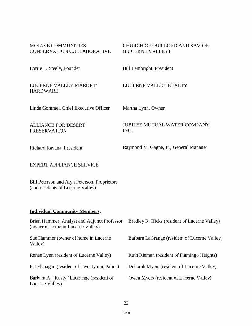
22
MOJAVE COMMUNITIES
CONSERVATION COLLABORATIVE
Lorrie L. Steely, Founder
LUCERNE VALLEY MARKET/
HARDWARE
Linda Gommel, Chief Executive Officer
ALLIANCE FOR DESERT
PRESERVATION
Richard Ravana, President
CHURCH OF OUR LORD AND SAVIOR
(LUCERNE VALLEY)
Bill Lembright, President
LUCERNE VALLEY REALTY
Martha Lynn, Owner
JUBILEE MUTUAL WATER COMPANY,
INC.
Raymond M. Gagne, Jr., General Manager
EXPERT APPLIANCE SERVICE
Bill Peterson and Alyn Peterson, Proprietors
(and residents of Lucerne Valley)
Individual Community Members:
Brian Hammer, Analyst and Adjunct Professor
(owner of home in Lucerne Valley)
Bradley R. Hicks (resident of Lucerne Valley)
Sue Hammer (owner of home in Lucerne
Valley)
Barbara LaGrange (resident of Lucerne Valley)
Renee Lynn (resident of Lucerne Valley) Ruth Rieman (resident of Flamingo Heights)
Pat Flanagan (resident of Twentynine Palms)
Deborah Myers (resident of Lucerne Valley)
Barbara A. “Rusty” LaGrange (resident of
Lucerne Valley)
Owen Myers (resident of Lucerne Valley)
E-204

23
John Smith (resident of Apple Valley)
Kathryn Anema (resident of Lucerne Valley)
Barbara Smith (resident of Apple Valley) George Stone (resident of Apple Valley)
Aaron Idouchi (resident of Milpas Highlands
(Apple Valley))
Gail Stone (resident of Apple Valley)
Barbara Idouchi (resident of Milpas Highlands
(Apple Valley))
Randy Polumbo (resident of Lucerne Valley)
Robert L. Berkman (resident of Daggett) Ellen Johnson (resident of Newberry Springs)
Ray Gagne (resident of Lucerne Valley)
Marina West (resident of Landers)
Jim Johnson (resident of Newberry Springs)
Roger Peterson (resident of Lucerne Valley)
Ted Stimpfel (resident of Newberry Springs)
Annie Lancaster (resident of Milpas Highlands
(Apple Valley))
Randy West (resident of Landers) Dennis Morrison (resident of Lucerne Valley)
Allan Raish (resident of Milpas Highlands
(Apple Valley))
Sara Tambellini (resident of Pioneertown)
Russell Scott (resident of Pioneertown) Lakey Kolb (resident of Pioneertown (Pipes
Canyon))
Stephen Andrews (resident of Pioneertown
(Pipes Canyon))
Kathy Spindler (resident of Hesperia)
Teresa Reyes (resident of Lucerne Valley)
Rachael Buettell (resident of Yucca Valley)
Ann Garry (resident of Pioneertown) Diana Bork (resident of Helendale)
Dave Garry (resident of Pioneertown Sarah Kennington (resident of Pioneertown)
Steve Bardwell (resident of Pioneertown) Peter Quintin Pena (resident of Lucerne
Valley)
Dennis Schwander (resident of Hesperia)
E-205

24
CCs:
Robert Lovingood (Chairperson and First District Supervisor;
James Ramos (Vice-Chairperson and Third District Supervisor; [email protected])
Janice Rutherford (Second District Supervisor; [email protected])
Curt Hagman (Fourth District Supervisor; [email protected])
Josie Gonzales (Fifth District Supervisor; [email protected])
Colin Drukker (Placeworks; [email protected])
E-206