Appendix A. Vegetation Table of Contents
36
Sawtooth National Forest Land and Resource Management Plan Appendix A
-
Upload
khangminh22 -
Category
Documents
-
view
0 -
download
0
Transcript of Appendix A. Vegetation Table of Contents
Sawtooth National Forest
Land and Resource Management Plan
Appendix A
Appendix A. Vegetation
Table of Contents
Introduction............................................................................................................................................................... A-1
National Standards for Vegetation Classification ................................................................................................. A-2
Fire Regimes and Spatial Pattern ........................................................................................................................ A-2
DESIRED VEGETATION CONDITIONS .................................................................................................................. A-5
Forested Vegetation ............................................................................................................................................ A-5
Tree Size Class .............................................................................................................................................. A-5
Canopy Cover ................................................................................................................................................. A-6
Species Composition ...................................................................................................................................... A-7
Shrub and Herb Communities within the Forested Potential Vegetation Groups ............................................ A-8
Snags and Coarse Woody Debris ................................................................................................................... A-8
Legacy Trees ..................................................................................................................................................... A-13
Vegetative Hazard and Wildfire within Forested Potential Vegetation Groups .............................................. A-13
Wildlife and Vegetation Restoration Strategy .................................................................................................... A-14
Other Forested/Woodland Vegetation Types ..................................................................................................... A-15
Shrublands ........................................................................................................................................................ A-16
Canopy Cover ............................................................................................................................................... A-16
Herb Communities Within the Shrubland ESP Groups ................................................................................. A-18
Riparian Vegetation ........................................................................................................................................... A-18
Grasslands ........................................................................................................................................................ A-18
Other Vegetation ............................................................................................................................................... A-19
VEGETATION MAPPING ....................................................................................................................................... A-19
Forested Vegetation Mapping ............................................................................................................................ A-19
Non-Forested Vegetation Mapping .................................................................................................................... A-19
VEGETATION CLASSIFICATION .......................................................................................................................... A-20
Forest Vegetation - Potential Vegetation Groups .............................................................................................. A-20
Potential Vegetation Group 1 - Dry Ponderosa Pine/Xeric Douglas-fir ......................................................... A-20
Potential Vegetation Group 2 - Warm, Dry Douglas-fir/Moist Ponderosa Pine ............................................. A-20
Potential Vegetation Group 3 – Cool, Moist Douglas-fir ................................................................................ A-20
Potential Vegetation Group 4 - Cool, Dry Douglas-fir ................................................................................... A-21
Potential Vegetation Group 7 - Warm, Dry Subalpine Fir.............................................................................. A-21
Potential Vegetation Group 10 - Persistent Lodgepole Pine ......................................................................... A-21
PVG 11 - High Elevation Subalpine Fir (with Whitebark Pine) ...................................................................... A-22
Stand Structure ............................................................................................................................................. A-22
Other Forested/Woodland Vegetation Types ..................................................................................................... A-22
Aspen Forest Type ....................................................................................................................................... A-22
Pinyon-Juniper Forest Type .......................................................................................................................... A-22
Shrubland and Grassland Vegetation ................................................................................................................ A-23
Shrubland ESP Groups................................................................................................................................. A-23
Low Sagebrush ...................................................................................................................................... A-23
Mountain and Wyoming Big Sagebrush .................................................................................................... A-24
Mountain Mahogany .............................................................................................................................. A-24
Montane Shrub ....................................................................................................................................... A-24
Grassland ESP Groups ..................................................................................................................................... A-25
Perennial Grass Slopes ......................................................................................................................... A-25
Perennial Grass Montane ...................................................................................................................... A-25
Riparian Cover Types ........................................................................................................................................ A-26
Riverine Riparian .......................................................................................................................................... A-26
Deciduous Tree ............................................................................................................................................ A-26
Shrub Riparian .............................................................................................................................................. A-26
Herbaceous Riparian .................................................................................................................................... A-26
Other Vegetation ............................................................................................................................................... A-27
Wetlands ....................................................................................................................................................... A-27
Marshes .................................................................................................................................................... A-27
Bogs, Fens, and Peatlands ................................................................................................................... A-27
Wet Meadows and Seeps ...................................................................................................................... A-27
Alpine ................................................................................................................................................................ A-27
REFERENCES ....................................................................................................................................................... A-28
Tables
Table A-1. Fire Regimes ............................................................................................................. A-3
Table A-2. Forested Potential Vegetation Groups by Fire Regimes .......................................... A-5
Table A-3. Tree Size Class Definitions ...................................................................................... A-6
Table A-4. Forestwide Range of Desired Tree Size Classes for Stages Other Than Large Tree,
Arranged by Fire Regime ............................................................................................................ A-6
Table A-5. Forestwide Range of Desired Conditions for the Large Tree Size Class for Forested
Vegetation within each PVG, Arranged by Fire Regime ........................................................... A-7
Table A-6. Desired Range of Snags per Acre in Green Stands for PVGs ................................ A-15
Table A-7. Desired Range of Coarse Woody Debris in Green Stands, in Tons per Acre Dry
Weight, and Percent Desired Amounts in Large Classes for PVGs ........................................ A-15
Table A-8. Desired Condition Ranges for Climax Aspen ........................................................ A-15
Table A-9. Desired Condition Ranges for Pinyon-Juniper ....................................................... A-16
Table A-10. Shrubland1 ESP Groups by Fire Regime .............................................................. A-16
Table A-11. Desired Condition Ranges for Low Sagebrush ESP Groups ................................ A-17
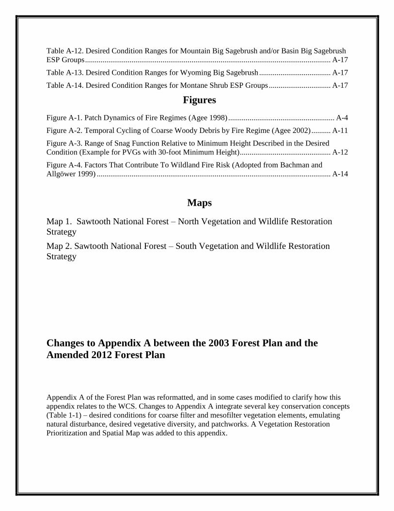
Table A-12. Desired Condition Ranges for Mountain Big Sagebrush and/or Basin Big Sagebrush
ESP Groups ............................................................................................................................... A-17
Table A-13. Desired Condition Ranges for Wyoming Big Sagebrush ..................................... A-17
Table A-14. Desired Condition Ranges for Montane Shrub ESP Groups ................................ A-17
Figures
Figure A-1. Patch Dynamics of Fire Regimes (Agee 1998) ....................................................... A-4
Figure A-2. Temporal Cycling of Coarse Woody Debris by Fire Regime (Agee 2002) .......... A-11
Figure A-3. Range of Snag Function Relative to Minimum Height Described in the Desired
Condition (Example for PVGs with 30-foot Minimum Height) ............................................... A-12
Figure A-4. Factors That Contribute To Wildland Fire Risk (Adopted from Bachman and
Allgöwer 1999) ......................................................................................................................... A-14
Maps
Map 1. Sawtooth National Forest – North Vegetation and Wildlife Restoration
Strategy
Map 2. Sawtooth National Forest – South Vegetation and Wildlife Restoration
Strategy
Changes to Appendix A between the 2003 Forest Plan and the
Amended 2012 Forest Plan
Appendix A of the Forest Plan was reformatted, and in some cases modified to clarify how this
appendix relates to the WCS. Changes to Appendix A integrate several key conservation concepts
(Table 1-1) – desired conditions for coarse filter and mesofilter vegetation elements, emulating
natural disturbance, desired vegetative diversity, and patchworks. A Vegetation Restoration
Prioritization and Spatial Map was added to this appendix.
Sawtooth Forest Plan Appendix A Vegetation
A-1
INTRODUCTION
Appendix A contains the mapping criteria, classification descriptions, and desired condition tables
for vegetation outside of designated wilderness areas. Separate tables and/or narratives relate to
desired conditions for 3 vegetation types: 1) components of forested vegetation; 2) woodland and
shrubland; and 3) riparian vegetation, including vegetation in Riparian Conservation Areas
(RCAs). Desired conditions do not represent a static state; they are dynamic because the
ecosystems are dynamic. The desired conditions will not be evident on every acre of the Sawtooth
National Forest (Forest) at every point in time; spatial and temporal variability will always exist.
However, Forest management’s long-term goal is to achieve desired conditions distributed across
the planning unit. Tree size class, canopy cover, and species composition will be evaluated north-
end wide for the north end of the Forest (Fairfield Ranger District, Ketchum Ranger District, and
Sawtooth National Recreation Area) and by division on the Minidoka Ranger District. Spatial
pattern will be evaluated at the 5th field hydrologic unit (HU) and snags and coarse woody debris
will be evaluated at the activity area scale. Desired conditions for tree size class, canopy cover
class, and species composition will be evaluated through the Sawtooth National Forest Land and
Resource Management Plan (Forest Plan) monitoring. This evaluation process may result in
Forest Plan amendments that will guide future project development. Snags and coarse woody
debris are evaluated during project planning. Watershed or activity-area scales of analysis may be
used where a different reference is more appropriate to identify opportunities for specific
treatments.
The Historical Range of Variability (HRV) was used as a basis for developing desired conditions.
The HRV has been suggested as a framework for coarse-filter conservation strategies
(Hunter 1990) and is described as an appropriate goal for ecological conditions (Landres et
al. 1999). Presumably, if a variety of historically functioning ecosystems are produced or
mimicked across the landscape, then much of the habitat for native flora and fauna should be
present. The desired conditions described below fall within a portion of the HRV and are balanced
with social and economic desired conditions.
In many areas, current conditions deviate strongly from desired conditions; this deviation may
create opportunities for managing vegetation. However, even under careful management, these
areas may take several decades to approach desired conditions. During that time, managers will
have to choose between several approaches to maintain progress toward desired conditions. There
may be many different paths to a common endpoint that meet different management objectives,
and each path has its own trade-offs. Navigating these paths and trade-offs will be the challenge of
ecosystem management in trying to achieve desired vegetative conditions. As we move forward
with vegetation management and learn more from monitoring and scientific research, desired
conditions may change, or we may alter the paths we chose to achieve them. For these reasons,
describing a completely prescriptive approach to desired conditions is impossible. We can only
offer guidance on how to achieve desired conditions.
Exceptions to the desired vegetative conditions may exist, possibly as a result of management
direction in other resource areas or undesirable site-specific conditions. In some cases,
Management Area Direction may have different goals and objectives that would override the
Forest-wide desired conditions. Each Management Prescription Category (MPC) may also have a
different theme regarding how to achieve desired conditions. All of these differences need to be
considered when we design our projects.
Sawtooth Forest Plan Appendix A Vegetation
A-2
The desired conditions are general conditions that can be modified at the local or project level
based on site-specific biophysical conditions. Some examples of projects where desired conditions
could deviate from those in this appendix include restoring rare plant habitat or considering the
needs of a threatened or endangered species where the Forest-wide desired conditions would not
provide the site-specific conditions appropriate to the plant community. The rationale for deviating
from desired conditions in this appendix would be documented through project-level analysis to
help develop alternate desired conditions.
This appendix provides the foundation for coarse-filter forestland, woodland, shrubland, and
grassland ecosystems and associated functions and processes. It also provides desired conditions
for fine-filter elements, such as snags and coarse woody debris, and sets a context for riparian
areas, wetlands, and alpine communities. Desired conditions are defined as ranges rather than as
an ―average‖ or ―target‖ to provide for a diversity and variety of conditions within and across
landscapes. The desired conditions are framed by the HRV and fire regimes and—though
presented in terms of tangible attributes of structure, patch, and pattern—embody intangible
attributes of function and process. These intangible attributes, particularly disturbance processes
that contribute to ecosystem structure and function, are generally captured as Forest-wide goals
and in the desired conditions for spatial pattern.
National Standards for Vegetation Classification
Ecosystem assessment and land management planning at national and regional levels require
consistent standards for classifying and mapping existing vegetation. A standardized vegetation
classification system provides a consistent framework for cataloging, describing, and
communicating information about existing plant communities. The net value of using standardized
existing vegetation classifications and maps is improved efficiency; accuracy; and defensibility of
resource planning, implementation, and activity monitoring. Appendix A represents a vegetation
classification for existing vegetation that precedes U.S. Department of Agriculture (USDA) Forest
Service policy and protocol for consistent standards for classification; the Existing Vegetation
Classification and Mapping Technical Guide (Brohman and Bryant 2005) documents and
establishes these standards. Our vegetation inventories and maps do not match these standards.
However, as new inventories and maps are completed, these will be consistent with
USDA Forest Service existing vegetation classification standards for dominant vegetation, size
class, and canopy cover. At that time, this appendix will also be modified with desired conditions
that are consistent with established classification standards.
Fire Regimes and Spatial Pattern
Recent advances in theory and empirical studies of vegetation and landscape ecology indicate that,
to achieve long-term biological diversity across landscapes, management needs to consider the
major disturbance processes, including variability and scale, which determine ecosystem
components and their spatial pattern (Baker 1992; Baker and Cai 1992; Hessburg et al. 2007).
Because fire was historically a major disturbance process in the West, historical fire regimes have
been recommended to help set context for the individual components of the desired conditions
(Wallin et al. 1996).
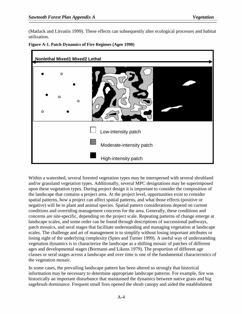
Fire regimes are summarized in Table A-1. Figure A-1 displays vegetative spatial patches and
patterns that generally resulted from the historical fire regimes (i.e., fire disturbance that occurred
on the landscape for approximately 500 years before European settlement [Hann et al. 2004]).
Hann et al. (2004) states that appropriate landscapes for evaluating fire regimes are ―relatively
Sawtooth Forest Plan Appendix A Vegetation
A-3
large-scale, contiguous areas big enough to exhibit natural variation in fire regimes and associated
vegetation.‖ They recommend basing the landscape size on the dominant historical fire regime
within an area; appropriate landscapes can range from 500 to 300,000 acres in highly dissected
topography. Spatial patterns are evaluated at the watershed landscape unit (5th HU) because, in
most cases, this scale is large enough to represent the desired fire regime patch dynamics that
created the largest patch sizes on the Forest (i.e., the lethal fire regimes). Much larger patches than
would be appropriate to represent using a watershed context could be created from very large,
stand-replacing fires. However, such fires, even within the historical range of lethal fire regimes,
are generally inconsistent with current management given the complexity of management goals
within national forests (Wallin et al. 1996; Cissel et al. 1999). Therefore, depending on the mix of
fire regimes, a watershed may be dominated by a few or many patches. For example, a watershed
dominated by nonlethal fire regimes may be primarily large tree size class with fine-grained
patches of smaller size classes. A watershed dominated by mixed fire regimes may have numerous
small-to-large patches of different size classes, while a watershed dominated by lethal fire regimes
may have primarily smaller tree size classes with fine-grained patches of larger-sized trees.
Table A-1. Fire regimes
Fire Regime Fire
Interval Fire Intensity Vegetation Patterns (Agee 1998)
Nonlethal 5–25 years ≤10% mortality Relatively homogenous with small patches generally less than 1.0 acre of different seral stages, densities, and compositions created from mortality.
Mixed1 5–70 years >10–50% mortality Relatively homogenous with patches created from mortality ranging in size from less than 1.0 to 600 acres of different seral stages, densities, and compositions.
Mixed2 70–300 years
>50–90% mortality
Relatively diverse with patches created by mixes of mortality and unburned or underburned areas ranging in size from less than 1.0 to 25,000 acres of different seral stages, densities, and compositions.
Lethal 100–400 years
>90% mortality
Relatively homogenous with patches sometimes greater than 25,000 acres of similar seral stages, densities, and compositions. Small inclusions of different seral stages, densities, and compositions often result from unburned or underburned areas.
Evaluating spatial pattern is a daunting task that requires both a conceptual framework to organize
and simplify ecosystem complexity and knowledge of the details of particular systems (Spies and
Turner 1999). Historically, patterns like those in Figure A-1 were the result of disturbance regimes
and succession that created spatial elements within and between vegetation types, including
amount, proportion, size, interpatch distance, patch size variation, and landscape connectivity.
Landscape spatial patterns affect ecological processes and can be illustrated through differences in
plant species composition and structure and through habitat utilization by wildlife. Despite recent
interest and progress in spatial patch and pattern research, determining the conditions under which
spatial heterogeneity is and is not important for various processes or organisms remains
challenging (Spies and Turner 1999). Ecosystems often include recognizable patchiness, usually
corresponding to physical changes in topography, hydrology, and substrate or due to large
disturbances (Whittaker 1956; Bormann and Likens 1979; Taylor and Skinner 2003). Patchiness in
the landscape can create changes in microclimate at patch edges, resulting in demographic fluxes
of many individual plant species, varied plant species distribution, and edge-oriented patterns
Sawtooth Forest Plan Appendix A Vegetation
A-4
(Matlack and Litvaitis 1999). These effects can subsequently alter ecological processes and habitat
utilization.
Figure A-1. Patch Dynamics of Fire Regimes (Agee 1998)
Within a watershed, several forested vegetation types may be interspersed with several shrubland
and/or grassland vegetation types. Additionally, several MPC designations may be superimposed
upon these vegetation types. During project design it is important to consider the composition of
the landscape that contains a project area. At the project level, opportunities exist to consider
spatial patterns, how a project can affect spatial patterns, and what those effects (positive or
negative) will be to plant and animal species. Spatial pattern considerations depend on current
conditions and overriding management concerns for the area. Generally, these conditions and
concerns are site-specific, depending on the project scale. Repeating patterns of change emerge at
landscape scales, and some order can be found through descriptions of successional pathways,
patch mosaics, and seral stages that facilitate understanding and managing vegetation at landscape
scales. The challenge and art of management is to simplify without losing important attributes or
losing sight of the underlying complexity (Spies and Turner 1999). A useful way of understanding
vegetation dynamics is to characterize the landscape as a shifting mosaic of patches of different
ages and developmental stages (Bormann and Likens 1979). The proportion of different age
classes or seral stages across a landscape and over time is one of the fundamental characteristics of
the vegetation mosaic.
In some cases, the prevailing landscape pattern has been altered so strongly that historical
information may be necessary to determine appropriate landscape patterns. For example, fire was
historically an important disturbance that maintained the dynamics between native grass and big
sagebrush dominance. Frequent small fires opened the shrub canopy and aided the establishment
Low-Severity Patch
Moderate-Severity Patch
High-Severity Patch
Low-Severity Fire Regime Moderate-Severity Fire Regime High-Severity Fire Regime Nonlethal Mixed1 Mixed2 Lethal
Low-intensity patch
Moderate-intensity patch
High-intensity patch
Sawtooth Forest Plan Appendix A Vegetation
A-5
of native perennial grasses at small scales, creating a mosaic of grassland and shrubland
communities in different development stages at large scales (Knick 1999). The system dynamics
changed when cheatgrass (Bromus tectorum) invaded the sagebrush ecosystem and provided
continuous fuels, compared to more patchily distributed native bunchgrasses. This invasion
facilitated fire spread and shrub loss, resulting in shrubland fragmentation into smaller, spread out
patches. Ultimately, many patches did not persist (Knick and Rotenberry 1997). Patch and pattern
have changed and may no longer provide for the processes and habitat associated with these
systems (Rotenberry and Wiens 1980; Knick and Rotenberry 1995; Paige and Ritter 1999;
Connelly et al. 2000; Knick and Rotenberry 2000). Spatial pattern considerations and subsequent
management will be particularly difficult in these highly disrupted ecosystems and vegetation
types.
DESIRED VEGETATION CONDITIONS
Forested Vegetation
The desired conditions for forested vegetation are described below. Forested vegetation refers to
land that contains at least 10 percent canopy cover by forest trees of any size, or land that formerly
had tree cover and is presently at an earlier seral stage. Forested vegetation is described by habitat
types, which use potential climax vegetation as an indicator of environmental conditions. At the
Forest Plan level, forested habitat types have been further grouped into Potential Vegetation
Groups (PVGs) that share similar environmental characteristics, site productivity, and disturbance
regimes. These groupings simplify the description of vegetative conditions for use at the broad
scale. For additional details on the specific habitat types and groupings into PVGs, see Steele
et al. (1981) and Mehl et al. (1998).
Table A-2 displays the forested PVGs grouped by fire regime. Additional information on PVGs is
available in the Vegetation Classification and Mapping section at the end of this appendix.
Table A-2. Forested Potential Vegetation Groups (PVGs) by Fire Regimes
Fire Regimes Potential Vegetation Group
Nonlethal PVG 1—Dry Ponderosa Pine/Xeric Douglas-fir
PVG 2—Warm Dry Douglas-fir/Moist Ponderosa Pine
Mixed1-Mixed2
PVG 3—Cool Moist Douglas-fir
PVG 4—Cool Dry Douglas-fir
Mixed2 PVG 7—Warm Dry Subalpine Fir
PVG 11—High Elevation Subalpine Fir
Mixed2-Lethal PVG 10—Persistent Lodgepole Pine
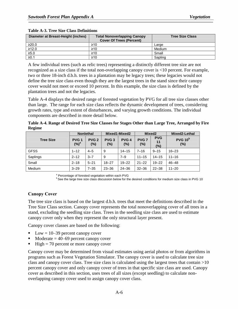
Tree Size Class
Tree size class is based on the largest diameter at breast-height (d.b.h.) of trees according to the
following definitions (Table A-3). If none of the definitions apply, the size class is considered
grass/forb/shrub/seedling (GFSS). Though a smaller size class may represent a greater canopy
cover area than a larger size class, the size class is determined by the largest trees that meet the
class definition not the most abundant:
Sawtooth Forest Plan Appendix A Vegetation
A-6
Table A-3. Tree Size Class Definitions
Diameter at Breast-Height (inches) Total Nonoverlapping Canopy Cover Of Trees (Percent)
Tree Size Class
≥20.0 ≥10 Large
≥12.0 ≥10 Medium
≥5.0 ≥10 Small
≥0.1 ≥10 Sapling
A few individual trees (such as relic trees) representing a distinctly different tree size are not
recognized as a size class if the total non-overlapping canopy cover is <10 percent. For example,
two or three 18-inch d.b.h. trees in a plantation may be legacy trees; these legacies would not
define the tree size class even though they are the largest trees in the stand since their canopy
cover would not meet or exceed 10 percent. In this example, the size class is defined by the
plantation trees and not the legacies.
Table A-4 displays the desired range of forested vegetation by PVG for all tree size classes other
than large. The range for each size class reflects the dynamic development of trees, considering
growth rates, type and extent of disturbances, and varying growth conditions. The individual
components are described in more detail below.
Table A-4. Range of Desired Tree Size Classes for Stages Other than Large Tree, Arranged by Fire
Regime
Tree Size
Nonlethal Mixed1-Mixed2 Mixed2 Mixed2-Lethal
PVG 1 (%)
a
PVG 2 (%)
PVG 3 (%)
PVG 4 (%)
PVG 7 (%)
PVG 11 (%)
PVG 10b
(%)
GFSS 1–12 4–5 9 14–15 7–16 9–15 16–23
Saplings 2–12 3–7 9 7–9 11–15 14–15 11–16
Small 2–18 5–21 18–27 19–22 21–22 19–22 46–48
Medium 3–29 7–35 23–36 24–36 32–36 22–38 11–20
a Percentage of forested vegetation within each PVG
b See the large tree size class discussion below for the desired conditions for medium size class in PVG 10
Canopy Cover
The tree size class is based on the largest d.b.h. trees that meet the definitions described in the
Tree Size Class section. Canopy cover represents the total nonoverlapping cover of all trees in a
stand, excluding the seedling size class. Trees in the seedling size class are used to estimate
canopy cover only when they represent the only structural layer present.
Canopy cover classes are based on the following:
Low = 10–39 percent canopy cover
Moderate = 40–69 percent canopy cover
High = 70 percent or more canopy cover
Canopy cover may be determined from visual estimates using aerial photos or from algorithms in
programs such as Forest Vegetation Simulator. The canopy cover is used to calculate tree size
class and canopy cover class. Tree size class is calculated using the largest trees that contain >10
percent canopy cover and only canopy cover of trees in that specific size class are used. Canopy
cover as described in this section, uses trees of all sizes (except seedling) to calculate non-
overlapping canopy cover used to assign canopy cover class.
Sawtooth Forest Plan Appendix A Vegetation
A-7
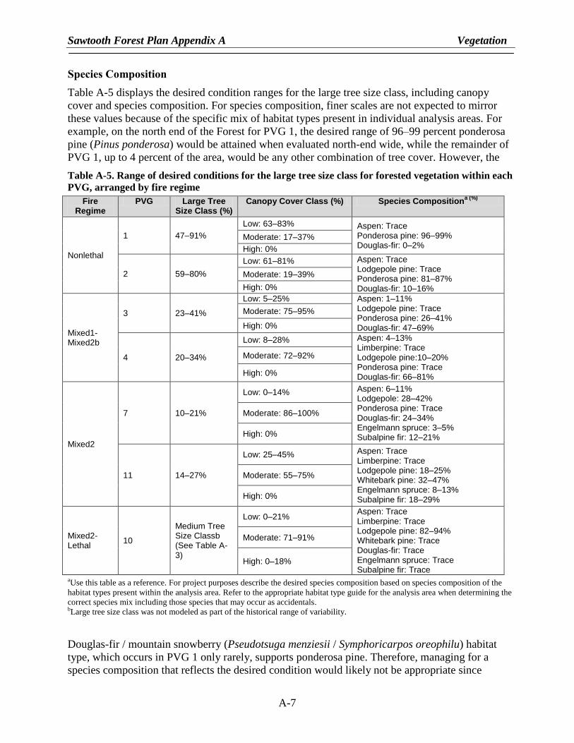
Species Composition
Table A-5 displays the desired condition ranges for the large tree size class, including canopy
cover and species composition. For species composition, finer scales are not expected to mirror
these values because of the specific mix of habitat types present in individual analysis areas. For
example, on the north end of the Forest for PVG 1, the desired range of 96–99 percent ponderosa
pine (Pinus ponderosa) would be attained when evaluated north-end wide, while the remainder of
PVG 1, up to 4 percent of the area, would be any other combination of tree cover. However, the
Table A-5. Range of desired conditions for the large tree size class for forested vegetation within each
PVG, arranged by fire regime
Fire Regime
PVG Large Tree Size Class (%)
Canopy Cover Class (%) Species Compositiona (%)
Nonlethal
1 47–91%
Low: 63–83% Aspen: Trace Ponderosa pine: 96–99% Douglas-fir: 0–2%
Moderate: 17–37%
High: 0%
2 59–80%
Low: 61–81% Aspen: Trace Lodgepole pine: Trace Ponderosa pine: 81–87% Douglas-fir: 10–16%
Moderate: 19–39%
High: 0%
Mixed1-Mixed2b
3 23–41%
Low: 5–25% Aspen: 1–11% Lodgepole pine: Trace Ponderosa pine: 26–41% Douglas-fir: 47–69%
Moderate: 75–95%
High: 0%
4 20–34%
Low: 8–28% Aspen: 4–13% Limberpine: Trace Lodgepole pine:10–20% Ponderosa pine: Trace Douglas-fir: 66–81%
Moderate: 72–92%
High: 0%
Mixed2
7 10–21%
Low: 0–14% Aspen: 6–11% Lodgepole: 28–42% Ponderosa pine: Trace Douglas-fir: 24–34% Engelmann spruce: 3–5% Subalpine fir: 12–21%
Moderate: 86–100%
High: 0%
11 14–27%
Low: 25–45% Aspen: Trace Limberpine: Trace Lodgepole pine: 18–25% Whitebark pine: 32–47% Engelmann spruce: 8–13% Subalpine fir: 18–29%
Moderate: 55–75%
High: 0%
Mixed2-Lethal
10
Medium Tree Size Classb (See Table A-3)
Low: 0–21% Aspen: Trace Limberpine: Trace Lodgepole pine: 82–94% Whitebark pine: Trace Douglas-fir: Trace Engelmann spruce: Trace Subalpine fir: Trace
Moderate: 71–91%
High: 0–18%
aUse this table as a reference. For project purposes describe the desired species composition based on species composition of the
habitat types present within the analysis area. Refer to the appropriate habitat type guide for the analysis area when determining the
correct species mix including those species that may occur as accidentals. bLarge tree size class was not modeled as part of the historical range of variability.
Douglas-fir / mountain snowberry (Pseudotsuga menziesii / Symphoricarpos oreophilu) habitat
type, which occurs in PVG 1 only rarely, supports ponderosa pine. Therefore, managing for a
species composition that reflects the desired condition would likely not be appropriate since
Sawtooth Forest Plan Appendix A Vegetation
A-8
managing for a predominance of Douglas-fir would be more ecologically suitable for this habitat
type. Therefore, the proper species ―mix‖ for a project area should be determined by habitat types
and other concerns, such as wildlife or wildland-urban interface (WUI).
While Table A-5 displays the desired species composition for the large tree size class, this same
species composition can be used to help guide projects conducted in intermediate size classes.
Individual species described as ―trace‖ were not explicitly modeled when developing the HRV
because they occur in habitat types that represent a minor part of the PVGs within the southern
part of the Idaho Batholith and/or because little is known about their historical occurrence within a
PVG. Quaking aspen (Populus tremuloides), which occurs in minor amounts in many PVGs, is an
example. Because quaking aspen is a minor component, it has not been extensively studied to fully
understand its role. However, these ―trace‖ species should be retained where they are found within
the landscape, particularly species in decline, including quaking aspen and whitebark pine (Pinus
albicaulis).
The appropriate species composition for a project area may vary from Table A-5 based on the mix
of habitat types present, particularly for PVGs that include several habitat types representing a
broad environmental range, such as PVG 7. Determining the mix of habitat types that comprise the
PVGs within the project area is necessary for project application in most PVGs. Since most
project areas will generally contain fewer habitat types than are represented by the PVGs, the
desired species composition should reflect that more limited set. Therefore, the project area
desired species composition may deviate from the desired composition but should, where
appropriate, result in landscapes dominated by early-seral species. These species are better adapted
to site conditions and usually more resilient to disturbances such as fire. For example, the desired
species composition for sites dominated by warmer, drier habitat types in PVG 7, which supports
Douglas-fir, would be different from sites dominated by cooler, more frost-prone habitat types that
support lodgepole pine (Pinus contorta).
The ranges in Tables A-4 and A-5 were developed from the HRV estimates adopted from Morgan
and Parsons (2001). The high end of the range for the large tree size class is equal to the mean
HRV value; the low end of the range equals the low end of the HRV. Although current conditions
may prevent us from obtaining desired conditions for quite some time, management actions over a
longer period (perhaps more than 100 years) should result in forested vegetation approaching the
desired conditions displayed in Tables A-4 and A-5. For the large tree size class, Table A-5 shows
the set of components that together achieve the desired conditions.
Shrub and Herb Communities within the Forested Potential Vegetation Groups
Similar to the tree component, the shrub and herb communities historically occurred within some
range of variability, depending on disturbance processes and succession (Steele and Geier-Hayes
1987). Shrub and herb communities that occur across the landscape reflect the environment as
controlled by elevation; aspect; topography; soils; and other factors, including management
activities that affect sites. The desired conditions for these communities are to have healthy,
resilient, and resistant native shrub and herb species.
Snags and Coarse Woody Debris
Snags and coarse woody debris are created by disturbances and vary depending on vegetation type
and stage of succession (Hutto 2006). In older forests, snags and coarse woody debris are
generally products of disease, insects, lightning, low-intensity fire, and senescence (Spies
et al. 1988). In postdisturbance forests, most snags and coarse woody debris are products of the
Sawtooth Forest Plan Appendix A Vegetation
A-9
disturbance that created the early-seral condition (Drapeau et al. 2002). Therefore, snags and
coarse woody debris in older forests often exhibit more advanced stages of decay than
postdisturbance forests, though some components of predisturbance snags and coarse woody
debris may still be present (Nappi et al. 2003). In all forests, snags and course woody debris serve
important ecological functions.
Much of the research regarding snags in older forests has focused on using them as nesting
habitats, particularly for primary cavity nesters (Hutto 2006). Recent research has shown that
while snags in postdisturbance forests provide nesting habitat, they are also an important resource
for foraging (Nappi et al. 2003), particularly for species such as the black-backed woodpecker
(Picoides arcticue) and the American three-toed woodpecker (Picoides tridactylus), which forage
on insects that infest recently burned trees. Although these trees only provide suitable foraging
habitat for a short time, they are an invaluable resource for these woodpecker species.
Tables A-6 and A-7 display the snag and coarse woody debris desired conditions for green stands
by PVG. Snags and coarse woody debris are finer-scale elements than the coarse-scale vegetative
components of species composition, tree size class, and canopy cover class. Snags and coarse
woody debris occur as more discrete components within stands, whereas the species composition,
tree size class, and canopy cover occur across stands. Therefore, snags and coarse woody debris
are evaluated during project planning for an activity area, which better reflects the appropriate
scale to consider these elements. The activity area for snags and coarse woody debris is the
specific site affected, whether the effects are positive or negative. Actions where snags and coarse
woody debris need to be assessed include timber harvest, reforestation, timber stand improvement,
and prescribed fire activities.
Table A-6. Desired Range of Snags per Acre in Green Stands for Potential Vegetation Groups
(PVGs)
Diameter Group Nonlethal Mixed1–Mixed2 Mixed2 Mixed2–Lethal
PVG 1a PVG 2
b PVG 3
b PVG 4
b PVG 7
b PVG 11
a PVG 10
a
10–20 inches 0.4–0.5 1.8–2.7 1.8–4.1 1.8–2.7 1.8–5.5 1.4–2.2 1.8–7.7
>20 inches 0.4–2.3 0.4–3.0 0.2–2.8 0.2–2.1 0.2–3.5 0.0–4.4 NA
Total 0.8–2.8 2.2–5.7 2.0–6.9 2.0–4.8 2.0–9.0 1.4–6.6 1.8–7.7
Note: This table is not meant to provide an even distribution of snags across every acre of the forested landscape, but to provide numbers that serve as a guide to approximate an average condition for an activity area. a Minimum height = 15 feet. Snags at or greater than the minimum height contribute to the desired conditions. However, snags less
than the minimum height contribute to ecological functions and should be retained. b Minimum height = 30 feet.

Sawtooth Forest Plan Appendix A Vegetation
A-10
Table A-7. Desired Range of Coarse Woody Debris in Green Stands, in Tons per Acre Dry Weight,
and Percent Desired Amounts in Large Classes for Potential Vegetation Groups (PVG)
Indicator Nonlethal Mixed1-Mixed2 Mixed2
Mixed2–Lethal
PVG 1 PVG 2 PVG 3 PVG 4 PVG 7 PVG 11 PVG 10
Dry Weight (tons/acre) in Decay Classes I and II
3–10 4–14 4–14 4–14 5–19 4–14 5–19
Distribution >15 inches >75% >75% >65% >65% >50% >25% >25%
Note: The recommended distribution is to try to provide coarse woody debris in the largest size classes, preferably over 15 inches (12 inches for PVG 10), that provide the most benefit for wildlife and soil productivity. This table is not meant to provide an even distribution of coarse woody debris across every acre of the forested landscape, but to provide numbers that serve as a guide to approximate an average condition for an activity area.
Because the desired conditions in Tables A-6 and A-7 are for green stands, in many cases they
may not be appropriate for postdisturbance forests. While a portion of the snags and coarse woody
debris in stands may be a legacy of postdisturbance communities, the kind of material created
immediately postdisturbance and the role it plays is different than dead wood dynamics in green
stands. Drapeau et al. (2002) found that snags in postdisturbance stands were generally less
decayed than those in green stands. Postdisturbance communities provide important habitat for
primary cavity nesters, while green stands support a greater proportion of secondary cavity
nesters.
Using historical fire regimes, Agee (2002) presents several diagrams that depict the spatial and
temporal variability found in snag and coarse woody debris numbers. According to Agee (2002),
the landscape ecology of historical fire regimes is a function of place. Low-intensity fire regimes
had small patches and little edge, while high-intensity regimes had the largest patch sizes and
moderate amounts of edge (Figure A-1). Moderate- or mixed-intensity fire regimes had
intermediate patch sizes and maximum amounts of edge.
Spatial distribution of snags and coarse woody debris is important. However, the desired
conditions described in Tables A-6 and A-7 are not meant to provide an even distribution of snags
or coarse woody debris across every acre of the forested landscape. The numbers serve as a guide
to approximate an average condition for an activity area. Clumping all dead material in an activity
area into one portion of the area would be undesirable and would leave little or no material in the
remainder of the area. Though snags are generally found in clumps within patches, snag patches
should be distributed across the activity area rather than clustered in a portion of the activity area;
the activity area should have snag patches throughout, depending on what is appropriate for the
PVG. Coarse woody debris is often more uniformly distributed across the landscape than snags
because it is created from green trees as well as snags.
Agee (2002) also discusses how woody debris dynamics have historically varied by fire regime
(Figure A-2). Frequent, low-intensity fires limit the amount of coarse woody debris. Figure A-2
displays fluctuations in course woody debris found in low-intensity fire regimes; the peaks may be
as high as 13–16 tons/acre (30–35 megagrams per hectare [Mg/ha]), the lows could be
<0.5 tons/acre (1 Mg/ha), and the average is around 5 tons/acre (11 Mg/ha) (Graham, personal
communication 2001). Although fires were frequent, they rarely affected every acre. In
moderate-intensity fire regimes, fires consumed and created coarse woody debris several times per
century (Agee 2002). In high-intensity fire regimes, a "boom-and-bust" dynamic operated:
substantial coarse woody debris was created postdisturbance, followed by a century or more

Sawtooth Forest Plan Appendix A Vegetation
A-11
without further substantial input. Therefore, it is important to understand the dynamics of the
project area’s particular PVG to best determine desired levels.
Figure A-2. Temporal Cycling of Coarse Woody Debris by Fire Regime (Agee 2002)
Large-diameter snags and coarse woody debris may not be available in seedling, sapling, and
small tree size stands depending on the amount of material present from postdisturbance early-
seral stands. In this case, some of the tonnage and snag numbers can be in smaller size classes.
The total amounts, particularly for coarse woody debris, are not expected to be made up in smaller
size classes, but opportunities to progress toward the desired ranges should exist. In particular, the
amount of material retained with diameters <6 inches should be balanced against the fire hazard
it—and the finer material that often comes with it—may create. Several factors determine the
potential fire hazard created by surface fuels, including the kind, depth, continuity, and extent of
surface fuels; connectivity to standing trees; and proximity to adjacent fuels. The risk of creating a
potentially hazardous condition should also be considered relative to the area’s management
objectives.
Our primary objective is to provide the majority of course woody debris in larger size classes as
this material is retained on-site longer. Although some small and intermediate stage stands may
not have the larger material available, the expectation is not to compensate with an abundance of
material in the small and medium size classes. If only smaller material is available, some should
be left to assist with long-term soil productivity. Coarse woody debris with diameters ≥15 inches
(≥12 inches for PVG 10) and lengths ≥6 feet are referred to as logs. These large pieces provide
important material for meeting wildlife needs.
Single management treatments may not produce all the dead material in the amounts and/or decay
classes desired. As much as possible, treatments should be designed to provide structural,
compositional, and functional elements that contribute to long-term sustainability of snags and
coarse woody debris. In many cases, actions will consume coarse wood (e.g., prescribed fire).
However, if an action results in mortality that produces snags or coarse woody debris, it will
contribute to desired levels of large snags and coarse woody debris over time. Furthermore, a
0
50
100
150
200
250
300
350
400
450
1 3 5 7 9 11 13 15 17 19 21 23 25 27 29 31 33 35 37 39 41 43 45 47 49 51 53 55 57 59 61
CW
D M
as
s (
mg
/ha
)
Time (5-Year Increments)
Low Severity
Moderate Severity
High Severity
Sawtooth Forest Plan Appendix A Vegetation
A-12
range of dead wood sizes and age classes should be retained. Snag height minimums described in
Table A-6 are just that—minimums—and do not preclude functions provided by smaller snags
(Figure A-3). Large trees and snags provide nesting or denning sites longer than small snags do
(Graham 1981; Morrison and Raphael 1993). However, smaller snags provide foraging sites,
which are needed in greater abundance than nesting sites (Bunnell et al. 2002).
Figure A-3. Range of Snag Function Relative to Minimum Height Described in the Desired Condition
(Example for PVGs with 30-foot Minimum Height)
Historical fire regimes, particularly the nonlethal and mixed1 regimes, continually recycle
material. Larger material may take several fire cycles before it is fully consumed. This constant
recycling also helps provide decay class variety, another important component of achieving
desired conditions. Therefore, management actions should result in a variety of snag and coarse
wood decay classes. Some wildlife species prefer hard snags, while others prefer those with more
decay. For soil productivity, inputs from these different decay classes need to occur at various
temporal increments to ensure productivity gaps do not result over time. To provide for continual
recruitment into decay class III, only decay classes I and II count towards the desired amounts; the
goal is to provide snags and coarse woody debris in decay class III. In addition to decay,
characteristics that affect the type and extent of wildlife use of coarse woody debris include
physical orientation (vertical or horizontal), size (diameter and length), wood species, and overall
material abundance (Harmon et al. 1986; Bunnell et al. 2002).
The increasing number of studies on tree mortality and decomposition are providing a global view
of how these processes vary by forest type and climate. These data also provide the basis for a
dynamic rather than a static approach to the management of woody material (Harmon 2002).
However, to be successful, this perspective must be coupled with a detailed understanding of how
certain species and ecosystem processes vary with snag and coarse woody debris amount and
quality. The application of a static-state approach, as illustrated by the desired conditions, is based
on a set of general objectives designed to provide snags and coarse woody debris across the

Sawtooth Forest Plan Appendix A Vegetation
A-13
Forest. However, applying a static-state approach does not account for the dynamic nature of
ecosystem processes and the specific objective-oriented needs of species and their functions
(Harmon 2002). Evidence suggests a variety of snags and coarse woody debris, with a variety of
decay and size characteristics, provides for all functional wildlife groups and may be necessary for
continuous soil productivity. Therefore, project analysis should consider that greater range of
function and process that cannot be captured by the desired conditions.
Legacy Trees
Perry and Amaranthus (1997) defined forest legacies as ―anything handed down from a
pre-disturbance ecosystem.‖ These legacies can occur at different scales ranging from the
landscape to the stand to individual components within a stand (Huckaby et al. 2003; Van
Pelt 2008). For example, within a lethal fire area, unburned or underburned patches and individual
trees are legacies. Legacies are not an artifact of current land-use activities—they also occurred in
the historical landscape (Huckaby et al. 2003). Old live and dead ponderosa pine and Douglas-fir
trees are an important legacy of the historical condition in many areas (see the Snags and Coarse
Woody Debris section for a discussion on dead trees). Legacies are generally resistant to
nonlethal/mixed1 fire, provide food and habitat for wildlife, and genetic material reflective of the
local site conditions (Huckaby et al. 2003), particularly when present in plantations. However,
legacies may now be less common in number and/or distribution due to changes in disturbance
regimes (Van Pelt 2008). Since legacies, in particular old tree legacies, are deficient within many
landscapes, retaining old trees, as well as trees that are transitioning into old, provides the greatest
opportunity for creating and/or replacing these important components.
Vegetative Hazard and Wildfire within Forested Potential Vegetation Groups
Vegetative desired conditions are directly related to fire hazard: both define conditions that can
occur on the landscape. Fire hazard describes potential fire behavior based on characteristics such
as the horizontal and vertical arrangement of fuels, fuel continuity, and flammability. High fire
hazard implies conditions where fires have a high likelihood of being lethal or difficult to suppress
even without contributing factors such as drought or wind. In nonlethal and mixed1 fire regimes,
near historical conditions are expected to reduce the risk of lethal wildfires due to the emphasis on
larger trees, more fire resistant seral species, and discontinuous ladder and surface fuels. Ignitions
within these conditions are more likely to stay on the ground, increasing the chances of keeping a
wildfire small (Wagle and Eakle 1979; Omi and Martinson 2002). By definition, lethal fires are
consistent with the way historically mixed2 and lethal fire regimes operated. Mixed2 and lethal
fire regimes have a greater component of more flammable later-seral species and more continuous
ladder and surface fuels.
Wildfires, whether historically characteristic or uncharacteristic, are undesirable in some cases,
particularly in WUI areas. Although wildfire risks can partially be addressed by using defensible
space, in many situations watersheds are a more appropriate scale to deal with concerns about
firefighter and public safety and the multitude of infrastructures, resources, and values often
associated with interface areas. Therefore, the juxtaposition and arrangement of vegetative
conditions relative to WUIs need to be considered at a scale greater than the project area.
Considering the vegetative conditions adjacent to the WUI is important because the desired
vegetative conditions for some areas may contribute to a risk of stand-replacing wildland fire. In
particular, the desired conditions for forested vegetation in mixed2 and lethal fire regimes are
generally more hazardous than those found in nonlethal and mixed1 fire regimes. Since desired
conditions are intended to create vegetative communities that reflect historical conditions, the

Sawtooth Forest Plan Appendix A Vegetation
A-14
resulting disturbances would also reflect historical disturbances. Therefore, by definition, desired
conditions for PVGs in mixed2 and lethal fire regimes would produce more stand-replacing
wildland fire.
Although desired conditions in certain PVGs increase the hazards associated with stand-replacing
wildland fire, the risk of these events may be reduced using a variety of vegetation management
techniques. These techniques can include strategically placing fuel breaks, surrounding vulnerable
areas with vegetative conditions where fires can be more easily suppressed, or arranging
treatments to break up continuous hazardous conditions (Deeming 1990; Graham et al. 1999;
Finney 2001; Fulé et al. 2001; Omi and Martinson 2002). In some cases these strategic treatments
can be effective without being extensive.
Although vegetative management techniques can reduce lethal wildland fire risk, they address
only one of several factors (vegetative conditions). Vegetative manipulation alone cannot
eliminate all the risks associated with wildland fire (Figure A-4). The efforts made by property
owners on their own behalf are essential in protecting homes in the WUI.
Figure A-4. Factors That Contribute To Wildland Fire Risk (Adopted from Bachman and
Allgöwer 1999)
Wildlife and Vegetation Restoration Strategy
A Wildlife and Vegetation Restoration Strategy was developed for forested vegetation to identify
Forest-wide priorities for restoring the large tree size class. Watersheds were assigned to active
and passive restoration categories and prioritized as high, medium, or low. Active restoration
watersheds are those with the most historically nonlethal and mixed1 fire regimes, and high
priority watersheds are those with the greatest number of acres in medium and large tree size class
within these fire regimes. These watersheds were selected as high priority because they likely
contain larger patches of conditions that can be restored faster toward desired conditions than
areas that have fewer medium and large tree size class acres and likely smaller patches. Active
Sawtooth Forest Plan Appendix A Vegetation
A-15
restoration is generally where management activities such as thinning, planting, control of
nonnative plants, and prescribed fire may be needed to create conditions that are more resilient and
resistant to disturbance. In many cases within historically nonlethal and mixed1 fire regime areas,
conditions are such that current disturbances often create structures, functions, and processes that
are out of sync with historical conditions and therefore can have undesirable ecosystem
consequences.
Passive restoration watersheds are those where natural disturbances are likely to operate most
similar to historical disturbances. In these areas, allowing disturbance processes to occur creates
desirable ecosystem results. High-priority watersheds are those that have been undisturbed for a
long time and would benefit from disturbances that begin to diversify spatial patch, pattern, and
structure. Low-priority watersheds are those that have experienced recent large-scale disturbance,
such as wildfire, and need time to allow early-seral conditions to progress into other size classes.
Other Forested/Woodland Vegetation Types
In addition to developing desired conditions for the 11 PVGs, 2 additional forest types, climax
aspen and pinyon-juniper, are found on the southern portion of the Forest. As is the case for the
11 PVGs, forested vegetation for these two types refers to land that contains at least 10 percent
canopy cover by trees of any size or land that formally had tree cover and is presently at an earlier
seral stage. Climax aspen falls into the lethal fire regime and pinyon-juniper falls in the mixed2
fire regime category. Refer to the Vegetation Classification portion of this appendix for
description of climax versus seral aspen, as the desired conditions do not apply to seral aspen.
Desired conditions for climax aspen and pinyon-juniper forest types are presented somewhat
differently than ranges for other forest types. Rather than a range of desired conditions for specific
components, the aspen and pinyon-juniper desired conditions are represented as ranges of acres
found in the various size classes (TablesA-8 and A-9). Although current conditions may prevent
us from obtaining desired condition for quite some time, over a longer period (perhaps more than
100 years), management actions should result in vegetation that is approaching Forest-wide
desired conditions.
Table A-8. Desired Condition Ranges as Percent of Area by Size Class for Climax Aspen Forest Type
Aspen Size Classes Percent of Area
Grass/Forb/Shrub/Seedling, <10% canopy cover or areas where tree height is <4.5 feet.
40–60% in this class
Saplings (0.1–4.9 inch d.b.h.), all canopy covers 20–35% in these two classes combined
Small (5.0–11.9 inch d.b.h.), all canopy covers
Medium (≥12 inch d.b.h.), all canopy covers 20–25% in this class
Table A-9 displays the desired ranges for pinyon-juniper forest type, which refers to stands whose
potential vegetation is pinyon-juniper (refer to the classification portion of this appendix for the
description). This determination generally needs to be site-specific. In those areas with
pinyon-juniper potential, the desired ranges are similar to climax aspen in that they represent
ranges for the amounts of acres found in the various combinations of size and canopy cover for
pinyon-juniper.
Sawtooth Forest Plan Appendix A Vegetation
A-16
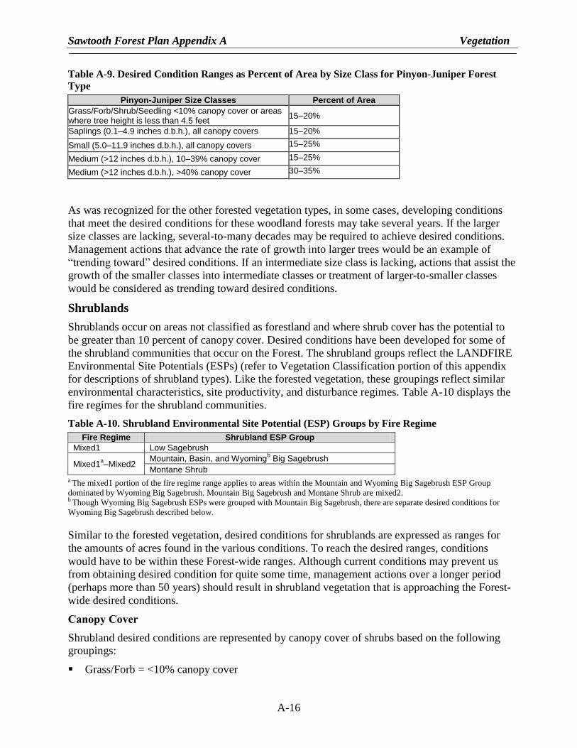
Table A-9. Desired Condition Ranges as Percent of Area by Size Class for Pinyon-Juniper Forest
Type
Pinyon-Juniper Size Classes Percent of Area
Grass/Forb/Shrub/Seedling <10% canopy cover or areas where tree height is less than 4.5 feet
15–20%
Saplings (0.1–4.9 inches d.b.h.), all canopy covers 15–20%
Small (5.0–11.9 inches d.b.h.), all canopy covers 15–25%
Medium (>12 inches d.b.h.), 10–39% canopy cover 15–25%
Medium (>12 inches d.b.h.), >40% canopy cover 30–35%
As was recognized for the other forested vegetation types, in some cases, developing conditions
that meet the desired conditions for these woodland forests may take several years. If the larger
size classes are lacking, several-to-many decades may be required to achieve desired conditions.
Management actions that advance the rate of growth into larger trees would be an example of
―trending toward‖ desired conditions. If an intermediate size class is lacking, actions that assist the
growth of the smaller classes into intermediate classes or treatment of larger-to-smaller classes
would be considered as trending toward desired conditions.
Shrublands
Shrublands occur on areas not classified as forestland and where shrub cover has the potential to
be greater than 10 percent of canopy cover. Desired conditions have been developed for some of
the shrubland communities that occur on the Forest. The shrubland groups reflect the LANDFIRE
Environmental Site Potentials (ESPs) (refer to Vegetation Classification portion of this appendix
for descriptions of shrubland types). Like the forested vegetation, these groupings reflect similar
environmental characteristics, site productivity, and disturbance regimes. Table A-10 displays the
fire regimes for the shrubland communities.
Table A-10. Shrubland Environmental Site Potential (ESP) Groups by Fire Regime
Fire Regime Shrubland ESP Group
Mixed1 Low Sagebrush
Mixed1a–Mixed2
Mountain, Basin, and Wyomingb Big Sagebrush
Montane Shrub a The mixed1 portion of the fire regime range applies to areas within the Mountain and Wyoming Big Sagebrush ESP Group
dominated by Wyoming Big Sagebrush. Mountain Big Sagebrush and Montane Shrub are mixed2. b Though Wyoming Big Sagebrush ESPs were grouped with Mountain Big Sagebrush, there are separate desired conditions for
Wyoming Big Sagebrush described below.
Similar to the forested vegetation, desired conditions for shrublands are expressed as ranges for
the amounts of acres found in the various conditions. To reach the desired ranges, conditions
would have to be within these Forest-wide ranges. Although current conditions may prevent us
from obtaining desired condition for quite some time, management actions over a longer period
(perhaps more than 50 years) should result in shrubland vegetation that is approaching the Forest-
wide desired conditions.
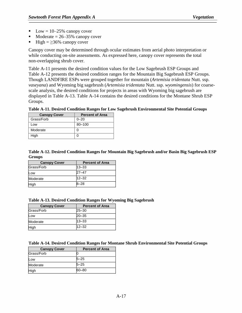
Canopy Cover
Shrubland desired conditions are represented by canopy cover of shrubs based on the following
groupings:
Grass/Forb = <10% canopy cover
Sawtooth Forest Plan Appendix A Vegetation
A-17
Low = 10–25% canopy cover
Moderate = 26–35% canopy cover
High = ≥36% canopy cover
Canopy cover may be determined through ocular estimates from aerial photo interpretation or
while conducting on-site assessments. As expressed here, canopy cover represents the total
non-overlapping shrub cover.
Table A-11 presents the desired condition values for the Low Sagebrush ESP Groups and
Table A-12 presents the desired condition ranges for the Mountain Big Sagebrush ESP Groups.
Though LANDFIRE ESPs were grouped together for mountain (Artemisia tridentata Nutt. ssp.
vaseyana) and Wyoming big sagebrush (Artemisia tridentata Nutt. ssp. wyomingensis) for coarse-
scale analysis, the desired conditions for projects in areas with Wyoming big sagebrush are
displayed in Table A-13. Table A-14 contains the desired conditions for the Montane Shrub ESP
Groups.
Table A-11. Desired Condition Ranges for Low Sagebrush Environmental Site Potential Groups
Canopy Cover Percent of Area
Grass/Forb 0–20
Low 80–100
Moderate 0
High 0
Table A-12. Desired Condition Ranges for Mountain Big Sagebrush and/or Basin Big Sagebrush ESP
Groups
Canopy Cover Percent of Area
Grass/Forb 13–33
Low 27–47
Moderate 12–32
High 8–28
Table A-13. Desired Condition Ranges for Wyoming Big Sagebrush
Canopy Cover Percent of Area
Grass/Forb 25–30
Low 20–35
Moderate 13–33
High 12–32
Table A-14. Desired Condition Ranges for Montane Shrub Environmental Site Potential Groups
Canopy Cover Percent of Area
Grass/Forb 0
Low 5–25
Moderate 5–25
High 60–80
Sawtooth Forest Plan Appendix A Vegetation
A-18
Unlike the other vegetation groups, desired conditions for Wyoming big sagebrush are not within
the HRV. Because these sites are extremely vulnerable to invasion by non-native species
following disturbance, the intent is to limit disturbance in areas currently occupied by Wyoming
big sagebrush. Lack of disturbance will increase the amount of area in higher canopy cover classes
compared to what would have occurred historically but will reduce the risk of more area becoming
occupied by non-native species.
Similar to the forested vegetation types, in some cases it may take many years to reach desired
conditions. If an area has recently experienced a large wildfire, the necessary structural complexity
can take many years to develop at a landscape level. Conversely, an area with little disturbance
over many years may have dense canopy cover. Management actions that reduce canopy cover
would be an example of ―trending toward‖ desired conditions, even if only applied on a small
scale. When at desired conditions, maintenance activities would keep the balance of canopy cover
classes within the range of desired conditions; as some acres become denser through succession,
other acres may be treated to limit overall canopy cover density. For example, if the Mountain Big
Sagebrush ESP Groups are currently at desired conditions but with acres of high canopy cover
approaching the high end of the range, it may be necessary to move some of these acres into
another canopy cover class to prevent conditions from exceeding desired ranges and creating
insufficient amounts of other canopy cover classes. Natural disturbances will also play a role in
moving acres in and out of canopy cover classes.
Herb Communities within the Shrubland Environmental Site Potential Groups
Like with the tree and shrub component, some of the grass and forb communities that developed
within shrubland ecosystems occurred within the HRV, depending on disturbance processes and
succession. These herb communities also reflect environmental conditions such as elevation;
aspect; topography; soils; and other factors, including management activities that affect sites. Due
to the high variability of these communities across the Forest, desired conditions should be
determined at the site-specific scale. The desired conditions should focus on producing healthy,
resilient, and resistant grass and forb communities dominated by native species.
Riparian Vegetation
Refer to Tables A-4 and A-5 for the desired conditions for riparian vegetation comprised of
coniferous PVGs. The desired conditions in Tables A-4 and A-5 include the upland portions of
coniferous vegetation found in the RCAs. Additional information for RCAs is found in Appendix
B, Table B-1.
Riparian vegetation is dominated by a variety of species, age classes, and structures—including
deciduous trees, willows (Salix spp.), alders (Alnus spp.), sedges (Cyperaceae spp.), and hydric
grasses—depending on stream substrate, gradient, elevation, soil hydrology, and disturbance
processes. Riparian areas have their own disturbance processes that influence vegetative
dynamics, causing an almost continual readjustment in successional stages in many areas.
Riparian vegetation is also influenced by upland and upstream processes. Site conditions are
highly variable due to these factors, which influence riparian vegetation desired conditions at
site-specific locations. Therefore, site-specific desired condition determinations are needed.
Grasslands
Grasslands occur in areas where forest or shrubland canopy cover does not have the potential to
exceed 10 percent. Grassland communities on the Forest are comprised of perennial grass species.
Sawtooth Forest Plan Appendix A Vegetation
A-19
The grassland groups reflect the LANDFIRE ESPs (refer to Vegetation Classification section at
the end of this appendix for descriptions of grassland types). Like the forested and shrubland
vegetation, these groupings reflect similar environmental characteristics, site productivity, and
disturbance regimes. Two grassland communities are described for the Forest: Perennial Grass
Slopes and Perennial Grass Montane. The fire regimes for these communities are mixed1 to
mixed2 for the Perennial Grass Slopes and nonlethal to mixed1 for the Perennial Grass Montane.
Desired conditions in these grasslands support native species and aim to reduce threats from
nonnative species, particularly invasive annual grasses.
Other Vegetation
Other vegetation types, such as wetlands, marshes, and alpine habits, not described above exist on
the Forest. Desired conditions for these vegetation types need to be determined on a project basis,
using available local information. Other Forest-wide and Management Area Direction may apply
to these types, such as limiting potential establishment and spread of noxious weeds. Some of
these communities may also be important habitats for rare plants.
VEGETATION MAPPING
Forested Vegetation Mapping
Forested vegetation is evaluated using habitat types, which use potential climax vegetation as an
indicator of environmental conditions. Habitat type describes the mix of vegetative communities
that may occur within landscapes based on site potential. For example, subalpine fir habitat types,
which generally occur on cooler sites, would support a different mix of vegetative communities
than ponderosa pine habitat types, which are found on warmer sites. Existing vegetation is
described using cover types, which represent the vegetation on the landscape. Cover types are
often an earlier seral stage relative to the climax plant community. Cover types, and associated
attributes of size class and canopy cover, were mapped using a LANDSAT remote sensing
classification developed at the University of Montana by Redmond et al. (1998). This information
was updated in 2008 to reflect changes from wildland fires and other disturbances.
Forested PVGs were mapped using a modeling process. The Forest was divided into 5th field HU
groupings that shared similar larger-scale environmental characteristics, such as climate and
geology. Each of these groupings was modeled separately. Models were based primarily on slope,
aspect, elevation, and land type associations but could also include forest inventory information,
forest timber strata information, cover type information, existing habitat type mapping, and cold
air drainage models. Where necessary, some field verification did occur. Modeling rules were
developed and processed in ArcGrid. Draft maps were sent to ranger district personnel
knowledgeable of the area for review, and refinements were made as necessary.
Non-Forested Vegetation Mapping
Shrubland and grassland areas were identified using LANDFIRE ESPs, which are based on
NatureServe’s Ecological Systems Classification (Comer et al. 2003). ESPs represent the natural
plant communities that would become established at late or climax stages of successional
development in the absence of disturbance. They reflect the current climate and physical
environment, as well as the competitive potential of native plant species. The LANDFIRE ESP
concept is similar to that used in classifications of potential vegetation, including habitat types
(Daubenmire 1968, Pfister et al. 1977). Therefore, the ESP Groups described for the shrubland
Sawtooth Forest Plan Appendix A Vegetation
A-20
and grassland communities are conceptually similar to the PVGs used to describe the forested
vegetation. The LANDFIRE ESP layer was generated using a predictive modeling approach that
relates spatially explicit layers representing biophysical gradients and topography to field training
sites assigned to ESP map units. Existing vegetation was described in LANDFIRE using Existing
Vegetation Types (EVTs).
VEGETATION CLASSIFICATION
Forest Vegetation - Potential Vegetation Groups
PVG 1—Dry Ponderosa Pine/Xeric Douglas-fir
This group represents the warm, dry extreme of the forested zone. Typically, this group occurs at
lower timberline elevations from 3,000 feet to 6,500 feet on steep, dry, south-facing slopes.
Ponderosa pine is a dominant cover type that historically persisted due to frequent nonlethal fire.
Under such conditions, open park-like stands of large, old ponderosa pine dominated the area.
Douglas-fir may occur occasionally in PVG 1, particularly at higher elevations. Understories are
sparse and consist of low-to-moderately dense perennial grasses such as bluebunch wheatgrass
(Pseudoroegneria spicata) and Idaho fescue (Festuca idahoensis). In some areas, shrubs such as
mountain snowberry and bitterbrush dominate (Purshia spp.). This group is found only on the
west side of the Forest. On the east side of the Forest, the Douglas-fir/mountain snowberry is
found, which although part of PVG 1, does not contain ponderosa pine.
PVG 2—Warm, Dry Douglas-fir/Moist Ponderosa Pine
This group represents warm, mild environments at low-to-mid elevations, but may extend upward
to 6,500 feet on dry, southerly slopes. Ponderosa pine, particularly at lower elevations, or large
ponderosa pine mixed with smaller size classes of Douglas-fir, are the dominant cover types in
this group. Historically, frequent nonlethal fire maintained stands of large, park-like ponderosa
pine. Douglas-fir would occur on moister aspects, particularly at higher elevations. Understories
are mostly graminoids such as pinegrass (Calamagrostis rubescens) and elk sedge
(Carex garberi), with a cover of shrubs such as common snowberry (Symphoricarpos albus),
white spirea (Spiraea betulifolia), and mallow ninebark (Physocarpus malvaceus). This group is
found only on the west side of the Forest (Fairfield District), primarily in the lower elevation river
canyons.
PVG 3—Cool, Moist Douglas-fir
This group represents the cooler extremes in the Douglas-fir zone. This group can extend from
4,800 feet up to 6,800 feet elevation, following cold air. Adjacent sites are often subalpine fir
(Abies lasiocarpa). This group has a relatively minor representation on the Forest. Some areas
support grand fir (Abies grandis). Ponderosa pine occurs as a major seral species only in the
warmest extremes of the group. Lodgepole pine may dominate in cold air areas, particularly where
cold air accumulates to form frost pockets. In some areas, Douglas-fir is the only species capable
of occupying a site. The conifer cover types that historically dominated are a combination of
several factors, including fire frequency and intensity, elevation, and topography. Understories in
this group are primarily shrub species including mountain maple (Acer glabrum), mountain ash
(Sorbus spp.), and blue huckleberry (Gaylussacia frondosa). Several other species—including
Scouler’s willow (Salix scouleriana), thimbleberry (Rubus parviflorus), and chokecherry (Prunus
virginiana)—may occur from disturbance, depending on its intensity. Historical fire regimes were
Sawtooth Forest Plan Appendix A Vegetation
A-21
mixed (generally mixed1 where ponderosa pine occurs and mixed2 where other species dominate),
creating a diversity of vegetative combinations. Two habitat type phases occur within this PVG:
(1) Douglas-fir/Rocky Mountain Maple occurs on the west side of the Forest and (2) Douglas-
fir/Rocky Mountain Maple-Mountain Snowberry occurs on the east side of the Forest.
PVG 4—Cool, Dry Douglas-fir
Douglas-fir is the only species that occurs throughout the entire range of the group. Lodgepole
pine may be found in areas with cold air. Quaking aspen is also a common early seral species.
Understories are sparse due to the cool, dry environment, and often support pinegrass and elk
sedge. Understories of low shrubs—such as white spirea, common snowberry, Oregon grape
(Mahonia aquifolium), and mallow ninebark—occur in some areas that represent slightly different
environments across the group. The historical fire regime ranged from mixed1 to mixed2,
depending on the fuels present at the time of ignition. Organic matter accumulates slowly in this
group, so fire effects depend on the interval between fires, stand density and mortality, and other
factors. Fire regimes tend to be mixed1 in the drier habitat types with discontinuous fuels and
mixed2 in the habitat types that support lodgepole pine as a major seral species. This group is
most common on eastern portions of the Forest although it may be found in minor amounts at
higher elevations in the Douglas-fir zone in other parts of the Forest. In these cases, it is usually
found above 6,000 feet on sites that are too cool to support ponderosa pine. Where it is common, it
occurs at lower elevations in areas that are beyond the extent of ponderosa pine.
PVG 7—Warm, Dry Subalpine Fir
This group is common. It represents warmer, drier environments in the subalpine fir zone.
Elevations range from 4,800 to 7,500 feet. It is found on rolling topography. Adjacent sites at
lower elevations are Douglas-fir, and these commonly intermix where topography controls cold air
flow. Douglas-fir is the most common cover type throughout this group. Ponderosa pine may be
found at the warmest extremes, particularly where this group grades into the Douglas-fir zone.
Lodgepole pine can dominate as a persistent seral species, and graminoids comprise the majority
of the understory. Historical fire regimes were generally mixed2, though mixed1 fires may have
occurred where ponderosa pine was maintained.
PVG 10—Persistent Lodgepole Pine
This group is common throughout the subalpine fir zone. It represents cold, dry subalpine fir sites
in frost-pockets that range in elevation from 5,200 to over 9,200 feet. Lodgepole pine is the
dominant cover type although small amounts of other species may occasionally occur. Vegetation
under the tree cover can be sparse. Generally, grasses and scattered forbs are the most common
components. Shrubs are sparse and consist mainly of low-growing huckleberries, including dwarf
huckleberry (Gaylussacia dumosa) and grouse whortleberry (Vaccinium scoparium). Historically,
this group experienced lethal fire although nonlethal fires may have occurred during stand
development. Lodgepole pine is more often non-serotinous in western portions of Idaho and
appears to become more serotinous moving eastward across the state. Within the Forest, lodgepole
pine may reproduce in areas that experience nonlethal fires. The result is more vertical stand
diversity in some areas than is often found where lodgepole pine is mostly serotinous. Over time,
the combinations of these low-intensity events, subsequent reproduction, and mountain pine beetle
(Dendroctonus ponderosae) mortality would have created fuel conditions that allowed lethal fires
to occur under the right weather conditions.
Sawtooth Forest Plan Appendix A Vegetation
A-22
PVG 11 - High Elevation Subalpine Fir (with Whitebark Pine)
This group occurs at the highest elevations of the subalpine fir zone and generally represents the
upper timberline conditions. It often grades into krummholz or alpine communities. Whitebark
pine is a major seral species in this group. Engelmann spruce (Picea engelmannii) and subalpine
fir are the climax co-dominates. In some areas, whitebark pine serves as a cover for
Engelmann spruce–subalpine fir establishment. Understories are primarily forbs and grasses
tolerant of freezing temperatures that can occur any time during the growing season. Shrubs are
sparse due to the cold, harsh conditions. Historically, the fire regime in this group is characterized
as mixed2 although the effects of fires were highly variable. Ignitions are common due to the high
elevation; however, fuel conditions were historically sparse due to the cold growing conditions
and shallow soils. Therefore, fire effects were patchy. Fire regimes are mixed2 with whitebark
pine being a major early seral component.
Stand Structure
Stands can be classified as single- or multistoried. While historically, this structure reflected
succession and disturbance, current stand structure can also be attributed to management activities.
Stands generally become multistoried in the absence of disturbance, with seral, shade intolerant
species forming upper layers with later seral/climax, shade-tolerant species underneath. Single-
storied stands historically resulted from disturbance processes such as nonlethal fire that killed
regeneration. In some cases, single-storied stands can be even-aged, such as a lodgepole pine stand
that results from a lethal fire and is unaffected by disturbance until the next lethal fire. In other
cases, single-storied stands can be multi-aged, such as a ponderosa pine stand where small groups
or individuals regenerated following disturbances that occurred at different times and survived,
eventually becoming large enough to be defined as the largest tree size class.
Other Forested/Woodland Vegetation Types
Aspen
Aspen forest type covers a broad environmental range across the Intermountain Region (Mueggler
and Campbell 1982). It grows at elevations as low as 5,000 feet and as high as 11,000 feet.
Quaking aspen occurs both as a seral and climax tree species within its range (Mueggler 1985) and
both types of communities are found on the Forest. Throughout areas where quaking aspen is
seral, individual stands are relatively small, early-seral stage stands that seldom exceed 5 acres
(Mueggler 1985) and are maintained on the landscape by disturbance. Historically, fire was
considered a primary disturbance agent (Jones and DeByle 1985). Fires result in single-aged
stands that develop from root suckering, and fire frequencies and severities vary greatly from low
to high. Although it does not burn readily, all but the lowest intensity fires kill aspen because of its
thin, uninsulated bark. Declines in quaking aspen, particularly in the seral stage, have been
attributed to a lack of disturbances that allowed this shade-intolerant species to persist across the
landscape where conifers could eventually shade it out (Jones and DeByle 1985).
Pinyon-Juniper
Within the interior west, different species of pinyon and juniper occur with diverse shrubs and
herbs forming distinct associations. The mapping of these associations is difficult because various
associations exist with different assemblages of species, highly variable tree densities, and variable
age classes (Monsen and Stevens 1999). The development of mature pinyon and especially juniper
woodlands has often resulted in a decrease in the herbaceous and shrub understory components.
Sawtooth Forest Plan Appendix A Vegetation
A-23
Junipers are much more widespread than pinyons. The term ―pinyon-juniper‖ refers to the PVG.
There are many different habitat types and cover types within this group. On the Forest, the
majority of cover types in the pinyon-juniper are pure juniper stands.
Pinyon-juniper woodland vegetation occurs at the northern extent of its range in Idaho (Cronquist
et al. 1972). The furthest north that self-sown pinyon occurs is in the extreme south of Idaho (West
1999). Pinyons are less tolerant of drought and cold than junipers, so many dominate at middle
elevations, while junipers tend to dominate both the higher and lower elevations of the woodland
belt of Intermountain ranges (West 1999). Fires are frequent on deep soils that produce an
abundance of fine fuels and infrequent on shallow soils and rocky sites where fuels are sparse
(Gruell 1999).
Rust (1990) describes 23 pinyon-juniper plant associations or habitat types that are endemic to
Idaho. Overstory contains singleleaf pinyon (Pinus monophylla), Utah juniper
(Juniperus osteosperma), Rocky Mountain juniper (Juniperus scopulorum), or curl-leaf
mountain-mahogany (Cercocarpus ledifolius), which vary in dominance on an apparent
environmental gradient of moisture availability and temperature. Our desired future condition
table (Table A-9) refers only to those pinyon-juniper sites determined to be potential pinyon-
juniper, those sites that would be dominated by pinyon-juniper in the overstory at climax. This is a
site-specific determination to distinguish potential pinyon-juniper from shrub-steppe or grasslands
newly invaded by pinyon-juniper. Rust’s (1990) description provides a baseline to assist with the
identification and description of reference stand conditions in pinyon-juniper woodland
vegetation. Determining the relationships of plant associations identified by Rust (1990) to similar
vegetation within the region can be difficult due to the lack of availability and presentation of
existing information.
New woodlands are those that have largely developed this century, without any indication they
were previously present. The expansion and development of new woodlands is usually attributed
to altered fire regimes, domestic livestock use, and optimal climate for establishment (Miller
et al. 1999). Pinyon-juniper communities often occur as a mosaic with shrub-steppe and grassland
communities. The desired future condition tables are not meant to apply to new woodlands;
however, when a vegetation type is potential woodland or new woodland is not always clear
because these types can respond to ecological thresholds. Once a threshold is crossed, the new
community may have very different functional capabilities than the previous community.
Management actions need to occur well before a threshold is crossed to be effective, and those
actions need to reflect the scales of time and space in which the affected ecosystems and their
threshold function (Tausch 1999). Recognizing both spatial and temporal heterogeneity is
important when evaluating habitat suitability, predicting potential resource problems related to
stand development, developing management plans, and setting priorities (Miller et al. 1999).
Shrubland and Grassland Vegetation
Shrubland Environmental Site Potential Groups
Low Sagebrush—The following LANDFIRE ESPs were assigned to this group:
Columbia Plateau Low Sagebrush Steppe
Great Basin Xeric Mixed Sagebrush Shrubland
This ESP group is dispersed in patches overlapping Wyoming and Mountain Big Sagebrush sites.
Patchiness is related to sites of strongly developed soils (clay hardpan), and to soils generally
Sawtooth Forest Plan Appendix A Vegetation
A-24
derived from basalt or rhyolitic parent material. Typically, this group occurs in the 8–16 inch
precipitation zone and on slopes <40 percent. Canopies are open with few areas of closed or dense
canopies. Fire intervals are seldom (40–60 years), with a mixed1 fire regime. Historical vegetation
disturbances were related to frost heaving of fine soils, ungulate grazing of highly palatable
sagebrush, and fast spring snowmelt conditions. Common understory species are bluebunch
wheatgrass (Pseudoroegneria spicata), Sandberg bluegrass (Poa secunda), wild onion (Allium
ascalonicum), milk vetches (Astragalus spp.), eriogonums, and fleabanes (Erigeron spp.). Green
rabbitbrush (Ericameria teretifolia) may occur. Low sagebrush species on the Forest is primarily
low sagebrush (Artemesia arbuscula), however black sagebrush (Artemesia nova) and little
sagebrush Artemesia longiloba also occur and were included in the low sagebrush cover type.
Mountain and Wyoming Big Sagebrush—The following LANDFIRE ESPs were assigned to this
group:
Artemisia tridentata ssp. vaseyana Shrubland Alliance
Inter-mountain Basins Montane Sagebrush Steppe
Inter-mountain Basins Big Sagebrush Steppe
Inter-mountain Basins Big Sagebrush Shrubland
Inter-mountain Basins Mixed Salt Desert Scrub
This ESP group connects with the greatest number of other forest, non-forest, and riparian cover
types. This type consists of large blocks with a wide range of distribution. This group occurs in the
14–18 inches or greater precipitation zone on well-drained sites and on soils with a high content of
rock or gravel. Structural stage ranges are typically balanced with high ground cover and few
cryptogams. Fire intervals can be frequent, ranging from 20–60 years, with a mixed1 to mixed2
fire regime. Historical vegetation disturbances were related to ungulate grazing of southern
exposures due to less snow and early green-up. Understory forb and grass species can be variable
and diverse. Bitterbrush (Purshia spp.), grey horsebrush, and green rabbitbrush are frequently
present. Snowberry is present on moister sites.
Mountain Mahogany—The following LANDFIRE ESP was assigned to this group:
Inter-mountain Basins Curl-leaf Mountain Mahogany Woodland and Shrubland
This ESP group typically occurs from 1,970 to over 8,690 feet in elevation on rocky outcrops or
escarpments and forms small-to-large-patch stands in forested areas. Most stands occur as
shrublands on ridges and steep rim-rock slopes, but they may be composed of small trees in steppe
areas. Scattered junipers or pines may also occur. This system includes both woodlands and
shrublands dominated by mountain mahogany, mountain big sagebrush, and bitterbrush. Species
of currant or snowberry are often present. Undergrowth is often very sparse and dominated by
bunch grasses, usually bluebunch wheatgrass and Idaho fescue (Festuca idahoensis). Mountain
mahogany (Cercocarpus sp.) is a slow-growing, drought-tolerant species that generally does not
resprout after burning and needs protection from fire that rocky sites provide. Fire intervals are
long and fire regimes are lethal.
Montane Shrub—The following LANDFIRE ESPs were assigned to this group:
Northern Rocky Mountain Montane-Foothill Deciduous Shrubland
Rocky Mountain Lower Montane-Foothill Shrubland
Rocky Mountain Bigtooth Maple Ravine Woodland
Sawtooth Forest Plan Appendix A Vegetation
A-25
This ESP group is usually interspersed as stringers and patches within the mountain and Wyoming
big sagebrush, quaking aspen, and conifer cover types. The patchiness found in this cover type is
strongly related to mesic soils with high water-holding capacity and/or northerly exposures.
Typically, this group has multiple vegetation layers that are dominated by sprouting species.
Species include chokecherry, snowberry, serviceberry (Amelanchier sp.), and wild rose. Several
other browse species may occur. This group usually has a rich and diverse herbaceous component.
These conditions provide extremely diverse wildlife habitats. Fire intervals are typically 20–40
years, with a mixed2 fire regime. Ungulate and grazing disturbance are not uncommon
components. Insect and disease may be common with occasional outbreaks.
Grassland Environmental Site Potential Groups
Perennial Grass Slopes—The following LANDFIRE ESPs were assigned to this group:
Inter-mountain Basins Semi-desert Shrub Steppe
This ESP group connects with the dry forested cover types and mountain and Wyoming big
sagebrush communities and is more prevalent in the north and northwestern foothills and
canyonlands of the Forest. It usually occurs between the 10–18 inch precipitation zone, on
southern and western aspects. Perennial grasses are dominant on the sites, composing 80–
90 percent of production. The group is predominantly bluebunch wheatgrass. Sandberg bluegrass
is a lesser but constant associate. The forb component contains a large number of species, few of
which are common throughout. The most common forbs are Indian wheat (Plantago ovate), shiny
chickweed (Stellaria nitens), salsify (Tragopogon porrifolius), yarrow (Achillea spp.), lupine
(Lupinus spp.), balsamroot (Balsamorhiza spp.), biscuit root (Lomatium spp.), hawksbeard
(Crepis spp.), fleabane, milkvetch, and phlox (Phlox spp.). This vegetation group can be
susceptible to damage under very hot and dry conditions and stand recovery is very difficult and
slow in the Idaho Batholith. Historical fire intervals are frequent (20 years), with typically a
mixed1 to mixed2 fire regime, depending upon the amount of Idaho fescue present. This group is
highly susceptible to several invaders including annual bromes (Bromus spp.), rush skeletonweed
(Chondrilla juncea), yellow star thistle (Centaurea solstitialis), several knapweeds (Centaurea
spp.), Dyer’s woad (Isatis tinctoria), and Dalmatian toadflax (Linaria dalmatica).
Perennial Grass Montane—The following LANDFIRE ESPs were assigned to this group:
Columbia Plateau Steppe and Grassland
Northern Rocky Mountain Lower Montane Foothill–Valley Grassland
Rocky Mountain Alpine / Montane Sparsely Vegetated Systems
This ESP group connects with numerous forested, mountain and Wyoming big sagebrush, and
bluebunch communities. Its ecotone diversity is very highly rated. It usually occurs between the
18–30 inch precipitation zone on southern aspects, and 14–30 inches on northern aspects and
represents slightly moister and cooler conditions than the Perennial Grass Slopes. Idaho fescue is
the predominant grass in this group. Other grass species that occur are slender wheatgrass (Elymus
trachycaulus), sedges, intermediate oatgrass (Danthonia intermedia), western needlegrass
(Achnatherum occidentale), and Richardson’s needlegrass (Achnatherum richardsonii). Forbs
comprise 40–65 percent of overall production. Common forbs are yarrow, bessaya, geum, Indian
paintbrush (Castilleja spp.), lupines, phlox, and balsamroot. Historical fire intervals are frequent
(20 years) in typically nonlethal to mixed1 regimes. Certain species within the community are
susceptible to fire damage under very hot and dry conditions, but recovery occurs in a few years.
Trampling damage is minimal-to-nonexistent and primarily occurs at the higher elevations.
Sawtooth Forest Plan Appendix A Vegetation
A-26
Bluegrass (Poa spp.) is a common invader. This group is highly susceptible to several invaders,
including annual bromes, rush skeletonweed, yellow star thistle, several knapweeds, dyer’s woad,
and Dalmatian toadflax.
Riparian Cover Types
No comprehensive riparian classifications or vegetative community descriptions exist for the
Forest. However, a riparian classification is being developed and is forthcoming. Riparian
community type classifications have been developed by Youngblood et al. (1985) for eastern
Idaho and western Wyoming; by Padgett et al. (1989) for Utah and southeastern Idaho; and by
Hall and Hansen (1997) for Bureau of Land Management districts in southern and eastern Idaho,
which includes portions of the South Hills on the Forest. Due to the lack of comprehensive
classification information for this area, the Forest Plan Revision Team chose to use the Utah
LANDSAT cover types to display these communities.
Riverine Riparian
This cover type consists of vegetative communities dominated by conifer species and shrubs. The
primary conifers are subalpine fir, Engelmann spruce, limber pine (Pinus flexilis), and Douglas-fir,
with some quaking aspen. Other trees and shrubs include Rocky Mountain maple (Acer glabrum),
serviceberry, chokecherry, thinleaf alder (Alnus incana), currants (Ribes spp.), and willows. These
communities generally occur on steep slopes and occupy edges of riparian zones with A and
B stream channel types. Padgett et al. (1989) and Youngblood et al. (1985) stated that these
community types in their areas likely represent successional stages within described forested
communities. For this reason, Padgett et al. (1989) recommended consulting available forest
habitat type classifications for additional information.
Deciduous Tree
This cover type consists of a dominant overstory of black cottonwood (Populus balsamifera) or
narrowleaf cottonwood (Populus angustifolia). Associated tree species include thinleaf alder,
Rocky Mountain maple, water birch (Betula occidentalis), and aspen. Primary shrub species
include chokecherry and willows. This cover type is generally located below 5,500 feet along
stream channels in lower canyons. This cover type usually requires a moist and coarse substrate.
Shrub Riparian
This cover type is dominated by willow species. Primary associated tree and shrub species include
cottonwoods (Populus spp.), swamp birch (Betula pumila), thinleaf alder, Rocky Mountain maple,
shrubby cinquefoil (Dasiphora fruticosa), and chokecherry. Grasses and forbs include sedges,
tufted hairgrass (Deschampsia cespitosa), geranium (Geranium spp.), louseworts
(Pedicularis spp.), and American bistort (Polygonum bistortoides). This cover type is found in
mid-toupper elevations in broad, wet meadows and alluvial terraces on relatively low gradients (1–
3 percent).
Herbaceous Riparian
This cover type is typically found in mountain meadows where soil moisture is abundant
throughout the growing season. Principle species include sedges, woodrush (Luzula spp.),
reedgrass (Calamagrostis spp.), pinegrass, timothy (Phleum L.), bluegrass, tufted hairgrass,
saxifrage (Saxifraga spp.), and fireweed (Chamerion angustifolium). The herbaceous riparian
cover type occurs widely and is typically found in broad, flat meadows.
Sawtooth Forest Plan Appendix A Vegetation
A-27
Other Vegetation
Wetlands
Wetlands are those areas that are inundated or saturated by surface or ground water at a frequency
and duration sufficient to support a prevalence of vegetation typically adapted for life in saturated
soil conditions. Wetlands generally include swamps, marshes, bogs, wet meadows, seeps, and
similar areas. These lands are transitional areas between terrestrial and aquatic systems. Vegetative
species found in wetlands are heavily influenced by local site conditions.
Marshes—This cover type is permanently or semi-permanently flooded and dominated by hydric
species located adjacent to small streams, beaver ponds, lakes, and meadows. Sedges are the most
common species. This cover type usually occurs around the 7,000-foot elevation level. Sites are
dominated or co-dominated by bulrushes, cattails (Typha spp.), woodrushes, or sedges.
Bogs, Fens, and Peatlands—These cover types are wetlands that typically have sub-irrigated cold
waters sources. Peatlands are generally defined as wetlands with waterlogged substrates and at
least 30 centimeters of peat accumulation (Moseley et al. 1994). The vegetation is often dense and
dominated with low-growing perennial herbs (Skinner and Pavlick 1994).
Wet Meadows and Seeps—These cover types are wet openings that contain grasses, sedges,
rushes and herbaceous forbs that thrive under saturated moist conditions. These habitats can occur
on a variety of substrates and may be surrounded by grasslands, forests, woodlands, or shrublands
(Skinner and Pavlick 1994).
Alpine
Alpine habitats are defined as the area above the treeline in high mountains. Rocky or gravelly
terrain is generally prevalent. Grasses and sedges often form thick, sod-like mats in meadows.
Most alpine plant species have unique adaptations to survive the harsh conditions of this habitat
(Billings 1974). Many plants grow in mats or cushions. Perennials predominate in the alpine
floras, as the growing season is often too short for annuals to complete their life cycles
(Strickler 1990).

Sawtooth Forest Plan Appendix A Vegetation
A-28
REFERENCES
Agee, J. K. 1998. The landscape ecology of western forest fire regimes, Northwest Science
72(Special Issue 1998): 24–34.
Agee, J. K., 2002. Fire as a coarse filter for snags and logs. In: Proceedings of the Symposium on
the Ecology and Management of Dead Wood in Western Forests. USDA Forest Service,
Pacific Southwest Research Station, General Technical Report. PSW-GTR-181.
Bachmann, A. and B. Allgöwer. 1999. The need for a consistent wildfire risk terminology. In:
Proceedings from the Joint Fire Science Conference and Workshop, Grove Hotel, Boise,
Idaho, June 15–17, 1999,Volume I. University of Idaho and the International Association of
Wildland Fire. p. 67–77.
Baker, W. L. 1992. The landscape ecology of large disturbances in the design and management of
nature reserves. Landscape Ecology, 7(3):181–194.
Baker, W. L., and Y. Cai. 1992. The r.le programs for multiscale analysis of landscape structure
using the GRASS geographical information system. Landscape Ecology 7(4):291–302.
Billings, W. D. 1974. Adaptations and origins of alpine plants. Arctic and Alpine Research 6(2):
129–142.
Bormann, F. H., and G. E. Likens. 1979. Pattern and process in a forested ecosystem: disturbance,
development and the steady state based on the Hubbard Brook Ecosystem Study.
Springer-Verlag, New York, NY.
Brohman, R. and L. Bryant, editors. 2005. Existing vegetation classification and mapping
technical guide. USDA Forest Service, Ecosystem Management Coordination Staff,
Washington, DC. General Technical Report WO-67. 305 p.
Bunnell, F. L., I. Houde, B. Johnston, and E. Wind. 2002. How dead trees sustain organisms in
western forests. USDA Forest Service, Pacific Southwest Research Station, Albany, CA.
General Technical Report PSW-GTR-181. p. 193–205.
Cissel, J. H., F. J. Swanson, and P. J. Weisberg. 1999. Landscape management using historical fire
regimes: Blue River, Oregon. Ecological Applications 9(4):1217–1231.
Comer, P., D. Faber-Langendoen, R. Evans, S. Gawler, C. Josse, G. Kittel, S. Menard, M. Pyne,
M. Reid, K. Schulz, K. Snow, and J. Teague. 2003. Ecological systems of the United States: a
working classification of U.S. terrestrial systems. NatureServe, Arlington, VA.
Connelly, J. W., M. A. Schroeder, A. R. Sands, and C. E. Braun. 2000. Guidelines to manage sage
grouse populations and their habitats. Wildlife Society Bulletin. 28(4):967–985.
Crane, M. F. and W. C. Fischer. 1986. Fire ecology of the forest habitat types of central Idaho.
USDA Forest Service, Intermountain Research Station, Ogden, UT. General Technical
Report INT-218. 86 p.
Daubenmire, R. 1968. Communities: a textbook of plant synecology. Harper and Rowe Publishers.
New York, NY. 300 p.
Deeming, J. E. 1990. Effects of prescribed fire on wildfire occurrence and severity. Natural and
prescribed fire in the Pacific Northwest forests. Oregon State University Press, Corvallis,
Oregon. p. 95–104.
Sawtooth Forest Plan Appendix A Vegetation
A-29
Drapeua, P., A. Nappi, G. Jean-Francois, A. Leduc, and J.-P. Savard. 2002. Distribution patterns
of birds associated with snags in natural and managed boreal forests. USDA. Forest Service,
Pacific Southwest Research Station, Albany, CA. General Technical Report PSW-GTR-181.
p. 193–205.
Finney, M. A. 2001. Design of regular landscape fuel treatment patterns for modifying fire growth
and behavior. Forest Science 47(2): 219–228.
Fule, P. Z., C. McHugh, T. A. Heinlein, and W. W. Covington. 2001. Potential fire behavior is
reduced following forest restoration treatments. USDA Forest Service Rocky Mountain
Research Station—P-22. p. 28–35.
Graham, Robin L.L. 1981. Biomass dynamics of dead Douglas-fir and western hemlock boles in
mid-elevation forests of the Cascade Range. Oregon State University, Corvallis, OR. Ph.D.
Dissertation. 152 p.
Graham, R. 2001, personal communication. Coarse woody debris field trip to Boise Basin
Experimental Forest.
Graham, R. T., A. E. Harvey, T. B. Jain, and J. R. Tonn. 1999. The effects of thinning and similar
stand treatments on fire behavior in western forests. USDA Forest Service, Pacific Northwest
Research Station and USDI Bureau of Land Management. General Technical
Report PNW-GTR-463.
Green, P., J. Joy, D. Sirucek, W. Hann, A. Zack, and B. Naumann. 1992. Old-growth forest types
of the Northern Region. USDA Forest Service, Northern Region. R-1 SES 4/92. 60 p.
Hall, J. B., and P. L. Hansen. 1997. A preliminary riparian habitat type classification system for
the Bureau of Land Management districts in southern and eastern Idaho. USDI Bureau of Land
Management, Idaho State Office. Technical Bulletin No. 97-11.
Hann, W., A. Shlisky, D. Havlina, K. Schon, S. Barrett, T. DeMeo, K. Pohl, J. Menakis,
D. Hamilton, J. Jones, M. Levesque, and C. Frame. 2004. Interagency fire regime condition
class guidebook. Last update January 2008: Version 1.3.0 [Homepage of the Interagency and
The Nature Conservancy fire regime condition class website, USDA Forest Service,
U.S. Department of the Interior, The Nature Conservancy, and Systems for Environmental
Management]. Available: www.frcc.gov.
Hamilton, R. C. 1993. Characteristics of old-growth forests in the Intermountain Region.
USDA Forest Service, Intermountain Region, Ogden, UT.
Harmon, M. E. 2002. Moving towards a new paradigm for woody debris management.
USDA Forest Service, Pacific Southwest Research Station, Albany, CA. General Technical
Report PSW-GTR-181. p. 929–944.
Harmon, M. E., J. F. Franklin, F. J. Swanson, P. Sollins, S. V. Gregory, J. D. Lattan,
N. H. Anderson, S. P. Cline, N. G. Aumen, J. R. Sedell, G. W. Lienkaemper, K. Cromack Jr,
and K. W. Cummins. 1986. Ecology of coarse woody debris in temperate ecosystems.
Advances in Ecological Research 15: 133–302.
Hessburg, P. F., R. B. Salter, and K. M. James. 2007. Re-examining fire severity relations in
pre-management era mixed conifer forests: inferences from landscape patterns of forest
structure. Landscape Ecology 22(1): 5–24.
Sawtooth Forest Plan Appendix A Vegetation
A-30
Huckaby, L.S., M.R. Kaufmann, P.J. Fornwalt, J.M. Stoker, and C. Dennis, Identification and
Ecology of Old Ponderosa Pine Trees in the Colorado Front Range, U.S. Department of
Agriculture, Forest Service, Rocky Mountain Research Station, RMRS-GTR-110, 47 pp., 2003
Hunter, M. L. 1990. Wildlife, forests, and forestry: principles of managing forests for biological
diversity. Prentice Hall, Englewood Cliffs, NJ. 370 p.
Hutto, R. L. 2006. Toward meaningful snag-management guidelines for postfire salvage logging
in North America conifer forests. Conservation Biology 20(4): 984–993.
Jones, J. R., and N. V. DeByle. 1985. Fire in aspen: ecology and management in the western
United States. USDA Forest Service, Rocky Mountain Forest and Range Experiment Station,
Fort Collins, CO. General Technical Report RM-119.
Knick, S. T. 1999. Requiem for a sagebrush ecosystem. Northwest Science 73(1):53–57.
Knick, S. T., and J. T. Rotenberry. 1995. Landscape characteristics of fragmented shrubsteppe
habitats and breeding passerine birds. Conservation Biology 9(5): 1059–1071.
Knick, S. T., and J. T. Rottenberry. 1997. Landscape characteristics of disturbed shrubsteppe
habitats in southwestern Idaho. Landscape Ecology 12(5): 287–297.
Knick, S. T., and J. T. Rotenberry. 2000. Ghosts of habitats past: contribution of landscape change
to current habitats used by shrubland birds. Ecology 81(1):220–227.
Matlack, G., and J. Litvaitis. 1999. Dynamic forest mosaics, maintaining biodiversity in forest
ecosystems. Cambridge University Press, New York, NY. p. 210–233.
Mehl, C. A., R. Steele, S. Warren, B. Holt, J. B. Haufler, and G. J. Roloff. 1998. The ecosystem
diversity matrix for the Idaho Southern Batholith landscape: a user’s manual. Boise Cascade
Corporation, Boise, ID.
Morgan, P., and R. Parsons, 2001. Historical range of variability of forests of the Idaho Southern
Batholith Ecosystem. Revised Final Report, June 12, 2001. Department of Forest Resources,
University of Idaho, Moscow, Idaho, and Fire Sciences Laboratory, Rocky Mountain Research
Station, Missoula, Montana
Morrison, M. L., and M. G. Raphael. 1993. Modeling the dynamics of snags. Ecological
Applications 3: 322–330.
Moseley, R. K., R. J. Bursik, F. W. Rabe, and L. D. Cazier. 1994. Peatlands of the Sawtooth
Valley, Custer and Blaine Counties, Idaho. Cooperative cost share project with the Sawtooth
National Forest, The Nature Conservancy and the Idaho Department of Fish and Game, Boise,
ID. p. 1–15.
Mueggler, W. F. 1985. Vegetation associations. In: Aspen: ecology and management in the
western United States. N.V. DeByle and R.P. Winokur, editors, USDA Forest Service, Rocky
Mountain Forest and Range Experiment Station, Fort Collins, CO. General Technical
Report RM-119283.
Mueggler, W. F. and R. B. Campbell, Jr. 1982. Aspen community types on the Caribou and
Targhee National Forests in southeastern Idaho. USDA Forest Service, Intermountain Forest
and Range Experiment Station, Ogden, UT. Research Paper INT-294. 32 p.
Sawtooth Forest Plan Appendix A Vegetation
A-31
Nappi, A., P. Drapeau, J. F. Giroux, and J.-P. Savard. 2003. Snag use by foraging black-backed
woodpeckers (Picoides arcticus) in a recently burned eastern boreal forest. The Auk 120: 505–
511.
Omi, P. N., and E. J. Martinson. 2002. Effects of fuel treatment on wildfire severity. Western
Forest Fire Research Center, Colorado State University, CO.
Padgett, W. G., A. P. Youngblood, and A. H. Winward. 1989. Riparian community type
classification of Utah and southeastern Idaho. USDA Forest Service, Intermountain Region,
R4-Ecol-89-0.
Paige, C., and S. A. Ritter. 1999. Birds in a sagebrush sea, managing sagebrush habitats for bird
communities. Partners in Flight, Western Working Group.
Perry, David A. and P. Amaranthus. 1997. Disturbance recovery and stability, In: Creating a
Forestry for the 21st Century – The Science of Ecosystem Management, ed. Kohm, Kathryn A.
and Jerry F. Franklin, Washington, D.C., Island Press, pp. 31-56 (complete document on file
at the Boise NF Planning library)
Pfister, R. D., B. L. Kovalchik, S. F. Arno, and R. C. Presby. 1977. Habitat-types of Montana.
USDA Forest Service, Intermountain Research Station, Ogden, UT. General Technical
Report GTR-INT- 34. 174 p.
Redmond, R. L., T. P. Tady, F. V. Fisher, M. Thornton, and J. C. Winne. 1998. Landsat
Vegetation Mapping of the Southwest and Central Idaho Ecogroups. Executive Summary,
Contract #53-0261-6-25, Wildlife Spatial Analysis Lab, Montana Cooperative Wildlife
Research Unit, University of Montana, Missoula, MT.
Rotenberry, J. T., and J. A. Wiens. 1980. Habitat structure, patchiness, and avian communities in
North American steppe vegetation: a multivariate analysis, Ecology 61(5): 1228–1250.
Rust, S. K. 1990. Process based attributes: a key to the conservation of old-growth forest
communities. The Northwest Environmental Journal 6(2):425–427.
Skinner, M.W. and B.M. Pavlik, eds. 1994. Inventory of Rare and Endangered Vascular Plants of
California. Special Publication No. 1 (fifth edition). California Native Plant Society.
Sacramento, CA.
Spies, T. A., and M. G. Turner. 1999. Dynamic forest mosaics, maintaining biodiversity in forest
ecosystems. Malcolm L. Hunter, Jr., editor. Cambridge University Press, New York, NY.
p. 95–160.
Spies, T. A., J. F. Franklin, and T. B. Thomas. 1988. Coarse woody debris in Douglas-fir forests
of western Oregon and Washington. Ecology 69(6): 1689–1702.
Spies, T. A., M. A. Hemstrom, A. Youngblood, and S. Hummel. 2006. Conserving old-growth
forest diversity in disturbance prone landscapes, Conservation Biology 20(2): 351–362.
Steele, R. and K. Geier-Hayes. 1987. The grand fir/blue huckleberry habitat type in central Idaho:
succession and management. USDA Forest Service, Intermountain Research Station, Boise,
ID. General Technical Report INT-228.
Steele, R., R. D. Pfister, R. A. Ryker, and J. A. Kittams. 1981. Forest habitat types of central
Idaho. USDA Forest Service, Intermountain Forest and Range Experiment Station, Boise, ID.
General Technical Report INT-114.
Sawtooth Forest Plan Appendix A Vegetation
A-32
Strickler, D. 1990. Alpine wildflowers: showy wildflowers of alpine and subalpine areas of the
Rocky Mountain State. Falcon Press Publishing Company. p. 5–7.
Taylor, A. H., and C. N. Skinner. 2003. Spatial patterns and controls on historical fire regimes and
forest structure in the Klamath Mountains, Ecological Applications 13(3):704–719.
Thomas, J. W., L. F. Buggiero, R. W. Mannan, J. W. Schoen, and R. A. Lancia. 1988.
Management and conservation of old-growth forests in the United States. Wildlife Society
Bulletin 16:252–262.
Turner, M. G. 1989. Landscape ecology: the effect of pattern on process. Annual Review of
Ecology and Systematics 20:171–197.
Van Pelt, Robert. 2008. Identifying Old Trees and Forests in Eastern Washington. Washington
State Department of Natural Resources, Olympia, WA. 166 p.
Wagle, R. F., and T. W. Eakle. 1979. A controlled burn reduces the impact of a subsequent
wildfire in a ponderosa pine vegetation type. Forest Science 25(1):123–129.
Wallin, D. O., F. Swanson, B. Marks, J. H. Cissel, and J. Kertis. 1996. Comparison of managed
and pre-settlement landscape dynamics in forests of the Pacific Northwest, USA. Forest
Ecology and Management 85:291–309.
Whittaker, R. H. 1956. Vegetation of the Great Smoky Mountains. Ecological Monographs 26:1–
80.
Wisdom, M. J., R. S. Holthausen, B. C. Wales, C. D. Hargis, V. A. Saab, D. C. Lee, W. J. Hann,
T. D. Rich, M. M. Rowland, W. J. Murphy, and M. R. Eames. 2000. Source habitats for
terrestrial vertebrates of focus in the Interior Columbia Basin: broad-scale trends and
management implications, Volumes 1, 2, and 3. USDA Forest Service, Pacific Northwest
Research Station and USDI Bureau of Land Management. General Technical
Report PNW-GTR-485.
Youngblood, A. P., W. G. Padgett, and A. H. Winward. 1985. Riparian community type
classification of Eastern Idaho–Western Wyoming. USDA Forest Service, Intermountain
Region, R4-Ecol-85-01.