APPENDIX A - RELEVANT LEGISLATION - NOPSEMA
252
WHP and Subsea Fields AC/L7 & AC/L8 Drilling Program 2020 Environment Plan TM-50-PLN-I-00001 Rev 0 APPENDIX A - RELEVANT LEGISLATION
-
Upload
khangminh22 -
Category
Documents
-
view
2 -
download
0
Transcript of APPENDIX A - RELEVANT LEGISLATION - NOPSEMA

WHP and Subsea Fields AC/L7 & AC/L8 Drilling Program 2020 Environment
Plan
TM-50-PLN-I-00001
Rev 0
APPENDIX A - RELEVANT LEGISLATION

APPENDIX A: RELEVANT LEGISLATION
APPENDIX A: RELEVANT LEGISLATION
Convention on Biological Diversity (1992)
The objectives of the convention are the conservation of biological diversity, the sustainable use of its components and the fair and equitable sharing of the benefits arising out of the utilisation of genetic resources.
United Nations Framework Convention on Climate Change (1992)
The objective of the convention is to stabilise greenhouse gas concentrations in the atmosphere at a level that would prevent dangerous interference with the climate system. Australia ratified the convention in December 1992 and it came into force on 21 December 1993.
International Convention on Oil Pollution Preparedness, Response and Co-operation (1990)
This convention sets up a system of oil pollution contingency plans and cooperation in fighting oil spills.
Vienna Convention on the Protection of the Ozone Layer (1985) and the Montreal Protocol; on Substances that Deplete the Ozone Layer (1987)
The Convention (ratified by Australia in 1987) and the Protocol (ratified in 1989) concern the phasing out of ozone depleting substances.
United Nations Convention on the Law of the Sea (UNCLOS) (1982)
Part XII of the convention sets up a general legal framework for marine environment protection. The convention imposes obligations on State Parties to prevent, reduce and control marine pollution from the various major pollution sources, including pollution from land, from the atmosphere, from vessels and from dumping (Articles 207 to 212). Subsequent articles provide a regime for the enforcement of national marine pollution laws in the many different situations that can arise. Australia signed the agreement relating to the implementation of Part XI of the Convention in 1982, and UNCLOS in 1994.
Bilateral Agreements on the Protection of Migratory Birds
Australia has negotiated bilateral agreements with Japan (Japan-Australia Migratory Birds Agreement [JAMBA], 1974), China (China-Australia Migratory Birds Agreement [CAMBA], 1986) and the Republic of Korea (Republic of Korea – Australia Migratory Birds Agreement [ROKAMBA], 2007) to protect species of migratory birds with international ranges.
In November 2006, the East Asian-Australasian Flyway Partnership (Flyway Partnership) was launched in order to recognise and conserve migratory waterbirds in the East Asian – Australasian Flyway for the benefit of people and biodiversity.
Convention on the Conservation of Migratory Species of Wild Animals (CMS or Bonn Convention) (1979)
This Convention was concluded in 1979 and came into force on 1 November 1983. The Convention arose from a recommendation of the United Nations Conference on the Human Environment (Stockholm, 1972), and aims to conserve terrestrial, marine and avian species over the whole of their migratory range. It commits “Range States” to take action to conserve migratory species, especially those under threat. It is an umbrella agreement under which subsidiary regional agreements are established.
International Convention for the Protection of Pollution from Ships (1973) and Protocol (1978)

APPENDIX A: RELEVANT LEGISLATION
This Convention and Protocol (together known as MARPOL) build on earlier conventions in the same area. MARPOL is concerned with operational discharges of pollutants from ships. It contains five Annexes, dealing respectively with oil, noxious liquid substances, harmful packaged substances, sewage and garbage. Detailed rules are laid out as to the extent to which (if at all) such substances can be released in different sea areas. The legislation giving effect to MARPOL in Australia is the Protection of the Sea (Prevention of Pollution from Ships) Act 1983, the Navigation Act 2012 and several Parts of Marine Orders made under this legislation.
Australian and New Zealand guidelines for fresh and marine water quality (ANZECC/ARMCANZ 2000)
These guidelines provide a framework for water resource management and state specific water quality guidelines for environmental values, and the context within which they should be applied.
International Convention for the Prevention of Pollution from Ships, 1973/1978 (MARPOL 73/78)
This convention is designed to reduce pollution of the seas, including dumping, oil and exhaust pollution. MARPOL 73/78 currently includes six technical annexes. Special areas with strict controls on operational discharges are included in most annexes.
International Convention on the Control of Harmful Anti-fouling Systems
This convention prohibits the use of harmful organotins in anti-fouling paints used on ships, and establishes a mechanism to prevent the potential future use of other harmful substances in anti-fouling systems.
International Convention for the Safety of Life at Sea (SOLAS) 1974
In the event of an offshore emergency event that endangers the life of personnel, the International Convention for the Safety of Life at Sea (SOLAS) 1974 may take precedence over environmental management.
Bonn Agreement for Cooperation in Dealing with Pollution of the North Sea by Oil and other harmful substances (Bonn Agreement)
The Bonn Agreement is the mechanism by which the North Sea states, and the European Union (the Contracting Parties), work together to help each other in combating pollution in the North Sea area from maritime disasters and chronic pollution from ships and offshore installations; and to carry out surveillance as an aid to detecting and combating pollution at sea.
The Bonn Agreement Oil Appearance Code (BAOAC) may be used during spill response activities.
London (Dumping) Convention (1972)
Dumping at sea is regulated by the convention on the Prevention of Marine Pollution by Dumping of Wastes and other Matter 1972 (the 'London Convention'). Article 4 provides a general prohibition on dumping of wastes except as specified in the Convention. The convention has annexed to it two lists of substances, the 'black list' of substances which may not be dumped at all, and the 'grey list' of substances which may only be dumped under a specific permit.
International Convention Relating to Intervention on the High Seas in Cases of Oil Pollution Casualties (1969)
The convention gives States Parties powers to intervene on ships on the high seas when their coastlines are threatened by an oil spill from that ship.
International Convention on Civil Liability for Oil Pollution Damage (1969)

APPENDIX A: RELEVANT LEGISLATION
The convention and the associated International Convention on the Establishment of an International Fund for Compensation for Oil Pollution Damage 1971 set up a system of compulsory insurance and strict liability up to a certain figure for damages suffered as a result of an oil spill accident.
Offshore Petroleum and Greenhouse Gas Storage Act 2006
The OPGGSA 2006 (OPGGSA) entered into force in 2008, superseding and repealing the previous offshore petroleum legislation – the Offshore Petroleum Act 2006 (OPA) and the Petroleum (Submerged Lands) Act 1967 (PSLA).
Facilities located entirely in Commonwealth offshore waters are controlled by the Commonwealth OPGGSA and its regulations, including but not limited to the Offshore Petroleum and Greenhouse Gas Storage (Environment) Regulations 2009 (OPGGS (E) Regulations).
The Act, and its regulations, is currently administered by the Joint Authority, which consists of the Commonwealth Minister for Resources and Energy and the State Minister for Mines and Petroleum. The WA Minister for Mines and Petroleum acts as a Designated Authority and is advised by the DMP whilst the Commonwealth Minister for Energy and Resources is advised by the Commonwealth Department of Resources, Energy and Tourism (DRET).
Offshore Petroleum and Greenhouse Gas Storage (Environment) Regulations 2009 (OPGGS (E) Regulations)
Under the OPGGS (E) Regulations an EP is required for proposals under Commonwealth jurisdiction, comprising a description of the environmental effects and risks of the project, and proposed mitigation measures to reduce these risks.
The EP must be submitted to, and accepted by the Designated Authority (DA). The DA for Commonwealth waters adjacent to Western Australian state waters and out to the Australian Exclusive Economic Zone (EEZ) at 200 nm is NOPSEMA, who administers the regulations.
Environment Protection and Biodiversity Conservation Act 1999
This Act came into force in July 2000 replacing five existing Commonwealth Acts (Environmental Protection (Impact of Proposals) Act 1974, World Heritage Properties Conservation Act 1983, National Parks and Wildlife Conservation Act 1975, Whale Protection Act 1980; and Endangered Species Protection Act 1992).
The Environment Protection and Biodiversity Conservation Act (EPBC) provides for the protection of the environment, especially those aspects of the environment that are matters of National Environmental Significance (NES); and promotes ecologically sustainable development through the conservation and ecologically sustainable use of natural resources. Under this legislation all activities that will, or have the potential to, affect matters of NES are prohibited except; when undertaken in accordance with approval by the Minister for Environment, or when approved through a Bilateral Agreement with a State or Territory, or when approved through a process accredited by the Minister.
Matters of “National Environmental Significance” are:
World Heritage Properties;
National Heritage Places;
Wetlands of International Importance;
Listed Threatened Species and Communities;
Listed Migratory Species;

APPENDIX A: RELEVANT LEGISLATION
Nuclear Actions;
Commonwealth Marine Areas; and
Great Barrier Reef Marine Park.
Historic Shipwrecks Act 1976
This Act protects shipwrecks, which have lain in Territorial waters for 75 years or more. It is an offence to interfere with any shipwreck covered by the Act.
Navigation Act 2012
This Act requires that ships carrying oil and chemical tankers conform to relevant Regulations in Annex I of the MARPOL convention for the Prevention of Pollution from Ships. Marine Orders are a body of delegated legislation made pursuant to the Navigation Act 2012 and the Protection of the Sea (Prevention of Pollution from Ships) Act 1983.
Protection of the Sea (Prevention of Pollution from Ships) Act 1983
This Act gives effect to the International Convention for the Prevention of Pollution from Ships 1973/78 (MARPOL 73/78/97 and Annexes). It provides for penalties of up to AUD 10 million for not complying with the MARPOL. Marine Orders are a body of delegated legislation made pursuant to the Navigation Act 2012 and the Protection of the Sea (Prevention of Pollution from Ships) Act 1983.
Biosecurity Act 2015
The Act and its supporting legislation are the primary legislative means for managing risk of pests and diseases entering into Australian territory and causing harm to animal, plant and human health, the environment and/or the economy.
National Greenhouse and Energy Reporting Act 2007
This Act provides for the National Greenhouse and Energy Reporting (NGER) Scheme to account for and manage (via the safeguard mechanism) greenhouse gas emissions and energy consumption and production.
Marine Orders
Marine Orders Part 91 implements Part II of the POPS Act, Chapter 4 of the Navigation Act 2012, and Annex I of MARPOL 73/78 (oil pollution).
The Marine Orders provide standards for the discharge of certain oily mixtures or oily residues and associated equipment and include duties to manage bunkering and transfers of oil between vessels; to maintain Oil Record Books and Shipboard Oil Pollution Emergency Plans (SOPEPs); and to report oil pollution.
Marine Orders Part 93 – Marine pollution prevention — to noxious liquid substances; and Marine Orders Part 94 – Marine pollution prevention — packaged harmful substances
The requirements of Marine Orders Part 93 and Marine Orders Part 94 and the POPS Act relating to noxious liquid substances and packaged harmful substances do not apply to the activity on the basis that:
the activity does not involve ‘chemical tankers’ or ‘NLS tankers’ that carry a cargo of noxious liquid substances in bulk, as defined by Annex II of MARPOL 73/78.
Packaged harmful substances, as defined by Annex III of MARPOL 73/78,
Marine Orders Part 96 – Marine pollution prevention — sewage

APPENDIX A: RELEVANT LEGISLATION
Marine Orders Part 96 – Marine pollution prevention — sewage implements Part IIIB of the POPS Act, Chapter 4 of the Navigation Act 2012, and Annex IV of MARPOL 73/78 (sewage).
The Marine Orders include requirements for the treatment, storage and discharge of sewage and associated sewage systems, and for an International Sewage Pollution Prevention (ISPP) certificate to be maintained on board.
Marine Orders Part 95 – Marine pollution prevention — garbage
Marine Orders Part 95 – Marine pollution prevention — garbage implements Part IIIC of the POPS Act, Chapter 4 of the Navigation Act 2012, and Annex V of MARPOL 73/78 (garbage).
The Marine Orders provide for the discharge of certain types of garbage at sea, waste storage, waste incineration, and the comminution and discharge of food waste. They also set out requirements for garbage management and recording.
Marine Orders Part 97 – Marine pollution prevention — air pollution
Marine Orders Part 97 – Marine pollution prevention — air pollution implements Part IIID of the POPS Act, Chapter 4 of the Navigation Act 2012, and Annex VI of MARPOL 73/78 (air pollution).
The Marine Orders set requirements for marine diesel engines and associated emissions, waste incineration on board vessels, engine fuel quality, and equipment and systems containing ozone-depleting substances (ODS).

WHP and Subsea Fields AC/L7 & AC/L8 Drilling Program 2020 Environment
Plan
TM-50-PLN-I-00001
Rev 0
APPENDIX B - OIL SPILL RISK EMBA

DOCUMENT NUMBER REVISION NUMBER
UNCONTROLLED WHEN PRINTED
JADESTONE ENERGY (AUSTRALIA) PTY LTD Level 8, 1 William Street, Perth, Western Australia 6000 | PO Box 5388 Perth WA 6000
Telephone: +61 8 9486 6600 Website: www.jadestone-energy.com (ACN: 613 671 819)
1. Existing Environment for the RISK EMBA ......................................................................................... 3
1.1 Defining the Area ........................................................................................................................ 3
1.2 Marine Regional setting .............................................................................................................. 3
1.2.1 North West Marine Region ................................................................................................................ 4
1.2.2 North Marine Region ......................................................................................................................... 4
1.2.3 Provinces of the NWMR and NMR .................................................................................................... 4
1.3 Conservation values and sensitivities ........................................................................................... 9
1.3.1 Matters of National Environmental Significance (MNES) ................................................................. 9
1.3.2 Listed Threatened and Migratory Species ....................................................................................... 17
1.3.3 Others Matters Protected by the EPBC ........................................................................................... 17
1.3.4 Australian Marine Parks (AMPs) ...................................................................................................... 18
1.3.5 Other Areas of High Conservation Significance within the RISK EMBA ........................................... 29
1.4 Biological environment – species and communities’ descriptions ............................................... 41
1.4.1 Benthic habitats and communities .................................................................................................. 41
1.4.2 Banks and Shoals ............................................................................................................................. 42
1.4.3 Shoreline Habitats ........................................................................................................................... 45
1.4.4 Plankton and Invertebrates ............................................................................................................. 47
1.4.5 Fish, Sharks and Rays ....................................................................................................................... 47
1.4.6 Marine Mammals ............................................................................................................................ 52
1.4.7 Marine reptiles ................................................................................................................................ 57
1.4.8 Avifauna ........................................................................................................................................... 61
1.4.9 Indonesia and Timor Leste .............................................................................................................. 69
1.5 Social Values ............................................................................................................................. 70
1.5.1 Commercial Fishing ......................................................................................................................... 70
1.5.2 Shipping and vessel movements ..................................................................................................... 75
1.5.3 Oil and Gas Industry ........................................................................................................................ 77
1.5.4 Defence ............................................................................................................................................ 78
1.5.5 Tourism ............................................................................................................................................ 78
1.5.6 Population Centres .......................................................................................................................... 78
1.5.7 Cultural Heritage ............................................................................................................................. 78
2. References to add to jadestone list ............................................................................................... 80
DOCUMENT NUMBER REVISION NUMBER
2 of 81
FIGURES
Figure 1-1: Spatial extent of the RISK EMBA ................................................................................................ 5
Figure 1-2: Provincial Bioregions relevant to the RISK EMBA ...................................................................... 8
Figure 1-3: Australian Marine Parks within the RISK EMBA ...................................................................... 19
Figure 1-4: State and Territory Marine Parks and Marine Management Areas within the RISK EMBA .... 34
Figure 1-5: Key Ecological Features within the RISK EMBA ....................................................................... 40
Figure 1-6: Fish, Sharks and Rays BIAs ....................................................................................................... 51
Figure 1-7: Marine Mammal BIAs ............................................................................................................. 53
Figure 1-8: Marine Turtle BIA .................................................................................................................... 58
Figure 1-9: Avifauna BIAs ........................................................................................................................... 62
Figure 1-10: Shipping activity within the RISK EMBA (2018-2019) .............................................................. 76

DOCUMENT NUMBER REVISION NUMBER
1. EXISTING ENVIRONMENT FOR THE RISK EMBA
The Environments that May Be Affected (RISK EMBA) are the geographical area encompassing the environment that may be affected by the unplanned events associated with the described activities (Section 2 of the EP). The maximum extent of an oil spill due to a loss of well control (LOWC) resulting in a major blowout has been used to inform the oil spill response planning and oil spill risk assessment.
See Section 3 of the EP for the detailed description of the Operational Area, including details of Threatened and Migratory animal’s distribution, migratory movements, preferred habitat and likely presence within the Operational Area. For other receptors not previously described further detail is provided in this Appendix.
It should be noted that several species identified in the PMST search of the RISK EMBA as listed threatened species have not been presented as they are either terrestrial fauna or bird species that are typically found in habitats distributed on the coastal fringes of Australia but are unlikely to be present on shorelines. Therefore, these species are not considered relevant to this EP and not discussed further.
1.1 Defining the Area
To assist in the impact assessment, four sub-categories of EMBA were defined:
1. Surface hydrocarbons EMBA– hydrocarbons that are ‘on’ the water surface (10 g/m2); 2. Entrained hydrocarbons EMBA– hydrocarbon that is entrained ‘in’ the water; (100 ppb); 3. Dissolved hydrocarbons EMBA– the dissolved component of hydrocarbon in’ the water (70 ppb);
and, 4. Shoreline loading EMBA - hydrocarbons that have accumulated on shorelines (10 g/m2);
Collectively the total area of impact they intersect with is referred to as the “RISK EMBA” (See Figure 1).
Refer to Appendix B for more detail on how the thresholds were defined and the modelling underpinning the RISK EMBA delineation.
This description of the environment within the RISK EMBA addresses OPGGS(E) Regulation 13(2), which requires an Environment Plan to include a description of the environment that may be affected by the petroleum activity (EMBA) and to detail particular relevant values and sensitivities of that EMBA.
1.2 Marine Regional setting
Australia’s offshore waters have been divided into six marine regions to facilitate their management by the Australian Government under the EPBC Act. The RISK EMBA is located within the North West Marine Region (NWMR) and the North Marine Region (SEWPaC 2012a and 2012b). The objectives of the North and North-west Marine Parks Management Plan 2018 are to provide for:
a. the protection and conservation of biodiversity and other natural, cultural and heritage values of marine parks in the North-west Network; and
b. ecologically sustainable use and enjoyment of the natural resources within marine parks in the Northwest Network, where this is consistent with objective (a).
The values of the marine regions are broadly defined as:
• Natural values — habitats, species and ecological communities within marine parks, and the processes that support their connectivity, productivity and function;
• Cultural values — living and cultural heritage recognising Indigenous beliefs, practices and obligations for country, places of cultural significance and cultural heritage sites;
• Heritage values — non-Indigenous heritage that has aesthetic, historic, scientific or social significance; and
• Socio-economic values — the benefit of marine parks for people, businesses and the economy.

DOCUMENT NUMBER REVISION NUMBER
4 of 81
A summary of each region is provided below.
1.2.1 North West Marine Region
The North West Marine Region (NWMR) encompasses Commonwealth waters from the Western Australian/ Northern Territory border in the north, to Kalbarri in the south. A number of regionally important marine communities and habitats have been identified as part of the NWMR bioregional plan and WA State planning processes. These include Ashmore Reef, Cartier Island, Seringapatam Reef and Scott Reef, which have been identified as regionally important areas supporting a high biodiversity of marine life and supporting foraging and breeding aggregations. Ashmore Reef and Cartier Island are located approximately 160 km and 100 km north-west, respectively, from the wellhead platforms (WHP). A number of key ecological features (KEFs) have been identified in the RISK EMBA (Section 1.3.5.2). The Continental Slope Demersal Fish Community has been identified as an important marine community, due to its high species diversity and endemism. The Carbonate Bank and Terrace System of the Sahul Shelf has also been identified as regionally important as it is a unique sea floor feature; contributing to the biodiversity and productivity of the local area. Other priority areas in the NWMR include Rowley Shoals and Ningaloo Reef, approximately 700 km from the WHP.
1.2.2 North Marine Region
The North Marine Region (NMR) comprises Commonwealth waters from the west Cape York Peninsula to the Northern Territory–Western Australia border, covering approximately 625,689 km2 of tropical waters in the Gulf of Carpentaria and Arafura and Timor seas. This region is highly influenced by tidal flows and less by ocean currents. The marine environment of the NMR is known for its high diversity of tropical species but relatively low endemism, in contrast to other bioregions. A number of regionally important marine communities and habitats have been identified as part of the NMR bioregional plan. These include the Gulf of Carpentaria coastal zone, plateaux and saddle north-west of the Wellesley Islands, and the submerged coral reefs of the Gulf of Carpentaria. Additional to these, Key Ecological Features (KEFs) in the region within the RISK EMBA include the Pinnacles of the Bonaparte Basin, the Carbonate Bank and Terrace System of the Van Diemen Rise, the Shelf Break of the Arafura Shelf, the tributary canyons of the Arafura Depression and the Gulf of Carpentaria Basin.
1.2.3 Provinces of the NWMR and NMR
The NWMR and NMR are further divided into Integrated Marine and Coastal Regionalisation of Australia (IMCRA) provincial bioregions, with those occurring within the RISK EMBA summarised in Table 1-1.

DOCUMENT NUMBER REVISION NUMBER
5 of 81
Figure 1-1: Spatial extent of the RISK EMBA

DOCUMENT NUMBER REVISION NUMBER
6 of 81
Table 1-1: Description of the IMCRA Provincial Bioregions within the RISK EMBA
Provincial Bioregion
Description
Timor Province The Timor Province covers an area of 24,040 km2 and predominantly covers shelf terrace and the continental slope, extending into waters 200 – 300 m deep in the Arafura Depression. The oceanographic environment is mainly influenced by tides, with some influence from the Indonesian Throughflow Current (ITF). These open waters support pelagic species, including whale sharks, an unusual array of threadfin fish species and distinct genetic stocks of red snapper.
Timor transition
This bioregion is the shallowest on average of all the NBMB bioregions due to its location on the upper slope of the north margin. This bioregion contains the second smallest area of slope. The demersal fish data indicate that this bioregion has a strong boundary with Indonesian and Papua New Guinea fauna, although the similarity of the demersal fishes in this bioregion to Timor and Indonesian fauna has not been fully established
Northwest IMCRA Transition
The Northwest IMCRA Transition covers the mostly shallow waters (<100 m) between Cape Leveque (WA) and the Tiwi Islands (NT). This transition has a diverse seafloor topography including submerged terraces, carbonate banks, pinnacles, reefs and sand banks.
Northwest IMCRA Province
The Northwest Shelf Province is located primarily on the continental shelf between North West Cape and Cape Bougainville, varying in width from 50 m at Exmouth Gulf to more than 250 km off Cape Leveque. Around half of the bioregion has water depths of only 50 – 100 m. It is characterised by a dynamic oceanographic environment, influenced by strong tides, cyclonic storms, long-period swells and internal tides.
Northwest Transition
The Northwest Transition includes the shelf break, continental slope and the majority of the Argo Abyssal Plain of the NMWR. Mermaid Reef is a key topographical feature of the bioregion; a biodiversity hotspot where the steep change in slope around the reef attracts a range of pelagic migratory species including billfish, sharks, tuna and cetaceans.
Northwest Province
This bioregion is the third largest of all the IMCRA shelf bioregions. It includes unit clusters of geomorphic features defined by the distribution and abundance of pinnacles, banks, and sand banks. This bioregion contains the 2nd largest area of Class 1 units of all the IMCRA shelf bioregions.
Northern IMCRA Province
This bioregion is the largest of all the IMCRA shelf bioregions. It includes units defined by the distribution and abundance of pinnacles, banks, and sand banks. This bioregion contains the largest area of Class 1 and Class 7 units of all IMCRA shelf bioregions, dominated by the low-gradient basin located in the Gulf of Carpentaria.
Christmas Island Province
The Christmas Island bioregion covers 277,180 km2 of the marine area surrounding Christmas Island, specifically capturing the endemic fish species and other fauna associated with Christmas Island.
Central Western IMCRA transition
Covering a total area of 3080km2, this bioregion is the smallest of the IMCRA shelf bioregions. Class 1 units are overwhelmingly the dominant geomorphic class in this bioregion.

DOCUMENT NUMBER REVISION NUMBER
7 of 81
Provincial Bioregion
Description
Central Western Transition
Covering a total of 173,660 km2, this bioregion’s biomes are defined by the demersal fish depth structure and are the 7th largest in terms of their total area.
Cocos (Keeling) Island Province
Covering a total area of 467,260km2, this bioregion contains the largest abyssal plain/deep ocean floor area of all the NBMB bioregions. This bioregion does not correspond to any demersal fish province, but specifically captures endemic fish species and other fauna associated with the Cocos (Keeling) Islands. This bioregion is the deepest NBMB bioregion on average due to the relatively large areas of abyssal plain/deep ocean floor. Due to the similar geomorphology and location adjacent to Indonesia in the tropical Indian Ocean, the fauna contained in this bioregion is probably similar or related to the fauna associated with the Christmas Island bioregion (PB23).

DOCUMENT NUMBER REVISION NUMBER
8 of 81
Figure 1-2: Provincial Bioregions relevant to the RISK EMBA

DOCUMENT NUMBER REVISION NUMBER
9 of 81
1.3 Conservation values and sensitivities
1.3.1 Matters of National Environmental Significance (MNES)
Conservation values and sensitivities listed and protected under the EPBC Act include Matters of Environmental Significance (MNES) and Other Protected Matters. MNES occurring, or potentially occurring, in the RISK EMBA are summarised in Table 1-2. The full EPBC Act Protected Matters report for the RISK EMBA is provided in Appendix G.
Table 1-2: Summary of conservation values and sensitivities in the RISK EMBA
MNES Protected under EPBC Act RISK EMBA Presence
Appendix Section
World Heritage ✔ (1) 1.3.1.1
National Heritage Places ✔ (2) 1.3.1.2
Wetlands of International Importance (Ramsar) ✔ (7) 1.3.1.3
Great Barrier Reef Marine Park ✘
Commonwealth Marine Areas ✔ (2) 1.3.1.4
Threatened Ecological Communities ✔ (1) 1.3.1.5
Listed Threatened Species ✔ (92) 1.3.2
Listed Migratory Species ✔ (88) 1.3.2
Nuclear actions and water resources, in relation to coal seam gas or coal mining ✘
Other Matters Protected under EPBC Act RISK EMBA Presence
Commonwealth Land ✔ 1.3.3
Commonwealth Heritage Places ✔ (37) 1.5.7
Listed Marine Species ✔ (163) 1.4
Whales and other cetaceans ✔ (30) 1.4.6
Critical habitats ✘
Commonwealth reserves terrestrial ✘
Australian Marine Parks ✔ (22) 1.3.4
Other Areas of high conservation significance RISK EMBA Presence
State and Territory Marine Parks (MP) and Marine Management Areas (MMA) ✔ 1.3.5.1
Key Ecological Features (KEFs) (Marine) ✔ (15) 1.3.5.2
1.3.1.1 World Heritage Places
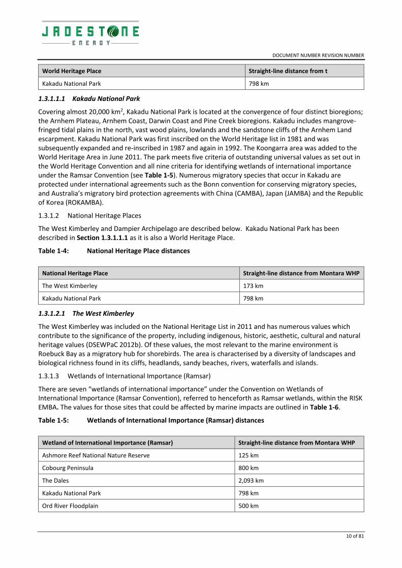
Although it will not receive floating/entrained/dissolved oil above threshold, Kakadu National Park has been described as there is the potential for shoreline loading along its coastal boundaries, making this within the RISK EMBA (Table 1-3).
Table 1-3: World Heritage place distance to the Montara Development Facility
DOCUMENT NUMBER REVISION NUMBER
10 of 81
World Heritage Place Straight-line distance from t
Kakadu National Park 798 km
1.3.1.1.1 Kakadu National Park
Covering almost 20,000 km2, Kakadu National Park is located at the convergence of four distinct bioregions; the Arnhem Plateau, Arnhem Coast, Darwin Coast and Pine Creek bioregions. Kakadu includes mangrove-fringed tidal plains in the north, vast wood plains, lowlands and the sandstone cliffs of the Arnhem Land escarpment. Kakadu National Park was first inscribed on the World Heritage list in 1981 and was subsequently expanded and re-inscribed in 1987 and again in 1992. The Koongarra area was added to the World Heritage Area in June 2011. The park meets five criteria of outstanding universal values as set out in the World Heritage Convention and all nine criteria for identifying wetlands of international importance under the Ramsar Convention (see Table 1-5). Numerous migratory species that occur in Kakadu are protected under international agreements such as the Bonn convention for conserving migratory species, and Australia’s migratory bird protection agreements with China (CAMBA), Japan (JAMBA) and the Republic of Korea (ROKAMBA).
1.3.1.2 National Heritage Places
The West Kimberley and Dampier Archipelago are described below. Kakadu National Park has been described in Section 1.3.1.1.1 as it is also a World Heritage Place.
Table 1-4: National Heritage Place distances
National Heritage Place Straight-line distance from Montara WHP
The West Kimberley 173 km
Kakadu National Park 798 km
1.3.1.2.1 The West Kimberley
The West Kimberley was included on the National Heritage List in 2011 and has numerous values which contribute to the significance of the property, including indigenous, historic, aesthetic, cultural and natural heritage values (DSEWPaC 2012b). Of these values, the most relevant to the marine environment is Roebuck Bay as a migratory hub for shorebirds. The area is characterised by a diversity of landscapes and biological richness found in its cliffs, headlands, sandy beaches, rivers, waterfalls and islands.
1.3.1.3 Wetlands of International Importance (Ramsar)
There are seven “wetlands of international importance” under the Convention on Wetlands of International Importance (Ramsar Convention), referred to henceforth as Ramsar wetlands, within the RISK EMBA. The values for those sites that could be affected by marine impacts are outlined in Table 1-6.
Table 1-5: Wetlands of International Importance (Ramsar) distances
Wetland of International Importance (Ramsar) Straight-line distance from Montara WHP
Ashmore Reef National Nature Reserve 125 km
Cobourg Peninsula 800 km
The Dales 2,093 km
Kakadu National Park 798 km
Ord River Floodplain 500 km

DOCUMENT NUMBER REVISION NUMBER
11 of 81
Pulu Keeling National Park 2,963 km
Hosnies Spring 2,093 km
There are a number of key management principles applicable to Ramsar wetlands. Contracting parties of the Ramsar Convention are expected to manage their Ramsar Sites as to maintain their ecological character and retain their essential functions and values for future generations. Preventing, stopping and reversing the loss and degradation is one of the priority areas of focus for the Ramsar Convention over 2016-2025.
The most significant threats to the ecological character of these sites are identified to be from seismic surveys, drilling activities, oil spills, mineral resource recovery and exploration. However, the majority of these impacts are recognised to be localised and short-term and would therefore only be relevant if development occurs in close proximity to the reserve.
Management goals include protecting the reserves from extractive commercial activity and minimising potential impact on the natural features of the reserve from exploration and extraction activities in the region. Relevant management strategies include prohibition of mining operations (including mineral and petroleum exploration and development) within the reserve and continuing to liaise with relevant departments and agencies in relation to proposals for exploration and extraction in the vicinity of the reserve.

DOCUMENT NUMBER REVISION NUMBER
12 of 81
Table 1-6: Description of Ramsar Wetlands of International Importance within the RISK EMBA
Ramsar Wetland
Ecological Characteristics Relevant Management Documents
Ashmore Reef Marine Park Ramsar site
- All wetland types present are in near natural condition
- Supports 64 internationally and nationally threatened species
- Supports 47 waterbird species listed as migratory under international treaties, plus breeding of 20 waterbird species
- Important feeding site for three turtle species and critical nesting and inter-nesting habitats for two turtle species
- Regularly supports more than 20,000 waterbirds and has been known to support more than 65,000 waterbirds
- Regularly supports > 1% of at least six species of waterbirds
Environment Australia (2002)
DoNP (2018a)
Ashmore Reef Commonwealth Marine Reserve Ramsar site Ecological Character Description (Hale and Butcher, 2013)
Cobourg Peninsula Ramsar site
- Covers an area of 2,207 km2
- Wetlands represent some of the better protected and near-natural wetlands in the bioregion
- Diverse array of wetland in a confined area
- Supports 14 nationally or internationally endangered or vulnerable marine fauna species
- Supports a diverse assemblage of flora and fauna species, plus almost all Ramsar wetland types known to occur within the bioregion
- Provides nesting habitat for significant populations of marine turtles and habitat for several cetaceans
- Supports significant seabird breeding colonies and important feeding and nesting habitat for migratory shorebirds (including 37 species listed under migratory bird agreements)
- Provides a wide range of habitats, feeding areas, dispersal and migratory pathways and spawning sites for numerous fish species of direct and indirect fisheries significance, plus crustaceans
Ecological Character Description for Cobourg Peninsula Ramsar Site (Cobourg Peninsula Sanctuary and Marine Park Board and Parks and Wildlife Service of the Northern Territory 2011)
The Dales - Located on Christmas Island, the Dales Ramsar site is located within the Christmas Island National Park, with the western boundary of the site extending to 50 m seaward from the low water mark (including a narrow, shallow reef)
- System of seven watercourses that contain a number of wetland types
- Exhibits unusual water-related limestone deposition features, including a 'flowstone' formation that is usually found underground
- supports a wide diversity of endemic and threatened species (Director of National Parks 2014)
The Dales Ramsar site Ecological Character Description (2010)
Christmas Island NP Management Plan 2014-2024

DOCUMENT NUMBER REVISION NUMBER
13 of 81
Ramsar Wetland
Ecological Characteristics Relevant Management Documents
- Migrating red crabs pass through the area on their annual breeding
- Provides critical habitat for blue crabs that are dependent upon the freshwater streams for their reproductive cycle
- Supports endemic fauna species including the Abbott’s booby, blue crabs and forest birds (Director of National Parks 2014)
Hosnies Spring Located on Christmas Island, Hosnies Spring is a small area of shallow freshwater streams and seepages 20-45 metres above sea-level on the shore terrace of the east coast of the island. The Ramsar site consists of a stand of two species of mangroves of the usually tidal genus Bruguiera. The Ramsar site includes surrounding terrestrial areas with rainforest grading to coastal scrub, and includes an area of shoreline and coral reef.
Species and height of individual trees present rare and height above sea level unusual.
Provides habitat for the protected blue crab
Hosnies Spring Ecological Character Description (2010)
Christmas Island NP Management Plan 2014-2024
Kakadu National Park
- A mosaic of contiguous wetlands comprising the catchments of two large river systems, the East and South Alligator rivers, seasonal creeks and the lower reaches of the East Alligator River. It also includes the Magela Creek floodplain, the lower South Alligator floodplain, virtually the entire West Alligator River system and nearly all the Wildman River system - Comprises sandstone plateau communities, escarpments, extensive seasonal floodplains, estuaries, tidal flats and offshore islands. The rivers are tidal in their lower reaches and are associated with extensive tidal flats formed from riverborne mud - The Wildman, West Alligator and East Alligator rivers support bands of mangrove forest along their tidal reaches
- During the dry season water contracts into lagoons and billabongs and up to two million waterbirds accumulate on the floodplains
- At least 53 species of waterbirds use the Ramsar site including large concentrations of magpie geese and wandering whistling-duck. These and many other species breed in the wetlands but most species are dry season migrants. - Both freshwater and saltwater crocodiles are known to breed within the Ramsar site
- 59 fish species are known from the wetland, including eight with narrowly restricted ranges - The area has significant cultural and heritage value. Kakadu has been home to Indigenous people for more than 50,000 years, and during that time the land and their culture have become intertwined
Kakadu National Park Management Plan (2016-2026)
Ord River Floodplain
- Floodplain and estuarine wetland system
- The site includes the Ord River Estuary leading into the Cambridge Gulf
- The north-east end of the site heads around the coast to include a series of extensive intertidal creeks and flats known as the False Mouths of the Ord
Ecological Character description of the Ord River Floodplain Ramsar Site (2008)

DOCUMENT NUMBER REVISION NUMBER
14 of 81
Ramsar Wetland
Ecological Characteristics Relevant Management Documents
- The upstream portion of the floodplain and river tends to be freshwater, and becomes more saline as the river approaches the Cambridge Gulf and falls under tidal influence - Mangroves are the most common vegetation in the site, extending from the False Mouths of the Ord to the upstream sections of the estuary
The mangroves form narrow fringes along the intertidal areas, with saltmarsh on higher ground. The intertidal mangroves support many species of birds and bats, and are a breeding area for banana prawns - Over 200 species of birds have been recorded within the site including waterfowl, migratory shorebirds, mangrove birds and terrestrial species
- The wetlands are habitat for many diadromous fish species (that require migration between marine and more freshwater environments some time during their life), including the nationally threatened species freshwater sawfish, green sawfish and northern river shark
Pulu Keeling National Park
- Pulu Keeling National Park protects the natural and cultural values of the 122 ha North Keeling Island and its surrounding marine waters, within a roughly rectangular boundary framing 2,602 ha of land and sea. The entire park is listed as a Ramsar wetland
- Fifteen species of birds recorded on the Island are listed under international migratory bird agreements and 15 seabird species use the atoll for nesting. The breeding colony of the dominant bird species, the red-footed booby, is one of the largest in the world. It is also the main locality of the endemic Cocos buff-banded rail
- The Ramsar site supports three endemic species: the Cocos buff-banded rail; the Cocos sub-species of Pandanus tectorius; and the angelfish, which is only recorded from Christmas and the Cocos (Keeling) Islands. In addition, Pulu Keeling National Park supports a number of species of plant and animal that are not recorded in the southern atoll islands
- Relatively pristine ecosystems and habitat of high significance for Indian Ocean seabirds, playing a vital part in the stability of the Indian Ocean seabird biota
- One of the largest known nesting habitats for the red-footed booby in the world
- The park is a listed for its natural and cultural heritage significance as a place on the Commonwealth Heritage List under the EPBC Act because of the park’s importance in the course, or pattern, of Australia’s natural or cultural history
- Possession of uncommon, rare or endangered aspects of Australia’s natural or cultural history
- Potential to yield information that will contribute to an understanding of Australia’s natural or cultural history and importance in demonstrating the principal characteristics of a class of Australia’s natural or cultural places or a class of Australia’s natural or cultural environments
Pulu Keeling National Park Management Plan 2015 - 2025

DOCUMENT NUMBER REVISION NUMBER
15 of 81
Ramsar Wetland
Ecological Characteristics Relevant Management Documents
- The park is categorised as IUCN Ia and IIa
- Green turtles nest on the island and hawksbill turtles (inhabit the waters of the park. The only species of sea snake recorded from the southern atoll is the yellow-bellied sea-snake
- There are no known cetaceans that are restricted to Pulu Keeling National Park, but two species of dolphin (Common dolphin and the Bottlenose dolphin) are regularly seen in the park

DOCUMENT NUMBER REVISION NUMBER
16 of 81
1.3.1.4 Commonwealth Marine Areas
The RISK EMBA are within the Australian EEZ, Territorial Sea and the Extended Continental Shelf Commonwealth Marine Areas. The Commonwealth marine area is “any part of the sea, including the waters, seabed, and airspace, within Australia's exclusive economic zone and/or over the continental shelf of Australia, that is not State or Northern Territory waters” (EPBC Act 1999). Commonwealth marine areas are Matters of National Environmental Significance under the EPBC Act.
An action is likely to have a significant impact on the environment in a Commonwealth marine area if there is a real chance or possibility that the action will:
• Result in a known or potential pest species becoming established in the Commonwealth marine area;
• Modify, destroy, fragment, isolate or disturb an important or substantial area of habitat such that an adverse impact on marine ecosystem functioning or integrity in a Commonwealth marine area results;
• Have a substantial adverse effect on a population of a marine species or cetacean including its life cycle (for example, breeding, feeding, migration behaviour, life expectancy) and spatial distribution;
• Result in a substantial change in air quality or water quality (including temperature) which may adversely impact on biodiversity, ecological integrity; social amenity or human health;
• Result in persistent organic chemicals, heavy metals, or other potentially harmful chemicals accumulating in the marine environment such that biodiversity, ecological integrity, social amenity or human health may be adversely affected; or
• Have a substantial adverse impact on heritage values of the Commonwealth marine area, including damage or destruction of an historic shipwreck.
1.3.1.5 Threatened Ecological Communities
One Threatened Ecological Community (TEC), the Monsoon Vine Thicket on the Coastal Sand Dunes of Dampier Peninsula (Table 1-7Error! Reference source not found.), was identified by the PMST search of the RISK EMBA (Appendix G).
Table 1-7: TEC distances
TEC Straight-line distance from Montara WHP
Monsoon vine thickets on the coastal sand dunes of Dampier Peninsula
432 km
1.3.1.5.1 Monsoon Vine Thicket on the Coastal Sand Dunes of Dampier Peninsula
Monsoon vine thicket occurs as semi - deciduous and evergreen vine thicket communities of coastal Holocene sand dunes on the Dampier Peninsula in the Kimberley Region, covering an area of ~2,500 ha from Broome in the south to One Arm Point in the north, and on the north-eastern coast of the Peninsula from One Arm Point to Goodenough Bay (DSEWPaC 2013a). The community is predominantly restricted to the leeward slopes and swales of coastal sand dunes but occasionally found on dune crests and other coastal landforms such as beaches, sand-spit headlands and storm ridges with intertidal flats (Black et al. 2010).
It represents the most southern occurrences of rainforest type vegetation in WA. The most common canopy forming species are Bauhinia cunninghammi (jigal, joomoo), Celtis philippensis (goolnji), Diospyros humilis (ebony wood), Exocarpos latifolius (jarnba, mistletoe tree), Grewia breviflora (goolmi, currant/coffee fruit), Mallotus nesophilus (yellow ball flower), Mimusops elengi (joongoon, mamajen), Sersalisia sericea (mangarr), Terminalia ferdinandiana (gabiny, gubinge, kabiny) and Terminalia petiolaris (blackberry tree, marool, narwulu) (DSEWPaC 2013a).

DOCUMENT NUMBER REVISION NUMBER
17 of 81
The extent of the ecological community corresponds to the traditional lands of the Bardi Jawi, Djabera Djabera, Goolarabaloo, Jabirr Jabirr, Nyul Nyul and Yawuru Indigenous people and is of cultural significance. It is listed as Endangered under the EPBC Act (Government of Western Australia 2010; DoEE 2016b) and described in the Approved Conservation Advice for the monsoon vine thickets on the coastal sand dunes of Dampier Peninsula (DSEWPaC 2013a); and, as Vulnerable in the Interim Recovery Plan 2018-2023 for the Monsoon vine thickets on the coastal sand dunes of Dampier Peninsula (DBCA, 2018). This community is also subject to the Threat abatement plan for disease in natural ecosystems caused by Phytophthora cinnamomi (DoE 2014c).
1.3.2 Listed Threatened and Migratory Species
The PMST search of the RISK EMBA (Appendix G) identified 92 Listed Threatened Species (LTS) and 88 Listed Migratory Species (LMS).
The Listed Threatened Species included:
• 23 species of mammals (four marine species relevant to impact assessment);
• 16 species of reptiles (eight marine species relevant to impact assessment);
• Eight shark species; and,
• 33 avifauna species (14 marine or inter-tidal species relevant to impact assessment).
The Listed Migratory species (LMS) included:
• 17 Migratory Marine avifauna;
• 36 Migratory Wetland avifauna; and,
• 29 Migratory Marine species.
The relevant sections of this Appendix discuss the likelihood of these species and their biologically important areas occurring within the RISK EMBA. Those species that have been identified as likely to be present in the RISK EMBA are detailed in the sections below.
Sensitive habitat areas such as an aggregation, resting or feeding or known migratory routes for these species are shown as Biologically Important Areas (BIAs). Relevant management for the species are described below and in Section 3 of the EP such as:
• Recovery plans
• Conservation advice; or
• Threat abatement plan for the impacts of marine debris on vertebrate marine life (DoEE 2018a).
The requirements of the species recovery plans and conservation advices are considered to identify any requirements that may be applicable to the risk assessment in the event of an unplanned hydrocarbon spill.
1.3.3 Others Matters Protected by the EPBC
Listed Marine Species
A total of 163 Listed Marine Species are either likely to, or may, occur within the RISK EMBA, including:
• 76 avifauna species;
• 30 cetacean species;
• One mammal species;
• 52 fish species; and
• 34 reptile species.

DOCUMENT NUMBER REVISION NUMBER
18 of 81
Whales and Other Cetaceans
The Protected Matters search determined that 30 cetacean species or their habitat, may occur within the RISK EMBA. Threatened species of whales and cetaceans occurring in the RISK EMBA are discussed in Section 1.4.6.
Commonwealth Land
The RISK EMBA intersect with nine Commonwealth land sites, including four Defence sites.
Commonwealth Heritage Places
Six natural Commonwealth Heritage Places are found in the RISK EMBA (Table 1-8). These locations are Marine Parks and are discussed in previous MNES sections.
Table 1-8: Commonwealth Heritage Place distances
Commonwealth Heritage Place Straight-line distance from Montara WHP
Ashmore Reef National Nature Reserve 125 km
Christmas Island Natural Areas 2,077 km
Mermaid Reef – Rowley Shoals 712 km
Scott Reef and Surrounds – Commonwealth Area 321 km
North Keeling Island 2,963 km
Yampi Defence Area 220 km
1.3.4 Australian Marine Parks (AMPs)
10 Australian Marine Parks (AMPs) exist within the RISK EMBAError! Reference source not found..
Marine parks are managed under management plans which provide the rules about what activities can and cannot occur within marine park zones. Petroleum titleholders must ensure that their offshore environment plans are consistent with the zoning and rules that apply to mining operations in marine parks, as described in the management plans. They must also ensure that impacts on the representative values of the parks will be of an acceptable level and managed to as low as reasonably practicable (ALARP) (NOPSEMA 2018). A summary of conservation values and management principles for marine parks found within the RISK EMBA is provided in Table 1-9 and Figure 1-3.

DOCUMENT NUMBER REVISION NUMBER
19 of 81
Figure 1-3: Australian Marine Parks within the RISK EMBA

DOCUMENT NUMBER REVISION NUMBER
20 of 81
Table 1-9: Description of Australian Marine Parks within the RISK EMBA
Australian Marine Park
Distance from Montara WHP
Description and Key Features of Conservation Significance IUCN Zone within EMBA
Rules/Requirements
Ashmore Reef 125 km - Atoll-like structure with three low vegetated islands, sandbanks, lagoon areas, and surrounding reef
- largest of only three emergent oceanic reefs present in the north-eastern Indian Ocean
- Only oceanic reef in the region with vegetated islands
- The Ashmore Reef Ramsar site is located within the boundary of the Marine Park. The site was listed under the Ramsar Convention in 2002 (site 1220) and is a wetland of international importance under the EPBC Act
- Reef covers an area of 227 km2
- Encompasses ecosystems, habitats and communities associated with the North-West Shelf, Timor Province, and emergent oceanic reefs
- World’s highest recorded abundance and diversity of sea snakes (DSEWPaC 2012c)
- Important biological stepping-stone facilitating transport of biological material to the reef systems along the WA coast
- Critical nesting and inter-nesting habitat for green turtles on all three islands (DoE 2015a)
- Moderate nesting habitat for hawksbill turtles (Whiting and Guinea 2005; Guinea 2013)
- Low nesting activity by loggerhead turtles (single report of nesting on West Island; Whiting and Guinea 2005)
- Large and significant feeding populations of green, hawksbill and loggerhead turtles occur around the reefs
- Supports a range of pelagic and benthic marine species
Sanctuary (1a)
Recreational (IV)
North-west Marine Parks Network Management Plan (DoNP 2018a)
Sanctuary Zone (IUCN category Ia)—managed to conserve ecosystems, habitats and native species in as natural and undisturbed a state as possible
The zone allows only authorised scientific research and monitoring
Emergency response permitted

DOCUMENT NUMBER REVISION NUMBER
21 of 81
Australian Marine Park
Distance from Montara WHP
Description and Key Features of Conservation Significance IUCN Zone within EMBA
Rules/Requirements
- Seagrass supports a small dugong population of less than 50 individuals that breeds and feeds around the reef (Whiting and Guinea 2005)
- Reef is highly diverse, particularly for corals and molluscs,
supporting the highest number of coral species of any reef off the west Australian coast (DSEWPaC 2012b)
- Migratory pathway for pygmy blue whales
- Islands support some of the most important seabird rookeries on the North West Shelf, including colonies of bridled terns, common noddies, brown boobies, eastern reef egrets, frigatebirds, tropicbirds, red-footed boobies, roseate terns, crested terns and lesser crested terns (DoEE 2018c)
- Important seabird rookery and staging/feeding areas for many migratory seabirds, including 43 species listed on one or both of the China– Australia Migratory Bird Agreement (CAMBA) and the Japan– Australia Migratory Bird Agreement (JAMBA)
- Cultural and heritage sites including Indonesian artefacts and grave sites
- Two KEFs: Ashmore Reef and Cartier Island and surrounding Commonwealth waters and Continental Slope Demersal Fish Communities
- Subject to the Memorandum of Understanding between Australia and Indonesia (MoU Box)
- Indigenous Australians
Sea country is valued for Indigenous cultural identity, health and wellbeing. Across Australia, Indigenous people have been sustainably using and managing their sea country for tens of thousands of years. At the commencement of this plan there is limited information about the cultural significance of this Marine Park
- Indonesian

DOCUMENT NUMBER REVISION NUMBER
22 of 81
Australian Marine Park
Distance from Montara WHP
Description and Key Features of Conservation Significance IUCN Zone within EMBA
Rules/Requirements
The Marine Park contains Indonesian artefacts and grave sites and Ashmore lagoon is still accessed as a rest or staging area for traditional Indonesian fishers travelling to and from fishing grounds within the MoU Box
No international or national heritage listings apply to the Marine Park at commencement of the management plan (DoNP 2018a)
- Commonwealth heritage
Ashmore Reef was listed on the Commonwealth Heritage List in 2004, meeting Commonwealth heritage listing criteria A, B and C
Tourism, recreation and scientific research are important activities in the Marine Park. These activities contribute to the wellbeing of regional communities and the prosperity of the nation
Cartier Island 84 km - The Marine Park includes an unvegetated sand island (Cartier Island), mature reef flat, a small, submerged pinnacle (Wave Governor Bank), and two shallow pools to the north-east of the island
- Covers an area of 172 km2
- Encompasses ecosystems, habitats and communities associated with the Timor Province (Director of National Parks 2018a)
- Internationally significant for its abundance and diversity of sea snakes (DSEWPaC 2012b)
- Important biological stepping stone facilitating the transport of biological material to the reef systems along the WA coast
- Large and significant populations of green, hawksbill and loggerhead turtles occur around the reefs (interesting and feeding habitat), with a significant population of nesting green turtles (DSEWPaC 2012b)
- Important seabird rookery and staging/feeding areas for many migratory seabirds
Sanctuary Zone (1a)
Sanctuary Zone (IUCN category Ia)—managed to conserve ecosystems, habitats and native species in as natural and undisturbed a state as possible.
The zone allows only authorised scientific research and monitoring.
DoNP (2018a)

DOCUMENT NUMBER REVISION NUMBER
23 of 81
Australian Marine Park
Distance from Montara WHP
Description and Key Features of Conservation Significance IUCN Zone within EMBA
Rules/Requirements
- Supports colonies of bridled terns, common noddies, brown boobies, eastern reef egrets, frigatebirds, tropicbirds, red-footed boobies, roseate terns, crested terns and lesser crested terns (DoE 2015b)
- Supports a range of pelagic and benthic marine species
- High diversity and abundance of hard and soft corals, gorgonians (sea fans), sponges and a range of encrusting organisms
- Reef crests are generally algal dominated
- Reef flats feature ridges of coral rubble and large areas of seagrass (Director of National Parks 2018a)
- Foraging habitat for whale sharks (DoEE 2018b)
- Two KEFs: Ashmore Reef and Cartier Island and surrounding Commonwealth waters and Continental Slope Demersal Fish Communities
- Cultural and heritage site of the Ann Millicent historic shipwreck
- Subject to the Memorandum of Understanding between Australia and Indonesia (MoU Box)
- Sea country is valued for Indigenous cultural identity, health and wellbeing. Across Australia, Indigenous people have been sustainably using and managing their sea country for tens of thousands of years. At the commencement of the management plan (DoNP 2018a), there is limited information about the cultural significance of this Marine Park.
- Scientific research is an important activity in the Marine Park
Oceanic Shoals
162 km - Covers an area of 72,000 km2
- Examples of the ecosystems of the Northwest Shelf Transition Province and the Timor Transition Province
- Important internesting area for flatback and olive ridley turtles
- Important foraging area for loggerhead and olive ridley turtles (DoEE 2018b)
National Park (II)
Multiple Use (VI)
Habitat Protection (IV)
The objective of the National Park Zone (II) is to provide for the protection and conservation of ecosystems, habitats and native species in as natural a state as possible

DOCUMENT NUMBER REVISION NUMBER
24 of 81
Australian Marine Park
Distance from Montara WHP
Description and Key Features of Conservation Significance IUCN Zone within EMBA
Rules/Requirements
- BIAs include foraging and internesting habitat for marine turtles, particularly the threatened flatback turtle and olive ridley turtle
- Four KEFs: carbonate bank and terrace system of the Van Diemen Rise; carbonate banks of the Joseph Bonaparte Gulf; pinnacles of the Bonaparte Basin; and shelf break and slope of the Arafura Shelf
Special Purpose [Trawl] (VI)
The objective of the Multiple Use Zone (VI) is to provide for ecologically sustainable use and the conservation of ecosystems, habitats and native species
DoNP (2018a)
Argo-Rowley Shoals
464 km - Covers an area of 146,099 km2
- Important foraging areas for migratory seabirds and the endangered loggerhead turtle (DoE 2016a)
- Important area for sharks, which are found in abundance around the Rowley Shoals relative to other areas in the region (DoE 2016a)
- Provides protection for the communities and habitats of the deeper offshore waters of the region in depth ranges from 220 m to over 5,000 m
- Provides connectivity between the existing Mermaid Reef Marine National Nature Reserve and reefs of the WA Rowley Shoals Marine Park and the deeper waters of the region
- 2 KEFs: The canyons linking the Argo Abyssal Plain with the Scott Plateau and Mermaid Reef and the Commonwealth waters surrounding Rowley Shoals
- Sea country is valued for Indigenous cultural identity, health and wellbeing. Across Australia, Indigenous people have been sustainably using and managing their sea country for tens of thousands of years. At the commencement of the management plan (DoNP 2018a) there is limited information about the cultural significance of this Marine Park
- Commercial fishing and mining are important activities in the Marine Park. These activities contribute to the wellbeing of regional communities and the prosperity of the nation
- No international, Commonwealth or national listings apply to the Marine Park
Multiple Use (VI)
National Park (II)
Special Purpose [Trawl] (VI)
Multiple Use Zone (IUCN category VI)—managed to allow ecologically sustainable use while conserving ecosystems, habitats and native species. The zone allows for a range of sustainable uses, including commercial fishing and mining where they are consistent with park value.
The objective of the Special Purpose Zone (Trawl) (VI) is to provide for ecologically sustainable use and the conservation of ecosystems, habitats and native species, while applying special purpose management arrangements for specific activities.
The objective of the National Park Zone (II) is to provide for the protection and conservation of ecosystems,

DOCUMENT NUMBER REVISION NUMBER
25 of 81
Australian Marine Park
Distance from Montara WHP
Description and Key Features of Conservation Significance IUCN Zone within EMBA
Rules/Requirements
- Historic shipwrecks:
The Marine Park contains two known shipwrecks listed under the Historic Shipwrecks Act 1976: Alfred (wrecked in 1908) and Pelsart (wrecked in 1908)
habitats and native species in as natural a state as possible.
DoNP (2018a)
Kimberley 108 km - Covers an area of 74,500 km2
- The Wunambal Gaambera, Dambimangari, Bardi Jawi and the Nyul Nyul people’s sea country extends into the Kimberley Marine Park and supports key cultural values and future socio-economic opportunities
- Provides connectivity between deeper offshore waters, and the inshore waters of the adjacent WA North Kimberley Marine Park and Lalang-garram/Camden Sound Marine Park
- Breeding and foraging habitat for seabirds
- Internesting and nesting habitat for marine turtles
- Breeding, calving and foraging habitat for inshore dolphins
- Calving, migratory pathway and nursing habitat for humpback whales
- Migratory pathway for pygmy blue whales
- Foraging habitat for dugong
- Foraging habitat for whale sharks
- Adjacent to important foraging and pupping areas for sawfish and important nesting sites for green turtles (DoE 2016a)
- 2 KEFs: the ancient coastline at the 125-m depth contour and continental slope demersal fish communities
- No international, Commonwealth or national heritage listings apply to the Marine Park at commencement of the management plan (DoNP 2018a), however the Marine Park is adjacent to the national heritage place of The West Kimberley
- Historic shipwrecks
Multiple Use (VI)
Habitat Protection (IV)
National Park (II)
Multiple Use Zone (IUCN category VI)—managed to allow ecologically sustainable use while conserving ecosystems, habitats and native species. The zone allows for a range of sustainable uses, including commercial fishing and mining where they are consistent with park value
The objective of the Habitat Protection Zone (IV) is to provide for the conservation of ecosystems, habitats and native species in as natural a state as possible, while allowing activities that do not harm or cause destruction to seafloor habitats.
The objective of the National Park Zone (II) is to provide for the protection and conservation of ecosystems, habitats and native species in as natural a state as possible
DoNP (2018a)

DOCUMENT NUMBER REVISION NUMBER
26 of 81
Australian Marine Park
Distance from Montara WHP
Description and Key Features of Conservation Significance IUCN Zone within EMBA
Rules/Requirements
The Marine Park contains more than 40 known shipwrecks listed under the Historic Shipwrecks Act 1976
- Tourism, commercial fishing, mining, recreation, including fishing, and traditional use are important activities in the Marine Park. These activities contribute to the wellbeing of regional communities and the prosperity of the nation
Arafura 900 km - Covers an area of 22,924 km2
- Examples of the ecosystems of the Northern Shelf Province and the Timor Transition Province
- Important internesting area for flatback, green, hawksbill and olive ridley turtles
- Important foraging habitat for breeding aggregations of the migratory roseate tern (DoNP 2018b)
- One KEF: Tributary Canyons of the Arafura Depression
Multiple Use (IV), Special Purpose (VI [Trawl]) and Special Purpose (VI)
Multiple Use Zone (IUCN category VI)—managed to allow ecologically sustainable use while conserving ecosystems, habitats and native species. The zone allows for a range of sustainable uses, including commercial fishing and mining where they are consistent with park value
The objective of the Special Purpose Zone (Trawl) (VI) is to provide for ecologically sustainable use and the conservation of ecosystems, habitats and native species, while applying special purpose management arrangements for specific activities
The objective of the Special Purpose Zone (IUCN VI) is to protect the area with sustainable use of its natural resources and managed mainly

DOCUMENT NUMBER REVISION NUMBER
27 of 81
Australian Marine Park
Distance from Montara WHP
Description and Key Features of Conservation Significance IUCN Zone within EMBA
Rules/Requirements
for the sustainable use of natural ecosystems
Environment Australia (2002)
DoNP (2018b)
Mermaid Reef 700 km - Covers an area of 540 km2
- National and international significance due to its pristine character, coral formations, geomorphic features and diverse marine life
- Key area for over 200 species of hard corals and 12 classes of soft corals with coral formations in pristine condition
- Important areas for sharks including the grey reef shark, the whitetip reef shark and the silvertip whaler
- Important foraging area for marine turtles
- Important area for toothed whales, dolphins, tuna and billfish
- Important resting and feeding sites for migratory seabirds
National Park (II)
The objective of the National Park Zone (II) is to provide for the protection and conservation of ecosystems, habitats and native species in as natural a state as possible
Environment Australia (2002)
DoNP (2018a)
Joseph Bonaparte Gulf
409 km - Covers an area of 8,600 km2
- Examples of the shallow water ecosystems and communities of the Northwest Shelf Transition Province
- Contains a number of prominent shallow seafloor features, including an emergent reef system, shoals and sand banks
- Provides connectivity between the sea and nearshore environments, such as the Ord River floodplain, as well as the adjacent North Kimberley Marine Park
- Important foraging area for threatened and migratory marine turtles (green and olive ridley) (DoNP 2018b)
- Significant year-round flatback turtle nesting at Turtle Point (Chatto and Baker 2008)
- Important foraging area for Australian snubfin dolphin
Multiple Use (IV)
Special Purpose (VI)
Multiple Use Zone (IUCN category VI)—managed to allow ecologically sustainable use while conserving ecosystems, habitats and native species. The zone allows for a range of sustainable uses, including commercial fishing and mining where they are consistent with park value
The objective of the Special Purpose Zone (IUCN VI) is to protect the area with sustainable use of its natural

DOCUMENT NUMBER REVISION NUMBER
28 of 81
Australian Marine Park
Distance from Montara WHP
Description and Key Features of Conservation Significance IUCN Zone within EMBA
Rules/Requirements
- One KEF: Carbonate banks of the Sahul Shelf resources and managed mainly for the sustainable use of natural ecosystems
Environment Australia (2002)
DoNP (2018)
Arnhem 979 km - Covers an area of 7,125 km2
- Examples of the ecosystems of the Northern Shelf Province
- Important internesting area for the flatback turtle
- Important foraging habitat for breeding aggregations of the migratory bridled and roseate terns, and the listed marine crested tern
Special Purpose (VI)
The objective of the Special Purpose Zone (IUCN VI) is to protect the area with sustainable use of its natural resources and managed mainly for the sustainable use of natural ecosystems
Environment Australia (2002)
DoNP (2018b)
Wessel 1,354 km - Covers an area of 5,908 km2
- Examples of the ecosystems of the Northern Shelf Province
- Important internesting area for flatback, green, hawksbill and olive ridley turtles
- Important foraging habitat for breeding aggregations of the migratory common noddy and roseate tern, and the listed marine crested tern
- One KEF: Gulf of Carpentaria Basin
Habitat Protection (IV)
Special Purpose [Trawl] (VI)
The objective of the Habitat Protection Zone (IV) is to provide for the conservation of ecosystems, habitats and native species in as natural a state as possible, while allowing activities that do not harm or cause destruction to seafloor habitats
The objective of the Special Purpose Zone (Trawl) (VI) is to provide for ecologically sustainable use and the conservation of ecosystems, habitats and native species,

DOCUMENT NUMBER REVISION NUMBER
29 of 81
Australian Marine Park
Distance from Montara WHP
Description and Key Features of Conservation Significance IUCN Zone within EMBA
Rules/Requirements
while applying special purpose management arrangements for specific activities
Environment Australia (2002)
DoNP (2018b)
1.3.5 Other Areas of High Conservation Significance within the RISK EMBA
1.3.5.1 State and External Territory Reserves
51 State and Territory reserves are located within the RISK EMBA, eight of which are marine or coastal and relevant to potential impact assessment (Table 1-10 and Figure 1-4).

DOCUMENT NUMBER REVISION NUMBER
30 of 81
Figure 1-4

DOCUMENT NUMBER REVISION NUMBER
31 of 81
Table 1-10: Description of State and Territory Marine Parks within the RISK EMBA
State or External Territory Marine Parks
Straight-line distance from Montara
Key Features of Conservation Significance Rules/ Requirements
North Kimberley Marine Park (WA)
555 km - Covers an area of ~1,845,000 ha
- Comprises four separate management areas including, Uunguu, Balanggarra, Miriuwung Gajerrong and Wilinggin
- Recognised for its Aboriginal cultural and heritage values
- Natural values include coral reefs, marine turtle species, dugongs, seagrass and macroalgal communities, mangroves and saltmarshes, finfish, and water and sediment quality
- Social values include recreation, tourism and community values) and commercial values and resource use (e.g. commercial fishing) (DPaW 2016a)
North Kimberley Marine Park Joint Management Plan 2016 Uunguu, Balanggarra, Miriuwung Gajerrong, and Wilinggin management areas (Department of Parks and Wildlife 2016)
Browse Island Nature Reserve (WA)
193km - Small, approx. 14 ha uninhabited island
- Coral assemblages characteristic of coral platform reefs throughout the Indo-West Pacific region, particularly Cartier Island
- Coral diversity greatest on the reef faces and shallow lagoons but these areas were of very limited extent (URS 2010a)
- Nesting site for green turtles
- Seabird nesting site
- Fringing coral reefs with the waters around the island a site of upwelling associated with concentrations of tropical krill
- Nine historic shipwrecks (one on register of National Estate)
- Historical human impact from guano mining, lighthouse construction and introduction of house mice
- Surrounding waters visited by Indonesian fisherman
No MP in place
Christmas Island ~2500 km - An isolated oceanic island, approximately 135 km2 in area
- Rises steeply from the sea floor from depths of 5,000 m
Christmas Island National Park Management Plan (2014-2024)

DOCUMENT NUMBER REVISION NUMBER
32 of 81
State or External Territory Marine Parks
Straight-line distance from Montara
Key Features of Conservation Significance Rules/ Requirements
- National Park covers approximately 85 km2 (63%) of the island’s land area (Director of National Parks 2014).
- High level of endemism - 254 endemic species and 165 species occurring nowhere else in Australia (including 50 fish species)
- Whale sharks generally migrate through the island’s waters between November and April
- Waters surrounding the island are critical for the survival of the island’s land crabs, including tens of millions of red crabs, as they release their eggs into the sea as part of their breeding life cycle
- Two marine turtles listed as vulnerable under the EPBC Act, the green and hawksbill turtles, are found in the park’s waters and green turtles occasionally nest on Dolly Beach
- One of the world’s significant seabird islands
- More than 100 migrant and vagrant species have been recorded, including nine resident breeding seabird species (with three of these being endemic or endemic subspecies) and 23 vagrant/non-breeding seabirds
- Abbott's booby and the Christmas Island frigatebird have their only extant nesting habitat in the world on Christmas Island
- Fringing coral reefs and significant geomorphological features such as the island’s terraces and cave systems, including anchialine cave systems (caves containing a subterranean water body with connections to the ocean) which provide animal habitat
- The Dales and Hosnies Spring Ramsar wetlands
- High recreational value
Lalang-garram/ Horizontal Falls and North Lalang-garram Marine Parks
226 km Jointly managed by Dambimangari Traditional Owners and the Department of Parks and Wildlife (DPaW 2016)
- Included in the Australian National Heritage List for its nationally significant natural, indigenous and historic values (DoEE 2017c)
- The Lalang-garram/ Horizontal Falls Marine Park covers approximately 353,000 ha (DPaW 2016). The North Lalang-garram Marine Park covers approximately 110,000 ha (DPaW 2016)
- protects the internationally recognised Horizontal Falls and is important for the region’s tourism
DPaW 2016, Lalang-garram/ Horizontal Falls and North Lalang-garram marine parks joint management plan 2016. Management Plan 88. Department of Parks and Wildlife, Perth.

DOCUMENT NUMBER REVISION NUMBER
33 of 81
State or External Territory Marine Parks
Straight-line distance from Montara
Key Features of Conservation Significance Rules/ Requirements
- large tidal range results in extensive intertidal areas with diverse ecosystems such as fringing coral reefs, mangroves and mudflat communities
- critical foraging and nursery areas for dugong, marine turtles, estuarine crocodiles, snubfin and Indo-Pacific humpback dolphins, several species of sawfish and migratory seabirds
- a principal calving habitat for humpback whales (DPaW 2016)
Lalang-garram/Camden Sound
276 km - Located ~300 km north of Broome and lies within the traditional country of three Aboriginal native title groups; The Dambimangari people (majority of the marine park), Wunambal Gaambera people (includes a small portion of St George Basin) and Mayala people (southwest corner of the marine park) (DPaW 2013)
- Covers an area of approximately 705,000 ha
- Principal calving habitat of the humpback whale
- Important habitat for marine turtles, snubfin and Indo-Pacific humpback dolphins, dugong, saltwater crocodiles, and several species of sawfish
- Wide range of marine habitats and associated marine life, such as coral reef communities, rocky shoals, and the extensive mangrove forests and marine life of the St George Basin and Prince Regent River (DPaW 2013)
Lalang-garram / Camden Sound Marine Park Management Plan
2013–2023 (Department of Parks and Wildlife 2013)
Rowley Shoals 744 km - ~300 km north-north-west of Broome
- Comprise three oceanic reef systems approximately 30–40 km apart (Mermaid Reef, Clerke Reef and Imperieuse Reef
- Intertidal and subtidal coral reefs, exceptionally rich and diverse marine fauna and high water quality - Lying in the headwaters of the Leeuwin Current, the Shoals are thought to provide a source of invertebrate and fish recruits for reefs further south and as such are regionally significant
Rowley Shoals Management Plan (DEC 2007b)
Garig Gunak Barlu/Coburg (NT)
797 km - Covers an area of 4,500 km2
- Contains a diverse marine habitat including coral reefs, rocky reefs, sand and mudflats, and areas of mangroves, seagrass and macroalgae
- 35 species of mangroves
Cobourg Marine Park Plan of Management (PWS 2011)

DOCUMENT NUMBER REVISION NUMBER
34 of 81
State or External Territory Marine Parks
Straight-line distance from Montara
Key Features of Conservation Significance Rules/ Requirements
- Seagrass habitats are key foraging areas for dugong and marine turtles
- Sandy beaches provide green and flatback turtle nesting areas
- Sandy Islands I and II provide important seabird rookery areas
Scott Reef Nature Reserve
314 km Scott Reef is a large, emergent shelf atoll located on the edge of the broad continental shelf, about 300 km from mainland north-western Australia. The listing comprises the areas of Scott Reef that are within Commonwealth waters to the 50 m BSL bathymetric contour. This includes North Reef, an annular reef, 16.3 km long and 14.4 km wide; and parts of the lagoon of South Reef, a crescent shaped reef 17 km across (DSEWPaC 2012b).
The place is regionally significant both because of its high representation of species not found in coastal waters off Western Australia and for the unusual nature of its fauna which has affinities with the oceanic reef habitats of the Indo-West Pacific as well as the reefs of the Indonesian region (DSEWPaC 2012b).
KEF and Commonwealth Marine

DOCUMENT NUMBER REVISION NUMBER
35 of 81
Figure 1-4: State and Territory Marine Parks and Marine Management Areas within the RISK EMBA

DOCUMENT NUMBER REVISION NUMBER
36 of 81
1.3.5.2 Key Ecological Features
The KEFs that intersect the RISK EMBA are described in Table 1-11 and their location is shown in Figure 1-5.
Table 1-11: Description of Key Ecological Features within the RISK EMBA
Key Ecological Feature Straight-line distance from Montara
Description and Values
Continental Slope Demersal Fish Communities
82 km
- Valued for its high degree of endemism as the diversity of demersal fish assemblages is high compared to elsewhere along the continental slope
Ashmore Reef and Cartier Island and Surrounding Commonwealth Waters
84 km - Regionally important for feeding and breeding aggregations of birds and other marine life
- Areas of enhanced primary productivity in an otherwise low-nutrient environment
- Ashmore Reef supports the highest number of coral species of any reef off the WA coast
Seringapatam Reef and Commonwealth Waters in the Scott Reef Complex
279 km - Coral communities occur across shallow (<30 m) and deep (>30 m) habitats
- 306 hard coral species from 60 genera and 14 families having been identified; all were predominantly widespread Indo–Pacific species (Gilmour et al. 2009)
- Coral species diversity comparable to other reefs in the region, such as Ashmore, Seringapatam and Mermaid Reef/Rowley Shoals
- Green turtle nesting at Sandy Islet (Guinea 2006)
- Shallow atoll reef forms an intertidal platform at low tide
High primary productivity relative to other parts of the region and coral communities are largely self-seeded and rely on the reproductive output of resident corals
- Relatively pristine and has a high species richness, which apply to both the benthic and pelagic habitats, attracting aggregations of marine life including whale and dolphin species
Canyons Linking the Argo Abyssal Plain with the Scott Plateau
540 km - Scott Plateau connects with the Argo Abyssal Plain via a series of canyons, the largest of which are the Bowers and Oates canyons (DSEWPaC 2012a)
- High productivity of the region is believed to be led by topographically induced water movements through the canyons and the action of internal waves in these canyons as well as around islands and reefs

DOCUMENT NUMBER REVISION NUMBER
37 of 81
Key Ecological Feature Straight-line distance from Montara
Description and Values
- The canyons are thought to be linked to small and periodic upwellings that enhance this biological productivity (DEWHA 2008c)
- The canyons are likely to be important features due to their historical association with sperm whale aggregations (DSEWPaC 2012a). Historical records indicate that the number of sperm whales was high. Although current numbers are unknown, it is possible that they congregate around the canyon heads, encouraged by the high biological productivity, supporting stocks of their prey (DEWHA 2008c)
- Anecdotal evidence that the Scott Plateau may be a breeding ground for sperm and beaked whales
- Likely that important demersal communities occur in the canyons, as they do in the Scott Plateau supported by the localised upwelling (DEWHA 2008c)
Mermaid Reef and Commonwealth Waters Surrounding Rowley Shoals
700 km - The Rowley Shoals are a group of three atoll reefs—Clerke, Imperieuse and Mermaid reefs—located ~300 km north-west of Broome
- Mermaid Reef lies 29 km north of Clerke and Imperieuse reefs and is totally submerged at high tide
- Regionally important in supporting high species richness, higher productivity and aggregations of marine life associated with the adjoining reefs themselves (Done et al. 1994)
- Contains 214 coral species and approximately 530 species of fishes (Gilmour et al. 2007), 264 species of molluscs and 82 species of echinoderms (Done et al. 1994; Gilmour et al. 2007)
- Both coral communities and fish assemblages differ from similar habitats in eastern Australia (Done et al. 1994)
Pinnacles of the Bonaparte Basin
284 km - The Pinnacles rise steeply from depths of ~80 m to within 30 m of the water surface. Supported communities include sessile benthic invertebrates, including hard and soft corals, sponges, whips, fans, bryozoans and aggregations of demersal fish species such as snappers, emperors and groupers
- Recognised as a unique seafloor feature and a biodiversity hotspot for sponges
Ancient Coastline at 125 m Depth Contour
57 km - A unique seafloor feature with ecological properties of regional significance
- Migratory pelagic species (e.g. humpback whales and whale sharks) may use this escarpment as a guide
- The topographic complexity of escarpments associated with this feature may facilitate vertical mixing of the water column, providing nutrient-rich localised environments

DOCUMENT NUMBER REVISION NUMBER
38 of 81
Key Ecological Feature Straight-line distance from Montara
Description and Values
Carbonate Bank and Terrace System of the Sahul Shelf
46 km - Regionally important because of its likely ecological role in enhancing biodiversity and local productivity relative to its surrounds
- Forms a unique seafloor feature, with banks that rise to at least 45 m, and to within 30 m water depth, allow light dependent organisms to thrive and support more biodiversity (Nichol et al. 2013; NERP 2014)
- Supports a high diversity of organisms including reef fish, sponges, soft and hard corals, gorgonians, bryozoans, ascidians and other sessile filter feeders
- The banks are known to be foraging areas for loggerhead, olive ridley and flatback turtles
- Cetaceans and green and largetooth sawfish are likely to occur in the area
Shelf Break and Slope of the Arafura Shelf
578 km - Situated in a major biogeographic crossroad where biota is largely affiliated with the Timor–Indonesian–Malay region
- Area is characterised by continental slope, patch reefs and hard substrate pinnacles
Carbonate Bank and Terrace System of the Van Diemen Rise
408 km - Unique seafloor feature with ecological properties of regional significance
- While reef-forming corals are sparse throughout the region, some locally dense hard corals can be found on the banks of the Van Diemen Rise. These include near threatened, vulnerable and endangered species on the IUCN Red List. Coral communities on the Van Diemen rise are believed to be genetically distinct from those elsewhere in northern Australia.
- Pelagic fish such as mackerel, red snapper and a distinct gene pool of gold band snapper are also found on the Van Diemen rise
Exmouth Plateau 1,302 km - Unique seafloor feature with ecological properties of regional significance, covering an area of 49,310 km2, located approximately 150 km northwest of Exmouth
- The plateau ranges in water depths from 800 to 4,000 m (Heap & Harris 2008 in DSEWPaC 2012)
- Serves an important ecological role by acting as a topographic obstacle that modifies the flow of deep waters that generate internal tides, causing upwelling of deeper water nutrients closer to the surface (Brewer et al. 2007)
- Sediments on the plateau suggest that biological communities include scavengers, benthic filter feeders and epifauna

DOCUMENT NUMBER REVISION NUMBER
39 of 81
Key Ecological Feature Straight-line distance from Montara
Description and Values
- Whaling records suggest that the Exmouth Plateau may have supported large populations of sperm whales (Bannister et al. 2007)
- Fauna in the pelagic waters above the plateau are likely to include small pelagic species and nekton (Brewer et al. 2007)
Tributary Canyons of the Arafura Depression
964 km - Valued for its high productivity, levels of endemism and biodiversity, and is located in the Timor Transition provincial bioregion
- The canyons are approximately 80–100 m deep and 20 km wide. The largest of the canyons extend some 400 km from Cape Wessel into the Arafura Depression (Heap et al. 2004)
- Almost all canyons in the NMR are located within this KEF and endemic benthic species are believed to occur there (Wilson 2005)
- Primary productivity likely to be associated with movements of water through the canyons and surface water circulation driven by seasonal north-west monsoon winds
- The steep topography of the canyons, their diverse current regimes, nutrient enrichment and entrapment, detritus funnelling and diverse substrate types form widely divergent ecosystems (McClain & Barry 2010; Vetter 1994; Vinogradova 1958) which, in combination with the regional setting and geological origins of the area, strongly influence species biodiversity (Kloser et al. 2010)
- Marine turtles (most likely olive ridleys) have been reported to feed in the vicinity of the canyons (Whiting et al. 2007)
Glomar Shoals 1,118 km - Submerged feature situated at a depth of 33–77 m, approximately 150 km north of Dampier on the Rowley Shelf (Falkner et al. 2009 in DSEWPaC 2012a)
- Consist of a high percentage of marine-derived sediments with high carbonate content and gravels of weathered coralline algae and shells (McLoughlin & Young 1985 in DSEWPaC 2012a)
- The area’s higher concentrations of coarse material compared to surrounding areas are indicative of a high energy environment subject to strong seafloor currents (Falkner et al. 2009 in DSEWPaC 2012a)
- Biological communities found at the Glomar Shoals have not been comprehensively studied, however the shoals are known to be an important area for a number of commercial and recreational fish species such as rankin cod, brown striped snapper, red emperor, crimson snapper, bream and yellow-spotted triggerfish. Catch rates at the

DOCUMENT NUMBER REVISION NUMBER
40 of 81
Key Ecological Feature Straight-line distance from Montara
Description and Values
Glomar Shoals are high, indicating that the area is a region of high productivity (Falkner et al. 2009, Fletcher & Santoro 2009 in DSEWPaC 2012a). It is unclear if the removal of non-target species due to the commercial fishing over the shoals is having an impact on its value (DSEWPaC 2012a).
- Regionally important for their potentially high biological diversity and localised productivity
- Biological data specific to the Glomar Shoals is limited, however the fish of the shoals are probably a subset of reef-dependent species and anecdotal evidence suggests they are particularly abundant (DSEWPaC 2012a)
Gulf of Carpenteria Basin 1,343 km - The Gulf of Carpentaria is believed to be one of the few remaining near-pristine marine environments in the world (Bustamante et al. 2010; Coles et al. 2004; Wightman et al. 2004)
- Primary productivity in the gulf’s basin is mainly driven by cyanobacteria that fix nitrogen (Burford et al. 2009), but is also strongly influenced by seasonal processes
- The soft sediments of the basin are characterised by moderately abundant and diverse communities of infauna and mobile epifauna dominated by polychaetes, crustaceans, molluscs and echinoderms
- Supports assemblages of pelagic fish species including planktivorous and schooling fish, and top predators such as shark, snapper, tuna and mackerel (Smith et al. 2006)
- Important migratory route for seabirds, shore birds and marine turtles

DOCUMENT NUMBER REVISION NUMBER
__________________________________________________________________________________
DOCUMENT TITLE 41 of 81
Figure 1-5: Key Ecological Features within the RISK EMBA

DOCUMENT NUMBER REVISION NUMBER
__________________________________________________________________________________
DOCUMENT TITLE 42 of 81
1.4 Biological environment – species and communities’ descriptions
1.4.1 Benthic habitats and communities
Regionally, the seabed generally comprises a relatively flat and featureless habitat, although numerous seamounts or banks can be found along the perimeter of the Australian continental shelf. The shoals and banks in the NWMR share a tropical marine biota consistent with that found on emergent reef systems of the Indo West Pacific region, such as Ashmore Reef, Cartier Island, Seringapatam Reef and Scott Reef. These support a diverse range of benthic communities; algae, soft corals, hard corals and filter feeders. Bare sand and consolidated reef supporting turfing algae are features of all shoals and banks in the Timor Sea. Hard corals and macroalgae tend to be variable in abundance, while soft corals and sponges are often present. All banks and shoals in the region support comparable levels of biodiversity but vary in the abundance and diversity of dominant species (Heyward et al. 1997; Moore et al 2017).
A benthic habitat assessment was undertaken in the area of Petroleum Production Licence AC/L7 during the 2010 wet season, which included the Montara field and surrounding areas (ERM 2011). Surveys were carried out using a towed video system and seabed sediment samples were also collected for sediment and macrobenthic fauna analysis. Benthic habitats surveyed were characterised by homogenous, flat, featureless soft sediment; predominately comprised of sand with small rubble/shell fragments and marked by low relief ripples with evidence of bioturbation. Sparse patches of epifauna were recorded and included hydroids, octocorals (soft corals, gorgonians and seapens), black corals and ascidians.
Macrobenthic faunal assemblages surveyed had a generally low and highly patchy abundance of individuals. Polychaete bristleworms from the Phylum Annelida contributed the highest relative abundance of macrobenthic assemblages across the surveyed area, ranging from approximately 40 to 60% followed by Malacostracan crustaceans (shrimps, crabs etc.; approximately 13 to 19%). Gastropoda was represented by 33 taxa across the surveyed area with abundance ranging from approximately 0.5 to 5% (ERM 2011).
Hydrozoa and Bryozoa were the other common groups encountered in samples. All other taxa identified across the surveyed areas were minor contributors to macrobenthic assemblages (relative abundance <5%) (ERM 2011).
Deep water soft sediment habitats are expected to be broadly similar in the wider EMBA to the surveyed locations in the Montara field and surrounding areas. In a study of benthic habitats on the continental shelf near the Big Bank Shoals (approximately 200 km to the northeast of the Operational Area) by Heyward et al. (1997), the predominant benthic infaunal species were polychaetes (burrowing worms) and crustaceans (prawns, shrimp, crabs, etc.). These two groups made up 84% of the total species in sediment samples with a high diversity of species but a low abundance of each individual species. The remaining 16% of species included echinoderms, such as sea stars, sea urchins, feather stars, molluscs, both gastropods and bivalves, nemerteans (ribbon worms), sponges and fish. Epibenthic communities were sparse and species commonly associated with soft sediment habitats included sponges, gorgonians such as sea whips and sea fans, ascidians such as sea squirts, echinoderms, crustaceans, bryozoans such as lace corals, and soft corals (Heyward et al. 1997). The absence of light and hard substrate is considered a limiting factor for recruitment of epibenthic organisms.
Windows of sensitivity are shown in Table 1-12. Key locations for types of benthic communities are shown in Table 1-13.

DOCUMENT NUMBER REVISION NUMBER
43 of 81
Table 1-12: Benthic habitat windows of sensitivities
Key
Peak times
Jan
uar
y
Feb
ruar
y
Mar
ch
Ap
ril
May
Jun
e
July
Au
gust
Sep
tem
be
r
Oct
ob
er
No
vem
be
r
De
cem
be
r
Key Ecosystems and Biological Resources
Coral: Spawning
Seagrass: Flowering and Fruiting
1.4.2 Banks and Shoals
There are around 150 shoal/bank features across the Sahul Shelf and a high level of interconnectivity exists between them. They are often 5 – 20 km apart, creating an extensive series of ‘stepping stone’ habitats for larval recruitment. The larval development rates of the species present, current speeds (20-30 km/day in mild weather) and the relatively short distance between the shoals, banks and reefs maintains this connectivity. As such, neighbouring shoals and banks (i.e. within 100s of kms) share ~>80% benthic community composition (Moore et al. 2017). The associated fish fauna is highly diverse but variable between shoals and banks but sharing of many species, which is influenced by depth, substrate, exposure to prevailing weather. Fish species richness tends to increase with reef structure and size of shoal/bank (Moore et al. 2017).
By analysing local bathymetry, Heyward et al. (2010) identified more than 20 possible shoal features within a 100 km radius of the Operational Area and greater than 100 similar bathymetric features within 200 km. The nearest shoals to the Operational Area, which are likely to experience the highest concentrations of entrained and dissolved hydrocarbons in the event of a LOWC are Goeree and Vulcan Shoals, located approximately 30 km to the southwest. Other shoals in close proximity include Eugene McDermott Shoal (approximately 45 km south) and Barracouta Shoal (approximately 60 km northwest).
1.4.2.1 Barracouta and Vulcan Shoals
Extensive surveys to characterise the habitats and ecosystems of the Barracouta and Vulcan Shoals were undertaken between 2010 and 2013 (Heyward et al. 2010, 2011a, 2013). These shoals rise steeply from 100 to 200 m depths on the outer continental shelf and are elliptical in shape with the long axis running approximately east-west (Heyward et al. 2010). The shoals begin to plateau at approximately 40 to 50 m depth with the plateau area of each shoal covering several square kilometers (10 to 15 km2) at depths of 20 to 30 m (Heyward et al. 2011a). Occasional higher ground rises to within approximately 10 m of the sea surface.
The surveys observed that Barracouta and Vulcan Shoals support diverse biological communities across their shallow plateau areas, with many organisms typical of shallow water coral reefs (Heyward et al. 2010, 2011a, 2013). Benthic environments were composed of ~25-42 % living macro-epibenthic organisms, including diverse algae, sponge, and hard and soft coral communities, interspersed with rubble, sand and consolidated reef (Heyward et al. 2013). Extensive rubble and rock fields were observed to support reef building corals, seagrass, algae and filter feeders, particularly the calcareous green algae Halimeda species.

DOCUMENT NUMBER REVISION NUMBER
44 of 81
Significant differences were observed between the Barracouta and Vulcan Shoals in the relative abundance of dominant groups, particularly the algae, seagrass, hard corals and soft corals. The western margin of the Barracouta Shoal supported abundant soft corals and calcareous red and green algae with only a limited area of seagrass. Vulcan Shoal supported extensive seagrass fields at the eastern end as well as hard corals, algae and some filter feeders. The surveys also indicated that Barracouta Shoal had more bare sand and consolidated low, reef-like substrate in comparison to Vulcan Shoal. These consolidated areas were dominated by light dependent organisms and supported a rich coral community and macroscopic invertebrates or encrusting red algae. Filter feeders such as sponges and soft corals generally had a lower representation although they were widely distributed (Heyward et al. 2010, 2011a, 2013).

DOCUMENT NUMBER REVISION NUMBER
__________________________________________________________________________________
DOCUMENT TITLE 45 of 81
Table 1-13: Key locations of benthic habitat
Aspect Timor Province Northwest Province
Northwest Transition
Northwest Shelf Province
Northwest Shelf Transition
Northern Shelf Province
Timor Transition
Christmas Island Province
Other
(Indonesia, Timor Leste)
Coral Ashmore Reef, Cartier Island, Hibernia, Scott and Seringapatam Reef, shoals and banks of the Sahul Shelf
Montebello Islands, Dampier Archipelago
Rowley Shoals
Browse Island
Big Bank Shoals
Christmas Island
Indonesia (west)
Rote Island
Timor-Leste (east - Coral Triangle)
Seagrasses Ashmore Reef, Cartier Island, Scott Reef, Seringapatam reefs
Eighty Mile Beach,
Montebello Islands
Rowley Shoals
Darwin Coast, Tiwi Islands
Arnhem Coast
Present but no significant areas
Indonesia (west) Kepulauan Seribu National Park
Timor-Leste
Macroalgae Ashmore Reef, Cartier Island, Scott Reef, Seringapatam Reef, shoals and banks of the Sahul Shelf, Barracouta Shoal
Dampier Archipelago, Shallow coastal and offshore waters of the Pilbara,
Montebello Islands
Present but no significant areas
Big Bank Shoals
Present but no significant areas
Present but no significant areas
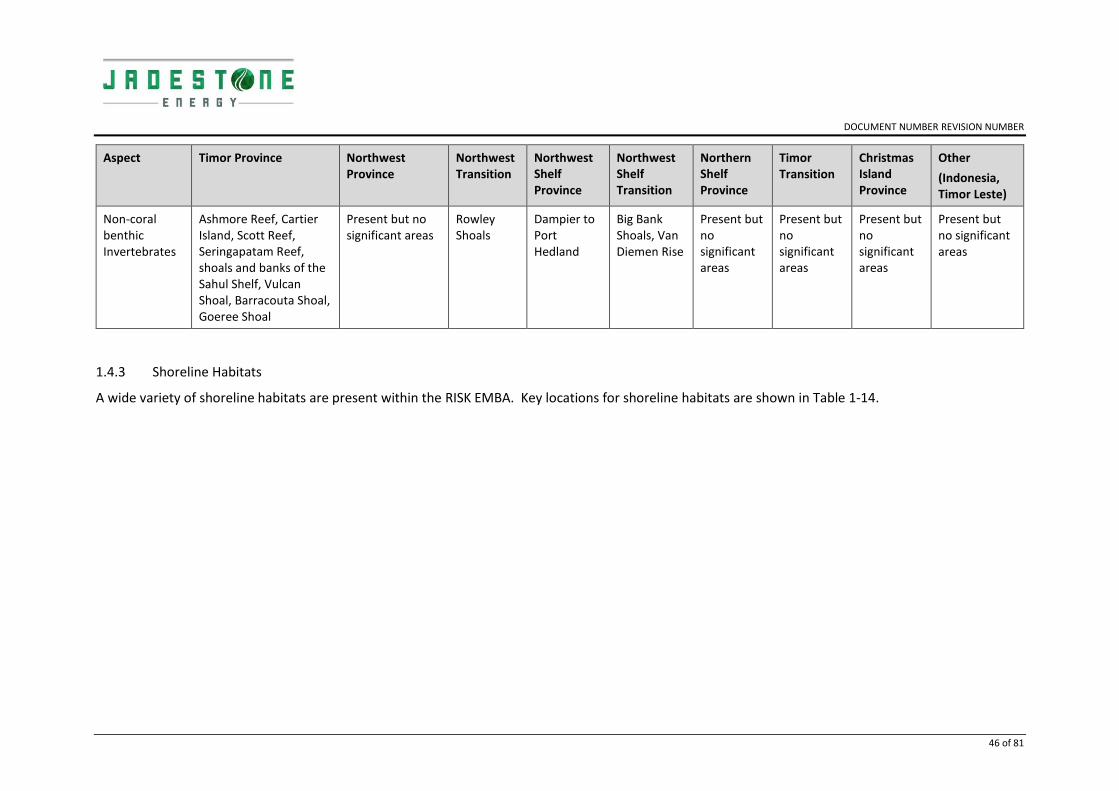
DOCUMENT NUMBER REVISION NUMBER
46 of 81
Aspect Timor Province Northwest Province
Northwest Transition
Northwest Shelf Province
Northwest Shelf Transition
Northern Shelf Province
Timor Transition
Christmas Island Province
Other
(Indonesia, Timor Leste)
Non-coral benthic Invertebrates
Ashmore Reef, Cartier Island, Scott Reef, Seringapatam Reef, shoals and banks of the Sahul Shelf, Vulcan Shoal, Barracouta Shoal, Goeree Shoal
Present but no significant areas
Rowley Shoals
Dampier to Port Hedland
Big Bank Shoals, Van Diemen Rise
Present but no significant areas
Present but no significant areas
Present but no significant areas
Present but no significant areas
1.4.3 Shoreline Habitats
A wide variety of shoreline habitats are present within the RISK EMBA. Key locations for shoreline habitats are shown in Table 1-14.

DOCUMENT NUMBER REVISION NUMBER
47 of 81
Table 1-14: Location of key shoreline habitats
Aspect Timor Province
Northwest Province
Northwest Transition
Northwest Shelf Province
Northwest Shelf Transition
Northern Shelf Province
Timor Transition
Christmas Island Province
Other
(Indonesia, Timor Leste)
Mangroves Not present Not present Not present North Kimberley Marine Park,
Port Hedland, Karratha
Darwin Coast, Tiwi Islands, Joseph Bonaparte Gulf, Kakadu
Cobourg Peninsula, Kakadu
Not present
Present but no significant areas
Indonesia (west)
Intertidal sand/mud flats
Ashmore Reef Not present Not present Eighty Mile Beach, Roebuck Bay
Darwin Coast, Joseph Bonaparte Gulf, Kakadu
Cobourg Peninsula, Arnhem Coast, Kakadu
Not present
Present but no significant areas
Intertidal platforms
Ashmore Reef, Scott Reef, Cartier Island
Not present Not present Eight Mile Beach Darwin Coast, Joseph Bonaparte Gulf
Cobourg Peninsula, Arnhem Coast
Not present
Present but no significant areas
Present but no significant areas
Sandy beaches
Ashmore Reef,
Sandy Islet (Scott Reef)
Not present Not present Eight Mile Beach Darwin Coast Arnhem Coast, Cobourg Peninsula
Not present
Present but no significant areas
Rocky shorelines
Not present Not present Not present North Kimberley Marine Park, Dampier to Point Samson
Present but no significant areas
Not present
Present but no significant areas

DOCUMENT NUMBER REVISION NUMBER
__________________________________________________________________________________
DOCUMENT TITLE 48 of 81
1.4.4 Plankton and Invertebrates
Plankton is divided into two categories: phytoplankton and zooplankton. Phytoplanktonic algae are important primary producers and range in size from 0.2 to 200 mm. Zooplankton are small, mostly microscopic animals that drift with the ocean currents, and it has been estimated that 80% of the zooplankton in waters off Australian continental shelf and shelf margin are the larval stages of fauna that normally live on the seabed (Raymont, 1983). A common feature of plankton populations is the high degree of temporal and spatial variability. Phytoplankton in tropical regions have marked seasonal cycles with higher concentrations occurring during the winter months (June–August) and low in summer months (December–March) (Hayes et al., 2005). Zooplankton rely on phytoplankton as food and are subject to similar seasonality. Key windows of sensitivity for plankton is shown in Table 1-15.
Table 1-15: Plankton windows of sensitivity
Key
Peak times
Jan
uar
y
Feb
ruar
y
Mar
ch
Ap
ril
May
Jun
e
July
Au
gust
Sep
tem
be
r
Oct
ob
er
No
vem
be
r
De
cem
be
r
Plankton: Concentrations
1.4.5 Fish, Sharks and Rays
1.4.5.1 Whale Shark (Vulnerable/Migratory)
Whale sharks (Rhincodon typus) have a broad distribution in tropical and warm temperate seas. The whale shark is a highly migratory fish and only visits Australian waters seasonally (DoEE 2017b). They are known to aggregate at Ningaloo Reef (approximately 1,500 km south-west of the Operational Area) between May and June, and in the Queensland Coral Sea (approximately 2,400 km east of the Operational Area) between November and December (DoEE 2017b). Neither of these locations are within the RISK EMBA. The whale shark foraging BIA intersects with the RISK EMBA (Figure 1.6).
1.4.5.2 Great White Shark (Vulnerable/Migratory)
The great white shark (Carcharodon carcharias) is widely, but sparsely, distributed in all seas, including cold temperate waters, having been recorded from central Queensland around the south coast to north-west WA, with movements occurring between the mainland coast and the 100 m isobath (DoEE 2017b). The species is known to undertake migrations along the WA coast, with individuals occasionally travelling as far north as North West Cape during spring, before returning south for summer (DoEE 2017b). No great white shark BIAs are intersected by the RISK EMBA (Figure 1.6). Given a preference for cooler, southern waters inhabited by seals and sea lions, great white sharks are considered unlikely to be encountered in the RISK EMBA.

DOCUMENT NUMBER REVISION NUMBER
49 of 81
1.4.5.3 Northern River Shark (Endangered)
The northern river shark (Glyphis garricki) is known to inhabit rivers, tidal sections of large tropical estuarine systems, macrotidal embayments, as well as inshore and offshore marine habitats, although adults have only been recorded in marine environments (DoEE 2017b). Limited data suggests that the species displays a preference for highly turbid, tidally influenced waters with fine muddy substrate. However, the presence of individuals in offshore areas suggests that northern river sharks undertake movements away from rivers and estuaries and are therefore likely to move between river systems (DoEE 2017b). Given the species’ preference for turbid, inshore waters, it is likely that the species will be encountered in the RISK EMBA.
1.4.5.4 Grey Nurse Shark (vulnerable)
The grey nurse shark (Carcharias taurus) is listed as vulnerable under the EPBC Act and the Biodiversity Conservation Act 2016 and may be found within the RISK EMBA. In Australia, the grey nurse shark is now restricted to two populations, one on the east coast from southern Queensland to southern NSW and the other predominantly around the southwest coast of WA, but has been recorded on the North West Shelf (DoE 2014d; Pogonoski et al. 2002). It is believed that the east and west coast populations do not interact and ongoing research is likely to confirm that the populations are genetically different (Last & Stevens 2009).
While it is thought that grey nurse sharks have a high degree of site fidelity, some studies (McCauley 2004) suggest that grey nurse sharks move between different habitats and localities, exhibiting some migratory characteristics. In certain areas grey nurse sharks are vulnerable to localised pressure due to high endemism. The status of the west coast population is poorly understood although they are reported to remain widely distributed along the WA coast and are still regularly encountered, albeit with low and indeterminate frequency (Chidlow et al. 2006).
Grey nurse sharks are often observed hovering motionless just above the seabed, in or near deep sandy-bottomed gutters or rocky caves, and in the vicinity of inshore rocky reefs and islands (Pollard et al. 1996). The species has been recorded at varying depths, but is generally found between 15–40 m (Otway & Parker 2000). Grey nurse sharks have also been recorded in the surf zone, around coral reefs, and to depths of around 200 m on the continental shelf (Pollard et al. 1996). Grey nurse sharks feed primarily on a variety of teleost and elasmobranch fishes and some cephalopods (Gelsleichter et al. 1999; Smale 2005) and may be found within the RISK EMBA.
1.4.5.5 Dwarf Sawfish (Vulnerable/Migratory)
The dwarf sawfish (Pristis clavata) is listed as vulnerable under the EPBC Act and thought to be restricted to Australia (DoE 2014b). It is also listed as a Priority 1 conservation species in WA. The Australian distribution of the dwarf sawfish is considered to extend across northern Australia and along the Kimberley and Pilbara coasts (Last and Stevens 2009, Stevens et al. 2005). However, the majority of records of dwarf sawfish in WA have come from shallow estuarine waters of the Kimberley region which are believed to be nursery (pupping) areas, with immature juveniles remaining in these areas up until three years of age (Thorburn et al. 2004). Adults are known to seasonally migrate back into inshore waters (Peverell 2007); although it is unclear how far offshore the adults travel as captures in offshore surveys are very uncommon. The species' range is restricted to brackish and salt water (Thorburn et al. 2007).
The recovery plan identifies pupping as known to occur in the King Sound, the Cambridge Gulf and 80 Mile Beach, with pupping likely to occur identified at a number of locations along the Pilbara and Kimberly coastline. Under the associated recovery plan all areas where aggregations of individuals have been recorded displaying biologically important behaviours such as breeding, foraging, resting

DOCUMENT NUMBER REVISION NUMBER
50 of 81
or migrating are considered critical to the survival of the species unless population data suggests otherwise.
1.4.5.6 Freshwater/Largetooth Sawfish (Vulnerable/Migratory)
The freshwater, or largetooth, sawfish (Pristis pristis) may occur in all large rivers of northern Australia from the Fitzroy River in WA, to the western side of Cape York Peninsula, Queensland, although is mainly confined to the primary channels of large rivers (DoEE 2017b). In northern Australia, this species is thought to be confined to freshwater drainages and the upper reaches of estuaries, occasionally being found as far as 400 km inland. Few records exist of adults at sea, occurring in fresh or weakly saline water (DoEE 2017b). Given the species’ known distribution, individuals are likely to be found within the RISK EMBA.
1.4.5.7 Green Sawfish (Vulnerable/Migratory)
In Australian waters, green sawfishes (Pristis zijsron) have been recorded in the coastal waters off Broome in WA, around northern Australia to Jervis Bay, NSW (DoEE 2017b). It is unknown whether green sawfish migrate into Australian waters as adults or juveniles from populations outside Australia (DoEE 2017b). This species inhabits muddy bottom habitats and enters estuaries, although it has also been recorded in inshore marine waters, estuaries, river mouths, embankments and along sandy and muddy beaches, usually in shallow waters (DoEE 2017b). Based on the known distribution of the species, individuals are known to exist within the RISK EMBA.
1.4.5.8 Speartooth shark (Critically endangered)
The Speartooth Shark (Glyphis glyphis) has only been captured in tidal rivers and estuaries indicating that large tropical river systems appear to be the primary habitat for this shark (Stevens et al. 2005). The Speartooth Shark is known to have feeding and ontogenetic (life cycle) migrations offshore, and to migrate inshore to breed, although data to support this is limited (Stevens et al. 2005). Given the species’ known distribution, individuals are likely to be found within the RISK EMBA.
1.4.5.9 Shortfin and Longfin Mako Sharks (Migratory)
The shortfin mako (Isurus oxyrinchus) and the longfin mako (Isurus paucus) are both offshore epipelagic species found in tropical and warm-temperate waters (DoEE 2017b). Both species occur in Australia in coastal waters off WA, NT, QLD and NSW at depths ranging from shallow coastal waters to at least 500 m (DoEE 2017b). These species may be found within the RISK EMBA.
1.4.5.10 Reef Manta Ray (Migratory)
The reef manta ray (Manta alfredi) is commonly sighted inshore, but also found around offshore coral reefs, rocky reefs and seamounts, tending to inhabit warm tropical or sub-tropical waters (Marshall et. al. 2011a). Long-term sighting records of the reef manta ray at established aggregation sites suggest that this species is more resident to tropical waters and may exhibit smaller home ranges, philopatric movement patterns and shorter seasonal migrations than the giant manta ray (Marshall et al. 2011a). Given the RISK EMBA overlap with a number of coral and rocky reefs in the region, it is possible the species may be encountered within the RISK EMBA.
1.4.5.11 Giant Manta Ray (Migratory)
The giant manta ray (Manta birostris) inhabits tropical, marine waters worldwide. In Australia, the species is recorded from south-western WA, around the north coast to the southern coast of New South Wales (Australian Museum 2014). The species is commonly sighted along productive coastlines with regular upwelling, oceanic island groups, particularly offshore pinnacles and seamounts. Nearer to shore the giant manta ray is commonly encountered on shallow reefs, while

DOCUMENT NUMBER REVISION NUMBER
51 of 81
being cleaned, or is sighted feeding at the surface inshore and offshore. It is also occasionally observed in sandy bottom areas and seagrass beds (Marshall et al. 2011b). Given the RISK EMBA overlap with a number of coral and rocky reefs in the region, it is possible that the species may be encountered within the RISK EMBA.
1.4.5.12 Narrow Sawfish (Migratory)
The narrow sawfish (Anoxypristis cuspidate) or knifetooth sawfish are distributed throughout the Gulf of Carpentaria, which has been identified as one of the only places worldwide where viable populations of sawfish remain (Peverell 2005). There are only sparse anecdotal records of the narrow sawfish occurring beyond the Gulf of Carpentaria to the west, but their habitat is accepted to be fresh and brackish waters of coastal and inshore areas in depths up to 100 m (Bray 2019). Based on the species’ habitat preference it may be encountered within certain parts of the RISK EMBA.
1.4.5.13 Sygnathids
Three offshore banks assessment surveys (2010, 2011 and 2013) were undertaken to identify and assess the level of impact, if any, to the submerged marine banks in the region of the 2009 Montara oil spill (Heyward et al. 2010, 2011a, 2013). The surveys used Baited Remote Underwater Video Stations (BRUVS) to characterise fish assemblages and included the following shoals/banks in the region: Vulcan Shoal, Barracouta Shoals, Echuca Shoal, Eugene McDermott Shoal, Goeree Shoal, Heywood Shoal, Shoal 25 and Wave Governor Bank. BRUVS were deployed on the seafloor from the shallowest areas of the shoals to depths of approximately 60 m for at least 60 minutes (Heyward et al. 2011a). No individuals from the Syngnathidae family were reported (Heyward et al. 2010, 2011a, 2013).
Table 1-16: Fish, Shark and Ray windows of sensitivity
Key
Peak times
Jan
uar
y
Feb
ruar
y
Mar
ch
Ap
ril
May
Jun
e
July
Au
gust
Sep
tem
be
r
Oct
ob
er
No
vem
be
r
De
cem
be
r
Fish Spawning
Southern Bluefin Tuna: Spawning
Goldband Snapper: Spawning
Red Emperor: Spawning
Elasmobranchs
Whale Shark: Foraging

DOCUMENT NUMBER REVISION NUMBER
__________________________________________________________________________________
DOCUMENT TITLE 52 of 81
Figure 1-6: Fish, Sharks and Rays BIAs

DOCUMENT NUMBER REVISION NUMBER
__________________________________________________________________________________
DOCUMENT TITLE 53 of 81
1.4.6 Marine Mammals
The region is known to be an important migratory pathway between feeding grounds in the Southern Ocean and breeding grounds in tropical waters for several cetacean species. Pygmy blue whales (Balaenoptera musculus), fin whales (Balaenoptera physalus), dwarf minke whales (Balaenoptera acutorostrata) and Antarctic minke whales (Balaenoptera bonaerensis) may travel through the region on their way to breeding grounds, which are thought to be in deep oceanic waters around the Indonesian Archipelago.
During ambient noise monitoring at the southern (AC/L7) permit area in June–December 2011, numerous cetacean vocalisations were recorded (McPherson et al. 2012). Two species of odontocetes (toothed whales and dolphins) were identified during the first six months of deployment, false killer whales and common bottlenose dolphins.
Pygmy blue whales (B. m. brevicauda) were detected at the nearby Cash-Maple (AC/RL7 block) permit area, which coincided with the timing of the northern and southern migrations (McCauley 2011). Humpback whales were only recorded during two periods in July and August 2011 at the Southern station. The vocalisations of Bryde’s whales were also detected at the southern permit area at the time of survey. Based on the most recent scientific literature (Cerchio et al. 2015) and re-analysis of data, some of the Bryde’s whales (Balaenoptera edeni) reported are now believed to be the calls of Omura’s whale (Balaenoptera omurai) (McPherson et al. 2017). Omura’s whales therefore appear to be present year-round along the region’s continental shelf, but showed seasonal differences in occurrence at specific sites (McPherson et al. 2017). Overall, they are most commonly detected in the Timor Sea in winter.
Table 1-17: Marine Mammal windows of sensitivity
Key
Peak times
Jan
uar
y
Feb
ruar
y
Mar
ch
Ap
ril
May
Jun
e
July
Au
gust
Sep
tem
be
r
Oct
ob
er
No
vem
be
r
De
cem
be
r
Marine Mammals
Dugong: Calving / breeding
Pygmy Blue Whale: Northern migration
Pygmy Blue Whale: Southern migration
Humpback Whale: Calving / breeding

DOCUMENT NUMBER REVISION NUMBER
__________________________________________________________________________________
DOCUMENT TITLE 54 of 81
Figure 1-7: Marine Mammal BIAs

DOCUMENT NUMBER REVISION NUMBER
__________________________________________________________________________________
DOCUMENT TITLE 55 of 81
1.4.6.1 Blue Whale (Endangered/Migratory)
Blue whales (Balaenoptera musculus) are widely distributed throughout the worlds’ oceans. There are two subspecies in the Southern Hemisphere: the southern blue whale (Balaenoptera musculus intermedia) and the pygmy blue whale (Balaenoptera musculus brevicauda) (DEWHA 2008c). In general, the southern blue whale is found south of 60° S and pygmy blue whales are found north of 55° S (DEWHA 2008).
Blue whale migration is thought to follow deep oceanic routes, although little is known about their precise migration routes (DoEE 2017b). Sea noise loggers set at various locations along the coast of Western Australia have detected a seasonal presence indicating a pattern of annual northbound and southbound migration of pygmy blue whales past Exmouth and the Montebello Islands and locations to the north (McCauley and Jenner 2010). Pygmy blue whales appear to migrate south from Indonesian waters passing Exmouth through November to late December each year. Observations suggest most pygmy blue whales pass along the shelf edge out to water depths of 1,000 m depth contour. The northern migration passes Exmouth over an extended period ranging from April to August (McCauley and Jenner 2010). They are believed to calve in tropical waters in winter and births peak in May to June, however the exact breeding grounds of this species are unknown (Bannister et al. 1996).
The RISK EMBA overlap with the pygmy blue whale migratory route BIA off the Kimberley Coast (). The pygmy blue whale migratory BIA extends from approximately the south-westernmost point of WA to the northernmost edge of Australian commonwealth waters, north of Scott Reef. Blue whale BIAs overlapping the RISK EMBA include migration, foraging, and ‘distribution’ areas. Possible foraging habitat has been identified in the area around Scott and Seringapatam Reefs.
1.4.6.2 Humpback Whale (Vulnerable/Migratory)
Humpback whales (Megaptera novaeangliae) have a wide distribution, having been recorded from the coastal areas off all Australian states other than the Northern Territory (Bannister et al. 1996). Humpback whales migrate within 30 km of the coast, along the eastern and western coasts of Australia from calving grounds in the tropical north to feeding grounds in the Southern Ocean (DoEE 2017b). Peak migration off the north-western coast of Australia occurs from late July to early September. From June to mid-September the inshore waters (landward of the 100 m isobath) between the Lacepede Islands and Camden Sound are used as a calving area for this species (Jenner et al. 2001).
The RISK EMBA overlap with the humpback whale BIA identified for breeding and calving at Camden Sound Marine Park, adjacent to the Kimberley coast (). Individuals may be encountered within the RISK EMBA.
1.4.6.3 Sei Whale (Vulnerable/Migratory)
Sei whales (Balaenoptera borealis) are a cosmopolitan species, found in the waters off all Australian states (DoEE 2017b). The Australian Antarctic waters are important feeding grounds for sei whales, as are temperate, cool waters (DoEE 2017b). The species has also been observed feeding in the Bonney Upwelling area in South Australia, indicating the area as potentially being an important feeding ground.
Breeding in this species is known to occur in tropical and subtropical waters (DoEE 2017b). Currently, the movements and distributions of sei whales are unpredictable and not well documented. However, information suggests that sei whales have the same general pattern of migration as most

DOCUMENT NUMBER REVISION NUMBER
56 of 81
other baleen whales, although timing is later in the season and such high latitudes are not reached (DoEE 2017b). Individuals of the species may be encountered within the RISK EMBA, although large numbers are unlikely.
1.4.6.4 Fin whale (Vulnerable/Migratory)
Fin whales (Balaenoptera physalus) are found in the waters all around Australia and the Australia Antarctic Territory (DoEE 2017b). The Australian Antarctic waters are also thought to be important feeding grounds for fin whales, while feeding has been observed in the Bonney Upwelling area indicating the area to be of importance as a feeding ground for the species (Morrice et al. 2004). No known mating or calving areas are known from Australian waters. Currently, the migration routes and locations of winter breeding grounds for this species are uncertain (DoEE 2017b).
Individual fin whales may be encountered within the RISK EMBA, although large numbers are unlikely.
1.4.6.5 Bryde's whale (Migratory)
Bryde's Whales (Balaenoptera edeni) are a cosmopolitan species, found in the waters of all Australian states, including both Christmas and the Cocos Islands (DoEE 2017b). Two forms have been recognised in the past, however recent DNA sequencing has revealed the known ‘pygmy form’ of Bryde’s whale to be a separate species now known as the Omura’s whale (Balaenoptera omurai) which has been recorded at the Coco-Keeling Islands offshore of northwest Australia (Cherchio et al. 2019).
Ambient noise monitoring conducted in the Southern, Cash-Maple and Oliver permits by JASCO (2012) over a 12-month period between December 2010 and December 2011 recorded whale calls that were attributed to Bryde’s whales year-round at all three permits, with no seasonal cycle observed. This data demonstrates that individuals are likely to occur within the RISK EMBA.
1.4.6.6 Orca/Killer Whale (Migratory)
Orcas, or killer whales (Orcinus orca), are a cosmopolitan species, found in the waters off all Australian states in oceanic, pelagic and neritic regions, in both warm and cold waters. Killer whales are known to make seasonal movements, and are likely to follow regular migratory routes, however little is known about either local or seasonal movement patterns of the species (DoEE 2017b).
Given the lack of known migration routes or areas of significance in the region, the species is not expected to be encountered in the RISK EMBA in significant numbers.
1.4.6.7 Spotted Bottlenose Dolphin (Migratory)
The spotted bottlenose dolphin (Tursiops aduncus) is generally considered to be a warm water subspecies of the common bottlenose dolphin (Tursiops truncates) and known to exist in waters off all Australian states. The spotted bottlenose dolphin appears to be restricted to inshore areas such as bays and estuaries, nearshore waters, open coast environments, and shallow offshore waters including coastal areas around oceanic islands (DoEE 2017b). BIAs for this species are illustrated in Figure 1-7.
Given their cosmopolitan distribution, the species may be encountered within the RISK EMBA.
1.4.6.8 Indo-Pacific Humpback Dolphin (Migratory)
In Australia, humpback dolphins are thought to be widely distributed along the northern Australian coastline from approximately the Queensland–New South Wales border to western Shark Bay, Western Australia. Most studies to date indicate that Australian humpback dolphins occur mostly

DOCUMENT NUMBER REVISION NUMBER
57 of 81
close to the coast (within 20 km from land) and in relatively sheltered offshore waters near reefs or islands.
1.4.6.9 Sperm Whale (Migratory)
The habitat of the Sperm Whale is difficult to categorise due to the cosmopolitan nature of this species and its ability to inhabit all oceans. Sperm Whales tend to inhabit offshore areas with a water depth of 600 m or more and are uncommon in waters less than 300 m deep.
1.4.6.10 Australian snubfin dolphin (Migratory)
Australian Snubfin Dolphins occur only in waters off the northern half of Australia, from approximately Broome on the west coast to the Brisbane River on the east coast. Most recorded sightings come from protected and shallow coastal waters, especially in close vicinity to river mouths.
1.4.6.11 Dugong (Migratory)
Dugongs occur in coastal and island waters from Shark Bay in Western Australia across the northern coastline to Moreton Bay in Queensland (Marsh et al. 2002, 2011a). The winter range includes about 24 000 km of Australia’s coast, which represents about 19% of the global extent of occurrence along coastline habitats (Marsh et al. 2011a). A single individual has been recorded in the Cocos (Keeling) Islands (Hobbs et al. 2007). Dugongs are seagrass community specialists and the range of the dugong is broadly coincident with the distribution of seagrasses in the tropical and sub-tropical waters in their Australian range.
1.4.6.12 Antarctic Minke Whale/Dark-shoulder Minke Whale
Found throughout the Southern Hemisphere, the distribution up the west coast of Australia is currently unknown. Antarctic Minke Whales appear to occupy primarily offshore and pelagic habitats within cold temperate to Antarctic waters but this species does undergoe extensive migration between the summer Antarctic feeding grounds and winter sub-tropical to tropical breeding grounds.

DOCUMENT NUMBER REVISION NUMBER
__________________________________________________________________________________
DOCUMENT TITLE 58 of 81
1.4.7 Marine reptiles
A search of the EPBC Act Protected Matters database identified eight species of marine reptiles (6 species of turtles) that may occur in, or have habitat within the RISK EMBA. The RISK EMBA intersect with a number of BIAs for marine reptiles in the region (Figure 1-9). These are discussed in further detail below for each species. BIAs for turtle species in the RISK EMBA include the following locations: Browse Island, Ashmore Reef, Cartier Island, Cassini Island, Joseph Bonaparte Gulf, Joseph Bonaparte Depression, Sahul Shelf, and Sandy Islet (Scott Reef). These locations support marine turtle foraging, nesting and internesting areas with the windows of sensitivity shown in Table 1-18.
Table 1-18: Marine Reptile windows of sensitivity
Key
Peak times
Jan
uar
y
Feb
ruar
y
Mar
ch
Ap
ril
May
Jun
e
July
Au
gust
Sep
tem
be
r
Oct
ob
er
No
vem
be
r
De
cem
be
r
Marine Reptiles
Flatback Turtle: Nesting
Green Turtle: Nesting (Ashmore and Cartier)
Hawksbill Turtle: Nesting
Leatherback Turtle: Nesting
Loggerhead Turtle: Nesting
Olive Ridley Turtle: Nesting

DOCUMENT NUMBER REVISION NUMBER
__________________________________________________________________________________
DOCUMENT TITLE 59 of 81
Figure 1-8: Marine Turtle BIA

DOCUMENT NUMBER REVISION NUMBER
__________________________________________________________________________________
DOCUMENT TITLE 60 of 81
1.4.7.1 Green Turtle (Vulnerable/Migratory)
The closest known significant breeding/nesting grounds for the green turtle (Chelonia mydas) to the Montara and Skua fields are Ashmore Reef and Cartier Island, approximately 125 and 84 km to the northwest respectively (Figure 1-9). Green turtle nesting has also been observed at Cassini Island (RPS 2010a) and the island is recognised as a significant green turtle rookery (Conservation Commission 2010). In WA, the major nesting sites include Dampier Archipelago, along the Ningaloo and Jurabi Coasts, Thevenard Island and the Barrow-Lowendal-Montebello island complex (DoEE 2017b). In the NT, nesting occurs at Coburg Peninsula and between Nhulunbuy and northern Blue Mud Bay (East Arnhem Land) (DoEE 2017b). Satellite tracking studies have shown that green turtles migrate between breeding grounds and feeding grounds off the northwest coast (Pendoley 2005).
Sandy Islet at Scott Reef is a green turtle nesting site, with summer months from November through to February being the preferred nesting period (Guinea 2006a). While no published literature is available relating to turtle activities around Seringapatam Reef, it can be assumed that no nesting occurs due to the lack of permanent land (e.g. a sandy islet or island). However, turtles are likely to visit the reef system as part of transitory foraging behaviour. It has also been noted that green turtles may feed around Barracouta Shoal based on the proximity of the shoal to Cartier Island (Fugro 2009). Due to the presence of several rookery and foraging sites within the RISK EMBA, it is expected that green turtles will occur.
1.4.7.2 Flatback Turtle (Vulnerable/Migratory)
The flatback turtle (Natator depressus) is found in the tropical waters of northern Australia, Papua New Guinea and Irian Jaya. It is the most widely distributed nesting marine turtle species in the Northern Territory (Chatto and Baker 2008), nesting on a wide variety of beach types around the entire coastline. The flatback turtle also nests in the Kimberley Region of Western Australia, with Cape Dommett (Bowlay and Whiting 2007) and Lacrosse Island being important nesting areas for the species. The closest nesting sites to the Operational Area are approximately 500 km to the south-east (Lacepede Islands). While flatback turtles make lengthy reproductive migrations, up to 1,300 km from nesting beaches (Limpus et al. 1983), movements are generally restricted to the continental shelf (DoEE 2017b). Flatback turtles nesting within the Pilbara region migrate to their foraging grounds in the Kimberley region along the continental shelf at the end of the nesting season (RPS 2010).
The RISK EMBA intersect flatback turtle BIAs at the Sahul Shelf used for foraging off the West Australia coast, and the internesting BIA in the coastal waters off Arnhem Land in the Northern Territory (Figure 1-9). Subsequently, the species is expected to be present within the RISK EMBA.
1.4.7.3 Hawksbill Turtle (Vulnerable/Migratory)
Hawksbill turtles (Eretmochelys imbricata) are found in tropical, subtropical and temperate waters in all oceans of the world. In WA, the Dampier Archipelago is an important part of the migration route for hawksbill turtles, as are Scott Reef and the Joseph Bonaparte Gulf. Hawksbill turtles nest all year round in WA, with a peak in October and January (DoEE 2017b).
In WA, the major nesting sites include the Dampier Archipelago, along the Ningaloo and Jurabi Coasts, Thevenard Island and the Barrow-Lowendal-Montebello island complex (DoEE 2017b). In the NT, nesting occurs at Coburg Peninsula and between Nhulunbuy and northern Blue Mud Bay (East Arnhem Land) (DoEE 2017b). Hawksbill turtles are also found in the reserves of Ashmore Reef and Cartier Island where they feed throughout the year (Guinea 1995).

DOCUMENT NUMBER REVISION NUMBER
61 of 81
In WA, the Dampier Archipelago is an important part of the migration route for hawksbill turtles, as are Scott Reef and the Joseph Bonaparte Gulf. Hawksbill turtles nest all year round in WA, with a peak in October and January (DoEE 2017b).
The EMBA intersects with hawksbill turtle BIAs at Scott Reef, Ashmore Reef and Cartier Island, and in the coastal waters off Arnhem Land in the Northern Territory (Figure 1-9). Subsequently, hawksbill turtles are expected to occur within the RISK EMBA.
1.4.7.4 Leatherback Turtle (Endangered/Migratory)
The leatherback turtle (Dermochelys coriacea) has the widest distribution of any marine turtle, and can be found in tropical, subtropical and temperate waters throughout the world (Marquez 1990). No major centres of nesting activity have been recorded in Australia, although scattered isolated nesting (1-3 nests per annum) occurs in southern Queensland and Northern Territory (Limpus and McLachlin 1994). The RISK EMBA intersect with one leatherback turtle BIA, an internesting area in the waters off Arnhem Land in NT waters (Figure 1-9). The species is likely to be present within the RISK EMBA.
1.4.7.5 Loggerhead Turtle (Endangered/Migratory)
The loggerhead turtle (Caretta caretta) has a global distribution throughout tropical, sub-tropical and temperate waters (Marquez 1990). The closest known breeding/nesting grounds to the Montara and Skua fields are found at Muiron Island and the beaches of the Northwest Cape (Baldwin et al. 2003), approximately 1,500 km south-west of the wellhead platform and outside the RISK EMBA. Loggerhead turtles have also been recorded in the reserves of Ashmore Reef (125 km) and Cartier Island (84 km), west- northwest of the Operational Area (Guinea 1995). The EMBA intersects with one loggerhead turtle BIA, a foraging area on the Sahul Bank off NT waters (Figure 1-9).
This species is likely to be present, in limited numbers, within the RISK EMBA.
1.4.7.6 Olive Ridley Turtle (Endangered/Migratory)
The olive ridley turtle (Lepidochelys olivacea) has a circum-tropical distribution, with nesting occurring throughout tropical waters. No concentrated nesting has been observed in Australia, although low density nesting occurs along the Arnhem Land coast of the Northern Territory, including the Crocodile, McCluer and Wessel Islands, Grant Island and Cobourg Peninsula (Chatto and Baker 2008). The EMBA intersects with a number of olive-ridley turtle BIAs (foraging and internesting areas) of the Sahul Bank in the Joseph Bonaparte Gulf and in NT waters off the Arnhem Land coast (Figure 1-9). This species may be encountered in limited numbers within the RISK EMBA.
1.4.7.7 Short-nosed Sea-snake (critically endangered)
The short-nosed seasnake (Aipysurus apraefrontalis) is listed as critically endangered under the EPBC Act and the Biodiversity Conservation Act 2016. It is a fully aquatic, small snake and is endemic to WA. It has been recorded from Exmouth Gulf, WA to the reefs of the Sahul Shelf, in the eastern Indian Ocean. This species is believed to show strong site fidelity to shallow coral reef habitats in less than 10 m of water, with most specimens having been collected from Ashmore and Hibernia reefs (Guinea & Whiting 2005; Minton & Heatwole 1975).
The species prefers the reef flats or shallow waters along the outer reef edge in water depths to 10 m (Cogger 2000; McCosker 1975). The species has been observed during daylight hours, resting beneath small coral overhangs or coral heads in 1–2 m of water (McCosker 1975). Guinea and Whiting (2005) reported that very few short-nosed sea-snakes moved even as far as 50 m away from the reef flat and are therefore unlikely to be expected in high numbers in deeper offshore waters.

DOCUMENT NUMBER REVISION NUMBER
62 of 81
1.4.7.8 Leaf-scaled Sea-snake (critically endangered)
The leaf-scaled seasnake (Aprasia rostrate rostrata) is listed as critically endangered under the EPBC Act and the Biodiversity Conservation Act 2016. It occurs in shallow water (less than 10 m in depth), in the protected parts of the reef flat, adjacent to living coral and on coral substrates (DoE 2014). The species is found only on the reefs of the Sahul Shelf in Western Australia, especially on Ashmore and Hibernia reefs (Minton & Heatwole 1975). The leaf-scaled seasnake forages by searching in fish burrows on the reef flat (DoE 2014) and are therefore unlikely to be expected in high numbers in deeper offshore waters, but may occur within the RISK EMBA.
1.4.7.9 Salt water crocodile (migratory)
The species' distribution ranges from central Queensland throughout coastal Northern Territory to northern Western Australia. It is the largest species of crocodile in the world, reaching up to 7m and occurs in tidal rivers, coastal floodplains and billabongs and swamps. Individuals have been known to travel large distances, including across open ocean. Most prevalent in coastal areas they are therefore unlikely to be expected in high numbers in deeper offshore waters, but may occur within the RISK EMBA.
1.4.8 Avifauna
No avifauna migration, resting, foraging or breeding BIAs are present within the Operational area (Figure 5 7). The nearest breeding/roosting site to the Operational Area is Cartier Island approximately 80km away.
Numerous species of birds frequent the Timor Sea or fly through the area on annual migrations. Seabird feeding grounds, roosting and nesting areas are found at the offshore atolls in the wider region, particularly Ashmore Reef. Many species are listed under the Japan-Australia Migratory Bird Agreement (JAMBA), China-Australia Migratory Bird Agreement (CAMBA) or Republic of Korea-Australia Migratory Bird Agreement (ROKAMBA). Most seabirds breed at offshore sites, such as Ashmore Reef, Cartier Island and Browse Island, from mid-April to mid-May (Clarke 2010). Peak migration time of migratory shorebirds is between October and December (Clarke 2010). It is expected that some individuals of these species may pass through the RISK EMBA during their annual migrations (Table 1-19). Protected avifauna species are described below, with migratory species described in Table 1-20.
Table 1-19: Windows of sensitivity for avifauna
Key
Peak times
Jan
uar
y
Feb
ruar
y
Mar
ch
Ap
ril
May
Jun
e
July
Au
gust
Sep
tem
be
r
Oct
ob
er
No
vem
be
r
De
cem
be
r
Avifauna
Seabirds: Breeding
Shorebirds: Migrating

DOCUMENT NUMBER REVISION NUMBER
__________________________________________________________________________________
DOCUMENT TITLE 63 of 81
Figure 1-9: Avifauna BIAs

DOCUMENT NUMBER REVISION NUMBER
__________________________________________________________________________________
DOCUMENT TITLE 64 of 81
1.4.8.1 Red Knot (Endangered/Migratory)
The red knot, a migratory shorebird, is described with five subspecies, including two found in Australia; Calidris canutus piersmai and Calidris canutus rogersi. It undertakes long-distance migrations from breeding grounds in Siberia, where it breeds during the boreal summer, to the southern hemisphere during the austral summer. Both Australia and New Zealand host significant numbers of red knots during their non-breeding period (Bamford et al. 2008). As with other migratory shorebirds, the species occurs in coastal wetland and intertidal sand or mudflats, where they feed on intertidal invertebrates, especially shellfish (Garnet et al. 2011). They are likely to be found in these habitats throughout the RISK EMBA.
1.4.8.2 Australian Lesser Noddy (Vulnerable)
The Australian lesser noddy (Anous tenuirostris melanops) is usually only found around its breeding islands including the Houtman Abrolhos Islands and on Ashmore Reef and Barrow Island in WA (DoEE 2017b). This species may forage out at sea or in seas close to breeding islands and fringing reefs (Johnstone and Storr 1998; Storr et al. 1986; Whittell 1942). Based on known distribution and the location of rookeries the species is known to occur within the RISK EMBA.
1.4.8.3 Curlew Sandpiper (Critically Endangered/Migratory)
In Australia, curlew sandpipers (Calidris ferruginea) occur around the coasts and are widespread inland. In WA, they are found around coastal and subcoastal plains from Cape Arid to the south-west Kimberley, albeit rarely encountered in the north-west of the Kimberley region (DoEE 2017b). Curlew sandpipers mainly occur on intertidal mudflats in sheltered coastal areas, such as estuaries, bays, inlets and lagoons, as well as around non-tidal swamps, lakes and lagoons near the coast, occurring in both fresh and brackish waters (DoEE 2017b). The species may be present within the RISK EMBA.
1.4.8.4 Eastern Curlew (Critically Endangered/Migratory)
Within Australia, the eastern curlew (Numenius madagascariensis) has a primarily coastal distribution. They have a continuous distribution from Barrow Island and Dampier Archipelago in WA, through the Kimberley and along the NT, Queensland, and NSW coasts and the islands of Torres Strait. They are intermittently distributed elsewhere.
The species nests in the northern hemisphere, from early May to late June and does not breed in Australia. During the non-breeding season in Australia, the eastern curlew is most commonly associated with sheltered coasts, especially estuaries, bays, harbours, inlets and coastal lagoons, with large intertidal mudflats or sandflats (TSSC 2015g). The species may be present within the RISK EMBA.
1.4.8.5 Abbott’s Booby (Endangered/Migratory)
In Australia, Abbott’s booby (Papasula abbotti) is only found on Christmas Island, where it nests in tall rainforest trees. It is a pelagic feeding species, spending long periods at sea and often foraging hundreds of kilometres from land (Olsen 2001). The species is may be present foraging within the RISK EMBA.
1.4.8.6 Great Knot (Critically Endangered, Migratory)
The great knot is a migratory shorebird with a global distribution, breeding in north-east Siberia and spending the non-breeding season along coasts from Arabia to Australia. Nonbreeding birds migrate

DOCUMENT NUMBER REVISION NUMBER
65 of 81
to inlets, bays, harbours, estuaries and lagoons with large intertidal mud and sand flats where they feed on bivalves, gastropods, crustaceans and other invertebrates (Higgins & Davies 1996 in Garnet et al. 2011). The species may be present within the RISK EMBA.
1.4.8.7 Western Alaskan Bar tailed Godwit (Vulnerable) and Northern Siberian Bar tailed Godwit (Critically Endangered)
Two subspecies of the bar-tailed godwit exist, as determined by their breeding locations in Alaska (Limosa lapponica bauera) and Siberia (Limosa lapponica menzbieri) (Bamford et al. 2008). Non-breeding birds migrate to the coasts of Australia. The western Alaskan subspecies occurs especially on the north and east coasts of Australia whilst the northern Siberian subspecies occurs mainly along the coasts of north Western Australia (DoEE 2017b).
Nonbreeding birds are found on muddy coastlines, estuaries, inlets, mangrove-fringed lagoons and sheltered bays, feeding on annelids, bivalves and crustaceans (Higgins and Davies 1996 in Garnet et al. 2011). The species may occur within the RISK EMBA.
1.4.8.8 Greater Sand Plover (Vulnerable, Migratory)
During the non-breeding season, the species is recorded in many coastal areas of Australia. The Greater Sand Plover is one of the first migratory waders to return to north-western Australia, usually arriving in late July with most Plovers leaving the north-west by mid to late April. In Australia, the Greater Sand Plover occurs in coastal areas in all states, though the greatest numbers occur in northern Australia, especially the north-west. Greater Sand Plovers usually feed from the surface of wet sand or mud on open intertidal flats of sheltered embayments, lagoons or estuaries, feeding on molluscs, worms, crustaceans and insects. They usually roost on sand-spits and banks on beaches or in tidal lagoons, and occasionally on rocky points
1.4.8.9 Lesser Sand Plover (Endangered, Migratory)
The species is present at non-breeding grounds in Australasia mostly between September and April or May, with greatest numbers in northern Australia. Within Australia, the Lesser Sand-Plover is widespread in coastal regions, and has been recorded in all states. Internationally important sites in Australia and maximum counts in Western Australia and Northern Territory include Eighty Mile Beach, Roebuck Bay, Broome, Port Hedland Saltworks and Darwin area. This species usually occurs in coastal littoral and estuarine environments. It inhabits large intertidal sandflats or mudflats in sheltered bays, harbours and estuaries, and occasionally sandy ocean beaches, coral reefs, wave-cut rock platforms and rocky outcrops. It also sometime occurs in short saltmarsh or among mangroves. Lesser Sand Plovers eat invertebrates, such as molluscs (especially bivalves), worms, crustaceans (especially crabs) and insects.
1.4.8.10 Christmas Island Frigate bird (Endangered, Migratory)
he Christmas Island frigatebird is the ninth most evolutionary distinct and globally endangered bird in the world. Christmas Island is its home and the only place in the world where it breeds and nests in the forest canopy. Australia shares this bird with Indonesia. The male frigatebird has a bright red throat pouch called a 'gular', that it blows up like a fancy balloon to attract females during the mating season. It takes at least 15 months for a pair of Christmas Island frigatebirds to raise one chick to independence, and the birds can live as long as 50 years. Frigatebirds primarily forage in the ocean for food, scooping marine organisms such as fish and squid.

DOCUMENT NUMBER REVISION NUMBER
66 of 81
1.4.8.11 Round Island Petrel (Critically Endangered)
In Australia, the Round Island petrel (Pterodroma arminjoniana) has only been recorded on North Keeling Island, where it may breed (DEH, 2003). There is concern about the future survival of the Round Island petrel in Australia. They only visit land to breed, nesting in sandy areas on the ground, sheltered under shrubs between February and July. At sea, they generally glide close to the surface of the water, only occasionally flapping their wings and hunting in the near-surface water layers. The Round Island petrel is expected to occur within the RISK EMBA.
1.4.8.12 Australian Painted Snipe (Endangered)
The Australian painted snipe (Rostratula australis) has been recorded at wetlands in all states of Australia (DoEE 2019). The Australian painted snipe generally inhabits shallow terrestrial freshwater (occasionally brackish) wetlands, including temporary and permanent lakes, swamps and claypans. They also use inundated or waterlogged grassland or saltmarsh, dams, rice crops, sewage farms and bore drains. Typical sites include those with rank emergent tussocks of grass, sedges, rushes or reeds, or samphire; often with scattered clumps of lignum Muehlenbeckia, canegrass or sometimes tea-tree (Melaleuca). The Australian painted snipe sometimes utilises areas that are lined with trees, or that have some scattered fallen or washed-up timber (DoE 2014). The Australian Painted snipe is expected to occur within the RISK EMBA due to it’s habitat preference.
1.4.8.13 Australian Fairy Tern (Vulnerable)
The fairy tern (Sternula nereis) has a large geographic range between Australia, New Zealand and New Caledonia. Three subspecies have been identified, one of which is found in Australia (the Australian fairy tern, Sternula nereis nereis). The Australian fairy tern occurs along the coasts of Victoria, Tasmania, South Australia and Western Australia; occurring as far north as the Dampier Archipelago in WA (DoEE 2017a). The subspecies has been found in embayments of a variety of habitats including offshore, estuarine or lacustrine islands, wetlands and mainland coastline (Higgins & Davies 1996).
Australian fairy terns nest on sheltered sandy beaches, spits and banks, above the high tide line and below vegetation. The species breeds from August to February depending on the location of the breeding colony (Higgins & Davies 1996). They generally nest in small colonies of up to 100 birds, although larger colonies of more than 1,400 pairs have been reported in Western Australia (Hill et al. 1988).
The National Conservation Values Atlas (DoEE 2017b) identifies the vicinity of the lower north-west coast (north to Dampier Archipelago) and west coast (south to Peel Inlet) as BIAs for foraging. Breeding BIA’s were also identified scattered along the coast from Shark Bay to the Pilbara. The Australian Fairy tern is expected to occur within the RISK EMBA.
Table 1-20: Protected and Migratory avifauna
Common name Scientific name EPBC Act Status
(CE = Critically Endangered E = Endangered V = Vulnerable M = Migratory CD = Conservation Dependent)
Particular Values or Sensitivities Within the EMBA

DOCUMENT NUMBER REVISION NUMBER
67 of 81
Roseate tern Sterna dougallii M Breeding known to occur within area
Curlew sandpiper Calidris ferruginea CE, M Species or species habitat known to occur within area
Red knot Calidris canutus E, M Species or species habitat known to occur within area
Eastern curlew Numenius madagascariensis
CE, M Species or species habitat known to occur within area
Common noddy Anous stolidus M
Species or species habitat likely to occur within area
Overlaps foraging BIA (provisioning young)
Streaked shearwater Calonectris leucomelas
M Species or species habitat likely to occur within area
Lesser frigatebird Fregata ariel M
Species or species habitat known to occur within area
Overlaps with breeding, foraging BIA
Common sandpiper Actitis hypoleucos M Species or species habitat known to occur within area
Sharp-tailed sandpiper Calidris acuminata M Species or species habitat known to occur within area
Pectoral sandpiper Calidris melanotos M Species or species habitat may occur within area
Osprey Pandion haliaetus M Breeding known to occur within area
Australian fairy tern Sternula nereis nereis
V
Breeding known to occur within area
Overlaps with breeding and foraging BIAs
Fork-tailed swift Apus pacificus M Species or species habitat likely to occur within area
Wedge-tailed shearwater
Ardenna pacifica M Breeding known to occur within area
Overlaps with breeding and foraging BIA
Western Alaskan bar-tailed godwit
Limosa lapponica baueri
V, M Species or species habitat may occur within area
Northern Siberian bar-tailed godwit
Limosa lapponica menzbierii
CE, M Species or species habitat may occur within area
White-tailed tropicbird Phaethon lepturus M
Foraging, feeding or related behaviour likely to occur within area
Overlaps breeding BIA
Little shearwater Puffinus assimilis Listed Marine Species
Foraging, feeding or related behaviour known to occur within area
Overlaps foraging BIA

DOCUMENT NUMBER REVISION NUMBER
68 of 81
Greater frigatebird Fregata minor M Breeding known to occur within area
Caspian tern Hydroprogne caspia M Breeding known to occur within area
Little tern Sternula albifrons M Breeding known to occur within area
Bridled tern Onychoprion anaethetus
M Breeding known to occur within area Overlaps foraging BIA
Oriental plover Charadrius veredus Species or species habitat may occur within area
Oriental pratincole Glareola maldivarum
M Foraging, feeding or related behaviour known to occur within area
Crested tern Thalasseus bergii M Breeding known occur within area
Common greenshank Tringa nebularia M Species or species habitat known to occur within area
Australian lesser noddy Anous tenuirostris melanops
V
Foraging, feeding or related behaviour known to occur within area
Overlaps with foraging BIA
Abbott’s booby Papasula abbotti E Species or species habitat known to occur within area
Masked booby Sula dactylatra M Breeding known to occur within area
Red-footed booby Sula sula M Breeding known to occur within area
Brown booby Sula leucogaster M Breeding known to occur within area
Australian painted snipe Rostratula australis E Species or species habitat known to occur within area
Christmas Island frigatebird
Fregata andrewsi E, M Foraging, feeding or related behaviour known to occur within area
Red-tailed tropicbird Phaethon rubricauda
M Breeding known to occur within area
Greater Sand Plover/Large Sand Plover
Charadrius leschenaultia
V, M Foraging, feeding or related behaviour known to occur within area
Great Knot Calidris tenuirostris CE, M Foraging, feeding or related behaviour known to occur within area
Lesser Sand Plover/Mongolian Plover
Charadrius mongolus
V, M Foraging, feeding or related behaviour known to occur within area
Round Island Petrel Pterodroma arminjoniana
CE Breeding likely to occur within area
Black-naped tern Sterna smatrana M Breeding known to occur within area
Ruddy Turnstone Arenaria interpres M Foraging, feeding or related behaviour known to occur within area

DOCUMENT NUMBER REVISION NUMBER
69 of 81
Sanderling Calidris alba M Foraging, feeding or related behaviour known to occur within area
Red-necked stint Calidris ruficollis M Foraging, feeding or related behaviour known to occur within area
Long-toed Stint Calidris subminuta M Foraging, feeding or related behaviour known to occur within area
Little Ringed Plover Charadrius dubius M Foraging, feeding or related behaviour known to occur within area
Swinhoe’s snipe Gallinago megala M Foraging, feeding or related behaviour known to occur within area
Pin-tailed Snipe Gallinago stenura M Foraging, feeding or related behaviour known to occur within area
Broad-billed Sandpiper Limicola falcinellus M Foraging, feeding or related behaviour known to occur within area
Asian Dowitcher Limnodromus semipalmatus
M Foraging, feeding or related behaviour known to occur within area
Bar-tailed Godwit Limosa lapponica M Foraging, feeding or related behaviour known to occur within area
Black-tailed Godwit Limosa limosa M Foraging, feeding or related behaviour known to occur within area
Little curlew/Little Whimbrel
Numenius minutus M Foraging, feeding or related behaviour known to occur within area
Whimbrel Numenius phaeopus
M Foraging, feeding or related behaviour known to occur within area
Pacific Golden Plover Pluvialis fulva M Foraging, feeding or related behaviour known to occur within area
Grey Plover Pluvialis squatarola M Foraging, feeding or related behaviour known to occur within area
Grey-tailed Tattler Tinga brevipes M Foraging, feeding or related behaviour known to occur within area
Wood Sandpiper Tringa glareola M Foraging, feeding or related behaviour known to occur within area
Wandering Tattler Tringa incana M Foraging, feeding or related behaviour known to occur within area
Marsh Sandpiper/Little Greenshank
Tringa stagnatilis M Foraging, feeding or related behaviour known to occur within area
Common Redshank/Redshank
Tringa tetanus M Species or species habitat known to occur within area
Terek Sandpiper Xenus cinereus M Foraging, feeding or related behaviour known to occur within area

DOCUMENT NUMBER REVISION NUMBER
__________________________________________________________________________________
DOCUMENT TITLE 70 of 81
1.4.9 Indonesia and Timor Leste
The Indonesian coastline is rich in tropical marine ecosystems such as sandy beaches, mangroves, coral reefs and seagrasses ecosystems (Hutomo and Moosa 2005). These are home to a wide variety of living communities and a high species diversity and richness.
The benthic habitiat of the Indonesian coastline include seagrass meadows and coral reefs. The best environment for growth of seagrass is considered to be the sandy reef flats that occur in sheltered areas in the low tidal ranges. Wide areas of the Indonesian coastal waters are covered by dense beds of seagrass. Pioneering vegetation in the intertidal zone is dominated by Halophila ovalis and Halodule pinifolia, while Thalassodendron ciliatum dominate the lower subtidal zones.
Indonesia has an estimated 75,000 km2 coral reef ecosystem distributed throughout the archipelago (Tomascik et al. 1997 cited in Hutumo and Moosa 2005). Fringing reefs are the most common reef types with scleractinian corals being the most dominant and important group. It is estimated that Indonesian waters are home to 452 species of hermatypic scleractinian coral and 590 species of scleractinian corals (Tomascik et al. 1997, cited in Hutumo and Moosa 2005; Suharsono 2004, cited in Hutumo and Moosa 2005).
The Java and Bali Province is rich in tropical marine ecosystems such as mangroves, coral reefs, seagrasses and seaweeds, sand beaches on the east coast of Java and rocky coasts on the south-eastern coast of Bali. The mangrove forests provide a valuable physical habitat for a variety of important coastal species such as crabs, shrimps, fishes, and commercial fishes. Turtles are commonly seen at Crystal Bay, Nusa Penida.
Maluku Province’s inshore waters are rich in mangroves, seagrass beds and coral reef habitats for dugongs, green turtle, reef fish, shark, giant clam and trochus (Moss and Van Der Wal 1998).
West Nusa Tengarra Province consists of two islands: Lombok Island and Sumbawa Island. Mangroves, seagrass beds and coral reefs exist in the surrounding waters of Lombok (Tomascik et al. 1997 cited in Hutumo and Moosa 2005). It has been noted that fishermen in the west coast of Lombok collect seagrass from mixed seagrass meadows (Tomascik et al. 1997 cited in Hutumo and Moosa 2005). Green turtles and dugong likely feed on the seagrass beds located on the west coast of Lombok and north coast of Sumbawa.
Mangrove forests in Indonesia account for 76% of the total mangroves found in the southeast Asian region. The Timor Leste coastline features mangrove communities surrounding entrance to rivers primarily on the south coast, whilst the north and eastern coast feature a higher degree of coral reef communities.
The below shoreline habitats are present in the East Nusa Tengarra Province and Timor Leste:
• Rote Island features mangrove communities with sparse patches of seagrass habitats and high abundance of coral reef communities;
• The Savu sea region has an abundance of coral reef habitats that act as nurseries and feeding grounds for whales and dolphins. In particular, Savu and Raidjua Islands are surrounded by a fringing coral reef community. Savu Island features a small area of seagrass located in the north east corner of the Island;
• Sumba Island is surrounded by a fringing coral reef community, with sparse patches of seagrass and mangrove communities around the island;

DOCUMENT NUMBER REVISION NUMBER
71 of 81
• The majority of the West Timor coastline features a narrow fringing coral reef community with four dense areas of mangrove communities occurring primarily along the south coast;
• Pulau Dana, the southernmost island of Indonesia, is surrounded by exposed reefs and is known to be inhabited by a large number of bird species and nesting turtles;
• Alor Island is located at the border between Indonesia and Timor Leste with mangroves, coral reefs and seagrasses; and
• The majority of the Pulau Semau coastline features a narrow fringing coral reef community with areas of mangrove and seagrass communities occurring primarily along the east coast.
1.5 Social Values
1.5.1 Commercial Fishing
Three Commonwealth, 19 WA state fisheries and eleven NT fisheries overlap the RISK EMBA. Of these, 29 commercial fisheries overlap the RISK EMBA, but effort is not expected to occur in the Operational Area (Table 1-21). Descriptions of commercial fisheries that are expected to have effort in the Operational Area are provided in EP Section 4.6.1.
Table 1-21: Commercial fisheries that overlap the RISK EMBA
Commonwealth WA NT
Potential for effort in the Operational Area
Western Tuna and Billfish Joint Authority Northern Shark Fishery
Mackerel Area 1
Northern Demersal Scalefish Area 2
None
Effort not expected in the Operational Area
Western Skipjack Tuna Fishery
Southern Bluefish Tuna Fishery
Specimen Shell managed fishery
Marine Aquarium
West Coast Deep Sea Crustacean
Pearl oyster fishery
Abalone managed fishery
Kimberly prawn fishery
Mackerel managed fishery
Nickol Bay Prawn
Onslow Prawn
Pilbara line
Pilbara trap
Pilbara fish trawl
Beche der mer
Broome managed prawn
Trochus
Kimberley Crab Managed Fishery
Coastal Line Fishery
Coastal Net Fishery
Spanish Mackerel Fishery
Offshore Net and Line Fishery
Demersal Fishery
Barramundi Fishery
Mud Crab Fishery
Aquarium Fish/Display Fishery
Trepang Fishery
Timor Reef Fishery
Fishing Tour Operator Fishery

DOCUMENT NUMBER REVISION NUMBER
72 of 81
1.5.1.1 Commonwealth fisheries
The Australian Fisheries Management Authority (AFMA) manages all Commonwealth fisheries under the Fisheries Management Act 1991.
Western Skipjack Tuna Fishery
The Western Skipjack Fishery is part of the Skipjack Tuna Fishery, which contains two stocks: one to the east and one to the west, that are assessed separately but managed together under various management arrangements and general conditions in addition to the Fisheries Management Act 1991. The Western Skipjack Fishery targets only skipjack tuna Katsuwonus pelamis. While the RISK EMBA overlap the fishery, effort within the fishery is confined to the southern coast of Australia, several thousand kilometres away. No fishing effort has been recorded anywhere in the fishery since the 2008-2009 season (ABARES 2018).
Southern Bluefish Tuna Fishery
The Southern Bluefin Tuna Fishery targets southern bluefin tuna (Thunnus maccoyii) under the Southern Bluefin Tuna Fishery Management Plan 1995. Effort in this fishery is concentrated in the Great Australian Bight, several thousand kilometres from the location of the RISK EMBA, with this trend demonstrated historically from 2014 to 2018. Southern bluefin tuna spawn in the North West Shelf region of Western Australia between September and March. The larvae may be seasonally abundant in surface waters of the broader region during these months and migrating adult tuna may transit through the RISK EMBA.
1.5.1.2 Western Australian state fisheries
The Department of Primary Industries and Regional Development (DPIRD), fisheries division, manages WA state fisheries under the Fisheries Management Act 1991.
Specimen Shell managed fishery
The Specimen shell fishery covers all Western Australian waters from the high-water mark to the 200 m isobath. Effort is historically concentrated around population centres such as Broome, Karratha and Shark Bay. The primary method of collection is via hand while diving and wading along the coastal beaches, however a small number of operators utilise ROV’s.
Marine Aquarium Fish Managed Fishery
The Marine Aquarium fish managed fishery covers all of WA coastal waters. Collection methods include diving with handheld nets and covers over 950 species of fish, live rock, coral, seagrass, algae and invertebrates.
West Coast Deep Sea Crustacean
The West Coast Deep-sea Crustacean Managed Fishery is a quota-based pot fishery that mostly operates in depths of 500–800 m, with no fishing is permitted on the landward side of the 150 m isobath. The only allowable method fishing is baited pots on long-lines, with most set on muddy seabed. The boundaries of this fishery include all WA waters of the Indian Ocean and the Timor Sea north of 34°24’S.
Pearl oyster fishery
The WA pearl oyster fishery is the only remaining significant wild-stock fishery for pearl oysters in the world. It is a quota-based, dive fishery, operating in shallow coastal waters (< 35 m depth) along the NWS from Exmouth to the NT border. The harvest method is drift diving.

DOCUMENT NUMBER REVISION NUMBER
73 of 81
Abalone managed fishery (Area 4)
The Abalone Managed Fishery is active in the southern region of Western Australia. Fishing methods are dive and wading. Fishing was closed in Area 8, the area of WA waters north of Moore River during the 2011/12 season due to the catastrophic mortality observed following a marine heatwave in 2010/11 and remains closed (ABARES 2018).
Kimberly prawn fishery
The jurisdiction of the Kimberley Prawn Managed Fishery overlaps the RISK EMBA. The gear used consists of otter trawls and is typically restricted to depths less than 60 m. The fishery is generally active between April and May, and August to November each year (ABARES 2018).
Mackerel managed fishery (Area 2)
The Mackerel Managed Fishery targets Spanish mackerel (Scomberomorus commerson), with smaller landings of other species such as grey mackerel (S. semifasciatus). The fishery extends from Cape Leeuwin on the southern west coast of Australia to the Western Australian/Northern Territory Border, and historically most of the catch is landed in the Pilbara and Kimberley regions (Lewis & Jones 2017).
Nickol Bay Prawn
The Nickol Bay Prawn fishery covers the waters between 116°45’E to 120°E on the landward side of the 200 m isobath. It operates as an otter trawl fishery for banana prawns (Penaeus merguiensis).
Onslow Prawn
The Onslow Prawn fishery operates as an otter trawl fishery between the Exmouth and Nickol Bay prawn fisheries east of 144°39.9’E on the landwards side of the 200 m isobath. The fishery targets western king prawns (Penaeus latisulcatus), brown tiger prawns (P. esculentus) and endeavour prawns (Metapenaeus spp.).
Pilbara Demersal Scalefish Fisheries (Pilbara Fish Trawl Managed Fishery, the Pilbara Trap Managed Fishery and the Pilbara Line Fishery)
PDSF licence holders operate within “Pilbara waters” (all waters bounded by a line commencing at the intersection of 21°56’S latitude and the highwater mark on the western side of the North West Cape on the mainland of Western Australia; thence west along the parallel to the intersection of 21°56’S latitude and the boundary of the Australian Fishing Zone and north to longitude 120°E.)
The PDSF collectively use a combination of vessels, effort allocations (time), gear limits, plus spatial zones (including extensive trawl closures) as management measures. The main species landed by the fisheries in the Pilbara subregion are bluespotted emperor, red emperor, and rankin cod.
Bêche-de-Mer
Sea cucumbers (also known as bêche-de-mer or trepang) are collected by hand by divers and waders throughout the Kimberley region as part of the Bêche-de-Mer Fishery. Catches are mainly comprised of two species, sandfish (Holothuria scabra) and redfish (Actinopyga echinites).
Broome managed prawn
The Broome managed prawn fishery operates in the waters off the north-west coast of Western Australia, north-west of Roebuck Bay.
Trochus Fishery
DOCUMENT NUMBER REVISION NUMBER
74 of 81
The Trochus Fishery is a small, hand-harvested fishery based on the collection of a single target species, Tectus niloticus from King Sound and the Buccaneer Archipelago. There is only one licence holder in the fishery, which is managed under a ministerial exemption (WAFIC 2019).
Kimberley Crab Managed Fishery
The Kimberley Crab Managed Fishery management plan was drafted in October 2018. The fishery targets mud and blue swimmer crabs within state coastal waters. Although the fishery management plan includes all Western Australian waters, the fishery is closed seaward of the WA coastal waters (DPIRD 2018).
1.5.1.3 Northern Territory fisheries
The Department of Primary Industry and Resources (DPIR), fisheries division, manages NT fisheries under the Fisheries Act 1988. There are 11 NT managed fisheries that overlap the RISK EMBA.
Coastal Line Fishery
The NT Coastal Line Fishery (CLF) extends seaward from the high water mark to 15 nm from the low water mark and primarily targets black jewfish (Protonibea diacanthus) and golden snapper (Lutjanus johnii) using hook and line gear. Most fishing activity is concentrated around rocky reefs within 150 km of Darwin.
Coastal Net Fishery
The NT Coastal Net Fishery extends seaward from the high water mark to 3 nm from the low water mark and harvests a range of species including mullets (Family Mugilidae), Blue Threadfin (Eleutheronema tetradactylum), sharks and queenfish (Scomberoides spp.).
Spanish Mackerel Fishery
The NT Spanish Mackerel Fishery extends seaward from the high water mark to the outer limit of the Australian Fishing Zone (AFZ) and targets Spanish Mackerel (Scomberomorus commerson) using trolled lures or baited lines. The primary fishing grounds include waters near Bathurst Island, New Year Island, the Wessel Islands around to Groote Eylandt and the Sir Edward Pellew Group of islands.
Offshore Net and Line Fishery
The NT Offshore Net and Line Fishery extends seaward from the high water mark to the outer limit of the AFZ and targets Australian Blacktip Sharks (Carcharhinus tilstoni), Common Blacktip Sharks (C. limbatus), Spottail Sharks (C. sorrah) and Grey Mackerel (Scomberomorus semifasciatus) using pelagic gillnet and longline gear.
Demersal Fishery
The NT Demersal Fishery extends from 15 nm from the low water mark to the outer limit of the AFZ (excluding the area of the Timor Reef Fishery) and targets a range of tropical snappers (Lutjanus spp. and Pristipomoides spp.) using a variety of gear. Fish traps, hand lines and droplines are permitted throughout the fishery and demersal trawl nets are permitted in two defined zones.
Barramundi Fishery
The NT Barramundi Fishery operates within 3 nm of the low water mark and targets Barramundi (Lates calcarifer) and King Threadfin (Polydactylus macrochir) using gillnets. The inner boundary of the fishery is complex, with some rivers (or parts thereof) open to netting and others closed.
Mud Crab Fishery

DOCUMENT NUMBER REVISION NUMBER
75 of 81
The NT Mud Crab Fishery is confined to the tidal waters of the Northern Territory and targets mud crabs (Scylla spp.) using baited pots. Licence holders are not permitted to operate in Darwin Harbour and in most creeks adjoining Shoal Bay, Leaders Creek, Kakadu National Park or parts of the Cobourg Marine Park.
Aquarium Fish/Display Fishery
The NT Aquarium Fish/Display Fishery (the fishery) operates in both tidal and non-tidal waters of the NT to the outer limit of the AFZ. The fishery supplies a range of aquarium fishes, plants and invertebrates (including corals) to local and interstate pet retailers and wholesalers. Some specimens are also sold to overseas buyers.
Trepang Fishery
The NT Trepang Fishery extends seaward from the high water mark to 3 NM from the coast and targets Sandfish (Holothuria scabra; a type of Sea Cucumber), by means of hookah diving. Most fishing activity is concentrated along the Arnhem Land coast of the NT, from Cobourg Peninsula to Groote Eylandt.
Timor Reef Fishery
The Timor Reef Fishery operates offshore in a zone covering roughly 8,400 NM2 to the north-west of Darwin and targets tropical snappers (Lutjanus spp. and Pristipomoides spp.) using a variety of gear. The majority of the catch is taken using baited traps, but hand lines, droplines and demersal longlines may also be used.
Fishing Tour Operator Fishery
Fishing Tour Operators assist their clients in the pursuit of a wide range of sport fish in the non-tidal and tidal waters of the NT to the outer limit of the AFZ. Guide vessels range in size from small dinghies to luxury mother ships. Some operators also utilise fan-propelled “air boats” or helicopters.
1.5.1.4 Recreational and Charter Fishing
Recreational fishing is a popular activity in the Kimberley region, however effort is concentrated around regional centres due to the remoteness. Transiting recreational vessels passing through the RISK EMBA will undertake recreational fishing activities for sustenance and leisure. A small group of recreational fishing and charter vessels do occasionally visit the Ashmore Reef and surrounds and other reefs in the RISK EMBA.
1.5.1.5 Customary fishing
Customary fishing occurs in the Dambimangari IPA, Djelk IPA and Uunguu IPA. The importance of customary fishing in WA and NT is to recognise Aboriginal cultural heritage and needs. Customary fishing is fishing for personal, domestic, ceremonial, educational or non-commercial needs. Fishers use modern fishing methods such as aluminium boats and outboard motors.
1.5.1.6 International subsistence fishing
As the world’s largest archipelagic State with approximately 17,500 islands, fisheries form a significant socio-economic sector in Indonesia. As in Timor-Leste, the vast majority of fishery production (up to 95%) comes from artisanal fishing practices (FAO 2017). Fisheries management area 573 (South of Java – East Nusa Tenggara), encompasses the Lesser Sunda Ecoregion and is a particular productive area with a variety of target demersal and pelagic fisheries, including, lobster, tuna, sardines and shark fisheries. Many of these fisheries are under pressure from overexploitation, unsustainable fishing practices, under regulation and poor management/monitoring, nevertheless

DOCUMENT NUMBER REVISION NUMBER
76 of 81
they significantly contribute to the economy and social fabric within coastal communities in the region (FAO 2017).
Coral reefs are vital sources of food and income for coastal communities. More than one-third of the Indonesian population living in coastal areas depends on nearshore fisheries for livelihood (ADB 2014). More than 60% of the animal protein consumed by the population in 2000 was derived from fisheries.
Discussions with Indonesian fishermen in Kupang and the Australian Fishery Management Authority (Sinclair Knight Merz 1993) and with fishermen at Suai, Timor Leste, Pepela and East Rote (Ataupah) (BHPP 1996) indicated that two types of fisheries occur in the region that is likely to intersect the EMBA; trawl and longline. Trawl fishing is commonly undertaken in shallower, inshore areas, targeting scarlet and saddletail perch, snapper and emperor fish. Trawling is also concentrated in the vicinity of Sahul Bank and Echo Shoals and boats will pass through the RISK EMBA to reach these fishing grounds (BHP 2007).
1.5.1.7 Aquaculture
Aquaculture within the RISK EMBA is undertaken within estuarine and marine waters focusing on a variety of species and methods, including prawns, fish and seaweed. Trochus at Cape Leveque and Barramundi at Cone Bay are two larger scale operations along the Australian coastline within the RISK EMBA. In Indonesia and Timor Leste, aquaculture activities often contribute significantly to local employment and food production within the region (FAO 2017). Almost 50% of Indonesia’s fisheries are produced from aquaculture (worth $4.3 billion USD).
1.5.1.8 Commercial Fish, Sharks and Ray species spawning
Within the RISK EMBA, potential spawning grounds exist for southern bluefin tuna, goldband snapper and red emperor. The spatial occurrence of spawning is variable and poorly understood; however, temporally it appears that southern bluefin tuna spawn from August to April (peak October to February), goldband snapper from January to April (peak March), and red emperor from October to March (peak October) (Table 1-16). None of these species are listed as threatened; however, they are commercially valuable.
1.5.2 Shipping and vessel movements
Heavy vessels following the charted Osborn Passage will pass through both permits to the north of the Montara Venture FPSO (Error! Reference source not found.). The area may also be utilised by support vessels from oil and gas operations in the Timor Sea Area.
Occasional interaction with Australian Commercial Fishing vessels, illegal foreign fishing vessels or other illegal vessels is also possible.
To monitor for illegal passage of immigrants and illegal fishing activity the Australian Border Force (ABF) and Royal Australian Navy (RAN) vessels undertake surveillance within an area extending roughly 200 nm from the mainland (Jones 2013). Due to the large geographic extent of these operations and the documenting development at the WHP and subsea fields AC/L7 and AC/L8, direct interaction with ABF or RAN vessels is not expected to occur.
Shipping activity over the past three years in the waters within the RISK EMBA were mapped using AMSA’s Craft Tracking System and shown in Error! Reference source not found..
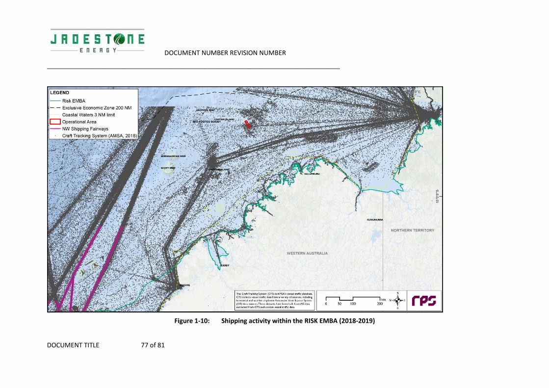
DOCUMENT NUMBER REVISION NUMBER
__________________________________________________________________________________
DOCUMENT TITLE 77 of 81
Figure 1-10: Shipping activity within the RISK EMBA (2018-2019)

DOCUMENT NUMBER REVISION NUMBER
__________________________________________________________________________________
DOCUMENT TITLE 78 of 81
1.5.3 Oil and Gas Industry
There are numerous exploration and production oil and gas operators in the region. The closest to the WHP and subsea fields AC/L7 and AC/L8 include Auriga West 1 (Shell) and the Maple wells (PTTEP) which are 34 and 59 km away respectively. See Error! Reference source not found..
Table 1-22: Titleholders in vicinity of EMBA
Titleholder Title blocks
Bounty Oil & Gas NL AC/P32
Carnarvon Petroleum Limited WA-523-P, AC/P62, AC/P63
Cornea Resources Pty Ltd WA-54-R
ConocoPhillips Pty Ltd WA-398-P, WA-315-P
Eni Australia Limited AC/P21
Finder Exploration Pty Ltd AC/P61, AC/P56, AC/P55, AC/P45
INPEX AC/P36, WA-343-P, WA-56-R, WA-285-P
IPB Petroleum Limited WA-471-P, WA-485-P
Murphy Australia Pty Ltd AC/P57, AC/P59
Octanex Bonaparte Pty Ltd WA-420-P
Santos Limited WA-74-R, WA-274-P, WA-513-P
SGH Energy Pty Ltd WA-377-P
Shell Australia AC/P52, AC/P41, WA-44-L, AC/RL9, WA-371-P
Sinopec O&G Pty Ltd AC/RL1
Timor Sea Oil & Gas Australia Pty Ltd AC/L5
Total E&P Australia Exploration Pty Ltd AC/P60
Vulcan Exploration Pty Ltd AC/P50

DOCUMENT NUMBER REVISION NUMBER
79 of 81
1.5.4 Defence
The two closest defence training areas to the WHP and subsea fields AC/L7 and AC/L8 are the North Australian Exercise Area (NAXA) (approximately 370 km to the east) and the Curtin Air-to-Air Air Weapons Range (approximately 280 km south west). Defence estate also exists through the Kimberley shoreline.
1.5.5 Tourism
The tourism activities likely to occur within the RISK EMBA (e.g. recreational fishing and boating and charter boats operations) tend to be focussed around nearshore waters, islands and coastal areas. Some charter operations access islands and reefs (including Scott Reef, Ashmore Reef and Cartier Island) as part of regular itineraries.
Tourism is important to the economy and livelihood of Indonesia (ADB 2014) with particular tourist centres in Bali, Flores, Lombok, Komodo and the Gili Islands. Bali is one of the most popular holiday destinations for Western Australians, with the value estimated to be 30% of GDP. Tourists visit Bali and other Indonesian locations such as West Java and Jakarta to appreciate the culture, but also to enjoy the natural biodiversity found within them. The marine environment within these centres is a major attraction, with beach and coastal activities (snorkelling, surfing, diving and fishing) are common (ADB 2014).
Scuba diving is very popular in National Parks like Bali Barat and Komodo National Park because of the park's high marine biodiversity. The development of, largely marine-based, ecotourism is the main strategy to make the park self-financing and generate sufficient revenue through entrance fees and tourism licenses to cover operational and managerial costs.
Tourism in Timor-Leste represents a small percentage of the country’s economy at present, but the Government regards growth in tourism as critical to future economic development.
1.5.6 Population Centres
1.5.6.1 Australia
The nearest major population centres to the Operational Area are Broome and Darwin. The closest coastline to the Operational Area on the Australian mainland is the Kimberley Coast, which is sparsely populated.
1.5.6.2 Indonesia and Timor Leste
The city of Kupang, the capital of the Indonesian province East Nusa Tenggara, is the closest major population centre to the Operational Area (~295 km). The city has a population of approximately 250,000 and supports a diverse range of industries including fishing, cement production and aquaculture. It is also an important focal point for the tourism industry.
Timor-Leste comprises the eastern half of the island of Timor, the nearby islands of Atauro and Jaco, and Oecusse, an exclave on the northwestern side of the island surrounded by Indonesian West Timor. The city of Suai is the closest major population area in Timor-Leste to the Operational Area.
1.5.7 Cultural Heritage
It has been recorded that Ashmore Reef Marine Park contains Indonesian artefacts and grave sites, and Ashmore lagoon is still accessed as a rest or staging area for traditional Indonesian fishers travelling to and from fishing grounds. The closest shipwreck is the Ann Millicent, approximately 110 km north-west of the Operational Area (DEWHA 2008b).

DOCUMENT NUMBER REVISION NUMBER
80 of 81
Within Australian waters and coastline that may be affected in the broader RISK EMBA, there are many places of cultural significance, including Registered Aboriginal Sites and communities (DPLH, 2019). Along the Kimberley Coast and the Northern Territory there are many Native Title Determinations and Indigenous Land Use Agreements, including some that include sea country.

DOCUMENT NUMBER REVISION NUMBER
81 of 81
2. REFERENCES TO ADD TO JADESTONE LIST
ABARES 2019. Fishery status reports 2019. Research by the Australian Bureau of Agricultural and Resource Economics and Sciences. Available online: http://www.agriculture.gov.au/abares/Documents/research-topics/fisheries/00_FishStatus2019_1.0.0.pdf. Accessed10/10/2019.
ERM (2011) – pp. 11
Heyward et al 2017 – pp. 11 <- has become moore et al 2017
Raymont 1983 – pp. 18
(Hayes et al., 2005; Schroeder et al., 2009) – pp. 18
DPLH, 2019. Aboriginal Heritage Inquiry System. Department of Planning, Lands and Heritage. Available online: www.maps.daa.wa.gov.au/AHIS . Accessed 10/10/2019/
Hayes, D., Lyne, V., Condie, S. A., Griffiths, B., Pigot, S., and Hallegraeff, G. (2005). Collation and Analysis of Cceanographic Datasets for National Marine Bioregionalisation. Clayton, VIC: CSIRO Marine Research.
Hutomo, M., & Moosa, M. K. (2005). Indonesian marine and coastal biodiversity: Present status.
Moore, C., Cappo, M., Radford, B., & Heyward, A. (2017). Submerged oceanic shoals of north Western Australia are a major reservoir of marine biodiversity. Coral Reefs, 36(3), 719-734
Moss, S. M., & van der Wal, M. A. R. K. (1998). Rape and run in Maluku: exploitation of living marine resources in eastern Indonesia. Cakalele: Maluku Research Journal, 9(2), 85-97.
Raymont, J. E. G. (1983). Plankton and productivity in the oceans-Zooplankton. New York. Ed.
Tomascik, T. (1997). The ecology of the Indonesian seas. Oxford University Press.
Dianne J. Bray, Anoxypristis cuspidata in Fishes of Australia, accessed 23 Oct 2019, http://fishesofaustralia.net.au/home/species/1842
Peverell, S.C., 2005. Distribution of sawfishes (Pristidae) in the Queensland Gulf of Carpentaria, Australia, with notes on sawfish ecology. Environmental Biology of Fishes, 73(4), pp.391-402.
Department of the Environment (DoEE) (2019). Rostratula australis in Species Profile and Threats Database, Department of the Environment, Canberra. Available from: http://www.environment.gov.au/sprat. Accessed Wed, 23 Oct 2019 15:37:00 +1100.
WAFIC (2019). Trochus fishery. Available from: https://www.wafic.org.au/fishery/trochus-fishery/
http://www.agriculture.gov.au/abares/Documents/research-topics/fisheries/00_FishStatus2019_1.0.0.pdf

WHP and Subsea Fields AC/L7 & AC/L8 Drilling Program 2020 Environment
Plan
TM-50-PLN-I-00001
Rev 0
APPENDIX C - CONSULTATION

_________________________________________________________________________________________________________________
Appendix C ‐ Consultation
This appendix has been redacted prior to publishing to preserve the privacy of those persons or organisations consulted with. This can include the removal personal information (as defined by the Privacy Act 1988) and the removal of any information that was provided during consultation where that person has requested for that information not to be published as per OPGGS(E) Regulations sub‐regulation 11(A). Jadestone Energy has made reasonable efforts to inform each relevant person consulted that they may request for particular information not to be published during all stages of the consultation.
The following inputs were internally defined as per the EP to assist with identifying relevant persons:
Operational Area (Section 3.1 of EP)
EMBAs (Section 3.1 of EP)
Activity Description (Section 2 of EP).
1.1 Guiding Search Criteria for Identification of Relevant Persons
To assist in identifying relevant persons, guiding search criteria were used to act as prompts and to ensure lessons learnt from previous approvals processes were captured (Table 1). This also indicates relevant data sources used in the identification process.
The results of the guiding search criteria can be used to inform the development of a matrix for the Montara EP mapping relevant stakeholders against risks/values. This information allows appropriate identification/classification of stakeholders and also for a more rapid response in the event of an unplanned event.
It should be noted that at present, International Stakeholders are communicated with through DFAT as guided by NOPSEMA.

_________________________________________________________________________________________________________________
Table 1: Guiding Search Criteria
Entities whose FUNCTIONS make them a
relevant person
Guiding search criteria Information sources Ongoing concerns/action required from previous consultation
A person or organisation’s power, duty, authority or responsibilities,
An activity that is natural to or the purpose of a person or thing
What State and Federal government agencies have jurisdiction within the Operations Area/EMBA? Including jurisdiction over values.
Australian Hydrographic Office
Ensure confirmation received regarding update to maps
DPIRD – Fisheries
Request for notification of any oil spill or discharge of any other pollutant within 24 hours.
Request that when developing OPEP JSE collects baseline marine data to compare against post spill monitoring. Baseline data should be made available to the Department.
Consideration of spawning grounds and nursery areas should be included in OPEP.
Biosecurity: Two ways to demonstrate commitment:
Utilise the Departments Vessel Check tool and complete actions to manage any activity related to vess3els to a low/acceptable risk rating.
Actively use a biofouling management plan and record book that meets requirements under International Organisation’s Guidelines for the Control and Management of Ships’ biofouling to minimise the Transfer of Invasive Aquatic Species.
Recommendation that residual risk after using above measures is managed. Recommended this could be achieved by follow‐up marine pest inspection around 75 days after arrival if the vessel is still in WA waters.

_________________________________________________________________________________________________________________
Request that any suspected marine pest or disease be reported within 24 hours.
Will WA or Commonwealth Marine Park/Reserve values be potentially affected or have implications for endangered, threatened or otherwise protected species/communities?
https://parksaustralia.gov.au/marine/
What government and non‐government organisations have an interest in cultural affairs in the region?
Entities whose INTERESTS make them a
relevant person
Guiding search criteria Information sources Ongoing concerns
A person or organisation’s rights, advantages, duties, and liabilities
A group or organisation having a common concern
What NGO’s are active in the Operations/EMBA area?
Internet searches
What commercial fishers, pearlers or aquaculture venture operators operate in the Operations Area/EMBA area?
WA‐DPIRD licence holder information request
Commonwealth – concession holder list
WAFIC
Clarity around restricted area definitions
Interaction with oil and gas operators – operators to avoid active fishing even if inconvenient
Sensitivity around commercial fishers (who are not allowed to recreationally fish) seeing oil and gas staff recreationally fishing
What charter fishing operators are licensed to operate within the Operations Area/EMBA area?
WA‐DPIRD licence holder information request

_________________________________________________________________________________________________________________
What representative bodies act on behalf of individuals identified as having a commercial interest in the operations or EMBA areas?
Fishing representative bodies and associations
WAFIC
Tourism representative bodies
WAFIC – see above regarding commercial fishing
What Traditional owner interests and rights of exist within the operational area or EMBA including: • Native Title Determination Applications • Native Title Claims • Native Title Determinations
• Indigenous Land Use Agreements
Native Title Tribunal database
Contact through land councils
Who are the Federal and State MPs/government representatives for the areas adjacent to the EMBA?
Commonwealth senators and members list
State (WA) parliament members list
What ports occur within or adjacent to the EMBA?
Ports Australia database
Entities whose ACTIVITIES make them a relevant person
Guiding search criteria Information sources Ongoing concerns
A thing that a person or group does or has done
Will the project affect, or potentially affect, recreational fishers?
Internet search

_________________________________________________________________________________________________________________
What recreational pursuits could or do take place within the Operations Area/EMBA?
Internet search
What interest groups represent recreational pursuits that are identified within the EMBA?
Internet search
What other oil and gas operations occur within the EMBA?
NEATS approvals system
1.2 Fisheries Assessment
A separate assessment of relevant fisheries was undertaken to identify which fisheries should be considered relevant parties (Table 2). Note this is based on advice from WAFIC that only active fisheries at risk of impact from a planned event should be actively consulted.
Table 2: Fisheries relevant persons assessment
Jurisdiction Name Relevant party assessment?
WA Mackerel managed fishery (Area 1)
✓ This fishery overlaps the Operations area. Commercial fishers will be potentially active in this region.
WA Northern shark fishery-joint authority
✓ This fishery overlaps the Operations area. Commercial fishers will be potentially active in this region.
WA Northwest demersal scalefish managed fishery
✓ This fishery overlaps the Operations area. Commercial fishers will be potentially active in this region.
Commonwealth Western Tuna Billfish ✓ This fishery overlaps the Operations area. Commercial fishers will be potentially active in this region.
Commonwealth Northwest slope fishery
✘This fishery does not overlap the Operations area. The fishery does overlap the EMBA and should be considered relevant for EMBA acknowledgement and consideration in the event of a significant hydrocarbon spill.

_________________________________________________________________________________________________________________
Jurisdiction Name Relevant party assessment?
Commonwealth Southern Bluefin tuna ✘There is no effort in WA. However, the spawning grounds for this fishery occur off the northwest of WA and this fishery should be considered in the event of a significant hydrocarbon spill. The industry association for this fishery has been contacted for consultation.
Commonwealth Western Skipjack Fishery
✘Effort within this fishery is mainly confined to the southern coast of Australia. No fishing effort has been recorded since the 2008-2009 season and so there is no expected effort. Management arrangements are currently under review.
WA Specimen shell managed fishery
✘This fishery is primarily a dive and hand collect fishery, which excludes many operators, and there are no ROV fishers active in the area.
WA Abalone managed fishery
✘This fishery does not overlap the Operations area Areas 4 and 8 of the fishery should be considered relevant for EMBA acknowledgement and consideration in the event of a significant hydrocarbon spill.
WA Kimberly prawn fishery ✘Whilst the fishery overlaps the Operations area effort occurs in the coastal areas and does not overlap the Operations area. The fishery is relevant for EMBA acknowledgement and consideration in the event of a significant hydrocarbon spill.
WA Pearl oyster fishery Zone 3
✘This fishery is primarily a dive and hand collect fishery, which excludes many operators, and there are no ROV fishers active in the area. However, the industry association for this fishery has been contacted for consultation.

_________________________________________________________________________________________________________________
Jurisdiction Name Relevant party assessment?
WA Mackerel managed fishery (Area 2) Marine aquarium fish managed fishery North coast shark fishery Nicol Bay Prawn Onslow Prawn Pearl oyster zone 4 Pilbara line Pilbara trap Pilbara fish trawl West coast deep sea crustacean managed fishery Beche der mer Broome managed prawn Trochus
✘These fisheries do not overlap the Operations area. They do overlap the EMBA and should be considered relevant for EMBA acknowledgement and consideration in the event of a significant hydrocarbon spill.

_________________________________________________________________________________________________________________
Jurisdiction Name Relevant party assessment?
NT Coastal Line Fishery Coastal Net Fishery Spanish Mackerel Fishery Offshore Net and Line Fishery Demersal Fishery Barramundi Fishery Mud Crab Fishery Aquarium Fish/Display Fishery Trepang Fishery Timor Reef Fishery Fishing Tour Operator Fishery
✘These fisheries do not overlap the Operations area. They do overlap the EMBA and should be considered relevant for EMBA acknowledgement and consideration in the event of a significant hydrocarbon spill.

_________________________________________________________________________________________________________________
1.3 Classification of Relevant Persons
In undertaking an assessment of the relevant persons, and to inform what constitutes sufficient information under the Offshore Petroleum and Greenhouse Gas Storage (Environment) Regulations 2009, each relevant person was classified according to the categories in Table 3 based on the combination of potential for impact and the level of interest of the person or group. A summary table of all relevant stakeholders and their classification is found in Table 4.
Table 3: Classification and associated levels of engagement
Classification Level of engagement Description
RP1 Monitor This category applies to people or groups who have no or low potential risk of impact or low interest. Generally have no activity/function in Operations Area and hence no risk from Planned Operations – but may be at risk of impact in event of unplanned event.
RP2 Involve‐action required This category applies to people or groups who have a potential risk of impact, interest or from whom follow up action is required eg update to maps, marine notices
RP3 Engage Relevant person who have a high potential risk of impact, high interest or high influence. Often have an interest, activity, function in Operations Area with potential risk from Planned activities
RP4 Regulator Relevant person with regulatory function in potentially affected area
RP5 Response Organisation Primary interest in activity is commercial to assist in response should an unplanned spill occur
Table 1: List of relevant persons and classification
Relevant persons Classification
Commonwealth government department or agency
Australian Border Force RP4
Australian Fisheries Management Authority (AFMA) RP4
Australian Hydrographic Office (AHO) RP2
Australian Maritime Safety Authority (AMSA) RP4
Department of Defence RP4
Department of Environment RP4
Department of Environment and Energy RP4

_________________________________________________________________________________________________________________
Relevant persons Classification
Department of Foreign Affairs and Trade RP4
Department of Jobs, Tourism, Science and Innovation RP4
Hon Sussan Ley MP, Minister for the Environment RP1
Hon. Greg Hunt Minister for Industry, Innovation and Science RP1
Hon. Josh Frydenberg Minister for Environment and Energy RP1
Melissa Price Member for Durack RP1
National Native Title Tribunal RP4
NOPSEMA RP4
Senator the Hon. Matt Canavan Minister for Resources and Northern Australia RP1
WA State government department or agency
Bill Johnston Minister for Mines and Petroleum; Energy; Industrial Relations Minister for Mines and Petroleum; Energy; Industrial Relations
RP1
Chris Tallentire MLA, Member for Gosnells Shadow Minister for Environment RP1
Department of Biodiversity, Conservation and Attractions RP4
Department of Mines and Petroleum RP4
Department of Primary Industry and Regional Development (Fisheries Branch) RP4
Department of Transport (Emergency Response) RP5
Department of Transport (Marine Safety) RP5
Hon Alannah MacTIERNAN MLC, Minister for Regional Development; Agriculture and Food; Ports; Minister Assisting the Minister for State Development, Jobs and Trade
RP1
Hon Dave J KELLY BA MLA, Minister for Water; Fisheries; Forestry; Innovation and ICT; Science
RP1
Hon Francis M LOGAN BA(Hons) MLA, Minister for Emergency Services; Corrective Services
RP1
Hon. Bill Marmion MLA, Minister for State Development, Transport RP1
Honourable Stephen Dawson MLC, Minister for Environment; Disability Services; Electoral Affairs
RP1
Shire of Broome RP4
Shire of West Derby/West Kimberley RP4
Shire of Wyndham East Kimberley RP4
NT State government department or agency
Department of Tourism and Culture (Parks and Wildlife Commission of the NT) RP1
NT Environmental Protection Agency RP1
Commercial fishers and fishing associations: Commonwealth
Australian Council of Prawn Fisheries RP1
Australian Fisheries Trade Association RP1
Australian Southern Bluefin Tuna Industry Association RP1

_________________________________________________________________________________________________________________
Relevant persons Classification
Commonwealth Fisheries Association (CFA) RP3
Northern Prawn Fishery Industry P/L RP1
Western Tuna and Billfish Licence Holders: Ocean Wild Tuna
RP3
Commercial fishers and fishing associations: WA state
Pearl Producers Association RP1
Western Australian Fishing Industry Council (WAFIC) RP3
Northern Demersal Scalefish Area 2 licence holders:
RP3
Mackerel Area 1 licence holders:
RP3
Northern Shark Joint Authority Fishery licence holders: Atlantis Fisheries
RP3
Commercial fishers and fishing associations: NT state
NT Seafood Council RP3
Department of Primary Industry and Resources - Fisheries Division RP4
Cultural/ Indigenous heritage
Kimberley Land Council RP1
North Australian Indigenous Land and Sea Management Alliance RP1
Northern Land Council (NT) RP1
Tiwi Land Council RP1
Emergency Response
Australian Marine Oil Spill Centre (AMOSC) RP5
Department of Infrastructure, Planning and Logistics (NT) RP5
ENGO
Australian Conservation Foundation RP1
Australian Marine Conservation Society RP1
Environs Kimberley RP1
International Fund for Animal Welfare RP1
Save the Kimberley RP1
The Wilderness Society RP1
WA Conservation Council RP1
World Dolphin Conservation Society RP1
Oil and Gas
Australian Petroleum Production and Exploration Association RP1
BHP RP1

_________________________________________________________________________________________________________________
Relevant persons Classification
Bounty Oil & Gas NL RP1
Carnarvon Petroleum Limited RP1
Chevron RP1
Eni Australia RP1
Finder No 11 Pty Ltd RP1
Murphy Australia AC/P59 Oil Pty Ltd RP1
PTTEP Australasia (Ashmore Cartier) Pty Ltd RP1
Quadrant Energy RP1
Shell Australia Pty Ltd RP1
Vermillion Energy RP1
Research
Australian Institute of Marine Science RP1
CSIRO RP1
Western Australian Museum RP1
Shipping
Darwin Port Authority RP1
Kimberley Port Authority (Port of Broome) RP1
Pilbara Port Authority RP1
Tourism and recreation
Amateur Fisherman’s Association of the NT RP1
Kimberley Birdwatching RP1
Kimberley Expeditions RP1
NT Guided Fishing Association RP1
Recfish West RP1
Tourism NT RP1
Tourism WA RP1
1.4 Sufficiency of information
A copy of the information sheets developed are attached:
General Information Sheet – Attachment 1
Fisheries Information Sheet – Attachment2

Invitation for Consultation - 10 October 2019 Page 0
Invitation for Consultation
Attachment 1

Invitation for Consultation Page 1
Invitation for Consultation - 10 October 2019 Page 1
Invitation for Consultation Jadestone Energy is preparing an Environment Plan (EP) for the drilling of two development wells and workover of a third well within the Montara Development Project off northern Western Australia. The Environmental Plan will be assessed and accepted by the National Offshore Petroleum Regulatory Authority prior to Jadestone commencing drilling activity at the Montara facilities.
During preparation of the EP Jadestone will provide relevant persons with information to allow them to make an informed assessment of the possible consequences of the proposed survey on their functions, interests or activities. Please contact us if you have any feedback, comments or questions on this activity, or do not think that this activity will affect your functions, interests or activities.
Who is Jadestone Energy?
Jadestone Energy (Jadestone) is a Singapore based oil and gas exploration company listed on the TSX Venture Exchange (TSXV: JSE) and on AIM (JSE). Contact details for the Perth office are provided at the end of this document.
Jadestone Energy is committed to preventing all health, safety and environmental incidents and complying with all
regulatory requirements. Incidents of this nature are preventable, and we will strive to operate in a way that
does not harm the environment.
What is an environment plan?
The purpose of an environment plan (EP) is to identify the proposed petroleum activity’s impacts on and risks to the receiving environment. The EP also sets out measures to reduce the identified environmental impacts and risks of the activity and describe how and to what standard those measures will be implemented throughout the activity; this includes emergency situations.
Jadestone Energy’s H-6 and Skua-12 Drilling Program 2020 Environment Plan does this for activities associated with the drilling of a development well in each of the Montara and Skua Fields and the workover of H-3 well in the Montara Field.
Timing
The drilling and workover activities are scheduled to commence during Q2 of 2020 and last for 150 days.
Final survey timing will be dependent on weather, drilling vessel availability and operational efficiency. As such the option to conduct the activity at any time between April 2020 and April 2021 will be sought for approval from the relevant government regulators.
Every effort will be made to time the activity to minimise any potential adverse effects on relevant stakeholders. This Invitation for Consultation document includes an initial assessment of potential interaction with each of the overlapping commercial fisheries, including the timing component.
Location
The Montara Development Project is located in the Timor Sea approximately 690 km west of Darwin. The permit areas (AC/L7 Montara field and AC/L8 Skua, Swift and Swallow fields) are located in Australian waters at depths of approximately 80 m LAT.
All planned activities will be contained within the Operational Area. Indicative location details are provided in Figure 1.
Lat:12o39’35.3”S Long:124o32’41.1”E

Invitation for Consultation - 10 October 2019 Page 2
Drilling and workover activities
The detailed workover plan for H-3 and well designs for H-6 and Skua-12 will be finalised in a Well Operations Management Plan (WOMP), which is to be accepted by the National Offshore Petroleum Regulatory Authority prior to commencement of drilling. Workover activities will include positioning of the jack-up rig onto the Well Head Platform, establishment of service and safety systems, hook up to the well and commencement of workover activities including casing repair and pressure testing. Drilling activities will take between 50 and 80 days for each well and include positioning of the jack-up rig, drilling and casing of the hole, pressure testing, suspending the well and installation of the subsea Christmas tree. The Skua-12 well will also be tied-back to existing subsea infrastructure shown in Figure 2 via an 800 m jumper (flowline).
The drilling and workover will be supported by three support/supply vessels (60 – 90 m length) operating out of Darwin. Routine helicopter operations will occur 5 – 7 days per week between the Operational Area and Mungalalu-Truscott air base in the Kimberley region.
Figure 1 – Montara Development Project - Indicative Operational Area

Invitation for Consultation - 10 October 2019 Page 3
Figure 2 – Montara Development Project – existing infrastructure
Montara Development Project – existing infrastructure
• A floating production, storage and offtake (FPSO) facility and its associated mooring system• An unmanned well head platform (WHP) at the Montara field• Five subsea wells at the Skua, Swift and Swallow fields• Production flowline system• Gas lift flowline system• Three infield control umbilicals• A subsea manifold in the Swift field• Three support/supply vessels (with a fourth possibly used in tie-back operations to the Skua field) using
Darwin as the home port. One vessel will always be near the MODU• Helicopter support

Invitation for Consultation Page 4
Invitation for Consultation - 10 October 2019 Page 4
Operational Area Environmental Values
There are 20 Environment Protection Biodiversity Conservation Act protected species that have the potential to occur within the Operational Area, including whales, turtles, whale sharks and birds. There are no Matters of National Environmental Significance in the Operational Area.
The benthic habitat in the Operational Area is generally sandy seabed that is well represented in the region.
In the event of an accidental event (e.g. hydrocarbon spill), the values in a broader Environment that May be Affected (EMBA) have been identified to enable key habitats or locations of particular value in the region to be responded to as protection priorities.
Potential risks
A summary of potential risks and associated management measures is provided below.
Potential Risks Mitigation and /or Management Measure
Planned activities
Exclusion zone for marine users
A 500 m petroleum safety zone is in placearound the facility for duration of operations. No vessels are to enter thiszone.
Notice to Mariners
Noise and Light emissions
Operational measures will be taken toprotect marine fauna and ecosystemsfrom noise and light emissions during theActivity.
Compliance with EPBC legislation
Effluent discharge and waste management
Routine discharges will meet legalrequirements.
Waste Management Plan
Drill cuttings, fluids and cement discharges
Drill cuttings, fluids and cementdischarges will be modelled andmonitored to manage discharges to andacceptable levels of environmentalperformance
Potential Risks Mitigation and /or Management Measure
Unplanned risks
Vessel collision
Marine notifications will be made torelevant stakeholders, describing thelocation of the activity and a 500 mexclusion zone to prevent the risk of vessel collisions
Hydrocarbon release
Oil Pollution Emergency Plan Appropriate vessel spill response plans,
equipment and materials will be in placeand maintained
Appropriate refuelling procedures andequipment will be used to prevent spills to the marine environment
Introduced Marine Species (IMS)
IMS Management will meet legalrequirements and reduce risks to ALARPand Acceptable levels.
Australian Marine Parks Not present
World Heritage Not present
Ramsar Wetlands Not present
National Heritage Places Not present
Commonwealth Heritage Places Not present
Threatened Ecological Communities Not present
State and Territory Marine Parks Not present
Key Ecological Features (KEFs) Not present
Providing Feedback If you would like to comment on the proposed activity outlined in this fact sheet or would like additional information, please contact Jadestone before 7/11/2019. Phone: 08 9486 6600 Email: [email protected] Our Perth office is located at: L8, 1 William Street, Perth 6000, WA. Any person providing feedback is asked to advise if information provided is to remain confidential and is not to be published within the final environmental plan.

Invitation for Consultation - 4 October 2019 Page 0
Invitation for Consultation
Attachment 2

Invitation for Consultation Page 1
Invitation for Consultation - 4 October 2019 Page 1
Invitation for Consultation
Jadestone Energy is preparing an Environment Plan (EP) for the drilling of two development wells and
workover of a third well within the Montara Development Project off northern Western Australia. The
Environmental Plan will be assessed and accepted by the National Offshore Petroleum Regulatory
Authority prior to Jadestone commencing drilling activity at the Montara facilities.
During preparation of the EP Jadestone will provide relevant persons with information to allow them to
make an informed assessment of the possible consequences of the proposed survey on their functions,
interests or activities. Please contact us if you have any feedback, comments or questions on this
activity, or do not think that this activity will affect your functions, interests or activities.
Who is Jadestone Energy?
Jadestone Energy (Jadestone) is a Singapore based oil
and gas exploration company listed on the TSX Venture
Exchange (TSXV: JSE) and on AIM (JSE). Contact details
for the Perth office are provided at the end of this
document.
Jadestone Energy is committed to preventing all health,
safety and environmental incidents and complying with
all regulatory requirements. Incidents of this nature are
preventable, and we will strive to operate in a way that
does not harm the environment.
What is an Environment Plan?
The purpose of an Environment Plan (EP) is to identify
the proposed petroleum activity’s impacts on and risks
to the receiving environment. The EP also sets out
measures to reduce the identified environmental
impacts and risks of the activity and describe how and
to what standard those measures will be implemented
throughout the activity; this includes emergency
situations.
Jadestone Energy’s H-6 and Skua-12 Drilling Program
2020 Environment Plan does this for activities
associated with the drilling of a development well in
each of the Montara and Skua Fields and the workover
of H-3 well in the Montara Field.
Timing
The drilling and workover activities are scheduled to
commence during Q2 of 2020 and last for 150 days.
Final survey timing will be dependent on weather,
drilling vessel availability and operational efficiency. As
such the option to conduct the activity at any time
between April 2020 and April 2021 will be sought for
approval from the relevant government regulators.
Every effort will be made to time the activity to
minimise any potential adverse effects on relevant
stakeholders. This Invitation for Consultation document
includes an initial assessment of potential interaction
with each of the overlapping commercial fisheries,
including the timing component.
Location
The Montara Development Project is located in the
Timor Sea approximately 690 km west of Darwin. The
permit areas (AC/L7 Montara field and AC/L8 Skua, Swift
and Swallow fields) are located in Australian waters at
depths of approximately 80 m LAT.
All planned activities will be contained within the
Operational Area. Indicative location details are:
Lat:12o39’35.3”S Long:124o32’41.1”E
(GDA 94, Zone 51)

Invitation for Consultation - 4 October 2019 Page 2
Drilling and workover activities
The detailed workover plan for H-3 and well designs for H-6 and Skua-12 will be finalised in a Well Operations
Management Plan (WOMP), which is to be accepted by NOPSEMA prior to commencement of drilling. Workover activities
will include positioning of the jack-up rig onto the Well Head Platform, establishment of service and safety systems, hook
up to the well and commencement of workover activities including casing repair and pressure testing. Drilling activities
will take between 50 and 80 days for each well and include positioning of the jack-up rig, drilling and casing of the hole,
pressure testing, suspending the well and installation of the subsea Xmas tree. The Skua-12 well will also be tied-back to
existing subsea infrastructure shown in Figure 1 via an 800 m jumper (flowline).
The drilling and workover will be supported by three support/supply vessels (60 – 90 m length) operating out of Darwin.
Routine helicopter operations will occur 5 – 7 days per week between the Operational Area and Mungalalu-Truscott air
base in the Kimberley region.
Figure 1 – Montara Development Project – existing infrastructure
Montara Development Project – existing infrastructure
• A floating production, storage and offtake (FPSO) facility and its associated mooring system
• An unmanned well head platform (WHP) at the Montara field
• Five subsea wells at the Skua, Swift and Swallow fields
• Production flowline system
• Gas lift flowline system
• Three infield control umbilicals
• A subsea manifold in the Swift field
• Three support/supply vessels (with a fourth possibly used in tie-back operations to the Skua field) using
Darwin as the home port. One vessel will always be near the MODU
• Helicopter support

Invitation for Consultation Page 3
Invitation for Consultation - 4 October 2019 Page 3
Figure 2 – Location of the Operational Area and fisheries that may potentially utilise it

Invitation for Consultation - 4 October 2019 Page 4
What fisheries may be affected?
Jadestone Energy understands from the Department of Primary Industry and Resources (DPIRD) and West Australian
Fishing Industry Council (WAFIC) that the Northern Demersal Scalefish Managed Fishery is the only managed fishery
active in the Operational Area since 2015. Other fisheries that are licensed to operate and may utilise this area in the
future include (Figure 2):
• Western Tuna and Billfish (Commonwealth)
• Joint Authority Northern Shark Fishery (WA)
• Mackerel Fishery (WA)
• Specimen Shell Managed Fishery (WA)
• Northern Shark Fishery Joint Authority (WA)
These fisheries will be Jadestone Energy’s focus for consultation. Consultation for other fisheries regarding the
development of the EP will take place through notification of State and Commonwealth representative bodies.
In the unlikely event of a hydrocarbon spill, Jadestone Energy will conduct extensive and immediate consultation with
other fisheries licensed to operate within the broader Environment that May be Affected (EMBA) by such a spill.
Potential risks to fishing sector
A summary of potential risks to the fishery sector and associated management measures is provided below:
Potential Risks Mitigation and /or Management Measure
Planned activities
Exclusion zone for marine users
• A 500m petroleum safety zone is in place around the facility for duration of operations. No vessels are to enter this zone.
• Notice to Mariners
Noise and Light emissions
• Operational measures will be taken to protect marine fauna and ecosystems from noise and light emissions during the Activity.
• Compliance with EPBC legislation
Effluent discharge and waste management
• Routine discharges will meet legal requirements.
• Waste Management Plan
Drill cuttings, fluids and cement discharges
• Drill cuttings, fluids and cement discharges will be modelled and monitored to manage discharges to and acceptable levels of environmental performance
Unplanned risks
Vessel collision • Marine notifications will be made to relevant stakeholders, describing the location of the activity and a 500 m exclusion zone to prevent the risk of vessel collisions
Hydrocarbon release • Oil Pollution Emergency Plan
• Appropriate vessel spill response plans, equipment and materials will be in place and maintained
• Appropriate refuelling procedures and equipment will be used to prevent spills to the marine environment
Introduced Marine Species (IMS) • IMS Management will meet legal requirements and reduce risks to ALARP and Acceptable levels.
Providing Feedback If you would like to comment on the proposed activity outlined in this fact sheet
or would like additional information, please contact Jadestone before 7/11/2019.
Phone: 08 9486 6600 Email: [email protected] Our Perth office is located at: L8, 1 William Street, Perth 6000, WA. Any person providing feedback is asked to advise if this information is to remain confidential and not published within the Environmental Plan.

WHP and Subsea Fields AC/L7 & AC/L8 Drilling Program 2020 Environment
Plan
TM-50-PLN-I-00001
Rev 0
APPENDIX D - PMST OPERATIONAL AREA

EPBC Act Protected Matters Report
This report provides general guidance on matters of national environmental significance and other mattersprotected by the EPBC Act in the area you have selected.
Information on the coverage of this report and qualifications on data supporting this report are contained in thecaveat at the end of the report.
Information is available about Environment Assessments and the EPBC Act including significance guidelines,forms and application process details.
Other Matters Protected by the EPBC Act
Acknowledgements
Buffer: 1.0Km
Matters of NES
Report created: 20/12/19 00:58:57
Coordinates
This map may contain data which are©Commonwealth of Australia(Geoscience Australia), ©PSMA 2010
CaveatExtra Information
DetailsSummary

Summary
This part of the report summarises the matters of national environmental significance that may occur in, or mayrelate to, the area you nominated. Further information is available in the detail part of the report, which can beaccessed by scrolling or following the links below. If you are proposing to undertake an activity that may have asignificant impact on one or more matters of national environmental significance then you should consider theAdministrative Guidelines on Significance.
Matters of National Environmental Significance
Listed Threatened Ecological Communities:
Listed Migratory Species:
None
Great Barrier Reef Marine Park:
Wetlands of International Importance:
Listed Threatened Species:
None
20
None
None
National Heritage Places:
Commonwealth Marine Area:
World Heritage Properties:
None
1
32
The EPBC Act protects the environment on Commonwealth land, the environment from the actions taken onCommonwealth land, and the environment from actions taken by Commonwealth agencies. As heritage values of aplace are part of the 'environment', these aspects of the EPBC Act protect the Commonwealth Heritage values of aCommonwealth Heritage place. Information on the new heritage laws can be found athttp://www.environment.gov.au/heritage
This part of the report summarises other matters protected under the Act that may relate to the area you nominated.Approval may be required for a proposed activity that significantly affects the environment on Commonwealth land,when the action is outside the Commonwealth land, or the environment anywhere when the action is taken onCommonwealth land. Approval may also be required for the Commonwealth or Commonwealth agencies proposing totake an action that is likely to have a significant impact on the environment anywhere.
A permit may be required for activities in or on a Commonwealth area that may affect a member of a listed threatenedspecies or ecological community, a member of a listed migratory species, whales and other cetaceans, or a member ofa listed marine species.
Other Matters Protected by the EPBC Act
None
None
13
Listed Marine Species:
Whales and Other Cetaceans:
60
Commonwealth Heritage Places:
None
None
Critical Habitats:
Commonwealth Land:
Commonwealth Reserves Terrestrial:
NoneAustralian Marine Parks:
Extra Information
This part of the report provides information that may also be relevant to the area you have nominated.
None
NoneState and Territory Reserves:
Nationally Important Wetlands:
NoneRegional Forest Agreements:
Invasive Species: None
NoneKey Ecological Features (Marine)

Details
Listed Threatened Species [ Resource Information ]Name Status Type of PresenceBirds
Australian Lesser Noddy [26000] Vulnerable Species or species habitatmay occur within area
Anous tenuirostris melanops
Red Knot, Knot [855] Endangered Species or species habitatmay occur within area
Calidris canutus
Curlew Sandpiper [856] Critically Endangered Species or species habitatmay occur within area
Calidris ferruginea
Eastern Curlew, Far Eastern Curlew [847] Critically Endangered Species or species habitatmay occur within area
Numenius madagascariensis
Abbott's Booby [59297] Endangered Species or species habitatmay occur within area
Papasula abbotti
Mammals
Sei Whale [34] Vulnerable Species or species habitatmay occur within area
Balaenoptera borealis
Blue Whale [36] Endangered Species or species habitatlikely to occur within area
Balaenoptera musculus
Fin Whale [37] Vulnerable Species or species habitatmay occur within area
Balaenoptera physalus
Humpback Whale [38] Vulnerable Species or speciesMegaptera novaeangliae
Commonwealth Marine Area [ Resource Information ]
Name
Approval is required for a proposed activity that is located within the Commonwealth Marine Area which has, will have, or islikely to have a significant impact on the environment. Approval may be required for a proposed action taken outside theCommonwealth Marine Area but which has, may have or is likely to have a significant impact on the environment in theCommonwealth Marine Area. Generally the Commonwealth Marine Area stretches from three nautical miles to two hundrednautical miles from the coast.
EEZ and Territorial Sea
Matters of National Environmental Significance
If you are planning to undertake action in an area in or close to the Commonwealth Marine Area, and a marinebioregional plan has been prepared for the Commonwealth Marine Area in that area, the marine bioregionalplan may inform your decision as to whether to refer your proposed action under the EPBC Act.
Marine Regions [ Resource Information ]
NameNorth-west

Name Status Type of Presencehabitat likely to occur withinarea
Reptiles
Loggerhead Turtle [1763] Endangered Species or species habitatlikely to occur within area
Caretta caretta
Green Turtle [1765] Vulnerable Species or species habitatknown to occur within area
Chelonia mydas
Leatherback Turtle, Leathery Turtle, Luth [1768] Endangered Species or species habitatlikely to occur within area
Dermochelys coriacea
Hawksbill Turtle [1766] Vulnerable Species or species habitatlikely to occur within area
Eretmochelys imbricata
Olive Ridley Turtle, Pacific Ridley Turtle [1767] Endangered Species or species habitatlikely to occur within area
Lepidochelys olivacea
Flatback Turtle [59257] Vulnerable Species or species habitatknown to occur within area
Natator depressus
Sharks
White Shark, Great White Shark [64470] Vulnerable Species or species habitatmay occur within area
Carcharodon carcharias
Northern River Shark, New Guinea River Shark[82454]
Endangered Species or species habitatmay occur within area
Glyphis garricki
Freshwater Sawfish, Largetooth Sawfish, RiverSawfish, Leichhardt's Sawfish, Northern Sawfish[60756]
Vulnerable Species or species habitatknown to occur within area
Pristis pristis
Green Sawfish, Dindagubba, Narrowsnout Sawfish[68442]
Vulnerable Species or species habitatknown to occur within area
Pristis zijsron
Whale Shark [66680] Vulnerable Foraging, feeding or relatedbehaviour known to occurwithin area
Rhincodon typus
Listed Migratory Species [ Resource Information ]* Species is listed under a different scientific name on the EPBC Act - Threatened Species list.Name Threatened Type of PresenceMigratory Marine Birds
Common Noddy [825] Species or species habitatmay occur within area
Anous stolidus
Streaked Shearwater [1077] Species or species habitatmay occur within area
Calonectris leucomelas
Lesser Frigatebird, Least Frigatebird [1012] Species or species habitatlikely to occur within area
Fregata ariel
Great Frigatebird, Greater Frigatebird [1013] Species or species habitatmay occur within area
Fregata minor
Migratory Marine Species
Narrow Sawfish, Knifetooth Sawfish [68448] Species or speciesAnoxypristis cuspidata

Name Threatened Type of Presencehabitat may occur withinarea
Sei Whale [34] Vulnerable Species or species habitatmay occur within area
Balaenoptera borealis
Bryde's Whale [35] Species or species habitatmay occur within area
Balaenoptera edeni
Blue Whale [36] Endangered Species or species habitatlikely to occur within area
Balaenoptera musculus
Fin Whale [37] Vulnerable Species or species habitatmay occur within area
Balaenoptera physalus
White Shark, Great White Shark [64470] Vulnerable Species or species habitatmay occur within area
Carcharodon carcharias
Loggerhead Turtle [1763] Endangered Species or species habitatlikely to occur within area
Caretta caretta
Green Turtle [1765] Vulnerable Species or species habitatknown to occur within area
Chelonia mydas
Leatherback Turtle, Leathery Turtle, Luth [1768] Endangered Species or species habitatlikely to occur within area
Dermochelys coriacea
Hawksbill Turtle [1766] Vulnerable Species or species habitatlikely to occur within area
Eretmochelys imbricata
Shortfin Mako, Mako Shark [79073] Species or species habitatlikely to occur within area
Isurus oxyrinchus
Longfin Mako [82947] Species or species habitatlikely to occur within area
Isurus paucus
Olive Ridley Turtle, Pacific Ridley Turtle [1767] Endangered Species or species habitatlikely to occur within area
Lepidochelys olivacea
Reef Manta Ray, Coastal Manta Ray, Inshore MantaRay, Prince Alfred's Ray, Resident Manta Ray [84994]
Species or species habitatmay occur within area
Manta alfredi
Giant Manta Ray, Chevron Manta Ray, Pacific MantaRay, Pelagic Manta Ray, Oceanic Manta Ray [84995]
Species or species habitatmay occur within area
Manta birostris
Humpback Whale [38] Vulnerable Species or species habitatlikely to occur within area
Megaptera novaeangliae
Flatback Turtle [59257] Vulnerable Species or species habitatknown to occur within area
Natator depressus
Killer Whale, Orca [46] Species or species habitatmay occur within area
Orcinus orca
Freshwater Sawfish, Largetooth Sawfish, RiverSawfish, Leichhardt's Sawfish, Northern Sawfish
Vulnerable Species or species habitatknown to occur
Pristis pristis

Name Threatened Type of Presence[60756] within area
Green Sawfish, Dindagubba, Narrowsnout Sawfish[68442]
Vulnerable Species or species habitatknown to occur within area
Pristis zijsron
Whale Shark [66680] Vulnerable Foraging, feeding or relatedbehaviour known to occurwithin area
Rhincodon typus
Spotted Bottlenose Dolphin (Arafura/Timor Seapopulations) [78900]
Species or species habitatmay occur within area
Tursiops aduncus (Arafura/Timor Sea populations)
Migratory Wetlands Species
Common Sandpiper [59309] Species or species habitatmay occur within area
Actitis hypoleucos
Sharp-tailed Sandpiper [874] Species or species habitatmay occur within area
Calidris acuminata
Red Knot, Knot [855] Endangered Species or species habitatmay occur within area
Calidris canutus
Curlew Sandpiper [856] Critically Endangered Species or species habitatmay occur within area
Calidris ferruginea
Pectoral Sandpiper [858] Species or species habitatmay occur within area
Calidris melanotos
Eastern Curlew, Far Eastern Curlew [847] Critically Endangered Species or species habitatmay occur within area
Numenius madagascariensis
Listed Marine Species [ Resource Information ]* Species is listed under a different scientific name on the EPBC Act - Threatened Species list.Name Threatened Type of PresenceBirds
Common Sandpiper [59309] Species or species habitatmay occur within area
Actitis hypoleucos
Common Noddy [825] Species or species habitatmay occur within area
Anous stolidus
Australian Lesser Noddy [26000] Vulnerable Species or species habitatmay occur within area
Anous tenuirostris melanops
Sharp-tailed Sandpiper [874] Species or species habitatmay occur within area
Calidris acuminata
Red Knot, Knot [855] Endangered Species or species habitatmay occur within area
Calidris canutus
Curlew Sandpiper [856] Critically Endangered Species or species habitatmay occur within
Calidris ferruginea
Other Matters Protected by the EPBC Act

Name Threatened Type of Presencearea
Pectoral Sandpiper [858] Species or species habitatmay occur within area
Calidris melanotos
Streaked Shearwater [1077] Species or species habitatmay occur within area
Calonectris leucomelas
Lesser Frigatebird, Least Frigatebird [1012] Species or species habitatlikely to occur within area
Fregata ariel
Great Frigatebird, Greater Frigatebird [1013] Species or species habitatmay occur within area
Fregata minor
Eastern Curlew, Far Eastern Curlew [847] Critically Endangered Species or species habitatmay occur within area
Numenius madagascariensis
Abbott's Booby [59297] Endangered Species or species habitatmay occur within area
Papasula abbotti
Fish
Corrugated Pipefish, Barbed Pipefish [66188] Species or species habitatmay occur within area
Bhanotia fasciolata
Three-keel Pipefish [66192] Species or species habitatmay occur within area
Campichthys tricarinatus
Pacific Short-bodied Pipefish, Short-bodied Pipefish[66194]
Species or species habitatmay occur within area
Choeroichthys brachysoma
Pig-snouted Pipefish [66198] Species or species habitatmay occur within area
Choeroichthys suillus
Fijian Banded Pipefish, Brown-banded Pipefish[66199]
Species or species habitatmay occur within area
Corythoichthys amplexus
Reticulate Pipefish, Yellow-banded Pipefish, NetworkPipefish [66200]
Species or species habitatmay occur within area
Corythoichthys flavofasciatus
Australian Messmate Pipefish, Banded Pipefish[66202]
Species or species habitatmay occur within area
Corythoichthys intestinalis
Schultz's Pipefish [66205] Species or species habitatmay occur within area
Corythoichthys schultzi
Roughridge Pipefish [66206] Species or species habitatmay occur within area
Cosmocampus banneri
Banded Pipefish, Ringed Pipefish [66210] Species or species habitatmay occur within area
Doryrhamphus dactyliophorus
Bluestripe Pipefish, Indian Blue-stripe Pipefish, PacificBlue-stripe Pipefish [66211]
Species or species habitatmay occur within area
Doryrhamphus excisus
Cleaner Pipefish, Janss' Pipefish [66212] Species or species habitatmay occur within
Doryrhamphus janssi

Name Threatened Type of Presencearea
Tiger Pipefish [66217] Species or species habitatmay occur within area
Filicampus tigris
Brock's Pipefish [66219] Species or species habitatmay occur within area
Halicampus brocki
Red-hair Pipefish, Duncker's Pipefish [66220] Species or species habitatmay occur within area
Halicampus dunckeri
Mud Pipefish, Gray's Pipefish [66221] Species or species habitatmay occur within area
Halicampus grayi
Spiny-snout Pipefish [66225] Species or species habitatmay occur within area
Halicampus spinirostris
Ribboned Pipehorse, Ribboned Seadragon [66226] Species or species habitatmay occur within area
Haliichthys taeniophorus
Beady Pipefish, Steep-nosed Pipefish [66231] Species or species habitatmay occur within area
Hippichthys penicillus
Spiny Seahorse, Thorny Seahorse [66236] Species or species habitatmay occur within area
Hippocampus histrix
Spotted Seahorse, Yellow Seahorse [66237] Species or species habitatmay occur within area
Hippocampus kuda
Flat-face Seahorse [66238] Species or species habitatmay occur within area
Hippocampus planifrons
Hedgehog Seahorse [66239] Species or species habitatmay occur within area
Hippocampus spinosissimus
Tidepool Pipefish [66255] Species or species habitatmay occur within area
Micrognathus micronotopterus
Pallid Pipehorse, Hardwick's Pipehorse [66272] Species or species habitatmay occur within area
Solegnathus hardwickii
Gunther's Pipehorse, Indonesian Pipefish [66273] Species or species habitatmay occur within area
Solegnathus lettiensis
Robust Ghostpipefish, Blue-finned Ghost Pipefish,[66183]
Species or species habitatmay occur within area
Solenostomus cyanopterus
Double-end Pipehorse, Double-ended Pipehorse,Alligator Pipefish [66279]
Species or species habitatmay occur within area
Syngnathoides biaculeatus
Bentstick Pipefish, Bend Stick Pipefish, Short-tailedPipefish [66280]
Species or species habitatmay occur within area
Trachyrhamphus bicoarctatus
Straightstick Pipefish, Long-nosed Pipefish, StraightStick Pipefish [66281]
Species or species habitatmay occur within area
Trachyrhamphus longirostris

Name Threatened Type of PresenceReptiles
Horned Seasnake [1114] Species or species habitatmay occur within area
Acalyptophis peronii
Dubois' Seasnake [1116] Species or species habitatmay occur within area
Aipysurus duboisii
Olive Seasnake [1120] Species or species habitatmay occur within area
Aipysurus laevis
Stokes' Seasnake [1122] Species or species habitatmay occur within area
Astrotia stokesii
Loggerhead Turtle [1763] Endangered Species or species habitatlikely to occur within area
Caretta caretta
Green Turtle [1765] Vulnerable Species or species habitatknown to occur within area
Chelonia mydas
Leatherback Turtle, Leathery Turtle, Luth [1768] Endangered Species or species habitatlikely to occur within area
Dermochelys coriacea
Spectacled Seasnake [1123] Species or species habitatmay occur within area
Disteira kingii
Olive-headed Seasnake [1124] Species or species habitatmay occur within area
Disteira major
Turtle-headed Seasnake [1125] Species or species habitatmay occur within area
Emydocephalus annulatus
Beaked Seasnake [1126] Species or species habitatmay occur within area
Enhydrina schistosa
Hawksbill Turtle [1766] Vulnerable Species or species habitatlikely to occur within area
Eretmochelys imbricata
Slender-necked Seasnake [25925] Species or species habitatmay occur within area
Hydrophis coggeri
Elegant Seasnake [1104] Species or species habitatmay occur within area
Hydrophis elegans
Spotted Seasnake, Ornate Reef Seasnake [1111] Species or species habitatmay occur within area
Hydrophis ornatus
Olive Ridley Turtle, Pacific Ridley Turtle [1767] Endangered Species or species habitatlikely to occur within area
Lepidochelys olivacea
Flatback Turtle [59257] Vulnerable Species or species habitatknown to occur within area
Natator depressus
Yellow-bellied Seasnake [1091] Species or species habitatmay occur within area
Pelamis platurus

Whales and other Cetaceans [ Resource Information ]Name Status Type of PresenceMammals
Sei Whale [34] Vulnerable Species or species habitatmay occur within area
Balaenoptera borealis
Bryde's Whale [35] Species or species habitatmay occur within area
Balaenoptera edeni
Blue Whale [36] Endangered Species or species habitatlikely to occur within area
Balaenoptera musculus
Fin Whale [37] Vulnerable Species or species habitatmay occur within area
Balaenoptera physalus
Common Dophin, Short-beaked Common Dolphin [60] Species or species habitatmay occur within area
Delphinus delphis
Risso's Dolphin, Grampus [64] Species or species habitatmay occur within area
Grampus griseus
Humpback Whale [38] Vulnerable Species or species habitatlikely to occur within area
Megaptera novaeangliae
Killer Whale, Orca [46] Species or species habitatmay occur within area
Orcinus orca
False Killer Whale [48] Species or species habitatlikely to occur within area
Pseudorca crassidens
Spotted Dolphin, Pantropical Spotted Dolphin [51] Species or species habitatmay occur within area
Stenella attenuata
Indian Ocean Bottlenose Dolphin, Spotted BottlenoseDolphin [68418]
Species or species habitatmay occur within area
Tursiops aduncus
Spotted Bottlenose Dolphin (Arafura/Timor Seapopulations) [78900]
Species or species habitatmay occur within area
Tursiops aduncus (Arafura/Timor Sea populations)
Bottlenose Dolphin [68417] Species or species habitatmay occur within area
Tursiops truncatus s. str.
Extra Information

- non-threatened seabirds which have only been mapped for recorded breeding sites
- migratory species that are very widespread, vagrant, or only occur in small numbers
- some species and ecological communities that have only recently been listed
Not all species listed under the EPBC Act have been mapped (see below) and therefore a report is a general guide only. Where available datasupports mapping, the type of presence that can be determined from the data is indicated in general terms. People using this information in makinga referral may need to consider the qualifications below and may need to seek and consider other information sources.
For threatened ecological communities where the distribution is well known, maps are derived from recovery plans, State vegetation maps, remotesensing imagery and other sources. Where threatened ecological community distributions are less well known, existing vegetation maps and pointlocation data are used to produce indicative distribution maps.
- seals which have only been mapped for breeding sites near the Australian continent
Such breeding sites may be important for the protection of the Commonwealth Marine environment.
Threatened, migratory and marine species distributions have been derived through a variety of methods. Where distributions are well known and iftime permits, maps are derived using either thematic spatial data (i.e. vegetation, soils, geology, elevation, aspect, terrain, etc) together with pointlocations and described habitat; or environmental modelling (MAXENT or BIOCLIM habitat modelling) using point locations and environmental datalayers.
The information presented in this report has been provided by a range of data sources as acknowledged at the end of the report.Caveat
- migratory and
The following species and ecological communities have not been mapped and do not appear in reports produced from this database:
- marine
This report is designed to assist in identifying the locations of places which may be relevant in determining obligations under the EnvironmentProtection and Biodiversity Conservation Act 1999. It holds mapped locations of World and National Heritage properties, Wetlands of Internationaland National Importance, Commonwealth and State/Territory reserves, listed threatened, migratory and marine species and listed threatenedecological communities. Mapping of Commonwealth land is not complete at this stage. Maps have been collated from a range of sources at variousresolutions.
- threatened species listed as extinct or considered as vagrants
- some terrestrial species that overfly the Commonwealth marine area
The following groups have been mapped, but may not cover the complete distribution of the species:
Only selected species covered by the following provisions of the EPBC Act have been mapped:
Where very little information is available for species or large number of maps are required in a short time-frame, maps are derived either from 0.04or 0.02 decimal degree cells; by an automated process using polygon capture techniques (static two kilometre grid cells, alpha-hull and convex hull);or captured manually or by using topographic features (national park boundaries, islands, etc). In the early stages of the distribution mappingprocess (1999-early 2000s) distributions were defined by degree blocks, 100K or 250K map sheets to rapidly create distribution maps. More reliabledistribution mapping methods are used to update these distributions as time permits.
-12.46417 124.4425,-12.67194 124.57389,-12.70333 124.52417,-12.49556 124.39278,-12.46417 124.4425
Coordinates

-Environment and Planning Directorate, ACT-Birdlife Australia-Australian Bird and Bat Banding Scheme
-Department of Parks and Wildlife, Western Australia
Acknowledgements
-Office of Environment and Heritage, New South Wales
-Department of Primary Industries, Parks, Water and Environment, Tasmania
-Department of Land and Resource Management, Northern Territory-Department of Environmental and Heritage Protection, Queensland
-Department of Environment and Primary Industries, Victoria
-Australian National Wildlife Collection
-Department of Environment, Water and Natural Resources, South Australia
This database has been compiled from a range of data sources. The department acknowledges the followingcustodians who have contributed valuable data and advice:
-Australian Museum
-National Herbarium of NSW
Forestry Corporation, NSW-Australian Government, Department of Defence
-State Herbarium of South Australia
The Department is extremely grateful to the many organisations and individuals who provided expert adviceand information on numerous draft distributions.
-Natural history museums of Australia
-Queensland Museum
-Australian National Herbarium, Canberra
-Royal Botanic Gardens and National Herbarium of Victoria
-Geoscience Australia
-Ocean Biogeographic Information System
-Online Zoological Collections of Australian Museums-Queensland Herbarium
-Western Australian Herbarium
-Tasmanian Herbarium
-Northern Territory Herbarium
-South Australian Museum
-Museum Victoria
-University of New England
-CSIRO
-Other groups and individuals-Tasmanian Museum and Art Gallery, Hobart, Tasmania
-Museum and Art Gallery of the Northern Territory
-Reef Life Survey Australia-Australian Institute of Marine Science-Australian Government National Environmental Science Program
-Australian Tropical Herbarium, Cairns
-Australian Government – Australian Antarctic Data Centre
-Queen Victoria Museum and Art Gallery, Inveresk, Tasmania
-eBird Australia
-American Museum of Natural History
© Commonwealth of Australia
+61 2 6274 1111
Canberra ACT 2601 Australia
GPO Box 787
Department of the Environment
Please feel free to provide feedback via the Contact Us page.

WHP and Subsea Fields AC/L7 & AC/L8 Drilling Program 2020 Environment
Plan
TM-50-PLN-I-00001
Rev 0
APPENDIX E - PMST RISK EMBA

EPBC Act Protected Matters Report
This report provides general guidance on matters of national environmental significance and other mattersprotected by the EPBC Act in the area you have selected.
Information on the coverage of this report and qualifications on data supporting this report are contained in thecaveat at the end of the report.
Information is available about Environment Assessments and the EPBC Act including significance guidelines,forms and application process details.
Other Matters Protected by the EPBC Act
Acknowledgements
Buffer: 1.0Km
Matters of NES
Report created: 20/11/19 12:15:48
Coordinates
This map may contain data which are©Commonwealth of Australia(Geoscience Australia), ©PSMA 2010
CaveatExtra Information
DetailsSummary

Summary
This part of the report summarises the matters of national environmental significance that may occur in, or mayrelate to, the area you nominated. Further information is available in the detail part of the report, which can beaccessed by scrolling or following the links below. If you are proposing to undertake an activity that may have asignificant impact on one or more matters of national environmental significance then you should consider theAdministrative Guidelines on Significance.
Matters of National Environmental Significance
Listed Threatened Ecological Communities:
Listed Migratory Species:
1
Great Barrier Reef Marine Park:
Wetlands of International Importance:
Listed Threatened Species:
None
92
2
1
National Heritage Places:
Commonwealth Marine Area:
World Heritage Properties:
7
2
88
The EPBC Act protects the environment on Commonwealth land, the environment from the actions taken onCommonwealth land, and the environment from actions taken by Commonwealth agencies. As heritage values of aplace are part of the 'environment', these aspects of the EPBC Act protect the Commonwealth Heritage values of aCommonwealth Heritage place. Information on the new heritage laws can be found athttp://www.environment.gov.au/heritage
This part of the report summarises other matters protected under the Act that may relate to the area you nominated.Approval may be required for a proposed activity that significantly affects the environment on Commonwealth land,when the action is outside the Commonwealth land, or the environment anywhere when the action is taken onCommonwealth land. Approval may also be required for the Commonwealth or Commonwealth agencies proposing totake an action that is likely to have a significant impact on the environment anywhere.
A permit may be required for activities in or on a Commonwealth area that may affect a member of a listed threatenedspecies or ecological community, a member of a listed migratory species, whales and other cetaceans, or a member ofa listed marine species.
Other Matters Protected by the EPBC Act
3
None
30
Listed Marine Species:
Whales and Other Cetaceans:
163
Commonwealth Heritage Places:
9
37
Critical Habitats:
Commonwealth Land:
Commonwealth Reserves Terrestrial:
22Australian Marine Parks:
Extra Information
This part of the report provides information that may also be relevant to the area you have nominated.
24
51State and Territory Reserves:
Nationally Important Wetlands:
NoneRegional Forest Agreements:
Invasive Species: 43
15Key Ecological Features (Marine)

Details
Wetlands of International Importance (Ramsar) [ Resource Information ]Name ProximityAshmore reef national nature reserve Within Ramsar siteCobourg peninsula Within Ramsar siteHosnies spring Within Ramsar siteKakadu national park Within Ramsar siteOrd river floodplain Within Ramsar sitePulu keeling national park Within Ramsar siteThe dales Within Ramsar site
Listed Threatened Species [ Resource Information ]Name Status Type of PresenceBirds
Christmas Island Goshawk [82408] Endangered Species or species habitatknown to occur within area
Accipiter hiogaster natalis
Australian Lesser Noddy [26000] Vulnerable Breeding known to occurwithin area
Anous tenuirostris melanops
Red Knot, Knot [855] Endangered Species or species habitatknown to occur
Calidris canutus
World Heritage Properties [ Resource Information ]Name StatusStateKakadu National Park Declared propertyNT
Commonwealth Marine Area [ Resource Information ]
Name
Approval is required for a proposed activity that is located within the Commonwealth Marine Area which has, will have, or islikely to have a significant impact on the environment. Approval may be required for a proposed action taken outside theCommonwealth Marine Area but which has, may have or is likely to have a significant impact on the environment in theCommonwealth Marine Area. Generally the Commonwealth Marine Area stretches from three nautical miles to two hundrednautical miles from the coast.
EEZ and Territorial SeaExtended Continental Shelf
National Heritage Properties [ Resource Information ]Name StatusStateNaturalKakadu National Park Listed placeNTThe West Kimberley Listed placeWA
For threatened ecological communities where the distribution is well known, maps are derived from recoveryplans, State vegetation maps, remote sensing imagery and other sources. Where threatened ecologicalcommunity distributions are less well known, existing vegetation maps and point location data are used toproduce indicative distribution maps.
Listed Threatened Ecological Communities [ Resource Information ]
Name Status Type of PresenceMonsoon vine thickets on the coastal sand dunes ofDampier Peninsula
Endangered Community likely to occurwithin area
Matters of National Environmental Significance
If you are planning to undertake action in an area in or close to the Commonwealth Marine Area, and a marinebioregional plan has been prepared for the Commonwealth Marine Area in that area, the marine bioregionalplan may inform your decision as to whether to refer your proposed action under the EPBC Act.
Marine Regions [ Resource Information ]
NameNorthNorth-west

Name Status Type of Presencewithin area
Curlew Sandpiper [856] Critically Endangered Species or species habitatknown to occur within area
Calidris ferruginea
Great Knot [862] Critically Endangered Foraging, feeding or relatedbehaviour known to occurwithin area
Calidris tenuirostris
Christmas Island Emerald Dove, Emerald Dove(Christmas Island) [67030]
Endangered Species or species habitatknown to occur within area
Chalcophaps indica natalis
Greater Sand Plover, Large Sand Plover [877] Vulnerable Foraging, feeding or relatedbehaviour known to occurwithin area
Charadrius leschenaultii
Lesser Sand Plover, Mongolian Plover [879] Endangered Foraging, feeding or relatedbehaviour known to occurwithin area
Charadrius mongolus
Alligator Rivers Yellow Chat, Yellow Chat (AlligatorRivers) [67089]
Endangered Species or species habitatknown to occur within area
Epthianura crocea tunneyi
Red Goshawk [942] Vulnerable Species or species habitatknown to occur within area
Erythrotriorchis radiatus
Gouldian Finch [413] Endangered Species or species habitatknown to occur within area
Erythrura gouldiae
Crested Shrike-tit (northern), Northern Shrike-tit[26013]
Vulnerable Species or species habitatknown to occur within area
Falcunculus frontatus whitei
Christmas Island Frigatebird, Andrew's Frigatebird[1011]
Endangered Breeding known to occurwithin area
Fregata andrewsi
Partridge Pigeon (western) [66501] Vulnerable Species or species habitatlikely to occur within area
Geophaps smithii blaauwi
Partridge Pigeon (eastern) [64441] Vulnerable Species or species habitatknown to occur within area
Geophaps smithii smithii
Buff-banded Rail (Cocos (Keeling) Islands), AyamHutan [88994]
Endangered Species or species habitatknown to occur within area
Hypotaenidia philippensis andrewsi
Bar-tailed Godwit (baueri), Western Alaskan Bar-tailedGodwit [86380]
Vulnerable Species or species habitatknown to occur within area
Limosa lapponica baueri
Northern Siberian Bar-tailed Godwit, Bar-tailed Godwit(menzbieri) [86432]
Critically Endangered Species or species habitatknown to occur within area
Limosa lapponica menzbieri
Purple-crowned Fairy-wren (western) [64442] Endangered Species or species habitatknown to occur within area
Malurus coronatus coronatus
Tiwi Islands Hooded Robin, Hooded Robin (TiwiIslands) [67092]
Critically Endangered Species or species habitatknown to occur within area
Melanodryas cucullata melvillensis
Horsfield's Bushlark (Tiwi Islands) [81011] Vulnerable Species or species habitatknown to occur within area
Mirafra javanica melvillensis

Name Status Type of Presence
Christmas Island Hawk-Owl, Christmas Boobook[66671]
Vulnerable Species or species habitatknown to occur within area
Ninox natalis
Eastern Curlew, Far Eastern Curlew [847] Critically Endangered Species or species habitatknown to occur within area
Numenius madagascariensis
Abbott's Booby [59297] Endangered Species or species habitatknown to occur within area
Papasula abbotti
Night Parrot [59350] Endangered Species or species habitatmay occur within area
Pezoporus occidentalis
Christmas Island White-tailed Tropicbird, GoldenBosunbird [26021]
Endangered Breeding likely to occurwithin area
Phaethon lepturus fulvus
Princess Parrot, Alexandra's Parrot [758] Vulnerable Species or species habitatknown to occur within area
Polytelis alexandrae
Round Island Petrel, Trinidade Petrel [89284] Critically Endangered Breeding likely to occurwithin area
Pterodroma arminjoniana
Australian Painted Snipe [77037] Endangered Species or species habitatknown to occur within area
Rostratula australis
Australian Fairy Tern [82950] Vulnerable Species or species habitatmay occur within area
Sternula nereis nereis
Christmas Island Thrush [67122] Endangered Species or species habitatlikely to occur within area
Turdus poliocephalus erythropleurus
Masked Owl (northern) [26048] Vulnerable Species or species habitatknown to occur within area
Tyto novaehollandiae kimberli
Tiwi Masked Owl, Tiwi Islands Masked Owl [26049] Endangered Species or species habitatknown to occur within area
Tyto novaehollandiae melvillensis
Mammals
Fawn Antechinus [344] Vulnerable Species or species habitatknown to occur within area
Antechinus bellus
Sei Whale [34] Vulnerable Foraging, feeding or relatedbehaviour likely to occurwithin area
Balaenoptera borealis
Blue Whale [36] Endangered Migration route known tooccur within area
Balaenoptera musculus
Fin Whale [37] Vulnerable Foraging, feeding or relatedbehaviour likely to occurwithin area
Balaenoptera physalus
Brush-tailed Rabbit-rat, Brush-tailed Tree-rat,Pakooma [132]
Vulnerable Species or species habitatknown to occur within area
Conilurus penicillatus
Christmas Island Shrew [86568] Critically Endangered Species or species habitatlikely to occur within area
Crocidura trichura
Northern Quoll, Digul [Gogo-Yimidir], Wijingadda[Dambimangari], Wiminji [Martu] [331]
Endangered Species or species habitatknown to occur
Dasyurus hallucatus

Name Status Type of Presencewithin area
Golden Bandicoot (mainland) [66665] Vulnerable Species or species habitatknown to occur within area
Isoodon auratus auratus
Ghost Bat [174] Vulnerable Breeding known to occurwithin area
Macroderma gigas
Greater Bilby [282] Vulnerable Species or species habitatknown to occur within area
Macrotis lagotis
Humpback Whale [38] Vulnerable Breeding known to occurwithin area
Megaptera novaeangliae
Black-footed Tree-rat (Kimberley and mainlandNorthern Territory), Djintamoonga, Manbul [87618]
Endangered Species or species habitatknown to occur within area
Mesembriomys gouldii gouldii
Black-footed Tree-rat (Melville Island) [87619] Vulnerable Species or species habitatknown to occur within area
Mesembriomys gouldii melvillensis
Northern Hopping-mouse, Woorrentinta [123] Vulnerable Species or species habitatlikely to occur within area
Notomys aquilo
Nabarlek (Top End) [87606] Endangered Species or species habitatlikely to occur within area
Petrogale concinna canescens
Nabarlek (Kimberley) [87607] Endangered Species or species habitatknown to occur within area
Petrogale concinna monastria
Northern Brush-tailed Phascogale [82954] Vulnerable Species or species habitatknown to occur within area
Phascogale pirata
Kimberley brush-tailed phascogale, Brush-tailedPhascogale (Kimberley) [88453]
Vulnerable Species or species habitatknown to occur within area
Phascogale tapoatafa kimberleyensis
Christmas Island Pipistrelle [64383] Critically Endangered Species or species habitatknown to occur within area
Pipistrellus murrayi
Christmas Island Flying-fox, Christmas Island Fruit-bat[87611]
Critically Endangered Roosting known to occurwithin area
Pteropus natalis
Bare-rumped Sheath-tailed Bat, Bare-rumpedSheathtail Bat [66889]
Vulnerable Species or species habitatlikely to occur within area
Saccolaimus saccolaimus nudicluniatus
Butler's Dunnart [302] Vulnerable Species or species habitatknown to occur within area
Sminthopsis butleri
Water Mouse, False Water Rat, Yirrkoo [66] Vulnerable Species or species habitatknown to occur within area
Xeromys myoides
Plants
Christmas Island Spleenwort [65865] Critically Endangered Species or species habitatknown to occur within area
Asplenium listeri
[82017] Endangered Species or species habitatlikely to occur within area
Burmannia sp. Bathurst Island (R.Fensham 1021)
Seppelt Range Gum [3889] Vulnerable Species or speciesEucalyptus ceracea

Name Status Type of Presencehabitat known to occurwithin area
Mountain White Gum, King Leopold Range Mallee,Moore's Gum [17656]
Vulnerable Species or species habitatknown to occur within area
Eucalyptus mooreana
a vine [55436] Vulnerable Species or species habitatknown to occur within area
Hoya australis subsp. oramicola
a vine [82029] Vulnerable Species or species habitatlikely to occur within area
Mitrella tiwiensis
fern [68812] Critically Endangered Species or species habitatknown to occur within area
Pneumatopteris truncata
a triggerplant [86366] Endangered Species or species habitatknown to occur within area
Stylidium ensatum
[14767] Endangered Species or species habitatlikely to occur within area
Tectaria devexa
a herb [62412] Endangered Species or species habitatknown to occur within area
Typhonium jonesii
a herb [79227] Endangered Species or species habitatknown to occur within area
Typhonium mirabile
a shrub [82030] Endangered Species or species habitatknown to occur within area
Xylopia monosperma
Reptiles
Plains Death Adder [83821] Vulnerable Species or species habitatknown to occur within area
Acanthophis hawkei
Short-nosed Seasnake [1115] Critically Endangered Species or species habitatknown to occur within area
Aipysurus apraefrontalis
Leaf-scaled Seasnake [1118] Critically Endangered Species or species habitatknown to occur within area
Aipysurus foliosquama
Loggerhead Turtle [1763] Endangered Foraging, feeding or relatedbehaviour known to occurwithin area
Caretta caretta
Green Turtle [1765] Vulnerable Breeding known to occurwithin area
Chelonia mydas
Christmas Island Blue-tailed Skink, Blue-tailed Snake-eyed Skink [1526]
Critically Endangered Species or species habitatlikely to occur within area
Cryptoblepharus egeriae
Arafura Snake-eyed Skink [83106] Endangered Species or species habitatknown to occur within area
Cryptoblepharus gurrmul
Christmas Island Giant Gecko [86865] Endangered Species or species habitatknown to occur within area
Cyrtodactylus sadleiri
Leatherback Turtle, Leathery Turtle, Luth [1768] Endangered Foraging, feeding or relatedbehaviour known
Dermochelys coriacea

Name Status Type of Presenceto occur within area
Christmas Island Forest Skink, Christmas IslandWhiptail-skink [1400]
Critically Endangered Species or species habitatknown to occur within area
Emoia nativitatis
Hawksbill Turtle [1766] Vulnerable Breeding known to occurwithin area
Eretmochelys imbricata
Olive Ridley Turtle, Pacific Ridley Turtle [1767] Endangered Breeding known to occurwithin area
Lepidochelys olivacea
Christmas Island Gecko, Lister's Gecko [1711] Critically Endangered Species or species habitatknown to occur within area
Lepidodactylus listeri
Yellow-snouted Gecko, Yellow-snouted Ground Gecko[82993]
Endangered Species or species habitatlikely to occur within area
Lucasium occultum
Flatback Turtle [59257] Vulnerable Breeding known to occurwithin area
Natator depressus
Christmas Island Blind Snake, Christmas Island PinkBlind Snake [1262]
Vulnerable Species or species habitatlikely to occur within area
Ramphotyphlops exocoeti
Sharks
Grey Nurse Shark (west coast population) [68752] Vulnerable Species or species habitatlikely to occur within area
Carcharias taurus (west coast population)
White Shark, Great White Shark [64470] Vulnerable Species or species habitatmay occur within area
Carcharodon carcharias
Northern River Shark, New Guinea River Shark[82454]
Endangered Breeding known to occurwithin area
Glyphis garricki
Speartooth Shark [82453] Critically Endangered Species or species habitatknown to occur within area
Glyphis glyphis
Dwarf Sawfish, Queensland Sawfish [68447] Vulnerable Breeding known to occurwithin area
Pristis clavata
Freshwater Sawfish, Largetooth Sawfish, RiverSawfish, Leichhardt's Sawfish, Northern Sawfish[60756]
Vulnerable Species or species habitatknown to occur within area
Pristis pristis
Green Sawfish, Dindagubba, Narrowsnout Sawfish[68442]
Vulnerable Breeding known to occurwithin area
Pristis zijsron
Whale Shark [66680] Vulnerable Foraging, feeding or relatedbehaviour known to occurwithin area
Rhincodon typus
Listed Migratory Species [ Resource Information ]* Species is listed under a different scientific name on the EPBC Act - Threatened Species list.Name Threatened Type of PresenceMigratory Marine Birds
Common Noddy [825] Breeding known to occurwithin area
Anous stolidus
Fork-tailed Swift [678] Species or species habitatlikely to occur within area
Apus pacificus
Wedge-tailed Shearwater [84292] Breeding known to occurwithin area
Ardenna pacifica

Name Threatened Type of Presence
Streaked Shearwater [1077] Species or species habitatknown to occur within area
Calonectris leucomelas
Christmas Island Frigatebird, Andrew's Frigatebird[1011]
Endangered Breeding known to occurwithin area
Fregata andrewsi
Lesser Frigatebird, Least Frigatebird [1012] Breeding known to occurwithin area
Fregata ariel
Great Frigatebird, Greater Frigatebird [1013] Breeding known to occurwithin area
Fregata minor
Caspian Tern [808] Breeding known to occurwithin area
Hydroprogne caspia
Bridled Tern [82845] Breeding known to occurwithin area
Onychoprion anaethetus
White-tailed Tropicbird [1014] Breeding known to occurwithin area
Phaethon lepturus
Red-tailed Tropicbird [994] Breeding known to occurwithin area
Phaethon rubricauda
Roseate Tern [817] Breeding known to occurwithin area
Sterna dougallii
Black-naped Tern [800] Breeding known to occurwithin area
Sterna sumatrana
Little Tern [82849] Breeding known to occurwithin area
Sternula albifrons
Masked Booby [1021] Breeding known to occurwithin area
Sula dactylatra
Brown Booby [1022] Breeding known to occurwithin area
Sula leucogaster
Red-footed Booby [1023] Breeding known to occurwithin area
Sula sula
Migratory Marine Species
Narrow Sawfish, Knifetooth Sawfish [68448] Species or species habitatknown to occur within area
Anoxypristis cuspidata
Antarctic Minke Whale, Dark-shoulder Minke Whale[67812]
Species or species habitatlikely to occur within area
Balaenoptera bonaerensis
Sei Whale [34] Vulnerable Foraging, feeding or relatedbehaviour likely to occurwithin area
Balaenoptera borealis
Bryde's Whale [35] Species or species habitatlikely to occur within area
Balaenoptera edeni
Blue Whale [36] Endangered Migration route known tooccur within area
Balaenoptera musculus
Fin Whale [37] Vulnerable Foraging, feeding or relatedbehaviour likely to occurwithin area
Balaenoptera physalus
White Shark, Great White Shark [64470] Vulnerable Species or species habitatmay occur within area
Carcharodon carcharias

Name Threatened Type of Presence
Loggerhead Turtle [1763] Endangered Foraging, feeding or relatedbehaviour known to occurwithin area
Caretta caretta
Green Turtle [1765] Vulnerable Breeding known to occurwithin area
Chelonia mydas
Salt-water Crocodile, Estuarine Crocodile [1774] Species or species habitatlikely to occur within area
Crocodylus porosus
Leatherback Turtle, Leathery Turtle, Luth [1768] Endangered Foraging, feeding or relatedbehaviour known to occurwithin area
Dermochelys coriacea
Dugong [28] Breeding known to occurwithin area
Dugong dugon
Hawksbill Turtle [1766] Vulnerable Breeding known to occurwithin area
Eretmochelys imbricata
Shortfin Mako, Mako Shark [79073] Species or species habitatlikely to occur within area
Isurus oxyrinchus
Longfin Mako [82947] Species or species habitatlikely to occur within area
Isurus paucus
Olive Ridley Turtle, Pacific Ridley Turtle [1767] Endangered Breeding known to occurwithin area
Lepidochelys olivacea
Reef Manta Ray, Coastal Manta Ray, Inshore MantaRay, Prince Alfred's Ray, Resident Manta Ray [84994]
Species or species habitatknown to occur within area
Manta alfredi
Giant Manta Ray, Chevron Manta Ray, Pacific MantaRay, Pelagic Manta Ray, Oceanic Manta Ray [84995]
Species or species habitatknown to occur within area
Manta birostris
Humpback Whale [38] Vulnerable Breeding known to occurwithin area
Megaptera novaeangliae
Flatback Turtle [59257] Vulnerable Breeding known to occurwithin area
Natator depressus
Australian Snubfin Dolphin [81322] Species or species habitatknown to occur within area
Orcaella heinsohni
Killer Whale, Orca [46] Species or species habitatmay occur within area
Orcinus orca
Sperm Whale [59] Species or species habitatmay occur within area
Physeter macrocephalus
Dwarf Sawfish, Queensland Sawfish [68447] Vulnerable Breeding known to occurwithin area
Pristis clavata
Freshwater Sawfish, Largetooth Sawfish, RiverSawfish, Leichhardt's Sawfish, Northern Sawfish[60756]
Vulnerable Species or species habitatknown to occur within area
Pristis pristis
Green Sawfish, Dindagubba, Narrowsnout Sawfish[68442]
Vulnerable Breeding known to occurwithin area
Pristis zijsron
Whale Shark [66680] Vulnerable Foraging, feeding or relatedbehaviour known to occurwithin area
Rhincodon typus

Name Threatened Type of Presence
Indo-Pacific Humpback Dolphin [50] Breeding known to occurwithin area
Sousa chinensis
Spotted Bottlenose Dolphin (Arafura/Timor Seapopulations) [78900]
Species or species habitatknown to occur within area
Tursiops aduncus (Arafura/Timor Sea populations)
Migratory Terrestrial Species
Red-rumped Swallow [80610] Species or species habitatknown to occur within area
Cecropis daurica
Oriental Cuckoo, Horsfield's Cuckoo [86651] Species or species habitatknown to occur within area
Cuculus optatus
Barn Swallow [662] Species or species habitatknown to occur within area
Hirundo rustica
Grey Wagtail [642] Species or species habitatknown to occur within area
Motacilla cinerea
Yellow Wagtail [644] Species or species habitatknown to occur within area
Motacilla flava
Rufous Fantail [592] Species or species habitatknown to occur within area
Rhipidura rufifrons
Migratory Wetlands Species
Oriental Reed-Warbler [59570] Species or species habitatknown to occur within area
Acrocephalus orientalis
Common Sandpiper [59309] Species or species habitatknown to occur within area
Actitis hypoleucos
Ruddy Turnstone [872] Foraging, feeding or relatedbehaviour known to occurwithin area
Arenaria interpres
Sharp-tailed Sandpiper [874] Foraging, feeding or relatedbehaviour known to occurwithin area
Calidris acuminata
Sanderling [875] Foraging, feeding or relatedbehaviour known to occurwithin area
Calidris alba
Red Knot, Knot [855] Endangered Species or species habitatknown to occur within area
Calidris canutus
Curlew Sandpiper [856] Critically Endangered Species or species habitatknown to occur within area
Calidris ferruginea
Pectoral Sandpiper [858] Species or species habitatknown to occur within area
Calidris melanotos
Red-necked Stint [860] Foraging, feeding or relatedbehaviour known to occurwithin area
Calidris ruficollis
Long-toed Stint [861] Foraging, feeding or relatedbehaviour known to occurwithin area
Calidris subminuta

Name Threatened Type of Presence
Great Knot [862] Critically Endangered Foraging, feeding or relatedbehaviour known to occurwithin area
Calidris tenuirostris
Little Ringed Plover [896] Foraging, feeding or relatedbehaviour known to occurwithin area
Charadrius dubius
Greater Sand Plover, Large Sand Plover [877] Vulnerable Foraging, feeding or relatedbehaviour known to occurwithin area
Charadrius leschenaultii
Lesser Sand Plover, Mongolian Plover [879] Endangered Foraging, feeding or relatedbehaviour known to occurwithin area
Charadrius mongolus
Oriental Plover, Oriental Dotterel [882] Foraging, feeding or relatedbehaviour known to occurwithin area
Charadrius veredus
Swinhoe's Snipe [864] Foraging, feeding or relatedbehaviour known to occurwithin area
Gallinago megala
Pin-tailed Snipe [841] Foraging, feeding or relatedbehaviour likely to occurwithin area
Gallinago stenura
Oriental Pratincole [840] Foraging, feeding or relatedbehaviour known to occurwithin area
Glareola maldivarum
Broad-billed Sandpiper [842] Foraging, feeding or relatedbehaviour known to occurwithin area
Limicola falcinellus
Asian Dowitcher [843] Foraging, feeding or relatedbehaviour known to occurwithin area
Limnodromus semipalmatus
Bar-tailed Godwit [844] Species or species habitatknown to occur within area
Limosa lapponica
Black-tailed Godwit [845] Foraging, feeding or relatedbehaviour known to occurwithin area
Limosa limosa
Eastern Curlew, Far Eastern Curlew [847] Critically Endangered Species or species habitatknown to occur within area
Numenius madagascariensis
Little Curlew, Little Whimbrel [848] Foraging, feeding or relatedbehaviour known to occurwithin area
Numenius minutus
Whimbrel [849] Foraging, feeding or relatedbehaviour known to occurwithin area
Numenius phaeopus
Osprey [952] Breeding known to occurwithin area
Pandion haliaetus
Pacific Golden Plover [25545] Foraging, feeding or relatedbehaviour known to occurwithin area
Pluvialis fulva
Grey Plover [865] Foraging, feeding or relatedbehaviour known to occurwithin area
Pluvialis squatarola
Crested Tern [83000] Breeding known to occurThalasseus bergii

Name Threatened Type of Presencewithin area
Grey-tailed Tattler [851] Foraging, feeding or relatedbehaviour known to occurwithin area
Tringa brevipes
Wood Sandpiper [829] Foraging, feeding or relatedbehaviour known to occurwithin area
Tringa glareola
Wandering Tattler [831] Foraging, feeding or relatedbehaviour known to occurwithin area
Tringa incana
Common Greenshank, Greenshank [832] Species or species habitatknown to occur within area
Tringa nebularia
Marsh Sandpiper, Little Greenshank [833] Foraging, feeding or relatedbehaviour known to occurwithin area
Tringa stagnatilis
Common Redshank, Redshank [835] Species or species habitatknown to occur within area
Tringa totanus
Terek Sandpiper [59300] Foraging, feeding or relatedbehaviour known to occurwithin area
Xenus cinereus
Commonwealth Land [ Resource Information ]The Commonwealth area listed below may indicate the presence of Commonwealth land in this vicinity. Due tothe unreliability of the data source, all proposals should be checked as to whether it impacts on aCommonwealth area, before making a definitive decision. Contact the State or Territory government landdepartment for further information.
NameCommonwealth Land -Commonwealth Land - Australian Government SolicitorCommonwealth Land - Christmas Island National ParkCommonwealth Land - Kakadu National ParkCommonwealth Land - Pulu Keeling National ParkDefence - MT GOODWIN RADAR SITEDefence - QUAIL ISLAND BOMBING RANGEDefence - RIMBIJA ISLAND RAAF RADIO BEACONDefence - YAMPI SOUND TRAINING AREA
Commonwealth Heritage Places [ Resource Information ]Name StatusStateNatural
Listed placeAshmore Reef National Nature Reserve EXTListed placeChristmas Island Natural Areas EXTListed placeMermaid Reef - Rowley Shoals WAListed placeNorth Keeling Island EXTListed placeScott Reef and Surrounds - Commonwealth Area EXTListed placeYampi Defence Area WA
IndigenousWithin listed placeBoulder Hill West Area WAWithin listed placeOombalai Area WA
HistoricListed placeAdministration Building Forecourt EXTListed placeAdministrators House Precinct EXTListed placeBungalow 702 EXTListed placeCaptain Ballards Grave EXTListed placeDirection Island (DI) Houses EXTListed placeDrumsite Industrial Area EXTListed placeEarly Settlers Graves EXTListed placeGovernment House EXT
Other Matters Protected by the EPBC Act

Listed Marine Species [ Resource Information ]* Species is listed under a different scientific name on the EPBC Act - Threatened Species list.Name Threatened Type of PresenceBirds
Oriental Reed-Warbler [59570] Species or species habitatknown to occur within area
Acrocephalus orientalis
Common Sandpiper [59309] Species or species habitatknown to occur within area
Actitis hypoleucos
Black Noddy [824] Breeding known to occurwithin area
Anous minutus
Common Noddy [825] Breeding known to occurwithin area
Anous stolidus
Australian Lesser Noddy [26000] Vulnerable Breeding known to occurwithin area
Anous tenuirostris melanops
Magpie Goose [978] Species or species habitatmay occur within area
Anseranas semipalmata
Fork-tailed Swift [678] Species or species habitatlikely to occur within area
Apus pacificus
Great Egret, White Egret [59541] Breeding known to occurwithin area
Ardea alba
Cattle Egret [59542] Species or species habitatmay occur within area
Ardea ibis
Ruddy Turnstone [872] Foraging, feeding or relatedbehaviour known to occurwithin area
Arenaria interpres
Sharp-tailed Sandpiper [874] Foraging, feeding or relatedbehaviour known to occurwithin area
Calidris acuminata
Sanderling [875] Foraging, feeding or relatedbehaviour known to occurwithin area
Calidris alba
Name StatusStateListed placeHome Island Cemetery EXTListed placeHome Island Foreshore EXTListed placeHome Island Industrial Precinct EXTListed placeIndustrial and Administrative Group EXTListed placeMalay Kampong Group EXTListed placeMalay Kampong Precinct EXTListed placeOceania House and Surrounds EXTListed placeOld Co-op Shop (Canteen) EXTListed placePhosphate Hill Historic Area EXTListed placePoon Saan Group EXTListed placeQantas Huts (former) EXTListed placeRAAF Memorial EXTListed placeSettlement Christmas Island EXTListed placeSix Inch Guns EXTListed placeSlipway and Tank EXTListed placeSouth Point Settlement Remains EXTListed placeType 2 Residences EXTListed placeType T Houses Precinct EXTListed placeWest Island Elevated Houses EXTListed placeWest Island Housing Precinct EXTListed placeWest Island Mosque EXT
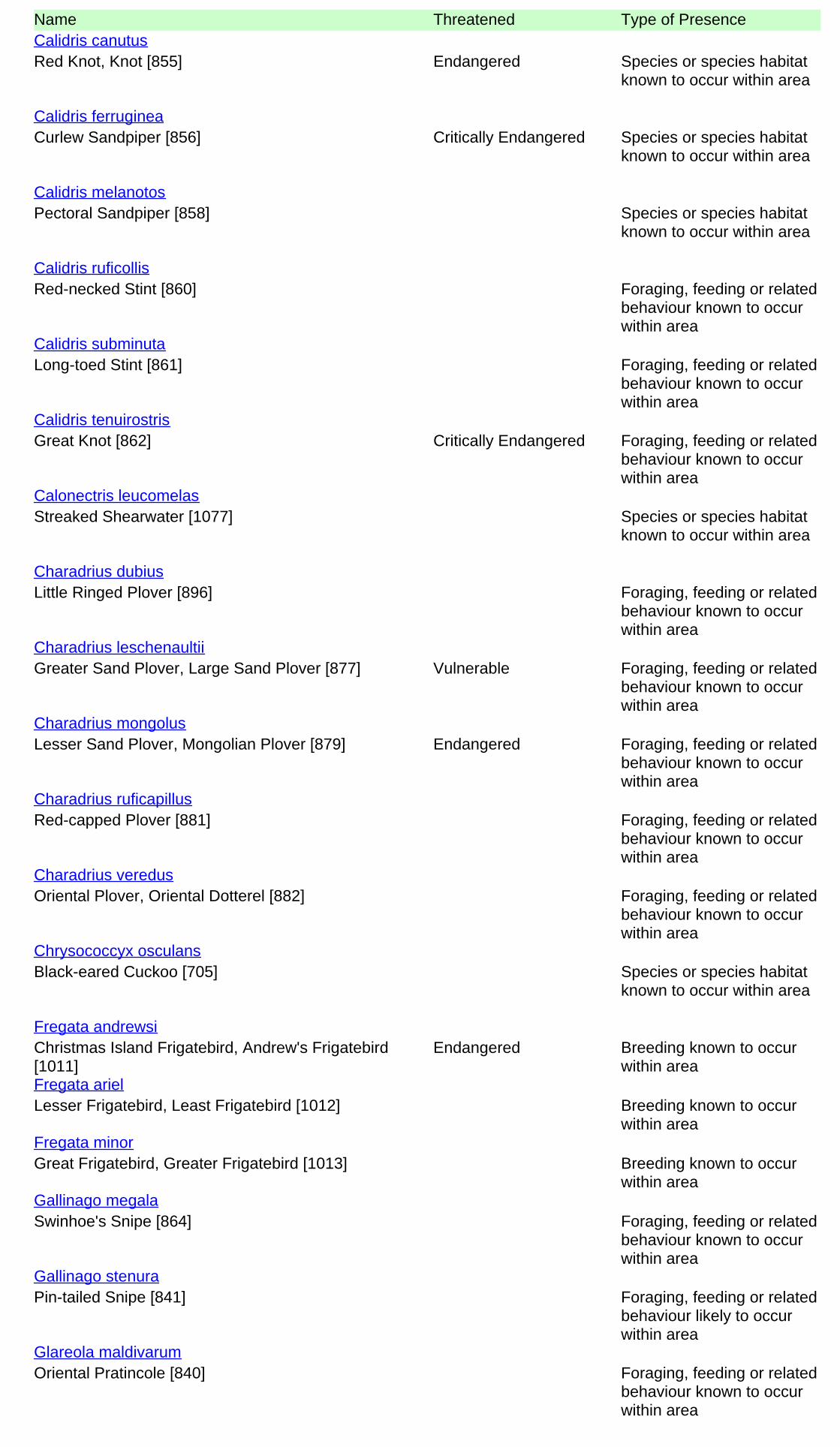
Name Threatened Type of Presence
Red Knot, Knot [855] Endangered Species or species habitatknown to occur within area
Calidris canutus
Curlew Sandpiper [856] Critically Endangered Species or species habitatknown to occur within area
Calidris ferruginea
Pectoral Sandpiper [858] Species or species habitatknown to occur within area
Calidris melanotos
Red-necked Stint [860] Foraging, feeding or relatedbehaviour known to occurwithin area
Calidris ruficollis
Long-toed Stint [861] Foraging, feeding or relatedbehaviour known to occurwithin area
Calidris subminuta
Great Knot [862] Critically Endangered Foraging, feeding or relatedbehaviour known to occurwithin area
Calidris tenuirostris
Streaked Shearwater [1077] Species or species habitatknown to occur within area
Calonectris leucomelas
Little Ringed Plover [896] Foraging, feeding or relatedbehaviour known to occurwithin area
Charadrius dubius
Greater Sand Plover, Large Sand Plover [877] Vulnerable Foraging, feeding or relatedbehaviour known to occurwithin area
Charadrius leschenaultii
Lesser Sand Plover, Mongolian Plover [879] Endangered Foraging, feeding or relatedbehaviour known to occurwithin area
Charadrius mongolus
Red-capped Plover [881] Foraging, feeding or relatedbehaviour known to occurwithin area
Charadrius ruficapillus
Oriental Plover, Oriental Dotterel [882] Foraging, feeding or relatedbehaviour known to occurwithin area
Charadrius veredus
Black-eared Cuckoo [705] Species or species habitatknown to occur within area
Chrysococcyx osculans
Christmas Island Frigatebird, Andrew's Frigatebird[1011]
Endangered Breeding known to occurwithin area
Fregata andrewsi
Lesser Frigatebird, Least Frigatebird [1012] Breeding known to occurwithin area
Fregata ariel
Great Frigatebird, Greater Frigatebird [1013] Breeding known to occurwithin area
Fregata minor
Swinhoe's Snipe [864] Foraging, feeding or relatedbehaviour known to occurwithin area
Gallinago megala
Pin-tailed Snipe [841] Foraging, feeding or relatedbehaviour likely to occurwithin area
Gallinago stenura
Oriental Pratincole [840] Foraging, feeding or relatedbehaviour known to occurwithin area
Glareola maldivarum
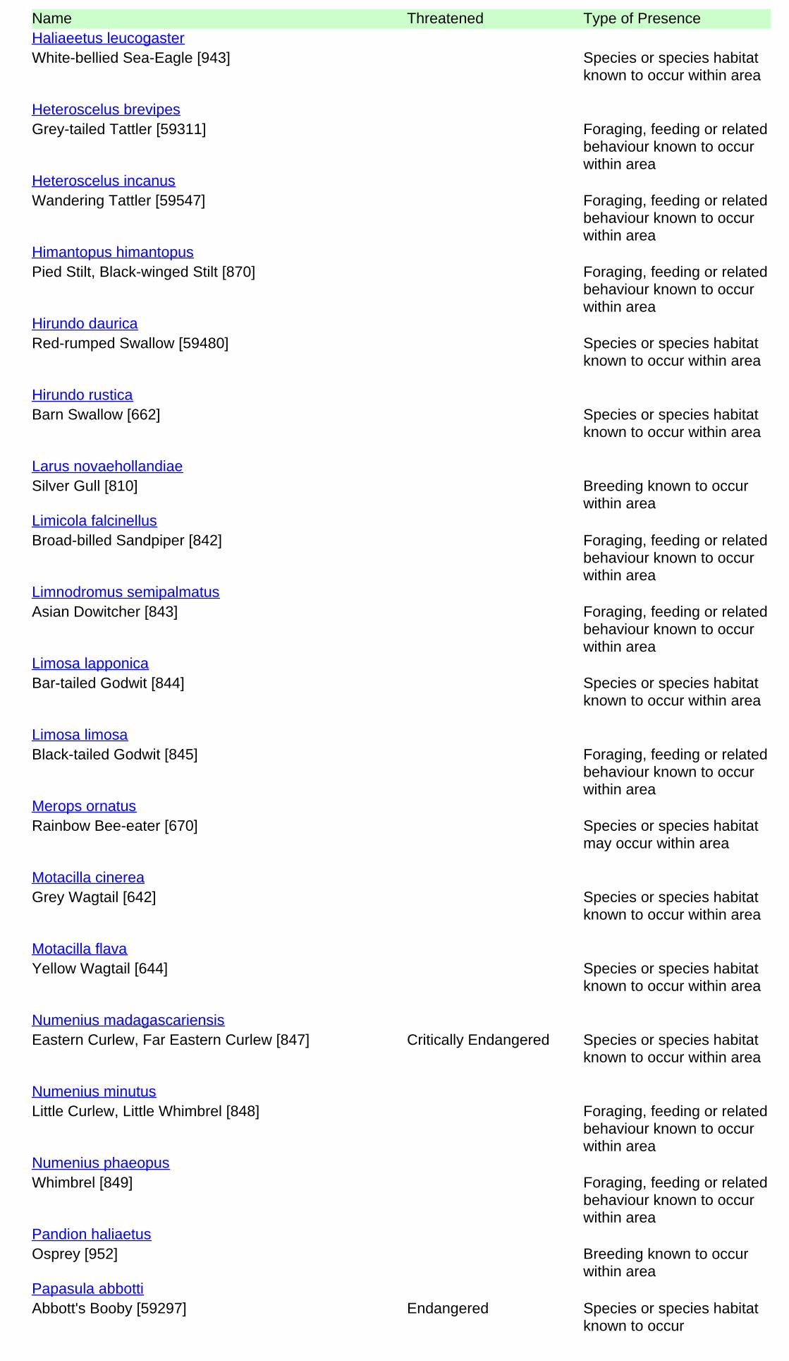
Name Threatened Type of Presence
White-bellied Sea-Eagle [943] Species or species habitatknown to occur within area
Haliaeetus leucogaster
Grey-tailed Tattler [59311] Foraging, feeding or relatedbehaviour known to occurwithin area
Heteroscelus brevipes
Wandering Tattler [59547] Foraging, feeding or relatedbehaviour known to occurwithin area
Heteroscelus incanus
Pied Stilt, Black-winged Stilt [870] Foraging, feeding or relatedbehaviour known to occurwithin area
Himantopus himantopus
Red-rumped Swallow [59480] Species or species habitatknown to occur within area
Hirundo daurica
Barn Swallow [662] Species or species habitatknown to occur within area
Hirundo rustica
Silver Gull [810] Breeding known to occurwithin area
Larus novaehollandiae
Broad-billed Sandpiper [842] Foraging, feeding or relatedbehaviour known to occurwithin area
Limicola falcinellus
Asian Dowitcher [843] Foraging, feeding or relatedbehaviour known to occurwithin area
Limnodromus semipalmatus
Bar-tailed Godwit [844] Species or species habitatknown to occur within area
Limosa lapponica
Black-tailed Godwit [845] Foraging, feeding or relatedbehaviour known to occurwithin area
Limosa limosa
Rainbow Bee-eater [670] Species or species habitatmay occur within area
Merops ornatus
Grey Wagtail [642] Species or species habitatknown to occur within area
Motacilla cinerea
Yellow Wagtail [644] Species or species habitatknown to occur within area
Motacilla flava
Eastern Curlew, Far Eastern Curlew [847] Critically Endangered Species or species habitatknown to occur within area
Numenius madagascariensis
Little Curlew, Little Whimbrel [848] Foraging, feeding or relatedbehaviour known to occurwithin area
Numenius minutus
Whimbrel [849] Foraging, feeding or relatedbehaviour known to occurwithin area
Numenius phaeopus
Osprey [952] Breeding known to occurwithin area
Pandion haliaetus
Abbott's Booby [59297] Endangered Species or species habitatknown to occur
Papasula abbotti

Name Threatened Type of Presencewithin area
White-tailed Tropicbird [1014] Breeding known to occurwithin area
Phaethon lepturus
Christmas Island White-tailed Tropicbird, GoldenBosunbird [26021]
Endangered Breeding likely to occurwithin area
Phaethon lepturus fulvus
Red-tailed Tropicbird [994] Breeding known to occurwithin area
Phaethon rubricauda
Pacific Golden Plover [25545] Foraging, feeding or relatedbehaviour known to occurwithin area
Pluvialis fulva
Grey Plover [865] Foraging, feeding or relatedbehaviour known to occurwithin area
Pluvialis squatarola
Wedge-tailed Shearwater [1027] Breeding known to occurwithin area
Puffinus pacificus
Rufous Fantail [592] Species or species habitatknown to occur within area
Rhipidura rufifrons
Painted Snipe [889] Endangered* Species or species habitatknown to occur within area
Rostratula benghalensis (sensu lato)
Little Tern [813] Breeding known to occurwithin area
Sterna albifrons
Bridled Tern [814] Breeding known to occurwithin area
Sterna anaethetus
Lesser Crested Tern [815] Breeding known to occurwithin area
Sterna bengalensis
Crested Tern [816] Breeding known to occurwithin area
Sterna bergii
Caspian Tern [59467] Breeding known to occurwithin area
Sterna caspia
Roseate Tern [817] Breeding known to occurwithin area
Sterna dougallii
Sooty Tern [794] Breeding known to occurwithin area
Sterna fuscata
Fairy Tern [796] Breeding known to occurwithin area
Sterna nereis
Black-naped Tern [800] Breeding known to occurwithin area
Sterna sumatrana
Australian Pratincole [818] Foraging, feeding or relatedbehaviour known to occurwithin area
Stiltia isabella
Masked Booby [1021] Breeding known to occurwithin area
Sula dactylatra
Brown Booby [1022] Breeding known to occurwithin area
Sula leucogaster
Red-footed Booby [1023] Breeding known to occurwithin area
Sula sula
Wood Sandpiper [829] Foraging, feeding or relatedbehaviour known
Tringa glareola

Name Threatened Type of Presenceto occur within area
Common Greenshank, Greenshank [832] Species or species habitatknown to occur within area
Tringa nebularia
Marsh Sandpiper, Little Greenshank [833] Foraging, feeding or relatedbehaviour known to occurwithin area
Tringa stagnatilis
Common Redshank, Redshank [835] Species or species habitatknown to occur within area
Tringa totanus
Terek Sandpiper [59300] Foraging, feeding or relatedbehaviour known to occurwithin area
Xenus cinereus
Fish
Helen's Pygmy Pipehorse [66186] Species or species habitatmay occur within area
Acentronura larsonae
Corrugated Pipefish, Barbed Pipefish [66188] Species or species habitatmay occur within area
Bhanotia fasciolata
Braun's Pughead Pipefish, Pug-headed Pipefish[66189]
Species or species habitatmay occur within area
Bulbonaricus brauni
Three-keel Pipefish [66192] Species or species habitatmay occur within area
Campichthys tricarinatus
Pacific Short-bodied Pipefish, Short-bodied Pipefish[66194]
Species or species habitatmay occur within area
Choeroichthys brachysoma
Muiron Island Pipefish [66196] Species or species habitatmay occur within area
Choeroichthys latispinosus
Sculptured Pipefish [66197] Species or species habitatmay occur within area
Choeroichthys sculptus
Pig-snouted Pipefish [66198] Species or species habitatmay occur within area
Choeroichthys suillus
Fijian Banded Pipefish, Brown-banded Pipefish[66199]
Species or species habitatmay occur within area
Corythoichthys amplexus
Reticulate Pipefish, Yellow-banded Pipefish, NetworkPipefish [66200]
Species or species habitatmay occur within area
Corythoichthys flavofasciatus
Reef-top Pipefish [66201] Species or species habitatmay occur within area
Corythoichthys haematopterus
Australian Messmate Pipefish, Banded Pipefish[66202]
Species or species habitatmay occur within area
Corythoichthys intestinalis
Schultz's Pipefish [66205] Species or species habitatmay occur within area
Corythoichthys schultzi
Roughridge Pipefish [66206] Species or species habitatmay occur within
Cosmocampus banneri

Name Threatened Type of Presencearea
Maxweber's Pipefish [66209] Species or species habitatmay occur within area
Cosmocampus maxweberi
Redstripe Pipefish [66718] Species or species habitatmay occur within area
Doryrhamphus baldwini
Banded Pipefish, Ringed Pipefish [66210] Species or species habitatmay occur within area
Doryrhamphus dactyliophorus
Bluestripe Pipefish, Indian Blue-stripe Pipefish, PacificBlue-stripe Pipefish [66211]
Species or species habitatmay occur within area
Doryrhamphus excisus
Cleaner Pipefish, Janss' Pipefish [66212] Species or species habitatmay occur within area
Doryrhamphus janssi
Many-banded Pipefish [66717] Species or species habitatmay occur within area
Doryrhamphus multiannulatus
Flagtail Pipefish, Masthead Island Pipefish [66213] Species or species habitatmay occur within area
Doryrhamphus negrosensis
Girdled Pipefish [66214] Species or species habitatmay occur within area
Festucalex cinctus
Ladder Pipefish [66216] Species or species habitatmay occur within area
Festucalex scalaris
Tiger Pipefish [66217] Species or species habitatmay occur within area
Filicampus tigris
Brock's Pipefish [66219] Species or species habitatmay occur within area
Halicampus brocki
Red-hair Pipefish, Duncker's Pipefish [66220] Species or species habitatmay occur within area
Halicampus dunckeri
Mud Pipefish, Gray's Pipefish [66221] Species or species habitatmay occur within area
Halicampus grayi
Whiskered Pipefish, Ornate Pipefish [66222] Species or species habitatmay occur within area
Halicampus macrorhynchus
Samoan Pipefish [66223] Species or species habitatmay occur within area
Halicampus mataafae
Glittering Pipefish [66224] Species or species habitatmay occur within area
Halicampus nitidus
Spiny-snout Pipefish [66225] Species or species habitatmay occur within area
Halicampus spinirostris
Ribboned Pipehorse, Ribboned Seadragon [66226] Species or species habitatmay occur within area
Haliichthys taeniophorus

Name Threatened Type of Presence
Blue-speckled Pipefish, Blue-spotted Pipefish [66228] Species or species habitatmay occur within area
Hippichthys cyanospilos
Madura Pipefish, Reticulated Freshwater Pipefish[66229]
Species or species habitatmay occur within area
Hippichthys heptagonus
Short-keel Pipefish, Short-keeled Pipefish [66230] Species or species habitatmay occur within area
Hippichthys parvicarinatus
Beady Pipefish, Steep-nosed Pipefish [66231] Species or species habitatmay occur within area
Hippichthys penicillus
Belly-barred Pipefish, Banded Freshwater Pipefish[66232]
Species or species habitatmay occur within area
Hippichthys spicifer
Western Spiny Seahorse, Narrow-bellied Seahorse[66234]
Species or species habitatmay occur within area
Hippocampus angustus
Spiny Seahorse, Thorny Seahorse [66236] Species or species habitatmay occur within area
Hippocampus histrix
Spotted Seahorse, Yellow Seahorse [66237] Species or species habitatmay occur within area
Hippocampus kuda
Flat-face Seahorse [66238] Species or species habitatmay occur within area
Hippocampus planifrons
Hedgehog Seahorse [66239] Species or species habitatmay occur within area
Hippocampus spinosissimus
Three-spot Seahorse, Low-crowned Seahorse, Flat-faced Seahorse [66720]
Species or species habitatmay occur within area
Hippocampus trimaculatus
thorntail Pipefish, Thorn-tailed Pipefish [66254] Species or species habitatmay occur within area
Micrognathus brevirostris
Tidepool Pipefish [66255] Species or species habitatmay occur within area
Micrognathus micronotopterus
Black Rock Pipefish [66719] Species or species habitatmay occur within area
Phoxocampus belcheri
Pallid Pipehorse, Hardwick's Pipehorse [66272] Species or species habitatmay occur within area
Solegnathus hardwickii
Gunther's Pipehorse, Indonesian Pipefish [66273] Species or species habitatmay occur within area
Solegnathus lettiensis
Robust Ghostpipefish, Blue-finned Ghost Pipefish,[66183]
Species or species habitatmay occur within area
Solenostomus cyanopterus
Double-end Pipehorse, Double-ended Pipehorse,Alligator Pipefish [66279]
Species or species habitatmay occur within area
Syngnathoides biaculeatus

Name Threatened Type of Presence
Bentstick Pipefish, Bend Stick Pipefish, Short-tailedPipefish [66280]
Species or species habitatmay occur within area
Trachyrhamphus bicoarctatus
Straightstick Pipefish, Long-nosed Pipefish, StraightStick Pipefish [66281]
Species or species habitatmay occur within area
Trachyrhamphus longirostris
Mammals
Dugong [28] Breeding known to occurwithin area
Dugong dugon
Reptiles
Horned Seasnake [1114] Species or species habitatmay occur within area
Acalyptophis peronii
Short-nosed Seasnake [1115] Critically Endangered Species or species habitatknown to occur within area
Aipysurus apraefrontalis
Dubois' Seasnake [1116] Species or species habitatmay occur within area
Aipysurus duboisii
Spine-tailed Seasnake [1117] Species or species habitatmay occur within area
Aipysurus eydouxii
Leaf-scaled Seasnake [1118] Critically Endangered Species or species habitatknown to occur within area
Aipysurus foliosquama
Dusky Seasnake [1119] Species or species habitatknown to occur within area
Aipysurus fuscus
Olive Seasnake [1120] Species or species habitatmay occur within area
Aipysurus laevis
Brown-lined Seasnake [1121] Species or species habitatmay occur within area
Aipysurus tenuis
Stokes' Seasnake [1122] Species or species habitatmay occur within area
Astrotia stokesii
Loggerhead Turtle [1763] Endangered Foraging, feeding or relatedbehaviour known to occurwithin area
Caretta caretta
Green Turtle [1765] Vulnerable Breeding known to occurwithin area
Chelonia mydas
Freshwater Crocodile, Johnston's Crocodile,Johnston's River Crocodile [1773]
Species or species habitatmay occur within area
Crocodylus johnstoni
Salt-water Crocodile, Estuarine Crocodile [1774] Species or species habitatlikely to occur within area
Crocodylus porosus
Leatherback Turtle, Leathery Turtle, Luth [1768] Endangered Foraging, feeding or relatedbehaviour known to occurwithin area
Dermochelys coriacea
Spectacled Seasnake [1123] Species or species habitatmay occur within area
Disteira kingii

Name Threatened Type of Presence
Olive-headed Seasnake [1124] Species or species habitatmay occur within area
Disteira major
Turtle-headed Seasnake [1125] Species or species habitatmay occur within area
Emydocephalus annulatus
Beaked Seasnake [1126] Species or species habitatmay occur within area
Enhydrina schistosa
North-western Mangrove Seasnake [1127] Species or species habitatmay occur within area
Ephalophis greyi
Hawksbill Turtle [1766] Vulnerable Breeding known to occurwithin area
Eretmochelys imbricata
Black-ringed Seasnake [1100] Species or species habitatmay occur within area
Hydrelaps darwiniensis
Black-headed Seasnake [1101] Species or species habitatmay occur within area
Hydrophis atriceps
Slender-necked Seasnake [25925] Species or species habitatmay occur within area
Hydrophis coggeri
Fine-spined Seasnake [59233] Species or species habitatmay occur within area
Hydrophis czeblukovi
Elegant Seasnake [1104] Species or species habitatmay occur within area
Hydrophis elegans
Plain Seasnake [1107] Species or species habitatmay occur within area
Hydrophis inornatus
null [25926] Species or species habitatmay occur within area
Hydrophis mcdowelli
Spotted Seasnake, Ornate Reef Seasnake [1111] Species or species habitatmay occur within area
Hydrophis ornatus
Large-headed Seasnake, Pacific Seasnake [1112] Species or species habitatmay occur within area
Hydrophis pacificus
Spine-bellied Seasnake [1113] Species or species habitatmay occur within area
Lapemis hardwickii
Olive Ridley Turtle, Pacific Ridley Turtle [1767] Endangered Breeding known to occurwithin area
Lepidochelys olivacea
Flatback Turtle [59257] Vulnerable Breeding known to occurwithin area
Natator depressus
Northern Mangrove Seasnake [1090] Species or species habitatmay occur within area
Parahydrophis mertoni
Yellow-bellied Seasnake [1091] Species or species habitatmay occur within area
Pelamis platurus

Whales and other Cetaceans [ Resource Information ]Name Status Type of PresenceMammals
Antarctic Minke Whale, Dark-shoulder Minke Whale[67812]
Species or species habitatlikely to occur within area
Balaenoptera bonaerensis
Sei Whale [34] Vulnerable Foraging, feeding or relatedbehaviour likely to occurwithin area
Balaenoptera borealis
Bryde's Whale [35] Species or species habitatlikely to occur within area
Balaenoptera edeni
Blue Whale [36] Endangered Migration route known tooccur within area
Balaenoptera musculus
Fin Whale [37] Vulnerable Foraging, feeding or relatedbehaviour likely to occurwithin area
Balaenoptera physalus
Common Dophin, Short-beaked Common Dolphin [60] Species or species habitatmay occur within area
Delphinus delphis
Pygmy Killer Whale [61] Species or species habitatmay occur within area
Feresa attenuata
Short-finned Pilot Whale [62] Species or species habitatmay occur within area
Globicephala macrorhynchus
Risso's Dolphin, Grampus [64] Species or species habitatmay occur within area
Grampus griseus
Longman's Beaked Whale [72] Species or species habitatmay occur within area
Indopacetus pacificus
Pygmy Sperm Whale [57] Species or species habitatmay occur within area
Kogia breviceps
Dwarf Sperm Whale [58] Species or species habitatmay occur within area
Kogia simus
Fraser's Dolphin, Sarawak Dolphin [41] Species or species habitatmay occur within area
Lagenodelphis hosei
Humpback Whale [38] Vulnerable Breeding known to occurwithin area
Megaptera novaeangliae
Blainville's Beaked Whale, Dense-beaked Whale [74] Species or species habitatmay occur within area
Mesoplodon densirostris
Gingko-toothed Beaked Whale, Gingko-toothedWhale, Gingko Beaked Whale [59564]
Species or species habitatmay occur within area
Mesoplodon ginkgodens
Irrawaddy Dolphin [45] Species or species habitatknown to occur within area
Orcaella brevirostris
Killer Whale, Orca [46] Species or species habitatmay occur within area
Orcinus orca

[ Resource Information ]Commonwealth ReservesTerrestrialName State TypeChristmas Island EXT National Park (Commonwealth)Kakadu NT National Park (Commonwealth)Pulu Keeling EXT National Park (Commonwealth)
Name Status Type of Presence
Melon-headed Whale [47] Species or species habitatmay occur within area
Peponocephala electra
Sperm Whale [59] Species or species habitatmay occur within area
Physeter macrocephalus
False Killer Whale [48] Species or species habitatlikely to occur within area
Pseudorca crassidens
Indo-Pacific Humpback Dolphin [50] Breeding known to occurwithin area
Sousa chinensis
Spotted Dolphin, Pantropical Spotted Dolphin [51] Species or species habitatmay occur within area
Stenella attenuata
Striped Dolphin, Euphrosyne Dolphin [52] Species or species habitatmay occur within area
Stenella coeruleoalba
Long-snouted Spinner Dolphin [29] Species or species habitatmay occur within area
Stenella longirostris
Rough-toothed Dolphin [30] Species or species habitatmay occur within area
Steno bredanensis
Indian Ocean Bottlenose Dolphin, Spotted BottlenoseDolphin [68418]
Species or species habitatlikely to occur within area
Tursiops aduncus
Spotted Bottlenose Dolphin (Arafura/Timor Seapopulations) [78900]
Species or species habitatknown to occur within area
Tursiops aduncus (Arafura/Timor Sea populations)
Bottlenose Dolphin [68417] Species or species habitatmay occur within area
Tursiops truncatus s. str.
Cuvier's Beaked Whale, Goose-beaked Whale [56] Species or species habitatmay occur within area
Ziphius cavirostris
[ Resource Information ]Australian Marine ParksName LabelArafura Multiple Use Zone (IUCN VI)Arafura Special Purpose Zone (IUCN VI)Arafura Special Purpose Zone (Trawl) (IUCN VI)Argo-Rowley Terrace Multiple Use Zone (IUCN VI)Argo-Rowley Terrace National Park Zone (IUCN II)Argo-Rowley Terrace Special Purpose Zone (Trawl) (IUCN VI)Arnhem Special Purpose Zone (IUCN VI)Ashmore Reef Recreational Use Zone (IUCN IV)Ashmore Reef Sanctuary Zone (IUCN Ia)Cartier Island Sanctuary Zone (IUCN Ia)Joseph Bonaparte Gulf Multiple Use Zone (IUCN VI)Joseph Bonaparte Gulf Special Purpose Zone (IUCN VI)Kimberley Habitat Protection Zone (IUCN IV)

Name LabelKimberley Multiple Use Zone (IUCN VI)Kimberley National Park Zone (IUCN II)Mermaid Reef National Park Zone (IUCN II)Oceanic Shoals Habitat Protection Zone (IUCN IV)Oceanic Shoals Multiple Use Zone (IUCN VI)Oceanic Shoals National Park Zone (IUCN II)Oceanic Shoals Special Purpose Zone (Trawl) (IUCN VI)Wessel Habitat Protection Zone (IUCN IV)Wessel Special Purpose Zone (Trawl) (IUCN VI)
State and Territory Reserves [ Resource Information ]Name StateAdele Island WABalanggarra WABardi Jawi WABrooking Gorge WABrowse Island WACamp Creek WAChannel Point NTCharnley River WADambimangari WADambimangari WADevonian Reef WADhimurru NTDjelk NTDjukbinj NTDrysdale River WAGarig Gunak Barlu NTGeikie Gorge WAGeikie Gorge WAKeep River NTKing Leopold Ranges WALacepede Islands WALaterite WALawley River WALesueur Island WALow Rocks WAMarion Downs WAMarri-Jabin (Thamurrurr - Stage 1) NTMarthakal NTMary River NTMijing WAMitchell River WAMornington WAOrd River WAParry Lagoons WAPrince Regent WASwan Island WATableland WATanner Island WATunnel Creek WAUnnamed WA28968 WAUnnamed WA37168 WAUnnamed WA41775 WAUnnamed WA44669 WAUnnamed WA44673 WAUnnamed WA44677 WAUnnamed WA46940 WAUnnamed WA48482 WA
Extra Information
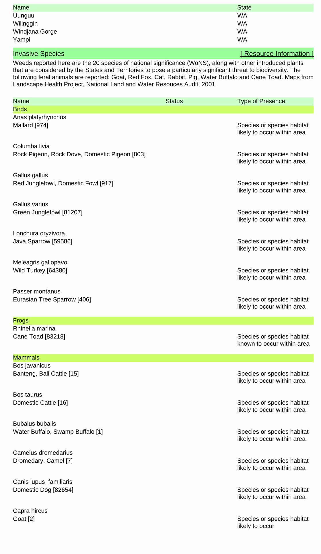
Name StateUunguu WAWilinggin WAWindjana Gorge WAYampi WA
Invasive Species [ Resource Information ]Weeds reported here are the 20 species of national significance (WoNS), along with other introduced plantsthat are considered by the States and Territories to pose a particularly significant threat to biodiversity. Thefollowing feral animals are reported: Goat, Red Fox, Cat, Rabbit, Pig, Water Buffalo and Cane Toad. Maps fromLandscape Health Project, National Land and Water Resouces Audit, 2001.
Name Status Type of PresenceBirds
Mallard [974] Species or species habitatlikely to occur within area
Anas platyrhynchos
Rock Pigeon, Rock Dove, Domestic Pigeon [803] Species or species habitatlikely to occur within area
Columba livia
Red Junglefowl, Domestic Fowl [917] Species or species habitatlikely to occur within area
Gallus gallus
Green Junglefowl [81207] Species or species habitatlikely to occur within area
Gallus varius
Java Sparrow [59586] Species or species habitatlikely to occur within area
Lonchura oryzivora
Wild Turkey [64380] Species or species habitatlikely to occur within area
Meleagris gallopavo
Eurasian Tree Sparrow [406] Species or species habitatlikely to occur within area
Passer montanus
Frogs
Cane Toad [83218] Species or species habitatknown to occur within area
Rhinella marina
Mammals
Banteng, Bali Cattle [15] Species or species habitatlikely to occur within area
Bos javanicus
Domestic Cattle [16] Species or species habitatlikely to occur within area
Bos taurus
Water Buffalo, Swamp Buffalo [1] Species or species habitatlikely to occur within area
Bubalus bubalis
Dromedary, Camel [7] Species or species habitatlikely to occur within area
Camelus dromedarius
Domestic Dog [82654] Species or species habitatlikely to occur within area
Canis lupus familiaris
Goat [2] Species or species habitatlikely to occur
Capra hircus

Name Status Type of Presencewithin area
Donkey, Ass [4] Species or species habitatlikely to occur within area
Equus asinus
Horse [5] Species or species habitatlikely to occur within area
Equus caballus
Cat, House Cat, Domestic Cat [19] Species or species habitatlikely to occur within area
Felis catus
House Mouse [120] Species or species habitatlikely to occur within area
Mus musculus
Pacific Rat, Polynesian Rat [79] Species or species habitatlikely to occur within area
Rattus exulans
Black Rat, Ship Rat [84] Species or species habitatlikely to occur within area
Rattus rattus
Pig [6] Species or species habitatlikely to occur within area
Sus scrofa
Red Fox, Fox [18] Species or species habitatlikely to occur within area
Vulpes vulpes
Plants
Gamba Grass [66895] Species or species habitatlikely to occur within area
Andropogon gayanus
Para Grass [5879] Species or species habitatlikely to occur within area
Brachiaria mutica
Cabomba, Fanwort, Carolina Watershield, Fish Grass,Washington Grass, Watershield, Carolina Fanwort,Common Cabomba [5171]
Species or species habitatlikely to occur within area
Cabomba caroliniana
Buffel-grass, Black Buffel-grass [20213] Species or species habitatlikely to occur within area
Cenchrus ciliaris
Prickly Pears [85131] Species or species habitatlikely to occur within area
Cylindropuntia spp.
Water Hyacinth, Water Orchid, Nile Lily [13466] Species or species habitatlikely to occur within area
Eichhornia crassipes
Hymenachne, Olive Hymenachne, Water Stargrass,West Indian Grass, West Indian Marsh Grass [31754]
Species or species habitatlikely to occur within area
Hymenachne amplexicaulis
Cotton-leaved Physic-Nut, Bellyache Bush, Cotton-leafPhysic Nut, Cotton-leaf Jatropha, Black Physic Nut[7507]
Species or species habitatlikely to occur within area
Jatropha gossypifolia
Lantana, Common Lantana, Kamara Lantana, Large-leaf Lantana, Pink Flowered Lantana, Red FloweredLantana, Red-Flowered Sage, White Sage, Wild Sage[10892]
Species or species habitatlikely to occur within area
Lantana camara
Mimosa, Giant Mimosa, Giant Sensitive Plant, Species or speciesMimosa pigra

Nationally Important Wetlands [ Resource Information ]Name State"The Dales", Christmas Island EXTAdelaide River Floodplain System NTAshmore Reef EXTBig Springs WACobourg Peninsula System NTDrysdale River WAFinniss Floodplain and Fog Bay Systems NTGeikie Gorge WAGladstone Lake WAHosine's Spring, Christmas Island EXTKakadu National Park NTLake Kununurra WAMary Floodplain System NTMermaid Reef EXTMitchell River System WAMoyle Floodplain and Hyland Bay System NTMurgenella-Cooper Floodplain System NTOrd Estuary System WAParry Floodplain WAPrince Regent River System WA
Name Status Type of PresenceThornySensitive Plant, Black Mimosa, CatclawMimosa, Bashful Plant [11223]
habitat likely to occur withinarea
Prickly Pears [82753] Species or species habitatlikely to occur within area
Opuntia spp.
Parkinsonia, Jerusalem Thorn, Jelly Bean Tree, HorseBean [12301]
Species or species habitatlikely to occur within area
Parkinsonia aculeata
Mission Grass, Perennial Mission Grass,Missiongrass, Feathery Pennisetum, FeatherPennisetum, Thin Napier Grass, West IndianPennisetum, Blue Buffel Grass [21194]
Species or species habitatlikely to occur within area
Pennisetum polystachyon
Salvinia, Giant Salvinia, Aquarium Watermoss, KaribaWeed [13665]
Species or species habitatlikely to occur within area
Salvinia molesta
Athel Pine, Athel Tree, Tamarisk, Athel Tamarisk,Athel Tamarix, Desert Tamarisk, Flowering Cypress,Salt Cedar [16018]
Species or species habitatlikely to occur within area
Tamarix aphylla
Prickly Acacia, Blackthorn, Prickly Mimosa, BlackPiquant, Babul [84351]
Species or species habitatlikely to occur within area
Vachellia nilotica
Reptiles
Asian House Gecko [1708] Species or species habitatlikely to occur within area
Hemidactylus frenatus
Mourning Gecko [1712] Species or species habitatlikely to occur within area
Lepidodactylus lugubris
Wolf Snake, Common Wolf Snake, Asian Wolf Snake[83178]
Species or species habitatlikely to occur within area
Lycodon aulicus
Christmas Island Grass-skink [1312] Species or species habitatlikely to occur within area
Lygosoma bowringii
Flowerpot Blind Snake, Brahminy Blind Snake, CacingBesi [1258]
Species or species habitatknown to occur within area
Ramphotyphlops braminus

Name StatePulu Keeling National Park EXTTunnel Creek WAWindjana Gorge WAYampi Sound Training Area WA
Key Ecological Features are the parts of the marine ecosystem that are considered to be important for thebiodiversity or ecosystem functioning and integrity of the Commonwealth Marine Area.
Key Ecological Features (Marine) [ Resource Information ]
Name RegionCarbonate bank and terrace system of the Van NorthGulf of Carpentaria basin NorthPinnacles of the Bonaparte Basin NorthShelf break and slope of the Arafura Shelf NorthTributary Canyons of the Arafura Depression NorthAncient coastline at 125 m depth contour North-westAshmore Reef and Cartier Island and surrounding North-westCanyons linking the Argo Abyssal Plain with the North-westCarbonate bank and terrace system of the Sahul North-westContinental Slope Demersal Fish Communities North-westExmouth Plateau North-westGlomar Shoals North-westMermaid Reef and Commonwealth waters North-westPinnacles of the Bonaparte Basin North-westSeringapatam Reef and Commonwealth waters in North-west

- non-threatened seabirds which have only been mapped for recorded breeding sites
- migratory species that are very widespread, vagrant, or only occur in small numbers
- some species and ecological communities that have only recently been listed
Not all species listed under the EPBC Act have been mapped (see below) and therefore a report is a general guide only. Where available datasupports mapping, the type of presence that can be determined from the data is indicated in general terms. People using this information in makinga referral may need to consider the qualifications below and may need to seek and consider other information sources.
For threatened ecological communities where the distribution is well known, maps are derived from recovery plans, State vegetation maps, remotesensing imagery and other sources. Where threatened ecological community distributions are less well known, existing vegetation maps and pointlocation data are used to produce indicative distribution maps.
- seals which have only been mapped for breeding sites near the Australian continent
Such breeding sites may be important for the protection of the Commonwealth Marine environment.
Threatened, migratory and marine species distributions have been derived through a variety of methods. Where distributions are well known and iftime permits, maps are derived using either thematic spatial data (i.e. vegetation, soils, geology, elevation, aspect, terrain, etc) together with pointlocations and described habitat; or environmental modelling (MAXENT or BIOCLIM habitat modelling) using point locations and environmental datalayers.
The information presented in this report has been provided by a range of data sources as acknowledged at the end of the report.Caveat
- migratory and
The following species and ecological communities have not been mapped and do not appear in reports produced from this database:
- marine
This report is designed to assist in identifying the locations of places which may be relevant in determining obligations under the EnvironmentProtection and Biodiversity Conservation Act 1999. It holds mapped locations of World and National Heritage properties, Wetlands of Internationaland National Importance, Commonwealth and State/Territory reserves, listed threatened, migratory and marine species and listed threatenedecological communities. Mapping of Commonwealth land is not complete at this stage. Maps have been collated from a range of sources at variousresolutions.
- threatened species listed as extinct or considered as vagrants
- some terrestrial species that overfly the Commonwealth marine area
The following groups have been mapped, but may not cover the complete distribution of the species:
Only selected species covered by the following provisions of the EPBC Act have been mapped:
Where very little information is available for species or large number of maps are required in a short time-frame, maps are derived either from 0.04or 0.02 decimal degree cells; by an automated process using polygon capture techniques (static two kilometre grid cells, alpha-hull and convex hull);or captured manually or by using topographic features (national park boundaries, islands, etc). In the early stages of the distribution mappingprocess (1999-early 2000s) distributions were defined by degree blocks, 100K or 250K map sheets to rapidly create distribution maps. More reliabledistribution mapping methods are used to update these distributions as time permits.
-14.686627 128.573727,-15.059116 128.689303,-15.208015 128.380806,-15.542755 128.342574,-15.765334 128.226558,-16.135896128.072749,-16.173041 127.918501,-16.80132 127.571332,-17.133377 127.224608,-17.427529 127.185936,-17.648354 126.415133,-17.94209126.415133,-18.271648 126.492038,-18.491007 126.337789,-18.7105 125.913716,-18.418058 125.682563,-17.868492 125.335834,-17.6115124.911766,-17.391048 124.873094,-17.35414 124.487693,-17.35414 123.793794,-17.133377 123.678218,-17.169909 123.215473,-16.764295123.061229,-16.838338 122.637156,-17.022897 122.406003,-17.280722 122.020602,-17.684785 122.174851,-19.656803 117.9728,-19.584364111.381003,-18.527679 103.594333,-14.984839 97.773336,-10.511727 94.727926,-4.514371 94.882175,-3.63024 101.358395,-6.892549105.251949,-6.816195 106.061424,-7.160348 106.523726,-7.389638 106.523726,-7.848296 108.567183,-7.733787 108.759664,-7.733787109.299314,-8.420795 111.612156,-8.229909 111.805074,-8.535108 112.691893,-8.344278 113.23154,-8.57335 114.465085,-8.687618114.811814,-8.840065 115.274557,-8.344278 115.929783,-8.725844 116.122701,-8.801851 116.084029,-8.95425 116.46943,-8.496863116.932175,-9.0684 116.816599,-8.344278 125.181591,-5.436362 124.372116,-4.898909 128.072749,-6.203185 128.959128,-7.198716128.342574,-7.389638 128.727975,-7.007277 129.498778,-8.115506 131.117722,-7.542579 132.351264,-6.816195 132.158784,-6.280069131.464891,-6.164737 131.773388,-6.93094 133.353659,-7.542579 133.122507,-8.725844 134.124896,-9.714838 139.521383,-12.137014136.861812,-12.023997 136.399066,-12.061818 135.859422,-11.608911 135.859422,-11.94877 135.512253,-12.174819 135.2811,-12.174819135.049947,-11.910933 134.780122,-11.94877 134.317377,-11.835674 133.854637,-11.608911 133.54658,-11.382397 133.431004,-11.571459133.083834,-11.193208 132.81401,-11.64679 132.544185,-12.061818 132.659761,-12.099634 132.46728,-12.212619 132.158784,-12.287772131.965863,-12.287772 131.426219,-12.249983 131.002145,-12.400676 130.616744,-12.55128 130.53984,-12.664069 130.385591,-12.852227130.346919,-12.852227 130.153999,-13.302969 130.231343,-13.565408 129.922846,-13.452604 129.807269,-13.82756 129.845942,-14.014387129.807269,-14.201489 129.421874,-14.612223 129.53745,-14.835785 129.421874,-14.910537 129.228953,-14.798398 128.920456,-14.798398128.920456,-14.686627 128.573727
Coordinates

-Environment and Planning Directorate, ACT-Birdlife Australia-Australian Bird and Bat Banding Scheme
-Department of Parks and Wildlife, Western Australia
Acknowledgements
-Office of Environment and Heritage, New South Wales
-Department of Primary Industries, Parks, Water and Environment, Tasmania
-Department of Land and Resource Management, Northern Territory-Department of Environmental and Heritage Protection, Queensland
-Department of Environment and Primary Industries, Victoria
-Australian National Wildlife Collection
-Department of Environment, Water and Natural Resources, South Australia
This database has been compiled from a range of data sources. The department acknowledges the followingcustodians who have contributed valuable data and advice:
-Australian Museum
-National Herbarium of NSW
Forestry Corporation, NSW-Australian Government, Department of Defence
-State Herbarium of South Australia
The Department is extremely grateful to the many organisations and individuals who provided expert adviceand information on numerous draft distributions.
-Natural history museums of Australia
-Queensland Museum
-Australian National Herbarium, Canberra
-Royal Botanic Gardens and National Herbarium of Victoria
-Geoscience Australia
-Ocean Biogeographic Information System
-Online Zoological Collections of Australian Museums-Queensland Herbarium
-Western Australian Herbarium
-Tasmanian Herbarium
-Northern Territory Herbarium
-South Australian Museum
-Museum Victoria
-University of New England
-CSIRO
-Other groups and individuals-Tasmanian Museum and Art Gallery, Hobart, Tasmania
-Museum and Art Gallery of the Northern Territory
-Reef Life Survey Australia-Australian Institute of Marine Science-Australian Government National Environmental Science Program
-Australian Tropical Herbarium, Cairns
-Australian Government – Australian Antarctic Data Centre
-Queen Victoria Museum and Art Gallery, Inveresk, Tasmania
-eBird Australia
-American Museum of Natural History
© Commonwealth of Australia
+61 2 6274 1111
Canberra ACT 2601 Australia
GPO Box 787
Department of the Environment
Please feel free to provide feedback via the Contact Us page.

WHP and Subsea Fields AC/L7 & AC/L8 Drilling Program 2020 Environment
Plan
TM-50-PLN-I-00001
Rev 0
APPENDIX F - HYDROCARBON THRESHOLDS

Hydrocarbon thresholds
Hydrocarbon impact pathways and thresholds
The modelling method described is able to track hydrocarbon concentrations of floating oil, entrained oil and dissolved aromatic hydrocarbons below biologically significant impact levels. Consequently, threshold concentrations are specified for the model to control what contact is recorded for surface (floating oil) and subsurface locations (entrained oil and dissolved aromatic hydrocarbons) to ensure that recorded contacts are for biologically meaningful concentrations.
The determination of biologically meaningful impact levels is complex since the degree of impact will depend on the sensitivity of the biota contacted, the duration of the contact (exposure) and the toxicity of the hydrocarbon mixture making the contact. The toxicity of a hydrocarbon will change over time, due to weathering processes altering the composition of the hydrocarbon. To ensure conservatism in the environmental impact assessment process, the threshold concentrations applied to the model are selected to adopt the most sensitive receptors that may be exposed, the longest likely exposure times and the more toxic hydrocarbons.
Impact pathways and impact threshold concentrations are detailed below for surface (floating) oil, entrained oil and dissolved aromatic hydrocarbons (DAHs).
Surface (floating) oil
The impact threshold concentration for exposure to surface (floating) oil is derived from levels likely to cause adverse impacts to marine/ coastal fauna and habitats. Marine/ coastal fauna, habitats and socio-economic receptors may be impacted by floating oil in the following way:
• Marine mammals, reptiles and birds can be exposed to oil when at the water surface. For marine mammals and reptiles this can occur when surfacing within a slick to breathe while for birds this includes contact from diving into a slick or floating on the sea surface while feeding or resting. For marine fauna surfacing in floating oil contact to sensitive areas may occur (e.g. eyes, mouth and respiratory system) creating irritation and potentially cell damage. Volatile compounds evaporating form surface oil may be inhaled by marine mammals and reptiles, particularly when the oil is fresh and relatively unweathered. Inhalation of these compounds may cause damage to internal respiratory structures. It is generally considered that marine mammals with smooth skin (e.g. cetaceans) are less susceptible to coating of oil than those covered with hair given hair has a greater potential to trap and retain oil causing longer exposure times. Birds are particularly susceptible to impact from floating oil in that feathers retain oil, particularly when the oil is ‘sticky’ (e.g. heavy crudes). The coating of oil on birds may hinder flight and feeding, reduce the ability of the bird to thermoregulate (control body temperature) and irritate/damage sensitive surfaces such as eyes, ears and nasal structures. Secondary impacts can occur through the ingestion of oil as birds attempt to preen contaminated feathers. Ingestion may lead to oil absorption and further toxic impacts;
• Surface oil can coat emergent habitats such as coral or rocky reefs and intertidal and shoreline areas around islands or along coastlines. Habitats that can be affected include rocky shorelines, sandy beaches, mangrove communities and intertidal areas which may support seagrass, algae and coral reef communities. The physical coating of mangroves, in particular their root system, can prevent gas exchange and/or cause toxicity at the cellular level. Mangrove response to oil contact includes deforestation, yellowing of leaves and mortality. Other chronic responses include reduced growth, reduced reproductive output and success and genetic mutation. Intertidal areas may be contacted at low tides where emergent habitat is coated by oil. Seagrass, algae and sessile fauna such as hard corals, soft corals and sponges may be smothered as well as small low mobility fauna that live in close association with these and other benthic habitats or within/on sediments. Smothering of intertidal photosynthetic organisms such as seagrass, algae and hard coral may reduce their capacity for photosynthesis (energy production) or lead to a

toxic response at the cellular level. For seagrass and algae this could lead to plant death, shedding of leaves/thalli, reduced growth, reduced reproductive output/success and genetic mutation. Similarly, for hard corals, bleaching, colony death, reduced growth and reduced reproductive capacity may occur. Such impacts may be exacerbated if these organisms are already under stress from marginal environmental conditions or if impacts occur during critical life-history stages (e.g. spawning periods). Small fauna smothered by oil may be hindered in their ability to move and feed or may suffer a toxic response from mortality to reduced growth rate or reproductive success. The coating of habitats can lead to secondary impacts to marine/coastal fauna. For example, marine turtles and shorebirds may be contacted by oil when using nesting beaches or when roosting/feeding along shorelines, respectively. Marine/coastal fauna may also ingest oil when feeding on coated habitats, e.g. dugongs or turtles ingesting coated seagrass/algae and shorebirds ingesting coated intertidal organisms such as molluscs and crabs; and
• Surface oil may impact on socio-economic receptors such as the oil and gas industry, commercial shipping, fisheries/aquaculture and tourism. The presence of floating oil may pose a human health risk from volatile compounds depending on the nature and freshness of the oil (i.e. fresh light oils and condensates posing the greatest risk) while oil spill response activities targeting floating oil may preclude or disrupt activities by other users in the area both offshore and at oil affected shorelines. This could have an economic impact on affected industries. In addition, floating and stranded oil may be highly visible to the general public and have a resultant negative effect on tourism in affected areas. Real or perceived deterioration of nearshore and coastal habitats may also have long lasting effect on the tourism value of an area and of fisheries activities that may rely on those areas to support healthy fish stocks.
There is a paucity of data on floating oil concentrations with respect to impacts to marine organisms. The impact of floating oil on birds is better understood than other receptors. Estimates for the minimum oil thickness that will harm seabirds (through ingestion from preening of contaminated feathers or loss of thermal protection of their feathers) range from at 10 g/m2 (O’Hara and Morandin, 2010) to 25 g/m2 (Koops et al., 2004). A conservative threshold of 10 g/m2
has been applied to impacts from floating diesel and crude oil. This hydrocarbon threshold is also considered appropriate for turtles, sea snakes and marine mammals (NRDAMCME, 1997) and has also been applied herein to determine impacts of surface oils to emergent habitat such as coral reefs.
A 1g/m2 threshold was also modelled which may appear as a rainbow sheen and may be indicative of socio-economic impacts.
Entrained oil
Entrained oil is oil that is dispersed within the water column as oil droplets. For oil spills released at surface, entrained oil is created in the top few meters of the water column through mixing of surface oil by wave action. For oil spills released subsea (e.g. pipelines leaks, well blowouts) entrained oil may be distributed deeper within the water column.
The concentrations of entrained droplets output by SIMAP represent hydrocarbons that are not bioavailable. The soluble and semi-soluble fractions dissolve from the droplets over time, and a potential effects analysis based on the dissolved hydrocarbons characterizes their risk.
Because PAHs are the most toxic components of oil and crude oils typically contain about 1% PAHs by mass (French-McCay 2002; Forth et al. 2017), the sublethal concentration threshold (PNEC) expressed as total hydrocarbon concentration (THC, not TPH) based on the most toxic components would be ~100 μg/L (100 ppb) for fresh oil. However, as oil weathers, PAHs are lost to volatilization and degradation. Thus, the whole-oil threshold of 100 ppb is appropriate for fresh oil and conservative (highly protective of aquatic resources) for weathered oil. An exposure concentration of 1,000 ppb (1 ppm or 1 mg/L) of (total) oil hydrocarbons was deemed a low level of concern for sensitive life stages in marine organisms by Kraly et al. (2001). The 1 mg/L concentration is at the low

end of the range where sub-lethal impacts from acute exposure have been observed (NRC, 2005). Based on the review of toxicity studies by Bejarano et al. (2017), a THC lethal threshold of 3–28 mg/L (or 3–30 mg/L with rounding, given uncertainties) would be appropriate for a range of oils and states of weathering for species from all geographical areas globally.
Based on this information, a contact threshold of 100 ppb was considered a conservative contact threshold for the assessment of impacts from entrained oil.
Dissolved Aromatic Hydrocarbons
Dissolved hydrocarbons are taken up into organisms directly through external surfaces and gills, as well as through the digestive tract. Thus, soluble and semi-soluble hydrocarbons are bioavailable, whereas insoluble compounds in oil are not bioavailable to aquatic organisms. Laboratory studies have shown that the dissolved hydrocarbons exert the most effects on aquatic biota (Carls et al. 2008; Nordtug et al. 2011; Redman 2015). The volatilization rates of hydrocarbons from surface slicks are faster than the dissolution rates. Thus, dissolution from oil droplets in the water column is the main source of concentrations dissolved in the water.
The most toxic components of oil to water-column and benthic organisms are lower-molecular-weight compounds, which are both volatile and soluble in water (generally in the water accommodated fraction – WAF). The polynuclear aromatic hydrocarbons (PAHs) exert the most toxic effects because they are semi-soluble and not highly volatile, so they persist in the environment long enough for significant exposure to occur (Anderson et al., 1974, 1987; Neff and Anderson, 1981; Malins and Hodgins, 1981; McAuliffe, 1987; NRC 2003, 2005). The monoaromatic hydrocarbons (MAHs), including BTEX (benzene, toluene, ethylbenzene, and xylenes), and the soluble alkanes also contribute to toxicity, but these compounds are highly volatile, so exposures of aquatic biota are minimal or negligible except when light oils are discharged at depth where volatilization does not occur (French-McCay 2002).
French McCay (2018) provides an outline of the measured total PAH concentrations within the water accommodated fraction of medium crude oils as being 74.9 to 282 µ/l.
Within the soluble and semi-soluble hydrocarbons, toxicity is inversely related to solubility, typically quantified by the octanol-water partition coefficient (Kow), a measure of hydrophobicity (Nirmalakhandan and Speece 1988; Hodson et al. 1988; Blum and Speece 1990; McCarty 1986; McCarty et al. 1992a, b; Mackay et al. 1992; McCarty and Mackay 1993; Verhaar et al. 1992, 1999; Swartz et al. 1995; French-McCay 2002; McGrath et al 2009).
Due to the toxic nature of MAHs and low molecular weight PAHs, and the ability for these to be transferred across cellular structures, DAHs contribute to the acute toxicity of an oil. The proportion of BTEX, and other DAHs that are readily dissolved or evaporated, diminish over time. DAH concentration is therefore higher around fresh oil than weathered oil. The toxicity of DAHs to an organism is dependent on both the concentration of the oil and the amount of time an organism is exposed to a given concentration.
The range of LC50s varies from ~10 mg/L (ppb) for 3-ring PAHs (which are semi-soluble) to ~10-100 mg/L (ppm) for the highly soluble BTEX compounds (French-McCay 2002). Thus, the toxicity of an oil hydrocarbon mixture is strongly related to the chemical composition, which varies as the oil weathers since the soluble and semi-soluble hydrocarbons are all volatile to varying degree. Aurand and Coelho (2005) suggest that, based on the wide variation of toxicity data, a threshold of 1,000 ppb will represent a reasonable level for protection of more sensitive life stages of organisms residing in the water column.
For most oil spills, exposures of water column biota to concentrations above potential thresholds of concern are typically on time scales of minutes to hours, even for spills lasting weeks or months because of the varying movements of the oil in the water, dilution and losses to biodegradation and

volatilization. Furthermore, the concentrations vary in time over the short exposure periods (McAuliffe et al. 1980, 1981; McAuliffe 1987; Lunel 1994; French McCay 2002, 2004; Bejarano et al. 2014). Thus, the use of LC50s for >48 hours of exposure, or chronic endpoints for longer exposure times, as thresholds for oil spills is highly conservative. Acute aquatic toxicity thresholds would be sufficiently conservative for oil spills in open water systems (as opposed to ponds or other contained systems). There is no need for an ACR correction for evaluating acute toxicity to aquatic biota from oil spills in open waters.
Based on this information, a contact threshold of 70 ppb was considered a conservative contact threshold for the assessment of impacts from dissolved aromatic hydrocarbons.

WHP and Subsea Fields AC/L7 & AC/L8 Drilling Program 2020 Environment
Plan
TM-50-PLN-I-00001
Rev 0
APPENDIX G - EPBC ACT CONSOLIDATED NOTICE

.~; _A_u_st_r_al_ia_n_G_ ov_e_r_n_m_e_n_t ____ _
~ Department of the Environment and Energy
CONSOLIDATED APPROVAL NOTICE
Montara 4, 5 and 6 Oil Production Wells and Gas Re-injection Well, Timor Sea (EPBC 2002/755)
The attached notice (Attachment A) is provided to consolidate the approval conditions for the above project, approved on 3 September 2003. The approval conditions were subject to variation at various times during the post approval phase. These decisions are publicly available on the Department's website at http://epbcnotices.environment.gov.au/referralslist/.
The publication of this notice does not alter the dates of: effect for the approval; the variations to conditions; the expiry date of the approval; or any other dates mentioned in conditions. The consolidated approval notice is for ease of reference only.
Name and position
Date of Consolidated Approval Notice
Greg Manning Assistant Secretary Assessments (WA, SA, NT) & Post Approvals Branch
{~June 2018

Attachment A
Australian Government
Department of the Environment and Energy
Montara 4, 5 and 6 Oil Production Wells and Gas Re-injection Well, Timor Sea (EPBC 2002/755)
This decision is made under sections 130(1) and 133 of the Environment Protection and Biodiversity Conservation Act 1999.
Proposed action
person to whom the approval is granted
proponent's ABN
proposed action
Approval
Controlling Provision
PTTEP Australasia (Ashmore Cartier) Pty Ltd (formerly Newfield Australia (Ashmore Cartier) Pty Ltd)
27 004 210 164
To drill and operate Montara 4, Montara 5 and Montara 6 Wells for the purpose of oil production and to re-complete and operate Montara 3 for use as a gas re-injection well in Permit Area AC/RL3, in the Timer Sea approximately 200 km from the coast of Western Australia [See EPBC Act referral (EPBC 2002/755)].
Decision
Commonwealth marine areas (sections 23 & 24A) Approved
conditions of approval
This approval is subject to the conditions specified below.
expiry date of approval
This approval has effect until 1 September 2028.
Decision-maker
name and position
signature
date of decision ·
Gerard Patrick Early First Assistant Secretary Approvals and Wildlife Division
SIGNED
3 September 2003

,•
Conditions attached to the approval
1. The person taking the action must submit for the Minister's approval, an Oil Spill Contingency Plan (OSCP) that demonstrates the response preparedness of the person taking the action for any spills, including hydrocarbons from offshore wells and infrastructure, pipelines, construction and operation vessels. This must include the capacity to respond to a spill and mitigate the environmental impacts on the Commonwealth marine area and species listed as threatened or migratory under the EPBC Act. The OSCP must include, but is not limited to:
a) identification of sensitive areas, species or habitats that may be impacted by a potential spill, as determined by site-specific modelling of worst case scenario spills;
b) specific response measures for those sensitive areas, species or habitats and prioritisation of those areas during a spill response, including a net environmental benefit analysis of the response options;
c) a description of resources available for use in containing and minimising impacts in the event of a spill and arrangements for accessing them;
d) a demonstrated capacity to respond to a spill at the site and measures that can feasibly be applied within the first 48 hours of a spill occurring;
e) training of staff in spill response measures and identifying roles and responsibilities of personnel during a spill response;
f) procedures for reporting spill incidents within 48 hours of a spill occurring; and
g) a demonstrated procedure or a plan for testing, maintenance and review of the OSCP.
The OSCP must be submitted and approved by the Minister prior to the recommencement of operations, or as otherwise agreed to in writing by the Minister. The person taking the action must not recommence the operations unless the Minister has approved the OSCP. The approved OSCP must be implemented.
2. The person taking the action must submit for the Minister's approval a Decommissioning Plan at least one (1) year prior to commencement of decommissioning of any components of the floating production, storage and offtake vessel, subsea wells, flowlines, or any associated infrastructure. The Decommissioning Plan must address the removal of all structures and components above the sea floor. The person taking the action must not commence decommissioning until the Decommissioning Plan has been approved by the Minister. The approved Decommissioning Plan must be implemented.
3. The person taking the action must monitor produced formation water in accordance with a NOPSEMA accepted Environment Plan for the activity, including aspects of quality, quantity and effects on the receiving environment.
Note: Condition 4, 5 and 6 were revoked on the date of this consolidated notice.
7. The person taking the action must submit for the Minister's approval, an Operational and Scientific Monitoring Program (OSMP) that will be implemented in the event of a spill to determine the potential extent and ecosystem consequences of such a spill, including, but not limited to:
Page 3 of 5

a) triggers for the initiation and termination of the OSMP, including, but not limited to, spill volume, composition, extent, duration and detection of impacts;
b) a description of the studies that will be undertaken to determine the operational response, potential extent of impacts, ecosystem consequences and potential environmental reparations required as a result of the spill;
c) inclusion of sufficient baseline information on the biota and the environment that may be impacted by a potential spill, to enable an assessment of the impacts of such a spill;
d) a strategy to implement the scientific monitoring plan, including timelines for delivery of results and mechanisms for the timely peer review of studies; and
e) provision for periodic review of the program.
The OSMP must be submitted and approved by the Minister within three (3) months following the recommencement of operations, or as otherwise agreed to in writing by the Minister. The approved OSMP must be implemented.
Note: Condition 8 was revoked on the date of this consolidated notice.
9. Within 30 days after the recommencement of operations, the person taking the action must advise the Department in writing of the actual date of recommencement of operations.
10. The person taking the action must maintain accurate records substantiating all activities associated with or relevant to the conditions of approval, including measures taken to implement the management plans/monitoring programs required by this approval, and make them available upon request to the Department. Such records may be subject to audit by the Department or an independent auditor in accordance with section 458 of the EPBC Act, or used to verify compliance with the conditions of approval. Summaries of audits will be posted on the Department's website. The results of audits may also be publicised through the general media.
11. Upon the direction of the Minister, the person taking the action must ensure that an independent audit of compliance with the conditions of approval is conducted and a report sub.mitted to the Minister. The independent auditor must be approved by the Minister prior to the commencement of the audit. Audit criteria must be agreed to by the Minister and the audit report must address the criteria to the satisfaction of the Minist~r.
Note: Condition 12 was revoked on the date of this consolidated notice.
13. A plan, program or strategy required by condition 1, 2 or 7 is automatically deemed to have been submitted to, and approved by, the Minister if the measures (as specified in the relevant condition) are included in an environment plan (or environment plans) relating to the taking of the action that:
a) was submitted to NOPSEMA after 27 February 2014; and
b) either:
i. is in force under the OPGGS Environment Regulations; or
ii. has ended in accordance with regulation 25A of the OPGGS Environment Regulations.
Page 4 of 5
13A. Where a plan, program or strategy required by condition 1 or 7 has been approved by the Minister and the measures (as specified in the relevant condition) are included in an environment plan (or environment plans) that:
a) was submitted to NOPSEMA after 27 February 2014; and
b) either:
i. is in force under the OPGGS Environment Regulations; or
ii. has ended in accordance with regulation· 25A of the OPGGS Environment Regulations,
the plan, program or strategy approved by the Minister no longer needs to be implemented.
138. Where an environment plan, which includes measures specified in the conditions referred to in conditions 13 and 13A above, is in force under the OPGGS Environment Regulations that relates to the taking of the action, the person taking the action must comply with those measures as specified in that environment plan.
Definitions
Department: The Australian Government Department or any other agency administering the Environment Protection and Biodiversity Conservation Act 1999 (Cth) from time to time.
Environment Plan: an environment plan as existing from time to time which has the meaning given in the OPGGS Environment Regulations.
In force: in relation to an environment plan, has the meaning given in the OPGGS Environment Regulations.
Minister: The Minister administering the Environment Protection and Biodiversity Conservation Act 1999 and includes a delegate of the Minister.
Net Environmental Benefit Analysis: a methodology of comparing and ranking the net environmental benefit of alternative management options.
NOPSEMA: the National Offshore Petroleum Safety and Environmental Management Authority or any other agency that administers the OPGGS Environment Regulations from time to time.
OPGGS Environment Regulations: Offshore Petroleum and Greenhouse Gas Storage (Environment) Regulations 2009 (Cth) as in force or existing from time to time.
Recommencement of operations/recommence the operations: the recommencement of oil production following suspension of production of oil on 21 August 2009.
Page 5 of 5

WHP and Subsea Fields AC/L7 & AC/L8 Drilling Program 2020 Environment
Plan
TM-50-PLN-I-00001
Rev 0
APPENDIX H - PRIORITY RECEPTOR KEY VALUES

Protection Priority
Key Values and Potential Impacts Oil Spill Modelling Parameter Worst Case
Scenario Result
Ashmore Reef/Cartier Island (including Ashmore Reef and Cartier Island and surrounding Commonwealth waters Ashmore Reef AMP Cartier Island AMP)
• Ashmore is an atoll-like structure with three low vegetated islands, sandbanks, lagoon areas, and surrounding reef largest of only three emergent oceanic reefs present in the north-eastern Indian Ocean. Only oceanic reef in the region with vegetated islands.
• Cartier Island includes an unvegetated sand island (Cartier Island), mature reef flat, a small, submerged pinnacle (Wave Governor Bank), and two shallow pools to the north-east of the island.
• Encompasses ecosystems, habitats and communities associated with the North-West Shelf, Timor Province, and emergent oceanic reefs. These locations are Important biological stepping-stones facilitating transport of biological material to the reef systems along the WA coast and Subject to the Memorandum of Understanding between Australia and Indonesia (MoU Box).
Physical Habitat
Present Notes Key periods Impacts
Coral reefs ✔ Very high diversity; Ashmore supports the highest number of coral species of any reef off the West Australian coast
Spawning: Mar/Apr &
Oct/Nov
Contact from floating oil is likely to impact the shoreline and result in accumulated stranded oil at discrete locations. Mangroves and intertidal areas may be impacted by being smothered, although continuous tidal movements will mobilise oil and add to dispersion. Contact from entrained oil may impact shoreline through accumulation, although constant tidal and current motions will re-mobilise oil and create further dilution.
Contact from entrained and dissolved oil (although well below threshold levels) may impact submerged habitats resulting in smothering and/or contact toxic impacts; although constant tidal and current motions will re-mobilise oil and create further dilution
Seagrasses ✔ Supports a small dugong population at Ashmore
Flowering and fruiting: Oct-Jan
Macroalgae and non-coral benthic invertebrates
✔ Algal reef flats important foraging habitat for marine turtles
High diversity and abundance of soft corals, gorgonians, sea fans and sponges
Mangroves ✖
Rocky shoreline
✖
Marine Fauna
Present Comment Key periods Impacts
Invertebrates ✔ High diversity of molluscs at Ashmore Contact from floating oil is likely to impact marine fauna by coating (causing skin/eye irritation and affect ability to thermo-regulate) and oil contact from movement across the shoreline. In addition, ingestion may occur from preening/cleaning body and/or eating oil covered food resulting in internal toxicity. Contact from entrained oil may impact marine fauna by causing skin irritation/toxicity as fauna move through water, or internal toxicity from ingesting oil tainted food. Although constant tidal and current motions will re-mobilise oil and create further dilution and fauna are mobile
Fish and sharks
✔ Foraging habitat for whale sharks SBF Tuna: Spawn Oct - Feb
Goldband: Spawn - Mar
Red Emperor spawn: Oct
Whale shark migration: June - Nov
Birds ✔ Some of the most important seabird rookeries on the North West Shelf.
43 CAMBA and JAMBA listed species at Ashmore
Breeding: May – June/Oct
Migrating: Feb-Apr/Sept-Oct
Marine reptiles
✔ • Critical nesting and inter-nesting habitat for green turtles at Ashmore and Cartier (DoE 2015a)
• Moderate nesting of hawksbill turtles at Ashmore
• Low nesting activity by loggerhead turtles (single report of nesting on West Island, Ashmore)
Turtles
• Mating: Oct
• Nesting: Nov – March (peaks Jan – Feb)
• Hatching: Peaks Mar – Apr Foraging: Year-round Sea snakes: Mating: ~September
Probability of contact by floating/shoreline oil at ≥10g/m2
% 88
Probability of contact by floating/shoreline oil at ≥100g/m2
% 100
Probability of contact by entrained oil at ≥100ppb
(%) 100
Probability of contact by dissolved aromatics at ≥ 70 ppb
(%) 51
Maximum oil loading on shorelines
m3 5 284
Minimum time to contact by floating oil at ≥10 g/m2
days 3
Minimum time to contact by floating oil at ≥100 g/m2
days 3
Maximum concentration of entrained oil at ≥100ppb
ppb 8 574
Maximum concentration of dissolved aromatics at ≥ 70 ppb
ppb 1 675

Protection Priority
Key Values and Potential Impacts Oil Spill Modelling Parameter Worst Case
Scenario Result
• Large and significant feeding populations of green, hawksbill and loggerhead turtles
• World’s highest abundance and diversity of sea snakes at Ashmore
Marine Mammals
✔ • Migratory pathway for pygmy blue whales
• Small population of dugongs at Ashmore (approx. 50 individuals)
Dugong calving/breeding: Sept-Dec
Pygmy Blue whale migration north: May-Aug
Pygmy Blue whale migration south – Sept-Dec
Protected Areas
Present Comment Impacts
AMP ✔ Ashmore and Cartier AMPs
Oil contacting these values are described under the individual receptors.
The habitat and marine fauna which may be contacted by oil (as described above) may then impact upon the socio-economic values (tourism) with impacts on reputation.
State MP ✔
KEF ✔ Ashmore Reef and Cartier Island and surrounding Commonwealth waters
Continental Slope Demersal Fish Communities
RAMSAR ✔ Wetland of International Importance
Present Comment Key periods Impacts
Traditional Owner values
✔ Sea country
Oil contacting shorelines will impact upon these values, in particular, tourism and fishing activities from visible stranded oil and tainted fish
• Heritage value: onshore graves and artefacts highly unlikely to be contacted by oil
• Commercial fishing: a number are licensed to operate in the area
The habitat and marine fauna which may be contacted by oil (as described above) will then impact upon the socio-economic values
Indonesian ✔ Artefacts and graves
Current resting and staging area from MOU Box
Commonwealth heritage list
✔ Ashmore reef only
Ann Millicent historical shipwreck at Cartier Island
Tourism ✔
Recreation ✔
Scientific Research
✔

Protection Priority
Key Values and Potential Impact Oil Spill Modelling Parameter Worst Case Scenario Result
Surface
Subsea
Darwin Coast Physical Habitat
Present Notes Key periods Potential impact
Coral reefs ✔ Several hard-coral communities including the Heritage listed Channel Island corals (AHPI 2012)
13 hard coral species identified, with cover ranging from 13-23% (Cardno 2013b).
Spawning: Mar/Apr &
Oct/Nov
Contact from floating oil is likely to impact the shoreline and result in accumulated stranded oil at discrete locations. Mangroves and intertidal areas may be impacted by being smothered, although continuous tidal movements will mobilise oil and add to dispersion. Contact from entrained oil may impact shoreline through accumulation, although constant tidal and current motions will re-mobilise oil and create further dilution.
Contact from entrained and dissolved oil (although well below threshold levels) may impact submerged habitats resulting in smothering and/or contact toxic impacts; although constant tidal and current motions will re-mobilise oil and create further dilution. There is potential for major losses and functions of the benthic coral reefs and seagrass habitats, with recovery spanning over decades given toxicity impacts associated with hydrocarbon exposure. The seagrasses provide important foraging areas for dugongs who may also be impacted by the hydrocarbon.
Seagrasses ✔ Seagrass habitat is mostly found in sandy intertidal and subtidal substates in the outer region of Darwin Harbour and consists of Halophila and Halodule, which is highly variable in its distribution and cover (Cardno 2014)
Flowering and fruiting: Oct-Jan
Macroalgae and non-coral benthic invertebrates
✔
Mangroves ✔ Intertidal areas between Tapa Bay and Shoal Bay contain over 30,000 hectares (ha) of mangrove habitat (Cardno 2013a). Recognised for its diversity and contains over 30 mangrove species (McGuinness 2003; Wightman 2006)
Rocky shoreline
✔
Marine Fauna
Present Comment Key periods Impacts
Invertebrates ✔ Recreationally and commercially important populations of mud crab and prawns
Mud crab spawning: Sept – Nov
Contact from floating oil is likely to impact marine fauna by smothering (causing skin/eye irritation and affect ability to thermo-regulate) and oil contact from movement across the shoreline. In addition, ingestion may occur from preening/cleaning body and/or eating oil covered food resulting in internal toxicity. Contact from entrained oil may impact marine fauna by causing skin irritation/toxicity as fauna move through water, or internal toxicity from ingesting oil tainted food. Although constant tidal and current motions will re-mobilise oil and create further dilution and fauna are mobile.
Fish and sharks
✔ Recreationally and commercially important populations of barramundi
Barramundi spawning: Sept - Mar
Birds ✔
Marine reptiles
✔ Juvenile and adult green turtles forage in mangroves and rocky reef areas
Marine Mammals
✔ Foraging population of dugongs in seagrass habitat Darwin Harbour Outer
Protected Areas
Present Comment Impacts
AMP ✖ Oil contacting these values are described under the individual receptors.
State MP ✖
Probability of contact by floating oil at ≥10g/m2
% 17
Probability of contact by floating/shoreline oil at ≥100g/m2
days 50
Probability of contact by entrained oil at ≥100ppb
(%) 5
Probability of contact by dissolved aromatics at ≥ 70 ppb
(%) <1
Maximum oil loading on shorelines
m3 4 255
Minimum time to contact by floating oil at ≥10 g/m2
days 17
Minimum time to contact by floating oil at ≥100 g/m2
days 17
Maximum concentration of entrained oil at any depth ppb
ppb 316
Maximum concentration of dissolved aromatics at any depth ppb
ppb NC

Protection Priority
Key Values and Potential Impact Oil Spill Modelling Parameter Worst Case Scenario Result
Surface
Subsea
KEF ✖ The habitats and marine fauna which may be contacted by oil (see individual receptors) may then impact upon the socio-economic values (tourism) with impacts on reputation. RAMSAR ✖
Present Comment Key periods Impacts
Traditional Owner values
✔ Sea country
Oil contacting shorelines will impact upon these values, in particular, tourism and fishing activities from visible stranded oil and tainted fish
• Commercial fishing: a number are licensed to operate in the area
The habitat and marine fauna which may be contacted by oil (as described above) will then impact upon the socio-economic values
Indonesian ✖
Commonwealth heritage list
✖
Tourism ✔ Dry Season (May – October)
Recreation ✔ Dry Season (May – October)
Protection Priority
Key Values and Potential Impacts Oil Spill Modelling Parameter Scenario Result
Surface
Subsea
International Waters
(including Timor Leste and Indonesia coastline)
Indonesia *
Physical Habitat
Present Notes Key periods Impacts
Coral reefs ✔ Fringing reefs are the most common reef types with scleractinian corals being the most dominant and important group
~600 coral species recorded in Indonesia
Spawning: Mar/Apr &
Oct/Nov
Contact from floating oil is likely to impact the shoreline and result in accumulated stranded oil at discrete locations. Mangroves and intertidal areas may be impacted by being smothered, although continuous tidal movements will mobilise oil and add to dispersion. Contact from entrained oil may impact shoreline through accumulation, although constant tidal and current motions will re-mobilise oil and create further dilution.
Contact from entrained and dissolved oil (although well below threshold levels) may impact submerged habitats resulting in smothering and/or contact toxic impacts; although constant tidal and current motions will re-mobilise oil and create further dilution
Seagrasses ✔ Indonesia (west), Kepulauan Seribu National Park, Timor-Leste
Flowering and fruiting: Oct-Jan
Macroalgae and non-coral benthic invertebrates
✔
Mangroves ✔ Timor Leste coastline features mangrove communities surrounding entrance to rivers primarily on the south coast
Rocky shoreline
✔
Marine Fauna
Present Comment Key periods Impacts
Invertebrates ✔ Contact from floating oil is likely to impact marine fauna by smothering (causing skin/eye irritation and affect ability to thermo-regulate) and oil contact from movement across the Fish and
sharks ✔ Whale shark foraging Whale sharks: year round
Probability of contact by floating oil at% ≥10g/m2
% 10
Probability of contact by floating/shoreline oil at ≥100g/m2
43
Probability of contact by entrained oil at ≥100ppb
(%)
Probability of contact by dissolved aromatics at ≥ 70 ppb
(%) 14
Maximum oil loading on shorelines
m3 <1
Minimum time to contact by floating oil at ≥10 g/m2
days 26
Minimum time to contact by floating oil at ≥100 g/m2
days 777
Maximum concentration of entrained oil at any depth ppb
ppb 2 276

Protection Priority
Key Values and Potential Impacts Oil Spill Modelling Parameter Scenario Result
Surface
Subsea
Goldband: Spawn - Mar
Red Emperor spawn: Oct
shoreline. In addition, ingestion may occur from preening/cleaning body and/or eating oil covered food resulting in internal toxicity. Contact from entrained oil may impact marine fauna by causing skin irritation/toxicity as fauna move through water, or internal toxicity from ingesting oil tainted food. Although constant tidal and current motions will re-mobilise oil and create further dilution and fauna are mobile
Birds ✔ Pulau Dana, Sulawesi, Lesser Sunda Islands, Lombok
Breeding: May – June/Oct
Migrating: Feb-Apr/Sept-Oct
Marine reptiles
✔ Marine turtle nesting at Sukamade Beach (mainly green turtles with smaller numbers of leatherback, hawksbill and olive ridley turtles; Meru Betiri National Park), Komodo and Nino Komis National Parks and Pulau Dana Nature Reserve
Turtles
• Mating: Oct
• Nesting: Nov – March (peaks Jan – Feb)
• Hatching: Peaks Mar – Apr Foraging: Year-round
Marine Mammals
✔ Savu sea breeding and feeding for whales and dolphins
Dugong calving/breeding: Sept-Dec
Pygmy Blue whale migration north: May-Aug
Pygmy Blue whale migration south – Sept-Dec
Protected Areas
Present Comment Impacts
National Park ✔ Kepulauan Seribu, Meru Betiri and Komodo National Parks, Pulau Dana Nature Reserve
Oil contacting these values are described under the individual receptors.
The habitats and marine fauna which may be contacted by oil (see individual receptors) may then impact upon the socio-economic values (tourism) with impacts on reputation.
RAMSAR ✔
Present Comment Key periods Impacts
Traditional Owner values
✖ Oil contacting shorelines will impact upon these values, in particular, tourism and fishing activities from visible stranded oil and tainted fish
The habitat and marine fauna which may be contacted by oil (as described above) will then impact upon the socio-economic values
Indonesian ✔
Commonwealth heritage list
✖
Tourism ✔ Year-round
Recreation ✔ Year-round
Scientific Research
✔
Maximum concentration of dissolved aromatics at any depth ppb
ppb NC

Protection Priority
Key Values and Potential Impacts Oil Spill Modelling Parameter Worst Case Scenario Result
Surface
Subsea
Joseph Bonaparte Gulf coastline NT
The Joseph Bonaparte Gulf Marine Park covers an area of 8,600 km2 and contains key examples of the ecosystems of the Northern Shelf Province.
Physical Habitat
Present Notes Key periods Impacts
Coral reefs ✔ Benthic substrate mostly shifting sands with high energy water movement.
Small isolated specimens of hard corals on the muddy inner shelf
Contact from floating oil is likely to impact the shoreline and result in accumulated stranded oil at discrete locations. Mangroves and intertidal areas may be impacted by being smothered, although continuous tidal movements will mobilise oil and add to dispersion. Contact from entrained oil may impact shoreline through accumulation, although constant tidal and current motions will re-mobilise oil and create further dilution.
Contact from entrained and dissolved oil (although well below threshold levels) may impact submerged habitats resulting in smothering and/or contact toxic impacts; although constant tidal and current motions will re-mobilise oil and create further dilution
Seagrasses ✔ Not significant areas due to high tidal movements
Macroalgae and non-coral benthic invertebrates
✔ Habitat within the emergent reef systems, shoals and banks
Mangroves ✔
Rocky shoreline
✔
Marine Fauna
Present Comment Key periods Impacts
Invertebrates ✔ Key banana prawn habitat
Mud crabs
Mud crab spawning: Sept - Nov
Contact from floating oil is likely to impact marine fauna by smothering (causing skin/eye irritation and affect ability to thermo-regulate) and oil contact from movement across the shoreline. In addition, ingestion may occur from preening/cleaning body and/or eating oil covered food resulting in internal toxicity. Contact from entrained oil may impact marine fauna by causing skin irritation/toxicity as fauna move through water, or internal toxicity from ingesting oil tainted food. Although constant tidal and current motions will re-mobilise oil and create further dilution and fauna are mobile
Fish and sharks
✔ Sawfish, barramundi and threadfin salmon habitat
Sawfish pupping: early wet season (Nov)
Barramundi spawning: Sept - March
Birds ✔ Significant feeding and breeding sites Breeding: May – June/Oct
Migrating: Feb-Apr/Sept-Oct
Marine reptiles
✔ Green turtle foraging area (BIA)
Olive ridley turtle foraging and internesting BIA
Hawsbill migration route
Significant flatback nesting at Turtle Point
Turtles
• Flatback Nesting: year round (peaks June-Aug)
• Foraging: Year-round
Marine Mammals
✔ Whales not likely due to shallow water depth
Dugongs not expected to be abundant due to lack of seagrass
Potential for common, bottlenose, Irrawaddy, Risso’s, Indo-Pacific and pantropical spotted dolphin.
Snubfin dolphin breeding and foraging area
Snubfin dolphin mating: Mar - June
Protected Areas
Present Comment Impacts
Probability of contact by floating oil at ≥10g/m2
% 21
Probability of contact by floating/shoreline oil at ≥100g/m2
% 58
Probability of contact by entrained oil at ≥100ppb
(%) 5
Probability of contact by dissolved aromatics at ≥ 70 ppb
(%) <1
Maximum oil loading on shorelines
m3 8 694
Minimum time to contact by floating/shoreline oil at ≥10 g/m2
days 17
Minimum time to contact by floating/shoreline oil at ≥100 g/m2
days 17
Maximum concentration of entrained oil at any depth ppb
ppb 131
Maximum concentration of dissolved aromatics at any depth ppb
ppb N/C

Protection Priority
Key Values and Potential Impacts Oil Spill Modelling Parameter Worst Case Scenario Result
Surface
Subsea
AMP ✔ Oil contacting these values are described under the individual receptors.
The habitats and marine fauna which may be contacted by oil (see individual receptors) may then impact upon the socio-economic values (tourism) with impacts on reputation.
State MP ✔
KEF ✔ Carbonate banks of the Sahul Shelf
RAMSAR ✔ Adjacent to Ord River Floodplain
Present Comment Key periods Impacts
Traditional Owner values
✔ Sea country
Sacred sites
Oil contacting shorelines will impact upon these values, in particular, tourism and fishing activities from visible stranded oil and tainted fish
• Commercial fishing: a number are licensed to operate in the area
The habitat and marine fauna which may be contacted by oil (as described above) will then impact upon the socio-economic values
Indonesian ✔
Commonwealth heritage list
✔
Tourism ✔
Recreation ✔
Commercial Fishing
✔ Major prawn fishery
Protection Priority
Key Values and Potential Impacts Oil Spill Modelling Parameter Worst Case Scenario Result
Surface
Subsea
Western NT
(including Kakadu Coast, Cobourg Peninsula, East Arnhem Land, West Arnhem Land)
Kakadu National Park and Ramsar Wetlands are a mosaic of contiguous wetlands comprising the catchments of two large river systems. It comprises sandstone plateau communities, escarpments, extensive seasonal floodplains, estuaries, tidal flats and offshore islands. The rivers are tidal in their lower reaches and are associated with extensive tidal flats.
Physical Habitat
Present Notes Key periods Impacts
Coral reefs ✔ Spawning: Mar/Apr &
Oct/Nov
Contact from floating oil is likely to impact the shoreline and result in accumulated stranded oil at discrete locations. Mangroves and intertidal areas may be impacted by being smothered, although continuous tidal movements will mobilise oil and add to dispersion. Contact from entrained oil may impact shoreline through accumulation, although constant tidal and current motions will re-mobilise oil and create further dilution.
Contact from entrained and dissolved oil (although well below threshold levels) may impact submerged habitats resulting in smothering and/or contact toxic impacts; although constant tidal and current motions will re-mobilise oil and create further dilution
Seagrasses ✔ Important areas Flowering and fruiting: Oct-Jan
Macroalgae and non-coral benthic invertebrates
✔
Mangroves ✔ Mangrove forest along the Wildman, West Alligator and East Alligator tidal reaches
Rocky shoreline
✔
Marine Fauna
Probability of contact by floating oil at ≥10g/m2
% 13
Probability of contact by floating oil at ≥100g/m2
% 43
Probability of contact by entrained oil at ≥100ppb
(%) 4
Probability of contact by dissolved aromatics at ≥ 70 ppb
(%) <1
Maximum oil loading on shorelines
m3 11 496
Minimum time to contact by floating/shoreline oil at ≥10 g/m2
days 21
Minimum time to contact by
days 21

Protection Priority
Key Values and Potential Impacts Oil Spill Modelling Parameter Worst Case Scenario Result
Surface
Subsea
Present Comment Key periods Impacts
Invertebrates ✔ Contact from floating oil is likely to impact marine fauna by smothering (causing skin/eye irritation and affect ability to thermo-regulate) and oil contact from movement across the shoreline. In addition, ingestion may occur from preening/cleaning body and/or eating oil covered food resulting in internal toxicity. Contact from entrained oil may impact marine fauna by causing skin irritation/toxicity as fauna move through water, or internal toxicity from ingesting oil tainted food. Although constant tidal and current motions will re-mobilise oil and create further dilution and fauna are mobile
Fish and sharks
✔ Barramundi
Sawfish
Barramundi spawning: Sept – March
Sawfish pupping: Nov
Birds ✔ Numerous migratory species that occur in Kakadu are protected under international agreements such as the Bonn convention for conserving migratory species, and Australia’s migratory bird protection agreements with China (CAMBA), Japan (JAMBA) and the Republic of Korea (ROKAMBA).
53 species of waterbird
Breeding: May – June/Oct
Migrating: Feb-Apr/Sept-Oct
Marine reptiles
✔ Important inter-nesting area for the flatback and green turtle
BIA (inter-nesting) for leatherback turtles Seasnakes
Turtles
• Mating: Oct
• Green nesting: Nov – March (peaks Jan – Feb)
• Flatback nesting: year round (peaks June-August)
• Hatching: Peaks Mar – Apr Foraging: Year-round
Marine Mammals
✔ Dugong Dugong calving/breeding: Sept-Dec Dugong foraging: year-round
Protected Areas
Present Comment Impacts
AMP ✖ Garig Gunak:
- Contains a diverse marine habitat including coral reefs, rocky reefs, sand and mudflats, and areas of mangroves, seagrass and macroalgae
- 35 species of mangroves
- Seagrass habitats are key foraging areas for dugong and marine turtles
- Sandy beaches provide green and flatback turtle nesting areas
- Sandy Islands I and II provide important seabird rookery areas
Kakadu:
Wetlands, mangroves, intertidal sand/mud flats, migratory listed water and shoreline birds,
State MP ✖
National Parks ✔ Garig Gunak Barlu National Park
Kakadu National Park
World Heritage
✔ Kakadu NP
RAMSAR ✔ Kakadu - Wetland of International Importance
Present Comment Key periods Impacts
Traditional Owner values
✔ Sea country
Sacred sites
Oil contacting shorelines will impact upon these values, in particular, tourism and fishing activities from visible stranded oil and tainted fish
Indonesian ✔
floating/shoreline oil at ≥100 g/m2
Maximum concentration of entrained oil at any depth ppb
ppb 254
Maximum concentration of dissolved aromatics at any depth ppb
ppb N/C

Protection Priority
Key Values and Potential Impacts Oil Spill Modelling Parameter Worst Case Scenario Result
Surface
Subsea
Commonwealth heritage list
✔ • Heritage value: onshore graves and artefacts not contacted by entrained oil. Significant cultural and
heritage value, mental well being • Commercial fishing: a number are licensed to operate in
the area eg NT Mud crab fishery
The habitat and marine fauna which may be contacted by oil (as described above) will then impact upon the socio-economic values
Tourism ✔
Recreation ✔
Scientific Research
✔

Protection Priority
Key Values and Potential Impacts Oil Spill Modelling Parameter Worst Case Scenario Result
Surface
Subsea
Tiwi Islands (Melville Island and Bathurst Island)
Physical Habitat
Present Notes Key periods Impacts
Coral reefs ✔ Spawning: Mar/Apr &
Oct/Nov
Contact from floating oil is likely to impact the shoreline and result in accumulated stranded oil at discrete locations. Mangroves and intertidal areas may be impacted by being smothered, although continuous tidal movements will mobilise oil and add to dispersion. Contact from entrained oil may impact shoreline through accumulation, although constant tidal and current motions will re-mobilise oil and create further dilution.
Contact from entrained and dissolved oil (although well below threshold levels) may impact submerged habitats resulting in smothering and/or contact toxic impacts; although constant tidal and current motions will re-mobilise oil and create further dilution
Seagrasses ✔ Flowering and fruiting: Oct-Jan
Macroalgae and non-coral benthic invertebrates
✔
Mangroves ✔ East coast of islands, covering ~800 km2
Rocky shoreline
✔
Marine Fauna
Present Comment Key periods Impacts
Invertebrates ✔ Contact from floating oil is likely to impact marine fauna by smothering (causing skin/eye irritation and affect ability to thermo-regulate) and oil contact from movement across the shoreline. In addition, ingestion may occur from preening/cleaning body and/or eating oil covered food resulting in internal toxicity. Contact from entrained oil may impact marine fauna by causing skin irritation/toxicity as fauna move through water, or internal toxicity from ingesting oil tainted food. Although constant tidal and current motions will re-mobilise oil and create further dilution and fauna are mobile
Fish and sharks
✔ SBF Tuna: Spawn Oct - Feb
Goldband: Spawn - Mar
Red Emperor spawn: Oct
Birds ✔ World's largest breeding colony of crested terns
Breeding: May – June/Oct
Migrating: Feb-Apr/Sept-Oct
Marine reptiles
✔ Large population of the vulnerable olive ridley turtle at Cape Van Diemen on Melville Island. Green turtle BIA
Olive Ridley nesting: Peak April - May
Marine Mammals
✔
Protected Areas
Present Comment Impacts
AMP x
Seagrasses, mangroves -values of the NW Shelf Transition
State MP x
KEF x
RAMSAR x
Present Comment Key periods Impacts
Traditional Owner values
✔ Sea country
Probability of contact by shoreline oil at ≥10g/m2
% 18
Probability of contact by shoreline oil at ≥100g/m2
% 56
Probability of contact by entrained oil at ≥100ppb
(%) 15
Probability of contact by dissolved aromatics at ≥ 70 ppb
(%) <1
Maximum oil loading on shorelines
m3 8 375
Minimum time to contact by floating/shoreline oil at ≥10 g/m2
days 19
Minimum time to contact by floating/shoreline oil at ≥100 g/m2
days 19
Maximum concentration of entrained oil any depth ppb
ppb 483
Maximum concentration of dissolved aromatics at any depth ppb
ppb NC

Protection Priority
Key Values and Potential Impacts Oil Spill Modelling Parameter Worst Case Scenario Result
Surface
Subsea
Indonesian X Oil contacting shorelines will impact upon these values, in particular, tourism and fishing activities from visible stranded oil and tainted fish
• Heritage value: onshore graves and artefacts are highly unlikely be contacted by entrained oil above impact thresholds
• Commercial fishing: a number are licensed to operate in the area - NT Spanish Mackerel Fishery
The habitat and marine fauna which may be contacted by oil (as described above) will then impact upon the socio-economic values
Commonwealth heritage list
X
Tourism ✔
Recreation ✔

Protection Priority
Key Values and Potential Impacts Oil Spill Modelling Parameter Worst Case Scenario Result
Surface
Subsea
Kimberley Coast (including North Kimberley Marine Park, Kimberley Coast
Physical Habitat
Present Notes Key periods Impacts
Coral reefs ✔ Spawning: Mar/Apr &
Oct/Nov
Contact from floating oil is likely to impact the shoreline and result in accumulated stranded oil at discrete locations. Mangroves and intertidal areas may be impacted by being smothered, although continuous tidal movements will mobilise oil and add to dispersion. Contact from entrained oil may impact shoreline through accumulation, although constant tidal and current motions will re-mobilise oil and create further dilution.
Contact from entrained and dissolved oil (although well below threshold levels) may impact submerged habitats resulting in smothering and/or contact toxic impacts; although constant tidal and current motions will re-mobilise oil and create further dilution
Seagrasses ✔ Flowering and fruiting: Oct-Jan
Macroalgae and non-coral benthic invertebrates
✔
Mangroves ✔
Rocky shoreline
✔
Marine Fauna
Present Comment Key periods Impacts
Invertebrates ✔ Contact from floating oil is likely to impact marine fauna by smothering (causing skin/eye irritation and affect ability to thermo-regulate) and oil contact from movement across the shoreline. In addition, ingestion may occur from preening/cleaning body and/or eating oil covered food resulting in internal toxicity. Contact from entrained oil may impact marine fauna by causing skin irritation/toxicity as fauna move through water, or internal toxicity from ingesting oil tainted food. Although constant tidal and current motions will re-mobilise oil and create further dilution and fauna are mobile
Fish and sharks
✔ Adjacent to important foraging and pupping areas for sawfish
Important foraging grounds for whale sharks
SBF Tuna: Spawn Oct - Feb
Goldband: Spawn - Mar
Red Emperor spawn: Oct
Sawfish pupping: Nov
Whale shark migration: June - Nov
Birds ✔ Some of the most important seabird rookeries on the North West Shelf. CAMBA and JAMBA listed species
Breeding: May – June/Oct
Migrating: Feb-Apr/Sept-Oct
Marine reptiles
✔ Sea snakes
Flatback turtle foraging
Nesting and internesting habitat for marine turtles
Turtles
• Mating: Oct
• Nesting: Nov – March (peaks Jan – Feb)
• Hatching: Peaks Mar – Apr Foraging: Year-round
Marine Mammals
✔ Dugong
Australian snubfin dolphin
Indo-Pacific humpback dolphin
Spotted bottlenose dolphin
Pygmy blue whale migration
Calving, migratory pathway and nursing habitat for humpback whales
Dugong calving/breeding: Sept-Dec
Pygmy Blue whale migration north: May-Aug
Pygmy Blue whale migration south – Sept-Dec
Protected Areas
Present Comment Impacts
Probability of contact by floating oil at ≥10g/m2
% 13
Probability of contact by floating oil at ≥100g/m2
% 34
Probability of contact by entrained oil at ≥100ppb
(%) 2
Probability of contact by dissolved aromatics at ≥ 70 ppb
(%) 5
Maximum oil loading on shorelines
m3 11 220
Minimum time to contact by floating/shoreline oil at ≥10 g/m2
days 7
Minimum time to contact by floating/shoreline oil at ≥100 g/m2
days 7
Maximum concentration of entrained oil at any depth ppb
ppb 4
Maximum concentration of dissolved aromatics at any depth ppb
ppb 5

Protection Priority
Key Values and Potential Impacts Oil Spill Modelling Parameter Worst Case Scenario Result
Surface
Subsea
AMP ✔ Kimberley AMP
State MP ✔ North Kimberley MP
KEF x the ancient coastline at the 125-m depth contour and continental slope demersal fish communities
RAMSAR ✔ Roebuck Bay
Present Comment Key periods Impacts
Traditional Owner values
✔ Wunambal Gaambera, Dambimangari, Bardi Jawi and the Nyul Nyul people’s sea country
Oil contacting shorelines will impact upon these values, in particular, tourism and fishing activities from visible stranded oil and tainted fish
• Heritage value: onshore graves and artefacts unlikely to be contacted by oil. Supports key cultural values and future socio-economic opportunities
• Commercial fishing: a number are licensed to operate in the area
The habitat and marine fauna which may be contacted by oil (as described above) will then impact upon the socio-economic values
Tourism ✔
Recreation ✔
Shipwrecks ✔ More than 40 known shipwrecks listed under the Historic Shipwrecks Act 1976
Protection Priority
Key Values and Potential Impacts Oil Spill Modelling Parameter Worst Case Scenario Result
Surface
Subsea
Browse Island
Physical Habitat
Present Notes Key periods Impacts
Coral reefs ✔ - Coral assemblages characteristic of coral platform reefs throughout the Indo-West Pacific region, particularly Cartier Island
- Coral diversity greatest on the reef faces and shallow lagoons but these areas were of very limited extent (URS 2010a)
Spawning: Mar/Apr &
Oct/Nov
Contact from floating oil is likely to impact the shoreline and result in accumulated stranded oil at discrete locations. Mangroves and intertidal areas may be impacted by being smothered, although continuous tidal movements will mobilise oil and add to dispersion. Contact from entrained oil may impact shoreline through accumulation, although constant tidal and current motions will re-mobilise oil and create further dilution.
Contact from entrained and dissolved oil (although well below threshold levels) may impact submerged habitats resulting in smothering and/or contact toxic impacts; although constant tidal and current motions will re-mobilise oil and create further dilution
Seagrasses X
Macroalgae and non-coral benthic invertebrates
X
Mangroves X
Rocky shoreline
x
Probability of contact by floating oil at ≥10g/m2
% 31
Probability of contact by floating oil at ≥100g/m2
% 60
Probability of contact by entrained oil at ≥100ppb
(%) 54
Probability of contact by dissolved aromatics at ≥ 70 ppb
(%) 2
Maximum oil loading on shorelines
m3 511
Minimum time to contact by floating/shoreline oil at ≥10 g/m2
days 14

Protection Priority
Key Values and Potential Impacts Oil Spill Modelling Parameter Worst Case Scenario Result
Surface
Subsea
Marine Fauna
Present Comment Key periods Impacts
Invertebrates ✔ Contact from floating oil is likely to impact marine fauna by smothering (causing skin/eye irritation and affect ability to thermo-regulate) and oil contact from movement across the shoreline. In addition, ingestion may occur from preening/cleaning body and/or eating oil covered food resulting in internal toxicity. Contact from entrained oil may impact marine fauna by causing skin irritation/toxicity as fauna move through water, or internal toxicity from ingesting oil tainted food. Although constant tidal and current motions will re-mobilise oil and create further dilution and fauna are mobile
Fish and sharks
✔
Birds ✔ Seabird nesting site CAMBA and JAMBA listed species
Breeding: May – June/Oct
Migrating: Feb-Apr/Sept-Oct
Marine reptiles
✔ Sea snakes
Nesting and internesting habitat for marine turtles
Turtles
• Mating: Oct
• Nesting: Nov – March (peaks Jan – Feb)
• Hatching: Peaks Mar – Apr Foraging: Year-round
Marine Mammals
✔
Protected Areas
Present Comment Impacts
AMP X
As above
State MP ✔ Browse Island Nature Reserve, not Class A
KEF x
RAMSAR x
Present Comment Key periods Impacts
Traditional Owner values
X Surrounding waters visited by Indonesian fisherman.
Oil contacting shorelines will impact upon these values, in particular, tourism and fishing activities from visible stranded oil and tainted fish
• Commercial fishing: a number are licensed to operate in the area
The habitat and marine fauna which may be contacted by oil (as described above) will then impact upon the socio-economic values.
Tourism ✔
Recreation ✔
Shipwrecks ✔ Nine historic shipwrecks listed under the Historic Shipwrecks Act 1976
Minimum time to contact by floating/shoreline oil at ≥100 g/m2
days 14
Maximum concentration of entrained oil at any depth ppb
ppb 1 049
Maximum concentration of dissolved aromatics at any depth ppb
ppb 184
Protection Priority
Key Values and Potential Impacts Oil Spill Modelling Parameter Worst Case Scenario Result
Surface
Subsea
Seringapatam and Scott Reef
Physical Habitat
Probability of contact by floating oil at ≥10g/m2
% 13

Protection Priority
Key Values and Potential Impacts Oil Spill Modelling Parameter Worst Case Scenario Result
Surface
Subsea
Present Notes Key periods Impacts
Coral reefs ✔ Spawning: Mar/Apr &
Oct/Nov
Contact from floating oil is likely to impact the shoreline and result in accumulated stranded oil at discrete locations. Mangroves and intertidal areas may be impacted by being smothered, although continuous tidal movements will mobilise oil and add to dispersion. Contact from entrained oil may impact shoreline through accumulation, although constant tidal and current motions will re-mobilise oil and create further dilution.
Contact from entrained and dissolved oil (although well below threshold levels) may impact submerged habitats resulting in smothering and/or contact toxic impacts; although constant tidal and current motions will re-mobilise oil and create further dilution
Seagrasses ✔ Flowering and fruiting: Oct-Jan
Macroalgae and non-coral benthic invertebrates
✔
Mangroves X
Rocky shoreline
X
Marine Fauna
Present Comment Key periods Impacts
Invertebrates ✔ Contact from floating oil is likely to impact marine fauna by smothering (causing skin/eye irritation and affect ability to thermo-regulate) and oil contact from movement across the shoreline. In addition, ingestion may occur from preening/cleaning body and/or eating oil covered food resulting in internal toxicity. Contact from entrained oil may impact marine fauna by causing skin irritation/toxicity as fauna move through water, or internal toxicity from ingesting oil tainted food. Although constant tidal and current motions will re-mobilise oil and create further dilution and fauna are mobile
Fish and sharks
✔
Birds ✔ Scott Reef Little Tern
Marine reptiles
✔ Sea snakes
Nesting and internesting habitat for marine turtles
Turtle BIA
Turtles
• Mating: Oct
• Nesting: Nov – March (peaks Jan – Feb)
• Hatching: Peaks Mar – Apr Foraging: Year-round
Marine Mammals
✔ Blue whale BIA
migration north: May-Aug
migration south – Sept-Dec
Protected Areas
Present Comment Impacts
Commonwealth Heritage Place
✔ Scott Reef and surrounds
AMP ✔ Seringapatam Reef and Commonwealth Waters in the Scott Reef Complex
State MP X
KEF ✔ Seringapatam Reef and Commonwealth Waters in the Scott Reef Complex
RAMSAR X
Present Comment Key periods Impacts
Traditional Owner values
✔
Probability of contact by floating oil at ≥100g/m2
% 87
Probability of contact by entrained oil at ≥100ppb
(%) 53
Probability of contact by dissolved aromatics at ≥ 70 ppb
(%) 2
Maximum oil loading on shorelines
m3 7 152
Minimum time to contact by floating/shoreline oil at ≥10 g/m2
days 10
Minimum time to contact by floating/shoreline oil at ≥100 g/m2
days 12
Maximum concentration of entrained oil at any depth ppb
ppb 5 826
Maximum concentration of dissolved aromatics at any depth ppb
ppb 215

Protection Priority
Key Values and Potential Impacts Oil Spill Modelling Parameter Worst Case Scenario Result
Surface
Subsea
Tourism ✔ Oil contacting shorelines will impact upon these values, in particular, tourism and fishing activities from visible stranded oil and tainted fish
• Heritage value: onshore graves and artefacts unlikely to be contacted by oil. Supports key cultural values and future socio-economic opportunities
• Commercial fishing: a number are licensed to operate in the area
The habitat and marine fauna which may be contacted by oil (as described above) will then impact upon the socio-economic values
Recreation ✔
Shipwrecks X

WHP and Subsea Fields AC/L7 & AC/L8 Drilling Program 2020 Environment
Plan
TM-50-PLN-I-00001
Rev 0
APPENDIX I - POTENTIAL MONITORING SITES AND SMPs

Wa
ter
Qu
ality
Se
dim
en
t Q
uality
Sh
ore
lin
es a
nd
Co
asta
l
Ha
bit
ats
– s
an
dy
beach
es,
rocky s
ho
res
Sh
ore
lin
es a
nd
Co
asta
l
Ha
bit
ats
-M
an
gro
ve
s
Sh
ore
lin
es a
nd
Co
asta
l
Ha
bit
ats
– in
tert
idal
mu
dfl
ats
Be
nth
ic H
ab
itats
Se
ab
ird
s a
nd
Sh
ore
bir
ds
Ma
rin
e M
eg
afa
un
a
Ma
rin
e R
ep
tile
s
Se
afo
od
Qu
ality
,
Fis
heri
es a
nd
Aq
ua
cu
ltu
re
Fis
h, In
ve
rte
bra
tes
(Cru
sta
ce
an
s a
nd
Ce
ph
alo
po
ds
)
Surface
10g/m2
Entrained
100ppb
Dissolved
70ppb
SMP 1 SMP 2 SMP 3 SMP 4 SMP 5 SMP 6 SMP 7 SMP 8 SMP 9 SMP 10 SMP 11
Arafura AMP X X X X X
X
Arnhem AMP X X X X
X
X
Joseph Bonaparte
Gulf AMP
X X X
X X
Oceanic Shoals
AMP
X X X X
X X X
Wessel AMP X X X X
Argo-Rowley
Terrace AMP
X X X X
Ashmore Reef AMP X X X X
X X X X
Carnarvon Canyon
AMP
X X X X
X X
Cartier Island AMP X X X X
X X X X X X
Eighty Mile Beach
AMP
X X X X
X X X X X X
X X X
Gascoyne AMP X X X X
X
X X
Kimberley AMP X X X X
X X
X X
X X X
Mermaid Reef AMP X X X X
X X
X X
X X
Montebello AMP X X X X
X X
X X
Roebuck AMP X X X
X X X X
X X X

Wa
ter
Qu
ality
Se
dim
en
t Q
uality
Sh
ore
lin
es a
nd
Co
asta
l
Ha
bit
ats
– s
an
dy
beach
es,
rocky s
ho
res
Sh
ore
lin
es a
nd
Co
asta
l
Ha
bit
ats
-M
an
gro
ve
s
Sh
ore
lin
es a
nd
Co
asta
l
Ha
bit
ats
– in
tert
idal
mu
dfl
ats
Be
nth
ic H
ab
itats
Se
ab
ird
s a
nd
Sh
ore
bir
ds
Ma
rin
e M
eg
afa
un
a
Ma
rin
e R
ep
tile
s
Se
afo
od
Qu
ality
,
Fis
heri
es a
nd
Aq
ua
cu
ltu
re
Fis
h, In
ve
rte
bra
tes
(Cru
sta
ce
an
s a
nd
Ce
ph
alo
po
ds
)
Surface
10g/m2
Entrained
100ppb
Dissolved
70ppb
SMP 1 SMP 2 SMP 3 SMP 4 SMP 5 SMP 6 SMP 7 SMP 8 SMP 9 SMP 10 SMP 11
Continental Slope
Demersal Fish
Communities
X X X X
X X
Ashmore Reef and
Cartier Island and
surrounding
Commonwealth
waters
X X X X
X X X X X X X X
Seringapatam Reef
and
Commonwealth
waters in the Scott
Reef Complex
X X X X
X X X X X X X X
Canyons linking
the Argo Abyssal
Plain with the Scott
Plateau
X X X X
Mermaid Reef and
Commonwealth
waters surrounding
Rowley Shoals
X X X X
X X X X X X X
Canyons linking
the Cuvier Abyssal
Plain and the Cape
Range Peninsula
X X
Pinnacles of the
Bonaparte Basin
X X X X
Ancient coastline
at 125 m depth
contour
X X X X
Exmouth Plateau X X X X
X X
Carbonate bank
and terrace system
of the Sahul Shelf
X X X X

Wa
ter
Qu
ality
Se
dim
en
t Q
uality
Sh
ore
lin
es a
nd
Co
asta
l
Ha
bit
ats
– s
an
dy
beach
es,
rocky s
ho
res
Sh
ore
lin
es a
nd
Co
asta
l
Ha
bit
ats
-M
an
gro
ve
s
Sh
ore
lin
es a
nd
Co
asta
l
Ha
bit
ats
– in
tert
idal
mu
dfl
ats
Be
nth
ic H
ab
itats
Se
ab
ird
s a
nd
Sh
ore
bir
ds
Ma
rin
e M
eg
afa
un
a
Ma
rin
e R
ep
tile
s
Se
afo
od
Qu
ality
,
Fis
heri
es a
nd
Aq
ua
cu
ltu
re
Fis
h, In
ve
rte
bra
tes
(Cru
sta
ce
an
s a
nd
Ce
ph
alo
po
ds
)
Surface
10g/m2
Entrained
100ppb
Dissolved
70ppb
SMP 1 SMP 2 SMP 3 SMP 4 SMP 5 SMP 6 SMP 7 SMP 8 SMP 9 SMP 10 SMP 11
Shelf break and
slope of the
Arafura Shelf
X X X X
Carbonate bank
and terrace system
of the Van Diemen
Rise
X X X X
Tributary Canyons
of the Arafura
Depression
X X X X
Gulf of Carpentaria
basin
X X
X X X X
Lalang-garram /
Camden Sound
Marine Park
X X X X
X X X X X X X X X
Lalang-garram /
Horizontal Falls
Marine Park
X X X
X X X
X X
X X
North Lalang-
garram Marine Park
X X X X X X X X
X X
X X X
North Kimberley
Marine Park
X X X X X X X X X
X X
X X X
Darwin Coast X X X X X X X X X
X
X X X
International
Waters
X X X X X X X X X X X X X X
Western NT X X X X X X X X X X X X X X
Tiwi Islands X X X X X X X X X X X X X
WHP and Subsea Fields AC/L7 & AC/L8 Drilling Program 2020 Environment
Plan
TM-50-PLN-I-00001
Rev 0
APPENDIX J - SMP FRAMEWORK


GF-70-PR-I-00035 ________________________________________________________________________________________________________________________
Framework for Scientific Monitoring Plan 2 of 31
REVISION HISTORY
Revision Author / Editor Amendment
0 Helen Astill / Gill Starling Final for submission to NOPSEMA
1 Helen Astill Revised submission to NOPSEMA
2 Helen Astill Revised submission to NOPSEMA
3 Helen Astill Revised submission to NOPSEMA
4 Helen Astill Revised submission to NOPSEMA

GF-70-PR-I-00035 ________________________________________________________________________________________________________________________
Framework for Scientific Monitoring Plan 3 of 31
CONTENTS
1. INTRODUCTION .............................................................................................................................. 6
1.1 Purpose ...................................................................................................................................... 6
1.2 Documentation ........................................................................................................................... 6
1.3 Document Updates ..................................................................................................................... 6
2. RESPONSE MANAGEMENT .............................................................................................................. 7
2.1 Incident Action Planning Cycle ..................................................................................................... 7
2.2 Identifying Receptors at Risk ....................................................................................................... 7
2.3 Implementation of SMPs ............................................................................................................. 7
2.3.1 Initiation and Termination of Monitoring Activities .......................................................................... 8
2.3.2 Roles and Responsibilities ................................................................................................................. 8
2.3.3 Implementation Readiness ................................................................................................................ 9
2.3.4 Reporting ......................................................................................................................................... 11
2.3.5 Review, Auditing and Testing .......................................................................................................... 11
2.3.6 Monitoring Equipment .................................................................................................................... 11
3. SCIENTIFIC MONITORING .............................................................................................................. 11
3.1 Scientific Monitoring Plans – List of SMPs .................................................................................. 11
3.2 Scientific Monitoring Plans – Information Provided per SMP ...................................................... 12
3.3 Baseline and Reference Information .......................................................................................... 13
4. REFERENCES ................................................................................................................................. 14
List of Figures
Figure 2-1 SMP Activation ................................................................................................................................. 8
List of Tables
Table 2.1: SMPIP Summary ................................................................................................................................ 7 Table 2.2: SMP Implementation Phases .......................................................................................................... 10 Table 3.1: Summary of the SMPs..................................................................................................................... 11 Table 3.2: Information Provided per SMP ....................................................................................................... 12

GF-70-PR-I-00035 ________________________________________________________________________________________________________________________
Framework for Scientific Monitoring Plan 4 of 31
Acronyms and Abbreviations
Abbreviation Description
ALARP As Low As Reasonably Practicable
AMOSC Australian Marine Oil Spill Centre
AMSA Australian Maritime Safety Authority
BTEX benzene, toluene, ethylbenzene and xylene
BRUV Baited Remote Underwater Video
CMR Commonwealth Marine Reserve
DA Designated Authority
DAWR Department of Agriculture and Water resources
DOT Department of Transport
EMBA Environment that May Be Affected
EPBC Act Environment Protection and Biodiversity Conservation Act 1999
EP Environment Plan
EPA Environmental Protection Authority
EP Act Environmental Protection Act 1986
EPO Environmental Performance Outcome
HMA Hazard Management Authority
HSE Health Safety Environment
IEUL IMT Environment Unit Lead
IGEMs Industry-Government Environmental Meta-database
IMPS Introduced Marine Pest Species
IMT Incident Management Team
IMTRP Incident Management Team Response Plan
KEFs Key Ecological Features
LAT Lowest astronomical tide
MP Monitoring Personnel
MPRA Marine Parks Reserves Authority
MSA Master Services Agreement
NEBA Net Environmental Benefit Assessment
NES National Environmental Significance
NOPSEMA National Offshore Petroleum Safety and Environmental Management Authority

GF-70-PR-I-00035 ________________________________________________________________________________________________________________________
Framework for Scientific Monitoring Plan 5 of 31
Abbreviation Description
NWS North West Shelf
OGP Oil and gas producers (association)
OIM Offshore Installation Manager
OIW Oil-in-water
OMP Operational Monitoring Plan
OMT Operational Monitoring Tactic
OPEP Oil Pollution Emergency Plan
OPGGS Act Offshore Petroleum and Greenhouse Gas Storage Act 2006
OPGGS (E) Regs Offshore Petroleum and Greenhouse Gas Storage (Environment) Regulations 2009
OSMP Operational Scientific Monitoring Plan
OSRP Oil Spill Response Organisation
OSTM Oil Spill Trajectory Model
ppm parts per million
ROV Remote Operated Vehicle
SME Subject Matter Expert
SMP Scientific Monitoring Plan
SMPIP Scientific Monitoring Plan Implementation Plan
SoW Scope of Work
TL Technical Lead
TPH Total petroleum hydrocarbons
UAV Underwater Automated Vehicle
WA Western Australia
WAF Water accommodated fraction

GF-70-PR-I-00035 ________________________________________________________________________________________________________________________
Framework for Scientific Monitoring Plan 6 of 31
1. INTRODUCTION
1.1 Purpose
The Offshore Petroleum and Greenhouse Gas Storage (Environment) Regulations 2009 (the Environment Regulations) require a Titleholder to have a plan for monitoring environmental and social impacts due to an oil pollution event and the associated response activities.
Monitoring is needed to characterise the environmental and social impacts, and recovery from these impacts. Monitoring activities are commonly needed for Level 2 (notionally, 1 to 10 tonne of oil released) spill events, and usually in greater complexity in Level 3 (>10 tonne of oil released) spill events.
Whilst scientific monitoring will generate data that provides information relating to remediation activities (e.g. marine fauna observation data will inform oiled wildlife response activities), the purpose of scientific monitoring is to provide quantitative data on environmental and social impacts – and recovery – arising from a spill to inform the incident management planning cycle.
Scientific monitoring does not replace the need to develop remediation plans in the event they are required. For example, shoreline clean-up is a remediation activity provided for in the relevant OPEP. Scientific monitoring information will inform decisions to commence and terminate shoreline clean-up; however, scientific monitoring does not replace the need for clean-up activities.
To anticipate remediation activities now – including defining objectives, action requirements and close out measures – before the level of impact is known would be inefficient. In addition, the development of remediation plans would be highly dependent on the relevant HMA (i.e. State or Commonwealth representative) for a given incident.
1.2 Documentation
This Framework document provides an overview of how monitoring activities are developed and delivered by Jadestone’s Incident Management Team, and interfaces with other Jadestone documents:
Incident Management Team Response Plan (IMTRP) (JS-70-PLN-F-00008) – The IMTRP describes the onshore response planning and incident management that would operate under emergency conditions. The document describes how the Incident Management Team (IMT) operates and interfaces with the Group Crisis Team and external parties including third party contractors, emergency services, designated authorities, joint operations Agreement Partners, families of personnel involved and the media;
Oil Spill Response Arrangements (OSRA) (JS-70-PLN-I-00037) – This document outlines the standard processes to be followed when managing an oil pollution event;
Oil Pollution Emergency Plan (OPEP) – This document is activity specific and makes clear the detailed requirements and considerations foe the management of an oil pollution event associated with that activity/location;
Operational Monitoring Tactics (OMTs) – OMTs are described in the activity-specific OPEP. The operational monitoring tactics support Planning and Operations activities of the response by informing the Incident Management Team of the spill behaviour and assist tracking the effectiveness of spill response measures being used;
Scientific Monitoring Plans (SMPs) – Appendix 2 details the technical aspects of each plan such as initiation and termination criteria, field method, data analysis and reporting and other information; and
Scientific Monitoring Plan – Implementation Plan (SMPIP) – Implementation of scientific monitoring activities is provided by Jacobs to Jadestone. The SMPIP is the operational document that outlines how Jacobs will coordinate its response arrangements for Jadestone including procedures, logistics and coordination, resourcing and preliminary study specifications. This document is contained within the MSA with Jacobs.
1.3 Document Updates
The currency of the information provided in the SMP Framework will be maintained by review:
Every 12-months, following an annual OPEP exercise;
In response to acquiring approval for a new or modified activity that affects the content of this document;
Management of Change processes that require a change of the content of this document.

GF-70-PR-I-00035 ________________________________________________________________________________________________________________________
Framework for Scientific Monitoring Plan 7 of 31
2. RESPONSE MANAGEMENT
2.1 Incident Action Planning Cycle
The Jadestone Incident Action Planning cycle for oil spill response is presented in Error! Reference source not found.. For further information, please refer to Jadestone’s Oil Spill Response Arrangements (JS-70-PLN-I-00037).
2.2 Identifying Receptors at Risk
During the approvals process for Jadestone activities, predictions of environmental and social receptors that may be affected during an oil spill event were identified. This information can be found in the applicable Environment Plan (EP) and the Oil Pollution Emergency Plan (OPEP), specific to the activity, and will be available to the Incident Management Team for planning purposes in the early stages of a spill response. In the event of a spill, regular review and update of the receptors at risk will occur based on monitoring information constantly feeding the Incident Action Planning process. By constant review of the receptors at risk in the incident planning process, this allows the environmental monitoring provisions to be flexible, adaptable and sufficiently conservative to accommodate all receptors at risk.
Predicted sensitive receptors have been identified during preparation of the environment plan and assigned an appropriate SMP to ensure potential impacts are identified and monitored in a formal Scientific Monitoring Program. Once the SMPs are activated, they become part of the IAP process (refer Figure 6-1 of the OSR Arrangements) and impacts to sensitive receptors are captured, documented and monitored until recovery (as determined by the specific SMP). This enables a check to occur to ensure that any contacted sensitive receptors (as identified by operational monitoring) are included in an SMP (as operational monitoring showing potential or actual hydrocarbon contact of a sensitive receptor is a trigger of the SMP) and then part of the IAP. Appendix 1 shows the relevant management plans, and their key performance indicators for meeting management targets for protected areas, both associated with the sensitive receptors identified during the activity approval process and for which SMPs are to be implemented to monitor impact and recovery.
2.3 Implementation of SMPs
Table 2.1 provides a summary of the SMP Implementation Plan (SMPIP) that details how Jacobs will implement the monitoring activites on behalf of Jadestone in the event of an oil spill. Full detail of the SMPIP is provided in the Contract for Service.
Table 2.1: SMPIP Summary
SMPIP content details Description Reference
Initiation and termination criteria
• Initiation criteria, based on data from operational activities. • Termination criteria, based on analysis of scientific monitoring
data translated to the IMT through the planning function.
• Appendix 2
Implementation • Roles and responsibilities • Lines of communication • Requirements of monitoring activities • Implementation phases • HSE requirements • Survey logistics including mobilisation, support and
demobilisation • Data management • Technical reporting • Internal review, external audit and testing • Maintenance and review
• OPEP • OPEP/SMPIP • Appendix 2 • SMPIP • SMPIP • SMPIP
• EP / OPEP
Resources • Organisations and personnel • Support equipment (e.g. vessels) • Monitoring equipment
• SMPIP
Scientific monitoring considerations
• Sites during reactive baseline surveys • Additional sites • Impact assessment approach.
• SMPIP

GF-70-PR-I-00035 ________________________________________________________________________________________________________________________
Framework for Scientific Monitoring Plan 8 of 31
2.3.1 Initiation and Termination of Monitoring Activities
Initiation of monitoring occurs in the event of a Level 2 or 3 oil spill through a decision process described within Jadestone’s OSRA and illustrated in Error! Reference source not found.. Each SMP is triggered by initiation criteria linked to information provided by the operational monitoring as described in the OSRA. The specific initiation criteria are defined in the SMPs (Appendix 2).
Figure 2-1 SMP Activation
Predictive modelling results obtained through operational monitoring will provide direction on what SMPs (if any) are to be initiated and the spatial extent of the monitoring in the first week, HSE arrangements permitting. Other operational monitoring plans such as aerial surveillance, tracking buoy data, vessel surveillance once activated can then provide realtime confirmation and better direct the SMPs.
SMPs may occur concurrently with and/or directly after the operational response phase. The individual monitoring activities initiated may be directly determined by the response activities implemented and the information collected during the response phase.
The monitoring activity is stopped when termination criteria associated with the SMP are achieved. These criteria are defined in the SMPs (Appendix 2). Where there is a Protected Area Management Plan in place for any SMP, defined management targets will guide the termination criteria (Refer Appendix 1).
SMPs will be activated and terminated in consultation with stakeholders such as government, community or fishing groups in response to particular concerns or claims, and under the direction of the IMT Leader.
2.3.2 Roles and Responsibilities
The Jadestone Incident Management Team (IMT) will be activated in the event of a level 2 or 3 oil spill. The Jadestone response structure to a major emergency is detailed in the Incident Management Team Response Plan – onshore (IMTRP) (JS-70-PLN-F-00008).
The Planning Team, specifically the Jadestone Environmental Team Lead, is responsible for the delivery of the SMPs. The roles and responsibilities of the for all personnel involved in the response are detailed in the OSRA.

GF-70-PR-I-00035 ________________________________________________________________________________________________________________________
Framework for Scientific Monitoring Plan 9 of 31
External Support
During and post-spill, scientific monitoring activities require resources external to Jadestone which include specialist technical capabilities. Jacobs is nominated as Jadestone’s primary support agency for scientific response monitoring activities; a Purchase Order is in place with Jacobs for intial mobilisation and work. An MSA is in place for ongoing support.
Jacobs has the ability to increase resourcing for SMPs through the hiring of personnel and equipment through sub-contracted companies, as may be required to provide for the varied disciplines and fields of expertise for each of the SMPs, and to accommodate the scaling up of monitoring as the spatial extent of a spill increases. This is considered normal practice for environmental monitoring providers given the limited ability of any single provider to provide all expertise and equipment across the multitude of marine and coastal scientific disciplines.
Vessels to mobilise field teams to monitoring sites or for on-water sampling activities will be mobilised through Jadestone existing MSAs through multiple vessel providers. Given that sampling locations for the SMPs would in many instances be coincident to sites targeted for operational monitoring and spill response strategies, there exists opportunities for shared vessel usage during a spill.
Jacobs’ Capability
The service provider, Jacobs provides the following key personnel to support the execution of the SMP. These are:
Project Manager – manages project and is ‘on call’ pre-spill
Technical Director – manages the full scientific monitoring program
Field Operations Coordinator – across full program
Field Technical Lead
Field Scientist
Lead Surveyor (for beach profiling etc. if required)
Surveyor (for beach profiling etc. if required)
The resourcing strategy in the event of a spill basically draws upon marine and environmental resources that can be made available from:
Jacobs Perth Operations
The remainder of Jacobs Australia / New Zealand Operations
Sole Contractor
MOUs Jacobs has in place
Jacobs UK operations as bench strength (Jacobs has a large marine and aquatic science team in the UK).
When Jacobs provide their OSMP Monthly Readiness Reports, Jacobs will make certain reasonable assumptions with respect to personnel availability (based on knowledge of workload and data from Jacobs internal resourcing tools); and the ability to make people who are committed to projects available in the event of a spill. In addition, the monthly readiness report will illustrate how the roles within the SMP program requirements are resourced for that month.
In terms of equipment, Jacobs maintains a register of suppliers and contacts these each month. They provide an estimate of the likely available of the equipment for the following months which Jacobs report on. Where possible, Jacobs identify multiple suppliers for each piece of equipment to provide redundancy.
Further details of the equipment and personnel to execute the monitoring plan are provided in the SMPIP.
2.3.3 Implementation Readiness
Implementation phases of response monitoring include a readiness phase and a monitoring phase upon notification of the spill through to post spill recovery monitoring.
An SMPIP prepared by Jacobs is the guiding document for the initiation and delivery of the scientific monitoring plans. The SMPIP is appended to the Contract for Service between Jacobs and Jadestone. As part of Jadestone’s Contractor Management activities, Jacobs will be audited and monitored for readiness arrangements in the provision of scientific monitoring services, including how science quality is assured earlier in the pre-implementation phase of a response to ensure experimental designs are robust and defensible prior to their implementation. The audit scope will include review of the capability requirements as per Section 2.3.2.

GF-70-PR-I-00035 ________________________________________________________________________________________________________________________
Framework for Scientific Monitoring Plan 10 of 31
As an overarching document that ties together the delivery of the separate SMPs, the SMPIP provides:
Linkages between Jadestone’s and Jacobs relevant emergency response documentation;
An overview of the organisational chart and communication protocol applicable to the Planning/ Environmental Team Lead responsible for coordinating the monitoring activities, and the Operations Team Leader responsible for implementing the monitoring activities in the field;
Information on personnel, equipment and management team requirements;
Implementation steps (preparedness, project execution and scientific methodology);
Independent service provider preparedness requirements;
SMP initiation procedures and actions; and
SMP implementation activities (including logistical considerations, reporting and data management requirements).
Table 2.2 explains when each phase will commence, what activities will be undertaken and their intended purpose and output.
Table 2.2: SMP Implementation Phases
Phase When / Timing
Activity Purpose Output
Readiness Ongoing Review and update of SMPIP, SMPs as necessary Maintain contracting arrangements for personnel and equipment. Maintain testing and exercising requirements
‘Readiness’ to ensure timely response to implement SMP.
Mobilisation of SMP in event of an incident as soon as possible, to manage risks and impacts to ALARP.
Monitoring Upon Notification of Spill
Mobilise as per implementation plan.
Ensure potential impacts can be ascertained and monitored Gather baseline and reference data (both IGEMs and new) Inform response planning and management of hydrocarbon spill.
Information (data, reports etc.) to IMT to inform a response which manages risks and impacts to ALARP.
During Spill Continue monitoring activities as required.
SMP to inform response. SMP to monitor contacted sensitivities.
Information (data, reports etc.) to IMT to inform a response which manages risks and impacts to ALARP.
During Spill Collate and assess existing baseline data for key sensitivities.
Establish baseline condition of sensitivities Identify gaps in baseline to acquire from scientific monitoring studies.
Baseline data reports for each scientific study.
Post Spill Long-Term Monitoring
Continued implementation of scientific monitoring
Scientific monitoring studies to monitor impact and recovery of sensitivities.
Reports on impact and recovery to sensitivities.
Post Spill Long-Term Monitoring
Terminate scientific monitoring when termination criteria met.
Environmental sensitivities sufficiently recovered from hydrocarbon impacts or
Final Reports.

GF-70-PR-I-00035 ________________________________________________________________________________________________________________________
Framework for Scientific Monitoring Plan 11 of 31
Phase When / Timing
Activity Purpose Output
assessed to satisfaction of stakeholders.
As a measure of readiness, Jacobs will maintain the following during contract tenure:
Development and maintenance of the SMP Implementation Plan;
Maintenance of operational readiness including MOUs with service providers to ensure capability and capacity;
Monthly reporting of resource (people and equipment) availability against the resourcing requirements of the scientific monitoring programs detailed within this document;
General support such as drill participation; and
A commitment to support Jadestone in the undertaking of operational and scientific monitoring in the event of an activation of a Jadestone OSMP, including taking all reasonable endeavours to mobilise the required resources (people and equipment) within the specified mobilisation times.
2.3.4 Reporting
Each study will provide daily reports on progress and relevant findings to the Environment Team Lead during the response to an incident.
For the scientific monitoring activities, regulators and relevant stakeholders will be provided with reports through the Jadestone IMT.
2.3.5 Review, Auditing and Testing
Readiness to implement each SMP will be assessed in accordance with the schedule outlined in the EP.
2.3.6 Monitoring Equipment
The required equipment capacity to meet the monitoring needs of an incident will be specified in the SMPIP. This will include a catalogue of monitoring equipment and systems (e.g. water and sediment samples, marine autonomous vehicles, aerial drones etc.).
3. SCIENTIFIC MONITORING
3.1 Scientific Monitoring Plans – List of SMPs
In the event the need for scientific monitoring is triggered, for example, shoreline contact of oil is predicted, scientific monitoring activities will be triggered according to the environmental and social sensitivities that may be impacted by the event.
A summary of the scientific monitoring plans that may be implemented during a spill response are listed in Table 3.1.
Table 3.1: Summary of the SMPs
Reference Study Name Aim
SMP 1 Water Quality To determine the presence and spatial extent of hydrocarbon compounds in marine waters
SMP 2 Sediment Quality To determine the presence and extent of hydrocarbon compounds in marine sediments
SMP 3 Intertidal Mudflats, Sandy beaches and Rocky Shores
To monitor change and subsequent recovery of biota of sandy and rocky shoreline habitats from hydrocarbon exposure
SMP 4 Mangroves To monitor change to mangrove extent and health due to hydrocarbon exposure
SMP 5 Benthic habitats To evaluate change in cover and composition of benthic habitats due to hydrocarbon exposure.
SMP 6 Marine Fauna To monitor short and long-term environmental effects on marine fauna that may have resulted from the hydrocarbon spill and

GF-70-PR-I-00035 ________________________________________________________________________________________________________________________
Framework for Scientific Monitoring Plan 12 of 31
associated response.
SMP 7 Seafood Quality, Fisheries and Aquaculture
To identify potential health risks due to the presence of hydrocarbons in the flesh of targeted fisheries/aquaculture species
SMP 8 Fish, Invertebrates (Crustaceans and Cephalopods)
To monitor the abundance and distribution of fish assemblages in areas contacted by hydrocarbon spill.
Further detail is provided for each SMP in Appendix 2.
3.2 Scientific Monitoring Plans – Information Provided per SMP
For each SMP, common information is provided in a standardised template (refer Table 3.2).
Table 3.2: Information Provided per SMP
SMP detailed item Description
Rationale Importance of receptor, possible impact and importance of monitoring program.
Aim A statement of what the program intends to achieve.
Baseline No baseline data required.
It is assumed marine waters of the environment that may be affected will not be polluted with hydrocarbons over the spatial extents considered for spill scenarios.
Contact Contact is defined as occurring where any aerial, visual or fluorescence observation reports submitted to the IMT show presence, or spill fate modelling predicts oil at sensitive receptors of > 1 g/m2 for surface oil, and >100 ppb and 50 ppb for entrained and dissolved oil respectively. 1
Initiation criteria Triggers to activate the program
Termination criteria Triggers to terminate the program. Termination criteria will be aligned and agreed with key stakeholders.
Where there is a Protected Area Management plan in place, management targets will guide termination criteria (Appendix 1), and be determined in conulstation with relevant stakeholders. Termination criteria form to be signed off by relevant stakeholders to make sure their interests have been met
Receptor impact Measured states and pressures according to the State-Pressure-Response model.
Methodology Descriptions of sampling methods to carry out scientific monitoring, including reference to methods described in an appendix. Where relevant, measurement criteria will align with Protected Area Management Plan or recovery plans where relevant.
Scope of works. Timeline for scope of works (SoW) development.
Statistically significant
The basis of the significance is determined by the methodological approach as outlined in the relevant SMP.
Resources List of some of the required resources.
Implementation Mobilisation requirements for service provider(s).
Analysis and reporting
Summary of analysis, data management and reporting.
1 For noting, the concentration thresholds set in this table are deliberately lower than the contact thresholds used for impact assessment in the Environment Plan. The intended lower contact threshold concentrations set here are to be used by spill fate modelling in a spill response scenario. The lower concentrations will allow the response team to identify sensitive receptor locations at risk of contact by oil fractions prior to contact.

GF-70-PR-I-00035 ________________________________________________________________________________________________________________________
Framework for Scientific Monitoring Plan 13 of 31
3.3 Baseline and Reference Information
No pre-collected baseline or reference data are required to assess impacts to the marine environment due to a hydrocarbon release. It is assumed marine waters of the environment that may be affected will not be polluted with hydrocarbons in the areas considered for spill scenarios relevant to this activity.
Many relevant datasets that help establish baseline or reference data are available, including those held by other operators, government authorities and research agencies. IGEM (Industry-Government Environmental Meta-database) is a collaboration between the oil and gas Industry and government-funded organisations. Its primary goal is to enable the sharing of marine-based studies between government, industry and other stakeholders in a metadatabase format. It provides members the ability to enter, view and filter metadata and export results to a report. Where environmental knowledge gaps are identified, in the event of a spill, appropriate bio-statistical design of the fieldwork, data analysis and reporting would be incorporated into the post-spill event monitoring activities in place of full baseline datasets.
While baseline data can be used to evaluate ecological changes at a location, baseline data is not required to measure changes due to exposure to a pollutant over time (e.g. Underwood 1992 and references cited therein). The ideal that baseline data will make clear when an ecosystem has returned to pre-exposure conditions is difficult to achieve in reality due to natural perturbations that the marine environment is expected to experience (e.g. cyclones, El Niño events, climate change, etc.). In fact, the use of reference sites that allow a measure of ecological function as well as features (e.g. assemblages, coverage) that are also experiencing common natural perturbations is a more desirable approach to measuring impact and recovery so changes due to additional drivers are also incorporated into the assessment.

GF-70-PR-I-00035 ________________________________________________________________________________________________________________________
Framework for Scientific Monitoring Plan 14 of 31
4. REFERENCES
Astron (2013). ‘Exmouth Islands Turtle Monitoring Program October 2013 Field Survey’, unpublished report to Quadrant Energy Energy Ltd. Report reference 560-13-SRM-2 Rev0-131202
Babcock, R, Haywood, M, Vanderklift, M, Clapin, G, Kleczkowski, M, Dennis, D, Skewes, T, Milton, D, Murphy, N, Pillans, R and Limbourn, A 2008, Ecosystem impacts of human usage and the effectiveness of zoning for biodiversity conservation: broad-scale fish census, CSIRO Marine and Atmospheric Research, Australia.
Bamford, M and Moro, D 2011, ‘Barrow Island as an important bird area for migratory waders in east Asian-Australasian flyway’, Stilt, vol. 60, pp. 46-55.
Cadee, SA, Inman, CG, McHarrie and Taylor, JPA 2011, ‘Chapter 9: Comparative methods for monitoring of sanctuary zones on rocky intertidal platforms at Ningaloo Marine Park’, honours thesis, in Black, R, Johnson, MS, Prince, J and Brearley, Diversity, abundance and distribution of intertidal invertebrate species in the Ningaloo Marine Park, Western Australian Marine Science Institute, Perth, Western Australia
CSIRO (2016) Oil Spill Monitoring Handbook. Published by the Commonwealth Scientific and Industrial Research Organisation, edited by Hook, S., Batley, G., Holloway, M., Irving, P. and A. Ross, October 2016.
de Goeij, P, Lavaleye, M, Pearson, GB and Piersma, T 2003, ‘Seasonal changes in the macrozoobenthos of tropical mudflat: Report on MONROEB, MONitoring ROEbuck Bay Benthos, 1996-2001’, Royal Netherlands Institute for Sea Research, Texel. NIOZ Report 2003-4, 49pp.
Eros, C, Marsh, H, Bonde, R, O'Shea, TJ, Beck, C, Recchia, C, Dobbs, K, Turner, M, Lemm, S, Pears, R and Bowter, R 2007, Procedures for the salvage and necropsy of the dugong (Dugong dugon)
Department of the Environment and Heritage (DEH) 2006, Standardised protocols for the collection of biological samples from stranded cetacean, DEH, Canberra, Commonwealth of Australia viewed March 2015, http://www.environment.gov.au/resource/standardised
Gagnon, MM 2009, ‘Report on biopsy collection from specimens collected from surrounds of West Atlas oil leak –sea snake specimens’, Curtin University, Perth, Western Australia.
Gagnon, MM and Rawson, C 2010, ‘Montara Well Release: Report on necropsies from birds collected in the Timor Sea’, Curtin University, Perth, Western Australia
Gagnon, MM and Rawson, C 2011, ‘Montara Well Release, Monitoring Study S4A – Assessment of Effects on Timor Sea Fish’, Curtin University, Perth, Western Australia.
Gagnon, MM and Rawson, C 2012, ‘Montara Well Release, Monitoring Study S4A Phase IV - Assessment of Effects on Timor Sea Fish,’ Curtin University, Perth, Western Australia. 66pp.
Hedley, SL, Bannister, JL and Dunlop, RA 2011 ‘Abundance estimates of Southern Hemisphere
Breeding Stock ‘D’ Humpback Whales from aerial and land-based surveys off Shark Bay, Western Australia, 2008’, Journal Cetacean Research and Management, Special issue 3, pp.209-221.
Jonker, M, Johns, K and Osborne, K 2008, Surveys of benthic reef communities using underwater digital photography and counts of juvenile corals, Long-term Monitoring of the Great Barrier Reef. Standard Operational Procedure No. 10, Australian Institute of Marine Science, 75pp.
Kuenzer, C, Bluemel, A, Gebhardt, S, Vo Quoc, T, and Dech, S 2011, Remote Sensing of Mangrove Ecosystems: A Review, Remote Sensing, vol. 3, pp. 878–928.
Kohn AJ 2003, ‘Infaunal invertebrates of an intertidal sand flat, Dampier, Western Australia’, in Wells, FE, Walker, DI and Jones, DS (eds), The Marine Flora and Fauna of Dampier, Western Australia, Western Australia Museum, Perth, Western Australia
Lincoln-Smith, MP, and Cooper, TF 2004, ‘Combining the use of gradients and reference areas to study bioaccumulation in wild oysters in the Hunter River estuary, New South Wales, Australia’, Marine pollution bulletin, vol. 48(9), pp. 873-883.
McAlpine, KW, Sim, CB, Masini, RJ, and Daly, T 2010, Baseline petroleum hydrocarbon content of marine water, shoreline sediment and intertidal biota at selected sites in the Kimberley region, Western Australia, Marine Technical Report Series Report MTR 3, Office of the Environmental Protection Authority (OEPA), Perth, Western Australia.

GF-70-PR-I-00035 ________________________________________________________________________________________________________________________
Framework for Scientific Monitoring Plan 15 of 31
Montagna, PA, Baguley, JG, Cooksey, C, Hartwell, I, Hyde, LJ, Hyland, JL, Kalke, RD, Kracker, LM, Reuscher, M, and Rhodes, AEC 2013, ‘Deep-sea benthic footprint of the deepwater horizon blowout’ PLoS One, vol. 8, e70540.
Rawson, C, Gagnon, MM and Williams, H 2011, ‘Montara Well Release: Olfactory Analysis of Timor Sea Fish Fillets’, Curtin University, Perth, Western Australia.
Shortis, MR, Harvey, ES and Abdo, DA 2009, ‘A review of underwater stereo-image measurement for marine biology and ecology applications’, in Gibson, RN, Atkinson, RJA and Gordon, JDM (eds), Oceanography and Marine Biology: An Annual Review, vol. 47, pp. 257‐292, CRC Press, Boca Raton FL, USA.
Standards Australia 2005, Standards Australia 2005, Method 2.4 Specific methods Duo Trio. In Australian Standard 2542: Sensory analysis, Sydney Standards Australia.
Underwood, AJ 1992. Beyond BACI: the detection of environmental impacts on populations in the real, but variable, world. Journal of Experimental Marine Biology and Ecology, vol. 161, pp. 145–178.
Watson, JEM, Joseph, LN and Watson, AWT 2009, A rapid assessment of the impacts of the Montara oil leak on birds, cetaceans and marine reptiles, Department of the Environment, Water, Heritage and the Arts (DEWHA), Canberra, Commonwealth of Australia.
Yender R, Michel J, Lord C. 2002. Managing Seafood Safety After an Oil Spill. Seattle, WA: Hazardous Materials Response Division, Office of Response and Restoration, National Oceanic and Atmospheric Administration.

GF-70-PR-I-00035 ________________________________________________________________________________________________________________________
Framework for Scientific Monitoring Plan 16 of 31
Appendix 1: Management Plans and Key Performance Indicators / Key Values for Protected Areas

GF-70-PR-I-00035 ________________________________________________________________________________________________________________________
Framework for Scientific Monitoring Plan 17 of 31
Table A.1
Note for all CMRs there are no current Management Plans - Until new management plans come into effect, transitional management arrangements are in place for marine reserves in the South-west, North-west, North, Temperate East and Coral Sea. Under these transitional arrangements, there are no changes “on the water” for users of the reserves. - See more at: https://parksaustralia.gov.au/marine/faq.html#sthash.gLaohh8v.dpuf

GF-70-PR-I-00035 ________________________________________________________________________________________________________________________
Framework for Scientific Monitoring Plan 18 of 31
Appendix 2: Scientific Monitoring Plans
Table A1-1 SMP1 Water Quality
Strategy Component Description – SMP1 Water quality
Rationale Release of hydrocarbon to the marine environment will cause pollution of marine waters.
Aim To determine the presence and spatial extent of hydrocarbon in marine waters.
Baseline No baseline data required.
It is assumed marine waters of the environment affected will not be polluted with hydrocarbons over the spatial extents considered for spill response.
Initiation criteria Upon notification of a tier 2/3 spill event.
Termination criteria When hydrocarbon pollution is no longer detectable within the environment affected by the spill.
Receptor impact All environmental and social resources supported by marine waters within the environment affected by the spill.
Methodology Water sampling and laboratory processing will follow the methods provided in CSIRO (2016) and McAlpine et al. (2010).
Where relevant, measurement critieria will align with Protected Areas Management Plans.
Scope of works Prepared for issue within 48 hours from activation of SMP1.
Resources
2 x water quality technicians
1 x Geographic Information Systems (GIS) personnel National Association of Testing Authorities (NATA) accredited laboratory for sample analysis
Vessel and tender in operation
Refueling facilities Decontamination/ washing facilities
Safety aircraft/ rescue vessel on standby
Submersible hydrocarbon fluorometers
Water quality profilers Water samplers
Booms and absorbent pads
Cleaning agent
Coolers (including ice bricks) Sample containers
Preservative
Hand held GPS unit Field laptop
Hard drives
Implementation Service provider to mobilise within 3 days from SMP1 being activated (this time allowing for preparation scope of work, equipment and disposables and travel to site).
Analysis and reporting
Chemical analysis will be carried out by NATA-accredited Laboratories. Data will be entered into an appropriate database which includes spatial information.
Data will be statistically analysed.
Data and conclusions will be summarised in a data report.
Final report will be technically reviewed (peer review).

GF-70-PR-I-00035 ________________________________________________________________________________________________________________________
Framework for Scientific Monitoring Plan 19 of 31
Table A1-2 SMP2 Sediment Quality
Strategy Component Description – SMP2 Sediment quality
Rationale Hydrocarbons released during a spill may contact and accumulate in marine sediments.
Aim To determine the presence and extent of hydrocarbon compounds in marine sediments.
Baseline No baseline data required. It is assumed marine sediments of the environment affected will not be polluted with hydrocarbons over the spatial extents considered for spill response.
Initiation criteria Upon notification of a tier 2/3 spill event.
Termination Criteria When hydrocarbon pollution is no longer detectable in the environment affected by the spill.
Receptor impact All environmental and social resources supported by sediments within the environment affected by the spill.
Methodology Sediment sampling and laboratory processing will follow the methods provided in AMSA (2003) and McAlpine et al. (2010).
Where relevant, measurement critieria will align with Protected Areas Management Plans.
Scope of works Prepared for issue within 48 hours from activation of SMP2.
Resources
2 Sediment quality technicians (field-based) 1 Geographic Information Systems (GIS) personnel (office based)
National Association of Testing Authorities (NATA) accredited laboratory for sample analysis
Vessel and tender in operation
Refueling facilities Decontamination/washing facilities
Safety aircraft/rescue vessel on standby
Box corer Van veen sampler
Sample drums
10% formalin 1L
5mm dyneema rope Flat spade
Laser level and staff
Nally tubs
Sieve (1mm) Sampling containers
Consumables (Decon 90, cleaning agents)
Eskies and freezer blocks Glass mixing bowl and plastic spoons
Non-powdered gloves
Implementation Service provider to mobilise within 3 days from SMP2 being activated (this time allowing for preparation of scope of work, equipment and disposables and travel to site).
Analysis and reporting
Sediment samples analysed by NATA-accredited laboratories Data will be entered into an appropriate database which includes spatial information.
Data will be statistically analysed. Data and conclusions will be summarised in a data report.
Final report will be technically reviewed (peer review).

GF-70-PR-I-00035 ________________________________________________________________________________________________________________________
Framework for Scientific Monitoring Plan 20 of 31
Table A1-3 SMP3 Intertidal Mudflats, Sandy Beaches and Rocky Shores
Strategy Component Description – SMP3 Intertidal mudflats, sandy beaches and rocky shores
Rationale Intertidal mudflats, rocky shores and sandy beaches may be loaded during a hydrocarbon spill with the stranding of floating and entrained oil. Intervertable faunal assemblages in turn may be affected due to hydrocarbon pollution.
Aim To monitor change and subsequent recovery of biota of intertidal mudflats, sandy beaches and rocky shoreline habitats from hydrocarbon exposure.
Baseline No baseline data required. It is assumed invertebrate assemblages of intertidal mudflats, sandy beaches and rocky shorelines will not be experiencing perturbations due to pollution immediately prior to, or at the time of commencement of the spill.
Initiation Criteria Following information provided by operational monitoring (spill tracking buoys, spill modelling, surveillance), SMP1 or SMP2 that floating oil will, or has, stranded along intertidal mudflats/ sandy beaches/ rocky shores.
Termination Criteria
Shoreline invertebrate assemblages (abundance, species diversity/ composition) are not significantly different with assemblages at comparable reference sites not impacted by the spill. Once shoreline invertebrate assemblages have demonstrated no significant difference between areas affected and areas unaffected, recovery has been achieved.
Receptor Impacts
Hydrocarbon contact with intertidal mudflats, sandy beaches and rocky shores may result in changes to invertebrate assemblages including:
Species diversity;
Assemblage composition; and
Abundance of indicator taxa.
Methodology
Overall design will be in accordance with the following principles:
A comparison of invertebrate assemblages will be made between sites contacted and not contacted (reference) by floating oil. Where applicable (e.g. where whole expanses of shoreline have not been contacted by oil) a gradient approach may be applied along/ up the tidal face to assess impact and recovery.
Wherever possible, common sampling sites will be used with SMP2 sediment measurement sites to allow multivariate analysis of physico-chemical parameters of the sediment in combination with the invertebrate assemblage.
Where relevant, measurement criteria align with Protected Area management plans.
Intertidal mudflat invertebrate assemblages will be evaluated as per the Monitoring Roebuck Bay Benthos program as described in de Goeij et al. (2003). Rocky shorelines will be evaluated using quadrats as per Cadee et al. (2008). Invertebrate sampling associated with sandy shores will follow the methodology of Kohn (2003).
Scope of works Prepared for issue within 72 hours from activation of SMP3.
Resources
1 Senior Scientist (experience with shoreline macroinvertebrates) (field based) 3 Field Assistants
GIS personnel (office based)
Quadrats, marking stakes and tape (50 m)
Metric tape measure Sieve (1mm)
Plastic corers
Shovels, trowels, spoons Shore levelling equipment (theodolite, dumpy level, staffs)
Sampling containers
preservative

GF-70-PR-I-00035 ________________________________________________________________________________________________________________________
Framework for Scientific Monitoring Plan 21 of 31
Strategy Component Description – SMP3 Intertidal mudflats, sandy beaches and rocky shores
Eskies and freezer blocks
Waders, wetsuit boots Latex gloves
Decon 90, deionised water
Plastic bags
Laboratory facilities for sorting and processing specimens Safety aircraft/rescue vessel on standby
Refueling facilities
Implementation Service provider to mobilise within 5 days of SMP3 being activated (this time allowing for preparation of scope of works, equipment and disposables and travel to site).
Analysis and reporting
Taxa from quadrats or sediment samples will be described to at least a family level and to species level where possible.
Data will be entered into an appropriate database which includes spatial information and sediment quality information. Data will be analysed to determine statistical differences among spatially and temporally replicated sites. Where appropriate (e.g. for assemblage composition data) both univariate and multivariate analyses will be used. Data and conclusions will be summarised in an environmental report. Sediment quality data (SMP2) collected concurrently will be used to inform conclusions on impacts where data is relevant.
Final report will be technically reviewed (peer review).

GF-70-PR-I-00035 ________________________________________________________________________________________________________________________
Framework for Scientific Monitoring Plan 22 of 31
Table A1-4 SMP4 Mangroves
Strategy Component Description – SMP4 Mangroves
Rationale
Mangroves may be contacted by floating and/ or entrained oil. Mangrove health may be directly affected by hydrocarbons due to coating, or indirectly via hydrocarbon contaminants within sediments. Exposure and contact to hydrocarbons can lead to leaf loss, mortality and reduction in aerial extent of mangrove habitat
Aim To evaluate change in mangrove health and extent due to hydrocarbon exposure.
Baseline
Baseline data including the extent and health of mangroves is available for the north-west region as remotely sensed imagery (Landsat and Worldview) (Kuenzer et al. 2011).
As the impacts to mangroves that may occur due to hydrocarbon exposure are not instantaneous, the need for pre-exposure data is reduced.
Initiation criteria Following information provided by operational monitoring (spill tracking buoys, spill modelling, surveillance), SMP1 or SMP2 that floating or entrained oil will, or has, made contact with mangrove habitat.
Termination criteria
The diversity, health and extent of mangrove areas are not significantly different from from pre-exposure state, or are not significantly different from comparable non-contacted reference mangrove habitats. Once mangroves have demonstrated no significant difference between areas affected and areas unaffected, recovery has been achieved.
Receptor impact
Impact to mangroves from contact with hydrocarbons may be measured through change in:
Species diversity;
Tree health;
Aerial extent.
Methodology
Remote sensing data will be accessed from Landsat and/or Worldview datasets in mangrove areas of interest and analysed using a Normalised Difference Vegetation Index (NDVI), an index of plant health, and a control chart (time series) approach. Remote sensing of mangrove canopy cover and spatial extent of mangrove habitat has been used effectively elsewhere in Australia and has sufficient sensitivity to detect changes in canopy cover. Remote sensing allows larger areas to be monitored and will provide more informative long-term and broad-scale monitoring of mangrove habitats. In-field monitoring design will be in accordance with the following principles:
A comparison of mangrove habitat will be made between sites contacted and not contacted by oil.
Wherever possible, data generated by SMP1 water quality and and SMP2 sediment quality will be used in combination with assessment of impacts to mangrove habitat.
Where relevant, mangrove measurement criteria will align with Protected Area management plans.
Scope of works Prepared for issue within 96 hours from activation of SMP4.
Resources
1 Senior Scientist (experience in mangrove condition assessment) (field based) 1 Field Assistant
1 GIS personnel (office based)
Available vessel in operation
Satellite imagery Quadrat marking stakes and tape
Metric tape measure
Laser distance measurer/ optical reading clinometer/ hypsometer/ 2m measuring pole Densiometer

GF-70-PR-I-00035 ________________________________________________________________________________________________________________________
Framework for Scientific Monitoring Plan 23 of 31
Strategy Component Description – SMP4 Mangroves
Compass
Box core and / or van veen grab and accessories Sieve (1mm)
Hi-resolution binoculars
Torches
Implementation Service provider to mobilise within 7 days from SMP4 being activated (this time allowing for costing, preparation of scope of work, equipment and disposables and travel to site).
Analysis and reporting
Remote sensing data will be accessed from Landsat and/or Worldview datasets where hydrocarbons have contacted known mangrove areas and analysed using a Normalised Difference Vegetation Index (NDVI), an index of plant health, and a control chart (time series) approach.
Data will be entered into an appropriate database which includes spatial information.
Data will be analysed to determine statistical differences among spatially and temporally replicated sites. Water quality and sediment quality data (SMP1, SMP2) where relevant will be used to inform conclusions on impacts to mangrove habitats.
Final report will be technically reviewed (peer review).

GF-70-PR-I-00035 ________________________________________________________________________________________________________________________
Framework for Scientific Monitoring Plan 24 of 31
Table A1-5 SMP5 Benthic Habitats
Strategy Component Description – SMP5 Benthic habitats
Rationale
Coral reefs, macroalgae, seagrass and benthic invertebrate (e.g. sponge gardens) communities are benthic habitats at risk of contact from floating oil (intertidal) and entrained hydrocarbons (subtidal). Impacts to benthic habitats include chronic (e.g. reduced productivity) and acute (e.g. death/ loss of habitat) effects.
Aim To evaluate change in cover and composition of benthic habitats due to hydrocarbon exposure.
Baseline No baseline data required. It is assumed benthic habitats in the area of the environment that may be affected will not be experiencing perturbations due to pollution immediately prior to, or at the time of commencement of the spill event.
Initiation Criteria Following information provided by operational monitoring (spill tracking buoys, spill modelling, surveillance), SMP1 or SMP2 that floating or entrained oil will, or has, made contact with benthic habitats populated with benthic communities.
Termination Criteria
Benthic habitat cover and composition is not significantly different from from pre-exposure state, or are not significantly different from comparable non-contacted benthic habitats (as measured at reference sites). Once benthic habitats have demonstrated no significant difference between areas affected and areas unaffected, recovery has been achieved.
Receptor impact
Impact to benthic habitats from hydrocarbon exposure will be measured through change in:
Species diversity
Assemblage composition
Percent cover
Methodology
Monitoring design will be in accordance with the following principles:
A comparison of benthic habitats will be made between sites contacted (impact) and not contacted (reference) by oil.
Wherever possible, data generated by SMP1 water quality and and SMP2 sediment quality will be used in combination with assessment of impacts to benthic habitats.
Where relevant, measurement criteria for benthic habitats will align with Protected Area management plans.
Fixed transect monitoring approach of benthic habitats is the preferred method allowing greater power for temporal changes to be evaluated.
Scope of works Prepared for issue within 96 hours from activation of SMP5.
Resources
1 Senior Scientist (experience in benthic habitat assessment) (field based)
1 Field Assistant
GIS personnel (office based)
2 ROV Pilot/ towed camera technicians (sourced externally with equipment) (field based) Safety aircraft/rescue vessel on standby
Available vessel in operation
Decontamination/ washing facilities
Satellite imagery ROV spread with mounted video and still camera, lighting and laser scaling
Towed video equipment with lighting, laser scaling
Drop down camera and housing Field Laptop
Hard drives

GF-70-PR-I-00035 ________________________________________________________________________________________________________________________
Framework for Scientific Monitoring Plan 25 of 31
Strategy Component Description – SMP5 Benthic habitats
Digital cameras
Hand held GPS unit
Implementation Service provider to mobilise within 7 days from SMP5 being activated (this time allowing for costing, preparation of scope of work, equipment and disposables and travel to site).
Analysis and reporting
Image analysis software will be used and data recorded into a database.
Data will be analysed to determine statistical differences among spatially and temporally replicated sites. Where appropriate (e.g. for assemblage composition data) both univariate and multivariate analyses will be employed. Results and conclusions will be summarised in an environmental report. Water quality and sediment quality data (SMP1 and SMP2) collected where relevant will be used to inform conclusions on impacts. Final report will be technically reviewed (peer review).

GF-70-PR-I-00035 ________________________________________________________________________________________________________________________
Framework for Scientific Monitoring Plan 26 of 31
Table A1-6 SMP6 Marine fauna
Strategy Component
Description – SMP6 Marine fauna
Rationale
For the purposes of this SMP, marine fauna are defined as:
Shorebirds – those birds that inhabit and feed in the intertidal zone and adjacent areas and are resident or migratory, using the area principally during the austral summer;
Seabirds – those birds associated with the sea and deriving most of their food from it;
Marine megafauna – cetaceans (whales and dolphins), sirenians (dugong) and whale sharks (Rhincodon typus);
Marine reptiles – turtles, seasnakes and estuarine crocodiles
Marine fauna are at risk of contact from floating oil (on-water roosting/ swimming) and entrained hydrocarbons (diving/ sub-surface movement).
Aim To monitor short and long-term environmental effects on marine fauna that may have resulted from the hydrocarbon spill and associated response.
Baseline No baseline data required to quantify the number of individuals affected by a spill event.
Initiation Criteria Upon notification of spill event.
Termination Criteria
When, in consultation with NOPSEMA, state agencies and DOEE:
o Impacts to populations from hydrocarbon exposure have been quantified;
o Recovery of populations has been demonstrated; o Agreement with relevant stakeholders based on the nature and scale of the spill, that
observed impacts can no longer be attributed to the spill.
Receptor impact Marine fauna are at risk of contact from floating oil (on-water roosting/ swimming) and entrained hydrocarbons (diving/ sub-surface movement). Impacts to marine fauna include smothering, ingestion, hypothermia, death.
Methodology Marine fauna monitoring will include opportunistic aerial, vessel and shore-based surveys.
Scope of works Prepared for issue within 72 hours from activation of SMP6.
Resources
Aerial Survey
1 Senior Marine Scientist
2 Trained Marine Wildlife Observers Pilots and fixed wing aircraft
Vessel and shore-based Surveys
1 Senior Marine Scientist 2 Trained Marine Wildlife Observers
Equipment
Available vessel and tender in operation
Refueling facilities for aircraft and vessel NATA accredited laboratory for sample analysis and necropsy
Decontamination/ washing facilities
Safety aircraft/ rescue vessels on standby
Stretchers Hi-resolution binoculars
Temperature loggers
Torches Latex gloves, garbage bags, plastic aprons
Disposable biopsy tools, forceps, scissors

GF-70-PR-I-00035 ________________________________________________________________________________________________________________________
Framework for Scientific Monitoring Plan 27 of 31
Strategy Component
Description – SMP6 Marine fauna
Battery operated clippers Haul nets
Freezer
Digital cameras
Hard drives Field laptop
Satellite phone and radios
Handheld GPS units
Implementation Service provider to mobilise within 3 days from SMP6 being activated (this time allowing for costing, preparation of equipment and disposables and travel to site).
Analysis and reporting
Data will be entered into an appropriate database and analysed. Data collected from oiled wildlife response documenting numbers of animals affected (e.g. oiled) or dead (necroscopy) are to be included in reporting and analysis. Results and conclusions will be summarised in a data report.
Final report will be technically reviewed (peer review).

GF-70-PR-I-00035 ________________________________________________________________________________________________________________________
Framework for Scientific Monitoring Plan 28 of 31
Table A1-7 SMP7 Seafood Quality, Fisheries and Aquaculture
Strategy Component Description – SMP7 Seafood quality, fisheries and aquaculture
Rationale
Exposure of commercial and recreationally targeted fish and aquaculture species to entrained and dissolved aromatic hydrocarbons can cause sub-lethal or lethal effects and result in flesh tainting and levels of toxicants above human consumption guidelines.
This scope includes finfish, sharks and invertebrates (principally crustacea).
Aim To identify potential health risks due to the presence of hydrocarbons in the flesh of targeted fish/ fisheries/ aquaculture species.
Baseline Representative baseline data will be obtained from pre-contact samples or samples from non-contacted (reference) sites as available.
Initiation criteria Following indication from operational monitoring and SMP1 that marine waters have been contacted by entrained hydrocarbons and/ or dissolved aromatic hydrocarbons such that there may be subsequent impacts to fish.
Termination criteria
Hydrocarbon concentrations and taint in target species tissue samples are not significantly different from comparable non-impacted (reference) samples, where available. Hydrocarbon concentrations must meet statutory specification for residues and taints in food products (see Yender et al., 2002) indicating that the resource is once again commercially available.
Receptor impact Impact to seafood quality from hydrocarbons is measured through change in toxicity indicators and olfactory taint.
Methodology
Target fish species (indicator species) will be determined from initial data from SMP8 and relevant commercially and recreationally fished species which are sufficiently abundant.
Sampling method will be determined by habitat, target species and spill location and will use commercial or recreational techniques as appropriate. Commercial samples for market will be sampled where available. Implementation of this monitoring activity is to be undertaken in conjunction with commercial and recreational fishers as part of the stakeholder communication and consultation activities. Analysis of seafood tissue will follow Gagnon and Rawson (2012); with the addition of muscle (tail) samples of crustacea.
Olfactory testing will follow Rawson et al. (2011), following the duo-trio method (Standards Australia 2005).
Scope of works Prepared for issue within 96 hours from activation of SMP7.
Resources
1 Field Lead
2 Fish Assistants
1 commercial fisherman and vessel (desirable)
Commercial fishing equipment Recreational fishing equipment
Freezer
Liquid nitrogen
Glutaraldehyde (preservative) Eskies and freezer blocks
Large heavy duty plastic bags
Aluminium foil Latex gloves
Balance
Calipers, rulers, tape measure

GF-70-PR-I-00035 ________________________________________________________________________________________________________________________
Framework for Scientific Monitoring Plan 29 of 31
Strategy Component Description – SMP7 Seafood quality, fisheries and aquaculture
Centrifuge
Implementation Service provider to mobilise within 7 days from SMP7 being activated (this time allowing for costing, preparation of equipment and disposables and travel to site).
Analysis and reporting
Laboratories NATA-accredited for food standards analyses.
Data recorded in an appropriate database and analysed to test for significant differences between impacted and non-impacted seafood. Hydrocarbon concentrations must meet statutory specification for residues and taints in food products (Yender et al. 2002). Final report will be technically reviewed (peer review).

GF-70-PR-I-00035 ________________________________________________________________________________________________________________________
Framework for Scientific Monitoring Plan 30 of 31
Table A1-8 SMP8 Fish, Invertebrates (Crustaceans and Cephalopods)
Strategy Component Description – SMP8 Fish, invertebrates (crustaceans and cephalopods)
Rationale
The region consists of a high diversity of fish and benthic motile invertebrate species, comprising an Indo-West Pacific assemblage and the region provides spawning and nursery grounds for several fisheries species. Fish, pelagic and benthic motile invertebrates (together referred to as ‘fish’) may be affected by entrained hydrocarbon and dissolved aromatic hydrocarbons.
Aim To monitor the abundance and distribution of fish assemblages in areas contacted by hydrocarbon spill.
Baseline
No baseline data required. It is assumed fish assemblages in the area of the environment that may be affected will not be experiencing perturbations due to pollution immediately prior to, or at the time of commencement of the spill event.
Initiation criteria Following indication from operational monitoring and SMP1 water quality that marine waters have been contacted by entrained hydrocarbons and/ or dissolved aromatic hydrocarbons such that there may be subsequent impacts to fish.
Termination criteria
Fish assemblages not significantly different from pre-exposure state, or are not significantly different from comparable non-contacted (reference) sites. Once fish assemblages have demonstrated no significant difference between areas affected and areas unaffected, recovery has been achieved.
Receptor impact Potential impacts from hydrocarbon exposure include effects on the respiratory process through coating of gills and irritation and damage to epidermal surfaces through exposure.
Methodology
Fish assemblages will be assessed using the stereo-baited remote underwater video (BRUVs) following Shortis et al. (2009). Fish assemblages will be sampled within discrete habitats at cross-shelf impact areas and non-impact areas.
Fish assemblage data will also be collected during assessment of benthic habitats along transects as per SMP5. Fisheries data, where relevant, collected before and after the spill, will be assessed in consultation with Department of Fisheries. Monitoring design will be in accordance with the following principles:
A comparison of fish assemblages will be made between sites contacted (impact) and not contacted (reference) by oil.
Wherever possible, data generated by SMP1 water quality will be used in combination with assessment of impacts to fish assemblages.
Where relevant, measurement criteria for fish assemblages will align with Protected Area management plans.
Scope of works Prepared for issue within 96 hours from activation of SMP8.
Resources
1 Senior Marine Scientist Lead
1 Marine Scientist trained in fish identification and necropsy
2 BRUVS technicians (sourced externally with equipment)
BRUVS spreads Bait for BRUVS
Field laptop
Digital camera NATA accredited laboratory for sample analysis
Available vessel and tender in operation
Decontamination/washing facilities

GF-70-PR-I-00035 ________________________________________________________________________________________________________________________
Framework for Scientific Monitoring Plan 31 of 31
Strategy Component Description – SMP8 Fish, invertebrates (crustaceans and cephalopods)
Safety aircraft/rescue vessels on standby
Resources to analyse BRUV data Freezers
Implementation Service provider to mobilise within 7 days from SMP7 being activated (this time allowing for costing, preparation of equipment and disposables and travel to site).
Analysis and reporting
BRUV imagery will be processed using appropriate software (for example ‘Event Measure’ Software, www.seagis.com.au.). Data collected from BRUVS or from SMP5 will be entered into appropriate database and analysed to test for statistically significant differences between non-contacted and contacted assemblages. Use of fisheries data and statistical analyses will be informed through consultation with Department of Fisheries.
NATA-accredited Laboratories will be employed for health analyses.
Data and conclusions will be summarised in an environmental report. Final report will be technically reviewed (peer review).

WHP and Subsea Fields AC/L7 & AC/L8 Drilling Program 2020 Environment
Plan
TM-50-PLN-I-00001
Rev 0
APPENDIX K - SMP APPENDIX 2

Appendix 2 Baseline Studies ___________________________________________________________________________________________________________________________________________________________ Table A2-1: Baseline studies for the SMPs applicable to identified priority protection areas. Summary includes the current and target states and available baseline monitoring data for identified high biodiversity values within the EMBA. The Western Australia Ocean Data Network (WAODN) which includes the I-GEM database, was included in searches. This list should not be considered static and data sharing agreement amongst resource companies and agencies should be enhanced to ensure data availability and quality is consistently updated and well documented. Baseline data here is considered to be current (usually less than 5 years old), and spatially and parameter relevant. Target states are derived from management objectives for natural resources within the region.
Ecological value
Current state Target state IMCRA Baseline monitoring Methodology Source Spatial extent Temporal extent Control/ impact
SMP1 Water Quality
Pristine, localised disturbance Background quality is high, generally undisturbed and uncontaminated
No change from background levels
NWST
McAlpine, KW, Sim, CB, Masini, RJ and Daly, T 2010, Baseline petroleum hydrocarbon content of marine water, shoreline sediment and intertidal biota at selected sites in the Kimberley bioregion, Western Australia. Marine Technical Report Series No. MTR3, Office of the Environmental Protection Authority (OEPA), Perth, Western Australia.
WA EPA Kimberley bioregion (15 shoreline sites, mainland and island, spanning 340 km)
2009 Potentially control and impact depending upon spill
NWST
Sim, CB, Masini RJ, Daly T., Tacey W., Kemps R.J. and McAlpine K.W. (2012). Petroleum hydrocarbon content of shoreline sediment and intertidal biota at selected sites in the Kimberley bioregion, Western Australia. Marine Technical Report Series No. MTR4. Office of the Environmental Protection Authority, Perth, Western Australia, May 2012. (Follow up to McAlpine 2010)
Oyster tissue samples testing for hydrocarbons
WA EPA Kimberley bioregion (15 shoreline sites, mainland and island, spanning 340 km)
2010 Potentially control and impact depending upon spill
NWSP
Bancroft K., Field S., Evans R., Shedrawi G. (2011). Western Australian Marine Monitoring Program: annual marine protected area condition pressure response report: Montebello Islands Marine Park, Barrow Island Marine Park and Barrow Islands Marine Management Area
Parks and Wildlife Montebello Islands and Barrow Island
2011 - present Control or impact
NWSP
Astron (2012). Montebello Islands Pre-well Construction Survey for Vermilion Oil & Gas (Australia) Pty Ltd.
VOGA Montebello Islands 2012 Control or impact
NWST
BHP Billiton unpublished (WAODN) Pyrenees Floating Production Storage Offtake, 2011-2013 (Approx. 11 km north-west of Ningaloo Marine Park) and the nearby
BHP Approx. 11 km north-west of Ningaloo MP
2008 - 2013 Control or impact depending upon spill.

Ecological value
Current state Target state IMCRA Baseline monitoring Methodology Source Spatial extent Temporal extent Control/ impact
SMP1 Water Quality -continued
Pristine, localised disturbance Background quality is high, generally undisturbed and uncontaminated
No change from background levels
Stybarrow Floating Production Storage Offtake (2008-2013).
OSS Jacobs Australia 2017, Montara Environmental Monitoring: Produced formation water toxicity and potential effects on the receiving environment. Prepared for PTTEP Australasia.
Water column profiles using Seabird profiler (DO, salinity, temperature, turbidity, pH). Water sample collection using submersible pump at 5m and 10m depths.
Jacobs Montara Field in Timor Sea. 9 water quality sampling locations. Another sampling location, 2000m away from FPSO served as a reference location.
2017 Control or impact
OSS Jacobs Australia 2018, Montara Environmental Monitoring: Produced formation water chemical characterisation and potential effects on the receiving environment. Prepared for PTTEP Australasia.
Samples taken at 3 depths, surface, 15m and 30m. Physico-chemical profiles of water column for DO, salinity, temperature, turbidity and pH. Water samples tested for ammonia, barium, manganese.
Jacobs Montara Field in Timor Sea. 16 monitoring locations around FPSO including three 2km away.
2018 Control or impact
SMP2 - Sediment Quality
Pristine, localised disturbance Background quality is high, generally undisturbed and uncontaminated
No change from background levels
NWST
McAlpine K.W., Sim C.B., Masini R.J. and Daly T. (2010). Baseline petroleum hydrocarbon content of marine water, shoreline sediment and intertidal biota at selected sites in the Kimberley bioregion, Western Australia. Marine Technical Report Series No. MTR3. Office of the Environmental Protection Authority, Perth, Western Australia.
Sediment samples from shoreline using stainless steel spade collected into glass sample containers
WA EPA Kimberley bioregion (15 shoreline sites, mainland and island, spanning 340 km)
2009 Potentially control and impact depending upon spill
Ecological value
Current state Target state IMCRA Baseline monitoring Methodology Source Spatial extent Temporal extent Control/ impact
NWST
Sim C.B., Masini R.J., Daly T., Tacey W., Kemps H.A. and McAlpine K.W. (2012). Petroleum hydrocarbon content of shoreline sediment and intertidal biota at selected sites in the Kimberley bioregion, Western Australia. Marine Technical Report Series No. MTR4. Office of the Environmental Protection Authority, Perth, Western Australia, May 2012. (Follow up to McAlpine 2010).
WA EPA Kimberley bioregion (15 shoreline sites, mainland and island, spanning 340 km)
2011 - present Control or impact
SMP2 - Sediment Quality continued
Pristine, localised disturbance Background quality is high, generally undisturbed and uncontaminated
No change from background levels
NWST, TP
Heyward et al. (2012). Monitoring Study s5 Banks and Shoals, Montara 2011. Offshore Banks Assessment Survey. Report for Pttep Australiasia (Ashmore Cartier) Pty. Ltd , AIMS, Townsville, 253pp.
PTTEP
Montara – 9 Shoals
2012 Control or impact
NWSP
Chevron Australia (2011). Gorgon Gas Development and Domgas Pipeline sediment monitoring.
Chevron Australia 29 sites, Barrow Island and DomGas Pipeline 2009
Control or impact
NWSP
RPS (2011). Sediment Quality Surveys: March-April 2011, Greater Western Flank Marine Environmental Baseline Studies, report to Woodside Energy Ltd.
Woodside 130 km NW of Dampier 2011 Control or impact
NWSP
Worley parsons (2011). Sediment quality and acid sulfate soils assessment, Dampier Port.
Worley parsons Dampier Port 2009 Control or impact
NWSP
Astron (2012). Montebello Islands Pre-well Construction Survey for Vermilion Oil & Gas (Australia) Pty Ltd.
VOGA Montebello Islands 2012 Control or impact
NWSP
Bancroft K.P. (2013). Sediment quality. In Western Australian Marine Monitoring Program: annual marine protected area biodiversity assets and social values report: Montebello Islands Marine Park, Barrow Island Marine Park and Barrow Island Marine Management Area, 2011-2012 (ed KP Bancroft). Department of
Parks and Wildlife Montebello and Barrow Islands 2011-2012 Control or impact

Ecological value
Current state Target state IMCRA Baseline monitoring Methodology Source Spatial extent Temporal extent Control/ impact
Parks and Wildlife, Kensington, WA. pp. 11–21.
CWST
Bancroft K.P. (2013). Sediment quality In Western Australian Marine Monitoring Program: annual marine protected area biodiversity assets and social values report: Ningaloo Marine Park and Muiron Islands Marine Management Area, 2011-2012 (ed KP Bancroft). Department of Parks and Wildlife, Kensington, WA. pp. 10–18.
Parks and Wildlife Ningaloo and Muiron Islands 2011-2012 Control or impact (potentially both when combined with other Parks and Wildlife monitoring)
SMP2 - Sediment Quality continued
Pristine, localised disturbance Background quality is high, generally undisturbed and uncontaminated
No change from background levels
CWSP
Bancroft KP (2013). Sediment quality. In Western Australian Marine Monitoring Program: annual marine protected area biodiversity assets and social values report: Shark Bay Marine Park and Hamelin Pool Marine Nature Reserve, 2011-2012 (ed KP Bancroft). Department of Parks and Wildlife, Kensington, WA. pp. 152–156.
Parks and Wildlife Shark Bay 2011 – 2013 Control or impact (potentially both when combined with other Parks and Wildlife monitoring)
CWSP
Bancroft KP (2014). Sediment quality. In Western Australian Marine Monitoring Program: annual marine protected area biodiversity assets and social values report: Shark Bay Marine Park and Hamelin Pool Marine Nature Reserve, 2012-2013 (ed KP Bancroft). Department of Parks and Wildlife, Kensington, WA. pp. 188–193.
Parks and Wildlife Shark Bay 2011 - 2013 Control or impact (potentially both when combined with other Parks and Wildlife monitoring)
OSS Jacobs Australia 2017, Montara Environmental Monitoring: Produced formation water toxicity and potential effects on the receiving environment
Sediment sample collections with van Veen grab sampler. Testing for metals, nutrients, TOC, hydrocarbons and phenols.
Jacobs Montara Field in Timor Sea. 8 sediment sampling location ranging from 500m to 1km and 2km away from FPDO
2017 Control or impact
SMP3 Sandy Beaches and Rocky Shores
Generally pristine
1.No loss of invertebrate diversity
NWST
Western Australian Museum (2008). Intertidal Habitats of Selected Sites in the Canning Bioregion. Preliminary Field Results. Western Australian
Video transects, still photographs, biological specimens
WAM
Canning Bioregion – 3 sites - Packer Island, Gordon Bay & Perpendicular Head
2008 Control or impact

Ecological value
Current state Target state IMCRA Baseline monitoring Methodology Source Spatial extent Temporal extent Control/ impact
2.No change to invertebrate abundance
Museum, Perth WA. May – June 2008. 77pp.
NWSP
Sinclair Knight Merz (2009). Baseline Intertidal Report. Cape Lambert Port B Development. RioTinto Australia Pty Ltd.
Rio Tinto Cape Lambert 2009 Control or impact
NWSP
Sinclair Knight Merz (2010). Browse Kimberly LND DFS 10 - Intertidal Survey Prepared for Woodside.
Woodside
James Price Point 2009 Control or impact
CWST
Black R., Johnson M.S., Prince J. and Brearley A. (2011). WAMSI 3.2.2b final report: Diversity, abundance and distribution of intertidal invertebrate species in the Ningaloo Marine Park.
WAMSI Ningaloo 2007 - 2010 Control or impact
KIM Woodside Energy Ltd - Intertidal Survey at James Price Point - 2009
Baseline intertidal survey to describe the spatial variability in benthic communities on intertidal beaches, sand flats, rocky shores and reef platforms using video transects
Woodside Energy Ltd
James Price Point coastal area (between Quondong and Coloumb Points).
2009 Control or impact
KIM Fry, G., Heywood, A., Wassenberg, T., Taranto, T., Stieglitz, T., Coquhoun, J. 2008, Benthic habitat surveys of potential LNG hub locations in the Kimberley region. A joint CSIRO and AIMS Preliminary Report for Western Australian Marine Science Institute.
Vessel video transects and benthic sample collection identifying benthic habitat
WAMSI Gordon Bay, Quondong-Coulomb Points, Perpendicular Head and Packer Island.
2008 Control or impact
SMP4 Mangroves
Generally pristine, with localised loss and disturbance
1. No loss of mangrove diversity 2. No loss of mangrove extent
All Remote sensing of mangrove extent and condition (e.g., NDVI)
Remote sensing Landsat Worldview
Full extent of geographic area ~2000 - present (dependent upon satellite)
Control and impact
NWSP
Astron (2012). Montebello Islands Pre-well Construction Survey for Vermilion Oil & Gas (Australia) Pty Ltd.
VOGA Montebello Islands 2012 Control and impact
NWSP
Astron (2013b). Annual Varanus and Bridled Islands Mangrove Monitoring for Apache Energy Limited.
Apache Varanus and Bridled Islands 2001 - Present Control and impact
NWSP
Bancroft K.P. (2013). Mangrove communities. In Western Australian Marine Monitoring Program: annual
Parks and Wildlife Montebello and Barrow Islands 2012 - Present Control and impact

Ecological value
Current state Target state IMCRA Baseline monitoring Methodology Source Spatial extent Temporal extent Control/ impact
marine protected area biodiversity assets and social values report: Montebello Islands Marine Park, Barrow Island Marine Park and Barrow Island Marine Management Area, 2012-2013 (ed KP Bancroft). Department of Parks and Wildlife.
NWSP
Astron (2014). Barrow Island Post-development mangrove survey Gorgon Gas Development. Unpublished report for Chevron Australia.
Chevron Australia Barrow Island and adjacent mainland 2010 - Present
Control or both given BI and Mainland site
CWST
Bancroft K.P. (2013). Mangrove communities. In Western Australian Marine Monitoring Program: annual marine protected area biodiversity assets and social values report: Ningaloo Marine Park and Muiron Islands Marine Management Area, 2012-2013 (ed KP Bancroft). Department of Parks and Wildlife.
Parks and Wildlife
Ningaloo and Muiron Islands 2012 - present Control or impact
SMP4 Mangroves continued
Generally pristine, with localised loss and disturbance
1. No loss of mangrove diversity 2. No loss of mangrove extent
CWSP
Bancroft K.P. (2013). Mangrove communities. In Western Australian Marine Monitoring Program: annual marine protected area biodiversity assets and social values report: Shark Bay Marine Park and Hamelin Pool Marine Nature Reserve. Department of Parks and Wildlife.
Parks and Wildlife Shark Bay Marine Park 2012 - present Control or impact
KIM WA Office of the EPA 2010. Baseline Petroleum Hydrocarbon Content of Marine Water, Shoreline Sediment and Intertidal Biota at Selected Sites in the Kimberley Bioregion, Western Australia. Marine Technical Report Series.
Sediment sampling and geo-tagged digital photographs assessing hydrocarbon content
WA EPA 16 shoreline sites of the Kimberley bioregion (between Camden Sound to Cape Londonberry)
2010 Control or impact
KIM WA Office of the EPA. 2012. Petroleum Hydrocarbon Content of Shoreline Sediment and Intertidal Biota
Sediment sampling and geo-tagged digital photographs assessing hydrocarbon content
WA EPA 16 shoreline sites of the Kimberley bioregion.
2012 Control or impact

Ecological value
Current state Target state IMCRA Baseline monitoring Methodology Source Spatial extent Temporal extent Control/ impact
at Selected Sites in the Kimberley Bioregion, Western Australia. Marine Technical Report Series.
KIM Duke, N., Wood, A., Hunnam, K., Mackenzie, J., Haller, A., Christiansen, N., Zahmel, K., Green, T. 2010, Shoreline Ecological Assessment Aerial and Ground Surveys 7-19 November 2009. Prepared for PTTEP Australasia.
Aerial shoreline video surveys assessing physical characteristics, vegetated habitat type (such as mangrove, seagrass, fringing coral reef), state of erosion and deposition, tidal wetlands, human modified areas and counts of marine megafauna
PTTEP Australasia Between Darwin and Broome 2009 Control or impact
SMP4 Mangroves continued
Generally pristine, with localised loss and disturbance
1. No loss of mangrove diversity 2. No loss of mangrove extent
N/A Geosciences Australia. OzCoasts Australian Online Coastal Information
Shoreline baseline information of the coasts of Australia.
Geosciences Australia http://www.ozcoasts.gov.au/geom_geol/index.jsp
Australian coastline 2018 Control or impact
KIM Marine and Freshwater Research Laboratory. 2001. WA Mangrove Assessment Project 1999 to 2000. Murdoch University.
Baseline mangrove information
Murdoch University http://wamangrove.murdoch.edu.au/frameset.html
Kimberley Region - Northern Territory border in the Kimberley (140 49' S), to the western peninsula of Shark Bay (260 12' S) and also includes many of the offshore islands. In addition, Leschenault Inlet near Bunbury (330 20' S) is also included in the study as it is the southern most mangal site on the WA coastline
1999 - 2000 Control or impact
KIM Woodside Energy Limited, James Price Point, Calliance and Torosa, Environmental Baseline Survey. Seabed Features, Water Quality, Sediment Quality and Macrofauna – 2009
Physio-chemical characteristics and benthic communities utilising 5-metre Cone Penetration Testing (CPT), a 3-metre Piston Corer, deep-water digital stills and video cameras, 0.25 m2 box corer, FSI multi-parameter probe (conductivity, temperature, depth sensor; CTD) and 5 litre Niskin bottle
Woodside Energy Ltd
Locations off the NW coast of Western Australia, extending from the Calliance and Torosa Fields, up the continental shelf and onwards to James Price Point, off the Kimberley coast
2009 Control or impact
NWS Department of Sustainability, Environment, Water, Population and Communities. 2012. Species Group Report Card – Cetaceans. Supporting the Marine Bioregional Plan for the North-west Marine Region.
Cetacean baseline information
DSEWPaC North-west marine region 2012 Control or impact

Ecological value
Current state Target state IMCRA Baseline monitoring Methodology Source Spatial extent Temporal extent Control/ impact
SMP4 Mangroves continued
Generally pristine, with localised loss and disturbance
1. No loss of mangrove diversity 2. No loss of mangrove extent
NWS Department of Sustainability, Environment, Water, Population and Communities (DSEWPaC) (2012). A Marine bioregional plan for the North Marine Region
DSEWPaC North marine region 2012 Control or impact
NWS Department of Sustainability, Environment, Water, Population and Communities. 2012. Species Group Report Card – Cetaceans. Supporting the Marine Bioregional Plan for the North-west Marine Region.
Cetacean baseline information
DSEWPaC North-west marine region 2012 Control or impact
NWS Department of Sustainability, Environment, Water, Population and Communities (DSEWPaC) (2012). A Marine bioregional plan for the North Marine Region
Cetacean baseline information
DSEWPaC North marine region 2012 Control or impact
NWS Department of Sustainability, Environment, Water, Population and Communities. 2012. Species Group Report Card – Cetaceans. Supporting the Marine Bioregional Plan for the North Marine Region.
Dugong baseline information DSEWPaC North marine region 2012 Control or impact
NWS Department of Sustainability, Environment, Water, Population and Communities. 2012. Species Group Report Card – Dugongs. Supporting the Marine Bioregional Plan for the North-west Marine Region.
Dugong baseline information DSEWPaC North-west marine region 2012 Control or impact
NWS Department of Sustainability, Environment, Water, Population and Communities. 2012. Species Group Report Card – Marine Reptiles. Supporting the Marine Bioregional Plan for the North Marine Region.
Marine reptile baseline information
DSEWPaC North marine region 2012 Control or impact

Ecological value
Current state Target state IMCRA Baseline monitoring Methodology Source Spatial extent Temporal extent Control/ impact
SMP4 Mangroves continued
Generally pristine, with localised loss and disturbance
1. No loss of mangrove diversity 2. No loss of mangrove extent
NWS Department of Sustainability, Environment, Water, Population and Communities. 2012. Species Group Report Card – Marine Reptiles. Supporting the Marine Bioregional Plan for the North-west Marine Region.
Marine reptiles baseline information
DSEWPaC North-west marine region 2012 Control or impact
SMP5. Intertidal Mudflats
Generally pristine condition, localised disturbance
1. No loss of mudflat invertebrate diversity 2. No change in the abundance of intertidal mudflat invertebrate assemblages
NWSP
de Goeij, P, Lavaleye, M, Pearson, GB and Piersma, T 2008, ‘Seasonal changes in the macro-zoobenthos of Roebuck Bay: a 10 year study: report on MONROEB-2, MONitoring ROEbuck Bay Benthos, 1996-2005’, Royal Netherlands Institute for Sea Research, Texel. NIOZ Report 2008/9, 57 p. Piersma, T, Pearson, G, Hickey, R, Dittmann, S, Rogers, D, Folmer, E, Honkoop, P, Drent,, J, de Goeij, P and Marsh, L 2006, Roebuck Bay Invertebrate and Bird Mapping 2006, Research Report ROEBIM-06, Department of Conservation and Land Management, Perth, Western Australia. Roebuck Bay Working Group Macroinvertebrate surveys
Roebuck Bay Working Group
Roebuck Bay 1997 - present Control or impact. Spatial extent may allow both
NWSP
Bancroft K.P. (2013). Intertidal sand/mudflat communities. In Western Australian Marine Monitoring Program: annual
Parks and Wildlife Barrow and Montebello Islands 2012 - 2013 Control or impact

Ecological value
Current state Target state IMCRA Baseline monitoring Methodology Source Spatial extent Temporal extent Control/ impact
marine protected area biodiversity assets and social values report: Montebello Islands Marine Park, Barrow Island Marine Park and Barrow Island Marine Management Area, 2012-2013 (ed KP Bancroft). Department of Parks and Wildlife, Kensington, WA. pp. 124–125.
SMP5. Intertidal Mudflats continued
Generally pristine condition, localised disturbance
1. No loss of mudflat invertebrate diversity 2. No change in the abundance of intertidal mudflat invertebrate assemblages
NWST, TP
Heyward et al. 2013; Montara: Baracouta East, Goeree and Vulcan Shoals Survey 2013. Report for PTTEP Australasia (Ashmore Cartier) Pty Ltd. Australian Institute of Marine Science, Perth. (87pp.).
PTTEP Montara: Baracouta East, Goeree and Vulcan Shoals 2011 - 2013 Control or impact
SMP6. Benthic Habitats - Coral
Generally undisturbed, some localised disturbances due to human activity
1. No loss of coral diversity 2. No change to coral cover
NWST, NWSP, TP PTTEP_Aims (WAODN) PTTEP/ Aims
NW Fields - Governor Bank, Shoal 25, Goeree, Eugene McDermott, Echuca, Barracouta, Hywood, Vulcan
2008 - 2011 Control or impact
TP Conoco Philips/AIMS (WAODN)
Conoco Philips/AI MS Seringapatam Reef 2012 Control or impact
TP AIMS WEL (WAODN) AIMS WEL Scott and Seringapatam Reef 1994 - 2014 Control or impact
NWSP
Bancroft K.P. (2009). A baseline of 26 coral community monitoring sites established throughout the Montebello and Barrow Islands for long-term monitoring surveys.
Parks and Wildlife
Montebello and Barrow Islands
2006 – present Control or impact
NWSP
Chevron Australia (2010). Draft environmental impact statement/environmental review and management programme for the proposed Wheatstone Project. Appendix N7: Baseline coral community description. Chevron Australia Pty Ltd, Perth, Western Australia.
Chevron Australia Onslow 2009 Control or impact

Ecological value
Current state Target state IMCRA Baseline monitoring Methodology Source Spatial extent Temporal extent Control/ impact
SMP6. Benthic Habitats – Coral - continued
Generally undisturbed, some localised disturbances due to human activity
1. No loss of coral diversity 2. No change to coral cover
NWSP
Cardno Ecology Lab (2011). Apache Coral Monitoring Program 2010, unpublished report prepared for Apache Energy Lts.; Cardno Ecology Lab 2013, ‘Apache Coral Monitoring Program 2012’, unpublished report prepared for Apache Energy Lts. URS Australia Pty Ltd (URS) 2009a, ‘2008 Annual Marine Monitoring – Corals’, unpublished report prepared for Apache Energy Ltd.
Apache Varanus, Barrow, Airlie Island and Montebellos 2000 – present Control or impact
NWSP
Chevron Australia (unpublished) Hard and soft coral monitoring from 2008 to 2010.
Chevron Australia Barrow Island and pipeline 2008 – 2012 Control or impact
NWSP
Chevron Australia (2011). Gorgon gas development and Jansz feed gas pipeline: coastal and marine baseline state and Environmental Impact Report. Chevron Australia, Perth, Western Australia.
Chevron Australia Barrow Island and pipeline 2008 - 2010 (ongoing) Control or impact
NWSP
Richards Z.T. and Rosser N.L. (2012). Abundance, distribution and new records of scleractinian corals at Barrow Island and Southern Montebello Islands, Pilbara (Offshore) Bioregion’, Journal of the Royal Society of Western Australia, vol. 95, pp. 155-165.
Rapid ecological assessment on snorkel WAM Barrow and Montebello Islands 2012 Control or impact
OSS Heyward AJ, Pinceratto E and Smith LD (1997) Big Bank Shoals of the Timor Sea: an environmental resource atlas. Australian Institute of Marine Science & BHP Petroleum
Bathymetric surveys (geomorphology), side-scan sonar (substrate features). ROV surveys (distribution and species composition), deployment of current meters and water samples (abundance and composition of plankton).
AIMS Big Bank Shoals 1997 Control or impact
NWS Woodside Energy Ltd - AIMS - long-Term Monitoring of Shallow Water Coral and Fish communities at Scott Reef -
Video transects, surveys of coral reproduction and recruitment
Woodside Energy Limited
Scott Reef 1994 - 2014 Control or impact

Ecological value
Current state Target state IMCRA Baseline monitoring Methodology Source Spatial extent Temporal extent Control/ impact
SMP6. Benthic Habitats – Coral - continued
Generally undisturbed, some localised disturbances due to human activity
1. No loss of coral diversity 2. No change to coral cover
1994 to 2014
NWS Woodside Energy Ltd - AIMS - Extended Benthic Habitat Models and Habitat Maps of Rankin Bank – 2014
Towed video camera Woodside Energy Limited
100 km2 of seabed, extending from the outer flank of Rankin Bank across the adjacent shelf at depths of 60 to 100 m.
2014 Control or impact
NWS Woodside Energy Ltd - AIMS - Biodiversity Survey Glomar Shoals and Rankin Bank 2013
Towed video to assess benthic communities
Woodside Energy Limited
Glomar shoals and Rankin Bank 2013 Control or impact
NWS Woodside Energy Ltd - Seafloor Mapping Using HyMap Data at Scott Reef – 2007
Hyperspectral survey Woodside Energy Limited
Scott Reef 2007 Control or impact
NWS Woodside Energy Ltd - Scott Reef Environmental Survey. ROV inspection of deepwater outer reef habitats – 2007
ROV seafloor transects Woodside Energy Limited
Scott Reef 2007 Control or impact
NWS Woodside Energy Ltd -AIMS Seafloor communities of Deep Lagoon South Scott Reef 2006
ROV georeferenced video transects
Woodside Energy Limited
Scott Reef 2006 Control or impact
NWS Quadrant Energy - Coral Monitoring - Varanus and Airlie Islands - 2000 – present
Video and still imagery from divers and ROV
Quadrant Energy / Santos
Varanus and Airlie Islands 2000 - 2019 Control or impact
NWS Inpex – Coral Communities - Maret, Albert Montalivet island groups, as well as Berthier and Turbin Islands – 2007
Reef walks of coral cover INPEX Maret, Albert Montalivet island groups, as well as Berthier and Turbin Islands
2007 Control or impact
NWS AIMS - ConocoPhillips - Seringapatam Reef baseline Surveys (2012 – 2013
Digital stills along transects ConocoPhillips Seringapatam Reef 2012 - 2013 Control or impact
NWS AIMS - ConocoPhillips - Towed Video deployments at Blackwood Shoal (2015
Towed video surveys ConocoPhillips Blackwood Shoal 2015 Control or impact
NWS AIMS – ConocoPhillips – Tassie and Evans Shoal Studies (2015)
BRUVS ConocoPhillips Tassie and Evans Shoal 2015 Control or impact

Ecological value
Current state Target state IMCRA Baseline monitoring Methodology Source Spatial extent Temporal extent Control/ impact
SMP6. Benthic Habitats – Coral - continued
Generally undisturbed, some localised disturbances due to human activity
1. No loss of coral diversity 2. No change to coral cover
NWS AIMS - Shell/INPEX - Echuca Shoal, Heywood Shoal Studies (2015/16
Benthic images AIMS https://www.shell.com.au/sustainability/environment/_jcr_content/par/toptasks_b64e.stream/1536901116648/6596570c5ffb95c00ba9c0cadda53d9986393ff2cd29098ba057a279d0097dd0/arp7-subtidal-benthos-towards-benthic-baselines-in-the-browse-basin.pdf
Echuca Shoal, Heywood Shoal 2015 - 2016 Control or impact
NWS Heyward et. al. 2011. Montara: 2011 Offshore Banks Assessment Survey. Monitoring Study S5.
Sediment sampling for hydrocarbon analysis
Multibeam echo sounder to characterise benthic habitat Fish community assessment using BRUVS
PTTEP Australasia Big Bank Shoals - Barracouta Shoal East, Barracouta Shoal West, Echuca Shoal, Eugene McDermott Shoal, Goeree Shoal, Heywood Shoal, Shoal 25, Vulcan Shoal and Wave Governor Bank.
2011 Control or impact
NWS Heyward et al. 2010. Monitoring Program for the Montara Well Release Timor Sea: Final Report on the Nature of Barracouta and Vulcan Shoals. A Report Prepared by the Australia Institute of Marine Science for PTTEP Australasia (Ashmore Cartier) Pty Ltd.
Field sampling, still photo analysis, cluster analysis, heatmaps and power analysis to determine the broad scale characterisation of habitat types (including seagrass) and fine scale patterns and patchiness
PTTEP Australasia Barracouta and Vulcan Shoals 2010 Control or impact
NWS Heyward et al. 2010. Montara Environmental Study S6.4 Corals. Montara Surveys: Final Report on Benthic Surveys at Ashmore, Cartier and Seringapatam Reefs. Report prepared by the Australian Institute of Marine Science for PTTEP Australasia (Ashmore Cartier) Pty Ltd
Benthic photo sampling and sediment collection and analysis to identify benthic communities, coral cover, composition and reproduction and sediment analyses
PTTEP Australasia Ashmore, Cartier and Seringapatam Reefs.
2010 Control or impact
NWS Heyward et al. 2012. Montara Monitoring Study S6B Coral Reefs. Montara: 2011 Shallow Reef Surveys at Ashmore, Cartier and Seringapatam Reefs. Final Report prepared
Transect survey dive teams deployed to assess benthic reef, coral reproductive activity, coral reef fish and sediment hydrocarbon analyses
PTTEP Australasia Ashmore, Cartier and Seringapatam Reefs
2012 Control or impact

Ecological value
Current state Target state IMCRA Baseline monitoring Methodology Source Spatial extent Temporal extent Control/ impact
by the Australian Institute of Marine Science for PTTEP Australasia (Ashmore Cartier) Pty Ltd.
SMP6. Benthic Habitats – Coral - continued
Generally undisturbed, some localised disturbances due to human activity
1. No loss of coral diversity 2. No change to coral cover
KIM Wilson et al. 2010. Characterizing the Seabed Biodiversity and Habitats of the Deep Continental Shelf and Upper Slope off the Kimberley Coast, NW Australia. Report produced for Woodside Energy Ltd by CSIRO
Characterised seabed topography in terms of ecological relevance from multibeam bathymetry data
Woodside Energy Ltd
Deep continental shelf and upper slope off the Kimberley Coast
2007 - 2010 Control or impact
NWS Department of Sustainability, Environment, Water, Population and Communities (DSEWPaC) (2012). A Marine bioregional plan for the North-west Marine Region
Marine baseline information for bony fish
DSEWPaC North-west marine region 2012 Control or impact
NWS Department of Sustainability, Environment, Water, Population and Communities (DSEWPaC) (2012). A Marine bioregional plan for the North Marine Region
Marine baseline information for bony fish
DSEWPaC North marine region 2012 Control or impact
NWS Commonwealth of Australia 2002. Ashmore Reef National Nature Reserve and Cartier Island Marine Reserve (Commonwealth Waters) Management Plans Environment Australia, Canberra - Baseline information (habitat characterisation) for Ashmore Reef, Cartier Island and Hibernia Reef.
Video surveys Department of Environment and Heritage, Australia.
Ashmore and Cartier Reef 2002 Control or impact

Ecological value
Current state Target state IMCRA Baseline monitoring Methodology Source Spatial extent Temporal extent Control/ impact
SMP6. Benthic Habitats – Coral - continued
Generally undisturbed, some localised disturbances due to human activity
1. No loss of coral diversity 2. No change to coral cover
NWS Clarke, R.H. & Herrod, A. 2016. The status of seabirds and shorebirds at Ashmore Reef, Cartier Island & Browse Island. Final impact assessment for the Montara Oil Spill. Prepared on behalf of PTTEP Australasia and the Department of the Environment. Monash University, Melbourne.
Bird counts, active nests, tagging
PTTEP Australasia Ashmore Reef, Cartier Reef and Browse Islands
Control or impact
NWS Department of Sustainability, Environment, Water, Population and Communities (DSEWPaC) (2012). A Marine bioregional plan for the North-west Marine Region
N/A DSEWPaC North-west marine region 2012 Control or impact
NWS Department of Sustainability, Environment, Water, Population and Communities (DSEWPaC) (2012). A Marine bioregional plan for the North Marine Region
N/A DSEWPaC North marine region 2012 Control or impact
NWS Department of Sustainability, Environment, Water, Population and Communities. 2012. Species Group Report Card – Seabirds and migratory shorebirds. Supporting the Marine Bioregional Plan for the North-west Marine Region.
N/A DSEWPAC North West Marine Region 2012 Control or impact
NWS Department of Sustainability, Environment, Water, Population and Communities. 2012. Species Group Report Card – Seabirds. Supporting the Marine Bioregional Plan for the North Marine Region
N/A DSEWPAC North Marine Region 2012 Control or impact
CAN Woodside Energy Ltd - Migratory birds at James Price Point - 2010
Abundance and distribution, habitat types
Woodside Energy Limited
James Price Point 2007 - 2010 Control or impact

Ecological value
Current state Target state IMCRA Baseline monitoring Methodology Source Spatial extent Temporal extent Control/ impact
SMP6. Benthic Habitats - Macroalgal and Seagrass
Generally undisturbed, some localised disturbances due to human activity
1. No loss of macroalgal and seagrass diversity 2. No change in abundance of macroalgae and seagrass
NWSP
URS (2009b). 2009 Annual Marine Monitoring – Macroalgae, unpublished report prepared for Apache Energy Ltd.
Apache Varanus and Montebello Islands 2004 – present Control or impact
CWST
Rule M.J. (2013). Macroalgal and seagrass communities. In Western Australian Marine Monitoring Program: annual marine protected area biodiversity assets and social values report: Montebello Islands Marine Park, Barrow Island Marine Park and Barrow Island Marine Management Area, 2012-2013 (ed KP Bancroft). Department of Parks and Wildlife, Kensington, WA. pp. 102–121.
Parks and Wildlife Montebello and Barrow Islands 2011 – present Control or impact
NWSP
McKenzie L.J. and Yoshida R.L. (2014). Seagrass Watch: Proceedings of a workshop for monitoring seagrass habitats in the Kimberley region, Western Australia. Department of Parks and Wildlife - Broome Work Centre, Broome 25-27 October 2014 (Seagrass-Watch HQ, Cairns). 56pp.
Seagrass- Watch HQ, Cairns
Roebuck Bay Dampier Peninsula 2007 – present 2010 – present
Control or impact
CWST
URS 2009b, ‘2009 Annual Marine Monitoring – Macroalgae’, unpublished report prepared for Apache Energy Ltd.
Apache Varanus and Montebello Islands 2004 - 2013 Control or impact
CWST
Rule M.J. (2013). Macroalgal and seagrass communities. In Western Australian Marine Monitoring Program: annual marine protected area biodiversity assets and social values report: Ningaloo Marine Park and Muiron Islands Marine Management Area, 2012-2013 (ed KP Bancroft). Department of Parks and Wildlife, Kensington, WA. pp. 70–82.
Parks and Wildlife Ningaloo 2011 - present Control or impact
SMP6. Benthic Habitats -
Generally undisturbed, some localised
1. No loss of benthic soft bottom
NWSP Bancroft K.P. (2013). Soft sediment communities. In Western Australian Marine
Parks and Wildlife Ningaloo 2011 - present Control or impact

Ecological value
Current state Target state IMCRA Baseline monitoring Methodology Source Spatial extent Temporal extent Control/ impact
Soft Bottom
disturbances due to human activity
species diversity 2. No change benthic soft bottom assemblage abundance
Monitoring Program: annual marine protected area biodiversity assets and social values report: Montebello Islands Marine Park, Barrow Island Marine Park and Barrow Island Marine Management Area, 2012-2013 (ed KP Bancroft). Department of Parks and Wildlife, Kensington, WA. pp. 126–127.
CWST
Bancroft KP (2013). Soft sediment communities. In Western Australian Marine Monitoring Program: annual marine protected area biodiversity assets and social values report: Ningaloo Marine Park and Muiron Islands Marine Management Area, 2012-2013 (ed KP Bancroft). Department of Parks and Wildlife, Kensington, WA. pp. 66–69
Parks and Wildlife Ningaloo 2011 - present Control or impact
SMP6. Benthic Habitats - General
Generally undisturbed, some localised disturbances due to human activity
1. No loss of benthic species diversity 2. No change to benthic species abundance
NWSP
Chevron Australia (2013). Gorgon Gas Development and Jansz Feed Gas Pipeline Coastal and Marine Baseline State and Environmental Impact Report, Year 2: 2012-2013.
Chevron Australia Barrow Island 2012 - 2013 Control or impact
NWSP Deep water benthic habitats off Onslow (unpublished) Chevron Australia Barrow Island 2008 - 2010 Control or impact
NWSP
Chevron Australia (2014). Gorgon Gas Development and Jansz Feed Gas Pipeline: Post- Development Coastal and Marine State and Environmental Impact Survey Report: Offshore feed gas pipeline systems and marine component of the shore crossing, Year 1: 2013. Chevron Australia Pty Ltd, Perth, Western Australia
Chevron Australia Barrow Island 2011 - present Control or impact
NWSP
Chevron - non published Thevenard Island Area, Environmental Monitoring Program
Chevron Australia Thevenard Island 1990 - Present Control or impact

Ecological value
Current state Target state IMCRA Baseline monitoring Methodology Source Spatial extent Temporal extent Control/ impact
SMP6. Benthic Habitats - General
Generally undisturbed, some localised disturbances due to human activity
1. No loss of benthic species diversity 2. No change to benthic species abundance
NWSP
Chevron - non published Thevenard Island Area, Dredging marine monitoring program
Chevron Australia Thevenard Island 2009 - Present Control or impact
SMP7. Seabirds and Shorebirds
Probably stable
1. No loss of seabird and shorebird diversity 2. No loss of seabird and shorebird abundance
TP
Clarke R. (2010). The status of seabirds and shorebirds at Ashmore reef, Cartier island & Browse Island monitoring program for the Montara Well release. Pre-impact assessment and first post-impact field survey. Final report: June 2010
PTTEP Ashmore Reef, Cartier Island and Browse Island
2009 - 2014 Control or impact
NWSP
Galaxia Marine Environmental Consulting (2010). Browse Liquid Natural Gas Development: Migratory Bird Study, James Price Point. Prepared for Woodside Energy Ltd. Browse Business Unit.
Woodside James Price Point 2010 Control or impact
NWSP
Bennelongia (2011). Port Hedland Migratory shorebird survey report and impact assessment. Prepared for BHP Billiton Iron Ore by Bennelongia Environmental Consultants, Report 2011/124.
BHP Port Hedland (9 Sites) 2011 Control or impact
NWSP
Astron (2012). Montebello Islands Pre-well Construction Survey for Vermilion Oil & Gas (Australia) Pty Ltd.
VOGA Montebello Islands 2012 Control or impact
NWSP Halfmoon Biosciences (2012). Seabird Impact Assessment for the Varanus Island Works.
Apache Varanus Island 2012 Control or impact
NWSP
Nicholson and Surman (2012). Integrated Shearwater Monitoring Program (1987–present) (Apache Energy Ltd).
Apache Varanus, Airlie, Bridled and Serrurier Islands 1987 - present Control or impact
NWSP
Surman and Nicholson (2012). Lowendal Islands Seabird Monitoring Program (2005–present). (Apache Energy Ltd).
Apache Lowendal Islands 2005 - present Control or impact
NWSP Astron (2013c). Barrow Island Seabird Monitoring Program. Chevron Australia Barrow Island 2008 - present Control or impact

Ecological value
Current state Target state IMCRA Baseline monitoring Methodology Source Spatial extent Temporal extent Control/ impact
SMP7. Seabirds and Shorebirds
Probably stable
1. No loss of seabird and shorebird diversity 2. No loss of seabird and shorebird abundance
NWSP
Bancroft K.P. (2013). Seabirds, shorebirds and migratory waders. In Western Australian Marine Monitoring Program: annual marine protected area biodiversity assets and social values report: Montebello Islands Marine Park, Barrow Island Marine Park and Barrow Island Marine Management Area, 2012-2013 (ed KP Bancroft). Department of Parks and Wildlife, Kensington, WA. pp. 157–160
Parks and Wildlife Montebello and Barrow Islands 2012 - 2013 Control or impact
NWSP
Phoenix (2013). Migratory shorebird survey for the Balla Balla Magnetite Project barge loading facility, Prepared for Forge Resources 2013
Forge Resources Forestier Bay (85 Km E Karratha) 2013 Control or impact
NWSP
Astron (2014). Wheatstone Project. Barrow Island Shorebird Survey Baseline Update, unpublished report for Chevron Australia Pty Ltd.
Chevron Australia Barrow Island 2003 - present Control or impact
NWSP
Bancroft KP (2013). Seabirds. In Western Australian Marine Monitoring Program: annual marine protected area biodiversity assets and social values report: Rowley Shoals Marine Park, 2012-2013 (ed KP Bancroft). Department of Parks and Wildlife, Kensington, WA. pp. 94–100
Parks and Wildlife Rowley Shoals 2012 - 2013 Control or impact
NWSP
Bancroft K.P. (2013). Seabirds, shorebirds and migratory waders. In Western Australian Marine Monitoring Program: annual marine protected area biodiversity assets and social values report: Ningaloo Marine Park and Muiron Islands Marine Management Area, 2012-2013 (ed KP Bancroft). Department of Parks and Wildlife, Kensington, WA. pp. 119–127
Parks and Wildlife Ningaloo 2012 - 2013 Control or impact
CWSP
Bancroft K.P. (2013). Seabirds. In Western Australian Marine Monitoring Program: annual marine protected area
Parks and Wildlife Shark Bay 2012 - 2013 Control or impact

Ecological value
Current state Target state IMCRA Baseline monitoring Methodology Source Spatial extent Temporal extent Control/ impact
biodiversity assets and social values report: Shark Bay Marine Park and Hamelin Pool Marine Nature Reserve, 2012- 2013 (ed KP Bancroft). Department of Parks and Wildlife, Kensington, WA. pp. 137–140.
SMP8 Marine Megafauna
Population of cetaceans is generally undisturbed. Dugong population unknown.
1. No loss of marine mammal diversity 2. No loss of marine mammal abundance
NWST, TP, NWSP
RPS (2012). Humpback Whale Survey Report. Browse MMFS 2011
Woodside Browse Basin 2011 Likely background to impact assessment
NWSP
Chevron Australia (2010a). Appendix O4: A Description of Mega Fauna Distribution and Abundance in the SW Pilbara Using Aerial Surveys – Mid-study Report December 2009.
Chevron Australia SW Pilbara 2009 Likely background to impact assessment
NWSP
Jenner K.C.S. and Jenner M.N.M. (2010). A Description of Humpback Whale and other Mega fauna Distribution and Abundance in the Western Pilbara Using Aerial Surveys - 2009/2010. Field Report. Centre for Whale Research (WA) Inc. Perth, Western Australia.
Centre for Whale Research Western Pilbara 2009 – 2010
Likely background to impact assessment
NWSP
Jenner K.C.S., Jenner M.N.M. and McCauley R.D. (2010). A description of megafauna distribution and abundance in the SW Pilbara using aerial and acoustic surveys - Final Report. Perth, Western Australia. Unpublished report for URS Pty Ltd.
URS SW Pilbara 2010 Likely background to impact assessment
NWSP
Chevron Australia (2014). Wheatstone Project. Dugong Research Plan, Chevron Australia, Perth.
Chevron Australia Wheatstone (Onslow) 2014 – present Likely background to impact assessment
CWST
Bancroft K.P. (2014). Dugong. In Western Australian Marine Monitoring Program: annual marine protected area biodiversity assets and social values report: Ningaloo Marine Park and Muiron Islands Marine Management Area, 2012- 2013 (ed KP Bancroft). Department of Parks and Wildlife, Kensington, WA. pp. 242–243.
Parks and Wildlife Ningaloo and Muiron Islands 2012 - 2013 Likely background to impact assessment

Ecological value
Current state Target state IMCRA Baseline monitoring Methodology Source Spatial extent Temporal extent Control/ impact
CWST
Waples K (2014). Cetaceans. In Western Australian Marine Monitoring Program: annual marine protected area biodiversity assets and social values report: Ningaloo Marine Park and Muiron Islands Marine Management Area, 2012- 2013 (ed KP Bancroft). Department of Parks and Wildlife, Kensington, WA. pp. 217–224.
Parks and Wildlife Ningaloo and Muiron Islands 2012 - 2013 Likely background to impact assessment
SMP8 Marine Megafauna -continued
Population of cetaceans is generally undisturbed. Dugong population unknown.
1. No loss of marine mammal diversity 2. No loss of marine mammal abundance
CWST
Nicholson K., Bejder L., Allen S., Krützen K. and Pollock K. (2012). Abundance, survival and temporary emigration of bottlenose dolphins (Tursiops sp.) off Useless Loop in the western gulf of Shark Bay, Western Australia. Marine and Freshwater Research. 63: 1059-68.
Nicholson et al. Shark Bay 2006 - 2011 Likely background to impact assessment
CWST
Bancroft KP (2013). Dolphins. In Western Australian Marine Monitoring Program: annual marine protected area biodiversity assets and social values report: Shark Bay Marine Park and Hamelin Pool Marine Nature Reserve, 2011- 2012 (ed KP Bancroft). Department of Parks and Wildlife, Kensington, WA. pp. 116–124.
Parks and Wildlife Shark Bay 2011 - 2013 Likely background to impact assessment
CWSP
Bancroft KP (2013). Dolphins. In Western Australian Marine Monitoring Program: annual marine protected area biodiversity assets and social values report: Shark Bay Marine Park and Hamelin Pool Marine Nature Reserve, 2012- 2013 (ed KP Bancroft). Department of Parks and Wildlife, Kensington, WA. pp. 147–155.
Parks and Wildlife Shark Bay 2011 - 2013 Likely background to impact assessment
CWSP
Waples K. (2013). Cetaceans. In Western Australian Marine Monitoring Program: annual marine protected area biodiversity assets and social values report: Shark Bay Marine Park and Hamelin Pool
Parks and Wildlife Shark Bay 2011 - 2012 Likely background to impact assessment

Ecological value
Current state Target state IMCRA Baseline monitoring Methodology Source Spatial extent Temporal extent Control/ impact
Marine Nature Reserve, 2011- 2012 (ed KP Bancroft). Department of Parks and Wildlife, Kensington, WA. pp. 125–137.
SMP8 Marine Megafauna -continued
Population of cetaceans is generally undisturbed. Dugong population unknown.
1. No loss of marine mammal diversity 2. No loss of marine mammal abundance
KIM Duke, N., Wood, A., Hunnam, K., Mackenzie, J., Haller, A., Christiansen, N., Zahmel, K., Green, T. 2010, Shoreline Ecological Assessment Aerial and Ground Surveys 7-19 November 2009. Prepared for PTTEP Australasia.
Aerial survey sightings to detect and count megafauna (including marine reptiles, cetaceans, sharks, rays, crocodiles and dugongs
PTTEP Australasia Between Darwin and Broome 2009 Control or impact
NWS Department of Sustainability, Environment, Water, Population and Communities (DSEWPaC) (2012). A Marine bioregional plan for the North-west Marine Region
Cetacean baseline information
DSEWPaC North-west marine region 2012 Control or impact
NWS Department of Sustainability, Environment, Water, Population and Communities. 2012. Species Group Report Card – Cetaceans. Supporting the Marine Bioregional Plan for the North-west Marine Region.
Cetacean baseline information
DSEWPaC North-west marine region 2012 Control or impact
NWS Department of Sustainability, Environment, Water, Population and Communities (DSEWPaC) (2012). A Marine bioregional plan for the North Marine Region
Cetacean baseline information
DSEWPaC North marine region 2012 Control or impact
NWS Department of Sustainability, Environment, Water, Population and Communities. 2012. Species Group Report Card – Cetaceans. Supporting the Marine Bioregional Plan for the North Marine Region.
Dugong baseline information DSEWPaC North marine region 2012 Control or impact
NWS Department of Sustainability, Environment, Water, Population and Communities. 2012. Species Group Report Card – Dugongs. Supporting the Marine Bioregional Plan for the North-west Marine Region.
Dugong baseline information DSEWPaC North-west marine region 2012 Control or impact

Ecological value
Current state Target state IMCRA Baseline monitoring Methodology Source Spatial extent Temporal extent Control/ impact
SMP8 Marine Megafauna -continued
Population of cetaceans is generally undisturbed. Dugong population unknown.
1. No loss of marine mammal diversity 2. No loss of marine mammal abundance
NWS Department of Sustainability, Environment, Water, Population and Communities. 2012. Species Group Report Card – Dugongs. Supporting the Marine Bioregional Plan for the North Marine Region.
Dugong baseline information DSEWPaC North marine region 2012 Control or impact
NWS Woodside Energy Ltd. Scott Reef, Sea Noise Logger Program - Whales, Fish and Man-made Noise - 2006 to 2009
Twenty four CMST-DSTO sea noise loggers were deployed
Woodside Energy Ltd.
23 sites at Scott Reef 2006 - 2009 Control or impact
KIM Woodside Energy Ltd. Humpback Whale Distribution and Abundance in the Nearshore SW Kimberley 2008
Aerial surveys to determine seasonal distribution and abundance of whales and other cetaceans
Woodside Energy Ltd.
SW Kimberley region (Cape Leveque to south Lagrange Bay)
2008 Control or impact
KIM Woodside Energy Ltd - Nearshore Vessel Surveys in the SW Kimberley Region during the Humpback Whale Southern Migration 2009
A thirteen day vessel survey was conducted in September 2009 to compare density and behavioural characteristics of whales
Woodside Energy Ltd.
Three sites in the Southwest Kimberley. The three sites were North Head, Quondong Point and Gourdon Bay
2009 Control or impact
NWS Woodside Energy Ltd - Satellite Tracking of Northbound Humpback Whales (Megaptera novaeangliae) off Western Australia 2011
Studies on whale migration of humpback whales by deploying satellite tags on North-bound male and female whales
Woodside Energy Ltd.
North West Cape of Western Australia
2011 Control or impact
LNE Woodside Energy Ltd - Satellite Tagging of Pygmy Blue Whales (Balaenoptera musculus brevicauda), Perth Canyon, Western Australia 2011
Tagging and tracking of pygmy blue whales
Woodside Energy Ltd.
Perth canyon area near Rottnest Island
2011 Control or impact
KIM INPEX - Cetacean surveys – 2007
Aerial and vessel-based line-transect surveys used to investigate the temporal and spatial patterns of use by cetaceans
INPEX Kimberley region
2007 Control or impact
NWS Woodside Energy Ltd – Baseline Humpback Whale Monitoring Survey, North West Cape 2001 - 2008
Aerial surveys Woodside Energy Ltd
North West Cape 2001 - 2008 Control or impact

Ecological value
Current state Target state IMCRA Baseline monitoring Methodology Source Spatial extent Temporal extent Control/ impact
SMP8 Marine Megafauna -continued
Population of cetaceans is generally undisturbed. Dugong population unknown.
1. No loss of marine mammal diversity 2. No loss of marine mammal abundance
KIM RPS. 2009. Humpback Whale Survey Report. Browse MMFS 2009. Prepared for Woodside Energy Ltd
Vessel transect surveys and aerial surveys to detect and count humpback whales
Woodside Energy Ltd
West of the Kimberley coast with a focus on James Price Point.
2009 Control or impact
KIM RPS. 2009. Marine Megafauna Report. Browse MMFS 2009. Prepared for Woodside Energy Ltd.
Aerial transect and vessel transect surveys to detect and count megafauna
Woodside Energy Ltd
West coast of the Kimberley from Cape Bossut to Cape Leveque.
2009 Control or impact
KIM RPS. Nearshore Regional Survey Dugong Report. Browse MMFS 2009. Report prepared for Woodside Energy Ltd
Aerial survey to detect and count dugong distribution and abundance
Woodside Energy Ltd
West coast of the Kimberley. 2009 Control or impact
NWS Guinea M. 2013. Surveys of Sea snakes and sea turtles on reefs of the Sahul Shelf: Monitoring program for the Montara Well Release Timor Sea. Monitoring Study S6 sea snakes and turtles
Manta board surveys, snorkel surveys, foot surveys, boat transects, beach surveys
PTTEP Australasia Ashmore Reef, Cartier Island, Hibernia Reef, Scott Reef, Seringapatam, Browse Island, and Montgomery Reef
2012 - 2013 Control or impact
NWS Department of Sustainability, Environment, Water, Population and Communities. 2012. Species Group Report Card – Marine Reptiles. Supporting the Marine Bioregional Plan for the North-west Marine Region.
N/A DWSPAC North West Marine Region 2012 Control or impact
NWS Department of Sustainability, Environment, Water, Population and Communities. 2012. Species Group Report Card – Marine Reptiles. Supporting the Marine Bioregional Plan for the North Marine Region
N/A DWSPAC North Marine Region 2012 Control or impact
NWS Department of Sustainability, Environment, Water, Population and Communities (DSEWPaC) (2012). A Marine bioregional plan for the North-west Marine Region
N/A DWSPAC North West Marine Region 2012 Control or impact
CAN Woodside Energy Ltd - Turtle Beach Studies at James Price Point - 2009 and 2010
Beach surveys, point surveys, track count surveys
Woodside Energy Ltd
James Price Point 2009 - 2010 Control or impact

Ecological value
Current state Target state IMCRA Baseline monitoring Methodology Source Spatial extent Temporal extent Control/ impact
SMP8 Marine Megafauna -continued
Population of cetaceans is generally undisturbed. Dugong population unknown.
1. No loss of marine mammal diversity 2. No loss of marine mammal abundance
CAN Woodside Energy Ltd - Turtle Beach Studies at the Lacepede Island Group – 2010
Sand temperature loggers Woodside Energy Ltd
Lacepe Island Group and James Price Point
2009 - 2010 Control or impact
KIM WAMSI 2 - Kimberley Node - Project 1.2.2 - Key biological indices required to understand and manage nesting sea turtles along the Kimberley coast
Track counts, nesting distribution, weather stations and loggers
WAMSI Kimberley Coast 2013 - 2016 Control or impact
SMP9. Marine Reptiles – continued
Populations are probably stable however trends may be unclear
1. No loss of turtle diversity 2. No loss of turtle abundance 3. No decline in nesting rate and success
NWP, TP
Guinea M.L. (2013). Surveys of the Sea Snakes and Sea Turtles on Reefs of the Sahul Shelf Monitoring Program for the Montara Well Release Timor Sea. Monitoring study s6 sea snakes / turtles. Draft Report 2012/2013.
PTTEP Reefs of Sahul Shelf 2006 and 2012-13 Control or impact
NWSP
Various regarding Chevron Gorgon Project, Barrow Island. (eg. Pendoley Environmental (2009a). Gorgon Project: Reproductive success of Flatback Turtles on Barrow Island 2008/2009. Unpublished Report to Chevron Australia, Perth, Western Australia).
Chevron Australia Barrow Island 2004 - Present Control or impact
NWSP
Astron (2012). Montebello Islands Pre-well Construction Survey for Vermilion Oil & Gas (Australia) Pty Ltd.
VOGA Montebello Islands 2012 Control or impact
NWSP
Chevron Australia (2012; 2014). Barrow Island Long-term Marine Monitoring Program.
Chevron Australia Barrow Island, Lowendal Islands, Rosemary Island
2004- present Control or impact
NWSP
Astron (2014). Exmouth Islands Turtle Monitoring Program, January 2014 Field Survey, unpublished report to Apache Energy Limited.
Apache Exmouth Gulf 2014 Control or impact
NWSP Parks and Wildlife Rosemary Island turtle tagging program. Parks and Wildlife Rosemary Island
1994- Present
Control or impact
NWSP Apache Varanus Island Turtle Monitoring.
Apache Varanus Island 2004- Present Control or impact

Ecological value
Current state Target state IMCRA Baseline monitoring Methodology Source Spatial extent Temporal extent Control/ impact
NWSP West Pilbara Turtle Program. West Pilbara Turtle Program
Cape Lambert/Wickham Back Beaches 2005- Present Control or impact
NWSP Broome Turtle Program. Broome Turtle Program Broome, One Arm point 2005- Present Control or impact
NWSP Port Hedland Flatback Turtle Monitoring Program.
Port Hedland Turtle Program
Port Headland 2004- Present Control or impact
NWT
Bancroft K.P. (2013). Marine turtles. In Western Australian Marine Monitoring Program: annual marine protected area biodiversity assets and social values report: Rowley Shoals Marine Park, 2012-2013 (ed KP Bancroft). Department of Parks and Wildlife, Kensington, WA. pp. 87–93.
Parks and Wildlife Rowley Shores 2011- Present Control or impact
SMP9. Marine Reptiles – continued
Populations are probably stable however trends may be unclear
1. No loss of turtle diversity 2. No loss of turtle abundance 3. No decline in nesting rate and success
CWST
Coote C., Markovina K., Prophet M., Smallwood C. and Whiting A. (2013). Ningaloo Turtle Program Annual Report 2012-2013, Department of Environment and Conservation and the Ningaloo Turtle Program, Exmouth, Western Australia.
Parks and Wildlife Ningaloo 2003- present Control or impact
CWST Gnarloo Turtle Monitoring Program.
Gnarloo Turtle program
Gnarloo station 2005- Present Control or impact
CWSP
Bancroft K.P. (2013). Marine turtles. In Western Australian Marine Monitoring Program: annual marine protected area biodiversity assets and social values report: Shark Bay Marine Park and Hamelin Pool Marine Nature Reserve, 2012- 2013 (ed KP Bancroft). Department of Parks and Wildlife, Kensington, WA. pp. 128–136.
Parks and Wildlife Shark Bay 2011- present Control or impact
SMP 11. Fish, Fisheries and Aquaculture
Stable population, localised impact on some species
1. No loss of finfish diversity 2. No loss of finfish
All
Fletcher W.J. and Santoro, K. (eds) (2013). Status Reports of the Fisheries and Aquatic Resources of Western Australia 2012/13: The State of the Fisheries, Department of Fisheries, Western
DOF WA 2003- present Ongoing independent study (control and impact, potentially)

Ecological value
Current state Target state IMCRA Baseline monitoring Methodology Source Spatial extent Temporal extent Control/ impact
species abundance
3. Abundance and size composition of finfish species to be at natural levels
4. No decline in consumability of seafood
Australia. (Annual publication).
NWST, TP, NWSP
PTTEP_Aims (WAODN), NW Fields PTTEP_Aims
NW Fields - Governor Bank, Shoal 25, Goeree, Eugene McDermott, Echuca, Barracouta, Hywood, Vulcan
2012 - 2013 Control or impact
SMP 11. Fish, Fisheries and Aquaculture
Stable population, localised impact on some species
1. No loss of finfish diversity 2. No loss of finfish species abundance
3. Abundance and size composition of finfish species to be at natural levels
4. No decline in consumability of seafood
NWST, TP
Burns K., Slee D., Lloyd J., Hanlon M., Skepper C. and Mitsopoulos G. (2011). Monitoring plan for the Montara Well release, Timor Sea, Monitoring Study S3. Assessment of fish for the presence of oil.
PTTEP Montara Well 2010 - 2011 Control or impact
NWST, TP
Gagnon M.M., Rawson C., 2012. Montara Well Release, Monitoring Study S4A Phase IV – Assessments of Effects on Timor Sea Fish. Curtin University, Perth, Western Australia. 66pp.
PTTEP Montara Well 2010 - 2011 Control or impact
NWST, TP
Heyward et al. (2013). Montara: Baracouta East, Goeree and Vulcan Shoals Survey 2013. Report for PTTEP Australasia (Ashmore Cartier) Pty Ltd. Australian Institute of Marine Science, Perth. 87pp.
PTTEP Baracouta East, Goeree and Vulcan Shoals 2012 - 2013 Control or impact
TP ConocoPhillips - AIMS Fish (WAODN)
ConocoPhillips - AIMS Seringpatam Reef 2012 Control or impact
TP
Holmes T. and Wilson S. (2013). Finfish. In Western Australian Marine Monitoring Program: annual marine protected area biodiversity assets and social values report: Rowley Shoals Marine Park, 2012-2013 (ed KP Bancroft). Department of Parks and Wildlife, Kensington, WA. pp. 68–86.
Parks and Wildlife Rowley Shoals 2012 - 2013 Control or impact

Ecological value
Current state Target state IMCRA Baseline monitoring Methodology Source Spatial extent Temporal extent Control/ impact
NWSP
Armstrong (2009). Baseline survey of finfish abundance in the outer Dampier Archipelago with proposed monitoring of 12 long-term sites through time.
Parks and Wildlife Dampier Archipelago 2009 – present? Control or impact
NWSP
Chevron Australia (2011). Gorgon Gas Development and Jansz Feed Gas Pipeline Coastal and Marine Baseline State and Environmental Impact Report: Offshore Feed Gas Pipeline System and the Marine Component of the Shore Crossing, Chevron Australia, Perth.
Chevron Australia Barrow Island and Pipeline 2005 – present Control or impact
SMP 11. Fish, Fisheries and Aquaculture
Stable population, localised impact on some species
1. No loss of finfish diversity 2. No loss of finfish species abundance
3. Abundance and size composition of finfish species to be at natural levels
4. No decline in consumability of seafood
NWT Gilmour et al (2013). Rowley Shoals Environmental Survey, unpublished.
AIMS/Woodside Rowley Shoals 2004 – 2013 Control or impact
CWST
Holmes T. and Wilson S. (2013). Finfish. In Western Australian Marine Monitoring Program: annual marine protected area biodiversity assets and social values report: Ningaloo Marine Park and Muiron Islands Marine Management Area, 2012-2013 (ed KP Bancroft). Department of Parks and Wildlife, Kensington, WA. pp. 128–164.
Parks and Wildlife Ningaloo and Muiron Islands 2011 - 2013 Control or impact
CWSP
Holmes T, Wilson S (2013). Finfish. In Western Australian Marine Monitoring Program: annual marine protected area biodiversity assets and social values report: Shark Bay Marine Park and Hamelin Pool Marine Nature Reserve, 2012-2013 (ed KP Bancroft). Department of Parks and Wildlife, Kensington, WA. pp. 103–125.
Parks and Wildlife Shark Bay 2011 - 2013 Control or impact
OSS Curtin University. 2011. Montara Well Release Monitoring Study S4A: Assessment of Effects on Timor Sea Fish. Final Report November 2011.
Fillet sampling of fish species and olfactory analysis of targeted by Northern Demersal Scalefish Managed Fishery
PTTEP Australasia Sampling locations within 150km of Montara site
2011 Control or impact

Ecological value
Current state Target state IMCRA Baseline monitoring Methodology Source Spatial extent Temporal extent Control/ impact
SMP 11. Fish, Fisheries and Aquaculture
Stable population, localised impact on some species
1. No loss of finfish diversity 2. No loss of finfish species abundance
3. Abundance and size composition of finfish species to be at natural levels
4. No decline in consumability of seafood
OSS Burns, K., et al. 2011. Montara Monitoring Study S3 “Assessment of Fish for the Presence of Oil”. Western Australian Department of Fisheries.
Fillet sampling of fish species targeted by Northern Demersal Scalefish Managed Fishery
PTTEP Australasia Sampling locations in the NDSF within approximately 200km of the Montara site
2011 Control or impact
PIN Woodside Energy Ltd - Legendre Fish Biomarker Study, Dampier - 2001 and 2003
Fish sampled and their health status evaluated by the use of physiological examination and biochemical (biomarkers) determination
Woodside Energy Ltd
Ocean Legend oil production facility approximately 105 km north of Dampier, Western Australia
2001 - 2003 Control or impact
OSS Curtin University. 2011. Montara Well Release Monitoring Study S4A: Assessment of Effects on Timor Sea Fish. Final Report November 2011.
Biopsies collected on fish specimens (goldband snapper, red emperor, rainbow runner and Spanish mackeral) to identify evidence of exposure to hydrocarbons
PTTEP Australasia Within 80 nm of Montara site.
2011 Control or impact
NWS Woodside Energy Ltd - AIMS - long-Term Monitoring of Shallow Water Coral and Fish communities at Scott Reef - 1994 to 2014
Video transects, surveys of coral reproduction and recruitment
Woodside Energy Limited
Scott Reef 1994 - 2014 Control or impact
NWS Department of Sustainability, Environment, Water, Population and Communities (DSEWPaC) (2012). A Marine bioregional plan for the North-west Marine Region
Marine baseline information for bony fish
DSEWPaC North-west marine region 2012 Control or impact
NWS Department of Sustainability, Environment, Water, Population and Communities (DSEWPaC) (2012). A Marine bioregional plan for the North Marine Region
Marine baseline information for bony fish
DSEWPaC North marine region 2012 Control or impact
NWS Department of Sustainability, Environment, Water, Population and Communities. 2012. Species Group Report Card – Bony fish. Supporting the Marine Bioregional Plan for the North-west Marine Region
Marine baseline information for bony fish
DSEWPaC North-west marine region 2012 Control or impact
NWS Department of Sustainability, Environment, Water, Population and Communities. 2012. Species Group Report Card – Bony fish. Supporting the Marine Bioregional Plan
Marine baseline information for bony fish
DSEWPaC North marine region 2012 Control or impact

Ecological value
Current state Target state IMCRA Baseline monitoring Methodology Source Spatial extent Temporal extent Control/ impact
for the North Marine Region
SMP 11. Fish, Fisheries and Aquaculture
Stable population, localised impact on some species
1. No loss of finfish diversity 2. No loss of finfish species abundance
3. Abundance and size composition of finfish species to be at natural levels
4. No decline in consumability of seafood
WSC Southern Blue Fin Tuna - Zhou et al., 2009; Hobday et al., 2007;AFMA, 2009;Biological: Woodhams et al., 2011;Farley and Davis, 1998; Young et al., 1997.
Recruitment information: (i) CSIRO scientific aerial survey of SBT in Great Australian Bight (biomass ages 2-4); (ii) Commercial abundance index of SBT on GAB fishing grounds (biomass ages 2-4); (iii) Small-scale survey of age 1 SBT around SW edge of WA; (iv) time-series of recruitment estimates from SBT stock assessment
CSIRO Great Australian Bight, SW edge of WA
1997 - 2009 Control or impact
KIM NWS OSS
DPIRD Annual Report 2018
Goldband Snapper (Pristiomoides Multidens Other species P. typus Demersal Cod (Epinephelus Areolatus, Yellow spotted cod Red Emperor (Lutjanus sebae)/ Northern Demersal Scalefish Fishery (NDSF) fishery catch data
DPIRD Northern Demersal Scalefish Fishery
2018 Control or impact
KIM NWS OSS
Commercial Catch and Effort data system (CAES) - Australian Fisheries Management Authority
Demersal snapper (Lutjanus russelli. Moses snapper/ Northern Demersal Scalefish Fishery (NDSF)
CAES Northern Demersal Scalefish Fishery
2018 Control or impact
BON DPIRD Annual Report 2018
Shark (Fast Growing e.g. common and black tipped whalers)/ WA North Coast Shark Fishery (WANCSF) and Joint Authority Northern Shark Fishery (JANSF)
DPIRD WA North Coast 2018 Control or impact
BON Commercial Catch and Effort data system (CAES) - Australian Fisheries Management Authority
Shark (Fast Growing e.g. common and black tipped whalers)/ WA North Coast Shark Fishery (WANCSF) and Joint Authority Northern Shark Fishery (JANSF)
CAES WA North Coast 2018 Control or impact
OSS Skewes TD, Dennis DM, Jacobs DR, Gordon SR, Taranto TJ, Haywood M, Pitcher
Sea cucumber stock assessment
Skewes et al 1999 Timor Sea Mou74 Box 1998 Control or impact

Ecological value
Current state Target state IMCRA Baseline monitoring Methodology Source Spatial extent Temporal extent Control/ impact
CR, Smith GP, Milton D, Poiner IR (1999) Survey and stock Estimates of the Shallow Reef (0-15m) deep) and Shoal Area (15-50m deep) marine resources and Habitat Mapping within the Timor Sea Mou74 Box. Volume1: Stock estimates and stock
status. CSIRO Report. 71pp.
SMP 11. Fish, Fisheries and Aquaculture
Stable population, localised impact on some species
1. No loss of finfish diversity 2. No loss of finfish species abundance
3. Abundance and size composition of finfish species to be at natural levels
4. No decline in consumability of seafood
NWS Prescott, J. 2013 Estimating sea cucumber abundance and exploitation rates using removal methods
Sea cucumber abundacne Prescott 2013 Scott Reef 2013 Control or impact
KIM Commercial Catch and Effort data system (CAES) - Australian Fisheries Management Authority
Mackerel (Scomeromoros commerson/ Kimberly Troll Fishery
CAES Kimberley Region 2018 Control or impact
KIM Commercial Catch and Effort data system (CAES) - Australian Fisheries Management Authority
Demersal Inshore fish (e.g. Barramundi, Threadfin (King and Blue))/ Kimberly gillnet and barramundi fishery
CAES Kimberley Region 2018 Control or impact
KIM DPIRD Annual Report 2018
Demersal Inshore fish (e.g. Barramundi, Threadfin (King and Blue))/ Kimberly gillnet and barramundi fishery catch assessment
DPIRD Kimberley Region 2018 Control or impact
OSS Curtin University. 2011. Montara Well Release Monitoring Study S4A: Assessment of Effects on Timor Sea Fish. Final Report November 2011.
Fillet sampling of fish species and olfactory analysis of targeted by Northern Demersal Scalefish Managed Fishery
Curtin University Sampling locations within 80nm of Montara site
2011 Control or impact
OSS Burns, K., et al. 2011. Montara Monitoring Study S3 “Assessment of Fish for the Presence of Oil”. Western Australian Department of Fisheries. Fillet sampling of fish species targeted by Northern Demersal Scalefish Managed Fishery
Fillet sampling of fish species targeted by Northern Demersal Scalefish Managed Fishery
sampling locations in the NDSF within approximately 200km of the Montara site.
2011 Control or impact