APPENDIX A – EXISTING & PROPOSED CONTOURS
37
APPENDIX A – EXISTING & PROPOSED CONTOURS
-
Upload
khangminh22 -
Category
Documents
-
view
0 -
download
0
Transcript of APPENDIX A – EXISTING & PROPOSED CONTOURS

APPENDIX A – EXISTING & PROPOSED CONTOURS

File Ref: 1805_018_Illustrative_Masterplan.indd
Date: 03 October 2019 | Revision J
OHINEWAI STRUCTURE PLAN
Plan prepared by Adapt Studio Ltd for Gaze Property Solutions
S T U D I O
Illustrative Masterplan
Drawing Number: 1805_018
1. REALIGNED LUMSDEN / BALEMI ROADS SO SIDING CROSSES AT 90 DEGREES2. CARGO / FREIGHT STORAGE AREA
3. PRIMARY INDUSTRIAL TENANT WITH DIRECT ACCESS TO RAIL SIDING, OFFICE AND CAR PARKING4. ACCESS TO RAIL SIDING AND FACTORY SITE
5. LIFESTYLE LOTS TO REMAIN6. MAIN LIGHT INDUSTRIAL AREA
7. SHARED PATH CONNECTION TO EXISTING OHINEWAI, PRIMARY SCHOOL AND WAIKATO RIVER8. SERVICE CENTRE WITH TRUCK STOP AND CONVENIENCE RETAIL
9. EMERGENCY SERVICE BUILDINGS AND BUS DEPOT10. FACTORY OUTLET STORES
11. POTENTIAL FUTURE ROAD ACCESS IF ADJOINING FARM IS DEVELOPED12. COMMUNITY FACILITY / HALL / COMMUNITY HUB
13. COMMUNITY CORNER SHOP14. SPORTS FIELDS
15. MARKET GARDEN AND PROCESSING AREA / CAFE16. SHARED PATH CONNECTIONS INTO DOC RESERVE
17. ORCHARD / BEE HIVES AND PROCESSING AREA18. FULL THREE WAY INTERSECTION. DESIGN TBC
19. LEFT IN / LEFT OUT INTERSECTION. DESIGN TBC20. REINSTATEMENT OF HISTORIC TRAIN STATION AND POSSIBLE SERVICE TO AUCKLAND / HAMILTON
3
2
5
6
8
9
10
10
12
11
13
15
14
16
16
17
7
1
4
SITE BOUNDARY
MAIN ROAD
LOCAL ROAD
COMMERCIAL BUILDING
ATTACHED HOME
FREESTANDING HOME
COMMUNITY ACTIVITY NODE
COMMUNITY BUILDING
WETLAND PLANTING
RESTORATION PLANTING
PRODUCTIVE PLANTING
SHARED PATH
18
19
19
18
1820
18
4
4
4
STATE HIG
HWA
Y 1
TAHUNA ROAD
LAKE ROTOKAWAU
LAKE OHINEWAI
RAILW
AY LIN
E
DOC RESERVE
BALEMI ROAD
TO AUCKLAND CBD (60MINS), PAPAKURA (40MINS)
TO HAMILTON (35MINS)
LUMSDEN RO
AD
CENTRAL PARK
WILDERNESS PARK
RAIL SIDING
1:7,500 @ A3
250m0

BALEMI ROAD
LUMSDEN ROAD
NORTH ISLAND MAIN TRUNK LINE (NIM
T)
STATE HIGHWAY 1 (SH1)
TAHUNA ROAD
LUMSDEN ROAD
TAHUNA ROAD
TAHUNA ROAD
6
6
6
6
6
6
6
6
6
6
6
6
6
6
6
6
6
6
6
6
6
6
6
6
6
6
6
6
6
6
6
6
6
6
6
6
6
6
6
6
6
6
6
6
66
6
6
6
6
6
6
6
6
6
6
6
6
6
66
6
6
6
6
6
66
6
6
6
6
6
6 6
66 6
6
6
6
6
6
6
6
6
6
6
6
6
6
6
6
6
6
6 6
6
6
6
66
6
6
6
6
6
6
6
6
6
6
6
6
6
6
6
6
6
6
6
6
6 6
6
6
6
6
6
6
6
6
6
6
6
6
6
6
6
6
6
6
6
6
6
66
6
6
6 6
6
6
6
6
6
6
6
6
6
6
6
6
6
6
66
6
6
6
66
6
6
6
6
6
6
6
6
6
6
6
6
6
6
6
6
6
6
6
6
6
6
6
6
6
6
6
6
6
6 6
6
6
6
6
6
6
6
6
6 6
6
6
6
6
6
6
6
6
6
6
6
6
6
6
6
6
6
6
6
6
6
6
6
6
66
6
6
6
6
6
6
6
6
6
6
6
6
6
6
6
6
6
6
6
6
6
6
6
6
6
6
6
66
6
6
6
6
6
6
6
6
6
6
6
6
6
6
6
6
6
6
6
6
6
6
6
6
6
6
6
6
6
6
6
6
6
6
6
6
6
6
66
6
66
6
6
6
6
6
6
6
6
6
6
6
6
6
6
6
6
6
6
6
6
6
66
6
6
6
6
6
6
6
6
6
6
66 6
6
6
6
6
6
6
6
6
6
6
6
6
6
6
6
8
8
8
8
8
8
8
8
8
8
8
8
8
8
8
8
8
8
8
8
8
8
8
8
8
8
8
8
8
8
88
8
8
8
8
8
8
8
8
8
8
8
8
8
8
8
8
8
88
88
8
8
8
8
8
8
8
8
8
8
8
8
8
8
8
8
8
8
8
8
8
8
8
8
8
8
8
8
8
88
8
8
10
10
10
10
10
10
10
10
10
10
10
10
10
10
10
10
10
10
10
10
10
10
10
10
10
10
10
10
10
10
10
10
10
10
10
10
10
1010
10
10
10
10
10
10
1010
10
10
10
10
10
10 10
10
10
10
10
10
10
10
10
10
10
10
10
10
10
10
10
10
10
10
10
12
12
12
12
12
12
12
12
12
12
12
12
12 12
12
12
12
12
1212
12
12
12
1212
12
12
12
12
12
12
12
12
12
12
12
14
14
14
14
14
14
14
14
14
14
14
14
14
14 14
14
14
14
14
14
14
14
14
14
14
16
16
16
16
16
16
16
16
16
16
16
1616
16
16
16
16
18
18
18
18
18
18
18
18
20
20
20
20
22
22
22
24
242628
30
32
34
COUNCIL
REVSTATUSSCALE
DWG NOWOODS.CO.NZ
REVISION DETAILS INTDESIGNEDDRAWNCHECKEDAPPROVED
SURVEYEDDATE231 TAHUNA ROAD SLEEPYHEAD ESTATE, OHINEWAI - 3 WATERSOHINEWAIWAIKATO
& 88 LUMSDEN ROAD
P19-137-00-1015-SK
1MASTER PLAN EXISTING CONTOURS
ISSUED FOR INFORMATION1:7500 @ A3, 1:3750 @ A1
RHMCBPBP
1 ISSUED FOR INFORMATION BP 20/11/2019
WAIKATO DISTRICT COUNCILN
FACTORY ZONE
INDUSTRIAL ZONE
COMMERICIAL ZONE
RESIDENTIAL ZONE
OPEN SPACE
LEGENDEXISTING CONTOURS 23.0
ZONE BOUNDARY

BALEMI ROAD
LUMSDEN ROAD
NORTH ISLAND MAIN TRUNK LINE (NIM
T)
STATE HIGHWAY 1 (SH1)
TAHUNA ROAD
LUMSDEN ROAD
TAHUNA ROAD
TAHUNA ROAD
6
6
6 6
6
6
6
6
6
6
6 6
66
6
6 6
6
66
66
6
6
6
6
66
6
6
66
6
6
6
6
6
66
6
6
6
66
66
66
66
6
6
66 6
6
6
6
66
6
6
6
66
6
6
6
6
6
6
6
6 6
6
6
6
6
6
6
6
6
66
6
6
6
6
6
6
6
6
6
7
7
7
7 7
7
7
7 7
7 7
7
7
7
7
7
7
8 8
8
8
8
8
8
8
8
8
8
8
8
8
88
9
9
9
9
9
99
99
9
9
9
9
9 9
9
9 9
10
10
1010
10
10
10
10
10
10
10
10
11
11
11
1111
11
12
12
12
12
12
1313
6
6
6
6
6
6
6
6
6
6
6
6
6
6
6
6
6 6
6
6
6
6 6 6
6
6
66
6
6
6
6
6
6 6 6 6 6
66 66
6
6
7
7
7
7
7
7
7
9
10
10
6
6
6
6
6
6
6
6
6
6
6
6
6
6
6
6
6
6
6
66
6
6
6
6
66
6
666 6
6
6
6
66
6
6
66
6
6 6
6
7
7
7
7
7
7
7
7
7
7
7
7
7
7
7
77
7
77
7
77
77
7
77
7
7
7
77 7
77
77
77
77
7
7 7
7
7
7
7
7
7
7
7
7
7
7
7
7
7
7
7 7 7
7
7
7 7 7 7
7
7
7
7
7
77
7
77
7
7
7
7
7
77
77
7
77
77
77
7
77
7
7
77
7
7
77
77
7
8 8
88
8
88
8
8888
8
8
8
888
8
8
8
8
8
8
8
8
8
8
8
8
8
8
8
8
8
8
88
88
888
888
888
88
8
88
8
88
88
8
88
8
8 8
8
8
8
8
8
8
8
8
8
88
8
8
88
88
8
8
88
88
88
8
88
88
88
8
88
88
888
8
8
8
8
88
8
8
8
8
8
8
8 8 8 8
88 8
8
8
9 9
9
9
9
9
9
9
9
9
9
9
9
9
9
99
9
9
9
99
9
9
9
9
9
9
9
9
9
99
9
9
9
9
9
9
9
9
9
9
9
9
9
99
9
9
9
99
9
9
9
9
9
9 9
9
99
9
9
9
9
9
9
9 9
9
99
9
9
9
9
9
9
9
9
9
9
9
9
9
9
9
9
99
9
99
9
9 9
9
9
9
9
99
9
9
9
9
9
9
9
9
9 9 9
9
9
9
9
9
9
9
9
99
9 9
99
9
9
9
9
9
99
9999
9
9
9
99
9
9
9
9
9
9
9 9
9
9
9
9
9
99
9
9
9
99
9
9
9
9
9
9
9
99
9
9
9
9
9
99
99
99
99 9
99
99
9
9
9
9
9
9
9
9
9
9 9
9
9
9
9
9
9
99
9 9
9
9
99
9
9
9
9
9
9
9
9
9
9
9
9
9
9
9
99
9
9
9
9
9
99
9
9
9
9
9
9
9
9
9
9
9
9
9
9
9
9
9
99
99
9
9
99
9
99
99
9
9
9
9999
9
9
9
9
9 9
9
9
9
9
99
9 9
9
99
9
9
9
9
9
9
9
9
9
9
9
9
99
9
9
9
9
9
9
9
9
9
9
99
9
9
9
9
99
9
99
9
9
9
10 10
10
10
10
10
10
10
10
10
10
10 10
10
10
10
10
10
1010
10
10
10 10
10
10
10
10
10
10
10
10
10
10
1010
10
10
10
10
10
10
10
10
10
1010
10
1010
10
10
10
10
10
10
10
10
10
10
10
10
10
10
10
10
10
10
10
10
10
10
10
1010 10 10
10
10
10
1010 10
10
10
10
10 10
10
1010
10
10
10
10
10
10
10
10
10
10
10
10
10
10
10
10
10
10
10
10
10
10 1010 10
10
10
10
10
10
10
10
10
1010
1010
10
10
10
10
10
10
10
10
10
10
10
1010
10
10
10
10
10
10
10
10
10
10
10
10
10
10
10
10
10
1010
10
11
11
11
11
11
11
1111
11
1111
11
11
11
11
11 11
11
11 11
11
1111
11
11
11
11
11
11
11
11
11
11
11
11
11
11111111
11111111
11
11
1111
11
11
11
11
11
11
11
11
11
11
11
11
11
11
11
11
11
11
11
11
1111
11
11
11
11
11
11
11
11
11
11
11
11
11
11
11
11
11
11
11
111111
11
11
11
11
11
1111
11
11
11
11
11
11
11
11
11
11
11
11
11
12
12
12
12
12
12
12
12
12
12
12
12
12
12
12
12
1212
12
12
1212
12
12
12 12
12
12
12
12
1212
12
12
12
12
12
1212
1212
1212
12
12
12
12
12 12 12
12
1212
12
12
12
12
12
12
12
12
12
12
1212
12
12
12
12
1212 12 12
12
12
12
1212
1212
1212
12
12
12
12
12
13
1313
13
13
13
13
13
13
13 13 13
13
1313
13
13
13
13
13
13
13
13
1313
13
13 13
13
13
1313
13 13 13
13
1313
13
13
13
13
1313
13
13
13
13
13
13
13
1313
13
1313
14
14
14
14
141414
14
14
14
1414
14
14
1414
14
14
1414
14 14
14
1414
14
14
14
14
14
14 1414
141414
15
15
15
15
15
15 15
1515
15
15
1515
15
15
1515
15
15
151515
15
15
1515
15
15
15
15
16
16
16
16
1616
16
16
16
16
16
16
1616
1616
17
1717
17
17
17
1717
17
1717
17
17
17
17
18 18
1818
1818
18
18
1818
18
18
1818
1919
19
19
19
191919
19
19
1919
19
19
20
202020
20
21
COUNCIL
REVSTATUSSCALE
DWG NOWOODS.CO.NZ
REVISION DETAILS INTDESIGNEDDRAWNCHECKEDAPPROVED
SURVEYEDDATE231 TAHUNA ROAD SLEEPYHEAD ESTATE, OHINEWAI - 3 WATERSOHINEWAIWAIKATO
& 88 LUMSDEN ROAD
P19-137-00-1016-SK
1MASTER PLAN PROPOSED CONTOURS
ISSUED FOR INFORMATION1:7500 @ A3, 1:3750 @ A1
RHMCBPBP
1 ISSUED FOR INFORMATION BP 20/11/2019
WAIKATO DISTRICT COUNCILN
FACTORY ZONE
INDUSTRIAL ZONE
COMMERICIAL ZONE
RESIDENTIAL ZONE
OPEN SPACE
LEGEND
ZONE BOUNDARY
PROPOSED CONTOURS 23.0

BALEMI ROAD
LUMSDEN ROAD
NORTH ISLAND MAIN TRUNK LINE (NIM
T)
STATE HIGHWAY 1 (SH1)
TAHUNA ROAD
LUMSDEN ROAD
TAHUNA ROAD
TAHUNA ROAD
6
6
6
6
6
6
6
6
6
6
6
6
6
6
6
6
6
6
6
6
6
6
6
6
6
6
6
6
6
6
6
6
6
6
6
6
6
6
6
6
6
6
6
6
66
6
6
6
6
6
6
6
6
6
6
6
6
6
66
6
6
6
6
6
66
6
6
6
6
6
6 6
66 6
6
6
6
6
6
6
6
6
6
6
6
6
6
6
6
6
6
6 6
6
6
6
66
6
6
6
6
6
6
6
6
6
6
6
6
6
6
6
6
6
6
6
6
6 6
6
6
6
6
6
6
6
6
6
6
6
6
6
6
6
6
6
6
6
6
6
66
6
6
6 6
6
6
6
6
6
6
6
6
6
6
6
6
6
6
66
6
6
6
66
6
6
6
6
6
6
6
6
6
6
6
6
6
6
6
6
6
6
6
6
6
6
6
6
6
6
6
6
6
6 6
6
6
6
6
6
6
6
6
6 6
6
6
6
6
6
6
6
6
6
6
6
6
6
6
6
6
6
6
6
6
6
6
6
6
66
6
6
6
6
6
6
6
6
6
6
6
6
6
6
6
6
6
6
6
6
6
6
6
6
6
6
6
66
6
6
6
6
6
6
6
6
6
6
6
6
6
6
6
6
6
6
6
6
6
6
6
6
6
6
6
6
6
6
6
6
6
6
6
6
6
6
66
6
66
6
6
6
6
6
6
6
6
6
6
6
6
6
6
6
6
6
6
6
6
6
66
6
6
6
6
6
6
6
6
6
6
66 6
6
6
6
6
6
6
6
6
6
6
6
6
6
6
6
8
8
8
8
8
8
8
8
8
8
8
8
8
8
8
8
8
8
8
8
8
8
8
8
8
8
8
8
8
8
88
8
8
8
8
8
8
8
8
8
8
8
8
8
8
8
8
8
88
88
8
8
8
8
8
8
8
8
8
8
8
8
8
8
8
8
8
8
8
8
8
8
8
8
8
8
8
8
8
88
8
8
10
10
10
10
10
10
10
10
10
10
10
10
10
10
10
10
10
10
10
10
10
10
10
10
10
10
10
10
10
10
10
10
10
10
10
10
10
1010
10
10
10
10
10
10
1010
10
10
10
10
10
10 10
10
10
10
10
10
10
10
10
10
10
10
10
10
10
10
10
10
10
10
10
12
12
12
12
12
12
12
12
12
12
12
12
12 12
12
12
12
12
1212
12
12
12
1212
12
12
12
12
12
12
12
12
12
12
12
14
14
14
14
14
14
14
14
14
14
14
14
14
14 14
14
14
14
14
14
14
14
14
14
14
16
16
16
16
16
16
16
16
16
16
16
1616
16
16
16
16
18
18
18
18
18
18
18
18
20
20
20
20
22
22
22
24
242628
30
32
34
COUNCIL
REVSTATUSSCALE
DWG NOWOODS.CO.NZ
REVISION DETAILS INTDESIGNEDDRAWNCHECKEDAPPROVED
SURVEYEDDATE231 TAHUNA ROAD SLEEPYHEAD ESTATE, OHINEWAI - 3 WATERSOHINEWAIWAIKATO
& 88 LUMSDEN ROAD
P19-137-00-1017-SK
1MASTER PLAN CUT & FILL DEPTH POLYGONS
ISSUED FOR INFORMATION1:7500 @ A3, 1:3750 @ A1
RHMCBPBP
1 ISSUED FOR INFORMATION BP 20/11/2019
WAIKATO DISTRICT COUNCILN
FACTORY ZONE
INDUSTRIAL ZONE
COMMERICIAL ZONE
RESIDENTIAL ZONE
OPEN SPACE
FILL AREAS
CUT AREAS
LEGEND
ZONE BOUNDARY
EXISTING CONTOURS 23.0
VOLUMESCUT = 500 000 m³FILL = 2 450 000 m³AREA = 176 Ha

APPENDIX B – WRC COMMUNITY GATE OPERATIONS

SH1
TE ONETEA GATE OPERATION
Action is determined primarily by the relationship between the Waikato River level at the gate and the Lake Waikare level.
Situation Action
Waikato River level is below Lake Waikare Levels Te Onetea gate will be closed
Waikato River level is above Lake Waikare Level but below RL 7.00 metres
Te Onetea gate will be open
Waikato River level is above Lake Waikare Level and above RL 7.00 metres
Te Onetea gate will be closed
WAIKARE GATE OPERATION
Action is determined by the relationship between the Lalce Level and the appropriate seasonal Target Level.
Season Action
April 1 to September 30RL 5.50 metres
Gate opening/closing levels and apertures are to be set with the objective of keeping the Lake level between RL’s 5.40 and 5.60 metres.
October 1 to December 31RL 5.65 metres
Gate opening/closing levels and apertures are to be set with the objective of keeping the Lake level between RL’s 5.55 and 5.75 metres.
January 1 to March 31RL 5.60 metres
Gate opening/closing levels and apertures are to be set with the objective of keeping the Lake level between RL’s 5.50 and 5.70 metres.
Situation Action
Whangamarino Gate is closed Waikare Gate is then closed. Te Onetea Gate is also closed.
Rangiriri Spillway is operating Waikare Gate is then closed. Te Onetea Gate is also closed.
WHANGAMARINO GATE OPERATION
Action is determined by the relationship between the Whangamarino River Level and the Waikato River Level.
Situation Action
Waikato River level is above Whangamarino River Level Whangamarino gate will be closed, unless agreed otherwise by key parties.
Waikato River level is below Whangamarino River Level Whangamarino gate is opened.
WAIKARE GATE FISH PASS
Situation Action
Lake is operating under a �ood. Fish pass gate is closed.
Lake is at or below RL 5.40 meters. Fish pass gate is closed.
Lake is operating in normal range. Fish pass gate is opened.
Reference: EWDOCS n1348507 v2 Lake Waikare system structures mitigation management plan - Lower Waikato Waipa �ood control
Waikato River
Whangamarino River
Lake Waikare Control Gate
Lake Waikare Fish Gate
Waikare Canal
Rangiriri Spillway Lake Waikare
Te Onetea Control Gate
Te Onetea stream
Whangamarino Control Gate
Whangamarino Wetland
Recorders
Control gates
Fish gate
Legend
Department of Conservation weir
N

APPENDIX C – STAKEHOLDER ENGAGEMENT RECORDS / MEETING MINUTES

www.woods.co.nz P19-186: 13/09/2019 : Page 1 of 3
To From
Mark Pennington
Tonkin + Taylor (T+T) /
Waikato Regional Council (WRC)
Woods
Ajay Desai – Senior Stormwater Modeller
Circulation: Woods, WRC W-REF: P19-186
13 September 2019
Meeting Minutes - 12/09/2019
88 Lumsden Road/231 Tahuna Road, Ohinewai
Location Microsoft Team Meeting
Time & Date 12/09/2019 Taken by Ajay Desai
Attendees Initials Name Company
AD Ajay Desai Woods
MP Mark Pennington T+T / WRC
SG Sakti Gounder Woods
PW Pranil Wadan Woods
Apologies Initials Name Company
DG David Gaze Gaze Holdings Limited
Proposal / Introduction
Mark Pennington has been engaged by Waikato Regional Council to review the modelling completed by
Woods (working on behalf of Ambury Properties Ltd) for the proposed development at 88 Lumsden
Road/231 Tahuna Road, Ohinewai. Findings will be discussed and shared with WRC. This meeting was the
first model review discussion meeting to agree on items listed below.

www.woods.co.nz P19-186: 13/09/2019 : Page 2 of 3
Minutes
Action Items Responsibility Status Agreement between
Reviewer and Modeller
a) Findings to the review will be discussed and shared with WRC MP Ongoing Agreed
b) Stormwater drains being surveyed, to be included in the model (to be represented in 2D) AD Ongoing
c) Check the DHI model vertical datum - possibly Moturiki 1953 AD / MP Ongoing
d) Survey datum to be checked and confirmed to match DHI model AD Ongoing
Pre-Development Model Development discussions
e) 2D model boundary extent as shown in Appendix A Completed Agreed
f) 2D model extent to be subtracted from the contributing NAM runoff catchment (catchment 25) AD Ongoing Agreed
g) Infiltration losses to be modelled for 2D domain once predevelopment model is validated
against the Waikato River model AD Ongoing Agreed
h) Stormwater drain survey data to be included in the model when available
Waiting for drain
survey to be
completed
Agreed
i) River Waikato (along with the associated lateral link) trimmed as per the 2D model extent Completed Agreed
j) River Waikato stop banks within 2D extents to be modelled as per DHI model Completed Agreed
k) Rangiri Spillway to be modelled as per DHI model in 1D Completed Agreed
l) 1D model extent to include modelled streams to include all control gates - Lake Waikare
Control gate, Whangamarino Control gate, Te Onetea Control gate Completed Agreed
m) All the control gates to be included in the model based on the DHI model (Lake Waikare
Control gate, Whangamarino Control gate, Te Onetea Control gate) Completed Agreed
n) Lake Waikere to be modelled in 1D based on Waikato River DHI model as additional storage in
cross section data Completed Agreed
o) Level storage relationship to be checked against DEM elevations to avoid double counting of
storage. Area represented in 2D domain to be subtracted from Lake Waikere storage. AD Ongoing Agreed
p) DHI model to be checked for Lake Waikere storage being modelled appropriately AD Ongoing Agreed
q) Lake Ohinewai included in 2D model using depth contours provided by WRC Completed Agreed
r) Hydraulic grade between Lake Rotokawau and Lake Waikere to be checked against connecting
stormwater drain survey data is available
To be checked
when drain survey
data is available
Agreed
Post Development Model Development Scenarios:
s) To be discussed on completion of Pre-Development scenario AD / MP Planned Agreed
Stop bank breach scenarios:
t) To be discussed on completion of Pre-Development scenario. Initial thoughts: AD / MP Planned Agreed
u) Calculate water level differences between River Waikato and eastern land adjoining the stop
bank along the stopbank length to assess the critical location for stopbank breach. AD / MP Planned Agreed
Ajay Desai
Senior Stormwater Modeller
Approved as true and accurate record of meeting

www.woods.co.nz P19-186: 10/10/2019 : Page 1 of 3
To From
Mark Pennington
Tonkin + Taylor (T+T) /
Waikato Regional Council (WRC)
Woods
Ajay Desai – Senior Stormwater Modeller
Circulation: Woods, WRC W-REF: P19-186
10 October 2019
Meeting Minutes - 12/09/2019
88 Lumsden Road/231 Tahuna Road, Ohinewai
Location Microsoft Team Meeting
Time & Date 10/10/2019 Taken by Ajay Desai
Attendees Initials Name Company
AD Ajay Desai Woods
MP Mark Pennington T+T / WRC
Apologies Initials Name Company
DG David Gaze Gaze Holdings Limited
SG Sakti Gounder Woods
PW Pranil Wadan Woods
Proposal / Introduction
Mark Pennington has been engaged by Waikato Regional Council to review the modelling completed by
Woods (working on behalf of Ambury Properties Ltd) for the proposed development at 88 Lumsden
Road/231 Tahuna Road, Ohinewai. Findings will be discussed and shared with WRC. This meeting was the
third model review discussion meeting to agree on items listed below.

www.woods.co.nz P19-186: 10/10/2019 : Page 2 of 3
Minutes
Action Items Responsibility Status
Agreement
between
Reviewer and
Modeller
Pre-Development Model Development discussions
a) Update the maximum dx for Waikato River to 10
(DHI model uses 10,000) AD Completed Agreed
b) Update the Mike 11 initial water levels for
surveyed drains as follows:
Drain 1 and Drain 2 – 4.9mRL; Drain 3 – 5.0mRL
AD Completed Agreed
c) Lake Waikare and Lake Rotokawau modelled as
1D without any storage associated with Lake
Rotokawau (no data available and surveying is
difficult with no access)
AD Completed Agreed
d) Refer to WRC’s Modelling Specifications for Curve
Number method for subcatchment based
modelling approach instead of rain on grid to
represent losses associated with land uses
appropriately
AD Ongoing Agreed
e) Compare CN approach with wider DHI model to
assure they have similar results (minor differences
are expected with CN and NAM Runoff methods) AD Ongoing Agreed
Post Development Model Development Scenarios:
f) To be discussed on completion of Pre-
Development scenario AD / MP Planned Agreed
Stop bank breach scenarios:
g) Calculate water level differences between River
Waikato and eastern land adjoining the stop bank
along the stopbank length to assess the critical
location for stopbank breach.
AD Planned Agreed
h) Check model results to the south west of site if
flows from breach would enter site AD Planned Agreed

www.woods.co.nz P19-186: 10/10/2019 : Page 3 of 3
Ajay Desai
Senior Stormwater Modeller
Approved as true and accurate record of meeting

www.woods.co.nz P19-186: 24/10/2019 : Page 1 of 3
To From
Mark Pennington
Tonkin + Taylor (T+T) /
Waikato Regional Council (WRC)
Woods
Ajay Desai – Senior Stormwater Modeller
Circulation: Woods, WRC W-REF: P19-186
24 October 2019
Meeting Minutes - 23/10/2019
88 Lumsden Road/231 Tahuna Road, Ohinewai
Location Microsoft Team Meeting
Time & Date 23/10/2019 Taken by Ajay Desai
Attendees Initials Name Company
AD Ajay Desai Woods
MP Mark Pennington T+T / WRC
Apologies Initials Name Company
DG David Gaze Gaze Holdings Limited
SG Sakti Gounder Woods
PW Pranil Wadan Woods
Proposal / Introduction
Mark Pennington has been engaged by Waikato Regional Council to review the modelling completed by
Woods (working on behalf of Ambury Properties Ltd) for the proposed development at 88 Lumsden
Road/231 Tahuna Road, Ohinewai. Findings will be discussed and shared with WRC. This meeting was the
third model review discussion meeting to agree on items listed below.

www.woods.co.nz P19-186: 24/10/2019 : Page 2 of 3
Minutes
Action Items Responsibility Status
Agreement
between
Reviewer and
Modeller
Pre-Development Model Development discussions
a) Waikato River model built by DHI gives a maximum
water level of approximately 8.5mRL around Lake
Waikere which is higher than the spillway which would
operate at 8mRL. Hence the model results cannot be
relied upon for this assessment and Woods should
continue using the local model that has been built using
Curve Number approach (as per Waikato Stormwater
Runoff Modelling Guideline)
AD / MP Agreed
b) Use a constant boundary condition of 8mRL for Lake
Waikere and exclude interactions between River
Waikato and Lake Waikare which operates above 8mRL AD / MP Agreed
c) River Waikato and other streams to be excluded from
the model as there is no interaction between River
Waikato and proposed site (flood effects are only from
Lake Waikare). DHI model to be used as reference only.
AD / MP Agreed
d) AD to document DHI model results around Lake
Waikare in an email and circulate to MP and Rick
Liefting (WRC). AD Agreed
Post Development Model Development Scenarios:
e) To be discussed on completion of Pre-Development
scenario AD / MP Planned Agreed
Stop bank breach scenarios:
f) 2 locations identified for breach discussed and agreed
to be tested in one model run, if needed these can be
tested separately following discussion between AD and
MP.
AD Agreed Agreed
g) Use steady state analysis with a breach of approximately
30m by applying a constant water level of 10mRL at
River Waikato and 8mRL at Lake Waikare for checking
the impact of breach on proposed development. This is
not an effects assessment for comparing pre and post
development scenarios but only to understand and
highlight risk by breach of stop bank.
AD Planned Agreed

www.woods.co.nz P19-186: 24/10/2019 : Page 3 of 3
Ajay Desai
Senior Stormwater Modeller
Approved as true and accurate record of meeting

www.woods.co.nz P19-186: 25/10/2019 : Page 1 of 3
To From
Mark Pennington
Tonkin + Taylor (T+T) /
Waikato Regional Council (WRC)
Woods
Ajay Desai – Senior Stormwater Modeller
Circulation: Woods, WRC W-REF: P19-186
25 October 2019
Meeting Minutes - 25/10/2019
88 Lumsden Road/231 Tahuna Road, Ohinewai
Location Microsoft Team Meeting
Time & Date 23/10/2019 Taken by Ajay Desai
Attendees Initials Name Company
AD Ajay Desai Woods
RL Rick Liefting WRC
GB Ghassan Basheer WRC
SG Sakti Gounder Woods
Apologies Initials Name Company
MP Mark Pennington T+T / WRC
Proposal / Introduction
This meeting was arranged between WRC and Woods to discuss the modelling approach taken and agreed
with Mark Pennington has been engaged by Waikato Regional Council to review the modelling completed
by Woods for the proposed development at 88 Lumsden Road/231 Tahuna Road, Ohinewai.
Findings will be discussed and shared with WRC. This meeting was the fourth model review discussion
meeting to agree on items listed below.

www.woods.co.nz P19-186: 25/10/2019 : Page 2 of 3
Minutes
Action Items Responsibility Status
Agreement
between
Reviewer and
Modeller
Pre-Development Model Development discussions
a) Waikato River model built by DHI gives a maximum
water level of approximately 8.5mRL around Lake
Waikere which is higher than the spillway which would
operate at 8mRL. Hence the model results cannot be
relied upon for this assessment and Woods should
continue using the local model that has been built
using Curve Number approach (as per Waikato
Stormwater Runoff Modelling Guideline).
AD Done Agreed
b) Use a constant boundary condition of 8mRL for Lake
Waikere and exclude interactions between River
Waikato and Lake Waikare which operates above 8mRL AD Done Agreed
c) River Waikato and other streams to be excluded from
the model as there is no interaction between River
Waikato and proposed site (flood effects are only from
Lake Waikare). DHI model to be used as reference only.
AD Done Agreed
Post-Development Model Development discussions
d) WRC and Woods have agreed that the proposed
development would not be discharging to any of the
existing WRC drains. This will be reflected in the
ongoing Stormwater Management, design and
modelling.
AD/SG Information
only
Stop bank breach scenarios:
e) 2 locations identified for breach discussed and agreed
to be tested in one model run, if needed these can be
tested separately following discussion between AD and
MP.
AD Ongoing Agreed
f) Use steady state analysis with a breach of
approximately 30m by applying a constant water level
extracted from the DHI Waikato River model using
RCP8.5 scenario and 8mRL at Lake Waikare for
checking the impact of breach on proposed
development. This is not an effects assessment for
comparing pre and post development scenarios but
only to understand and highlight risk by breach of stop
bank.
AD Ongoing Agreed

www.woods.co.nz P19-186: 25/10/2019 : Page 3 of 3
g) Include earth bund around Rangiriri Spillway (part of
Flood Management Emergency Plan) upstream end the
spillway across the state highway terminating at the
railway embankment to have no overland flow around
the highway corridor at this location. Details provided
by GB.
AD Ongoing Agreed
Ajay Desai
Senior Stormwater Modeller
Approved as true and accurate record of meeting

www.woods.co.nz P18-258: 16/09/2019 : Page 1 of 5
To From
Mercury Energy
Fraser Graafhuis
Level 3/17 Grantham Street
Hamilton 3204
Woods
Sakti Gounder – Stormwater Engineer
W-REF: P18-258 16 September 2019
Memorandum
88 Lumsden Road/231 Tahuna Road – Stormwater Summary
This memo has been written to summarise the stormwater modelling proposed to be undertaken for the site
at 88 Lumsden Road and 231 Tahuna Road, Ohinewai. Both addresses are part of the development site held
by the New Zealand Comfort Group (NZCG), a subsidiary of Ambury Properties Ltd (APL).
APL are intending to develop both sites to include industry, factory outlet shops, a service centre and
community focused shops/activities and a medium density residential development.
This memo summarises the stormwater flood modelling strategy for the proposed development. The flood
modelling strategy has been formulated to quantify the effects of development on the water levels in Lake
Waikare, Lake Rotokawau and neighbouring sites.
1. Modelling approach
The site lies to the east of the Waikato Expressway and the Waikato River. The site location is indicated in
green in Figure 1. The site is located to the east of the stop banks along the Waikato River.
Three modelling scenarios are proposed to be run:
• Pre-development model: to quantify the existing scenario.
• Post development model: to quantify the effects of development. Effects includes any increases in
water level or flood extents within Lake Waikare, Lake Rotokawau or neighbouring sites.
• Post development optioneering models: to quantify the effects of development across Lake
Waikare/Lake Rotokawau and other neighbouring sites with proposed stormwater management
devices in place.
o It should be noted that the post development optioneering models will quantify flood
effects with stormwater attenuation devices in place.
• An emergency management scenario: to quantify effects in the instance of a damn/stop bank
breach. Flood results to quantify inundation risk to the development.
Waikato Regional Council (WRC) have requested that all future/post development models use the RCP6.0
temperature increase to model future rainfall scenarios with an additional sensitivity analysis to be done for
RCP8.5 temperature increase.
RCP6.0 and RCP8.5 are models to represent increase in rainfall resulting from climate change. RCP stands for
representative concentration pathways for the greenhouse gas emissions currently in the atmosphere.
RCP6.0 represents a ‘stabilisation pathway’ scenario, where the effect of greenhouse gas emissions stabilises
after 2100. This is a conservative estimate of increases in rainfall due to climate change.
RCP8.0 represents a ‘business as usual’ concentration pathway, with very high greenhouse gas
concentrations by 2100 and beyond. This represents extreme increases in temperature and will result in a
conservative estimate of flood levels for the project. It should be noted that the RCP8.0 scenario will only be
run as part of a sensitivity analysis.

WRC are kept involved and informed throughout the project as Woods are working collaboratively with Mark
Pennington who has been appointed as the reviewer by WRC.
Figure 1: Site location
2. Modelled extent
Woods have received Waikato Regional Council’s (WRC’s) Mike by DHI model of the Waikato River. The
modelling scope includes running a ‘cut down’ version of the model to set a baseline scenario to be used to
quantify the effects of the development on Lake Waikare, Lake Rotokawau and other land holders in the
area.
The DHI model is a 1D model of the Waikato River only and does not include the rivers and lakes to the east
of the expressway. Woods have defined a modelling approach, which has been shared with WRC. This section
summarises the modelling approach.
Woods propose to take the existing 1D model and incorporate the 2D extents to quantify the effects of filling
in the site. The proposed extents of the 1D/2D model can be seen in Figure 2.
Figure 2 shows the following features:
• The proposed model extent in white;
• Farm drains– to be modelled in 2D highlighted with red lines;
• Lake Ohinewai – to be modelled in 2D as lake depths are available;
• Lake Rotokawau – representation to be discussed with WRC;
• Lake Waikare to be modelled as a 1D storage node with spillway and flood gate as per WRC’
Waikato River DHI model;
• Boundary conditions:
o Inflows into Lake Waikare within the proposed model extent
o Tailwater boundary conditions to be considered from Lake Waikare; and
o Tailwater boundary conditions in the Waikato at the outlet from the model extent
Lake Ohinewai
Lake Rotokawau
Site location
Lake Waikare

o Alternate boundary condition for Lake Waikare to be confirmed in discussion with WRC
(described in section 3)
• Location of the proposed stop banks to the west of the Waikato Expressway as per WRC ‘s Waikato
River DHI model (shown in green in Figure 3 below)
• The proposed model also includes the gates as shown in Figure 2 below and gate operations are
modelled as per the Waikato River model.
Figure 2: Proposed model extents

Figure 3: Control Gate locations
3. Other Considerations
Based on records of the Waikato Regional Flood Event of 9 – 20 July 1998, the following information is known
about historical flooding in Lake Waikare:
• The lake level in the 1998 event is approximately 6.29 m RL.
• The lake levels are artificially controlled between 5.50-5.65 m RL.
• The design flood level of the land drainage scheme is 7.37 m RL.

• The spillway for Lake Waikare is at 8.00 mRL. This means that water levels in Lake Waikare will reach
a maximum of 8.00 mRL.
There will be proposed topographical changes to the site following development, including the filling in of
existing floodplain storage to raise the site out of the floodplain, as well as increases in runoff volume
resulting from on-site intensification. All stormwater management devices on site will address both flood
displacement volume and attenuation volume from the increase in impervious area.

APPENDIX D – CATCHMENT EXTENTS

21/11/19ADFinal issue1DATEINTREVISION DETAILS
DWAPPROVEDPWCHECKEDSHDRAWNADDESIGNEDn/aSURVEYED
WOODS.CO.NZ
231 TAHUNA ROAD& 88 LUMSDEN ROATOHINEWAIWAIKATO
SLEEPYHEAD ESTATE, OHINEWAI - 3 WATERSCatchment Extents
REV
..\GIS\P19-268-reports.qgzP19-140-00-1106-SK
DWG NO
WAIKATO DISTRICT COUNCILCOUNCIL1:XXXX @ A3SCALEISSUED FOR INFORMATIONSTATUS
Proposed Site Layout
Sleepyhead Site Extent
WRC Drains
Lakes
Stop Bank
Lake Waikare Catchment
Sleepyhead Model Extent
LegendProposed Site Layout
Sleepyhead Site Extent
WRC Drains
Lakes
Stop Bank
Lake Waikare Catchment
Sleepyhead Model Extent
Legend

APPENDIX E – MODELLING INPUTS


HIRDS V4 Depth-Duration-Frequency ResultsSitename: Ohinewai_Centroid Coordinate system: WGS84 Longitude: 175.185 Latitude: -37.4834 DDF Model Parameters: c d e f g h i
Values: 0.000258 0.391302 -0.01917 0 0.253632 -0.00903 2.954586Example: Duration (hrs)ARI (yrs) x y Rainfall Depth (mm)
24 100 3.178054 4.600149 146.0617
Rainfall depths (mm) :: Historical Data ARI AEP 10m 20m 30m 1h 2h 6h 12h 24h 48h 72h 96h 120h
1.58 0.633 8.95 12.2 14.5 19.2 24.9 36.4 45.1 54.8 65.5 72 76.8 80.52 0.5 9.81 13.4 15.9 21 27.3 39.9 49.4 60.1 71.8 79 84.2 88.35 0.2 12.8 17.5 20.8 27.5 35.8 52.2 64.7 78.7 94 103 110 116
10 0.1 15.1 20.6 24.5 32.4 42.2 61.6 76.3 92.9 111 122 130 13720 0.05 17.5 23.9 28.4 37.6 49 71.5 88.6 108 129 142 151 15930 0.033 19 25.9 30.8 40.8 53.1 77.5 96.1 117 140 154 164 17240 0.025 20.1 27.4 32.6 43.2 56.1 82 102 124 148 163 173 18250 0.02 21 28.6 34 45 58.5 85.5 106 129 154 170 181 19060 0.017 21.7 29.5 35.1 46.5 60.5 88.4 110 133 159 175 187 19680 0.012 22.8 31.1 37 49 63.7 93.1 115 140 168 185 197 207
100 0.01 23.7 32.3 38.4 50.9 66.2 96.7 120 146 175 192 205 215250 0.004 27.5 37.5 44.6 59.1 76.9 112 139 170 203 223 238 250
Depth standard error (mm) :: Historical Data ARI AEP 10m 20m 30m 1h 2h 6h 12h 24h 48h 72h 96h 120h
1.58 0.633 1.1 1.4 1.5 2.1 2.8 5.1 7 12 14 16 17 182 0.5 1.2 1.5 1.6 2.4 3.1 5.6 7.7 13 16 18 19 195 0.2 1.7 2.2 2.4 3.3 4.4 7.5 10 17 21 24 25 26
10 0.1 2.1 2.9 3.2 4.3 5.7 9.3 13 20 25 28 30 3120 0.05 2.8 3.8 4.3 5.6 7.6 12 16 24 29 33 35 3630 0.033 3.3 4.5 5.1 6.6 9 13 18 26 32 36 38 4040 0.025 3.6 5.1 5.7 7.4 10 15 20 28 34 39 41 4350 0.02 3.9 5.5 6.2 8.1 11 16 21 29 36 41 43 4560 0.017 4.2 5.9 6.7 8.8 12 17 23 31 38 43 45 4780 0.012 4.7 6.7 7.5 9.9 13 19 25 33 40 46 48 50
100 0.01 5.1 7.3 8.2 11 15 21 27 35 42 48 50 53250 0.004 7.2 10 12 16 21 29 38 43 53 59 62 65
Rainfall depths (mm) :: RCP2.6 for the period 2031-2050 ARI AEP 10m 20m 30m 1h 2h 6h 12h 24h 48h 72h 96h 120h
1.58 0.633 9.58 13.1 15.5 20.5 26.6 38.4 47.2 57.1 67.7 74.2 78.9 82.62 0.5 10.5 14.3 17 22.6 29.2 42.2 51.9 62.7 74.4 81.6 86.8 90.85 0.2 13.8 18.8 22.3 29.6 38.4 55.4 68.2 82.3 97.8 107 114 119
10 0.1 16.3 22.2 26.4 35 45.3 65.5 80.6 97.3 116 127 135 14120 0.05 18.9 25.8 30.7 40.6 52.6 76.1 93.7 113 134 147 157 16430 0.033 20.5 28 33.3 44.1 57.1 82.7 102 123 146 160 170 17840 0.025 21.7 29.6 35.2 46.6 60.4 87.4 108 130 154 169 180 18850 0.02 22.6 30.9 36.7 48.6 63 91.2 112 135 161 176 188 19660 0.017 23.4 31.9 37.9 50.2 65.2 94.3 116 140 166 183 194 20380 0.012 24.6 33.6 39.9 52.9 68.6 99.3 122 148 175 192 204 214
100 0.01 25.6 34.9 41.5 55 71.3 103 127 153 182 200 213 223250 0.004 29.7 40.5 48.2 63.9 82.8 120 148 178 212 232 247 259
Rainfall depths (mm) :: RCP2.6 for the period 2081-2100 ARI AEP 10m 20m 30m 1h 2h 6h 12h 24h 48h 72h 96h 120h
1.58 0.633 9.58 13.1 15.5 20.5 26.6 38.4 47.2 57.1 67.7 74.2 78.9 82.62 0.5 10.5 14.3 17 22.6 29.2 42.2 51.9 62.7 74.4 81.6 86.8 90.85 0.2 13.8 18.8 22.3 29.6 38.4 55.4 68.2 82.3 97.8 107 114 119
10 0.1 16.3 22.2 26.4 35 45.3 65.5 80.6 97.3 116 127 135 14120 0.05 18.9 25.8 30.7 40.6 52.6 76.1 93.7 113 134 147 157 16430 0.033 20.5 28 33.3 44.1 57.1 82.7 102 123 146 160 170 17840 0.025 21.7 29.6 35.2 46.6 60.4 87.4 108 130 154 169 180 18850 0.02 22.6 30.9 36.7 48.6 63 91.2 112 135 161 176 188 19660 0.017 23.4 31.9 37.9 50.2 65.2 94.3 116 140 166 183 194 20380 0.012 24.6 33.6 39.9 52.9 68.6 99.3 122 148 175 192 204 214
100 0.01 25.6 34.9 41.5 55 71.3 103 127 153 182 200 213 223250 0.004 29.7 40.5 48.2 63.9 82.8 120 148 178 212 232 247 259
Rainfall depths (mm) :: RCP4.5 for the period 2031-2050 ARI AEP 10m 20m 30m 1h 2h 6h 12h 24h 48h 72h 96h 120h
1.58 0.633 9.74 13.3 15.8 20.9 27 38.9 47.7 57.7 68.3 74.7 79.4 83.22 0.5 10.7 14.6 17.3 22.9 29.7 42.8 52.5 63.3 75.1 82.2 87.4 91.45 0.2 14 19.1 22.7 30.1 39 56.3 69.1 83.3 98.7 108 115 120
10 0.1 16.6 22.6 26.9 35.6 46.1 66.5 81.7 98.5 117 128 136 14220 0.05 19.3 26.3 31.2 41.4 53.6 77.3 95 114 136 149 158 16530 0.033 20.9 28.5 33.9 44.9 58.2 84 103 124 147 162 172 18040 0.025 22.1 30.1 35.8 47.4 61.5 88.8 109 131 156 171 182 19050 0.02 23 31.4 37.4 49.5 64.2 92.6 114 137 163 178 189 19860 0.017 23.8 32.5 38.6 51.2 66.3 95.8 118 142 168 184 196 20580 0.012 25.1 34.2 40.7 53.9 69.9 101 124 149 177 194 206 216
100 0.01 26.1 35.6 42.3 56 72.6 105 129 155 184 202 215 225250 0.004 30.3 41.3 49.1 65.1 84.4 122 150 180 214 235 250 261
Rainfall depths (mm) :: RCP4.5 for the period 2081-2100 ARI AEP 10m 20m 30m 1h 2h 6h 12h 24h 48h 72h 96h 120h
1.58 0.633 10.2 14 16.6 21.9 28.3 40.5 49.4 59.5 70.1 76.5 81.1 84.92 0.5 11.3 15.3 18.2 24.1 31.2 44.6 54.5 65.4 77.1 84.3 89.4 93.45 0.2 14.8 20.2 24 31.8 41.1 58.8 71.9 86.2 102 111 118 123
10 0.1 17.5 23.9 28.4 37.6 48.6 69.6 85.1 102 120 132 140 14620 0.05 20.4 27.8 33 43.7 56.5 81.1 99 119 140 153 163 17030 0.033 22.1 30.1 35.8 47.5 61.4 88 108 129 152 166 177 18440 0.025 23.4 31.9 37.9 50.2 64.9 93.2 114 136 161 176 187 19550 0.02 24.4 33.2 39.5 52.4 67.7 97.2 119 142 168 184 195 20460 0.017 25.2 34.4 40.9 54.1 70 101 123 147 174 190 202 21080 0.012 26.6 36.2 43.1 57 73.8 106 129 155 183 200 212 222
100 0.01 27.6 37.6 44.8 59.3 76.7 110 135 161 190 208 221 231250 0.004 32 43.7 52 68.8 89.1 128 156 187 221 242 257 268
Rainfall depths (mm) :: RCP6.0 for the period 2031-2050 ARI AEP 10m 20m 30m 1h 2h 6h 12h 24h 48h 72h 96h 120h
1.58 0.633 9.67 13.2 15.7 20.7 26.8 38.7 47.5 57.4 68.1 74.5 79.2 82.92 0.5 10.6 14.5 17.2 22.8 29.5 42.5 52.3 63.1 74.8 82 87.1 91.25 0.2 13.9 19 22.6 29.9 38.8 55.9 68.7 82.9 98.3 108 115 120
10 0.1 16.5 22.5 26.7 35.3 45.8 66.1 81.3 98 116 128 135 14220 0.05 19.1 26.1 31 41.1 53.2 76.9 94.4 114 135 148 158 16530 0.033 20.7 28.3 33.6 44.6 57.8 83.4 103 124 147 161 171 17940 0.025 21.9 29.9 35.6 47.1 61.1 88.3 108 131 155 170 181 18950 0.02 22.9 31.2 37.1 49.1 63.7 92 113 136 162 178 189 19760 0.017 23.7 32.3 38.4 50.8 65.9 95.2 117 141 167 184 195 20480 0.012 24.9 34 40.4 53.5 69.4 100 123 149 176 193 206 215
100 0.01 25.9 35.3 42 55.6 72.1 104 128 155 183 201 214 224250 0.004 30 41 48.7 64.6 83.7 121 149 180 213 234 249 260
Rainfall depths (mm) :: RCP6.0 for the period 2081-2100 ARI AEP 10m 20m 30m 1h 2h 6h 12h 24h 48h 72h 96h 120h
1.58 0.633 10.7 14.6 17.3 22.9 29.5 41.9 50.9 61.1 71.7 78 82.6 86.42 0.5 11.8 16 19.1 25.2 32.6 46.3 56.3 67.2 79 86.1 91.2 95.25 0.2 15.5 21.1 25.1 33.3 42.9 61.1 74.4 88.7 104 114 121 126
10 0.1 18.3 25 29.7 39.4 50.8 72.4 88.1 105 124 135 143 14920 0.05 21.3 29.1 34.6 45.8 59.2 84.4 103 122 144 157 166 17430 0.033 23.2 31.6 37.6 49.8 64.3 91.7 111 133 156 171 181 18940 0.025 24.5 33.4 39.7 52.6 67.9 97.1 118 141 165 181 191 20050 0.02 25.6 34.9 41.5 54.9 70.9 101 123 147 173 188 200 20860 0.017 26.4 36 42.9 56.8 73.3 105 127 152 179 195 207 21580 0.012 27.9 38 45.2 59.8 77.3 110 134 160 188 206 218 227
100 0.01 29 39.5 47 62.2 80.4 115 140 167 196 214 227 236250 0.004 33.6 45.8 54.5 72.2 93.3 133 162 193 228 248 263 275
Rainfall depths (mm) :: RCP8.5 for the period 2031-2050 ARI AEP 10m 20m 30m 1h 2h 6h 12h 24h 48h 72h 96h 120h
1.58 0.633 9.85 13.4 16 21.1 27.3 39.3 48.1 58.1 68.7 75.1 79.8 83.62 0.5 10.8 14.8 17.5 23.2 30.1 43.2 53 63.8 75.5 82.7 87.9 91.95 0.2 14.2 19.4 23 30.5 39.5 56.9 69.8 83.9 99.4 109 116 121
10 0.1 16.8 22.9 27.2 36.1 46.7 67.2 82.5 99.3 118 129 137 14320 0.05 19.5 26.6 31.6 41.9 54.3 78.2 95.9 115 137 150 159 16630 0.033 21.2 28.9 34.3 45.5 58.9 84.9 104 125 149 163 173 18140 0.025 22.4 30.5 36.3 48.1 62.3 89.8 110 133 157 172 183 19150 0.02 23.4 31.9 37.9 50.2 65 93.7 115 138 164 179 191 19960 0.017 24.1 32.9 39.2 51.9 67.2 96.9 119 143 169 186 197 20680 0.012 25.4 34.7 41.3 54.6 70.8 102 125 151 179 196 208 217
100 0.01 26.4 36.1 42.9 56.8 73.6 106 130 157 186 203 216 226250 0.004 30.7 41.9 49.8 65.9 85.5 123 151 182 216 236 251 263
Rainfall depths (mm) :: RCP8.5 for the period 2081-2100 ARI AEP 10m 20m 30m 1h 2h 6h 12h 24h 48h 72h 96h 120h
1.58 0.633 11.7 15.9 18.9 25.1 32.1 45.2 54.4 64.7 75.3 81.5 86.1 89.82 0.5 12.9 17.6 20.9 27.7 35.6 50 60.3 71.3 83.1 90.2 95.3 99.25 0.2 17.1 23.3 27.6 36.6 47.1 66.3 80 94.6 110 120 127 132
10 0.1 20.2 27.6 32.8 43.4 55.9 78.7 95 112 131 143 150 15720 0.05 23.6 32.1 38.2 50.6 65.1 91.9 111 131 153 166 175 18230 0.033 25.6 34.9 41.5 55 70.8 99.9 120 142 166 180 191 19840 0.025 27 36.9 43.9 58.1 74.8 106 128 151 176 191 202 21050 0.02 28.3 38.5 45.8 60.7 78.2 110 133 157 184 199 211 21960 0.017 29.2 39.8 47.4 62.7 80.8 114 138 163 190 207 218 22780 0.012 30.8 42 50 66.2 85.2 120 145 171 200 218 230 239
100 0.01 32 43.7 51.9 68.8 88.6 125 151 178 208 226 239 249250 0.004 37.2 50.7 60.3 79.9 103 146 176 207 242 263 278 289

www.woods.co.nz P17-268: 18/11/2019 : Page 3 of 35
APPENDIX F – MODELLING RESULTS

18/11/19ADFinal issue1DATEINTREVISION DETAILS
DWAPPROVEDPWCHECKEDSHDRAWNADDESIGNEDn/aSURVEYED
WOODS.CO.NZ
231 TAHUNA ROAD& 88 LUMSDEN ROATOHINEWAIWAIKATO
SLEEPYHEAD ESTATE, OHINEWAI - 3 WATERSModelled Flood Level Difference (m) - Post Development vs. Pre Development
100 year ARI with Climate Change
REV
..\GIS\P19-268-reports.qgzP19-140-00-1103-SK
DWG NO
WAIKATO DISTRICT COUNCILCOUNCIL1:XXXX @ A3SCALEISSUED FOR INFORMATIONSTATUS
Model Results Locations
Peak Water Level Difference (m)<0.05
0.05-0.1
0.1-0.15
0.15-0.2
0.2-0.25
0.25-0.6
0.6-1
1-2
2-3
3-6
Existing Flood Extent
Post Development Flood Extent
Proposed Site Layout
Sleepyhead Site Extent
WRC Drains
Lakes
Stop Bank
Overland Flow Paths
Legend

18/11/19ADFinal issue1DATEINTREVISION DETAILS
DWAPPROVEDPWCHECKEDSHDRAWNADDESIGNEDn/aSURVEYED
WOODS.CO.NZ
231 TAHUNA ROAD& 88 LUMSDEN ROATOHINEWAIWAIKATO
SLEEPYHEAD ESTATE, OHINEWAI - 3 WATERSModelled Flood Level Difference (m) - Post Development vs. Pre Development
10 year ARI with Climate Change
REV
..\GIS\P19-268-reports.qgzP19-140-00-1102-SK
DWG NO
WAIKATO DISTRICT COUNCILCOUNCIL1:XXXX @ A3SCALEISSUED FOR INFORMATIONSTATUS
Model Results Locations
Peak Water Level Difference (m)<0.05
0.05-0.1
0.1-0.15
0.15-0.2
0.2-0.25
0.25-0.6
0.6-1
1-2
2-3
3-6
Existing Flood Extent
Post Development Flood Extent
Proposed Site Layout
Sleepyhead Site Extent
WRC Drains
Lakes
Stop Bank
Overland Flow Paths
Legend
18/11/19ADFinal issue1DATEINTREVISION DETAILS
DWAPPROVEDPWCHECKEDSHDRAWNADDESIGNEDn/aSURVEYED
WOODS.CO.NZ
231 TAHUNA ROAD& 88 LUMSDEN ROATOHINEWAIWAIKATO
SLEEPYHEAD ESTATE, OHINEWAI - 3 WATERSModelled Flood Level Difference (m) - Post Development vs. Pre Development
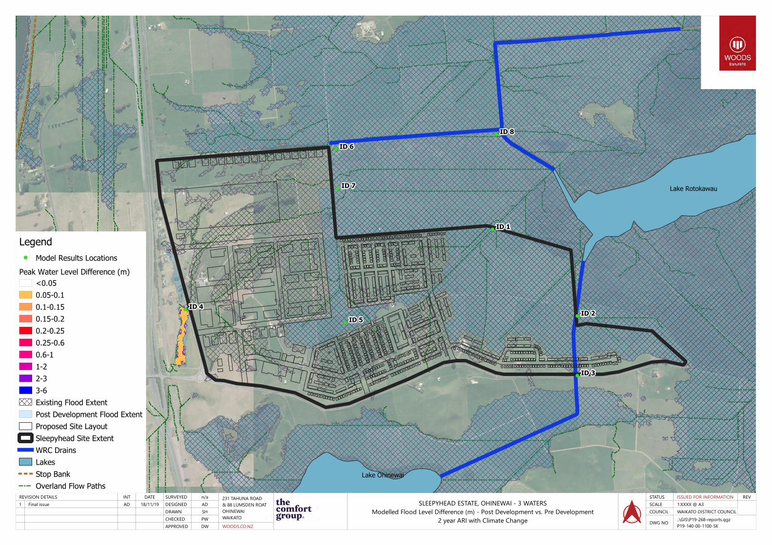
2 year ARI with Climate Change
REV
..\GIS\P19-268-reports.qgzP19-140-00-1100-SK
DWG NO
WAIKATO DISTRICT COUNCILCOUNCIL1:XXXX @ A3SCALEISSUED FOR INFORMATIONSTATUS
Model Results Locations
Peak Water Level Difference (m)<0.05
0.05-0.1
0.1-0.15
0.15-0.2
0.2-0.25
0.25-0.6
0.6-1
1-2
2-3
3-6
Existing Flood Extent
Post Development Flood Extent
Proposed Site Layout
Sleepyhead Site Extent
WRC Drains
Lakes
Stop Bank
Overland Flow Paths
Legend

18/11/19ADFinal issue1DATEINTREVISION DETAILS
DWAPPROVEDPWCHECKEDSHDRAWNADDESIGNEDn/aSURVEYED
WOODS.CO.NZ
231 TAHUNA ROAD& 88 LUMSDEN ROATOHINEWAIWAIKATO
SLEEPYHEAD ESTATE, OHINEWAI - 3 WATERSModelled Flood Level Difference (m) - Post Development vs. Pre Development
2 year( Lower Tail Water Level Scenario) ARI with Climate Change
REV
..\GIS\P19-268-reports.qgzP19-140-00-1101-SK
DWG NO
WAIKATO DISTRICT COUNCILCOUNCIL1:XXXX @ A3SCALEISSUED FOR INFORMATIONSTATUS
Model Results Locations
Peak Water Level Difference (m)<0.05
0.05-0.1
0.1-0.15
0.15-0.2
0.2-0.25
0.25-0.6
0.6-1
1-2
2-3
3-6
Existing Flood Extent
Post Development Flood Extent
Proposed Site Layout
Sleepyhead Site Extent
WRC Drains
Lakes
Stop Bank
Overland Flow Paths
LegendModel Results Locations
Peak Water Level Difference (m)<0.05
0.05-0.1
0.1-0.15
0.15-0.2
0.2-0.25
0.25-0.6
0.6-1
1-2
2-3
3-6
Existing Flood Extent
Post Development Flood Extent
Proposed Site Layout
Sleepyhead Site Extent
WRC Drains
Lakes
Stop Bank
Overland Flow Paths
Legend

18/11/19ADFinal issue1DATEINTREVISION DETAILS
DWAPPROVEDPWCHECKEDSHDRAWNADDESIGNEDn/aSURVEYED
WOODS.CO.NZ
231 TAHUNA ROAD& 88 LUMSDEN ROATOHINEWAIWAIKATO
SLEEPYHEAD ESTATE, OHINEWAI - 3 WATERSModelled Flood Level Difference (m) –
Scenario 3 (Maximum Probable Development) vs. Scenario 1 (Pre Development)100 year MPD ARI with Climate Change
REV
..\GIS\P19-268-reports.qgzP19-140-00-1104-SK
DWG NO
WAIKATO DISTRICT COUNCILCOUNCIL1:XXXX @ A3SCALEISSUED FOR INFORMATIONSTATUS
Model Results Locations
Peak Water Level Difference (m)<0.05
0.05-0.1
0.1-0.15
0.15-0.2
0.2-0.25
0.25-0.6
0.6-1
1-2
2-3
3-6
Existing Flood Extent
Post Development Flood Extent
Proposed Site Layout
Sleepyhead Site Extent
WRC Drains
Lakes
Stop Bank
Overland Flow Paths
LegendModel Results Locations
Peak Water Level Difference (m)<0.05
0.05-0.1
0.1-0.15
0.15-0.2
0.2-0.25
0.25-0.6
0.6-1
1-2
2-3
3-6
Existing Flood Extent
Post Development Flood Extent
Proposed Site Layout
Sleepyhead Site Extent
WRC Drains
Lakes
Stop Bank
Overland Flow Paths
Legend

18/11/19ADFinal issue1DATEINTREVISION DETAILS
DWAPPROVEDPWCHECKEDSHDRAWNADDESIGNEDn/aSURVEYED
WOODS.CO.NZ
231 TAHUNA ROAD& 88 LUMSDEN ROATOHINEWAIWAIKATO
SLEEPYHEAD ESTATE, OHINEWAI - 3 WATERSModelled Flood Level Difference (m) –
Scenario 5 (Pre Development Sensitivity) vs. Scenario 1 (Pre Development)100 year SENS ARI with Climate Change
REV
..\GIS\P19-268-reports.qgzP19-140-00-1105-SK
DWG NO
WAIKATO DISTRICT COUNCILCOUNCIL1:XXXX @ A3SCALEISSUED FOR INFORMATIONSTATUS
Model Results Locations
Peak Water Level Difference (m)<0.05
0.05-0.1
0.1-0.15
0.15-0.2
0.2-0.25
0.25-0.6
0.6-1
1-2
2-3
3-6
Existing Flood Extent
Post Development Flood Extent
Proposed Site Layout
Sleepyhead Site Extent
WRC Drains
Lakes
Stop Bank
Overland Flow Paths
LegendModel Results Locations
Peak Water Level Difference (m)<0.05
0.05-0.1
0.1-0.15
0.15-0.2
0.2-0.25
0.25-0.6
0.6-1
1-2
2-3
3-6
Existing Flood Extent
Post Development Flood Extent
Proposed Site Layout
Sleepyhead Site Extent
WRC Drains
Lakes
Stop Bank
Overland Flow Paths
Legend