Research Article Understanding Block and Transaction Logs ...
Upload
khangminh22Category
view
3download
0
Appendix 1. Borehole geophysical logs from boreholes on or near Miller Mountain, near Machiasport, Maine
Explanation Information for Appendixes Abbreviations on log plots:
Acou Caliper, in inch caliper measured by acoustic televiewer, in inches ATV acoustic televiewer traveltime ATV Amp acoustic televiewer amplitude ATV Amp, in mV acoustic televiewer amplitude, in millivolts Azi azimuth Caliper, in inch 3-arm mechanical caliper, in inches deg degrees dev deviation DO dissolved oxygen Eh, in mV electromotive potential, in millivolts EMI Cond, in mmho/m electromagnetic induction conductivity, in millimhos per meter Frax fracture FRX fracture gal/min gallon(s) per minute gpm gallon(s) per minute Fl Cond, in µS/cm fluid conductivity, in microsiemens per centimeter Gamma, in CPS natural gamma radiation, in counts per second HPFM Amb, in gal/min heat-pulse flowmeter, under ambient conditions, in gallons per minute HPFM Pump, in gal/min heat-pulse flowmeter, under pumped conditions, in gallons per minute LH lower hemisphere Lith lithologic feature ls land surface Max maximum Min minimum Mtn Mountain O2 ppm dissolved oxygen, in parts per million OTV optical televiewer image pH pH R8, in Ohm-m normal resistivity with electrode spacing of 8 inches, in ohm-meters R16, in Ohm-m normal resistivity with electrode spacing of 16 inches, in ohm-meters R32, in Ohm-m normal resistivity with electrode spacing of 32 inches, in ohm-meters R64, in Ohm-m normal resistivity with electrode spacing of 64 inches, in ohm-meters SP, in mV spontaneous potential, in millivolts SP Cond, in µS/cm specific conductivity, in microsiemens per centimeter SPR, in Ohm single point resistance, in ohms Std. Dev. standard deviation T-Frax transmissive fracture tad tadpole Temp, in deg F temperature, in degrees Fahrenheit TN true north toc top of casing tt travel time Tx transmissive

Image log interpretation:
Interpretations of structure from the image logs are shown in three forms, including projection, stereo, and tadpole plots. A consistent color code was used for all three plots. In addition, lithologic features are shown in the tadpole and stereoplots with squares, so as to distinguish them from interpreted fractures. Fractures interpreted as transmissive and shown with blue dots, were determined to be transmissive using the heat-pulse flowmeter. Transmissive fractures coded with blue squares were inferred to be transmissive from fluid conductivity, temperature, or other water-quality parameter logs.
(C) Tadpole (D) Stereoplot(B) Structural ProjectionN E S W N
62
64
0 90
(A) Optical TeleviewerN E S W N
DEP
TH, IN
FEE
T BE
LOW
TO
P O
F CA
SING
Figure. Example of interpretation of borehole imaging data.(A) Optical televiewer image and the corresponding interpretation of planar data in (B) structural, (C) tadpole, and (D) stereographic projection plots. The trace of the features on the structural projection (B) directly overlays on the image (A). In the tadpole plot (C), depth is plotted along the y axis, and the magnitude of dip is plotted on the x axis. The tail of the tadpole points in the direction of dip relative to True North, which is at the top of the page. The poles to the planar features are shown in a lower-hemisphere equal-area stereonet (stereoplot) (D), which reduces the plane to a point. (E) Rose diagram, which shows frequency of dip direction.
63
65
61 Dip, in degrees
N
(E) Rose diagram
N
Example of interpretation of borehole imaging data:
Appendix 1. Borehole geophysical logs from boreholes on or near Miller Mountain, near Machiasport, Maine
A. Borehole MW-13
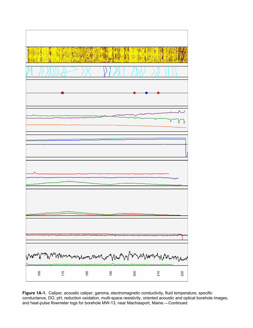
Figure 1A–1. Caliper, acoustic caliper, gamma, electromagnetic conductivity, fluid temperature, specific conductance, dissolved oxygen, pH, reduction oxidation, multi-space resistivity, oriented acoustic and optical borehole images, and heat-pulse flowmeter logs for borehole MW-13, near Machiasport, Maine.
Figure 1A–2. Borehole deviation logs for borehole MW-13, near Machiasport, Maine. Table 1A–1. Interpretation of acoustic televiewer logs for borehole MW-13, near
Machiasport, Maine. Figure 1A–3. Projection, tadpole, and stereoplots of interpretation of borehole image
data for borehole MW-13, near Machiasport, Maine. B. Borehole DW-22
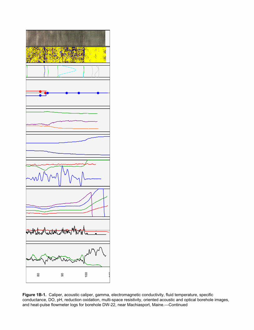
Figure 1B–1. Caliper, acoustic caliper, gamma, electromagnetic conductivity, fluid temperature, specific conductance, dissolved oxygen, pH, reduction oxidation, multi-space resistivity, oriented acoustic and optical borehole images, and heat-pulse flowmeter logs for borehole DW-22, near Machiasport, Maine.
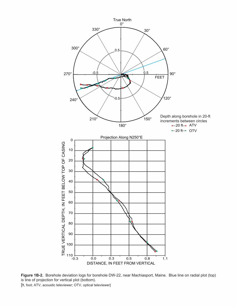
Figure 1B–2. Borehole deviation logs for borehole DW-22, near Machiasport, Maine. Table 1B–1. Interpretation of acoustic televiewer logs for borehole DW-22, near
Machiasport, Maine. Table 1B–2. Interpretation of optical televiewer logs for borehole DW-22, near
Machiasport, Maine. Figure 1B–3. Projection, tadpole, and stereoplots of interpretation of borehole image
data for borehole DW-22, near Machiasport, Maine. Figure 1B–4. Interpretation and modeling of heat-pulse flowmeter logs for borehole
DW-22, near Machiasport, Maine. C. Borehole DW-23
Figure 1C–1. Caliper, acoustic caliper, gamma, electromagnetic conductivity, fluid temperature, specific conductance, dissolved oxygen, pH, reduction oxidation, multi-space resistivity, oriented acoustic and optical borehole images, and heat-pulse flowmeter logs for borehole DW-23, near Machiasport, Maine.
Figure 1C–2. Borehole deviation logs for borehole DW-23, near Machiasport, Maine. Table 1C–1. Interpretation of acoustic televiewer logs for borehole DW-23, near
Machiasport, Maine. Table 1C–2. Interpretation of optical televiewer logs for borehole DW-23, near
Machiasport, Maine. Figure 1C–3. Projection, tadpole, and stereoplots of interpretation of borehole image
data for borehole DW-23, near Machiasport, Maine. Figure 1C–4. Interpretation and modeling of heat-pulse flowmeter logs for borehole
DW-23, near Machiasport, Maine. D. Borehole DW-24
Figure 1D–1. Caliper, acoustic caliper, gamma, electromagnetic conductivity, fluid temperature, specific conductance, dissolved oxygen, pH, reduction oxidation, multi-space resistivity, oriented acoustic and optical borehole images, and heat-pulse flowmeter logs for borehole DW-24, near Machiasport, Maine.
Figure 1D–2. Borehole deviation logs for borehole DW-24, near Machiasport, Maine. Table 1D–1. Interpretation of acoustic televiewer logs for borehole DW-24, near
Machiasport, Maine. Figure 1D–3. Projection, tadpole, and stereoplots of interpretation of borehole image
data for borehole DW-24, near Machiasport, Maine.
Figure 1D–4. Interpretation and modeling of heat-pulse flowmeter logs for borehole DW-24, near Machiasport, Maine.
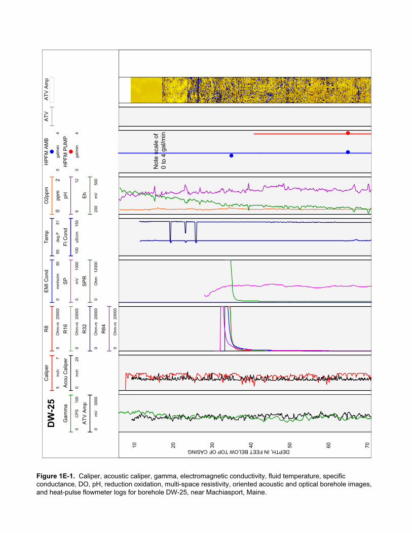
E. Borehole DW-25 Figure 1E–1. Caliper, acoustic caliper, gamma, electromagnetic conductivity, fluid
temperature, specific conductance, dissolved oxygen, pH, reduction oxidation, multi-space resistivity, oriented acoustic and optical borehole images, and heat-pulse flowmeter logs for borehole DW-25, near Machiasport, Maine.
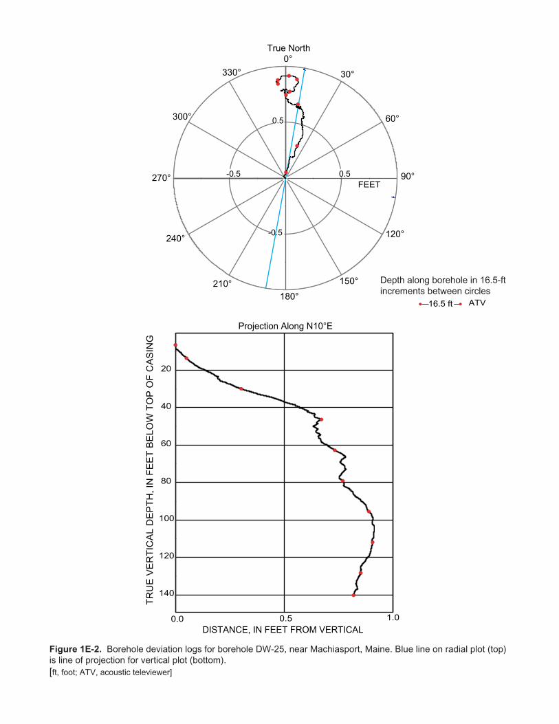
Figure 1E–2. Borehole deviation logs for borehole DW-25, near Machiasport, Maine. Table 1E–1. Interpretation of acoustic televiewer logs for borehole DW-25, near
Machiasport, Maine. Figure 1E–3. Projection, tadpole, and stereoplots of interpretation of borehole image
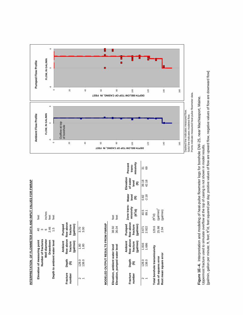
data for borehole DW-25, near Machiasport, Maine. Figure 1E–4. Interpretation and modeling of heat-pulse flowmeter logs for borehole
DW-25, near Machiasport, Maine. F. Borehole DW-31
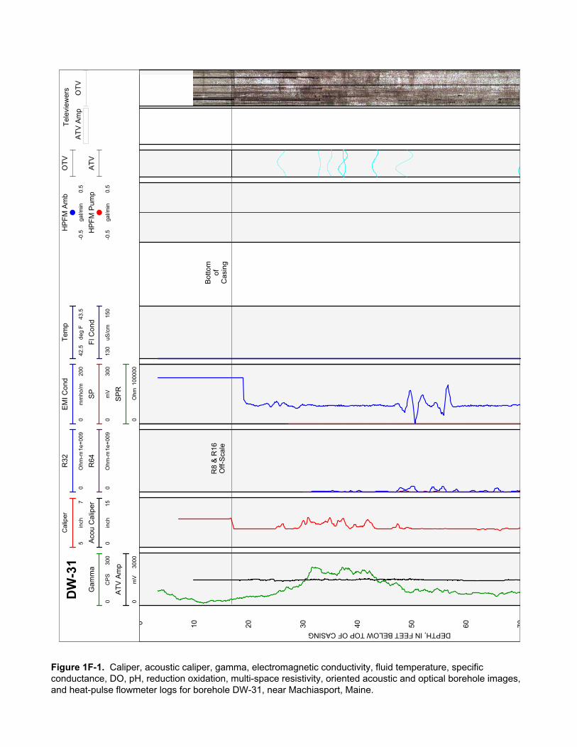
Figure 1F–1. Caliper, acoustic caliper, gamma, electromagnetic conductivity, fluid temperature, specific conductance, dissolved oxygen, pH, reduction oxidation, multi-space resistivity, oriented acoustic and optical borehole images, and heat-pulse flowmeter logs for borehole DW-31, near Machiasport, Maine.
Figure 1F–2. Borehole deviation logs for borehole DW-31, near Machiasport, Maine. Table 1F–1. Interpretation of acoustic televiewer logs for borehole DW-31, near
Machiasport, Maine. Table 1F–2. Interpretation of optical televiewer logs for borehole DW-31, near
Machiasport, Maine. Figure 1F–3. Projection, tadpole, and stereoplots of interpretation of borehole image
data for borehole DW-31, near Machiasport, Maine. Figure 1F–4. Interpretation and modeling of heat-pulse flowmeter logs for borehole
DW-31, near Machiasport, Maine. G. Borehole DW-32
Figure 1G–1. Caliper, acoustic caliper, gamma, electromagnetic conductivity, fluid temperature, specific conductance, dissolved oxygen, pH, reduction oxidation, multi-space resistivity, oriented acoustic and optical borehole images, and heat-pulse flowmeter logs for borehole DW-32, near Machiasport, Maine.
Figure 1G–2. Borehole deviation logs for borehole DW-32, near Machiasport, Maine. Table 1G–1. Interpretation of acoustic televiewer logs for borehole DW-32, near
Machiasport, Maine. Figure 1G–3. Projection, tadpole, and stereoplots of interpretation of borehole image
data for borehole DW-32, near Machiasport, Maine. Figure 1G–4. Interpretation and modeling of heat-pulse flowmeter logs for borehole
DW-32, near Machiasport, Maine. H. Borehole DW-33
Figure 1H–1. Caliper, acoustic caliper, gamma, electromagnetic conductivity, fluid temperature, specific conductance, dissolved oxygen, pH, reduction oxidation, multi-space resistivity, oriented acoustic and optical borehole images, and heat-pulse flowmeter logs for borehole DW-33, near Machiasport, Maine.
Figure 1H–2. Borehole deviation logs for borehole DW-33, near Machiasport, Maine. Table 1H–1. Interpretation of acoustic televiewer logs for borehole DW-33, near
Machiasport, Maine. Figure 1H–3. Projection, tadpole, and stereoplots of interpretation of borehole image
data for borehole DW-33, near Machiasport, Maine. Figure 1H–4. Interpretation and modeling of heat-pulse flowmeter logs for borehole
DW-33, near Machiasport, Maine.

I. Borehole DW-34 Figure 1I–1. Caliper, acoustic caliper, gamma, electromagnetic conductivity, fluid
temperature, specific conductance, dissolved oxygen, pH, reduction oxidation, multi-space resistivity, oriented acoustic and optical borehole images, and heat-pulse flowmeter logs for borehole DW-34, near Machiasport, Maine.
Figure 1I–2. Borehole deviation logs for borehole DW-34, near Machiasport, Maine. Deviation (tilt) data interpolated from 95 to 295 feet below top of casing.
Table 1I–1. Interpretation of acoustic televiewer logs for borehole DW-34, near Machiasport, Maine.
Figure 1I–3. Projection, tadpole, and stereoplots of interpretation of borehole image data for borehole DW-34, near Machiasport, Maine.
Figure 1I–4. Interpretation and modeling of heat-pulse flowmeter logs for borehole DW-34, near Machiasport, Maine.
J. Borehole DW-39 Figure 1J–1. Caliper, acoustic caliper, gamma, electromagnetic conductivity, fluid
temperature, specific conductance, dissolved oxygen, pH, reduction oxidation, multi-space resistivity, oriented acoustic and optical borehole images, and heat-pulse flowmeter logs for borehole DW-39, near Machiasport, Maine.
Figure 1J–2. Borehole deviation logs for borehole DW-39, near Machiasport, Maine. Table 1J–1. Interpretation of acoustic televiewer logs for borehole DW-39, near
Machiasport, Maine. Figure 1J–3. Projection, tadpole, and stereoplots of interpretation of borehole image
data for borehole DW-39, near Machiasport, Maine. Figure 1J–4. Interpretation and modeling of heat-pulse flowmeter logs for borehole
DW-39, near Machiasport, Maine. K. Borehole DW-40
Figure 1K–1. Caliper, acoustic caliper, gamma, electromagnetic conductivity, fluid temperature, specific conductance, dissolved oxygen, pH, reduction oxidation, multi-space resistivity, oriented acoustic and optical borehole images, and heat-pulse flowmeter logs for borehole DW-40, near Machiasport, Maine.
Figure 1K–2. Borehole deviation logs for borehole DW-40, near Machiasport, Maine. Table 1K–1. Interpretation of acoustic televiewer logs for borehole DW-40, near
Machiasport, Maine. Figure 1K–3. Projection, tadpole, and stereoplots of interpretation of borehole image
data for borehole DW-40, near Machiasport, Maine. Figure 1K–4. Interpretation and modeling of heat-pulse flowmeter logs for borehole
DW-40, near Machiasport, Maine. L. Borehole WY-GATR
Figure 1L–1. Caliper, acoustic caliper, gamma, electromagnetic conductivity, fluid temperature, specific conductance, dissolved oxygen, pH, reduction oxidation, multi-space resistivity, oriented acoustic and optical borehole images, and heat-pulse flowmeter logs for borehole WY-GATR, near Machiasport, Maine.
Figure 1L–2. Borehole deviation logs for borehole WY-GATR, near Machiasport, Maine.
Table 1L–1. Interpretation of acoustic televiewer logs for borehole WY-GATR, near Machiasport, Maine.
Table 1L–2. Interpretation of optical televiewer logs for borehole WY-GATR, near Machiasport, Maine.
Figure 1L–3. Projection, tadpole, and stereoplots of interpretation of borehole image data for borehole WY-GATR, near Machiasport, Maine.
Figure 1L–4. Interpretation and modeling of heat-pulse flowmeter logs for borehole WY-GATR, near Machiasport, Maine.

AT
V A
mp
Tem
p
4952
deg
F
R8
01e
+007
Ohm
-m
R16
01e
+007
Ohm
-m
EM
I Con
d
08
mm
ho/m
Cal
iper
35
inch
Fl C
ond
125
175
uS/c
m
SP
010
00m
V
SP
Con
d
200
250
uS/c
m
HP
FM
Am
b
-0.1
0.1
gal/m
inM
W-1
3G
amm
a
030
0C
PS
Aco
u C
alip
er
35
inch
HP
FM
Pum
p
-0.1
0.1
gal/m
in
SP
R
02e
+006
Ohm
AT
V
AT
V A
mp
010
00m
V
O2
ppm
01
pH
710
Eh
300
450
mV
0 10 20 30 40 50 60 70
DEPTH, IN FEET BELOW TOP OF CASING
Bot
tom
ofC
asin
g
R32
& R
64O
ff-S
cale
Figure 1A-1. Caliper, acoustic caliper, gamma, electromagnetic conductivity, fluid temperature, specific conductance, DO, pH, reduction oxidation, multi-space resistivity, oriented acoustic and optical borehole images, and heat-pulse flowmeter logs for borehole MW-13, near Machiasport, Maine.

70 80 90 100
110
120
130
140
150
Figure 1A-1. Caliper, acoustic caliper, gamma, electromagnetic conductivity, fluid temperature, specific conductance, DO, pH, reduction oxidation, multi-space resistivity, oriented acoustic and optical borehole images, and heat-pulse flowmeter logs for borehole MW-13, near Machiasport, Maine.—Continued
160
170
180
190
200
210
220
Figure 1A-1. Caliper, acoustic caliper, gamma, electromagnetic conductivity, fluid temperature, specific conductance, DO, pH, reduction oxidation, multi-space resistivity, oriented acoustic and optical borehole images, and heat-pulse flowmeter logs for borehole MW-13, near Machiasport, Maine.—Continued

TR
UE
VE
RT
ICA
L D
EP
TH
, IN
FE
ET
BE
LO
W T
OP
OF
CA
SIN
G
True North
DISTANCE, IN FEET FROM VERTICAL
Projection Along N58°E
Depth along borehole in 20-ftincrements between circles
Figure 1A-2. Borehole deviation logs for borehole MW-13, near Machiasport, Maine. Blue line on radial plot (top)is line of projection for vertical plot (bottom).[ft, foot; ATV, acoustic televiewer]
0 4 8 12 16
40
60
80
100
120
140
160
180
200
220
ATV20 ft
FEET
0°
30°
60°
90°
120°
150°
180°
210°
240°
300°
330°
4 8 12 16-4-8-12-16
-4
-8
-12
-16
4
8
12
16
270°

Table 1A–1. Interpretation of acoustic televiewer logs for borehole MW-13, near Machiasport, Maine.[Televiewer data are corrected for deviation and magnetic declination, so orientations are relative to true north; depths are below top of casing, which is 3.48 feet above land surface; dip azimuth is given in degrees east of true north; strike is reported in right-hand-rule (RHR)-azimuthal degrees east of true north and where the direction of dip is 90 degrees to the right of strike]
Depth, in feet
Depth, in meters
Dipazimuth
Strike, in RHR Dip Dip
direction Dip descriptor Comment
34.13 10.40 240 150 5 SW Nearly horizontal Minor fracture36.22 11.04 64 334 51 NE Steep Partial fracture
39.94 12.17 222 132 68 SW Steep Transmissive fracture, inferred from fluid logs
40.18 12.25 242 152 53 SW Steep Minor fracture40.56 12.36 192 102 83 S Nearly vertical Minor fracture
41.37 12.61 201 111 82 S Nearly vertical Transmissive fracture, inferred from fluid logs
42.72 13.02 178 88 86 S Nearly vertical Minor fracture44.13 13.45 92 2 67 E Steep Minor fracture44.14 13.45 194 104 78 S Nearly vertical Minor fracture44.45 13.55 72 342 70 E Nearly vertical Minor fracture45.75 13.94 86 356 58 E Steep Minor fracture45.92 14.00 200 110 89 S Nearly vertical Partial fracture47.70 14.54 89 359 55 E Steep Minor fracture48.12 14.67 99 9 62 E Steep Minor fracture48.60 14.81 272 182 85 W Nearly vertical Minor fracture48.77 14.86 96 6 65 E Steep Minor fracture
49.25 15.01 203 113 85 SW Nearly vertical Transmissive fracture, inferred from fluid logs
50.72 15.46 200 110 82 S Nearly vertical Transmissive fracture, inferred from fluid logs
51.92 15.82 96 6 64 E Steep Minor fracture52.23 15.92 211 121 73 SW Nearly vertical Minor fracture52.57 16.02 230 140 69 SW Steep Minor fracture53.33 16.25 123 33 82 SE Nearly vertical Minor fracture54.53 16.62 224 134 83 SW Nearly vertical Minor fracture55.49 16.91 209 119 82 SW Nearly vertical Minor fracture57.55 17.54 209 119 88 SW Nearly vertical Partial fracture62.95 19.19 233 143 12 SW Shallow Possible fracture64.12 19.54 115 25 11 SE Shallow Possible fracture68.78 20.96 42 312 59 NE Steep Minor fracture77.34 23.57 116 26 23 SE Shallow Minor fracture79.62 24.27 250 160 31 W Moderate Possible fracture80.00 24.38 241 151 36 SW Moderate Possible fracture 83.00 25.30 236 146 80 SW Nearly vertical Minor fracture84.69 25.81 209 119 76 SW Nearly vertical Minor fracture90.88 27.70 261 171 5 W Nearly horizontal Minor fracture90.98 27.73 256 166 59 W Steep Minor fracture93.85 28.60 279 189 57 W Steep Minor fracture96.44 29.39 128 38 51 SE Steep Minor fracture
103.44 31.53 293 203 59 NW Steep Minor fracture105.49 32.15 235 145 78 SW Nearly vertical Minor fracture109.33 33.32 288 198 29 W Shallow Minor fracture116.43 35.49 274 184 30 W Shallow Minor fracture126.07 38.42 7 277 16 N Shallow Minor fracture132.82 40.48 77 347 87 E Nearly vertical Partial fracture133.49 40.69 252 162 88 W Nearly vertical Minor fracture135.86 41.41 285 195 22 W Shallow Minor fracture138.68 42.27 289 199 22 W Shallow Minor fracture
144.98 44.19 237 147 80 SW Nearly vertical Transmissive fracture, inferred from fluid logs
145.52 44.35 221 131 77 SW Nearly vertical Transmissive fracture, inferred from fluid logs
147.65 45.00 236 146 38 SW Moderate Minor fracture148.55 45.28 30 300 82 NE Nearly vertical Minor fracture
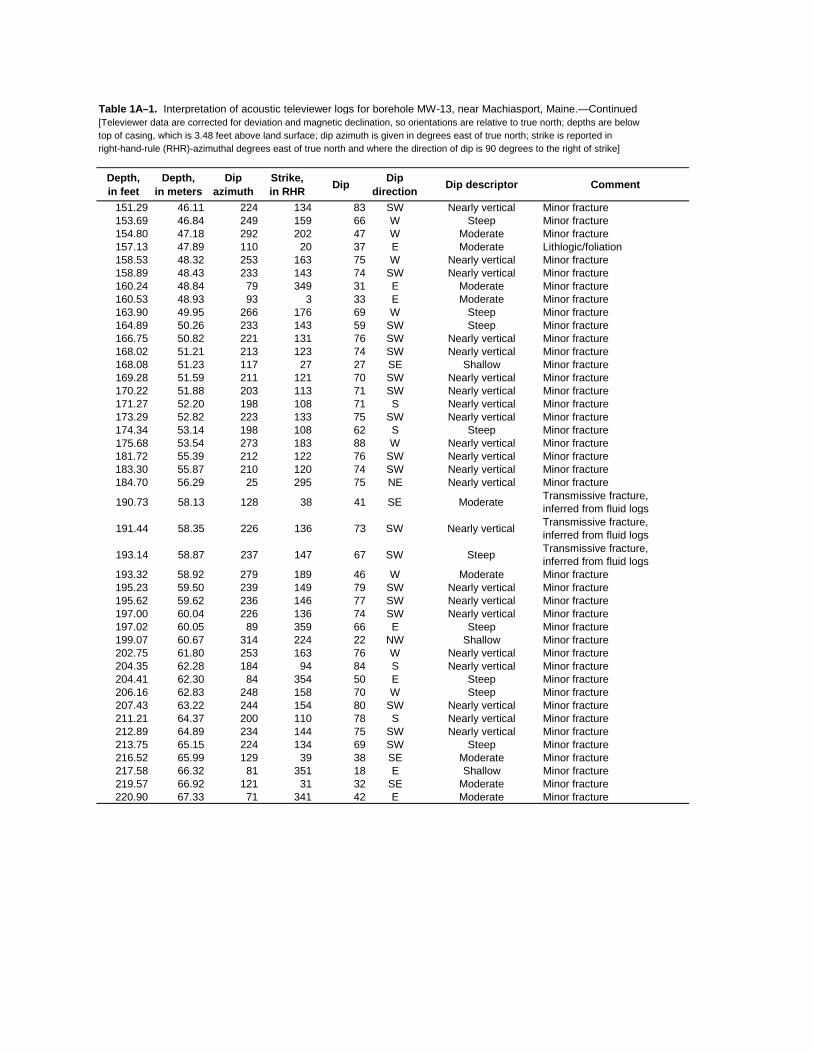
Table 1A–1. Interpretation of acoustic televiewer logs for borehole MW-13, near Machiasport, Maine.—Continued[Televiewer data are corrected for deviation and magnetic declination, so orientations are relative to true north; depths are below top of casing, which is 3.48 feet above land surface; dip azimuth is given in degrees east of true north; strike is reported in right-hand-rule (RHR)-azimuthal degrees east of true north and where the direction of dip is 90 degrees to the right of strike]
Depth, in feet
Depth, in meters
Dipazimuth
Strike, in RHR Dip Dip
direction Dip descriptor Comment
151.29 46.11 224 134 83 SW Nearly vertical Minor fracture153.69 46.84 249 159 66 W Steep Minor fracture154.80 47.18 292 202 47 W Moderate Minor fracture157.13 47.89 110 20 37 E Moderate Lithlogic/foliation158.53 48.32 253 163 75 W Nearly vertical Minor fracture158.89 48.43 233 143 74 SW Nearly vertical Minor fracture160.24 48.84 79 349 31 E Moderate Minor fracture160.53 48.93 93 3 33 E Moderate Minor fracture163.90 49.95 266 176 69 W Steep Minor fracture164.89 50.26 233 143 59 SW Steep Minor fracture166.75 50.82 221 131 76 SW Nearly vertical Minor fracture168.02 51.21 213 123 74 SW Nearly vertical Minor fracture168.08 51.23 117 27 27 SE Shallow Minor fracture169.28 51.59 211 121 70 SW Nearly vertical Minor fracture170.22 51.88 203 113 71 SW Nearly vertical Minor fracture171.27 52.20 198 108 71 S Nearly vertical Minor fracture173.29 52.82 223 133 75 SW Nearly vertical Minor fracture174.34 53.14 198 108 62 S Steep Minor fracture175.68 53.54 273 183 88 W Nearly vertical Minor fracture181.72 55.39 212 122 76 SW Nearly vertical Minor fracture183.30 55.87 210 120 74 SW Nearly vertical Minor fracture184.70 56.29 25 295 75 NE Nearly vertical Minor fracture
190.73 58.13 128 38 41 SE Moderate Transmissive fracture, inferred from fluid logs
191.44 58.35 226 136 73 SW Nearly vertical Transmissive fracture, inferred from fluid logs
193.14 58.87 237 147 67 SW Steep Transmissive fracture, inferred from fluid logs
193.32 58.92 279 189 46 W Moderate Minor fracture195.23 59.50 239 149 79 SW Nearly vertical Minor fracture195.62 59.62 236 146 77 SW Nearly vertical Minor fracture197.00 60.04 226 136 74 SW Nearly vertical Minor fracture197.02 60.05 89 359 66 E Steep Minor fracture199.07 60.67 314 224 22 NW Shallow Minor fracture202.75 61.80 253 163 76 W Nearly vertical Minor fracture204.35 62.28 184 94 84 S Nearly vertical Minor fracture204.41 62.30 84 354 50 E Steep Minor fracture206.16 62.83 248 158 70 W Steep Minor fracture207.43 63.22 244 154 80 SW Nearly vertical Minor fracture211.21 64.37 200 110 78 S Nearly vertical Minor fracture212.89 64.89 234 144 75 SW Nearly vertical Minor fracture213.75 65.15 224 134 69 SW Steep Minor fracture216.52 65.99 129 39 38 SE Moderate Minor fracture217.58 66.32 81 351 18 E Shallow Minor fracture219.57 66.92 121 31 32 SE Moderate Minor fracture220.90 67.33 71 341 42 E Moderate Minor fracture
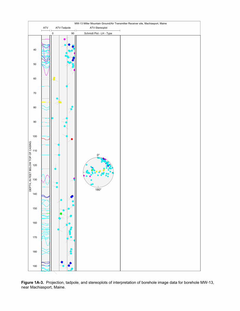
MW-13 Miller Mountain Ground/Air Transmitter Receiver site, Machiasport, Maine
ATV-Stereoplot
Schmidt Plot - LH - Type
ATV-Tadpole
0 90
ATV
40
50
60
70
80
90
100
110
120
130
140
150
160
170
180
190
0°
180°DE
PT
H, I
N F
EE
T B
ELO
W T
OP
OF
CA
SIN
G
Figure 1A-3. Projection, tadpole, and stereoplots of interpretation of borehole image data for borehole MW-13, near Machiasport, Maine.

200
210
220
Figure 1A-3. Projection, tadpole, and stereoplots of interpretation of borehole image data for borehole MW-13, near Machiasport, Maine.—Continued

AT
V A
mp
OT
V
Tel
evie
wer
sC
alip
er
48
inch
DW
-22
Aco
u C
alip
er
020
inch
HP
FM
Am
b
-0.5
0.5
gal/m
in
HP
FM
Pum
p
-0.5
0.5
gal/m
in
R8
025
000
Ohm
-m
R16
025
000
Ohm
-m
R32
025
000
Ohm
-m
R64
025
000
Ohm
-m
EM
Con
d
030
0m
mho
/m
Tem
p
4453
deg
F
Fl C
ond
100
600
uS/c
m
O2p
pm
01
ppm
SP
010
00m
V
Gam
ma
030
0C
PS
pH
47
Eh
040
0m
V
SP
R
020
00O
hm
AT
V A
mp
030
00m
V
OT
V
20 30 40 50 60 70
Bot
tom
ofC
asin
g
DEPTH, IN FEET BELOW TOP OF CASING
Figure 1B-1. Caliper, acoustic caliper, gamma, electromagnetic conductivity, fluid temperature, specific conductance, DO, pH, reduction oxidation, multi-space resistivity, oriented acoustic and optical borehole images, and heat-pulse flowmeter logs for borehole DW-22, near Machiasport, Maine.
80 90 100
110
Figure 1B-1. Caliper, acoustic caliper, gamma, electromagnetic conductivity, fluid temperature, specific conductance, DO, pH, reduction oxidation, multi-space resistivity, oriented acoustic and optical borehole images, and heat-pulse flowmeter logs for borehole DW-22, near Machiasport, Maine.—Continued
TR
UE
VE
RT
ICA
L D
EP
TH
, IN
FE
ET
BE
LO
W T
OP
OF
CA
SIN
G
True North
DISTANCE, IN FEET FROM VERTICAL
Projection Along N250°E
Depth along borehole in 20-ftincrements between circles
-0.3 0.0 0.3 0.5 0.8
10
20
30
40
50
60
70
80
90
100
0
1.1110
ATV20 ft
OTV20 ft
FEET
0°
30°
60°
90°
120°
150°
180°
210°
240°
300°
330°
0.5-0.5
-0.5
0.5
270°
Figure 1B-2. Borehole deviation logs for borehole DW-22, near Machiasport, Maine. Blue line on radial plot (top)is line of projection for vertical plot (bottom).[ft, foot; ATV, acoustic televiewer; OTV, optical televiewer]
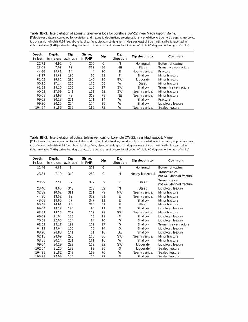
Table 1B–1. Interpretation of acoustic televiewer logs for borehole DW-22, near Machiasport, Maine.[Televiewer data are corrected for deviation and magnetic declination, so orientations are relative to true north; depths are below top of casing, which is 0.34 feet above land surface; dip azimuth is given in degrees east of true north; strike is reported in right-hand-rule (RHR)-azimuthal degrees east of true north and where the direction of dip is 90 degrees to the right of strike]
Depth, in feet
Depth, in meters
Dipazimuth
Strike, in RHR Dip Dip
direction Dip descriptor Comment
22.71 6.92 0 270 0 N Horizontal Bottom of casing23.08 7.03 63 333 66 NE Steep Transmissive fracture44.66 13.61 94 4 80 E Nearly vertical Fracture48.17 14.68 180 90 21 S Shallow Minor fracture51.92 15.82 230 140 39 SW Moderate Minor fracture56.25 17.14 256 166 68 W Steep Minor fracture82.89 25.26 208 118 27 SW Shallow Transmissive fracture90.52 27.59 242 152 81 SW Nearly vertical Minor fracture95.08 28.98 49 319 78 NE Nearly vertical Minor fracture99.02 30.18 261 171 14 W Shallow Fracture99.26 30.25 264 174 25 W Shallow Lithologic feature
104.54 31.86 255 165 72 W Nearly vertical Sealed feature
Table 1B–2. Interpretation of optical televiewer logs for borehole DW-22, near Machiasport, Maine.[Televiewer data are corrected for deviation and magnetic declination, so orientations are relative to true north; depths are below top of casing, which is 0.34 feet above land surface; dip azimuth is given in degrees east of true north; strike is reported in right-hand-rule (RHR)-azimuthal degrees east of true north and where the direction of dip is 90 degrees to the right of strike]
Depth, in feet
Depth, in meters
Dipazimuth
Strike, in RHR Dip Dip
direction Dip descriptor Comment
22.46 6.85 5 275 0 N Horizontal Bottom of casing
23.31 7.10 349 259 9 N Nearly horizontal Transmissive, not well defined fracture
23.32 7.11 72 342 62 E Steep Transmissive, not well defined fracture
28.40 8.66 343 253 52 N Steep Lithologic feature32.89 10.02 311 221 79 NW Nearly vertical Minor fracture44.35 13.52 82 352 81 E Nearly vertical Minor fracture48.08 14.65 77 347 11 E Shallow Minor fracture55.49 16.91 86 356 51 E Steep Minor fracture59.64 18.18 180 90 11 S Shallow Lithologic feature63.51 19.36 203 113 78 SW Nearly vertical Minor fracture69.03 21.04 166 76 18 S Shallow Lithologic feature75.39 22.98 184 94 10 S Shallow Lithologic feature82.59 25.17 199 109 27 S Shallow Transmissive fracture84.12 25.64 168 78 14 S Shallow Lithologic feature88.20 26.88 141 51 16 SE Shallow Lithologic feature92.15 28.09 225 135 86 SW Nearly vertical Minor fracture98.88 30.14 251 161 16 W Shallow Minor fracture99.04 30.19 222 132 32 SW Moderate Lithologic feature
102.54 31.25 182 92 35 S Moderate Sealed feature104.39 31.82 248 158 70 W Nearly vertical Sealed feature105.29 32.09 164 74 22 S Shallow Sealed feature

DW-22 Miller Mountain Ground/Air Transmitter Receiver site, Machiasport, Maine
ATV OTVATV-Tadpole
0 90
OTV-Tadpole
0 90
ATV-Stereoplot
Schmidt Plot - LH - Type
OTV-Stereoplot
Schmidt Plot - LH - Type
20
30
40
50
60
70
80
90
100
110
0°
180°
0°
180°
DE
PT
H, I
N F
EE
T B
ELO
W T
OP
OF
CA
SIN
G
Figure 1B-3. Projection, tadpole, and stereoplots of interpretation of borehole image data for borehole DW-22, near Machiasport, Maine.
INTE
RPR
ETAT
ION
OF
FLO
WM
ETER
DAT
A AN
D IN
PUT
VALU
ES F
OR
FW
RAP
Elev
atio
n of
mea
surin
g po
int
60 fe
etN
umbe
r of f
ract
ures
2W
ell d
iam
eter
6 in
ches
Dra
wdo
wn
5.6
feet
Dep
th to
am
bien
t wat
er le
vel
6.7
feet
Frac
ture
nu
mbe
rD
epth
(ft)
Ambi
ent
flow
abo
ve
frac
ture
(g
al/m
in)
Pum
ped
flow
abo
ve
frac
ture
(g
al/m
in)
222
.50.
000.
501
82.5
-0.1
00.
10
MO
DEL
ED O
UTP
UT
RES
ULT
S FR
OM
FW
RAP
Elev
atio
n, a
mbi
ent w
ater
leve
l53
.30
feet
Elev
atio
n, p
umpe
d w
ater
leve
l47
.70
feet
Frac
ture
nu
mbe
rD
epth
(ft)
Ambi
ent
flow
abo
ve
frac
ture
(g
al/m
in)
Pum
ped
flow
abo
ve
frac
ture
(g
al/m
in)
Zone
tran
s-m
issi
vity
(ft
2 /d)
Wat
er le
vel (
ft)
Elev
atio
n of
wat
er
leve
l (ft
)
Perc
ent
tran
s-m
issi
vity
222
.50.
000
0.52
411
.66
5.08
54.9
263
182
.5-0
.099
0.10
46.
829.
4850
.52
37
Tota
l bor
ehol
e tr
ansm
issi
vity
18.5
(ft2 /d
)Su
m o
f squ
ares
err
or0.
0006
0(g
al/m
in)2
Roo
t mea
n sq
uare
err
or
0.01
737
(gal
/min
)
Das
hed
line
indi
cate
s m
easu
red
flow
.
Sol
id li
ne in
dica
tes
mod
eled
flow
.P
oint
s in
dica
te m
easu
red
heat
-pul
se fl
owm
eter
dat
a.
Figu
re 1
B–4
. In
terp
reta
tion
and
mod
elin
g of
hea
t-pul
se fl
owm
eter
logs
for b
oreh
ole
DW
-22,
nea
r Mac
hias
port,
Mai
ne.
[gal
/min
, gal
lon
per m
inut
e; ft
, fee
t; ft2 /d
, fee
t squ
ared
per
day
; pos
itive
val
ues
of fl
ow a
re u
pwar
d flo
w, n
egat
ive
valu
es o
f flo
w a
re d
ownw
ard
flow
]
0 20 40 60 80 100
120-0
.15
00.
15
DEPTH BELOW TOP OF CASING, IN FEET
FLO
W, I
N G
AL/M
IN
Ambi
ent F
low
Pro
file
0 20 40 60 80 100
120-0
.60
0.6
DEPTH BELOW TOP OF CASING, IN FEET
FLO
W, I
N G
AL/M
IN
Pum
ped
Flow
Pro
file
OT
V A
TV
Am
p
Tel
evie
wer
sC
alip
er
57
inch
DW
-23
Tem
p
4445
deg
F
Fl C
ond
200
300
uS/c
m
Aco
u C
alip
er
020
inch
HP
FM
Am
b
05
gal/m
in
Pum
p O
verf
low
05.
4ga
l/min
HP
FM
Pum
p
00.
5ga
l/min
R8
050
000
Ohm
-m
R16
050
000
Ohm
-m
R32
050
000
Ohm
-m
EM
I Con
d
020
0m
mho
/m
Gam
ma
030
0C
PS
SP
Con
d
200
400
uS/c
m
SP
200
1000
mV
OT
VO
2ppm
00.
2pp
m
pH
610
SP
R
012
000
Ohm
Eh
260
360
mV
AT
V A
mp
020
00m
V
10 20 30 40 50 60 70
Ove
rflo
win
gw
ell a
t 4
gal
/min
R64
O
ff S
cale
Bot
tom
ofC
asin
g
DEPTH, IN FEET BELOW TOP OF CASING
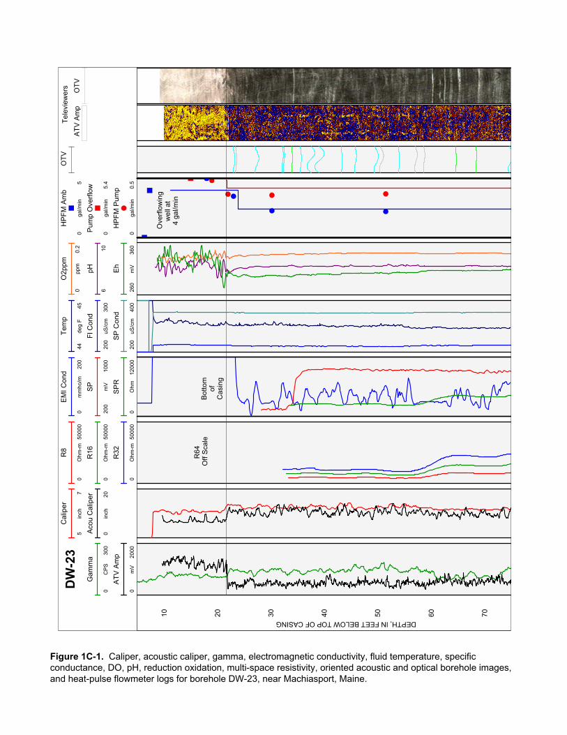
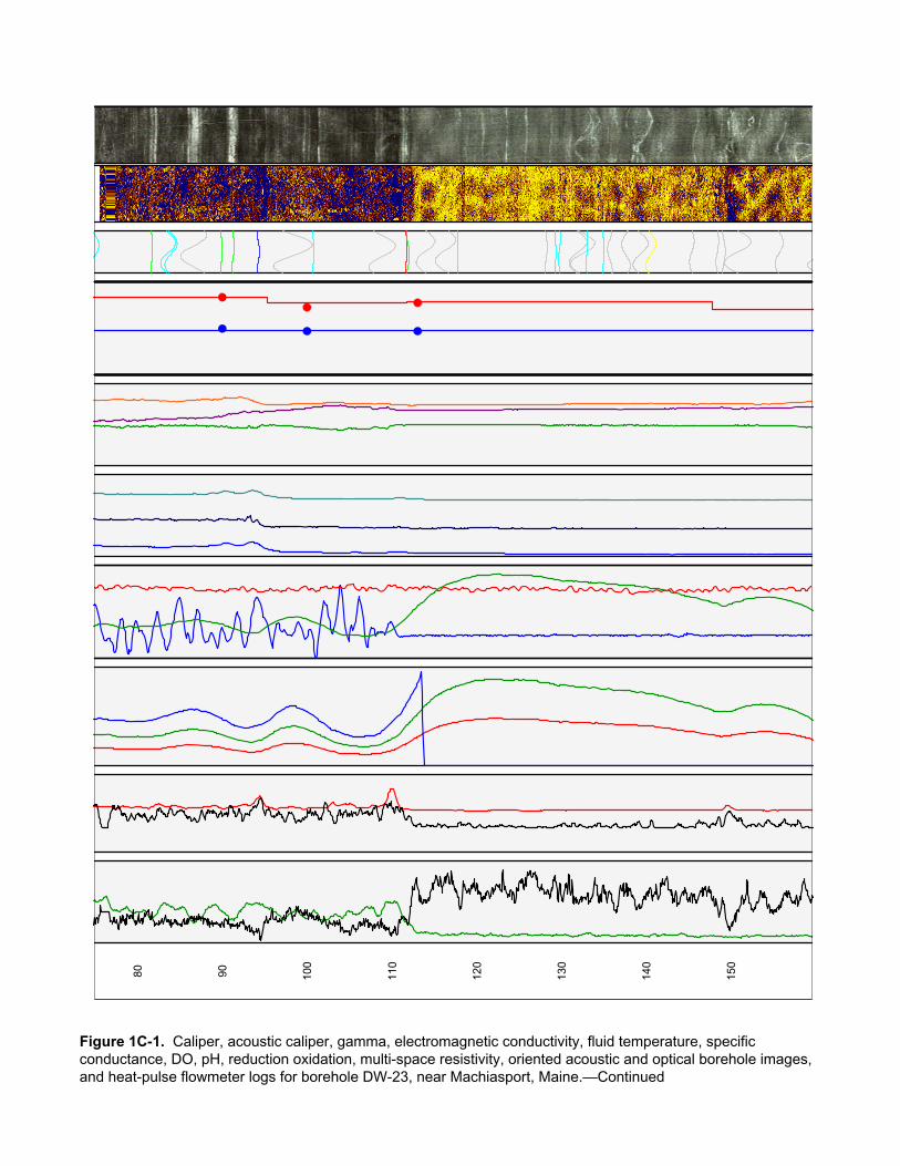
Figure 1C-1. Caliper, acoustic caliper, gamma, electromagnetic conductivity, fluid temperature, specific conductance, DO, pH, reduction oxidation, multi-space resistivity, oriented acoustic and optical borehole images, and heat-pulse flowmeter logs for borehole DW-23, near Machiasport, Maine.
80 90 100
110
120
130
140
150
Figure 1C-1. Caliper, acoustic caliper, gamma, electromagnetic conductivity, fluid temperature, specific conductance, DO, pH, reduction oxidation, multi-space resistivity, oriented acoustic and optical borehole images, and heat-pulse flowmeter logs for borehole DW-23, near Machiasport, Maine.—Continued

160
170
180
Figure 1C-1. Caliper, acoustic caliper, gamma, electromagnetic conductivity, fluid temperature, specific conductance, DO, pH, reduction oxidation, multi-space resistivity, oriented acoustic and optical borehole images, and heat-pulse flowmeter logs for borehole DW-23, near Machiasport, Maine.—Continued
TR
UE
VE
RT
ICA
L D
EP
TH
, IN
FE
ET
BE
LO
W T
OP
OF
CA
SIN
G
DISTANCE, IN FEET FROM VERTICAL
Projection Along N240°E
0.0 0.5
20
40
60
80
100
120
140
160
180
1.0
True North
Depth along borehole in 20-ftincrements between circles
0°
30°
60°
90°
120°
150°
180°210°
240°
300°
330°
ATV20 ft
OTV20 ft
270°FEET
-0.50 0.50
0.50
-0.50
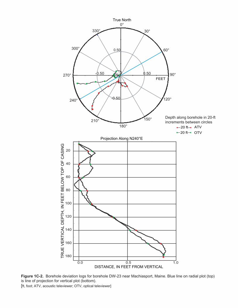
Figure 1C-2. Borehole deviation logs for borehole DW-23 near Machiasport, Maine. Blue line on radial plot (top)is line of projection for vertical plot (bottom).[ft, foot; ATV, acoustic televiewer; OTV, optical televiewer]
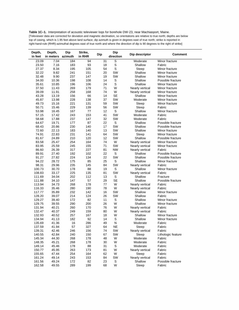
Table 1C–1. Interpretation of acoustic televiewer logs for borehole DW-23, near Machiasport, Maine.[Televiewer data are corrected for deviation and magnetic declination, so orientations are relative to true north; depths are below top of casing, which is 1.95 feet above land surface; dip azimuth is given in degrees east of true north; strike is reported in right-hand-rule (RHR)-azimuthal degrees east of true north and where the direction of dip is 90 degrees to the right of strike]
Depth, in feet
Depth, in meters
Dipazimuth
Strike, in RHR Dip Dip
direction Dip descriptor Comment
23.09 7.04 184 94 31 S Moderate Minor fracture23.50 7.16 183 93 18 S Shallow Fabric27.37 8.34 195 105 54 S Steep Minor fracture32.22 9.82 241 151 20 SW Shallow Minor fracture32.48 9.90 237 147 19 SW Shallow Minor fracture34.00 10.36 198 108 14 S Shallow Possible fracture35.61 10.85 196 106 24 S Shallow Minor fracture37.50 11.43 269 179 71 W Nearly vertical Minor fracture39.09 11.91 258 168 74 W Nearly vertical Minor fracture43.28 13.19 156 66 14 SE Shallow Minor fracture45.87 13.98 228 138 37 SW Moderate Minor fracture49.73 15.16 221 131 59 SW Steep Minor fracture50.71 15.46 229 139 56 SW Steep Fabric53.98 16.45 167 77 12 S Shallow Minor fracture57.15 17.42 243 153 41 SW Moderate Fabric58.68 17.88 237 147 32 SW Moderate Fabric64.67 19.71 177 87 22 S Shallow Possible fracture68.43 20.86 230 140 17 SW Shallow Possible fracture72.60 22.13 183 140 13 SW Shallow Minor fracture74.91 22.83 231 141 64 SW Steep Minor fracture81.67 24.89 210 120 12 SW Shallow Possible fracture83.58 25.47 254 164 74 W Nearly vertical Minor fracture83.95 25.59 245 155 71 SW Nearly vertical Minor fracture86.60 26.39 317 227 81 NW Nearly vertical Fabric89.91 27.40 192 102 22 S Shallow Possible fracture91.27 27.82 224 134 22 SW Shallow Possible fracture94.22 28.72 175 85 25 S Shallow Minor fracture98.31 29.96 235 145 84 SW Nearly vertical Fabric
100.73 30.70 178 88 19 S Shallow Minor fracture108.83 33.17 225 135 81 SW Nearly vertical Fabric111.69 34.04 202 112 13 S Shallow Fracture111.88 34.10 147 57 29 SE Shallow Possible fracture113.94 34.73 268 178 77 W Nearly vertical Fabric116.33 35.46 280 190 78 W Nearly vertical Fabric117.77 35.89 232 142 16 SW Shallow Minor fracture128.20 39.07 214 124 26 SW Shallow Fabric129.27 39.40 172 82 11 S Shallow Minor fracture129.75 39.55 290 200 26 W Shallow Minor fracture131.94 40.21 260 170 76 W Nearly vertical Fabric132.47 40.37 249 159 80 W Nearly vertical Fabric132.93 40.52 257 167 18 W Shallow Minor fracture134.94 41.13 182 92 14 S Shallow Minor fracture135.69 41.36 16 286 49 N Moderate Fabric137.59 41.94 57 327 64 NE Steep Fabric139.31 42.46 246 156 74 SW Nearly vertical Fabric140.55 42.84 240 150 67 SW Steep Lithologic feature145.34 44.30 268 178 48 W Moderate Fabric148.35 45.21 268 178 30 W Moderate Fabric149.14 45.46 178 88 31 S Moderate Fabric150.77 45.95 263 173 81 W Nearly vertical Fabric155.65 47.44 254 164 62 W Steep Fabric161.24 49.14 243 153 84 SW Nearly vertical Fabric161.56 49.24 172 82 23 S Shallow Possible fracture162.58 49.55 289 199 68 W Steep Fabric

Table 1C–1. Interpretation of acoustic televiewer logs for borehole DW-23, near Machiasport, Maine.—Continued[Televiewer data are corrected for deviation and magnetic declination, so orientations are relative to true north; depths are below top of casing, which is 1.95 feet above land surface; dip azimuth is given in degrees east of true north; strike is reported in right-hand-rule (RHR)-azimuthal degrees east of true north and where the direction of dip is 90 degrees to the right of strike]
Depth, in feet
Depth, in meters
Dipazimuth
Strike, in RHR Dip Dip
direction Dip descriptor Comment
164.22 50.05 0 270 27 N Shallow Minor fracture164.72 50.20 87 357 21 E Shallow Fracture165.15 50.34 72 342 40 E Moderate Fabric165.86 50.55 50 320 24 NE Shallow Fracture166.68 50.80 241 151 38 SW Moderate Fabric167.75 51.13 195 105 30 S Moderate Fabric170.64 52.01 15 285 67 N Steep Minor fracture173.66 52.93 259 169 40 W Moderate Minor fracture174.20 53.09 339 249 31 N Moderate Minor fracture175.16 53.39 285 195 62 W Steep Fracture177.12 53.98 189 99 30 S Moderate Transmissive fracture
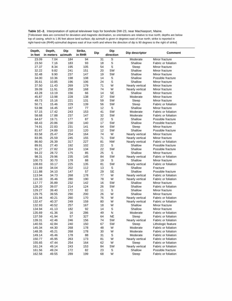
Table 1C–2. Interpretation of optical televiewer logs for borehole DW-23, near Machiasport, Maine.[Televiewer data are corrected for deviation and magnetic declination, so orientations are relative to true north; depths are below top of casing, which is 1.95 feet above land surface; dip azimuth is given in degrees east of true north; strike is reported in right-hand-rule (RHR)-azimuthal degrees east of true north and where the direction of dip is 90 degrees to the right of strike]
Depth, in feet
Depth, in meters
Dipazimuth
Strike, in RHR Dip Dip
direction Dip descriptor Comment
23.09 7.04 184 94 31 S Moderate Minor fracture23.50 7.16 183 93 18 S Shallow Fabric or foliation27.37 8.34 195 105 54 S Steep Minor fracture32.22 9.82 241 151 20 SW Shallow Minor fracture32.48 9.90 237 147 19 SW Shallow Minor fracture34.00 10.36 198 108 14 S Shallow Possible fracture35.61 10.85 196 106 24 S Shallow Minor fracture37.50 11.43 269 179 71 W Nearly vertical Minor fracture39.09 11.91 258 168 74 W Nearly vertical Minor fracture43.28 13.19 156 66 14 SE Shallow Minor fracture45.87 13.98 228 138 37 SW Moderate Minor fracture49.73 15.16 221 131 59 SW Steep Minor fracture50.71 15.46 229 139 56 SW Steep Fabric or foliation53.98 16.45 167 77 12 S Shallow Minor fracture57.15 17.42 243 153 41 SW Moderate Fabric or foliation58.68 17.88 237 147 32 SW Moderate Fabric or foliation64.67 19.71 177 87 22 S Shallow Possible fracture68.43 20.86 230 140 17 SW Shallow Possible fracture74.91 22.83 231 141 64 SW Steep Minor fracture81.67 24.89 210 120 12 SW Shallow Possible fracture83.58 25.47 254 164 74 W Nearly vertical Minor fracture83.95 25.59 245 155 71 SW Nearly vertical Minor fracture86.60 26.39 317 227 81 NW Nearly vertical Fabric or foliation89.91 27.40 192 102 22 S Shallow Possible fracture91.27 27.82 224 134 22 SW Shallow Possible fracture94.22 28.72 175 85 25 S Shallow Minor fracture98.31 29.96 235 145 84 SW Nearly vertical Fabric or foliation
100.73 30.70 178 88 19 S Shallow Minor fracture108.83 33.17 225 135 81 SW Nearly vertical Fabric or foliation111.69 34.04 202 112 13 S Shallow Fracture111.88 34.10 147 57 29 SE Shallow Possible fracture113.94 34.73 268 178 77 W Nearly vertical Fabric or foliation116.33 35.46 280 190 78 W Nearly vertical Fabric or foliation117.77 35.89 232 142 16 SW Shallow Minor fracture128.20 39.07 214 124 26 SW Shallow Fabric or foliation129.27 39.40 172 82 11 S Shallow Minor fracture129.75 39.55 290 200 26 W Shallow Minor fracture131.94 40.21 260 170 76 W Nearly vertical Fabric or foliation132.47 40.37 249 159 80 W Nearly vertical Fabric or foliation132.93 40.52 257 167 18 W Shallow Minor fracture134.94 41.13 182 92 14 S Shallow Minor fracture135.69 41.36 16 286 49 N Moderate Fabric or foliation137.59 41.94 57 327 64 NE Steep Fabric or foliation139.31 42.46 246 156 74 SW Nearly vertical Fabric or foliation140.55 42.84 240 150 67 SW Steep Lithologic feature145.34 44.30 268 178 48 W Moderate Fabric or foliation148.35 45.21 268 178 30 W Moderate Fabric or foliation149.14 45.46 178 88 31 S Moderate Fabric or foliation150.77 45.95 263 173 81 W Nearly vertical Fabric or foliation155.65 47.44 254 164 62 W Steep Fabric or foliation161.24 49.14 243 153 84 SW Nearly vertical Fabric or foliation161.56 49.24 172 82 23 S Shallow Possible fracture162.58 49.55 289 199 68 W Steep Fabric or foliation

Table 1C–2. Interpretation of optical televiewer logs for borehole DW-23, near Machiasport, Maine.—Continued[Televiewer data are corrected for deviation and magnetic declination, so orientations are relative to true north; depths are below top of casing, which is 1.95 feet above land surface; dip azimuth is given in degrees east of true north; strike is reported in right-hand-rule (RHR)-azimuthal degrees east of true north and where the direction of dip is 90 degrees to the right of strike]
Depth, in feet
Depth, in meters
Dipazimuth
Strike, in RHR Dip Dip
direction Dip descriptor Comment
164.22 50.05 0 270 27 N Shallow Minor fracture164.72 50.20 87 357 21 E Shallow Fracture165.15 50.34 72 342 40 E Moderate Fabric or foliation165.86 50.55 50 320 24 NE Shallow Fracture166.68 50.80 241 151 38 SW Moderate Fabric or foliation167.75 51.13 195 105 30 S Moderate Fabric or foliation170.64 52.01 15 285 67 N Steep Minor fracture173.66 52.93 259 169 40 W Moderate Minor fracture174.20 53.09 339 249 31 N Moderate Minor fracture175.16 53.39 285 195 62 W Steep Fracture177.12 53.98 189 99 30 S Moderate Transmissive fracture

DW-23 Miller Mountain Ground/Air Transmitter Receiver site, Machiasport, Maine
ATV-Stereoplot
Schmidt Plot - LH - Type
OTV-Stereoplot
Schmidt Plot - LH - Type
ATV OTVATV-Tadpole
0 90
OTV-Tadpole
0 90
30
40
50
60
70
80
90
100
110
120
130
140
150
160
170
180
0°
180°
0°
180°
DE
PT
H, I
N F
EE
T B
ELO
W T
OP
OF
CA
SIN
G
Figure 1C-3. Projection, tadpole, and stereoplots of interpretation of borehole image data for borehole DW-23, near Machiasport, Maine.

INTE
RPR
ETA
TIO
N O
F FL
OW
MET
ER D
ATA
AN
D IN
PUT
VALU
ES F
OR
FW
RA
P
Elev
atio
n of
mea
surin
g po
int
60 fe
etN
umbe
r of f
ract
ures
3W
ell d
iam
eter
6 in
ches
Dra
wdo
wn
1.3
feet
Dep
th to
am
bien
t wat
er le
vel
7.3
feet
Frac
ture
nu
mbe
rD
epth
(ft)
Am
bien
t flo
w a
bove
fr
actu
re
(gal
/min
)
Pum
ped
flow
abo
ve
frac
ture
(g
al/m
in)
394
.54.
005.
402
150
4.00
4.70
117
7.6
4.00
04.
460
MO
DEL
ED O
UTP
UT
RES
ULT
S FR
OM
FW
RA
P
Elev
atio
n, a
mbi
ent w
ater
leve
l52
.70
feet
Elev
atio
n, p
umpe
d w
ater
leve
l51
.40
feet
Frac
ture
nu
mbe
rD
epth
(ft)
Am
bien
t flo
w a
bove
fr
actu
re
(gal
/min
)
Pum
ped
flow
abo
ve
frac
ture
(g
al/m
in)
Zone
tran
s-m
issi
vity
(ft
2 /d)
Wat
er le
vel (
ft)
Elev
atio
n of
wat
er
leve
l (ft
)
Perc
ent
tran
s-m
issi
vity
394
.53.
939
5.38
869
.00
6.88
53.1
245
215
03.
916
4.72
524
.00
6.98
53.0
216
117
7.6
3.91
84.
484
60.0
0-4
.52
64.5
239
Tota
l bor
ehol
e tr
ansm
issi
vity
153.
0(ft
2 /d)
Sum
of s
quar
es e
rror
2.74
000
(gal
/min
)2
Roo
t mea
n sq
uare
err
or
0.82
800
(gal
/min
)
Das
hed
line
indi
cate
s m
easu
red
flow
.
Solid
line
indi
cate
s m
odel
ed fl
ow.
Poin
ts in
dica
te m
easu
red
heat
-pul
se fl
owm
eter
dat
a.
Figu
re 1
C–4
. In
terp
reta
tion
and
mod
elin
g of
hea
t-pul
se fl
owm
eter
logs
for b
oreh
ole
DW
-23,
nea
r Mac
hias
port,
Mai
ne.
[gal
/min
, gal
lon
per m
inut
e; ft
, fee
t; ft2 /d
, fee
t squ
ared
per
day
; pos
itive
val
ues
of fl
ow a
re u
pwar
d flo
w, n
egat
ive
valu
es o
f flo
w a
re d
ownw
ard
flow
]
0 20 40 60 80 100
120
140
160
180
200
06
DEPTH BELOW TOP OF CASING, IN FEET
UPW
ARD
FLO
W, I
N G
AL/M
IN
Ambi
ent F
low
Pro
file
0 20 40 60 80 100
120
140
160
180
200
46
DEPTH BELOW TOP OF CASING, IN FEET
UPW
ARD
FLO
W, I
N G
AL/M
IN
Pum
ped
Flow
Pro
file
Mea
sure
d di
rect
ly a
t ove
rflow
Mea
sure
d flo
wm
eter
va
lues
adj
uste
d to
ra
te a
t ove
rflow

Am
pT
T
Aco
ustic
Tel
evie
wer
Cal
iper
510
inch
EM
I Con
d
030
mm
ho/m
Tem
p
5052
deg
F
AT
VR
8
020
000
Ohm
-m
R16
020
000
Ohm
-m
R32
020
000
Ohm
-m
R64
020
000
Ohm
-m
Fl C
ond
100
300
uS/c
m
HP
FM
Pum
p
-11
gal/m
in
O2p
pm
01
ppm
pH
710
DW
-24
Aco
u C
alip
er
312
inch
Gam
ma
030
0C
PS
SP
012
00m
V
SP
R
012
000
Ohm
SP
Con
d
100
300
uS/c
m
Eh
050
0m
V
AT
V A
mp
012
00m
V
0 10 20 30 40 50 60
DEPTH, IN FEET BELOW TOP OF CASING
HP
FM
Am
bien
tN
ot S
how
n(F
low
affe
cted
by o
ther
wel
ls)
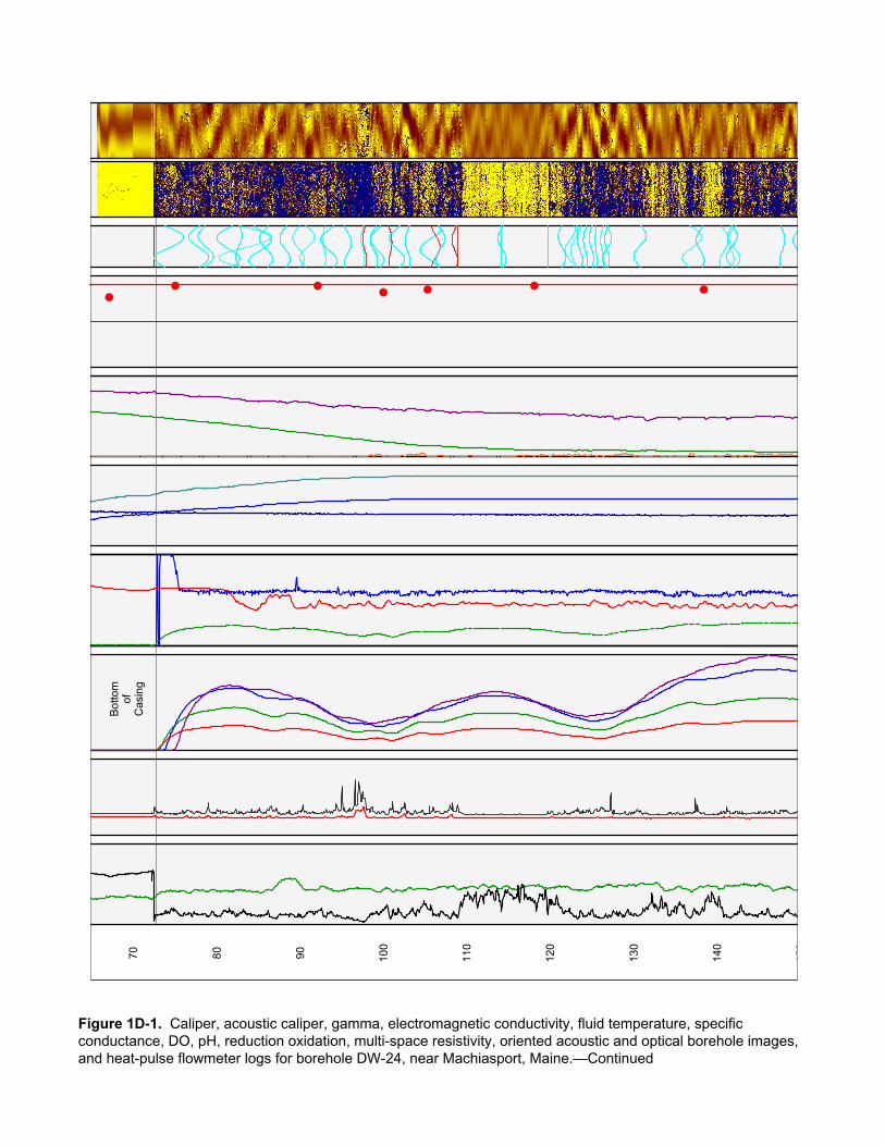
Figure 1D-1. Caliper, acoustic caliper, gamma, electromagnetic conductivity, fluid temperature, specific conductance, DO, pH, reduction oxidation, multi-space resistivity, oriented acoustic and optical borehole images, and heat-pulse flowmeter logs for borehole DW-24, near Machiasport, Maine.
70 80 90 100
110
120
130
140
150
Bot
tom
ofC
asin
g
Figure 1D-1. Caliper, acoustic caliper, gamma, electromagnetic conductivity, fluid temperature, specific conductance, DO, pH, reduction oxidation, multi-space resistivity, oriented acoustic and optical borehole images, and heat-pulse flowmeter logs for borehole DW-24, near Machiasport, Maine.—Continued

150
160
170
180
190
Figure 1D-1. Caliper, acoustic caliper, gamma, electromagnetic conductivity, fluid temperature, specific conductance, DO, pH, reduction oxidation, multi-space resistivity, oriented acoustic and optical borehole images, and heat-pulse flowmeter logs for borehole DW-24, near Machiasport, Maine.—Continued
TR
UE
VE
RT
ICA
L D
EP
TH
, IN
FE
ET
BE
LO
W T
OP
OF
CA
SIN
G
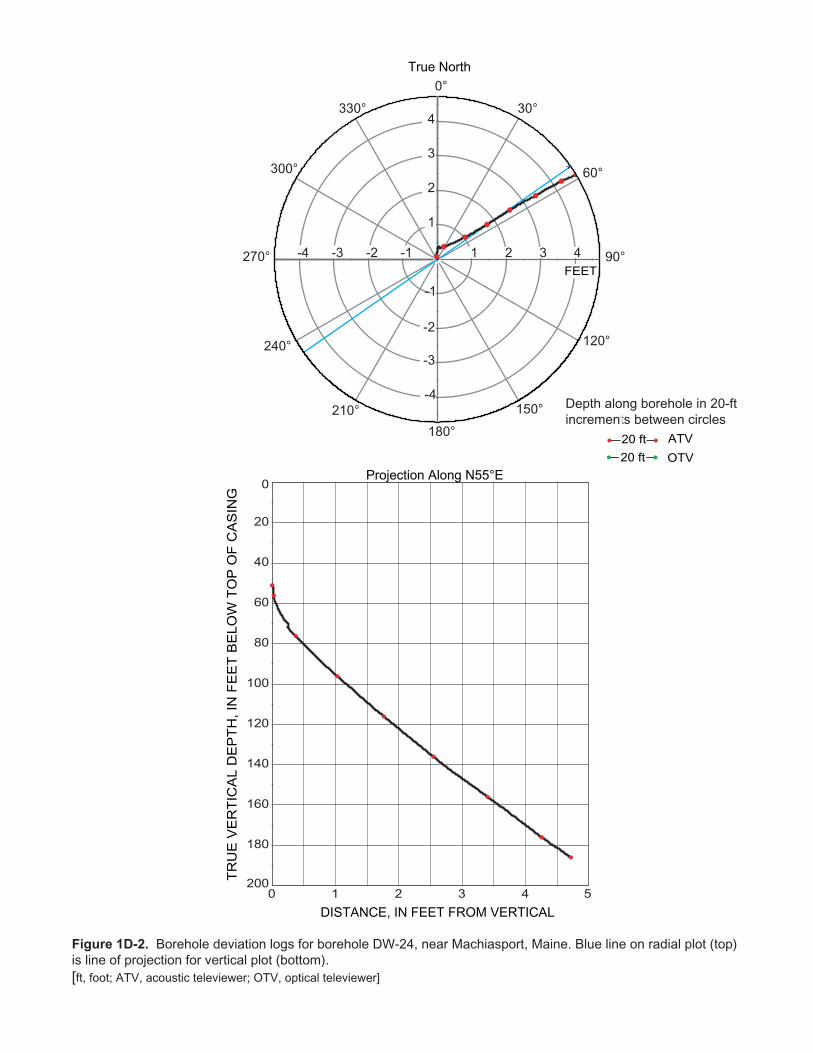
True North
DISTANCE, IN FEET FROM VERTICAL
Projection Along N55°E
Depth along borehole in 20-ftincrements between circles
0 51 2 3 4
20
40
60
80
100
120
140
160
180
0
200
ATV20 ft
OTV20 ft
0°
30°
60°
90°
120°
150°
180°
210°
240°
300°
330°
1 2 3 4-1-2-3-4
-1
-2
-3
-4
1
2
3
4
270°
Figure 1D-2. Borehole deviation logs for borehole DW-24, near Machiasport, Maine. Blue line on radial plot (top)is line of projection for vertical plot (bottom).[ft, foot; ATV, acoustic televiewer; OTV, optical televiewer]
FEET

Table 1D–1. Interpretation of acoustic televiewer logs for borehole DW-24, near Machiasport, Maine.[Televiewer data are corrected for deviation and magnetic declination, so orientations are relative to true north; depths are below top of casing, which is 1.52 feet above land surface; dip azimuth is given in degrees east of true north; strike is reported in right-hand-rule (RHR)-azimuthal degrees east of true north and where the direction of dip is 90 degrees to the right of strike]
Depth, in feet
Depth, in meters
Dipazimuth
Strike, in RHR Dip Dip
direction Dip descriptor Comment
72.53 22.11 0 270 0 N Horizontal Foliation74.28 22.64 256 166 82 W Nearly vertical Minor fracture77.85 23.73 83 353 78 E Nearly vertical Minor fracture78.68 23.98 88 358 75 E Nearly vertical Minor fracture81.38 24.80 71 341 80 E Nearly vertical Minor fracture82.70 25.21 273 183 55 W Steep Minor fracture83.42 25.43 259 169 85 W Nearly vertical Minor fracture85.22 25.97 234 144 79 SW Nearly vertical Minor fracture85.91 26.18 67 337 72 NE Nearly vertical Minor fracture88.17 26.87 69 339 68 E Steep Minor fracture89.80 27.37 74 344 69 E Steep Minor fracture90.83 27.68 259 169 74 W Nearly vertical Minor fracture92.92 28.32 68 338 30 E Shallow Minor fracture93.44 28.48 56 326 76 NE Nearly vertical Minor fracture95.73 29.18 207 117 60 SW Steep Minor fracture97.74 29.79 65 335 40 NE Moderate Fracture98.89 30.14 55 325 61 NE Steep Minor fracture99.26 30.25 61 331 72 NE Nearly vertical Minor fracture
100.84 30.73 214 124 34 SW Moderate Fracture101.64 30.98 65 335 74 NE Nearly vertical Minor fracture102.91 31.37 47 317 46 NE Moderate Minor fracture105.61 32.19 329 239 78 NW Nearly vertical Minor fracture106.32 32.40 176 86 63 S Steep Fracture106.86 32.57 247 157 64 SW Steep Minor fracture108.56 33.09 56 326 54 NE Steep Fracture108.88 33.19 232 142 15 SW Shallow Fracture114.12 34.78 74 344 12 E Shallow Minor fracture114.20 34.81 67 337 63 NE Steep Minor fracture119.73 36.49 205 115 6 SW Nearly horizontal Minor fracture121.40 37.00 85 355 61 E Steep Minor fracture122.38 37.30 326 236 68 NW Steep Minor fracture122.88 37.45 318 228 59 NW Steep Minor fracture123.59 37.67 59 329 49 NE Moderate Minor fracture124.20 37.85 55 325 42 NE Moderate Minor fracture124.94 38.08 72 342 46 E Moderate Minor fracture125.49 38.25 57 327 25 NE Shallow Minor fracture126.22 38.47 51 321 40 NE Moderate Minor fracture126.82 38.65 59 329 48 NE Moderate Minor fracture126.83 38.66 254 164 66 W Steep Minor fracture130.74 39.85 273 183 71 W Nearly vertical Minor fracture137.02 41.76 258 168 78 W Nearly vertical Minor fracture138.00 42.06 54 324 62 NE Steep Minor fracture140.82 42.92 230 140 64 SW Steep Minor fracture141.62 43.16 70 340 57 E Steep Minor fracture141.78 43.21 270 180 69 W Steep Minor fracture142.08 43.30 74 344 69 E Steep Minor fracture147.82 45.05 236 146 49 SW Moderate Minor fracture149.75 45.64 50 320 67 NE Steep Minor fracture154.58 47.11 259 169 73 W Nearly vertical Minor fracture155.70 47.46 74 344 76 E Nearly vertical Minor fracture157.29 47.94 267 177 54 W Steep Minor fracture160.53 48.93 109 19 24 E Shallow Minor fracture161.71 49.29 209 119 21 SW Shallow Minor fracture163.72 49.90 62 332 22 NE Shallow Minor fracture164.94 50.27 239 149 79 SW Nearly vertical Minor fracture

Table 1D–1. Interpretation of acoustic televiewer logs for borehole DW-24, near Machiasport, Maine.—Continued[Televiewer data are corrected for deviation and magnetic declination, so orientations are relative to true north; depths are below top of casing, which is 1.52 feet above land surface; dip azimuth is given in degrees east of true north; strike is reported in right-hand-rule (RHR)-azimuthal degrees east of true north and where the direction of dip is 90 degrees to the right of strike]
Depth, in feet
Depth, in meters
Dipazimuth
Strike, in RHR Dip Dip
direction Dip descriptor Comment
166.80 50.84 210 120 12 SW Shallow Minor fracture168.10 51.23 158 68 22 S Shallow Minor fracture169.11 51.54 212 122 56 SW Steep Fracture171.30 52.21 173 83 55 S Steep Minor fracture173.92 53.01 57 327 50 NE Moderate Minor fracture176.45 53.78 55 325 49 NE Moderate Minor fracture177.75 54.18 237 147 14 SW Shallow Minor fracture179.59 54.74 256 166 25 W Shallow Minor fracture179.82 54.81 215 125 74 SW Nearly vertical Minor fracture180.06 54.88 46 316 71 NE Nearly vertical Minor fracture181.46 55.31 48 318 24 NE Shallow Minor fracture183.51 55.93 101 11 26 E Shallow Transmissive fracture184.30 56.17 251 161 42 W Moderate Minor fracture185.64 56.58 164 74 19 S Shallow Minor fracture187.48 57.14 149 59 13 SE Shallow Minor fracture188.99 57.60 208 118 56 SW Steep Minor fracture189.21 57.67 220 130 58 SW Steep Minor fracture189.82 57.85 266 176 15 W Shallow Minor fracture
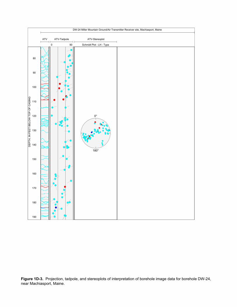
DW-24 Miller Mountain Ground/Air Transmitter Receiver site, Machiasport, Maine
ATV-Tadpole
0 90
ATV ATV-Stereoplot
Schmidt Plot - LH - Type
80
90
100
110
120
130
140
150
160
170
180
190
0°
180°
DE
PT
H, I
N F
EE
T B
ELO
W T
OP
OF
CA
SIN
G
Figure 1D-3. Projection, tadpole, and stereoplots of interpretation of borehole image data for borehole DW-24, near Machiasport, Maine.

INTE
RPR
ETAT
ION
OF
FLO
WM
ETER
DAT
A AN
D IN
PUT
VALU
ES F
OR
FW
RAP
Elev
atio
n of
mea
surin
g po
int
60 fe
etN
umbe
r of f
ract
ures
1W
ell d
iam
eter
6 in
ches
Dra
wdo
wn
0.5
feet
Dep
th to
am
bien
t wat
er le
vel
9.8
feet
Frac
ture
nu
mbe
rD
epth
(ft)
Ambi
ent
flow
abo
ve
frac
ture
(g
al/m
in)
Pum
ped
flow
abo
ve
frac
ture
(g
al/m
in)
118
2.0
0.00
0.82
MO
DEL
ED O
UTP
UT
RES
ULT
S FR
OM
FW
RAP
Elev
atio
n, a
mbi
ent w
ater
leve
l50
.20
feet
Elev
atio
n, p
umpe
d w
ater
leve
l49
.70
feet
Frac
ture
nu
mbe
rD
epth
(ft)
Ambi
ent
flow
abo
ve
frac
ture
(g
al/m
in)
Pum
ped
flow
abo
ve
frac
ture
(g
al/m
in)
Zone
tran
s-m
issi
vity
(ft
2 /d)
Wat
er le
vel
(ft)
Elev
atio
n of
wat
er
leve
l (ft
)
Perc
ent
tran
s-m
issi
vity
118
2.0
0.0
0.81
306.
09.
8050
.20
100
Tota
l bor
ehol
e tr
ansm
issi
vity
306.
0(ft
2 /d)
Sum
of s
quar
es e
rror
0.00
0(g
al/m
in)2
Roo
t mea
n sq
uare
err
or
0.00
6(g
al/m
in)
Das
hed
line
indi
cate
s m
easu
red
flow
.
Sol
id li
ne in
dica
tes
mod
eled
flow
.P
oint
s in
dica
te m
easu
red
heat
-pul
se fl
owm
eter
dat
a.
Figu
re 1
D–4
. In
terp
reta
tion
and
mod
elin
g of
hea
t-pul
se fl
owm
eter
logs
for b
oreh
ole
DW
-24,
nea
r Mac
hias
port,
Mai
ne.
[gal
/min
, gal
lon
per m
inut
e; ft
, fee
t; ft2 /d
, fee
t squ
ared
per
day
; pos
itive
val
ues
of fl
ow a
re u
pwar
d flo
w, n
egat
ive
valu
es o
f flo
w a
re d
ownw
ard
flow
]
0 20 40 60 80 100
120
140
160
180
200-0
.20
0.2
DEPTH BELOW TOP OF CASING, IN FEET
FLO
W, I
N G
AL/M
IN
Ambi
ent F
low
Pro
file
0 20 40 60 80 100
120
140
160
180
200-1
.20
1.2
DEPTH BELOW TOP OF CASING, IN FEET
FLO
W, I
N G
AL/M
IN
Pum
ped
Flow
Pro
file
Tem
p
5051
deg
F
HP
FM
AM
B
04
gal/m
in
HP
FM
PU
MP
04
gal/m
in
DW
-25
Gam
ma
010
0C
PS
R8
020
000
Ohm
-m
R16
020
000
Ohm
-m
R32
020
000
Ohm
-m
R64
020
000
Ohm
-m
EM
I Con
d
030
mm
ho/m
SP
010
00m
V
O2p
pm
02
ppm
Cal
iper
57
inch
SP
R
012
000
Ohm
AT
V A
mp
AT
V
Aco
u C
alip
er
020
inch
pH
612
Eh
200
500
mV
Fl C
ond
100
150
uS/c
m
AT
V A
mp
030
00m
V
10 20 30 40 50 60 70
Not
e sc
ale of
0 to
4 gal/min
DEPTH, IN FEET BELOW TOP OF CASING
Figure 1E-1. Caliper, acoustic caliper, gamma, electromagnetic conductivity, fluid temperature, specific conductance, DO, pH, reduction oxidation, multi-space resistivity, oriented acoustic and optical borehole images, and heat-pulse flowmeter logs for borehole DW-25, near Machiasport, Maine.

80 90 100
110
120
130
140
Bot
tom
ofC
asin
g
Figure 1E-1. Caliper, acoustic caliper, gamma, electromagnetic conductivity, fluid temperature, specific conductance, DO, pH, reduction oxidation, multi-space resistivity, oriented acoustic and optical borehole images, and heat-pulse flowmeter logs for borehole DW-25, near Machiasport, Maine.—Continued
TR
UE
VE
RT
ICA
L D
EP
TH
, IN
FE
ET
BE
LO
W T
OP
OF
CA
SIN
G
True North
DISTANCE, IN FEET FROM VERTICAL
Projection Along N10°E
Depth along borehole in 16.5-ftincrements between circles
0.0 0.5 1.0
20
40
60
80
100
120
140
ATV16.5 ft
0°
30°
60°
90°
120°
150°
180°210°
240°
300°
330°
0.5-0.5
-0.5
0.5
270°FEET
Figure 1E-2. Borehole deviation logs for borehole DW-25, near Machiasport, Maine. Blue line on radial plot (top)is line of projection for vertical plot (bottom).[ft, foot; ATV, acoustic televiewer]

Table 1E–1. Interpretation of acoustic televiewer logs for borehole DW-25, near Machiasport, Maine.[Televiewer data are corrected for deviation and magnetic declination, so orientations are relative to true north; depths are below top of casing, which is 0.78 feet above land surface; dip azimuth is given in degrees east of true north; strike is reported in right-hand-rule (RHR)-azimuthal degrees east of true north and where the direction of dip is 90 degrees to the right of strike]
Depth, in feet
Depth, in meters
Dipazimuth
Strike, in RHR Dip Dip
direction Dip descriptor Comment
81.38 24.80 227 137 1 SW Nearly horizontal Bottom of casing81.40 24.81 227 137 2 SW Nearly horizontal Other81.64 24.88 214 124 80 SW Nearly vertical Minor fracture84.01 25.60 201 111 78 S Nearly vertical Large fracture92.28 28.13 90 0 52 E Steep Minor fracture92.33 28.14 238 148 56 SW Steep Minor fracture93.79 28.59 250 160 66 W Steep Minor fracture96.89 29.53 281 191 77 W Nearly vertical Minor fracture99.28 30.26 76 346 68 E Steep Minor fracture
100.58 30.66 72 342 77 E Nearly vertical Minor fracture106.15 32.35 330 240 82 NW Nearly vertical Minor fracture106.37 32.42 130 40 72 SE Nearly vertical Minor fracture110.80 33.77 249 159 77 W Nearly vertical Minor fracture111.28 33.92 250 160 78 W Nearly vertical Minor fracture114.79 34.99 241 151 81 SW Nearly vertical Minor fracture115.84 35.31 33 303 61 NE Steep Minor fracture116.07 35.38 266 176 54 W Steep Minor fracture116.65 35.55 65 335 74 NE Nearly vertical Minor fracture118.50 36.12 84 354 79 E Nearly vertical Minor fracture119.63 36.46 212 122 63 SW Steep Minor fracture121.01 36.88 85 355 83 E Nearly vertical Minor fracture121.88 37.15 231 141 44 SW Moderate Large fracture122.83 37.44 249 159 28 W Shallow Minor fracture123.60 37.67 322 232 78 NW Nearly vertical Minor fracture123.77 37.72 88 358 72 E Nearly vertical Minor fracture125.06 38.12 43 313 54 NE Steep Minor fracture125.24 38.17 92 2 80 E Nearly vertical Minor fracture127.95 39.00 43 313 53 NE Steep Transmissive fracture129.98 39.62 11 281 43 N Moderate Minor fracture131.73 40.15 156 66 74 SE Nearly vertical Minor fracture131.97 40.22 351 261 77 N Nearly vertical Minor fracture135.29 41.23 49 319 52 NE Steep Transmissive fracture137.90 42.03 80 350 81 E Nearly vertical Minor fracture138.22 42.13 2 272 63 N Steep Transmissive fracture141.30 43.07 275 185 12 W Shallow Lithologic feature141.91 43.25 310 220 76 NW Nearly vertical Minor fracture

DW-25 Miller Mountain Ground/Air Transmitter Receiver site, Machiasport, Maine
ATV - Stereoplot
Schmidt Plot - LH - Type
ATV ATV-Tadpole
0 90
80
90
100
110
120
130
140
0°
180°DE
PT
H, I
N F
EE
T B
ELO
W T
OP
OF
CA
SIN
G
Figure 1E-3. Projection, tadpole, and stereoplots of interpretation of borehole image data for borehole DW-25, near Machiasport, Maine.
INTE
RPR
ETAT
ION
OF
FLO
WM
ETER
DAT
A AN
D IN
PUT
VALU
ES F
OR
FW
RAP
Elev
atio
n of
mea
surin
g po
int
40 fe
etN
umbe
r of f
ract
ures
3W
ell d
iam
eter
6 in
ches
Dra
wdo
wn
2.46
feet
Dep
th to
am
bien
t wat
er le
vel
1.5
feet
Frac
ture
nu
mbe
rD
epth
(ft)
Ambi
ent
flow
abo
ve
frac
ture
(g
al/m
in)
Pum
ped
flow
abo
ve
frac
ture
(g
al/m
in)
212
8.0
1.80
3.70
113
8.0
1.80
3.00
MO
DEL
ED O
UTP
UT
RES
ULT
S FR
OM
FW
RAP
Elev
atio
n, a
mbi
ent w
ater
leve
l38
.50
feet
Elev
atio
n, p
umpe
d w
ater
leve
l36
.04
feet
Frac
ture
nu
mbe
rD
epth
(ft)
Ambi
ent
flow
abo
ve
frac
ture
(g
al/m
in)
Pum
ped
flow
abo
ve
frac
ture
(g
al/m
in)
Zone
tran
s-m
issi
vity
(ft
2 /d)
Wat
er le
vel
(ft)
Elev
atio
n of
wat
er
leve
l (ft
)
Perc
ent
tran
s-m
issi
vity
212
8.0
1.81
63.
671
40.5
0.82
39.1
831
113
8.0
1.68
62.
922
89.1
-2.1
842
.18
69
Tota
l bor
ehol
e tr
ansm
issi
vity
129.
6(ft
2 /d)
Sum
of s
quar
es e
rror
25.9
8(g
al/m
in)2
Roo
t mea
n sq
uare
err
or
2.94
(gal
/min
)
Das
hed
line
indi
cate
s m
easu
red
flow
.
Sol
id li
ne in
dica
tes
mod
eled
flow
.P
oint
s in
dica
te m
easu
red
heat
-pul
se fl
owm
eter
dat
a.
Figu
re 1
E–4.
Int
erpr
etat
ion
and
mod
elin
g of
hea
t-pul
se fl
owm
eter
logs
for b
oreh
ole
DW
-25,
nea
r Mac
hias
port,
Mai
ne.
Upp
erm
ost f
ract
ure
used
to s
imul
ate
over
flow
at t
he to
p of
cas
ing
is n
ot s
how
n in
mod
el re
sults
. [g
al/m
in, g
allo
n pe
r min
ute;
ft, f
eet;
ft2 /d, f
eet s
quar
ed p
er d
ay; p
ositi
ve v
alue
s of
flow
are
upw
ard
flow
, neg
ativ
e va
lues
of f
low
are
dow
nwar
d flo
w]
0 20 40 60 80 100
120
140
160
-60
6
DEPTH BELOW TOP OF CASING, IN FEET
FLO
W, I
N G
AL/M
IN
Ambi
ent F
low
Pro
file
0 20 40 60 80 100
120
140
160
-60
6
DEPTH BELOW TOP OF CASING, IN FEET
FLO
W, I
N G
AL/M
IN
Pum
ped
Flow
Pro
file
Out
flow
at t
op
of b
oreh
ole
OT
V
AT
V A
mp
Tel
evie
wer
sH
PF
M A
mb
-0.5
0.5
gal/m
in
Cal
iper
57
inch
Aco
u C
alip
er
015
inch
DW
-31
HP
FM
Pum
p
-0.5
0.5
gal/m
in
Tem
p
42.5
43.5
deg
F
Fl C
ond
130
150
uS/c
m
EM
I Con
d
020
0m
mho
/m
SP
030
0m
V
R32
01e
+009
Ohm
-m
R64
01e
+009
Ohm
-m
OT
V
AT
VG
amm
a
030
0C
PS
SP
R
010
0000
Ohm
AT
V A
mp
030
00m
V 0 10 20 30 40 50 60 70
Bot
tom
ofC
asin
gR
8 &
R16
Off-
Sca
le
DEPTH, IN FEET BELOW TOP OF CASING
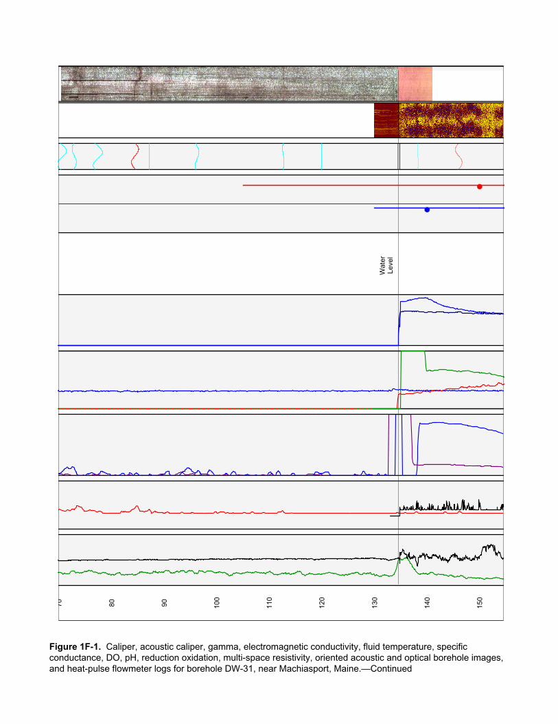
Figure 1F-1. Caliper, acoustic caliper, gamma, electromagnetic conductivity, fluid temperature, specific conductance, DO, pH, reduction oxidation, multi-space resistivity, oriented acoustic and optical borehole images, and heat-pulse flowmeter logs for borehole DW-31, near Machiasport, Maine.
70 80 90 100
110
120
130
140
150
Wat
erLe
vel
Figure 1F-1. Caliper, acoustic caliper, gamma, electromagnetic conductivity, fluid temperature, specific conductance, DO, pH, reduction oxidation, multi-space resistivity, oriented acoustic and optical borehole images, and heat-pulse flowmeter logs for borehole DW-31, near Machiasport, Maine.—Continued

160
170
180
190
200
210
220
230
Am
bien
tO
utflo
w
Pum
ping
In
flow
Figure 1F-1. Caliper, acoustic caliper, gamma, electromagnetic conductivity, fluid temperature, specific conductance, DO, pH, reduction oxidation, multi-space resistivity, oriented acoustic and optical borehole images, and heat-pulse flowmeter logs for borehole DW-31, near Machiasport, Maine.—Continued

240
Figure 1F-1. Caliper, acoustic caliper, gamma, electromagnetic conductivity, fluid temperature, specific conductance, DO, pH, reduction oxidation, multi-space resistivity, oriented acoustic and optical borehole images, and heat-pulse flowmeter logs for borehole DW-31, near Machiasport, Maine.—Continued
TR
UE
VE
RT
ICA
L D
EP
TH
, IN
FE
ET
BE
LO
W T
OP
OF
CA
SIN
G
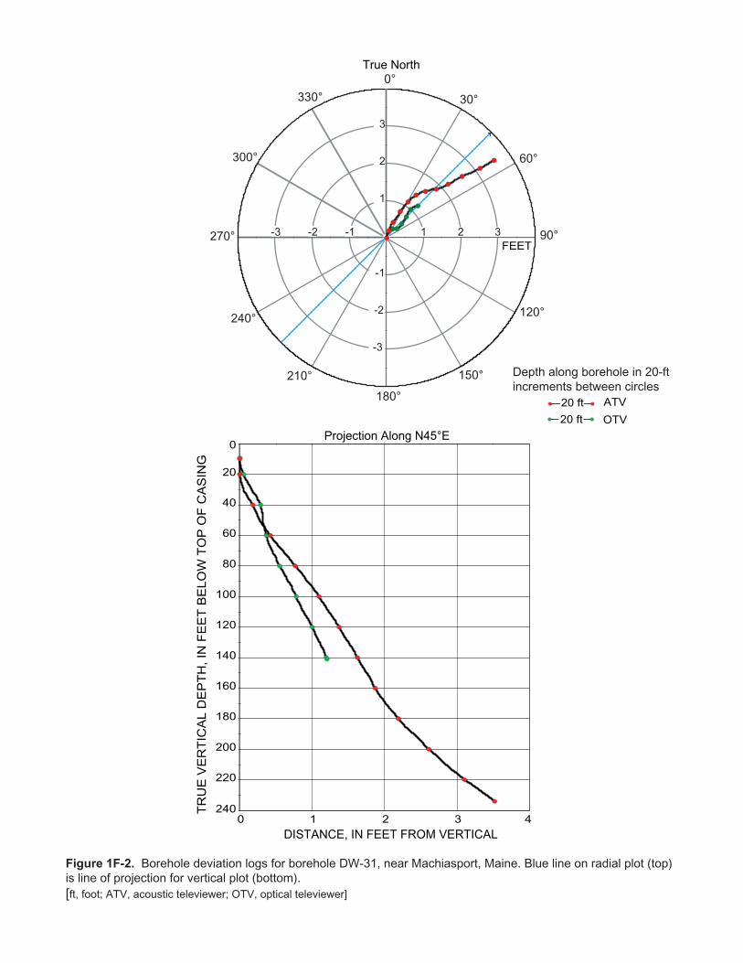
True North
DISTANCE, IN FEET FROM VERTICAL
Projection Along N45°E
Depth along borehole in 20-ftincrements between circles
0 1 2 3
20
40
60
80
100
120
140
160
180
200
220
4
0
240
ATV20 ft
OTV20 ft
FEET
0°
30°
60°
90°
120°
150°
180°
210°
240°
300°
330°
1 2 3-1-2-3
-1
-2
-3
1
2
3
270°
Figure 1F-2. Borehole deviation logs for borehole DW-31, near Machiasport, Maine. Blue line on radial plot (top)is line of projection for vertical plot (bottom).[ft, foot; ATV, acoustic televiewer; OTV, optical televiewer]
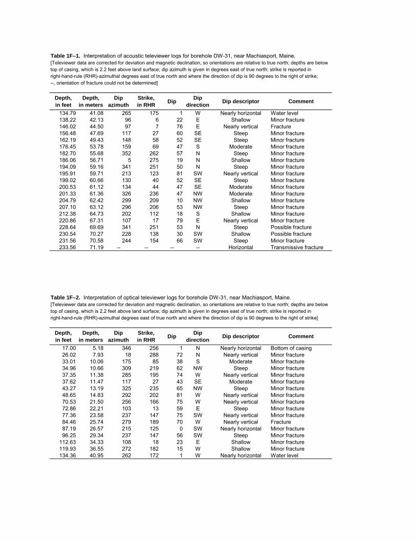
Table 1F–1. Interpretation of acoustic televiewer logs for borehole DW-31, near Machiasport, Maine.[Televiewer data are corrected for deviation and magnetic declination, so orientations are relative to true north; depths are below top of casing, which is 2.2 feet above land surface; dip azimuth is given in degrees east of true north; strike is reported in right-hand-rule (RHR)-azimuthal degrees east of true north and where the direction of dip is 90 degrees to the right of strike;--, orientation of fracture could not be determined]
Depth, in feet
Depth, in meters
Dipazimuth
Strike, in RHR Dip Dip
direction Dip descriptor Comment
134.79 41.08 265 175 1 W Nearly horizontal Water level138.22 42.13 96 6 22 E Shallow Minor fracture146.02 44.50 97 7 76 E Nearly vertical Fracture156.48 47.69 117 27 60 SE Steep Minor fracture162.19 49.43 148 58 52 SE Steep Minor fracture176.45 53.78 159 69 47 S Moderate Minor fracture182.70 55.68 352 262 57 N Steep Minor fracture186.06 56.71 5 275 19 N Shallow Minor fracture194.09 59.16 341 251 50 N Steep Minor fracture195.91 59.71 213 123 81 SW Nearly vertical Minor fracture199.02 60.66 130 40 52 SE Steep Minor fracture200.53 61.12 134 44 47 SE Moderate Minor fracture201.33 61.36 326 236 47 NW Moderate Minor fracture204.79 62.42 299 209 10 NW Shallow Minor fracture207.10 63.12 296 206 53 NW Steep Minor fracture212.38 64.73 202 112 18 S Shallow Minor fracture220.86 67.31 107 17 79 E Nearly vertical Minor fracture228.64 69.69 341 251 53 N Steep Possible fracture230.54 70.27 228 138 30 SW Shallow Possible fracture231.56 70.58 244 154 66 SW Steep Minor fracture233.56 71.19 -- -- -- -- Horizontal Transmissive fracture
Table 1F–2. Interpretation of optical televiewer logs for borehole DW-31, near Machiasport, Maine.[Televiewer data are corrected for deviation and magnetic declination, so orientations are relative to true north; depths are below top of casing, which is 2.2 feet above land surface; dip azimuth is given in degrees east of true north; strike is reported in right-hand-rule (RHR)-azimuthal degrees east of true north and where the direction of dip is 90 degrees to the right of strike]
Depth, in feet
Depth, in meters
Dipazimuth
Strike, in RHR Dip Dip
direction Dip descriptor Comment
17.00 5.18 346 256 1 N Nearly horizontal Bottom of casing26.02 7.93 18 288 72 N Nearly vertical Minor fracture33.01 10.06 175 85 38 S Moderate Minor fracture34.96 10.66 309 219 62 NW Steep Minor fracture37.35 11.38 285 195 74 W Nearly vertical Minor fracture37.62 11.47 117 27 43 SE Moderate Minor fracture43.27 13.19 325 235 65 NW Steep Minor fracture48.65 14.83 292 202 81 W Nearly vertical Minor fracture70.53 21.50 256 166 75 W Nearly vertical Minor fracture72.86 22.21 103 13 59 E Steep Minor fracture77.36 23.58 237 147 75 SW Nearly vertical Minor fracture84.46 25.74 279 189 70 W Nearly vertical Fracture87.19 26.57 215 125 0 SW Nearly horizontal Minor fracture96.25 29.34 237 147 56 SW Steep Minor fracture
112.63 34.33 108 18 23 E Shallow Minor fracture119.93 36.55 272 182 15 W Shallow Minor fracture134.36 40.95 262 172 1 W Nearly horizontal Water level
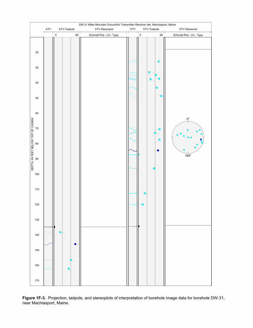
DW-31 Miller Mountain Ground/Air Transmitter Receiver site, Machiasport, Maine
ATV-Stereoplot
Schmidt Plot - LH - Type
OTV-Stereonet
Schmidt Plot - LH - Type
OTVATV-Tadpole
0 90
OTV-Tadpole
0 90
ATV
20
30
40
50
60
70
80
90
100
110
120
130
140
150
160
170
0°
180°
DE
PT
H, I
N F
EE
T B
ELO
W T
OP
OF
CA
SIN
G
Figure 1F-3. Projection, tadpole, and stereoplots of interpretation of borehole image data for borehole DW-31, near Machiasport, Maine.
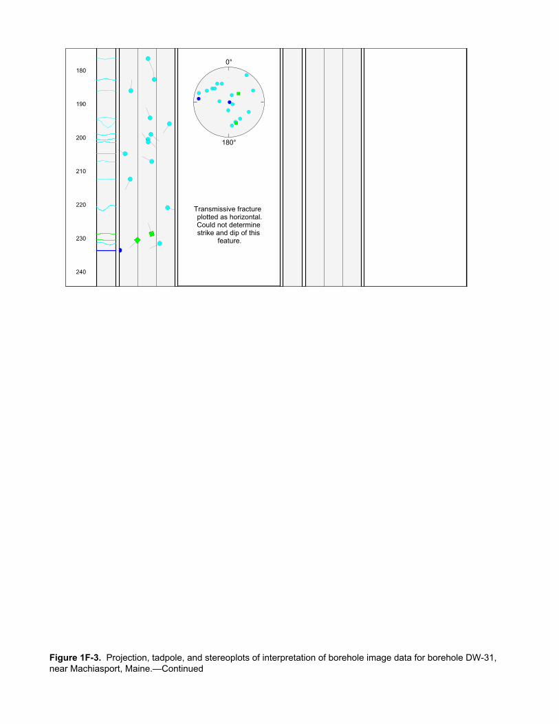
180
190
200
210
220
230
240
0°
180°
Transmissive fracture plotted as horizontal.Could not determine strike and dip of this
feature.
Figure 1F-3. Projection, tadpole, and stereoplots of interpretation of borehole image data for borehole DW-31, near Machiasport, Maine.—Continued
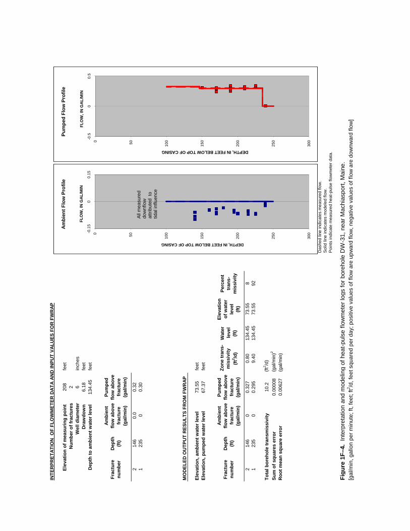
INTE
RPR
ETAT
ION
OF
FLO
WM
ETER
DAT
A AN
D IN
PUT
VALU
ES F
OR
FW
RAP
Elev
atio
n of
mea
surin
g po
int
208
feet
Num
ber o
f fra
ctur
es2
Wel
l dia
met
er6
inch
esD
raw
dow
n 6.
18 fe
etD
epth
to a
mbi
ent w
ater
leve
l 13
4.45
feet
Frac
ture
nu
mbe
rD
epth
(ft)
Ambi
ent
flow
abo
ve
frac
ture
(g
al/m
in)
Pum
ped
flow
abo
ve
frac
ture
(g
al/m
in)
214
60.
00.
321
235
00.
30
MO
DEL
ED O
UTP
UT
RES
ULT
S FR
OM
FW
RAP
Elev
atio
n, a
mbi
ent w
ater
leve
l73
.55
feet
Elev
atio
n, p
umpe
d w
ater
leve
l67
.37
feet
Frac
ture
nu
mbe
rD
epth
(ft)
Ambi
ent
flow
abo
ve
frac
ture
(g
al/m
in)
Pum
ped
flow
abo
ve
frac
ture
(g
al/m
in)
Zone
tran
s-m
issi
vity
(ft
2 /d)
Wat
er le
vel
(ft)
Elev
atio
n of
wat
er
leve
l (ft
)
Perc
ent
tran
s-m
issi
vity
214
60
0.32
70.
8013
4.45
73.5
58
123
50
0.29
59.
4013
4.45
73.5
592
Tota
l bor
ehol
e tr
ansm
issi
vity
10.2
(ft2 /d
)Su
m o
f squ
ares
err
or0.
0000
8(g
al/m
in)2
Roo
t mea
n sq
uare
err
or
0.00
627
(gal
/min
)
Das
hed
line
indi
cate
s m
easu
red
flow
.
Sol
id li
ne in
dica
tes
mod
eled
flow
.P
oint
s in
dica
te m
easu
red
heat
-pul
se fl
owm
eter
dat
a.
Figu
re 1
F–4.
Int
erpr
etat
ion
and
mod
elin
g of
hea
t-pul
se fl
owm
eter
logs
for b
oreh
ole
DW
-31,
nea
r Mac
hias
port,
Mai
ne.
[gal
/min
, gal
lon
per m
inut
e; ft
, fee
t; ft2 /d
, fee
t squ
ared
per
day
; pos
itive
val
ues
of fl
ow a
re u
pwar
d flo
w, n
egat
ive
valu
es o
f flo
w a
re d
ownw
ard
flow
]
0 50 100
150
200
250
300-0
.15
00.
15
DEPTH, IN FEET BELOW TOP OF CASING
FLO
W, I
N G
AL/
MIN
Am
bien
t Flo
w P
rofil
e
All m
easu
red
dow
nflo
w
attri
bute
d to
tid
al in
fluen
ce
0 50 100
150
200
250
300-0
.50
0.5
DEPTH, IN FEET BELOW TOP OF CASING
FLO
W, I
N G
AL/
MIN
Pum
ped
Flow
Pro
file

Cal
iper
58
inch
AT
V A
mp
Aco
u C
alip
er
020
inch
HP
FM
Am
b
-0.6
0.6
gal/m
in
HP
FM
Pum
p
-0.6
0.6
gal/m
in
DW
-32
Gam
ma
030
0C
PS
AT
VT
emp
4449
deg
F
O2p
pm
04
ppm
Fl C
ond
5010
0U
S/C
M
SP
Con
d
5012
5uS
/cm
R32
01e
+009
Ohm
-m
R64
01e
+009
Ohm
-m
EM
I Con
d
012
0m
mho
/m
SP
010
00m
V
pH
510
Eh
200
400
mV
SP
R
040
000
Ohm
AT
V A
mp
020
00m
V
20 30 40 50 60 70 80
R8
and
R16
Off-
Sca
leB
otto
mof
Cas
ing
DEPTH, IN FEET BELOW TOP OF CASING
Figure 1G-1. Caliper, acoustic caliper, gamma, electromagnetic conductivity, fluid temperature, specific conductance, DO, pH, reduction oxidation, multi-space resistivity, oriented acoustic and optical borehole images, and heat-pulse flowmeter logs for borehole DW-32, near Machiasport, Maine.
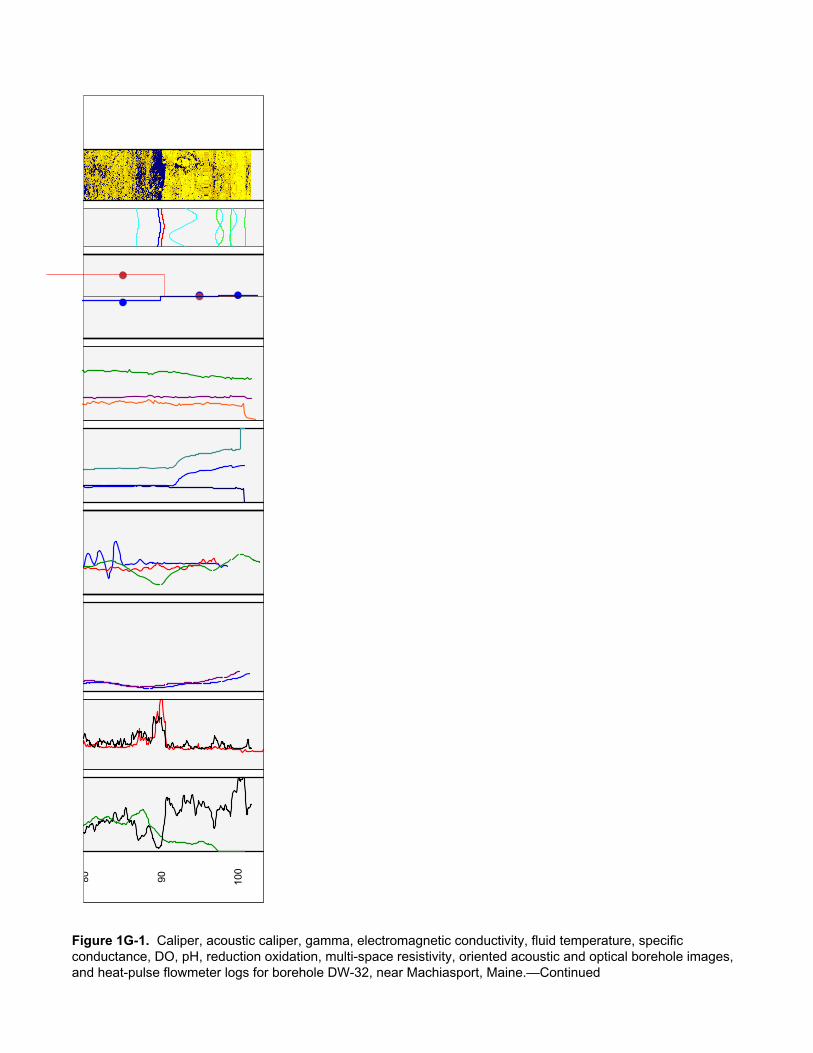
80 90 100
Figure 1G-1. Caliper, acoustic caliper, gamma, electromagnetic conductivity, fluid temperature, specific conductance, DO, pH, reduction oxidation, multi-space resistivity, oriented acoustic and optical borehole images, and heat-pulse flowmeter logs for borehole DW-32, near Machiasport, Maine.—Continued
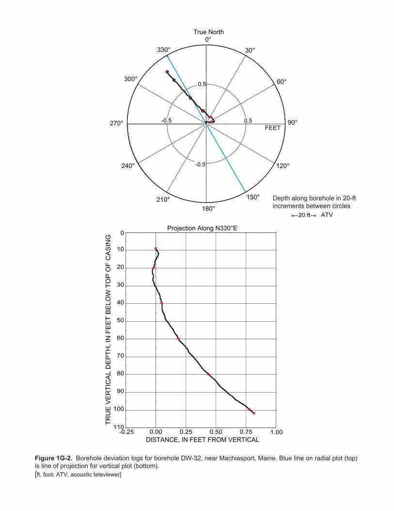
TR
UE
VE
RT
ICA
L D
EP
TH
, IN
FE
ET
BE
LO
W T
OP
OF
CA
SIN
G
True North
DISTANCE, IN FEET FROM VERTICAL
Projection Along N330°E
Depth along borehole in 20-ftincrements between circles
-0.25 0.00 0.25 0.50 0.75
10
20
30
40
50
60
70
80
90
100
1.00
0
110
ATV20 ft
0°
30°
60°
90°
120°
150°
180°210°
240°
300°
330°
0.5-0.5
-0.5
0.5
270°FEET
Figure 1G-2. Borehole deviation logs for borehole DW-32, near Machiasport, Maine. Blue line on radial plot (top)is line of projection for vertical plot (bottom).[ft, foot; ATV, acoustic televiewer]
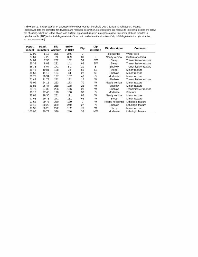
Table 1G–1. Interpretation of acoustic televiewer logs for borehole DW-32, near Machiasport, Maine.[Televiewer data are corrected for deviation and magnetic declination, so orientations are relative to true north; depths are below top of casing, which is 1.4 feet above land surface; dip azimuth is given in degrees east of true north; strike is reported in right-hand-rule (RHR)-azimuthal degrees east of true north and where the direction of dip is 90 degrees to the right of strike;--, no measurement]
Depth, in feet
Depth, in meters
Dipazimuth
Strike, in RHR Dip Dip
direction Dip descriptor Comment
17.00 5.18 336 246 0 -- Horizontal Water level23.61 7.20 89 359 89 E Nearly vertical Bottom of casing24.04 7.33 232 132 59 SW Steep Transmissive fracture26.33 8.02 231 141 68 SW Steep Transmissive fracture26.38 8.04 171 81 20 S Shallow Transmissive fracture35.46 10.81 128 38 66 SE Steep Minor fracture36.50 11.12 124 34 22 SE Shallow Minor fracture66.75 20.34 197 107 47 S Moderate Minor fracture71.47 21.78 282 192 15 W Shallow Transmissive fracture79.09 24.11 263 173 70 W Nearly vertical Minor fracture86.86 26.47 268 178 26 W Shallow Minor fracture89.73 27.35 256 166 23 W Shallow Transmissive fracture90.16 27.48 190 100 33 S Moderate Fracture92.84 28.30 281 191 88 W Nearly vertical Minor fracture97.53 29.73 271 181 65 W Steep Minor fracture97.63 29.76 260 170 2 W Nearly horizontal Lithologic feature99.10 30.20 339 249 27 N Shallow Lithologic feature99.36 30.28 272 182 70 W Steep Minor fracture
100.96 30.77 336 246 38 NW Moderate Lithologic feature

DW-32 Miller Mountain Ground/Air Transmitter Receiver site, Machiasport, Maine
ATV-Tadpole
0 90
ATV-Stereoplot
Schmidt Plot - LH - Type
ATV
10
20
30
40
50
60
70
80
90
100
0°
180°
DE
PT
H, I
N F
EE
T B
ELO
W T
OP
OF
CA
SIN
G
Figure 1G-3. Projection, tadpole, and stereoplots of interpretation of borehole image data for borehole DW-32, near Machiasport, Maine.

INTE
RPR
ETAT
ION
OF
FLO
WM
ETER
DAT
A AN
D IN
PUT
VALU
ES F
OR
FW
RAP
Elev
atio
n of
mea
surin
g po
int
62 fe
etN
umbe
r of f
ract
ures
3W
ell d
iam
eter
6 in
ches
Dra
wdo
wn
0.21
feet
Dep
th to
am
bien
t wat
er le
vel
17.0
4 fe
et
Frac
ture
nu
mbe
rD
epth
(ft)
Ambi
ent
flow
abo
ve
frac
ture
(g
al/m
in)
Pum
ped
flow
abo
ve
frac
ture
(g
al/m
in)
326
0.00
00.
600
271
-0.0
450.
410
189
.7-0
.046
0.31
0
MO
DEL
ED O
UTP
UT
RES
ULT
S FR
OM
FW
RAP
Elev
atio
n, a
mbi
ent w
ater
leve
l44
.96
feet
Elev
atio
n, p
umpe
d w
ater
leve
l44
.75
feet
Frac
ture
nu
mbe
rD
epth
(ft)
Ambi
ent
flow
abo
ve
frac
ture
(g
al/m
in)
Pum
ped
flow
abo
ve
frac
ture
(g
al/m
in)
Zone
tran
s-m
issi
vity
(ft
2 /d)
Wat
er le
vel
(ft)
Elev
atio
n of
wat
er
leve
l (ft
)
Perc
ent
tran
s-m
issi
vity
326
.00.
000
0.57
082
.516
.95
45.0
516
271
.0-0
.045
0.42
299
.017
.04
44.9
619
189
.7-0
.046
0.29
933
0.0
17.0
744
.93
65
Tota
l bor
ehol
e tr
ansm
issi
vity
511.
5(ft
2 /d)
Sum
of s
quar
es e
rror
0.00
116
(gal
/min
)2
Roo
t mea
n sq
uare
err
or
0.01
967
(gal
/min
)
Das
hed
line
indi
cate
s m
easu
red
flow
.
Sol
id li
ne in
dica
tes
mod
eled
flow
.P
oint
s in
dica
te m
easu
red
heat
-pul
se fl
owm
eter
dat
a.
Figu
re 1
G–4
. In
terp
reta
tion
and
mod
elin
g of
hea
t-pul
se fl
owm
eter
logs
for b
oreh
ole
DW
-32,
nea
r Mac
hias
port,
Mai
ne.
[gal
/min
, gal
lon
per m
inut
e; ft
, fee
t; ft2 /d
, fee
t squ
ared
per
day
; pos
itive
val
ues
of fl
ow a
re u
pwar
d flo
w, n
egat
ive
valu
es o
f flo
w a
re d
ownw
ard
flow
]
0 20 40 60 80 100
120
-0.2
00.
2
DEPTH BELOW TOP OF CASING, IN FEET
FLO
W, I
N G
AL/M
IN
Ambi
ent F
low
Pro
file
0 20 40 60 80 100
120
-0.7
00.
7
DEPTH BELOW TOP OF CASING, IN FEET
FLO
W, I
N G
AL/M
IN
Pum
ped
Flow
Pro
file

Am
pT
T
Aco
ustic
Tel
evie
wer
AT
VC
alip
er
68
inch
R8
010
000
Ohm
-m
R16
010
000
Ohm
-m
R32
010
000
Ohm
-m
R64
010
000
Ohm
-m
EM
I Con
d
015
mm
ho/m
SP
600
1000
mV
SP
R
012
000
Ohm
O2p
pm
02
ppm
pH
810
Tem
p
5051
.5D
eg F
Fl C
ond
035
0uS
/cm
SP
Con
d
035
0uS
/cm
HP
FM
Am
bien
t
-0.5
50.
55ga
l/min
HP
FM
Pum
ping
-0.5
50.
55ga
l/min
DW
-33
Gam
ma
010
0C
PS
Aco
u C
alip
er
58
inch
Eh
-400
100
mV
AT
V A
mp
030
00m
V
20 30 40 50 60 70
Bot
tom
of c
asin
g at
34.
0 ft
Bot
tom
ofC
asin
g
Inflo
w a
tF
ract
ure
DEPTH, IN FEET BELOW TOP OF CASING
Figure 1H-1. Caliper, acoustic caliper, gamma, electromagnetic conductivity, fluid temperature, specific conductance, DO, pH, reduction oxidation, multi-space resistivity, oriented acoustic and optical borehole images, and heat-pulse flowmeter logs for borehole DW-33, near Machiasport, Maine.
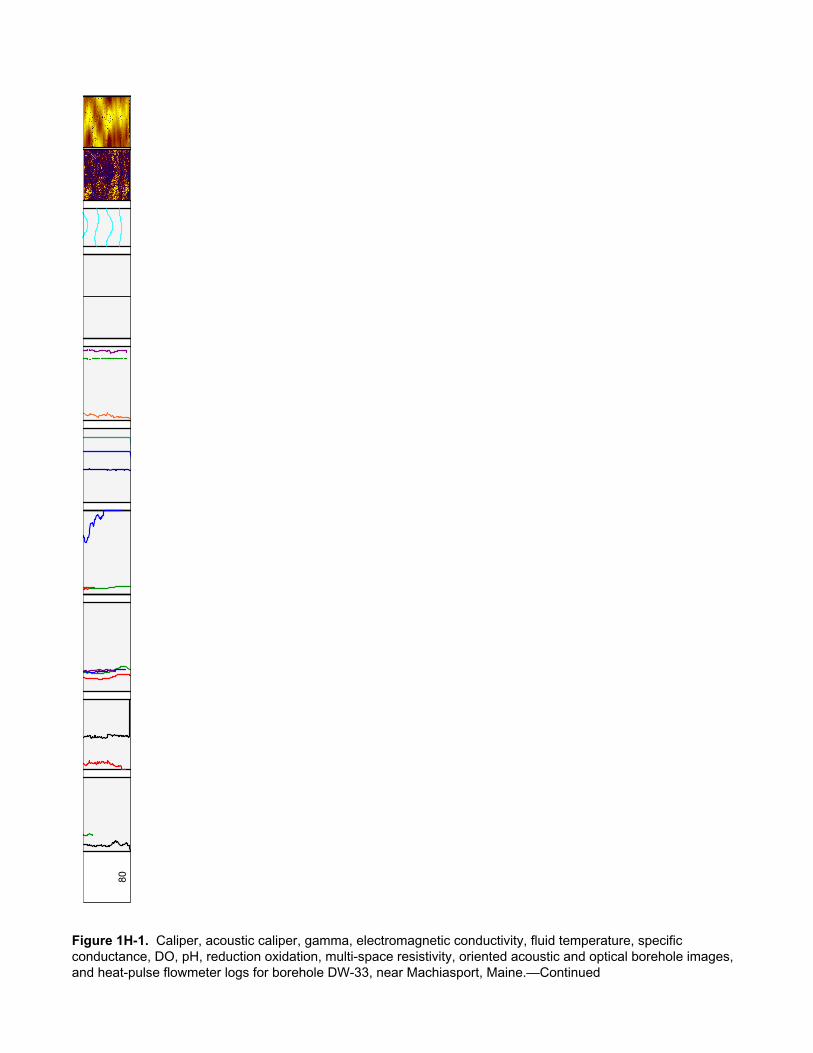
80
Figure 1H-1. Caliper, acoustic caliper, gamma, electromagnetic conductivity, fluid temperature, specific conductance, DO, pH, reduction oxidation, multi-space resistivity, oriented acoustic and optical borehole images, and heat-pulse flowmeter logs for borehole DW-33, near Machiasport, Maine.—Continued
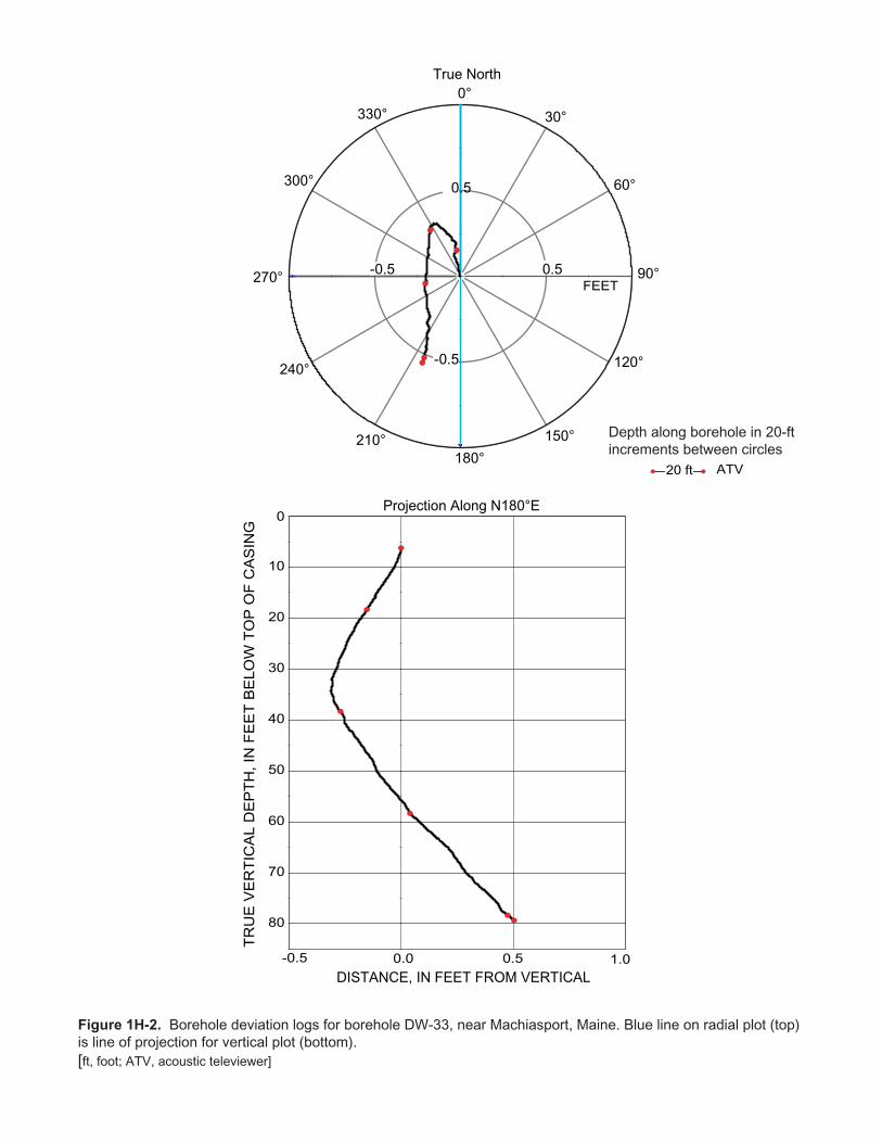
TR
UE
VE
RT
ICA
L D
EP
TH
, IN
FE
ET
BE
LO
W T
OP
OF
CA
SIN
G
True North
DISTANCE, IN FEET FROM VERTICAL
Projection Along N180°E
Depth along borehole in 20-ftincrements between circles
-0.5 0.0 0.5
10
20
30
40
50
60
70
80
1.0
0
ATV20 ft
FEET
0°
30°
60°
90°
120°
150°
180°210°
240°
300°
330°
0.5-0.5
-0.5
0.5
270°
Figure 1H-2. Borehole deviation logs for borehole DW-33, near Machiasport, Maine. Blue line on radial plot (top)is line of projection for vertical plot (bottom).[ft, foot; ATV, acoustic televiewer]
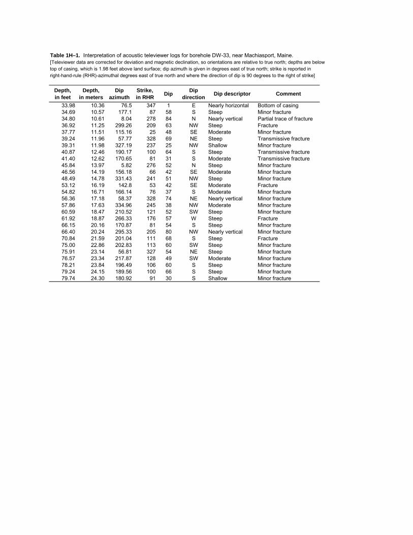
Table 1H–1. Interpretation of acoustic televiewer logs for borehole DW-33, near Machiasport, Maine.[Televiewer data are corrected for deviation and magnetic declination, so orientations are relative to true north; depths are below top of casing, which is 1.98 feet above land surface; dip azimuth is given in degrees east of true north; strike is reported in right-hand-rule (RHR)-azimuthal degrees east of true north and where the direction of dip is 90 degrees to the right of strike]
Depth, in feet
Depth, in meters
Dipazimuth
Strike, in RHR Dip Dip
direction Dip descriptor Comment
33.98 10.36 76.5 347 1 E Nearly horizontal Bottom of casing34.69 10.57 177.1 87 58 S Steep Minor fracture34.80 10.61 8.04 278 84 N Nearly vertical Partial trace of fracture36.92 11.25 299.26 209 63 NW Steep Fracture37.77 11.51 115.16 25 48 SE Moderate Minor fracture39.24 11.96 57.77 328 69 NE Steep Transmissive fracture39.31 11.98 327.19 237 25 NW Shallow Minor fracture40.87 12.46 190.17 100 64 S Steep Transmissive fracture41.40 12.62 170.65 81 31 S Moderate Transmissive fracture45.84 13.97 5.82 276 52 N Steep Minor fracture46.56 14.19 156.18 66 42 SE Moderate Minor fracture48.49 14.78 331.43 241 51 NW Steep Minor fracture53.12 16.19 142.8 53 42 SE Moderate Fracture54.82 16.71 166.14 76 37 S Moderate Minor fracture56.36 17.18 58.37 328 74 NE Nearly vertical Minor fracture57.86 17.63 334.96 245 38 NW Moderate Minor fracture60.59 18.47 210.52 121 52 SW Steep Minor fracture61.92 18.87 266.33 176 57 W Steep Fracture66.15 20.16 170.87 81 54 S Steep Minor fracture66.40 20.24 295.33 205 80 NW Nearly vertical Minor fracture70.84 21.59 201.04 111 68 S Steep Fracture75.00 22.86 202.83 113 60 SW Steep Minor fracture75.91 23.14 56.81 327 54 NE Steep Minor fracture76.57 23.34 217.87 128 49 SW Moderate Minor fracture78.21 23.84 196.49 106 60 S Steep Minor fracture79.24 24.15 189.56 100 66 S Steep Minor fracture79.74 24.30 180.92 91 30 S Shallow Minor fracture

DW-33 Miller Mountain Ground/Air Transmitter Receiver site, Machiasport, Maine
ATV ATV-Tadpole
0 90
ATV-Stereoplot
Schmidt Plot - LH - Type
40
50
60
70
80
0°
180°
DE
PT
H, I
N F
EE
T B
ELO
W T
OP
OF
CA
SIN
G
Figure 1H-3. Projection, tadpole, and stereoplots of interpretation of borehole image data for borehole DW-33, near Machiasport, Maine.

INTE
RPR
ETAT
ION
OF
FLO
WM
ETER
DAT
A AN
D IN
PUT
VALU
ES F
OR
FW
RAP
Elev
atio
n of
Mea
surin
g Po
int
52.8
feet
Num
ber o
f fra
ctur
es2
Wel
l Dia
met
er6
inch
esD
raw
dow
n 0.
97 fe
etD
epth
to A
mbi
ent W
ater
Lev
el
3.97
feet
Frac
ture
nu
mbe
rD
epth
(ft)
Ambi
ent
flow
abo
ve
frac
ture
(g
al/m
in)
Pum
ped
flow
abo
ve
frac
ture
(g
al/m
in)
234
.00.
000.
501
41.0
0.00
0.42
MO
DEL
ED O
UTP
UT
RES
ULT
S FR
OM
FW
RAP
Elev
atio
n, A
mbi
ent w
ater
leve
l48
.83
feet
Elev
atio
n, P
umpe
d w
ater
leve
l47
.86
feet
Frac
ture
nu
mbe
rD
epth
(ft)
Ambi
ent
flow
abo
ve
frac
ture
(g
al/m
in)
Pum
ped
flow
abo
ve
frac
ture
(g
al/m
in)
Zone
tran
s-m
issi
vity
(ft
2 /d)
Wat
er le
vel (
ft)
Elev
atio
n of
wat
er
leve
l (ft
)
Perc
ent
tran
s-m
issi
vity
234
.00.
000
0.50
614
.03.
9748
.830
002
141
41.0
0.00
00.
420
84.0
3.97
48.8
3000
286
Tota
l bor
ehol
e tr
ansm
issi
vity
98.0
(ft2 /d
)Su
m o
f squ
ares
err
or0.
000
(gal
/min
)2
Roo
t mea
n sq
uare
err
or
0.00
4(g
al/m
in)
Das
hed
line
indi
cate
s m
easu
red
flow
.
Sol
id li
ne in
dica
tes
mod
eled
flow
.P
oint
s in
dica
te m
easu
red
heat
-pul
se fl
owm
eter
dat
a.
Figu
re 1
H–4
. In
terp
reta
tion
and
mod
elin
g of
hea
t-pul
se fl
owm
eter
logs
for b
oreh
ole
DW
-33,
nea
r Mac
hias
port,
Mai
ne.
[gal
/min
, gal
lon
per m
inut
e; ft
, fee
t; ft2 /d
, fee
t squ
ared
per
day
; pos
itive
val
ues
of fl
ow a
re u
pwar
d flo
w, n
egat
ive
valu
es o
f flo
w a
re d
ownw
ard
flow
]
0 10 20 30 40 50 60 70 80
-10
1
DEPTH BELOW TOP OF CASING, IN FEET
FLO
W, I
N G
AL/M
IN
Ambi
ent F
low
Pro
file
0 10 20 30 40 50 60 70 80
-10
1
DEPTH BELOW TOP OF CASING, IN FEET
FLO
W, I
N G
AL/M
IN
Pum
ped
Flow
Pro
file
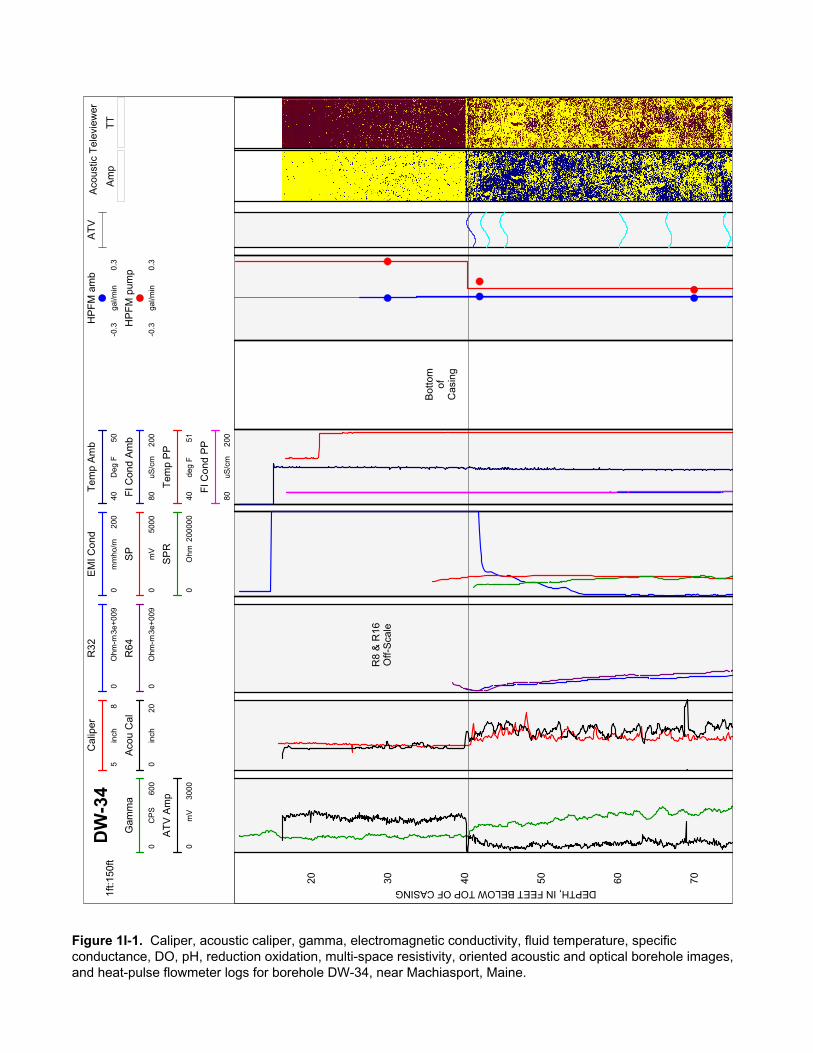
TT
Am
p
Aco
ustic
Tel
evie
wer
1ft:1
50ft
Tem
p A
mb
4050
Deg
F
EM
I Con
d
020
0m
mho
/m
SP
050
00m
V
R32
03e
+009
Ohm
-m
HP
FM
am
b
-0.3
0.3
gal/m
in
R64
03e
+009
Ohm
-m
HP
FM
pum
p
-0.3
0.3
gal/m
in
AT
V
Fl C
ond
Am
b
8020
0uS
/cm
Tem
p P
P
4051
deg
F
SP
R
020
0000
Ohm
Cal
iper
58
inch
Aco
u C
al
020
inch
DW
-34
Gam
ma
060
0C
PS
Fl C
ond
PP
8020
0uS
/cm
AT
V A
mp
030
00m
V
20 30 40 50 60 70
R8
& R
16O
ff-S
cale
Bot
tom
ofC
asin
g
DEPTH, IN FEET BELOW TOP OF CASING
Figure 1I-1. Caliper, acoustic caliper, gamma, electromagnetic conductivity, fluid temperature, specific conductance, DO, pH, reduction oxidation, multi-space resistivity, oriented acoustic and optical borehole images, and heat-pulse flowmeter logs for borehole DW-34, near Machiasport, Maine.

80 90 100
110
120
130
140
150
160
Figure 1I-1. Caliper, acoustic caliper, gamma, electromagnetic conductivity, fluid temperature, specific conductance, DO, pH, reduction oxidation, multi-space resistivity, oriented acoustic and optical borehole images, and heat-pulse flowmeter logs for borehole DW-34, near Machiasport, Maine.—Continued
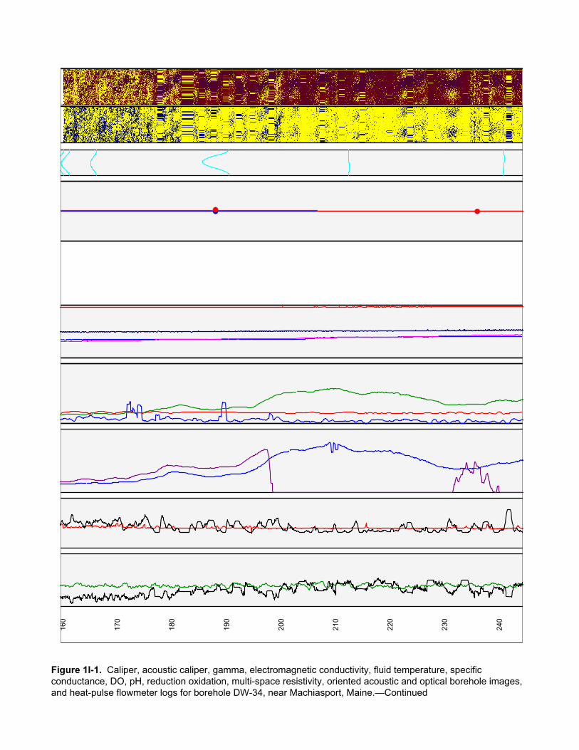
160
170
180
190
200
210
220
230
240
Figure 1I-1. Caliper, acoustic caliper, gamma, electromagnetic conductivity, fluid temperature, specific conductance, DO, pH, reduction oxidation, multi-space resistivity, oriented acoustic and optical borehole images, and heat-pulse flowmeter logs for borehole DW-34, near Machiasport, Maine.—Continued

250
260
270
280
290
300
310
Figure 1I-1. Caliper, acoustic caliper, gamma, electromagnetic conductivity, fluid temperature, specific conductance, DO, pH, reduction oxidation, multi-space resistivity, oriented acoustic and optical borehole images, and heat-pulse flowmeter logs for borehole DW-34, near Machiasport, Maine.—Continued
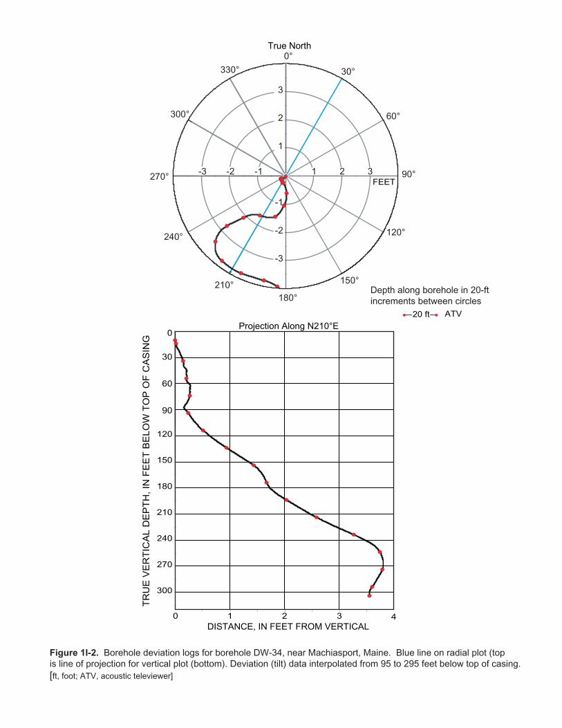
TR
UE
VE
RT
ICA
L D
EP
TH, I
N F
EE
T B
EL
OW
TO
P O
F C
AS
ING
True North
DISTANCE, IN FEET FROM VERTICAL
Projection Along N210°E
Depth along borehole in 20-ftincrements between circles
Figure 1I-2. Borehole deviation logs for borehole DW-34, near Machiasport, Maine. Blue line on radial plot (topis line of projection for vertical plot (bottom). Deviation (tilt) data interpolated from 95 to 295 feet below top of casing.[ft, foot; ATV, acoustic televiewer]
0 1 2 3
30
60
90
120
150
180
210
240
270
300
4
0
ATV20 ft
FEET
0°
30°
60°
90°
120°
150°
180°210°
240°
300°
330°
1 2 3-1-2-3
-1
-2
-3
1
2
3
270°

Table 1I–1. Interpretation of acoustic televiewer logs for borehole DW-34, near Machiasport, Maine.[Televiewer data are corrected for deviation and magnetic declination, so orientations are relative to true north; depths are below top of casing, which is 2.25 feet above land surface; dip azimuth is given in degrees east of true north; strike is reported in right-hand-rule (RHR)-azimuthal degrees east of true north and where the direction of dip is 90 degrees to the right of strike;--, no measurement]
Depth, in feet
Depth, in meters
Dipazimuth
Strike, in RHR Dip Dip
direction Dip descriptor Comment
40.50 12.34 -- -- -- -- -- Bottom of casing40.87 12.46 72 342 66 E Steep Transmissive fracture42.67 13.01 72 342 67 E Steep Minor fracture45.16 13.76 80 350 65 E Steep Minor fracture60.73 18.51 188 98 63 S Steep Minor fracture66.71 20.33 91 1 58 E Steep Minor fracture74.21 22.62 94 4 61 E Steep Minor fracture82.59 25.17 131 41 57 SE Steep Minor fracture82.92 25.27 326 236 78 NW Nearly vertical Minor fracture93.85 28.60 74 344 63 E Steep Minor fracture98.79 30.11 134 44 56 SE Steep Minor fracture
103.94 31.68 199 109 75 S Nearly vertical Minor fracture115.01 35.05 317 227 67 NW Steep Minor fracture132.14 40.27 118 28 49 SE Moderate Minor fracture136.34 41.55 164 74 28 S Shallow Minor fracture145.83 44.45 95 5 61 E Steep Transmissive fracture146.80 44.74 87 357 62 E Steep Minor fracture151.78 46.26 310 220 85 NW Nearly vertical Minor fracture152.42 46.46 280 190 73 W Nearly vertical Minor fracture154.62 47.13 97 7 26 E Shallow Minor fracture156.02 47.55 335 245 73 NW Nearly vertical Minor fracture157.06 47.87 324 234 74 NW Nearly vertical Minor fracture159.30 48.55 355 265 74 N Nearly vertical Minor fracture160.48 48.91 351 261 72 N Nearly vertical Minor fracture165.62 50.48 352 262 65 N Steep Minor fracture188.05 57.31 12 282 84 N Nearly vertical Minor fracture212.39 64.73 112 22 14 E Shallow Minor fracture240.87 73.41 239 149 23 SW Shallow Minor fracture286.45 87.31 326 236 74 NW Nearly vertical Minor fracture287.13 87.51 308 218 75 NW Nearly vertical Minor fracture295.53 90.07 284 194 62 W Steep Minor fracture296.44 90.35 290 200 61 W Steep Minor fracture304.42 92.78 178 88 62 S Steep Minor fracture309.17 94.23 57 327 60 NE Steep Minor fracture
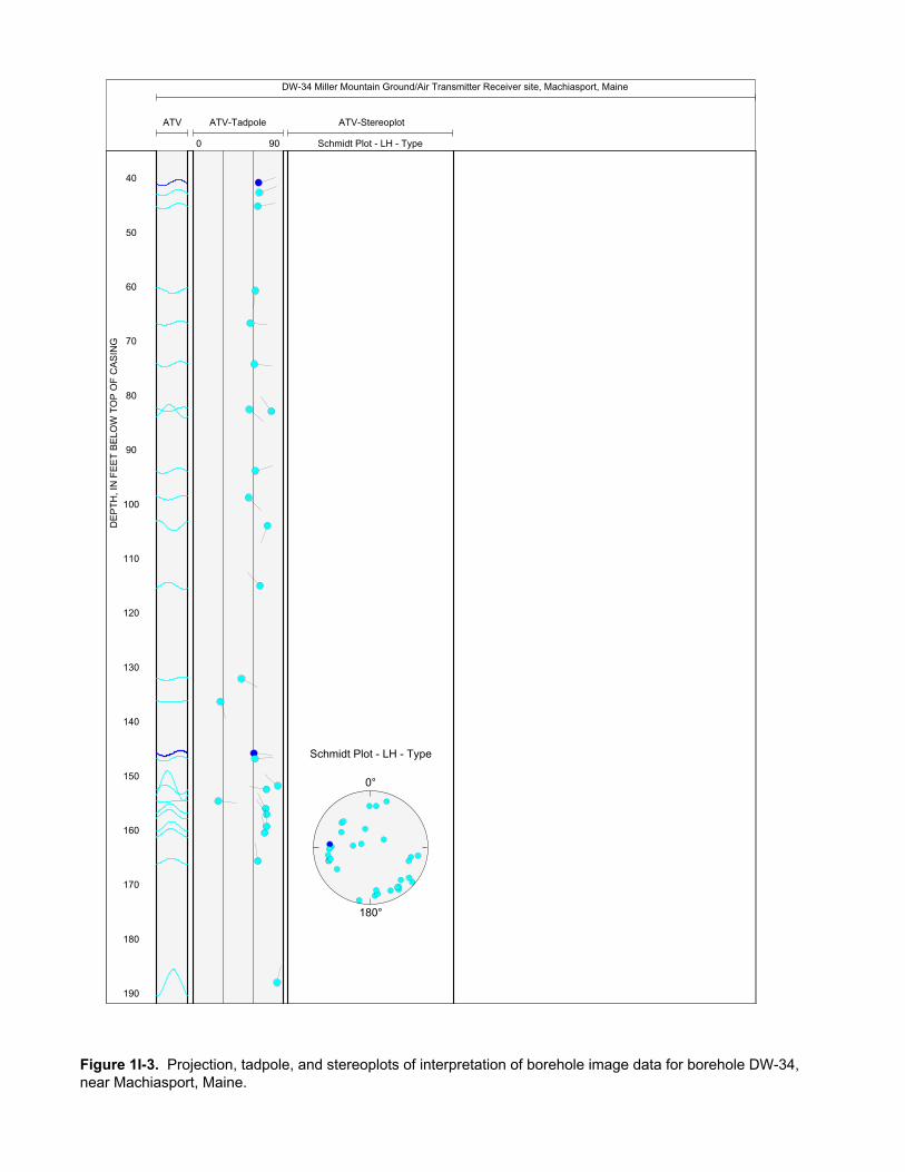
DW-34 Miller Mountain Ground/Air Transmitter Receiver site, Machiasport, Maine
ATV ATV-Tadpole
0 90
ATV-Stereoplot
Schmidt Plot - LH - Type
40
50
60
70
80
90
100
110
120
130
140
150
160
170
180
190
Schmidt Plot - LH - Type
0°
180°
DE
PT
H, I
N F
EE
T B
ELO
W T
OP
OF
CA
SIN
G
Figure 1I-3. Projection, tadpole, and stereoplots of interpretation of borehole image data for borehole DW-34, near Machiasport, Maine.

200
210
220
230
240
250
260
270
280
290
300
310
Figure 1I-3. Projection, tadpole, and stereoplots of interpretation of borehole image data for borehole DW-34, near Machiasport, Maine.—Continued
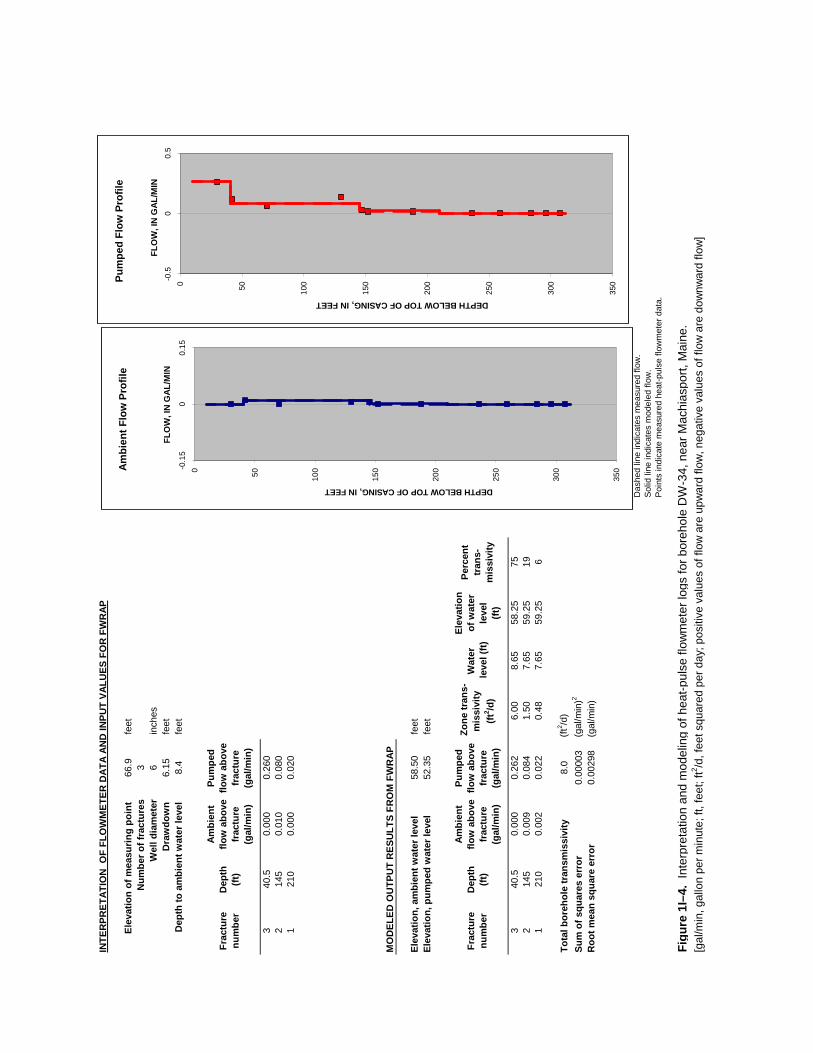
INTE
RPR
ETAT
ION
OF
FLO
WM
ETER
DAT
A AN
D IN
PUT
VALU
ES F
OR
FW
RAP
Elev
atio
n of
mea
surin
g po
int
66.9
feet
Num
ber o
f fra
ctur
es3
Wel
l dia
met
er6
inch
esD
raw
dow
n 6.
15 fe
etD
epth
to a
mbi
ent w
ater
leve
l 8.
4 fe
et
Frac
ture
nu
mbe
rD
epth
(ft)
Ambi
ent
flow
abo
ve
frac
ture
(g
al/m
in)
Pum
ped
flow
abo
ve
frac
ture
(g
al/m
in)
340
.50.
000
0.26
02
145
0.01
00.
080
121
00.
000
0.02
0
MO
DEL
ED O
UTP
UT
RES
ULT
S FR
OM
FW
RAP
Elev
atio
n, a
mbi
ent w
ater
leve
l58
.50
feet
Elev
atio
n, p
umpe
d w
ater
leve
l52
.35
feet
Frac
ture
nu
mbe
rD
epth
(ft)
Ambi
ent
flow
abo
ve
frac
ture
(g
al/m
in)
Pum
ped
flow
abo
ve
frac
ture
(g
al/m
in)
Zone
tran
s-m
issi
vity
(ft
2 /d)
Wat
er le
vel (
ft)
Elev
atio
n of
wat
er
leve
l (ft
)
Perc
ent
tran
s-m
issi
vity
340
.50.
000
0.26
26.
008.
6558
.25
752
145
0.00
90.
084
1.50
7.65
59.2
519
121
00.
002
0.02
20.
487.
6559
.25
6
Tota
l bor
ehol
e tr
ansm
issi
vity
8.0
(ft2 /d
)Su
m o
f squ
ares
err
or0.
0000
3(g
al/m
in)2
Roo
t mea
n sq
uare
err
or
0.00
298
(gal
/min
)
Das
hed
line
indi
cate
s m
easu
red
flow
.
Sol
id li
ne in
dica
tes
mod
eled
flow
.P
oint
s in
dica
te m
easu
red
heat
-pul
se fl
owm
eter
dat
a.
Figu
re 1
I–4.
Int
erpr
etat
ion
and
mod
elin
g of
hea
t-pul
se fl
owm
eter
logs
for b
oreh
ole
DW
-34,
nea
r Mac
hias
port,
Mai
ne.
[gal
/min
, gal
lon
per m
inut
e; ft
, fee
t; ft2 /d
, fee
t squ
ared
per
day
; pos
itive
val
ues
of fl
ow a
re u
pwar
d flo
w, n
egat
ive
valu
es o
f flo
w a
re d
ownw
ard
flow
]
0 50 100
150
200
250
300
350-0
.15
00.
15
DEPTH BELOW TOP OF CASING, IN FEET
FLO
W, I
N G
AL/M
IN
Ambi
ent F
low
Pro
file
0 50 100
150
200
250
300
350-0
.50
0.5
DEPTH BELOW TOP OF CASING, IN FEET
FLO
W, I
N G
AL/M
IN
Pum
ped
Flow
Pro
file
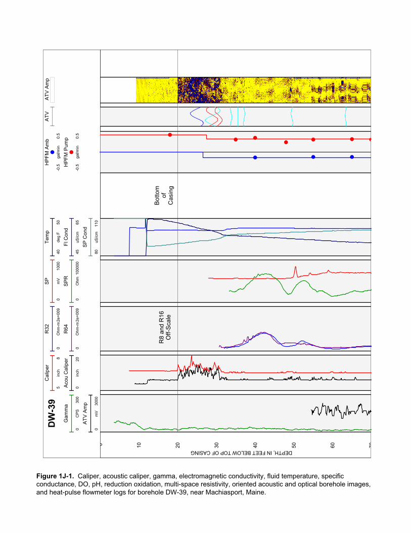
Cal
iper
58
inch
AT
V A
mp
Aco
u C
alip
er
020
inch
AT
VD
W-3
9T
emp
4050
deg
F
Fl C
ond
4565
uS/c
m
SP
Con
d
8011
0uS
/cm
HP
FM
Am
b
-0.5
0.5
gal/m
in
HP
FM
Pum
p
-0.5
0.5
gal/m
in
R32
02e
+009
Ohm
-m
R64
02e
+009
Ohm
-m
SP
010
00m
V
SP
R
010
0000
Ohm
Gam
ma
030
0C
PS
AT
V A
mp
030
00m
V 0 10 20 30 40 50 60 70
Bot
tom
ofC
asin
g
R8
and
R16
Off-
Sca
le
DEPTH, IN FEET BELOW TOP OF CASING
Figure 1J-1. Caliper, acoustic caliper, gamma, electromagnetic conductivity, fluid temperature, specific conductance, DO, pH, reduction oxidation, multi-space resistivity, oriented acoustic and optical borehole images, and heat-pulse flowmeter logs for borehole DW-39, near Machiasport, Maine.
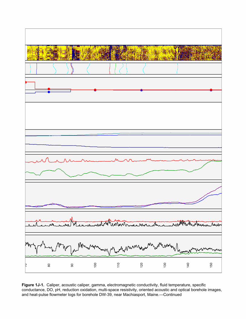
70 80 90 100
110
120
130
140
150
Figure 1J-1. Caliper, acoustic caliper, gamma, electromagnetic conductivity, fluid temperature, specific conductance, DO, pH, reduction oxidation, multi-space resistivity, oriented acoustic and optical borehole images, and heat-pulse flowmeter logs for borehole DW-39, near Machiasport, Maine.—Continued

160
170
180
190
200
210
220
Figure 1J-1. Caliper, acoustic caliper, gamma, electromagnetic conductivity, fluid temperature, specific conductance, DO, pH, reduction oxidation, multi-space resistivity, oriented acoustic and optical borehole images, and heat-pulse flowmeter logs for borehole DW-39, near Machiasport, Maine.—Continued

TR
UE
VE
RT
ICA
L D
EP
TH, I
N F
EE
T B
EL
OW
TO
P O
F C
AS
ING
DISTANCE, IN FEET FROM VERTICAL
Projection Along N140°E
Depth along borehole in 20-ftincrements between circles
Figure 1J-2. Borehole deviation logs for borehole DW-39, near Machiasport, Maine. Blue line on radial plot (top)is line of projection for vertical plot (bottom).[ft, foot; ATV, acoustic televiewer]
0°
-1 0 1 2 3 4 5
20
40
60
80
100
120
140
160
180
200
220
True North
30°
60°
90°
120°
150°
180°
210°
240°
300°
330°
1 2 3-1-2-3-4
-1
-2
-3
-4
1
2
3
4
270°
ATV20 ft
FEET

Table 1J–1. Interpretation of acoustic televiewer logs for borehole DW-39, near Machiasport, Maine.[Televiewer data are corrected for deviation and magnetic declination, so orientations are relative to true north; depths are below top of casing, which is 2.18 feet above land surface; dip azimuth is given in degrees east of true north; strike is reported in right-hand-rule (RHR)-azimuthal degrees east of true north and where the direction of dip is 90 degrees to the right of strike]
Depth, in feet
Depth, in meters
Dipazimuth
Strike, in RHR Dip Dip
direction Dip descriptor Comment
20.14 6.14 0 270 0 N Horizontal Bottom of casing24.93 7.60 57 327 81 NE Nearly vertical Transmissive fracture28.88 8.80 122 32 80 SE Nearly vertical Large fracture29.03 8.85 291 201 82 W Nearly vertical Minor fracture30.56 9.31 113 23 75 SE Nearly vertical Large fracture33.77 10.29 168 78 35 S Moderate Minor fracture35.52 10.83 191 101 12 S Shallow Minor fracture37.13 11.32 232 142 31 SW Moderate Minor fracture49.50 15.09 59 329 38 NE Moderate Minor fracture63.37 19.31 18 288 30 N Shallow Minor fracture72.03 21.95 164 74 25 S Shallow Minor fracture74.74 22.78 259 169 25 W Shallow Transmissive fracture82.49 25.14 101 11 69 E Steep Minor fracture88.06 26.84 132 42 56 SE Steep Minor fracture89.88 27.39 133 43 57 SE Steep Large fracture90.19 27.49 128 38 59 SE Steep Transmissive fracture97.01 29.57 320 230 67 NW Steep Minor fracture
106.28 32.39 305 215 35 NW Moderate Large fracture108.66 33.12 274 184 39 W Moderate Lithologic feature111.29 33.92 281 191 75 W Nearly vertical Minor fracture113.60 34.62 87 357 34 E Moderate Minor fracture121.14 36.92 310 220 68 NW Steep Minor fracture135.49 41.30 243 153 39 SW Moderate Minor fracture159.77 48.70 276 186 18 W Shallow Minor fracture167.11 50.93 136 46 81 SE Nearly vertical Minor fracture176.22 53.71 295 205 55 NW Steep Lithologic feature177.85 54.21 19 289 10 N Nearly horizontal Minor fracture184.20 56.14 110 20 36 E Moderate Minor fracture191.42 58.34 247 157 75 SW Nearly vertical Minor fracture191.56 58.38 76 346 66 E Steep Minor fracture193.51 58.98 76 346 53 E Steep Minor fracture194.13 59.17 67 337 64 NE Steep Minor fracture

DW-39 Miller Mountain Ground/Air Transmitter Receiver site, Machiasport, Maine
ATV-Stereoplot
Schmidt Plot - LH - Type
ATV ATV-Tadpole
0 90
20
30
40
50
60
70
80
90
100
110
120
130
140
150
160
170
0°
180°
DE
PT
H, I
N F
EE
T B
ELO
W T
OP
OF
CA
SIN
G
Figure 1J-3. Projection, tadpole, and stereoplots of interpretation of borehole image data for borehole DW-39, near Machiasport, Maine.

180
190
200
210
220
Figure 1J-3. Projection, tadpole, and stereoplots of interpretation of borehole image data for borehole DW-39, near Machiasport, Maine.—Continued

INTE
RPR
ETAT
ION
OF
FLO
WM
ETER
DAT
A AN
D IN
PUT
VALU
ES F
OR
FW
RAP
Elev
atio
n of
mea
surin
g po
int
130
feet
Num
ber o
f fra
ctur
es3
Wel
l dia
met
er6
inch
esD
raw
dow
n 5.
83 fe
etD
epth
to a
mbi
ent w
ater
leve
l 11
.67
feet
Frac
ture
nu
mbe
rD
epth
(ft)
Ambi
ent
flow
abo
ve
frac
ture
(g
al/m
in)
Pum
ped
flow
abo
ve
frac
ture
(g
al/m
in)
331
0.00
00.
500
275
-0.1
300.
310
190
-0.0
900.
040
MO
DEL
ED O
UTP
UT
RES
ULT
S FR
OM
FW
RAP
Elev
atio
n, a
mbi
ent w
ater
leve
l11
8.33
feet
Elev
atio
n, p
umpe
d w
ater
leve
l11
2.50
feet
Frac
ture
nu
mbe
rD
epth
(ft)
Ambi
ent
flow
abo
ve
frac
ture
(g
al/m
in)
Pum
ped
flow
abo
ve
frac
ture
(g
al/m
in)
Zone
tran
s-m
issi
vity
(ft
2 /d)
Wat
er le
vel (
ft)
Elev
atio
n of
wat
er
leve
l (ft
)
Perc
ent
tran
s-m
issi
vity
331
.00.
000
0.48
61.
6-3
.81
133.
819
275
.0-0
.127
0.30
913
.012
.19
117.
8170
190
.0-0
.087
0.02
44.
016
.19
113.
8122
Tota
l bor
ehol
e tr
ansm
issi
vity
18.6
(ft2 /d
)Su
m o
f squ
ares
err
or0.
0004
6(g
al/m
in)2
Roo
t mea
n sq
uare
err
or
0.01
2366
49(g
al/m
in)
Das
hed
line
indi
cate
s m
easu
red
flow
.
Sol
id li
ne in
dica
tes
mod
eled
flow
.P
oint
s in
dica
te m
easu
red
heat
-pul
se fl
owm
eter
dat
a.
Figu
re 1
J–4.
Int
erpr
etat
ion
and
mod
elin
g of
hea
t-pul
se fl
owm
eter
logs
for b
oreh
ole
DW
-39,
nea
r Mac
hias
port,
Mai
ne.
[gal
/min
, gal
lon
per m
inut
e; ft
, fee
t; ft2 /d
, fee
t squ
ared
per
day
; pos
itive
val
ues
of fl
ow a
re u
pwar
d flo
w, n
egat
ive
valu
es o
f flo
w a
re d
ownw
ard
flow
]
0 50 100
150
200
250-0
.15
00.
15
DEPTH BELOW TOP OF CASING, IN FEET
FLO
W, I
N G
AL/M
IN
Ambi
ent F
low
Pro
file
0 50 100
150
200
250-0
.70
0.7
DEPTH BELOW TOP OF CASING, IN FEET
FLO
W, I
N G
AL/M
IN
Pum
ped
Flow
Pro
file
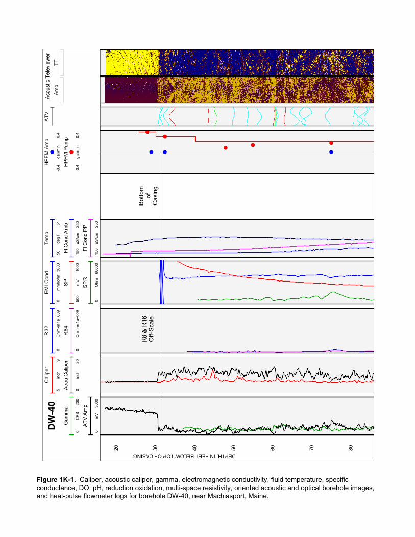
Am
pT
T
Aco
ustic
Tel
evie
wer
EM
I Con
d
030
00m
mho
/m
Cal
iper
59
inch
Tem
p
5051
deg
F
HP
FM
Am
b
-0.4
0.4
gal/m
in
Aco
u C
alip
er
020
inch
HP
FM
Pum
p
-0.4
0.4
gal/m
in
Fl C
ond
Am
b
150
250
uS/c
m
Fl C
ond
PP
150
250
uS/c
m
DW
-40
Gam
ma
020
0C
PS
R32
01e
+009
Ohm
-m
R64
01e
+009
Ohm
-m
AT
V
SP
500
1000
mV
SP
R
060
000
Ohm
AT
V A
mp
030
00m
V
20 30 40 50 60 70 80
R8
& R
16O
ff-S
cale
Bot
tom
ofC
asin
g
DEPTH, IN FEET BELOW TOP OF CASING
Figure 1K-1. Caliper, acoustic caliper, gamma, electromagnetic conductivity, fluid temperature, specific conductance, DO, pH, reduction oxidation, multi-space resistivity, oriented acoustic and optical borehole images, and heat-pulse flowmeter logs for borehole DW-40, near Machiasport, Maine.
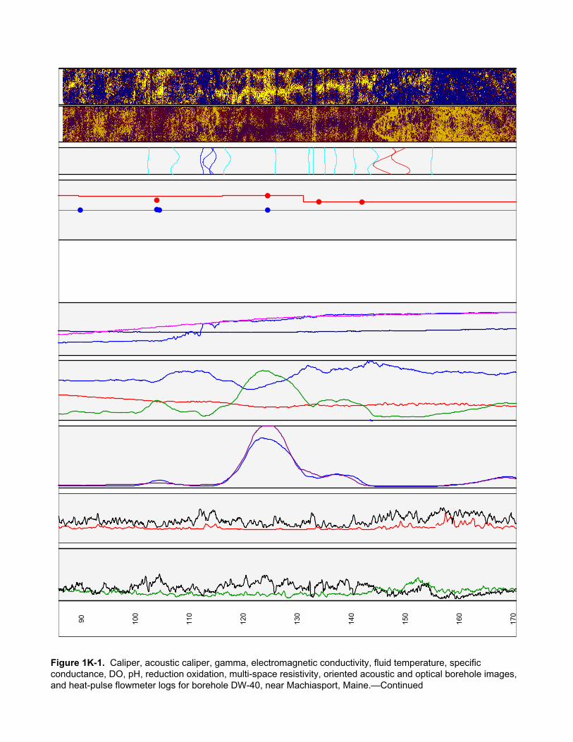
90 100
110
120
130
140
150
160
170
Figure 1K-1. Caliper, acoustic caliper, gamma, electromagnetic conductivity, fluid temperature, specific conductance, DO, pH, reduction oxidation, multi-space resistivity, oriented acoustic and optical borehole images, and heat-pulse flowmeter logs for borehole DW-40, near Machiasport, Maine.—Continued
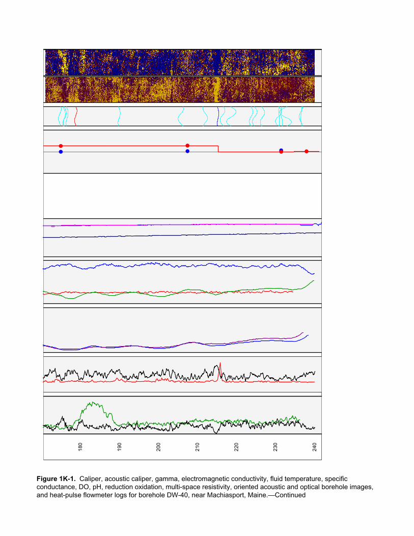
180
190
200
210
220
230
240
Figure 1K-1. Caliper, acoustic caliper, gamma, electromagnetic conductivity, fluid temperature, specific conductance, DO, pH, reduction oxidation, multi-space resistivity, oriented acoustic and optical borehole images, and heat-pulse flowmeter logs for borehole DW-40, near Machiasport, Maine.—Continued
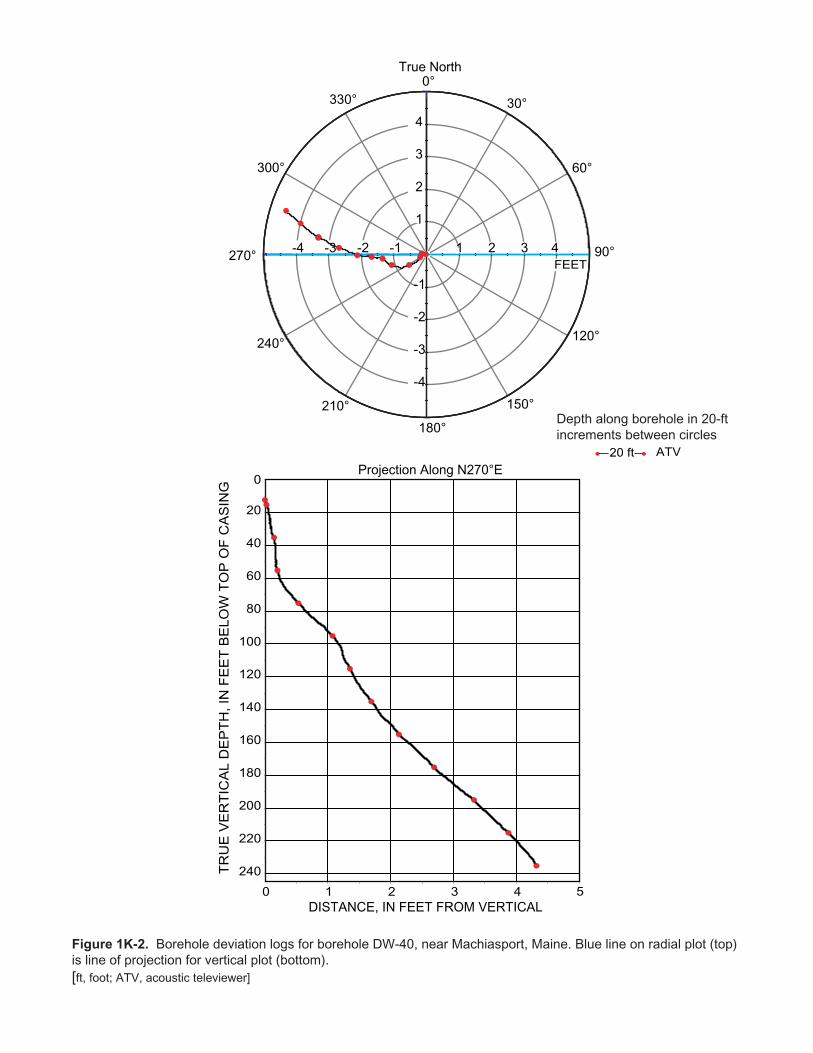
TR
UE
VE
RT
ICA
L D
EP
TH, I
N F
EE
T B
EL
OW
TO
P O
F C
AS
ING
True North
DISTANCE, IN FEET FROM VERTICAL
Projection Along N270°E
Depth along borehole in 20-ftincrements between circles
Figure 1K-2. Borehole deviation logs for borehole DW-40, near Machiasport, Maine. Blue line on radial plot (top)is line of projection for vertical plot (bottom).[ft, foot; ATV, acoustic televiewer]
0 1 2 3 4
20
40
60
80
100
120
140
160
180
200
220
240
5
0
ATV20 ft
30°
60°
90°
120°
150°
180°
210°
240°
300°
330°
1 2 3-1-2-3-4
-1
-2
-3
-4
1
2
3
4
270°
0°
4FEET

Table 1K–1. Interpretation of acoustic televiewer logs for borehole DW-40, near Machiasport, Maine.[Televiewer data are corrected for deviation and magnetic declination, so orientations are relative to true north; depths are below top of casing, which is 2.45 feet above land surface; dip azimuth is given in degrees east of true north; strike is reported in right-hand-rule (RHR)-azimuthal degrees east of true north and where the direction of dip is 90 degrees to the right of strike]
Depth, in feet
Depth, in meters
Dipazimuth
Strike, in RHR Dip Dip
direction Dip descriptor Comment
30.68 9.35 207 117 1 SW Nearly horizontal Other31.31 9.54 256 166 62 W Steep Minor fracture31.50 9.60 17 287 60 N Steep Minor fracture32.76 9.98 19 289 70 N Nearly vertical Minor fracture34.29 10.45 6 276 72 N Nearly vertical Fracture43.62 13.29 198 108 25 S Shallow Fracture45.49 13.86 146 56 57 SE Steep Lithologic feature50.03 15.25 248 158 45 W Moderate Minor fracture53.63 16.35 226 136 36 SW Moderate Minor fracture56.58 17.24 178 88 67 S Steep Minor fracture60.43 18.42 211 121 37 SW Moderate Fracture60.73 18.51 209 119 35 SW Moderate Lithologic feature61.08 18.62 197 107 49 S Moderate Minor fracture63.16 19.25 308 218 44 NW Moderate Fracture65.65 20.01 104 14 78 E Nearly vertical Minor fracture67.70 20.63 68 338 74 E Nearly vertical Minor fracture68.77 20.96 269 179 79 W Nearly vertical Minor fracture74.14 22.60 11 281 68 N Steep Minor fracture80.83 24.64 301 211 48 NW Moderate Minor fracture81.97 24.98 103 13 77 E Nearly vertical Minor fracture82.90 25.27 315 225 79 NW Nearly vertical Minor fracture84.00 25.60 339 249 69 N Steep Minor fracture
102.42 31.22 319 229 27 NW Shallow Minor fracture107.34 32.72 240 150 72 SW Nearly vertical Minor fracture112.31 34.23 24 294 49 NE Moderate Transmissive fracture113.47 34.58 351 261 75 N Nearly vertical Transmissive fracture114.40 34.87 241 151 67 SW Steep Transmissive fracture117.06 35.68 214 124 68 SW Steep Minor fracture125.92 38.38 227 137 11 SW Shallow Minor fracture132.13 40.27 43 313 9 NE Nearly horizontal Minor fracture132.98 40.53 135 45 10 SE Nearly horizontal Minor fracture135.11 41.18 89 359 13 E Shallow Minor fracture137.08 41.78 199 109 44 S Moderate Minor fracture140.57 42.84 116 26 40 SE Moderate Minor fracture144.01 43.89 247 157 75 SW Nearly vertical Minor fracture146.11 44.53 311 221 83 NW Nearly vertical Fracture149.12 45.45 55 325 82 NE Nearly vertical Fracture154.88 47.21 298 208 34 NW Moderate Minor fracture174.77 53.27 320 230 55 NW Steep Minor fracture175.83 53.59 227 137 51 SW Steep Minor fracture176.02 53.65 246 156 58 SW Steep Minor fracture176.63 53.83 241 151 46 SW Moderate Minor fracture178.82 54.50 285 195 48 W Moderate Fracture189.94 57.89 241 151 50 SW Moderate Minor fracture205.77 62.72 320 230 70 NW Nearly vertical Minor fracture212.00 64.61 152 62 67 SE Steep Minor fracture215.29 65.62 233 143 40 SW Moderate Transmissive fracture216.43 65.96 293 203 69 NW Steep Minor fracture218.68 66.65 267 177 78 W Nearly vertical Minor fracture223.76 68.20 271 181 63 W Steep Minor fracture224.70 68.49 266 176 68 W Steep Minor fracture226.70 69.09 254 164 66 W Steep Minor fracture230.82 70.35 271 181 73 W Nearly vertical Minor fracture230.98 70.40 88 358 14 E Shallow Minor fracture231.58 70.58 67 337 45 NE Moderate Minor fracture232.56 70.88 78 348 81 E Nearly vertical Minor fracture236.52 72.09 355 265 60 N Steep Minor fracture236.64 72.12 327 237 27 NW Shallow Minor fracture
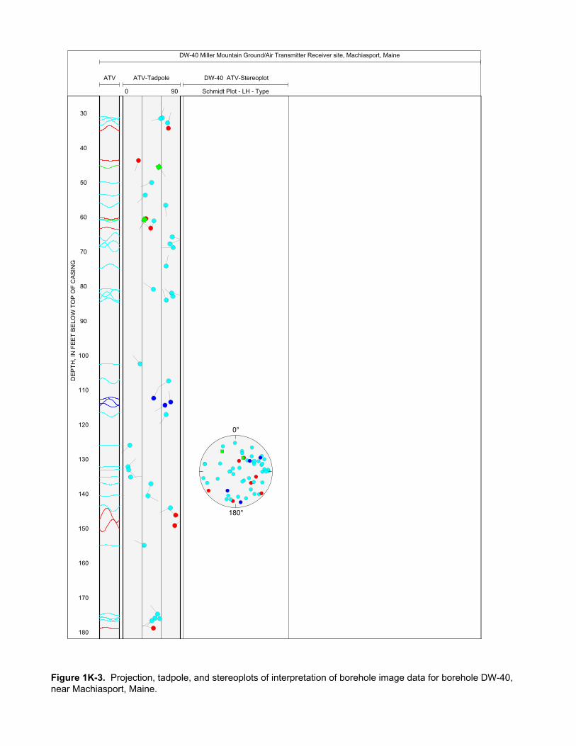
DW-40 Miller Mountain Ground/Air Transmitter Receiver site, Machiasport, Maine
ATV ATV-Tadpole
0 90
DW-40 ATV-Stereoplot
Schmidt Plot - LH - Type
30
40
50
60
70
80
90
100
110
120
130
140
150
160
170
180
0°
180°
DE
PT
H, I
N F
EE
T B
ELO
W T
OP
OF
CA
SIN
G
Figure 1K-3. Projection, tadpole, and stereoplots of interpretation of borehole image data for borehole DW-40, near Machiasport, Maine.

190
200
210
220
230
240
Figure 1K-3. Projection, tadpole, and stereoplots of interpretation of borehole image data for borehole DW-40, near Machiasport, Maine.—Continued
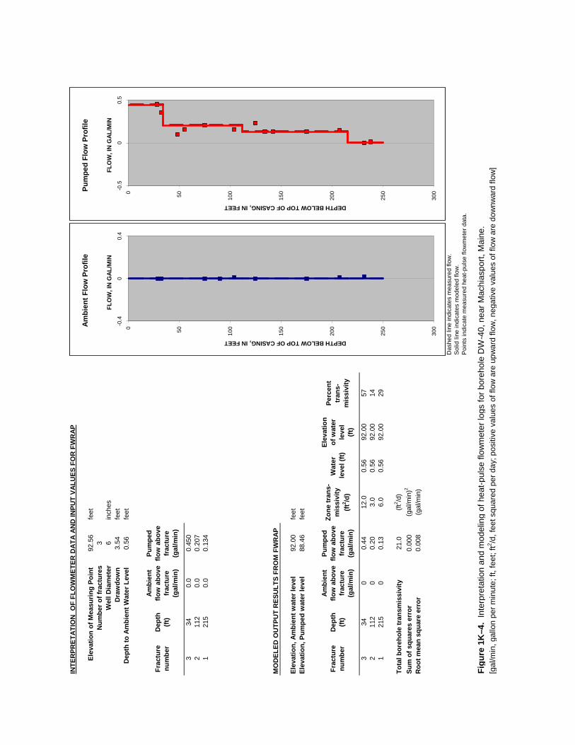
INTE
RPR
ETAT
ION
OF
FLO
WM
ETER
DAT
A AN
D IN
PUT
VALU
ES F
OR
FW
RAP
Elev
atio
n of
Mea
surin
g Po
int
92.5
6 fe
etN
umbe
r of f
ract
ures
3W
ell D
iam
eter
6 in
ches
Dra
wdo
wn
3.54
feet
Dep
th to
Am
bien
t Wat
er L
evel
0.
56 fe
et
Frac
ture
nu
mbe
rD
epth
(ft)
Ambi
ent
flow
abo
ve
frac
ture
(g
al/m
in)
Pum
ped
flow
abo
ve
frac
ture
(g
al/m
in)
334
0.0
0.45
02
112
0.0
0.20
71
215
0.0
0.13
4
MO
DEL
ED O
UTP
UT
RES
ULT
S FR
OM
FW
RAP
Elev
atio
n, A
mbi
ent w
ater
leve
l92
.00
feet
Elev
atio
n, P
umpe
d w
ater
leve
l88
.46
feet
Frac
ture
nu
mbe
rD
epth
(ft)
Ambi
ent
flow
abo
ve
frac
ture
(g
al/m
in)
Pum
ped
flow
abo
ve
frac
ture
(g
al/m
in)
Zone
tran
s-m
issi
vity
(ft
2 /d)
Wat
er le
vel (
ft)
Elev
atio
n of
wat
er
leve
l (ft
)
Perc
ent
tran
s-m
issi
vity
334
00.
4412
.00.
5692
.00
572
112
00.
203.
00.
5692
.00
141
215
00.
136.
00.
5692
.00
29
Tota
l bor
ehol
e tr
ansm
issi
vity
21.0
(ft2 /d
)Su
m o
f squ
ares
err
or0.
000
(gal
/min
)2
Roo
t mea
n sq
uare
err
or
0.00
8(g
al/m
in)
Das
hed
line
indi
cate
s m
easu
red
flow
.
Sol
id li
ne in
dica
tes
mod
eled
flow
.P
oint
s in
dica
te m
easu
red
heat
-pul
se fl
owm
eter
dat
a.
Figu
re 1
K–4
. In
terp
reta
tion
and
mod
elin
g of
hea
t-pul
se fl
owm
eter
logs
for b
oreh
ole
DW
-40,
nea
r Mac
hias
port,
Mai
ne.
[gal
/min
, gal
lon
per m
inut
e; ft
, fee
t; ft2 /d
, fee
t squ
ared
per
day
; pos
itive
val
ues
of fl
ow a
re u
pwar
d flo
w, n
egat
ive
valu
es o
f flo
w a
re d
ownw
ard
flow
]
0 50 100
150
200
250
300-0
.40
0.4
DEPTH BELOW TOP OF CASING, IN FEET
FLO
W, I
N G
AL/M
IN
Ambi
ent F
low
Pro
file
0 50 100
150
200
250
300-0
.50
0.5
DEPTH BELOW TOP OF CASING, IN FEET
FLO
W, I
N G
AL/M
IN
Pum
ped
Flow
Pro
file
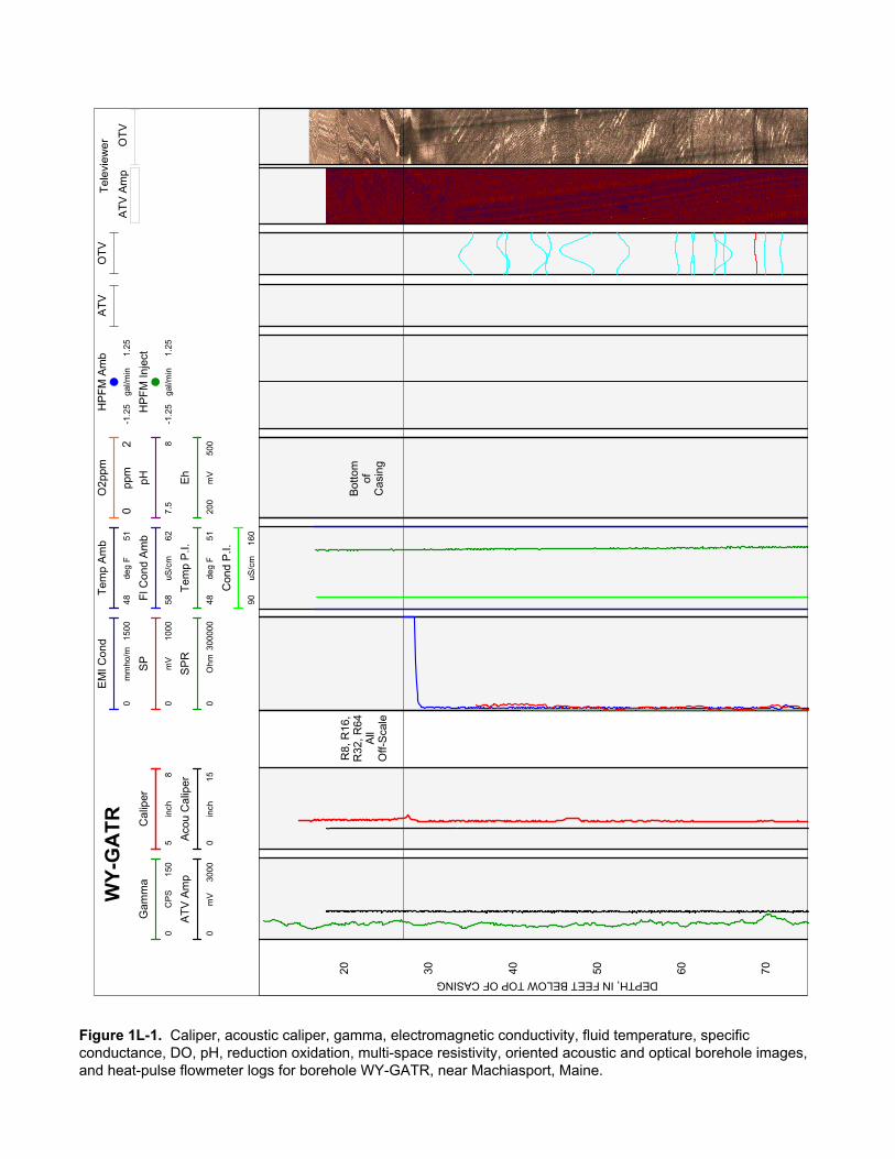
AT
V A
mp
OT
V
Tel
evie
wer
Tem
p A
mb
4851
deg
FW
Y-G
AT
RF
l Con
d A
mb
5862
uS/c
m
EM
I Con
d
015
00m
mho
/m
SP
010
00m
V
Gam
ma
015
0C
PS
HP
FM
Am
b
-1.2
51.
25ga
l/min
HP
FM
Inje
ct
-1.2
51.
25ga
l/min
Tem
p P
.I.
4851
deg
F
Con
d P
.I.
9016
0uS
/cm
OT
VA
TV
Cal
iper
58
inch
AT
V A
mp
030
00m
V
O2p
pm
02
ppm
pH
7.5
8
SP
R
030
0000
Ohm
Eh
200
500
mV
Aco
u C
alip
er
015
inch
20 30 40 50 60 70
R8,
R16
,R
32, R
64A
llO
ff-S
cale
Bot
tom
ofC
asin
g
DEPTH, IN FEET BELOW TOP OF CASING
Figure 1L-1. Caliper, acoustic caliper, gamma, electromagnetic conductivity, fluid temperature, specific conductance, DO, pH, reduction oxidation, multi-space resistivity, oriented acoustic and optical borehole images, and heat-pulse flowmeter logs for borehole WY-GATR, near Machiasport, Maine.
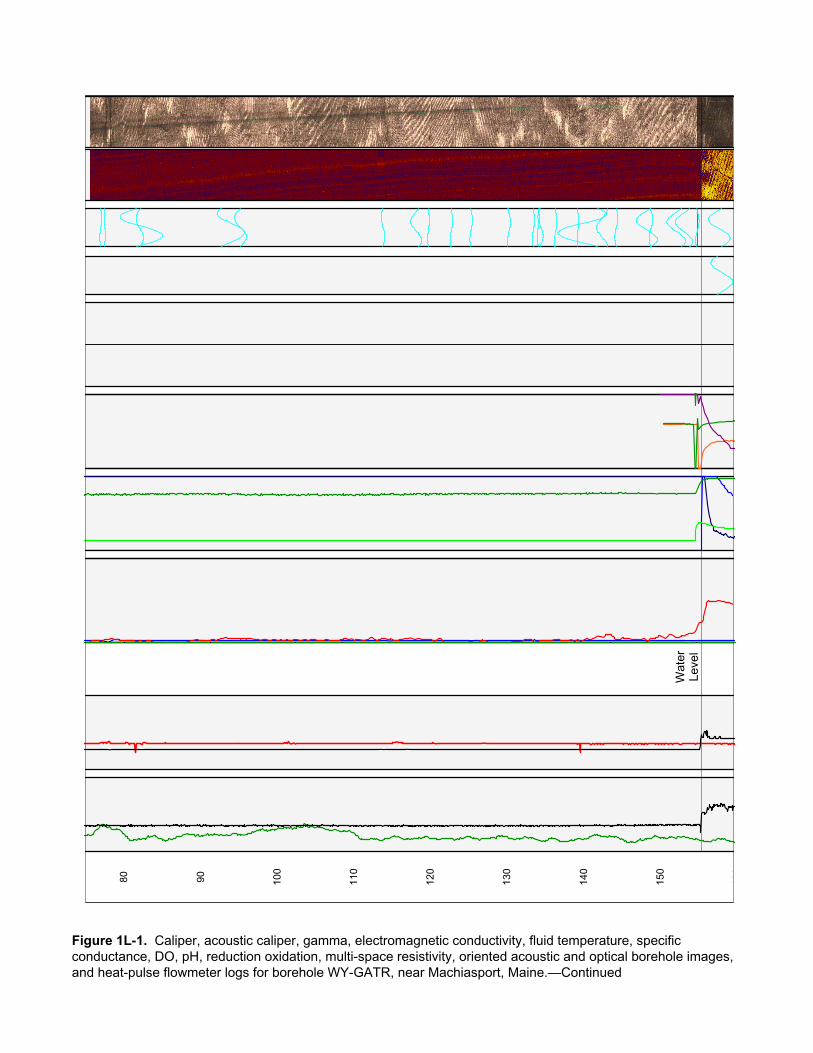
80 90 100
110
120
130
140
150
160
Wat
erLe
vel
Figure 1L-1. Caliper, acoustic caliper, gamma, electromagnetic conductivity, fluid temperature, specific conductance, DO, pH, reduction oxidation, multi-space resistivity, oriented acoustic and optical borehole images, and heat-pulse flowmeter logs for borehole WY-GATR, near Machiasport, Maine.—Continued
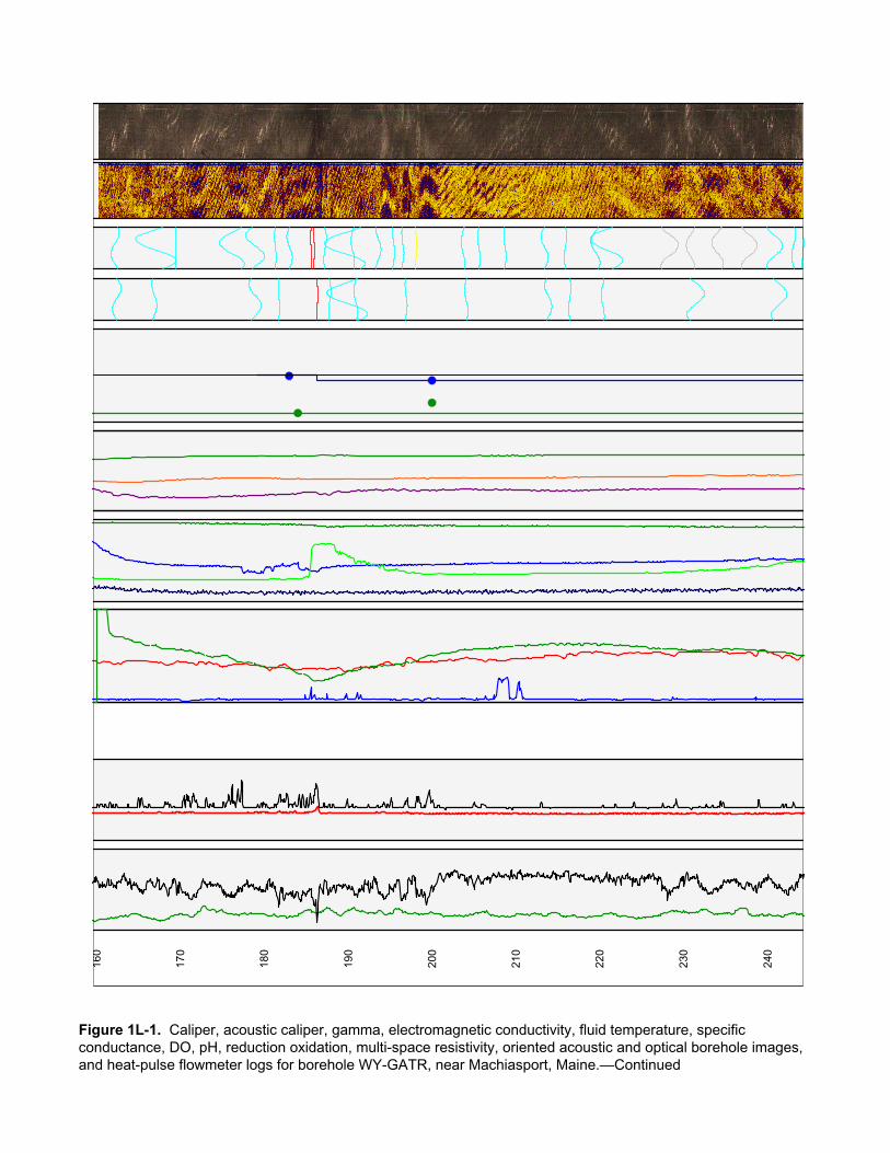
160
170
180
190
200
210
220
230
240
Figure 1L-1. Caliper, acoustic caliper, gamma, electromagnetic conductivity, fluid temperature, specific conductance, DO, pH, reduction oxidation, multi-space resistivity, oriented acoustic and optical borehole images, and heat-pulse flowmeter logs for borehole WY-GATR, near Machiasport, Maine.—Continued

250
260
270
280
290
300
310
320
Figure 1L-1. Caliper, acoustic caliper, gamma, electromagnetic conductivity, fluid temperature, specific conductance, DO, pH, reduction oxidation, multi-space resistivity, oriented acoustic and optical borehole images, and heat-pulse flowmeter logs for borehole WY-GATR, near Machiasport, Maine.—Continued
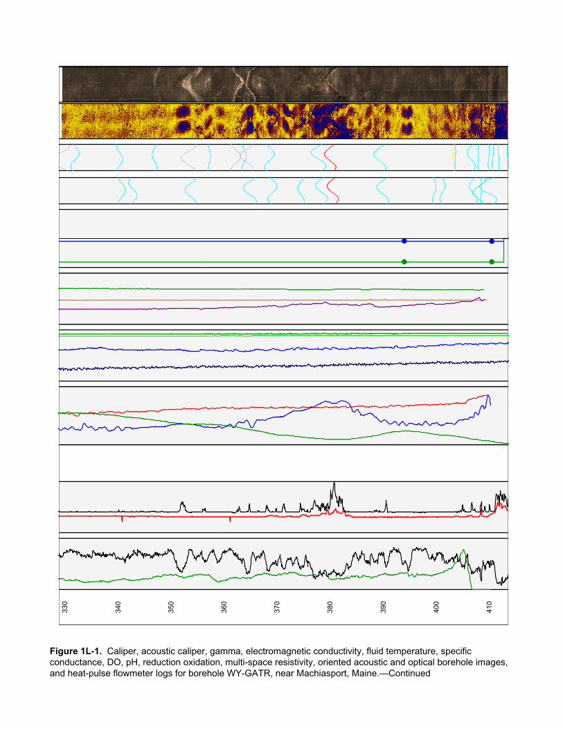
330
340
350
360
370
380
390
400
410
Figure 1L-1. Caliper, acoustic caliper, gamma, electromagnetic conductivity, fluid temperature, specific conductance, DO, pH, reduction oxidation, multi-space resistivity, oriented acoustic and optical borehole images, and heat-pulse flowmeter logs for borehole WY-GATR, near Machiasport, Maine.—Continued
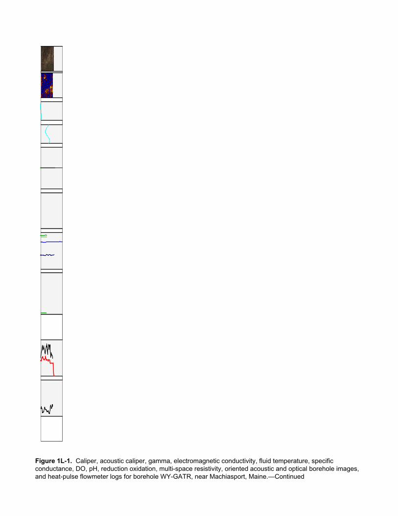
Figure 1L-1. Caliper, acoustic caliper, gamma, electromagnetic conductivity, fluid temperature, specific conductance, DO, pH, reduction oxidation, multi-space resistivity, oriented acoustic and optical borehole images, and heat-pulse flowmeter logs for borehole WY-GATR, near Machiasport, Maine.—Continued
Figure 1L-1. Caliper, acoustic caliper, gamma, electromagnetic conductivity, fluid temperature, specific conductance, DO, pH, reduction oxidation, multi-space resistivity, oriented acoustic and optical borehole images, and heat-pulse flowmeter logs for borehole WY-GATR, near Machiasport, Maine.—Continued
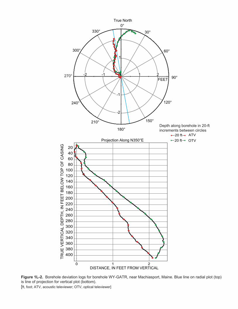
TR
UE
VE
RT
ICA
L D
EP
TH
, IN
FE
ET
BE
LO
W T
OP
OF
CA
SIN
G
True North
DISTANCE, IN FEET FROM VERTICAL
Projection Along N350°E
Depth along borehole in 20-ftincrements between circles
Figure 1L-2. Borehole deviation logs for borehole WY-GATR, near Machiasport, Maine. Blue line on radial plot (top)is line of projection for vertical plot (bottom).[ft, foot; ATV, acoustic televiewer; OTV, optical televiewer]
0 1 2
20406080
100120140160180200220240260280300320340360380400
ATV20 ft
OTV20 ft
270°
0°
30°
60°
90°
120°
150°
180°
210°
240°
300°
330°
1 2-1-2
-1
-2
1
2
FEET
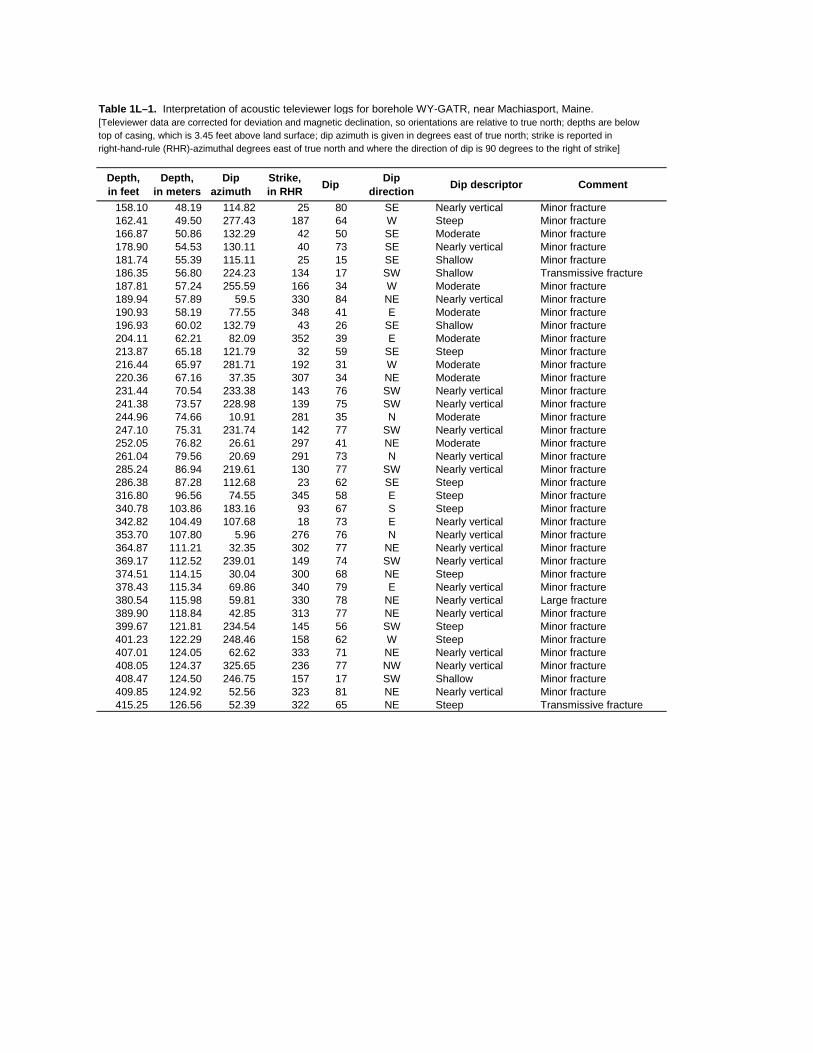
Table 1L–1. Interpretation of acoustic televiewer logs for borehole WY-GATR, near Machiasport, Maine.[Televiewer data are corrected for deviation and magnetic declination, so orientations are relative to true north; depths are below top of casing, which is 3.45 feet above land surface; dip azimuth is given in degrees east of true north; strike is reported in right-hand-rule (RHR)-azimuthal degrees east of true north and where the direction of dip is 90 degrees to the right of strike]
Depth, in feet
Depth, in meters
Dipazimuth
Strike, in RHR Dip Dip
direction Dip descriptor Comment
158.10 48.19 114.82 25 80 SE Nearly vertical Minor fracture162.41 49.50 277.43 187 64 W Steep Minor fracture166.87 50.86 132.29 42 50 SE Moderate Minor fracture178.90 54.53 130.11 40 73 SE Nearly vertical Minor fracture181.74 55.39 115.11 25 15 SE Shallow Minor fracture186.35 56.80 224.23 134 17 SW Shallow Transmissive fracture187.81 57.24 255.59 166 34 W Moderate Minor fracture189.94 57.89 59.5 330 84 NE Nearly vertical Minor fracture190.93 58.19 77.55 348 41 E Moderate Minor fracture196.93 60.02 132.79 43 26 SE Shallow Minor fracture204.11 62.21 82.09 352 39 E Moderate Minor fracture213.87 65.18 121.79 32 59 SE Steep Minor fracture216.44 65.97 281.71 192 31 W Moderate Minor fracture220.36 67.16 37.35 307 34 NE Moderate Minor fracture231.44 70.54 233.38 143 76 SW Nearly vertical Minor fracture241.38 73.57 228.98 139 75 SW Nearly vertical Minor fracture244.96 74.66 10.91 281 35 N Moderate Minor fracture247.10 75.31 231.74 142 77 SW Nearly vertical Minor fracture252.05 76.82 26.61 297 41 NE Moderate Minor fracture261.04 79.56 20.69 291 73 N Nearly vertical Minor fracture285.24 86.94 219.61 130 77 SW Nearly vertical Minor fracture286.38 87.28 112.68 23 62 SE Steep Minor fracture316.80 96.56 74.55 345 58 E Steep Minor fracture340.78 103.86 183.16 93 67 S Steep Minor fracture342.82 104.49 107.68 18 73 E Nearly vertical Minor fracture353.70 107.80 5.96 276 76 N Nearly vertical Minor fracture364.87 111.21 32.35 302 77 NE Nearly vertical Minor fracture369.17 112.52 239.01 149 74 SW Nearly vertical Minor fracture374.51 114.15 30.04 300 68 NE Steep Minor fracture378.43 115.34 69.86 340 79 E Nearly vertical Minor fracture380.54 115.98 59.81 330 78 NE Nearly vertical Large fracture389.90 118.84 42.85 313 77 NE Nearly vertical Minor fracture399.67 121.81 234.54 145 56 SW Steep Minor fracture401.23 122.29 248.46 158 62 W Steep Minor fracture407.01 124.05 62.62 333 71 NE Nearly vertical Minor fracture408.05 124.37 325.65 236 77 NW Nearly vertical Minor fracture408.47 124.50 246.75 157 17 SW Shallow Minor fracture409.85 124.92 52.56 323 81 NE Nearly vertical Minor fracture415.25 126.56 52.39 322 65 NE Steep Transmissive fracture
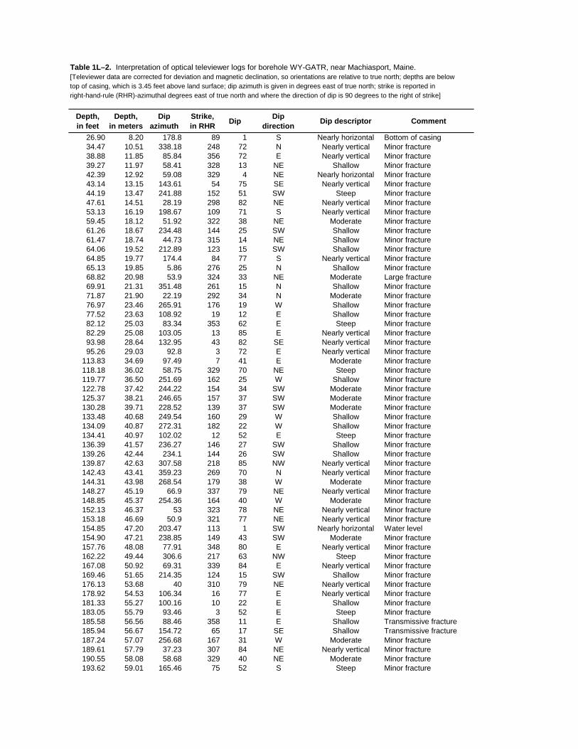
Table 1L–2. Interpretation of optical televiewer logs for borehole WY-GATR, near Machiasport, Maine.[Televiewer data are corrected for deviation and magnetic declination, so orientations are relative to true north; depths are below top of casing, which is 3.45 feet above land surface; dip azimuth is given in degrees east of true north; strike is reported in right-hand-rule (RHR)-azimuthal degrees east of true north and where the direction of dip is 90 degrees to the right of strike]
Depth, in feet
Depth, in meters
Dipazimuth
Strike, in RHR Dip Dip
direction Dip descriptor Comment
26.90 8.20 178.8 89 1 S Nearly horizontal Bottom of casing34.47 10.51 338.18 248 72 N Nearly vertical Minor fracture38.88 11.85 85.84 356 72 E Nearly vertical Minor fracture39.27 11.97 58.41 328 13 NE Shallow Minor fracture42.39 12.92 59.08 329 4 NE Nearly horizontal Minor fracture43.14 13.15 143.61 54 75 SE Nearly vertical Minor fracture44.19 13.47 241.88 152 51 SW Steep Minor fracture47.61 14.51 28.19 298 82 NE Nearly vertical Minor fracture53.13 16.19 198.67 109 71 S Nearly vertical Minor fracture59.45 18.12 51.92 322 38 NE Moderate Minor fracture61.26 18.67 234.48 144 25 SW Shallow Minor fracture61.47 18.74 44.73 315 14 NE Shallow Minor fracture64.06 19.52 212.89 123 15 SW Shallow Minor fracture64.85 19.77 174.4 84 77 S Nearly vertical Minor fracture65.13 19.85 5.86 276 25 N Shallow Minor fracture68.82 20.98 53.9 324 33 NE Moderate Large fracture69.91 21.31 351.48 261 15 N Shallow Minor fracture71.87 21.90 22.19 292 34 N Moderate Minor fracture76.97 23.46 265.91 176 19 W Shallow Minor fracture77.52 23.63 108.92 19 12 E Shallow Minor fracture82.12 25.03 83.34 353 62 E Steep Minor fracture82.29 25.08 103.05 13 85 E Nearly vertical Minor fracture93.98 28.64 132.95 43 82 SE Nearly vertical Minor fracture95.26 29.03 92.8 3 72 E Nearly vertical Minor fracture
113.83 34.69 97.49 7 41 E Moderate Minor fracture118.18 36.02 58.75 329 70 NE Steep Minor fracture119.77 36.50 251.69 162 25 W Shallow Minor fracture122.78 37.42 244.22 154 34 SW Moderate Minor fracture125.37 38.21 246.65 157 37 SW Moderate Minor fracture130.28 39.71 228.52 139 37 SW Moderate Minor fracture133.48 40.68 249.54 160 29 W Shallow Minor fracture134.09 40.87 272.31 182 22 W Shallow Minor fracture134.41 40.97 102.02 12 52 E Steep Minor fracture136.39 41.57 236.27 146 27 SW Shallow Minor fracture139.26 42.44 234.1 144 26 SW Shallow Minor fracture139.87 42.63 307.58 218 85 NW Nearly vertical Minor fracture142.43 43.41 359.23 269 70 N Nearly vertical Minor fracture144.31 43.98 268.54 179 38 W Moderate Minor fracture148.27 45.19 66.9 337 79 NE Nearly vertical Minor fracture148.85 45.37 254.36 164 40 W Moderate Minor fracture152.13 46.37 53 323 78 NE Nearly vertical Minor fracture153.18 46.69 50.9 321 77 NE Nearly vertical Minor fracture154.85 47.20 203.47 113 1 SW Nearly horizontal Water level154.90 47.21 238.85 149 43 SW Moderate Minor fracture157.76 48.08 77.91 348 80 E Nearly vertical Minor fracture162.22 49.44 306.6 217 63 NW Steep Minor fracture167.08 50.92 69.31 339 84 E Nearly vertical Minor fracture169.46 51.65 214.35 124 15 SW Shallow Minor fracture176.13 53.68 40 310 79 NE Nearly vertical Minor fracture178.92 54.53 106.34 16 77 E Nearly vertical Minor fracture181.33 55.27 100.16 10 22 E Shallow Minor fracture183.05 55.79 93.46 3 52 E Steep Minor fracture185.58 56.56 88.46 358 11 E Shallow Transmissive fracture185.94 56.67 154.72 65 17 SE Shallow Transmissive fracture187.24 57.07 256.68 167 31 W Moderate Minor fracture189.61 57.79 37.23 307 84 NE Nearly vertical Minor fracture190.55 58.08 58.68 329 40 NE Moderate Minor fracture193.62 59.01 165.46 75 52 S Steep Minor fracture

Table 1L–2. Interpretation of optical televiewer logs for borehole WY-GATR, near Machiasport, Maine.—Continued[Televiewer data are corrected for deviation and magnetic declination, so orientations are relative to true north; depths are below top of casing, which is 3.45 feet above land surface; dip azimuth is given in degrees east of true north; strike is reported in right-hand-rule (RHR)-azimuthal degrees east of true north and where the direction of dip is 90 degrees to the right of strike]
Depth, in feet
Depth, in meters
Dipazimuth
Strike, in RHR Dip Dip
direction Dip descriptor Comment
195.41 59.56 142.14 52 29 SE Shallow Minor fracture196.51 59.89 130.35 40 26 SE Shallow Minor fracture198.16 60.40 188.05 98 17 S Shallow Lithologic feature203.69 62.08 46.53 317 38 NE Moderate Minor fracture205.60 62.66 88.02 358 33 E Moderate Minor fracture208.74 63.62 106.88 17 22 E Shallow Minor fracture213.44 65.05 93.43 3 60 E Steep Minor fracture215.92 65.81 277.25 187 31 W Moderate Minor fracture219.52 66.91 50.09 320 64 NE Steep Minor fracture220.84 67.31 70.87 341 82 E Nearly vertical Minor fracture228.34 69.59 202.73 113 77 SW Nearly vertical Sealed fracture - felsic230.82 70.35 18.58 289 62 N Steep Sealed fracture - felsic234.05 71.33 44.56 315 69 NE Steep Sealed fracture - felsic237.84 72.49 199.31 109 76 S Nearly vertical Sealed fracture - felsic240.87 73.41 196.23 106 76 S Nearly vertical Minor fracture243.12 74.10 291.44 201 42 W Moderate Minor fracture244.26 74.45 221.9 132 21 SW Shallow Minor fracture244.66 74.57 57.27 327 35 NE Moderate Minor fracture247.10 75.31 231.85 142 78 SW Nearly vertical Minor fracture251.38 76.62 354.56 265 76 N Nearly vertical Minor fracture252.36 76.92 23.01 293 48 NE Moderate Minor fracture260.28 79.33 194.05 104 83 S Nearly vertical Minor fracture267.77 81.61 284.89 195 73 W Nearly vertical Minor fracture270.29 82.38 263.76 174 59 W Steep Minor fracture273.08 83.23 262.03 172 63 W Steep Minor fracture291.05 88.71 216.92 127 21 SW Shallow Sealed fracture - felsic291.35 88.80 241.38 151 22 SW Shallow Sealed fracture - felsic293.55 89.47 259.85 170 30 W Moderate Minor fracture294.15 89.65 85.65 356 15 E Shallow Sealed fracture - felsic300.85 91.69 14.23 284 22 N Shallow Sealed fracture - felsic300.95 91.73 72.41 342 8 E Nearly horizontal Sealed fracture - felsic301.21 91.80 115.06 25 63 SE Steep Sealed fracture - felsic301.45 91.88 94.14 4 28 E Shallow Sealed fracture - felsic304.49 92.80 198.34 108 75 S Nearly vertical Sealed fracture - felsic313.62 95.59 48.31 318 59 NE Steep Sealed fracture - felsic316.75 96.54 70.55 341 58 E Steep Minor fracture324.32 98.85 150.34 60 62 SE Steep Sealed fracture - felsic325.25 99.13 330.42 240 80 NW Nearly vertical Sealed fracture - felsic328.86 100.23 327.7 238 82 NW Nearly vertical Sealed fracture - felsic331.88 101.15 241.29 151 73 SW Nearly vertical Minor fracture340.33 103.73 159.64 70 67 S Steep Minor fracture346.90 105.73 39.16 309 59 NE Steep Minor fracture353.32 107.69 353.64 264 80 N Nearly vertical Sealed fracture - felsic357.25 108.88 189.52 100 42 S Moderate Minor fracture362.24 110.41 194.58 105 74 S Nearly vertical Sealed fracture - felsic363.80 110.88 203.88 114 60 SW Steep Minor fracture364.28 111.03 25.12 295 78 NE Nearly vertical Sealed fracture - felsic368.62 112.35 230.02 140 74 SW Nearly vertical Minor fracture377.81 115.15 68.02 338 80 E Nearly vertical Minor fracture380.03 115.83 47.32 317 78 NE Nearly vertical Large fracture389.39 118.68 43.94 314 77 NE Nearly vertical Minor fracture403.29 122.92 37.1 307 17 NE Shallow Lithologic feature403.62 123.02 264.95 175 17 W Shallow Minor fracture406.54 123.91 62.44 332 72 NE Nearly vertical Minor fracture407.93 124.33 247.96 158 17 W Shallow Minor fracture409.91 124.93 267.6 178 19 W Shallow Minor fracture410.68 125.17 274.33 184 21 W Shallow Minor fracture411.78 125.50 106.27 16 15 E Shallow Transmissive fracture413.47 126.02 73.31 343 26 E Shallow Transmissive fracture

WY-GATR Miller Mountain Ground/Air Transmitter Receiver site, Machiasport, ME
ATV ATV - Tadpole
0 90
ATV-Stereoplot
Schmidt Plot - LH - Type
OTV-Stereoplot
Schmidt Plot - LH - Type
OTV OTV - Tadpole
0 90
20
30
40
50
60
70
80
90
100
110
120
130
140
150
160
170
DE
PT
H, I
N F
EE
T B
ELO
W T
OP
OF
CA
SIN
G
Figure 1L-3. Projection, tadpole, and stereoplots of interpretation of borehole image data for borehole WY-GATR, near Machiasport, Maine.
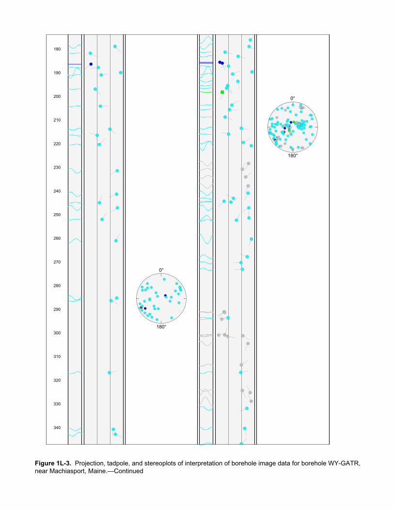
180
190
200
210
220
230
240
250
260
270
280
290
300
310
320
330
340
0°
180°
0°
180°
Figure 1L-3. Projection, tadpole, and stereoplots of interpretation of borehole image data for borehole WY-GATR, near Machiasport, Maine.—Continued

350
360
370
380
390
400
410
Figure 1L-3. Projection, tadpole, and stereoplots of interpretation of borehole image data for borehole WY-GATR, near Machiasport, Maine.—Continued
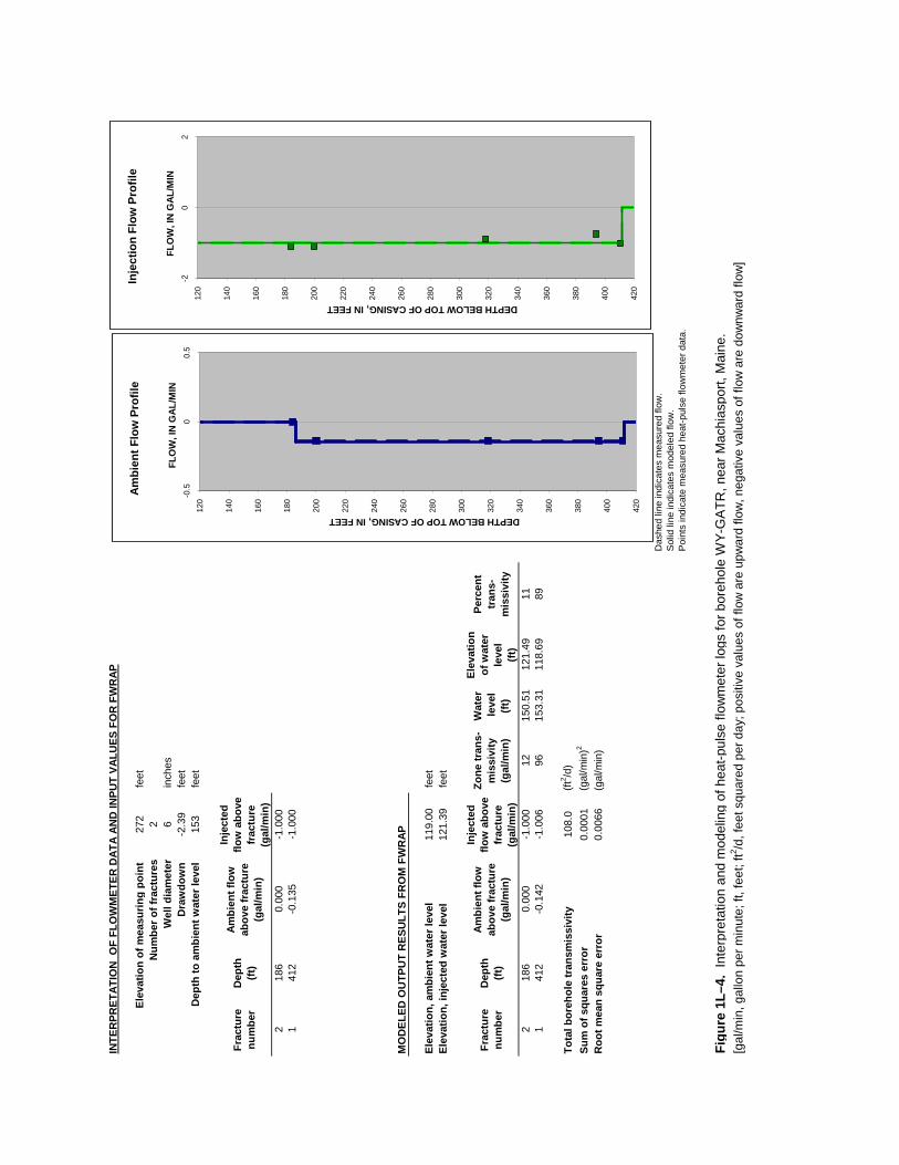
INTE
RPR
ETAT
ION
OF
FLO
WM
ETER
DAT
A AN
D IN
PUT
VALU
ES F
OR
FW
RAP
Elev
atio
n of
mea
surin
g po
int
272
feet
Num
ber o
f fra
ctur
es2
Wel
l dia
met
er6
inch
esD
raw
dow
n -2
.39
feet
Dep
th to
am
bien
t wat
er le
vel
153
feet
Frac
ture
nu
mbe
rD
epth
(ft)
Ambi
ent f
low
ab
ove
frac
ture
(g
al/m
in)
Inje
cted
flo
w a
bove
fr
actu
re
(gal
/min
)2
186
0.00
0-1
.000
141
2-0
.135
-1.0
00
MO
DEL
ED O
UTP
UT
RES
ULT
S FR
OM
FW
RAP
Elev
atio
n, a
mbi
ent w
ater
leve
l11
9.00
feet
Elev
atio
n, in
ject
ed w
ater
leve
l12
1.39
feet
Frac
ture
nu
mbe
rD
epth
(ft)
Ambi
ent f
low
ab
ove
frac
ture
(g
al/m
in)
Inje
cted
flo
w a
bove
fr
actu
re
(gal
/min
)
Zone
tran
s-m
issi
vity
(g
al/m
in)
Wat
er le
vel
(ft)
Elev
atio
n of
wat
er
leve
l (ft
)
Perc
ent
tran
s-m
issi
vity
218
60.
000
-1.0
0012
150.
5112
1.49
111
412
-0.1
42-1
.006
9615
3.31
118.
6989
Tota
l bor
ehol
e tr
ansm
issi
vity
108.
0(ft
2 /d)
Sum
of s
quar
es e
rror
0.00
01(g
al/m
in)2
Roo
t mea
n sq
uare
err
or
0.00
66(g
al/m
in)
Das
hed
line
indi
cate
s m
easu
red
flow
.
Sol
id li
ne in
dica
tes
mod
eled
flow
.P
oint
s in
dica
te m
easu
red
heat
-pul
se fl
owm
eter
dat
a.
Figu
re 1
L–4.
Int
erpr
etat
ion
and
mod
elin
g of
hea
t-pul
se fl
owm
eter
logs
for b
oreh
ole
WY-
GA
TR, n
ear M
achi
aspo
rt, M
aine
.[g
al/m
in, g
allo
n pe
r min
ute;
ft, f
eet;
ft2 /d, f
eet s
quar
ed p
er d
ay; p
ositi
ve v
alue
s of
flow
are
upw
ard
flow
, neg
ativ
e va
lues
of f
low
are
dow
nwar
d flo
w]
120
140
160
180
200
220
240
260
280
300
320
340
360
380
400
420
-0.5
00.
5
DEPTH BELOW TOP OF CASING, IN FEET
FLO
W, I
N G
AL/M
IN
Ambi
ent F
low
Pro
file
120
140
160
180
200
220
240
260
280
300
320
340
360
380
400
420
-20
2
DEPTH BELOW TOP OF CASING, IN FEET
FLO
W, I
N G
AL/M
IN
Inje
ctio
n Fl
ow P
rofil
e
Copyright © 2022 FDOKUMEN