Aotea Great Barrier Island historic heritage survey appendix 1 ...
110
Aotea Great Barrier Island Historic Context Statement 100 As adults, with families of their own, the children of Thomas and Elizabeth Medland built a school for their children in the 1930s, as their numbers grew (Fig.152). This avoided the long journey to Tryphena. The Medland family contributed greatly to the Great Barrier infrastructure when the brothers built a road between Medlands and Tryphena and with their neighbour, Cyril Eyre, constructed the wharf at Puriri Bay. (Refer 3.1.4.2). There are still a number of extant built places on the island that are associated with the history of the Medland family. The old cowshed/sawmill which was once part of the Woolstone farm, built in the 1920s is still on its original site. The Medlands school, built c1932, has been relocated within the Medlands area and has been converted into a bach (Fig. 153). The creamery and wash house have also been relocated to what was once Grace Benson’s (nee Medland) property in Sandhills Road. 4.2.3.10 Tryphena The Barstows Robert Barstow arrived in Auckland on the Bangalore in 1843 from England, purchased land at Tamaki as an intended grain farm. Undertaking a trip to South America in 1844, Barstow did not return to Auckland until late 1845. It was around this time, that he purchased land at Mulberry Grove, Tryphena. In 1846, he married Jane Hulme, who was the daughter of the Commanding Officer of the British Contingent in New Zealand, Lieutenant Colonel Hulme. Although they settled on the farm in Tamaki, he was spending a substantial amount of time on the Barrier on what he called his cattle ranch. He employed people to help him manage the cattle he had acquired there. It appears the cattle, which had been transported to the island in the early 1840s, without fencing and prepared grazing land, had run wild. Following substantial losses on the Tamaki farm, the Barstows sold this in 1850 and moved permanently to the property in Mulberry Grove, in an effort to take control of his ‘cattle ranch’. 236 Apparently, he had tried to sell the Barrier property but could not get a purchaser. 237 The Barstows became the first settlers in Tryphena, built a house and began to raise a family there. In one of his letters Barstow wrote to his father, he included a plan of the house along with a plan of Tryphena, that he had drawn. (Fig.82). 238 From his letters it appears he failed to cope with the problems of capturing and containing the wild cattle and completing fencing and other activities necessary for this farm to be successful. He was also heavily in debt due to farm expenses. He managed to bring a partner on board in 1858 to assist him both financially and physically when he met Neill and Emilie Malcolm.
-
Upload
khangminh22 -
Category
Documents
-
view
2 -
download
0
Transcript of Aotea Great Barrier Island historic heritage survey appendix 1 ...

Aotea Great Barrier Island Historic Context Statement 100
As adults, with families of their own, the children of Thomas and Elizabeth Medland built a school for their children in the 1930s, as their numbers grew (Fig.152). This avoided the long journey to Tryphena. The Medland family contributed greatly to the Great Barrier infrastructure when the brothers built a road between Medlands and Tryphena and with their neighbour, Cyril Eyre, constructed the wharf at Puriri Bay. (Refer 3.1.4.2). There are still a number of extant built places on the island that are associated with the history of the Medland family. The old cowshed/sawmill which was once part of the Woolstone farm, built in the 1920s is still on its original site. The Medlands school, built c1932, has been relocated within the Medlands area and has been converted into a bach (Fig. 153). The creamery and wash house have also been relocated to what was once Grace Benson’s (nee Medland) property in Sandhills Road. 4.2.3.10 Tryphena The Barstows Robert Barstow arrived in Auckland on the Bangalore in 1843 from England, purchased land at Tamaki as an intended grain farm. Undertaking a trip to South America in 1844, Barstow did not return to Auckland until late 1845. It was around this time, that he purchased land at Mulberry Grove, Tryphena. In 1846, he married Jane Hulme, who was the daughter of the Commanding Officer of the British Contingent in New Zealand, Lieutenant Colonel Hulme. Although they settled on the farm in Tamaki, he was spending a substantial amount of time on the Barrier on what he called his cattle ranch. He employed people to help him manage the cattle he had acquired there. It appears the cattle, which had been transported to the island in the early 1840s, without fencing and prepared grazing land, had run wild. Following substantial losses on the Tamaki farm, the Barstows sold this in 1850 and moved permanently to the property in Mulberry Grove, in an effort to take control of his ‘cattle ranch’.236 Apparently, he had tried to sell the Barrier property but could not get a purchaser.237 The Barstows became the first settlers in Tryphena, built a house and began to raise a family there. In one of his letters Barstow wrote to his father, he included a plan of the house along with a plan of Tryphena, that he had drawn. (Fig.82).238 From his letters it appears he failed to cope with the problems of capturing and containing the wild cattle and completing fencing and other activities necessary for this farm to be successful. He was also heavily in debt due to farm expenses. He managed to bring a partner on board in 1858 to assist him both financially and physically when he met Neill and Emilie Malcolm.

Aotea Great Barrier Island Historic Context Statement 101
However, three months after the Malcolms arrived, Robert Barstow accepted a position as resident magistrate in Russell239 and left Great Barrier Island for good.
Figure 82. A plan drawn by Robert of the family home in Mulberry Grove and, below this another plan he drew of Tryphena. Dated September 1851. (Beament 2011b:35)

Aotea Great Barrier Island Historic Context Statement 102
The Malcolms Neill and Emilie Malcolm, along with their daughter Emilie, arrived in New Zealand from England on the Victory in February 1851.240 Neill was a barrister and searched for work as a lawyer in Auckland. They had three more daughters, Fanny, Clara and Constance, between 1852 and 1856. They met Robert and Jane Barstow in Auckland and arranged a partnership to farm land in Tryphena, Great Barrier Island. By 1858, the Malcolms had moved to Great Barrier Island. At first, they lived in the raupo house built by Barstow. Then they built their own home in Mulberry Grove. When the Barstow family left the island to live in Russell, Neill Malcolm acquired the Barstow land and petitioned the Government to ratify his claim and arrange for a survey of the land. Despite many petitions made by Neill Malcom, he never received confirmation of the ownership of his farm and a survey was only partially completed. It was reported that the Provincial Government had granted Neill Malcolm the right of selection of his land to secure a survey and an official title to the land. However, because of poor communication between the mainland and Great Barrier, Neill Malcolm never received this grant. There was simply no record of his claim to ownership of the Malcolm farm when Crown grant parcels of land were being offered, by a new government on Great Barrier for new settlers. Because of the Neill Malcolm was completely unaware of his land being subdivided for sale, he was unable to defend his ownership or even bid for the land.241 Consequently, his farm was subdivided and sold to the new settlers on the island including the Osbornes and the Sandersons. The Osbornes owned much of the property that held, not only the Malcolm house, but also had taken possession of the Malcolm orchard, his stock and stockyard buildings. Only the plot of land (some 80 acres) that held the Malcolm house was returned to the Malcolms for a fee of £56.242 Neill Malcolm continued to petition his claim but was unsuccessful in his attempts to regain his original farm acreage, despite the obvious blunder made by the Government in not communicating the sale of land. The Malcolm family moved to Rosalie Bay in the 1870s to establish a farm there and in 1897 they moved to Waiwera after 40 years on the island.243 The Osborne Family The Osborne family came to New Zealand on the Cairngorm, arriving in Auckland in January 1863. Joseph and Mary Osborne and their 4 children, Alfred, Emily, Mary and Harry.244 A wool merchant from Leeds, Joseph Osborne moved to New Zealand after a considerable financial loss. He settled in as a wool dealer in Auckland and bought property at Tryphena on the Barrier when land was put up for sale by the government in the mid-1860s (Refer to the history of the Malcolm family).

Aotea Great Barrier Island Historic Context Statement 103
Alfred Osborne, the eldest son, settled on the Barrier in the late 1860s to manage the farm purchased by his father. In 1874, Alfred eloped with Fanny Malcolm against both their parent’s wishes, mainly because of land disputes between the two families (due to government mismanagement of land titles). They were married by Bishop Cowie at Bishopcourt in Parnell.245 They returned to Tryphena to take up residence at the Osborne homestead. Fanny was well known for her detailed botanical watercolours. Alfred became the first school teacher at the Tryphena School when it was opened in 1884 (Refer Section Tryphena School 6.2.1). Alfred is said to have planted the Mulberry trees that Mulberry Grove is named after. He was also a keen botanist and gardener, developing tiered lily ponds near their home. Alfred and Fanny Osborne raised thirteen children on the Barrier, some of whom remained on the island and continued farming, such as Harold, Ernie and Charlie Osborne. Fanny remained on the property after Alfred died in 1920 until her health failed and she moved to Mt Eden to live with her daughter Constance. Fanny died in 1934. They built two homes on their property. It is not known what happened to the first house but there is little evidence of its existence now. On the property there is a clearing that appears to be where the first house was located. A number of exotic trees on this part of the property provide evidence of an early home being built there including a magnolia, camphor tree, and a Port Jackson fig tree.
Figure 83. Vegetation in the clearing on the former Osborne property. It is likely the first home was located here. (Auckland Council 2016). The second house was built further to the western side of the property. The house is no

Aotea Great Barrier Island Historic Context Statement 104
longer extant. However, there is still some physical evidence of the home there. Chimney breasts and the remains of the stone terraced lily ponds complete with glass jars acting as tubes to irrigate the ponds, still remain. Plantings here include macrocarpa trees, camelias, rose bushes and remnants of an orchard. A family burial ground is located close to the second house.
Figure 84. Osborne house in Tryphena. (AWMM/L PH-CNEG-C26203)
Figure 85. The remains of the terraced lily ponds. (Auckland Council 2016)

Aotea Great Barrier Island Historic Context Statement 105
Figure 86. One of the chimney breasts still standing on the former Osborne property. (Auckland Council 2017). There are other former Osborne properties that still exist on the island that belonged to Fanny and Alfred’s sons Ernie and Charlie. Both of these are on Cape Barrier Road. Ernie’s former home was a 1930s bungalow that has since been substantially extended and altered and is now known as the Stray Possum Lodge. Two of Ernie Osborne’s honey sheds have been relocated to the former Todd property and Fanny Osborne’s Cream shed has been relocated and partially reconstructed on the Milk, Grain and Honey Museum in Claris. (Refer Section 5.8 Farming) The Blackwell Family George Blackwell, his wife Elizabeth came to Auckland from Ireland arriving on the Victory in January 1864. They were accompanied by Elizabeth’s brother James Williams. Their

Aotea Great Barrier Island Historic Context Statement 106
first daughter Elizabeth died on the voyage. After arriving in Auckland, they had two more children. After working in Auckland, at first as a wheelwright (for which George was trained) and then for the army during the land wars, making horse shoes and shoeing horses, George and his family took up an 80acre grant on Great Barrier Island. They shared this grant with Elizabeth’s brother, James. The blocks of land turned out to be unsuitable for farming, being steep and difficult terrain. They built a whare and felled trees on a small section of level land and sold firewood. They planted crops but lost these in a large flood. After losing their crops, they relocated to Okupu where George cut firewood for William Sanderson to make a living and saved money to buy land at Pa Beach in Tryphena in 1870 where the family finally settled. Nine more children were born after they settled here. On their new farm, George and James built a whare for the family and they cleared the land selling the firewood and making room for grazing stock. The new whare was the first portion of the Blackwell homestead, known as Ox Park. They constructed dry stone walls and bridges, which can still be seen on the property. (Fig.90).
Figure 87. Ox Park in a photograph taken by Henry Winkelmann c1892. (AWMM/L PH-NEG-1082).

Aotea Great Barrier Island Historic Context Statement 107
Figure 88. Ox Park in 2016. (Auckland Council 2016). George produced honey on the farm, exporting honey to Auckland. He set up a sawmill with a waterwheel powering it to produce boxes for the enterprise. (Refer Section 5.9 Honey Production). In 1880 the homestead was extended with a two storey addition. Elizabeth died in 1911 and three years later George moved to Auckland to live with his daughter, Jane. He died in 1932.246

Aotea Great Barrier Island Historic Context Statement 108
Figure 89. Ox Park from the eastern side 2016. (Auckland Coucnil 2016)
Figure 90. Stone culvert on Blackwell property. (Auckland Council 2016)

Aotea Great Barrier Island Historic Context Statement 109
Thomas Blackwell was the oldest son of George and Elizabeth. Thomas, and his wife Mary, built a house (no longer extant) at Mulberry Grove and farmed there. Thomas and Mary’s eldest child, Walter, took up farming along the Kaitoke shore and extended the honey house to become a home for his wife, Hannah (known as Jean to some) and their children.247 This building is still extant, although in a modified form. (Fig. 137). It was George and Elizabeth’s son William Blackwell and his wife Margaret who took over Ox Park and farm, when George left the island in 1914. The farm was split up between William and Jonathan, each farming 50 acres.248 After William and Margaret left the farm around 1938, Tom Blackwell (Thomas Blackwell’s youngest child) and his wife Edna took possession. Jonathan Blackwell was the youngest of George and Elizabeth’s children. On his 50 acres of the family farm he built a bay villa which still exists but is now converted into the Currach Irish pub (Fig,91). Jonathan, and his wife Maude, ran the sheep farm, continued the family commercial honey produce and also ran a general store. His very small honey shed is now located on the roadside outside the Currach Pub. George and Elizabeth’s son, Adam, (1876-1955) after an adventurous life as a seafarer, married Benjamin and Eliza Sanderson’s daughter, Eleanor. He farmed 750 acres of Cape Barrier land with his home situated in Shoal Bay. Adam and Eleanor retired from the island in 1955. Their house in Shoal Bay is no longer extant.
Adam and Eleanor’s daughter, Alice, lived in a small bach on the foreshore of the family property after she married George Borich in 1938. The bach was originally built in the 1920s By Adam Blackwell as a shelter for roadmen building the road along the bay (Fig.31).

Aotea Great Barrier Island Historic Context Statement 110
Figure 91. Jonathan Blackwell’s home, now the Currach pub. (Auckland Council March 2018). The Todds George Todd and his family arrived at Mulberry Grove around 1890. He built a small whare alongside the Mulberry Grove Creek17 prior to building his first house two years later along the foreshore in what is now the Mulberry Grove School grounds. An existing dry stone wall is believed to be part of the grounds of the original Todd homestead.249. This house was demolished in the early 1960s. George Todd’s son, also called George, built the second Todd house around 1928 -1929. According to CHI records, the house was built with timber from the workers houses at the Whangaparapara mill.250 The house has been modified but is still easily identified as a bungalow from this era. The last member to occupy the second Todd home, was George’s son Les. Behind the house are earlier outbuildings and two of Ernie Osborne’s honey sheds have been relocated to the property.
17 Survey plan SO 6067A shows Allotment 22 owned by ‘Todd’, along with ‘Todd’s House’ shown inland south of the Mulberry Grove stream. This is probably Todd’s ‘whare’ where he lived before moving into his first house on the foreshore at Mulberry Grove.

Aotea Great Barrier Island Historic Context Statement 111
Figure 92. The Todd house,built in the late 1920s, (David Watson). The Bailey Family Another early pioneer in Tryphena was Robert Bailey and his wife Eliza Jane. Robert Bailey is believed to have donated the land for the school in Tryphena.251 He was the chairman of the school committee252 and was significantly involved in the establishment of the Tryphena school. The Bailey homestead no longer exists but it has been documented in earlier photographs (Fig.93). Henry Penwell Alcock, who was the third child of Sarah and William, was born in 1876. He married Agnes Bailey, the daughter of Robert and Eliza-Jane Bailey, another early pioneer family in Tryphena. Henry and Agnes had a son, Edwin Henry and a daughter, Edith Agnes, who were both born in Tryphena.253 Edwin, known as Tom Alcock, stayed in Puriri Bay, building a house there, known as Rose Cottage, for himself and his wife Dorothy. The remains of the chimney and elements of the cottage still exist on the original site. However, the cottage collapsed more recently (within the last ten years as at 2018 – Fig.93). Adjacent to the property is the burial ground for the Bailey and Alcock families. (Refer Section 6.4.2.3 The Bailey Alcock Graves).

Aotea Great Barrier Island Historic Context Statement 112
Figure 93. The Bailey homestead with the later Alcock/Rose Cottage below it in the foreground. (date unknown) (Courtesy Ben Sanderson).
Figure 94. Remains of Rose Cottage. (Auckland Council 2018),

Aotea Great Barrier Island Historic Context Statement 113
The Blairs
John Blair sailed to Auckland from London in 1864 with his wife Jean, and their children, John and Isabella on the Lord Clyde.254 They initially bought 220 acres of land on the Barrier in Puriri Bay (adding another 220 acres later) and began farming there.255 They eventually built a house of pit sawn kauri with a roof of kauri shingles (Fig.4) which was to be used for the first post office in Tryphena established in 1871. In entrepreneurial mode, the Blairs purchased a cutter in the mid-1870s, named The Three Brothers, which conveyed firewood to Auckland from the Barrier. The cutter was lost in a storm in July 1880 With John Blairs son, Thomas and his crew lost with it.256
John; son John Junior, who had married Agnes McKay in 1875, continued to farm the family holding after John Senior died in 1892. His brother James married Mary Jane Moor of Nagle Cove and they left the island after John Senior died.
The Blairs have a family burial plot north west of where the homestead and post office stood.257 The house was replaced in the 1920s with the current home
Figure 95. The Blair family outside their oitsawn timber home in a photograph taken by Henry Winkelmann in 1896. (AWMM/L PH-NEG-10459)

Aotea Great Barrier Island Historic Context Statement 114
4.2.3.11 Rosalie Bay
The Pittar Family In 1865-1866, Arthur Pittar purchased 952 acres fronting on to Rosalie Bay. 258 He married Ellen Brewer in 1867.259 The Pittars had six children on Great Barrier Island, who all started school there. Arthur established a fishing station in Rosalie Bay, smoking and curing fish for the Auckland market.260 However, the venture was not successful due to the many costs involved in selling the fish and in distribution.261 It is not known when the Pittar family left the property at Rosalie Bay, but the family did eventually relocate to the mainland. Newspapers report him as the legal manager of the John Bull Gold Mining Company in Coromandel in 1872.262 Later he is placed as being the manager of the Great Barrier Land Harbour and Mining Company in 1881, and it seems at this time based at Port Fitzroy. Later reports have Arthur and Ellen living in Three Kings in the late 1880s.263 Neill and Emilie Malcolm As mentioned earlier the Malcolm family moved to Rosalie Bay in the 1870s to establish a farm there. They remained there for approximately 20 years prior to moving to Waiwera in 1897.264 The house they built there no longer exists.265 (Refer Section on Malcolm Family Tryphena). Henry Winkelmann In 1895 Henry Winkelmann moved to Rosalie Bay with his friend, Richard Harington. Helen Jordan Luff writes that they farmed 952 acres there, next door to the Malcolm property.266 Being the same amount of acreage as the Pittar farm, it is possible they had purchased the former Pittar property. The house Henry documented in several photographs in 1895, appears to be of an earlier colonial style and is certainly not a new house on this farm in Rosalie Bay. This is the more likely scenario. Further investigation into land titles would confirm this. Winkelmann had already bought land in Oruawharo (now Medlands) in 1889, possibly as an investment, as he did not reside there permanently at any time. There was a raupo hut on this property. 267 The ownership of the Rosalie Bay property was short lived and the two men sold the farm to Matthew Todd (a son of George Todd) in 1897 at a massive loss.268
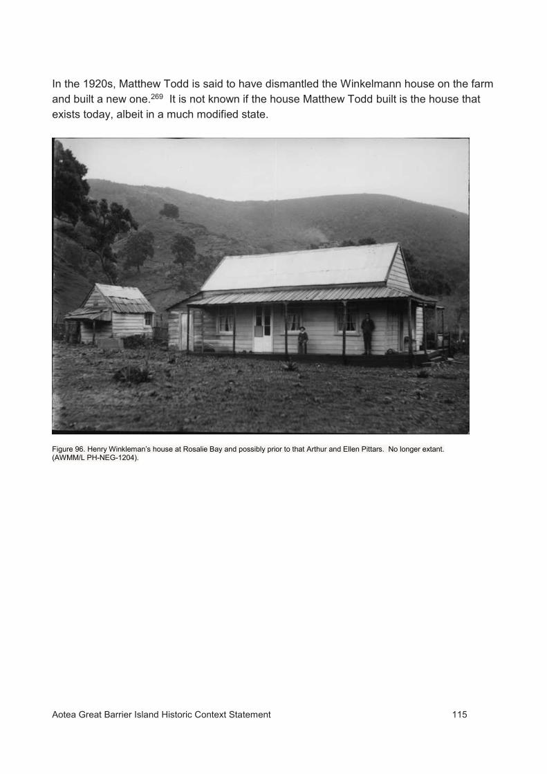
Aotea Great Barrier Island Historic Context Statement 115
In the 1920s, Matthew Todd is said to have dismantled the Winkelmann house on the farm and built a new one.269 It is not known if the house Matthew Todd built is the house that exists today, albeit in a much modified state.
Figure 96. Henry Winkleman’s house at Rosalie Bay and possibly prior to that Arthur and Ellen Pittars. No longer extant. (AWMM/L PH-NEG-1204).

Aotea Great Barrier Island Historic Context Statement 116
5 CHAPTER FIVE - WORK
5.1 Shipbuilding Shipbuilding was the first industry to be established on Aotea Great Barrier, commencing with the construction of the schooner Rory O’More which was completed in 1841. Materials for the frames, planking and masts were available from the extensive forests of pohutukawa and kauri on the island, while local Māori were available to provide inexpensive labour to fell, extract and pit saw timber in return for coveted trade goods. The island was also a convenient location for ships to call in for repairs and to take on firewood and water away from the temptations of Russell/Kororareka. 5.1.1 Nagle Cove shipyard UID 02165; CHI 9496; S08_296 Nagle Cove18 was the site of a shipyard where three ships were constructed, including the largest sailing vessel to be built in New Zealand.
The first ship to be completed for the partnership of William Webster, William Abercrombie and Jeremiah Nagle at Nagle Cove was the schooner Rory O’More. The vessel was built by Jeremiah Nagle and launched on 10 October 1841 (New Zealand Herald & Auckland Gazette 27 October 1841). The Rory O’More was subsequently owned by William Eppes Cormack. The schooner serviced the copper mine at Miners Head, transporting copper ore for the Great Barrier Mining Company between the mine and transport ships waiting in Port Abercrombie, for export to overseas markets.
The second ship on the stocks at Nagle Cove was the barque Stirlingshire. Construction of the Stirlingshire commenced in 1841, initially under the direction of shipwright Robert Menzies. Progress on the ship was slow due to a number of setbacks. By 1846 work had ceased on the partially completed ship and there was no money to enable it to be completed. After borrowing £3000, the Nagles engaged Captain John Gillies in February 1846 to oversee the completion of the vessel, which was finally launched on 11 November 1848. Gillies had in the meantime built the schooner Vivid beside the Stirlingshire (Fig.97). The Vivid was launched on 6 July 1848. A number of visiting whaling and other ships were repaired and re-provisioned at Nagle Cove over the years.
The Gillies left Great Barrier on 2 February 1849.270
18 Earlier known as Mohunga Bay, Nagle’s Cove or Nagle’s Bay and sometimes miss-spelt.

Aotea Great Barrier Island Historic Context Statement 117
Figure 97. Vivid and Stirlingshire on the stocks at Nagle Cove in 1847. William Bambridge sketch. (William Bambridge journal 9-10 December 1847. MS-463 AWMM/L qMS-0122-187 ATL). The following vessels are known to have been built at Nagle Cove:
Rory O’More, schooner, reg.1/1842 Port of Auckland (1841)
Vivid, schooner (1848) reg. unknown
Stirlingshire, barque reg.17/1847 [later 24868] (1848)
5.1.2 Richard Smith’s shipyard, Smiths Bay UID 02181; CHI 11432-3; S09_153-4 The most prolific shipbuilder on Aotea Great Barrier was Richard Smith. Smith acquired 80 acres of land in 1867 at what is now known as Smith’s Bay between Tryphena and Okupu (Fig.98) and is known to have designed and built five ships before eventually moving in 1879 to Thames, where he lived until his death in 1896.271
The following vessels are known to have been built by Richard Smith on Great Barrier:
Florence, fore-and-aft schooner, reg. 57790 (1869)
Atlanta, fore-and-aft schooner, reg. 66546 (1873)
South Carolina, cutter, reg. 70202 (1874)
Champion, cutter, reg. 70374 (1876)
Pirate, fore-and-aft schooner, reg. 78370 (1879).

Aotea Great Barrier Island Historic Context Statement 118
The site of the shipyard and associated features including Smith’s house is marked by terracing, hearth remains and artefact scatters. The site and stone ruins of a building thought to be Smith’s second house are further upslope.272
Figure 98. Location of “SMITHS SHIPBUILDING YARD” shown on SO plan1622 (1878).
Figure 99. The site of Richard Smith’s first house. SO plan 1525 (1878).

Aotea Great Barrier Island Historic Context Statement 119
Figure 100. Smiths Bay. The shipyard was located behind the far end of the cobble beach. (Auckland Council 2013).
5.1.3 Shipbuilding at Tryphena
Robert Barstow appears to have undertaken minor boat building and ship repairs at Tryphena, perhaps near his residence at Mulberry Grove. He expressed an intention to build a schooner in 1850-1,273 but it is unclear if this proceeded. There does not appear to have been any New Zealand registered ship built on the island at that time.
5.2 Mining and mineral prospecting on Great Barrier Great Barrier Island was once optimistically described as being …one mass of minerals…274 However while the geology of the island is closely related to that of the Coromandel Peninsula and mineralisation is evident in places, none of the various attempts to exploit mineral deposits on Great Barrier over the years have been a long term commercial success or generated returns comparable to the Coromandel fields. From a historical perspective the island does have significance as the site of New Zealand’s oldest mine workings.

Aotea Great Barrier Island Historic Context Statement 120
5.2.1 Pre-European use of Stone Resources The exploitation of geological materials on Great Barrier predates European settlement. Māori discovered and exploited deposits of high quality obsidian suitable for use for cutting tools at Te Ahumatā.275 Other lithic materials were used for various purposes. These included cherts from Whangaparapara and stone for small scale adze manufacturing near Tryphena.19 Obsidian from the island is present as artefacts in sites in other parts of the upper North Island dating back at least 600 years, providing evidence that it was discovered at an early date and has been either directly transported or traded for a considerable time. By the late pre-European period Te Ahumata obsidian appears to have become the dominant source of obsidian in the Tamaki district.276 Obsidian, generally of poor quality, is also found in streams draining Mt Hobson/Hirakimatā. 277(Moore, 2013). The names Te Ahumatā and Hirakimatā (matā = obsidian) are references to the obsidian sources at these locations. Stone boulders or cobbles were also used for construction purposes by Māori on Aotea. In parts of the island stone was used in the construction of defended fortifications (pā), for terrace facings and for garden structures such as enclosures and rows or removed to form mounds in cultivated areas. A number of writers,20 including archaeologists, have implied that this use of stone is significant because of the apparent frequency or nature of such sites on Aotea. However, it is not clear whether this reflects a local tradition, the often stony local environment, better survival of sites on the island than elsewhere,21 or all of these factors.
5.2.2 Copper – Miners Head The history of commercial prospecting and mining on Great Barrier began after copper mineralisation was discovered on the Miners Head headland on the northeast coastline of the island by Ernest Dieffenbach in 1841.278 During the following year William Webster, William Abercrombie and Jeremiah Nagle entered into a partnership and formed the Great Barrier Mining Company. Initial investigations confirmed the presence of high grade ore. The first party of miners arrived in November 1842 and commenced building housing and access roads. Mining eventually began in February 1843.279 This was New Zealand’s first commercial mining
19 The main source of high quality stone in the wider area was at the Tahanga basalt quarry at Opito. 20 See for example New Zealand Herald, 22 February 1908:1. 21 For example, stone-faced terraces are common in the Poor Knights Islands.

Aotea Great Barrier Island Historic Context Statement 121
venture, preceding other early mining operations including the copper mine on Kawau Island and manganese workings on Waiheke Island. At its peak, around 40 men were employed at the mine.
Figure 101. Labour supply has been a persistent issue for industries on the island in the past. (New Zealander 14 June 1845:1).
The company employees were housed in a village at Miners Bay, and the company operated a store and school at the village. At the time the mine finally closed there were 12 dwelling houses and one eight-room stone house.280 Some supplies including peaches, potatoes, melons, cabbages and locally produced ‘wai Māori’ (grog) were purchased or traded from Māori from the settlements at Katherine Bay, then known by Europeans as Māori Bay. Feral goats were also hunted for food.281
Mining ceased in 1845 and the company’s assets were removed after harassment by (non-local) Māori and the perceived threat that hostilities in Northland would escalate and spread to the south of the Bay of Islands.282 It did not resume until 1851. The mine would be operated under four different companies until finally closing in 1868.
By 1866 much of the headland where the ore body existed had been ‘scooped out’ and there had been talk of blowing ‘the whole hill to pieces with gunpowder’.283 The Otea Copper Mining Company, the last company to work the mine, invested heavily in developing the operation during 1866-7. Modern steam-powered ore processing machinery complete with a permanent water supply was installed on the foreshore beside the mine (Fig.104), with a breakwater to protect it from the sea. Water was fed via a water race and flumes from a dam across the stream in the Miners Bay valley, a tortuous route

Aotea Great Barrier Island Historic Context Statement 122
involving significant engineering challenges to channel the water around the steep and rocky coastline.
Investors became nervous about the length of time the work was taking without returns and became reluctant to invest further funds, so part of the work was funded by debt. Shipments of ore finally commenced in late 1867. The ore was transferred at Auckland to ships fitted with iron tanks to overcome the risk of fire which had threatened earlier shipments of non-smelted copper ore from New Zealand.
In February 1868 a severe storm washed away part of the machinery and did other damage at the mine.284 Creditors quickly obtained a writ of fieri facias, forcing the sale of the company assets said to have cost £12,000, on 20 March of that year and prompting unpaid workers to publish a letter complaining at the mismanagement of the process.285 The ore processing equipment from Miners Head was subsequently removed to the Moanataiari mine or Kuranui mine22 at Thames.286
No commercial mining has taken place at Miners Head since 1867, although there were two further attempts in 1888 and 1895-6.287 As recently as 1973, the area was prospected by drilling, but insufficient copper was found to warrant further exploration. The total output of the mine has been estimated to be 2323 tons.288 Problems over the years have included the difficult & isolated location, the limited size of the ore body, under-investment, difficulties in attracting and retaining employees (particularly after the start of the Australian gold rushes in 1851), and the loss of the schooner Rory O’More which had been used to service the mine.
5.2.3 Copper – Coppermine Bay, Whangaparapara In 1844 it was announced that Frederick Whitaker had discovered a very rich copper mine on Great Barrier Island.289 The location of the supposed discovery is today marked by the place name Coppermine Bay near the entrance to Whangaparapara Harbour and some prospecting drives nearby on the southern shore of the harbour.290 Whittaker was a shrewd lawyer, property speculator and (subsequently) politician who would later hold the positions of Premier and Attorney General. He made use of his legal knowledge to exploit loopholes in the law and entered into some highly dubious land transactions. These included acquisition of part of the Kawau Island copper lode as compensation for the building of Fort Ligar on his land in Auckland, even though the fort existed when he purchased of the property. Whitaker’s motivation for claiming to have discovered copper on the Whangaparapara property was to obtain a certificate of pre-
22 There are conflicting reports

Aotea Great Barrier Island Historic Context Statement 123
emption to acquire the land. In reality, this was a scam. There never was any evidence that a workable copper ore deposit existed. 5.2.4 Silver and Gold Prospecting for gold had been undertaken on the island by the 1870s.291 During the late 1880s gold, silver and antimony prospecting was attracting greater interest, with finds of silver and gold mineralisation on the east side of the island leading to requests for the Government to declare the area a goldfield.292 In 1892 Ben and William Sanderson discovered a quartz reef containing silver and some gold on the southern slopes of Te Ahumata (then known as White Cliffs) above Blind Bay. Although the brothers abandoned the claim after several years work, a nationwide mining boom shortly afterwards drew renewed attention to the field. Several companies were formed to prospect the field. By 1897 there were 12 claims in the vicinity of Blind Bay. The Edgerton, Great Barrier, Ryan’s Freehold, Kaitoke, Iona, Aotea, Mount Argentum, Proprietary and Excelsior (formerly White Cliffs) were being actively prospected or worked, while little or no work had been undertaken at Barrier Junction, Comstock and Bonanza. On the Edgerton claim a drive was in 900’, while on the Kauri Timber Company’s land west of White Cliffs an 80’ drive had been was in progress. Antimony was being prospected on the Palmers land at Awana. Of the various companies that prospected and worked the field, only the Barrier Reefs Gold-Mining Company produced any appreciable amounts of gold and silver, from Lee’s reef. Activity on the field had all but ended by 1920, although some further work was undertaken during the early 1930s. In 2010, the then National government proposed to remove about 700 hectares of Department of Conservation land centred on Te Ahumata from protection under Schedule 4 of the Crown Minerals Act. The proposal, which would have opened up the land to mining, generated widespread opposition, forcing the government to back down.
Aotea Great Barrier Island Historic Context Statement 124
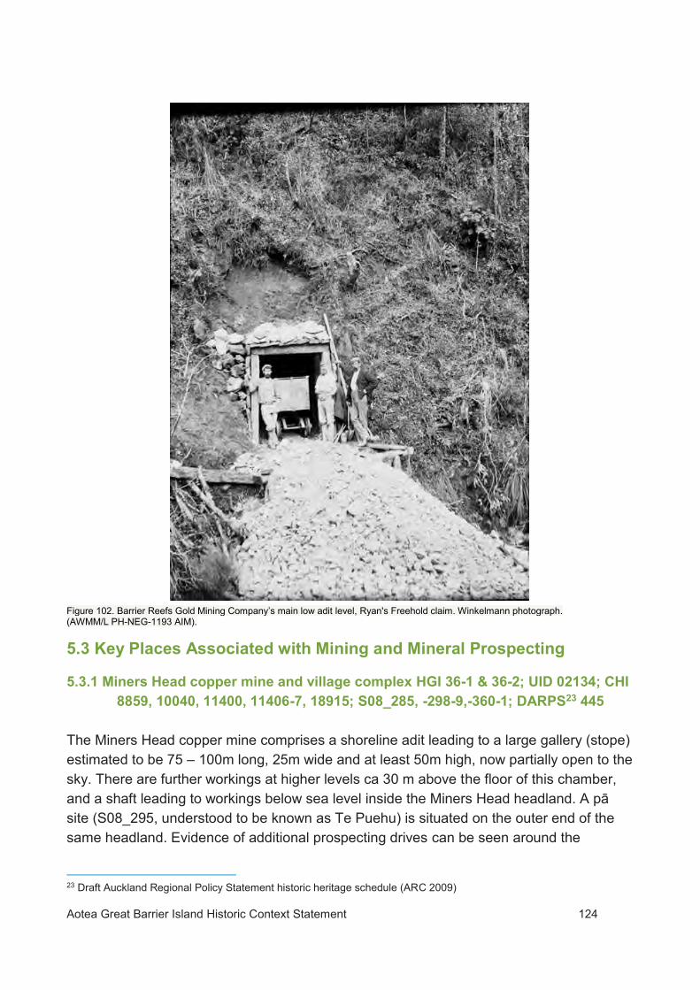
Figure 102. Barrier Reefs Gold Mining Company’s main low adit level, Ryan's Freehold claim. Winkelmann photograph. (AWMM/L PH-NEG-1193 AIM).
5.3 Key Places Associated with Mining and Mineral Prospecting
5.3.1 Miners Head copper mine and village complex HGI 36-1 & 36-2; UID 02134; CHI 8859, 10040, 11400, 11406-7, 18915; S08_285, -298-9,-360-1; DARPS23 445
The Miners Head copper mine comprises a shoreline adit leading to a large gallery (stope) estimated to be 75 – 100m long, 25m wide and at least 50m high, now partially open to the sky. There are further workings at higher levels ca 30 m above the floor of this chamber, and a shaft leading to workings below sea level inside the Miners Head headland. A pā site (S08_295, understood to be known as Te Puehu) is situated on the outer end of the same headland. Evidence of additional prospecting drives can be seen around the
23 Draft Auckland Regional Policy Statement historic heritage schedule (ARC 2009)
Aotea Great Barrier Island Historic Context Statement 125
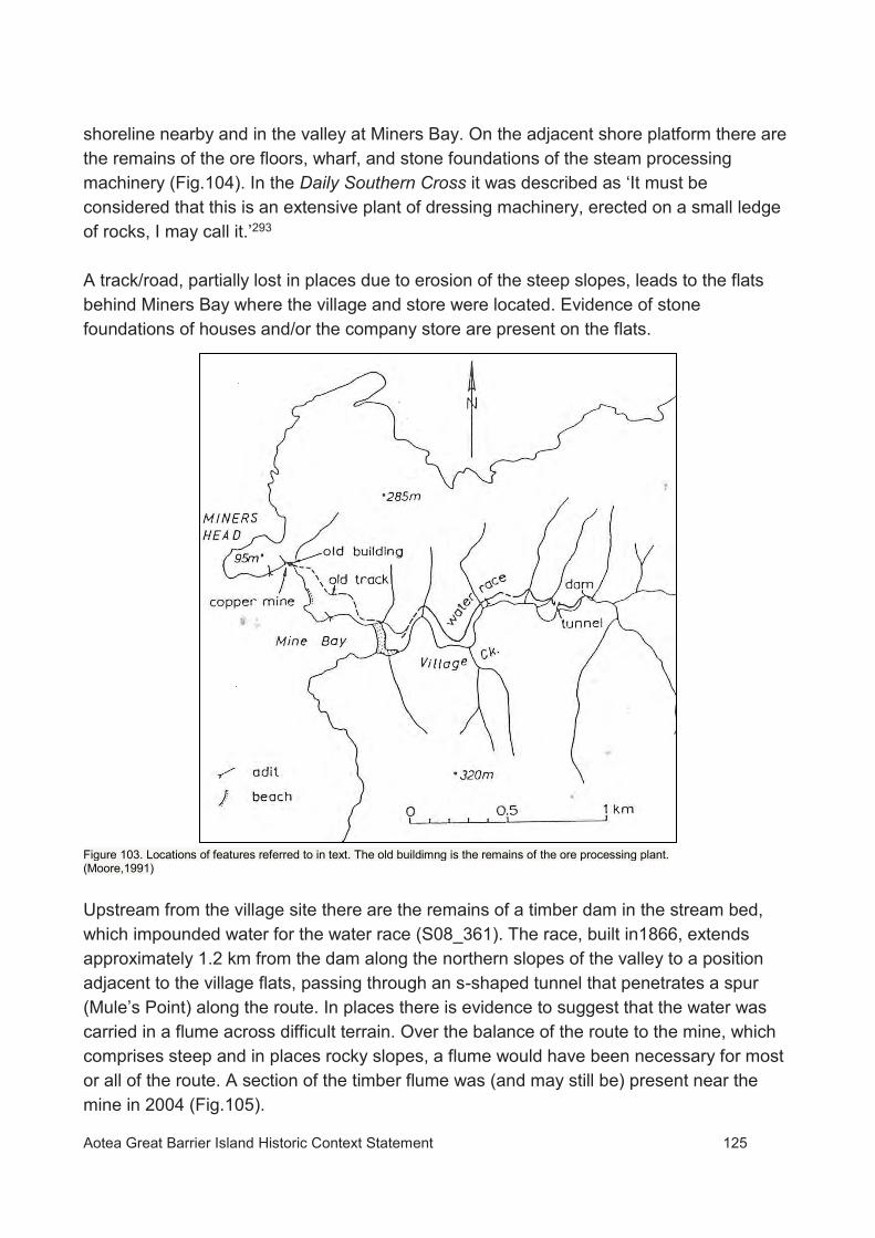
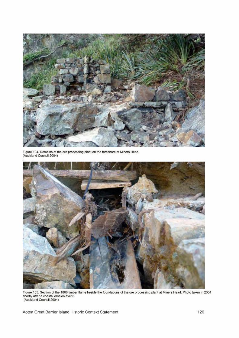
shoreline nearby and in the valley at Miners Bay. On the adjacent shore platform there are the remains of the ore floors, wharf, and stone foundations of the steam processing machinery (Fig.104). In the Daily Southern Cross it was described as ‘It must be considered that this is an extensive plant of dressing machinery, erected on a small ledge of rocks, I may call it.’293 A track/road, partially lost in places due to erosion of the steep slopes, leads to the flats behind Miners Bay where the village and store were located. Evidence of stone foundations of houses and/or the company store are present on the flats.
Figure 103. Locations of features referred to in text. The old buildimng is the remains of the ore processing plant. (Moore,1991) Upstream from the village site there are the remains of a timber dam in the stream bed, which impounded water for the water race (S08_361). The race, built in1866, extends approximately 1.2 km from the dam along the northern slopes of the valley to a position adjacent to the village flats, passing through an s-shaped tunnel that penetrates a spur (Mule’s Point) along the route. In places there is evidence to suggest that the water was carried in a flume across difficult terrain. Over the balance of the route to the mine, which comprises steep and in places rocky slopes, a flume would have been necessary for most or all of the route. A section of the timber flume was (and may still be) present near the mine in 2004 (Fig.105).
Aotea Great Barrier Island Historic Context Statement 126
Figure 104. Remains of the ore processing plant on the foreshore at Miners Head. (Auckland Council 2004) .
Figure 105. Section of the 1866 timber flume beside the foundations of the ore processing plant at Miners Head. Photo taken in 2004 shortly after a coastal erosion event. (Auckland Council 2004)

Aotea Great Barrier Island Historic Context Statement 127
5.4.2 Oreville Battery Site and Mine Complex CHI 9502 S09_46; DARPS 442 The Barrier Reefs Gold Mining Company, which had been formed in 1897, commenced work in 1899 on a 20 stamp battery, cyanide plant and associated works to process ore from the company’s Ryan’s Freehold claim. The company built a 150’ long wharf at Whangaparapara and a road from the wharf to the claim. Tramways and sawpits were also built to obtain timber, along with a water race and pipelines to supply water to the battery. An electric lighting plant was installed, and accommodation, offices and other buildings constructed.
By October 1900 the battery was operational, with 40 men employed on the claim. At its peak the ‘township’ of Oreville (sometimes pronounced Oroville) is said to have had a population of 150, but within 18 months the battery was idle.
The company acquired the Great Barrier Gold and Silver Mining Company which had been working an adjacent claim to the east of the Barrier Reefs mine, in 1901,294 presumably to obtain additional material for processing. In March 1902 the company went into voluntary liquidation.295 The failure of the venture was attributed to the excessive scale and level of investment in the operation, which outweighed the actual and potential returns from the limited ore body. The claim was taken over by a new company, but little new work was undertaken apart from reprocessing of tailings from earlier mining. The works were removed in 1920 to the Muir’s Reef mine at Te Puke.296 The Oreville battery site includes the stone block foundations of the stamping battery on two levels, and further archaeological remains of structures, mine workings and the settlement located around the battery. The Whangaparapara road passes through the site, which is now a visitor attraction with on-site interpretation.

Aotea Great Barrier Island Historic Context Statement 128
Figure 106. The Oreville battery and associated works shortly after completion in a photograph taken by Henry Winklemann c.1900. (AWMM PH-NEG-1231).

Aotea Great Barrier Island Historic Context Statement 129
Figure 107. Advertisement for the sale of the assets of the Barrier Reefs Gold Mining Company. (Auckland Star 15 April 1902:8).
5.4.3 Sunbeam Mine and Battery Complex, Okupu CHI 11422-3; S09_143-4 In 1903, shortly after the initial closure of the Barrier Reefs mine, the Sunbeam Gold and Silver Company acquired a claim at Sunbeam Creek, on the western side of White Cliffs at Okupu. The company built a five-stamp battery which became operational in 1906. The mine was not profitable and work ceased in 1907 and the company went into liquidation in July 1909. The Sunbeam workings were acquired by Ngatiawa Consolidated Gold Mines Limited.297 Considerable remains including terraces, tramway, extraction ponds and remains of the boiler and various pieces of machinery are still present at the site.24 The mine and part of the tramway are on Department of Conservation land; the balance is privately owned.
24 It is likely that the mine workings and various remains recorded in this vicinity relate to the operations of several companies who worked the Sunbeam reef at various times.

Aotea Great Barrier Island Historic Context Statement 130
5.4.4 Ngatiawa mine and battery site, Okupu [?not specifically recorded25]. The Ngatiawa Gold Mining Company invested some £30,000 in the development of a mine, and built an inclined tramway, water race and battery on the hillside at Okupu.298 The mine was closed in 1908 due to a lack of capital to link the mine to the battery. In 1909 the Sunbeam and original Ngatiawa companies were wound up and amalgamated to form a new company with the intention of sharing access to crushing equipment.299 The new company was known as Ngatiawa Consolidated Gold Mines Limited. It appears that resources for further development dried up. A proposal to relocate processing equipment from the Sunbeam to the Ngatiawa mine did not proceed, and the Ngatiawa battery and tramway were not completed. Work was suspended at the mine in November 1910 and the company went into liquidation in December 1910.300 The original Ngatiawa company worked the Sunbeam reef. The company’s claim appears to have been adjacent to that of the Sunbeam company. The workings and other remains associated with the original Ngatiawa company are not identified on existing site records and some may well be unrecorded. Further research would be necessary to clarify which features relate to this company and to the Ngatiawa mine. 5.4.5 Iona Mine complex, Okupu CHI 11416 (mine); 11417 (magazine); 11419 (aerial tramway) & 11938 (battery site); S09_136-8 & 140 The Iona mine was developed by the Iona Gold and Silver Mining Syndicate, a company formed in 1896 to work a 100 acre claim at the southern end of the Whitecliffs on the Te Ahumata field.301 It was once speculated that the mine could potentially be one of the greatest bullion producers in New Zealand.302 The mine complex included five adits over a range of 625 – 1000 ft (190-305m) above sea level, a surface and aerial tramway, buildings, accommodation and a school, and a 5 head stamping battery completed in 1902. Crushed ore was taken to Oreville for processing.303 Revenue from the mine was limited by the methods employed and the complexity of the ore body.304 Production peaked between1901-6, and the company was wound up and the mine abandoned by about 1908. Surviving evidence of the mine complex includes the mine adits, battery site and associated machinery, and remains of the aerial tramway, water race and explosives store (at Okupu Beach). The lower (main) adit is accessible via the Blind Bay Recreation Reserve walkway. 25 The workings and other remains associated with the original Ngatiawa company are not identified on existing records and some may well be unrecorded. Further research would be necessary to clarify which features relate to this company and to the Ngatiawa mine.

Aotea Great Barrier Island Historic Context Statement 131
The site has public interpretation and has recently been maintained to conserve some of the heritage features and manage visitor safety.
5.4.6 Slate quarry (Te Tereti), Katherine Bay UID 02190 CHI 10915 S08_327 There is a small slate quarry known as Te Tereti (a Māori transliteration of slate) on the foreshore at Motairehe Bay. Slate from the outcrop is said to have been used by miners at the Miners Bay copper mine village for hearths and doorsteps, and by local Māori. It has not been commercially quarried.
Figure 108. Survey plan ML2200 (1877) with the slate quarry shown as Tereti.

Aotea Great Barrier Island Historic Context Statement 132
Figure 109. The Te Tereti slate quarry. (Auckland Council, 2002).
5.4 Gum digging Gum digging and the bleeding of standing trees for gum was a significant subsistence scale activity on Great Barrier, particularly in the central part of the island where most of the kauri grew. Gum, probably dug by local Māori, was being exported from the island by the late 1850s.305 In 1889 there were 40-50 gum diggers working on the island.306 By the First World War gum digging had declined significantly as easily won deposits were worked out but was still being carried out on a small scale as late as the 1930s. Gum diggers were responsible for firing and destroying large amounts of kauri forest and other vegetation on the island.

Aotea Great Barrier Island Historic Context Statement 133
Figure 110. Gumdigger and miner Sino Samway and his daughter outside their nikau thatched gumdiggers shanty with sod chimney, Sunbeam Creek, Okupu. Date: 1908. (Courtsey Ben Anderson).
5.4.7 Gumdigging camp and grave, Okupu CHI 10122 S09_45 This location was the site of a gum digging camp during the 1890s. On 8 October 1895 a 22 year old gum digger named Cecil Smith died suddenly at the camp307 and was buried nearby. The grave is marked by a headstone and iron fence, which was erected by his parents. The grave is located near a terrace with the stone outline of a building.
5.4.8 Gumdiggers graves Awana CHI 12301;T08_104 The graves of three gumdiggers (Pasko Prienda aged 45 Ivan Simich aged 34 and Nikola Cvitanovich aged 18) who drowned when their hut was swept away during severe flooding on February 14 1907,308 are located on privately owned land at Awana. There is also reputed to another grave, of a Mr McGee, associated with these.
5.5 Timber and firewood industry The first timber to be cut during the historic era on Aotea–Great Barrier was undertaken to replace ships’ spars and replenish firewood during the late 18th Century. Commercial

Aotea Great Barrier Island Historic Context Statement 134
timber harvesting of forests on Great Barrier began soon after acquisition of land by Europeans, but much of the logging and milling of kauri on the island did not occur until the 20th Century. Records of shipping arrivals from Great Barrier show that shipments of timber including puriri fencing materials and pohutukawa shipbuilding timbers had commenced by the 1840s. The cutting of kanuka and manuka for firewood for the Auckland market had also begun by this time. Thousands of tons of firewood would eventually be exported from the island as demand for fuel for the settlement of Auckland grew, with firewood cutting providing a long term source of revenue for residents on the island for many years. The first large scale attempt to exploit the island’s forests for sawn timber commenced after the establishment of the Great Barrier Land, Harbour and Mining Company in 1857. The company’s operations focussed primarily on cutting and milling kauri and developing sheep and cattle farms in the vicinity of Port Abercrombie. The company also had aspirations to develop Port Fitzroy as a port of call and coaling station for steamers en route to Auckland and dabbled in fish curing at Port Fitzroy. A separate company called The Otea Copper Mining Company Limited was established by the shareholders to work the copper mine at Miner’s Head. Albert Allom managed both companies on Great Barrier Island. The company had acquired substantial areas of kauri forest in the Kaiarara, Wairahi and Kiwiriki catchments. Driving dams were built in the Kaiarara & Wairahi catchments (see SO plan1622), and a large sawmill powered by a 60 horsepower steam engine was erected during 1861-3 at Bush’s Beach in the Kaiarara Inlet. The imported machinery alone for this mill cost £3,500, with considerably more expended to get the mill operational. Both companies suffered from shortages of skilled labour, under-investment and poor business decisions and went into liquidation during the financial crisis of 1867. The GBLMC was wound up in 1868. Some pit-sawing of timber for the mining industry was undertaken on the island during the mining boom of the late 19th-early 20th century,309 and some logging was undertaken in the Kaiarara and Whangaparapara areas during the 1880s.310 During the 19th and early 20th centuries significant areas of forest on the island were destroyed by fires lit to open up areas for gum digging or clear land for farming. The Kauri Timber Milling Company, a company that had been formed by a Melbourne-based syndicate, established a very large steam powered timber mill at Whangaparapara in 1909. Although the company owned extensive areas of forest on Great Barrier this mill
Aotea Great Barrier Island Historic Context Statement 135
was not built to mill kauri from the island. The buoyancy of kauri enabled kauri logs to be transported economically by floating them in large rafts towed by steamers to centralised sawmills. As logs of other native timbers generally sank, this transport system was unique to the northern part of New Zealand. Exports from Great Barrier were not subject to customs duty before WWII, and Whangaparapara was chosen as a central location to mill logs rafted from the forests of Northland and Coromandel. However, difficulties were experienced in attracting labour to this isolated location, and the mill closed in 1913. Kauri was not logged on the island again until the interwar period, due to the difficult terrain and relatively small size of the remaining trees on the island. During this period, much of the logging took place under contract to the Kauri Timber Company in a large stand of kauri located between Whangaparapara and the island’s east coast – one of New Zealand’s last remaining substantial unprotected kauri forests. Extracting the logs and delivering them to the harbour at Whangaparapara was a formidable task, requiring tramways, hauling engines and locomotives to raise them over four steep ridges.311 The logs were towed to Auckland in large rafts and milled at Freemans Bay for export to Australia and Great Britain312 as well as local markets. Logging also resumed in the Kaiarara catchment, with three driving dams built on the Kaiarara Stream to extract logs from stands of kauri that had previously been considered inaccessible. By 1941 the forests had been worked out with the exception of locations that were beyond the reach of the loggers such as the area around Hirakimata (Mount Hobson).

Aotea Great Barrier Island Historic Context Statement 136
Figure 111. Kauri logs at Whangaparapara awaiting shipment to Auckland, 1930s. Offcuts of timber from the earlier mill can be seen on the beach beneath the logs. Arthur Breckon photograph. (AWMM/L PH-NEG-H451).
A large part of the remaining cutover forest has since regenerated and some has been replanted. In 1973 the government approved a revised kauri management policy aimed at perpetuating kauri in unmodified stands and as managed forests. This led to the formation of the NZ Forest Service Kauri Management Unit, which planted approximately 150,000 kauri seedlings on the island between 1976 and 1987. Unfortunately, areas of kauri forest on Aotea Great Barrier have become infected with kauri dieback (PTA - Phytophthora taxon Agathis). This disease was first described in New Zealand in 1974 by forest pathologist Dr Peter Gadgil in a NZ Forest Service block at Whangaparapara. There are some key places on the island associated with the historic timber industry and these have been listed below.

Aotea Great Barrier Island Historic Context Statement 137
5.5.1 GBLHMC Sawmill and related sites, Bush’s Beach CHI 9500; 10182;?12265; S08/70; NZ List Nos. 6184; 6185 Construction of the Kairarara sawmill commenced in 1861. The barque Mersey arrived on 1 August 1861, with two 8 -10 ton boilers26, funnels, 5000 firebricks and a range of other materials for the new mill. The Kairarara sawmill was described as being undoubtedly, for size and power, the largest sawmill in New Zealand.313 The mill commenced operation in 1863, with advertisements for sawn timber appearing in Auckland newspapers by August of that year.314 Attempts to contract out the operation of the mill (Fig.113) were unsuccessful and by September 1865 the mill was not operating, with an enormous quantity of timber waiting to be sawn in the Wairahi River.315
Figure 112. An 1878 plan (SO 1622) showing the location of the Kaiarara mill on the south side of the inlet at Bush’s Beach.
26 The boilers were so large that part of the ship’s deck had to be cut away to accommodate them (Lyttelton Times 19 April 1862:4).

Aotea Great Barrier Island Historic Context Statement 138
Figure 113. Advertisement from the New Zealander 13 February 1864:1. The mill appears to have eventually been dismantled about 1880. By 1889 all that remained was the fast-decaying framework to mark the once busy site.316 We have not inspected the sawmill site. The CHI record (9500) indicates that there are several terraces (one very large), stone faced steps and other stone structures, a log chute, relict planting and other evidence. About half way between the sawmill site at Bush’s Beach and the west point of Kaiarara Bay is a sheltered stream and valley that was the site of a bake house that is said to have been associated with the single men’s quarters for the mill. A prominent feature of the site is the stone walling that retains the terraces along the edge of the creek (Fig.114). There is also evidence of other terracing, structures, paths and garden escapes. This location was the site of a dwelling and other buildings said to have been occupied by a Dr Hallen from around the 1890s until late 1926, when Roland (Roley) Bush moved in. It may have once been the site of a store.27 Little more is known of the history of the site and of Dr Hallen’s life on Great Barrier.317
27 This seems somewhat unlikely, given the location, unless it was when the mill was operational.

Aotea Great Barrier Island Historic Context Statement 139
The site is generally in good condition but has been subject to scavenging of bricks – reputedly including by NZ Forest Service staff for the hearth at the Port Fitzroy headquarters building. There has been some recent erosion of the terrace fill behind the retaining wall at the creek mouth. We note that vegetation management has been recently undertaken on and around the bake house ruins. Figure 114. Western retaining wall at the bake house site. (Auckland Council March 2018).
5.5.2 GBLMC mill manager’s house site, Blair’s Landing CHI 12278 S08_390 The manager of the GBLMC, Albert Allom, lived in a house on the north side of the Kaiarara inlet opposite the company mill. The house was built for Allom in 1862. Allom had

Aotea Great Barrier Island Historic Context Statement 140
vacated the house by 1880 after which it was occupied by the Pittars, who were involved in winding up the mill, and then by the Blair family. It was destroyed by fire in 1909.318 The nice homestead..on a commanding position319 was to become a substantial dwelling.(Fig.46). It may have been the largest dwelling to have been built on the island prior to the modern era. A photo taken in 1894 included in the appendix to Moor320 shows it to have been a H-pattern building, with four gables. A descendant, Barrie Allom, writes about Albert Allom’s son Alby’s memory of the house as being a ‘long two -gabled house’.321 This implies the house was much smaller originally with later additions. An orchard, which included peaches and mulberry trees, was located nearby.322 A track leads to the site of a landing on the point below the house site. The house site is marked by a level area which is assumed to have been the site of the dwelling, and a number of relict plantings including macrocarpa trees, a large magnolia tree, cherry laurel, peach trees, and grape vines as well as other garden escapes.
5.5.3 Kauri Timber Company mill, Whangaparapara UID 02129; CHI 9501; S09_48; DARPS 444. Whangaparapara was chosen by the Kauri Timber Company as a site for a mill for several reasons. The long term intention was to mill kauri from the company’s Great Barrier forests. In the interim it enabled logs from both Northland and Coromandel forests to be milled at a centralised location rather than establishing separate mills that would eventually need to be disestablished and relocated as those forests were worked out. The harbour at Whangaparapara had the advantage that it was deep enough to allow the loading of sawn timber into large vessels directly from the mill without the need for double handling. This allowed timber to be shipped directly to overseas markets from Great Barrier, as well as avoiding the duty that applied at that time to exports through the Port of Auckland.
The mill was constructed in a bay on the western side of the harbour. The Kauri Timber Company was granted a lease for a wharf site by the Marine Department in June 1909. In October 1909. they were also granted a site for booms, breastwork and reclamation (Fig 116).
A substantial wharf around ¼ of a mile long provided 20’ of water at low tide.323 In addition to the mill there was a large accommodation camp, a cookhouse, dining hall, a hall, a school, post office, store and butcher’s shop, orchard and gardens, and separate housing for management.
At the time it was operational the mill is said to have been the largest timber milling operation in the Southern Hemisphere.

Aotea Great Barrier Island Historic Context Statement 141
The mill was in operation for a very short period, closing in 1913 less than five years after construction. In 1920 the Kauri Timber Company was put into liquidation in order to form a new company of the same name, and the assets were transferred to the new company. The Whangaparapara sawmill was dismantled at around this time and relocated to one of the company’s Australian operations where it was used to mill jarrah.324 Various dwellings and other buildings at the site were removed from the KTC property and relocated to other parts of the island.
The building now known as the Great Barrier Lodge is recorded as being the mill manager Monaghan’s house.325 It is believed to have been relocated to its current site in 1914 following the closure of the mill and has been extensively altered since then, so that its form is no longer recognisable. It now has a lengthy history as a guest house.
Figure 115. The Great Barrier Lodge, recorded as being formed from the Mill Manager’s house. (Auckland Council March 2018) Considerable evidence of the Whangaparapara mill, wharf and associated facilities has survived. At the mill site this includes piles and other remains of the buildings and wharf, numerous timber offcuts, an iron flue, a steam traction engine. The site is on DOC land and is accessible via a walking track from Copes Flat. There are also later features associated with the extraction and marshalling of logs when the Whangaparapara tramway was in operation, at or near the mill site, including stacks of rails.

Aotea Great Barrier Island Historic Context Statement 142
Figure 116. Marine Department plan MD3386(1909) showing the location of the wharf and proposed reclamation and timber boom.

Aotea Great Barrier Island Historic Context Statement 143
Figure 117. The Whangaparapara mill in operation in a photograph taken by Arthur Breckon. (AWWMM/L PH-NEG-H450).
5.5.4 Whangaparapara tramway (1926-41) CHI 8855 T08_50 The last large-scale kauri logging operation undertaken by the Kauri Timber Company, New Zealand’s largest native timber company, took place on Aotea Great Barrier. At its peak the company employed up to 70 men on the island, mostly working as contractors.
Although the company had extensive land holdings on the island, logging was initially restricted to areas accessible by bullock teams due to the rugged terrain. Between 1925 and 1935 a tramway was built in stages to extract felled logs from the remaining areas of forest. The tramway enabled logs to be transported from stands as far away as Palmer’s Bush through to Whangaparapara, and included a branch leading out to the Wairahi and Kiwiriki kauri stands.
The tramway would eventually include 10 sections extending over 9 km. It had a total of 10 inclines, a cumulative total of 1160m of vertical rise, and grades as steep as 1-in-1. There were 7 steam haulers operating on the inclines, along with a locomotive and 2 rail tractors on the flat sections. Six campsites were located along the length of the tramway to

Aotea Great Barrier Island Historic Context Statement 144
accommodate the workers. At Whangaparapara, the logs were contained in booms (Fig. 117) and chained into rafts to be towed across the Hauraki Gulf to the Kauri Timber Company’s waterfront mill in Auckland for milling.
Figure 118. One of the inclines in the Whnagparapara tramway. (AWMM/L PH-NEG-C18805).
The tramway finally closed down in 1941 once the last of the accessible kauri had been felled on the island. It was estimated that over 1.5 million m³ of kauri timber had been extracted over an area of almost 5000 hectares.

Aotea Great Barrier Island Historic Context Statement 145
The Whangaparapara tramway was a major feat of engineering and is considered to be outstanding on an international scale. Its length and number of sections made it the most extensive logging incline system in New Zealand and possibly the world.326
The tramline runs through the Great Barrier Forest Conservation Area and Hirakimata/Kaitoke Swamp Ecological Area and now forms part of a 14 km long DOC tramping track.
5.5.5 Kauri driving dams, Kaiarara catchment and Maungapiko HGI 48-2 to -8; CHI 9515-9520 and 12850; S08_101-6; DARPS 276. Kauri driving dams were built by loggers to drive kauri logs downstream from rugged and otherwise inaccessible locations.
Built without the aid of drawings or engineering calculations, the dams were built to pond many tonnes of water and considerable quantities of kauri logs and were able to withstand the combined force of these when the dam was tripped, and the logs were driven downstream through the gate.
The use of driving dams caused considerable environmental damage. In the Kaiarara catchment blasting was undertaken to clear rocks and other obstacles in streams, while the release of dams gouged out and significantly widened the stream beds, destroying vegetation along the banks and releasing sediment into the bay.
The first kauri driving dams on Aotea Great Barrier were built in the 1860s by the Great Barrier Land, Harbour and Mining Company on the Kaiarara stream and Wairahi River. Further dams were built when logging resumed in 1926, including three across the headwaters of the Kaiarara Stream directly below Hirakimata (Mt Hobson).
The lower dam was the largest of the three. This dam was built in 1926 by George Murray. At 40 m wide by 14 m high, it was one of the largest and (until recently) most intact of c.3000 timber dams built in New Zealand. The Kaiarara lower dam was a type known as a rafter flume dam. Rather than having a solid gate it was built with loose gate planks which hung vertically (Fig.119) - a concept thought to be unique to New Zealand.
The lower dam was one of the best known historic landmarks on Aotea Great Barrier. The dam was destroyed in a severe storm on 10 June 2014, shortly after extensive conservation works had been undertaken by DOC. The base of the dam, once a significant visitor attraction, still exists and can be seen in the stream from the Kaiarara track.

Aotea Great Barrier Island Historic Context Statement 146
Figure 119.Sketch of the large dam on the Kaiarara Stream (now destroyed) showing the various parts of the structure. The dam is unusual in that three layers of sills were used below the flume. (Diamond and Hayward n.d. p16-17)
5.5.6 Campsites associated with the historic timber industry (HGI 48-9 to -10; CHI 10140 & 10143; S08_107 & 110 There are the sites of a number of bush camps recorded within area of former kauri forest on Great Barrier. The camps were primarily associated with timber felling and dam or tramway construction during the major phases of logging on the island (1860s, and 1926-41). Two examples of these are scheduled in the HGI plan.

Aotea Great Barrier Island Historic Context Statement 147
Figure 120. Murray’s bush camp, Kaiarara, 1925-9 period. (Alexander Turnbull Library Ref: 1/2-097152-F.).
5.6 Whaling Port Abercrombie was considered an ideal place for whaling ships to re-provision and undertake maintenance and repairs, and there are a number of records of visits to Aotea Great Barrier during the 1790s-1850s period. Whales were once common in and around the island327, and the island had been suggested as an ideal location for a shore whaling station as early as 1844.328 It has been claimed that there was an early station on the island329, but this seems unlikely. During the early 20th century there was an international revival in interest in whaling as the value of whale oil increased. In 1912 a Norwegian company investigated a potential site on the island for establishing a whaling station, possibly the Whangaparapara site that would later be developed.330 However exploratory cruises produced disappointing results and the venture did not proceed.

Aotea Great Barrier Island Historic Context Statement 148
5.6.1 Whangaparapara whaling station CHI10946 S09_`117 and related sites; DARPS 443. The prospectus for the Hauraki Whaling Company was issued on 31 January 1956, and the company commenced operations at Mac’s Point, Whangaparapara, later that year. The station had up to 40 employees, including whalers from the Perano Whaling Station in Tory Channel. There were lookout posts on Rakitu-Arid Island and Cape Barrier. The venture was not a success, however, and the station experienced three changes of ownership during its short period of operation. Poor catches were obtained during the first two years (1956-7), and no whaling was carried out in 1958. Whaling recommenced in 1959 after a new company had taken over the operation, and a good season was experienced that year. Seventy-one northbound humpback whales, 31 southbound humpbacks, and 2 Sei whales were caught. In 1960 a record number of humpback whales were caught in New Zealand, including 135 by Gulf Whaling Industries at Great Barrier. The improvement in the catch proved to be short-lived and was not sufficient to turn the venture into a viable proposition. The station closed down in July 1961 and was dismantled in 1962. When the station was in operation oil was extracted from the flensed whales and was transported by tanker to Australia and Europe where it was used in the production of margarine and cosmetics. Some whale meat was sold on the American market with waste flesh and bone being processed for stock food. The whaling station comprised a concrete haulout and large processing area on the concreted reclamation above the ramp, and a timber jetty. It included a flensing deck, boilers, separators, a generator house, and steel pipeline connected to a large whale-oil storage tank. Other buildings included an office, cookhouse, mess room and accommodation block at Tennis Court Bay,331 houses,332 and an explosives magazine.333 The Whangaparapara whaling station was the last to be established in New Zealand and one of NZ’s few 20th century whaling stations. It was the only large whaling station to have operated in the Auckland region. The station site, which is the only example in the Auckland region, includes the remains of a substantial reclamation, concrete haulout and winding gear, and the foundations of the station buildings. The station site is symbolic of the change in New Zealand’s attitude to whaling that has taken place over the last 50 years.

Aotea Great Barrier Island Historic Context Statement 149
Figure 121. Plan of the whaling station in 1959, showing proposed jetty. MD plan 10721.

Aotea Great Barrier Island Historic Context Statement 150
Figure 122. Whale oil being pumped to the vessel Tirranna in Whangaparapara Bay. The pipeline is supported by a combination of 44-gallon drums and reused harbour defence buoys. (AWMM/L PH-NEG-H51).
5.7 Fishing Fishing has, until relatively recently, been a largely subsistence scale activity on Aotea Great Barrier Island due to the practical difficulty in getting fresh fish to the Auckland market. Some attempts were made to overcome this by preserving fish by salting, drying or smoking. Preserving fish by drying was widely practiced by Māori in northern New Zealand, including on Aotea Great Barrier.334 The presence of large shoals of ‘herrings’28 in the harbours attracted early interest in the possibility of preserving fish for sale on a commercial basis. Robert Barstow, who was resident at Tryphena, salted and smoked fish to sell on a small scale in 1850,335 and, as noted earlier, the Great Barrier Land, Harbour and Mining Company ventured briefly into fish curing during the 1860s. A trial shipment of fish comprising about 7 cwt (about 350 kg)
28 Possibly yellow-eyed mullet

Aotea Great Barrier Island Historic Context Statement 151
of ‘salted snappers and rock cod’ was sent to Auckland,336 but sales were presumably not encouraging and the company had difficulty attracting shareholder investment337 and contractors to undertake the work. It is not known what infrastructure, if any, was constructed and if so, whether any evidence of this venture has survived.29 Figure 123. Advertisements foremployment and ivetsment into the fihing industry. (Daily Southern Cross: Top: 19 August 1862:1; Bottom 29 April 1867:1). Arthur Pittar established a fishing station in Rosalie Bay in 1867, which was reported to be the ‘first of a regularly organised character’ in the colony, some of which was destined for the Australian market.338 In 1885, in a letter to the editor, Pittar explains the difficulties he had in his endeavours in the fishing industry. He stated the following:
29 There is a Smokehouse Bay on the island, but we have not investigated the origin and antiquity of this place name.

Aotea Great Barrier Island Historic Context Statement 152
Its success, so far as catching fish was concerned was all that could be desired; but I (the manager) found that the take was too large for Auckland at the time, and there was no means of distribution, besides which, I had to submit to the demands of the middlemen, and these were extortionate, so much so that I resolved to stop operations.339 Although there were believed to be other small ventures in the fishing industry, none were successful until the mid-1960s when Bill Owen started a fish packing enterprise in Blind Bay, Okupu. In the initial stages of this venture, known as Exotic Foods, a trawler, the Marine Princess, made regular trips to Okupu to process the weekly output of around six tons. Eventually the plant invested in a cool room and a processing plant. Some packaged fish was exported.340 The business was very successful for some time. In the 1970s, the plant was purchased by Halma Holdings.341 However the industry was not a long-term success up against the large seafood companies, Sanfords and Sealord, and the plant eventually closed down. Rock oysters were gathered commercially on Great Barrier for the Auckland market in the late 19th and early decades of the 20th century. The oyster beds were predominantly located around the Port Fitzroy Harbour and Nagle Cove (Fig.124). In the mid 19thcentury, the oyster beds were open for exploitation and were often depleted. In 1866, the Oyster Fish Act recognised the need to protect the beds, but no effective enforcement took place. In 1892, the Oyster Fisheries Act introduced licences to collect oysters and leasing of the foreshore for the development of oyster beds. 342 In 1899 the Chief Inspector of Fisheries, Lake Falconer Ayson, recommended that the government should be responsible for the picking and harvesting of oysters, to have more control over their production.343 Since 1908 oyster pickers were employed by the Marine Department. When the oyster season opened, the public were banned from accessing the beds. The pickers were expected to supply 30 sacks a week to the Auckland market. On Great Barrier, the Marine Department employed between 3 and 5 pickers each year. From 1909, lines of rocks, some of which were brought to the island by barge, were laid to encourage the establishment of oyster beds.344 In 1911, local residents, William Flinn and Emilius Le Roy offered their services by supplying free transport using their launches to carry oysters for replanting. It is not known if this offer was taken up by the Ministry of Fisheries.345

Aotea Great Barrier Island Historic Context Statement 153
. Figure 124. Marine Department chart of area with 25 marked native oyster beds in the Port Fitzroy vicinity. (https://sites.google.com/a/aotea.org/don-armitage/Home/great-barrier-island-history/oyster-picking-industry).

Aotea Great Barrier Island Historic Context Statement 154
It is unclear if the industry hired locals to pick the oysters during the seasons. In 1933 the oyster beds were closed on the Barrier.346 The harvesting of oysters on the Barrier diminished over time and the lines of rocks relocated to the Port Fitzroy harbour, can still be seen as evidence of a bygone once thriving industry. 5.8 Farming Ngāti Rehua were already growing European crops and rearing pigs in Katherine Bay prior to European settlement. When the mining settlement was established at Miner’s Bay, the miners and their families relied heavily on this produce which included peaches, potatoes, melons, and cabbages.
For most Great Barrier pioneers, farming became the main source of their livelihood in the years after their initial establishment on the island. The very first settlers were generally involved in subsistence farming which involved the cutting of firewood to be loaded into scows and sold on the Auckland market. Clearance of land was necessary to open up land for grazing and cultivation and also provided income from the firewood and timber that could be sold in Auckland. The soil was often poorly suited to farming and required fertilisation to establish and maintain productive pasture.
In 1841, the Brigantine Porter brought sheep to Great Barrier Island which were possibly offloaded at Nagle Cove. However, there is some dispute over where the first farm originated. Don Armitage informs us that farming began in the north of the island in 1842.347 In August 1844, the Brigantine Terror brought sheep and cattle to Nagle Cove and Tryphena from Sydney.348 It is confirmed that Robert Barstow had started grazing cattle in Mulberry Grove, Tryphena in the 1840s, after purchasing 1250 acres there. He was not a full-time resident on the Barrier at the time and it appears he had not cleared the land to make it more suitable for grazing, and the cattle roamed free. He relocated to the Barrier in 1850 to take up full time residence and to try to take control of his farm and stock. The steep contours on the Barrier were suitable for sheep farming while the low-lying coastal flatlands provided good cattle grazing land. Romney sheep were farmed for their wool and also for meat. Cattle included Herefords, Shorthorn, and Black Polls while dairy included Ayrshires, Dairy Shorthorns, Jerseys and Friesians.349 Wool and livestock were exported to the mainland every year by ship.

Aotea Great Barrier Island Historic Context Statement 155
Farming on the Barrier reached its peak in the late 1940s and early 50s. In the 1940s, the islanders formed a branch of the Auckland Provincial Farmers Union,30 in an effort to improve the status of the residents of the island as an agricultural community. In 1944, the subject of building a dairy factory on the island was raised by the local farmers. The general consensus was to build it at Awana,31 which was considered reasonably central to the farms on the island. However, the dairy factory did not eventuate. Farming became very tough for later generations, with transport issues and farm costs rising. Transport of livestock from the Barrier to the mainland was by scows, and dependant on wind and tides, which was totally unreliable. When barges replaced the scows, these became a more expensive form of transport for the local farmers. When the NZ Dairy Co-operative moved their factory from a central location in Auckland to further away, transporting cream before its freshness expired, became impossible. The last cream run was in 1972. The cost of farming increased when farm subsidies for fertilisers were dropped making it more expensive to cultivate the land. However, although some farms have survived on a smaller scale, large chunks of farmland have been subdivided into lifestyle blocks or alternatively have reverted from pastureland to manuka and kanuka scrubland. In Whangapoua, the Mabey family, who bought the former Eglington farm in 1918, are one of the few families who have continued to farm on a large scale. Some of the farm buildings associated with these activities are still in place. These include shearing sheds and dairy sheds and creameries. Although, some of these have been relocated, a few remain on their original site. There are some surviving early shearing sheds on the island. These include Tom Blackwell’s shed in Tryphena, Walter Blackwell’s shed in Kaitoke, and the Edlington shed on Mabey’s property at Whangapoua Beach.
In Nagle Cove, the former Moor woolshed is believed to be still extant. It is understood to have been built using some of the timber from the Wairarapa. According to the CHI record dated 1996, 'Cheviot stud' sheep ear tags with the name Nagle Cove are present on the wall and there is an old concrete sheep dip still extant with Mulberry tree alongside. 350 (Fig.125).
In 1916, the number of sheep recorded on the island was 10,000 and it was reported that the island was capable of holding 50,000 on good grazing land.351
30 Bay of Plenty Times, 11 May 1944, p8 31 Rodney and Otamatea Times, Waitemata and Kaipara Gazette,26 July 1944, p3
Aotea Great Barrier Island Historic Context Statement 156
Figure 125. The woolshed in Nagle Cove (Courtesy Megan Wilson)
Figure 126. Tom Blackwell’s shearing shed. (Auckland Council, March 2018)

Aotea Great Barrier Island Historic Context Statement 157
Figure 127. Sheep being yarded prior to shearing on th Edlington property. (Auckland Libraries Heritage Collections AWNS 19041020-12-1)
Figure 128. Shipping wool from Medlands Beach (formerly Wooslstone Bay) c.1909. (Auckland Libraries Heritage Collections AWNS-19091202-2-5).
Dairy farming had been a form of livelihood on the island since it was first settled. Cream was churned to butter in small sheds (creameries) specifically built for this purpose, and

Aotea Great Barrier Island Historic Context Statement 158
then supplied locally to miners, mill workers and others who came to work on the island. Butter was also shipped to the mainland on a regular basis.352 As the settlers developed their farms and increased their herd sizes, the farmers employed centrifuges to separate cream. They were able to export cream at this point to the mainland, loading up cream cans to be shipped to the mainland. In 1916, the Medland family were the first to install a milking machine.353 Other farmers followed and the dairy industry on the island continued to grow. After WWI, herd sizes increased, and farmers modernised with milking machines and better built facilities. Better equipment made it easier to milk cows and store cream and the industry boomed. There is considerable evidence on the island of the earlier dairy farms including creameries, milking sheds and so on. One of the earliest dairies that still exists, albeit as a ruin, is the stone dairy which was built by the Sanderson family in the1860s. The image on the following page shows the dairy still in use in Blind Bay in the 1930s, when the land was still used for dairy farming. The stone dairy is currently concealed by vegetation and overgrowth.
Figure 129. Bill and Phyllis Sanderson gumdigging in the 1930s and posing in front of the Sanderson stone dairy in the background. (Courtsey Ben and Teresa Sanderon).

Aotea Great Barrier Island Historic Context Statement 159
Figure 130. The remains of the stone dairy today partially concealed by overgrown vegetation. (Auckland Council, March 2018).
Figure 131. The old cowshed on George Medland’s farm. Once part of Woolstone farm. (Auckland Council, March 2018)
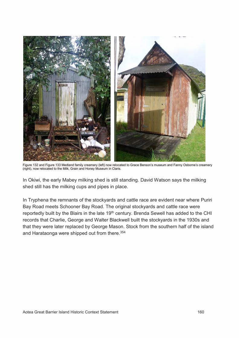
Aotea Great Barrier Island Historic Context Statement 160
Figure 132 and Figure 133 Medland family creamery (left) now relocated to Grace Benson’s museum and Fanny Osborne’s creamery (right), now relocated to the Milk, Grain and Honey Museum in Claris. In Okiwi, the early Mabey milking shed is still standing. David Watson says the milking shed still has the milking cups and pipes in place. In Tryphena the remnants of the stockyards and cattle race are evident near where Puriri Bay Road meets Schooner Bay Road. The original stockyards and cattle race were reportedly built by the Blairs in the late 19th century. Brenda Sewell has added to the CHI records that Charlie, George and Walter Blackwell built the stockyards in the 1930s and that they were later replaced by George Mason. Stock from the southern half of the island and Harataonga were shipped out from there.354

Aotea Great Barrier Island Historic Context Statement 161
Figure 134. Stockyards and cattle race in Puriri Bay. (Jonathan Arlidge).
5.9 Honey Production As part of subsistence farming, early settlers on Great Barrier Island began to produce honey to sell to the mainland. All of the early families were involved in beekeeping and producing honey. Weetman355 recorded that one settler had reportedly extracted 12,000lbs of honey from his hives, and another 8,000lbs during 1888. Some of the original honey sheds still exist on the island, some being relocated. This is still an industry that thrives on the island today with honey continuing to be exported to the mainland. The New Zealand Herald reported in 1916 that pohutukawa, along with tea tree and puriri and other native flowers “afford a rich harvest for the bees, and every homestead has it row of hives. In some instances, the honey is merely used for home consumption, but a large quantity is put on the market. As each hive represents a clear profit of £1 to 30s each season, this industry is one which well repays the apiarist for the small amount of work involved.”32
32 New Zealand Herald, 4 February 1916, p4

Aotea Great Barrier Island Historic Context Statement 162
Figure 135. Beekeeping:cutting out sections of honey c1920. (Auckland Libraries Heritage Collection AWNS-19200909-36-5).
In Tryphena, the Blairs, the Osbornes and the Blackwells were prolific in their production of honey. The Blackwells were among the first commercial apiarists. Originally building beehives of pit sawn timber, the Blackwells eventually built a sawmill powered by a waterwheel in the later decades of the 20th century to saw kauri. The Kauri was used to produce bespoke beehives. Before the end of the 20th century they possessed 500 hives and produced pohutukawa honey. They exported honey as far afield as England and in the later 1890s they are said to have shipped 10 tons of honey to London and greater New Zealand. The Blackwell honey making business was undertaken by all members of the family and they continued the tradition on their individual farms. Thomas Blackwell bought land in Kaitoke primarily for beekeeping. The original Blackwell honey house is still standing in Kaitoke. It has been added to and altered significantly, but the original form with its exterior chimney is still recognisable. The honey shed on the original Blackwell property in Tryphena has more recently collapsed.

Aotea Great Barrier Island Historic Context Statement 163
Figure 136. Blackwell honey shed in Tryphena . (Auckland Council, 2016).
Figure 137. Tom Blackwell’s honey shed in Kaitoke, later to become Walter Balckwell’s home. (Auckland Council 2017).

Aotea Great Barrier Island Historic Context Statement 164
Figure 138. A surviving example of Ernie Osborne’s honey shed, now relocated to the property once owned by Les Todd. (Courtesy David Watson) The Osbornes were also prolific honey makers. Fanny and Alfred’s sons, Ernest (Ernie) and Charlie were particularly productive. Ernie built a number of honey sheds around the island to help in his production. Two were based in Shoal Bay, and the others in Schooner Bay, Sugar Loaf and Medlands Beach, maintaining apiaries at these locations.33 The Shoal Bay sheds were relocated to Les Todd’s property in Mulberry Grove in the 1960s. Ernie’s shed on Medlands Beach was located in Joe Medland’s orchard near the Sugarloaf stream.34 In Okiwi, the Mabey honey house survives on the property still owned by the Mabeys. David Watson was informed by George Mason that the shed was built in 1934 by George along with Fred and Alan Mabey specifically for honey extraction. It later became a honey mead distillery for a while.
33 A tale of Two Families, p43 34 A tale of two families, p53

Aotea Great Barrier Island Historic Context Statement 165
Figure 139. Mabey honey house. (David Watson).

Aotea Great Barrier Island Historic Context Statement 166
6 CHAPTER SIX - WAYS OF LIFE
The broader Ways of Life theme covers a range of topics relating to activities within the community, including any development of churches and places of worship, educational facilities, community organisations, and places associated with remembrance of the past.
6.1 Religion and Worship Worshipping on the island was generally attended to in people’s homes or farm buildings or gardens, in the early settlement days of the Barrier. With only a small population spread over several remote communities, which were not connected by roading, it was impossible for one resident clergy to serve the entire island. Instead, at least from the 1880s, Great Barrier Island received visits from the Anglican Home Mission Clergy, who stayed in people’s homes as they travelled around the island to provide church services. Residents travelled (sometimes great distances) to one appointed home to attend these services. In these very early days, as travel to the island was difficult in itself, it appears this may only have been done three times a year.356 In February 1885, Reverend John Hazeldene reported that it was “very hard work travelling over the island and could not be done at all without the help of the settlers who seem to grudge no time spent in helping the minister.”357 Later, services were held in schoolrooms and then more recently in community halls. Even today churches are at a minimum on the island. In Grace Medland’s book she refers to early settlers in Tryphena meeting every week to worship since the early 1890s.358 The Sunday School conducted by Grace Medland held an annual picnic that was a big social event on the island.359 The first church to be built on the island was the Catholic church built for the timber workers at the Kauri Timber Company mill at Whangaparapara. Following the closure of the timber mill, the church was demolished, and the timber was reused to build a home near the harbour.

Aotea Great Barrier Island Historic Context Statement 167
Figure 140. Catholic Church at Whangaparapara, now demolished. (Auckland Libraries Heritage Collections 7-A10650) Other places of worship have arrived on the island in more recent times. The Church of Jesus Christ of Latter Day Saints in Okiwi is one of these. Also, the Orama Christian Community sits in Karaka Bay on the former Paddison property and is known as the Orama Oasis. It welcomes all religions and offers Sunday services in a chapel. Both of these have more contemporary buildings of worship. In Port Fitzroy a church hall was built in 1926 to provide a place for Sunday services, a school and community hall. The construction of the hall was requested as early as 1915 by the Reverend Trevor Gilfillian, Home Missioner at Coromandel and Great Barrier.360 Residents of Port Fitzroy were asked to contribute to a fund for this purpose. Although the request was granted by the Anglican Bishop, the First World War interrupted any further proceedings, delaying the construction of the hall until1926.361 The land for the hall was donated by the Warrens and the hall was built by locals by materials they provided. The building was reused as an army base mess hall during WWII and has since been adapted for use as the Port Fitzroy Boat Club. The original building has been extensively modified. However, the interior, with its trusses is still legible as a 1920s hall.

Aotea Great Barrier Island Historic Context Statement 168
Figure 141. The church hall when it was used by the army during WWII. (Garth Cooper Collection)
Figure 142. Former Church hall and school. (Courtesy Bob Shearing, April 2019) The only early traditional church on the island is St John’s Community Church in Medlands which caters for all religions. However, the church is not original to the island. The church was gifted to the Barrier people by the Anglican Parish of Kaitaia. Situated in Awanui, Northland, the church was found by the Rev. Ken Stoker in 1985/86. Rev. Ken Stoker was a minister from Waiheke Island, who, on every 5th Sunday travelled to Great Barrier Island

Aotea Great Barrier Island Historic Context Statement 169
to give services at Orama Christian Community, Fitzroy Hall, Claris Hall, Tryphena Hall, and Barleyman Cottage, Okupu.362 The history of the church started in October 1981, when the Great Barrier Island Interdenominational Church Committee was formed at a meeting held at the home of Beverley and Les Blackwell.363 The committee set about raising money for a church to be built and searching for land. The Methodist Church donated land they had been gifted by John Medland along Medlands Road close to the beach. Several designs were submitted for a church. The Committee also considered using an existing building, should a suitable one be found. The church found in Awanui was considered to be the best option. The church arrived on the island at the end of June 1986. The church was restored by locals and was dedicated on 30 November 1986.
Figure 143. St John’s Community Church. (David Watson).
6.2 Education The first schooling on Great Barrier Island took place at the remote Miners Bay village in the north west of the island. Few details are recorded, but in 1858 storekeeper Peter McDonald was teaching school on Sundays to the children (including his own) living in the

Aotea Great Barrier Island Historic Context Statement 170
village.364 It is possible that some form of schooling commenced as early as the 1840s and took place intermittently during the periods the mine was operational until the 1860s. Education on the Barrier was difficult because of the vast distances between the early settlements and the small number of children at each settlement who varied in age and requirements in schooling. More often than not, there were only up to three or less at each school. School rooms were normally a small shed like building attached to or close to a settler’s home. A teacher was expected to teach at more than one school, spending one week in one while the students home schooled in the other and then riding by horseback to another settlement to teach there. Isolation and a fluctuating population determined the need for schools in various settlements on the Barrier. At first schooling was undertaken by the earliest settler’s home schooling their children. This is evident in Emilie Malcolm’s journal.365 6.2.1 Tryphena School The earliest formal school building to be established on Great Barrier Island was at Tryphena in the 1880s. A site for the school, recommended by Mr Barstow was accepted by the Board of Education in 1883.366 The school at Tryphena was built in 1884 with 20 pupils.367 The first teacher was early settler, Mr Alfred Osborne. This school building is still extant. It was used as a school until 1939 when it closed due to the low numbers of pupils. Children were then home schooled or undertook correspondence schooling. It was not until 1962 that the current primary school was opened in Mulberry Grove on the shores of Tryphena harbour.
In 1973, the original school building was moved approximately 50m north of its original site on the same corner site. It is now used as a centre for the Aotea Family Support Group Charitable Trust.
Despite the number of years since the building was used as a school, there have been relatively few changes to the building fabric. The school is now slightly raised with base boards added and a small verandah has been added along with an accessibility ramp

Aotea Great Barrier Island Historic Context Statement 171
Figure 144. The 1884 Tryphena School in 1930. (Photograph, courtesy of Colin Davis, whose father Claude was teacher at the school in 1929-1930)
Figure 145. The former school building today on the relocated site. (Auckland Council, March 2018)

Aotea Great Barrier Island Historic Context Statement 172
A school teacher’s house was built adjacent to the school, although the date it was built is unknown, possibly in the early 1900s. It has since been relocated and highly modified. It is now part of the Arts Village at Claris.
Figure 146. The former school teachers house at Tryphena. (Auckland Council March2018).
Figure 147. The Tryphena school roll, 1884, which displays the children of the early Barrier families. (David Watson).

Aotea Great Barrier Island Historic Context Statement 173
6.2.2 Schools in Other Settlements In the northern part of Great Barrier Island there was a school at Katherine Bay, recorded as early as 1900.368 In 1920 the Education Board approved a new school building to be erected at Katherine Bay for up to 30 students to be schooled on a part time basis.369 In 1923, a request for a full-time school at Katherine Bay was declined. However, at that time, it was recommended a site be acquired for a new school in Katherine Bay.370 In 1931, newspaper reports indicate a new school was approved to be built in the area.371 In 1935 this school was opened.372 A board and batten school was built as is shown in the images below. Typical of a simple country school design at the time, the building has since been relocated and incorporated into the Kawa Marae. It is uncertain when the relocation occurred. Figure 148. Katherine Bay school typical of the country style school house of that era. (https://sites.google.com/a/aotea.org/don-armitage/Home/great-barrier-island-history/history-of-schools-of-great-barrier-island/catherine-bay-schoolD).

Aotea Great Barrier Island Historic Context Statement 174
Figure 149. Katherine Bay School possibly being relocated. (https://sites.google.com/a/aotea.org/don-armitage/Home/great-barrier-island-history/history-of-schools-of-great-barrier-island/catherine-bay-school). Other schools on Great Barrier Island arose as the population grew in other settlements.
Following the 1877 Education Act, making primary education in New Zealand “free, secular and compulsory”35, the settlers of Port Fitzroy formed a school committee, with John Moor as the manager. As a result, in September 1879, the first teacher, Mr Kinross was appointed to the island. Spending a week with each family, he schooled the Moor, Paddison and Flinn children. Later, Emilius Le Roy was to build a schoolroom on his property in Rarohara Bay for his children and the Warren children. It was reported in 1893, that Le Roy received a £10 grant to enlarge his schoolroom.373 The school was known as the Great Barrier School. A teacher attended the new classroom, on a part time basis so that other children in the area, such as the Moors, the Flinns and the Paddisons could also be educated. The schoolroom was attached to the store and post office that Emilius Le Roy operated and continued to run until 1927. In 1927, a church hall was built in Port Fitzroy which was also to be utilised as a school during the week. (Fig.142). However, with only a small number of pupils, between 8 and 9
35 The Education Act of 1877 allowed free, compulsory state education for children between the ages of 7 and 13.

Aotea Great Barrier Island Historic Context Statement 175
in the 1930s, the school closed at the beginning of WWII. (Refer Section 6.1 Religion and Worship). Alice Paddison worked as a teacher at Okiwi School in 1912 for the year it was open, schooling her three children there. They returned to the Great Barrier School along with the other children who attended the Okiwi School. Alice Paddison taught at this school and the Katherine Bay School on alternate weeks.374 At Oreville a school was opened around 1901 for the children of the miners.375 Mining in the area began at the end of the 19th century and continued until 1919. At its peak, in the early 1900s, the school is reported to have had 50 pupils376, making it the largest of the early schools on the Barrier. It is believed to have closed down in 1908 following the closure of the Barrier Reefs Gold Mining Company in 1902. When a new company took on the mine, it appears the mining town applied for a new school.377
Figure 150. This image is believd to be the former Oreville school. (Source unknown) In Whangaparapara a school opened for the children of the Kauri Timber Company mill workers around 1909-1910. The school operated during the time the mill was in operation, eventually closing. The school house was still standing until the 1990s, but fell into disrepair and after severe flood damage, was demolished.

Aotea Great Barrier Island Historic Context Statement 176
Figure 151.Whangaparapara School n.d (Molly Elliott) In the settlement of Okupu, another school was opened around the early 1920s for the Sanderson family. At this time the schools in Okupu and Tryphena were operated as part-time schools with the teacher travelling between the two.
Figure 152. The school at Okupu with three of the Sanderson family children in 1929. (Photograph, courtesy of Colin Davis, whose father Claude was teacher at the school in 1929-1930)
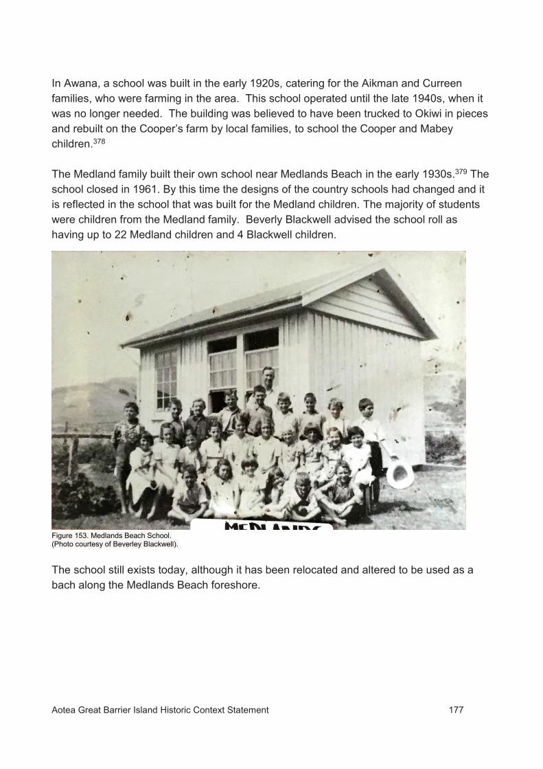
Aotea Great Barrier Island Historic Context Statement 177
In Awana, a school was built in the early 1920s, catering for the Aikman and Curreen families, who were farming in the area. This school operated until the late 1940s, when it was no longer needed. The building was believed to have been trucked to Okiwi in pieces and rebuilt on the Cooper’s farm by local families, to school the Cooper and Mabey children.378 The Medland family built their own school near Medlands Beach in the early 1930s.379 The school closed in 1961. By this time the designs of the country schools had changed and it is reflected in the school that was built for the Medland children. The majority of students were children from the Medland family. Beverly Blackwell advised the school roll as having up to 22 Medland children and 4 Blackwell children.
Figure 153. Medlands Beach School. (Photo courtesy of Beverley Blackwell). The school still exists today, although it has been relocated and altered to be used as a bach along the Medlands Beach foreshore.

Aotea Great Barrier Island Historic Context Statement 178
Figure 154. The Medlands Beach School today. (Auckland Council, March 2018).
Community Facilities and Organisations 6.3.1 Public Halls The construction of schools, the church in Whangaparapara, and the church hall in Port Fitzroy, provided multifunctional purposes, including being used by the community for meetings and events. Prior to their construction, the local communities on the Barrier used each other’s homes and gardens for community purposes. Until more recent times, purpose-built community facilities were not a consideration of the local population.

Aotea Great Barrier Island Historic Context Statement 179
In Claris, a hall was built during WWII by the army as a drill hall to provide for a large army camp nearby. After the war it became a hall for the community. It is believed it was moved around the 1980s to Awana Bay. It appears to be intact, with little alteration.
Figure 155. The former army drill hall now located at Awana. (Auckland Council, 2017).
There is now a community hall at Tryphena which houses the Barrier’s Roll of Honour. The scrollwork on this memorial were completed by Tom Ryan’s nephew Darby, who was an accomplished artist.380
6.3.2 Community Organisations In early settlement days there was a small following of the Presbyterian temperance group Band of Hope. This included social gatherings with entertainment. The extent of the popularity of this group on the island has not been researched, but it is believed to have some interest. In 1948, the Awana Branch of Women’s Division of Federated Farmers was formed for farming wives who lived between Port Fitzroy and Tryphena.381 Originally held in member’s homes, and later, also halls, the branch organisation was bequeathed the Okupu home of Tom Barleyman when he died. Following the renovation of the place, they held their first meeting there in 1979.382 The group raised money for various needs around the island, and elsewhere and held social gatherings. They have since rebuilt a cottage on the land bequeathed to them.

Aotea Great Barrier Island Historic Context Statement 180
6.3.3 Entertainment and Sports Since the early days of European settlement on the island there has been a number of social activities that have occurred in the various settlements. Frequently, settlers travelled far and wide to attend sophisticated parties with feasts and dancing, often taking place in wool sheds, festively decorated for the purpose. The newspaper, the Observer reported many such events. Figure 156. A report on a dance at John Ryan’s woolshed (Observer, 31 October 1891) Other social outings included public picnics in various parts of the island. Grace Medland recalls an annual picnic in Tryphena, organised by a formal committee took place with games and competitions until the First World War intervened.383 On St Patrick’s Day, horse racing on Kaitoke Beach was an annual event384 until a real race horse was introduced by someone from the Oreville township. Uneven odds and the serious turn of this annual race brought this event to an end. On a number of settler farms were tennis courts, particularly in the northern and central settlements. Tennis sessions were popular on weekends as a social gathering. There may be some evidence of former tennis courts on the island, but these have not been sited.

Aotea Great Barrier Island Historic Context Statement 181
Figure 157. Tennis outing at Whangaparapara c.1910 (Alexander Turnbull Library Ref: 1/2-000102-G.).

Aotea Great Barrier Island Historic Context Statement 182
6.4 Remembering the Past 6.4.1 Shipwrecks and other maritime incidents There have been approximately 4436 recorded shipwrecks around the coastline of Great Barrier Island. A number of vessels have also lost in unknown locations offshore with wreckage coming ashore on the island. Other vessels have been involved in incidents but have been salvaged or refloated. A small number of vessels have been abandoned or dumped onshore on the island as unseaworthy hulks. 37
There have also been a number of other maritime incidents of various kinds that have resulted in loss of life.
The best known shipwrecks on Great Barrier Island are those of the ss Wairarapa (1894), and ss Wiltshire (1922). The relatively recent (1989) wrecking of the Rose-Noelle on Great Barrier is also widely known. For additional information on these and other wrecks referred to below, and other wrecks around Great Barrier Island see Armitage 2010a385 and https://sites.google.com/a/aotea.org/don-armitage/Home/great-barrier-island-history/shipwrecks--scuttlings. 6.4.1.1 Ss Wairarapa (1894) Miners Head UID 02166; CHI 9471 The ss Wairarapa sank with the tragic loss of around 140 passengers and crew after striking the shoreline near Miners Head in 1894. The exact number will never be known because of discrepancies between the passenger list and those known to have been on board the vessel. Most of the victims were transported for burial on the mainland. An estimated 60 unidentified victims of the sinking are buried in two groupings of graves on the island, at Tapuwai point at the north end of Whangapoua beach, and at Onepoto in Katherine Bay. The Wairarapa shipwreck remains one of New Zealand’s worst maritime disasters, with the death toll only exceeded by the loss of HMS Orpheus in 1863 and the ss Tararua in 1881. The wreck site is scheduled in the AUP.
36 Armitage (2010a) lists 54 but this includes vessels that were salvaged. 37 For example the derelict dredge grabber hopper Wanganui at Whangaparapara (see also Error! Reference source not found.).

Aotea Great Barrier Island Historic Context Statement 183
6.4.1.2 Ss Wiltshire, (1922), Rosalie Bay UID 02167; CHI 9475; T09_201 The Wiltshire was a steel twin-screw five-masted insulated cargo steamer of 12,169 tons gross. It was driven ashore at Rosalie Bay. The wreck is notable because of the large size of the vessel, and in particular the efforts of rescuers who were able to get the entire complement of 103 ashore onto the adjacent cliffs without loss of life. One of the ship’s anchors that has been removed from the wreck and is at Whangaparapara. The wreck site is scheduled in the AUP.
6.4.1.3 Rose-Noelle (1989), Little Waterfall Bay The Rose-Noelle was a 12.65 m trimaran which came ashore on a reef off Little Waterfall Bay on the east coast of Great Barrier Island after drifting for 119 days and some 1900 miles upside down. After capsizing during in a storm on route to Tonga, the crew sought shelter in the aft cabin and all survived the ordeal. Their story was so remarkable that it was initially received with scepticism by some members of the public. Other wrecks of historic heritage significance The wrecks listed below are known to, or potentially have, surviving evidence of the event in the form of wreckage of the vessel or graves of victims. They have not been evaluated but are considered to potentially be of some historical or other significance to Great Barrier Island.
6.4.1.4 Rory O'More (1843), Rory Bay CHI 11; S08_456 Rory O’More, reg.1/1842 Port of Auckland, was a small locally built schooner 41.5 ft in length and of 22 tons register. It was the first ship constructed on Great Barrier and was built by Jeremiah Nagle at Nagle Cove and launched on 10 October 1841.386 The vessel serviced the copper mine at Miners Head, transporting copper ore for the Great Barrier Mining Company between the mine and transport ships waiting in Port Abercrombie, for export to overseas markets. In October 1843 the vessel foundered at the entrance to the harbour whilst carrying 30 tons38 of ore destined for the brig Tryphena.387 The precise location of the wreck site is presently unknown, but it sank in what became known as Rory Bay, near Nagle Cove, 38 Southern Cross says 20 tons

Aotea Great Barrier Island Historic Context Statement 184
coincidentally very close to where it was built. Although no longer known by this name it is the bay inside Okokewa Island.388 The cargo that was being carried (copper ore) should make the wreck site readily identifiable using remote sensing techniques such as side scan sonar or magnetometer survey. 6.4.1.5 Maggie Robertson (1878) CHI 891 The schooner Maggie Robertson reg. no. 57833 sank off Wellington Head on the southeast side of the entrance to Port Abercrombie on 27 October 1878.389 The vessel developed a leak in a gale and sank before it could be driven ashore. No lives were lost. The precise location of the wreck is presently unknown. However, the vessel was carrying a load of manganese ore39 and is likely to have sunk in intact condition so substantial remains of the ship may be present at the wreck site and may be able to be located using remote sensing techniques. 6.4.1.6 Zillah (1889) CHI 486 & 16557 The ketch Zillah was wrecked in a storm on the east coast of Great Barrier on 2 June 1889, with the loss of two lives. Zillah, reg. no. 75117, was a vessel of 36 tons and 54.4ft.in length with a beam of 16.2ft. The location of the wreck and grave sites are currently unknown. The vessel is recorded as having struck rocks between the Onawa [presumably Awana] Creek and the residence of Mr Palmer, at Korotete [Korotiti], near Palmers Point.390 However, there is some evidence to suggest that the wreck and victims came ashore closer to Korotiti Bay further north. A piece of wreckage, possibly from the vessel, has been recorded in this vicinity. 6.4.1.7 Whaleboat (1892) The owner of Kaikoura Island, Allen Taylor, and Charles Harvey, a visitor to the island, were drowned when the whaleboat they were in capsized and sank on 4 December 1892. The boat, which was ballasted with iron, sank about 400 yards off the island during a circumnavigation of Kaikoura Island. Allen Taylor is buried at the Karaka Bay burial ground. Charles Harvey was buried at Purewa burial ground (Auckland). Taylor’s brother survived the sinking.391 The exact location of the wreck and its condition are unknown.
39 Not likely to be from Great Barrier, possibly from Waiheke Island
Aotea Great Barrier Island Historic Context Statement 185
6.4.1.8 Rapid (1864) The schooner Rapid capsized in a gale on its maiden voyage from Mercury Bay to Auckland in March 1864. In the days following the capsize four of the nine crew/passengers on board survived by clinging to the rigging in a remarkable tale of human endurance. The vessel eventually came ashore just inside the entrance to Whangaparapara Harbour. One passenger who had managed to survive the ordeal drowned attempting to get to the shore. He was buried somewhere at Whangaparapara along with another passenger (the owner of the vessel) who had drowned in the cabin during the initial capsize. The tragedy is remembered through the naming of Rapid Bay, where the vessel floated ashore. The vessel itself was subsequently righted and repaired. The location of the graves is currently unknown. 6.4.2 Cemeteries and Burial Sites On the island there is a Pioneers Cemetery along with a number of burial grounds and graves on private properties. Because of the historic isolation of some of the communities on the island, and the logistics of burying people there are a large number of scattered grave sites and in some cases unmarked graves around the island, some in places that are still inaccessible by road. The locations of a number of interments are currently unknown. As noted earlier there are a number of urupā and isolated Māori burials recorded or known on Aotea Great Barrier, and others are certain to exist.
6.4.2.1 Pioneer Cemetery The most public cemetery is the Pioneer Cemetery in Tryphena which houses the Blackwell family. Located opposite the harbour, the Pioneer Cemetery is at the rear of the public cemetery in Tryphena.392
The first grave in the cemetery is that of Susan Cozens, (the daughter of George and Elizabeth Blackwell) who died on 21 October 1911. Her mother died less than two weeks later on 2 November 1911.

Aotea Great Barrier Island Historic Context Statement 186
Figure 158. Pioneer Cemetery in Tryphena. (Auckland Council, March 2018). Figure 159. Marble headstone for Susan Cozens (nee Blackwell). (Auckland Council, 2018).

Aotea Great Barrier Island Historic Context Statement 187
6.4.2.2 The Osborne Graves In Tryphena, there are a number of grave sites that are on private properties. On the former Osborne property there is a commemorative cairn marking the burial ground of a number of family members. There are no individual headstones. Surrounded by a picket fence, the cairn has a plaque that reads: "In memory of the ancestors who pioneered this land and who are buried in this plot. Alfred Joe Osborne died 1920 aged 73, his wife Fanny died 1933 aged 81. Also son, Albert Nigel, daughter-in-law Eliza Osborne, wife of Harry died 1914, son-in-law Edward Hartwell, husband of Ellen died 1937. This plaque was donated by a representative section of the grand children of Joe and Fanny and erected by David Dodd present owner of the property 1984." 393
Figure 160. Osborne Family burial ground in Rosalie Bay Road. (Auckland Council, 2016)
6.4.2.3 The Bailey Alcock Graves Another burial ground in Tryphena located on private property is the early settler Bailey and Alcock burial ground at Puriri Bay. Containing 8 headstones of marble and granite. The earliest being that of Robert Bailey who died on 1 November 1907.394 These graves are now severely overtaken by vegetation and require some work done to clear the area. Originally, they were enclosed in a picket fence, which has disappeared under the extensive overgrowth.

Aotea Great Barrier Island Historic Context Statement 188
6.4.2.4 The Blair Graves Also, at Puriri Bay is the burial ground of the Blair family. This site is west of the former Tryphena Post Office near the junction of Schooner Bay Road and Tryphena Harbour Road. Like the Osborne burial ground there are no headstones, only a commemorative cairn within a picket fence. A plaque reads “Sacred to the memory of John 1820-1892, his wife Jean 1817-1900, and their children, Thomas 1850-1880, Peter 1852-1853, Agnes 1857-1859, Mary 1859-1860, John 1844-1909 and his wife Agnes Mckay1853-1913 and their children, John Maxwell 1876-1900, Robert James 1875-1910, Stevenson Septimus 1888-1888.” This site has not been visited since 1992 and it is uncertain what condition it will be in. 395
6.4.2.5 Other Known Tryphena Graves Other graves in Tryphena include that of Robert Taylor who was murdered in his home on 19 June 1886. The grave site is inland from his former home in Taylor’s Bay.396 In Shoal Bay is the grave site of Mary Davids who died on the 31 May 1867. She is believed to be buried on land close to the wharf at 32 Shoal Bay Road.397 6.4.2.6-Medland Graves At Medlands Beach on the corner of Medland Road and Oruawharo Lane, CHI records the grave sites for Tom and Elizabeth Medland who died in 1920 and 1952 respectively. There are no headstones to mark this site and it needs to be determined if they are actually buried here.398
6.4.2.7 Claris A Sanderson burial ground is located in Claris for 3rd generation Sandersons, including Great Barrier Island identity, Hector Sanderson. In Claris, there is also a commemorative plaque for Bill Claris, the engineer who was largely responsible for the construction of the airfield and who died in a plane crash on the airfield.
6.4.2.8 Blind Bay Sanderson Graves In Blind Bay, there are the graves of William and Annie Sanderson on their former farm property. These graves are unmarked.399 The grave of gum digger, Cecil Leslie Rowland Smith, is also located in Blind Bay above Blind Bay Road. There Is a marble headstone with the inscription “Leslie Rowland Cecil, third son of J.E Smith of Bower, Queensland, who died suddenly at Okupu on the 2nd

Aotea Great Barrier Island Historic Context Statement 189
October 1895, aged 22 years.” It is believed Cecil died from suffocation as a result of suffering from a seizure (Refer Section 5.4.7 Gum digging camp and grave). Cecil’s parents are thought to have paid for the headstone.400 6.4.2.9 Whangaparapara A public burial ground at Whangaparapara dates back to 1895 with the grave of early settler Paul Silva. Across the harbour to the west of lighthouse point is another historic burial ground with graves that are unmarked but are clearly of an early vintage with concrete edging and hoops of wrought iron 0.5m high with pointed iron corner posts. 401
6.4.2.10 Awana In Awana, above the O’Shea house are the graves of three Austrian gum diggers who were swept away by a flood in 1907. The graves are commemorated with a headstone which reads “Pasko Prienda aged 45 Ivan Simich aged 34 Nikola Cvitanovich aged 18 Who were accidentally drowned by The Great Flood at Great Barrier Island February 14 1907”.402 (Refer Section 5.4.8 Gumdiggers graves Awana). 6.4.2.11 Alcock - Overton Graves In Harataonga are the Alcock and Overton family graves on the hill to the south east of the former Alcock homestead. The earliest grave is that of Susannah Alcock who died on 19 December 1882.403 This site is in good condition.
Figure 161. Settlers graves at Harataonga. (Auckland Council, 2016).

Aotea Great Barrier Island Historic Context Statement 190
6.4.2.12 Okiwi Along Aotea Road in Okiwi is the burial ground for the early settler Cooper and Sanderson families. This is a large burial ground with 21 graves recorded, the earliest being that of Elizabeth Stark, formerly Elizabeth Cooper, who died on 21 February 1902. This is located near where the Cooper’s homestead was situated.404 Near the Mabey homestead at Whangapoua Beach is the grave of Jane Edlington who died in 1899.405 The headstone reads “Jane wife of Alfred Edlington Died 24 May 1899 Aged 49.” Jane married Alfred Edlington who had come to Great Barrier Island in the 1860s to work in the copper mine. When the mine closed Alfred took up land at Whangapoua Beach and built their home. Members of the Mabey family who settled on the property after Alfred died are also buried on what is still the Mabey property.
Figure 162. Jane Edlington’s grave at Whangapoua. (https://sites.google.com/a/aotea.org/don-armitage/Home/great-barrier-island-history/cemeteries-and-gravesites-of-great-barrier-island/whangapoua-beach
6.4.2.13 Port Fitzroy At Wairahi Bay near Port Fitzroy are the graves of John Flinn’s wife Annie and their daughter. A single headstone reads “Annie Sanderson, the beloved wife of John Thomas Flinn died July 25 1893 aged 30 years. Also, their infant daughter Ann Winifred died July 28 1893 aged three months.” The graves are reasonably close to where the Flinn homestead stood.406

Aotea Great Barrier Island Historic Context Statement 191
In Kaiarara Bay are the graves of an island identity, Girlie Le Roy and her sister Ada. A plaque reads “Agnes Dalziel Le Roy (Girlie) daughter of Emilius and Elizabeth, 1912-1979 ending 100 years of Le Roy settlement on their property. Also, Ada Marie Moor daughter of E. and E. Le Roy1883-1979.”407 In Karaka Bay there is an historic burial ground which contains some of the earliest settlers from this part of Great Barrier Island. This is on the site of the former Paddison farm. Edward Paddison had come to Great Barrier Island in the 1850s to work in the copper mine and had remained on the island following the mines collapse. He is buried here with his family and fellow early settler neighbours, John and Susan Moor. The earliest grave recorded there is that of Allen Ashlin Taylor, who drowned in 1892. Although he was not a member of the Paddison or Moor families, his wife Susan’s father, Charles Ellis was a close friend of Edward Paddison. Allen was also a close friend of William Moor (John and Susan’s son) who is also buried here. A number of graves are unmarked.408
6.4.2.14 Quoin Island (aka Grave Island) The remainder of the Flinn and Le Roy family are buried on Quoin Island, located in the middle of Rarohara Bay, Port Fitzroy. Once used as a cemetery for the Port Fitzroy community, the earliest burial is noted as being that of Vera Le Roy who died on 20 September 1886. Early settler, William Flinn (d.1918) and his wife Charlotte (d.1925) are buried here with their children. Some graves have headstones, but many are only marked depressions. There are concrete steps leading up from the foreshore of the island to the ground surface. This site has not been visited and it is not known what state the graves are in.409
6.4.2.15 SS Wairarapa mass graves Around 140 passengers and crew lost their lives when the ss Wairarapa sank at Miners Head in 1894 (Refer 6.4.1.1). Of the bodies that were found and identified, 21 were transported to Auckland for burial on the mainland. There were approximately another 60 bodies that could not be identified. The majority were buried in mass graves in two locations, in Katherine Bay and Whangapoua beach. In Katherine Bay there are 44 graves of unidentified victims. The graves are located on the beach front within an enclosed picket fence in the Onepoto Reserve. There are another 14 graves located on the other side of the island at Whangapoua Beach near Tapuwai Point also surrounded by a picket fence. While both of these grave sites are recorded in the CHI, there are other grave sites in Karaka Bay,

Aotea Great Barrier Island Historic Context Statement 192
Harataonga and Arid Island.410 In 1894, the following was recorded regarding the various burial places. “There are five burial grounds in five different places, the principal one being at Māori Bay, in a very pretty spot. It is now a very difficult matter to remove any body, and no doubt all the dead will be allowed to finally repose in their present resting places on the Barrier. The burial ground at Māori Bay (Kawa) is Māori property, and by Māori Law the bodies must not be touched for twelve months. Steps should be at once taken to fence these burial grounds. The cemetery at Karaka Bay, Port Fitzroy (Mr Paddison’s place), will be surveyed as soon as an authorised surveyor visits the island, and will then be made over to the Anglican Church. The burial ground at Whangapoua, (Mr Eglington’s property), can also be conveyed to the Church as a burial ground for ever.”411 “At Arid Island there is only one grave, that of the ship’s boy McDonald. At Harataonga there is also only one body buried. I hope that fences will be placed round these graves; or perhaps in time the bodies should be removed to the Whangapoua cemetery.”412
Figure 163. Burial ceremony at Katherine Bay for unidentified victims in 1894. (Auckland Libraries Heritage Collections, 581-6944)

Aotea Great Barrier Island Historic Context Statement 193
Figure 164. Burial site in Katherine Bay prior to being fenced in 1894. (Auckland Libraries Heritage Collections, 581-6934).
Figure 165. SO Plan 20107 showing the graves at Onepoto as surveyed in 1918.

Aotea Great Barrier Island Historic Context Statement 194
Figure 166. Burial site for unidentified victims of Wairarapa shipwreck at Whangapoua Beach after fencing completed c 1890s. (Auckland Libraries Heritage Collections, 1370-200-1).
6.4.2.16 Recorded interments, location unknown These are a number of recorded interments on the island where the locality is known but not the specific site of the grave/s. The nearest known cemetery is identified in some cases below because some early cemeteries may have been established near existing/earlier isolated graves. HMS Tortoise Graves, Nagle Cove The Admiralty spar ship HMS Tortoise was anchored at Nagle Cove in Port Abercrombie from 7 June 1842 until 1 January 1843. The deaths of two crew members were recorded during this time. James Hanney, a Gunner’s Mate, died on 11 August 1842 after a long illness. Then on 22 October 1842, a cutter from the ship was sent to a Māori settlement at Susan’s Bay to purchase pigs. The cutter was swamped and sank near a small island, drowning one of the crew, Thomas Anderson. This island is understood to be Wood Island, which lies just

Aotea Great Barrier Island Historic Context Statement 195
off Susan’s Bay. Susan’s Bay is un-named on modern maps but is shown on a chart drawn during the Tortoise visit and is located between Karaka Bay and Mohunga Bay. It is likely that both individuals were buried in the same location somewhere near the Tortoise anchorage in Nagle Cove. The location of the graves is presently unknown. Oyster Island would have possibly been a convenient site. The nearest known burial ground is at Karaka Bay.413 Rapid graves, Whangaparapara Two of the victims of the Rapid tragedy (Refer 6.4.1.8) were buried somewhere at Whangaparapara. They are Joseph Pagitt (aka Paget) and Robert Clarke. Pagitt was the owner of the vessel. Both were passengers. The nearest burial ground is in a small bay inside Lighthouse Point.414 Zillah grave/s, east coast between Korotiti and Palmers Point The victims of the 1889 Zillah shipwreck (Refer 6.4.1.6) were interred at the beach where the deceased came ashore on the east coast of Great Barrier Island. The bodies of John Sena (master), and the mate John Inchle were found some time after the event and buried by locals in a large grave at the beach. The grave was topped with a cairn of stones to mark the spot in the event of the bodies being exhumed at a future occasion.415 No record has been found to indicate that this (exhumation and reburial) occurred. The specific location is unknown but is likely to be north of Palmers Point where the vessel sank (possibly well north closer to Korotiti due to the prevailing south-easterly conditions at the time). No subsequent reference to the grave has been located. It is uncertain whether the deceased were exhumed and reburied elsewhere, and if not, whether the grave and cairn still exist. Tom Fouhy, Whangaparapara Tom Fouhy, an Irish gumdigger, was killed when a dead tree fell during the night on a tent he was sharing with Charles Jones. The incident occurred close to ‘Mangopeko dams’, about 2 miles from Whangaparapara on 6 March 1881. Fouhy was buried at the scene of the accident.416

Aotea Great Barrier Island Historic Context Statement 196
Thomas Stratton In Rosalie Bay, there is a grave, possibly unmarked, for Thomas Stratton who died on 30 August 1866, after falling from a cliff following a bullock hunting expedition near Rosalie Bay with friends. After conveying the bullock down the cliff, Thomas Stratton attempted to descend the cliff and fell to his death. He was taken the next day to Rosalie Bay to be buried.417

Aotea Great Barrier Island Historic Context Statement 197
References and abbreviations
Abbreviations
AJHR Appendices of the Journals of the House of Representatives
AWMM/L Auckland War Memorial Museum/Library
DARPS Draft Auckland Regional Policy Statement Historic Heritage Schedule
GBIHRG Great Barrier Island History Research Group
Newspapers Auckland Star
Auckland Weekly News
Colonist
Daily Southern Cross
Evening Post
Grey River Argus
Lyttelton Times
Nelson Examiner and New Zealand Chronicle
New South Wales Examiner
New Zealand Herald
New Zealand Herald & Auckland Gazette
Observer
Otago Witness
Press
Sydney Morning Herald
The Times
Te Aroha News
Thames Star
Thames Advertiser

Aotea Great Barrier Island Historic Context Statement 198
Tasmanian News
Waihi Daily Telegraph
Published and unpublished works Allom, Barrie 2004. Dear Tyrant: An Extraordinary Colonial Life. Wairarapa Archive, Masterton in association with Fraser Books.
Armitage, Don (ed) 2001. Great Barrier Island, Canterbury University Press.
Armitage, Don (ed.) 2010 (a). Great Barrier Island Shipwrecks. Don Armitage, Whangarei in association with the Great Barrier Island History Group Inc.
---------------------2010. Captain John Gillies. Don Armitage, Whangarei, in association with the GBIHG.
-------------------- 2016. True Tales of Great Barrier Island, JOP, Whangarei
----------------------n.d. Aotea.org website. https://sites.google.com/a/aotea.org/don-armitage/Home/great-barrier-island-history/shipwrecks--scuttlings .
Appendices of the Journals of the House of Representatives 1879 Section H10 page 26 Return of Wrecks.
Auckland Regional Council 2009. Draft Auckland Regional Policy Statement. Schedule of Regionally Significant Historic Heritage.
Bambridge, William, Journal 9-10 December 1847. MS-463 AWMML; qMS-0122-187 ATL.
Banfield, Colin C. 1978 Sowers of Seed A Story of the Anglican Church on Waiheke Island, With references to Great Barrier Island
Barstow, Robert Clapham 1850. Letter written to his father from Mulberry Grove, Tryphena on 10th December, 1850. Published electronically at:https://sites.google.com/a/aotea.org/don-armitage/Home/great-barrier-island-history/robert-clapham-barstow---letters/from-great-barrier-island---last-half-of-1850
Bush, Graham W A. 1991 Advance in Order, The Auckland City Council from Centenary to Reorganisation 1971-1989. Auckland City Council.
Butts, David and Roger Fyfe 1978. Report on the Kaitoke-Harataonga Archaeology Site Survey, Great Barrier Island. Unpublished report, New Zealand Historic Places Trust.
Cameron, E.K. 1990. Vascular plants of the main northern Mokohinau islands, north-east New Zealand. Tane 32:113-130.
Coster, John and Gabrielle Johnston 1975. Report on the Kaitoke-Harataonga archaeological site survey, Great Barrier Island for the New Zealand Historic Places Trust. NZ Historic Places Trust, Auckland.

Aotea Great Barrier Island Historic Context Statement 199
County of Great Barrier Island 1976. District Planning Scheme.
de Lange, Peter J., Ian McFadden, and Ewen K. Cameron 1995. Preliminary report of the flora and fauna of Fanal Island, Mokohinau Islands Nature Reserve. Science and Research Series No. 94. Dept. of Conservation, Wellington.
Diamond, J.T. and B.W. Hayward n.d. Kauri Timber Dams. Lodestar Press, Auckland.
Dieffenbach, Ernest 1843. Travels in New Zealand [Vol.I] [Capper reprint, 1974] - Part II.
Dodd, Andy, 2007. Te Maraeroa Flat, Little Barrier Island: Heritage Assessment. Department of Conservation, Auckland.
Elliott, Molly G.1971. Island on the Skyline Great Barrier Island, A.H.& A.W. Reed Ltd, Wellington.
Flemming, C.A. 1950. The Geology of the Mokohinau Islands, North Auckland. Transactions and Proceedings of the Royal Society of New Zealand Vol. 78: 255-268.
Great Barrier Island County 1986. District Scheme.
The Great Barrier Island History Research Group Inc. (Compiled by) 2011. True Tales of Great Barrier Island, Jeff Oliver Print Ltd, Whangarei.
The Great Barrier Island History Research Group Inc. (Compiled by) 2014. More True Tales of Great Barrier Island, Jeff Oliver Print Ltd, Whangarei.
Goulding, Jeanne H. 1983. Fanny Osborne’s Flower Paintings. Heinemann, Auckland
Heritage New Zealand New Zealand 2008. Te Pa a Wana wahi tapu area (NZ List number 7775) registration entry
Johnson, R. 1999. Historical Report on the Crown Acquisition of Hauturu (Little Barrier
Island): A Report Commissioned by the Waitangi Tribunal. Unpublished report to the
Waitangi Tribunal.
Lang, John Dunmore 1839. New Zealand in 1839: or Four, Letters, to the Right Hon. Earl Durham, Governor of the New Zealand Land Company , &c. &c. &c. On the Colonization of that Island, and on the Present Condition and Prospects of its Native Inhabitants. Smith, Elder & Co., London.
Law, Garry 1972. Archaeology at Harataonga Bay, Great Barrier Island. Records of the Auckland Institute and Museum 9:81-123.
Luff, Helen 2003. Tales from Great Barrier Island. David Ling Publishing, Auckland.
Mahoney, Paul 2004. The Era of the Bush Tramway in New Zealand. Transpress, Wellington.

Aotea Great Barrier Island Historic Context Statement 200
----------------------n.d. 'Bush trams and other log transport - Curves, trestles and inclines', Te Ara - the Encyclopedia of New Zealand, http://www.TeAra.govt.nz/en/bush-trams-and-other-log-transport/page-5 (accessed 10 October 2018).
Malcolm, Emilie Monson,1904. My Own Story; An Episode in the Life of a New Zealand Settler of 50 Years Back.
Māori Land Court 1999. Status of land - investigation of customary title - Great Barrier Islands. 25 Tai Tokerau MB 212. 23 February 1998. http://Māori lawreview.co.nz/1999/10/october-1999-contents/
Maxwell, Ian 2018. World War Two defences of Great Barrier. Unpublished manuscript. Copy held by Auckland Council.
McDonald, Peter 1858. Great Barrier Island journal. GNZ MSS 191(1), Auckland Libraries.
McMath, Te Witi 1995. Investigation of title to the offshore islands, islets, and rocks off the coastline of Aotea (Great Barrier Island). Evidence for and behalf of the Ngati Wai Trust Board. Appendix to the Waitangi Tribunal Ngātiwai Mandate Inquiry. Report WAI 2561. Waitangi Tribunal 2017.
Medland, G.M, 1969. Great Barrier Calls, The Institute Printing and Publishing Society Ltd, Auckland.
Moor, Cyril. 1987 Early Settlement of Port Fitzroy Great Barrier Island.
Moore, P.R. 1985. Archaeological sites and obsidian deposits on the Mokohinau Islands, Hauraki Gulf. Tane 31:75-84.
---------------- 1991. Archaeological features related to copper mining (1842-1867) at Miners Head, Great Barrier Island. Tane 33:147-156.
----------------- 2013. Obsidian sources of the Coromandel Volcanic Zone, Northern New Zealand, Journal of the Royal Society of New Zealand 43:1pp.38-57.
Robinson, Howard. 1964 A History of the Post Office in New Zealand, R.E Owen, Government Printer, Wellington.
Spring-Rice, Wynne 1963a. Great Barrier Island. NZ Archaeological Association Newsletter 5:92-5.
------------------------------------b. Harataonga, Great Barrier Island. New Zealand Archaeological Association Newsletter. 6(1):24-27
Tatton, Kim 1994. Aotea: nga unahi me nga taratara o Te Ika roa a Maui = The scales and spines of Mauis fish: the settlement archaeology of Aotea. Thesis (MA Anthropology), University of Auckland.

Aotea Great Barrier Island Historic Context Statement 201
Waters S.D.1956. The Royal New Zealand Navy. Part of: The Official History of New Zealand in the Second World War 1939–1945. Historical Publications Branch, Wellington.
Watson, David. Nd A Tale of Two Families, The Pioneer Blackwell and Osborne Families of Tryphena Great Barrier Island.
------------------------------2008. Dairy Farming on Great Barrier Island.
------------------------------2014. Ye Olde Barrier Scrapbook..
Weetman, Sydney 1886. Notes on some Moa Remains found at the Great Barrier Island during February, 1886. Transactions and Proceedings of the Royal Society of New Zealand Volume 19, 1886:193-4.
------------------------- 1889. Notes on the Great Barrier Island. Transactions and Proceedings of the Royal Society of New Zealand Volume 22, 1889:79-84.
Wright, A.E. 1980. Vegetation and flora of Fanal Island, Mokohinau Group. Tane 26:25-43.
ZC1 Radio Club website http://www.zc1-radioclub.org.nz/Radar.html

Aotea Great Barrier Island Historic Context Statement 202
Endnotes 1 Lovegrove 2004 2 (Crook 1973), 3 (Heaphy 1842:27). 4 (Collins et al 2014). 5 Luff 2003:12; McMath 1995:2 6 (Best 1934:22) 7 (Luff 2003:12) 8 (McMath 1995:9) 9 [CHI20031]) 10 (e.g. Barstow 1850; ML 2163 [1870]; SO 1498 [1877]) 11 (Weetman 1889:83). 12 (Spring-Rice 1963a, b) 13 Coster and Johnston, p11 14 (Butts and Fyfe 1978:11). 15 (Weetman 1886, 1889) 16 (Law 1972). 17 (CHI 17251/ S08_471) 18 (McMath 1995:4). 19 Auckland Star, 4 September 1896, p2 20 Medland, GM, Great Barrier Calls, p53 21 New Zealand Herald, 2 October 1912, p7 22 New Zealand Herald, 16 July 1913, p6 23 Ibid 24 Ibid 25 Auckland Star, 15 August 1913, p2 26The Barrier Bulletin, August 1989, Issue no 173; Bush, p406 27 Appendix of the Journal of the House of Representatives 1866, Session 1, D-03, Nominal Return of all Officers in the Employ of the Government 28 Auckland Star, 18 April 1871, p2 29 Observer, 31 March 1894, p8 30New Zealand Herald, 1 December 1914, p4 31 Observer, 13 December 1913, p30 32 https://www.thebarrier.co.nz/History/LeRoyFamily.htm accessed 9 July 2018. 33 More True Tales of Great Barrier Island, p53 34 More True Tales of Great Barrier Island, p53 35 Ibid 36 Auckland Star, 20 April 1897, p8 37 Auckland Star, 11 May 1935, p3 38 39 New Zealand Herald, 25 November 1899, p8 40 Ibid 41 A History of the Post Office in New Zealand, Howard Robinson, p171. 42 New Zealand Herald, 29 September, 19018, p5 43 GBIHRG, More True Tales, p27 44 Auckland Star, 22 March 1916, p2 45 New Zealand Herald, 5 March 1909, p5 46 New Zealand Herald, 21 March1928, p12 47 New Zealand Herald, 29 August 1939, p8 48 New Zealand Herald, 7 March 1938, p12 49 Auckland Star, 28 February 1939, p12 50 New Zealand Herald, 9 August 1937, p10 51 Tales From Great Barrier Island, p149. 52 Tales From Great Barrier Island, p149. 53 (Cooke 2000:254)

Aotea Great Barrier Island Historic Context Statement 203
54 Cooke 2000:474. 55 CHI 10931. 56 (CHI 12287; S08_399). 57 (see Cooke 2000: C-9) 58 Waters S.D.1956. The Royal New Zealand Navy. Part of: The Official History of New Zealand in the Second World War 1939–1945. Historical Publications Branch, Wellington. 59 New Zealand Herald 11 September 1945:4 60 Cooke 2000, p669 61 CHI 11400 62 New Zealand Herald, 21 December 1880, p6 63 Auckland Star, 19 August 1898, p4 64 Auckland Star, 8 February 1890, p5 65 New Zealand Herald, 4 February 1916, p4 66 Great Barrier Community Board, Murdoch, 1992. 67 Ibid 68 Island on the Skyline, Great Barrier Island, p203. 69 Ibid 70 Auckland Star, 29 January 1937, p9 71 Island of the Skyline, Great Barrier Island, p29 72 Tryphena 1931, True Tales of Great Barrier Island, p127-128 73 Ibid, p128 74 Auckland Star, 4 August 1941, p8 75 Great Barrier Community Board Memo, Murdoch 25 November 1991, p41 76 Great Barrier Community Board Report, Murdoch, 1992, p8 77 Ibid 78 Ibid, p9 79 Ibid 80 Ibid 81 Ibid, p12 82 Auckland Star, 27 October 1940, p6 83 New Zealand Herald, 11 April 1940, p13 84 Auckland Star, 27 September 1940, p6 85 Bay of Plenty Times, 4 December 1948, p2 86 GBIHRG, 2011, p71 87 GBIHRG, 2011, p44 88 Waihi Daily Telegraph 27 May 1909:2 89 New Zealand Herald, 19 July 1916, p9 90 Island of the Skyline, Great Barrier Island, p30 91 New Zealand Herald, 4 April 1928, p13 92 Auckland Star, 29 January 1937, p5 93 New Zealand Herald, 10 October 1931, p10 94 https://sites.google.com/a/aotea.org/don-armitage/Home/great-barrier-island-history/air--sea-transport- tofrom-great-barrier-island/air-transport/the-first-aircraft-to-land-at-great-barrier-island 95 Auckland Star, 16 March 1939, p11 96 Auckland Star, 22 December 1938, p12 97 https://3rdlevelnz.blogspot.com/search?q=okiwi 98 http://3rdlevelnz.blogspot.com/2011/06/great-barrier-islands-aviation-history.html 99 http://3rdlevelnz.blogspot.com/2012/12/auckland-aero-club-index-of-posts.html 100 http://3rdlevelnz.blogspot.com/2015/05/the-barrier-connection-great-barrier.html 101 http://3rdlevelnz.blogspot.com/2011/08/quiet-coming-and-going-of-gulf-air.html 102 http://3rdlevelnz.blogspot.com/2011/06/fly-gulf-tikapa-air.html 103 https://3rdlevelnz.blogspot.com/search?q=air+national 104 http://3rdlevelnz.blogspot.com/2011/12/trans-island-air-quietest-quickest-way.html 105 http://3rdlevelnz.blogspot.com/2011/07/economic-and-efficient-travel-northern.html 106 http://3rdlevelnz.blogspot.com/2011/11/mountain-air-friendly-connection.html; http://3rdlevelnz.blogspot.com/2011/11/fly-my-sky.html 107 http://3rdlevelnz.blogspot.com/2011/11/shower-of-spray-and-were-away-nz.html

Aotea Great Barrier Island Historic Context Statement 204
108 https://en.wikipedia.org/wiki/Fred_Ladd_(aviator) 109 rdlevelnz.blogspot.com/2011/12/sea-bee-air-last-chapter-of-scheduled.html 110 (McMath 1995:4) 111 (NZHPT 2008; McMath 1995:5; MLC 1998). 112 (MLC 1999). 113 (McMath 1995:6-7). 114 (MLC 1998) 115 (MLC 1998). 116 (Lang 1839:21). 117 (MLC 1998). 118 MLC 1998 119 ML plan 2164 120 Tales from Great Barrier Island, Helen Jordan Luff, p15 121 Captain Jeremiah Nagle, Don Armitage, p22 122 Don Armitage website 123 New Zealander, 21 February 1846, p2 124 GBIHG, 2014:16; Luff, 2003:20 125 GBIHG, 2014:20. 126 More True Tales of Great Barrier Island, p16; Tales from Great Barrier Island, p20 127 More True Tales of Great Barrier Island, p161` 128 ML plan 2164 129 Allom, p111-113 130 Moor p87 131 Wai 686 C005, p48 132 Ibid 133 Wai 686 C005, p58 134 OLC1/1130 & 1131, Bell Report, 12 August 1861 &”Appendix to the Report of the Land Claims Commissioner”, AJHR 1863, d-14, p83 135 Ibid 136 Daily Southern Cross, 30 August 1866, p4 137 Daily Southern Cross, 19 July 1859, p3 138 http://thebarrier.co.nz/History/MoorFamily.htm 139 Moor, p38 140 http://thebarrier.co.nz/History/MoorFamily.htm 141 Auckland Star, 21 June 1911, p12 and New Zealand Herald, 3 April 1911, p1 142 New Zealand Herald, 8 June 1900, p3 143 Auckland Star, 28 October 1912 144 Deeds Index 9A 809 145 Deeds Index 9A 809 146 Sir George Grey Special Collections, Auckland Libraries, AWNS-19201021-34-1 147 Daily Southern Cross, 27 September 1859, p3 148 https://www.thebarrier.co.nz/History/PaddisonFamily.htm accessed 6 July 2018 149 Daily Southern Cross, 2 January 1868, p8 150 https://www.thebarrier.co.nz/History/PaddisonFamily.htm accessed 6 July 2018 151 Ibid 152 Early Settlement of Port Fitzroy, Great Barrier Island,p42 153 More True Tales of Great Barrier Island, p37 154 Ibid 155 Island on the Skyline, p46 156 New Zealand Herald, 8 December 1902, p4 157 https://www.thebarrier.co.nz/History/LeRoyFamily.htm accessed 16 August 2018 158 CHI record 10936 159 Moor, p130 160 Ibid and https://www.thebarrier.co.nz/History/LeRoyFamily.htm accessed 16 August 2018 161 Auckland Star 13 March 1906, p8 162 https://www.thebarrier.co.nz/History/LeRoyFamily.htm accessed 16 August 2018 163 New Zealand Herald, 20 December 1944, p1 164 More True Tales Great Barrier Island, p206

Aotea Great Barrier Island Historic Context Statement 205
165 Moor, p116 166 CHI record 10935 167 CHI record 10101 168 Ibid 169 Ibid 170 CHI 10940 171 Moor, p126-127 172 New Zealand Herald, 15 May 1940, p1 173 New Zealand Herald, 28 January 1941 174 http://www.aucklandcity.govt.nz/dbtw-wpd/exec/dbtwpub.dll accessed 15 August 2018 and New Zealand Herald, 6 January 1866, p3 175 Daily Southern Cross, 17 December 1867, p3. 176Daily Southern Cross, 27 November 1869, p4 177 New Zealand Herald, 3 March 1902, p1 178 New Zealand Herald, 5 July 1879, p4 179 http://www.aucklandcity.govt.nz/dbtw-wpd/exec/dbtwpub.dll accessed 15 August 2018 180 Ibid 181 New Zealand Herald, 21 February 1902, p5 182 More True Tales of Great Barrier Island, p53 183 CHI 10101 184 Auckland Star, 20 April 1893, p9 185 CHI10888 186 CHI 10941 187 CHI 10898 188 New Zealand Herald, 18 February 1909, p6. 189 New Zealand Herald, 9 June 1899, p4 190 New Zealand Herald, 18 February 1909, p6. 191 https://www.wikitree.com/wiki/Alcock-636 192 CHI record 11047 193 https://www.wikitree.com/wiki/Alcock-636 194 Ibid 195 Ibid 196 Ibid 197 Tales from Great Barrier Island, p208 198 CHI record 11049 199 CHI 11420 200 CHI 11425 201 SO 6738 202 CHI 11425 203 CHI 10958 204 CHI 10962 205 Watson, Ye Olde Barrier Scrapbook,p68 206 https://sites.google.com/a/aotea.org/don-armitage/Home/great-barrier-island-history/great-barrier-island---places/whangaparapara accessed 2 Dec 2018 207 CHI 12304 208 New Zealand Herald, 29 November 1890 209 New Zealand Herald, 14 April 1897 210 CHI 12378 211 CHI 13504 212 CHI 12378 213 CHI 13502 214 CHI 12379 215 CHI 12302 216 CHI12303 217 True Tales of Great Barrier Island, p41 218 Elliott, Molly G. p209 219 Ibid, p132 220 Daily Southern Cross, 15 June 1866

Aotea Great Barrier Island Historic Context Statement 206
221 New Zealand Herald, 18 February 1909, p6. 222 Auckland Libraries, Auckland Area Passenger Arrivals 1838-1889 223 Otago Witness “A rush to the Great Barrier”, 23 February 1893, p13 224 New Zealand Herald, 29 June 1894, p6 225 Ibid 226 True Tales of Great Barrier Island 2016, p76 227 CHI 11434 228 CHI 11431 229 Auckland Star, 20 April 1897 230 Ibid 231 True Tales of Great Barrier Island 2016, p180 232 CHI 11939 233 New Zealand Herald, 31 August 1865, p2 234 New Zealand Herald, 29 November 1920, p1 235 Grace Medland p72 236 True Tales of Great Barrier Island, p30-31 237 Ibid 238 Ibid, p35 239 Daily Southern Cross 9 November 1860, p3 240 Daily Southern Cross 4 February 1851, p2 241 Daily Southern Cross 19 April 1865 242 Daily Southern Cross 19 April 1865, https://teara.govt.nz/en/biographies/1m6/malcolm-emilie-monson accessed 20 August, 2018 243 https://teara.govt.nz/en/biographies/1m6/malcolm-emilie-monson accessed 20 August, 2018 244 Daily Southern Cross, 31 January 1863, p13 245 https://teara.govt.nz/en/biographies/2o10/osborne-fanny accessed 24 July 2018 246 Auckland Star, 13 February 1932, p7 247 Information provided by Beverley Blackwell. 248 CHI record 12406. 249 Clough and Tatton 2013, p48 250 CHI.13516 251 Island of the Skyline, Great Barrier Ilsand, p175 252 New Zealand Herald, 2 June1884, p4 253 https://www.wikitree.com/wiki/Alcock-636 254 New Zealander, 31 May 1864, p4 255More True Tales of Great Barrier Island, p124 256 New Zealand Herald 27 July 1880:4 257 CHI record 9772 258 Daily Southern Cross, 15 June 1866 259 Daily Southern Cross, 12 October 1867 260 Daily Southern Cross, 28 May 1867 261 New Zealand Herald, 20 May 1885 262 Auckland Star, 7 May 1872 263 Auckland Star, 24 November 1892 264 https://teara.govt.nz/en/biographies/1m6/malcolm-emilie-monson accessed 20 August, 2018 265 CHI 13508, 13509 266 Luff, p206 267 Ibid 268 Ibid, p207 269 CHI 13509 270 Armitage, Don 2010. Captain John Gillies. Don Armitage, Whangarei, in association with the GBIHRG 271 Thames Star 27 November 1896:2 272 CHI 11433; S09_154 273 Barstow 1850 274 Southern Cross 7 December 1844:3 275 Cruikshank, 2011 276 Ibid 277 Moore, 2013 278 Dieffenbach 1843:282

Aotea Great Barrier Island Historic Context Statement 207
279 New South Wales Examiner 31 Aug 1842: 2; Sydney Morning Herald 4 May 1843:2 280 Southern Cross 21 March 1868 281 McDonald 1858 282 Nelson Examiner and New Zealand Chronicle 3 May 1845:33 283 Southern Cross 29 January 1866:7 284 Colonist 21 February 1868:3 285 New Zealand Herald 4 March 1868:3; Southern Cross 20 March 1868:2 286 New Zealand Herald 24 September 1909; 4 February 1916:4 287 Colonist 28 May1896:3; Tasmanian News 4 Sep 1895:4 288 Southern Cross 30 June 1869:4 289 Southern Cross 7 December 1844:3 290 CHI 12365; S09_180 291 Southern Cross 28 August 1871:2 292 Grey River Argus 1 October 1886:4 293 Daily Southern Cross 4 March 1867, p4 294 New Zealand Herald 5 February 1901:6 295 New Zealand Herald 21 February 1902:1; Evening Star 26 March 1902:6 296 Luff 2003:101 297 Auckland Star 20 July 1909, p8; Observer, 3 July 1909, p9. 298 .New Zealand Herald 24 September 1909:6. 299 Thames Star 23 September 1909:1 300 New Zealand Herald 20 December 1910:3 301 Observer 12 September 1896:16. 302 Thames Star 20 August 1897:2 303 Armitage 2001:30 304 Tatton and Clough 2015:9 305 Daily Southern Cross 19 January 1858:2 306 New Zealand Herald: 23 March 1889:1 307 New Zealand Herald 18 October 1895:4 308 Otago Witness 20 February 1907:30 309 Auckland Star 11 May 1900:6 310 Moor 1987:92 311 Evening Post 28 December 1933:9 312 New Zealand Herald 3 July 1934:11 313 Southern Cross 29 September 1865:7 314 Southern Cross 18 August 1863:2 315 Press 28 September 1865:2 316 (New Zealand Herald 15 June 1889:1). 317 (Moor 1987:136; CHI record 10182). 318 (Moor 87). 319 (Moor 1987:84) 320 Moor 1987 321 Allom 2004 322 Moor 1987:87,91 323 Waihi Daily Telegraph 27 May 1909:2 324 Auckland Star 19 December 1931:29 325 CHI 11427 326 Mahoney 2004:175; Mahoney n.d. 327 Daily Southern Cross 2 May 1851:3, 328 Daily Southern Cross 27 July 1844:2 329 Evening Star 13 October 1887:2 330 Ashburton Guardian 7 August 1912:5 331 CHI 11429; S09_150 332 CHI 6396; S09_1 333 CHI 11941; S09_170 334 Baines1874: 145-6

Aotea Great Barrier Island Historic Context Statement 208
335 Barstow 1850 336 Allom 2014:125, 337 Times 22 April 22 1863:10 338 Daily Southern Cross, 28 May 1867 339 New Zealand Herald, 20 May 1885 340 Elliott, p113, 118- 119 341 GBIHRG, More True Tales, p11 342 http://www.nzlii.org/nz/legis/hist_act/ofa189256v1892n4283/ 343 New Zealand Herald, 18 August 1899 344 New Zealand Herald, 24 July 1915, p11 345 GBIHRG 2014, Armitage p20 346 New Zealand Herald, 31 May 1934 347 https://sites.google.com/a/aotea.org/don-armitage/Home/great-barrier-island-history/history-of-farming-on-great-barrier-island 348 https://sites.google.com/a/aotea.org/don-armitage/Home/great-barrier-island-history/history-of-farming-on-great-barrier-island 349 Great Barrier Island, Don Armitage, p16 350 CHI 12275 351 New Zealand Herald, 4 February 1916, p4 352 Ibid 353 Dairy Farming on Great Barrier Island, David Watson 354 CHI 12403 355 Weetman,1889:82 356 Sowers of Seed, A Story of the Anglican Church on Waiheke Island, With references to Great Barrier Island, p70 357 Ibid,p72 358 Great Barrier Calls, p24 359 Island on the Skyline, Great Barrier Island, p205 360 Sowers of Seed, Waiheke Island, A Story of the Anglican Church on Waiheke Island, With References to Great Barrier Island. p81 361 Ibid 362 Beverley Blackwell’s Speech given at the 20th Anniversary of the Church 12 November 2006 363 Ibid 364 McDonald, 1858 365 My Story, Emilie Malcolm 366 Auckland Star, 19 October 1883, p3 367 https://sites.google.com/a/aotea.org/don-armitage/Home/great-barrier-island-history/great-barrier-island---places/tryphena/history-of-mulberry-grove-tryphena/mulberry-grove-school 368 CHI 10916 369 New Zealand Herald, 18 November 1920, p6 370 New Zealand Herald, 22 February 1923, p4 371 Auckland Star 20th August 1931, p8 372 Press, 8 March 1935, p7 373 New Zealand Herald, 9 September 1893, p3 374 https://www.thebarrier.co.nz/History/PaddisonFamily.htm accessed 6 July 2018 375 Auckland Star, 30 May 1901, p3 376 Island on the Skyline Great Barrier Island, Moly Elliott, p128 377 Auckland Star, 25 October 1911, p2 378 More True Tales of Great Barrier Island, p53 379 CHI 12394 380 Elliott, p117 381 True Tales of Great Barrier Island , p114 382 Ibid 383 Great Barrier Calls, Grace Medland, p24 384 Great Barrier Calls, Grace Medland, p23 385 Armitage 386 New Zealand Herald & Auckland Gazette 27 October 1841 387 Southern Cross 21 October 1843:2; Sydney Morning Herald 6 November 1843:2

Aotea Great Barrier Island Historic Context Statement 209
388 Armitage 2010a; Bambridge 9-10 December 1847 389 AJHR 1879 Section H10:26 390 Te Aroha News 15th June; 1889:6; New Zealand Herald 15 July 1889:9 391 New Zealand Herald 30 December 1892:1 (Supplement) 392 CHI 11052 T09_149 393 CHI 11053 T09_150 394 CHI 13513 T09_226 395 CHI 9772 T09_148 396 CHI 12415 T09_194 397 Grave list supplied by Sue Gray 398 CHI 12851 399 CHI 11439 S09_162 400 CHI 10122, S09_45 401 CHI10944 S09_115 402 CHI 12301;T08_104 403 CHI 11046 T08_94 404 CHI 10887, S08_269 405 CHI 10899, S08_282 406 CHI 10939, S08_353 407 CHI 10937, S08_351 408 CHI 12281, S08_393, https://www.thebarrier.co.nz/History/KarakaBayGraveyard.htm accessed 6 July 2018 409 CHI 10273, S08_43 410 SS Wairarapa Graves Heritage Assessment; Auckland Star,22 November 1894, 411 Evening Star, 23 November 1894, p5 412 New Zealand Herald, 22 November 1894, p6 413 CHI 12281 414 CHI 10944 415 Thames Advertiser 22 June 1889:2 416 Auckland Star 18 March 1881:3 417 Daily Southern Cross, 11 September 1866, p4