Analysis of the fire hazard posed by petrol stations in ...
107
Analysis of the fire hazard posed by petrol stations in Stellenbosch and the extent to which planning acknowledges risk Thesis presented in partial fulfilment of the requirements for the degree of Master of Philosophy in Disaster Risk Science and Development in the Faculty of Arts & Social Science at Stellenbosch University. By Kwanele Qonono Supervisor: Dr R Pharoah April 2019 All rights reserved Copyright © 2019 Stellenbosch University
-
Upload
khangminh22 -
Category
Documents
-
view
0 -
download
0
Transcript of Analysis of the fire hazard posed by petrol stations in ...

Analysis of the fire hazard posed by petrol stations in
Stellenbosch and the extent to which planning
acknowledges risk
Thesis presented in partial fulfilment of the requirements for the degree of Master of
Philosophy in Disaster Risk Science and Development in the Faculty of Arts & Social Science
at Stellenbosch University.
By
Kwanele Qonono
Supervisor: Dr R Pharoah
April 2019
All rights reserved
Copyright © 2019 Stellenbosch University

i
DECLARATION
By submitting this thesis/dissertation electronically, I declare that the entirety of the work
contained therein is my own, original work, that I am the sole author thereof (save to the extent
explicitly otherwise stated), that reproduction and publication thereof by Stellenbosch
University will not infringe any third-party rights and that I have not previously in its entirety
or in part submitted it for obtaining any qualification.
Signature: K.Qonono Date: April 2019
Copyright © 2019 Stellenbosch UniversityAll rights reserved
Stellenbosch University https://scholar.sun.ac.za

ii
DEDICATION
I dedicate this to my entire family for the love, sacrifice, patience they have shown over the
years. They have confronted difficult moments and endured such sacrifices with broad smiles
without complaining. My parents, Nxoboyi and Nowandile Qonono and siblings namely,
Tandiwe, Lungile, Pakama and Mandisa from the bottom of my heart thank you for everything.
To my late brothers Mphumzeni and Vuyisile Qonono, I love you. God bless you.
Stellenbosch University https://scholar.sun.ac.za

iii
ABSTRACT
The study aimed to investigate the extent to which land-use planning in Stellenbosch, South
Africa, considers the fire-risk posed by petrol stations, and the implications for public safety,
as well as preparedness for large fires or explosions. In order to achieve this, the study first
identified the land-use types around petrol stations in Stellenbosch, and determined the extent
to which their locations comply with the international and national planning regulations. Petrol
stations within a six-kilometre radius from Stellenbosch’s centre were used as study sites.
Second, the study examined the risk of fires/explosions at petrol stations. Third, the study
investigated Stellenbosch Municipality’s institutional preparedness to respond in an event of a
fire/explosion at a petrol station. These results suggest that the siting of petrol stations does not
comply with the international and national good practices, thus exposing the surrounding
developments to fires and explosions. The results also suggests that land-use planning does not
consider hazards created by petrol stations. In addition, while observation at petrol stations
suggest the potential for major fires, Stellenbosch Municipality’s preparedness to respond to
petrol station fires appears low, due to the prioritisation of more frequent events.
KEY WORDS: Petrol stations, Stellenbosch, Technological hazard, DRR, Land-use planning, Risk
analysis.
Stellenbosch University https://scholar.sun.ac.za
iv
OPSOMMING
Die studie beoog om ondersoek in te stel tot watter lands gebruik beplanning in Stellenbosch,
Suid Afrika die vuur risiko wat petrol (vulstasies) moontlik kan inhou, en die implikasies
daarvan vir publieke vuiligheid. Die studie het land rondom die vulstasies geïdentifiseer en
sodoende vas gestel tot watter matter hul voldoen in Stellenbosch met internasionale en
nasionale beplanning regulasies. Vulstasies binne ʼn radius van ses kilometers vanaf die
Stellenbosch sentrum’s was gebruik as studie areas. Tweedens, is die risiko van vuur
verhoeding meganismes by vulstasies ondersoek. Derdens, het die studie ondersoek ingestel na
Stellenbosch Munisipaliteit se institusionele voorbereidheid om te reageer in die geval van ʼn
brand/vuur by ʼn vulstasie. Die resultate dui ook aan dat die gebruik van land beplanning nie
gevare oorweeg nie , asook die risiko geassosieerd met vulstasies aangesien daar geen riglyne
oorweeg ten opsigte van lokasies uitsluitend sonering skemas. Sluitend is gevind dat die
Stellenbosch Munisipaliteit se voorbereidheid om te reageer in geval van ʼn brand by ʼn
vulstasie, baie laag is. Dit is as gevolg van prioriteitheid van meer dikwels gevalle.
SLEUTELWOORDE: Vulstasies, Stellenbosch, Tegnologiese gevaar, DRR,
Grondgebruikbeplanning, Risiko-analise
Stellenbosch University https://scholar.sun.ac.za

v
ACKNOWLEDGEMENTS
I would like to express my sincere appreciation and gratitude to the following people and
institutions that have made the completion of this thesis possible:
God and Ancestors for granting me the strength and wisdom to complete this study.
My supervisor, Dr. Robyn Pharoah for her tremendous support and constant feedback
throughout the research and her effective guidance.
All Stellenbosch Municipality officials who took part in the interviews.
The Department of Geography and Environmental Science, CGA and Umvoti Ltd for
providing spatial data.
Stellenbosch University’s Post Graduate and International Office for financial support
and funding.
The HCI foundation and my mentor Barry Mathews who supported me during the
studies at Stellenbosch University.
My family for financial support throughout the years at the University of Stellenbosch
and for being patient with me.
My brother and friend, Eunison Mugamu for his advice and the many nights we spent
together.
My comrades whom I have known for many years, Inga Maqume and Siyabulela
Mandela for motivation during dark moments.
Finally, to all the people who have contributed in many different ways to the successful
completion of my studies.
Stellenbosch University https://scholar.sun.ac.za

vi
CONTENT
DECLARATION....................................................................................................................... i
DEDICATION.......................................................................................................................... ii
ABSTRACT ............................................................................................................................ iii
OPSOMMING......................................................................................................................... iv
ACKNOWLEDGEMENTS .................................................................................................... v
CONTENT ............................................................................................................................... vi
FIGURES .................................................................................................................................. x
TABLES ................................................................................................................................... xi
ACRONYMS .......................................................................................................................... xii
CHAPTER ONE: INTRODUCTION .................................................................................... 1
1.1. BACKGROUND TO THE STUDY ........................................................................... 1
1.1.1. Concept of risk and its analysis in the context of petrol stations ......................... 1
1.1.2. Defining petrol stations ........................................................................................ 2
1.1.3. Basic principles of fire; fire risk and hazard at petrol stations ............................ 4
1.1.4. Impacts of petrol station fires on exposed and vulnerable elements: international
cases …………………………………………………………………………………..5
1.1.5. Impacts of petrol station fires on exposed and vulnerable elements: South African
cases …………………………………………………………………………………..6
1.2. RESEARCH PROBLEM AND RATIONALE .......................................................... 7
1.3. THE AIMS AND OBJECTIVES OF THE STUDY ................................................... 8
1.4. THESIS OUTLINE ..................................................................................................... 8
1.5. SUMMARY OF THE CHAPTER .............................................................................. 9
CHAPTER TWO: TECHNOLOGICAL HAZARDS AND THEIR MANIFESTATION
IN URBAN AREAS ............................................................................................................... 10
2.1. INTRODUCTION ..................................................................................................... 10
2.2. DEFINITION OF THE MAJOR CONCEPTS ......................................................... 10
Stellenbosch University https://scholar.sun.ac.za
vii
2.3. UNDERSTANDING TECHNOLOGICAL HAZARDS .......................................... 11
2.4. PETROL STATIONS AS HAZARDS ..................................................................... 18
2.5. PLANNING AND RISK GENERATION ................................................................ 18
2.6. PERSPECTIVES ON THE SITING OF PETROL STATIONS .............................. 20
2.7. INTERNATIONAL BEST PRACTICES ON THE LOCATION OF PETROL
STATIONS........................................................................................................................... 22
2.8. ADHERENCE TO GLOBAL BEST PRACTICES AND THE REASONS ............ 23
2.9. INSTITUTIONAL DISASTER PREPAREDNESS FOR EFFECTIVE RESPONSE:
A CRITICAL COMPONENT OF DRR .............................................................................. 24
2.10. SUMMARY OF THE CHAPTER ........................................................................ 26
CHAPTER THREE: RESEARCH METHODOLOGY .................................................... 27
3.1. INTRODUCTION ..................................................................................................... 27
3.2. GEOGRAPHICAL LOCATION OF THE STUDY AREA ..................................... 27
3.3. GEOGRAPHICAL CONTEXT OF STELLENBOSCH .......................................... 28
3.4. DESCRIPTION OF THE STUDY AREA: THE TOWN OF STELLENBOSCH ... 28
3.5. DATA COLLECTION AND ANALYSIS ............................................................... 30
3.6. QUALITATIVE DATA COLLECTION .................................................................. 31
3.6.1. In-depth interviews ............................................................................................ 31
3.6.2. Observational data collection ............................................................................. 32
3.7. GEOSPATIAL DATA COLLECTION AND ANALYSIS...................................... 33
3.6. LIMITATIONS OF THE STUDY ............................................................................ 34
3.8. ETHICAL CONSIDERATIONS .............................................................................. 34
3.9. SUMMARY OF THE CHAPTER ............................................................................ 34
CHAPTER FOUR: LAND-USE PLANNING GUIDELINES FOR PETROL STATIONS
IN STELLENBOSCH ............................................................................................................ 35
4.1. INTRODUCTION ..................................................................................................... 35
4.2. SPATIAL LOCATION AND DISTRIBUTION OF PETROL STATIONS IN
STELLENBOSCH ............................................................................................................... 35
Stellenbosch University https://scholar.sun.ac.za

viii
4.3. CONFORMITY OF PETROL STATIONS WITH DEVELOPMENT GOOD
PRACTICES IN STELLENBOSCH ................................................................................... 36
4.3.1. Land-use developments at petrol stations in Stellenbosch ................................ 37
4.3.2. Development within 100 metres radius from the petrol stations. ...................... 38
4.3.3. Analysis of the maps .......................................................................................... 44
4.4. LAND-USE PLANNING GUIDELINES AND REGULATIONS IN
STELLENBOSCH ............................................................................................................... 46
4.5. LAND-USE DEVELOPMENT PROCEDURE IN STELLENBOSCH ................... 46
4.6. ZONING POLICY IN STELLENBOSCH ............................................................... 47
4.7. SUMMARY OF THE CHAPTER ............................................................................ 48
CHAPTER FIVE: EMERGENCY RESPONSE PREPAREDNESS FOR PETROL
STATION FIRE ACCIDENTS IN STELLENBOSCH ..................................................... 49
5.1. INTRODUCTION ..................................................................................................... 49
5.2. EMERGENCY RESPONSE PREPAREDNESS PLAN .......................................... 49
5.3. INSTITUTIONAL MANAGEMENT....................................................................... 51
5.4. THE MUNICIPALITY’S STANDARD OPERATING PROCEDURES ................ 51
5.5. FIRE SAFETY AT THE PETROL STATIONS IN STELLENBOSCH .................. 55
5.6. RISK BEHAVIOURS ............................................................................................... 55
5.7. FIRE PREVENTION EQUIPMENT AT PETROL STATIONS ............................. 55
5.8. SUMMARY OF THE CHAPTER ............................................................................ 59
CHAPTER SIX: DISCUSSION AND CRITICAL ANALYSIS ........................................ 60
6.1. INTRODUCTION ..................................................................................................... 60
6.2. REVISITING THE OBJECTIVES ........................................................................... 60
6.1. DISCUSION OF THE FINDINGS ........................................................................... 61
6.1.1. Reflecting on technological hazard literature .................................................... 61
6.1.2. Implications of the findings on land-use planning procedure in Stellenbosch .. 63
6.1.3. Fire-safety at petrol stations ............................................................................... 63
6.2. SUMMARY & CONCLUSION ............................................................................... 66
Stellenbosch University https://scholar.sun.ac.za
ix
6.3. Recommendations for further research .................................................................. 67
REFERENCES ....................................................................................................................... 68
Appendices ............................................................................................................................... 82
Appendix A: Approval letter to commence research ........................................................... 82
Appendix B: Semi-structured interview for Stellenbosch Municipality Disaster Management
(DM) & Fire Prevention (FP)/Fire Service (FS) .................................................................. 84
Appendix C: Semi-structured interview for Stellenbosch Traffic Department.................... 85
Appendix D: Semi-structured interview for Stellenbosch Land-Use Planning ................... 86
Appendix E: Fire safety standard checklist for petrol stations adopted from sabs combined
with the literature ................................................................................................................. 88
Stellenbosch University https://scholar.sun.ac.za
x
FIGURES
Figure 1: The Risk Triangle ___________________________________________________ 2
Figure 2: Japan's Nuclear Energy Plants _________________________________________ 14
Figure 3: Location of Stellenbosch in Western Cape, South Africa. ___________________ 27
Figure 4: Location of the petrol stations in Stellenbosch ____________________________ 30
Figure 5: Spatial location of petrol stations in Stellenbosch__________________________ 36
Figure 6: Dwellings within 100 meters of the petrol station in northern Stellenbosch _____ 39
Figure 7: Dwellings within 100 meters of the petrol stations in eastern Stellenbosch ______ 40
Figure 8: Dwellings within 100 meters of the petrol stations in central Stellenbosch ______ 41
Figure 9: Dwellings within 100 meters of the petrol stations in south-central Stellenbosch 42
Figure 10: Dwellings within a100 meters of the petrol stations in southern Stellenbosch ___ 43
Figure 11: Land-use development within 100 metres buffer of petrol stations ___________ 44
Figure 12: Land-use development within 100 metres buffer at the petrol stations ________ 45
Figure 13: SOP in Stellenbosch Municipality. ____________________________________ 52
Figure 14 : Live & typical traffic flow during peak hours in Stellenbosch ______________ 54
Figure 15: Unprotected Fire Extinguisher at petrol station #6 in Stellenbosch ___________ 56
Stellenbosch University https://scholar.sun.ac.za

xi
TABLES
Table 1: Names of fuel facility in different countries. ............................................................... 3
Table 2: Technological disasters in MDCs and LDCs............................................................. 15
Table 3: Examples of disasters at petrol stations globally ....................................................... 17
Table 4: Land-use development in and around petrol stations ................................................ 38
Table 5: Priority hazards in Stellenbosch Municipality. .......................................................... 50
Table 6: Summary of the observational checklist at the petrol stations in Stellenbosch ......... 57
Stellenbosch University https://scholar.sun.ac.za

xii
ACRONYMS
AC21 : Academic Consortium 21
ADPC : Asian Disaster Preparedness Centre
AFP : Agence France-Presse
ARA : Australia Retail Association
CGA : Centre for Geographical Analysis
DEADP : Department of Environmental Affairs and Development
Planning
DM : Disaster Management
DMA : Disaster Management Act
DPR : Department of Petroleum Resource
DRR : Disaster Risk Reduction
EIA : Environmental Impact Assessment
ECA : Environment Conservation Act
EOP : Emergency Operational Plan
FP : Fire Prevention
FS : Fire Service
GDoACELA : Gauteng Department of Agriculture, Conservation,
Environment and Land Affairs
GEJE : Great East Japan Earthquake
GIS : Geographic Information System
Stellenbosch University https://scholar.sun.ac.za

xiii
GMT : Greenwich Meridian Time
GPS : Global Positioning System
HSA : Health and Safety Authority
HFA : Hyogo Framework of Action
IDP : Integrated Development Plan
IFLA : International Federation of Library Association and Institution
KASUPDA : Kaduna State Urban Planning Development Agency
LDCs : Less Developed Countries
LPG : Liquefied Petroleum Gas
LPG : Liquefied Petroleum Gas
LUM : Land-use Management
LUPA : Land-use Planning Act
MDCs : More Developed Countries
NDMF : National Disaster Management framework
NEBOSH : National Examination Board in Occupational Safety and Health
NEMA : National Environmental Management Act
NFPA : National Fire Protection Association
NPA : National Petroleum Authority
PSO : Pakistan State Oil
RSA : Republic of South Africa
SABS : South African Bureau of Standard
Stellenbosch University https://scholar.sun.ac.za

xiv
SANS : South African National Standards
SOP : Standard Operating Procedure
SP : Spatial Planning
SPLUMA : Spatial Planning and Land-use Management Act
UK : United Kingdom
UKHSA : United Kingdom’s Health and Safety Authority
UNDP : United Nation Development Programme
UNISDR : United Nation International Strategy Disaster Reduction
USNFPA : United States National Fire Protection Association
WHO : World Health Organization
Stellenbosch University https://scholar.sun.ac.za
1
CHAPTER ONE: INTRODUCTION
1.1. BACKGROUND TO THE STUDY
Society is increasingly dependent on complicated man-made systems and new technologies
(Ayyub 2003). According to Cutter (1993), the world will always have technocrats who try to
improve the human condition by solving all environmental, medical, military and economic
problems with bigger and better technology. The term ‘technology’ has been defined in
technological research in various ways (Thierer 2014). However, for the purpose of this
research, the term is defined as “an effort to organise the world for problem-solving so that
goods and services can be invented, developed, produced and used” (Hughes 2004:6). The
underlying assumption in this definition is that technology, and technological solutions, will
only improve the human condition and not degrade it (Cutter 1993). However, this is not always
the case. The 18th century industrial revolution, which marks a change of human economic
conditions from an agrarian society to an industrial one, is such a historical example (Kitson &
Michie 2014). Firstly, due to the negative impacts of the industrial development on the
environment, characterised by thick smog and smoke which hung over cities in the United
Kingdom (UK). Secondly, by the problems associated with the provision of services such as
water supply, sanitation, street-cleaning and open spaces, which could not keep pace with
expanding urban populations, especially after 1830, resulting in epidemics of cholera, typhoid
and other diseases (Elliott 2010). Brooks (1973) argues that while the main purpose of
technology is development and better living, the risk of death and destruction associated with
technology is rising. In an increasingly technological society, the notion of progress persists
(Kate & Kasperson 1983). However, technology can also constitute a hazard.
1.1.1. Concept of risk and its analysis in the context of petrol stations
Risk is a combination of the interaction of a hazard, exposure and vulnerability (UNISDR
2009), which can be represented by the three sides of a triangle (see Figure 1). According to
Asian Disaster Preparedness Center (ADPC) (n.d) if any one of these sides of the triangle
moved upwards, the area of the triangle grows larger, resulting in increased risk. In contrast, if
any one of the sides the triangle drops, the area of the triangle grows smaller, reducing risk
(ADPC n.d). If any of the sides of the triangle are eliminated (hazard, vulnerability or exposure)
there would be no risk (ADPC n.d). This is the basic principle of risk analysis.
Stellenbosch University https://scholar.sun.ac.za

2
Figure 1: The Risk Triangle
Source: Asian Disaster Preparedness Center (ADPC) n.d
A hazard is defined as “a dangerous event that may cause loss of life, injury or other health
impacts, as well as damage and loss to property, infrastructure, livelihoods and services, social
and economic disruption and, or environmental damage” (UNISDR 2009:17). Technological
hazards refer to a “dangerous event” (UNISDR 2009:17) that emanates from “technology
invented, developed, produced and used” (Hughes 2004:6). This may include industrial
pollution, nuclear radiation, toxic waste, dam failures, transport accidents, factory explosions,
fires and chemical spills in petrol stations, that can result in loss of life, injury, illness or other
health impacts, property damage, loss of livelihoods and services, social and economic
disruption and/or environmental damage (UNISDR 2009).
In this context, petrol stations present health and safety concerns, especially the potential for
fires owing to the toxicity and flammability of the liquid and gaseous products (Australia Retail
Association (ARA) 2009). Petrol stations are, therefore, one type of technological invention
that poses a threat to individuals, society and surrounding environments (Cutter 1993). It is for
this reason that this research analyses the hazard posed by petrol stations in Stellenbosch, the
extent to which this is incorporated into land-use planning, and the consequence for urban
public safety.
1.1.2. Defining petrol stations
Petrol stations are critical facilities that often contain large quantities of hazardous materials
(hazmat) (Australia Retail Association (ARA) 2009). Hanekom (2001), Genovese (2004) and
Stellenbosch University https://scholar.sun.ac.za

3
Spencer (2004) believe that a petrol station could refer to any petroleum facility, service station,
public garage, highway filling station and/or fuel depot that sells fuel and lubricants for motor
vehicles. Mohammed et al. (2014) refer to a petrol station as any land, building or equipment
used for the sale or dispensing of petrol or oil for motor vehicles. According to Ayodele (2011),
nearly all petrol stations sell petrol or diesel. Some petrol stations carry specialty fuels such as
liquefied petroleum gas (LPG), natural gas, hydrogen, biodiesel, kerosene, or butane, while
others add shops or convenience stores to their primary business (Ayodele 2011). The
potentially hazardous nature of these facilities necessitates special care in their design and
location in order to avoid fires or explosions (Ahmed et al. 2011). Even though these facilities
may have different names depending on the part of the world (See Table 1), the purpose
remains the same (Mshelia et al. 2015): a structure or building where petroleum products are
sold to motorists or other users.
Table 1: Names of fuel facility in different countries.
Country Name
Australia Service station
Canada Garage, Fuelling station or a Gasbar
India Petrol pump
Japan Gasoline
Nigeria Filling station
UK & South Africa Garage
USA Gas station
Source: Mshelia et al. (2015).
While noting the differences in terminology used to describe facilities selling fuel, the term
consistently applied and used in this research is that of ‘petrol station’. The use of this term
Stellenbosch University https://scholar.sun.ac.za

4
does not in any way imply petrol to be the only petroleum product sold. The term ‘petrol station’
is applied in this research because, according to UK’s Health and Safety Authority (UKHSA)
(2018), petrol gives off highly flammable vapour even at very low temperatures, which makes
petrol the single most dangerous petroleum product with respect to fire risk. Therefore, the use
of the term ‘petrol station’ underscores the volatility of petroleum products that can easily catch
fire, affecting the whole facility, as well as people and the surrounding environment. This thesis
also refers to major fires, recognising that these may often be associated with explosions.
1.1.3. Basic principles of fire; fire risk and hazard at petrol stations
Fire is a rapid chemical process in which oxygen combines with another substance in the
presence of a source of heat (National Examination Board in Occupational Safety and Health
(NEBOSH) 2016). The reaction of these elements is called combustion, which gives off heat,
light and flames (NEBOSH 2016). Before a fire can start, three components need to be present
and in sufficient quantities: heat, combustible material (fuel) and oxygen (NEBOSH 2016).
Heat is a source of ignition and anything that gives off heat can start a fire. Importantly, the
ignition source is not necessarily a flame, spark or fire itself but the heat they give off
(NEBOSH2016). Combustible material refers to any material that will ignite and burn, or will
add appreciable heat to an ambient fire (National Fire Protection Association (NFPA) 2011).
The described conditions are present in petrol stations and can generate fires. The storage,
supply and distribution of flammable liquid and gaseous products, combined with the repeated
movement of vehicles and the presence of members of the public, can lead to fires at petrol
stations (ARA 2009).
Cutter (1993) argues that technological hazards arising from the individual or societal use of
technology pose some very unique challenges. Most often, technological hazards spread
quickly and pose some unique management challenges (Cutter 1993). This is especially the
case at petrol stations (ARA 2009). For instance, the threat of technological fire hazards often
results in panic (Cutter 1993). This was illustrated in October 2017, when a manager at a petrol
station in Durban, South Africa, sprayed a smoking customer with a fire extinguisher (Mercury
Reporter 2017). This precautionary action led to an argument between the smoking customer
and the petrol station manager (Mercury Reporter 2017). Moreover, Cutter (1993) argues that
because members of the public, including customers, cannot necessarily see, hear, smell or
taste hazardous material, they may be unaware of the threat of fires at petrol stations. This
Stellenbosch University https://scholar.sun.ac.za

5
makes an analysis of the fire hazards at petrol stations necessary, with a view to mitigating the
potential for a disaster.
The exposed persons, infrastructure and properties at petrol stations vary in their levels of
vulnerability. Vulnerability refers to the characteristics of persons, a group or properties and
their situation that influence their capacity to anticipate, cope with, resist or recover from the
impact of hazards (Wisner et al. 2004). The differentiation in the levels of vulnerability,
although not limited to these factors, is based on characteristics such as wealth, gender, age,
access to information, disability and health status etc. (Cardona et al. 2012). For instance,
elderly, disabled or sick people, and those living in properties without insurance, would be
more vulnerable compared to young and healthy people, or those living in insured properties.
This is because old, sick and disabled people cannot move fast and find it harder to evacuate if
a disaster happens. This was the case during Great East Japan Earthquake (GEJE) in March
2011, where causalities and deaths were concentrated amongst people fifty years and older
(Khazai et al. 2011; Norio et al. 2011).
1.1.4. Impacts of petrol station fires on exposed and vulnerable elements:
international cases
In the eastern part of Accra, Ghana’s capital city, at approximately 7:30 pm (19:30 Greenwich
Meridian Time (GTM)) 2017, a liquefied gas filling station and nearby petrol station caught
fire and exploded, killing seven, and injuring over 132 people (Aljazeera 2017). The explosion
began at a state-owned GOIL liquefied natural gas station and spread to a Total petrol station
across the street, sending a giant fireball high into the night sky and forcing frightened residents
to flee to the nearby grounds of the University of Ghana (Aljazeera 2017). A number of cars
were burnt as the fire spread (Aljazeera 2017). In June 2015, a blast at a petrol station near a
busy downtown intersection in Accra killed more than 150 people, who were sheltering there
from heavy rain and flooding (Aljazeera 2017). Furthermore, in May 2017, several people were
injured when a tanker discharging natural gas exploded in the western city of Takoradi, Ghana
(Agence France-Presse (AFP) 2017).
The technological fire incidents in petrol stations in Ghana are not unique. In France, more than
270 fire accidents at petrol stations were reported between 1958 and 2007 (ARA 2009).
Moreover, the United States (US) National Fire Protection Association (NFPA) (2011)
reported responding to an average of 5 020 fires at service or gas stations per year during a
Stellenbosch University https://scholar.sun.ac.za

6
five-year period between 2004 and 2008. These fires caused an annual average of two civilian
deaths, 48 civilian fire injuries, and $20 million in direct property damage (NFPA 2011). In
China, in Shaanxi Province, an oil tanker exploded at a petrol station while it was being refilled
(Newsflare 2016). The whole station then caught fire and several people, including the lorry
driver and eight firefighters, were injured (Newsflare 2016). Vegetation within an
approximately 50 metre radius were burnt out (Newsflare 2018).
As in factories and chemical industries, a fire at a petrol station can potentially cause loss of
life, injury or other health impacts, as well as damage and loss to property, infrastructure,
livelihoods and services, social and economic disruption and, or environmental damage.
Numerous studies identify the safety concerns associated with petrol stations, both in
developed and developing countries (see, for example, McCarthy et al. 1998; Gattas et al. 2001;
Cezar-Vaz MR et al. 2012; Monney et al. 2015). According to a World Health Organization
(WHO) (2004) report, more than 2.3 million lives, and properties worth more than 4.5 billion
US Dollars, are lost to fires associated with mishandling of petroleum products in African
countries. Between 2007 and 2014, approximately 11 Liquefied Petroleum Gas (LPG)-related
accidents in Ghana killed more than 39 people, leaving approximately 186 others with various
degrees of injuries (Bokpe 2015). Similarly, roughly 41 accidents occurred between 1992 and
2003 in Korea, with 25 cases (61%) being fire and explosions related to LPG pumps (Nouri et
al. 2009). In addition, according to statistics in Tehran, approximately 22 871 fire incidents
were reported between 2002 and 2006, of which 480 cases were related to petrol stations (Nouri
et al. 2009).
1.1.5. Impacts of petrol station fires on exposed and vulnerable elements: South
African cases
There have also been several instances of fires in South Africa. On the 18th of April 2015, at
11:03 am (GMT), a petrol tanker exploded at a filling station on the N3, in Cato Ridge, in
Kwazulu-Natal (ENCA 2015), but no deaths or injuries were reported. In March 2016, there
was large petrol and diesel fire at the Mvoti Ultra City on the N2, near Stanger, in Kwa-Zulu
Natal, in which three trucks and three homes were destroyed (Venktess 2016). The N2 freeway
at the Mvoti Ultra City was completely closed to traffic because of the fire, and the thick black
plume of smoke that rose from the three vehicles (Savides 2016). This fire incident was
reportedly caused by spark from a generator which was used to pump diesel (Savides 2016).
In Cape Town, in the Western Cape, approximately 268 fire incidence relating to petrol stations
Stellenbosch University https://scholar.sun.ac.za
7
were recorded between 2009 and 2017 (City of Cape Town Open Data Portal 2018). Recently,
during the service delivery protest in Mitchells Plain, Cape Town, a petrol station was
reportedly torched by the angry protestors (ENCA 2018). However, there were no significant
injuries, deaths or property damage reported (ENCA 2018; City of Cape Town Open Data
Portal 2018). In light of the dangers posed by petrol stations, it is of utmost importance that a
safe distance should be established between petrol stations and residential apartments, schools,
shopping malls and other sensitive facilities (Zhou & Liu 2011). This can be done to get the
maximum benefit from land, while at the same time minimising significant risks for urban
public safety.
1.2. RESEARCH PROBLEM AND RATIONALE
There has been no research on the fire hazard posed by petrol stations in Stellenbosch or in
South Africa generally. Most of the academic literature on South Africa has focused on issues
relating to fuel prices and the economic benefits of petrol stations, fuel demand and health
impacts (see respectively Bennett 1990; Hadland 2002; Moolla & Curtis 2013; Moolla & Curtis
2015). None of these studies relate to fire safety in and around petrol stations, despite the
abundant evidence for potential fires. This may have compromised the safety of the public. A
case in point for an example is the Mvoti Ultra City fire of 2016, discussed above, where three
homes near the Ultra city petrol station were destroyed. This example illustrates that the
potential for fires suggests that petrol stations should be at a safe distance from residential
areas, commercial centres, schools, and community halls etc. However, the proximity of
residential areas, commercial centres, schools, and community halls to petrol stations in
Stellenbosch and elsewhere suggests that the hazard potential has not been taken into account
in planning. Land-use planning has a critical role to play in ensuring the safety of the public.
The purpose of land-use planning is to resolve conflicts and reduce the risks associated with
the location of dangerous facilities (Smith 2004). At its simplest, land-use zoning should aim
to separate densely populated areas from dangerous materials and their associated transport
routes and reduce exposure to hazards through the creation of buffer zones around dangerous
facilities (Smith 2004). However, the threat posed by petrol stations is poorly studied, with the
result that it is often inadequately integrated into land-use planning (Walker et al. 2000). This
is jeopardising the safety of the general public.
Stellenbosch University https://scholar.sun.ac.za

8
1.3. THE AIMS AND OBJECTIVES OF THE STUDY
The aim of this research was to investigate the level of compliance with national laws
governing land-use development in and around petrol stations. The research focuses on petrol
stations within a six-kilometre radius of the Stellenbosch Post Office, in Stellenbosch, South
Africa.
The objectives of the research were to:
a. Identify petrol stations in Stellenbosch, determine the land-use type around petrol
stations, and the extent to which the positioning of petrol stations in Stellenbosch
complies with international and national planning regulations.
b. Examine the risk of fires at petrol stations by observing risk behaviours and the
availability of fire prevention equipment.
c. Investigate Stellenbosch Municipality’s preparedness to respond in the event of a fire
at a petrol station.
The results stemming from this study will be of value to the Cape Winelands District
Municipality’s Disaster Management Centre, Stellenbosch Municipality’s fire services and the
Municipality’s Land-use Management (LUM) office. It can aid in policy making at various
scales. It also contributes to the literature on technological hazards in South Africa, particularly
the threat posed by petrol stations, and implications for planning. The research findings could
assist Stellenbosch Municipality in developing comprehensive mitigation measures and
responses to fires at petrol stations, as well as public awareness campaigns for communities
living in proximity to petrol stations. The information generated will support effective disaster
risk reduction (DRR) with respect to petrol stations. The approach could also be used to assess
fire risk elsewhere in South Africa.
1.4. THESIS OUTLINE
The thesis is broken down into six chapters. This first chapter sets the scene. The second chapter
provides an overview of the literature on technological hazards and the changing urban
landscape characterised by the proliferation of petrol stations in urban areas. It reviews
international and local literature on disasters at the petrol stations, highlighting contributing
factors, as well as the role of land-use planning and disaster management in DRR. The chapter
also discusses international best practices on siting of petrol stations, which frames this
Stellenbosch University https://scholar.sun.ac.za

9
research. The third chapter provides an extensive description of the research methodology,
challenges and the limitations of the study. The fourth and fifth chapters present the study
results and analyse the findings with respect to themes in the literature. Chapter six provides
concluding remarks coupled with recommendations on how the fire hazard posed by petrol
stations can be reduced to prevent a disaster at a petrol station in Stellenbosch.
1.5. SUMMARY OF THE CHAPTER
This chapter provided the introduction to the study. It identified a need to analyse the risk of
technological fire hazards at petrol stations in Stellenbosch, in order to protect and ensure the
safety of people in the town. This study is the first such risk analysis for Stellenbosch, and a
review of the literature suggests, for South Africa as a whole. The chapter also provided the
aims and objectives of the study, study significance and how the thesis is organised. The
following chapter reviews the academic literature relating to technological fire hazards.
Stellenbosch University https://scholar.sun.ac.za

10
CHAPTER TWO: TECHNOLOGICAL HAZARDS AND THEIR
MANIFESTATION IN URBAN AREAS
2.1. INTRODUCTION
This chapter examines the existing academic literature framing the research, including
definitions, ideas, concepts, theories, key perspectives and critiques, and the findings of
relevant studies. This study is positioned within the fields of DRR and urban planning.
Birkmann et al. (2013: 194) argue that “reducing risk from hazards of natural origin is a major
challenge at present”. The same argument is applicable to technological hazards, particularly
owing to their complexity and evolving form. Continuous technological innovation means that
reducing the threat posed by technological hazards requires a flexible, dynamic DRR approach.
For that reason, this chapter is concerned with the identification, assessment and reduction of
disaster risks relating to the technological hazards and the implications for urban land-use
planning.
The chapter starts with the definition of the key concepts such as technological hazards, DRR,
land-use planning, disaster risk and risk analysis. This is followed by discussion of
technological hazards, their origins and evolution in urban areas. The chapter moves on to
discuss DRR approaches that can reduce the risk of fires at the petrol stations. The literature in
other fields is given attention in the chapter, as it relates to the overarching approach, and
specifically, to the concept of technological hazards.
2.2. DEFINITION OF THE MAJOR CONCEPTS
Hazards are “ dangerous events that may cause loss of life, injury or other health impacts, as
well as damage and loss to property, infrastructure, livelihoods and services, social and
economic disruption and, or environmental damage” (UNISDR 2009:17).
Risk is the combination of the probability of an event happening and its negative consequences
(UNISDR 2009).
Technological hazards are dangerous events originating from technological or industrial
conditions, dangerous procedures, infrastructure failures or specific human activities. These
may include industrial pollution, nuclear radiation, toxic waste, dam failures, transport
accidents, factory explosions, fires and chemical spills (Hewitt 1997; UNISDR 2004).
Stellenbosch University https://scholar.sun.ac.za

11
Disaster risk refers to “the potential loss of life, injury, or destroyed or damaged assets which
could occur to a system, society or a community in a specific period of time, determined
probabilistically as a function of hazard, exposure, vulnerability and capacity” (UNISDR 2017:
n.p). It is the likely result of the hazard occurring and resulting in damage or loss to exposed
elements, be it infrastructure, social assets or human beings (UNISDR 2004; Smith 2004).
Disaster Risk Reduction (DRR) refers to a systematic effort to reduce disaster risk by
minimising exposure of elements to hazards, reducing the vulnerability of people and property
through better land management practices, and improving preparedness (UNISDR 2009). DRR
is the policy objective of disaster risk management, and its goals and objectives are defined in
disaster risk reduction strategies and plans (UNISDR 2017).
Risk analysis is a structured procedure to evaluate qualitatively and/or quantitatively the threat
posed by hazards and vulnerability to their effects (Christou et al. 1999). The aim is to aid
decision-making related to DRR (Christou et al. 1999). Risk analysis entails firstly,
identification of hazards, and the characteristics of hazards such as their location, intensity,
frequency and probability; secondly, the analysis of exposure and vulnerability, including the
physical, social, health, environmental and economic dimensions; and thirdly, evaluation of the
effectiveness of prevailing and alternative coping capacities with respect to likely risk scenarios
(UNISDR 2017).
Land-use planning refers to “physical and socio-economic planning that determines the
means and assesses the values or limitations of various options in which land is to be utilised,
with the corresponding effects on different segments of the population or interests of a
community taken into account in resulting decisions” (UNISDR 2009:19).
2.3. UNDERSTANDING TECHNOLOGICAL HAZARDS
Cutter (1993) defines technological hazard as the interaction between technology, society and
the environment. Cutter (1993) argues that technological hazards are a product of our society
and not acts of God or extreme geophysical events. They are the product of failures in
technological systems and shortcomings in the political, social, and economic systems that
govern the use of technology (Cutter 1993). Smith (2004) concurs with Cutter (1993) and
argues that technological hazards arise from human negligence, actions or inactions when
dealing with dangerous technologies. Therefore, technological hazards are not threats ‘in and
of themselves’, but are linked to greater social behaviours, particularly lifestyle factors which
Stellenbosch University https://scholar.sun.ac.za

12
are likely to increase human errors in decision-making (Smith 2004). Hence, Cutter (1993) and
Smith (2004) articulate technological hazards as human-induced events. For example,
misinformation, ill-health, substance abuse and/or depression, amongst other factors, may
affect an individual’s capacity and state of mind to act timeously and correctly when dealing
with technology or chemical substances, thus increasing fallibility in decision-making (Smith
2004). This may increase the probability (risk) of a potential threat (hazard) resulting in a
disaster. Smith (2004) argues that technological disasters that arise from acts of terror and
warfare, like the use of atomic bombs in Hiroshima and Nagasaki during WWII (History.com
2009) and the 2001 terrorist attacks in New York and Washington (National Research Council
of the National Academies 2006), are examples of deliberate harmful use of technology. Smith
(2004) argues that these are acts of violence and not accidents. Accidents are unfortunate
incidents that happen unexpectedly and unintentionally, typically resulting in damage or injury
(Oxford dictionary n.d). Therefore, Hiroshima and Nagasaki and the 2001 terrorist attacks
cannot be referred to as technological disasters but sociological disasters (Smith 2004).
The term ‘technological hazards’ has been applied in different ways in the literature, ranging
from a single toxic chemical to an entire industry like nuclear power (Smith 2004). Health risks
from prolonged exposure to chemicals or dangerous waste have sometimes been
conceptualised as technological hazards (Cutter 1993). Showalter & Myers (1994) have drawn
attention to natural-technology (na-tech) disasters, in what they referred to as hybrid disasters.
In this context, natural-technology or hybrid disasters occur when natural hazards such as
earthquakes or floods result in spills of oil, chemicals or radioactive materials (Showalter &
Myers 1994). The GEJE, which led to the Fukushima nuclear accident, is a classic example of
a ‘na-tech’ or ‘hybrid’ disaster (Norio et al. 2011). The earthquake caused a massive tsunami
which swept away structures and infrastructure (Norio et al. 2011). The earthquake and tsunami
resulted in a nuclear crisis in the Fukushima Genshiryoku and Fukushima Hatsudensho and
Onagawa nuclear power plants (Norio et al. 2011). These nuclear power plants are close to
each other on Japan’s east coast (see Figure 2). The proximity of these nuclear power plants to
each other (demonstrated in Figure 2) suggest high levels of risk owing to increased hazard,
exposure and vulnerability (Asian Disaster Preparedness Center (ADPC) n.d). The nuclear
power plants at Fukushima Genshiryoku (also referred to as Fukushima Daiichi) and
Hatsudensho (sometimes called Fukushima Daini), were severely affected by the earthquake
and tsunami, resulting in radiation leaks from the nuclear reactors. These threatened local
people, and polluted water, vegetables and milk (Norio et al. 2011). Onagawa nuclear power
Stellenbosch University https://scholar.sun.ac.za
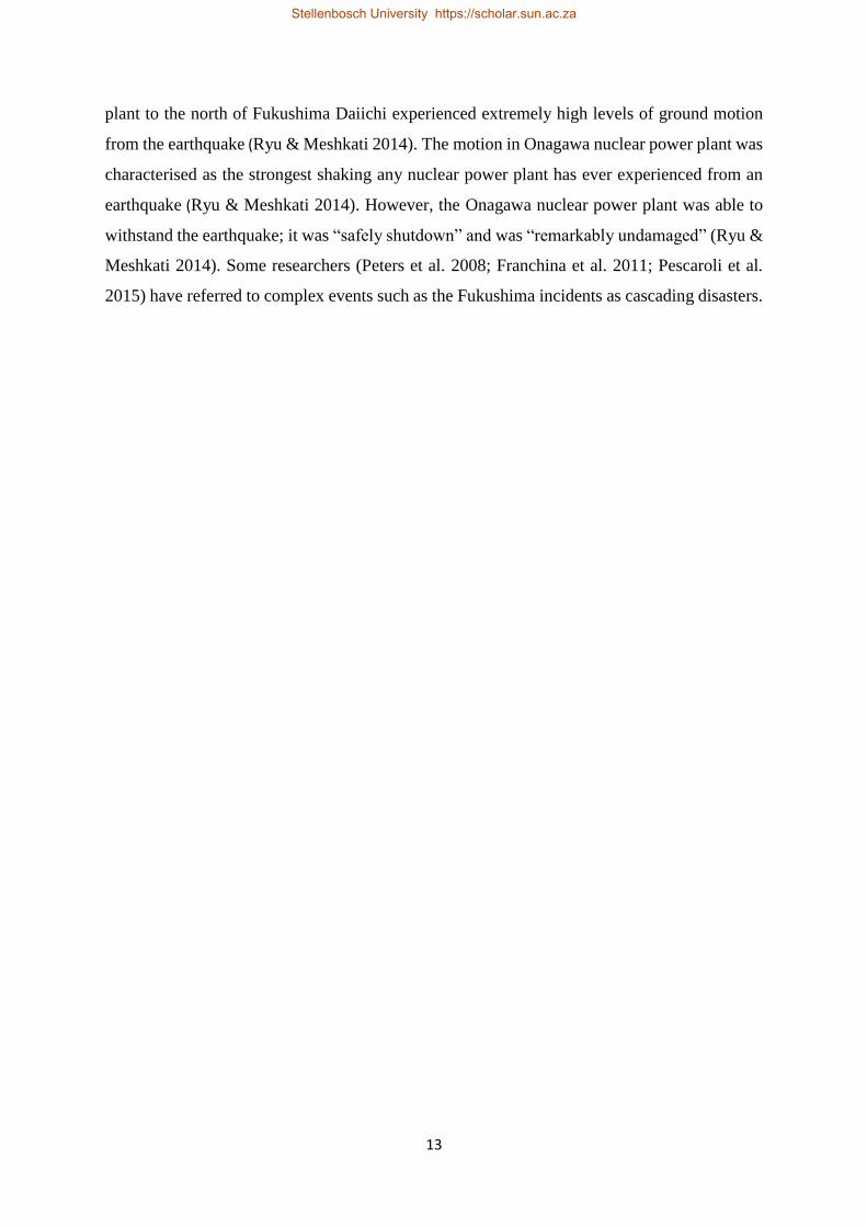
13
plant to the north of Fukushima Daiichi experienced extremely high levels of ground motion
from the earthquake (Ryu & Meshkati 2014). The motion in Onagawa nuclear power plant was
characterised as the strongest shaking any nuclear power plant has ever experienced from an
earthquake (Ryu & Meshkati 2014). However, the Onagawa nuclear power plant was able to
withstand the earthquake; it was “safely shutdown” and was “remarkably undamaged” (Ryu &
Meshkati 2014). Some researchers (Peters et al. 2008; Franchina et al. 2011; Pescaroli et al.
2015) have referred to complex events such as the Fukushima incidents as cascading disasters.
Stellenbosch University https://scholar.sun.ac.za

14
Figure 2: Japan's Nuclear Energy Plants
Source: Ryu & Meshkati (2014)
Stellenbosch University https://scholar.sun.ac.za

15
In an increasingly complex technological society, technological hazards are a growing threat
to people and their environment (Krejsa 1997). This is the consequence of the globalization of
production, industrialization, and the risk of accidents connected with production, processes,
transportation and waste management (Krejsa 1997). These hazards are often associated with
the release of dangerous chemical substances, because of accidents, or with the production of
toxins when fires occur (Krejsa 1997). The most severe technological accidents have affected
thousands of people, both in developed and developing countries (Krejsa 1997). The records
indicate that technological accidents were first experienced or recorded in More Developed
Countries (MDCs) and subsequently in Less Developed Countries (LDCs) (Smith 2004). Table
2 shows some examples of recorded technological accidents, the location and year in which
they occurred, and their impact. According to Silei (n.d:n.p) in “the 19th century, more
especially after the second half of the century, industrial accidents, maritime disasters, railway
and public transportation wrecks became unavoidable aspects of most advanced societies”.
These accidents resulted in the introduction of technological disaster risk reduction measures
through policy intervention and legislation.
Table 2: Technological disasters in MDCs and LDCs
Source: Smith (2004)
As Silei (n.d:n.p) concisely puts it, “all these disasters contributed to place the question of the
adoption of safety standards in legislation and policy decision-making to prevent further
accidents and insure the safety of persons”. Comprehensive safety laws to reduce industrial
disasters were developed in MDCs in the 1970s (Smith 2004). For example, the UK passed a
Health and Safety at Work Act in 1974 to improve industrial safety (UK Government 1974).
With regards to fire, MDCs improved fire regulations and the efficiency of fire-fighting
services (Smith 2004). Even with such developments, however, technological disasters
Year Type of incident Impacts
London England 1666 Structure fire Approximately 13 200 houses burned down
Puente’s Spain 1802 Collapse of the Dam More than 608 people died
Halifax Canada 1917 Cargo explosion More than 1200 people died
Brazil 1984 Petroleum Spillage Aproximatel 500 deaths
Mexico 1984 Liquidified petroleum gas leakage More than 452 people died and over 300 000 left homeless
India Bhopal 1984 Toxic gas leakage from an urban factory 2000 deaths, 34 000 eye defects and 200 000 people displaced
Developed countries
Developing countries
Stellenbosch University https://scholar.sun.ac.za

16
continued to increase (Smith 2004). Technological disasters were first recorded in LDCs in late
1970s and early 1980s, owing to proliferation of new technologies, which was facilitated by
the process of industrialization and an era of mass consumption (Silei n.d.; Krejsa 1997). The
LDCs experienced similar problems in relation to the management of these new technological
developments, owing to their inexperience in managing the negative externalities emerging
from new technological innovations (Smith 2004). Silei (n.d) refers to this process as the
globalisation of technological hazards and risk. The year 1984 was a turning point, when three
industrial accidents in LDCs resulted in about 3 500 deaths, leaving over 200 000 people
homeless (Smith 2004). The incident in Bhopal, India in 1984 is singled out as the world’s
deadliest industrial accident (Smith 2004). The other two incidents were a petroleum spillage
in Campos Basin, Rio de Janeiro, Brazil, and an LPG gas explosion in San Juan Ixhuatepec,
Mexico City. “These three technological disasters resulted in more deaths in one year than all
technological disasters combined since WWII” (Smith 2004:233).
South Africa has also experienced technological disasters. The recent explosion at a Denel
munitions depot near Somerset West on the 3rd of September 2018 is an example. The
explosion resulted in eight deaths, four injuries and nearby property damage (Evans 2018). The
plant contained 400 buildings‚ each with blast walls to prevent a chain reaction in the event of
an explosion, but the explosion destroyed an entire building and surrounding blast walls (Gous
& Hyman 2018). The plant is reportedly one of the largest of its kind in the world and is South
Africa’s only large-calibre munitions production facility (Gous & Hyman 2018).
Technological hazards have changed over time and space with the evolution, and increasing
sophistication, of technology forming components of complex urban systems (Iossifova 2016).
The emergence of cars as the popular mode of road transport created new hazards (Rodrigue
2017).The introduction of the internal combustion engine in the 1800s resulted in the large-
scale mechanization of transportation modes, especially road transport (Rodrigue 2017). This
was followed by the proliferation of cars, buses and trucks and the establishment of vast
highway networks (Rodrigue 2017). The increase of urban populations and growth in the
number of cars and other vehicles increased demand for fuel, and by extension petrol stations,
and expansion of the petroleum industry (Mohammed et al. 2014). Petrol stations are now a
common feature in urban centres across the world (Monney et al. 2015). However, petrol
stations are associated with hazards, and as Table 3 shows, there have been many disasters at
petrol stations globally.
Stellenbosch University https://scholar.sun.ac.za

17
Table 3: Examples of disasters at petrol stations globally
Year (s) Country Fatalities and injuries
1958 & 2007 France A total of 270 fire accidents (ARA 2009)
2004 & 2008 United States (US) An average of 5 020 fires at service or gas
stations per year
2009 & 2017 South Africa (Cape Town) No significant injuries, deaths or property
damage reported (ENCA 2018; City of Cape
Town Open Data Portal 2018)
2015 South Africa (Kwazulu-
Natal)
Approximately 3 trucks & 3 homes were
destroyed (Venktess 2016)
2015 Ghana (capital city Accra) More than 150 killed (Aljazeera 2017)
2016 China Several people, including the lorry driver
and 8 firefighters, were injured (Newsflare
2016).
2017 Ghana (eastern part of
capital city Accra))
Approximately 7 people killed, 132
seriously injured (Aljazeera 2017).
2017 Ghana (western city of
Takoradi)
Unknown injuries (Aljazeera 2017)
Stellenbosch University https://scholar.sun.ac.za

18
2.4. PETROL STATIONS AS HAZARDS
While the causes of fires vary, Ahmed et al. (2011) categorise underlying causal and amplifying
factors as social, technical, political, economic, administrative and institutional. According to
Ahmed et al. (2011) failures in human behaviours, lifestyle and processes are the primary
causes of fires at petrol stations. In Pakistan, for example, Pakistan State Oil (PSO) reported
130 minor accidents at petrol stations between July 2002 and June 2007, with the primary cause
identified as negligence (Corporate Environment Report 2007). In Malaysia, on the other hand,
224 cases were attributed to carelessness in 2008 (Ahmed et al. 2011). Mechanical faults and
small petrol leakages also contributed to fire ignitions in Malaysia (Ahmed et al. 2011).
Electrostatic charges generated by the human body can also cause fires (Ahmed et al. 2011).
Once the electrostatic charges interact with weather, clothing, and car seat material
(Babrauskas 2003 & 2005), people can start fires accidentally just by entering and exiting their
vehicle during refuelling (Renkes 2004). Hazmat trucks also pose a threat during their
operation and maintenance (Melcheersa 2001). In Malaysia, for instance, a hazmat truck driver
felt dizzy and fell while filling his vehicle, resulting in a fire (Ahmed et al. 2011). Ahmed et al.
(2011) also describe a fire caused by a petrol attendant who collapsed due to a heart attack.
2.5. PLANNING AND RISK GENERATION
The impacts of technological accidents are increased where there is development in proximity
to dangerous sites, such as where petrol stations are in densely populated areas (Christou et al.
1999). However, it appears that hazard potential is not always considered systematically when
locating petrol stations, increasing the exposure of surrounding communities. In countries
where planning regulations are available, they are often not properly implemented (Christou et
al. 1999), hence the extensive damage at petrol stations reported in many countries (NFPA
2011; WHO 2004; Bokpe 2015 etc). Examples from Ghana are used often in this section to
demonstrate the significance of the links between planning and risk generation.
For example Oteng-Ababio (2016:402), studying the Melcom disaster, in which the six-story
Melcom shopping centre collapsed in Accra, Ghana, in 2012, notes that “technological
incidents are easily forgotten which signifies the inevitable broader social consequences and
penalty people pay for the lack of institutional memory, learning and risk preparedness”. He
argues that these consequences indicate weak institutional arrangements for DRR,
characterised by a fragmented approach (Oteng-Ababio 2016). For example, he found that the
Stellenbosch University https://scholar.sun.ac.za
19
development planning process in Ghana does not include local inter-agency cooperation
amongst institutions or departments at the local government level, despite Section 12 (1) of the
local government law, Act 462, stipulating that local government institutions be involved in
development planning processes in Ghana (Oteng-Ababio 2016). According to Oteng-Ababio
(2016), the development planning process in Ghana is dominated by central government
agencies. This means that institutions or departments at national level make most development
planning decisions, often in a siloed manner, and exclude institutions or departments at the
local government level. He attributes the collapse of the Melcom building to the lack of inter-
agency cooperation between central government and local government agencies (Oteng-
Ababio 2016). In addition, while the Town and Country Department, the Survey Department
and the National Development Planning Commission are required by law to collaborate in their
planning role, this legislation does not clearly recognise DRR as a concern (Oteng-Ababio
2016). The likely consequence of this individualistic development approach is failed
development. Pelling (2003: ii) argues that “disasters can result in failed development, but
failures in development planning can also lead to disaster risk”. This was the case in the
Melcom disaster in Ghana. Even the director of planning in the Kumasi Metropolitan area
admitted that, in many instances, after acquiring the land, developers build without the planning
permission (Yeboah & Obeng-Odoom 2010), signalling weak institutional arrangements.
Satterthwaite (2011) argues that properly governed cities with strong institutions can
significantly reduce the likelihood of disasters, as well as their magnitude. In 2014, speaking
at the General Assembly Informal Thematic Debate on Disaster Risk Reduction, United
Nation’s (UN) Secretary-General Ban Ki-moon (United Nations Office for Disaster Risk
Reduction (UNISDR) 2014: n.p) argued “the more governments, UN agencies, organisations,
business and civil society understand risk and vulnerability, the better equipped they will be to
mitigate disasters when they strike and save more lives”.
However, such institutional learning and risk preparedness should be embedded within an
integrated DRR approach. For that reason, it is essential that disaster risk reduction is
mainstreamed into development and land-use planning at the national, provincial and local
level (Sutanta et al. 2012). Land-use planning can help to mitigate disasters and reduce risk by
“discouraging high-density settlements and construction of key installations in hazard-prone
areas, control of population density and expansion, and in the siting of service routes for
Stellenbosch University https://scholar.sun.ac.za

20
transport, power, water, sewage and other critical facilities” (UNISDR 2009:19). Sutanta et al.
(2012) argue that land-use planning can play a fundamental role in DRR by ensuring that it:
a. Prevents current and future development in highly dangerous areas
b. Classifies different land into classes based on exposure and the level of risk
c. Makes land-use categories legally binding, including criminalising unauthorised
development in hazardous zones
However, although there is clear evidence of the relationship between the two fields (land-use
planning and disaster management), and shared concern for ensuring the safety of people and
their environment (Britton & Lindsey 1995), land-use planning and disaster management
remain largely siloed. A typical example is Ghana’s case of the Melcom disaster demonstrated
above (Oteng-Ababio 2016). Britton & Lindsey (1995) argue that land-use planning
concentrates on development priorities, with little, if any, attention to risk reduction. For
example, land-use planning often focuses on accommodating the increasing urban population
and promoting economic development, through housing projects, conservation of the natural
environment, and upgrading of the debilitated urban structures.
2.6. PERSPECTIVES ON THE SITING OF PETROL STATIONS
According to Mahmood et al. (2015), petrol stations should be located not only in places where
they are accessible, but also cause as little danger and congestion as possible. This means the
installation of petrol stations should be in line with the principles of DRR (Sutanta et al. 2012),
while at the same time meeting the development demands of population increase, economic
development, nature conservation and urban renewal (Britton & Lindsey 1995). Such an
integrated approach would effectively bridge the existing disconnect between land-use
planning and DRR, promote sustainable development, and ensure the safety of the public. The
location of petrol stations in densely populated areas, where they pose a threat to local
communities, goes against DRR and sustainable development principles, with serious
implications for public safety.
Research indicates that over concentration of petrol stations in a small area within a city has
resulted in problems like traffic congestion, health risks, fires and explosions, and in some
cases, hampered emergency response (Sur & Sokhi 2006; Sangotola et al. 2015). For example,
the government of Ghana argues that installing too many petrol stations in Accra and other
major cities in Ghana is unsafe and unsustainable (Myjoyonline 2016). The petrol station fire
Stellenbosch University https://scholar.sun.ac.za

21
in Accra in 2015, which led to seven civilian deaths and injured over 132 people (Aljazeera
2017), could arguably have been associated with the high number of petrol stations in Accra in
proximity to housing developments. Following this fire, the National Petroleum Authority of
Ghana (NPA) established new regulations on the siting and operation of filling stations in the
country, as a risk reduction measure (Myjoyonline 2016). The NPA of Ghana directed that no
filling stations can be built less than 200 meters away from a residence (MyJoyOnline 2017).
Smith (2004) and Mshelia et al. (2015) argue that facilities such as petrol stations in the urban
environment should be located away from schools, hospitals and densely populated areas.
However, they do not indicate how far away these should be, as they recognise the distance
may be influenced by local context and conditions. Moreover, they observe that, globally, there
are no universal standards with respect to exactly how far away petrol stations should be from
other developments. Mshelia et al. (2015) argue that safe distances should be determined
through a scientific risk assessment, where countries develop their own specific set of
requirements, guided by their own legal land-use framework and risk assessment approaches.
In South Africa, there is legislation guiding land-use planning. This is informed by the broader
principles in South Africa’s Constitution (South Africa (Republic of) 1996). Land-use planning
is regulated by legislation at all three spheres of government in the Western Cape:
a. National level: The Spatial Planning and Land-use Management Act, 2013 (Act 16 of
2013) (SPLUMA) and the Municipal Systems Act, 2000 (Act 32 of 2000)
b. Provincial level: The Western Cape Land-use Planning Act, 2014 (Act 3 of 2014)
(LUPA) and the Western Cape Land-use Planning Act Regulations, 2015
c. Local level: Municipal Bylaws (Western Cape Government 2018)
SPLUMA broadly encompasses spatial planning, land-use management, land development
management principles, and norms and standards that should be developed by all municipalities
(South Africa (Republic of) 2013). Flowing from these broader principles of the SPLUMA is
the LUPA which outlines different functions of municipalities (South Africa (Republic of)
2013). Chapter 2 Section (2) of LUPA, argues that municipalities must regulate, among others,
the development, adoption, amendment and review of a zoning schemes, and the enforcement
by the Municipality of its by-laws and decisions regarding land-use planning (Western Cape
Government 2018). However, Stellenbosch Municipality does not have local standards with
respect to the siting of petrol stations in its zoning scheme and land-use planning by-laws. On
Stellenbosch University https://scholar.sun.ac.za

22
the other hand, the Gauteng Department of Agriculture, Conservation, Environment and Land
Affairs (hereafter referred as GDoACELA) has a set of procedures for siting petrol stations
(Environmental Impact Assessment 2002). These guidelines are known as Environmental
Impact Assessment (EIA) Administrative Guidelines for the Construction and Upgrading of
Filling Stations and Associated Tank Installations and were developed in March 2002 (EIA
2002). The EIA guidelines stipulate that new petrol stations will not be approved where they
are:
a. within 100 metres of residential properties, schools, or hospitals, unless it can be
clearly demonstrated that there will be no significant noise, visual intrusion, safety
concerns or fumes and smells;
b. within three kilometres of an existing filling station in an urban, built-up or residential
area (and within 25 kilometres driving distance of an existing filling station in other
instances, such as in rural areas, and along highways and national roads); or
c. within a sensitive area such as wetlands, alongside rivers etc.
According to Kruger (2012) the limitation on the distance between filling stations outlined
above was influenced by international experience, views of interested persons and legislative
obligations under Environment Conservation Act (ECA) and National Environmental
Management Act (NEMA). Therefore, while this is a Gauteng-based guideline, the guideline
reflects good practice regarding the siting of petrol stations (Kruger 2012).
2.7. INTERNATIONAL BEST PRACTICES ON THE LOCATION OF PETROL
STATIONS.
Countries follow different risk assessment methodologies including a consequence-based
approach, a risk-based approach and use of generic distances (Christou et al. 1999). The
consequence-based assessment methodology focuses on several conceivable event scenarios,
while the risk-based assessment methodology assesses the probability of the possible event
scenario (Christou et al. 1999). The generic safe distance approach focuses on the type of
activities instead of a detailed risk analysis of land-use type (Christou et al. 1999). This is
derived from an expert judgement mainly based on historical experience, the effects of similar
establishments, or environmental impact of a plant or installation (Christou et al. 1999). It is
based on the principle that land-uses which are not compatible with each other should be
separated by a buffer distance (Christou et al. 1999). However, they do not stipulate what these
Stellenbosch University https://scholar.sun.ac.za

23
buffer distances should be, as the extent depends on the type of industrial activity or quantity
and type of hazardous substance involved (Christou et al. 1999). In Spain, for example, Spanish
scientists calculated the levels of an aromatic compound (benzene) and a hydrocarbon (n-
hexane) at three Murcia petrol stations, near the petrol pumps and surrounding areas, to
determine the distance at which the petrol stations can be considered hazardous (Mail online
2011). The analysis considered several factors, such as the number of petrol pumps, the amount
of fuel drawn from them, traffic intensity, the type of surrounding buildings, and weather
conditions (Mail online 2011). Based on their assessment they concluded that a minimum
distance of 50 metres is required between petrol stations and housing developments (Mail
online 2011). They also concluded that 'especially vulnerable' facilities such as hospitals, health
centres, schools and old people's homes, should be at least 100 metres away (Mail online 2011).
In Nigeria, the Department of Petroleum Resource (DPR) stipulates that a petrol station should
be located a minimum of 50 meters away from built-up areas, to create a buffer zone devoted
to non-residential land-use (DPR 2007). Petrol stations should be at least 100 meters from
schools, hospitals, theatres, clinics and other public and semi-public buildings (DPR 2007).
The regulations state that there should be a distance of at least 15 meters from the edge of the
road to the nearest pump (DPR 2007). In addition, the DPR states that petrol stations should be
located at least 400 meters apart (DPR 2007). To approve a new development, they stipulate
that there should be no more than four other petrol stations within a two-kilometre radius of
the proposed site (DPR 2007).
The safe distance assessment approach followed by the GDoACELA in South Africa, Ghana,
Spain and Nigeria respectively suggests a consensus. First, petrol stations should be no nearer
than 50 metres from residential buildings, and there should be a distance of at least 100 meters
between petrol stations facilities such as hospitals, health centres, schools and old people’s
homes. Secondly, there should be minimum safety distance between petrol stations. In South
Africa’s GDoACELA guidelines, a minimum safety distance is three kilometres (EIA 2002),
while it is two kilometres in Nigeria (DPR 2007). The following section discusses the extent
to which the international community adheres to these good practices.
2.8. ADHERENCE TO GLOBAL BEST PRACTICES AND THE REASONS
Globally, many countries do not seem to adhere to the standards. For example in Nigeria,
research conducted at approximately 153 petrol stations in the Niger Delta Region shows that
only 35 (23%) petrol stations conform to the DPR (2007) guideline of 400 metres between
Stellenbosch University https://scholar.sun.ac.za
24
stations, while 118 (77%) were in breach of the guideline (Arokoyu et al 2015). Moreover,
only 50 (33%) petrol stations conformed with the rule that the nearest pumps should be at least
15 meters away from the edge of the road; 103 (67%) petrol stations did not (Arokoyu et al
2015). Similar cases were identified in the townships of Maiduguri and Jere (Mshelia et al
2015). However, this phenomenon is not unique to Nigeria. In Accra, Ghana, a survey of 33
petrol stations found that 60% were built less than 200 meters away from a residence (Baffour
et al n.d). In the province of Baghdad, in Iraq, it was discovered that the location of petrol
stations did not consider the standards and requirements established by the competent
authorities (Mahmood et al. 2015).
The literature advances varying reasons for non-compliance with good practices. The Kaduna
State Urban Planning Development Agency (KASUPDA) found that there was a high demand
for land for services, including petrol stations, in Nigeria’s many cities (Tah 2017). This often
resulted in a scramble for land and the building of illegal petrol stations. This has led to
haphazard development and the deliberate location of petrol stations in unsuitable areas that
are highly exposed to hazards (Tah 2017). In addition, petrol stations are a lucrative business
in Nigeria (Mshelia et al 2015), creating incentives to bypass the rules (Mshelia et al 2015). In
the province of Baghdad in Iraq, non-conformity with the planning standards for the
distribution of petrol stations has jeopardised the safety of surrounding developments
(Mahmood et al. 2015). According to Mahmood et al. (2015:854) “this has led to the planning
problems which adversely affect the role of the fuel stations in the provision of service to the
citizens”. While Mahmood et al. (2015) do not explicate these standards; they indicate
population density of the area as factor which should be considered when locating petrol
stations. This appears, not to have been considered in the province of Baghdad in Iraq as
distribution pattern of petrol stations suggest discrepancy in the spatial distribution (Mahmood
et al. 2015). This failure to meet guidelines places in jeopardy developments around petrol
stations. In this context, institutional capacity to anticipate and prepare for potential
emergencies at the petrol stations is necessary. The following section discuses a framework for
disaster preparedness.
2.9. INSTITUTIONAL DISASTER PREPAREDNESS FOR EFFECTIVE
RESPONSE: A CRITICAL COMPONENT OF DRR
The challenge to reduce the impact of disasters and make risk reduction an important element
of development policies and programmes is outlined in the Hyogo Framework of Action (HFA)
Stellenbosch University https://scholar.sun.ac.za

25
2005-2015 (UNISDR 2008). The HFA called for countries to pursue three strategic goals aimed
at (1) integrating DRR into sustainable development policies and plans and (2) creating
institutions and capacities to build resilience and systematically incorporate risk reduction
plans into disaster preparedness (UNISDR 2008). The Hyogo Framework also defined five
priorities for action with the fifth priority being disaster preparedness for effective response in
all spheres. The framework further outlined in this regard collective and individual roles and
duties of the key stakeholders with government being the critical role player in any country’s
disaster situation.
The HFA provides a framework on how to meet the challenge of being prepared to. While land-
use planning can help to mitigate disasters and reduce risk (Sutanta et al. n.d), disaster
preparedness can help to anticipate and respond effectively to the impact of likely, imminent
or current hazard events or conditions (UNISDR 2008). This is a critical component of DRR
(Coppola 2015). However, it should be supported by formal institutional, legal and budgetary
capacities (UNISDR 2008). Many different entities and individuals should conduct disaster
preparedness activities, including emergency response agencies, government workers,
businesses and the public (Coppola 2015: 275). Preparedness to respond to disasters includes
engaging in a variety of activities such as Emergency Operational Planning (EOP), exercises
and drills, developing warning systems and public education etc. (Coppola 2015). This
includes knowing what to do in a disaster’s aftermath, how to do what needs to be done and
being equipped with the right tools and information to act effectively.
Responding to any disaster is guaranteed to be unique, complex and confusing, hence it is good
practice for institutions to engage in emergency and disaster response planning, which
establishes clear jurisdictional roles and responsibilities (Coppola 2015). The onset of a disaster
is not the time to start planning. The most systematic approach used to plan for disasters is
through the creation of an emergency operational plan (Coppola 2015). This should be
followed by exercises and drills. Exercises potentially reemphasize points made in training
programmes, and test the system, exposing gaps that otherwise might have been overlooked
(Coppola 2015). Drills are most effective when they mimic real-life situations (Coppola 2015).
Rehearsing response procedures also provides opportunities for the evaluation and
improvement of preparedness plans (Twigg 2004; Coppola 2015).
There are a range of other factors that are critical for preparedness. Equipment, such as fire
suppression tools designed to limit the spread of fires, increases the effectiveness of response
Stellenbosch University https://scholar.sun.ac.za
26
agencies (Coppola 2015) - although access to this equipment is driven by resources. Public
education is the backbone of effective public preparedness efforts. This involves creating
public awareness about hazards and risk (Coppola 2015). Once the public is made aware, they
are likely to change their behaviour to reduce their exposure to hazards and their overall
vulnerability to their effects (UNISDR 2008). Warning systems must be designed to reach a
full range of possible recipients within their communities (UNISDR 2008). These preparedness
activities are explored in Chapter 5 and further discussed critically in the context technological
fires at petrol stations in Stellenbosch.
2.10. SUMMARY OF THE CHAPTER
The chapter examined areas of literature which have shaped the research: the definition of the
major concepts such as technological hazards, DRR, land-use planning, disaster risk and risk
analysis. It discussed technological hazards and disasters in the urban context, their causes and
impacts and how they have changed with time and space globally, including the growth in the
petroleum industry, and by extension petrol stations. Both local and international literature
suggests that petrol stations create the risk of fires and indicate a need for careful risk
assessment to guide the development of such facilities. The literature also highlights the need
for the integration of DRR into land-use planning to ensure sustainable and safe development
around petrol stations – although the fields remain siloed in most countries. Local and
international guidelines for the location of petrol stations were explored, with a view to
identifying good practices. These suggest that petrol stations should be 50 metres from
residential buildings, and at least 100 metres from facilities such as hospitals, health centres,
schools and old people’s homes. Petrol stations should also be at least two kilometres apart.
These good practice guidelines will be further explored in the context of Stellenbosch in
Chapter 4.
Stellenbosch University https://scholar.sun.ac.za

27
CHAPTER THREE: RESEARCH METHODOLOGY
3.1. INTRODUCTION
This chapter outlines the research approach and methodology followed to achieve the research
aim and objectives. It describes the study area in some detail and the criteria used to select the
study area. The chapter further describes the approach to data collection and analysis and
reflects on the limitations of the study. The chapter concludes with a discussion of the ethical
considerations related to the study.
3.2. GEOGRAPHICAL LOCATION OF THE STUDY AREA
Stellenbosch is located in the Cape Winelands District Municipality in the Western Cape
Province, South Africa (see Figure 3). It is situated approximately 50 kilometres from Cape
Town, along the banks of the Eerste River, and is flanked by the N1 and N2 highways
(International Federation of Library Association and Institution (IIFLA) 2015). The town’s
global positioning coordinates system is -33° 55' 55.5816'' South (S) and 18° 51' 36.5436''
East(E) (IFLA 2015).
Figure 3: Location of Stellenbosch in Western Cape, South Africa.
Stellenbosch University https://scholar.sun.ac.za

28
3.3. GEOGRAPHICAL CONTEXT OF STELLENBOSCH
The town was established in 1680 by the Governor of the Cape, 28 years after the establishment
of Cape Town (Nicks n.d). The town resembles the pre-colonial settlements of the land along
Eerste River whose main aspects were in place by 1710 (Nicks n.d). Its streets were aligned at
right angles to the contours and furrows for irrigation and drinking water to flow to each
property (Nicks n.d). Buildings were built along the edges of the blocks so as reduce their
impact on land for cultivation (Nicks n.d). This planning pattern reflected proximal links with
the natural environment that the town relied upon for water, food, fibre and building material
(Nicks n.d). During this period energy requirements were very limited, water moved by gravity
and transport was supplied by animals. There were no cars, trucks, pumps, generators and
refrigerators (Nicks n.d). This meant that the need to travel and transport goods had to be
minimised (Nicks n.d).
The beginning of the modern economy in 1870’s in South Africa advanced regional transport,
beginning with the railways (Nicks n.d). There was greater mobility of commuters and freight
(Nicks n.d). Stellenbosch was not affected by these major changes until 1920’s (Nicks n.d).
The first major changes following the 1920’s in Stellenbosch includes the advent of motor cars
for those who could afford them, post union transformation of local government and the
emergence of scientific town planning, as well as advancement of urban engineering
technology (Nicks n.d). At this point, Stellenbosch town spread into the surrounding
countryside as walking distances were no longer a constraint (Nicks n.d). The second major
changes in spatial planning of Stellenbosch was under the apartheid period which was
characterised by the emergence of areas such as Franschhoek north, Cloetesville, Idas Valley
and Kayamandi (Nicks n.d). During this period, the area demarcated today as Stellenbosch
Municipality fell into three jurisdictions: Stellenbosch (town) Municipality, Franschhoek
Municipality and Stellenbosch Divisional Council (Nicks n.d). The third set of changes
occurred after 1994. The three municipalities were amalgamated into one (Stellenbosch
Municipality), forming part of the Cape Winelands District Municipality (Nicks n.d). The
existing design of the Stellenbosch town today is influenced by the town’s historical planning.
3.4. DESCRIPTION OF THE STUDY AREA: THE TOWN OF STELLENBOSCH
The town of Stellenbosch is the second oldest colonial town in South Africa, after Cape
Town, and is one of the smallest towns in the Western Cape, South Africa (Academic
Consortium 21 (AC21) 2014). It covers an area of approximately 812 square kilometres
Stellenbosch University https://scholar.sun.ac.za

29
with a population of more than 167 572 people (Stellenbosch Municipality IDP 2016/17).
The study examined petrol stations in Stellenbosch situated within a six-kilometre radius
from the town’s centre. Stellenbosch was used because it is relatively a small town and was
easily accessible to the researcher.
There are approximately 18 petrol stations in Stellenbosch. However, the study selected
nine petrol stations that fall within a six-kilometre radius from the town centre, measured
from Stellenbosch’s central Post Office. The Post Office’s global positioning coordinates
system are -33° 55' 55.5816'' South (S) and 18° 51' 36.5436'' East(E) (IFLA 2015). A six-
kilometre buffer from the post office was created in ArcMap and petrol stations falling
within this area were selected as study sites. The six-kilometre buffer from the post office
was determined using a shapefile for Stellenbosch, obtained from Stellenbosch
University’s Centre for Geographic Analysis (CGA). However, Google Earth was used to
identify the location of the relevant petrol stations. The following nine petrol stations were
identified and mapped in ArcMap (Figure 4). Figure 4 shows the location of petrol stations
in the study area.
Stellenbosch University https://scholar.sun.ac.za

30
Figure 4: Location of the petrol stations in Stellenbosch
3.5. DATA COLLECTION AND ANALYSIS
This study used a two-prong or mixed research approach consisting of the collection and
analysis of geospatial data and qualitative data collection and analysis. Qualitative data
collection methods study things in their original settings, to make sense of or interpret
phenomena in terms of the meanings people bring to them (Denzin & Lincoln 2011). This was
Stellenbosch University https://scholar.sun.ac.za
31
complemented by geospatial data collection, which examines the distribution and location of
geographical data over space and time (Lwin et al. 2014).
Mixed research methods “…combine the methods in a way that achieves complementary
strengths and non-overlapping weakness” (Johnson & Owuegbuzie 2004:18). The main reason
for using a two-prong approach was thus to combine the strengths of methods while at same
time addressing the weakness of each. For example, geospatial data was used in this study to
identify the location and distribution of geographical objects, such as natural or constructed
features; however, this does not provide insight into why built features are positioned as they
are (Johnson & Owuegbuzie 2004). A qualitative approach provides useful supplementary data.
In this study, the qualitative research sought to understand the rationale for the location and
distribution of features. It also sought to investigate the legislative environment, the
institutional infrastructure and land-use decisions governing the development of petrol stations,
and planning for responding to petrol station fires. Finally, the researcher visited all the petrol
stations to collect observational data on each site.
3.6. QUALITATIVE DATA COLLECTION
Two qualitative data collection instruments were used. The first comprised an open-ended
interview schedule for key stakeholders and the second an observational data collection matrix.
3.6.1. In-depth interviews
In-depth interviews were conducted with four key governmental role-players from
Stellenbosch Municipality’s Disaster Management (DM) function, Fire Prevention (FP) also
referred to as Fire Service (FS) generally known as Stellenbosch Fire and Rescue Services,
Land-use Management (LUM) and the Traffic Department. An interview was also conducted
with experts from a planning unit at Stellenbosch University. The in-depth interviews were
conducted using a semi-structured interview guide, containing open-ended questions. The
interview with DM focused on preparedness plans to respond to emergencies at petrol stations,
awareness programmes regarding fire hazards for communities living close to petrol stations,
as well as institutional roles and responsibilities with respect to responding to fire emergencies.
An in-depth interview with FP/FS was also conducted to understand their role in fire
emergency management, obtain statistics on fires at petrol stations and explore emergency
response challenges. The in-depth interviews conducted with the Municipality’s LUM and the
planner from Stellenbosch University focused on understanding land-use rules, guidelines and
Stellenbosch University https://scholar.sun.ac.za

32
regulations, as well as legislation informing the siting of petrol stations in relation to other
facilities. Interviews with the Traffic Department sought to establish routes with high volumes
of traffic through Stellenbosch, escape options and the implications for emergency response
services, as well as their role in planning decisions.
The interviews were recorded with a tape recorder and notes taken in writing. A deliberate or
purposeful sampling approach was used. This involves targeting participants specifically for
their knowledge and insight with respect to the research questions (Ravitch & Carl 2016). The
in-depth interviews were transcribed by the researcher. Through the process of interviews and
transcription, the researcher became familiar with the data and thus was able to identify
emerging themes across the data from the start. The emerging themes were compared to the
broader theoretical literature to identify gaps and complementary and contrasting findings.
3.6.2. Observational data collection
Data was also collected through observation. Observation is a data collection technique that
can be either structured or unstructured (Punch 2014). The observation was structured using an
adapted version of the South African Bureau of Standards (SABS) Petrol Station Fire Safety
Standards checklist. The observation was carried out for approximately 15-30 minutes. The
length of the observation depended primarily on how busy a petrol station was. In busy petrol
stations a maximum time of 30 minutes was spent observing. While the methodology initially
included a survey of petrol station managers, scoping research found that managers were wary
of and reluctant to speak to the researcher, despite a letter of support provided by his supervisor.
For this reason, the research focused only on the facilities visible in and around the precinct of
petrol stations. The checklist assisted in identifying hazards, risk behaviours, fire prevention
and fire suppression equipment at petrol stations.
The SABS is a statutory body that was established in terms of the Standards Act, 1945 (Act
No. 24 of 1945) and operates in terms of the latest edition of the Standards Act, 2008 (Act No.
8 of 2008). As the national standardisation institution in South Africa, it is mandated to:
a. Develop, promote and maintain South African National Standards (SANS)
b. Promote quality in connection with commodities, products and services
c. Ensure conformity in assessment services and requirements established in terms the
Standard Act (SABS n.d).
Stellenbosch University https://scholar.sun.ac.za

33
The SABS checklist was adapted to comprise variables that could be assessed through
observation alone, and incorporated international good practices identified in the literature. The
adapted Petrol Station Fire Safety Standard Checklist was structured into two components
which focused on risk behaviours and fire prevention at petrol stations. Risk behaviours
focused on technical factors and human behaviour that could potentially cause fires at petrol
stations such as smoking, open flames etc. Fire prevention mechanisms included observation
of (a) existing fire safety measures, (b) control of ignition sources or sources of fuel, (c) fire
detection and warning, and (d) means of escape (see Appendix E). Photographs were also
taken on sites.
3.7. GEOSPATIAL DATA COLLECTION AND ANALYSIS
The geospatial data collection sought to identify the spatial location and distribution of petrol
stations in Stellenbosch. It also sought to compare the location of these petrol stations in
relation to fire emergency response services, hospitals as well as developments such as
residential apartments, schools, community halls etc. The geographic location of petrol stations
in the study area was determined using Google Earth and confirmed with a mobile GPS handset
during visits to each station. The GPS points, presenting both latitude and longitude, were
compiled in an Excel spreadsheet and converted to decimal degrees (DD) to make them
compatible with ArcMap. The following formula was used:
Latitudes: “(Degree South+ (Minutes South/60) + (Seconds south/3600))”
Longitudes: “Degree East+ (Minutes East/60) + (Seconds East/3600))”.
Source: Centre for Geographical Analysis (CGA) extracted from an Introduction to GIS
Guide Book (n.d)
After conversion into decimal degrees, the excel spread was saved in .csv file format
compatible with ArcMap. The .csv file was then imported into ArcMap to show petrol stations
as geographical points or features. Shapefile for the town of Stellenbosch, roads and streets
were acquired from CGA. The six-kilometre radius from the Post office was determined using
the Stellenbosch shapefile. A 2017 recently updated buildings shapefile compiled by Eskom
was obtained from Umvoto Africa (Pty) (Ltd) on 22 of November 2017. Umvoto was identified
through Internet search for GIS consulting companies. They provided the required data free of
Stellenbosch University https://scholar.sun.ac.za
34
charge. The Eskom buildings layer covers the Western Cape and Eastern Cape Provinces. The
Eskom buildings falling within the study area were extracted in ArcMap using a geo-processing
tool.
3.6. LIMITATIONS OF THE STUDY
The study encountered the following challenges. Firstly, the Eskom buildings shapefile layer
excluded new developments and did not represent all land-use types around petrol stations.
Some land-use had to be identified manually on Google Earth and through site visits. Secondly,
due to time and cost constraints, the study was limited only to petrol stations that were within
six kilometres of the town centre in Stellenbosch. Thirdly, petrol station managers, workers
and those living in houses and apartments surrounding petrol stations were not interviewed.
While the methodology initially included a survey of petrol station managers, scoping research
found that managers were wary of and reluctant to speak to the researcher, despite a letter of
support provided by his supervisor.
3.8. ETHICAL CONSIDERATIONS
This study was conducted in line with established norms and standards for ethical social
research. Ethical clearance for the study was obtained from the University of Stellenbosch
Humanities Research Ethics Committee (see Appendix A). Informed consent was obtained
from respondents before proceeding to interview them, along with permission to record the
interview. Respondents could terminate the interview at any time. A letter from the researcher’s
supervisor was obtained to assist in approaching informants for interview. This explained that
the study was for academic purposes and for obtaining of Master’s qualification. The results
are presented in a manner that ensures the anonymity of respondents.
3.9. SUMMARY OF THE CHAPTER
The chapter presented the location of the study area and provided reasons for selecting the area.
It described the approach to collecting and analysing the data. The methodology included the
collection and analysis of geospatial and qualitative data. Finally, the sampling method, data
analysis, limitations and ethical considerations were, discussed. The following chapter presents
the results.
Stellenbosch University https://scholar.sun.ac.za

35
CHAPTER FOUR: LAND-USE PLANNING GUIDELINES FOR
PETROL STATIONS IN STELLENBOSCH
4.1. INTRODUCTION
This chapter presents the findings of the research. It discusses the geospatial analysis regarding
the spatial location and distribution of petrol stations in Stellenbosch, and the surrounding
development patterns. The chapter discusses the land-use planning guidelines as well as
legislation informing the siting of petrol stations in relation to other facilities or land-uses in
Stellenbosch.
As discussed in Chapter 2, there are neither provincial nor national guidelines on the siting of
petrol stations in relation to residential apartments, schools, hospitals etc. – although there is a
land-use procedure that the Municipality follows for the building of petrol stations and
development in general. In the absence of standards, the 2002 EIA development guidelines
used in Gauteng, and discussed in Chapter 2, were applied. These EIA development guidelines
stipulate a generic safe distance of 100 metres between petrol stations and residential properties,
schools, or hospitals and a three-kilometre distance between petrol stations.
4.2. SPATIAL LOCATION AND DISTRIBUTION OF PETROL STATIONS IN
STELLENBOSCH
In Stellenbosch, nine petrol stations were identified within a six-kilometre radius from the Post
Office. They are not equally distributed spatially. Along the main roads (the R310 and R304),
there are four petrol stations, with three located on the R310 and one on the R304 (see Figure
5). The three petrol stations on the R310 are petrol stations #7, #8 and #9. The one petrol station
on the R304 is petrol station #6. There are five other petrol stations located along secondary
roads, avenues and streets: #1, #2, #3, #4 and #5. The R310, running in an easterly direction
from the town has two petrol stations in close proximity to each other. These petrol stations are
#7 and #9. The distance between them is less than 200 meters and they are on opposite sides
of the road. Of the nine petrol stations, these are the nearest to each other. The next closest are
petrol stations #3 and #4 on secondary road, with less than 300 metres between them. Petrol
station #8 on R310 is found to the south west of the town. According to Gauteng’s guidelines
and international good practice the acceptable distance between petrol stations should be at
least three-kilometres. These spatial locational guidelines prohibits two or more petrol stations
Stellenbosch University https://scholar.sun.ac.za

36
within three-kilometres. The circles in Figure 5 represent three-kilometres from the petrol
stations within the study area. The Figure below illustrates that approximately seven petrol
stations are within three-kilometre radius of each other.
Figure 5: Spatial location of petrol stations in Stellenbosch
4.3. CONFORMITY OF PETROL STATIONS WITH DEVELOPMENT GOOD
PRACTICES IN STELLENBOSCH
The siting of petrol stations in Stellenbosch conforms neither to Gauteng’s guidelines nor
international good practice. In several instances, development, in the form of residential
Stellenbosch University https://scholar.sun.ac.za
37
apartments, hostels and commercial buildings, has occurred near petrol stations. In addition,
seven petrol stations were within a three-kilometre radius of each other. In this respect the
findings are similar to the cases in Nigeria where the siting of petrol stations in Maiduguri and
Jere does not conform to Nigeria’s DPR guidelines.
4.3.1. Land-use developments at petrol stations in Stellenbosch
As Table 4 shows, different land-use developments are found immediately in and around the
petrol stations. These land-use types are classified as commercial activity, dwellings, hostels
and other buildings. The classification of these land-use developments is based on the Eskom
buildings layer provided by Umvoto Africa (Pty) (Ltd) and site observation. In this
classification, commercial activity refers to any activity that involves buying and selling,
including convenience stores, fast food restaurants, laundromats, warehouses and retail stores,
factory shops etc. Dwellings comprise any self-contained unit of accommodation such as a
house, an apartment block, mobile home, or other 'substantial' residential structure. A hostel is
defined as an establishment which provides lodging for a specific group of people, such as
students, workers or travellers. Other buildings refer to any structure that belongs either to
institutions, i.e. government or university buildings, or structures used for an unknown or
unidentified activity. These land-use types are not evenly distributed around the petrol stations.
Some petrol stations have more dwellings and hostels close to them, while others have
commercial buildings with no dwellings or hostels. Several petrol stations were attached to
convenience stores. Some petrol stations have primarily residential apartments around them,
while others have more commercial buildings (see Table 4).
Stellenbosch University https://scholar.sun.ac.za

38
Table 4: Land-use development in and around petrol stations
4.3.2. Development within 100 metres radius from the petrol stations.
In terms of Gauteng’s EIA guidelines, petrol stations should not be within 100 metres of
residential properties, schools, or hospitals, unless it can be clearly demonstrated that there will
be no impact in terms of noise, visual intrusion, safety considerations or fumes and smells.
However, the analysis shows that many petrol stations are located close to surrounding
developments. In fact, none of the petrol stations conform to these guidelines, as there are
dwellings, particularly residential houses and hostels, within 100 metres of the petrol stations
Figures 6, 7, 8, 9 and 10 show maps with a 100-metre buffer around petrol stations and the
surrounding land-use developments. In each of the petrol stations a 100-metre buffer is
illustrated by the light orange circles. Petrol station are illustrated by the red and white logo at
the centre of the circle. Dwellings within 100-metre buffer is indicated by small dots with
Petrol stations Land-use developments in and surrounding petrol stations
#1 Commercial buildings
#2 Commercial buildings
#3 Residential building & commercial buildings
#4 University building, hostel and commercial buildings
#5 Hostel, commercial building & other buildings
#6 Residential building & commercial buildings
#7 Residential buildings & commercial buildings
#8 Commercial buildings
#9 Commercial building & other buildings
Stellenbosch University https://scholar.sun.ac.za
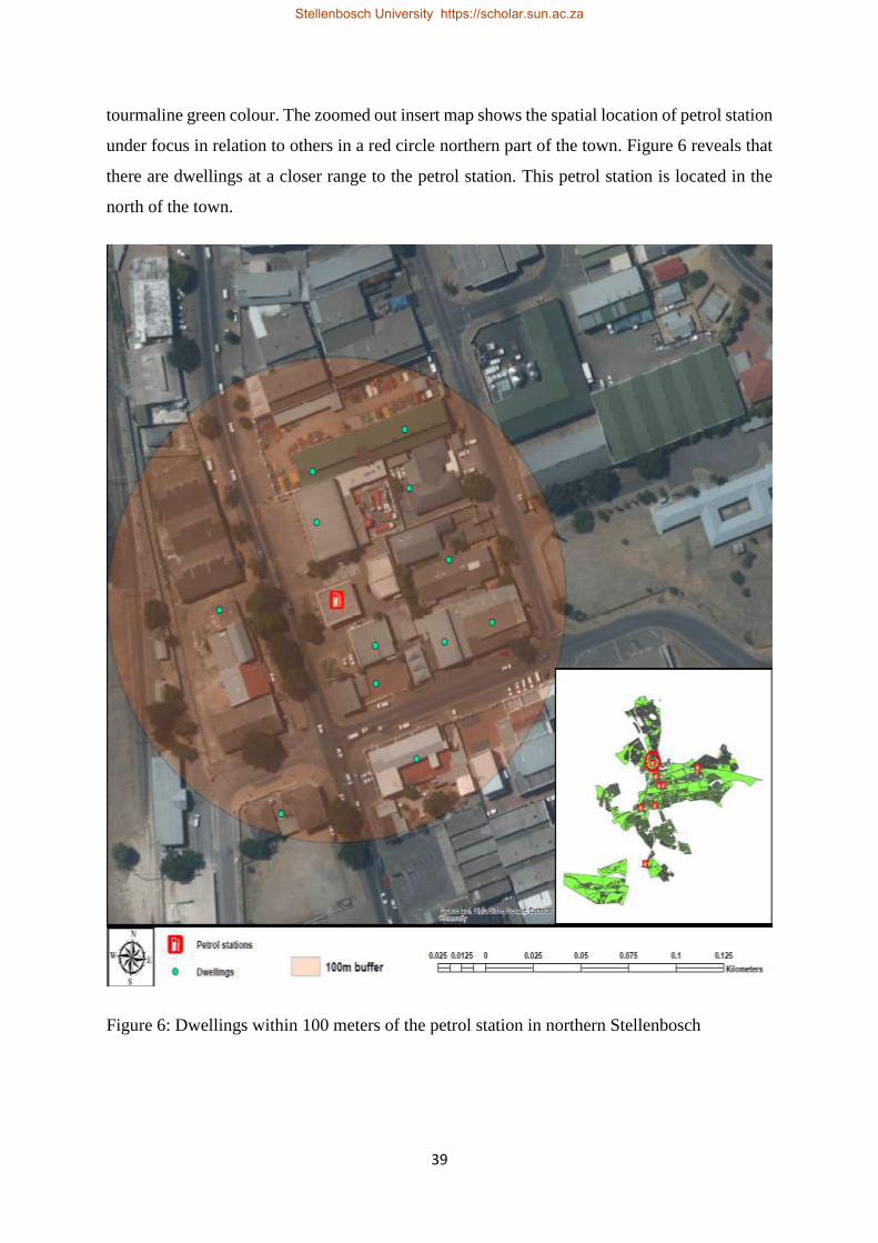
39
tourmaline green colour. The zoomed out insert map shows the spatial location of petrol station
under focus in relation to others in a red circle northern part of the town. Figure 6 reveals that
there are dwellings at a closer range to the petrol station. This petrol station is located in the
north of the town.
Figure 6: Dwellings within 100 meters of the petrol station in northern Stellenbosch
Stellenbosch University https://scholar.sun.ac.za

40
Figure 7 reveals that there are dwellings at a closer range to the petrol stations. The Figure also
shows is a fire station closer to the two petrol stations that belongs to Stellenbosch Local
Municipality east of the town. These petrol stations are located in the east of the town.
Figure 7: Dwellings within 100 meters of the petrol stations in eastern Stellenbosch
Stellenbosch University https://scholar.sun.ac.za
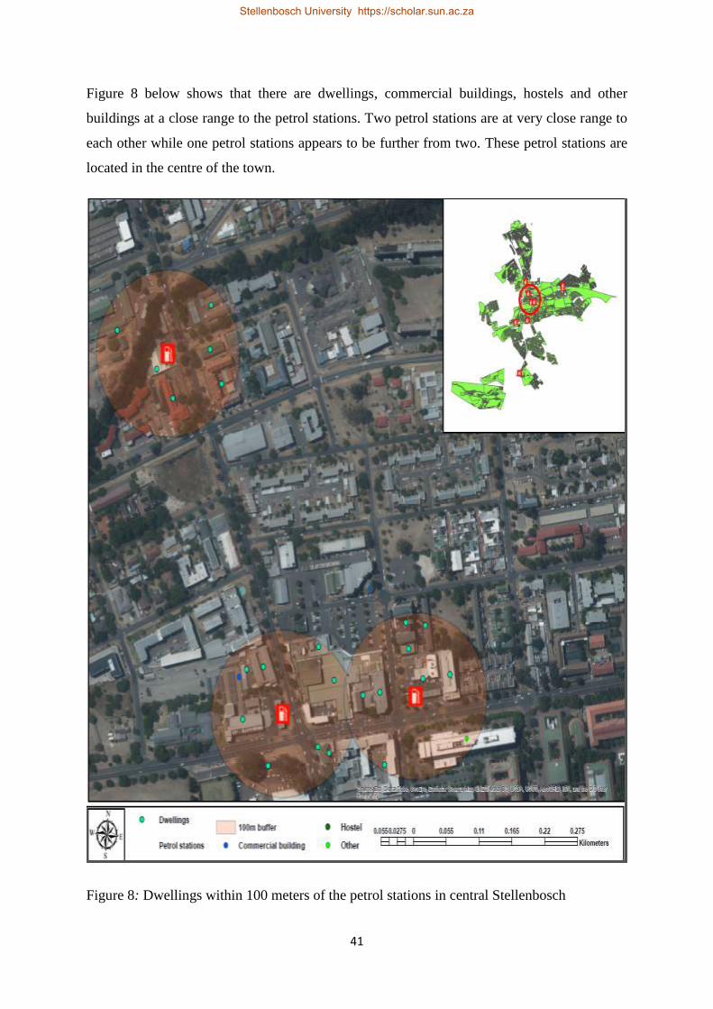
41
Figure 8 below shows that there are dwellings, commercial buildings, hostels and other
buildings at a close range to the petrol stations. Two petrol stations are at very close range to
each other while one petrol stations appears to be further from two. These petrol stations are
located in the centre of the town.
Figure 8: Dwellings within 100 meters of the petrol stations in central Stellenbosch
Stellenbosch University https://scholar.sun.ac.za

42
Figure 9 also shows that there are dwellings at a closer range to the petrol stations. It appears
there is more dwellings closer to the petrol station on the east than there one on the west. These
petrol stations are located in the south-centre of the town.
Figure 9: Dwellings within 100 meters of the petrol stations in south-central Stellenbosch
Stellenbosch University https://scholar.sun.ac.za

43
Figure 10 shows that there are dwellings, hostels and other buildings at a close range to the
petrol station. This petrol station is located far south of the town.
Figure 10: Dwellings within a100 meters of the petrol stations in southern Stellenbosch
Stellenbosch University https://scholar.sun.ac.za
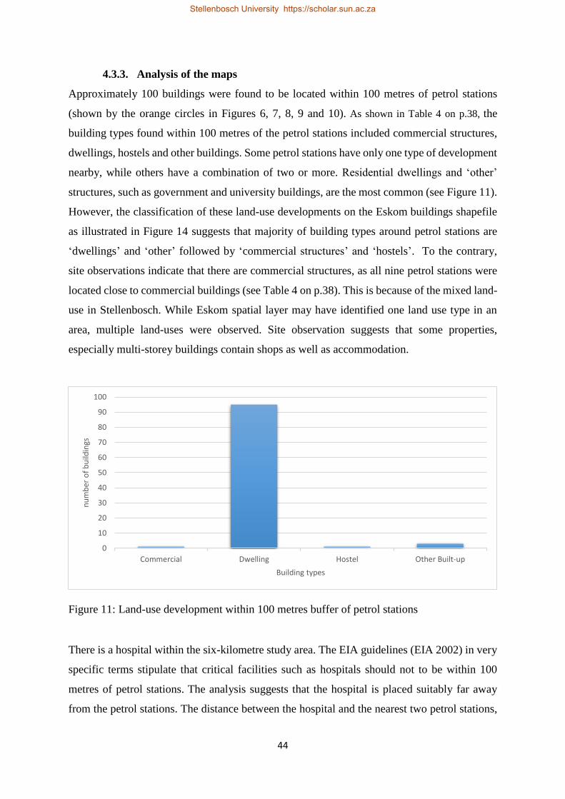
44
4.3.3. Analysis of the maps
Approximately 100 buildings were found to be located within 100 metres of petrol stations
(shown by the orange circles in Figures 6, 7, 8, 9 and 10). As shown in Table 4 on p.38, the
building types found within 100 metres of the petrol stations included commercial structures,
dwellings, hostels and other buildings. Some petrol stations have only one type of development
nearby, while others have a combination of two or more. Residential dwellings and ‘other’
structures, such as government and university buildings, are the most common (see Figure 11).
However, the classification of these land-use developments on the Eskom buildings shapefile
as illustrated in Figure 14 suggests that majority of building types around petrol stations are
‘dwellings’ and ‘other’ followed by ‘commercial structures’ and ‘hostels’. To the contrary,
site observations indicate that there are commercial structures, as all nine petrol stations were
located close to commercial buildings (see Table 4 on p.38). This is because of the mixed land-
use in Stellenbosch. While Eskom spatial layer may have identified one land use type in an
area, multiple land-uses were observed. Site observation suggests that some properties,
especially multi-storey buildings contain shops as well as accommodation.
Figure 11: Land-use development within 100 metres buffer of petrol stations
There is a hospital within the six-kilometre study area. The EIA guidelines (EIA 2002) in very
specific terms stipulate that critical facilities such as hospitals should not to be within 100
metres of petrol stations. The analysis suggests that the hospital is placed suitably far away
from the petrol stations. The distance between the hospital and the nearest two petrol stations,
0
10
20
30
40
50
60
70
80
90
100
Commercial Dwelling Hostel Other Built-up
nu
mb
er o
f b
uild
ings
Building types
Stellenbosch University https://scholar.sun.ac.za
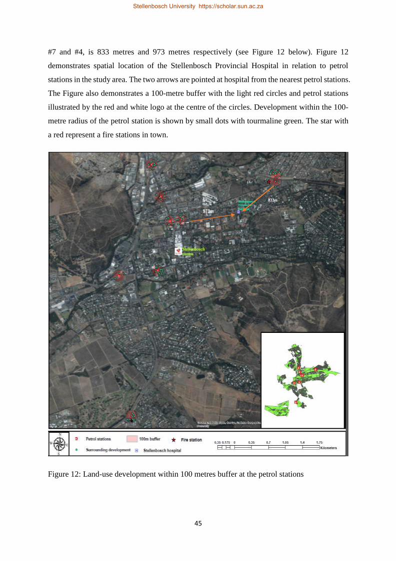
45
#7 and #4, is 833 metres and 973 metres respectively (see Figure 12 below). Figure 12
demonstrates spatial location of the Stellenbosch Provincial Hospital in relation to petrol
stations in the study area. The two arrows are pointed at hospital from the nearest petrol stations.
The Figure also demonstrates a 100-metre buffer with the light red circles and petrol stations
illustrated by the red and white logo at the centre of the circles. Development within the 100-
metre radius of the petrol station is shown by small dots with tourmaline green. The star with
a red represent a fire stations in town.
Figure 12: Land-use development within 100 metres buffer at the petrol stations
Stellenbosch University https://scholar.sun.ac.za
46
4.4. LAND-USE PLANNING GUIDELINES AND REGULATIONS IN
STELLENBOSCH
Interviews with municipal role-players were conducted with the department responsible for
LUP in Stellenbosch Municipality. The interviews aimed to understand land-use rules,
guidelines and regulations, as well as legislation informing the siting of petrol stations in
relation to other facilities. The department responsible for LUP in Stellenbosch Municipality
consists of two units: Spatial Planning (SP) and LUM. The SP unit is responsible for strategic
planning and deals broadly with the Municipality’s urban renewal strategy. The urban renewal
strategy focuses on high density and low-density housing and upgrading of dilapidated
buildings. The LUM unit, on the other hand, implements the zoning scheme. The LUM unit
ensures compliance with, and the implementation of, the parameters established in the zoning
scheme. A zoning scheme is a legal document that records all land-use rights on properties in
its area of jurisdiction (Stellenbosch Municipality 2017). It also includes regulations restricting
these rights and how they can be exercised. The Municipality uses the zoning policy to guide
land-use planning.
4.5. LAND-USE DEVELOPMENT PROCEDURE IN STELLENBOSCH
In Stellenbosch, as elsewhere, individuals or developers wishing to build on land are expected
to conduct an EIA and obtain approval from the Provincial Department of Environmental
Affairs and Planning (DEADP). Once DEADP approves a development, a developer must
apply to the Municipality for permission to develop the area. The purpose of the application is
to ensure that developments comply with the municipal zoning scheme and prevent illegal land-
use development. The Municipality considers any developments bypassing this step as illegal.
However, those interviewed noted that illegal developments are not unusual. Notwithstanding
the EIA, the Municipality conducts its own risk evaluation of the proposed development when
a developer submits their proposed plans. A developer is required to submit multiple
development plans and indicate the preferred option, with supporting reasons for their choice.
The LUP department then circulates the development plan proposal to other relevant
departments and functions, including DM, FP, and traffic and civil engineering, to identify and
consider any shortcomings and effects regarding their respective functions. These role-players
provide feedback to the LUP department, where they have an opportunity to raise any concerns.
The developer is expected to address concerns before their plans can be approved.
Stellenbosch University https://scholar.sun.ac.za

47
4.6. ZONING POLICY IN STELLENBOSCH
Stellenbosch Municipality uses its own unique zoning scheme. As with any other municipality,
the zoning scheme is tailored to the Municipality’s developmental and strategic priorities.
However, the Municipality does not have a specific policy in relation to the location of petrol
stations. In interviews with municipal role players noted that the Municipality’s zoning
scheme/policy regulations do dictate the features of petrol stations. Under the 1996 zoning
scheme regulations, petrol station buildings should cover 75% of the site area; be a maximum
of three storeys high; setback three metres from roads (five metres on proclaimed Main Roads);
and 10 metres from other zones such as shops (Stellenbosch Municipality 2012 :32). This was
amended in 1998, to include additional provisions. These include that the entrance and exit to
and from petrol stations or public garages must be:
a. not less than 30 metres from the point where a proclaimed or planned main road
intersects any other road, or the nearest point of an intersection where traffic is
controlled, or is proposed to be controlled, by a traffic signal or traffic island;
b. not less than one and a half metres from the side boundary of the premises; and
c. not less than 10 metres from the corner of an intersection that is 10 metres wide or five
metres from the point where the line of splay (or site line) meets the road boundary.
These additional amendments are aimed at managing and ensuring the free, unobstructed and
safe flow of traffic. They did not consider fire-safety at petrol stations. This is because
stakeholders such as DM and FP/FS do not perceive petrol stations as potentially hazardous
sites, as there have been no major fires or accidents in Stellenbosch.
The Municipality does have a policy regarding the location of other land-uses, such as clubs or
liquor stores, with no clubs or liquor stores allowed near schools, churches or clinics.
Interviews with DM and FP/FS stakeholders indicated that petrol stations are not a priority
hazard. Fires at petrol stations are not included in DM’s priority hazard list. While most
stakeholders perceived the risk of a fire at a petrol station to be low, the municipal planner
acknowledged the potential danger, noting that there are also health and environmental hazards
associated with petrol stations. The planner emphasised that the role of land-use planning is to
enforce and ensure compliance with the zoning scheme. If the risks associated with petrol
stations and the distance between developments are not identified in the zoning scheme, these
will not be considered in developing land. He also indicated that developers “invest huge
Stellenbosch University https://scholar.sun.ac.za

48
capital in building petrol stations; planners do not intensively look at risks imposed by such
developments but focus on the economic benefits to the local community and municipality”
(LUP department Interviews 2018). This is a classic example of the fragmented land-use
planning approach demonstrated by Britton & Lindsey (1995) and Sutanta et al. (n.d). This
promotes economic development at the expense of safety.
According to FS and DM records, there have been no significant fires or accidents at petrol
stations in Stellenbosch. Nonetheless, the planner recommended that the Municipality should
craft and develop a policy that deals with the siting of petrol stations, to for example, ensure
that petrol stations are located a safe distance from one another. However, he also highlighted
that Stellenbosch is a historical town, with available land already developed. The current
planning in Stellenbosch reflects decisions made years ago, although in some cases
developments have been upgraded. While he stressed a need for measures to protect residents,
when asked if he could consider the EIA guidelines developed by the GDAoACELA, he argued
that “each town has a unique environment; therefore, I believe that these guidelines would not
be useful in the sense of applicability to Stellenbosch or any other town other than in Gauteng”.
4.7. SUMMARY OF THE CHAPTER
The land-use regulations regarding the development of petrol stations in Stellenbosch are not
in line with good practice suggested in the literature, or local guidelines, such as those used in
Gauteng. The hazard posed by petrol stations are not considered by land-use developers and
municipal officials in Stellenbosch. This is seemingly due to low levels of danger perception
owing to absence of fire accidents at petrol stations in Stellenbosch. Currently, development of
residential and other land-uses is allowed extremely close to petrol stations. The following
chapter presents the levels of the institutional preparedness to respond to fires at the petrol
stations and protect surrounding developments.
Stellenbosch University https://scholar.sun.ac.za

49
CHAPTER FIVE: EMERGENCY RESPONSE PREPAREDNESS FOR
PETROL STATION FIRE ACCIDENTS IN STELLENBOSCH
5.1. INTRODUCTION
Considering the closeness of the residential housing developments to petrol stations and to each
other, this chapter examines how well prepared Stellenbosch Municipality is to respond to a
large fire at a petrol station. The chapter also discusses the related institutional management
challenges facing the Municipality, as well as risk behaviours and fire prevention measures at
petrol stations. This information was established through interviews with DM, FS/FP and the
Traffic Department, as well as site observation.
5.2. EMERGENCY RESPONSE PREPAREDNESS PLAN
Stellenbosch Municipality developed a Disaster Management Plan in May 2017, which
establishes governance procedures and arrangements for disaster risk management, including
preparing for and responding to disasters within the Municipality (Stellenbosch Municipality
2017). The HFA and Sendia framework argues that plans are critical for effective response
(Coppola 2015). The Stellenbosch Municipality’s Disaster Management Plan consists of four
key coordinated processes and institutional arrangements: for disaster management; risk
assessment and establishing a risk profile; disaster risk reduction planning; and disaster
preparedness (Stellenbosch Municipality 2017). Responsibility for reducing disaster risk,
preparing for and responding to disasters is shared by all local municipal departments and
employees, the Cape Winelands District Municipality, provincial and national organs of state
and all sectors of society (Stellenbosch Municipality 2017). Stellenbosch Local Municipality
is required by the Disaster Management Act 57 of 2002 to conduct risk assessments and
identify disaster risks threatening the Municipality and to develop risk reduction and
preparedness plans for the identified threats (Disaster Management Act (DMA) 2002). This
systematic process aims to create an environment conducive for institutions and community
organizations to understand and reduce risk. The national disaster management framework of
2005 is a legal instrument specified by the Act to guide integrated action, by providing a
coherent, transparent and inclusive policy on disaster management appropriate for the whole
South Africa (National Disaster Management framework (NDMF) 2005).
Stellenbosch University https://scholar.sun.ac.za

50
Pursuant to the legislative obligation outlined above, Stellenbosch Local Municipality in the
2017 Disaster Management Plan identified 20 priority hazards (Stellenbosch Municipality
2017). Petrol station fires were not included (see Table 5). In interviews with municipal role
players, it was explained that the Municipality prioritises hazards according to their frequency,
hence rare or hypothetical events are excluded. However, respondents from DM agreed that
fires at petrol stations are possible and that having no experience of fighting these fires has
lowered the Fire and Rescue Service’s preparedness for fires should they occur. Moreover, the
prioritisation of hazards in Stellenbosch Local Municipality may also be inaccurate. Although
hazards are supposed be determined by their frequency, frequent events such as informal
settlement fires are not listed. A recent study suggests that between 2015 and 2017, 104
informal dwellings and 22 houses were destroyed by fire (Mugamu 2018).
Table 5: Priority hazards in Stellenbosch Municipality.
Source: Stellenbosch Municipality (2017:15).
Stellenbosch University https://scholar.sun.ac.za

51
5.3. INSTITUTIONAL MANAGEMENT
Stellenbosch Municipality is responsible for responding to fires at petrol stations or events
within the urban footprint, and the District Municipality for everything outside it, such as
wildland fires. In a written reply to questions, a Stellenbosch Municipality official indicated
that in terms the Municipal Structures Act, 1998 (Act 117 of 1998) (as amended) Section 84(1)
(j) there is a strict “segregation of powers between “C” [District] and [B or local]
Municipalities”. Section 84(1) states that a District Municipality has the following functions
and powers in respect to fires:
a. planning, co-ordination and regulation of fire services;
b. specialised firefighting services such as mountain, veld and chemical fire services;
c. co-ordinating the standardisation of infrastructure, vehicles, equipment and procedures;
and,
d. training of fire officers in the Cape Winelands District Municipality.
Neither Stellenbosch Municipality, nor the Cape Winelands District Municipality are
responsible for conducting fire drills at petrol stations (this responsibility lies with the
landowners and/or petrol station managers). However, it could be argued that both DM and
FP/FS, in their efforts to ensure adequate preparedness for fires, should test their own
preparedness levels, raise awareness about how to respond in the event of a fire, as well as
identify escape and alternate routes that the public and responders would need to use. The
municipal FP/FS and DM officials indicated that the Municipality had visited a few shops,
restaurants, commercial centres and one petrol station (station #5) to distribute the (now old)
number to call in emergencies. This implies that, prior to this, the emergency number was
unknown, and is now obsolete. The visit did not include any other awareness raising or
oversight activities.
5.4. THE MUNICIPALITY’S STANDARD OPERATING PROCEDURES
The municipal role players indicated that the Municipality’s Standard Operating Procedures
(SOPs) have not been tested with respect to a fire at a petrol station. The SOPs facilitate and
guide collaborative efforts between different municipal departments and institutions during an
emergency. Figure 13 shows the departments involved in disaster coordination and response,
as explained by the municipal officials. Under existing SOPs, an emergency call reporting a
fire or fire-related emergency is received at the Stellenbosch Local Municipality’s DM call
Stellenbosch University https://scholar.sun.ac.za

52
centre and is then redirected to FP/FS, Law Enforcement or Police, the Traffic department or
other relevant institutions. All these departments should play a unique but complementary role
during an emergency in Stellenbosch. The Police and Law Enforcement, for instance, are
responsible for crowd control, while the Traffic department focuses on road closures and
coordinating emergency routes. Nonetheless, as noted by a respondent from DM in
Stellenbosch Local Municipality, a “SOP cannot be a cut and paste exercise, as responding to
a structure fire in an informal settlement [as opposed to] a petrol station is a unique exercise”,
as the substances involved require different treatment. He argued that the SOP has been
standardised to the extent that it ignores the uniqueness of different kinds of fires. An
interviewee suggested that a specialised SOP should be developed to cater for an accident or
fire at a petrol station (DM department interviews 2018). This would need to be tested through
fire drills.
Source: Author’s own.
Figure 13: SOP in Stellenbosch Municipality.
Disaster Management
Fire Prevention/Service Department
Law Enforcement
Traffic department
Police service
Ambulance service
Stellenbosch University https://scholar.sun.ac.za
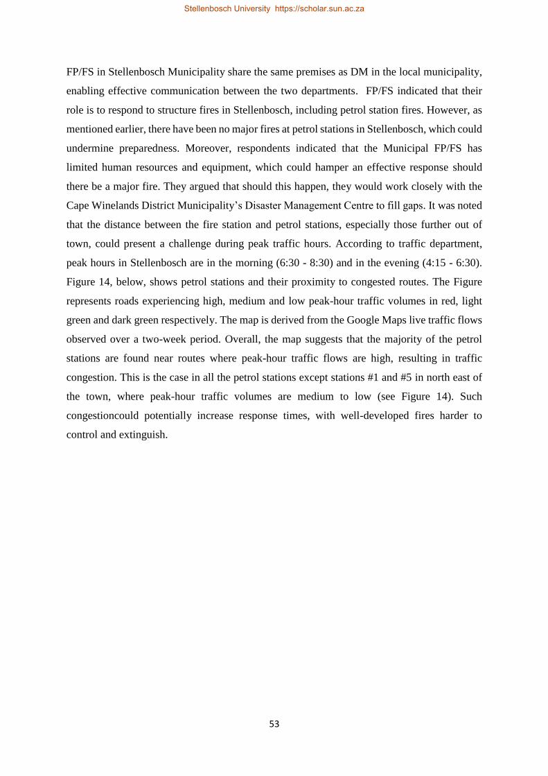
53
FP/FS in Stellenbosch Municipality share the same premises as DM in the local municipality,
enabling effective communication between the two departments. FP/FS indicated that their
role is to respond to structure fires in Stellenbosch, including petrol station fires. However, as
mentioned earlier, there have been no major fires at petrol stations in Stellenbosch, which could
undermine preparedness. Moreover, respondents indicated that the Municipal FP/FS has
limited human resources and equipment, which could hamper an effective response should
there be a major fire. They argued that should this happen, they would work closely with the
Cape Winelands District Municipality’s Disaster Management Centre to fill gaps. It was noted
that the distance between the fire station and petrol stations, especially those further out of
town, could present a challenge during peak traffic hours. According to traffic department,
peak hours in Stellenbosch are in the morning (6:30 - 8:30) and in the evening (4:15 - 6:30).
Figure 14, below, shows petrol stations and their proximity to congested routes. The Figure
represents roads experiencing high, medium and low peak-hour traffic volumes in red, light
green and dark green respectively. The map is derived from the Google Maps live traffic flows
observed over a two-week period. Overall, the map suggests that the majority of the petrol
stations are found near routes where peak-hour traffic flows are high, resulting in traffic
congestion. This is the case in all the petrol stations except stations #1 and #5 in north east of
the town, where peak-hour traffic volumes are medium to low (see Figure 14). Such
congestioncould potentially increase response times, with well-developed fires harder to
control and extinguish.
Stellenbosch University https://scholar.sun.ac.za
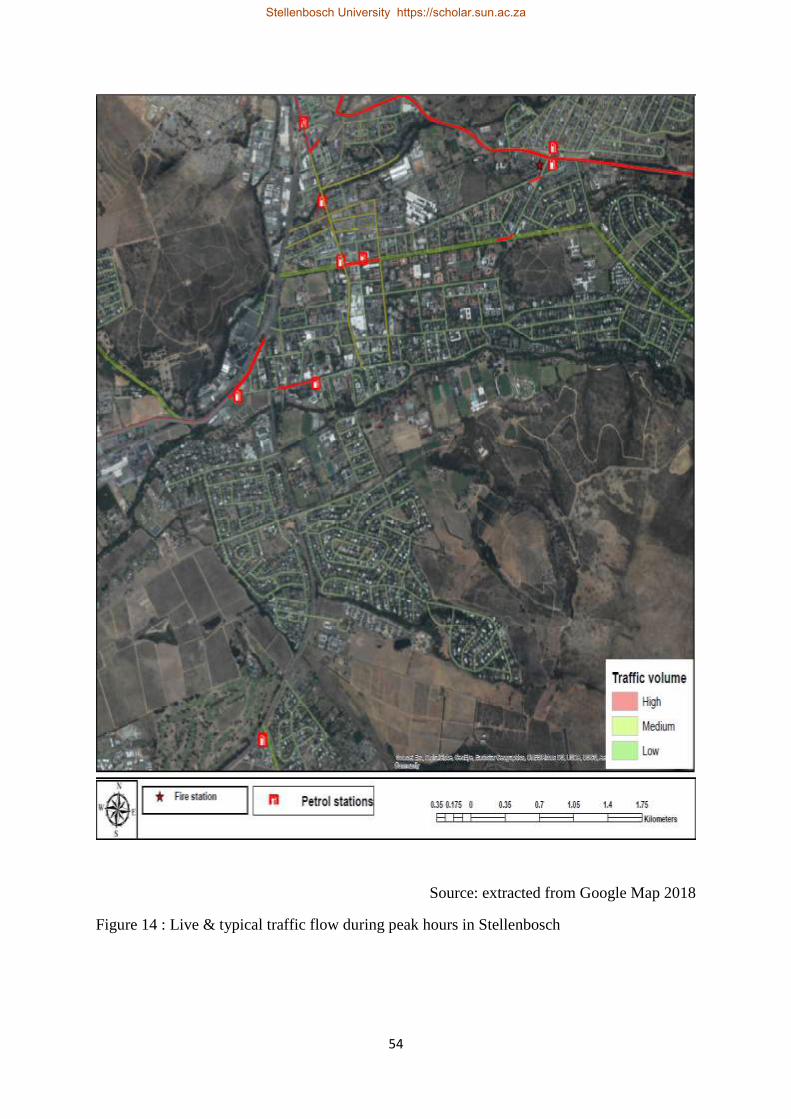
54
Source: extracted from Google Map 2018
Figure 14 : Live & typical traffic flow during peak hours in Stellenbosch
Stellenbosch University https://scholar.sun.ac.za

55
5.5. FIRE SAFETY AT THE PETROL STATIONS IN STELLENBOSCH
This section explores risk behaviours at petrol stations that could potentially lead to fires and
the prevention measures adopted at petrol stations. It discusses the findings identified through
observation and the application of the adapted Fire Safety Standards Checklist. As noted earlier,
this focused only on facilities visible in and around petrol station precincts and is supplemented
by photographs of the stations. It focused on the source components of fire - heat, combustible
material (fuel) and oxygen - and the extent to which there were measures evident to address
these.
5.6. RISK BEHAVIOURS
Heat, and anything that gives off heat, can ignite fires where there is enough fuel and oxygen
(NEBOSH 2016). In this regard, it is widely accepted that motorists can prevent fires by
switching off their engines when filling their cars, and by not smoking. In this respect, the
checklist examined risky behaviours, such as motorists not switching off their cars, or smoking.
Despite clear warning signs posted at each pump requesting customers to “Turn off Engine”,
in several cases – particularly at petrol stations #6 and #8 - cars were filled while their engines
were still running, creating the risk of fires. In petrol station #6, a group of customers who went
to the convenience store, stood approximately 12-22 meters from a pump and smoked cigars
for approximately two minutes. While there is no recommended minimum distance at which
smoking, or flames can be considered safe, intuitively this kind of activity appears to create the
potential for fires. In this respect, Cutter (1993) argues that the public often does not appreciate
the dangers of technological fire hazards, sometimes with devastating results. Fortunately, in
this instance, there was no harm done. In petrol stations #6 and #9 different sizes of EASiGas
containers were observed in the precinct (see Table 6). It appears these petrol stations are also
selling EASiGas, increasing available fuel for fires. In keeping with the literature on
technological hazards, the observation data suggests fires are most likely to start due to human
behaviour and negligence (Ahmed et al. 2011) and underscores the importance of enforcing
safety standards.
5.7. FIRE PREVENTION EQUIPMENT AT PETROL STATIONS
The observation component examined fire prevention mechanisms, including visible evidence
of (a) adequate fire safety measures, (b) control of ignition sources or sources of fuel, (c) fire
Stellenbosch University https://scholar.sun.ac.za
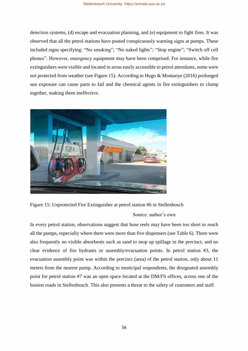
56
detection systems, (d) escape and evacuation planning, and (e) equipment to fight fires. It was
observed that all the petrol stations have posted conspicuously warning signs at pumps. These
included signs specifying: “No smoking”; “No naked lights”; “Stop engine”; “Switch off cell
phones”. However, emergency equipment may have been comprised. For instance, while fire
extinguishers were visible and located in areas easily accessible to petrol attendants, some were
not protected from weather (see Figure 15). According to Hugo & Montanye (2016) prolonged
sun exposure can cause parts to fail and the chemical agents in fire extinguishers to clump
together, making them ineffective.
Figure 15: Unprotected Fire Extinguisher at petrol station #6 in Stellenbosch
Source: author’s own
In every petrol station, observations suggest that hose reels may have been too short to reach
all the pumps, especially where there were more than five dispensers (see Table 6). There were
also frequently no visible absorbents such as sand to mop up spillage in the precinct, and no
clear evidence of fire hydrants or assembly/evacuation points. In petrol station #3, the
evacuation assembly point was within the precinct (area) of the petrol station, only about 11
meters from the nearest pump. According to municipal respondents, the designated assembly
point for petrol station #7 was an open space located at the DM/FS offices, across one of the
busiest roads in Stellenbosch. This also presents a threat to the safety of customers and staff.
Stellenbosch University https://scholar.sun.ac.za
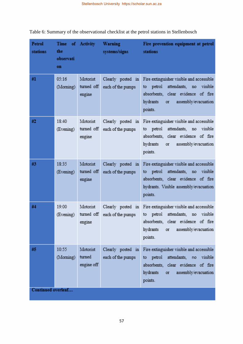
57
Table 6: Summary of the observational checklist at the petrol stations in Stellenbosch
Stellenbosch University https://scholar.sun.ac.za

58
Stellenbosch University https://scholar.sun.ac.za

59
5.8. SUMMARY OF THE CHAPTER
The research findings suggest that technological fires at petrol stations are not considered a
priority hazard in Stellenbosch. This is because the municipality prioritises hazards according
to their frequency, and there have been no recorded fires at petrol stations in Stellenbosch. This
lack of experience and emphasis may undermine levels of preparedness, leaving Stellenbosch’s
FP/FS and DM less equipped to deal with a fire emergency at a petrol station. Observation at
the research sites suggests that although petrol stations have posted warning signs and have fire
extinguishers, there is the potential for fires at petrol stations, indicating an important gap in
the Municipality’s disaster management planning. Petrol station managers should also
carefully consider existing response measures, such as the siting of evacuation and assembly
points.
Stellenbosch University https://scholar.sun.ac.za
60
CHAPTER SIX: DISCUSSION AND CRITICAL ANALYSIS
6.1. INTRODUCTION
The aim of this research was to investigate the extent to which land-use planning in
Stellenbosch considers the fire-risk posed by petrol stations, and the implications for public
safety. The study also examined the potential for fires at petrol stations and how well prepared
the authorities are to respond to such fires. The study focused on petrol stations within a six-
kilometre radius of the Stellenbosch Post Office, in Stellenbosch, South Africa.
This chapter will provide a critical discussion and analysis of the findings. It will begin by
revisiting the study’s aims and objectives, followed by a discussion of the findings. It will then
discuss the implications of the findings for the current land-use planning practices, policy, and
DRR in Stellenbosch Municipality. It will also provide recommendations on how the land-use
planning guidelines can better integrate DRR principles to ensure sustainable development of
petrol stations and the safety of those living and working in surrounding developments. Finally,
the chapter will conclude with proposals for further research.
6.2. REVISITING THE OBJECTIVES
The research in this thesis had three objectives. The first was to identify petrol stations within
six kilometres from central Stellenbosch, the nature and extent of development around the
stations and whether these comply with the international and national planning regulations. The
second, examined the potential for fires by observing risk behaviours and fire-suppression
equipment at petrol stations. The third was to investigate Stellenbosch Municipality’s
preparedness to respond in the event of a fire at a petrol station.
With respect to the first objective, nine petrol stations were identified within six kilometres
from Stellenbosch centre. Contrary to best practice, there was significant development close to
petrol stations. Land-uses included (1) commercial activity such as convenience stores,
restaurants, fast food stores, liquor stores, (2) dwellings such as residential apartments, (3)
hostels and (4) institutional buildings. In addition, it was established that Stellenbosch
Municipality does not have any local standards, legislation or policy with respect to the siting
of petrol stations. There are also neither provincial nor national guidelines that stipulate the
siting of petrol stations in relation to residential homes and apartments, hospitals, schools etc.
Stellenbosch University https://scholar.sun.ac.za

61
other than those set by SABS. However, the 2002 EIA development guidelines discussed in
Chapter 2 stipulate a generic safe distance of 100 metres between petrol stations and residential
properties, schools, or hospitals and a three kilometre distance between petrol stations. The
study showed that petrol stations in Stellenbosch do not comply with these guidelines. More
than 100 residential developments were found to be within 100 metres of petrol stations. Seven
petrol stations were found with three kilometres of each other.
In terms of the second objective, the findings suggest the potential for fires. Risky behaviours
were observed in petrol stations, which included customers leaving engines running while
refilling their cars and smoking. All petrol stations had visible fire suppression equipment, and
warning signs, but in some petrol stations fire extinguishers were unprotected from weather.
The final objective was to investigate Stellenbosch Municipality’s level of preparedness to
respond in the event of a fire at a petrol station. In this regard, it was established that petrol
station fires were not considered a priority hazard, and therefore there were no plans in place
to deal with such incidents. In addition, the municipality did not conduct emergency drills.
These findings indicate that the Municipality is less prepared for petrol station accidents should
they occur.
6.1. DISCUSION OF THE FINDINGS
6.1.1. Reflecting on technological hazard literature
Technological hazards are well documented historically (see Brooks 1973; Kate & Kasperson
1983; Cutter 1993; Ayyub 2003) and in the main the literature focuses on technological
disasters in urban areas linked to industrial development and factories. The historical
technological hazard literature describes technological disasters as unavoidable aspects of most
advanced societies in the second half of the 19th century (see Silei n.d; Cutter 1993; Showalter
& Myers 1994; Krejsa 1997; Smith 2004). As a result, disaster risk reduction measures, enacted
through policy intervention and legislation, were introduced in many countries and contexts
(see UK 1974). This reduced deaths and injuries resulting from large industrial accidents.
However, technological inventions have continually changed the nature of hazards and created
new ones, presenting management challenges (Iossifova 2016), and often resulting in disasters
(Brooks 1973). Contemporary society has advanced technologically and become so complex
that the successful management and amelioration of technological disasters requires a holistic
approach.
Stellenbosch University https://scholar.sun.ac.za
62
The technological hazards literature identifies petrol stations as a common feature in the global
urban landscape. However, the hazard posed by petrol stations is not explored in the
technological hazard literature in the South African context. Christou et al. (1999) observed
that hazard potential is not always considered systematically when locating petrol stations,
increasing the exposure of surrounding communities. They cautioned that the impacts of
technological accidents are increased by development in proximity to dangerous sites, such as
where petrol stations are in densely populated areas (Christou et al. 1999). The study findings
correspond with observations by Christou et al. (1999) that petrol stations are often placed too
close to one another and surrounding developments and show that the spacing of petrol stations
does not adhere to good practice. The findings show that there has never been a large fire at a
petrol station in Stellenbosch, but that an explosion or fire in Stellenbosch could potentially
result in extensive damage and even deaths and injuries. The literature on technological hazards
suggests that disasters at petrol stations have happened before across the globe and elsewhere
in South Africa.
Stellenbosch is not unique in not adhering to best practices. Countries such as Nigeria, Ghana,
and Iraq have all been shown to not comply with guidelines (see Baffour et al n.d; Tah 2017;
Mshelia et al 2015; Arokoyu et al. 2015). In countries where there are planning regulations,
they were often ignored (Christou et al. 1999). While the reasons may vary, the most common
relates to the economic benefits of the petrol stations to the local community and municipality
(Tah 2017; Mshelia et al 2015). Mshelia et al (2015) argues that petrol stations are lucrative
businesses. This means that, in many instances, the economic benefits of petrol stations are
emphasised at the expense of safety considerations. Likewise, a planner spoken to in
Stellenbosch indicated that because developers invest huge capital in the development of petrol
stations, planners tend to focus on the economic benefits.
Moreover, Britton & Lindsey (1995) argue that land-use planning practices in most countries
concentrate on development priorities, with little, if any, attention to risk reduction. This
appears true in Stellenbosch, where the economic benefits of petrol stations appear to count
more than the economic and human costs that could result from a disaster. Unfortunately, it is
often only after a disaster that the economic, environmental and human costs of petrol stations
are seriously considered. For example, in Ghana, it was only after the 2015 fire in Accra that
the National Petroleum Authority of Ghana established new regulations on the siting and
operation of filling stations in the country (MyJoyOnline 2017).
Stellenbosch University https://scholar.sun.ac.za

63
Good practice suggests a generic safe distance of 100 metres between petrol stations and
residential properties, schools or hospitals and three kilometres between petrol stations (EIA
2002; DPR 2007; Mail online 2011; Myjoyonline 2016). In Stellenbosch, the findings reveal
that the hospital is a reasonable distance, with the closest two petrol stations, #7 and #4, 833
metres and 973 metres away respectively. This also conforms with the minimum distance of
100 metres outlined by the EIA guidelines (EIA 2002). However, there were residences, hostels
and university buildings located within 100 metres of petrol stations. Moreover, the findings
suggest that petrol stations are built closer together than the three kilometres radius suggested
in literature. Seven petrol stations were found within three kilometres distances to each other.
This exposes surrounding developments to fire hazards.
6.1.2. Implications of the findings on land-use planning procedure in
Stellenbosch
The findings of the study have implications for land-use planning practices in the municipality.
The study found that there were accepted land-use planning procedures and practices in place,
which require that developers conduct an EIA and apply to the Municipality for permission to
develop land. The Municipality, in turn, should consider the proposed development and its
level of compliance with the municipal zoning policy. However, it was found that the
Municipality’s zoning scheme/policy regulations do not dictate how far away residential
houses, hospitals, schools etc. should be from petrol stations. It was also found that there were
neither provincial nor national guidelines on the siting of petrol stations in South Africa. These
findings, together with those on risky practices at petrol stations, identify a need for measures
to protect residents from potential fires at petrol stations. Buffer zones surrounding petrol
stations should be integrated into the zoning policy. This should also insure that petrol stations
are located a safe distance from one another.
6.1.3. Fire-safety at petrol stations
A potential for a fire/explosion breaking out exists in petrol stations. NEBOSH (2016) outlined
that heat, and anything that gives off heat, can ignite fires where there is fuel and oxygen.
However, for a technological accident to occur technology must interact with humans or
society directly or indirectly. Previous studies (Corporate Environment Report 2007; Ahmed
et al. 2011) indicate that petrol station accidents are most often due to human failures and
negligence, with Cutter (1993) and Smith (2004) identifying technological disasters as human-
Stellenbosch University https://scholar.sun.ac.za

64
induced events. In keeping with the literature on technological hazards, the observation data
suggests that fires could start due to human behaviour and negligence and underscores the
importance of enforcing safety standards. For example, it was observed in several cases that
cars were filled while their engines were still running, and people were also seen smoking near
a pump. The observed risky behaviour echoes Cutter’s (1993) argument that the public and
customers often do not appreciate the dangers of technological fire hazards. In this respect,
Coppola (2015) argues that public education should be the backbone of effective public
preparedness efforts. He argues that once the public is made aware, they are likely to change
their behaviour to reduce their exposure to hazards and their overall vulnerability (Coppola
2015). However, Stellenbosch Municipality indicated that they have not extensively engaged
in public awareness programmes in developments around petrol stations.
That developments are exposed to fires indicates a need for preparedness to respond to
incidents – especially as responding to any disaster can be complex and confusing (Coppola
2015). In Stellenbosch, the local municipality plays a critical role in this regard. Interviews
with municipal role-players established that Stellenbosch Municipality has a generic Disaster
Management Plan for 2017, which establishes governance procedures and arrangements for
disaster risk management, including preparing for and responding to disasters within the
Municipality (Stellenbosch Municipality 2017). This is identified in the HFA 2005-15, under
priority five, as a critical component of effective emergency response (UNISDR 2008).
However, this generic plan has not been tested with respect to a disaster at a petrol station. This
is because there have never been fires at petrol stations in Stellenbosch, and such incidents are
not viewed as a priority. However, responding to petrol station fires cannot be a cut and paste
exercise, as these incidents may pose unique challenges such as traffic congestion, and owing
to the chemicals present, specialised firefighting equipment. Therefore, as Coppola (2015)
argues, specific plans are necessary, and should be linked to exercises and drills. Such exercises
help to identify roles and responsibilities, and test the system, exposing gaps that otherwise
might have been overlooked (Coppola 2015). Rehearsing response procedures also provides
opportunities for the evaluation and improvement of preparedness plans (Twigg 2004; Coppola
2015). However, the research suggests that Stellenbosch Municipality has not tested its own
response preparedness, or raised awareness amongst the public about how to respond in the
event of a fire or escape and alternate routes. While this is the responsibility of the landowners,
it could be argued that the Fires Services and DM should play a leadership role with respect to
this issue.
Stellenbosch University https://scholar.sun.ac.za
65
In addition, Coppola (2015) argues that risk and hazard analysis should be performed to
determine the appropriate response to hazard by the relevant body. In Stellenbosch, it is DM
that conducts risk assessments and identifies disaster risks threatening the Municipality, and
subsequently, develops risk reduction and preparedness plans for the identified disaster risks.
Approximately 20 disaster hazards have been identified as priority hazards in Stellenbosch
(Stellenbosch Municipality 2017). However, petrol stations are not considered as potential
priority hazards, because in Stellenbosch they remain hypothetical and unrealised events.
Coppola (2015) also argues that public education should involve putting warning systems in
place. Warning systems (warning signs in the context of petrol stations) must be designed to
reach a range of possible recipients (Coppola 2015). All nine petrol stations appear to have
understood fire could possibly occur. As result, they have posted conspicuous warning signs at
pumps, which customers and petrol attendants can see clearly. Furthermore, Coppola (2015)
states that equipment, such as fire extinguishers and other suppression tools, designed to limit
spread of fire, are essential and should be accessible and in working order (Coppola 2015). At
the petrol stations in Stellenbosch, fire extinguishers were visible and located in areas easily
accessible to petrol attendants. However, some were not protected from weather, which could
prevent them working properly. Hugo & Montanye (2016) caution that prolonged sun exposure
can cause parts to fail and the chemical agents in fire extinguishers to clumped together, making
them ineffective. Moreover, in every petrol station, observation data suggest that hose reels
may have been too short to reach all the pumps, especially where there were more than five
dispensers. There were also frequently no visible absorbents such as sand to mop up possible
spillage in the precinct, clear evidence of fire hydrants or assembly/evacuation points. However,
Coppola (2015) acknowledges that resources may be a constraint. He states that access to
equipment such as firefighting trucks and personnel is mainly driven by resource availability
and may influence response effectiveness (Coppola 2015). Therefore, creative ways should be
developed to overcome resource constraints.
FP/FS indicated that inadequate human resources (firefighters) and firefighting equipment
could hamper an effective response should there be a major fire. However, in such instances,
the local municipality should work together with the district municipality to fill the gap. In
addition, reaching petrol stations that are further from the fire stations could present a challenge
during an emergency at petrol stations, especially at peak traffic hours. This is why it is
important, as part of preparedness planning, to engage in exercises to rehearse response
Stellenbosch University https://scholar.sun.ac.za
66
procedures and evaluate preparedness options (Twigg 2004; Coppola 2015). This could help
the municipality determine the approximate time it would practically take for firefighters to
reach each petrol station under different traffic conditions.
6.2. SUMMARY & CONCLUSION
The literature on technological hazards and the record of fires at petrol stations globally and
locally highlights a need to ensure urban public safety through risk-aware development.
Internationally, good practice prevents development near petrol stations, especially of hospitals,
health centres, schools and old people’s homes and housing. Land-use planning must play and
important role in risk reduction. In South Africa, there are few regulations with respect to
development around petrol stations, either at the national or provincial level; only Gauteng has
developed specific guidelines on the siting of stations. These stipulate that there should be (a)
a generic safe distance of 100 metres between petrol stations and residential properties, schools,
or hospitals and (b) a three-kilometre distance between petrol stations.
The application of these standards shows that the siting of petrol stations in Stellenbosch does
not meet these good practice guidelines. Of the nine petrol stations in the study area,
approximately seven petrol stations were within a three-kilometre radius of each other, with
two stations on opposite sides of a road less than 200 meters apart, and another two less than
300 metres apart, along the same street. Moreover, the results also reveal that the surrounding
developments are located within 100 metres of the petrol stations. Approximately 100 buildings,
ranging from dwellings, hostels, commercial and other buildings were found to be located
within 100 metres of petrol stations. These findings show that the current land-use model and
policies do not recognise the fire hazard posed by petrol stations, and do not adequately protect
the public.
At the same time, the Municipality’s preparedness to respond to petrol station fires appears
low. This is due to the prioritisation of more frequent events. The untested disaster management
plan could compromise effective responses during a fire at a petrol station. However,
observation of petrol stations suggests the potential for major fires, and the need for both petrol
station managers and the authorities to prepare for these events.
Stellenbosch University https://scholar.sun.ac.za

67
6.3. Recommendations for further research
This study focused on investigating the extent to which land-use planning in Stellenbosch
considers the fire-risk posed by petrol stations, and the implications for public safety. Further
researcher is recommended. This should focus on bigger towns with larger populations and
more complex land-use features. Expanding the research scope to the country’s large cities in
different provinces would further assist in establishing whether there are guidelines or
procedures elsewhere that could guide the siting of petrol stations. It would also help gauge the
extent to which petrol stations in South Africa comply with good practices and incorporate the
urgent need for risk-aware land-use planning. Future research should also seek to understand
levels of preparedness for fires at petrol stations in other towns and the perceptions of the public,
petrol station managers and the authorities with respect to the potential fire hazards associated
with petrol stations in South Africa.
Stellenbosch University https://scholar.sun.ac.za
68
REFERENCES
Academic Consortium 21 (AC21) 2014. AC21. [Online] Available from
http://www0.sun.ac.za/ac21/about/ac21.html [Accessed on 24 March 2018].
Agence France-Presse (AFP) 2017. Anger in Ghana after four die in fuel station fire, blasts.
[Online]. Available from https://www.timeslive.co.za/news/africa/2017-10-08-anger-
in-ghana-after-four-die-in-fuel-station-fire-blasts/ [Accessed on 11 March 2018].
Ahmed MM., Kutty SRM., Shariff AM & Khamidi MF 2011. Petrol Fuel Station Safety and
Risk Assessment Framework. Civil Engineering Department, Universiti Teknologi
PETRONAS, Malaysia; Chemical Engineering Department Universiti Teknologi
PETRONAS, Malaysia.
Aljazeera news 2017. Ghana: Gas depot blasts kill at least seven in Accra. [Online] Available
from http://www.aljazeera.com/news/2017/10/blast-gas-station-rocks-ghana-capital-
accra-171007211009348.html [Accessed on 14 October 2017].
Arokoyu SB, Ogoro M & Jochebed AO 2015. Petrol filling stations’ location and minimum
environmental safety requirements in Obio Akpor lga, Nigeria. International Journal of
Scientific Research and Innovative Technology ISSN: 2313-3759 (2) 11. [Online].
Available
from:https://www.researchgate.net/publication/288986564_Petrol_Filling_stations'_L
ocation_and_Minimum_Environmental_Safety_Requirements_in_Obio_Akpor_LGA
_Nigeria [Accessed 19 January 2019].
Australia Retail Association (ARA) 2009. Petrol Station Accidents France, 1958 – 2007.
[Online]. Available from https://www.aria.developpement-
durable.gouv.fr/.../Petrolstations_accidents_jan09.pdf. [Accessed 14 October 2017].
Asian Disaster Preparedness Center (ADPC) n.d. Hazard, risk, vulnerability and disaster?
How these terms are interconnected to each other? [Online]. Available from
http://www.adpc.net/casita/Bangkok-
workshop/Day%202/Introduction_to_Hazard_Vulnerability_and_Risk.pdf [Accessed
on 05 February 2019].
Stellenbosch University https://scholar.sun.ac.za
69
Ayodele S. J 2011. Spatial Distribution of Petroleum Filling Station in Kaduna North.
American Journal of Engineering Research (AJER). 3, (9), 147-158. Available from
www.srib.com/samuel_ayodele1 [Accessed on 19 January 2018].
Ayyub BM 2003. Risk Analysis in Engineering and Economics. University of Maryland at
College Park. Chapman & Hall CRC.
Babrauskas V 2003. Ignition Handbook. Fire Science Publishers/Society of Fire Protection
Engineers: Issaquah WA.
Babrauskas V 2005. Some basic facts about ignition events during Fuelling of Motor Vehicles
at Filling Stations. California Fire/Arson Investigator. 16, 25.
Baffour RA, Offe A & Annor LD n.d. Assessing the Impact of Fuel Filling Stations on the
Environment in Ghana. [Online]. Available
from:https://www.proceedings.esri.com/library/userconf/proc13/papers/980_191.pdf.
[Accessed 19 January 2019].
Bennett. K F 1990. Matching petrol and diesel fuel demand in South Africa. Department of
Mechanical Engineering, University of Cape Town. Available from www-
sciencedirect-com.ez.sun.ac.za/science/article/pii/030142159090217R?via%3Dihub
[Accessed on 5 September 2018].
Birkmann J, Cardona OD, Carren˜o ML, Barbatm AH, Pelling M, Schneiderbauer S,
Kienberger S, Keiler M, Alexander D, Zeil P & Welle T 2013. Framing vulnerability,
risk and societal responses: the MOVE framework. Natural Hazards 67: 193-211.
Bokpe SJ 2015. LPG stations in residential areas raise alarm. [Online]. Available from:
http://graphic.com.gh/news/general-news/17367-lpg-stations-in-residential-areas-
raise-alarm.htm [Accessed on 19 January 2018].
Britton NR & Lindsey J 1995. Integrating City planning and emergency preparedness: Some
of the Reasons Why’. International Journal of Mass Emergencies and Disasters. 13 (1)
93-106.
Stellenbosch University https://scholar.sun.ac.za
70
Brooks H 1973. Technology and values: new ethical issues raised by technological progress.
[Online]. Available from https://onlinelibrary.wiley.com/doi/pdf/10.1111/j.1467-
9744.1973.tb00212.x [Accessed on 14 October 2017].
Cardona, O.D., M.K. van Aalst, J. Birkmann, M. Fordham, G. McGregor, R. Perez, R.S.
Pulwarty, E.L.F. Schipper, and B.T. Sinh, 2012: Determinants of risk: exposure and
vulnerability. In Field, C.B., V. Barros, T.F. Stocker, D. Qin, D.J. Dokken, K.L. Ebi,
M.D. Mastrandrea, K.J. Mach, G.-K. Plattner, S.K. Allen, M. Tignor, and P.M. Midgley
(eds.), Managing the Risks of Extreme Events and Disasters to Advance Climate
Change Adaptation. A Special Report of Working Groups I and II of the
Intergovernmental Panel on Climate Change (IPCC). Cambridge University Press,
Cambridge, UK, and New York, NY, USA, pp. 65-108.
Centre for Geographical Analysis (CGA) n.d. Introduction to GIS. University of Stellenbosch.
Cezar-Vaz MR, Rocha LP, Bonow CA, Santos da Silva MR, Vaz JC & Cardoso LS 2012. Risk
Perception and Occupational Accidents: A Study of Gas Station Workers in Southern
Brazil. International Journal of Environmental Research. Public Health 2012, 9, 2362-
2377; doi:10.3390 /ijerph9072362.
Christou M, Amendola A & Maria S M. 1999. The control of major accident hazards: The land-
use planning issue. Journal of Hazardous Materials. 65(1-2):151-78.
City of Cape Town Open Data Portal 2018. Petro station fire incidence. [Online]. Available
from http://web1.capetown.gov.za/web1/opendataportal/default [Accessed on 11
March 2018].
Coppola DP 2015. Introduction to International Disaster Management. 3rd ed. Butterworth
Heinemann, Oxford:.
Corporate Environment Report 2007. Pakistan State Oil. [Online]. Available from
http://121.52.153.178:8080/xmlui/bitstream/handle/123456789/11220/Annual%20Re
port%202007.pdf?sequence=1&isAllowed=y [Accessed on 11 March 2018].
Cutter S 1993. Living with risk: the geography of technological hazard. Rutgers University,
Great Britain.
Stellenbosch University https://scholar.sun.ac.za
71
Disaster Management Act (DMA) 2002. Republic of South Africa. Vol. 451 Cape Town 15
January 2003 No. 24252. [Online]. available from
http://www.cogta.gov.za/cgta_2016/wp-content/uploads/2016/06/DISASTER-
MANAGEMENT-ACT.pdf [Accessed on 05 February 2019].
Denzin NK & Lincoln YS 2011. The SAGE Handbook of Qualitative Research (Sage
Handbooks). 4th Edition.
Department of Petroleum Resource (DPR) 2007. Procedure Guide for Grant of and Approval
to Construct and Operate Petroleum Products Retail Outlets. Issued by DPR, Ministry
of Petroleum Resources in Nigeria.
Elliott G 2010. Enigmatic Variations. In Hobsbawm (ed.) History and Politics (pp. 87-142).
Pluto Press, London and New York. doi:10.2307/j.ctt183p9t8.8.
ENCA 2015. Petrol tanker explodes at KZN filling station. [Online]. Available from
https://www.enca.com/south-africa/petrol-tanker-explodes-kzn-filling-station
[Accessed on 14 October 2017].
ENCA 2018. Mitchells Plain petrol station torched during protest. [Online] Available
https://www.enca.com/south-africa/watch-mitchells-plain-residents-torch-vehicle-
petrol-station-over-lack-of-housing [Accessed on 11 March 2018].
Environmental Impact Assessment (EIA) 2002. Guideline for the construction and upgrade of
filling stations and associated tank installations: Agriculture, conservation,
environment and land affairs, Gauteng province. [Online]. Available from
http://home.intekom.com/salbu/a_R21/FillingStationsGuidelines.html [Accessed on
24 March 2018].
Evans J 2018. 8 dead in Denel munitions factory blast. [Online] Available at:
https://www.news24.com/SouthAfrica/News/blast-rocks-denel-somchem-plant-
outside-somerset-west-20180903. [Accessed 4 September 2018].
Franchina L, Carbonelli M, GraaL, Crisci M & Perucchini D 2011. An impact-based approach
for the analysis of cascading effects in critical infrastructures. International Journal of
Critical Infrastructures, 7(1): 73-90.
Stellenbosch University https://scholar.sun.ac.za

72
Gattás GJ, Cardoso Lde A, Medrado-Faria Mde A, & Saldanha PH. 2001. Frequency of oral
mucosa micronuclei in gas station operators after introducing methanol. 51(2) 107-13.
Occupational Medicine (Oxford) https://www.ncbi.nlm.nih.gov/m/pubmed/11307685/.
Genovese P 2004. Full-Service Gas Stations. In Lurie Maxine N & Mappen Marc (eds.).
Encyclopedia of New Jersey. Rutgers University Press, New Jersey.
Gous N & Hyman A 2018. Denel explosion deaths are ‘heartbreaking’‚ says company chair.
[Online] Available at: https://www.timeslive.co.za/news/south-africa/2018-09-04-
denel-explosion-deaths-are-heartbreaking-says-company-chair/ [4 September 2018].
Hadland A 2002. In Terror and in Silence: An Investigation into Safety Levels and Standards
December 2002. Social cohesion and integration research programme. Human sciences
research Council HSRC, Cape Town, South Africa.
Hanekom P 2001. Guidelines for the Construction and Upgrade of Filling Stations and
Associated Tank Installations. Agricultural, Conservation, Environmental and Land
Affairs. Johannesburg, South Africa. Pp. 1 – 17. [Online]. Available from
http://home.intekom.com/salbu/a_R21/FillingStationsGuidelines.html. [Accessed 19
January 2018].
Hewitt, K 1997. Regions of Risk: A Geographical Introduction to Disasters. Addison Wesley
Longman, Essex
History.com 2009. Bombing of Hiroshima and Nagasaki. A+E Networks. [Online]. Available
from http://www.history.com/topics/world-war-ii/bombing-of-hiroshima-and-
nagasaki. [Accessed 19 January 2018].
Hugo J & Montanye C 2016. #59 - Protect Outside Fire Extinguishers with Outdoor Fire
Extinguisher Cabinets. [Online]. Available from
http://quickresponsefiresupply.3dcartstores.com/59--Protect-Outside-Fire-
Extinguishers-with-Outdoor-Fire-Extinguisher-Cabinets. [Accessed 19 January 2019].
Hughes TP 2004. Human-Built World: How to Think about Technology and Culture. Chicago,
2004 (review). The British Journal for the History of Science. 39: 441 - 442.
10.1017/S0007087406258680.
Stellenbosch University https://scholar.sun.ac.za

73
International Federation of Library Association and Institution (IFA) 2015. It Section Satellite
Meeting. [Online] Available from
http://conferences.sun.ac.za/index.php/IFLA_IT/index/pages/view/map [Accessed on
24 March 2018].
Iossifova D 2016. Complex urban: linking hard and soft urban systems.[Online]. Available at
http://www.urbantransformations.ox.ac.uk/blog/2016/complex-urban-linking-hard-
and-soft-urban-systems/. [Accessed on 14 October 2017]
Johnson RB & Onwuegbuzie AJ 2004. Mixed Methods Research: A Research Paradigm Whose
Time Has Come. Educational Researcher, 33(7):14–26. Available at
http://journals.sagepub.com/doi/pdf/10.3102/0013189X033007014. [Accessed on 14
October 2017]
Kate RW & Kasperson JX, 1983. Comparative risk analysis of technological hazards (A
Review). 80 7027-7038. [Online]. Available at
https://www.ncbi.nlm.nih.gov/pmc/articles/PMC390121/.[Accessed on 14 October
2017]
Tah DS 2017. GIS-based locational analysis of petrol filling stations in Kaduna Metropolis.
Science World Journal Vol 12 (2) 8-13. [Online]. Available from
http://www.scienceworldjournal.org/article/view/17749/11463. [Accessed 19 January
2019].
Khazai B, Daniell JE & Wenzel F 2011. The March 2011 Japan Earthquake: Analysis of losses,
impacts, and implications for the understanding of risks posed by extreme events.
[Online]. Available from
https://www.researchgate.net/publication/258375534_The_March_2011_Japan_Earth
quake_Analysis_of_Losses_Impacts_and_Implications_for_the_Understanding_of_Ri
sks_Posed_by_Extreme_Events. [Accessed 19 January 2019].
Kitson M & Michie J 2014. The de-industrial revolution: The rise and fall of UK
manufacturing, 1870-2010. [Online]. Available from
https://www.cbr.cam.ac.uk/fileadmin/user_upload/centre-for-business-
research/downloads/working-papers/wp459.pdf. [Accessed on 08 August 2018].
Stellenbosch University https://scholar.sun.ac.za
74
Krejsa P 1997. United Nations International Decade for Natural Disaster Reduction IDNDR
Early Warning Programme Report on Early Warning for Technological Hazards.
IDNDR Secretariat, Geneva.
Kruger R 2012. A critical analysis of the quality of EIA reports for filling stations in South
Africa. Mini-dissertation, North-West University, Potchefstroom.
Lwin K, Hashimoto M &Murayama Y 2014. Real-Time Geospatial Data Collection and
Visualization with Smartphone. Journal of Geographic Information Systems, 6: 99-108
[Online]. Available from http://www.scirp.org/journal/jgis
http://dx.doi.org/10.4236/jgis.2014.62011. [Accessed on 08 August 2018].
Mahmood H, Shaban AH & Numan SA 2015. Optimal Spatial Distribution of Gasoline
Stations in Baghdad Province Utilizing GIS Techniques. [Online] Available from
https://www.iasj.net/iasj?func=fulltext&aId=103040 [Accessed on 08 August 2018].
Mail 2011. Living near a petrol station is 'bad for your health' as fuel pollutants found to travel
100m. Available from http://www.dailymail.co.uk/health/article-1354430/Petrol-
station-Living-100m-garage-bad-health.html [Accessed 24 March 2018].
McCarthy GJ Chatto K & Tolhurst K 1998. Overall Fuel Hazard Guide. Research Report No.
47. Fire Management Branch, Dept. of Natural Resources and Environment, Victoria.
Melcheersa RE & Feutrillb WR 2001. Risk Assessment of LPG automotive refuelling facilities.
Reliability Engineering and Sand System Safety 74:283-290.
Mercury Reporter 2017. Smoking customer blasted with fire extinguisher at petrol station. IOL
news. [Online]. Available from https://www.iol.co.za/mercury/news/smoking-
customer-blasted-with-fire-extinguisher-at-petrol-station-11508044 [14 October 2017].
Mohammed MU, Musa IJ & Jeb DN 2014. GIS-Based Analysis of the Location of Filling
Stations in Metropolitan Kano against the Physical Planning Standards. American
Journal of Engineering Research (AJER). 3(9):147-158.
Monney I, John Bosco Dramani JB, Aruna A, Tenkorang AG & Osei-Poku F 2015. Health and
safety in high-risk work environments: A study of fuel service stations in Ghana.
Journal of Environmental and Occupational Science. 4:1-9.
Stellenbosch University https://scholar.sun.ac.za

75
Moolla R & Curtis CJ 2013. Health Risk Assessment of BTEX Emissions from Gas Stations in
Johannesburg, South Africa. Paper presented at: XVth International Medical
Geography Symposium on Health and Medical Geography: Highlights of Research,
Training and Practice. Michigan, United States.
Moolla R, Curtis CJ & Knight J 2015: Occupational exposure of diesel station workers to
BTEX compounds at a bus depot. International Journal of Environmental Research
and Public Health, 4(5): 4101-4115
Mshelia M, John A & Emmanuel D 2015. Environmental effects of petrol stations at close
proximities to residential buildings in Maiduguri and Jere, Borno State, Nigeria. IOSR
Journal of Humanities and Social Science (IOSR-JHSS), 20(4):1-8.
Mugamu E 2018. Exploring the level of preparedness to fire risk in schools in South Africa: A
case study of four schools in Kayamandi Township, Stellenbosch. Thesis presented in
partial fulfilment of the requirements for the degree of Master of Philosophy in Disaster
Risk Science and Development in the Faculty of Arts and Social Sciences at
Stellenbosch University.
Myjoyonline 2016. NPA sets up National Licensing Committee to regulate filling station.
[Online] Available from https://www.myjoyonline.com/news/2016/june-6th/npa-sets-
up-national-licensing-committee-to-regulate-filling-stations.php. [Accessed on 23
March 2018]
MyJoyOnline 2017. NPA, AMA & others sued over siting of filling station. [Online] Available
from https://www.modernghana.com/news/808266/npa-ama-others-sued-over-siting-
of-filling-station.html. [Accessed on 23 March 2018]
National Examination Board in Occupational Safety and Health (NEBOSH) 2016.
International General Certificate in Occupational Health and Safety. [Online]
Available from https://www.britsafe.org/media/1653/nebosh-international-general-
certificate-occupational-healt-safety-guide.pdf. [Accessed on 08 August 2018].
National Fire Protection Association (NFPA) 2011. Fires at U.S. Service Stations. [Online].
Available from http://www.nfpa.org/News-and-Research/Fire-statistics-and-
Stellenbosch University https://scholar.sun.ac.za
76
reports/Fire-statistics/Fires-by-property-type/Business-and-mercantile/Fires-at-US-
Service-stations [Accessed 14 October 2017].
National Disaster Management Framework (NDFM) 2005. Introduction: A policy framework
for disaster risk management in South Africa. South Africa’s disaster risk management
context. [Online] Available from https://www.westerncape.gov.za/text/2013/July/sa-
national-disaster-man-framework-2005.pdf. [Accessed on 05 February 2019].
National Research Council of the National Academies 2006. Facing Hazards and Disasters:
Understanding Human Dimensions. The National Academies Press, Washington, D.C.
Newsflare 2016. Oil tanker explodes at petrol station in China. [Online]. Available from
https://www.newsflare.com/video/94198/crime-accidents/oil-tanker-explodes-at-
petrol-station-in-china [accessed on 14 October 2017].
Newsflare 2018. Dramatic moment a gas tanker explodes in northern China. [Online]
Available from https://www.msn.com/en-in/video/viral/dramatic-moment-a-gas-
tanker-explodes-in-northern-china/vp-BBJ1x6H [accessed on 14 June 2018].
Norio O., Ye T., Yoshio K., Peijun S & Hirokazu T 2011. The 2011 eastern Japan great
earthquake disaster: Overview and comments. International Journal of Disaster Risk
Science. 2 (1) 34-42.
Nouri J, Omidvari M & Tehrani SM 2009. Risk assessment and crisis management in gas
stations. International. Journal. Environmental. Research., 4(1):143-152. Winter 2010
ISSN: 1735-6865 143.
Nicks S. n.d. Spatial planning: planning a sustainable Stellenbosch. [Online]. Available from
http://www.stellenboschheritage.co.za/wp-content/uploads/SUSTAINABLE-
STELLENBOSCH-Chapter-1-short-1.pdf [Accessed on 05 February 2019].
Oteng-Ababio M 2016. Was ‘Black Wednesday’ avoidable? The Melcom disaster in Accra puts
a generation on trial. Department of Geography, National University of Singapore and
John Wiley & Sons Australia, 37 (3) 401-417
https://onlinelibrary.wiley.com/doi/full/10.1111/sjtg.12167
Stellenbosch University https://scholar.sun.ac.za

77
Oxford dictionary n.d. English Oxford Living dictionary: Accident. [Online] Available from
https://en.oxforddictionaries.com/definition/accident [Accessed on 08 August 2018]
Pelling M 2003b. Disaster risk and development planning: the case for integration.
International Development Planning Review 25 (4), 1–9.
Pescaroli, G. and Alexander, D 2015. A definition of cascading disasters and cascading effects:
Going beyond the “toppling dominos” metaphor. Planet@Risk, 2(3): 58-67, Davos:
Global Risk Forum GRF Davos.
Peters K., Buzna L & Helbing D 2008. Modelling of cascading effects and efficient response
to disaster spreading in complex networks. International Journal of Critical
Infrastructures 4(1-2): 46-62.
Punch K 2014. Introduction to social research: qualitative and quantitative Approaches.
Available from /uk.sagepub.com/en-gb/eur/change-location/0. Google books.
Ravitch SM & Carl NM 2016. Qualitative research: bridging the conceptual, theoretical, and
methodological. SAGE, Los Angeles.
Renkes RN 2004. Fires at refuelling Sites that appear to be static related. Petroleum
Equipment Institute, Tulsa OK.
Rodrigue J-P 2017. The Geography of transport systems. Fourth Edition, Routledge, New York.
Ryu, A & Meshkati N 2014. Onagawa: The Japanese nuclear power plant that didn’t melt
down on 3/11. [Online] Available from https://thebulletin.org/2014/03/onagawa-the-
japanese-nuclear-power-plant-that-didnt-melt-down-on-3-11/. [Accessed on 16 August
2018].
Sanderson D 2000. Cities, disasters and livelihoods. Environment & Urbanization. 12(2): 93-
102.
Sangotola TM, Fasanmade PA., Ayanrinde WA, Olatinwo IO & Olaniran HF 2015. On the
effects of petrol stations in Nigeria. International Journal of Science, Engineering and
Technology Research (IJSETR) 4(4):947-954.
Stellenbosch University https://scholar.sun.ac.za

78
Satterthwaite D 2011. What role for low‐ income communities in urban areas in disaster risk
reduction? Global assessment report on disaster risk reduction. International Strategy
for Disaster Reduction (UNISDR), Geneva and International Institute for Environment
and Development (IIED), London.
Savides M 2016. Two arrested for petrol station fire in KZN. [Online] Available from
https://www.sowetanlive.co.za/news/2016-03-29-two-arrested-for-petrol-station-fire-
in-kzn/. [Accessed on 08 August 2018].
Showalter PS & Myers MF 1994. Natural disasters in the United States as release agent of oil
chemicals or radiological materials between 1980-1989: analysis and recommendations.
Risk analysis 14:169- 82.
Silei G n.d. History of technological hazards, disasters and accidents. Department of Historical,
Law, Political and Social Sciences, University of Siena.
Smith K 2004. Environmental hazards: Assessing and reducing disasters. Fourth edition.
Routledge, London & New York.
South Africa (Republic of) 1996. Constitution of the Republic of South Africa No. 108 of 1996.
Available at
/www.environment.gov.za/sites/default/files/legislations/constitution_rsa108of1996.p
df. [Accessed on 23 March 2018].
South Africa (Republic of) 2013. Act on Spatial Planning and Land-use Management, Act No.
16 of 2013. Government Gazette of South Africa 36730. GOVERNMENT GAZETTE,
5.08.2013.
South African Bureau of Standards (SABS) n.d. Petrochemicals - standards & publications.
Available from https://www.sabs.co.za/About-SABS/index.asp [Accessed 24 March
2018].
South African National Standards SANS 10087-2 2011. South African National Standards.
[Online] Available from
https://store.sabs.co.za/pdfpreview.php?hash=22ede3821e931bcb04acce0c3642f13e3
36b1ae6&preview=yes. [Accessed on 24 March 2018].
Stellenbosch University https://scholar.sun.ac.za

79
Spencer K 2004. Mobile phone as fire risks. (BBC News Online). [Online] Available from
http://newsbbc.co.uk/1/hi/programmes/clickonline/3986509.stm. Retrieved 2010-08-
22. [Accessed on 24 March 2017].
Stellenbosch Municipality 2012/2017. Draft Integrated Development Plan. A fourth Review
of the third generation IDP as prescribed by section 34 of Municipal systems Act (2000).
Available from https://www.stellenbosch.gov.za/documents/all-categories/idp-
budget/2016-6/drafts/3429-idp-2016-17-draft/file [Accessed on 24 March 2018].
Stellenbosch Municipality 2018. Land-use planning department. Interviews. Conducted by K.
Qonono July-September 2018.
Stellenbosch Municipality 2018. Disaster Management department. Interviews. Conducted by
K. Qonono July-September 2018.
Stellenbosch Municipality 2018. Fire Service department. Interviews. Conducted by K.
Qonono July-September 2018.
Sur U & Sokhi, BS (2006). GIS in city fire hazard: Petrol station vicinity vulnerability
assessment. 20:50-51.GIM International.
Sutanta H 2012. Spatial Planning Support System for an Integrated Approach to Disaster Risk
Reduction. Doctor of Philosophy thesis, University of Melbourne Victoria, Australia.
Sutanta H, Rajabifard A & Bishop ID n.d. Center for Spatial Data Infrastructures and Land
Administration (CSDILA). Integrating Spatial Planning and Disaster Risk Reduction
at the Local Level in the Context of Spatially Enabled Government. Department of
Geomatics, University of Melbourne.
Thierer A 2014. The Technology Liberation Front; the real problem is not whether machines
think, but whether men do. [Online] Available from
https://techliberation.com/2014/04/29/defining-technology/ [Accessed on 08 August
2018].
Twigg J 2004. Disaster risk reduction: mitigation and preparedness in development and
emergency programming. Commissioned and published by the Humanitarian Practice
Network at ODI. United Kingdom.
Stellenbosch University https://scholar.sun.ac.za
80
UK 1974. Safety and h#Health Act 1974: Health & Safety Executive. [Online] Available from
http://www.hse.gov.uk/legislation/hswa.htm [Accessed on 08 August 2018].
UN 2014. Remarks at General Assembly informal thematic debate on disaster risk reduction.
United Nations Office for Disaster Risk Reduction, New York UNHQ Liaison Office
(UNISDR NY), 9 February, New York, USA. Available at:
https://www.un.org/sg/en/content/sg/speeches/2011‐ 02‐ 09/remarks‐ general‐
assembly‐ informal‐ thematic‐ debate‐ disaster‐ risk. [Accessed 19 January 2018].
United Kingdom’s Health and Safety Authority (UKHSA) 2018. Petrol Station Safety.
[Online]. Available from http://www.hsa.ie/eng/Your_Industry/Petrol_Stations/
[Accessed on 11 March 2018].
United Nations Office for Disaster Risk Reduction (UNISDR) 2009. The 2009 UNISDR
Terminology on Disaster Risk Reduction. (Online). Available from
https://www.unisdr.org/files/7817_UNISDRTerminologyEnglish.pdf. [Accessed 19
January 2018].
United Nations Office for Disaster Risk Reduction (UNISDR) 2004. Disaster Risk Reduction:
1994-2004. 3-part CD. (Online). Available from
https://www.unisdr.org/we/inform/publications/35338. [Accessed 19 January 2018].
United Nations Office for Disaster Risk Reduction (UNISDR) 2008. Disaster Preparedness
for Effective Response: Guidance and Indicator Package for implementing Priority
Five of the Hyogo Framework. United Nations Geneva & New York.
United Nations Office for Disaster Risk Reduction (UNISDR) 2017. Terminology on Disaster
Reduction. [Online] Available from https://www.unisdr.org/we/inform/terminology
[Accessed on 08 August 2017].
Venktess K 2016. Homes damaged in fuel station inferno. [Online]. Available from
http://www.news24.com/SouthAfrica/News/homes-damaged-in-fuel-station-inferno-
20160327 [Accessed on 14 October 2017].
Walker G.,Mooney J & Pratts D 2000. The people and hazard: The spatial context of major
accident hazard management in Britain. Applied Geography, 20,119-35.
Stellenbosch University https://scholar.sun.ac.za

81
Western Cape Government 2015. Provincial Gazette Extraordinary. 1 December, No 7539.
Cape Town. Province of Western Cape.
Western Cape Government 2018. Western Cape Land-use Planning Act, 2014: progressive
change brings new opportunities. [Online] Available from
https://www.westerncape.gov.za/eadp/files/atoms/files/2014%20WC%20Land%20Us
e%20Planning%20Act%203%20of%202014.pdf. [Accessed on 14 October 2017]
Wisner, B., Blaikie, P., Cannon, T. and Davis, I. 2004. At Risk: Natural Hazards, People’s
Vulnerability aoovernmentnd Disasters. Routledge, New York
World Health Organization (WHO) 2004. Safe Piped Water: Managing Microbial Water
Quality in Piped Distribution Systems by Richard Ainsworth.
http://apps.who.int/iris/bitstream/handle/10665/42785/924156251X.pdf;jsessionid=0C
82389573ACA49471AC5B385ED9FB81?sequence=1. [Accessed on 14 October
2017].
Yeboah E & Obeng-Odoom F 2010. We are not the only to blame: district assemblies′
perspectives on the state of planning in Ghana. Commonwealth Journal of Local
Governance 7: 78–98. Available at:
http://epress.lib.uts.edu.au/journals/index.php/cjlg/article/view/1893/2034. [Accessed
on 14 October 2017].
Zhou Y & Liu M 2011. Risk Assessment of Major Hazards and its Application in Urban
Planning: A Case Study. http://onlinelibrary.wiley.com/doi/10.1111/j.1539-
6924.2011.01670.x/full.[ Accessed on 14 October 2017].
Stellenbosch University https://scholar.sun.ac.za
82
APPENDICES
Appendix A: Approval letter to commence research
Stellenbosch University https://scholar.sun.ac.za

83
Stellenbosch University https://scholar.sun.ac.za

84
Appendix B: Semi-structured interview for Stellenbosch Municipality Disaster
Management (DM) & Fire Prevention (FP)/Fire Service (FS)
1. Is there a disaster management plan in Stellenbosch municipality (link to the document)?
2. Who is responsible to coordinating the response and responding to fire/ explosion in
petrol stations? What are the institutional challenges associated with this.
3. Is there a specific response plan to fire emergency in petrol stations? If yes, briefly
outline.
4. Are there sufficient personnel and equipment to respond to fires generally?
5. How well equipped are they to respond to multiple events?
6. Would they be able to respond simultaneously to another event (e.g. normal dwelling
fire or flood) and an event at a petrol station?
7. Are petrol stations required to have an Assembly point for an emergency? Is this
enforced and by who?
8. Are there Emergency exits i.e. primary and secondary evacuation routes out of
Stellenbosch should there be an emergency in petrol stations?
9. Does the Disaster Management (DM) run community awareness workshops on fire
hazards in petrol stations. If yes how often?
10. What is an average distance from Fire station to the closest petrol stations?
11. Approximately how much time would it take to reach a petrol station for rescue,
considering the traffic at different times? Morning, Midday and in the Evening?
12. How can safety be maintained in petrol station and what role should urban planners
play in managing development close to potentially hazardous sites like petrol stations?
13. Have there been a fire or an explosion at any petrol station in Stellenbosch. If yes how
many incidents, where or which petrol stations (which routes) and who was affected, number
of injuries and/or deaths and properties damaged?
Stellenbosch University https://scholar.sun.ac.za

85
Appendix C: Semi-structured interview for Stellenbosch Traffic Department
Stellenbosch University https://scholar.sun.ac.za

86
Appendix D: Semi-structured interview for Stellenbosch Land-Use Planning
Stellenbosch University https://scholar.sun.ac.za

87
Stellenbosch University https://scholar.sun.ac.za

88
Appendix E: Fire safety standard checklist for petrol stations adopted from sabs
combined with the literature
Name of the petrol
station
Identify the fire hazards/risk
Ignition source
Fuel
Oxygen
Identify people at risk/Activity
Any persons who
are in and around
the premises should
be considered at
risk, but there will
be some people who
require particular
attention.
The number of people in the premises of the
petrol stations.
Employees working at convenience store
Petrol Attendants
Hazmat drivers
Customers
Surrounding land-
use type
Open space
Residential buildings
Industrial buildings
Schools
Churches
Community Halls
Other.
Adjacency to road Main road
Secondary road
Stellenbosch University https://scholar.sun.ac.za

89
Arterial
WARNING
SIGNS
Y N
Warning signs shall be conspicuously posted at
the individual dispensing area incorporating the
following wordings:
No smoking
No naked lights
Stop engine
Switch off cell phones
EMERGENCY
EQUIPMENT
Y N
Fire Extinguishers: Shall be provided at the
individual dispensing units and protected from
the weather.
Horse reels: Sufficient hose reels coverage shall
be provided at the service station
Absorbents: A small quantity of absorbent or
sand shall be provided at the service Station to
mop up any spillage.
Fire Hydrant: Fire hydrant must be within any
part of the fire engine access road
Assembly/Evacuation points
Turn-it-in report
Stellenbosch University https://scholar.sun.ac.za
90
Stellenbosch University https://scholar.sun.ac.za

91
Weight letter
Stellenbosch University https://scholar.sun.ac.za

92
Stellenbosch University https://scholar.sun.ac.za