An integrated approach to watershed management within the DPSIR framework: Axios River catchment and...
52
An Integrated Approach to Watershed Management within the DPSIR Framework: Axios River Catchment and Thermaikos Gulf A.P. Karageorgis 1 , M.S. Skourtos 2 , V. Kapsimalis 1 , A.D. Kontogianni 2 , N.Th. Skoulikidis 1 , K. Pagou 1 , N.P. Nikolaidis 3 , P. Drakopoulou 1 , B. Zanou 1 , H. Karamanos 4 , Z. Levkov 5 , Ch. Anagnostou 1 1 National Centre for Marine Research, Institute of Oceanography, P.O. Box 712, 19013 Anavyssos, Hellas (Greece) 2 University of the Aegean, Laboratory of Applied Environmental Economics, Mytilini 85100, Hellas (Greece) 3 Technical University of Crete, Department of Environmental Engineering, Polytechnioupolis, 73100 Chania, Crete, Hellas (Greece) 4 Institute of Geological and Mineral Exploration, 1, Fragon Str., Thessaloniki 54626, Hellas (Greece) 5 Institute of Biology, Faculty of Natural Sciences, Gazi Baba bb (P.O. Box, 162), 1000 Skopje, FY Republic of Macedonia To be published in Regional Environmental Change
-
Upload
independent -
Category
Documents
-
view
2 -
download
0
Transcript of An integrated approach to watershed management within the DPSIR framework: Axios River catchment and...

An Integrated Approach to Watershed Management within
the DPSIR Framework: Axios River Catchment and
Thermaikos Gulf
A.P. Karageorgis1, M.S. Skourtos2, V. Kapsimalis1, A.D. Kontogianni2, N.Th.
Skoulikidis1, K. Pagou1, N.P. Nikolaidis3, P. Drakopoulou1, B. Zanou1, H.
Karamanos4, Z. Levkov5, Ch. Anagnostou1
1National Centre for Marine Research, Institute of Oceanography, P.O. Box 712, 19013
Anavyssos, Hellas (Greece) 2University of the Aegean, Laboratory of Applied Environmental Economics, Mytilini
85100, Hellas (Greece) 3Technical University of Crete, Department of Environmental Engineering,
Polytechnioupolis, 73100 Chania, Crete, Hellas (Greece) 4Institute of Geological and Mineral Exploration, 1, Fragon Str., Thessaloniki 54626,
Hellas (Greece) 5Institute of Biology, Faculty of Natural Sciences, Gazi Baba bb (P.O. Box, 162),
1000 Skopje, FY Republic of Macedonia
To be published in
Regional Environmental Change

-2-
Table of contents 1. INTRODUCTION.................................................................................................................... 3 2. REGIONAL SETTING ............................................................................................................ 5
2.1. The Thermaikos Gulf............................................................................................................ 5 2.2. The Axios River catchment .................................................................................................. 5
3. MATERIALS AND METHODS............................................................................................... 6 3.1. Socioeconomic analysis ........................................................................................................ 6 3.2. Nutrient inputs from the rivers.............................................................................................. 7 3.3. Nutrients, dissolved oxygen and chlorophyll-α in the Thermaikos Gulf .............................. 8 3.4. Nutrient inputs from point sources........................................................................................ 9 3.5. Other data.............................................................................................................................. 9
4. ANALYSIS OF THE AXIOS CATCHMENT- COASTAL AREA ACCORDING TO THE DPSIR FRAMEWORK ........................................................................................................... 9
4.1. Drivers .................................................................................................................................. 9 4.1.1. Destabilization of the Balkans region-FYROM policy ............................................. 10 4.1.2. Greek policy .............................................................................................................. 10 4.1.3. European Union Policies ........................................................................................... 11
4.2. Pressures ............................................................................................................................. 12 4.2.1. Main pressures in FYROM ....................................................................................... 12
4.2.1.1. Industry ................................................................................................................ 12 4.2.1.2. Agriculture ........................................................................................................... 13 4.2.1.3. Livestock.............................................................................................................. 13 4.2.1.4. Urban ................................................................................................................... 14
4.2.2. Stakeholders mapping in Greece ............................................................................... 14 4.2.3. Farmers...................................................................................................................... 14 4.2.4. Shellfish farmers ....................................................................................................... 15 4.2.5. Industrial sector ......................................................................................................... 15 4.2.6. Pressures in the Greek part of the Axios River catchment ........................................ 16
4.2.6.1. Agriculture ........................................................................................................... 16 4.2.6.2. Industry ................................................................................................................ 16 4.2.6.3. Urban ................................................................................................................... 16
4.2.7. Pressures in the coastal zone ..................................................................................... 17 4.2.7.1. Agriculture ........................................................................................................... 17 4.2.7.2. Urban ................................................................................................................... 18 4.2.7.3. Mussel farming .................................................................................................... 18
4.3. STATE................................................................................................................................ 19 4.3.1. Water discharge......................................................................................................... 19 4.3.2. Nutrients.................................................................................................................... 19
4.3.2.1. Nutrients in the Axios R. catchment .................................................................... 19 4.3.2.2. Nutrient inputs from rivers and point sources to the Thermaikos Gulf................ 20 4.3.2.3. Nutrients distribution in the Thermaikos Gulf ..................................................... 21 4.3.2.4. Modeling of nutrients in the Axios R. catchment ................................................ 22 4.3.2.5. Modeling of nutrients in the Thermaikos Gulf..................................................... 22
4.4. IMPACTS........................................................................................................................... 23 4.4.1. Impacts on functions of the ecosystem –ecological approach................................... 23
4.4.1.1. Eutrophication-Chlorophyll-α and Dissolved Oxygen in the coastal zone .......... 23 4.4.1.2. HABs ................................................................................................................... 24 4.4.1.3. Local tourism ....................................................................................................... 25 4.4.1.4. Biodiversity loss................................................................................................... 25
4.4.2. Impacts on functions of ecosystem/human welfare approach ................................... 26 4.4.2.1. Representatives of local farmers .......................................................................... 26 4.4.2.2. Representatives of local fishermen/shellfish producers ....................................... 27 4.4.2.3. Representatives of local industrialists .................................................................. 28
4.5. RESPONSES ...................................................................................................................... 29 4.5.1. Catchment Responses in FYROM............................................................................. 29 4.5.2. Coastal zone responses.............................................................................................. 30
5. CONCLUSIONS.....................................................................................................................32
-3-
ABSTRACT
The coastal zone of the Thermaikos Gulf has been influenced by nutrient over-
enrichment, during the past decades. The conditions of the catchment area-coastal zone
continuum are assessed under the holistic Driver-Pressure-State-Impact-Response (DPSIR)
framework. The Thermaikos Gulf is a highly complex system, being affected by nutrient
inputs from four rivers and the Thessaloniki mega-city. Long-term analysis has shown that
presently, more than 17,000 tonnes of nitrogen and 3,200 tonnes of phosphorous are
released annually into the system. During the past 20 years, freshwater discharge has
decreased, riverine nutrients have increased, whereas inputs from domestic and industrial
effluents have a decreasing trend. The latter, is directly attributed to the improvement of
wastewater treatment plants. However, nutrient over-enrichment impacts, i.e.
eutrophication, harmful algal blooms, hypoxia, still have to be addressed, to identify
whether the coastal system is recovering or further actions should be undertaken to control
nutrient inputs from the Axios River and/or other sources.
1. INTRODUCTION
The origins of ‘catchment management’ can be traced back to biblical times
(Newson 1997). Remnants of the ancient water management technology are met today in
many parts of the Mediterranean region. In recent times, public authorities proactively
exerted control over their watersheds in order to secure supplies and reclaim land for
agricultural purposes. Therefore, Mediterranean catchments, especially their coastal zone,
have been modified and degraded to a great extent. For example, the loss and/or
degradation of coastal wetlands in the 20th century amounts to 73% of marshes in Greece,
86% of the most important wetlands in France, 60% of wetlands in Spain and 15% of lakes
and marshes in Tunisia (MedWet 1996). The reasons for this have been the prevention of
water-born diseases, the development of agricultural land and the expansion of cities.
Catchment management represents a complex problem setting and therefore requires
fully integrated approaches. By ‘integrated approaches’, we refer here to a ‘team based’
learning process for experts, decision makers and stakeholders (Ledoux et al. 2002). The
Drivers-Pressures-Status-Impacts-Response, or simply DPSIR sequence, is increasingly
used to address integrated management issues in the marine environment (Turner et al.
1998; Luiten 1999; Elliott 2002; Walmsley 2002).
The DPSIR approach is currently applied, within the framework of EUROCAT
-4-
Project, in six European catchments, to address various stressors of the marine
environment. In the case of the Thermaikos Gulf, in the NW Aegean Sea (Fig. 1),
eutrophication has been identified as a major problem that requires management action.
The Thermaikos Gulf is a shallow embayment, which receives freshwater from four rivers,
namely, the Axios, Aliakmon, Loudias, and Gallikos. However, in the past, the discharge
of untreated urban and industrial sewage, and agricultural-stockbreeding runoff, has
increased the levels of nutrients in the rivers, over the past decades. Of all the rivers, the
most important in terms of flow contribution is the Axios. The Axios has been reported as
the second most polluted Greek river, in terms of nutrients (Skoulikidis 1993; Skoulikidis
1996; Skoulikidis 2002); 83% of its watershed belongs to the Former Yugoslav Republic
of Macedonia (FYROM). In addition, the Thermaikos Gulf receives domestic and
industrial effluents from the second largest city of Greece, Thessaloniki, with a population
of 1,2000,000. Until recently, none or only a part of the sewage was treated. These
elevated nutrient inputs in the sea have resulted in substantial eutrophication (Gotsis-
Skretas and Friligos 1990; Balopoulos and Friligos 1993) and the occurrence of algal
blooms (Moncheva et al. 2001). However, the wastewater treatment facilities in
Thessaloniki have been substantially upgraded to cover the needs of the area, making
Axios R. the most important contributor of nutrients to the Thermaikos Gulf.
This communication reviews the current state of our knowledge concerning the
integrated assessment of nutrient inputs in the Thermaikos Gulf, focusing in the Axios
catchment (hereafter AXCAT), which represents: (a) the largest part of the watershed; and
(b) the most important contributor in freshwater and nutrients. In addition, the other rivers
and the city of Thessaloniki are assessed as nutrient sources, in order to estimate the total
diachronic input of nutrients in the gulf. The structure of the present work follows the
DPSIR scheme, analyzing concurrently each one of its components. Therefore, socio-
economic drivers, environmental pressures, the state of the watershed and the coastal
environment are addressed, and the consequential impacts on human welfare are discussed,
along with the policy response options. However, the main scope is limited to a number of
issues referring mainly to the impacts of nutrient over-enrichment on the coastal zone. For
example, the impacts of heavy metal pollution or elevated pesticides levels will not be
addressed here. The importance of these issues is appreciated, but the concept would be too
wide to analyze efficiently. The data used in this study were obtained from a wide variety
of sources, unequal in their scope, methodological approach and temporal coverage
(including the census, specific studies and smaller quantitative and qualitative

-5-
publications). This review is by no means exhaustive; it represents work in progress,
focusing on the major analytical questions of a prospective analysis of AXCAT’s main
management issues and options. It combines descriptive, analytical and evaluative
dimensions, and presents some interpretations of the available evidence, along with
suggestions for further research.
2. REGIONAL SETTING
2.1. The Thermaikos Gulf
The Gulf of Thermaikos is located in the northwestern part of the Aegean Sea; its
northern part is named after the city of Thessaloniki as Thessaloniki Gulf. The catchment
area of the Thermaikos Gulf is ~40,000 km2, and the main rivers are the Axios, Aliakmon,
Loudias and Gallikos (Fig. 1). The bottom relief is smooth, as a result of continuous
sediment input from the rivers. Water depths in the gulf of Thessaloniki are less than 30 m
(Karageorgis and Anagnostou 2001). The gulf of Thermaikos forms a wide continental
shelf. The area of interest within the EUROCAT project lies in the northern sector of the
Thermaikos Gulf, where water depths are between 20 and 60 m. Water mass circulation is
predominantly cyclonic (Robles et al. 1983; Balopoulos 1985; Sultan et al. 1987; Durrieu
de Madron et al. 1992). Aegean water masses entrain the gulf from deeper layers along the
eastern coast and move counter clockwise toward the gulf of Thessaloniki. Riverine waters
usually move to the south along the western coast, however in some cases freshwater has
been traced into the gulf of Thessaloniki under the forcing of westerlies (Kontoyiannis et
al. 2003). Water exchange with the Aegean Sea is stronger in the period of high river
discharge. During summer and autumn, Black Sea waters are traced in the gulf of
Thessaloniki (Hyder et al. 2002; Kontoyiannis et al. 2003). Water temperature varies
between 10 °C and 28 °C, whereas salinity varies between 33 and 39 psu (Poulos et al.
2000). Elevated nutrient inputs from the rivers, urban and industrial runoff, are the main
causes of eutrophication, which has been reported as a major problem in the gulf of
Thermaikos (Gotsis-Skretas and Friligos 1990; Balopoulos and Friligos 1993; Moncheva et
al. 2001).
2.2. The Axios River catchment
The Axios River basin is located in the central Balkan Peninsula (Fig. 1) and drains
80% of the Former Yugoslavian Republic of Macedonia (FYROM), parts of Bulgaria, the
Federal Republic of Yugoslavia and Greece, the latter occupying the delta area. The

-6-
catchment covers an area of approximately 25,000 km2 and hosts a population of
~1,834,000, where 1,600,000 reside in FYROM (out of 1,800,000 total FYROM
population according to 1994 census) and 234,000 rest in Greece (census 2001). Average
population density in FYROM is 81 inh/km2, whilst sixty percent of the population lives in
urban areas. Average population density in the Greek part of the AXCAT is 60 inh/km2.
Furthermore, the population within the entire Thermaikos Gulf catchment, according to
most recent census data, was estimated at 3,300,000 inhabitants.
The climate varies between continental to the northern part of the catchment and
Mediterranean towards the coastal zone (Poulos et al. 2000). Mean annual air temperatures
vary between 9 °C and 17.5 °C, while annual rainfall ranges between 400 mm and 1300
mm (Poulos et al. 2000). The western and north-western part of the catchment is
mountainous and the highest altitude is ~2,400 m, whereas at the eastern boundary
altitudes reach 1,800 m. Altitudes in the river valley range between 250 and 750 m, and the
delta area in the Greek side ranges between 0 and 250 m. Alluvial, lacustrine deposits and
flysh-molasse cover the river valley and the delta. The mountainous areas are formed
largely by metamorphic rocks, limestones, patches of granitoids, volcanic rocks, and
ultrabasic formations (ophiolites, serpentinites and peridotites). The latter, are important
sources of Pb-Zn ores that are exploited in smelting factories located in Veles and
Probistip.
Over the past decades, the river has suffered numerous human interventions. In the
beginning of the 20th century the river mouth was located a few kilometers SW of
Thessaloniki, threatening the access to the port, as a result of continuous siltation. The
river was deviated artificially to the area where it discharges today; the constructions
commenced in 1930 and lasted for four years (Evmorphopoulos 1961; Kotoulas 1984).
Since then, the river propagated rapidly building an extensive deltaic plain; however,
recent observations have demonstrated that erosional processes have prevailed over the
past thirty years (Poulos et al. 1994; Kapsimalis et al. 2002).
3. MATERIALS AND METHODS
3.1. Socioeconomic analysis
Behavioral decision research (BDR) and decision analysis (DA) give a basic
structure for research into how prescriptive techniques can be used to improve the quality
of group decision process. Recent research (O’Riordan 1996; Faucheaux 1997;
Kontogianni 2001) indicates that stakeholder values are the key to a structured decision

-7-
approach to public involvement.
Stakeholder values identify what matters to participants, and, in turn, highlight the
consequences that require most careful attention, and the tradeoffs that matter most
(Gregory 2000). According to Hammond (1999), meaningful involvement in the decision
making process, requires not only an invitation to participate, but also a forum for careful
deliberation, and a mechanism for incorporating the results of technical analysis. Focusing
on stakeholder values early in the EUROCAT-Axios project, two major stakeholder groups
were identified and selected: (a) community residents; and (b) state and local resource
managers/technical experts. The focus group technique for eliciting preferences and trace
conflicts between community residents was applied to three professional groups: farmers,
fishermen/shellfish producers and industrial producers. To interpret the focus groups
results, the content analysis methodology was employed. The second stakeholder level
(local and state resource managers) was approached in two different ways: (a) a pre-
constructed questionnaire was dispatched to representatives of state agencies followed by a
first round of discussions; and (b) the focus group technique was engaged for local
resource managers. Useful input was received from all stakeholder groups approached for
public involvement. The values elicited from stakeholders will be fed into multi-criteria
analysis in a later stage. It is expected that within next phase of research, stakeholders will
be invited to enter the consultation process by interpreting factual scenarios. As Gregory
(2000) states: ‘… disagreements in the expressed values of participants or differences in
their interpretation of factual evidence are welcomed and examined in the context of what
they can show decision makers about the links from stakeholders’ support of, or opposition
to, specific options to their underlying preferences’.
3.2. Nutrient inputs from the rivers
Long-term measurements (1981-2000), mainly obtained from the Hellenic Ministry
of Agriculture, have been used for the assessment of nutrient trend analysis. This is the
most comprehensive dataset available, based on monthly measurements, although very
often many values were missing. To complete missing values, the algorithm of Skoulikidis
(2002) was applied, wherever this was possible. Nutrients data for the FYROM part of the
Axios R. were three years (1996-1998) monthly averages (Levkov 2001), measured at 20
stations (Fig. 1). The water discharge is a key parameter required to calculate fluxes of
nutrients; this was the most difficult parameter to acquire, as river monitoring is not
conducted in Greece on a regular basis. However, all available data (monthly and daily

-8-
measurements) for the Axios and the Aliakmon Rivers were collected to estimate nutrient
fluxes. Moreover, the Hydrometeorological Institute of FYROM, has recently provided
long-term (1961-1996) mean daily discharge data, obtained from the Gevgelija station,
situated nearby the Greek-FYROM border. These data were statistically significant with
the mean monthly discharge data obtained from the Greek stations (AX-14: Thessaloniki-
Eidomeni Railway Bridge, AX-15: Prochoma, and AX-16: Chalastra, see Fig. 1 for
location); therefore, we have used this dataset to generate mean daily discharge values for
the Greek stations. The latter data were integrated on a monthly basis to calculate the
monthly water flux. The annual flux of nutrients was calculated as follows:
FN = Σ ((ΣQij)*Cj)
Where i= day of the month, j = month of the year, FN = nutrient flux, Qij = daily water
discharge during month j, and Cj = nutrient concentration measured during month j.
3.3.Nutrients, dissolved oxygen and chlorophyll-α in the Thermaikos Gulf
The gulf of Thermaikos has been monitored regularly since the 1990s, within the
framework of national and EU projects, conducted by the NCMR of Greece. The data used
in this paper, are derived from a study performed over the continental shelf of Thermaikos
Gulf, up to 50 m depth. The study included a full annual cycle of monthly observations of
environmental parameters performed in the framework of the EU METRO-MED project
(Pagou et al. 2000) and a national monitoring project funded by the ‘Thessaloniki Water
Supply and Sewerage Company S.A. - EYATH’ (NCMR 2000). The sampling stations
encompassed the inner area of Thermaikos Gulf, where a gradient of trophic conditions
exists, from the eutrophic shallow northern part, to the mesotrophic - oligotrophic waters
of the southern part. Integrated values were calculated by the trapezoid rule, from the
surface to the bottom and were divided by the depth of the integration, providing a
weighted mean value.
Dissolved oxygen and nutrients: Samples for the determination of nutrients were
collected in 100 ml polyethylene bottles from standard depths and kept continuously under
deep freeze (-20 oC), until analysis in the laboratory, by an ALPKEM Flow Solution III
autoanalyser. Phosphates were measured on board, by a Perkin Elmer Lambda 2S UV/VIS
spectrometer. The methods described by Murphy and Riley (1962) for phosphates, and
Stickland and Parsons (1968) for nitrates, were employed. For the dissolved oxygen
determination, samples were analyzed immediately after collection with the Winkler
method, as modified by Carpenter (1965a, b).

-9-
Chlorophyll-α: For chlorophyll-α determination, 0.5-1 L of seawater was filtered
through Millipore polycarbonate filters (diameter 47 mm, pore-size 0.2 µm) and stored
immediately at –20 oC. At the laboratory the filters were ground in 10 mL 90% acetone
solution, and measured on a TURNER 00-AU-10 fluorometer (Holm-Hansen et al.. 1965)
3.4. Nutrient inputs from point sources
Two-wastewater treatment plants (WWTP-1 of Sindos and WWTP-2 of Nea
Michaniona) discharge directly processed domestic effluents into the sea, through
underwater pipelines (Fig. 2). Moreover, treated industrial effluents, from the WWTP-3
(Sindos), reach the Thermaikos Gulf, through a channel. Data concerning the nutrient
concentrations of the effluents have been obtained from EYATH. The levels of nutrients in
industrial wastewater have been estimated from data obtained from Tsagarlis (1998).
3.5. Other data
Statistical data on primary crops of FYROM (1992-2001) were obtained from FAO
(2002), assuming that the entire country is drained by the Axios R.. Similar data for the
Greek part of the catchment were collected from the National Statistical Service of Greece
(NSSG; http://www.statistics.gr/) on the municipality level, and afterwards the data were
summed for the whole Greek part.
4. ANALYSIS OF THE AXIOS CATCHMENT- COASTAL AREA ACCORDING
TO THE DPSIR FRAMEWORK
4.1. Drivers
Socio-economic drivers, which are adopted here, remain on broad issues, i.e. the
political situation in the Balkans, Greek development policy for the area, and the citizen’s
life-style, driven by major EU/national legislative framework. In other words, driving
forces are translated here as the back up forces, which ‘drive’ the society to enforce or
decrease the pressures to the environment. The major socio-economic drivers that affect
the total Axios catchment area (FYROM and Greece) can then be summarized as follows:
(a) the wider political and economic destabilization of the Balkans region leading to
uncertainty, delay in the rate of growth and difficulty to tackle environmental degradation;
(b) the new Greek Development Strategy for the role of Thessaloniki as the new
Metropolitan center of the Balkans (Balkan and Black Sea area Cooperation Pole); and (c)

-10-
the European Union Policies, especially the Common Agricultural and Fisheries Policies,
the Water Framework Directive, and the Habitat Directive.
4.1.1. Destabilization of the Balkans region-FYROM policy
The Former Yugoslav Republic of Macedonia is in a period of transition in moving
towards a market-based economy. Within this framework, it is apparent that FYROM is
seeking to make progress in the field of environmental protection, and very keen to comply
with EU environmental requirements and standards (NEAP 1996). Nevertheless, the
adoption of new environmental legislation and the creation of new institutional structures
by FYROM need to be supported by investment, implementation and enforcement.
Specific environmental management recommendations given by UNEP for the water sector
in FYROM include the following: ‘an integrated river basin management plan should be
developed and implemented for the Vardar (Axios) River. The approach should be
consistent with the EU Water Framework Directive and take full account of trans-boundary
considerations’.
The Kosovo conflict placed an additional burden on the already over stretched
resources of FYROM, although the direct environmental impacts of the influx of 261,000
refugees were found to be minimal (UNEP 2000). With regard to UNEP’s conclusion, two
key areas of environmental improvement have been identified for the State of FYROM: (a)
the implementation of environmentally acceptable industrial processes, including measures
for adequately controlling the use of chemicals; and (b) adequate handling, storage,
treatment and disposal of waste, whether solid or liquid, hazardous or non- hazardous,
municipal or industrial. According to Krstic et al. (1999), the Axios R. is heavily polluted,
primarily due to lack of wastewater treatment facilities.
UNEP identifies a chronic lack of investment in environmental protection although
the economic context of the last decade in FYROM has led to decreased industrial output
and consequential reductions in pollution (Industry is the dominant sector accounting for
about 35% of the Gross National Product (GNP) and 39.9% of employment in 1994
(NEAP 1996).
4.1.2. Greek policy
According to the new Greek development policy for 2000-2006, the general
development goal for the region is the utilization of the new metropolitan role of
Thessaloniki in the Balkans area, along with the reinforcement of intra-regional balance
-11-
and sustainability. The main strategic objectives for achieving this goal are the following
(Konsolas et al. 2002):
1. Development of Thessaloniki into a metropolitan center with international functions.
Emphasis is given on the areas of transportation- communication, culture, urban
infrastructure, infrastructure and services for enterprises. Actions include the creation
of an integrated trans-modal transportation network with transportation hubs in major
concentration points of production activity and their connection with trans-European
and inter-regional transport networks.
2. Protection and utilization of natural environment. The emphasis is given on: (a)
urban and industrial waste adopting measures for combating inner water and coastal
pollution and completion of infrastructure for treatment of liquid and solid waste; and
(b) management of natural and anthropogenic environment with special actions for
rational management of water resources and their protection from unsuitable
cultivation practices, design and implementation of integrated protection programmes
for biotopes and wetlands.
3. Reduction of intra-regional disparities and sustainable development. Emphasis is
given on upgrading of health services, modernization of the railway network,
improvements in infrastructure of regional sea ports, promotion of local production
through agriculture and agro-industrial restructuring in the region’s plains,
modernization and development of fishery and stock raising, reinforced protection
and preservation of agricultural land.
4. Decrease of unemployment and provision of equal opportunities in education and
skills. Emphasis is given to integrated employment programmes for emigrants,
repatriates and socially excluded groups to enter the labor market.
5. Within the third Community Support Framework 2000-2006, the Central Macedonia
Funding Programme, which will finance the above-mentioned actions, has a total
public expenditure of 1.2 billion €.
4.1.3. European Union Policies
On a European scale, the recent Water Framework Directive (WFD) stands
prominently in offering tools in support of an integrated management of watersheds. In this
line, adopting the ‘wise use’ imperative of the European Union is a prerequisite, as is also
taking explicitly into account a number of factors considered to affect specifically the
management of Mediterranean catchments, as: (a) developmental needs and economic

-12-
inequality; (b) pressure from population growth, immigration and mass tourism; and (c)
social and cultural conflicts.
4.2. Pressures
The pressures are identified for the Axios R. catchment area including the FYROM
and the Greek part of the river, as well as the coastal zone of the Thermaikos Gulf. In this
sector, all catchment pressures are mentioned, while the emphasis is given in describing
those pressures, which solely influence the coastal zone.
4.2.1. Main pressures in FYROM
Pressures exerted on the studied catchment area within FYROM are:
environmentally unacceptable industrial processes and practices, waste (solid or liquid,
hazardous or non hazardous, municipal or industrial), increased water demand for drinking
water and irrigation.
4.2.1.1. Industry
Industry is the dominant economic sector in FYROM, accounting for 35% of the
GNP (NEAP 1996). UNEP (2000) identified environmental ‘hot spot’ conditions in five of
the sites visited during its field mission in FYROM: the ferro-alloy plant in Jegunovce, the
OHIS A.D. organic chemicals plant in Skopje, the lead smelter ‘MHK Zletovo’ in Veles,
the lead and zinc ‘Rudnici Zletovo’ mine in Probistip, and the electrical power plant in
Bitola. The overall risk assessment suggests that these sites require urgent attention in
order to halt serious hazards to public health and the natural environment. Treatment of the
industrial sewage takes place only in a few factories. For example, in 1993, a wide range of
industries discharged 420 million m3 of wastewater, of which only 6% was treated (NEAP
1996). However, these sites are more important as heavy-metal sources. For nutrients
emissions, the most important point source is the fertilizer plant in the industrial zone of
Veles. The plant produces yearly 60,000 t of fertilizers, using sulfuric acid from the
neighboring smelter and imported phosphorites from Morocco. The plant’s wastewater
loadings of phosphorus and nitrogen are equivalent to those that would be generated by
population centers of 4.6 million and 0.4 million people, respectively (UNEP 2000), which
corresponds to 4,600 t for phosphorous, and 1,600 t for nitrogen, annually.

-13-
4.2.1.2. Agriculture
Agriculture is the second important economical sector in FYROM, accounting for
22% of the GNP. Nearly half of the total area of the country is used by agriculture, split
equally between cultivated areas and pastures. Concerning intensive agriculture in
FYROM, the existing trends are decreasing, but pollution is present. Fertilizer use has been
declining over the last 10 years, and there were rapid declines in the 1990-1993 period,
because of the phasing out of input subsidies, import constraints and the financial
difficulties faced by farmers. Over the period 1994-2000, the consumption of total
(nitrogenous and phosphate) fertilizers decreased from 47,000 t to 39,000 t (FAO 2002).
Nevertheless, fertilizer use remains quite high. Pesticide consumption has declined
dramatically over the past 10 years, i.e., from 2,706 t in 1983, to 659 t in 1993. Herbicide
consumption has similarly declined. Analysis suggests that there are few problems in
FYROM regarding retention of pesticide chemical residuals in vegetable products, partly
because pesticide use is much lower than in Western Europe, and partly because standards
are respected. Wheat, maize, rice, tobacco, and barley are the primary crops in FYROM
(Fig. 3). Their production during the last decade shows relatively small variations, and
clear increasing or decreasing trends could not be identified.
Irrigation in FYROM is based on a system of seventeen dams, with reservoir
capacity of more than 500 x 106 m3, which distributes water through pipes and canals to ca.
80,000 ha of land (Fig. 1). Continuously decreasing rainfalls during the 1990s have
generated inefficiency in water demand, especially during the summer months. However,
FYROM plans to irrigate 400,000 ha by the year 2025, based on the construction of high-
capacity dams (Lisiche and Kozjak dams are currently in a final stage of construction). As
the dams collect water during high flow periods and redistribute it during the dry months,
this policy finds the Greek side largely in agreement. However, possible environmental
impacts of regulated-low flow during winter months have not been assessed at all.
4.2.1.3. Livestock
Animal industry is intense in FYROM; sheep, cattle, pigs, and hens (poultry) are the
most important livestock (Fig. 4). Throughout the past decade, a slight decrease in
livestock occurred, except for pigs, which exhibit 16% increase (FAO 2002). Pastureland
covers about 634,000 ha, corresponding to ~10% of the land use. Animal feeding requires
high water availability, posing additional pressure to water resources. Moreover, livestock
manure is an important non-point source of nutrients, contributing to the enrichment of

-14-
topsoils in nitrogen (N-surplus). Organic fertilizer production totals about 3 million tonnes,
which satisfy about 30% of the country’s total fertilizer demand (NEAP 1996).
4.2.1.4. Urban
Urbanization has gradually emerged in FYROM, and to date, ~60% of the people
live in large cities, e.g. Skopje, the country’s capital is inhabited by ~450,000 people.
Wastewater treatment plants exist only for three cities, Ohrid, Prespa, and Doiran, but still
their sewage network is incomplete. Municipal untreated wastewaters that end to the Axios
R. were estimated at 4,700 t yr-1 for nitrogen, and at 857 t yr-1 for phosphorous (NEAP
1996). The immediate construction of WWTPs, at least for the major cities, is a target of
ultimate importance for the quality of the freshwater resources of the country.
Drinking water resources for the urban population are relatively satisfactory,
although water shortages appear occasionally and trigger conflicts between the different
user groups (NEAP 1996). Nevertheless, water demand for expanding urban centers is
expected to grow, posing additional pressures to availability of the water resources.
4.2.2. Stakeholders mapping in Greece
Stakeholders mapping in the Greek part of the Axios R. catchment has allowed us to
define in more detail the groups involved. It is rather difficult to analyze completely the
pressures and the corresponding stakeholder groups of the Axios catchment-coastal zone,
mainly because the dynamics of the river flow affect largely the activities in the delta.
Many occasional human activities become intense or stop, according to the river flow, as
for instance, sand extraction. Additionally, some stakeholders are multi-professional, e.g.
plenty of rice farmers (practicing intensive agriculture) are also engaged in aquaculture
(shellfish farming). These two stakeholder groups are greatly interested in freshwater and
their interests have been contradicted several times in the past.
4.2.3. Farmers
Farmers constitute the principal interest group in the Greek part of the AXCAT. The
primary crops that make up more than 85% of the total crops are wheat, maize, rice,
tobacco, barley, and rice (Fig. 3). Fruits and vegetables are also cultivated. A particular
characteristic is that in the Axios delta area, almost solely rice is cultivated, and the
production of this area amounts to ~60% of the entire Greece. The farming community is
the largest consumer of Axios water. There is no direct control by the Ministry of

-15-
Agriculture or any other state agency referring to the maximum allowed quantity of
fertilizers and pesticides that can be used in the rice cultivation. However, in Greece as a
total, fertilizers consumption decreased from 696,000 t in 1990, to 457,500 t in 2000 (FAO
2002).
4.2.4. Shellfish farmers
The second important user group is shellfish (mussel) farmers, a group strongly
dependent on the freshwater of the Axios R., and in fact, the particulate matter supplied by
the river. It has been estimated that a single shellfish filters ~70 g yr-1 of particulate matter,
and uses 50% of it for growth (Widdows et al. 1977). The shellfish farming activity in the
Axios delta is a profitable activity comprising 85% of the total Greek shellfish output. The
abundance of freshwater and particles near the Axios River mouth suggests that shellfish
grow faster, resulting in larger profits for the shellfish farmers. On the contrary, a scarcity
of freshwater (and particulates) or potential contamination, affects severely shellfish
farming, decreasing productivity.
4.2.5. Industrial sector
Industry plays an important role in the economy of the area. Enterprises situated
within the Axios R. watershed are in total 3,735, which are mostly very small units
(personnel less than one). Small units (personnel 10-49) are 182, with a turnover of 300
million €, whilst medium and large units do not exist. The enterprises are activated mostly
in textiles and apparel production, food and beverages industries, and a few metal and
chemical industries.
At this point, we should consider that the Axios catchment is relatively not
industrialized, compared to the entire Thessaloniki County (57,260 very small enterprises,
1,696 small enterprises, and 229 medium/large enterprises, turnover of ~10 billion €). Out
of these, a number of ~1,300 units require wastewater treatment (Tsagarlis 1998). The
major industrial sector of the County is located in the western part of Thessaloniki, in the
so-called ‘National Industrial Site of Thessaloniki Prefecture’, which houses more than 100
small-medium-large industrial units. Inside the site, wastewater treatment facilities are
provided. The WWTP was constructed in 1978. The industrial wastes are processed and
discharged in a channel, actually an older course of the Axios River. It has been estimated
that large food industries, located within the Industrial Site of Thessaloniki, can fully treat
their wastes before discharging them into the river. However, many small and/or medium

-16-
size enterprises situated in the Thessaloniki and other Counties drained in the Thermaikos
Gulf, have no wastewater treatment facilities and their wastes are directly released into the
river(s).
4.2.6. Pressures in the Greek part of the Axios River catchment
4.2.6.1. Agriculture
Water demand for irrigation constitutes the most important pressure factor, within
the Greek part of the catchment. A key component is the irrigation dam located in
Prochoma, named “Elesoussa” or “Elli’s” dam (Fig. 1), ~28 km from the river mouth. The
dam was constructed in the 1950s and irrigates through a system of channels about 30,000
ha, out of which 20,000 ha are rice and maize fields. The irrigated area expands
downstream of the dam, up to the river mouth. Upstream of the dam, water is pumped from
the Axios River to irrigate other types of crops. Wheat is the most common crop (100,000
ha), followed by cotton (32,000 ha), barley (12,000 ha), alfalfa (8,000 ha), and tobacco
(3,200 ha). The dam is partially open during the winter/spring months and regulates the
water flow, to reserve water for the dry summer period (Konstandinidis 1989). Throughout
the area, water is pumped from several registered and illegal drill holes, which affect
considerably the level of the groundwater.
4.2.6.2. Industry
Industries within the Axios R. catchment are comprised of a cheese factory, three
dye-houses, a slaughterhouse, a dairy factory and a canning industry (Table 1). Their
relatively limited number and capacity could not justify that industrial water use is an
important pressure factor. Likewise, nutrient emissions are low, as the industries effluents
are processed (except for the Axioupolis’ dye-house and slaughter-house). The total annual
input of nitrogen and phosphorous load originating in industrial sources situated within the
AXCAT was estimated at 15 t and 12 t, respectively.
4.2.6.3. Urban
Nowadays, all communities and municipalities in the Axios catchment (population
~233,500; census 2001) satisfy their drinking water needs pumping directly from the river,
or from neighboring drillings, which actually drain the aquifers. Census data suggest that
population grows slightly in the area. During the decade 1981-1991 population growth was

-17-
~4%, whereas during 1991-2001, population increase was more than 20%. These figures,
therefore, suggest that water demand for urban use will increase in the next years.
4.2.7. Pressures in the coastal zone
The wetlands of the Thessaloniki plain, where the Axios delta is located, provide a
characteristic example of wetland destruction in Greece. While in 1917, 36% of the plain
were wetlands, today, this area amounts only to 5.5%. The main environmental pressures,
which affected negatively the delta’s area ecological character, leading to the destruction
of 70% of the original wetlands during the 20th century, are numerous: water discharge
decrease, drainage works, urbanization, and pollution. Moreover, the general decrease in
rainfall, combined with over-use of water for irrigation, has resulted in severe salinization
of the delta area, with a direct impact on the flora and fauna of the wetlands (Zalidis 1998).
Nowadays, some of these activities have been stopped and their impacts have already been
mitigated. The main pressures identified in the area of the coastal zone within the DPSIR
framework will be listed hereafter.
4.2.7.1. Agriculture
Agricultural activity in the Axios delta area is intensive. Rice production in the area
amounts to ~60% of the total Greek production (Fig 3c), and takes place mainly in the
delta area. The farming community is the largest consumer of the Axios R. water. Over the
last decade, many farmers have switched to rice instead of cotton or vegetables, because
rice is very tolerant to weather conditions, rice seeds are relatively cheap, and harvest is
much easier. However, it demands vast amounts of freshwater (three to four times the
water needed for other irrigated crops), thus, rice farmers have great interests to preserve
the Axios R. water resources. There is no direct control by any state agency for the
maximum allowed quantity of fertilizers, pesticides, and herbicides used in the rice
cultivation. Usage of toxic pesticides, like the addition of parathion in water, can have
direct impact in the local wild flora and fauna especially in the rice fields, which are a
usual habitat for wildfowl.
Concerning the water pricing for irrigation, the pricing strategy of the Local
Irrigation Network (TOEV) does not reflect the full cost of the resource, but intends to
cover only running expenses. The pricing policy is based on the average estimated price
per hectare that each Local Irrigation Network has set for irrigation.
-18-
4.2.7.2. Urban
The total population for the five municipalities that administratively form the Axios
delta area is ~48,000 inhabitants (census 2001) within 552 km2. Local population density
reaches 87 inh/km2, slightly higher than the average of Greece (83 inh/km2). During the
decade 1981-1991, population increase was 10.5%, whereas during the next decade it was
5% (population density 75 inh/km2 and 84 inh/km2, respectively). The population trend in
the delta area is continuously increasing due to the highly productive land, the
multiplication of industrial units and the consequent labor demand. On this basis, urban
development constitutes a substantial type of pressure in the Axios delta area.
However, to evaluate urban pressures in the coastal zone, we estimated the
population within the municipalities bordering the coast. Apparently, this estimate includes
also the Thessaloniki metropolis (89% of the total county population). During 1981, the
‘coastal’ population was ~800,000, which increased to 860,000 in 1991, and to 940,000 in
2001. The overall increase in the period 1981-2001 was ~18%. Some of the Thessaloniki’s
municipalities are heavily populated (population density >20,000 inh/km2), underscoring
the role of the city as a major pressure area. In addition, recent plans of EYATH include
the Axios and the Aliakmon Rivers as potential suppliers of Thessaloniki for drinking
water.
4.2.7.3. Mussel farming
During the last 20 years, a considerable growth in shellfish (mussel) production
appeared in the Axios River coastal area. To date, more than 44 pole cultures and 229
long-line cultures occupy the marine area between the Axios River mouth to the NE
(Chalastra area), whereas 37 pole and 120 pole cultures are situated to the SW of the Axios
R. mouth, covering a narrow zone of ~6 km (Fig. 2) (NCMR 2001). Shellfish production in
the area reaches 85% of the total Greek production, and increased rapidly since the 1990s
to more than 30,000 tonnes per year (Fig. 5), whereas 70-80% of the product is exported to
other countries. The value of the production amounts to more than 10 million € annually
(Zanou and Anagnostou 2001), and about 1,000 people are employed in the units.
Recently, the production has been considerably affected due to the occurrence of harmful
algae blooms (HABs), which sometimes result to the accumulation of toxins in shellfish,
making dangerous or even lethal to consumers. It should be noted that toxins, although
hazardous to humans, do not affect the mussel itself. As this problem is of paramount
importance, it will be discussed in more detail in the ‘Impact’ section of the DPSIR

-19-
analysis. Moreover, shellfish farming is accompanied by high amounts of solid waste
(mainly shells), illegal construction of auxiliary premises, and occasionally severe hygienic
problems.
4.3. STATE
4.3.1. Water discharge
The inter-annual flow regime of the Axios R. is generally characterized by average
flows during the 70s, a wet period during the 1980-1985, and then dry period during 1988-
1994 (Karageorgis et al. 2003). There is a constant decreasing trend in flow between 1980
and 1994 (Fig. 6), proportional to respective rainfall variations. Minimum runoff is
observed during the period 1988-1994, when a dry wave affected Europe (e.g., Shuurmans
1990) and Greece (Lambrakis et al. 1997). The mean annual water discharge estimated
from historical data is 5 x 10⁹ m3 yr-1, however recent (1997-1998) monthly measurements
revealed a considerable decrease estimated at 3 x 10⁹ m3 yr-1 (Karageorgis and Anagnostou
2001). Similarly, mean annual solid discharges from historical data were estimated at 1-2 x
106 t yr-1, whereas recent estimates were found 10 to 20-fold lower (0.1 x 10⁶ t yr-1). This
paramount reduction is related to the decrease of water discharge, as well as the
construction of the Prochoma dam.
4.3.2. Nutrients
4.3.2.1. Nutrients in the Axios R. catchment
The Axios River intra-annual discharge variation is characterized by high values
during spring (maximum in April) and a second peak during winter (maximum in
February) (Fig. 7a). This pattern classifies the Axios as a snow-rain type-b river
(Malikopoulos 1957).
When long-term surveys are available, average seasonal variations can be set up,
thus defining a ‘chemical quality regime’, based on the long-term monthly average
concentrations (Meybeck 1996). The following interpretations rely on the assumption that
instant monthly measurements are representative for the entire month. The intra-annual
variation of nitrates, reveal that concentrations exhibit minima during the dry period of the
year (June to August) (Fig. 7b). By rising limb of the hydrograph (September to
December), nitrate concentrations increase gradually, reaching the annual maximum in
December. From January to May, nitrate concentrations decrease gradually. This type of

-20-
intra-annual variation is attributed to arable land flushing during autumn and early winter
and dilution during the springtime. Low concentrations during summer indicate that nitrate
point sources are of minor importance. The variation of ammonium and total phosphorous
shows maximum values during the dry period (July and August) (Fig. 7c, d). This pattern,
inverse to the nitrates variation, is attributed to the combination of low flow and point
pollution sources contribution (domestic wastewaters and seasonally operating industries).
During high water flow, relatively low concentrations are observed, as in the case of
nitrates, due to dilution. Ammonium exhibits high fluctuations over the same month, and
especially during the dry period, probably due to episodic inputs. However, the long-term
nitrate concentration variation, in general, reveals a gradual increase throughout the years
(Fig. 8). For total phosphorous, maximum median concentration is observed in October,
because of agricultural land flushing (Fig. 7d). On the other hand, total phosphorous
fluctuations are relatively smaller, due to its lower mobilization, since it readily absorbs on
particulate matter (e.g. Lajtha and Schlessinger 1988).
The spatial nutrients variation is illustrated in a cross-section along the main river
course (Fig. 9). The peak concentrations of total nitrogen and total phosphorous, at station
T8 (downstream of Skopje) and particularly at station T15 (downstream of Veles), indicate
significant impact of wastewater discharges of the town of Skopje (wastes from the organic
chemical plant and municipal wastes) and waste discharges from the town and the fertilizer
factory at Veles. In order to determine whether the water quality of Axios River
(concerning nutrients), is altering along the Greek stations or not, we applied an ANOVA
test for each variable (nitrate, nitrite ammonium and phosphorus) separately. The results
indicate that we could not reject the null hypothesis (µ1 = µ2 = µ3) at the 5% significance
level. Hence, at a 95% significance level, the nutrients do not show a differencing spatial
tendency.
4.3.2.2. Nutrient inputs from rivers and point sources to the Thermaikos Gulf
The four major rivers (Axios, Aliakmon, Loudias, and Gallikos) discharging in the
Thermaikos Gulf has been suggested to significantly influence the trophic conditions of
these areas and have a direct effect on primary production and thus to the whole food web
structure and functioning. In fact, these four rivers contribute for almost 40% of the
freshwater inflow to the North Aegean Sea according to UNEP/MAP data. The elevated
concentrations of nutrients in the river water of the Thermaikos Gulf are very likely due to
the intensive agricultural, mining and smelting activities that take place in the river

-21-
drainage region. The total annual flux of nitrogen and phosphorous was estimated at 9,500
t and 2,100 t, respectively for 1980-1985. Recently (1995-2000), the loads increased to
12,200 t and 2,200 t, for nitrogen and phosphorous, respectively (Table 2). It worth’s
noting that during the draught 1990-1994 period, nutrient fluxes exhibited minima.
The urban effluents of the Thessaloniki city (population 1,200,000) have been
released untreated into the sea for several decades, as the sewage network was incomplete
and wastewater treatment plants were non-existent. During this period, more than 100,000
m3 of effluents were discharged daily, resulting in a rapid deterioration of the Thermaikos
Gulf water quality and aesthetic degradation. The WWTP-1 of the city was constructed at
Sindos area (Fig. 2). The constructions commenced in 1983 and finished in 2002. At this
stage, the WWTP-1 operates as a tertiary system (according to EYATH, nitrogen removal
is better than 80%), treating ~120,000 m3 of sewage daily. In parallel, the WWTP-2 was
constructed in the eastern (tourist) part of the city (Nea Michaniona), and set to operation
in 1997, with a capacity to treat daily ~25,000 m3 of wastewater.
The industrial effluents of Thessaloniki were collected and transported at the
WWTP-3 of Sindos, which was constructed in 1978 and upgraded in 1991. The facility
treats 1,500-12,000 m3 of sewage daily (average 7,500 m3 d-1) and releases 950 t of
nitrogen and 243 t of phosphorous annually.
The diachronic variation of total nutrient inputs to the Thermaikos Gulf shows that,
although the operation of the WWTPs has recently commenced, nutrient fluxes continue to
increase, because of increasing population and agricultural/industrial activities. However,
some improvement should be expected in the short-term, as the untreated domestic sewage
have been constantly reduced, tending to zero, since spring 2002.
4.3.2.3. Nutrients distribution in the Thermaikos Gulf
The distribution of nutrients (mean integrated concentrations over depth) in the Bay
and Gulf of Thessaloniki (Inner Thermaikos Gulf), during two contrasting periods (warm
and cold) exhibits distinct patterns for both nitrates and phosphates (Fig. 10). The
contribution of the sewage to the total nutrient load is marked during both seasons,
characterized by high nutrient concentrations in the northern part of the area. However, the
significance of the riverine input is more pronounced along the western coast, during the
cold period (winter-spring), which represents high river discharge. In contrast, the warm
period (summer-autumn), which corresponds to low river discharge, is characterized by
low nutrient concentrations near the river mouths. It must be noticed also, that along the

-22-
western coast of the Inner Thermaikos Gulf, extensive aquaculture activities exist
(shellfish), which also contribute to the eutrophication of this coastal area, since shellfish
are highly efficient in the remineralization of nutrients.
High values of phosphate, nitrate and ammonium are recorded near the bottom in
Thessaloniki Bay, especially during the warm period. Dissolved oxygen (values indicating
hypoxia/anoxia) and nutrient data suggest that regeneration processes occurred in the near
bottom layer of the shallower stations mainly under conditions of water column stability
(Pagou et al. 2000). Furthermore, the N/P ratio is exhibiting extremely lower values than
the theoretical Redfield ratio (Redfield et al. 1963), and the mean values ranged between
0.6 (spring) to 4.9 (winter). This indicates a strong nitrate deficit occurring during all the
seasons, which can be attributed not only to sewage, but also to additional enrichment
through the riverine inflow. Orthophosphate input in the Thermaikos Gulf from the rivers
is at the same range and higher from that reported for the Rhône River, in the Gulf of Lions
(EEA 1999).
4.3.2.4. Modeling of nutrients in the Axios R. catchment
Mathematical modeling is used to determine the impact of future human activities in
the catchment and the coastal zone. The objective of the modeling exercise in a DPSIR
framework of analysis is the estimation of nutrient emissions to the river, the determination
of spatial and temporal response of the catchment and the understanding of its past, present
and future biogeochemical changes. An emission-based model, MONERIS (Behrendt et al.
1999), is used to address strategic planning and management issues at the catchment level.
MONERIS was developed to estimate the nutrient inputs into river basins by point sources
and various diffuse pathways. The model uses data of river flow, water quality, digital
maps and extensive socio-economic and land use statistics. The model uses expressions of
nutrient emission from various land uses that the coefficients are site specific. MONERIS
was calibrated using data from 1990-1995 and estimated the nitrogen and phosphorous
emissions to the coastal zone. The model will be used to generate future scenarios of
emissions based on the socio-economic studies and feed in this way the coastal models.
4.3.2.5. Modeling of nutrients in the Thermaikos Gulf
Regarding the coastal zone, two models were used to address the impacts to
Thermaikos Gulf. These are CABARET (supported by IGBP-LOICZ) (Gordon et al.
1996) and WASP (Wool et al. 2001) models. CABARET is a carbon, nitrogen and

-23-
phosphorous (CNP) mass balance model that aims at quantifying both the current fluxes of
the elements and how these fluxes might change due to management scenarios. Even
though the model is relatively simple and requires little data, it provides a sound
description and understanding of nutrient dynamics by quantifying the fluxes of the
system. The model assumes that CNP are linked stoichiometrically. It conducts three types
of budgets: hydrologic, salt and non-conservative substance budget. It then applies
stoichiometric relationships to relate the non-conservative budgets and account for the
major processes that control carbon, nitrogen and phosphorous concentrations in the
system. The Gulf was compartmentalized into various compartments (model boundary
illustrated in Fig. 1) in series and mass balance on salinity, and nutrients were performed.
CABARET provided a first cut assessment of the net system metabolism. On the other
hand, WASP is a fully dynamic hydraulic and water quality model that was used to model
the salinity and nutrient monthly data in the Thermaikos Gulf and assess the contribution
of various sources to the eutrophication of the system.
4.4. IMPACTS
4.4.1. Impacts on functions of the ecosystem –ecological approach
4.4.1.1. Eutrophication-Chlorophyll-α and Dissolved Oxygen in the coastal zone
Eutrophication, the manifestation of nutrient-enhanced primary productivity, often
indicated by the presence, not only of high chlorophyll concentrations, but also by the
presence of noxious phytoplankton blooms and bottom water hypoxia/anoxia, has been
reported from a variety of marine environments (Rosenberg 1985; Anderson and Rydberg
1988; Justic et al. 1995). The frequency of eutrophic events has increased in many coastal
areas, especially those affected by riverine inflows.
The fresh water entering the Inner Thermaikos Gulf at the surface layer is
characterized by high values of dissolved oxygen, whereas the seawater influenced by
sewage is characterized by low values. However, during summer, the most critical period
for the occurrence of hypoxia in the Thermaikos Gulf, the measurements showed that
dissolved oxygen varies from 2.6 mL/L to 7.6 mL/L. The lower values were recorded near
the bottom of the northern part of Thessaloniki bay, which is mostly influence by sewage
(Fig. 11a, b).
The seasonal horizontal distribution of chlorophyll-α mean integrated concentrations
-24-
in the Inner Thermaikos Gulf (Fig. 11c, d), show the significant contribution of the sewage
discharged at the northern Thessaloniki Bay to the eutrophication of the environment
during the warmer period, whereas during winter the influence of the rivers can be equally
important.
4.4.1.2. HABs
Changes in plankton community structure caused by nutrient over-enrichment often
result in phenomena called red tides. They are characterized by the proliferation and
occasional dominance of particular species of toxic or harmful algae (NRC 2000). For this
reason, they are more correctly called Harmful Algal Blooms or simply HABs. One major
category of HAB impact occurs when toxic phytoplankton are filtered from the water as
food by shellfish, which then accumulate the algal toxins. Humans may suffer poisoning
syndromes, which have been named paralytic, diarrhetic, neurotoxic, and amnesic shellfish
poisoning (PSP, DSP, NSP, and ASP) (NRC 2000). Other HAB impacts occur: (a) when
marine fauna are killed by algal species that release toxins into the water; and (b) when
blooms have sufficient density to cause anoxia, as large quantities of algal biomass fall to
the sediment and decay consuming oxygen.
According to Moncheva et al. (2001), in the case of the Thermaikos Gulf, data on
phytoplankton response to eutrophication from the 1980s to 1995, demonstrated that
frequent diatom blooms occurred during summer. The dominance of diatoms in the
Thermaikos Gulf was attributed to their higher efficiency in utilizing high nutrient levels
(especially Si), mainly supplied by river run-off. However, after 1995, dramatic changes
occurred. The diatoms blooms changed to even toxic dinoflagellate blooms that can be
related to the low N/P ratios (seasonal mean not exceeding 12). Occurrence of HABs was
related to the toxic dinoflagellate species Dinophysis acuminata, a DSP causative. The first
confirmed bloom of Dinophysis acuminata was recorded from January to May 2000, with
cell abundances >5.0 x10⁴ cells/L and okadaic acid concentrations up to 1,600 ng/g of
mussel tissue (8 times higher than limits). The Dinophysis acuminata bloom was repeated
the two following years (January-April 2001, February-May 2002), with cell abundances
not exceeding 1.5 x10⁴ cells/L.
Mussels affected by the DSP toxin were not released to the market at the time the
bloom occurred. However, several months later, the mussels were shelf-purified, and
finally the production was sold at lower prices. The economic impact of the toxic blooms
has been estimated at losses of ~3 million € every year.
-25-
4.4.1.3. Local tourism
Traditionally, the coastal area east and southeast of Thessaloniki has been a tourist
resort area for the local people during the 1950-1960s. The aesthetic degradation of the
coast (e.g. increased water turbidity, production of noxious odors, pathogenic bacteria)
inhibited swimming and recreation activities, moving the population further away to the
neighboring Chalkidiki peninsula. It is difficult to assess the economic cost of this massive
(over the years) change. Apparently, certain land properties have been substantially
devaluated, while gasoline consumption (to reach clean coasts), traffic and automobile
emissions increased. For example, Bockstael et al. (1989) applied a travel cost model to
estimate the amount that individuals are willing to pay to travel farther or more often to
sites with better water quality; applying this technique to the Chesapeake Bay, they found
that on average a 20% reduction in nitrogen and phosphorous inputs would generate
benefits of ~$35 million (in 1984 dollars) from increased public beach use. Obviously, the
same benefits could be obtained in the near future for the Thessaloniki Bay and Gulf, if
measures were undertaken and water quality was improved.
4.4.1.4. Biodiversity loss
Biodiversity loss in the Axios delta area could not be directly attributed to excess
nutrient inputs, but rather to pollution from multiple sources, i.e. the extensive use of
pesticides and herbicides, industrial heavy metal inputs, sand extraction, etc.. However,
due to the high ecological significance of the area, some information about the flora and
fauna are presented hereafter.
The Axios River has been listed as one of the most important ornithological areas in
Europe. In the Axios delta area, 109 wetland birds have been identified, either sheltering in
the wetlands for the winter period, or using the area as an intermediate station during
migration. Almost half of these birds are seriously threatened in Europe. The European
Commission has prepared management plans for the protection of three specific birds: the
Pygmy Cormorant (Phalacrocorax pygmaeus), the Great White Egret (Egretta alba) and
the White-Tailed Eagle (Haliaeetus albilica). The population of these birds has declined
drastically in the last ten years and remaining pairs are protected in the Axios delta area.
Six zones of different flora exist in the Axios delta. Some species are almost extinct
nowadays, because of the continuous sand extractions.

-26-
4.4.2. Impacts on functions of ecosystem/human welfare approach
Analysis of focus groups
The stakeholder analysis was designed for identification of conflicting uses of
environmental assets, the conceptualization of conflicts on the basis of property rights
allocations among social groups, regions and nations, and last but not least, the
understanding of the institutional mechanisms by which costs and benefits are appropriated
(Munasinghe 1992; Brouwer et al. 1999; Langford et al. 1999)
Three focus group interviews were undertaken in summer of 2001, comprising
representatives of local farmers, fishermen/shellfish producers, and industrialists in the
Axios catchment area. A series of general questions relating to the catchment and its
coastal zone was prepared for each group, and these formed the focus of the group
discussion: degradation of water quantity and quality, the Axios delta values,
State/stakeholders’ relationship, economic activities and resulting conflicts and their
attitudes towards the future of the area. The focus groups were organized in accordance
with guidelines given by Morgan (1988), Morgan and Kreuger (1997) and Stewart and
Shamsardani (1990). Fishermen and shellfish producers were interviewed both in a group
discussion as they were identified as a cohesive set of individuals, who rely on fishing as
their main source of income, but also worked in shellfish production.
4.4.2.1. Representatives of local farmers
Farmers of the Axios catchment are organized in local and national cooperatives and
unions, representing a very dynamic sector, not only for the region but also for Greece as a
whole. They are considered the main users of Axios water, be it for purposes of irrigation
or for releasing agricultural runoffs into the river. Farmers are in the position to influence
any future management scheme of the region through their strong lobbying position. In our
research, this group comprised seven individuals between 40 and 50 years old. They were
mostly concerned about water quantity and quality problems being generated by the
general development of the watershed. In this respect, they recognize as main causes for
the water quality degradation: industrial waste dumping (especially in FYROM), overuse
of fertilizers and pesticides, lack of control measures both in FYROM and Greece.
Concerning the water quantity: climate change, increased irrigational needs due to
intensive agriculture in the catchment area (Greece), which (they recognize) leads to non
sustainable use of water by farmers, and the unsuitability of irrigation network, were

-27-
identified by the group as factors leading to changes in the state variables.
Farmers stated that overuse of pesticides and fertilizers, is not their fault, as they are
acting under the scientific guidance of the state or private sector agriculturalists.
Concern was expressed about the future of the water quantity in Axios River. Their
trend scenario for the area includes prosperity through dynamic economy of the region,
environmental consequences constrained through technological advances, generalization of
intensive agriculture, although they recognize an increasing tendency between farmers to
adopt organic farming methods.
Unwise use of water by farmers is caused by their risk aversion behavior: trying to
reduce the risk of irrigation water shortage for July and August, they over pump water
earlier, in an attempt to make personal water savings. They are asking for a water
management plan, which through sustainable use will ensure the existence of irrigation
water for summer months. They were concerned that both agriculture and nature protection
should be considered in future plans, and there were trade-offs to be made between the
two.
The group commented slightly on delta values focusing on wild fauna, which they
think is positively linked to agricultural activities. They apparently were not conscious
about the risks for the delta area. Farmers’ representatives categorically ask information on
best agricultural practices, financing opportunities and environmental state. Distrust to the
State was obvious through the discussion and expressed in many ways. The group stated
that they won’ t allow any management plan for the area to be designed without their
participation. The worst conflict, revealed through this focus group, was with FYROM
control measures for municipal and industrial wastewater dumping.
4.4.2.2. Representatives of local fishermen/shellfish producers
Twelve representatives of local fishermen/shellfish producers were invited to the
group discussion. However, only six attended. This is a rather weak group in terms of
social and economic weight but an important one in terms of vulnerability. Fishermen and
shellfish producers are also strongly depended on future management plans since the
location of their activity is in the proximity of delta areas considered to be of special
ecological importance.
Discussion focused on the productive value of the Thermaikos Gulf and issues
surrounding it, such as the development of aquaculture and the problem of pollution from
agricultural (pesticides), industrial and municipal discharges. The representatives

-28-
acknowledged that bad fishing practices had led to depletion of fishing stock in the past,
and accepted that the state had passed laws to make fishing more sustainable. While on the
one hand they felt the need to address the water quality issues, they, nevertheless, felt the
designation of the delta area as a Ramsar site to be a potential threat to the economic
activities and were ready to oppose it decisively.
Their perceptions of the impacts were framed in terms of the uncertainty in the
markets for shellfish under the present conditions. The ensuing risks for the economic
viability of shellfish production in the Gulf were perceived to be very high. The main
reason for the expressed fear of loosing the market is negative advertisement. They do not
believe that their production is threatened by quantitative and qualitative reduction due to
eutrophication. Consequently, they also foresee large economic losses in the future; a fact
that makes them reluctant to let their ancestors entering the sector. This pessimist attitude
was substantially enhanced by both the lack of definite scientific answers concerning water
pollution and shellfish production as well as the widespread belief in the inability of the
state to confront the problem.
4.4.2.3. Representatives of local industrialists
The industrialists' focus group comprised seven people. This is the most powerful
interest group in the watershed. Its power derives from its financial status, institutional
representation, and ability to lobby successfully for its interests. Its importance derives
from being the explicit target of critic by other groups for the discharges this group emits
into the Gulf. Though most of the industrial plants are located away from the Axios River,
they nevertheless are located within the wider catchment area influencing the coastal zone.
This group provided the most vivid discussion, mostly about the potential for the
development of industry and the problems of waste disposal regarding the coastal zone and
the gulf. Some of the group members pinpointed their own responsibility for water
pollution, but did not acknowledge that the pollution problems of the gulf were overall
severe. They linked existing problems to use of agrochemicals and illegal dumping of
municipal waste. Overall, the group perceived the problems of the Thermaikos Gulf area in
terms of development potential, and in some respects considered the ongoing urbanization
and intensive infrastructure building in the region as an outmost national priority given
Greece’s arbitrator character in Balkans.
At this point, we may refer to a study on the structure of social preferences for
improving water quality in Thermaikos Gulf (Kontogianni et al. 2001) in order to

-29-
complement the insights gained from the focus groups. In this study, a sample of 480
inhabitants of Thessaloniki was surveyed in order to analyze qualitatively the determinants
of social preferences for a clean water environment in Thermaikos and at the same time
quantify the willingness of respondents to pay in order to finance it. Among other things,
the respondents emphasized the aesthetic deterioration of the Gulf as a main impact of
uncontrolled discharges. The motivations for accepting to participate in the cleaning up
scheme are complex and can be categorized as both ‘consumer’ and ‘citizen’ motivations.
(Sagoff 1988; Brouwer et al. 1999). Hence, the impacts on human welfare of a eutrophic
and unpleasant Thermaikos Gulf, besides been linked to productivity losses, rest also on
wider considerations referring to aesthetics and intergenerational justice.
4.5. RESPONSES
Information to the stakeholders appears to be the main problem for implementation
of environmental regulations. The design of policies as a societal response to the
deterioration of the environment:
1. does not depict the stakeholders opinion, reflecting only the facts and no values;
2. it is not accompanied by a proper downscaling of information, leaving a big gap of
knowledge to the stakeholders.
All stakeholder groups declare that the enforcement of control measures by the State
is minimal. Industry representatives group especially, are unaware of the new
environmental regulations and their impacts on industrial performance, expressing fears
about sector viability in case of potential enforcement of regulations.
4.5.1. Catchment Responses in FYROM
The terms, conditions and management of the water in FYROM are regulated by the
law under the title: “Legislative for waters” (Official Gazette of FYROM, no. 4/1998). The
classification of the water (mineral and thermal water are not included) is defined by the
“Decree for water classification”, while waters from natural and artificial springs and
lakes are divided into five classes according to the “Decree for water categorization, lakes,
accumulation and ground waters” (Official Gazette of FYROM, no. 18/1999). The means
for definition and preservation of the sources supplying the population with drinking water
are determined with the “Regulation for the means for determination and maintenance of
the protective zones around the sources of drinking water” (Official Gazette of Socialist
Federal Republic of Yugoslavia, 17/1983).

-30-
FYROM has early identified the importance of the problems related to the quantity
and quality of water resources. Within the National Environmental Action Plan (NEAP
1996), several considerations appear focusing on the improvement of the water resources
state. Some of the priorities/recommendations are: (a) to construct WTTPs for the major
cities and improve the industrial units; (b) to manage water resources more effectively,
constructing additional dams; (c) to develop a water resources plan using recently acquired
data; (d) to introduce industry specific effluent standards; (e) to improve enforcement of
existing regulations; and (f) to launch a permanent multi-parameter monitoring
programme. Although it is clear that, in a political level, there is a generally good
understanding of the environmental issues, it remains to be seen whether the country will
manage to allocate funding to materialize the aforementioned (or some) plans.
4.5.2. Coastal zone responses
The ecological significance of Axios-Gallikos-Aliakmon-Loudias delta and their
catchments is a strong evidence why these regions have stimulated the interest of the Greek
Ministry of Environment and Physical Planning (YPEXODE) and several national or
international ecological groups. The first signs of environmental awareness have been
declared through the establishment in 1998 of the Information Centre by YPEXODE in
Chalastra (Operational Programme ‘Environment’, Sub-Project 3.2). This was one of the
main obligations for the delta area, and a great part of the river, since they were listed in
the Ramsar Convention and the proposals for the Natura 2000. The Information Centre is
responsible for the scientific study of flora and fauna, the preservation of the delta area, the
monitoring, the reports about the state and the threats inside the delta and the surroundings.
YPEXODE was responsible for the financial and functional support of the Centre until
recently, but there is now great uncertainty about its future.
The delta area is one of most important places for the immigrating and endangered
species of birds in Greece. That is one of the reasons why the Hellenic Ornithological
Society (HOS) is quite active in this region. HOS is one of the largest non-profit ecological
organizations in Greece. The objectives of the Hellenic Ornithological Society are the
study and protection of birds and their habitats in Greece, the promotion of these aims to
the European Union, in cooperation with related European ornithological societies,
informing and educating the public. It supports the scientific and monitoring activities and
conducts reports and statements about the natural conditions in Axios.
In addition, WWF Greece has expressed its interest for the area and in co-operation

-31-
with the Hellenic Ornithological Society, within the framework of the LIFE project, has
conducted a two-years project for the protection of the Pygmy Cormorant and the White-
fronted Goose in the delta area. Furthermore, it supports financially the Information Centre
and with the HOS is one of the supporters for a plan of establishing a Natural Park.
Because of international and national efforts the following legal framework of the
Axios catchment and its delta is now in place:
Ramsar Site: Axios delta and part of the river, up to 7 km upstream from the river’s
mouth (6,700 ha), are designated as a Ramsar site. It has to be mentioned that the Ramsar
convention is one of the most official conventions concerning the protection of the global
ornithological fauna. Greece has ratified the Ramsar Convention in 19/11/1974 and listed
12 wetlands including the Axios delta. Recent governmental actions aim at declaring also
the Alyki Kitrous lagoon as a Ramsar site (Fig. 1).
Natura 2000: This is the official environmental programme of the European Union
concerning the identification and protection of all the environmentally rich habitats. In our
catchment, the following areas are designed as Natura 2000 sites: site GR1220002, Axios-
Loudias-Aliakmon delta (11,180 ha); site GR1220007, Axios River (7,700 ha); site
GR1250010, delta Axios-Loudias-Aliakmon-Alyki Kitrous (13,763 ha).
Special Protected Areas (SPA): site GR1250010, delta Axios-Loudias-Aliakmon-
Alyki Kitrous (13,763 ha) has been designated as a Special protected Area. Joint
Ministerial Decision: with the JMD 14874/3291 of 6/7/1998, the areas of Gallikos estuary,
Kalochori lagoon, and Alyki Kitrous lagoon, were also designated as ecological important
areas to be protected. Game Reserve: Almost the 30% of the area characterized as Ramsar
Site is also characterized as game reserve to be protected.
The improvement of the WWTPs and the sewage collection networks in the greater
Thessaloniki are considered as response actions of paramount importance for the quality of
the Thermaikos Gulf. The private (since 1998) EYATH company has invested so far more
than 70,000,000€ (EC contribution 85%) to upgrade the city’s sewage treatment
infrastructure and for the period 2002-2006 has planned to invest more than 30,000,000€
for additional works. In addition, the company plans to use the pipeline network to support
fiber-optics telecommunication services. Finally, EYATH has shown understanding, as far
it concerns the role of the Axios R. in the quality of the Thermaikos Gulf system, and plans
to collaborate with FYROM to construct sewage networks and WWTPs in twelve cities.
These actions would help towards the improvement of the Axios River overall quality.
-32-
5. CONCLUSIONS
Fundamental changes in the Earth’s system have been observed since the invention
of the steam engine (1784) and particularly after the 1950s, giving birth to the new term
‘Anthropocene era’ (Crutzen and Stoermer 2000; Meybeck 2001a, b). Human impacts on
river basins, during the Anthropocene, have been documented on all continents, especially
regarding the alteration of natural hydrological regimes and the general degradation of
continental (and coastal) aquatic systems water quality (NRC 2000; Meybeck 2002). An
example of this anthropogenic impact is the coastal area of the Thermaikos Gulf and its
watershed, which has been affected by nutrient over-enrichment over the past decades.
Industry, agriculture, livestock breeding and urbanization, are the benchmark
socioeconomic drivers that exert various pressures on the system, altering its natural
conditions. Reduce in freshwater, and nutrient over-enrichment, are some of the most
important types of pressures identified. Nutrients derive from multiple sources. Riverine
nutrients have been identified as the primary source, due to the release of untreated or
partly treated domestic and industrial effluents, together with the extensive use of
fertilizers in agricultural practices. Presently, more than 12,200 tonnes of nitrogen and
2,200 tonnes of phosphorous originate in the Axios, Aliakmon, Loudias and Gallikos
Rivers, which discharge in the Thermaikos Gulf. An additional important source of
nutrients is the Thessaloniki megapolis. Total annual nutrient load from all sources has
been estimated at 17,000 t of nitrogen and 3,200 t of phosphorous. The Axios R., which
drains mainly FYROM and Greece, is the major contributor of nutrients, supplying about
50% of the load.
Although difficult to quantify, the social and economic consequences of nutrient
over-enrichment include ecological effects and economic, aesthetic, health and livelihood
impacts (NRC 2000). The direct impacts have been the occurrence of phytoplankton
blooms, occasionally of toxic species, anoxic conditions in the water column, and aesthetic
degradation of the marine environment.
Several measures have been undertaken to tackle the problem. The establishment and
continuous improvement of WWTPs in the wider Thessaloniki area are the most important
ones, whilst industrial and municipal point sources situated in FYROM continue to
discharge untreated effluents in the river. State response should focus upon this issue,
together with a controlled use of fertilizers, in order to improve the current condition of the
river. In any case, continuous monitoring of the Axios (and the other) Rivers should be
conducted routinely, accompanied with monitoring of the coastal area to assess the

-33-
system’s feedback in future managerial actions.
EUROCAT project aims at identifying in more detail the parameters that will ensure
beneficial response of the system currently in pressure. The applicability of the solutions
will be tested by cost-benefit analysis and a number of hierarchically ordered policy
options will be evaluated, until the completion of the project.
ACKNOWLEDGMENTS
This research was performed under the auspices of the project EUROCAT (European
catchments. Catchment changes and their impact on the coast; http://www.iia-
cnr.unical.it/EUROCAT/project.htm), funded by the European Commission, DG Research,
under contract No. EVK1-CT-2000-00044. Moreover, the Metro-Med project (Dynamics
of Matter Transfer and Biogeochemical Cycles: Their Modeling in Coastal Systems of the
Mediterranean Sea, contract MAS3-CT96-0049), provided background information on
river and Thermaikos Gulf data.
REFERENCES
Anderson L and Rydberg L (1988) Trends in nutrient and oxygen conditions within the
Kattegat: effects on local nutrient supply. Estuar Coast Shelf Sci, 26: 559-579
Balopoulos ETh (1985) On hydrographic conditions in coastal waters of the northwestern
Aegean Sea. Thalassographica 8: 83-92
Balopoulos ET, Friligos NC (1993) Water circulation and eutrophication in the north-west
Aegean Sea: Thermaikos Gulf. J Env Sci Health A 28(6): 1311-1329
Behrendt H, Huber P, Kornmilch M, Opitz D, Schmoll O, Scholz G, Uebe R (1999)
Nutrient Emissions into River Basins of Germany. Federal Environmental Agency,
UFOPlan-Ref. No. 296 25 515, 261p
Bockstael NE, McConell KE, Strand IE (1989) Measuring the benefits of improvements in
water quality: the Chesapeake Bay. Mar Resour Econ 6: 1-18
Brouwer R, Powe N, Turner RK, Bateman IJ, Langford IH (1999) Public attitudes to
contingent valuation and public consultation. Environ Values 8: 325-347
Carpenter JH (1965a) The accuracy of the Winkler method for the dissolved oxygen
analysis. Limnol Ocean 10: 135-140
Carpenter JH (1965b) The Cheseapeake Bay Institute technique for dissolved oxygen
method. Limnol Ocean 10: 141-143
-34-
Crutzen P J and Stoermer EF (2000) The “anthropocene”. IGBP Newsletter 41: 17–18
Durrieu de Madron X, Nyffeler F, Balopoulos ET, Chronis G (1992) Circulation and
distribution of suspended matter in the Sporades Basin (northwestern Aegean Sea). J
Mar Syst 3: 237-248
European Environment Agency-EEA (1999) State and pressures of the marine and coastal
Mediterranean environment. Environ Asses Ser, No 5, 137p.
Evmorphopoulos L (1961) The changes of Thessaloniki Bay. Techn Annal 205-208: 51-76
FAO (2002) Food and agriculture organization of the United Nations, FAOSTAT database.
http://apps.fao.org/page/collections
Gordon Jr DC, Boudreau PR, Mann KH, Ong JE, Silvert WL, Smith SV, Wattayakorn G,
Wulff F, Yanagi T (1996) LOICZ Biogeochemical Modelling Guidelines. LOICZ
Report and Studies No 5, 1-96
Gotsis-Skretas O, Friligos N (1990) Contribution to eutrophication and phytoplankton
ecology in the Thermaikos Gulf. Thalassographica 13: 1-12
Gregory R (2000) Using stakeholder values to make smarter environmental decisions.
Environment 42: 34-42
Hammond JS, Keeney RK, Raifa H (1999) Smart choices: A practical guide to making
better decisions. Harvard Business School Press, Boston, Mass
Holm-Hansen O, Lorenzen CJ, Hormes RN, Strickland JDH (1965) Fluorometric
determination of chlorophyll. J Cons perm Int Explor Mer 30: 3-15
House ER, Howe KR (1999) Values in evaluation and social research. Sage, London
Hyder P, Simpson JH, Christopoulos S, Krestenitis Y (2002) The seasonal cycles of
stratification and circulation in the Thermaikos Gulf region of freshwater influence
(ROFI), north-west Aegean. Cont Shelf Res 22: 2573-2597
Justic D, Rabalais NN and Turner RE (1995) Stoichiometric nutrient balance and origin of
coastal eutrophication. Mar Pollut Bull, 30: 41-46
Kapsimalis V, Karageorgis AP, Poulos S (2002) Determination of long-term
morphological changes in a human affected coastal system using G.I.S., inner
Thermaikos Gulf, Greece. Proc 6th Panhell Geogr Conf, Thessaloniki, 3-6 Oct 2002,
1: 115-122
Karageorgis AP, Anagnostou ChL (2001) Particulate matter spatial-temporal distribution
and associated surface sediment properties: Thermaikos Gulf and Sporades Basin,
NW Aegean Sea. Cont Shelf Res 21: 2141-2153
Karageorgis AP, Nikolaidis NP, Karamanos H, Skoulikidis N (2003) Water and Sediment

-35-
Quality Assessment of Axios River and its Coastal Environment. Cont Shelf Res,
accepted
Konsolas N, Papadaskalopoulos A, Plaskovitis I (2002) Regional Development in Greece.
Springer, Berlin
Kontogianni A, Skourtos M, Langford I, Bateman I, Georgiou S (2001) Integrating
Stakeholder Analysis in non- market valuation of environmental assets. Ecological
Economics 37: 123-138
Kontoyiannis H, Kourafalou VH, Papadopoulos V (2003) The seasonal characteristics of
the hydrology and circulation in the northwest Aegean Sea (eastern Mediterranean):
Observations and modeling. J Geophys Res, in press
Kotoulas D (1984) Bodenbtrag und-ablagerungen in Gricheland am Beispiel des
Gebirgslandes und der Edene von Thessaloniki. Interpravent, Villach (in German)
Krstic S, Levkov Z, Stojanovski P (1999) Saprobiological characteristics of diatom
microflora in river ecosystems in Macedonia as a parameter for determination of the
intensity of anthropogenic influence. In: Prygiel J, Whitton BA, Bukowska J (eds)
Use of algae for monitoring rivers III, Agence de l'Eau Artois-Picardie, pp 145-153
Lajtha K and Schlessinger WH (1988) The biogeochemistry of phosphorus cycling and
phosphorus availability along a desert soil chronosequence. Ecology 69: 24-39
Lambrakis NJ, Voudouris KS, Tiniakos LN, Kallergis GA (1997) Impacts of simultaneous
action of drought and overpumping on Quaternary aquifers of Glafkos basin (Patras
region, western Greece). Environ Geol 29(3/4): 209-215
Langford IH, Georgiou S, Day RJ, Bateman IJ (1999) Comparing perceptions of risk and
quality with willingness to pay: a mixed methodological study of public preferences
for reducing health risks from polluted coastal bathing waters. Risk Decision and
Policy 4(3): 201-220
Lazaridou-Dimitriadou M (1998) Control of ecological quality of the surface waters of the
Central and Western Macedonia using biological indices. Final Report, General
Secretariat of Research and Technology, Thessaloniki, 79-161 (in Greek)
Ledoux L, Cave R, Turner RK (2002) The use odd scenarios in integrated environmental
assessment of coastal-catchment zones: The case of the Humber Estuary, UK.
Working document, EUROCAT project
Levkov Z (2001) Distribution of heavy metals in the river Vardar and their influence on
microflora and aquatic mosses. MSc thesis, St Cirilus and Methodius Univ, Skopje,
203p
-36-
Malikopoulos SK (1957) Collection of data on the hydraulic forces in Greece. Report of
the Ministry of Public Works, Athens (in Greek)
MedWet (1996) Mediterranean Wetland Strategy 1996-2006, http://www.iucn.org/
Meybeck M (1996) River water quality. Global ranges, time and space variabilities,
proposal for some redefinitions. Plenary lectures, Verh. Internat. Verein. Limnol., 26:
81-96
Meybeck M (2001a) River basin under anthropocene conditions. In: von Bodungen B,
Turner K (eds) Science and Integrated Basin Management. Dahlem workshop series,
Wiley, pp 275–294
Meybeck M (2001b) Integration of earth systems and human dimensions in continental
aquatic systems. IHDP Update: 14–16
Meybeck M (2002) Riverine quality at the Anthropocene: Propositions for global space
and time analysis, illustrated by the Seine River. Aquat Sci 64: 376-393
Ministry of Agriculture (2000) The Greek agriculture in numbers: Basic characteristics.
Athens, http://www.minagric.gr/
Moncheva S, Gotsis-Skretas O, Pagou K, Krastev A (2001) Phytoplankton blooms in
Black Sea and Mediterranean ecosystems subjected to anthropogenic eutrophication:
Similarities and differences. Est Coast Shelf Sci 53: 281-295
Morgan DL, Krueger RA (1993) When to use focus groups and why. In: Morgan DL (ed)
Successful Focus Groups: advancing the state of the art. Newbury Park, Sage
Morgan DL (1988) Focus groups as qualitative research. University series on qualitative
research methods Vol. 1. Beverley Hills, Sage
Munasinghe M (1992) Biodiversity protection policy: Environmental valuation and
distribution issues. Ambio 21(3): 227-236
Murphy J, Riley JP (1962) A modified solution method for determination of phosphate in
natural waters. Analyt Chim Acta 27: 31-36
National Research Council (NRC) 2000 Clean coastal waters: understanding and reducing
the effects of nutrient pollution. National Academy Press, Washington, DC
National Centre for Marine Research-NCMR (2000) Monitoring the quality of the marine
environment in the Gulf of Thessaloniki for 1997. Final Technical Report, Athens,
249p (in Greek)
National Centre for Marine Research-NCMR (2001) Land planning of the mussel-culture
units in the mussel production areas of Thessaloniki and Thermaikos Gulfs. Final
Technical Report, NCMR, 147p (in Greek)
-37-
NEAP (1996) National environmental action plan. Synthesis Report, Ministry of Urban
Planning, Construction and Environment, Skopje
Newson M (1997) Land, Water and Development. Sustainable management of river basin
systems. Routledge, London New York
O’Riordan T (2001) On participatory valuation in shoreline management. In: Turner RK,
Bateman IJ, Adger WN (eds) Economics of coastal and water resources: Valuing
environmental functions. Kluwer, Dordrech
Pagou K, Assimakopoulou G, Krasakopoulou E, Pavlidou A (2000) Nutrient input, fluxes
and cycling in relation to the biological production in Mediterranean ecosystems
influenced by river discharges: Thermaikos Gulf. In: Anagnostou Ch (Ed), Dynamics
of Matter Transfer and Biogeochemical Cycles: Their Modeling in Coastal Systems
of the Mediterranean Sea. Final Scientific Report Metro-Med Project, EU MAS3-
CT96-0049 Commission of the European Union, Part A: Synthetic part, pp 50-81
Poulos S Papadopoulos A Collins MB 1994 Deltaic progradation in Thermaikos Bay,
Northern Greece and its socio-economic implications. Ocean Coast Manage 22: 229-
247
Poulos SE, Chronis GTh, Collins MB, Lykousis V (2000) Thermaikos Gulf coastal system,
NW Aegean Sea: an overview of water/sediment fluxes in relation to air-land-ocean
interactions and human activities. J Mar Syst 25: 47-76
Redfield AC, Ketchum BH and Richards FA (1963) The influence of organisms on the
composition of sea water. In: Hill MN (Ed), The sea, ideas and observations on
progress in the study of the seas. Interscience, New York, pp 26-77
Regional Environmental Center for Central and Eastern Europe (1995) Status of national
environmental action programs in Central and Eastern Europe (NEAP Report).
http://www.rec.org/
Robles FLE, Collins MB, Ferentinos G (1983) Water masses in Thermaicos Gulf, north-
western Aegean Sea. Estuar Coast Shelf Sci 16(4): 363-378
Rosenberg R (1985) Eutrophication - the future marine coastal nuisance? Mar Pollut Bull,
16: 227-231
Sagoff M (1988) The Economy of the Earth. Cambridge: Cambridge University Press
Skoulikidis NT (1993) Significance evaluation of factors controlling river water
composition. Environ Geol 22: 178-185
Skoulikidis NT (2002) Hydrochemical character and spatiotemporal variations in a heavily
modified river of western Greece. Environ Geol 36(1/2): 1-24
-38-
Stewart DW, Shamdasani (1990) Focus groups: theory and practice. Newbury Park, Sage
Strickland JDH, Parsons TR (1968) A practical handbook of sea water analysis. Bull Fish
Res Bd Canada 167: 310p
Sultan S, James A., Collins M (1987) Water masses in the northwestern Aegean, eastern
Mediterranean Sea (Autumn/Winter 1978). Thalassographica 10/1: 89-104
Shuurmans C (1990) New insights in climate research reviewed. Change, Research and
Policy Newsletter on Global Change, Netherlands, 22: 1-4
Tsagarlis G (1998) The wastewaters in Thessaloniki county. Report, Environmental
Protection Department, Thessaloniki
UNEP (1997) Draft Transboundary Diagnostic Analysis for the Mediterranean Sea (TDA
MED). Athens
UNEP (2000) Post-conflict environmental assessment- FYR of Macedonia.
http://postconflict.unep.ch/
UNEP (2001) Protecting the Mediterranean from land-based Pollution. Athens
Widdows J, Fieth P, Worrall CM (1979) Relationship between seston, available food and
feeding activity in the common shellfish Mytilus edulis. Mar Biol, 50: 195-207
Wool TA, Ambrose RB, Martin JL, Comer EA (2001) Water Quality Analysis Simulation
Program (WASP) Version 6.0: User’s Manual. U.S. Environmental protection
Agency, Athens, GA.
Zalidis G 1998 Management of river water for irrigation to mitigate soil salinization on a
coastal wetland. J Environ Manage 54: 161–167
Zanou B, Anagnostou Ch (2001) Integrated management in the drainage basin of the
Thermaikos Gulf (NW-Aegean Sea) methodological steps and proposed measures,
according to the win-win policy. Europ Water Manage, 4(6): 33-42
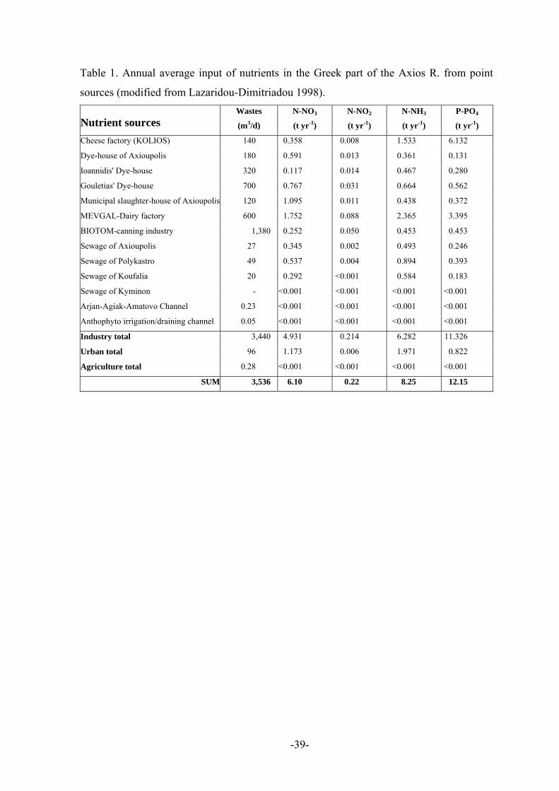
-39-
Table 1. Annual average input of nutrients in the Greek part of the Axios R. from point
sources (modified from Lazaridou-Dimitriadou 1998).
Nutrient sources Wastes
(m3/d)
N-NO3
(t yr-1)
N-NO2
(t yr-1)
N-NH3
(t yr-1)
P-PO4
(t yr-1)
Cheese factory (KOLIOS) 140 0.358 0.008 1.533 6.132
Dye-house of Axioupolis 180 0.591 0.013 0.361 0.131
Ioannidis' Dye-house 320 0.117 0.014 0.467 0.280
Gouletias' Dye-house 700 0.767 0.031 0.664 0.562
Municipal slaughter-house of Axioupolis 120 1.095 0.011 0.438 0.372
MEVGAL-Dairy factory 600 1.752 0.088 2.365 3.395
BIOTOM-canning industry 1,380 0.252 0.050 0.453 0.453
Sewage of Axioupolis 27 0.345 0.002 0.493 0.246
Sewage of Polykastro 49 0.537 0.004 0.894 0.393
Sewage of Koufalia 20 0.292 <0.001 0.584 0.183
Sewage of Kyminon - <0.001 <0.001 <0.001 <0.001
Arjan-Agiak-Amatovo Channel 0.23 <0.001 <0.001 <0.001 <0.001
Anthophyto irrigation/draining channel 0.05 <0.001 <0.001 <0.001 <0.001
Industry total 3,440 4.931 0.214 6.282 11.326
Urban total 96 1.173 0.006 1.971 0.822
Agriculture total 0.28 <0.001 <0.001 <0.001 <0.001
SUM 3,536 6.10 0.22 8.25 12.15
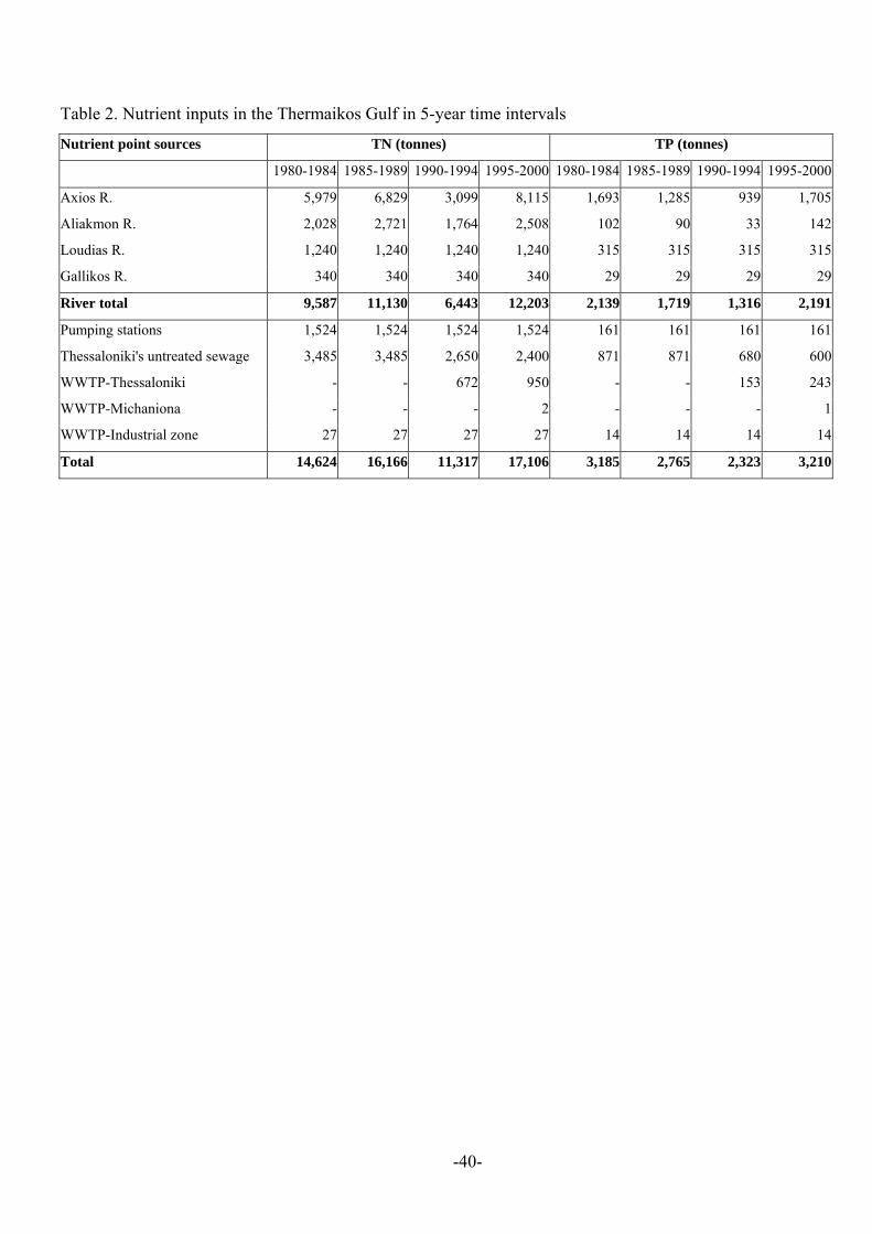
-40-
Table 2. Nutrient inputs in the Thermaikos Gulf in 5-year time intervals
Nutrient point sources TN (tonnes) TP (tonnes)
1980-1984 1985-1989 1990-1994 1995-2000 1980-1984 1985-1989 1990-1994 1995-2000
Axios R. 5,979 6,829 3,099 8,115 1,693 1,285 939 1,705
Aliakmon R. 2,028 2,721 1,764 2,508 102 90 33 142
Loudias R. 1,240 1,240 1,240 1,240 315 315 315 315
Gallikos R. 340 340 340 340 29 29 29 29
River total 9,587 11,130 6,443 12,203 2,139 1,719 1,316 2,191
Pumping stations 1,524 1,524 1,524 1,524 161 161 161 161
Thessaloniki's untreated sewage 3,485 3,485 2,650 2,400 871 871 680 600
WWTP-Thessaloniki - - 672 950 - - 153 243
WWTP-Michaniona - - - 2 - - - 1
WWTP-Industrial zone 27 27 27 27 14 14 14 14
Total 14,624 16,166 11,317 17,106 3,185 2,765 2,323 3,210

-41-
FIGURE CAPTIONS
Figure 1. The catchment area of the Thermaikos Gulf.
Figure 2. Location and type of WWTPs. 1: municipal WWTP of Sindos; 2: municipal
WWTP of Nea Michaniona; 3: industrial WWTP of Sindos. Inset map: location of
mussel-farming units in the Thermaikos Gulf.
Figure 3. Primary crops in Greece (source: National Statistical Service of Greece) and
FYROM (source: FAO 2002).
Figure 4. Primary animal breeding in Greece (source: National Statistical Service of
Greece) and FYROM (source: FAO 2002).
Figure 5. Shellfish production in the Thermaikos Gulf (source: Ministry of Agriculture).
Figure 6. Axios R. long-term (1980-1998) inter-annual variations of water discharge
measured at the Thessaloniki-Eidomeni Railway Bridge station. A line is drawn
between the median of each year. The bars represent the 25-75% quartiles and the
upper and lower ticks represent the minimum and maximum values, respectively.
Figure 7. Axios R. long-term (1980-1998) intra-annual variations of water discharge (a),
nitrates (b), ammonium (c), and total phosphorous (d), measured at the Thessaloniki-
Eidomeni Railway Bridge station. The bars represent the 25-75% quartiles and the
upper and lower ticks represent the minimum and maximum values, respectively.
Figure 8. Axios R. long-term (1980-1998) inter-annual variations of nitrates, measured at
the Thessaloniki-Eidomeni Railway Bridge station. A line is drawn between the
median of each year. The bars represent the 25-75% quartiles and the upper and
lower ticks represent the minimum and maximum values, respectively.
Figure 9. Total nitrogen (TN) and total phosphorous (TP) variations along the Axios River
course. Average concentrations of 1997-1998-1999.
Figure 10. Seasonal variation of depth integrated nutrients concentrations in the
Thermaikos Gulf. (a) winter nitrates, (b) summer nitrates, (c) winter phosphates, and
(d) summer phosphates. Winter months: November to April, summer months: May to
October.
Figure 11. Seasonal variation of near-bottom dissolved oxygen concentrations in the
Thermaikos Gulf during (a) winter, and (b) summer. Seasonal variation of depth
integrated chlorophyll-α concentrations during (c) winter, and (d) summer. Winter
months: November to April, summer months: May to October.

-42-
Figure 1

-43-
-40 m
-30 m
-20 m
-10 m
-5 m
N
-5 m
Aliakmon R.
Loudias R.
Axios R
.
Gallikos R
.
THESSALONIKI
NeaMichaniona
Sindos
Chalastra
WWTP-2
WWTP-1WWTP-3
Mussel-farmingunits
Figure 2

-44-
Wheat: Production (tons)
0100,000200,000300,000400,000500,000600,000700,000
1992 1993 1994 1995 1996 1997 1998 1999 2000 2001
GREECEFYROM
Rice: Production (tons)
020,00040,00060,00080,000
100,000120,000140,000160,000
1992 1993 1994 1995 1996 1997 1998 1999 2000 2001
GREECEFYROM
Barley: Production (tons)
0
50,000
100,000
150,000
200,000
1992 1993 1994 1995 1996 1997 1998 1999 2000 2001
GREECEFYROM
Maize: Production (tons)
0
50,000100,000
150,000
200,000
250,000300,000
350,000
1992 1993 1994 1995 1996 1997 1998 1999 2000 2001
GREECEFYROM
Cotton: Production (tons)
0
20,000
40,000
60,00080,000
100,000
120,000
140,000
1992 1993 1994 1995 1996 1997 1998 1999 2000 2001
GREECE
Tobacco: Production (tons)
05,000
10,00015,00020,00025,00030,00035,00040,00045,000
1992 1993 1994 1995 1996 1997 1998 1999 2000 2001
GREECEFYROM
(a) (b)
(c) (d)
(e) (f)
Figure 3

-45-
Sheep: Production in 1000 heads
0
500
1000
1500
2000
2500
3000
1992 1993 1994 1995 1996 1997 1998 1999 2000 2001
GREECEFYROM
(a)
Pigs: production in 1000 heads
0
50
100
150
200
250
1992 1993 1994 1995 1996 1997 1998 1999 2000 2001
GREECEFYROM
(c)
Cattle: Production in 1000 heads
050
100150200250300350400
1992 1993 1994 1995 1996 1997 1998 1999 2000 2001
GREECEFYROM
(b)
Hens: Production in 1000 heads
0
1000
2000
3000
4000
5000
6000
1992 1993 1994 1995 1996 1997 1998 1999 2000 2001
GREECEFYROM
(d)
Figure 4
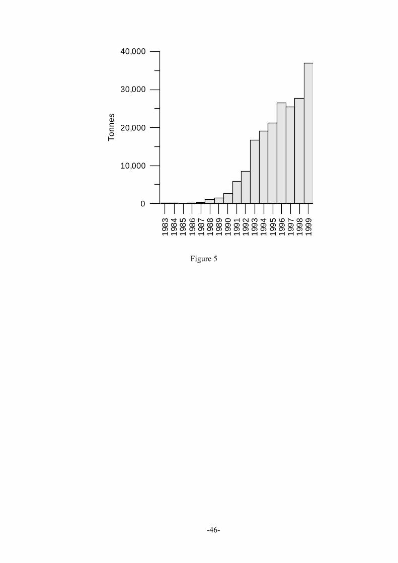
-46-
1983
1984
1985
1986
1987
1988
1989
1990
1991
1992
1993
1994
1995
1996
1997
1998
1999
0
10,000
20,000
30,000
40,000
Tonn
es
Figure 5

-47-
0
100
200
300
400
500
Dis
char
ge (m
3 /sec
)
1980
1981
1982
1983
1984
1985
1986
1987
1988
1989
1990
1991
1992
1993
1994
1995
1996
1997
1998
Figure 6

-48-
0
100
200
300
400
500D
isch
arge
(m3 /s
ec)
J F M A M I I A S O N D
0
5
10
15
20
25
NO
3 (m
g/L)
J F M A M I I A S O N D
0
0.4
0.8
1.2
1.6
NH
4 (m
g/L)
J F M A M I I A S O N D
0
1
2
3
4
5
TP (m
g/L)
J F M A M I I A S O N D
(a) (b)
(c) (d)
Figure 7

-49-
0
2
4
6
NO
3 (m
g/L)
1980
1981
1982
1983
1984
1985
1986
1987
1988
1989
1990
1991
1992
1993
1994
1995
1996
1997
1998
Y = 0.09 * X - 181.50R2 = 0.55
Figure 8
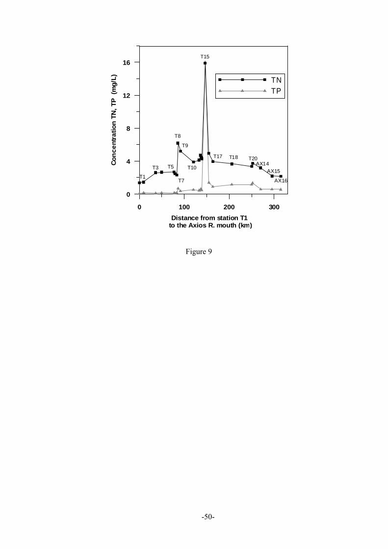
-50-
0 100 200 300Distance from station T1
to the Axios R. mouth (km)
0
4
8
12
16
Conc
entra
tion
TN, T
P (m
g/L) TN
TP
T1
T3 T5
T7
T8
T9
T10
T15
T17 T20
AX15
AX16
AX14T18
Figure 9

-51-
Axios R .
Al iakm on R.
ThessalonikiMean winter depth integrated nitrates (ì M)
(a)
Axios R .
Al iakm on R.
ThessalonikiMean summer depth integrated nitrates (ì M)
(b)
Axios R .
Al iakm on R.
ThessalonikiMean winter depth integrated phosphates (ì M)
(c)
Axios R .
Al iakm on R.
ThessalonikiMean summer depth integrated phosphates (ì M)
(d)
Figure 10

-52-
Axios R.
Aliakmon R.
ThessalonikiMean summer depth integrated chorophyll-á (ì g/L)
Axios R.
Aliakm on R.
ThessalonikiMean winter depth integrated chlorophyll-á (ì g/L)
Axios R.
Aliakmon R.
Thessalonikiwinter near-bottom oxygen (mL/L)
Axios R.
Aliakm on R.
Thessalonikisummer near-bottom oxygen (mL/L)
(c) (d)
(b)(a)
Figure 11