an attempt to synthesize neo-republican and socialist thought
Upload
khangminh22Category
view
0download
0
I

Digitized by the Internet Archive
in 2015
https://archive.org/details/b24991478


AN ATTEMPT I
TO DEVELOP
THE LAW OF STORMSBY MEANS OF FACTS,
ARRANGED ACCORDING TO PLACE AND TIME;
HENCE TO POINT OUT A CAUSE
FOR
THE VARIABLE WINDS,WITH THE VIEW TO
PRACTICAL USE IN NAVIGATION.
ILLUSTRATED BY CHARTS AND WOODCUTS.
THIRD EDITION.
BY LIEU T.-C 0 L 0 N E L W. REID, C.B., F.R.S.1/
{Of the Royal Engineers.)
LONDON:
PUBLISHED BY JOHN WEALE,
LIBRARY OF CIVIL, MILITARY, AND MECHANICAL ENGINEERING,
•59, HIGH HOLBORN.
1850.

ROYAL COLLEGE OF PHYSICIANS.
LIBRARY
CLASS
ACCN.
SOURCEt
DATE
CcvOF
PHYSICIANS
OF
%
*oNdcP
LONDON:Palmkr anil Clayton, Printers,
10, Crane Court.

The Second Edition of this Work being out of
print, I republish it on account of the value I attach
to the Log Books of Ships, and Narratives of Seamen,
which formed the basis for “The Law of Storms.'’
W. R.
CON T E N r
r S.
CHAPTER I.
An Introductory Chapter.—How this Inquiry originated.
— Franklin’s North-east Storms.—Capper’s Whirl-
winds.— Redfield’s Progressive Gyratory Storms.
—
Rise and Fall of the Barometer. .
Page
l
CHAPTER II.
Storms traced by Redfield.—Storm of September, 1821.
—Storm of August, 1830 . . . . .10
CHAPTER III.
The Barbados Hurricane of 1831 ..... 24
CHAPTER IV.
Barbados Hurricane, September 3, 1835.—Another at
Antigua, August 12th, 1835. — Hurricanes not caused
by the Islands.—Ground Swells explained.—A Rota-
tory Gale. ........ 35
CHAPTER V.
On the Hurricanes of 1S37-—Five Storms traced in close
succession.—How these point out a Cause for the
Variable Winds . . . . . . .47
CHAPTER VI.
On Storms in the Southern' Hemisphere.—They revolve
in the contrary manner to North Latitude.—Ships

VI CONTENTS.
Page
may overtake Storms.—That there are Hurricanes in
the Pacific Ocean.—Mauritius Hurricanes of 1S18,
1819, 1824, 1S34, and 1836.—Two Stormy which
were very disastrous to East India Fleets under
Convoy of the Albion and Culloden, in 1808 and
1809.—Mauritius Gales of 1811.—The Blenheim’s
Storm, &c.—Barometrical Records . . . .144
CHAPTER VII.
On Typhoons in the China Sea, and on the Hurricanes
of India.— Extraordinary Change of the Barometer at
Canton and Macao.—Capper’s Whirlwinds.—Pondi-
cherry Hurricane of 176O-I.—The Bay of Bengal
Hurricanes.—Remarkable Fall of the Barometer . 271
CHAPTER VIII.
The Hurricanes of 17S0.—That which destroyed Savanna-
la-Mar, 3rd of October.—The Great Barbados Hurri-
cane, 10th of October.—Solano’s Storm, and of the
Winds called Norths....... 289
CHAPTER IX.
On Storms in High Latitudes.—The Cause of the Baro-
meter falling, with a Southerly Wind in the Northern
Hemisphere, and with a Northerly Wind in the
Southern Hemisphere, explained.—Easterly Storms
in Ireland and Westerly of the Coasts of Portugal, in
the middle of February, 183S.—The way in which
Storms appear to pass over the British Islands.—The
Lighthouse and Coast-guard Reports.— Logs, &c.,
from the Lisbon Scpiadron.—Mediterranean Storms.
—The Storms of 1838.—Effect of Storms on Chain
Bridges.—The Bermuda Hurricane of 1839 403
CONTENTS. VII
CHAPTER X.
Pag'e
On Measuring the Wind’s Force.—Captain Beaufort’s
Table for denoting the Force of the Wind and the
State of the Weather . . . . . .453
CHAPTER XI.
On Waterspouts and the Smaller Whirlwinds.—Moving
Columns of Sand.—On the Fall of Fish on Land . 46
1
CHAPTER XII.
CONCLUDING CHAPTER.
Tornadoes on the West Coast of Africa; Pamperos; the
Barometer;
the Rollers at St. Helena and Ascension;
the Ripplings in the Straits of Malacca.—Rule for
laying Ships to in Hurricanes .... 490
APPENDIX.
Popular Explanation of the Barometer and Sympiesometer 519
General Index . 523

.
'

ON
HURRICANES AND STORMS.
CHAPTER I.
AN INTRODUCTORY CHAPTER.
My attention was first directed to the subject of
storms from having been employed at Barbados in
re-establishing the government buildings blown down
in the hurricane of 1831 ;when from the violence of
the wind 1477 persons lost their lives in the short
space of seven hours. I was induced to search every
where for accounts of previous storms, in the hope of
learning something of their causes and mode of action.
West Indian histories, however, contain little beyond
a record of the losses in lives and property, and the
sufferings of the inhabitants," during the period of
these tempests.
The first paper I met with, which appeared to con-
vey any just opinion on the nature of hurricanes, was
one published in the ‘ American Journal of Science,’
bv Mr. W. C. Redfield of New York.J
The late Colonel James Capper of the East India
Company’s Service, who published a work of the
winds and monsoons in 1801, mentions some of the
hurricanes which happened on the Coromandel Coast
of India;but he merely reprints very brief statements
CHAP.i.
Capper.
JJ

INTRODUCTORY CHAPTER.
c ii^a r. of their fatal effects from ‘ Orme’s History of Iliu-
dostan.’ The following passage is to be found in
Colonel Capper’s work
:
“ It would not, perhaps, be a matter of great diffi-
culty to ascertain the situation of a ship in a whirl-
wind, by observing the strength and changes of the
wind. If the changes are sudden, and the wind
violent, in all probability the ship must be near the
centre of the vortex of the whirlwind; whereas if the
wind blows a great length of time from the same
point, and the changes are gradual, it may be reason-
ably supposed the ship is near the extremity of it.”
RedHcld. Mr. Redfield, living amidst the records of storms and
shipwrecks, had actually done what Colonel Capper
was satisfied with merely suggesting, and had come to
the same conclusion, without being at all aware of
what Colonel Capper had written;
and he has also
shown that they are progressive.
In one of the numbers of the ‘ American Journal of
Science’ above alluded to, in 1831, I found collected
together many records of the same storms; and a chart
on a very small scale, showing the progress of one of
the storms.
Strongly impressed with the belief that Mr. Red-
field’s views were correct, I determined to verify them
by making charts on a large scale, and on these laying-
down the different reports of the wind at points given
in the ‘American Journal of Science.’ The more
exactly this was done, the nearer appeared to be the
approximation to the tracks of a progressive whirlwind.
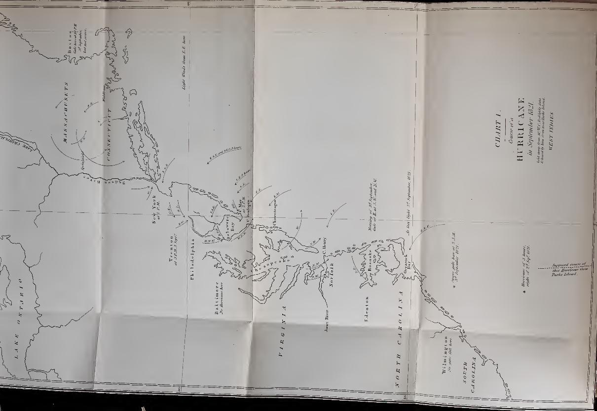
See Charts These are Charts I. and II. prefixed to this volume.
Since my object is not to propose a particular theory,
but to endeavour to direct attention to the curious facts

INTRODUCTORY CHAPTER. 3
I have collected and arranged (with some degree of c ha r.
labour), I shall do little more than print these as they -
are arranged, and set them before the public.
The facts are in themselves however full of interest
;
for the records best suited for the purpose are detailed
accounts of the greatest storms, and the dangers to
which seamen are exposed.
The barometer, as a measure for the atmospheric
pressure, will appear more valuable than ever; and we
have a new, and apparently the true, explanation of
the cause of its fall in great storms.
A popular description of the barometer will be
found at the end of the volume.
W r
e have at length a clue towards an explanation of Variable.
^ winds,tile VARIABLE WINDS.
The quantity of electricity^ exhibited during tropical
hurricanes is very great; and this part of the subject
deserves great attention.
Many of the storms we call gales, certainly partake
of the same nature as tropical hurricanes, and are rota-
tory;and so many of their courses pass over the same
track, that the fact is remarkable. They seem to be
carried towards the poles in some of the general re-
turning atmospheric currents from the equator;and
by tracing storms, it seems probable that we maylearn something more than wre at present knowr of
these upper currents.
Franklin was aware, that what he called north-east lYankiin.
storms came from the south-west; and the geographical
position in which he was placed, probably contributed
not a little to lead his inquiring mind to meteorological
studies : for it will be seen by the annexed charts, that
a great portion of the tropical storms which pass over
b 2

4 INTRODUCTORY CHAPTER.
chap, or near to the West Indies, change their direction,’— about the twenty-fifth degree of latitude, on approach-
ing the coast of the American continent, and that they
sweep along its eastern coast. Franklin died before he
made the next step.
At New York the labouring people remark, that if
the haze indicating a storm be first seen over Staten
Island (or south-eastward), the wind will come from
the north-east
;
but if the haze be seen first over the
Jersey shore of the Hudson river (or westward), then
the wind will come on from the south-east. It is also
said to be a seaman’s phrase, that a north-wester will
never remain long in debt to a south-easter. The cor-
rectness of these observations, and the reasons for
them, will be understood as we proceed.
In reading the observations, it will tend to make
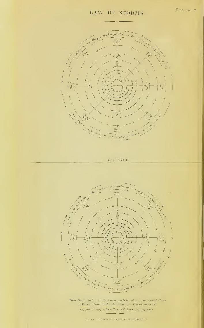
them more easily understood if figures like the fol-
lowing be constructed on paper and then cut out,
so that they may be made to represent progressive
whirlwinds.
The fleurs-de-lis in both figures point to the north.
The first figure is intended to represent a whirlwind
turning from right to left (supposing yourself in its
centre), or in the contrary way to the hands of a
watch. The letters in the diagram denote the points
from whence the wind in the whirlwind blows.
In such a whirlwind as that represented by the upper-
most circle, the wind on the northernmost portion of
the circumference must be east
;
on the southernmost
portion it must be west
;
on the westernmost portion
it must be north
;
and on the easternmost portion it
must be south—and it is necessary that this should be
perfectly understood before proceeding further.

INTRODUCTORY CHAPTER. 5
Such a whirlwind storm coming from the south,
with its centre passing along the New Jersey side of
the Hudson River, would place the city of New York
Proper North, Wind East.
Proper
W?st,
WindNorth.
Proper
East,
WindSouth.
Proper South, Wind West.
Proper North, Wind West.
w
Proper
East,
WindNorth.
Proper South, Wind East.
C II A P.
I.
Figure for
the North-ern Hemi-sphere.
Equator.
Figure 'for
the South-ern Hemi-sphere.

6 INTRODUCTORY CHAPTER.
chap, in the right hand semicircle, and the wind there would
commence at the southward of east;but if the centre
of the storm were upon the sea and to the eastward of
New York, as usually happens, then the inhabitants of
that place would have a storm commencing at north-
east : and such were Franklin’s north-east storms.
A glance at the plates will show, that in the latitude
of New York, these gales come usually from the west-
ward of south. If they begin at south-east they must
end about north-west, which will be understood by a
little careful examination of the moveable figure;and
hence “ the north-wester seldom remains long in debt to
the south-easter.” In the West Indies they come from
the eastward, and proceed to the westward inclining
northerly : and it is constantly remarked, that the
severest hurricanes leave off blowing at the opposite
point to which they commence.
The following figure shows that this will occur if
they are progressive whirlwinds.
AT

INTRODUCTORY CHAPTER. /
In the last figure, such a whirlwind coming from c ii a v
the eastward, is supposed to pass over an island in the
middle of its course. The wind would at the com-
mencement be nearly north;and it would be at the
end nearly south. The direction of the wind is shown
by the arrowed heads.
Proper North, Wind East.
Proper
East,
WindSouth.
Lines drawn across concentric circles best explain
the mode of veering of the wind in these storms;and
(for those who may not recollect all the points) a figure
of the mariner’s compass will be found at the end of
this chapter.
Thus in the preceding figure, a progressive whirl-
wind, turning in the opposite way to the hands of a
watch, is supposed to pass over four ships. The wind
will veer but little whilst the storm is passing over the
ship most to the eastward. With this ship it will
commence at east by south, and leave oft1
at about
south by east.

8 INTRODUCTORY CHAPTER.
CHAP.I.
The next ship will be further within the centre of
the whirlwind;
with it the gale would commence at
east by north, veering by the east to the south, and
ending at south by west.
The fourth, or westernmost ship, would receive the
wind first from the north-east by north, veering at
first gradually to north;
then more rapidly to north-
west, and by degrees it will become west, and the storm
will finish with the wind blowing somewhat from the
south of west. The tempest will be furious whilst the
wind is veering fastest; for the ship will then be near
the centre of the storm:
yet in the very centre there
is a calm.
The ship in the figure over which the centre passes,
will have the wind change but once. This ship will
receive the wind at first from the north-east. If the
vessel could be supposed to remain stationary and not
to drift, the wind would blow over it in the same direc-
tion until the centre of the hurricane reached her. She
would then have a calm;and after an interval of calm,
she would have the wind as violent as before, but from
the south-west;and there would be no other change
of wind until the storm ended.
The gradual fall of the barometric column during
the first part of these storms, and its gradual rise
during the second part, will be found to be singularly
regular;and the nearer a ship is to the centre the
greater will be the fall.
The smaller whirlwinds and waterspouts appear to
be phenomena of another kind from the great storm.
No part of the subject is more curious than the
squalls and gusts;and their descriptions merit atten-
tive consideration.
INTRODUCTORY CHAPTER. 9
But by far the most interesting part of the subject
is, that we have at length a clue towards an explana-
tion of the VARIABLE WINDS.
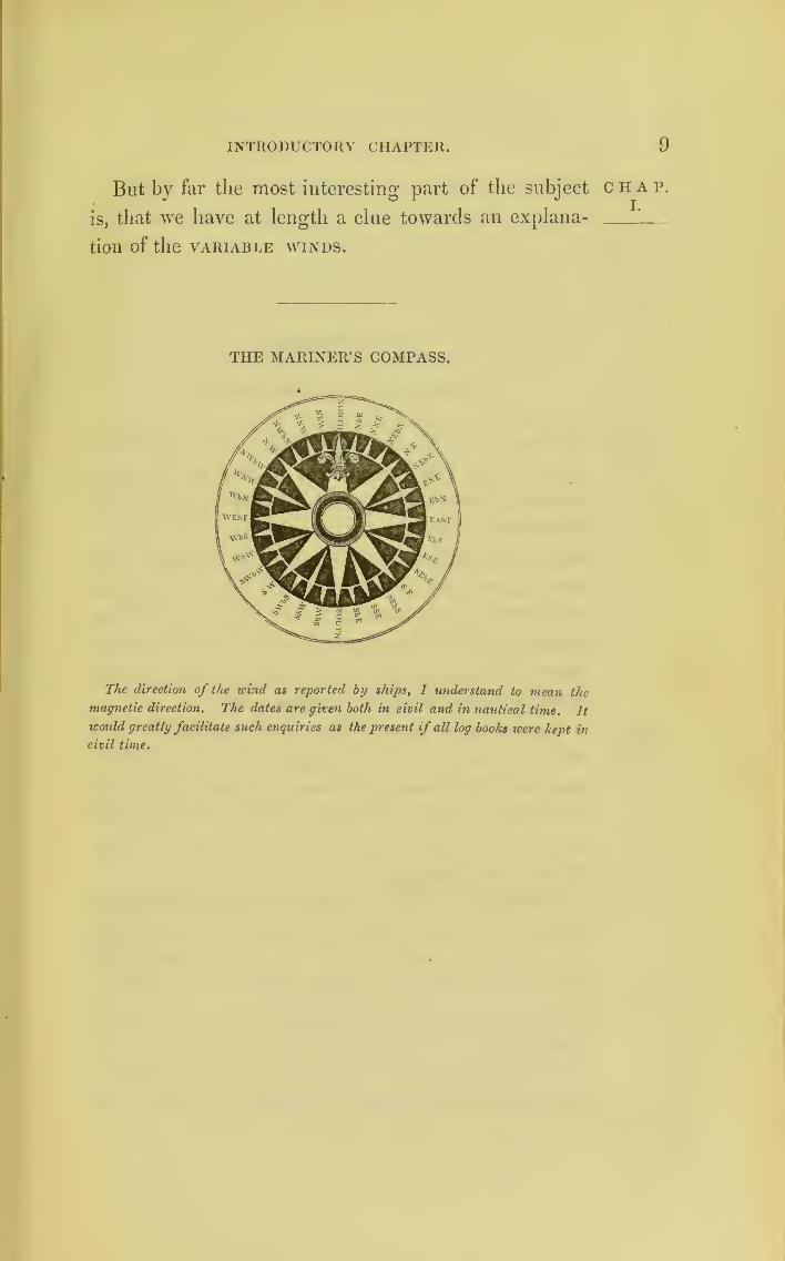
THE MARINER’S COMPASS.
The direction of the wind as reported by ships, I understand to mean the
magnetic direction. The dates are given both in civil and in nautical time. It
would greatly facilitate such enquiries as the present if all log books were kept in
civil time.
CHAP.I.

10
CHAP.II.
Chartsprefixed.
CHAPTER II.
STORMS TRACED BY llEDFIELD.
Charts I. and II. are those which were constructed
from the data published in the ‘American Journal of
Science;’ these data are here annexed: for it is only
by collecting together a number of facts relative to the
same storm, and by arranging these facts, that we can
hope to arrive at any knowledge of the mode of action
of Nature in great storms. The reader is therefore
invited to follow the reports step by step, comparing
them with the projections on the plans, and correcting
the projections where they may be faulty.
By taking a general view, however, of Charts I.
and II., before examining them in detail, it will be
observed, that the arrows which indicate the direction
of the wind, come from the southward on the right-
hand side of the storm;and from the northward on
the left-hand side.
Towards the centre of their courses, the arrows
appear to fly both east and west; but on examining
the reports in detail, it will be found, that as the
storms came from the south and were proceeding to
the north, the wind at the commencement of the gales
was easterly, and at the end of them westerly.
Violent as these storms were, their rate of progress,
on examining the dates, will be found to be no more

redfield’s storms. 11
than the rate of the ordinary atmospheric currents,
and are stated to be at from 7 to 15 miles an hour.
One of the most remarkable facts recorded of the
hurricane of 1821 is, that in the states of Massachusetts
and Connecticut, the trees were blown down on the
eastern portion of those states with their heads to the
north-west;whilst those on the western portion were
prostrated with their heads to the south-east.
The progress of the ship Illinois on Chart II., and a
letter from the master, deserve particular attention. It
will be seen, that on the 15th of August, 1830, the
swell caused by this storm, then to the southward of
the ship, reached the vessel;
but as the Illinois had a
fair wind and was assisted by the Gulf-stream, whilst
the storm made a detour towards Charleston and the
coast of Georgia, the ship, for a day, outran the
swell: on the 17th, however, the storm overtook her,
blowing furiously from the south; whilst, at the same
moment, it was unroofing houses at New York from
the north-east .
In following the course of this storm, it will be
found in what a remarkable manner it suddenly
changed its course on meeting the continent of America
near Charleston. This will afterwards be found to be
the case with most of the others which pass over the
Bahama Islands, though not of all. It will be seen
that they change their direction about the twenty-fifth
degree of latitude.
The Blanche, British frigate, commanded by Com-modore Farquhar, having been in the hurricane of
1830, I procured her log from the Admiralty; and I
have laid down her track from the time she was off
Cuba until her arrival at Halifax. The first part of
c H a p.
ii.
Hurricaneof 1821.
Treesblown in
opposite
direction.
Hurricaneof 1830.
ShipIllinois.
Change of
direction.
H. M. S.
Blanche,1830.

191 redfield’s storms.
chap, the log is printed in this chapter; the latter part willII t
1
'
be printed in its proper place farther on.
A diagram is given to explain the manner in which
this storm most probably passed over the Blanche.
This direction is marked by a line cutting the concen-
tric circles in the figure;and the veering of the wind,
as given in the log, may be read off along this line,
from the time when it began at N.E., until it became
S.W.
See log,
page 22.
But a ship in her situation must have been affected,
and carried on by the current of the Gulf-stream;and
when the frigate made sail, she no doubt kept up with,
and kept within the influence of what seamen call the
tail of the hurricane. The storm at this period going
* towards the north-west, the Blanche was left in the
eastern half-circle, and therefore had for a time a
southerly and fair wind for Halifax.

REDFIELD S STORMS. 13
The place of the ship Britannia is also marked on
Chart II. This vessel left New York on the evening
of the 16th, with fine weather. On the night of the
17th she met the hurricane, having the wind first at
N.E., then E.N.E., and after midnight she had the
wind from S.E. Her course being towards England,
she probably crossed the centre of the whirlwind
storm’s track.
Data on which Chart I. is constructed.
“ The earliest supposed trace of this hurricane which has been
obtained, is from off Turk’s Island in the West Indies, where it
appeared on the 1st of September, 1821, two days previous to
its reaching our coast. It was felt there severely, but at what
hour in the day we are not informed.
“The next account we have is from lat. 23° 43', where the
storm was severe on the 1st September, from south-east to
south-west. Whether these two accounts are considered as
identifying the storm, or otherwise, will not at this time be
deemed material.
“ Our next report is from lat. 32° 30', long. 77° from Green-
which, on the night of the 2nd of September, a hurricane for
three hours.
“ At 3 a.m. on the 3rd of September, a severe gale was expe-
rienced 30 miles outside of the American coast, off Wilmington,
N. Carolina.
“ At Wilmington there w'as no gale.
“ At Ocracock Bar, N. C., at daylight on the morning of the
3rd, a severe gale from E. S. E.
“At Edenton, N.C. the gale was at N.E.“ Off Roanoke, on the morning of the 3rd September, a dread-
ful gale at E. : then S.W. and N.W.“ A vessel from Charleston, S. Carolina, two days previous to
arriving in the Chesapeake, experienced the gale at 4 a.m. on the
3rd, from S.E. to W.S.W.“ A vessel from Bermuda experienced the gale from the west-
ward, on the inner edge of the Gulf- stream.
“ Another vessel from Charleston did not experience the gale.
“In lat. 37° 30r
, on the inner edge of the Gulf-stream, gale
from the westward with squalls.
CHAP.II.
ShipBritannia,
1830.
Hurricaneof 1821.

14
CHAP.II.
Hurricaneof 1821.
redfield’s STORMS.
On James River, Virginia, the gale was severe from theN.W.
“At Norfolk, Virginia, the gale raged on the 3rd for five
hours, from N.N.E. to N.N.W., and terminated at the latter
point: greatest violence at 10 a.m. to 1 p.m.
“ At sea, forty miles north of Cape Henry, severe at S.E.
changing to N.W.“Off Chincoteague, coast of Maryland, gale from the S.E. on
the 3rd.
“ At Snowhill, Maryland, gale commenced at 1 1 a.m.“ In lat. 38° 30', long. 74° 30', gale S. by E.“ A ship from Boston, bound to Norfolk, experienced nothing
of the gale. On the 3rd was in lat. 40° 19', w eather foggy, and
light winds from S.E.
“At Morris River, Jersey, the gale w’as E.S.E.
“No hurricane was felt at Baltimore.
“ At Cape Henlopen, Delaware, the hurricane commenced at
half-past eleven a.m. from E.S.E. shifted in twenty minutes to
E.N.E., and blew very heavy for nearly an hour. A calm of half
an hour succeeded, and the w'ind then shifted to the W.N.W.,and blew, if possible, with still greater violence.
“At Cape May, New Jersey, commenced at N.E. at 2 p.m.
and veered to S.E. and blew with violence;
after abating fifteen
minutes, it again blew with increased violence for two hours, and
then abated. The sun set clear with pleasant W'eather;
at which
time not a cloud was to be seen in the western horizon.
“At Bombay Hook, near the mouth of the Delaware River,
the gale blew from the N.N.E. and W. N.W.“ At sea, forty miles N.E. of Cape May, the gale was at S.E.,
and lasted eight hours.
“At Philadelphia, the storm commenced at 1 p.m. on the 3rd
from the N.E., and raged with great violence from N.E. to N.W.
during the greater part of the afternoon.
“At Trenton, New Jersey, the gale commenced at 3 p.m. with
the w'ind at N.E.
“ In lat. 39° 20', long. 73° 30', the gale blew from the E.S.E.
and S.S.E., and lasted eight hours.
“At New York, the gale was from N.E. and E., and com-
menced blowing w'ith violence at 5 p.m.;continued with great
fury for three hours, and then changed to the W. More damage
was sustained in two hours than was ever before witnessed in
the cityjthe wind increasing in the afternoon. The wharves were


Btirbm

redfield’s storms.
overflowed, rising thirteen feet in one hour. Previous to the gale
the wind was from S. to S.E., but changed to N.E, at the com-
mencement of the storm, and blew with great fury until the even-
ing, and then shifted to the westward.
“At the Quarantine, Staten Island, the wind was reported at
E.S.E.;other accounts fix it at E.
“At Bridport, Connecticut, the gale commenced violent at
S.E. at 6 p.m., and continued until 9 p.m., then shifted to N.W.,
and blew until nearly 11 p.m.
“At New London, the gale was from 7 p.m. until midnight.
“At Middleton, Connecticut, violent from S.E. for five hours.
“At Springfield, Massachusetts, violent from 9 to 12 p.m.,
then changed to the westward,
“At Northampton, at S.E. on the same evening.
“ At Worcester, Massachusetts, in the night between the 3rd
and 4th September.
“At Boston, the gale commenced at 10 p.m., but was not
severe. At the time the storm was raging with its greatest fury
at New York, the inhabitants of Boston were witnessing the
ascent of a balloon, and the aeronaut met with little or no wind.
“The general course of this storm, northward of Cape
Hatteras, appears to have been S. S.W. and N.N.W.;
and of its
further progress we are uninformed.”
—
American Journal of
Science, vol. xx. p. 24.
Data on which Chart II. is constructed.
“ This storm, or hurricane, was severe at the Island of
St. Thomas, on the night between the 12th and 13th of
August, 1830.
“On the afternoon of August 14, and the succeeding night,
it continued its course along the Bahama Islands, the windveering almost round the compass during the existence of the
storm.
“On the 15th of August the storm prevailed in the Florida
channel, and was very disastrous in its effects.
“ In lat. 26° 51', long. 79° 40', in the Florida stream, the gale
was severe on the 15th, from north-north-east to south-west.“ Late on the 15th, off St. Augustine (Florida), in lat. 29° 58',
long. 80° 20', the gale was very severe.
“ At St. Andrew’s, twenty miles north of St. Mary’s (Georgia),* from 8 o’clock p.m. on the 15th, to 2 a.m. on the 16th, the storm
15
CHAP.IT.
Hurricaneof 1821.
Hurricaneof 1830.
16 redfield’s storms.
CHAP.II.
Hurricaneof 1830.
was from an eastern quarter, then changed to south-west, andblew till 8 a.m.
“ Off Tybee, and at Savannah (Georgia), on the night of the
1 5th, changed to north-west at 9 a.m. on the 16th, and blew
till 12 m.
“At Charleston (S.C.) on the 16th, the gale was from the
south-east and east, till 4 p.m., then north-east, and round to
north-west.
“ At Wilmington (N.C.), the storm was from the east, andveered subsequently to the west.
“ In the interior of North Carolina the storm was felt at
Fayetteville.
“In the vicinity of Cape Hatteras, at sea, the storm was very
heavy from the south-east, and shifted to north-west.
“A vessel bound from New York to Hayti, in the middle or
outer part of the Gulf-stream, about lat. 33°, long. 72°, expe-
rienced the gale moderately from the south-west and south-
south-west, but with a heavy sea from a very westerly direction,
and is supposed to have been on the outer margin of the storm.
“ Another vessel, at about the same distance from the coast,
experienced similar effects.
“Early on the morning of the 17th the gale was felt severely
at Norfolk, and also in Chesapeake Bay, from the north-east.
“ Off the Capes of Virginia, on the 17th, in lat. 36° 20', long.
74° 2', ‘a perfect hurricane,’ from south to south-south-east,
from 5 a.m. to 2 p.m., then shifted to north-west.
“On the 19th, in lat. 37° 30', long. 74° 30', near the east of
Virginia, the gale was severe at east-north-east, and changed to
west-north-west.
“ Off Chincoteague (Md.), precise distance from the coast
unknown, the gale was severe between south south-east and
north-north-east.
“ Off the coast of Delaware, in lat. 3S°, long. 72°, ‘tremendous
gale,’ commencing at south-east at 1 p.m. on the 17th, and blow-
ing six hours, then changed to north-west.
“At Cape May (N.J.), the gale was north-east off Cape May,
in lat. 39°, long. 74° 15'; heavy gale from east-north-east on
the afternoon of the 17th of August.
“Near Egg Harbour, coast of New Jersey, the gale was heavy
at north-east on the same afternoon.
“ Off the same coast, in lat. 39°, long. 73°, the gale was at
east-north-east.
redfield's storms. 17
« In the same latitude, long. 70° 30', ‘tremendous gale,’ com-
mencing at south-south-east and veering to north.
“ At New York and on Long Island Sound the gale was at
north-north-east, and north-east on the afternoon and evening
of the 17th.
“ Olf Nantucket Shoals, at 8 p.m., the gale commenced severe
at north-east by east.
“In the Gulf-stream, off Nantucket, in lat. 38° 15', long.
67° 30', on the night of the 17th, ‘tremendous hurricane,’ com-
mencing at south, and veering with increasing severity to south-
west, west, and north-west.
“ At Elizabeth Island, Chatham, and Cape Cod, Massachusetts,
the gale was severe at north-east, on the night between the 17th
and 18th of August.
“ On the ISth, heavy gale from north-east at Salem and Newbury Port, Massachusetts.
“ Early on the 18th, in lat. 39° 51', long. 79°, severe gale
from south-east, suddenly shifting to north.
“ In lat. 41° 20', long. 66° 25', ‘tremendous hurricane’ from
north-north-east on the ISth of August.
“ On the night of the 18th, off Sable Island, and near the
Porpoise Bank, in lat. 43°, long. 59° 30', ‘ tremendous gale’ from
south and south-west, to west and north-west.
“ In lat. 43°, long. 58°, severe gale from the south; the man-
ner of change is not reported. This remarkable storm appears
to have passed over the whole route comprised in the foregoing
sketch in about six days, or at an average rate of about seven-
teen geographical miles per hour.
“ The duration of the most violent portion of the storm, at the
several points over which it passed, may be stated at from seven
to twelve hours.
“ The general width of the tract, influenced in a greater or less
degree by the gale on the American coast, is estimated to have
been from five to six hundred miles.
“ Width of the hurricane portion of the track or severe part
of the gale, one hundred and fifty to two hundred and fifty
miles.
“ Semidiameter of the hurricane portion of the storm, seventy-
five to one hundred and twenty-five miles.
“ Rate of the storm’s progress from the Island of St.
Thomas to Providence Island, Bahamas, fifteen nautical miles
per hour.
C
CHAP.II.
Hurricaneof 1830.
Rate17 miles
an hour.
Lastedfrom 7 to
12 hours.
Diameter500 miles.

18
CHAP.II.
Hurricaneof 1830.
Master of
Illinois’
letter.
SeeChart II.
Heavy ap-pearancein South.
Windbacked.
Preparedfor badweather.
redfield’s storms.
“ Rate of progress from Providence to St. John’s, Florida,
sixteen miles per hour.“ From St. John’s to Cape Hatteras, North Carolina, sixteen
and a half miles an hour.“ From Cape Hatteras to Nantucket, on the south-eastern
coast of Massachusetts, eighteen miles per hour.“ From Nantucket to Sable Island, off the south-eastern coast
of Nova Scotia, twenty miles per hour.”
Extract of a letter from the Master of the ship
Illinois.
“ I sailed from New Orleans on the 3rd of August, bound to
Liverpool.“ Nothing worth notice occurred until the 15th of August, in
lat. 33° N., long. 77° W., when there was a very heavy swell
from the south, more than I had ever experienced before in this
part, unless preceded by heavy gales. We had no indication of
wind at this time, but there was a dull and heavy appearance in
the south. During the day the wind was light and at south-east,
at night it shifted to south-south-west.
“ On the 16th it was a fresh wholesome breeze;so that with
the help of the Gulf-stream we ran at a great rate, steering north-
east, and at noon we were in lat. 36°, long. 73°.
“ The 17th the wind continued steady at south-south-west,
blowing a strong wholesome breeze, but the appearance to the
south continuing dull and heavy
;
the sea was smooth again, and we
seemed to have outrun the southerly swell. At noon, lat. 37° 58',
long. 69° 23', we were still continuing to run about the course of
the Gulf-stream. The temperature of the water was S6°. Onthe first part of the 18th (afternoon of the 17th current time*)
the wind backed to south, and began to freshen in very fast
;
some
heavy clouds arising in the south-west with flashes of lightning
in that quarter. At 8 p.m. the wind had increased to a strong
gale : the weather at this time had an unusual appearance, but
still it did not look bad.
“ At 10 the wind had increased, and we took in our sails, and
prepared for the worst.
“ At 11 o’clock the sea ran high and cross, which induced me
to heave the ship to, under a close-reefed topsail.
“ At half-past 12, midnight, all was darkness;
the heavy
* Civil time.
redfield’s storms. 19
clouds which had been rising in the south-west had overtaken
us;the rain fell in torrents, and the lightning was uncommonly
vivid ;the wind had, in the space of an hour, increased from a
moderate gale to a perfect hurricane.
“ At half-past 1 a.m. it began to veer to the westward.
“ At 3 a.m. it was west, and rather increased in violence as it
shifted.
“ At daylight the sky was clear, hut the gale, if anything, rather
increased in its fury; the sea was tremendous, and ran in every
direction.
“ At. 7 the wind had got to the north-west, and at 9 it began
to abate a little.
“ I have only to add, that from an experience of twenty or
thirty years, during which time I have been constantly navi-
gating the Atlantic, my mind is fully made up that heavy winds
or hurricanes run in the direction of whirlwinds.
“ Believe me, &c.,
(Signed) " ROBERT WATERMAN.”
The Blanche’s place at noon on the 12th will be
found on Chart II. At midnight the weather is stated
in her log-book as being “ calm and cloudy.”
Extract from the Log of H.M.S. Blanche, Commodore Farquhar,
kept by Mr. Middlemist, Master R.N .—In Civil Time.
Hour. Courses. Winds.Remarks, &c., H. M. S. Blanche,
August 15, 1830.
A.M. NNW N East's- A.M. Fresh breezes and squally; tried
2 NNW h W for soundings half-hourly. 3.30. Downfore-topmast-staysail and set fore staysail
;
3 close-reefed mizen-topsail. 4. Dittoweather. 4.30. Close-reefed fore-topsail,
and reefed foresail and set it. 5.30. Wore,5 NW by N dose-reefed main-topsail
; furled fore
0 F. 1 S North' yand mizen topsails ;
down top-gallant-
8 )
-LJ KJ
Head from Eto S to SE hv E
yards and masts ;in flying jib-boom
;
reefed and furled mainsail. 8. Stronggales, with violent squalls
;ship pitching
and working heavily. 9. A hurricane
;
9i
getting in jib-boom, ship made a heavy
10 from E to X E NWest'rplunge ; lost the boom, spritsail yard, andjib, and three seamen, who were unfortu-
n) nately drowned; cut away life-buoy, but
to no effect ; both bumkins went in about
c 2
CHAP.II.
Hurricaneof 1830.
Blanche’sLog.
SeeChart II.
for ship
hovc-to,
and
windveering.

*20 REDFIELD S STORMS.
CHAT.II.
Blanche’sLog.
Hurricanepassingover ship.
Moremoderate.
Stormmovingnorthwardand leav-
ing ship.
Extract from the Log of H.M.S. Blanche—continued.
Hour. Courses. Winds.Remarks, &c. H.M.S. Blanche,
August 15, 1830.
A.M.
12 Head to N E N West'* the same time. 9 - 50. Both fore-topmast
-
stays went. 10. Fore-topmast carried
away close to the cap, and fell with top-sail-yard on fore-yard, springing it in thestarboard quarter
; main-topmast stay car-
ried away;
got a hawser up and securedthe masts
;fore and main courser split and
blew away;starboard cutter filled, cut her
adrift, lost her gear;
split fore- staysail
;
down ditto and trysail; violent hurri-
cane and heavy sea;scuttled lower deck,
and worked chain pumps. 11. Washedaway starboard hi. nettings. 11.30. Windshifted to N W, and blew more violently
;
bowsprit shroud carried away.
Course. Latitude. Longitude. Bearings and Distance. R.W.
NE 27° 15' N 79° 35' W Matinilla Reef, NE | E 30 miles. 78|
UPWoffWNW
from N E byN to NW
from W by Nto NW by W
WNWN by WNorth
N by E
North
S West1 *
W by N
S by E
P. M. Ship laying over so much as to
bury the starboard quarter-gallery, thatin rising it was completely stove, as wellas the dead-lights lost, with fore-topsail,
top- gallant, and royal staysail.
2. More moderate;set main-staysail.
3. Split ditto ; bent a new one.
4. Ditto weather; set main-staysail;jolly-boat filled, carried away larboardtackle
;cut her adrift, lost her gear.
6. Lashed the wreck of fore-topsail andtopsail-yard to the ship
; swifted mainrigging ; found bowsprit, mainmast, andfore-yard badly sprung.
8. Strong gales and squally; tried re-
peatedly to put the ship before the wind.Midnight. Strong gales and squally
weather.
August 16, 1830.
A. M. Strong gales and squally.
12.30. Set main-staysail.
Strong breezes and squally, rolling hea-vily ; employed clearing the wreck andsecuring the masts
;found that the main
rigging had, during the hurricane, drawnconsiderably through the seizings,
8. Strong gales and squally weather
;
employed turning main rigging in afresh.
Fresh gales and squally. Lat. 30° 12'
N, long. 79° 22' W.
redfield's storms. 21
Extract from the Log of H.M.S. Blanche—continued. C H A P.
II.
Hour. Courses. Winds.Remarks, &c. H. M. S. Blanche,
August 16, 1830.
P.M.Bermuda, E pt. N 80 E, 772 miles.
1 N J E S W P.M. Fresh breezes and squally weather.
212.30. Sent the fore-yard down.3.30. Wore; unbent mainsail and main-
4 ENE topsail.
4.40. Set mizen-topsail.
6. Strong gales and squally weather;
set main-trysail.
8. Strong gales, with a heavy sea.
12. Fresh breezes and squally, with rain.
A.M. August 17, 1830.
i ENE S by W A.M. Fresh breezes and squally, with
10 E by N rain.
Fresh breezes with a heavy swell.
li NE Observed a ship running before the
12 E by N wind;bent spritsail to main-topsail-yard
as jury main-topsail ;showed our colours.
Altered course to speakNewYork Packet(of London) from Jamaica bound to Lon-don ;
set trysails, and resumed our course.
Noon. Fresh breezes and cloudy weather.Lat. 31° 42' N, long. 76° 59' W.
P.M.
1
Bermuda, N 87° E, 596 miles.
E by N sw P.M. Fresh breezes and cloudv weather.2.30. Bent mainsail
; reefed ditto.E 4 N* 4. Ditto weather
; set mainsail.
4.30. Got main-top-gallant-mast up for
fore-tcpmast;down main-trysail, and set
spanker.
7. Set main-staysail;crossed main-top-
gallant-yard.
9.40. Dp spanker.11.30. Up mainsail.
Fresh breezes and cloudy.
A.M. August 18, 1830.
1 E£ X sw A.M. Fresh breezes and rainy.
4 WNW 3. Up foreyard and jury-topsail, and in
main-trysail.
5 S W 4. Light airs andcloudy, with heavy rain,
thunder, and lightning.
5.30. Trimmed; set courses
; observeda ship and barque on weather -beam.Squared yards
;got stump of jib-boom
in, and pointed flying jib-boom.9.30. Up mainsail, and set main-trysail.11.30. Set spanker.Moderate, with rain.
Lat. (No observation.) Long. 74° 6'.
Bermuda, N 87° E, 477 miles.
Blanche’s
Log.
Stormhad nowreachedBoston.

90 redfield’s storms.
CHAP.II.
Extract from the Log of H. M. S. Blanche— continued.
Blanche’sLog.
Hour. Courses. Winds.
|
Remarks, &e., H. M. S. Blanche,August 18, 1830.
r.M.
i E £ N w sw P.M. Lioht airs and cloudy.2 West 3.30. Got flying jib-boom out, as a jib-
boom crossed ; main-royal-yards as a jury4 N by W6
NECalm fore-gallant-yard.
9 Set the sail.
10
5 }
ENE Ditto weather.Up mainsail. 7.30. Trimmed.
NE Calm 12. Light airs and cloudy : trimmed
;
set mainsail.
A M. August 19, 1830.
1 SE ENE A.M. Light airs and cloudy. 12.10.
2 S SE Trimmed;wore ship.
4. Light airs and cloudy. 4.30. Trim-4 NE Variable med, and set spanker.
NNE 7.40. Up mainsail and in jury-topsail.
8.50. Spoke ship Ruth (of London)7 N NE E from Jamaica.
8 N E by N 11.30. Up mainsail; unbent jury-top-sail, &c.
10
11
NNE iE
NNEEast 12. Presh breezes and cloudy weather.
Lat. (No observation.) Long. 73° 34' W.Wreck Hill, N 88° 50' E, 445 miles.
P.M.
i NNE East Moderate with rain;discovered a leak
NNE JEin after bread-room.
64. Moderate and cloudy ;
found main-5 North Variable topsail-yard sprung in larboard quarter.
7 N byW Moderate and cloudy.Ditto weather.
8 S E by E 12. Moderate and cloudy.
9 ESE10 E by S NE11 ESE
AM.1
August 20, 1830.
ESE NE A.M. Moderate and cloudy weather.
4. Ditto weather. 4.30. Out fourth
3
{
Eastreef of main-topsail and second reef of
mizen-topsail.S E by E
7.30. Unbent main-topsail to fish the
5 East
E* E Variable
yard.
Noon. Light breezes and fine weather.7 Lat. 32° 52' N, long. 72" 43' W.
10 N by E
P.M.
1 E by S N by E P.M. Moderate and fine weather.
5 E i S NNE10 E by S Midnight. Ditto weather.

REDFIELD S STORMS. 23
Extract from the Log of II. M. S. Blanche
—
concluded.
Hour. Courses. Winds.Remarks, &c., H. M. S. Blanche,
August 21, 1830.
A.M.
1 E by S A.M. Moderate and fine weather.
2 E|S8 E % S NNE9 E i S
10 E by S i S
12 SEbyE JE Noon. Moderate and fine weather.
Lat. 32° 25' N., long. 70° 39' W.P.M.
1 NE2 £ S E
3 S E by E i E
5 S E by E
0 SE ENE7 SE by E
11 S E by E i E Midnight. Fresh breezes and fine.
The remainder of the Blanche’s log, as far as the
time of her arrival at Halifax, will be found in
Chapter V.
This ship had fine weather until the evening of the
22nd, when another storm overtook her. Her place
on the 22nd will be found on Chart II. The dotted
circle marked on that chart is intended to represent
the storm’s place on the 25th.
These two storms closely following each other, and
causing changes of wind, will be further illustrated in
Chapter V., which treats of the Variable Winds.
CHAP.II.
Blanche’sLog.

24
CHAP.HI.
Progres-sive rate
of hurri-
canes.
CHAPTER III.
THE BARBADOS HURRICANE OF 1831.
Whilst employed for two years and a half in the
islands of Barbados and St. Vincent, amongst the
ruins caused by the hurricane of 1831, I had the best
opportunity of ascertaining that the progressive rate of
the storms is not greater than that of the ordinary
atmospheric currents;and that hurricanes certainly
appear to owe their destructive power to their rotatory
velocity.
The distance between Barbados and St. Vincent is
nearly 80 miles. This storm began at Barbados a
little before midnight on the 10th of August, 1831 ;
but it did not reach St. Vincent until seven o’clock
next morning : its rate of progress, therefore, was about
10 miles an hour.
A gentleman of the name of Simons, who had resided
for forty years in St. Vincent, had ridden out at day-
light, and was about a mile from his house, when he
observed a cloud to the north of him, so threatening in
appearance, that he had never seen any so alarming
during his long residence in the tropics : he described
it as appearing of an olive-green colour. In expecta-
tion of terrific weather, he hastened home to nail up his
doors and windows;and to this precaution attributed
the safety of his house, which is situated on the Upper
Adelphi estate, on the east side of St. Vincent, and
opposite the centre of the island. Mr. Simons described


To face page/ 25 'Nl'WI'ODNDLAND
CHART HI
WESTERN ATLANTICwith. the Courses
ofVarious
HURRICANES ,
By'WCaRrdfrM
1835.
Quebec
•Hililitx
V\Sahtr
Bost/iVeCf
NewYork|
Philadelphia
Baltimore
EUNGTON
/jChuapauA /
CJiarUcIniif
<i/ Beruinda
S'Cruf
JAMAICA
Domin i <vv^ \ *•,p
SlLoc££|7«..1
SfVuuxini o'
°(j QarbadoesVplmnn of
Margarita^
’ Grri/tr/atai
BARBADOS HURRICANE OF 1831. 25
the effects of the storm to me, on the spot from whence
he first saw the cloud, in the north.
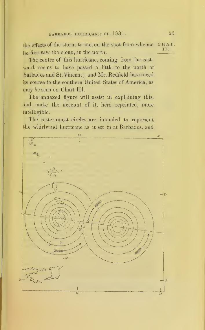
The centre of this hurricane, coming from the east-
ward, seems to have passed a little to the north of
Barbados and St. Vincent;and Mr. Redfield has traced
its course to the southern United States of America, as
may be seen on Chart III.
The annexed figure will assist in explaining this,
and make the account of it, here reprinted, more
intelligible.
The easternmost circles are intended to represent
the whirlwind hurricane as it set in at Barbados, and
«o
C H A P.
III.
T
HU)
— 10
I
1
26 BARBADOS HURRICANE OF 1831.
CHAP.III.
Morningbefore thestorm.
Noon.
4 p m.
6 p.m.
7 p.m.
9 p.m.
10 p.m.windNNE.
the westernmost circles are meant to represent the
same whirlwind storm when its centre was over the
southern part of the island of St. Lucia and the wind
blowing from the south at Barbados.
The following account of the Barbados hurricane of
1831 is taken from that published at Bridgetown in
that island immediately after it occurred.
“ On the 10th of August, 1831, the sun rose without a cloud,
and shone resplendently. At 10 a.m. a gentle breeze which had
been blowing died away. After a temporary calm, high winds
sprung up from the east-north-east, which in their turn subsided.
For the most part calms prevailed, interrupted by occasional
sudden puffs from between the north and north-east.
“ At noon the heat increased to 87°, and at 2 p.m. to 88°, at
which time the weather was uncommonly sultry and oppressive.
“ At 4 the thermometer sank again to 86°. At 5 the clouds
seemed gathering densely from the north, the wind commencing
to blow freshly from that point : then a shower of rain fell, fol-
lowed by a sudden stillness;but there was a dismal blackness
all round. Towards the zenith there was an obscure circle of
imperfect light, subtending about 35 or 40 degrees.
“ From 6 to 7 the weather was fair, and wind moderate, with
occasional slight puffs from the northjthe lower and principal
stratum of clouds passing fleetly towards the south, the higher
strata a scud, rapidly flying to various points.
“ At 7 the sky was clear and the air calm : tranquillity reigned
until a little after 9, when the wind again blew from the north.
“ At half-past 9 it freshened, and moderate showers of rain
fell at intervals for the next hour.
“ Distant lightning was observed at half-past 10 in the north-
north-east and north-west. Squalls of wind and rain from the
north-north-east, with intermediate calms succeeding each other
until midnight. The thermometer meantime varied with re-
markable activity : during the calms it rose as high as 86°, and
at other times it fluctuated from 83° to 85°. It is necessary to
be thus explanatory, for the time the storm commenced and the
manner of its approach varied considerably in different situa-
tions. Some houses were actually levelled to the earth, when
the residents of others, scarcely a mile apart, were not sensible
that the weather was unusually boisterous.
BARBADOS HURRICANE OF 1831. 27
« After midnight the continued flashing of the lightning was
awfully grand, and a gale blew fiercely from the north and
north-east3but at 1 a.m. on the 1 1th of August the tempestuous
rage of the wind increased; the storm, which at one time blew
from the north-east, suddenly shifted from that quarter, and
burst from the north-west and intermediate points. The upper
regions were from this time illuminated by incessant lightning;
but the quivering sheet of blaze was surpassed in brilliancy by
the darts of electric fire which were exploded in every direction.
At a little after 2 the astounding roar of the hurricane, which
rushed from the north-north-west and north-west, cannot be
described by language.* About 3 the wind occasionally abated,
but intervening gusts proceeded from the south-west, the west,
and west-north-west, with accumulated fury.
“ The lightning also having ceased, for a few moments only
at a time, the blackness in which the town was enveloped was
inexpressibly awful. Fiery meteors were presently seen falling
from the heavens;one in particular, of a globular form and a
deep red hue, was observed by the writer to descend perpen-
dicularly from a vast height. It evidently fell by its specific
gravity, and was not shot or propelled by any extraneous force.
On approaching the earth with accelerated motion, it assumed a
dazzling whiteness and an elongated form;and dashing to the
ground in Beckwith-square, opposite to the stores of Messrs.
II. D. Grierson and Co., it splashed around in the same manner
as melted metal would have done, and was instantly extinct. In
shape and size it appeared much like a common barrel-shade ;f
its brilliancy and the spattering of its particles on meeting the
earth gave it the resemblance of a body of quicksilver of equal
bulk. A few minutes after the appearance of this phenomenon,
the deafening noise of the wind sank to a solemn murmur, or,
more correctly expressed, a distant roar, and the lightning,
which from midnight had flashed and darted forkedly with few
and but momentary intermissions, now, for a space of nearly
half a minute, played frightfully between the clouds and the
earth with novel and surprising action. The vast body of vapour
C II A P.
III.
Midnight.1 a.m.
Storm’scentre.
2 a.m.windN N W.3 a.m.
Lightning.
* Lieutenant-Colonel Nickle, commanding the 36th regiment, who hadsought protection by getting under an arch of a lower window, outside his
house, did not hear the roof and upper story fall;and was only assured this
had occurred by the dust caused by the falling ruins.
t A barrel-shade is the name for the glass cylinder put over candles in
the tropics.

28 BARBADOS HURRICANE OF 1831.
CHAP, appeared to touch the houses, and issued downward flamingni ‘ blazes which were nimbly returned from the earth upward.
“ The moment after this singular alternation of lightning, the
hurricane again burst from the western points with violence
prodigious beyond description, hurling before it thousands of
missiles—the fragments of every unsheltered structure of humanart. The strongest houses were caused to vibrate to their foun-
dations, and the surface of the very earth trembled as the
destroyer raged over it. No thunder was at any time distinctly
heard. The horrible roar and yelling of the wind, the noise of
the ocean—whose frightful waves threatened the town with the
destruction of all that the other elements might spare—the
clattering of tiles, the falling of roofs and walls, and the com-
bination of a thousand other sounds, formed a hideous and
appalling din. No adequate idea of the sensations which then
distracted and confounded the faculties, can possibly be conveyed
to those who W'ere distant from the scene of terror.“ After 5 o'clock the storm, now and then for a few moments
abating, made clearly audible the falling of tiles and building
materials, which by the last gust had probably been carried to a
lofty heights
6 a.m. “ At 6 a.m. the wind was at south, and at 7 south-east : atwindSouth. 8 east-south-east
jand at 9 there was again clear weather.
* * * *
“ As soon as dawn rendered outward objects visible, the
writer, anxious to ascertain the situation of the shipping, pro-
ceeded, but with difficulty, to the wharf. The rain at the time
was driven with such force as to injure the skin, and was so
thick as to prevent a view of any object much beyond the head
of the pier. The prospect w'as majestic beyond description. The
gigantic waves rolling onwards seemed as if they w’ould defy all
obstructionjyet as they broke over the careenage they seemed
to be lost, the surface of it being entirely covered with floating
wrecks of every description. It wras an undulating body of
lumber*—shingles, staves, barrels, trusses of hay, and every
kind of merchandise of a buoyant nature. Two vessels only
were afloat writhin the pier3but numbers could be seen which
had been capsized, or thrown on their beam-ends in shallow
water.
" On reaching the summit of the cathedral tower, to whichever
Lumber is the American term for timber ; and shingles are made of split
blocks of wood, and are used instead of tiles and slates for roofs.

BARBADOS HURRICANE OF 1831.
point of the compass the eye was directed, a grand but distressing
picture of ruin presented itself. The whole face of the country
was laid waste ; no sign of vegetation was apparent, except here
and there small patches of a sickly green. The surface of the
ground appeared as if fire had run through the land, scorching
and burning up the productions of the earth. The few remaining
trees, stripped of their boughs and foliage, wore a cold and
wintry aspect3
and the numerous seats in the environs of
Bridgetown, formerly concealed amid thick groves, were now
exposed and in ruins.
“ From the direction in which the cocoa-nut and other trees
were prostrated next to the earth, the first that fell must have
been blown down by a north-north -east wind3
but far the
greater number were rooted up by the blast from the north-
west.”
The centre of this storm appears to have passed a
little to the north of Barbados, and over the southern
extremity of St. Lucia;and its further progress may
be seen on Chart III.
On the evening of the 10th no unusual appearance
had been observed at St. Lucia;but as early as 4 or
5 o’clock next morning the garrison, stationed near
the northern extremity of the island, began to be
alarmed : some lmt-barracks were blown down, and
the wind was then nearly north.
The storm was at its greatest height between 8 and
10 o’clock in the morning; but from that time the
wind gradually veered round to the east,diminishing
in force and dwindling as it were to nothing in the
south-east,and it was succeeded by a beautiful evening,
with scarcely a breath of wind.
At the southern extremity of the island the most
violent part of the storm is reported to have been from
the south-west.
At St. Vincent the garrison was at Fort Charlotte,
near the south-west point of the island; and there the
29
CHAP.III.
St. Lucia.
4 a.m.Aug. 11th.
10 a.m.
St. Vin-cent.
30 BARBADOS HURRICANE OF 1831.
CHAP.III.
WindAVest.
Marti-nique.
AVindEast.
Off Gre-nada.AVindAVesterly.
Dominica.
Effect of
electricity
on forest
trees.
wind first set in from north-west,veering to west and
to south-west,raising the Avater of the sea in Kingston
Bay so as to flood the streets;and it unroofed several
of the buildings in the fort, and blew down others
:
but at Martinique (as will be seen from the following
report printed in the “London Shipping List” for
1831), the wind was easterly during the gale.
“Paris, Sep. 15, 1831.—The Martial arrived at Havre from
Martinique; sailed on the 15th of August. On the 11th of
August a gale at east was experienced there which lasted six
hours. The plantations suffered severely. Two vessels belong-
ins to Bordeaux, and all the Americans at anchor in the road of
St. Pierre, were driven out to sea.”
The army schooner, the Duke of York, on her
return from Trinidad to Barbados during this hurri-
cane, Avas in sight of Grenada in the evening, and to
the eastward of that island. About midnight she first
began to experience hard squalls from the north-west,
which caused the master to take in sail. The squalls
increased until the vessel could carry no sail at all,
and she Avas expected every moment to founder.
Happily, at daylight, those on board of her unex-
pectedly found themselves drifted close to the island
of Barbados, the cause of which will be evident on
inspection of the figure given in page 25, AAdiere her
place is marked.
The hurricane Avas felt at Dominica, but I have not
learned in Avhat direction the wind bleAv there.
A great part of the island of St. Vincent is covered
Avitli forest, and a large portion of the trees at its
northern extremity were killed without being bloAvn
down. These I frequently examined in 1832; and
they appeared to have been killed, not by the wind,

BARBADOS HURRICANE OF 1631 .31
but by the extraordinary quantity of electric matter
rendered active during the storm.
Most accounts of great hurricanes represent the
quantity of electric matter exhibited to be very great
;
and the description given by Hughes of a great storm,
which occurred at Barbados during the night of the
31st of August, 1675, is nearly the same as that of
1831. He states, that the lightning darted, not with
its usual short-lived flashes, but in rapid flames, skim-
ming over the surface of the earth, as well as mount-
ing to the upper regions.
During the severest period of the hurricane at Bar-
bados, on the night of the 10th of August, 1831, two
negroes were greatly terrified by sparks passing oft’
from one of them. This took place in the garden of
Codrington College;and it was related to me on the
spot where it happened, by the Rev. Mr. Pindar, the
Principal of that College. Their hut in the garden
had just been blown down, and in the dark they were
supporting eacli other, and endeavouring to reach the
main building.
In the work I have quoted on this Barbados hurri-
cane, allusions are made to the declarations of some
persons, that they felt shocks of earthquakes during
the storm. But after attentively listening to the
opinions of different people on this point, and careful
examination of the ruins with reference to it, I feel
persuaded there are no sufficient reasons for believing
that any earthquake occurred at this period : and it is
very material to the success of the present investiga-
tion, that the phenomena of hurricanes and earth-
quakes should not be connected together without
proof. The ancient Charibs, and after them many of
C II A p.
hi.
No earth-
quake.

32 BARBADOS HURRICANE OF 1831 .
chap, the European settlers, seem to have thought no powerm '
but that of earthquakes sufficient to cause these tem-
pests which suddenly disturb their regular climate.
The following paragraph occurs in the same work:
Mr. Benjamin Gittens relates, that at his property,
called Tubbs’s, “About two p. m. of the 10th of
indica- August, he observed indications of approaching bad
hurricane, weather;and at four, intimated to his negroes that
a hurricane might be expected. At six, he bid them
not quit their homes, as a dreadful storm was approach-
ing, and if they went abroad they would probably be
seen no more. At nine, the indications which caused
his apprehensions were less apparent, and he retired
to rest. It is well known that this gentleman foretold
the storm of 1819, some hours previous to any other
person suspecting such an event. The indications
observed by Mr. Gittens were— 1st. The darting for-
ward of the clouds in divided portions, and with fleet
irregular motion, not as if borne by the wind, but
driven as it were before it. 2ndly. The distant roar
of the elements, as of wind rushing through a hollow
vault. 3rdly. The motion of the branches of trees,
not bent forward as by a stream of air, but constantly
whirled about.”
Bermuda. The undulations of the sea caused by this hurricane
STheTea. reached the Bermudas, where they broke against the
south shore of those islands. Whilst the storm was
passing over the West Indies on the 11th, 12th, and
white 13th, white objects appeared of a light blue, so de-
aptearcd cidedly as to attract the attention of all the inhabitants,
light blue.It ig thug recordeci i ri the Bermuda Gazette.
“ Appearance before a Hurricane. Barbados Hurricane, 1831.
“It is worthy of remark, that on the 11th, 12th, and 1.3th of

BARBADOS HURRICANE OF 1831. 33
August, 1831, the sun here bore a blue appearance, and where it
shone in rooms, or elsewhere, it was also blue : this was about
the time of the hurricane of Barbados.”
The crews of vessels off Bermuda observed the same
appearance, their sails appearing blue;and the same
is said to have been observed by ships as far west as
the coast of America.
Dr. John Frith, of Bermuda, was at sea on the
afternoon of the 11th of August, 1831, becalmed a
few miles north of St. Kitts. He informed me that
the appearance of the day was that of evening when
the sun had set, and the full moon risen.
The only information relative to the fall of the
barometer I have been able to obtain, is contained
in the following extract from a note from Lieutenant
Byrne, Fort Adjutant at Barbados, addressed to Arch-
deacon Eliot. Lieutenant Byrne says:—
“ On reference to my notes, I find that at eight o’clock at
night, on the 10th of August, the barometer stood at thirty
inches, and at two o’clock in the morning of the 1 1th of August,
it had sunk to 29.40;and my informant, on whose statement I
can rely, states, that he is almost confident, by four o’clock, it
must have sunk below twenty-eight inches.”
D
CHA P.
III.
Appear-ance off
St. Kitts
Barome-ter.
SUPPLEMENTTO
Chapter III., page 31, of the Progress of the Development
of the Law of Storms and Variable Winds.
It may be useful to show by diagrams under what
circumstances the veering of the wind will cause
cables to cross when ships are moored with two bower
anchors, a subject which was first brought to my notice
by Sir James Dombrain, commanding the revenue
vessels on the coast of Ireland.
.4
jf/
Figurefor the
Northernhemi-sphere.
Ship pi
right-handside ofgale.
In these diagrams the dotted circles represent the
MOORING SHIPS.
approaching gales, and the long dotted spears show
the direction in which the gales are moving. The
size of the ships and length of cables are necessarily
exaggerated. The number 1 is intended to mark the
place where the first anchor is let go, and the dotted
line drawn from the number 1 to the white ship, the
direction in which the vessel was swinging at the
setting in of the revolving gale. The number 2
represents the position of the ship when she lets
go the second bower anchor while swinging to the
veering gale.
The first figure (page 1) will serve to show that a
ship will ride with open hawse, notwithstanding the
veering of the wind, by letting go the port bower
anchor first, when gales in the Northern hemisphere
set in at S.E., and veer by the South to the "W est.
The ship represented in this position would be in the
right-hand side of a progressive whirlwind gale, and
such gales are the most frequent on the Atlantic,
coasts of Europe.
But if a ship were in the left-hand side of a similar
gale, and in what is called a North-East storm on the
Atlantic coast of America, then the case would be
reversed, as may be seen by the second figure (p. 3).
In a gale on the Northern hemisphere veering from
N.E. by the North to NAY., a ship would ride with
open hawse by letting go the starboard bower anchor
first.
The third and fourth figures (p. 4) are intended to
show what the effect of the veering of the wind would
be on either side of a gale in the Southern hemisphere.
By inspecting the four diagrams, it will be seen that

MOORING SHIPS. 3
Figurefor the
Northernhemi-sphere.
Ship in
left-hand
side of
gale.
it’ the wind veers so as to make the ship swing to
the left hand, then the port anchor is that which is the
first let go. But when the wind veers so as to make
the ship swing to the right, the starboard anchor is first
let go.
Or, a rule may be expressed thus :
—
When a ship
is coming to anchor and going to moor at the setting
in of a cyclone, if the ship be in the right-hand side
of the storm let go the port bower anchor first, but if
the ship be in the left-hand side of the storm let go
the starboard bower anchor first.
4 MOORING SHIPS
Figurefor theSouthernhemi-sphere.
Ship in
right-handside of
gale.
Figurefor theSouthernhemi-sphere.
Ship in
left-hand
side of
gale.
VA*.
MOORING SHIPS.
The following observations were sent to me by
Captain George Duncan :
—
“ During the first three years I was a shipmaster, 1 840 and
1843, I was employed in the Baltic Trade during the time it
was open, and the vessel being rather large for loading in
most of the ports there I generally loaded in the bays;and in
Narva Bay, Gulf of Finland, have on several occasions rode
during heavy gales in September, October, and November.
Those gales always veered from South, S.W., and round to
N.W., from which last point they blew with greatest force , and
we learned from experience that, as the wind always veered to
the right-hand, to keep a clear hawse we must let go the port
anchor firstj
and as the land sheltered us a little until the
wind came to the westward of S.W., we always delayed, if
possible, letting go the starboard anchor until the wind had
veered somewhat to the westward. There was a precaution
which I found essential to be attended to, viz., that the starboard
chain should be kept slack, and all clear for veering out, as the
wind often veers in the squalls to the West and N.W. You are
always liable to the whole strain of the ship coming upon the
starboard chain when riding with a short scope5from want of
attention to this, I had the starboard chain broken twice whenI was not on board, whilst the port chain, although smaller,
with a long scope rode the breeze out.”


(35 )
CHAPTER IV.
BARBADOS HURRICANE, SEPTEMBER 3, 1835. — ANOTHERAT ANTIGUA IN AUGUST, 1835.—GROUND SWELLS EX-PLAINED.
Hurricanes at Barbados have usually been expe- chap.rienced in their extremest violence, blowing from the
IV ‘
north-west, west, and south-west;and the reason is,
that their centres generally pass to the northward of the
island. But the storm about to be traced here of Sep-
tember 3, lb35, came from the south-east, and passed
on a course much further to the south than usual.
The account here given of it, has been chiefly ob- Weather
tained from the executive Engineer Officer at the time to storm,
on the island, Captain George Tait, who was con-
structing a pier of timber in Carlisle Bay;and at six
in the morning had set his parties to work, when the
weather was more close than usual, and inclining to
calm. About seven, he observed a ship of war coming
from the eastward to stand into the bav ;and soon after-
wards crowding sail, and standing out again to sea.
This vessel proved to be H. M. S. Champion, and the h. m. s.
barometers on board indicated an approaching storm.
About nine a.m. a report was brought to Captain swell.
Tait, that the sea had risen in an extraordinary man-
ner, and was threatening great damage to the pier.
On returning to the beach, he found the waves rolling
into the bay, of a very unusual height, and actually
destroying the work;
the wind still blowing but
lightly from the usual direction of the trade-wind,
d 2
36 BARBADOS HURRICANE OF 1835.
C H A P.
IY.
WindE.N.E.
veering to
south.
H. M. S.
Spitfire.
about east-north-east : but before half an hour more,
it had come on to blow so violently, that with diffi-
culty could persons keep their feet.
The wind, at first east-north-east, veered gradually
more and more to the east,and then having1 reached
the east continued veering towards the south,
until
at the conclusion of the storm it blew into Carlisle
Bay, just round the Cape, on which Fort Charles is
situated, as marked on Chart IV.
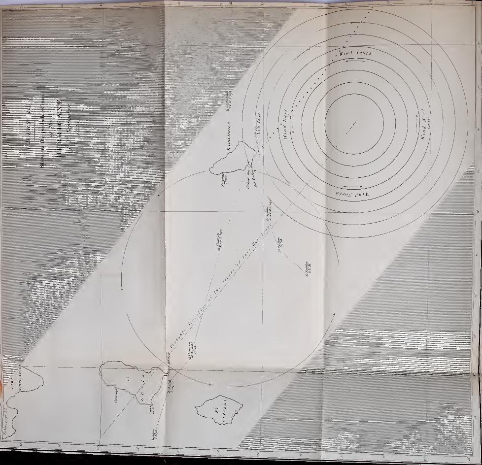
One dotted line on the chart shows the probable
course of the centre of this storm;and another line
parallel to it shows the portion of it which would pass
over Carlisle Bay;and this last line will explain the
mode of the veering of the wind. Id. M. steam-vessel
Spitfire (commanded by Lieutenant Kennedy) was
lying in the bay;and her log, as well as that ot the
Champion, has been procured from the Admiralty;
and both are here inserted. The fires of the Spitfire s
boilers not being lighted, she did not go to sea until
1 1 a.m. By steering to the westward, both vessels
remained for a longer period of time subject to the
influence of the hurricane ;and it will be found in
Shipssometimessail withthe storm.
pursuing the examination of various reports of ships,
that vessels often sail with the storm, when they scud
in a hurricane.
During: this storm several boats v7ere driven to sea
from their anchors at Speightstown on the north-west
side of Barbados;
and one large boat, which had
broke from her moorings, was found at St. Lucia.
Another boat having one man on board returned to
Barbados, after being several days at sea.
This storm abated at Barbados about one o’clock in
the afternoon, and by two was altogether over.
BARBADOS HURRICANE OF 1835 .37
About half-past three in the afternoon it would
appear that the ship Champion was in the centre of
the tempest, and by her course she must have crossed
from the right-hand side to the left, of the course of
the hurricane. At midnight she still was in the gale
;
but by one in the morning of September 4th it was
over at the place she then occupied.
The Spitfire steering west-south-west from Carlisle
Bay, and going at the rate of five, six, and seven
knots an hour, lost her mainmast at four in the after-
noon, by which time she also was in the left-hand side
of the hurricane’s course;but by eight in the evening
she appears to have got out of the storm.
This storm was felt only in a slight degree at St.
Vincent.
The place of the Nightingale packet, arriving from
England and approaching Barbados, will be found on
the chart;and an extract from her log-book is like-
wise inserted.
Extract from the Log of H. M. S. Champion, kept by
W. Parker, Master.
Hour. Courses. Winds. Thursday, Sept. 3, 1835.
A.M.1 EjS N N E A.M. Fresh breezes and cloudy ; braced
up on starboard tack, head off shore ; ex-tremes of the island of Barbados, NW byW h w.
2.30 2.30. Furled the mainsail.
4 4. Squally, with rain.
5.40 5.40. Bore up, set the foresail, jib, anddriver.
G.15 6.15. Squallv, with thick heavy rain
;
up foresail and driver, down jib; wore
ship’s head off shore;
lowered topsails,
and close reefed them.7 7. Wore and set the courses. 7.45. Made
our number to the signal station, Barbados.8 8. Up courses and hove-to
; found lyinghere H.M. steam-vessel Spitfire
;the com-
mander of ditto came on board; bore-up :
out fourth and third reef ; set the top-
CHAP.IV.
II. M. S.
Championoff Bar-bados.SeeChart IV.
Left Car-lisle Bay.

38 BARBADOS HURRICANE OF 1835.
CHAP.IY.
Stormovertaking
ship.
Storm’scentre.
Extract from the Log of H. M. S. Champion—continued.
Hour. Courses. Winds.
A.M.
gh
9 W by Nn
s
10 W by N | N NEf
a
Noon
P.M. (
i W by N J N NEbyN
:
1.20
2
2.30 N NE
3.40 S S w
5.40
6 ssw
6.30
7 & 8 SWoffWSW11
MidnSW by S
A.M.ESE
>1Head from NtoNE
5 Easterly
7 W by.N
8
9 WbyN|N10
11 ESE
Thursday, Sept. 3, 1835.
rllant-sails. Needham's Point, E S E,
alf a mile ; set courses.
9.
Squally; in top -gallant-sails, up
tainsail, down top-gallant-yards, and
;ruck the masts.
10.30.
In three reefs of the topsail
;
rrled the mizen ditto; reefed the foresail,
nd set it.
Noon. Strong gales, with thick rain.
Lat. d. r. 13° 15' 24" N, long. d. r. 60°
4' 40".
Point Moliciqua, St. Lucia, N 66° W,0 miles.
P.M. Strong gales, with thick rain;
UU illuuo an onug1.20. Heavy squalls; furled fore-top-
hi, up foresail, in main- topsail, and furled
rem.2. Set the main-trysail and fore and
2.30.
A tremendous heavy hurricane ;
uiiu, mvu rr- >
ew most violently t a sea over the stern.
6.40. Washed the dingy and life buoy
from the stern.
6. The wind moderated ;set the main-
staysail and main-trysail.
6.30.
Strong gales; down main-staysail.
8. Strong gales and squally, with rain ;
set the fore-staysail.
Midnight. Strong gales and squally,
with rain ;wore ship.
Friday, Sept. 4, 1835.
A.M. Moderate and cloudy.
.
4. Wore ship; down main- staysail.
Day-light. Saw the high land of St.
Lucia, N W by W, 15 or 16 miles ;mode-
rate and cloudy; made sail to single-
reefed top- sail and fore-sail.
8. Point Moliciqua, N E, 4 miles;mo-
derate, with rain.
10. Sent the top-gallant-mast up, and
fidded ditto ;crossed top- gallant- yards,
and set top-gallant- sails ; sent the stud-
sail-boom and small sails up, and loosed
them to dry ;carpenter employed repair-
ing hammock-nettings, and other delects.
11. Out first reefs of the topsail.
BARBADOS HURRICANE OF 1835 . 39
Extract from the Log of H. M. S. Champion—concluded.
Hour. Courses. Winds. Friday, Sept. 4, 1835.
A.m.Noon WNW Noon. Moderate and cloudy ;
Sugar-loaf
Hill, St. Lucia, E, 13 miles. Observations,13° 48' 8" N Altofela, N by W, 125 miles.
p.m.
1 W NW SEbvE P.M. Moderate and fair.
8 ENE Ditto weather.11 E by S Ditto.
Extract from the Log of H. M. Steam-Vessel Spitfire,
Barbados, Lieut. A. Kennedy, Commanding3
kept by
Samuel Lillinop, Second Master.
Hour. Courses. Winds. Thursday, Sept. 3, 1835.
A.M.
1 NE A.M. Fresh breezes and cloudy, threaten-8 ing weather, with rain at times. At 8, ar-
rived H.M.S. Champion; commander went8.45 on board per signal. 8.45. Sailed H.M.S.9.50 Champion. 9.50. Lit the fires; every ap-10 pearance of a hurricane. At 10, a hard
gale, heavy sea making in the bay ; several
sail slipt their cables;
several boats thatwere lying at the engineer’s wharf weresunk at their moorings
;sent a boat to their
assistance, but found it impossible from the10.30 wind and sea to make head-way. 10.30.
The anchor came home, the wind blowing a11 heavy gale. At 1 1 ,
finding it impossible to
ride the hurricane, slipt the cable with along buoy-rope, 60 fathoms of chain, wind
11.15 blowing a hurricane from N E. At 11.15,the dingy was blown from the stern
; the gigswamped and lost ; the cutter was blownin-board, and stove in several places
; themasts, sails, and oars of the boats were lost.
Noon Veered Noon. Blowing ahurricane; wind veeredto south- round to the southward and westward,ward and sea making a complete breach over thewest- ship ; hove 73 bags of coals overboard toward lighten ship.
P.M.No observation.
1 w swVariable
P.M. Still blowing a hurricane; main •
2 trysail, fore-staysail, and jib blown from3 the bolt-rope; ship labouring very much;
fore-trysail was blown from the gaskets,and a great part of it lost
; main-trysail-gaff carried away.
4 At 4, the mainmast went, about threefeet below the deck, and fell across thei)
CHAP.IV.
Spitfire in
Carlisle
Bay.Lightedfires andput to sea.
SeeChart IV.
Crossedstorm-track.
Mainmastwent.

40 BARBADOS HURRICANE OF 1835.
CHAP.IV.
SeeChart IV.
Nightin-gale
_
within thecircuit of
storm.
Extract from the Log of H. M. Steam-Vessel Spitfire—concluded.
Hour. Courses. Winds. Thursday, Sept. 3, 1835.
A.M.6
7
8
9 S W | S
larboard quarter, breaking the rail, twostancheons, and splitting the covering-
board;
six hammocks were washed out
of the netting, and larboard binnacle
10
11
12 SWquarter-deck, and fore-hammock-cloths.
8. More moderate.
12. Fresh breezes, and cloudy weather.
Extract from the Log of H. M. Brig Nightingale.
Hour. Courses. Winds. Wdnesday, Sept. 2, 1835.
A.M.
1 ENE Fresh breezes and cloudy.
Lat. 14° 34', long. 55° 40'. Barbados,Noon ENES 73, W 251.
P.M.
1 ENE Fresh breezes and squally.
4.30 ENE Heavy squalls, with rain ; in all stud-
8 Eding-sails
;close-reefed the topsails.
Squally, with rain.
A.M.
1 EThursday, Sept. 3, 1835.
Squally, unsettled weather.
8
10 SE
Squally, with rain;
furled all sails
;
dovVn the top- gallant-yards and mast,
and got flying jib-boom on deck.
Bent the storm-sails, and set them.
12 S Sun obscured.
P.M.
1 SSE
Lat. d. r. 13° 10', long. 57° 54'. Bar-
bados, south point, S 85, W 102.
Strong gales and squally.
2
4
8
9 SE
Set the topsails and course.
Strong breezes and dark cloudy weather.
Moderate breezes and cloudy.
Saw the island of Barbados, bearing
W, distant three or four leagues, south
!point bearing W S W. Midn. North ex-
i tremity of the island W 13 N.
The wind is stated as blowing trom the south-east
and east-south-east, until the evening of the 4th,
when it became east-north-east, and the Nightingale
anchored in Carlisle Bay, at 7.15, p.m.; and was
soon afterwards despatched after the Spitfire, supposed
to have been in sight, dismasted.

BARBADOS HURRICANE OF 1835. 41
"Liverpool, Oct. 22, 1835.—The island of Barbados was
visited with a severe hurricane on the 3rd of September. The
sloop Goldhunter, of St. Vincent, was lost;
crew saved. The
mail-boat, Lady Lyon, was capsized and sunk;
one man saved.
The mail-boats, Nancy and Mary and Placid, were stranded.
The Manchester and Montague lost foremastsjand the Firefly,
Ariel, and Barbados, were driven out to sea, and they had not
returned on the 1 4th of September.
" H. M. steamer Spitfire, the Hebe, of London, and several
other vessels put to sea;
the Spitfire was driven into Grenada
with damage and loss of mainmast;and the Hebe returned on
the 9th under jury-masts, having been dismasted. The gale
extended to St. Lucia;and the north end of that island was
strewed with lumber and pieces of wrecked vessels. The Thomas
Parker was driven there from Barbados, dismasted. H.M. S.
Nightingale arrived at Barbados on the 4th of September.”
—
From the London Shipping List of 1835.
A ship at anchor, in such a storm as the one here
detailed, where the wind blows into the bay in which
she is riding, affords the best opportunity for ascer-
taining the height of the waves in hurricanes, when
vessels are observed by persons on shore. The main-
mast of the Spitfire lias been ascertained to measure
ninety-two feet in length : and some observations were
taken with a view to this inquiry into the height of the
waves before she slipped her cable to go to sea, but as
they were not committed to writing at the time, they
cannot be relied upon.
In ordinary gales of wind on the south coast of
England, I found, in 1836, the height of the waves
measure twelve feet, by a graduated pile on the outer
end of the Brighton chain-pier, and they proceeded
forward at the rate of twelve miles an hour. In
1837, during gales rather more severe, the waves were
observed at the same place, by Captain Alderson,
Royal Engineers; they were then found to be thirteen
c H A p.
IV.
Barbados.
Groundswells.
Height of
waves.
42 GROUND SWELLS EXPLAINED.
CHAP.IV.
Inunda-tions.
Progressof undulations.
and a half feet high, and proceeding at the rate of
nineteen miles an hour;but the height of the barome-
ter was not noted at the time. In the deep sea of the
Atlantic, Captain Fitz Roy measured the height of the
waves by ascending the rigging of a frigate, and found
them to be sixty feet high, computed from the trough.
The diminished atmospheric pressure probably allows
the undulations of the sea to rise higher in storms, as
is the case with the tides : and this may be another
cause, as well as the wind, why great disasters often
occur from inundations during storms.
If undulations were to proceed forward no faster
than nineteen miles an hour during hurricanes, still
the waves would considerably precede the storm.
This chapter, together with Chart IV., tends to ex-
plain what is called a ground swell;and the reasons
for the uncertainty of seaman, whether a ground swell
does or does not bespeak a coming storm : for a ship
on the shaded portion of the plan would have the
swell, and yet not experience the storm.
It was long supposed that the undulations in water
were merely on the surface, and that the motion of
the particles of water was vertical. Recent researches
prove that this opinion is not correct, and seem clearly
to show that the effect of heavy waves is propagated
downwards. The great waves which are raised by
hurricanes, affect the sea by degrees to an unknown
depth;
but rolling onwards until they reach sound-
ings and shallower water, they are there found to act
powerfully against the bottom. These are strictly
“Ground Swells;” of which further illustration will
be given in the progress of this work.
A short time before this there had been a hurricane

ANTIGUA HURRICANE OF 1835. 43
at Antigua and St. Kitts. At Antigua it happened
on the 12th of August, 1835; the wind during the
first part blowing from the north, and during the
latter part from the south, with a calm of twenty
minutes in the middle of it. From this account, the
centre probably passed over Antigua.
The barometer was observed to fall 1.4 inch; and
the sympiesometer was much agitated, and fell pro-
portionably.
Trees were blown down, as if forming lanes, an
effect which has been remarked in many other de-
scriptions of hurricanes;and at its commencement the
wind was described as coming in gusts.*
The course of the storm, which passed over Antigua
on the 12th of August, has been traced by Mr. Red-
field, and will be found on Chart III.
It has been said that hurricanes are not met with
to the eastward of the West India islands;but this is
not correct. A ship met the Barbados hurricane of
1831 to the eastward of that island. Two of the hur-
ricanes of 1837 I have traced to the eastward of the
West Indies; and there seems no reason to believe
that they are caused by the islands, as some persons
imagine.
Whatever their cause may be, that cause seems to
act with very different degrees of intensity at different
periods;
for the usual atmospheric current, or trade-
wind, is sometimes disturbed, the veering and changes
indicating a rotatory movement of part of the atmo-
sphere, without proving destructive. Such an instance
occurred on the 9th and 10th of July, 1837;and
* From a verbal statement of Major Barry, R.E., who was at that time at
Antigua.
CHAP.IV.
Antiguahurricaneof 1835.
Calm.
Gusts.
Storms dooriginate
eastwardof theAVestIndiaislands.
Rotatorywinds notalwaysstorms.
44 A ROTATORY GALE
C II A P.
IY.
Clouds in
this gale
mistakenfor land.
ShipCastries.
this is also another instance in proof that storms come
from the eastward of the West India islands.
The gale about to be mentioned was met to the
eastward of Barbados, both by the ships Trinidad and
Castries;
but I have not been able to trace the first
ship. Mr. Mondel, as well as all his crew and passen-
gers, appears to have taken one of the squalls for
land; and it seems to have passed very nearly over
the same track as that on Chart IV., the centre pass-
ing over St. Lucia. At St. Vincent the wind became©
west.
Extract of a letter from Liverpool.
“On the 9th July, the Castries (Mondel), from Liverpool to
St. Lucia, in lat. 15° 4', long. 54° 58', having the wind then at
cast-south-east, the master being confident in his reckoning, his
mate suddenly reported, f Land on the lee-bow !’ the man at the
helm pointing it out at the same time : it had all the appearance
of the broken outline of the West India islands, and looked as if
within a mile and a half from them. Never doubting but that it
was land, the captain trimmed his sails, that he might alter his
course : when he had finished, he again looked for the land,
when nothing like it was visible. On Reaching St. Lucia, and
hearing that there had been a hurricane there on the 10th, he
concluded that what he had seen was this storm. The Castries
had no barometer on board.”
The following is Mr. Mondel’s account
:
“Noon, 9th July, nautical time (8th civil time), wind east-
north-east. At 3h 52’" 2 s
,long, per sun and moon 51° 33' west
j
4 h 8ni
9K
,long, per chronometer, 51° 59' west
;cloudy weather.
At midnight strong breezes, and much lightning;
2 a.m. heavy
squalls and rain. At noon, lat. by account 15° 3', by observation
15° 4'j
long, by chronometer 54° 58', by observation 54° 18';
north point ot St. Lucia, south SI 12 west;353 miles.
“At 8h 16"’ 45 s
,long, per moon and * Antares 54° 41J'.
Noon, 10th July, nautical time (9th civil time), commences cloudy
weather. At 3.30. p.m. was alarmed by the officer on deck

A ROTATORY GALE. 45
calling out ‘Land a-head!’ I ran up from below, and there, to
my astonishment, saw what appeared to be the land, about two
miles distant, the vessel sailing seven to eight miles per hour.
We took in all staysails and stood to the south (wind east-south-
east), which might have occupied six or eight minutes to accom-
plish, in which all appearance of land had subsided. So strongly
the appearance of land did this phenomenon assume, that even
the Irish passengers saw it, or believed they saw it;
and I have
a perfect recollection of one of them calling down the hatchway
to his comrades, ‘Arrah, by Jasus, boys, here’s the land close-to.’
Every seaman on board saw it, and would have sworn it was the
land, had they not been convinced to the contrary by the course
steered. I had some difficulty to convince two gentlemen that
were passengers that it was not the land, nor were they altogether
assured until we saw Barbados. At noon, lat. by log 14° 28',
by observation 14° 57/
jlong- by chronometer 57° 42', by ob-
servation 57° 14'; current 29 miles north; north point of St.
Lucia, south 75° 32' west; 188 miles.
“ 1, King Street. (Signed) “ J. MONDEL, Jun.”
“ The barque Trinidad, from the Clyde, experienced a severe
gale of wind, approaching to a hurricane, on Sunday last, the
9tli July, to the eastward of Barbados.”
—
From the Port of Spain
Gazette, July 10, 1837.
Extract from a letter in Lloyd’s Books, dated Bar-
bados.
“The whole of the 9th July the wind blew strong from north-
east, with occasional heavy gusts, until 7 p.m., when it came in
a severe gale. At 10 p.m. the wind moderated for a short time,
when it began again, with increased violence, from south-east andsouth-south-east, until daylight next morning, when the gale
abated. The schooners Myrtle and St. Andrews were driven onshore on the Pelican reef, to the leeward of Carlisle Bay.”
“ The gale on the 9th July did some injury to the mills andhouses in Barbados.”
—
From the West Indian, July 10.
C II A P.
IV.
ShipTrinidad.
Barbados.WindN. E. andS.E.

46 A ROTATORY GALE.
0 H A P.
IV.
St. Lucia.
Wind N.and S.
St. Vin-cent.
Windwest.
“ St. Lucia, July 19th.—The island received a severe gale
from the north and from the south, on the evening of Sunday,
9th July, and the morning of Monday, 10th July, lSd?> during
which the schooner Mary Ellice (M'Lean), then lying in the bay
of Vieux Fort, was driven on the rocks, and the drogher Eliza
driven on shore .”—From Lloyd's Books.
(Signed) “ WM. MASTERS.”
“ St. Vincent, July 10th.—The weather has been boisteious
during the night, and the wind was at ivest."—Ibid.

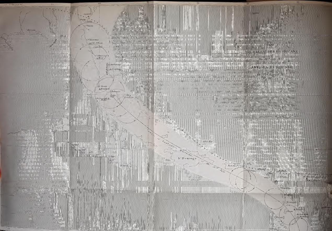

47
CHAPTER V.
ON THE HURRICANES OF 1837 ; AND ON THE VARIABLEWINDS.
The foregoing accounts may not of themselves furnish c ha p.
conclusive proof that great storms are rotatory;yet
they sufficiently show that the inquiry opens to us a
new field for meteorological investigation.
On Charts V., VI., and VII. four storms are traced,
and connected with a fifth, which followed each other
with only the interval of a few days. The investiga-
tion into these is connected with a fifth storm, not
drawn on the charts. An attentive examination of the
details of these strengthens the probability that all such
storms are rotatory, if it does not actually confirm it
;
and, by tracing and connecting so many in close suc-
cession, the subject opens in yet another form, alto-
gether new and of fresh interest, for it leads us to an
explanation of the Variable Winds.
But it is necessary to examine each storm with
attention and to follow the details, in order to ascertain
whether or not they were really rotatory;and at the
end of this chapter we shall be prepared to enter again
on the consideration of the last half of the voyage of
the Blanche frigate to Halifax in 1830, which affords a
good example of the way in which a succession of pro-
gressive revolving gales causes changes of wind.
The Spey packet brought to England the account
of two severe hurricanes in the West Indies in 1837.

48 THE VARIABLE WINDS.
chap. These have been traced, and are laid down on Charts
v ~
y. and VI. The earlier of the two passed over Bar-
bados on the morning ol the 2Gth of July;
at ten the
same night it was at Martinique, by which hour it was
all over at Barbados ;at midnight on the 26th and
morning of the 27th it reached Santa Cruz. By the
30th of July it reached the Gulf of Florida, where some
vessels were wrecked by it, and many damaged ,it
then took a more northerly direction, being on the 1st
of August at Jacksonville, in Florida.
From Jacksonville it passed over Savannah and
Charleston, going in a direction to the eastward of
north.
The other hurricane on Chart VI. was at Antigua
on the 2nd of August ;by the 5th and 6th it also was
on the coasts of Georgia and Florida, crossed the line
of the other hurricane, nearly meeting it ;and it seems
to have touched Pensacola on the 8th of August.
Barbados The reports of these two storms are arranged in the
of 1837.
n
6
order of their progress, and are as follow :
Ring-dove’sLog.SeeChart V
.
Fineweather.
Extract from the Log-Book of H. M. Brig Ringdove,
Barbados Hurricane of the 2Gth July, 1837- lecene
in the
d from
Lieut. J. "W. Tarleton, R.N.
H. K. F. Courses. Winds. Remarks on Board.
A.M.
1
2
3
r.M.
4
Easterly.
July 25th, 1837.
At anchor in Carlisle
Bay, Barbados.
A.M. Light breezes and
fine.
8. Loosed sails.
Noon . Moderate and fine.
P.M. In cutter.
4. Weighed and made
sail out of the Bay.Weighed.

HURRICANES OF 1837. 49
Log of the Ringdove
—
continued.C H A P.
V.
H. K. F. Courses. Winds. Remarks on Board.
F M.
5
6
7
8
9
10
11
12
1
A.M.
2
3
4
5
G
7
8
9
10
11
12
7
6
7
7
7
5
6
6
4
3
4
4
3
1
3
9
6
6
2
6
G
6
6
6
6
2
6
4
4
4
4
4
4
4
6
2
NNWN byW £ WN byW
N byW £WNNWNWbyN
N W l N
N W \ NENENEbyE±E
ENE
E§N
NNE
North
NE
Variable
from N E
NNE
Variable
S by E
0. In first reefs, unbentcables.
7. North point ofBarba-dos, E by N, 7 or 8 miles.
8. Moderate, and cloudy.
10.45. Hard squalls, with
heavy rain ;in top-gallant
sails, mainsail, and jib; first
reef of boom-mainsail, andsecond reefs of topsails.
Midnight. Fresh breezes,
with passing squalls; set
jib and mainsail.
July 26(h, 1837.
A.M. Fresh breezes andsqually, with rain.
1. 50. Up mainsail;
tacked.
2. 40 Heavy squalls,
with rain.
4. 10. Down jib, set stay-
sail.
5.30. Up foresail, andlowered the topsails to a
squall;
in third reefs of
topsails, down top-gallant-
yards and masts ; in fly-
ing jib-boom; down boom-mainsail
;braced round on
the starboard tack.
8. Variable breezes andcloudy weather. A heavycross swell.
9. Trimmed sails to a
breeze from the southward.9.20. Dark threatening
weather, wind increasing.10. Fresh gales, with
hard squalls and a heavysea
; close-reefed and furledthe topsails
; in jib-boom,got preventer-braces onthe yards and runners to
secure the foremast.11. Gale moderating.Noon. Fresh gales, with
passing squalls.
Courses. Dist. I,at.
Obs.I.at.D.R.
I.on.
Cliro. Long. D.n. Bearings and Distance.
N 19°W 63 None 14° 2FN
None.|
60° 4'
W
Cape Ferre, Martinique,N 75° W, 44 miles.
First
storm.
Ring-dove’s
Log.
Squalls.
Heavysqualls
onstarboard
tack.
Close-
reefed
topsails.
E

50 THE VARIABLE WINDS.
CHAP.V.
First
storm.
Ring-dove’s
Log.
Outthird
reefs.
Outsecondreefs.
Log of the Ringdove
—
concluded.
H.
P.M.
1
2
3
4
5
G
7
8
9
10
11
12
A.M.
1
2
3
4
5
6
7
8
9
1011
12
Courses.
Iv.
ST 176°
1
2
3
4
5
6
7
8
9
1011
12
5
6
7
7
G
7
7
G
6
7
F.
6
6
6
5
6
6
6
5
5
44
5
Dist.
155
6
4
4
4
G
6
4
6
6
4
4
4
Courses. Winds.
N by E
NNES by E
6
4
2
4
4
4
4
6
4
6
6
6
NNE
N by E | E
N by ENorth
ESE
Easterly
East
Lat. Lon.Obs. Chro.
17°21 /
N.58 56
W.
4
44
4
5
5
4
5
4
4
5
5
6
2
4
6
6
G
4
4
4
6
4
Lat.D.R.
Remarks on Board.
P.M. Fresh breezes and
squally;a heavy swell.
1. More moderate ;set
fore-staysail and close-
reefed fore-topsail.
1.40. Set close-reefed
main- topsail.
2.50. Out fourth reefs,
set foresail and lee clew of
mainsail.
4. Moderate and cloudy,
a heavy swell.
4.20. Out third reefs,
down fore and set fore-top-
mast- staysail.
5.40. Trimmed sails.
6. Fresh breezes and
cloudy.8. Ditto weather.
11. Trimmed sails.
12. Fresh breezes and
fine.
Julv 27th, 1837.
A.M. Moderate breezes
and fine.
2. Trimmed.4. Fresh breezes and
cloudy.
7. Altered course to NbyE; out jib-boom.
8. Fresh breezesand fine.
Altered course to N.8.40. Set jib.
10.50. Out second reefs
of topsails.
Noon. Moderate and fine,
Long. d.r.
16 °49‘
N.
NorthN by W
59° 7' W
Bearings and Distance.
Bermuda,N 19°W,949 miles
EastESE
SE
ENE
P.M. Moderate and fine.
1. 30. Up top-gallant-
masts, crossed top-gallant-
yards, and set the sails.
Out first reefs, and set
starboard fore-topmast and
top-gallant studding-sails.
4. Moderate and cloudy
.
6. Ditto weather.
8. Ditto breezes and
fine ;trimmed.
Moderate and cloudy.

HURRICANES OF 1837. 51
At 10 a.m. on 26th, the sympiesometer fell from
30.10 to 29.74. At 11, sympiesometer rising. Noon,
sympiesometer 29.92. No barometer on board.
Extract from Lieut. James’s Private Journal, com-
manding the Spey Packet. See account of Antigua
hurricane, 2nd August, 1837:
“Barbados, July 26, a.m.—At 2 o’clock, light showers of
rain, wind shifting from south to north-west, the sky dark and
gloomy, with flashes of lightning in the south-east and south-
west : at 4, calm, with a heavy swell rolling into the bay light-
ning and thunder, sky assuming a blue- black appearance, with a
red glare at the verge of the horizon;
every flash of lightning
was accompanied with an unusual whizzing noise, like that of a
red-hot iron plunged in water : at 6 the barometer fell rapidly,
the sympiesometer much agitated and unsettled, and fell at
length to 28.45 inches;
hoisted in the boats, sent down top-
gallant-masts, struck lower yards and topmasts, let go both
bower anchors, veered out a long scope of cable on the moorings
and both bowers : at 7-30, the hurricane burst on us in all its\
dreadful fury : at 8, it shifted from east-south-east to south, and
blew for half an hour, so that we could scarcely stand on the
deck , made preparations for battening the hatches down and
cutting away the masts;
the sea came rolling into the bay like
heavy breakers, the ship pitching deep, bowsprit and forecastle
sometimes under water : the wind shifting to the west-south-west,
at 9 the barometer began to rise, and to our great joy we ob-
served a change in the sky for the better. As the haze cleared
away, we counted twenty-one sail of merchantmen driven on
shore, and perfect wrecks. Her Majesty’s ship Gannet drove
with four anchors down, but fortunately brought up and rode
out the gale. Her Majesty’s steamer Alban went on shore, but
in all probability will be got off. One brig foundered at her
anchors, and sunk. Thank God, we rode it out so well ! TheSpey, the Gannet, and Fortitude merchant ship, were all that
rode out the hurricane. The City of Kingston steamer put to
sea, and returned next day.
“ On the 30th of July, the Spey left Barbados to run along
E 2
CHAP.Y.
First
storm.
Chart Y.Its com-mence-ment.
WindE. S. E.
veering to
S. and to
w.s.w.

52 TIIE VARIABLE WINDS.
CHAP, the islands and pick up the mails for England. Found that the
V. hurricane had scarcely been felt at St. Lucia, but at Martinique
several ships were wrecked.”
—
Times Newspaper.
storm.
« The barque Clydesdale, from Barbados to Antigua, encoun-
tered a severe hurricane ten miles north of Barbados, on the 26th
of July, 1837.”
Grenada, “ Arrived the British schooner Emancipation, from Grenada,
The captain states, that Grenada and the neighbouring islands
had been visited by a violent gale on the 26th July, 1837-”—New York General Advertiser.
St. Yin- “ Our paper from St. Vincent’s informs us, that the gale of
cenUthe 26th of July was severely felt there
;the wind being from
the west and the south, with a heavy swell of the sea.”—From the
Barbadian.
St. Lucia. “ St. Lucia, 30th July, 1837—We have experienced a severe
gale from the north-west, which blew very violently for several
hours.”—From Lloyd s Books.
Marti- “Martinique suffered a severe gale on the 26th July, from
liique. south-east. The brig Blayais went on shore, with forty-three
persons on board, and only six were saved.”
—
From the Weekly
Register.
“The storm of the 26th July was felt severely at Martinique
The tempest raged there with great violence at 10 at night, at
which hour all was calm at Barbados. The Blayais was driven
on shore at St. Pierre, a harbour much exposed to the south-
west. An American vessel was driven on shore at Fort Royal,
which is an unusual occurrence, as that harbour has always
been considered a safe anchorage in any weather."—From the
Barbadian.
Dominica. « One of the most violent gales of wind, which at this season
are so alarming to these colonies, occurred on Wednesday last,
26th July, 1837. The wind blew from south-east all day, and
about 8 in the evening, a violent swell set in from the south-
west, which occasioned a tremendous surf. The barque Jane
Lockhart was obliged to slip her cables, and stand to sea.
The Venus sloop was washed up into Kew-street. The sloop

HURRICANES OF 1837. 53
Dolphin, from St. Bartholomew’s to Barbados, was forced back CHAP,to this island, after having got within twelve miles of Barbados.” ^ •
—Dominica Colonist.
Copy of a MS. report at Lloyd’s, dated St. Croix, st. Croix.
“About midnight on Wednesday, the 26th of July, it came
on to blow smartly from the east-south-east, shifting by Thursday
morning, the 27th July, to south-east, blowing a gale of wind
until towards noon, when it began to moderate.
(Signed) “ANDREW LANG.”
“ Le Navire Bonne Aimee a peri h Porto Rico dans un coup rorto
de vent, 26, 27 Juillet, 1837.”
—
Port of Spain Gazette. ltico.
“ A Spanish brig was totally dismasted on the 28th of July, g t j)0,
off St. Domingo, in a hurricane, and had to throw overboard a mingo.
quantity of flour.”
—
American Paper.
“ St. Domingo, Aug. 13.
—
Two hurricanes have been recently
experienced here, during which the Edward (French ship) was
wrecked in the outer roads, and three of the crew drowned : three
Haytian vessels were also lost on the coast, and only one mansaved.” ——— f
“The gale on the 29th July, at Nassau, was from the east and Nassau.
the east- south-east, as reported by the master of the sloop Hum-ming-Bird.”
—
Newfoundland Gazette.
“There was a violent gale at Nassau, New Providence, from
the cast and south-east, on the 29th July, which continued until
2 p.m. on Monday, the 31st of July .”— New York General
Advertiser.
The following was received from Captain Milne, Captain
R.N. By referring to Chart V. and the place of the icn.i1uc
'
Snake, off the N.E. end of Cuba, it will be understood
how this storm caused the trade wind to be reversed.
We have here an example of variable winds within
the limits of the trades, changing in conformity to a
fixed law.
“H.M.S. Snake, under my command, was employed during
the months of June, July, and August, 1837, on the N.E. coast
54 TIIE VARIABLE WINDS.
C H A r.
V.
First
storm.
Bar. 30.19.
Bar.falling.
Sky light
blue.
of Cuba, in the vicinity of Point Mulas, during which time the
following facts connected with the hurricanes of that year were
observed.
“It was found from observation, that at 8 a.m., the mean
height of the barometer on the Coast of Cuba was 30.19 at a
temperature of 83°, and the diurnal fall until 4 o’clock, at which
time it was lowest, was 0.45 nearly. That the barometer vas
invariably affected by the direction of the wind;being highest
with a N.E. wind, and lowest with a S.W.
“ On the morning of the 25th July the barometer indicated
30.19, with the trade wind varying as usual from E.N.E. to
E.S.E., force 3 to 4, with fine weather. On the following
morning, July 26tli, the barometer stood at 30.16, wind N.E. by
E., the sky overcast, with thin rain.
“July 27 th. Barometer drooping, now 30.10, wind very light
and unusual, varying from N.N.W. to N.N.E. Dense cumuli
in the N.W., streaked with strata of a dark colour3
blue of the
sky very light colour.
“ July 28th. Barometer 30.08. Wind Northerly and E.N.E.,
very variable, sky overcast. Forenoon, breeze sprung up from
the S.E. 9 f.m. heavy squall from N.E., with a heavy swell
setting in from the same quarter.
“ July 29th. Barometer 29-94. Fresh breezes and squally
;
wind E.N.E. to S.E. 10 a.m. a heavy long swell setting in
from the N.E. increasing rapidly. Wind flying about, shifted to
Bar. 29 . 86 . N. and N.W. 3.30. Barometer 29.S6, and drooping. 4 p m.
heavy squall of wind and rain, in which wind shifted to W.S.W
and S.W. Blew a strong gale all night; the barometer rose
after the squall.
“ ju]y 30th. Barometer risen to 30.06. Sky still wild,
although gale of last evening has subsided. Wind still S. to
S. by E. with squalls of wind and rain.
“July 31st. Wind S. by E. Barometer 30.17 ;fine weather.
“ It is a curious fact, relative to the gradual fall of the baro-
meter from the 26th, the very day on which the hurricane was
at Barbados, until the bad weather reached H.M.S. Snake on
<29th, at 4 p.m., when it immediately rose. The shifting of the
wind it will be observed was from S.E. to E.N.E. 3then to N.,
N.W., W.S.W., S.S.W., S., and S. by E., when it cleared up.
Vessels boarded at the time had experienced, on the 29th, a
heavy north-easterly gale outside of Crooked Island.
(Signed) “A- MILNE,
“Captain H.M.S. Snake.
CentrepassingSnake.
Bar. 30.17.
HURRICANES OF 1837. 55
Extract of a letter from Lieut. Parsons, command-
ing H. M. packet Seagull, dated Falmouth Har-
bour, 18th Sept. 1837 ;addressed to Admiral Sir
P. H. Durham.
“We arrived here on the 18th from Mexico and Havannah;
we had the wind for twenty days from the east and east-north-
east, with four days calm. In coming through the Gulf of
Florida, and in the narrow7 part of the channel, on the night of
the 30th July, I experienced a very heavy gale of wind from the
north-west, which increased on the morning of the 31st, with
thick weather, lightning, and rain in torrents. At about 10 a.m.
we discovered discoloured water on the lee-beam, having had no
observation on the 30th. At this time the wind was west, which
made the Bahama bank (where I judged we were) a lee-shore
;
and in carrying a press of sail to clear it, all of them were split
and blown out of the bolt-ropes : I was therefore under neces-
sity of anchoring in five fathoms water;
and by the time I had
veered out 100 fathoms of chain, the vessel’s stern 'was in 4*
fathoms. I did not let go the other anchor, fearing she might
founder, as the sea was making a fair breach, and rolling aft to
the wheel on the quarter-deck;
and if we parted, we had still a
chance of getting into the Old Bahama Channel. With great
difficulty we tried to get another jib and trysail bent.
“On the morning of the 1st August the wind increased, and
blew a perfect hurricane for about four hours, when it mode-
rated a little, and veered to the south-west, which enabled us to
bend another topsail. At noon we began to weigh, and in three
hours we were able to make sail off the reef.
“ The part of the bank on which I suppose we anchored is
lat. 24° 40' north, long. 79° 87west, and twelve miles south of
Orange Keys.
(Signed) " J. PARSONS.”
" The barque Baltimore, from Havannah, experienced heavy
gales from the ivcstward, on the 31st July, which continued until
the 1st of August. She was over the reef on the Bahama banks
by the Cat Keys, and compelled to anchor and ride out the gale.
When the weather cleared on the 2nd, she saw three vessels on
the reef wrecked, but she was unable to lend them assistance.”
—
New York General Advertiser.
CHAP.V.
First
storm.
Chart V.
H. M.packetSeagull.
On lee-
shore,
split sails
and an-
chored.
Bahamas.

56
C II AY.
First
storm.
Florida
coast.
TIIE VARIABLE WINDS.
“ The barque Cossack, on the 1st August, encountered a
violent gale forty miles south of St. Augustine. Met a ship,
supposed to be the Emily, of Liverpool, dismasted, and making
for a port.”
—
New York General Advertiser.
“The ship Providence, on the 1st August, in lat. 29° 30,
experienced a heavy gale.”
—
Ibid.
Extract of a letter from St. Simond’s Island, lat.
31° 2', long. 81° 28':
“On the 1st and 2nd August we had a very severe gale
here.”
—
Ibid.
“ The brig Monument (Fisher) experienced a severe gale on
the 1st of August, olf Cape Florida. ’ Ibid.
“The barque Josephine, on the 1st August, experienced a
severe gale from north-east, lat. 27° 30 ,long. / 9 20 ,
and had
some of her sails blowing from the yards, though they were
furled.”
—
Charleston Mercury.
“The brig Moses, on the 1st August, off Cape Carnaveral,
lat. 2S° 16', long. 80° 24', experienced a severe hurricane, com-
mencing at north-east and veering round to south, which hove the
brig on her beam-ends, and obliged her to cut away her mast.
She was in fourteen feet water, and was saved by the wind com-
ing from the south.' —Ibid.
“The schooner A. Brook, on the 2nd August, lat. 29 38,
long. 80° 41', experienced a severe gale of wind from east-north-
east to south- south-east. Lost her flying jib and split her main-
sail.”
—
New York General Advertiser.
“A severe gale of wind at Jacksonville, on Tuesday, 1st of
August, which continued until Sunday, the 6tli of August,*
when it blew a hurricane from the north-east and south-east. Two
government warehouses were blown down at Jacksonville, and
the crops of cotton destroyed.”— National Intelligencer.
“ The barque Mablehead, of Boston, was lost on the western
reef of the little Bahama bank on the 2nd August."-From the
Southern Patriot.
* This was owing to the second hurricane nearly overtaking the first one.


HURRICANES OF 1837.
“ The brig Howell anchored on the little Bahama bank on the
SJnd August, 1S37. Obliged to cut away both masts to prevent
her going on shore in a violent gale.”
—
From the Southern Patriot.
“ The Ida * experienced a severe gale in the Gulf on the
3rd August. All her sails were blown to pieces. The boats
and twenty of the crew were washed overboard. The captain
has brought her into port with five men.”
—
New York General
Advertiser.
“ On the 26th July, the sympiesometer indicated the ap-
proaching storm more decidedly than the barometer.”
—
West
Indian Newspaper.
“ The Georgia steam-packet left Charleston on Saturday,
August 5th 1837, in the morning, and arrived at Norfolk in
the Chesapeake, on Monday the 7th August. Had rough
weather and north-east winds.”— From the New York General
Advertiser.
About 1 p.m. the southern portion of this storm was
about W. S.W. of the Balclut.ha.
“ Greenock, Dec. 5, 1837.—Thursday, 27th (26 p.m. civil
time) July, in lat. 14° 28' north, and long. 56° 12' west, wind
veered from east-north-east to west-south-west, with a tremen-
dous swell from the southward;
the sky clouded, with thunder
and lightning, and heavy rain, with all the appearance of hurri-
cane of wind;
furled all sails but the main-topsail;
at 1 p.m.
a heavy gust took the ship, and laid the sail under water, which
continued for the space of half an hour;
at 3 p.m. the wind
veered to the northward, and cleared up to the southward, but a
very bad appearance to the south-west;
had no barometer or
sympiesometer; at 6 o’clock, fine clear weather; made all sail
for Demerara, where the Balclutha arrived on the 3rd August.
“ WILLIAM MILRAE.”
* There were five ships named Ida. This is not the same ship which was
in the third hurricane on the 17th August, 1837.
57
CHAP.V.
First
storm.
The Bal-clutha.
July 26th.
SeeChart V.

58 TI1E VARIABLE WINDS.
Antigua Hurricane of 2nd of August.
THE SECOND STORM.Secondstorm. rp|
ie g packet, which had been at anchor m
Carlisle Bay, Barbados, during the hurricane of the
‘26th July, sailed from that island on the 30th for St.
Thomas, delivered mails at the northern islands as she
went along, and, as will be seen by her log, was very
nearly sailing into the second hurricane.
Spey'sLog-
Chart VI.
Extract from the Log of H. M. Packet Spey, in Civil Time,
Lieut. James, Commander.
Spey ap-
proachingsecondstorm;
Near it.
past Spey.
SeeChart V.
Hour. Wind.|
Bar. I'her.
A.M ... filling
s
ii
JV
t
P.M. SW:
c
1
1
A.M. SEtoW
r. m. rising
A.M.
P.M.
A.M.
Remarks.
Tuesday ,August 1, 1837.
A.M. Moderate and cloudy, with light
towers and hazy weather ;barometer fa11-
ig- landed the mails at Dominica, lhe
ane Lockhart, of London, slipped and
vent to sea on the 26th, and returned to
ake in the rest of her cargo.
P.M. Calm and sultry, the sky overcast_ ,-.1 t- tho camp
Wednesday, August 2, 1837.
A.M. Heavy squalls, with lightning and
nunder ;heavy sea running ;
wind shitted
rom S E to W. ..
P.M. Barometer rising ;made more sail,
and stood in for Guadaloupe ;at 3, saw the
land, ran in for Basseterre, and landed the
mails in a heavy surf; at 5, bore away for
Antigua.
Thursday, August 3, 1837.
At 5 a.m. close in with the land ;observed
the island had suffered lately, all the cocoa-
nut trees, were blown to pieces, lhe Mon-
trose bark, of Liverpool, totally wrecked
with 300 hhds. of sugar on board, the day
before in a severe hurricane.
P.M. Made all sail for Montserrat.
Friday, August 4, 1837-
A.M. Landed the mails, and found that
there had been no hurricane felt on the -0th
of July or the 2nd of August.

HURRICANES OF 1837 59
Extract from the Log of H. M. Packet Spey—continued.
Hour.1
Wind. Bar. Ther. Remarks.
A.M.
A.M.
P.M.
[
Saturday, August 5, 1837.
A.M. Landed the mails at Nevis and St.
Kitts ; here the hurricane was most severely
felt. The ship J ulia, of London, full cargo,
was wrecked on the 2nd, and so smashed to
atoms, that there is hardly a vestage of her to
be seen. The ship Michael, of London, onshore, bilged, part of cargo saved, and dis-
charging into the Robert, of London. Themail-boat Eleanor, with the Leeward mailson board, knocked to atoms ; mails lost.
Sunday, August 6, 1837.
A.M. Arrived at Tortola. Here the hur-ricane has destroyed the town and several
plantations. One brig from St. John’s, witha great number of small craft, total wrecks.
P.M. 2.30. Came to an anchor in St.
Thomas’s harbour, and landed the mails.
Here the hurricane of the 2nd appeared to
have concentrated all its power, force, andfury ; for the harbour and town were a scenethat baffles all description. Thirty-six ships
and vessels totally wrecked all around theharbour, among which about a dozen hadsunk or capsized at their anchors
; some rodeit out by cutting away their masts, and up-wards of 100 seamen drowned
; but whatwas very extraordinary, there was not oneEnglish vessel in the port. The harbour is
so choked up with wreck and sunken vessels,
that it is difficult to pick out a berth for aship to anchor. The destructive powers ofthis hurricane will never be forgotten. Somehouses were turned regularly bottom up.One large well-built house was carried bythe force of the wind from off its foundation,and now stands upright in the middle of thestreet. The fort at the entrance of the har-bour is levelled with the foundation, and the24-pounders thrown down : it looks as if it
had been battered to pieces by cannon-shot.In the midst of the hurricane shocks ofearthquake were felt : and to complete thisawful visitation, a fire broke out in the backstores of Messrs. Stubbs and Co. Heavytiles were flying about from the tops of theshaking and" trembling houses, killing andwounding many persons. One fine Americanship, 500 tons, was driven on shore underthe citadel, and in an hour nothing could beseen of her but a few timbers. Several fine
merchant ships and brigs are at anchor, dis-
masted, with cargoes; and not a spar or rope
for standing rigging to be had in the island.No place hitherto has suffered so much froma hurricane in all the West Indies as St.Thomas’s. Thank God we escaped so wellout of it! R. B. JAMES.
CHAP.V.
Secondstorm.
Chart VL

60 TIIE VARIABLE WINDS.
C H A P.
V.
Secondstorm.
“Jamaica, Aug. 13.—The Judith and Esther arrived hero
from Cork; experienced a tremendous gale on the 1st inst. oil
Deseada, lat. 16°, long. 61°, for 24 hours, during which she was
three times on her beam-ends, and lost boats, part of her bul-
wark, and sails.”
Antigua. “ On the 2nd of August, between 2 and 3 a.m. we had a smart
gale from north, which crept gradually round by north-west, west,
and south-west, until it died away at south-east:'—Antigua Herald
of the 5th of August, 1837-
“ The barometer at Antigua, in the gale of the 2nd August,
only sunk .43, another sunk .63.”
—
West Indian.
Barbuba. “The brig Maria Jane upset and dismasted off Barbuda, in
the storm of August 2, 1837-”—American Paper.
Nevis. “ This morning, between 3 and 4, the wind being north, a
shower of rain fell. At half-past 6 a.m. the wind began to rise
until 8, it then shifted to the north-north-west, and gradually
increased in gusts until 10, during which time much rain fell.
The wind then veered to the westward, and next to due south,
then back to south-west* and last backed to south again, from
whence it blew steadily and with violence until 2 i\m. when it
abated.”
—
Nevis Post Newspaper, August 2, 1837-
“ Early on Wednesday morning, the 2nd of August, the wind
blew strong from the north, and indicated the forthcoming storm.
At about 8 a.m. it veered to north-west, and shortly afterwards
to ivest, during which time it blew a perfect gale, throwing a
tremendous sea into the harbour, and threatening the destruc-
tion of every vessel.”
—
St. Christopher Gazette.
“The mail-boat Eleonore, Captain Carter, wrecked to the
eastward of the bay of Basseterre, St. Kitts, on the 2nd August,
1837.”
—
Kingston Chronicle, Jamaica.
* “ It is difficult to ascertain with certainty the direction of the wind while
tbe storm continued.”- From the St. Thomas's Times Newspaper, August 5.

HURRICANES OF 1837. 61
“ At St. Bartholomew the storm commenced at north-east,
and continued to increase with violence until 2 p.m.”—Barbadian
Newspaper.
Extract of a letter from the Dutcli island of St.
Martin
:
“ A gale commenced about 9 a.m. and raged with great vio-
lence from 11 a.m. to p.m ., veering from east-north east to north-
west.”—Barbadian Newspaper.
Extract of a letter from Lloyd’s Correspondent,
dated Santa Cruz :
“On Monday, 31st July, 1837, the weather was moderate;
several ships sailed on Tuesday, the 1st of August;
in the even-
ing the wind was north-east and the weather moderate. OnWednesday, the 2nd, the wind during the night had shifted to
the north
;
the weather looked squally, cloudy, and suspicious,
and continued so during the forenoon;
the wind shifted gra-
dually to the north-north-west.
“At 1 p.m. the falling of the barometer, the appearance of the
weather, and the increasing wind, left us no doubt of the approach-
ing storm, and it came on from the north-west, between 3 and 4
p.m. The mercury continued falling, and the gale increasing
until half-past 6 p.m. when the wind became westerly. At 7 p.m.
the mercury began slowly to ascend, but yet the storm increased
in violence. At 8 p.m. it was blowing a hurricane from west-
south-west to the south-west, coming in furious gusts until 10 p.m.,
when a certain decrease in their violence had taken place, which
abatement continued until Thursday morning, the 3rd of August,
when it blew a fresh gale from the south.
(Signed) “ ANDREW LANG.”
“ At Tortola the hurricane commenced at 3 p.m., and increased
in violence until 9 p.m., when it began to abate.”
“The brig Jane, of St. John’s, N.B., was driven on shore
during the gale on the 2nd of August.”
—
Tortola, August 6.
CHAP.V.
Secondstorm.
St. Barts.
St.Martin.
SantaCruz.
Chart VI.
Tortola.

62 the variable winds.
C H A P. Extract from the Log-book of the Brig Water-Witch, W.
V. Newby, Commander, from Liverpool to St. Thomas s (kept
I~
by the Mate), made by Mr. Gilbert Ker, Consignee of the
the track Vessel.—In Nautical Time.
of brig — ~
Water-Witch.
Chart VIII.
T' Hk. R Course. Wind. Remarks on board, Tuesday, Aug. 1, 1837.
P.M.
2
4
6
8
10
12
A.M.
2
4
6
8
10
12
5 ..
5
G .
5 1
6
• •
West
W £ N
Midnight
. W N W
E by N
Variable
ENE
N EN
P.M. Fresh breezes and clear;people
employed bending cables and shifting foi e-
topmast, and top- gallant studding-sails
At 5.30 made the island of Deseada,
bearing S W by S, distant about 6 leagues.
At dusk, the land bore S S W ;mid-
night, squally with heavy rain ;in royals
and all studding-sails.
A.M. Steady breezes and cloudy ; set do.
sail ; at daylight made the island of Mont-
serrat right a- head ;set the jib and trysail.
Noon clear; rock Redonda bearing E o Ji
and Charleston (Nevis) N. Lat. obs.
18° 3' N.
Remarks on board, Wednesday, Aug. 2,
1837.
By civil
time p.m.
1st Aug.Brig in
front of
storm.
P.M2
4
6
8
10
12
A.M
1
2
4
6
8
10
i
12
•
. NWbyW
. N W | W
NE P.M. Fresh breezes and clear ;people
employed variously ;made the island of St.
Kitts ;in lower and all lee studding-sails.
At 2, made the island of Saba.
At dusk, in all studding-sails ;Saba
bearing N N E ;and Eustatia E N E ;
at 8,
in Hying jib and royals ;midnight, fresh
breezes and cloudy ;in top- gallant-sails.
A.M. Do. weather.
At 7, made the island of St. John, and
shortly after that of St. Thomas.
Noon squally; double reefed the top-
sails, and stowed the jib ;the town in
sight.
Stormovertaking
the brig.
Extract of a letter from Captain Newby, of the
British brig Water-Witch, from Liverpool to St. Tho-
mas’s, and which left Liverpool, July 17, 1837.
' Arrived off St. Thomas’s on the 2nd of August; morning
tally and the Water-Witch was off St. John’s, and standing
St Thomas’s, the wind north and north-north-west. Noon,
pping in the harbour visible;
at 1 p.m. squalls violent ;at
m we had beat up within half a mile of the forts, when we
dd proceed no further for the violence oi the squalls, an
shored in ten fathoms water ;sent down top-gallant-yards,
HURRICANES OF 1837 . 63
&c.;
did not suspect a hurricane. At 5 p.m. squalls ceased,
and began a heavy gale of wind, at that time off the land. At 7
p.m. a hurricane beyond all description dreadful;the windlass
capsized, and I could not slip my cables, ship driving until I was
in twenty fathoms water;
a calm then succeeded for about ten
minutes, and then, in the most tremendous unearthly screech I
ever heard, it recommenced from the south and south-west
;
I now
considered it all over with us, for the wind was directly on shore,
and the sea rose and ran mountains high. The foretop-gallant-
mast (though struck) and the gig were carried up some feet in
the air, and the vessel drove again into twelve fathoms. We were
obliged to steer her all night, and keep her head to wind, for
when she got her bows to it she went down on her broadside.
At 2 p.m. the gale abated somewhat, and the barometer rose an
inch;
at daylight, out of forty vessels, the Water-Witch and one
other w'ere the only two not sunk, ashore, or capsized.”
“ Papers from Caraccas have been received to the 5th of Sep-
tember. They contain a detailed account of the hurricane at
Puerto Rico, on the 2nd of August, which was equally disastrous
in its effects with that at Barbados and the other West India
islands. Fourteen Spanish vessels, nine foreign, of which, how-
ever, not one was English, and ten coasters, were entirely
wrecked during the tempest .”—Hampshire Telegraph.
Extract of a letter from the Harbour- Master at
Porto Rico to the Governor.
“At 4 P.M. on the 2nd of August, 1837, in consequence of
having observed the barometer falling, I ordered all vessels in the
harbour to prepare for stormy weather, although the fall of the
barometer was not great.
“ At 8 p.m. the mercury was at 29.6“ At 9 p.m 29.5 Wind at N. N. E.“ At 10 p.m. barometer . . . 29-4 and strong.
“ At 11 P.M 29.3 Wind veering to E.
At this hour it began to blow in an alarming
and furious degree until midnight; when the
barometer stood at 28.0, and every vessel
sunk or ashore.
“At i p. 1 a.m. 3rd August, the ba-
rometer rose to 29.17“ At 4 a.m. the barom. stood at 29.5 Wind fell and then
veered to S.
CHAP.y.
Secondstorm at
St. Tho-mas.
Portoliico.
Baro-meter.

64 THE VARIABLE WINDS.
C II A P. “Thirty-three vessels were at anchor, and all lost. From St.
V. Bartholomew we have learned, that on the 2nd ol August two
hundred and fifty buildings were destroyed.”Second
“ The Nile, American brig, foundered at sea August 4th, 1837;
lat. 31° 30', longitude not known.”
“ The William IV. was lost at the island of Ramos, near the
island of Taxando, Porto Rico.”
« It blew a hurricane off Ragged Island on the 4th of August,
1837.” —
St Do- “A severe hurricane was experienced at Porto Plata (St.
mingo. Domingo) on the 3rd of August, which did considerable da-
mage .”—New York Paper
.
CaptainA. Milne,
R.N.
Chart VI.
It is the salt water, driven by the force of the wind
in hurricanes, over islands, which blackens vege-
tation in the manner described below. This evil is
mitigated when abundant rain falls at the same time,
by washing the salt spray from plants. Gales, un-
accompanied by heavy rains, prove sometimes very
destructive to small islands. The following I it
ceived from Captain Milne, R.N.
“ H. M. S. Snake, off N.E. point of Cuba.
“ August 2nd. Bar. 30.25, wind east, force 3, fine weather.
"August 3rd. Bar. 30.18, wind not as usual, being from S.E.
to E., and p.m. to E.N.E., then to N.N.E., fine weather.
“ August 4th. Bar. 30.04, morning dull and hazy, sky uild an
unsettled, wind N. by E„ a heavy swell from N.N.E^etog
heavy on the coast. Bar. 29.9S, wind shifted to NAV, fresh
breezes and squally ,3 r.M. wind W. ,
6
and wild, a great deal of dull blue lightning pouring down in the
Iheru sky; . strong gales with heavy squaUs^
-
S.W. by W., with thunder, lightning, and hea\y ,
wind subsided, barometer risen; midnight, light units
Cl
°o Followin^dayTne weather, with wind S.W., S, and S.E.;
Bar. noon, 30.13.
THE VARIABLE WINDS. 65
“ On the 6th, arrived at Fortune Island : found that Crooked C H A P.
Island had been visited by a hurricane. The statement given by '
the residents was, that on Thursday night, the 3rd August, at gecon(^
II p.m., the gale freshened up at N.E., blowing with great vio- storm,
lence, uprooting trees, blowing down their flag-staffs, and destroy-
ing vegetation. On the 4th, about noon, the wind shifted to
N.W., blowing with greater violence than before;several vessels
which were there were wrecked or left dry upon the beach :
total destruction to all vegetation. Torrents of rain fell during the
whole time, inundating the low lands : this rain was brackish.
On the afternoon of the 4th, the wind shifted from N.W. to
S.W,. still blowing hard;during the night it shifted to N.E.,
and cleared up. Another hurricane was expected next full moon,
from there being little thunder and lightning during the hurri-
cane. From the fall of the barometer, on the 15th and 1 6th August,
a gale must have blown in the vicinity of the Bahamas.*
“Having visited Crooked Island in the middle of July, I was
much struck on my return after the hurricane, at the change
produced on the face of the country. Where a few days previous
nature presented all the brilliancy of tropical vegetation—oranges
and limes hanging to their trees in graceful festoons—all nowwere gone
;the trees lay prostrate, and the whole aspect of the
island was changed from the vivid green of vegetation to the dark
withered leaf, as if winter had encroached on the tropical regions.
The changes of the wind were, as before, round by the north.
(Signed) “A. MILNE, Capt. H.M.S. Snake.”
“Nassau, New Providence, 6th Sept., 1837.—Since the Nassau,
storms which occurred here on the 29th of July and 5th of
August, 1837, we have had no accounts from the out islands
until within the last three or four days. These accounts are very
distressing. It was the gale which began amongst them on
August 4th which did the greatest damage. The sea rose on the Chart YI.
south side of the Great Bahama, and washed away some low land.
At St. Salvador the storm was very severe, and several houses
were blown down, as well as stock destroyed. At Long Island
(more particularly on the north part of it) an unusual and de-
structive rise of the sea took place, and drowned a number of
cattle. At Rum Key the loss was great indeed.”
—
From the
Charleston Courier.
* This alludes to the storm on Chart VII.
F
66' HURRICANES OF 183 /.
CHAP. “The Ulrica was dismasted off Hole-in-the-Wall on the 5th
Y. August, 1837 ."—Charleston Mercury.
Secondstorm.
“ The brig Ann and Minerva, from Havannah to Corunna, on
the 6th August, 1837, in lat. 30 31, long. /.» 19/ during a
severe gale from the south-east, was hove on her beam- ends and
compelled to cut away both masts.”—From the Southern Patriot.
“ The brig Bell, from Demerara to Nassau, in gales from the
4th to the 6th August. She experienced a succession of hurri-
canes from the north-west and south-west. On the 7th, in a
070 40 lone 75° 50', spoke the Saratoga, and got a supply ot
Wd and spars. On L 15th of August, in lat. 31° 21', ^ng.
78° 57', met the Brilliant, Jamaica ship, bound for Liverpool,
which supplied her with water and spars.
Storm’svortex.
ShipAthol.
Chart YI.
Extract of a letter from Mr. Gleig, Commander
of the ship Athol, Havannah to Antwerp :
“ Cowes, 15th Sept., 183/.
“ I sailed from Havannah on August 1st, with a favourable
wind from the south-east, until the morning of the 5th when
we were forced to shorten sail, with the wind from north-east.
Towards evening we were compelled to heave-to, with a heavy
sea going from the same direction, until the morning of the 6th,
when about 9 o’clock the sea was perceived to be in a tremendous
uproar, which was occasioned by the swell from the other direc-
tion.f At 10 o’clock it fell away calm all at once, and in it
course of 20 minutes the water was perceived through the haze
to appear the same as heavy breakers : when about 10 hours 30
minutes, our breakers turned into a complete hurricane which
assumed its greatest strength in the course ot an hour andHaste
until betwixt 4 and 5 in the afternoon, when it abated gradua y
The direction of wind was in general from north to but at
times it extended as far as south.ao iui v—,,
(Signed) “ GEORGE GLEIG, Master.
“ To Lieut. -Col. Reid, R. E.”
. This lat. and long places the ship beyond the verge of the storm, as I
,J Variable Winds" for an explanation of winds and waves at the storm
vortex.
TIIE VARIABLE WINDS. 67
“ The brig William, from Portland to Matanzas, put into
Charleston on the 5th of August, 1837. Off Abaco experienced
a severe gale from the north-east
:
lay to;hove overboard all
that was upon her decks. Finding she was driving towards the
shore, cut away both lower masts and let go her anchors, with
the full scope of cable. At 9 p.m. the wind shifted to the south-
west, when she parted the starboard chain cables;then the crew
shipped the other chain and tried for the nearest port. Fell in
with the William Davison, from Jamaica to London, and received
from the master a spar and a sail, for which he publicly thanks
Captain Nares.”
—
Charleston Mercury.
“ Brig Pomeroy, off Abaco, in the gale on the 5th of August,
1837, lost her masts, and put into Wilmington.”
—
Ibid.
“ A severe gale of wind at Jacksonville, on the 1st of August,
which continued until Sunday last, the 6th August, when it blew
a hurricane from the north-east to south-east. Two government
warehouses were blown down in Jacksonville, and the cotton
crops destroyed.”
—
National Intelligencer.
“ The brig Opulence experienced a hurricane on the 5th August,
1837. Hole-in-the-Wall bearing south-west forty miles distant
;
wind from south-east to north-east; lost topmasts, &c. &c.”
The effect of storms in creating unusually high tides,
and in deluging low lands on the border of the sea,
will be frequently noticed, and this is a part of the
subject of great interest.*
“ Darien, August 10.—During the last week we have been
visited by a storm which has not been equalled since that of the
year 1824. The wind on Sunday last, in the morning, blew fresh
from the north-east
;
in the after part of the day it shifted round
to south-east, when the rain began to fall in heavy torrents. The
wind then rose very high, and began to blow' with fearful violence,
tearing up the oldest oaks and mulberry-trees in the place by the
roots, while limbs and branches of the different trees were flying
in all directions. The water of the river then rose, and covered
the rice plantations so completely, that they appeared to the eye
C II A P.
V.
Secondstorm
Florida
coast.
Inunda-tion by thesr a.
* See page 100, “ Progress of the Development,” &c.
F 2

HURRICANES OF 1837.68
CHAP, to form part of the river. The rice, there is no doubt, will be
V. greatly injured by the salt with which the water is impregnated.
From the country, the accounts represent the cotton crops to be
storm.
dall but destroyed, and the corn broken down, and many houses
unroofed. A letter from Jacksonville says, ‘We have had tie
hurricane on a visit for two days. Houses innumerable have
been destroyed, and two great stores have also been demolished.
Our crops have shared a similar fate, especially corn, which
completely laid waste in the fields.’ The vessels which had ma-
terially suffered from the hurricane are as follow The Bolivar,
Richardson, drifted nine miles over the marsh, and left about
six hundred yards from the bed of the river. Virginia in the
same state. The Forester, after having dragged six miles over
the marsh, left high and dry four hundred yards from the river.
Geor-e and Mary, from Charleston, was lost;crew saved. I he
Favourite drifted over St. John’s bar, and afterwards sank in
Jacksonville harbour3
cargo, United States’ stores, lost, ihe
Ann, after drifting six miles into the woods, was left seven hun-
dred yards from the river. A schooner, with black bottom, on
shore on Cumberland bank. A sloop on shore near Fernandi
with mast, &c., broken. Great apprehensions were entertained
for the S. S. Mills, which left St. Augustine’s on the 5tli inst.
with thirty passengers on board.”—Times Newspaper.
Inunda-tion by the
sea, andhigh tide.
» St. Mary’s, August 13.-On the 5th we were visited with
very severe gale, which has done great injury to the crops an
uildings. Our streets were completely inundated by the over-
owing" of the river, and persons walking were knee-deep in
rater^
In the bay it was waist-deep, and it was not long be: ore
be place was rendered impassable. Had the wind continued for
wo or three hours longer there could not have been a house left
tanding. The oldest inhabitant does not recollect a similar
iccurrence, and the buildings are all more or less injured The
lam age here has been estimated at from 10,000 to 15,000 dollars,
rhe cotton, as far as I have heard, is totally destroyed.
SchoonerS.S. Mills.
“ The schooner S. S. Mills, from St. Augustine’s, on Saturday,
5th August, 1837, for Charleston, with passengers, was over-
taken by the hurricane on the 6th August, and capsized on
attempting to cross the bar of St. Andrews. One man only was
saved on a spar.”—Charleston Mercury ,20th August, 1S3/.

THE VARIABLE WINDS. 69
(From the Savannah Republican, Aug. 7.)
“The Weather.—We have not for some time, particularly
at this season of the year, been visited with a blow equal to that
we have experienced for the last five days, and we are fearful
that much injury has occurred to the shipping along the coast.
Our city has suffered in the prostration of trees and fences. The
tide on yesterday was over our wharves, and no doubt those who
have planted on lowlands on the river have suffered materially.”
—Times Newspaper.
“ Savannah, August 15.—The heavy gale with which we
have been visited has left us nearly desolate, and the houses left
standing are much injured. All goods in the front of the stores
are damaged, and many of the vessels in the harbour, after
having dragged miles up the river, are left high and dry upon the
marsh. The schooner America was struck by lightning, and her
fore, royal, and main-topgallant-mast severely damaged;
the
decks ripped up, and her cargo set on fire, though not entirely
consumed. The captain as he stood was stunned, and did not
recover for an hour after. She was shortly to leave for NewOrleans. Happily we have heard of no lives being lost, not-
withstanding houses were frequently seen falling just on the eve
of the tenants leaving them, whilst others were completely swept
from their foundations by the water, which was from four to six
feet deep in the streets. The cotton crop is totally lost;and it
is considered by some who have seen several of the plantations
that ten bags will not be made round the country. I suppose
the destruction by hurricane in this part of the country was never
before so universal. Our cotton-fields, which were good for a
bag per acre, have been three feet deep in water, and our corn is
utterly gone. It is impossible to estimate the damage done to the
crops, buildings, trees, and fences;but it is my opinion that we
shall scarcely recover in five years.”
—
Ibid.
“ The schooner Erie, off Charleston bar, the 6th August, 1837,
at 3 p.m. The wind suddenly shifted to the south-east, and com-
pelled her to stand to the south to prevent her going on shore.
Passed two disabled vessels .”—Southern Patriot.
“ Brig Franklin, Captain Schofield, experienced a severe gale
on the 6th August, 1837, off Doboy Island. She was compelled
to scud, and make the north end of Cumberland Island. Struck
CI1A P.
Y.
Secondstorm
Coast of
Georgia.
High tide,
and
inunda-tion bythe sea.

70 HURRICANES OF 1837 .
CHAP.V.
Secondstorm.
three times in crossing the bar. Saw a schooner to leeward at
the commencement of the storm. The schooner suddenly dis-
appeared, but we soon saw her again, bottom upwards.”—From
the New York General Advertiser.
Extract of a letter from St. Simon’s Island :
“ On the 1st and 2nd of August, 1837 (m lat. 31° 2', long.
81° 28'), we had a very severe gale here;and on Sunday, the 6th
August, it commenced blowing about noon ;and between 3 an
5 o’clock it shifted from north-east to south-east, and became one
of the most furious hurricanes we have had since 1834. It con-
tinued to blow until midnight, or 1 o’clock in the morning of the
7th, when it abated suddenly.”
“ The gale, which swept along the south coast, on the 7th of
August, 1837, was felt in full force at Pensacola, lat. 30° 2o
,
long. 87° 29'. Almost all the vessels, except the ships of war,
dragged and went ashore.”—New York Gazette.
“New York, 23rd August, 1 837-—During a violent gale at
Pensacola, on the 8th inst., the brigs Alvira, Rondout, and Lion,
were driven on shore, and much damage done to the shipping in
port. Most of the small vessels were driven on shore.’ -From
Lloyd's List.
ShipJudithandEsther,
andNarrativeof Mr.Seymour.
Chart YI.
Remark-able ap-
pearance
The following is a remarkable narrative
:
“ Cove of Cork, Dec. 14t.h, 183/.
« g IR) Having received yours of the 7th instant, I haste to
aive you every information respecting the hurricane which I was
in, on board of the brigantine Judith and Esther, ot Cork, which
vessel I was master of, and bound from Cork to Kingston,
Jamaica.
« X saiied from Cork on the 2nd of July, in the present year,
for Jamaica, having carried a fair wind from the time of my
departure up to the 1st of August, on which day I experienced
a most dreadful hurricane, the following of which are the
particulars:, w0 ,
“On the night of the 31 stof July, at 8 p.m., in lat. 17 19
north, and long 52° 10' west, the wind blowing fresh from the
north-east, and all possible sail set, / observed a white appearance
TIIE VARIABLE WINDS. 71
of a roundform, nearly vertical, and while looking steadfastly at it,
a sudden gust of wind carried away the topmast and lower studding-
sails. At S.30 p.m. the atmosphere became very cloudy, and the
wind increasing, we took in our small sails and took one reef in
the topsail, not observing at this time any swell but what would
have rose from such a breeze. The wind continued after this
time cpiite steady from the north-east, and not increasing until
the hour of 1 a.m. on the following morning (1st August), when
the wind increased and the sea rose very fast, so that it caused
the vessel to labour hard. At 6.30 a.m. on the same day, close-
reefed the topsail, reefed the foresail and furled it, and close-
reefed the mainsail;
sent top-gallant-yards down, and housed
the main-top gallant-mast ; the sea at this time very high and
regular from the north-east. Seven a.m. the wind gradually in-
creasing;took in the mainsail and topsail, and let the vessel run
under bare poles, all hands being of opinion that she would do
better running than if hove-to;
the sea at this time very high,
and the vessel labouring and straining much, and shipping great
quantities of water : the pumps being particularly attended to.
At about 8 a.m. very heavy rain, and the wind increasing to a
hurricane, so that it was impossible to hear each other speak on
deck, or yet do anything for our safety. She broached-to, and
was hove on her larboard beam- ends, by a tremendous heavy
sea, which, after she righted, we found took all the bulwarks
nearly away on the larboard side. She had been for some time
on her larboard beam-ends before she rose, and when she did,
the wind veered suddenly to the southward of east. After running
a short time before the wind, she was hove again on her beam-
ends, which, when she righted, took all the bulwark away on the
other side except a few planks;
she then became again ma-
nageable for about fifteen minutes, which time was about noon.
After the short time she was manageable, it fell calm for about
fifteen minutes, and the hurricane suddenly veered to about
south, when we then gave up all hopes of safety. A sea, owing
to the sudden shift of wind, had struck her on the starboard
side, and hove the vessel the third time on her beam-ends. She
had remained some time so, the cabin nearly filled with water, and
forecastle (though as much precaution as possible taken against
it);
all the boats (3), the cookhouse, water-casks, spare spars,
sails, a quantity of spare rope, in fact every thing of any value
was gone;
the mate, who was attending as well as possible to
the wheel, was washed from it, the wheel was carried away. All
C II A r.
V.
Secondstorm,
in the at-
mosphere.
No swell.
Closereefed
6.30 a.m.
Wind in-
creasing.
Scudding.
8 a.m.
Broached-to ; twiceon I earn
ends.
Calm.
Third timeon beamends.
HURRICANES OF 1837.72
CHAP.Y.
Secondstorm.
Fingernails grewblack, andcrew lost
their
sight.
3 P.M.
Very darkin the
•west.
4 A.M.
trade-
wind re-
turned.
BarqueLaidmansfelt the
swell.
the stanchions on the starboard side were broken, and every
sail, except the mainsail, blown away into rags, though furled
properly;the foretop, while on her beam-ends, nearly smashed
to pieces, when to our agreeable surprise we observed her again
righting, and could not account for the manner in which we
were saved, but through the powerful hand of an Almighty
Protector. For nearly an hour we could not observe each other, oi
anything but merely the light; and, most astonishing, every one of
our finger-nails turned quite black, and remained so nearly five weeks
afterwards * After she had righted, we observed the clouds
break, which were from the commencement of the gale in a
body, with heavy rain, the wind also abating a little;one hand
managed to get below and procured a handspike, which we
shipped as a tiller, and managed to get her again before the sea,
which was then running tremendously high;
the pumps were
again got at, and kept going. This time we considered about
8 p.m., the gale then began to abate, and the sea did not break
so furiously, so that we managed to set a balance reefed main-
sail, and hove her to. The gale still abating, I went below, and
found every article, that could be damaged by salt water, da-
maged : the pumps still attended to;and we found she did not
make any water except what got from the cabin and forecastle.
At 6 p.m. the gale greatly abated, and the sea fell fast. The
appearance of the sky at this time was most remarkable, being
of a deep red colour to the north, and looking very dark to the
west, as if the gale was moving in that direction. At midnight
the gale considerably abated and the weather appeared much
better, the vessel not making any water. At 4 a.m. on the fol-
lowing morning, being the 2nd of August, the weather appeared
as before the gale (a steady breeze from north-east), the atmo-
sphere at this time being a dark red, and the clouds not moving.
We at this time beirt the second topsail and ran under it single-
reefed, and a close-reefed mainsail. At 10 a.m. on the same day,
the wind remaining quite steady, ran under a whole topsail and
single-reefed mainsail ;the crew being quite exhausted, I gave
them the remainder part of the day for rest. The wind was at
first north-east, and veered easterly to south, or south-south-west.
No swell preceded the storm. The barometer was broken;
but by
the barque Laidmans, of Liverpool, Capt. Hughes, which arrived
in Kingston four days after me, her barometer (in the lat. and
long, in which I experienced the gale) was very unsteady, rising
* A second letter on this subject follows this one.
THE VARIABLE WINDS. 73
and falling during three days, and a very heavy sea running,
though not an increase of wind.
“ Our sufferings were very great, more so than any person
could imagine.
“All the within particulars are well authenticated, which will
be seen by the protest now in London.
“ I trust every information you require is here;
and if the
track of the Judith and Esther be required, I shall send you an
abstract;
it is really 'worthy of notice. Trusting I have not
delayed this information too long, I remain your obedient
humble servant, “ WILLIAM SEYMOUR.”“To Lieut. -Col. Wm. Reid, R.E.”
On receiving Mr. Seymour’s first letter, I wrote for
an explanation on certain parts of it, and the following
is his answer
:
“ Cove of Cork, Jan. 2nd, 183S.
“Sir,—The information which you require I would have
given you ere now, but being from home.“ Respecting the gust of wind which first alarmed us on the
night commencing the hurricane ? It came from a north-east
direction, and remained so without turning until the time men-
tioned in my last to you.
“ Secondly, as to our holding on when the vessel lay on her
beam-ends the third time ?
“ The third time the vessel had been on her beam-ends, some
of the crew were in the main rigging, and the others standing on
the weather side of the companion, holding on the weather rail.
“ Thirdly, as to the cause of not being able to see each other >
“ The cause of this I cannot well tell;
but while running
before the vessel was hove the third time on her beam-ends, and
while on the beam-ends, the atmosphere had quite a different
appearance;
darker, but not so dark that (I should imagine)
would hinder one from seeing the other, or from seeing a greater
distance, were it not that our eyes were affected. It was about
this time our finger-nails had turned black;and whether it was
from the firm grasp we had on the rigging or rails I cannot tell,
but my opinion is, that the wrhole was caused by an electric body
in the element. Every one of the crew were affected in the same way.
“ I have the honour, &c.
“WILLIAM SEYMOUR.”“To Lieut. -Col. Wm. Reid, R.E.”
CHAP.V.
Secondstorm.
Mr. Sey-mour’ssecondletter.

74 HURRICANES OF 1837.
CHAP.V.
Secondstorm.
Thirdstorm.
These two storms lead us towards an explanation of
the variable winds. The track of the Barbados hurri-
cane, delineated on Chart V., is also marked by cruci-
form dots on Chart VI., and its probable place on the
6th of August is shown by a dotted circle. The places
of two progressive whirlwind storms on the 6th of
August, are, therefore, shown on Chart VI. By con-
sidering these figures, it will be seen, that the west
wind of the first storm would become neutralized and
reversed, as the second storm advanced to the place
left by the first.
Hurricane of the middle of August.
THE THIRD STORM.
On Chart VII. a more extensive storm is described ;
and as it occurred at the period when the last Jamaica
ships of the season were on their passage to England,
it affords a good opportunity for the investigation on
the nature of storms.
I have endeavoured to procure as many logs of ships
in these storms, or narratives in place of the logs, from
the masters in command of the vessels as possible ;
yet it will be found, that there are still many to be
obtained : and notwithstanding the appearance of this
plate, crowded with the names of vessels, there are still
others whose positions I have not been able to procure.
The barque Felicity, of Greenock, met this stoim,
on the 13th of August, upwards of 400 miles to the
eastward of the West Indies, and somewhat to the
northward of these islands; and her place is marked
on the chart. Whether the storm originated there or
more to the eastward I am unable to explain ;but it is

J'/l
TIIE VARIABLE WINDS. 75
remarkable, that at the commencement of the storm it
was in the north-west quarter in which the sky ap-
peared black. The wind commenced blowing from
that quarter, veering to west, to south-west, and south;
but I have not obtained the log in detail.
Three other ships met with the hurricane north-
east of Antigua, viz., the Castries, the Scipio, and the
Margaret;but I have only been able to get the log of
the first; and her course from St. Lucia to England
will be found laid down. Between noon-day of the
14th, and noon of the 15th of August, the Castries
appears to have crossed the last portion the third storm;
and to have had the wind veering as it would do under
such circumstances, in a storm which revolved from
right to left. On the 14th, the Sophia, then 800 miles
from the storm, began to feel the swell from the
south-east.
On the 15th the storm had reached Turk’s Island;
and on the 16th, it began to be felt by the easternmost
vessels, then off the Bahamas: on that day the Mary
Sharpe was dismasted; on the 17th the Calypso was
upset.
At midnight on the 18th, the Rawlins will be found
becalmed in the centre of this great storm; now extend-
ing; over a circle of 600 miles in diameter. If such a
circle be described, and we turn to the log of any ship
(as for example the Sophia) which the circle includes,
we shall find the veering of the wind such as it would
be in a rotatorv storm. A short time before the centreJ
of the storm reached the ship Rawlins, the Sophia had
the wind from the east-north-east. By degrees, as the
northern portion of the storm was passing over the
Sophia, the gusts came from the east,and then from
c ii a r.
v.
Thirdstorm.
Castries,
Scipio,
andMargaret.
Chart VII,

76 HURRICANES OF 1837.
CHAP.Y.
Thirdstorm.
See log,
Aug. 20thand 21st.
the east-south-east, for the hurricane was then moving
towards the north-west : and when the storm suddenly
changed its direction (as so many of these gales do on
approaching this part of the coast of America), then
we find by Mr. Barclay’s narrative, that on the after-
noon of the next day, the wind backed to the east and
then to north
:
for the storm proceeding now towards
the north-east, left the Sophia in the left-hand semi-
circle. The West Indian (Turner), like the Rawlins,
will be found becalmed in its turn : and the log of the
Rawlins contains a remark on “ the dismal appearance
to the north-west :” which points at the place of the
West Indian at this period. If a new circle be now
described with the same radius, and with the place of
the West Indian as a centre, this circle will reach the
Penelope; and if we turn to Mr. Grimes’s narrative,
we shall find his ship beginning to feel the hurricane
about this period of its course.
This will explain the mode of investigation adopted:
but to render it as satisfactory as the subject is capable
of being made, the log of every ship on Chart VII.
should be procured and printed : to obtain them all
has been beyond my power; for although I have found
in every quarter a strong desire to aid this inquiry, the
masters of ships are too busily employed when in port
to copy out the necessary documents. I shall now
give the data procured, such as they are; and aftei-
wards endeavour to explain the fourth and fifth storms.
Most of the ships placed on this chart were drifting
with the Gulf-stream during the storm, at a time when
no observations could be got. Their actual places,
therefore, during the storm, cannot be ascertained with
exactness ;but the evidence from the reports leaves

THE VARIABLE WINDS. 77
little doubt but that this great storm, like the others,
was rotatory and progressive. The following are the
documents
:
“St. Augustine, 19th August, 183/.—On Tuesday, the 15th
August, we were visited by a third gale of wind, of equal severity
with the two which preceded it, and which continued until the
afternoon of Friday, 18th August, when it ceased.”
—
American
Newspaper.
“The schooner James Busick, sailed from Norfolk, U.S., for
the West Indies, but returned, being damaged in a severe gale
on the 14th August, which continued with violence for thirty-six
hours.”
—
Ibid.
“A severe gale at Turk’s Island on the loth August.”
—
From Lloyd's List.
Narrative of Mr. Wilkinson, Master of the Calypso,
in the storm of the middle of August, 1837.
“ On the 15th August, at noon, the Calypso was, by obser-
vation, in lat. 260 4/' north, and long. 75° 5' west;the wind was
from the eastward, about east-north-east
;
she had royals and
fore-topmast-studding-sail set : shortly after, we got a heavy
swell from the north-eastward, and the wind freshened gradually
till 9 o’clock, when only the double-reefed topsails, reefed foresail
and mizen, could be carried. During the night the wind in-
creased, and day-light (the moon about full) found the vessel
under a close-reefed main-topsail, with royal and top-gallant-
yards on deck, and prepared for a gale of wind. At 10 a.m. the
wind about north-east, the lee- rail under water, and the masts
bending like canes;
got a tarpaulin on the main rigging, and
took the main-topsail injthe ship labouring much, obliged main
and bilge-pumps to be kept constantly going. At 6 p.m. the
wind north-west, I should think the lat. would be about 27 °, and
long. 77°. At midnight the wind was tvest, when a sea took the
quarter-boat away. At day-dawn, or rather I should have said
the time when the day would have dawned, the wind was south-
west, and a sea stove the fore- scuttle;
all attempts to stop this
leak were useless, for when the ship pitched the scuttle was
considerably under water : I then had the gaskets and lines cut
C II A P.
V.
Thirdstorm.
ShipCalypso.
Chait VII.
Heavyswell.
Close-
reefed.
Took in
topsail.
Fore-seuitle
stove.

78 HURRICANES OF 1837.
C II AF. from the reefed foresail, which blew away;
a new fore-topmast
-
V. studding-sail was got up and down the fore-rigging, but in a
few seconds the bolt-rope only remained;the masts had then to
stonn. be cut away. My chief mate had a small axe in his berth.
Whilst which he had made very sharp a few days previous;
that was
masts ship immediately procured;and while the men were employed cutting
went over, away the mizenmast, the lower yard-arms went in the water. It
is human nature to struggle hard for life;
so fourteen men and
myself got over the rail between the main and mizen rigging,
as the mast-heads went into the water
:
the ship was sinking fast;
while some men were employed cutting the weather-lanyards of
the rigging, some were calling to God for mercy;
some were
stupified with despair;
and two poor fellows, who had gone
from the afterhold, over the cargo, to get to the forecastle, to
try to stop the leak, were swimming in the ship’s hold. In
about three minutes after getting on the bends, the weather-
lanyards were cut fore and aft, and the mizen, main, and fore-
masts went one after the other, just as the vessel was going
down head foremost.
“ She then righted very slowly. On getting on board again,
I found the three masts had gone close off by the dec : tie
boats were gone, the main hatchesstove in, the planks of the
deck had started in many places, the water was up to the beams,

THE VARIABLE WINDS. 79
and the puncheons of rum sending about the hold with great CHAP,violence
jthe stai'board gunwale was about a foot from the level
of the sea. and the larboard about five feet;the main and mizen- .
. , .Third
masts were held on the starboard side by the lee-rigging, and the storm,
foremast was kept from floating from the starboard side by the
stay. The sea was breaking over the ship as it would have done
over a log. You will, perhaps, say it could not have been worse,
and any lives spared to tell the tale. I assure you, Sir, it was
worse;
and by Divine Providence, every man was suffered to
walk from that ship to the quay at Wilmington, although the
main and bilge-pumps were broken ! The wind, from about
noon of the 16th till about 10, or noon of the 17 th, blew with
nearly the same violence. There was no lull;neither did it fly
from one quarter of the compass to the other, but backed from
east-north-east to south-west, and then died away gradually. OnSunday, while beating off Rum Key, the wind was variable and
squally. On Monday, in lat. 24° 40', long. 74° 45', had fine
steady winds from the eastward. Tuesday I have described. I
had no barometer;
but from the appearance of the weather on
Monday and Tuesday morning, I did not apprehend we should
have had bad weather.
“ We shall now return from noticing the winds and weather,
to see the Calypso safely anchored. After fishing the pumps,
and getting them made air-tight, by putting candles and winding
new canvass round, they were set to work, notwithstanding the
seas breaking constantly over. The week of the masts was
cleared, about sixty puncheons of rum stove, and the men re-
mained night and day at the pumps, till Mon.lay the 21st, whenthe water in the hold having decreased to nine feet, a spare spar
was lashed to the paul-bolts for a jury-foremast, and a topsail
set on it, the wind being then southerly. On Tuesday, the
spritsail-yard was turned into a jury-mizenmast, and an old
foresail set on it, that being the only sail, except the jib of the
sparesail, that was not entirely destroyed. On Wednesday, got
the pumps to suck, and set the jib forward : there being only
two-thirds of a puncheon of water, two bags of damaged bread,
and a barrel of pork, but no cooking apparatus on board, were
obliged to go on an allowance of one pint of wrater each per day.
The condition the men now were in was indeed very badj
they
were worn down with fatigue, had lost all their clothes and
bedding, and were covered with boils. On Friday, shortened the
allowance of water to half a pint each per day, and remained in

80 HURRICANES OF 1837.
CHAP.Y.
Thirdstorm.
Filthstorm.
that condition till the 30th, during the days, under a scorching
sun, and at night laying on deck. On the 30th, in lat. 32 25
,
and long, about 78h° W., we fell in with the American brig
Rupert, from Havannah to New York : the generous captain
immediately sent a puncheon of water, some fruit, and many
little luxuries, for which I shall ever feel grateful. This was the
third vessel we had spoken since the hurricane, but the only one
that assisted us. The first had had his deck swept, and could
spare nothingjthe second was an American brig, that we fell in
with at night, and hailed, telling him our distress : he asked if
we could remain on board till daylight : and when I told that I
only wanted provision and water, he surlily asked, ‘ What ship is
that? where are you from ? where are you bound to then ? what s
your longitude?’ When all his questions were answered, he
hauled his wind, and at day-dawn in the morning could just be
seen on the horizon. On the 31 st of August we sighted the land,
about thirty miles to the southward of Cape Fear, but the wind
coming more from the eastward, had to bring up in five fathoms
water. During the night the wind increased, but fortunately
backed into the northward (which was off the land), and at noon
on the following day blew a very heavy gale of wind, and continued
until the morning of the 2nd, when it backed to the west-north-west,
and moderated : we then slipped the cable, and sailed along the
land for Baldhead lighthouse. At noon we got a pilot on board,
and anchored once more in port. We were kindly received by
the good people at Smithville and Wilmington, who complame
bitterly of the late storm, for many of their houses were up-
roofed, and trees blown down.
(Signed) “GILBERT WILKINSON.”
“To Lieut. -Col. Reid, R.E.
Two paintings of the ship have been made by the
marine-painter, Mr. Huggins, under the direction of the
master, Mr. Wilkinson, which Mr. Huggins has re-
duced for this work. The first shows the crew on the
ship’s bottom cutting the weather-rigging, and is placed
where that act is described by Mr. W llkinson.
The other is the Calypso under jury-masts, and
the crew bringing their ship into Wilmington, lhe

THE VARIABLE WINDS. 81
“ shifting of the wind to the eastward,and its in-
creasing” will be again adverted to, in illustration of
our subject : it was the fifth storm and came from
the west.
CHAP.v.
Thirdstorm.
The Calypso appears to have been upset just after
half the storm had passed over, and to have been very
nearly, although not quite in the centre of its course.
“ The brig Mary, Sharp, dismasted and lost her rudder on the
16th August, lat. 27° 30', long. 73° 50'.”
“The brig Cumberland put into Nassau, having experienced a
hurricane on the 15th August.”
—
Lloyd's List.
“ The Mary, Sharp, from New Orleans to Barbados, was
abandoned on the 5th September, lat. 32°, long. 80°, having been
dismasted and thrown on her beam ends, with six feet water
in her hold, in a gale on the loth August, in lat. 27° 30, long.
73° 53'.”
“The Neptune from Jamaica to London, was dismasted in
this storm.”
G

82 HURRICANES OF 1837 .
CHAP.Y.
Thirdstorm.
“The Jennet, Gibson, from Honduras to London, was cap-
sized in a gale on the 21st August. On the 3rd September the
crew arrived at Rhode Island.
“ The Emerald saw the Rosebud, of Glasgow, on the 23rd
August, in lat. 34°, long. ?5°, a wreck;stood for her, and found
her derelict.''—Lloyd s List.
“ The Duke of Manchester was thrown on her beam ends, and
lost her mainmast in a gale on the 18th and 19th August, lat.
32°, long. 17°r—Ibid.
“The brig Yankee, on the 16th August, in lat. 24° 30', long.
70° 30', experienced a severe gale of wind from north-east to
south-south-west, which lasted until the 20th. Lost her foresail,
main-topsail, &c. &c."—New York General Advertiser.
“The packet ship Sheridan, Russell, arrived at New York,
on the 28th August, from Liverpool. On the 22nd August,
in lat. 39° 45', long. 68° 33', experienced a hurricane, which took
away the fore and main-topsails (double-reefed) from the yards
entirely, leaving nothing but the bolt-rope standing.
“ Philadelphia, Aug. 19--The Mecklenburg brig Harmonie,
Galle from New York for Alexandria, was driven on shore fifty
miles to the southward of the Capes on Saturday night last in
the gale;the captain has come to town for assistance, and states
that the vessel is perfectly tight, and can be got off without much
damage.” __“ New York, Aug. 31.—The Hindley, Turner, from Laguna
for Liverpool, which was off Sandy Hook on the 16th inst., dis-
masted, has been brought up to this port;the three lower masts
have been replaced without discharging, and it is expected she
will be able in a fortnight to proceed.”
„ Sept- s.—The barque Wanstead, arrived here from London,
experienced on the 23rd August, in lat. 43° 34', long. 54° 20',
a severe gale of windj
lost boat, stove bulwarks, and washed
seven men and the captain overboard, and succeeded in getting
them on board again.
THE VARIABLE WINDS. 83
“ The Rosebud, Dick, from Havannah to London, was capsized
and dismasted on the ISth August, in lat. 34°, long. 74°; fallen
in with by the General Sumpter, Bonnet, which attempted to tow
her into the Chesapeake.”
—
Lloyd,' s List.
Extract from ail American newspaper, dated Wil-
mington, August 25
:
“ On the afternoon of Friday, the ISth, the wind shifted to
the north-east, and rain began to pour heavily. Before midnight
the storm increased, threatening ruin;and daylight revealed to
us uprooted trees, and our streets washed into gullies, roads
obstructed, and bridges carried away. [Then follow the details
of injury done to buildings.] The embankments of the sea it
is said have given way, and that two new inlets are formed
opposite M'Rae’s, of Peden Sound. The tide rose six feet higher
than usual.”
—
Charleston Mercury.
“ Newbourne, N.C., Aug. 25.—A severe gale commenced on
Friday, the 18th, at midnight, and continued until Sunday, 20tli,
at daybreak.”
—
Ibid.
“ There was a severe gale at Charleston on the 17th, 18th, and
19th of August.”
—
New York Daily Express.
" The William Thompson, which arrived yesterday from
Jamaica, having sailed on the 29th July, and come by the wind-
ward passage, encountered a hurricane in»lat 38°, long. 60°,
on the 21st and 22nd of August, 1837.”—Lloyd's List, 1 9th
Sept.
“ The Lady Katharine Barham, from Jamaica;
in a hurricane
16th, 17th, and 18th August, 1837, in lat. 29°, long. 77°.”
“ The Brilliant, from Jamaica, experienced a violent hurricane
on the 18th of August, 1837, 120 miles south of Cape Iiatteras,
which lasted to the 21st. —Ibid. 18th Sept.
CHAP.V.
Thirdstorm.
Hightide.
Dikesbroken
84 HURRICANES OF 1837.
CHAP.V.
Thirdstorm.
" The Westchester, from Havannah, ex
from the north-east, on the 18th and on
perienced a heavy gale
the 20th, in lat. 32°,
long. 74°.» j
« The James Ray, from Jamaica, sailed 1st August, and came
the Gulf passage;experienced dreadtul weather, particularly on
the 16th and 19th.”
—
Lloyd's List.
ce qqie Maria, from Honduras to London, on the 20th ol
August, in lat. 30°, long. 74°, capsized. A boat’s crew picked
up by the Hogarth, from New Orleans, bound to New York.”-
Ibid.
“ The Argus, on the 20th and 21st of August, experienced a
heavy gale from east, and suffered damage.”—New York General
Advertiser..
“ The Mecklenburg brig Harmonia was run on shore, fifty
miles southward of the Cape, on Saturday night last, 19th
August, in the gales.”
—
Ibid.
“ The ship Napier, from Liverpool, 19th August, off Cape
Henry, experienced a heavy galefrom east and east-north-east.
Ibid.
“ Captain Robinson, of the Maria, was saved in his boat, with
his crew. The Maria was capsized on the 20th August. Ibid.
“ Liverpool, Aug. 4.—The Experiment, arrived here from
Nassau, experienced a hurricane on the 20th of August, and lost
sails, &c. There \vere two severe gales at Nassau previous to the
12th of August, and several vessels lost.
“The barque St. Helena, on the 18th and 19th August ex-
perienced heavy gales from the north-east and north. At 7 wi,
on the 19th, lost the close-reefed main-topsail, lying-to. Win
shifted to north-west, and blew a hurricane for twenty-two hours,
during which time she lay-to under five yards of canvass in the
mizen -rigging;
rail under water part of the time.”—Ibid.

THE VARIABLE WINDS. 85
“ The steam-packet Columbia, from New York to Charleston, C H A r.
experienced a severe gale on the 20th August, from east to north- ^ •
west."—New York General Advertiser.Thirdstorm.
“ The Powliatam, Chase, from Malta and Gibraltar to NewYork, on the 22nd August, lat. 40°, long. 67° 30', experienced a
tremendous hurricane from east-south-east to north, and lost both
top-gallant-masts.”
—
Ibid.
“Philadelphia, August 30.—Arrived the ship Ellen Mar,
from Cronstadt, and the Citizen, from New Orleans, in distress.
On the I8th, had experienced a hurricane; on the 22nd, picked
up Captain Tilley and the crew of the Ida, from Jamaica, bound
to London.”
“ The barque Chief, Eldrige, from Charleston for Boston,
suffered severely in a gale on the 19th August, off Frying-pan
shoals. On the 21st August spoke the Duke of Manchester,
lat. 34° 12', long. 74°, main and mizen-masts gone.”
—
Ibid.
“The brig Pensacola, on 18th August, lat. 31°, long. 79° 30',
encountered a heavy gale; carried away tiller and foremast.”
—
Ibid.
“ Express Mail.—A third storm has visited the Floridine
coast, but the details are not yet known.”
—
Ibid.
“A severe gale was experienced at Washington, Edenton,
North Carolina, on the 18th August. Great damage has been
done, and several vessels have been lost;one of them, with the
crew, on the bar of Washington.”
—
Ibid.
“The Oglethorpe, on the 13th August, experienced a violent
gale from the north-west. (Lat. not given.)”
—
Ibid.
“ Captain Robinson and crew of the Maria, of Hull, were
picked up by the Hogarth.”
“The Brig Vincennes, from Teneriffe to New York, in lat.
35° 30', long. 65° 40', on the 21st August, experienced a heavy
gale from south-south-west."—Ibid.

86 HURRICANES OF 1837.
CHAP. “ The brig Delos, Smith, from Leghorn and Gibraltar, on the
V. 21st August, in lat. 37° 40', long. 66° 30', had a gale from the
Thirdsouth and south -east
»on the 22nd she had moderate weather -’ —
storm. New York General Advertiser
.
On the 4th of August the ship Sophia, from Jamaica
to England, was between the Islands of Cuba and
Hayti. She was then within the influence of the
second storm, as marked on Chart VI., having a heavy
swell rolled back by that storm from the north, and
the trade-wind reversed by the same gale. A break
will be found in this Log-book, between the 6th and
13th of August.
ShipSophiafeeling
secondhurricane
onChart YI.
Tradewindreversed.
An Account of Part of the Voyage of the Sophia, J. Barclay,
Master, from Jamaica to London, in August, 1837. In
Nautical Time.
Hour. Wind. Bar. Tier. Remarks.
Noon SW set fair
Thursday, August 4, 1837.
Wind SW ;a fine steady breeze, with a
peculiar haze round the horizon ;the sky
heavy to the northward, and clouds meeting
it from S W : at noon, doubled Cape Maize:
met a heavy sea from the northward; the
water covered with dried wood, evidently
washed off the neighbouring bushes very
recently ;barometer standing at set fair.
P. M. SW
ssw
set fair
Friday, August 5, 1837.
Wind SW ;steady breeze ;
sun obscured
by thick haze ;head sea making the ship
plunge much ;obliged to shorten sail and
lower the topsails on the caps;
at 6 p.m.
spoke an American schooner from Port-au-
Prince, apparently prepared for and antici-
pating a breeze ;at midnight, reefed the
foresail and close reefed the topsails
;
squally ;barometer as yesterday ;
at day-
light made all sail, the sea having fallen
considerably ;at noon, wind SSW ;
fine
breeze ;the sun partially obscured by red-
dish haze
;
latitude observed 21° 52', longi-
tude p. chronometer 74° 10' 30" W ;baro-
meter stationary at set fair.

THE VARIABLE WINDS. 87
Account of the Voyage of the Sophia—continued.
Hour. Wind. Bar. Ther. Remarks.
P.M. SW
N E to E
set fair
•
Saturday, August 6, 1837.
Wind SW with the same appearance; at
2 p.m. saw Castle Island N N W about four
leagues ; at 3, perceived two vessels on shore
on their beam ends, with a signal of distress
flying, and tents on the beach;proved to be
two Nassau wreckers, cast away the daybefore in a violent hurricane from the north-
ward, which they gave a terrific account of.
From this date to the 13th inst. fine weather,with the wind from N E to E.
ShipSophia in
secondstorm.
P.M.
A.M.
E fair
Sunday, August 13, 1837.
Wind E; squally with rain; a.m. darkand cloudy with thunder and lightning ; at
noon, observed in lat. 27° 20', long. p. chro-
nometer 74° 57' 20";barometer at fair.
Chart VII.
P.M.
A.M.
E fair
Monday, August 14, 1837.
Wind E ; moderate ; observed a long swell
coming from the southward and eastward;a.m. squally
; made and shortened sail as
necessary; at noon, dark cloudy weather
;
latitude by indifferent observation 28° 38',
long. 74° 50' 15";barometer at fair.
Swell of
third
hurricanefrom S.E.
.... E fair
Tuesday, August 15, 1837.
Wind E;
steady, but light all these 24hours; swell still from the SSE; lat.
observed 29° 50’, long. p. chronometer74° 37' 20" W ; bar. as yesterday.
Swell fromS.S.E.
P.M.
A.M.
ENE fair
Wednesday, August 16, 1837.
Wind ENE; steady and moderate, witha heavy lowering sky ; at 4 p.m. in top-gal-
lant sails and gaff-topsail : at midnight, do.
weather; a.m. breeze freshening; at noon,strong breeze with a very stormy appearance,the swell evidently increasing; latitude ob-served 31° 37', longitude p. chronometer74° 54' 30"
; barometer at fair.
Swellincreasing.
P.M.
A.M.
NEby E changeThursday, August 17, 1837.
Wind N E by E;steady
;the sky loaded
to the eastward with heavy sluggish clouds,
and apparently no distance over head ; at
3 p.m. down royal yards;at 6, breeze fresh-
ening ; in first reef of the topsails;at 7, in
spanker, jib, and mainsail, set the trysails,
and in second reef of the topsails : at mid-night, strong gale with a high cross sea
;up
foresail; the mercury much agitated and in-
clined to fall ; at 6 a.m. set the foresail again
;
at noon, very hazy round the horizon, withthe appearance over head as yesterday
; lati-
tude 33 p 3' N, longitude p. chronometer75° 9’
; barometer fallen to change.
Cloudslow.
Bar.
falling

88 HURRICANES OF 1837.
CHAP.V.
Third ^
storm.
lour. Wind. Bar. T
Storm ap-proaching. P.M. ENE c ha nge
E falling
Hove-to. ES E
stormyto
change
P.M. SSE
a.M.1
Wore.
Seeremarks,page 75.
Storm re-
curvihg.
P.M.
A.M.
SSE stormyto
change
NNW
Account of the Voyage of the Sophia— continued.
Remarks.
Friday, August 18, 1837.
Wind E N E with the same wild appear-
ance, and every indication of a dangerous
change of weather ; at 3 p.m. wore ship to
the southward ;in foresail and main-stay-
sail;at midnight, do. weather ;
barometer
still falling; windE; gale increasing; close-
reefed the topsails and stowed the foresail
;
at daylight, in fore and main-topsails, downtop-gallant-yards, and housed the top-gal-
lant-masts ;in jib-boom, and stowed jib and
fore-topmast-staysail in the net ;came-to
under the storm mizen and main-trysail
;
at noon, heavy gale of wind E S E ; sea run-
ning very high, the ship labouring much ;
the sky as if closing around us, and haying
a most dismal appearance : no observation ;
barometer from stormy to change, but im-
possible to set it in consequence of the ship’s
labouring ;in dead lights.
Saturday, August 19, 1837.
Heavy gale with violent squalls and rain;
at 6 p.m. blowing a hurricane, the sea con-
tinually breaking over the ship ;one pump
constantly kept going; at 11.30, shipped a
tremendous sea, which carried away the
whole of the bulwark s and some of the stan-
chions on both sides of the main deck, some
spare spars, and lee-beam ;at midnight, the
scene most appalling, the wind lashing the
foam and rain, so as to render it impossible
to look to windward; the ship literally
under water forward ;about this time the
starboard quarter-boat w'as blown from her
lashings, and we saw no more of her ; at 3
a.m. gale harder, if possible ;blew the main-
trysail completely out of the bolt-rope, at
the same time a succession of seas breaking
over the ship, swept every thing off the
decks but guns and long-boat ;turned the
hands up and rigged both pumps ;at noon,
not the least appearance of a change ;wind
S S E ;dismally dark, and no observation ;
barometer as yesterday ;wore ship.
Sunday, August 20, 1837.
No alteration until 10 p.m. when the wind
backed to the eastward, blowing as hard as
ever ;at midnight, do. weather, the same
terrific appearance ;A.M. the gradually back-
ing to the northward with no abatement ;at
noon, wind N NW but not the least abate-
ment; no observation; barometer as yes-
terday.
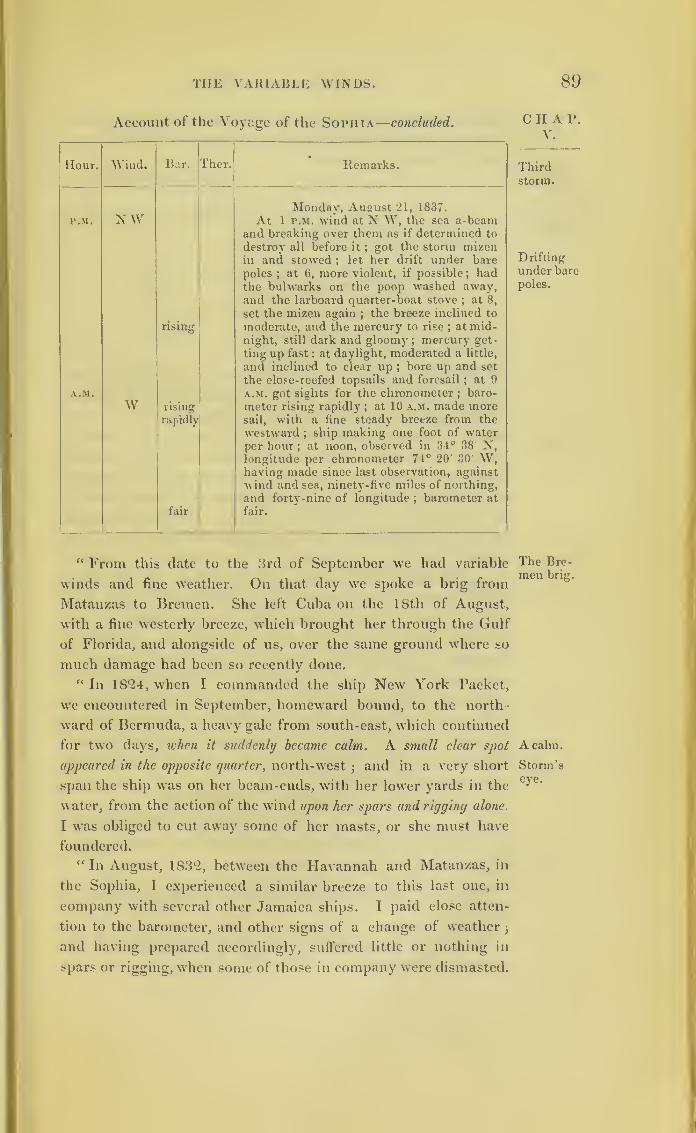
THE VARIABLE WINDS. 89
Account of the Voyage of the Sophia—concluded.
Hour. Wind.
N W
Bar. Ther.
rising
A.M.
W|
rising' rapidly
fair
Remarks.
Monday, August 21, 1837.
At 1 r.M. wind at N W, the sea a-beamand breaking over them as if determined to
destroy all before it;got the storm mizen
in and stowed ; let her drift under bare
poles;at 6, more violent, if possible ; had
the bulwarks on the poop washed away,and the larboard quarter-boat stove ; at 8,
set the mizen again;the breeze inclined to
moderate, and the mercury to rise ; at mid-night, still dark and gloomy
;mercury get-
ting up fast : at daylight, moderated a little,
and inclined to clear up ;bore up and set
the close-reefed topsails and foresail;at 9
a.m. got sights for the chronometer ;baro-
meter rising rapidly ; at 10 a.m. made moresail, with a fine steady breeze from the
westward;ship making one foot of water
per hour;at noon, observed in 31° 38 N,
longitude per chronometer 7-1° 20' 30' W,having made since last observation, against
wind and sea, ninety-five miles of northing,
and forty-nine of longitude;barometer at
fair.
“ From this date to the 3rd of September we had variable
winds and fine weather. On that day we spoke a brig from
Matanzas to Bremen. She left Cuba on the 18th of August,
with a fine westerly breeze, which brought her through the Gulf
of Florida, and alongside of us, over the same ground where so
much damage had been so recently done.
“ In 18*24, when I commanded the ship New York Packet,
we encountered in September, homeward bound, to the north-
ward of Bermuda, a heavy gale from south-east, which continued
for two days, when it suddenly became calm. A small clear spot
appeared in the opposite quarter, north-west;and in a very short
span the ship was on her beam-ends, with her lower yards in the
water, from the action of the wind upon her spars and rigginy alone.
I was obliged to cut away some of her masts, or she must have
foundered.
“ In August, 183*2, between the Havannah and Matanzas, in
the Sophia, I experienced a similar breeze to this last one, in
company with several other Jamaica ships. I paid close atten-
tion to the barometer, and other signs of a change of weather
;
and having prepared accordingly, suffered little or nothing in
spars or rigging, when some of those in company were dismasted.
C H A P.V.
Thirdstorm.
Drifting
under bare
poles.
The Bre-men brig.
A calm.
Storm’seye.
90 HURRICANES OF 1837.
CHAP. On that occasion, ships not thirty miles off were not aware of it.
V. It began at south-east, and going round the compass, westward, ended
where it began in six hours.
(Signed) “ JAMES BARCLAY.Thirdstorm
ShipRawlins.
Calm for
an hour.
Bar.
Narrative of Mr. Macqueen, Master of the Ship
Rawlins, from Jamaica to London.o
“Latitude — Commencement, N. 30 30
,,Termination, 30 40
“Longitude—Commencement, W. 77 40
i}Termination, 77 18
“ Dates— 17th, 18th, 19th August.
“ Wind commenced at north-east by east, blowing strong from
that quarter, about twelve hours, then suddenly veered to north,
continuing with unabated vigour until midnight of 18th; in an
instant a perfect calm ensued for one hour5
then quick as
thought the hurricane sprung up, with tremendous force, from
south-west, not again shifting from that point. No swell whatever
preceded the convulsion. The barometer gave every notice of
the coming gale for many previous hours. Two days antecedent
the weather beautifully serene, but oppressively hot, with light
shifting airs;barometer during that time standing at ‘ set-fair,
during the gale as low as almost to be invisible in the tube, abo\e
the frame-work of the instrument. The force subsided at mid-
night, August 19th;the sea tremendous, and rising in every
direction;from the force of wind no tops to the waves, being
dispersed in one sheet of white foam;the decks tenanted by
many sea-birds, in an exhausted state, seeking shelter in the
vessel ;impossible to discern, even during the day, anything at
fifty yards distance ,the wind representing numberless voices,
elevated to the shrillest tone of screaming ;but few flashes of
lightning, and those in the south-west. A very heavy sea con-
tinued for some days after.
(Signed) “ GILBERT MACQUEEN,“ Commander of the ship Rawlins.”
In the log of the Rawlins, on the 20th August, a.m.,
there is this expression
“The wind and sea much abated. A dismal appearance to
the north-west."
This was the direction in which the centre of the
storm had moved.
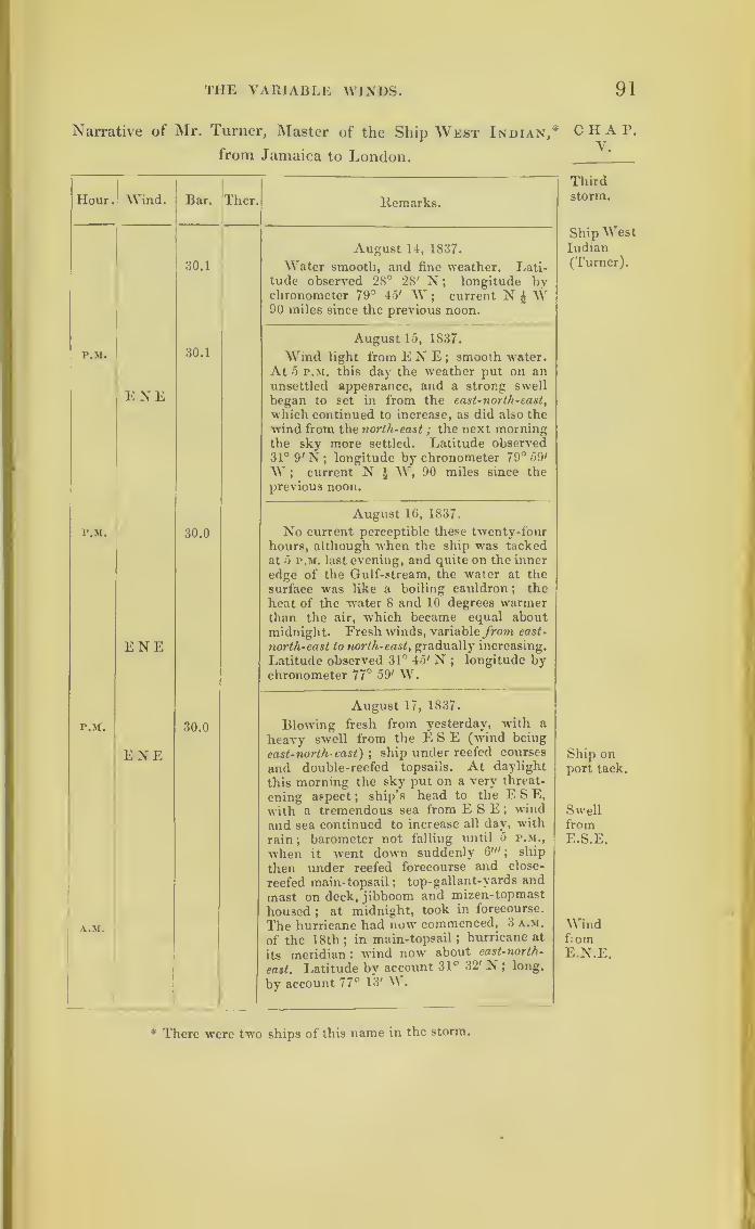
THE VARIABLE WINDS. 91
Narrative of Mr. Turner, Master of the Ship West Indian,
from Jamaica to London.
Hour. Wind. Bar. Ther. Remarks.
30.1
August 14, 1837.
Water smooth, and fine weather. Lati-tude observed 28° 28' N ; longitude hvchronometer 79° 4o' W
;current N £ W
90 miles since the previous noon.
P.M.
ENE
30.1
August 15, 1837.
Wind light from E N E ; smooth water.At 5 p.m. this day the weather put on anunsettled appearance, and a strong swell
began to set in from the east-north-east,
which continued to increase, as did also the
wind from the north-east
;
the next morningthe sky more settled. Latitude observed31° 9' N; longitude by chronometer 79° 59'
W ; current N ^ W, 90 miles since the
previous noon.
r.M.
ENE
30.0
August 16, 1837.
No current perceptible these twenty-fourhours, although when the ship -was tackedat 5 p.m. last evening, and quite on the inner
edge of the Gulf-stream, the water at the
surface was like a boiling cauldron; the
heat of the water 8 and 10 degrees warmerthan the air, which became equal aboutmidnight. Fresh winds, variable from east-
north-east to north-east, gradually increasing.
Latitude observed 31° 45' N;
longitude bychronometer 77° 59' W.
P.tf.
A.M.
ENE30.0
August 17, 1837.
Blowing fresh from yesterday, with a
heavy swell from the E8E (w-ind being
east-north east); ship under reefed courses
and double-reefed topsails. At daylight
this morning the sky put on a very threat-
ening aspect ;ship’s head to the E S E,
with a tremendous sea from E S E ; windand sea continued to increase all day, with
rain ;barometer not falling until 5 p.m.,
when it went down suddenly 6'"; ship
then under reefed forecourse and close-
reefed main-topsail ;top-gallant-yards and
mast on deck, jibboom and mizen-topmast
housed ; at midnight, took in forecourse.
The hurricane had now commenced, 3 a.m.
of the 18th;in main-topsail ;
hurricane at
its meridian : wind now about east-north-
east. Latitude by account 31° 32' N ; long,
by account 77° 13' W.
CHAP.V.
Thirdstorm.
Ship WestIndian(Turner).
Ship onport tack.
SwellfromE.S.E.
WindfromE.N.E.
* There were two ships of this name in the storm.
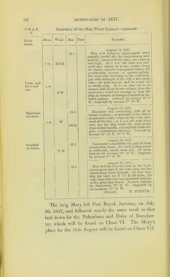
92 HURRICANES OF 1837.
C H A P.
Y.
Thirdstorm.
Calm, andlet a reef
out.
Hurricanereturned.
Scudded24 hours.
Narrative of the Ship West Indian— continued.
Hour. Wind. Bar. ?her. Remarks.
r.M.
A.M.
ESE
S W
29.1
August 18, 1837.
Ship now lying-to;main-topsail sheet
partially hauled aft ; the wind drawing more
easterly ; constant heavy rain;sea running
very high. At 6 p.m. the wind was east-
south-east; struck by a sea; nearly swept
the decks ;carried away quarter-boats ;
did
considerable damage to quarter-gallery.
The wind still increasing to the southward;
just after midnight of the 18th it fell nearly
calm ;set main-topsail, and let a reef out
to steady ship. At 2 a.m. came out in an
instant, icith all its former violence, from the
south-west; could not attempt to wear the
ship on account of damage sustained on lar-
board quarter. Latitude by account 31° 8'
N ;longitude by account 77° 56' W.
A.M. W
28.8
rising
August 19, 1837.
Hurricane still continuing, with all its
former violence ;at midnight of the 19th it
moderated a little, wind veering to the west-
ward all the time ; at 4 a.m. the wind about
west; got the ship before the wind under
close-reefed topsails, and scudded before the
gale;a tremendous cross sea. Latitude by
account 31° 21' N, 78° 6' W.
;
N W29.5
August 20, 1837.
Continued to run before the gale all these
twenty-four hours, the wind getting round
to north-west; heavy cross sea. At noon,
latitude by account 31° 42' N; longitude
^ by account 77° 14' W.
29.5
August 21, 1837.
Now find the ship has been in the Gulf-
stream great part of the time since the last
observations were obtained. In four days
ship has been set N 52° E 130 miles ;for
some days after had very unsettled wea.ther,
with a great deal of sea. At noon, latitude
by observation 33° 32 N; longitude by
chronometer 72° 13' W.(Signed) H. 1LRNER.
The brig Mary left Port Royal, Jamaica, on July
30, 1837, and followed nearly the same track as that
laid down for the Palambam and Duke of Manches-
ter, which will be found on Chart VI. The Mary s
place for the 16th August will be found on Chart VII.
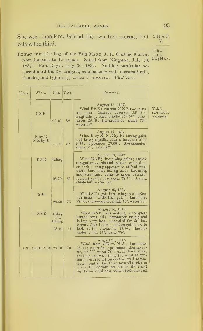
THE VARIABLE WINDS. 93
She was, therefore, behind the two first storms, but
before the third.
Extract from the Log of the Brig Mary, J. R. Crosbie, Master,
from Jamaica to Liverpool. Sailed from Kingston, July 29,
1837 ;Port Royal, July 30, 1837. Nothing particular oc-
curred until the 3rd August, commencing with incessant rain,
thunder, and lightning;
a heavy cross sea .— Civil Time.
Hour. Wind. Bar. Ther.l Remarks.
ESE
29.10 82
August 16, 1837.
Wind ESE; current N N E two milesper hour ;
latitude observed 32° 21',
longitude p. chronometer 77° 50'; baro-
meter 29.10; thermometer, shade 82°,
water 82°.
E by NNEbyE
29.00 82
August 17, 1837.
Wind E by N, N E by E ; strong gales
and heavy squalls, with a head sea fromNE; barometer 29.00; thermometer,shade 82°, water 82°.
ESE falling
28.70 80
August 18, 1837.
Wind ESE; increasing gales;struck
top-gallant- yards and masts ; secured all
on deck ; every appearance of bad wea-ther ;
barometer falling fast;
labouring
and straining;
lying-to under balance-
reefed trysail ; barometer 28.70 ; therm.,
shade 80°, water 82°.
SE
28.60 76
August 19, 1837.
Wind S E;gale increasing to a perfect
hurricane;under bare poles ;
barometer28.60; thermometer, shade 76°, water 80°.
ESE rising
andfalling
28.50 74
August 20, 1837.
Wind ESE; sea making a completebreach over all
; barometer rising andfalling very fast ; unsettled for the last
twenty- four hours;seldom get below to
look at it ; barometer 28.50 ;thermo-
meter, shade 74°, water 78°.
A.M. SEtoNW 28.10 70
August 21, 1837.
Wind from SE to NW; barometer
28 .10 ; a terrific appearance ;thermome-
ter, air 70°, water 76°;under bare poles
;
nothing can withstand the wind at pre-
sent ; secured all on deck as well as pos-
sible;sent all but three men off deck ; at
5 a.m. tremendous sea struck the vessel
on the larboard bow, which took away all
CHAP.V.
Thirdstorm.Brig Mary.
Thirdstorm com-mencing.

94 HURRICANES OF 1837 .
CHAP. Extract from the Log of the Brig Mary continued.
V.
Third lour. Wind. Bar. jTher. Remarks.
P.M.
rising
28.40 70
bulwarks, stanclieons, boats, spars, water-
casks, caboose, and every moveable off
deck, stream and kedge anchor ;vessel
laying on her broadside, unfortunately
lurched ; one seaman overboard ;picked
him up, with imminent risk of my own
life, but he had his leg broken, and another
man his arm, and had more men disabled
;
one man found himself under the foretop
when he recovered himself ; the hurricane
continuing to rage more and more, every
exertion made to save as much as pos-
sible ; at noon gale abating; barometer
rising gradually ; I could not leave the
deck to note it, but it certainly must
have been lower, noon 28.40 ;thermo-
meter, shade 76°, water 76°;p.m. latitude
36° 12' N, longitude p. chronometer
72° 11' AY; a turbulent cross sea; vessel
very laboursome ;midnight, set the reefed
square mainsail, all other sails being
blown away.
SW 28.80 Ther.broker
August 22, 1837.
AVind SAV ;made all sail that circum-
stances would permit ;heavy rain,
thunder, and lightning; latitude 36° 22 ,
longitude 76° 6' AAr ;barometer 28.80;
thermometer broken.
SW to
NW 28.90
August 23, 1837.
AVind SW to N AY ;latitude 36° 22',
longitude 68° 17'; barometer 28.90.
N by E 29.00
August 24, 1837.
AVind N by E ;latitude 36° 13', lon-
gitude 66 p 45'; barometer 29.00; move-
able and gloomy.
NAY 29.0 )
August 25, 1837.
AArind N AAr ;latitude 36° 35', longi-
tude 65° 38'; barometer 29.00.
« The remaining part of the passage strong breezes from the
westward 3barometer rising gradually.
(Signed) « J- R- CROSBIE, Master of the brig Mary.”

THE VARIABLE WINDS. 95
Extract from the Log of the Barque Penelope, J. H. Grimes,
Master, from Jamaica to London.—In Nautical Times.
Hour. Wind . Bar. jTher. Remarks.
P.M.
A.M.
P.M.
A.M.
ESE
NE
E to SE
ESEto E
August 19
—
Nautical Times.
Strong gales and cloudy. At 4 r.M. (18thmean time) larboard pump choked
; shiplabouring much, and making a great deal ofwater
;midnight, strong gales
;kept the
ship off the wind occasionally, to pump theship out with weather-pump
;at 3 a.m.
(19th) wore ship to the southward ; took in
forecourse, and close-reefed the topsails ;
wind ESE; at 6 a.m. wore ship to north-ward
; at 10 a.m. (19th) hard gales;in fore-
topsail and fore-topmast staysail, and hoveto under close-reefed main-topsail
;latitude,
by account at noon, 34° 56' N, longitude75° 2' W.
August 20— (19 p.m. Civil Time).
Hard gales, and a heavy sea; at 4 p.m.
(19th) gale increasing; starboard pump con-
stantly going;ship labouring much, and
making much water ; at 8 p.m. (20th) tre-
mendous gales;ship laying with gunwales
in the water, on the larboard tack; at 11
p.m. hoisted the fore-topmast staysail, andwore ship to the N E
; a very heavy sea
running, when the ship came to the windon the other tack ; fore-topmast staysail
blew away, and the main-topsail was split
;
midnight, a heavy sea broke on board andwashed the boats to the leeside of the deck,
and carried away bulwarks on both sides,
fore and aft; at 2 a.m. (20th civil time) set
main-trysail, to keep ship to;in five mi-
nutes it blew away in tatters;wind from
E to S E ; one pump constantly going;at
4 a.m. sounded the well, and found nearly
three foot water in the weather-pump;
called all hands to the pump, and found the
sand had washed from the bottom of the
larboard pump;
set both pumps on ; at
daylight found the plankshear on the lar-
board side had started off half an inch for
three feet in length;at 8 a.m. wind mode-
rated;
secured the long-boat and spare
anchors; pumps still going ;sugar washing
out very fast ;at 10 a.m. (20th) wind more
moderate ; set close-reefed fore-topsail
;
wind ESE to E,* noon, dark cloudy
weather ;wore ship to southward
;noon,
latitude account 35° 20', longitude 7-5° 20»
W.
CHAP.V.
Thirdstorm.
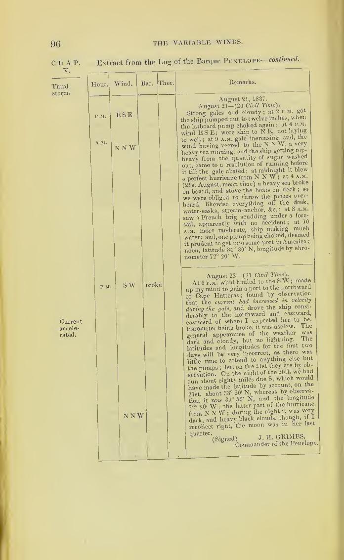
96 THE VARIABLE WINDS.
CHAP.V.
Thirdstorm
.
Currentaccele-
rated.
Extract from the Log of the Barque Penelope—continued.
Hour. Wind. lar. T aer. Remarks.
P.M.
A.M.
P.M.
ESE
NNW
sw
NNW
broke
August 21, 1837.
August 21—(20 Civil Time).
Strong gales and cloudy ; at 2 p.m. got
the ship pumped out to twelve inches, when
the larboard pump choked again ;at 4 p.m.
wind ESE; wore ship to N E, not laying
to well ;at 9 a.m. gale increasing, and, the
wind having veered to the N N W, a very
heavy sea running, and the ship getting top-
heavy from the quantity of sugar washed
out, came to a resolution of running before
it till the gale abated ;at midnight it blew
a perfect hurricane from NNW; at 4 a.m.
(21st August, mean time) a heavy sea broke
on board, and stove the boats on deck ; so
we were obliged to throw the pieces over-
board, likewise everything off the deck,
water-casks, stream-anchor, &c. ;at 8 a.m.
saw a French brig scudding under a fore-
sail, apparently with no accident ;at 10
a.m. more moderate, ship making much
water; and, one pump being choked, deemed
it prudent to get into some port in America ;
noon, latitude 34° 30' N, longitude by chro-
nometer 72° 20' W.
August 22— (21 Civil Time).
At 6 p.m. wind hauled to the S W ;made
up my mind to gain a port to the northward
of Cape Hatteras; found by observation
that the current had increased in velocity
during the gale, and drove the ship consi-
derably to the northward and eastward,
eastward of where I expected her to be.
Barometer being broke, it was useless. The
general appearance of the weather was
dark and cloudy, but no lightning, lhe
latitudes and longitudes for the first two
days will be very incorrect, as there was
little time to attend to anything else but
the pumps ;but on the 21st they are by ob-
servation. On the night of the 20th we had
run about eighty miles due S, which would
have made the latitude by account, on the
21st, about 33° 20' N, whereas by observa-
tion it was 34° 50' N, and the longitude
79° 20' W ;the latter part of the hurricane
from NNW; during the night it was very
dark, and heavy black clouds, though, it 1
recollect right, the moon was in her last
quarter,i ^d) } H GMyIES
Commander of the Penelope.
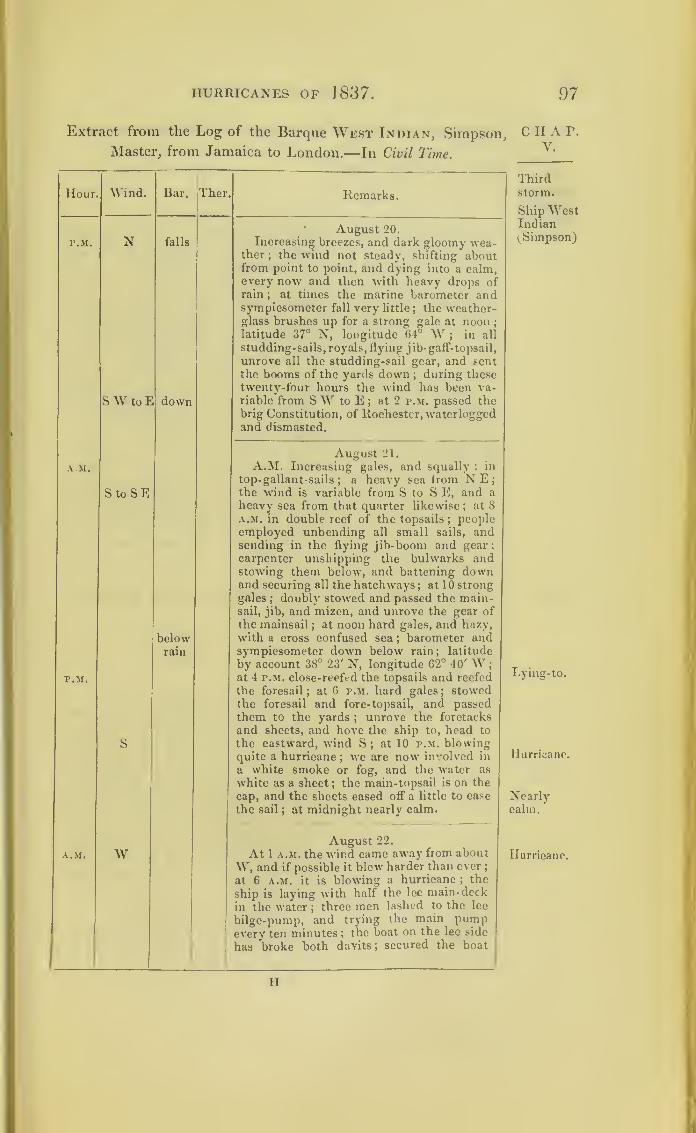
HURRICANES OF 1837 . 97
Extract from the Log of the Barque West Indian, Simpson,
Master, from Jamaica to London.—In Civil Time.
Hour,
P.M.
AM.
P.M.
A.M.
. Wind. Bar. Ther.
N falls
S W to E down
StoSE
belowrain
S
W
Remarks.
• August 20.
Increasing breezes, and dark gloomy wea-ther
; the wind not steady, shifting aboutfrom point to point, and dying into a calm,every now and then with heavy drops ofrain
; at times the marine barometer andsympiesometer fall very little
;the weather-
glass brushes up for a strong gale at noon;
latitude 37° N, longitude 64° W ; in all
studding-sails, royals, flying jib- gaff- topsail,
unrove all the studding-sail gear, and sentthe booms of the yards down ; during thesetwenty-four hours the wind has been va-riable from SW to E ;
at 2 p.m. passed thebrig Constitution, of Rochester, waterloggedand dismasted.
August 21.
A.M. Increasing gales, and squally : in
top- gallant-sails;
a heavy sea from NE;the wind is variable from S to S E, and a
heavy sea from that quarter likewise; at 8
a.m. in double reef of the topsails;people
employed unbending all small sails, andsending in the flying jib-boom and gear;carpenter unshipping the bulwarks andstowing them below, and battening downand securing all the hatchways
;at 10 strong
gales;doubly stowed and passed the main-
sail, jib, and mizen, and unrove the gear of
the mainsail;at noon hard gales, and hazy,
with a cross confused sea ;barometer and
sympiesometer down below rain; latitude
by account 38° 23' N, longitude 62° 40' W;
at 4 p.m. close-reefed the topsails and reefed
the foresail; at 6 p.m. hard gales ; stowed
the foresail and fore- topsail, and passedthem to the yards
;unrove the foretacks
and sheets, and hove the ship to, head to
the eastward, wind S;at 10 p.m. blowing
quite a hurricane;we are now involved in
a white smoke or fog, and the water as
white as a sheet;the main-topsail is on the
cap, and the sheets eased off a little to ease
the sail; at midnight nearly calm.
August 22.
At 1 a.m. the wind came away from about
W, and if possible it blew harder than ever;
at 6 a.m. it is blowing a hurricane ; the
ship is laying with half the lee main- deck
in the water;three men lashed to the lee
o 5-pump, and trying the main pumpevery ten minutes ;
the boat on the lee side
has broke both davits; secured the boat
II
C H A P.
V.
Thirdstorm.
Ship WestIndian(Simpson)
Lying- to.
Hurricane.
Nearlycalm.
Hurricane.
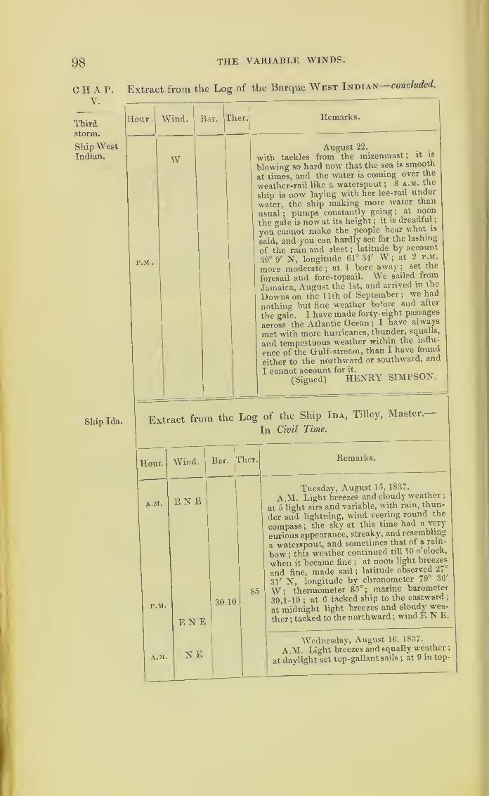
98 THE VARIABLE WINDS.
CHAP.V.
Thirdstorm.
Ship WestIndian.
Ship Ida.
Extract from the Log of the Barque West Indian concluded.
Hour
.
Wind.
W
Bar. Ther. Remarks.
P.M.
August 22._ .
with tackles from the mizenmast ;it is
blowing so hard now that the sea is smooth
at times, and the water is coming over the
weather-rail like a waterspout; 8 a.m. the
ship is now laying with her lee-rail under
water, the ship making more water than
usual;pumps constantly going ;
at noon
the gale is now at its height ;it is dreadful
;
you cannot make the people hear what is
said, and you can hardly see for the lashing
of the rain and sleet ;latitude by account
39° 9' N, longitude 61° 34' W;at 2 p.m.
more moderate; at 4 bore away; set the
foresail and fore-topsail. We sailed from
Jamaica, August the 1st, and arrived in the
Downs on the 11th of September; we had
nothing but fine weather before and after
the gale. I have made forty-eight passages
across the Atlantic Ocean ;I have always
met with more hurricanes, thunder, squalls,
and tempestuous weather within the influ-
ence of the Gulf- stream, than I have found
either to the northward or southward, and
I cannot account for it.
(Signed) HENRY SIMPSON
Extract from the Log of the Ship Ida, Tilley, Master.
In Civil Time.
Hour. Wind.
A.M.
P.M,
A.M.
E N E
Bar. Ther. Remarks.
EN E
N E
30.10
85
Tuesday, August 15, 1837.
A.M. Light breezes and cloudy weather
;
at 5 light airs and variable, with rain, thun-
der and lightning, wind veering round the
compass ;the sky at this time had a very
curious appearance, streaky, and resembling
a waterspout, and sometimes that of a rain-
bow ;this weather continued till 10 o clock,
when it became fine ;at noon light breezes
and fine, made sail ;latitude observed 27
^
31' N, longitude by chronometer 79 36
W; thermometer 85°; marine barometer
30.1-10 ;at 6 tacked ship to the eastward;
at midnight light breezes and cloudy wea-
ther ;tacked to the northward ;
wind E N E.
Wednesday, August 16, 1837.
A.M. Light breezes and squally weather
;
at daylight set top-gallant sails;at 9 in top-

HURRICANES OF 1837. 9.9
Extract from the Log of the Ship Ida—continued.
Hour. Wind. Bar. Ther. Remarks.
Wednesday, August 16, 1837.gallant gails
; at noon fresh breezes andsqually weather
; latitude observed 29° 54'
N, longitude 79° 39' W ; thermometer 80°;P.M.
N N E
29.80 80 marine barometer 29.8-10 : p.m. strongbreezes and squally
;in second and third reef
of the topsails;sent down the royal yards
;
at 3 wore ship to the eastward; wind
N N E ; at midnight strong breezes andcloudy, with a swell from the eastward
;
29.20 marine barometer 29.2-10.
Thursday, August 17, 1837.
|
A.M. N E to
ESE
29.00
A.M. Fresh gales and squally weather ;
at 4 handed the fore-topsail and foresail; at
intervals the wind came in gusts, then sud-denly dying away, and continued so for four
hours; sent down top-gallant-yards and
masts on deck ; at 8 hove-to under close-
reefed main-topsail and main-trysail ; at 9
split the main-trysail ; at 10 the main-top-sail blew from the bolt-rope ; at noon blow-ing a hurricane
; marine barometer 29°; no
latitude, no longitude ; wind N E;
head1 P.M. N Eto E S E
; laying- to under bare poles; at
8 p.m. shipped a heavy sea, which washedaway the caboose and bulwarks on the lee
side;at 10 shipped a heavy sea on the wea-
ther quarter, which stove in the companionand washed away all the after bulwarks
;
the lee-quarter-boat was completely blownto pieces by the wind
; at midnight blowinga tremendous hurricane, with rain and a
heavy mountainous sea ; ship labouringheavily, and shipping great quantities of
water fore and aft ; four feet water in thehold
;used every exertion to free the ship
28. dO without success ; marine barometer 28.5-10.
Friday, August 18, 1837.
A.M. N E to A.M. Blowing a tremendous hurricane;
the wind veering from N E to S W withinS Wlast twelve hours, and every sail blown to
atoms from the vards and from under the
gaskets ; all the pumps choked with bal-
last ; the ship was laying over in a mostP.M.
,
1
awful stale;at 5 p.m. succeeded in getting
the ship before the wind, w'hich we expect
prevented her from foundering ;at 8 found
to our great joy the ship made much better
weather scudding than laying-to ; at mid-
night found we had run out of the hurri-
cane, but it still blew a very heavy gale
;
water in the hold increased to six feet; all;
H 2
CHAP.V.
Hurri-cane,
middle of• August.
Ship Ida.
Near the
centre.
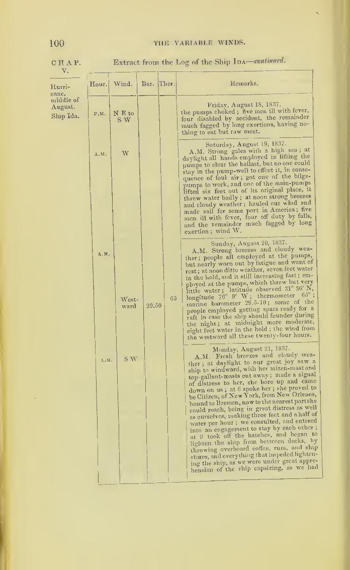
X
100 THE VARIABLE WINDS.
C H A P. Extract from the Log of the Ship Ida—continued.
V.
1
Hurri- ^lour. Wind. Bar. T aer. Remarks.
middle of
August.
Ship Ida.P.M. N E to
S WFriday, August 18, 1837.
_
the pumps choked ;five men ill with fever,
four disabled by accident, the remainder
much fagged by long exertions, having no-
thing to eat but raw meat.
A.M. wSaturday, August 19, 1837.
A.M. Strong gales with a high sea ;at
daylight all hands employed in lifting the
pumps to clear the ballast, but no one could
stay in the pump-well to effect it, in conse-
quence of foul air ;got one of the bilge-
pumps to work, and one of the main-pumps
lifted six feet out of its original place, it
threw water badly ;at noon strong breezes
and cloudy weather ;hauled our wind and
made sail for some port in America ;five
men ill with fever, four off duty by falls,
and the remainder much fagged by long
exertion ;windW
.
A.M.
West-ward 29.50
65
Sunday, August 20, 1837.
A.M. Strong breezes and cloudy wea-
ther; people all employed at the pumps,
but nearly worn out by fatigue and want of
rest ;at noon ditto weather, seven feet water
in the hold, and it still increasing fast ;em-
ployed at the pumps, which threw but very
little water ;latitude observed 31 36 N,
longitude 76° 9' W ;thermometer 65°
;
marine barometer 29.5-10; some of the
people employed getting spars ready for a
raft in case the ship should founder during
the night ; at midnight more moderate,
eight feet water in the hold ;the wind from
the westward all these twenty-four hours.
A.M. SWMonday, August 21, 1837-
A.M. Fresh breezes and cloudy wea-
ther ;at daylight to our great joy saw a
ship to windward, with her mizen-mast and
top- gallant-masts cut away; made a signal
of distress to her, she bore up and came
down on us ;at 6 spoke her ;
she proved to
be Citizen, of New York, from New Orleans,
bound to Bremen, now to the nearest portshe
could reach, being in great distress as well
as ourselves, making three feet and a half of
water per hour ;we consulted, and entered
into an engagement to stay by each other ;
at 9 took off the hatches, and began to
lighten the ship from between decks, by
throwing overboard coffee, rum, and ship
stores, and everything that impeded lighten-
ing the ship, as we were under great appre-
hension of the ship capsizing, as we had
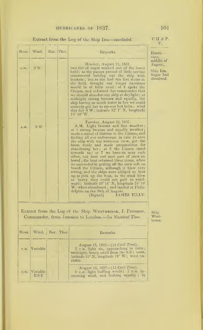
HURRICANES OF 1837. 101
Extract from the Log of the Ship Ida—concluded.
II our. Wind. Bar. Ther. Remarks.
A.M. S WMonday, August 21, 1837.
two tier of sugar washed out of the lowerhold ; as the pumps proved of little service
commenced baleing out the ship withbuckets ; but as she had ten feet water in
the hold, thought our longer exertions
would be of little avail : at 8 spoke the
Citizen, and informed her commander that
we should abandon our ship at daylight; at
midnight strong breezes and squally, the
ship having so much water in her we could
scarcely get her to answer her helm;wind
this day S W;latitude 32° V N, longitude
75° 30' W.
A.M. SWTuesday, August 22, 1837.
A.M. Light breezes and line weather;at 4 strong breezes and squally weather
;
made a signal of distress to the Citizen, andfinding all our endeavours in vain to save
the ship with our worn-out crew, got the
boats ready and made preparations for
abandoning her;
at 6 the Citizen stood
towards us ; at 7 we hove-to near eachother, out boat and sent part of crew onboard
;the boat returned three times, when
we succeeded in getting all the crew safe onboard the Citizen, although it blew very
strong, and the ships were obliged to bear
up to pick up the boat, as the wind blewso heavy they could not pull to wind-ward ; latitude 33° 14' N, longitude 75° 19'
W. when abandoned ; and landed at Phila-
delphia on the 30th of August.(Signed) JAMES TILLY.
Extract from the Log of the Ship Westbrook, J. Freeman,
Commander, from Jamaica to London.—In Nautical Time.
Hour. Wind.!
Bar. Ther. Remarks.
P.M. VariableAugust 15, 1837—(14 Civil Time).
5 p.m. light air, approaching to calm ;
midnight, heavy swell from the S E ; noon,
latitude 31° N, longitude 78° W ;wind va-
riable.
P.M. Variable
ESE
August 16, 1837—(15 Civil Time).
1 p.m. light baffling winds; 7 p.m. in-
creasing wind, and looking squally ; in
CHAP.V.
Hurri-cane,
middle of
August.
Ship Ida.
Sugar haddissolved.
ShipWest-brook.
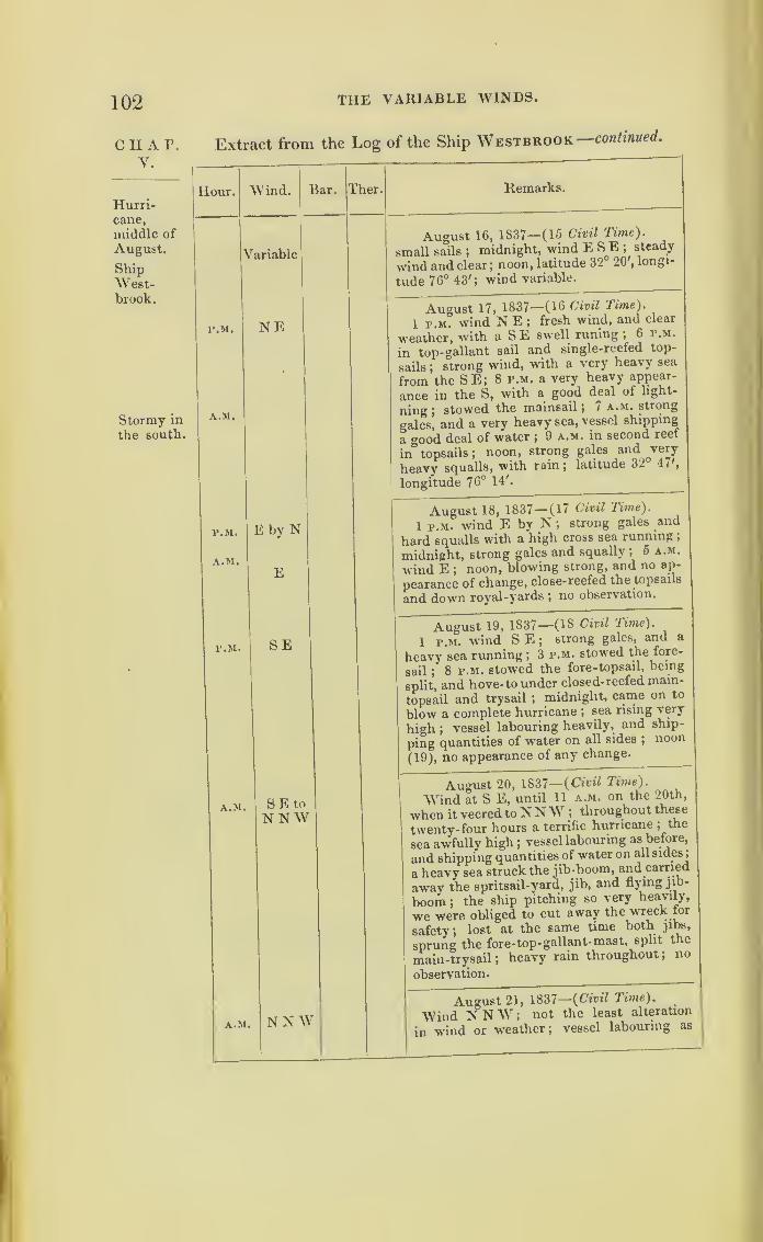
102 THE VARIABLE WINDS.
CHAP.V.
Hurri-cane,
middle of
August.
ShipWest-brook.
Stormy in
the south.
Extract from the Log of the Ship Westbrook—continued.
Hour. Wind. Bar. 1 her. Remarks.
V ariable
August 16, 1837—(15 Civil Time ).
small sails ;midnight, wind E S E ;
steady
wind and clear;noon, latitude 32 20 ,
longi-
tude 76° 43'; wind variable.
P.M.
A.M.
NEAugust 17, 1837—(16 Civil Time ).
1 p.m. wind N E ;fresh wind, and clear
weather, with a SE swell runing ;6 p.m.
in top-gallant sail and single-reefed top-
sails;
strong wind, with a very heavy sea
from the SE; 8 p.m. a very heavy appear-
ance in the S, with a good deal of light-
ning ;stowed the mainsail ; 7 a.m. strong
gales, and a very heavy sea, vessel shipping
a good deal of water ;9 a.m. in second reef
in topsails ;noon, strong gales and very
heavy squalls, with rainj latitude 32 1//
,
longitude 76° 14'.
P.M.
A.M.
E by N
E
August 18, 1837— (17 Civil lime).
1 p.m. wind E by N ;strong gales and
hard squalls with a high cross sea running ;
midnight, strong gales and squally; 5 a.m.
wind E ;noon, blowing strong, and no ap-
pearance of change, close-reefed the topsails
and down royal-yards ;no observation.
P.M. SEAugust 19, 1837—(16 Civil Time).
1 p.m. wind S E ;strong gales, and a
heavy sea running ; 3 p.m. stowed the fore-
sail ; 8 p.m. stowed the fore-topsail, being
split, and hove-to under closed-reefed main-
topsail and trysail ;midnight, came on to
blow a complete hurricane ;sea rising very
high ;vessel labouring heavily, and ship-
ping quantities of water on all sides ;noon
(19), no appearance of any change.
A.M. SEtoNNW
August 20, 1837— (Civil Time).
Wind at S E, until 11 a.m. on the 20th,
when it veeredtoNNW ;throughout these
twenty-four hours a terrific hurricane ;the
sea awfully high;vessel labouring as before,
and shipping quantities of water on all sides
;
a heavy sea struck the jib-boom, and carried
away the spritsail-yard, jib, and flying jib-
boom ;the ship pitching so very heavily,
we were obliged to cut away the wreck lor
safety; lost at the same time both jibs,
sprung the fore-top-gallant-mast, split the
main- trysail ;heavy rain throughout ;
no
observation.
A.M. NNWT
August 21, 1837—
(
Civil Time).
Wind NNW'; not the least alteration
in wind or weather; vessel labouring as
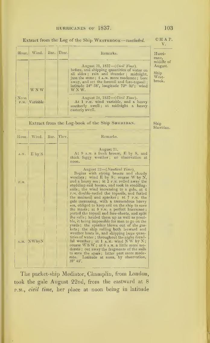
HURRICANES OF 1837. 103
Extract from the Log of the Ship Westbrook— concluded.
1
Hour. Wind. Bar. Ther Remarks.
WNW
August 21, 1837
—
(Civil Time).before, and shipping quantities of water onall sides
;rain and thunder
; midnight,just the same
;4 a.m. more moderate
; boreaway, and set the foresail and fore-topsail
;
latitude 34° 58', longitude 73° 32'; windW N W.
NoonP.M. Variable
August 24, 1837
—
(Civil Time).At 1 p.m. wind variable, and a heavy
southerly swell ; at midnight a heavyeasterly swell.
Extract from the Log-book of the Ship Sheridan.
Hour. Wind. Bar. Ther. Remarks.
A.M. E by S
August 21.
At 9 a.m. a fresh breeze, E by S, andthick foggy weather ; no observation at
noon.
P.M.
A.M. 'NWbyN
August 22
—
(Nautical Time),Begins with strong breeze and cloudy
weather;wind E by S ; course W by N,
and a heavy sea;at 2 p.m. rolled away the
studding-sail booms, and took in studding-sails
;the wind increasing to a gale, at 4
p.m. double-reefed the topsails, and furled
the mainsail and spanker; at 7 p.m. thegale increasing, with a tremendous heavysea, obliged to keep sail on the ship to savethe masts ; at 8 p.m. a perfect hurricane
;
parted the topsail and fore-sheets, and split
the sails ; hauled them up as well as possi-
ble, it being impossible for men to go on theyards ; the spanker blown out of the gas-
kets;
the ship rolling both leeward andweather boats in, and shipping large quan-tities of water
;throughout the night dread-
ful weather; at 1 a.m. wind NW by N
;
course W SW ; at 6 a.m. a little more mo-derate
; cut away the fragments of the sails
to save the spars ; latter part more mode-rate. Latitude at noon, by observation,39° 45'.
CHAP.V.
Hurri-cane,
middle of
August.
ShipWest-brook.
ShipSheridan.
The packet-ship Mediator, Champlin, from London,
took the gale August 22nd, from the eastward at 8
p.m., civil time,her place at noon being in latitude

104 THE VARIABLE WINDS.
chap. 42° 36', longitude 01° 42'. At midnight the gale
•_ was east-north-east;
at 4 a.m., on the 23rd, north-
east; at 7 a.m. at north; at 8 a.m. the gale abated,
beino’ of shorter duration than with the Sheridan, and
having hauled gradually by the north to north-west.
On the afternoon of the 22nd of August, the barque
Barlow, from Liverpool, bound to St. John’s, New
Brunswick, passed the Mediator, New York packet,
whilst that vessel was lying to. On the afternoon of
the 20th, at the period the storm was very severe to
the south-west of her, the Barlow experienced calms
and variable winds. By noon on the 21st, the wind
freshed, with the weather cloudy. At 4, in the after-
noon of that day, it became south-easterly. Increasing
in force, and veering towards east, it changed first to
north, and afterwards by degrees to north-west.
In the Barlow’s log-book the wind is marked north
at noon on the 22nd, at which time the topsails were
close reefed, having previously split a sail. Profiting
by the fair wind, this ship ran before it to the west-
ward, and was soon out of the influence of the storm;
for by four o’clock on the morning of the 23rd, she had
royals set again, with light and variable breezes.
The ships The narrative of Mr. Griffith, Master of the ship
Sanches- Duke of Manchester, tends further to explain the
Sum- nature of the three first storms. The Duke of Man-
bam- Chester and another vessel, the Palambam, were to the
south of the two first hurricanes on Charts V. and VI.;
but they were in the heart ot the third one, and the
Palambam foundered. Her place where last seen by
Mr. Griffith is marked on Chart VII., and she was
then under a close-reefed topsail, near the centre of
the storm.
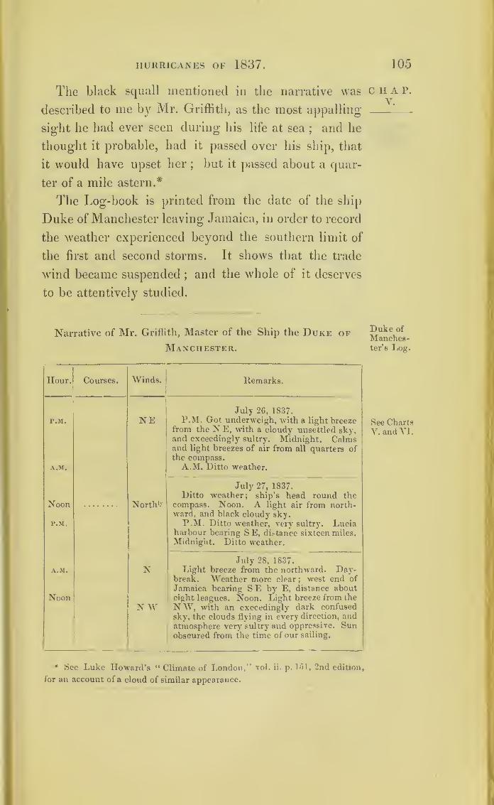
HURRICANES OF 1837. 105
The black squall mentioned in the narrative was
described to me by Mr. Griffith, as the most appalling
sight he had ever seen during his life at sea;and he
thought it probable, had it passed over his ship, that
it would have upset her;
but it passed about a quar-
ter of a mile astern.*
The Log-book is printed from the date of the ship
Duke of Manchester leaving Jamaica, in order to record
the weather experienced beyond the southern limit of
the first and second storms. It shows that the trade
wind became suspended;and the whole of it deserves
to be attentively studied.
Narrative of Mr. Griflith, Master of the Ship the Duke of
Manchester.
Hour
.
Courses. Winds. Remarks.
p.m.
A.M.
NEJuly 26, 1837.
P.M. Got underweigh, with a light breezefrom the N E, with a cloudy unsettled sky,and exceedingly sultry. Midnight. Calmsand light breezes of air from all quarters ofthe compass.A.Mi Ditto weather.
Noon
P.M.
North1*
July 27, 1837.Ditto weather; ship’s head round the
compass. Noon. A light air from north-ward, and black cloudy sky.P.M. Ditto weather, •very sultry. Lucia
harbour bearing S E, distance sixteen miles.
Midnight. Ditto weather.
A.M.
Noon
N
N W
July 28, 1837.Light breeze from the northward. Day-
break. Weather more clear ; west end of
Jamaica bearing SE by E, distance abouteight leagues. Noon. Light breeze from the
NW, with an exceedingly dark confused
sky, the clouds flying in every direction, andatmosphere very sultry and oppressive. Sunobscured from the time of our sailing.
* See Luke Howard’s “ Climate of London,” vol. ii. p. 151, 2nd edition,
for an account of a cloud of similar appearance.
CHAP.V.
Duke of
Manches-ter’s Log.
See ChartsV. and VI.

106 STORMS OF 1837 .
CHAP.Y.
Duke of
Manches-ter’s Log.
Narrative of the Ship the Duke of Manchester—continued.
Hour. Courses. Winds. Remarks.
P M.
SSW
July 28, 1837.
2 p.m. Wind veering round the compass,
with heavy rain and squalls.
5. The appearance ofthe weather threaten-
ing ; wind SSW; took in small sails, andsingle-reefed the topsail.
8. Heavy rain, thunder, and lightning ;
inclined to a calm. Midnight. Eresh breeze
and cloudy, with small rain.
A.M.
Noon
P.M.
sswJuly 29, 1837.
A.M. Ditto weather; wind SSW. 10.
Weather more clear. Noon. Pleasant wea-
ther;got a sight of the sun for the first time
since sailing.
Lat. 19° 10' N, long. 79° 17' W.P.M. Light airs and cloudy, sultry wea-
ther. Midnight. Ditto weather.
A.M.
Noon
P.M.
Southward
SSW to
s
w sw
July 30, 1837.
2 a.m. Squally ;took in small sails ;
wind
veering from S SW to S.
8. Clear weather. Noon. Steady breeze.
Lat. 19° 14', long. 80° 26'.
P.M. Ditto weather; wind still the same.
8. Light breeze from the WSW; tacked
to the southward. Midnight. Light airs
and cloudy.
A.M.
P.M.
WestwardSSW
July 31, 1837.
5 a.m. Steady breeze from the SSW;tacked ship to the westward.
8. Steady breeze and clear weather.
11. Made the land (Grand Caymans),
bearing S W, distance fifteen miles.
Lat. (Noon) 19° 21', long. 80° 57'.
P.M. Light breeze and steady.
Midnight. Ditto weather.
A.M.
Noon
P.M.s s wSEs
August 1, 1837.
A.M. Light breeze and clear.
8. Pleasant weather, but sultry ; one sail
in sight to the southward. Noon. Ditto
weather.Lat. 19° 45', long. 82° 9'.
P.M. Light breeze and fine weather
;
wind still from the S S W.8. The wind shifted to the SE, with heavy
squalls. Midnight. Squally ;wind S.
A.M.
Noon
P.M.
SE
August 2, 1837.
A.M. Weather more settled.
8. The wind veered to the S E.
Noon. Pleasant weather.
Lat. 20° 25', long. 83° 12'.
P.M. Moderate breeze and pleasant wea-
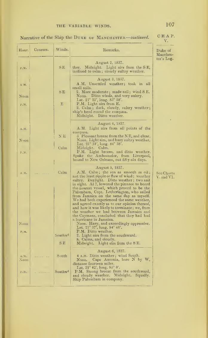
THE VARIABLE WINDS. 107
Narrative of the Ship the Duke of Manchester—continued.
Hour. Courses. Winds.
r.M. SE 1
A M.
NoonSE
P.M. E
A.M.
NoonNE
P.M.
Calm
A M. • k . it*. Calm
Noon
P.M.
Southw' 1
SE
A.M.
Noon. » l . . V . South
P.M. » • w • % .. • Southw d
Remarks.
August 2, 1837.
ther. Midnight. Light airs from the S E,inclined to calm
;cloudy sultry weather.
August 3, 1837.
A.M. Unsettled weather ; took in all
small sails.
2. More moderate;made sail
;wind S E.
Noon. Ditto winds, and very sultry.
Lat. 21° 25', long. 83° 58'.
P.M. Light airs from E.2. Calm; dark, cloudy, sultry weather;
ship’s head round the compass.Midnight. Ditto weather.
August 4, 1837.
A.M. Light airs from all points of thecompass.
5. Pleasant breeze from the NE, and clear.
Noon. Light airs, and hazy sultry weather.Lat. 21° 31', long. 84° 38'.
Midnight. Calm.P.M. Light breeze, and ditto weather.
Spoke the Ambassador, from Liverpool,
bound to New Orleans, out fifty-six days.
August 5, 1837.
A.M. Calm;
the sea as smooth as oil ;
not the least ripple or flaw of wind; weather
sultry. Daylight. Ditto weather;two sail
in sight. At 7, lowered the pinnace to boardthe nearest vessel, which proved to be thePalambam, Capt. Lotherington, who sailed
from Jamaica on the same day as myself.
We had both experienced the same weather,and agreed exactly as to our opinion thereof,
and how it was likely to terminate; we, from
the weather we had between Jamaica andthe Caymans, concluded that they had hada hurricane in Jamaica.Noon. Hazy, and exceedingly oppressive.
Lat. 21° 37 , long. 84° 46'.
P.M. Ditto weather.2. Light airs from the southward.8. Calms, and cloudy.Midnight. Light airs from the S E.
August 6, 1837.
4 a.m. Ditto weather ; wind South.
Noon. Cape Antonia, bore N by W,distance fourteen miles.
Lat. 21° 42', long. 85° O'.
P.M. Strong breeze from the southward,
and cloudy weather. Midnight. Squally.
Ship Palambam in company.
CHAP.V.
Duke of
Manches-ter’s Log.
See ChartsV. and VI.

108 STORMS OF J837.
CHAP.v.
Duke of
Manches-ter’s Log.
Narrative of the Ship the Duke of Manchester—continued.
Hour. Courses. Winds. Remarks.
A.M.
Noon SEbyS
August 7, 1837.
A.M. Ditto weather. 6. Increasing breeze
and squally ;wind S E by S. Noon. Ditto
weather.Lat. 23° 48', long. 84° 56'.
1\M.
SEbyEP.M. Strong breeze and cloudy, but fine
weather;wind veering from S E by E to
.oEby N E by N, latter part squally and variable
weather, with a heavy sea from the ENE.
August 8, 1837.
A.M. A.M. Commences with strong breeze andsqually
;took in and made sail as necessary;
ENE wind variable from E N E to E S E.
toESE 5. More moderate. 9. Tacked ship to the
Southward southward.Lat. (Noon) 24° 5', long. 83° 59'.
P.M. P.M. Strong breezes and squally7, a heavy
sea running from the ENE, shipping muchwater. 6. A very heavy white squall, with
thunder and lightning;
in small sails, anddouble-reefed the topsails. 7. More mode-rate. Midnight. Squally, with lightning
and thunder.
August 9, 1837.
A.M. A.M. Ditto weather ;blowing a strong
E double-reefed-topsail breeze from East, a
heavy sea running from that quarter; several
Noonvessels in sight. Ship Palambam in com-pany. Noon. Ditto weather.
Lat. 23° 20', long. 83° 12'.
P.M. Ditto weather. 8. Tacked to theP.M.SE south-eastward. Midnight. More mode-
rate, but cloudy.
August 10, 1837.
A.M.NNE
E A.M. Steady breeze from E. 4. Tackedto the NNE. 5. Pine w'eather
;out reefs,
and made all possible sail by the wind. 8.
Noon SE ENE Tacked to the SE; wind ENE. Noon.
Fresh breeze and cloudy, with aENE swell.
P.M.
Lat. 23° 33', long. 82° o'.
P.M. Strong breeze and steady. 5.
Northward Tacked to the nortfnvard. Midnight. Ditto
weather. Palambam in company.
August 11, 1837.
A.M. A.M. Commences with fine steady7 breeze
E and ditto weather ; wind E to NNE.Noon toENl Noon. Ditto weather.
Lat. 24° 38', long. 80° 30'.
P.M. P.M. Increasing breeze and squally. 5.
NE Strong breeze from the N E;
double-reefed
the topsails. Midnight. More moderate ;
•1
made all sail.

THE VARIABLE WINDS. 109
Narrative of the Ship the Duke of Manchester— continued.
Hour.
A.M.
Noon
P.M.
A.M.
Noon
P.M.
A.M.
Noon
P.M.
A.M.
Noon
P.M.
A.M.
Noon.
P.M.
Courses.
A.M.
Winds.
SSE
E S E
N E to
S E by E
N
N E by Eto
E byN
Remarks.
August 12, 1837.
A.M. Fresh breeze and fine weather, butcloudy and sultry. Noon. Ditto. ShipPalambam in company.Lat. 25° 42', long. 79° 55'.
P.M. Ditto weather. 8. Squally, withmuch rain ;
shortened sail. 10. Moresettled ; made sail. Midnight. Cloudy, withpassing showers of rain.
August 13, 1837.
A.M. Strong breeze and cloudy weather.Noon. Ditto weather. Palambam in com-pany.
Lat. 28° 19', long. 79° 41'.
P.M. Light breeze from the SSE, andhazy. Midnight. Ditto weather.
August 14, 1837.
A.M. A continuance of light winds andcloudy. Noon. Light airs and calms.Lat. 30° 17', long. 79° 36'.
P.M. Very sultry weather. Midnight.Light breeze and cloudy.
August 15, 1837.
A.M. Light airs from the E S E. Noon.Light airs and close oppressive weather-Palambam in company.
Lat. 31° 36', long. 78° 40'.
P.M. Light variable winds and hazy. 3.
squally, with rain. From 4 to midnight,wind variable, veering from N E to S E by E.
August 16, 1837.
A.M. Light variable winds and a cloudyconfused sky. 8. A fresh breeze from theNorth and hazy weather
;a swell from the
eastward. Noon. Increasing breeze andcloudy ; head sea also increasing fast.
Lat. 32° 39', long. 77° 30'.
Ship Palambam in company.P.M. Increasing breeze and head sea ; took
in top -gallant- sails;single-reefed the top-
sails, and sent down royal-yards ; windveering from N E by E to E by N.
5. Fresh gale; double-reefed the topsails ;
a very heavy sea running from E N E. 6.
Saw the Palambam for the last time, dead to
leeward. Midnight. Fresh gales and hazy.
August 17, 1837.
A.M. Commences with strong gales andsqually, with rain. 2. Close-reefed the top-
sails;reefed the courses, and stowed the
square mainsail and spanker; sent down
C II A P.
y.
Duke of
Manches-ter’s Log.
Thirdstorm ap-proaching.
SeeChartVII.
Palambamwhen last
seen.
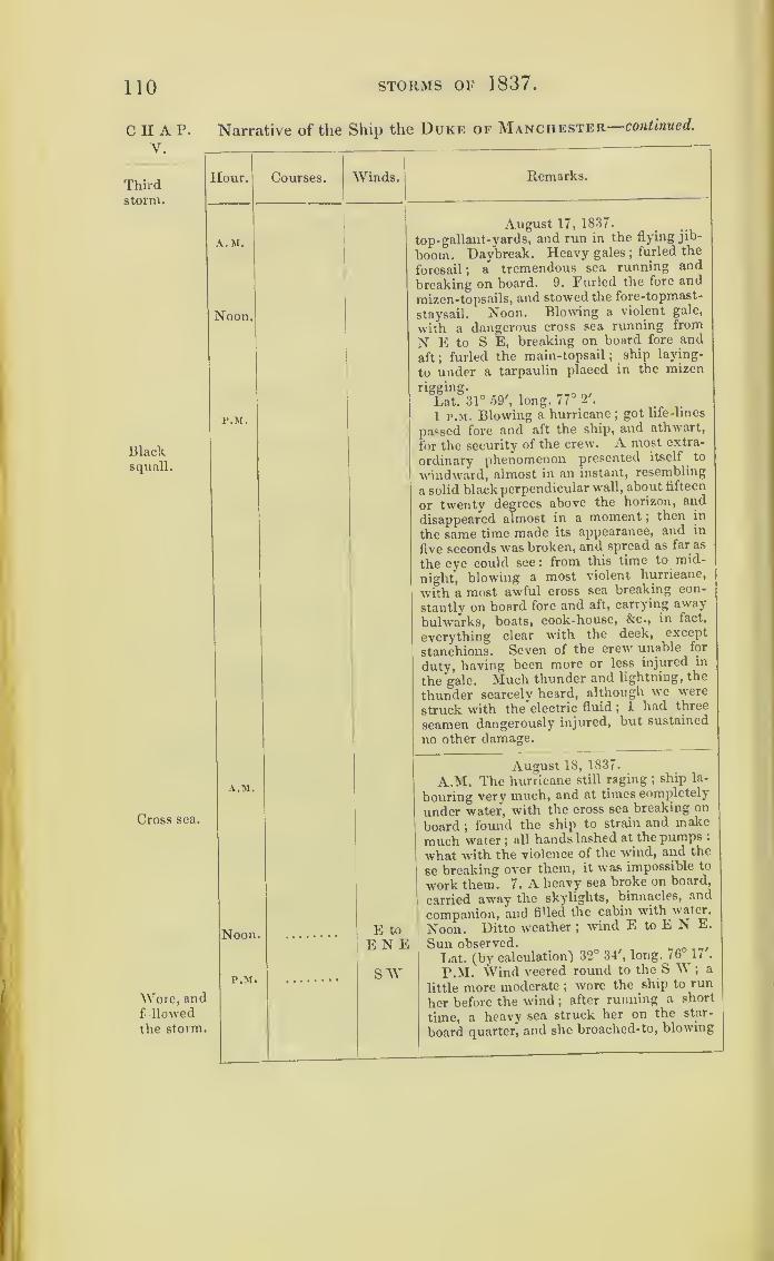
110 STORMS OF 1837.
CHAP.V.
Thirdstorm.
Narrative of the Ship the Duke of Manchester continued.
Hour.
A.M.
Noon.
Blacksquall.
P.M.
Courses. Winds.
Cross sea.
A.M.
Noon,
P.M.
Wore, andf> llowedthe storm.
Remarks.
August 17, 1837.
top- gallant-yards, and run in the flying jib-
boom. Daybreak. Heavy gales;furled the
foresail ;a tremendous sea running and
breaking on board. 9. Furled the fore and
mizen-topsails, and stowed the fore-topmast-
staysail. Noon. Blowing a violent gale,
with a dangerous cross sea running from
N E to S E, breaking on board fore and
aft; furled the main-topsail ;ship laying-
to under a tarpaulin placed in the mizen
rigging.
Lat. 31° 59', long. 77° 2'.
1 p.m. Blowing a hurricane; got life-lines
passed fore and aft the ship, and athwart,
for the security of the crew. A most extra-
ordinary phenomenon presented itself to
windward, almost in an instant, resembling
a solid black perpendicular wall, about fifteen
or twenty degrees above the horizon, and
disappeared almost in a moment ;then in
the same time made its appearance, and in
five seconds was broken, and spread as far as
the eye could see: from this time to mid-
night, blowing a most violent hurricane,j
with a most awful cross sea breaking con- 1
stantly on board fore and aft, carrying away
bulwarks, boats, cook-house, &c., in fact,
everything clear with the deck, except
stanchions. Seven of the crew' unable for
duty, having been more or less injured in
the gale. Much thunder and lightning, the
thunder scarcely heard, although we were
struck wdth the electric fluid ;1 had three
seamen dangerously injured, but sustained
no other damage.
E to
ENESAY
August 18, 1837.
A.M. The hurricane still raging ; ship la-
bouring very much, and at times completely
under water, with the cross sea breaking on
board ;found the ship to strain and make
much water ;all hands lashed at the pumps .
what with the violence of the wind, and the
se breaking over them, it was impossible to
work them. 7. A heavy sea broke on board,
carried away the skylights, binnacles, and
companion, and fiUed the cabin with water.
Noon. Ditto weather ;wind E to E N E.
Sun observed.
Lat. (by calculation) 32° 34', long. 76 1/ .
P.M. Wind veered round to the S W ; a
little more moderate ;wore the ship to run
her before the wind ;after running a short
time, a heavy sea struck her on the star-
board quarter, and she broached-to, blowing
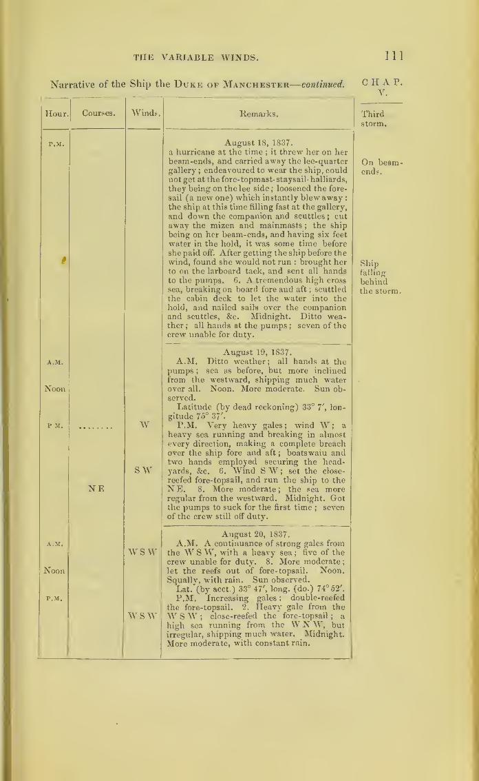
THE VARIABLE WINDS. Ill
Narrative of the Ship the Duke of Manchester— continued.
Hour.
p.m.
#
A.M.
Noon
P M.
Courses. Winds.
W
s wNE
Remarks.
August 18, 1837.
a hurricane at the time; it threw her on her
beam-ends, and carried away the lee-quarter
gallery;endeavoured to wear the ship, could
not get at the fore-topmast- staysail- halliards,
they being on the lee side; loosened the fore-
sail (a new one) which instantly blew away
:
the ship at this time filling fast at the gallery,
and down the companion and scuttles; cut
away the mizen and mainmasts;the ship
being on her beam-ends, and having six feet
water in the hold, it was some time before
she paid off. After getting the ship before thewind, found she would not run : brought herto on the larboard tack, and sent all handsto the pumps. 6. A tremendous high cross
sea, breaking on board fore and aft;scuttled
the cabin deck to let the water into thehold, and nailed sails over the companionand scuttles, &c. Midnight. Ditto wea-ther ;
all hands at the pumps ; seven of thecrew unable for duty.
August 19, 1837.
A.M. Ditto weather;
all hands at thepumps ; sea as before, but more inclined
from the westward, shipping much waterover all. Noon. More moderate. Sun ob-served.
Latitude (by dead reckoning) 33° 7', lon-
gitude 75° 37'.
P.M. Very heavy gales; wind W; a
heavy sea running and breaking in almostevery direction, making a complete breachover the ship fore and aft
; boatswain andtwo hands employed securing the head-yards, &c. 6. Wind SW ; set the close-
reefed fore-topsail, and run the ship to theNE. 8. More moderate; the sea moreregular from the westward. Midnight. Gotthe pumps to suck for the first time ;
sevenof the crew still off duty.
A.M.
Noon
P.M.
w s w
w s w
August 20, 1837.
A.M. A continuance of strong gales fromthe W S W, with a heavy sea ;
five of the
crew unable for duty. 8. More moderate
;
let the reefs out of fore- topsail. Noon.Squally, with rain. Sun observed.
Lat. (by acct.) 33° 47', long, (do.) 74° 52'.
P.M. Increasing gales ; double-reefed
the fore-topsail. 2. Heavy gale from the
W SW ;close-reefed the fore-topsail
; a
high sea running from the W N W, butirregular, shipping much water. Midnight.
More moderate, with constant rain.
CHAP.V.
Thirdstorm.
On beam-ends.
Shipfalling
behindthe storm.

112 STORMS OF 1837.
CHAP. Narrative of the Ship the Duke of Manchester—concluded.
Y. —Thirdstorm.
Hour.
A.M.
Noon
P.M.
A.M.
Noon.
p.m.
Courses. Winds.
VnIT
£t
e
t
i
t
s
SW A
f
1
1.
SW
Variable
N
n.
North" d.
N to NE
. N by Eto NE
i.
>n.Variable
I.
jn.
Variable
Remarks.
August 21, 1837.
A.M. Moderate and fair weather, with a
UU VYttO J1UU1 -
Lat. (Noon) 34° 19', long. 74° 2'.,
P.M. Light winds and sultry weather ;a
August 22, 1837.
A.M. Light breeze from the SW ;all
ands employed about getting up the jury-
lainmast. 8. Squall}', with rain ;clewed all
he sails down. 9. More moderate ;made
11 sail ; eet a topsail on the jury-mainmast.
$oon. Cloudy, with heavy rain.
Lat. (d.r.) 34* 9', long. 74® 24'.
Sun observed. Four men unable for duty.
P.M. Fresh breeze and cloudy, with rain.
4. More settled and fine;a heavy sea still
running from the westward ;wind variable.
Midnight. Steady breeze and fine weather
;
wind N.
Augmt 23, 1837.
A.M. Steady breeze from the northward.
2. Wind variable from N to N E, with fine
weather until noon.
Lat. (by observation) 34° 59', long. 74 46 .
P.M. Light winds and fair weather; wind
veering from N byE to NE. Midnight. Ditto
weather.
August 24, 1837.
A.M. Light breeze and fine weather ;all
possible sail put on the jury-masts. Noon
Lio-ht variable winds and fine weather.
Lat. 35° 45', long. 74° 49'.
P.M. Light winds and fine weather; wind
variable. Midnight. Cloudy.
August 25, 1837.
A.M. Commences with light airs and fine
weather. Noon. Ditto weather.
Lat. 36° 25', long. 74° 12'.
STORMS OF 1837. 113
“I have now given you, to the best of my recollection, the
particulars of the gale, winds, Ac. A compass at the time was
useless, and in the midst of it I had none to go by.
“ From the 25th to my arrival at New York had variable
winds and weather, attended with squalls, but nothing particu-
larly deserving of notice.
“I experienced a hurricane in 1830, olf Cape Florida, on the
15th and 1 6th August : several ships were lost and dismasted.
On the 26th same month had another, in latitude 31°, longitude
7 5°, which came on precisely in the same way as this of 1837
:
we were dismasted, &c.
(Signed) “ JOS. GRIFFITHS.”
These are the two storms on Chart II., described in
the log-book of the Blanche frigate.
We shall now follow the track of the ship Castries,
from the West Indies, and further develop a cause for
variable winds. The track of the Castries will be
found on Chart VII. By comparing the log-book
with the Chart, it will be seen how this ship on the
13th (civil time) sailed into the southern portion of
the third whirlwind storm, which caused her to have
a N.W. wind at C p.m. But the storm was on that
day making progress to the westward. When its
centre had passed the meridian of the ship, the west
wind would veer towards the south;and as the ship
then had a fair wind to run north, we might expect
her to advance from the storm’s southern half circle,
in which the wind blows west,into the northern half
circle, in which it blows east.
Thus the log-book has the wind changing from
N.W. to S.W., to S.S.W. to S.S.E., to S.E. to E.S.E.,
and E. before the return of the N.E. trade wind.
The Castries seems to have passed behind the
r
C H A P.
V.
Thirdstorm.
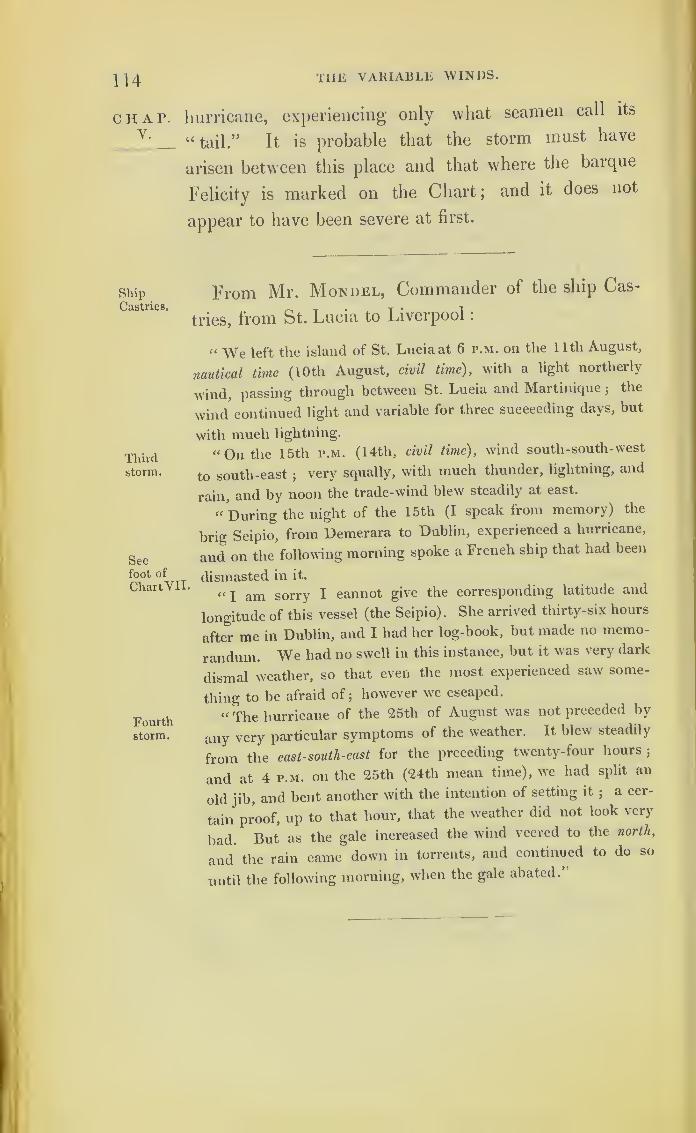
114 THE VARIABLE WINDS.
chap, hurricane, experiencing only what seamen call its
“tail.” It is probable that the storm must have
arisen between this place and that where the barque
Felicity is marked on the Chart; and it does not
appear to have been severe at first.
ShipCastries.
From Mr. Mon del, Commander of the ship Cas-
tries, from St. Lucia to Liverpool
:
Thirdstorm.
Seefoot of
ChartVII.
Fourthstorm.
“ We left the island of St. Lucia at 6 p.m. on the 1 1th August,
nautical time (l Oth August, civil time), with a light northerly
wind, passing through between St. Lucia and Martiniquej
the
wind continued light and variable for three succeeding days, but
with much lightning.
“On the 15th p.m. (14th, civil time), wind south-south-west
to south-east;
very squally, with much thunder, lightning, and
rain, and by noon the trade-wind blew steadily at east.
« During the night of the 15th (I speak from memory) the
brig Scipio, from Demerara to Dublin, experienced a hurricane,
and on the following morning spoke a French ship that had been
dismasted in it.
“ I am sorry I cannot give the corresponding latitude and
longitude of this vessel (the Scipio). She arrived thirty-six hours
after me in Dublin, and I had her log-book, but made no memo-
randum. We had no swell in this instance, but it was very dark
dismal weather, so that even the most experienced saw some-
thing to be afraid of;however we escaped.
“ The hurricane of the 25th of August was not preceded by
any very particular symptoms of the weather. It blew steadily
from the east-south-east for the preceding twenty-four hours;
and at 4 p.m. on the 25th (24th mean time), we had split an
old jib, and bent another with the intention of setting it;
a cer-
tain proof, up to that hour, that the weather did not look very
bad. But as the gale increased the wind veered to the north,
and the rain came down in torrents, and continued to do so
until the following morning, when the gale abated.”
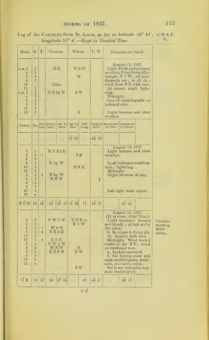
STORMS OF 1837. 115
Log of the Castries from St. Lucia, as far as latitude 39° 41',
longitude 50° 4'.—Kept in Nautical Time.
Hour. K. F. Courses. Winds. L.W. Remarks on board.
August 12, 1837.
A.M. 2 5 NE W SW Light winds and pleasant
4 5 weather; PointFerre.Mar-6 4 W • tinique, N 1 W; all stud-
8 3 dingsails set ; in all do.
;
10 Calm wind from N E \\ ith rain.
12 2 At sunset much light-
P.M. 2 2 N E by N sw ning.
4 2 Midnight.6 3 Out all studdingsails on8 3 larboard side.
10 3
12 3 3 Light breezes and clear
weather.
Dif. Depir- Lat. by Lat. by Diff. Long’.by Longitude LongitudeLat. ture. Acct. Obs. Long. Acct. by Obs. by Chron.
•• ••
O /
15 10o /
60 10
August 13, 1837.
2 3 NNEiE Light breezes and clear
4 3 4 SE weather.6 3
8 4 N by W In all larboard studding-
10 4 ENE sails ;lightning.
12 3 Midnight.2 2 4 N by W Slight showers of rain.
4 2 NNW i6 2
8 3
10 3 Fair light trade winds.12 4
N 9 W 68 66/
10o /
16 16O /
16 26/
11O /
60 21 60 40
August 14, 1837.
(13 at noon, Civil Time.)2 3 NW 6 W NNE to Light unsteady breezes4 2 N 1 W and cloudy
; all sail set by6 2 4 W 6 N the wind.8 4 4 NE 6 E 8. In royals & flying jib.
10 3 10. Squally with rain.12 3 4 E 6 N Midnight. Wind veered2 4 NW 1 \V round to the N E ; stood4 2 WNW N on starboard tack.6 4 NE 6 N NW 4. Tacked eastward.8 4 8. Set foretop-mast and10 8 main studdingsails, main-12 6 sails, and main-royal.
SW Set lower and main-top-mast studdingsail.
17 E 53 52 15O /
17 18 16O /
60 5O / 1
60 17
I 2
CHAP.y.
Castries
meetingthird
storm,
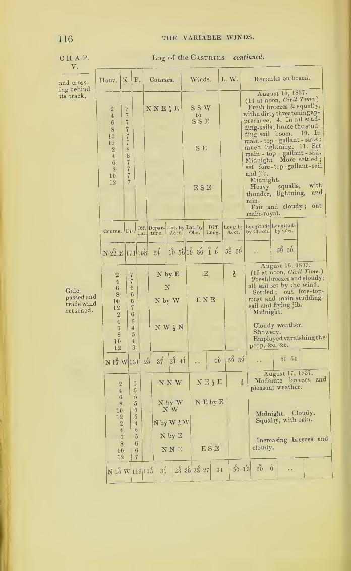
116 THE VARIABLE WINDS.
CHAP.V.
and cross-
ing behindits track.
Log of the Castries
—
continued.
Hour.
2
4
6
8
10
12
2
4
6
8
10
12
K. F. Courses.
NNE|E
Winds. L.W. Remarks on board.
S S Wto
S S E
S E
E S E
August 15, 1837.
(14 at noon, Civil Time .)
Fresh breezes & squally,
with a dirty threatening ap-
pearance. 4. In all stud-
ding-sails; broke the stud-
ding-sail boom. 10. In
main - top - gallant - sails ;
much lightning. 11. Set
main - top - gallant - sail.
Midnight More settled ;
set fore -top -gallant -sail
and jib.
Midnight.Heavy squalls, with
thunder, lightning, and
rain.
Fair and cloudy ;out
main-royal.
Course.
N 22 E
Dis.
171
Dif.
Lat.
158
Depar-ture.
6^
Lat. byAcct.
19 56
Lat. byObs.
19 36
Diff.
Long.
1 6
Long.byAcct.
58 59
Longitudpby Chrou.
Longitudeby Obs.
59 00
Galepassed andtrade windreturned.
2
4
6
8
10
12
2
4
6
8
10
12
N by E
N
N by W
N W i N
E
ENE
N 17 W 131 25
2
4
6
8
10
12
2
4
6
8
10
12
N 15 W
/ u /
37 21 41 40
August 16, 1837.
(15 at noon, Civil Time )
Freshbreezes and cloudy;
all sail set by the wind.
Settled ;out fore-top-
mast and main studding-
sail and flying jib.
Midnight.
Cloudy weather.
Showery.Employed varnishing the
poop, &c. &c.
59 39 59 54
N N W
N by WN W
NbyWiW
N by E
NEjE
N E by E
119 115
August 17, 1837.
Moderate breezes and
pleasant weather.
Midnight. Cloudy.
Squally, with rain.
NNE E S E cloudy.
31O /
23 36 23 271
0 '
34 Uo 13O '
60 0 ••
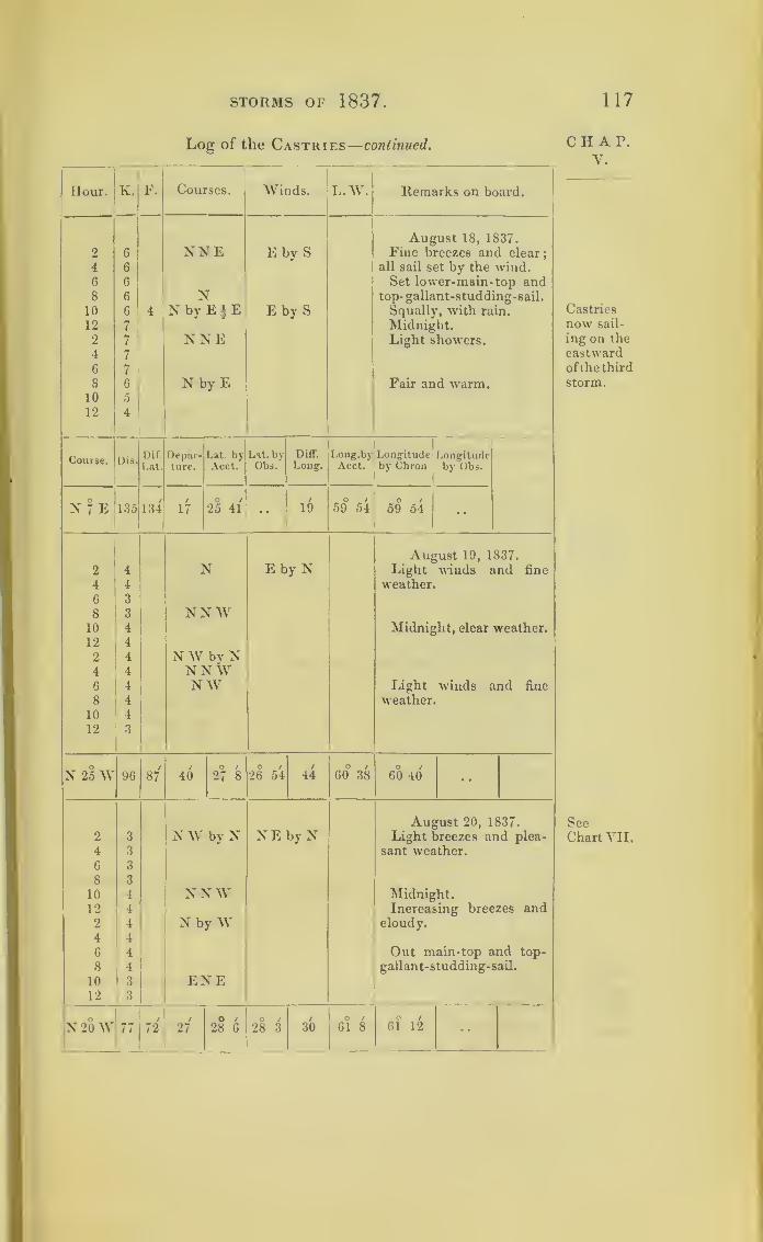
STORMS OF 1837 117
Log of the Castries
—
continued.
Hour. K. F. Courses. Winds. L.W. Remarks on board.
August 18, 1837.
2 6 NNE E by S Fine breezes and clear;
4 6 all sail set by the wind.6 6 Set lower-main- top and8 6 N top- gallant-studding-sail.
10 6 4 N by E 4 E E by S Squally, with rain.
12 7 Midnight.2 7 NNE Light showers.4 7
6 7
8 6 N by E Fair and warm.10 5
12 4
Dif. Depar- Lat by Lat. by Diff. Long.by Longitude LongitudeLat. ture. Acct. Obs. Long. Acct. by Chron by Obs.
N 7 E 135 134/
17o /
25 41 •• 19 59° 54O /
59 54 ••
August 19, 1837.
2 4 N E by N Light winds and fine
4 4 weather6 3
8 3 NNW10 4 Midnight, clear weather.12 4
2 4 NW by N4 4 NNW6 4 NW Light winds and fine
8 4 weather.10 4
12 3
N 25 W 96 87 40/
27 8O /
26 54/
44 60° 38O 1
60 40 ••
August 20, 1837.
2 3 NW by N N E by N Light breezes and plea-
4 3 sant weather.6 3
8 3
10 4 N NW Midnight.12 4 Increasing breezes and2 4 N by W cloudy.
4 4
6 4 Out main-top and top-
8 , 4 gallant-studding-sail.
10 1 3 ENE12
1
3
X 20W 1
1
/
72/
27O /
28 6O /
28 3 30O /
61 8O /
61 12 ••
CHAP.V.
Castries
now sail-
ing on the
eastwardof the third
storm.
SecChart VII.

118 THE VARIABLE WINDS.
CHAP.V.
Log of the Castries
—
continued.
Hour.
2
4
6
8
10
12
2
4
6
8
10
12
K. F. Courses. Winds.
N by E
NN WN
NEbyN
E
L.W. Remarks on board.
August 21, 1837.
Light airs and very warmweather ;
thermometer at
sunset 87|°.
Light airs ;midnight.
Increasing; set lower
studding-sail.
Light breezes.
Course. Dis.Dif.
Lat.
Depar-ture.
Lat. by
Acct.
Lat. byObs.
Diff.
Long.Long.!)}
Acct.
Longitudeby Chron.
Longitudeby Obs.
N 14 E 62 60 59O /
29 3o /
29 3/
17o /
60 51o /
60 48
2
4
6
8
10
12
2
4
6
8
10
12
NE£N
Chron. fast
SS W
sw
2h 42m 20 s
August 22, 1837
.
Light winds and fine
weather ;out larboard
studding-sail.
Midnight.Pleasant breezes.
Light winds and clear.
At 8h 38m long, per sun
and moon . . 59.49f.
Per chron. . . 59.44L
N33E 104 87
Swellprobablyfrom the
third
storm.
2
4
6
8
10
12
2
4
6
8
10
12
1 30 30o /
30 31o / o /
15 59 460 /
59 36o /
59 41
NEbyN
N 28 E 126 110
SSE
SEbyN
August 23, 1837.
Moderate breezes and
pleasant.
Midnight. Increasing
breezes and clear.
Cloudy.
A high westerly swell.
59 32 14 30 210 /
1 9 58 3Lt 58 40 58 45

STORMS OF 1837. 119
Log of the Castries
—
continued.
Hour. K. F. Courses. Winds. L.W. Remarks on board.
August 24, 1837.
2 6 NNE ESE Moderate breezes and4 6 hazy ; all staysails set.
6 6 NE by N In flying-jib and lower8 7 staysails.
10 7 In main - top gallant
12 7 main-staysails and fore-
2 8 royal.
4 9 Midnight.6 8 NE 1 E Fresh breezes and cloudy.
8 81 N Ditto ditto.
10 8 NNE Strong winds ;in flying-
12 8 jib and galf-topsail.
Dif. Depar- Lat. by Lat. by Oiff. Long.by Longitude LongitudeLat. ture. Acct. Obs. Long. Acct. by Chron. by Obs.
N 18 E 176 167 54o /
35 1 35 460
1 4O /
57 33o /
57 45 ••
August 25, 1837.
2 7 4 NNE E by S Strong winds and cloudy.
3. In top-gallant-sails;
4 5 increasing gales
;
double-reefed both topsails. 4.
6 3 N IE E by N i Furled both courses; split
the jib
;
bent another. 6.
8 1 4 2 Close-reefed both topsails
;
blowing a hard gale, with10 1 4 NNW NE heavyrain. 9. Fore-topsail
sheet broke, and split the12 1 4 (Midnight) NNE 5 sail; furled it. 11. Blow-
ing a hurricane
;
blew the2 1 4 N main-topsail out of the
ropes;got a boat-sail bent
4 1 4 s w W NW to the gaff, and another in
the main rigging; the ship6 1 4 NW keeps-to well
;
shippingmuch water over the lee-
8 1 4 rail; pumps carefully at-
tended to;washed most
10 5 ENE of the larboard bulwarksaway. As the wind veered
12 5 N to N E and to NWthe vessel was continually
with the sea, on or abaft
the beam, which caused
her to labour tremendous-ly, and I am afraid has
thrown some of the pun-cheons of molasses out of
their berths, as the wateris very much discoloured.
and we can hear some of
the casks rolling about.
N 10W 41 40
1
O /|
/ o /
35 371
- - 9 57 42 57 54 * *
CHAP.V.
Fourthstorm,overtaking’
Castries,
and
passingover her.

120 THE VARIABLE WINDS.
CHAT.V.
Fourthstorm.
Hour.
I
v. F
2 5 4
4 6 4
6 6 4
8 7 4
10 8
12 8
2 8
4 8
6 8
8 8
10 8
12 8
Course. rv DDis.
L
N53E 180 1
2 8
4 8
6 8
8 8
10 8
12 7
2 7
4 7
6 7
8 7
10 7
12
I
7
N 63 ]3 176
Log of the Castries—concluded
LAV.Courses.;
Winds. Remarks on board.
N E by E WNW
N E by | E NW
ENE
August 26, 1837
.
Strong winds with a high
cross sea.
Set jib, mainsail, andmain-top-gallant-sail.
Set fore-top- gallant- sail
and gaff-topsail.
Sea more regular; out
topmast-studding sails.
Strong breezesand cloudy.
Rain and lightning.
Fair and strong breezes ;
carried away fore-top-gal-
lant-mast, sent it down ;
in top main-staysail.
Depar-ture.
108 144
l.at. by bat. by
Acct. Obs
37 25 37 9
Diff. Long.byLong. Acct.
2 58 54 44
Longitudeby Chron.
54 56
Longitudeby Obs.
ENE NWAugust 27, 1837.
Strong breezes & cloudy
;
carrying moderate sail,
the rigging being muchstretched and very loose.
Clear weather.
Squally, with rain.
Set main - top - gallant-
sail and spanker.
Set fore-top-gallant-sail.
80|
156 38 29 38 25 3 10 51 34 52 26
2
4
6
8
10
12
24
6
8
10
12
N 50 E
6 '4
5
4
i6
5
4
4
3
4
5
N E by E*E
N \V
115 4
W
August 28, 1837.
Fresh breezes & squally ;
out lower and main-top-
mast studding-sails.
Pleasant breezes and
cloudy.
SW
88 30 39o /
39 41 113'O /
49 41O t
50 4

STORMS OF 1837. 121
Further remarks relative to the Castries, on the
24th and 25th August, 1837
:
“The hurricane commenced with the wind at cast by south,
and veered to the north-east as it increased. At 11 p.m. the
hurricane blew from the north-nortli-east, and veered about two
points per hour until 4.30 a.m. when it partially abated.
“We had a sudden lull whilst reefing topsailsvat 4 p.m. on
the 24tli, by civil time).
“ Had a high westerly swell for two Jays previous;
but as
this is very frequently the case about the termination of the
trade winds, I know not whether to ascribe it to the coming of this
hurricane or to some preceding gale.
“ Before the storm it was very dark and hazy, with muchlightning in the evenings.
(Signed) “J. MONDEL.”
By the log of the Castries, it will be seen that after
the 14th of August, at noon (by civil reckoning), that
vessel had fine weather and the usual trade winds until
the 22nd, notwithstanding the third storm that was
raging not very far off to the westward. About this
period, however, a heavy swell was felt from the west-
ward for two days;and there had been lightning in
the evenings.
On the 23rd it became hazy, and a breeze from
east-south-east freshened to a gale. This was not the
great storm which had passed onwards on its course,
and which on the 23rd had reached the place of the
ship Wanstead. This other gale being a fair wind for
the Castries, that ship was carried along with it, until
past noon on the 24th (civil reckoning). Although not
entered on the log, the master states, that there was a
sudden lull whilst close-reefing topsails, indicative of
being in the centre of a rotatory storm;and the log
shows how rapidly the wind was veering, and how
violently it was blowing just about this period.
CIIAP.v.
Hate of
veering.
Lull.
Swell.
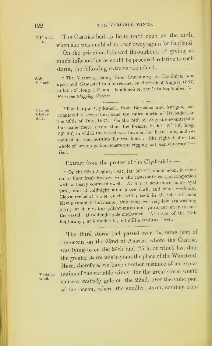
122 THE VARIABLE WINDS.
CHAP.V.
ShipVictoria.
BarqueClydes-dale.
Variable
•wind.
The Castries had to lie-to until noon on the 25th,
when she was enabled to bear away again for England.
On the principle followed throughout, of giving as
much information as could be procured relative to each
storm, the following extracts are added.
“ The Victoria, Dunn, from Lunenburg to Dominica, was
upset and dismasted in a hurricane, on the 24th of August, 1 837,
in lat. 33°, long. 58°, and abandoned on the 12th September.”—
From the Shipping Gazette.
“The barque Clydesdale, from Barbados and Antigua, en-
countered a severe hurricane ten miles north of Barbados, on
the 26th of July, 183?. On the 24th of August encountered a
hurricane more severe than the former, in lat. 32 30 ,long.
59° 30', in which the vessel was hove on her beam ends, and re-
mained in that position for two hours. She righted after the
whole of her top-gallant-masts and rigging had been cut away. —Ibid. __
Extract from the protest of the Clydesdale :
“ On the 23rd August, 1837, lat. 30° 21', about noon, it came
on to blow fresh breezes from the east-south-east, accompanied
with a heavy confused swell. At 4 p.m. sent down main-royal
yard, and at midnight atmosphere dark, and wind south-east.
Cloose-reefed at 5 a.m. on the 24thjtook in all sail
;at noon
blew a complete hurricane5ship lying over very low, sea washing
over3
at 4 p.m. top-gallant-masts and yards cut away to save
the vessel;
at midnight gale moderated. At 4 a.m. of the 25th
kept away;
at 8 moderate, but still a confused swell.
The third storm had passed over the same part of
the ocean on the 22nd of August, where the Castries
was lying-to on the 24 tb and 25th, at which last date
the greater storm was beyond the place of the Wanstead.
Here, therefore, we have another instance of an expla-
nation of the variable winds : for the great storm would
cause a westerly gale on the 22nd, over the same part
of the ocean, where the smaller storm, coming from

STORMS OF 1837. 123
the south-westward (and bringing up the Castries
along with it in the right hand semicircle), changed
the wind to east.
Bermuda lies between the courses of the two storms
marked on Chart VII. By comparing the projections
on this Chart with the following extract from a Regis-
ter kept by Captain Page, of the Royal Engineers, at
Bermuda, and given to me there, in 1839, further
views connected with the causes for the variable winds
will be suggested; for the greater storm on the 21st
of August, 1837, caused the wind at the Bermudas to
blow hard, with squalls, from the south-west
;
and as
it advanced in its course, the wind became west.
On the 24th of August the lesser storm, though it
did not reach Bermuda, changed the wind to north;
whilst a very heavy sea from the east rolled against
the eastern end of the islands, so remarkable as to be
spoken of to me two years after, as matter of great
curiosity at the time of its occurrence, because of the
north wind blowing lightly.
Extracts from Register of Weather, kept in St. George’s, Bermuda.
1837.
Aug.Barom. Ther. Winds.
Wrind’s
Force.Weather.
21st 30. 00029. 950
83.579.0
S W 7 Hazy dense cum. clouds; squalls
with rain;lightning at night.
22nd 30. 032 83.078.5
s w 4.
1
Showers; lightning in S E and
E.
23rd 30. 062 84.079.0
s wand W
2.0 Fine; passing clouds.
24 th 29. 962 83.078.5
N 2.0 Fine; cumul. clouds; a remark-
ably heavy swell of the sea; a tre-
mendous surf breaking on the rocks ;
quite remarkable and unusual.
Mean of tide + 5". 0 above the
mean, resulting from a series of
observations.
25th 30. 205 80.075.
5
Norcalm.
2.0 Fine ;air very dry
; Dew Pointfrom 12° to 15° below mean tem-perature.
CHAP.V.
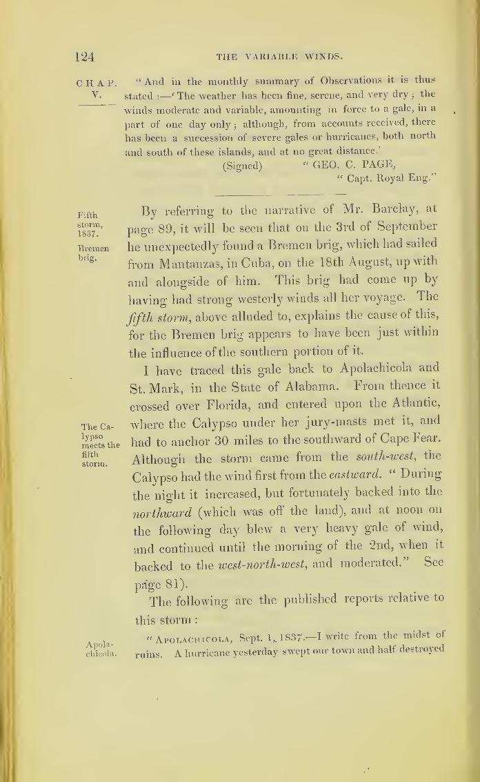
124 THE VARIABLE WINDS.
CHAP.V.
Fifth
storm,
1837.
Bremenbrig.
The Ca-lypsomeets the
fifth
storm.
Apola-chicola.
“ And in the monthly summary of Observations it is thus
stated :
—
f The weather has been fine, serene, and very dry;the
winds moderate and variable, amounting in force to a gale, in a
part of one day only;although, from accounts received, there
has been a succession of severe gales or hurricanes, both north
and south of these islands, and at no great distance.
(Signed)“ GEO. C. PAGE,
“ Capt. Royal Eng.”
By referring to the narrative of Mr. Barclay, at
page 89, it will be seen that on the 3rd of September
he unexpectedly found a Bremen brig, which had sailed
from Mantanzas, in Cuba, on the 18th August, up with
and alongside of him. This brig had come up by
having had strong westerly winds all her voyage. The
fifth storm,above alluded to, explains the cause of this,
for the Bremen brig appears to have been just within
the influence of the southern portion of it.
I have traced this gale back to Apolachicola and
St. Mark, in the State of Alabama. From thence it
crossed over Florida, and entered upon the Atlantic,
where the Calypso under her jury-masts met it, and
had to anchor 30 miles to the southward of Cape Fear.
Although the storm came from the south-west,the
Calypso had the wind first from the eastward. “ During
the night it increased, but fortunately backed into the
northward (which was oft the land), and at noon on
the following day blew a very heavy gale of wind,
and continued until the morning of the 2nd, when it
backed to the west-north-west ,and moderated.” See
page 81).
The following are the published reports relative to
this storm
:
" Apolachicola, Sept. 1,. 1837-—I write from the midst of
ruins. A hurricane yesterday swept our town and half destroyed
STORMS OF 1837. 125
it. Nearly every house is unroofed3
a number of the upper CHAP,stories are blown down, and many houses levelled. The storm ^ •
commenced on the afternoon of 30th August, but was not severe^
until 4 a.m. on the morning of the 31st, when it became very storm,
violent until 7 p.m. The wind was from the south-east to north."
—Extract of a Letter published in the American Newspapers.
“ The terrible tempest which visited Apolaehicola completely
destroyed the town of St. Mark. The lighthouse was almost
the only building left standing, yet the town of St. Joseph suf-
fered very little in the gale.’’
—
From the American Newspaper.
“ There has been a severe storm at St. Mark, which commenced St. Mark,
about sunrise on the morning of the 31st August, 1837, the wind
being from north-east. At 8 a.m. the wind was north, and it had
increased in violence : only one wharf has been left standing.
At the lighthouse the sea rose eight feet higher than usual. At
Pensacola there was no wind. The schooner Lady Washington was
becalmed at the same time at Key West. The wind was off shore
at the time of the storm, which makes it difficult to account for
the high tide • but it is supposed whilst the north-east wind was
blowing on shore, a south-easter prevailed at sea. This is frequently
the case, and invariably produces a high tide."—New York General
Advertiser.
“ Another storm commenced about the middle of last night, Georgia,
and at 10 a.m. this morning was blowing with some violence
from the north-west. It continued with somewhat increased
violence until noon, when the wind veered to about west. It is
now 2 o’clock, and still blowing a severe gale.”
—
From a Sava7inah
Newspaper, Georgian, 31s£ August, 1837.
“ The ship Florence experienced a heavy hurricane on the 2nd Near Cape
September, 1837, fifty miles east-south- east of Cape Hatteras. hUtteras.
It commenced blowing at east-north-east, and veered round fthe
compass."—New York General Advertiser.
“ The Danish brig Maria, on the 2nd September, in lat. 36' 6',
long. 73° 40', was scudding in a gale from the south.
§

126 THE VARIABLE WINDS.
CHAP.V.
Fifth
storm.
“ The brig Stranger, on the c2nd September, from Porto Plato
(in St. Domingo) to Philadelphia, experienced a severe gale from
south, changing suddenly to north.”
“ The wreck of a ship, abandoned and apparently recently dis-
masted, the sea breaking over her, and articles floating alongside,
was passed during a heavy gale of wind, on the 2nd September,
lat. 33° north, long. 74° west.”
Variablewinds.
It is only necessary to prove that the winds are
rotatory, and that by some fixed law of nature they
revolve uniformly in the same way, and we are enabled
to assign a cause for the variable winds. This subject
is best studied by beginning at the equator, and fol-
lowing storms towards the poles;
for the distuibing
causes, although very violent near the equator, seem to
occur less frequently, and we can there study the nature
of a single isolated storm. But in high latitudes it is
very difficult ;for the tropical storms seem to be car-
ried onwards towards the poles, whilst other storms aie
there generated, probably also rotatory; and as the
numbers increase, and they seem to expand in size,
and the meridians approach each other by the degrees
of longitude diminishing, the winds become huddled
together in a manner that has hitherto appeared inex-
plicable. Even admitting the great probability that
such is a fixed law of nature, it can only be satisfacto-
rily proved by adducing as many facts in connection
with each other as can be collected. As far as my in-
vestigations have been carried, all the facts I have met
with seem to be in accordance with such a fixed law;
and in one of Mr. Redfield’s published papers he states,
that not one instance of a contradictory kind has come
to his knowledge.
*

THE VARIABLE WINDS. 127
We shall, therefore, return to the latter part of the
voyage of H.M.S. Blanche, from the West Indies to
Halifax, in August, 1830. By her log-book we find
a second gale coming also from the southward, over-
taking the frigate on the 24th of August, and becom-
ing a violent hurricane by 10 p.m. on the 25th; and,
if we observe the veering of the wind, we find it to be
similar to all the other storms described.
This hurricane is mentioned in the ‘ American
Journal of Science,’ vols. xx. and xxi.;and it is there
stated by Mr. Redfield to have been at Martinique
between the 19th and 20th of August;
to have passed
northerly, and, touching the American shore near Cape
Hatteras, raged with great fury at each locality for
about forty hours, as it swept the great central curve
of their coast; and it passed from thence over St.
George’s Bank, in a north-east direction. On the
American coast it was everywhere a north-east storm;
but it will be seen by the log of the Blanche that ship
had the wind at south-east,veering to south-west and
to west. The Blanche was on the opposite side of the
whirlwind.
I have added, from the same volumes, an interesting
narrative of what befell the corvette Kensington, built
in America for the Russian Government. That vessel
sailed from the Delaware, with fine weather, on the
23rd of August, and, steering south-south-east, met
first “a disagreeable head sea,” and then the storm on
the 25th, without apparently being at all aware of
what she was about to encounter.
CHAP.V.
II.M.S.Blanche.
See dottedcircle,
Chart II.

128 tiie variable winds.
CHAP.V.
Blanche’sLog con-tinued.
Chart II.
Extract from the Log of H.M. S. Blanche, Commodore Farquhar,
kept by Mr. Middlemist, Master R.N —In Civil Time.
[Continued from Chap. II. p. 12.]
Gale com-mencing.
Middle of
gale.
lour. Courses. V
AM.1 S E by E N2 SE I
3 SEbyE N12 S E by E
P.M.
i N i W8
12
A.M.
4 N -* Ws
9.3011.20
12
P.M.
l N by W4
6
8 N10
A.M.
n2 j
3 lN E by N
4j off N E by E5 NNE9 N N E by N10 NNE
NoonP.M.
i NE,
5\ off N E by N0j upENE7 N E bv E9 ENE
11 E by N i N
A.M.
1 E by N3 E4
5 NE by N11 ENE
Winds.Remarks, &c. II.M.S. Blanche,
August 22, 1830.
ENE
ENE
A.M. Fresh breezes and fine weather.
1. 30. Squally ;up mainsail.
12. Fresh breezes and fine ;wore ship.
Wreck Hill, S. 78° E, 213 miles.
P.M. Fresh breezes and cloudy.
8. Strong winds and squally weather.
12. Strong gales and squally.
ENE
ENE
August 23, 1830.
A.M. Strong gales and squally.
4. Fresh gales and cloudy.
8. Strong gales, with a heavy sea.
9. 30. Down jury top-gallant-yard.
11.30. In flying jib-boom.
12. Strong gales and squally, with a
heavy sea.
Wreck Hill, S 55° E, 231 miles.
P.M. Hard gales, with heavy squalls.
Ditto weather;down main- staysail.
6. Hard gales and squally weather.
Ditto weather.
Most violent gales, with heavy squalls.
SEby E
SEby S
S by E
August 24, 1830.
A.M. Violent gales, with heavy squalls.
4. Ditto weather.
8. Hard gales, with heavy squalls.
Hard gales.
Wreck Hill, S 76° E, 260 miles.
P.M. Hard gales and heavy squalls.
8. Split main-staysail; unbent it, and
bent another.
Midnight. Strong gales and cloudy.
August 25, 1830.
A.M. Strong gales and cloudy.
Down main-staysail and set main-trysail.
4. Hard gales and squally.
4. 30. Set reefed foresail; down mizen-
trysail to repair._
9. 30. A heavy sea stove in cabin dead
lights and windows ;up foresail ;
hauled to
the wind.12. Hard gales and heavy squalls.
Wreck Hill, S 57° E, 248 miles.

STORMS OF 1837. 129
Extract from the Log of H. M. S. Blanche—continued.
Hour. Courses. Winds.Remarks, See. H.M.S. Blanche,
August 25, 1830.
P.M.
1 E S by E P.M. Hard gales and heavy squalls.
5 NEby E Ditto weather, with a heavy sea.
7 ENE Hard gales, with violent squalls.
10 E S by W Violent hurricane;
fore-staysail blew to
11 ESE pieces.
12 SE by E
A.M. August 26, 1830.
1 SE SWbyS A.M. Strong gales and squally weather.2. 30. Set main-staysail
; down mizen-5 SSE W trysail.
8 S by EStrong gales and squally.
8. Hard gales.9 S W by S 9. 30. Set fore-staysail
;down main-ditto.
12 S by E Noon. Strong gales and squally.
Lat. 36° 1' N, long. 69° 2' W.Wreck Hill, S 46° E, 325 miles.
P.M.
1 S W by S P.M. Hard gales and heavy squalls.2 NNE Ditto weather.7 N W
N W by N
Ditto ditto;hauled to the wind in conse-
quence of a heavy sea.
8 8. Fresh gales and clear.
9 Nff 12. Strong gales and squally.10 NW bv W11 NNiV
A.M. August 27, 1830.
1 N W by W W by S A.M. Strong gales and squally weather.3 3. More moderate.4 NNE W 4. Strong breezes and cloudy weather.8 8. Strong breezes and cloudy weather;
found ensign and several flags damaged.12 12. Fresh breezes and fine weather.
Lat. 38° 16' N, long. 68° l'W.Sambro Light, N 28° E, 425 miles.
P.M.
1 NNE W SW P.M. Strong breezes and fine weather.5 W6 6. Fresh breezes and fine weather.
12 12. Ditto weather.
A.M. August 28, 1830.1 NNE W A.M. Fresh breezes and fine.
8 8. Light airs and fine.
12 12. Light winds and fine.
Lat. 41° 21' N, long. 67° 2' W.Sambro Light, N 36° E, 233 miles.
P.M.
1 N E by N NW bW P.M. Moderate and fine weather.4 NW8 8. Light airs and fine.
12 12. Moderate and fine.
CHAP.Y.
Blanche’sLog.
End of
gale, fol-
lowed bywesterlywinds.
K

130 THE VARIABLE WINDS.
CHAT.Y.
Blanche’s
Log.
Blancheoff
Halifax.
Extract from the Log of H. M. S. Blanche concluded.
Hour. Courses. Winds.Remarks, &c. H.M.S. Blanche,
August 29, 1830.
A.M.
1
8
11
Noon
N E by N NWNNW
August 29, 1830.
A.M. Light airs and fine weather.
Observed land, bearing NE by N.
Noon. Light breezes and fine.
Lat. 43° 10' N, long. 65° 29' W.Sambro Light, N 48° 30' E, 114 miles.
P.M.1
3
5
9
12
NEN E by E
NWW by S
SWbS
P.M. Light airs and fine weather.
5. Shelbourne lighthouse, N f E.
12. Light airs and fine weather.
A.M.
1
6
Noon
SWbWssw
August 30, 1830.
A.M. Light airs and fine weather.
Ditto weather and foggy ;fired a gun for
a pilot.
Noon. Moderate and hazy weather.
Lat. 44° 5' N, long. (none).
Sambro Light, NE|N, 21 miles.
P.M.
1
2 SWestlP.M. Light airs and fine.
y 2. Eired a gun for a pilot.
4
Midn '
Ditto weather.
Midnight. Ditto weather.
At Bermuda, on the ‘21st of August, 1830, the
weather was fine, with light airs. On the 22nd there
were “ stormy heavy showers,’ the wind changing
from N.E. to S.E. On the 23rd and 24th it blew
strong, and south-easterly. On the 25th the wind
became south and squally ;and on the 26th it veered
to S.S.W., after which the weather became fine.
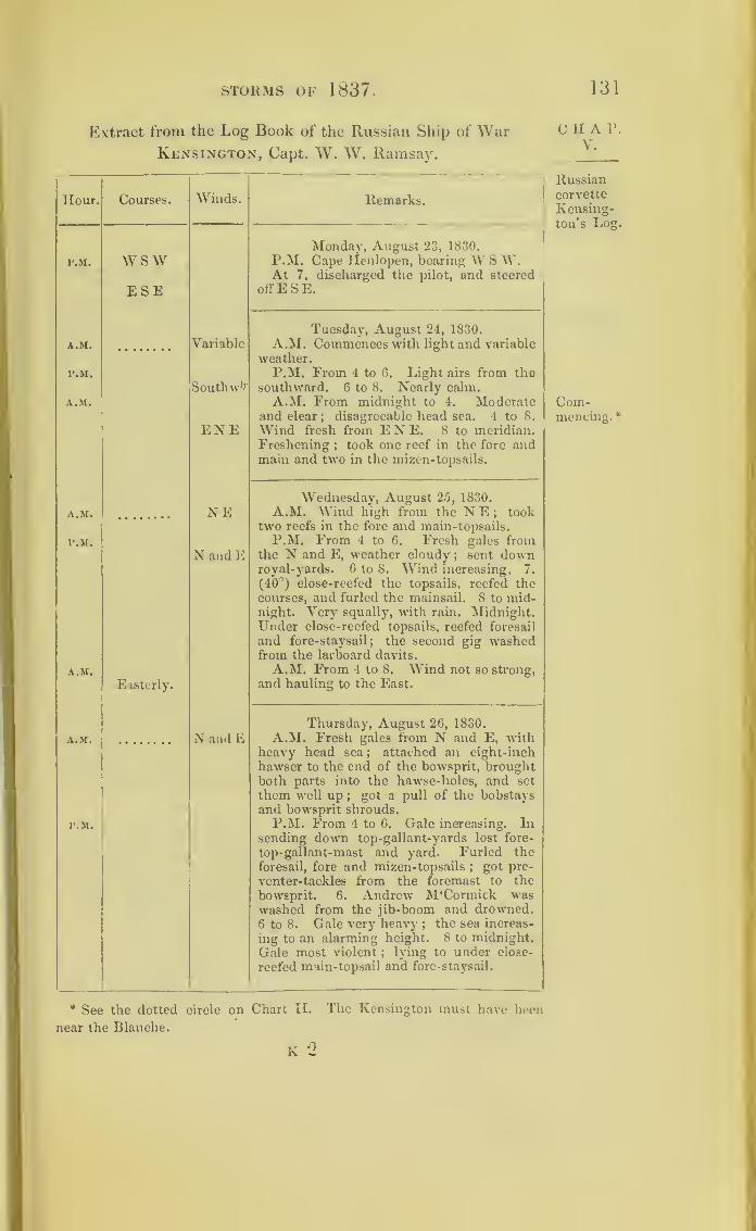
STORMS OF 1837. 131
Extract from the Log Book of the Russian Ship of WarKensington, Capt. W. W. Ramsay.
Hour. Courses. Winds.
P.M. WSWESE
A.M. Variable
I’.M.
SouthwhA.M.
ENE
A.M. NE
P.M.
N and E
A.M.
Easterly.
A.M. N and E
P.M.
Remarks.
Monday, August 23, 1830.
P.M. Cape Ilenlopen, bearing W S W.At 7, discharged the pilot, and steered
offESE.
Tuesday, August 24, 1830.
A.M. Commences with light and variable
weather.P.M. From 4 to 6. Light airs from the
southward. 6 to 8. Nearly calm.A.M. From midnight to 4. Moderate
and clear; disagreeable head sea. 4 to 8.
Wind fresh from E N E. 8 to meridian.Freshening ; took one reef in the fore andmain and two in the mizen-topsails.
Wednesday, August 2.5, 1830.
A.M. Wind high from the N E;
tooktwo reefs in the fore and main-topsails.
P.M. From 4 to 6. Fresh gales fromthe N and E, weather cloudy
;sent down
royal-yards. 6 to 8. Wind increasing. 7.
(40°) close-reefed the topsails, reefed thecourses, and furled the mainsail. 8 to mid-night. Very squally, with rain. Midnight.Under close-reefed topsails, reefed foresail
and fore- staysail; the second gig washedfrom the larboard davits.
A.M. From 4 to 8. Wind not so strong,
and hauling to the East.
Thursday, August 26, 1830.
A.M. Fresh gales from N and E, withheavy head sea; attached an eight-inch
hawser to the end of the bowsprit, broughtboth parts into the hawse-holes, and set
them well up;
got a pull of the bobstaysand bowsprit shrouds.
P.M. From 4 to 6. Gale increasing. Insending down top-gallant-yards lost fore-
top-gafiant-mast and yard. Furled the
foresail, fore and mizen-topsails;
got pre-
venter-tackles from the foremast to the
bowsprit. 6. Andrew M‘Cormick waswashed from the jib-boom and drowned.6 to 8. Gale very heavy ;
the sea increas-
ing to an alarming height. 8 to midnight.
Gale most violent; lying to under close-
reefed main-topsail and fore- staysail.
* See the dotted circle on Chart
near the Blanche.
[I. The Kensington must have been
k
C II A P.
V.
Russiancorvette
Kensing-ton’s Log
Com-mencing.*

132 THE VARIABLE WINDS.
CHAP.V.
Russiancorvette
Kensing-ton’s Log.
Middle of
gale.
Extract from the Log Book of the Russian Ship of War
Ken sington
—
continued.
Hour. Courses. "VVinds.Remarks.
A.M.
1
Ar
'
North
Thursday, August 26, 1837.
A.M. From midnight to 4. Gale raging
vith great violence ;a tremendous sea. 1.
Dhe main and mizen-top-gallant-masts were
down away close to the caps. 2. A perfect
hurricane from the North ;taken a-hack :
the ship in a very critical situation ;pitched
away the jib-boom, with it the spritsail-
yard; sprung the bowsprit and fore and
mainmasts; attempted to relieve the ship oi
the main-topsail, weather sheet parting, the
sail was instantly thrashed to pieces. 4.
The situation of the ship was most critical,
working violently, and much distressed
from the weight of her battery. 4.30. Fore-
sail, fore- topsail, and mainsail burst from
their gaskets, and were blown into ribbons.
4 to 8. Gale raging with unabated fury ;
fore-staysail blown from the bolt-rope, and
such the force of the storm that not a rag
of canvas could be shown. 4.40. Main-
topmast went by the cap. 5 - Fore and
mainmast badly sprung ;secured the part-
ner wedges with heavy spikes ;to save the
foremast and bowsprit cut away the fore-
topmast, carrying with it the head of the
foremast and part of the fore-top ;cock-
billed the fore-yard and secured the lee arm
to the cable-bitts. 5 30. Carried away wea-
ther mainbrace bumpkins ;to save the mast,
cut away the main-yard, which no human
effort could secure : the situation of the ship
awful in the extreme, five feet water in the
hold, and the crew perfectly paralysed ;the
wind had now attained a furious height,
and the sea increased to such an alarming
degree that with great difficulty men could
be°found to cut away the main-yard.
West
Friday, August 27, 1830.
P M Gale yet dreadful. 4.30. Wind
hauied' to West ;set the miz.en- staysail to
keep the ship to. 4 to 8. Gale somewhat
abated; set the main-staysail. 6. Gale
abating; all hands employed clearing
wreck ;weather cloudy. From 8 to mid-
night. Moderate; heavy sea; ship very
A.M. From midnight to 4. Very heavy
sea. 4 to 8. Gale again increasing ;spoke
ship Norfolk, from Norjolk; received an
offer of assistance. The Norfolk teas not %n
the gale.
A.M
133
The Racer s Storm ; and the Winds called Norths.
The Racer sloop of war encountered another hurri-
cane on the 28th of September, 1837 ;H. M. sloop
Ringdove being then in the same seas, and within
its influence: a comparison of the logs of these two
vessels enables us to lay down the probable course of
this storm. It may be an instructive one to inquire
into, inasmuch as it was moving over Yucatan and
towards the Gulf of Mexico; and will serve, along
with another storm to be described at the end of
Chap. VIII., to explain (at least in some degree) those
winds which the Spaniards call Norths,and the gales
of the eastern shores of Mexico.
By comparing the two log-books and the places of
these two vessels, we find the Racer was the most to
the southward. She experienced the storm first, and
had the wind from E. N. E., whilst the Ringdove, a
degree to the northward of her, had the wind more
easterly. Both vessels ran with the storm;but the
Racer having lost her masts, the Ringdove ran the
furthest into the Gulf of Mexico, and therefore longer
experienced the storm. It lasted with her until mid-
night of the 1st of October;whereas it left the dis-
masted Racer on the morning of that day.
The account of this storm is introduced, in the hope
that it will lead to further inquiry into the storms erf
the Gulf of Mexico, and ultimately to an explanation
of the true nature of the winds called Norths.
The wind’s force in the log of the Racer is recorded
CHAP.v.

134 the variable winds.
chap, according to Captain Beaufort’s rules ;which will be
v! found explained at the end of Chap. X. It is a
method so simple and expressive, that it is to be
hoped it will be adopted in all records ot the weathei,
both by sea and land.
The paragraph from the ‘ Jamaica Dispatch,’ which
follows the Ringdove’s log, was only met with after
the figure placed above had been engraved ;and it
shows that the Racer’s storm passed over part of
Jamaica.

WINDS CALLED NORTHS. 135
Extract from the Log of H. M. Sloop Racer, James Hope, Esq.,
Commanderjbetween 1 p.m. of the 28th September, 1837,
and 12 a.m. of the 30th September, 1837.
H K F Courses. Winds. Wind’s
Force.Weather
L.
W. Remarks.
September 28, 1837.
1 2 SW P.M. 1.30. Spoke an Eng-2 4 5 W S W EN E 7 O C Q lish schooner from Jamaica.3 3 SEbyS 2. Spoke an English brig
;
4 % furled the courses, and5 1 5 trimmed on larboard tack
;
6 1 5 rove top tackle-falls.
7 1 5 5 Sent top-gallant-yards8 1 S by E 7 Q RW on deck
;housed top-gallant-
9 1 Up S E masts, andinflyingjib-boom.10 1 7.30. Furled the topsails,
11 1 Off S S W 8 U QR andsettliemain try-sail;bat-
tened the hatchways down.12 1 Midnight. Set fore-stay-
sail, and wore ; down ditto.
September 29, 1837.
1 1 8 U Q R 6 A.M. 6. A sea washed2 1 Up N away life-buoy, stove stem-3 1 boat, and carried away star-
4 1 E by N 9 OUR 6 board- fall- gripes and lash-
5 1 ings.
6 1 Cut awav ditto.
7 1 5 Off N W 9. Down main-trysail; a
8 l 5 heavy sea running;
sent9 1 5 EN E 10 top gallant-masts on deck.10 1 5
11 1 512 1 5 10 QUR 6 Noon.
Course. Distance. Lat. N. Longitude W. Chron. Bearings and Distance.
JL).R. D.R.
S 44W 36 19 43 83 23 None. Cape Antonio,N 33W 156
1 4 9 NW 4W E N E 10 QUR P.M. Shaped a courseNWi W.
2 4 5 3. Sea washed away part
of lee hammock-nettings and3 4 5 two upper half-ports.
7.15. In a heavy gust of
4 4 4 11 wind the ship went over on I
her beam-ends, and lay with
5 4 4 her tops in the water for twominutes; when the masts
6 4 4 11 going she righted, with 6\ :
feet water in the hold.
7 4 5 12 Found bowsprit gone at thecollars ;
foremast six feet
above the deck, mainmast at[
the hounds ; everything on(
CHAT.Y.
Racer’s
Log.
Shorten-ing sail.
Furledtopsails.
Battenedhatches.
Barepoles.
Ship wentover.
Mastswent.
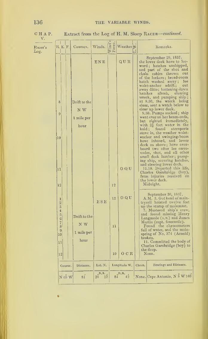
136 THE VARIABLE WINDS.
CHAP.V.
Racer’sLog.
Extract from the Log of H. M. Sloop Racer— continued.
1
H. K. F. Courses.
1.
Winds.[
IIw
ina
s
Force.
|Weather i Remarks.
8
9
10
11
12
1
2
3
4
5
6
7
8
9
10
11
12
Drift to the
N W1 mile per
hour
Drift to the
N W1 mile per
hour
ENE
ESE
12
12
11
10
QU R
0 QU
0 QU
OCR
September 29, 1837.
the lower deck hove to lee-
ward;
hatches unshipped,
and part of the shot andchain cables thrown out
of the lockers; bread-roomhatch washed away ;
lee
waist- anchor adrift ;cut
away ditto;battening down
hatches afresh, clearing
wreck, and pumping ship ;
at 8.30, the wreck being
clear, sent a watch below to
clear up lower deck.
9.30. Pumps sucked; ship
went over on her beam-ends,
but righted immediately,
with 2§ feet water in the
hold ;found sternports
stove in, the weather waist-
anchor and swinging-boomhove inboard, and lower
deck as above;hove over-
board two after lee earro-
nades, shot, and all other
small deck lumber; pump-ing ship, securing hatches,
and clearing lower deck.
11.10. Departed this life,
Charles Gambridge (boy),
from injuries received onthe lower deck.
Midnight.
September 30, 1837.
A.M. 3. Got head of main-
trysail hoisted twelve feet
up the stump of mainmast.7. Mustered ship’s crew,
and found missing HenryLangmede (a.b.) and JamesMartin (capt. forecastle).
Found the chronometers
full of water, and the main-spring of No. 374 (Arnold)
broken.11. Committed the body of
Charles Gambridge (boy) to
the deep.
Noon.
Course. Distance. Lat. N. Longitude W. Chron. Bearings and Distance.
N69W 810D.R.
,
20 120D.R. ,
84 42 None. Cape Antonio, N 8 W103
%
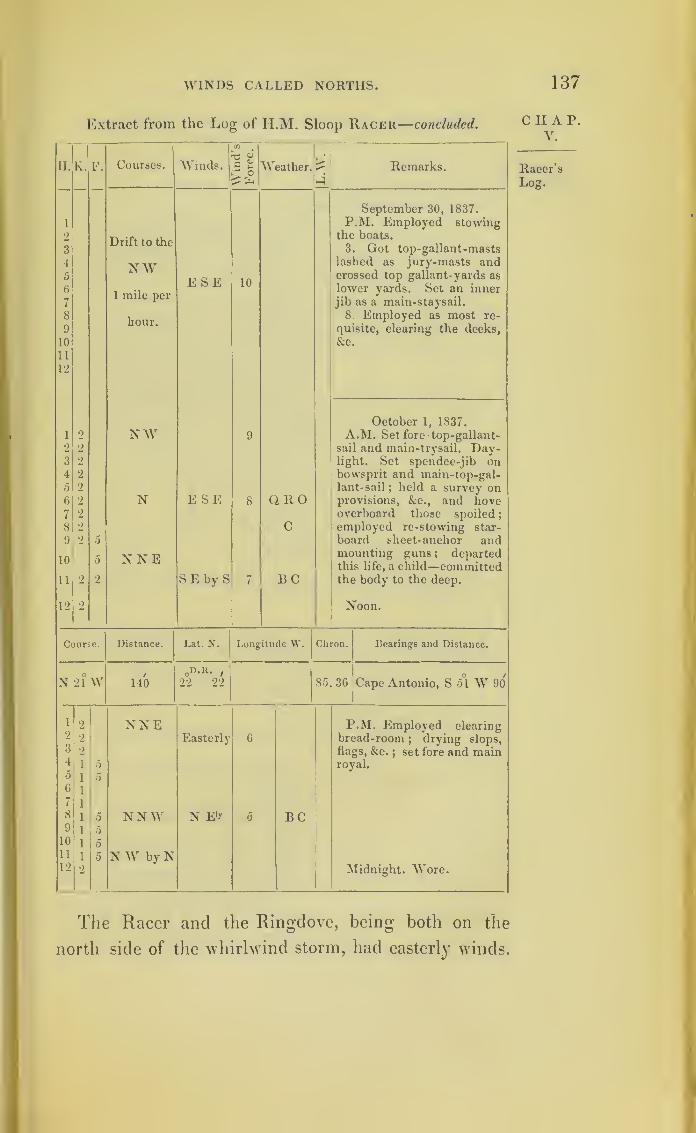
WINDS CALLED NORTHS. 137
Extract from the Log of H.M. Sloop Racer—concluded.
Courses. I
cn
^3 fII. K. F. Winds. e c
— Weather. Remarks.
September 30, 1837.
1 P.M. Employed stowing
2
3Drift to the
the boats.
3. Got top-gallant-masts
4 NW lashed as jury-masts and5 E SE 10
crossed top gallant-yards as
6
71 mile per
lower yards. Set an innerjib as a main-staysail.
8hour.
8 Employed as most re-
9 quisite, clearing the decks,
10 &c.
11
12
October 1, 1837.
1 2 NW 9 A.M. Set fore top-gallant-
2 2 sail and main-trysail. Day-3 2 light. Set spendee-jib on4 2 bowsprit and main-top-gal-5 2 lant-sail; held a survey on6 2 N E SE 8 QRO provisions, &c., and hove7 2 overboard those spoiled
;
8 2 C employed re-stowing star-
9 2 5 board sheet-anchor and
10 NNE mounting guns ; departedthis life, a child—committed
11 2 2 S E by S 7 BC the body to the deep.
12 2 Noon.
Course. Distance. Lat. N. Longitude W. Chron. Bearings and Distance.
O 0D.K. , _ o /
N 21 W 140 22 22 85. 36 Cape Antonio, S 51 W 90
1 2 NNE P.M. Employed clearing2 2 Easterly 6 bread-room
;drying slops,
3 2 flags, &c.;set fore and main
4 i 0 royal.0 i 06
7
i
i
8 i 0 NNW N E'r 5 BC9 i 010 i 011 i 5 N W by N12 2 Midnight. Wore.
CHAP.V.
Racer’s
Log.
The Racer and the Ringdove, being both on the
north side of the whirlwind storm, had easterly winds.

138 THE VARIABLE WINDS.
CHAP.V.
Log of the
Ringdove.
Extract from the Log of H. M. Sloop Ringdove,
John Shepherd, Master.
Hour. EL F. Courses. Winds. Remarks.
A.M. September 27, 1837.
i At anchor off Larza de Fuero.
6 NE A.M. Fresh breezes& cloudy, with occa-
sional squalls. Daylight, more moderate.
8 ENE At 8, sent a boat to sound to the east-
ward.
10
11
SSE Standing to the SSE.At 11, weighed & made sail to the SSE.
11.30, observed a strange sail on the lee-
bow, altered course to close her. 11.45,
shortened sail,wore ship, hove to &. boarded
the Spanish brig Gurtunedo, 63 days from
Barcelona, bound to Trinidad de Cuba.
12 Noon. Fresh breezes and cloudy ;bore
up and made sail to the S S E ;Sugar Loaf
Mount N N E, and north point Larza de
Feuro, E § N.
P.M.
1
2
Lat. 21° 23' N, Long. 79° 54' W, north
end of Larza, E 1 N ten miles.
5
5 *
SEby S Easterly P.M. Moderate and fine, with heavy
swell from the eastward.
3
4
4
3 4 S by E ESE At 4, ditto weather ;Cayo Breton,
E N E 10 or 12 miles.
5 3 5. 30, squally, with rain, thunder, and
6 3 N byWNE
lightning.
7
8
2
2
S E by EAt 8, moderate & cloudy, with lightning.
9 2 I
10 2 1
11
12
3
2
1 S by E3 SSE E Midnight. Fresh breezes and fine, with
heavy swell from the eastward.
A.M.
1
September 28, 1837.
2 4 SE A.M. Fresh breezes and fine.
2 2 4 S E by I
3 2 4 Easterly
4{1 5 }
N i EAt 4, fresh breezes and squally.
5 44 At 6, Cayo Breton, N E by N.
6
7
0
5 4 N byW At 7, strong vunds and cloudy ; in three
reefs.
8
9
N}W6
At 8, ditto weather.5
4At 9, observed the high land ofTrinidad
a-head.
10n 10. 30. Bent fore-stavsail and trysail
;
4Larza de Feuro on the weather bow.
11 4 Noon. Strong breezes and fine.
12 4Sugar Loaf Mount, N by E $ E. Course
E, distance, seven miles.
Lat. 21° 25', 21° 23' N, long. 79° 47'W79° 42'.
Larza de Feuro,E byN nine or ten miles.

WINDS CALLED NORTHS. 139
Extract from the Log of H. M. Sloop Ringdove—continued.
Hour. K. F. Courses. Winds. Remarks.
P.M. September 28, 1837.
P.M. Moderate and cloudy, with rain.
1.30, a heavy squall.1 2
2
0
4NbE£E
2 6 4 w sw Easterly 2.15. More moderate.
3 0 4 WbyS4 6 At 4, moderate and cloudy.
5 8
6 6 ESE7 7 6 WSW8 6 At 8, fresh breezes and fine, with heavy
swell from the eastward; in top-gallant-
9 8 sails;carried away the long line.
10 8
“{6
2
2
2
.... E
12 8 S W bw 11.45. Altered course to SW by W.
A.M.SWbW
September 29, 1837i 7 4 A.M. Strong winds and thick weather,
with high sea.
2 8 6
3 9 E 3.30. Up mainsail.
4 9 4 At 4, squally.
5 9 At 5, fresh gales, with high sea ; downtop-gallant yards and masts, and close
reefed the topsails;
in jib-boom, andfurled the courses.
6 9 w 6. Altered course to W.7 8 4
8 8 2 8. Fresh gales and dark gloomy wea-ther, with heavy squalls and rain.
9 8
10 8
11 8
12 7 6 Noon. Fresh gales and heavy squalls,withhigh sea ;
ship under close-reefed topsails.
Course, S 83° W, distance 179 miles.
Lat. 21° 4' N, long. 82° 56' W.Cape Corrientes, N 61' W, distance 96
P.M. miles.
1 8 w E P.M. Strong gales and heavy squalls;
set fore- staysail.
2 9
3 9
4 9 At 4, ditto weather, with passingshowers of rain.
5 9
6 9
7 8 6
8 8 4 At 8, strong gales and dark gloomyweather, with rain.
9 10
10 11 At 10, carried away the tack of fore- stay-
sail, and split the sail;unbent it to repair.
11 10
12 11 Midnight. Heavy gales, with hardsqualls and high sea.
CHAP.V.
Log of the
Ringdove.

140 THE VARIABLE WINDS.
C H A P.
V.
Log of the
Ringdove.
Extract from the Log of H.M. Sloop Ringdove—continued.
Hour. V. F. (bourses.
A.M.
1 1 0 W2 1 0
1 }
6
4
0
2!
WbN5 1 0
6 0
7 0 ]SfWbW
8 8
9 8
10 8
11 8
12 8
P.M.
1 8 NWbN2 8
3 8
4 8
5 2 4 N by E6 2 4
7 4 4
8 2 4
9 1 4 NNE10 1 4
11 1 4
12 1 4 NNE |E
A.M.
1 1 4 NE bv N2 1 4 NE3 1 4
4 1 4 NE by N5 1 4
6 1 4
7 1 4
8 1 4
9 1 4
10 1 4
11 1 4
12 2 2
Wind. Remarks.
E
E
September 30, 1837.
A.M. Strong gales, with heavy squalls,
lightning, and rain. 2. Altered course
to W by N. 2.40. Trimmed, and al-
tered course to WNW. 4. Strong
gales, with hard squalls and heavy rain.
6. Set fore-staysail and furled fore-
topsail;
got the jolly-boat in off the
quarter to prevent her being washedaway, the foremast davit being bent bythe sea ;
found the gig stove during the
night by the sea striking her. 8. Heavygales, with hard squalls
;furled main-
topsail, set fore and main trysail.
Noon. Hard gales, with heavy squalls
and high sea ;ship under trysails and
fore staysails.
Course, N 71° W, distance 211 miles.
Lat. 23° 13' N, long. 86° 32' W.Cape Corrientes, S 79° E, distance 121
miles.
P.M. Fresh gales and squally, with
high sea.
4.15. Set main-topsail, and hove ship
to.
7.30. Shipped a heavy sea, whichstove in four of the weather-ports, and
washed away the binnacles.
At 8 strong gales, with hard squalls
and high sea.
[squalls.
Midnight. Fresh gales, -with hard
Easterly
E by S
E SE
October 1, 1837.
A.M. Strong gales, with heavy squalls.
At 4 heavy rain, attended with light-
ning.
At 8 fresh gales and thick weather,
with high sea.
At 10 gale moderating ;set close-
reefed main-topsail and fore-trysail.
Noon. Strong winds and squally
;
ship under main-topsail, trysails, andfore-staysails.
Course, N 35° W, distance 76 miles.
Lat. 23° 40', 23° 16' N, long. 88° 12' W,87° 48'.
Fortugo Lighthouse, N 80° E, distance
295 miles.

WINDS CALLED NORTHS. 141
Log of H. M. Sloop Ringdove—concluded.
Hour. K. F. Courses. Winds. Remarks.
P. M. P.M. Fresh gales and squally, withi 2 NE by N ESE high sea.
2 3 6 At 2 a heavy squall;clewed up main-
3 6 NNE topsail.
4 5 At 4 fresh gales and dark gloomy5 5 weather, with heavy passing squalls.
6 4 2 NE by N 6. Ditto -weather. 6.16. Set main-7 2 4 topsail.
8 3 4 At 8 ditto weather.
9 4 NNE At 9 heavy squalls ; in main-topsail.
10 3 9.15. Set ditto.
11 3 3
12 3 Midnight. Fresh gales and thick wea-ther, with passing squalls.
A.M. October 2, 1837.1 3 4 NNE ESE A.M. Fresh breezes and cloudy sea,
gradually going down.Course, N 28° E, distance 99 miles.
Lat. 25° 10', 25° V N, long. 87° 17' W87° 22'.
Fortugo Lighthouse, S 80° E, distance
237 miles.
CHAP.V.
Log of the
Ringdove.
“ Kingston, Sept. 28, 1837.—State of the Weather.—The See
rains which commenced on Monday Evening last, in Spanish
Town, Kingston, and the neighbouring districts, have continued Racer and
unabated up to the present moment. During the last two dayshigdove.
the streets of Kingston were continually inundated, and all
business suspended, except in the daily printing offices.”
—
Jamaica Dispatch.
“ We are sorry to state we were visited during the whole of
Tuesday and yesterday with a severe gale of wind, which drove
from their moorings three vessels in the harbour. The brig
Clorinda, Moore, was driven upon a neighbouring wharf, where
the schooner Admiral Colpoys, Darrell, was lying. The con-
cussion took away the cut-water and bowsprit of the latter.
The harbour-master directed the scuttling of the Clorinda, to
save the adjacent wharves and vessels. The brig Cadwallader
dragged her anchor a considerable distancejand the sloop
Chatham parted her anchor, and has drifted down as far as
Greenwich. Mr. Stewart, the harbour-master, has been in-
142 THE VARIABLE WINDS.
CHAP.V.
Canada.
Variableoceancurrents.
Wreckers.
Necessityfor con-trolling
them.
strumental in protecting the shipping, by his decision and
exertions.”
—
Ibid.
The storms detailed in this chapter explain the
reason why north east winds bring rain and stormy
weather in Canada;and they account for the extra-
ordinary tides which sometimes happen in the river
St. Lawrence.
Here also we have a cause for currents of the ocean
being suddenly accelerated, or unexpectedly changing
their direction. The effect of diminished atmospheric
pressure combined with the action of the wind in
creating ocean currents will be noticed further on.
A far greater number of storms pass over the Gulf
of Florida than seem to fall to its regular share, thereby
increasing the danger of its navigation, sufficiently
imminent from currents, rocks, and shoals. 1 his has
given rise to the business of wrecking, followed as an
occupation, and in which considerable capital is em-
barked, on both sides of the Florida stream, by Ame-
ricans as well as English. The crews are required to
take out a licence, that they may be registeied and
under control.
The interests of navigation and of the social world
require that a strict control and watch should be
maintained over the conduct of inhabitants of islands
which border one of the most frequented as well as the
most dangerous thoroughfares on the ocean.
Had Mr. Wilkinson and his crew agreed to abandon
the Calypso, as he was asked to do, that vessel, in all
probability, would have been immediately afterwaids
taken possession of by the brig, which so shamefully
abandoned him at a time when he and his men had
WINDS CALLED NORTHS. 143
only three-quarters of a puncheon of fresh water
amongst fourteen persons, in a hot climate;and when
they were reduced to eat raw salt pork, being at the
time without masts or sails. Mr. Wilkinson’s situa-
tion serves to exemplify that of masters of ships when
they have to treat with wreckers.
Since the account of the Racer’s storm was first
published, its further course has been traced by Mr.
Redfield across the Southern United States to the
Atlantic Ocean, where it became an Atlantic gale,
north of the Bermuda islands.
CHAT.V.
144
CHAPTER VI.
ON STORMS IN THE SOUTHERN HEMISPHERE.
chap. The storm tracks already traced in north latitude,
VLwith few exceptions, are seen to follow nearly similar
courses, and in their progress to pass gradually to-
wards the North Pole. While studying the subject,
1 was led to conclude that, in accordance with the
beautiful order and regularity of Natuie, storms in
south latitude would be found to revolve in a precisely
contrary direction to that which they take in the
northern hemisphere ;I therefore earnestly sought for
facts, to ascertain if this were really the case or not.
The first observations I obtained were from Captain
Locke Lewis, of the Royal Engineers, who was for
several years stationed in the island of Mauritius,
between the 20th and 21st degrees of south latitude;
and I soon afterwards received others from Captain
Grierson, also of the Royal Engineers, who had like-
wise been stationed at the same island.
On first attempting to lay down these observations
of storms in south latitude, by means of the figure used
for those of north latitude, they were found only recon-
cileable with revolving storms, travelling towards the
equator instead of towards the pole;but a little inquiry
proved that this was not their true course. When the
other figure was used, which represents a storm revolv-
ino- like the hands of a watch (being the second figure
ON STORMS IN THE SOUTHERN HEMISPHERE. 145
at page 5), then their progress was of course reversed,
and tended towards the south pole;and such will be
found (as far as I have been able to obtain records)
to be their real course and mode of action.
It was not until I had laid down these observa-
tions from the Mauritius, and others in south latitude
obtained at the India House, that I received from Mr.
Redfield, of New York, a copy of the pamphlets written
by that gentleman on the subject of storms; and found
in those of the latest date a sentence expressive of pre-
cisely the same opinion as my own. Mr. Redfield had
not then published any detailed proofs in support of it.
The following is the sentence alluded to
:
“ There is reason to believe that the great circuits
of wind, of which the trade winds form an integral
part, are nearly uniform in the great oceanic basins
;
and that the courses of these circuits and of the
stormy gyrations which they may contain, is, in the
southern hemisphere, in a counter direction to those
north of the equator, producing a corresponding
difference in the general phases of storms and winds
in the two hemispheres.”
Neither was I aware, when the first edition of this
work was printed, that Professor Dove, of Berlin,
entertained opinions somewhat analogous, viz., that
the winds do revolve, and that in different direc-
tions, in the two hemispheres. Professor Dove and
Mr. Redfield do not appear to have been known to
each other. It therefore strengthens the probability
of the correctness of what is here stated, that three
individuals should have formed similar opinions on
the subject before they had any communication with
each other.
L
C II A P.
YI.

14G ON STORMS IN THE
hap. Since the mode of action of the wind in storms can
VLonly be satisfactorily ascertained by procuring many
simultaneous observations regarding the same storms,
recorded at distant points, I proceed to give such de-
tails as I have collected from south latitudes. But the
number of ships navigating the southern seas is few
compared with those sailing on the North Atlantic
;
it has therefore proved proportionably difficult to pro-
cure simultaneous observations of one and the same
storm in the southern hemisphere.
Though much less perfect than the observations ob-
tained from north latitude, the facts brought together
and arranged in this chapter can hardly fail to
interest those who navigate the southern hemisphere.
I have printed extracts from the logs in some instances,
where I have met with a single ship only in a storm in
south latitude, without being able to find a vessel
which encountered the same storm at a second point
:
and though such logs may be of little value in proving
by themselves the rotatory nature of storms, yet they
may be the means of tracing out other vessels which
have encountered the same hurricanes.
I was not aware, when I commenced this inquiry,
that it is an observation among seamen, that the
storms near the islands of Mauritius and Madagas-
car generally begin at south-east and end at north-
west.
Ships may This will commonly happen when ships are sailing
sto
e
rma
s
kefrom the Cape of Good Hope towards India
;but on
the returning voyage, it would appear as if the ships
sometimes overtake the storms, and by sailing fastei
than they move along, plunge into them from the
east side, receiving the wind from the north-west-

SOUTHERN HEMISPHERE. 147
north, or north-east. The case of the Neptune, which
will be given hereafter, is an instance of what is here
supposed to happen.
The most useful observations for our purpose are
those made at several islands within the sphere of the
same storm;and if the tracks of ships can be added,
little more seems required than that such observations
should be made and recorded at each place with
proper care. In 1824, Captain Locke Lewis, R.E.,
proposed, that regular observations regarding hurri-
canes should be kept by the French at the Isle of
Bourbon, and by the English in the island of Mau-
ritius, and that duplicates of these observations should
be exchanged. This should now be done, and the
sphere of observation extended to the island of Rodri-
guez eastward, and to Madagascar and the coast of
Africa westward.
The small vessels which supply Mauritius and
Bourbon with cattle, which they bring from Madagas-
car, although they seldom venture to make the voyage
during the hurricane months, sometimes meet with
storms;
and the reports collected from them by the
harbour-masters would be very useful. If such records
as are here suggested were kept, the logs of ships
which may meet with storms in the same seas would
be of great value;and the whole, when put together
and compared, would either prove or disprove the
rotatory nature of tempests.
It will be seen in this chapter, that the severe storms
experienced oft" the Cape of Good Hope are, in all
probability, sometimes the Mauritius hurricanes and
Madagascar gales; as the storms off Cape Hatteras
are certainly very often no other than the hurricanes
l 2
CHAP.VI.
148 ON STORMS IN THE
CHAP.VI.
The baro-
meter.
of the West Indies; and these two capes are in cor-
responding latitudes in opposite hemispheres.
In this chapter will be found many more perfect
observations on the barometer during hurricanes than
in any preceding one;and the results they present by
the gradual fall of the mercury until the middle ot the
storm is passed, and its rise until the storm is entirely
over, is very striking. This occurs so regularly and
so constantly in all the storms we have traced, that it
seems of itself almost a proof that storms revolve in
circles, and are progressive.
That there are portions of the same latitude within
the tropics which are more subject to hurricanes than
others, there seems no reason to doubt. The great
continents may change the courses of the storms, and
they may probably diminish their violence when they
do not change their direction. The localities subject
to hurricanes are not so limited as has been supposed
;
and we find them in the Pacific Ocean. In 1837,
an American ship, called the Independence, Fisher,
master, was in a severe hurricane at A avaoo, one of
the Friendlv Islands, latitude 19° south, longitude
173° west. She went on shore;when her masts were
cut away;
a shift of wind took her oil again. In
18— ,a whaling vessel experienced a severe hurricane
at the Navigator’s Islands, about latitude 12 south,
longitude 160° west; and in this storm two others
were lost. The very interesting narrative of Mr.
Williams, of the London Missionary Society, giving
an account of part of fifteen years residence in the
South Pacific, proves, that in the latitudes where he
sailed for so many years in the southern oceans, there
are hurricanes exactly corresponding in nature to

SOUTHERN HEMISPHERE. 149
those of other similarly situated tropical latitudes.
We find for example in his book, allusion made to the
breaking of the banana leaves as a measure of the
force of the wind when threatening to amount to a
hurricane; and this is the common mode of express-
ing the dread of its approaching strength in the West
India islands.
I subjoin a short extract from another part of Mr.
Williams’s work, to show with what violence the storms
of the Pacific Ocean sometimes rage. The hurricane
alluded to happened at the island of Rarotonga, one of
the groupe called Ilervey Islands, situated in latitude
19° south, longitude 160° west, on the 21st and 22nd
of December, 1831. The vessel belonging to the mis-
sionaries was at the time hauled up on shore to be
lengthened. By Mr. Williams’s account* it will ap-
pear that the ground swell preceded the “ coming
tempest;” and the sea was raised so high that his
vessel was carried some distance inland from the
shore. When the east end of their chapel was blown
in, we must conclude that the wind was easterly, and
it is stated that the gale ended in the west.
Extract from the Rev. Mr. Williams’s narrative,
giving an account of a hurricane at Rarotonga.o o o
“On the morning of December 21, 1831, I received informa-
tion that a Very heavy sea was rolling into the harbour;and if
it increased (of which there was every probability) the vessel
must sustain damage. I set out for Avarua, and was alarmed
on arriving by the threatening appearance of the atmosphere and
agitated state of the ocean. I instantly employed natives to
carry stones, and raise a sort of breakwater round the vessel.
One end of the chain cable was then fastened to the ship, and
the other attached to the main post of our large school-house,
which stood on a bank ten feet high, forty or fifty yards from
the sea : and having removed all the timber and ship’s stores to
CHAP.VI.
Hurricanein the Pa-cificOcean.

150 ON STORMS IN THE
CHAP.YI.
what I conceived a place of safety, and taken every precaution
to secure my ship and property from the coming tempest, I re-
turned to Ngatangiia. As I was leaving Avarua, I saw a heavy
sea rolling in lift the vessel several feet;she fell however gently
to her place again. Next day (Sunday) was one of gloom and
distressjthe wind blew most furiously, and rain descended in
torrents from morning to night. We held however our religious
services as usual. Towards evening the storm increased; trees
were rent and houses began to fall : among the latter was a
large shed used as a temporary school-house, which buried my
best boat in its ruins.
“ About 9 p.m. notice came to me that the sea had risen to an
alarmiug height; that the vessel had been thumping all day on
the stones; and that at 6, the roof which covered her was blown
down and washed away : to complete the evil tidings, the mes-
senger told us the sea had gone over the bank and reached the
school-house, which contained the rigging, coppers, and stores
of our vessel; and that if it continued, all our settlement would
be endangered.
“As the distance was eight miles, the night terrifically dark,
and the rain pouring down like a deluge, I determined to wait
till morning.
“Before daylight I set out for Avarua; and in order to avoid
walking knee deep in water all the way, and to escape the falling
limbs of trees, which were being torn with violence from their
trunks, I attempted to take the sea-side path;but the wind and
rain were so violent, I found it impossible to make any progress.
I was obliged to take the inland road;and by watching oppor-
tunities, and running between the falling trees, escaped without
injury. Half-way I was met by some of my workmen, who in-
formed me that the sea had risen to a great height, and swept
away the store-house and its contents. The vessel was driven in
against the bank, upon which she was lifted with every wave,
and fell off again when it receded. On reaching the settlement,
it presented a scene of fearful desolation : its luxuriant groves,
broad pathway, and neat white cottages, were one mass of ruins,
among which scarcely a house or tree was standing. The poor
women were running wildly with their children, seeking a place
of shelter, and the men dragging their property from the ruins
of the prostrated houses On reaching the chapel, I was
rejoiced to see it standing; but as we were passing, a resistless
gust burst in the east end, and proved the premonitory symptom

SOUTHERN HEMISPHERE. 151
of its destruction. The new school-house was lying in ruins by C II A P.
its side;Mr. Buzacott’s excellent house, which stood on a stone
foundation, was unroofed and rent : the inmates had fled.
“ Shortly after my arrival, a heavy sea burst in with devas-
tating vengeance, and tore away the foundation of the chapel,
which fell with a frightful crash. The same wave rolled on, till
it dashed on Mr. Buzacott’s already mutilated house, and laid it
prostrate with the ground. The Chief’s wife had conducted
Mrs. Buzacott to her habitation;
but shortly after they reached
it the sea dashed against it, and the wind tore olf the roof, so that
they were obliged to take refuge in the mountains, They waded
nearly a mile through water, in some places several feet deep, to
reach a temporary shelter, and found that a huge tree had fallen
and crushed the hut. Again they pursued their way, and found
a hut standing, crowded with women and children taking refuge,
where they were however gladly welcomed.“ The rain was still descending in deluging torrents
;the angry
lightning was darting its fiery streams along the dense black
clouds, which shrouded us in their gloom. The thunder, deep and
loud, rolled and pealed through the heavens, and the whole island
trembled to its very centre as the infuriated billows burst upon
its shores. The crisis had arrived—this was the hour of our
greatest anxiety; ‘but man's extremity is God’s opportunity.’
Never was this sentence more signally illustrated than at this
moment—the wind shifted suddenly a few points to the west
;
which was a signal to the sea to cease its ravages, and retire
within its wonted limits. The storm was hushed; the lowering
clouds began to disperse;and the sun, as a prisoner, burst forth
from his dark dungeon and smiled upon us. * * * * * *
"As soon as possible, I sent a messenger to obtain some
information respecting my poor vessel, expecting she had been
shivered to a thousand pieces;
but, to our astonishment, he
returned with the intelligence, that although the bank, the
school-house, and the vessel, were all washed away together, the
latter had been carried over a swamp, and lodged amongst a
grove of large chestnut trees, several hundred yards inland, and
yet appeared to have sustained no injury whatever. As soon as
practicable I went myself, and was truly gratified at finding that
the report was correct, and that the trees had stopped her wild
progress;
otherwise she would have driven several hundred
yards further, and have sunk in a bog.”
The first hurricane of which I received any account

152 MAURITIUS HURRICANE OF 1818.
chap, in south latitude, was that which happened on the 28thV1 ‘
of February and 1st of March, 1818, at the Mauritius,
when the Magicienne frigate was lying there, moored
in the harbour of Port Louis : and on that occasion,
this frigate and forty other vessels went on shore, or
were sunk;
the American brig Jason being the only
vessel out of forty-one which rode out the storm.
By a communication from France, I find that this
storm was felt at the Isle of Bourbon, though it was
not so severe as at the Mauritius; but 1 have not
succeeded in getting either the date when it reached
Bourbon, or any account of how the wind blew during
the time it lasted.
A figure is here annexed explanatory of its progress
over Mauritius.
“ Ouragan ti Maurice, du 28 Fevrier au soir, au l Mars, ISIS,
“Les signes auxquel on reconnait a Maurice l'approche des
grandes tempfites n’ont point annoncd celle-ci. Dans les jours
precedens le mercure des barometres de la ville etait descemlu

SOUTHERN HEMISPHERE. 153
deux fois au dessous de 28 pouces (29'8 English), mais le 28
Fevrier, il avait repris son niveau ordinaire. Seulement dans
l’aprfes-midi, le vent se mit a soulller par rafalles variant de
l’est-sud-est au sud-est et au sud-sud-est. La force des grains
augmenta progressivement jusques h la nuit et cependant peu de
personnes concurent des inquietudes. Plusieurs fois dans cette
saison, des menaces de templates plus caracterisees n’avaient eu
aucun resultat fdcheux. Aussi les marins du port, et les lia-
bitans des campagnes negligerent-ils dgalement les precautions
que l’on prend d’ordinaire lorsqu’on craint un coup de vent.
Peu de navires renforchrent leurs amarres;
aucun habitant lie
songea h couper les tiges des maniocs pour en sauver les racines.
La nuit survint et l’ouragan commenca ses ravages. La force
du vent toujours croissante, et la descente rapide du mercure
dans le barometre, ne laisshrent plus de doute sur le fleau dont
on allait eprouver les terrible effets.
“Jusques au milieu de la nuit les vents soufflbrent du sud-
sud-est, au sud avec une extreme violence. Yers une heure aprhs
minuit, ils commencbrent a tourner vers Vest
;
au point du jour,
ils dtaient au nord-nord-est et au nord; le mercure fetait descendu
h 26 pouces 4 lignes (28,00 English), hauteur reduite it celle du
niveau de la mer. Jamais on ne l’avait vu aussi has. Plusieurs
personnes crurent que leurs barometres etaient derang^, celles qui
ne pouvaient se meprendre sur la cause de cette depression, s’at-
tendaient h une grande catastrophe. Heureusement pour la
colonie que cet 6tat de l’atmosphbre, n’eut qu’une courte dur£e.
En effet on peut juger, par le mal qu’a fait l’ouragan, de celui
qu’il aurait produit si sa violence, telle qu elle £tait, de 4 heures
1 k 6 heures du matin, se fCtt prolongee de quelques heures.
En passant au nord-ouest, le vent se calma assez promptement;
le mercure remonth avec toute la rapidite qu’il avait mise it
descendre, et dans le journee m&me du premier Mars, on parvint it
communiquer avec la plupart des vaisseaux £chou6s dans la rade,
et Ton put s’occuper de porter quelque rembde aux accidens causes
par la tempfite, h ceux du moins qui en Etaient susceptibles.
“ On h observe le lendetnain du coup de vent que les eaux
avaient partout un goCit saumatre. La pluie. pendant sa duree,
avait elle-mfime une saveur trhs-sal£e.
“ La salle de spectacle est un trbs-grand Edifice. Sa forme
est celle d’un T dont la tfite est un avant-corps considerable,
puisque la partie posterieure, formant la queue du T, a seule 53
pieds de largeur sur S2 de long. Si cet Edifice eftt et6 brisd ]>ar
la tempfite on aurait pu att.ribuer, cet ev^nement h la manure
CHAP.YI.
WindS.S.E.toS.
East.
N.N.E.North.
N. W.
Effect ohbuildings.
154 MAURITIUS HURRICANE OF 1818.
CHAP, dont il etait construit;
mais, ce qui est a-peine croyable, cet
VI. immense arrifere-corps de 34 pieds et surmonte d’un comble en
charpente, lie en outre avec l’avant-corps qui forme la facade, a
cependant chassis de prbs de cinq pieds sur son soubassement.
Quelle force prodigieuse que celle qui a pu produire, le displace-
ment horizontal d’une telle masse ! son renversement eut £te un
phdnombne ordinaire;
sa translation, si 1 on peut employer ce
terme, ne se con<^oit pas.
“ Toutes les maisons couvertes en bardeaux (shingles) et c’est
la presque totalite de celles de la colonie, ont et£ inond^es in-
terieurement par la pluie. On n’imagine point la violence et
l’abondance avec laquelle elle est lancee horizontalement pendant
nos temp6tes. Alors les couvertures imbriquees sont inutiles
et dangereuses m6me car elles donnent au vent une grande prise,
et contribuent h la destruction des Edifices. Si 1 ouragan eut
dure jusques h midi seulement avec la meme-force la ville n eut
6t6 qu’tin monceau de mines. D<Sjh, au moment ou il a cesse
beaucoup de belles maisons, intactes en apparence, daidit en-
tamees par le toit. Celles qui n’auraient pas 6te renvers6es,
eussent £te emportees pifece a pibce.
Flat roofs.“ Les maisons couvertes en terrasses ou argamasses, h la
manifere de l’lnde, ont r£sist£ h la temp&te, et on y a a l’abri
de la pluie. Mais aucune sorte de couverture n’a mieux soutenu
cette epreuve decisive que celle construite suivant le procede de
M. Chaix, c’est-h-dire en briques unies par un ciment resineux de
sa composition.
“ Les couvertures en ardoises ont de enlevises. La plupart
de celles en cuivre et en fer-blanc ont 6te enlevees aussi, et
cependant les toits de cette dernifere sorte ont sur les bardeaux
l’avantage inappreciable de ne point donner de gouttibres et d etre
facile h Sparer. Le mal est venu de ce qu'on n’avait pris pas
les moyens convenables pour les fixer sur le lattis des combles.
“ Autrefois les habitans ais£s construisaient une petite maison
houses. servant habituellement de dependance, mais destin^e surtout h
leur servir de refuge pendant les coups de vent. Quoiqu il soit
probable qu’un fleau pareil a celui du 1 Mars, ne se reproduira
pas de longtemps, on ferait bien de reveuir h cette sage pre-
caution. Un petit pavilion en pierre soigneusement bfiti, peu
eleve sur le sol, et couvert d’un toit plat etroitement lie h la
ma^onnerie, ne coute pas beaucoup plus, que construit k la
manifere ordinaire, et il a le double avantage d’une dur^e in-
definie, et d'etre un lieu de surete, pour les families lorsque
1’ouragan se declare.”
Resinouscement.
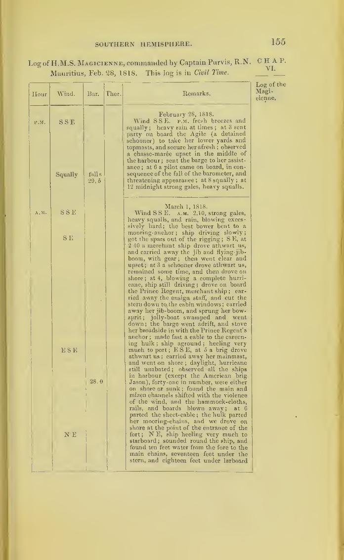
SOUTHERN HEMISPHERE. 155
Log of H.M.S. Magicienne, commanded by Captain Purvis, R.N.
Mauritius, Feb. 2S, 1818. This log is in Civil Time.
Hour
P.M.
A.M.
Wind.
SSE
Squally
SSE
SE
Bar. Ther.
falls
29.5
ESE
N E
28.0
Remarks.
February 28, 1818.
Wind SSE. p.m. fresh breezes andsqually ; heavy rain at times
;at 3 sent
party on board the Agile (a detained
schooner) to take her lower yards andtopmasts, and secure her afresh
;observed
a chasse-maree upset in the middle of
the harbour;sent the barge to her assist-
ance ; at 6 a pilot came on board, in con-
sequence of the fall of the barometer, andthreatening appearance ; at 8 squally ; at
12 midnight strong gales, heavy squalls.
March 1, 1818.
Wind SSE. a.m. 2.10, strong gales,
heavy squalls, and rain, blowing exces-sively hard; the best bower bent to a
mooring- anchor;
ship driving slowly;got the spars out of the rigging
;S E, at
2.40 a merchant ship drove athwart us,
and carried away the jib and flying-jib-
boom, with gear; then went clear andupset ; at 3 a schooner drove athwart us,
remained some time, and then drove onshore
;at 4, blowing a complete hurri-
cane, ship still driving ; drove on boardthe Prince Regent, merchant ship
;car-
ried away the ensign staff', and cut thestern down to the cabin windows; carried
away her jib-boom, and sprung her bow-sprit; jolly-boat swamped and wentdown; the barge went adrift, and stove
her broadside in with the Prince Regent’sanchor ; made fast a cable to the careen-
ing hulk ; ship aground;heeling very
much to port ; E S E, at 5 a brig droveathwart us ; carried away her mainmast,and went on shore
;daylight, hurricane
still unabated;
observed all the ships
in harbour (except the American brig
Jason), forty-one in number, were either
on shore or sunk ; found the main andmizen channels shifted with the violence
of the wrind, and the hammock-cloths,rails, and boards blown away; at 6
parted the sheet-cable ; the hulk partedher mooring-chains, and we drove onshore at the point of the entrance of the
fort ; N E, ship heeling very much to
starboard ; sounded round the ship, andfound ten feet water from the fore to themain chains, seventeen feet under thestern, and eighteen feet under larboard
CHAP.VI.
Log of the
Magi-cienne.
0
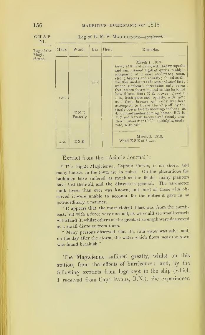
156 MAURITIUS HURRICANE OF 1818.
CHAP.VI.
Log of theMngi-cienne.
Log of H. M. S. Magicienne—continued.
Hour. Wind. Bar. rher. Remarks.
r.M.
ENEEasterly
29.5
March 1 1818.
bow ; at 8 hard gales, with heavy squalls
and rain; issued a gill of spirits to ship’s
company;
at 9 more moderate ;noon,
strong breezes and squally; found as the
weather moderates the water shoaled fast
;
under starboard forechains only seven
feet, astern fourteen, and on the larboard
bow fifteen feet ; N E, between 2 and 3
p.m., fresh gales and squally, with rain;
at 4 fresh breezes and rainy weather
;
attempted to heave the ship off by the
single bower fast to mooring-anchor ; at
4.30 found anchor coming home ;E N E,
at 7 and 8 fresh breezes and cloudy wea-
ther; easterly at 10.30 ;midnight, mode-
rate, with rain.
A.M. ESEMarch 2, 1818.
Wind E S E at 8 a.m.
Extract from the ‘Asiatic Journal’
:
“ The frigate Magicienne, Captain Purvis, is on shore, and
many houses in the town are in ruins. On the plantations the
buildings have suffered as much as the fields : many planters
have lost their all, and the distress is general. The barometer
sunk lower than ever was known, and most of those who ob-
served it were unable to account for the notice it gave in so
extraordinary a manner.
“ It appears that the most violent blast was from the north-
east, but with a force very unequal, as we could see small vessels
withstand it, whilst others of the greatest strength were destroyed
at a small distance from them.
“ Many persons observed that the rain water was salt;and,
on the day after the storm, the water which flows near the town
was found brackish.’’
The Magicienne suffered greatly, whilst on this
station, from the effects of hurricanes ;and, by the
following extracts from logs kept in the ship (which
t received from Capt. Evans, R.N.), she experienced
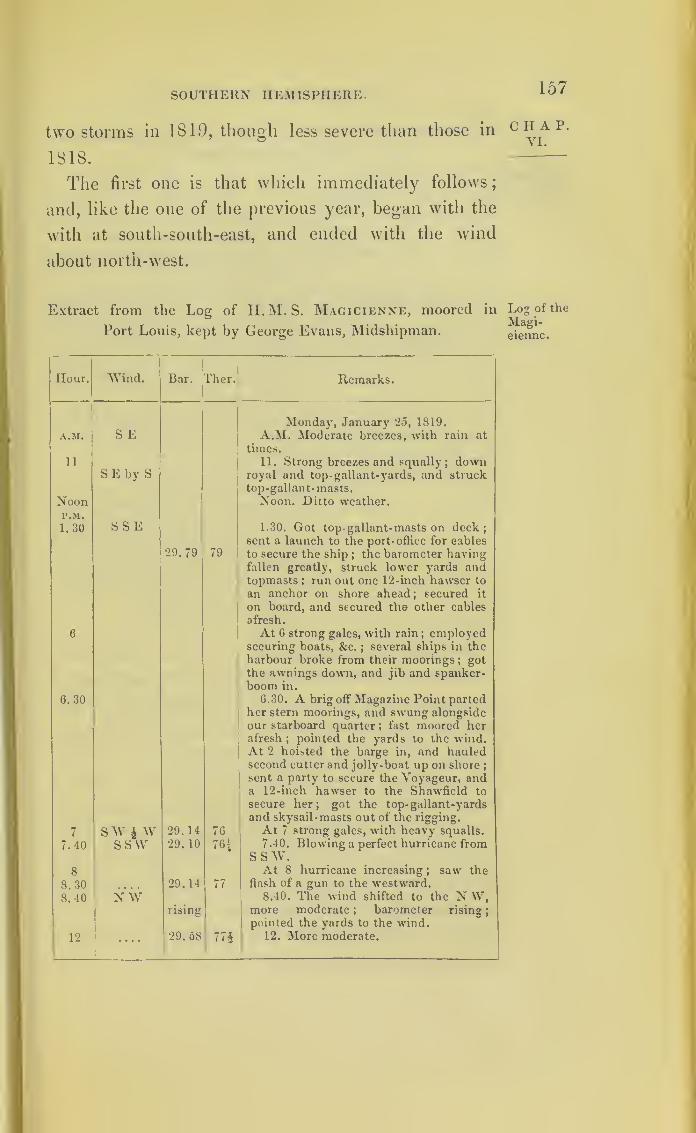
SOUTHERN HEMISPHERE. 157
two storms in 1819, though less severe than those in
1818 .
The first one is that which immediately follows
;
and, like the one of the previous year, began with the
with at south-south-east, and ended with the wind
about north-west.
Extract from the Log of H.M.S. Magicienne, moored in
Port Louis, kept by George Evans, Midshipman.
Hour. Wind. Bar. Then Remarks.
Monday, January 25, 1819.
A.M. S E A.M. Moderate breezes, with rain at
times.
11 11. Strong breezes and squally;down
S E by S royal and top- gallant-yards, and strucktop-gallant- masts.
Noon Noon. Ditto weather.P.M.
1.30 SSE 1.30. Got top- gallant-masts on deck;sent a launch to the port-office for cables
29.79 79 to secure the ship;the barometer having
fallen greatly, struck lower yards andtopmasts ; run out one 12-inch hawser to
an anchor on shore ahead; secured it
on board, and secured the other cables
afresh.
6 At 6 strong gales, with rain; employedsecuring boats, &c. ;
several ships in theharbour broke from their moorings
;got
the awnings down, and jib and spanker-boom in.
6.30 6.30. A brig off Magazine Point partedher stern moorings, and swung alongsideour starboard quarter ; fast moored herafresh
;pointed the yards to the wind.
At 2 hoisted the barge in, and hauledsecond cutter and jolly-boat up on shore
;
sent a party to secure the Voyageur, anda 12-inch hawser to the Shawfield to
secure her; got the top- gallant-yards
and skysail -masts out of the rigging.
7 SW i w 29. 14 76 At 7 strong gales, with heavy squalls.
7.40 ssw 29. 10 76.1 7.40. Blowing a perfect hurricane fromSSW.
8 At 8 hurricane increasing ; saw the
8.30 29.14 77 flash of a gun to the westward.
8.40 NW 8.40. The wind shifted to the N W,rising more moderate ; barometer rising
;
pointed the yards to the wind.
12 29. 58 774 12. More moderate.
CHAP.VI.
Log of the
Magi-cienne.

158 MAURITIUS HURRICANE OF 1819.
CHAP.VI.
Log of the
Magi-ciennue.
Extract from the Log of H. M. S. Magicienne, moored in
Port Louis
—
continued.
Remarks.
Tuesday, January 26, 1819.
A.M. 12.30. Strong gales and squally ;
a hulk astern parted her stern moorings,
and swung under our stern.
At 4 heavy gales, with rain; at daylight
every vessel in the harbour on shore, with
the exception of two brigs ;one ship on
Tonnelieo reef dismasted, and another on
shore near her, with her masts standing
and signal of distress up ; sent an officer
on board her ;sent a party to moor the
, hulk astern, and another party to heave
the Voyageur off.
At 8 dark cloudy weather, with ram.
At 9 sent the lugger St. Jaques out to
the Wolfe’s Cove on shore off Fort Ton-
nelieo, to take her cargo out.
At 10 squally, with rain at times.
Noon. Moderate and cloudy.
P.M. Moderate breeze and cloudy ;got
the jib and spanker-booms out, and got
the top-gall ant- yards and skysail-masts
in the rigging ;swayed the gaff up ;
sent
the Voyageur with an officer to the
Wolfe’s Cove to assist in unloading her ;
hove a brig off Magazine Point ;sent a
boat to tow the St. Jaques up with part
of the Wolfe’s Cove’s cargo.
Midnight. Moderate and fair.
The next extract from the log of the Magicienne
describes a third hurricane, which that ship encountered
whilst lying in Port Louis Harbour, Mauritius, on the
28th and 29th March, 1819. The centre of this storm
would seem to have passed nearly over, or a little to
the northward of where the ship was lying; for we
find the wind moderating in the middle of the gale,
yet veering from the south-south-east, where it com
menced, to the north-east, and ending like the two
former storms in the north-west. It will likewise be
seen how regularly the barometer fell, until the wind
began to veer about to the opposite quarter from
where the gale commenced.
Hour.j Wind. Bar. L'lier.j
A.M.
12.30 .... 29. 62 m4 N
29. 80 73*
NN E
8
9 29.80 75|
10
NoonP.M.
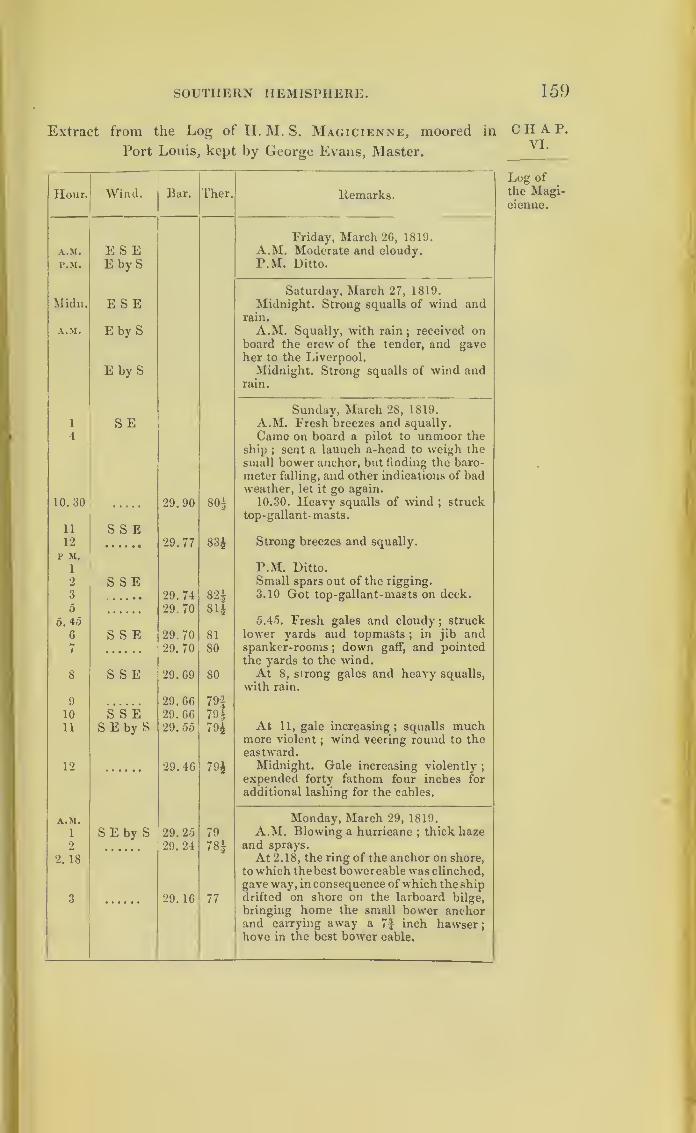
SOUTHERN HEMISPHERE. 159
Extract from the Log of H. M. S. Magicienne, moored in
Port Louis, kept by George Evans, Master.
Hour. Wind. Bar. Ther. Remarks.
Friday, March 26, 1819.
A.M. Moderate and cloudy.A.M. E S EP.M. E by S P.M. Ditto.
Saturday, March 27, 1819.
Midn. E S E Midnight. Strong squalls of wind andrain.
A.M. E by S A.M. Squally, with rain;received on
board the crew of the tender, and gaveher to the Liverpool.
E by S Midnight. Strong squalls of wind andrain.
Sunday, March 28, 1819.
A.M. Fresh breezes and squally.1 S E4 Came on board a pilot to unmoor the
ship ; sent a launch a-head to weigh the
small bower anchor, but finding the baro-
meter falling, and other indications of badweather, let it go again.
10. 30 29.90 OCO 10.30. Heavy squalls of wind;struck
top-gallant- masts.
11 S S E12 29.77 83£ Strong breezes and squally.
1 P.M. Ditto.
2 S S E Small spars out of the rigging.
3 29.74 82± 3.10 Got top-gallant-masts on deck.
5 29.70 81 i5.4o 5.45. Fresh gales and cloudy
;struck
6 S S E 29.70 81 lower yards and topmasts;
in jib andspanker-rooms
;down gaff, and pointed
the yards to the wind.7 29.70 80
8 S S E 29.69 80 At 8, strong gales and heavy squalls,
with rain.
9 29. 66 79J10 S S E 29.66 79±
11 S E by S 29. 55 794 At 11, gale increasing; squalls muchmore violent
;wind veering round to the
eastward.
12 29.46 794 Midnight. Gale increasing violently;
expended forty fathom four inches for
additional lashing for the cables.
A.M. Monday, March 29, 1819.
i SE by S 29. 25 79 A.M. Blowing a hurricane ; thick haze
2 29. 24 78| and sprays.
2. 18 At 2. 18, the ring of the anchor on shore,
to which the best bower cable was clinched,
gave way, inconsequence of which the ship
3 29. 16 77 drifted on shore on the larboard bilge,
bringing home the small bower anchorand carrying away a 7J inch hawser;hove in the best bower cable.
C H A P.
VI.
Log of
the Magicienne.
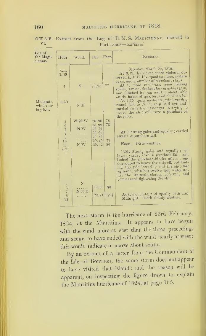
160 MAURITIUS HURRICANE OF 1818.
CHAP.VI.
Log of
the Magicienne.
Moderate,wind veer-
ing fast.
Extract from the Log of II. M. S. Magicienne, moored in
Port Louis
—
continued.
Hour. Wind. Bar. flier. Remarks.
A.M.
3. 19
Monday, March 29, 1819.
At 3.19, hurricane more violent; ob-
served H.M.S. Liverpool on shore, a-stern
of us, and a number of merchant ships.
4 S 28.98 77 At 4, more moderate, wind veering
round ; ran out the best bower cable again,
and clinched it ;ran out the sheet cable
on the larboard- quarter, and clinched it.
4. 30N E
At 4.30, quite moderate, wind veering
round fast to N E; ship still aground;
carried away the messenger in trying to
heave the ship off; rove a purchase on
the cable.
5 W N W 28.98 78
6 28. 99 78
7
8
N W 29.7029. 20 At 8, strong gales and squally ;
carried
9 29. 32 away the purchase fall.
10 29.40 79Noon. Ditto weather.
12 N W 29. 42 80
P.M.
1P.M. Strong gales and squally; up
lower yards; rove a purchase-fall, and
lashed the purchase-blocks afresh;en-
deavoured to heave the ship off, but find-
ing the tide lowering and the ship fast
aground, with, but twelve feet water un-
der the lee-main-chains, deferred, and
commenced lightening the ship.
2 N3 29.50 80
7
8
12
N NE29.71 791 At 8, moderate, and squally with rain.
Midnight. Dark cloudy weather.
The next storm is the hurricane of 23rd February,
1824, at the Mauritius. It appears to have begun
with the wind more at east than the three preceding,
and seems to have ended with the wind nearly at west
:
this would indicate a course about south.
By an extract of a letter from the Commandant of
the Isle of Bourbon, the same storm does not appeal
to have visited that island : and the reason will be
apparent, on inspecting the figure drawn to explain
the Mauritius hurricane of 1824, at page 165.

SOUTHERN HEMISPHERE.
The registers from three different barometers for this
hurricane have been preserved by Captain Locke Lewis;
and it will be seen how nearly they agree in the gradual
descent before alluded to, during the first part of the
hurricane, and the gradual and regular ascent during
the latter part of its continuance.
The French extract, which follows Captain Lewis’s
tables, relates to the manner in which these storms
blow in gusts or veins, which seems to be a distinguish-
ing character of hurricanes.
Observations of the State of the Barometers daring a Hurricane
at the Mauritius, on the 23rd February, 1824.
Hour. No. 1. No. 2. No. 3. Remarks.
At 7. 0 a.m. 29.75 29.77 29. 50 Wind S E;var. to E ; strong gales.
8. 0 ,
,
», 75 ,, 77 ,, 50 Ditto ditto
8.30 ,, ,, 70 ,, 73 ,, 50 Ditto ditto
9. 0 ,
,
,, 70 ,, 73 ,, 50 Ditto ditto
9.30 ,, ,, G8 ,, 70 ,, 50 Ditto ditto
10. 0 ,, ,, 68 ,, 70 ,, 50 Ditto ditto
10.30 ,, ,, 63 ,, 68 ,, 47 Ditto ditto
11. 0 ,, ,, 63 ,, 65 ,, 47 Ditto ditto
11.15 ,, ,, 60 ,, 62, ,
45 Ditto ditto
11.30 ,, ,, 56 ,, 58 », 40 Ditto ditto
11.45 ,, ,, 56, > 58 40 Wind shifted to the eastward.
12. 0 ,, ,, 53 ,, 56 ,, 38 Ditto12. 15 p.m. ,, 49 ,, 50 ,, 33 Ditto12.30 ,, ,, 44 ,, 48 ,, 28 Ditto12.45 ,, ,, 40 ,, 42
> > 25 Ditto
1. 0 ,, ,, 37 ,, 40 ,, 20 Wind E N E.1.15 ,, ,, 30 ,, 34 ,, 18 Ditto1.30 ,, ,, 29 ,, 34 ,, 16 Ditto1.45 ,, ,, 25 ,, 28 ,, 10 Ditto2. 0 ,, ,, 20 ,, 22
, ,05 Ditto
2.15 ,, ,, 11 ,, 13 28. 95 Ditto2.30 ,, ,, 11 ,, 13 , , 95 Ditto2. 45 ,
,
,, 02 , > 05 ,, 88 Ditto3. 0 , , 28. 97 28. 99 ,, SO Ditto3. 15 ,
,
,, 85 ,, 83 ,, 69 Wind N E.3.30 ,, ,, 75 >, 77 ,, 66 Ditto3. 45
y y ,, 66 ,, 69 ,, 52 Ditto4. 0 ,, ,, 58 ,, 60
, >45 Wind N N E.
4. 15 ,
,
,, 58 ,, 60, ,
45 Ditto4.30 ,, ,, 59 ,, 60
,
,
46 Wind North.4. 45 ,
,
,, 59 ,, 60, >
47 Wind N N W.5. 0 ,, >> 59 ,, 60 ,, 47 Wind N W.5.15 ,, ,, 62 ,, 60 , >
47 Ditto
5.30 ,, ,, 67 ,, 60 ,, 53 Ditto
161
CHAP.VI.
M

162 MAURITIUS HURRICANE OF 1824.
C II A 1*. Observations of the State of the Barometers— continued.
1
Hour. No. 1. No. 2. No. 3. Remarks.
At 5. 45 p.m. 28.67 28.60 28.53 Wind N W.6. 0 ,, ,, 72 ,, 71 ,, 59 Wind W
;gale decreasing.
6.15 ,, ,, 86 ,, 83 ,, 73 Ditto ditto
6. 30 ,
,
,, 97 ,, 94 ,, 80 Ditto ditto
7. 0 ,, 29. 09 29.06 ,, 90 Wind S W.7.30 ,, ,, 17 ,, 11 29.00 Ditto
8. 0 ,, ,, 28 ,, 23 ,, 08 Wind S E.
8. 30 ,
,
,, 33 ,, 30 ,, 16 Ditto
February 24. Wind S W.6. 0 a.m. ,, 67 ,, 60 ,, 46 Ditto
7. 0 ,, ,, 69 ,, 62 ,, 49 Dttto
8. 0 ,, ,, 70 ,, 06 ,, 50 Wind W.
(Signed) THOMAS LOCKE LEWIS,
Captain Royal Engineers.
In the hurricane of the 23rd of February, 1824, at
the Mauritius, upwards of thirty vessels were wrecked
there.
The following remarks, printed in a Mauritius news-
paper, relate to the manner in which the wind appears
to blow in veins differing in degrees of strength :
“ II parait qu’une trombe, ou tourbillon (de ceux qui ont fait
donner aux ouragans le nom de typhon), a parcouru une ligne
sur laquelle se sont trouvees plusieurs maisons du Champ-de-
Lort, et particulibrement le College Royal.
“ C’est contre ce terrible phenombne, qu’il faut seprecautionner
dans les ouragans : aussi n’est il pas prudent en pared cas, de
demeurer dans les maisons blevbes;dans cedes surtout qui sont
posbes sur de haut soubassemens en pierre formant le rez-de-
chaussee. C’est trbs mal raisonner que de dire, qu’une maison
a resiste h tel ouragan ou h tel autre. Elle ne s’est pas trouvbe
sur le chemin d’un tourbillon, voilh ce qui l’a preserve. Telle
est aussi la cause d’un fait observd dans tous les ouragans celui
de la preservation d'une maison tombante de vbtuste, etroite,
elevbe, qui n’est pas meme dbranlee h peu de distance d un
Edifice neuf, qui est renverse ou mis en pihces.
« La mbtborologie est encore dans son enfance. Tout-ce-que
nous savons c’est que, dans ce qu’on appelle les mauvais terns,

SOUTHERN HEMISPHERE. 163
la pesanteur des colonnes atmospheriques decroit plus ou moinsj
mais les proportions entre ce decroissement, et Taction de l air
k la surface dc notre planfite, demeureront probablemcnt long-
temps ignordes. Probablement aussi ce n’est pas nous qui
verrons construire l’anenomfitre capable de mesurer la force
acquise par l’air, lorsqu’il reduit en filamens, et qu’il tord commeun cordage le tronc d’un arbre vigoureux, ou qu’il fait tourner
sur sa base une (klifice en pierre comme la Maison LafTargue.
Aussi les diverses denominations donndcs r^cemment aux dif-
ferens degrtis de la tempfite, en raison de l’espace que le vent par-
court dans une seconde, nous semblent telles fort insignificantes.
C’est le tort de beaucoup de savans. Ils ont la fureur de rdduire
prematurement en theories certains points des sciences naturelles,
sur lesquelles on est entikrcment depourvu de faits suffisamment
observes. “ J. M.”
Copy of a Letter from the Commandant of the
Island of Bourbon, to Captain T. Locke Lewis, Royal
Engineers, relative to the hurricane of the 23rd of
February, 1824:
“Nous avons ressenti k Bourbon, le contre coup de votre
tempfite. II est k remarquer, que le 22 Fevrier, nous eftmes
aussi des apparences de mauvais terns;qui s’accruerent jusqu’au
lendemain, au point de me determiner, k donner le signal d’appa-
reillage k nos batimens. Mais ces deux jours les vents restkrent
k Test et au sud-est, ils s’appaishrent dans la journ^e m£me du
23. Le lendemain le terns fut magnifique, et se maintient en cet
etat jusque dans l’aprks-midi du 25, que le vent s’6tant declare
au nord,a mena des nuages et une simple apparence de pluie.
L’indication barometrique, n’ctait nullement defavorable. Par
mallieur les batimens 6toient revenues sur la rade;dans la nuit
la mer devint afFreuse, et contribua surtout k en pousser neuf
d’entre eux sur la cote. Le vent souffla alternativement du
nord et du nord-ouest;mais sans une extreme violence. Le
baromCtre etoit desccndu alors k per long. 27.7 (or 28.2 inches
English).”
There was a severe hurricane at the Mauritius on
the 19th and 20th of January, 1S34. Captain Grier-
son, Royal Engineers, who was stationed there at that
m 2
C H A P.
VI.

164
CHAP.VI.
MAURITIUS HURRICANE OF 1834.
date, has informed me, that the wind scarcely veered
at all during the continuance of this storm ;and that
its general direction was that of the trade wind at the
Mauritius, or nearly south-east. Captain Grierson s
statement was from memory, having made no record
in writing at the time.
Mr. James Tilley, who was then master of the ship
Emma Eugenia, was also there at the time; and he
states that the wind was east,veering to the southward.
His ship and seventy-nine other vessels were driven
on shore. Mr. Tilley describes the wind as blowing in
sudden gusts.
If this storm were a rotatory one, revolving as we
suppose those of the southern hemisphere to turn, a
portion of its west side only would pass over Mauri-
tius, as represented in a figure hereafter annexed
;
and it was probably moving on a course nearly south.
Had it been moving towards the contrary direction,
it would have been carried towards the Seychelles
islands ;but there it is said hurricanes never happen
;
and they are probably of rare occurrence so near the
equator. During the war it was the practice of our
ships to go to these islands for safety during the hurri-
cane months from the Mauritius, as it was the custom
in the West Indies to go to Trinidad : thus we find
in both hemispheres our ships of war sought to avoid
hurricanes by approaching the equator. 4 et further
on in this inquiry, one great storm will be traced,
which seems to have been felt within a degree of the
equator.
If the Mauritius storm of the 19th and 20th of
January moved southward, this would bring it to the
place of the ship Duke of Buccleugh, on the 21st and
SOUTHERN HEMISPHERE. 165
22nd of January. By referring to her log, it will be CI^ P *
seen this ship was proceeding on her voyage from
Calcutta and Madras towards England, when she met
a storm on the afternoon of the 21st of January, which
has every appearance of being this hurricane. She
was then standing on a course W. I S., her place at
noon being marked in the log;and her place at about
5 p.m. is on the foregoing figure.
At 5 p.m. she had the wind at east-north-east
;
at
midnight it had veered to east by north,and was in-
creasing, with the weather cloudy. The ship ran in
166
CHAP.VI.
Log of
the Dukeof Buc-cleugh.
MAURITIUS HURRICANE OF 1834.
the gale until past noon, the wind veering to east-
south- east, and to south. Then the vessel had to be
laid-to;and we have again in the log the description
of what occurs when a ship is near the centre of a
storm. From south the wind veered to south-south-
west, and next became south-west
;
and at 4 next
morning, which was the 23rd of January, when the
wind was west, the gale began to moderate.
Extract from the Log of the Ship Duke of Buccleugh.
Civil Time.
Hour. Courses. Winds. Remarks.
Noon
WSW ENETuesday January 21, 1834.
Steady breeze and hazy weather. Em-
ployed variously under the boatswain;
cleaned the lower deck.
Noon. Fresh breeze.
Dist.
per Log Course and Dist. Sun’s Lat- Long. Chro. Bar. Ther. Symp. Diff.
• •S 57°W 200' 24° 35 S 61° 49' E 30.00 80* 29.60 .40
W i S E by N
ENE
|
E by N
Fresh breeze and hazy weather; all sail
set
5. Cloudy ;in top gallant-studding-sails,
and' fore and mizen-royals, and top-gallant-
^(h'ln main-topmast-studding-sails.
Midnight. Increasing breeze and cloudy
weather. In lower and fore-topmast-stud-
ding-sails and main-royal.
ESE
Wednesday, January 22, 1834.
Fresh breezes and unsettled weather
;
furled the fore and main-top-gallant-sails.
4. Increasing; double-reefed the topsails
and sent down royal yards ;heavy rain.
8. Thick rainy weather and sharp squalls ;
spar-lashed the long-boat and booms, and
battened the hatches down ;furled the main-
Sa
1
il
l‘. Fresh gale ;in third reef fore-topsail,
'and housed the flying-jib-boom.
Noon The gale increasing, with a nign
irregular sea on ;the ship labouring heavily

SOUTHERN HEMISPHERE. 167
Log of the Duke of Buccleugh
—
continued.
Hour. Courses,i
Winds. Remarks.
South
Wednesday, January 22, 1834.
and shipping quantities of water; furled the
fore-topsail and foresail, and close-reefed themain- topsail, and rounded- to, under themain-topsail, and main-trysail on the lar-
board tack.*
DUt.per LogK.
225
Course and Dist.
S 74° W 243'
Sun’s Lat.
25° 39' S
Long. Chro.
57° 32' E
Bar.
29.76
Ther. Symp.
80° 28. 94
Diff.
.82
P.M.
ssw
s w
P.M. At 30™ past noon, the gale increased
to a severe hurricane, and blew in furious
gustsfrom S S W, the ship laying over on her
beam-ends, labouring heavily, and shipping
great quantities of water ; broke the main-trysail-gaff, and split the sail to pieces
;
broke the inner bobstay- chain;got the fish-
tackles and preventer-tackles up to securethe foremast and ease the bowsprit
; split
the main-topsail ; a considerable quantity of
water came in at the lee lower quarter-gallery,
although the slide was shut, and through thelee lower dead-lights ;
the carpenteremployedcaulking and securing them
;employed bale-
ing water from the lower deck and work-ing the pumps ; found a quantity of waterrushing in on the lee-bow ; loosed the fore-
t 'pmast-staysail and lowered the driver gaff
;
split the sail to pieces to try to wear the ship
;
split the staysail;
loosed the foresail, andsplit it to ribbons, and afterwards the fore-
topsail, which split also;
got tarpaulings in
the fore-rigging, but the ship lay on herbroadside in the trough of the sea, and re-
fused to wear, with her lee-waist full of water,the gale blowing furiously from S W, and thesea occasionally making a complete breachover us; stove the lee-quarter cutter; cuther away ; cut the lee guns adrift, and threwthem overboard, and all the bales of hay fromthe top of the long-boat to ease the ship ; the
lee hammock-nettings washed away. At 3,
discovered the leak, which proceeded fromthe lower sill of the upper-deck scuttle
under the top-gallant-forecastle having beenknocked away ; stopped it ; cut away all thehead- sails, and put tarpaulins in the weathermizen-rigging, to bring the ship again to thewind ; employed baleing the lower-deck andworking the pumps
;found the bilge-water
CHAP.YI.
Log of
the Dukeof Buc-cleugh.
* See the left-hand vessel marked in the figure, p. 165.

168 MAURITIUS HURRICANE OF 1834.
CHAP.YI.
Log of
the Dukeof Buc-cleugh.
Log of the Duke oe Buccleugh—concluded.
Hour. Courses. Winds. Remarks.
P.M. Wednesday, January 22, 1834.
strongly impregnated with nitre, from the
cargo being damaged. The gale blew with
great fury until 4 o’clock, when it began to
moderate;got hold of the bobstay-chain and
set it up with a preventer-tackle ;bent the
new driver and set it, balance-reefed. 6. The
gale abating and the ship easier ;continued
pumping, and at 8 pumped her dry ;fresh
gale with a heavy cross sea ;ten to eleven
inches in the well;pumped her dry. Mid-
night. Fresh gale and a high sea.
A.M. Hi a<l to the
NN W
Thursday, January 23, 1834.
A M. Strong gale :pumped her out every
two hours. 4. Moderating; bent best fore-
topinast-staysail.
7. Set the close-reefed mizen-topsail. 8.
Reefed mainsail and set it ;a high sea run-
ning ;got wreck main-topsail cleared away ;
bent new one;
set it treble-reefed ;unbent
the remains of foresail and fore-topsail, and
bent the new ones, close-reefed fore-topsail,
and reefed foresail and set them ;observed
bowsprit slightly sprung outside the gam-
moning.
Dist.
per I.o
K.l Course and Di st. Sun’s Lat. Long. Chro. Bar. Ther. Symp. Diff.—N 32° E 5~t' 24° 53' S rH
0CO 29.76 76° 29. 43 .33
Head to the
NWand
NNW
From
SWto
W
Wednesday, January 23, 1834.
Moderate gale and passing squalls ; re-
paired chain-bobstay with a spare iron
skackle and set it up ;got the flying jib-
boom in ;furled mainsail ;
sent down fore-
top-gallant-yard, and housed the mast ;sent
down mizen-top-gallant-yard ;sent down
broken rnain-trysail gaff;pumped when we
had about twelve inches water ;was used
every four hours ;strong winds and passing
squalls, with a high cross sea.
<< it is surprising that previous to so severe a gale a greater
fall of the barometer had not taken place, having not been lower
than 29.76 inches. It may be accounted for, from the wind
blowing from the southward. The sympiesometer had been for
the last week about .38 decimals lower than the barometer5but
SOUTHERN HEMISPHERE. 169
on the morning of the gale it fell .S2 decimals lower than the
latter;
therefore the indications of this sensitive instrument
ought to be attended to.*
(Signed) “ A. H., Commander.”
The following table of Observations was given to
me by Col. Lloyd, whilst this edition was in the press.
Meteorological Observations taken at the Observatory in the
Hurricane, on the 20th January, 1834.
Jan. 1834. Barometer.
Winds. Remarks.Day. Hour. Eng. Inch.
19 7 p.m. 29. 885 Wind increasing in
violent gusts.
Clouds flying and oc-
casional rain.
20 7 A.M. 29.775 Wind in strong andsudden gusts.
Looking wild& gloomy'
with heavv rain.
10f ,, 29.685 Wind increasing in
heavy gusts.
Raining heavily,scudsflying and looking wild.
Rain decreasing a lit-
little, scuds still flying
& looking very gloomy.
Hi ,, 29.665 SE by E wind in
very violent and sud-den gusts.
nf ,, 29. 655 Ditto ditto Ditto ditto
12 ,, 29. 628 Wind increasing in
very heavy gusts.
Raining very heavily& looking very wild.
12* ,, 29. 575 Wind still increasing. Raining very heavily.
1 P.M. 29.570 Ditto ditto Ditto ditto
1| ,, 29.510 Ditto ditto Ditto ditto
2 ,, 29.475 Ditto ditto Ditto ditto
2| ,, 29. 425 Ditto ditto Ditto ditto
•1 ,, 29. 385 Ditto ditto Ditto ditto
3§ ,, 29. 295 Ditto ditto Ditto ditto
4> >
29.310 Wind increasing in
sudden gusts.
Still raining heavily.
> >29. 230 Wind increasing in
heavy gusts.
Ditto
5 ,, 29. 195 Ditto ditto Raining very heavily.
H ,, 29. 155 Ditto ditto Ditto7i1 2 y y
29. 085 Wind increasing in
tremendous and sud-den gusts.
Ditto
8* ,, 29.135 Wind abating a little. Raining less heavily'.
9 ,, 29. 170 Ditto ditto Rain not quite so
heavy.
9? „ 29. 200 Wind still decreas-ing, but occasionally in
heavy gusts.
Ditto ditto
10f ,, 29.285 Ditto ditto Raining heavily at
intervals.
Hi ,, 29.300 Ditto ditto Ditto ditto
12* ,, 29. 330 Ditto ditto Ditto ditto
21 5* A.M. 29. 655 Wind much abated. Ditto ditto
* A ship called the Asia was also in this storm, and some observations
upon it will be found in Mr. Thom’s work, on “The Nature of Storms
South of the Equator,” page 87.
CHAP.VI.

170 MAURITIUS HURRICANE OF 1830.
CHAP.VI.
Storm of
1836.
Meteorological Observations
—
continued.
Jan. 1834. Barometer.
Winds. Remarks.Day. Hour. Eng. Inch
22
64 ,,
U*12* ,,
2-j; P.M.
3 ,,12 A.M.
29. 69529. 78529. 795
29.78229. 78229. 895
Wind still abating.
Ditto ditto
Still abating but oc-
casionally strong.
Ditto ditto
Wd. increasing alittle.
Very light wind.
Raining occasionally.
Very dull and cloudy.
Ditto ditto and oc-
casional rain.
Ditto ditto
Raining heavily.
Cloudy.
J. A. LLOYD, Surveyor General and Civil Engineer.
Another storm was experienced at Mauritius on
March 6, 1836 ;during which, according to the state-
ment of Captain Grierson, Royal Engineers (made
from memory), “ the wind blew, during the fiist half
of the storm, from south by west, or nearly south.
There was a calm of about an hour in the middle ol
the storm, after which a very heavy sea came rolling
in from the north by east, or nearly north;
half an
hour after which occurrence, the wind came on again
from the opposite quarter with very great violence/’
In the “ Nautical Magazine for June, 1837,” the fol-
lowing report has been published of observations which
were made during the storm by the Surveyor-General
of Mauritius, at the Observatory, apparently with great
care. The wind in that table is marked as oscillating
in a remarkable manner. A mean of these oscillations
makes the first portion of the hurricane to come from
a little to the eastward of south, and the last portion a
little to the westward of north, or nearly the same as
the observations of Captain Grierson.
Immediately over Port Louis, where the Observa-
tory stands, is a high and steep mountain, which pro-
bably influenced the direction of the gusts of wind.
This hurricane came from the direction of Rodriguez.
SOUTHERN HEMISPHERE. 171
Meteorological Observations taken at the Observatory, Port
Louis, Mauritius, during a Hurricane on the 5th, 6th, 7th, and
8th of March, 1836 .— (Copied from the Nautical Magazine for
June, 1837.)
Day.
Hour.
Barometer,
English
Inches.
Difference.
French
Inches,
and
Lines.
Thermometer.
Sympiesometer.
Rain
Gauge.
Wind.
5th 8 29.930 28 1.00 82.0 29.14
I. T. H0 0 0 Light wind.
12 29.850 080 28 0.10 83.0 29.05 ... Very variable, and blowing
4 29.740 110 27 10.86 83.5 28.94
hard : wind varied from Sby W to E N E by N.
S E very strong, E S E by S
7£ 29.770 030 27 11.19 82.8 28.98
to S S W by S : raining.
S E very strong, and in gusts,
8 29.770 27 11.19 82.6 28.98
S E by E to S W by S
:
raining.
ENE ditto, NE by N to
6th 6|
29.220 550 27 5.00 81.5 28.44S SW : raining heavily.
Varying from S to E in very
6£ 29.190 030 27 4.66 81.5 28.42
strong gusts. Made a com-plete variation during thenight : raining heavily.
Varying from S to E in very
7 29.175 015 27 4.44 81.5 28.40
strong and sudden gusts
:
raining heavily.
Varying from NE by N to
71i 5 29.175 27 4.44 81.5 28.40
S SW by W, in heavy andsudden gusts : still ditto.
A complete variation inheavy
8 29.120 055 27 3.88 81.5 28.34
and tremendous gusts : do.
Varying from ENE bv N
8£ 29.110 010 27 3.76 81.5 28.34
to S W by W, in heavyand continued gusts : ditto.
Varying from E by N to
9 28.995 115 27 2.53 80.5 28.25
W IS \V, in heavy blasts
:
still raining.
Varying from E N E bv N to
n 28.950 045 27 1.96 80.2 28.22
S S W by S, in heavy andsudden puffs : raining veryheavily.
A complete variation inheavy
10 28.845 105 27 0.72 80.0 28.15
and sudden gusts : ditto.
Ditto, ditto.
101 28.860 015 27 0.95 80.0 22.12 ... Varying from NEby N to
11 28.775 085 26 11.95 79.5 28.04SW: ditto.
Varying from ENE by N
11* 28.695 080 '26 11.03 79.0 27.93
to SW : ditto.
Ditto, ditto : still raining.
12 28.545 050 26 9.35 79.0 27.84 ... Ditto, ditto.
12* 28.511 034 26 9.01 79.5 27.78 ... Ditto, ditto.
1 28.470 041 26 8.56 79.8 27.72 ... Ditto to S SW by W : ditto.
1* 28.375,095 26 7.43 79 8 27.60 ... Ditto, still high, and raining.2 28.330 045 26 6.98 80.2 27.52 . . . Varying from N E to S W,
decreasing in violence, andraining less heavily.
CHAP.VI.
Mr.Lloyd’sObserva-tions.
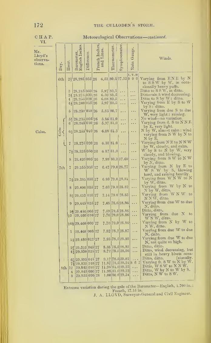
172 THE CULLODEN'S STORM.
CHAP.VI.
Mr.Lloyd'sobservetions.
Calm.
Meteorological Observations
—
continued.
nCl
rC
aT
rC rJj
UCl
c01-4->
Cl
vT £ci
<DO
O Cl
p pi
hH *r±
Cl
s£o
bf)
pc3
Day.
UPow
S2lJ>cs aWW
01u
Pci
'g
p£ 5p
OsmCl
r5H
e
0£c3
Winds.
6th 2| 28.295 135 26 6.53 SO.
5
27.52
. T. H) 0 0 Varying from E N E by N
to S SW by W, in occa-
sionally heavy puffs.
3 28.245 050 26 5.97 80.5 • • • • • • Ditto to S S W, in ditto.
H 28.275 030 26 6.30 80.5 . . • • • • Ditto rain & wind decreasing.
4 28.255 020 26 6.08 80.5 • • • • • • Ditto to S by W : ditto.
4* 28.240 015 26 5.97 80.5 ... • • • Varying from E by S to Wby S : ditto.
5 28.230 010 26 5.85 80.7 • •
.
Varying from due S to dueW, very light : raining.
—5^ 28.235 005 26 5.86 81.0 ... • . • No wind—no variation.
6 28.245 010 26 5.97 81.0 • • • Varying from d. S to JN N Eby E, very light.
|
6§ 28.255 010 26 6.08 81.3 • •
.
N by W, almost calm : windvarying from hi \V by N to
N by E.
7 28.275 020 26 6.30 81.0 Varying from JN E to JN N \V
n 050 26 6.87 81.0
by W, cloudy, and calm.
W by S to N by W, very28.325cloudy, and blowing.
8 28.420 095 26 7.99 80.2 27.69 • • * Varying from S VV to JN Wby N, ditto.
7 th 7 29.355 935 27 6.47 79.0 28.77 • • • Varying from JN by E to
W S W by S, blowing
hard, and raining heavily.
n 29.385 030 27 6.80 79.0 28.81 ... Varying from W JN W to Nby W, ditto.
8 29.400 015 27 7.03 79.0 28.82 ... Varying from \V by N to
N by W, ditto.
81 29.410 010 27 7.14 79.0 28.83 • • • Varying from W JN W to
NNW, ditto.
9 29.445 035 27 7.48 78.6 28.86 • • • Varying from due W to dueN, ditto.
91 29.450 005 27 7.59 79.5 28.86 Ditto, ditto.
10 29.460 010 27 7.70 79.0 28.86 • • • Varying from due N to
W N W, ditto.
m 29.460 000 27 7.70 79.
C
28.86 • • * Varving from N by W to
N W, ditto.
1 29.468 008 27 7.82 78.7 28.87 Varying from due W to dueN, ditto.
-29.480 012 27 7.93 78.5 28.88 • • • Varying from due W to due
N, not quite so high.
2-3 29.525 045 27 8.38 78.; 28.92 ... Ditto, ditto.^ A
H 29.55C 025 27 8.72 78.; 28.9C ... Ditto, wind decreasing, but
still in heavy blasts occa-
5/
71
12
29.595
jj29.835
045
24C
27 9.17
27 11.87
78.;
78.;
29.01
29.24 sY'Ditto, ditto. [sionally.
Varying fr. SW to N by W.
8th 29.84; 01C 27 11.98 81.
(
) 29.22 ... Ditto, W SW to N N W.
4 29.845 00f 27 11.98 81. 29.25 ... Ditto, W by N to W by S.
8 29.93i 09f 28 1.0( 80.
(
1 29.34 ..
.
Ditto, NW to S W.
Extreme variation during the gale of the Barometer— English, 1.700 m.
,
French, 17.15 in.
J. A. LLOYD, Surveyor-General and Civil Engineer.
SOUTHERN HEMISPHERE. 173
Whilst searching for records of storms in south
latitude, my attention was directed to two, very dis-
astrous in their consequences; which, even after a lapse
of thirty years, have left a deep impression on the
minds of many persons, from the great loss of life as
well as property they occasioned. These were the
storms of 1808 and 1809, encountered by the fleets
of the East India Company, under convoy of his
Majesty’s ship Albion, Captain John Farrier, and of
the Culloden, with the flag of Rear-Admiral Sir
Edward Pellew, the first Lord Exmouth. The East
India Company’s ships Glory, Lord Nelson, and Ex-
periment, foundered in the storm of 1808. The Lady
Jane Dundas, Jane Duchess of Gordon, the Calcutta,
and the Bengal, with his Majesty’s brig of war Har-
rier, foundered in the hurricane of the year 1809.
A court of inquiry, composed of twelve East India
Directors, was engaged for a considerable time inves-
tigating the subject of these losses;and the minutes
of their proceedings are preserved at the India House,
as well as the logs of the surviving ships. From each
of these records I have been allowed to make any
extracts I desired.
On Chart VIII. will be found the storm which was
experienced by the East India fleet, under convoy of
the Culloden line-of-battle ship and the Terpsichore
frigate, in March, 1809. These ships had crossed the
equator, and had sailed on their homeward passage,
with fine weather, until about the 1 1th of March. The
place of the fleet, at noon the next day, will be found
on the chart, and the ships sailed in company until the
14th: on that day the storm became so violent, that
they were dispersed;and I have taken advantage of
CHAP.YI.
174 THE CULLODEN’S STORM.
CHAP.VI.
this circumstance to compute each ships place, where
it was not previously marked on the log ;and have
also endeavoured to trace out the track ol each vessel
in the storm, in order thus to obtain simultaneous
observations of the wind at different places.
Whilst this fleet, under the convoy of the Culloden,
was sailing from India towards the Cape of Good
Hope, four British men-of-war left the Cape on the
21st of February, 1809, intending to cruise off the
islands of Mauritius and Bourbon : one of these, the
Caledon, put back, having sprung a leak;the Nereide
frigate, with the Racehorse and Harrier, proceeded for
their cruising ground, and kept together until the 24th
of February, when the Nereide separated from the
other two, and followed a more northerly track. Their
respective tracks are laid down on the chart from the
8th of March ;and we shall find them, by the logs of
the Nereide and Racehorse, encountering the storm on
different days, according to the courses they sailed;
but the Harrier has never been heard of since.
So many ships dispersed by the same storm over a
great extent gives us the means of judging its nature,
and of the course it took;and we find it, after having
travelled obliquely with regard to the trade-wind from
the east towards the west, recurving at the 25th and
30th degrees of south latitude, and going off to the
south-eastward, with a remarkable degree of simi-
larity to the manner in which hurricanes already
traced in the northern hemisphere pass off to the
north-eastward.
In the minutes of the proceedings of the Committee
of Inquiry at the India House, most of the commanders
speak of this hurricane as two distinct storms ;and
SOUTHERN HEMISPHERE. 175
throughout their evidence used the terms first and
second gales.
This appeared an enigma until Chart VIII. was
projected ;but when the chart was finished, this very
circumstance helped to explain the nature of the storm :
for we see at once why the Huddart, William Pitt,
Harriet, and Euphrates had fine weather for two days
;
and why the Huddart again met a storm with the
wind blowing violently from the north-west,so that
she was obliged to put all her guns but two down in
the hold to stiffen her. These four ships, on the shaded
portion of the plan, by lying-to and falling to the
southward, got out of the hurricane; but the Huddart
met it again when it had recurved, and this vessel en-
countered the last part of it about the time when the
first part had reached the Racehorse.
The Northumberland, Indus, and Sovereign, also
lay-to, and got out of the violence of the hurricane
soon after the four ships on the shaded portion of the
plan;but the Sir William Bensley and the St. Vincent
scudded, by which they ran a day’s sail a-head of the
seven ships already named : and the chart shows where
the Sir William Bensley was forced to lie-to, on the
17th, for twenty-one hours under bare poles, with the
wind veering from north to west.
The Culloden scudded, the Terpsichore and the
four missing Indiamen following her; and if they put
before the wind, they must have sailed towards the
track of the storm’s centre, near which in all proba-
bility they foundered.
The Terpsichore lay-to on the 15th for sixteen
hours, but the Culloden still stood on. By the 15th at
noon the centre of the storm was due north of her, and
C IIAP.VI.
176 THE CULLODEN S STORM.
CHAP.VI.
was overtaking her when both ship and storm changed
their courses, the ship (excepting for five hours) run-
ning under her foresail and close-reefed main-topsail
to the south-west, whilst the hurricane commenced the
curve which was soon afterwards to direct it to the
south-east. There the Culloden, in her turn, got out
of it with the wind blowing at south-west, whilst the
dismasted Nereide was in a north-west storm on the
opposite side of the great whirlwind.
The Nereide was sailing with fine weather and
studding-sails set on the forenoon of the loth ,but
by three o’clock in the afternoon of the next day she
had reached the centre of the hurricane, where, by
the last part of the Northumberland’s log, she had a
lull for half an hour ;and before this period she was
dismasted.
The Nereides place on the chart for noon on the
16th March is her place computed by the dead ieckon-
ing;but the ships appear to have been all set more
than twenty leagues to the southward in the current.
This would place the Nereide to the south-west of the
Culloden at mid-day on the 16th, and therefore on the
middle of the storm’s track, as dotted on the chart.
The account of the sail which the missing ships
were under when last seen cannot fail to be inteiesting
to every seaman, and I have found the following in
the minutes of the Inquiry.
The Calcutta and Bengal were last seen about noon
on the 14th, near the Admiral, and under their close-
reefed main-topsails and foresails.
The Jane Duchess of Gordon was last seen on the
14th, by the Inglis, with her fore and main-topsails
close-reefed and set : it was then blowing a storm,

SOUTHERN HEMISPHERE. 177
and she lost sight of her at three o’clock in the after-
noon.
The Lady Jane Dundas was also last seen that day,
with close-reefed fore and main-topsails set.
Each ship had on board from five to seven thousand
hags of saltpetre;and in hurricanes, when water gets
into a ship’s hold, such cargoes as saltpetre and sugar
are well known to melt, and the trim of a vessel thereby
becomes deranged, and it is in consequence in danger
of oversetting. In the Calypso, and H. M. ships
Raleigh and Racer, we have instances of ships upset-
ting when under bare poles.
I have placed on the same chart, No. VIII., the
track of the ship Boyne, commanded by Mr. Stockley,
and marked the progress of a gale he encountered, as
recorded in his log here printed. This storm crossed
the land of Madagascar, and had been previously met
on the east of that island by a Glasgow ship, the name
of which Mr. Stockley was not able to recollect, and
which he could not ascertain, as he was leaving
England outward bound when I received his log.
The Boyne’s log will be found after those of the Cul-
loden’s fleet.
If this storm followed a course similar to that traced
as encountered by the East India fleet and the Cullo-
den, it must have passed near the Cape of Good Hope.
To afford the means of verifying the chart, the whole
of the logs are printed in detail. The four first given
are those of the ships of war.
N
C H A P.VI.
TheBoyne'sgale.
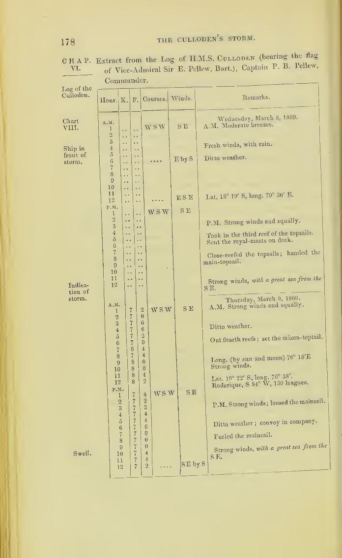
178 THE CULLODEN’S STORM.
CHAP.VI.
Log of the
Culloden.
ChartVIII.
Ship in
front of
storm.
Indica-
tion of
storm.
Swell.
Extract from the Log of H.M.S. Colloden (bearing the flag
of Vice-Admiral Sir E. Pellew, Bart.), Captain P. B. Pellew,
Commander.
Itemarks.
Wednesday, March 5, 1809.
A.M. Moderate breezes.
Fresh winds, with rain.
Ditto weather.
Lat. 18° 19' S, long. 79° 30' E.
P.M. Strong winds and squally.
Took in the third reef of the topsails.
Sent the royal-masts on deck.
Close-reefed the topsails; handed the
main-topsail.
Strong winds, with a great sea from the
SE.
Thursday, March 9, 1809.
A.M. Strong winds and squally.
Ditto weather.
Out fourth reefs ;set the mizen-toptail.
Long, (by sun and moon) 76° lo'E
Strong winds.
Lat. 19° 22' S, long. 76° 38'.
Roderique, S S4° W, 130 leagues.
P.M. Strong winds; loosed the mainsail.
Ditto weather ;convoy in company.
Furled the mainsail.
Strong winds, with a great sea from the
SE.

SOUTHERN HEMISPHERE. 179
Extract from the Log of H.M.S. Culloden—continued.
Hour. K F. Courses. Winds. Remarks.
A.M. Friday, March 10, 1809.
1 7 2 wsw SEbyS A.M. Strong winds.
2 7 4 ... SE3 7 6
4 7 4 Ditto weather; convoy in company,0 8 0 except the Northumberland.6 7 G Up foresail.
7 7 2 Saw the Northumberland a-stern.
8 6 4 Long, (by lunar obs.) at a.m. 73°53'30".
9 7 0
10 7 2
11 7 0 Lat. 20° 17' S, long. 73° 58' E.
12 7 2 Thermometer 77°.
Cape St. Mary, S 79° W, 533 leagues.
P.M.
i 7 0 wsw SEbyS P.M. Strong winds.
2 6 6 Set the fore and main-topmast-staysails.
3 7 4
4 8 0
5 7 6
6 G 4
7 6 6
8 7 0 Strong breezes, with a great swell from9 6 6 the S E.
10 6 6
11 6 6
12 7 0 Ditto weather;twelve ships in sight.
A.M. Saturday, March 11, 1809.
i 6 0 w sw SEbyS A.M. Strong winds.
2 6 0
3 6 2 Split the foresail; set the mainsail and
4 7 2 • • • • SSE main-topmast-staysail.
5 6 6
6
7
7
7
0
2 Unbent the foresail, fore and mizen-top-
8 7 0 Why S S by E sails, and bent new ones.
9 7 4
10 8 2
11 8 4
12 8 4 Lat. 20° 58' S, long. 71° 10' E.Cape St. Mary, S 79° W, 483 leagues.
P.M.
1 6 2 Why S SSE2 6 4
3 6 4 P.M. Strong winds and squally.
4 6 6 ... S E by S Ditto weather; convoy in company.
5 7 0
6 6 4 .... SSE7 6 4
8 7 2
9 7 2 Strong breezes, with rain.
10 7 6
11 7 6
12 7 4
i
N 2
C H A P.
VI.
Log of the
Culloden.
Swellfrom the
comingstorm.

180
CHAP.VI.
Log of the
Culloden.
THE CULLODEN’S STORM.
Extract from the Log of H.M.S. Culloden—continued.
Hour. K.
Swell.
Fleet still
in front of
storm.
Stormnow over-
taking the
fleet.
A.M.
1
2
3
4
5
6
7
8
9
10
11
12
P.M.
1
2
3
4
5
6
7
8
9
10
11
12
A.M.1
2
3
4
5
6
7
8
9
10
Courses.
W by S
Winds.
S by E
W by S
Remarks.
SEbyS
SE
Sunday, March 12, 1809.
A.M. Strong winds; close-reefed the
fore-topsail.
Ditto weather ;ten sail in sight.
Strong winds and squally, with a great
sea; all the fleet in sight.
Fresh winds and squally.
Cape St. Mary, S 80° W, 430 leagues.
Lat. 20° 4V S, long. 68° 14' E.
Thermometer 78°.
P.M. Strong winds and squally.
Ditto weather ;convoy in company.
Squally, with rain;seven ships in sight
.
11
12 8
P.M.
1
2
3
4
5
6
7
8
9
10
11
12
W by S SE
WW by S
W by S SE
S SE
SSE
Mondav, March 13, 1809.
A.M. Strong winds and squally.
Ditto weather ;handed the fore-topsail
at daylight ;set it again.
Strong breezes and cloudy ;convoy in
company.
Cape St. Mary, S 80° W, 370 leagues.
Lat. 22° 19' S Jong. 65° 23' E.
Thermometer 77g°.
P.M. Strong winds and squally.
Ditto weather, with rain.
Fresh gales and squally.
Five ships in sight.
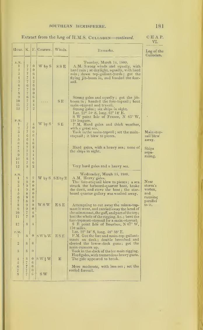
SOUTHERN HEMISPHERE. 181
Extract from the Log of II.M.S. Culloden—continued.
1
Hour. K. F. Courses. Winds. Remarks.
A.M. Tuesday, March 14, 1809.
A.M. Strong winds and squally, with1 7 0 W byS SSE2 7 0 hard rain
;at daylight, squally, with hard
rain ; down top-gallant-yards;
got the3 7 6
4 7 4 flying jib-boom in, and handed the fore-
5 7 2 sail.
G G G
7 7 0
8 7 0
9 6 G Strong gales and squally;
got the jib-
10 7 4 .... SE boom in;handed the fore-topsail ; bent
11 7 4 main-staysail and trysail.
12 7 2 Strong gales ; six ships in sight.
Lat. 22° 54' S, long. 62° 14' E.S W point Isle of France, N 65 3 W,
P.M.W by S
118 leagues.1 7 4 SE P.M. Hard gales and thick weather,2 7 0 with a great sea.
3 7 0 Took in the main-topsail; set the main-
4 6 6 staysail;
it blew to pieces.
0 6 4
6 6 6
7 7 2 Hard gales, with a heavy sea; none of
8 7 4 the ships in sight.
9 7 4
10 8 4
11 7 6
12 8 2 Very hard gales and a heavy sea.
A.M. Wednesday, March 15, 1809.
l 9 2 W by S SEbyE A.M. Heavy gales.
2 9 0 The fore-staysail blew to pieces; a sea
struck the larboard-quarter boat, broke3 9 0
4 9 0 the davit, and stove the boat ; the star-
5 8 0 board quarter gallery was washed away.G 8 0
7 8 0 •
8 9 0 w s w ESE Attempting to cut away the mizen-top-9 9 0 mast it went, and carried away the head of
10 7 4 the mizenmast, the gaff, andpartof thetop
;
11 7 0 lost the whole of the rigging, &c. ; bent thefore-topmast-staysail for a main-staysail.
12 8 4 S E point Isle of Bourbon, N 67° W,170 miles.
P.M. Lat. 22° 34' S, long. 58° 38' E.1 8 0 SWbW ESE P.M. Got the fore and main-top-gallant-
masts on deck ; double breeched and2 8 0 cleeted the lower-deck guns
;got the
main-runners up.
3 8 0 Took in the slack of the lee main rigging.
Hard gales,with tremendous heavy gusts.
4 8 0 s w \ w E The gale appeared to break.
5 7 6
6 7 0 More moderate, with less sea;set the
7 7 0 reefed foresail.
8 7 6 sw
C H A P.
VI.
Log of the
Culloden.
Mainstay-sail blewaway.
Shipssepa-
rating.
Nearstorm’s
vortex,
andrunningparallel
to it.

182 THE CULLODEN’S STORM.
Extract from the Log of H.M.S. Culloden—continued.CHAP.VI.
Eng of the
Culloden.
Stormre-curvin:
towardsS.E.
Remarks.
Wednesday, March 15, 1809.
Strong gales, with rain at times.
Found 150 yards of the spanker saved,
the rest was lost with the mizenmast head,
and spanker-boom ;found several knees
broke, the transom worked very much,and
the nails of the lower deck planks drawn
three or four inches ;the upper stroke
broken in the wake of the mainmast, kc.
Thursday, March 16, 1809.
A.M. Strong gales and cloudy.
At 7, up foresail;brought-to lor trie
convoy : employed mending the service
of the rigging, putting the ship to rights,
&Lat. 26° 6' S, long. 56° 37' E.
Cape St. Mary, N 87° W, 213 leagues.
P.M. Strong winds and hazy.
Set up the larboard main-rigging.
Hard gales, with rain and a heavy sea.
Larboard gallery washed away.
A very haid squall; clewed up the
main- topsail; it blew away; hauled up
the foresail and handed it; the ship
strained and laboured much, one chain
and one hand pump kept her free.
A.M,Friday, March 17, 1809.
Very hard gales, with heavy sea.
Set the trysail..
The ship strained, and leaked m every
part of the upper works and deck; at
daylight, found the fore and main belly-
stays, the inner bob-stays, and laniards
of the two foremost fore-shrouds carried
away.
Cape St. Mary, N 82° W, 194 leagues.
Lat. 26° 53' S, long. 54° 42' E.

SOUTHERN HEMISPHERE. 183
Extract from the Log of H.M.S. Culloden—concluded.
Hour. K. F. Courses Winds.
LRemarks.
P.M. Friday, March 17, 1809.
i
,
up2 \ SSW W by S P.M. Fresh gales and cloudy, with a
3 off great swellfrom the S \V.
4) ( S byE5 1 6 N W b N
iN6 2 0 NWbN7 2 0
8 2 0
9 2 0
10 2 4 N W11 2 G
12 4 0 NWbW SW Wind veering to the southward; fine
weather.
Extract from the Log of H.M.S. Terpsichore,
J. M. Gordon, Captain.
Hour. K. F. Courses. Winds. Remarks.
A.M. Monday, March 13, 1809.
1 7 0 W by S SEbvS A.M. Strong breezes, w'ith hard squalls
2 6 4 and rain. 12.30. Up foresail; ship
3 7 0 making five inches per hour.
4 6 4 Ditto weather ;Admiral W £ S.
5 6 0
6 6 0 At 6, fresh breezes and thick cloudy
7 6 0 weather.
8 6 2
9 6 4
10 6 4 up SSW At 10, up foresail, and hove-to. 10.15.
offS W bore up ;furled the mainsail and mizen-
11 5 4 W by S SE topsail.
12 7 2 Strong winds and squally weather;Ad-
miral W bv S 3 or 4 miles.
Course, S 77° W, distance 155.
Lat. 22° 14', long. 64° 42' E.P.M. Cape St. Mary, S 80° 20' W, 399 leagues.
1 7 0 W by S SEbvE P.M. Fresh breezes and squally, with2 7 4 rain.
3 7 6
4 7 4 Ditto weather ;Admiral W by S.
5 6 6
6 6 2 Set the foresail.
7 6 4 Up foresail.
8 7 4 Squally, with rain.
9 7 0
10 7 0
11 7 0 Strong breezes and squally weather;
12 7 0 . . . SE Admiral W by S.
CHAP.VI.
Log of the
Culloden.
Log of
theTerpsi*
chore.

184
CHAP.VI.
Log of
the Terp-sichore.
Swellfrom east-
ward.
Cullodenin sight.
Sails
splitting.
THE CULLODEN’S STORM.
Extract from the Log of H.M.S. Terpsichore—continued.
Hour. IL F Courses. Vinds. Remarks.
A.M.
1 6 4 W byS ESETuesday, March 14, 1809.
A.M. Fresh gales and squally, with
2
3
4
5
6
7 1
8
9
6 0
6 2
6 4
6 4
6 6
7 0
7 0
7 (
rain. 1.30. Burnt a blue light.
At 2, lowered the main-topsail.
Ditto weather; close-reefed the main-
topsail and furled the fore-topsail.
Strong gales and thick squally weather ;
down main-top-gallant-yard and mizen-
top-gallant-mast ;bent storm-staysails
and reefed the foresail.
At 8, strong gales and thick heavy
weather ;struck the fore and main-top-
10 6 C gallant- mast and set storm-staysail ;
11 5 4 carried awav the strap of the main-stay-
12 5 4 SEbyEsail-sheet and split the sail.
Noon. Strong gales and thick rainy
r.M.
1 5 1 W by S SEbyE
weather, a heavy sea from the eastward ;
six of the convoy in sight.
Course, S 82° W, distance 158.
Lat. 22° 36', long. 61° 56' E.
Cape St. Mary, S 80° 15' W, 343 leagues.
P.M. Hard gales and thick cloudy
2 5 2
weather; ship making nine inches per
hour; sent top- gallant-mast on deck
and rigged jib-boom in.
2.40. Carried away the tiller three feet
3 f5 0 from the rudder -head; clewed up & furled
4 4 4
the main-topsail ;shipped the short tiller.
At 4, ditto weather.
5 5 4 At 5.40, a sea broke over the stern,
stove the jolly-boat to pieces.
At 6, ditto weather.6 6 4
7
8
6
6
0
4 At 8, strong gales, with rain, and a heavy
9 6 0 sea running ;employed at the chain-
10
11
6
G
4
6
pumps.
At 11, the Admiral’s light W by N.
12 7 4 E Midnight. Hard gales & squally weather.
A.M.
1 7 0 W by S EWednesday, March 15, 1809.
A.M. Hard gales and thick cloudy
2 7 0 weather. At 1, the ship brought by
the lee ;loosened the foresail ;
burnt a3 7 0
4 7 0
blue light; the spare main- topsail-yard
washed away from chain.
At 4, ditto weather.
5
6
7
7
4
4 Excessive strong gales and thick rainy
7 8 0 weather; split every staysail we at-
8 8 0
tempted to set.
At 8, do. weather ;shipped a sea over the
9 7 6 Wlarboard-quarter, which greatly damaged it.
At 9, saw a sail in the W N W ;ship
making twm feet per hour.
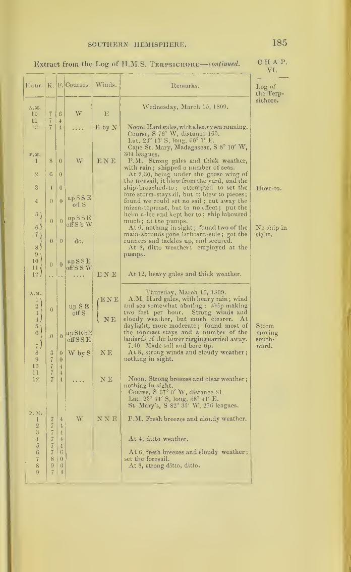
SOUTHERN HEMISPHERE. 185
Extract from the Log of H.M.S. Terpsichore—continued.
Hour. K. F. Courses. Winds. Remarks.
A.M. Wednesday, March 15, 1809.
10 7 6 W E11 7 4
12 7 4 • • • • E by N Noon. Hard gales, with aheavy sea running.
Course, S 76° W, distance 160.
Lat. 23° 13' S, long. 60° 1' E.Cape St. Mary, Madagascar, S 8° 10' W,
P.M. 304 leagues.
i 8 0 w ENE P.M. Strong gales and thick weather,with rain
;shipped a number of seas.
2 6 0 At 2.30, being under the goose wing of
the foresail, it blew from the yard, and the
3 4 0 ship-broached-to;
attempted to set the
,m QQ 17fore storm-staysail, but it blew to pieces
;
4 0 0 found we could set no sail;cut away the
on 0mizen- topmast, but to no effect; put the
5) helm a-lee and kept her to ;ship laboured
l 0 0Up O 0 P;
KW much; at the pumps.
6 ) At 6, nothing in sight ;found two of the
7
)
main-shrouds gone larboard-side; got the
0 0 do. runners and tackles up, and secured.
8) At 8, ditto weather; employed at the
9\ pumps.10
0 0upSSE
11(
offSS W12 J • • • • .... EN E At 12, heavy gales and thick weather.
A.M. Thursday, March 16, 1809.
i\ /ENE A.M. Hard gales, with heavy rain; wind2 up S E )
and sea somewhat abating;
ship making3
uoff S i
two feet per hour. Strong winds and
4) l NE cloudy weather, but much clearer. At5 \ daylight, more moderate
;found most of
6 upSEbE the topmast-stays and a number of theu
offSS E laniards of the lower rigging carried away.
7) 7.40. Made sail and bore up.
8 3 0 W by S NE At 8, strong winds and cloudy weather ;
9 7 0 nothing in sight.
10 7 4
11 "f1 4
12 7 4 NE Noon. Strong breezes and clear weather ;
nothing in sight.
Course, S 67° O' W, distance 81.
Lat. 23° 44' S, long. 58° 41' E.St Mary’s, S 82° 35' W, 276 leagues.
1 7*
41
W NNE P.M. Fresh breezes and cloudy weather.
L
3
1
7 4
4 7 4 At 4, ditto weather.5 7 4
6 7 6 At 6, fresh breezes and cloudy weather;
7 8 0 set the foresail.
8 9 0 At 8, strong ditto, ditto.
9 7 1
CHAP.VI.
Log of
the Terp-sichore.
Hove-to.
No ship in
sight.
Stormmovingsouth-ward.

186
CHAP.VI.
Log of
the Terp-sichore.
Stormre-curvingtowardsS.E.
Swellfrom west'
ward.
StormleavingTerpsi-
chore.
THE CULLODEN S STORM.
Extract from the Log of H. M. S. Terpsichore continued.
Hour. K.
P.M.
10
11
12
A.M.
1
2
3
4
5
6
7
8
9
10
11
12
P.M.
1
Courses,
W
Winds. Remarks.
W by S
w s w
SWb.W
NNENE
N
NWb.N
Thursday, March 16, 1809.
At 10, hand pumps kept going.
At 12, fresh breezes and hazy weather.
Friday, March 17, 1809.
A.M. Fresh breezes and cloudy ;ship
making twenty inches per hour.
At 2, took in the fore-topsail.
At 4, fresh breezes, with a head sea
;
close reefed the main topsail.
3
4
5
6
7
8
9
10
11
12
A.M.
1
N W
10
11
up SWoffSb.W
SWbySSSWS bv W
§
S bvWS
S by ES S E
W by N
W
N W
WN W
SW
Noon. Moderate breezes and cloudy ;
weather ;hove-to, to sling the main-yard
afresh •
‘Course, S. 64° O' W, distance 125.
Lat. 25° 29' S, long. 56° 28' E.
Cape St. Mary, N 88° W, 180 leagues.
P.M. Moderate and cloudy weather.
At 2, filled and set the mainsail.
Ditto weather; a heavy swell from the
westward.Pumped ship occasionally.
LDht breezes and dark cloudy weathei
.
Ditto weather ;wore ship.
variable
W by S
{
WbyS4SW SSW
Saturday, March, 18, 1809.
A.M. Fresh breezes and cloudy ;Added
top gallant-mast.
2.30. Out third reef of the topsails and
set the jib. . . ,
Ditto -weather ;observed a deal ot the
copper off on each side of the stern. At
daylight, saw a sail bearing S E by E ;
shortened sail..
At 7, the stranger proved, by signal, to be
the Earl St. Vincent, one of the convoy.
At 8, moderate breezes and hazy weather.

SOUTHERN HEMISPHERE. 187
Extract from the Log of H. M. S. Terpsichore— concluded.
II our. K. F. Courses. Winds. Remarks.
A.M. Saturday, March 18, 1809.
12 7 0 W. S S W Noon. Fresh winds ; Earl St. Vincentin company.Lat. 25° 50' S, long 55° 8' E.
Cape St. Mary, N 88° 10' W, 180 leagues.
r.M.
1 7 2 P.M. Fresh breezes and cloudy weather.2 6 6
3 6 4
4 0 0 At 4, ditto weather;Earl St. Vincent in
company.5 5 4 Unfidded the fore-topmast.6 5 2
7 5 2
8 5 2 At 8, ditto weather.9 5 0
10 5 0
11 5 2
12 5 6 .... S
Copy of the Log of H. M. S. Nereide.—In Civil Tune.
Hour. K. F. Courses. Winds. Remarks.
A.M. Wednesday, March 15, 1809.
A.M. Moderate breezes and cloudy.i 5 6 N E S S W2 5 6
3 6 0 S by E Varying to the eastward.
4 6 4 At daylight, moderate breezes and fine
5 6 f> weather.
6 7 2 SE Set fore lower-studding-sails.
7 7 6
8{
4 0 I NE Set the fore-topmast and top-gallant-
4 2/ *N studding-sails.
9 8 2 Wind freshening; down flying-jib.
10 9 2 N E In studding-sails and top-gallant-sails.
11 9 2 Lat. 27° 35' S, long. 55° 30' E.
12 9 2 Isle of Bourbon, bearing N 4° E, 370P.M. miles.
i 10 0 N E S S W P.M. Fresh gales and clear weather;in
2 10 2 second reef in the topsails.
3 10 2
4 10 0 Down fore-topmast-staysail ; close-reef, d
main- topsail; down top-gallant-yards ;the
same weather.Struck the top-galiant-mast.
5 8 6
6 10 0
7 10 0
8 10 0 Strong gales and hazy weather.
9 9 6
CHAP.VI.
Log of
the Terp-sichore.
Log of theNereidefrom theCape of
GoodHope.
Sailing
towardsthe storm.
ChartVIII.
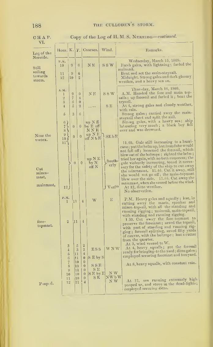
188 tiie culloden’s storm.
CHAP.VI.
Copy of the Log of II. M. S. Nereide—continued.
Log of the
Nereide.
Still
sailing
towardsstorm.
Near the
vortex.
Cutmizen-mast.
mainmast,
fore-
topmast.
Poopid.
Remarks.
Wednesday, March 15, 1809.
Fresh gales, with lightning ;furled the
mainsail.
Bent and set the main-staysail.
Midnight. Strong gales and dark gloomy
weather, and a heavy sea on.
Thursday, March 16, 1809.
A.M. Handed the fore and main top-
sails ; up foresail and furled it ;bent the
trysail.
At I, strong gales and cloudy weather,
with rain.
Strong gales ;carried away the mam-
staysail sheet and split the sail.
Strong gales, with a heavy sea; ship
labouring very much; a black boy fell
over and was drowned.
11.40. Gale still increasing to a hurri-
cane; putthehelmup.but foundshewould
not fall off; loosened the foresail, which
blew out of the boltrope ;righted the helm ;
tried her again,with no better success; the
gale violently increasing, found it neces-
sary for the safety of the ship to cut away
the mizenmast. 11.45. Cut it away, still
she would not go off; the main-topmast
blew over the side. 11.55. Cut away the
mainmast, when she veered before the wind.
At 12, ditto weather.
No observation.
P.M. Heavy gales and squally;
lost, in
cutting away the masts, spanker and
mizen-topsail, with all the standing and
running rigging; mainsail, main-topsail,
with standing and running rigging.
1.30. Cut away the fore topmast to
preserve the foremast; saved the topsail,
with part of standing and running rig-
ging;foresail splitting, saved fifty yards
of canvas, with the boltrope ;lost a cutter
from the quarter.
At 3, wind veered to W.At 4, heavy squalls
;got the foresail
ready forbringing-to the yard ;ditto gales
;
employed securing foremast and loreyard.
At 8, heavy squalls, with constant rain.
At 12, sea running extremely high
pooped us, and stove in the dead-lights
;
employed securing ditto.

SOUTHERN HEMISPHERE. 189
Copy of the Log of H. M. S. Nereide—concluded.
Hour. K. F. Courses. AVinds. Remarks.
A. SI. Friday, March 17, 1809.
Heavy gales and squally.1 11 4 S by E N by AV2 11 4
3 11 4 SSE NX AV4 11 0 Ditto weather.
5 9 0
6 10 0 Ditto, ditto.
7 10 0
8 9 0 More moderate;bent the foresail.
9 9 4 SE by S NAVb N Ditto weather;
people variously em-10 9 2 SE N AV ployed clearing the wreck.11 8 4
12 9 0 Ditto weather.P.M. No observation.
1 7 0 SEbyENWbW Fresh gales and cloudy weather;bent
IE and set foresail and fore-topmost-staysail.
2 6 0 SEby E; Hauled to the wind on the starboard2 0 tack.
3 2 0 SAVbyS NAV Ditto sveather.
4 3 4 $SW£W 4.30. Down topmast-staysail.
5 3 0 SS \V AV S AV6 2 4 S byW7 2 0 N by E8 2 4 Fresh breezes and cloudy ; wore ship.
9 2 4 NAVbAV More moderate, with a heavy swell.
10 2 '2
11 2 4
12 2 2 N Moderate and cloudy weather.
A. SI.Saturday, March 18, 1809.
1 X by AV A'ariable
2 N AV SAV b AV3
4 XAVbAV SAV Fresh breezes and cloudy weather.
0 Ditto weather, with rain at intervals
;
6 WNW got up a pair of sheers ; set maintop-
7 gallantsail on it.
8 Ditto weather ; made all possible sail
;
9 cut the stump of the mast up.
10
11
12 Ditto weather.Lat. 26° 46' S, long. 58° 16' E.
P.SI. Juan de Lisboa, N 85° 30' AV 155 miles.
1
2
\V by N S by AV Fresh breezes and cloudy;down mizen.
3
4 Ditto weather.
5
6 Fresh breezes and cloudy ;down mizen.
i
8 Ditto, ditto.
9 Moderate and cloudy.
10
11
12 Ditto, ditto.
(Signed) CORBET, Captain.
CIIAP.VI.
Log of the
Nereide.
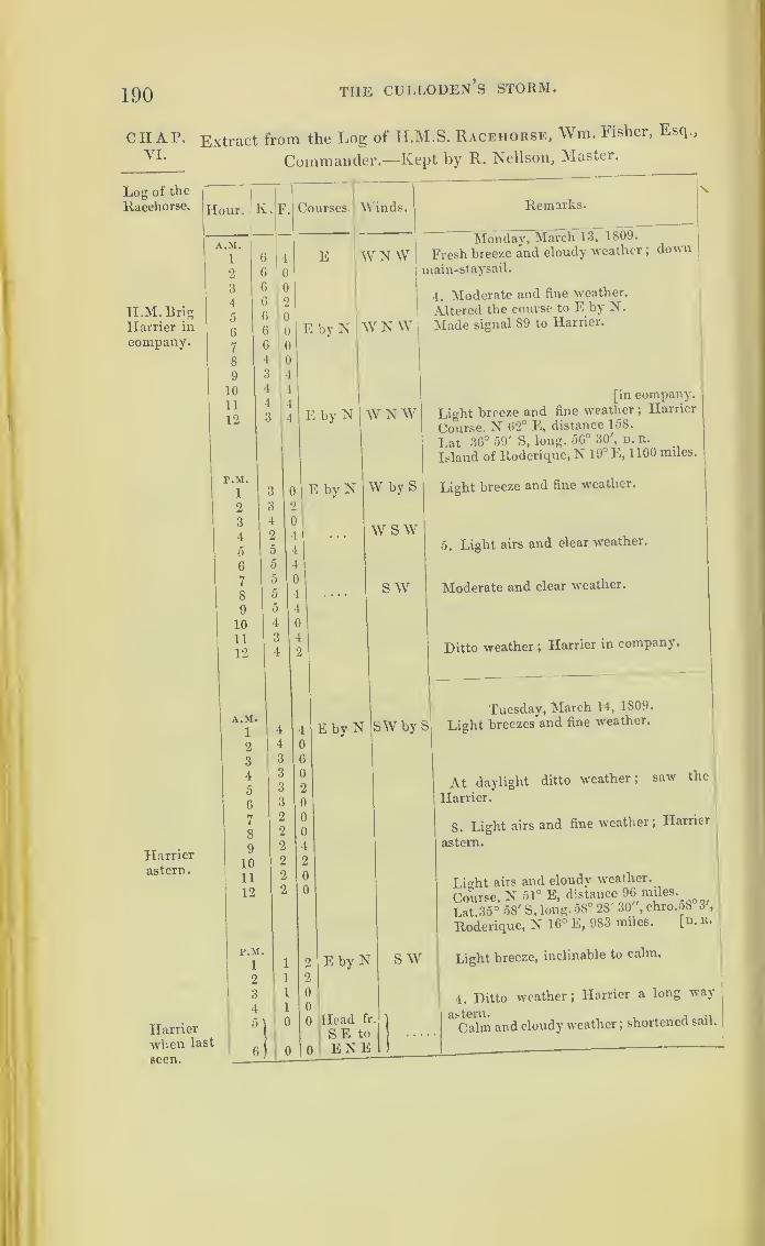
190 tiie culloden’s storm.
CHAP. Extract from the Log of H.M.S. Racehorse, Wm. Fisher, Esq.,
VT i tr ... i -u.. n AT „11 TVTncf-prVI.
Log of the
Racehorse.
Commander.—Kept by R. Nellson, Master.
ILM.BrigHarrier in
company.
Harrierastern.
Harrierwhen last
seen.
Remarks.
Monday, March 13, 1809.
Fresh breeze and cloudy weather ;down
main-staysail.
4. Moderate and fine weather.
Altered the course to E by N.
Made signal 89 to Harrier.
[in company.
Light breeze and fine weather ;Harrier
Course. N 62° E, distance 158.
Lat 36° 59' S, long. 56° 30', d.b.
Island of Roderique, N 19° E, 1100 miles.
Light breeze and fine weather.
5. Light airs and clear weather.
Moderate and clear weather.
Ditto weather ;Harrier in company.
Tuesday, March 14, 1809.
Light breezes and fine weather.
At daylight
Harrier.
ditto weather; saw the
8. Lmht airs and fine weather; Harrier
astern.
Light airs and cloudy weather.
Course N 51° E, distance 96 miles.
21 35° 58' S, long. 58° 28' 30", chro.58°3',
Roderique, N 16° E, 983 miles. [n. B.
Light breeze, inclinable to calm.
4. Ditto weather ;Harrier a long way
Calm and cloudy weather ;shortened sail.
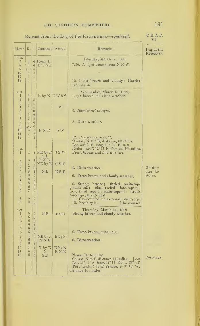
THE SOUTHERN HEMISPHERE. 191
Extract from the Log of the Racehorse—continued.
Hour K. F. Courses. Winds. Remarks.
P.M.
7 0 0 Head fr.Tuesday, March 14, 1809.
8 0 0 Eto SE 7.30. A light breeze from N N W.9 1-3 410 3 4 •
11 3 4
12 3 4 12. Light breeze and cloudy; Harriernot in sight.
A.M. Wednesday, March 15, 1809.
1 3 4 E by N NWbW Light breeze and clear weather.2 4 2
3 5 4
4~~5
4 W5 6 0 5. Harrier not in sight.
6 G 2
7 5 4
8 6 0 8. Ditto weather.
9 3-2 0
10 3 6 E N E sw11 4 2
12 4 4 12. Harrier not in sight.
Course, N 49° E, distance, 83 miles.
Lat. 35° 2' S, long. 59° 22' E. d. r.
P.M. Roderique,N 12° 23' E, distance, 954 miles.
1 4 4 NE byE1 E
E NE
s s w Fresh breeze and fine weather.
2 6 4
• 3 7 2 NE byE S S E4 7 0 4. Ditto weather.5 8 4 NE ES E6 9 0 6. Fresh breeze and cloudy weather.7 8 0
8 8 0 8. Strong breeze ; furled main-top-9 6 0 gallant-sail; close-reefed fore-topsail;10
11
7 0 took third reef in main-topsail; struck
fore-top-gallant-mast.G 0 11. Close- reefed main-topsail, and reefed
12 0 0 12. Fresh gale. [the courses.
A.M. Thursday, March 16, 1809.1 6 0 NE ESE Strong breeze and cloudy wreather.2 6 0
3 6 0
4 6 40 G 46 0 0 6. Fresh breeze, with rain.
7 4 6 NE bvN E by S8 6 0 N NE 8. Ditto weather.9 G 4
10 7 4 N by E E bvN11 6 0 N EN E12 6 0 SE Noon. Ditto, ditto.
Course, N to E, distance 1 44 miles, [d.r.
Lat. 32° 40 S. long. 61° 14' E ch„ 59° 52'
Port Louis, Isle of France, N 9° 40' W,distance 761 miles.
CHAP.VI.
Log of the
Racehorse.
Gettinginto the
storm.
Port-tack.
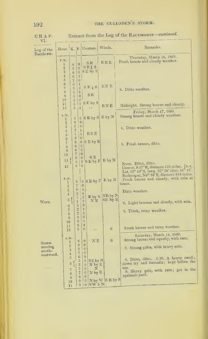
192
CHAP.VI.
Log of the
Racehorse.
Wore.
THE CULLODEN’S STORM.
Extract from the Log of the Racehorse—continued.
Hour. K. F.
Stormmovingsouth-eastward.
p.m.
1
2
3
4
5
6
7
8
9
10
11
12
A.M.
1
2
3
4
5
6
7
8
9
10
11
12
P.M.
1
2
3
4
Courses.
SES E 4 S
SE i S
SE
SE by
SE by S
ESE
[S E by E
S E
6
7
8
9
10
11
12
A.M.
1
2
3
4
5
7
8
9
10
11
SE byE
NE
1
Winds. Remarks.
ENEThursday, March 16, 1809.
Fresh breeze and cloudy weather.
ENE8. Ditto weather.
ENE Midnight. Strong breeze and cloudy.
3 E by NFriday, March 17, 1809.
Strong breeze and cloudy weather.
4. Ditto weather.
E8. Fresh breeze, ditto.
E EbyN
E EbyN
Noon. Ditto, ditto.
Course, S 57° E, distance 121 miles, [d.r.
Lat. 33° 44' S, long. 62° 30' eliro. 61 49 .
Roderique, N0° 40' E, distance 844 miles.
Fresh breeze and cloudy, with rain at
times.
g NEbyNSE by E
Ditto weather.
6. Light breezes and cloudy, with rain.
8. Thick, rainy weather.
S Fresh breeze and rainy weather.
E S
Saturday, March 18, 1809.
Strong breeze and squally, with ram.
3. Strong gales, with heavy rain.
yNE
6. Ditto, ditto. 6.30. A heavy swell;
down try and foresails ;kept before the
E
W S E bybN
8. Heavy gale, with rain;
got in the
spritsail-yard.
S

THE SOUTHERN HEMISPHERE. 193
Extract from the Log of the Racehorse—concluded.
Hour. K. F. Courses. Winds. Remarks.
A.MNW Saturday, March 18, 1809.
12 9 G SE by E 12. The sea running very high;brought
her to on the starboard tack under try
and fore staysails.
Course, N 26° E, distance 135 miles.
Lat. 31° 42' D. r., long. 63° 41'. Noobservation n. r.
Roderique, N, distance 722 miles.
Port Louis, N 25° 45' W, G92 miles.r.M.
n Strong gales, with heavy squalls and2 1
up E S E S rain.
3 y4 1
off NE 4. Ditto, ditto.
5J 5. The small cutter was carried away6 (by a sea) from the stern.
7) up E S E8/ otfENE9\
10 1
up E b N11
(off NE
12/ SSE 12. Ditto weather.
A.M. Sunday, March 19, 1809.
1 up E b N SSE Strong gale and squally, with rain.
off N E
l\4 )
•• up E N Eoff NEby N
5\ 5. More moderate weather.
6 ) • • • • up NE 6. Moderate and cloudy.
11• * * *
off N b E 8. Fresh breeze and cloudy.
9 2 4 N by E E by S10 4 4
11 4 4
12 3 4 NJE 12. Moderate and clear weather.Course, N 34° W, distance 22 miles.Lat. 31° 26' S, long. G2° 48' chro., 63° 26'
D. R.
Roderique, N 1° W, 706 miles.P.M.
1 2 0 N ENE Moderate breeze and cloudy weather.2 2 4
3 3 1!
4 3 2 4. Light breeze and rainy weather.5 2 0 N by W Ditto, ditto.
6 3 0 Variable
7 1 0 N by E8 1 0 N9 2 0 N by E10 3 4
11 3 0 N i W 11. Squally, with rain.
12 0 0 head fr.
NtoNW12. Ditto, ditto.
CHAP.VI.
Log of the
Racehorse.
O

194 THE CULLODEn’s STORM.
C H A P.
YI.
Log of the
Huddart.
The four next logs are those of the ships which first
got out of the hurricane, and whose places are marked
on the shaded part of the Chart, viz., the Huddart,
William Pitt, Harriet, and Euphrates.
Extract from the Log of the H. C. S. Huddart * Captain Wm.
Nesbitt, towards England.—In Nautical Time.
Hour. Iv.
P.M.
1
2
3
4
5
6
7
8
9
1011
12
A.M.
1
2
3
4
o
6
7
8
9
10
11
12
P.M.
1
2
3
4
5
6
7
8
9
10
11
12
F. Courses,
wsw
Winds, Remarks.
SEbySMonday, March 13, 1809.
P.M. Presh breezes and squally weather
throughout.
WSW
A.M. At 8.30, departed this life Captain
John Robinson ;at noon, committed the
(
body to the deep with the usual cere-
monies. . „Lat. observed, 22° 25' S, long. 6o 23 E.
(Signed) C. ARKCOLL.
S EbySTuesday, March 14, 1809.
P.M. First and middle parts a strong
trade, the weather heavy and unsettled,
with constant hard rain and a rising sea,
latterly increasing to a heavy gale, with
violent squalls from the S S E, and ship-
ping much water.
* H. C. S. Honourable Company’s Ship.
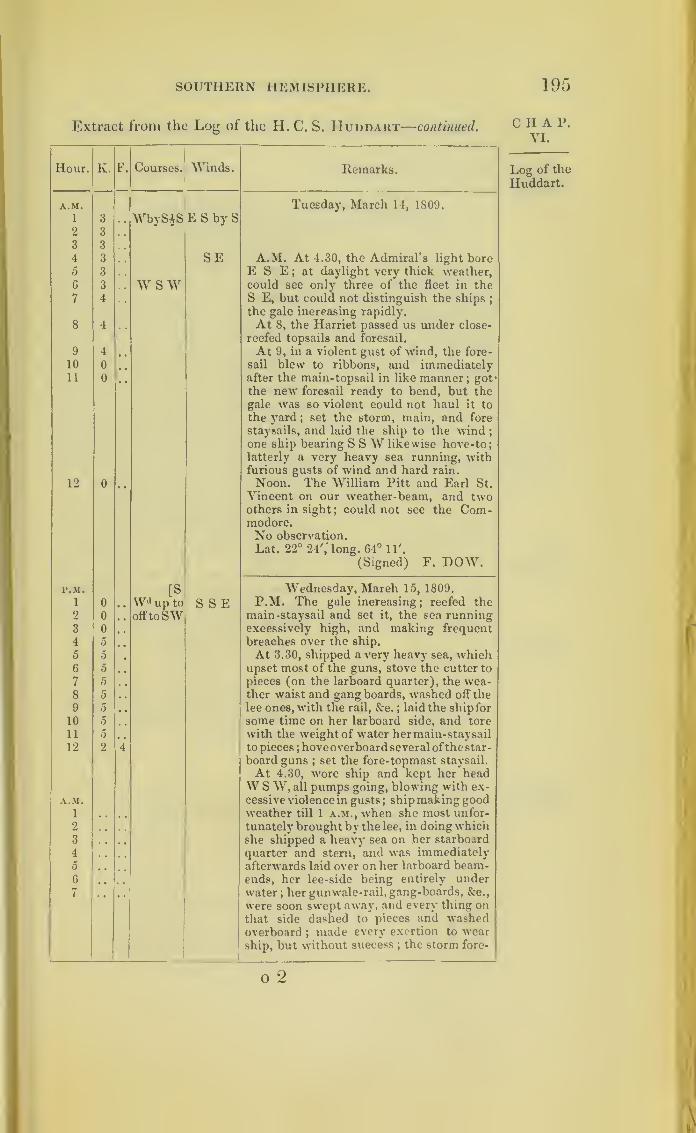
SOUTHERN HEMISPHERE. 195
Extract from the Log of the H. C. S. IIuddart—continued.
Hour. K. F. Courses. Winds. Remarks.
A.M. Tuesday, March 14, 1809.
1
2
3
3
WbySiS E S by S
3
4
3
3 SE A.M. At 4.30, the Admiral’s light bore5 3 E S E
; at daylight very thick weather,6 3 W S W could see only three of the fleet in the
7 4 S E, but could not distinguish the ships;
the gale increasing rapidly.
8 4 At 8, the Harriet passed us under close-
reefed topsails and foresail.
9 4 At 9, in a violent gust of wind, the fore-
sail blew to ribbons, and immediately10 0
11 0 after the main-topsail in like manner;got 1
the new foresail ready to bend, but thegale was so violent could not haul it to
the yard; set the storm, main, and fore
staysails, and laid the ship to the wind ;
one ship bearing S SW likewise hove- to;latterly a very heavy sea running, withfurious gusts of wind and hard rain.
12 0 Noon. The William Pitt and Earl St.
Vincent on our weather-beam, and twoothers in sight ; could not see the Com-modore.No observation.
Lat. 22° 24',' long. 64° 11'.
(Signed) F. DOW.
P.M. [S Wednesday, March 15, 1809.
1 0 VVd up to S S E P.M. The gale increasing; reefed themain-staysail and set it, the sea runningexcessively high, and making frequent
2 0 offtoSW3 0 , ,
4 5 breaches over the ship.
5 5 At 3.30, shipped a very heavy sea, which6 5 upset most of the guns, stove the cutter to
7 5 pieces (on the larboard quarter), the wea-8 5 . . ther waist and gang boards, washed off the
9 5 lee ones, with the rail, &c. ; laid the ship for
some time on her larboard side, and tore10 5
11 5 , , with the weight of water her main-staysail
12 2 4 to pieces;hove overboard several ofthe star-
board guns;set the fore-topmast staysail.
At 4.30, wore ship and kept her headW S W, all pumps going, blowing with ex-
A.M. cessive violence in gusts ; ship making goodi weather till 1 a.m., when she most unfor-
tunately brought by the lee, in doing which2
3 she shipped a heavy sea on her starboard
4 quarter and stern, and was immediately5 afterwards laid over on her larboard beam-6 ends, her lee-side being entirely under
7 water;her gunwale-rail, gang-boards, &c.,
were soon swept away, and every thing onthat side dashed to pieces and washedoverboard ;
made every exertion to wearship, but without success ; the storm fore-
CHAP.VI.
Log of the
Huddart.
o 2
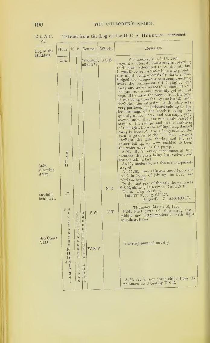
196
chap.VI.
Log of the
Huddart.
Shipfollowing
storm,
but falls
behind it.
See ChartVIII.
THE CULLODEN'S STORM.
Extract from the Log of the II. C. S. Huddart continued.
Hour. K.
AM.
8
9
10
11
12
P.M.
1
2
3
4
5
6
7
8
9
10
11
12
A.M.1
2
3
4
5
F. Courses
Wtlup toS
offtoSW
Winds.
S SE
N E
SW
w s w
Remaiks.
Wednesday, March 15, 1809.
staysail and fore-topmast staysail blowing
to ribbons ;attempted to set the jib, but
it was likewise instantly blown to pieces ,
the night being excessively dark, it was
judged too dangerous to attempt cutting
away the mizenmast till daylight; cut
away and hove overboard as many of our
lee guns as we could possibly get at, and
kept all hands at the pumps from the time
of our being brought by the lee till near
daylight; the situation of the ship was
very perilous, her larboard side up to the
lee-coamings of the hatches being fre-
quently under water, and the ship laying
over so much that the men could scarcely
stand to the pumps, and in the darkness
of the night, from the railing being dashed
away to leeward, it was dangerous for the
men to go over to the lee side ;towards
daylight, the gale abating and the sea
rather falling, we were enabled to keep
the water under by the pumps.
A.M. By 8, every appearance of fine
weather, the gusts being less violent, and
the sea falling fast.
At 11, moderate, set the main-topmast-
At 11.30, wore ship and stood before the
wind,in hopes of joining the fleet; the
wind continued..
In the first part of the gale the wind was
S S E, shifting latterly to E and N E.
Noon. Pair weather.
Lat. 23° 8', long. 63° 37'.
(Signed) C. ARCKOLL
N EThursday, March 16, 1809.
P.M. Eirst part; gale decreasing
middle and latter moderate, with
squalls at times.
The ship pumped out dry.
fast
light
A.M. At 5, saw three ships from the
mainmast head bearing E S E.

SOUTHERN HEMISPHERE. 197
Extract from the Log of the H. C. S. Huddaut— continved.
Hour. K. F. Courses. Winds. Remarks.
A.M. Thursday, March 16, 1809.
6 6 4 w sw NE7 4 4
8 4 4
9 4 0
10 3 0 At 10, the headmost stranger made sig-
11 2 0 nal;made ournumber, which he answered,
12 2 4 informing us that he was the William Pitt,
and the other two were the Harriet and
*Euphrates, which had been damaged in
the gale, and leaked ; informed the Pitt
by telegraph that we had suffered in the
gale, thrown guns overboard, and feared
our cargo was much damaged.Lat. observed, 25° 14' S, long. 61° 45'.
r.M. Friday, March 1 7, 1809.
1 3 0 w N E P.M. First part, fresh breezes ; middle2 4 0 and latter, blowing hard and increasing
;
3 4 4 W£S N N E employed drying sail and clearing ship
;
4 4 4 bent and set main-topsail.
5 5 0
6 4 4 W by S N N W7 4 0
8 4 0
9 G 0
10 6 0
11 6 0
12 6 0
A.M. No observation.
1 5 0 Lat. 25° 34', long. 60°.
2 0 0
3 5 0
4 0 0
5 4 0
6 4 4
7 4 4
8 4 4
9 4 4
10 3 0
11 2 0
12 2 0
P.M. Saturday, March 18, 1809.
1 2 0 w sw N W P.M. Strong breezes throughout, with2 2 0 hard squalls at times
;guns all but two,
3 2 0 SWbyW and everything of any weight, down in the
4 2 0 hold to stiffen the ship.
5 2 0 sw N W6 2 0
7 2 0
8 2 0 NNW9 2 4 NWb.tV W by S
10 2 4
11 2 4
12 2 4
CHAP.VI.
Log of the
Huddart.
Meetingthe stormwhen re-
curving,
but gains
below.

198 THE CULLODEN S STORM.
CIIAP. Extract from the Log of the H. C. S. Huddart concluded.
VI.
Log of the
Huddart.
Hour. K'l
F.
A.M.
1 3 1
2 3 ..
3 3 , «
4 3 . ,
5 3 , .
0 3 . .
7 3 . .
8 3 . .
9 3 . ,
10 3 . •
11 3 , .
12 3 r
Courses. Wtuds.
Log of the
WilliamPitt.
NWWbWWNWW
W by S
Remarks.
Saturday, March 18, 1809.
Lat. observed, 26° 33' S, 59° 19' E.
(Signed) C. ARKCOLL.
Extract from the Log of the H.C.S. William Pitt, Captain
Charles Graham, towards St. Helena.
Hour. K.
P.M.
1
2
3
4
5
6
7
8
9
10
11
12
A.M.1
2
3
4
5
6
7
8
9
10
11
12
P.M.
1
2
3
4
Courses. Winds. Remarks.
Wby S ,E S by SMonday, March 13, 1809.
Lat. 22° 15' S.
W by NW by S
6|
W by 86
4
4
SSETuesday, March 14, 1809.
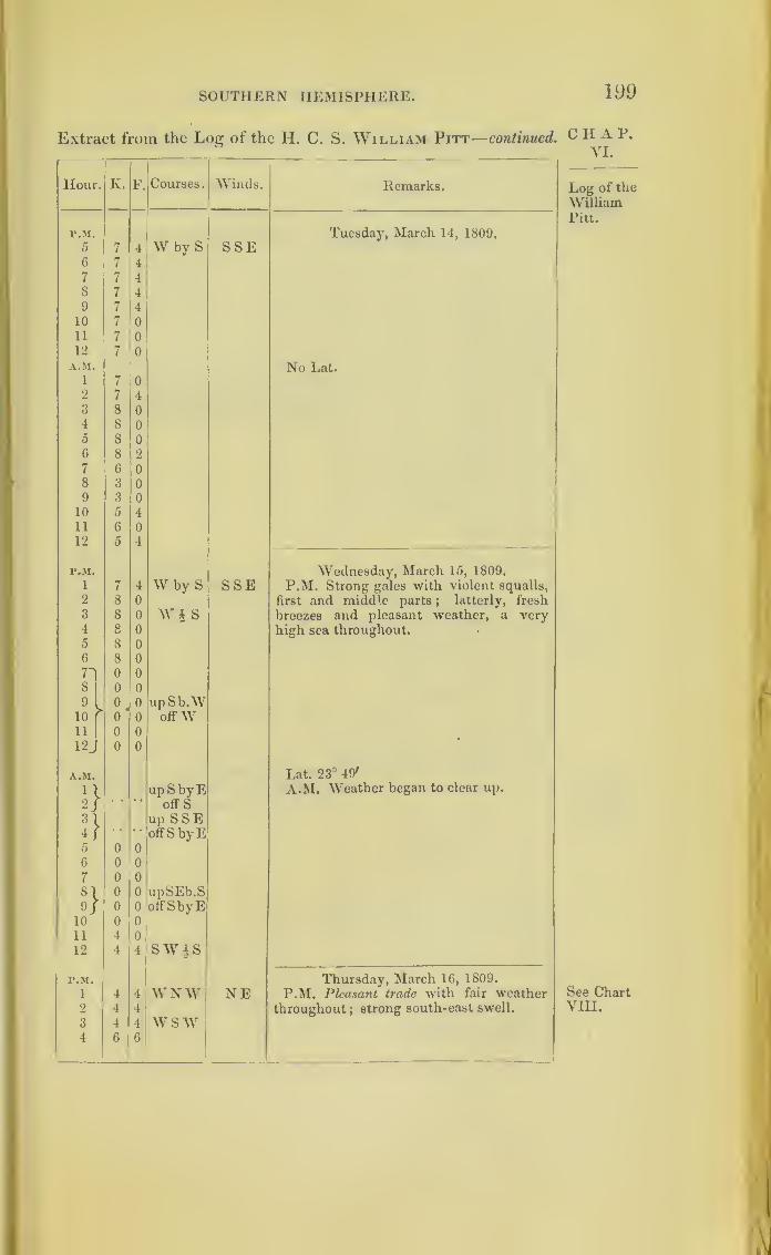
SOUTHERN HEMISPHERE. 199
Extract from the Log of the H. C. S. William Pitt— continued. CHAP.YI.
Hour. K. F. Courses. Winds. Remarks. Log of the
WilliamPitt.
P.M. Tuesday, March 14, 1809.
5 7 4 W by S SSE6 7 4
7 7 4
8 7 49 7 4
10 7 0
11 7 0
12 7 0
A.M. No Lat.1 7 0
2 7 4
3 8 0
4 8 0
5 8 0
6 8 2
7 6 0
8 3 09 3 0
10 5 4
11 6 0
12 5 4
P.M. Wednesday, March 15, 1809.
1 7 4 W by S SSE P.M. Strong gales with violent squalls,
2 8 0 first and middle parts;
latterly, fresh
3 8 0 Wt s breezes and pleasant weather, a very4 8 0 high sea throughout.5 8 0
6 8 0
71 0 0
8 0 0
0 0 upSb.W10 > 0 0 offW11
10 0
12J 0 0
A.M. Lat. 23° 49'
1
1
upSbyE A.M. Weather began to clear up.
2/* * • •
offS
n up SSE4 f
* * • •
offS by E5 0 0
G 0 0
7 0 0
8l
0 0 upSEb.S9f 0 0 offSbyE
10 0 0
11 4 0
12 4 4 SW|S
P.M. Thursday, March 16, 1809.
1 4 4 WNW NE P.M. Pleasant trade with fair weather See Chart2 4 4 throughout; strong south-east swell. VIII.
3 4 4 wsw4 6 6

200
CHAP.VI.
Log of the
WilliamPitt.
Meetingthe stormwhen re-
curving.
THE CULLODEN’S STORM.
Extract from tlie Log of the H. C. S. William Pitt—continued.
Hour. ] v. F. Courses. Winds. Remarks.
P.M. Thursday, March 16, 1809.
5 0 0 W by S NE6 6 0
7 6 0
8 6 2
9 6 2
10 G 2
11 6 2
12 6 2
A.M. Lat. 26° 16' S.
1 G 2 E Noon. Fell in with the Huddart.
2 G 2 (The Harriet and Euphrates appear to be
3 G 2 in company with the William Pitt.)
4 G 0
5 o 0
6 5 0
7 5 2 sw8 5 4
9 6 0 SWbW4 w
10 G 0
11 6 0
12 6 0
P.M. Friday, March 17, 1809.
i 6 C SWbyS E by N2 6 4 N W3 6 1
4 4 A W by S5 4 4
6 4
7 3 made sail
8 6
W) NE P.M. Lightning in the north-west
;
9 G 1squally.
10 6 1
11
12
A.M.
1
6
7
1
0 First and middle parts, fresh breezes
and pleasant weather ;latterlyfreshening ,
/ 4 with a very confused swell.
2 7 4
3 6 0 wsw4 5 4 W | N5 5 6 WSW6 5 G
7 5 0 w8 3 0
9 4 0
10 2 0
11 2 0 W by S
12 2 0
P.M. Saturday, March 18, 1809.
l\0
0® upWS'V" off SW
vNW P.M. Cloudy.
3) 0 0
1

SOUTHERN HEMISPHERE. 201
Extract from the Log of the H. C. S. William Pitt—concluded.
Hour. K. F. Courses. Winds. Remarks.
r.M. Saturday, March 18, 1809.
4/ 0 0 upWSW N W6J 0 0 off S W6 2 0 SE7 2 0 N N W8 2 0 NWbW9 2 4
10 2 411 2 4 NW12 2 4 NWb WA.M. Lat. 56° o'.
1 3 0 WN W2 3 4
3 3 4
4 3 4
5 3 4 Why N6 3 0
7 3 4
8 3 4
9 3 4
10 3 4
in 0 0 upW b S12/ 0 0 offWbN
Extract from the Log oftheH.C.S. Harriet, Captain W. Lynch,
towards England.—In Nautical Time.
Hour. K. F. Courses. Winds. Remarks.
r.M. Monday, March 13, 1809.i 7 4 W by S SEbyS P.M. Hazy; fresh gales and a heavy2 7 4 sea
;pumped ship every watch
;most
3 7 4 water 12 inches.4 6 0
5 6 0
6 6 4
7 6 0
8 6 0
9 6 410 6 4
11 6 0
12 6 0 Noon. Fleet in company', and Euphratesand Northumberland well up towards
A.M. noon.1 6 0 W by S SEbyS2 6 4
3 6 1
4 6 n
0 6 0
6 6 0
7 6 0
*
C H A P.
VI.
Log of the
WilliamPitt.
Log of theHarriet

202 THE CULLODEN S STORM.
CHAP.VI.
Log of theHarriet.
Extract from the Log of the H. C. S. Harriet—continued.
Hour. K. F. Courses. Winds.
——• |
Remarks.
A.M.1
Monday, March 13, 1809.
8 6 0 W by S SEbyS9 6 6
A.M. At 10, brought-to, by signal ;at
10 6 6
11 5 2 10. 30, filled.
12 7 4 Lat. observed, 22° 19' S.
(Signed) ALEX. RAMSAY.
r.M. Tuesday, March 14, 1809.
1 7 4 W by S SE P.M. Cloudy, with small ram ;fresh
gales during the first and middle parts2 7 4
3 7 4 with squalls and rain, latter blowing
4 7 4 violently, and the sea rising.
5 7 0
6 7 0
7 7 4
8 7 4
9 7 4
10 7 0
11 7 0
12 7 4
A.M.
1 7 C W by S SE During the A.M. saw the Admiral south
one mile, and Calcutta and Hugh Inglis
2 7 C SE; weather very thick, and every ap-
3 7 4 pearance of a violent gale;pumped ship
4 7 4every half hour.
5 7 No observation.6 7 l
7
8
7
7
t
1
(Signed) JOHN JONES JAMES.
9 7 1
10 7 3
11 5 31
12 5 3
Wednesday, March 15, 1809.
r.M.
1 6 0 W by S
0
0
S SE P.M. Thick mist; blowing without in-
termission till 4 a.m. most violently, when2
3
6
6it moderated.
4 6 0
5 6 0
up S W SE
;
• * •• offWb 3
9/10 >
'upSSV; ESE11 }
• ' •* offSW
12up S E
* * •• offSSVI
A.M.
1 ditto
21 up SSI5
3i•• off Sb 1
1
V

SOUTHERN HEMISPHERE. 203
Extract from the Log of the H. C. S. Harriet—continued.
Hour. K. F. Courses. Winds. Remarks.
A.M. Wednesday, March 15, 1809.
4
|
up S Eoff S bE
ENE A.M. At 4, the pumps sucked for the
first time since 8 p.m.
5) At 5, brought-to, finding it impossible
to run;
the ship labouring excessively,
and the sea washing over all ;kept both
pumps going, but from the immensequantity of water which got between
6 0 0 decks down the hatchways could not keepher clear, and most part of the night wehad two feet and two and a half in the
well ; all hands employed throughoutthe night at the pumps, and in attendingthe scuppers on the lower decks.
At daylight, observed only the Euphrates7 0 0 in sight ; kept lying-to till 7 a.m., when no8 6 0 other ship appearing bore up on a W by S
course, and made her signal to follow.
9 6 0 At 9, were joined by the William Pitt.
10 6 0 Towards noon the swell abating, and the
11 6 0 weather bearing the appearance of con-tinuing moderate.
12 6 0 No observation.
(Signed) ALEX. RAMSAY.
p.m. Thursday, March 16, 1809.
1 6 0 W by S WbyN P.M. Hazy ; breeze steady;
repairing
2 6 0 the ravages of the late gale.
3 6 04 6 4
5 6 0
6 6 0
7 7 0
8 6 4
9 7 0
10 6 0
11 6 0
12 6 0
A.M.
1
2
5
5
4
4W by S W byN
3 5 4
4 4 0
5 5 0
6 6 4
7 6 4
8 6 49 7 0
10 i 0
11 5 4
12 6 4 (Signed) JOHN JONES JAMES.
C H A P.
VI.
Log of the
Harriet.
%
Hove- to,
andtherebydroppedout of the
storm.

204 THE CULLODEN’S STORM
CHAP.VI.
Log of the
Harriet.
Extract, from the Log of the H. C. S. Harriet— concluded.
Hour. K.
p.m.
1
2
3
4
5
6
7
8
9
10
11
12
A.M.
1
2
3
4
5
6
7
8
9
10
11
12
r.M.
1
2
3
4
5
6
7
8
9
10
11
12
A.M.
1
2
3
4
5
6
7
8
9
10
11
12
F. Courses. Winds.
W byS
Why S
Remarks.
Friday, March 17, 1809.
W by SWNWS W
NNW
NWWNWW by N
Saturday, March 18, 1809.
Noon. Lat. 26 9' S.
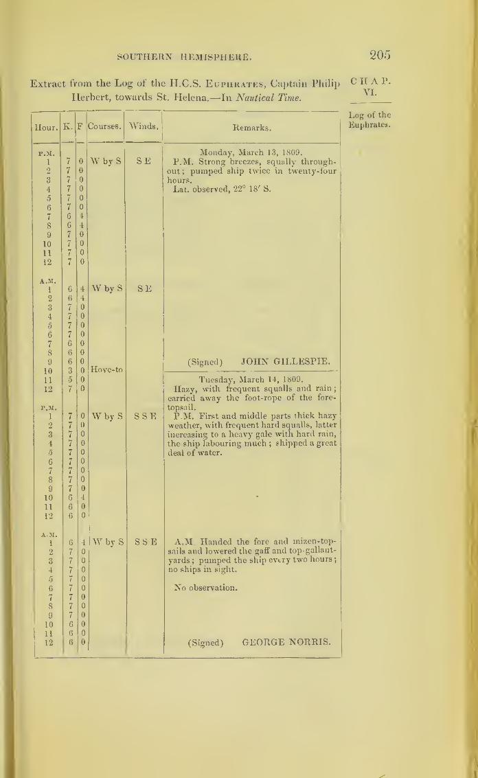
SOUTHERN HEMISPHERE. 205
Extract from the Log of the Ii.C.S. Euphrates, Captain Philip
Herbert, towards St. Helena.—-In Nautical Time.
Hour. K. F Courses. Winds. Remarks.
P.M. Monday, March 13, 1809.
1 7 0 Why S SE P.M. Strong breezes, squally through-2 7 0 out; pumped ship twice in twenty-four3 7 0 hours.
4 7 0 Lat. observed, 22° 18' S.
5 7 0
6 7 0
7 6 4
8 6 4
9 7 0
10 7 0
11 7 0
12 7 0
A.M.
1 6 4 W by S SE2 6 1
3 7 0
4 7 0
5 7 0
6 7 0
7 6 0
8 6 0
9 6 0 (Signed) JOHN GILLESPIE.i n 9 o FTovp-to
a 5 0 Tuesday', March 14, 1809.
12 7 0 Hazy, with frequent squalls and rain;
carried away the foot-rope of the fore-
P.M. topsail.
1 7 0 W by S SSE P.M. First and middle parts thick hazy2 7 0 weather, with frequent hard squalls, latter
3 7 0 increasing to a heavy gale with hard rain,
4 7 0 the ship labouring much ;shipped a great
5 7 0 deal of water.
6 7 0
7 7 0
8 7 0
9 7 0
10 6 4 •
11 6 0
12 6 0
AM.1 6 4 W by S SS E A.M Handed the fore and mizen-top-
2 7 0 sails and lowered the gaff and top-gallant-
3 7 0 yards;pumped the ship every two hours
;
4 7 0 no ships in sight.
5 7 o
6 7 0 No observation.
7 7 0
8 7 0
9 7 0
10 6 0 0
11 6 0
12 6 0 (Signed) GEORGE NORRIS.
C II A P.
VI.
Log of the
Euphrates.
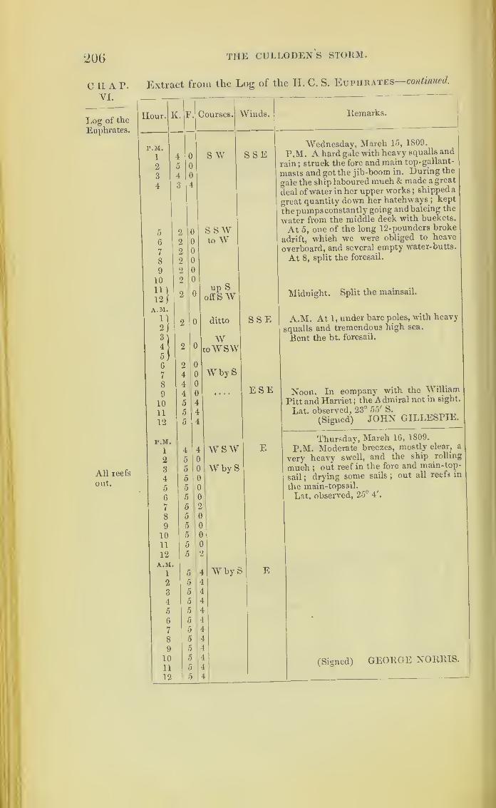
206
ciiap.VI.
Log of the
Euphrates.
All reefs
out.
THE CULLODENS STORM.
Extract from the Log of the II. C. S. Euphrates continued.
Hour. K. F.
P.M.
1
2
3
4
5
6
7
8
9
10
12 f
A.M.
n213
4
5
6
7
8
9
10
11
12
P.M.
1
2
3
4
5
6
7
8
9
10
11
12
A.M.
1
2
3
45
6
7
8
9
10
11
12
Courses. Winds
S W SSE
Remarks.
S S Wto W
up Soff SW
ditto
WtoWSW
W by S
SSE
w swWhy S
E
W by S E
ESE
Wednesday, March 15, 1809.
P.M. A hard gale with heavy squalls and
rain ;struck the fore and main top-gallant-
masts and got the jib-boom in. During the
gale the ship laboured much & made a great
deal of water in her upper works ;shipped a
great quantity down her hatchways ;kept
thepumpsconstantly going andbaleing the
water from the middle deck with buckets.
At 5, one of the long 12-pounders broke
adrift, which we were obliged to heave
overboard, and several empty water-butts.
At 8, split the foresail.
Midnight. Split the mainsail.
A.M. At 1 ,under bare poles, with heavy
squalls and tremendous high sea.
Rent the bt. foresail.
Noon. In company with the William
Pitt and Harriet ;the Admiral not in sight.
Lat. observed, 23° 55'S.
(Signed) JOHN GILLESPIE.
Thursday, March 16, 1809.
P.M. Moderate breezes, mostly clear, a
very heavy swell, and the ship rolling
much ;out reef in the fore and main-top-
sail;drying some sails
;out all reefs in
the main-topsail.
Lat. observed, 25°4'.
(Signed) GEORGE NORRIS.
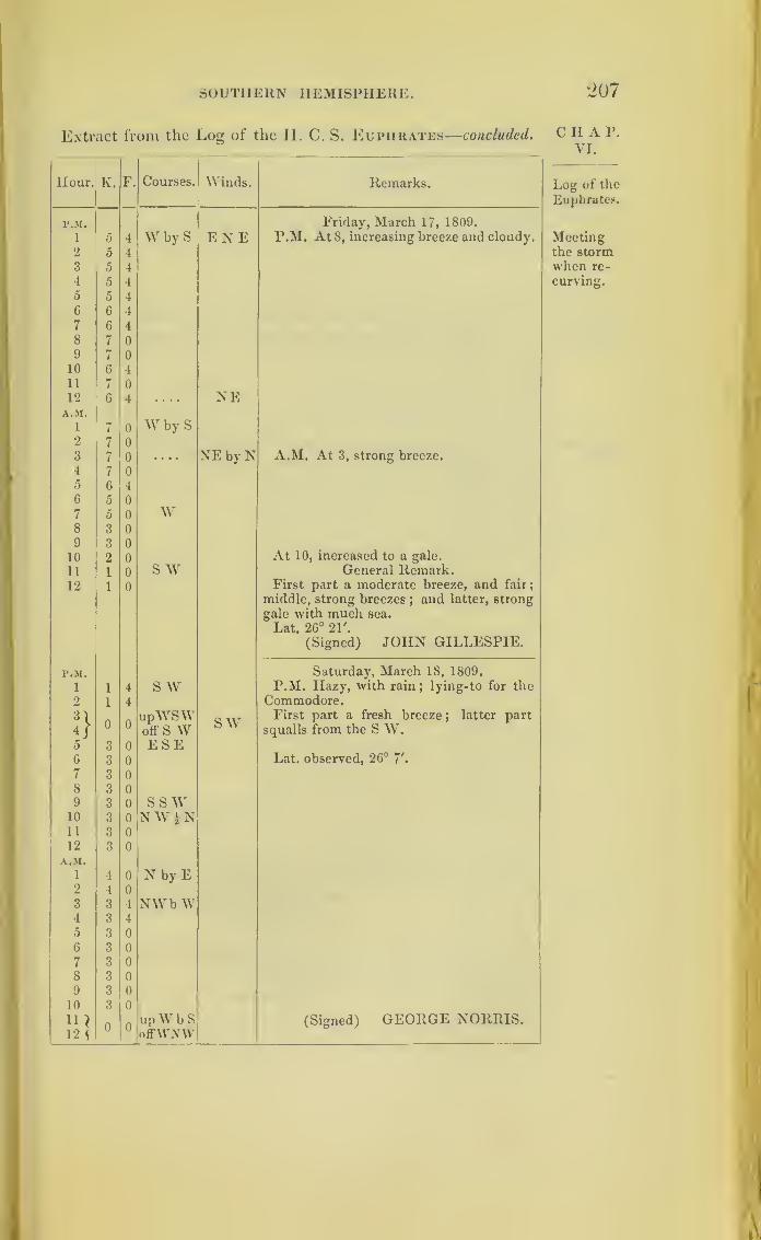
SOUTHERN HEMISPHERE. 207
Extract from the Log of the II. C. S. Euphrates—concluded.
Hour. K. F. Courses. Winds. Remarks.
F.M. Friday, March 17, 1809.
1 5 4 W by S ENE P.M. At 8, increasing breeze and cloudy.
2 5 43 5 4
4 5 4
5 5 4
6 6 4
7 6 4
8 7 0
9 7 0
10 6 4
11 7 0
12 6 4 .... NEA.M.
1 7 0 W by S2 7 0
3 7 0 • • • • NrE by N A.M. At 3, strong breeze.
4 7 0
5 6 4
6 5 0
7 0 0 W8 3 0
9 3 0
10 2 0 At 10, increased to a gale.
11 1 0 s w General Remark.12 1 0 First part a moderate breeze, and fair;
middle, strong breezes;and latter, strong
gale with much sea.
Lat. 26° 21'.
(Signed) JOHN GILLESPIE.
P.M. Saturday, March 18, 1809.
i 1 4 s w P.M. Hazy, with rain;lying-to for the
2 1 4 Commodore.
3\ 0 0upWSW SW First part a fresh breeze ; latter part
4/ off S W squalls from the S W.5 3 0 ESE6 3 0 Lat. observed, 26° 7'.
7 3 0
8 3 09 3 0 SSW10 3 0 NW i N11 3 0
12 3 0
A.M.
1 4 0 N by E2 4 0
3 3 4 NWb W4 3 l
5 3 0
6 3 0
7 3 0
8 3 0
9 3 0
10 3 0
11 ) 0 0upWbS (Signed) GEORGE NORRIS.
12 \ offVViWV
C n A P.
VI.
Log of the
Euphrates.
Meetingthe stormwhen re-
curving.
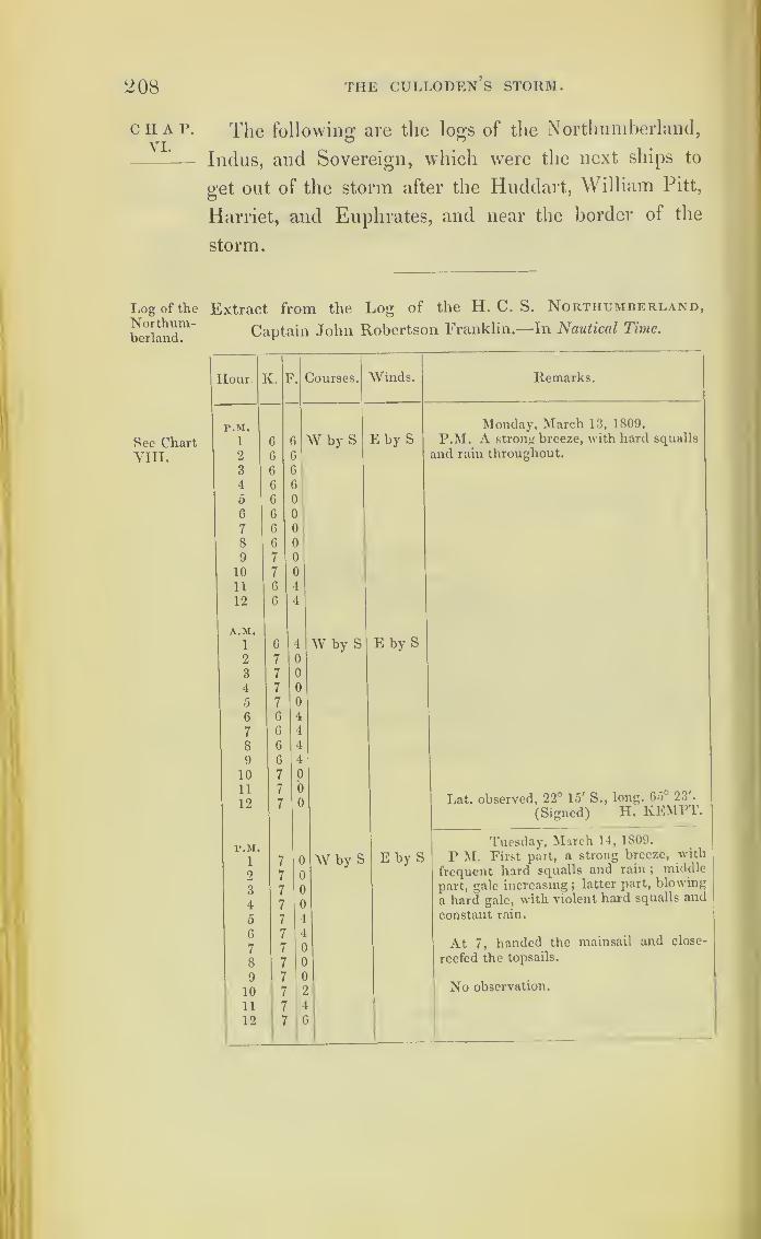
208 THE CULLODEN S STORM.
CHAP.VI.
Log of theNorthum-berland.
See ChartVIII.
The following are the logs of the Northumberland,
Indus, and Sovereign, which were the next ships to
get out of the storm after the Huddart, William Pitt,
Harriet, and Euphrates, and near the border of the
storm.
Extract from the Log of the H. C. S. Northumberland,
Captain John Robertson Franklin.—In Nautical Time.
Hour'
v. F. Courses. Winds. Remarks.
P.M. Monday, March 13, 1809.
1 6 6 W by S E by S P.M. A strong breeze, with hard squalls
2 6 6 and rain throughout.
3 6 6
4 G 6
5 6 0
6 6 0
7 6 0
8 6 0
9 7 0
10 7 0
11 6 4
12 6 4
A.M.
1 6 4 W by S E by S2 7 C
3 7 C
4 7 C
5 7 f
6 6 4
7 6 1
8 6 L
9 6 !
10 7 1
11*
I 97
7
)
3 Lat. observed, 22° 15' S., long. 65c 23'.
(Signed) H. KEMPT.
Tuesday, March 14, 1809.
i 7 0 W by S E by S P M. First part, a strong breeze, with
2 7 0 frequent hard squalls and rain ;middle
3 7 0 part, gale increasing ;latter part, blowing
4 7 0 a hard gale, with violent hard squalls and
5 7 4 constant rain.
6
7
7
7
4
o At 7, handed the mainsail and close-
8 7 0 reefed the topsails.
9
10
7
7
0
2 No observation.
11 7 4
12 7 G
1
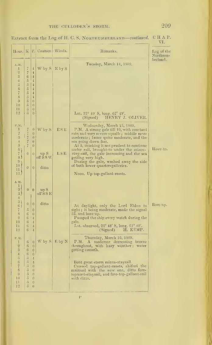
THE CULLODEN’S STORM. 209
Extract from the Locr of H. C. S. Northumberland—continued. CHAP.VI.
Hour. K F. Courses Winds. Remarks. Log of the
Northum-berland.
A.M. Tuesday, March 14, 1809.
1 7 4 VV by S E by S2 7 4
3 G 4
4 5 4
5 5 4
6 5 4
7 5 4
8 5 4
9 5 0
10 5 0
11 5 0
12 0 0 Lat. 22° 49' S, long. G2° 49'.
(Signed) HENRY J. OLIVER.
P.M. Wednesday, March 15, 1809.1 7 0 W by S ESE P.M. A strong gale till 10, with constant2 7 0 rain and very severe squalls ; middle more3 7 0 moderate
;latter quite moderate, and the
4 7 0 sea going down fast.
5 7 0 At 5, thinking it not prudent to continueHove-to.6
)under sail, brought-to under the mizen-
7 0 0 up S ESE stay-sail, the gale increasing and the sea
8) off SSW getting very high.
9\ During the gale, washed away the side10
n(
0 0 dittoof both lower quarter-galleries.
12/ Noon. Up top- gallant-masts.
A M.
1)2 0 0 up S3)4
off S S E
n0J
0 0 ditto At daylight, only the Lord Eldon in Bore up.
7 0 0 sight;
it being moderate, made the signal
8 6 0 53, and bore up.9 6 4 Pumped the ship every watch during the
10 6 4 gale.
11 6 4 Lat. observed, 23° 48' S, long. 61° 40'.
12 6 4 (Signed) Id. KEMP.
P.M. Thursday, March 16, 1809.
1 6 0 W by S E by N P.M. A moderate decreasing breeze0 6 0 throughout, with hazy weather ;
water
3 6 0 getting smooth.4 G 0
5 5 4
6 5 4 Bent great storm mizen-staysail.
7 5 0 Crossed top-gallant-masts, shifted the
8 5 0 mainsail with the new one, ditto fore-
9 0 0 topmast-staysail, and fore-top-gallant-sail
10 5 0 with ditto.
11 5 0
12 5 0
v
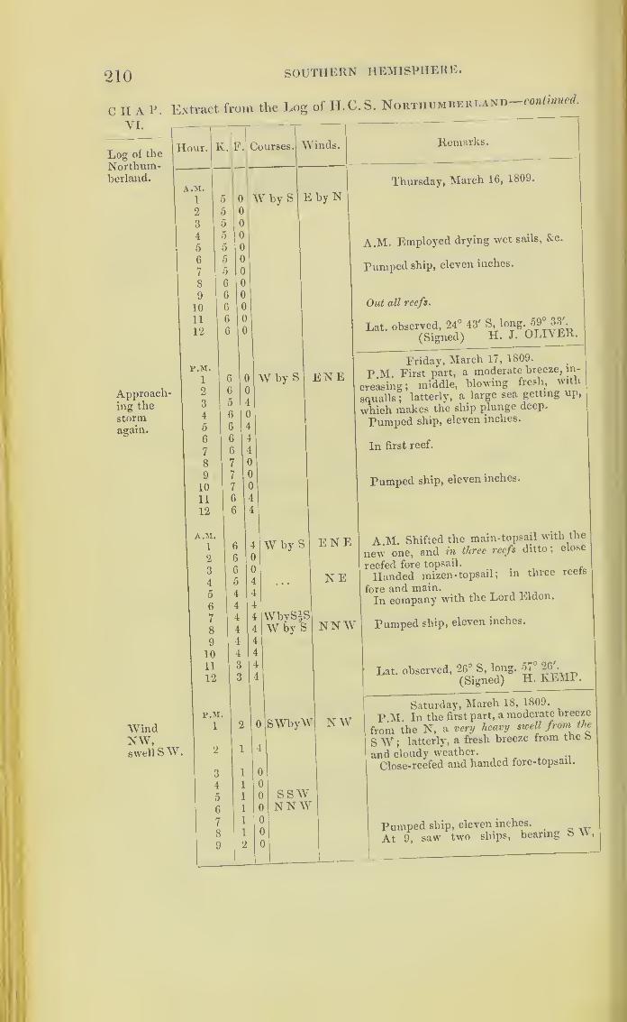
210 SOUTHERN HEMISPHERE.
C H A P. Extract from the Log of H.C.S. Northumberland—continued.
VI.
Log of the
Northum-berland.
Approach-ing the
stormagain.
WindNW,swell SW.
Remarks.
Thursday, March 16, 1809.
A.M. Employed drying wet sails, &c.
Pumped ship, eleven inches.
Out all reefs.
Lat. observed, 24° 43' ^iong. 59° 33'.
(Signed) H. J. OLIVER.
Friday, March 17, 1809.
P.M. First part, a moderate breeze, in-
creasing; middle, blowing fresh, with
squalls ;latterly, a large sea getting up,
which makes the ship plunge deep.
Pumped ship, eleven inches.
In first reef.
Pumped ship, eleven inches.
A.M. Shifted the main-topsail with the
new one, and in three reefs ditto; close
reefed fore topsail. ...Handed mizen - topsail ;
in three reefs
fore and main.
In company with the Lord Eldon.
Pumped ship, eleven inches.
Lat. observed, 26° S, long. 57° 26'.
(Signed) H. KEMP.
Saturday, March 18, 1809.
P.M. In the first part, a moderate breeze
from the N, a very heavy swell from the
SW ;latterly, a fresh breeze from the &
and cloudy weather.
Close-reefed and handed fore-topsail.
Pumped ship, eleven inches.
At 9, saw two ships, bearing S W,

SOUTHERN HEMISPHERE. 211
Extract from the Log of H.C.S. Northumberland— continued.
Hour.
•
K. F. Courses. Winds. Remarks.
P.M. Saturday, March 18, 1809.
10 2 4 NNE NW standing to the southward ;supposing
11 2 4 SEby S them to be part of our fleet, bore up and12 3 4 made the signal to speak; the command-
ing officer spoke them at midnight; they
proved to be the Indus and Sovereign
;
made the signal to wear.A.M.
i 2 0 A.M. Scraped and cleansed ship below.
2 2 4
3 3 0 WNW SWbS Out third reefs.
4 3 4
5 3 4
6 3 6 Pumped ship, eleven inches.
7 4 0
8 4 2
9 5 0
10 5 4 Out second reefs.
11 5 4 W by N In company with the Lord Eldon, Sove-reign, and Indus.
12 5 4 Lat. (by indiff. obs.) 25° 45' S, long. 56°44'.
(Signed) H. J. OLIVER.
P.M. Sunday, March 19, 1809.
1 6 6 W by N ssw P.M. A fresh breeze, with squalls and2 7 0 rain in the first part
;latter, moderate.
3 7 0
4 6 4 . . . . S by E5 6 0
6 6 0
7 6 0 Signal to steer W.8 6 0
9 6 0
10 6 0
11 6 0
12 6 0
A.M.
1 6 0 W by N S by E A.M. The Sovereign informed us that,
2 5 4 having leaked and laboured so much3 5 4 during the gale, she was under the neces-4 5 4 sity of throwing overboard saltpetre.
5 5 0
6 4 4 At daylight, the Lord Eldon and Indus7
8
9
4.i
4
4
just in sight, astern;shortened sail.
4 4
10 4 o
11 4 0
12 o 0 Noon. Wore and stood towards the Indus.Lat. observed, 26° 2' S.
(Signed) H. KEMP.
> O
CHAP.YI.
Log of the
Northum-berland.
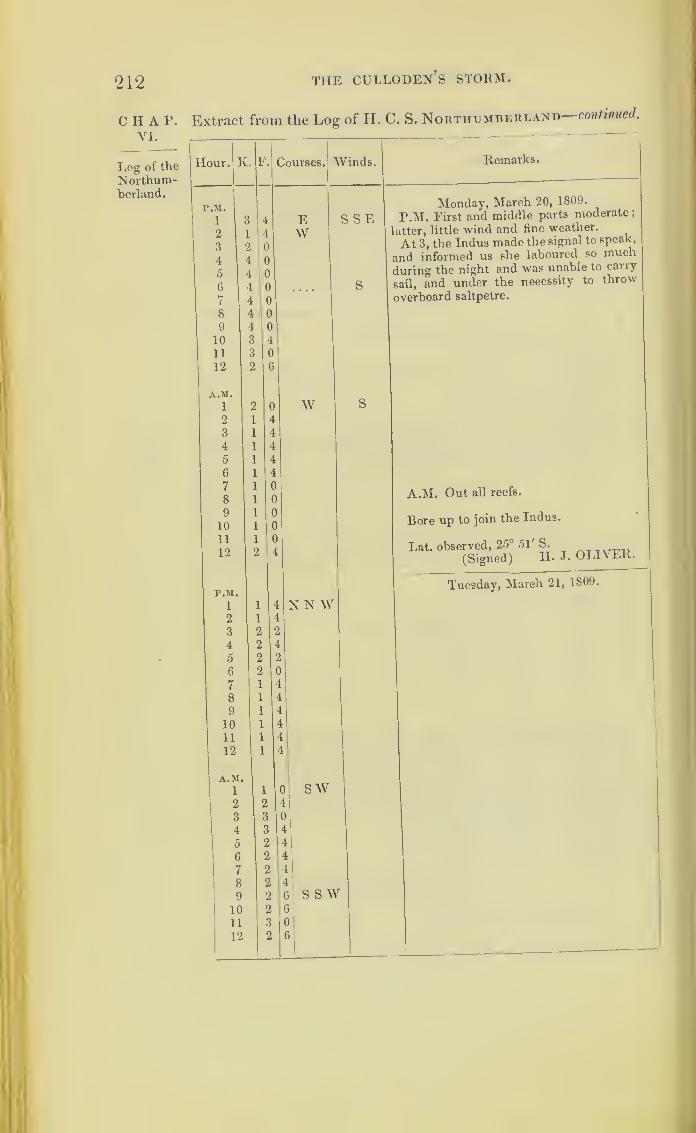
212 THE CULLODEN’S STORM.
CHAP. Extract from the Log of H. C. S. Northumberland continued.
VI.
Log of the Hour.
Northum-berland.
Remarks.
Monday, March 20, 1809.
P.M. First and middle parts moderate ;
latter, little wind and fine weather.
At 3, the Indus made the signal to speak,
and informed us she laboured so much
during the night and was unable to carry
sail, and under the necessity to throw
overboard saltpetre.
A.M. Out all reefs.
Bore up to join the Indus.
Lat. observed, 25° 51' S. ___(Signed) H. J. OLIVER.
Tuesday, March 21, 1809.
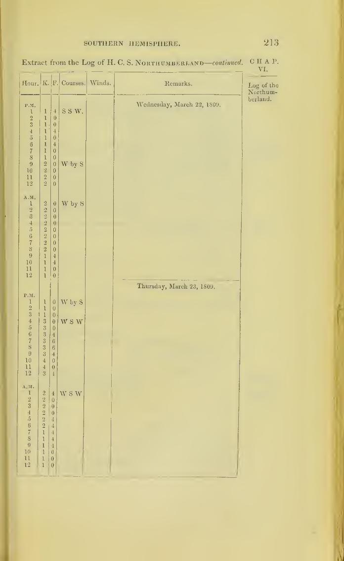
SOUTHERN HEMISPHERE 213
Extract from the Log of H. C. S. Northumberland—continued.
Hour. K. F Courses Winds. Remarks.
r.M. Wednesday, March 22, 1809.
1 1 4 S S W.2 1 0
3 1 04 1 l
5 1 0
6 1 l
7 1 0
8 1 0
9 2 0 W by S10 2 011 2 0
12 2 0
A.M.
1 2 0 W by S2 2 0
3 2 00
4 2 0
5 2 0
6 2 o
7 2 i)
8 2 0
9 1 410 1 411 1 0
12 1 0
Thursday, March 23, 1809.
P.M.
i 1 0 W by S2 1 0
3 1 0
4 3 0 \V S W5 3 0
6 3 4
7 3 6
8 3 6
9 3 4
10 4 0
11 4 0
12 3 4
A.M.
1 2 4 W S w2 2 0
3 2 0
4 2 0
5 2 4
6 2 4
7 1 4
8 1 4
9 1 4
10 1 0
11 1 0
12 1 0
CHAP.VI.
Log of the
Northum-berland.
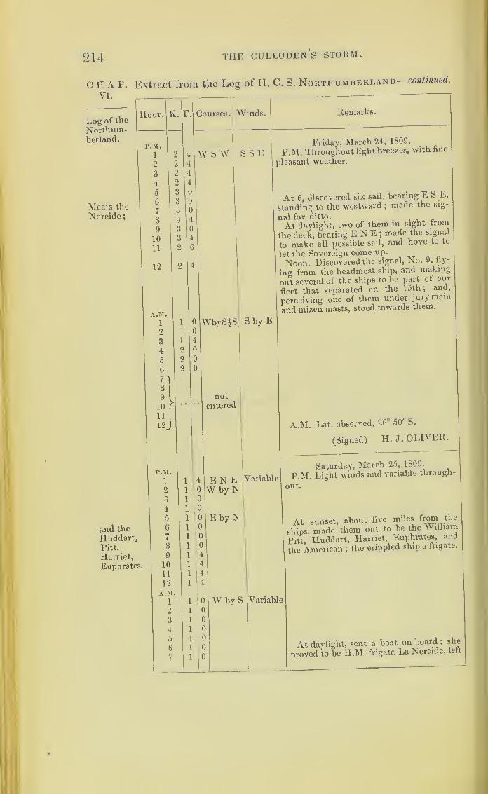
214 the culloden’s storm.
C II A P. Extract from the Log of H. C,
VI.
S. Northumberland
—
continued.
Log of the
Northum-berland.
'Meets the
Nereide
;
Hour. K.
And the
Huddart,Pitt,
Harriet,
Euphrates.
r.M.
1
2
3
4
5
6
7
8
9
10
11
12
A.M.
1
2
3
4
6
6
718
|
10(
11I
12J
P.M.
1
2oO
4
5
G
7
8
9
10
11
12
A.M.1
2
3
4
5
6
7
Courses. Winds. Remarks.
W S W S S E
WbySJS
Friday, March 24, 1809.
P.M. Throughout light breezes, with fine
pleasant weather.
At 6, discovered six sail, bearing E S E,
standing to the westward ;made the sig-
nal for ditto.,
At daylight, two of them in sight iroin
the deck, bearing ENE; made the signal
to make all possible sail, and hove-to to
let the Sovereign come up.
Noon. Discovered the signal, No. 9, fly-
ing from the headmost ship, and making
out several of the ships to be part ol our
fleet that separated on the 15th; and,
perceiving one of them under jury main
and mizen masts, stood towards them.
notentered
S by E
ENE Variable
W by N
E by N;
A.M. Lat. observed, 26° 50' S.
(Signed) H. J. OLIVER.
Saturday, March 25, 1809.
P.M. Light winds and variable through-
out.
At sunset, about five miles from the
ships, made them out to be the William
Pitt, Huddart, Harriet, Euphrates, and
the American ;the crippled ship a frigate.
0 W by S0
0
0
0
0
0
Variable
At daylight, sent a boat on board ;she
proved to be H.M. frigate La Nereide, left
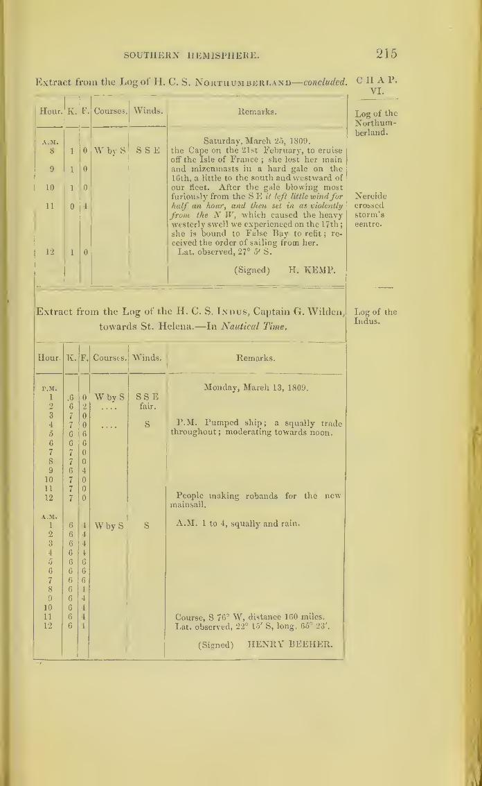
SOUTHERN HEMISPHERE. 215
Extract from the Log of H. C. S. Northumberland—concluded.
Hour. K. F. Courses. Winds. Remarks.
A.M.
8
9
10
11
12
1
1
1
0
1
0
0
0
4
0
W by S S S ESaturday, March 25, 1809.
the Cape on the 21st February, to cruise
off the Isle of France;she lost her main
and mizeninasts in a hard gale on the
16th, a little to the south and westward of
our fleet. After the gale blowing mostfuriously from the S E it left little windforhalf an hour, and then set in as violently
from the N W, which caused the heavyAvesterly swell we experienced on the 17th;
she is bound to False Bay to refit ; re-
ceived the order of sailing from her.
Lat. observed, 27° o' S.
(Signed) H. KEMP.
Extract from the Log of the H. C. S. Indus, Captain G. Wildcn,
towards St. Helena.—In Nautical Time.
Hour. K. F. Courses. Winds. Remarks.
P.M. Monday, March 13, 1809.
1 .6 0 W by S SS E2 6 2 .... fair.
3 7 0
4 7 0 S P.M. Pumped ship; a squally trade
5 6 6 throughout; moderating towards noon.
6 6 6
7 7 0
8 7 0
9 6 4
10 7 011 7 0
12 7 0 People making robands for the newmainsail.
A.M.
1 6 4 W by S S A.M. 1 to 4, squally and rain.
2 6 4
3 6 1
4 6 4
5 6 6
6 6 G
7 6 6
8 6 4
9 6 4
10 6 4
11 6 4 Course, S 76° W, distance 160 miles.
12 6 4 Lat. observed, 22° 15' S, long. 65° 23'.
(Signed) HENRY BEEHER.
CHA P.
VI.
Log of the
Northum-berland.
Nereidecrossed
storm’scentre.
Log of the
Indus.

216 THE CULLODEN’S STORM.
CHAP.VI.
Log of the
Indus.
Lightenedship.
Hurri-cane
on the
horde! of
storm.
Extract from the Log of the H. C. S. Indus—continued.
Hour.
p.m.
1
2
3
4
5
6
7
8
9
10
11
12
A.M.
1
2
3
4
5
6
7
Iv.
10
11
12
F. Courses
WbvS
Winds.
ESbyS
Remarks.
WN W
w
W by S
squally
andrain.
9
10
11
12
P.M.
1
ditto
WS W
S W
S byWE
Tuesday, March 14, 1809.
P.M. At 3, squally; first and middle
parts, a fresh trade, with frequent squalls
and rain ;latter, increasing to a gale, with
a very heavy sea.
Pumped ship.
Handed the mizen-topsail.
At 10, the ship labouring very much,
hove overboard two 6- pounder guns, two
kedge and one stream anchor, and all the
lumber of the forecastle, to ease the ship.
Pumped ship ;Commodore not in sight.
A.M. At 6, set the main-topsail, sent
down top- gallant-yards, & struck the masts,
close-reefed the fore and main topsails.
Furled the fore-topsail and mainsail, and
reefed the foresail ;in setting it, it split
;
furled it ;got in the jib and driver booms.
Three ships in sight.
The sea running very high, and making
a fair breach over us.
Course, S 71°, W, distance, 146 miles.
Lat. observed, 22° 55', long. 63' 9'.
(Signed) T. W. ALDIIAM.
SbyEWednesday, March 15, 1809.
P.M. The ship" labouring so extremely
as seriously to endanger the ***•*, and
having much water below decks.
At 4, hove overboard 300 bags of salt-
petre, it then blowing a hurricane ;two
ships in sight.
Heavy gale.
General Remarks.
First and middle parts, a fresh gale and
rain at times ;latter more moderate
;
towards noon a pleasant breeze. These
twenty-four hours the ship labouring
much, shipped a great deal of water, and
kept the bilge-pump going all night.
Pumped ship every two hours.

SOUTHERN HEMISPHERE. 217
Extract from the Log of the II. C. S. Indus—continued.
Hour. K F. Courses. Winds. Remarks.
A.M. Wednesday, March 15, 1809.
At daylight saw the Sovereign bearing1 2 4 S byW EENE; at 10 a.m. joined her.
2 2 4 A.M. At 2, the yawl was washed away3 3 0 from the starboard quarter.
4 3 0 Set the fore and mizen topsails close-
0 3 0 reefed, and foresail.
6 3 4 W by N7 4 4
8 4 4
9 4 0
10 4 0 W11 4 4
12 4 0 Noon. Out third and fourth reefs of fore
and main- topsails.
Course, S W 74°, distance 74 miles.
Lat. observed, 23° 37', long. 62° 12'.
(Signed) 11. BEEHER.
r.M. Thursday, March 10, 1809.
i 4 6 W N W N E by E P.M. Cloudy; a pleasant breeze andfine weather throughout.2 5 0
3 5 4
4 5 6
5 5 4
6 5 4 W JS7 0 0 Pumped ship.
8 5 0 w9 0 2 Found the rigging very much damaged,
10 5 4 and the sails in the sail-room wet.
11 5 4
12 5 4
A.M. A.M. Out all reefs of topsails, and lidded
l 5 4 top-gallant-masts;
loosed all sails to dry.
2 0 4
3
4
5
5
4
4 Swayed up the top-gallant-yards, and
4 out all reefs clear.
6 5 4 The Sovereign in company;
7 5 4
8 5 4
9 6 0
10 6 4
11 6 4
12 6 1
Course, W 74° S, distance 133 miles.
Lat. observed, 24° 4' S, long. 59° 50'.
(Signed) T. W. ALDIIAM.
Friday, March 17, 1S09.
r.M.
i 0 W4S ENE P.M. Moderate and fair.
2 0
3 0
4 0
CHAP.VI.
Log of the
Indus.
Loosedsails.

‘218 TIIE CULLODEn’s STORM.
Extract from tlie Log of the H. C. S. Indus continued.CHAP.VL
Log of the
Indus.
Meetingthe stormrecurring.
Hour.
P.M.
5
6
7
8
9
10
11
12
A.M.1
2
3
4
5
6
7
8
9
10
11
12
P.M.
1
2
3
4
5
6
7
8
9
10
11
10
A.M.1
2
3
4
5
6
7
8
9
10
11
12
K. Courses.
5
5
5
5
5
5
5
5
WjS
Winds.
EN E
Remarks.
5
5
6
5
5
5
5
5
5
5
5
5
W by S Variable
W sW ditto
S WbW
W N W
3
3
3
3
3
3
2
2
2
2
2
2
2
2
4
4
4
4
4
4
4
4
4
4
SWss wS by W
Friday, March 17, 1809.
Lightning in the N W
.
In first reefs of topsails.
Pumped ship.
First part, moderate and fair ;middle,
cloudy, with light passing clouds and vari-
able;
latter, a fresh breeze, with a N Wstvell. The ship labouring much, rolling
very heavy, and shipping a great quantity
of water throughout.
A.M. Cloudy, and small rain.
Pumped ship.
Course, S VV, distance 128 miles.
Lat. observed, 25° 29' S, tong. 5/ 53 .
(Signed) H. BEEHER.
Variable
NWbNNNWWNW
W by N
Saturday, March 18, 1809.
P.M. Cloudy.
Pumped ship.
In second and third reefs of fore-topsail,
and two ditto main.
Saw two strange sail.
First and middle parts, a moderate breeze
and variable ;latter, pleasant breeze, with
passing showers., „ P
A.M. At 1, joined company the ii.u.
ships Northumberland and Lord Eldon.
First part, a heavy swell, the ship
labouring very much.
Course, S 66° W, distance 76 miles.
Lat. observed, 26° 43' S.
(Signed) T. W. ALDIIAM.
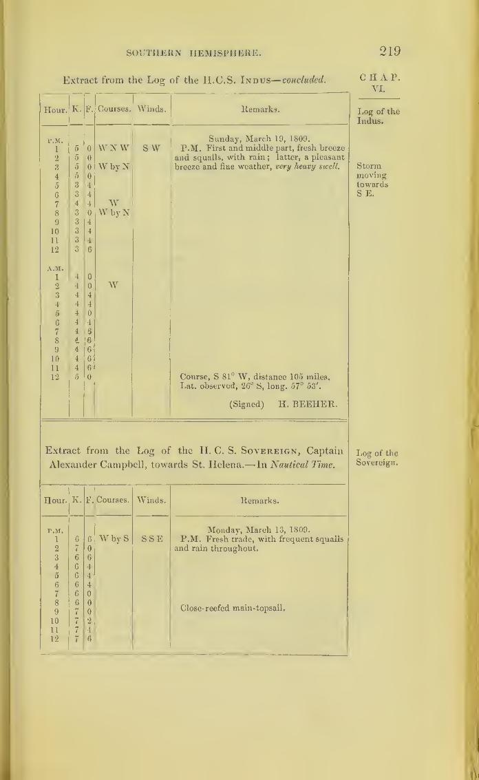
SOUTHERN HEMISPHERE. 219
Extract from the Log of the H.C.S. Indus— concluded.
Hour. K. F. Courses. Winds. Remarks.
r.M. Sunday, March 19, 1809.
i 5 0 W N W S W P.M. First and middle part, fresh breeze
2 5 0 and squalls, with rain ; latter, a pleasant
breeze and fine weather, very heavy swell.3 5 0 W by N4 5 0
5 3 4
6 3 4
7 4 4 W8 3 0 W by N9 3 4
10 3 4
11 3 4
12 3 6
A.M.
1 4 0
2 4 0 W3 4 4
4 4 4
5 4 0
6 4 4
7 4 6
8 J 6
9 4 6
10 4 6
11 4 6
12 5 0 Course, S 81° W, distance 105 miles.
Lat. observed, 26° S, long. 67° 53'.
(Signed) H. BEEIIER.
Extract from the Log of the LI. C. S. Sovereign, Captain
Alexander Campbell, towards St. Helena.—In Nautical Time.
Hour. K. F. Courses. Winds. Remarks.
r.M. Monday, March 13, 1809.
P.M. Fresh trade, with frequent squalls1 6 6 W by S SSE2 7 0 and rain throughout.3 6 6
4 6 4
5 6 4
6 6 4
7 6 0
8
9
6
7
0
0Close- reefed main-topsail.
10 7 2
11 7 4
12 7 6
C H A P.
VI.
Log of the
Indus.
StormmovingtowardsS E.
Log of the
Sovereign.

220 T11E culloden’s storm.
CHAP.YI.
Log of the
Sovereign.
Extract from the Log of the II.C.S. Sovereign— continued.
Hour. 1 C. F. Courses. Winds. Remarks.
A.M.Monday, March 13, 1809.
1 7 4 W by S SSE A.M. At 1, shifted the fore-topmast stay-
2 7 4 sail, with a new one;sailmaker repairing
3 7 4 the fore-topmast staysail that was split.
4 7 4
5 6 4
6 6 4
7 7 0
8 7 0
9 6 6
10 4 0
Pumped ship every four hours.11 6 6
12 7 0
Lat. observed, 22° 18' S.
(Signed) JOHN FREEMAN.
r.M.
1
1 Tuesday, March 14, 1809.
7 4 W by S S by E P.M. First and middle parts, strong
breezes, with squalls and rain;latter part,
a fresh gale, with hard squalls and rain;
ship rolling very much, and shipped a
great deal of water over all and through
the ports, her top side working very much.
2 7 Out fourth reef main-topsail.
3 7 l Struck mizen top-gallant-mast, handed
4 7 mainsail.
5
6
6
6 S Squally and rain;
close-reefed main-
7 6 6 topsail.
8 7 0
9 7 4
10 7 4
11 7 4
12 7 4
A.M.
1
o
7 4. A.M. Admiral burnt a blue light;i
7 4 handed mainsail.
3 7 0SE4
5
7
7
4
4 Squally, with rain; reefed the foresail.
6 7 0
7
8
6
6
6
4 Handed the fore-topsail.
9
10
11
6
0
0
0 At 10, a heavy sea struck the larboard
3 0 quarter- gallery and stove it in ;got it se-
cured before much water got in ;down
top-gallant-yards, and struck the masts.
Pumped ship every hour during the last
twenty-four hours ;latterly, constantly at
the pumps.
12 3 0 Noon. Only three ships in sight.
No observation.(Signed) N. BENI.

SOUTHERN HEMISPHERE. 221
Extract from the Log of the H. C. S. Sovereign—continued.
Hour. K. F. Courses. Winds. Remarks.
P.M. Wednesday, March 15, 1809.
1l
2 0 up SW ESE P.M. Hard gales, with rain in the first
21 2 0 offW and middle parts; latter, more moderate3
|
3 0 up S off and fine weather.41 2 0 sw Ship pitching, rolling, and straining very5 1 4 up S b E much; carried away the headrails, and6 1 1 oft S b W washed away the waist bulwarks
;making
7 1 4 up S S E a great deal of water ;hands constantly at
the pumps;a great deal of water on the
8j
1 1 5 E oft
S by E1 1 gun-deck.
9] 1 4
upSENEbyN
10 1 4
11i
1 4 off S b E12 1 4
A.M.
1 \ 1 4 At daylight, one ship in sight, which2 \ 1 4 upSEbE proved to be the Indus.
3 (1 1 offSEbS
4 / 1 0
M 1 0 upSEbE61 1 0 offSEbS7 4 0
8 4 4 w sw9 4 4
10 5 0 W by S11 5 0
12 5 0 Noon. In company with the Indus.
Lat. observed, 23° 54' S.
(Signed) JOHN FREEMAN.
P.M. Thursday, March 16, 1S09.
i 5 0 WNW NE P.M. Pleasant breezes and fair weather
0
throughout; got the jib-boom out and set
the jib.
2 6 Set mizen-topsail.3 5 4 NWbW4 5 0
5 5 4 WNW6 5 4
7 5 4
8 5 0
9 0 0 W10 0 2
11 5 4
12 5 4
A.M.
1 5 4 A.M. Swayed the top -gallant-masts an
2 5 4 end, and crossed the yards ; out reef of
3 5 4 foresail, and third and fourth reef main4 5 4 and fourth ditto fore topsails
; set the
5 5 0 mainsail, and loosed small sails to dry.
Pumped ship every half hour.
CHAP.VI.
Log of the
Sovereign.
On port
tack,
comingup,
andgetting
out of
storm.
Loosedsmallsails.

222 the culloden’s storm.
Extract from the Log of the H.C.S. Sovereign continued.C H A P.
VI.
Log of the
Sovereign.
Meetingthe stormrecurring.
Hour. K. F. Courses.
A.M.
6
7
8
9
1011
12
r.M.
1
2
3
4
Winds.
6
7
8
9
10
11
12
A.M.1
2
3
4
5
6
7
8
9
10
11
12
r.M.
1
2
3
4
5
6
7
5
55
6
5
5
4
5
6
6
6
6
W NE
W a S NE
SW bW
SW
SWSSW
Remarks.
Thursday, March 16, 1809.
Lat. observed, 24° 7' S.
(Signed) N. BENT.
Friday, March 17, 1809.
P.M. Moderate breeze and cloudy wea-
ther, with a heavy head sea ;on ship
pitching bowsprit and spritsail-yard in,
got the jib-boom and spritsail-yard in
;
hands constantly at the pumps; found
the water gaining on the pumps ;came to
the determination (by the advice of myofficers and petty officers) of throwing
overboard some dead weight from forward ;
employed clearing away to the saltpetre ;
threw overboard sixty bags ;informed the
Indus per telegraph that we could not
carry sail on that account.
In third reef main-topsail, and reefed the
foresail.
A.M. At 2, close-reefed fore-topsail.
W by NCloudy.
Out fourth reef fore and third ditto
main topsail.
T *rt observed, 25° 30 S.
(Signed) JOHN FREEMAN,A. CAMPBELL.
Saturday, March 18, 1809.
P.M. Moderate breezes, cloudy weather,
with a very heavy head sea.
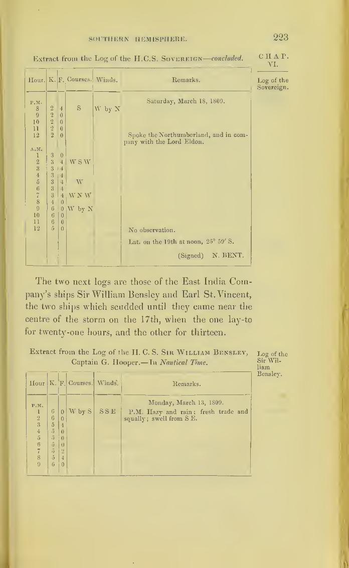
S< )UTI IERN IIEMISPHERE. 223
Extract from the Log of the II.C.S. Sovereign—concluded.
Hour. K. F. Courses. Winds. Remarks.
P.M. Saturday, March 18, 1809.
8 2 4 S W by N9 2 0
10 2 0
11 2 0
12 2 0 Spoke the Northumberland, and in com-pany with the Lord Eldon.
A.M.1 3 0
2 3 4 wsw3 3 1
4 3 4
5 3 4 w6 3 4
7 3 4 W NW8 4 09 6 0 W by N10 6 0
11 6 0
12 5 0 No observation.
Lat. on the 19th at noon, 25° 59' S.
(Signed) N. BENT.
CIIA P.VI.
Log of the
Sovereign.
The two next loos are those of the East India Com-©
pany’s ships Sir William Bensley and Earl St. Vincent,
the two ships which scudded until they came near the
centre of the storm on the 17th, when the one lay-to
for twenty-one hours, and the other for thirteen.
Extract from the Log of the H. C. S. Sir William Bensley,
Captain G. Hooper.— In Nautical Time.
Hour K. F. Courses. Winds'. Remarks.
P.M. Monday, March 13, 1809.
1 6 0 W by S SSE P.M. Hazy and rain ; fresh trade and2 6 0 squally
;swell from S E.
3 5 4
4 5 0
5 5 0
6 5 07 5 2
8 5 4
9 6 i)
Log of theSir Wil-liamBensley.
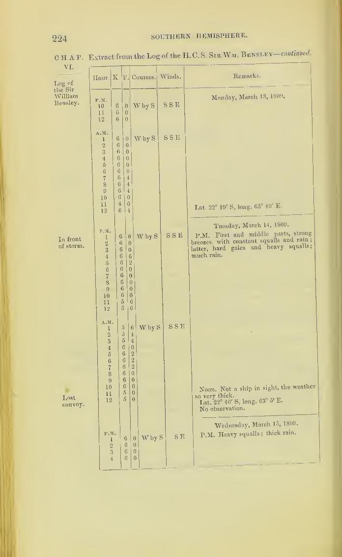
224 SOUTHERN HEMISPHERE.
CIIAP. Extract from the Log of the II. C. S. Sir Wm. Bensley-continued.
YI.
Log of
the Sir
WilliamBensley.
In front
of storm.
Lostconvoy.
Hour. K. F.
r.M.
10
11
12
A.M.
1
2
3
4
5
6
7
8
9
10
11
12
P.M.
1
2
3
4
5
6
7
8
9
10
11
12
A.M.
1
2
3
4
5
6
7
8
9
10
11
12
r.M.
1
2
3
4
Courses.
W by S
W by S
Winds. Remarks
SSE
SSE
Monday, March 13, 1809.
W by S SSE
Lat. 22° 19' S, long. 65° 40' E.
W by S
W by S
Tuesday, March 14, 1809.
P.M. First and middle parts, strong
breezes with constant squalls and rain ;
latter, hard gales and heavy squalls;
much rain.
SSE
Noon. Not a ship in sight, the weather
so very thick. . _Lat. *22° 46' S, long. 63 5 E.
No observation.
SE
Wednesday, March 15, 1809.
P.M. Heavy squalls ;thick rain.

SOUTHERN HEMISPHERE. 225
Extract from the Log of the H.C.S. Sir Wm. Bensley—continued.
Hour. K. F. Courses Winds. Remarks.
PM. Wednesday, March 15, 1809.
e}5 0 W S W SE Heavy gales.
7 5 0
8 5 0
9 4 6
10 4 6 I
11
12
4 6 Violent squalls.
4 4 )
A.M.
1 4 4 w s w SE i A.M. Ditto.2 4 4 )
3 4 4
4 4 0
5 4 4
6 4 4
7 4 4E8 4 4
O A 4
0
More moderate.
10 5Set the fore-topsail, and bent the fore-
11
12
6
5
0
0
sail.
Set the mizen-topsail.
Lat. 24° 26' S, long. 60° 30' E.
P.M.
1
Thursday, March 16, 1809.
o 4 ws w E by N P.M. Fresh gales and cloudy weather in
2 4 the first part ; middle and latter, a con-
3 5 4 fused and heavy swell.
4 5 4
5 5 4
6 0 4
7 5 4
8 5 0
9 5 0
10 5 0
11 0 0
12 0 0
A.M.
1 5 0 w s w E by N2 5 0
3 5 0
4 0 0
5 5 0
6 5 4
7 •5 4
8 5 4
9 5 4
10 5 4
11 5 4
12 5 4 Noon. No ship in sight.
Lat. 25° 59’ S, long. 58° 10' E.
Q
CHAP.VI.
Log of
the Sir
WilliamBensley,
Stormrecurving.

226
CHAP.VI.
Log of
the Sir
WilliamHensley.
Centre of
storm nowWestof the
Bensley.
THE CULLODEN S STORM.
Extract from the Log of the II.C.S. Sir Wm. Bensley continued.
Hour. K. F. Courses. Winds.
ENE
EN E
NE
Remarks.
Friday, March 17, 1809.
P.M. Cloudy; first part, fresh breezes.
SWoff S bW
N
NNWNW
WN W
O
*1r I
0 o
0
S byWoff
S by E
-,
UP0 SWbyS0 offS
W by N
Midnight. Hard squalls and rain.
A.M. Lying-to, under bare poles.
Heavy hard squalls.
Middle and latter, heavy gales, with a
high sea; obliged to throw twelve guns
overboard.
No observation.
Lat. 26° 12' S, long. 56° 50' E.
0 0
4 SSE
Saturday, March 18, 1809.
P.M. Cloudy, and blowing strong.
SW
W by N
SbyW
11;
1
12 1
S W
Set the reefed mainsail.
First part, strong gales ;latter part,
moderate. No ship in sight.
No observation.
Long. 56° 20' E.

SOUTHERN HEMISPHERE. 227
Extract from the Log of the H.C.S. Sir Wm. Bensley—concluded.
Hour. K. F. Courses. Winds. Remarks.
P.M. Sunday, March 19, 1809.1 1 4 W by S S W2 1 4
3 1 6
4 1 65 1 6
6 1 6
7 1 6
8 1 6
9 1 6 W.JS
10 1 4
11 1 4
12 1 4
A.M.
1 2 0 WiS SW2 2 0
3 2 04 2 05 1 6
6 1 6
7 1 6
8 1 6 (This ship seems to have been separated9 1 6 W by S from the fleet, and saw no vessel till she
10 1 6 rounded the Cape of Good Hope.)11 1 6 W by N12 1 6 Latitude observed, 27° 24' S.
Extract from the Log of the H.C.S. Earl St. Vincent, Captain
John Brook Sampson, towards England.—In Nautical Time.
Hour. K. F. Courses. Winds. Remarks.
P.M. Monday, March 13, 1809.1 7 0 W byS SE P.M. Cloudy; throughout a strong2 7 0 trade, with frequent squalls and rain
;a
3 6 6 swell from the south-east.4 6 65 6 56 6 0
7 6 0
8 6 0
9 6 510 7 0
11 7 512 7 0
A.M.
1 7 4 A.M. Hard squalls and rains.
2 7 5
3 7 0
4 7 0
Q 2
CHAP.VI.
Log of
the Sir
WilliamBensley.
Log of theEarl St.
Vincent.

228 tiie culloden’s storm.
CHAP. Extract from the Log of the ILC.S. Earl St. Vincent continued
VI.
Log of the
Earl St.
Vincent.
Hour. K.
A.M.
5
6
7
8
9
10
11
12
p.m.
1
2
3
4
5
6
7
8
9
10
11
12
A.M.
1
23
4
5
6
7
8
9
10
11
12
P.M.
1
2
3
4
5
6
7
8
9
10
11
12
F Courses. Winds
W by S
W by S
SE
SE
W by S
wswW SwS WbWSWbW
Remarks.
Monday, March 13, 1809,
Lat. observed, 21° 19' S.
(Signed) ROBERT BROOKS.
SSE
Tuesday, March 14, 1809.
P.M. Squalls and rain ;first and middle
parts, a fresh trade ;latterly, hard gale,
variable at S and S E, with squalls, rain,
and a high sea, very thick the latter part
of the twenty-four hours.
A.M. At 5, handed mizen- topsail, and
close reefed main-topsail.
Down top-gallant-yards.
Handed fore-topsail.
Split main-topsail ;lost sight of the fleet.
No observation.(Signed) J. GTJMM.
SE
Wednesday, March 15, 1809.
P.M. Throughout strong gales, with
severe squalls and rain, a very high cross
sea, ship making six inches water per
hour, owing to her shipping many seas
;
pumped ship twice every watch.
Carried away the tiller-rope ;rove a new
one.

SOUTHERN HEMISPHERE. 229
Extract from the Log of the H.C.S. Earl St. Vincent— continued.
Hour. K. F Courses Winds. Remarks.
A.M. Wednesday, March 15, 1809.1 4 0 A.M. At daylight no ships in sight;2 4 6 S W ES E altered the course to west, suspecting the3 4 0 fleet to be to the north, as we had kept to4 6 0 the south during the night to ease the ship
;
5 5 0 W under a fore and reefed main-staysail these6 5 0 twenty- four hours.7 5 0 More moderate.8 5 0 Rain and squalls.9 5 0 No ships in sight.
10 6 011 6 5 Moderate.12 0 6 Lat. observed, 24° 19' S.
(Signed) ROBERT BROOKS.
P.M. Thursday, March 16, 1809.
i 6 0 W E by N P.M. Fresh wind throughout, and2 6 i) cloudy, with showers in the first and3 6 0 middle parts ; latterly fair.
4 0 0
5 6 5 No ships in sight.
6 6 6
7 7 0
8 7 0
9 7 0
10 7 0
11 7 0
12 7 0
A.M.
i 7 0
2 7 0
3 7 0
4 7 0
5 7 0
0 7 0
7 7 4 A.M. At 7, out two reefs in the main-8 7 4 topsail.
9 7 6
10 7 5
11 7 5
12 7 G Lat. 25° 27', long. 58° 13'.
P. M.W Friday, March 17, 1809.
1 / 6 ES E P.M. First part, strong breezes from the2 1 G eastward
; middle and latter, strong gales3 ) 6 from N E to N W, with severe squalls and
t7 G heavy rain; high cross sea ;
put the ship
c7
G
0
0under fore and main-staysails.
7 5 0
8 3 0 NEbvE9 3 0
10 3 0
C H A P.
VI.
Log of the
Earl St.
Vincent.

230
CHAT.VI.
Log of the
Earl St.
Vincent.
the culloden’s storm.
Extract from the Log of the H.C.S. Earl St. Vincent-concluded.
Hour. K. F.
P.M.
11
12
A.M.
1
2
3
4
5
6
7
8
9
10
11
12
P.M.
1
2
3
4
5
6
7
8
9
10
11
12
a.m.
1
2
3
4
5
6
7
8
9
10
11
12
Courses.
W
Winds.
NEbE
N
upWbNoff VVSWupWbSoff SW b
NupWNW
off SW
N W
upSWbW
ofFSSW
WN W
upSSWoff S
NWbNNWbN
W by S
SW b W
WNWW by NW
W by N
W by SW
ssw
Remarks.
Friday', March 17, 1809.
Lat. observed, 25° 9' S, long. 57° 3'.
Saturday, March 18, 1809.
P,M. Variable wind, and fresh breezes.
A.M. At daylight, saw a strange sail
bearingW N W ;made the private signal,
stranger proved to be the Terpsichore.
Lat. observed, 25° 51'.
(Signed) JAMES GUMM.
Memorandum.—The St. ^incent met
the Culloden again in lat. 28° 27', at 1 p. m
on the 28th March, 1809.
The documents explaining the Culloden’s storm end
here. The next log is that of the ship Boyne ;and is
placed here because the gale she experienced is also
marked on Chart \ III.

TI1E BOYNE S GALE. 231
Extract from the Log of the Ship Boyne, Captain William H. C HA 1\
Stockley, from Bombay towards London, and in the Mozam- ’
hique Channel} in lat. 15° 24' S., long. 4l c 30 E.—In Log of the
Nautical Time. Boyne.
Hour. Iv. F. Courses. Winds. Bar. L'her. Remarks.
F.M. 1 Sunday, Jan. 11, 1835.
i 4 0 sw & w N 30.00 83 P.M. First part, decreasing2 2 4 breeze from the N E ;
middle3 1 4 part, calm, with squalls and4 2 0 # . NE hard rain; light breeze and5 0 0 Calm squally from S W.6 0 0
9 2 0 S by E Squally.
Midn.A.M.
3 1 0 S4 1 4 W SW5 1 0 SbvE8 0 SSE SW
11 3 0 S by E Squally.
Lat. 17° 8' S, long. 40° 53' E.
P.M. Monday, Jan. 12, 1835.
i 1 4 ss W W 29.90 82 First part, thick, unsettled
9 4 SSE weather, with constant heavy
G 2 4 SW squalls from the SW ; middle
9 o o and latter part, fresh gales
from the southward and west-
Midn. 1 4 off SE ward, with squalls and heavy
A.M. rain, and a long swell from
2 1 4 N W the southward.Taken aback in a hard squall;
at daylight, down royal yards.
5 1 4 NW b N Bent the storm mizen, and
10 l 4 S by \V set it.
12 2 0 SWbySLat. 17° 11' S, long. 41° 7' E.
P.M. Tuesday, Jan. 13, 1835.
i 2 0 S SW W by N 29. 80 Eirst part, blowing hard
2 2 0 SW by S from the SW, with heavysqualls and rain ;
middle part,
continual heavy rain, with
vivid lightning and thunder,
and the wind shifting all
all round round; latter part, variable
-wind, with thick, unsettled
weather.
9 2 4 SW b WVariable Wind variable.
Midn 2 0
A.M.
6 2 0 W SW SSE9 2 0 W by S Variable Variable wind.
Noon Variable Wind variable.
1Lat. 17° 54' S, long. 40°46'
E
ChartVIII.
232 THE BOYNE’S GALE.
CHAP.VI.
Log of the
Boyne.
Extract from the Log of the Ship B0YN12 —continued.
Hour. K. 1\ Courses. AVinds. Bar. .'her. Remarks.
P.M. AVednesday, Jan. 14, 1835.
1 3 0 sW bW SSE 29. 0G Unsettled weather, with
squalls and hard rain.
5 5 0 AV SAV , • Blowing hard, and sea get-
10 2 0 SW b W S by E ting up.
A.M.9 2 0 W s AV SE8 2 0 SSE Blowing hard.
First part, variable, unsettled
weather, and hard rain ; mid-dle and latter part, blowing
heavy from the S S E.
Lat. 18° 20' S, long. 39° E.
P.M. Thursday, Jan. 15, 1835.
Blowing a hard gale, withl 2 0 SAV SE 29.05
squally weather and rain;hard
gales throughout from SSE.Midn.A.M.
1 0 S S AVHeadSW
to
W SAV
Ditto weather.
Lat. 18° 34', long. 38°.
P.M. Friday, Jan. 16, 1835.
29. 38 Heavy gale from the S S E,
with heavy gusts at 8 a.m. ;
barometer still falling, andHead fr.
AV S AV from 9 to noon the gale conti-
1 to to nued with increased force;at
1 4 SAV 10 a.m. the main-topsail went,
and left the ship under storm
mizen.Lat. 19° 5' SJkmg. 37° 12' E.
P.M. Saturday, Jan. 17, 1835.
HeadWSAV to
29. 07 AVind decreasing.
2 1 4 SAVG 2 0 s N Light breeze.
8 7 0 SSE AA'ind increasing, and draw-
ing to the N E.
MidnA.M.
2
6 0 Heavy gusts and hard rain.
First part, decreasing gale
;
8 0 S middle part, hard gale from
7 -1 4 S by E ENE theN E, with severe gusts and
heavy rain, and a high cross
sea; ship labouring much.Latter part, moderate breeze,
and hazv.
Lat. 21° 10' S, long. 37° 4'E.
P.M.Sunday, Jan. 18, 1835.
4 0 SbE^I1 E29. 9( Throughout, a fresh breeze
from the eastward ;and next
day a steady trade at E S E.
Lat. 23° 14' S, long. 37° 20' E.
233
The Albion's Hurricane,in Nocenibcr, 1808.
It is a prevailing opinion amongst seamen who na-
vigate the Indian seas, and it is stated in the minutes
of inquiry into the storms of 1808 and 1809, that hur-
ricanes are frequently avoided by ships steering on a
course so as to keep well to the eastward of Mauritius.
But the storm next to be described occurred in longi-
tude ninety degrees east, about thirty degrees to the
eastward of that island;and by the log of the Cullodcn
the ships under her convoy in 1808 were in long. 80° E.
when they felt the first indication of that hurricane
which has been just detailed.
The fleet under convoy of H M. S. the Albion, 74
guns, consisted of nine ships belonging to the H. E. I.
Company.
They sailed from Madras on October 5, 1808, had
crossed the equator, and were in lat. 5° south, and
long. 90°, when, on the 18th and 19th of November,
they began to experience a heavy swell of the sea, and
occasional squalls of wind. On the morning of the 20th
the weather was much the same;but in the afternoon
it began to blow hard, and on the 21st it amounted to
a very severe hurricane.
The ships under the Albion’s convoy were as stated
below :
—
The Anne and Preston, most to the northward.
The Cevlon and Tigris, nearest the Albion.
The Phccnix and Diana, got most to the southward.
The Glory, Lord Nelson, and the Experiment,
foundered.
c h a r.
VI.
Albion’s
hurricane.
234 the Albion’s hurricane of 1808.
c h a r.
VI.
Albion’shurricane.
This fleet was not very much dispersed, and tne
ships were carried but a little way from where they fiist
encountered the severe part of the storm. But, as 1
have not been able to determine their relative posi-
tions, it has not been practicable to construct a chart
;
and therefore the logs of the E. I. C.’s ships have not
been given in detail, but only extracts taken horn
them as here inserted.
The log of the Albion will be given here;and there
is this remarkable difference between the storm now
detailed, and those which have been hitherto traced,
that the wind not only made the complete circle, but
something more.
The ships Anne and Preston appear to have felt the
storm less than the others of the fleet. The Anne had
sprung her bowsprit, and had fallen astern;and the
Preston was near her. In the course of the afternoon
of the 21st all the other ships experienced a lull in the
midst of the storm, although at somewhat different
periods of time; but with all of them the wind on this
afternoon veered very rapidly round the compass.
By the log of the Albion the gale began to moderate
at 5 p.m. of the 21st. With the Ceylon it moderated
at 2 p.m., but at 4 is reported “ to have recommenced
as hard as ever.”
The Phoenix reports it was almost calm at 5 p.m.,
when she set close-reefed mizen-topsail and loosed her
foresail. Her log at this time records, “ light winds
and variable all round.” Two hours afterwards she
had split her mizen-topsail and handed her foresail.
With the Tigris the gale had moderated at 1 p.m. ;
half an hour afterwards the wind died away suddenly
altogether ;but at 2, as expressed in the log, “ came

SOUTHERN HEMISPHERE. 235
on to blow if possible with greater violence than ever,”
and the ship had to lie-to under bare poles. The wind
had veered as with the other ships.
In the Diana’s log it is stated, “ the gale broke at
1 p.m., continued to moderate till 5, and then came on
as hard as ever,” the wind veering round as stated by
the other loss.
With the Diana and Phoenix (the ships most to the
southward) the storm appears to have continued until
the morning of the 23rd. With the Albion, and ships
near her, the storm ended on the morning of the
22nd; and the Preston and Anne did not feel it after
the 21st.
The three missing ships were all seen on the after-
noon of the 21st. The Lord Nelson was going fast
ahead of the Phoenix, with three or four reefs in her
main-topsail, and her foresail in the brails. The fore
and mizen top-gallant yards were down.
The Glory was seen at the same time a little astern;
and the commander of the Phoenix states in his evi-
dence, that her topsails were double reefed, and her
courses set, for she sailed very badly, and therefore had
in general to carry much canvass.
The Experiment, at 2 p.m. of the same day, was seen
to the eastward of the Phoenix, with her foresail and
close-reefed main-topsail set, and her fore and mizen
top-gallant masts down on the deck.
The violence of the wind in this hurricane appears
to have been extreme. During its greatest fury the
Diana and Phoenix are said to have been within a few
inches of running; foul of each other. With these two
ships the gale appears to have been particularly severe
on the 22nd, after it had left the other eight vessels.
c H A 1\
YI.
Albion’s
hurricane.
Missingships
when last
seen.
2.36 the Albion’s hurricane of 1808.
CHAP.VI.
Albion’shurricane.
The log of the Diana states, “The noise of the
wind resembled thunder, and on the afternoon of the
22nd it was still blowing a hurricane, with every gust
apparently more violent than the last. The water in
the hold gradually increasing, the gun-deck forward
from the main hatchway four feet deep in water. At
5 p.m. her commander, finding the gun-deck filling
very fast, had to remove the ladies and children ;and
for some hours they were every minute in expectation
of the ship’s sinking.
About this time a part of the upper fore-hatcliway
stove in with the weight of water above it. In this
state of the ship, the commander ordered to cut away
the foremast, which was with difficulty effected, from
the exhausted state of the crew. At midnight the
wind with this ship moderated considerably, at which
time she must have been about a degree of latitude
south of the Albion.
This storm does not appear to have been moving
onward, at first, with the regular progression of those
which have been traced on the charts; but seems
more to have resembled the commencement of a whiil-
wind, floating with irregular motion, as waterspouts
do in calm weather;
yet, after it left the fleet, we see
by the logs of the Diana and Phoenix that they felt the
hurricane a considerable time after the other ships.
By their observations they were to the southward;
and if this storm, like that of the Culloden, last
described, had set the currents to the westward, these
ships were probably south-west of the Albion; and,
being yet within the influence of the storm, must have
commenced a progress not dissimilar to others traced
in south latitude.
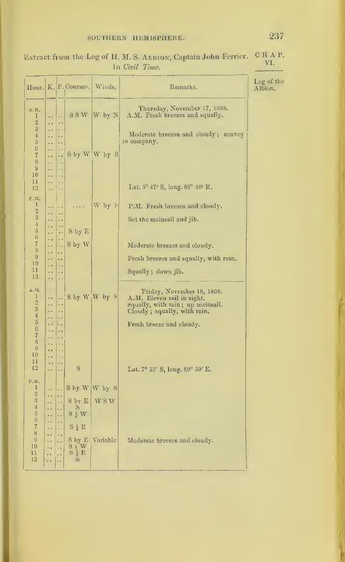
SOUTHERN HEMISPHERE. 237
Extract from the Log of H. M. S. Albion, Captain John Ferrier.
In Civil Time.
Hour. K, F. Courses. Winds. Remarks.
A.M. Thursday, November 17, 1808.
1 SSW W by N A.M. Fresh breezes and squally.
2
3Moderate breezes and cloudy
;convoy4
5 in company.
6
7 S by W W by S
8
9
10
11
12 Lat. 5° 47' S, long. 89° 40' E.
P.M.1
2.... W by S P.M. Fresh breezes and cloudy.
3
4Set the mainsail and jib.
5 S by E6
7
8S by W Moderate breezes and cloudy.
9
10Fresh breezes and squally, with rain.
11
12• » Squally
; down jib.
!
A.M.
S by W W by SFriday, November 18, 1808.
1 A.M. Eleven sail in sight.2 Squally, with rain
; up mainsail.3
4Cloudy ;
squally, with rain.
5
6Fresh breeze and cloudy.
7
8
9
10
11
12 S Lat. 7° 33' S, long. 89° 50' E.
P.M.
1
2S by W W by S
3 S by E WSW4 S5 SAW6
7 S $ E8
9 Sbv E Variable Moderate breezes and cloudy.10 S 4 W11 S a E12 • • S
CHAP.VI.
Log of the
Albion.
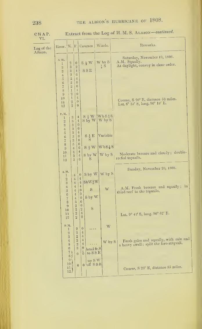
238 the Albion’s hurricane of 1808.
CHAP.VI.
Log of the
Albion.
Extract from the Log of H. M. S. Albion—continued.
Remarks.
Saturday, November 19, 1808.
A.M. Squally.
At daylight, convoy in close order.
Course, S 20° E, distance 53 miles.
Lat. 8° 23' S, long. 90° 18' E.
WbSJS
W by S Moderate breezes and cloudy ;double-
reefed topsails.
Sunday, November 20, 1808.
A.M. Fresh breezes and squally, in
third reef in the topsails.
Lat. 9° 41' S, long. 90° 52' E.
Freeh gales and squally, with rain and
heavy swell ;split the fore- staysail.
Course, S 23° E, distance 85 miles.
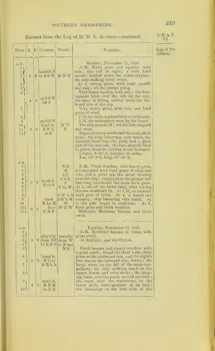
SOUTHERN HEMISPHERE. 239
Extract from the Log of H. M. S. Albion—continued.CHAP.
VI.
Hour.1
K. F.| Courses.^ Winds. Remarks.
A.M. Monday, November 21, 1808.
1 \ A.M. Hard gales and squally, with
2 fread fr.S rain
;one sail in sight
; a very hard
3> 0 0 ,o S S W W N W squall ;hauled down the storm-staysail
;
the ship making much water.
4 ) At 4, strong gales, with hard squalls
5~) and rain ; all the pumps going.
Very heavy squalls, with rain; the fore-
topmast blew over the side by the cap
;
the mast in falling carried awav the lar-
6
, „ q ftw>
0 0off S
board side of the top.
7 1
Very heavy gales, with rain and hardgusts of wind.
8j 7. 30, the main-topmastblew over the side.
9 up S SAY 9.30, the mizenmast went by the board.
10!
11
12)
head fr. N W The ship payed-off ; set the fore-staysail
0 0 EN E N and wore.
to E Began to throw overboard the main-deckguns
;the ship labouring very much, the
mainsail blew from the yard, and a great
part of the foresail ; the fore- staysail blewto pieces from the netting in the bowsprit.
P.M.
n
Course, S 58° E, distance 40 miles.
Lat. 10° 6' S, long. 91° 23' E.
NE P.M. Thick weather, with heavy gales,
21
E accompanied with hard gusts of wind and3 SE rain, and a great sea, the latter blowing
0 r 0 0SSE over the ship ; employed at the pumps and
E to S S throwing overboard the main deck guns.6 S byW At 3, left off the latter duty, after having7 thrown overboard 19. At 3.30, an extreme8. S W b S hard gust of wind. At 4, a heavy sea9 head SWbW running
;ship labouring very much. At
5, the gale began to moderate. At 8,10 N by E W11)
0 0heat: W N W fresh gales and thick weather.
12/ NNE Midnight. Moderate breezes and thickswell.
A.M. Tuesday, November 22, 1808.
1 \ A.M. Moderate breezes at times, with2
(ship’shd variable great swell.
3( 0 0 from NE from W At daylight, saw the Ceylon.4/ toENE to N and
OI head fr.
NE Presh breezes and cloudy weather, witha great swell ; found the third main-chain
6 1plate on the starboard side, and the eighth
V 0 0 NEto fore one on the larboard side, drawn ;the
7|
N E b N barge stove, by the fall of the main-top-
gallants; the ship working much on the
8J upper, lower, and orlop decks;the hoop-
ing butts, over the ports, opened one inch ;
9) head fr. the seam, next the waterways, on the
lower deck, three-quarters of an inch
;
10)
0 0 NNEtoNE the fastenings on the butt-ends of the
Log of the
Albion.
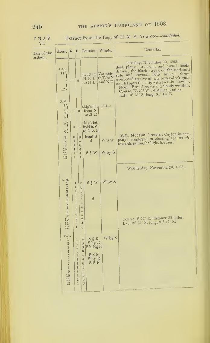
240
CHAP.VI.
Log of the
Albion.
THE ALBION S HURRICANE OF 1808.
Extract from the Log. of H .M. S. Albion- -concluded.
Hour. K. F. Courses.
0 0
head fr.
N N EtoN E
Winds.
Variablefr.WtoNand N E
Remarks.
0 0
Tuesday, November 22, 1808.
deck planks, transom, and breast hooks
drawn ;the black streak on the starboard
side and several bolts broke ;threw
overboard twelve of the lower-deck guns
and frapped the ship with an 8-in. hawser.
Noon. Fresh breezes and cloudy weather.
Course, N.790 W., distance 8 miles.
Lat. 10° 31' S, long. 91° 12' E.
ship’s lid.
from NtoN E
ship’shd.
fr.Nb.Wto N b. E
sjw
ditto
$ W
WSW
W by S
P.M. Moderate breezes ;Ceylon in com-
pany ;employed in clearing the wreck ;
towards midnight light breezes.
Wednesday, November 23, 1808.
W by S
S*ES by ESb.E&E
SSES by ESSE
W by
Course, S 22° E, distance 32 miles.
Lat 10° 31' S, long. 91° 12 E.

241
Mauritius Gales of 1811.
The next figure shows the relative positions of the CI*r^
p '
Astraea and four other vessels of war, on the 5th and
6th of March, 1811, when the Astraea was in the liar- g s
ntlus
hour of Port Louis, Mauritius. All five vessels had
fine weather on the moraine: of the 5th.
55 <>0
We find by the logs which are here printed, that the
Racehorse and Phcebe, which ships were most to the
eastward, were the first to prepare for bad weather,
and they began to do so between eight and ten in the
forenoon. The Nisus, though she felt squalls, did not
prepare until the afternoon, and the Astraea in the
harbour had still “ light airs” at noon.
It was night before the Eclipse felt it; and this ship,
the furthest to the westward, did not strike her top-
gallant-masts until the morning; of the 6th.o o
Thus these vessels are found feeling the storm in
succession, as if it came from the eastward, moving
R

242 THE MAURITIUS GALES OF 1811 .
CHAP.VI.
Mauritiusgales.
slowly to the west. The Racehorse and Eclipse were
about 180 miles from each other;and, as twelve hours
elapsed from the time when the former prepared for
the gale and when the Eclipse split a topsail, we may
infer the storm moved at the rate of about 15 miles
an hour..
A ship called the Melville is mentioned m the
Astrata’s log ;and could the Melville’s log be found it
would tend to explain further the nature of this gale
;
but the Melville was not one of the regular East India
ships; for there is no record of such a vessel at the
India House.
The Racehorse, the ship furthest to the north, seems
to have been in the track of the centre of the gale, and
between 4 and 5 o’clock P.M., on the 5th, to have been
almost in the centre itself. The wind is reported to be
then veering very fast; and it would appear as if the
Racehorse crossed the gale’s central path. The courses
and the wind, as stated in the log, are no doubt t le
magnetic bearings. The variation of the needle at
Mauritius, as given in “ Norie’s Navigation, was
1b° 20' W., in the year 1789.
Log of tlie
Racehorse.
tract from the Log of H.M. S. IUcehorsf, Captain William
. -l t i 4- T R Tot-nnll
II our. Iv. F. Courses. Winds. Remarks.
A.M.1
2
2
3
G
0 E by N S E by S
March 5, 1811.
A.M. Moderate and fine.
3
45
2
1
2
2
6
0
6
7
8
4
4
3
0
2
6
SWbyS At 7, fresh breezes and squally weather
8.30, in main top-gallant-sail and third
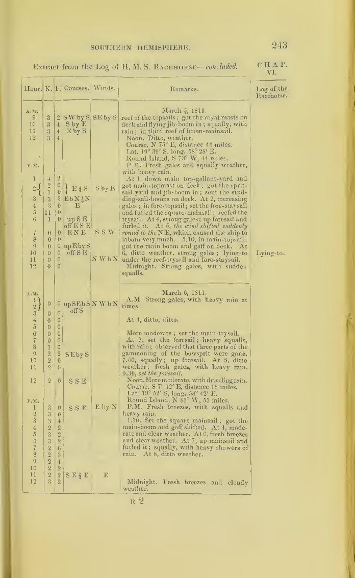
SOUTH Eli N HEMISPHERE. 243
Extract from the Log of II. M. S. Racehorse— concluded.
Hour. K. F. Courses. Winds. Remarks.
A.M. March q, 1811.
9 3 2 SWbvS SEbyS reef of the topsails;got the royal masts on
10 3 4 S by E deck and flying jib-boom in;squally, with
11 3 4 E by S rain;in third reef of boom-mainsail.
12 3 4 Noon. Ditto, weather.
Course, N 75° E, distance 44 miles.
Lat. 19° 39' S, long. 58° 28' E.
Round Island, S 73° W, 44 miles.
r.M. P.M. Fresh gales and squally weather,
with heavy rain.
1 4 2 At 1, down main top-gallant-yard and
2 ;2 0
1 F 4 S S bv E got main-topmast on deck ; got the sprit-
I 1 0 sail-yard and jib-boom in ; sent the stud-3 3 3 EbN^N ding-sail-booms on deck. At 2, increasing
4 3 0 E gales ; in fore-topsail; set the fore-staysail
5 11 11 and furled the square-mainsail ; reefed the
G 1 0 upSE trysail. At 4, strong gales; up foresail andoffESE furled it. At 5, the wind shifted suddenly
7 0 0 ENE S S W round to the N E, which caused the ship to
8 0 0 labour very' much. 5.10, in main-topsail;
9 0 0 up E by S got the main boom and gaff on deck. At10 0 0 off S E 6, ditto weather, strong gales
;lying-to
11 0 0 N WbN under the reef-trysail and fore-staysail.
12 0 0 Midnight. Strong gales, with suddensqualls.
A.M. March 6, 1811.
2 }0 0 upSEbS NW b N
A.M. Strong gales, with heavy rain at
times.
3 0 0oil's
4 0 0 At 4, ditto, ditto.
5 0 0
6 0 0 More moderate ; set the main-trysail.
7 0 6 At 7, set the foresail; heavy squalls,
8 1 0 with rain;observed that three parts of the
9 2 2 SEby S gammoning of the bowsprit were gone.10 2 0 7.50, squally; up foresail. At 8, ditto
11 2 6 weather ; fresh gales, with heavy rain.
9.30, set the foresail.
12 2 6 S S E Noon. More moderate, with drizzling rain
.
Course, S TJ 42' E, distance 18 miles.Lat. 19° 52' S, long. 58° 42' E.
F.M. Round Island, N 83° W, 53 miles.
1 3 0 S S E E by N P.M. Fresh breezes, with squalls and2 3 0 heavy rain.
3 3 4 1.30. Set the square mainsail;
got the4 2 2 main-boom and gaff shifted. At 4, mode-5 3 2 rate and clear weather. At 6, fresh breezes
6 3 2 and clear weather. At 7, up mainsail and7 2 6 furled it
; squally, with heavy showers of
8 2 3 rain. At 8, ditto weather.
9 2 410 2 2
11 2 2 S E £ E E12 3 2 Midnight. Fresh breezes and cloudy
'
weather.
R 2
C II A P.
YI.
Log of the
Racehorse.
Lying-to.
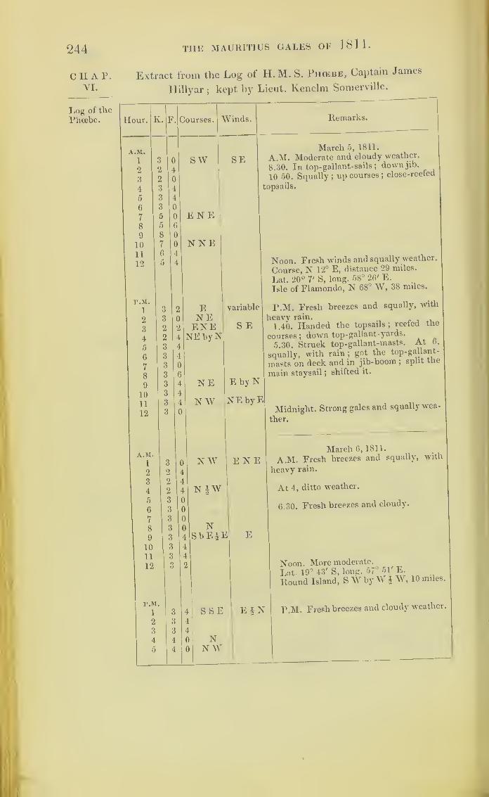
244
CHAP.VI.
Log of the
Phoebe.
the MAURITIUS GALES OF 1811 .
Extract from the Log of H.M. S. Phcebe, Captain Jamc^
Hillyar;kept by Lieut. Kenelm Somerville.
Hour. F. Courses. Winds.
S W SE
Remarks.
E N E
N NE
March 5, 1811.
A.M. Moderate and cloudy weather.
8.30. In top-gallant-sails ;down jib.
10 50. Squally;up courses ;
close-reefed
topsails.
ENEENENEbyN
NE
N W
variable
S E
E by N
NEbyE
Noon. Fresh winds and squally weather.
Course, N 12° E, distance 29 miles.
Lat. 20° 7' S, long. 58° 26' E.
Isle of Flamondo, N 68° W, 38 miles.
P.M. Fresh breezes and squally, with
heavy rain. . ,
1.40. Handed the topsails; reefed the
courses ;down top-gallant-yards.
5.30. Struck top-gallant-masts. At 6,
squally, with rain;got the top-gallant-
masts on deck and in jib-boom ;split the
main staysail ;shifted it.
Midnight. Strong gales and squally wea-
ther.
NW ENE
N |W
E
S SE
NN W
March 6, 1811.
A.M. Fresh breezes and squally, with
heavy rain.
At 4, ditto weather.
6.30. Fresh breezes and cloudy.
Noon. More moderate.
Lat 19° 43' S, long. 67‘, — , i n itt l
51' E.
Ep
jjut iy ^ «- —
Round Island, SW byW j W, 10 miles
P.M. Fresh breezes and cloudy weather.

SOUTHERN HEMISPHERE. •245
Extract from the Log of H. M. S. Phcebe—concluded.
Hour. K. F. Courses. Winds. Remarks.
F.M. March 6, 1811.
6 4 4 NW E*N At 6, moderate and squally weather.
7 3 6
8 3 4 N by E Variable At 8, ditto weather.9 4 6
10 4 4
11 4 2
12 4 2
Extract from the Log of H. M. S. Nisus, Captain P. Beaver.
In Civil Time.
Hour. K. F. Courses. Winds. Remarks.
r.M. March 5, 1811.
1 2 6 SW by S SE by S A M, Moderate and cloudy.2 2 4
3 2 2 SSWiW4 2 0
5 2 0 SW by S At 5.30, squally.
6 2 0 SW 4 s7 2 0 SW by S8 2 0
At 8, squally, with rain.
9{
0
4
6
2 }
NNE10 7 2 NE bv N11 3 0 SWbyW12
{
1
2
4
6 j
N E Noon. Fresh breezes & squally, with rain.
Course, S 79 E°, distance 12° W.Lat. 19° 54' S, long. 58° 5'.
P.M.( t\t v. T? Q TT
Round Island, N 79° 12' W, 19 miles.
M5
1 4 ENE P.M. Fresh breezes and squally. 12.40.
close-reefed the topsails;furled ditto,
2 i 6 E by N SEbyS At 2, reefed the courses, hard squalls,
took in and set the storm-staysails, occa-sionally furled mainsail.
3 i 6 At 3.45, struck top- gallant-masts.4 i 6 At 4, hard squalls and rain.5 i 6 E bv N At 5, sent top-gallant-masts on deck.
J N 5.45, down main-staysail.6 i 6 At 6, hazy weather and hard squalls.7 2 2 E by N 7.10, carried away the starboard bomkin.8 i 0 ENE At 8, ditto weather.9 i 4 up ENE
off N Eby N
10 2 0 SEby E11 2 0
12 2 0 NNE Midnight. Fresh gales and squally; con-
offNbW stant rain.
C II A P.
VI.
Log of the
Phoebe.
Log of the
Nisus.

246 THE MAURITIUS GALES OF 1811.
Extract from the Log of H. M. S. Nisus—concluded.
Hour. [v. F. Courses. Winds. Remarks.
A.M.
1
March 6, 1811.
1 6 NIE ENE A.M. Fresh gales and squally, withrain.
2 1 0 N byW3
4
1 2
1 0
NN by E At 4, ditto breezes and squally, ditto.
5 0 0 upN'NEoffNbW,
6 1 01
7
8
2 2
2 2
NNE 1E
At 8, ditto ditto ditto.
9 2 C
10
11
12
2 (
3
3
NiEN
l N § WENE
Noon. Ditto weather.
Lat. 35° S.
Round Island, S f W, 7 or 8 leagues.
P.M.1 3 0 N|W ENE P.M. Fresh breezes and cloudy.
2 3 0
3
4
2
2
0
6 At 4.10, squally.
5 1 4 upN off
6 3
N by AY4 N Variable At 6, fresh breezes and squally.
7 2 2 N l)W|W8 1 6 N|W
E by N9 2 0 N by E10 2 2
11
12
2
1
0
6
I
Midnight. Fresh breezes and cloudy.
Log of the Extract from the Log of H.M.S. Astr*a, Captain C. M.
Astraea. Schomberg.—In Civil Time.
Hour. K. F Courses. Winds. Remarks.
A.M.1 In Port Calm
March 5, 1811.
A.M. Clear, fine weather.
23
• •
• •
Louis
SE Lmht airs and cloudy weather. Sailed,
the Melville, E.I.C. ship, for Benga .4c
. • • •
6
7
VariableLight airs, with rain.
8
9
10
11
12

SOUTHERN HEMISPHERE. 247
Extract from the Log of H. M. S. Astr/EA—concluded.
Hour. K. F. Courses. Winds. Remarks.
P.M. March 5, 1811.
1 In Port SSE P.M. Squally, with showers of rain.
2 Louis3
4
5
6
7
8
9
10Heavy squalls, with constant, heavy rain.
ii
12 .... Variable Ditto weather.
A.M. March 6, 1811.
iA. M. Heavy squalls, with constant,
2 ditto ditto heavy rain;got top-gallant mast on deck,
3 and struck lower yards and topmasts
;
4 squally, with showers ofrain;got the sheet
0 anchor over the side ready for letting go.
6
7
8
9
10
11
12
P.M.
i P.M. Squally, with showers of rain;
2 got the stream cable out on the larboard
3 bow ; one of the larboard cables broke
;
4 got a new one from the dock-yard.
5
6
7
8
9
10
11
12 Ditto weather.
Extract from the Log of H. M. Brig Eclipse, Captain W.Steed —In Civil Time.
Hour. K. F. Courses. Winds. Remarks.
A.M. March 5, 1811.
l 4 0 SSW SE A.M. Light breezes and cloudy.
2 3 4 Sbv W3 3 6 Si W Variable4 3 6 Shy W
C H A P.
VI.
Log of the
Astrsea.
Log of theEclipse.

248 THE MAURITIUS GALES OF 1811 .
CHAP.YI.
Log of the
Eclipse.
Extract from the Log of H. M. Brig Eclipse—concluded.
j
Hour. K. ?. Courses.
A.M.
0
65
l
2
1ESE V
6 2 2 SEbyE7 3 0 SE1E8 3 0 SE9 3 0 3 E by E10 3 0 SE §E11 2 6 SE V
12 4 0 3 E by E
r.M.
1 5 0 EbvSiS2 6 0
3 6 6
4 6 2
5 5 4
6 3 0
7 2 0 E by S8 3 6 E ^
9 3 4 E | S10 3 2
11 2 0 E12 3 4 E 3 S
A.M.
1 3 2 E by S2 3 0
3 2 6
4 3 0 E5 2 4
6)
2 0 up E b N7 1 6 off N E8 S 1 6 by E9 \
10(
0
0
0
0upENE
offn (
12 ;
0
0
0
0NNE
P.M.
1 0 0
3!1
1
04upNEbN
off N4 ) 1 4
1 4 up NNE6) 2 0 off N71 2 0 upNEbE8) 1 6 ofFNbW9\ 1 0
10 1 1 0 up N b En 0 ofFNbW12 ) 1 0
Winds.
Variable
Variable
S by W
Variable
Remarks.
March 5, 1811.
Course, S 16° 52' E, distance G7 miles.
Lat. 20° 20' S, long. 54° 44' E.
Port Louis, N 44° E,* 105 miles.
P.M. Fresh breezes and cloudy.
At 4, ditto weather.
At 5, fresh breezes and squally.
At 8, ditto, ditto. 8. 50, split the fore-
topsail ;shifted ditto, and in four reefs of
the topsails.
March 6, 1811.
A.M. Fresh breezes and squally ;furled
the fore-topsail, and struck top-gallant
mast ;employed securing the booms,
furled the boom mainsail.
At 4, strong gales with very heavy
squalls.
At 8, ditto weather ;reefed the foresail,
and handed the main-topsail ;got the top-
gallant masts on deck ;in jib-boom ;
got
the spritsail yard on deck.
Course, S 62° E, distance 68°.
Lat. 19° 48', long. 56° 48\Port Louis, S 61° B, 58 miles,fP.M. Fresh gales and squally, with rain
at times. 1.30, set the lore-staysail and
trysail.
At 4, ditto weather.
At 6, ditto, with rain.
At 8, ditto, ditto.
Fresh gales and cloudy.
Noon. More moderate.
* There appears to be some mistake here
;
N 86° 17' E, 154 miles.
f Supposed to mean Port Louis, S 75 6 L, 36 miles.
supposed to mean Port Louis,
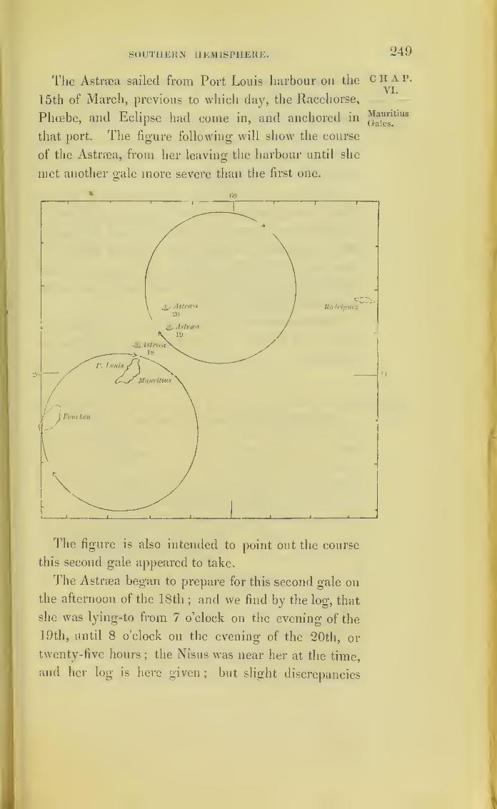
SOUTHERN HEMISPHERE. 249
The Astrgea sailed from Port Louis harbour on the
15th of March, previous to which clay, the Racehorse,
Phoebe, and Eclipse had come in, and anchored in
that port. The figure following will show the course
of the Astrsea, from her leaving the harbour until she
met another gale more severe than the first one.
c H A p.
VI.
MauritiusGales.
The figure is also intended to point out the course
this second gale appeared to take.
The Astrma began to prepare for this second gale on
the afternoon of the 18th;and we find by the log, that
she was lying-to from 7 o’clock on the evening of the
19th, until 8 o’clock on the evening of the 20th, or
twenty-five hours; the Nisus was near her at the time,
and her log is here given; but slight discrepancies

250 TIIE MAURITIUS GALES OF 1811 .
chap, in these logs prevent my being able to lay down the
VLexact relative positions of these two vessels, for which
Mauritius reason the place of the Astraea is only marked. The
Nisus laid-to at an earlier hour, and continued in that
position nearly the whole time, until ten at night ol
the 20th.
The logs of the Phoebe, Racehorse, and Eclipse,
which were lying in Port Louis harbour, follow that of
the Nisus;and no notice is taken of bad weather in
these logs until the 20th, when the gale began, and
continued till the 21st: all five logs report the wind
beginning at the southward of east, and ending at the
northward of west.
The Astrsea and Nisus had again fine weather on
the 21st of March ;and the three ships in harbour on
the 22nd.
Log of the Extract from the Log of H. M. S. Astraia, Captain C. MAstraca. Schomberg, kept by Lieut. John Baldwin.—In Civil Time.
Hour. K. F. Courses. Winds. Remarks.
Monday, March 18, 1811.
Lat. 19° 36', long. 57° 53'.
Round Island, S W, 5 leagues.
P.M.
\ 4 6 E by N SE P.M. Fresh breezes and cloudy weather;
9 4 2 unbent the fore and main-topsail, and bent
Q 4 0 ENE better ones ;close-reefed them ;
down top-
4 4 2 gallant-yards, and struck the masts ;got in
5 5 0 E by N flying jib-boom.
6 6 4
7 5 4
8 6 0 E S S E9
10
5
6
0
6 At 10, ditto weather ;reefed the courses
ii 7 6 and set them ; set trysails.
(3 4 Squally weather.
12 Q 0 ENEl
Tuesday, March 19, 1811.
1 4 4 E SSE Squally, with rain.

SOUTHERN HEMISPHERE. 251
Extract from the Log of H. M. S. Astr.ea—continued.
Hour. K. F.1
Courses. Winds. Remarks.
A.M. Thursday, March 19, 1811.
2 4 4
3 4 4 S W4 4 2 At 4, squally weather ;
furled fore -top-
sail ; got jib-boom in.5 5 0 S VV b W6 0 0
7 4 0 E8 4 0
9 4 0 E by S S by E10 3 0
11 2 2
12 2 2 EbS IS Strong breezes and a heavy sea from the
eastward.Lat. 19°, long. 58° 33'.
Round Island, S 40°, distance 68 miles.
r.M.
1 2 2 E S E S P.M. Ditto weather. 1.30, up mainsail;
got top-gallant-masts on deck ;strong2 2 0
3 2 2 E by S gale, with showers of rain.
4 2 0 Furled the main and main-topsails.
5 2 4
6 2 0
7) 0 0 up E b S E by N Up foresail.
8/ 0 0 off E b N Fresh gale and squally, with rain;reefed
9i
0 0 , , , , S by E the trysail and set it.
10 0 0 up E off
11 0 0 ENE12j 0 0 Midnight. Ditto weather.
A.M.
0
0
up E b SofFEbN
Wednesday, March 20, 1811.
5}0
0 SA.M. Strong gale, with rain and a heavy
sea.3
10 0 up S E
4) 0 0 off E S E At 4, ditto weather.5) 0 0 .... W SW6
j
0
00 up S At 6, the gale increasing, with constant
7 (
8/0
off S S E rain ; fore- staysail halliards broke, hauled0 0
WSWthe sail down
; observed the drift of theship to be 1J mile per hour.
9 upSb.E• • .
.
At 9.30, took second reef in the trysail,
10
offSEbSupSSWoff S W
the only sail now set.
11 • • upSWbSoffSbW
12 up SW Strong gale and cloudy.offSSW W NW Lat. 18° 37', long. 58° 48'.
Round Island, S 39°W, distance 95 miles.F.M.
M up S W W N W P.M. Strong gale and squally, with2)
• •
off S SW rain. 1.30, bore up; set fore-staysail.
At 3, hauled to the wind.3
£)5
g)• •
upSW£SoffSWbS At 5.30, more moderate.
CHAF.VI.
Log of the
Astraea.
252 THE MAURITIUS GALES OF 1811.
CHAP.VI.
Log of the
Astrsea.
Log of the
Nisus.
Extract from the Log of H. M. S. Astr.ea— concluded.
Hour. .EL F. Courses. Winds. Remarks.
P.M.
9
10
11
12
.. ..
up N Eoff E b N
N W
NW
Wednesday, March 20, 1811.
At 8, ditto weather ; set main-staysail.
Ditto weather.
Extract from the Log of H. M. S. Nisus, Captain P. Beaver.
In Civil Time.
Hour. K. F . Courses. Winds. Remarks.
A.M.1
Tuesday, March 19, 1811.
i 3 ! c SW4S S SE A.M. Fresh breezes and cloudy weather.
2 3i
5 SWbyS At 2. 10, squally ;in fore andmizen-top-
sails, and mizen- storm-staysail.
3 2 5 S by E At 3.40, in main-topsail; furled the
mainsail.
4 1 upEbyS At 4, ditto weather. 4. 15, wore ship;
offENE down top-gallant-mast ; in flying jib-
5 1 boom. 8, fresh breezes and squally.
6 2 D
7 2 ) .... Variable
8 1 5 up E \ Soff E b N
9 2 0 At 9. 15, close-reefed main-topsail.
10 2 2 E S S E11 3 0 E 4 N12 2 6 E Noon. Fresh gales and hazy weather.
Course, N 50° E, distance 41'.
Lat. 19° 19', long. 58° 18'.
Round Island, S 50° W, 41 miles.
1 1 4 up E off ESE P.M. Commences very strong gales and
ENE dark cloudy weather.
2 0 0
3 0 0 SSW4 0 0 upSEbF At 4, hard gales and constant rain.
offE5 0 0 upSEbF
6 0
off Eby S
0 At 6, very hard squalls.
7 0 0 SE to SIby E
8 0 0 SEbStf At 8, hard gales ana rain;
got the fore
SEbvF runners up, and secured the foremast.
9 0 0 S E off
10 0
SEbyE0 10. 20, the wind shifted to the north-xoest.
11 0 0 StoSS] 5 NW12 0 0 SSW to
f
5
ftL
Moderate ; ditto weather.
SOUTHERN HEMISPHERE. ‘253
Extract from the Log of H. M. S. Nisus
—
concluded.
Hour. K. F. Courses. Winds.
—Remarks.
A.M. Wednesday, March 20, 1811.
1 1 2 up E off Variable A.M. Hard gales and dark cloudy. ENE weather.
2 0 0 Hard gales and constant rain.oO 0 0
4 1 0 upSE5 0 0 offESE6 0 0
7 0 0 SE to Sby E
8 1 0 SEtoSEbyE
At 8, ditto, ditto.
9 0 0
10 0 0 Noon. Hard gales and heavy squalls, with
11 0 0 S S E rain ;ship under fore and mizen-staysails.
12 0 0 S W. Course, N 39° E, distance 42'.
Lat. 18° 47', long. 58° 46'.
PM. Round Island, S 42° W, 84 miles.
i •• upNWoffSWbW
W NW P.M. Fresh gales and squally.
2 ••
3
(up NW
4 by W At 4, more moderate.
5t offESbS
6 W NW/ •• offSW
8 N W(W by S
9
»
off
SWbW10 • •
WoffW NW At 10. 20, squally, with heavy rain.
11 ..
12 — NNW Midnight. Strong breezes and squally.
Extract from the Log ofH.M.S. Phoebe, Captain James Ilillyar,
in Port Louis, Mauritius.—In Civil Time.
Hour. Courses. iWinds. Remarks.
A.M. South'*Wednesday, March 20, 1811.
A.M. Strong breezes and squally wea-ther ; sent top-gallant-mast on deck.
S by ES by W
r.M. P.M. Squally, with rain; struck lower
yards and topmasts;employed heaving
taut the moorings.10 Heavy squalls
; blew away the mizen-storm-staysail.
CHA P.
VI.
Log of the
Nisus.
Log of thePhoebe.
254 the MAURITIUS GALES OF 1811.
CHAP. Extract from the Log of H. M. S. Phcebe—concluded.
VI.
Log of the f
Phoebe.
lour. Courses. Winds. Remarks.
A.M. SffThursday, March 21, 1811.
A.M. Strong breezes and squally, with
P.M. 1Vester'r
rain.
P.M. Ditto weather ;employed heaving
1tfidn.
taut the moorings.Midnight. More moderate.
Log of theRacehorse.
Extract from the Log of H. M. S. Racehorse, Captain
W. Fisher, in Port Louis Harbour, Mauritius, kept by
Lieutenant J. B. Tatnall.—In Civil Time.
Hour. Courses. Win ds. Remarks.
A.M.
4
NoonP.M.
6
11
Midn.
S E
Variable
Wednesday, March 20, 1811.
A.M. Presh breezes and clear weather.
Ditto weather.
Strong breezes, with heavy squalls.
P.M. Strong breezes, with heavy squalls
of wind and rain.
Ditto weather.
Hard gales and continued heavy rain.
Midnight. Heavy weather ;brought home
the stern anchor, and slightly touched.
A.M.
1
9
NoonP.M.
1
11
Midn
WW by N
W
Variable
Thursday, March 21, 1811.
A.M. Hard gale, with heavy rain.
Got the lower yards down ;still lightly
touching.Noon. More moderate and cloudy.
P.M. Fresh breezes and cloudy.
Moderate ;a cable and anchor received
from the dockyard, and laid it out to the
westward, for the purpose of heaving the
ship off.
Hove her off and secured her.
Midnight. Light airs and cloudy weather.
Log of the
Eclipse.
Extract from the Log of H.M. Brig Eclipse, Captain W. Steed,
lying in Port Louis, Mauritius—In Civil Time.
Hour Courses. Winds Remarks.
Wednesday, March 20, 1811.
A.M. Strong breezes and clear weather ;
afternoon came on to blowing very hard.

SOUTHERN HEMISPHERE. 255
Extract from the Log of H.M. Brig Eclipse— concluded.
Hour. Courses. Winds. Remarks.
A.M. VariableThursday, March 21, 1811.
A.M. Begins blowing very strong, with
P.M.
constant rain;
pilot brought an anchor to
lay out a-stern.
P.M. More moderate, with heavy rain.
C H A P.
VI.
Log of the
Eclipse.
The Blenheims Storm, February, 1807.
The storm in which H. M. ships Blenheim and Bien-1
_ t #heim’s
Java foundered, bears the same indications of a storm,
rotatory character with those already described in
southern latitudes. The manner in which these ships
met the hurricane, looks as if they had been sailing to
the southward of it, and, plunging into its south-east
side, received the wind from north-east.
The following figure is intended to represent how
this may have occurred.

256 the bleniieim’s storm.
chap.VI.
Blen-heim’sstorm.
The ships were sailing’ at the rate of nine or ten
knots an hour. Some storms, as for example that of
1821, traced by Mr. Redfield, certainly move along
no faster than the rate of seven miles an hour;ships
may therefore overtake such storms.
The Harrier, brig of war, the same which foundered
in the Culloden’s storm, was the only vessel out of three
which survived on this occasion. She was in company
with the Blenheim and Java up to the evening of the
1st of February, 1807, at which time all three were in
the greatest distress. The Blenheim was the flag-ship
of the late Rear-Admiral Sir Thomas Troubridge.
The log of the Harrier, from the 1st to the 4th of
February, is printed in detail; and in it will be found
the last recorded signals from the Blenheim.
On the morning of the 30th of January, these tin ce
ships had moderate weather, but it was cloudy ;there
was a heavy swell, and the wind was at north-east:
at noon that day their latitude was 16 34 S., long.
71° 56' E. In the afternoon of the same day, the log
states the breeze to be freshening, the weather squally,
and records various stays carried away. On the morn-
ing of the 31st, the Harrier was still carrying stud-
ding-sails;
but there was “ a very cross sea always
rolling away some back-stay, top-gallant-sheet,” &e.
;
and at noon of the 31st, their latitude was 18° 41' S.,
and long. 69° 36' E. During the afternoon (judging
by the log) the weather became gradually worse. On
the morning of February 1st, it is styled threatening;
and from this period the log is given in detail. The
brig scudded throughout ;and if we follow her course,
hour by hour, on the 2nd of February and forenoon ol
the 3rd, we find she sailed in a circle, completing three-

SOUTHERN HEMISPHERE. 257
quarters of the revolution, in accordance with the sup-
posed law of storms in the southern hemisphere. But
the report from a single ship does not afford conclusive
evidence, and I am not at present aware of any other storm
vessel being in this storm. It is most probable that at
Rodriguez the wind became south-west.
CHAP.VI.
Extract from the Log of H. M. Brig Harrier, Captain
Justin Finley.
Log of the
Harrier.
Hour. K. F. Courses. Winds. Remarks.
F.M. Sunday, February 1, 1807.
1 9 4 SW NE A.M. Threatening weather; in third reef
2 9 6 of fore-topsail;heavy rain and the wind in-
3 9 0 crea«ing ;sent the top-gallant-yards down
;
in third reef of main-topsail; hauled the
mainsail up, and bent the storm-staysails
and trysail.
4 9 0 Strong gales, with heavy squalls and rain.
5 9 4 Ditto weather; struck the fore-top- gal-
6 9 4 lant-mast;the wind still increasing, found
7 9 6 it dangerous to attempt striking the main-top-gallant-mast ; the wind blowing so
strong, sent all the small sails from aloft.
Strong gales, with heavy rain; Admiral8 10 2
9 9 2 and Java in company.10 9 0 Strong gales, with rain
;handed the
mainsail ;close-reefed the fore-topsail
;
11 9 0
people employed in clearing the ship andlashing the booms.
12 9 0 Noon. Heavy gales; Admiral and Java
in company.Course, S 50° W, distance 225 miles.
Lat. 21° 4' S, long. 65° 11' E.F.M. Rodriguez, N 80° W, 180 miles.
1 9 0 W SW NE P.M. Strong gales;in fourth reef main-
topsail; the gale increasing, with a veryheavy sea.
2 9 0 2.30. Hauled up the foresail and reefedit; carried away the fore-topmast backstay,
3 9 4 repeated the knotted, and spliced ditto.
Blenheim and Java in company.4 9 0 SW The main-topsail-yard was carried away5 9 0 SWbyS NEbyN in the slings, owing to the lift and brace
giving way; endeavoured to furl the sail, in
doing which William Mailtrott was blownfrom the yard and drowned
;cut the sail
from the yard. At 5.20, lost sight of theAdmiral, in a very heavy squall, bearingN W by W, distant half a mile
; and theJava, bearing N E by E, distant a quarter ofa mile : at this time we were shipping agreat
S

258
CHAP.VI.
Log of the
Harrier.
THE BLENHEIMS STORM.
Extract from the Log of H.M. Brig Harrier—confined.
Hour,
r.M.
7
8
9
10
11
12
K. F. Courses. Winds.
9 4 SWbyW NEby E
9 0 NNW ESE10 0
9 0
9 4
10 2
10 0
Remarks.
Sunday, Pebruary 1, 180/
.
itity of water. 5.30. The fore-topsail
f awayfromthefourth-reefedband;the
o-ale still continued to increase, with most
violent squalls of wind and rain, the vesse
labouring very much, and the sea striking
her in all directions very heavily ;stove
several half-ports in, and much water going
below ;kept the pumps continually going.
7.50. The main-royal-mast blew away;
the gale increased to a hurricane, and,
shifting round in tremendous squalls to the
eastward, obliged us to keep betore the sea.
SIGNALS.
Hour. No. By whom.
Last sig-
nals of
the Blen-
heim.
331
8080
Blenheim
do.
do.
To whom.
Java
Generaldo.
The ship is overpressed with sail
and cannot keep her station on that
account.
To steer S W.To steer S W by S.
The Blenheim made another signal,
which we could not make out.
Wind
A.M.1 10 0 w E
East.
2 10 2 WbyN*N
E by S
3 10 4 WNW ESE
4 9 0 N W SE
5 9 0 NNW S SE
6 9 0 WbyN S by E
7 9 0
WindSouth. 8 9 0 N S
Monday, February 2, 1807.
A.M. At this time we shipped a great
quantity of water, which washed a great
quantity of the shot-boxes to pieces.
2.10. The wind flew round from east to
south in a most tremendous squall ;kept
right before it;a great quantity of water
in the waist, so as to affect the vessel s
steerage very much ;most of the starboard
ports either stove in or washed out, as also
many of the larboard ones ;the squall
still coming on with greater violence, and
a most enormous sea.
At 3, the fore-staysail blew away. 3.4J_
Shipped twoseas, which filled thewaistand
waterlogged the brig for some minutes,
whichcausedher tobroach-to ;endeavoured
to get the fore-sheet aft, but the foresail
blew away from the yard, leaving the reef
;
she went off, but did not rise to the sea ;the
waist being full of water, a great quantity
going forward she settled down by the
head ;sounded the well, found it increased
from 12 to 30 inches in two minutes ;hove

SOUTHERN HEMISPHERE. 259
Extract from the Log of H. M. Brig Harrier—continued.
Hour K F Courses Winds. Remarks.
A.M. Monday, February 2, 1807.
9 9 0 the four foremost guns overboard, whichre-
lieved her much ; hove overboard all the
10 8 4 round and canister shot on deck; a great
quantity of water having lodged in the
11 9 0 wings between decks, got up all the old
rope and some shot, and threw it over-
board;the w'ater in the waist flew with
such violence from side to side as to washthe studding-sails and hammock-cloths,which were lashed under the booms, aboutthe deck, and in consequence went over-
board;washed overboard the starboard-
binnacle and compass. At daylight, blow-ing most violently, employed in clearing
the deck and splicing the rigging that waschafed through and cut in the night.
12 9 0 Noon. Strong gale.
Course, S 67° W ; distance 114 milesLat. observed, 19° 29' S, long. 64° 26' E.
P.M. Rodriguez, S 84° W, G4 miles.
1 9 4 N S P.M. Strong gales and cloudy ; carpen-2 9 4 ters employed stopping up the ports
;got
the old main- topsail-yard on deck and the3 9 0
remains of the old foresail, and bent thenew one.
4 9 0 Ditto weather.4.40. Reefed the foresail.
5 8 6 Strong gales, with squalls; sent the top-
gallant-mast down on deck.
6 9 0 More moderate ; the vessel labouringvery much and shipping great quantities of7 9 0
8 7 4ENE
water; strong gales and cloudy weather.
Ditto weather.9 7 2 wsw10 7 0 Ditto weather.11 7 0 E w12 7 0 Strong gales and cloudy
;the sea much
agitated.
A.M.E
Tuesday, February 3, 1807.
1 5 0 w A.M. Strong gales and cloudy, and very2 5 0 heavy sea running.
3 5 0
4 5 0 Ditto weather.
5 2 4 SE N W Fresh gales and cloudy; set the main-
6 3 0 S Variable staysail, trysail, and mainsail; bent a new
7 4 0 s w N fore-topsail; employed rigging spare main-
topsail-yard.
8 4 0 Ditto weather;
split the mainsail.
9 7 6
10 8 0 Moderate and cloudy.
11 6 0
12 8 0 £sWbyW NE Moderate, with small rain.
Course, N 22° E, distance 110 miles.
Lat. 19° 42' S, long. 65° E.Mauritius, S 83° W, 740 miles.
CHAP.VI.
Log of the
Harrier.
WindWest.
Wind
s 2

260 THE BRIDGEWATER STORM.
CHAP.VI.
Log of the
Harrier.
Extract from the Log of H. M. Brig Harrier—concluded.
Hour. K. F.
p.m.
1
2
3
4
6
6
7
8
9
10
11
12
A.M.
1
2
3
4
5
6
7
8
9
10
11
12
P.M.
1
23
4
5
6
7
8
9
10
11
12
Courses. Winds.
SWSWbWS byWss wSWbWSWbS
NE
SW by S NE
E
Remarks.
Tuesday, February 3, 1807.
P.M. Moderate and cloudy.
Ditto weather. .
Pointed the main-top-gallant-mast; in
third reef main-topsail.
Ditto weather.
Moderate, with small rain.
9.20. Hauled down the main-topmast-
staysail.
Ditto weather.
SW by S NE
Wednesday, February 4, 1807.
A.M. Moderate, with small rain.
Fresh gales and cloudy, the vessel roll-
ing very much.
Furled the mainsail; in third reef of
main-topsail.
Windy looking weather, and the sea
running very fast.
Noon. Ditto weather, & a veryheavy sea.
Lat. 21° 18' S., long. 62° 31' E.
Cape of Good Hope, S 71°W, 2440 miles.
P.M. Strong gales and squally; got tne
top-gallant-masts down on deck, close-
reefed the topsails, and furled the fore-
Strong gales and heavy rain ;got the jib-
boom in, and the spritsail yard fore and alt.
Squally weather ;thunder and lightning
in the south-east quarter.
Ditto weather ;a cross sea running.
The Ship Bridgewater.
Bridge- The H.E.I.C.S. Bridgewater, commanded by Cap-
WcL. tain Maunderson, encountered a severe hurricane in
March, 1830, about lat. 20° 55' S„ and long. 90 h.,
another instance in proof that these storms are not
always to be avoided on the homeward voyage from

SOUTHERN HEMISPHERE. 261
India, by keeping a course “ well to the eastward of
Mauritius,” as lias been supposed by many to be the
case. The Bridgewater, sailing to the westward, met
the storm with the wind blowing at north-east,and
when it abated the wind was at north-west,but the
intermediate points not being stated, a copy of the log
has not been inserted here. By it we find that a heavy
swell from the northward preceded the storm. On the
2nd of March, the barometer was at 29.75. On the
4th, the wind being easterly, the ship hove-to on the
larboard tack under the trysail, until that blew to
pieces;
after which she hove-to under bare poles,
heaving her guns overboard. The barometer fell
until it was at 28.80, with the wind increasing in vio-
lence, so that the ship was in much danger of founder-
ing. After this gale, the Bridgewater was left with
only her foremast, and the stump of her mizenmast.
The Ship Neptune.*
The ship Neptune is another instance of a vessel, on
her returning voyage from India, falling into a hurri-
cane where she receives the wind at north-east : an
extract from her log is annexed.
A painting of the Neptune was made by Mr. Hug-
gins, under the superintendence of her commander,
Mr. Broadhurst, who assures me the picture does not
give an exaggerated representation of the state of his
ship. The sketch here added was reduced by the
painter himself. The ship appears to have sailed
onwards until she was dismasted, and then perhaps
dropped out of the hurricane, by being disabled, and
left behind as the tempest proceeded on its course.
* See “ The Progress of the Development of the Law of Storms,” page 35.
CHAP.VI.
Bridge-water's
hurricane.
The ship
Neptune.

262 the neptune’s storm.
chap.VI.
Log of the
Neptune.
Extract from the Log of the Ship Neptune, from Calcutta
towards the Cape of Good Hope, Captain Alfred Broadhurst.—
In Nautical Time.
Hour. K. F.
P.M.
1
23
4
5
6
7
8
9
10
11
12
A.M.
1
2
3
45
6
7
8
9
10
11
12
P.M.
1
23
4
5
6
7
8
9
10
11
12
A.M.
1
2
3
4
5
6
7
8
9
Courses. Winds. Bar.*
W by S N Eastly 29.86
0 W by S0
0
0
0
0
0
0
0
0
0
0
NNE
NNW
N
Ther.
81
29.82
W t S North 1?
W§ S
E
Remarks.
Saturday, January 31, 1835.
P.M. Breezes, with rain
;
very heavy swell from the
NW ;ship very uneasy.
A.M. Taken a-back, with a
smart squall at N W ;carried
away the boom-iron on the
starboard fore-yard-arm.
Much rain.
Course S 63° W, dist. 121m.
Dept. 109 miles.
Lat. 22° 30' S, long. 68° 20' E.
Sunday, February 1, 1835.
P.M. Cloudy, with heavy
north-westerly swell ;wind
increasing, latterly with a very
heavy swell at north-west
;
the ship rolling and labouring
very heavily.
Midnight. Fresh breeze, and
sea getting up.
The barometer on the previous day had been 29. 98 inches.

SOUTHERN HEMISPHERE. 263
Extract from the Log of the Neptune—continued.
Hour. K. F Courses Winds. Bar. Ther|
Remarks.
A.M. Sunday, February 1, 1835.
10 7 0 SbW*S E Altered course to ease the
11 7 0 rolling.
12
r.M.
1
7 0 29. 77 80 Course, S 67° W, dist. 111m.Dept. 102 miles.
Lat. 23° 36'S, long. 66° 23'E.
7 0 W by S ENE Monday, February 2, 1835.
2 7 1
3 7 0
29.74P.M. Fresh easterly breeze
4 7 0 • . • • .... and hazy.5 7 4
29.72Wind increasing, with a
heavy sea from N E;down6 7 4 • • • • ....
7 7 4 • • • • .... 29.70 royal yards, hauled top-gal-
8 8 0 lant- sails, double-reefed the
9 8 0 • • • • .... 29. 68 mizen-topsails, and got every-
10 8 1
29. 62thing as snug as possiblealoft
;
11 8 4 battened down the hatches.
12 9 0 • • • •29. 55 Midnight. Fresh gales, with
frequent hard squalls andheavy rain
;sea running very
A.M.29. 50
high and cross; ship labouring
1 9 0 W by S ENE heavily;handed the foresail.
2 9 4 .... . . • .29. 45
29. 42
At 2, gale increasing;the
ship labouring violently, and3 9 0 .... .... shipping a great quantity of
29.40water.
4 8 0 At 4, gale still increasing;
turned the hands out to takein the topsails ; a furious
squall from NNE split the
fore and main-topsails, andcarried away every vestige of
running rigging. Bydaylightitblew a most furious hurricane,
every sail blown from the yards,although the courses were se-
cured by extra gaskets andstudding-sail-tacks. The hur-ricane still increasing with tre-
mendous fury, the sea runningterrifically high, causing theship to labour in a most violent
manner : at times the lee-side
29.35
and hammock-nettings com-pletely buried in the water for
some minutes ; found the waterincreasing in the well to 30 in.
5 0 0 NtoNW ENE 5.30. Shipped a very heavyseaonthelarboard side,and theimmense weight ofwater rush-ing over the fore hatches tore
off the tarpaulin, and a verylarge quantity of water gotbelow into the lower deck,before the hatches could be
CHAP.YI.
Log of the
Neptune.

264 the neptune’s storm.
Extract from the Log of the Neptune continued.CHAP.VI.
Log of the
Neptune.
Hour. K. F.j
Courses. Winds. Bar. 'her. Remarks.
A.M.
5 0 0 In toNW ENE 1'>9.35
Monday, February 2, 1835.
secured again ;an old sail,
three times doubled, and an
extra tarpaulin, were quickly
battened over them.
0 'o 22.30 At 6, a heavy blast blewO
away the fore-topmast, the
jib-boom, and the spritsail-
yard ;the water in the well
increasing on us.
0 (29.25 At 7, the main-topmast was
7 blown over the side, and, cap-
sizing the maintop along with
01
)29. 20 it, carried away all the futtock-
oshrouds on the starboard side,
and started it up from thej
o10
trussel trees. AVith the heavy9
rolling of the ship, filled both
the quarter-boats, which weretorn clear away from the davits.
10 0 0 29. It At 10, blowing a most fu-....
rious hurricane between E
1
and N, and the sea at times
making a complete breach
11 0 29. 1( over us;and we were appre-
hensive, from the continued1
V
quantity of water in the well,
that the ship would go down.
•;U.\

SOUTHERN HEMISPHERE 265
Extract from the Log of the Neptune—concluded.
Hour. K. F. Courses. Winds. Bar. rher. Remarks.
A.M.
NtoNWMonday, February 2, 1835.
Noon. A slight lull;
sent12 0 0 ENE 29. 15
hands aloft to cut and clear
away the wreck.
r.M. Tuesday, February 3, 1835.
1 0 0 up NW EN E P.M. Gale still blowing,
off W with great violence.
2 0 0 At 2, the hurricane suddenlyabated, and it soon fell calm,
3 0 0 causing the ship to labour
dreadfully.
4 0 0 head fr.S ENE 29. 10 At 4, with dark, dismal ap-
to SE pearance and constant rain.
5 0 0 — — 29. 10 At 5, calm; a heavy sea
struck us, and stove in the
6 0 0 — .... 29. 10 quarter-gallery.
7 0 0 .... .... 29. 10
8 0 0 .... .... 29.10 At 8, a fresh breeze sprungup from theW, and blew hard.
9 0 0 — — 29. 12
10 0 0 .... — 29. 15
11 0 0 .... — 29. 18
12 0 0 .... — 29.20
A.M.
1 0 0 head fr.S ENE 29.20to SE
2 0 0 — — 29. 30 A.M. At 2, more moderate.
3 0 0 — .... 29. 30
4 0 0 from 29. 40 Moderate, and the sea goingSW bW down
;held a consultation
5 0 0 to , , , , 29.45 with the chief officer, and,S by W considering it impracticable
6 0 0 .... .... 29.60 to run for the Cape, consi-dered it best to run for the
7
8
0
0
0
29.75
Isle of France, to repair.
0 • • » • ....
9 0 0 Wednesday, February 4, 1835.Lat. observed, 24° 29' S.
10 0 0 29.90 A.M. Chron. 64° 35' E.Bar. 30. 10. Ther. 78°.
11 0 0
12 0 0 29. 90 Thursday, February 5, 1835.
1
Bar. 30.15.
CHAP.VI.
Log of the
Neptune.
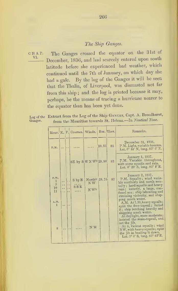
266
CHAP.VI.
Log of the
Ganges.
The Ship Ganges.
The Ganges crossed the equator on the 31st of
December, 1836, and had scarcely entered upon south
latitude before she experienced bad weather, which
continued until the 7th of January, on which day she
had a gale. By the log of the Ganges it will be seen
that the Thalia, of Liverpool, was dismasted not far
from this ship;and the log is printed because it may,
perhaps, be the means of tracing a hurricane nearer to
the equator than has been yet done.
Extract from the Log of the Ship Ganges, Capt. A. Broadhurst,
from the Mauritius towards St. Helena.—In Nautical Time.
Hour. Courses. Winds. Bar. 1[her. Remarks.
P.M. .... 29.83 83
December 31, 1836.
P .M. Light, variable breezes.
Lat. 0° 10' N, long. 83° 6' E.
SE by S WNW‘>’ 29.80 82
January 1, 1837.
P.M. Variable throughout,
•with some squalls and rain.
Lat. 0° 20' S, long. 83° P E.
P.M.
1
9
10
11
A.M.
1
8
• •
• •
• •
••
S by E
S S E....
. . • •
NorthbNWNWb
NW
29.75 82
January 2, 1837.
P.M. Squally; wind varia-
bly northerly and north-wes-
terly ;hard squalls and heavy
rain ;latterly, a large, con-
fused sea ;ship labouring and
straining violently, and ship-
ping much water
.
A.M. At 1.30, heavy squalls;
split the fore-topsail ;furled
it ;ship lurching heavily and
shipping much water.
At daylight, more moderate;
hoisted the main-topsail, and
set the jib.
At 8, Violent squalls ;wind
NW, with heavy squalls ;split
the jib in hauling it down.
Lat. 3° 6' S, long. 83° 42' E.
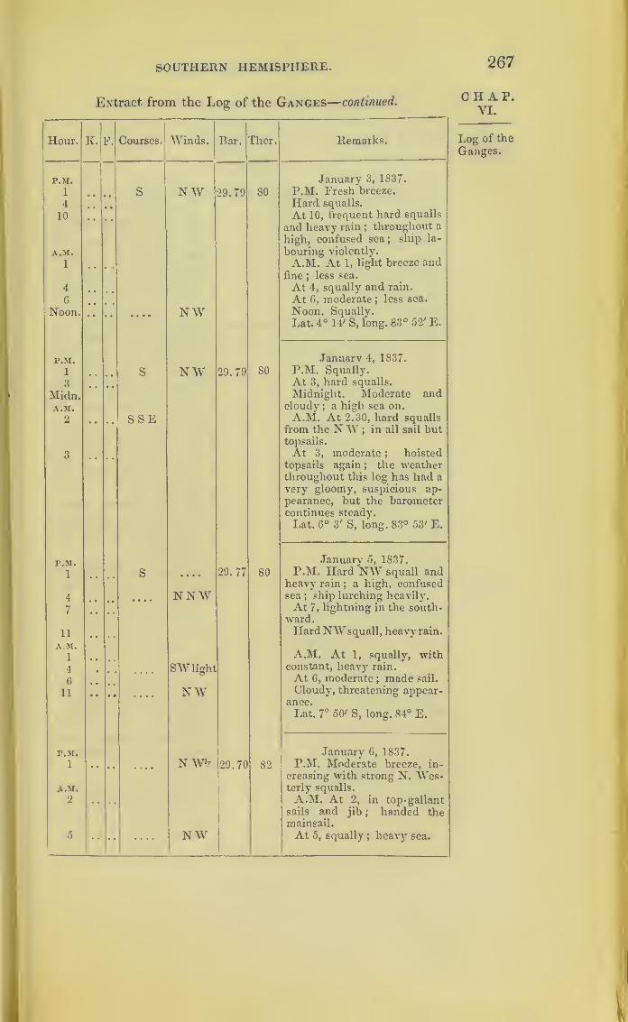
SOUTHERN HEMISPHERE. 267
Extract from the Log of the Ganges—continued.
Hour. K. F. Courses. Winds. Bar. Ther. Remarks.
P.M. January 3, 1837.
1 S NW 29.79 80 P.M. Fresh breeze.
4 Hard squalls.
10 • * At 10, frequent hard squalls
and heavy rain ;throughout a
high, confused sea;
ship la-
A.M. bouring violently.
1 A.M. At 1, light breeze andfine
;less sea.
4 At 4, squally and rain.
G At 6, moderate;less sea.
Noon. Squally.Noon. NWLat. 4° 14' S, long. 83° 52' E.
P.M. Januarv 4, 1837.
1 s NW 29.79 80 P.M. Squally.
3 At 3, hard squalls.
Midn. Midnight. Moderate and
A.M. cloudy;a high sea on.
2 * * SSE A.M. At 2.30, hard squalls
from the NW ;in all sail but
topsails.
3 At 3, moderate ; hoistedtopsails again; the weatherthroughout this log has had avery gloomy, suspicious ap-pearance, but the barometercontinues steady.
Lat. 6° 3' S, long. 83° 53' E.
P.M. January 5, 1837.
1 s .... 29.77 80 P.M. Hard NW squall andheavy rain
;a high, confused
sea ; ship lurching heavily.4 NNW7 •• At 7, lightning in the south-
ward.
11 . , . ,HardNWsquall, heavy rain.
A.M.
1 A.M. At 1, squally, withconstant, heavy rain.4 SW light
6 At 6, moderate; made sail.
11 # # • • NW Cloudy, threatening appear-ance.
Lat. 7° 50' S, long. 84° E.
P.M. Januarv 6, 1837.
1 •• •• — N W'r 129.70 82 P.M. Moderate breeze, in-
creasing with strong N. Wes-A.M.
1
terly squalls.
2 * * * * A.M. At 2, in top-gallantsails and jib
; handed themainsail.
5 • • •• — NW|
At 5, squally; heavy sea.
CHAP.VI.
Log of the
Ganges.

268 THE GANGES STORM.
Extract from the Log of the Ganges continued.
Log of the|
^our '
Ganges.
A.M.
9
|
Noon
K. F
P.M.
1
4
6
Midn.
I
Day 1 '
Noon
Midn
Day 11
A.M.
6
Courses. Winds.
S
Head fr.
W by S
N W
Bar. Ther.
29.70
WNW
82
29.60
NN W
NNW
82
SW bWto
SW b SS
NW 29.70
S by W
Remarks.
January 6, 1837.
At 9, squally ;heavy sea.
Noon. The weather having a]
very threatening appearance,
and the barometer falling,
down top-gallant masts and
yards on deck, and housed the
mizen-topmast, as I am nowapprehensive of a hurricane.
Lat. 9° 38' S, long. 84° 91 E.
81
January 7, 1837.
P.M. Increasing, with very
suspicious, threatening ap-
pearance, a high sea, and the
ship labouring violently ;ba-
rometer at 3 p.m. 29. 60, and
falling;pumped ship eighteen
inches ;handed fore-topsail,
and rounded two under the
main one.
At 4, heavy squalls ;handed
main-topsail and secured all
sails with extra gaskets.
At 6, blowing hard, with
furious squalls and heavy rain
and a high sea.
Midnight. Blowing a heavy
gale, with a high, cross, confu-
sed sea; ship labouring heavily.
Daylight, heavy gale and
violent squalls.
Noon. Ditto weather ;the
barometer fell to 29. 55, which
was the lowest, and it rose
towards noon to 29. 60.
Lat. 10° 15' S, long. 84°21'E.
January' 8, 1837.
P.M. Hard NW gale.
At 5, more moderate.
At 6.30, bore up south, and
set the foresail to ease the
violent motion of the ship.
Midnight. More moderate
and less sea.
Daylight, moderate, with
dark, squally, threatening ap-
pearance.
A.M. At 6.
During the forenoon the wea-
ther still looks suspicious and
the barometer has hastily
risen.
Lat. 11° 10' S, long. 84° 30' E.

SOUTHERN HEMISPHERE. 269
Extract from the Log of the Ganges—concluded.
Hour.
r.M.
1
K.
r.M.
1
P.M.
5.45
Courses.
S by W
SW by S
Winds. Bar.
NNW 29. 73
North 1 !' 29.76
S W b S Variable 29.78
29.78
SSE 29.80
Ther. Remarks.
80
84
84
84
83
January 9, 1837.
P.M. More moderate ; ahigh, cross, confused sea.
Moderate and fine;swell un-
abated;
set the main-topsail
double reefed.
Lat. 13° 4'S, long. 84° 22' E.
January 10, 1837.
P.M. Light breeze, decreas-
ing latterly, but squally ap-
pearance ; a heavy, confusedswell throughout.
Lat. 14° T S, long. 84° E.
January 11, 1837.
Light airs and fine, withconfused swell.
Lat. 14° 17' S, long. 83° 40' E.
January 12, 1837.
Light airs and calm.
Lat. 14° 26' S, long' 83° 43' E.
January 13, 1837.
P.M. At 5.45, saw a ship
S by E;standing north as we
neared her, observed she hadlost her mizenmast and top-masts
; backed the mainyardto speak to her, and to offer
her assistance.
At 6, spoke the stranger, theThalia, of Liverpool, bound toCalcutta ; informed us shehad lost her masts in a violenthurricane on the 7th inst. (theday we had the gale), in lat.
12° S, long. 85° E ; she hadbeen hove-to under bare polesfor nine hours before her mastswere blown away; she wasgoing tight and all well
; of-
fered to render assistance, butit was not required.
Lat. 16° S, long. 82° 10'.
CHAP.VI.
Log of the
Ganges.
Met the
Thalia.
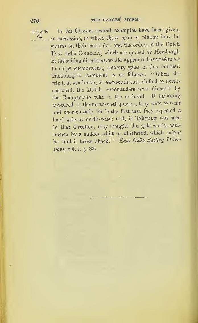
270 THE GANGES’ STORM.
CHAP.YI.
In this Chapter several examples have been given,
in succession, in which ships seem to plunge into the
storms on their east side ;and the orders ol the Dutch
East India Company, which are quoted by Horsburgh
in his sailing directions, would appear to have refeience
to ships encountering rotatory gales in this manner.
Horsburgh’s statement is as follows: “When the
wind, at south-east, or east-south-east, shifted to north-
eastward, the Dutch commanders were directed by
the Company to take in the mainsail. If lightning
appeared in the north-west quarter, they were to wear
and shorten sail ;for in the first case they expected a
hard gale at north-west; and, if lightning was seen
in that direction, they thought the gale would com-
mence by a sudden shift or whirlwind, which might
be fatal if taken aback .”—East India Sailing Direc-
tions, vol. i. p. 83.
271
CHAPTER VII.
ON TYPHOONS IN THE CHINESE SEA, AND ON THEIIUMIICANES OF INDIA.
This Chapter will contain such accounts of Typhoons chap.VII
in the China seas as I have been able to procure. !
They are neither in sufficient number nor sufficiently TyphoonsJ J m the
connected to be satisfactory : so far as they go, how- Chinese
ever, they exhibit the same character as the storms of
north latitude already traced ;and they may serve to
create an interest for more extensive inquiry into the
subject.
The H. C. S. Bridgewater,* Captain Maunderson,
was lying at Canton on the 9th of August, 1829,
when she was driven on shore by the violence of the
wind, and obliged to cut away her masts. At the com-
mencement of the hurricane the wind was northerly,
veering to the east,then becoming east-south-east, and
ending at south-east; by which it may be inferred
that the ship was in the northern or right hand semi-
circle of this storm.
At the same period the H. C. S. Charles Grant was
approaching Canton from the southward;and on the
night of the same 9tli of August, we find by her log,
she had the wind in the opposite direction, with squalls
and rain, and that she struck her royal masts and
yards, and split her main-topsail. It may be supposed
she was in the southern or left-hand portion of the
same storm.
* The same ship as that mentioned at page 260 .
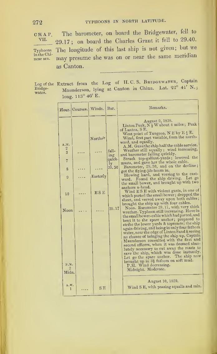
272 TYPHOONS IN NORTH LATITUDE.
CHAP.VII.
Typhoonsin the Chi-
nese sea.
Log of theBridge-water.
The barometer, on board the Bridgewater, fell to
29.17; on board the Charles Grant it fell to 29.40.
The longitude of this last ship is not given; but we
may presume she was on or near the same meridian
as Canton.
Extract from the Log of H.C.S. Bridgewater, Captain
Maunderson, lying at Canton in China. Lat. 22 41 N.
;
long. 1 13° 46' E.
Hour. Courses. Winds. Bar.
A.M.
2
3
7
8
9
10
Noon
Northr 1?
Remarks.
fall-
ingquick-
ly
29. 30
Easterly
ESE
29.17
P.M.2
Midn
A.M.1 SE
August 9, 1829.
Linten Peak, N iW about 4 miles ;Peak
of Lantoa, S E.
West point of Tungcoa, N E by E \ E.
Wind, first part variable, from the north-
ward, and squally.
A.M. Gave the ship half the cable service.
Weather still squally; wind increasing,
and barometer falling quickly.
Struck top-gallant-yards; lowered the
masts, and gave her the whole cable.
Barometer, 29. 30, and on the decline
;
got the flying-jib-boom in.
Blowing hard, and veering to the east-
ward. Found the ship driving. Let go
the small bower, and brought up with two
anchors a-head.
Wind ESE with violent gusts, in one ot
which parted the small bower ;dropped the
sheet, and veered away upon both cables;
brought the ship up with four cables.>
Noon. Barometer 29. 17, with very thick
weather. Typhoon still increasing. Hovemthesmallbower-cablewhichhadparted,and
bent it to the spare anchor;prepared to
strike the lower yards & topmasts; the ship
again driving, and being in only four fathom
water, near the edge of Linten Sand & seeing
no chance of bringing the ship up, Captain
Maunderson consulted with the first and
second officers, when it was deemed abso-
lutely necessary to cut away the masts to
save the ship, which was done instantly.
Let go the spare anchor. The ship now
brought up in 3$ fathom on soft mud.
P.M. Wind decreasing.
Midnight, Moderate.
August 10, 1829.
Wind S E, with passing squalls and rain,

TYPHOONS IN THE CHINESE SEA. 273
Extract from the Log of H. C. S. Charles Grant, from
England towards China.
CHAP.VII.
Hour. Courses. Winds, Remarks.
A.M. Saturday, August 8, 1829.1 E by S A.M. Hazy.6 Light airs.
8 Light airs, S by W in the first part;middle
easterly airs and calmsj
in the latter an in-
creasing breeze at N W.10 Light airs and calms.
P.M.
3
9— W by N
NWbW P.M. Cloudy.A.M. Scrubbed hammocks, and washed the
gun deck;Lady Melville in company.
Lat. observed, 17° 35' N. ;Bar. 29.55; Ther. 85°.
(Signed) JOSEPH COATES.
A.M.Sunday, August 9, 1829.
i NW A.M. Fresh breezes.
3 Cloudy.
5 In first and second reefs topsails.
11 NWbN Rain.
12 Midnight. Handed fore and mizen topsails.
P.M.
i • • • • W3 Throughout a strong breeze and cloudy wea-
ther, with squalls and rain.
4 • • • • W by S6 Struck royal masts and yards.8 Up foresail.
10 Split the main-topsail;shifted with the second
best.
Lat. observed, none ; Bar. 29.40; Ther. 83°.
Log of the
CharlesGrant.
The Raleigh's Hurricane.
A storm passed over the same place on the 5th and
6th August, 1835 ;and in the “ Asiatic Journal ” there
is the following short account of it.
“ A typhoon was experienced in the China Seas on the 5th and
6th August, 1835, during which the following vessels suffered :
—
“ The Danish brig Maria, totally wrecked on Pootoy.“ H. M. S. Raleigh, Captain Quin, dismasted, and in great
danger of foundering.
“ British brig Watkins, Whiteside, dismasted under Lantao.
“ Brig Governor Finlay, Kenedy, dismasted among the
islands.
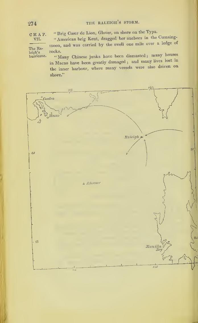
274 the raleigh’s storm.
CHAP. “ Brig Coeur de Lion, Glover, on shore on the Typa.
VII. “ American brig Kent, dragged her anchors in the Cumsing-
moon, and was carried by the swell one mile over a ledge of
The Ra-leigh’s rocks.
hurricane. “Many Chinese junks have been dismasted; many houses
in Macao have been greatly damaged;and many lives lost in
the inner harbour, where many vessels were also driven on
shore.”
ju. Schooner
.
15
-t-
(
1
r?
ManillaJ}ny

TYPHOONS IN THE CHINESE SEA. 275
The Raleigh sailed from Macao on the 1st of
August, 1835. On the 4th, the barometer was falling;
and in the afternoon, the wind veered round to the
N.N.E., when the storm set in. The barometer con-
tinued to fall until it was at 28.20, and soon after this
the ship upset. The master’s log speaks of the vessel
as being “ keel out;
” and the greater part of the
officers and ship’s company were upon the weather
larboard broadside for twenty minutes.
A three masted schooner, commanded by Mr.
Bennett, met with this hurricane, on the 5th of
August, in lat. 18° 2XS., and long. 115° 50' E. : but
this schooner’s log has not yet arrived from India.
Extract from the Log of H. M. S. Raleigh, Captain Quin, at
anchor in Macao Roads, from whence she sailed on the 1st of
August, 1835.—In Civil Time.
Hour. Courses. Winds. Bar. Ther. Remarks.
A.M. August 4, 1835.
i • • • • Variable8 • • • • N by E 29. 60 Barometer 29. 60, and falling
;in
fore and main-top-gallant-sail.
10 Close-reefed topsails and courses.
Noon • • • • 29. 45 Dowrn top-gallant-mast and yards.
12. 30 Barometer fell from noon . 15
;
took in sail as usual.
5 • • • • North1* Split the fore-staysail.
P.M.
7.30 • * • • SE The wind veered round to NNE,when a heavy typhoon commenced.
8 NNE 29.36 Ship, falling off, made a lurch, andtook in so much water that had notthe hatches been battened down, theconsequences must have been fatal
;
it vras wTith the greatest difficulty
she righted : typhoon increasing,
unbent main-trysail.*
10 • « • • NE At 10, p.m., close-reefed the fore-
trysail and set it; typhoon veering
gradually round to E N E, with aheavy sea.
* Portions have been omitted, which only relate to taking in sail.
T 2
CHAP.VII.
The Ra-leigh’s
hurricane.
Log of the
Raleigh.
Hurri-cane com-mences.

276 the raleigh’s storm.
Extract from the Log of H. M. S. Rale.gh-conclM.
Log of the
Raleigh.
Centre of
storm.
Remarks.
August 4, 1835.
Ship making such dangerous
lurches, in fore-trysail: typhoon
increasing.
August 5, 1835.
At 3, typhoon veered round to
E S E, still increasing in violence ;
and at 3, the barometer 29.5 and fall-
ing ;at 6.30, barometer falling from
28*30 to 28.20, commenced throwing
carronades, slides, and shot over-
board ;at 8 a.m. typhoon increasing,
relieved ship of remainingcarronades,
except the 7th carronade larboard.
(The cutter on larboard quarter held
so much of typhoon, and fearing the
boat might be forced up the mizen
rigging, or fall in-board and increase
ship’s danger, cut her away.) At
9 30, the ship made a very deep lee
lurch, and at the same time was
struck by a heavy weather sea ;the
typhoon blowing, if possible, with
still greater fury; the ship went
over, and carried away both wheel
ropes and relieving tackle; in this
awful situation, the ship lay for about
twenty minutes, with the major part
of officers and ship’s company on
her weather larboard broadside, who,
with the most praiseworthy coolness
and activity, succeeded in cutting
the lanyards of backstays and lower
rigging ;9.50, the masts and bow-
sprit went by the board, and H.
Majesty’s sloop righted, with lour
feet water in her hold.
Lat. 20° 44', long. 119 E.
People employed clearing the
wreckObserved the typhoon to moderate
a little. At 6, typhoon more mode-
rate, strong gusts of wind, with a
heavy sea from the southward.
The pinnace and second gig were
cut a-drift, and floated out of the
ship while she was on her beam ends,
or more properly speaking, keel-out
;
all anchors saved, two long guns
9 -pounders, one 32, and one Im-
pounder carronades, and a jolly-boat
on the poop larboard side saved
,
but in all other respects, a clean
sweep on her upper deck.

TYPHOONS IN THE CHINESE SEA. 277
Since the first edition of this work was printed,
Mr. Redfield has published some further accounts, rela-
tive to the Raleigh’s Hurricane, which will be found
at page 8 of the “ Nautical Magazine ” for January,
1839. I abstract from this account the following
tables of the barometer, at Macao and at Canton.
Canton is distant about sixty miles north of Macao.
The difference in the fall of the barometer at these
places is very remarkable, and strikingly indicates the
greater depression near the centre of a hurricane.
August 5 th.h. m. Barom.
August 6th.
h. m. Barom.
1. 0 A.M 1. 55 A.M
3. 30 p.m 2. 0 „5. 0 „ 29.20 2. 25 28. 56
7.20 „ 2.45
9. 0 29.08 3.10 „10.20 „ 3.40 „10.45 28. 90 4.10 „ 28.90
11. 5 „ 4.45 „11.30 5.15 „ 29.02
11.53 „ 6. 0 ....29.08
6. 45 j f 29. 12
August 6th.
0. 15 A.M
7.45
8.15
0.30 28.40 8.45 ,,
0.45 28.30 9. 30
1.20 ,, (lowest) 28. 05 10.25 „1.25 11. o
1.45 2. 0 p.m
After which the barometer continued rising to 29-65, at which
point it usually stands during fine weather .—Canton Register,
August 15.
The following is an account of the state of the
barometer and winds at Canton :
Hour. Barom. Wind. August 4th.
9 a.m. . . 29. 79 .
.
N.W . Fine weather.
4 p.m. .. 29.70 .. N. by W. . . Moderate breeze.
August 5th.
9 a.m. .. 29.62 .. N.&N.W. . Fair weather.
4 p.m. .. 29.54 .. Unsettled. . . Rain and fresh breeze.
12 „ .. 29.37 .. N. . Blowing hard and in heavy gusts.
CHAP.VII.
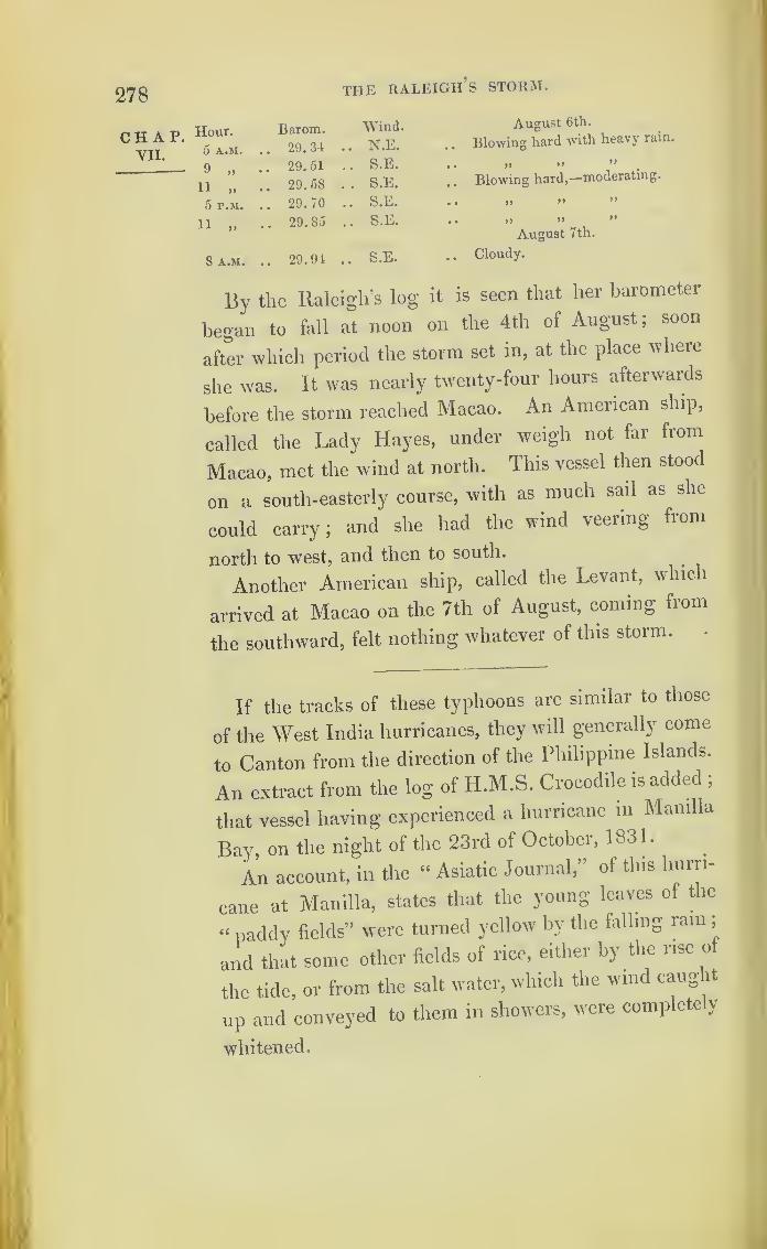
278 the raleigh’s storm.
chap.VII.
Hour. Barom. Wind. August 6th.
5 A.M. .. 29.34 .. N.E. Blowing hard with heavy rain.
9 .. 29.51 .. S.E. » » ”v 19
11 .. 29.58 . . S.E. Blowing hard,—moderating.
5 P.M. .. 29.70 .. S.E. » » ”
11 „ .. 29.85 . . S.E. .. >» >» ”
August 7th.
8 A.M. .. 29.94 .. S.E. . . Cloudy.
By the Raleigh’s log it is seen that her barometer
began to fall at noon on the 4th of August; soon
after which period the storm set in, at the place where
she was. It was nearly twenty-four hours afterwards
before the storm reached Macao. An American ship,
called the Lady Hayes, under weigh not far from
Macao, met the wind at north. This vessel then stood
on a south-easterly course, with as much sail as she
could carry ;and she had the wind veering from
north to west, and then to south.
Another American ship, called the Levant, which
arrived at Macao on the 7th of August, coming from
the southward, felt nothing whatever of this storm.
If the tracks of these typhoons are similar to those
of the West India hurricanes, they will generally come
to Canton from the direction of the Philippine Islands.
An extract from the log of H.M.S. Crocodile is added ;
that vessel having experienced a hurricane m Manilla
Bay, on the night of the 23rd of October, 1831.
An account, in the “ Asiatic Journal,” of this hurri-
cane at Manilla, states that the young leaves of the
“ paddy fields” were turned yellow by the falling rain ;
and that some other fields of rice, either by the rise of
the tide, or from the salt water, which the wind caught
up and conveyed to them in showers, were completely
whitened.

COLONEL CAPPER’S WHIRLWINDS. 279
Extract from the Log of H.M.S. Crocodile, Captain R. Bancroft,
at Manilla.—In Civil Time.
Hour. Courses. Winds. Remarks.
October 22, 1831.
A.M. .... ENE A.M. Light wind and cloudy.
P.M. P.M. Light wind and fine;latter part, mode-
rate breezes.
October 23, 1831.
A.M. • • • • NE A.M. Light wind and cloudy.P.M. P.M. Moderate and cloudy weather.
Sunset, increasing breeze and cloudy, veering
more northward.7 At 7, veered to seventy-five fathoms, and
ranged the best bower.8 • • • • N At 8.30, the ship drove, let go the best bower
;
pointed yards to the wind, and struck top-
gallant-masts ;carried away the main-top-
gallant-mast, by its being swayed through the
cross-trees.
11 At 11, the typhoon very heavy and the sea
high ; at 11.20, the ship again drove, veeredout the whole of the best bower, which broughther up ; at this time the first gig was washedaway from the quarter.
Midn. At midnight, the hurricane very severe, withheavy rain and high sea
;bent the sheet cable
over all, not being able to get it out of thehawse-hole.
October 24, 1831,
A.M. Typhoon very heavy, with incessantA.M. • • • • N byWrain and high sea.
1
NEAt 1 .40, its extreme rage abated, and shifted
to the N E ; the sea became less violent, andthe ship rode more easily ; but very heavysqualls.
Colonel Capper s Whirlwinds.
The late Colonel James Capper’s opinion, that hur-
ricanes are vast whirlwinds, was formed during twenty
years’ observation and study of the subject, on the
coast of Coromandel. In the preface to his work, pub-
lished in 1801, he says, that when he first attempted
an investigation into the winds in India, he had great
doubts of success, from the number and variety of
CHAP.VII.
Log of the
Crocodile.
280 COLONEL CAPPERS WHIRLWINDS.
CHAP, them: but as he proceeded, he found that there were
VIL many words to express the same thing, and that the
hurricane, the typhoon, and the tornado were but
English, Greek, or Persian, and Italian or Spanish
names, for a whirlwind.
In classing the winds, he observes, “ the tempest is,
both in cause and effect, the same as the hurricane 01
whirlwind; and that the storm, or what the English-
man calls a hard gale, is likewise nearly the same.
He also states, that it is a long standing error that
hurricanes in India occur only at the changes of the
monsoons; and that Dr. Halley must have been mis-
informed on that subject.
There is this difference in the observations of
Colonel Capper and Mr. Redfield, that the former
seemed of opinion that all whirlwinds are local and
temporary, whilst Mr. Redfield has clearly shown that
they are progressive. It is not improbable, however,
that some storms are local, and end nearly at the same
place where they began.
The accounts of those storms, quoted by Colonel
Capper, extracted from “ Orme’s History,” all oc-
curred on the coast of Coromandel : but the reports
given of some of the winds, though they may show
that these hurricanes were whirlwinds, are not suffi-
ciently detailed to enable us to determine their tracks,
and from what directions (if they were not local) they
came.
The following are extracts from Colonel Capper’s
work on the winds and monsoons.
« puring the siege of Pondicherry, at the time of the N.E.
cherry monsoon, and on the 30th of December, 1 760, the weather was
176o!
Cane’ fine in the evening 5
but a heavy swell rolled on the shore from

COLONEL CAPPERS WHIRLWINDS. 281
the south-east. The next morning the sky was of a dusky hue,
accompanied by a closeness of the air;but without that wild
irregularity which prognosticates a hurricane. Towards the
evening, however, the wind freshened from the north-west, and at
8 at night increased considerably. About midnight the wind
veered round to the north-east; fell calm with a thick haze-;
and, in a few minutes, flew round to the south-east, whence it
blew with great violence. Almost all the ships might have been
saved had they taken advantage of the wind blowing off the
land;but the roaring of the wind and sea prevented the cap-
tains from hearing the signals for standing out to sea. The
Newcastle and Protector were driven on shore, a few miles south
of Pondicherry, and the crews were saved. The Norfolk, Admiral
Stevens, returned next day;and on the 7th, came in the Salis-
bury, from Trinco, Trincomalee, south;
and the Tiger, from
Madras, north : so that in these opposite directions, of east,
north, and south, the violence of the storm had not been felt.
“The next in succession was that of 1773; on the 20th of
October that year, many days after the north-east monsoon had
apparently commenced, the wind began to slacken, and the
clouds in the evening appeared uncommonly red, particularly
on the day preceding the storm. On the morning of the 21st, a
strong wind blew oif the land; and, in the course of a few hours,
flew all round the compass. At this time the Norfolk, man-of-
war, Admiral Cornish, with the America and Weymouth, and
the Princess Charlotte, country ship of 400 tons, remained in
Madras Roads, with several other country vessels. The wind
began to blow from the north -west, and continued from that
quarter for three or four hours, of which time the men of war
availed themselves to put to sea;but it then suddenly shifted to
the eastward, and prevented most of the country ships from
following their example. After having blown with incessant
violence for fourteen hours, and with almost equal strength from
every point of the compass, it at length ceased, but literally left
only wrecks behind.
“ All the vessels at anchor were lost, and almost every person
on board perished;but the men- of-war and Princess Charlotte
returned into the Roads on the 24th. The former had felt the
gale very severely whilst near the coast, but without sustaining
any material injury : the latter vessel likewise, from staying
rather too long at anchor, had lost her fore and main masts, and
was otherwise much damaged.”
CHAP.VII.
Madrashurricane,
1773.

282 COLONEL CAPPER’S WHIRLWINDS.
CHAP.VII.
From the Admiralty I obtained copies of the log-
books of the Norfolk, the Salisbury, Tiger, York, and
other ships of Admiral Stevens’ squadron of 1760-1.
At Pondicherry Roads this storm began about N.N.W .,
and ended about S.S.E.
The Tiger, as well as the Salisbury, York, and
Weymouth, were all to the southward of Pondicheiiy,
and were in different places within the influence of
this storm;apparently showing that, like the others,
it came from the direction of the equator, although it
must have moved a little southerly at Pondicherry, by
the wind veering from N.N.W. to S.S.E.
After accounts of other storms, Colonel Cappei
continues :
—
“ Ships which put to sea in due time very soon get beyond
the influence of the hurricane to the eastward; and it is very
well known that they never extend far inland. All these cir-
cumstances, properly considered, clearly manifest the nature of
these winds, or rather positively prove them to be whirlwinds,
whose diameter cannot be more than 120 miles;and the vortex
seems generally near Madras or Pulicat. * Those which happen
in the north-east monsoon, generally fall with most violence
within a few leagues of this place, and never, I believe, reach
south of Porto Novo.
“ But at the commencement of the south-west monsoon,
violent gales are sometimes felt on the east side ot Ceylon, and
the southern extremity of the coast.”
After describing a hurricane, encountered in south
latitude by the Britannia, Indiaman, on the 10th of
March, 1770, and explaining that it did not extend
above 30 leagues, since the Britannia fell in with two
ships which were within this distance, Colonel Cappei
proceeds
“
Thus then it appears that these tempests
or hurricanes are tornadoes or local whirlwinds, and
are felt with at least equal violence on the sea coast
COLONEL CAPPER’S WHIRLWINDS.
and at some little distance out at sea. But there is a
material difference in the situation of the sun when
they appear at different places : on the coast of Coro-
mandel, for example, they seldom happen, particularly
to the northward, except when the sun is in the oppo-
site hemisphere. On the Malabar coast they rage
with most violence during the monsoon, whilst the sun
is almost vertical. Near the island of Mauritius they
are felt in January, February, and March, which may
be deemed their summer months;and in the West
Indies, according to Mr. Edward’s ‘History of Ja-
maica,’ the hurricane season begins in August and
ends in October.”
In Colonel Capper’s work, we find Franklin’s expla-
nation of what first led him to observe that the north-
east storms of America came from the south-west. It
is in a letter to Mr. Alexander Small, dated the 12th
of May, 1760, and is as follows:—
-
“ About twenty years ago, we were to have an
eclipse of the moon at Philadelphia, about 9 o’clock;
I intended to have observed it, but was prevented by
a north-east storm, which came on about 7, with thick
clouds as usual, that quite obscured the whole hemi-
sphere;
yet when the post brought us the Boston
newspaper, giving us an account of the same storm in
those parts, I found the beginning of the eclipse had
been well observed there, though Boston is north-east
of Philadelphia about 400 miles. This puzzled me,
because the storm began so soon with us as to prevent
any observation;
and, being a north-east storm, I
imagined it must have begun rather sooner in places
further to the north-eastward, than it did at Philadel-
phia;but I found that it did not begin with them until
283
CHAP.VII.
Franklin.

284 BAY OF BENGAL HURRICANES.
chap, near 1 1 o'clock, so that they had a good observation
VILof the eclipse. And, upon comparing all the other
accounts I received from the other colonies, of the time
of the beginning of the same storm, and since that of
other storms of the same kind, I found the beginning
to be always later the further north-eastward.”
Whilst introducing the above paragraph, Colonel
Capper says, it affords us a proof that a current of air
in America moved many hundred miles during a
north-east storm, probably from the Gulf of Mexico to
Boston. Thus, having stated his belief that hurricanes
were whirlwinds, he was upon the point of showing
also that they were progressive.
Bay of Bengal Hurricanes .*
Bay of When hurricanes occur at the mouths of the River
hurricanes. Ganges, the inundations of the sea, owing to the
lowness of the alluvial land there, appear to be very
disastrous; and also to be very frequent. On the
31st of October, 1831, during a hurricane, it is said,
150 miles of country were flooded, and 300 villages,
with 10,000 persons, destroyed.
Hurricane, The account of another hurricane, on October 7,
?832°.ber7
’ 1832, being more detailed, is here reprinted from the
“ Asiatic Journal.” It will be seen that the barometer
of the ship London fell very nearly two inches on that
day, off the mouths of the Ganges ;whilst at Clian-
dernagore it only fell half an inch. It may hence be
presumed, as well as from the report of the wind, that
the London was near the centre of the storm. The
* See “ The Progress of the Development of the Law of Storms.
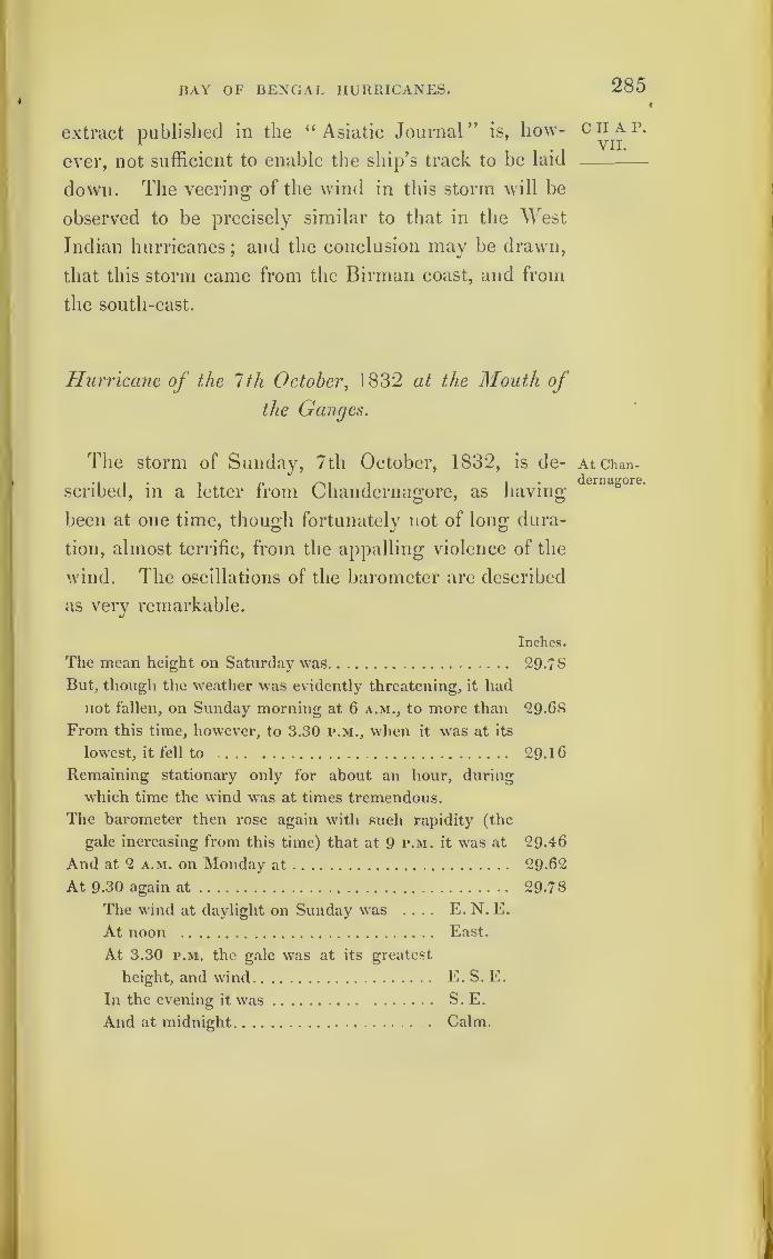
BAY OF BENGAL HURRICANES.
extract published in the “Asiatic Journal” is, how-
ever, not sufficient to enable the ship’s track to be laid
down. The veering- of the wind in this storm will be
observed to be precisely similar to that in the West
Indian hurricanes;and the conclusion may be drawn,
that this storm came from the Birman coast, and from
the south-east.
Hurricane of the 1th October,1832 at the Mouth of
the Ganges.
The storm of Sunday, 7th October, 1832, is de-
scribed, in a letter from Chandernagore, as having-
been at one time, though fortunately not of long dura-
tion, almost terrific, from the appalling violence of the
wind. The oscillations of the barometer are described
as very remarkable.
Inches.
The mean height on Saturday was 29-78
But, though the weather was evidently threatening, it had
not fallen, on Sunday morning at 6 a.m., to more than 29-68
From this time, however, to 3.30 p.m., when it was at its
lowest, it fell to ... 29- 1
6
Remaining stationary only for about an hour, during
which time the wind wras at times tremendous.
The barometer then rose again with such rapidity (the
gale increasing from this time) that at 9 p.m. it w-as at 29-46
And at 2 a.m. on Monday at 29-62
At 9-30 again at 29-78
The wind at daylight on Sunday was .... E. N. E.
At noon East.
At 3.30 p.m. the gale was at its greatest
height, and wind E. S. E.
In the evening it was S. E.
And at midnight Calm.
285
CHAP.YII.
At Chan-dernagore.

286 BAY OF BENGAL HURRICANES.
CHAP. Extract from the “Asiatic Journal,” relative to a Gale on the
VII. 7th October, 1S32.
Lo°- of the Note made from the Log of the Ship London, Mr. Wimble,
London. Commander, between lat. 18° 26' and 20° 23'j
long. 86 o0
and 90° East.
1
1
Hour.j Winds. Bar. Remarks.
A.M.
8
12
29.70
October 6, 1832.
A M. Cloudy weather.
.... 29. 50 Midnight. Squalls and raiu.
A.M.
8 NE 29.40
October 7, 1832.
A.M. Squalls, with rain.
10 ENE Strong gales.
Noon 28.90 Noon. Gales increasing.
P.M.
4 E by N 28.80 P.M. Eresh gales.
6 28.50 A hurricane.
8
9
27.80 Tremendous hurricane.
SW 28.10
Wind shifted to S W, and blew with in-
creased violence.
10 28.20 Increased violence.
12 .... 29.00 Midnight. More moderate.
A.M.
6 SW 29.30
October 8, 1832.
A.M. Moderating.
Noon1
• • • •
1
29.50 Noon. Strong gales, high sea.
At Calcutta, during the same storm, the wind, com-
mencing at north-east,veered to east
,then shifted to
south-west. The lowest point of the barometer at
Calcutta was 29.20.
Hurricane The most severe storm of late occurrence at the
?83Lay21
’ mouth of the Ganges, is that of May 21, 1833, when
the H. E. I. C. ship Duke of York was carried a great
way inland and wrecked. An account of her loss was
published soon after ;but is now out of print, and no
copy can be obtained.
In the Journal of the Bengal Asiatic Society, Mr.
Princep (secretary to the society) has given a report of
the barometer on board the Duke oi ^ ork. The fall is
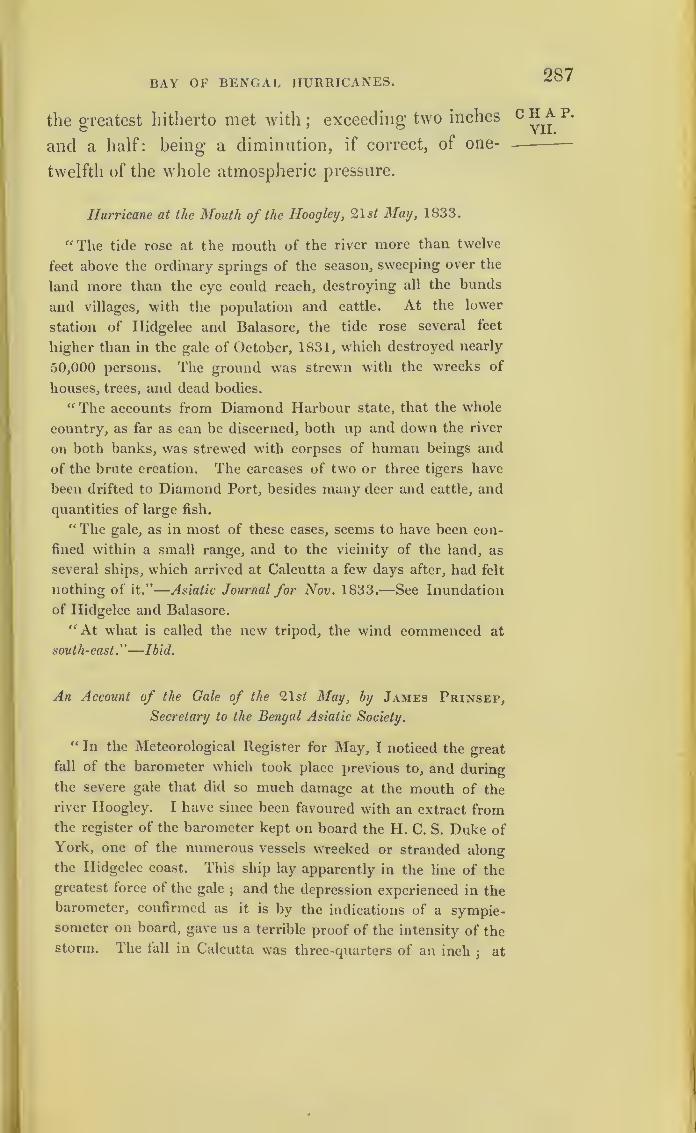
BAY OF BENGAL HURRICANES. 287
the greatest hitherto met with;exceeding two inches
and a half: being a diminution, if correct, of one-
twelfth of the whole atmospheric pressure.
Hurricane at the Mouth of the Hoogley
,
21s/ May, 1833.
“ The tide rose at the mouth of the river more than twelve
feet above the ordinary springs of the season, sweeping over the
land more than the eye could reach, destroying all the bunds
and villages, with the population and cattle. At the lower
station of Hidgelee and Balasore, the tide rose several feet
higher than in the gale of October, 1831, which destroyed nearly
50,000 persons. The ground was strewn with the wrecks of
houses, trees, and dead bodies.
“ The accounts from Diamond Harbour state, that the whole
country, as far as can be discerned, both up and down the river
on both banks, was strewed with corpses of human beings and
of the brute creation. The carcases of two or three tigers have
been drifted to Diamond Port, besides many deer and cattle, and
quantities of large fish.
“ The gale, as in most of these cases, seems to have been con-
fined within a small range, and to the vicinity of the land, as
several ships, which arrived at Calcutta a few days after, had felt
nothing of it.”
—
Asiatic Journal for Nov. 1833.—See Inundation
of Hidgelee and Balasore.“ At what is called the new tripod, the wind commenced at
south-east.”
—
Ibid.
An Account of the Gale of the 21s/ May, by James Prinsep,
Secretary to the Bengal Asiatic Society.
“ In the Meteorological Register for May, I noticed the great
fall of the barometer which took place previous to, and during
the severe gale that did so much damage at the mouth of the
river Hoogley. I have since been favoured with an extract fromthe register of the barometer kept on board the H. C. S. Duke of
York, one of the numerous vessels wrecked or stranded along
the Hidgelee coast. This ship lay apparently in the line of the
greatest force of the gale;and the depression experienced in the
barometer, confirmed as it is by the indications of a sympie-someter on board, gave us a terrible proof of the intensity of the
storm. The fall in Calcutta was three-quarters of an inch;
at
CHAP.VII.
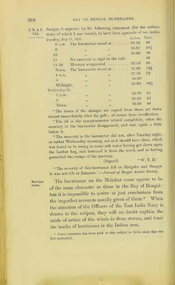
288 BAY OF BENGAL HURRICANES.
0 II A P.
VII.
Malabarcoast.
Saugor, it appears, by the following statement (for the authen-
ticity of which I can vouch), to have been upwards of two inches.
Tuesday, May 21, 1833.
8 a.m. The barometer stood at
9 >> »
10 ,> >>
11 No mercury in sight in the tube
11.30 Mercury reappeared
Noon. The barometer stood at . .
Inches.
29.09
28.67
28.00
26.50
27-00
Ther.
80
80 h
80
80
80
79 £
4 P.M. yy27-50 79
8 >} .»
Midnight. „ »
28.00
28.60 80g
Wednesday 22.
4 AoM. » >>
8 ,> >>
Noon. „ »
“The times of the changes are copied from those set down
almost immediately after the gale;
of course from recollection.
“ The oil in the sympiesometer retired completely, when the
mercury in the barometer disappeared, and rose again a little
before it.
“ The mercury in the barometer did not, after Tuesday nig t,
or rather Wednesday morning, act as it should have done, which
was found to be owing to some salt water having got down upon
the leather bag, and loosened it from the wood, and so having
permitted the escape of the mercury.
(Signed) “W. T. D.
28.20 81
28.30 82
2S.60 84
“ The severity of this hurricane fell on Hidgelee and Saugor.
It was not felt at Balasore."—Journal of Bengal Asiatic Society.
The hurricanes on the Malabar coast appear to be
of the same character as those in the Bay of Bengal
:
but it is impossible to arrive at just conclusions from
the imperfect accounts usually given of them.* When
the attention of the Officers of the East India Navy is
drawn to the subject, they will no doubt explain the
mode of action of the winds in these storms, and trace
the tracks of hurricanes in the Indian seas.
* Great attention has been paid to this subject in India since this was
first published.


•289
CHAPTER VIII.
the HURRICANES OF 1 780.
A [.-TER having so far studied the nature of storms, I
felt desirous of ascertaining whether the greatest hur-ricane recorded in West Indian history partook of thesame character as those already described
; and theBoard of Admiralty have afforded me every facility inobtaining the documents necessary for the inquiry.
Ihrce great storms occurred nearly at the sametime
;and these have been confounded together, and
considered but as one. The first destroyed the townof Savanna-la-Mar, on the 3rd of October, 1780.The second
> and by far the greater one, passed overBarbados on the 10th and 11th of the same monthand year. The third dispersed and disabled theSpanish fleet, under Solano, in the Gulf of Mexico,after it had sailed from Havannah, to attack Pen-sacola.
An account, published in the “ Annual Register/’ ofan earthquake having occurred at the same time, hasbeen quoted as an example to prove that these twophenomena are connected. An earthquake may cer-tainly occur at the same time as a hurricane
; but, inthe West Indies, persons seem to have been pre-disposed to believe in these phenomena accompanying
c II a r.
VIII.
290
CHAP.VIII
HURRICANES OF 1780 .
each other. We have a very strong instance of this
in Sir George Rodney’s despatch ;for, after express-
ing his conviction that an earthquake must have
accompanied the great Barbados hurricane, he states
“ that the violence of the wind could alone have pre-
vented the inhabitants from feeling the shock,” which
only proves the force of the wind. The mode of
investigation adopted here, of printing in detail the
whole of the matter collected relative to hurricanes,
will afford to every one the same opportunity for
forming a judgment on the truth, or otherwise, of the
connection between these phenomena. A note on tins
subject, introduced into the modern editions of Bryan
Edwards’s History of the West Indies, is not to be
found in the last edition, which that author revise
before his death. There seems no reason to doubt,
from what we now know of the effects caused by
hurricanes, that Savanna-la-Mar was overwhelms
by the sea, owing to the effect of diminished atmo-
spheric pressure, together with the force of the
wind. .
Chart IX. has been formed from the various docu-
ments procured relative to these storms. As England
was then at war, there were large fleets in the West
Indies and on the American coast ;and this circum-
stance has afforded great facilities for tracing these
^alcs •
On the same principle as that followed in the
preceding chapters, documents explanatory of these
three hurricanes will now be given in detail; the
course of the first one being marked by a line dotted
on the Chart. ......The command of the British fleet in the West

HURRICANE OF 1780. 291
Indies was divided. Sir Peter Parker commanded
at Jamaica, and was at Port Royal; but Sir George
Rodney was ofT New York in the Sandwich, having
gone to the coast of America with a portion of his
fleet just before the storms occurred.
Of Sir Peter Parker’s squadron, the Thunderer,
Stirling Castle, Scarborough, Barbados, Phoenix,
Deal Castle, Victor, and the Endeavour, were all
lost; and nearly the whole of their crews perished.
The Berwick, Hector, Trident, Ruby, Bristol, Ulysses,
and Pomona, were dismasted.
Of Sir George Rodney’s squadron, the Blanche,
Andromeda, Laurel, Camelion, and Beaver’s Prize,
were lost;and the Vengeance, Montagu, Ajax, Alc-
mene, Egmont, Endymion, Albemarle, Venus, and
Amazon, were dismasted or severely damaged.
Some of the logs printed to explain the Savanna-
la-Mar hurricane, serve also to explain the great
Barbados hurricane.
It is necessary, in comparing the dates, to bear
in mind that the log-books of 1780 were kept in
nautical time.
II A p.
VIII.
u 2

292
Savcinna-la-Mar Hurricane.
chap. Account of the Jamaica hurricane of the 3id of
VI1LOctober, 1780, from the “Annual Register.”
Savanna-La-Mar.
Chart IX.
Earth-quake said
to havebeen felt
at 10 p.m.
LuceaBay,Jamaica.
MontegoBay,Jamaica.
Midnight.
“About one p.m. the gale began from the S.E., and con-
tinued increasing with accumulated violence until tour in the
afternoon, when it veered to the south, and became a perfect
tempest, which lasted in force until near eight; it then abated.
The sea during the last period exhibited a most awful scene
;
the waves swelled to an amazing height, rushed with an im-
petuosity not to be described on the land, and in a few minutes
determined the fate of all the houses in the Bay.
“About ten the waters began to abate, and at that time a
smart shock of an earthquake was felt. All the small vessels
were driven ashore, and dashed to pieces. The ships. Princess
Royal, Captain Ruthven; Henry, Richardson ;and Austin Hall,
Austin, were forced from their anchors, and carried so far into
the morass that they will never be got off. The earthquake
lifted the Princess Royal from her beam-ends, righted her, and
fixed her on a firm bed. This circumstance has been of great
use to the surviving inhabitants, for whose accommodation she
now serves as a house.
“At Lucea Bay only two houses remain; and H. M. sloop
Badger, lying in that harbour, has lost all her masts, and run
on shore.
“ At Montego Bay the tempest increased to such an amazing
degree, as at dark to threaten general ruin and destruction.
The prodigious flashes of lightning, which regularly succeeded
each other, was an alleviation. From midnight (from the best
of our information and recollection) the storm began to abate.
The log of H. M. sloop Badger, then commanded
by the late Lord Collingwood, which is mentioned as
having been in Lucea Bay, will be given;and Lucea
Bay will be found marked on the Ghait.
SAVANNA-LA-MAR HURRICANE, 1780. 293
The centre of the hurricane passed over this vessel
about six o’clock on the afternoon of the 3rd October.
Four of the ships which were lost, the Phoenix,
Scarborough, Barbados, and Victor, were lying in
Mondego Bay a few days before the storm. The two
last sailed on the 29th;
the Phoenix on the 30th of
September; and the Scarborough on the 1st of
October. This last ship was bound for the Spanish
Main. Both the Badger and Phoenix were in com-
pany with the Barbados just previous to the hurri-
cane. The place of the Barbados when last seen by
the Phoenix, and of the Phoenix when wrecked on the
coast of Cuba, are both marked on the Chart. The
Scarborough and Victor have never been heard of.
In a published letter by the First Lieutenant of the
Phoenix, the hurricane, as felt by that ship, is thus
described. When the Phoenix was in company with
the Barbados off Port Antonio, the wind began to
blow, with a stormy appearance to the eastward, about
1 1 at night, on the 2nd of October;and the Phoenix
then close-reefed her topsails. At 8, on the morning
of the 3rd, the wind was east-north-east,with occa-
sional heavy squalls;
and Sir Hyde Parker, who
commanded the Phoenix, remarked that the weather
had the same appearance as lie had observed in the
commencement of a hurricane in the East Indies.
He then ordered the topsails to be taken in, and wore
the ship in order to keep mid channel between Jamaica
and Cuba.
At 2 p.m. the Phoenix lav-to, with a storm mizen-
staysail, and her head to the northward. When night
set in, the storm increased with great violence. At
midnight the wind was south-east, and the ship
ciiap.VIII.

SAVANNA-LA-MAR HURRICANE, 1780.
chap, drawing upon Cuba, Sir Hyde Parker determined to
Wear her ;but no canvass could withstand the wind
at this time, and she was wore by sending two hun-
dred of the crew into the fore-rigging. When about
to cut away the masts, the ship took the ground on
the coast of Cuba ;and it was then 5 o’clock in the
morning of the 4th of October. At Lucea Bay,
Jamaica, the Badger's log shows that, six or seven
hours before this period, it was moderate weather
there ;and this proves the progress of the storm. An
extract from Lieut. Archer’s letter to his mother will
be found to follow after the log of the Princess Royal.
By the account here given, the hurricane wou
appear to have come to Savanna-la-Mar from the
south-eastward.
Log of the Extract from the Log of H. M. S. Badger, commanded by
Cutlrbert Collingwood, Esq., at Lucea Bay, amai
T'Jfmtirnl Time.
Badger
Hour. Courses. Winds. Remarks.
P.M.
A.M.
10
Noon.
Monday, October 2, 1780.
P.M. Showery ;received on board two cords
of wood from the shore.
A M. Weighed, in company with the Man-
chcec, for Pensacola. At 10, dispatched the
above vessel for Pensacola..
Noon, came-to, for Lucea harbour, in set en
fathoms water, with the best bower.
P.M.
9
A.M.
10
1
NETuesday, October 3, 1780.
P.M. Moderate.. ... „n
At 9, hard rain, and continued raining all
night, with squally weather. _ .
At 10, tripped our anchor ;let her dm e
within the point of the Fort, till it bore
E, distant three-quarters of a mile ,and the
easternmost N E by N, distant one mde and a
half ;heavy squalls, with hard rain ;
down top-
gallant-masts.
_____

SAVANNA-LA-MAR HURRICANE, 1780.
Extract from the Log of H. M. S. Badger—concluded.
205
Hour. Courses. Winds. Remarks.
F.M.
1
4
4.30
5
5.30
6
10
A.M.
....
NE
CalmS W
Wednesday, October 4, 1780.
P.M. At 1, let go the sheet anchor in five
and a half fathoms ;muddy ;
veered the cable,
and brought both anchors a-head; continued
very heavy gales, with hard rain.
At 4, let go another anchor.
At 4.30, both sheet and bower anchors
came home ; veered away to the clinch roundthe mast, when the best bower cable parted
;
then immediately the sheet cable parted like-
wise.
At 5, she was driving on shore very fast,
when a gU3t of wind laid her down, with the
coamings of the hatchway in the water.
By consent of captain and officers, cut awaythe weather lanyards of the main shrouds,
when the mainmast went away about twentyfeet above deck
;she immediately righted, and
drove broadside on shore, abreast of the town,the sea making a free passage over us, whenour boat went to pieces alongside.
At 5.30 cut the bower cable t<j let her swingend on.
About 6, it fell calm for half an hour, whenthe wind shifted round to the S W, blowing ahurricane, with strong flashes of lightning.
At 10, it became quite moderate.A.M. Turned everybody to, to clear the
wreck of the mast ; moderate, with frequentshowers.
Tuesday, October 10, 1780.
Had an account of H.M.S. Phoenix beingwrecked on the coast of Cuba.
(Signed) JAMES MORING.
CHAP.VIII.
Log of the
Badger.
Extract of a despatch from Rear-Admiral Sir Peter
Parker, commanding a squadron on the Jamaica sta-
tion, dated on board the Ruby, Port Royal harbour,
Nov. 6, 1780.
“ It is with much concern, that I give the following detail of
the disasters which have befallen some of the ships and vessels
on this station in the late hurricanes.
“The 4th of last month, at half-past five in the morning,
H.M.S. Phoenix was wrecked on the island of Cuba, about three
leagues to the eastward of Cape Crux, in a most dreadful liurri-
296 SAVANNA-LA-MAR HURRICANE, 1/80.
CHAP, cane ; and, according to Sir Hyde Parker’s representation, if
VIII. she had not been driven on shore she must soon have foundered.
All the ship’s company were saved excepting twenty, most ot
whom were lost with the mainmast and washed overboard. Sir
Hyde Parker despatched his first lieutenant, Mr. Archer, in one
of the ship’s boats to Montego Bay for assistance ;and, by the
1
1
th of October, all that remained of the ship’s crew, to the num-
ber of 240, were embarked on board of H.M. sloop Porcupine
and three sloops, and arrived safe in Montego Bay on the loth.
I sent the James to bring the people round to this port and this
bay. Sir PI. Parker was tried for the loss of the ship, and
honourably acquitted.
“ H. M. sloops the Barbados and Victor, and PI. M. S. the
Scarborough, were in the hurricane. The two former, it is ap-
prehended, are foundered;but the latter, I am in hopes, is sate.
She was under orders to proceed to the Spanish Main 5and as
the hurricane ran in veins, she may have escaped, as N'ell as the
Pallas, Diamond, Pelican, and Lowestoffe, who were also at sea
at the time, Mid are all arrived safe, without any damage what-
ever. The Pomona arrived on the 24th, with the bowsprit and
foremast sprung, and mizen-mast gone;and on the 26th, Rear-
Admiral Rowley arrived in the Grafton, with the following sliips^
from convoying the trade part of the way to Europe, viz., the
Plector, Bristol, Trident, and Ruby, all of them disabled, and
mostly dismasted. The Ulysses arrived the same day, without
main and mizen-mast, having thrown all her upper-deck guns
overboard. Captain Stewart has informed me that he is going to
England with the Berwick, dismasted 5and I hope the Thunderer
and Stirling Castle are also on their passage home, for I have not
as yet received any intelligence ot these ships.
“Their Lordships will see, by the enclosed defects of the
ships, what a miserable state several of them are in5
and what
a number of masts, yards, and stores, are wanting to refit
them.
“ I have dircted the naval storekeeper to send an abstract ot
the defects, &c., and remainder of stores in our magazine, to the
Commissioners of the Navy, and I have written to them on that
head..
...“ Surveys are taking on the hulls of the ships that were in the
hurricanes of the 5th and l?th ultimo. It is at present appre-
hended that the Hector cannot be put into a condition here to
enable her to proceed to England before next summer 5but she

SAVANNA-LA-MAR HURRICANE, 1780. 297
may then safely undertake the voyage with jury-masts, and only C II A P.
a few guns on board. She threw all her guns overboard in the MU.
storm, excepting two 18-pounders.
“ I shall send home with the next convoy as many of the
disabled ships as can be fitted with jury-masts. By the different
accounts which have arrived, I find that the late storms have
visited the Windward Islands as well as these seas. The
Egmont arrived here on the 28th ultimo. On the 11th of last
month the Egmont, Montagu, Ajax, and Amazon, being placed
across the entrance of the cai'cenage to St. Lucia, were obliged, by
the violence of the wind, to put to sea;
and Captain Fanshawe
does not know what has become of the other ships. On the 29tli,
the Endymion arrived at this port from a cruize to windward of
Martinico, with only the foremast standing. She brought in
with her two French ships, named the Marquis de Braneas and
L’Esle, which she took on her way hither. These two ships
were, on the 11th of October, forced out with many others from
St. Pierre's Road, Martinico, by the violence of the storm. They
only arrived the day before with about fifty merchant ships,
transports, and victuallers, and having 5000 troops on board; French
and were escorted by two French frigates, named La Ceres and conv°y-
La Constant.
“ I am. Sir, &c.
(Signed) " P. PARKER.”
“To Philip Stephens, Esq.”
Extract of a letter from Rear-Admiral Sir Peter
Parker, Commander on the Jamaica station, dated on
board the Ruby, 30th December, 1780.
“By my last letter of the 6th ultimo, their Lordships will
see the distressed state of this squadron. The loss of the Scar-
borough frigate, and the Barbados and Victor sloops, seems nowpast all doubt. The Thunderer has not been heard of. There is
a chance that she has either got to England or America.
“The 19th of October, the Stirling Castle, after having wea-
thered the late gale and saved her foremast, her hull being very
little damaged, ran at nine o’clock at night, going eight knots,
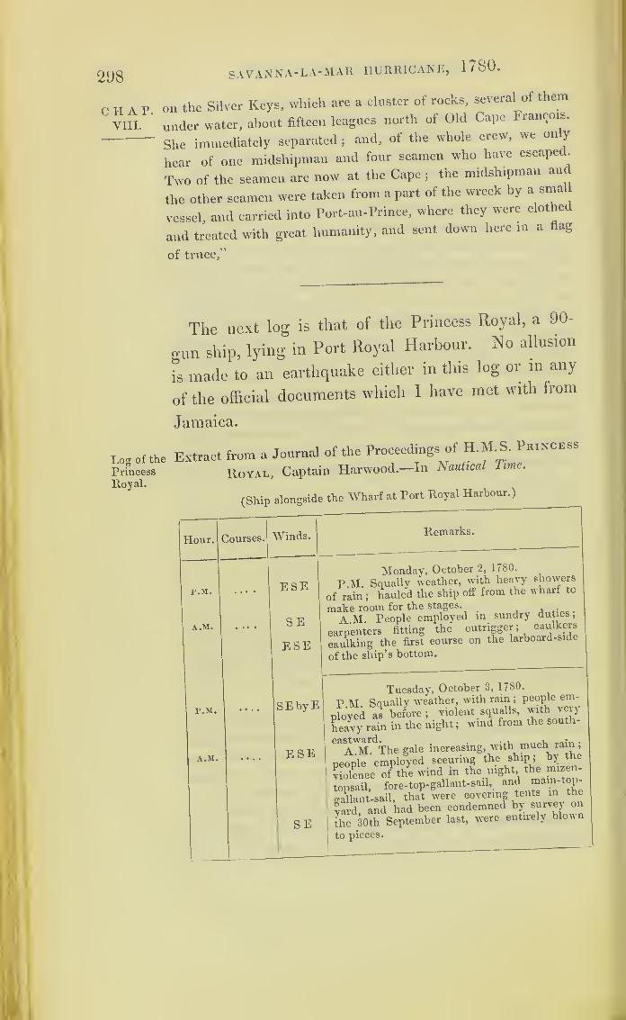
298 SAVANNA- LA-MAR HURRICANE, 1780.
C H A P.
VIII.
on the Silver Keys, which are a cluster of rocks, several of them
under water, about fifteen leagues north of Old Cape Francois.
She immediately separated; and, ot the whole crew, we on y
hear of one midshipman and four seamen who have escaped.
Two of the seamen are now at the Cape;
the midshipman and
the other seamen were taken from a part of the wreck by a small
vessel, and carried into Port-au-Prince, where they were clothed
and treated with great humanity, and sent down here in a flag
of truce,”
The next log is that of the Princess Royal, a 90-
o-un ship, lying in Port Royal Harbour. No allusion
is made to an earthquake either in this log or in any
of the official documents which 1 have met with from
Jamaica.
Log of the Extract from a Journal of the Proceedings of H.M.S. Princess
Princess Royal, Captain Harwood.—In Nautical Time.
Royal.
(Ship alongside the Wharf at Port Royal Harbour.)
Hour. Courses. Winds.
P.M. . . . •ESE
1
A.M. SE
ESE
P.M. — SEbyE
A.M. ESE
Remarks.
SE
Monday, October 2, 1780.
P.M. Squally weather, with heavy showers
f rain ;hauled the ship off from the wharf to
(lake room for the stages._ . .
A M. People employed m sundry duties
,
carpenters fitting the outrigger ;caulkers
caulking the first course on the larboard-side
of the ship’s bottom.
Tuesday, October 3, 1780.
V M Saually weather, with rain;people em-
ployed as before ;violent squalls, with very
heavy rain in the night ;wind from the south-
CaAAL^Thc gale increasing, with much rain;
people employed securing the ship ;by the
violence otPthe wind in the night the nnzen-
topsail, fore-top- gallant-sail, and mam-top-
*aUant-sail, that were covering tents in the
Sard, and had been condemned by survey on
the 30th September last, were entirely blown
to pieces.

SAVANNA-LA-MAR HURRICANE, 1780. 299
Extract from a Journal of the Proceedings of H. M.S. Princess
Royal
—
concluded.
Hour. Courses. Winds. Remarks.
r.M. SSEWednesday, October 4, 1780.
P.M. Excessive * hard squalls, with thun-
A.M. S
der, lightning, and rain;people employed as
before. At midnight more moderate, and light
rain.
A.M. Moderate and fair; people employed
ssw
getting the outrigger’s pendants over the mast-
head, and other duties ;caulkers caulking the
larboard-side of the ship’s bottom.
Extract from a letter* of Lieutenant Archer’s to
his mother. The Phoenix frigate had been sent to
Pensacola. This extract commences from that part
of the letter which speaks of the ship’s return to
Jamaica.
“Nothing remarkable happened for ten days afterwards,
when we chased a Yankee man-of-war for six hours, but could
not get near enough to her before it was dark, to keep sight of
herj
so that we lost her because unable to carry any sail on
the mainmast. In about twelve days more made the island of
Jamaica, having weathered all the squalls, and put into Mon-tego Bay for water
jso that we had a strong party for kicking
up a dust on shore, having found three mcn-of-war lying there.
Dancing, &c. &c. till two o’clock every morning, little thinking
what was to happen in four days’ time;
for out of the four
men-of war that were there, not one was in being at the end
of that time, and not a soul alive but those left of our crew.
Many of the houses, where we had been so merry, were so
completely destroyed, that scarcely a vestige remained to markwhere they stood. Thy works are wonderful, O God
!praised
be thy holy name !
“ September the 30th, weighed;bound for Port Royal, round
the eastward of the island;
the Barbados and Victor had sailed
the day before, and the Scarborough was to sail the next. Mo-
C H A P.
VIII.
Log of the
Princess
Royal.
Chart IX.
Lieut.
Archer’sletter.
* I am indebted to Mr. Redfield for this letter.

300 SAVANNA- LA-MAlt HURRICANE, 1780.
C II A P.
VIII.
derate weather until October the 2nd. Spoke to the Barbados
off Port Antonio in the evening. At eleven at night it began
to snuffle, with a monstrous heavy appearance from the east-
ward. Close reefed the topsails. Sir Hyde sent for me. ‘What
sort of weather have we. Archer ?’ ‘ It blows a little, and has a
very ugly look : if in any other quarter but this, I should say
we were going to have a gale of wind. —‘Ay, it looks so \ery
often here when there is no wind at all;however, don t hoist
the topsails till it clears a little;there is no trusting any coun-
try.’ At twelve I was relieved;
the weather had the same
rough look : however, they made sail upon her, but had a very
dirty night. At eight in the morning I came up again, found
it blowing hard from the east-north-east with close-reefed topsails
upon the ship, and heavy squalls at times. Sir Hyde came
upon deck. ‘ Well, Archer, what do you think of it ?‘ Oh,
Sir, it is only a touch of the times;we shall have an observa-
tion at twelve o’clock;the clouds are beginning to break
;it
will clear up at noon, or else blow very hard afterwards. I
wish it would clear up;but I doubt it much. I was once in a
hurricane in the East Indies, and the beginning of it had much
the same appearance as this: so take in the topsails; we ha\e
plenty of sea-room.’
“ At twelve, the gale still increasing, wore ship, to keep as
near mid-channel, between Jamaica and Cuba, as possible : at
one the gale increasing still;
at two harder yet : it still blows
harder. Reefed the courses, and furled them ;brouglit-to under
a foul mizen-staysail : head to the northward. In the evening
no sign of the weather taking off, but every appearance of the
storm increasing, prepared for a proper gale of wind;secured
all the sails with spare gaskets;good rolling tackles upon the
yards;squared the booms
;saw the boats all made fast
;new
lashed the guns;double-breeched the lower deckers ;
saw that
the carpenters had the tarpaulins and battens all ready for hatch-
ways;
got the top-gallant-mast down upon the deck;jib-boom
and spritsail-yard fore and aft; in fact, every thing we could
think of to make a snug ship.
« The poor devils of birds now began to find the uproar in the
elements, for numbers, both of sea and land kinds, came on
board of us. I took notice of some which, happening to be to
leeward, turned to windward, like a ship, tack and tack;
for
they could not fly against it. When they came over the ship
they dashed themselves down upon the deck, without attempt-

SAVANNA-LA-MAR HURRICANE, 1780. 301
ing to stir till picked up, and when let go again they would not
leave the ship, but endeavoured to hide themselves from the
wind.“ At eight o’clock a hurricane
;the sea roaring, but the wind
still steady to a point;did not ship a spoonful of water. How-
ever, got the hatchways all secured, expecting what would be
the consequence, should the wind shift;placed the carpenters
by the mainmast, with broad axes, knowing, from experience,
that at the moment you may want to cut it away to save the
ship an axe may not be found. Went to supper— bread, cheese,
and porter. The purser frightened out of his wits about his
bread-bags;
the two marine-officers as white as sheets, not
understanding the ship’s working so much, and the noise of the
lower deck guns, which, by’’ this time, made a pretty screeching
to people not \ised to it;
it seemed as if the whole ship’s side
was going at each roll. Wooden, our carpenter, was all this time
smoking his pipe and laughing at the doctor;the second lieute-
nant upon deck, and the third in his hammock.“ At ten o’clock I thought to get a little sleep
;came to look
into my cot, it was full of water;
for every seam, by the strain-
ing of the ship, had begun to leak. Stretched myself, therefore,
upon deck between two chests, and left orders to be called,
should the least thing happen. At twelve a midshipman came
to me. * Mr. Archer, we are just going to wear ship, Sir.’‘ Oh,
very well;
I’ll be up directly. What sort of weather have you
got?’—‘It blows a hurricane.’ Went upon deck; found Sir
Hyde there. ‘ It blows damned hard. Archer.’ ‘It does indeed.
Sir.’
—
fI don’t know that I ever remember its blowing so hard
before, but the ship makes a very good weather of it upon this
tack as she bows the sea;but we must wear her, as the wind
has shifted to the south-east, and we are drawing right upon
Cuba; so do you go forward, and have some hands stand by;
loose the lee yard-arm of the foresail, and, when she is right
before the wind, whip the clew-garnet close up, and roll up
the sail.’‘ Sir, there is no canvass can stand against this a
moment;
if we attempt to loose him he will fly into ribbons in
an instant, and we may lose three or four of our people;
she’ll
wear by manning the fore shrouds.’
—
c No, I don’t think she
will.’ ‘ I'll answer for it, Sir ; I have seen it tried several times
on the coast of America with success.’
—
( Well, try it; if she
does not wear, we can only loose the foresail afterwards.’ This
was a great condescension from such a man as Sir Hyde. How-
C H A P.
VIII.

302 SAVANNA- LA-MAR HURRICANE, 1780.
C II A P.
VIII.
ever by sending about two hundred people into the fore-rigging,
after a hard struggle, she wore;found she did not make so
n-ood weather on this tack as on the other;
for as the sea began
to run across she had not time to rise from one sea be ore
another lashed against her. Began to think we should lose
our masts, as the ship lay very much along, by the pressure o
the wind constantly upon the yards and masts alone;
for the
poor mizen-staysail had gone in shreds long before, and the
sails began to fly from the yards through the gaskets into
coachwhips. My God ! to think that the wind could have such
force!
“ Sir Hyde now sent me to see what was the matter between
decks, as there was a good deal of noise. As soon as I was
below, one of the marine-officers calls out, ‘Good God . h .
Archer, we are sinking; the water is up to the bottom ot my
cot.’—
‘ Pooh, pooh ! as long as it is not over your mouth you
are well off; what the devil do you make this noise lor r 1
found there was some water between decks, but nothing to .<
alarmed at ;scuttled the deck, and let it run into the we ;
found she made a good deal of water through the sides and
decks; turned the watch below to the pumps, though only two
feet of water in the well ;but expected to be kept constantly at
work now, as the ship laboured much, with scarcely a part ot
her above water but the quarter-deck, and that but seldom.
‘ Come, pump away, my boys. Carpenters, get the weather
Chain-pump rigged.’* AH ready, Sir.’- • Then man it, and keep
both pumps going.’
« At two o’clock the chain-pump was choked; set
penters at work to clear it;the two head-pumps at work upon
deck • the ship gained upon us while our chain-pumps weie
idle • in a quarter of an hour they were at work again, an, we
beoan to gain upon her. While I was standing at the pumps,
cheering the people, the carpenter s mate came running to me
w th a face as long as my arm. ‘ Oh, Sir, the ship has sprung a
leak in the gunner’s room.’-' Go, then, and tell the carpenter
to come to me ;but don’t speak a word to any one else. ... r.
Goodirmh, I am told there is a leak in the gunner’s room;go
and see what is the matter, hut don t alarm any bo y
,
come and make your report privately to me.’ In “ ‘‘“e
he returned. 'Sir, there’s nothing there; tis only the wat
wasCc «P between the timbers that this booby has taken for a
Teak.’ ' Oh, very well;go upon deck and see if you can keep
SAVANNA-LA-MAR HURRICANE, 1780. 303
any of the water from washing down below.’—
‘ Sir, I have
had four people constantly keeping the hatchways secure, but
there is such a weight of water upon the deck that nobody can
stand it when the ship rolls.’ The gunner soon afterwards
came to me. ‘ Mr. Archer, I should be glad if you would step
this way into the magazine for a moment.’ I thought some
damned thing was the matter, and ran directly ‘ Well, what is
the matter here ?’—‘ The ground tier of powder is spoiled, and I
want to show you that it is not out of carelessness in me in
stowing it, for no powder in the world could be better stowed :
now, Sir, what am I to do ? if you don’t speak to Sir Hyde, he
will be angry with me.’ I could not forbear smiling to see how
easy he took the danger of the ship, and said to him, ‘ Let us
shake olf this gale of wind first, and talk of the damaged powder
afterwards.’
“ At four we had gained upon the ship a little, and I went
upon deck, it being my watch. The second lieutenant relieved
me at the pumps. Who can attempt to describe the appear-
ance of things upon deck ? If I was to write for ever I could
not give you an idea of it—a total darkness all above3the sea
on fire, running as it were in Alps, or Peaks of Teneriffe (moun-
tains are too common an idea)3the wind roaring louder than
thunder (absolutely no flight of imagination); the whole made
more terrible, if possible, by a very uncommon kind of blue
lightning3
the poor ship very much pressed, yet doing what
she coidd, shaking her sides, and groaning at every stroke. Sir
Hyde upon deck lashed to windward ! I soon lashed myself
alongside of him, and told him the situation of things below,
saying the ship did not make more water than might be ex-
pected in such weather, and that I was only afraid of a gun
breaking loose. ‘ I am not in the least afraid of that;
I have
commanded her six years, and have had many a gale of wind
in her;
so that her iron work, which always gives way first,
is pretty well tried. Hold fast! that was an ugly sea3we
must low'er the yards, I believe, Archer;
the ship is muchpressed.’—‘ If we attempt it, Sir, we shall lose them, for a manaloft can do nothing
3besides, their being down would ease the
ship very little;the mainmast is a sprung mast
3I wish it was
overboard without carrying anything else along with it3
butthat can soon be done
jthe gale cannot last for ever
3’twill
soon be daylight now.’ Found by the master’s watch that it
was five o’clock, though but a little after four by ours;clad
CHAP.VIII.
304 SAVANNA-LA-MAR HURRICANE, 17 SO.
CHAP.VIII.
it Was so near daylight, and looked for it with much anxiety.
Cuba, thou art much in our way! Another ugly sea: sent
a midshipman to bring news from the pumps : the ship was
gaining on them very much, for they had broken one of their
chains, but it was almost mended again. News from the pump
again. ‘ She still gains ! a heavy lee !’ Back-water from lee-
ward, half-way up the quarter-deck, filled one of the cutters
upon the booms, and tore her all to pieces; the ship lying
almost on her beam-ends, and not attempting to right again.
Word from below that the 1 ship still gained on them, as they
could not stand to the pumps, she lay so much along. I said to
Sir Hyde, ‘ This is no time. Sir, to think of saving the masts
;
shall we cut the mainmast away ?‘ Ay ! as last as you can.
I accordingly went into the chains with a pole-axe, to cut away
the lanyards ;the boatswain went to leeward, and the carpenters
stood by the mast. We were all ready, when a very violent
sea broke right on board of us, carried every thing upon deck
away, filled the ship with water, the main and mizen masts
went, the ship righted, but was in the last struggle of sinking
under us. 0 . „ ,
» As soon as we could shake our heads above water, Sir Hyde
exclaimed,f We are gone at last, Archer ! foundered at sea !
—< Yes, Sir
;farewell
;and the Lord have mercy upon us . I
then
5
turned about to look forward at the ship, and thought
she was struggling to get rid of some of the water;but all in
vain: she was almost full below. ‘Almighty God! I thank
thee, that now I am leaving this world, which I have always
considered as only a passage to a better, I die with a full hope
of thy mercies, through the merits of Jesus Christ, thy son, our
Saviour !’
, , T
“ I then felt sorry that I could swim, as by that means I
miBht be a quarter of an hour longer dying than a man who
could not ;and it is impossible to divest ourselves of a wish
to preserve life. At the end of these reflections I thought I
heard the ship thump and grinding under our feet : it_was so.
Sir, the ship is ashore 1' ‘ What do you say ? - The ship
is ashore, and we may save ourselves yet!
'
By this time the
quarter-deck was full of men, who had come up from below
and -The Lord have mercy upon us! flying about from a
quarters. The ship now made every body sensible that she was
ashore for every stroke threatened a total dissolution of her
whoTe frlei found she was stern ashore, and the how broke
SAVANNA-LA-MAR HURRICANE, 1780. 305
the sea a good deal, though it was washing clean over at every C II A P.
stroke. Sir Hyde cried out, ‘ Keep to the quarter-deck, my ^ ***'
lads; when she goes to pieces it is your best chance!’ Pro- |J
videntially got the foremast cut away, that she might not pay
round broadside. Lost five men cutting away the foremast,
by the breaking of a sea on board just as the mast went. That
was nothing, every one expected it would be his own fate next
:
looked for daybreak with the greatest impatience;
at last it
came : but what a scene did it show us ! The ship upon a bed
of rocks, mountains of them on one side, and Cordilleras of
water on the other; our poor ship grinding and crying out at
every stroke between them;
going away by piecemeal. How-
ever, to show the unaccountable workings of Providence, that
which often appears to be the greatest evil proves to be the
greatest good ! That unmerciful sea lifted and beat us up so
high among the rocks that at last the ship scarcely moved.
She was very strong, and did not go to pieces at the first
thumping, though her decks tumbled in. We found afterwards
that she had beat over a ledge of rocks, almost a quarter of a
mile in extent beyond us, where, if she had struck, every soul
of us must have perished.“
I now began to think of getting on shore, so stripped off mycoat and shoes for a swim, and looked for a line to carry the
end with me. Luckily could not find one, which gave me time
for recollection. * This won’t do for me, to be the first man out
of the ship, and first lieutenant;we may get to England again
;
and people may think I paid a great deal of attention to myself,
and did not care for any body else. No, that won’t do;instead
of being the first, I will see every man, sick and well, out of her
before me.’“
I now thought there was no probability of the ship’s soon
going to pieces, therefore had not a thought of instant death :
took a look round with a kind of philosophic eye, to see how the
same situation affected my companions, and was surprised to
find the most swaggering, swearing bullies, in fine weather, now
the most pitiful wretches on earth, when death appeared before
them. However, two got safe; by which means, with a line, we
got a hawser on shore, and made fast to the rocks, upon which
many ventured and arrived safe. There were some sick and
wounded on board, who could not avail themselves of this
method;we, therefore, got a spare top-sail-yard from the chains,
X •
„ i
306 SAVANNA-LA-MAR HURRICANE, 1780.
C H A P.
VIII.
and placed one end ashore and the other on the cabin window,
so that most of the sick got ashore this way.
“ As I had determined, so I was the last man out of the ship
;
this was about ten o’clock. The gale now began to break. Sir
Hyde came to me, and taking me by the hand, was so affected
that he was scarcely able to speak. ‘ Archer, I am happy beyon
expression to see you on shore, but look at our poor Phoenix
I turned about, but could not say a single word, being too lull
.
my mind had been too intensely occupied before; but every
thing now rushed upon me at once, so that I could not contain
myself, and I indulged for a full quarter of an hour in tears.
“ By twelve it was pretty moderate;got some nails on shore
and made tents;found great quantities of fish driven up by the
sea into holes of the rocks;knocked up a fire, and had a most
comfortable dinner. In the afternoon made a stage from t le
cabin windows to the rocks, and got out some provisions and
water, lest the ship should go to pieces, in which case we must
all have perished of hunger and thirst;
for we were upon a deso-
late part of the coast, and under a rocky mountain, that could
not supply us with a single drop of water.
“ Slept comfortably this night and the next day, the idea o
death vanishing by degrees;
the prospect of being prisoners,
during the war, at Havanna, and walking three hundred miles
to it through the woods, was rather unpleasant. However, to
save life for the present, we employed this day in getting more
provisions and water on shore, which was not an easy matter,
on account of decks, guns, and rubbish, and ten feet water that
lay over them. In the evening, I proposed to Sir Hyde to
repair the remains of the only boat left, and to venture in her to
Jamaica myself; and in ease I arrived safe, to bring vessels to
take them all off;a proposal worthy of consideration. It was,
next day, agreed to;therefore got the cutter on shore, and set
the carpenters to work on her;
in two days she was ready, and
at four o’clock in the afternoon I embarked with four volunteers
and a fortnight’s provision ;hoisted English colours as we put
off from the shore, and received three cheers from the lads left
behind which we returned, and set sail with a light heart,
having not the least doubt, that, with God’s assistance, we
should come and bring them all off. Had a very squally night,
and a very leaky boat, so as to keep two buckets constant y
baleing. Steered her myself the whole night by the stars, and in
SAVANNA-LA-MAR HURRICANE, 1780 . 307
the morning saw the coast of Jamaica, distant twelve leagues.
At eight in the evening arrived at Montego Bay.“
I must now begin to leave off, particularly as I have but half
an hour to conclude;
else my pretty little short letter will lose
its passage, which I should not like, after being ten days, at dif-
ferent times, writing it, beating up with the convoy to the north-
ward, which is a reason that this epistle will never read well
;
for I never sat down with a proper disposition to go on with itj
but as I knew something of the kind would please you, I was
resolved to finish it:yet it will not bear an overhaul
;so don’t
expose your son’s nonsense.
“ But to proceed. I instantly sent off an express to the
admiral, another to the Porcupine man-of-war, and went myself
to Martha Bay to get vessels;
for all their vessels here, as well
as many of their houses, were gone to moco. Got three small
vessels, and set out back again to Cuba, where I arrived the
fourth day after leaving my companions. I thought the ship’s
crew would have devoured me on my landing;they presently
whisked me up on their shoulders, and carried me to the tent
where Sir Hyde was.
“ I must omit many little occurrences that happened on shore,
for want of time;but I shall have a number of stories to tell
when I get alongside of you; and the next time I visit you I
shall not be in such a hurry to quit you as I was the last, for
then I hoped my nest would have been pretty well feathered.
But my tale is forgotten.
I found the Porcupine had arrived that day, and the lads had
built a boat almost ready for launching, that would hold fifty of
them, which was intended for another trial, in case I had
foundered. Next day embarked all our people that were left,
amounting to two hundred and fifty;
for some had died of their
wounds they received in getting on shore;
others of drinking
rum;
and others had straggled into the country. All our
vessels were so full of people, that we could not take away the
few clothes that were saved from the wreck;
but that was a
trifle since we had preserved our lives and liberty. To makeshort of my story, we all arrived safe at Montego Bay, and
shortly after at Port Royal, in the Janus, which was sent on
purpose for us, and were all honourably acquitted for the loss
of the ship. I was made admiral’s aide-de-camp;and a little
time afterwards sent down to St. Juan’s as captain of the Re-
source, to bring what were left of the poor devils to Blue Fields
X 2
CHAP.VIII.

308
CHAT.VIII.
SAVANNA-LA-MAR HURRICANE, 1/SO.
on the Musquito shore, and then to Jamaica, where they arrived
after three months’ absence, and without a prize, though I looked
out hard off Porto Bello and Carthagena. Found in my absence
that I had been appointed captain of the Tobago, where I re-
main his Majesty’s most true and faithful servant, and my dear
mother’s most dutiful son.. ••
The logs of the four ships, which Sir Peter Parker
in his despatch reports as having returned safe, follow
It will be seen, that the Pelican and Diamond,
which were to the south of Jamaica, felt nothing of the
first storm ;and that the Pallas and Lowestoffe were
out of the influence of it, cruizing near the islands ot
Caycos; yet they had the wind from south-south-west,
and must have been just on the border of the gale.
The Scarborough, on her way from Montego l?ay
to the Spanish Main, would be within its influence off
the west end of Jamaica, and near that point she pio-
bably foundered.
This hurricane may have originated within the
limits of the Caribbean Sea; since we have no ac-
count of its passing over the chain of the Antilles
islands, or of having visited the Spanish Main.
Log of the
Pelican.
Extract from the Log of H.M.S. Pee, can, Captain Thomas
Haynes.—In Nautical Time.
Hour. Courses. Winds. Remarks.
r.M.
1
4
5
6
WNWN W by NN by EN f W
Wester'f
October 3, 1780.
P.M. Light breezes and cloudy.
Lat. 12° 38', long. 82° 7'.
Great Corn Island, S 68° W, distance 3o
miles.
A.M.
7 NW

SAVANNA-LA-MAR HURRICANE, 1780 .
Extract from the Log of H. M. S. Pelican—continued.
Hour. Courses. Winds. Remarks.
p.m. October 4, 1780.
1 NW by W Wester 1? Moderate breeze and clear weather.
2 SSE Lat. 12° 25' N.
7 W Great Corn Island, SW by W, distance
9 W by N 8 leagues.
10 N WA.M.
9 S
P.M. October 5, 1780.
1 WNW Ditto P.M. Fresh breezes.
6 NW by W Great Corn Island,W S W, 24 leagues.
7 S by E9 SSE10 S
A.M.
4 NW A W10 S12 NW
\October G, 17S0.
Ditto Fresh breeze and cloudy ;at anchor at
Great Corn Island.
P.M. October 7, 1780.
2 WNW S West1? Moderate breeze and clear weather;got
5 NW A W under weigh.
7 S by W8 SSW9 S byW
S11
Noon Noon. Lat. 12° o' N.
A.M. October 8, 1780.
Light breezes and clear.3 S i E Wester1?
5 NW Lat. 12° 2'.
7 N W by N8 NW
10 N N W
Variable October 9, 1780.
October 10, 1780.
First and latter part, light breezes andVariableclear ; middle part, squally.
October 11, 1780.Wester 1 ? Light breezes.
309
CHAP.VIII.
Log of tlie
Pelican.

310 SAVANNA-LA-MAR hurricane, 1780 .
CHAP.VIII.
Log of the
Pelican.
Withinthe in-
fluence of
the great
hurricane.
Extract from the Log of H. M. S. Pelican-continued.
Hour. Courses. Winds. Remarks.
Noon. vv s wOctober 12, 1780.
Got under weigh and made sail.
Noon. Moderate.
Great Corn Island, NE|E, distance 7
leagues.
Lat. 12° 9'.
P.M.
3
9
12
A.M.
E
E|SE
E by N
E N E
SE bySOctober 13, 1780.
Presh breezes and clear; set studding-
S
Lat. 11° 47', long. 80° 40'.
The Island of St. Andna, bearing N 9
W, distance 44 miles.
11
P.M.
1
Noon.
sswsw
October 14, 1780.
P.M. Light breezes and clear weather.
Noon. Moderate breeze and cloudy.
Lat. 12° 8', long. 79° 31'.
Bugles’ Shoals, bearing N 21 E, dis-
tance 70 leagues.
P.M.
1
6
A.M.
3
4
6
10
NoOn.
EN E wsw
swww sw
October 15, 17S0.
P.M. Moderate breeze and clear weather.
Hauled down the studding-sails.
A.M. Hard squall and rain ;handed the
top- gallant-sails and staysails.
Presh gales and rainy weather.
More moderate and lair.
Presh gale and hazy ;close-reefed top-
sails, and handed the fore and mizen
ditto ;down top-gallant-yards.
Lat. 12° 52' N, long. 76 58 W.Bugles’ Shoals, N 24° W, distance 187
miles.
P.M.
1
7
A.M.
10
Noon.
N E by NN by E w
October 16, 1780.
P.M. Presh gale and cloudy.
In third reef main-topsail, and handed
the mizen-topsail.
Hard squalls; lowered topsails occa-
sionally.
Noon. Ditto weather.
A.M.
7
8
NJEN
No observation.
Lat. 15° 35', long. 75° 55 .
P.M.1
Q
N swW S "W
October 17, 1780.
P.M. Presh gales, with squall.
Hauled up the courses and bent the main-
sail, it being split, and bent another.
Set the mainsail and lay-to ;hard squalls,4
7 sw12 wsv
with rain. .
f More moderate and rainy weather,
>
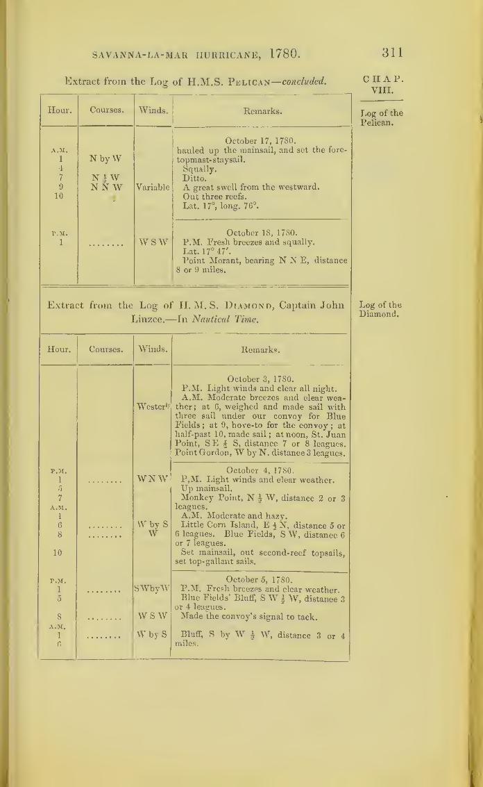
SAVANNA-LA-MAR HURRICANE, 1780.
Extract from the Log of H.M.S. Pelican— concluded.
311
Hour. Courses. Winds. Remarks.
October 17, 1780.A.M. hauled up the mainsail, and set the fore-
1 N byW topmast-staysail.4 Squally.7 NJW Ditto.9 NNW Variable A great swell from the westward.
10 * Out three reefs.
Lat. 17°, long. 76°.
P.M. October 18, 1780.
i wsw P.M. Fresh breezes and squally.
Lat. 17° 47'.
Point Morant, bearing N N E, distance
8 or 9 miles.
Extract from the Log of LI. M. S. Diamond, Captain John
Linzee.—-In Nautical Time.
Hour. Courses. Winds. Remarks.
October 3, 1780.
P.M. Light winds and clear all night.A.M. Moderate breezes and clear wea-
WesterO' ther; at 6, weighed and made sail withthree sail under our convoy for BlueFields
;at 9, hove-to for the convoy
; athalf-past 10, made sail
; at noon, St. JuanPoint, SE i S, distance 7 or 8 leagues.Point Gordon, W by N. distance 3 leagues.
P.M. October 4, 1780.
i WNW P.M. Light winds and clear weather.Up mainsail.5
7 Monkey Point, N | W, distance 2 or 3A.M. leagues.
1 A.M. Moderate and hazy.
6 W by SW
Little Com Island, E § NT, distance 5 or6 leagues. Blue Fields* S W, distance 6or 7 leagues.
8
10 Set mainsail, out second-reef topsails,set top- gallant sails.
P.M. October 5, 1780.
1 SWbyW P.M. Fresh breezps and clear weather0 Blue Fields’ Bluff, SW § W, distance 3
or 4 leagues.
8 W S W Made the convoy’s signal to tack.
A.M.
1
6
W by S Bluff, S by W i W, distance 3 or 4miles.
CHAP.VIII.
Log of the
Pelican.
Log of the
Diamond.

312
CHAP.VIII.
Log of the
Diamond.
SAVANNA-LA-MAIt HURRICANE, 1 / 80 .
Extract from the Log of H. M. S. Diamond— continued.
Hour. Courses. Winds. Remarks.
r.M.
1
S 52° E Calm
October 6, 1780.
P.M. Fresh breezes.
Lat. 10° 40', long. 81° 5'.
Corn Island, bearing N 52° W ,distance
98 miles.
P.M.
1 S 81° E SEOctober 7, 1780.
P.M. Light winds and hazy.
Lat. 10° 32', long. 80° 3'.
Porto Bello, S E, 14 leagues.
P.M.
1
EWester 1 '
1
October 8, 1780.
P.M. Light airs and cloudy.
Lat. 10° 32', long. 79° 12' W.
P.M.
1
E by NEasterly
October 9, 1780.
P.M. Light breezes.
Lat. 10° 52', long. 78° 5'.
P M.
1
EVariable
October 10, 1780.
P.M. Light air and clear weather.
Lat. 10° 54', long. 76° 33' W.
r.M.
1 SEOctober 11, 1780.
P.M. Squally, with rain.
A.M.
2 A.M. Light winds and squalls, with
rain.
No observation.
High land of Santa Marta, bearing S E,
distance 11 leagues.
P.M.
1
Midn.A.M.
11
NNE i E
S WsswWN W
October 12, 1780.
P.M. Moderate and cloudy.
Moderate and squally.
Moderate breezes and rain.
Lat. 12°, long. 73°.
P.M.1 SWbyV
NW
October 13, 1780.
7 P.M. Fresh breezes and squally.
6
8 Light airs and fair weather.
A.M.
4 NWbVV Moderate and squally.
Noon NE NW Noon. Moderate and fair.
Lat. 13° 57', long. 72° 26'
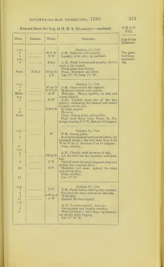
SAVANNA-LA-MAR HURRICANE, 1780.
Extract from the Log of H. M. S. Diamond— continued.
313
Hour. Courses. Winds. Remarks.
P.M. October, 14, 1780.
1 W NW P.M. Moderate and squally.
Squally, with rain ; up mainsail.4 NWA.M.
4 Ditto A.M. Fresh breezes and squally ;in two
reefs in the topsail.
NoonFresh gales and cloudy.
NNE W by N Noon. Moderate and clear.
Lat. 15° 59', long. 71° 38'.
P.M. October 15, 1780.
1
4
Why NNWbW
P.M. Close-reefed the topsails.
Moderate breezes and squalls.
Midnight. Heavy squalls ;in fore and
mizen-topsail.
Midn. NWA.M.
7 N W A.M. Carried away one of the fore
sheets;clewed up the foresail and reefed
it again, set the sail.
9 NWbW In main-topsail.
Hove- to.10
Noon Noon. Strong gales and squally.
High land about Cape Beata, St. Do-mingo, bearingNN W, distance 13 leagues.
P.M. October 16, 1780.
1 W P.M. Strong gales.
4 Reefed the mainsail and handed ditto ; set
balanced mizcn; the land bore from S by
AV to AV by N, distance 12 or 14 leagues.
12 Ditto weather.A.M.
5SWbyW
A.M. Cloudy, with showers of rain.
7 Let the reef out the mainsail, and madesail.
8 S WSAV
Carried away the main- topmast-stay andspring, fore-topmast ditto.
10 Moderate and clear; spliced the stays
and set up ditto.
Ditto weather.12 Lat. 17° 22'.
P.M.
1
4
8
12
S AVOctober 17, 1780.
P.M. Fresh breeze and squally weather.Spanned the main and mizen shrouds.AVore ship.
Handed the fore-topsail.
SAVbySS AV
AM.1 A.AI. In main-topsail
; hove-to.6 Strong gales and squally weather.
11 More moderate ; wore ship; up foresail
;
set up the main rigging.
Lat. 17° 35' N.
C H A P.
VIII.
Log of the
Diamond.
The great
hurricaneapproach-ing.

314 SAVANNA-LA-MAR HURRICANE, 1/80.
C H A P.
VIII.
Log of the
Diamond.
Extract from the Log of H. M. S. Diamond continued.
Hour.
r.M.
1
3
5
8
12
A.M.
6
10
12
P.M.
1
26
7
8
9
11
12
A.M.
5
6
7
8
10
11
12
Courses.
P.M.
1
6
Noon
r.M.
1
4
Winds.
S W
Remarks.
NW
Ditto
N
CalmN by E
October 18, 1780.
P.M. Saw the land, bearing E by N, dis-
tance 9 or 10 leagues.
Unbent the foresail and bent a new one.
Wore ship; unbent fore-topmast-stay-
sail, and bent another.
The Island of Beata, bore E N E, dis-
tance 9 or 10 leagues.
Light airs.
Rainy weather.
A.M. The Island of Beata, N N E, dis-
tance 5 or 6 leagues.
Moderate and clear ;out second reefs
topsail.
Island of Beata, NEbyN, distance 9
leagues.
Lat. 17° 20' N.
N by ES byWw sww
wswW byNWNW
Calm
SE
SEbyE
E by Sw s w
October 19, 1780.
P.M. Light airs and hazy weather.
In second reefs topsails.
Island of Beata, N E, distance 6 leagues
;
wore ship.
Ditto weather.
A.M. Light breezes and squally with
rain.
Out first reef main-topsail.
Saw two sail from the mast-head bear-
ing NW by N.Light breezes and hazy weather.
Lat. 17° 11' N.
S 76° W
NW Jr WNNEEasterly
andvariable
October 20, 1780.
P.M. Light breezes and drizzling ram.
Squally, with rain.
Noon. Ditto, ditto.
Lat. 16° 44', long. 73° 20'.
October 21, 1780.
P.M. Squally, with rain.
Moderate and clear.
Lat. 17° 34', long. 74° 41 .

SAVANNA-LA-MAR HURRICANE, 1780.
Extract from the Log of H. M. S. Diamond—concluded.
Hour. Courses. Winds. Remarks.
P.M.
1 Easterly
andvariable
October 22, 1780.
P.M. Light breezes and cloudy. SawJamaica, and anchored at Port Royal
Harbour on the 23rd October.
The Pallas and the Lowestoffe must have been
just on the east side of this first hurricane;and it is
remarkable, that these ships were becalmed at no
great distance from both storms. They narrowly
escaped the second one by leaving their cruising
ground;and it is interesting to follow their tracks on
the Chart, and trace their escape.
Extract from the Log of H. M. S. Pallas, Captain T. Spry.
—
In Nautical Time.
Hour. Courses. Winds. Remarks.
P.M. October 3, 1780.
1 WNW SW P.M. Moderate weather; Lowestoffe2 and prize in company.5 ssw Lat 22° 8', long. 69° 35' W.
10)
Turk’s Island, S 37° W, distance 18
11 Calm leagues.
12)A.M.
10 w11 W by N
P.M. October 4, 1780.
1 W' SSW' P.M. Varying from light to fresh
2 W i s breezes.
5 w Lat. 21° 54', long. 71° 0' W.7 W N W Great Caicos, W, distance 10 leagues.
8 s9 ) Calm.
10 s
11 s w
* At this hour, when the Pallas was becalmed, the Phoenix was in themidst of the first hurricane.
315
CHAP.VIII.
Log of the
Diamond.
Log of thePallas.
Calm.*
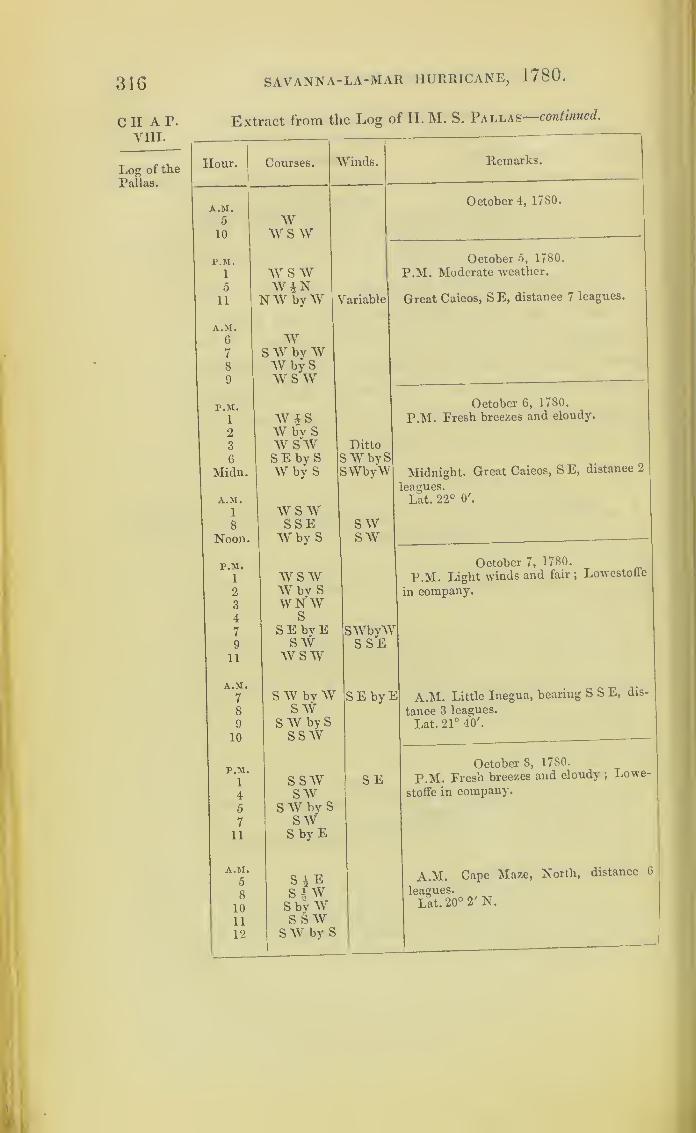
316 SAVANNA-LA-MAR HURRICANE, 1780
cii a r.
VIII.
Log of the
Pallas.
Extract from the Log of H. M. S. Pallas- continued.
Hour. Courses. AiVinds. Remarks.
A.M.October 4, 1780.
5 AV10 wswP.M. October 5, 1780.
1 w s w P.M. Moderate weather.
5 WJN11 NAVbyAV {ariable Great Caicos, S E, distance 7 leagues.
A.M.
6 W7 S AV by W8 AV by S9 AVS AV
r.M. October 6, 1780.
i AV § S P.M. Fresh breezes and cloudy.
2 AV by S3 AV S AV Ditto
6 S E by S S AV by S
Midn. AV by S SWbyAV Midnight. Great Caicos, S E, distance 2
leagues.
A.M. Lat. 22° O'.
1 AVS AV8 SSE SAV
Noon. AV by S SAV
P.M. October 7, 1780.
1 AV S AV p.M. Light winds and fair ;Lowestoffe
2 AV bv S in company.3 W N AV4 S
7 SEbyE SAVbyAA9 S AV S SE
11 AV S AV
A.M.
7 S AV by AV SEbyl2 A.M. Little Inegua, bearing SSE, dis-
8 S AV tance 3 leagues.
9 S AV by S Lat. 21° 40'.
10 S S AV
October 8, 1780.P.M.
1 S S AV SE P.M. Fresh breezes and cloudy ;Lowe-
4 SAV stoffe in company.
5 S AV by S
7 SAV11 S by E
A.M.
5 S A E A.M. Cape Maze, North, distance 6
8 S | AV leagues.
10 S by AV Lat. 20° 2' N.
11 S SAV12 S AV by S

SAVANNA-LA-MAR HURRICANE, 1780.
Extract from the Log of H. M. S. Pallas— concluded.
317
Hour. Courses. Winds. Remarks.
A.M.
6 SSW NEOctober 9, 1780.
A.M. Saw the east end of Jamaica;moderate weather.
r.M.
1
A.M.
2
11
12
S
swSE
S E by E
Calm.October 10, 1780.
P.M. Calm
;
ship’s head all round the
compass.
A.M. Yellow Hiil, WSW, distance 10
leagues.
Lat. 18° r N.
r.M.
1
4
. 2 }11
WJSWbW
SSWCalm.
SE
October 11, 1780.
P.M. Moderate and fair;
spoke the
Rarnilies, in company with the South-ampton and Jamaica.
A.M.
2
5
7
S W by SSWw sw
A.M. East end of Jamaica, NW by W,distance G leagues.
r.M.
1 wsw SSEOctober 12, ,1780.
P.M. Fresh breezes.
A.M.
1
Noon.NWN Noon. Ditto.
A.M.
6
12
W by SW
A.M. Upper White Horses, bearingNWby N, distance 2 leagues.
r.M. Calm.October 13, 1780.
P.M. Lowestoffe in company.
P.M.
6 NWOctober 14, 1780.
P.M. Anchored at Port Royal;
light
winds.
NOctober 15, 1780.
Light winds.
SSWOctober 16, 1780.
Squally.
CHAP.VIII.
Log of the
Pallas.
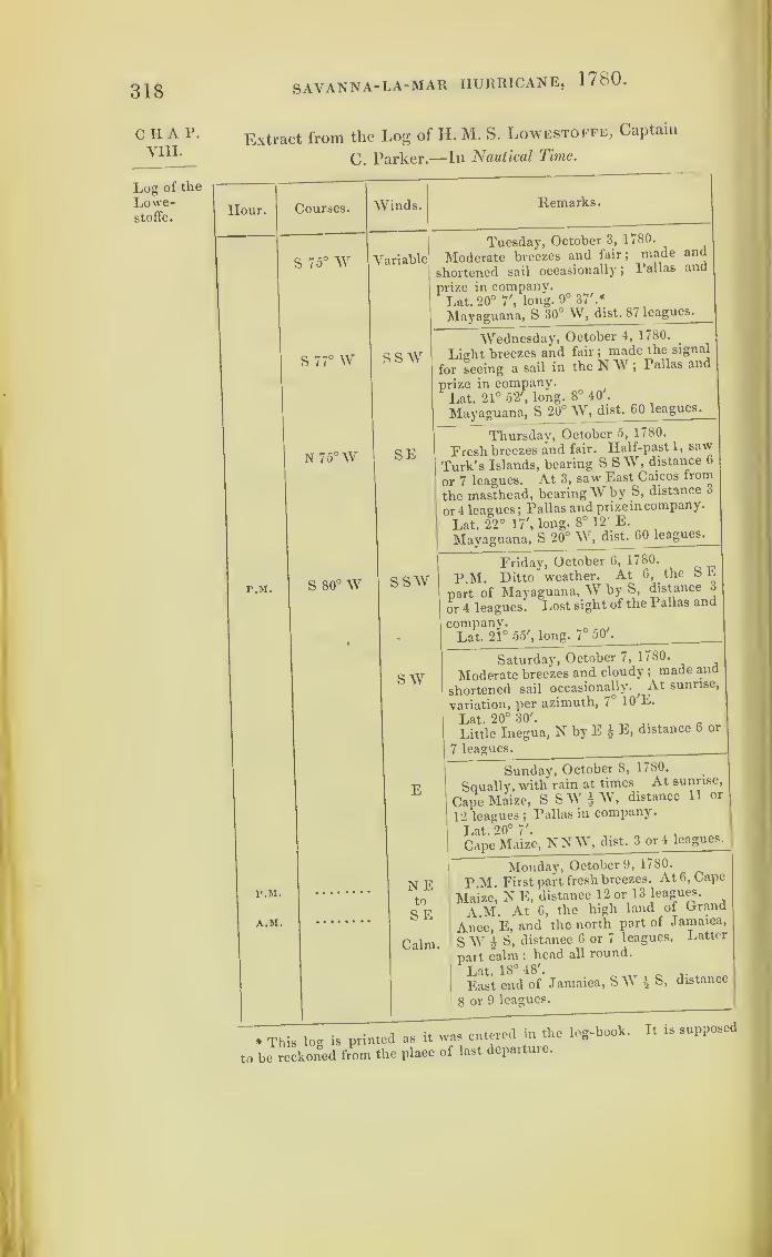
318 SAVANNA- LA-MAR HURRICANE, 1780.
CHAP.VIII.
Log of the
Lowe-stoffe.
Extract from the Log of H. M. S. Lowestoffe, Captain
C. Parker.—In Nautical Time.
Hour. Courses.1VVinds. Remarks.
S 75° W 1?ariable
1
Tuesday, October 3, 1780.
Moderate breezes and fair ;made and
hortened sail occasionally; Pallas and
irize in company.Lat. 20° 7', long. 9° 37'.*
Mayaguana, S 30° W, dist. 87 leagues.
S 77° W sswWednesday, October 4, 1780.
_
Light breezes and fair ;made the signal
'or seeing a sail in the N W ;Pallas and
orize in company.Lat. 21° 52 ,
long. 8° 40'.
Mayaguana, S 20° W, dist. 60 leagues.
N75°W SEThursday, October 5, 1780.
Fresh breezes and fair. Half-pasti, saw
Turk’s Islands, bearing SSW, distance 6
or 7 leagues. At 3, saw East Caicos from
the masthead, bearing Why S, distance 3
or 4 leagues; Pallas and prize in company.
Lat. 22° 17', long. 8° 12' E.
Mayaguana, S 20° W, dist. 60 leagues.
P.M. S 80° W SSWFriday, October 6, 1780.
P.M. Ditto weather. At 6, the SEpart of Mayaguana, W by S, distance 3
or 4 leagues. Lost sight of the Pallas and
company.Lat. 21° 55', long. 7° 50'.
swSaturday, October 7, 1780.
Moderate breezes and cloudy ;made and
shortened sail occasionally.,
At sunrise,
variation, per azimuth, 7° 10 E.
Lat. 20° 30'. „ a .
Little Inegua, NbyE± E, distance 6 or
7 leagues.
ESunday, October 8, 1780.
Squally, with rain at times At sunrise,
Cape Maize, S SW | W, distance 1 1 or
12 leagues ;Pallas in company.
Lat. 20° 7'.
Cane Maize, NNW, dist. 3 or 4 leagues.
P.M.
A.M.
NEMonday, October 9, 1780.
P.M. First part fresh breezes. At 6, Cape
Maize, N E, distance 12 or 13 leagues.
A.M. At 6, the high land of Orand
Alice, E, and the north part of Jamaica,
§ \y £ S, distance 6 or 7 leagues. Latter
part calm ;head all round.
Lat. 18° 48'.r „
East end of Jamaica, S1V l S, distance
8 or 9 leagues.
to
SE
Calm.
* This log is printed as it was emereu
to be reckoned from the place of last departuie.

SAVANNA-LA-MAR HURRICANE, 1780 .
Extract from the Log of H. M. S. Lowestoffe—concluded.
319
Hour. Courses. Winds. Remarks.
CalmTuesday, October 10, 1780
Calm ;head all round ;
Pallas in company.
Lat 18° 6'.
Yallah’s Hill, W S \Y £ W, distance 13
or 14 leagues.
P.M
Noon.
ESEWednesday, October 11, 1780.
P.M. Light breeze and fair. 1. Madethe signal for seeing two sails in the S W.At 2, saw another sail in the S W. At
3, one of the sails made the private signal,
which wras answered. 4.30. Pound the
sails to be H. M. ships Ramilies, South-
ampton, and Jamaica.
Noon. Pallas in company.Lat. 17° 45'
Yallah’s Hill, W - N, dist. 8 leagues.
P.M. Variable
Thursday, October 12, 1780.
P.M. Ditto weather. At 6, Yallah’s
Hill, W £ N, distance, off shore, 2 or 3
leagues ; Pallas in company.Lat. 17° 51'.
White Horses, NW byW \ W, distance
3 or 4 leagues.
P.M.
A.M.
VariableFriday, October 13, 1780.
P.M. Ditto weather. At 6, Salt panHill, W by N
;Cow Bay Point, W N W,
off shore, distance 2 or 3 leagues.
A.M. At 6, Rock Fort, NNW, off
shore, distance 4 or 5 miles.
Lat. 17° 49'.
Rock Fort, N byW £ W, distance 2 or
3 miles.
P.M. Variable
Saturday, October 14, 1780.
P.M. Light breezes;running down for
Port Royal. 4.30. Came to an anchor in
Port Royal. Port Royal Point, S; andthe Twelve Apostles, W by S.
Sea andlandbreezes.
Sunday, October 15, 1780.
Light breezes ; sent seventeen prisoners
to Kingston ; moored a cable each way.
Ditto
Monday, October 16, 1780.
Ditto weather.
Ditto
Tuesday, October 17, 1780.
Ditto weather, with rain. ReceivedVice-Admiral Parker’s flag from H. M.ship Tobago, and hoisted on the fore-top-gallant-mast-head.
C H A P.
VIII.
Log of the
Lowe-stoffe.

320 SAVANNA-LA-MAR HURRICANE, 17S0.
CHAP.VIII.
Chart IX.
Log of the
Grafton.
We next find the storm overtaking, on the morning
of the 5th, the ships under Admiral Rowley, which
were sent by Sir Peter Parker, to convoy a fleet
part of the way to Europe : and the Stirling Castle
was one of them. These ships suffered greatly;
and in their crippled state had likewise the misfor-
tune to meet the great hurricane at a later date.
Extract from the Log of H. M. S. Grafton, bearing the flag of
Rear-Admiral Rowley.—In Nautical lime.
Hour. Courses. Winds.
P.M.
i N by E E by N2 si
3 0
4
5 N by W Variable
6
7 N ENE8 N by E E by N9 N by E 4 E •
10
11
12
A.M.
1 N by E E by N2
3 NNW N W4 ESE5
6 SEbyE Variable
7 SE ENE8 ESE NE9
10 S E ENE11 S E by E NEbyE12 ESE
p M.
1 SEbyE Variable
2
3 ESE4
5
6
Remarks.
Thursday, October 5, 1780.
Ditto weather.
Ditto weather.
A.M. Made signal to tack ;tacked ship
;
Ditto weather.
Squally, with rain ;handled top-gallant-
sails.
Ditto weather.
Set top-gallant-sails.
Noon. No observation.
Lat. 29° 19' N, long. 74° 32'.
Walling’s Island, S 8° E, distance 154
leagues.
Friday, October 6, 1780.
P.M. Fresh gales and hazy; squalh
weather ;close -reefed the topsails.
At 4, ditto weather, with rain at in-
tervals ;got down top-gallant-yards.
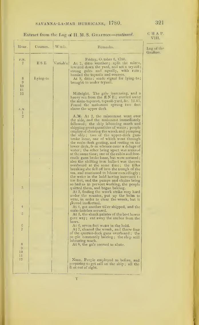
r.M
7
8
9
10
11
12
AM1
2
3
4
5
C
7
8
9
10
11
12
SAVANNA-LA-MAR HURRICANE, 1780. 321
;raet from the Lost erf
-
II. M. S. Grafton
—
continued. C H A P.
VIII.
Courses. W>n<ls.
E S E Variable
I.ying-to
Remarks.
Friday, October 6, 1780.
At 7, ditto weather; split the rnizen,
lowered down the yard, and set a trysail
;
strong gales and squally, with rain
;
handed the topsails and courses.
At 8, ditto ; made signal for lying-to
;
brought- to under trysail.
Log of the
Grafton.
Midnight. The gale increasing, and a
heavy sea from the E N E ;carried away
the main-topmast, topsail-yard, &c. 12.4-5.
Found the mainmast sprung two feet
above the upper deck
A.M. At 2, the mizenmast went over
the side, and the mainmast immediatelyfollowed
;the ship labouring much and
shipping great quantities of water; peopleemployed clearing the wreck and pumpingthe ship ; two of the upper-deck gunsbroke loose, one of which went throughthe main-deck grating, and resting on the
lower deck, from whence came a deluge of
water; the other being upset was secured
at the same time; one of the cabin and fore-
castle guns broke loose, but were secured;
also the shifting iron ballast was thrownoverboard at the same time ; the tiller
breaking she fell off into the trough of thesea, and continued to labour exceedingly
;
the water in the hold having increased to
ten feet, and the pumps and chains beingso bad as to prevent working, the peoplequitted them, and began baleing.
At 3, finding the wreck strike very hardunder the counter, put up the helm to
wear, in order to clear the wreck, but it
proved ineffectual.
At 4, got another tiller shipped, and themain-hatches secured.At 5, the shank painter of the best bower
gave way ; cut away the anchor from thebows.At 6, seven feet water in the hold.At 7, cleared the wreck, and threw four
of the quarter-deck guns overboard; the
people constantly baleing; the ship still
labouring much.At 8, the gale seemed to abate.
Noon. People employed as before, andpreparing to get sail on the ship
; all thefleet out of sight.
Y
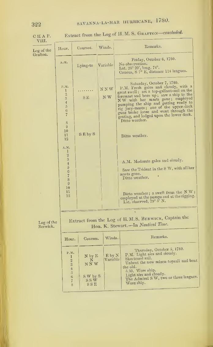
322
C H A P.
yin.
Log of the
Grafton.
SAVANNA- LA-MAR HURRICANE, 1780.
Extract from the Log of H.M. S. Grafton concluded.
Hour. Courses.;
Winds.
Log of the
Berwick.
A.M. 1
Lying-to Y
1
ariable
Friday, October 6, 1780.
No observation.
Lat. 28° 20', long. 74°.
Caucus, S 7° E, distance 114 leagues.
P.M.\
1 •
ST NWSaturday, October 7, 1780.
p M Fresh gales and cloudy, with a
Treat swell ;set a top-gallant-sail on the
bremast and bore up ;saw a ship to the
ST W with her masts gone ;employed
pumping the ship and getting ready to
rig jury-masts ;one of the upper-deck
guns broke loose and went through the
grating, and lodged upon the lower deck.
Ditto weather.
2
3
4
5
6
7
8
SE N W
9
10
11
12
SEby SDitto weather.
A.M.
1
2
3
4A.M. Moderate gales and cloudy.
5
6
7
8
Saw the Trident in the SW ,with all her
masts gone.
Ditto weather.
9
10
n12
|
Ditto weather ;a swell from the N W ;
employed at the pumps and at the rigging.
Lat. observed, 29° 5' N.
1«
e Extract from the Log of H.M. S. Berwick, Captain the
Hon. K. Stewart—In Nautical Tune.
Hour.|
Courses. Winds. ltemarks.
P.M.
1
2
3
4
5
6
7
8
N by EN
NN W
S W by SSS WSSE
E by NVariabl
Thursday, October 5, 1780.
P.M. Light airs and cloudy.
c Shortened sail. . ,
Unbent the new mizen- topsail and bent
the old.
5.30. Wore ship.
Light airs and cloudy.
The Admiral S W, two or three leagues.
Wore ship.

SAVANNA- LA-MAR HURRICANE, 1780 .
Extract from the Log of IL M.S. Berwick—continued.
323
Hour. Courses. Winds. Remarks.
P.M. Thursday, October 5, 1780.
9 N by E Variable Handed top-gallant-sails.
10 Ditto weather.
11 N by W12
A.M.
1
2
3 NNW NE A.M. At 3, tacked, by signal;
set top-
gallant-sails.
4 N E by S i SESE'
Moderate breezes and cloudy.
5
6 SE NNE Squally, with heavy showers of rain.
7
8 SEby E NEbyE Moderate and cloudy.
9 SE i S10 SE ENE Squally ; shortened sail occasionally ;
the Stirling Castle and Hector’s signal
11 SEby E NEbyE was made for their being out of their
station ; dark, hazy weather.
12 ESE NE Lat. 29° 2P, long. 71°.*
P.M. Friday, October 6, 1780.
1 ESE NE P.M. Fresh breezes and heavy showersof rain.
2 S E by E At 2.30, double-reefed the fore and main-
3 Variable topsails and close-reefed mizen ; heavy
4 squalls of wind and rain.
5
f> At 6, in third reef in the fore and main-topsails.
7 SE At 7, handed the fore and mizen ditto.
At 7.30, split the foresail and fore-top-
mast-staysail.
8 At 8, handed the main-topsail.
9 up S E by Soff
S by E
At 9, saw the Admiral, bearing aboutW S W. At 9.30, bent another foresail,
and got down top-gallant-yards.
10 At 10, could not see the Admiral; heavy
11 gales of wind and rain ; lying-to underthe mainsail, the gale increasing much.
12 About ten minutes before 12, our bow-sprit and foremast went over the side,
about thirty feet above the deck, and in
the fall carried away the mainyard andmainsail, all split to pieces.
A.M.1
2 A.M. At 2.15, blowing a hurricane;carried away the mizenmast. At 2.30, the3
4 mainmast went by the board; hands5 employed in pumping and clearing the
6 wreck; shipped a great quantity of water,
7 especially in the gun-room and ward-room
;
C H A P.
VIII.
Log of the
Berwick.
* The Berwick’s longitude does notlogs of the squadron.
Y 2
agree with that given in the other
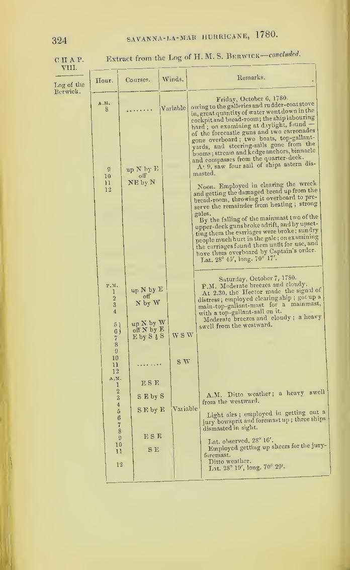
324 SAVANNA-LA-MAR HURRICANE, 1780.
CHAP.VIII.
Log of the
Berwick.
Extract from the Log of H. M. S. Berwick-concluded.
Hour.
A.M.
8
9
10
11
12
Courses. Winds. Remarks.
Variable
up N by Eoff
NE by N
F.M.1
2
3
4
5 )
7
8
9
10
11
12
A.M.
1
2
3
4
5
6
7
8
9
1011
12
up N by Eoff
N by W
up N by Woff N by EE by S
E S E
S Eby S
SEby E
E S E
S E
Friday, October 6, 1780.
owing to the galleries and rudder-coat stove
in, great quantity of water went down in the
cockpit and bread-room; the ship labouring
hard ;on examining at daylight, found
of the forecastle guns and two carronades
a0ne overboard ;two boats, top-gallant-
vards, and steering-sails gone from the
booms; stream and kedge anchors, binnacle
and compasses from the quarter-deck.
At 9, saw four sail of ships astern dis-
masted.
Noon. Employed in clearing the wreck
and getting the damaged bread up from the
bread-room, throwing it overboard to pre-
serve the remainder from heating ;strong
8By
8
the falling of the mainmast two of the
upper-deck guns broke adrift, andby upset-
ting them the carriages were broke ;sundry
people muchhurt in the gale ;onexamining
the carriages found them unfit for use, and
hove them overboard by Captain’s order.
Lat. 28° 45', long. 70° 17'.
Saturday, October 7, 1780.
P.M. Moderate breezes and cloudy.
At 2.30, the Hector made the signal of
distress; employed clearing ship ;got up a
main-top-gallant-mast for a mainmast,
with a top- gallant-sail on it.
Moderate breezes and cloudy ; a heavy
swell from the westward.
W s AY
S W
Variable
A.M. Ditto weather; a heavy swell
from the westward.
Li<»ht airs ;employed in getting out a
jury bowsprit and foremast up ;three ships
dismasted in sight.
Lat. observed, 28° 16'.
Employed getting up sheers for the jury-
foremast.
Ditto weather.
Lat. 28° 19', long. 70° 29'.

SAVANNA-LA-MAR HURRICANE, 1780 . 325
Extract from a Journal of the Proceedings of H.M. S. Trident,
Captain J. A. P. Molloy.— In Nautical Time.
C H A P.
VIII.
Hour. Courses. Winds. Remarks.
p.st. Thursday, October 5, 1780.
1 NNE E P.M. Light airs ;Admiral made the
22
signal to disannul the line.
4 Nbv W Variable0A
N i W Admiral called in all cruisers.
7
8
9
N
10
11 N by E12 Ditto weather.AM.
2 W3 NNff4
5
6
E S E N E A.M. Tacked by signal.
7
8 Light breezes and cloudy, with heavy9 rain.
101 1
SE by E Mil by 1\ Squally, with rain.
12 Ditto weather.
Lat. 29° 17' N.Bermudas, N 75' 3', distance 145 leagues.
r.M. Friday, October 6, 1780.
1 E S E NE P.M. Fresh breezes and squally, with2 heavy rain.
3 In second-reef topsail;down top-gal-
4 lant-yards.5 SE* E Split main-topsail
;repaired it.
6 Squally ; split main-topmast-staysailsand jib
; bent others.
7 Handed fore and mizen- topsails.
8 Heavy squalls, with rain.
9 S S E E Admiral made signal to bring-to on thelarboard tacks.
10 E by N Hauled the foresail up.11 Handed main- topsails, bunted the main-
sail, and brought-to under mizen-staysail.
12 Heavy gales and violent squalls and rain;
bunted the foresail.A.M.
1 up SE by S A.M. Main-topmast went away.2 offS Mizenmast went over theside, with all the3 sails and rigging, clearing the wreck away.4 Excessive heavy squalls
; carried awaythe foremast, and with it the best boweranchor, sails, and rigging.
Log of i heTrident.

326
c ii a r.
VIII.
Log of the
Trident.
Their jury-
masts.
SAVANNA-LA-MAR HURRICANE, 1780 .
Extract from the Log of H. M. S. Trident concluded.
Hour.
A.M.
5
G
7
8
9
10
11
12
r.M.
1
2
3
4
5
6
7
8
9
10
11
12
A.M.1
2
3
4
5
6
7
8
9
10
11
Log of the
Heutor.
12
Courses.
J
^Vinds. Remarks.
up SE by SoffS
|
up NE by N P
off ENE
Eby N
sWbyN
Friday, October 6, 1780.
At 5, the mainmast went over the side
;
ost every thing belonging to it.
People employed clearing the ship of the
wrecks.
up N byWoff N N E
W by N
Hard gales and cloudy ;no ship in sight.
Lat. 28° 18' N.Bermudas, N 68° 3' E, dist. 153 leagues.
up NNW 1
offN
E by S
W
S W
Saturday, October 7, 1780.
P.M. Strong gales and hazy ;employed
clearing ship and getting jury-masts.
Got a top-gallant-mast for foremast,
another for a mainmast, and the long-boat
mast for a mizenmast.
More moderate ;made sail under jury-
masts.
S E
Moderate and cloudy.
SE » E
E S EE
NNW
Variabl
A.M. Fitting rigging for the jury-masts.
e
Employed getting a top-gallant-mast for
a foremast.
Light airs ;no ship in sight.
Lat. 28° 3' N.Bermudas, N 67° 52' E, dist. 140 leagues.
Extract from the Log of H.M.S. Hector, Captain Sir John
Hamilton.—In Nautical Time.
Hour.
r.M.
Courses.
N by E
N by E
Winds. Remarks.
E by N
E by N
Thursday, October 5, 1780.
P.M. Light airs and fair at 50 min. past
noon ;the squadron being in a line, the sig-
nal was made to discontinue ;answered

SAVANNA- LA-MAlt HURRICANE, 1780.
Extract from the Log of H. M. S. Hector—continued.
327
Hour. Courses. Winds. Remarks.
P.M. Thursday, October 5, 1780.
3 per signal, and immediately made sail.
4 S S E E At 3, wore ship to get into our station.
5 At 4, hauled our wind to the northward;
G the Admiral, NNW | W.7 At 6, light breezes ; the Admiral, NW8 by N. 6.30. Hoisted in the boat. At 8,
9 NNE * E E by S the Admiral, NW j W, distance half a
10 mile; light airs and cloudy. At 12, the
11 N by E E by N Admiral, N W, distance half a mile.
12 A.M. At 3, tacked ship, per signal, to
A.M. the S E. At 4, the Admiral, S by E.1 N E At 5, squally, with rain, thunder, and2 N by W lightning
; found the slings of the main-3 N by W i W yard broke
;got them down
;employed
4 S E by E NE by E fitting another pair. At 8, moderate and5 dark cloudyweather
; the Admiral, S by E.
0 Fresh gales and passing squalls. At 11.25
7 N E the Stirling Castle’s and Hector’s signal
8 was made for being out of their station.
9 SE| S ENE Answered, per signal, and bore downupon10 the Grafton’s lee quarter. At noon, she11 ESE NE bore E by N ^ N, distance half a mile.
12 No observation.
r.M. Friday, October 6, 1780.1 SSE E P.M. Strong gales and squalls. At 5, got•2 down top-gallant-yards and dose-reefed the3 topsails
; ditto, handed the mizen-topsail.4 At 7, the gale increasing and sea running5 SEJE NE byE high, took in the fore-topsail. At 8, theG Grafton not in sight; wore ship to the7 SEby S E by N northward, and at 8.30, to the south. At 9,
8 hove-to, per signal; do., handed main-top-
9 f N ENE sail and courses under balance- mizen andS ESE mizen-staysail. At 12, the main-topmast
10 up SSE went over the side; the gale increased to
11 off a hurricane. At 1 a.m. the mizenmast12 S by E went over the side; at 1.30, the foremast
A.M. went likewise, and a few minutes after thei mainmast went over the side
; found the2 up S E by S foremast by the fall carried away the stop-3 off per of the best bower anchor, that we were4 S by E obliged to cut it from the bows with the5 rest of the wreck; found the ship hadG water in the hold, over the second tier of7 casks
; upon sounding of the well, found8 feet water in ; turned all hands down to the9 pumps; some chosen seamen only kept10 upon deck to clear the wreck
; she shipped11 many heavy seas, which broke loose all
12 our shot, &c. ; the longboat received greatquantities of water
; scuttled her in orderto save her
; hove over seven of the upper-deck guns, and four of the quarter-deckditto
;off the forecastle one gun, likewise
CHAP.VIII.
Log of the
Hector.
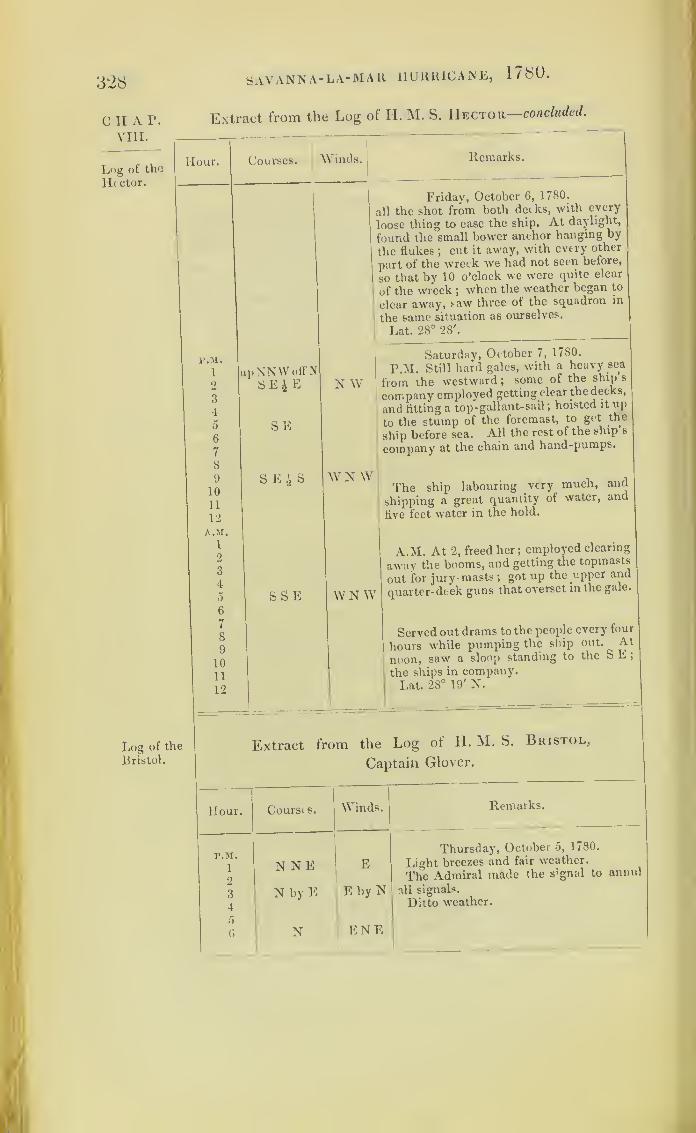
328
C II AVIII
SAVANNA- LA- MALI HURRICANE, 1780.
I*. Extract from the Log of II. M. S. Hector concluded.
Log of
Hector.
theHour. Courses,
i
Winds. Remarks.
P.M.
1
2
3
4
5
6
7
8
9
10
11
12
A.M.
1
2
3
4
o
6
7
8
9
1011
12
upNNWoffNSE£ E
SE
SEi S
N W
W N W
S S E
Log of the
Bristol.
WNW
Friday, October 6, 1780.
all the shot from both decks, with every
loose thing to ease the ship. At daylight,
found the small bower anchor hanging by
the flukes ;cut it away, with every other
part of the wreck we had not seen before,
so that by 10 o’clock we were quite clear
of the wreck ;when the weather began to
clear away, saw three of the squadron in
the same situation as ourselves.
Lat. 28° 28'.
Saturday, October 7, 1780.
P.M. Still hard gales, with a heavy sea
from the westward ;some of the ship s
company employed getting clear the decks,
and fitting a top -gallant-sail ;hoisted it up
to the stump of the foremast, to get the
ship before sea. All the rest of the ship s
company at the chain and hand-pumps.
The ship labouring very much, and
shipping a great quantity of water, and
five feet water in the hold.
A.M. At 2, freed her ;employed clearing
away the booms, and getting the topmasts
out for jury-masts;got up the upper and
quarter-deck guns that overset in the gale.
Served out drams to the people every four
hours while pumping the ship out. At
noon, saw a sloop standing to the S E
;
the ships in company.Lat. 28° 19' N.
Extract from the Log of H. M. S. Bristol,
Captain Glover.
Hour. Coursts. Winds,
P.M.
1 N NE E2
3 N by E E by N4
5
6 N ENE
Remarks.
Thursday, October 5, 1780.
Light breezes and fair weather.
The Admiral made the signal to annul
all signals.
Ditto weather.
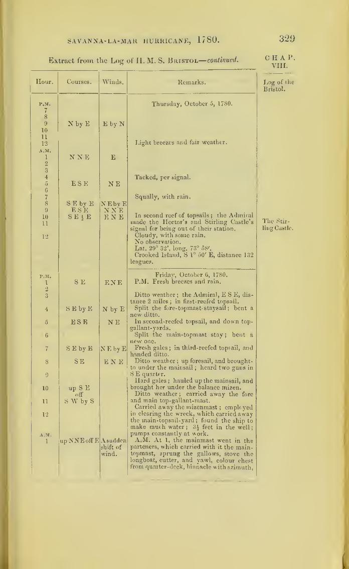
SAVANNA- LA-MAlt HURRICANE, 1780 .
Extract from the Log of H. M. S. Bristol— continued.
320
Hour. Courses. Winds. Remarks.
r.M.
7
Thursday, October 5, 1780.
8
9 N by E E by N10
11
12 Light breezes and fair weather.
A.M.
1
2N NE E
3
4 Tacked, per signal.
5
6
7
ESE NESqually, with rain.
8 S E by E NEbvE9 ESE NNE10 SE i E E N E In second reef of topsails
;the Admiral
11 made the Hector’s and Stirling Castle’s
signal for being out of their station.
12 Cloudy, with some rain.
No observation.
Lat. 29° 32', long. 73° 58'.
Crooked Island, S 1° 50' E, distance 132leagues.
r.M. Fridav, October 6, 1780.
i S E ENE P.M. Fresh breezes and rain.
2
3 Ditto weather ; the Admiral, ESE, dis-
tance 2 miles;in first-reefed topsail.
4 SEbyE N by E Split the fore- topmast- staysail; bent a
new ditto.
5 ESE NE In second-reefed topsail, and down top-
gallant-yards.
6 Split the main-topmast stay ; bent a
new one.
7 SEbyE NEbyE Fresh gales;in third-reefed topsail, and
handed ditto.
8 SE ENE Ditto weather; up foresail, and brought-to under the mainsail
;heard two guns in
9 S E quarter.
Hard gales ; hauled up the mainsail, and
10 up S E brought her under the balance mizen.
off Ditto weather ; carried away the fore
11 S IV by S and main top-gallant-mast.Carried away the mizenmast
; employed12 in clearing the wreck, which carried away
the main-topsail-yard; found the ship to
make much water; 3J feet in the well
;
A.M. pump3 constantly at work.
1 upNNEoffE Asudden A.M. At 1, the mainmast went in theshift of parteners, which carried with it the main-wind. topmast, sprung the gallows, stove the
longboat, cutter, and yawl, colour chestfrom quarter-deck, binnacle with azimuth,
CHAP.VIII.
Log of the
Bristol.
The Stir-
ling Castle.

330 SAVANNA-LA-MAR HURRICANE, 1780.
CIIAP.VIII.
Log of the
Bristol.
Extract from the Log of H. M. S. Bristol—concluded.
Hour.
A.M.
2
3
4
a
6
10
11
12
Courses.
up N N EoffE
1>.M.
1
1
5
6
7
8
9
10
11
12
A.M.
1
2
3
45
6
7
8
9
1011
12
Winds. Remarks.
N W
up Noff
E by NWNf
Lying-to
up N by EoffN E by N
Friday, October 6,1780.
>
two common compasses, the gunner s
stores. 4
At 2.15, the foremast went by the board,
carried with it the fore-top- gallant and
yard, with gunner’s stores in the top, com-
plete ;royal top and top-gallant steering -
sail with rigging full ;dismounted one
forecastle gun, and did other material
damage ;seamen clearing the wreck ;
ship
made much water, 5 feet in the well,
pumps constantly at work, At 6,the bow-
sprit went with the wreck forward. At
6.30, cleared the wreck of the ship, ana
clearing the ship of lumber.
At 7, hard gales; employed in getting
the ship in a state of safety ;shipped much
water, pumps still at work. At 9, the gale
somewhat abated ;saw two ships having
lost their masts, supposed to be the Ruby
and Hector. At 10, the Hector passed very
near us. At 11, employed in getting spare
spars as jury-masts; the ship made less
water. At meridian, gale abated, and
clear ;saw a ship, supposed to be the Ber-
wick, with stumps ;three sail in sight.
Lat. 28° 41'.
S ESEby E
NW
WNWSWbyVW SW
SSE W
Calm
Saturday, October 7, 1780.
P.M. Fresh gales, and a great swell from
the NW ;in company with the lluby and
Hector; the gale abating and clear.
Saw in the S E three ships in company
;
a strange sail, ditto quarter.
The Hector made signal of distress, bore
down to join her.
Moderate breezes and fair weather ;em-
ployed in getting jury-masts ready.
Moderate breezes, with a great swell
from the NW ;three ships in company.
A M. Saw a Strange sail in the SE quarter.
Turk’s Island, S 18° E, dist. 145 leagues.
Employed rigging a jury-foremast, with
the spare topmast, and ditto topsail for a
foresail.
Lat. observation, 28 20 .

SAVANNA-LA-MAR HURRICANE, 1780. 331
Extract from a Journal of the Proceedings of H. M. S. Ruby,
Captain John Cowling.
CHAP.VIII.
Hour. Courses.
a.m. Not in log
Winds.
E by N
Remarks.
Thursday, October 5, 1780.
A.M. Light airs and cloudy ; made andshortened sail occasionally
;squadron in
company.
12
r.M.
2.30
3
3. 15
5.30
N E
EXE
N N W
Friday, October 6, 1780.
Fresh breezes and squally ; made andshortened sail, and tacked occasionally;
very heavy gales. At 12, the mizen-stay-sail blew overboard, bent another ; theAdmiral’s light, N by E
;the mizen and
mizen staysail blew overboard. P.M. At2.30, the foremast went by the board, andcarried away the best bower, and cut thecable. At 3, the mizenmast went by theboard, ten feet above deck. 3.15. Themainmast went by the board, and stove
two of the boats; lost three tons of water
casks from the quarter, and two ditto fromthe upper and quarter decks ; violentheavy gales, ship very laboursome. At5.30, hove overboard ten of the 9-poundersto ease the ship
; cut the wreck of themasts away ; saw three of the squadrondismasted
;got the cutter’s foremast to
the weather cat-head, and set the sail andwore ship to get clear of them
;employed
rigging a jury-foremast;Berwick, Bristol,
and Hector in company.Lat. 28° 20'.
Saturday, October 7, 1780.M - A.M. Moderate and clear, the clouds
much fallen; three dismasted ships in
sight ; found six puncheons of rum stove1 N W entirely. At 4, the Berwick made signal
for the ships to the S E to join him; two
ships in sight, bearing N by E, 1 ditto,
I W NW N N W, distance 4 miles; saw a strange
sail to the northward; employed getting
up jury-masts.Lat. 28°.
1*.M.
2
8
Not in log
Sunday, October 8, 1780.P.M. Ditto weather
; employed gettingup jury-masts. At 2, saw the above sail, asloop bearing down upon us. At 5, got ajury-mizenmast up ; and at 8, a jury-fore-mast; Bristol and Hector in company;Berwick insight; set fore-top-gallant-sail
Log of the
Ruby.
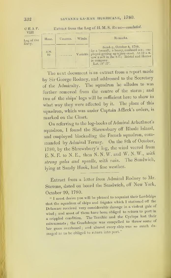
332 SAVANNA LA-MAR HURRICANE, 1780.
C H A P.
VIII
Log of the
ltuby.
Extract from the Log of H. M. S. Ruby—concluded.
Hour. Courses. Winds. Rt marks.
A.M.
10 Variabli
Sunday, October 8, 1780.
for a foresail;a heavy, confused sea ;
em-
ployed getting up a jury-mast. At 10 a.m.
saw a sail in the S E ;Bristol and Hector
in company.Lat. 28° 27'.
The next document is an extract from a report made
by Sir George Rodney, and addressed to the Secietaiy
of the Admiralty. The squadron he alludes to was
further removed from the centre oi the storm,and
two of the ships’ logs will be sufficient here to show in
what way they were affected by it. 1 he place of this
squadron, which was under Captain Affleck s orders, is
marked on the Chart.
On referring to the log-books of Admiral Aibutlmot s
squadron, I found the Shrewsbury oft Rhode Island,
and employed blockading the French squadron, com-
manded by Admiral Ternay. On the 8th of October,
1780, by the Shrewsbury’s log, the wind veered from
E. N. E. to N. E., then N. N. VV. and W. N. W., with
strong gales and squalls, with lain, lhe Sandwich,
lying at Sandy Hook, had fine weather.
Extract from a letter from Admiral Rodney to Mr.
Stevens, dated on board the Sandwich, off New Aork,
October 20, 1780.
“I must desire you will be pleased to acquaint their Lordships
that the squadron of ships and frigates which I stationed off the
Delaware received very considerable damage in a violent gait o
wind;and most of them have been obliged to return to port in
a crippled condition. The Terrible and the Cyclops lost their
mizenmasts;the GuadaloUpe was compelled to throw sortie of
her guns overboard ;and almost every ship was so much da-
maged as to be obliged to return into port.

SAVANNA-LA-MAR HURRICANE, 1780. 333
Extract from a Journal of the Proceedings of H.M.S. Terrible,o
kept by Lieut. Benjamin Forest.—In Nautical Time.
Hour. Courses. Winds.
r.M.
6 S 23° W
9
10
11 NW bW
P.M.
3
S 40° E
4
8
A.M.
2
7
E by N
10
r.M. N 77° E
6 N N W
11
Remarks.
Friday, October 6, 1780.
P.M. Fresh gales and hazy w eather. A.t
6, we made signal for a strange sail in the
NE. At 9.30, saw three in the NWquarter. At 10.30, the signal for the ships
to the windward to make more sail; ditto
the signal to chase in the west. At 11,
shortened sail and hove-to ;the Triumph
brought-to the chase at noon ;fresh gales
and thick hazy weather; sounded at dif-
ferent times, and tacked occasionally, as
per signal.
Cape Henry, S 65° W, distance 74
miles.
Lat. 36° 29' N, long. 74°.
Saturday, October 7, 1780.
P.M. Fresh breezes and squally, withrain. At 3, unbent the mainsail, beingsplit; William Underhill, a soldier, fell
overboard, and was drowned. At 4, em-ployed setting up the mizen rigging. At 8,
carried away the larboard clew of main-topsail
;handed the sail. At 2 a.m.
unbent the main-topsail and sent it
down. At 7.30, the mizenmast wentaway
;employed cutting away the wreck.
At 10, mainsail, in hauling up, split to
pieces and blew away; found the main-mast sprung in the lower decks
;lowered
down the mainyard; employed repairing
the damages ;ditto weather.
Cape Charles, N 56 W, distance 48leagues.
Lat. 35° 39' N, long. 73° 50'.
Sunday, October 8, 1780.
P.M. Strong gales and hazy weather
;
carpenters employed making a fish for
the mainmast; sailmakers employed re-
paiiing the mainsail; people employedsetting up the rigging. At 6, saw five
sail, two to N E, three to S W, supposedto be some of our cru :sers
;bent a foresail
for a mainsail ; bent a main-topsail. At11, spoke II. M. S. Triumph and Cyclopsfrigate
;people employed repairing the
rigging.
New York, N 11° W, distance 58leagues.
Lat. 36° 20' N, long. 73° 17'.
CHAP.VIII.
Log of the
Terrible.
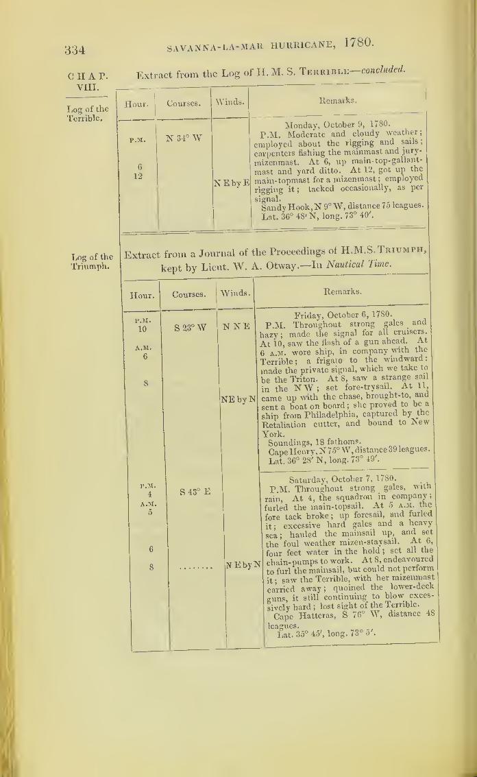
334
CHAT.VIII.
Log of the
Terrible.
SAVANNA-LA-MAR HURRICANE, 1780 .
Extract from the Log of II. M. S. Terrible—concluded.
Hour. Courses.
r.M. lN 34°W
G
12
Winds.
NEbyE
Remarks.
Monday, October 9, 1780.
P.M. Moderate and cloudy weather;
employed about the rigging and sails;
carpenters fishing the mainmast and jury-
mizenmast. At 6, up main- top-gallant-
mast and yard ditto. At 12, got up the
main-topmast for a mizenmast ;employed
rigging it; tacked occasionally, as per
signal.
Sandy Hook,N 9° W, distance 7 o leagues.
Lat. 36° 48' N, long. 73° 40'.
Log of the
Triumph.
Extract from a Journal of the Proceedings of H.M.S. Triumph,
Hour. Courses. Winds.
P.M.
10
A.M.
6
S 23°W N NEhA6
1
n
8 t
i
NEbyN c
s
s
1
P.M.S 43° E4
A.M.
5
6
8 NEbyN
Remarks.
Friday, October 6, 1780.
P.M. Throughout strong gales and
azy ;made the signal for all cruisers.
1 10, saw the flash of a gun ahead. At
a.m. wore ship, in company with the
errible ; a frigate to the windward:
lade the private signal, which we take to
e the Triton. At 8, saw a strange sail
i the NW; set fore-trysail. At 11,
Retaliation cutter, and bound to Newfork.Soundings, 18 fathoms.
Cape Henry,N 75° W, distance 39 leagues.
Lat. 36° 28' N, long. 73° 49'.
Saturday, October 7, 1780.
P.M. Throughout strong gales, with
rain, At 4, the squadron in company
;
furled the main-topsail. At 5 a.m. the
fore tack broke; up foresail, and furled
it ;excessive hard gales and a heavy
sea; hauled the mainsail up, and set
the foul weather mizen-staysail. At 6,
four feet water in the hold ; set all the
cliain-pumps to work. At 8, endeavoured
to furl the mainsail, but could not perform
it ;saw the Terrible, with her mizenmast
carried away ;quoined the lower-deck
guns, it still continuing to blow exces-
sively hard ;lost sight of the Terrible.
Cape Hatteras, S 76° W, distance 48
leagues.
Lat. 35° 45', long. 73° 5'.
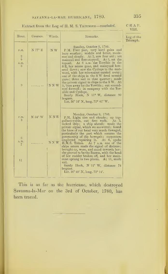
SAVANNA-LA-MAR HURRICANE, 1780.
Extract from the Log of H. M. S. Triumph—concluded.
335
Hour. Courses. Winds.
P.M. N 77° E NW2
9
A.M.
G
9 NN W
P.M. N 34° W N NE3
6
A.M.
7NN W
11
Remarks.
Sunday, October 8, 1780.
P.M. First part, very hard gales and
hazy weather ;middle and latter, mode-
rate and cloudy. At 2, saw four sail ; set
mainsail and fore-staysail. At 9, set the
topsail. At 6 a.m. the Terrible in the
S E, her mizen gone, and mainyard low-
ered down ;saw the Cyclops to the east-
ward, with her mizenmast carried away
;
one of the ships in the SW fired several
guns ;three sail in that quarter ; made
the private signal to ships in the S W. At9, bore away for the Terrible ;
out second-
reef foresail;
in company with the Ter-
rible and Cyclops.
Sandy Hook, N 11° W, distance 99
leagues.
Lat. 36° 10' N, long. 72° 41' W.
Monday, October 9, 1780.
P.M. Light airs and cloudy ;up top-
gallant-yards, out first reefs. At 3,
tacked ship; a ship ahead ; made the
private signal, which we answered ; foundthe knee of our head very much damaged,particularly the part which secures thegammoning of the bowsprit; carpenters
employed repairing it. At 6, spokeH.M.S. Triton. At 7 a.m. one of theships astern made the signal of distress
;
brought-to, wore, and stood towards her
;
she proved to be the Boreas, with the headof her rudder broken off, and her main-mast sprung in two places. At 11, madesail.
Sandy Hook, N 11° W, distance 74leagues.
Lat. 36° 49' N, long. 73° 14'.
CHAP.VIII.
Log of the
Triumph.
This is as far as the hurricane, which destroyed
Savanna-la-Mar on the 3rd of October, 1780, has
been traced.
'

337
The Great Hurricane of 1780.
It has been stated that Sir George Rodney was off
New York during the occurrence of the hurricanes
of October, 1780. He had left the command in the
Leeward Islands to Admiral Hotham, who, with his
flag on board the Vengeance, and having with him
the Montagu, Egmont, Ajax, Alcmene, Amazon, and
some other vessels of war, was in the Careenage at
St. Lucia, with his ships moored across the entrance
of that harbour. The Albemarle was in Carlisle Bay,
Barbados. The Endymion, with the Andromeda and
Laurel, were cruising on the east side of Martinique
;
and the Venus, Convert, and Surprise, were cruising
among the northern Antilles Islands.
The storm, coming from the south-east,was first
felt at Barbados;
and the ships of Admiral HothanTs
squadron experienced the hurricane each in turn,
according to the place she was in;
and it will be
found to have passed on, until it reached the ships
under Sir Peter Parker.
The Deal Castle was wrecked on Porto Rico. The
Ulysses and Pomona, with the fleet under their convoy,
were in the Mona Passage;and we find them suffering
greatly, and almost in the centre of the storm.
The Diamond and the Pelican had been sent to
Honduras, convoying merchant ships, and had felt
nothing of the first hurricane; but, on their return
towards Jamaica, though on somewhat different courses,
both ships came within the influence of the Great
z
CHAP.VIII.
SeeChart IX.
338 THE GREAT HURRICANE, 1/80.
CHAP.VIII.
Hurricane about the 15th of October, as will be seen
on reference to their logs, which have been printed,
and to their places as marked on the Chart IX.
The Pallas and the Lowestoffe had, most fortunately,
left their cruising ground just before the hurricane
passed over it. On the 13th they were becalmed ;and
on the 14th anchored at Port Royal, Jamaica; an
there, on that day, the wind was north-west. On the
15th it became north ,though light. On the 16th, by
the log of the Pallas, it veered round to the south-
south-west, with squalls, thus indicating that a slight
influence of the hurricane was felt at Port Royal. 1 ie
storm, as marked on the Chart, is confined to that
space over which it was violent.
The Thunderer, bearing the broad pennant ot Com-
modore Walsingham, had just arrived from England ;
and in her way to Jamaica to join Sir Peter Parker,
had touched at St. Lucia. She foundered in one ot
these storms ;but where, and on what day, never has
been ascertained.,
The Chart shows the position of Admiral Rowley s
already disabled ships when the second hurricane
reached them. The Stirling Castle, which belonged
to this squadron, was wrecked by striking on Silver
Keys after the storm.
The Berwick had separated from this fleet after the
hurricane of Savanna-la-Mar, and was proceeding to
England under jury-masts. She had reached nort 1
of the latitude of Bermuda when the second hurricane
overtook her ;and by her track and log-book we are
enabled to ascertain the direction taken by this storm.
On reading the logs of these ships, and the various
accounts of this hurricane, and comparing the different

THE GREAT HURRICANE, 1780. 339
reports of the wind, it will be found, that no storm yet
described more strongly proves than this the rotatory
nature of hurricanes; and, after attentive consideration
of this tempest, in addition to the details of so many
others, it seems difficult to refuse belief to this being
their mode of action. The centre of the circle would
appear to have passed just to the north of Barbados,
and thence over the middle of the Island of St. Lucia
:
so that Admiral Hotham’s ship, the Vengeance, which
remained in the Careenage to ride out the gale, was
in the right-hand semicircle of the storm;whilst the
ships which cut, or parted their cables, and ran first to
the southward, were for awhile in the left-hand semi-
circle. These last appear to have been dismasted, and
the Vengeance driven on shore, just as the centre of
the storm was passing between them.
The three ships to the eastward of Martinique being
in the right-hand semicircle, had the gale from the
eastward, and were therefore upon a lee-shore. By the
log of the Endymion, it will be seen that ship just
cleared the north-east point of the island;
but the
Andromeda and Laurel were wrecked, and twenty-five
men of the crew of the Laurel alone were saved. These
men, of course, were made prisoners;but were sent
by the Marquis de Bouill6 to the British Governor at
St. Lucia, with a letter expressing that he could not
detain them as prisoners, from the chances of a catas-
trophe common to all.
An application having been made, at my request,
bv Viscount Palmerston, to the French Government,
for any information which they could afford relative
to the Great Hurricane of 1780, an extract from a
report on the subject, made by the “ Intendant of
z 2
CHAP.VIII.
Coup de_
vent : de-
sastres de
St. Pierre.
TIIE GREAT HURRICANE, 1 < bO.
chap. Martinique” to the Minister of Marine, was received
VIIL- from France.
The extract proves the wind to have veered at
Martinique, as may have been expected, according to
the apparent law of storms in the northern hemi-
sphere; and throughout shows that the towns and
fishing villages suffered even more from the extra-
ordinary height to which the sea rose, than from
the wind.
Such a portion only of this document is printed as
is still of interest.
“ Le vent qui rdgnait de la partie de l'E.N.E. etant detenu
assez fort dans la journde du 11 Octobre, plusieurs des bktimcns
du convoi ddradisrent et furent portds an large. II augments de
plus en plus et devint trds violent. II se rangea ensu.te k
I E S E et bientfit aprbs au S. et k 10. en varient avec autant de
rapiditd que d-impetuositd. Alors tout ce qui restart sur la rade
fut entrains k l'exeeption de trois petits bhtimens caboteurs
Ceux de convoi iispamrenl avec beaucoup de bhteaux et d
goelettes, soil de la colonie, soit des autres iles Frankses on
nditrcs
" Un raz de marde des plus furieux mit le comble an malheur
nue l’on dprouvait ;il ddtruisit dans un instant plus de 150
maisons au bord, dont trente ou quarante nouvellement bkt.es ;
celles qui dtaient derribre furent enfoncees en grand partie jet
les marchandises queUes contenaient entferement perdues. C est
avec beaucoup de peine que les particulars qui les habitaie.it,
sont parvenus h se sauver.
“Le Fort St. Pierre constmit il y a environ 120 ans, a
egalement detruit, a l’exeeption des magasms.
« La mer a fait dans les bourgs surtout a St. Pierre, b~au
coup plus de mal quo le vent 5Marne y a monttjusqu'd, vmgt-cinq
.
Pi1' Le vent et la mer out fait les plus grands ravages k la
Dominique. Plusieurs bktimens cabotcurs ont cte jettes k .
cbte Presque toutes les maisons du bord de mer ont etc em-
portdes, ainsi que les magasins dn Roi, la boulangene et nne
partie des casernes.
French.
convoy.
The swell.
La Dominique.

THE GREAT HURRICANE, 1780. 341
“Le desastre a 6t6 encore plus affreux a St. Vincent, et les
pertes plus considerables. La fregate la Junon qui venait d’y
arriver y a peri.
“ Des 600 maisons qui composaient le bourg de King’s-town
il n’cn reste que 14. Les autres ont 6t6 rashes. La campagne
a etc entibrement devastee, et tous les habitans sont exposes it
la plus affreuse misbre.
“Ilya eu peu de mal il la Grenade quelques Mtimens s’y
sont echoues, mais nous n’avons pas appris que l’ile ait souffret.
“ La Guadeloupe a re(;u quelques dommages dans des planta-
tionsj
le raz de maree en a fait beaucoup it la basse terre, et en
d’autres quartiers de la colonie.
“ Marie Galante a bte epargnbe en grande partie.
“ Il n’en a pas ete de merae de St. Eustache. La mer y a
fait aussi beaucoup de mal, elle a considbrablement month et a
inonde une grande partie des Magasins du Commerce.”
A Danish report, also procured for me by Viscount
Palmerston, was made by Captain Stockfleth, who
commanded the frigate Christiana, to the Danish
Admiralty. This ship met the hurricane on the 13th
of October, 1780, when south-west of Porto Rico;
but the direction of the wind is not given.
This report states, that only six or seven ships of
the French convoy at Martinique were saved;and
from Sir Peter Parker’s Report, printed at page 302,
we learn that there were 5000 troops on board.
From St. Lucia, the centre of the storm appears to
have passed over, or very near to, the Island of Mona,
on the morning of the 15th of October; and, when
we take up the logs of the Venus and Convert, which
were on one side of the storm at that date, and those
of the Diamond and Pelican, which were on the
other side of it, we find the wind blowing in contrary
directions.
On referring to the logs of ships lying in the harbour
of Antigua, we there find the wind blowing in squalls
;
CHAP.VIII.
St. Vin-cent.
LaGrenade.
Guade-loupe et
MarieGalante.
St. Eus-tache.

342 THE GREAT HURRICANE, 1780 .
CHAP.VIII.
at first coming from the east-north-east, then veeiing by
the east to the south-east ,in strict accordance with the
apparent law of storms in the northern hemisphere.
The squadron of Admiral Rowley, being in latitude
26° 30' (about which latitude we find hurricanes so
frequently change their direction and set towards the
eastward), first received the storm easterly. As the
gale proceeded towards the north-east, this squadron
was in its left-hand semicircle ;and the Chart shows
the manner in which the ships then ran to the south-
east, with the gale at north-west.
By referring to the log-books of H. M. ships Shrews-
bury and Resolution, it appeared that they were under-
weigli off Long Island on the 18th of October, 1780.
The weather had been fine for some time, both before
and after;and the only exception was that day, when
it blew in squalls, so as to make these ships strike
their top-gallant-masts, and the Shrewsbury split a
topsail, the wind becoming north.
At Bermuda, fifty vessels were driven on shore on
the 18th of October ;and we have here the log of the
Berwick for that day, when she was to the northward
of that island, from which we get the direction of the
wind.* Thus the Great Hurricane is traced beyond
Bermuda, moving in the direction of the Azores;and
if this same storm was really the cause of the Shrews-
bury and the Resolution striking their top-gallant-
masts, and they increase in diameter as they proceed
towards the Poles, this storm, on reaching the latitude
of Great Britain, may have given a circular direction
* The wind, as laid down from the Berwick’s log-book, accords with the
reports of living witnesses (1839) at Bermuda ;and this storm is there still
referred to as the greatest ever experienced in their latitude.

TI1E GREAT HURRICANE, 1780. 343
to the wind over an extent equal to the width of the
Atlantic from the British Islands to Newfoundland.
But the extent of the storm marked on the Chart is
confined to the space where it was violent.
Copy of an account of the hurricane of the 10th of
October, 1780, which was sent to Lieutenant-General
Vaughan, Commander-in-Chief of the Leeward Islands;
and by him transmitted to Lord G. Germaine. Copied
from the Gentleman s Magazine of 1780.
“The evening preceding the hurricane, the 9th of October,
was remarkably calm;but the sky surprisingly red and fiery.
During the night much rain fell.
“On the morning of the 10th much rain and wind from the
north-west.
“ By 10 a.m. it increased very much.
“By 1 p.m. the ships in the bay drove.
“ By 4 p.m. the Albemarle frigate parted and went to sea,
as did all the other vessels, about 25 in number.“ By 6 p.m. the wind had torn up and blown down many
trees, and foreboded a most violent tempest.
At Government House* every precaution was
taken to guard against .what might happen
:
the doors and windows were barricaded, but it
availed little.
“By 10 p.m. the wind forced itself a passage through the
house from the north-north-west ; and the tempest
increasing every minute, the family took to the
centre of the building, imagining, from the
prodigious strength of the walls, they being
three feet thick, and from its circular form, it
would have withstood the wind’s utmost rage
;
1 lh. 30m. however, by half-past eleven they were obliged
to retreat to the cellar, the wind having forced
its passage into every part, and tore off mostof the roof.
* The Governor of the Island of Barbados, in October, 1780, was JamesCunninghame, Esq.
CHAP.VIII.
344 THE GREAT HURRICANE, 1/80.
CHAP. “ From this asylum they were soon driven out5
the water,
Yin. being stopped in its passage, having found itself a course to the
'cellar, they knew not where to go. The water had rose four
feet, and the ruins were falling from all quarters.
“ To continue in the cellar was impossiblej
to return to the
house equally so. The only chance left was making for the
fields, which at that time appeared equally dangerous. It was,
however, attempted jand the family got to the ruins of the
foundation of the flagstaff, which soon after giving way, every
one endeavoured to find a retreat for himself. The Governor
and the few that remained were thrown down;
and it was with
great difficulty they gained the cannon, under the carriage of
which they took shelter. Their situation here was deplorable
;
many of the cannon were moved;
and they had reason to fear
that the one under which they sat might be dismounted and
crush them by its fall, or that some of the ruins which were
flying about might put an end to their existence jand, to render
the scene still more doubtful, they were near the powder-maga-
zine. The armoury was levelled to the ground, and the arms
scattered about.
“Anxiously did they look for break of day, flattering them-
selves that with the light they would see a cessation of the
storm ;yet, when it appeared, little was the tempest abated.
Nothing can be compared with the terrible devastation that
presented itself on all sides : not a building standing. Ihe
trees, if not torn up by the roots, were deprived of their leaves
and branches ;and the most luxuriant spring changed, in this
one night, to the dreariest winter.
“ It is yet impossible to make a calculation of the number
of c'Ouls that have perished : whites and blacks together, it
is supposed to exceed some thousands. Many were buried in
the ruins of the buildings;many fell victims to the weather
;
and a great number were driven into the sea, and there
perished. The troops suffered inconsiderably, though their
barracks and hospital were early blown down. What few public
buildings there were, are fallen in the wreck : the fortifications
have suffered considerably. The buildings were all demolished j
for so violent was the storm here, when assisted by the sea, that
a 12-pounder gun was carried from the south to the north
battery, a distance of 140 yards* The loss to this country is
immense : many years will be required to retrieve it.
“Alarming consequences were dreaded from the number of
* On its carriage, of course, which, had wheels.

THE GREAT HURRICANE, 1780 . 345
dead bodies which lay uninterred, and from the quantity of fish
the sea threw up;but these alarms soon subsided.’’
C H A P.
VIII.
“ At St. Christopher’s, many vessels were forced on shore.
“ At St. Lucia, all the barracks and huts for his Majesty’s
troops, and other buildings in the island, were blown down, and
the ships driven to sea;
and the Amazon, Captain Finch,
miraculously escaped foundering.
“ At Dominica, they suffered greatly.
“At St. Vincent, every building was blown down, and the
town destroyed.*
“At Grenada, nineteen sail of loaded Dutch ships were
stranded and beat to pieces.
“ At Martinique, all the ships were blown off the island that
were bringing troops and provisions. On the 12th, four ships
foundered in Fort Royal Bay, and the crews perished. The
other ships were blown out of the roads. In the town of St.
Pierre every house is blown down, and more than 1000 people
have perished. At Fort Royal, the cathedral, seven churches,
and other religious edifices;many other public buildings, and
1400 houses, were blown down. The hospital of Notre Dame,
in which were 1600 sick and wounded, was blown down; and
the greatest part of these persons buried in the ruins. The
number of persons who perished in Martinique are said to have
been 9000.
“At St. Eustatia, the loss was very great. On the 10th of
October, at eleven in the morning, the sky on a sudden black-
ened all round;
it looked as dismal as night, attended with the
most violent rain, thunder, lightning, and wind, ever knownbefore. In the afternoon the gale increased. Seven ships were
driven on shore near North Point, and dashed to pieces on the
rocks, and their crews perished. Nineteen vessels cut their
cables and went to sea;
and only one is yet returned. In the
night, every house to the northward and southward was blown
dow-n, or washed away with the inhabitants into the sea, a few
only escaping. The houses to the east and west were not so
much hurt till the afternoon of the 1 1 th, when the wind on a
sudden shifted to the eastward; and at night it blew with
redoubled fury, and swept away every house. The old and
new forts, the barracks and hospital, the cathedral, and four
* St. Vincent and Grenada then belonged to the French.
346 THE GREAT HURRICANE, 1 / 80.
CHAP.VIII.
Sir GeorgeRodney’sletter.
churches, stood. Between 4000 and 5000 persons are supposed
to have lost their lives in St. Eustatia.”
—
Annual Register for
1780, p. 297.
Extract from Sir George Rodney’s official report
of the hurricane of the 10th of October, 1780, at
Barbados.
“No naval stores of any kind can be got at Barbados or
St. Lucia, owing to the dire effects of the hurricane which
happened on the 1 0th of October.
“ It is impossible to describe tlie dreadful scene it has
occasioned at Barbados, and the condition of the miserable
inhabitants. Nothing but ocular demonstration could have
convinced me that it was possible for the wind to cause so total
a destruction of an island remarkable for its numerous and well-
built habitations;and I am convinced that the violence of the win
must have prevented the inhabitants from feeling the earthquake,
which certainly attended the storm. Nothing but an earth-
quake could have occasioned the foundations of the strongest
buildings to be rent : and so total has been the devastation,
that there is not one church, nor one house^as I am well in-
formed, but what has been destroyed. * * * * *
“I leave their lordships to judge how much my concern
must have been heightened upon the report made to me, ot the
loss his Majesty and the public had sustained in the destruc-
tion of ships of war, and the gallant officers and men belonging
to them, a list of which I have the honour to enclose. But 1
hope some of them have escaped and arrived at Jamaica, to
which island I shall despatch an express, acquainting Sir Peter
Parker with the great disaster which has happened, an( reques
and demand his assistance, in not only hastening such of my
squadron as may have escaped the hurricane and armed at
Jamaica, to rejoin me, without loss of time, with the Thunderer
and the Berwick, in pursuance to the orders he received by
Commodore Walsingham.”
Extract of a letter to Lady Rodney, dated St. Lucia,
10th December, 1780.
“ I sailed from New York on the l6th November, and arrived
at Barbados on tlie 5th of this month.

THE GREAT HURRICANE, 1780. 347
‘‘You may easily conceive my surprise, concern, and astonish-
ment, when I saw the dreadful situation of this island and the
destructive effects of the hurricane. The strongest buildings and
the whole of the houses, most of which were of stone, and re-
markable for their solidity, gave way to the fury of the wind,
and were torn up to their foundation;
all the forts destroyed,
and many of the heavy cannon carried upwards of a hundred
feet from the forts. Had I not been an eye-witness, nothing
could have induced me to have believed it. More than six
thousand persons perished, and all the inhabitants are entirely
ruined. Our friend. Sir P. Gibbs, has suffered severely. The
hurricane proved fatal to six ships of my squadron, among
whom poor Jack Drummond perished on the back of St. Lucia.
Several other valuable officers underwent the same fate at Mar-
tinique and Dominica. * * * * ”—From the Life of Lord Rodney,
vol. i. page 455.
Extract of a letter from Dr. Blane (afterwards the
late Sir Gilbert Blane) to Dr. William Hunter, dated
from on board the Sandwich (Sir G. Rodney’s flag-
ship), December 22, 1780.
“ It began to blow at Barbados on the 9th of October, but
it was not apprehended until next day that there would be any
thing more than such a gale of wind as they experience, from
time to time, in this island at that season. On the evening of
the 10th, the wind rose to such a degree of violence as clearly to
amount to what is called a hurricane. At 8 p.m., it began to
make impression on all the houses, by tearing off the roofs, and
overthrowing some of the walls. As the inhabitants had never
been accustomed to such a convulsion of nature, they remained
for some time in security, but they now began to be in the
utmost consternation. * * * * It was thought
to be at its greatest height at midnight, and did not abate con-
siderably until eight next morning. During all this time, most
of the inhabitants had deserted their houses, to avoid being
buried in the ruins5and every age, sex, and condition, were ex-
posed in the fields to the impetuous wind, incessant torrents of
rain, and the terrors of thunder and lightning. Many were
overwhelmed in the ruins, either by clinging too long in them
CHAP.VIII.
The late
Sir Gilbert
Blane’sletter.

348 THE GREAT HURRICANE, 1780 .
CHAP, for shelter, or attempting to save what was valuable, or by un-
VIII. avoidable accidents in the fall of walls, roofs, and furniture, the
materials of which were projected to great distances. Even the
bodies of men and cattle were lifted from of the ground, and carried
several yards. An estimate has been attempted of the number
of deaths, from returns made to the governor, and they amounted
to more than 3000 ,though several parishes had not given in
their returns when I was there.
fruits of the earth, then standing, have been destroyed ;most of
the trees of the island have been torn up by the roots;and (what
will give as strong an idea of the force of the wind as any
thing) many of them were stripped of their bark. The sea rose
as high as to destroy the fort, carrying the great guns many
yards from the platform, and demolishing the houses near the
beach. A ship was driven on shore against one of the buildings
of the Naval Hospital, which, by this shock, and by the im-
petuosity of the wind and sea, was entirely destroyed and swept
* * * * The mole head was sweptaway. . ,
away; and ridges of coral rock were thrown up, which still
remain above the surface of the water: but the harbour and
roadstead have upon the whole been improved, having been
The effect deepened in some places six feet, in others many fathoms. The
of undu- cmst of corai }which had been the work of ages, having been
l
£ebeioi torn up, leaving a soft oozy bottom, many shells and fish were
the sea.found ashore which had been heretofore unknown.
Lo.of.he Extract from a Journal of the Proceedings of H.M.S Albk-
Albemarle. Marle, kept by Captain Thomas Taylor, lying in Carlisle
Bav. Barbados.—In Nautical Time.
Hour
.
Courses. Winds. Remarks.
In Carlisle P.M. ETuesday, October 10, 1780.
P.M. First part, moderate and hazy;
middle and latter, strong gales, with hard
Bay.
A.M. ENErain ;
employed watering.
A.M. It blowing very hard, employed
clearing our hawse ;freshened ditto
;
several ships driving ; a brig parted her
cables, hoisted out a boat, ana sent a
midshipman and four men to assist.
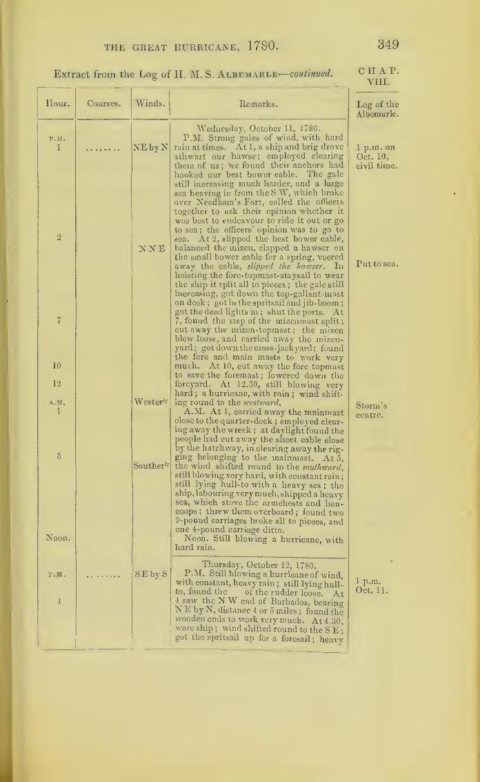
THE GREAT HURRICANE, 1780 .
Extract from the Log of H. M. S. Albemarle—continued.
Hour. Courses. Winds. Remarks.
P.M.
1
2
7
10
12
A.M.
1
5
Noon.
P.M.
4
NE by N
NNE
Wester 1?
Souther 1?
SEbyS
Wednesday, October 11, 1780.
P.M. Strong gales of wind, with hardrain at times. At 1, a ship and brig drove
athwart our hawse; employed clearing
them of us ;we found their anchors had
hooked our best bower cable. The gale
still increasing much harder, and a large
sea heaving in from the S W, which broke
over Needham’s Fort, called the officers
together to ask their opinion whether it
was best to endeavour to ride it out or goto sea ;
the officers’ opinion was to go to
sea. At 2, slipped the best bower cable,
balanced the mizen, clapped a hawser onthe small bower cable for a spring, veeredaway the cable, slipped the hawser. Inhoisting the fore-topmast-staysail to wearthe ship it split all to pieces
;the gale still
increasing, got down the top-gallant -maston deck; got in the spritsail and jib-boom ;
got the dead lights in ; shut the ports. At7, found the step of the mizenmast split;
cut away the mizen-topmast; the mizen
blew loose, and carried away the mizen-yard; got down the cross-jackyard; foundthe fore and main masts to work verymuch. At 10, cut away the fore topmastto save the foremast
; lowered down theforeyard. At 12.30, still blowing veryhard
; a hurricane, with rain; wind shift-
ing round to the westward.A.M. At 1, carried away the mainmast
close to the quarter-deck; employed clear-
ing away the wreck; at daylight found the
people had cut away the sheet cable closeby the hatchway, in clearing away the rig-ging belonging to the mainmast. At 5,the wind shifted round to the southward,still blowing very hard, with constant rain
;
still lying hull-to with a heavy sea ; theship, labouring very much, shipped a heavysea, which stove the armchests and hen-coops ; threw them overboard
; found two9-pound carriages broke all to pieces, andone 4-pound carriage ditto.
Noon. Still blowing a hurricane, withhard rain.
Thursday, October 12, 1780.P.M. Still blowing a hurricane of wind,
with constant, heavy rain; still lying hull-
to, found the of the rudder loose. At4 saw the NW end of Barbados, bearingN E by N, distance 4 or 5 miles
; found thewooden ends to work very much. At 4.30,wore ship
; wind shifted round to the S E;
got the spritsail up for a foresail; heavy
349
CHAP.VIII.
Log of the
Albemarle.
1 p.m. onOct. 10,
civil time.
Put to sea.
Storm’scentre.
1 p.m.Oct. 11.

350 the great hurricane, 1/80.
CHAP.VIII.
Log of the
Albemarle.
Log of
the Ven-geance,AdmiralHotham.
Extract from the Log of H. M. S. Albemarle—concluded.
Hour. Courses.
r.M.
11
A.M.
Noon.
p.m.
4
9
12
A.M.
3
5
8
Winds. Remarks.
Thursday, October 12, 1780.
gales of wind, with constant rain. At 1 1,
still sounding, the wind on our quarter.
A.M. At 5, more moderate ;hove the
ship to under a trysail ;employed clearing
t»ViG wreck.Noon. Fresh gales ;
large sea from the
SW ; the Island of Barbados, S E by L,
distance 6 or 7 leagues.
SE
SEby S
Friday, October 13, 1780.
P.M. Fresh gales and cloudy, with a
heavy sea from the SW ;swayed up the
foreyard, set the foresail and fore- stay sail.
At 4, the extremes of Barbados Irorn EbE
to SE, distance 6 or 7 leagues. At 9,
ditto ;freshbreeze and hazy. At 12, ditto
weather, with heavy sea.
A.M. At 3, ditto weather, until light-
ninq to the westward. At 5, saw the Island
of Martinico, bearing from N V to \\ by
N, distance 7 or 8 leagues. At 8, saw the
Island of St. Lucia, S W, distance 7 or 8
leagues ;employed getting up a top-ga -
lant-mast for a mizen-topmast ;saw two
large pieces of a wreck pass us ;employed
as needful ;N E end of St. Lucia, S W by
S, distance 3 leagues.
Extract from the Log of H. M. S.Vengeance (kept by James
Walton, Master), moored in the Careenage at St. Lucia.-In
Nautical Time.
In Careen-age,
St. Lucia.
Hour.
P.M.
A.M.6
P.M.
7
Courses. Winds.
Variable
9
11
12
Remarks.
Tuesday, October 10, 1780.
P.M. Dark, cloudy weather ;a mate
and forty men employed on the \igie.
A.M. At 6, sailed the Blanche and Alc-
mene ;down top-gallant-yards.
Variable
Variable
Wednesday, October 11, 1780.
P.M. Strong squalls; shifted the stream
anchor on the starboard bow to the N E.
At 7.15, the Egmont drove and brought
up again. At 7.30, very strong squalls.
At 9 the Aiax parted her cables, and
went out to sea. At 11, the gale increased
very much. At 12, the Egmont slipped,
and went out to sea.

TIIE GREAT HURRICANE, 1780.
Extract from the Log of II. M. S. Vengeance—continued.
351
Hour. Courses. Winds.
AM.4 Variable
6
8 NE
r.M. NE
8 NEbyE
9
10
12
A.M.
4
5
8
11 ESE
P.M.
8
A.M.5 ESE9
Remarks.
Wednesday, October 11, 1780.
A.M. At 4, let go the sheet anchor. At4.30, the Montagu slipped and run out to
sea. At 6, struck lower yards and top-
ts. At 8.30, the Amazon slipped and
run out to sea. Several transports drove
on shore and dismasted in the harbour.
Thursday, October 12, 1780.
P.M. Violent squalls, the gale still in-
creasing. At 12.15, parted the small
bower, and brought up with the stream
and sheet anchors. At 12.30, cut awaythe mizen, main, and foremast; a small
brig parted three cables, and drove ashore
under our stern, and stove to pieces. Theship struck very hard abaft, run four-
teen guns forward to ease her;employed
clearing the wreck ; cut away the long-
boat, cutter, and schooner-tender, whichwere immediately dashed to pieces ; thehurricane still increasing, the ship still
striking at times. At 8, rode clear off therocks
;got the guns in their places, and
quoined and secured the lower-deck gunsand ports ; wind veering to the eastward.
At 9, lightning between the squalls, still
blowing excessively hard, with rain. At10, less wind, with more rain and lightning.
At 12, the hurricane abated, with rain.
A.M. At 4, strong gales and squally,
with heavy rain. At 5, saw all the smallvessels in the harbour on shore, and mostof them dismasted. At 8, made the signal
of distress with two guns;got the boats
over the side, and got the parted cable onboard. At 11, carried out the small an-chor to steady the ship
;lost all the rigging
of the masts and yards, one foresail, onefore-topsail, one main-topsail, one main-topmast-staysail, mizen, and mizen-topsail.
Friday, October 13, 1780.
P.M. Moderate, with rain; warped
further to the southward, and brought upwith the sheet anchor ; veered away andhove up the small bower, bent anothercable, and moored as before. At 8, thun-der and lightning, and rain.
A.M. At 5, saw the Montagu off theharbour, with all her masts and bowspritgone. At 9, got up the stream anchor
;
the Montagu brought up;got a schooner
and sent boats with hawsers to assist herin warping in.
CHAP.VIII.
Log of
the Ven-geance.
Windveeringeastward.
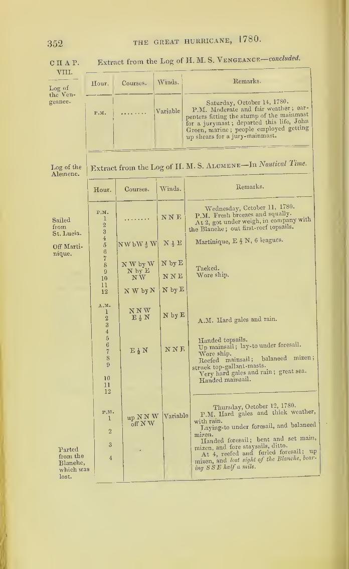
352 THE GREAT HURRICANE, 1780 .
CHAP.VIII.
Log of
the Ven-geance.
Extract from the Log of H. M. S. Vengeance—concluded.
Log of the
Alcmene.
SailedfromSt. Lucia.
Off Marti-
nique.
Hour. Courses. Winds. Remarks.
P.M. Variable
Saturday, October 14, 1780.
P.M. Moderate and fair weather ;car-
penters fitting the stump of the mainmast
for a jurymast ;departed this life, John
Green, marine;people employed getting
up shears for a jury -mainmast.
Extract from the I,og of H. M. S. Alcmene-Im Nautical Time.
Hour. Courses. Winds. Remarks.
P.M.
1
2
3
NNEWednesday, Cctober 11, 1780.
P.M. Fresh breezes and. squally.
At 2, got under weigh, in company with
the Blanche ;out first-reef topsails.
4
5
6
NWbW |W N £ E Martinique, E £ N, 6 leagues.
7
8
9
10
NW byWN by ENW
N by E
NNETacked.Wore ship.
11
12 NWbyN N by E
Partedfrom the
Blanche,-which waslost.
A.M.
1
2
3
4
5
6
7
8
9
10
11
12
P.M.
1
2
3
4
NNWE£N
E£N
upNNWoff NW
N by E
NNE
Variable
A.M. Hard gales and rain.
Handed topsails.
Up mainsail ;lay-to under foresail.
Wore ship.
Reefed mainsail ;balanced mizen
;
struck top-gallant-masts.
_
Very hard gales and ram;great sea.
Handed mainsail.
Thursday, October 12, 1780.
P.M. Hard gales and thick weather,
'Laying-to under foresail, and balanced
mizen.Handed foresail; bent and set mam,
mizen, and fore staysails, ditto.
At 4, reefed and furled foresail; up
mizen, and lost sight of the Blanche, beat -
ing S S E half a mile.

THE GREAT HURRICANE, 1780 .
Extract from the Log of H. M. S. Alcmene—continued.
353
Hour. Courses. Winds. Remarks.
P.M. Thursday, October 12, 1780.
5 upNNW N W6 off N W7 The gale increasing; split main-stay-
sail ; lay hull-to.
8 Blowing very hard;shipped many seas.
9 Two pumps going;lowered the cross-
10 up SWbvS SE jack-yard on deck.11 off S by W12 Gale still increasing.
A.M.
1 A.M. Ship labouring hard, shipping2 much sea ;
six of the larboard half-ports
washed overboard.3 up S E by S s w4 offESE5 up S E6 offESE Gale abated.
7 upE SEoffE S byW Kept one pump going.
8 Little more moderate.
9
10 Gale abated ; saw a ship a-head, whichw'as supposed to be the Blanche.
ii Began to clear up ;a great sea running.
Passed by several pieces of wreck.12
P.M. Friday, October 13, 1780.
P.M. Fresh gales and squally; sent1 upEoffENE S S E2 down mizen-topmast and yard ;
at half-
3 N N E SE past, set mizen-staysail; more moderate
;
4 kept more away.5
5Squally, with rain.
7 Set foresail.
8Q
Set close-reefed main-topsail.
10 N N E * E Saw Martinique, E by N, 5 leagues;set
n N by E close-reefed topsails.
12 N by WA.M.
1
2
3
4 A.M. At 4, up mizen-topmast.At 5, do. weather; out one-reef-topsails.5
6 At 6, spoke a brig, the Norfolk, in dis-
7 N W by N tress ; the Saints, bearing ENE, 6 leagues.
8 N W At 8, gave chase to a snow in the N W.9 W NW10 At 10, boarded ditto, being lately from
Bordeaux, and had drove out of Mar-tinique ; fired one gun at ditto.
11 up N E by S At 11, got the prisoners on board, andoff N E fired a gun at and brought-to a brig from
Ostend for St. Eustatia.
...
CHAP.VIII.
Log of the
Alcmene.
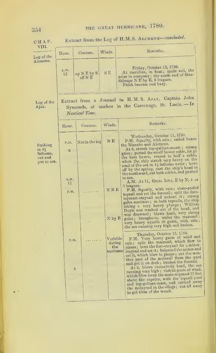
354
CHAP.VIII.
THE GREAT HURRICANE, 1780.
Extract from the Log of H.M.S. Alcmene-concluded.
Log of the
Alcmene.
Log of the
Ajax.
j
Hour. Courses. Winds. Remarks.
A.M.
12 up N E bv Soff N E'
SEFriday, October 13, 1780.
At meridian, in boat; made sail, the
prize in company ;the south end of Gua-
deloupe N E by E, 8 leagues.
Fresh breezes and hazy.
Extract from a Journal in H.M.S. Ajax, Captain John
Symonds, at anchor in the Careenage, St. Lucia.— In
Nautical Time.
Hour. Courses. Winds. Remarks.
Striking
in 4i
fathoms,
cut andput to sea.
P.M. Not in the log NE
a.m.11
P.M. NNE
P.M.
N by E
Wednesday, October 11, 1780.
P.M. Squally, with rain ;sailed hence
the Blanche and Alcmene.
At 6, struck top-gallant-masts ;strong
<rales ;parted the small bower cable, let go
the best bower, veered to half a cable,
when the ship struck very heavy on the]
send of the sea in 4£ fathoms water ;hove
off by the spring, cast the ship s head to
the northward, cut both cables, and pushed
t0
A.M. At 11, Gross Islet, E by N, 4 or
P.M. Squally, with rain; close-reefed
topsail and set the foresail ;split the fore-
topmast-staysail and unbent it; strong
gales continue ;in both topsails, the ship
taking a very heavy
Dovle was washed out of the head, and
was drowned ;blows hard, very strong
gales ;brought-to, under the mainsail
,
very heavy squalls in gusts, with ram
,
the'sea running very high and broken^
*
Yariable
duringthe
hurricane
Thursday, October 12, 1780.
P M. Very heavy gusts of wind ana
rain; split the mainsail, which flew to
pieces ;bent the fore-staysail for a mizen-
staysail and set it ;balanced the mizen and
set it, which blew to pieces ;cut the wea-
ther part of the mainsail from the yard
and got it on deck ;bunted the foresail.
At 8, blows excessively hard, the sea
running very high ;violent gusts of wind
which blew away the mam-topmast 1- teet
above the capstan, with the topsail-yard
and top-gallant-mast, and carried away
the mainyard in the slings; cut all aw ay
to get clear of the wreck.

THE GREAT HURRICANE, 1780.
Extract from the Log of H. M. S. Ajax—concluded.
Hour.
P.M.
P.M.
7
A.M.
2
r.M.
10
A.M.
12
Courses. Winds.
Variableduringthe hur-ricane
Variable
Remarks.
Thursday, October 12, 1780.
A.M. Heavy gusts of winds with light-
ning;the mizenmast blew over the side,
about nine feet above the poop-deck ;cut
away the rigging to clear the wreck
;
shipped a great quantity of water into our
scuppers and ports, which employed our
pumps until morning; strong gusts andblowing weather, with a lofty and irregular
sea;saw a large ship to leeward of us, and
two frigates to windward ;employed clear-
ing the standing and running-rigging that
had been cut; pumps constantly going,
with which we but just kept the ship free.
At 8, more moderate;set the main-stay-
sail;less wind
;the sea high and confused.
Friday, October 13, 1780.P.M. Squally, with a confused sea; em-
ployed clearing the decks of the running-rigging and blocks
;got down and saved
both the main-yardarms.At 7, more moderate and showery
;
kept only one hand-pump going.A.M. At 2, squally, with showers of
rain, thunder, and lightning.
At 5, wore ship; employed cutting the
head of mizenmast to fit a cap for the jury-mast, and preparing the main topsail-yardfor a mainyard
; set fore-topsail, employedrigging the jury mizenmast, and main-topmast; got up the jury mizenmast ;
fresh gales and rain.
Saturday, October 14, 1780.P.M. Moderate and heavy rains
; se-cured the mizenmast and set a fore-stay-sail for a mizen
;got the main-topsail-yard
across for a mainyard; bent the sail and
swayed the yard up; bent the main-top-gallant-staysail for a mizen-staysail.At 10, more moderate
; set the fore andmizen-staysail.
A.M. Ditto weather; set the mainsail
and got the top-gallant-yard across for atopsail, and set it on.At 6, saw the land, south end Dominica,
S E by F-, 10 leagues; Saints, N E by E,
12 leagues; examined the guns, and
scaled those that were wet.At 9, spoke the Aibemarle frigate, who
had lost her mainmast, fore and mizen-topmasts, bound for Antigua to refit
; em-ployed variously.
Noon. Saints, E by N j E, 5 leagues;
north end Dominica, E ± S, 7 leagues.
2 a 2
355
C II A P.
VIII.
Log of the
Ajax.
Off Do-minica.
Spoke the
Albemarle.

356 the great hurricane, 1780 .
CHAP. Extract from the Log of the H.M.S. Egmont, Captain Fan-
VIILshawe ;
kept by Mr. Robert Hartley, Master—In Nautical Time.
Log of the
Egmont,in St.
Lucia.
Hour. Courses.|
Winds.
P.M.
A.M.10
Cut andwent to
sea.
12
P.M.
1
2
3
4
5
6
7
8
9
10
11.30
12
A.M.
1
2
3
4
5
6n
819j1011
12
N by S
Remarks.
Variable
iNorthw
Tuesday, October 10, 1780.
P.M. Most part unsettled, with frequent
squalls of rain; received on board nine
casks of flour and eighty bags of bread ;
caulkers employed as before, and the long-
boat watering.
A.M. At 10, in a squall of wind, parted
the stream cable, and dropped the best
bower underfoot.
At 9, run a hawser out to the Amazonfrigate, and hove-in upon her, and veered
away on the small bower, and hove up
the best bower; moored the ship with
best bower and small bower, a whole cable
on the best bower and half a cable on the
small bower.Noon. Got down the top- gallant-yards;
squally, with hard rain ;sailed hence the
Blanche and Alcmene frigates.
Wednesday, October 11, 1780.
P.M. Fresh gales and squally, with rain.
EN E
NN by W
NEbyN
up E £ Noff S E i E
NbyW
At 7, came on a heavv squall of wind and
rain, which parted the small bower cable
at twenty fathom from the anchor ;the ship
swung to the best bower, which brought
her up ;employed clearing the ship for sea.
At 11.30, cut away the best bower at a
whole cable, the hawser that was fast to
the Amazon, and the hawser for the
spring, and went to sea under our staysail.
Midnight. Split the main-topmast-stay-
sail, and set the courses.
A.M. Strong gales, with hard squalls of
rain.
Split the fore-staysail.
Unbent the main-topmast-staysail.
Carried away the main-staysail.
Saw the Ajax standing to the eastward.
Wore and lay-to.
Noon. St. Lucia, N 19° E, distance 13
leagues.
Excess of latitude, 7°.
Departure, 30° W
.
Very heavy gales and squally.

THE GREAT HURRICANE, 1780.
Extract from the Log of H. M. S. Egmont
—
continued.
o f <*
OO/
Hour. Courses.I
Winds. Remarks.
P. M. Thursday, October 12, 1780.1 NE P.M. Very strong gales, with hard2 squalls and rain.3 Saw a sloop lying- to in the SE quarter
;
4 lost overboard the davit.5 Lying- to, under a main & mizen-staysail.6 A.M. At 8, the main-topmast and bow-
sprit went away. At 8.15, the foremast8 went away by the larboard-side, and car-9 ried away the rigging and stopper of the
10 From all sheet anchor, which we were obliged to cut11 quarters away
;very hard gales and a very heavy sea.
12 Noon. The tiller in the gun-room broke;A. M. the wind from all quarters q)' the compass
;
1 shipped a great deal of water.2 At 9.30, the mizenmast went over the3 larboard-quarter, as did the mainmast ;
all
4 the people employed clearing the wreck.
I
CHAP.VIII.
Log of the
Egmont.
This Sketch of the Egmont is,from a drawing made the day after the hurricane. in 1780 ,an officer of that shtp, and preserved in thefamily of the late Commissioner Fanshav-e.
Thursday, October 12, 1780.rrom all A.M. At 8, got up a jury foremast andquaiters 1 set the spritsail-topsail lor a foresail
Noon. Wore ship to the N W, the timethe mast went away by the wreck
; the

358 the great hurricane, 1780.
CHAP.VIII.
Log of the
Egmont.
Extract from the Log of H.M. S. Egmont-continued.
Hour. Courses. ^Vinds. Remarks.
A.M.
81
r. m.|
9
10 1
11
12
E'rom all
Thursday, October 12, 1780.
cutter and gig, larboard-side on the ship
quarterssides, were stove to pieces.
P.M. At 9, washed in both quarter-
gallery sashes ;the ward-room continually
full of water, and gun-room, the ship being
much by the stern.
St. Lucia, NEbyE| E, dist. 11 leagues.
P. M.
1
s1
4
5
6
7
8
9
10
11
12
A.M.1
2
3
4
5
6
7
SSEFriday, October 13, 1780.
P.M. At 1, wore ship ;a great deal of
our bread damaged, and very wet.
Fresh gales and cloudy, with frequent
squalls of wind and rain.
Much lightning. /r. the north-east quarter.
Course made, NW by W f W.Distanced, 21 miles.
Excess of latitude, 7 miles.
Excess of longitude, 21 miles
Departure, 20 miles
Latitude by account, 13 ot JN
.
Distance made, 58 miles, W
.
Longitude made, 1° W.Midnight. Ditto weather.
A.M. Saw the land ;making the Sugar
Loaf in St. Lucia.
Bearing, E by N, 10 or 11 leagues.
1
SE
8
9
10
11
12
I
Noon. St. Lucia, N. 75° 25' E, distance
15 leagues.. .
Ditto weather; getting jurymast up,
and clearing the bread-rooms of damaged
bread, and throwing it overboard ;filled
twentv-four butts of salt-water in the
forehold to bring the ship by the head.
P. M.1
12
A. M.
12
SEbylSaturday, October 14, 1780.
E PM Fresh gales and cloudy, with rain.
Noon. St. Lucia, E, 27 leagues 1 mile.
Lat. by account, 13° 46' N.
A.M. Fresh breezes and hazy weather.
P. M.1
SEbySunday, October 15, 1780.
S P.M. Cloudy, with small rain.

THE GREAT HURRICANE, 1780 .
Extract from the Log of H.M. S. Egmont—continued.
359
Hour. Courses. Winds. Remarks.
r.M.
12
8
9
12
SEby SW by SSWbyW
Sunday, October 15, 1780.
Noon. St. Lucia, S 69° 48' E, distance
44 leagues 1 mile.
Lat. by account, 14° 30' N.Great swell from the S W.
r.M.
1
5
12
SE by SSE by E
Monday, October 16, 1780.
P.M. Fresh breezes and hazy weather.•
Lat. 14° 56' N.Noon. St. Lucia, S 66° 38' E, distance
59 leagues 2 miles.
r.M.
1
12SEbyE
Tuesday, October 17, 1780.
P.M. Fresh breezes and fair weather.Lat. 15° 46' N.St. Lucia, S 59° 44' E, dist. 77 leagues.
P.M.
1
12S S W Wednesday, October 18, 1780.
P.M. Light breezes.
Noon. Lat. 16° 29' N.St. Lucia, S 57° 20' E, dist. 86 leagues.
P.M.
1
12
w sw Thursday, October 19, 1780.
P.M. Lat. by observation, 16° 54' N.Midnight. Calm.
P.M.
1 NNEFriday, October 20, 1780.
P.M. Lat. by observation, 16° 45' N.St. Lucia, S 55° E, distance 104 leagues.
P.M.
1
12
NNESaturday, October 21, 1780.
P.M. Squallv, and hard rain.
Lat. 17° 10' N.St. Lucia, S 60° E, distance 137 leagues.
P.M.
1
12
NESunday, October 22, 1780.
P.M. Lat. 17° 19' N, long. ex. 8° 18' W.Noon. Port Royal, Jamaica, N 85° 44' W,
distance 139 leagues.
P.M.
1
12• Easterly
Monday, October 23, 1780P.M. Lat. 17° 36' N.Port Royal, Jamaica, N 89° 24' W, dis-
tance 127 leagues.
P.M.
1 ESETuesday, October 24, 1780.
P.M. Lat.l7°14'N, long.made, 9°44'W.
CHAP.YHI.
Log of the
Egmont.

360
CHAP.VIII.
Log of the
Egmont.
THE GREAT HURRICANE, 1780.
Extract from the Log of H. M. S. Egmont
—
concluded.
Jamaica.
Log of the
Montagu.
Hour. Courses. Winds.
P.M.
12 Variable
P.M.
12 Easterly
P.M.
12 ENE
P.M.
12 NE
P.M. NE
Remarks.
Wednesday, October 25. 1780.
P.M. Lat. 17° 28'.
East end of Cape Tiberon, NW £ W,
Thursday, October 26, 1780.
P.M. Lat. 18° V N.
Cape Donna Maria, N E ;distance 10 or
11 leagues.
Friday, October 27, 1780.
P.M. Lat. 18° 15' N.Saw the end of Jamaica, WSW ;
dis-
tance 9 or 10 leagues ;Morant Point, 7 or
8 leagues.
Saturday, October 28, 1780.
Noon. Kingston, 7 leagues.
Sunday, October 29, 1780.
P.M. Moored the ship in Port Royal
harbour, Jamaica.
Extract from the Log of H. M. S. Montagu (kept by Mr.
William Raven, Master), lying off the Entrance of the
Careenage, St. Lucia.—In Nautical Time.
Montaguparted andwent to sea.
Hour
.
Courses. Winds.
P.M. N
12
A.M.
3
6
8
|
WN WHead to Nup NW
offW by N
NNE
Remarks.
Wednesday, October 11, 1780.
P.M. Strong gales, with heavy squalls
of rain ;struck the top-gallant^ masts ;
a
very heavy swell from the N W\ At 12,
parted or slipped, H.M.S. Ajax.
A.M. At 3, slipped and stood to sea,
H.M.S. Egmont. At 5.30, in preparing
to slip and go to sea, we parted our stream
and small bower cables ;stood outW N W
till 8 a.m. South end of St. Lucia then
bore, S S E, 9 or 10 leagues ;brought her
to with her head to the northward; up
N W, offW by N, very strong gales ;ship
makes much water.
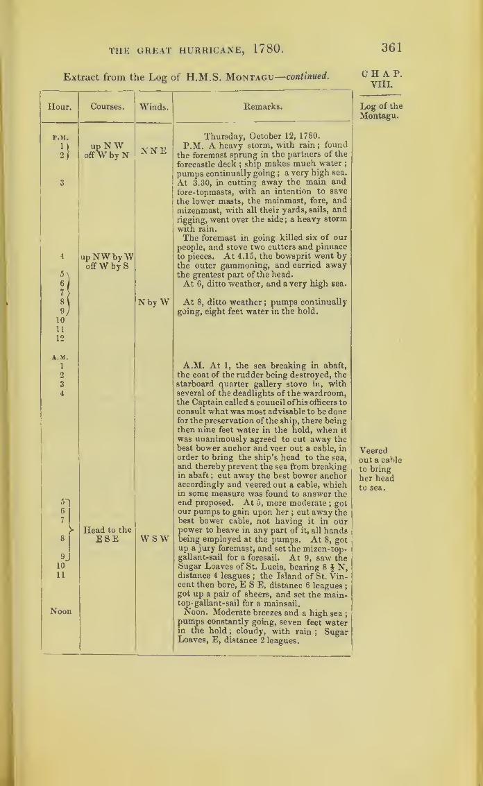
361THE GREAT HURRICANE, 1780 .
Extract from the Log of H.M.S. Montagu—continued.
F.M.
!}
5'
6
7
8
9,
10
11
12
A.M.
1
2
3
4
9
10
11
Hour.
Noon
Courses.
up NWoffW by N
Winds.
NNE
up NW byWoffW by S
NbyW
Head to the
ESE W SW
Remarks.
Thursday, October 12, 1780.
P.M. A heavy storm, with rain;found
the foremast sprung in the partners of the
forecastle deck ;ship makes much water ;
pumps continually going ; a very high sea.
At 3.30, in cutting away the main andfore-topmasts, with an intention to save
the lower masts, the mainmast, fore, andmizenmast, with all their yards, sails, andrigging, went over the side ; a heavy storm
with rain.
The foremast in going killed six of our
people, and stove two cutters and pinnace
to pieces. At 4.15, the bowsprit went bythe outer gammoning, and carried awaythe greatest part of the head.
At 6, ditto weather, and a very high sea.
At 8, ditto weather;pumps continually
going, eight feet water in the hold.
A.M. At 1, the sea breaking in abaft,
the coat of the rudder being destroyed, thestarboard quarter gallery stove in, withseveral of the deadlights of the wardroom,the Captain called a council of his officers to
consult what was most advisable to be donefor the preservation of the ship, there beingthen nine feet water in the hold, when it
was unanimously agreed to cut away thebest bower anchor and veer out a cable, in
order to bring the ship’s head to the sea,
and thereby prevent the sea from breakingin abaft
; cut away the best bower anchoraccordingly and veered out a cable, whichin some measure was found to answer theend proposed. At 5, more moderate
;got
our pumps to gain upon her ; cut away thebest bower cable, not having it in ourpower to heave in any part of it, all handsbeing employed at the pumps. At 8, gotup a jury foremast, and set the mizen-top-gallant-sail for a foresail. At 9, saw theSugar Loaves of St. Lucia, bearing 8 $ N,distance 4 leagues ; the Island of St. Vin-cent then bore, ESE, distance 6 leagues
;
got up a pair of sheers, and set the main-top-gallant-sail for a mainsail.Noon. Moderate breezes and a high sea
;
pumps constantly going, seven feet waterin the hold ; cloudy, with rain
; SugarLoaves, E, distance 2 leagues.
CHAP.VIII.
Log of the
Montagu.
Veeredout a cable
to bring
her headto sea.
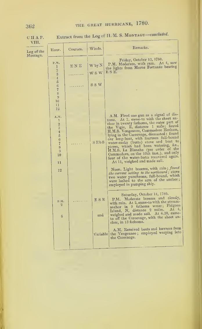
362
CHAP.VIII.
Log of the
Montagu.
THE GREAT HURRICANE, 1780.
Extract from the Log of H. M. S. Montagu-cohc/m^.
Hour.
P.M.
1
2
3
4
5
6
7
8
9
10
11
12
A.M.1
2
3
4
5
6
7
8
9
10
11
12
P.M.
2
Courses. Winds.
ENE W byN
w s w
s s w
Remarks.
Friday, October 13, 1780.
P.M. Moderate, with rain. At 4, saw
the lights from Morne Fortune bearing
E S E.
SEbS
A.M. Fired one gun as a signal of dis-
tress. At 7, came-to with the sheet an-
chor in twenty fathoms, the outer part of
the Vigie, E, distance 1 mile; found
HALS. Vengeance, Commodore Hotharn,
lying in the Careenage, dismasted ;found
our long-boat, with fourteen full-bound
water-casks (butts) stove and beat to
pieces, which had been watering, &c.,
H.M.S. La Blanche (per order of the
Commodore, on the 10th inst.), and only
four of the water-butts recovered again.
At 11, weighed and made sail.
Noon. Light breezes, with rain ;found
the current setting to the northward
;
stove
two water puncheons, full-bound, which
were lashed to the arm of the anchor
,
employed in pumping ship.
E S E
and
Variable
Saturday, October 14, 1780.
P.M. Moderate breezes and cloudy,
with rain. At 2, came-to with the stream-
anchor in 9 fathoms water; Pidgeon
Island, N, distance 2 miles. At 4,
weighed and made sail. At 6.30, came-
to off the Careenage, with the sheet an-
chor, in 13 fathoms.
A.M. Received boats and hawsers from
the Vengeance ;employed warping into
the Careenage.
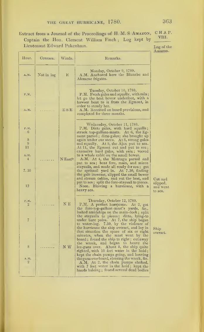
THE GREAT HURRICANE, 1780 . 363
Extract from a Journal of the Proceedings of H. M. S Amazon,
Captain the Hon. Clement William Finch;
Log kept by
Lieutenant Edward Pakenham.
Hour. Courses.
A.M.
r.M.
A.M.
P.M.
6
8
9
11
A.M.
4
7.30
12
p.m.
2
Not in log
A.M.
2
Winds.
E
ESE
N East 1 )'
N E
N W
Remarks.
Monday, October 9, 1780.
A.M. Anchored here the BlancheAlcmene frigates.
and
Tuesday, October 10, 1780.
P.M. Fresh gales and squally, with rain
;
let go the best bower underfoot, with a
hawser bent to it from the Egmont, in
order to steady her.
A.M. Received on board provisions, andcompleted for three months.
Wednesday, October 11, 1780.
P.M. Ditto gales, with hard squalls
;
struck top-gallant-masts. At 6, the Eg-mont parted
;ditto gales ; she brought up
again under our stern. At 8, strong gales
and squally. At 9, the Ajax put to sea.
At 11, the Egmont cut and put to sea;
excessive hard gales, with rain ; veeredto a whole cable on the small bower.A.M. At 4, the Montagu parted and
put to sea ; bent fore, main, and mizenstaysails, and made all ready for sea
;got
the spritsail yard in. At 7.30, finding
the gale increase, slipped the small bowerand stream cables, and cut the best, andput to sea ; split the fore-staysail to pieces.
Noon. Blowing a hurricane, with aheavy sea.
Thursday, October 12, 1780.
P.M. A perfect hurricane. At 2, gotthe fore-top-gallant-mast’s yards, &c.,
lashed amidships on the main-deck; split
the staysails to pieces ; ditto, lying-to
under bare poles. At 7, the ship beganto water-log. 7.30, by the violence of
the hurricane the ship overset, and lay in
that situation the space of six or eight
minutes, when the mast went by the
board ; found the ship to right ; cutawaythe wreck, and began to heave thelee-guns over. About 8, the ship quite
righted, with 10 feet water in the hold
;
kept the chain pumps going, and heavingthe guns overboard, clearing the wreck, &c.
A.M. At 2, the chain pumps choked,with 7 feet water in the hold ; kept thehands baleing ;
found several dead bodies
CHAP.VIII.
Log of the
Amazon.
Cut andslipped,
and wentto sea.
Shipoverset.
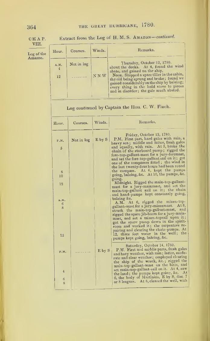
364 THE GREAT HURRICANE, 1/80.
CHAP.VIII.
Log of the
Amazon.
Extract from the Log of H. M. S, Amazon—continued.
Hour.
A.M.
4
12
Courses.
Not in log
Winds.
NN W
Remarks.
Thursday, October 12, 1780.
about the decks. At 4, found the wind
abate, and gained on the ship.
Noon. Shipped a spare tiller in the cabin,
the old being sprung and broke ;found we
gained considerablyonthe ship by baleing;
every thing in the hold stove to pieces
and in disorder ;the gale much abated.
Log continued by Captain the Hon. C. W. Finch.
Hour.
p.m.
5
6
10
12
A.M.
6
8
6
8
Courses. Winds.
Not in log E by S
Remarks.
12
P.M.
Friday, October 13, 1780.
P.M. First part, hard gales with rain, a
heavy sea ;middle and latter, fresh gales
and squally, with rain. At 5, broke the
chain of the starboard pump ; rigged the
fore-top-gallant-mast for a jury-foremast,
and set the fore-top-gallant sail on it;got
one of the compasses fitted;
the wind in
the last twenty-four hours had been round
the compass. At 6, kept the pumpsgoing, baleing, &c. At 10, the pumps, &c.
going.
Midnight. Rigged the main- top -gallant-
mast for a jury-mainmast, and set the
main-top-gallant sail on it ;the chain
and hand-pumps kept constantly going,
baleing &c.
A.M. At 6, rigged the mizen-top-
gallant-mast for a jury-mizenmast. At 8,
struck the main-top-gallant-mast, and
rigged the spare jib-boom for a jury-main-
mast, and set a mizen-topsail upon it
;
got the spare pump down in the spirit-
room and worked it ;the carpenters re-
pairing and clearing the chain-pumps. At
12, three feet water in the well ;the
pumps kept going, baleing, &c.
E by S
Saturday, October 14, 1780.
P.M. First and middle parts, fresh gales
and hazy weather, with rain; latter, mode-
rate and clear weather ;employed clearing
the ship of the wreck, &c. ;rigged the
main-top -gallant-mast on the bitts, and
set main-top-gallant-sail on it. At 4, saw
the land; the pumps kept going, &c. At
6, the bodv of Martinico, E by S, diet. 7
or 8 leagues. At 8, cleared the well, with

THE GREAT HURRICANE, 1780 .
Extract from the Log of H. M. S. Amazon—concluded.
Hour. Courses. Winds. Remarks.
Not in log Saturday, October 14, 1780.
the hand-pumps, baleing, &c. ;the spare
pump choked ;set the royals.A.M.
10 SSE A.M. At 10, spoke H.M.S. Ajax, with
the loss of her mizenmast.12 Noon. The northward point of Domi-
nica, E by S. and southward point of Gua-deloupe, N N E.—Lat. 16° 26' N.
The following is from the Hon. Captain Finch’s
Narrative.
“ About seven o’clock at night the gale increased to a degree
that can be better conceived from the consequences, than from
any description I can give. There was an evident necessity of
doing something to relieve the ship;but I was unwilling to cut
away the lower masts till the last extremity, and accordingly
ordered the people to cut awTay the main-topmast;
but, before
it could be accomplished, I found it necessary to cut away the
mainmast.“ Whilst I was waiting for the men to come down, a sudden
gust overset the ship;most of the officers, with myself and a
number of the ship’s company, got upon the side of the ship :
the wheel of the quarter-deck was then under water. In this
situation I could perceive the ship settling bodily some feet,
until the water washed up to the afterpart of the slides of the
carronades on the weather side. Notwithstanding that the ship
was so far gone, upon the masts, bowsprit, &c., going away, she
righted as far as to let us heave the lee quarter-deck guns and
carronades overboard, and soon after one of the forecastle guns,
and to cut away the sheet anchor;which had so good an effect,
that we were enabled to get at the pumps and lee-guns on the
main deck. The throwing them overboard was, in our situation,
a work of great difficulty;and I could perceive the ship was
already going down by the stern. This arduous task was ac-
complished under the direction of Lieutenant E. Pakenham,
whose experience and determined perseverance marked him out
as perhaps the only individual to whom (amid such great exer-
tion) a pre-eminence could be given.”
365
CHAP.VIII.
Log of the
Amazon.
CaptainFinch’snarrative.

3GG THE GREAT HURRICANE, 1/80.
CHAP. Extract from the Log of H. M.S. Endymion, Captain Carteret,
VIII. and kept by William Price, Master.—In Nautical lime.
Log of the
Endymion. Hour. Courses. Winds.
P.M.
Windwardof Marti-
nique.
1
5
7
12
A.M.
2
3
5
8
Andro-meda andLaurel in
company.
10
12
r.M.
1
6
10
A.M.
1
8
12
P.M.
1
2
5
9
12
A.M.
3
Remarks.
S S WE
Variable
E by SE
E by N
Monday, October 9, 1780.
jt.ua. Fresh breezes and fair weather;
lying-to, setting fore-rigging, forestay and
topmast rigging up ;H.M. frigates Andro-
meda and Laurel in company.
Midnight. Moderate breezes and fair.
Lat. by observation, 14° 44' N.
ENE
NE byE
N E
N E
N E
A.M. At 8, made the Andromeda and
Laurel signals, to keep on head, as far as
signals could be observed..
At 9, the Andromeda made the signal
for seeing a strange sail ;made the signal
to chase, and made sail ;out reefs ;
set all
sail upon a wind.
Rove new fore -topmast -staysail -hal-
yards..
Noon. Moderate and fair weather.
Martinico, W S W, distance 17 leagues.
Tuesday, October 10, 1780.
P.M. Fresh breezes and hazy weather
;
11
The Laurel being a considerable distance
a-head brought the chase to, alter firing
several shot; found her to be the brig Sarah
and Nancy, from Boston, bound to Gra-
nada, loaded with lumber.
At 6, in second reefs, and wore ship
,
hove-to to shift the men out of the prize
;
manned her and sent her to Barbados.
A.M. Fresh gales and squally ; in third
Martinico, W S W, distance 10 leagues.
Strong gales and squally weather ;An-
dromeda and Laurel in company.
Wednesday, October 11, 1780.
P.M. Strong gales and hard squalls.
Handed topsails; down top- gallant-
yards ;struck top-gallant-masts.
At 4, saw the land N E end of Marti-
nico, SW by S, distance 7 leagues.
At 5, set topsails.
Strong gale and great swell from the
E N E ;° handed ditto topsails.
Midnight. Strong gale and hard squalls.
A.M. At 3, made the signal for the An-
dromeda and Laurel to lie-by on the lar-
board tack.

THE GREAT HURRICANE, 1780 .
Extract from the Log of H. M. S. Endymion—continued.
307
Hour.
I
Courses. Winds. Remarks.
A.M. Wednesday, October 11, 1780.8
9
12
ENE At 8, handed topsail j heavy gales andstrong squalls ; lost sight of the two ships.
At 9, handed mainsail under balance-
mizen and mizen-topsail.
Noon. Blows strong and violent squalls;
north-east end of Martinico, W S W, dis-
tance 4 leagues.
P.M. Thursday, October 12, 1780.1 E N E P.M. Strong gale and hard squalls.
12 Noon. Wore ship to northward ; thereA.M. saw white water to leeward.
2 A.M. At 2, saw land.3 At 3, just weathered the Island of Cara-5 E val, the north-east end of Martinico, then
bore away, and run between Dominicaand Martinico. The main, mizenmast,
|
and fore-topmast blown away by the vio-
lence of the wind; some time after, the
bowsprit ; the wreck being so foul of thebest bower anchor, obliged us to cut away25 fathoms of cable ; employed clearingthe wreck.
7 1-1 by N At 7, hove-to under a mizen-topsail.12 ESE Noon. Continues blowing a heavy gale
and violent squalls; bearing and distance
Martinico, north end, dist. 15 leagues.
P.M.
1
5
12
SWbyWFriday, October 13, 1780.
P.M. Strong gales and violent squalls.
Bent the longboat’s mainsail to the stumpof the mainmast, to keep the ship to thewind ;
ship labouring very much, shippingvery heavy seas
;got a stay up to the
mizenmast, and set a mizen-staysail, al-
tered for the purpose.ESE Midnight. Blowing a strong gale and
A.M. hard squalls.4 A.M. Ship rolls very heavy, which occa-
sions her to strain much.6
12
More moderate and settled. (Then fol- I
lows details of repairing the rigging.)
Noon. Moderate and squally. Martinico,E, distance 34 leagues.
P.M. Saturday, October 14, 1780.3 ESE P.M. Strong gales and thick weather,
with rain ; standing to the westward.Constant rain.9
9 SE A.M. Blowing strong and squally
;
making a mizen-staysail to set on the
stump of the mizenmast.Lat. 14° 17' N, long. 64° 7' W.Martinico, E by N, distance 60 leagues.
CHAP.VIII.
Log of the
Endymion.
Loses sight
of Andro-meda andLaurel.
WeatheredCaraval.*
Ship keep-ing upwith thestorm.
* Andromeda and Laurel went on shore.

368 THE GREAT HURRICANE, 1780.
CHAP.VIII.
Log of tlie
Endymion.
Extract from the Log of H. M. S. Endymion continued.
Hour.|
Courses.
p.m.
1
12
A.M.
7
8
12
P.M.
2
8
A.M.
12
P.M.
1
5
9
A.M.
6
12
P.M.
1
3
9
12
A.M.
5
7
12
Winds. Remarks.
ESE
SE
S S E
Sunday, October 15, 1780.
P.M. Strong gales and squally, with
hard rain, and a great swell from south-
south- east.
Wore ship and hove-to ;head to north-
ward;
setting the main-staysail ;split it
to pieces. ,
Midnight. Thick weather, with hard
rain.
A.M. Hard squalls and heavy ram.
Santa Cruz, north-easterly, distance 6/
lL
Noon8
.’ Lat. 14° 32' N, long. 65° 9' W.
S S E
S S E
Monday, October 16, 1780.
P.M. Eresh gale and thick weather ;a
great swell from the south, heavy rain.
Blows dreary and squally.
A.M. Moderate and clear ;all hands em-
ployed rigging jury-mainmast and mizen-
mast; saw several sails standing different
ways.Noon. Santa Cruz, north, 31 E, dis-
tance 49 miles.
Moderate and cloudy weather.
Lat. by observation, 17° 15' N.
SES by E
wsw
S S E
Tuesday, October 17, 1780.
P.M. Moderate and cloudy.
All hands getting jury-mast up and bow-
sprit out. ,
Squally, with rain from the southward.
A M. Saw the land, bearing N N W,distance, 8 or 9 leagues, body of Porto
Rico., „ . .
Noon. Moderate and fair weather; west
end of the Island of Porto Rico, bearing
N N W, distance 7 leagues.
Lat. by observation, 17° 43' N.
SW by SS S WSW by S
S byWS
Variable
Wednesday, October 18, 1780.
P.M. Light breezes and clear.
Squally ;handed topsails.
Midnight. Fresh breezes and cloudy.
A.M. Fresh breezes. ... .
Noon. The westernmost land in sight,
bearing N W by N, distance 9 leagues.
A sail in sight ahead.
Lat. by observation, 17 40 N.
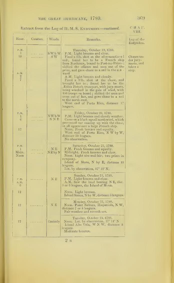
THE GREAT HURRICANE, 1780 .
Extract from the Log of II. M. S. Endymion— continved.
Hour. Courses.|
Winds. ltemark8.
P.M.
1
10
A.M.
2
7
swbwsw
Thursday, October 19, 1780.
P.M. Light breezes and clear.
Fired a 91b. shot at the aforementione 1
sail;
found her to be a French ship
from Bordeaux, bound to Port-au-Prince;shifted the officers and men out of the
prize, and gave chase to a sail in the ets -
wardA.M. Light breezes and cloudy.
Fired a 91b. shot at the chase, andbrought her to
;found her to be the
iEolus French transport, with jury-masts,j
being wrecked in the gale of wind, with150 troops on board
;shifted the men and
arms out of her, and gave chase to a sail
to the north-east.
West end of Porto Rico, distance 17leagues.
P.M.
1
6
12
NWb WNNE
Friday, October 20, 1780.P.M. Light breezes and cloudy weather.Came on a black squall northward, which
prevented our coming up with the chase,in all appearance a large French ship.
Noon. Fresh breezes and squally.West end of Porto Rico, NWbyW,
distance 30 leagues.No observation.
P.M.
1
Midn.Noon
• •
NENEbyN
Saturday, October 21, 1780.P.M. Fresh breezes and squally.Midnight. Fresh breezes and clear.
Noon. Light airs and fair; two prizes incompany.Island of Mona, N by E, distance 18
leagues.
Lat. by observation, 17° 32' N.
P.M.
A.M.
c
N ESunday, October 22, 1780.
P.M. Light breezes and clear.
A.M. Saw the land bearing N E, dist.
5 or 6 leagues, the Island of Mona.
12 Noon. Light breezes.
Island Saona, N by W, distance 5 leagues.
12 N EMonday, October 23, 1780.
Noon. Point Salines, Hispaniola, N W,distance 7 or 8 leagues.
Fair weather and smooth sea.
12 Easterly
Tuesday, October 24, 1780.
Noon. Lat. by observation, 17° 11' NIsland Alta Yela, W N W, distance 8
leagues.
Moderate breezes.
C H A F.
VIII.
Log of tlie
Endymion.
Chases un-der jury-
masts, andtakes a
ship.

370 THE GREAT HURRICANE, 1 / SO.
CHAP.VIII.
Log of the
Endymion.
Hour. Courses. Winds. I
Remarks.
-
12 Easterly
Wednesday, October 25, 1780.
Noon. Lat. by observation, 17"' 7' N.
Saw land bearing N by W, distance 1 (
or 18 leagues.
Moderate weather.
|12
Variable
Thursday, October 26, 1780.
Noon. Lat. by observation, 17° 32 N.
Isle a, Vache, bearing N, distance 10
leagues.
12Variable
Friday, October 27, 1780.
Noon. Cape Donna Maria, bearing N E.
Moderate weather.
Lat. 17° 57' N.
1 9 ENESaturday, October 28, 1780.
Noon. East end of Jamaica, bearing
N W, distance 7 leagues.
P.M.
Sunday, October 29, 1780.
P.M. The town of Kingstown, JN *»
,
distance 7 miles. .
Found at Port Royal harbour the foliow-
1 intr vessels :Hinchenbrook, Resource,
I Pelican, Princess Royal, Albion Diamond,
LowestofFe, Pomona, Hector, Ruby,
mont, Grafton, Bristol, Trident, Ulysses ,
the seven last dismasted.
Log of the
Star.
Extract from the Log of H. M. S. Star (kept by R Carnmdy,
Master), lying in St. Johns Harbour, Ant.gna.-In Nautva
Time.
Hour.
StormreachesAntigua.
P.M.
P.M.
A.M.
P.M.
A.M.
Courses. Winds.
EN E
ditto
ditto
Remarks.
Tuesday, October 10, 1780.
P.M. Moderate and cloudy.
Wednesday, October 11, 1(80.
P.M. Moderate breezes and cloudy.
A.M. Fresh breezes ;squally.
Thursday, October 12, 1780.
P M Moderate breezes and calm.
A.M. Fresh gales, with squalls ot rain.

THE GREAT HURRICANE, 1780 .
Extract from the Log of H. M. S. Star—concluded.
371
Hour. Courses. Winds. Remarks.
P.M. EasterlyFriday, October 13, 1780.
P.M. Fresh gales, with squalls of rain.
A.M. More moderate.A.M.
P.M. S ESaturday, October 14, 1780.
P.M. Moderate gales, with squalls of
rain.
A.M. Ditto weather.A.M.
P.M. ditto
Sunday, October 15, 1780.
P.M. Moderate breezes, with squalls of
rain.
A.M. Fresh breezes and squally.A.M.
P.M. ditto
Monday, October 16, 1780.
P.M. Fresh breezes and squally, withrain.
A.M. Ditto weather.A.M
P.M. VariableTuesday, October 17, 1780.
P.M. Moderate and cloudy.A.M. Light airs, inclining to calm.A.M.
Extract from the Log of H. M. S. Salamander, by Lieut.
G. W. A. Courtenay, lying in the English Harbour,
Antigua.—In Nautical Time.
Hour. Courses. Winds. Remarks.
P.M. ETuesday, October 10, 1780.
P.M. Fresh breezes, middle and latter
part strong squalls, with rain ; Commo-dore’s signal for a lieutenant from ship.
P.M.
•
ENEWednesday, October 11, 1780.
Strong squalls and rain.
P.M. Struck yards and topmast.E
P.M. ESEThursday, October 12, 17S0.
P.M. Ditto weather.
P.M. ditto
Friday, October 13, 1780.
P.M. Ditto weather.
At 4, got the lower yards fore and aft,
and the stream-cable on shore, on the lar-
board quarter.
4
CHAT.VIII.
Log of the
Star.
Log of
the Sala-
mander.
2 B 2
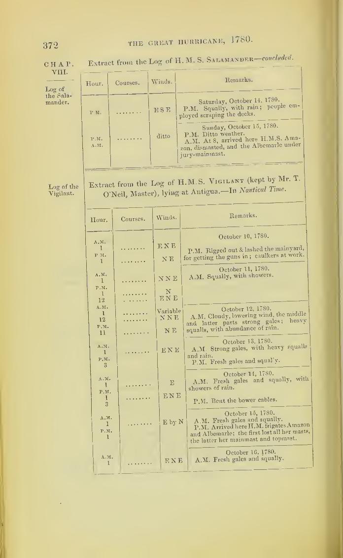
372 THE GREAT HURRICANE, 17S0.
CHAP.VIII.
Log of
the Sala-
mander.
Log of the
Vigilant.
Extract from the Log of H. M. S. Salamander concluded
.
Hour. Courses. "NVinds. Remarks.
r m. ESESaturday, October 14, 1780.
P.M. Squally, with rain; people em-
loyed scraping the decks.P
ditto
Sunday, October 15, 1780.
P.M. Ditto weather.. o
A M At 8, arrived here H.M.S. Ama-
on, dismasted, and the Albemarle under
ury-mainmast.
A.M.z
j
Extract from the Log of H.M.S. Vigilant (kept hy Mr. T.
O'Neil, Master), lying at Antigua.—In Nautical Time.
Hour. Courses. Winds. Remarks.
A.M.1
P M.
1
October 10, 1780.
ENENE
P.M. Rigged out & lashed the mainyard,
for getting the guns in;caulkers at work.
A.M.1 NNE I
October 11, 1780.
A.M. Squally, with showers.
P.M.
1
12
NENE
A.M.1
12
r.M.
11
Variable
NNENE
October 12, 1780.
A.M. Cloudy, lowering wind, the middle
and latter parts strong gales; heavy
squalls, with abundance of rain.
A.M.
1
P.M.
3
ENEOctober 13, 1780.
A.M. Strong gales, with heavy squalls
and rain.
P.M. Fresh gales and squally.
A.M.
x EOctober 14, 1780.
A.M. Fresh gales and squally, with
P.M.
1
3
• ••••••• ENEshowers of rain.
P.M. Bent the bower cables.
A.M.
x E by NOctober 15, 1780.
A.M. Fresh gales and squally.
P M Arrived here H.M. frigates Amazon
and Albemarle ;the first lost all her masts,
the latter her mainmast and topmast.
P.M.
1
A.M.
1ENE
October 16, 1780.
A.M. Fresh gales and squally.
'
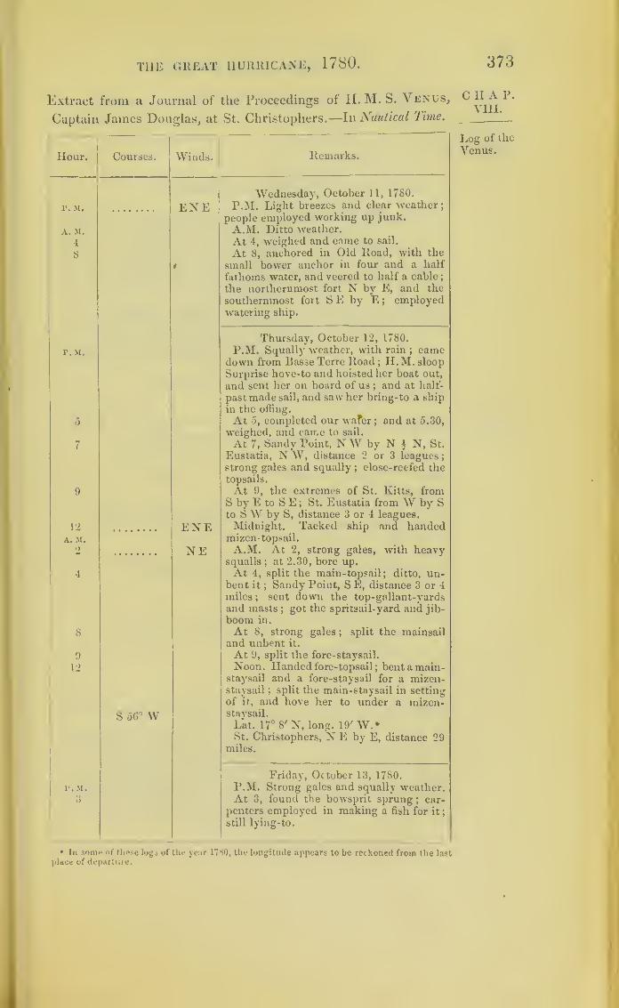
T11E GREAT HURRICANE, 1780 .
Extract from a Journal of the Proceedings of PI. M. S. Venus,
Captain James Douglas, at St. Christophers .—In Nautical lime.
Hour. Courses. Winds. Remarks.
Wednesday, October 11, 1780.
1*. M. ENE P.M. Light breezes and clear weather;
people employed working up junk.
A. M. A.M. Ditto weather.
4 At 4, weighed and came to sail.
8i
At 8, anchored in Old Road, with the
small bower anchor in four and a half
fathoms water, and veered to half a cable;
the northernmost fort N by E, and the
southernmost fort S E by E ; employedwatering ship.
Thursday, October 12, 1780.
P. M. P.M. Squally weather, with rain ; camedown from Basse Terre Road ;
H. M. sloop
Surprise hove-to and hoisted her boat out,
and sent her on board of us;and at half-
past made sail, and saw her bring-to a ship
in the offing.
0 At 5, completed our wafer;and at 5.30,
weighed, and came to sail.
7 At 7, Sandy Point, N W by N § N, St.
Eustatia, N W, distance 2 or 3 leagues
;
strong gales and squally; close-reefed the
topsails.
9 At 9, the extremes of St. Kitts, fromS by E to S E ; St. Eustatia from W by Sto SW by S, distance 3 or 4 leagues.
Midnight. Tacked ship and handed12 ENEA. M. mizen-topsail.
2 NE A.M. At 2, strong gales, with heavysqualls
;at 2.30, bore up.
4 At 4, split the main-topsail; ditto, un-bent it
;Sandy Point, S E, distance 3 or 4
miles; sent down the top-gallant-yardsand masts
;got the spritsail-yard and jib-
boom in.
8 At 8, strong gales ; split the mainsailand unbent it.
9 At 9, split the fore-staysail.
12 Noon. Handed fore-topsail; bent a main-
staysail and a fore-staysail for a mizen-staysail ; split the main-staysail in setting
S 56° Wof it, and hove her to under a mizen-staysail.
Lat. 17° 8' N, long. 19' W.*St. Christophers, NE by E, distance 29
miles.
Friday, October 13, 1780.
P.M. Strong gales and squally weather.r. m.
3 At 3, found the bowsprit sprung ; car-
penters employed in making a fish for it ;
still lying-to.
• In some of these logs of the year 1780, the longitude appears to be reckoned from the lastplace of departure.
373
C II A P.
VIII.
Log of the
Venus.
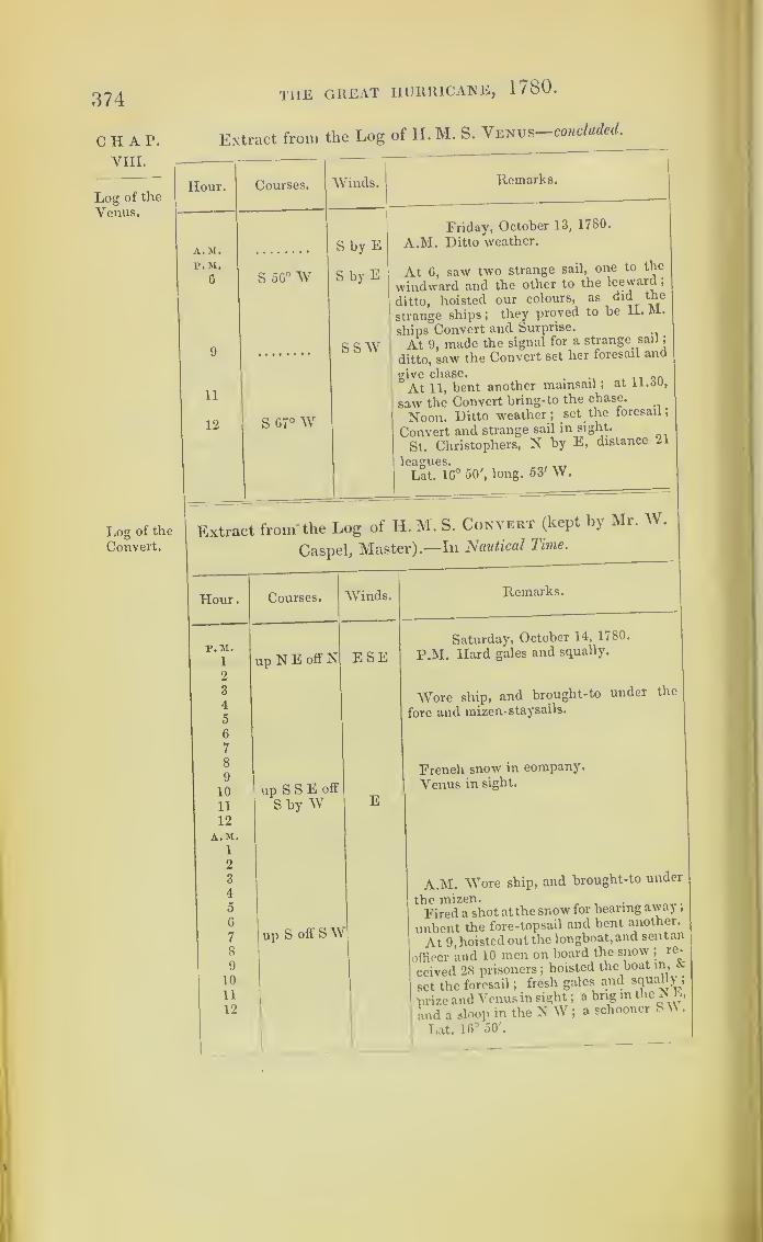
374
CHAP.yiii.
Log of the
Venus.
the great hurricane, 1780 .
Extract from the Log of H. M. S. Venus—concluded.
Hour.
A.M.
P. M.
6
Courses.
S 56°W
Winds. Remarks.
11
12
liOg of the
Convert.
S G7° W
S by E
S by E
SSW
Friday, October 13, 1780.
A.M. Ditto weather.
At 6, saw two strange sail, one to the
windward and the other to the leeward
,
ditto, hoisted our colours, as did the
strange ships ;they proved to be H. M.
ships Convert and Surprise.
At 9, made the signal for a strange sail;
ditto, saw the Convert set her foresail and
give chase.. .. . ,
,
At 11, bent another mainsail ;at
saw the Convert bring-to the chase.
Noon. Ditto weather; set the foresail;
Convert and strange sail in sight.
St. Christophers, N by E, distance -1
leagues.
Lat. 16° 50', long. 53' W.
Extract from the Log of H. M. S. Convert (kept by Mr. IV.
Caspel, Master).—In Nautical Time.
Hour. Courses.
P.M.1
2
3
4
5
6
7
8
9
10
11
12
A. M.
1
2
3
4
5
6
7
8
9
10
11
12
up N E off N
Winds.
ESE
up S S E off
S by W
Remarks.
Saturday, October 14, 1780.
P.M. Hard gales and squally.
Wore ship, and brought-to under the
fore and mizen- staysails.
French snow in company.
Venus insight.
E
up S off SW
A.M. Wore ship, and brought-to under
the mizen. .
Fired a shot at the snow for bearing away
unbent the fore-topsail and bent another.
At 9, hoisted out the longboat, and sentan
officer and 10 men on board the snow ;re-
ceived 28 prisoners ;hoisted the boat in, &
set the foresail ;fresh gales and squally;
prize and Venus in sight ; a brig in the N E,
and a sloop in the N W ;a schooner .
Lat. 16° 50'.
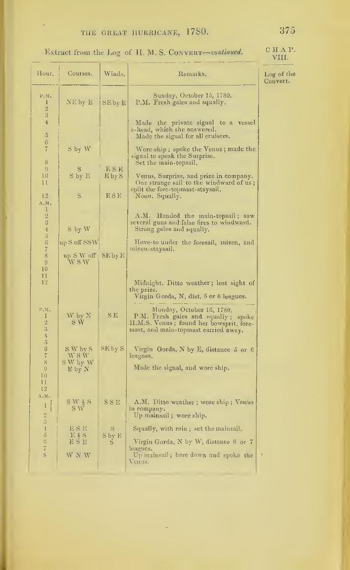
THE GREAT HURRICANE, 1780.
Extract from the Log of H. M. S. Convert—continued.O
Hour. Courses. Winds. Remarks,
P.M. Sunday, October 15, 1780.
P.M. Fresh gales and squally.1
2
NE by E SEbyE
3
4 Made the private signal to a vessel
a-head, which she answered.a
6
7
Made the signal for all cruisers.
S by W Wore ship ;spoke the Venus ;
made the
signal to speak the Surprise.
8 Set the main-topsail.
9 S ESE10 S by E E by S Venus, Surprise, and prize in company.11 One strange sail to the windward of us
;
split the fore-topmast-staysail.
12 S ESE Noon, Squally.A.M.
1
2 A.M. Handed the main-topsail ; saw3 several guns and false fires to windward.4
56
S by W Strong gales and squally.
up S off SSW Hove-to under the foresail, mizen, and7 mizen-staysail.
S up SW off’ SEbyE9 w sw
10
11
12 Midnight. Ditto weather; lost sight of
the prize.
Virgin Gorda, N, dist. 5 or G leagues.
P.M.
Why N SEMonday, October 16, 1780.
P.M. Fresh gales and squally; spoke1
2 S W H.M.S. Venus; found her bowsprit, fore-3
4
mast, and main-topmast carried away.
56 S \V by S SE by S Virgin Gorda, N by E, distance 5 or 67 w sw leagues.
8 S W bv W9 E by N Made the signal, and wore ship.
10
11
12
A.M.
i fS W i S SSE A.M. Ditto weather
;wore ship
;Venus
1
l sw in company.o Up mainsail
; wore ship.
4 ESE S Squally, with rain ; set the mainsail.
0 E i S S by E0 ESE S Virgin Gorda, N by W, distance 6 or 7
7 leagues.
8 W N W Up mainsail;bore down and spoke the
Venus.
1
375
CIIAP.VIII.
Log of the
Convert.
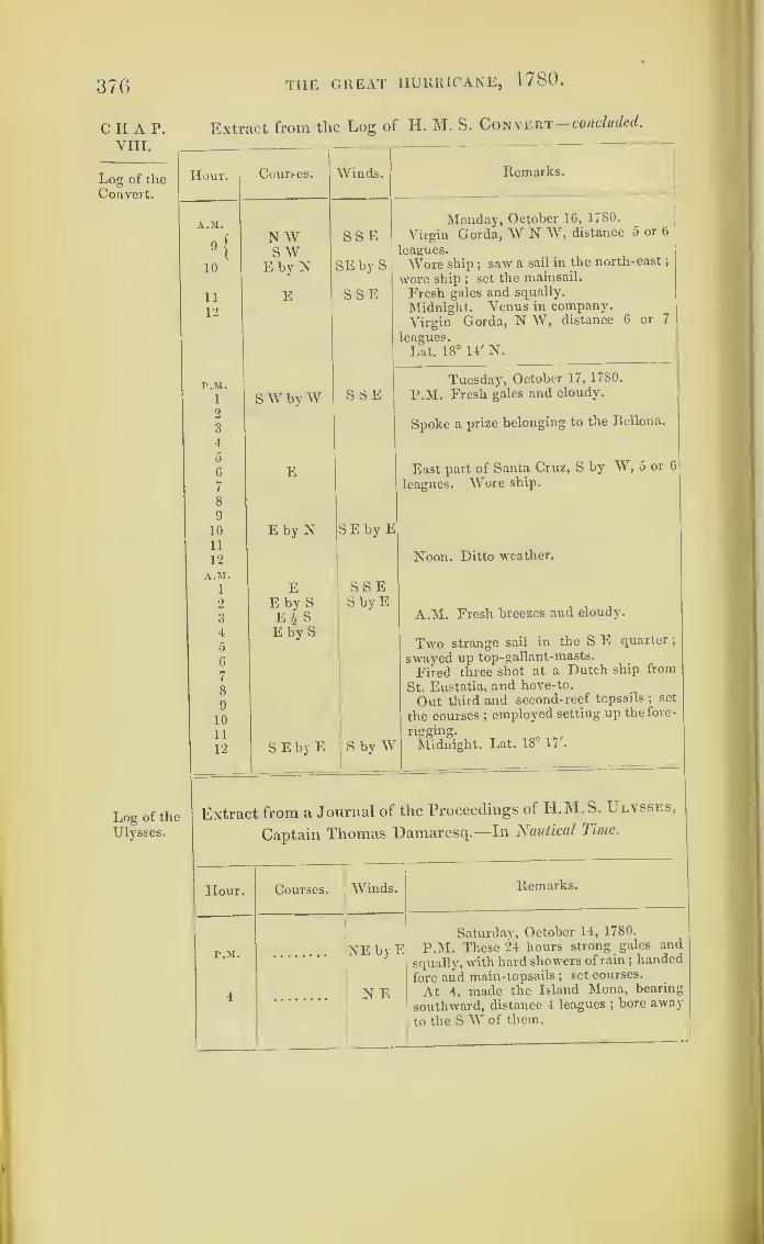
376
CHAP.VIII.
Log of the
Convert.
THE GREAT HURRICANE, 1780.
Extract from the Log of H. M. S. Convert— concluded.
Log of the
Ulysses.
Hour. Courses. Winds.
A.M.
9!
N W SS ES W 1
10 E by N SE by S
11
12
E SSE
r.M.S SE1 SW byW
2
3
4
5
6 E7
8
9
10 E by N S E by E11
12
A.M.1 E SSE2 E by S
E ^ SS by E
oO
4 E by S5
6
7
8
9
10
11
12 S E by E S by W
Remarks.
Monday, October 1G, 1780.
Virgin Gorda, W N W, distance 5 or 6
eagues.
Wore ship;saw a sail in the north-east
;
wore ship ; set the mainsail.
Fresh gales and squally.
Midnight. Venus in company.
Virgin Gorda, N W, distance 6 or 7
leagues.
Lat. 18° 14' N.
Tuesday, October 17, 1780.
P.M. Fresh gales and cloudy.
Spoke a prize belonging to the Bellona.
East part of Santa Cruz, S by W, 5 or 6
leagues. Wore ship.
Noon. Ditto weather.
A.M. Fresh breezes and cloudy.
Two strange sail in the S E quarter ;
swayed up top-gallant-masts.
Fired three shot at a Dutch ship from
St. Eustatia, and hove-to.
Out third and second-reef topsails ; set
the courses ;employed setting up the fore-
rigging.
Midnight. Lat. 18° \ 1 '
.
Extract from a Journal of the Proceedings of H.M.S. L lysses,
Captain Thomas Damaresq.—In Nautical Time.
Hour. Courses. Winds. Remarks.
P.M.
4
NE by E
N E
Saturday, October 14, 1780.
P.M. These 24 hours strong gales and
squally', with hard showers of rain ;handed
fore and main-topsails ;set courses.
At 4,made the Island Mona, bearing
southward, distance 4 leagues ;bore away
to the S W of them.

THE GREAT HURRICANE, 1780.
Extract from the Log of H. M. S. Ulysses—continued.
377
Hour. Courses. Winds.
P.M.
8E by S
AM.1
2
SE
r.M.
2 NE
3
4
5
8
Variable
roundthe
compass
A.M.
2
P.M. * • • Variable
A.M.
3 Lying-to,Southward,
andSSE
Remarks.
Saturday, October 14, 1780.
At 8, the south end of Mona, E N E,
distance 3 leagues, from which I take mydeparture.
A.M. At 1, lost sight of the Pomona.
At 2, up foresail and brought-to under
mainsail; struck top-gallant-masts ; car-
ried away one of the fore and two of
the main shrouds, and one of the main-
topmast backstays ;employed getting up
preventers.
Island Saona, N 22° W, dist. 22 leagues.
Lat. 17°, long. 4° 14'.
Sunday, October 15, 1780.
P M. Ditto, hard gales, with a great
sea ;lying-to under mainsail.
At 2, balanced the niizen and set it,
and handed the mainsail.
At 3, carried the mizenmast over the
side ;cleared the wreck.
At 4, carried away the fore-topmast andtopsail- yard over the side
;ditto the jib-
boom ; carried away one of the main-shrouds.
At 5, the mainsail blew to pieces fromthe yard
;ditto, cut away the main-top-
mast, in hopes of saving the mainmast
;
got the ship before the wind.At 8, the mainmast went over the side,
stove the boats and the booms, and carried
away the barricading on the quarter-deck
;
the ship brought-to; employed clearing
the wreck, it blowing a storm of wind
;
the foresail and spritsail blew to pieces
from the yard; the ship proving veryleaky,with four feet water in the hold, and oneof the chain-pumps rendered useless.
A.M. At 2, the wind continued shifting
round the compass.Island of Saona, N 33° YV, dist. 32 leagues.Lat. 16° 20', long. 4° 35'.
Monday, October 10, 1780.
P.M. These twenty- four hours ditto wea-ther ; lowered the foreyard down to get it
rigged, the rigging being all beat to pieces
;
got a new foresail and bent it;took a reef
in ditto, finding the ship to open much in
her upper works, and the water gaining onus, having three feet water in the hold.
A.M. At 3, lying-to a-hull. At 3.30,
got all the upper -deck guns thrown over-
board, and all the lumber on deck, when,with the pumps and baling, we began to
gain on the water.
C II A 1>.
VIII.
Log of the
Ulysses.
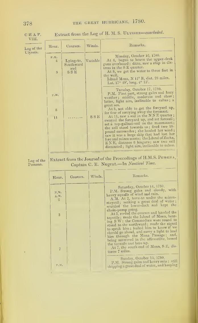
378 the great hurricane, 1780.
c II A P. Extract from the Log of H. M. S. Ulysses—concluded.
VIII.
Log of the
Ulysses. _
Hour. Courses. Vinds. Remarks.
P.M.
4
8
Lying-to, VSouthward
andSSE
'ariable
Monday, October 16, 1780.
At 4, began to heave the upper-deck
guns overboard ;ditto, saw a ship in dis-
tress in the S E quarter.
At 8, we got the water to three feet in
the well.
Island Mona, N 11° E, dist. 28 miles.
Lat. 17° 49', long. 4° 13'.
P.M.
8
11 SSE
Tuesday, October 17, 1780.
P.M. First part, strong gales and hazy
weather ;middle, moderate and clear
;
latter, light airs, inclinable to calms ;a
great sea. , ,
At 8, not able to get the foreyard up,
for fear of carrying away the foremast.
At 11, saw a sail in the N N E quarter ;
swayed the foreyard up, and set foresail
;
set a top-gallant-sail on the^ mizenmast
;
the sail stood towards us; fired two 18-
pound carronades ;she hauled her wind ;
saw it was a large ship that had lost her
fore and mizen masts ;the Island of Zacha,
ENE, distance 6 leagues; saw two sail
dismasted ;light airs, inclinable to calms.
Log of the
Pomona.
Extract from the Journal of the Proceedings of H.M.S. Pomona,
Captain C. E. Nugent.—In Nautical Time.
Hour. Courses. Winds. Remarks.
«
P.M.
A.M.
2
3
7
Saturday, October 14, 1/80.
P.M. Strong' gales and cloudy, with
heavy squalls of wind and rain.
A.M. At 2, hove-to under the mizen-
staysail ;making a great deal of water
;
scuttled the lower-deck and kept the
chain-pump going.
At 3, reefed the courses and handed the
topsails ;made the Island of Mona, bear-
ing SW ;the Commodore wore round to
stand to the northward ;made the signal
to speak him ;hailed him to know if we
should go ahead, and carry a light to lead
him through the Mona Passage; and,
being answered in the affirmative, loosed
the topsails and bore up.,.
At 7, the south end of Mona, S L, dis-
tance 7 miles.
r.M.
Sunday, October 15, 1780.
P.M. Strong gales and heavy rain ; still
shipping a great deal of water, and keeping

THE GREAT HURRICANE, 1780 . 370
Extract from the Los: of H. M. S. Pomona—concluded.o
Hour. Courses. Winds. Remarks. .
v m.
6
7
A.M.
1
3
4
Sunday, October 15, 1780.
the chain and hand pumps going;lowered
down the fore and main yards.
At 6, the main-topmast went overboard,
with topsail-yard and part of the maintop;
obliged to cut away the mainyard to get
clear of the wreck.At 7, the mizenmast went about 15 feet
above the deck ;employed clearing the
wreck; then bore away; the pumps going,with four and a half feet water in thehold; hove overboard four 18-poundersfrom the quarter-deck.A.M. At 1, fore-top-gallant-mast blew
away.At 3, the fore-topmast went over the
side, with the topsail-yard, &c.At 4, shipped a sea which stove the
cutter and long-boat; hove them over-board to clear the ship
;the gale abating ;
employed in securing the foreyard andsetting the foresail.
P.M. EMonday, October 16, 1780.
P.M. Light breezes, and a heavy seaand rain
;employed about the rigging.
P.M. SAYTuesday, October 17, 1780.
P.M. Ditto weather; employed as before.
Lat. 16° 38'.
Extract from the Log of H. M. S. Grafton, Rear-Admiral
Rowley.—In Nautical Time.
Hour. Courses. AVinds. Remarks.
P.M.
1
2
3
4
5
SSE ENEMonday, October 16, 1780.
P.AI. Fresh breezes and thick, cloudyweather.
6
7
8
9
10
xiSE by S Variable
Ditto weather, and hazy, wr ith a heavyswell from the N E.
12
2
3
Midnight. Ditto weather.
C II A P.VIII.
Log of the
Pomona.
Log of theGrafton.

380 the great hurricane, 1780.
Extract from the Log of H.M. S. Grafton—
•
continued
.
VIII.
Log of the Hour.. Courses. 11iVinds. Remarks.
A.M.
4
5
SEbyS \'ariable
Monday, October 16, 1780.
G
7
8
9
10
11
12
up S S E oh
saw
A.M. Strong gales, and thick heavy
weather ;handed the topsails.
Hauled up the courses and handed
ditto, and brought- to under a trysail;
Trident, Ruby, and Bristol in company.
Noon. Heavy gales and cloudy weather ;
employed at the pumps.No observation.
Lat. 26° 30' N, long. 71° 30* W.Caucus,* S 6° E, distance 97 leagues.
•P.M.
1
2
3
4
0
6
7
8
9
10
11
12
up S S E off
SWbyS
Easterly
ENE
Tuesday, October 17, 1780.
P.M. Lying- to under a trysail; heavy
gales.
Ship falling off in the trough of the sea,
laboured much, and shipped heavy seas
;
employed at the pumps ;three feet water
above the kelson.
Split the trysails to ribands ;lay-to
under bare poles.
A.M.
1
2
3
4
0
6
7
N N E by Noff ENE
NW A.M. Wind shifted round, and a con-
fused sea.
8
9
10
11
12
Trident and Ruby in sight to the north-
WNoon. Saw the Ruby bear up under her
foresail.
No observation.
Lat. 26° 1', long. 71° 50'.
Caucus, S 7° W, distance 84 leagues.
1
P.M.
\)
ii
Lying-to
Wednesday, October 18, 1780.
P.M. Strong gales, with heavy squalls
;
a heavy sea running ;employed baling the
ship ;all the pumps broke; six feet water
in the hold.
Wore and bore up under a reefed tore-
sail ;Trident in company.
* Gieat Caycos.
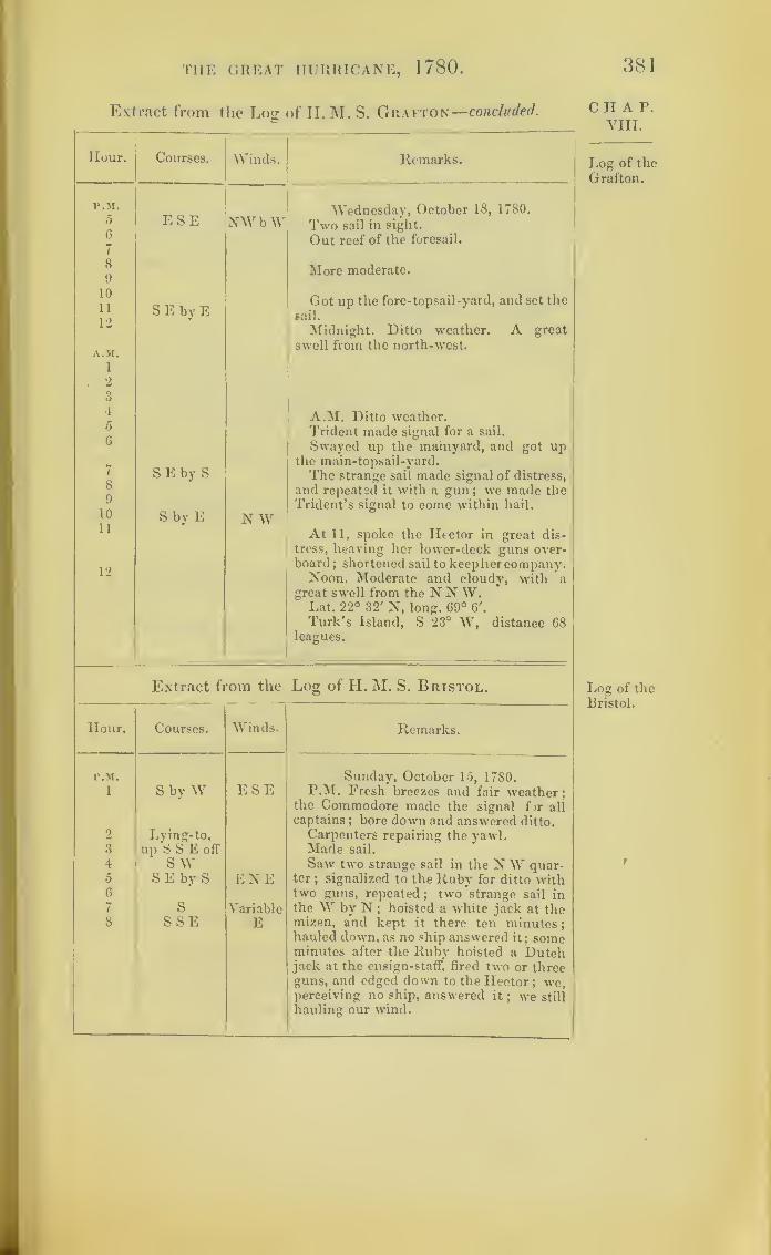
THE GREAT HURRICANE, 1780 . 381
Extract from the Log of II. M. S. Grafton—concluded.
Hour. Courses. Winds. Remarks.
p.m.5
6
7
8
9
10
11
12
A.M.
1
. 2
3
4
5
6
7
8
9
10
11
12
ESE
S E by E
SEby S
S by E
NWbW
N W
Wednesday, October 18, 1780.
Two sail in sight.
Out reef of the foresail.
More moderate.
Got up the fore-topsail-yard, and set the
sail.
Midnight. Ditto weather. A great
swell from the north-west.
A.M. Ditto weather.Trident made signal for a sail.
Swayed up the mainyard, and got upthe main-topsail-yard.
The strange sail made signal of distress,
and repeated it with a gun ; we made theTrident’s signal to come within hail.
At 11, spoke the Hector in great dis-
tress, heaving her lower-deck guns over-board
; shortened sail to keephercompany.Noon, Moderate and cloudy, with a
great swell from the N N W.Lat. 22° 32' N, long. 69° 6'.
Turk’s Island, S 23° W, distance G8leagues.
Extract from the Log of H. M. S. Bristol.
Hour. Courses. Winds. Remarks.
P.M.
1 S by W ESESunday, October 15, 1780.
P.M. Fresh breezes and fair weather;
2 Lying-to,
the Commodore made the signal for all
captains ; bore down and answered ditto.
Carpenters repairing the yawl.3 up 6 S E off Made sail.
4 SW Saw two strange sail in the NW quar-5 SEby S ENE ter
;signalized to the Ruby for ditto with
6
1 s Variable
two guns, repeated;two strange sail in
the W by N ; hoisted a white jack at the8 SSE E mizen, and kept it there ten minutes
;
hauled down, as no ship answered it; someminutes after the Ruby hoisted a Dutchjack at the ensign-staff, fired two or threeguns, and edged down to the Hector; we,perceiving no ship, answered it
; we still
hauling our wind.
C II A P.
VIII.
Log of the
Grafton.
Log of theBristol.
t

382
C H A P.
VIII.
Log of the
Bristol.
THE GREAT HURRICANE, 1780 .
Extract from tlie Log of H.M. S. Bristol continued.
Hour. Courses.
F.M.
9
10
11
12
SEby S
A.M.1
2
3
4
5
6
8
9
10
11
12
SSE
N by WS E by S h
SSE
r.M.
1
2
3
4
5
6
7
8
9
10
11
12
SEby S
SSE
S by E 4 ESE by S
A.M.
1
2
3
4
5
6
7
8
9
10
11
12
SSE
SEby S
Winds. Remarks.
E by NSunday, October 15, 1780.
The Hector S 4W, distance 4 or o miles.
Parted company with the Hector.
Squally weather.
Midnight. The Ruby W, distance 2 or 3
miles.
E
E by N
A.M. Saw two sail in theNW quarter,
appeared to be dismasted ships; bore
down and spoke to the Ruby.
Wore ship, then bearing N N \\ ,o or b
The above ships proved to be the Graf-
ton, Admiral Rowley, and Trident ;wore
ship with ditto.
Noon. Variously employed; in company
with H.M.S. Grafton, Trident,^ and Ruby.
Lat. by observation, 27° 47'.
E by NMonday, October 16, 1780.
P.M. Fresh breezes and clear weather.
E
At 3, sprung the main-topmast ;em-
ployed in getting it down.
Ditto weather.
Split the jib.
E by N Light breezes and cloudy.
Fresh breezes and squally.
Midnight. The Admiial b E by fe, ^
miles.
E A M- Ditto weather.
Reefed fore -topsail.
E by IS
Saw a schooner standing to the north-
ward.,
Fresh breezes and squally.
In second reef fore-topsail.
Noon. Ditto weather; in second reef
foresail.
No observation.

THE GREAT HURRICANE, 1780.
Extract from the Log of H. M. S. Bristol—continued.
383
Hour. Courses. Winds. Remarks.
P.M.S E by S
Tuesday, October 17, 1780.i E by N P.M. Fresh breezes : in second and
third reef in main and fore topsail.up S E off S2
3
4
5
G
Fresh gales.
Brought-to the Admiral, S S E, 2 or 3
miles, under mizen- staysail;saw a ship,
supposed standing northward;struck the
fore and main topmast.
up E S EENE Hard gales and squally
;lost sight of
7 the fleet.
8Q
off S by E
10
11
12
A.M.
1
2
NE Ditto weather.
A.M. Heavy gales; split the mizen-3 up N E staysail and set the balance mizen.4 off E S E NNW A great swell running from the S E.5
67
Ditto winds and weather.
8
9 up N N E NW Ditto weather, employed repairing the
10 off E mizen- staysail.
11 More moderate ; wore ship and madesail.
12 SE by E N W Noon. Saw two sail on the larboardbow
;brought-to for some minutes, and
made sail again; the Ruby in company.
No observation.
l’.M.
S E by EWednesday, October 18, 1780.
1 N W P.M. Fresh gales;
in company with2o
the Ruby.
4 A great swell from the NNW. One5 mile and a quarter per hour.
6 Got the fore-topsail-yard, and set sail.
7 Some showers of rain; out second reefs
8 of the topsails.
9 Got up the ....
10
11 Saw a strange sail, bearing N E, quarter
12 of a mile;she made sail at our appear-
ance, and made her escape.
A.M.1
2
3
4
5
6
A.M. Moderate.
In company with the Ruby.7 Set the mainsail and other small sails.
CHAP.VIII.
Log of the
Bristol.

384
CHAPVIII.
Log of the
Bristol.
Log of the
Hector.
TI1E GREAT HURRICANE, 1780.
Extract front the Log of II . M. S. Bristol concluded.
Hour. Courses. Winds.
P.M8 SEbyE N W
9
10 W N VV
It
12 N
Extract from the
Hour. Courses. Winds.
P.M.
6 S by E E by S
7 S by R \ E E
8 ssw SE9 SSE E
Remarks.
Wednesday, October 18, 1780._
Made the Ruby’s signal to come within
hail, which was not noticed ;made ditto
with Admiral Rowley’s, with one gun,
and was answered.
Ditto weather.
Employed variously.
Noon. Ditto weather.
Lat. observed, 24° 27' N.
10
11
12
A.M.1
2
8
4
5
(i
7
8
9
10
11
12
P.M.1
2
3
4
5
6
7
8
9
10
Remarks.
S by E
SSE
N bv E
Sunday, October 15, 1780.
P.M. Eresh gales and cloudy.
At 8, the Bristol, N E by E.
At 10.30, split the main-topsail, unbent
it, and bent another.
Noon. Moderate and fair.
A.M. At 3, fresh breezes and cloudy.W.
At 6.30, saw two sail bearing about
SAt 8, fresh gales and squally; put the
ship’s company to an allowance oi two
quarts of water a day per man ;coopers
employed shaking the empty and stove
casks in the hold, to clear away.
Lat. observed, 27° 13' N.
E by S
E bv N
Monday, October 16, 17S0.
P.M. The first part, fresh gales, with
showers, rain, and sea ;split the main-
topsail, unbent it, and bent another.
At 8, wore ship to the northward.
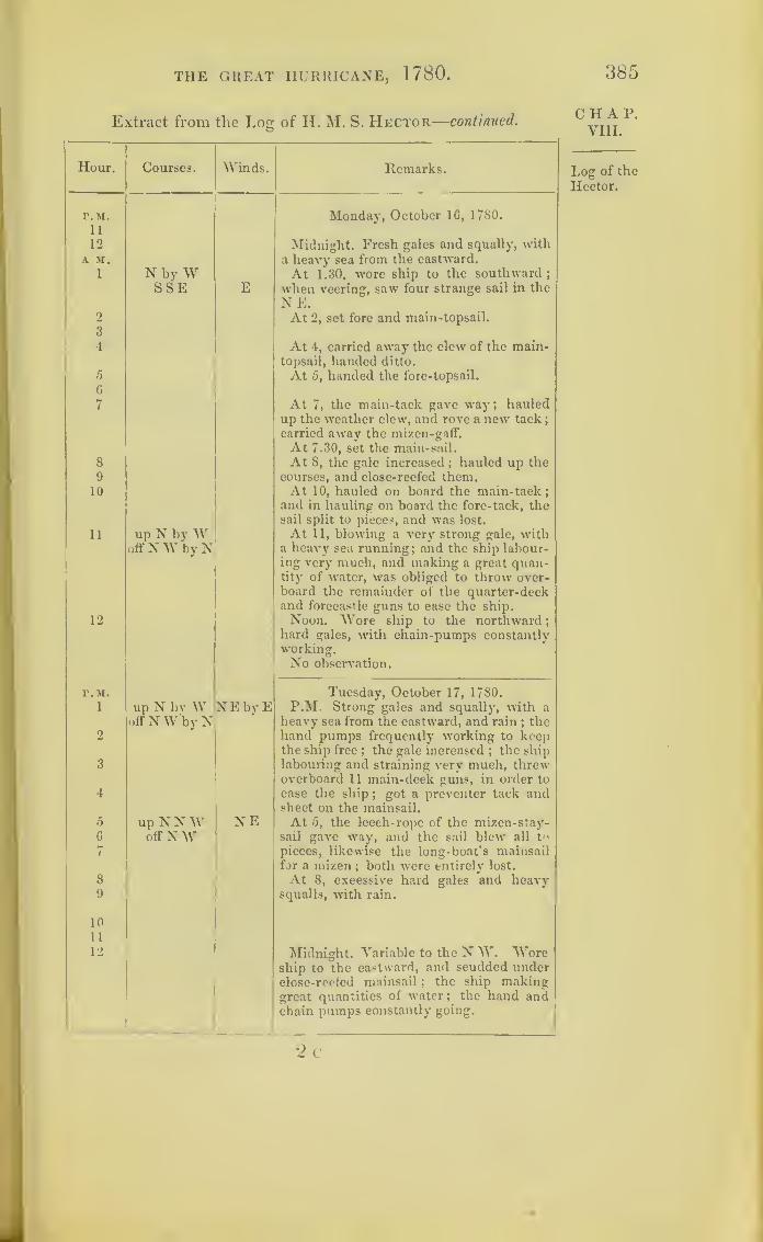
THE GREAT HURRICANE, 1780. 385
Extract from the Log of IL M. S. Hector—continued.
Hour. Courses. Winds. Remarks.
r.M.11
12
Monday, October 16, 1780.
Midnight. Fresh gales and squally, withA M. a heavy sea from the eastward.
1 N by W At 1.30, wore ship to the southward ;
2
3
4
5
6
7
SSE E when veering, saw four strange sail in the
NE.At 2, set fore and main-topsail.
At 4, carried away the clew of the main-topsail, handed ditto.
At 5, handed the fore-topsail.
At 7, the main-tack gave way; hauledup the weather clew, and rove a new tack
;
carried away the mizen-gaff.
At 7.30, set the main-sail.
At 8, the gale increased ; hauled up the8
9 courses, and close-reefed them.10 At 10, hauled on board the main-tack
;
and in hauling on board the fore-tack, thesail split to pieces, and was lost.
11 up N byW At 11, blowing a very strong gale, withoff NW by N a heavy sea running; and the ship labour-
ing very much, and making a great quan-tity of water, was obliged to throw over-board the remainder of the quarter-deckand forecastle guns to ease the ship.
12 Noon. Wore ship to the northward
;
hard gales, with chain-pumps constantlyworking.No observation.
r.M. Tuesday, October 17, 1780.
1 up N by Woff N W by N
NEbyE P.M. Strong gales and squally, with aheavy sea from the eastward, and rain
; the2 hand pumps frequently working to keep
the ship free; the gale increased;the ship
3 labouring and straining very much, threwoverboard 11 main-deck guns, in order to
4 ease the ship;
got a preventer tack andsheet on the mainsail.
5 up N NW NE At 5, the leech- rope of the mizen-stay-6 off NW sail gave way, and the sail blew all t<>
7 pieces, likewise the long-boat's mainsailfor a mizen
; both were entirely lost.
8 At 8, excessive hard gales and heavv9 squalls, with rain.
10
11
12 Midnight. Variable to the N W. Woreship to the eastward, and scudded underclose-reefed mainsail ; the ship makinggreat quantities of water ; the hand andchain pumps constantly going.
2 c
CHAP.VIII.
Log of the
Hector.

386
CHAP.VIII.
Log of the
Hector.
THE GREAT HURRICANE, 1780.
Extract from the Log of H. M. S. Hector—concluded.
Hour.
A.M.
1
2
3
4
5
6
7
8
9
10
11
12
P.M.
1
2
3
4
5
6
7
8
9
10
11
12
A.M.
1
2
3
4
5
6
7
8
9
10
11
12
Courses.
E by NEN E
Winds.
N W
Remarks.
E by S
E by S i S
W
ESE
E by S
SSE
ESE
S E i E
S E i SS E by S
SSE
Tuesday, October 17, 1780.
Served drams to the ship’s company at
4 ;excessive hard gales, with rain.
At 8, ditto weather; the hand-pumps
and one chain-pump constantly going.
Noon. Hard gales and squally, with
rain ;and a heavy sea running ;
unbent
the remainder of the foresail trom the
yard.* No observation.
WNW
N N W
S by E
N
Wednesday, October 18, 1780.
P.M. The first part moderating, got up
a spritsail and set it for a foresail ;we find
the ship more leaky, which obliges us to
clear away the hold for baling ;cooper
and assistants employed shaking water-
casks ;ditto, hove them overboard.
About 11, began to heave the remainder
of the main-deck guns overboard, to ease
the ship, as the leak increased so fast;
ditto, set the mainsail ;the leak obliges
us to keep our chain and hand-pumps
constantly working.
A.M. At 6, saw two strange sail in the
N N W, which we soon discovered to be
part of the squadron. N.B. We kept two
of the upper-deck guns for signals.
At 9, fired one 18-pounder, and made
the signal in distress;employed heaving
overboard the low-er-deck guns.
Noon. The Grafton and Trident joined
us;we informed the Admiral of our situa-
tion, who promised to stay by us, and
render us every assistance in his power ;
unbent the spritsail, and bent a new- fore-
topsail for a foresail ;likewise, let all the
reefs out of the mainsail to air ;broke
two of the winches of the chain-pumps ;
armourers employed repairing them.
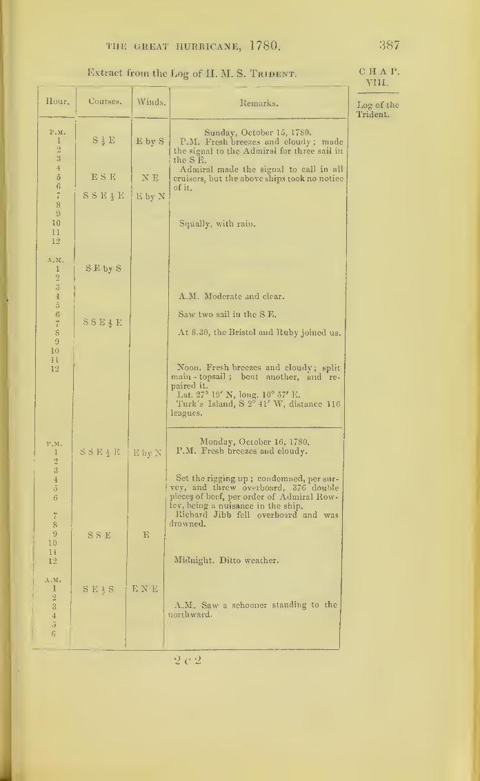
THE GREAT HURRICANE, 1780 .
Extract from the Log of II. M. S. Trident.
Hour. Courses. Winds. Remarks.
F.M.
1
2
3
4
5
6
7
8
9
10
11
12
A.M.
1
2
3
4
5
6
7
8
9
10
11
12
S*E
E S E
SSEJE
SEby S
SSE i E
E by S
N E
E by N
Sunday, October 15, 1780.
P.M. Fresh breezes and cloudy; made
the signal to the Admiral for three sail in
the S E.Admiral made the signal to call in all
cruisers, but the above ships took no notice
of it.
Squally, with rain.
A.M. Moderate and clear.
Saw two sail in the S E.
At 8.30, the Bristol and Ruby joined us.
Noon. Fresh breezes and cloudy; split
main - topsail ; bent another, and re-
paired it.
Lat. 27° 19' N, long. 10° 57' E.Turk’s Island, S 2° 41' W, distance 116
leagues.
p.m. Monday, October 16, 1780.
1
2
S S E § E E by N P.M. Fresh breezes and cloudy.
3
4 Set the rigging up;condemned, per sur-
5 vey, and threw overboard, 376 double
6 pieces of beef, per order of Admiral Row-ley, being a nuisance in the ship.
7 Richard Jibb fell overboard and was8 drowned.
9 SSE E10
11
12 Midnight. Ditto weather.
A.M.
i S E t S EN E2
3 A.M. Saw a schooner standing to the
4 northward.
5
6
887
CHA P.
VIII.
Log of the
Trident.
2 c '2
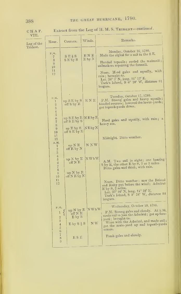
388
C H A P.
VIII.
Log of the
Trident.
THE GREAT HURRICANE, 1 / 80 .
Extract from the Log of H. M. S. Trident—continued.
Hour.
r.M.
7
8
9
10
11
12
P.M.
1
2
3
4
5
6
7
8
9
10
11
12
A.M.1
2
3
4
5
6
7
8
9
10
11
12
Courses.
SEJSSE by S
Winds.
EN EE by N
Remarks
.
up S E by Soff S by E
Monday, October 1G, 1780.
Made the signal for a sail in the S E.
Handed topsails ;reefed the mainsail ,
sailmakers repairing the foresail.
Noon. Hard gales and squally, with
rain ;brought-to.
Lat. 26° 2' N, long. 11° 12'’E.
Turk’s Island, S G° 20' W, distance 91
leagues.
E N E
upSEbyE NEbyEoff S E by S
up E by Soff S E by E
up N Eoff E by N
up N by Eoff N E
up N by EoffN EbyN
NEbyN
N NW
Tuesday, October 17, 1780.
P.M. Strong gales and heavy squalls;
handed courses ;lowered the lower-yards
;
got topsail-yards down.
Hard gales and squally, with rain
;
heavy sea.
Midnight. Ditto weather.
NWbW
P.M.
1
2
3
4
5
6
7
8
9
up N by Eoff N EE by S
E by S | S
ES E
A.M. Two sail in sight; one bearing
S by E, the other E by S, 2 or 3 miles-
Ditto gales and thick, with rain.
Noon. Ditto wreather ;saw the Bristol
and Ruby put before the wind ;Admiral
E bv S, 2 miles., „
Lat. 25° 40' N, long. 11° 24 E.
Turk’s Island, S 9° 24' W, distance 84
leagues.
NWbW
N W
Wednesday, October 18, 1780.
P M. Strong gales and cloudy. At 1-30,
made sail to join the Admiral ;got up fore-
yard ;brought-to.
" Wore with the Admiral, and made sail
,
got the main-yard up and topsail-yards
across.
Fresh gales and cloudy.
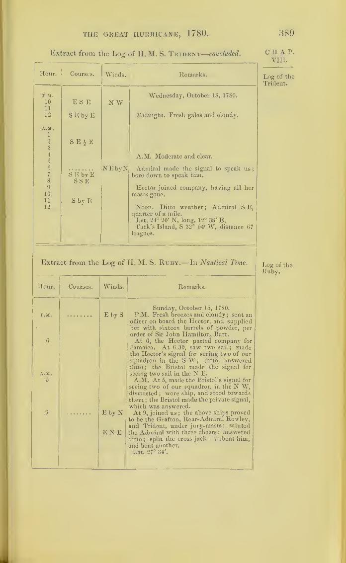
TIIE GREAT HURRICANE, 1780.
Extract from the Log of H. M. S. Trident—concluded.
389
Hour. Courses. Winds. Remarks.
P.M.
10
11
12
E S E N WWednesday, October 18, 1780.
SE byE Midnight. Fresh gales and cloudy.
A.M.
1
2
3
4
5
6
SEJE
NEbyN
A.M. Moderate and clear.
Admiral made the signal to speak us
;
7 S E bvE bore down to speak him.8
9
10
11
12
S S E
S by E
Hector joined company, having all hermasts gone.
Noon. Ditto weather; Admiral S E,quarter of a mile.
Lat. 24° 20' N, long. 12° 38' E.Turk’s Island, S 32° 54' W, distance 67
leagues.
Extract from the Log of H. M. S. Rury.
—
In Nautical Time.
Hour. Courses. AVinds. Remarks.
P.M. E by SSunday, October 15, 1780.
P.M. Fresh breezes and cloudy; sent an
6
A.M.
5
9 E by N
officer on board the Hector, and suppliedher with sixteen barrels of powder, perorder of Sir John Hamilton, Bart.
At 6, the Hector parted company for
Jamaica. At 6.30, saw two sail ; madethe Hector’s signal for seeing two of oursquadron in the S W ;
ditto, answeredditto
;the Bristol made the signal for
seeing two sail in the N E.A.M. At 5, made the Bristol’s signal for
seeing two of our squadron in the N W,dismasted ; wore ship, and stood towardsthem ; the Bristol made the private signal,
which was answered.At 9, joined us
;the above ships proved
to be the Grafton, Rear-Admiral Rowley,and Trident, under jury-masts ; saluted
the Admiral with three cheers; answered
ditto ;split the cross jack ; unbent him,
and bent another.
Lat. 27° 34'.
E N E
C H A P.
VIII.
Log of the
Trident.
Log of theRuby.
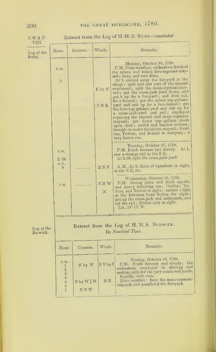
390 THE GREAT HURRICANE, 1780.
C H A P.
VIII.
Log of the
Ruby.
Extract from the Log of H. M. S. Ruby— concluded.
Hour.
r.M.
r.M.
2. 30
A.M.
8
r.M.
Courses. Winds. Remarks.
E by N
ENE
Monday, October 16, 1780.
P.M. Ditto weather;sailmakers finished
the mizen and mizen fore-topmast-stay-
sail;bent, and sent ditto.
At 9, carried away the foreyard in the
slings;
split and lost part of the foresail
overboard ;split the main-topmast-stay-
sail; got the cross-jack-yard down, and
got it up for a foreyard ;and ditto sail,
for a foresail;
got the mizen top-gallant-
yard and sail up for a fore-topsail;
got
the fore-top-gallant-yard and sail up for
a cross-jack-yard and sail ;employed
repairing the foresail and main- topmast-
staysail; got down top - gallant - yards
upon deck;
reefed and handed courses
;
brough-to under the mizen- staysail ;Graf-
ton, Trident, and Biistol in company ;a
very heavy sea.
ENE
NN WN
Tuesday', October 17, 1780.
P.M. Fresh breezes and cloudy. At 1,
saw a strange sail in the S E.
At 2.30, split the cross-jack-yard.
A.M. At 8, three of squadron in sight,
to the S E, &c.
Wednesday', October 18, 1780.
P.M. Strong gales and thick squalls,
and heavy following sea; Grafton, Tri-
dent, and Bristol in sight ;carried a light
at the foremast head during the night
;
got up the cross-jack and mainyards, and
set the sail ;Bristol only in sight.
Lat. 24° 19' N.
Log of the
Berwick.
Extract from the Log of H. M. S. Berwick.
In Nautical Time.
Hour. Courses. Winds.
P.M.
1 N by W NEbyE2
3
4
5 N byW |W NE6
7 NNW
Remarks.
Sunday, October 15, 1780.
P.M. Fresh breezes and cloudy; the
sailmakers employed in altering and
making sails for the jury-masts and yards.
Squally, with rain.
Ditto weather ;bent the main-topmast-
staysail, and paralleled the foreyard.

THE GREAT HURRICANE, 1780.
Extract from the Log of H. M. S. Berwick—continued.
391
Hour. Courses. Winds. Remarks.
r.M. Sunday, October 15. 1780.
8 Fresh breezes, with frequent showers of
9 X by W|W Variable rain.
10 N a W11 N12 N by E Midnight. Light breezes and cloudy.
A.M.
1 N2 N byW 4W4 N bv W NE byE A.M. Ditto weather ; the sailmakers5
6
N employed in fitting a jury-main-topsail.
7
8 N by E E by N9 Lat. observed, 34° 20' N.10 N N E E by S11 NE by N Got two of the quarter-deck guns on the
forecastle.
12 Noon. Lat. 34° 21', long. 69° 18'.
Nantucket Shoals, N 5° W, distance
129 leagues.
F.M. Monday, October 16, 1780.
i NEbyN E by S P.M. Moderate and clear ; sailmakers2Q
employed in fitting and repairing sails.
4 Ditto weather.
0
6E SE
Sailmakers employed as above*
7
8
9
10
11
12
A.M.
1
2
NE Ditto weather.
EN E S S E3 A.M. Light airs and cloudy.45
6
NE
7
8 Sailmakers employed as above.9 S Calm
10 head to N E11 ditto, to Ditto A great swell from the eastward.
12 N N E Lat. observed 35° 3' N., long. 68° 42'.
Nantucket Shoals, N 10° W, distance 116leagues.
CHAP.VIII.
Log of the
Berwick.
On her wayto England.
Light airs,
but a great
swell.

392 THE GREAT HURRICANE, 1780.
CHAP. Extract from the Log of H. M. S. Berwick—continued.
V III.
Log of theHour. Courses. Winds. Remarks.
Berwick. _
Hurricaneovertakes
the Ber-wick.
P.M.
2
3
4
up N by EE by N 1>
E | N
Calmortherh
Tuesday, October 17, 1780.
P.M. At 1.45, was taken a-back
;
wore
,hip and handed topsails; squally, with
rain ;loosed the topsails.
5
6
7
8
9
10
11
12
A.M.1
E by N
E | N
EE§N
E$S NNE
At 6.15, reefed the fore and main-top-
sails ;in setting the main-topsail carried
away the yard in the slings;got it down
;
desh gales.
At 7.45, got another yard across, and
oent the sail.
At 8, set ditto;reefed preventer lanyard.
Fresh gales.
2
3
4
5 E N by E
A.M. At 3.30, handed fore-topsail.
Ditto weather.
6
7
8
9
10
11
12
EiSE by S
E by S | SE*S*
NNENo observation.
People employed about the rigging and
Noon. Lat. 34° 50', long. 65° 40'.
Bermudas, N 34° E, distance 61 leagues.
P.M.
1
2
3
4
5
6
7
8
E|S
E by Nup E by Noff E S E
NNEWednesday, October 18, 1780.
P.M. Fresh gales and cloudy.
At 2, hauled the mainsail up and the
fore-staysail down.At 4, handed the mainsail. At 4.30,
handed foresail and main-topsail : split the
main-staysail ;hove-to under the mizen
ditto ;very hard gales and squally.
Hard gales and squally.
Ditto weather.
I
I
9
10
11
12A.M.
1
2
Midnight. Strong gales and heavj
squalls*
3
4
5
6
7
A.M. Ditto weather.
1
1

THE GREAT HURRICANE, 1780.
Extract from the Log of H. M. S. Berwick—concluded.
393
Hour. Courses. Winds. Remarks.
AM. Wednesday, October 18, 1780.
8 up E by N NNE Strong gales and heavy squalls;rove
off E S E new fore-tacks and sheets.
9 up E N E10 off E by S11 Lat. observed, 33
u31' N, long. (36° 10'.
12 Noon. Ditto weather.
Bermudas, S 53° E, distance 31 leagues.
P.M. Thursday, October 19, 1780.
i up E N E N P.M. Eresh gales, with frequent show’ers
2 off E S E of rain.
3 Set the mizen ;the sailmakers employed
4 in repairing the main- staysail.
5 Ditto weather ; set up the lee, main, andfore-shrouds.
6
7
Ditto weather.
8
9 up E N E10 off E by S11
12
A.M.
1 up N E by E A.M. More moderate.2 offE3
4Ditto weather; bent the main-staysail.
5
6 At 6.30, bore away under a foresail and7 SE N by W forq-topsail.
8 At 8, got the mizen-topsail-yard across.
9 Fresh gales and cloudy ; the people em-10 ployed at the rigging and sails.
11 At 11, set the mainsail and main-topsail
;
the sailmakers employed in repairing themizen-staysail.
12 Noon. Ditto weather.Lat. 32° 2-5', long. 64° 21'.
Bermudas, E, distance 41 leagues.
CHAP.Yin.
Log of the
Berwick.

394
ciiap.VIII.
Solano's Storm ,1780, and the Winds called “ Norths.”
The chart of the great Barbados hurricane has been
made, and its course determined by closely following
the data procured. In none of the log-books of the
same year, which have been examined at the Admi-
ralty, is there any allusion made to other gales, coming
from the eastward, and happening at the same time.
The course laid down on Chart IX. is therefore, pro-
bably, very nearly the true course of that tempest..
I have made this remark, previous to introducing
the subject of that storm which dispersed and disabled
the Spanish fleet under Solano, destined for the attack
of Pensacola, in Florida, first colonized from Europe
by the Spaniards. This state was ceded by them to
the English in the treaty of 1763. It was still held
bv England in 1780; but the Spaniards reconquered
that part called West Florida, in 1781, the storm
having saved it for the English for one year.
This third storm, like that which destroyed Savanna-
la-Mar, had been confounded with the great Barbados
hurricane, which disabled Rodney’s fleet, although it
appears to have been a distinct one. It will serve to
show, that the gales of the Gulf of Mexico are some-
times, at least, of the same rotatory nature as those
which have been desciibed.
It is possible, that the Spaniards may apply the
term Nortes, or Norths, to more than one pheno-
menon ;but the violent north winds in the neighbour-
hood of Vera Cruz, are frequently no other than t le
left-hand side of rotatory storms, in their northerly

NORTHS. 395
95 00 8 5 80 75

396 solan's storm, 1780.
CHAT.VIII.
progression across the Gulf of Mexico;just as Red-
field’s storms, in their northerly progression, have been
clearly shown to be in reality identical with Franklin’s
north-east storms. What is here meant will be under-
stood by inspecting the preceding figure, which is in-
tended to represent the storm which dispersed this
Spanish fleet.
I am indebted to Lord Clarendon, formerly British
ambassador at Madrid, for copies of documents, pro-
cured by him from the Spanish government, relative to
Solano’s storm, extracts from which are here printed.
These records show, that the Spanish Admiral’s flag-
ship was in the northern half of a circular storm, for
the wind commenced at north-east, veered to south-
east, and ended at south-south-east. It is possible that
this storm may have had its origin near the west end
of Cuba, for the weather at this period was moderate,
and fine at Jamaica ;and we find no trace of it in any
of the log-books of Sir P. Parker’s squadron. The
Phoenix British frigate, just before she was wrecked,
had come from Pensacola, and she had looked into
Havannah harbour, and seen Solano’s fleet lying
there.
On the morning of the 15th the wind at Havannah
was south-east ;on that day, Solano (having first con-
sulted the pilots) called together the captains of the
fleet, when it was determined to sail the next day,
provided the wind did not veer from the south-east
quarter to south. Next morning, the 16th of October,
the wind being light, and more easterly, the signal
was made to weigh, and fifty-eight ships out of
seventy-four gut out of harbour before night, and
they were all out at 9 p.m.

NORTHS. 397
Fuerza de la Escuadra.
Comandantes.
Navios. . .
.
, . . San Juan (flag-ship) Pereda.
Guerrero ... Estava.
Velasco Munoz Velasco.
Dragon . . . .
.
Autran.
San Ramon. ... Calvo de Irazabal.
San Genaro Tejada.
Astulo Velasco.
Fragatas . . . . Matilde Alderete.
Rosalia Tacon.
0. Comandante del Convoy.
.
Aristizabal.
Aulia Goicoechea.
Chambequin . Caiman Roda.
Paquebot. . . . Pio . Ibregon.
Lugre . .
.
. . . Duque de Cornwallis . Correa.
Convoy.—Aristizabal.
32 Transposes de Tropos . . . . <f Ejercito al mandol del Gen. Galvez.
2 TIospitales.
6 Transposes con Artilleria, viveres, municiones
y pertrechos.
11 Goletas con polvore.
9 Mercantes con destino d Nueva Orleans.
Extract from the Journal of the Spanish Admiral
Don Jos£ Solano, having his flag on board of the
San Juan, commanded by Pereda:
—
“ Oct. 1 6th, 1780. At daybreak, after a moderate land breeze
from E. and E.S.E.,tbe scud moving in the same direction, it fell
calm. The wind afterwards sprung up again from the E. S. E.
quarter, and freshened; and at 6 a.m. the signal was made to
heave short. The wind appeared settled in the E.;
the signal
was made to weigh anchor, and the Caiman ordered to wait to see
all the vessels out of port. By half-past, nine the Admiral was
a league from the land, standing on under topsails only, in order
to unite his fleet. In this manner he stood on a northerly course
with the same sail during the rest of the day, with the wind
varying from E. to N.E. By sunset, the Velasco, San Genaro,
and the San Ramon, with seven transports, had not got out of
CHAP.VIII.
Journal of
the SanJuan, flag-
ship.
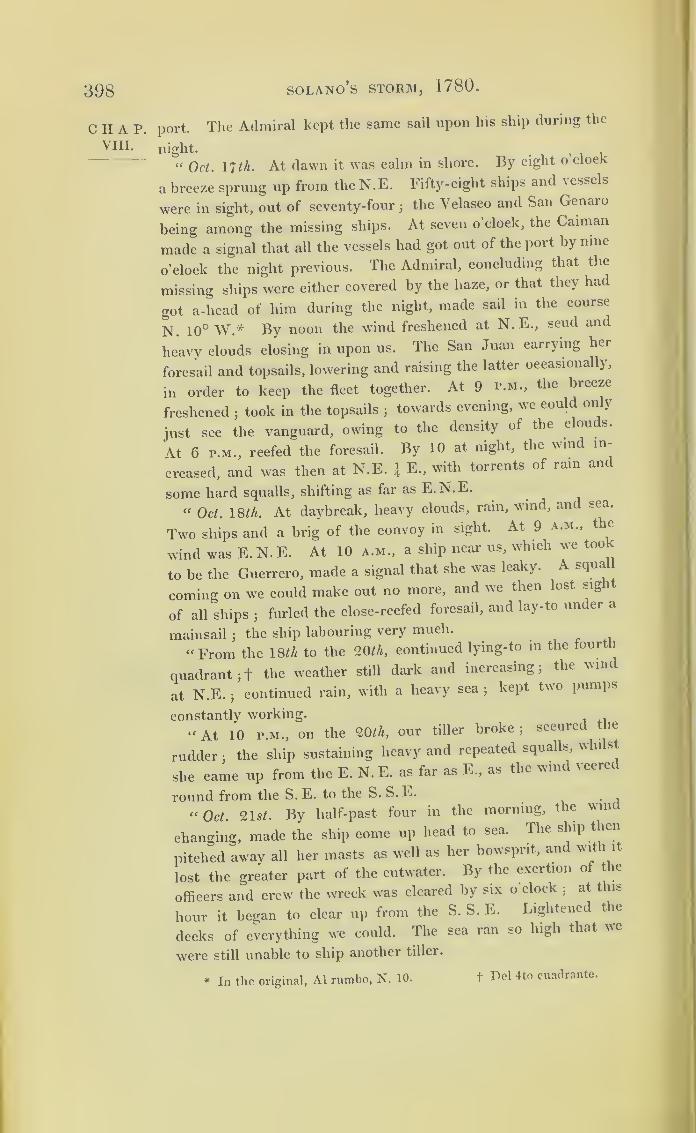
398 SOLANO’S STORM, 1780.
CHAP.VIII.
port. The Admiral kept the same sail upon his ship during the
night..
“ Oct. 17 th. At dawn it was calm in shore. By eight o clock
a breeze sprung up from theN.E. I'ifty-eight ships and \essels
were in sight, out of seventy-fourjthe Velasco and San Genaro
being among the missing ships. At seven o’clock, the Caiman
made a signal that all the vessels had got out of the port by nine
o’clock the night previous. The Admiral, concluding that the
missing ships were either covered by the haze, or that they had
got a-head of him during the night, made sail in the course
N. 10° W* By noon the wind freshened at N.E., scud and
heavy clouds closing in upon us. The San Juan carrying her
foresail and topsails, lowering and raising the latter occasionally,
in order to keep the fleet together. At 9 p.m., the breeze
freshened;took in the topsails
;towards evening, we could only
just see the vanguard, owing to the density of the clou s.
At 6 p.m., reefed the foresail. By 10 at night, the wind in-
creased, and was then at N.E. \ E., with torrents of rain and
some hard squalls, shifting as far as E.N.E.
“ Oct. IS th. At daybreak, heavy clouds, rain, wind, and sea.
Two ships and a brig of the convoy in sight. At 9 a.m., the
wind was E.N.E. At 10 a.m., a ship near us, which we too
to be the Guerrero, made a signal that she was leaky. A squa
coming on we could make out no more, and we then lost sight
of all ships3
furled the close-reefed foresail, and lay-to under a
mainsail3the ship labouring very much.
.
“ From the 18/A to the 20 th, continued lying-to in the fourth
quadrant 3+ the weather still dark and increasing 3the vim
at N.E.jcontinued rain, with a heavy sea
jkept two pumps
constantly working.
“At 10 p.m., on the 20/A, our tiller broke; secured the
rudder3
the ship sustaining heavy and repeated squalls, whilst
she came up from the E. N. E. as far as E., as the wind veered
round from the S. E. to the S. S. E.
“Oct. 21 st. By half-past four in the morning, the vim
changing, made the ship come up head to sea. The ship then
pitched away all her masts as well as her bowsprit, and with it
lost the greater part of the cutwater. By the exertion of the
officers and crew the wreck was cleared by six o clock;
at this
hour it began to clear up from the S. S. E. Lightened the
decks of everything we could. The sea ran so high that we
were still unable to ship another tiller.
* In the original, A1 rumbo, N. 10. f Del 4to cuadrante.
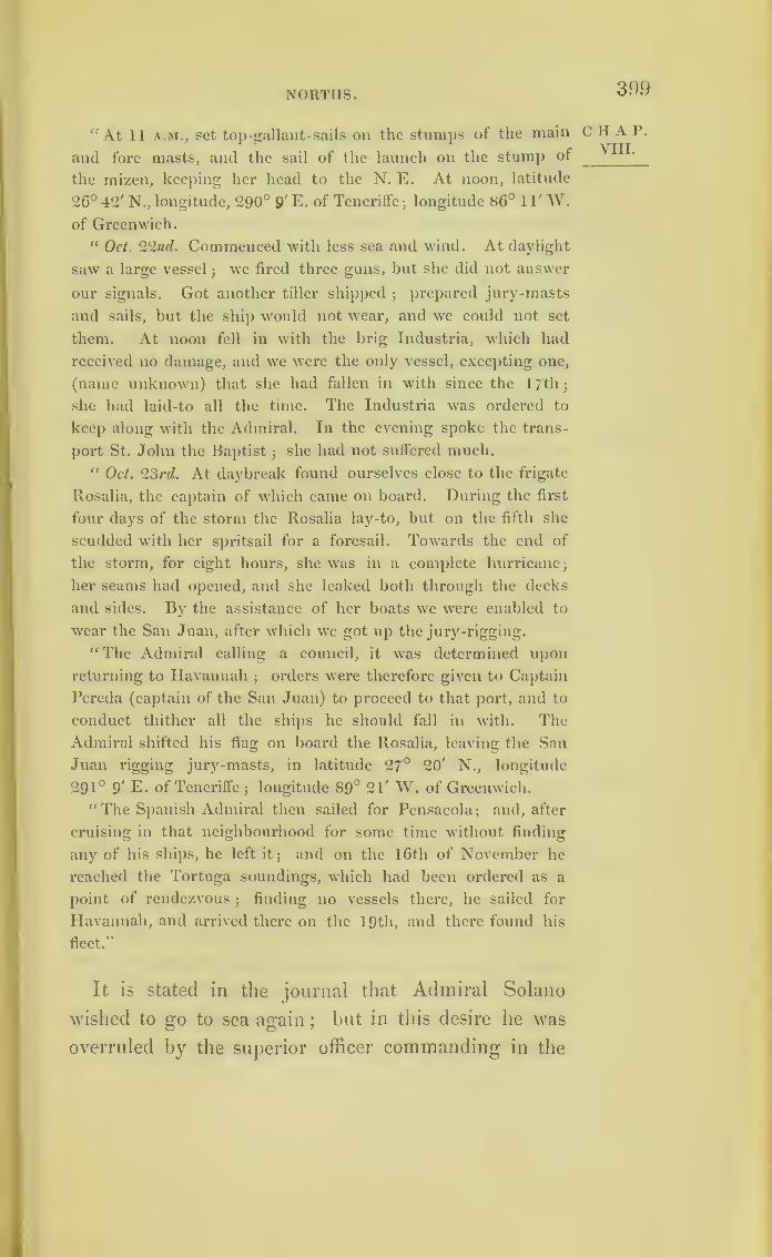
NORTHS. 399
"At 11 a.m., set top-gallant-sails on the stumps of the main
and fore masts, and the sail of the launch on the stump of
the mizen, keeping her head to the N. E. At noon, latitude
26° 42' N., longitude, 290° 9' E. of Teneriffe;longitude 86° 1 1' W.
of Greenwich.
“ Oct. 22nd. Commenced with less sea and wind. At daylight
saw a large vessel;wc fired three guns, but she did not answer
our signals. Got another tiller shipped;
prepared jury-masts
and sails, but the ship would not wear, and we could not set
them. At noon fell in with the brig Industria, which had
received no damage, and we were the only vessel, excepting one,
(name unknown) that she had fallen in with since the 17th
;
she had laid-to all the time. The Industria was ordered to
keep along with the Admiral. In the evening spoke the trans-
port St. John the Baptist;she had not suffered much.
" Oct. 23rd. At daybreak found ourselves close to the frigate
Rosalia, the captain of which came on board. During the first
four days of the storm the Rosalia lay-to, hut on the fifth she
scudded with her spritsail for a foresail. Towards the end of
the storm, for eight hours, she was in a complete hurricane;
her seams had opened, and she leaked both through the decks
and sides. By the assistance of her boats we were enabled to
wear the San Juan, after which we got up the jury-rigging.
"The Admiral calling a council, it was determined upon
returning to Havannah;
orders were therefore given to Captain
Pereda (captain of the San Juan) to proceed to that port, and to
conduct thither all the ships he should fall in with. The
Admiral shifted his flag on board the Rosalia, leaving the San
Juan rigging jury-masts, in latitude 27° 20' N., longitude
291° 9' E. of Teneriffe;longitude 89° 21' W. of Greenwich.
“ The Spanish Admiral then sailed for Pensacola;
and, after
cruising in that neighbourhood for some time without finding
any of his ships, he left it; and on the 16th of November he
reached the Tortuga soundings, which had been ordered as a
point of rendezvous;
finding no vessels there, he sailed for
Havannah, and arrived there on the 19th, and there found his
fleet.”
It is stated in the journal that Admiral Solano
wished to go to sea again;
but in this desire he was
overruled by the superior officer commanding in the
CHAP.VIII.

400 SOLANO’S STORM, 1780 .
CHAP.VIII.
TheGuerrero.
TheVelasco.
island of Cuba. Having called for reports to be
made to him by the commanders of ships of war and
frigates, giving an account ol what each suffered
during the storm, I have received extracts from these,
made by order of the Spanish Government : but it is
better that we should endeavour to trace recent storms
than dwell on those of which little more information
can now be obtained. I shall, therefore, biiefly state
what befel some of the other ships whose places are
marked in the figures inserted in page 395.
The journal of the Guerrero, for the first part of
the storm, is nearly the same as the journal of the
Admiral’s ship ;but this ship experienced the severest
part of the hurricane with the wind blowing from the
north.
On the 20th their latitude was 25° 57'
N., and
long. 91° 7' W. of Greenwich. The wind having
then veered into the fourth quadrant (il 4 t0 cuadrante)
they made for the Tortugas soundings, where they
fell in with the San Juan, Velasco, and other dis-
masted ships, and the Guerrero returned with them
to Havannah.
During the early part of the gale the Velasco car-
ried away a topsail, her foresail, and fore-topmast
staysail. During a part of the storm this ship scud-
ded to the W. N.W., under bare poles, and therefore
she probably had the wind from E.S E. It blew in
violent gusts, and during the night of the 18th she
lost her main-topmast. At two in the morning, the
sea and wind augmenting, the main and mizen masts
went. On the 20th the fore-topmast went, and the
rudder split diagonally. The storm with the Velasco
ended on the 22nd, the wind having veered from
NORTHS. 401
the first to the fourth quadrant. They considered
themselves in lat. 24° 1' N., long. 88° 14' W. of
Greenwich.
The Dragon carried her foresail throughout, and
reached lat. 25° 59' N., long. 88° 53' W. of Green-
wich.
The 18th, the San Ramon, having no ship in
sight, and unable to stand her course, scudded to
the W. S. W. In one of the most violent squalls
this vessel became water-logged;
four pumps did
not keep the water under, so that they were “ inun-
dated ” between decks, and the whole crew were put
to baleing. This ship, intended to batter the forts of
Pensacola, was armed with heavy guns, and eleven
of them were thrown overboard to lighten her. She
was carried to lat. 24° 10' N., long. 90° 5' W. of
Greenwich.
The San Genaro, losing the fleet on the 19th,
scudded under bare poles to the W. S. W.;
and
during that day lost all three masts, one after the
other. The storm with her ended on the 20th ; lat.
23° 33' N., long. 87° 14' W. of Greenwich.
The Astulo lost the storm on the 21st, in lat.
26° 46', long. 89° 30', having run for some time
N. W., under bare poles, and then lay-to.
The Matilde at first lay-to under her mizen, but
afterwards bore up and scudded. The storm with
her was most violent on the 19th;
at three o’clock
she lost her foremast, and soon afterwards her main
and mizen masts. The wind veered from E. to E.S.E.
and S. E.;
and she lost the storm on the 21st, in
lat. 26° 29' N., long. 88° 42'.
Extracts from the journals of other ships have
2 n
CHAP.VIII.
TheDragon.
The SanRamon.
The SanGenaro.
TheAstulo.
TheMatilde.
402 SOLANO’S STORM, 1780 .
chap, been sent from Madrid;
but enough is already given
VIILto show that the wind veered in this storm as in
other West Indian hurricanes. The paper concludes
by stating that there were nineteen vessels missing
:
whether any of them were ever again heard of is
not stated.
By referring to the storms of 1837, and examining
that one experienced by the Racer, it will be seen
that the course of it was very similar to that of the
storm met by Solano, just described; and both of
them, in all probability, caused a northerly wind to
blow on the shores of Mexico.

403
CHAPTER IX.
ON STORMS IN HIGH LATITUDES.
Having traced hurricanes to the fortieth degree of
north latitude, with their courses pointing in the
direction of the islands of the Azores and the con-
tinent of Europe, we are naturally led to consider
whether the gales of our own country partake also of
a rotatory character;and whether those of the corre-
sponding latitudes in the other hemisphere revolve
in the contrary direction. Whilst we pursue this
subject, however, following it up as facts may lead us
onward, we must not suppose the rotatory storm
(though probably the greatest) is the only disturbing-
cause of the regular atmospheric currents;
and we
should bear in mind not to carry its application too far.
The further we go from the equator, the more com-
plicated this subject becomes;and gales succeed each
other so fast during our stormy season, that it is not
easy to identify the particular storm we may wish to
study. It has been shown, that the hurricanes which
originate within the tropics increase in diameter, and
diminish in force, as they proceed towards the poles;
and as the meridians approach each other the gales
may become huddled together. They may, therefore,
frequently neutralize each other, and become irregular.
Their force, too, may often fall off, until the strength
of the wind on that side of the circle where it blows
2 d 2
C II A P.
XI.

404 STORMS IN HIGH LATITUDES.
CHAP.IX.
from east is unable to reverse the regular westerly
atmospheric current, and to convert it into a tem-
porary easterly gale;and this may be a reason why
easterly storms are less frequent in both hemispheres
in the latitudes within which Great Britain is
situated.
What is here meant will be better understood by
turning to the two figures at page 410. These two
figures, which are intended to represent the manner in
which great storms revolve in both hemispheres, will
also serve to show that on the sides of the circles next
the poles the wind always blows from the east ;and
on the sides next the equator from the west.
The wind’s force on the polar sides of the figures
may be expressed by the rotatory velocity diminished
by that of the regular westerly atmospheric current
;
and if they should be equal a calm would be the con-
sequence ;on the contrary, the same atmospheric
current would add its force to the westeily and oppo-
site sides of the storms in both hemispheres. Within
the tropics, however, the violence of the hurricanes is
so o’reat, that the difference here alluded to is not
perceptible.
Circles have been used in illustration of the move-
ments of progressive whirlwinds ;but the curves
described are most likely not circles. It is more
probable that they resemble the figures annexed, the
degree of curvature altering with the rate of progress
of the storms ;and this may be another cause why,
in high latitudes, westerly winds, in storms, blow
harder than easterly. These two figures will serve
to explain what is here meant, and the manner in
which squalls may, perhaps, revolve in both henn-
/

STORMS IN HIGH LATITUDES. 405
spheres, if, for the sake of illustration, we may suppose c p
them to be continuous.
NORTHERN HEMISPHERE.
SOUTHERN HEMISPHERE.
The Cause of the Barometer falling with a Southerly
Wind in the Northern Hemisphere,and with a
Northerly Wind in the Southern Hemisphere, ex-
plained.
On the south coast of England, violent gales usually
set in with the wind about south, or south-south-east,
and veer by the west towards north-west. The baro-
meter, falling at the commencement, rises as the wind
becomes northerly. In the corresponding latitude in
the southern hemisphere, this order, as regards both
the wind and barometer, is reversed.
Captain King, in his sailing directions for Terra Weather,
del Fuego, says
—

406 STORMS IN HIGH LATITUDES.
hap. “ Gales of wind succeed each other at short inter-
IX ‘
vals, and last several days. At times the weather
is fine and settled for a fortnight; but those times
Winds.
Easterly
winds.
North andnorth-westwinds,
arc few.
“ Westerly winds prevail during the greater part of
the year. The east wind blows chiefly in the winter
months, and at times very hard;
but it seldom blows
in summer.
“ Winds from the eastern quarter invariably rise
light, with fine weather;
they increase gradually, the
weather changes, and at times end in a determined
heavy gale. More frequently they rise to the strength
of a treble-reefed topsail breeze, then die away gradu-
ally, or shift to another quarter.
“ From the north the wind always begins to blow
moderately, but with thicker weather and more clouds
than from the eastward ;and it is generally accom-
panied by small rain. Increasing in strength, it
draws to the westward gradually, and blows hardest
between north and north-west, with heavy clouds,
thick weather, and much rain.
“When the fury of the north-wester is expended,
which varies from twelve to fifty hours, or even while
shift sud-
denly to
south-west.
it is blowing hard, the wind sometimes shifts suddenly
into the south-west quarter, blowing harder than be-
fore. This wind soon drives away the clouds, and in
a few hours you have clear weather, but with heavy
squalls passing occasionally.
“ In the south-west quarter the wind hangs several
days (generally speaking), blowing strong ;but mode-
rating towards its end, and granting two or three days
of fine weather.
“ Northerly winds then begin again, generally

STORMS IN HIGH LATITUDES. 407
during the summer months;
but all manner of shifts c ha p.
and changes are experienced from north to south by
the west during that season, which would hardly ^a
t c
re
deserve the name of summer, were not the days so 8ummer -
much longer, and the weather a little warmer. Rain
and wind prevail much more during the long than
the short days.
“ It should be remembered, that bad weather never
comes on suddenly from the eastward
;
neither does a
south-west or southerly gale shift suddenly to the
northward. South-west and southerly winds rise
suddenly and violently;and must be well considered
in choosing anchorages, and preparing for shifts of
wind at sea.
“ The most usual weather in these latitudes is a Commonweather.
fresh wind between north-west and south-west, with a
cloudy overcast sky.
“ Much difference of opinion has prevailed as to the Barome l crr 1 and sym-
utility of a barometer in these latitudes. I can only piesometcr.
say, that during twelve months’ constant trial of a
barometer and sympiesometer (Adie’s) I found their
indications of the utmost value. Their variations do
not, of course, correspond to those of middle latitudes
;
but they correspond to those of high northern latitudes
in a remarkable manner, changing south for north
(east and west remaining the same)”
Captain King makes also the following remarks on
the same subject :
—
“ The mercury stands lowest with north-west winds,
and highest with south-east. With the wind at north-
west, or northerly, the mercury is low : if it falls to
•29 inches, or to 28.80, a south-west gale may be ex-
pected;but it does not commence until the column has

408
CHAP.IX.
STOIIMS IN HIGH LATITUDES.
ceased to descend. It frequently, however, falls with-
out being followed by this change.”
Horsburgh, in speaking of the winds of the South
Atlantic, about latitude 38° and 39°, says, “ Although
here the westerly winds prevail during most months
of the year, they are often very unsettled, completing
a revolution round the horizon, coincident with the
course of the sun, every two, three, or four days,
with intervening calms, particularly when the wind
is in the south-west quarter.” * * # * And in a
note he says,* “When cloudy weather accompanies
these northerly or north-west winds, there is a risk
of a sudden shift to south-west or south : this happened
to H.M.S. Bristol, to the Queen, and to us in the
Anna, in January, 1800. We were in latitude 31 S.,
long. 22° W. : had run 230 miles in the preceding
twenty-four hours;
and, with steering-sails set, were
runnin <T at the rate of ten or eleven miles an houi,
when, at 9 p.m., in a shower, the wind shitted from
the north-west to the south-south-west in an instant,
taking us a-back. We lost all the light sails and
booms, and the ship’s head was thrown round against
the north-west sea before the sails were trimmed,
which made her plunge bowsprit and forecastle undei
.
“ Off the south coast of Terra Australis the progress
of the gales is usually this : the barometer falls to 29.5
inches or lower, and the wind rises from the north-
west, with thick weather, commonly with rain;
it
veers gradually to the west, increasing in stiength,
and when it veers t6 the southward of that point the
weather begins to clear up;
at south-west the gale
blows hardest, and the barometer rises;and by the
* East India Sailing Directory, vol. i. p. 67, second edition.

STOItMS IN HIGH LATITUDES.
time the wind gets to south or south-south-east it
becomes moderate, with fine weather, and the baro-
meter about 30 inches.”*
Professor Dove, of Berlin, aware of what is here
stated, viz., that storms set in, in the southern hemi-
sphere, from the opposite quarter to that in which
they commence in the northern, proposed a theory
to explain the cause, in an octavo volume, published
in German;
a portion of which will be found trans-
lated in Nos. 67 and 68 of the “ London and
Edinburgh Journal of Science.” Professor Dove, in
support of this fact, quotes reports from various
authorities, from which the following are copied :
—
“1. I am indebted to the kindness of Captain Wendt, who
sailed round the world several times as commander of the
Prussian ship Princess Louise, in answer to an inquiry ad-
dressed to him, for the following notice :
—“ ‘ The wind in the southern hemisphere usually turns from
north through west to south and south-east. Its direction
consequently is contrary to that of the wind in the northern
hemisphere. To the best of my knowledge the fact is nearly as
follows : near the Cape of Good Hope in summer the wind is
chiefly south-east, but if the wind turns northerly it is then
more violent. When the best summer months are at an end,
after a calm of short duration, the wind usually blows very
moderately from south-east, with an unusually clear sky. The
wind is continually increasing, whenever it turns easterly; and
if it has turned to the north, clouds and lightning are sure to
appear on the western horizon, and in less than half an hour a
storm from west-north-west will ensue, and will not cease until,
after 24 or 48 hours, it has veered more to the south.“ ‘ Near Cape Horn, both to the east and west, with a north
w’ind there is generally good weather;when it veers to the
north-west it soon blows hard;with a west-north-west to south-
west it usually blows a storm (which is also frequently the case
from west-north-west and north-west). The wind subsides as
it becomes southerly. South-south-east fine weather, frequently
succeeded by a calm.'
* East India Sailing Directory, vol. i. p. 97, second edition.
409
HAP.IX.
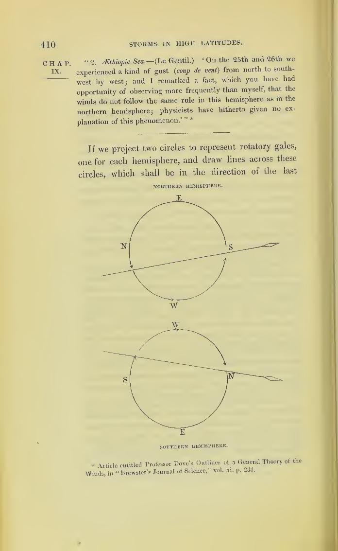
410 STORMS IN HIGH LATITUDES.
CHAP.IX.
“ 2. JEthiopic Sea .— (Le Gentil.)‘ On the 25th and 26th we
experienced a kind of gust (coup de vent) from north to south-
west by west; and I remarked a fact, which you have had
opportunity of observing more frequently than myself, that the
winds do not follow the same rule in this hemisphere as in the
northern hemisphere; physicists have hitherto given no ex-
planation of this phenomenon. *
If we project two circles to represent rotatory gales,
one for each hemisphere, and draw lines across these
circles, which shall be in the direction of the last
NORTHERN HEMISPHERE.
w
* Article entitled Professor Dove’s Outlines of a General Theory of the
Winds, in “Brewster’s Journal of Science,’’ vol. xi. p. 233.

STORMS IN HIGH LATITUDES. 411
portions of the tracks of the storms traced on Charts
VII. and VIII., but in both figures on the side next
to the equator, being that on which the wind is
always westerly; and if we suppose these two circles
to revolve as the storns did which are represented on
Charts VII. and VIII., then the lines drawn across
these figures will show the veering of the wind in
high latitudes of the two hemispheres. They will
also explain the reason why the barometer usually
begins to fall with a southerly wind in the northern
hemisphere; and with a northerly wind in the southern
hemisphere. 'In these figures, the spear-heads mark
the courses of the storms, and the sides which first
arrive at each place they would pass over.
In high latitudes the veering is often not com-
pleted before the wind backs to near the point from
whence the gale had commenced, and in such in-
stances the wind often blows harder than before. Asuccession of storms, which all revolve in the same
way, following closely upon each other, might pro-
duce this effect;
and something approaching to this
consequence may be seen on Chart VII., where two
storms nearly meet : but my desire, throughout this
investigation, has been to avoid theory or hypothesis,
and to confine myself to collecting and arranging
facts, and to observing the consequences to which they
lead. In an attempt made to procure sufficient in-
formation relative to the storms of our own country,
I have received the most liberal and ready support
from various quarters : the Trinity Board having
furnished observations from the lighthouses in all
parts of the kingdom, and the Comptroller-General
chat.IX.
Windbacking.
412 STORMS IN HIGH LATITUDES.
chap, of the Coast Guard,* and the officers under him,
1X ‘
contributing much useful information ;but the whole
length of our kingdom, from the Scilly to the Shet-
land Islands, is not equal to the diameter of the storm
traced on Chart VII., and the breadth of Great
Britain and Ireland is still less so.
The attempt alluded to was to ascertain the nature
of the gales of February, 1838; particularly a storm
which was severe, from the south-east quarter, in
Ireland and on the west of Scotland. The report
received from the Irish lighthouses possesses the
great advantage of having the wind s force denoted
by numbers: a 0 denoting a calm, and 12 a hurri-
cane ;and in the tables, which will be found at the
end of this chapter, numbers have been substituted
for the expression of the wind’s strength in words.
The state of the weather is denoted by letters, and an
explanation of these will be found at the end of the
next chapter.
Where the height of the barometer is wanting in
the English and Irish tables, it has been in part
supplied from the Coast Guard reports.
By referring to the report from Cape Clear light-
house (pp. 424, 5), it will be seen that a storm set in
there on the 13th of February.
On the 12th the wind’s force is marked . . 8,
On the 13th it is marked IE
On the 14th
and on the 15th its force removed the stone-coping
of the lighthouse ;but from that time it appears by
the report to have begun to diminish.
* Captain Bowles, K.N.
BRITISH ISLANDS. 413
If we compare the reports, we find, on the 14th,
the wind’s force in Shetland is marked 4, and at the
Pentland Firth only 1 ;at Greenwich it is marked 2,
and on the coast of Northumberland a calm. On the
15th the revenue cruiser Swift, at sea, between Cum-
bray and Rothsay Bay, on the west coast of Scotland,
reports the weather calm and cloudy between 1 1 a.m.
and 2 p.m. on that day; and the first indications of
the storm were felt by the Swift between 2 and 4 of
the same afternoon.
On the loth the wind also removed the coping-
stones from the lighthouse at Maiden Rocks, on the
north coast of Ireland, its force being marked 10 ;but
the further to the eastward we examined the wind the
less we find its force becomes. At the same date, at
Greenwich, though easterly, it is only marked G; and
at Heligoland, on the same day, a strong breeze. By
comparing the reports, the gale is found to make a
gradual northerly progress;
as, for example, at Pent-
land Skerries, the force on the 15th is marked 1, but
on the 16th it is reported 8.
Thus the scope afforded by Great Britain and Ire-
land being too limited for this inquiry, application was
made to Admiral Sir John Ommaney, commanding on
the Lisbon station, from whom I have received every
assistance he could afford. By the reports from the
ships under his command, we find, on the 14th of
February, when the storm was blowing violently at
Cape Clear lighthouse at south-east, that the Camelion
was lying-to in a hard gale off’ Oporto, with the wind
at south-west. On the 15th the Camelion ran into the
harbour of Vigo. By midnight on the 16th there was
moderate weather, with the wind west-north-west;and
CHAP.IX.

414 STORMS IN HIGH LATITUDES.
CHAP.IX.
ShipSwan.
next day light southerly breezes. A meteorological
report from the flag-ship in the Tagus contains a state-
ment nearly similar, and is annexed.
The Bellerophon and Iberia steamer were at Gib-
raltar, and the Magicienne in the Bay of Cadiz. At
Gibraltar the wind was light on the 7th, and the wea-
ther cloudy until seven in the evening, when it set in
to blow hard; and on the 12th the Bellerophon was
driven on shore. At Cadiz, by the Magicienne’s log,
the wind blew from south-west and west during this
period ;but at Gibraltar it was more variable, being
south-south-east, south-south-west, and north-west. On
the 14th, 15th, and following days, the Magicienne’s
log reports the weather at Cadiz as being moderate ,
and, in proof of this, during each of these days that
frigate was enabled to loose her sails.
The Iberia steamer left Gibraltar on the 9th, was at
Cadiz on the 10th, and came out again the same day :
from that time to the 14th, when she entered Lisbon,
she was off that coast in heavy gales of wind varying
from south-west to west-north-west. This looks as ll
it were the same storm there;having also a northerly
progression.
At the time the Bellerophon was driven on shore
at Gibraltar, with the wind at south-west, the Athol
troop-ship, in lat. 27° N., long. 36° W., returning
from Mauritius, was then about south-west of that
place, having at the time light and variable winds, and
the day before the Athol was becalmed. As she sailed
north the wind freshened, and became west-north-west
and north-west, with squalls ;but the weather was not
bad.
By Lloyd’s printed reports it appears that a ship,
URITISII ISLANDS. 415
called the Swan (Erring-ton, Master), sailed from Cork
for Jamaica on the lltli, when the wind was easterly
both at Cork and at Cape Clear lighthouse;yet this
ship returned to Cork on the 19th, in consequence of
meeting a gale at south-west and south-south-west, so
heavy that she was obliged to throw part of her cargo
overboard.
I have been informed by Mr. Yarrell that a great
many of the Red-band-fish (Cibola rubescens), as well
as various tribes of the genus Labrus, which inhabit
only the bottom of the sea, and are rarely seen, were
cast on shore on the coast of Cornwall during this gale.
This was supposed to be occasioned by the effect of the
surface undulations being transmitted by degrees to
the bottom. A similar effect, but one of a greater
degree, is described in the late Sir Gilbert Blane’s let-
ter to Dr. Hunter, speaking of the hurricane of 1780,
printed at page 347.
What has been here stated is not sufficient to prove
satisfactorily that the gale during the middle of Feb-
ruary was rotatory, although this south-east storm of
Ireland, and of the west of Scotland, does not appear
to have come as a storm from the south-east; nor the
south-west gales of Gibraltar from the south-west, since
the Athol was becalmed in that quarter.
When the first edition of this work was published
I had not been able to procure the log-books of the
squadron on the north coast of Spain under the orders
of Lord John Hay. These vessels, at anchor in the
harbour of Passages, at the bottom of the Bay of Bis-
cay, should have had the wind from south, but more
moderate than in Ireland. The log-book of the North
Star, the Commodore’s ship, has now been procured,
c H A P.
ix.
Effect of
undula-tions onthe bed of
the sea.

STORMS IN HIGH LATITUDES.416
CHAP.IX.
and it proves that the wind changed, and it became
south for two days, and then became south-west.r
l he
following is an extract from the log-book ol the North
Star, lying in Passages Harbour :
—
“ 12th February . . . Wind south; light winds, and fine.
_ ... — south;
moderate, with rain at
times.
_ ... — S.W.; moderate and fine.
_ ... — S.W.; A.M. ditto; p.M. fresh
breezes and squally.
_ ... S.W.; fresh breezes and squally.
_ ... — S.W.; moderate, with rain.”
13th
14th
15th
16th
17th
The annexed diagram of the British Isles is intended
to show what the veering of the wind would be in
these islands during a rotatory storm of great diametei,
moving in a north-north-east direction, with its centre
passing on the westward side of Ireland and the western
isles of Scotland. By examining this figure it will be
seen that in Ireland such a storm would set in about
south-east, that it would veer more and more towards
south-west, and end with the wind about west ;so that
this diagram will serve, almost without altei ation, to
represent the storm just described, and to explain the
veering of the wind in many of the gales which pass
over Great Britain and Ireland.
The dotted portions of concentric circles show the
way such a storm would set in, whilst those marked
by continuous curved lines represent the storm pass-
ing off; the right-hand side of it passing over Great
Britain. The influence of such a storm might be felt
much beyond the limits of the curves as drawn in the
diagram. Thus it might change a north-west wind
to a south-east one, as far as Heligoland, which hap-
pened in February, 1837, as may be seen by turning
g| tirrmiri, //


BRITISH ISLANDS. 417
to the Lighthouse reports of the weather for that
period
.
When we look at a globe, and examine the true
figure of the earth and water, we see how very much
the Atlantic narrows between Greenland and Norway.
If land in any way influences the course of storms,
it is possible the centres of a great number of the
Atlantic storms may pass between these two countries.
It will be curious to know the truth of this, which is
at present little more than mere hypothesis. If cor-
rect, north-easterly storms must be the most frequent
gales at Labrador and Greenland;but whether these
really are the prevailing winds there I am not in-
formed.
In studying the subject, and consulting the figures,
it should be borne in mind that the squalls, particu-
larly those of high latitude, in all probability, do not
follow curves so regular as the figures represent.
The greatest difficulty in the inquiry is, in getting
the logs of merchant ships, which have hitherto been
considered of no value after the accounts for the voy-
ages to which they relate are settled. Sometimes
they are retained by the masters, at other times by
the brokers;and no doubt they are ofteu destroyed.
Whilst procuring information I found that a proposal
had long since been made, by a Captain in the service
of the East India Company,* to preserve the log-
books of merchant ships, and to deposit them, when no
longer required by the masters or merchants, in some
public building, where they might be referred to. If
this were done at the principal commercial ports, by
agreement amongst the merchants, each port keeping
* Captain Geddes.
2 E
CIIAP'IX.
Value of
merchants’
log-books.
Proposalfor pre-serving
them.
418
CHAP.IX.
STORMS IN IIIGII LATITUDES.
its own, and placing the log-books together in a dep6t
where they might be examined, then the further pur-
suit of this inquiry would be made comparatively
easy;and the log-books of ships in all probability
would assume, as meteorological reports, a high degree
of importance.
The registers of the weather kept at the lighthouses
afford a means of obtaining much information on this
subject; and, if different countries would exchange
reports, such observations would become of great use.
On our own coasts the revenue cruisers have the means
of making good reports.
Our numerous colonies, and the islands we possess
in various seas, could furnish information from fixed
points on shore;and these, combined with the reports
contained in the log-books of ships, would afford very
great means for determining whether or not the courses
which storms pursue are as uniform as they appear to
be. Much information respecting the weather is also
transmitted, from all parts of the world to which British
commerce extends, by the agents and correspondents
of Lloyd’s Society. But, to render all such information
useful for meteorological purposes, it requires to be
arranged ;and it might be printed periodically.
Of Mr. Luke Howard’s work, entitled ‘The Climate
of London,’ two volumes are entirely occupied by
recording facts collected during many years. The fol-
lowing passage extracted from it bears directly on the
subject of this chapter .
“ Corresponding Opposite Currents in the Atmosphere.
« On the 30th October, 1823, at Geneva, it was very warm,
the thermometer at 59° F.jbut in the following night there was
a remarkable change of temperature. A very strong gale came
on with much rain ;and, towards morning, snow on the mom -
BRITISH ISLANDS. 419
tains round the lake down to one thousand eight hundred feet
elevation. The thermometer fell to 38' 5° F.
“ On the coast of Bretagne, and in the counties of Wilts,
Bucks, Bedford, Oxon, &c., there was in the same night a great
storm of wind, with torrents of rain. On the morning of the
3 1st of October the hills round Salisbury were covered with
snow, which near Devizes, &c., was said to be drifted four or five
feet deep.
“ The remarkable part of this case is, the opposite directions of
the wind during the storm. At Geneva, on the 29th, 30th, and
31st of October, it is stated to have been constantly south-west.
In England it was north-east, or even verging to north;yet the
same depressure of temperature obtained in both situations.
“ So far M. de Luc, who writes to the editors of the Bibl.
Univ. for November, 1823. I may add, that having fallen in
with a gentleman from Halifax, Nova Scotia, he informed me,
that, during the gale above mentioned, the vessel in which he
came, being then in the midst of the Atlantic, one thousand miles
from Britain, had fine weather, with a strong westerly wind,
which brought them to Falmouth;
but attended with so great a
swell from north-east as to occasion a remark by the Captain,
that he was persuaded there must have been a great storm in
that direction. The northerly gale, therefore, spent its fury on
the ocean west of Britain; and the neighbouring continent was
subjected merely to the counter current from the southward,
which yet must have descended from a colder tract of atmo-
sphere above.”—Yol. iii. page 127.
Whatever the phenomenon may he which has the
power to cause such gyrations, it may originate new
disturbances within the expanded limits of storms
diminished to a breeze;and this, in high latitudes,
may be another reason for the complicated nature of
the winds in Great Britain.
When gales diminish to strong breezes, and become
no longer dangerous, they cease to be noticed in the
shipping reports, and therefore we can trace them no
further.
The following Tables relate to the gales of Feb-
ruary, 1838.
CHAP.IX.
2 e 2

420 STORMS IN HIGH LATITUDES
CHAP.IX.
CDCOCD
S*rt
&&<u
pH
Q£
WPi
s-
Cd
PH
bo
C/3
03WPorP
&bS)
P03u
,<L>
0>
rP
cd
o>
rP
cd03
pcd
r3P
•jaaau]o.n!go><N
Maq;HDA\
'9010^
to
6
tp
d
P3xfi
c/5
Wc/5
W WC/5 C/5
W w pq«
s" “ "
co
•ja^uioiefl 29.60
•jaifleaAV HPcn
TdCO ;
CO r" o bin •
^ -rH
•aoioj04r-H
or—
H
ol—
H
or-H
03 N »o CO
rOa’£
SE
iSE w SE
WCO
SE C/5 SE SE
•as laaioiugtO
0304
MtnnoM. H2 GO CO ;CO > d bi) bb
COf-H
* 99.10JrHi—
H
C3 CO o t— CO ‘O CO to
Wind.
•jo^rent)
WCO
WWCO
w mCO
wCO
SE jSEwto
co
NE
*J aijauioaeg29
.
66
uaqinaAVCO
a"
CO
bp
-d;
CO > CO d > •
Olr-H •90IOJ OO 1 CO CO
to to
Wind. wco I
NE w wCO
w£
wCO
wCO
• %
uaiamoxeg; 29.70
•jaqtes.W
• q.s.CO CO Ob
r-H
r-H *9010^1
10 to tO tO CO CO to to CO
Wind.
•aovi’snt SE NE NE £wfc
fc
fc
.
SE
.
Var.
.
NE
a>
-G
>-t
oP<CU
Pi
>..o
"s**
rt e«
£ S
o 05 °
3s 2
-> a*s 3° kw0)
sCTj
cd<u
f HovpHCd
ooO
cs
Pa£'rt
o
TdCdOwis
or—>
r*o
pcd
:p ^o
c -
cd p3^2 «* '"io j? £030^0^
is S
u-i Ho 5t is
a p
M £ cd<3 O fc-|
W H HS
« —.a(2(2
P
•Sh
Pc
Northermost
lighthou3e
of
Ireland.
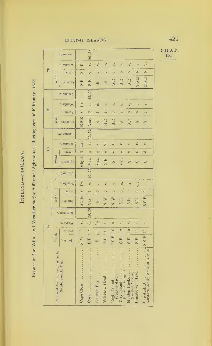
Report
of
the
Wind
and
Weather
at
the
different
Lighthouses
during
part
of
February,
183S.
BRITISH ISLANDS 421
o<N
•Jdiawoivq29.
58
•jatncoAV
Wind.
•aoio^i
•jaiaBnt) SE SE E S SE SE SE SSE ESE
05rH
U913lU0J^a29.
96
•jatniiSAS. 4 : o > o c5 d > *
Wind.
•aoioj 00 CD I-- CO 1^- O <D
•iai-rent) ESE Yar. S SE SE S SE S s
00i-H
ua^auumg30.
12
uaiiv^AV £ d M > H (’ «!-.>.
Wind.
•aojoj 05 LO ‘O *0 ‘O ‘O GO CD >0
•jDjJBnt)
Sby
EYar. Var. SE S Var. S S S
NrH
•.ia4auxo.njg 29.55
uam^a.VV f.r. V. V. V. c. s.o.c.
'H
£
•aojoj COt"-CO»0‘OiOC5COC5
•jj^snO SSE Var. ENW
NW
SE SE SE SSE
oH
•aa^araoicg
O<N
C5<N
•wq^SAV ^^^cocflcococoo
Wr
ind.
•aojoj t>-C^r-*rHOC<lOr-«r-Hi-H r-H T—t rH rH r—1 «-H *—4
•J31.lEnt)
NW
SE E SE ESE SE SE SE SSE
£3 : : : : . : : i :|<D
M .
£ O'
s a
1
I
0 cA O•2 co
’bo CU
^ s
flD ^1acJ
fc
uaQ>
5op<ca
OoO
a
<xS
©
03<D
£o
f <
o
£
^3 «c s<5 ^m c
,® §BCU(3
W i
3O£S
—bo
i oifc
CHAP.IX.

422
C H A P.
IX.
STORMS IN HIGH LATITUDES.
MO|OUJOJT!;iCD l—
1“
4
COo O*o
‘OoCMtO
05CM
oCM
05CM
05CM
05CM
C>CM
05CM
05CM
05CM
o(N
wi-iBnQ
A >
i- oo
m m w£ fc 55 cc
taM
„H ® CO
05lO
oN COcd
toCD
Oto
rrto
COCO
oCO
05*
CM05CM
C*CM
05CM
05CM
05CM
05CM
05CM
05CM
a>
soc5
rO
£<VA+J
o-4-3
o04<v
pH
CDCM
05
oCO
05Cl
29.25
CCCM
05CM
29.0029. 29.
3229.14 29.
13
> > CC CO CO co > > v.s.
CM TH CD CO CD CO CO CO CO
£55
£55
55
55£55
55
55 <5 55AV
X55
.
opH
o
rS.afn
o
SCw
aHo4-3
5tJo
r*ooPh
•^5
dO
d§£
. »-<
o‘hM<D
C/2
Cdr*H
£ID
PH
,-or*
s«—
*
o
£•S)
3rO
a3
C/2
c5•—
*
oT3ad
>>CS
co
e• *—
*
PS
C5
£O
'd
©o
03
§
•—
-
o
do
ao•r-
drQ0
1»-•
o>
£ocS
£
O6
acJ

Report
of
the
Wind
and
Weather
at
the
Lighthouses
during
part
of
February,
1838.
BRITISH ISLANDS 423
20.
•j^auioiRg
OCO lO'TfOOOO''7< 1lOOO^OCO^O^OCOCO05 05* 05050505050505<M <M OJ <M <M <M <N <M <M
isqwaM. ^3^3 »^3 c»5 S* > jS JS
Wind.
•0OIOJ rtCU<MC<3'^<<MC,5COe<3
M3;aenf) Var. Yar. SW Yar. SW E SE SE E
05l-H
•lapuicuBfl 29.9630.
0830.02
29.
6029.82 29.70 29.73 29.68
29.
64
h. h. s. r. h. V. r. s. h.
73a
£
*80i0^ *—'OOCOOrHCOCOCOaj9?i8nt)
u r*~ h fa w« a, a; ®.ai 3 oi " a^ cc
> 00 a
18.
•JopuioaRa29.
93
30.
0730.09 29.74 29.90 29.80
29.
85
29.
6629.66
•J3l[;B3AV A A > A > <n' £ .£3 ^
Wind.
•00JOJ 'cooco-^r^eocseo
SSSE S S SSE S SE SE SE
Nr—
1
•.ia^auiojreg 29.59 29.77 29.83 29.82 29.80 29.55 29.5629.
15
29.00
MaineoAV V. h. V. h. V. V. h. h.s.
sh.
Wind.
•doaoj ocoooo^^ococoo•jajjeno SE SSE SE SE SE SE E SE SW
16.
29.
54
29.
69
29.
7829.80 29.66 29.55
29.
30
29.
16
29.04
•jailpiaAV
Wind.
* 90.10J ooogo^^ooocooSE SE SE E SE SE SE SE SE
ii
Names
of
Lighthouses,
marked
by
Numbers
on
the
Map.
Inchkeith
(Firth
of
Forth)
.
..
Bell
ltock
(ofiftheTay)
Kinnaird
Head
Pentland
Skerries
Sumburgh
(Shetland)
Island
Glass
Rhins
of
Islay
Mull
of
Galloway
Calf
of
Man
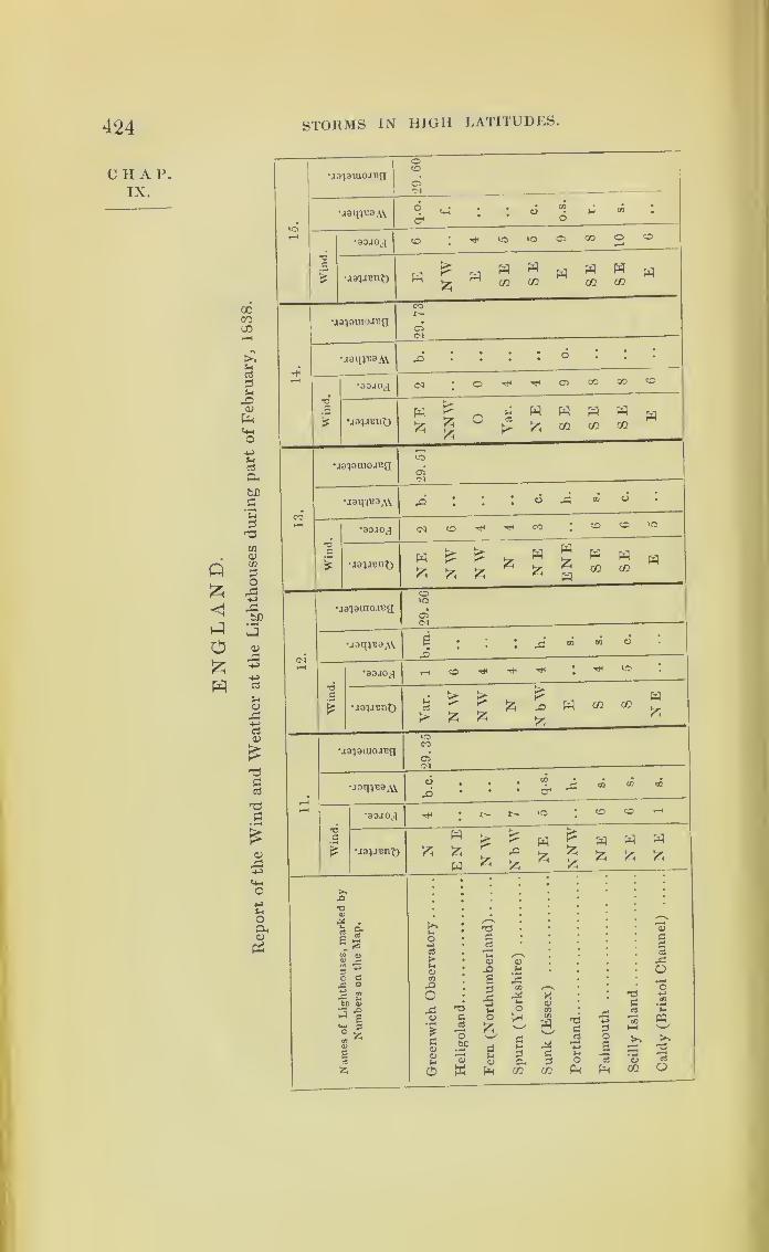
424
C II A P.
IX.
STORMS IN HIGH LATITUDES.
Q
<1
O£
ccGOUD
i>.t.nS
atH
-O<u
p-l
(4a&bfl
a'SaT3
tn<umao
a:t/3
13
a>
0)
X,
ci<u
oaaa
a
SO
uoCL,<v
&
VOr-H
•jo'jaiuoi^gCO
05'M —
•j8m«8Av ^ <+H* •
°
Wind.
•80J0J co : rH VO VO 05 CO o co
•javrent) E NW E SE SE E SE SE E
r-H
•aa^DUioa^a 29.
73
•.isqpio.W b.0.
T3
.£
£
*8010^ Cq • O ^ ^ CJ5 GO CO CO
•jajitjnt)H £ 0 * W H W W w
\io}3tuo.n3g
uaq^aAV
05Cl
• • c5 rl5 ® «
•aojoj
•ja'jaunt)
ua^aracuug
•jaq^oAV
CO ^ CO co co
COVO
05
•80JOJ
•aaijunt)
vo
>
t>- b> ^ p3
* fc * *
•ja^raoxeg 29.35
uaqiuaAi b.c.•
; •
00
a
*
.a ao 00 CD
*80IOJ T* * I— VO • CO CO r—
(
T3d W
£ £ pqpP H « W
£ £ 'Z ^W *
X£ & fee
£ JZ5
>».o
'Oo•§ &cl Xr
Sec
.S03 flj
0> £o> ra9o^
a
f £bn oj
.o£
do
*-3
£cO
£
(>*lx
o4->
c<3
kM<DCO-O
oAo*£
Goa>uC&
T3GcS
O.Sf*—
X
<D
W
T3r~*
ci
MOJ
£G4->
Ho£
<D
P*4
rGCO
r*1-4
O
G04
</3
<DCOco
wAGgCO
T3ga4-3-•
oPh
js4-3
0os2PH
T3G«J
aCO
oG
r*
jdO
PQ
>»
2o

Report
of
the
Wind
and
Weather
at
the
Lighthouses
during
part
of
February,
1838.
BRITISH ISLANDS 425
©<N
•j^auioiBg29.64
•jaipieaAV b.c. c. f. r. h.
Wind.
•80JOJ
SE SEbE 0 s ESE S SE W SE
©
Ud'jauioaug 30.16
•joqi«a^ 0. h. c.hli. h.
*o3
0
•aojoJ
jairnnO E ESE S SE ESE SE SE SE SE
18.
30.5
•.laipBaAY 0.h.c. h. c. b.
Wind.
•aojoj (MCOt—
•asiJBnO N SEbE SE SSE NE E S S w
17.
ua^Duiojug29.
46
•JomvsAV• •
CO . • , CC * • • •
o '• d*
' * *
Wind.
•OOJOj] CO CO © CO^ ‘O
MaunnJ) W SE ESE ESE
Eby
SW NW NW W
COr—i
uapiuo-njg29.57
•jamKaAV q.b.
cm.
c. o.s. r. r.
Wind.
•aojok,i co co co coco • CO CO CO
•joyenf) EEby
SESE SE SE SE
SSW SSW SE
Names
of
Lighthouses,
marked
by
N
umbers
on
the
Map.
Greenwich
Observatory
Heligoland
Fern
(Northumberland)
Spurn
(Yorkshire)
Sunk
(Essex)
PortlandFalmouth
Scilly
Island
Caldy
(Bristol
Channel)
CHAP.IX.

426 STORMS IN HIGH LATITUDES.
CHAP.IX.
LISBON.
Iler Majesty’s Ship Donegal’s Meteorologieal Journal,
in the River Tagus, Feb. 1838.
Thermometer. Barometer.
Day.8
Y.M.
1
P.M.
8l
>. M.'
8
A.M.
1 59 59 58j
27.73
2 60 59 60 29.92
3 57 52 60 29.92
4 58 56 58 29.70
5 59 57 59 29.50
6 57 56 58 29.50
7 60 56 56 29.50
8 62 63 61 29.54
9 58 59 60 29.47
10 59 61 59 29.35
11 57 58 59 29.26
12 57 58 58 29.20
13
14
15
16
17
18
19
20
21
2223
24
25
26
27
28
5658
5660
61
60
6260
5761
59
54
54
55
5755
8
P.M.
60
59
59
5961
59
606260
59
59
56
56
60
5859
59
62
60
60
61
60
60
57
57
53
29.42
29.33
29.42
29.13 29.03
29.18
29.30
29.40
29.50
29.75
29.66
29.23
29.25•29.44
29.56
29.76
29.60
29.51
29.50
29.70
29.55
29.47
29.20 29.31 29.21
5656
57
29.52
29.52
29.61
29.60
29.23
56
57
56
29.03
29.20
29.41
29.34
29.03
29.26
29.41
29.36
Winds. Remarks.
Variable Light airs and cloudy.
Variable Light airs and hazy.
Easterly Light breezes and fine.
Variable Light airs and fine.
NEast'r Ditto.
S W Light winds & fine weather.
wsw A.M. Squally, with rain.
P.M. Moderate and fine.
3 WSW Moderate breezes, with rain
at times.
2 S West‘>’ A.M. Moderate & cloudy.
P.M. Squally, with rain.
4 SWtoW Strong breezes and cloudy.
7 W to Bar. at 4 a.m. 29.20.
SSE At 4.30, blowing a gale,
with heavy rain.
P.M. Moderate with rain.
3 W Bar. at 4, 28.96.
A.M. Strong breezes andcloudy with rain.
P.M. Strong gales, wTith
squalls and rain.
13 W Strong winds and squally.
10 w Fresh gales, with rain.
16 WSW Strong breezes and squally.
31 Wester 1? Fresh breezes and fine.
78 Easterly Light airs and fine.
54 ESEto SW
Light winds and cloudy.
52 Wester 1 -' Light breezes and fine.
56 N West1 Ditto.
55 S W Moderate and fine.
65 SWest') Light breezes and fine.
10 S W A.M. Moderate and cloudy.
P.M. Heavy gales,with rain.
21 WSW A.M. Heavy gales, with a
continuation of heavy
squalls of wind and rain.
P.M. Ditto weather.
.10 NWto\V Fresh gales, with heavy
squalls from W N W..41 NW Squally, with heavy rain.
.44 W by 3 Squally, with ram.
.36 W SVT A. M. Heavy squalls of
wind, rain, thunder, and
lightning.

BRITISH ISLANDS. 427
It is upon the European side of the Atlantic that
attention should now principally be directed, in order
to ascertain the usual course of storms. That which
follows is printed with a view to induce inquiry into
the gales of Europe.
On the 11th of October, 1838, a very violent storm,
which was called a hurricane, passed over Scotland
;
and it is remarkable, inasmuch as its progress was to-
wards the southward of east, and consequently coming
from the northward of west : the progression appeared
to be gradual. There was nothing unusual in the
weather in the south of England on the lltli and 12th
of October; but early on the 13th the wind at Ports-
mouth set in with squalls, commencing at north-west,
veering towards north,—an unusual circumstance,
which led me to believe that a gale to the northward
of us might be passing on a south-easterly course;and
the snow which fell at intervals, during the squalls in
the afternoon, strengthened this opinion, which subse-
quent accounts confirmed.
It will be a very curious and interesting part of this
inquiry to ascertain hereafter, if the nature of storms
should become better understood, whether the great
alterations in the temperature of the air, particularly
in the winter season, be not frequently caused by the
rotation of a great extent of the atmosphere. Thus,
for example, circular storms of a thousand miles dia-
meter, as they approach Great Britain, would bring to
us part of the atmosphere of the Azores;and may,
perhaps, cause us to have the thermometer in the early
part of December standing as high as 50°, which often
occurs. On the contrary, if we suppose a storm coming
to Great Britain from the direction of Labrador, with a
CHAT.IX.
Storm in
Scotland.
Cause for
changes oftempera-ture, and

428 STORMS IN HIGH LATITUDES.
CHAP.IX.
Early fall
of snow.
Effect of
storms onchain-
bridges.
MontroseBridge.
BrightonChain-pier.
progression somewhat southerly, we may conceive a
very sudden alteration in the temperature likely to take
place, and that in our winter months it would cover the
country with snow.
The progression of this gale, which passed over
Scotland on the 11th of October, 1838, coming from
the northward of west, and moving somewhat to the
southward of east, seems to have been the cause of
snow falling so early in the year as the 13th of Octobei
in the south of England.
The chain-bridge at Montrose was broken by this
storm. This bridge was visited soon afterwards by
Colonel Pasley, of the Royal Engineers, who made the
following remarks upon the subject :
—
“ The suspension-bridge of Montrose was inspected
by me soon after it was blown up by the hunicane of
the lltli of October. It was blown up from below, it
being, like our English roofs, rather resting by its
own weight than secured against hurricane action.
The bridge at Montrose had nothing to stiffen it
longitudinally in a vertical direction. Iron transverse
beams, supported by the rods, had two tiers of planking
over them, and a light railing on each side, like that
of a common balcony. The suspension-bridge at
Hammersmith, on the contrary, has railing of strong-
iron posts, and the rest of wood, on each side;and
two longitudinal sets of king-post trusses on each
side of the carriage-way and between it and the foot-
paths.”
Previous to this period Brighton chain-pier had been
twice broken by the force of the wind: this occurred
the second time during the gale of the 29th of Novem-
ber, 1836. Having witnessed the effect of the wind

BRITISH ISLANDS. 429
upon it until the fracture took place, I endeavoured c ha p.
immediately afterwards to record the appearance, by
sketches, from which the two following woodcuts have
been reduced. The roadway of the pier gave way half
an hour after midday of the 29th of November ;about
which time Mr. Osier’s anemometer recorded the pres-
sure caused by the wind’s force at Birmingham as
equal to 1
1
2 lbs. on the square foot: the barometer at
Greenwich had sunk to 29*24;the wind’s force there
being denoted by 1H.
There was a double motion in the Brighton pier,
for both chains and roadway oscillated laterally and
undulated longitudinally;
but the latter movement
increased greatly, whilst the former diminished just
before the fracture took place. It was, perhaps, owing
to this double motion that half the upper part of the
roadway (at b ), and half the under part (at a), were
visible to the spectators at the same instant.
(enqf/t 2£>5y*'
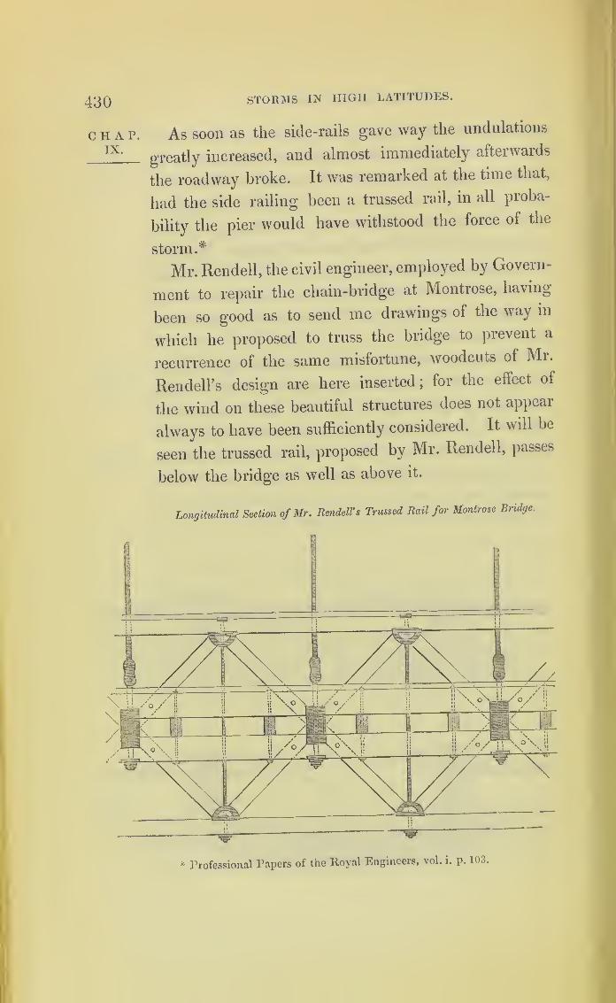
430 STORMS IN HIGH LATITUDES.
CHAP. As soon as the side-rails gave way the undulations
IX -
greatly increased, and almost immediately afterwards
the roadway broke. It was remarked at the time that,
had the side railing been a trussed rail, in all pioba-
bility the pier would have withstood the force of the
storm.*
Mr. Rendell, the civil engineer, employed by Govern-
ment to repair the chain-bridge at Montrose, having
been so good as to send me drawings of the way in
which he proposed to truss the bridge to prevent a
recurrence of the same misfortune, woodcuts of Mr.
Rendell’s design are here inserted ;lor the effect of
the wind on these beautiful structures does not appear
always to have been sufficiently considered. It will be
seen the trussed rail, proposed by Mr. Rendell, passes
below the bridge as well as above it.
Longitudinal Section of Mr. Rendell' s Trussed Rail for Montrose Bridge.
* Professional Papers of the Royal Engineers, vol. i. p. 103.

BRITISH ISLANDS. 431
C II A P.Transverse Section of Half the Roadway and One Footpath.
Transverse Section showing Cross bracing at every 35 feet below the Roadway.
A storm which passed over England on the 28th
and 29th of October, 1838, is one of much interest.
From the information collected it appears to have been
proceeding on a course somewhat to the eastward
A stormwhichcame fromthe south-west,

432 STORMS IN HIGH LATITUDES.
CHAP.IX.
and
passedoverEngland.
of north, and therefore coming from the westward of
south. At 3 o’clock in the afternoon of Sunday, the
2Sth, it was calm at Portsmouth. The breeze which
existed previous to the calm had left the vanes point-
ino- from the west. I observed them turn suddenlyo
to the opposite quarter, whilst the smoke from the
neighbouring chimneys also showed that a decided
change of wind had taken place. By 4 o clock the
sky, which had been clear, became overcast, and from
that time all the appearances of the atmosphere indi-
cated the approach of bad weather, d he wind rose,
blowing from the eastward of south, and soon became
squally. The squalls increased, the wind veering to
the south, and then towards west; and between 10
and 1 1 at night its violence at Portsmouth was very
great. It continued increasing in force until about
two in the morning of the 29th, at which time it was
alarming, and appeared at its height. Aftei daylight
the wind continued to veer towards west-north-west,
and the barometer rapidly rose. By the log-books of
H. M. S. Etna it appears that she was in sight of the
Needles at daylight of the 28th, and at noon she was
becalmed. Between 4 and 5 in the afternoon she was
working up to Spithead with the wind at east-south-
east ;the wind’s force, by Captain Beaufort s scale,
being marked 4. The barometer had descended from
29*70 to 29'44. Between 7 and 8 p.m. the wind w-as
south ;and at midnight it is marked west-south-west.
By the Etna’s log its force at 3 in the morning is
expressed by the number 9.
From a statement in the Exeter newspaper, appa-
rently made by an experienced observer, the barometer
at 2 p.m. of the 28th was observed to be as low as

BRITISH ISLANDS. 433
29.28, and the air to be saturated with vapour. In
the evening the barometer continued to fall rapidly,
and at 9 p.m. it was at 28.29, with squalls and heavy
showers of rain. At 1 in the morning the wind was
at its highest force : the barometer then standing at
28.7. At this hour, at Exeter, the wind suddenly
shifted with great force from nearly south to west.
At 2 a.m., on the 29th, the barometer had risen to
28.b2, and by 10 o’clock it was as high as 29.27,
when the gale was nearly over.
An extract of a letter addressed to me by Captain
Pringle, R.E., the circumstances therein detailed having
been communicated by Captain Allen, of the Adelaide,
states that “ the Adelaide and Leith steamers were
together off Flamborough Head, 28th October, 1838.
Wind north and by west, a hurricane. The Adelaide
stood south-south-west, and the gale lasted three hours;
the Leith, north-north-east (out to sea), and was ten
hours in the ^ale.’'
By the following reports from Lloyd’s list, the
centre of the storm seemed to have passed over Port
Talbot and Milford, and from thence proceeded nearly
in the direction of Hull
:
—“ Port Talbot, 29th Oct.—It blew a heavy gale at south-east
last night, which shifted suddenly to north-west at 2 a.m., and
blew a perfect hurricane for about an hour. The coasters in
the port all broke adrift, but no material damage was done.”
“Milford, 29th Oct.—Yesterday the wind was moderate at
south-eastj
at 12 last night it dew to west, and blew a perfect
hurricane for five hours.”
“Hull, 29th Oct.— 11.15 a.m. Yesterday the wind backed
to south-east and east-soutff-east, and blew strong till this
morning, when it got round to the westward, blowing very
heavy
;
—at 6 a.m. it dew round in a heavy squall to north;but
has since backed to west-north-west, blowing hard.”
2 F
CHA F.
IX.

434 STORMS IN HIGH LATITUDES.
CIIAP.IX.
Gave a
foul windto the
Liverpool,
and a fair
wind to
GreatWestern.
Iii the “ Nautical Magazine” for February, 1839,
further details relative to this storm may be seen.
At Dublin the wind became east-north-east. The
whole evidence indicates the storm being of a rotatory
nature, although the veering of the wind in the left-
hand semicircle was not regular. This in high lati-
tudes will probably often prove to be the case.
No incidents connected with this storm are more
interesting than those which befell two great steam
ships in their passage to America. One, the Liver-
pool, had sailed from her port some days before
the storm. She had gained the 46° of lat., and
20° 50' of long., and there on the 27th of October
meeting a violent storm, was forced to put back to
Cork. The other steam ship was the Great Western,
which sailed at three o’clock in the afternoon of the
dav preceding the storm. Much anxiety was natu-
rally felt for her safety, no accounts of her having-
reached England until the arrival of a ship, called the
Pearl, which met the Great Western on the 29th,
in lat. 50° N., and in long. 11° W. As she had by
that time made good progress, there was reason for
supposing she must have had the storm at east, and
consequently by being more to the northward, had
fallen into the left-hand semicircle of the gale, which
would be to her a fair wind for America. The follow-
ing letter was received from the secretary of the Steam
Navigation Company, to which she belonged, relative
to this subject, on the ship’s return, and is a document
of much interest and importance
“Bristol, 13th Dec., 1838.
“ Dear Sir,—
O
n leaving King’s Road at 3 p.m., 27th October,
the wind was west-south-west, blowing strong and squally.
MEDITERRANEAN STORMS. 435
“ On the morning of the 28th, wind west-north-west, and mo-
derate, falling to a calm by noon;from noon the wind rose in
sudden gusts from the southward, gradually drawing to the east-
ward until 8 p.m., when it blew a gale at east, with very heavy
squalls and confused high sea to midnight, when the wind had gra-
dually drawn to north-east;from that time to eight in the morning
of the 29th, the wind gradually shifted to west-north-west against
the sun, blowing very hard all the time;
it then moderated.
(Signed) “ C. CLAXTON.“ Great Western Steam Ship Office,
35, Princes-street.”
Iii the lighthouse reports from Scotland, the wind
on the ‘29th of October, 1838, is marked “ Variable”
at most of the stations;
at some easterly, and at a few
on the north-west course, westerly. The force of the
wind in most is marked moderate, or light.
It deserves to be remarked, that by the same reports
on the 27th October, it had been blowing strong from
the west. If it be admitted that the storm, the course
of which was over the north of England, was a rota-
tory storm, the left-hand semicircle would pass over
Scotland with the wind easterly. But the westerly
gale which just previously prevailed, would, as it
encountered the easterly storm, tend to neutralize its
effect, and perhaps be the cause of variable and fluc-
tuating winds. By referring to the reports from
Heligoland lighthouse, the same storm appears to
have been there on the 29th and 30th of October.
Mediterranean Storms.\
Inquiries into the storms of the Mediterranean pos-
sess an interest peculiar to themselves, from classical as
well as from sacred history. The violent east or Levant
winds, in all probability, will be found to be storms
2 f 2
CHAP.IX.
43G STORMS IN HIGH LATITUDES.
CHAP.XI.
coming from the south-west; and they may sometimes
also originate to the southward of the Sahara. We
may be enabled to account for the peculiar sensations
felt in the Mediterranean during the prevalence of
certain winds, and to ascertain the cause of the sirocco.
It is stated in different books of sailing directions that
the sand of Africa has been observed to be carried far
into the Atlantic by the wind.
Should it be ascertained that the storms of the
Mediterranean have a northerly progression, it may be
found that they sometimes carry with them impalpable
powder from the deserts. When the brig of war
Ferret was in the Mediterranean, a few years ago, her
commander, Captain Thomas Hastings, collected a
fine sand from the shrouds and rigging during a
sirocco wind. This fact, and the statement which
follows, will, I trust, induce those who have the oppoi
tunity for observation further to investigate into thi^
part of the subject.
The following communication is from Dr. Davy
:
“ Fort Pitt, Chatham, Dec. 25, 1S3S.
“ The phenomena respecting which you have applied to me
occurred at Malta on the 15th of May, 1830. The dust was
conveyed by a sirocco, or south-easterly wind. On the same
day, and about the same time of the day, a similar dust fell at
Utica, over a considerable portion of Sicily, and in Sardinia; also
accompanied with a south-east wind. I examined two or three
different specimens of it collected in Malta, and a small quantity
which was brought from Palma Bay, by the late Hon. Sir Robert
Spencer, which had fallen on the deck of his ship, the Madagas-
car; and I found them all agreeing in appearance and chemical
composition. In Italy, in many places, the phenomenon was
also witnessed. Here it appeared to have occurred a day or two
later. The opinion I formed at the time was, that the dust might
have been raised from the desert of Africa by a whirlwind, carried
up to a great height, and then be driven and spread over a vast

STORMS IN HIGH LATITUDES. 437
surface. At Malta when it began to fall there was a lull, the
violence of the storm having ceased. I could not learn that it
had fallen on the decks of any vessels close in on the African
shore, or on the African coast. On Etna it is said that the dust
fell less abundantly than on lower situations in Sicily. It certainly
was not derived from Etna, as was at first supposed. What I have
mentioned I believe may be depended on, being given from the
notes taken at the time, and to which I have referred.
(Signed) “ JOHN DAVY.“ Lieut. -Col. Reid, Royal Engineers.”
The Storms of 1838.
The first intelligence of a severe storm on the Ameri-
can coast in September, 1838, was brought to England
by the Montreal, New York packet, commanded by
Captain Griffing. She left New' York on the 13th of
September. A violent gale had set in on the 10th,
blowing at first from north-east,“and, on the wind
veering more to the northward, this ship, with the
Sheffield, for Liverpool, slipped away.”
According to the theory of storms, these vessels, after
putting to sea from New York for England, should
have had the wind veering towards west, and conse-
quently for them a fair wind. 1 have not been able to
procure their log-books.
The storm above alluded to, however, has been
clearly traced in its course, from the Bahama Islands
along the coast of America ;and the reports made
by the officers in command of the surveying vessels,
Thunder and Lark, at the Bahamas, to the Admiralty,
are of very great interest. These reports have been
printed in detail in “The Nautical Magazine” for
January, 1839.
c H a r.
IX.

438 BERMUDA HURRICANE, 1839 .
CHAP.IX.
H.M. ship
Thundercarried
round the
front of
the storm.
The Thunder, after dragging her anchors amongst
the Bahama Islands, was carried into the Gulf Stream.
Falling into the right-hand semicircle of the progressive
storm, with the wind blowing in the same direction as
the current of the Gulf Stream set, the 1 hunder w as
driven along faster than the storm s centre progressed.
As the vessel advanced, the wind, by degrees, fiom
being southerly became easterly ;and the ship, ciossing
before the track of the storm’s centre, got the wind
from northeast. Then the Thunder was driven by the
wind in the opposite direction to the storm’s course,
until her anchors, which were still dragging, helped to
bring her up on the coast of Florida.
This is the explanation given by Mr. Lawrence,
mate of H.M. surveying ship Thunder, of the cause for
the many changes of the wind experienced on board
that ship during this hurricane.
The Bermuda Hurricane of 1839.
The account of a storm, which passed over Bermuda
on the night of the lltli and morning of the 12th of
September, 1839, is placed amongst the storms oi
high latitude, because it has been traced from the
tropic to Newfoundland, and over the mouth of the
River St. Lawrence ;and because there is evidence to
show that it still partook of the nature of a revolving
storm on reaching the high latitudes, as well as when
passing over Bermuda, and when further to the south.
In setting in, over Newfoundland, the wind was south-
easterly ,veering to south-west
;
whilst at Halifax it
was north-easterly ,ending in north-west.
BERMUDA HURRICANE, 1839 . 439
This storm appears to have originated to the east-
ward of the West Indies, as it was not felt in any
of the most windward islands. Whilst passing over
Bermuda, it was evident that it was at that time
moving on in a course nearly north ; for it set in with
violence at east-south-east,and ended at west-south-
west.
In proof that the centre passed very near the Ber-
mudas, the merchant schooner Jane, coming from the
American continent, which had seen the islands the
previous night, and hove-to to the westward of them,
had the wind during the whole storm northerly.
The centre, therefore, must have passed between
this vessel and the islands, for in the islands it was
southerly.
Northward of Bermuda its course appears to have
been a little to the eastward of north, as the annexed
plate will show. An abstract only is given from the
various ships’ reports, to show in what manner the
wind was experienced by each, in order not to en-
cumber the subject with longer details, most of which
have already been printed in the Bermuda news-
papers.
“ The barque Euterpe, from London, bound to Antigua, en-
countered this hurricane in lat. 20° 36' N., long. 46° 55' W.,
on the evening of the 8th of September, having studding-
sails and royals set at the time. The published log does not
state which way the wind blew, but it has the expression, * in
close-reefed topsails, and furled the courses.’ At eight p.m.,
the storm became a violent hurricane, which laid the ship over
on her beam-ends;so that she was dismasted.
“The French barque La Blayaise, from Cayenne, bound to
Bourdeaux, met this storm in about latitude 22°, longitude 58°,
and at noon, on the 9th of September, began to feel the effect of
CHAP.IX.
440 STORMS IN HIGH LATITUDES.
CHAT.IX.
the south-west part of it, having the wind at first north-westerly,
but veering to south-west as the storm passed onwards. On the
1 1th, this ship fell in with and rescued the crew of the brig
Scott, of New Brunswick, which had become water-logged in
the same gale. Captain Arabel, of the town of Blay, on the
Garonne, behaved with much kindness to the crew, and brought
them to Bermuda. By the report of the master of the Scott,
his ship on the 7 th and 8th of September had light winds;
but
on the 9th, the weather became heavy, with lightning, and the
wind easterly, increasing to a gale, with a very high sea. At
four p.m. the vessel was hove on her beam-ends, but righted
on cutting the weather lanyards, which allowed the masts to
break. By eight they supposed the wind to be east-north-east
;
but as the master and crew were obliged to lash themselves on
deck during the night, they could give no further evidence as
to the veerings of the wind.
“ The Scott was met with in . . . latitude 26° 14,
longitude 57° 38',
as reported by Captain Arabel, master of La Blayaise.
“ On the morning of the 9th of September, the brigantine
Devonshire, was in latitude 24 50
,
longitude 58° 30',
when the master reports, ‘ that the wind freshened until it blew
a hurricane from .
that at four p.m., it veered first to
and then during the night to the
and ended about six on the morning of the
east-north-east
;
north;
north-west
;
10th, a little ....The merchant brig Vincennes, was in
south of west.'
latitude 28° 35',
longitude 63° 30',
when the gale reached her about midnight, between the 9th and
10th of September. ‘The wind blew easterly until six o'clock
in the morning, when it was north-east, increasing with violence,
and constant rain. By noon the wind was north-north-east,
still increasing in violence. Between eleven and twelve very
violent, so as nearly to throw the brig on her beam-ends;
soon
after it lulled for about half-an-hour, the wind at the time
becoming north-westerly.
By one a.m., of the 11th, it blew with increased
violence from . ... south-west,
and afterwards became south.


BERMUDA HURRICANE, 1839. 441
By referring to the Chart it will be seen that the
storm was upwards of six hundred miles from the
Bermudas on the 9th of September;
yet, at that
period, a swell had begun to roll on the south side of
the islands, and to break on the south shore with a
loud noise. This indication of a storm in the neigh-
bourhood gradually increased until the lltli, when
the barometer began to give corroborative warning
that a gale was approaching ; and it wTas also observed
that the sea assumed that brown or muddy colour
which the inhabitants remark to take place in violent
storms. In the afternoon of the 11th, the surf broke
against the south side of the island with great gran-
deur. The wind blowing very fresh, and somewhat
unsteady, was generally to the northward of east
;
but between eight and nine at night the true storm
seemed to reach the islands;
for then the wind blew
in hard squalls from east-south-east. The barometers
continued to descend to 28.3 inches, and the wind to
become more southerly,until about five on the morn-
ing of the 12th, after which the wind was south. Then
the barometers began to rise, and the wind to veer
gradually towards west-south-west
;
and it moderated
about one or two in the afternoon.
During the hardest part of the gale, several persons
observed remarkable oscillations of the mercury in the
tubes of the barometers.
The following is a copy of the Weekly Report of
the weather;
a similar Report to which is printed
each week in the “ Bermuda Gazette,” and afterwards
deposited in the Library of the Colonial Office, in
London.
CHAP.IX.
Indica-
tions ofthe
coining
storm.
442 STORMS IN HIGH LATITUDES.
CHAP.IX. Weekly Report of the Weather, from the Central Signal Station
at Bermuda, between the 8th and 1 4th September, 1839}
height above the Sea being 134 feet.
Date.
o * 1Sept.
r
Lours.
Erection ^of ,
Wind.1
find’s^
orce.Veather. Bar. [her. General Remarks.
1839.
8th,'
9 th,
SToon
SoonSWS
2
3
b.
b.
30.1
30.14
85.
85. Sea breaking
loudly on south
side.
10th, Soon NE 3 b. v. 30.15 85. Wind veered to
N by E at 5 p.m.
Lightning in the
south at 8.25 p.m.
Sea breaking loud-
er on south side.
l Weather threaten-
ing.
11th, Noon
P.M.
5
SEbyE 5 d. c. m. 29.95 87. Threatening ap-
pearance of the
weather.
NEbyE 6 m. u. 29.83 85. Sea roaring on
south side.
8 SE 6 o. u. r. 29.8 84. Wind veered to
S E by E ;very
heavy rain & light-
ning.
11
Midn.SEbySSE
8
10
o. 1. r.
o. r.
29.629.5
83.
82. A whole gale at
this hour.
12th,
A.M.
1 SSE 11 o. r. 29.35 82. Storm; barome-
ter falling rapidly.
2 SSE 11 o. r. 29.2 82. Every appear-
ance of a hurri-
cane.
3
4
SSESSE
12
12
o. r.
o. r.
28.8528. 64
81.
81. Hurricane.
5
7
SSEs
12
11
r.
r.
28.328.72
81.
81. More moderate.
9. 45 s w 9 m. 29. 81.
Noon wsw 8 V. 29. 4C 79.
P.M.
7 W by S 4 b. 29.9 79. Quite moderate;
storm right.
13th Noon NW 3 b. c. m . 29.9 1 79. High sea break-
ing at north reef.
14th NoonMidn
NEE
3
4
b.
c.
30.130.1
i 78.
76. Squall at 9. 40
P.M.
John Mahon, Sergeant 30th Regiment,
Signal Director.

443BERMUDA HURRICANE, 1839.
By examination of the south coast of the islands,
the sea was found to have risen fully eleven feet
higher than the usual tides. It carried boats into
fields, thirteen feet above the usual high water mark,
and removed several rocks, containing by measure-
ment twenty cubic feet;some of them bearing evi-
dence of having been broken oft* from the beds in
which they rested by the surge. On the north and
leeward side of the island, and within the camber
of the dock-yard, the water was observed to rise two
feet and a half higher than the ordinary tides.
As the weather became fine at Bermuda, and the
hurricane proceeded on its course, the northern reefs
of the islands, in their turn, presented a line of white
surge from the swell rolled back by the gale.* Vessels,
as they arrived from the east or the west, reported
that they met the wind in conformity with what
appears to be a law of nature in these tempests. Thus,
the Jane coming from Baltimore and the westward,
had the wind northerly
;
whilst the schooner Governor
Reid, from England and the eastward, had the wind
southerly.
On the arrival of the brig Lottery at Bermuda, it
was ascertained that she was becalmed in latitude
27° V N., longitude 71° 52'. At the same time that
the Vincennes was in the centre of the hurricane, the
Lottery experienced a heavy swell.
“The storm reached the schooner Damsel about midnight,
between the 11th and 12th, blowing from the . . north-east,
and veering to ...... north-west.
“It was six in the morning of the 12th before the storm
overtook the Daphne (in latitude 35° 38', longitude 65° 24'), a
* See the Engraving of the Bermuda Hurricane of 1839 in the “Progress
of the Development of the Law of Storms,” and the Chapter “ On the Swell
raised by Storms.”
CHAP.IX.
9
444 STORMS IN HIGH LATITUDES.
CHAP.IX.
schooner, which had sailed from Bermuda for Halifax, on the
10th, at noon. The master. Captain Ingham, states, ‘But
for the warning given by the barometer, we must have been
dismasted.’ The wind with the Daphne at 6 a.m. was E.N.E.
gand its force marked
At noon it was N.E Force 1
1
At 2 p.m N.N.E
At 4 p.m N- ” * 2
At 6 a.m. 13th Sept N -W - ” 9
At noon N.W. by W. „ 7
On the morning of the llth, the barometer of the Daphne
stood at29 '95
and from that time it fell with great regularity to 29,1
At 4 p.m., on the 12th, the wind was north,
and consequently the vessel may be supposed to have been, then,
due west of the centre of the storm.
Extract from the Log-book of the Brigantine Standard,
Thomas Blay, Master, from Jamaica, towards Halifax, N.S.
“ Wednesday, llth September, 1839-—Commences with light
variable airs from north-east to south-east, and clear sky;
all
sail set. At S a.m., civil time, moderate breezes from north-
east, accompanied with light showers of rain, and a very heavy
swell from that quarter : latitude by observation 34° 3 ,long. Jy
chron 66° 6' at noon. At 8 p.m. strong breezes, the sky to the
eastward very dark and gloomy, whilst it remained quite clear
to the westward up to midnight : took in the gaff-topsail and
royal, and single-reefed the topsail5
light showers of rain
occasionally, and a very heavy swell—the wind and swell sti
from north-east. At midnight, strong breezes without rain, the
sky to the eastward very gloomy.
“Thursday, 12th September.—Commences with strong breezes,
and dark gloomy sky, the wind blowing steady from north-east.
U 6 a m. it commenced raining, the wind mereasmg rapidly
every instant; so suddenly indeed did the storm commence,
that we were compelled to clew up and furl every sail set as
quick as possible, without stopping to reef; and m one hour
after, I found it necessary to shorten sail-we were laymg-to
. -l At 30m a.m. sent down top-under the storm-trysail. At/h. 3um. a.m r
gallant-yard, housed top-gallant-mast and mam-topmast. T on
9 a.m. to noon it blew tremendously hard ,n gusts, but w had
little rain ;lat. at noon, by account, 35* 5 N„ long. 6 8 W.
At 1 P.M. the swell appeared to set more from the northwaid.
BERMUDA HURRICANE, 1839. 445
the wind shortly after commenced to back gradually. At 2h. 30m.
p.m. the wind was at north-north-east; the sky to the north-
ward began to open, and the wind to moderate. At 4 p.m.
wind north, sky clearing fast, wind still moderating, saw a brig
scudding to the southward. At midnight, wind north-west,
clear sky, wind moderating fast, and sea falling;
wore ship,
and made sail to the north-east.
“Remarks.—I remark that I have experienced several hurri-
canes at sea, and have invariably found, that by observing strict
attention to the set of the swell previous to the commencement, and
even after, a tolerable correct idea may be formed oj the direction the
wind is likely to take.
“I particularly noticed this in the last two which I expe-
rienced; and on the 2nd Sept, 1838, in a hurricane that com-
menced at cast-north-east, although the sea when I first hove-to,
set from that quarter, I found it afterwards altered its direction,
and came from south-east, and for some time before the wind
shifted to that point.
“I felt so confident from that circumstance that I should
have the hardest of the storm from that quarter, that I continued
to lay-to on the starboard tack, well knowing that when the
wind shifted I should head the sea much better, and con-
sequently the vessel would lay safer.
“ In the storm of the 12th September last, although the sky
looked much more dismal in the south-east than any other
direction, the swell gave no indication of the wind coming from
that quarter, as it set constantly from the northward.
** T. W. BLAY.”
The Victoria sailed from Bermuda from New York, on the
9th. The storm overtook her when in the position shown in
the chart, with the wind blowing at north-east, which caused her
to heave-to for six hours.
The Grant, on her voyage from Baltimore, was cither beyond
its influence, or very nearly so;
for she had no occasion to take
in any sail.
The mail-boat Margaret had sailed from Bermuda to Halifax,
a few days before the storm. She was overtaken by this gale,
and lost her topmast, in . . . . latitude 37° 30',
longitude 64° 10'.
The Ariel had the wind from north-east; the Joseph Porter
from east-south-east, veering to south and south-west.
CHAP.IX.

44C STORMS IN HIGH LATITUDES.
CHAP.IX.
The brig Hester had the wind from south-south-east, veering
to south-south-west and west.
The mail-boat Roseway, in her passage from Boston to
Halifax, in latitude 42° 50',
longitude 64° 51',
was overtaken by this storm about four o’clock in the morning
of the 13th. At that hour her sails were double-reefed.
At eight a.m., the wind was . . • east-north-east,
increasing so that the vessel was hove-to.
At nine the wind was marked . . . north-north-east.
At one p.m. ....•• northerly.
Later in the afternoon it moderated with the
wind . . . • • • • north-west.
The following Extract from the Log-book of H.M.S. Croco-
dile, commanded by Captain Milne, shows what the weather
was at Halifax.
“ Halifax.—September 13th, eight a.m. Barometer 29 90.
Morning, cloudy with rainjwind north-east
5force four to five.
Eleven. Wind freshing up in squalls, barometer falling, 29-80.
Noon to one p.m. Strong gales and heavy squalls of wind and
rain; wind hauling round now north by east.— 1.30. \ ery
heavy gusts of wind; barometer 29-3; Crocodile parted hei
moorings.—Two to three. Wind north by west; barometer
29.2; a complete hurricane of wind, with heavy rain.—4 p.m.
More moderate; barometer rising, now 29-5.—Seven. Mode-
rate, with occasional gusts of wind.—Nine. Moderating;wind
north-west by north.—Ten. Barometer 29-7.”
“ September 14th, eight a.m. Wind moderate; fine; wind
north-west by west; barometer 30.20.”
H. M. S. Cleopatra was twenty-five miles south-south-east of
St. John’s, Newfoundland, on the 13th ol September.
In the morning the wind is marked variable; force 1.
Ten a.m. . • • east-south-east; force 2.
Noon . . . south-south-east; force 5.
Three p.m. . . • south-south-west; force 6.
Five p.m. . • • south-west; force 6.
Midnight . . • south-south-west; force S.
One a.m., 14th September south-west;
Eight _ . . west by north; force 7-
From which time the wind’s force diminished until the gale
ended.

447BERMUDA HURRICANE, 1839 -
“ St. John’s, Newfoundland.—September 13th, eight a.m.,
noon. Barometer 29-90. Ten p.m. Barometer 29-67; wind
south-west^ 3. b. c.
“September 14th, six a.m. Barometer 29-64; wind south-
west; cloudy.—Ten a.m. Barometer 29-70 ;wind west; force
seven to eight.—Noon. Wind west;
force eight to nine.^Three
p.m. Barometer 29-90; wind west; force seven.—Seven p.m.
Wind west; force five;and cleared up.
“ Taken from the Register kept by Mr. Templeman, Colonial
Office. „“ Alex. Milne.
The following; (lata I received from Mr. Redfield.
“ Brig Alfred Taylor. September 13th, latitude 43° 30' N.,
longitude 62° W., experienced a severe gale from east-south-
east to north-north-east.”
“ Ship Echo. September 12th, latitude 43° N., longitude
63° W., experienced a severe gale from north-east, lasting eight
hours.”
“Ship Lucretia. September (date not given), experienced a
most violent hurricane from south-east, shifting rapidly by
south-west to north-west; latitude 43° N., longitude 62° W.”“ Ship Cosmo. September 13th, latitude 41° 50' N., longitude
62° 37' W., experienced a severe gale from south-east.”
“Ship Lancashire. September 13th, experienced a hurricane
from east; latitude 41° 30' N., longitude 63° W.”“ Ship Emerald. September 13th, latitude 40° 8', longitude
62° 50' W., experienced a severe hurricane from east, veering
round by south to west, and west-north-west.”
“ Barque Madonna. September 13th, experienced strong gales
from north-north-east to north-north-west and north-west; lati-
tude 36° 19;N., longitude 71° 26' W.”
“Brig Angola. September 13th, experienced heavy gales from
north-north-east; latitude 36° N., longitude 68° W.”“ Schooner Ganges. September 10th, experienced a hurricane
from east.; latitude 29° 15' N., longitude 62° 10' W.”
H. M. ship Andromache, commanded by Captain
Baynes, was in the Gulf of St. Lawrence, and an
extract from this ship’s log’ is here printed in detail.
CHAP.IX.
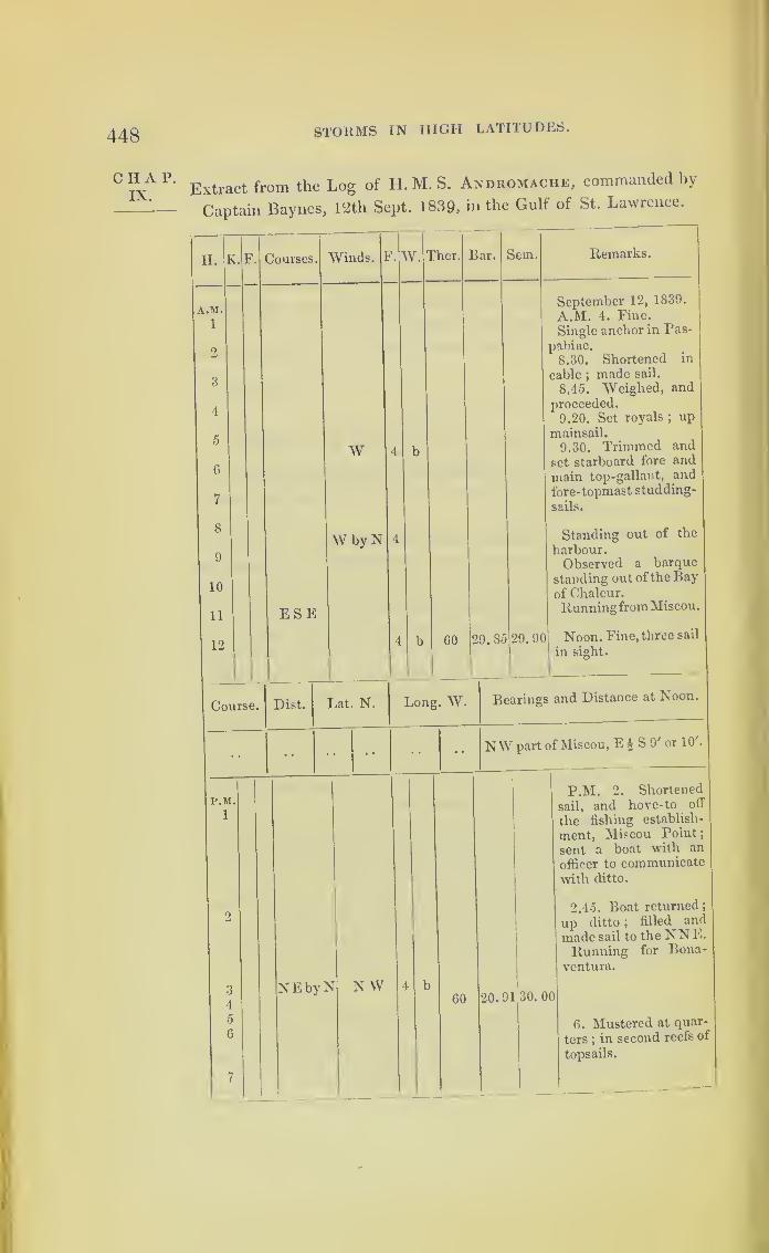
448 STORMS IN HIGH LATITUDES.
CHAP.IX.
Extract from the Log of H. M. S. Andromache, commanded by
Captain Baynes, lc2th Sept. 1839, in the Gulf of St. Lawrence.
H.
A.M1
2
3
4
5
6
7
8
9
10
11
12
K. Courses.
Course.
r.M.
1
Winds. F.
W
ESE
W by X
W. Ther. Bar. Sem. Remarks.
4 b GO 29.85
September 12, 1839.
A.M. 4. Fine.
Single anchor in Pas-
pabiac.
8.30. Shortened in
cable ;made sail.
8.45. Weighed, and
proceeded.
9.20. Set royals ;up
mainsail.
9.30. Trimmed and
set starboard fore and
main top-gallant, and
fore-topmast studding-
sails.
Standing out of the
harbour.Observed a barque
standing out ofthe Bayof Chaleur.
Runningfrom Miscou.
29. 90 Noon. Fine, three sail
in sight.
Dist. Lat. N. Long. W. Bearings and Distance at Noon.
NW part of Miscou, E£ S 9' or 10',
NEbyN N WGO 20.91 30.00
P.M. 2. Shortened
sail, and hove-to off
the fishing establish-
ment, Miscou Point;
sent a boat with an
officer to communicatewith ditto.
2.45. Boat returned
;
up ditto ;filled and
made sail to the NN E.
Running for Bona-
ventura.
6. Mustered at quar-
ters ;in second reefs of
topsails.

BERMUDA HURRICANE, 1839 .
Extract from the Log of H.M.S. Andromache—continued.
H.
P.M.
8
10
11
12
A.M,
1
2
3
7
8
9
10
11
12
Course.
Courses. Winds. F.W.
Calm.
N WVariable
NE 2
Ther.
NNE
N
to
Dist.
59 29.91
59
54
46
Bar. Sem.
30. 00
Remarks.
29. 95 30. 4
29.90
29. 88
30.2
September 12, 1839.
8. Nearly calm.Bonaventura, W by
S, 2' or 3'.
Hove-to off ditto.
9.30. Up foresail,
down jib, and hove-toon larboard tack.
Standing off and on.
10.15. Set jib, woreand filled on starboard
tack.
Isle of Bonaventura.12. Fine, with an
aurora borealis.
29. 84
September 13, 1839.
A.M. At 3, tacked.
Standing off and onBonaventura.
4. Bonaventura, WbyS, 5' or 6'.
6. Set foresail. 8.
Perse, W S W, 2.
Working to wind-ward towards CapeGaspe.8.20. Tacked ;
com-municated with a boatfrom the shore ; outsecond reefs, set main-sail, and flying jib.
10.45. Spoke thebarque Pallas of Cork,from ditto, out twenty-eight days. Intop-gal-lant-sails, and secondreefs of topsails.
11. Tacked. 11.20
ditto; set top-gallant-
sails.
12. Tacked; in top
gallant-sails. Barquein company.
Lat. N. Long. W. Bearings and Distances at Noon.
Flat Island, N W, 2' or 3'
Z G
449
CHAP.IX.
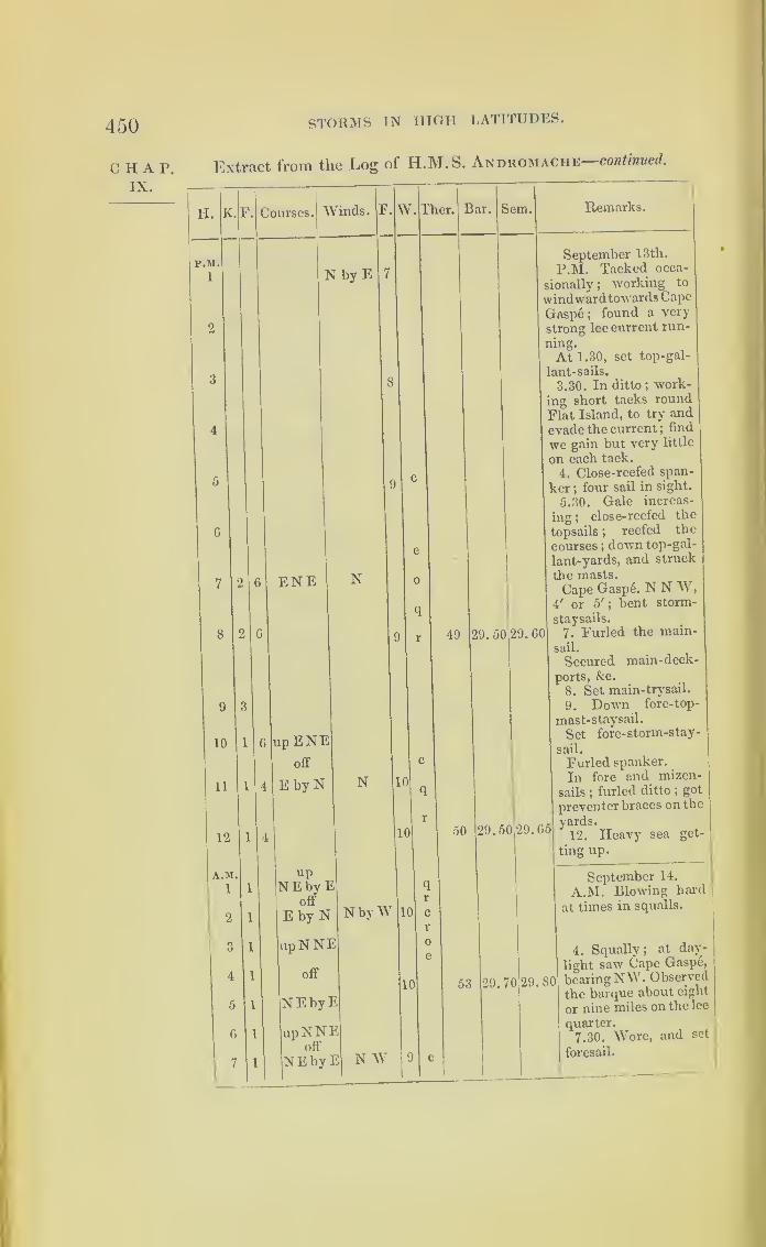
450
C HAP.IX.
STORMS TN HIGH LATITUDES.
Extract from the Log of H.M.S. Andromache—continued.
H. K.
P.M.
1
Courses. Winds. F. W
N by E
9
10
11
12
A.M.
1
2
3
4
5
6
7
ENE N
6
l 4
1
1
1
1
1
1
1
1
up ENEoff
E by N N
upNEbyE
off
E by N
upNNE
off
NEbyE
upNNEoff
NEbyE
Ther.
10
10
N byW
N W
10
10
Bar. Sem, Remarks.
49 29. 50 29. 60
50 29.50 29.65
September 13th.
P.M. Tacked occa-
sionally; working to
windwardtowards Cape
Gasp6 ;found a very
strong lee current run-
At 1.30, set top-gal-
lant-sails.
3.30. In ditto; work-
ing short tacks round
Flat Island, to try and
evade the current ;find
we gain but very little I
on each tack.
4. Close-reefed span-
ker ;four sail in sight.
5.30. Gale increas-
ing ;close-reefed the
topsails ;reefed the
courses ;down top-gal-
lant-yards, and struck
the masts.
Cape Gaspe. N N W,4' or 5'
;bent storm-
staysails.
7. Furled the main-
sail.
Secured main-deck-
ports, &c.
8. Set main-trysail.
9. Down fore-top-
mast-staysail.
Set fore-storm-stay-
sail.
Furled spanker.
In fore and mizen-
sails ;furled ditto
;got
preventer braces on the
yards.
12. Heavy sea get-
ting up.
53
September 14.
A.M. Blowing hard
at times in squalls.
4. Squally; at day-
light saw Cape Gaspe,
29. 70 29. 80 bearingNW. Observed
the barque about eight
or nine miles on the lee
quarter.
7.30. Wore, and set
foresail.
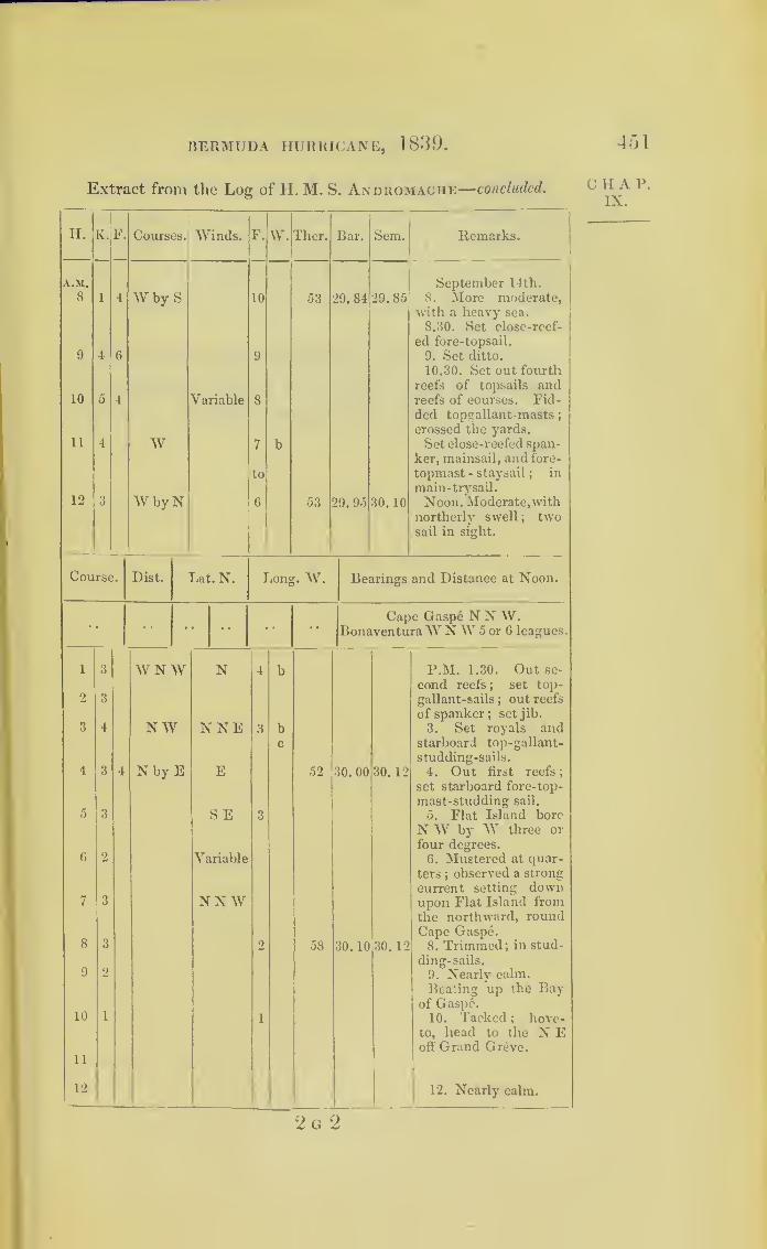
BERMUDA HURRICANE, 1839.
Extract from the Log of H. M. S. Andromache—concluded.
II.
A.M.
8
9
10
11
12
K.F. Courses. Winds.
W by S
W
W by N
Variable
F.
10
W. Tlxer.
53
53
Bar.
29. 84
29. 95
Sem.
29.85
30. 10
Remarks.
September 14th.
8. More moderate,with a heavy sea.
8.30. Set close-reef-
ed fore-topsail.
9. Set ditto.
10.30. Set out fourth
reefs of topsails andreefs of courses. Fid-ded topgallant-masts;crossed the yards.
Set close-reefed span-
ker, mainsail, and fore-
topmast - staysail;
in
main-trysail.
Noon. Moderate,withnortherly swell; twosail in sight.
Course. Dist. Lat. N. Long. W. Bearings and Distance at Noon.
1 3 WNW N 4 b
2 3
3 4 NW NNE 3 bc
4 3 4 N by E E 52 30. 00 30. 12
5 3 SE 3
6 2 Variable
7 3 NN W
8 3 2 58 30.10 30. 12
9 2
10 1 1
11
12
Capo Gaspe N N W.BonaventuraWNW 5 or G leagues.
P.M. 1.30. Out se-
cond reefs ; set top-
gallant-sails ; out reefs
of spanker; set jib.
3. Set royals andstarboard top-gallant-
studding-sails.
4. Out first reefs
;
set starboard fore-top-
mast-studding sail.
5. Flat Island bore
N W by W three or
four degrees.
6. Mustered at quar-
ters ;observed a strong
current setting downupon Flat Island fromthe northward, roundCape Gaspe.8. Trimmed; in stud-
ding-sails.
9. Nearly calm.
Beating up the Bayof Gaspe.10. Tacked ; hove-
to, head to the N Eoff Grand Greve.
12. Nearly calm.
451
C II A P.
IX.
2 g 2
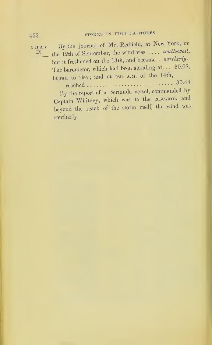
452
CHAP.IX.
STORMS IN HIGH LATITUDES.
By the journal of Mr. Redfield, at New York, on
the 12th of September, the wind was south-west ,
but it freshened on the 13th, and became . northerly.
The barometer, which had been standing at. . . 30.08,
becan to rise ;and at ten a.m. of the 14th,
reached30,48
By the report of a Bermuda vessel, commanded by
Captain Whitney, which was to the eastward, and
beyond the reach of the storm itself, the wind was
southerly.

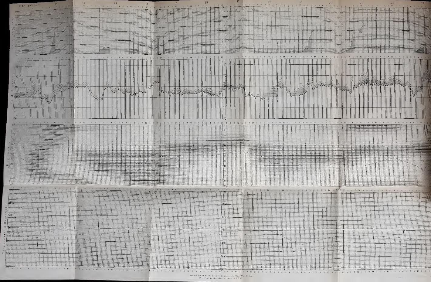

453
CHAPTER X.
ON MEASURING THE WIND’S FORCE.
The first successful attempt for measuring the force chap.and velocity of the wind, that I am aware of, was that 1
of the Rev. Dr. Whewell, Master of Trinity College,
Cambridge, who thus describes it, in a paper printed
in the Transactions of the Cambridge Philosophical
Society.
A fly (resembling the fly of a revolving ventilator, Whe-
or the sails of a windmill) is fixed to the small end of anemo-
the vane of a weathercock, so as always to be turned
with its circular disk to the wind;and it consequently
revolves, by the action of the wind, with a rapidity
increasing as the force of the wind increases. The
revolutions of the axis of this fly are converted by a
train of toothed wheels and screws into a vertical
motion, by which a pencil is carried downwards,
touching the surface of a vertical cylinder, the cylin-
der having the axis of the weathercock for its axis.
As the vertical rod on which the pencil slides is at-
tached to the vane of the weathercock, the point of the
compass from which the wind blows is recorded on
the side of the cylinder on which the mark is made;
while the quantity of the wind is represented by the
extent of the descent of the pencil.
One of the difficulties which most interfered with
the precision of the observations was that which arose
from the wavering of the wind. The weathercock is
454
c h a r.
X.
Osier’s
anemo-meter.
MEASURING THE WIND’S FORCE.
in almost constant motion, swinging to and fro through
an arc often not less than a quadrant ;and the conse-
quence is, that the pencil describes upon the cylinder,
not a single line, but a broad path of irregular form,
made up of the transverse line which the oscillation oi
the vane occasions. It might at first be supposed that
this oscillation arose from the momentum of the vane,
and might be remedied by some contrivance which
should cause the change of direction of the wind to
come into effect more slowly. But the cause of this
oscillation is in reality almost entirely the constant
shifting of the wind, as may be seen by examining the
motions of the vane ;for it often swings into a new
position, or stands still awhile, before it swings back
again.
Whewell’s anemometer was erected at Cambridge,
Edinburgh, Greenwich, and Plymouth, m 1838.
In the year 1837, another instrument, for the same
purpose, and of very ingenious construction, was ex-
plained to the British Association by the inventor,
Mr. Follett Osier.
Extract from the Report in the “ Athemeum ” for Sept. 16, 1837,
of the proceedings of the British Association, at Liverpool.
“ In Mr. Osier’s instrument, the direction of the wind is ob-
tained by means of a vane attached to a rod, or rather tube, that
carries it; and consequently causes the latter to move with itself.
At the lower extremity of this tube is a small pinion working m
a rack, which slides backwards and forwards as the wind moves
the vane;and to this rack a pencil is attached, which marks the
direction of the wind on a paper ruled with the cardinal points,
and so adjusted as to progress at the rate of halt an inch per
hour by means of a clock. The force is at the same time ascer-
tained by a plate one foot square, placed at right angles with the
vane, supported by two light bars running on friction-rollers,
and communicating with a spiral spring in such a way that i«

455MEASURING THE WIND’S FORCE.
plate cannot be affected by the wind’s pressure without instantly C II A 1’.
acting on this spring, and communicating the quantum ot its
action by a light wire passing down the centre of the tube to
another pencil below it, which thus registers the degree of force.
“ The rain is registered at the same time, by its weight acting
on a balance, which moves in proportion to the quantity tailing;
and has also a pencil attached to it recording the result. The
receiver is so arranged as to discharge every quarter of an inch
that falls, when the pencil again returns to zero.”
It is sufficient to supply the instrument once in
twenty-four hours with a sheet of paper ruled to the
proper form.
In order to render the observations recorded by his
anemometer and rain-gauge as generally useful and
available as possible, Mr. Osier has adopted a plan for
giving a condensed and comprehensive view of the
records obtained.
Having been much struck with the manner in which
this anemometer records the squalls, writing their force
at the same time that it gives the veering of the wind,
and the quantity of rain that falls, showing also the
precise time of their occurrence, Mr. Osier has done
me the favour to copy a portion of his condensed
registers (which is here engraved and annexed) for
fourteen days in the month of February, 1837, made
by collecting and condensing the work of the instru-
ment, and adding to it the heights of the barometer,
thermometer, and hygrometer;
so that we see at a
glance six simultaneous comparisons. It is divided
into days, and the days into hours.
The upper portion records the rain which has fallen,
and the hour at which each portion fell. Thus the
first fall of rain commenced on the 10th of February,
at \ past 4 f.m., and ceased at a 1 before 6 the same
Sec plate
oppositeto page453 .

456
CHAP.X.
»—
MEASURING THE WIND’S FORCE.
afternoon. The next portion, amounting to -52 of an
inch, began the following clay at 6 a.m., and ended at
11 a.m. The rate at which these descended was
regular, but the rest marked on the register fell at
various rates; sometimes very rapidly, and then
almost ceasing, as the different inclinations of the line
indicate.
The next division of the table gives the variations in
the current of the wind, together with its degree of
force. These observations are condensed from the
registers of the anemometers, thus:—The course as
recorded is not a definite line, owing to the oscillations
of the vane, produced by the waves or pulses of the
wind, already referred to in the extract from Professor
Whewell’s paper : the mean, however, of these oscilla-
tions gives the absolute direction, and this is the line
transferred to the table.—See the dark line, a. a.a.
On this line, as a base, is drawn the force of the
wind at the time, represented by lines perpendicular
to it, and varying in length according to the pressure
;
thus showing the force and direction of the wind on
the same division of the paper. The bars which cross
the perpendicular lines, and run parallel with the
direction line, denote each 1 lb. pressure on the squaie
foot. Thus, on the morning of the 10th of February,
the wind was south by west, with a pressure of 2 lbs.
on the square foot ;and between five and six in the
afternoon it veered to about south-west, and increased
in strength to a gale, with 6 lbs. pressure on the
square foot : then the wind began to abate, declining
in pressure to what it was before.
On the 11th of February the force of the wind was
only 1 lb. on the square foot; and the register shows it

MEASURING THE WIND’S FORCE. 457
backing to the south-east. By referring to the portion
showing the register of the barometer, we find it de-
scending until it comes to 28 ’50 ;and we find by the
register of the thermometer and hygrometer that the
air was saturated with moisture. The line which
denotes the direction of the wind shows that it veered
from south-east to south, and then to west
;
and as it
veered it blew a gale of 9 lbs. pressure to the square
foot. The rain registered just above this is the heavy
rain alluded to before.
The state of the barometer is taken at 9 a.m. and
3 p.m. daily. The daily maximum and minimum
temperatures are denoted by two black lines, and the
temperature at 9 a.m. by a dotted line. The dew-
point, taken at the same hour, is marked by an arrow
head.
These fourteen days were selected by Mr. Osier as
strikingly illustrative of the extraordinary meteorologi-
cal changes which accompany squally weather.
A gale in the south of England, which blew down
trees, and broke the chain-pier at Brighton, on the 29th
of November, 1836, approached in violence almost to
a hurricane. Mr. Osier’s anemometer had then been
set up at Birmingham;and it has recorded the wind
on that occasion as blowing with a force equal to the
pressure of ll£ lbs. on the square foot. A squall the
day before, which lasted but a few minutes, yet did
much damage, blew with a pressure equal to 17 lbs. on
the square foot;the wind veering at the time from
south-west towards south, and *10 of an inch of rain
fell at the same moment.
Mr. Osier informed me, that, being desirous practi-
cally to ascertain the force exerted by the wind at
CHAP.x.

458
CHAP.X.
MEASURING THE WIND’S FORCE.
various velocities, lie made a few experiments for
that purpose while travelling on a calm day on a
railroad. No very great degree of accuracy was at-
tempted ;but, as far as the experiments went, they
fully corroborated the tables published many years ago
by Dr. Lind, of Edinburgh, of which the following is
a copy :
—
Scale of Pressure on One Square boot.
Pressure on one]
square foot in
lbs. Avoirdupois.
Miles perhour.
•005 1
•020 2
•044 3
•079 4
•123 5
•492 10
1 -107 15
1 -968 20
3-075 25
4-429 30
6-027 35
7-873 40
9 -963 45
12-300 50
17-715 60
31 -490 80
49-002 100
Feet persecond.
•47
•93
•40
•87
•33
Observations.
14-6722-0029-3436-6744-0151-3458-6866-0173-3588-02117-36146-07
Hardly perceptible.
Just perceptible.
Gentle, pleasant wind.
Pleasant gale.
Brisk gale.
Very brisk gale.
Storm.Great storm.
Tempest.Violent tempest.
Hurricane.
Most violent hurricane.
Since the first edition of this work was published
Mr. Osier’s anemometer has been placed at several
places in India as well as in Europe.
A measure of the wind’s force, as regards its
strength, to be inserted in the log-books of ships, pro-
posed by the hydrographer to the Admiralty, Cap-
tain Beaufort, is now ordered by the Admiralty to lie
adopted in the Royal Navy. The concise mode of
inserting this measure, as well as the description ol the
weather, first adopted at Greenwich Observatory, is
so great an improvement, that it is annexed; in the
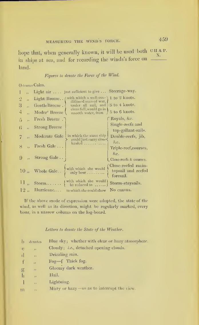
MEASURING THE WINDS FORCE. 459
hope that, when generally known, it will be used both
in ships at sea, and for recording the winds’s force on
land.
Figures to denote the Force of the Wind.
() denotes Calm.
1 „
2 »
3 „
4 „
5 »
6 »
7 «
8 »
9 »
10 „
11 „
12 „
Light air .... just sufficient to give . .. Steerage-way.
Li^ht Breeze. . /with which a well-con- \ i to ‘2 knots.
1 ditioned man-of-war,f
Gentle Breeze . < under all sail, and 3 to 4 knots.
|clean full,would go in 1
Moderc Breeze \ smooth water, from J 5 to o knots.
Fresh Breeze .
Strong Breeze
Moderate Gale
Fresh Gale . . .
Strong Gale .
.
! in which the same ship I
could just carry closed
Ihauled
f Royals, &c.
j
Single-reefs and
top-gallant-sails.
Double-reefs, jib,
&c.
Triple-reef,courses,
&c.
Close-reefs & courses.
Whole Gale..
Storm
Hurricane. . .
.
Close-reefed main-topsail and reefed
foresail.
Iwith which she would ) r.. , •,
{ be reduced to )Storm-staysads.
to which she could show No canvas.
with which she wouldonly bear
If the above mode of expression were adopted, the state of the
wind, as well as its direction, might be regularly marked, every
hour, in a narrow column on the log-board.
Letters to denote the State of the Weather.
b denotes
C
(1
f „
g ”
h »
1 „
m »
Blue sky3whether with clear or hazy atmosphere.
Cloudy; i.e., detached opening clouds.
Drizzling rain.
Fog—f Thick fog.
Gloomy dark weather.
Hail.
Lightning.
Misty or hazy—so as to interrupt the view.
C H A P.
X.

460 MEASURING THE WIND’S FORCE.
CHAP.X.
O denotes
P
qr
s
t
u „
V »
w
Overcast
—
i.e., the whole sky covered with one
impervious cloud.
Passing showers.
Squally.
Rain
—
i.e., continuous rain.
Snow.
Thunder.
Ugly threatening appearance in the weather.
Visibility of distant objects, whether the sky be
cloudy or not.
Wet dew.
Under any letter denotes an extraordinary degree.
By the combination of these letters, all the ordinary pheno-
mena of the weather may be recorded with certainty and
brevity.
EXAMPLES.
b c m—Blue sky, with detached opening clouds, but hazy
round the horizon.
g v—Gloomy dark weather, but distant objects remarkably
visible.
q p d 1 t—Very hard squalls, and showers of drizzle, accom-
panied by lightning with very heavy thunder.
461
CHAPTER XI.
ON WATERSPOUTS AND THE SMALLER WHIRLWINDS; AND
ON THE FALL OF FISHES ON LAND.
On Waterspouts and the Smaller Whirlwinds.
Of the different atmospheric phenomena, none are chap.more curious than waterspouts. That they cause _x^_small whirlwinds there seems no reason to doubt
; butI regard them as phenomena of a different nature fromthe great extended storm. Since the first edition ofthis work was published it has been found that thewaterspout, or whirlpillar, does not revolve always inthe same direction.
That which renders the waterspout remarkable is
the circumstance of a double cone being formed whenthe phenomenon is complete, one cone pointing down-wards from a cloud, whilst another points upwardsfrom the sea. The thin semi-transparent columns,which stalk, as it were, on the surface of the ocean incalm weather, though no cloud is to be seen abovethem, as well as the small agitated circles, which areonly seen by their marking the smooth surface of thesea in their gyrations, may probably have the sameorigin as the waterspout. One of these circles, whichappeared too insignificant to do harm, after performingmany gyrations near a ship commanded by CaptainMarquis, on the coast of Malabar, suddenly approached
4G2 ON WATERSPOUTS AND
CHAP.XI.
CaptainBeechey’swater-spouts.
her, as she lay becalmed, with her sails loose, and,
passing across her bows, carried oh the flying-jib and
jib-boom into the air, higher than the mast-head. I
have myself witnessed these semi-transparent columns,
within the tropics, without being able to decide which
way they turned round ;and the spiral form in which
they are said to revolve may be the reason.
The following account I received from Captain
Beechey, R.N. :—
“ While we were off Clermont Tonnerre we had a narrow
escape from a waterspout of more than ordinary size. It ap-
proached us amidst heavy rain, thunder, and lightning, and was
not seen until it was very near to the ship. As soon as we were
within its influence, a gust of wind obliged us to take in every
sail • and the topsails, which could not be furled in time, were
in danger of splitting. The wind blew with great violence, mo-
mentarily changing its direction, as if it were sweeping round in
short spirals : the rain, which fell in torrents, was also precipi-
tated in curves, with short intervals of cessation. Amidst ns
thick shower the waterspout was discovered, extending m a
tapering form, from a dense stratum of cloud to within ti y
feet of the water, where it was hid by the foam of the sea bemg
whirled upwards by a tremendous gyration. It changed its
direction after it was first seen, and threatened to pass over the
Ship;but, being diverted from its course by a heavy gust of wind,
it gradually receded. On the dispersion of this magnificent pi -
nomenon we observed the column to diminish gradually and
length to retire to the cloud from whence it had descended,
“
,
Uvtrious
gcluses have been assigned for these formations
which appear to be intimately connected with electricity. On
the present occasion a hall of fire was observed to be pree.p.ta ed
into the sea, and one of the boats, which was away from the
ship was so surrounded by lightning, that Lieut. Belcher thought
it advisable to get rid of the anchor by hanging >t
under water, and to cover the seamen s muskets. Trom
accounts of this officer and Mr. Smyth, who were at a d.stanee
from the ship, the column of the waterspout first descended in a
spiral form, until it met the ascending column a short d.stanee

TI1E SMALLER WHIRLWINDS. 4G3
from the sea : a second and a third were afterwards formed,
which subsequently united into one large column, and this again
separated into three small spirals, and then dispersed. It is not
impossible that the highly rarefied air, confined by the woods
encircling the Lagoon Islands, may contribute to the formation
of these phenomena.“ Neither the barometer nor sympiesometer were sensibly
affected by this partial disturbance of the atmosphere;but the
temperature underwent a change of eight degrees, falling from
82° to 74°: at midnight it rose to 78°. On the day succeeding
this occurrence several waterspouts were seen at a distance, the
weather being squally and gloomy.”
Clermont Tonnerre is in south latitude, and is one of
the group of islands called “ Dangerous Archipelago,”
about lat. 19° S., long. 137° W.
Having applied to Captain Beechey, in the hope
that he might he able to explain in which way the
gyrations of wind which accompanied this waterspout
revolved, I received from him the following expla-
nation :
—
“ The gyrations were in a direction contrary to that of the
hands of a watch : if it had been otherwise the ship would have
changed her tack, whereas she only broke off. She was on the
starboard tack, and the waterspout came down upon the weather-
beam, and passed under the stern. At first the ship broke
round off seven or eight points, and afterwards kept coming up
and breaking off, as the gusts of wind varied their direction; but
the wind continued on the starboard side the whole time, and
the ship did not alter her position more than a quarter of the
circle. It was quite clear, from the peculiar manner in which
the rain (if such large drops can be so designated) fell, that wewere within the vortex of the spout, aud that the gusts which
laid the vessel on her side were part of the phenomenon, and
consequently that the gyration must have been as I have stated.
I have observed many waterspouts between the tropics, but, with
the exception of that off Clermont Tonnerre, never noticed the
direction in which they turned, and regret that the subject was
never before mentioned to me, as I have had many opportunities
of determining the fact.
C II A P.XI.

0N WATERSPOUTS AND
CHAP. Diagram to explain the foregoing Remarks.
XI.
Another “ As it appears to me that any observations upon this extra-
water- ordinary phenomenon will be interesting, I extract from mySP°Ut
' journal a few lines, which I wrote when I last crossed the
equator :—
« < The day had been very sultry, and in the afternoon a
long arch of heavy cumuli and nimbi rose slowly above the
southern horizon : while watching its movement, a waterspout
began to form at a spot on the under side of the arch, that was
darker than the rest of the line. A thin cone (Sketch No. 1 )

465
—TIIE SMALLER WHIRLWINDS.
first appeared, which gradually became elongated, and was
shortly joined with several others, which went on increasing in
length and bulk until the columns had reached about half down
to the horizon. They here united and formed one immense
dark-coloured tube. The sea beneath had been hitherto undis-
turbed;
but when the columns united it became perceptibly
agitated, and almost immediately became whirled in the air with
a rapid gyration, and formed a vast basin, from the centre of
which the gradually-lengthening column seemed to drink fresh
supplies of water (Sketch No. 2). The column had extended
about two-thirds of the way toward the sea, and nearly con-
3 HAP.XI.

466 ON WATERSPOUTS AN1)
CHAP, nected itself with the basin, when a heavy shower ot rain fell
XI. from the right of the arch, at a short distance from the spout,
and shortly after another fell from the opposite side. This dis-
charge appeared to have an effect upon the waterspout, which
now began to retire. The sea, on the contrary, was perceptibly
more agitated, and for several minutes the basin continued to
increase in size, although the column was considerably di-
minished (Sketch No. 3). In a few minutes more, the column
had entirely disappeared; the sea, however, still continued
agitated, and did not subside for three minutes after all disturb-
ing causes from above had vanished.
“ * This phenomenon was accompanied by thunder or lig it-
ning, although the showers of rain, which fell so suddenly,
seemed to be occasioned by some such disturbance.
“ Two days afterwards we got the south-east trade wind, m
lat. 0° 33' S., long. 21° 40' W.f< The waterspouts were seen in *20' N., and 22 "W
.
(Signed) “W. J. BEECHEY.’
The circular motion imparted to the water of the
sea during waterspouts, is probably not confined
merely to the surface, for the ocean, to an unknown
depth, may partake ot the impulse.
In 1815, the Orontes frigate, commanded by Cap-
tain Cochrane, was in company with the Newcastle,
the flag-ship of the late Admiral Sir Pulteney Mal-
colm. The ships were near the equator, between
Teneriffe and St. Helena, when two large waterspouts
were observed a-liead of the Orontes, one on each bow,
about a mile and a half distant, whilst the Newcastle,
was nearly the same distance on the larboard-beam.
It was perfectly calm at the time:
yet the Oronte>
was observed to be going a-liead of the Admiral ;and
it was proved, by throwing paper into the sea, that the
vessel was making no way through the water. The
officers were of opinion that the Orontes was carried
forward by a partial current, which did not affect the

THE SMALLER WHIRLWINDS. 467
Newcastle; and the circumstance was mentioned to the
Admiral, by Captain Cochrane, on their arrival at St.
Helena, as a curious coincidence, viz., the Orontes
being carried forward, whilst the waterspouts were
a-head of her.
Observations on a Whirlwind or Waterspout in my passage from
Demerara to Barbados, on the 24th August, 1836, in lat. 9°
N., and long. 58° W.
“Hamilton, 19th July, 1839.—The early part of the day was
sultry and calm, with occasional heavy squalls of rain and wind,
such as are common at that season of the year in tropical
climates. At about two o’clock in the afternoon (a gentle breeze
having sprung up) we observed a waterspout to windward of us.
Phenomena of that description being very common in this
quarter, it excited no particular attention, until it was seen ap-
proaching the vessel with considerable velocity, and in a direction
so likely to come in contact with her, that it became necessary
to clew up all sail and put the vessel before the wind, in order
that, sailing in a line parallel with the line of motion of the
meteor, we might keep out of the range of its gyration. Wewere obliged to continue in company with it in this way for
twenty minutes or half an hour; and I had an opportunity of
satisfying myself that its progressive motion was in the direction,
and of course with the velocity, of the general current of air, and
that its rotatory motion, supposing the point of commencement
to be the east, revolved towards the south. The water was
raised up like water boiling in a pot to the height of two feet
or more; and the spray, by the centrifugal action, to a muchgreater altitude. I would also remark that, although when at a
distance the conical spiral-shaped cloud, indicating the existence
of waterspouts, was perfectly apparent, yet on the approach of
the meteor it entirely disappeared; nor did it again show’ itself
after passing to leeward of us.
(Signed) “ W. BURGESS.“ To Lieutenant-Colonel Reid.
“ P.S. The waterspout, when at its nearest point to us, musthave been within a hundred yards, and I judged it to have a
diameter of about twenty to thirty feet.”
2 II 2
CHAPXI.
468 ON WATERSPOUTS AND
CHAP.XI.
Movingcolumns of
sand.
The moving pillars of sand described by Bruce as
having been seen in Nubia, though the account may
be familiar to many, is here reprinted, because these
moving pillars probably originated from the same
cause, whatever that may be.
“ On the 14th of November, at 7 in the morning, we left Assa
Nagga, our course being due north; at 1 o’clock we alighted
among acacia trees at Waadi el Halboub, having gone twenty-
one miles. We were here at once surprised and terrified, by
truly one of the most magnificent sights in the world. In that
vast expanse of desert, from west and to north-west of us, we saw
a large number of pillars of sand at different distances, at times
moving with great celerity, at others stalking on with a majestic
slowness; at intervals we thought they were coming in a very
few minutes to overwhelm us; and small quantities of sand did
actually more than once reach us. Again they would retreat, so
as to be almost out of sight, their tops reaching to the very
clouds. Then the tops often separated from the bodies; and
these once disjoined, dispersed in the air, and did not appear
more. Sometimes they were broken near the middle, as if
struck with a large cannon shot. About noon they began to
advance with considerable swiftness upon us, the wind being
very strong at north. Eleven of them ranged alongside of us,
about the distance of three miles. The greatest diameter of the
largest appeared to me, at that distance, as if it would measure
ten feet. They retired from us with a wind at south-east,
leaving an impression upon my mind to which I can gi\e no
name, though surely one ingredient in it was fear, and a con-
siderable deal of wonder and astonishment. It was in vain
to think of flying: the swiftest horse, or fastest sailing ship,
would have been of no use to have carried us out of the
danger.
“15th Nov. At 7 a.m. we left Waadi Dimokea. The same
appearance of moving pillars of sand presented themselves to us
this day, in form and disposition like those we had seen at
Waadi el Halboub, only they seemed to be more m number and
less in size.” /
These moving pillars of sand are not confined to
Africa. They may be seen in every quarter of the
TI1E SMALLER WHIRLWINDS. 469
globe. They are thus alluded to by Captain Lyons,
in his work, entitled “ Residence and Tour ol the
Republic of Mexico,” p. 196:
—
“ From San Luis Potosi to Zalatecas.—Our whole journey on
this day was over an excellent, though dusty road, through a
desert, only enlivened by the numerous spiral whirlwinds, which
half buried us at times beneath the cloud they created.”
Page 157, “Journey in Protillas”:
—
“ In three leagues over a stony road, we reached the Raneo del
Tejou, and passed on to a plain, on which the number of whirl-
winds was quite extraordinary. We had repeatedly seen a few
of them;
but on this day they appeared to have assumed a new
form, raising the dust to a height of 200 or 300 feet in straight
columns, which preserved their perpendicularity and moved but
slowly over the plain, while many continued to turn rapidly on
their axis, without any perceptible progressive motion.”
The same phenomenon is constantly observed in
India : and the following extract is descriptive of
some small whirlwinds seen at Deesa. These whirl-
winds are usually termed “ Devils ” in India.
Extract from a letter from Lieutenant Fyers, 40th
regiment, dated Deesa, Bombay Presidency, 1838.
“The sand is so loose here in many parts, that the Devils
take it up to a great height, and in such quantities that it has
almost the appearance of an immense pillar of about eighteen
feet in diameter, and some hundred in altitude;
this goes travel-
ling along in no very straight course. When it comes to any
loose bushes cut for hedges, it takes and twirls them up, a
good number of feet, like a corkscrew. Up high, the pillar loses
itself in a cloud of sand, which is carried along by the current
of air, but which appears to have lost the revolving power.
(Signed) “WILLIAM FYERS.”
CHAP.XI.
The sudden storm which sunk the steam-boat
Tigris on the River Euphrates, on the 21st May,
470
C H AXI.
ON WATERSPOUTS AND
P. 1836,
in some respect bears a resemblance to the
waterspout and the moving columns of sand just
described.
A memorandum, written by Mr. Ainsworth, who
kept the meteorological journal of the expedition,
states,
—
“ It was a fine afternoon, only a few clouds, cumulo and
cirro-strati, in the horizon;a light breeze from the east-north-
east; the sun about two hours past the meridian, when a dense
black cloud was first observed moving across the wilderness
from the west-south-west, and in the teeth of the wind. As it
approached, it was found to consist, in its base, of red-coloured
masses of dust, which succeeded one another rapidly, breasting
the wind in their onward progress, and rising till they were re-
ceived into the bosom of an overhanging cloud, from which these
columns of dust were again precipitated with great force and rapidity,
accompanied with a violent rain.
“ During the storm the barometer fell upwards of two-tenths
of an inch, which is a very large amount in a climate where the
average diurnal oscillation did not at that time amount to
05 . Immediately after the storm had passed by, the
weather resumed its previous tranquillity;
nimbi, or large
clouds in the horizon.
(Signed) “ W. AINSWORTH.’
A written account by Captain Lynch states,
—
“ Light blue clouds, with sheet lightning, had been observed
above the western and west-north-western horizon, between the
hours of noon and three p.m., for two days previous to the
storm. On the 21st, a little after noon, the clouds in the west-
north -west assumed a dense appearance, and the breeze that had
blown lightly from the northward, a little westerly, during the
morning, drew gradually round to that point, and freshened
about one p.m. sufficiently to induce the officer on deck to furl
the awnings of the Tigris; ere this operation (the work of a few
minutes) was performed, the clouds were drawn down in contact
with the horizon, inducing the commander of the Tigris to warn
Colonel Chesney, who happened to be on board, of the proba-
bility of a squall; and endeavoured to make both vessels (the
Euphrates was in company) fast to the bank during its expected

TIIE SMALLER WHIRLWINDS. 471
passage. Almost as soon as the cloud touched the horizon, a
point of it a little to the left of its centre, as seen from us, was
disturbed and enlightened, until cracked by fine white lines,
which I recollect remarking at the time resembled a lace veil
thrown against the cloud;
this advanced rapidly, preceded by
numerous little whirlwinds, gyrating contrary to ‘ the direction of
the hands of a watch.’ The gyrations of the main shaft could
not be seen, even if my attention had been drawn to it, as the
clouds of sand that preceded it rendered its motions invisible.
About three minutes after the appearance of the veil, the vessel
was unable, from the force of the wind, to keep her head to it
with full force of steam, and in another she was whirling in
it, contrary to * the direction of the hands of a watch.’ Aminute of noise and horror, in which sand sparks (probably
from the galley) and large drops from the clouds, were soon
mingled with foam and wreck from the river, and the Tigris went
down in silence—head south, or right down the river; having
gone round by the westward, or against the storm point. Her
head being north-westward, the wind on her larboard bow.
Head westward, wind on the starboard bow. South-westward,
on the starboard beam;
larboard side under water. South,
wind on starboard quarter as she sunk.
(Signed) “H. BLOSSE LYNCH.”
Having read an account in the “Times” newspaper
of whirlwinds (similar to those so often described by
Mr. Luke Howard), as having been seen near Lincoln,
as well as Manchester, on the same day, I wrote to the
persons named in the paragraph.
The answers which have been received deserve
attention, and are inserted, as well as the paragraphs
which led to the inquiry.
“Effect of a Whirlwind.—That phenomenon, which is
known by this familiar name, was witnessed with great atten-
tion, and no small cause of apprehension, on Wednesday last,
by Mr. John Prestwood, of Branston, near this city, whose
minute description wc state almost in his own words. About a
quarter before 3, just preceding the storm, a whirl of air was
} II A P.
XI.

472 ON WATERSPOUTS AN1)
CHAP, seen to approach from the east, and to become a vast column
XI. about SO yards in height, and as large round as a hay-stack that
should have about 15 tons of hay in it. It approached the field
slowly where Mr. Prestwood and his men were hay-making, and
took up the hay in a spiral ascent to a vast height, carrying it
to a great distance, going off across the adjoining fields. In
about ten minutes or a quarter of an hour another great tornado
was seen to approach out of the same quarter, proceeding in the
same route as the other;but it took across a fallow piece, about
60 yards from Prestwood’s house. It made a turn to the right,
and then along the fallow field;there then occurred a sight
most wonderful, for it tore up the earth, and raised it to a great
height in a black mass that seemed to be full of fire, with thun-
der and lightning out of the midst of it; the noise and crackling
were hideous and appalling. It missed the house by a few
yards;and Prestwood believes that if it had passed over it the
whole would have been carried away. The corner of an out-
house, and nearly a ton weight of newly-cut thorns, were taken
along with it and scattered in all directions. It did not go faster
than a horse could keep up with it. Its course then went whirling
and curving towards Canwick. The cattle that beheld it fled about
in order to avoid the danger;and such was its force, that anything
that lay in its way must have been destroyed .”—Lincoln Gazette.
“Extraordinary Whirlwind.—About 12 o’clock at noon,
on Wednesday, a very extraordinary whirlwind took place at
Hopwood, about one mile from Middleton, in a field at Higher-
fold, belonging to Mr. Joseph Howarth, a farmer. A large oak
tree was torn up by the roots, another was blown down in Hop-
wood Clough, and boughs torn from off trees were seen flying
in the air for nearly five minutes. The spouts from two cottages
in Blomerly Clough, and the slating from an engine-house near,
were torn off. The men in Hopwood Clough Colliery, upwards
of 300 yards under ground, were seriously alarmed, describing
the noise to be the same as if an engine had burst:people for
the distance of a mile and upwards could hear it. What makes
the affair more strange is, that the breadth the whirlwind took
was only about 20 yards. A man’s pair of breeches were carried
off the coal-hill at Hopwood Colliery, and found in a sheep pas-
ture about 400 yards off. There was not much rain, but there
were many brilliant flashes of lightning and heavy claps of
thunder during the afternoon .”—Manchester Guardian.
(From the Times of July 11, IS38.)
TIIE SMALLER WHIRLWINDS. 473
Mr. Prestwood having; carried the letter lie received c ha
p
from me to the editor of the “ Lincoln Gazette,” the —following is the additional declaration taken down by
the editor; and in recording which, he stated he was
desirous of being exact.
“ Lincoln, 12th July, 1838.“ According to John Prestwood’s declaration, and that of his
wife, and Dennis Brodwell, their man-servant, the first column
was not seen to revolve on its own centre. It might do so;but
that escaped their observation. It went something like ‘ a rush-
ing wind, a tearing wind; ’ but would not say it turned round
as a top does when it is set spinning. The second was seen dis-
tinctly to whirl round in that manner, and in the direction that
the hands of a watch go.
“ The first was seen \ before 3 in the afternoon. It came
from out of the east, inclined southward in curves, following the
sun then to westward, and must have been inclining towards the
northward afterwards. Canwick is four miles north-west from
Branston. Both places are south-east from the city of Lincoln
a few miles.—(See Ordnance map.) The first column, after
passing Prestwood’s, was (according to hearsay) seen at Canwick
fields (still inclining to north-west), and went over a farmer’s
yard near the spot called Sweepwash in the map. In the two
fields off this point, a ball of fire was seen to fall by three men,
and it made a great hole, the stony soil being scattered around
as if a large cart-load had been cast out in all directions. This
was caused, it is supposed, by the first column. This column
then made a detour more northward across the river Witham,
which it momentarily dried for 50 to 100 yards, and made great
devastation en the opposite side to where Prestwood first saw it,
at Greetwell especially.
“ There was much lightning in all directions at the time this
was occurring, and heavy rain followed, with much hail of large
size;
but no water was seen in the columns, and he docs not
suppose they contained any. ‘ They seemed to be full of thunder,
lightning, and earth, all mixed together.’
(Signed) “E. B. DRURY.“ Gazette Office, Lincoln.”
474 ON WATERSPOUTS AND
CHAP.XI.
Extract from a report, dated Middleton, Aug. 8,
1838, relative to a whirlwind which occurred on the
4th July, 1838 :
—
“ 1. The wind went round in the same manner as the hands
of a watch.
“ 2 . There was a cloud over it at the time, and it appeared to
be much disturbed.
“3. It came from the south-east, went about a mile and a
half, and was about twenty yards in breadth.
(Signed) “ JOSEPH FIELDING.
“ Middleton, near Manchester.” “ Reporter.
1 have also received from Mr. Fielding the follow-
lowing statement, which was published in several
newspapers.
“Extraordinary Whirlwind.—At six o’clock on Monday
evening last, 6th of August, 1838, a most extraordinary whirl-
wind took place in a field belonging to Mr. George Wolstencroft,
of Little Green Mill, near Middleton. It tore a large willow
tree up by the roots, which measured upwards of twelve feet in
circumference, it was also split up the middle3
and very laige
boughs were torn off-
other trees and carried upwards of a mile.
They turned round in the air in the same direction as the hand of
a clock or a watch, and made a noise which was heard upwards
of a mile distant. A great number of apples were blown off the
trees, and some were blown through the windows of several
houses. The clouds appeared very much disturbed at the time,
and there was a smart shower of rain which lasted about five
minutes. Thousands, for miles round, have been to look at the
above tree.
“ On Monday night last, there was a very heavy fall of ram
and hail at Oldham and the neighbourhood, accompanied by
much thunder and lightning. The rivers became much swollen,
and many houses were flooded. There was a violent wind during
the rain and hail, which tore many boughs oft the trees, and did a
deal of damage to fruit. A child four years of age, at Coldhurst
Lane Colliery, was struck with the electric fluid. At Ashton-
under-Lyne, a boy ten years of age, son of Mr. John Neild, who
keeps a beer-shop, fell into the river, and was washed away3
he was not found on Wednesday evening, although great exer-
tions had been made.”
TI1E SMALLER WHIRLWINDS. 475
A record of the state of the weather, and of meteoro-
logical phenomena, is now ordered to be kept at the
central signal station in the Bermuda Islands;and
weekly reports from this record are to be published in
the “ Bermuda Royal Gazette.” The following is an
extract from one of these reports.
Report relative to a Waterspout,seen from Fort George, Bermuda.
“ May 13th, 1839.
“ I observed on the morning of the 17th ult., about six a.m.,
a waterspout, bearing from Fort George south-west. Whenfirst seen it appeared very small, and travelled in an easterly
directionjwhen bearing south-east it vanished for a minute or
two : when it was again seen it gradually became larger, and
was of a pale red colour, although the sun was not shining.
It was about twelve miles distant from the laud, and it lasted
for fifteen minutes. I am unable to state which direction it
turned round.
(Signed) “LUKE HEDDERLEY,“ Sergeant 30th Regiment, S. Director.’*
(Bermuda Royal Gazette.)
On the 15th of August, 1839, I had an oppor-
tunity of observing the mode of revolving of a water-
spout. It formed under Government-House at Ber-
muda, which stands about 130 feet above the level of
the sea.
A heavy cloud, from which rain was falling:, and
from which the waterspout projected, moved slovvlv
towards the shore, and to within 1000 yards of the
spectators, who were to the southward of it. The modeof revolving could not be ascertained by the naked
eye ;but on looking down through a telescope upon
the lower part of the phenomenon, it appeared like a
cylinder formed of sprav from the sea. The heighta •/ ft
CHAP.XI.
Whirl-pillars re-
volving in
different
ways.

476 ON WATERSPOUTS AND
chap, seemed about fifteen feet. On the south side, nearest
_XI
; the spectators, the spray was seen distinctly to fly
from the right hand towards the left with somewhat
of a spiral motion : whilst over the top of it a small
portion of the opposite side was seen returning from
the left hand towards the right, completing the revo-
lution in the same manner as the hands of a watch
revolve. The upper part was alternately condensed
into visible vapour, and re-dissolved in a remarkably
sudden manner several times. Whilst contemplating
this phenomenon, it was not easy to refuse belief that
it owed its origin to some fixed cause.
I am indebted to Mr. Walker, the Queens Harbour
Master at Plymouth, for an account of a waterspout
he sailed through in the Bay of Naples; which, by
his statement, revolved in a contrary way to the one
just described. Mr. Walker says, “ I have been
through a waterspout in the Bay of Naples, and can
safely state that its rotations were not in accordance
with the law we have been discussing— namely, on
its south side the wind was westerly, and on its north
side easterly”
On the 28th of August, 1839, I witnessed another
at Bermuda, which likewise seemed to revolve in the
contrary direction to the hands of a watch ;but it was
not sufficiently developed, and was too distant to be
certain of the fact, though attentively watched with a
telescope.
On the Fall of Fishes upon Land.
Minute The description of waterspouts carrying up the
thM aid
water of the sea into the air, together with the re-
rain!'8
ported rains of salt water during hurricanes, led me
FALL OF FISHES ON LAND. 477
to inquire into the singular accounts of minute fish
being seen in India on the land, both alive and dead,
after heavy rain, and which are there believed by
most persons to fall from the clouds. I thought it
possible, since whirlwinds on land carry up branches
of trees, and whirlwinds at sea carry up the water
of the ocean, such phenomena might have the power
of raising pools of water, and all small bodies floating
in them. This inquiry led to a very curious paper
being written on the subject by Captain W. C. Grant,
of the Bombay Engineers, and which will be found
subjoined;and it will be found that Captain Grant
also alludes to the moving pillars of sand.
He had never, however, observed which way these
small whirlwinds revolved.
This singular fact of fish being found on the land in
India after rain, which is discredited only by those
who have not inquired, deserves more close investi-
gation than it has yet received.
I annex the reports I have met with;and if they
do not altogether confirm the opinion alluded to
above—that fish are carried into the air by the smaller
whirlwinds—they will at least, I trust, awaken a desire
for further and more attentive inquiry.
I am indebted to Mr. Murray, of Albemarle Street,
London, for the following notes by Mr. Yarrell.
Descent of Fishes from the Clouds.
Extracts from a Letter to William Peete, Esq., F.L.S., giving an
account of a shower of Fishes in India;with some additional
remarks by Mr. Peete.
“ The fish (a species of Cyprinus, 2| inches long) was copied
from a drawing taken by Mrs. Smith, at Monadabad, July 29th,
1829, who speaks of this fish as being one amongst a number
C H A P.
XI.
478 ON WATERSPOUTS AND
CHAP, that came from the clouds in a shower of rain, and was presented
XI. to her with many others.
“ (The drawing was made by that lady immediately, and
coloured from life in every respect, with the exact size of the
fish in length and breadth.
“ The drawing represents a small species of Cyprinus, 2$
inches in length, green above, silvery white below, with a broad
lateral line of bright red.)
“ Mrs. Smith, in a letter from Silpot, in Bengal, when re-
siding there, July 30th, 1836, thus speaks of a similar extraor-
dinary event:— ‘ Have you not heard of its raining fish in India ?
I can assure you that our men went out and picked them up,
during a tremendous storm, on the grass. I saw them myself
from the window, leaping about, and the men taking them up.
Is it possible the violence of the storm may force them out of
the river, or may they be drawn up by the ascent of the foam
or vapoftr, and fall down in the rain? but that many were
springing about on the grass, is most true, dhey were small;
the largest I saw was about the size of a small gudgeon.’
“ The following lately appeared in a newspaper.
“ f Shower of Young Herrings.—On the 9th of March,
1830, the inhabitants of the Island of Ula, Argyleshire, after a
day of heavy rain, were surprised to find numbers of small
herrings strewed over their fields, perfectly fresh, and some
of them exhibiting signs of life. Similar instances of showers
of small fish are well authenticated.
“ In c Hasted’s History of Kent,’ vol. v., page 2, 8vo edition,
is the following.f About Easter, in the year 1666, a pasture field
in the parish of Stansted, which is a considerable distance from
the sea or any branch of it, and a place where there are no fish
ponds, in quantity about a bushel, supposed to have been rained
down from a cloud, there having been at that time a great tem-
pest of thunder, hail, wind, &c. These fish were about the size
of a man’s little finger, some were small whitings, others like
sprats, and some smaller like smelts. Several of these fish were
shown publicly at Maidstone and Dartford.’
“ In a letter from Dr. Latham, he observed, that the circum-
stance of the shower of fishes is no doubt a fact as recorded in
Hasted. I referred, too, to the ‘Philosophical Transactions,
vol. xx., page 289, where it is said to have happened at Stansted’
I find in this volume of mine a MS. note, dated 1/20, by the
Rev. Mr. Barrel, which says, that an old servant of his, named
FALL OF FISHES ON LAND. 479
William Martin, mentioned to him, that, when a boy, he lived
with his father near where the fish fell, and saw the storm of
hail and rain which preceded, and took up several of the fishes.
“ Colonel Sykes tells me, that in ‘ Harriot’s Struggles through
Life,’ there is an account of a shower of fishes that fell in India :
the storm overtook some troops on their inarch, and the living
fish fell on the hats of the men.
(Signed) “ WILLIAM YARRELL.“ Forwarded with a note.”
The next statement was given me by Mr. Buckley,
with whom I made a voyage:—“On March 30th, 1836, at 4 a.m., being in the brig Matilda,
of St. John, N.B., off the Bay of Naples, the Island of Ischia
bearing east, distant ten leagues. It blowing hard north-west,
and thick weather, I observed a very curious appearance in
the north-west. It appeared columnar, and like a lighthouse
enveloped in a white blaze of fire, and continued so for fifteen
or twenty minutes, and then disappeared. Immediately after
the wind fell to a moderate breeze, and cleared up, when we had
a fine pleasant day.
(Signed) “JAS. BUCKLEY,“ Mate of the barque Barlow.”
For the following;; 1 am indebted to Mr. Redfield:
—
c5
Phenomena.—“ Recently we have seen accounts of a shower
of mud at Buenos Ayres; a shower of chalk at Bennington, Vt.j
and a shower of fish at Baton Rouge, La .”—American Newspaper,
1833.
“ Louisville, Kentucky.
“ Yesterday morning a great number of small fish were found
swimming in the gutters on Jefferson-street. During the night
previous a heavy rain fell, and the fish of course descended with
the water. We saw a number of them—they were from two to
three inches long, and mostly sun perch .”—Louisville Newspaper,
Nov. 1835.
The Staunton, Va., Spectator, of the 24th ult. says, “ During a
storm last week (June, 1S33), a gentleman of this place, who was
C II A P.
XI.

480 ON WATERSPOUTS AND
CHAP, on one of the roads a few miles from town, distinctly saw a large
XI. snake fall from the clouds into the roads, a short distance before
him. There was no tree near the spot, and the snake was at a
considerable height when he first noticed it. The snake was
supposed to be of the water species, and was alive. It was
doubtless taken up in a waterspout or whirlwind.”
Shower of Eels.—“ A friend of ours, yesterday, presented
to us a small paper of eels, from one to two inches in length,
which he gathered after the heavy rain on Sunday, May 20, 1832,
in the neighbourhood of Lafayette-place. They are perfect in
form, and attracted the attention of thousands who yesterday
called at our office .”—American Newspaper.
Hail-Storm.—“A most tremendous and destructive hail-
storm passed over the country, about five miles above Irenton,
yesterday afternoon, Sunday, May 20, 1832. Windows, poultry,
&c. was extensively destroyed.”
—
Ibid.
Waterspout, 1832.—“On Thursday, 11th inst., several of
the inhabitants of Carver, about eight miles from this place, had
an opportunity of witnessing this truly wonderful phenomenon,
though, indeed, on not a very extensive scale. We have learned
upon inquiry that a whirl in the air was perceived at a little
distance from Sampson’s Pond. This whirlwind took the direc-
tion of the pond;and, at the moment of passing over it, a
column of water ascended in one unbroken mass, and to such a
height as to be seen at the distance of five miles. A cloud
charged with electric fluid was suspended over the pond at the
time. In this cloud the top of the column was apparently
merged, but in a few moments the whole mass descended into
the neighbouring woods, with such force as to break off the
limbs of some of the trees with which it came in contact. By
this sudden freak of the elements, several frogs became, uninten-
tionally, aeronauts ;and, like Vincent Lemanli, paid for their
excursion with their lives.”—Plymouth Democrat.
A Shower of Fishes.—“ We have received from a most
respectable and credible authority the following narrative
< There is a farm bordering on Lake Gwynant, in this county, of
which Mr. John Rowlands is the tenant, called Hafod Ghvyfog.
FALL OF FISHES ON LAND. 481
On last Wednesday fortnight a servant woman was engaged in
washing a pail at the edge of the lake, and a number of children
were with her. While she was thus employed (the time was
about eight o’clock in the evening) she was astonished by a
shower of small fishes, which fell upon her and about her, partly
into the lake and partly upon the land. They resembled her-
rings, but were much smaller. The children picked many of
them up, and threw them into the lake. A heavy shower of rain
had preceded the descent of these fishes, and the day following
there was much thunder and very heavy rain indeed.’ Our cor-
respondent has preserved the remains of some of these fish in
spirits of wine.”— Carnarvon Herald (English Paper, 1833.)
1 was informed by Admiral Sir iiug’li Pigot that he
himself saw a fish fall upon the deck of the Princess
Charlotte, in Toulon harbour, when he was on board
that ship. A waterspout struck her, and covered her
decks with water. No one in the ship doubted but
that this fish had been carried up out of the sea by the
waterspout, and then fell on the deck. It was some-
what longer than a man’s hand.
An account of salmon-fry being found on land at
Jedburgh, in Scotland, after very heavy rain, having
appeared in the “Scotsman” newspaper, I wrote to the
minister of the parish to ascertain the truth of the re-
port, and the following is the answer I received :—
“ Jedburgh, 19th Sept. 183S.
“ Report said that many salmon-fry were found. I have been
able to find only two, and these are still alive. They were found
in a pitcher—quite empty and dry—which a woman had set out
to receive some of the rain which was falling in torrents. The
pitcher was placed beneath a water-conductor, leading downfrom the roof of a slated house, and the fish must have comedown through it. There can be no doubt of the fact of their
being found in this, as the woman to whom the pitcher belonged
assured me there was not a drop of water in it when set out, and
2 i
C II A P.
XI.

482 ON WATERSPOUTS AND
CHAP, nobody approached it to put any thing in. I am sorry that I
XI. paVe been able to get no precise information about the weather
on that day, except that it was an absolute deluge of lain.
About the period in question a decided waterspout loll in the
neighbourhood of the town, and much damaged the fields5but
whether it was the same as that in which the fish were found I
have not been able to ascertain. I may add, that this place
stands on the brink of a small river;in which, however, there
are no salmon, and is about two miles distant from a still larger
one in which there are many.
(Signed) “ JOHN PURVES,“ Minister of Jedburgh.”
Having written a second time to Mr. Purves, to
know what size the small fishes were, the answer I
received is as follows :
—
“ Jedburgh, 10th Oct., 183S.
“ I have waited for some time in replying to your communi-
cation of the 29th ultimo, in consequence of some reports in the
place of other fishes being found near this on the same day. In
so far as my inquiries have gone, they seem mere reports. I
have, however, examined the two of which I wrote to you again.
They are still alive, and quite lively. As near as I can guess,
they are each about an inch in length; ahead somewhat large
in proportion to the body, which tapers much towards the tail
with clear transparent fins, and a tail very elegantly formed. I
have renewed my inquiries about the vessel, which was perfectly
dry when set out;as was also the vessel into which the water
was subsequently poured, and where they were discovered. On
recalling every thing, I can distinctly remember that the day on
which they were found was not only very rainy, but rain accom-
panied every now and then with swirls of wind of terrible power,
as often in a thunderstorm—in short, it was quite like a water-
"p0ut .
(Signed) “ JOHN PURVES.
“ Lieut.-Colonel Reid.”
For the next account I am indebted to Mrs. Kenrick,
of Bourne-place, near Canterbury. Lord Eastnor thus
writes to her :—.. X have much pleasure in complying with your request, and
FALL OF FISHES ON LAND. 483
stating, to the best of my recollection, the circumstances of the
crabs being found near Reigate.“ Soon after a most violent storm of rain and wind,* in the
summer of 1829, three small crabs, weighing from 1^ to 1^ oz.(
were found in the area of the workhouse at Reigate$and a fourth
was afterwards found at a little, distance, I think the following
morning. One of them appeared to be still living. In the morn-
ing of the day previous to the storm the area of the workhouse
had been thoroughly swept and cleaned;consequently they must
have been seen had they been there then. They were found by
a boy, who told the governor that he had found a comical sort
of a frog. I went myself to the workhouse as soon as I heard of
the circumstance, and saw the frogs. I know7 that Mr. Turner
had one of them, for the purpose of preserving it;and you will,
probably, hear from him whether he has it still.
“ Believe me, &c.,
(Signed) “ EASTNOR.“ Tyttenhanger, 5th Aug., 1836.
“ To Mrs. Kenrick, Bourne-place, near Canterbury.”
Mr. Turner, veterinary surgeon, of Reigate, thus
writes on the subject to Mr. Fairholme :
—
“ Sir, “ Reigate, 8th Aug. 1836.“
I beg to acknowledge the receipt of your letter, and shall be
most happy to give you the particulars of the crabs, one of which
is now in my possession. On the 19th July, 1829, there was a
very violent storm, attended writh a very heavy rain and hail, the
wind being due south.f
“ Within the walls of the House of Industry, at Redhill, about
one mile and a half from hence, the fall of water was so great as
to appear like an inundation. After it had in some degree sub-
sided, the inmates of the house went to open the drains in the
yard, to relieve the water, and found four crabs alive and moving,
one of which lived several days, and was preserved by me. The
others, I fear, were not properly considered, and were ultimately
destroyed and lost. The species appears to me to be the cancer
paegarus, or common crab, though of small size. It is of a dull
* “This was described to me as having been more like a West Indian
hurricane than a European shower.”
f Reigate is distant from Brighton, which lies to the south of it, about
thirty-five miles.
CHAP.XI.

484 ON WATERSPOUTS AND
CHAP, brown colour, has two claws and eight legs, four on each side.
XI. j have given beneath a rough outline of its size.* A similar cir-
cumstance to this occurred seven or eight years ago near this
town, and was witnessed by many highly respectable persons.
After a severe downfal of rain, the road, and some little space,
was positively covered with thousands ol toads and frogs, though
extremely small, nor larger than a walnut; and many were lodged
on the roofs of some of the houses. I shall be happy to show
you the crab, as it is in a very perfect state.
(Signed) “ EDWARD TURNER.”
The next statement is that written by Captain C. \\ .
Grant, Bombay Engineers, before alluded to
:
On Ike Fact of Small Fish Falling during Rain in India.
“ That such is the case is certainly the generally received
opinion;and I have met with many officers who profess to have
themselves witnessed the fact;that is, that after a hea\ y fall oi
rain they have seen small fish jumping about on the terraced
roofs of houses, and in other places wholly inaccessible to them,
unless they had fallen from the clouds;but I never knew any
one who had either caught them in a water-tub or other rcsei-
voir, or had known them to fall on his person, as we have a
right to expect would have sometimes occurred, if such were the
case;or that, in fact, wTould affirm that he had actually seen
them falling.
“I have myself frequently noticed little fish flapping about in
puddles on the top of a high table land during and after heavy
rains;but think their presence in such places, as well as on ter-
races,' may be accounted for without resorting to so improbable
an hypothesis as that of falling from the clouds.
“ In most parts of India the beds of small rivers, as well as
those of the tanks or natural ponds, which are so numerous in
the rainy reason, become dry during the hot months, so that the
small fish with which they abound must all perish, either from
this cause, or by means of the numerous water-fowl and other
enemies to which they become an easy prey ; so that, unless
their spawn had the power of retaining its vitality under very
untoward circumstances, it would be difficult to account for their
* The sketch is omitted. The body of the crab in it measured exactly two
inches and a half.
FALL OF FISHES ON LAND. 485
reappearance every season in such numbers;
and that the
spawn has this power there are many reasons for believing :
among others, it is even said that some water-fowl, who subsist
on this substance during their migrations, void the spawn two
or three days afterwards, the eggs retaining their vital functions
unimpaired.—(See Lyell’s ‘Principles of Geology.’) It is, there-
fore, very probable that this spawn may adhere to pieces of stick
or grass floating in the tanks or rivers, which on their becoming
dry are borne aloft by the small whirlwinds, or devils as they are
called in India, and thus carried through the air for a considerable
distance, and lodged either on the terraces of houses, or on any
other apparently inaccessible places (or the spawn may in itself
be drifted along, mixed with the sand of the dried-up river-beds)
:
here they are swept by the eddy into the corners, gutters, or other
protected spots, where they remain until washed out by the first
fall of rain, which frequently lasts for many days. And when we
consider how rapidly generation takes place in tropical latitudes,
it is easy to suppose these little fish or fry might appear in such
unlikely places. The constant heat of the atmosphere, from the
time of the drying up of the tanks, &c. (that is during the hot
months of April and May), till the first fall of rain, may perhaps
account for the spawn or eggs retaining their vitality under such
apparently unfavourable circumstances.“ The small whirlwind, or devil, above alluded to, has such
power that it frequently unroofs a house, carrying the thatch a
great height into the air, as well as pieces of paper, matting, or
any light substance;and frequently assumes the appearance of a
large and lofty pillar of sand, moving at a steady pace across the
plains, sucking every thing of small weight into its vortex, and
thus sweeping along for miles, being evidently acted upon by two
distinct forces, a spiral motion round its own axis, and a pro-
gressive or linear impulse;and might, therefore, possibly draw
up these small fish into the air (as has been suggested by some),
whence they would fall with the rain : but as these devils occur
chiefly, solely I believe, in the hot winds or dry season, and never
during a fall of rain, such a mode of accounting for their ap-
pearance loses its weight;though I admit that these peculiar
currents of air may pass over the sea as well as the land, having
myself seen the ocean affected in a manner that could only be
occasioned by some such cause, namely, the surface drawn up in
an irregular conical form to a considerable height, the clouds
CHAP.XI.
486 ON WATERSPOUTS AND
C H A P. bellying down as it were to meet it, and the whole advancing in
XI. a given direction.
“ The space between the clouds and the water being very
strongly marked, so that it is just possible that a shoal of small
fish swimming near the surface might be lifted out of the water
by such a cause; but as they have been said to fall m the
interior of Hindostan, in places immensely distant from the sea,
and at a time when the tanks, &c., are mostly dried up, such an
explanation of the fact is beset with difficulties.
“ The late Major Hawkins, of the Bombay Engineers, who
built and put up the machinery of the Mint at that presidency,
told me that he had paid much attention to this subject, but
that he had never met with any person who believed in the idea
of these fish falling from the clouds who did not, on further
inquiry, admit facts that enabled him (Major H.) to account for
their presence in a more probable manner;his idea being, that
the fish generally contrived to work themselves up to these ap-
parently inaccessible places, such as the terraces of houses, &c.,
by means of the pipes or gutters by which the water is let ofl
them, or by the angles or corners of the buildings ;it being well
known that fish have an extraordinary power of surmounting
obstacles to their progressive movements, as is evinced by the
salmon and other species, particularly the young of eels, who
are said to be enabled to climb over the gates of a lock, even
when dry, by means of the slime on their bodies.
« Be this as it may, I still think that either this explanation,
or that which I have here suggested, is more consistent with our
knowledge of nature and her laws, than that these small fish
should actually fall from the clouds;
though, I believe, we are
in a minority on the subject, the fact of their actually falling
with the rain being the more generally received opinion.
“ Since writing the above, my attention has been called to a
paper in the f Journal of the Asiatic Society ’ of Bengal, for De-
cember, 1833, which bears so directly upon this subject, that I
am induced to transcribe it, from an idea that it may not have
come under the notice of many of the readers of this work. It
is written by James Prinsep, Esq., the editor of the journal in
question, and is headed, ‘ Fall of Fish from the Sky.’
“ ‘ The phenomenon of fish falling from the sky in the rainy
season, however incredible it may appear, has been attested by
such circumstantial evidence, that no reasonable doubt can be

FALL OF FISHES ON LAND. 487
entertained of the fact. I was as incredulous as my neighbours, C
until I once found a small fish, which had apparently been alive
when it fell, in the brass funnel of my pluviameter, at Benares,
which stood on an insulated stone pillar, raised five feet above
the ground in my garden. I have now before me a note of a
similar phenomenon, on a considerable scale, which happened at
Nakulhatty Factory, Zillah Decca Jelalpoor, in 1830.
'“Mr. Cameron, who communicated the fact, took the pre-
caution of having a regular deposition of the evidence of several
natives, who had witnessed the fall, made in Bengalee, and
attested before a magistrate : the statement is wrell worthy of
preservation in a journal of science, I therefore make no apology
for introducing a translation at length. The shower of fish took
place on the 9th February, 1830, in the neighbourhood of the
Surbundy Factory, Feridpoor.
‘James Prinsep.’
“ The depositions of eight or ten people here follow, of which
I shall merely give extracts.
“ Shekh Chandhari Ahmed relates in his deposition, ‘I had
been doing my work at a nieadow, when I perceived at the hour
of 12 o’clock the sky gather clouds, and it began to rain slightly,
then a large fish, touching my back by its head, fell to the
ground. Being surprised, I looked about, and behold a numberof fish likewise fell from heaven ! They were saul, sale, yugal,
mingal, and badul. I took ten or eleven fish in number, and I
saw many other persons take many. I looked at heaven, and I
saw like a flock of birds flying up, but there my perceptions
were not clear enough : amongst these fish many were found
rotten, w ithout heads, and others fresh and perfect5and amongst
the number which I had got, five were fresh, and the rest
stinking and headless.’
“ Shekh Punikulloh, twelve years of age, declared, * While I
was sitting in my own house, I perceived a number of fish fall
from the sky, some of them on the roof of my own cottage, one
of them was large, about one cubit, and three seer (lb.) in weight.'
“ Another man says, ‘ I perceived a baduli fish, large, about
one cubit, fall before me from the sky, after which I went further
and found another.’
" Another says, ‘ I observed a mingal, and some other fish,
badulis, kc. of different sizes, fall from the sky3
I picked up
about five or six of them to satify my curiosity, but did not eat
them at all.’
ON WATERSPOUTS AND
CHAP.XI.
“ Another man deposed, ‘ I found every part of my hut
scattered with fish;
they were baduli, mingal, and nauchi, and
amounted to twenty-five in number.'“ Again, ‘ some were fresh, but others rotten and without
heads.’
“All accounts agree as to the time, 12 o’clock, and as to the
description of fish.
“ With regard to the small fish that Mr. Prinsep found in his
pluviameter, I think its presence is as likely to have been occa-
sioned by either of the causes before mentioned, as that it fell
from the clouds;but with respect to the circumstantial account
of the fall of fish in the neighbourhood of Feridpoor, I have
nothing to say. When we read of fish, a cubit in length and
three pounds in weight, falling from the sky, some fresh, others
putrid, and without their heads, our reason is at fault, unless
we suppose them to have been thrown up by some volcanic or
gaseous eruption, such as is, I believe, mentioned by Humboldt
as having occurred in South America : but it is cpiite ev ident that
such a phenomenon can have no connexion with the fact of
small fish commonly falling during rain in India; though I beg
to state, that my suggestions as to the cause of their appearance
in apparently inaccessible spots are offered with the greatest
diffidence, having been induced to give them solely with the
hope of exciting discussion and information on this certainly
interesting fact3
as, before we can arrive at a proper understand-
ing of the subject, it would be necessary to learn from repeated
observations, whether the fish that fall are of fresh water or
marine species, and whether they are full grown specimens of a
small class, or the fry of larger kinds;what the direction of the
wind was at the time of their falling, as well as any peculiarity
of the atmosphere as denoted by the barometer or thermometer,
and other minutiae that will naturally occur my aim in writing
these few remarks being chiefly to detail the effects of those
small whirlwinds called devils, that sweep across the Indian
plains, and to show that they may be considered as models of
those mighty hurricanes, that it has been the object of the fore-
going paper* to describe.
“March, 1838.”
« C. W. GRANT,
Captain, Bombay Engineers.
* This alludes to the original article on Hurricanes, printed in the
Professional Papers of the Corps oi Royal Engineers.

FALL OF FISHES ON LAND. 489
The next account of the fall of fish in India, is
copied from the “ Asiatic Journal” of January, 1839,
page 78, and taken by that journal from the “ Calcutta
Courier” of the 24th Sept., without naming the year.
“ We have the following account of an extraordinary fall of
fish, from a correspondent of undoubted veracity, who witnessed
the occurrence himself at a place not more than twenty miles
south of Calcutta, in the Sunderbunds, by way of the Salt Water
Lakes:—'About 2 o’clock, p.m., of the 20th instant (probably
20th September, 1838), we had a very smart shower of rain, and
with it there descended a quantity of live fish, about three inches
in length, and all of one kind only. They fell in a straight line
on the road from my house to the tank, which is about forty or
fifty yards distant. Those which fell on the hard ground, were
as a matter of course, killed from the fall, but those which fell
where there was grass growing, sustained no injury, and I picked
up a large quantity of them ‘ alive and kicking,’ and let them go
into my tank. Some people suppose phenomena of this nature
take place through the agency of waterspouts, which draw up the
fish, &c., from rivers and tanks, and afterwards return them to
the earth again in showers of rain; and there appears to me no
other way of accounting for the occurrence of the phenomena,
or that fish should be found so far out of their element. The
most strange thing that struck me, in connexion with this event
was, that the fish did not fall helter skelter, everywhere, or ‘ here
and there;’ but they fell in a straight line, not more than a cubit
in breadth. The natives living in and about the place gave to the
fish the name of uka
;
but whether this be the right word or not,
I cannot tell from my own knowledge.”
When such a phenomenon as this occurs a few fishes
should be preserved;which is easily done by putting
them into any common spirit, so that they may be
sent to persons competent to determine their genus
and species.
CHAP.XI.
490
CHAP.XII.
CHAPTER XII.
THE CONCLUDING CHAPTER.
The vast quantity of electricity rendered active during
hurricanes, and the appearances accompanying water-
spouts, lead insensibly to the consideration whether
this can be the agent which causes great storms. It
was impossible, while arranging the matter here de-
tailed, to avoid speculations on the subject;and these
speculations assumed a character ol great interest,
when satisfactory proof was obtained that great storms
in the southern hemisphere revolve in the opposite
direction to those of the northern;and the two poles of
the magnet, when in conjunction with a voltaic battery,
were seen to exhibit a similar phenomenon. But being-
desirous, throughout this investigation into storms, of
avoiding mere hypothesis, I state this only as a re-
markable coincidence.
With the view of trying if rotations could be ex-
hibited off' the poles, a 10-inch hollow shot was
obtained from the Board of Ordnance, and converted
into one of Barlow’s magnetic globes, and placed in
the hands of Mr. Clarke, ol the Lowther Arcade,
London. It was left to his ability to prepare it for
experiments as he might judge best.
A broad belt was turned on this 84 lbs. shot, in the
lathe for turning cannon at Woolwich, equal to the
relative width between the tropics ;and this space was
\

CONNEXION OF STORMS WITH ELECTRICITY. 491
covered with coils of copper wire, as in Mr. Barlow’s
globes. A small iron cylinder was then inserted in
that part of the globe which corresponds to the latitude
of Great Britain;and a small coil of another wire
passed round this cylinder to create a disturbance in
the electric currents of this artificial globe. Then,
when both coils were placed in communication with
the exciting battery, and another voltaic current was
passed through the wire which was designed to move
in circles, and was put in proper connection with it, a
rotation immediately commenced, changing its mode
of revolving as the upper wire was changed from the
copper to the zinc.
There are squalls within the limits of the trade-
winds which evidently are not of the nature of
rotatory storms. From explanations received from
naval officers, as well as from some log-books, I
should be convinced that the tornadoes on the west
coast of Africa, as well as the pamperos on the coast
of South America, and also arched squalls, are phe-
nomena altogether different from the whirlwind; but
the evidence has not proved reconcileable. Thus, in
the log-book of H.M.S. Tartar, is to be found that
which follows :
—
Extract from Log of H.M.S. Tartar, on the West Coast of Africa.
Hour. Courses. Winds. Remarks.
Noonr.M.
4
( Light
\ breezes
April 3, 1821.
At single anchor in the north-west bayof Fernando Po.Noon. Light breezes.
P.M. Ditto weather.
At 4, completed watering 110 tuns ; in
launch.
t
CHAP.XII.
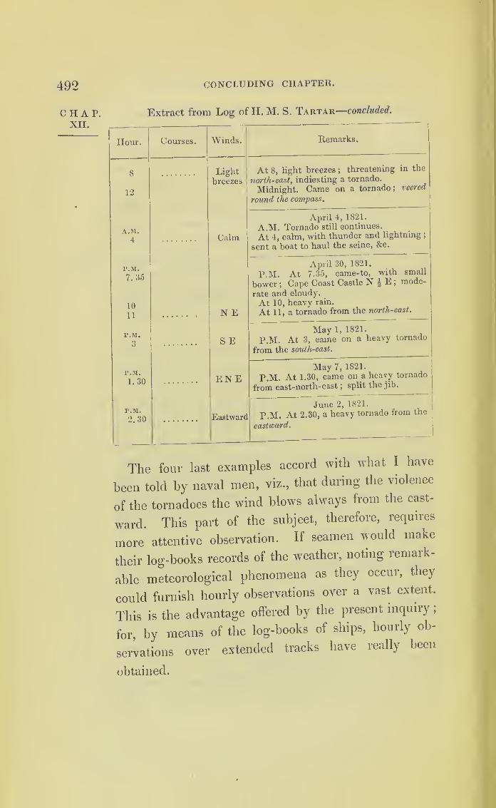
492 CONCLUDING CHAPTER.
CHAP.XII.
Extract from Log of H. M. S. Tartar—concluded.
Hour. Courses. Winds. Remarks.
8
12
Lightbreezes
At 8, light breezes ;threatening in the
north-east, indicating a tornado.
Midnight. Came on a tornado; veered
round the compass.
A.M.
4 Calm
April 4, 1821.
A.M. Tornado still continues.
At 4, calm, with thunder and lightning ;
sent a boat to haul the seine, &c.
P.M.
7.35
10
11 N E
April 30, 1821.
P.M. At 7.35, came-to, with small
bower ;Cape Coast Castle N £ E ;
mode-
rate and cloudy.
At 10, heavy rain.
At 11, a tornado from the north-east.
P.M.
3 S EMay 1, 1821.
P.M. At 3, came on a heavy tornado
from the south-east.
P.M.
1.30 ENEMay 7, 1821.
P.M. At 1.30, came on a heavy tornado
from east-north-east ;split the jib.
P.M.
2.30 Eastward
June 2, 1821.i
P.M. At 2.30, a heavy tornado from the
eastward.
The four last examples accord with what I have
been told by naval men, viz., that during the violence
of the tornadoes the wind blows always from the east-
ward. This part of the subject, therefore, requires
more attentive observation. If seamen would make
their log-books records of the weather, noting remark-
able meteorological phenomena as they occur, they
could furnish hourly observations over a vast extent.
This is the advantage offered by the present inquiiy
,
for, by means of the log-books of ships, hourly ob-
servations over extended tracks have really been
obtained.
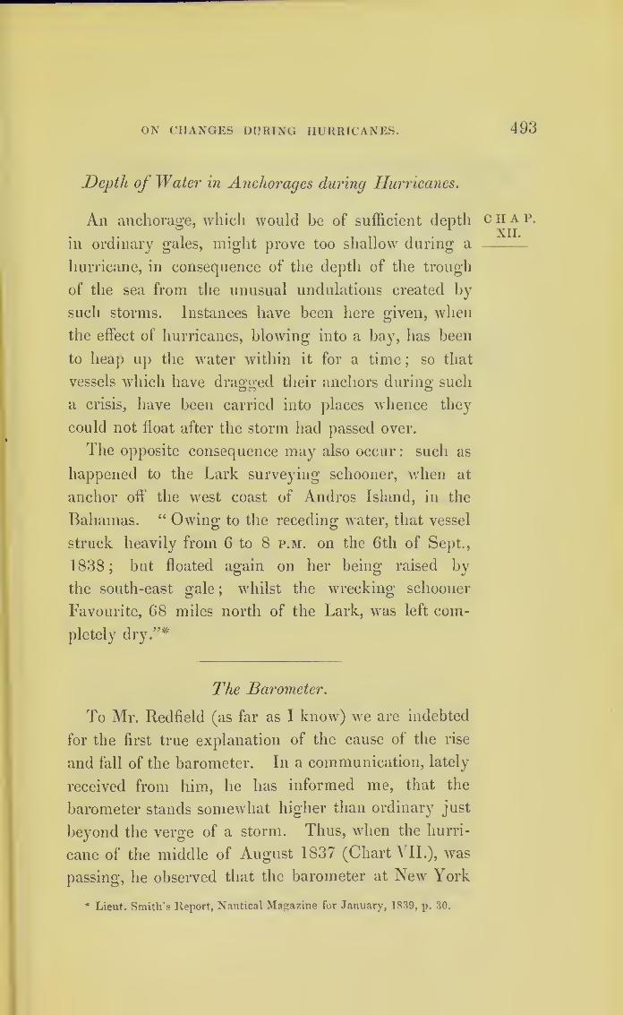
ON CHANGES DURING HURRICANES. 493
Depth oj Water in Anchorages during Hurricanes.
An anchorage, which would be of sufficient depth
in ordinary gales, might prove too shallow during a
hurricane, in consequence of the depth of the trough
of the sea from the unusual undulations created by
such storms. Instances have been here given, when
the effect of hurricanes, blowing into a bay, lias been
to heap up the water within it for a time; so that
vessels which have dragged their anchors during such
a crisis, have been carried into places whence they
could not float after the storm had passed over.
The opposite consequence may also occur: such as
happened to the Lark surveying schooner, when at
anchor oft' the west coast of Andros Island, in the
Bahamas. “ Owing to the receding water, that vessel
struck heavily from 6 to 8 p.m. on the 6th of Sept.,
1838 ;but floated again on her being raised by
the south-east gale;
whilst the wrecking schooner
Favourite, 68 miles north of the Lark, was left com-
pletely dry.”*
The Barometer.
To Mr. Redfield (as far as I know) we are indebted
for the first true explanation of the cause of the rise
and fall of the barometer. In a communication, lately
received from him, he has informed me, that the
barometer stands somewhat higher than ordinary just
beyond the verge of a storm. Thus, when the hurri-
cane of the middle of August 1837 (Chart A II.), was
passing, he observed that the barometer at New York
* Lieut. Smith’s Report, Nautical Magazine for January, 1839, p. 30.
CHAP.XII.

494 CONCLUDING CHAPTER.
CHAP.XII.
was considerably above 30 inches. Captain Leith s
position in the Bahama Channel, in the Seringapatam
frigate, will be found engraved on the same Chart;
and I here add an extract from her log-book, which
appears to confirm Mr. Redfield’s remark. The baio-
meter of the Seringapatam stood above thirty inches
on the day the Calypso was upset, not very far from
her ;and it fell to 29.6 as the ship stood to the south-
ward, and the storm went off towards the north.
Extract from the Log of H.M.S. Seringapatam, on her Voyage
between Nassau, New Providence, and Havannah, in Aug. 1S37.
Hour. Wind. Bar. Remarks.
A.M. Northand N by E
30.2
August 15, 1837.
A.M. Moderate and fine weather.
Lat. 25° 25' N, long. 77° 28' W.
A.M. N W by N 30.0
August 16, 1837.
A.M. Eresh breezes and cloudy ;sent
top-gallant-masts on deck, &c.
A.M. WNW 30.2
August 17, 1837.
A.M. First part ;fresh breezes and hazy
;
latter part, moderate and fine.
29.6
August 18, 1837
.
A.M. Moderate and fine ;wind variable.
-
Unfortunately, the barometer is supposed to foretell
bad weather, whereas it only indicates that a physical
change in the atmosphere has actually occurred ;but
this may be the beginning of a storm : from what has
just been stated, it will be understood that to mark
the words “ set fair," usually marked on barometers, is
to bring this valuable instrument into disrepute, and
instrument-makers should leave off the practice.x
* Whatever Mr. Redfield has written on Meteorology deserves to be read
with attention. The following list of what he has published is taken from a
paper of his own in the English Nautical Magazine for January, 1839.

TIIE BAROMETER. 495
The gusts and squalls in the midst of the storms are chap.
features of great interest, towards which attention was
suggested in the first chapter of this inquiry. These
phenomena explain Mr. Daniell’s observations, in the
paper published in the “ Philosophical Transactions of
1832,” on the Water Barometer of the Royal Society,
constructed by himself. Mr. Daniell says,
—
“ It is extremely curious to watch its action in Water
windy weather; the column of water appears to be in of the
perpetual motion, resembling the slow action of respi- Sodety.
ration. During a gale of wind, on the 16tli of Novem-
ber, 1830, I made the following observations :
—
Time.
Thermometer. WaterBarometer
in
Inches.
MercurialBarometer
in
Inches.Internal. External.
h. m. O O
2 30 56 55.5 387. 87 29. 092
2 45 .... • • . . 387. 59 29. 090
3 0 .... .... 387.44 29. 090
3 15 . . • • .... 387. 28 29. 090
4 0 .... .... 387.64 29. 090
4 15 .... — 387. 85 29. 090
“ About half-past two, the maximum range of the
oscillations was about 0.28 of an inch; about half an
hour later, one gust of wind caused an oscillation of
0.43 of an inch;and the minor oscillations were gene-
rally nearer the lower than the higher extreme. At
“Silliman’s Journal for April, 1831, Vol. xx. p. 17
—
51. See also Vol. xx.
p. 191—193; Blunt’s Am. Coast Pilot, 12th Edition, tfuly, 1833, p. 626— 629;
Silliman’s Journal, vol. xxv. p. 114—135; vol. xxviii. p. 310—318; xxxi.
p. 115— 130; xxxiii. p. 50—65 and 261—265; Jour. Franklin Inst. vol. xix.
Feb. 1837, p. 112— 127 ;Am. Coast Pilot, 13th Edition; Jamieson’s Edin-
burgh Journal, Feb.—April, 1838.”

CONCLUDING CHAPTEK.
four o’clock the movement became sensibly less in
extent, and the mean point of the oscillation began to
rise, and, as I ventured to predict, the wind very soon
began to abate. It became very suddenly calm, and
the next day was very fine.”
Mr. Daniell next states, that the water barometer
precedes the mercurial barometer, in its indications, by
one hour. The fact probably is, that the watei baio-
meter being more than thirty feet high, shows us
those small changes which the mercurial barometer,
only about three feet high, does not record. The true
value of the sympiesometer is its approach to the deli-
cacy of the water barometer. The latter instrument is
now out of order;but Mr. Daniell concludes his paper
by stating, that should the Council of the Royal Society
hereafter come to the conclusion that there is enough
of interest in the subject to induce them to prosecute
it further, he is of opinion that the instrument may be
reboiled and resealed, without much risk. If it were
only for the purpose of showing us something more
of the nature of gusts and squalls, it would be^ very
desirable to restore this fine instrument to its efficient
state.
If further reasons still were wanting to show the
importance of frequently observing and recording the
variations of the barometer and sympiesometer whilst
at sea, they might be supplied from a statement re-
ceived from Mr. George Hepburn, master of the
barque Felicity, of Greenock. (See the first part of the
hurricane on Chart VII.) On the morning of the 13th
of August, 1837, he found the sympiesometer down at
28.50 inches, with the ship at the time under sky-sails
and studding-sails. Hurrying on deck he furled all
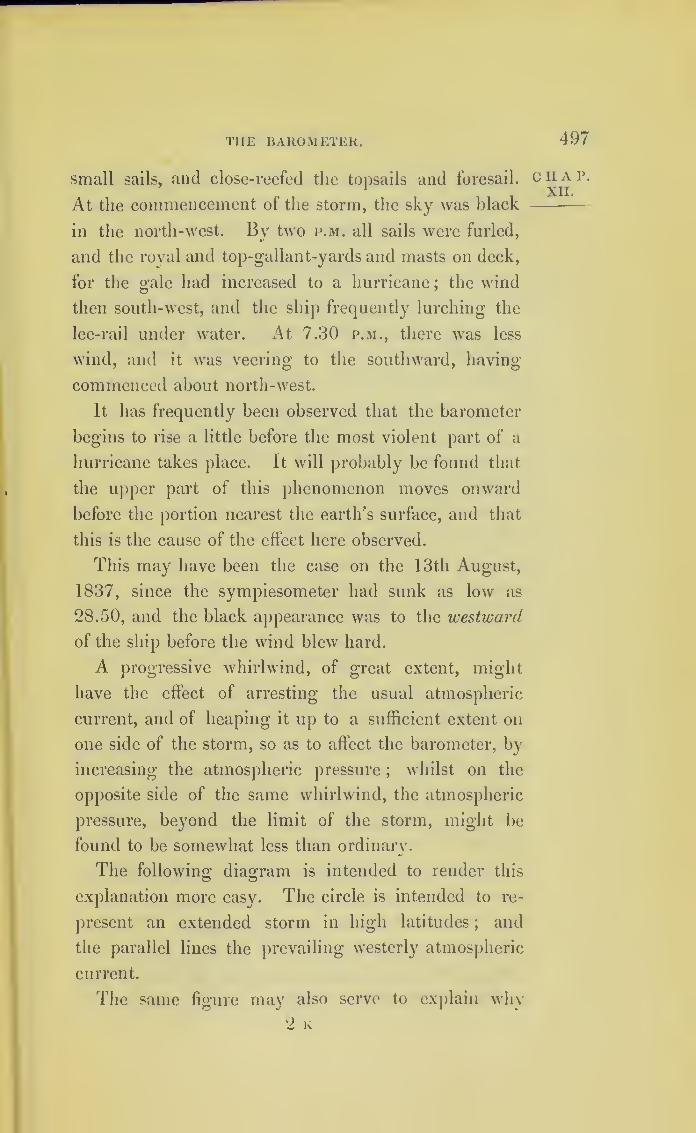
THE BAROMETER. 497
small sails, and close-reefed the topsails and foresail.
At the commencement of the storm, the sky was black
in the north-west. By two p.m. all sails were furled,
and the royal and top-gallant-yards and masts on deck,
for the gale had increased to a hurricane;the wind
then south-west, and the ship frequently lurching the
lee-rail under water. At 7.30 p.m., there was less
wind, and it was veering to the southward, having
commenced about north-west.
It has frequently been observed that the barometer
begins to rise a little before the most violent part of a
hurricane takes place. It will probably be found that
the upper part of this phenomenon moves onward
before the portion nearest the earth’s surface, and that
this is the cause of the effect here observed.
This may have been the case on the 13th August,
1837, since the sympiesometer had sunk as low as
28.50, and the black appearance was to the westward
of the ship before the wind blew hard.
A progressive whirlwind, of great extent, might
have the effect of arresting the usual atmospheric
current, and of heaping it up to a sufficient extent on
one side of the storm, so as to affect the barometer, by
increasing the atmospheric pressure;
whilst on the
opposite side of the same whirlwind, the atmospheric
pressure, beyond the limit of the storm, might be
found to be somewhat less than ordinary.
The following diagram is intended to render this
explanation more easy. The circle is intended to re-
present an extended storm in high latitudes;
and
the parallel lines the prevailing westerly atmospheric
current.
The same figure may also serve to explain why
CHAP.XII.

498 CONCLUDING CHAPTER.
chap, progressive revolving storms are often preceded byXIL
calms ;and why a rise in the barometer may some-
times precede the setting in of a storm.
—
>
Every policy of insurance should bind the owners
or masters of a ship insured to provide a barometer :
and the protest should show that the barometer was
registered at least once during every watch. But it
ought to be registered oftener;and, within the tropics
during the hurricane season, every time the log is
heaved.
Many of the sympiesometers are made too short
;
for which reason this sensitive and valuable instrument
may fail at the moment it is most wanted. Thus, the
oil of the sympiesometer of H. M. brig Racer, com-
manded by Captain James Hope, on the 29th of Sep-
tember, 1837, retired altogether from the column into

TI1K SYMPIESOMETER. 499
the well;and then a bubbling was observed through c ^ai\
the oil, which was no doubt the escape of the hydrogen —gas, owing to the high temperature and diminished
atmospheric pressure acting conjointly. The number
12 had been entered on the log-board to denote the
wind’s force. Soon after this, though under bare poles
at the time, the Racer upset, and was only saved by
her masts giving way in about twrn minutes. She was
running at the time, with the wind tw7o points abaft
the beam on the starboard side, and she went over
until her tops struck the waves. It is supposed to
have been the sea, rather than the wind, which upset
the Racer, for she was struck by a second wave before
she recovered the lurch caused by the first. Her
ballast had also been diminished as her water was
nearly out, having at the time only eleven tons in-
stead of forty-four. This show's the value of the
precaution some naval officers adopt, of filling the
iron water-tanks with salt water as the fresh is ex-
pended.
The barometer will enable us to distinguish that
deceitful calm, which is only a lull in the midst of a
storm, from a calm arising from other causes;since
the barometer stands lowest near the centre of a
storm. On the contrary, when the barometer stands
unusually high, and a calm ensues, such a calm may
be the prelude to a gale; but a ship would then be
upon the verge of a storm, instead of in its centre.
Calms.
Calms will probably be found to be intimately con-
nected with gales; for a rotatory storm must no doubt
2 k 2

500 CONCLUDING CHAPTER.
chat, influence the atmosphere around it. J hus if a sli
i
XII » in high northern latitudes were on the east or north-
east side of a storm coming from the west, we might
expect the prevailing westerly wind to be suspended,
and a calm to ensue, until a southerly breeze should
give tlie next indication of an approaching gale, which
a fall of the barometer would confirm.
If, however (being still on the east side), a ship
should happen to be opposite to, and first fall into
that portion of a gale which is nearest to the equator,
and in which the wind blows westerly, then instead oi
a calm, the westerly breeze (if such previously pre-
vailed) would probably increase;the appearance ol
the weather might threaten a storm;the barometer
sink a little, and the wind even blow hard from the
westward;but if such a breeze should be found to veer,
then the barometer might be expected to rise after the
wind became due west, and soon afterwards to abate
to its former force.
In south latitude this order would be reversed.
The calms which are so frequent on the borders ol
the trade winds, and those light and fluctuating winds,
about the 30th degree of latitude, termed “ The Vari-
ables,” seem to be owing to such causes as those just
mentioned. 1 he trade winds might tlieie prevail,
were it not that rotatory gales, moving eastward be-
tween the 30th and 40th degrees of latitude, extend
their influence within the limits usually assigned to
these variable winds, and, balancing the easteily
breeze, first cause calms, and then reverse the wind.
501
Diminished Atmospheric Pressure.
It lias been stated, at page 42, Chap. IV., that the
diminished atmospheric pressure in hurricanes may
be one of the causes of great inundations during
storms;and I regard this as a very curious field of
inquiry.
In most detailed accounts of great hurricanes near
the sea, statements are found of extraordinary high
tides occurring at the time. We read instances of
great disaster from inundation, which lead to the
belief such occurrences could not take place without
the agency of some very powerful cause yet unex-
plained. Thus, on the 21st of October, 1831, three
hundred villages, with ten thousand inhabitants, were
swept away by an inundation at the mouth of the
Hooghly. And, on the 21st of May, 1833, near the
same place, when the sea rose several feet higher than
is reported in the gale of 1831, it is stated, in the
“ Asiatic Journal ” of November, 1833, that fifty thou-
sand people were drowned.
We have the authority of the learned secretary of
the Bengal Asiatic Society, Mr. James Prinsep, for
observations that, at this time, the barometer fell
upwards of two inches;and that the oil in the sym-
piesometer retired entirely from the tube.
The Intendant of Martinique, in making his report
upon that island to the French government, in 1780,
says, “ the sea was more destructive than the wind;
in the suburb of St. Pierre the surf rose twenty-five
feet.” And in the same report, speaking of St. Vin-
cent, which then belonged to the French, he says,
C II A 1\
XII.

502 CONCLUDING CHAPTER.
CHAP.XII.
“ Jn Kingston, out of six hundred houses, only fourteen
were left.” The Jamaica reports state, that in that
year Savanna-la-Mar was entirely submerged.
At St. Vincent, in 1833, various marks on the
shore, showing that the sea had risen twelve feet
during; the hurricane ol 1831, and overflowed the
roads below that level, remained distinctly visible.
From the narratives of Mr. Williams, it is seen that
similar effects occur in the South Sea Islands. He
states that, after having moved his vessel forty or fifty
yards from the sea, to what he thought a place of
security, the sea notwithstanding reached it, and lifted
the vessel several feet.
During the Bermuda hurricane in 1839, the sea
was observed to rise more than two feet higher than
usual at a spot which was not only on the leeward side
of the island, but within the camber of the dock-yard ;
neither did the tide at this place ebb as usual.
I was told by Sir Thomas Hastings, that he had
observed the ebbing tide in Portsmouth harbour sus-
pended during a rapid fall of the barometer, and begin
again to flow;which he ascribed to the influence of
diminished atmospheric pressure. A fall of two inches
in the barometer indicates a diminution of a fifteenth
part of the atmospheric pressure, which would cause
water to rise a little more than two feet.
If a revolving power, like a whirlwind, were the
only one exerted, it might be expected that the level
of the water would be diminished at the centre of the
vortex, though heaped up towards the verge of the
storm. But it may be possible, that a wave of a
round or oval form, moving onward like a tidal wave,
but at the rate of the storm’s progress, may accompany

DIMINISHED ATMOSPHERIC PRESSURE. 503
the storm in its course, and that its height may depend
on the degree of atmospheric pressure, modified by
the revolving power of the wind. The impulse in the
direction of the storm’s course being given, and main-
tained for a few hundred miles, currents, very similar
to the ordinary currents of the tidal wave, might be
created : so that if the effect produced by such a wave
is added to the spring-tides, it might assist in causing
those inundations in flat lands which often occur in
violent storms. It will, therefore, be very desirable
to note the height to which the tides rise on the lee-
ward side of islands, particularly those lying at a
distance from and uninfluenced by continents.
After the storm of September, 1839, Mr. Hurst, of
the brigantine Queen Victoria (whose place is marked
in the chart), found the current of the Gulf Stream
neutralized : and the same commander, on another
occasion, found the current running to the westward;
a fact corroborated by other printed statements at the
time.
The storm of 1839, when crossing the Gulf Stream,
was probably five hundred miles in diameter; and a
diminished pressure, amounting to a fifteenth part of
the atmosphere, at the centre of a moving circle of this
extent, seems adecpiate either to arrest or to accelerate
existing currents, or create new ones.
The width of the Bay of Bengal, contracting gra-
dually, does not much exceed half the circumference
of the greatest storms on the 20th degree of north
latitude, so that an attendant wave, during a great
hurricane coming from the south, might be expected
to deluge the low countries at tiie mouths of the
( ianges.
CHAP.XII.

504 ROLLERS AT ST. HELENA AND ASCENSION.
CHAP.XII.
This part of the subject deserves the attention of
engineers, whilst constructing breakwaters in the sea.
Rollers at St. Helena and Ascension.
At the island of Ascension, as well as St. Helena,
there are no storms;but at both these places a very
heavy swell occasionally sets in, which the inhabitants
call “ rollers.”
These rollers are said to come from leeward, which
is there the north-westward. There has been much
speculation as to what can cause this sudden swell of
the sea ; some believing it to be owing to volcanic
action, and others supposing it to be the ground swell
occasioned by distant storms. It is said that the
rollers not unfrequently continue for a whole day.
In the narrative of Mr. Williams (a missionary in
the South Seas), a similar swell of the sea is described.
Speaking of Tahiti, he says,—“ Mostly once, and fre-
quently twice in the year, a very heavy sea rolls over
the reef, and bursts with great violence on the shore :
but the most remarkable feature, in the periodical high
sea, is, that it invariably comes from "west, or south-
west, which is the opposite direction to that from which
the trade-wind blows. The eastern sides of these islands
are, I believe, uninjured by these inundations.”
When the swell, proceeding from a hurricane, rolls
against the east side of an island, within the tropics,
some part of the storm which causes it will usually
pass over that island : but a distant storm may pass
on either side, sending only its swell upon the shore.
It should be observed whether these rollers, by

RIPPLES. 505
setting in during the season of hurricanes, are con-
nected with them;for if connected with the seasons,
they cannot be volcanic. The exact direction from
whence the swell comes at its beginning, as well as at
its end, should be noted;
for if the swell be caused
by passing storms, it will assist us in approximating
to the direction in which the storms pass, and be a
guide in searching for vessels which may have en-
countered them.
Ripplings in the Straits of Malacca*
A disturbance of the surface of the sea of a different
kind has been observed in the Straits of Malacca, which
is not easily accounted for;
and I shall here insert
Horsburgh’s description of it, in the hope that it may
create inquiry and observation.
“ In the entrance of Malacca Strait, near the Nicobar and
Aclien Islands, and betwixt them and Junkseylon, there are
often very strong ripplings, particularly in the south-wrest mon-
soon;
these are alarming to persons unacquainted with them,
for the broken water makes a great noise when a ship is passing
through the ripplings in the night. In most places, ripplings
are thought to be produced by strong currents, but here they
are frequently seen when there is no perceptible current.
Although there is often no perceptible current experienced, so
as to produce an error in the course and distance sailed, yet the
surface of the w'ater is impelled forward by some undiscovered
cause. The ripplings are seen, in calm weather, approaching
from a distance, and in the night their noise is heard a con-
siderable time before they come near; they beat against the
sides of a ship with great violence, and pass on, the spray some-
times coming on deck;and a small boat could not alw ays resist
the turbulence of these remarkable ripplings.”
* See page 7 “Progress of the Development of the Law of Storms,” for
further observations on this curious subject.
CHAP.XII.
506 CONCLUDING CHAPTER.
CHAT.XII.
The following is an account of the ripples in the
Straits of Malacca, which were met with by Captain
Basil Hall, R.N. :—
“In H.M.S. Minden, in September, 1834, we just noticed the
ripples, when about half-way between Poolo-Penaug and the
Nicobar Islands; and they continued from that place to the
passage between Nicobar and Poolo-Way, off the north end ol
Sumatra.
“ They were always of several miles in length, and in general
from two to three and four hundred yards across; they stretched
from the northward to the southward;
and they all proceeded
towards the east and north-east. The ripple has much the
appearance of a flat sandy shore, just covered by the water, and
breaking to a considerable distance from the beach. The waves
curl and break uniformly towards the east or north-east, that is
towards the point of the compass to which the whole ripple is
advancing. There is this difference between the ripple and the
breaking on the flat shore, alluded to above, viz., that the ripple
has not such long equal waves, but breaks shorter, and splashes
the water up, in a manner different from that produced by the
regular curl and dash of the beach wave. It has moie theo
appearance of a ‘ race.’
“They differ very much in the magnitude of their waves.
Some are quite gentle, and scarcely whiten the surface, and
create only a low noise;
others foam and dash, so as to shake
the ship very sensibly, and even to throw the water up many
feet. The noise of these is considerable, and is heard at night
from some distance. As we approached the line joining the
Achen and Nicobar Islands, the ripples became more frequent
and violent. On the 5th of September, one passed us every
quarter of an hour, on an average. The wind during the days
on which these phenomena were most remarkable, was between
east and north-east, very light, and shifting about. By means
of chronometers and good latitudes, the ship appeared to have
been set to the north west, somewhat less than one mile an
hour (0.79 miles N.W. by W.). There was no bottom at eighty
fathoms.,
“The following attendant circumstance is curious. On the
evening of the 3rd of Sept., the wind was very light from north-
east by north. The ship s head west-south-west, and the rate
of sailing U miles an hour. It was remarked, that whenever
RIPPLINGS IN THE STRAITS OF MALACCA. 507
the ripple touched the ship, or rather when the ship was com-
pletely in it, the wind uniformly freshened. Upon watching this
phenomenon, it was distinctly made out, that, at the same time
with the wind’s freshening, a change occurred in its direction.
Before entering the ripple, the wind was north-east by north.
‘ On entering it, it appeared to blow from about north. The
exact difference in the angle could not be ascertained, though a
considerable difference was manifest.’”
Captain Basil Hall is of opinion that this might only
have been an apparent shift of wind, caused by the
ship drifting in the current.
For the following I am indebted to an officer of the
Royal Navy
:
—“Between the years of 1829 and 1833, I was attached to
Mauritius and its dependencies, in two brigs (the Jaseur and
Badger), and whilst cruising amongst the various coral islands
between Madagascar, about 72° east longitude, within the tropics,
I have more than once passed through a complete circle of
breakers, having the appearance of a reef of rocks, generally
in a moderate breeze, and the spray was thrown over, so as
slightly to wet the deck;
the centre of this circle was perfectly
smooth and free from the least swell even, giving one the idea
of a boiling cauldron or a whirlpool, such as is formed by water
being forced from under the gate of a mill-pond, having a
diameter of from one to two miles : as far as I can remember,
no one attempted to account for these at the time, but all
appeared to look upon it as a most extraordinary and inex-
plicable wonder.
(Signed) “ F. L. BARNARD.”
Naval officers, who have often seen these ripplings,
represent them as being met with out of soundings,
and in other localities besides the Straits of Malacca.
These ripples are said to be obliterated by such a
breeze as would carry a ship two knots an hour, with
sky-sails set.
The great height to which the salt water of the sea
is sometimes carried up into the air, whether by the
chap.XII.
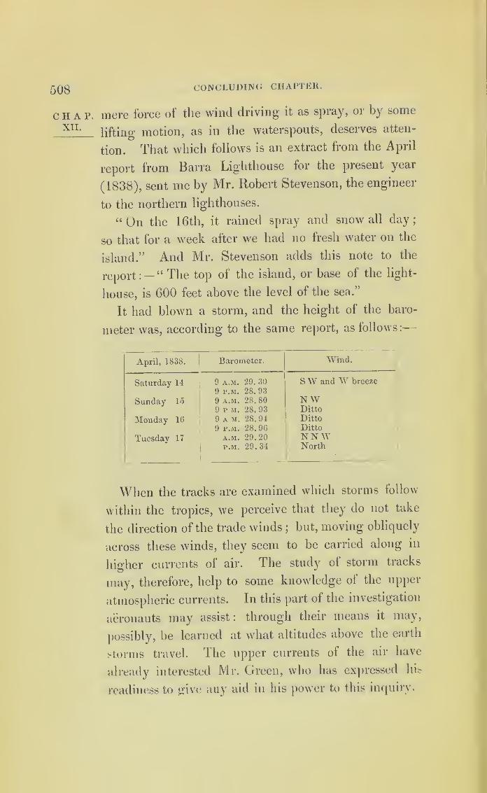
508 CONCLUDING CHAPTER.
CHAP.XII.
mere force of the wind driving it as spray, or by some
lifting motion, as in the waterspouts, deserves atten-
tion. That which follows is an extract from the April
report from Barra Lighthouse for the present year
(1838), sent me by Mr. Robert Stevenson, the engineer
to the northern lighthouses.
“On the 16th, it rained spray and snow all day;
so that for a week after we had no fresh water on the
island.” And Mr. Stevenson adds this note to the
report :— “ The top of the island, or base of the light-
house, is 600 feet above the level of the sea.”
It had blown a storm, and the height of the baro-
meter was, according to the same report, as follows:—
April, 1S38. Barometer. Wind.
Saturday 14
Sunday 15
Monday 16
Tuesday 17
9 a.m. 29. 30
9 p.m. 28. 93
9 a.m. 28. 80
9 r M. 28. 93
9 a m. 28.94
9 p.m. 28. 96a.m. 29.20p.m. 29.34
SW and W breeze
N WDittoDittoDitto
NNWNorth
•
When the tracks are examined which storms follow
within the tropics, we perceive that they do not take
the direction of the trade winds;
but, moving obliquely
across these winds, they seem to be carried along in
higher currents of air. The study of storm tracks
may, therefore, help to some knowledge of the upper
atmospheric currents. In this part of the investigation
aeronauts may assist: through their means it may,
possibly, be learned at what altitudes above the earth
storms travel. The upper currents of the air have
already interested Mr. Green, who lias expressed his
readiness to give any aid in his power to this inquiry.

RULE FOR LAYING SHIPS TO IN HURRICANES. 509
During a gale in the North Atlantic, about lat. 40°,
in a ship hove-to, on the clouds breaking sufficiently
to see through the lower ones, 1 observed the upper
light clouds in a quiescent state, as if the storm was
confined to an altitude little above the surface of the
globe.
Rule for Laying Ships to in Hurricanes.*
That tack on which a ship should be laid-to in a
hurricane has hitherto been a problem to be solved
;
and is one which seamen have long considered im-
portant to have explained.
In these tempests, when a vessel is lying- to, and
the wind veers by the ship’s head, she is in danger of
getting sternway, even when no sail is set;
for in a
hurricane the wind’s force upon the masts and yards
alone will produce this effect, should the wind veer
ahead;
and it is supposed that vessels have often
foundered from this cause.
When the wind veers aft, as it is called, or by the
stern, this danger is avoided; and a ship then comes up
to the wind, instead of having to break off from it.
If great storms obey fixed laws, and the explanation
given of them in this work be the true one, then the
rule for laying a ship to follows like the corollary to a
problem already solved.
In order to define the two sides of a storm, that side
will be here called the right-hand semicircle which is
on the right of the storm’s course, as we look in the
* In “The Progress of the Development of the Law of Storms” this ruleis carried out further. It is there shown that the port tack leads a shipwhen north of the equator towards the storm’s vortex
;and that the star-
board tack leads a ship when south of the equator towards the storm’svortex.
CHAP.XII.

510 CONCLUDING CHAPTER.
C H A P.
XII.
direction in which it is moving'; just as we speak ot
the right bank of a river.
The rule for laying a ship to will be, when in the
right-hand semicircle, to heave-to on the starboard
tack; and when in the left-hand semicircle, on the
larboard tack, in both hemispheres.
The first of two figures inserted here is intended to
represent one of the West Indian hunicanes, moving
towards the north-west by north, in the dnection of
the spear drawn obliquely. The commander of a ship
can ascertain what part of a circular storm he is lulling
into by observing how the wind begins to veer. Thus,
in the first figure, the ship which falls into the left-
hand semicircle would receive the wind at fiist about
east by north;but it would soon veer to east, as the
storm passes onwards. The ship which falls into the
left-hand semicircle would at first receive the wind at
north-east; but with this latter ship, instead ot \eeiing
towards east, it would veer towards north.
The explanation of the rule will best be made out
by attentively inspecting the two figures. In both,
the black ships are on the proper tacks;
the white
ships being on the wrong ones.
The second figure is intended to represent one of
those hurricanes in south latitude which pass neai
Mauritius, proceeding to the south-westward. The
whirlwind is supposed to be passing over the vessels
in the direction of the spear head. It will be seen that
the black ships are always coming up, and the white
ships always breaking off; and that they are on oppo-
site tacks on opposite sides of the circles. Thus, the
Astrea, commanded by the late Sir C. Schomberg,
was on the proper tack on the 20th of March, 1811,

RULES FOR LAYING SHIPS TO IN HURRICANES. 511
Proper North
,
and Wind East.
C II AXII.
3s'a. a
a-
>§
Ship on
Larboard
Tack.
Ship on
Starboard
Tack.
Figurefor thenorthernhemi-sphere.
Proper North,
and Wind West.
Figure _
for the
southernhemi-sphere.
Proper South,
and Wind East.
512 CONCLUDING CHAPTER.
CHAP.XII.
Practical
observa-tions.
and an inspection of the log of that ship, at page 24G,
will show how gradually she came up;
but the Buc-
cleugh, on the 22nd of January, 1834, having had the
wind from east-south-east, veering to south, and then
to south-south-west, thereby proving her to be in the
right-hand semicircle of a storm moving southerly,
was in the wrong position when laid-to on the lar-
board tack. Had she been on the other tack, the
wind in veering would have drawn aft;then, perhaps,
she would not have lain so long “ with her broadside
in the trough of the sea, and with her lee-waist full ot
water.” This will frequently be found to bring a
ship’s head to the sea;
for the wind veers round
faster than the swell changes its direction.
If hurricanes were to move in the opposite course
to that which they have hitherto been found to follow,
then would the rule be reversed;
for the white ships
would come up, and the black ships break off.
It can require no comments to point out, that if the
wind in storms follows a fixed law, much advantage
may be gained by the knowledge of that law.
In following the tracts of storms here detailed, we
find that the hurricane drawn on Chart VI. passed
over the Island of Antigua in six hours. ^ et the
ship Judith and Esther, not far from that island, was
twenty-four hours in the same storm ;for that ship
ran along with it; and many other instances of the
same nature occur in this inquiry.
If one side of a storm be to a ship in her voyage a
foul wind, the opposite side of the same storm would
be a fair one. Thus, within the tropics in the Indian
Ocean, the left-hand semicircle is a fair wind for ships
in their vovages from India to the Cape of Oood Hope,

RULE FOR LAYING SHIPS TO IN HURRICANES. 513
whilst the right-hand side will assist the voyages of
outward-bound ships: but there is this important dif-
ference, that in the first case ships would carry the fair
wind with them; whereas in the other semicircle, owing
to the ship sailing in the contrary direction to the pro-
gression of the gale, she would have the benefit of it
during a short time only. Thus, if a hurricane coming
from the eastward were passing over Mauritius, moving
at the rate of ten miles an hour, and a ship sailing
eastward were to fall into the side of the storm next
the equator, and to run at the rate of ten knots an
hour, the ship and storm would pass each other in
half the time in which the hurricane would pass over
the island, since they would be travelling at the same
rates, but in opposite directions.
In the 12th edition of the “American Coast Pilot”
will be found some practical rules, by Mr. Redficld, ap-
plicable to ships meeting storms in the North Atlantic;
and all I have collected proves that these rules are cor-
rect. That a seaman may be able to apply them, how-
ever, requires that he should study the subject, and
understand the principle.
The annexed note, written in 1842, when at Ber-
muda, is inserted as an instance to show how the
theory of storms may be applied in aid of navigation.
Note on the Winds, as influencing the Courses sailed by Bermuda
Vessels.
In high latitudes the atmospheric currents, when undisturbed,
are westerly, particularly in the winter season. If storms and
gales revolve by a fixed law, and we are able, by studying these
disturbing causes of the usual atmospheric currents, to dis-
tinguish revolving gales, it is likely that voyages may be
shortened.
CHAP.XII.
514 CONCLUDING CHAPTER.
C H A P.
XII.
The indications of a revolving gale are, a descending baro-
meter, with a regularly veering wind.
In a voyage from Bermuda to New York, in the waiter,
strong westerly v*nds, together with the Gulf-stream, would
carry vessels attempting to sail direct to New York to the east-
ward of their course. No doubt all seamen are aware ot this,
and do in consequence make some allowance by keeping to
the westward. But according to the usual practice, on an
east wind overtaking them, they would steer in a direct course
for their destined port, making allowance only for the current,
as the wind would be considered a fair one. If, however, the
o-ale were a revolving one, the wind, at first easterly, would veer
until it became westerly;
and would probably blow from the
westward with increased force, when the vessel would be carried
off her course. It is, therefore, a subject deserving considera-
tion, whether advantage should not be taken of the temporary
east wind in order to run to the westward, nearly as far as the
meridian of Cape Hatteras; so that, in the rest of the voyage to
New York, the chance of reaching that port would be the same
as that of coasting vessels in their voyage from the Carolinas.
But should a dry easterly wind set in, and the barometer
maintain its mean height, or rise above it, the ease would be
altogether different; for these would be indications of a steady
wind and not of a revolving gale. The ship may then be steered
direct for the intended port; and this shows that the lygro-
meter might prove a useful instrument at sea, though not
hitherto used, that I am aware of, in aid of navigation.
Since vessels sailing from Bermuda, and bound to New T ork,
or the Chesapeake, must necessarily cross the Gulf-stream, they
will have the advantage in doing so before that stream begins to
set strongly to the eastward. For this reason, as well as to have
a better chance of getting to the westward, it would seem adv isable
on first leaving Bermuda to make no northing; but if the wind
should at the time blow, for example, from the north-west, to
sail free upon the starboard tack, and to keep on this tack until
the vessel be so far advanced as to fall into the northerly current
of the Gulf-stream ;and this might prove to be the best course to
pursue, even should the ship for a time make southing. e
more southerly the port to be gained, as for example Baltimore
the more does it appear advisable that this should be persevered
in. The same principle of sailing for Boston and even fo
Halifax (though in a much less degree), might be found to be

NOTES ON THE WIN US.
that by which the most certain course would be secured. It CHA 1*.
may appear unreasonable to propose, that a ship bound to a X11 *
port to the northward, should, on leaving Bermuda, steer southerly
;
yet, when we shall be better acquainted with the causes of the
variable winds and their changes, this may really not appear to
be so unreasonable.
For example, towards the end of a revolving gale passing over
Bermuda, the wind may still be vvest, and blowing hard. Since
the courses of such gales are northerly, a ship by steering north
would only continue the longer in the same westerly gale, whereas
by steering southerly a ship and the storm would be moving
in opposite directions, and the vessel would the sooner have the
chance of falling into a new variation of the wind. Sailing
southerly, on the starboard tack, the latter end of such revolving
gales as the one supposed above might (as frequently happens)
veer to the west-north-west and even to north-west, which would
enable a ship to come up and make a better course towards the
west.
These suggestions are offered to practical seamen, in the hope
that some persons will be induced to consider this subject;and,
if gales really revolve, that advantage may be taken of their
mode of action.
In sailing from the West Indies to Bermuda, in the winter
season, the trade wind will generally enable vessels to gain a
meridian sufficiently to the westward, before they leave the lati-
tudes where it usually blows;
and in winter it would seem
desirable to make the 68th or 70th degrees of west longitude,
before leaving the 25th of latitude.
In voyages between Bermuda and Halifax, in the winter
season, the same reasons hold good for keeping to the west-
ward as have been recommended for the passage from the West
Indies to Bermuda, but in a much greater degree;
for in this
latter case there is not the easterly trade wind to carry ships to
the westward. On the contrary, the west wind may blow
throughout, whilst the Gxdf-stream also would tend to set
vessels to the eastward. The degree of westing to be made in
this passage in the different seasons does not seem to be agreed
upon
The chief object, however, of this Note is to point out the
benefit which may be derived from profiting by the east winds,
which blow on the north side of a revolving gale in north latitude,
before the gale shall veer to the westward.
•2 l 2

516 CONCLUDING CHAPTER.
CHAP.XII.
Ships leaving ports in North America for Europe
will have a fair wind when half a storm shall have
passed, for the wind will then become westerly ;and, if
they are bound to the north of Europe, they may run
in the gale and make a rapid voyage. When ships
sail from England the reverse will usually be the case.
If a south-east wind set in, it may veer by the east
towards north-east, and thus be a fair wind also (which
would imply that the centre was passing to the south-
ward);
but if, instead of easterly, the wind should
become more southerly, accompanied with gusts, and
veer rapidly, whilst the barometer should fall fast,
then a gale which would be a foul wind foi ciossing
the Atlantic towards America may be expected to
follow. This difference arises from the storms of high
latitudes in the northern hemisphere having generally
a north-easterly progression.
When storms recurve in either hemisphere, and
cross the tracks of ships, the practical application of
such knowledge as we have gained becomes more
complicated. This will frequently happen to ships on
their homeward voyage from India, and as they cross
the meridians of the islands of Mauritius and Bourbon,
about the 25th degree of south latitude. This may be
a reason why the neighbourhood of these islands is so
much dreaded; for the Mauritius hurricanes, instead of
originating there, appear to come from the eastward.
If two ships, one in each hemisphere, were sailing
west, and each met storms after they had recurved,
the centres of both of which storms were also on the
same parallels of latitude as the ships, the vessel in
north latitude would meet the wind at south, and that
in south latitude would meet the wind at north. Each

NOTES ON THE WINDS. 517
C II A P.
XII.
Quadrantof greatest
danger.
Equator.
518 CONCLUDING CHAPTER.
C H A P.
XII.
ship would be most likely to avoid the stoim by
putting her head towards the equator: but they would
be on opposite tacks. The ship in north latitude
would be on the starboard tack, the ship in south
latitude on the larboard. In both cases the wind
would veer towards west, and both ships would come
up until the storms passed by them, in their progress
towards their proper poles; after which the wind
might be variable.
It is a point which has been often discussed, whether
a ship should scud or not in a hurricane.
In a revolving storm there will be one quadrant in
which it will be more dangerous lor a ship to scud
than in the other three;
that being the one in which
a vessel driven by the wind would be led in advance
of the centre of the storm’s track ;whilst to scud in
the opposite quadrant would tend to lead a ship out of
the hurricane.
The preceding diagram, in which the quadrants ol
greatest danger are shaded, will serve to explain for
both hemispheres what is here meant. Within the
tropics, whilst the course of storms tends towards the
west, the quadrants of greatest danger will be on the
sides of the storm next the poles ;but these quadrants
will gradually change their position as the storms
recurve ;and in high latitudes, after the courses of
storms become easterly, these quadrants will be on
the sides next the equator.
The four East India Company’s ships which foun-
dered in the Culloden’s storm were, from the accounts,
scudding in the most dangerous quadrant of the storm
when last seen.
The storm tracks here traced arc far from sufficient

NOTES ON TI1E WINDS. 519
in number to afford that knowledge of the winds at
which we are now capable of arriving. My object has
been to prove, that the subject deserves the attention
of abler men than myself, and that we have hitherto
studied meteorology in far too confined a sphere.
Since our own country is too limited for the com-
parisons required, nations should combine to study
the atmospheric laws. The lighthouses along the
coasts of the civilized world might exchange their ob-
servations for this end. The great steam navigation
companies might place their log-books where easy
reference could be made to them;and in the Pacific
Ocean many useful observations be made by the large
body of Englishmen settled there as missionaries.
I have much satisfaction in making known what
has been done towards carrying on this investigation,
since the first edition of the work was published;and
it is proper that those who are desirous of further
aiding in the inquiry should be made acquainted
where additional sources for obtaining information
are now opened, and where reports are collecting. 1
am the more desirous of making this publicly known,
because my object throughout has been to endeavour
to induce others to follow up the subject, as one
which can only be greatly advanced by the combined
observations of many.
The Trinity Board, who have always been desirous of
giving every support to the inquiry, have now ordered
more careful observations to be made at the lighthouses.
The Inspector-General of the Coast-guard, Capt.
Bowles, issued orders to the revenue cruisers to keep
hourly observations on the weather, both by night and
day.J
C II A P.
XII.
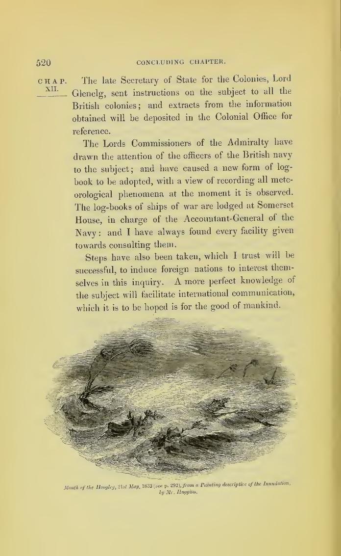
520 CONCLUDING CHAPTER.
chap. The late Secretary of State for the Colonies, LordXIL
Glenelg, sent instructions on the subject to all the
British colonies ;and extracts from the information
obtained will be deposited in the Colonial Office for
reference.
The Lords Commissioners of the Admiralty have
drawn the attention of the officers of the British navy
to the subject;
and have caused a new form of log-
book to be adopted, with a view of recording all mete-
orological phenomena at the moment it is observed.
The log-books of ships of war are lodged at Somerset
House, in charge of the Accountant-General of the
Navy : and I have always found every facility given
towards consulting them.
Steps have also been taken, which I trust will be
successful, to induce foreign nations to interest them-
selves in this inquiry. A more perfect knowledge of
the subject will facilitate international communication,
which it is to be hoped is for the good of mankind.
Mouth of the Huoglcy, 2Dt May, 1833 (see p. m\from a Painting descriptive of the Inundation,
by Mr. Huggins.
5*21
APPENDIX.
POPULAR EXPLANATION OF THE BAROMETER ANDSYMPIESOMETER.
The barometer is a measure for the weight of the atmosphere,
or its pressure on the surface of the globe. It is well knownthat it is owing to the atmospheric pressure that water rises in
a common pump, after the air has been drawn from the barrel
;
but that the height to which it can be raised by this means
is limited, and not much exceeds thirty feet. A little more
than thirty feet of water, therefore, balances the atmosphere.
Mercury being about twelve times heavier than water, about
thirty inches of mercury will also counterpoise the atmosphere.
The principle of the barometer is simple. If a tube, about three
feet long, closed at one end and open at the other, be filled with
mercury, and, with the open end stopped by a finger, this tube
be reversed, and placed upright in a cup partly filled with the
same liquid, the mercury in the tube, in ordinary states of the
weather, will descend to thirty inches, measured from the surface
of the fluid in the cup, and not much lower. The mercury is
sustained in the tube by the pressure of the atmosphere on the
surface of the fluid in the cup. Such a tube and cup, so filled,
would in fact be a barometerjand if a moveable index were
added to it, this simple instrument would indicate the changes
which take place in the atmospheric pressure. The sympieso-
meter is a more delicate instrument for measuring the atmo-
spheric pressure;but it is also a more complicated one than the
mercurial barometer, and it would be best understood by in-
spection. The upper part of the tube contains liydrogen-gas,
which is elasticjand the lower part, including the well, contains
oil. By this compound construction, whilst the length of the
tube is less than that of the mercurial barometer, the index, or
scale, for measuring the pressure is increased. Hydrogen-gas
being very sensibly affected by all changes of temperature, the
index, by which the atmospheric pressure is read, requires to be
set according to the actual temperature, before the atmospheric
pressure can be read off.
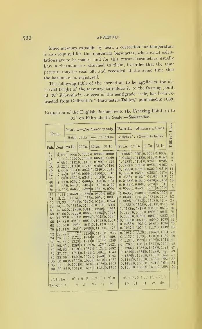
522 APPENDIX.
Since mercury expands by heat, a correction for temperature
is also required for the mercurial barometer, when exact calcu-
lations are to be made; and for this reason barometers usually
have a thermometer attached to them, in order that the tern
perature may be read off, and recorded at the same time that
the barometer is registered.
The following table of the correction to be applied to the ob-
served height of the mercury, to reduce it to the freezing point,
at 32° Fahrenheit, or zero of the centigrade scale, has been ex-
tracted from Galbraith’s “ Barometric Tables,” published in 1833.
Reduction of the English Barometer to the Freezing Point, or to
32° on Fahrenheit’s Scale.—Subtractive.
Temp.
Fah.
O
32
3436
38
4042
44464850
Cent.
Part I.—For Mercury only. Part II.—Mercury & Brass.
Heiaht of the Barom. in Inches.
28 In.
0.
1.
2 .
3*.
4.
5.
6 .
7.
8 .
10 .
52
54
5658
606264
66
68
70
11 .
12 .
13.
14.
15.
16.
17.
18.
20 ,
21 .
727476
788082
8486
8890
00 o.
11 0 .
22 0 .
33 0.
44 0.
55 0.
66|
0 .
77 0.
88b.00 (K
11 o.
22 0 .
33 0.
44 0.
55,0.
66 0 .
77 0.
88 0
00 0 .
11 0 .
29 In.
0000005601120168022402800336039204480504
000000580116017402320290034804060464
30 In.
0522 0
05590615067107270783;0
0838.0
0894j00950 0
1005 0
1061.0
05790637069507530811086809260984.1041
0000006001200180024003000360,0420.0480
. 0540
31 In.
1099 0
22 .
23.
24.
25.
26.
27,
28,
30
31
32
22 0 .
33 0.
44 0.
55 0.
66 0 ,
77 0.
88 0
00 b,
,11 0
,22 0
111711721228
128313391394145015051561
1617
0. 115612141271132913871444
150215591616
0.
0.
0.
0.
0.
0.
0.
0.
o. 1074I0
059906590719077908390898
,09581018
10771137
00000062012401860248031003720434,0496
, 0558
0.06190.06810.07430.0805
08670,09280. 0990
10511113
0. 1175
119612561315
137514341494
, 1553
, 1613
.1672
. 1731
0. 1236
0. 1298
0. 1359
0. 1421
0. 1482
0. 1544
0. 1605
0.16670.17280. 1790
P.P. for !
0°. 4 0°. 8 1°. 2 1°. 6 2°. 0
Temp.F. + 12 24 35 47 59
Height of the Barom. in Inches.
28 In. 29 In.
0. 0088 0.
0.0138 0.
0.01880.0. 0238;0.
0.0288 0.
0.0338 0.
0.0388 0.
0. 0438,0.
0.0488 0.
0.0538 0.
0091
014301940246029803500402045405060558
30 In. 31 In.
0.0588 0.
0.0638 0.
0.0688 0.
0.0738 0.
0.0788 0.
0. 0838b.0.08880.0.0938)0.
0. 0988 0.
0. 1037 0
0. 1087
0. 1137
0. 1187
0.12370. 1286
06090661071307650817086809200971
,1023
. 1075
0. 1336 0
0. 1386
0.14350. 1485
0.1535
1126
117812291281
133213841435
14861538
009401480201
02550309,0362
0416
,0470,0523
.0577
,coc
o
Sc
p
0097015202080263031903740430048505410596
06300684073807910845089809511005
, 1058
,1112
1589b
1165
121812721325
13781432
148515381501
.1644
0652070707620818087309280983
, 1039,1094
,1149
1204
1259131413691424
14791534158916441699
0°. 4 0°. 8 1 °. 2 1 °. 6 2°. 0
10 21 31 42 52
2
5
7
911
12
14
16
17
19
21
2325
26
2830
32
34
36
35
40
42
4445474951
5354
56
APPENDIX 523
The atmosphere is supposed to extend to about the height of
fifty milesj
and its density to diminish from the surface of the
globe upwards, in a geometrical ratio.
Thus when observations are made on land, above the level of
the sea, a correction is required for altitude, since the weight
of the atmosphere diminishes as we ascend. It is owing to this
that we are enabled to determine the height of mountains by
barometers;
and that aeronauts compute the altitude to which
they ascend in balloons.
If any fluid in a cup be put into rapid circular motion, we
should have a representation of the form that portion of the
atmosphere assumes which is within the limits of a storm; the
most depressed part of the fluid would represent the centre of
the gale where the atmospheric pressure is the least.
The principle of the barometer should be explained in all
works on navigation, and in all schools where navigation is
taught.

*
*
GENERAL INDEX.
A.Adelaide (steamer), 433.
Ainsworth, Mr., his memoranda on the
storm of the Euphrates, 470.
Ajax, 291, 297, 336 ;extract from log, 354.
Albemarle, 291, 337 ;extract from log, 347.
Albion, hurricane of the, described, 173,
233 ; extract from log, 237.
Alcmene, 291, 337 ; extract from log, 352.
Alfred Taylor, 447.
Amazon, 291, 297, 337 ; extract from log,
363.
Andromache, 447 ;extract from log, 448.
Andromeda, 291.
Anemometers, Professor Wliewell’s andMr. Osier’s, described, 453.
Angola, 447.
Ann and Minerva (brig), 66.
Anna, 408.
Anne, 233, 234.
Antigua, hurricane at, on Aug. 2, 1837,
60.
Apolachicola, storm at, 124.
Archer, Lieut., his letter on the wreck of
the Phoenix, 299.
Argus, 84.
Ariel, 445.
Astraea, 241, 510 ; extract from log, 246.
Athol, 66, 414.
Atmospheric currents effected by a pro-
gressive wind, with a diagram, 497.
B.Badger, 292 ; extract from log, 294.
Balclutha, 57.
Baltimore, 55.
Barbados, 293, 296, 297.
, hurricane at, in 1831, 24 ; in
Sept. 1835, 35 ;in 1837, 48.
Barlow, 104.
Barnard, Mr. (R.N.), on circles of waternear the Mauritius, 507. -
Barometer, fall of, at Barbados, in 1831, 33.
at Porto Rico, 1837, 63.
, striking results of, in storms,161.
at Macao and Canton, 277., cause of its falling in northern
and southern hemispheres explained, 405.' —
, true explanation of the rise
and fall of the, 493 ;importance of its
indications, 496.
Barometers, state of, during a hurricane at
the Mauritius, 169, 171.
Beaver’s prize, 291.
Beaufort, Capt., his mode of registering
the wind and weather, 458.
Beechey, Capt., his detail of a waterspout,462.
Bell, 66.
Bellerophon, 414.
Bengal, 173.
, hurricanes in the Bay of, 284.
Bermuda, great storm there, of 1780, 341.
, hurricane at, in 1839, 438
;
course of, and detail, 441.
, indications of a coming stormat, 441.
Berwick, 291, 296, 341 ;extracts from log,
322, 390.
Blanche, extracts from log, 19, 128, 291.
Blane, Sir Gilbert, his letter to Dr.Hunter, 347.
Blenheim, 255.
Bonne Aimee, 53.
Bourbon, Isle of, description of a hurricane
at, in 1824, 163.
Boyne, the gale of the, 177 ; extract fromlog, 231.
Bridgewater, hurricane encountered bythe, 260, 271 ;
extract from log, 272.
Brighton chain-pier, effect ofa gale on, 428.
Brilliant, 83.
Bristol, 291, 296, 408 ; extract from log,
381.
Britannia, 13, 282.
Brook, 56.
Bruce, his description of moving pillars of
sand in Nubia, 468.
Buccleuch, 512.
Buckley, Mr. J., remarkable phenomenaseen by, 479.
Burgess, Mr., his observations on whirl-
winds or waterspouts, 467.
C.
Calcutta, 173.
Caledon, 174.
Calms, their connection with gales, 499.
Calypso, 77, 124, 177, 494.
Camelion, 291, 413.
Capper, Col. James, his work on windsand monsoons, 1 ;
whirlwinds described
by, 280.

52G INDEX.
Carlisle Bay, Barbados, storm in 1835, 37.
Castries, 44, 75, 113 ;extract from log,
115.
Ceres, 297.
Ceylon, 233.
Chain bridges, effect ol storms on, 428.
Champion, 35 ;extract from log, 38.
Charles Grant, 271 ;extract from log, 273
Chart I., data for forming, 13.
II 15.
Ill 29.
IV 37.
V., VI., VII 47.
VIII 173.
IX 290.
Chief, 85..
Chinese seas, typhoons in the, -7 1
.
Christiana, 340.
Cleopatra, 446.
Clydesdale, 52, 122.
Cochrane, Capt., his remarks on water-
spouts, 446.
Cceur-de-Lion, 274.
Columbia, 85.
Compass, the mariner’s, 9.
Constante, 297-
Convert, 337, 340 ;extract from log, 374.
Cosmo, 447.
Cossack, 56.
Crocodile, extract from log, 279, 446.
Culloden, the storm of the, 173; extract
from log, 178.
Cumberland, 81.
Cyclops, 332.
D.
Davy, Dr., his account of sand falling in
the Mediterranean, 436.
Deal Castle, 291, 337.
Delos, 86. , . ,
Depth of water in anchorages during hur-
ricanes, 493.
“Devils” in India, whirlwinds so called,
469.
Diagram to show the veering of a storm
over Great Britain, 420.
Diamond, 296, 340 ;extract from log, 311.
Diana, 233, 236.
Diminished atmospheric pressure the cause
of high tides, &C..50L
Donegal, meteorological journal of, 426._
Dove, Professor, his theory of storms in
the two hemispheres, 145, 409.
Drury, Mr., on a whirlwind near Lincoln,
473Duke of Buccleuch, 164 ;
extract from log,
166Manchester, 82 ;
extract from log,
Earthquake, not felt during a hurricane, 31
.
East India Company, their ships in the
storms of 1808 and 1809, 173.
Eastnor, Lord, on some small crabs being
found after rain near lichgate, 482.
Echo, 447.
Eclipse, 241 ;extract from log, 247, 254.
Egmont, 291, 297, 337 ;extract from log,
356.
Electricity, its effects at St. Vincent, 30 ;
at Barbados, 31.
and magnetism, apparent con-
nection of storms with, 490.
Eleonora, 60.
Ellen Mar, 85
.
Emerald, 82, 447.
Emma Eugenia, 164.
Endeavour, 291.
Endymion, 291, 297, 337; extract from
log, 366.
Erie, 69.
Etna, 432.
Euphrates, 175 ;extract from log, 205.
(river), the storm on the, 469.
Euterpe, 439.
Experiment (H.C.S.), 173, 233, 235.
F.
Felicity, 496.
Ferret, 436.
Fielding, Mr., his report on a whirlwind
near Manchester, 474.
Finch, Hon. Capt., his narrative, 365.
Fish, on the fall of, on land, 476.
Florence, 125.
Franklin, Benjamin, his opinion of north-
east storms, 3 ;his letter to Mr. Small,
283.
Franklin (brig), 69.
Fyers, Lieut., on the “devils” in India,
469.
G.
Gales of 1811 at Mauritius, 241.
February, 1838, attempt to trace
them over Ireland and Scotland, 412 ;off
Portugal, 413 ;Gibraltar, 414; North of
Spain, 414.
Ganges, the storm of the, and extract from
log, 266.hurricane at the mouth of the
river, 285.(schooner), 447.
105.York, 30, 286.
E.
Earl St. Vincent, 223 ;extract from log,
227.
Georgia, 57.
Glory, 173, 233.
Governor Finlay (brig), 2/3.
Reid (brig), 443.
Grafton, 296 ;extracts from log, 320, 379.
Grant, 445. .
Captain, on the fall of fish during
rain in India, 484.
Great Western (steamer), 434.
Ground swells explained, 35.

INDEX. 527
H.Hall, Captain Basil, on the ripplings in
the Straits of Malacca, 505.
Harmonie, 82.
Harrier, 173 ;extract from log, 257.
Harriet, 175; extract from log, 201.
Hebe, 41.
Hector, 296 ; extract from log, 326, 384.
Hedderley, Sergeant, his report of a water-
spout at Bermuda, 475.
Height of waves in storms, 41.
Hemispheres, storms revolve differently in
northern and southern, 490.
Henry, 292.
Hester, 446.
Hindley, 82.
Hoogley, hurricane at the mouth of the
river, 287.
Horsburgh, Captain, on the barometer in
different winds, 408.
Ilotham, Admiral, his squadron in a hur-
ricane, 337.
Howard, Mr. Luke, his theory of the op-
posing currents of the atmosphere, 418.
, his views on tornadoes, whirl-
winds, and waterspouts, 471.
Howarth, Mr., his description of a whirl-
wind near Manchester, 472.
Howell (brig), 57.
Huddart, 175; extract from log, 194.
Hurricane at Massachusetts and Connec-ticut in 1821, 11.
, indications of a, 24.
of middle of August, 1837, 74.
of 1837 described, 47.
at the Mauritius, 152.
of 1780, 289.
, the great, of 1780, 337.
I.
Iberia, 414.
Ida, 57 ; extract from log, 98.
Illinois, 1 1 ;extract from master’s letter, 18.
Independence, 148.
India, on the hurricanes in, 271.Indus, 175 ; extract from log, 215.
Inglis, 176.
Instruments for measuring the wind’sforce described, 454.
Inundation by the sea at Darien, 67 ; at
Savannah, 69.
J.
James Busick, 77.
Hay, 84.
Jane Duchess of Gordon, 173.• (schooner), 439.Jason, 152.
Java, 256.
Jennett, 82.
Josephine, 56.
Joseph Porter, 445.
Judith and Esther, 60 : narrative of master,
70.
K.Kensington, extract from log of, 131.
Kent, 274.
King, Captain, on the barometer in dif-
ferent winds, 405.
L.La Blayaise, 439.
Lady Hayes, 278.
Jane Dundas, 173, 177.
Katharine Barham, 83.
Laidinans, 72.
Lancashire, 447.Lark, 457, 493.
Laurel, 291, 338.
Leith (steamer), 435.L’Esle, 297.
Levant, 278.
Lighthouse reports of the gales of Feb.,1838 — Ireland, 420; Scotland, 422;England, 424.
Liverpool (steamer), 434.Log-book, new form of, ordered by the
Admiralty, 520.
Logs ought to be kept in civil time, 9.
London, note from the log of, 286.Lord Nelson (H.C.S.), 175, 233.“ Los Nortes,” of the winds so called, 394.
Lottery, 443.
Lowestoffe, 296, 308, 338 ; extract fromlog, 318.
Lucretia, 447.
Lynch, Capt., on the storm in the Eu-phrates, 470.
Lyons, Capt., on moving pillars of sand in
South America, 469.
M.Mablehead, 56.
Madagascar, 436.
Madonna, 447.
Magicienne, 155, 414.
Magnetic pole, experiment on the, 490.
intensity of the globe, and con-nection with storms, 491.
Malabar, storm on the coast of, 288.
Malcolm, Rear-Admiral, on waterspouts,466.
Margaret, 75.
(mail boat), 445.
Maria, 84, 125.
Maria Jane, 60.
Marquis de Brancas, 297.
, Capt., his ship in a whirlwindoff Malabar, 461.
Martial, 30.
Martinique, French account of the stormthere in 1780, 340.
Mary, 92 ; extract from log, 93.
(Sharp), 81.
Matilda, 479.
Mauritius, storms at, in 1824, 161 ; in1834, 163; in 1836, 169; and in 1811,241.

528 INDEX.
Mecklenburgli, 84.
Mediator, 104.
Melville, 242.
Merchant- ships’ logs, value of, and propo-
sal to preserve them, 417.
Meteorological observations taken at I ort
Louis, Mauritius, in 1836, 171.
journal of H. M. S. Donegal
at Lisbon, in Feb. 1838, 426._
Meteorology, necessity for studying, and
means of doing so, 518.
Minden, 504.
Montagu, 291, 297 ; extract from log, 360.
Montreal, 437.
Monument, 56.
Moses, 56.
N.
Neptune, 81 ;hurricane encountered by
the, 261. _
Nereide, 174, 176 ; copy of log of, 187.
Newcastle, 281, 466.
Nightingale, 37 ;extract from log of, 40.
Nisus, 241 ;extract from log of, 245, 252.
Norfolk, 281. ,
North Star, extract from log of, 416.
Northumberland, 175; extract from log
Notes on the winds as influencing the
courses sailed by Bermuda vessels,
513.
O.
Oglethorpe, 85.
Opulence, 67.
Orontes, 466.. . , t
Osier, Mr. Follet, his instrument for
measuring the wind s force, 457.
P.
Palambam, 104. , , ..tPallas, 296, 337; extract from log of, 315.
Parker, Sir Hyde, capt. of the Phoenix on
her wreck, 296. , . .
Rear-Admiral Sir Peter, his des-
patches, 295, 297.
Pelican, 337 ;extract from log, 308.
Penelope, 76 ;extract from log, 95.
Pensacola, 85.
Phoebe, extract from log, 244, 206.
Phoenix, 233, 236, 295, 299._
Policy of insurance, right to bind owners
of ships to provide and register a baro-
meter, 496.
Pomona!’291, 296, 337 ;extract from log,
378.
Porcupine, 296.
Powhatan, 85.
PrestwooL Mr. ,his description of a whirl-
wind near Lincoln, 471.
Princep, Mr. James, his account of the
storm of 21st of May, 1833, 286.
Princess Charlotte, 481.
Louise, 409.
Royal, 298.
Protector, 281.
Providence, 56.
Purves, Rev. Mr., on the fall of salmon
fry during rain in Scotland, 481.
Q.Quadrant of greatest danger during storms,
how to be avoided, and diagram to ex-
plain, 517.
Queen, 408.
Victoria (brig), 503.
R.Racehorse, 174; extracts from log, 190,
242, 254.
Racer, 133, 177, 402, 496; extract from
log, 135.
Raleigh, 177 ;the hurricane of the, 273 ;
extract from log, 275.
Rarotonga, hurricane at, 149.
Rawlins, 75 ;narrative of master of, 90.
Recurving of storms in either hemisphere,
complication on the, 516.
Red-band-fish cast ashore by the undula-
tions of the sea, 415.. .
Redfield, Mr., of New York, his opinion
on hurricanes, 2 ;storms traced by, 10 ;
on storms in the southern hemisphere,
145 ;his data of the Bermuda hurricane
of 1839, 452 ;on the revolving of whirl-
winds, &c., 474.
Resolution, 342.
Revolving of a waterspout at Bermuda
described, 475.
Ringdove, 48 ;extract from log, 138.
Ripplings in the Straits of Malacca, 50o.
Rodney, Adm.,his letters to theAdmiralty,
332 ;his report of the hurricane at Bar-
bados, 345. . ,
Rollers at St. Helena, Ascension, and
Tahiti, 504.
Rosebud, 83.
Roseway (mail-boat), 446.
Rotatory winds not always storms, 43.
Rowley, Adm., a storm overtakes the ship
under his command, 320.
Ruby, 291, 296 ;extracts from log, 331, 389.
Rule for laying ships to in hurricanes, 509 ;
diagrams to explain, 511.
S.
Sailing directions, East India, quoted, 270.
Salamander, extract from log, 37LSalisbury, 281.
. . -
Salt water carried to a great height, 607.
, rain of, during a storm, 508.
Sand, moving pillars of, in Nubia, described
by Bruce, 468; by Capt. Lyons, in South
America, 469.

INDEX. 529
Sand found on board ships in the Medi-terranean during storms, 436.
Savanna-la-Mar hurricane, 292.
Sandwich, 291.
Scarborough, 291, 293, 296, 308.
Scipio, 75, 114.
Scott, 440.
Seagull, 55.
Seringapatam, extract from log, 494.
Seymour, Mr., on the storm of Aug. 1837,
70.
Sheffield, 437.
Sheridan, 82 ; extract from log, 103.
Shrewsbury, 332, 342.
Sir William Bensley, 175 ;extract from
log, 223.
Sketch of the Egmont after the hurricanein 1780, 357.
Snake, 52.
Solano’s storm, 1780, and the winds called“ Los Nortes,” 394.
Sophia, 75 ; account of voyage, 86.
Southern hemisphere, on storms in the,
144.
Sovereign, 175 ; extract from log, 219.
Spanish fleet (Solano’s), in storm of 1780,
397.
detail of the hurricane of 1780,
397.
Spey (packet), extract from log, 58.
Spitfire, 30 ; extract from log, 39.
St. Helena, 84.
St. Lucia, hurricane at, 29.
St. Vincent, 175.
, hurricane at, 29.
Star, extract from log, 370.
Standard (brigantine), 444.
Steam-ships, Great Western and Liver-pool, in the gales of Oct. 28, 1838, 434.
Stirling Castle, 296, 297, 320, 337.
Storm of 28th Oct. 1838, in its courseover England, 431.
Storms traced by Redficld, 10.
originate eastward of West IndiaIslands, 43.
in the southern hemisphere, 144.
may be overtaken by ships, 146.
of 1780, three different ones, 394.
in high latitudes, remarks on the,
403 ;theory and illustrations of, 405.
of 1838, their courses traced on the
Atlantic side, 437 ;and on the Euro-
pean, 427.
Storm-tracks in the tropics, 508.
Stranger, 126.
Surprise, 337.
Suspension-bridge at Montrose destroyed
by a hurricane, 428.
Swan, 414.
Swell, the set of the, a sure test of the
coming wind, 445.
Swift, 413.
Sympiesometer, its value in indications of
storms, 497.
2
T.
Tartar, extract from log, 491.
Terpsichore, 173, 175 ;extract from log,
183.
Terrible, extract from log, 333.
Thalia, 266.
“The variables” of the 30° latitude, 500.
Thunder, 437.
Thunderer, 291, 338.
Tiger, 281.
Tigris (H.C.S.), 233.
(steamer), 469.
Tornadoes described, 280.
on the west coast of Africa,
491 ;wind always from eastward during,
492.
Trident, 291, 296 ; extracts from log, 325,
387.Trinidad, 45.
Triumph, extract from log, 334.
Troubridge, Rear-Admiral, founders in theBlenheim, 256.
Turner, Mr., on some crabs being foundafter rain at Reigate, 483.
Typhoons in the Chinese sea, 271.
, tracks of the, 278.
IT.
Ulrica, 66.
Ulysses, 291, 296, 337 ;extract from log,
376.
Undulations of the sea, effect of, 415.
of waves, progress of esti-
mated, 42.
V.Vatiable winds, the cause of, 3, 47, 119.
Vaughan, Lieut.- General, account sent byhim of the hurricane at Barbados of
1780, 343.
Vengeance, 291, 337 ; extract from log,
350.
Venus, 291, 337 ; extract from log, 373.Victor, 293, 296.
Victoria, 122.
Vigilant, extract from log, 372.
Vincennes, 85.
W.Walker, Mr., on a waterspout in the Bay
of Naples, 476.
Walsingham, Commodore, his ship foun-ders, 338.
Wanstead, 82, 121.
Water barometer of the Royal Society,495 ; compared with the mercurial ba-rometer, 495.
Waterspouts and the smaller whirlwinds,on, 461.
Water Witch (brig), extract from log, 62.Weather, register of, kept at Bermuda,
123 ; weekly reports of, 442.registers of, ought to be kept, 418.
Westbrooke, 101.
M

530 INDEX.
Westchester, 84.
West Indian (barque), extract from log,
97.(Turner), 76; extract from
log, 91.
Weymouth, 281.
Whewell, Rev. Mr., his instrument for
measuring the wind’s force, 453.
Whirlwinds, caused by waterspouts, 463.
Wilkinson, Mr., his narrative of the storm
of Aug. 15, 1837, 77.
William (brig), 67.
IV., 64.
Eitt, extract from log, 198.
Williams, Mr. (London Missionary So-
ciety), narrative of, 149.
William Thompson, 83.
Wind backing, cause of, 411.
Wind, its pressure on one square foot, 458.
Wind and weather, Capt. Beaufort’s
mode of registering, 458.
Winds and moonsoons, description of, byColonel Capper, 280.
Winds, fair and foul, in sailing from Ame-rica, and from England, 515.
Wind’s force, on measuring the, 453.
Wreckers, ships called, in the Gulf of
Florida, 142.
, necessity for controlling them,
142.
Y.Yankee, 82.
Yarrell, Mr., notes by him, on the fall of
fish from the clouds, 477.
York, 282.
THE END
Palmer and Clayton, Printers, Crane-court, Fleet-street.
DIRECTIONS FOR THE BINDER.
The Plates to be cut close to the margin.
To face the Title page .... Circles to assist Seamen in the
practical application of the Law
of Storms.
To face page 1 . . . Chart I.
page 15 . . Chart II.
yy page 25 ... Chart III.
yy page 35 . . Chart IV.
yy page 47 .
.
Chart V.
yy page 57 •
•
Chart VI.
yy page 75 ... Chart VII.
yy page 177 ... Chart VIII.
yy page 289 - Chart IX.
yy page 416 .
.
Chart of the British Islands.
yy page 441 ... Course of the Bermuda Hurricane.
yy page 453 .
.
. Meteorological Diagram.
Three spare copies of the Circles to be placed at the end.

*


Copyright © 2022 FDOKUMEN