Amistad National Recreation Area - NPS IRMA Portal
304
National Park Service U.S. Department of the Interior Natural Resource Stewardship and Science Amistad National Recreation Area Natural Resource Condition Assessment Natural Resource Report NPS/CHDN/NRR—2016/1300
-
Upload
khangminh22 -
Category
Documents
-
view
0 -
download
0
Transcript of Amistad National Recreation Area - NPS IRMA Portal

National Park ServiceU.S. Department of the Interior
Natural Resource Stewardship and Science
Amistad National Recreation AreaNatural Resource Condition Assessment
Natural Resource Report NPS/CHDN/NRR—2016/1300

ON THE COVER
Overlooking the Devils River. Photo Credit: NPS Water Resources Division

Amistad National Recreation AreaNatural Resource Condition Assessment
Natural Resource Report NPS/CHDN/NRR—2016/1300
Author Name(s)
Patricia Valentine-Darby1, Kimberly Struthers2, Nina Chambers3, Allyson Mathis2,, Tomye Folts-Zettner4, Heidi Sosinski4, Robert E. Bennetts4
1University of West FloridaPensacola, Florida
2Utah State UniversityDepartment of Environment and SocietyLogan, Utah
3Northern Rockies Conservation CooperativeJackson, Wyoming
4National Park ServiceSouthern Plains Inventory and Monitoring NetworkTexas and Colorado
Editing and Design
Kimberly StruthersUtah State UniversityDepartment of Environment and SocietyLogan, Utah
September 2016
U.S. Department of the Interior National Park Service Natural Resource Stewardship and Science Fort Collins, Colorado

ii
Amistad National Recreation Area: Natural Resource Condition Assessment
The National Park Service, Natural Resource Stewardship and Science office in Fort Collins, Colorado, publishes a range of reports that address natural resource topics. These reports are of interest and applicability to a broad audience in the National Park Service and others in natural resource management, including scientists, conservation and environmental constituencies, and the public.
The Natural Resource Report Series is used to disseminate comprehensive information and analysis about natural resources and related topics concerning lands managed by the National Park Service. The series supports the advancement of science, informed decision-making, and the achievement of the National Park Service mission. The series also provides a forum for presenting more lengthy results that may not be accepted by publications with page limitations.
All manuscripts in the series receive the appropriate level of peer review to ensure that the information is scientifically credible, technically accurate, appropriately written for the intended audience, and designed and published in a professional manner. This report received formal peer review by subject-matter experts who were not directly involved in the collection, analysis, or reporting of the data, and whose background and expertise put them on par technically and scientifically with the authors of the information.
Views, statements, findings, conclusions, recommendations, and data in this report do not necessarily reflect views and policies of the National Park Service, U.S. Department of the Interior. Mention of trade names or commercial products does not constitute endorsement or recommendation for use by the U.S. Government.
This report is available from the Natural Resource Publications Management Web site (http://www.nature.nps.gov/publications/nrpm/) on the Internet. To receive this report in a format optimized for screen readers, please email [email protected].
Please cite this publication as:
Valentine-Darby, P., K. Struthers, N. Chambers, A. Mathis, T. Folts-Zettner, H. Sosinski, and R. E. Bennetts. 2016. Amistad National Recreation Area: Natural resource condition assessment. Natural Resource Report NPS/CHDN/NRR—2016/1300. National Park Service, Fort Collins, Colorado.
NPS 621/134139, September 2016

iii
Table of Contents
Executive Summary ...................................................................................................... xvii
Acknowledgements ...................................................................................................... xix
Chapter 1: NRCA Background Information ...................................................................1
Chapter 2: Introduction and Resource Setting ..............................................................52.1. Introduction .......................................................................................................................5
2.1.1. Enabling Legislation/Executive Order ........................................................................................52.1.2. Geographic Setting ..................................................................................................................62.1.3. Visitation Statistics .................................................................................................................13
2.2. Natural Resources ............................................................................................................132.2.1. Ecological Units and Watersheds ............................................................................................132.2.2. Resource Descriptions ......................................................................................................142.2.3. Resource Issues Overview ......................................................................................................16
2.3. Resource Stewardship .....................................................................................................182.3.1. Management Directives and Planning Guidance .....................................................................182.3.2. Status of Supporting Science .................................................................................................20
2.4. Literature Cited ................................................................................................................20
Chapter 3: Study Scoping and Design .........................................................................233.1. Preliminary Scoping ........................................................................................................233.2. Study Design ....................................................................................................................24
3.2.1. Indicator Framework, Focal Study Resources and Indicators ....................................................243.2.2. Reporting Areas .....................................................................................................................243.2.3. General Approach and Methods ............................................................................................25
3.3. Literature Cited ................................................................................................................27
Chapter 4: Natural Resource Conditions .....................................................................294.1. Night Sky ..........................................................................................................................31
4.1.1. Background and Importance ..................................................................................................314.1.2. Data and Methods .................................................................................................................314.1.3. Reference Conditions .............................................................................................................324.1.4. Condition and Trend ..............................................................................................................354.1.5. Sources of Expertise ...............................................................................................................364.1.6. Literature Cited ......................................................................................................................37
4.2. Air Quality ........................................................................................................................394.2.1. Background and Importance ..................................................................................................394.2.2. Data and Methods .................................................................................................................414.2.3. Reference Conditions .............................................................................................................424.2.4. Condition and Trend .............................................................................................................434.2.5. Sources of Expertise ...............................................................................................................464.2.6. Literature Cited ......................................................................................................................46
4.3. Geology ............................................................................................................................494.3.1. Background and Importance ..................................................................................................494.3.2. Data and Methods .................................................................................................................504.3.3. Reference Conditions .............................................................................................................504.3.4. Condition and Trend .............................................................................................................51
Contents Page

iv
Amistad National Recreation Area: Natural Resource Condition Assessment
4.3.5. Sources of Expertise ...............................................................................................................534.3.6. Literature Cited ......................................................................................................................54
4.4. Surface Water Quality .....................................................................................................554.4.1. Background and Importance .................................................................................................554.4.2. Data and Methods ................................................................................................................574.4.3. Reference Conditions .............................................................................................................634.4.4. Condition and Trend .............................................................................................................644.4.5. Sources of Expertise ...............................................................................................................704.4.6. Literature Cited ......................................................................................................................70
4.5. Groundwater and Springs ...............................................................................................734.5.1. Background and Importance .................................................................................................734.5.2. Data and Methods .................................................................................................................784.5.3. Reference Conditions .............................................................................................................814.5.4. Condition and Trend ..............................................................................................................824.5.5. Sources of Expertise ...............................................................................................................884.5.6. Literature Cited ......................................................................................................................88
4.6. Riparian Habitat ..............................................................................................................914.6.1. Background and Importance .................................................................................................914.6.2. Data and Methods .................................................................................................................944.6.3. Reference Conditions .............................................................................................................974.6.4. Condition and Trend .............................................................................................................974.6.5. Sources of Expertise .............................................................................................................1064.6.6. Literature Cited ....................................................................................................................107
4.7. Upland Vegetation ........................................................................................................1094.7.1. Background and Importance ...............................................................................................1094.7.2. Data and Methods ..............................................................................................................1114.7.3. Reference Conditions ..........................................................................................................1144.7.4. Condition and Trend ...........................................................................................................1144.7.5. Sources of Expertise ............................................................................................................1194.7.6. Literature Cited ....................................................................................................................119
4.8. Exotic Plants ..................................................................................................................1214.8.1. Background and Importance ...............................................................................................1214.8.2. Data and Methods ...............................................................................................................1224.8.3. Reference Conditions ...........................................................................................................1384.8.4. Condition and Trend ............................................................................................................1384.8.5. Sources of Expertise .............................................................................................................1474.8.6. Literature Cited ....................................................................................................................147
4.9. Breeding Landbirds .......................................................................................................1514.9.1. Background and Importance ................................................................................................1514.9.2. Data and Methods ...............................................................................................................1524.9.3. Reference Conditions ...........................................................................................................1574.9.4. Condition and Trend ............................................................................................................1584.9.5. Sources of Expertise .............................................................................................................1704.9.6. Literature Cited ....................................................................................................................170
4.10. Mammals ......................................................................................................................1734.10.1. Background and Importance ..............................................................................................1734.10.2. Data and Methods .............................................................................................................1734.10.3. Reference Conditions .........................................................................................................1754.10.4. Condition and Trend ..........................................................................................................175
Contents (continued)Page

v
Table of Contents
4.10.5. Sources of Expertise ...........................................................................................................1814.10.6. Literature Cited ..................................................................................................................181
4.11. Jaguarundi ...................................................................................................................1834.11.1. Background and Importance ..............................................................................................1834.11.2. Data and Methods .............................................................................................................1844.11.3. Reference Conditions .........................................................................................................1844.11.4. Condition and Trend ..........................................................................................................1844.11.5. Sources of Expertise ...........................................................................................................1854.11.6. Literature Cited ..................................................................................................................185
4.12. Herpetofauna ..............................................................................................................1874.12.1. Background and Importance ..............................................................................................1874.12.2. Data and Methods .............................................................................................................1884.12.3. Reference Conditions .........................................................................................................1894.12.4. Condition and Trend ..........................................................................................................1894.12.5. Sources of Expertise ...........................................................................................................1944.12.6. Literature Cited ..................................................................................................................194
4.13. Small Native Fish ..........................................................................................................1974.13.1. Background and Importance ..............................................................................................1974.13.2. Data and Methods .............................................................................................................1974.13.3. Reference Conditions .........................................................................................................2024.13.4. Condition and Trend ..........................................................................................................2024.13.5. Sources of Expertise ...........................................................................................................2074.13.6. Literature Cited ..................................................................................................................207
4.14. Exotic Mussels ..............................................................................................................2094.14.1. Background and Importance ..............................................................................................2094.14.2. Data and Methods .............................................................................................................2124.14.3. Reference Conditions .........................................................................................................2134.14.4. Condition and Trend .........................................................................................................2134.14.5. Sources of Expertise ...........................................................................................................2134.14.6. Literature Cited ..................................................................................................................213
Chapter 5: Discussion of Natural Resource Condition Assessment Findings and Considerations for Park Planning ...............................................................................215
5.1. Introduction ...................................................................................................................2155.2. Connecting Natural Resource Condition Assessment Topics to Park Purpose, Significance, and Fundamental Resources & Values ...........................................................2155.3. State of the Park Reporting ..........................................................................................2175.4. Night Sky Resource Condition Brief .............................................................................219
5.4.1. Noteworthy Highlights .........................................................................................................2195.4.2. Condition Rationale .............................................................................................................219
5.5. Air Quality Resource Condition Brief ...........................................................................2215.5.1. Condition Rationale .............................................................................................................221
5.6. Geology Resource Condition Brief ...............................................................................2235.6.1. Noteworthy Highlights .........................................................................................................2235.6.2. Condition Rationale .............................................................................................................224
5.7. Surface Water Quality Resource Condition Brief ........................................................2255.7.1. Noteworthy Highlights .........................................................................................................2255.7.2. Condition Rationale .............................................................................................................225
5.8. Groundwater and Springs Resource Condition Brief ..................................................227
Contents (continued)Page

vi
Amistad National Recreation Area: Natural Resource Condition Assessment
5.8.1. Noteworthy Highlights .........................................................................................................2275.8.2. Condition Rationale .............................................................................................................227
5.9. Riparian Habitat Resource Condition Brief ..................................................................2295.9.1. Condition Rationale .............................................................................................................229
5.10. Uplands Vegetation Resource Condition Brief .........................................................2315.10.1. Noteworthy Highlights .......................................................................................................2315.10.2. Condition Rationale ...........................................................................................................231
5.11. Exotic Plants Resource Condition Brief ......................................................................2335.11.1. Condition Rationale ...........................................................................................................233
5.12. Landbirds Resource Condition Brief ...........................................................................2355.12.1. Noteworthy Highlights .......................................................................................................2355.12.2. Condition Rationale ...........................................................................................................235
5.13. Mammals Resource Condition Brief ...........................................................................2375.13.1. Noteworthy Highlights: ......................................................................................................2375.13.2. Condition Rationale: .........................................................................................................237
5.14. Jaguarundi Resource Condition Brief .........................................................................2395.14.1. Noteworthy Highlights .......................................................................................................2395.14.2. Condition Rationale ...........................................................................................................239
5.15. Herpetofauna Resource Condition Brief ....................................................................2415.15.1. Noteworthy Highlights .......................................................................................................2415.15.2. Condition Rationale ...........................................................................................................241
5.16. Small Native Fishes Resource Condition Brief ...........................................................2435.16.1. Condition Rationale ...........................................................................................................243
5.17. Exotic Mussels Resource Condition Brief ....................................................................2455.17.1. Noteworthy Highlights .......................................................................................................2455.17.2. Condition Rationale ...........................................................................................................245
5.18. Literature Cited ............................................................................................................247
Contents (continued)Page

vii
Table of Contents
Appendix A: Team Members and Subject Matter Experts ......................................249
Appendix B: Bortle Dark-Sky Scale ..........................................................................251
Appendix C: Upland Vegetation Rapid Assessment, June 3-4, 2014 .....................253
Appendix D: Ecological Sites and Soils Maps for Vegetation Field Assessment Points at Amistad National Recreation Area, June 3-4, 2014 ...........259
Appendix E: Exotic Plant Species at Amistad NRA ..................................................263
Appendix F: Background on Bird Species of Conservation Concern Lists .............267
Appendix G: Bird Species Recorded by RMBO and Older Surveys .........................271
Appendix H: Bird Species not Recorded by RMBO at Amistad NRA but Recorded in Older Surveys or on NPSpecies List only .............................................275
Appendix I: Sport and Commercial Fish Species at Amistad NRA ........................277
AppendicesPage


ix
Table of Contents
Figure 2.1.2-1. Location of Amistad National Recreation Area (in green), located along the United States - Mexico international boundary, 10 km northwest of Del Rio, Texas. ................6
Figure 2.1.2-2. According to the Koppen Climate Classification System, the park’s climate is characterized as a warm, semi-arid environment. Figure Credit: ©Ali Zifan .................7
Figure 2.1.2-3. Two COOP stations are located near Amistad NRA. .........................................................8
Figure 2.1.2-4. Texas precipitation varies from high to low along an east-west gradient. Figure Credit: National Atlas ..........................................................................................................8
Figure 2.1.2-5. Annual precipitation in inches from 1897-2016 at COOP station, Langtry (#415048). Figure Credit: Climate Analyzer (2016) ..............................................................................9
Figure 2.1.2-6. Annual precipitation in inches from 1964-2016 at COOP station, Amistad Dam (#410225). Figure Credit: Climate Analyzer (2016)............................................................9
Figure 2.1.2-7. Monthly average precipitation from 1968-2016 at COOP station, Langtry (#415048) (left), and from 1964-2016 at COOP station, Amistad Dam (#410225) (right). Data Credit: Climate Analyzer (2016) ........................................................................................10
Figure 2.1.2-8. The peak hurricane and tropical storm season for the Atlantic Basin is from mid-August to late September. Figure Credit: NOAA ............................................................10
Figure 2.1.2-10. Serranías del Burro of Coahuila, Mexico shares the U.S.-Mexico border along the Rio Grande and its southern boundary is delineated by the thick red line. Figure Credit: Weiss and Zeitler (2008) ....................................................................................................11
Figure 2.1.2-9. Hurricane Alex’s residual moisture produced intense convection over Mexico and southern Texas for 72 hours, including the state of Coahuila, adjacent to Amistad NRA, where possibly as much as 1,270 mm (50 inches) fell. Image Credit: NOAA 2013. ............................................................................................................................................11
Figure 2.1.2-11. Average daily maximum (top) and minimum (bottom) temperatures by calendar years 1897-2016 at COOP station, Langtry (#415048), although the first year of data included is 1964. Figure Credit: Climate Analyzer (2016) ...............................................12
Figure 2.1.2-12. Average daily maximum (top) and minimum (bottom) temperatures by calendar years 1964-2016 at COOP station, Amistad Dam (#410225). Figure Credit: Climate Analyzer (2016) ..................................................................................................................................12
Figure 2.1.3-1. Average number of visitors to Amistad NRA by month, 1979-2015. .............................14
Figure 2.2.1-1. Amistad NRA includes six HUC10 watersheds. Figure Credit: H. Sosinski /SOPN...........15
Figure 2.2.3-1. Time series used to characterize the historical range of variability and most recent percentile for annual mean temperature at Amistad National Recreation Area (including areas within 30-km [18.6-mi] of the park’s boundary). The blue line shows temperature for each year, the gray line shows temperature averaged over progressive 10-year intervals (10-year moving windows), and the red asterisk shows the average temperature of the most recent 10-year moving window (2003–2012). The most recent percentile is calculated as the percentage of values on the gray line that fall below the red asterisk (excerpted from Monahan and Fisichelli 2014). .........16
Figure 2.2.3-2. The U.S. Drought Monitor (http://droughtmonitor.unl.edu/Home/StateDroughtMonitor.aspx?TX, accessed April 7, 2016 (top) and April 7, 2014 (bottom) for Texas indicates that most of the state was experiencing moderate to exceptional drought conditions less than a year ago. Now, only a few areas in the state, primarily to the north and west, are abnormally to moderately dry. Boxes show Val Verde County where the park is located. ...................................................................................17
Figure 2.3.1-1. The diagram shows the relationship of NRCAs to other park planning reports...........19
Figure 3.2.3-1. Condition, trend, and level of confidence key used in the Amistad NRA NRCA. .........27
FiguresPage

x
Amistad National Recreation Area: Natural Resource Condition Assessment
Figure 3.2.3-2. An example of a good condition, unchanging trend, and high confidence level in the assessment graphic used in NRCAs. ..................................................................................27
Figure 4.1.2-1. Composite image illustrating the range of night sky conditions based on the Bortle Dark Sky Scale. ..................................................................................................................34
Figure 4.1.4-1. Unshielded outdoor lighting at the Pecos River area impaired viewing the night sky. With some changes to outdoor lighting, the condition of the night sky there could be good. ..................................................................................................................................35
Figure 4.2.1-1. Amistad National Recreation Area is a Class II airshed. ..................................................39
Figure 4.2.1-2. A clear day at Amistad National Recreation Area...........................................................40
Figure 4.3.1-1. Pictograph of a panther in Panther Cave, Amistad National Recreation Area, Texas. .49
Figure 4.4.1-1. A view of the Pecos River and cliffs from the boat ramp, Amistad National Recreation Area, is one of the primary rivers monitored for water quality. ....................................55
Figure 4.4.2-1. There are five river segments within four major watersheds in the Rio Grande Basin closely associated with Amistad NRA’s water resources. Data are from USIBWC (2010) and USGS (2015). ...............................................................................................................59
Figure 4.4.2-2. There are eight long-term water quality monitoring stations near or in Amistad NRA. Data are from USIBWC GIS dataset. ................................................................................60
Figure 4.4.4-1. Increasing total dissolved solids trend at station 15893. Figure was excerpted from USIBWC (2013). ..................................................................................................................68
Figure 4.4.4-2. Increasing chloride trend at station 15893. Figure was excerpted from USIBWC (2013) . ...........................................................................................................................................68
Figure 4.5.1-1. Indian Springs is one of the many groups of springs found throughout Amistad NRA. ............................................................................................................................................73
Figure 4.5.1-2. The Edwards-Trinity (Plateau) is one of nine major aquifers in Texas, spanning 40 counties. (Figure excerpted from George et al. (2011)). .................................................74
Figure 4.5.1-3. Stratigraphic chart and map of the central Edwards Plateau region, with early Cretaceous rocks comprising the aquifer within Amistad NRA (Figure excerpted from George et al. (2011))..........................................................................................................75
Figure 4.5.1-4. There are 39 currently mapped springs in three watersheds that are located within Amistad NRA’s boundary. It’s likely that many more springs occur throughout the park. ...................................................................................................................................79
Figure 4.5.2-1. Location of the groundwater well used to determine change in groundwater elevation within the vicinity of Amistad NRA. ................................................................80
Figure 4.5.4-1. Hydrograph for groundwater state well #70-33-604 (1964-2016). ................................83
Figure 4.5.4-2. Annual average precipitation, 1964-2014 from Amistad Dam station (Coop #410225) (NOAA 2015). .....................................................................................................................83
Figure 4.5.4-3. Water level for Amistad Reservoir (1968-Mar. 2016). Figure credit: TWDB 2016c ........83
Figure 4.5.4-4. A map showing the locations of springs c. 1939 (orange dots) within the vicinity of Amistad NRA in Val Verde County. Figure adapted from George (1950). .....................84
Figure 4.5.4-5. Concentrations of nitrate (left) and arsenic (right) throughout water wells in the Edwards-Trinity Plateau Aquifer. .....................................................................................85
Figure 4.5.4-6. Concentrations of fluoride throughout water wells in the Edwards-Trinity Plateau Aquifer. ..............................................................................................................................86
Figure 4.5.4-7. A map showing the major shale plays in the United States. .........................................87
Figures (continued)Page

xi
Table of Contents
Figure 4.5.4-8. A map showing the Barnett shale and equivalents throughout Texas. Figure Credit: Ellis County Texas ..............................................................................................................87
Figure 4.6.1-1. Devils River above the influence of Amistad Reservoir Amistad. ..................................91
Figure 4.6.1-2. Both the Pecos and Devils Rivers drain portions of the Edwards Plateau physiographic province in south-central Texas (University of TX at Austin 1996). ................................92
Figure 4.6.2-1. The riparian habitat rapid assessment occurred along the Pecos and Devils Rivers above the influence of the reservoir. ...............................................................................95
Figure 4.6.4-1. Pecos River sub-reaches with predominantly bedrock banks (left) and floodplain and minimal riparian-wetland vegetation and mostly alluvial banks and floodplain with substantial riparian-wetland vegetation (right). ...........................................................101
Figure 4.6.4-2. Devils River bedding plane-controlled shoal (left) and the transition from limestone shelf to pool (right). ........................................................................................................102
Figure 4.6.4-3. Another example of bedding plane-controlled shoal on the Devils River. .................103
Figure 4.7.1-1. Uplands at Amistad NRA. Photo taken at one of the sites visited during the June 2014 field assessment (Site 4-Waypoint 14). ...........................................................................109
Figure 4.7.1-2. The Palmer Modified Drought Index for each of the four years (in May) prior to and including the period of the June 2014 vegetation field assessment. Map source: http://www.ncdc.noaa.gov/oa/climate/research/prelim/drought/palmer.html. The location of the Recreation Area is shown on the 2012 and 2013 maps. ........................................112
Figure 4.7.4-1. Photos of Site 1 (Waypoint 11; top) and Site 5 (Waypoint 15; bottom), sites in good condition for landscape scale- species composition. ....................................................116
Figure 4.7.4-2. Photos of Site 2 (Waypoint 12; top) and Site 3 (Waypoint 13; bottom), sites of significant concern for the measure of local species composition. ..............................117
Figure 4.8.1-1. Buffelgrass (Cenchrus ciliaris) can outcompete native grasses and increases the frequency and intensity of wildfires. ............................................................................121
Figure 4.8.2-1. Fifty meter blocks are sampled on each side of a high-risk vector (e.g., roads and trails) (Folts-Zettner et al. 2013). ....................................................................................122
Figure 4.8.2-2. Areas within Amistad NRA surveyed during CHDN annual monitoring and during the one-time 2014 CHDN rapid assessment. ........................................................................123
Figure 4.8.2-3. Cenchrus ciliaris plant density based on surveys conducted during CHDN’s 2011-2014 annual monitoring and CHDN’s 2014 rapid assessment. ..............................................130
Figure 4.8.2-4. Bothriochloa ischaemum plant density based on surveys conducted during CHDN’s 2011-2014 annual monitoring and CHDN’s 2014 rapid assessment. ............................131
Figure 4.8.2-5. Cynodon dactylon plant density based on surveys conducted during CHDN’s 2011-2014 annual monitoring and CHDN’s 2014 rapid assessment. .....................................132
Figure 4.9.1-1. Cassin’s Sparrow (Peucaea cassinii)is a species of conservation concern that has been recorded by RMBO every year (2010-2013) during surveys at Amistad NRA. .............151
Figure 4.9.2-1. Bird Conservation Regions in North America. ...............................................................154
Figure 4.9.2-2. Bird Conservation Regions in the vicinity of Amistad NRA. .........................................155
Figure 4.9.2-3. Survey points sampled by the Rocky Mountain Bird Observatory at Amistad NRA in 2010-2013 (15 of 19 transects/grids shown; not all points/transects/grids were sampled each year). .......................................................................................................................156
Figure 4.9.2-4. Three BBS routes in the vicinity of Amistad NRA used for the spatial/regional comparison of landbird species occurrence. (See text for notes about the use of route 83310). ............................................................................................................................158
Figures (continued)Page

xii
Amistad National Recreation Area: Natural Resource Condition Assessment
Figure 4.10.1-1. Townsend’s big-eared bat (Corynorhinus townsendii) is one of several bat species occurring at Amistad NRA. .............................................................................................173
Figure 4.10.4-1. European mouflon sheep (Ovis aries) at the 277 South day use area at Amistad NRA in June, 2014. There were about 80-150 sheep total in this herd. ...............................179
Figure 4.10.4-2. Bobcat (Lynx rufus) is one of the many native mammal species occurring at Amistad NRA. ..................................................................................................................................181
Figure 4.11.1-1. Gulf Coast jaguarundi (Puma yagouaroundi cacomitli). ..............................................183
Figure 4.11.4-1. Counties listed by USFWS as areas in which the Gulf Coast jaguarundi is “known to or is believed to occur” (all shaded counties). Because USFWS (2013) reported that no jaguarundis have been documented in Texas since 1986, these are probably counties in which the subspecies has the potential to occur. The four dark oranged-shaded counties are those in which jaguarundis have been documented (historically). Map adapted from USFWS 2014). ...........................................................................................185
Figure 4.12.1-1. Texas coralsnake, one of the reptile species observed at Amistad NRA during 2003-2004 surveys (and earlier surveys). .................................................................................187
Figure 4.12.4-1. Gulf Coast toad is one of nine amphibian species observed at Amistad NRA during 2003-2004 surveys (and earlier surveys). ........................................................................191
Figure 4.13.1-1. Amistad NRA includes the Amistad Reservoir and sections of the Rio Grande, Devils and Pecos Rivers...............................................................................................................197
Figure 4.13.4-1. The Devils River Minnow (left) is a state and federally threatened species and the Rio Grande Silvery Minnow (right) is state and federally endangered. Credit: TX State University San Marcos. ....................................................................................................205
Figure 4.14.1-1. Zebra and quagga mussels. ............................................................................................209
Figure 4.14.1-2. Distribution of zebra and quagga mussels. Credit: USGS .............................................210
Figure 4.14.1-3. Distribution of zebra and quagga mussels in Texas. ....................................................210
Figure 4.14.1-4. Zebra and quagga mussels can attach to boats and clog pipes. ..................................212
Figures (continued)Page

xiii
Table of Contents
Table 2.1.2-1. Precipitation and temperature data summaries for COOP stations: Langtry (#415048) and Amistad Dam (#410225) (data retrieved from Climate Analyzer 2016). ................13
Table 2.2.1-1. The watersheds and subbasins surrounding Amistad National Recreation Area (data supplied by H. Sosinski, SOPN). .........................................................................................14
Table 3.2.1-1. Amistad NRA Natural Resource Condition Assessment Framework. .............................25
Table 4-1. Amistad NRA Natural Resource Condition Assessment Framework. .............................29
Table 4.1.2-1. Indicators and measures of the night sky and why they are important to resource condition. ...........................................................................................................................32
Table 4.1.2-2. Bortle Dark Sky Scale.* ......................................................................................................33
Table 4.1.3-1. Night sky condition class summary. ..................................................................................34
Table 4.1.4-1. Summary of night sky indicators and measures and assessment of night sky condition at Amistad National Recreation Area. .............................................................................37
Table 4.2.3-1. Reference conditions for air quality indicators (NPS-ARD 2013b). ................................42
Table 4.2.4-1. Condition results for air quality indicators at Amistad National Recreation Area. ......43
Table 4.2.4-2. Ozone sensitive plants found at Amistad National Recreation Area (NPS-ARD 2006, Porter 2003). ......................................................................................................................43
Table 4.2.4-3. Summary of the air quality indicators/measures and their contributions to the overall condition. ...........................................................................................................................45
Table 4.5.3-1. Qualitative description for determining condition of geologic resources. ...................50
Table 4.5.4-1. Indicator, measure, and rationale of geology condition. ...............................................53
Table 4.4.2-1. Water quality monitoring sub-basins, river segments, assessment units and unit names adjacent to or within Amistad NRA (USIBWC 2013). ......................................................58
Table 4.4.2-2. Active and long-term water quality monitoring and USGS gauging stations within each river segment assessment unit closest to or within Amistad NRA. .......................59
Table 4.4.2-2. Water quality parameters monitored at stations from 2002-2011 in each assessment unit in closest proximity to Amistad NRA (USIBWC 2013). .............................................62
Table 4.4.3-1. 2014 Texas surface water quality standards for core parameters and major ions and designated uses (TCEQ 2014b). .........................................................................................64
Table 4.4.3-2. 2014 Texas surface water quality criteria for metals and designated uses (TCEQ 2014b). ...............................................................................................................................64
Table 4.4.4-1. Summary of the surface water quality core parameters and nutrients and their conditions at station(s) and assessment unit(s) closest to Amistad NRA, and conditions within the remaining river segment assessment units (USIBWC 2013, 2015; TCEQ 2014a). ................................................................................................................................65
Table 4.4.4-2. Summary of the surface water quality major ions and metals and their conditions at station(s) and assessment unit(s) closest to Amistad NRA, and conditions within the remaining river segment assessment units (USIBWC 2013, 2015; TCEQ 2014a). ...........66
Table 4.5.1-1. List of currently mapped springs within Amistad NRA’s boundary. ...............................77
Table 4.5.2-1. List of groundwater wells in the Edwards Aquifer owned and/or operated by Amistad National Recreation Area (Porter et al. 2009). ................................................................79
Table 4.5.2-2. The groundwater well within the Edwards-Trinity (Plateau) aquifer used as a proxy for park wells to determine change in groundwater elevation (TWDB 2016a,b). .......80
Table 4.5.3-1. Maximum contamination limits for groundwater quality data (TWDB 2014). .............81
TablesPage

xiv
Amistad National Recreation Area: Natural Resource Condition Assessment
Table 4.5.4-1. Maximum contamination level exceedances for groundwater quality data (TWDB 2014). ..................................................................................................................................85
Table 4.5.4-2. Indicator, measure, and rationale of groundwater condition. ......................................86
Table 4.6.3-1. The reference conditions used to determine whether the condition of the riparian habitat is good, moderate, or of significant concern as adapted from Prichard et al. 1998. ...................................................................................................................................97
Table 4.6.4-1. Results for the riparian habitat condition assessment along the Pecos River and Devils River at Amistad NRA (Wagner et al. 2015, excerpted from Appendices 1 and 2). ......98
Table 4.6.4-2. Summary of the indicators/measures and their contributions to the overall riparian habitat resource condition assessment. .........................................................................105
Table 4.7.2-1. Indicators and measures used to assess upland vegetation at Amistad NRA. .............113
Table 4.7.3-1. Reference conditions used to assess the current condition for measures of upland vegetation biotic integrity. .............................................................................................115
Table 4.7.4-1. The assessment of measures used to assess biotic integrity at each of five rapid assessment points at Amistad NRA. ...............................................................................116
Table 4.7.4-2. Summary of the upland vegetation indicator and measures for Amistad NRA..........118
Table 4.8.2-1. Significance of exotic plant impact ranking for species detected in CHDN 2011-2014 monitoring (NPS 2014b and 2015a) and the 2014 Rapid Assessment (2014a), using a subset of Hiebert and Stubbendieck’s (1993) Handbook for Ranking Exotic Plants for Management and Control. .............................................................................................125
Table 4.8.2-2. Definitions of the three measures used for prevalence of exotic plants indicator. ....126
Table 4.8.2-3. Extent of exotic plant species detected in CHDN high priority monitoring blocks sampled in 2011-2014. ....................................................................................................127
Table 4.8.2-4. Extent of exotic plant species detected in CHDN rapid assessment plots sampled in 2014. .................................................................................................................................127
Table 4.8.2-5. Density of exotic plants in CHDN 2011-2014 high priority vector blocks with the density class information in percentage of total occurrences recorded for each species. ..........................................................................................................................................129
Table 4.8.2-6. Density of exotic plants in CHDN 2014 rapid assessment plots, with the density class information in percentage of total occurrences recorded for each species. ...............133
Table 4.8.2-7. Geographic distribution of exotic plants found in Amistad NRA, with the proportion of infested blocks in each of the vectors surveyed during 2011-2014 CHDN monitoring. ......................................................................................................................134
Table 4.8.2-8. Distribution of exotic plants found in Amistad NRA, with the proportion of infested plots in each of the rapid assessment areas surveyed during the 2014 CHDN rapid assessment. .......................................................................................................................136
Table 4.8.2-9. Number of species found in each location during CHDN monitoring. ........................137
Table 4.8.2-10. Distribution of exotic plants above and below the 342 m elevation shoreline in rapid assessment areas. .............................................................................................................137
Table 4.8.2-11. Distribution of exotic plants between upland and lowland habitats. .........................138
Table 4.8.3-1. Descriptions for determining condition based on exotic plant potential to alter native plant communities impact ranking and degree of prevalence. ..................................139
Table 4.8.4-1. Exotic species found within Amistad NRA that are considered to have the most impact to native habitats throughout the recreation area based upon combined indicators and measures. ..................................................................................................................140
Table 4.8.4-2. Extent of exotic plants found by year 2011-2014 CHDN annual monitoring. .............144
Tables (continued)Page

xv
Table of Contents
Table 4.8.4-3. Indicators, measures, and their contributions to the overall exotic plants condition rationale. ..........................................................................................................................146
Table 4.9.2-1. Breeding habitat classes assigned to each species that has been reported to occur at Amistad NRA and is within or near its reported breeding range. ...............................153
Table 4.9.2-2. Classes assigned to species of concern regarding the potential for Amistad NRA to play a role in their conservation. ....................................................................................154
Table 4.9.3-1. Reference conditions used to assess the current condition of breeding landbird species occurrence in temporal and spatial contexts. ..................................................159
Table 4.9.4-1. Species reported in 1975-1976 (LoBello 1976), 1998-2002 (Larson 2005), and 2000-2002 (Larson 2004a, 2004b, 2004c) at Amistad NRA that were not observed during the 2010-2013 RMBO surveys. Also shown is range status, based on Birds of North America species accounts, and breeding habitat class. Species included from LoBello were observed March-August. Note that the list is separated into two parts by breeding habitat class (see third column). .....................................................................160
Table 4.9.4-2. Birds species detected during BBSs in the vicinity of Amistad NRA that were not detected in the Recreation Area during the 2010-2013 RMBO point-count surveys. Also shown are range status, breeding habitat class, and NPSpecies List descriptor for each species. ....................................................................................................................161
Table 4.9.4-3. Summary of species detected during 2010-2013 RMBO surveys (no asterisk) or an older survey/NPSpecies List for the park (names with an asterisk) at Amistad NRA of conservation concern, as listed by government agencies and non-governmental organizations. .................................................................................................................163
Table 4.9.4-4. Species detected at Amistad NRA during 2010-2013 surveys (and/or older surveys and/or NPSpecies Park List) that have also been identified as species of concern on one or more watch list. Species are organized by whether they have high, moderate, or low potential for the Recreation Area to contribute to their conservation. ....................167
Table 4.9.4-5. The number of individuals of species with highest conservation potential detected at Amistad NRA during recent RMBO surveys. .................................................................169
Table 4.9.4-6. Summary of the breeding landbirds indicator/measures and their contributions to the overall landbirds condition. ............................................................................................170
Table 4.10.4-1. Mammal species recorded at Amistad NRA during surveys in 2003-2004 or that have otherwise been documented at the park (Bahm and Mueller 2011). Bats recorded during the 1999 Bat Inventory are designated with a “1”. Also shown are additional notes about species from the 2011 report, species that are non-native, and species designated as Species of Greatest Conservation Need (SGCN) with the State. ..........176
Table 4.10.4-2. Relative abundance of the rodents captured during small mammal sampling by Bahm and Mueller (2011). .........................................................................................................178
Table 4.10.4-3. Indicator and measure of mammal condition. ..............................................................180
Table 4.11.4-1. Indicator and measure of jaguarundi condition. ..........................................................185
Table 4.12.4-1. Amphibian and reptile species recorded at Amistad NRA during surveys in 2003-2004 (Prival and Goode 2011) and 1975-1976 (LoBello 1976). .............................................190
Table 4.12.4-2. Species observed during 2003-2004 surveys (Prival and Goode 2011) and/or 1975-1976 surveys (LoBello 1976) at Amistad NRA (or that are on the NPSpecies list for the park) that are of conservation concern, as listed by the State (Texas Parks and Wildlife Department). None of the species are federally-listed (by U.S. Fish and Wildlife Service). ............................................................................................................................192
Table 4.12.4-3. Indicator and measure of herpetofauna condition. .....................................................194
Table 4.13.2-1. Summary of non-game fish species at Amistad National Recreation Area. ...............198
Tables (continued)Page

xvi
Amistad National Recreation Area: Natural Resource Condition Assessment
Table 4.13.4-1. Summary of non-game fish species at Amistad National Recreation Area that are identified as species of greatest conservation need by Texas Parks and Wildlife (2012) ..........................................................................................................................................203
Table 4.13.4-2. Indicator and measure of non-game fish condition. ....................................................206
Table 4.14.4-1. Indicator and measure of exotic mussels condition. ....................................................213
Table 5.2-1. Summary of natural resource topic relevance (denoted by black dots) as it relates to Amistad National Recreation Area’s purpose and significance statements identified in the park’s Foundation Document (NPS 2016). ..............................................................216
Table 5.3-1. State of the Park Natural Resource Summary Table. ....................................................217
Table 5.4.2-1. Summary of overall night sky condition, indicators and measures, and rationale for assigning condition assessment at Amistad National Recreation Area. ......................220
Table 5.5.1-1. Summary of overall air quality condition, indicators and measures, and rationale for assigning condition assessment at Amistad National Recreation Area. ......................222
Table 5.6.2-1. Summary of overall geology condition, indicators and measures, and rationale for assigning condition assessment at Amistad National Recreation Area. ......................224
Table 5.7.2-1. Summary of overall surface water quality condition, indicators and measures, and rationale for assigning condition assessment at Amistad National Recreation Area. 226
Table 5.8.2-1. Summary of overall groundwater and springs condition, indicators and measures, and rationale for assigning condition assessment at Amistad National Recreation Area. 228
Table 5.9.1-1. Summary of overall riparian habitat condition, indicators and measures, and rationale for assigning condition at Amistad National Recreation Area. ...................................230
Table 5.10.2-1. Summary of overall uplands vegetation condition, indicators and measures, and rationale for assigning condition at Amistad National Recreation Area. ...................232
Table 5.11.1-1. Summary of overall exotic plants condition, indicators and measures, and rationale for assigning condition assessment at Amistad National Recreation Area. ................234
Table 5.12.2-1. Summary of overall landbirds condition, indicators and measures, and rationale for assigning condition at Amistad National Recreation Area. .........................................236
Table 5.13.2-1. Summary of overall mammal condition, indicators and measures, and rationale for assigning condition at Amistad National Recreation Area. .........................................238
Table 5.14.2-1. Summary of overall jaguarundi condition, indicators and measures, and rationale for assigning condition at Amistad National Recreation Area. .........................................240
Table 5.15.2-1. Summary of overall herpetofauna condition, indicators and measures, and rationale for assigning condition at Amistad National Recreation Area. ...................................242
Table 5.16.1-1. Summary of overall small native fishes condition, indicators and measures, and rationale for assigning condition at Amistad National Recreation Area. ...................244
Table 5.17.2-1. Summary of overall exotic mussels condition, indicators and measures, and rationale for assigning condition at Amistad National Recreation Area. ...................................246
Tables (continued)Page
xvii
Executive Summary
Executive SummaryThe Natural Resource Condition Assessment (NRCA) Program, administered by National Park Service’s (NPS) Water Resources Division, aims to provide documentation about current conditions of important park natural resources through a spatially explicit, multi-disciplinary synthesis of existing scientific data and knowledge. Fourteen focal study natural resources were chosen for Amistad National Recreation Area’s NRCA. These resources were organized into three categories: landscape-scale, supporting environment (i.e., physical resources), and biological integrity, which included wildlife, mussels, small native fish, and vegetation topics.
The landscape scale resources included only night sky, which was assessed to be in moderate condition.
The national recreation area’s supporting physical environment resource topics included air quality, geology, surface water quality, and groundwater. The condition of these resources were primarily either good or moderate, except for surface water, which was of moderate to significant concern due to Amistad National Reservoir being listed on Texas Commission of Environmental Quality’s 2014 impaired waterbodies due to high levels of total dissolved solids and chloride.
The biological integrity resources included riparian habitat, uplands vegetation exotic plants, mammals, jaguarundi, landbirds, herpetofauna, fish, and exotic mussels. The riparian habitat was in good condition, however, the uplands vegetation and exotic plants were of significant concern. The conditions for the wildlife topics, including mammals, jaguarundi, and herpetofauna are all unknown at this time. The exotic mussels are in good condition since Amistad’s waters have yet to be invaded, but the small native fishes are of significant concern due to the extinction of one species and continuing loss of species.

xix
Acknowledgements
AcknowledgementsWe wish to thank Amistad National Recreation staff, especially Greg Garetz, Chief of Education and Resource Management, Jack Johnson, Integrated Resources Program Manager and Park Archeologist, Sarah Howard, Biologist, and Wendy Weckesser, Biological Science Technician for all of their substantive reviews and contributions towards this effort. The authors are grateful to the staff at the National Park Service Natural Resource Stewardship and Science Directorate for their technical expertise, guidance, and reviews of their respective subjects. We are extremely grateful to all subject matter experts who provided valuable information and insights pertaining to their respective areas of research and expertise, especially Dr. Fred Smeins for his on-site uplands vegetation field assessment and Joel Wagner, Mike Martin, and Chris Taliga for their on-site riparian habitat rapid assessment and report. Their input helped to create a relevant, scientifically based document that provided new insights into the communities and processes found and occurring throughout the national recreation area. Finally, we would like to express our gratitude and thanks to Jeff Albright, Natural Resource Condition Assessment Program Manager, National Park Service Water Resources Division, and Donna Shorrock, Natural Resource Condition Assessment Coordinator, National Park Service Intermountain Region Office, for their programmatic insight, guidance and contribution on project development. To all those remaining who reviewed and commented on this report, thank you. Your contributions have increased its professional value.


1
Chapter 1: NRCA Background Information
Chapter 1: NRCA Background InformationNatural Resource Condition Assessments (NRCAs) evaluate current conditions for a subset of natural resources and resource indicators in national park units, hereafter “parks.” NRCAs also report on trends in resource condition (when possible), identify critical data gaps, and characterize a general level of confidence for study findings. The resources and indicators emphasized in a given project depend on the park’s resource setting, status of resource stewardship planning and science in identifying high-priority indicators, and availability of data and expertise to assess current conditions for a variety of potential study resources and indicators.
NRCAs represent a relatively new approach to assessing and reporting on park resource
conditions. They are meant to complement — not replace — traditional issue- and threat-based resource assessments. As distinguishing characteristics, all NRCAs:
● are multi-disciplinary in scope;1 ● employ hierarchical indicator frame-
works;2
● identify or develop reference conditions/values for comparison against current conditions;3
● emphasize spatial evaluation of conditions and GIS (map) products;4
● summarize key findings by park areas; and5
● follow national NRCA guidelines and standards for study design and reporting products.
NRCAs Strive to Provide…
• Credible condition reporting for a subset of important park natural resources and indicators
• Useful condition summaries by broader resource categories or topics, and by park areas
1. The breadth of natural resources and number/type of indicators evaluated will vary by park.
2. Frameworks help guide a multi-disciplinary selection of indicators and subsequent “roll up” and reporting of data for measures [ conditions for indicators ] condition summaries by broader topics and park areas
3. NRCAs must consider ecologically-based refer ence conditions, must also consider applicable legal and regulatory standards, and can consider other management-specified condition object ives or targets; each study indicator can be evaluated against one or more types of logical reference conditions. Reference values can be expressed in qualitative to quantitative terms, as a single value or range of values; they represent desirable resource conditions or, alternatively, condition states that we wish to avoid or that require a follow-on response (e.g., ecological thresholds or management “triggers”).
4. As possible and appropriate, NRCAs describe condition gradients or differences across a park for important natural resources and study indicators through a set of GIS coverages and map products.
5. In addition to reporting on indicator-level con ditions, investigators are asked to take a bigger picture (more holistic) view and summarize overall findings and provide suggestions to managers on an area-by-area basis: 1) by park ecosystem/habitat types or watersheds, and 2) for other park areas as requested.
NPS
NRCAs report on current conditions for a subset of a park’s natural resources.

2
Amistad National Recreation Area: Natural Resource Condition Assessment
Although the primary objective of NRCAs is to report on current conditions relative to logical forms of reference conditions and values, NRCAs also report on trends, when appropriate (i.e., when the underlying data and methods support such reporting), as well as influences on resource conditions. These influences may include past activities or conditions that provide a helpful context for understanding current conditions, and/or present-day threats and stressors that are best interpreted at park, watershed, or landscape scales (though NRCAs do not report on condition status for land areas and natural resources beyond park boundaries).
Intensive cause-and-effect analyses of threats and stressors, and development of detailed treatment options, are outside the scope of NRCAs.
Due to their modest funding, relatively quick timeframe for completion, and reliance on existing data and information, NRCAs are not intended to be exhaustive. Their methodology typically involves an informal synthesis of scientific data and information from multiple and diverse sources. Level of rigor and statistical repeatability will vary by resource or indicator, reflecting differences in existing data and knowledge bases across the varied study components.
The credibility of NRCA results is derived from the data, methods, and reference values used in the project work, which are designed to be appropriate for the stated purpose of the project, as well as adequately documented. For each study indicator for which current condition or trend is reported, we will identify critical data gaps and describe the level of confidence in at least qualitative terms. Involvement of park staff and National Park Service (NPS) subject-matter experts at critical points during the project timeline is also important. These staff will be asked to assist with the selection of study indicators;
Important NRCA Success Factors• Obtaining good input from park staff and
other NPS subject-matter experts at critical points in the project timeline
• Using study frameworks that accommodate meaningful condition reporting at multiple levels (measures / indicators) broader resource topics, and park areas
• Building credibility by clearly documenting the data and methods used, critical data gaps, and level of confidence for indicator-level condition findings
A NRCA is intended to provide useful science-based information products in support of all levels of park planning.
NPS

3
Chapter 1: NRCA Background Information
recommend data sets, methods, and reference conditions and values; and help provide a multi-disciplinary review of draft study findings and products.
NRCAs can yield new insights about current park resource conditions, but in many cases, their greatest value may be the development of useful documentation regarding known or suspected resource conditions within parks. Reporting products can help park managers as they think about near-term workload priorities, frame data and study needs for important park resources, and communicate messages about current park resource conditions to various audiences. A successful NRCA delivers science-based information that is both credible and has practical uses for a variety of park decision making, planning, and partnership activities.
However, it is important to note that NRCAs do not establish management targets for study indicators. That process must occur through park planning and management activities. What a NRCA can do is deliver science-based information that will assist park managers in their ongoing, long-term efforts to describe and quantify a park’s desired resource conditions and management targets. In the near term, NRCA findings assist strategic park resource planning6 and help parks to report on government accountability measures.7 In addition, although in-depth analysis of the effects of climate change on park natural resources is outside the scope of NRCAs, the
condition analyses and data sets developed for NRCAs will be useful for park-level climate-change studies and planning efforts.
NRCAs also provide a useful complement to rigorous NPS science support programs, such as the NPS Natural Resources Inventory & Monitoring (I&M) Program.8 For example, NRCAs can provide current condition estimates and help establish reference
NRCA Reporting Products…• Provide a credible, snapshot-in-time
evaluation for a subset of important park natural resources and indicators, to help park managers:
• Direct limited staff and funding resources to park areas and natural resources that represent high need and/or high opportunity situations (near-term operational planning and management)
• Improve understanding and quantification for desired conditions for the park’s “fundamental” and “other important” natural resources and values (longer-term strategic planning)
• Communicate succinct messages regarding current resource conditions to government program managers, to Congress, and to the general public (“resource condition status” reporting)
6. An NRCA can be useful during the development of a park’s Resource Stewardship Strategy (RSS) and can also be tailored to act as a post-RSS project.
7. While accountability reporting measures are subject to change, the spatial and reference-based condition data provided by NRCAs will be useful for most forms of “resource condition status” reporting as may be required by the NPS, the Department of the Interior, or the Office of Management and Budget.
8. The I&M program consists of 32 networks nationwide that are implementing “vital signs” monitoring in order to assess the condition of park ecosystems and develop a stronger scientific basis for stewardship and management of natural resources across the National Park System. “Vital signs” are a subset of physical, chemical, and biological elements and processes of park ecosystems that are selected to represent the overall health or condition of park resources, known or hypothesized effects of stressors, or elements that have important human values.
A NRCA uses a variety of data to assess the condition of a park’s natural resources.
NPS

4
Amistad National Recreation Area: Natural Resource Condition Assessment
conditions, or baseline values, for some of a park’s vital signs monitoring indicators. They can also draw upon non-NPS data to help evaluate current conditions for those same vital signs. In some cases, I&M data sets are incorporated into NRCA analyses and reporting products.
Over the next several years, the NPS plans to fund a NRCA project for each of the approx imately 270 parks served by the NPS I&M Program. For more information on the NRCA program, visit http://www.nature.nps.gov/water/nrca/.

5
Chapter 2: Introduction and Resource Setting
Chapter 2: Introduction and Resource Setting2.1. Introduction
2.1.1. Enabling Legislation/Executive OrderAmistad National Recreation Area (NRA) was established by Public Law (P.L.) 101-628 on November 28, 1990 (NPS 2006) to manage recreational lands and waters, including the international Lake Amistad Reservoir. Amistad Reservoir was created under the provisions of the 1944 Water Treaty (P.L. 86-605) between the United States and Republic of Mexico on July 7, 1960, authorizing the construction of the international storage dam to provide flood control, a stable water supply, and recreational opportunities. The International Boundary and Water Commission assigned the administration of all reservoir lands and surface waters to the National Park Service, creating today’s national recreation area.
Park PurposeThe NRA was established to provide use and enjoyment of park lands and waters,
including Lake Amistad Reservoir and to protect scenic, scientific, cultural, and other values contributing to the public enjoyment of the land and water (NPS 2006, 2016).
Park SignificanceThe significance statements for Amistad NRA, excerpted from NPS (2016), include:
•As one of only two reservoirs managed jointly by the United States and the Republic of Mexico, Lake Amistad commemorates a water conservation partnership between the two nations.
•The waters of Lake Amistad provide diverse water-based recreational opportunities, including some of the finest recreational black bass fishing in the southwestern United States.
•Amistad National Recreation Area protects and interprets exceptional examples of the area’s distinct Lower Pecos River style rock art, one of
A sweeping vista from Viewpoint Cliffs at Amistad National Recreation Area.
NPS

6
Amistad National Recreation Area: Natural Resource Condition Assessment
the most significant and densest concentrations of Archaic rock art in the World.
•Amistad National Recreation Area contains hundreds of archeological sites and a museum collection of over 980,000 artifacts including many uncommon perishable artifacts from dry rock shelters. These resources provide important information from over 10,000 years of Native American hunter-gatherer, US military, ranching, and railroad history.
•Amistad National Recreation Area has a rich biological diversity in part due to the reservoir and its location at the convergence of three ecoregions: the Chihuahuan Desert, the Tamaulipan Thornscrub, and the Edwards Plateau.
•Amistad National Recreation Area encompasses ruggedly scenic canyonlands associated with three distinct rivers: the Rio Grande, Pecos
River and the clear, spring-fed Devils River.
•Amistad National Recreation Area includes one of the largest tracts of public land available for hunting in southwest Texas.
2.1.2. Geographic SettingThe NRA is located in Val Verde County, approximately 10 km (6 mi) northwest of Del Rio, Texas and is situated along the Rio Grande River demarcating the United States - Mexico international border (Figure 2.1.2-1). The national recreation area includes 17,503 hectares (43,250 acres) of water, 5,682 hectares (14,042 acres) of land, and more than 868 km (540 mi) of park boundary (NPS 2001).
ClimateAmistad NRA is the easternmost park within the Chihuahuan Desert I&M Network (CHDN) and according to the Koppen Climate Classification System, the park’s climate is characterized as warm and semi-arid
Service Layer Credits: Sources: Esri, HERE,DeLorme, USGS, Intermap, increment PCorp., NRCAN, Esri Japan, METI, Esri China(Hong Kong), Esri (Thailand), TomTom,
!
C o a h u i l aC o a h u i l a( M e x i c o )( M e x i c o )
T e x a sT e x a s( U S A )( U S A )
Te
r re
l lT
er r
el l
Va
l V
er d
eV
al
Ve
r de
Va
l V
er d
eV
al
Ve
r de
Ed
wa
r ds
Ed
wa
r ds
Va
l V
er d
eV
al
Ve
r de
Ki n
ne
yK
i nn
ey
Del Rio
Map Area
Figure 2.1.2-1. Location of Amistad National Recreation Area (in green), located along the United States - Mexico international boundary, 10 km northwest of Del Rio, Texas.

7
Chapter 2: Introduction and Resource Setting
(Figure 2.1.2-2) (Peel et al. 2007). Due to the large geographic extent of the CHDN, and the considerable variation in Texas climate in general, temperature and precipitation for any given location, either within the state, CHDN or even throughout the park, is non-uniform (Davey 2007, Asquith 1998).
Two Cooperative Observer Program (COOP) weather/climate stations were located in the park, Lake Walk (coordinates 29.517 -100.983) and Langtry 2 (coordinates 29.800 -101.567), but data collection ceased in 1968 and 1969, respectively. Instead, other long-term records are provided by COOP stations: Amistad Dam (1964-present) and Langtry (1897-present), which were accessed from Climate Analyzer’s (2016) website for the CHDN. The data originate from the National Oceanic and Atmospheric Administration (NOAA) National Weather Service. Amistad Dam is located just outside the southeast boundary of the park (coordinates 29.461 -101.023) and has a very complete data record that begins in 1964. The Langtry station is within 1 km of the park’s northwestern
boundary (coordinates 29.810 -101.560). This station has the longest data record (1897-present), however, the data are only reliable since September 1968. Figure 2.1.2-3 shows the locations of the two COOP stations
PrecipitationPrecipitation throughout the CHDN is inversely proportional along an east-west gradient (Davey 2007), with the highest amount of precipitation occurring along the eastern boundary of Texas and decreasing as one travels west (Figure 2.1.2-4). The mean annual precipitation total varies throughout the CHDN, with Amistad NRA receiving the highest amount of annual precipitation, 381-483.4 mm (15-19.03 in) from west (Langtry station) to east (Amistad Dam station) (Figures 2.1.2-5, and -6), with peaks occurring in May-June and September – October at the Langtry station and in May and September at the Amistad Dam station (Figure 2.1.2-7) (NOAA COOP data).
While maximum precipitation occurs during the summer and fall months throughout
Figure 2.1.2-2. According to the Koppen Climate Classification System, the park’s climate is characterized as a warm, semi-arid environment. Figure Credit: ©Ali Zifan

8
Amistad National Recreation Area: Natural Resource Condition Assessment
most of the western CHDN parks as a result of the North American monsoon, which is centered over the Sierra Madre Occidental (Grantz 2004, Adams 1997) and to the west of Amistad NRA, Amistad NRA receives most of its significant rainfall events from tropical storms and hurricane remnants coming off of the Gulf of Mexico during the Atlantic
hurricane season, which runs from June 1st to November 30th, and peaks in mid-September (Figure 2.1.2-8) (NOAA n.d.). However, hurricanes can occur throughout anytime of the season, although these events are rare.
However, one such rare event was Hurricane Alex, which originated on June 25, 2010 and
Figure 2.1.2-3. Two COOP stations are located near Amistad NRA.
Figure 2.1.2-4. Texas precipitation varies from high to low along an east-west gradient. Figure Credit: National Atlas

9
Chapter 2: Introduction and Resource Setting
attained hurricane status on June 30th as it approached Mexico. Fifty-one people died and almost $2 billion worth of damages resulted from the devastating hurricane. A ridge of high pressure located over southern Texas and Alex’s residual moisture produced intense convection over Mexico and southern Texas for 72 hours, including the state of Coahuila, adjacent to Amistad NRA, where possibly as much as 1,270 mm (50 inches) fell (NOAA 2013). The excessive rainfall, ranging between 222.5 – 376.2 mm (8.76-14.81
inches) (recorded at Amistad Dam and Langtry COOP stations, respectively) (Figure 2.1.2-9), caused Amistad Dam to reach 119% of its normal operating capacity, however, the excess storage did not result in the flooding of downstream municipalities.
Another contributing factor to the park’s higher amount of precipitation in relation to the CHDN is its proximity to the Serranías del Burro of Coahuila, Mexico, which is a region identified as “ideal” for supercell development
Figure 2.1.2-5. Annual precipitation in inches from 1897-2016 at COOP station, Langtry (#415048). Figure Credit: Climate Analyzer (2016)
Figure 2.1.2-6. Annual precipitation in inches from 1964-2016 at COOP station, Amistad Dam (#410225). Figure Credit: Climate Analyzer (2016)

10
Amistad National Recreation Area: Natural Resource Condition Assessment
(Edwards 2006, Weiss and Zeitler 2008). Serranías del Burro is situated in the northern lobe of the Sierra Madre Oriental mountains and extends to the Rio Grande just west of Boquillas del Carmen in Coahuila (along Big Bend National Park’s boundary) to Laredo, Texas, including along the southern boundary of Amistad NRA (Figure 2.1.2-10).
The topographic relief of Serranías del Burro ranges from 3 km (1.9 mi) to 50 m (164 ft) in areas of the Rio Grande valley, and its proximity to the Gulf of Mexico provides abundant boundary layer moisture. The Earth’s boundary layer is approximately the lowest one or two kilometers (0.62 – 1.24 mi)
of the atmosphere and is where temperatures are most strongly affected by daytime insolation and nighttime radiational cooling. In addition, the winds throughout this layer are affected by friction with the earth’s surface. (NOAA 2016), which is significant for supercell formation.
The subtropical jet, with a mean position of 30 degrees latitude, enhances vertical tropospheric wind shear (Edwards 2006), and along with moderate to strong wind speeds, and to a lesser degree, atmospheric buoyancy, are the most critical contributing factors to the development of supercells (NOAA 2011, Weiss and Zeitler 2008).
Supercells are the least common type of thunderstorm and most commonly occur in the central part of the United States, but are also known to occur in other areas as well, such as the Serranías del Burro region. According to NOAA (2011), “supercells have a high propensity to produce severe weather, including damaging winds, very large hail, and sometimes weak to violent tornadoes. What makes a supercell unique from all other thunderstorm types is that it contains a deep and persistent rotating updraft called a mesocyclone. If the environment is favorable, supercell thunderstorms can last for several hours,” contributing to the greater rainfall amounts that occur, primarily during the months of April and May (Weiss and Zeitler 2008).
Figure 2.1.2-7. Monthly average precipitation from 1968-2016 at COOP station, Langtry (#415048) (left), and from 1964-2016 at COOP station, Amistad Dam (#410225) (right). Data Credit: Climate Analyzer (2016)
Figure 2.1.2-8. The peak hurricane and tropical storm season for the Atlantic Basin is from mid-August to late September. Figure Credit: NOAA

11
Chapter 2: Introduction and Resource Setting
Many of the world’s extreme precipitation events have occurred in Texas (World Meteorological Organization, 1986 as cited in Asquith 1998) and contribute to the
destructive flooding that also occurs, usually on an annual basis, throughout the state (Asquith 1998). In addition, the extreme precipitation events exacerbate the damage caused by floods due to the common occurrence of short and long-term droughts (Asquith 1998).
TemperatureThe warmest park unit within the CHDN, annually, is Amistad NRA, with average maximum temperatures of 27.3ºC (81.2ºF) and 27.8ºC (82.1ºF) recorded at Amistad Dam and Langtry stations, respectively, with the warmest temperatures occurring in July and August. The coldest months are December and January, with the average minimum temperatures of 13.5ºC (56.3ºF) and 14.4ºC (57.9ºF) recorded at Langtry and Amistad Dam stations, respectively. The highest recorded temperature was 39.9°C (103.8°F) in July 1998 at the Langtry station, and
the lowest recorded temperature was -2.5°C (27.51°F) at the Langtry station as well in January 1976. Figures 2.1.2-11 and -12 show an apparent steady rise in both minimum and
Figure 2.1.2-9. Hurricane Alex’s residual moisture produced intense convection over Mexico and southern Texas for 72 hours, including the state of Coahuila, adjacent to Amistad NRA, where possibly as much as 1,270 mm (50 inches) fell. Image Credit: NOAA 2013.
Figure 2.1.2-10. Serranías del Burro of Coahuila, Mexico shares the U.S.-Mexico border along the Rio Grande and its southern boundary is delineated by the thick red line. Figure Credit: Weiss and Zeitler (2008)

12
Amistad National Recreation Area: Natural Resource Condition Assessment
Figure 2.1.2-11. Average daily maximum (top) and minimum (bottom) temperatures by calendar years 1897-2016 at COOP station, Langtry (#415048), although the first year of data included is 1964. Figure Credit: Climate Analyzer (2016)
Figure 2.1.2-12. Average daily maximum (top) and minimum (bottom) temperatures by calendar years 1964-2016 at COOP station, Amistad Dam (#410225). Figure Credit: Climate Analyzer (2016)

13
Chapter 2: Introduction and Resource Setting
maximum average daily temperatures, which is consistent with Monahan and Fisichelli (2014) climate change findings of three park temperatures variables exceeding “extreme warm,” which are discussed in section 2.2.3.
Precipitation and temperature data for both COOP stations are summarized in Table 2.1.2-1.
Warming TemperaturesFang et al. (2007) ran future climate scenarios, with an average increase in air temperature of 3.4ºC (38.1ºF), with a standard deviation of 0.9ºC (33.6ºF), ranging from 1.95 - 6.5ºC (35.5 – 43.7ºF), along with increased specific humidity and wind speed. Simulation results showed that the stratification of water temperature in Amistad Reservoir would last approximately three weeks longer, and the strength of the stratification process would be weaker, with fall turnover occurring more than two weeks earlier. It’s projected that the temperature near the reservoir bottom will increase in similar magnitude as surface water temperature (Fang et al. 2007). In turn, the
increased water temperatures would impact water quality, particularly dissolved oxygen.
2.1.3. Visitation StatisticsMonthly visitation data for the NRA were available for 1979-2015. Although there has been substantial monthly variation by year, the months receiving the greatest average number of visitors over the recording period were March - July (Figure 2.1.3-1). The total number of visitors each year ranged from 976.414 (in 1981) to 2,573,966 (in 2009). The number of visitors in 2015 was 1,250,051 (NPS Public Use Statistics Office 2016).
2.2. Natural ResourcesThe natural resource topic summaries in this section are brief, providing a general overview. Detailed information can be found in the Chapter 4 condition assessments.
2.2.1. Ecological Units and WatershedsThe NRA is situated within the confluence of three ecoregions of southern Texas and northeastern Mexico, including the Chihuahuan Desert, Edwards Plateau, and
Table 2.1.2-1. Precipitation and temperature data summaries for COOP stations: Langtry (#415048) and Amistad Dam (#410225) (data retrieved from Climate Analyzer 2016).
COOP Weather Station Langtry (#415048) Amistad Dam (#410225)
Years Data Availability 1964-2016 1968-2016
Station Elevation 393.2 m 352.7 m
Precipitation Max (inches) 14.81 (July 2010)15.59 (Sept 1964)Note: 8.76 was recorded in Jly 2010 (associated with Hurricane Alex)
Average Annual Precipitation (inches)
14.0* 19.03
Data Gaps for Precipitation
Jan-Aug 1968, Jun-Jly and Sept-Oct, 1973, Oct 1977, Jun 1978, Aug 1982, Aug 1988, Apr 1992, Jun-Dec 2016
Jan-Apr 1964, May 1982, Dec 2012, Jun-Dec 2016
Average Maximum Temperature (ºF)
82.1 81.2
Average Minimum Temperature (ºF)
56.3 57.9
Maximum Temperature (ºF) 103.8 (Jly 1998) 103.28 (Jly 1995)
Minimum Temperature (ºF) 27.51 (Jan 1976) 32.02 (Dec 1989)
Data Gaps for TemperatureJan-Aug 1968, Jun-Jly and Sept-Oct 1973,
Jan-Apr 1964, May and Aug 1981, Dec 2012, May 2015, Jun-Dec 2016
* This value is different than the average value shown in Figure 2.1.2-5 due to the omission of data from 1897-1963.

14
Amistad National Recreation Area: Natural Resource Condition Assessment
the Tamaulipan Thornscrub (Mezquital), which encompasses the majority of the park’s area (Rich et al. 2004 as cited in NPS-CHDN 2010).
Six watersheds (HUC10) and four subbasins (HUC8) comprise the drainage area surrounding Amistad National Recreation Area (Table 2.2.1-1) (Figure 2.2.1-1).
2.2.2. Resource Descriptions HydrologyAmistad Reservoir is created by an impoundment along the Rio Grande near Del Rio, Texas, extending 119 km (74 mi) up the Rio Grande, 22 km (14 mi) up the Pecos River, and 38 km (24 mi) up the Devils River (NPS-CHDN 2001). The NRA’s boundary is defined as the “reservoir surface and shore area up to the 348.7 m (1,144.3 ft) elevation contour above mean sea level, with a pool conservation level of 340.5 m (1,117 ft) above mean sea level” (NPS 2006, p.3).The reservoir receives surface water inflow from surrounding areas and the three major rivers, which buffers groundwater levels (Porter et al. 2009).
Geology Unique geologic features throughout the NRA include several possible type sections along the Devils River and possibly along the Rio Grande near the dam (KellerLynn 2008). Steep canyons of Cretaceous limestone (Salmon Peak Limestone) surround the reservoir; the Devils River Limestone, Del Rio Clay, Buda Limestone, and Boquillas
Formation are also exposed within the NRA. These limestones include paleontological resources dating back 100 million years that have remained relatively unexplored (Visaggi et al. 2009).
Air QualityDifferent categories of air quality areas have been established through the authority of the Clean Air Act (CAA) of 1970: Class I and II. Like most National Park Service areas, the NRA is designated as a Class II airshed. These classes are allowed different levels of permissible air pollution, with Class I receiving the greatest protection and strictest regulation. The CAA gives federal land managers responsibilities and opportunities to participate in decisions being made by regulatory agencies that might affect air quality in the federally protected areas they administer (NPS-ARD 2012).
Figure 2.1.3-1. Average number of visitors to Amistad NRA by month, 1979-2015.
Table 2.2.1-1. The watersheds and subbasins surrounding Amistad National Recreation Area (data supplied by H. Sosinski, SOPN).
Subbasin HUC 10 WatershedArea (km2)
Amistad Reservoir
Eagle Nest Creek-Rio Grande 931.72
Rio Grande-Amistad Reservoir
768.07
Elm-Sycamore
San Felipe Creek-Rio Grande 788.5
Lower Devils
Devils River-Amistad Reservoir
440.02
Evans Creek-Amistad Reservoir
713.09
Lower Pecos
Dead Mans Canyon-Pecos River
715.11
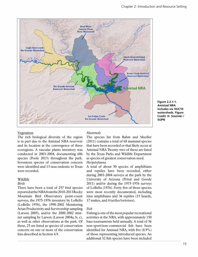
15
Chapter 2: Introduction and Resource Setting
VegetationThe rich biological diversity of the region is in part due to the Amistad NRA reservoir and its location at the convergence of three ecoregions. A vascular plants inventory was conducted in 2003-2004, documenting 686 species (Poole 2013) throughout the park. Seventeen species of conservation concern were identified and 13 taxa endemic to Texas were recorded.
WildlifeBirdsThere have been a total of 257 bird species reported at the NRA from the 2010-2013 Rocky Mountain Bird Observatory point-count surveys, the 1975-1976 inventory by LoBello (LoBello 1976), the 1998-2002 Monitoring Avian Productivity and Survivorship sampling (Larson 2005), and/or the 2000-2002 mist-net sampling by Larson (Larson 2004a, b, c), as well as other observations at the park. Of these, 25 are listed as species of conservation concern on one or more of the conservation lists described in Section 4.9.
MammalsThe species list from Bahm and Mueller (2011) contains a total of 68 mammal species that have been recorded or that likely occur at Amistad NRA Twenty-two of these are listed by the Texas Parks and Wildlife Department as species of greatest conservation need.HerpetofaunaA total of about 50 species of amphibians and reptiles have been recorded, either during 2003-2004 surveys at the park by the University of Arizona (Prival and Goode 2011) and/or during the 1975-1976 surveys of LoBello (1976). Forty-five of those species were most recently documented, including nine amphibians and 36 reptiles (15 lizards, 17 snakes, and 4 turtles/tortoises).
FishFishing is one of the most popular recreational activities at the NRA, with approximately 150 bass tournaments held annually. A total of 56 non-sport/non-commercial fish have been identified for Amistad NRA, with five (8.9%) of those representing introduced species. An additional 32 fish species have been included
Figure 2.2.1-1. Amistad NRA includes six HUC10 watersheds. Figure Credit: H. Sosinski /SOPN

16
Amistad National Recreation Area: Natural Resource Condition Assessment
in the Amistad Reservoir Binational Fishery Management Plan (2006) as either sport, commercial or both sport and commercial species. Sport and commercial species are routinely stocked by Mexico and the United States.
2.2.3. Resource Issues Overview Climate ChangeClimate change is anticipated to increase the effects of drought and result in increasingly erratic tropical storms in the Gulf of Mexico (Fang et al. 2007). Lake levels are anticipated to fluctuate even more as water needs for agriculture in the region are met, and the potential for flash floods and water management increase. Based on climate change projections (Fang et al. 2007), lower lake levels will lead to increased water temperatures and impact water quality, particularly dissolved oxygen.
Monahan and Fisichelli (2014) assessed the magnitude and direction of changes in climate for Amistad for 25 variables including temperature and precipitation between 1901-2012 (historical range of variability (HRV)). Results for extreme climate were defined as experiencing either <5th percentile or >95th percentile climates relative to the HRV. The
results for the extreme climate variables at the park were as follows:
● Three temperature variables were “extreme warm” (annual mean temperature, maximum temperature of the warmest month, mean temperature of the warmest quarter).
● No temperature variables were “extreme cold.”
● No precipitation variables were “extreme dry.”
● No precipitation variables were “extreme wet.”
The results for the temperature of each year between 1901-2012, the averaged temperatures over progressive 10-year intervals, and the average temperature of 2003-2012 (the most recent interval) are shown in Figure 2.2.3-1.
The results indicate that recent climate conditions have already begun shifting beyond the HRV. Overall, it’s likely that future climate change will increasingly affect all aspects of park resources and operations (Monahan and Fisichelli 2014).
Figure 2.2.3-1. Time series used to characterize the historical range of variability and most recent percentile for annual mean temperature at Amistad National Recreation Area (including areas within 30-km [18.6-mi] of the park’s boundary). The blue line shows temperature for each year, the gray line shows temperature averaged over progressive 10-year intervals (10-year moving windows), and the red asterisk shows the average temperature of the most recent 10-year moving window (2003–2012). The most recent percentile is calculated as the percentage of values on the gray line that fall below the red asterisk (excerpted from Monahan and Fisichelli 2014).

17
Chapter 2: Introduction and Resource Setting
Water ResourcesSince the reservoir is located in a semi-arid area, the lake level varies depending on inflow from the three rivers and rain, outflow from the dam, and evaporation rates. In drought years, water levels have decreased to its lowest level of 321.8 m (1,056 ft), which occurred on May 23, 2013. In an extreme to exceptional drought, it is prone to these conditions (Figure 2.2.3-2). The lake’s large surface area
makes it extremely susceptible to high rates of evapotranspiration (Porter et al. 2009). As a result, low lake levels leave boat docks high and dry, and also expose archeological resources.
Even though the lake level has been on the rise, as recent as May 2013, it was at its historic low of 321.8 m (1,055.9 ft). Other threats include atmospheric pollution, sedimentation
Figure 2.2.3-2. The U.S. Drought Monitor (http://droughtmonitor.unl.edu/Home/StateDroughtMonitor.aspx?TX, accessed April 7, 2016 (top) and April 7, 2014 (bottom) for Texas indicates that most of the state was experiencing moderate to exceptional drought conditions less than a year ago. Now, only a few areas in the state, primarily to the north and west, are abnormally to moderately dry. Boxes show Val Verde County where the park is located.
18
Amistad National Recreation Area: Natural Resource Condition Assessment
pollution from river inflows and area runoffs, sewage from debris and fecal matter from both countries, and hydrocarbons from boating and boat launch sites (NPS-CHDN 2010).
The flooding of the reservoir has impacted archaeological sites and caused the extirpation of non-game fish species that naturally occurred in the Devils, Pecos, and Rio Grande Rivers prior to inundation. One species, Amistad gambusia (Gambusia amistadensis) is now extinct due to the flooding of its former habitat at Goodenough Springs.
Non-native AnimalsNine of the mammal species (13.2%) found throughout the park are non-native (or exotic) and numerous fish species are non-native as well. Both the United States and Mexico routinely stock fish in Amistad Reservoir to support the commercial and world-class sport fishery.
Non-native Exotic PlantsA total of 67 species of exotic plants have been recorded in the recreation area. Some of these plants have the ability to change the ecosystem structure and alter nutrient cycles when prevalence is high. Exotic plants are often found in the canyon bottoms and in the reservoir’s inundation zone, where fluctuating water levels create disturbed areas for colonization, especially tamarisk (Tamarix ramosissima). Adjacent housing developments along the NRA’s boundary are also facilitating the spread of exotic plants throughout the park.
GrazingPark staff observations have shown that trespass livestock are encroaching on innundated zones and hunt areas. Fences are not being actively maintained, which likely impacts native vegetation and animals, although the effects from unmanaged grazing are currently not well understood.
2.3. Resource Stewardship
2.3.1. Management Directives and Planning GuidanceIn addition to NPS staff recommendations, the Washington (WASO) level programs guided the selection of key natural resources for this condition assessment. This included Chihuahuan Inventory and Monitoring Network (CHDN) Program, Air Resources Division for air quality, Water Resources Division for riparian habitat, and the Night Skies Program for the night sky assessment.
CHDN Program In an effort to improve overall national park management through expanded use of scientific knowledge, the Inventory & Monitoring (I&M) Program was established to collect, organize, and provide natural resource data as well as information derived from data through analysis, synthesis, and modeling (NPS 2011). The primary goals of the I&M Program are to:
● inventory the natural resources under NPS stewardship to determine their nature and status;
● monitor park ecosystems to better understand their dynamic nature and condition and to provide reference points for comparisons with other altered environments;
● establish natural resource inventory and monitoring as a standard practice throughout the National Park System that transcends traditional program, activity, and funding boundaries;
● integrate natural resource inventory and monitoring information into NPS planning, management, and decision making; and
● share NPS accomplishments and information with other natural resource organizations and form partnerships for attaining common goals and objectives (NPS 2011).
To facilitate this effort, 270 parks with significant natural resources were organized into 32 regional networks. Amistad NRA is part of the CHDN, which also includes six additional parks. Through a rigorous

19
Chapter 2: Introduction and Resource Setting
multi-year, interdisciplinary scoping process, each network selected a number of important physical, chemical, and/or biological elements and processes for long-term monitoring. These ecosystem elements and processes are referred to as ‘vital signs’, and their respective monitoring programs are intended to provide high-quality, long-term information on the status and trends of those resources. Inventories on a wide variety of natural resource topics have been completed, and long-term monitoring programs are currently underway. CHDN either currently or plans to monitor and/or coordinate the monitoring of exotic plants, climate, springs, landscape dynamics, and landbirds at Amistad NRA (NPS-CHDN 2015).
Park Planning Reports Natural Resource Condition AssessmentsThe structural framework for NRCAs is based upon, but not restricted to, the fundamental and other important values identified in a park’s foundation document or general management plan. NRCAs are designed to deliver current science-based information translated into resource condition findings for a subset of a park’s natural resources. The
NPS State of the Park (SotP) and Resource Stewardship Strategy (RSS) reports rely on credible information found in NRCAs as well as a variety of other sources. Figure 2.3.1-1 shows the relationships between the larger reporting efforts that are developed for parks.
Foundation DocumentFoundation documents describe a park’s purpose and significance and identify fundamental and other important park resources and values. A foundation document hasn’t been completed for Amistad at this time.
State of the ParkA SotP report is intended for non-technical audiences and summarizes key findings of park conditions and management issues, highlighting recent park accomplishments and activities. NRCA condition findings are used in SotP reports, and the NRCA’s Chapter 5 includes a SotP condition summary for the natural resources assessed.
Resource Stewardship StrategyAn RSS uses past and current resource conditions to identify potential management
Figure 2.3.1-1. The diagram shows the relationship of NRCAs to other park planning reports.

20
Amistad National Recreation Area: Natural Resource Condition Assessment
targets or objectives by developing comprehensive strategies using all available reports and data sources including NRCAs. National Parks are encouraged to develop an RSS as part of the park management planning process. Indicators of resource condition, both natural and cultural, are selected by the park. After each indicator is chosen, a target value is determined and the current condition is compared to the desired condition.
2.3.2. Status of Supporting Science Available data and reports for this NRCA varied depending upon the resource topic. The existing data used for each indicator to assess condition or to develop reference conditions are described in each assessment. In addition to data from the NPS CHDN and NRSS Programs and research by other scientists and subject matter experts, the park provided a significant amount of information to assist with developing the condition assessments.
2.4. Literature CitedAdams DK, Comrie AC. 1997. The North
American Monsoon. Bulletin of the American Meteorological Society 78: 2197-2213.
Asquith, W. H. 1998. Depth-duration frequency of precipitation for Texas. U.S. Geological Survey water resources investigation report 98-4044. 112 pages.
Bahm, M.A., and J.M. Mueller. 2011. The mammals of Amistad National Recreation Area, Texas: 2005 final report. Natural Resource Technical Report NPS/CHDN/NRTR—2011/492. National Park Service, Fort Collins, Colorado.
Binational Fisheries Management Plan for Amistad Reservoir. 2006. Contributors: Texas Parks and Wildlife Department, National Park Service, US Fish & Wildlife Service, Secretarfa de Agricultura, Ganaderia, Desarrollo Rural, Pesca y Alimentacion. Instituto Nacional de Pesca. Comision Nacional del Agua. Secretaria de Turismo SCT Gobierno del Estado de Coahuila. 68 pp.
Climate Analyzer.org. 2016. Chihuahuan Desert Network, Amistad National Recreation Area. Available at http://www.climateanalyzer.org/ (accessed June 16, 2016).
Davey, C. A., K. T. Redmond, and D. B. Simeral. 2007. Weather and Climate Inventory, National Park Service, Chihuahuan Desert Network. Natural Resource Technical Report NPS/CHDN/NRTR—2007/034. National Park Service, Fort Collins, Colorado.
Edwards, R. Unpublished. Supercells of the Serranias del Burro (Mexico). Storm Prediction Center, National Weather Center:Norman, OK.
Fang, X., R. Shrestha, A. W. Groeger, C. Lin, and M. Jao. 2007. Simulation of impacts of streamflow and climate conditions on Amistad Reservoir. Journal of Contemporary Water Research and Education 137(1):14-20. Available at: http://opensiuc.lib.siu.edu/jcwre/vol137/iss1/4.
Grantz, K. 2004. The North American Monsoon: a review of the literature. 6 pp.
KellerLynn, K. 2008. Geologic Resource Evaluation Scoping Summary, Amistad National Recreation Area, Texas. Geologic Resources Division, National Park Service. Denver, CO.
Larson, D. H. 2004a. 2000 Bird migration report for Amistad National Recreation Area. April 2004. National Park Service.
Larson, D. H. 2004b. 2001 Bird banding report for Amistad National Recreation Area. April 2004. National Park Service.
Larson, D. H. 2004c. 2002 Bird banding report for Amistad National Recreation Area. April 2004. National Park Service.
Larson, D. H. 2005. Summary Report of the Amistad National Recreation Area MAPS Project for 1998-2002. National Park Service.

21
Chapter 2: Introduction and Resource Setting
LoBello, R. L. 1976. Vertebrates of the Lake Amistad National Recreation Area, Texas. M.S. Thesis, Sul Ross State University, Alpine, Texas.
Monahan, W. B. and N. A. Fisichelli. 2014. Climate Exposure of U.S. National Parks in a New Era of Change. PLoS ONE 9(7):e101302. doi:10.1371/journal.pone.0101302.
National Park Service. 2006. Amistad National Recreation Area, Texas, draft general management plan/environmental assessment. 181p.
National Park Service. 2011. Program brief: Inventory and monitoring program. U.S. Department of the Interior, National Park Service, Natural Resource Program Center, Inventory and Monitoring Division, Fort Collins, Colorado.
National Park Service. 2016. Amistad National Recreation Area foundation document - E4- post-workshop-initial park review draft. U.S. Department of the Interior. 27 pages.
National Park Service Air Resources Division. 2012. Redesignation of clean air areas. Available at http://www.nature.nps.gov/air/Regs/redesig.cfm (accessed February 1, 2015).
National Park Service, Chihuahuan Desert Inventory and Monitoring Network (CHDN). 2001. Full Study Plan for Vertebrate and Vascular Plant Inventory of the Chihuahuan Desert Network. Amistad National Recreation Area, Texas. Appendix A.
National Park Service, Chihuahuan Desert Inventory and Monitoring Network (CHDN). 2010. Chihuahuan Desert Network vital signs monitoring plan. Natural Resource Report NPS/CHDN/NRR—2010/188. National Park Service, Fort Collins, Colorado.
National Park Service, Chihuahuan Desert Inventory and Monitoring Network
(CHDN). 2015. Park monitoring protocols. Available at http://science.nature.nps.gov/im/units/chdn/parks/index.cfm (accessed August 16, 2015).
National Park Service Public Use Statistics Office. 2016. NPS visitor use statistics. Annual park visitation (all years) and visitation by month and year. Available at https://irma.nps.gov/Stats/Reports/ReportList (accessed April 7, 2016).
National Oceanic and Atmospheric Administration (NOAA) National Hurricane Center. No date. Tropical cyclone climatology. Available at http://www.nhc.noaa.gov/climo/ (accessed June 17, 2016).
National Oceanic and Atmospheric Administration (NOAA). No date. Glossary: boundary layer (available at http://forecast.weather.gov/glossary.php?word=BOUNDARY%20LAYER (accessed June 16, 2016).
National Oceanic and Atmospheric Administration (NOAA). 2011. What is a supercell? Available at http://www.srh.noaa.gov/ama/?n=supercell (accessed June 16, 2016).
National Oceanic and Atmospheric Administration (NOAA). 2013. Brownsville, Texas. Available at http://www.srh.noaa.gov/bro/?n=2010event_julyriograndeflood (accessed June 27, 2016).
National Oceanic and Atmospheric Administration (NOAA). 2015. Annual observational data. Available at http://gis.ncdc.noaa.gov/map/viewer/#app=cdo&cfg=cdo&theme=annual&layers=1&node=gis (accessed August 15, 2015).
Peel, M. C.; Finlayson, B. L.; McMahon, T. A. 2007. Updated world map of the Köppen–Geiger climate classification. Hydrol. Earth Syst. Sci. 11: 1633–1644. Available at http://www.hydrol-earth-syst-sci.net/11/1633/2007/hess-11-1633-2007.pdf (accessed June 16, 2016).

22
Amistad National Recreation Area: Natural Resource Condition Assessment
Poole, Jackie M. 2013. An Inventory of the Vascular plants of Amistad National Recreation Area, Val Verde Co., Texas. Lundellia 16: 8-82. Available at w3.biosci.utexas.edu/prc/pdfs/Poole-Lundellia16.pdf (accessed June 14, 2015).
Porter, S. D., R. A. Barker, R. M. Slade, Jr., and G. Longley. 2009. Historical perspective of surface water and groundwater resources in the Chihuahuan Desert Network, National Park Service. Edwards Aquifer Research and Data Center, in cooperation with National Park Service, Chihuahuan Desert Network.
Prival, D., and M. Goode. 2011. Chihuahuan Desert national parks reptile and amphibian inventory. Natural Resource Technical Report NPS/CHDN/NRTR—2011/489. National Park Service, Fort Collins, Colorado.
Rich, T. C., C. J. Beardmore, H. Berlanga, P. Blancher, M. S. W. Bradstreet, G. S. Buthcher, D. W. Demarest, E. H. Dunn, C. W. Hunter, E. E. Inigo-Elias, and others. 2004. Partners in Flight North American landbird conservation plan. Cornell Lab of Ornithology, Ithaca, New York as cited in NPS CHDN 2010.
Visaggi, C. C. J. G. Johnson, A. S. Johnson, J. P. Kenworthy, and V. L. Santucci. 2009. Paleontological resource survey, Amistad National Recreation Area. Natural Resource Report NPS/NRPC/GRD/NRR—2009/133 (Public version, September 2009) National Park Service, Fort Collins, CO.
Weiss, J.D. and J.W. Zeitler. 2008. Supercells of the Serranías del Burro. Presented at the American Meteorological Society’s 24th Conference on Severe Local Storms.

23
Chapter 3: Study Scoping and Design
Chapter 3: Study Scoping and Design This NRCA is a collaborative project between the Amistad NRA staff, the CHDN and SOPN Networks. The purpose of the condition assessment is to provide a “snapshot-in-time” evaluation of the condition of a select set of National Recreation Area natural resources that were identified and agreed upon by the project team during the scoping session held on March 3, 2014. Project findings will aid National Recreation Area staff in the following objectives:
● Develop near-term management priorities
● Engage in watershed or landscape scale partnership and education efforts
● Conduct park planning (e.g., compliance, Resource Stewardship Strategy, and resource management plans).
The approach we used to select natural resources was to assess the fundamental and important values of the National Recreation Area as well as to consider broader natural resources as identified by the NPS’ Natural Resource Program Center. The resources assessed are limited to natural-based topics, but cultural resources were also taken into
consideration within the context of the chosen natural resources.
3.1. Preliminary Scoping The selection of resources to assess resulted from meetings and subsequent discussions. For a complete list of team members, please refer to Appendix A.
These meetings and discussions focused on:
1. Confirming the purpose of the National Recreation Area and its related significance statements and related values as they relate to the chosen NRCA topics
2. Identifying important natural and cultural resources and concerns for each topic
3. Identifying data sources and gaps for each resource topic.
Certain constraints are placed on NRCAs, including the following:
● Condition assessments are conducted using existing data and information.
● Identification of data needs and gaps is driven by the project framework categories.
NRCA scoping meeting at Amistad NRA.
KIM
STRUTH
ERS

24
Amistad National Recreation Area: Natural Resource Condition Assessment
● A preliminary study framework was developed as a result of the meetings and discussions, which lists the chosen resources and the degree of assessment (e.g., full or limited) based upon existing data and information (refer to Table 3.2.1-1).
Specific project expectations and outcomes included the following:
● For key natural resource components, consolidate available National Recreation Area data, reports, and spatial information from appropriate sources including: National Recreation Area resource staff, scientific literature, NatureBib, NPSpecies, Inventory and Monitoring data, and available third-party sources.
● Enlist the help of subject matter experts for each resource topic when appropriate and feasible (refer to Appendix A for subject matter expert list).
● Define an appropriate description of reference condition for each of the key natural resource topics and indicators so statements of current condition can be developed for the NRCA report.
● Where applicable, develop GIS products and graphic illustrations that provide spatial representation of resource data, ecological processes, resource stressors, trends, or other valuable information that can be better interpreted visually.
● Conduct analysis of specific existing data sets to develop descriptive statistics about key natural resource indicators.
● Discuss the issue of key natural resource indicators that are not contained within the National Recreation Area or controlled directly by National Recreation Area management activities (e.g., air quality condition). There are important stressors that impact key natural resource components in the National Recreation Area but are not under NPS jurisdiction.
National Recreation Area natural and cultural resource staff participated in on-site meetings and reviewed interim and final products. National Recreation Area staff, I&M staffs,
and writer/editors data mined information for each of their assigned resource topic(s).
3.2. Study Design
3.2.1. Indicator Framework, Focal Study Resources and IndicatorsThe National Recreation Area’s NRCA utilizes an assessment framework adapted from “The State of the Nation’s Ecosystems 2008: Measuring the Lands, Waters, and Living Resources of the United States”, by the H. John Heinz III Center for Science, Economics and the Environment. This framework was endorsed by the National NRCA Program as an appropriate framework for listing resource components, indicators/measures, and resource conditions.
Each NRCA project represents a unique assessment of key natural resource topics that are important to the specific park that is being assessed. As a result, the project framework is developed by the project participants to reflect the key resources of the park. For the purposes of this NRCA, 14 key National Recreation Area resources were identified and are listed under the “Resource” column in Table 3.2.1-1. This list of focal study resources is not all inclusive of every natural resource at the National Recreation Area, but it includes natural resources and processes that were of greatest concern at the time of this assessment.
Reference conditions were identified with the intent of providing a benchmark to which the current condition of each indicator/measure could be compared. Attempts were made to utilize existing research and documentation to identify reference conditions; however, many of the indicators lack a quantifiable reference condition according to literature and data reviewed for this project. When a specific reference condition for the National Recreation Area resources was unknown, an attempt was made to include a qualitative framework to provide some context for interpreting condition.
3.2.2. Reporting AreasThe reporting area was treated as one unit and encompassed the entire acreage within

25
Chapter 3: Study Scoping and Design
the National Recreation Area’s boundary. Due to the nature of some of the focal study resources, areas outside of the National Recreation Area’s boundary were assessed to determine overall condition within the National Recreation Area (e.g., air quality, night sky, surface water quality, etc.).
3.2.3. General Approach and MethodsThis study involved reviewing existing literature and data for each of the resources listed, and, where appropriate, analyzing the data to provide summaries or to create new spatial representations. After gathering data regarding current condition of indicators
and measures, a quantitative or qualitative statement was developed comparing the current condition(s) at the National Recreation Area to the reference condition(s) when possible.
Data Mining Data and literature were found in multiple forms: NPS reports and monitoring plans (National Recreation Area, regional, national, and international levels), other reports from various state and federal agencies, published and unpublished research documents, non-governmental organization reports, databases, and tabular data. Spatial data were provided by the National Recreation Area, the CHDN
Table 3.2.1-1. Amistad NRA Natural Resource Condition Assessment Framework.
Resource Assessment Level Indicators and Measures
I. Landscape Condition Context
Night Sky Full Assessment • Sky Brightness (Anthropogenic Light Ratio and Zenith Sky Brightness)
• Sky Quality (Bortle Dark-sky Scale)
II. Supporting Environment
Air Quality Full Assessment • Visibility (Haze Index)• Level of Ozone (Annual 4th-Highest 8-hour
Concentration)• Atmospheric Wet Deposition (Total N and Total S)
Geology Limited Assessment • Geologic Resource Integrity (No measures)
Surface Water Quality Full Assessment • Core Parameters (6 measures)• Nutrients (7 measures)• Major Ions (4 measures)• Metals (9 metals)
Groundwater and Springs Full Assessment • Groundwater Elevation (Change in Groundwater Elevation)
• Groundwater Quality (16 measures)
III. Biological Integrity
Vegetation
Riparian Habitat Full Assessment • Hydrology (4 measures)• Vegetation (6 measures)• Erosion/Deposition (4 measures)
Upland Vegetation Full Assessment • Biotic Integrity (5 measures)
Exotic Plants Full Assessment • Prevalence of Exotic Plants (3 measures)• Potential to Alter Native Plant Communities
(Significance of Impact)
Wildlife
Landbirds Full Assessment • Species Occurrence (3 measures)
Mammals Limited Assessment • Species Occurrence (Presence/Absence)
Jaguarundi Limited Assessment • Species Occurrence (Presence/Absence)
Herpetofauna Limited Assessment • Species Occurrence (Presence/Absence)
Small Native Fishes Limited Assessment • Species Occurrence (Presence/Absence)
Exotic Mussels Limited Assessment • Species Occurrence (Presence/Absence)

26
Amistad National Recreation Area: Natural Resource Condition Assessment
and SOPN staffs, and by the Natural Resource Program Center. Data and literature acquired throughout the data mining process were inventoried and analyzed for thoroughness, relevancy, and quality pertaining to the indicators identified in the project framework. All reasonably accessible and relevant data were used to conduct this assessment.
Subject Matter ExpertsSeveral researchers and subject matter experts were consulted while developing this assessment. Consultations ranged from on-site visits to personal communication, and reviews of resource sections. A full list of the team of experts can be found in Appendix A.
Data Analyses and Development Data analyses and development/writing tasks were performed for specific resources based on the data mining process and recom-mendations provided by NPS staff. Data analyses and development were resource specific, and the methodology for individual analyses can be found within each section of chapter four or in an appendix.
Geographic Information System (GIS) technology was utilized to graphically depict the status and distribution of considered resources when possible.
Final AssessmentsFinal assessments were made by incorporating comments provided by subject matter experts, reviewers, and National Recreation Area staff during the review of draft chapters. Additionally, continued contact with National Recreation Area staff to address questions and comments pertaining to each resource topic was maintained throughout the data analysis and report writing phase to ensure accurate representation of staff knowledge. The final assessments represent the most relevant and timely data available for each resource topic based on the recommendations and insight provided by National Recreation Area staff, researchers, subject matter experts, and assessment writers.
Indicator/Measures Assessment Format Indicator assessments are presented in a standard format that is consistent with State
of the Park reporting (NPS 2012). The major components are as follows:
The condition/trend/level of confidence graphic provides a visual representation for each resource indicator and is intended to give readers a quick interpretation of the authors’ assessments of condition. The level of confidence ranges from high-low and indicates how confident we are with the data used to determine condition. The written statements of condition, located under the “Condition and Trend” heading within each resource topic section, provides a more in-depth description of each indicator and associated measure(s)’ condition. Figure 3.2.3-1 shows the condition/trend/confidence level scorecard used to describe each indicator/measure.
Circle colors provide indication of condition based upon the chosen indicators/measures and reference conditions. Red circles signify that a resource is of significant concern; yellow circles signify that a resource is in moderate condition; and green circles denote that an indicator and/or measure is currently in good condition. A circle without any color, (which is almost always associated with the low confidence symbol-dashed line), signifies that there is insufficient information to make a statement about condition of the indicator, therefore, condition is unknown.
We include an indicator condition and overall rationale summary table at the end of each resource topic’s section to convey the relevancy of each measure to the overall condition interpretation.
Arrows inside the circles signify the trend of the indicator/measure condition. Upward pointing arrows signify that the indicator is improving; right pointing arrows signify that the indicator’s condition is currently unchanging; downward pointing arrows indicate that the indicator’s condition is deteriorating. No arrow denotes that the trend of the indicator’s condition is currently unknown. Figure 3.2.3-2 is an example of a final condition graphic used in the indicator assessments.

27
Chapter 3: Study Scoping and Design
An Overview of NRCA Chapter 4 Sections
Background and ImportanceThis section of the NRCA report provides information regarding the relevance of the resource to the National Recreation Area. This section also explains the characteristics of the resource that help the reader understand subsequent sections of the document.
Data and MethodsThis section describes the existing datasets used for evaluating the indicators/measures. Methods used for processing or evaluating the data are also discussed where applicable. The indicators/measures are listed in this section as well, describing how we measured or qualitatively assessed the natural resource topic.
Reference Conditions This section explains the reference conditions that were used to evaluate the current condition for each indicator. Additionally, explanations of available data and literature that describe the reference conditions are located in this section.
Condition and TrendThis section provides a summary of the condition and trend of the indicator/measure at the National Recreation Area based on available literature, data, and expert opinions. This section highlights the key elements used in defining the condition and trend designation, represented by the condition/
trend graphic, located at the beginning of each resource topic.
The level of confidence and key uncertainties are also included in the condition and trend section. This provides a summary of the unknown information and uncertainties due to lack of data, literature, and expert opinion, as well as our level of confidence about the presented information.
Sources of ExpertiseIndividuals who were consulted for the focal study resources are listed in this section. A short paragraph describing their background is also included.
Literature CitedThis section lists all of the referenced sources. A DVD is included in the final report with copies of all literature cited unless the citation was from a book. When possible, links to websites are also included.
3.3. Literature CitedThe H. John Heinz III Center for Science,
Economics and the Environment. 2008. The State of the Nation’s Ecosystems 2008: Measuring the Lands, Waters, and
Figure 3.2.3-1. Condition, trend, and level of confidence key used in the Amistad NRA NRCA.
Figure 3.2.3-2. An example of a good condition, unchanging trend, and high confidence level in the assessment graphic used in NRCAs.
Condition Status Trend in ConditionConfidence in Assessment
Warrants Significant Concern
Condition is Improving
High
Warrants Moderate Concern
Condition is Unchanging
Medium
Resource is in Good Condition
Condition is Deteriorating
Low
An open (uncolored) circle indicates that current condition is unknown or indeterminate; this condition status is typically associated with unknown trend and low confidence
Condition – Trend - Confidence
Good – Unchanging - High

28
Amistad National Recreation Area: Natural Resource Condition Assessment
Living Resources of the United States. Washington, D.C.
National Park Service. 2012. A Call to Action: Preparing for a Second Century of Stewardship and Engagement. Washington, D.C. 28pp

29
Chapter 4: Natural Resource Conditions
Chapter 4: Natural Resource ConditionsIn Chapter 4 we present the background and importance, data and methods, and condition and trend for each focal study resource that
was assessed for the park. A list of page numbers where each topic’s measures are presented is in Table 4.1.
Table 4-1. Amistad NRA Natural Resource Condition Assessment Framework.
Resource Indicators and Measures Page
I. Landscape Condition Context
Night Sky • Sky Brightness (Anthropogenic Light Ratio and Zenith Sky Brightness)
• Sky Quality (Bortle Dark-sky Scale)26
II. Supporting Environment
Air Quality • Visibility (Haze Index)• Level of Ozone (Annual 4th-Highest 8-hour Concentration)• Atmospheric Wet Deposition (Total N and S)
35-36
Geology • Geologic Resource Integrity (No measures) 44
Surface Water Quality • Core Parameters (6 measures)• Nutrients (7 measures)• Major Ions (4 measures)• Metals (9 metals)
55-57
Groundwater • Groundwater Elevation (Change in Groundwater Elevation)• Groundwater Quality (16 measures)
72-74
III. Biological Integrity
Vegetation
Riparian Habitat • Hydrology (4 measures)• Vegetation (6 measures)• Erosion/Deposition (4 measures)
88-91
Upland Vegetation • Biotic Integrity (5 measures) 108-110
Exotic Plants • Prevalence of Exotic Plants (3 measures)• Potential to Alter Native Plant Communities (Significance of
Impact)120-126
Wildlife
Breeding Landbirds • Species Occurrence (3 measures) 148-150
Mammals • Species Occurrence (Presence/Absence) 169-170
Jaguarundi • Species Occurrence (Presence/Absence) 180
Herpetofauna • Species Occurrence (Presence/Absence) 184
Small Native Fishes • Species Occurrence (Presence/Absence) 197
Exotic Mussels • Species Occurrence (Presence/Absence) 208-209


31
Chapter 4: Natural Resource Conditions - Night Sky
4.1. Night Sky
4.1.1. Background and ImportanceNatural dark skies are a valued resource within the NPS, reflected in NPS management policies (NPS 2006) which highlight the importance of a natural photic environment to ecosystem function, and the importance of the natural lightscape for aesthetics. The NPS Natural Sounds and Night Skies Division makes a distinction between a lightscape—which is the human perception of the nighttime scene, including both the night sky and the faintly illuminated terrain, and the photoic environment—which is the totality of the pattern of light at night at all wavelengths (Moore et al. 2013).
Lightscapes are an aesthetic and experiential quality that are integral to natural and cultural resources (Moore et al. 2013). A 2007 visitor survey conducted throughout Utah national parks found that 86% of visitors thought the quality of park night skies was “somewhat important” or “very important” to their visit. Additionally, in an estimated 20 national parks, stargazing events are the most popular ranger-led program (NPS 2010).
The value of night skies goes far beyond visitor experience and scenery. The photic environment affects a broad range of species, is integral to ecosystems, and is a natural physical process (Moore et al. 2013). Natural light intensity varies during the day-night (diurnal) cycle, the lunar cycle, and the seasonal cycle. Organisms have evolved to respond to these periodic changes in light levels in ways that control or modulate movement, feeding, mating, emergence, seasonal breeding, migration, hibernation, and dormancy. Plants also respond to light levels by flowering, vegetative growth, and their direction of growth (Royal Commission on Environmental Pollution 2009). Given the effects of light on living organisms, it is likely that the introduction of artificial light into the
natural light/darkness regime will disturb the normal routines of many plants and animals (Royal Commission on Environmental Pollution 2009), as well as diminish stargazing recreational opportunities offered to national park visitors.
Amistad National Recreation Area (NRA) is enjoyed by visitors for fishing, boating, and diving, among other lake-based recreation activities. Nighttime boating and fishing trips or evenings camped along the river are good times to enjoy the night sky. Protecting the night sky resources benefits the natural resources and is important for visitor experience at the NRA.
4.1.2. Data and MethodsThe NPS Natural Sounds and Night Skies Division goals of measuring night sky brightness are to describe the quality of the lightscape, quantify how much it deviates from natural conditions, and how it changes with time due to changes in natural conditions, as well as artificial lighting in areas within and outside of the national parks (Duriscoe et al. 2007).
Based on new guidance (Moore et al. 2013), the NPS Natural Sounds and Night Skies Division recommends that the all-sky Anthropogenic Light Ratio (ALR) is the best single parameter for characterizing the overall sky condition. When available, additional indicators and measures should also be considered in an assessment of night sky condition, but the ALR measure is the primary data source for condition assessment (see Table 4.1.2-1).
We conducted a supplemental rapid assessment of the NRA’s night sky condition over two nights May 29-30, 2014 using a sky quality meter to measure zenith sky
Condition – Trend – Confidence
Moderate - Insufficient Data - Medium
Indicators/Measures• Sky Brightness (2 measures)• Sky Quality (1 measure)

32
Amistad National Recreation Area: Natural Resource Condition Assessment
brightness and the Bortle Dark Sky Scale, a qualitative assessment commonly used by amateur astronomers to evaluate the potential quality for star gazing. This rapid assessment is supplementary and is intended only to illustrate the night sky condition.
MeasuresAnthropogenic Light Ratio and Zenith Sky Brightness
The anthropogenic light ratio (ALR) is the average anthropogenic sky luminance presented as a ratio over natural conditions. It is a useful metric to average the light flux over the entire sky (measuring all that is above the horizon and omitting the terrain). Recent advances in modeling of the natural components of the night sky allow the separation of anthropogenic light from natural features, such as the Milky Way. This metric is a convenient and robust measure. It is most accurately obtained from ground-based measurements with the NPS Night Skies Program’s photometric system, however, it can also be modeled with moderate confidence when such measurements are not available. No ground-based measures were taken for Amistad NRA; modeling data are reported here.
Sky brightness describes the amount of light in the night sky. One method of assessing sky brightness uses a Unihedron Sky Quality Meter (SQM) that samples the night sky in a broad spectrum band roughly corresponding to the entire human visual range. The SQM measures an aggregate average brightness for the entire sky that is skewed to zenith brightness over an 80 degree field of view (Moore 2012). Readings were taken at seven
locations within Amistad NRA over two nights (May 29-30, 2014) between one and three hours after moonset.
MeasureBortle Dark Sky Scale
The Bortle Dark Sky Scale (Appendix B) was proposed by John Bortle (Bortle 2001) based on 50 years of astronomical observations. Bortle’s qualitative approach uses a nine-class scale that requires a basic knowledge of the night sky and no special equipment (Bortle 2001, Moore 2001, White et al. 2012, Table 4.1.2-2). The Bortle scale uses both stellar objects and familiar descriptors to distinguish among the different classes. Another advantage of the Bortle scale is that it is suitable for conditions ranging from the darkest skies to the brightest urban areas (Moore 2001, Figure 4.1.2-1).
4.1.3. Reference ConditionsThe ideal night sky reference condition, regardless of how it’s measured, is one devoid of any light pollution. However, results from night sky data collection throughout more than 90 national parks suggest that a pristine night sky is very rare (NPS 2010). A natural night sky has an average brightness across the entire sky of 78 nL (nanolamberts, a measure of luminance), and includes features such as the Milky Way, Zodiacal light, airglow, and other starlight. This is figured into the ratio, so that an ALR reading of 0.0 would indicate pristine natural conditions where the anthropogenic component was 0 nL. A ratio of 1.0 would indicate that anthropogenic light was 100% brighter than the natural light from the night sky. For a summary of
Table 4.1.2-1. Indicators and measures of the night sky and why they are important to resource condition.
Indicator Measure Description
Sky Brightness Anthropogenic Light Ratio and Zenith Sky Brightness
The all-sky anthropogenic light ratio describes light due to man-made sources compared to light from a natural dark sky. Understanding the lightscape and sources of light is helpful to managers to maintain dark skies for the benefit of wildlife and people alike.
Sky Quality Bortle Scale Class The Bortle Dark Sky classification system describes the quality of the dark night sky by the celestial bodies and night sky features an observer can see. Observing the stars has been an enjoyable human pastime for centuries.
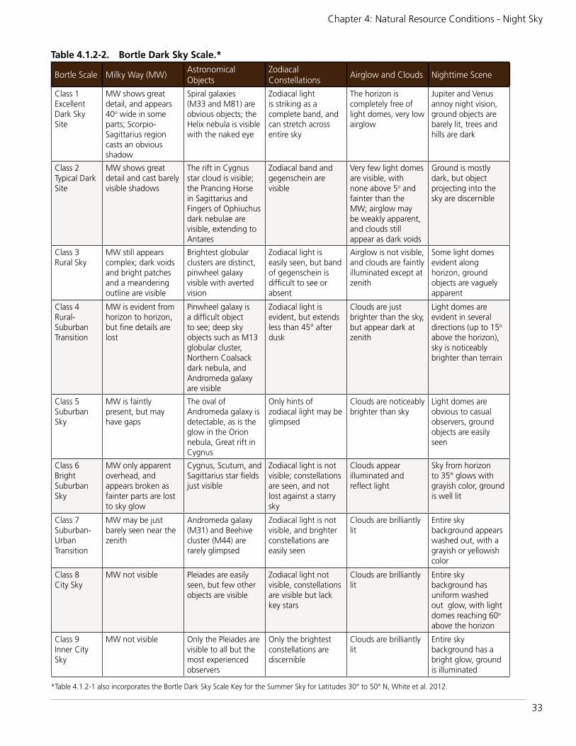
33
Chapter 4: Natural Resource Conditions - Night Sky
Table 4.1.2-2. Bortle Dark Sky Scale.*
Bortle Scale Milky Way (MW)Astronomical Objects
Zodiacal Constellations
Airglow and Clouds Nighttime Scene
Class 1Excellent Dark Sky Site
MW shows great detail, and appears 40o wide in some parts; Scorpio- Sagittarius region casts an obvious shadow
Spiral galaxies (M33 and M81) are obvious objects; the Helix nebula is visible with the naked eye
Zodiacal light is striking as a complete band, and can stretch across entire sky
The horizon is completely free of light domes, very low airglow
Jupiter and Venus annoy night vision, ground objects are barely lit, trees and hills are dark
Class 2Typical Dark Site
MW shows great detail and cast barely visible shadows
The rift in Cygnus star cloud is visible; the Prancing Horse in Sagittarius and Fingers of Ophiuchus dark nebulae are visible, extending to Antares
Zodiacal band and gegenschein are visible
Very few light domes are visible, with none above 5o and fainter than the MW; airglow may be weakly apparent, and clouds still appear as dark voids
Ground is mostly dark, but object projecting into the sky are discernible
Class 3Rural Sky
MW still appears complex; dark voids and bright patches and a meandering outline are visible
Brightest globular clusters are distinct, pinwheel galaxy visible with averted vision
Zodiacal light is easily seen, but band of gegenschein is difficult to see or absent
Airglow is not visible, and clouds are faintly illuminated except at zenith
Some light domes evident along horizon, ground objects are vaguely apparent
Class 4Rural- Suburban Transition
MW is evident from horizon to horizon, but fine details are lost
Pinwheel galaxy is a difficult object to see; deep sky objects such as M13 globular cluster, Northern Coalsack dark nebula, and Andromeda galaxy are visible
Zodiacal light is evident, but extends less than 45° after dusk
Clouds are just brighter than the sky, but appear dark at zenith
Light domes are evident in several directions (up to 15o above the horizon), sky is noticeablybrighter than terrain
Class 5Suburban Sky
MW is faintly present, but may have gaps
The oval of Andromeda galaxy is detectable, as is the glow in the Orion nebula, Great rift in Cygnus
Only hints of zodiacal light may be glimpsed
Clouds are noticeably brighter than sky
Light domes are obvious to casual observers, ground objects are easily seen
Class 6Bright Suburban Sky
MW only apparent overhead, and appears broken as fainter parts are lost to sky glow
Cygnus, Scutum, and Sagittarius star fields just visible
Zodiacal light is not visible; constellations are seen, and not lost against a starry sky
Clouds appear illuminated and reflect light
Sky from horizon to 35° glows with grayish color, ground is well lit
Class 7Suburban- Urban Transition
MW may be just barely seen near the zenith
Andromeda galaxy (M31) and Beehive cluster (M44) are rarely glimpsed
Zodiacal light is not visible, and brighter constellations are easily seen
Clouds are brilliantly lit
Entire sky background appears washed out, with a grayish or yellowish color
Class 8City Sky
MW not visible Pleiades are easily seen, but few other objects are visible
Zodiacal light not visible, constellations are visible but lack key stars
Clouds are brilliantly lit
Entire sky background has uniform washed out glow, with light domes reaching 60o above the horizon
Class 9Inner City Sky
MW not visible Only the Pleiades are visible to all but the most experienced observers
Only the brightest constellations are discernible
Clouds are brilliantly lit
Entire sky background has a bright glow, ground is illuminated
*Table 4.1.2-1 also incorporates the Bortle Dark Sky Scale Key for the Summer Sky for Latitudes 30° to 50° N, White et al. 2012.

34
Amistad National Recreation Area: Natural Resource Condition Assessment
condition assessment categories for all night sky indicators, see Table 4.1.3-1.
Anthropogenic Light Ratio The threshold for night skies in good condition is an ALR <0.33 and the threshold for a moderate condition is ALR 0.33-2.0. An ALR >2.0 suggests significant concern (Moore et al. 2013).
Zenith Sky BrightnessReference conditions for night sky brightness can vary moderately based on the time of night (time after sunset), time of the month (phase of the moon), time of the year (the position of the Milky Way), and the activity of the sun which can increase “airglow”—a kind of faint aurora. For the minimum night
sky brightness measure, the darkest part of a natural night sky is generally found near the zenith. A value of 22.0 magnitudes per square arc second (msa) is considered to represent a pristine sky, though it may vary naturally by more than +0.2 to -0.5 depending on natural conditions (Duriscoe 2013 [submitted]).Lower (brighter) values indicate increased light pollution and a departure from natural conditions. The astronomical magnitude scale is logarithmic, so a change of 2.50 magnitudes corresponds to a difference of l0x (100%); thus a 19.5 msa sky would be 10x brighter than natural conditions. Minimum night sky brightness values of 21.4 to 22.0 msa, are generally considered to represent natural (unpolluted) conditions (Duriscoe et al. 2007).
Table 4.1.3-1. Night sky condition class summary.
Condition Class ALR* SQMBortle Scale
GoodALR <0.33
(<26 nL average anthropogenic light in sky)≥21.60 1-3
Moderate0.33-2.0
(26-156 nL average anthropogenic light in sky)21.2-21.59 4
Significant ConcernALR >2.0
(>156 nL average anthropogenic light in sky)<21.2 5-9
*At least half of the NRA’s geographic area should meet the standard described.
IMA
GE G
ENERATED
FROM
STELLARIU
M (W
WW
.STELLARIU
M.O
RG)
Figure 4.1.2-1. Composite image illustrating the range of night sky conditions based on the Bortle Dark Sky Scale.

35
Chapter 4: Natural Resource Conditions - Night Sky
The maximum night sky brightness is often found within the Milky Way of a natural sky. A typical measurement from the Sagittarius region of the Milky Way in a natural sky yields 19.2 msa. Other regions of the Milky Way are somewhat dimmer, or around 20.0-21.0 msa. A value brighter than 19.0 msa will result in impairment to human night vision and may be noticeable by casting faint shadows or causing glare. A value lower (brighter) than 17.0 represents very bright areas of the night sky and would significantly impair human night vision and cast obvious shadows. Values for the brightest portion of the sky are of interest to the NPS because they represent unnatural intrusions on the nightscape, will prevent human dark-adapt vision, and may have effects on wildlife (Duriscoe et al. 2007)
Bortle Dark Sky Scale A night sky with a Bortle Dark Sky Scale class 1 is considered in the best possible condition (Bortle 2001); unfortunately, a sky that dark is so rare that few observers have ever witnessed it (Moore 2001). Non-urban park skies with a Bortle class 3 or darker are considered to be in good condition, class 4 of moderate condition, and class 5 are considered poor condition. At class 4 and higher, many night-sky features are obscured from view due to artificial lights (either within or outside the park). Skies class 7 and higher have a significantly degraded aesthetic quality that may introduce ecological disruption (Moore et al. 2013). It is important to note that such degraded conditions may be restored toward a more natural state by modifying outdoor lighting, depending on the surrounding conditions that exist outside the NRA.
4.1.4. Condition and TrendModeling data provided by the NPS Night Skies Program show an ALR of 0.49 indicating moderate condition (the models have an error of +0.1 ALR). Along the western portion of the park, the minimum ALR was 0.06, just 6% above natural. Although this area of the park is narrow, this is the area of the park with the most pristine night skies (pers. com. Jeremy White, February 4, 2014).
Ground-based SQM readings across the sites visited ranged from 19.72 (San Pedro campground) to 21.6 (Pecos River area). Those sites closest to town (277 North campground, San Pedro campground, Governor’s Landing) all had SQM readings indicating significant concern (from 19.72-20.97). Spur 406 campground and Rough Canyon campgrounds on the northern side of the park had readings indicating moderate condition (21.38 and 21.3 respectively). The Pecos River site had an SQM reading of 21.6, just into the “good” condition category, however, the bright outdoor lighting at the site intruded on the dark sky and impaired viewing (Figure 4.1.4-1).
The qualitative Bortle Scale assessment estimated the night sky quality to class 4 to 6, depending on the location, consistent with a rural to suburban sky, which indicates moderate condition.
Local and Regional ContextAmistad NRA is located just 15 miles from Del Rio, Texas and Ciudad Acuña, Coahuila in Mexico. Their combined population is over 184,000 (Del Rio’s population is 35,591 and the population of Acuna is 148,964; U.S. Census Bureau 2010). This U.S.-Mexico pair
Figure 4.1.4-1. Unshielded outdoor lighting at the Pecos River area impaired viewing the night sky. With some changes to outdoor lighting, the condition of the night sky there could be good.
NIN
A C
HA
MBERS

36
Amistad National Recreation Area: Natural Resource Condition Assessment
of cities has the greatest impact on night skies at Amistad NRA (Figure 4.1.4-2). Other sources of artificial light include the highways and associated businesses and towers.
Overall ConditionQuantitative modeling of sky brightness (all-sky anthropogenic light ratio), ground-based measures of zenith sky brightness, and a qualitative assessment of sky quality (the Bortle Dark Sky Scale) were used to assess the condition of the night sky. These indicators are summarized and interpreted in Table 4.1.4-1. The overall condition of the NRA’s night sky is moderate, based primarily on the more reliable ALR reading and the significant influence from nearby light domes.
UncertaintiesThe Bortle Dark Sky Scale estimates have inherent uncertainties and error. The principle drawback of the Bortle Scale is that it relies upon human visual observers.
Differences in visual acuity, experience and knowledge, as well as time and effort expended can influence the estimates (Bortle 2001, Moore 2001). Modeled data are based on 1996 satellite imagery, and ground truthed with NPS ground-based measures. Changes in population levels, private and commercial building growth, and energy development could impact current ALR values. This assessment should be interpreted as interim until ground-based measures of all-sky ALR are taken (C. Moore, NPS, pers. comm.).
4.1.5. Sources of ExpertiseChad Moore and Jeremy White, Natural Sounds and Night Skies Division, part of the NPS Natural Resource Stewardship and Science Directorate, provided information pertaining to night sky data collection methodology and interpretation of results. Moore earned a master’s degree in earth science in 1996 and began working for the NPS shortly thereafter. Moore is the Night Skies Program manager for a small team of scientists that measure, restore, and promote the proper management of the night sky resource. He and team member Dan Duriscoe have developed an automated all-sky camera capable of precise measurement of light
Night Sky
Indicators Measure
Sky Brightness
Anthropogenic Light Ratio and Zenith Sky Brightness
Sky Quality Bortle Scale Class
Figure 4.1.4-2. ALR map for Amistad NRA. The southeast side of the park is heavily impacted by the lights of Del Rio/Acuna, while the northwesternmost area has near-pristine dark skies.

37
Chapter 4: Natural Resource Conditions - Night Sky
pollution. White earned his Bachelors degree in Ecology and Systematic Biology in 2004 and began working with the NPS in 2005. White is a Physical Scientist with the Night Skies Program responsible for data collection and analysis, interpretation, and public outreach. Since 2001 the team has collected sky quality inventories at over 110 U.S. national parks.
4.1.6. Literature CitedBortle, J. E. 2001. Introducing the Bortle
Dark Sky Scale. Sky and Telescope February:126-129.
Duriscoe, D. M. 2013 (submitted). Measuring anthropogenic sky glow using a natural sky brightness model. Mon. Not. R. Astron. Soc.
Duriscoe, D., C. B. Luginbuhl, and C. A. Moore. 2007. Measuring night sky brightness with a wide-field CCD camera. Publications of the Astronomical Society of the Pacific 119:192-213.
Moore, C. A. 2001. Visual estimations of night brightness. George Wright Forum 18:4655.
Moore, C. A., J. M. White, and F. Turina. 2013. Recommended indicators of nightskyquality for NPS state of the park reports, interim guidance. Natural Sounds
and Night Skies Division, WASO-Natural Resource Stewarship and Science. April 10, 2013.
National Park Service. 2006. Management Policies 2006: The guide to managing the National Park System. Washington, DC. 180 pp.
National Park Service. 2010. Stargazing in parks. NPS Natural Resource Program Center Air Resources Division Night Sky Program. Available from http://www.nature.nps.gov/air/lightscapes (accessed 16 June 2014).
Royal Commission on Environmental Pollution. 2009. Artificial light in the environment. The Stationery Office Limited, London.
U.S. Census Bureau. 2010. Profile of general population and housing characteristics. Available at http://factfinder2.census.gov/faces/nav/jsf/pages/index.xhtml (accessed 16 June 2014).
White, J., D. Duriscoe, and C. Moore. 2012. Bortle Dark-Sky Scale: Key for the summer sky, latitudes 30o to 50o North. NPS Natural Sounds and Night Skies Division.
Table 4.1.4-1. Summary of night sky indicators and measures and assessment of night sky condition at Amistad National Recreation Area.
Indicator Measure Condition Condition Rationale
Sky Brightness
Anthropogenic Light Ratio
(0.49)Moderate
This measure results from modeled data from the NPS Night Sky Program. Specific thresholds for condition classes have been set by the NPS. In this case, the moderate condition results from the significant light domes of nearby cities. The confidence level in this assessment is medium.
Zenith Sky Brightness
(19.72-21.6)Moderate
Zenith sky brightness indicates moderate condition, based on the impact from light domes from nearby cities. Confidence level is medium.
Sky QualityBortle Scale
Class(4-6)
Moderate to Significant Concern
Night sky viewing from campgrounds near Del Rio/Acuna were most impacted by light domes and point sources of light from the nearby highway and businesses. The further away from the city--to the north and west--the better the quality of the night sky and the ability to view constellations, the Milky Way, and other celestial bodies. Because this measure is qualitative, it has a low confidence level.


39
Chapter 4: Natural Resource Conditions - Air Quality
4.2. Air Quality
4.2.1. Background and ImportanceUnder the direction of the NPS’ Organic Act, Air Quality Management Policy 4.7.1 (NPS 2006), and the Clean Air Act (CAA) of 1970 (U.S. Federal Register 1970), the NPS has a responsibility to protect air quality and any air quality related values (e.g., scenic, biological, cultural, and recreational resources) that may be impaired from air pollutants.
One of the main purposes of the CAA is “to preserve, protect, and enhance the air quality in national parks” and other areas of special national or regional natural, recreational, scenic or historic value. The CAA includes special programs to prevent significant air quality deterioration in clean air areas and to protect visibility in major national parks and wilderness areas (NPS-ARD 2012a).
Different categories of air quality areas have been established through the authority of the CAA: Class I, and II. Like most National Park Service areas, Amistad National Recreation Area (NRA) is designated as a Class II airshed (Figure 4.2.1-1).
These classes are allowed different levels of permissible air pollution, with Class I receiving the greatest protection and strictest regulation. The CAA gives federal land managers responsibilities and opportunities to participate in decisions being made by regulatory agencies that might affect air quality in the federally protected areas they administer (NPS-ARD 2012b).
It’s important to note that even though the CAA gives Class I areas the greatest protection against air quality deterioration,
Figure 4.2.1-1. Amistad National Recreation Area is a Class II airshed.
NPS
Indicators/Measures• Visibility (1 measure) • Level of Ozone (1 measure)• Atmospheric Wet Deposition (2
measures)
Condition – Trend – Confidence
Moderate - Insufficient Data - Medium

40
Amistad National Recreation Area: Natural Resource Condition Assessment
NPS management policies do not distinguish between the level of protection afforded to any unit of the National Park System (NPS 2006), and the legislation also aims to limit the level of additional pollution allowed in Class II areas, and potential impacts to these areas are to be considered.
Additional authority to consider and protect AQRVs in Class II parks is provided by the NPS.
Air Quality StandardsAir quality is deteriorated by many forms of pollutants that either occur as primary pollutants, emitted directly from sources such as power plants, vehicles, wildfires, and wind-blown dust, or as secondary pollutants, which result from atmospheric chemical reactions. The CAA requires the Environmental Protection Agency (EPA) to establish National Ambient Air Quality Standards (NAAQS) (40 CFR part 50) to regulate these air pollutants that are considered harmful to human health and the environment (EPA 2012a). The two types of NAAQS are primary and secondary, with the primary standards establishing limits to protect human health, and the secondary standards establishing limits to protect public welfare from air pollution effects, including
decreased visibility, damage to animals, crops, vegetation, and buildings (EPA 2012a).
The NPS’ Air Resources Division (NPS-ARD) air quality monitoring program uses EPA’s NAAQS, natural visibility goals, and ecological thresholds as benchmarks to assess current conditions of visibility, ozone, and atmospheric deposition throughout Park Service areas.
Visibility affects how well (acuity) and how far (visual range) one can see (NPS-ARD 2002), but air pollution can degrade visibility. Both particulate matter (e.g. soot and dust) and certain gases and particles in the atmosphere, such as sulfate and nitrate particles, can create haze and reduce visibility.
Visibility can be subjective and value-based (e.g. a visitor’s reaction viewing a scenic vista while observing a variety of forms, textures, colors, and brightness) (Figure 4.2.1-2) or it can be measured objectively by determining the size and composition of particles in the atmosphere that interfere with a person’s ability to see landscape features (Malm 1999). This section addresses measurements of particles and gases in the atmosphere affecting visibility.
NPS
Figure 4.2.1-2. A clear day at Amistad National Recreation Area.

41
Chapter 4: Natural Resource Conditions - Air Quality
Ozone is a gaseous constituent of the atmosphere produced by reactions of nitrogen oxides (NOx) from vehicles, powerplants, industry, and fire and volatile organic compounds from industry, solvents, and vegetation in the presence of sunlight (Porter and Biel 2011). It is one of the most widespread air pollutants (NPS-ARD 2003), and the major constituent in smog. Ozone can be harmful to human health, and it is also phytotoxic, causing foliar damage to plants (NPS-ARD 2003). The foliar damage requires the interplay of several factors, including the interaction of the plant to the ozone, the level of ozone exposure, and the exposure environment. The highest ozone risk exists when the species of plants are highly sensitive to ozone, the exposure levels of ozone significantly exceed the thresholds for foliar injury, and the environmental conditions, particularly adequate soil moisture, foster gas exchange and the uptake of ozone by plants (Kohut 2007).
Ozone penetrates leaves through stomata (openings) and oxidizes plant tissue, which alters the physiological and biochemical processes (NPS-ARD 2012c). Once the ozone is inside the plant’s cellular system, the chemical reactions can cause cell injury or even death (NPS-ARD 2012c), but more often reduces the plant’s resistance to insects and diseases, reduces growth, and reduces reproductive capability (NPS-ARD 2012d).
Air pollutants can be deposited to ecosystems through rain and snow (wet deposition) or dust and gases (dry deposition). Nitrogen and sulfur air pollutants are commonly deposited as nitrate, ammonium, and sulfate ions and can have a variety of effects on ecosystem health, including acidification, fertilization or eutrophication, and accumulation of toxins (NPS-ARD 2010a). Atmospheric deposition can also change soil pH, which in turn, affects microorganisms, understory plants, and trees (NPS-ARD 2010a). Certain ecosystems are more vulnerable to nitrogen or sulfur deposition than others, including high-elevation ecosystems in the western United States, upland areas in the eastern part of the country, areas on granitic bedrock, coastal and estuarine waters, arid ecosystems, and some
grasslands (NPS-ARD 2013a). Increases in nitrogen have been found to promote invasions of fast-growing annual grasses (e.g., cheatgrass) and exotic species (e.g., Russian thistle) at the expense of native species (Brooks 2003, Allen et al. 2009, Schwinning et al. 2005). Increased grasses cover/density can increase fire risk (Rao et al. 2010). Nitrogen may also increase water use in plants like big sagebrush (Inouye 2006).
According to the EPA, in the United States, roughly two thirds of all Sulfur in the form of SO2 and one quarter of all NOx come from electric power generation that relies on burning fossil fuels. Sulfur dioxide and nitrogen oxides are released from power plants and other sources, and ammonia is released by agricultural activities, feedlots, fires, and catalytic converters. In the atmosphere these transform to sulfate, nitrate, and ammonium and can be transported long distances across state, national, and international borders, impacting resources, including at Amistad National Recreation Area (EPA 2012b).
4.2.2. Data and MethodsThe approach we used for assessing the condition of air quality within the National Recreation Area airshed was developed by the NPS-ARD for use in Natural Resource Condition Assessments (NPS-ARD 2013a, 2010b). Given no on-site or nearby representative monitors, interpolated values generated by NPS-ARD, averaged over five years (2008-2012) were used to assess condition. NPS-ARD used all available data from NPS, EPA, state, tribal, and local monitors to generate the interpolated values across the contiguous U.S., with a specific value assigned to the center of each park. These values provided estimates for visibility, ozone, and atmospheric wet deposition in the absence of on-site monitoring. Even though the data are derived from all available monitors, the data from the closest monitor will “outweigh” the rest.
Indicators/Measures Visibility
Visibility is monitored by the Interagency Monitoring of Protected Visual Environments

42
Amistad National Recreation Area: Natural Resource Condition Assessment
(IMPROVE) Program (NPS-ARD 2010a). The NPS-ARD assesses visibility based on the deviation of the current Group 50 visibility conditions from estimated Group 50 natural visibility conditions; (i.e., those estimated for a given area in the absence of human-caused visibility impairment, EPA-454/B003-005). Group 50 is defined as the mean of the visibility observations falling within the range of the 40th through the 60th percentiles, as expressed in terms of a Haze Index in deciviews (dv). A factor of the haze index is light extinction, which is used as an indicator to assess the quality of scenic vista and is proportional to the amount of light lost due to scattering or absorption by particles in the air as light travels a distance of one million meters (NPS-ARD 2003). The haze index for visibility condition is calculated as follows:
Visibility Condition/Haze Index (dv) = current Group 50 visibility – estimated
Group 50 visibility (under natural conditions)
The deciview scale scores pristine conditions as a zero and increases as visibility decreases (NPS-ARD 2010b).
Indicator/Measure Level of Ozone ((Human Health: Annual
4th-highest 8hr concentration)
Ozone is monitored as part of the NPS Gaseous Pollutant Monitoring Program, in partnership with the EPA’s CASTNet Program (Porter and Biel 2011). The assessment for ozone levels at the National Recreation Area was made by referencing NPS ARD’s five-year interpolated values.
Indicator/Measures Atmospheric Wet Deposition (Total
N and Total S)
Atmospheric deposition can be monitored in both wet and dry forms, but for the purposes of this assessment, we will use wet deposition monitoring data only because most areas of the country do not have dry deposition data available, including the National Recreation Area. Atmospheric wet deposition is monitored across the United States as part of the National Atmospheric Deposition Program/National Trends Network (NADP/NTN; NPS-ARD 2003). The values for wet deposition condition are expressed as the average amount of nitrogen (N) or sulfur (S) in kilograms deposited over a one-hectare area in one year (kg/ha/yr) (NPS-ARD 2003).
4.2.3. Reference ConditionsThe reference conditions against which current air quality indicators are assessed are identified by NPS ARD (2013b) for NRCAs and listed in Table 4.2.3-1.
VisibilityA visibility condition estimate of less than 2 dv above estimated natural conditions indicates a “good” condition, estimates ranging from 2-8 dv above natural conditions indicate “moderate” condition, and estimates greater than 8 dv above natural conditions indicate “significant concern.” Although the dv ranges of these categories were selected somewhat subjectively, the NPS-ARD chose them to reflect the variation in visibility conditions across the monitoring network as closely as possible.
OzoneThe ozone standard set by the EPA at a level to protect human health, 75 parts per billion (ppb) averaged over an eight-hour period, is used as a benchmark for rating current ozone condition. The three-year average of the fourth-highest daily maximum eight-hour average ozone concentrations measured at each monitor in an area must not exceed 75
Table 4.2.3-1. Reference conditions for air quality indicators (NPS-ARD 2013b).Air Quality Indicator Significant Concern Moderate Good
Visibility >8 dv 2-8 dv < 2 dv
Ozone ≥ 76 ppb 61-75 ppb ≤ 60 ppb
Wet deposition (total N and total S) >3 kg/ha/yr 1-3 kg/ha/yr < 1 kg/ha/yr

43
Chapter 4: Natural Resource Conditions - Air Quality
ppb in order to be in compliance with the EPA standard.
The NPS-ARD rates ozone condition as “good” if the ozone concentration is less than or equal to 60 ppb, “moderate” if the ozone concentration is between 61 and 75 ppb, and of “significant concern” if the concentration is greater than or equal to 76 ppb.
Wet DepositionThe NPS-ARD considers parks with less than 1 kg/ha/yr of atmospheric wet deposition of nitrogen or sulfur compounds to be in “good” condition, those with 1-3 kg/ha/yr to be in “moderate” condition, and parks with wet deposition greater than 3 kg/ha/yr to be of “significant concern.”
4.2.4. Condition and Trend Condition for all air quality indicators are listed in Table 4.2.4-1.
VisibilityAll visibility data used for the condition assessment were derived from NPS ARD Air Atlas interpolated five-year average values (2008-2012) (NPS-ARD 2014a). The 5-year interpolated values average for the National Recreation Area’s visibility condition fell within the moderate condition rating, which indicates visibility is degraded from the good reference condition of <2 dv above the natural condition. No visibility trend was reported specifically for Amistad National Recreation Area , but in considering the overall trend
of visibility throughout national parks, NPS-ARD (2013b) analyzed visibility data for 157 parks during the period of 2000-2009. During that time, visibility on the clearest days improved at most sites; and visibility on the haziest days was relatively unchanged at many sites.
The Big Bend Regional Aerosol and Visibility Observations (BRAVO) Study, an investigation into the causes of visibility-reducing hazes at nearby Big Bend National Park (NPS 2004), was conducted in 1999. BRAVO results are generally applicable to the NRA, given that Big Bend is only 70 miles from Amistad. Study findings suggest that sulfate particles are the single largest contributor to haze at Big Bend NP. Sources of this secondary pollutant include coal-fired power plants, metal smelters, refineries, other industrial processes, and volcanoes. Episodes of high pollution at the park are the result of emission sources in East Texas, the Gulf Coast (Houston and Galveston), and U.S. states further to the north and east, as well as northeastern Mexico (Monterrey and Monclova) and Mexico City (Pitchford et al. 2004).
OzoneOzone data used for the condition assessment were derived from the five-year interpolated values average (2006-2010) (NPS-ARD 2014b), which resulted in a moderate ozone condition rating.
Table 4.2.4-2. Ozone sensitive plants found at Amistad National Recreation Area (NPS-ARD 2006, Porter 2003).Scientific Name Common Name Bioindicator
Artemisia ludoviciana Silver wormwood Yes
Cercis canadensis Redbud Yes
Salix gooddingii Goodding’s willow No
Sapium sebiferum* Chinese tallowtree Yes
*This species is non-native. No ozone-sensitive species were identified by Kohut (2004) for the NRA.
Table 4.2.4-1. Condition results for air quality indicators at Amistad National Recreation Area.Data Span Ozone Visibility Total N (kg/ha) Total S (kg/ha)
2008-2012 Moderate (69.8) Moderate (6.9) Moderate (2.0) Moderate (1.5)
Source: NPS-ARD (2014 a,b,c) Air Quality Estimate Tables

44
Amistad National Recreation Area: Natural Resource Condition Assessment
Four ozone-sensitive plant species were found within the National Recreation Area (NPS-ARD 2006) (Table 4.2.4-2), and three are ozone bioindicators (Porter 2003), which are plants that are more sensitive to ozone than humans.The NPS ARD recommends a benchmark for good ozone condition of 60 ppb or less, which is 80% of the primary standard (75 ppb).
An ozone risk assessment was conducted by Kohut (2004) for Chihuahuan Desert parks, including the NRA. The overall ozone ranking at the NRA was considered moderate, which is the same condition rating as the current condition reported by NPS-ARD (2014b).
Wet DepositionThe data for atmospheric wet deposition condition were derived from NPS-ARD’s 2006-2010 interpolated values (NPS-ARD 2014c). The average value for total nitrogen and total sulfur resulted in moderate condition ratings for both. Sullivan et al. (2011a), studied the risk from acidification for acid pollutant exposure and ecosystem sensitivity for Chihuahuan Desert
parks, including the NRA. Pollutant exposure included the type of deposition (i.e., wet, dry, cloud, fog), the oxidized and reduced forms of the chemical, if applicable, and the total quantity deposited. The ecosystem sensitivity considered the type of terrestrial and aquatic ecosystems present at the NRA and their inherent sensitivity to the atmospherically deposited chemicals. These risk rankings for Amistad NRA were considered low for acid pollutant exposure and for ecosystem sensitivity to acidification.
Sullivan et al. (2011b), also developed risk rankings for nutrient N pollutant exposure, which was ranked as low and ecosystem sensitivity to nutrient N enrichment, which was ranked as high at the NRA. As part of this nitrogen screening project, sensitive vegetation types were identified throughout the NRA using three datasets: LANDFIRE, National Wetlands Inventory (NWI), and National Land Cover Data (NLCD). Figure 4.2.4-1 shows the locations of NWI vegetation, which was the only dataset available for the NRA.
Figure 4.2.4-1. Locations of nitrogen sensitive NWI vegetation at Amistad National Recreation Area.

45
Chapter 4: Natural Resource Conditions - Air Quality
In general, nitrate, sulfate, and ammonium deposition levels have changed over the past 20 years throughout the United States. Regulatory programs that mandated a reduction in emissions have proven effective for decreasing both sulfate and nitrate ion deposition primarily through reductions from electric utilities, vehicles, and industrial boilers, although a rise in ammonium ion deposition has occurred in large part due to the agricultural and livestock industries (NPS-ARD 2014a). A study conducted by Lehmann and Gay (2011), indicated a decrease in sulfate concentrations from 1985-2009 in the area surrounding the NRA, and a likely increase in nitrate concentrations. Neither changes in concentrations were statistically significant.
It seems reasonable to expect a continued improvement in sulfate deposition levels because of Clean Air Act requirements, however, at this time, ammonium levels are not regulated by the EPA and may continue to rise as a result (NPS-ARD 2010a).
Overall Condition and TrendFor assessing the condition of air quality, we used three air quality indicators. Our indicators/measures for this resource were intended to capture different aspects of air quality, and a summary of how they contributed to the overall condition is summarized in Table 4.2.4-3.
We consider the overall condition of air quality at Amistad NRA to be in moderate condition, with a medium confidence level due to the interpolated values.
Trends cannot be derived for any of the air quality indicators since no monitoring sites are located near enough to be representative of the conditions at the NRA and on-site monitoring does not occur.
Air Quality
Indicators Measure
Visibility Haze Index
OzoneAnnual 4th Highest 8 hr. Concentration
Atmospheric Wet Deposition
Two Measures
Table 4.2.4-3. Summary of the air quality indicators/measures and their contributions to the overall condition.Indicator Measure(s) Condition Condition Rationale
Visibility Haze Index Moderate For 2008–2012, estimated average visibility in the NRA was 6.9 deciviews above natural conditions, therefore, the condition status warrants moderate condition based on NPS Air Resource Division benchmarks. No trend information is available because there are not sufficient on-site or nearby visibility monitor stations.
Level of Ozone Annual 4th-Highest 8-hour Concentration
Moderate The estimated ozone level for 2008–2012 at the NRA was 69.8 parts per billion, therefore, the condition status warrants moderate concern based on NPS Air Resource Division benchmarks. There are four ozone-sensitive plants in the NRA, with three representing bioindicators. No trend information is available because there are not sufficient on-site or nearby ozone monitor stations.
Atmospheric Wet Deposition in Total N and total S
Total N in kg/ha/yr
Moderate For 2008–2012, estimated wet nitrogen deposition was 2.0 kilograms per hectare per year, therefore, the condition status warrants moderate concern based on NPS Air Resource Division benchmarks. No NPS-ARD trend information is available for nitrogen.
Total S in kg/ha/yr
Moderate For 2008–2012, estimated wet sulfur deposition was 1.5 kilograms per hectare per year, therefore, the resource is in moderate condition based on NPS Air Resource Division benchmarks. No NPS-ARD trend information is available for sulfur.

46
Amistad National Recreation Area: Natural Resource Condition Assessment
Level of Confidence/Key UncertaintiesThe key uncertainty of the air quality section is knowing the effect(s) of air pollution, especially nitrogen deposition, on ecosystems at Amistad NRA.
4.2.5. Sources of ExpertiseThe National Park Service’s Air Resources Division oversees the national air resource management program for the NPS. Together with parks and NPS regional offices, they monitor air quality in park units; provide air quality analysis and expertise related to all air quality topics.
4.2.6. Literature CitedAllen, E. B., L. E. Rao, R. J. Steers, A.
Bytnerowicz, and M. E. Fenn. 2009. Impacts of atmospheric nitrogen deposition on vegetation and soils in Joshua Tree National Park. Pages 78–100 in R. H. Webb, L. F. Fenstermaker, J.S. Heaton, D. L. Hughson, E. V. McDonald, and D. M. Miller, editors. The Mojave Desert: ecosystem processes and sustainability. University of Nevada Press, Las Vegas, Nevada, USA.
Brooks, M.L. 2003. Effects of increased soil nitrogen on the dominance of alien annual plants in the Mojave Desert.Journal of Applied Ecology. 40:344–353.
Environmental Protection Agency. 2012a. National ambient air quality standards (NAAQS). Available at http://www.epa.gov/air/criteria.html (accessed May 6, 2014).
Environmental Protection Agency. 2012b. Acid rain. Available at http://www.epa.gov/acidrain/what/index.html (accessed May 16, 2014).
Inouye, R.S. 2006. Effects of shrub removal and nitrogen addition on soil moisture in sagebrush steppe. Journal of Arid Environments. 65: 604–618.
Kohut, R.J., 2004. Assessing the risk of foliar injury from ozone on vegetation in parks in the Chihuahuan Desert Network.
National Park Service, Fort Collins, Colorado. 31pp.
Lehmann, C.M.B. and D.A. Gay. 2011. Monitoring long-term trends of acidic wet deposition in U.S. precipitation: results from the National Atmospheric Deposition Program. Power Plant Chemistry (13)7: 378-385.
Malm, William C. 1999. Introduction to visibility. Cooperative Institute for Research in the Atmosphere, Colorado State University, Fort Collins, CO 80523.
National Park Service. 2006. Management Policies 2006-The guide to managing the National Park System. Washington D.C. 180pp.
National Park Service Air Resources Division. 2002. Air quality in the national parks, second edition. Lakewood, Colorado. 70pp.
National Park Service Air Resources Division. 2003. Air atlas summary tables for I&M parks. Available at http://www.nature.nps.gov/air/Permits/ARIS/networks/docs/SummariesAirAtlasRevised11072003.pdf (accessed May 6, 2014).
National Park Service. 2004. Understanding Haze in Big Bend National Park—Big Bend Regional Aerosol and Visibility Observational (BRAVO) Study. Fact sheet. Available at http://www.nature.n p s . g o v /a i r /s t u d i e s / b r a v o /d o c s /BravoFactSheet20040915.pdf (pdf, 157 KB).
National Park Service Air Resources Division. 2006. Ozone sensitive plant species, by park, November 2006. Available at http://www.nature.nps.gov/air/Permits/ARIS/docs/Ozone_Sensitive_ByPark_3600.pdf (accessed May 6, 2014).
National Park Service Air Resources Division. 2010a. Air quality in national parks: 2009 annual performance and progress report. Natural Resource Report NPS/NRPC/

47
Chapter 4: Natural Resource Conditions - Air Quality
ARD/NRR—2010/266. National Park Service, Denver, Colorado.
National Park Service Air Resources Division. 2010b. Guidance for evaluating air quality in natural resource condition assessments. Available at http://www.nature.nps.gov/air/planning/docs/20100112_Guidance-For-Evaluat ing-AQ-In-NRCA.pdf (accessed June 1, 2014).
National Park Service Air Resources Division. 2012a. Clean Air Act and regulations. Available at http://www.nature.nps.gov/air/Regs/cleanAir.cfm (accessed June 1, 2014).
National Park Service Air Resources Division. 2012b. Redesignation of clean air areas. Available at http://www.nature.nps.gov/air/Regs/redesig.cfm (accessed June 1, 2014).
National Park Service Air Resources Division. 2012c. Ozone effects on vegetation. Available at http://www.nature.nps.gov/air/AQBasics/ozoneEffects.cfm (accessed May 6, 2014).
National Park Service Air Resources Division. 2012d. Ozone effects on tree growth. Available at http://www.nature.nps.gov/air/AQBasics/TreeGrowth/index.cfm (accessed May 6, 2014).
National Park Service Air Resources Division. 2012e. Wet deposition monitoring. Available at http://www.nature.nps.gov/air/Monitoring/wetmon.cfm (accessed May 6, 2014).
National Park Service, Air Resources Division. 2013a. Air quality in national parks: trends (2000–2009) and conditions (2005–2009). Natural Resource Report NP S/NRSS/ARD/NRR—2013/683. National Park Service, Denver, Colorado.
National Park Service Air Resources Division. 2013b. Methods for Determining Air Quality Conditions and Trends for Park Planning and Assessments. Available at http://www.nature.nps.gov/air/
planning/docs/AQ_ConditionsTrends_Methods_2013.pdf (accessed June 1, 2014).
National Park Service Air Resources Division. 2014a. Air atlas 5 year average visibility estimates. NPS Air Quality Estimates. National Park Service. Denver, CO. Available at http://www.nature.nps.gov/air/Maps/AirAtlas/IM_materials.cfm (accessed May 6, 2014).
National Park Service Air Resources Division. 2014b. Air atlas 5 year average ozone estimates. NPS Air Quality Estimates. National Park Service. Denver, CO. Available at http://www.nature.nps.gov/air/Maps/AirAtlas/IM_materials.cfm (accessed May 6, 2014).
National Park Service Air Resources Division. 2014c. Air atlas 5 year average wet deposition estimates. NPS Air Quality Estimates. National Park Service. Denver, CO. Available at http://www.nature.nps.gov/air/Maps/AirAtlas/IM_materials.cfm (accessed May 6, 2014).
Pitchford, M. L., Tombach, I., Barna, M., Gebhart, K. A., Green, M. C., Knipping, E., Kumar, N., Malm, W. C., Pun, B., Schichtel, B. A., Seigneur, C. 2004. Big Bend Regional Aerosol and Visibility Observational Study Final Report. Available at http://vista.cira.colostate.edu/improve/Studies/BRAVO/reports/FinalReport/bravofinalreport.htm.
Porter, E. 2003. Ozone sensitive plant species on National Park Service and U.S. Fish and Wildlife Service lands: results of a June 24-25, 2003 workshop, Baltimore, Maryland. Natural Resource Report NPS/NRARD/NRR-2003/01.
Porter, E., and A. Wondrak-Biel. 2011. Air quality monitoring protocol and standard operating procedures for the Sonoran Desert, Southern Plains, and Chihuahuan Desert networks. Version 2.00. Natural Resource Report NPS/SODN/NRTR—2011/390. National Park Service, Fort Collins, Colorado.

48
Amistad National Recreation Area: Natural Resource Condition Assessment
Rao, L. E., E. B. Allen, and T. Meixner. 2010. Risk-based determination of critical nitrogen deposition loads for fire spread in southern California deserts. Ecological Applications 20:1320–1335.
Schwinning, S.; Starr, B.I.; Wojcik, N.J.; Miller, M.E.; Ehleringer, J.E.; Sanford, R.L. 2005. Effects of nitrogen deposition on an arid grassland in the Colorado plateau cold desert. Rangeland Ecology and Management. 58: 565–574.
Sullivan, T. J., G. T. McPherson, T. C. McDonnell, S. D. Mackey, and D. Moore. 2011a. Evaluation of the sensitivity of inventory and monitoring national parks to acidification effects from atmospheric sulfur and nitrogen deposition:
Chihuahuan Desert Network (CHDN). Natural Resource Report NPS/NRPC/ARD/NRR—2011/353. National Park Service, Denver, Colorado.
Sullivan, T. J., T. C. McDonnell, G. T. McPherson, S. D. Mackey, and D. Moore. 2011b. Evaluation of the sensitivity of inventory and monitoring national parks to nutrient enrichment effects from atmospheric nitrogen deposition: Chihuahuan Desert Network (CHDN). Natural Resource Report NPS/NRPC/ARD/NRR—2011/305. National Park Service, Denver, Colorado.
United States Federal Register. 1970. Clean Air Act. Public Law 95-124. Pages 5673-5965.
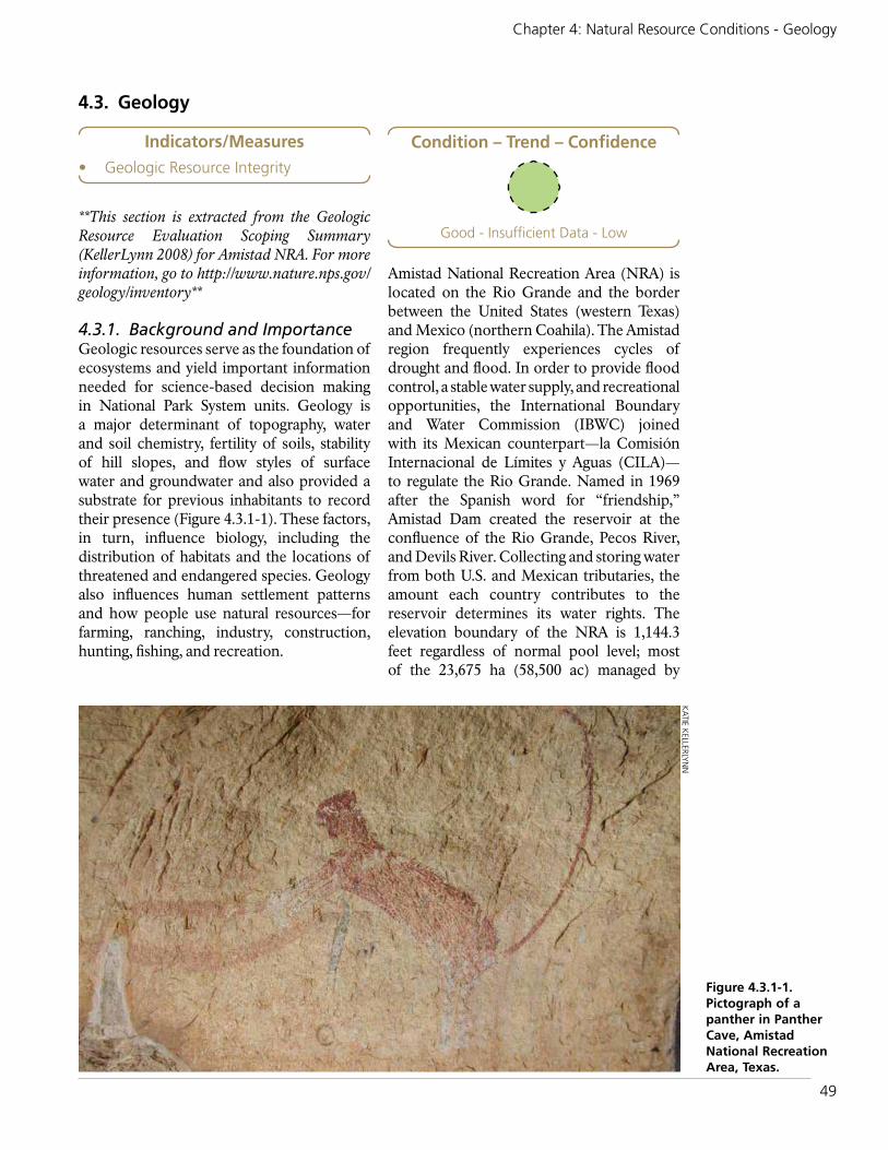
49
Chapter 4: Natural Resource Conditions - Geology
4.3. Geology
**This section is extracted from the Geologic Resource Evaluation Scoping Summary (KellerLynn 2008) for Amistad NRA. For more information, go to http://www.nature.nps.gov/geology/inventory**
4.3.1. Background and ImportanceGeologic resources serve as the foundation of ecosystems and yield important information needed for science-based decision making in National Park System units. Geology is a major determinant of topography, water and soil chemistry, fertility of soils, stability of hill slopes, and flow styles of surface water and groundwater and also provided a substrate for previous inhabitants to record their presence (Figure 4.3.1-1). These factors, in turn, influence biology, including the distribution of habitats and the locations of threatened and endangered species. Geology also influences human settlement patterns and how people use natural resources—for farming, ranching, industry, construction, hunting, fishing, and recreation.
Amistad National Recreation Area (NRA) is located on the Rio Grande and the border between the United States (western Texas) and Mexico (northern Coahila). The Amistad region frequently experiences cycles of drought and flood. In order to provide flood control, a stable water supply, and recreational opportunities, the International Boundary and Water Commission (IBWC) joined with its Mexican counterpart—la Comisión Internacional de Límites y Aguas (CILA)—to regulate the Rio Grande. Named in 1969 after the Spanish word for “friendship,” Amistad Dam created the reservoir at the confluence of the Rio Grande, Pecos River, and Devils River. Collecting and storing water from both U.S. and Mexican tributaries, the amount each country contributes to the reservoir determines its water rights. The elevation boundary of the NRA is 1,144.3 feet regardless of normal pool level; most of the 23,675 ha (58,500 ac) managed by
Figure 4.3.1-1. Pictograph of a panther in Panther Cave, Amistad National Recreation Area, Texas.
KATIE K
ELLERLYN
N
Indicators/Measures• Geologic Resource Integrity
Condition – Trend – Confidence
Good - Insufficient Data - Low

50
Amistad National Recreation Area: Natural Resource Condition Assessment
the National Park Service are submerged. Amistad NRA provides year-round, water-based recreation such as boating and fishing, as well as land-based camping and picnicking. The reservoir’s clear waters—an outcome of the area’s limestone foundation—also make it ideal for swimming and SCUBA diving.
In addition to recreational opportunities, Amistad protects some of the world’s best examples of prehistoric art, notably pictographs. Carbon-14 dating revealed that the oldest pictographs at Amistad are 4,000 years old, from the Lower Pecos River style, but archaeologists surmise that human habitation in the region extends as far back as 10,000 years ago (KellerLynn 2008).
The rich biological diversity of the region is in part due to the Amistad NRA reservoir and that it is located at the convergence of the Chihuahuan Desert, Edwards Plateau Savannah, and Tamaulipan Mezquital ecoregions. Marine fossils from the Cretaceous are embedded in the limestone canyons, and paleontological resources of the Quarternary are preserved within the rock shelters formerly used by indigenous people. These caves, and the continued limestone erosion, provide opportunities to study ancient fauna and flora from the Mesozoic and Cenozoic Eras, the paleoecological record, and archaeological connections to this location as well (Visaggi 2009).
4.3.2. Data and MethodsThis limited assessment summarizes the findings from a geologic resource evaluation scoping summary conducted by the National Park Service Geologic Resources Division (KellerLynn 2008) and a paleontological resource survey (Visaggi et al. 2009). The
summary documents a scoping meeting and field trips with park staff and geologic experts to identify geologic issues, features, and processes. For more information about the Geologic Resources Division, visit http://www.nature.nps.gov/geology/.
4.3.3. Reference ConditionsThe reference conditions by which geology condition was assessed are listed in Table 4.5.3-1.
Good condition is assigned to parks where no concerns or issues about geologic resources have been identified. Geologic resources and processes are in a generally natural state and function.
Moderate condition is assigned to parks if there are some areas of moderate concern either inside the park, or outside the park that may impact it. Examples of this could be moderate disturbance due to soil erosion, oil and gas, or mining exploration in the region.
Significant concern is assigned to parks that have identified areas of concern in assessments conducted by the NPS Geologic Resources Division or have significant impacts occurring inside or outside the park that have the potential to impact park resources.
Level of confidence is assessed depending on the level of information we have on which to base the condition assessment. A Geologic Resources Inventory Report produced by the NPS Geologic Resources Division, or similar report produced by the U.S. Geological Survey or state geologic survey specifically focused on a park’s geology, results in a high confidence level for the assessment. A Geologic Resources Scoping Report (or
Table 4.5.3-1. Qualitative description for determining condition of geologic resources.
Class Description
Good ConditionNo concerns or issues about geologic resources have been identified. Geologic resources and processes are in a generally natural state and function.
Moderate ConcernSome areas of moderate concern either inside the park, or outside the park that may impact it. Examples of this could be moderate disturbance due to soil erosion or mining exploration in the region.
Significant ConcernAreas of concern have been identified in assessments conducted by the NPS Geologic Resources Division or significant activities are occurring outside the park that have the potential to impact park resources.

51
Chapter 4: Natural Resource Conditions - Geology
the equivalent) provides a moderate level of confidence. If a Scoping Summary is all that is available and little is known or available about the geologic resources, then a low confidence level is assigned.
4.3.4. Condition and Trend Specific indicators and measures related to soil erosion are presented in section 4.7 on upland vegetation. Discussions on surface water (4.4) and groundwater (4.5) are presented in separate sections in this report. Based on the geologic scoping completed to date, a few areas of geologic concern have been identified. The condition of the NRA is considered to be in good condition (T. Connors, NPS Geologist, pers. comm. July 2014).
The following discussion on geologic features, processes, and issues are excerpts summarized from the geologic resource evaluation scoping summary (KellerLynn 2008).
Geologic Features and ProcessesCaves and KarstBased on a 1995 inventory of cave and karst resources at Amistad NRA, 23 significant karst features were noted and a cave management plan was recommended. In 1997 park staff did some preliminary work, but did not finish the plan. Since then investigators and visitors have discovered additional caves, which park staff need to add to the informal data set of known information; as of April 2008, the count was up to 36. Cavers mapped it in the 1950s and 1960s. The deepest cave—Goodenough Springs—is submerged; its “end” is 76 m (250 ft) below the entrance at the farthest extent of exploration to date; the exploration project is ongoing. Generally, the caves range from small sinkholes to conduits of up to 100 m (330 ft) in length. Typical depths of sinkholes are 11-18 m (35-60 ft). Such sinkholes may be a threat to unwary hunters or other backcountry users because they are not fenced or gated. Additionally, some of the caves contain “bad air” as a result of rotting vegetation (i.e., buildup of organic matter from the lake) that produces carbon dioxide that displaces oxygen. Park managers know of no threats to infrastructure from karst.
All caves are presently closed to the public pending completion of a management plan. Park managers would like to establish some of the caves as “recreational caves” for visitor use, but need to complete the management plan and perform resource surveys and evaluations before doing so (KellerLynn 2008).
Coastal and Lacustrine Features and ProcessesAmistad reservoir supports more than 1,370 km (850 mi) of shoreline, 870 km (540 mi) of which are in Texas. The water level in the reservoir fluctuates from -59 to +18 around the established conservation level of 1,117 feet above sea level. The State of Texas water master controls the water level; decisions are based primarily on irrigation/agricultural needs.
Known for its submerged resources such as Goodenough Springs, archaeological sites, and historic sites (e.g., submerged remnants of a ranch house, pump house, and two dams), Amistad reservoir is popular with SCUBA divers. Before the dam was constructed (1958-1968), investigators excavated and documented many of the archaeological sites that would become submerged (KellerLynn 2008).
Fluvial Features and ProcessesMajor flood events occurred on the Rio Grande and Devils River in 1932, the mid-1940s, and 1954. The 1954 flood prompted the formation of the International Boundary and Water Commission in 1958 and the damming of the Rio Grande for flood control in 1969. Today flooding occurs as a result of rainfall events, for example, Tropical Storm Charlie in 1998. Such events cause minor damage to bridges and boat docks, as well as erosion, which is a management concern for protecting archaeological sites (KellerLynn 2008). Flood events are also a natural and relatively frequent occurrence and are beneficial in uprooting non-native plants, flushing organics through the systems, and facilitating native plant regeneration.
Seismic Features and ProcessesFault lines run across Amistad NRA; however, active zones are farther west. Seismicity is not

52
Amistad National Recreation Area: Natural Resource Condition Assessment
a management concern; even overhangs in the alcoves are not particularly susceptible to seismic activity (KellerLynn 2008).
Unique Geologic ResourcesUnique geologic resources include natural features mentioned in a unit’s enabling legislation, features of widespread geologic importance, geologic resources of interest to visitors, and geologic features worthy of interpretation. The Geologic Resource Division also considers type localities and age dates as unique geologic resources. At Amistad NRA, unique features include several possible type sections (that is, exposure of a named layered stratigraphic unit or of a stratigraphic boundary that serves as the standard of reference) along the Devils River and possibly along the Rio Grande near the dam (KellerLynn 2008).
Paleontological ResourcesAmistad NRA has a rich paleontological record dating back 100 million years that remains relatively unexplored (Visaggi et al. 2009). Steep canyons of Cretaceous limestone (Salmon Peak Limestone) surround the reservoir; the Devils River Limestone, Del Rio Clay, Buda Limestone, and Boquillas Formation are also exposed within the NRA.
Of the Cretaceous marine fauna fossilized at Amistad, the most interesting are probably rudistid reef, which are quite distinct from the coral reefs of modern oceans. They are composed of extra-large bivalves that existed exclusively in the Late Jurassic and Cretaceous periods of the Mesozoic Era, in shallow, warm water reefs (Visaggi et al. 2009).
The Devils River Limestone includes rudistid reefs and a diversity of fossils that mark a shift from mud- to grain-dominated enviroments, including oysters, rudist bivalves, other mollusks, and corals (Kerans and Zahm 1998, Kerans and Loucks 2002, Miller 1984, Scott 1990, Johnson 2001, as cited in Visaggi et al. 2009).
Del Rio Clay was deposited as a shallow, nearshore muddy environment (Jones 1993, as cited in Visaggi et al. 2009). It is characterized by abundant oysters, and iron oxide minerals
are common. In addition to oysters, this unit also preserves a variety of fossils including ammonites (Kennedy et al. 2005), gastropods (Maddocks 1988), echinoids (Lock et al. 2007), decapods (Richardson 1955), and ostracods (Maddocks 1988, as cited in Visaggi et al. 2009), in addition to microfossils and trace fossils of other species.
The Buda Limestone is a fine-grained limestone, hard, massive, and poorly bedded into nodular thin beds. Trace fossils and bivalves are the most common fossils (Visaggi et al. 2009).
The Boquillas Formation includes four subunits with combinations of interbedded silty shale, siltstone, and granular limestone (Barnes 1977, as cited in Visaggi et al. 2009). The Boquillas formation (the lateral equivalent of the Eagle Ford) is currently very well known due to petroleum production and fracking in the counties southeast of Amistad NRA.
Archaeological excavations have also unearthed Quaternary flora and fauna. Caves preserve the remains of mammals, reptiles, fish, and plants and span 9,000 years of the Holocene Epoch (Santucci et al. 2007, Visaggi et al. 2009). The caves that host these remains are another notable resource. Richly colored (red, yellow, white, and black) rock-art panels up to 5 m (16 ft) in height decorate these caves (KellerLynn 2008).
Geologic IssuesGeologic issues are those that may warrant attention from resource managers at Amistad NRA as they are relevant for maintenance of facilities, mitigation of hazardous conditions, and protection of resources.
Paleontological ResourcesThe fossils at Amistad NRA are extensive, and exposures in caves make them quite accessible (by boat) for interpretation; however, fossil theft is a potential problem due to accessibility. Law enforcement staff employ efforts to stop the theft of fossils and other rocks, nevertheless, there have been instances of theft and attempted theft (KellerLynn 2008):

53
Chapter 4: Natural Resource Conditions - Geology
Disturbed LandsDisturbed lands are those park lands where the natural conditions and processes have been directly impacted by mining, development (e.g., facilities, roads, dams, abandoned campgrounds, and user trails), agricultural practices (e.g., farming, grazing, timber harvest, and abandoned irrigation ditches), overuse, or inappropriate use. The NPS Disturbed Lands Restoration Program, administered by the Geologic Resources Division, usually does not consider lands disturbed by natural phenomena (e.g., landslides, earthquakes, floods, hurricanes, tornadoes, and fires) for restoration unless influenced by human activities.
Some disturbances identified during the scoping meeting include overgrazing by 200 head of exotic mouflon sheep, which may result in erosion and sedimentation. The site has experienced significant historic soil erosion. Furthermore, livestock from surrounding ranches trespass onto parklands. Now that subdivisions are popping up around the NRA, park staff anticipate that development will bring other disturbances (KellerLynn 2008), such as off-road vehicles, dispersed camping and social trails, and other recreational activities that are likely to increase land disturbance.
Hillslope Features and ProcessesCreation of the reservoir and fluctuating water levels induce slope processes. For example a “slump site” has formed on the San Pedro arm of the reservoir, near the San Pedro bridge. As lake levels dropped, the area slumped. This slump is near an archaeological site, which is a management concern. In addition, the steep cliffs in the NRA are a source of rockfall; “boulder fields” have formed in places along
the base. Rockslides also originate from the railroad grade; the areas surrounding the two railroad tunnels generate rockfall (KellerLynn 2008).
Oil and Gas Exploration and DevelopmentWhile the Permian Basin is attractive for oil and gas exploration and development, the area near Amistad does not appear to be impacted at this time.
Overall ConditionIn parks that do not have a geologic resource focus, that is, they do not have significant canyons or volcanoes or other prominent geologic features, no specific indicators or measures have been identified by which to assess geologic condition. In these cases, we use professional judgment and qualitative assessment of general geologic integrity to assign condition class and level of confidence. Table 4.5.4-1 clearly states how condition was assessed.
The condition of the geologic resources at Amistad NRA is in good condition, with a low level of confidence.
4.3.5. Sources of ExpertiseThe National Park Service’s Geologic Resources Division conducts geologic inventories and resource evaluations, and produces digital geologic maps in close partnership with the Inventory and Monitoring Program, park staff, and partners. This section is based entirely on a report (KellerLynn 2008) produced by the Geologic Resources Division, and was reviewed by
Geology
Indicator Measures
Geologic Integrity None
Table 4.5.4-1. Indicator, measure, and rationale of geology condition.Indicator of Condition
Measure Condition Rationale for Condition
Geologic Integrity
None Good Generally geologic resources, including the outstanding paleontological resources, are in good condition. The park should be vigilant about preventing theft of exposed fossils, but otherwise human disturbances related to the geologic resources are few.
A geologic resource evaluation scoping summary was completed in 2008.

54
Amistad National Recreation Area: Natural Resource Condition Assessment
Tim Connors, Geologist at the National Park Service Geological Resources Division. The paleontological resources section was reviewed by Vincent Santucci, Paleontologist for the National Park Service.
4.3.6. Literature CitedBarnes, V. E. 1977. Del Rio Sheet, Geologic
Atlas of Texas. University of Texas Bureau of Economic Geology, Austin, TX. 1:250,000 scale map. (as cited in Visaggi et al. 2009)
Johnson, C. C. 2001. Taxonomic and morphologic changes in corals and rudists from Aptian and Albian strata, Texas and Puerto Rico. Geological Society of America Abstracts with Programs 33(6):13. (as cited in Visaggi et al. 2009)
Jones, J. O. 1993. Amistad National Recreation Area: Stratigraphy and paleontology, page 3 in National Park Service Paleontological Research Abstract Volume Technical Report NPS/NRPEFO/NRTR-93/11. (as cited in Visaggi et al. 2009)
KellerLynn, K. 2008. Geologic Resource Evaluation Scoping Summary, Amistad National Recreation Area, Texas. Geologic Resources Division, National Park Service. Denver, CO.
Kennedy, W. J. W. A. Cobban, J. M. Hancock, and A. S. Gale. 2005. Upper Albian and Lower Cenomanian ammonites from the Main Street Limestone, Grayson Marl and Del Rio Clay in northeast Texas. Cretaceous Research 26(3):349-428. (as cited in Visaggi et al. 2009)
Kerans, C. and R. G. Loucks. 2002. Stratigraphic setting and controls on occurrence of high-energy carbonate beach deposits; Lower Cretaceous of the Gulf of Mexico. Gulf Coast Association of Geological Societies Transactions 52:517-526. (as cited in Visaggi et al. 2009)
Kerans, C. and L. C. Zahm. 1998. Facies partitioning at the high-frequency sequence scale in carbonate ramp systems. American Association of
Petroleum Geologists Annual Meeting Abstracts 1998:55. (as cited in Visaggi et al. 2009)
Lock, B. E., F. S. Bases, and R. A. Glaser. 2007. The Cenomanian sequence stratigraphy of central to west Texas. Transactions of the Gulf Coast Association of Geological Societies 57:465-479.
Maddocks, R. F. 1988. One hundred million years of predation on ostracods; the fossil record in Texas, pages 637-657 in T. Hanai, N. Ikeya, and K. Ishizaki, eds. Evolutionary Biology of Ostracoda: Its fundamentals and applications. Elsevier, Netherlands. (as cited in Visaggi et al. 2009)
Miller, B. C. 1984. Physical stratigraphy and facies analysis, Lower Cretaceous, Maverick Basin, and Devils River Trend, Uvalde and Real counties, Texas. Bulletin of the American Association of Petroleum Geologists 68(4):508. (as cited in Visaggi et al. 2009)
Richardson, E. S., Jr. 1955. A new variety of Cretaceous decapod from Texas. Fieldana Zoology 37:445-448. (as cited in Visaggi et al. 2009)
Santucci, V. L., J. P. Kenworthy, and C. C. Visaggi. 2007. Paleontological Resource Inventory and Monitoring. Chihuahuan Desert Network. National Park Service TIC#D-500.
Scott, R. W. 1990. Models and stratigraphy of mid-Cretaceous reef communities, Gulf of Mexico. SEPM Concepts in Sedimentology and Paleontology 2. (as cited in Visaggi et al. 2009)
Visaggi, C. C. J. G. Johnson, A. S. Johnson, J. P. Kenworthy, and V. L. Santucci. 2009. Paleontological resource survey, Amistad National Recreation Area. Natural Resource Report NPS/NRPC/GRD/NRR—2009/133 (Public version, September 2009) National Park Service, Fort Collins, CO.

55
Chapter 4: Natural Resource Conditions - Surface Water Quality
4.4. Surface Water Quality
4.4.1. Background and Importance Streams and rivers are the integrators within a landscape. They depend upon inputs such as energy and nutrients from within their watershed, which in turn, support a wide variety of services. These services include habitat for plants and animals, hydrologic cycling, nutrient processing, recreational opportunities, as well as water supply for public and private uses. Since streams and rivers are generally sensitive to stressors, both locally and at the watershed-level, they are one of the most useful ecosystems to monitor to determine long-term conditions and trends (NPS I&M 2012) (Figure 4.4.1-1).
NPS Management Policies (2006a) state that parks must work with other governmental agencies to obtain Clean Water Act (CWA)
standards, take necessary action to maintain or restore surface water quality to the standards of the CWA or to meet federal, state, or local laws and regulations. This includes developing partnerships with other agencies to maximize resources and expertise to maintain these standards.
The health and quality of Amistad National Recreation Area’s (NRA) water resources are integral to the park’s mandate to provide for public outdoor recreation use and enjoyment of the United States (U.S.) portion of Amistad Reservoir and to protect the associated scenic, scientific, and cultural values (NPS 2006b). The numerous springs and seeps along the river and reservoir edges are considered as surface water once discharged. These
NPS
Figure 4.4.1-1. A view of the Pecos River and cliffs from the boat ramp, Amistad National Recreation Area, is one of the primary rivers monitored for water quality.
Indicators/Measures• Core Parameters (6 measures)• Nutrients (7 measures)• Major Ions (4 measures)• Metals (9 measures)
Condition - Trend - Confidence
Moderate to Significant Concern - Varied - High

56
Amistad National Recreation Area: Natural Resource Condition Assessment
resources support a diverse aquatic habitat and associated biological resources; however, these resources have been significantly impacted by the creation of the reservoir (Purchase et al. 2001) and are further discussed in the groundwater and springs section of this report.
Continued protection of the park’s water resources requires extensive coordination and cooperation between the U.S. and Mexico governments and adjacent landowners. The U.S. Section of the International Boundary and Water Commission (USIBWC) is responsible for coordinating all water quality data throughout the Texas portion of the Rio Grande Basin, which includes the park.
Water Resources at Amistad NRAAmistad Reservoir was created by damming the Rio Grande approximately 19 km (12 river mi) northwest of Del Rio, Texas and Cuidad Acuna, Coahuila and 1.6 km (1 mi) below the confluence with the Devils River and is fed by three major rivers: Rio Grande, Pecos
River, and Devils River. The NRA’s boundary is defined as the “reservoir surface and shore area up to the 348.7 m (1,144 ft) elevation contour above mean sea level, with a pool conservation level of 340.5 m (1,117 ft) above mean sea level” (NPS 2006b, p.3) and extends 119 km (74 mi) up the Rio Grande, 22 km (14 mi) up the Pecos River, and 40 km (25 mi) up the Devils River (NPS 2016).
Rio Grande RiverThe Rio Grande headwaters in the Colorado Rocky Mountains and is the 5th longest river in North America. The river extends ~2,012 km (1,250 mi) between the Texas / New Mexico state line and the Gulf of Mexico and is divided into four sub-basins managed by the USIBWC: upper, middle, and lower Rio Grand and the Pecos River (Figure 4.4.1-2).
The Upper Rio Grande sub-basin extends upstream from the Texas-New Mexico state line down to the International Amistad Dam — a length of 1,045 km (650 mi). The section that is within the park begins 58 km (36 mi)
Figure 4.4.1-2. The Rio Grande River Basin, managed by the USIBWC, extends from the Texas/New Mexico border to the Gulf of Mexico for ~2,012 km (1,250 mi) (figure excerpted from USIBWC nd). Rectangle shows the area of Amistad NRA within the Rio Grande Basin.

57
Chapter 4: Natural Resource Conditions - Surface Water Quality
above the confluence with the Pecos River (Purchase et al. 2001). Both the Rio Conchos in Mexico and the Pecos River in the United States serve as major tributaries to the Rio Grande, with the Big Bend region located between these two river systems.
The Rio Grade is characterized by a low gradient channel that meanders through high canyon walls (Purchase et al. 2001). Dam regulations have reduced regular high flows, resulting in channel incision and sediment deposition throughout some river segments. Historically, native riparian species, along with regular flows, helped to maintain the river’s channel morphology and function (Purchase et al. 2001).
Pecos RiverThe Pecos River is located within an 11.4 million hectares (44,000 square miles) watershed originating in New Mexico’s Sangre de Cristo Mountains, is impounded by the Red Bluff Reservoir, and flows southeasterly joining the Rio Grande upstream of the Amistad Reservoir. Historically, the Pecos River was wide, but irrigation practices since as early as 1877 and the establishment of salt cedar (Tamarix spp.) along the riverbanks, have reduced river flow and increased sedimentation (Purchase et al. 2001).
Devils RiverThe Devils River is perennial, spring fed, and the most pristine of the park’s river environments. It drains an area of 1.1 million hectares (4,305 square miles). Semi-annual high flows, limited land use alterations, and lack of highly invasive plant species throughout the watershed have helped to maintain the water quality within this river environment.
4.4.2. Data and Methods Water quality is a vital sign for the Chihuahuan Desert Inventory and Monitoring (I&M) Network (CHDN), including Amistad NRA. In 1995, the National Park Service’s Water Resources Division contracted with the I&M to provide a baseline surface water quality inventory for Amistad NRA and published the results from data retrievals from six of the U.S. Environmental Protection Agency’s (EPA)
databases: (1) Storage and Retrieval (STORET) water quality database management system; (2) River Reach File (RF3); (3) Industrial Facilities Discharge (IFD); (4) Drinking Water Supplies (DRINKS); (5) Water Gages (GAGES); and (6) Water Impoundments (DAMS) (NPS 1995). The retrieval from STORET, which relates to water quality related-data resulted in 72,973 observations for 544 separate parameters collected by the EPA, USGS, and Texas Water Commission at 84 monitoring stations. Most of the sampling stations represent either one-time or intensive single-year sampling efforts by the collecting agencies. Of the 84 stations, 36 were located within the park boundary, with nine of those stations yielding longer-term records (NPS 1995).
Currently, the USIBWC Texas Clean Rivers Program (CRP), a state fee–funded program, is responsible for coordinating the water quality monitoring, assessment, and public outreach throughout the Rio Grande Basin (area shown in Figure 4.4.1-2). The CRP’s primary goal is to improve the quality of water within each Texas river basin through partnerships with the Texas Commission on Environmental Quality (TCEQ) and 15 participating entities and to support special projects or studies when needed (USIBWC 2013). The program focuses on a watershed management approach to identify and evaluate water quality issues, establish priorities for corrective actions, and work to implement those actions.
To determine water quality conditions throughout the basin, the USIBWC CRP used 2002-2011 water quality data from USIBWC and TCEQ stations and flow data from the USGS stations. However, USGS data are primarily flow/discharge and sampled sporadically, therefore, not as detailed as USIBWC and TCEQ’s water quality data (L. Grijalva, USIBWC CRP RG Basin Program Manager, pers. comm., Dec. 2015).
The USIBWC publishes annual basin highlight reports, with the most recent one released in 2015. The USIBWC also publishes a more extensive summary report every five years, with 2013 representing the most

58
Amistad National Recreation Area: Natural Resource Condition Assessment
recent publication. These reports synthesize the water quality data throughout the basin, providing a watershed perspective, and were used to assess the condition of water quality within the NRA. In addition, USIBWC report results were cross-referenced to TCEQ’s (2014a) integrated 303(d) list report to provide the most current published information to assess Amistad NRA’s water quality condition.
River SegmentsAs stated and shown previously, the portion of the Rio Grande Basin managed by USIBWC is divided into the upper, middle, and lower Rio Grande and the Pecos River sub-basins. These sub-basins are then further divided into classified or designated river segments based upon common characteristics, such as water quality, land use, and habitat types and are protected by site-specific criteria
established by TCEQ surface water quality standards (USIBWC 2013). Each river segment is then subdivided into assessment units for more site-specific evaluations and conditions (USIBWC 2013). Table 4.4.2-1 summarizes the sub-basins, river segments, and assessment units within each segment that are most closely associated with Amistad NRA (Figure 4.4.2-1).
Each assessment unit contains water quality monitoring stations associated with the agency who collects the data (Table 4.4.2-2) (Figure 4.4.2-2). All agencies are required to use the sampling methods outlined in TCEQ’s Surface Water Quality Monitoring Procedures Manual, Volume 1 to ensure data integrity (USIBWC 2013). USGS gauging stations 08377200 and 08447410 are associated with stations 13223 and 13240, respectively.
Table 4.4.2-1. Water quality monitoring sub-basins, river segments, assessment units and unit names adjacent to or within Amistad NRA (USIBWC 2013).
Sub-BasinRiver Segment
Name
River Segment Length (km/mi)
Total # of Assessment
Units
Assessment Unit(s)
Closest to NRA
Assessment Unit Name(s) Closest to NRA
Upper Rio Grande
2306 - Rio Grande Above
Amistad Reservoir 1
503 / 313 9 2306_01
Rio Grande from the lower segment boundary at Ramsey Canyon upstream to the confluence of Panther Gulch.
2305 - International
Amistad Reservoir
120 / 75 4
2305_01 Rio Grande Arm
2305_02 Devils River Arm
2305_03Area around International Boundary Buoy 1
2305_04 Remainder of Reservoir
Pecos River
2310 - Lower Pecos River
143 / 89 3 2310_01
Pecos River from the Devils River Arm of International Amistad Reservoir confluence upstream to FM 2083 near Pandale
2309 - Devils River 2 108 / 67 2 2309_01
From the Rio Grande Arm of Amistad Reservoir upstream to Yellow Bluff (near the origin of Dolan Springs)*
Middle Rio Grande
2304 - Rio Grande Below
Amistad Reservoir
364 / 226 23 2304_10Rio Grande from the San Felipe confluence upstream to International Amistad Dam
1 This river segment is located just beyond (~0.60 miles) the NRA’s boundary.2 Water quality stations within the Devils River that are closest to Amistad NRA are located in river segment 2305 within assessment unit 2305_02 - Devils River Arm.
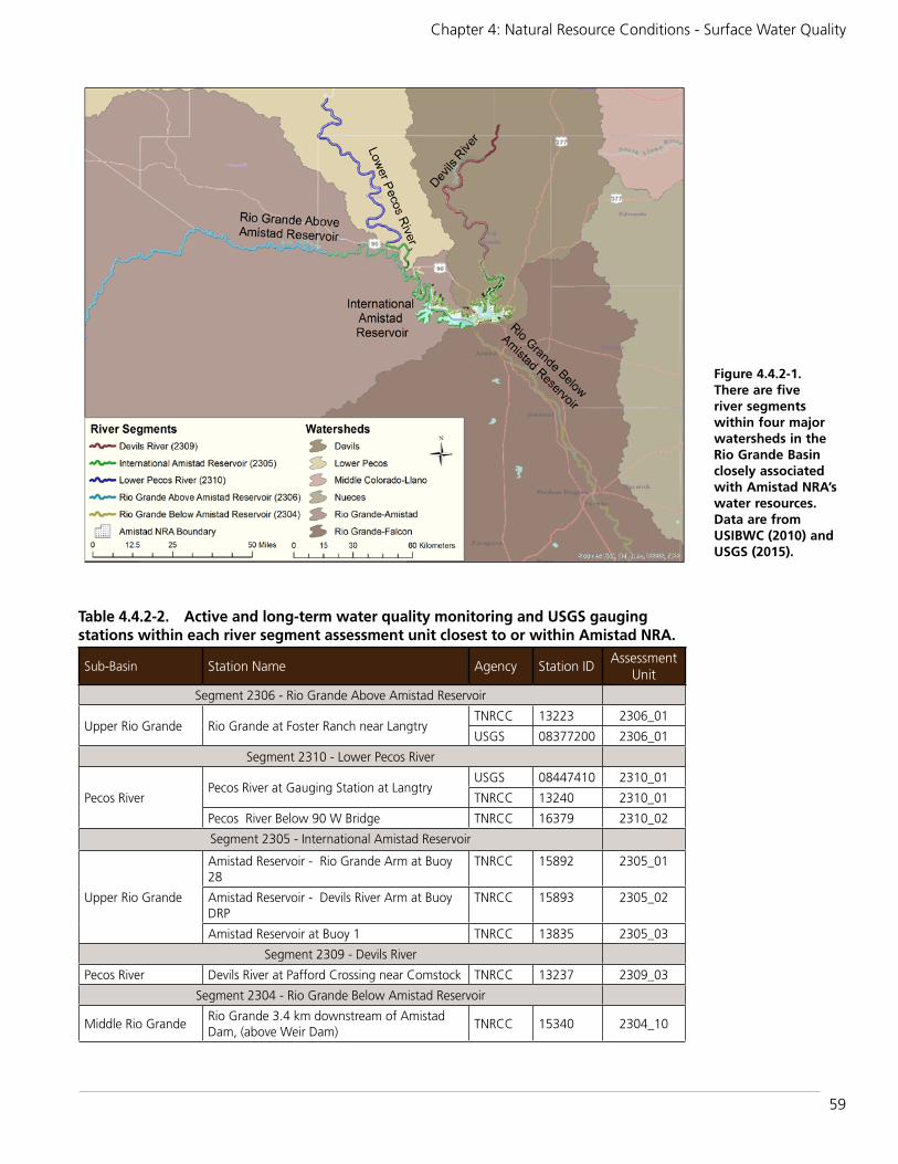
59
Chapter 4: Natural Resource Conditions - Surface Water Quality
Figure 4.4.2-1. There are five river segments within four major watersheds in the Rio Grande Basin closely associated with Amistad NRA’s water resources. Data are from USIBWC (2010) and USGS (2015).
Table 4.4.2-2. Active and long-term water quality monitoring and USGS gauging stations within each river segment assessment unit closest to or within Amistad NRA.
Sub-Basin Station Name Agency Station IDAssessment
Unit
Segment 2306 - Rio Grande Above Amistad Reservoir
Upper Rio Grande Rio Grande at Foster Ranch near LangtryTNRCC 13223 2306_01
USGS 08377200 2306_01
Segment 2310 - Lower Pecos River
Pecos RiverPecos River at Gauging Station at Langtry
USGS 08447410 2310_01
TNRCC 13240 2310_01
Pecos River Below 90 W Bridge TNRCC 16379 2310_02
Segment 2305 - International Amistad Reservoir
Upper Rio Grande
Amistad Reservoir - Rio Grande Arm at Buoy 28
TNRCC 15892 2305_01
Amistad Reservoir - Devils River Arm at Buoy DRP
TNRCC 15893 2305_02
Amistad Reservoir at Buoy 1 TNRCC 13835 2305_03
Segment 2309 - Devils River
Pecos River Devils River at Pafford Crossing near Comstock TNRCC 13237 2309_03
Segment 2304 - Rio Grande Below Amistad Reservoir
Middle Rio GrandeRio Grande 3.4 km downstream of Amistad Dam, (above Weir Dam)
TNRCC 15340 2304_10

60
Amistad National Recreation Area: Natural Resource Condition Assessment
River Segment 2306: Rio Grande above International Amistad DamRiver segment 2306 is approximately 503 km (313 river mi) long beginning downstream of the confluence with the Rio Conchos (Mexico) in Presidio County, flowing through Big Bend Ranch State Park and Big Bend National Park. This segment ends at a point 1.8 km (1.1 mi) downstream of the confluence of Ramsey Canyon in Val Verde County and just upstream of the International Amistad Reservoir (USIBWC 2013).
River Segment 2305: International Amistad ReservoirRiver segment 2305 is approximately 120 km (75 mi) long beginning from International Amistad Dam to a point 1.8 km (1.1 mi) downstream of the confluence of Ramsey Canyon in Val Verde County (USIBWC 2013) and is located completely within the park’s boundary. The majority of the water flowing into the reservoir is via rainfall runoff along the Rio Grande between Presidio and the reservoir or from Mexico’s Rio Conchos. Both the Pecos and Devils Rivers eventually
empty into the reservoir also serving as sources of water.
River Segment 2304: Rio Grande Below International Amistad ReservoirRiver segment 2304 is 364 km (226 river mi) long beginning downstream of the International Amistad Reservoir to the confluence of the Arroyo Salado in Zapata County (USIBWC 2013) and only 4.2 km (2.6 mi) are within the park’s boundary. This segment is mostly situated along populated areas of the river to the southeast of the reservoir.
River Segment 2309: Devils RiverRiver segment 2309 is 108 km (67 mi) long and only approximately 4 km (2.5 mi) of this segment are in the NRA’s boundary. Water quality monitoring stations associated with the Devils River and related to the park are situated within river segment 2305 International Amistad Reservoir, along the Devils River Arm. A short distance of river segment 2309 is within the park’s boundary
Figure 4.4.2-2. There are eight long-term water quality monitoring stations near or in Amistad NRA. Data are from USIBWC GIS dataset.

61
Chapter 4: Natural Resource Conditions - Surface Water Quality
but does not include any monitoring stations within this short distance.
River Segment 2310: Lower Pecos RiverRiver segment 2310 is approximately 143 km (89 mi) long and extends from the Pecos River from the Devils River Arm of International Amistad Reservoir confluence upstream to FM 2083 near Pandale. This segment includes one assessment unit within the park’s boundary.
Water Quality Parameters The FY2013 USIBWC water quality network included a total of 91 water quality monitoring stations throughout the entire Rio Grande Basin. The number of stations typically vary between years depending upon the data needs (e.g., new recommendations, localized issues, and/or available resources) (USIBWC 2013). In general, the Rio Grande has a long monitoring record to detect current water quality trends, and the Pecos River is also fairly well monitored and studied, whereas the Devils River is the least studied but most pristine.
Twenty-five priority water quality parameters, comprising four major groups (i.e., general/core parameters, nutrients, major ions, and metals) were monitored and are listed for each river segment in Table 4.4.2-2. The water samples were analyzed for physical, chemical, biological, and bacteriological information to provide baseline data for the determination of potential effects of point and non-point sources of pollution throughout the Rio Grande Basin (USIBWC 2013). These parameters were also analyzed for trends using data from 2002-2011, with the exception of fluoride, which was only monitored in the Devils River segment #2309 (USIBWC 2013).
USIBWC staff retrieved the water quality monitoring data from the TCEQ’s Surface Water Quality Monitoring (SWQM) database, meeting the following criteria: (1) at least 10 years of data, (2) regular sampling, and (3) minimum of 20-30 data points (USIBWC 2013).
Indicator/MeasuresGeneral (Core) Parameters (6 measures)
The six core water quality parameters are monitored throughout all five river segments and included water temperature, specific conduct ance (the ability of a solution to conduct an electrical current, i.e., the lower the conductivity, the “purer” the water), transparency/turbidity, pH, dissolved oxygen, and Esherichia coli (E. coli).
These water quality measures are easily monitored and constitute a means of characterizing potential stressors to the health of aquatic systems. Monitoring for these parameters dovetails with that of the NPS service-wide Water Quality Monitoring Program, which requires each network to collect all of these parameters (except for transparency/turbidity), for any water quality monitoring effort.
E. coli is one of the main species of bacteria living in the lower intestines of mammals, therefore, its presence in water is an indication of fecal contamination. Extreme conditions of this parameter is a good proxy for stream pollution and acts as an early warning of potential pathogen risks for aquatic and terrestrial biota.
Indicators/MeasuresNutrients (7 measures)
Seven nutrient parameters are monitored within river segments 2304 and 2306 , which includes four forms of nitrogen, two forms of phosphorus, and chlorophyll-a. Total nitrogen and cholorophyll-a are not monitored within the reservoir (segment #2305) and not within segments 2309 and 2310, respectively.
Nutrient levels in streams result from a hierarchy of biotic and abiotic processes occurring in the watershed, riparian zone, hyporheic zone, and the stream itself. Nitrogen and phosphorus are essential macronutrients for plant and animal life, but in excess they can interact with the biological and physical environment to reduce availability of high-quality aquatic habitat,

62
Amistad National Recreation Area: Natural Resource Condition Assessment
altering the composition and species diversity of aquatic communities. Measures of total nitrogen and total phosphorus indicate the potential for biological effects resulting from nutrient loading. High concentrations of nitrogen and/or phosphorus can increase levels of algae and chlorophyll-a.
Chlorophyll-a is a photosynthetic pigment found in all green plants and is an excellent measure of water column algae and/or phytoplankton concentrations and provides information about a waterbody’s state of eutrophication (USIBWC 2013).
Table 4.4.2-2. Water quality parameters monitored at stations from 2002-2011 in each assessment unit in closest proximity to Amistad NRA (USIBWC 2013).
Parameter Group and Type(s)
River Segments
2304 2305 2306 23091 2310
General (Core) Parameters
Dissolved Oxygen (mg/L) • • • • •pH (standard units (SU)) • • • • •Specific Conductance, Field (μmhos/cm @ 25°C) • • • • •Water Temperature (Degrees Centigrade) • • • • •Transparency, Secchi Disc (meters) • • • • •E. coli (MPN / 100 mL) • • • • •Nutrients
Ammonia Nitrogen (mg/L as N) • • • • •Nitrate Nitrogen (mg/L as N) • • • •Orthophosphate Phosphorus (mg/L as P) • • • • •Phosphorus, Total, Wet Method (mg/L as P) • • • • •Total Kjeldahl Nitrogen (mg/L as N) • • • • •Total Nitrogen (mg/L as N) • • •Chlorophyll-a (μg/L) • • •Major Ions
Chloride (mg/L as Cl-) • • • • •Sulfate (mg/L as SO4
2-) • • • • •Total Fluoride (mg/l) •Total Dissolved Solids (TDS) (mg/L) • • • • •Metals (Dissolved)
Aluminum (μg/L as Al) • •Arsenic2 (μg/L as As) • • •Cadmium (μg/L as Cd) • •Chromium (μg/L as Cr) • •Copper (μg/L as Cu) • •Lead (μg/L as Pb) • •Nickel (μg/L as Ni) • •Silver (μg/L as Ag) • •Zinc (μg/L as Zn) • •
1 Data were obtained from USIBWC Excel spreadsheet for station #13237 within the Devils River segment #2309. 2 Arsenic is a metalloid.

63
Chapter 4: Natural Resource Conditions - Surface Water Quality
Indicators/MeasuresMajor Ions (4 measures)
The major ions sampled include chloride, sulfate, and total dissolved solids within all river segments. The fourth major ion, fluoride, is only monitored within the Devils River segment 2309.
Total dissolved solids measures the mix of various salts dissolved in water, with high concentrations limiting the use for agricultural, drinking and industrial purposes.
These ions are important indicators of the watershed context of the stream, with different ion concentrations reflecting variation in geology, vegetation, and weathering processes. However, high concentrations of sulfate is common from mining waste or agricultural runoff, which are both relevant to this area, and can indicate pollution as well (Schweiger et al. 2012).
Indicators/MeasuresMetals (9 measures)
Eight metals (i.e., aluminum, chromium, nickel, cadmium, copper, lead, silver and zinc) and one metalloid (arsenic) are monitored within the Rio Grande River, both above (segment #2306) and below (segment #2304) Amistad Reservoir. Only arsenic is monitored within the Lower Pecos River segment #2310.
In high concentrations, metals cause major disruptions of aquatic ecosystems by lowering reproductive success, interfering with normal growth and development, and, in extreme cases, causing death of organisms. The relationship of metal toxicity to aquatic species is complex but well established. Surface waters in parks are exposed to metals through both point and non-point sources, including mine drainage, roadways, aerosolized particles dispersed through industrial processes, and by the release of metals naturally occurring in near-surface rock strata and sediments. Most of these contaminants bioaccumulate in aquatic food webs and may pose long-term threats to all trophic levels of the aquatic environment.
4.4.3. Reference ConditionsAccording to the U.S. Geological Survey (USGS) Water Science School, water quality is “a measure of the suitability of water for a particular use based on selected physical, chemical, and biological characteristics” (USGS 2012). Surface water quality is important for maintaining healthy habitats for many aquatic organisms, wildlife, and humans and can provide insights into overall system productivity, shift species abundance and distributions, and alter nutrient cycles (USDI NPS 2008, NPS-CHDN 2010).
The Texas Commission on Environmental Quality Control Commission establishes water quality standards for each Texas waterbody segment in accordance with the EPA and standards set forth by the Clean Water Act (TCEQ 2014b). Water quality criteria, either numerical or descriptive, are identified for water quality parameters depending upon designated uses: aquatic life use, general use, contact recreation, public water supply, and fish consumption (USIBWC 2013). Water quality criteria are determined based upon the use and specific conditions or pollutants. Water quality data are then evaluated against the established criteria to determine if the quality is high enough to maintain designated uses.
The water quality standards for the five river segments associated with Amistad NRA are listed in Table 4.4.3-1 for core parameters and major ions and in Table 4.4.3-2 for metals, serving as the reference conditions for this assessment. Note that different segments may have different standards. If the water quality data indicated poor water quality, and the water body was classified as “impaired” by the TCEQ, we considered it to be of significant concern since it was not supporting its designated use(s). If a parameter was identified as a “concern” but not listed on TCEQ’s 303(d) list, we considered the parameter to be in moderate condition.
In June 2010, TCEQ adopted site-specific numeric nutrient water quality criteria, although none were stipulated for streams or for Amistad Reservoir (TCEQ 2015). Even though criteria are not established, TCEQ

64
Amistad National Recreation Area: Natural Resource Condition Assessment
screens phosphorus, nitrate nitrogen, and chlorophyll-a data to provide preliminary indications of areas of possible concern based upon designated uses (USIBWC 2013).
4.4.4. Condition and Trend A summary of the conditions for the four water quality indicators (i.e., core parameters, nutrients, major ions, and metals) are
summarized in Tables 4.4.4-1 for core parameters and nutrients and in Table 4.4.4-2 for major ions and metals at three assessment levels: stations closest to the park, assessment unit closest to the park, and remaining river segment excluding the assessment unit closest to the park. Note that the values for the parameters were not presented in this assessment due to the volume of information.
Table 4.4.3-2. 2014 Texas surface water quality criteria for metals and designated uses (TCEQ 2014b).
Metals (Dissolved)Aquatic Life Protection
Human Health Protection
Freshwater Acute Freshwater Chronic Water and
FishFish Only
Aluminum (μg/L as Al) 991w -- -- --
Arsenic (μg/L as As) 340w 150w 101 --
Cadmium (μg/L as Cd) (1.136672-(ln(hardness)(0.041838))) (we (1.0166(ln(hardness))-2.4743))
(1.101672-(ln(hardness)(0.041838))) (we (0.7409(ln(hardness))-4.719)) 51 --
Chromium (Hex) (μg/L as Cr)
15.7w 10.6w 62 502
Copper (μg/L as Cu) 0.960me(0.9422(ln(hardness))-1.6448) 0.960me(0.8545(ln(hardness))-1.6463) -- --
Lead (μg/L as Pb) (1.46203-(ln(hardness)(0.145712))) (we(1.273(ln(hardness))-1.460))
(1.46203-(ln(hardness)(0.145712))) (we(1.273(ln(hardness))-4.705)) 1.15 3.83
Nickel (μg/L as Ni) 0.998we(0.8460(ln(hardness))+2.255) 0.997we(0.8460(ln(hardness))+0.0584) 332 1140
Silver (μg/L as Ag) 0.8w - -- --
Zinc (μg/L as Zn) 0.978we(0.8473(ln(hardness))+0.884) 0.986we(0.8473(ln(hardness))+0.884) -- --
1 Based on Maximum Contaminant Levels (MCLs) specified in 30 TAC §290 (relating to Public Drinking Water).
e The mathematical constant that is the basis of the natural logarithm. When rounded to four decimal points, e is equal to 2.7183.
m Indicates that a criterion may be multiplied by a water-effect ratio (WER) or a biotic ligand model result in order to incorporate the effects of local water chemistry on toxicity. The multiplier is equal to 1 except where sufficient data is available to establish a site-specific multiplier. Multipliers for individual water bodies are listed in Appendix E when standards are revised. The number preceding the m in the freshwater equation is an EPA conversion factor.
w Indicates that a criterion is multiplied by a WER in order to incorporate the effects of local water chemistry on toxicity. The WER is equal to 1 except where sufficient data is available to establish a site-specific WER. WERs for individual water bodies are listed in Appendix E when standards are revised. The number preceding the w in the freshwater criterion equation is an EPA conversion factor.3 The critical low-flow for Segments 2309 and 2313 is calculated in accordance with §307.8(a)(2)(A) of this title.
Table 4.4.3-1. 2014 Texas surface water quality standards for core parameters and major ions and designated uses (TCEQ 2014b).
Segment Number
Rio Grande BasinSegment Names
RecreationUse
AquaticLife Use
Domestic Water
Supply Use
Cl-
(mg/L)SO4
2-
(mg/L)TDS
(mg/L)
Dissolved Oxygen (mg/L)
pH Range (SU)
IndicatorBacteria1
#/100 mL
Temp(ºF)
2304 Rio Grande Below Amistad Reservoir
PrimaryContact
Recreation
High
Public2 200 300 1,000 5.0
6.5-9.0
126
95
2305 International Amistad Reservoir
Public
150 270 800 5.0 88
2306 Rio Grande Above Amistad Reservoir
200 450 1,400 5.0 93
2309 Devils River3 Exceptional 50 50 300 6.0 90
2310 Lower Pecos River High 1,700 1,000 4,000 5.0 92
1 The indicator bacteria for freshwater is E.coli.2 Designated in the 2014 TCEQ as a sole-source surface drinking water supply.3 The critical low-flow for Segments 2309 and 2313 is calculated in accordance with §307.8(a)(2)(A) of this title.

65
Chapter 4: Natural Resource Conditions - Surface Water Quality
If interested, please refer to USIBWC’s (2013 and 2015) reports.
Condition of Core ParametersUSIBWC’s (2013) trend analyses for core parameters at station 13835, within the
Amistad Reservoir (river segment 2305) showed a decrease in dissolved oxygen and an increase in pH, total phosphorus, sulfate, and conductivity, indicating water quality degradation in 2012. At the time of the trend analyses, low water levels and quality
Table 4.4.4-1. Summary of the surface water quality core parameters and nutrients and their conditions at station(s) and assessment unit(s) closest to Amistad NRA, and conditions within the remaining river segment assessment units (USIBWC 2013, 2015; TCEQ 2014a).
Assessment Extent
Condition for River Segment
Condition Rationale
2304 Below Reservoir
2305 Reservoir
2306 Above
Reservoir2309*
Devils River
2310 Lower Pecos
River
Assessment Units *
2304_102305_01, 02,
03, 04 2306_01 2309_01 2310_01
Core Parameters (6 measures)
Stations Within Assessment Unit
Good
Good Good Good Good
Station and Assessment Unit Levels: E. coli levels showed an increasing trend at station #13208 within river segment 2304; however, bacteria was not listed as a concern on TCEQ’s (2014a) list at this particular station. Overall, the conditions of the core parameters at the station and assessment unit levels are in good condition.Watershed Level: Many of the assessment units below the reservoir (river segment 2304) are currently impaired for contact recreation due to high levels of bacteria below Del Rio, TX and have been since 1996. Dissolved oxygen levels are also of concern within river segment 2304 closer to Amistad. Likely sources of pollutants include urban runoff, municipal effluent, and discharges made outside U.S. jurisdiction (USIBWC 2015, TCEQ 2014a).
Assessment Unit(s) *
Remaining Assessment Units Within River Segment
Significant Concern (E. coli)
Moderate (Dissolved Oxygen)
Nutrients (7 measures)
Stations Within Assessment Unit
GoodModerate (nitrate)
Moderate (total
phosphorus)
Good
Moderate (harmful alga
bloom)
Station and Assessment Unit Levels: Nitrate was listed as a concern for the Devils River arm only in 2014 within river segment 2305, which is an improvement from 2012 when both the Devils River and Rio Grande Arms were of concern for nitrate. Total phosphorus was listed as a concern just above the reservoir, within river segment 2306. Fish kills were reported within the Lower Pecos River assessment unit 2310_01, which may have been exacerbated by drought conditions (USIBWC 2013). Harmful golden alga blooms were also reported within the Lower Pecos River segment. Overall, the condition is moderate for nutrients at the station and assessment unit levels.Watershed Level: There are concerns for ammonia levels and toxicity in the water by the Falcon International Reservoir in segment 2304 were listed. In segment 2306, above the NRA, chlorophyll-a and fish kills were listed as concerns (USIBWC 2015).
Assessment Unit(s) *
Remaining Assessment Units Within River Segment
Moderate (ammonia and water toxicity)
GoodModerate
(chlorophyll-a and fish kills)
Good

66
Amistad National Recreation Area: Natural Resource Condition Assessment
of water received from upstream sources may have been contributing to the increased algal growth and concentrating pollutants (USIBWC 2013), but these parameters were not listed as impaired in TCEQ‘s 2014a 303(d) list.
High levels of E. coli below the reservoir (river segment 2304) have been recorded following high flow events and is listed as impaired (TCEQ 2014a), impacting water quality conditions at the watershed level, which is of significant concern. An increasing bacteria trend at station 13208, which is closet to the park within river segment 2304, was shown in 2012, although the assessment unit that it is located in was not listed as impaired or as a concern in TCEQ’s (2014a) 303(d) list.
Most of the water quality monitoring station stations within river segment 2304 are located around Laredo, Texas, which is one of the fastest growing cities in Texas (USIBWC 2013) and where the Rio Grande receives wastewater discharge resulting in significantly increased E. coli concentrations. E. coli impairments for this river segment have been on TCEQ’s 303(d) list since 1996. Other contributing sources of high bacteria are likely originating from urban runoff and discharges outside U.S. jurisdiction (USIBWC 2013).
With the exception of high levels of E. coli and dissolved oxygen at the watershed level within river segment 2304, all six measures for the core parameters were considered to be
Table 4.4.4-2. Summary of the surface water quality major ions and metals and their conditions at station(s) and assessment unit(s) closest to Amistad NRA, and conditions within the remaining river segment assessment units (USIBWC 2013, 2015; TCEQ 2014a).
Assessment Extent
Condition for River Segment
Condition Rationale
2304 Below
Reservoir2305
Reservoir
2306 Above
Reservoir2309*
Devils River
2310 Lower Pecos
River
Assessment Unit *
2304_102305_01, 02,
03, 04 2306_01 2309_01 2310_01
Major Ions (4 measures)
Stations Within Assessment Unit
GoodSignificant
Concern (TDS, chloride)
Significant Concern (TDS,
chloride, sulfate)
Good Good
Station/Assessment Units/Watershed Levels: All four assessment units within segment 2305 were impaired for total dissolved solids (TDS) and chloride. 2014 was the first year the reservoir was listed for both parameters. All assessment units within the Rio Grande above the reservoir were on TCEQ’s (2014a) 303(d) list of impaired waters for TDS, chloride and sulfate, resulting in significant concern. Segments 2304, 2309, and 2310 were not listed for any impairments, but high salinity levels are typical for the Pecos River. Freshwater input from Independence Creek has decreased values to treatable levels (USIBWC 2015).
Assessment Unit(s) *
Remaining Assessment Units Within River Segment
Metals (9 measures)
Stations Within Assessment Unit
Good Good
Moderate (lead)
Good Good
Station Level: An increasing trend in lead levels was shown at the station closest to the NRA (#13223) in river segment 2306, resulting in a moderate condition rating (USIBWC 2013).Assessment Units/Watershed Level: All remaining assessment units and watershed levels measures for metals were in good condition.
Assessment Unit(s) *
GoodRemaining Assessment Units Within River Segment

67
Chapter 4: Natural Resource Conditions - Surface Water Quality
in good condition within the remaining river segments.
Condition of NutrientsNitrate within the Rio Grande and Devils River arms of Amistad International Reservoir was of concern, although not listed as impaired (USIBWC 2013).
The assessment unit within the Rio Grande river segment (2306_01) closest to the park, showed a screening level concern for total phosphorus (USIBWC 2013). Within the same river segment, but at the watershed level, chlorophyll-a was listed as a screening level concern, and fish kill reports were listed as areas currently meeting their standards but at risk of violation on TCEQ’s (2014a) 303(d) list. Fish die-offs and harmful algal blooms were identified within the Lower Pecos River segment 2310 as well, with the possibility of increased salinity and nutrients contributing to the algal blooms (USIBWC 2013). River segment 2304, at the watershed level, is of concern due to ammonia levels and and toxicity in the water.
The overall condition rating for nutrient levels in the surface waters is moderate.
Condition of Major IonsEight of the assessment units in river segment 2306, above the reservoir in the Rio Grande, were listed as impaired for total dissolved solids, chloride and sulfate for the general use designation (USIBWC 2013). The first year these impairments were listed for this segment was in 2010, and they remained on TCEQ’s (2014a) most recent 303(d) list.
Several water diversions and dams in the upper portion of the Rio Grande above the reservoir control the water supply along this segment so most of the water downstream of Presidio is being supplied by the Mexican Rio Conchos. The Rio Conchos is used for ranching and farming and the salinity (dissolved solids) is increasing due to the decreased water flows (USIBWC 2013). In addition, salt cedar has formed large monocultures along segment 2306, above the reservoir, increasing the fire hazard along this stretch of river.
All four assessment units within river segment 2305, Amistad Reservoir, were impaired for total dissolved solids (TDS) and chloride, which is the first time the reservoir was listed on the Texas 303(d) list for these parameters. In 2012, total dissolved solids (Figure 4.4.4-1), chloride (Figure 4.4.4-2), and sulfate showed statistically significant increasing trends from station #15893 in assessment unit 2305_02, but sulfate was no longer listed as a concern in 2014. High salt levels from the Pecos River is potentially contributing to the reservoir’s high salt concentrations along with the high concentrations in river segment 2306 above the reservoir. This measure overall is of significant concern.
Condition of MetalsStation 13223 (monitored at USGS gage station No. 08377200), within river segment 2306 showed an increasing trend in lead levels since 2002. Unclassified river segment #2306A for Alamito Creek also showed an increasing trend in lead levels. Runoff from mines upstream (San Carlos, Tres Marias, and Boquillas Mines) may be contributing to the increased levels in both sediment and flows (USIBWC 2013). Conversely, downward trends (2002-2012) were identified for silver and chromium.(USIBWC 2013). Overall, the condition for metals is good.
Surface Water Quality
Indicators MeasuresGeneral (Core) Parameters
6 measures
Nutrients 7 measures
Major Ions 4 measures
Metals 9 measures
Overall Condition and Confidence LevelFour of the five river segments directly associated with the reservoir had some degree of impairment. Devils River was the only unimpaired river segment. The Rio Grande segment (#2306) above the reservoir had the highest number of impairments, including significant concerns for TDS, sulfate, and chloride and moderate concerns for phosphorus, chlorophyll-a, fish kills, and increasing lead levels. The reservoir segment (#2305) had the next highest number of impairments, including significant concerns

68
Amistad National Recreation Area: Natural Resource Condition Assessment
for TDS and chloride and was included in TCEQ’s (2014a) list of impairments for the first time in 2014. Nitrate was also on TCEQ’s (2014) 303(d) as a concern in the reservoir. The two parameters of significant concern, total dissolved solids and chloride, within Amistad Reservoir were designated as category 5c, which means that additional data or information will be collected and/or
evaluated before a management strategy is selected (TCEQ 2014a).
The remaining river segments, which included below the reservoir (#2304) and the Lower Pecos River (#2310) each had impairments. The river segment 2304 was listed for E. coli, and noted for concerns for dissolved oxygen, ammonia, and water toxicity. Harmful alga
Figure 4.4.4-1. Increasing total dissolved solids trend at station 15893. Figure was excerpted from USIBWC (2013).
Figure 4.4.4-2. Increasing chloride trend at station 15893. Figure was excerpted from USIBWC (2013).

69
Chapter 4: Natural Resource Conditions - Surface Water Quality
blooms were reported for the Lower Pecos River.
Devils River is the only one that has excellent water quality conditions and is considered to be one of the most pristine rivers throughout Texas (TNC 2008). The river supports a wide diversity of natural and cultural resources, including the largest known population of Texas snowbells (Styrax platanifolius spp. texanus), black-capped vireo (Vireo atricapilla), Devils River minnow (Dionda diaboli), and excellent examples of Native American pictographs (Karges and Bergan 2005, TNC 2008).
The Nature Conservancy has been actively protecting 40.2 km (25 mi) of the 96.6 km (60 mi) of river through land acquisitions and conservation easements (TNC 2008), and due to the relatively unimpacted area throughout its basin, it’s anticipated to remain in good condition. In addition two State Natural Areas help to protect the watershed from development(s).
Moring (2012) conducted a reconnaissance-level survey of water quality, fish, and macroinvertebrates in the Devils and Pecos Rivers in and upstream from the NRA from 2005-2007. Overall, the Devils River had a higher richness of aquatic insect taxa and non-insect macroinvertebrates (i.e., freshwater worms, snails, mites, and crayfish) were more common and abundant at the Devils River sites (Moring 2012), suggesting better water quality than the Pecos River.
In 2012, USIBWC identified assessment units 2310_01 and 2310_02 within the Lower Pecos River as of concern for harmful algal blooms; however, TCEQ (2014a) showed only assessment unit 2310_01 as of concern for the golden alga. The harsh conditions created by the low water flows due to excessive sedimentation greatly impacts aquatic life, especially fish (USIBWC 2013). The Upper Pecos River also has golden alga blooms, high salinity levels, low dissolved oxygen levels, fish kills, chlorophyll-a, and bacteria as parameters of concern (USIBWC
2013, 2015 and TCEQ 2014a). While salinity levels are lower in the Lower Pecos River region compared to the Upper region, due to base flow from springs, salinity levels are still elevated enough to contribute to Amistad Reservoir’s high levels of major ions (Gregory and Hatler 2008).
NPS Water Resources Division (1995) surface water quality data analysis (1964-1993) identified potential water quality problems within the study area, which included monitoring stations 4.8 km (3 mi) upstream and 1.6 km (1 mi) below Amistad NRA. In summary, the highest percentage of water quality criteria exceedances were for fecal coliform, sulfate, and chloride concentrations. Fecal coliform concentrations were high in the Rio Grande River segments 2304 (below the reservoir) and 2306 (above the reservoir). The highest percentage of exceedances for sulfate and chloride concentrations were primarily in the Pecos River.
TCEQ (2004) generally considered the water quality in Amistad Reservoir to be excellent due to its “high degree of clarity and natural aqua-blue coloration.” However, previously identified concerns over increasing levels of chloride, sulfate, and TDS levels are now manifesting as 303(d) impairments, resulting in an overall surface water condition rating of moderate to significant concern. Based on the long-term water quality monitoring program throughout the Rio Grande Basin, we have a high level of confidence in the conditions and reporting.
Threats/Key UncertaintiesThere are several issues that threaten the water quality within the Rio Grande Basin and Amistad Reservoir, beginning with the fact that perennial streams are scarce and widely distributed throughout the Chihuahuan Desert ecoregion and the arid western portion of the Edwards Plateau ecoregion (Karges and Bergan 2005). Drought is also a common occurrence in Texas, and it is anticipated that climate change will increase the frequency of drought, decreasing water flow rates, increasing runoff from ‘flashy’ storm events, and reducing groundwater flow into rivers.

70
Amistad National Recreation Area: Natural Resource Condition Assessment
Dams and large quantities of water uses for city and irrigation purposes have also decreased flows and elevated salinity levels (Purchase et al. 2001). Conversely, high rainfall and/or flood events can contribute significantly to the reservoir’s salt loading, nutrient, bacteria, and metal levels, as well as siltation (Purchase et al. 2001), with the highest amounts of sediment being deposited within the Pecos and Upper Rio Grande River arms of the reservoir, sometimes greatly reducing access.
Even though the reservoir receives surface water inflow from surrounding uplands and from the Rio Grande, Pecos, and Devils Rivers (Porter et al. 2009), URS (2004) strongly suggested that “maintaining or enhancing Devils River flows into the reservoir will continue to be important for the health of the Rio Grande system and that the relative value of these flows may well increase over time.”
The water in the upper portion of the Rio Grande River segment 2306 is heavily used for agriculture and as a source for drinking water supplies. Agricultural return flows, wastewater effluent, and raw or partially treated sewage contribute to the salt loading and high bacteria levels within the Rio Grande River. The base flow that the Devils River receives from the local groundwater, which eventually reaches the reservoir, dilutes these high concentrations of pollutants. In addition, rapid land use changes that convert natural land to impervious areas also contribute to the degradation of water quality throughout the Rio Grande Basin.
Oil and gas operations, including fracking, as well as proposals to divert large quantities of water to other Texas communities and mining operations all pose significant threats to the quality and quantity of the park’s and surrounding area’s water resources.
Invasion of saltcedar has also occurred in some areas of the Rio Grande Basin and contributes to significant amounts of evapotranspiration, especially along the Pecos River. Phragmites is also dominant in the Pecos River and is supported by
the disturbance regime of extreme flows generated by tropical storms and hurricanes in this narrow canyon (Wagner et al. 2015).
Some localized threats include oil and gas contamination from refueling of boats at the marinas, surrounding residential developments, and overgrazing, but the majority of threats occur at a regional scale, requiring many partners and continued coordination to effect long-term changes and protection of the water resources throughout the basin and park area.
4.4.5. Sources of ExpertiseScientists from several agencies and organizations conduct routine water quality monitoring and special studies throughout the Rio Grande Basin. This assessment was largely based on the annual and basin summary reports published by USIBWC and on Texas Commission on Environmental Quality’s 2014 integrated report of surface water quality- Texas 303(d) List.
4.4.6. Literature CitedGregory, L. and W. Hatler. 2008. A watershed
protection plan for the Pecos River in Texas. Texas Water Resources Institute and Texas AgriLife Extension Service, Texas A&M University.
Karges, J. and J. Bergan. 2005. Devils River conservation significance. The Nature Conservancy. 5 p.
Moring, J.B., 2012, Water quality and the composition of fish and macroinvertebrate communities in the Devils and Pecos Rivers in and upstream from the Amistad National Recreation Area, Texas, 2005-7: U.S. Geological Survey Scientific Investigations Report 2012–5038, 70 p.
National Park Service. 1995. Baseline Water Quality Data Inventory and Analysis Amistad National Recreation Area. Technical Report NPS/NRWRD/NRTR-95-72. National Park Service Water Resources Division Fort Collins, CO 80525. Pp. 653.

71
Chapter 4: Natural Resource Conditions - Surface Water Quality
National Park Service. 2006a. Management policies 2006-The guide to managing the National Park System. Washington D.C. 180pp.
National Park Service. 2006b. Amistad National Recreation Area, Texas, draft general management plan/environmental assessment. 181p.
National Park Service, Chihuahuan Desert Inventory and Monitoring Network. 2010. Chihuahuan Desert Network vital signs monitoring plan. Natural Resource Report NPS/CHDN/NRR—2010/188. National Park Service, Fort Collins, Colorado.
National Park Service Inventory and Monitoring. 2012. Stream ecological integrity. Available at http://science.nature.nps.gov/im/units/romn/monitor/stream/index.cfm (accessed December 15, 2015).
National Park Service Inventory and Monitoring. 2012. Amistad boating. Available at https://www.nps.gov/amis/planyourvisit/boating.htm (accessed February 5, 2016).
Porter, S. D., R. A. Barker, R. M. Slade, Jr., and G. Longley. 2009. Historical perspective of surface water and groundwater resources in the Chihuahuan Desert Network, National Park Service. Edwards Aquifer Research and Data Center, in cooperation with National Park Service, Chihuahuan Desert Network.
Purchase, Carol E., David Larson, Mark D. Flora, and John Reber. 2001. Amistad National Recreation Area, Texas water resources scoping report. Technical Report NPS/NRWRD/NRTR-2001/295. 106 p.
Schweiger, E.W., L. O’Gan, D. Shorrock and M. Britten. 2012. DRAFT Stream Ecological Integrity at Little Bighorn National Battlefield Monument; Rocky Mountain Inventory & Monitoring Network 2007 – 2010 Stream Monitoring Report. Natural
Resource Technical Report NPS/XXXX/NRTR—20XX/XXX. National Park Service, Fort Collins, Colorado.
Texas Commission on Environmental Quality. 2014a. 2014 Texas integrated report of surface water quality- Texas 303(d) List (Category 5) - Assessment results for Basin 23 - Rio Grande River. Available at https://www.tceq.texas.gov/waterquality/assessment/14twqi/14txir (accessed November 12, 2015).
Texas Commission on Environmental Quality. 2014b. 2014 Texas Surface Water Quality Standards. Available at https://www.tceq.texas.gov/waterquality/standards/2014standards.html (accessed November 19, 2015).
Texas Commission on Environmental Quality. 2015. Final Texas surface water quality standards, Chapter 307 Rule amendment. Available at https://www.tceq.texas.gov/assets/public/waterquality/standards/TSWQS2010/TSWQS2010_rule.pdf (accessed December 30, 2015).
The Nature Conservancy. 2008. Devils River fact sheet. 2 pp.
URS. 2004. Reconnaissance Investigation of groundwater and surface water resources of selected portions of the Devils River Basin, Val Verde, Crockett, and Sutton Counties, Texas. 37 p.
U.S.D.I. National Park Service, Southern Plains Inventory and Monitoring Network. 2008. Southern Plains Network Vital Signs Monitoring Plan. Natural Resource Report NPS/SOPN/NRR-2008/028. National Park Service, Fort Collins, Colorado.
United States Geological Survey. 2012. Water quality. Available at http://ga.water.usgs.gov/edu/waterquality.html (accessed June 15, 2013).
United States Geological Survey. 2015. Water resources of the United States boundary descriptions and names of
72
Amistad National Recreation Area: Natural Resource Condition Assessment
regions, subregions, accounting units and cataloging units. Available at (http://nhd.usgs.gov/data.html) (accessed December 22, 2015) .
United States International Boundary and Water Commission. n.d. Texas clean rivers program study area. Available at http://ibwc.state.gov/CRP/sa_home.htm (accessed November 19, 2015).
United States International Boundary and Water Commission. 2010. Clean Rivers
Program special studies and projects, and scientific research portal. Available at http://ibwc.state.gov/CRP/studies.htm#gisdata (accessed December 5, 2015).
United States International Boundary and Water Commission. 2013. 2013 Rio Grande basin summary report. 206 p.
United States International Boundary and Water Commission. 2015. 2015 basin highlights report. 30 p.

73
Chapter 4: Natural Resource Conditions - Groundwater and Springs
4.5. Groundwater and Springs
4.5.1. Background and Importance Amistad National Recreation Area (NRA) was established to manage recreational lands and waters, including the international Lake Amistad Reservoir and the Rio Grande, Pecos, and Devils river environments within its boundary. Groundwater is an integral resource to these waters and provides base flow to the river systems, which in turn, help to maintain the reservoir’s water level. Groundwater also supplies freshwater to the numerous seeps and springs that are found throughout the region, which are and have been culturally and environmentally significant (Figure 4.5.1-1).
The springs and surface waters were used throughout the long prehistoric and historic occupation of the area, with spring flow remaining unchanged, except as affected by the wet and dry cycles of the region (Brune
1975). According to Brune (1975), “Texas abounded with springs which acted as natural spillways to release the excess storage of underground reservoirs.” Descriptions of springs from the early explorers indicate that many of the springs were “fountains” of water, “gushing forth in great volume and numbers” (Brune 1975).
Today, as a result of groundwater reduction, the number and volume of spring flows have greatly diminished and have been affected by many factors, including significant land use changes (e.g., grazing, paving of natural areas, agricultural practices), and other factors, such as inundation by man-made reservoirs either completely stopping or greatly reducing spring flows (Brune 1975). However, in some instances, such as that of
Figure 4.5.1-1. Indian Springs is one of the many groups of springs found throughout Amistad NRA.
Condition - Trend - Confidence
Good to Moderate - Unknown - Medium
Indicators/Measures• Groundwater Elevation (1 measure)• Groundwater Quality (16 measures)
NPS

74
Amistad National Recreation Area: Natural Resource Condition Assessment
Amistad International Reservoir, man-made reservoirs have increased the flow of springs located downstream through increased recharge (Brune 1975, 1981; Purchase et al. 2001; LBG-Guyton Associates 2009; George et al. 2011).
Hydrogeology The primary source of groundwater within the vicinity of the NRA is the Edwards-Trinity (Plateau) (ETP) aquifer, which is recognized by the Texas Water Development Board (TWDB) as one of nine major aquifers in Texas. Major aquifers are defined as ones that produce large amounts of water over large areas (George et al. 2011), and the ETP aquifer extends across much of the southwestern part of Texas, spanning 40 counties (Figure 4.5.1-2).
The water-bearing units in the ETP aquifer are composed predominantly of early Cretaceous limestone (calcium carbonate) and dolostone (calcium-magnesium carbonate) of the Edwards Group and sands of the Trinity Group (Porter et al. 2009) (Figure 4.5.1-3). In
some areas, the maximum saturated thickness of the aquifer is greater than 243.8 m (800 ft), but it typically averages 132 m (433 ft) (George et al. 2011). The Devils River Formation to the north and the Salmon Peak Formation to the south are the water-bearing units located in the central region of the ETP aquifer within the vicinity of the NRA (Lozo and Smith 1964 as cited in Porter et al. 2009).
In places, Quaternary alluvium overlies the Cretaceous limestone, especially in the stream valleys, creating alluvial aquifers, which are especially important to the health of the riparian vegetation communities. The alluvium is comprised of a variety of grain sizes that includes clay, silt, sand, and/or gravel. The thickest deposits usually occur as floodplain and/or terrace deposits, likely serving as local aquifers (Purchase et al. 2001). Armstrong (1995) documented the Rio Grande losing water to the alluvial aquifer and terrace deposits in the river valley between the Amistad Reservoir Dam and the international bridge at Ciudad Acuna.
Figure 4.5.1-2. The Edwards-Trinity (Plateau) is one of nine major aquifers in Texas, spanning 40 counties. (Figure excerpted from George et al. (2011)).

75
Chapter 4: Natural Resource Conditions - Groundwater and Springs
Groundwater RechargeHigh evaporation rates are characteristic of the region where the NRA is located and suggest that large and / or frequent storms are needed to generate effective recharge to the ETP aquifer (Anaya and Jones 2009). Natural recharge to the ETP aquifer occurs from diffuse recharge from precipitation over the aquifer’s outcrop, direct recharge from surface runoff into sinkholes, and direct recharge from stream losses by numerous intermittent streams (Anaya and Jones 2009).
Armstrong (1995) documented that the recharge of the central ETP aquifer occurred in the Devils River drainage basin within the outcrops of the McKnight and associated limestones where the Devils River and Salmon Peak strata are permeable where fractured (Porter et al. 2009). LBG-Guyton Associates (2009) documented the ETP aquifer’s response to meteoric input through the use of pumping tests and geophysical log analyses, also suggesting that most of the groundwater
flow may be within the McKnight Formation, with lesser amounts occurring in the overlying Salmon Peak Formation of the Edwards. Groundwater and spring flows typically increase after large storm events, producing higher flows to the Devils River for months, and possibly years, after a large storm event (Purchase et al. 2001).
Groundwater Flow and DischargeIn general, the aquifer’s geologic layers dip to the south and southwest at a gradient of about one-percent. The groundwater flow in the United States generally follows this trend, from the higher Edwards Plateau to the lower Rio Grande River, with the Georgetown Formation Limestones, also known as McKnight and associated limestones, transmitting much of the ground and spring waters to the south-southwest area in Val Verde County (Armstrong 1995).The construction of Amistad Reservoir altered these regional groundwater movements in the United States to a predominately southerly
Figure 4.5.1-3. Stratigraphic chart and map of the central Edwards Plateau region, with early Cretaceous rocks comprising the aquifer within Amistad NRA (Figure excerpted from George et al. (2011)).

76
Amistad National Recreation Area: Natural Resource Condition Assessment
direction. In Mexico, the movement was altered towards an east-southeasterly direction from a northeasterly direction. However, all flow movements have remained towards the topographically lower Rio Grande (Reeves and Small 1973).
ETP aquifer discharge is determined by precipitation patterns and by withdrawals associated with different land uses (Purchase et al. 2001). According to George et al. (2011), more than two-thirds of the ETP aquifer’s pumped groundwater is used for irrigation. Anaya and Jones (2009) estimated over three-fourths of the total groundwater pumpage is used for irrigation, primarily in the northern and western portions of the ETP aquifer. The remaining amount of pumped groundwater is used for municipal, industrial, mining, livestock, and domestic use supplies (Anaya and Jones 2009). Additional ETP aquifer discharge occurs through significant base flows to the Rio Grande, Pecos, and Devils Rivers and via the numerous permanent or temporary streams, springs (Dering 2002), and seeps (Heitmuller and Reece 2003) throughout the region. These springs and seeps occur in higher concentrations along the northern, eastern, and southern margins of the ETP aquifer where the Edwards and Trinity Groups are exposed at the surface (George et al. 2011). As a result of the construction of the dam, the amount(s) of various spring discharges has changed. Since 1992, springs south of the dam have shown increases in discharge (Stanton et al. 2007), which may be a result of increased head from the reservoir forcing surface water into the groundwater system.
SpringsThe ETP aquifer supplies groundwater to dozens of freshwater springs throughout Amistad NRA (KellerLynn 2008) and the remaining region. Springs are typically comprised of multiple openings, but sometimes only one orifice exists. Spring flow varies considerably, depending upon the amount of rainfall, recharge, and water in storage. Typically, as groundwater levels increase, spring flow increases and as levels decline, spring flow declines (Brune 1975).
Springs constitute an important water resource at Amistad NRA supplying almost a third of the water that enters the reservoir (Purchase et al. 2001). In addition, the unique ecosystems created by springs provide critical aquatic and riparian habitats for a large diversity of organisms and have been known to harbor endemic species found no where else, such as the now extinct Amistad gambusia, which lived in Goodenough Springs, along the Rio Grande, prior to reservoir construction. High reservoir lake levels have impacted species, such as mentioned above, however, it’s very possible that rare and unique species are still present within and around the springs that are located above conservation pool level (Purchase et al. 2001).
Several sources have provided information about spring locations throughout the region. Brune (1975) mapped more than 280 major springs (i.e., all known springs over 1 ft/s average discharge) throughout Texas, with more than half (139 springs) emanating from the Edwards and ETP aquifers alone (Purchase et al. 2001). At the time of Brune’s (1975) effort, more than half of those springs had significantly decreased in flow or ceased to flow entirely.
Amistad NRA staff initiated a baseline inventory and mapping effort of spring locations throughout the park, both from on-going present-day surveys and from compiling previous reporting studies/efforts by others, documenting at least 39 springs within the park’s boundary of the Rio Grande, Lower Pecos, and Devils watersheds. These springs are listed in Table 4.5.1-1 and shown in Figure 4.5.1-4. While several additional springs are known to occur outside park boundaries, they were not included in this summary.
Sources of the park’s spring inventory and mapping effort include Brune’s (1975) and later mapping efforts as cited in the park’s GIS springs data set (Brune 1981, 2002), Graham and Davis (1958); Dureka (1992); Dureka and Mesrobian (1992); Dureka et al. (1993); Mesrobian and Mayberry (1993); Mesrobian et al. (1993); IBWC Project (2004); SAIP (1996) maps; goodenoughsprings.org; Garetz (2010) and GPS.
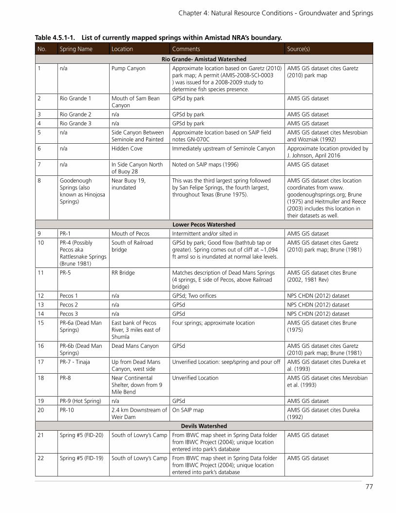
77
Chapter 4: Natural Resource Conditions - Groundwater and Springs
Table 4.5.1-1. List of currently mapped springs within Amistad NRA’s boundary.
No. Spring Name Location Comments Source(s)
Rio Grande- Amistad Watershed
1 n/a Pump Canyon Approximate location based on Garetz (2010) park map; A permit (AMIS-2008-SCI-0003 ) was issued for a 2008-2009 study to determine fish species presence.
AMIS GIS dataset cites Garetz (2010) park map
2 Rio Grande 1 Mouth of Sam Bean Canyon
GPSd by park AMIS GIS dataset
3 Rio Grande 2 n/a GPSd by park AMIS GIS dataset
4 Rio Grande 3 n/a GPSd by park AMIS GIS dataset
5 n/a Side Canyon Between Seminole and Painted
Approximate location based on SAIP field notes GN-070C
AMIS GIS dataset cites Mesrobian and Wozniak (1992)
6 n/a Hidden Cove Immediately upstream of Seminole Canyon Approximate location provided by J. Johnson, April 2016
7 n/a In Side Canyon North of Buoy 28
Noted on SAIP maps (1996) AMIS GIS dataset
8 Goodenough Springs (also known as Hinojosa Springs)
Near Buoy 19, inundated
This was the third largest spring followed by San Felipe Springs, the fourth largest, throughout Texas (Brune 1975).
AMIS GIS dataset cites location coordinates from www.goodenoughsprings.org; Brune (1975) and Heitmuller and Reece (2003) includes this location in their datasets as well.
Lower Pecos Watershed
9 PR-1 Mouth of Pecos Intermittent and/or silted in AMIS GIS dataset
10 PR-4 (Possibly Pecos aka Rattlesnake Springs (Brune 1981)
South of Railroad bridge
GPSd by park; Good flow (bathtub tap or greater). Spring comes out of cliff at ~1,094 ft amsl so is inundated at normal lake levels.
AMIS GIS dataset cites Garetz (2010) park map; Brune (1981)
11 PR-5 RR Bridge Matches description of Dead Mans Springs (4 springs, E side of Pecos, above Railroad bridge)
AMIS GIS dataset cites Brune (2002, 1981 Rev)
12 Pecos 1 n/a GPSd; Two orifices NPS CHDN (2012) dataset
13 Pecos 2 n/a GPSd NPS CHDN (2012) dataset
14 Pecos 3 n/a GPSd NPS CHDN (2012) dataset
15 PR-6a (Dead Man Springs)
East bank of Pecos River, 3 miles east of Shumla
Four springs; approximate location AMIS GIS dataset cites Brune (1975)
16 PR-6b (Dead Man Springs)
Dead Mans Canyon GPSd AMIS GIS dataset cites Garetz (2010) park map; Brune (1981)
17 PR-7 - Tinaja Up from Dead Mans Canyon, west side
Unverified Location: seep/spring and pour off AMIS GIS dataset cites Dureka et al. (1993)
18 PR-8 Near Continental Shelter, down from 9 Mile Bend
Unverified Location AMIS GIS dataset cites Mesrobian et al. (1993)
19 PR-9 (Hot Spring) n/a GPSd AMIS GIS dataset
20 PR-10 2.4 km Downstream of Weir Dam
On SAIP map AMIS GIS dataset cites Dureka (1992)
Devils Watershed
21 Spring #5 (FID-20) South of Lowry’s Camp From IBWC map sheet in Spring Data folder from IBWC Project (2004); unique location entered into park’s database
AMIS GIS dataset
22 Spring #5 (FID-19) South of Lowry’s Camp From IBWC map sheet in Spring Data folder from IBWC Project (2004); unique location entered into park’s database
AMIS GIS dataset

78
Amistad National Recreation Area: Natural Resource Condition Assessment
The National Park Service’s Chihuahuan Desert Inventory and Monitoring Program (CHDN) also conducted a preliminary springs inventory throughout the park in 2012 and the USGS (Heitmuller and Reece 2003) mapped spring locations throughout Texas, using digital data sets from USGS, TWDB, and Capitol Environmental Services based on the following original sources: Brune (1975; 1981), Meinzer (1927), and USGS Water-Data Reports and Water-Supply Papers (1910-1960 and 1961-2002). These efforts were cross referenced to the park’s GIS data set to develop a comprehensive list of currently known springs within the national recreation area.
4.5.2. Data and MethodsWe used two indicators and a total of 17 measures to assess the current condition of the groundwater resources at Amistad NRA.
Indicator/Measure Groundwater Elevation (Change in
Groundwater Elevation)
To determine the change in groundwater elevation we investigated whether we could use data from the park’s groundwater wells for this measure. Porter et al. (2009) listed five groundwater wells owned and/or operated by the NRA as shown in Table 4.5.2-1. The wells range in depth from about 91.4-190.5 m (300-625 ft), and all are finished within the ETP aquifer. However, only one of the park’s wells is listed in the TWDB well database (TWDB 2016a), and no on-site
Table 4.5.1-1. List of currently mapped springs within Amistad NRA’s boundary continued.
No. Spring Name Location Comments Source(s)
23 Lowry Springs Side Canyon to Devils River
Estimated location AMIS GIS dataset
24 Lowry Springs Side Canyon to Devils River
GPSd AMIS GIS dataset
25 n/a - FID 5 Old Smith Ranch At water line AMIS GIS dataset
26 n/a - FID 6 Old Smith Ranch At water line AMIS GIS dataset
27 n/a - FID 7 Old Smith Ranch Visible at water line AMIS GIS dataset
28 n/a - FID 1 Indian Springs Canyon n/a AMIS GIS dataset cites Dureka (1992)
29 n/a - FID 17 Indian Springs Canyon GPSd; Note that another spring was recorded but is outside park’s boundary.
AMIS GIS dataset
30 n/a - FID 18 Slaughter Bend GPSd; Slaughter Bend aka Swann-Shelton Springs (Brune 1975); Smith Springs (Brune 1981)
AMIS GIS dataset cites Brune (1975, 1981)
31-34 AMIS002 Indian Springs GPSd 4 springs; 1 primary orifice and 3 secondary orifices
NPS CHDN (2012) dataset
35 n/a - FID 32 Slaughter Bend Garmin Colorado 400t (J. Johnson); Note that another spring was recorded but is outside park’s boundary.
AMIS GIS dataset
36 Indian Springs Slaughter Bend Listed as the ”Big Spring” by Graham & Davis and as ”Indian Spring” by Mesrobian & Mayberry
AMIS and CHDN GIS datasets; AMIS cites (Graham and Davis 1958); (Mesrobian and Mayberry 1993)
37 n/a - FID 3 Slaughter Bend
Slaughter Bend aka Swann-Shelton Springs (Brune 1975); Smith Springs (Brune 1981)
AMIS GIS dataset cites Brune (1975) and Mesrobian and Mayberry (1993)
38 n/a - FID 2 Slaughter Bend AMIS GIS dataset cites Brune (1975)
39 Big Satan Springs Approx. 450 m up the Canyon From Mouth of Big Satan Creek
Several openings; approximate location - most of the spring openings form a pool against the cliff.
AMIS GIS dataset cites Brune (1981)

79
Chapter 4: Natural Resource Conditions - Groundwater and Springs
Figure 4.5.1-4. There are 39 currently mapped springs in three watersheds that are located within Amistad NRA’s boundary. It’s likely that many more springs occur throughout the park.
Table 4.5.2-1. List of groundwater wells in the Edwards Aquifer owned and/or operated by Amistad National Recreation Area (Porter et al. 2009).
Well Name
Land Surface Altitude (ft amsl)
Well Depth (ft)
Shallowest Water Level (ft)
Deepest Water Level (ft)
Formation
Diablo East / McNamara Well No. 21 1,178 480 (or 490)1
118.1 218.1 Salmon Peak
Diablo East, New 1,160 600 40 71.35 Salmon Peak
Rough Canyon2 -- 300 51.00 - Salmon Peak
Pecos River -- 625 153.5 - Devils River
Governors Landing 1,150 390 35.80 312.68 Salmon Peak
1 According to Martin (2004) Diablo East also was named McNamara Well No 2 and was listed as both 480’ and 490’ in the records at Fort Collins, Colorado, National Park Service Water Resources Division.2 The flow was very strong and cold, indicative of spring water (Martin 2004).3 Martin (2004) listed no information for a well named Headquarters.

80
Amistad National Recreation Area: Natural Resource Condition Assessment
water level data are available to assess change in groundwater elevation (TWDB 2016b). So instead we researched records for other wells also finished in the ETP aquifer within the general vicinity of the NRA and for wells with a long-term record, as well as recent (i.e., within the last year) water level readings to use as proxies for determining change in groundwater elevation. State well #70-33-604 met all criteria and is summarized in Table 4.5.2-2 and shown in Figure 4.5.2-1 (TWDB 2016 a,b). This is one of the same wells Porter et al. (2009) used to evaluate groundwater condition at the NRA in 2009.
Indicator/Measure Groundwater Quality (Primary (8) and
Secondary (8) Constituents)
The TWDB collects and synthesizes groundwater quality data for the ETP aquifer through the Texas Groundwater Protection Committee (TGPC), which manages the groundwater quality sampling program throughout the state (TWDB 2014). The TGPC is comprised of several member agencies that provide ambient groundwater quality data to the program. The most recent data analyzed for the ETP aquifer were from 607 wells (except for mercury, which was sampled from 213 wells) between 2003-2013. Two parameter groups, primary and secondary constituents, were collected, measuring the dissolved phases of 16 constituents (TWDB 2014), which are listed in the reference condition section below. Since data are not collected continuously, and drought, seasonal variation, or local flow
Figure 4.5.2-1. Location of the groundwater well used to determine change in groundwater elevation within the vicinity of Amistad NRA.
Table 4.5.2-2. The groundwater well within the Edwards-Trinity (Plateau) aquifer used as a proxy for park wells to determine change in groundwater elevation (TWDB 2016a,b).
Well Numbers
Land Surface Altitude (ft amsl)
Well Depth (ft)
Shallowest Water Level (ft)
Deepest Water Level (ft)
Formation Well Record
70-33-604 1173 554 -176 -129.1 Salmon Peak 1939, 1964-2016

81
Chapter 4: Natural Resource Conditions - Groundwater and Springs
directions are not considered in the sampling program, results may not be comparable over time (TWDB 2014). Thus, the primary intention of the sampling program is to provide a “reconnaissance” of potential problem areas (TWBD 2014) and for our purposes, we used the information to provide a snapshot of ETP aquifer quality.
4.5.3. Reference ConditionsThe reference condition for change in groundwater elevation was excerpted from NPS 2010 - PMIS #109567.
The science based management tool available for developing strategies that protect groundwater and springs is a Groundwater Availability Model (GAM). While the GAM can answer management questions like “does pumping lower water tables” it can not adequately resolve smaller scale issues such as identifying recharge areas for springs (NPS 2010).
In 2004, the TWDB produced a GAM for the Edwards and underlying Trinity aquifers. The Edwards Trinity aquifer system falls within six Regional Water Planning Areas, two Priority Groundwater Management Areas, and about 29 Groundwater Conservation Districts. The ET GAM covers most of west and central Texas. In 2006, Big Bend National Park staff and staff from the Water Resources Division of the NPS worked with the local water district to investigate the utility of the ET GAM in addressing the effects of large-scale groundwater development on flows and aquatic habitat in the Rio Grande, Pecos River and Devils River. In the requested model runs, groundwater pumping was added to the Edwards and Trinity aquifers in Terrell and Val Verde Counties until net discharge to the rivers decreased by 50%. The model runs indicated that the amount of pumping required to reduce discharge to the rivers by 50% varied from 12,000 to 160,000 acre-feet per year depending on which river, aquifer, and county was being evaluated. Modeling results were published in the GAM Run 06-16 Report (Donnelly 2007) and illustrate a fundamental hydrologic principle, that all water derived from wells must be balanced by a loss of water somewhere (Theis 1940
as cited in NPS 2010 - PMIS #109567-NPS 2010).
As of July 29, 2010, Groundwater Management Area 7’s desired future condition (DFC) for the Edwards-Trinity (Plateau), [Trinity and Pecos Valley] aquifer is an annual average drawdown of 2.1 m (7 ft), except within Kinney County GCD. It is understood that addressing local-scale issues requires a more detailed model trained with local data of hydrologic properties and that the GAM is more useful in determining the impacts of groups of wells distributed over many square miles. However, without this more site-specific information for the NRA, the DFC will serve as a general reference condition to evaluate the change in groundwater elevation measure for this assessment.
Groundwater QualityThe maximum contaminant limits (MCL) for 16 groundwater quality constituents are listed in Table 4.5.3-1 and based on TWDB (2014). A good reference condition was assigned when the MCL was at or below the established
Table 4.5.3-1. Maximum contamination limits for groundwater quality data (TWDB 2014).
Parameter GroupsMaximum
Contamination Limit
Primary Constituents
Arsenic 10 μg/l
Barium 2 mg/l
Cadmium 5 μg/l
Chromium 100 μg/l
Fluoride 4 mg/l
Mercury 2 μg/l
Nitrate (N) 10 mg/l
Selenium 50 μg/l
Secondary Constituents
Chloride 300 mg/l
Copper 1 mg/l
Fluoride 2 mg/l
Iron 0.3 mg/l
Manganese 50 μg/l
Sulfate 300 mg/l
Dissolved Solids 1000 mg/l
Zinc 5 mg/l
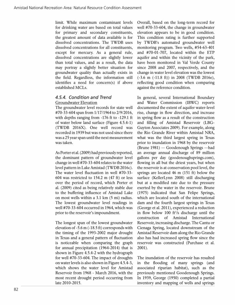
82
Amistad National Recreation Area: Natural Resource Condition Assessment
limit. While maximum contaminant levels for drinking water are based on total values for primary and secondary constituents, the greatest amount of data available is for dissolved concentrations. The TWDB uses dissolved concentrations for all constituents, except for mercury. As a general rule, dissolved concentrations are slightly lower than total values, and as a result, the data may portray a slightly better situation for groundwater quality than actually exists in the field. Regardless, the information still identifies a need for concern(s) if above established MCLs.
4.5.4. Condition and TrendGroundwater ElevationThe groundwater level records for state well #70-33-604 span from 1/17/1964 to 2/9/2016, with depths ranging from -176 ft to -129.1 ft of water below land surface (Figure 4.5.4-1) (TWDB 2016X). One well record was recorded in 1939 but was not used since there was a 25 year span until the next measurement was taken.
As Porter et al. (2009) had previously reported, the dominant pattern of groundwater level change in well #70-33-604 relates to the water level pattern in Lake Amistad (TWDB 2016c). The water level fluctuation in well #70-33-604 was restricted to 154.2 m (47 ft) or less over the period of record, which Porter et al. (2009) cited as being relatively stable due to the buffering influence of Amistad Lake on most wells within a 3.1 km (5 mi) radius. The lowest groundwater level readings in well #70-33-604 occurred in 1964, which was prior to the reservoir’s impoundment.
The longest span of the lowest groundwater elevation of -5.6 m (-18.5 ft) corresponds with the timing of the 1993-2002 major drought in Texas and a general pattern of fluctuation is noticeable when comparing the graph for annual precipitation (1964-2014) that is shown in Figure 4.5.4-2 with the hydrograph for well #70-33-604. The impact of droughts on water levels is also shown in Figure 4.5.4-3, which shows the water level for Amistad Reservoir from 1968 - March 2016, with the most recent drought period occurring from late 2010-2015.
Overall, based on the long-term record for well #70-33-604, the change in groundwater elevation appears to be in good condition. This condition rating is further supported by TWDB’s automated groundwater well monitoring program. Two wells, #54-63-401 and #70-01-707, located within the ETP aquifer and within the vicinity of the park, have been monitored in Val Verde County since 2008 and 2007, respectively, and the change in water level elevation was the lowest (-3.6 m (-11.8 ft)) in 2008 (TWDB 2016e), reflecting good condition when comparing against the reference condition.
In general, several International Boundary and Water Commission (IBWC) reports documented the extent of aquifer water-level rise, change in flow direction, and increase in spring flow as a result of the construction and filling of Amistad Reservoir (LBG-Guyton Associates 2009). For example, along the Rio Grande River within Amistad NRA, what was the third largest spring in Texas prior to inundation in 1968 by the reservoir (Brune 1981) — Goodenough Springs —had an average annual discharge of 89 million gallons per day (goodenoughsprings.com), flowing in all but the driest years, but when the reservoir is at conservation pool level, the springs are located 46 m (151 ft) below the surface (KellerLynn 2008) still discharging but at a modified rate due to the pressure exerted by the water in the reservoir. Brune (1975) indicated that San Felipe Springs, which are located south of the international dam and the fourth largest springs in Texas (George et al. 2011), experienced a reduction in flow below 100 ft3/s discharge until the construction of Amistad International Reservoir, increasing discharge. The Cantu or Cienaga Spring, located downstream of the Amistad Reservoir dam along the Rio Grande also has had increased spring flow since the reservoir was constructed (Purchase et al. 2001).
The inundation of the reservoir has resulted in the flooding of many springs (and associated riparian habitat), such as the previously mentioned Goodenough Springs. In 1939, George (1950) completed a partial inventory and mapping of wells and springs

83
Chapter 4: Natural Resource Conditions - Groundwater and Springs
Figure 4.5.4-2. Annual average precipitation, 1964-2014 from Amistad Dam station (Coop #410225) (NOAA 2015).
Figure 4.5.4-1. Hydrograph for groundwater state well #70-33-604 (1964-2016).
Figure 4.5.4-3. Water level for Amistad Reservoir (1968-Mar. 2016). Figure credit: TWDB 2016c

84
Amistad National Recreation Area: Natural Resource Condition Assessment
throughout Val Verde County. A total of 105 springs were mapped, with 45 of those springs (approx. 43%) located in the present day national recreation area primarily along the Devils River (Figure 4.5.4-4). Currently only 19 springs have been mapped along the Devils River within Amistad NRA’s boundary compared to 31 in 1939 (George 1939). The inundation of springs resulted in the extinction of the Amistad gambusia, a fish only known to be found in the Goodenough Springs. Many more species are becoming increasingly rare, likely as a result of degraded (or eliminated) habitat due to the reservoir inundation (refer to the small native fishes assessment for additional information). Despite the loss of habitat, groundwater elevation, in general, is considered to be in good condition.
Groundwater QualityAll but five groundwater quality constituents exceeded MCLs (Table 4.5.4-1). However, nitrate, which is in the primary constituent group, had the highest number of exceedances, exceeding the MCL in 46.3% of the measurements (Figure 4.5.4-5, left). Nitrate is also identified as a constituent of concern by TWDB due to the possible indication of fecal contamination (TWDB 2016d). It was also the highest concentration for any constituent in groundwater within Val Verde County, and in 2014, was also of concern in the surface water samples taken from within the Devils River arm of the reservoir.
TWDB considers two additional primary constituents to be of concern: arsenic (Figure 4.5.4-5, right) and fluoride (Figure 4.5.4-6). In general, concentrations of nitrate, arsenic,
Figure 4.5.4-4. A map showing the locations of springs c. 1939 (orange dots) within the vicinity of Amistad NRA in Val Verde County. Figure adapted from George (1950).

85
Chapter 4: Natural Resource Conditions - Groundwater and Springs
and fluoride in groundwater are highest in the northern counties of the ETP aquifer but warrant a moderate condition rating. TWDB did not identify any of the secondary constituents as concerns, but both sulfate and dissolved solids exceeded their MCLs 29.3% and 27.8%, respectively. These constituents are also high in the surface water monitoring samples.
In general, the water quality throughout the ETP aquifer ranges from fresh to saline from east to west, respectively, with total dissolved solids ranging from 100 to 3,000 milligrams per liter, which is well over the 1,000 mg/L MCL (George et al. 2011). Brune (1975) also identified that spring waters from the ETP aquifer can be high in sulfate. The high levels of total dissolved solids, sulfate, chloride, and nitrate are reflected in the surface water conditions throughout the NRA’s watersheds (refer to assessment 4.4 for more detail).
Figure 4.5.4-5. Concentrations of nitrate (left) and arsenic (right) throughout water wells in the Edwards-Trinity Plateau Aquifer.
Table 4.5.4-1. Maximum contamination level exceedances for groundwater quality data (TWDB 2014).
Parameter Groups
Total Wells
Sampled
≥ Maximum Contaminanttion
LevelPrimary Constituents
Arsenic 607 10
Barium 607 0
Cadmium 607 1
Chromium 607 0
Fluoride 607 8
Mercury 213 0
Nitrate (N) 607 281
Selenium 607 2
Secondary Constituents
Chloride 607 106
Copper 607 0
Fluoride 607 138
Iron 607 42
Manganese 607 24
Sulfate 607 178
Dissolved Solids 607 169
Zinc 607 0

86
Amistad National Recreation Area: Natural Resource Condition Assessment
Groundwater
Indicators MeasuressGroundwater Elevation
Change in Elevation
Groundwater Elevation
16 Constituents
Overall Condition/TrendFor assessing the condition of groundwater at the National Recreation Area, we chose two
indicators, with a total of 17 measures that are summarized in Table 4.5.4-2.
Based upon our review of the apparent groundwater condition relative to the change in groundwater elevation and groundwater quality throughout the ETP aquifer, we assess the condition of the groundwater resource at the national recreation area to be good to moderate. The trend is unknown but will be largely dependent upon climate conditions and future developments.
Key Uncertainties/ThreatsThere are several threats related to the NRA’s groundwater resource. Park staff have identified concerns that additional groundwater pumping planned by developers in the ETP aquifer may result in reduced spring and river flows throughout the region. Development is not just limited to water extraction for drinking or for agricultural interests, but is complicated by recent technological advances that make oil and gas exploration and production possible (NPS 2010).
Texas is the third largest area in the world (behind Russia and the remaining U.S. area) producing natural gas, with fracking rapidly on the rise (Powers 2013). In 2013, the community of Barnhart, Texas, located in Irion County with the ETP aquifer underlying it, no longer had running water. The recent drought coupled with overuse, including water extraction for fracking operations depleted the community’s water supply (Goldenberg 2013). Large-scale extraction of oil and gas from shale, using fracking
Figure 4.5.4-6. Concentrations of fluoride throughout water wells in the Edwards-Trinity Plateau Aquifer.
Table 4.5.4-2. Indicator, measure, and rationale of groundwater condition.Indicator of Condition
Measure Condition Rationale for Condition
Groundwater Elevation
Change in Groundwater Elevation
Good The change in groundwater elevation has fluctuated with the periods of drought, but overall, has decreased less than the annually recommended 2.1 m (7 ft) for the ETP aquifer, resulting in a good condition rating.
Groundwater Quality
Primary and Secondary Constituents
Moderate Sixteen constituents were used to assess groundwater quality. The highest number of exceedances were for nitrate, which is considered to be a high priority concern due to the possibly of fecal contamination. Concentrations of sulfate, total dissolved solids, fluoride, and chloride also exceeded maximum contamination levels several times, resulting in a moderate condition rating.

87
Chapter 4: Natural Resource Conditions - Groundwater and Springs
techniques, is a relatively new and unexplored technology and shale is abundant throughout Texas (Figure 4.5.4-7). One of the deepest and oldest shale plays, Barnett Shale, is located along the NRA’s northeastern boundary. (Figure 4.5.4-8). In 2015, the USGS estimated that the Barnett Shale in the Bend Arch - Fort Worth Basin Province contains recoverable mean volumes of 53 trillion cubic feet of shale natural gas, 172 million barrels of shale oil and 176 million barrels of natural gas liquids. The original USGS estimate in 2005 was half of the 2015 estimate due to not accounting for horizontal drilling used in fracking operations (USGS 2015).
Additional large scale threats include proposals such as that from the VV Water Company to pump and pipe water away from Val Verde County from a well field near Amistad to West Texas for Permian Basin oil and gas operations and as a public water supply. If a proposal such as this is authorized, the built infrastructure will likely be used to supply similar operations far outside county
boundaries, thereby depleting groundwater resources.
According to the Devils River Conservancy, increased groundwater pumping “could have a significant negative impact on the Devils River and numerous other waterways and springs, many of which provide drinking
Figure 4.5.4-7. A map showing the major shale plays in the United States.
Figure 4.5.4-8. A map showing the Barnett shale and equivalents throughout Texas. Figure Credit: Ellis County Texas

88
Amistad National Recreation Area: Natural Resource Condition Assessment
and irrigation water to towns throughout the region” (Environment Texas Research & Policy Center n.d.). This will impact the very important and pristine riparian corridor that supports numerous types of wildlife, including rare and endangered species.
These types of large-scale groundwater extractions coupled with climate change and effects of increased irrigation needs due to climate change and droughts pose serious threats to the groundwater and springs throughout the region. Additional threats and uncertainties include land use changes where natural cover is converted to pavement, limiting the capacity of recharge to the ETP aquifer and an incomplete understanding of the hydrogeologic framework of significant springs and water needs at the local level, including riparian habitat.
National Park Service Management Policy 4.6.1 states that the NPS will perpetuate surface waters and groundwater as integral components of park aquatic and terrestrial ecosystems (NPS 2006). Amistad NRA staff have partnered with other national parks and scientists to improve the understanding of their local groundwater and spring resources through a hydrogeologic study, which in turn, will better inform regional planning efforts to mitigate future threats and key uncertainties.
4.5.5. Sources of ExpertiseThe groundwater assessment for Amistad National Recreation Area was based on water level data reported by Texas Water Development Board (2016 a,b,c,d,e) and numerous reports pertaining to the park’s and surrounding area’s groundwater resources.
4.5.6. Literature CitedArmstrong, A. W. 1995. The use of stable
isotope ratios to investigate the relative importance of Amistad Reservoir to recharge of the McKnight and other associated limestones, southwestern Val Verde County, Texas, Master of Science, The University of Texas at San Antonio, Texas, 1 1/95 95pp. as cited in Purchase et al. 2001.
Brune, G. 1975. Major and historical springs of Texas. Report 189. Developed for Texas Water Development Board. 91 pp.
Brune, G. 1981. Springs of Texas. Volume 1. Branch-Smith, Inc. Fort Worth, Texas 76101. (Book-no access)Brune, Gunnar. 2002.
Dering, P. 2002. Amistad National Recreation Area: archeological survey and cultural resource inventory. In Partial Fulfillment of Cooperative Agreement No. 1443-CA-1250-6-005 Between National Park Service and Texas A&M University. 120 pp.
Dureka. 1992. As cited in Dering, P. 2002. Jack Johnson, Pers. comm. 2016. Restricted access.
Dureka and Mesrobian. 1992. As cited in Dering, P. 2002. Jack Johnson, Pers. comm. 2016. Restricted access.
Dureka et al. 1993. As cited in Dering, P. 2002. Jack Johnson, Pers. comm. 2016. Restricted access.
Donnelly, Andrew C. W., 2007. GAM Run 06-16. Texas Water Development Board, Groundwater Availability Modeling Section, February 2, 2007.
Garetz, Greg. 2010. As cited in park’s springs geodatabase.
George, W.O. 1950. Val Verde County Texas. A report submitted to the Texas Board of Water Engineers. 51p.
George et al. 2011. Peter G. George, P.G., R. E. Mace, and R. Petrossian. 2011. Aquifers of Texas. Texas Water Development Board, Report 380. 182 p.
Goldenberg, S. 2013. A Texan tragedy: ample oil, no water. The Gaurdian. August 11, 2013. Available at http://www.theguardian.com/environment/2013/aug/11/texas-tragedy-ample-oil-no-water (accessed February 6, 2016).

89
Chapter 4: Natural Resource Conditions - Groundwater and Springs
Goodenoughsprings.org. 2016. Introduction. Available at http://goodenoughsprings.org/(accessed February 1, 2016).
Graham, John A. and William A. Davis. 1958. Appraisal of the archeological resources of Diablo Reservoir, Val Verde County, Texas. Report submitted to the National Park Service by the Texas Archeological Salvage Program, The University of Texas at Austin.
Gregory, L. and W. Hatler. 2008. A watershed protection plan for the Pecos River in Texas. Texas Water Resources Institute and Texas AgriLife Extension Service, Texas A&M University.
Heitmuller and Reece. 2003. Database of historically documented springs and spring flow measurements in Texas. U.S. Geological Survey Open-File Report 03–315. Available at http://pubs.usgs.gov/of/2003/ofr03-315/(accessed February 1, 2016).
Hill, R. T., and Vaughn, T. W., 1898, Geology of the Edwards Plateau and Rio Grande Plain adjacent to Austin and San Antonio, Texas, with reference to the occurrence of underground waters; U.S. Geological Survey, 18th Ann. Rept, pt. II.IBWC Project. 2004 as cited in Brune (1975).
KellerLynn, K. 2008. Geologic Resource Evaluation Scoping Summary, Amistad National Recreation Area, Texas. Geologic Resources Division, National Park Service. Denver, CO.
LBG-Guyton Associates. 2009. Groundwater data acquisition in Edwards, Kinney and Val Verde Counties, Texas. Report prepared for Plateau Regional Water Planning Group and Texas Water Development Board. Austin, Texas.
Lozo, F.E., Jr. and C.I. Smith. 1964. Revision of Comanche Cretaceous stratigraphic nomenclature, southern Edwards Plateau, southwest Texas: Gulf Coast Association of Geological Societies Transactions 14:285–306 as cited in Porter et al. (2009).
Martin, L. 2004. Well summary for Amistad National Recreation Area’s wells. Information obtained from NPS Water Resources Division files in Fort Collins, Colorado. 2 p.
Meinzer, O.E. 1927. Large springs in the United States: U.S. Geological Survey Water-Supply Paper 557, 94 p. as cited in Heitmuller and Reece (2003).
Mesrobian and Mayberry. 1993. As cited in Dering, P. 2002. Jack Johnson, Pers. comm. 2016. Restricted access.
Mesrobian et al. 1993. As cited in Dering, P. 2002. Jack Johnson, Pers. comm. 2016. Restricted access.
National Park Service. 2006. Management Policies 2006-The guide to managing the National Park System. Washington D.C. 180p.
National Park Service. 2010. Detailed Implementation Plan Reconnaissance of Water Chemistry and Spring Flow from a Trans-border Aquifer Along the Rio Grande PMIS # 109567. 16 pp.
National Park Service Chihuahuan Desert Inventory and Monitoring. 2012. GIS dataset of spring locations within Amistad National Recreation Area.
NOAA. 2015. Annual observational data. Available at http://gis.ncdc.noaa.gov/map/viewer/#app=cdo&cfg=cdo&theme=annual&layers=1&node=gis (accessed August 15, 2015).
Porter, S. D., R. A. Barker, R. M. Slade, Jr., and G. Longley. 2009. Historical perspective of surface water and groundwater resources in the Chihuahuan Desert Network, National Park Service. Edwards Aquifer Research and Data Center, in cooperation with National Park Service, Chihuahuan Desert Network.
Powers, Bill. 2013. Cold Hungry and in the Dark, NSP. Available at http://www.sourcewatch.org/index.php/

90
Amistad National Recreation Area: Natural Resource Condition Assessment
Te x a s _ a n d _ f ra c k i n g # c it e _ n o t e - 1 (accessed February 6, 2016).
Purchase, Carol E., David Larson, Mark D. Flora, and John Reber. 2001. Amistad National Recreation Area, Texas water resources scoping report. Technical Report NPS/NRWRD/NRTR-2001/295. 106 p.
Reeves, R. D., and T. A. Small. 1973. Groundwater resources of Val Verde County, Texas. Texas Water Development Board, Report 172.
SAIP. 1996. Maps. As cited in Dering, P. 2002. Jack Johnson, Pers. comm. 2016. Restricted access.
Stanton, G.P., Kress, W.H., Teeple, A.P., Greenslate, M.L., and Clark, A.K., 2007, Geophysical analysis of the Salmon Peak Formation near Amistad Reservoir dam, Val Verde County, Texas, and Coahuila, Mexico, March 2006, to aid in piezometer placement: U.S. Geological Survey Scientific Investigations Report 2007–5143, 70 p.
Texas Water Development Board. 2014. Draft 2014 Texas integrated report for clean water Act Sections 305(b) and 303(d)Groundwater Assessment. 137 pp.
Texas Water Development Board. 2016a. Record of wells for Val Verde County. Available at http://www.twdb.texas.gov/groundwater/data/Database%20Reports/Val%20Verde/Record%20of%20Wells.pdf (accessed February 15, 2016).
Texas Water Development Board. 2016b. Water level publication report for Val Verde County. Available at http://www.twdb.texas.gov/groundwater/data/
Database%20Reports/Val%20Verde/Water%20Levels.pdf (accessed February 15, 2016).
Texas Water Development Board. 2016c. Water data for Texas - Amistad Reservoir. Available at http://www.waterdatafor texas.org/reser voirs/individual/amistad (accessed February 4, 2016).
Texas Water Development Board. 2016d. Groundwater data. Available at http://www.twdb.texas.gov/groundwater/data/index.asp (accessed February 4, 2016).
Texas Water Development Board. 2016e. Automated groundwater level wells. Available at http://waterdatafortexas.org/groundwater/ (accessed February 4, 2016).
Theis, C. V. 1940. The source of water derived from wells: Essential factors controlling the response of an aquifer to development. Civil Engineering, Vol 10, No. 5, May, 277-280 as cited in NPS 2010 (PMIS #109567).
USGS. Water-Data Reports and Water-Supply Papers (1910-1960 and 1961-2002). As cited in Heitmuller and Reece (2003).
USGS. 2015. Assessment of undiscovered shale gas and shale oil resources in the Mississippian Barnett Shale, Bend Arch–Fort Worth Basin Province, North-Central Texas Available at http://pubs.usgs.gov/fs/2015/3078/fs20153078.pdf (accessed February 6, 2016).
Wagner, J., M. Martin, and C. Taliga. 2015. Technical Assistance Report - Condition Assessment for the Pecos River and Devils River riparian systems in Amistad National Recreation Area. 32p.

91
Chapter 4: Natural Resource Conditions - Riparian Habitat
4.6. Riparian Habitat
This section is primarily excerpted from the Condition Assessment for the Pecos River and Devils River riparian systems in Amistad National Recreation Area report developed for the purposes of this condition assessment (Wagner et al. 2015). For more information, go to http://www.nature.nps.gov/publications/nrpm/nrr.cfm.
4.6.1. Background and Importance Riparian wetlands are a type of non-tidal wetland formed along river and stream floodplains. These wetlands serve many functions including water purification, flood control, buffering riverbank erosion, habitat for numerous wildlife, fish, shellfish, and plant species, and also provide many recreational opportunities. In the west, riparian habitat is often in marked contrast with the surrounding terrestrial vegetation and is strongly influenced by the presence or
absence of water (NPS-WRD 2011) (Figure 4.6.1-1). Riparian areas are also extremely productive and serve as excellent habitat for vertebrate species because they provide cover from predators for a variety of wildlife and usually support high invertebrate biomass (NPS-CHDN 2010).
The National Park Service (NPS) has several wetland protection procedures and policies (Director’s Order #77-1: Wetland Protection (2002), Procedural Manual #77-1 (2012), and NPS Management Policies (2006) to ensure a “no net loss” of wetlands throughout the NPS.
Geologic and PhysiographicBoth the Pecos and Devils Rivers drain portions of the Edwards Plateau physiographic province in south-central Texas (Figure
Figure 4.6.1-1. Devils River above the influence of Amistad Reservoir Amistad.
Condition – Trend– Confidence
Good - Insufficient Data - High
Indicators/Measures• Hydrology (4 measures)• Vegetation (6 measures)• Erosion/Deposition (4 measures)
NPS

92
Amistad National Recreation Area: Natural Resource Condition Assessment
4.6.1-2). Most of the land surface in this area is characterized by rolling terrain dissected by steep narrow canyons with near vertical walls. The Plateau is bounded on the south and east by the Balcones Escarpment, where a series of major, normal faults transition from the upper Plateau to the lower elevation interior coastal plains.
The geologic formations of the Edwards Plateau are composed primarily of limestones and dolomites that are mostly from the Cretaceous Period. The primary aquifer in the region is composed of the Edwards Limestone and its associated carbonate strata. These units dip to the south and southwest at a gradient of about one-percent, and groundwater flow generally follows this trend, ultimately discharging as springs and seeps in the deep canyons. Quaternary alluvium overlies the Cretaceous limestone strata in places, especially in the stream valleys. This alluvium has a variety of grain sizes and may include clay, silt, sand, and/or gravel. The thickest deposits usually occur as floodplain
and/or terrace deposits and may serve as local aquifers.
Soils and VegetationThe Pecos and Devils River watersheds include four ecological regions or “Major Land Resource Areas” (MLRA’s) defined by the Natural Resources Conservation Service (NRCS). These are the Southwestern part of the Southern High Plains (MLRA 77D), the Southern Desertic Basins, Plains and Mountains (MLRA 42), the Edwards Plateau (MLRAs 81A, B, C, and D) and the Western Rio Grande Plain (MLRA 83B) (NRCS 2015a). Within these MLRAs the NRCS has developed several provisional Ecological Site Descriptions (ESDs), which are considered the fundamental units of potential-based land classification systems. Their purpose is to classify similar types of lands based on their ability to support particular plant communities, which respond to management and disturbance in specific ways. These ecological sites are correlated to soil components in association with uplands, valleys, and bottomlands within the watersheds of the Pecos and Devils River systems.
The provisional ESD for loamy bottomlands (R081BY334TX) of the Central Part of the Edwards Plateau (MLRA 81B) describes the historic plant community as a Mixed-Grass Hardwood complex. Hardwood woodlands occurred with a tall-grass understory adjacent to watercourses, and Mixed-Grass Savannah with mid- and tall-grasses occurred away from the streams. As with the associated upland watershed, these sites evolved with grazing by wildlife and a fire regime influenced by climate and flooding. This provisional ESD further describes the historic riparian vegetation immediately adjacent to the rivers as having been dominated by open stands of hardwood trees, with occasional breaks in the canopy dominated by highly palatable tall- and mid-grass species and an understory of shade tolerant cool-season grasses and forbs. Humphrey (1958) describes an early 1850s account of vegetation along the Pecos River near Horsehead Crossing where no trees or shrubs were noted along the banks. Today that area is covered with tamarisk, mesquite,
Figure 4.6.1-2. Both the Pecos and Devils Rivers drain portions of the Edwards Plateau physiographic province in south-central Texas (University of TX at Austin 1996).

93
Chapter 4: Natural Resource Conditions - Riparian Habitat
and other woody species (Richardson 2003). Along with the influence of domestic livestock grazing, settlement activities of the 1800s included cutting wood for fuel and fences and converting lowland areas to permanent pastures.
Alteration of the bottomland grazing regimes along the Pecos and Devils Rivers, along with drought, fire cessation and human settlement activities, resulted in a change in plant cover. These factors reduced the amount of palatable mid- and tall-grass species, late successional forbs, and cool-season plant components. Along with the denuded plant communities, the soil properties were also adversely affected by less organic matter from grass cover, more bare ground and less frequent fires. This created an environment at risk to soil erosion and conducive to woody and other plant encroachment from early successional plant species such as Phragmites. As the more palatable grasses were displaced, the resulting plant community provided soil stability but poor forage and wildlife habitat. Recovery of historic plant communities after many decades of livestock grazing may be an extremely slow process. For example, after 60 years of livestock grazing cessation and recovery in the southernmost Trans-Pecos area at Big Bend National Park, the majority of the sites have not recovered to their historic plant communities. This provides an insight into the length of time for recovery in this type of an environment (R081DY295TX).
Hydrologic CharacteristicsThe United States Geological Survey (USGS) and the International Boundary and Water Commission (IBWC) have maintained multiple stream gaging stations in the area over the last few decades. These sites include: Pecos River near Shumla (08447400); Pecos River near Langtry (08447410); Pecos River at Mouth near Comstock (084477001); Devils River at Pafford Crossing near Comstock (08449400); Devils River at Mouth near Del Rio (084505001); Devils River near Juno (084490001); and Devils River at Bakers Crossing (08449000). Currently, records and real-time data from Pecos River near Langtry (08447410) and Devils River at Bakers Crossing (08449000)
are readily available on the IBWC website (http://www.ibwc.state.gov/).
Pecos RiverThe Pecos River has its headwaters in the Sangre de Cristo Mountains of northern New Mexico. From there it meanders in a southeastward direction 418 miles (mi) or 673 kilometers (km) to its confluence with the Rio Grande at Amistad NRA. It is the largest sub-watershed of the Rio Grande, with a contributing area of about 15,625 mi2 (40,469 km2). Within Texas, flow characteristics are very different above and below Interstate 10. Above I-10 the Pecos is largely comprised of irrigation releases from Red Bluff Reservoir near the New Mexico-Texas border, with occasional storm flows. Salinity levels are high in this upper reach, often reaching 6-12 parts per thousand. Below I-10 the Pecos begins to transform into a predominantly spring-fed river, including major freshwater inflows from Independence Creek. Salinity in this lower reach is markedly reduced by this freshwater dilution, but it is still elevated enough to affect aquatic and riparian-wetland biota, and it contributes significantly to the salt load of Amistad Reservoir (Gregory and Hatler 2008).
The Water Resources Management Plan for Amistad NRA states that the highest daily peak flow recorded for the lower Pecos was 29,416 cubic feet per second (ft3/sec) or 833 cubic meters per second (m3/sec) that occurred on September 22, 1974. However, peak flows generally range between 1,765 ft3/sec (50 m3/sec) and 14,125 ft3/sec (400 m3/sec). Total annual flow on the lower Pecos has declined steadily since the 1970s. Baseflow, which ranges between 77-177 ft3/sec (2.2-5 m3/sec), has become lower and more prolonged due to increasing surface and groundwater use upstream (Purchase et al. 2001). Data for USGS gaging station #08417455 (Pecos River near Langtry, TX) for 1975-1985 show mean daily flows ranging from a low of 74 ft3/sec (2.1 m3/sec) occurring on August 30, 1984 to a high of 18,400 ft3/sec (521 m3/sec) occurring on October 13, 1981.

94
Amistad National Recreation Area: Natural Resource Condition Assessment
Devils RiverThe Devils River drains an area of 4,305 mi2 (11,150 km2) in the southern part of the Edwards Plateau. Amistad NRA manages 2.7 mi (4.4 km) of free flowing river above the conservation pool level of the reservoir, but at lower pool levels, the river flows for several more miles before its confluence with the reservoir (Purchase et al. 2001). Devils River flow is perennial in the NRA because of discharge from several freshwater springs in the lower part of the basin. An analysis of discharge at IBWC station #08449400 (Devils River at Pafford Crossing near Comstock, TX) from 1960-1995 shows fairly uniform conditions throughout the year, with average monthly flows ranging from 258 ft3/sec (7.3 m3/sec) in February to 720 ft3/sec (20.4 m3/sec) in September (Mast and Turk 1999). However, extreme high flows can occur during tropical storms or hurricanes, which occur most often in September or October. The Water Resources Management Plan for Amistad NRA states that flows over 35,314 ft3/sec (1,000 m3/sec) had occurred 19 times since 1960, with the highest recorded flow at 122,893 ft3/sec (3,480 m3/sec) on September 18, 1974. Large storms apparently recharge the limestone aquifer in the watershed, producing higher spring and groundwater flow to the Devils River for months and possibly years after a large rain event (Purchase et al. 2001).
4.6.2. Data and MethodsThe purpose of the riparian habitat rapid assessment was to determine the overall functional condition or ecological “health” of the river channels and their associated riparian corridors. To complete the assessment, “A User Guide to Assessing the Proper Functioning Condition (PFC) and the Supporting Science for Lotic Areas” (Prichard et. al. 1998) was followed. The guide identifies “Proper Functioning Condition” as the highest rating that can be given to a riparian area based on the perceived stability of the physical system, which in turn is dictated by the interaction of geologic formations, soil, water, and vegetation.
Amistad NRA’s condition assessments were performed during June 2-4, 2015 by an
interdisciplinary team of technical experts from NPS’ Water Resources Division, Natural Resources Conservation Service and Amistad NRA, who evaluated a total of 19 measures pertaining to the hydrology, vegetation and erosion/deposition indicators/features along the Pecos and Devils Rivers. Each river contained one reach that was evaluated and located upstream of normal reservoir influence (Figure 4.6.2-1).
IndicatorHydrology (4 measures)
Streamflow forces and channel processes are characteristics of a riparian wetland’s hydrologic function, and four measures were evaluated for this indicator.
Measure: Floodplain inundated frequentlyA floodplain is topographically flat, a landform of unconsolidated sediments originating from the stream, and subject to periodic flooding, usually a recurrence interval between 1 and 3 years (Prichard et al. 1998). The floodplain’s role is to handle a basin’s discharge and sediment load by spreading out the water and sediment onto a low area adjacent to the stream. This hydrologic function dissipates energy, which keeps a riparian wetland in functioning condition. Periodic flooding also promotes vegetation growth, which contributes to a properly functioning riparian area as well.
Measure: Sinuosity, width/depth ratio, and gradient are in balanceSeveral channel parameters; specifically sinuosity, gradient, and width-to-depth ratio are closely related to a stream’s ability to dissipate hydraulic energy during flood flows. When these parameters are in balance with the landscape setting, the channel is able to convey larger runoff events with limited change in channel characteristics and associated riparian-wetland plant communities(Prichard et. al. 1998).
Measure: Riparian wetland area is widening or has achieved potential extentSediment capture develops floodplains, which in turn, aids functionality of a riparian wetland area. In addition, as sediment

95
Chapter 4: Natural Resource Conditions - Riparian Habitat
is deposited, vegetation can “take root”, increasing certain types of vegetation such as sedges, willows, and rushes.
Measure: Upland watershed is not contributing to riparian wetland degradationAssessing changes in water and/or sediment supply from uplands can help determine functionality of the riparian wetland area affected. Changes in upland conditions can affect the discharge, timing, and duration of streamflow events in lower areas, possibly degrading a riparian wetland’s condition.
IndicatorVegetation (6 measures)
Most riparian wetlands require some amount of vegetation to achieve functionality (Prichard et al. 1998). Different factors such as type, amount, and proportion of vegetation contribute to a wetland’s ecological condition. In order to accommodate periodic flooding, lateral distribution of vegetation is necessary.
In addition, plants must be vigorous and able to maintain or recruit into the plant community to serve their various functions. Six measures were used to assess the condition of riparian vegetation.
Measure: There is a diverse age-class distribution of riparian wetland vegetationAge class distribution is often associated with vigor of a system, and multiple age classes of vegetation provide recruitment and replacement. Not all age classes need to be present for a system to maintain or recover from a severe event, and the older age classes can usually persist even with degraded conditions.
Measure: There is diverse composition of riparian wetland vegetationNot all plants need to be present within a riparian wetland for the system to maintain itself, but there needs to be enough variety for a wetland to recover and maintain its vegetative component. Limited number of species makes an area more vulnerable to
Figure 4.6.2-1. The riparian habitat rapid assessment occurred along the Pecos and Devils Rivers above the influence of the reservoir.

96
Amistad National Recreation Area: Natural Resource Condition Assessment
extreme climatic changes or disease, although areas that contain unique water regimes or soils may naturally only support a limited number of plant species.
Measure: Species present indicate maintenance of riparian wetland soil moisture characteristicsPlants that grow in wetlands are hydrophytes and must be in contact with the water table in order to survive. Different types of plants require different wetness regimes and different plants vary in root depths. The root depths sometimes suggest that a water table may not be close to the surface if the plants growing are ones that usually have deeper root systems. Wetland plants are divided into different categories, indicating their preference for growing in wetlands or uplands and degree of wetness required.
Measure: Streambank vegetation is comprised of those plants or plant communities that have root masses capable of withstanding high streamflow eventsPlants that have adapted to riparian wetland conditions, such as cottonwood, aspen, alder, willow, sedge, rush, and some grasses, develop root masses that help stabilize riverbanks, especially during high-flow events. If banks are undercut during storm or high runoff events, many changes can occur to the channel’s width/depth ratio, gradient, and sinuosity, which in turn, may decrease the system’s ability to dissipate energy. The presence of obligate and facultative wetland plants is usually a good indication that the riverbanks will remain stabilized.
Measure: Riparian wetland plants exhibit high vigorIf plants are weakened or stressed, they are less able to withstand stressors making the riparian wetland more susceptible to degradation. On the other hand, plants that exhibit vigor are usually more equipped to maintain or recover from stressors.
Measure: Adequate riparian wetland vegetation cover is present to protect banks and dissipate energy during high flows
The amount of vegetation present indicates a wetland’s ability to dissipate energy, protect riverbanks from collapse, filter sediment, and aid floodplain development, which also dissipates energy during storms or high runoff. Some bank erosion is a natural part of river channel evolution, but excessive erosion usually indicates some failure in the system.
IndicatorErosion/Deposition (4 measures)
Erosion and depositional processes are naturally occurring within a river system, however, excessive amounts of either indicate an imbalance in the system. Four measures were used to assess the erosion/deposition condition for this assessment.
Measure: Floodplain and channel characteristics are adequate to dissipate energyEnergy dissipation results from the presence of a floodplain, which distributes the water over a larger area. Channel characteristics such as sinuosity reduces the velocity of waterflow. In addition, objects such as rocks or large woody debris can also aid in energy dissipation.
Measure: Lateral stream movement is associated with natural sinuosityStreams naturally adjust their channel by moving side to side without degrading the overall wetland environment. The movement is affected by many factors such as the type of stream, the type of materials that form the streambanks, and the types and amounts of vegetation growing along the banks. For example, streambanks composed of sandy materials will more easily erode than materials such as clay or silt, which provide more cohesiveness. Excessive movement can negatively impact a river/riparian area by diminishing the system’s ability to dissipate energy. Measure: System is vertically stable
This measure is used to determine whether a channel is lowering at a natural versus an accelerated rate. Naturally occurring channel lowering usually occurs over hundreds or more years, whereas, some accelerated lowering can occur over a decade or less. The

97
Chapter 4: Natural Resource Conditions - Riparian Habitat
channel lowering reduces the landscape’s overall elevation including the valley bottom through erosion.
Measure: Stream is in balance with the water and sediment being supplied by the watershedStream channels adjust to water and sediment loads and are classified as either single thread or braided channels. Most braided channels indicate unnaturally high sediment loads, whereas, excessive erosion indicates an imbalance in water flow.
4.6.3. Reference ConditionsA riparian area in PFC is in dynamic equilibrium with its stream flow forces and channel processes. The system adjusts to handle larger runoff events with limited change in channel characteristics and associated riparian-wetland plant communities. This limited change, such as some cutbank erosion and point bar expansion in stream meanders, is within the context of natural stream evolution and provides new geomorphic features for riparian-wetland vegetation recruitment. Because of this resiliency, riparian areas in PFC can maintain aquatic habitat, water quality enhancement and other important ecosystem functions, even after moderately large runoff events.
Systems that are functional but susceptible to degradation due to failure in one or more
of the attributes associated with either the hydrology, vegetation, or erosion/depositional processes are considered to be in moderate condition or “functional-at risk.”
In contrast, highly degraded systems subjected to the same flows might exhibit excessive erosion and sediment loading, loss of aquatic and wetland habitat, and so on. Those systems that are not providing adequate functioning and subsequent protection are considered nonfunctional.
These three states: proper function, functional-at risk, and nonfunctional, comprise the reference conditions against which the park’s riparian wetlands were assessed and is based on the condition definitions developed by Prichard et al. (1998) (Table 4.6.3-1). Prichard et al. (1998) also included a fourth condition class-Unknown- when sufficient information was unavailable to make a condition determination, however, this class was not applicable to the NRA’s assessment therefore was excluded.
4.6.4. Condition and Trend Table 4.6.4.1 summarizes the condition results for the riparian habitat rapid assessment along the Pecos River and Devils River.
Pecos River HydrologyThe Pecos River at Amistad NRA is subject to dramatic stage changes (up to 50-80 ft or
Table 4.6.3-1. The reference conditions used to determine whether the condition of the riparian habitat is good, moderate, or of significant concern as adapted from Prichard et al. 1998.Good Moderate Significant Concern
A good condition is referred to as a Proper Functioning Condition or PFC. PFC is a state of resiliency that allows a riparian wetland area to hold together during high flow events with a high degree of reliability. The resiliency allows an area to establish vegetative communities that create the structure necessary for fish and waterfowl habitat, to establish floodplains that help dissipate energy, and channel characteristics such as sinuosity and lower gradients, which help prevent streambank erosion.
A moderate concern condition is considered to be “Functional-At Risk” , which means that the riparian wetland area is in fundamental condition, but an existing soil, water, or vegetation indicator(s) is compromised making it susceptible to degradation. However, the majority of the riparian wetland indicators do not need to be compromised to receive a moderate condition rating.
A significant concern condition is considered to be “Nonfunctional”. The riparian wetland area is not providing adequate vegetation, landform, or large woody debris to dissipate stream energy associated with high flows, therefore, erosion is not reduced and water quality degradation is occurring. In addition, channel characteristics are such that high flow events either deposit an inordinate amount of sediment or water flow results in excessive erosion.

98
Am
istad National Recreation A
rea: Natural Resource C
ondition Assessm
ent
Table 4.6.4-1. Results for the riparian habitat condition assessment along the Pecos River and Devils River at Amistad NRA (Wagner et al. 2015, excerpted from Appendices 1 and 2).
Indicator/Measure Pecos River Devils River
Hydrology
Floodplain The Pecos River above Amistad Reservoir within AMIS is subject to dramatic stage changes (as much as 50-80 feet) during flood flows, especially during tropical storms or hurricanes. Park staff stated that overbank flows occur at least every 2 years. Wrack from a recent flood was deposited as much as 20 feet above bankfull stage (park staff stated that this was likely from a 2014 flood event). The channel is “on grade” (not incised), and there is no opportunity for incision in this bedrock-controlled reach.
This Devils River reach is subject to dramatic stage changes during flood flows, especially during tropical storms or hurricanes. Review of the gage record, park staff observations, and presence of recently deposited flood wrack 10 feet above bankfull stage suggest relatively frequent overbank flows. Channel is “on grade” (not incised), and there is no opportunity for incision in this bedrock-controlled reach.
Sinuosity, width/depth ratio, and gradient
The gradient of the entire system is controlled by shallow bedrock strata and is very low. Channel widths range widely, but are generally from about 100 to 150 feet. Width-to-depth ratios are variable but are generally about 10 – 20 under bankfull conditions.
The width/depth ratio varies from approximately 50 to 500 or more along the reach, and is almost completely controlled by geology. River sinuosity is mostly controlled by canyon sinuosity. Gradient is controlled by the bedrock geology.
Riparian wetland area achieved potential
Riparian zone is approaching or has reached its potential extent. Additional minor widening of the riparian zone may occur in some areas as Phragmites captures sediment and extends farther into the channel. No evidence of riparian zone narrowing observed.
Riparian zone appears to be approaching or is at its potential extent. In most areas the riparian zone extends from the river banks to the canyon walls on both sides. We did not observe evidence of channel widening, riparian zone narrowing, or channel incision.
Upland watershed We did not observe evidence of excessive water or sediment contributions from the upland watershed.
We did not observe any evidence of excessive water or sediment contributions from the upland watershed.
Vegetation
Diverse age-class distribution of riparian-wetland vegetation
Common reed (Phragmites australis) is dominant and spreading on most banks, with common threesquare (Schoenoplectus pungens) a co-dominant at some locations. Other species represented but not dominant include bent spikerush (Eleocharis geniculata), sand spikerush (Eleocharis montevidensis), swamp sawgrass (Cladium mariscus subsp. jamaicense), rabbitsfoot grass (Polypogon monspeliensis) and buffelgrass (Pennisetum ciliare).Woody: Honey mesquite (Prosopis glandulosa), Rooseveltweed (Baccharis neglecta) and tamarisk (Tamarix sp.) were the most common woody species on the streambanks and terraces. We observed multiple age classes for these species along most of the assessment reach, including young plants.
Common reed (Phragmites australis) and swamp sawgrass (Cladium mariscus subsp. jamaicense) were co-dominant on most streambanks. In the sub-reaches where the channel bottom was very shallow and partially vegetated, common reed and swamp sawgrass covered many small islands and American waterwillow (Justicia americana), spikerush (Eleocharis spp.), western umbrella-sedge (Fuirena simplex) and sago pondweed (Potamogeton pectinatus) occupied sites where limestone or travertine was very near or slightly above the channel surface. All appeared to be healthy. Common threesquare (Schoenoplectus pungens), whorled pepperwort (Hydrocotyle verticillata) and poison ivy (Toxicodendron radicans) were also occasionally observed along the banks. Woody species on the upper streambanks and low terraces, in descending order of cover, included American sycamore (Platanus occidentalis), ash (Fraxinus sp.), honey mesquite (Prosopis glandulosa), Rooseveltweed (Baccharis neglecta), walnut (Juglans sp.), sweet acacia (Acacia farnesiana), hackberry (Celtis sp.) and buttonbush (Cephalanthus occidentalis). We observed at least two age classes for each of these species along most of the assessment reach, including young plants.
Diverse composition of riparian-wetland vegetation
Species present indicate maintenance of riparian-wetland soil moisture characteristics
The woody species present above are all characteristic riparian species for this region and indicate maintenance of appropriate riparian soil moisture characteristics. The perennial herbaceous wetland species common reed and common threesquare were dominant or co-dominant along the banks and lower bar features over most of the reach, indicating maintenance of wetland soil moisture regimes. Other wetland species occurring along the reach included bent spikerush, sand spikerush and swamp sawgrass. Although the upland species buffelgrass was observed occasionally on some higher floodplain surfaces, it did not appear to indicate a drying trend in the riparian zone.
The woody species present are characteristic riparian species for this region and indicate maintenance of appropriate riparian soil moisture characteristics. With the exception of poison ivy, all of the herbaceous species present indicate maintenance of wetland soil moisture regimes in the channel, on the streambanks and on other low, near-channel features.

99
Chapter 4: N
atural Resource Conditions - Riparian H
abitat
Indicator/Measure Pecos River Devils River
Vegetation continued
Root masses are capable of withstanding high-stream flow events
Common reed, common threesquare, swamp sawgrass, sand spikerush, honey mesquite, and Rooseveltweed are native riparian-wetland species with root masses capable of withstanding high streamflows.
Maintenance of a properly functioning riparian system along the Devils River depends on vigorous and nearly continuous cover of soil-binding riparian-wetland vegetation on streambanks and other low, near-channel features. Dominant or commonly observed herbaceous wetland species such as Phragmites, swamp sawgrass, American waterwillow and spikerush and woody riparian species including sycamore, ash, honey mesquite and Rooseveltweed along the river banks all have root masses capable of withstanding high flow events.
Vigorous plants Woody riparian vegetation exhibited high vigor along the assessment reach. Honey mesquite and Rooseveltweed plants were typically robust, did not appear stressed, and were reproducing on appropriate floodplain surfaces. Perennial herbaceous wetland vegetation on the streambanks and other channel and low floodplain features appeared healthy and formed the dense root mats needed to anchor soils against erosion. Despite recent large flows that deposited flood wrack as much as 20 ft (6.1 m) above bankfull stage, we saw very little sign of riparian-wetland vegetation damage or loss.
Woody riparian vegetation exhibited high vigor along the assessment reach. Sycamore, ash, honey mesquite and other riparian trees and shrubs were typically robust, did not appear stressed, and were reproducing on appropriate floodplain surfaces. Perennial herbaceous wetland vegetation on the streambanks and other channel and low floodplain features appeared healthy and formed the dense root mats needed to anchor soils against erosion. Despite recent large flows (likely in 2014 according to park staff) that deposited flood wrack as much as 10 ft (3.1 m) above bankfull stage, we saw very little sign of riparian-wetland vegetation damage or loss.
Vegetative cover is present to protect banks and dissipate energy
Despite relatively recent high flows as evidenced by flood wrack 20 feet or more above bankfull stage (thought by park staff to be from a 2014 flood event), we did not observe evidence of vegetation loss or bank degradation.
Along many portions of the reach the banks and overbank areas are comprised mostly of exposed bedrock. Although these locations are very sparsely vegetated or completely unvegetated, they don’t require riparian-wetland vegetative cover for stability and energy dissipation. Where banks and overbank areas were composed of alluvium, they clearly had perennial herbaceous wetland and woody riparian vegetation cover capable of protecting banks and dissipating energy during moderately high flood flows. Despite recent high flows that deposited flood wrack 10 ft (3.1 m) or more above bankfull stage, we did not observe evidence of vegetation loss or bank degradation in the segments with more alluvial deposits.
Erosion/Deposition
Floodplain and channel characteristics
In bedrock reaches, flow energy is dissipated through turbulence induced by the morphology of the inner channel as well as the movement of cobbles and boulders as bedload through the channel.
Flow energy is dissipated through interaction with bedrock channel features, mostly shoals and pools, and riparian vegetation, which commonly occurs in the shoals as well as the channel margins.
Lateral stream movement Natural lateral channel migration is very limited along this reach of the Pecos River due to the confining bedrock canyon. Sinuosity is largely controlled by bedrock at both the valley and channel reach scales, and ultimately lateral channel migration is forestalled by bedrock cliffs. The only sub-reaches that appear to have indications of lateral stream instability, such as channel braiding, are those subject to sediment influence from the side canyons, including debris flows.
Natural lateral channel migration is very limited along this reach of the Devils River due to the stable nature of the bedrock channel and floodplain. Sinuosity is controlled by bedrock at both the valley and channel reach scales, and any channel evolution takes place at a very slow rate. Channel widths throughout this reach are relatively constant. Furthermore, there were no indications of lateral channel migration, even in the sub-reaches with substantial alluvium.
Vertical stability Bedrock channel bottom precludes incision. Bedrock control, especially the sequential, cross-river bedding planes provide vertical stability.
Balance of water and sediment The balance between the river system and incoming sediment appeared to be in equilibrium for this reach of the Pecos River. We did not observe areas that appeared to be receiving excessive amounts of sediment from the uplands, nor did we observe any degradation of the banks or adjoining uplands that would increase the sediment supply to the channel.
The balance between the river system and incoming sediment appeared to be in equilibrium throughout the entire Devils River assessment reach. We did not observe any areas of excessive sediment deposition, nor did we observe any degradation of the banks or adjoining uplands that would significantly increase the sediment supply to the channel. In fact, there is little available sediment and the system appears to be very supply limited.
Table 4.6.4-1. Results for the riparian habitat condition assessment along the Pecos River and Devils River at Amistad NRA (Wagner et al. 2015) continued.

100
Amistad National Recreation Area: Natural Resource Condition Assessment
15.2-24.4 m) during flood flows, especially during tropical storms or hurricanes. Overbank flows generally occur at least every 2 years according to park staff, and we observed recent flood deposits as much as 20 ft (6.1 m) above bankfull stage. The channel is “on grade,” with no indication of incision in this bedrock-controlled reach. Given these conditions, any substantial increase in river stage accesses the immediate floodplain and is considered to be in PFC.
Channel parameters for the Pecos River, specifically sinuosity, gradient, and width-to-depth ratios, are almost entirely controlled by the entrenched, bedrock meanders of the canyons. There are some reaches where alluvium forms floodplain and terrace deposits, and these landforms add some additional sinuosity. The gradient of the entire system is controlled by shallow bedrock strata and is very low, about 1%. Channel widths range widely, but are generally from about 100-150 ft (30.5-45.7 m). In reaches that are influenced by sediment inputs from side canyons or from mass wasting, channel widths may constrict down to less than 50 ft (15.2 m). Width-to-depth ratios are variable but generally are about 10-20 under bankfull conditions. Based on all of the channel and valley parameters that we estimated, we concluded that the channel morphology of the Pecos River is in balance with the landscape setting.
Where alluvial floodplains were present, they were heavily-vegetated with Phragmites and other riparian-wetland vegetation. We did not observe evidence of upland plant species invading the riparian zone, nor were there other signs of riparian zone narrowing. Additional, minor widening of the riparian zone may occur in some areas as Phragmites captures sediment and extends farther into the channel. The overall configuration of the Pecos River is a stable channel/floodplain morphology and a riparian zone that is approaching or at its potential extent. Consequently, we considered this reach of the Pecos River to be in PFC.
Although we were unable to directly examine the upland watershed condition above the assessment reach, we did not observe any evidence of excessive water or sediment contributions from the watershed, nor did we observe any excessive deposition in the channel. Consequently, we concluded that the upland watershed is not contributing to riparian-wetland degradation along this reach.
Pecos River VegetationHoney mesquite (Prosopis glandulosa), Rooseveltweed (Baccharis neglecta) and tamarisk (Tamarix sp.) were the most common woody species on the streambanks and terraces of the Pecos River. We observed multiple age classes for these species along most of the assessment reach, including young and replacement age plants. Common reed (Phragmites australis) was dominant and spreading on most banks, with common threesquare (Schoenoplectus pungens) a co-dominant at some locations. Other species represented but not dominant included bent spikerush (Eleocharis geniculata), sand spikerush (Eleocharis montevidensis), and swamp sawgrass (Cladium mariscus subsp. jamaicense). The non-native species rabbitsfoot grass (Polypogon monspeliensis) and buffelgrass (Pennisetum ciliare) were also occasionally present but never dominant.
Based on the presence of multiple age classes (including replacement classes) for the woody riparian species and the vigor and cover of perennial, herbaceous riparian-wetland species along the streambanks and other channel and low floodplain features, we considered this reach of the Pecos River to be in PFC.
The riparian plant communities along the Pecos River are not closely aligned with the historic communities described previously (Soils and Vegetation subsection) in the provisional loamy bottomlands ecological site descriptions for the region. However, based on the common occurrence of several woody species (e.g., honey mesquite, Rooseveltweed, Celtis sp., Juglans sp.) and presence of several herbaceous wetland-riparian plant species

101
Chapter 4: Natural Resource Conditions - Riparian Habitat
(e.g., common threesquare, Phragmites australis) with the capacity to provide critical bank stabilization, erosion resistance and hydraulic “roughness” characteristics along the reach, we considered this measure to be in PFC for the Pecos River.
The woody species previously listed are all characteristic riparian species for this region and indicate maintenance of appropriate riparian soil moisture characteristics. The perennial herbaceous wetland species common reed and common threesquare were dominant or co-dominant along the banks and lower bar features over most of the reach, indicating maintenance of wetland soil moisture regimes. Other wetland species occurring along the reach included bent spikerush, sand spikerush and swamp sawgrass. Although the upland species buffelgrass was observed occasionally on some higher floodplain surfaces, it did not appear to indicate a drying trend in the riparian zone. These species along with honey mesquite and Rooseveltweed are riparian-wetland species with root masses capable of withstanding high flows. These measures were considered to be in PFC.
Woody riparian vegetation exhibited high vigor along the assessment reach. Honey mesquite and Rooseveltweed plants were typically robust, did not appear stressed, and were reproducing on appropriate floodplain surfaces. Perennial herbaceous wetland vegetation on the streambanks and other channel and low
floodplain features appeared healthy and formed the dense root mats needed to anchor soils against erosion. Despite recent large flows that deposited flood wrack as much as 20 ft (6.1 m) above bankfull stage, we saw very little sign of riparian-wetland vegetation damage or loss and considered this measure to be in PFC.
Along some segments of the reach the banks and overbank areas are comprised of exposed bedrock and large boulders (Figure 4.6.4-1 (left)). Although these segments are very sparsely vegetated or completely unvegetated, they don’t require riparian-wetland vegetative cover for stability and energy dissipation. The more alluvial sub-reaches (Figure 4.6.4-1 (right)) had perennial herbaceous wetland and woody riparian vegetation cover capable of protecting banks and dissipating energy during moderately high flood flows. Despite recent high flows that deposited flood wrack 20 ft (6.1 m) or more above bankfull stage (thought by park staff to be from a 2014 flood event), we did not observe evidence of vegetation loss or bank degradation in the alluvial segments and considered this This measure to be in PFC. However, the Pecos River system does not depend on coarse and/or large woody debris to maintain channel stability.
Pecos River Erosion/DepositionIn bedrock reaches, flow energy is dissipated through turbulence induced by the morphology of the inner channel as well as the movement of cobbles and boulders as bedload through the channel. In reaches with more alluvial deposits,
NPS
NPS
Figure 4.6.4-1. Pecos River sub-reaches with predominantly bedrock banks (left) and floodplain and minimal riparian-wetland vegetation and mostly alluvial banks and floodplain with substantial riparian-wetland vegetation (right).

102
Amistad National Recreation Area: Natural Resource Condition Assessment
sediment transport, turbulence, and overflow onto the well-vegetated floodplain are the primary mechanisms of energy loss. At a larger scale, the valley sinuosity is a constant contributor to energy dissipation at all flows. Consequently, we concluded that the channel and floodplain characteristics were adequate to dissipate energy.
Natural lateral channel migration is very limited along this reach of the Pecos River due to the confining bedrock canyon. Sinuosity is largely controlled by bedrock at both the valley and channel reach scales, and ultimately lateral channel migration is forestalled by bedrock cliffs. The only sub-reaches that appeared to have indications of lateral stream instability, such as channel braiding, were those subject to sediment influence from the side canyons, including debris flows.
The Pecos River does not exhibit any of the attributes of a vertically unstable riparian system such as v-shaped channels, steep eroding banks, headcuts, or disconnection of the channel from the floodplain. Furthermore, numerous bedrock outcrops and reaches with complete bedrock control exist along the river and provide extremely stable grade control.
The balance between the river system and incoming sediment appeared to be in equilibrium for this reach of the Pecos River. We did not observe areas that appeared to
be receiving excessive amounts of sediment from the uplands, nor did we observe any degradation of the banks or adjoining uplands that would increase the sediment supply to the channel.
Overall, we found the Pecos River riparian system’s erosion/deposition measures to be in balance with the water and sediment being supplied by the watershed, and considered it to be in PFC.
Devils River HydrologyReview of gage records, park staff observations, and obvious evidence of recent flood deposits above bankfull stage suggested relatively frequent overbank flows for the Devils River reach. In addition, the river is periodically subject to dramatic flood flows during tropical storms or hurricanes. The channel showed no signs of incision and was on-grade for this entire reach, so any substantial increase in river stage accesses the immediate floodplain, and considered this measure to be in PFC.
Channel parameters for the Devils River, specifically sinuosity, gradient and width-to-depth ratios, are controlled by the shallow bedrock outcrops on the margins of and within the channel (Figure 4.6.4-2 (left)). There is very little alluvium in the upper section of the study reach and all of the associated landforms are limestone bedrock (Figure 4.6.4-2 (right). In the lower section,
NPS
NPS
Figure 4.6.4-2. Devils River bedding plane-controlled shoal (left) and the transition from limestone shelf to pool (right).

103
Chapter 4: Natural Resource Conditions - Riparian Habitat
a substantial amount of coarse-grained alluvium has formed floodplains and terraces in some locations, primarily on river right. The gradient of the entire system is strongly controlled by slightly dipping bedrock strata where bedding planes form shallow cross-channel shoals (Figure 4.6.4-3). The resulting overall gradient is very stable. Channel widths are broad, ranging from about 450 to 550 ft (137 to 168 m), and even the narrowest reaches are well above 200 ft (61 m). Width-to-depth ratios are extremely variable due to the bedding plane morphology, which creates a series of shallow shoal - deep pool sequences. Based on all of the channel and valley characteristics, we concluded that the channel morphology of the Devils River is in balance with the landscape setting.
The riparian zone appeared to be approaching or was at its potential extent. In most areas the width of the riparian corridor extended from the river banks to the canyon walls on both sides. We did not observe evidence of channel widening, riparian zone narrowing, or channel incision. The overall configuration of the Devils River is very stable, with channel and floodplain morphology controlled by shallow bedrock and a riparian zone that was approaching or at its potential width.We did not observe any evidence of excessive water or sediment contributions from the upland watershed, nor did we observe any excessive deposition in the channel. Consequently, we concluded that the upland watershed was not contributing to riparian-wetland degradation and in PFC.
Devils River VegetationWoody species on the upper streambanks and low terraces, in descending order of cover, included American sycamore (Platanus occidentalis), ash (Fraxinus sp.), honey mesquite (Prosopis glandulosa), Rooseveltweed (Baccharis neglecta), walnut (Juglans sp.), sweet acacia (Acacia farnesiana), hackberry (Celtis sp.) and buttonbush (Cephalanthus occidentalis). We observed at least two age classes for each of these species along the assessment reach, including young and replacement age plants.
The Devils River flow at Amistad NRA is sustained mainly by freshwater springs and has low levels of dissolved solids, with electrical conductance ranging from 250 – 460 microS/cm (Mast and Turk, 1999). Unlike the Pecos River, common reed’s (Phragmites australis) high tolerance for salinity is not a strong competitive advantage along the Devils River, and more herbaceous riparian-wetland species can establish and compete for resources. Instead of occurring as monocultures as described previously for the Pecos River, common reed was typically co-dominant with swamp sawgrass (Cladium mariscus subsp. jamaicense) on most streambanks. In the sub-reaches where the channel bottom was very shallow and partially vegetated, common reed and swamp sawgrass also covered many small islands. American waterwillow (Justicia americana), spikerush (Eleocharis cellulosa), western umbrella-sedge (Fuirena simplex) and sago pondweed (Potamogeton pectinatus) occupied sites where limestone was very near or slightly above the channel surface. All plants appeared to be vigorous. Common threesquare (Schoenoplectus pungens), whorled pepperwort (Hydrocotyle verticillata) and poison ivy (Toxicodendron radicans) were also occasionally observed along the banks.
Figure 4.6.4-3. Another example of bedding plane-controlled shoal on the Devils River.
NPS

104
Amistad National Recreation Area: Natural Resource Condition Assessment
Based on the presence of multiple age classes (including replacement classes) for the woody riparian species and the vigor and cover of herbaceous riparian-wetland species along the streambanks and other channel and low floodplain features, we considered this measure for the Devils River reach to be in PFC.
The riparian plant communities along the Devils River are not closely aligned with the historic communities described previously (Soils and Vegetation subsection) for the provisional loamy bottomlands ecological site descriptions. However, based on the common occurrence of several native woody species and several native herbaceous wetland-riparian plant species, with the capacity to provide critical bank stabilization and hydraulic “roughness” characteristics we considered this measure to be in PFC.
The woody species previously listed for Devils River are characteristic riparian species for this region and indicate maintenance of appropriate riparian soil moisture characteristics. With the exception of poison ivy, all of the herbaceous species indicate maintenance of wetland soil moisture regimes in the channel, on the streambanks, and on other low, near-channel features.
Maintenance of a properly functioning riparian system along the Devils River depends on vigorous and nearly continuous cover of soil-binding riparian-wetland vegetation on streambanks and other low, near-channel features. Dominant or commonly observed herbaceous wetland species such as Phragmites, swamp sawgrass, American waterwillow and spikerush and woody riparian species including sycamore, ash, honey mesquite and Rooseveltweed along the river banks all have root masses capable of withstanding high flow events.
In addition, the woody riparian vegetation exhibited high vigor along the assessment reach. Sycamore, ash, honey mesquite and other riparian trees and shrubs were typically robust, did not appear stressed, and were reproducing on appropriate floodplain surfaces. Perennial herbaceous
wetland vegetation on the streambanks and other channel and low floodplain features appeared healthy and formed the dense root mats needed to anchor soils against erosion. Despite recent large flows (likely in 2014 according to park staff) that deposited flood wrack as much as 10 ft (3.1 m) above bankfull stage, we saw very little sign of riparian-wetland vegetation damage or loss.
Along many portions of the reach, the banks and overbank areas were comprised mostly of exposed bedrock. Although these locations were very sparsely vegetated or completely unvegetated, they don’t require riparian-wetland vegetative cover for stability and energy dissipation. Where banks and overbank areas were composed of alluvium, they clearly had perennial herbaceous wetland and woody riparian vegetation cover capable of protecting banks and dissipating energy during moderately high flood flows. Despite recent high flows that deposited flood wrack 10 ft (3.1 m) or more above bankfull stage, we did not observe evidence of vegetation loss or bank degradation in the segments with more alluvial deposits.
All vegetation measures for the Devils River were considered to be in PFC.
Devils River Erosion/DepositionAt the reach scale, flow energy is dissipated through interaction with the shoals and pools of the bedrock channel and with riparian vegetation, which commonly occurs on the shoals as well as on the channel margins. At a larger scale, the valley sinuosity is a constant contributor to energy dissipation at all flows. We concluded that the channel and floodplain characteristics were adequate to dissipate energy and in PFC.Natural lateral channel migration was very limited along this reach of the Devils River due to the stable nature of the bedrock channel and floodplain. Sinuosity was controlled by bedrock at both the valley and channel reach scales, and any channel evolution would occur at a very slow rate. Channel widths throughout this reach were relatively constant. Furthermore, there were no indications of lateral channel migration, even in the sub-reaches with substantial alluvium.

105
Chapter 4: Natural Resource Conditions - Riparian Habitat
The numerous, sequential bedding plane outcrops that traverse the river and form shallow shoals impart great vertical stability to the system and create extremely stable grade control. In addition, the balance between the river system and incoming sediment appeared to be in equilibrium throughout the entire Devils River assessment reach. We did not observe any areas of excessive sediment deposition, nor did we observe any degradation of the banks or adjoining uplands that would significantly increase the sediment supply to the channel. In fact, there was little available sediment and the system appeared to be very supply limited.
All measures for erosion/deposition along the Devils River reach were considered to be in PFC.
Overall Condition and TrendA summary of the overall riparian habitat condition assessment is presented in Table 4.6.4-2.
All measures for riparian habitat assessment along the Pecos River reach were in good condition, supporting a Proper Functioning
Condition rating. The erosion resistant, bedrock-controlled sub-reaches are inherently stable and dissipate the energy of large flows through turbulence and sediment transport. The sub-reaches with alluvial banks and floodplains are stable and resilient because they are well-vegetated with species capable of withstanding erosive forces and dissipating energy during larger runoff events.
All measures for riparian habitat assessment along the Devils River reach were in good condition, supporting a Proper Functioning Condition rating. The bedrock-controlled channel and the limestone shoals are inherently stable and help dissipate the energy of large flows through turbulence, step pool morphology and sediment transport. Alluvial banks and floodplains support diverse and vigorous wetland-riparian plant communities that can withstand erosive forces and contribute to energy dissipation during larger flow events. In-channel vegetation in the segments with limestone shoals also contributes to energy dissipation.
Threats Despite the PFC rating, the assessment team and park staff had a broad-ranging discussion about why dense stands of Phragmites australis have established on and dominate most of the alluvial banks of the Pecos River. Park botanist Wendy Weckesser determined through examination of morphological characteristics that this is not the introduced Phragmites of
Riparian Habitat
Indicators Measures
Hydrology 4 measures
Vegetation 6 measures
Erosion/Deposition 4 measures
Table 4.6.4-2. Summary of the indicators/measures and their contributions to the overall riparian habitat resource condition assessment.Indicators Measures Condition Rationale for Pecos River Rationale for Devils River
Hydrology 4 measures Good The erosion resistant, bedrock-controlled sub-reaches are inherently stable and dissipate the energy of large flows through turbulence and sediment transport.
The bedrock-controlled channel and the limestone shoals are inherently stable and help dissipate the energy of large flows through turbulence, step pool morphology and sediment transport.
Vegetation 6 measures Good The sub-reaches with alluvial banks and floodplains are stable and resilient because they are well-vegetated with species capable of withstanding erosive forces and dissipating energy during larger runoff events
Alluvial banks and floodplains support diverse and vigorous wetland-riparian plant communities that can withstand erosive forces and contribute to energy dissipation during larger flow events. In-channel vegetation in the segments with limestone shoals also contributes to energy dissipation
Erosion/Deposition
4 measures Good All of the Pecos River riparian system’s erosion/deposition measures were in balance with the water and sediment being supplied by the watershed.
The balance between the river system and incoming sediment appeared to be in equilibrium throughout the entire Devils River assessment reach. No areas of areas of excessive sediment deposition and/or erosion were observed.

106
Amistad National Recreation Area: Natural Resource Condition Assessment
Eurasian origin, a highly aggressive wetland invader that displaces native species and typically forms dense monocultures. It may be the Gulf Coast genetic lineage of Phragmites (native status yet to be determined), the native North American lineage, or a hybrid. The Gulf Coast and North American lineages are less invasive than the Eurasian Phragmites and are often co-dominant with other wetland species, but under some conditions (e.g., disturbance) both are capable of forming dense, single-species stands (Peterson and Partyka 2006).
Several factors have likely contributed to the establishment and maintenance of dense Phragmites stands along the Pecos River. As described in the Soils and Vegetation subsection of this report, the change from the historic migratory wildlife grazing regime to more continuous use by domestic livestock (along with other factors) has encouraged conversion of historic grasslands to scrub and shortgrass communities with more bare ground subject to wind and water erosion. In the riparian zones, such disturbances can be exploited by opportunistic, early successional species like Phragmites.
Another important factor contributing to the dominance of Phragmites is that the Pecos is known as one of the saltiest rivers in North America (Gregory and Hatler 2008). Although fresh water inflows from tributaries south of Interstate 10 freshen the river substantially, it is still salty enough upstream of the park to strongly influence riparian-wetland plant community composition. Electrical conductance (EC) is a commonly used, indirect measure of total dissolved solids (mostly salts) in inland waters. Data from Pecos River monitoring station TX C799 near Langtry, Texas for 2012-2015 show annual maximum ECs of 3,090-9,120 microSiemens per centimeter (uS/cm) and average annual ECs of 2,499-5,087 uS/cm (Texas Commission on Environmental Quality 2015). Freshwater systems typically range from about 0-1,300 uS/cm (Russell and Kane 1993), so the Pecos River at Langtry, TX is well into the brackish range. Phragmites is very salt-tolerant and is capable of growing and reproducing on sites with far higher salt content than these Pecos
River EC values indicate (USDA, 2015). The other dominant riparian-wetland species observed along the assessment reach, honey mesquite, Rooseveltweed, tamarisk and common threesquare, are also salt-tolerant. In contrast, willows and cottonwoods, which were not observed anywhere along the assessment reach, have a low tolerance for salt and are generally restricted to sites with ECs less than about 3,000-4,000 uS/cm (NRCS 1997; NRCS 2015b).
Extreme flood flows generated by tropical storms or hurricanes in this narrow canyon create a disturbance regime that also favors establishment and dominance by Phragmites. This species is particularly effective in recolonizing disturbed sites because of its reproduction by rhizomes, rapid recovery after damage to aboveground growth (Meyerson et al. 2000) and ability to readily establish from root or stem fragments (Wisconsin Department of Natural Resources 2015). Delivery of nutrients from the watershed in areas used as rangeland may also have contributed to the predominance of Phragmites, since its growth responds strongly to nutrient enrichment (Ulrich and Burton 1985; Kettenring 2009).
Overall, the major resource concerns in the Pecos and Devils River watersheds are wind and water erosion caused by overgrazing (USDA 2006), which in turn may create disturbances favorable to non-native invasive plant establishment.
Level of Confidence/Key UncertaintiesNPS’ Water Resources Division scientists, NPS/NRCS Liason, Denver Service Center, and park biologists conducted the riparian assessment through a technical assistance request to evaluate the functional condition of the NRA’s riparian habitats. Based on the expertise of the scientists, we’re confident that the findings accurately reflected the condition of the NRA’s riparian habitats at the time of the assessment.
4.6.5. Sources of ExpertiseThe National Park Service’s Water Resources Division scientists, Michael Martin and Joel Wagner, NPS/NRCS Liason, Denver Service

107
Chapter 4: Natural Resource Conditions - Riparian Habitat
Center and Amistad NRA biologists provided expertise for this assessment.
AuthorsMichael Martin is a hydrologist with the NPS Water Resources Division and has his Masters of Science in Watershed Science. Specialty areas include open channel flow, geomorphology, flood analysis, wetlands, and hydrology.
Joel Wagner is the Wetlands Program Team Leader with the NPS Water Resources Division and has his Masters of Science in Environmental Science (Water Resources). Specialty areas include wetlands science, hydrology, restoration and regulatory issues.
Christine Taliga is a revegetation technical specialist with NRCS (Natural Resources Conservation Service) and has a bachelors of science in Environmental Science. Specialty areas include, ecological restoration, ecological site assessments, wetland delineation, soil conservation, plant establishment and propagations.
4.6.6. Literature CitedGregory, L. and W. Hatler. 2008. A watershed
protection plan for the Pecos River in Texas. Texas Water Resources Institute and Texas AgriLife Extension Service, Texas A&M University.
Humphrey, R. R. 1958. The desert grassland: a history of vegetational change and an analysis of causes. Agricultural Experiment Station Bulletin 299, University of Arizona ,Tucson, AZ.
Kettenring, K. 2009. Mechanisms of Phragmites invasion in the Chesapeake Bay: Disentangling the importance of land-use, disturbances, nutrients, genetic diversity, and viable seed production. 94th Ecological Society of America Annual Meeting, Albuquerque Convention Center, August 2-9, 2009. Available at http://works.bepress.com/karin_kettenring/72/ (accessed October 28, 2015).
Mast, M.A. and J.T. Turk. 1999. Environmental characteristics and water quality of hydrologic benchmark network stations in the west-central United States, 1963-95. U.S. Geological Survey Circular 1173-B, 130 pp. Available at http://www.alibris.com/Environmental-Characteristics-and-Water-Quality-of-Hydrologic-Benchmark-Network-Stations-in-the-West-M-Alisa-Mast/book/2081358 (accessed October 28, 2015).
Meyerson, L.A., K. Saltonstall, J. Windham, E. Kiviat and S. Findlay. 2000. A comparison of Phragmites australis in freshwater and brackish environments in North America. Wetlands Ecology and Management 8: 89-103. Klewer Academic Publishers, The Netherlands.
National Park Service. 2002. NPS Director’s Order #77-1: wetland protection. Available at http://www.nps.gov/policy/D O rd e r s / D O 7 7 - 1 - Re i s s u e . h t m l ) . (accessed October 19, 2015).
National Park Service. 2006. Management policies 2006-The guide to managing the National Park System. Washington D.C. 180p.
National Park Service. 2012. National Park Service procedural manual #77-1: wetland protection.
National Park Service, Chihuahuan Desert Inventory and Monitoring Network. 2010. Chihuahuan Desert Network vital signs monitoring plan. Natural Resource Report NPS/CHDN/NRR—2010/188. National Park Service, Fort Collins, Colorado.
National Park Service, Water Resources Division. 2011. Wetlands in the national parks. Available at http://nature.nps.gov/water/wetlands/aboutwetlands.cfm (accessed October 19, 2015).
Natural Resources Conservation Service (NRCS). 1997. Salinity tolerances of trees and shrubs. Field Office Technical Guide accessed online August 7, 2015 at:

108
Amistad National Recreation Area: Natural Resource Condition Assessment
Natural Resources Conservation Service (NRCS). 2015a. Ecological Site Descriptions for MLRA 42, MLRA 81A, B, C and D, MLRA 77D and MLRA 83B. Accessed online on August 25, 2015 at: https://esis.sc.egov.usda.gov/Welcome/pgReportLocation.aspx?type=ESD
Natural Resources Conservation Service (NRCS). 2015b. Guidelines for planting dormant pole cuttings in riparian areas of the Southwest. Los Lunas Plant Materials Center, New Mexico. Accessed online August 7, 2015 at:
Peterson, M.S. and M.L. Partyka. 2006. Baseline mapping of Phragmites australis (common reed) in three coastal Mississippi estuarine basins. Southeastern Naturalist 5.4 (2006): 747-56.
Prichard, Don, J. Anderson, C. Correll, J. Fogg, K. Gebhardt, R. Krapf, S. Leonard, B. Mitchell, and J. Staats. 1998. A user guide to assessing proper functioning condition and the supporting science for lotic areas. Technical reference 1737-15. Bureau of Land Management, Denver, Colorado.
Purchase, C.E., D. Larson, M.D. Flora and J. Reber. 2001. Amistad National Recreation Area, Texas, Water Resources Scoping Report. U.S. Department of the Interior, National Park Service Technical Report NPS/NRWRD/NRTR-2001/295.
Richardson, C. 2003. Trans-Pecos vegetation: a historical perspective. Trans-Pecos Wildlife Management Services, Leaflet No. 7
Russell, G.M and R.L. Kane. 1993. Bathymetry, freshwater flow, and specific conductance of Matlacha Pass, Southwestern Florida. U.S. Geological SurveyWater-Resources Investigations Report 93-4057.
Texas Commission on Environmental Quality. 2015. Specific conductance data for the
Pecos River at IBWC weir near Langtry, TX (TX C799). Data accessed online August 4, 2015 at: http://www.tceq.state.tx.us/cgi-bin/compliance/monops/water_yearly_summary.pl
Ulrich, K.E. and T.M. Burton. 1985. The effect of nitrate, phosphate and potassium fertilization on growth and nutrient uptake patterns in Phragmites australis (Cav.) Trin. Ex Steudel. Aquatic Botany Vol. 21, Issue 1 pp. 53-62.
University of Texas at Austin, Bureau of Economic Geology. 1996. Physiographic map of Texas. Available at http://www.beg.utexas.edu/UTopia/images/p a g e s i z e m a p s /p h y s i o g r a p h y. p d f (accessed October 26, 2015).
U.S. Department of Agriculture (USDA). 2006. Land Resource Regions and Major Land Resource Areas of the United States, the Caribbean, and the Pacific Basin, Handbook 296. Available at http://www.nrcs.usda.gov/wps/portal/nrcs/detail/soils/survey/?cid=nrcs142p2_053624 (accessed October 28, 2015).
U.S. Department of Agriculture (USDA). 2015. Fire Effects Information System web page for Phragmites australis accessed online August 7, 2015 at: http://www.fs.fed.us/database/feis/plants/graminoid/phraus/all.html#BOTANICAL AND ECOLOGICAL CHARACTERISTICS
Wagner, J., M. Martin, and C. Taliga. 2015. Technical Assistance Report - Condition Assessment for the Pecos River and Devils River riparian systems in Amistad National Recreation Area. 32p.
Wisconsin Department of Natural Resources. 2015. Invasive species web resources accessed online August 4, 2015 at: http://dnr.wi.gov/topic/invasives/fact/phragmites.html

109
Chapter 4: Natural Resource Conditions - Upland Vegetation
4.7. Upland Vegetation
4.7.1. Background and Importance Amistad National Recreation Area (NRA), consisting of approximately 57,292 acres (23,186 ha) in the United States, includes thornscrub ecosystems on rocky uplands and riparian habitats along the reservoir shoreline and river banks (Cogan and VonLoh 2011). About 70% of the Recreation Area consists of water surface, about 25% consists of desert plant communities (Figure 4.7.1-1) and unvegetated geologic exposures, and about 5% consists of woodland and forest vegetation (Cogan and VonLoh 2011). Most of the woodland and forest vegetation types are located along uninundated reaches of the Rio Grande and Pecos and Devils Rivers. Along the reservoir shoreline is a draw-down zone that may be unvegetated or vegetated (with annual and perennial vegetation), depending on the length of the drawdown period. In this
section of the condition assessment, we focus on upland vegetation.
Three Texas ecoregions come together at Amistad NRA; these are the South Texas Plains (also known as Tamaulipan Brushland), Edwards Plateau, and Trans-Pecos (also known as Chihuahuan Desert) ecoregions (Poole 2013). Poole (2013) described the convergence of these ecoregions and their vegetation at the Recreation Area:
From the south, South Texas Plains mixed shrublands of blackbrush (Acacia rigidula), guajillo (Acacia berlandieri) and Texas barometer bush (Leucophyllum frutescens) mingle with the oak (Quercus spp.)-juniper
Condition – Trend - Confidence
Significant Concern – Unchanging
Medium
NPS
Figure 4.7.1-1. Uplands at Amistad NRA. Photo taken at one of the sites visited during the June 2014 field assessment (Site 4-Waypoint 14).
Indicators/Measures• Biotic Integrity (5 measures)

110
Amistad National Recreation Area: Natural Resource Condition Assessment
(Juniperus spp.) woodlands of the Edwards Plateau which are primarily found north and east of the park. And from the west, creosote bush (Larrea tridentata) and lechuguilla (Agave lechuguilla), indicator species of the Chihuahuan Desert (Trans-Pecos ecoregion), blend with both of the aforementioned ecoregions.
Seventeen soil types that occur in Val Verde County were identified in the Recreation Area (Cogan and VonLoh 2011). Most of the soils in the area are relatively shallow loams and clay loams that are gravelly and/or stony (Smeins 2014). They tend to be easily eroded if they occur on a slope (even a slight one) where the cover of vegetation has been decreased. Soils are also discussed below, under “Historic Context.”
Cogan Technology, Inc. is conducting a vegetation classification and mapping project at Amistad NRA as part of the USGS-NPS Vegetation Characterization Program, a cooperative effort by the U.S. Geological Survey (USGS) and National Park Service (NPS) to classify, describe, and map vegetation communities in more than 280 national park units across the United States. This program uses a hierarchical classification scheme, the National Vegetation Classification Standard (http://biology.usgs.gov/npsveg/nvcs.html), as a basis for classifying vegetation. A final Amistad NRA vegetation map will be completed and available in the fall of 2016. A January 2014 draft report for the project describes the vegetation types in the park. Cogan Technology, Inc. (2014) describes five classes for the park’s vegetation, as well as 12 USNVC groups, and 30 fine scale types (i.e., associations). These classes/groups/associations include both upland and non-upland (e.g., riparian) types. An example of an upland vegetation type is the Quercus fusiformis / Acacia rigidula Woodland Association, which belongs to the Southern Plateau Dry Forest & Woodland Group, and the Forest and Woodland Class (Cogan Technology, Inc. 2014).
Historic ContextSoils and vegetation within Amistad NRA and the surrounding area have been affected by the land use history (Poole 2013, Smeins 2014, NPS Water Resources Division [WRD] 2015). Poole (2013) mentioned fire suppression, which may have resulted in an increase in woody vegetation; the clearing of native woody vegetation to “improve” forage; and the plowing and seeding (with nonnative grasses) of sites with deeper soils. All three of these reports mentioned the effects of grazing. Grazing by native wildlife (e.g., bison, white-tailed deer) was a part of the historical landscape. However, early ranchers brought to the land domestic cattle, sheep, goats, and horses. The impact of domestic livestock on the landscape is quite different than that of bison, for example. While herds of bison tend to exhibit short spurts of intense grazing, cattle persist for longer periods, often congregating near water. The grazing patterns by bison allow grasslands to recover, often for several years; whereas domestic livestock are a more constant pressure. The over-grazing of the land in much of the region led to the reduction in vegetation cover, changes in species composition, increases in woody species cover, and ultimately, the loss of soil (Smeins 2014). However, even with this history of disturbance to the vegetation and soils, “the National Recreation Area still contains one of the most diverse floras in the area (Poole 2013), as well as a great variety of different plant communities (Cogan Technology, Inc. 2014)” (Smeins 2014).
Smeins (2014) described (based on general agreement among scientific research and experienced observers) the pre-disturbance upland vegetation as having had, in many of the plant communities, sideoats grama (Boutleoua curtipendula), various feathery bluestems (Bothriochloa species), bristlegrasses (Setaria species), Arizona cottontop (Digitaria californica), and other grass and perennial forb species that are absent or lacking today. Many woody species, such as cenizo (Leucophyllum frutescens), are thought to be substantially more abundant today than in the past because of soil and vegetation changes.

111
Chapter 4: Natural Resource Conditions - Upland Vegetation
Conditions During Assessment The Amistad NRA area experiences hot summers and dry, relatively mild winters. Precipitation averages about 19 inches (48.3 cm) annually, with over 80% of annual precipitation falling between April and October (described in NPS WRD 2015). Summer temperatures often exceed 100°F (38°C).
It is important to recognize that drought conditions occurred during the time period of this assessment. This area of Texas experienced moderate to extreme drought conditions for portions of the four years prior to/during the field assessment (i.e., 2011-2014) based on the Palmer Modified Drought Index (Figure 4.7.1-2, maps for May shown).We have tried to take these conditions into account in our interpretations, but the reader should be aware that such conditions may have an important impact on our assessment.
4.7.2. Data and Methods We used one indicator category for this assessment of upland vegetation condition at the National Recreation Area, that of biotic integrity. This indicator and two others (soil/site stability and hydrologic functioning), are described by Pellant et al. (2005; i.e., “Interpreting Indicators of Rangeland Health” [Version 4.0]). Soil/site stability and hydrologic functioning were not used in our assessment, because 1) the soils are highly disturbed due to historic grazing, and 2) no ecological site descriptions with needed reference conditions existed at the time of the field assessment (also see the last paragraph in this discussion, in the column opposite this one). All three categories defined by Pellant et al. (2005) are presented below, but again, we only used the last, biotic integrity, in this assessment.
Soil/Site Stability - The capacity of an area to limit redistribution and loss of soil resources (including nutrients and organic matter) by wind and water.
Hydrologic Function - The capacity of an area to capture, store, and safely release water from rainfall, run-off, and snowmelt (where relevant), to resist a reduction in this capacity,
and to recover this capacity when a reduction does occur.
Biotic Integrity -The capacity of the biotic community to support ecological processes within the normal range of variability expected for the site, to resist a loss in the capacity to support these processes, and to recover this capacity when losses do occur. The biotic community includes plants, animals, and microorganisms occurring both above and below ground.
The measures for biotic integrity used in the assessment are summarized below. Also note that although no indicators were used to address soil/site stability and hydrologic functioning, we present some observations on soils from the field assessment.
Qualitative measures can provide land managers and technical assistance specialists with a good communication tool, and when used in association with quantitative monitoring and inventory information, they can be used to provide early warnings of resource problems on upland rangelands. No quantitative monitoring data, however, exist for upland vegetation at Amistad NRA.
Although no ecological site descriptions (ESDs) were available at the time of the field assessment in June 2014, ecological site maps and soil survey maps were available (see Appendix D). These maps, along with consultation with park staff and visits to upland areas within and outside of the Recreation Area, were used to select the five sites for the assessment. It should also be noted that while no ecological site descriptions existed at the time of the field assessment, provisional ESDs became available in 2015. This condition assessment includes the ecological site maps, but not specifically the ESDs. However, the provisional ESDs were reviewed “after the fact,” and it is our belief that they do not alter the conclusions of this assessment.
According to discussions with NRCS personnel for the county, uplands within the park are among the best examples of biological integrity remaining in the county (T. Folts-Zettner, pers. comm., 2015).

112
Amistad National Recreation Area: Natural Resource Condition Assessment
IndicatorBiotic Integrity
The assessment for the biotic integrity of upland vegetation was made based on a field assessment by rangeland ecologist Fred Smeins (Texas A&M University), Southern Plains Network (SOPN) botanist Tomye Folts-Zettner, and Sarah Howard and Wendy Weckesser (park natural resource staff [Park Biologist and Biological Science Technician, respectively]). Appropriate measures of grassland biotic integrity were developed previously for condition assessments of parks in the SOPN. Using the qualitative measures of rangeland health presented in Pellant et al. (2005) as a starting point, a suite of five measures of upland biotic integrity were developed. These measures are summarized
in Table 4.7.2-1 and described in greater detail below.
Based on these measures, a rapid field assessment was conducted at multiple sites at Amistad NRA (Figure 4.7.2-1). Each site was qualitatively evaluated by the experts according to the measures. Unlike for parks in other networks, where upland vegetation monitoring is conducted, there were no data available to augment the opinions of our experts and to provide a more quantitative baseline for future assessment. Therefore, this is a qualitative, and somewhat subjective, assessment (although it was conducted by experienced vegetation scientists).
Landscape-scale Diversity Plant communities are generally expected to reflect local conditions of soils, moisture,
Figure 4.7.1-2. The Palmer Modified Drought Index for each of the four years (in May) prior to and including the period of the June 2014 vegetation field assessment. Map source: http://www.ncdc.noaa.gov/oa/climate/research/prelim/drought/palmer.html. The location of the Recreation Area is shown on the 2012 and 2013 maps.

113
Chapter 4: Natural Resource Conditions - Upland Vegetation
disturbance, etc. As such, we would expect the diversity across the Recreation Area to generally reflect the variation in these site characteristics. With this measure, we are trying to determine that some reasonable level of landscape diversity exists, and that it generally corresponds to changes in ecological conditions. To assess this, we compared the vegetation communities observed during the site visit with maps of soil types (NRCS 2014) and ecological sites (NRCS 2007), both shown in Appendix D.
Local Species Composition The intent behind this measure is to see if the species composition is generally consistent with what might be expected for the site given the local conditions (soils, disturbance, moisture, etc) and using general descriptions of plant communities for the area. We considered this from two perspectives. First was the degree to which the local communities consisted of native versus exotic species. Here we provide an initial indication of the extent of invasion in the communities by exotic species. Details about which exotic species are present and their effect on the Recreation Area are presented in detail in Section 4.8. Second, we looked at the species composition of the native species relative to what might be expected for each site; this was based on expert opinion.
General Life Cycles Relative to DisturbanceIt is generally expected that the number of annual species at a given site would be higher immediately following a disturbance, and would shift toward an increasing number of
perennials as time passes since a disturbance. The persistence of annuals after a disturbance could indicate some basis for concern. For example, if an area was disturbed at one point in time, it might be expected to have a higher proportion of annual species during the first few years after the disturbance, but if it still had a high proportion of annuals 10 years after the disturbance, for example, that would be cause for some concern.
Service Layer Credits: Source: Esri,DigitalGlobe, GeoEye, i-cubed, USDA, USGS,AEX, Getmapping, Aerogrid, IGN, IGP,swisstopo, and the GIS User Community
!(!(
!(
!(
!(
Waypoint 11Waypoint 11
Waypoint 12Waypoint 12
Waypoint 13Waypoint 13
Waypoint 14Waypoint 14
Waypoint 15Waypoint 15
£¤277
£¤90
!( Assessment Points
AMIS boundary
00 11 22 33MilesMiles
Figure 4.7.2-1. Location of Upland Rapid Assessment points at Amistad NRA (visited in June 2014).
Table 4.7.2-1. Indicators and measures used to assess upland vegetation at Amistad NRA.
Indicator Measure Definition
Biotic Integrity
Landscape-scale DiversityThe extent to which landscape-scale diversity reflects spatial pattern of soils and disturbance.
Local Species CompositionThe extent to which species composition within a site (e.g., ecological site) deviates substantially from the expected native species complement either from exotics or native species.
General Life Cycles Relative to Disturbance
The proportion of annual, biennial, and perennial species relative to the time since disturbance.
Relative Proportion of Functional Groups (e.g., graminoid, forbs, shrubs, etc.)
The relative proportions of functional groups relative to what would be expected based on site characteristics (e.g., lack of forbs, excessive shrub density, etc.).
Relative Proportion of Cool- and Warm-season Species
The relative proportions of cool- and warm-season plants relative to what would be expected based on site characteristics.

114
Amistad National Recreation Area: Natural Resource Condition Assessment
Relative Proportion of Functional GroupsThe composition of functional groups can have a dramatic effect on ecosystems (e.g., grasslands) and their associated processes (Tilman et al. 1997, Pellant et al. 2005). Tilman et al. (1997) found that functional composition and functional diversity were principal factors explaining plant productivity, plant percent nitrogen, plant total nitrogen, and light penetration. They further concluded that habitat modifications and management practices that change functional diversity and functional composition would likely have a dramatic effect on ecosystem processes.
Relative Proportion of Cool-Season and Warm-Season SpeciesGrassland communities such as shortgrass prairies typically have a high proportion of perennial warm-season grasses (Lauenroth et al. 2008). The morphological and physiological characteristics of these plants make them highly adaptable to withstand stressors such as drought or grazing by large herbivores (e.g., cattle; Lauenroth et al. 2008). The proportion of cool-season and warm-season grasses can also dramatically influence how these communities respond to climate change and levels of CO2, although the nature of such response has been much debated (Wand et al. 1999).
4.7.3. Reference Conditions Determining quantitative reference conditions for upland communities at Amistad NRA is problematic given the dynamic nature of these resources and the history of disturbance that has occurred. This disturbance history was previously described under “Historic Context” (in Section 4.7.1). In our assessment of condition, we considered the past use of the land within the Recreation Area and county. This consideration included past activities that moved the upland vegetation within the park away from its more natural state.
Part of our consideration in choosing the measures we have used for biotic integrity is that they are moderately robust to the potentially substantial seasonal and annual variation that plant communities often exhibit. We began with a conceptual framework for assigning condition based on what might be
expected for the site conditions at Amistad NRA (Table 4.7.3-1). We recognize, however, that seasonal and annual variation in factors such as rainfall and disturbance can result in dramatic shifts in specific measurements that are still within an acceptable range of natural variation. In particular, drought conditions that have occurred at the Recreation Area and vicinity for some periods from at least 2011 to May of 2014 may have influenced some measures of biotic integrity. Our measure of landscape-scale diversity focuses on whether or not the diversity of plant communities reflects to a reasonable extent the diversity in site characteristics. As such, we used the spatial pattern of soil types (NRCS 2014) and assigned ecological sites (NRCS 2007) as a general reference for the extent and pattern of landscape diversity that might be expected.
For the remaining measures, we used a combination of the NRCS’s assigned ecological site maps and expert opinion as a general reference for plant community characteristics that might be expected given the soil types and ecological sites that occur at the Recreation Area.
4.7.4. Condition and Trend Field notes from the vegetation assessment are presented in Appendix C. Field reports were provided by both Fred Smeins and Tomye Folts-Zettner. Note that although we did not use an indicator/measure for soils in this assessment, a short section following the discussion below on the five measures discusses the soils observed at the sites.
Landscape-scale Diversity The spatial patterns of plant community distribution generally coincide with that of the assigned ecological sites and soils. For this measure at Amistad NRA, the overall condition is moderate. Three of the sites were considered of moderate concern for this measure (Sites 2, 3, and 4 [Waypoints 12, 13, and 14, respectively]), and two were considered in good condition (Sites 1 and 5 [Waypoints 11 and 15, respectively]; Table 4.7.4-1). Those in good condition were noted as having structural diversity and good grass cover (Site 1; Figure 4.7.4-1), and as a very

115
Chapter 4: Natural Resource Conditions - Upland Vegetation
unique habitat to the park (Site 5; Figure 4.7.4-1).
Local Species Composition The condition of local species diversity was variable among sites and ranged from moderate concern (i.e., Sites 1 and 4) to significant concern (i.e., Sites 2 [Figure 4.7.4-2], 3 [Figure 4.7.4-2], and 5). Forb species were limited or absent at all sites. It is not known whether the lack of forbs and annual grasses is due to drought or past grazing activities (Folts-Zettner 2014) or other factors. It is possible that condition could improve following the end of drought conditions.
As a result of condition of local species diversity ranging from moderate concern to significant concern among sites, we considered the overall condition of this measure to be of significant concern.
Non-native vs Native Species: A major threat to native plant communities is invasive exotic species. Invasive species have been directly linked to the replacement of dominant native species (Tilman 1999), the loss of rare species (King 1985), changes in ecosystem structure, alteration of nutrient cycles and soil chemistry (Ehrenfeld 2003), shifts in community productivity (Vitousek 1990), and changes in water availability (D’Antonio and Mahall 1991).
During the June 2014 rapid field assessment, the only invasive exotic species noted in the five sites was bufflegrass (Pennisetum ciliare) in Site 5. As mentioned previously, there is a separate assessment on exotic plant species at Amistad NRA in Section 4.8.
General Life Cycles Relative to Disturbance The proportion of annual, biennial, and perennial species of forbs, grasses, and shrubs provides an indication of the stability of a site. It is generally expected that the proportion of
Table 4.7.3-1. Reference conditions used to assess the current condition for measures of upland vegetation biotic integrity.
Measure Significant Concern Moderate Good
Landscape-scale Diversity
Significant lack of spatial landscape heterogeneity that does not reflect the expected diversity for the soil types and sites.
Moderate lack of spatial landscape heterogeneity that does not fully reflect the spatial pattern of soils and disturbance.
Landscape-scale diversity reflects spatial pattern of soils and disturbance.
Local Species Composition
Species composition deviates substantially from the native species complement that would typically occur at such sites. Such a deviation could also be either from exotics or native species.
Species composition moderately deviates from the expected native species complement either from exotics or native species in such a way that does reflect typical types of natural disturbance (e.g., fire).
Species composition reflects expected native species complement consistent with the site characteristics. Species composition need not reflect expected climax communities if their current state reflects typical types of natural disturbance (e.g., fire).
General Life Cycles Relative to Disturbance
Substantially higher proportion of annual species than expected in sites not recently disturbed.
Proportion of perennial species is moderately lower than what might be expected given the site and time since disturbance.
Proportion of perennial species is approximately what would be expected given the site and time since disturbance.
Relative Proportion of Functional Groups (e.g., graminoids, forbs, shrubs, etc.)
Proportions of functional groups differ substantially from what might be expected based on site characteristics (e.g., lack of forbs, excessive shrub density, etc.).
Proportions of functional groups exhibit moderate departure from what might be expected given the site and disturbance history.
Proportions of functional groups (e.g., grasses, forbs, and shrubs) are consistent with what might be expected given the site characteristics.
Relative Proportion of Cool-season and Warm-season Species
Sites dominated by cool-season grasses at sites traditionally dominated by warm-season grasses.
Higher than expected proportion of cool-season grasses given the ecological site and disturbance history.
Appropriate mix and natural variability of warm-season and cool-season grasses for the site (to maximize resilience).

116
Amistad National Recreation Area: Natural Resource Condition Assessment
annual species at a given site would be higher immediately following a disturbance, but would shift toward an increased proportion of perennials as time passes since a disturbance. For example, a large number of annual forbs
are to be expected in grasslands that have undergone frequent disturbance.
From our field assessment, we consider the overall condition for this measure to be of significant concern, with each of the five sites judged to be of significant concern for the measure. All five of the sites had few to no annual forbs or grasses present at the time of assessment. It is unknown whether this is a result of drought conditions, herbivory, phenology, and/or other factors.
Relative Proportion of Functional GroupsThe overall condition for this measure at Amistad NRA is of significant concern. Three of the sites were judged to be of significant concern (2, 3, and 5) and two of the sites (1 and 4) were judged to be of moderate concern for the measure.
At Site 1, there was good diversity of functional groups, but perennial forbs were lower than expected in quantity and annual forbs were absent. Warm-season grasses and woody vegetation were present in the highest relative proportions. At Site 2, shrubs made up the greatest proportion of plants. At Site 3, trees were the most dominant functional group, followed by warm-season grasses. Shrubs were the greatest component at
Figure 4.7.4-1. Photos of Site 1 (Waypoint 11; top) and Site 5 (Waypoint 15; bottom), sites in good condition for landscape scale- species composition.
NPS
NPS
Table 4.7.4-1. The assessment of measures used to assess biotic integrity at each of five rapid assessment points at Amistad NRA.
Indicator Measure
Site Assessment*
1 2 3 4 5Overall
per Indicator
Bitoic Integrity
Landscape-scale Diversity G M M M G M
Local Species Composition M S S M S S
General Life Cycles Relative to Disturbance
S S S S S S
Relative Proportion of Functional Groups (e.g., graminoid, forbs, shrubs)
M S S M S S
Relative Proportion of Cool-and Warm-season Species
S S S S S S
Overall Biotic Integrity Rating Per Site M S S M S S
* G = Good, M = Moderate Concern, S = Significant Concern

117
Chapter 4: Natural Resource Conditions - Upland Vegetation
Site 4, followed by grasses. Finally, at Site 5, subshrubs, followed by shrubs, were present in the highest relative proportions.
Relative Proportion of Cool-Season and Warm-Season Species Results of the field assessment indicated an overall condition of significant concern for this measure, with each of the sites being considered of significant concern for the measure.
At Site 1, condition was good for warm-season grasses, but there was no evidence of cool-season grasses. Folts-Zettner (2014) noted that it was uncertain as to whether the reason was drought, herbivory, or phenology. At Sites 2, 3, and 5, there were few to no grasses of any type (and few to no forbs at Sites 2 and 5). At Site 4, there were no cool-season grasses found. As described previously, having a mix of cool- and warm-season grasses provides resilience to disturbance.
Notes on Soils from Smeins (2014) (Not part of a Measure)Among the five sites visited during the June 2014 field assessment, soil conditions varied. Soils at Site 1 were deeper than those in most other areas observed and appear to be less altered than soils elsewhere in the Recreation Area (Smeins 2014). The soil type at Site 1 is generally higher in primary production than other park soils. The Site 2 area appears to have experienced heavy grazing in the past and has lost surface soil. At the time of the field visit, there was much bare soil with rocks and gravel on the surface. Site 3 is near the edge of the high flood level of the reservoir. Its soils appeared to have been eroded in the past. However, it appears that more recently, soil eroded from the adjacent (higher) area was deposited on the site. Site 4 occurs on an upland, flat ridge, and it has relatively good surface soil conditions (even though there are signs of past erosion). Finally, at Site 5 the soils are shallow with exposed rocks and gravel. The site is on a narrow ridge with steep, rocky slopes. The potential for runoff and erosion is high, and the surface soil (A horizon) appears largely absent. [See additional discussion of the absent/impacted A horizon in the next section].
Overall Condition For assessing the condition of upland vegetation at Amistad NRA, we used one indicator with five measures. A summary of how the measures contributed to the overall condition is summarized in Table 4.7.4-2. Based on the measures, we consider the overall condition of upland vegetation to be of significant concern with an unchanging trend.
Although condition for the measures at individual sites ranged from good to significant concern, a majority of measures for individual sites were of significant concern. A condition of good was assessed a total of two times (out of 25). A condition of moderate concern was assessed seven times (out of 25 times), and a condition of significant concern was assessed 16 times (out of 25; see also Table 4.7.4-1). Overall (for all sites combined), four of the measures were considered of significant concern, and one was considered of moderate concern. Among the five sites, three were considered of significant concern (when
Upland Vegetation
Indicator Measures
Biotic Integrity 5 measures
NPS
NPS
Figure 4.7.4-2. Photos of Site 2 (Waypoint 12; top) and Site 3 (Waypoint 13; bottom), sites of significant concern for the measure of local species composition.

118
Amistad National Recreation Area: Natural Resource Condition Assessment
considering all five of their measures), and two were considered of moderate concern.
It should be noted that the condition of upland vegetation is the result of a long history of land use and ecological conditions that began long before the establishment of Amistad NRA. The history of extensive grazing of livestock within the park and Val Verde County was described in the “Historic Context” section earlier. During the field assessment, it was observed that the soil’s A horizon was completely missing or heavily impacted at all of the sites visited (T. Folts-Zettner, pers. comm., 2015; Appendix C); in other words, the soils that can be seen today in at least some of the Recreation Area are highly altered from their original condition (i.e., pre-1700s).
Even with this history of significant disturbance to the vegetation and soils, “the National Recreation Area still contains one of the most diverse floras in the area (Poole 2013), as well as a great variety of different plant communities (Cogan Technology, Inc. 2014)” (Smeins 2014). The two sites considered to have a condition of moderate concern (Sites 1 and 4) were described by Smeins (2014) as having potential for restoration and serving as educational/demonstration areas (for restoration) for the public.
We also expect that conditions could improve somewhat if the region shifts from drought conditions to more normal rainfall patterns.
As previously described, this area of Texas has experienced moderate to extreme drought conditions for portions of the four years prior to/during the field assessment (see Figure 4.7.1-3). The Palmer Modified Drought Index showed “very moist” conditions in the vicinity of the park in May 2015.
Although we consider the condition of upland vegetation as unchanging at this time, we recognize that stewardship of the land as a Recreation Area has provided a level of protection that the surrounding land has not received. Natural succession and the cessation of heavy grazing will allow the land some level of recovery over time.
Level of Confidence/Key Uncertainties Overall, we have a medium level of confidence in this assessment, and there are some uncertainties. Some of the key uncertainties include annual variability in conditions and the effect of drought conditions, the qualitative and subjective nature of the assessment, and the relatively small number of sites visited.
Annual variability in rainfall, temperatures, diseases, etc. can have a dramatic effect on some measures (e.g., plant species composition), which in turn can affect our interpretation of vegetation condition. As mentioned elsewhere in this assessment, the area in which the park occurs experienced some periods of moderate to extreme drought conditions prior to the field assessment. It is
Table 4.7.4-2. Summary of the upland vegetation indicator and measures for Amistad NRA.Indicator Measure Condition Condition Rationale
Biotic Integrity 5 measures Significant Concern
Based on the five measures (sites combined), overall condition is of significant concern. Four of the measures were judged to be of significant concern and one was of moderate concern. Based on the five individual sites visited in the Recreation Area, the overall condition is also of significant concern. Three of the sites were judged to be of significant concern (Sites 2, 3, and 5) and two are of moderate concern (Sites 1 and 4). The only individual measure at sites that was considered to be in good condition was the landscape-scale diversity measure at Sites 1 and 5. Invasive exotic plants did not appear to be of particular concern at any of the five sites visited. Exotic species were only noted at one of the sites. Surface soil (A horizon) was missing or heavily impacted at all of the sites visited.

119
Chapter 4: Natural Resource Conditions - Upland Vegetation
possible that these drought conditions could partially explain the lack of annual grass and forb species observed at the field assessment sites. However, this is unknown, and the history of grazing, or other factors, could also play a role in the lack of these plants. Finally, because no quantitative monitoring data exist for upland vegetation at the Recreation Area, we relied on a one-time, qualitative assessment to determine condition. Although experienced individuals conducted the assessment, some level of subjectivity was inherent in the process. Additionally, at the time of the field assessment, no ecological site descriptions existed for the locations of the field sites; we did, however, use the ecological site maps, as well as soils maps (both shown in Appendix D), to assist in the selection of assessment sites. The selection of sites was also influenced by accessibility (T. Folts-Zettner, pers. comm., 2015).
4.7.5. Sources of Expertise During the course of this assessment, we consulted with the following individuals who provided subject matter expertise as well as participation in the on-site rapid assessment.
Dr. Fred Smeins is Professor of Ecology in the Department of Ecosystem Science and Management at Texas A&M University in College Station. He joined the Texas A&M faculty as a Professor 1979. His research focuses on understanding the structure and dynamics of rangeland (grassland, wetland, savanna) ecosystems as influenced by herbivory, soil, fire and weather. He has published over 85 technical papers, book chapters, and bulletins.
Tomye Folts-Zettner (Botanist with SOPN), Sarah Howard (Park Biologist, Amistad NRA), and Wendy Weckesser (Biological Science Technician, Amistad NRA), also participated in the vegetation field assessment.
4.7.6. Literature CitedCogan, D. and J. VonLoh. 2011. Gradsect and
field sampling plan for Amistad National Recreation Area. Natural Resource Report NPS/CHDN/NRR—2011/298. National Park Service, Fort Collins, Colorado.
Cogan Technology, Inc. 2014. Amistad National Recreation Area vegetation type descriptions. Draft, 1/14/2014. 69 pp.
D’Antonio, C.M. and B. E. Mahall. 1991. Root profiles and competition between the invasive, exotic perennial, Carpobrotus edulis, and two native shrub species in California coastal scrub. American Journal of Botany 78(7): 885-894. 1991.
Ehrenfeld, J.G. 2003. Effects of exotic plant invasions on soil nutrient cycling processes. Ecosystems 6: 503-523.
Folts-Zettner, T. 2014. Amistad National Recreation Area vegetation assessment notes, June 3-4, 2014. Assessment by F. Smeins, T. Folts-Zettner, S. Howard, and W. Weckesser.
King, W.B. 1985. Island birds: Will the future repeat the past? Pages 3–15 in P. J. Moors, ed., Conservation of Island Birds. International Council for Bird Preservation. Cambridge: Cambridge University Press.
Lauenroth, W.K., I.C. Burke, and J.A. Morgan. 2008. The shortgrass steppe, the region and research sites. Pages 3-13 in W.K. Lauenroth and I.C. Burke, eds. Ecology of the shortgrass steppe, a long-term perspective. Oxford University Press.
National Park Service (NPS), Water Resources Division (WRD). 2015. Condition assessment for the Pecos River and Devils River riparian systems in Amistad National Recreation Area. 32-page memorandum dated October 14, 2015.
Natural Resources Conservation Service (NRCS), U.S. Department of Agriculture. 2007. Ecological site description system. Retrieved January 2014 from https://esis.sc.egov.usda.
Natural Resources Conservation Service (NRCS), U.S. Department of Agriculture. 2014. Web Soil Survey. Available online

120
Amistad National Recreation Area: Natural Resource Condition Assessment
at http://websoilsurvey.nrcs.usda.gov/. Accessed January 2014.
Pellant, M., P. Shaver, D.A. Pyke, and J.E. Herrick. 2005. Interpreting indicators of rangeland health, version 4. Technical Reference 1734- 6. U.S. Department of the Interior, Bureau of Land Management, National Science and Technology Center, Denver, CO. BLM/ WO/ST-00/001+1734/REV05. 122 pp. Available at http://usda-ars.nmsu.edu/monit_assess/index.html.
Poole, J.M. 2013. An inventory of the vascular plants of Amistad National Recreation Area, Val Verde Co., Texas. Lundellia 16:8-82.
Smeins, F. 2014. Amistad National Recreation Area vegetation assessment, June 3-4, 2014. Assessment by F. Smeins, T. Folts-Zettner, S. Howard, and W. Weckesser.
Tilman, D. 1999. The ecological consequences of changes in biodiversity: a search for general principles. The Robert H. MacArthur Award Lecture. Ecology 80:1455-1474.
Tilman, D., J. Knops, D. Wedin, P. Reich, M. Ritchie, and E. Sieman. 1997. The influence of functional diversity and composition on ecosystem processes. Science 277: 1300-1302.
Vitousek, P.M. 1990. Biological invasions and ecosystem processes: towards an integration of population biology and ecosystem studies. Oikos 57: 7-13.
Wand, S.J.E., Midgley, G.F., Jones, M.H. and Curtis, P.S. 1999. Responses of wild C4 and C3 grass (Poaceae) species to elevated atmospheric CO2 concentration: a meta-analytic test of current theories and perceptions. Global Change Biology 5: 723-741.

121
Chapter 4: Natural Resource Conditions - Exotic Plants
4.8. Exotic Plants
4.8.1. Background and Importance Globalization of commerce, transportation, human migration, and recreation in recent history has introduced invasive exotic species to new areas at an unprecedented rate. Biogeographical barriers that once restricted the location and expansion of species have been circumvented, culminating in the homogenization of Earth’s biota. Approximately 4 - 19% of species introduced into the United States may become invasive (USFWS 2012).
Invasive species have been directly linked to the displacement of several native species of plants (Pimentel et al. 1999). Approximately 42% of threatened and endangered species are at risk primarily because of alien-invasive species (Pimentel et al. 2005). Exotic plants (Figure 4.8.1-1) cause changes in ecosystem
structure, alteration of nutrient cycles and soil chemistry, alteration of normal successional trajectory and fire regime of a system (Ehrenfeld 2003, Emery 2012), and negative impacts to agriculture (Pimentel 2009). They also often directly and indirectly compete with native plants for resources, including water (Gioria and Osborne 2014).
The spread of invasive species is one of the most environmentally serious global changes, causing economic and environmental damage in the United States and worldwide (UCSUSA 2008). Consequently, the dynamic relationships among plants, animals, soil, and water established over large time periods are at risk of being destroyed in a relatively brief period. For the National Park Service (NPS), the consequences of these invasions present
Figure 4.8.1-1. Buffelgrass (Cenchrus ciliaris) can outcompete native grasses and increases the frequency and intensity of wildfires.
FRIEND
S OF SO
NO
RAN
DESERT N
ATION
AL M
ON
UM
ENT
Indicators/Measures• Potential to Alter Native Plant Communi-
ties (1 measure)• Prevalence of Exotic Plants (3 measures)
Condition - Trend - Confidence
Significant Concern - Declining - High

122
Amistad National Recreation Area: Natural Resource Condition Assessment
a significant challenge to the management of the agency’s natural resources “unimpaired for the enjoyment of future generations.” National parks, like lands managed by other organizations, are deluged by new exotic species arriving through predictable (e.g., road, trail, and riparian corridors), sudden (e.g., long-distance dispersal through cargo containers and air freight), and unexpected anthropogenic pathways (e.g., weed seeds in restoration planting mixes). Nonnative plants claim an estimated 4,600 acres per day on federal lands alone in the western United States, quadrupling their range from 1985-1995, claiming approximately 17 million acres (BLM 2011) and significantly altering local flora. For example, in Great Smoky Mountains National Park, over ¼ of the plants (27%) are non-native species. On the big island of Hawaii, 35% of the plants are non-native (Pimentel et al. 2005). Invasive plants are dominant on approximately 5% of the lands managed by the NPS (NPS 2009).
4.8.2. Data and MethodsIn assessing the current condition and trend for exotic plants at Amistad NRA, we used two indicators. The first indicator, which has one measure, evaluated the overall impact an exotic plant has on the native plant communities throughout the recreation area. This indicator utilized known natural history characteristics of exotic plant species in
order to characterize their impact on natural ecosystems.
The second indicator, with three measures, was used to assess the prevalence of the exotic plant species on NPS lands. Data for the prevalence indicator and measures were collected by Chihuahuan Desert Inventory and Monitoring (CHDN) staff.
CHDN Annual Exotic Plants MonitoringThe CHDN’s systematic monitoring program gathers information in a financially feasible means about the occurrence of exotic plants in select areas in NPS units that can be spatially represented and used for data analysis (Folts-Zettner et al. 2013). The protocol involves regular monitoring of blocks along high priority vectors (e.g., roads and trails) that have been identified based on their potential risk for invasion by exotic plants. The overall approach is based on a generalized linear model, where 50-meter blocks on both sides of the vector (right [R] and left [L]) are surveyed from a transect running along (e.g., trails) or adjacent to (e.g., along the mow strip of roads) the vector (Figure 4.8.2-1). Four distances classes per block are assessed in order to provide information that may indicate that a given species has invaded interior habitats or whether it remained localized near the likely source of invasion (Folts-Zettner et al. 2013).
Figure 4.8.2-1. Fifty meter blocks are sampled on each side of a high-risk vector (e.g., roads and trails) (Folts-Zettner et al. 2013).

123
Chapter 4:
The standard sampling scheme includes monitoring of each high priority vector (Figure 4.8.2-2) every year, in either the spring or the fall. Some vectors were monitored in both the fall and spring seasons. We utilized CHDN’s annual monitoring data collected between 2011-2014 to report the most current condition of the recreation area’s exotic plants (NPS 2014b and 2015a). The use of data over this four-year period allows for detection of persistent occurrences and the trend of exotic species in the recreation area, versus just the variation in exotic plant populations that may be a result of shorter-duration climatic variables.
The CHDN monitored blocks along the Diablo East, Governors Landing, Marina Access, Marina Trails, San Pedro, Spur 454,
277 South, 277 North, Rough Canyon, and Spur 406 roads. The Governors Landing, Marina Access, Spur 454, 277 South, 277 North, and Spur 406 roads are paved. The Marina Trails Road is unpaved. The Diablo East and Rough Canyon roads have both paved and unpaved segments. Unpaved trails that were surveyed include the Diablo East, Nature, and Sunrise trails. In 2011, crews also surveyed four blocks each along the metal Panther Cave Dock and the unpaved Parida Cave Dock.
It is important to emphasize that CHDN’s sampling approach does not provide a complete survey of exotic plants throughout the recreation area. Instead, it provides a repeated snapshot for limited areas with high
Figure 4.8.2-2. Areas within Amistad NRA surveyed during CHDN annual monitoring and during the one-time 2014 CHDN rapid assessment.

124
Amistad National Recreation Area: Natural Resource Condition Assessment
potential (e.g., along roads or trails) for new invasions.
CHDN 2014 Rapid Assessment (one-time only)In addition to the annual monitoring program, a one-time rapid assessment of exotic plant occurrence was conducted by CHDN staff in September 2014 (NPS 2014a). The purpose of the rapid assessment was to collect information about the presence of exotic species in other areas of the recreation area for this condition assessment.
Because of the large size of Amistad NRA (57,292 acres), monitoring during the 2014 rapid assessment occurred in distinct areas that represent the major environments found in the recreation area, consisting of lowland areas parallel to the shoreline of the reservoir and upland habitat. The rapid assessment utilized points 150 meters apart, either paralleling the shore of the Amistad Reservoir or in a point grid (Heidi Sosinski, personal communication, 2014). Exotic species were observed within a 10-meter diameter of each point. Data for occurrence and density of exotic species found in these supplemental plots were recorded in the same way as in the standard monitoring described in Folts-Zettner et al. (2013), but without utilizing distance classes as in the vector monitoring.
The points parallel to the shoreline were either 50 meters below or above 342 m (1122 ft) elevation to detect which species were moving from the waterline into more upland habitat (Tomye Folts-Zettner, personal communication, 2015). Further, the fluctuating lake level of this reservoir in the semi-arid environment creates continual disturbance in areas prone to inundation (Poole 2013). The rapid assessment of the Amistad Reservoir shoreline took place in four areas: Box Canyon, Castle Canyon, Diablo East and Rough Canyon (Figure 4.8.2-2).
The Hunting Area 1 and 2 rapid assessment areas were designed to assess the condition of exotic plants, particularly Cenchrus ciliaris (buffelgrass), within upland hunting areas (Folts-Zettner, personal communication,
2015). In these areas, the rapid assessment utilized a grid.
Other sources of information about exotic plant species found in Amistad NRA include the recreation area’s vascular plant inventory (Poole 2013), and the list of non-native vascular plants available on the NPS Integrated Resource Management Application website (NPS 2015b).
Indicator/MeasurePotential to Alter Native Plant
Communities: Significance of Exotic Plant Impact)
The first indicator and measure, potential to alter native plant communities (significance of exotic plant impact), was derived from the Handbook for Ranking Exotic Plants for Management and Control (Hiebert and Stubbendieck 1993). The handbook’s analytical approach provides NPS managers with scientific information that encompasses the full array of significant factors that measure the ecological impact of an exotic species.
For the purposes of this assessment, Hiebert and Stubbendieck’s significance of exotic plant impact was modified to capture only the exotic plant’s innate ability to become a pest. The innate ability for a species to become a pest section quantifies the characteristics, such as ability to reproduce vegetatively, the number of seeds per plant, germination requirements, and the plant’s competitive ability, that preadapt it to become a problem.
The numerical ranking for this measure ranged between 0 - 50 possible points, with 50 representing the highest possibility of impacting and altering the native plant communities and zero being the lowest. We assigned the numerical rankings to the following categories:
● 40 - 50 = Highest Concern ● 35 - 39 = High Concern ● 30 - 34 = Medium Concern ● 0 - 29 = Low Concern
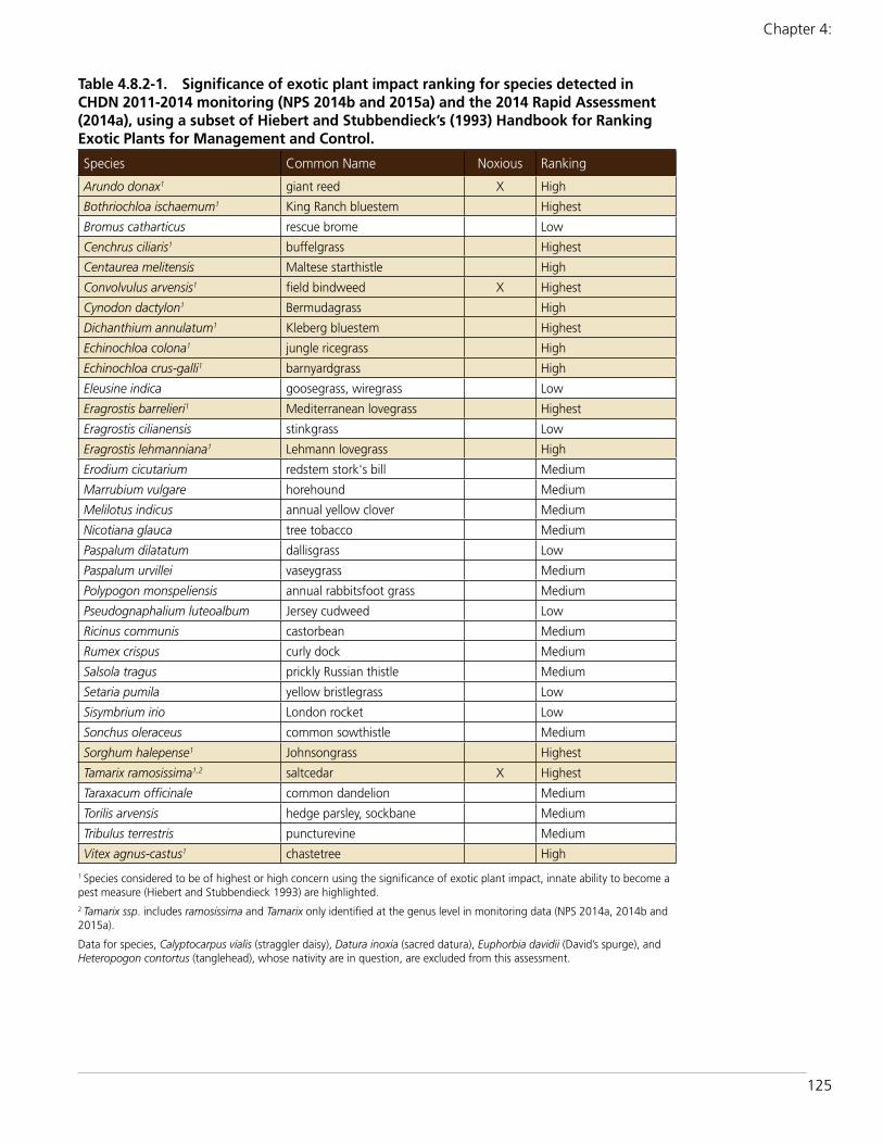
125
Chapter 4:
Table 4.8.2-1. Significance of exotic plant impact ranking for species detected in CHDN 2011-2014 monitoring (NPS 2014b and 2015a) and the 2014 Rapid Assessment (2014a), using a subset of Hiebert and Stubbendieck’s (1993) Handbook for Ranking Exotic Plants for Management and Control.
Species Common Name Noxious Ranking
Arundo donax1 giant reed X High
Bothriochloa ischaemum1 King Ranch bluestem Highest
Bromus catharticus rescue brome Low
Cenchrus ciliaris1 buffelgrass Highest
Centaurea melitensis Maltese starthistle High
Convolvulus arvensis1 field bindweed X Highest
Cynodon dactylon1 Bermudagrass High
Dichanthium annulatum1 Kleberg bluestem Highest
Echinochloa colona1 jungle ricegrass High
Echinochloa crus-galli1 barnyardgrass High
Eleusine indica goosegrass, wiregrass Low
Eragrostis barrelieri1 Mediterranean lovegrass Highest
Eragrostis cilianensis stinkgrass Low
Eragrostis lehmanniana1 Lehmann lovegrass High
Erodium cicutarium redstem stork's bill Medium
Marrubium vulgare horehound Medium
Melilotus indicus annual yellow clover Medium
Nicotiana glauca tree tobacco Medium
Paspalum dilatatum dallisgrass Low
Paspalum urvillei vaseygrass Medium
Polypogon monspeliensis annual rabbitsfoot grass Medium
Pseudognaphalium luteoalbum Jersey cudweed Low
Ricinus communis castorbean Medium
Rumex crispus curly dock Medium
Salsola tragus prickly Russian thistle Medium
Setaria pumila yellow bristlegrass Low
Sisymbrium irio London rocket Low
Sonchus oleraceus common sowthistle Medium
Sorghum halepense1 Johnsongrass Highest
Tamarix ramosissima1,2 saltcedar X Highest
Taraxacum officinale common dandelion Medium
Torilis arvensis hedge parsley, sockbane Medium
Tribulus terrestris puncturevine Medium
Vitex agnus-castus1 chastetree High
1 Species considered to be of highest or high concern using the significance of exotic plant impact, innate ability to become a pest measure (Hiebert and Stubbendieck 1993) are highlighted.2 Tamarix ssp. includes ramosissima and Tamarix only identified at the genus level in monitoring data (NPS 2014a, 2014b and 2015a).
Data for species, Calyptocarpus vialis (straggler daisy), Datura inoxia (sacred datura), Euphorbia davidii (David’s spurge), and Heteropogon contortus (tanglehead), whose nativity are in question, are excluded from this assessment.

126
Amistad National Recreation Area: Natural Resource Condition Assessment
Table 4.8.2-1 reports the significance of exotic plant impact rankings for each exotic species found during CHDN’s annual (2011-2014) and 2014 rapid assessment monitoring at the NRA. Seven species were ranked as having the highest concern, with seven additional species having high concern. Two of the species of highest concern, Convolvulus arvensis (field bindweed) and Tamarix ramosissima (saltcedar), and a species of high concern, Arundo donax (giant reed) are Texas state noxious weeds (USDA-NRCS 2014).
Indicators/MeasuresPrevalence of Exotic Plants (3 measures)
The prevalence of exotic plants includes three measures: extent, density, and distribution (Table 4.8.2-2). These measures describe how often, how many, and where respectively that exotic plant species were located during the annual and the 2014 rapid assessment monitoring.
MeasureExtent of Exotic Plants
Extent is a measure of the area (e.g., block in annual CHDN vector monitoring, or plot in 2014 rapid assessment monitoring) in which exotic species have been found. Extent is a proportional measure that indicates that an exotic species was identified a certain number of times. Extent is reported as the percentage of the surveyed blocks or plots that contained a specific exotic species, and is the frequency that blocks or plots contained exotic plant species. This measure only indicates whether the plant was found in the surveyed area, and does not include its density (e.g., number of plants found per block or plot) or where the block or plot was located. Extent is reported for all species identified during the CHDN 2011-2014 monitoring in Table 4.8.2-3, in Table 4.8.2-4 for the rapid assessment, and in Appendix E.
CHDN Annual Exotic Plants MonitoringThirty-five species of exotic plants were encountered during vector monitoring in 2011-2014 (NPS 2014b and 2015a) (Table 4.8.2-3), including 14 species of highest or high concern for their innate ability to
become a pest. Three species, Calyptocarpus vialis (straggler daisy), Euphorbia davidii (David’s spurge), and Heteropogon contortus (tanglehead), whose nativity is in question, are excluded from this assessment.
Although many different exotic species were found during monitoring, more than 43% of the blocks did not contain exotic plants. Most exotic plant species that were detected during monitoring had very limited extent: all but five species were found in less than 5% of the blocks.
Cenchrus ciliaris, a species of highest exotic plant impact, was the most common exotic plant found along the vectors, and was detected in 40% of the blocks. It was especially prevalent along the Governors Landing and Marina Access Road vectors where it was present in more than 82% of the blocks.
Bothriochloa ischaemum (king ranch bluestem), a species of highest concern, was detected in more than 25.6% of the blocks, and was the second most common exotic plant encountered during vector monitoring. It was encountered frequently along the Rough Canyon vector where it in almost 51% of the blocks.
Cynodon dactylon (Bermudagrass), which is of high concern, was also found in 25.6% of the blocks. Along the Rough Canyon Road, it was observed in 69.7% of the blocks.
Nicotiana glauca (tree tobacco) and Vitex agnus-castus (chastetree), a species of high
Table 4.8.2-2. Definitions of the three measures used for prevalence of exotic plants indicator.
Measure Description
Extent Answers how often. A measure of the percent of surveyed park monitoring locations (blocks or plots) that has exotic species occurring in it.
Density Answers how many. The number of exotic plants per unit of area (block or plot)
Distribution Answers where. A measure of the location of exotic plant occurrence.

127
Chapter 4:
concern, were present in 7.1% and 5.1% of the blocks respectively. Thirty species had limited extent along the vectors, being found in less than 5% of the blocks, including 25 species that were present in less than 1% of blocks. Ten of these species are of highest or high exotic plant impact: Centaurea melitensis (Malta starthistle) (4.2% of the blocks), Tamarix spp. (saltcedar) (3.6%), Eragrostis lehmanniana (Lehmann lovegrass) (1.7%), Arundo donax (giant reed) (1.2%), Convolvulus arvensis (field bindweed) (0.8%), Dichanthium annulatum (Kleberg bluestem) (0.8%), Sorghum halepense (Johnsongrass) (0.6%), Eragrostis barrelieri (Mediterranean lovegrass) (0.2%), Echinochloa colona (jungle ricegrass) (0.1%) and Echinochloa crus-galli (barnyardgrass) (0.1%).
CHDN 2014 Rapid AssessmentFourteen species were detected during the CHDN 2014 rapid assessment (NPS 2014a) (Table 4.8.2-4), including seven species of highest or high exotic plant impact. However, more than 43% of the plots did not contain exotic plants.
Cynodon dactylon had the widest extent in the rapid assessment and was documented
Table 4.8.2-3. Extent of exotic plant species detected in CHDN high priority monitoring blocks sampled in 2011-2014.
Species No. Blocks% (N=3134)
No Plant 1357 43.30%
Cenchrus ciliaris1 1254 40.01%
Bothriochloa ischaemum1 803 25.62%
Cynodon dactylon1 801 25.56%
Nicotiana glauca 221 7.05%
Vitex agnus-castus1 160 5.11%
Centaurea melitensis1 130 4.15%
Torilis arvensis 119 3.80%
Tamarix spp.1, 2 113 3.61%
Eragrostis lehmanniana1 52 1.66%
Arundo donax1 38 1.21%
Melilotus indicus 31 0.99%
Ricinus communis 26 0.83%
Convolvulus arvensis1 24 0.77%
Dichanthium annulatum1 24 0.77%
Polypogon monspeliensis 23 0.73%
Pseudognaphalium luteoalbum
23 0.73%
Sorghum halepense1 20 0.64%
Paspalum dilatatum 13 0.41%
Sonchus oleraceus 8 0.26%
Bromus catharticus 5 0.16%
Eragrostis barrelieri1 5 0.16%
Eragrostis cilianensis 5 0.16%
Sisymbrium irio 3 0.10%
Echinochloa colona1 2 0.06%
Echinochloa crus-galli1 2 0.06%
Eleusine indica 2 0.06%
Erodium cicutarium 2 0.06%
Rumex crispus 2 0.06%
Setaria pumila 2 0.06%
Taraxacum officinale 2 0.06%
Tribulus terrestris 2 0.06%
Marrubium vulgare 1 0.03%
Paspalum urvillei 1 0.03%
Salsola tragus 1 0.03%
1 Species considered to be of highest or high concern in (Table 4.10.2-1) are highlighted.2 Tamarix ssp. includes ramosissima and Tamarix only identified at the genus level in monitoring data (NPS 2014b and 2015a).
Table 4.8.2-4. Extent of exotic plant species detected in CHDN rapid assessment plots sampled in 2014.
Species No. Plots % (N=248)
No Plant 108 43.55%
Cynodon dactylon1 104 41.94%
Nicotiana glauca 68 27.42%
Tamarix spp.1, 2 50 20.16%
Bothriochloa ischaemum1 33 13.31%
Vitex agnus-castus1 18 7.26%
Cenchrus ciliaris1 17 6.85%
Eragrostis cilianensis 3 1.21%
Setaria pumila 2 0.81%
Arundo donax1 2 0.81%
Bromus catharticus 1 0.40%
Marrubium vulgare 1 0.40%
Ricinus communis 1 0.40%
Sorghum halepense1 1 0.40%
1 Species considered to be of highest or high concern in (Table 4.10.2-1) are highlighted.2 Tamarix ssp. includes ramosissima and Tamarix only identified at the genus level in monitoring data (NPS 2014a).
128
Amistad National Recreation Area: Natural Resource Condition Assessment
in nearly 42% of the plots. Three species had significantly greater extent in rapid assessment plots than along the vectors: Cynodon dactylon (41.9% versus 25.6%), Nicotiana glauca (27.4% versus 7.1%), and Tamarix spp. (20.16% versus 3.61%). Vitex agnus-castus had a slightly higher extent in the rapid assessment plots (7.3%) versus the vector blocks (5.1%).
On the other hand, Bothriochloa ischaemum (13.3% versus 25.6%), Cenchrus ciliaris (6.9% versus 40.0%) had substantially less extent in the rapid assessment blocks than along the vectors.
Seven species were found in less than 1% of the plots, including Arundo donax and Sorghum halepense. No species were present in rapid assessment plots that were not also present along the vectors.
MeasureDensity of Exotic Plants
The density measure is the number of exotic plants per unit of area (block or plot). During the annual CHDN monitoring and 2014 rapid assessment, the occurrence of each observed exotic species was assigned to one of five density classes, representing a range from not observed to a small number of individual plants to a continuous matrix within the block or plot.
These density classes are:
● 0 = Not observed ● 1 = 1-5 plants present ● 2 = Scattered in patches ● 3 = Scattered fairly evenly ● 4 = Forming a matrix (Folts-Zettner et al.
2013).
Density is reported for all species identified during the 2011-2014 annual monitoring in Table 4.8.2-5 (NPS 2014b and 2015a) and for all exotic species found during the 2014 one-time rapid assessment in Table 4.8.2-6 (NPS 2014a).
The density of three species that have highest or high concern for their impact to alter native
plant communities and that have wide extents are shown in Figures 4.8.2-3 (Cenchrus ciliaris), 4.8.2-4 (Bothriochloa ischaemum), and Figure 4.8.2-5 (Cynodon dactylon). For the annual monitoring, these maps only show the densities of the plants in the distance class closest to the vector.
CHDN Annual Exotic Plants MonitoringExotic species were most often found in density class 2 (scattered patchy) during the 2011-2014 monitoring of high priority vectors (Table 4.8.2-5). In fact, some species were found nearly exclusively in scattered patchy densities or higher (in classes 2 through 4), including Cynodon dactylon (95.5%), Melilotus indicus (annual yellow clover) (86%), Cenchrus ciliaris (96.7%), and Polypogon monspeliensis (annual rabbitsfoot grass) (84.1%).
Nine species were detected at evenly scattered densities (class 3) in the 2011-2014 monitoring, including seven species of highest or high concern for their potential to alter native plant communities. Cynodon dactylon was found in class 3 densities 19% of the time. Cenchrus ciliaris (7.5%), Melilotus indicus (7.4%), Convolvulus arvensis (6.1%), Bothriochloa ischaemum (4.5%), Torilis arvensis (hedge parsley) (3.9%), and Tamarix spp. (3.6%) were also present in class 3 in a significant number of blocks.
Three species were found in density class 4 (matrix). Cynodon dactylon formed the matrix in 26 blocks. Tamarix spp. and Cenchrus ciliaris also formed the matrix in two blocks.
CHDN 2014 Rapid Assessment Exotic plant species were also mostly detected in density class 2 or higher during the 2014 rapid assessment (Table 4.8.2-6). Cynodon dactylon was in density class 2 or higher in all but 1.9% of the plots, including 28.9% of the plots that were in density class 3, and 7.7% in density class 4. Nicotiana glauca was in density class 2 or high in 85.3% of the plots.
While Tamarix spp. was in density class 1 in 40% of the plots, 46% were in density class 2, 12% were in density class 3, and 2% (1 plot) was in density class 4.

129
Chapter 4: Natural Resource Conditions - Exotic Plants
Table 4.8.2-5. Density of exotic plants in CHDN 2011-2014 high priority vector blocks with the density class information in percentage of total occurrences recorded for each species.
SpeciesNumber of Occurrences
Density Classes
Class 1 (%)1-5 individuals
Class 2 (%)Scattered patchy
Class 3 (%)Scattered even
Class 4 (%)Matrix
Cenchrus ciliaris1 2696 14.02% 78.45% 7.46% 0.07%
Cynodon dactylon1 1861 4.46% 75.17% 18.97% 1.40%
Bothriochloa ischaemum1 1268 17.98% 77.52% 4.50%
Nicotiana glauca 344 27.33% 72.67%
Vitex agnus-castus1 265 52.45% 46.79% 0.75%
Tamarix spp.1, 2 225 36.89% 58.67% 3.56% 0.89%
Centaurea melitensis1 213 23.94% 75.59% 0.47%
Torilis arvensis 179 22.91% 73.18% 3.91%
Eragrostis lehmanniana1 100 51.00% 49.00%
Melilotus indicus 68 10.29% 82.35% 7.35%
Arundo donax1 60 18.33% 81.67%
Polypogon monspeliensis 53 15.09% 84.91%
Pseudognaphalium luteoalbum
37 32.43% 67.57%
Convolvulus arvensis1 33 66.67% 27.27% 6.06%
Dichanthium annulatum1 31 64.52% 35.48%
Ricinus communis 30 50.00% 50.00%
Sorghum halepense1 27 51.85% 48.15%
Paspalum dilatatum 23 39.13% 60.87%
Sonchus oleraceus 9 66.67% 33.33%
Bromus catharticus 7 28.57% 71.43%
Eragrostis cilianensis 7 42.86% 57.14%
Eragrostis barrelieri1 6 50.00% 50.00%
Eleusine indica 3 100.00%
Erodium cicutarium 3 33.33% 66.67%
Sisymbrium irio 3 66.67% 33.33%
Echinochloa colona1 2 100.00%
Echinochloa crus-galli1 2 50.00% 50.00%
Rumex crispus 2 100.00%
Setaria pumila 2 50.00% 50.00%
Taraxacum officinale 2 100.00%
Tribulus terrestris 2 100.00%
Marrubium vulgare 1 0.00% 100.00%
Paspalum urvillei 1 100.00%
Salsola tragus 1 100.00%
The number of occurrences includes those in all distance classes from the vector. Density classes are from (Folts-Zettner et al. 2013). Density class 0 measures are not reported in this table.1 Species considered to be of highest or high concern in (Table 4.10.2-1) are highlighted.2 Tamarix ssp. includes ramosissima and Tamarix only identified at the genus level in monitoring data (NPS 2014b and 2015a).

130
Amistad National Recreation Area: Natural Resource Condition Assessment
One species of very limited extent, Setaria pumila (yellow bristlegrass), occurred in density class 4 in one block.
MeasureDistribution of Exotic Plants
The distribution measure evaluated the occurrence of exotic plant species in different geographic areas of the recreation area, using data from both the CHDN annual monitoring and the 2014 rapid assessment. Additionally, the Amistad rapid assessment was designed to evaluate above and below the fluctuating level of the reservoir by surveying above and below the 342 m (1122 ft) elevation line and to assess whether Cenchrus ciliaris was moving into the upland hunting areas (Tomye Folts-Zettner, personal communication, 2015).
Overall, in Amistad NRA, exotic species diversity and distribution was variable depending on the proximity of the transect to the reservoir. Many of the heavily infested transects were very close to the water (Jonathan Horsley, personal communication, 2015).
For Amistad NRA, the distribution measure had three parts. The geographic distribution in different parts of the recreation area utilized data from both the annual vector monitoring and the rapid assessment. It is the proportion of blocks or plots infested with exotic plants reported for each of the distinct areas surveyed in CHDN 2011-2014 vector monitoring (NPS 2014b and 2015a) (Table 4.8.2-7) and the 2014 rapid assessment (NPS 2014a) (Table 4.8.2-8). This information
Figure 4.8.2-3. Cenchrus ciliaris plant density based on surveys conducted during CHDN’s 2011-2014 annual monitoring and CHDN’s 2014 rapid assessment.

131
Chapter 4: Natural Resource Conditions - Exotic Plants
showed whether the infestations of exotic species are widespread and found in multiple areas of the recreation area or restricted to a certain area. The discussion for distribution along the vectors excluded Panther Cave and Parida Docks that were only monitored in 2011 and only had 4 blocks each.
Table 4.8.2-9 shows the number of different species found in along each of the vectors and in each of the areas of the 2014 rapid assessment in order to assess which areas of the recreation area have the highest number of exotic plant species.
The inundation line distribution compared the occurrence of exotic plants 50 m above and below the 342 m (1122 ft) elevation line in four rapid assessment areas: Box Canyon, Castle
Canyon, Diablo East and Rough Canyon (Table 4.8.2-10). The availability of additional water below the inundation line most likely provides a favorable growing environment for some species of exotic plants (Tomye Folts-Zettner, personal communication, 2015).
Finally, the comparison of the upland hunting areas to the shoreline rapid assessment areas (Table 4.8.2-11) revealed the distribution of exotic plants in interior upland habitat (Hunting Area 1 and 2 rapid assessment areas) relative to the lowland area parallel to the shoreline of Amistad Reservoir.
Geographic Distribution: CHDN Annual Exotic Plants Monitoring Generally, the species with the greatest extent (e.g., found in more than 25% of
Figure 4.8.2-4. Bothriochloa ischaemum plant density based on surveys conducted during CHDN’s 2011-2014 annual monitoring and CHDN’s 2014 rapid assessment.
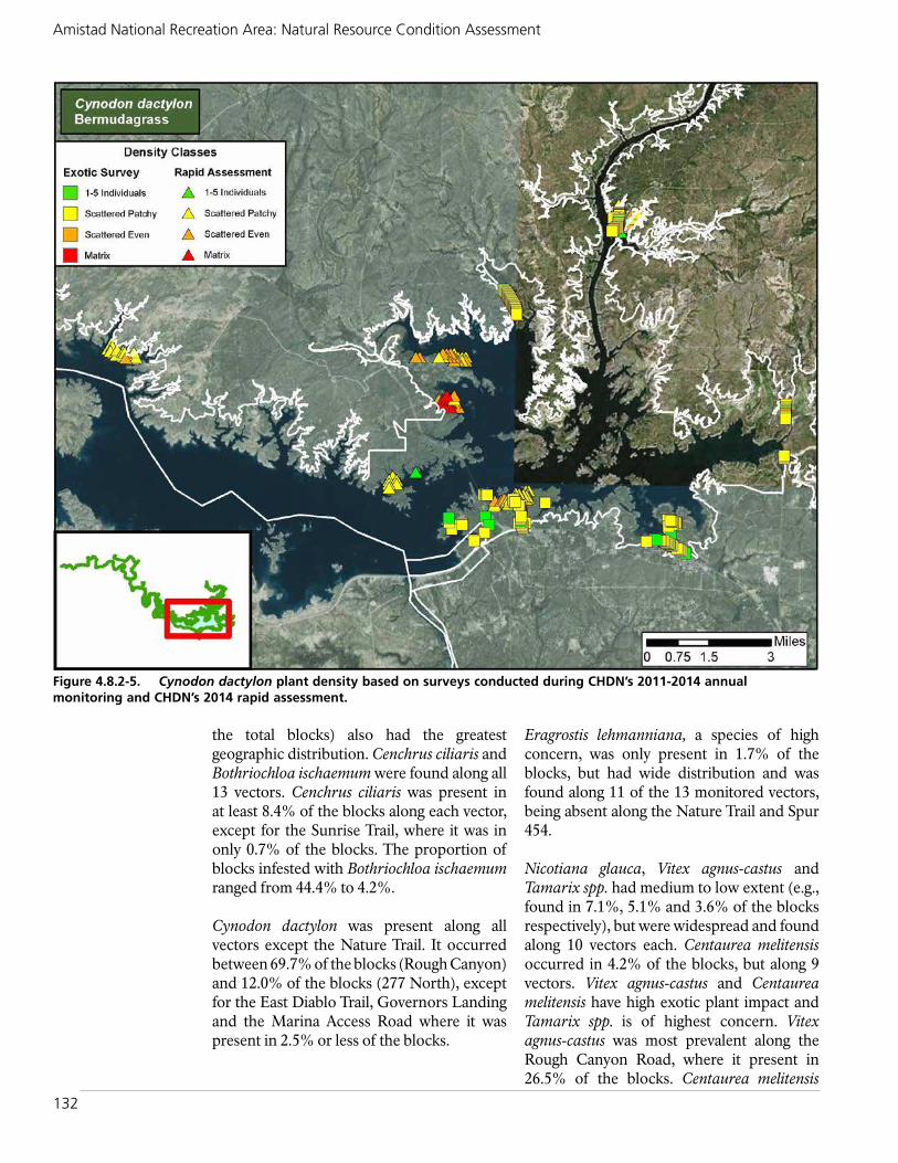
132
Amistad National Recreation Area: Natural Resource Condition Assessment
the total blocks) also had the greatest geographic distribution. Cenchrus ciliaris and Bothriochloa ischaemum were found along all 13 vectors. Cenchrus ciliaris was present in at least 8.4% of the blocks along each vector, except for the Sunrise Trail, where it was in only 0.7% of the blocks. The proportion of blocks infested with Bothriochloa ischaemum ranged from 44.4% to 4.2%.
Cynodon dactylon was present along all vectors except the Nature Trail. It occurred between 69.7% of the blocks (Rough Canyon) and 12.0% of the blocks (277 North), except for the East Diablo Trail, Governors Landing and the Marina Access Road where it was present in 2.5% or less of the blocks.
Eragrostis lehmanniana, a species of high concern, was only present in 1.7% of the blocks, but had wide distribution and was found along 11 of the 13 monitored vectors, being absent along the Nature Trail and Spur 454.
Nicotiana glauca, Vitex agnus-castus and Tamarix spp. had medium to low extent (e.g., found in 7.1%, 5.1% and 3.6% of the blocks respectively), but were widespread and found along 10 vectors each. Centaurea melitensis occurred in 4.2% of the blocks, but along 9 vectors. Vitex agnus-castus and Centaurea melitensis have high exotic plant impact and Tamarix spp. is of highest concern. Vitex agnus-castus was most prevalent along the Rough Canyon Road, where it present in 26.5% of the blocks. Centaurea melitensis
Figure 4.8.2-5. Cynodon dactylon plant density based on surveys conducted during CHDN’s 2011-2014 annual monitoring and CHDN’s 2014 rapid assessment.

133
Chapter 4: Natural Resource Conditions - Exotic Plants
was most common along Spur 406 where it occurred in 13.3% of blocks.
Each a species of highest exotic plant impact, Sorghum halepense was found along seven vectors, Dichanthium annulatum was present along six, and Convolvulus arvensis along five vectors.
Nine species only occurred along a single vector, including Echinochloa colona and Echinochloa crus-galli, both of high concern.
In eight of the 13 vectors, 50% or more of the blocks did not contain exotic plants, including 63.4% of blocks along Diablo East Trail, 62.1% of blocks at San Pedro, and 60.7% for 277 South. However, most blocks at Governors Landing (94.8%) and 277 North (91.7%), Rough Canyon (90.1%), Marina Access Road (86.7%), Spur 454 (86.5%), and Spur 406 (76.1%) contained exotic plants.
The number of exotic species found along each vector ranged from 24 to 5 (Table 4.8.2-9). Spur 406, a paved road, had 24 exotic plant species, the highest number found along
any vector. The Rough Canyon Road, which has both paved and unpaved segments, had 21 exotic species. The Diablo East and 277 North Roads each had 17 species of exotic plants. The Marina Access Road had the fewest number of exotic plant species of any vector and only five different species were found there.
In general, unpaved trails had fewer exotic species than roads. The Sunrise and Diablo East Trails each had nine exotic species, and the Marina Trails had only six species.
Geographic Distribution: CHDN 2014 Rapid AssessmentAs in the case of the vectors, exotic plant species with higher extent in the rapid assessment areas generally had a greater distribution. For example, Cynodon dactylon had the highest extent of any species in the rapid assessment, and was found in all six areas. Cynodon dactylon was the most common species found in the inundation zone, and many of the rapid assessment areas were within or near the inundation zone. The overall amount of Bermudagrass in the
Table 4.8.2-6. Density of exotic plants in CHDN 2014 rapid assessment plots, with the density class information in percentage of total occurrences recorded for each species.
SpeciesNumber of Occurrences
Density Classes
Class 1 (%)1-5 individuals
Class 2 (%)Scattered patchy
Class 3 (%)Scattered even
Class 4 (%)Matrix
Cynodon dactylon1 104 1.92% 61.54% 28.85% 7.69%
Nicotiana glauca 68 14.71% 80.88% 4.41%
Tamarix spp.1, 2 50 40.00% 46.00% 12.00% 2.00%
Bothriochloa ischaemum1 33 24.24% 75.76%
Vitex agnus-castus 18 16.67% 83.33%
Cenchrus ciliaris1 17 29.41% 70.59%
Heteropogon contortus 14 7.14% 92.86%
Eragrostis cilianensis 3 33.33% 66.67%
Arundo donax1 2 100.00%
Setaria pumila 2 50.00% 50.00%
Bromus catharticus 1 100.00%
Marrubium vulgare 1 100.00%
Ricinus communis 1 100.00%
Sorghum halepense1 1 100.00%
The number of occurrences includes those in all distance classes from the vector. Density classes are from (Folts-Zettner et al. 2013). Density class 0 measures are not reported in this table.1 Species considered to be of highest or high concern in (Table 4.10.2-1) are highlighted.2 Tamarix ssp. includes ramosissima and Tamarix only identified at the genus level in monitoring data (NPS 2014a).

134
Amistad National Recreation Area: Natural Resource Condition Assessment
Table 4.8.2-7. Geographic distribution of exotic plants found in Amistad NRA, with the proportion of infested blocks in each of the vectors surveyed during 2011-2014 CHDN monitoring.
SpeciesDiablo East 2011-14 (N=838)
Diablo East Trail 2012-14 (N=198)
Gov Landing 2011-14 (N=328)
Marina Access Rd 2011-14 (N=360)
Marina Trails 2011-14 (N=314)
Nature Trail 2013-14 (N=24)
Arundo donax1 0.30%
Bothriochloa ischaemum1 15.87% 4.55% 28.66% 10.56% 6.37% 4.17%
Bromus catharticus
Cenchrus ciliaris1 34.84% 20.20% 83.23% 82.50% 26.43% 12.50%
Centaurea melitensis1 2.15% 1.22%
Convolvulus arvensis1 1.07%
Cynodon dactylon1 16.47% 2.53% 2.44% 2.22% 10.51%
Dichanthium annulatum1 0.24% 0.32%
Echinochloa colona1
Echinochloa crus-galli1
Eleusine indica
Eragrostis barrelieri1 0.24%
Eragrostis cilianensis 0.51% 0.61%
Eragrostis lehmanniana1 2.51% 1.52% 4.27% 2.78% 0.32%
Erodium cicutarium
Marrubium vulgare
Melilotus indicus
Nicotiana glauca 3.58% 12.12% 7.32% 0.83% 15.92% 37.50%
Paspalum dilatatum 0.00%
Paspalum urvillei
Polypogon monspeliensis
Pseudognaphalium luteoalbum
Ricinus communis 1.01% 2.74% 16.67%
Rumex crispus
Salsola tragus 4.17%
Setaria pumila
Sisymbrium irio 0.12%
Sonchus oleraceus 0.36% 0.30%
Sorghum halepense1 0.12%
Tamarix spp.1,2 0.36% 0.51% 1.52% 5.10%
Taraxacum officinale
Torilis arvensis 7.76%
Tribulus terrestris 0.24%
Vitex agnus-castus1 2.15% 0.91% 4.46% 8.33%
No Plants Detected 52.63% 63.64% 5.18% 13.33% 58.28% 50.00%
1 Species considered to be of highest or high concern in (Table 4.10.2-1) are highlighted.
2 Tamarix ssp. includes ramosissima and Tamarix only identified at the genus level in monitoring data (NPS 2014b and 2015a).
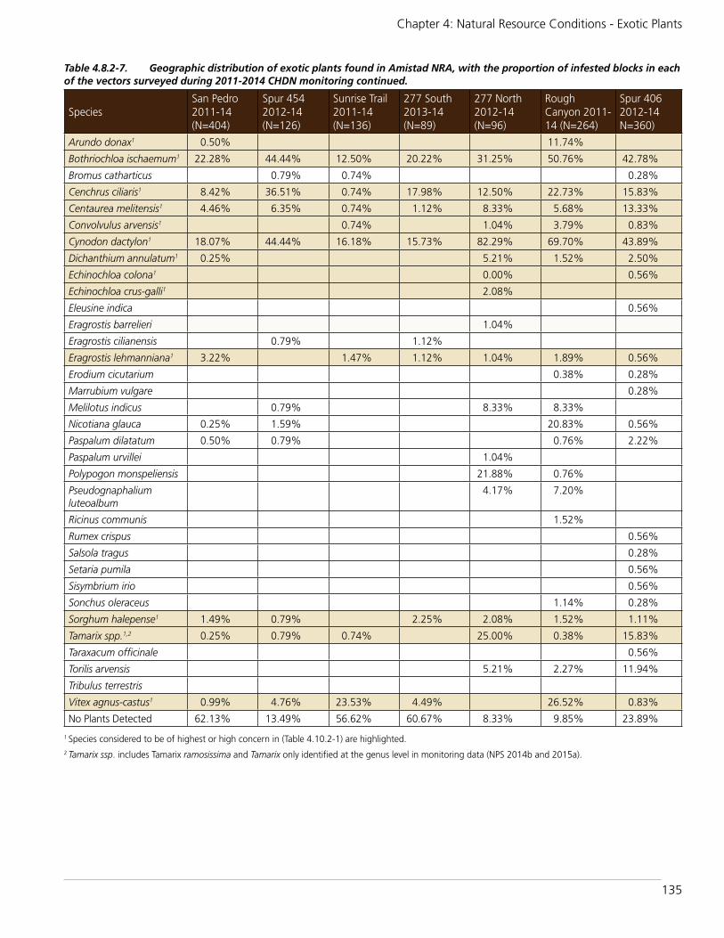
135
Chapter 4: Natural Resource Conditions - Exotic Plants
Table 4.8.2-7. Geographic distribution of exotic plants found in Amistad NRA, with the proportion of infested blocks in each of the vectors surveyed during 2011-2014 CHDN monitoring continued.
SpeciesSan Pedro 2011-14 (N=404)
Spur 454 2012-14 (N=126)
Sunrise Trail 2011-14 (N=136)
277 South 2013-14 (N=89)
277 North 2012-14 (N=96)
Rough Canyon 2011-14 (N=264)
Spur 406 2012-14 N=360)
Arundo donax1 0.50% 11.74%
Bothriochloa ischaemum1 22.28% 44.44% 12.50% 20.22% 31.25% 50.76% 42.78%
Bromus catharticus 0.79% 0.74% 0.28%
Cenchrus ciliaris1 8.42% 36.51% 0.74% 17.98% 12.50% 22.73% 15.83%
Centaurea melitensis1 4.46% 6.35% 0.74% 1.12% 8.33% 5.68% 13.33%
Convolvulus arvensis1 0.74% 1.04% 3.79% 0.83%
Cynodon dactylon1 18.07% 44.44% 16.18% 15.73% 82.29% 69.70% 43.89%
Dichanthium annulatum1 0.25% 5.21% 1.52% 2.50%
Echinochloa colona1 0.00% 0.56%
Echinochloa crus-galli1 2.08%
Eleusine indica 0.56%
Eragrostis barrelieri 1.04%
Eragrostis cilianensis 0.79% 1.12%
Eragrostis lehmanniana1 3.22% 1.47% 1.12% 1.04% 1.89% 0.56%
Erodium cicutarium 0.38% 0.28%
Marrubium vulgare 0.28%
Melilotus indicus 0.79% 8.33% 8.33%
Nicotiana glauca 0.25% 1.59% 20.83% 0.56%
Paspalum dilatatum 0.50% 0.79% 0.76% 2.22%
Paspalum urvillei 1.04%
Polypogon monspeliensis 21.88% 0.76%
Pseudognaphalium luteoalbum
4.17% 7.20%
Ricinus communis 1.52%
Rumex crispus 0.56%
Salsola tragus 0.28%
Setaria pumila 0.56%
Sisymbrium irio 0.56%
Sonchus oleraceus 1.14% 0.28%
Sorghum halepense1 1.49% 0.79% 2.25% 2.08% 1.52% 1.11%
Tamarix spp.1,2 0.25% 0.79% 0.74% 25.00% 0.38% 15.83%
Taraxacum officinale 0.56%
Torilis arvensis 5.21% 2.27% 11.94%
Tribulus terrestris
Vitex agnus-castus1 0.99% 4.76% 23.53% 4.49% 26.52% 0.83%
No Plants Detected 62.13% 13.49% 56.62% 60.67% 8.33% 9.85% 23.89%
1 Species considered to be of highest or high concern in (Table 4.10.2-1) are highlighted.2 Tamarix ssp. includes Tamarix ramosissima and Tamarix only identified at the genus level in monitoring data (NPS 2014b and 2015a).

136
Amistad National Recreation Area: Natural Resource Condition Assessment
recreation area is less than what was found in the rapid assessment (Jonathan Horsley, personal communication, 2015)
Cenchrus ciliaris was only present in 6.9% of the plots, but was widely distributed and found in each of the six rapid assessment areas. Bothriochloa ischaemum was also present in every rapid assessment area and was present in 13.3% of the plots. Tamarix spp. was present in all areas but Hunting Area 1, and Nicotiana glauca was present in all areas but Castle Canyon. Vitex agnus-castus was present in three of the rapid assessment areas.
Eight species were found in only one rapid assessment area. These species, including Arundo donax and Sorghum halepense, of high and highest concern respectively, usually had a very limited extent in that one area, and were found in only one or two plots.
The Box Canyon rapid assessment area had the most exotic plant species with nine species. Diablo East, Hunting Area 2, and Rough Canyon had eight different species. Hunting Area 1 had six species, and Castle Canyon had only five exotic plant species.
Hunting Area 1 had the most plots without any exotic plants as 66.7% of the plots did not contain nonnative species. Half of the plots at Diablo East did not contain exotic plants, and 35.9% of the plots in the Rough Canyon area were free of exotic plants.
Inundation Line DistributionEleven exotic plant species were found in the rapid assessment areas paralleling the Amistad Reservoir shoreline at Box Canyon, Castle Canyon, Diablo East and Rough Canyon (Table 4.8.2-10). Overall, plots below the 342 m (1122 ft) inundation line contained many more occurrences of exotic plants than the one above this elevation. Only 4.4% percent of plots below the inundation line did not contain exotic plants, whereas 76.3% of plots above it were free of exotic plants.
Additionally, most species were significantly more prevalent below the 342 m (1122 ft) elevation line than above the shoreline elevation. Cynodon dactylon was only present in 8.5% of the plots above the inundation line, but in 85.5% of plots below it. Likewise, Nicotiana glauca was rare above the line (in only 3.4% of plots), but present in 79.7% of plots of above it.
Table 4.8.2-8. Distribution of exotic plants found in Amistad NRA, with the proportion of infested plots in each of the rapid assessment areas surveyed during the 2014 CHDN rapid assessment.
SpeciesBox Canyon (N=27)
Castle Canyon (N=12)
Diablo East (N=50)
Hunting Area 1 (N=69)
Hunting Area 2 (N=51)
Rough Canyon (N=39)
Arundo donax1 5.13%
Bothriochloa ischaemum1 25.93% 16.67% 2.00% 10.14% 23.53% 10.26%
Bromus catharticus 1.45%
Cenchrus ciliaris1 7.41% 8.33% 10.00% 5.80% 7.84% 2.56%
Cynodon dactylon1 62.96% 50.00% 44.00% 10.14% 62.75% 51.28%
Eragrostis cilianensis 7.41% 8.33%
Marrubium vulgare 1.96%
Nicotiana glauca 51.85% 44.00% 10.14% 7.84% 53.85%
Ricinus communis 2.00%
Setaria pumila 3.92%
Sorghum halepense1 3.70%
Tamarix spp.1,2 29.63% 16.67% 30.00% 47.06% 2.56%
Vitex agnus-castus1 3.70% 4.00% 38.46%
No Plant 22.22% 25.00% 50.00% 66.67% 27.45% 35.90%
1 Species considered to be of highest or high concern in (Table 4.10.2-1) are highlighted.2 Tamarix ssp. includes ramosissima and Tamarix only identified at the genus level in monitoring data (NPS 2014b).

137
Chapter 4: Natural Resource Conditions - Exotic Plants
Five species were present below the 342 m line that were not detected above the line: Ricinus communis (castorbean), Sorghum halepense, Tamarix spp., and Vitex agnus-castus. Tamarix spp. was present in 37.7% of the plots below the inundation line, and Vitex agnus-castus was present in 26.1%. This greater occurrence of exotic species below the inundation line is probably a result of the greater availability of water.
Upland versus Lowland DistributionA comparison of the rapid assessment in the Hunting Areas 1 and 2 with the rapid assessment in the four areas parallel to the Amistad Reservoir shoreline (Box Canyon, Castle Canyon, Diablo East and Rough Canyon) allowed analysis of the upland versus the lowland habitat in Amistad NRA.
Most species occurred more frequently in the lowland plots than in the upland plots. Additionally, 50% of the plots in Hunting Areas 1 and 2 were free of exotic plants, but
only 37.5% of the plots along the Amistad shoreline did not contain exotic species.
Amistad NRA staff were interested in whether Cenchrus ciliaris was invading the upland hunting areas (Tomye Folts-Zettner, personal communication, 2015). The comparison of the results from the Hunting Area rapid assessment to the shoreline ones showed that the species was found in close to 7% of plots in both areas.
Species that have a particular affinity for water were much more common in the lowland plots than in the Hunting Areas. Nicotiana glauca was present in 44.5% of the lowland plots, but only 9.2% of the Hunting Area plots. Cynodon dactylon was present in 50% of the lowland plots, but in 32.5% of the upland plots. Vitex agnus-castus was not found in the Hunting Areas, but was in 14.1% of the shoreline plots.
Only Bothriochloa ischaemum was detected substantially more in the upland plots (15.8% versus 10.9%), although three species, Bromus catharticus (rescue brome), Marrubium vulgare (horehound), and Setaria pumila (yellow bristlegrass) were found in one or two
Table 4.8.2-9. Number of species found in each location during CHDN monitoring.
LocationMonitoring Type
# of Species
Diablo East Vector 17
Diablo East Trails Vector 9
Governors Landing Vector 12
Marina Access Road Vector 5
Marina Trails Vector 9
Nature Trail Vector 6
San Pedro Vector 12
Spur 454 Vector 12
Sunrise Trail Vector 9
277 South Vector 8
277 North Vector 17
Rough Canyon Vector 21
Spur 406 Vector 24
Panther Cave Dock Vector 3
Parida Cave Dock Vector 3
Box Canyon Rapid Assess. 9
Castle Canyon Rapid Assess. 5
Diablo East RA Rapid Assess. 8
Hunting Area 1 Rapid Assess. 6
Hunting Area 2 Rapid Assess. 8
Rough Canyon RA Rapid Assess. 8
Table 4.8.2-10. Distribution of exotic plants above and below the 342 m elevation shoreline in rapid assessment areas.
Species
% above 342 m elevation (N=59)
% below 342 m elevation (N=69)
Arundo donax1 1.69% 1.45%
Bothriochloa ischaemum1 8.47% 13.04%
Cenchrus ciliaris1 10.17% 4.35%
Cynodon dactylon1 8.47% 85.51%
Eragrostis cilianensis 1.69% 2.90%
Nicotiana glauca 3.39% 79.71%
Ricinus communis 1.45%
Sorghum halepense1 1.45%
Tamarix spp.1 37.68%
Vitex agnus-castus1 26.09%
No Plant 76.27% 4.35%
1 Species considered to be of highest or high concern in (Table 4.10.2-1) are highlighted.2 Tamarix ssp. includes ramosissima and Tamarix only identified at the genus level in monitoring data (NPS 2014a).

138
Amistad National Recreation Area: Natural Resource Condition Assessment
plots in the upland rapid assessment areas and were not present in the lowland plots.
4.8.3. Reference ConditionsWhenever an exotic plant is present that has the biological characteristics to alter native plant communities, there is cause for concern. However, early detection of these species provides managers with the necessary information to apply a rapid response management strategy before the exotic plant becomes established. If a rapid response is not implemented, the exotic plant may become established and potentially degrade the integrity of the native plant communities.
Our good, moderate, and significant concern reference conditions are based upon both an exotic plant’s ability to alter native plant communities as well as its prevalence (i.e., extent, density, and distribution). A summary of the reference conditions is shown in Table 4.8.3-1.
A good reference condition is the capability for primary communities to be maintained. By this, we mean that ecological attributes (e.g., species composition, structure, etc.) and natural processes remain within the natural variation for the community type.
A moderate condition is assigned to exotic plant species that have been ranked as highest or high concern but its prevalence remains low, or when a plant has been assigned a medium impact ranking score and is found in medium to high prevalence.
A condition of significant concern is assigned when an exotic plant is ranked as highest or high for its ability to alter native plant communities, and is found in at least at medium prevalence.
Further consideration of condition is warranted on a case by case basis, especially for species with low prevalence, or when a species’ prevalence may be increasing. Given the early detection and rapid response model for the control of exotic plants, species with low prevalence may be considered to be in moderate condition even though they may have low or medium impact rankings. Further, species that scored low in the Hiebert and Stubbendieck’s (1993) innate ability to become a pest ranking system, may considered to be of moderate condition depending on the individual characteristics of a species, and the unique attributes of the NPS site, regardless of prevalence.
4.8.4. Condition and TrendThirty-five exotic species were found within Amistad NRA during monitoring by the CHDN between 2011 and 2014 (NPS 2014a, 2014b, and 2015a). Altogether, 68 species of exotic plants (Appendix E) have been recorded in the recreation area. Three species, Echinochloa crus-galli, Taraxacum officinale (common dandelion), and Tribulus terrestris, (puncturevine) were detected during vector monitoring (NPS 2014b and NPS 2015a) that had not been not previously documented at Amistad (NPS 2015b, Poole 2013). In 2013, a single plant of Peganum harmala (African rue) was found along Spur 406 and was vouchered and destroyed (Weckesser 2013).
Table 4.8.2-11. Distribution of exotic plants between upland and lowland habitats.
Species% Upland RA areas1 (N=128)
% Lowland RA areas2 (N=120)
Arundo donax3 1.56%
Bothriochloa ischaemum3 10.94% 15.83%
Bromus catharticus 0.83%
Cenchrus ciliaris3 7.03% 6.67%
Cynodon dactylon3 50.00% 32.50%
Eragrostis cilianensis 2.34%
Marrubium vulgare 0.83%
Nicotiana glauca 44.53% 9.17%
Ricinus communis 0.78%
Setaria pumila 1.67%
Sorghum halepense3 0.78%
Tamarix spp.3, 4 20.31% 20.00%
Vitex agnus-castus3 14.06%
No Plant 37.50% 50.00%
1 Upland rapid assessment areas are Hunting Areas 1 and 2.2 Lowland rapid assessment areas are Box Canyon, Castle Canyon Diablo East and Rough Canyon.3 Species considered to be of highest or high concern in (Table 4.10.2-1) are highlighted.4 Tamarix ssp. includes ramosissima and Tamarix only identified at the genus level in monitoring data (NPS 2014a).

139
Chapter 4: Natural Resource Conditions - Exotic Plants
Fourteen of the species found during CHDN’s annual and one-time rapid assessment monitoring were considered to be the highest or high concern based upon their potential to alter native plant communities (Table 4.8.2-1). Five species were determined to be highly prevalent during monitoring and one species had medium prevalence.
Combining the results of the significance of impact indicator with prevalence data from the three measures, five species are in the condition of significant concern (Table 4.8.4-1). Of these species, Bothriochloa ischaemum, Cenchrus ciliaris, Cynodon dactylon and Tamarix spp., were highly prevalent in the recreation area. Vitex agnus-castus had medium prevalence.
Four species that were ranked at highest concern (Convolvulus arvensis, Dichanthium annulatum, Eragrostis barrelieri and Sorghum halepense) for their innate ability to become a pest were not prevalent in the NRA, and are in moderate condition. Five species with high exotic plant impact ranking and low prevalence in the recreation area were also determined to be in moderate condition: Arundo donax, Centaurea melitensis, Echinochloa colona, Echinochloa crus-galli and Eragrostis lehmanniana. One species, Nicotiana glauca, with medium impact ranking but high prevalence was also in moderate condition.
Condition of Significant Concern SpeciesBased on combining the two indicators with four measures, five species are in the condition of significant concern. Of these five species, three, Bothriochloa ischaemum, Cenchrus ciliaris and Tamarix spp., were ranked as highest concern for their innate ability to become a pest and had high prevalence. Cynodon dactylon has high exotic plant impact and high prevalence. Vitex agnus-castus also has high exotic plant impact, and was found in medium prevalence.
Bothriochloa ischaemum can dominate grassland communities, and reduce insect, landbird and mammal diversity, and is difficult to manage (Institute for the Study of Invasive Species 2014). It had wide extent
along the vectors, being present in 25.6% of blocks. It was especially prevalent along the Rough Canyon Road where it was found in 50.8% of the blocks. It was also found along every vector. The occurrence of king ranch bluestem in the interior of the recreation area was relatively limited as it was found in 17.8% of the rapid assessment plots. But it was widely distributed as it was found in all six rapid assessment areas. The species also was usually found in density class 2, scattered patchy. King ranch bluestem was usually restricted to roadside areas, including dirt two-track roads in the interior of the recreation area (Jonathan Horsley, personal communication, 2015).
Cenchrus ciliaris is a fast-growing bunchgrass that reproduces vegetatively and by seed that can be easily spread, and that reduces native plant richness and cover (Saguaro National Park 2012). The species promotes wildfire in the arid southwest, and thereby alters native plant communities. In Texas, the presence of buffelgrass has had an adverse impact on the populations of some species of native birds (Smith 2010).
Cenchrus ciliaris was present in 40% of the blocks surveyed during vector monitoring. It was particularly prevalent along the Governors Landing and Marina Access Roads, where it occurred in the majority of the blocks. Buffelgrass also had wide distribution along the vectors and was found along every
Table 4.8.3-1. Descriptions for determining condition based on exotic plant potential to alter native plant communities impact ranking and degree of prevalence.
Prevalence of Exotic Plant
Potential to Alter Native Plant Communities Impact Ranking
Low Medium High Highest
LowGood
Condition*
Good Condition*
Moderate Condition
Moderate Concern
Medium Variable* Moderate Condition
Significant Concern
Significant Concern
High Variable* Moderate Condition
Significant Concern
Significant Concern
* Species in these cells may warrant further consideration of condition on a case by case basis.

140
Amistad National Recreation Area: Natural Resource Condition Assessment
Table 4.8.4-1. Exotic species found within Amistad NRA that are considered to have the most impact to native habitats throughout the recreation area based upon combined indicators and measures.
Scientific Name Common Name Rationale for Rating1
Condition of Significant Concern (with highest or high impact and high or medium prevalence)
Bothriochloa ischaemum
king ranch bluestem
King ranch bluestem was present in 25.6% of the blocks along the vectors and in 13.3% of the rapid assessment plots. The density of the infestations were mostly in class 2, scattered patchy. The species was also widely distributed, and found along all of the vectors and in every rapid assessment area. Ranked as highest concern for its ability to become a pest, this species’ impact on native plant communities includes its drought tolerance, its great seed production, a thick basal growth that can displace native species and decrease plant and animal biodiversity. This grass can become a monoculture when left unmanaged. It also adds to fire threat by providing abundant fine fuel (Folts-Zettner and Sosinski 2012).
Cenchrus ciliaris buffelgrass Buffelgrass had the greatest extent of any exotic species found during vector monitoring and was present in 40% of the plots, usually in density class 2, scattered patchy. However, 7.5% of the plots were in density class 3, scattered even. It was also widely dispersed and found along every monitored vector. The species was significantly less prevalent in the rapid assessment plots and was found in only 6.9% of the plots, and was present in sub-equal amounts in both upland and lowland habitats.
Cynodon dactylon
Bermudagrass With a high significance of exotic plant impact, Bermudagrass was also prevalent in the park. It was found in 25.6% of the vector blocks and in 41.9% of the rapid assessment plots, and was usually present in density class 2, scattered patchy or higher. It was widely distributed and found in 12 of the 13 monitored vectors and in every rapid assessment area.
Tamarix spp.1 saltcedar A riparian species that outcompetes native plants for resources and reduces biodiversity, saltcedar is widely present in the NRA. It was found in 20.2% of the rapid assessment plots, and in 3.6% of the vector blocks, in densities mostly in class 2 or higher. In the rapid assessment plots along the Amistad shoreline, its presence was limited to below the inundation level.
Vitex agnus-castus
chasetree Chastetree was present in medium prevalence in Amistad NRA. It had wide distribution, but in the rapid assessment was limited to areas below the inundation line along the shoreline as the species is very water-dependent. Chastetree outcompetes native species.
Moderate Condition (with highest impact and low prevalence)
Convolvulus arvensis
field bindweed Convolvulus arvensis is listed as a noxious species in Texas. It was present in 0.8% of the vector blocks and found along five different vectors, including Rough Canyon where it occurred in 3.8% of the plots. It was not present in the rapid assessment plots. Field bindweed is extremely difficult to control once established.
Dichanthium annulatum
Kleberg bluestem
Kleberg bluestem was found in only 0.8% of the vector blocks, but was found along 6 different vectors. It was not present in detected during the 2014 rapid assessment.
Eragrostis barrelieri
Mediterranean lovegrass
Mediterranean lovegrass was found along only two vectors (277 North and Diablo East) and in only 0.2% of the total blocks.
Sorghum halepense
Johnsongrass A highly invasive species that is very disruptive to natural ecosystems, Johnsongrass was ranked as highest concern for its innate ability to become a pest. Sorghum halepense was moderately dispersed in the NRA, but in only 0.6% of the plots and in one rapid assessment plot, but most often in density class 2, scattered patchy. The species has the capacity to colonize large areas, and once established, Johnsongrass persists in the landscape despite eradication efforts (Folts-Zettner and Sosinski 2012).
Moderate Condition (with high impact and low prevalence)
Arundo donax giant reed Giant reed is a Texas noxious plant that can great monocultures that exclude other plants and change wildlife habitat in areas with abundant water. It was present in only 1.2% of the total vector blocks, but mostly along the Rough Canyon Road where it occurred in 11.7% of the plots. It was also found in Rough Canyon during the rapid assessment.
Centaurea melitensis
Maltese starthistle
This invasive thistle occurred in 4.2% of the vector blocks, was widely distributed and found along 9 vectors. It was not present in the rapid assessment.
Echinochloa colona
jungle ricegrass Jungle ricegrass had extremely low prevalence in Amistad NRA and was found in only 2 vector blocks along Spur 406. This invasive grass produces abundant seed.
Echinochloa crus-galli
barnyardgrass Echinochloa crus-galli was found only in 2 vector blocks along 277 North. Barnyardgrass prefers moist habitats and its seeds can spread by water.
Eragrostis lehmanniana
Lehmann lovegrass
Lehmann lovegrass is an invasive plant in desert environments. While it was present in only 1.7% of the vector blocks, it was widely distributed and found along 11 vectors, where it occurred about half of the time in density class 2.

141
Chapter 4: Natural Resource Conditions - Exotic Plants
one, although along the Sunrise Trail in only one block. The species was less prevalent in the rapid assessment areas, and was present in 6.9% of the plots. It was found in nearly equal extent in the upland Hunting Areas and the shoreline areas. Buffelgrass was also widely distributed as it was found along all vectors and in all rapid assessment areas.
Cenchrus ciliaris usually occurred in density class 2, scattered patchy. But 7.5% of the vector blocks were in density class 3, scattered even, and two blocks were density class 4, matrix. Cenchrus ciliaris did not occur in densities higher than scattered patchy (class 2) in the rapid assessment areas.
Cynodon dactylon also was prevalent in Amistad NRA. It was found along 12 of the 13 monitored vectors, and in all six rapid assessment areas. While found in 26% of total vector blocks, Bermudagrass was present in 69.7% of blocks along the Rough Canyon Road, and in approximately 44% of the blocks along Spurs 406 and 454. In all but 4.5% of the blocks, it occurred in density class 2, scattered patchy, or higher.
Bermudagrass was even more prevalent in the rapid assessment areas and was present in 41.9% of the plots. It occurred in at least 44% of the plots of each of the rapid assessment areas except Hunting Area 1 where it only grew in 10.1% of the plots. In the rapid assessment areas, Cynodon dactylon also almost exclusively occurred in scattered patchy densities or higher.
In the four lowland rapid assessment areas (Box Canyon, Castle Canyon, Diablo East and Rough Canyon), Bermudagrass was mostly limited to plots below the level of inundation of the Amistad Reservoir. Only 8.5% of the plots above the inundation line contained the species, while 85.5% of the plots below the line were infested.
A mat-forming grass that mostly spreads by rhizomes, Bermudagrass is difficult to eradicate. It also outcompetes other grasses (USDA Forest Service 1995).
Together, these three exotic grass species have a significant impact on vegetation communities in Amistad NRA. These species reduce bird and insect populations, reduce native plant diversity and change wildfire regime in Texas (Smith 2010). As in other places in Texas, areas in what is now Amistad NRA with deeper soils may have been plowed and seeded with these three nonnative species (Poole 2013). Poole (2013) states that high profile exotic species such as Tamarix spp., Arundo donax and Cenchrus ciliaris probably receive more attention than these exotic grasses, but Bothriochloa ischaemum and Cynodon dactylon probably cover more area and probably have more of an adverse impact on native plant diversity.
Tamarix spp. is on the Texas list of noxious plants. Saltcedar is highly competitive in riparian habitats and outcompetes native species and reduces natural biodiversity.
Saltcedar was found in only 3.6% of the vector blocks, but it was widely distributed and was
Table 4.8.4-1. Exotic species found within Amistad NRA that are considered to have the most impact to native habitats throughout the recreation area based upon combined indicators and measures continued.
Scientific Name Common Name Rationale for Rating1
Moderate Condition (with medium impact and high prevalence)
Nicotiana glauca tree tobacco Tree tobacco was present in 7.1% of vector blocks, including 20.8% of the blocks along the Rough Canyon Road. It was present in 27.4% of rapid assessment plots, including more than 50% of the plots in Box and Rough Canyons. It usually occurred in density class 2. Nicotiana glauca was widely dispersed, and present along 10 high priority vectors and in 5 of the 6 rapid assessment areas. In the rapid assessment areas, it was found mostly below the inundation level of the reservoir. Tree tobacco can outcompete native vegetation and form dense stands.
1 The rationale is comprised of the four measures: a species’ innate ability to become a pest, and the current extent, density and distribution of the exotic plant.2 Tamarix ssp. includes ramosissima and Tamarix only identified at the genus level in monitoring data (NPS 2014a, 2014b and 2015a).

142
Amistad National Recreation Area: Natural Resource Condition Assessment
present in 10 of the 13 vectors. It was present in density class 2 or higher most of the time (63.1%). Saltcedar was much more prevalent in the rapid assessment plots, being found in 20.2% of the plots. While 40% of the plots were in density class 1, 46% were in density class 2, 12% in density class 3, and 2% (1 plot) in density class 4 (matrix). It was present in all rapid assessment areas except Hunting Area 1.
In the shoreline rapid assessment areas (Box Canyon, Castle Canyon, Diablo East and Rough Canyon), Tamarix spp. only occurred in plots below the inundation zone, which shows its dependence on water-rich environments. It was present in equal amounts (approximately 20%) in the shoreline rapid assessment areas and the upland areas (Hunting Areas 1 and 2).
Vitex agnus-castus can outcompete native vegetation and is found on areas with limestone bedrock and dry creek beds in Texas (TexasInvasives.org 2006). At Amistad NRA, it had medium prevalence. Extent was 5.1% and 7.3% of the vector blocks and rapid assessment plots, respectively. In vector blocks, it was present in density class 1, 52.5% of the time, density class 2, 46.8% of the time, and in density class 3, 0.8% of the time. Density in rapid assessment plots was usually class 2, scattered patchy (83.3%). It was widely distributed and found along 10 vectors and in half of the rapid assessment areas. However, the distribution was limited to areas that had additional moisture available. In the shoreline rapid assessment plots (Box Canyon, Castle Canyon, Diablo East and Rough Canyon), it was only found below the inundation line, and it was not present in either of the upland Hunting Areas. Chastetree plants were infrequently found along the Sunrise Trail, which was inundated in 2011, but these plants are slowly dying (Jonathan Horsley, personal communication, 2015).
Moderate Condition Species with Highest Impact and Low PrevalenceFour species that were ranked as the highest for their innate ability to become a pest had low prevalence in the recreation area. These species are Convolvulus arvensis,
Dichanthium annulatum, Eragrostis barrelieri and Sorghum halepense.
Convolvulus arvensis was only present in 0.8% of the vector blocks, but was present along five vectors. Field bindweed was also not present in any of the rapid assessment plots. Once field bindweed gets established, it is very difficult to control and is highly competitive with native species.
Like Convolvulus arvensis, Dichanthium annulatum was found in 0.8% of the vector blocks, but not present in the rapid assessment plots. It was present along six of the 13 vectors.
Eragrostis barrelieri was present only along two vectors: 277 North, where it was present in 1.0% of the blocks, and Diablo East, where it was present in 0.2% of blocks. The species was only found in the NRA in 2014 as it was not detected during vector monitoring in previous years. Weeping lovegrass rapidly establishes, is a prolific seed producer and can outcompete other grasses.
Sorghum halepense had low prevalence, being present in only 0.6% of vector blocks. But was found along more than half of the vectors, where it was found in density class 2 nearly half the time. It was also present in one rapid assessment plot. Johnsongrass is a highly invasive species that can outcompete native grasses. It reproduces both by seed and from rhizomatous roots, and grows well in disturbed sites (Institute for the Study of Invasive Species 2014). The species is also very difficult to eradicate.
Moderate Condition Species with High Impact and Low PrevalenceArundo donax, Centaurea melitensis, Echinochloa colona, Echinochloa crus-galli and Eragrostis lehmanniana were ranked as high for their potential to alter native plant communities but had low prevalence in the recreation area.
Arundo donax is a Texas noxious plant. Once it gets established, it can form a monoculture that excludes other plants, changes water quality and wildlife habitat (USDA Forest

143
Chapter 4: Natural Resource Conditions - Exotic Plants
Service 2004). It grows best where the water table is at or near the surface. At Amistad, giant reed was found in only 1.2% of the vector blocks and 0.8% of the rapid assessment plots, where it usually occurred in density class 2. It was found along three vectors, but was most prevalent along the Rough Canyon Road where it was present in 11.7% of the plots. In the rapid assessment, it was only found in Rough Canyon.
Centaurea melitensis was present in 4.2% of vector blocks, but was not found during the rapid assessment. It was widely distributed, and grew along nine of the 13 vectors, and usually occurred in density class 2, scattered patchy. It was most prevalent along Spur 406, where it was present in 13.3% of the blocks. Malta starthistle is an invasive weed that grows in open and disturbed area and can produce abundant seed.
Echinochloa colona was present only in two vector blocks in 2014 along Spur 406. Jungle ricegrass is an annual, and each plant produces thousands of seeds that can be dispersed great distances by animals.
Like jungle ricegrass, Echinochloa crus-galli had extremely limited occurrence in Amistad NRA. It was only found in two blocks along the 277 North vector in 2012. Barnyardgrass grows in moist areas and produces abundant seed that can be dispersed by water (USDA Forest Service 1994).
Eragrostis lehmanniana only occurred in 1.7% of the vector blocks, but was widely distributed. It was found along 11 of the 13 vectors, but did not occur in more than 4.3% of blocks along any vector. It was not detected during the rapid assessment. Lehmann lovegrass has spread in desert environments and produces abundant seed (USDA Forest Service 1992).
Moderate Condition Species with Medium Impact and High Prevalence Nicotiana glauca was prevalent in the recreation area and was ranked according to Hiebert and Stubbendieck (1993) as having a medium potential to alter native plant communities. It can outcompete native
species, decrease water flow, and alter wildlife habitat by forming dense stands (DiTomaso et al. 2013). It was present in 7.1% of the monitored blocks along the high priority vectors, and in 27.2% of the rapid assessment plots. It usually occurred in density class 2 and was widely distributed. Tree tobacco was found along 10 of the 13 high priority vectors and in all rapid assessment areas except Castle Canyon. It was most prevalent in the Rough Canyon (53.9%), Box Canyon (51.9%) and Diablo East (44.0%) rapid assessment areas.
Like many other exotic plants, tree tobacco was much more prevalent in disturbed areas than elsewhere in the recreation area. It was found in 79.7% of the blocks below the inundation line along Amistad reservoir, but in only 3.4% of the blocks above the line.
TrendAnnual monitoring of vectors by the CHDN yielded quantitative data on the occurrence of exotic plant infestations along high priority vectors and provided information on the trend of exotic plant species at Amistad NRA. This trend analysis used data collected between 2011 and 2014 (Table 4.8.4-2). Extent, or proportion of infested blocks, was the only measure utilized for the trend determination.
Exotic plants were the most prevalent in 2012, both in number of species present (30) and extent of most species. However, the proportion of blocks without exotic species was also the highest (48.8%). The average annual temperature in 2012, 22.77°C (72.98°F), was higher than the mean average annual temperature of 20.77°C (69.38°F) for the period of record of the National Weather Service Cooperative Network station at Amistad Dam (1964-present), and also the warmest year in the 2011-2014 monitoring interval (Western Regional Climate Center 2015). The year 2012 was also the wettest year, with 492.76 mm (19.40 inches) of precipitation between 2011 and 2014, although the annual precipitation level in 2012 was approximately at the mean for the Amistad Dam weather station (484.12 mm or 19.06 inches).
With the exception of the very high number of exotic species present in 2012, the number

144
Amistad National Recreation Area: Natural Resource Condition Assessment
Table 4.8.4-2. Extent of exotic plants found by year 2011-2014 CHDN annual monitoring.
Species2011 % (N=520)
2012 % (N=754)
2013 % (N=928)
2014 % (N=932)
No Plant 45.58% 48.81% 41.38% 39.48%
Cenchrus ciliaris1 28.46% 47.21% 45.26% 35.41%
Cynodon dactylon1 17.50% 35.94% 21.23% 25.97%
Bothriochloa ischaemum1 25.96% 29.18% 23.17% 25.00%
Nicotiana glauca 5.58% 9.28% 8.30% 4.83%
Eragrostis lehmanniana1 ND 2.25% ND 3.76%
Vitex agnus-castus1 5.00% 7.16% 4.85% 3.76%
Centaurea melitensis1 0.19% 8.89% 3.13% 3.54%
Tamarix ramosissima1,2 1.92% 6.63% 2.91% 2.79%
Polypogon monspeliensis ND 1.59% ND 1.18%
Paspalum dilatatum ND 0.27% 0.32% 0.86%
Melilotus indicus ND 2.79% 0.32% 0.75%
Eragrostis barrelieri1 ND ND ND 0.54%
Ricinus communis 1.15% 1.33% 0.65% 0.43%
Sonchus oleraceus ND 0.66% ND 0.32%
Arundo donax1 2.50% 2.92% 0.11% 0.21%
Bromus catharticus ND ND 0.32% 0.21%
Echinochloa colona1 ND ND ND 0.21%
Sorghum halepense1 0.77% 1.06% 0.65% 0.21%
Eragrostis cilianensis ND ND 0.43% 0.11%
Sisymbrium irio ND 0.13% 0.11% 0.11%
Convolvulus arvensis1 ND 2.92% 0.22% ND
Dichanthium annulatum1 ND 1.72% 1.19% ND
Echinochloa crus-galli ND 0.27% ND ND
Eleusine indica ND 0.27% ND ND
Erodium cicutarium ND 0.27% ND ND
Marrubium vulgare ND 0.13% ND ND
Paspalum urvillei ND 0.13% ND ND
Pseudognaphalium luteoalbum ND 3.05% ND ND
Rumex crispus ND 0.27% ND ND
Salsola tragus ND 0.13% ND ND
Setaria pumila ND 0.27% ND ND
Taraxacum officinale ND ND 0.22% ND
Torilis arvensis ND 15.78% ND ND
Tribulus terrestris 0.19% 0.13% ND ND1 Species considered to be of highest or high concern in (Table 4.10.2-1) are highlighted.2 Tamarix ssp. includes ramosissima and Tamarix only identified at the genus level in monitoring data (NPS 2014a and 2015a).

145
Chapter 4: Natural Resource Conditions - Exotic Plants
of exotic species found in Amistad NRA increased between 2011, when 12 species were present, and 2014, when there were 22 species. A part of this apparent increase might be a result of the fact that only seven vectors were monitored in 2011 versus the 13 vectors monitored in 2014.
The extent of two exotic grasses of significant concern also increased from 2011 to 2014. The proportion of blocks infested with Cenchrus ciliaris increased from 28.5% in 2011 to 35.1% in 2014, and Cynodon dactylon from 17.5% to 26%. The extent of other exotic species did not substantially change between 2011 and 2014, with the exception of 2012, when the number of exotic species and their extent was the greatest.
While the extent of most species remained nearly stable from 2011 and 2014 (with the exception of Cenchrus ciliaris and Cynodon dactylon), the number of plots that did not contain exotic species decreased slightly. In 2011, 45.6% of plots were not infested by exotic plants, and in 2014, 39.5% did not.
Exotic Plants
Indicators MeasurePotential to Alter Native Plant Communities
1 Measure
Prevalence of Exotic Plants
3 Measures
Overall Condition and TrendFor assessing the condition of exotic plants in the NRA, we used two indicators and four measures that were not mutually exclusive but were intended to be different ways of capturing the essence of what we thought represented an exotic plant’s potential for concern.
Several factors contribute to an exotic’s ability to threaten the integrity of a native ecosystem, including its current extent, density, distribution and inherent ability to alter native plant communities. Thus, our measures for this resource were intended to capture different aspects of these contributing factors. A summary of how each measure and indicator contributed to the overall exotic plants condition assessment is in Table 4.8.4-3.
The potential for exotic species present in the NRA to alter native plant communities is of significant concern because 14 species (40% of the exotic species present) were ranked as highest or high for their significance of exotic plant impact based on their innate ability to become a pest.
Exotic plants also had a broad extent along the monitored vectors, more than half of the monitored blocks infested. Exotic plants were found in 56.7% of blocks along the high priority vectors. Exotic plants were equally extent in the rapid assessment plots, being found in 56.4% of the plots, although fewer species were present. Only 14 species were detected during the rapid assessment. Overall, the wide extent of exotic plants in the NRA is of significant concern.
Exotic species mostly occurred in density class 2, scattered patchy, or density class 1, 1-5 individuals per block, with few records at density class 3, scattered even. These densities are at a level of moderate concern.
The distribution of exotic plant species was also at level of significant concern. Most of the 35 species found during 2011-2014 annual monitoring and the 2014 rapid assessment were found in multiple areas of the park. Altogether, the prevalence of exotic plants for the park is of significant concern.
By combining the four measures and evaluating the species individually, five exotic plant species were in a condition of significant concern, and ten species were in moderate condition (Table 4.8.4-1).
The overall trend for the condition of exotic plants at the NRA was determined to be slightly declining. The number of exotic species found in the recreation area increased from the first rotation in 2011 to 2014. However, 2012 was an exception of this trend, and showed a spike in exotic plant infestation, perhaps attributable to a climatic factor that year that favored exotic species.
After analyzing all the available information about exotic plant species at Amistad NRA, we consider the overall condition for exotic

146
Amistad National Recreation Area: Natural Resource Condition Assessment
plants to be of significant concern with a declining trend.
Level of Confidence/Key UncertaintiesThe CHDN exotic plants monitoring program was designed to occur during times of year when spring plants are still identifiable, and when rosettes are present for fall blooming plants. This strategic timing ensured the highest degree of detection. Further, with the annual monitoring of vectors, CHDN staff feel confident that they will identify new plants before they become established.
The 2014 rapid assessment provided a one-time snapshot of the condition of six representative areas of the recreation area. The rapid assessment was further designed to assess whether Cenchrus ciliaris was moving into the upland Hunting Areas. It also assessed the level of exotic plants in the highly disturbed area below the inundation line of the reservoir versus the less disturbed area above the inundation line.
Another key uncertainty is the general variability in how a given exotic plant species will respond to localized conditions. What
Table 4.8.4-3. Indicators, measures, and their contributions to the overall exotic plants condition rationale.Indicator of Condition
Measure Condition Rationale for Condition.
Potential to Alter Native Plant Communities
Significance of Exotic Plant Impact
Significant Concern
This measure was based on the premise that species with the highest innate ability to become a pest generally cause the most severe problems in natural ecosystems. Fourteen of the 35 species of exotic plants found during CHDN monitoring were ranked as having the highest or high innate ability to become a pest. Therefore, we consider this measure to be of significant concern.
Prevalence of Exotic Plants
Extent of Exotic Significant Concern
Exotic plants were found in 56.7% of the blocks along high priority vectors. Thirty-five exotic species were found during monitoring between 2011-2014, including 3 species that were found in more than 25% of vector blocks. Fourteen species were found during the 2014 rapid assessment, including three species (Cynodon dactylon, Nicotiana glauca and Tamarix ramosissima) that had a significantly greater extent in rapid assessment plots than vector blocks. Other species were less prevalent in rapid assessment plots including Bothriochloa ischaemum and Cenchrus ciliaris. Exotic plants were present in 56.4% of rapid assessment plots.
Density of Exotic Moderate Most of the exotic species occurrences in Amistad NRA were in moderate to low densities in monitored parts of the site. Species were most often found in density class 2 (scattered patchy), although Cynodon dactylon occurred in density class 3 (patchy) or higher 20.4% of the time.
Distribution of Exotic
Significant Concern
Exotic plants were found in widely distributed in the park, especially along the high priority vectors. Two species, Bothriochloa ischaemum and Cenchrus ciliaris, were found along all 13 vectors and in all 6 rapid assessment areas. Cynodon dactylon was found in all rapid assessment areas and monitored vectors except the Nature Trail.

147
Chapter 4: Natural Resource Conditions - Exotic Plants
may be considered a non-threatening plant in one region may become a nuisance in a different region.
4.8.5. Sources of ExpertiseSurveys for exotic plants at Amistad NRA were conducted by the CHDN exotic plants monitoring team well trained in species identification and methods. Our confidence is very high regarding the reliability of their surveys.
Julie Christian is a ecologist with the CHDN and is also the project lead for monitoring exotic plants and grasslands in parks of the CHDN. Tomye Folts-Zettner, biologist/botanist with the Southern Plains Network works in partnership with CHDN parks on exotic plant monitoring. Sarah Howard is a biologist at Amistad NRA.
Jonathan Horsley is a biological technician for both the Chihuahuan Desert Network and the Southern Plains Network. He is the crew leader for the exotic plant monitoring crews.
Allyson Mathis, a science writer for Utah State University, authored this section. Exotic species rankings using the Handbook for Ranking Exotic Plants for Management and Control (Hiebert and Stubbendieck 1993) were done by Allyson Mathis, Kim Struthers, researcher/science writer, Utah State University, and Tomye Folts-Zettner, biologist/botanist, Southern Plains Network.
4.8.6. Literature CitedBureau of Land Management. 2011. Invasive
species. Available at http://www.blm.gov/wo/st/en/res/Education_in_BLM/L e a r n i n g _ L a n d s c a p e s / For _ K i d s /homework_helpers/invasive_species.html (accessed November 6, 2013).
DiTomaso, J.M., G.B. Kyser et al. 2013. Weed Report. Nicotiana glauca. Weed Control in Natural Areas in the Western United States. Weed Research and Information Center, University of California. Available at http://wric.ucdavis.edu/information/natural%20areas/wr_N/Nicotiana.pdf (accessed July 16, 2015).
Ehrenfeld, J. G. 2003. The effects of exotic plant invasions on soil nutrient cycling processes. Ecosystems 6:503–523.
Emery, S. 2012. Succession: A Closer Look. Nature Education Knowledge 3(10):45. Available at http://www.nature.com/scitable/knowledge/library/succession-a-closer-look-13256638 (accessed November 6, 2013).
Folts-Zettner, T., R. Bennetts, K. Gallo, S. Studd, M. Powell, K. Beaupre, and H. Sosinski. 2013. Multi-Network Exotic Plant Monitoring Protocol and Standard Operating Procedures : A collaboration among the Southern Plains, Chihuahuan Desert and Sonoran Desert Networks Natural Resource Technical Report NPS/SOPN/NRTR—2013/XXX. National Park Service, Fort Collins, Colorado.
Folts-Zettner, T. , and H. Sosinski. 2012. Exotic plant monitoring in the Southern Plains Network: project report 2011. Natural Resource Technical Report NPS/SOPN/NRTR—2012/538. National Park Service, Fort Collins, Colorado. Available at http://www.southwestlearning.org/download_product/1767/0 (accessed November 11, 2015).
Gioria, M. and Osborne B.A. 2014. Resource competition in plant invasions: emerging patterns and research needs. Frontiers in Plant Science. 5:501. doi: 10.3389/fpls.2014.00501. Available at http://www.ncbi.nlm.nih.gov/pmc/articles/PMC4179379/ (accessed November 11, 2015).
Hiebert, R. D. and J. Stubbendieck. 1993. Handbook for Ranking Exotic Plants for Management and Control. Natural Resources Report NPS/NRM, RWO/NRR-93/08. National Park Service, Denver, Colorado. Available at http://especes-envahissantes-outremer.fr/pdf/methode_hierarchisation_hiebert.pdf (accessed November 11, 2015).
Institute for the Study of Invasive Species. 2014. Bothriochloa ischaemum var.

148
Amistad National Recreation Area: Natural Resource Condition Assessment
songarica Available at http://www.tsusinvasives.org/database/king-ranch-bluestem.html (accessed August 10, 2014).
National Park Service. 2009. Invasive Species Management. Available at http://www.nature.nps.gov/biology/invasivespecies/index.cfm (accessed July 8, 2014).
National Park Service. 2014a. AMIS_2014_Rapid_Assessment_Data.xlsx. Excel spreadsheet. Provided by Heidi Sosinski (November 13, 2014).
National Park Service. 2014b. AMIS_Exotics_20141124.xlsx. Excel spreadsheet. Provided by Lauren Lien (November 25, 2014).
National Park Service. 2015a AMIS2014_Master.xlsx. Excel spreadsheet. Provided by Lauren Lien (June 8, 2015).
National Park Service. 2015b. Amistad National Recreation Area Non-native Vascular Plant List. Excel Spreadsheet. Available at https://irma.nps.gov/NPSpecies/Search/Advanced (accessed June 16, 2015).
Pimentel, D. 2009. Invasive plants: their role in species extinctions and economic losses to agriculture in the USA. Chapter 1 in Management of Invasive Weeds. Springer Science.
Pimentel, D., L. Lock, R. Zuniga, and D. Morrison. 1999. Environmental and economic costs associated with non-indigenous species in the United States. Available at http://www.grida.no/geo/GEO/Geo-2-084.htm (accessed November 6, 2013).
Pimentel, D. R. Zuniga and D. Morrison. 2005. Update on the environmental and economic costs associated with alien-invasive species in the United States. Ecological Economics 52 (2005) 273–288.
Poole, Jackie M. 2013. An Inventory of the Vascular plants of Amistad National
Recreation Area, Val Verde Co., Texas. Lundellia 16: 8-82. Available at w3.biosci.utexas.edu/prc/pdfs/Poole-Lundellia16.pdf (accessed June 14, 2015).
Saguaro National Park. 2012. Buffelgrass (Cenchrus ciliaris L. syn. Pennisetum ciliare (L.) Link) Fact Sheet. Available at http://www.buffelgrass.org/sites/default/files/Buffelgrass%20Fact%20Sheet_compiled%20by%20Saguaro%20NP.pdf (accessed July 24, 2015).
Smith, Forrest S. 2010. Texas Today: A Sea of the Wrong Grasses. Ecological Restoration 28:2. Available at http://www.hillcountryalliance.org/uploads/HCA/News061714.pdf (accessed July 22, 2015).
TexasInvasives.org. 2006. Invasives Database. Vitex agnus-castus. Available at http://www.texasinvasives.org/plant_database/detail.php?symbol=VIAG. (accessed July 21, 2015).
Union of Concerned Scientists (UCSUSA). 2008. Invasive species. Available at http://www.ucsusa.org/ssi/invasive-species/(accessed November 6, 2013).
USDA Forest Service. 1992. Eragrostis lehmanniana. Fire Effects Information System. Available at http://www.fs.fed.us/ database/feis/plants/graminoid/eraleh/all. html(accessed July 7, 2015).
USDA Forest Service. 1994. Echinochloa crus-galli. Fire Effects Information System http://www.fs.fed.us/database/feis/plants/graminoid/echcru/all.html (accessed July 22, 2015).
USDA Forest Service. 1995. Cynodon dactylon. Fire Effects Information System http://www.fs.fed.us/database/feis/plants/graminoid/cyndac/all.html (accessed July 22, 2015).
USDA Forest Service. 2004. Arundo donax. Fire Effects Information System. Available at http://www.fs.fed.us/database/feis/
149
Chapter 4: Natural Resource Conditions - Exotic Plants
plants/graminoid/arudon/all .htmll (accessed July 22, 2015).
USDA-NRCS. 2014. Texas state listed noxious weeds. Available at http://plants.usda.gov/java/noxious?rptType=State&statefips=48 (accessed November 18, 2014).
United States Fish and Wildlife Service, 2012. Invasive species. Available at http://www.fws.gov/invasives/faq.html#q5 (accessed November 6, 2013).
Weckesser, W. 2013. First record of Peganum harmala (Zygophyllaceae)
in Val Verde County, Texas, and subsequent eradication treatment. Phytoneuron 2013-71: 1–5. Published 27 September 2013. ISSN 2153 733X. Available at http://www.phytoneuron.net/2013Phytoneuron /71PhytoN-Peganumharmala.pdf (accessed November 11, 2015).
Western Regional Climate Center. 2015.Amistad Dam, TX. NCDC Station Historical Listing for NWS Cooperative Network. Available at http://www.wrcc.dri.edu/cgi-bin/cliMAIN.pl?tx0225 (accessed July 22, 2015).


151
Chapter 4: Natural Resource Conditions - Breeding Landbirds
4.9. Breeding Landbirds
4.9.1. Background and ImportanceThe National Park Service’s mission is to manage park resources “unimpaired for future generations.” Protecting and managing some of our nation’s most significant natural resources requires basic knowledge of the condition of ecosystems and species that occur in national parks. Landbirds are a conspicuous component of many ecosystems (Figure 4.9.1-1). They also have high body temperatures and rapid metabolisms and occupy high trophic levels. For these reasons, changes in landbird populations may indicate changes in the biotic or abiotic components of the environment upon which they depend (Canterbury et al. 2000; Bryce et al. 2002). Relative to other vertebrates, landbirds are also highly detectable and can be efficiently surveyed with the use of numerous standardized methods (Bibby et al. 2000; Buckland et al. 2001). Changes in landbird population and community parameters can be an important element of a comprehensive, long-term monitoring program, such as that being implemented for the CHDN parks. The CHDN began annual monitoring of landbirds at Amistad NRA and other CHDN parks in the spring (breeding season) of 2010.
Birds select habitat based on the presence of behavioral cues triggered by the environment (Hutto 1985; Alcock 2005). In some environments, however, especially those that vary unpredictably, habitat may not be saturated and changes in resources may not always be tracked by changes in animal populations (Wiens 1985). In these situations, relating changes in bird populations to environmental features can be complex, especially when confounded by time lags that are characteristic of site-tenacious bird species. Additional complications occur if birds respond more sensitively to environmental change than we can detect, or when cyclical environmental changes result in erratic changes in population size that are
ultimately inconsequential. However, the utility of monitoring landbirds is strengthened by concurrent monitoring of a broad suite of environmental parameters (Dale and Beyeler 2001) that may assist in relating changes in the bird community to other environmental factors. Such a broad-based approach is now being undertaken by the CHDN program (NPS, CHDN 2010) and other organizations/initiatives (e.g., Ringold et al. 1996; Stevens and Gold 2003; Barrows et al. 2005). For example, in comprehensive analyses using the landbird monitoring data (to be conducted in the future), data collected through the network’s vegetation monitoring efforts will be used, as will other data collected by CHDN or other organizations (e.g., on climate).
Perhaps the most compelling reason to monitor landbird communities in CHDN parks is that birds themselves are inherently valuable. The high aesthetic and spiritual
© RO
BERT SHA
NTZ
Figure 4.9.1-1. Cassin’s Sparrow (Peucaea cassinii)is a species of conservation concern that has been recorded by RMBO every year (2010-2013) during surveys at Amistad NRA.
Indicators/Measures• Species Occurrence (3 Measures)
Condition – Trend – Confidence
Good - Insufficient Data - High

152
Amistad National Recreation Area: Natural Resource Condition Assessment
values that humans place on native wildlife are acknowledged in the agency’s Organic Act: “to conserve . . . the wildlife therein . . . unimpaired for the enjoyment of future generations.” Bird watching, in particular, is a popular, longstanding, recreational pastime in the United States and forms the basis of a large and sustainable industry (Sekercioglu 2002). This section of the condition assessment addresses breeding landbirds at Amistad NRA, largely through the use of data from the annual network monitoring.
4.9.2. Data and MethodsIn 2010, Rocky Mountain Bird Observatory (RMBO) began annual systematic surveys of birds at Amistad NRA as part of the CHDN Monitoring program. There are now four years of data for the park (2010-2013). Although these data will enable quantitative evaluation of trends in birds in the future (e.g., in occupancy), such analyses are only just beginning to be explored (Rob Bennetts, Southern Plains Network, pers. comm.). Five years of data are about the minimum required to conduct such analyses, but additional years of data will render analyses more reliable. Therefore, for this assessment, we focus on species occurrence (presence/absence), focusing on what species are, or are not, observed at Amistad NRA.
The most recent data we have for occurrence of landbirds at the Recreation Area are the RMBO surveys. With the use of additional data sources, we evaluated species occurrence in three contexts: (1) a temporal context (i.e., changes over time), (2) a spatial context (i.e., comparison with surrounding region), and (3) a conservation context (i.e., the occurrence and status of species of conservation concern). We describe each of these, as well as the data sources used to support the comparisons, below.
Indicators/MeasuresSpecies Occurrence
Temporal Context – Changes over TimeTo evaluate birds in a temporal context, we compared the occurrence of species detected during 2010-2013 RMBO surveys at Amistad NRA (described below) to a 1975-1976
inventory (LoBello 1976) and mist-net sampling from 1998-2002 (Larson 2004a, 2004b, 2004c; Larson 2005) at the Recreation Area.
Our analysis is not intended as a rigorous or quantitative comparison given the limitations of the available information; rather, it is intended as a crude qualitative indicator of major changes over time. To do this in the most meaningful way, we needed the sources to be as comparable as possible. For example, the recent RMBO surveys were conducted during the breeding season; thus it is not reasonable to compare these results with species that occur at the Recreation Area during other seasons. LoBello’s work was conducted throughout the year, but we included only bird species he recorded during March through August. The RMBO surveys were conducted during the breeding season in April, May, and June. Although we included species from LoBello observed in months outside of the RMBO surveys, we dealt with differences in the species observed in our discussion of the comparison. MAPS (Monitoring Avian Productivity and Survivorship) sampling was conducted from May to early August (Larson 2005), and separate sampling by Larson was conducted in March (only March 31), April, May, and July (Larson 2004a, 2004b, 2004c). Larson (2004c) also sampled in October, but we did not use results from that month.
We focused our comparisons on those species for which Amistad NRA is within their normal breeding range. We made this determination based primarily on the Birds of North America (BNA) species accounts (Cornell Lab of Ornithology 2014). Given the potential for us to have made errors in determining whether the Recreation Area was within the normal breeding range from online and hard copy maps (GIS data were not available), we included for consideration species outside of their normal breeding range but within 100 miles of their breeding range edge. Unlike field guides that are often written by persons with general knowledge of birds, the BNA accounts for each species are written by persons that have extensive experience and knowledge working with that particular species. Consequently,

153
Chapter 4: Natural Resource Conditions - Breeding Landbirds
these accounts constitute a comprehensive summary of our current knowledge for a given species (including range) written by experts for that species. Note that by “normal breeding range” we mean the area designated by the BNA accounts where a species is known to consistently breed. Some birds may breed in small numbers outside of these areas, however.
We further refined our comparisons to species for which reasonably suitable breeding habitat exists at the Recreation Area (since comparisons are based on the breeding season). We assigned each species to one of three breeding habitat classes (Table 4.9.2-1) based primarily on the input of an avian ecologist who was conducting the annual network landbird monitoring at the Recreation Area in 2014 (see Section 4.9.5, Sources of Expertise). Note that for 2014, the Inventory & Monitoring Program switched from an agreement with RMBO (for the landbird monitoring) to working collaboratively with USFWS.
Spatial Context – Comparisons with Surrounding Region We also evaluated species occurrence in a spatial context. Again, this is intended only as a qualitative indicator rather than a rigorous quantitate estimate. For this assessment, we compared the recent RMBO surveys at the Recreation Area to regional surveys (Breeding Bird Surveys [BBSs] described below) in approximately similar habitats within the surrounding area over the approximate same period of time; the regional surveys serve as a general spatial reference for species occurrence within the region. As
with the temporal comparison, we focused our comparisons on those species for which the Recreation Area is within their normal breeding range, but we also considered species outside of but within 100 miles of their normal breeding range. We used the BBSs for the basis of our comparison because their methods are similar to those used in the annual RMBO surveys.
Conservation Context – The Occurrence and Status of Species of Conservation ConcernOur intent for this context was to determine which species that occur (or have occurred) at Amistad NRA are considered species of concern at either national or local scales, to assess the current status (occurrence) of those species at the Recreation Area, and to evaluate the potential for the Recreation Area to play a role in their conservation. For the latter, we assigned each species of conservation concern to one of three classes representing the potential for the park to play a role in its conservation during the breeding season (Table 4.9.2-2). This was based primarily on whether or not the Recreation Area was within the normal breeding range of the species and the availability of breeding habitat at the park. Note that we use the phrase “species of conservation concern” in a general sense throughout this chapter, not intending its use to be confined to only one agency or organization. However, “birds of conservation concern” is also a phrase used by the USFWS (and is discussed in this chapter).
To develop a candidate list for species of conservation concern, we used the lists
Table 4.9.2-1. Breeding habitat classes assigned to each species that has been reported to occur at Amistad NRA and is within or near its reported breeding range.
Breeding Habitat Class Class Description
Exists This class was assigned when the habitat at the Recreation Area is characteristic of habitats where a given species might be expected to breed.
Possibly Exists This class was assigned when it was unlikely that the habitat at the Recreation Area would support consistent or widespread breeding, but does not preclude some breeding in limited numbers.
Limited to None This class was assigned when it is unlikely that the habitat at the Recreation Area would support breeding by that species. This does not imply that the species would not occur at the Recreation Area in limited numbers or during other seasons, but rather that it would be unlikely to breed there.

154
Amistad National Recreation Area: Natural Resource Condition Assessment
developed by several organizations. There have been a number of such organizations that focus on the conservation of bird species. Such organizations may differ, however, in the criteria they use to identify and/or prioritize species of concern based on the mission and goals of their organization. They also range in geographic scale from global organizations, such as the International Union for Conservation of Nature (IUCN), who maintains a “Red List of Threatened Species,” to local organizations or chapters of larger organizations. This has been, and continues to be, a potential source of confusion for
managers that need to understand and make use of the information. In recognition of this, the U.S. North American Bird Conservation Initiative (NABCI) was started in 1999; it represents a coalition of government agencies, private organizations, and bird initiatives in the United States working to ensure the conservation of North America’s native bird populations. Although there remain a number of sources at multiple geographic and administrative scales for information on species of concern, several of which are presented below, the NABCI has made great progress in developing a common biological
framework for conservation planning and design.
One of the developments from the NABCI was the delineation of Bird Conservation Regions (BCRs) (U.S. North American Bird Conservation Initiative 2014). Bird Conservation Regions are ecologically distinct regions in North America with similar bird communities, habitats, and resource management issues (Figure 4.9.2-1). Amistad NRA lies within the Chihuahuan Desert Unit (BCR-35) (Figure 4.9.2-2), on the border of the Tamaulipan Brushland (BCR 36).
Conservation Organizations Listing Species of Conservation ConcernBelow we identify some of the organizations/efforts that list species of conservation
Figure 4.9.2-1. Bird Conservation Regions in North America.
Table 4.9.2-2. Classes assigned to species of concern regarding the potential for Amistad NRA to play a role in their conservation.
Potential for Conservation Conservation Class Description
High These are species for which the Recreation Area is within the normal breeding range or in proximity to the edge of that range. They are also species for which we considered the Recreation Area to have good breeding habitat. We assigned species to this class if we believed, based on the evidence, that the potential for breeding was good, regardless of whether they currently occur at the Recreation Area in substantial numbers.
Moderate These are the species for which the Recreation Area is within the normal breeding range or in proximity to the edge of that range, and for which there is some habitat at the Recreation Area that might support occurrence or even some breeding in limited numbers.
Low to None These are the species that are either outside of their normal breeding range and/or for which the habitat at the Recreation Area is unlikely to support breeding. This does not preclude limited occurrences of the species, but the potential for the Recreation Area to play any significant role in the conservation of that species during the breeding season is very limited.

155
Chapter 4: Natural Resource Conditions - Breeding Landbirds
concern; these are the listings we used for the condition assessment. Appendix F presents additional details on each of the organizations/efforts.
● U.S. Fish & Wildlife Service: Under the Endangered Species Act, the U.S. Fish and Wildlife Service (USFWS) lists species as threatened, endangered, or candidates for listing.
● State of Texas: In 1973, the Texas Parks and Wildlife Department (TPWD) was authorized to develop a list of endangered and threatened animal species in the state. Legal protection of endangered and threatened animals is provided by laws and regulations contained in Chapters 67 and 68 of the Texas Parks and Wildlife Code and Sections 65.171-65.176 of Title 31 of the Texas Administrative Code (TPWD 2014a).
● USFWS: This agency also developed lists of birds of conservation concern according to: the Nation, USFWS Region, and BCR.
● The National Audubon Society (NAS) and American Bird Conservancy
(ABC): These groups combined efforts to produce a “Watch List,” based on, but not identical to, the Partners in Flight approach to species assessment (see below). The 2007 WatchList has two primary levels of concern: a “Red Watchlist,” which identifies what these organizations consider as species of highest national concern; and a “Yellow WatchList,” which is made up of species that are somewhat less critical.
● Partners in Flight (PIF): This is a cooperative effort among federal, state, and local government agencies, as well as private organizations. PIF has adopted BCRs as the geographic scale for updated regional bird conservation assessments. At the scale of the individual BCRs, there are species of Continental Concern (CC) and Regional Concern (RC). There are also species at the lower level of Stewardship (CS and RS), but we have not included them in the assessment.
● Texas Species of Greatest Conservation Need: The State of Texas also designated species that, “due to limited distributions and/or declining populations, face the threat of extirpation or extinction but
Figure 4.9.2-2. Bird Conservation Regions in the vicinity of Amistad NRA.

156
Amistad National Recreation Area: Natural Resource Condition Assessment
lack legal protection” (TPWD 2014b). The lists were developed for the TPWD’s Texas Conservation Action Plan. Species are rated or ranked using a system developed by NatureServe.
Primary Data SourcesData used as part of the condition assessment include: surveys conducted by RMBO at Amistad NRA in 2010-2013; an inventory of vertebrates, including birds, conducted by LoBello (1976) in 1975-1976; mist-net sampling as part of the MAPS program in 1998-2002 (Larson 2005); mist-net sampling conducted by Larson at the Recreation Area in 2000-2002 (Larson 2004a, 2004b, and 2004c); and surveys conducted under the BBS program in the general vicinity of the Recreation Area. These primary data sources are described below, and secondary data sources are described in the subsequent section.
RMBO Surveys at the NRA in 2010-2013RMBO used point-transect surveys (Buck-land et al. 2001) during the breeding season to estimate and monitor landbird population parameters at Amistad NRA. A total of 108 to 165 points were sampled in grassland habitat and riparian habitat each year in 2010-2013 (Figure 4.9.2-3) (e.g., White and
Valentine-Darby [2014] for 2013). Points were surveyed one time each year. Observers spent six minutes at each point, where they recorded all birds detected. At each point, they used a rangefinder to measure the linear distance to each bird or group detected, which allows for the calculation of density estimates. After counts were completed, observers used a handheld GPS (Global Positioning System) unit to locate successive survey points. While walking between points, observers noted only species that were not recorded during the count period; sometimes these represented species that had not been previously reported for the Recreation Area. It should be noted that although surveys are conducted during the breeding season, some species recorded may not be breeding in the park. Field technicians note evidence of breeding when such evidence is observed; however, birds with no such evidence may or may not be breeding in the park.
LoBello (1976)LoBello (1976) conducted a study to determine which vertebrate species occurred in the Amistad NRA area, with emphasis on the Recreation Area. He spent 48 days in the field between February 21, 1975 and January 16, 1976, surveying for all types of vertebrates, including birds. His was one of the first efforts to study the birds of the reservoir area. LoBello (1976) established seven study sites that he visited on a regular basis and three that he visited irregularly. Few details were provided in his report on the survey methods used. His report included species that he observed, as well as occurrences (literature records and specimens) based on the Sul Ross State University Collection and species considered hypothetical (may occur but no specific reports). For the most part, in our list we only included species he observed. We used bird species he recorded for the months of March to August only.
1998-2002 Monitoring Avian Productivity and Survivorship (MAPS) samplingA five-year monitoring project of breeding birds was conducted at Amistad NRA from 1998-2002. The project was part of the MAPS program, the objective of which is to contribute to an integrated avian population
Figure 4.9.2-3. Survey points sampled by the Rocky Mountain Bird Observatory at Amistad NRA in 2010-2013 (15 of 19 transects/grids shown; not all points/transects/grids were sampled each year).

157
Chapter 4: Natural Resource Conditions - Breeding Landbirds
monitoring system for North America landbird species by providing annual regional indices and estimates for several population and demographic parameters (DeSante and O’Grady 2001). Under the program, sampling stations were established where researchers conducted constant-effort mist-netting and banding during the breeding season. At Amistad NRA, a sampling station was established below the Amistad Dam, about 15 miles (24 km) west of Del Rio. Twelve mist-nets were used in Acacia minuta woodland habitats, although most nets were also relatively close (10 m) to herbaceous and shrubland habitats (Larson 2005).
Larson sampling in 2000-2002In 2000-2002, David Larson (Natural Resources Program Manager at the Recreation Area at the time) and assistants captured and banded birds during pre-breeding, breeding, and migratory seasons (Larson 2004a, 2004b, and 2004c). The purpose of the effort was to provide baseline information on the presence of breeding and migratory birds and ascertain the importance of lands within the Recreation Area for birds (Larson 2004a). In 2000, constant-effort mist-netting was conducted at Lowry Springs and Satan Canyon in May. In 2001, it was conducted at Oak Creek/277 North Campground, Hunt Area 1, and Satan Canyon in April (and the last day of March in one site). In 2002, it was conducted at the Pecos River in May and Satan Canyon in July. Seven to 12 mist-nets (12-meter-long by 2.6-meter-high [40-ft-long by 8.5-ft-high]) were used per site. As noted previously, the October work was excluded from our analysis.
BBS RoutesBreeding Bird Surveys are conducted on over 4,100 survey routes located across the continental U.S. and Canada (http://www.pwrc.usgs.gov/BBS/). Each year during the height of the avian breeding season, participants skilled in avian identification sample birds along roadside survey routes. Each survey route is 24.5 miles (39.4 kilometers [km]) long with stops at 0.5-mile (0.8-km) intervals. At each stop, a 3-minute point count is conducted. During the count, every bird seen within a 0.25-mile (0.4-km)
radius or heard is recorded. Surveys start one-half hour before local sunrise and take about five hours to complete.
We used data from the BBSs to conduct our spatial comparison. We compared species observed during the BBS sampling in the vicinity of the park to those observed during RMBO surveys. There were at least three BBS routes in the vicinity of Amistad NRA, but one of them became inactive after 2000. For this reason, we used two routes in the vicinity of the park (83328 and 83081) and looked at one route further south (83310; Figure 4.9.2-4). Review of data from the three routes indicated that no species were recorded on the third route (83310) that were not already on the list from the first two routes. We used BBS data for the 2010 to 2013 period, but data was not available for all of the years on each of the routes.
Secondary Data SourcesSecondary data sources for this condition assessment consisted of the NPSpecies List for the Recreation Area (NPS 2014). The NPSpecies List for the park was obtained from IRMA on April 8, 2014. The list contains 257 species, including 11 noted as probably present. We used the list on a case by case basis as supporting information for the temporal and spatial comparisons, as well as for reviewing species that should be included on our list of species of conservation concern for the Recreation Area.
4.9.3. Reference ConditionsTemporal Reference Condition for Species Occurrence The first substantial bird inventory effort at Amistad NRA was that made by LoBello (1976). A total of 161 species was recorded during the complete inventory (i.e., including species recorded throughout the entire calendar year). Birds were captured using mist-nets during 1998-2002 sampling at the Recreation Area by Larson (Larson 2004a, 2004b, 2004c) and for the MAPS program (Larson 2005). These two separate efforts recorded 62 (including October sampling) and 61 species, respectively.

158
Amistad National Recreation Area: Natural Resource Condition Assessment
We compared the species lists from the earlier surveys/inventories (1975-1976, 1998-2002) to the list of species that have been detected during the 2010-2013 RMBO surveys to see if there were any differences. Differences in the two lists may represent changes over time. Specifically, we looked at species that were not observed during 2010-2013 RMBO surveys that had been documented in 1975-1976 and/or 1998-2002. We “refined” the list of species where there were differences by excluding those species that were outside of their normal breeding range (and more than 100 miles from the edge of their normal breeding range). Although this analysis is a crude measure, it does potentially provide some insights as to major shifts that might have occurred at the Recreation Area. Table 4.9.3-1 summarizes the qualitative condition classes we assigned for the temporal and spatial indicators.
Spatial Reference Condition for Species OccurrenceIn a spatial context, we compared the species observed during recent RMBO surveys (2010-2013) at Amistad NRA to the BBSs in the general vicinity (2010-2012; 2013 data were
not available). Both surveys were conducted during the breeding season. We used a similar approach as that described above for the temporal comparison. Seventy-six species were recorded during the BBSs on the three routes for those years.
Reference Condition for Species of ConcernThis aspect of the assessment is somewhat different than the other two in that the focus is on the avian species for which the Recreation Area can play a role in their conservation. From the list of species detected at the Recreation Area during recent RMBO surveys, as well as those detected during earlier surveys and those on the NPSpecies List, we identified the species that occurred on one or more of the lists of species of conservation concern. Those considered as having the greatest potential for conservation at the Recreation Area are those within their breeding range and for which breeding habitat exists at the park.
4.9.4. Condition and TrendThe NPSpecies List for Amistad NRA (NPS 2014) lists a total of 257 bird species for the
Figure 4.9.2-4. Three BBS routes in the vicinity of Amistad NRA used for the spatial/regional comparison of landbird species occurrence. (See text for notes about the use of route 83310).

159
Chapter 4: Natural Resource Conditions - Breeding Landbirds
park. These species were detected during the 2010-2013 RMBO point-count surveys, the 1975-1976 inventory by LoBello (LoBello 1976), the 1998-2002 MAPS sampling (Larson 2005), and/or the 2000-2002 mist-net sampling by Larson (Larson 2004a, b, c), as well as other observations at the park.
Species Comparisons using 1975-1976 and 1998-2002 Inventories/Surveys (Temporal Context)Of the species observed at Amistad NRA in the 1975-1976 inventory of LoBello (1976) and the 1998-2002 mist-net sampling of Larson (2004a, 2004b, and 2004c) and the MAPS project (Larson 2005), 39 were not observed on recent, 2010-2013 RMBO surveys (Table 4.9.4-1). However, none of the 39 species fall into the “exists” breeding habitat class, in which the habitat at the Recreation Area is characteristic of the habitat(s) where the species would be expected to breed. Eight of the species fall into the “possibly exists” habitat class and may breed in the vicinity of the park (four within their normal breeding ranges and four within 100 miles of the edge of their normal breeding ranges). A
review of the survey records of these eight species indicated that all were recorded in small numbers (e.g., one to three birds) and usually by only one of the earlier studies. The NPSpecies List indicated that seven of the species are uncommon breeders or uncommon residents, while one of the species (Grasshopper Sparrow) is rare and migratory.
The vast majority of the 39 species (31) fall into the “limited to none” breeding habitat class; of these, the majority (20) are outside of their normal breeding ranges. It is possible that many of these species were detected in months outside of the RMBO surveys. Recall that to be conservative, we used records from LoBello (1976) from March to August, and from the mist-net work from April to early August, while RMBO surveys were conducted in April-June only.
Given the information discussed here, it is not of concern that the eight species in the “possibly exists” breeding habitat class have not been observed by RMBO to date. It is very possible that at least some of these species, as
Table 4.9.3-1. Reference conditions used to assess the current condition of breeding landbird species occurrence in temporal and spatial contexts. Occurrence Indicator
Significant Concern Moderate Concern Good
Temporal Context
We considered condition to be of significant concern if several species of birds that are within their normal breeding range and have existing habitat at the Recreation Area were detected in the earlier surveys (1975-1976, 1998-2002) but not in recent RMBO surveys, particularly if those species had previously been considered common at the Recreation Area.
We considered condition to be of moderate concern if a few bird species that were detected during earlier surveys that are within their normal breeding range and have breeding habitat at the Recreation Area were not detected during recent RMBO surveys.
We considered condition to be good if all, or nearly all, birds that were detected during earlier surveys that are within their normal breeding range and have breeding habitat at the Recreation Area were detected during recent RMBO surveys.
Spatial Context We considered condition to be of significant concern if several species of birds that are within their normal breeding range and have breeding habitat at the Recreation Area were detected during regional surveys but not during recent RMBO surveys.
We considered condition to be of moderate concern if a few bird species that were detected during regional surveys and are within their normal breeding range and have breeding habitat at the Recreation Area were not detected during recent RMBO surveys.
We considered condition to be good if all, or nearly all, birds that were detected during regional surveys and are within their normal breeding range and have breeding habitat at the Recreation Area were detected during recent RMBO surveys.

160
Amistad National Recreation Area: Natural Resource Condition Assessment
Table 4.9.4-1. Species reported in 1975-1976 (LoBello 1976), 1998-2002 (Larson 2005), and 2000-2002 (Larson 2004a, 2004b, 2004c) at Amistad NRA that were not observed during the 2010-2013 RMBO surveys. Also shown is range status, based on Birds of North America species accounts, and breeding habitat class. Species included from LoBello were observed March-August. Note that the list is separated into two parts by breeding habitat class (see third column).
Common Name Range Status (BNA online) Breeding Habitat Class
Common Poorwill Breeding Possibly Exists
Couch's Kingbird Local Resident in vicinity of NRA Possibly Exists
Eastern Meadowlark Outside (but on edge) of Normal Breeding Range 1 Possibly Exists
Field Sparrow Outside Normal Breeding Range 1 Possibly Exists
Grasshopper Sparrow Wintering; Outside Normal Breeding Range 1 Possibly Exists
Green Kingfisher Year-round Possibly Exists
Inca Dove Breeding Possibly Exists
Loggerhead Shrike Wintering; Outside Normal Breeding Range 1 Possibly Exists
American Goldfinch Nonbreeding Limited to None
American Redstart Outside Normal Breeding Range Limited to None
American Robin Wintering; Outside Normal Breeding Range 1 Limited to None
Baird's Sandpiper Outside Normal Breeding Range Limited to None
Baltimore Oriole Outside Normal Breeding Range Limited to None
Black-and-white Warbler Outside Normal Breeding Range Limited to None
Black-crested Titmouse Year-round Limited to None
Blue-throated Hummingbird Outside Normal Breeding Range 1 Limited to None
Bufflehead Nonbreeding Limited to None
Bushtit Outside Normal Breeding Range 1 Limited to None
Eastern Screech-Owl Year-round Limited to None
Eastern Wood-Pewee Outside Normal Breeding Range 1 Limited to None
Elf Owl Breeding Limited to None
Hermit Thrush Wintering Limited to None
Herring Gull Outside Normal Breeding Range Limited to None
Lesser Scaup Wintering Limited to None
Long-billed Curlew Outside Normal Breeding Range Limited to None
Long-billed Dowitcher Wintering Limited to None
Long-billed Thrasher Year-round (on edge) Limited to None
Northern Shoveler Wintering Limited to None
Ring-billed Gull Wintering Limited to None
Ring-necked Duck Wintering Limited to None
Ruby-throated Hummingbird Outside Normal Breeding Range Limited to None
Rusty Blackbird Outside Normal Breeding Range Limited to None
Swainson's Thrush Outside Normal Breeding Range Limited to None
Western Meadowlark Year-round Limited to None
Western Tanager Outside Normal Breeding Range 1 Limited to None

161
Chapter 4: Natural Resource Conditions - Breeding Landbirds
well as others out of the 39 species, may be detected in the future.
A different set of species (28) was detected in the 2010-2013 RMBO surveys but not in the earlier inventory/surveys (e.g., American Pipit, Bank Swallow, Canvasback, Caspian Tern, Cassin’s Kingbird, Mallard, Peregrine Falcon; see Appendix G). Appendix G shows all of the species recorded by RMBO in 2010-2013, and, for those species, whether they were also recorded by the three earlier inventory/sampling efforts. To get a complete picture of all of the bird species that have been recorded at Amistad NRA, see Appendix H also, which lists species that have not been observed by RMBO to date but that appear on the NPSpecies List for the park and/or were recorded by earlier surveys.
From the comparison of species detected in 1975-1976 and 1998-2002 to 2010-2013, we do not have any particular concerns for species occurrence at the Recreation Area.
Species Comparisons to Surrounding Region (Spatial Context)Seven species were detected during the BBSs but not during the 2010-2013 RMBO surveys at Amistad NRA (Table 4.9.4-2). Of these seven species, three are within their normal breeding ranges, but only one falls into the “exists” breeding habitat class. One of the seven species is more than 100 miles from its normal breeding range. The other three species are within 100 miles of their normal breeding ranges.
Out of the seven species, two (Gray Vireo and Western Scrub-Jay) are in the “limited to none” breeding habitat class and do not
Table 4.9.4-2. Birds species detected during BBSs in the vicinity of Amistad NRA that were not detected in the Recreation Area during the 2010-2013 RMBO point-count surveys. Also shown are range status, breeding habitat class, and NPSpecies List descriptor for each species.
Common Name Range Status Breeding Habitat ClassNPSpecies List Description
Chimney Swift Outside Normal Breeding Range Possibly Exists Uncommon, Resident
Couch’s Kingbird Local Resident to around Amistad NRA
Possibly Exists Uncommon, Breeder
Dickcissel Outside but within 100 miles from Peripheral Breeding Range
Limited to None Occasional, Migrant
Gray Vireo Outside Normal Breeding Range 1 Limited to None -----2
Inca Dove Breeding Possibly Exists Uncommon, Resident
Rock Pigeon Year-round Exists Uncommon, Resident
Western Scrub-Jay Year-round Limited to None ------2
1 But within 100 miles of its breeding range edge. 2 Species not included on NPSpecies List for the park.
Common Name Range Status (BNA online) Breeding Habitat Class
Western Wood-Pewee Outside Normal Breeding Range 1 Limited to None
Wilson's Snipe Wintering Limited to None
Winter Wren Outside Normal Breeding Range Limited to None
Worm-eating Warbler Outside Normal Breeding Range Limited to None
1 But within 100 miles of breeding range edge.
Table 4.9.4-1. Species reported in 1975-1976 (LoBello 1976), 1998-2002 (Larson 2005), and 2000-2002 (Larson 2004a, 2004b, 2004c) at Amistad NRA that were not observed during the 2010-2013 RMBO surveys. Also shown is range status, based on Birds of North America species accounts, and breeding habitat class. Species included from LoBello were observed March-August. Note that the list is separated into two parts by breeding habitat class (see third column) continued.

162
Amistad National Recreation Area: Natural Resource Condition Assessment
appear on the NPSpecies Park List. The other five species were either recorded during the earlier studies or appear on the Park List; four are listed as either “uncommon” (as well as either breeders or residents), while the fifth (Dickcissel) is listed as an “occasional” migrant. Two of the species (Couch’s Kingbird, Inca Dove) also appear in Table 4.9.4-1 for the temporal comparison. It is possible that some of these species will be detected by RMBO in future surveys. Given the status of their ranges, breeding habitat classes, and “uncommon” or “migrant” descriptions, we do not have any particular concerns with this list of seven species. Therefore, based on the spatial comparison, a concern for bird species occurrence is not justified at this time.
Species of Conservation Concern There are 25 species that have been detected at Amistad NRA during 2010-2013 RMBO surveys that are listed as species of conservation concern on one or more of the lists described in Section 4.9.2 and Appendix F (Table 4.9.4-3). Additionally, there are 28 species that were recorded during an older inventory/sampling or that otherwise appear on the NPSpecies Park List that are considered species of conservation concern. Both groups of species appear in the table and are addressed here. Note that one additional species may have been shown in the table (Horned Lark), but the specific conservation concern listings were for a subspecies that occurs only on the west coast of the U.S. There is also one other species worth noting here. The Black-capped Vireo (Vireo atricapilla) is both federally and state endangered. It has not been recorded at the park based on the sources described here (RMBO surveys, older surveys, NPSpecies List). However, a biologist with TPWD recently indicated there is good potential nesting habitat for the species on the upper Devils River (Sarah Howard, Amistad NRA, pers. comm.).
Also, note that for the USFWS BCR geographic-scale listing and the PIF listing, we used only the list of birds for BCR 35 (Chihuahuan Desert), which is the BCR in which the park primarily occurs. We did not use the list for BCR 36 (Tamaulipan Brushland). Species from the BCR 36 lists are
noted, however, in the appropriate bullets that follow.
● USFWS / Listed Species: At this time, there is one bird species listed by the USFWS as endangered that is known to occur at Amistad NRA-- the Interior Least Tern (or Least Tern, interior population; USFWS 2014, Lott 2006). [See the next section for a description of this species]. Two additional species are the Sprague’s Pipit, which is a candidate for listing and the Yellow-billed Cuckoo, which is proposed as threatened. The Interior Least Tern and Sprague’s Pipit have not been recorded by RMBO to date. The Brown Pelican, which has been detected by RMBO, was removed from the Endangered Species list in 2009.
● State of Texas / Listed Species: There are six species shown in the table that are listed as threatened with the State, and one that is listed as endangered (Interior Least Tern). Only one of these seven species (Peregrine Falcon) was recorded by RMBO to date. The Brown Pelican, which has been recorded by RMBO, was removed from the State list.
● USFWS / Birds of Conservation Concern: There are 32 species shown in the table that have been identified by the USFWS as having the greatest conservation need at a National, USFWS Regional, or BCR geographic scale (USFWS 2008). Eleven of the 32 species were recorded by RMBO during surveys in 2010-2013. One additional species, Bewick’s Wren, appeared on the National list only; however, the listing was for one subspecies only (bewickii), which does not appear to breed in Texas. Therefore, this species has not been included in Table 4.9.4-3. Three additional species (not shown in the table) appear on the BCR 36 list only: Verdin, Curve-billed Thrasher, and Hooded Oriole.
● NAS / ABC: There are 18 species that occur or have occurred at Amistad NRA that are listed on the NAS/ABC 2007 Watch List. Two species, Bell’s Vireo and Reddish Egret, are listed on the Red List, while the remainder are on the Yellow List. Eight of the 18 species have been

Chapter 4: Natural Resource Conditions - Breeding Landbirds
163
Common Name
Listed Species Species of Conservation Concern Lists
CommentsFederal1 State2 US Fish & Wildlife ServiceNAS/ABC3 State
Partners in Flight
National Conservation
Strategy5
USFWS TPWD NationalRegion
2BCR 35
2007 Watch
List
T P W D SGCN4
BCR 35
CC RC
American Kestrel •
Bald Eagle * T • • • Species was delisted from the ESA due to recovery.
Bell's Vireo •A •A •A • • • •A Listing is for a non-listed subspecies or population of a federally T or E species.
Blue-throated
Hummingbird * •
Brewer's Sparrow • •Burrowing Owl * • • • •Cassin's Sparrow • • •Chestnut-collared
Longspur * • • •
Clark's Grebe * •Common Black-Hawk * T • • • •Common Nighthawk •Dickcissel * •Eastern Meadowlark * • •Elf Owl * • • • •
Ferruginous Hawk * • • •Golden Eagle * • • • •
Grasshopper Sparrow * •B •
B Listing is for ammolegus subsp., which, according to the BNA account, breeds only in southeast AZ and southwest NM to northern Sonora, Mexico. Other listing applies.
Table 4.9.4-3. Summary of species detected during 2010-2013 RMBO surveys (no asterisk) or an older survey/NPSpecies List for the park (names with an asterisk) at Amistad NRA of conservation concern, as listed by government agencies and non-governmental organizations.

Amistad National Recreation Area: Natural Resource Condition Assessment
164
Common Name
Listed Species Species of Conservation Concern Lists
CommentsFederal1 State2 US Fish & Wildlife ServiceNAS/ABC3 State
Partners in Flight
National Conservation
Strategy5
USFWS TPWD NationalRegion
2BCR 35
2007 Watch
List
T P W D SGCN4
BCR 35
CC RC
Gull-billed Tern * • • •Harris's Hawk •Interior Least Tern * E E
Lark Bunting • • •
Lark Sparrow •LeConte's Sparrow * • •
Lesser Yellowlegs • •Loggerhead Shrike * • • • • •Long-billed Curlew * • • • • •McCown's Longspur * • • • •Northern Bobwhite •Northern Harrier •Orchard Oriole •Painted Bunting • • • • •
Peregrine Falcon T • • • • Species was delisted from the ESA due to recovery.
Reddish Egret * T • • •Rufous Hummingbird * •Rufous-crowned Sparrow •Scaled Quail • •Scissor-tailed Flycatcher •Sedge Wren * •Short-billed Dowitcher * • •
Table 4.9.4-3. Summary of species detected during 2010-2013 RMBO surveys (no asterisk) or an older survey/NPSpecies List for the park (names with an asterisk) at Amistad NRA of conservation concern, as listed by government agencies and non-governmental organizations continued.

Chapter 4: Natural Resource Conditions - Breeding Landbirds
165
Table 4.9.4-3. Summary of species detected during 2010-2013 RMBO surveys (no asterisk) or an older survey/NPSpecies List for the park (names with an asterisk) at Amistad NRA of conservation concern, as listed by government agencies and non-governmental organizations continued.
Common Name
Listed Species Species of Conservation Concern Lists
CommentsFederal1 State2 US Fish & Wildlife ServiceNAS/ABC3 State
Partners in Flight
National Conservation
Strategy5
USFWS TPWD NationalRegion
2BCR 35
2007 Watch
List
T P W D SGCN4
BCR 35
CC RC
Snowy Plover * •C •C •C • •C Listing is for a non-listed subspecies or population of a federally listed species.
Solitary Sandpiper • •Sprague's Pipit * C • • • •
Summer Tanager • •Swainson's Hawk • • •Upland Sandpiper * • •Varied Bunting • • • •
Western Sandpiper •
White-faced Ibis * T
Wild Turkey •Worm-eating Warbler * • •
Yellow Warbler •D •D •
D Listing is for sonorana subsp. only, which does not appear to breed in TX, but does so in AZ and southern NM south to Baja CA (BNA); other listing applies.
Yellow-billed Cuckoo PT E •E •E •E •E Listing is for the Western U.S. Distinct Population Segment, which occurs in TX and in the general vicinity of Amistad NRA.
Zone-tailed Hawk * T •1 Federal Listed Species Codes 2 State Listed Species Codes 3 NAS/ABC 4 Species of Greatest 5 PIF NCS Categories T = Threatened C= Candidate T = Threatened E = Endangered • = Red List Conservation Need CC = Continental Concern RC = Regional Concern E = Endangered PT = Proposed Threatened • = Declining or Rare
166
Amistad National Recreation Area: Natural Resource Condition Assessment
recorded by RMBO surveys in 2010-2013.
● Texas Species of Greatest Conservation Need: Twenty-eight of the species in Table 4.9.4-3 are considered Species of Greatest Conservation Need in the Texas Conservation Action Plan (in the Chihuahuan Desert and Arizona - New Mexico Mountains) (TPWD 2014b). Seventeen of the species were recorded by RMBO during the 2010-2013 surveys, and the remaining 11 were recorded by older surveys/appear on the NPSpecies List for the park only.
● PIF: Twelve of the 53 birds in the table are listed by PIF as Regional Concern (RC). One of the species, Bell’s Vireo, is also listed as Continental Concern (CC). Six of the 12 species were recorded during RMBO surveys. Three additional species (not shown in the table) appear on the BCR 36 list only: Bullock’s Oriole, Cactus Wren, and Pyrrhuloxia.
Summary of Species Listed as Birds of Conservation Concern (Conservation Context)For this summary, we emphasize species for which Amistad NRA has the greatest potential to positively impact their conservation during the breeding season, based on their habitat and breeding range. We are not implying that other seasons are not important for the conservation of birds. Rather, we have limited this assessment to the breeding season because that is the only season for which we have current information. We also recognize that there is uncertainty and subjectivity in our assessment. Thus, we do not mean to imply that the classes we assigned are the only “correct” categories. Rather, this represents our interpretation from the available evidence, but we expect that other interpretations might be appropriate.
Of the 53 species listed by one or more organization as being of conservation concern (Table 4.9.4-3, including the 28 species recorded in older inventories/surveys/on the NPSpecies Park List), we believe that 12 have sufficient habitat at the Recreation Area to be considered as having high conservation potential (Table 4.9.4-4). These
are the species that are within their normal breeding range and sufficient habitat exists at the Recreation Area to support breeding. All of the species except for the Interior Least Tern have been recorded by RMBO during 2010-2013 surveys. Although it has not been recorded by RMBO to date, the Interior Least Tern has been monitored annually at the Recreation Area since 1985 (NPS 2010). Each year, annual surveys are conducted and nesting activities are monitored. The surveys provide an annual count of the total number of adult birds present at the time of the survey. The number of active nests and/or incubating adults may also be counted. This species would not be expected to be observed during RMBO surveys because the surveys are not conducted in the areas where the terns nest. Preferred nesting habitat for the bird is on unvegetated islands, which are available during spring draw downs of the reservoir (NPS 2010).
Excluding the Interior Least Tern, all of the remaining 11 species have been observed on recent (2010-2013) RMBO surveys in at least one of the four years (Table 4.9.4-5). Six of the 11 species were observed during all four years of surveys. A few of the species, such as Cassin’s Sparrow, have been observed in relatively high numbers (369 total for the four years).
Twelve of the 53 species are considered to have moderate potential for the Recreation Area to contribute to their conservation during the breeding season. Seven of these species were recorded by RMBO during the 2010-2013 surveys. Finally, 29 of the 53 species have low to no potential for the Recreation Area to contribute to their conservation.
In summary, nearly all species of conservation concern that are within their normal breeding range and have “existing” breeding habitat at the Recreation Area (i.e., high potential species) have been observed during recent (2010-2013) RMBO surveys. The only exception to this is the Interior Least Tern, as described above. Based on this, we consider the condition for species of conservation concern to be good.

167
Chapter 4: Natural Resource Conditions - Breeding Landbirds
Table 4.9.4-4. Species detected at Amistad NRA during 2010-2013 surveys (and/or older surveys and/or NPSpecies Park List) that have also been identified as species of concern on one or more watch list. Species are organized by whether they have high, moderate, or low potential for the Recreation Area to contribute to their conservation.
Common Name
Detected During
2010-2013 RMBO Surveys
Range Status Breeding Habitat Class
High Potential
Bell’s Vireo • Breeding Exists
Cassin’s Sparrow • Breeding Exists
Interior Least Tern Breeding Exists
Lark Sparrow • Year-round Exists
Orchard Oriole • Breeding Exists
Painted Bunting • Breeding Exists
Rufous-crowned Sparrow • Outside/on edge of Year-round Exists
Scaled Quail • Year-round Exists
Scissor-tailed Flycatcher • Breeding Exists
Summer Tanager • Breeding Exists
Varied Bunting • Breeding Exists
Yellow-billed Cuckoo • Breeding Exists
Moderate Potential
American Kestrel • Outside Normal Breeding Range 1 Possibly Exists
Burrowing Owl Year-round Possibly Exists
Clark’s Grebe Outside Normal Breeding Range 1 Possibly Exists
Common Nighthawk • Breeding Possibly Exists
Eastern Meadowlark Outside Normal Breeding Range 1 Possibly Exists
Grasshopper Sparrow Wintering; Outside Normal Breeding Range 1
Possibly Exists
Harris’s Hawk • Outside Normal Breeding Range 1 Possibly Exists
Loggerhead Shrike Wintering; Outside Normal Breeding Range 1
Possibly Exists
Northern Bobwhite • Breeding Possibly Exists
Peregrine Falcon • Edge of Breeding Range Possibly Exists
Swainson’s Hawk • Breeding Possibly Exists
Wild Turkey • Year-round Possibly Exists
Low to No Potential 2
Bald Eagle Wintering Possibly Exists
Blue-throated Hummingbird Outside Normal Breeding Range 1 Limited to None
Brewer’s Sparrow • Wintering; Outside Normal Breeding Range
Limited to None
Chestnut-collared Longspur Outside Normal Breeding Range Limited to None
Common Black-Hawk Outside Normal Breeding Range Possibly Exists
Dickcissel Outside but close to Peripheral Breeding Range
Limited to None
Elf Owl Breeding Limited to None
Ferruginous Hawk Wintering; Outside Breeding Range Limited to None
1 Outside Normal Breeding Range, but within 100 miles of breeding range edge.2 Species for which some breeding may occur, but the potential for the Recreation Area to play a significant role in its conservation is limited (e.g., due to low quality or small area of breeding habitat).

168
Amistad National Recreation Area: Natural Resource Condition Assessment
Breeding Landbirds
Indicators MeasuresSpecies Occurrence Three Measures
Overall ConditionFor assessing the condition of breeding landbirds, we used one indicator with three measures that assessed landbird occurrence. This indicator is summarized in Table 4.9.4-6. Although our assessment is based on limited data (four years of recent RMBO data, one inventory from 1975-1976, two mist-net sampling efforts over 1998-2002, and a few years of BBS data), we found no justification to warrant concern for landbird occurrence at Amistad NRA at this time.
From the comparison of species detected in 1975-1976 and 1998-2002 to 2010-2013, we do not have any particular concerns for species occurrence. The temporal comparison found 39 species that were not detected during recent RMBO surveys, but none of the 39 species fall into the “exists” breeding habitat class, in which the habitat at the Recreation Area is characteristic of the habitat(s) where the species might be expected to breed; they fall into the “possibly exists” (eight species) or “limited to none” (31 species) categories. Further, of the “possibly exists” species, all were recorded only in small numbers in the earlier study/studies. It is possible that as the annual monitoring continues, some of these species will be detected.
Table 4.9.4-4. Species detected at Amistad NRA during 2010-2013 surveys (and/or older surveys and/or NPSpecies Park List) that have also been identified as species of concern on one or more watch list. Species are organized by whether they have high, moderate, or low potential for the Recreation Area to contribute to their conservation continued.
Common Name
Detected During2010-2013 RMBO Surveys
Range Status Breeding Habitat Class
Golden Eagle Breeding and Wintering Limited to None
Gull-billed Tern Outside Normal Breeding Range Limited to None
Lark Bunting • Wintering; Irregular Breeder in Vicinity
Limited to None
LeConte’s Sparrow Outside Normal Breeding Range Limited to None
Lesser Yellowlegs • Outside Normal Breeding Range Limited to None
Long-billed Curlew Outside Normal Breeding Range Limited to None
McCown’s Longspur Nonbreeding Limited to None
Northern Harrier • Wintering Limited to None
Reddish Egret Outside Normal Breeding Range Limited to None
Rufous Hummingbird Outside Normal Breeding Range Limited to None
Sedge Wren Wintering Limited to None
Short-billed Dowitcher Outside Normal Breeding Range Limited to None
Snowy Plover Outside Normal Breeding Range Possibly Exists
Solitary Sandpiper • Outside Normal Breeding Range Limited to None
Sprague’s Pipit Wintering Limited to None
Upland Sandpiper Outside Normal Breeding Range Limited to None
Western Sandpiper • Outside Normal Breeding Range Limited to None
White-faced Ibis Outside Normal Breeding Range Limited to None
Worm-eating Warbler Outside Normal Breeding Range Limited to None
Yellow Warbler • Outside Normal Breeding Range Exists
Zone-tailed Hawk Breeding Limited to None1 Outside Normal Breeding Range, but within 100 miles of breeding range edge.2 Species for which some breeding may occur, but the potential for the Recreation Area to play a significant role in its conservation is limited (e.g., due to low quality or small area of breeding habitat).

169
Chapter 4: Natural Resource Conditions - Breeding Landbirds
Furthermore, 28 different (new) species were observed in recent RMBO surveys but not in the LoBello (1976) inventory or the 1998-2002 sampling (Larson 2004a, b, c, and Larson 2005).
Similarly, there was nothing particularly surprising or alarming when comparing species observed during recent RMBO surveys to the species observed during 2010-2012 BBSs in the vicinity of the Recreation Area. Seven species were observed during BBSs but not during RMBO surveys at the park. Of these seven species, only one falls into the “exists” breeding habitat class and is within its normal breeding range. Five of the species were reported from the earlier studies at the Recreation Area or are on the NPSpecies Park List, where they are noted as “uncommon” or as an “occasional” migrant (in one case). Therefore, based on the spatial comparison, a concern for bird species occurrence is not justified at this time.
We found 12 species that we believe have high conservation potential at Amistad NRA. Except for the Interior Least Tern, all of these species have been observed at the Recreation Area during RMBO surveys. The majority were observed in every or nearly every year, some in high numbers. The Interior Least Tern has been observed at the park during the
annual surveys by Recreation Area personnel. We consider the condition for species of conservation concern to be good.
Based on the information presented here, we consider the condition of breeding landbirds at the Recreation Area to be good. Unfortunately, we do not have sufficient data to justify a trend in that condition, although ongoing monitoring should provide such an estimate for future assessments.
Level of Confidence/Key UncertaintiesThe key uncertainties related to this assessment are the overall lack of data (e.g., four years of recent data and relatively few years of comparable prior data) and subjectivity with respect to assigning individual species to range, habitat, or conservation classes. Although we are currently collecting data that will provide for a quantitatively rigorous analysis in the future, at the present time we relied primarily on qualitative indicators to assess the condition of landbirds.
We determined the breeding ranges primarily from the BNA species accounts and had to judge from online and hard copies whether or not the Recreation Area was within those ranges. We tried to account for this uncertainty by also including species that
Table 4.9.4-5. The number of individuals of species with highest conservation potential detected at Amistad NRA during recent RMBO surveys.
Species 2010 Survey 2011 Survey 2012 Survey 2013 Survey 4-Year Total
Bell’s Vireo 45 75 96 93 309
Cassin’s Sparrow 180 76 64 49 369
Interior Least Tern * --- --- --- --- ---
Lark Sparrow 4 14 10 84 112
Orchard Oriole 4 0 11 23 38
Painted Bunting 92 5 88 72 257
Rufous-crowned Sparrow 80 4 59 53 196
Scaled Quail 45 29 24 36 134
Scissor-tailed Flycatcher 3 0 1 5 9
Summer Tanager 14 0 6 14 34
Varied Bunting 0 0 2 0 2
Yellow-billed Cuckoo 8 1 0 0 9
* This species has not been detected by RMBO. However, targeted surveys are conducted annually for this species by Recreation Area personnel.

170
Amistad National Recreation Area: Natural Resource Condition Assessment
were on the edge of their ranges (i.e., less than 100 miles from the breeding range edge). Similarly, there is subjectivity in our assignment of breeding habitat classes, which were determined primarily with input of an avian expert (see below).
4.9.5. Sources of ExpertiseMoez Ali, an avian expert, provided input on the breeding habitat classes for each species in Tables 4.9.4-1, 4.9.4-2, and 4.9.4-4. Mr. Ali led the annual landbird monitoring at the Recreation Area in 2014 and has become the lead for field efforts for landbird monitoring in the CHDN, Sonoran Desert Network, and Southern Plains Network. He formerly worked for the Rocky Mountain Bird Observatory, and is now with the Tucson Audubon Society.
4.9.6. Literature CitedAlcock, J. 2005. Animal behavior: An
evolutionary approach. Sunderland, Massachusetts, Sinauer Associates.
Barrows, C. W., M. B. Swartz, W. L. Hodges, M. F. Allen, J. T. Rotenberry, B. L. Li, T. A. Scott, and X. W. Chen. 2005. A framework for monitoring multiple-species conservation plans. Journal of Wildlife Management 69:1333–1345.
Bibby, C. J, N. D. Burgess, D. A. Hill, and S. Mustoe. 2000. Bird census techniques. Second ed. London: Academic Press.
Bryce, S. A., R. M. Hughes, and P. R. Kaufmann. 2002. Development of a bird integrity index: Using bird assemblages
Table 4.9.4-6. Summary of the breeding landbirds indicator/measures and their contributions to the overall landbirds condition.Indicator Measure Condition Condition Rationale
Species Occurrence
Temporal Context
Good Out of the birds observed by LoBello (1976) during the March-August period, as well as those recorded by Larson (2004a, b, c) and Larson (2005) in 1998-2002, 39 were not observed on recent RMBO surveys in 2010-2013. However, none of the 39 species are in the “exists” breeding habitat class. The majority of the species are in the “limited to none” habitat class. Additionally, 28 species were observed in the 2010-2013 RMBO surveys that were not observed in the earlier surveys. In a temporal context, the condition of breeding landbirds at the Recreation Area is good. Data are available for a relatively small number of years, so no trend information is available at this time.
Spatial Context
Good In a comparison of BBSs in the vicinity of the Recreation Area to RMBO surveys within the Recreation Area, there were seven species that were not observed at the park from 2010-2013. However, of these seven species, only one falls into the “exists” breeding habitat class and is within its normal breeding range. Five of the species occur on the NPSpecies list for the park, but four are noted as “uncommon” and one is noted as a migrant. Based on this comparison, the condition of breeding landbirds is good. Because data are available for a relatively small number of years, no trend information is available at this time.
Conservation Context
Good There are 53 species that have been observed during 2010-2013 and/or older surveys (1975-1976 and 1998-2002) that are listed by one or more organization as being of conservation concern. We believe that 12 of these species have high conservation potential at the Recreation Area. These are species that are within their normal breeding range and sufficient habitat exists at the Recreation Area to support breeding. All of these species have been observed on recent RMBO surveys (in one or more years) or in annual surveys specifically for the Least Tern. Therefore, we consider the condition of species of conservation concern at the Recreation Area to be good. We do not have sufficient data to justify a trend in the condition at this time.

171
Chapter 4: Natural Resource Conditions - Breeding Landbirds
as indicators of riparian condition. Environmental Management 30:294–310.
Buckland, S. T., D. R. Anderson, K. P. Burnham, J. L. Laake, D. L. Borchers, and L. Thomas. 2001. Introduction to distance sampling: Estimating abundance of biological populations. Oxford, U.K.: Oxford University Press.
Canterbury, G. E., T. E. Martin, D. R. Petit, L. J. Petit, and D. F. Bradford. 2000. Bird communities and habitat as ecological indicators of forest condition in regional monitoring. Conservation Biology 14:544–558.
Cornell Lab of Ornithology. 2014. The birds of North America. Online. (http://bna.birds.cornell.edu/bna/). Last accessed July 2, 2014.
Dale, V. H., and S. C. Beyeler. 2001. Challenges in the development and use of ecological indicators. Ecological Indicators 1:3–10.
DeSante, D. F., and D. R. O’Grady. 2000. The Monitoring Avian Productivity and Survivorship (MAPS) Program 1997 and 1998 report. Bird Populations 5:49-101, as cited in Larson (2005). [Note- Larson reported the publication year as 2001].
Hutto, R. L. 1985. Habitat selection by nonbreeding, migratory, land birds. Pages 455–476 in M. L. Cody, ed., Habitat selection in birds. Orlando, Florida, Academic Press.
Larson, D. H. 2004a. 2000 Bird migration report for Amistad National Recreation Area. April 2004. National Park Service.
Larson, D. H. 2004b. 2001 Bird banding report for Amistad National Recreation Area. April 2004. National Park Service.
Larson, D. H. 2004c. 2002 Bird banding report for Amistad National Recreation Area. April 2004. National Park Service.
Larson, D. H. 2005. Summary Report of the Amistad National Recreation Area MAPS
Project for 1998-2002. National Park Service.
LoBello, R. L. 1976. Vertebrates of the Lake Amistad National Recreation Area, Texas. M.S. Thesis, Sul Ross State University, Alpine, Texas.
Lott, C. A. 2006. Distribution and abundance of the interior population of the least tern (Sternula antillarum), 2005. A review of the first complete range-wide survey in the context of historic and ongoing monitoring efforts. Prepared for U.S. Army Corps of Engineers. ERDC/EL TR-06-13.
NPS, CHDN (Chihuahuan Desert Inventory and Monitoring Network). 2010. Chihuahuan Desert Network vital signs monitoring plan. Natural Resource Report NPS/CHDN/NRR—2010/188. National Park Service, Fort Collins, Colorado.
National Park Service. 2010. Bird studies overview for Amistad National Recreation Area. Four pages. Available on the Learning Center of the American Southwest website (www.southwestlearning.org).
National Park Service. 2014. NPSpecies List for Amistad National Recreation Area. Full list with details. Obtained April 8, 2014 from https://irma.nps.gov/npspecies.
Ringold, P. L., J. Alegria, R. L. Czaplewski, B. S. Mulder, T. Tolle, and K. Burnett. 1996. Adaptive monitoring design for ecosystem management. Ecological Applications 6:745–747.
Sekercioglu, C. H. 2002. Impacts of birdwatching on human and avian communities. Environmental Conservation 29:282–289.
Stevens, L. E., and B. D. Gold. 2003. Monitoring for adaptive management of the Colorado River Ecosystem in Glen and Grand Canyons. Pages 101–134

172
Amistad National Recreation Area: Natural Resource Condition Assessment
in D. E. Busch and J. C. Trexler, eds., Monitoring ecosystems: Interdisciplinary approaches for evaluating ecoregional initiatives. Washington, D.C.: Island Press.
Texas Parks and Wildlife Department (TPWD). 2014a. Nongame and rare species program - Texas Threatened and Endangered Species. Available at http://www.tpwd.state.tx.us/huntwild/wild/wildlife_diversity/texas_rare_species/txendangered/. Last accessed February 21, 2014.
Texas Parks and Wildlife Department (TPWD). 2014b. Nongame and rare species program: Species of greatest conservation need. Available at http://www.tpwd.state.tx.us/huntwild/wild/wildlife_diversity/texas_rare_species/sgcn/. Last accessed February 21, 2014.
U.S. Fish and Wildlife Service. 2008. Birds of Conservation Concern 2008. United States Department of Interior, Fish and Wildlife Service, Division of Migratory Bird Management, Arlington, Virginia. 85
pp. [Online version available at <http://www.fws.gov/migratorybirds/>].
U.S. Fish & Wildlife Service. 2014. Federal threatened and endangered species in Texas. Available at http://www.fws.gov/southwest/es/ES_ListSpecies.cfm. Last accessed March 14, 2014.
U.S. North American Bird Conservation Initiative. 2014. Main page. Online. Available at http://www.nabci-us.org. Last accessed July 2, 2014.
White, C., and P. Valentine-Darby. 2014. Landbird monitoring in the Chihuahuan Desert Network: 2013 annual report. Natural Resource Technical Report NPS/CHDN/NRTR—2014/846. National Park Service, Fort Collins, Colorado.
Wiens, J. A. 1985. Habitat selection in variable environments: Shrub-steppe birds. Pages 191–226 in M. L. Cody, ed., Habitat selection in birds. Orlando, Florida: Academic Press.

173
Chapter 4: Natural Resource Conditions - Mammals
4.10. Mammals
4.10.1. Background and ImportanceWorld-wide, the class of animals known as mammals is extremely diverse. Different mammal species are able to swim, fly, climb, burrow in the ground, live in trees, hop and/or run. Mammals also vary tremendously in size, from large members of the class, such as whales, to small members, such as shrews and some bats. More than 181 species of mammals, including ocean-dwelling species, live in the state of Texas and its waters (Davis and Schmidly 1997) (Figure 4.10.1-1).
There have been a number of studies of mammals in or in the vicinity of Amistad NRA over the past several decades. The most recently conducted survey of mammals in the Recreation Area was that by Bahm and Mueller in 2003-2004 (Bahm and Mueller 2011). In their report, they summarized previous mammal studies conducted before construction of the reservoir (Boston 1966)
and after construction of the reservoir (LoBello 1976, Ditton and Schmidly 1977, and Scudday et al. 1984). No comprehensive survey was conducted from the time of the last study (i.e., Scudday et al. 1984) to that of Bahm and Mueller, or since Bahm and Mueller’s 2003-2004 work.
4.10.2. Data and Methods
Indicator/MeasureSpecies Occurrence: Presence/Absence
Because there is no recent information to assess current condition of mammals (native and non-native), we used the 2003-2004 at the Recreation Area (Bahm and Mueller 2011), as well as a bat survey by Recreation Area personnel in 1999 (Amistad NRA 1999) to
Figure 4.10.1-1. Townsend’s big-eared bat (Corynorhinus townsendii) is one of several bat species occurring at Amistad NRA.
© RO
BERT SHA
NTZ
Indicators/Measures• Species Occurrence (1 measure)
Condition – Trend - Confidence
Insufficient Data - Insufficient Data - Medium
174
Amistad National Recreation Area: Natural Resource Condition Assessment
assess one indicator/measure of condition-- species occurrence: presence/absence. We also reviewed the NPSpecies list of mammals for the park (NPS 2014) and have included a separate section in the condition assessment for a brief discussion of the jaguarundi, a rare mammal that occurred historically in southern Texas.
The Occurrence of Species of Conservation ConcernWe also used the surveys of Bahm and Mueller (2011) to generate a list of species of conservation concern. The list was complied by comparing the list of species observed during 2003-2004 surveys at the Recreation Area to a federal/state list of endangered and threatened species (described below) and those of Greatest Conservation Need in Texas (described below). We also reviewed the NPSpecies list for the park (NPS 2014) to see whether any additional species should be included.
Primary Data SourcesBahm and Mueller (2011)Bahm and Mueller (2011) used a combination of field sampling and review of literature records and museum vouchers to compile a list of mammal species for the Recreation Area. They conducted their field work, to document the presence of mammals at that time, from May 2003 to July 2004. Sampling was carried out for small mammals, medium and large mammals, and bats. Small mammals were trapped in 21 sites (each with two parallel transects), using Sherman live traps during three consecutive nights (for a total of 3,150 trap nights). Tomahawk Economy Rabbit Traps and Economy Raccoon Traps were used for medium-sized mammals. Traps were placed along one transect in each of nine sites. Traps were again used on three consecutive nights (for a total of 135 trap nights). Species not easily captured by traps were also observed using spotlight counts, road kills, spoor, and incidental encounters. Bats were sampled in nine sites using mist nets (for a total of 10 nights). Mist net sampling began at dusk and continued until bat activity ended. A harp trap (one night) and/or visual surveys were used at bat roost sites. In 2004, bats were recorded acoustically during five nights. The
researchers also examined museum records of specimens collected in Val Verde County from 12 institutions.
Bahm and Mueller (2011) presented a list of 68 species (they report 67, but their table holds 68) of mammals that probably occur in Amistad NRA. A subset of the 68 species were recorded by them during the mammal trapping and other survey methods described above (see condition and trend section for more detail).
Secondary Data Sources 1999 Bat Observations and MonitoringAt Amistad NRA, bats were observed and/or monitored a number of times from May to August of 1999 (Amistad NRA 1999). Bats were observed in/around the Comstock Tunnel and the Railroad Drainage Tunnel. Six species of bats were observed (see condition and trend section for details), sometimes in very large numbers. For example, on May 15th, about 130,000 Brazilian (or Mexican) free-tailed bats (Tadarida brasiliensis) were seen flying out of the Comstock tunnel, and a colony of cave myotis (Myotis velifer) with about 400 young were found inside the tunnel.
Protected/Rare Species ListsIn 1973, the Texas Parks and Wildlife Department (TPWD) was authorized to develop a list of endangered and threatened animal species in the state. Legal protection of endangered and threatened animals is provided by laws and regulations in Chapters 67 and 68 of the Texas Parks and Wildlife Code and Sections 65.171-65.176 of Title 31 of the Texas Administrative Code (TPWD 2014a). Under the Endangered Species Act, the U.S. Fish and Wildlife Service (USFWS) lists species as threatened, endangered, or candidates for listing. A list of federal and state-listed mammal species was obtained from the TPWD website (TPWD 2014b).
The State of Texas also designated species that, “due to limited distributions and/or declining populations, face the threat of extirpation or extinction but lack legal protection” (TPWD 2014c). The lists were developed for the TPWD’s Texas Conservation Action Plan (TCAP). Species are rated or ranked using

175
Chapter 4: Natural Resource Conditions - Mammals
a system developed by NatureServe (2014). The TCAP divides the state into different ecoregions, and the primary one in which the Amistad NRA occurs is the Chihuahuan Desert Ecoregion (TPWD 2012). Because of the close proximity of the park to the Tamaulipan Shrubland (called the South Texas Plains Ecoregion in the TCAP) and the Edwards Plateau Ecoregion, those lists were obtained and checked as well (but no species occurring at the park in addition to those listed on the Chihuahuan Desert Ecoregion list emerged).
4.10.3. Reference ConditionsNo reference conditions were developed for this resource topic.
4.10.4. Condition and TrendSpecies Occurrence: Presence/Absence The species list from Bahm and Mueller (2011), which we have reproduced but slightly modified here, contains 68 species that have been recorded (53 species) or that probably occur (15 species) at Amistad NRA (Table 4.10.4-1). The table also includes six species that were recorded in the past by others that Bahm and Mueller (2011) considered as extirpated from the area (four species) or accidental (two species). Note, however, that the NPSpecies list for the park (NPS 2014) lists one of the two accidental species as present in the park. The majority of the species were recorded by Bahm and Mueller during their mammal trapping and other survey methods described previously. Two additional mammals, the domestic goat and domestic sheep, are known to occur in the park (Sarah Howard, Amistad NRA, pers. comm.) and are included in the table.
Although a number of species were reported for the Recreation Area for the first time by Bahm and Mueller (2011) (e.g., cactus mouse, rock pocket mouse), the authors believed it was probably due to increased sampling effort in and around the park. They pointed out, however, that three of the species documented for the first time may have expanded their range to include the Recreation Area: the northern pygmy mouse, evening bat, and pocketed free-tailed bat.
Excluding the two accidental species, 15 species of bats appear in Table 4.10.4-1 as occurring (13) or probably occurring (2) in the Recreation Area. Six of the 13 species were observed during the 1999 bat monitoring at the park.
During their small mammal sampling work, Bahm and Mueller (2011) captured 160 rodents belonging to 12 species. Four species accounted for the vast majority (84%) of those captured (Table 4.10.4-2).
The Occurrence of Species of Conservation ConcernOf the species that occur or may occur at Amistad NRA, 22 are listed by the TPWD as Species of Greatest Conservation Need (SGCN) (Table 4.10.4-1); this includes four species that are identified as probably present. One of the SGCN is also listed by the TPWD as threatened (the black bear). None of the mammal species are federally-listed.
Non-native SpeciesNine of the species in Table 4.10.4-1 are non-native (or exotic) mammal species. All but the domestic goat and sheep are described below. Although citations are provided, note that information for the species descriptions came primarily from The Mammals of Texas - Online Edition (Davis and Schmidly 1997).
Aoudad sheep, mouflon sheep, and feral pigs were intentionally introduced in the U.S. for hunting. According to Bahm and Mueller (2011), nutria dispersed from their introduction site in Louisiana, where they were introduced in the 1930’s for their desirable pelts. Other sources indicate that nutria have been introduced in Texas to combat unwanted vegetation in ponds and lakes (Davis and Schmidly 1997). The remaining species discussed here, house mouse, black rat, and feral cat, were generally not intentional introductions.
Aoudad sheep, mouflon sheep, and feral pigs, as well as the native white-tailed deer, javelina, and rabbit, are allowed to be hunted in the five public hunting areas in the Recreation Area (although not all species occur in all hunt areas). Except for rabbit, these species may
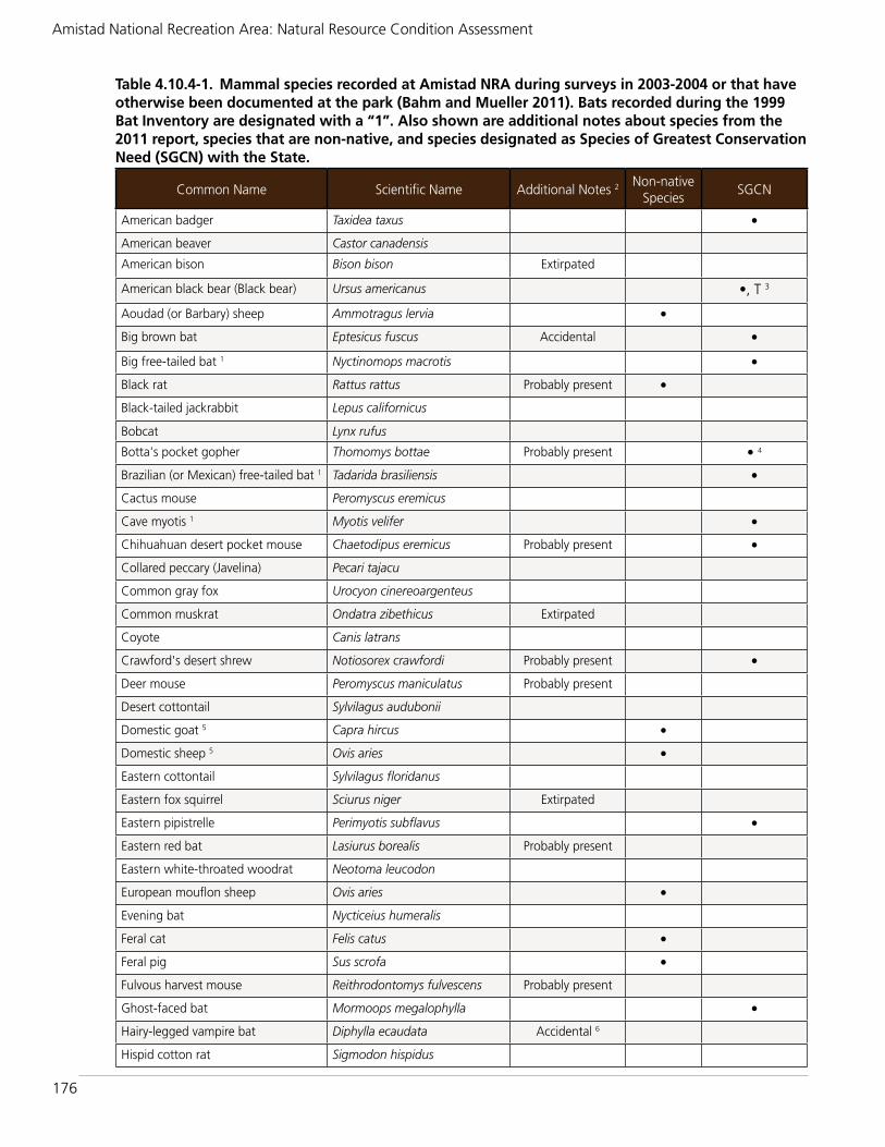
176
Amistad National Recreation Area: Natural Resource Condition Assessment
Table 4.10.4-1. Mammal species recorded at Amistad NRA during surveys in 2003-2004 or that have otherwise been documented at the park (Bahm and Mueller 2011). Bats recorded during the 1999 Bat Inventory are designated with a “1”. Also shown are additional notes about species from the 2011 report, species that are non-native, and species designated as Species of Greatest Conservation Need (SGCN) with the State.
Common Name Scientific Name Additional Notes 2 Non-native Species
SGCN
American badger Taxidea taxus •
American beaver Castor canadensis
American bison Bison bison Extirpated
American black bear (Black bear) Ursus americanus •, T 3
Aoudad (or Barbary) sheep Ammotragus lervia •
Big brown bat Eptesicus fuscus Accidental •
Big free-tailed bat 1 Nyctinomops macrotis •
Black rat Rattus rattus Probably present •
Black-tailed jackrabbit Lepus californicus
Bobcat Lynx rufus
Botta's pocket gopher Thomomys bottae Probably present • 4
Brazilian (or Mexican) free-tailed bat 1 Tadarida brasiliensis •
Cactus mouse Peromyscus eremicus
Cave myotis 1 Myotis velifer •
Chihuahuan desert pocket mouse Chaetodipus eremicus Probably present •
Collared peccary (Javelina) Pecari tajacu
Common gray fox Urocyon cinereoargenteus
Common muskrat Ondatra zibethicus Extirpated
Coyote Canis latrans
Crawford's desert shrew Notiosorex crawfordi Probably present •
Deer mouse Peromyscus maniculatus Probably present
Desert cottontail Sylvilagus audubonii
Domestic goat 5 Capra hircus •
Domestic sheep 5 Ovis aries •
Eastern cottontail Sylvilagus floridanus
Eastern fox squirrel Sciurus niger Extirpated
Eastern pipistrelle Perimyotis subflavus •
Eastern red bat Lasiurus borealis Probably present
Eastern white-throated woodrat Neotoma leucodon
European mouflon sheep Ovis aries •
Evening bat Nycticeius humeralis
Feral cat Felis catus •
Feral pig Sus scrofa •
Fulvous harvest mouse Reithrodontomys fulvescens Probably present
Ghost-faced bat Mormoops megalophylla •
Hairy-legged vampire bat Diphylla ecaudata Accidental 6
Hispid cotton rat Sigmodon hispidus

177
Chapter 4: Natural Resource Conditions - Mammals
Common Name Scientific Name Additional Notes 2 Non-native Species
SGCN
Hispid pocket mouse Chaetodipus hispidus
Hoary bat Lasiurus cinereus
House mouse Mus musculus •
Least Shrew Cryptotis parva Probably present
Long-tailed weasel Mustela frenata Probably present •
Merriam's kangaroo rat Dipodomys merriami Probably present
Merriam's pocket mouse Perognathus merriami
Mexican ground squirrel Spermophilus mexicanus
Mountain lion Puma concolor •
Mule deer Odocoileus hemionus Probably present
Nelson's pocket mouse Chaetodipus nelsoni •
Nine-banded armadillo Dasypus novemcinctus
North American porcupine Erethizon dorsatum
Northern grasshopper mouse Onychomys leucogaster Probably present
Northern pygmy mouse Baiomys taylori
Northern raccoon Procyon lotor
Nutria Myocastor coypus •
Pallid bat 1 Antrozous pallidus •
Pocketed free-tailed bat Nyctinomops femorosaccus •
Ringtail Bassariscus astutus
Rock pocket mouse Chaetodipus intermedius
Rock squirrel Otospermophilus variegatus
Seminole bat Lasiurus seminolus Probably present
Southern Plains woodrat Neotoma micropus
Spotted ground squirrel Spermophilus spilosoma Probably present
Striped skunk Mephitis mephitis
Texas antelope squirrel Ammospermophilus interpres •
Texas pocket gopher Geomys personatus Extirpated
Townsend's big-eared bat 1 Corynorhinus townsendii •
Virginia opossum Didelphis virginiana
Western bonneted bat Eumops perotis • 7
Western pipistrelle Parastrellus hesperus •
Western spotted skunk Spilogale gracilis •
White-ankled mouse Peromyscus pectoralis
White-backed hog-nosed skunk Conepatus leuconotus •
White-footed mouse Peromyscus leucopus
White-tailed deer Odocoileus virginianus
Table 4.10.4-1. Mammal species recorded at Amistad NRA during surveys in 2003-2004 or that have otherwise been documented at the park (Bahm and Mueller 2011). Bats recorded during the 1999 Bat Inventory are designated with a “1”. Also shown are additional notes about species from the 2011 report, species that are non-native, and species designated as Species of Greatest Conservation Need (SGCN) with the State continued.

178
Amistad National Recreation Area: Natural Resource Condition Assessment
be hunted only with bows. Although hunting is allowed only during certain time periods, there are no bag limits for the two sheep species and feral pigs within the allowed hunt periods (Amistad NRA website, http://www.nps.gov/amis/planyourvisit/hunting.htm). Note that the park website also addresses hunting for birds (e.g., dove, duck) and exotic blackbuck antelope (Antilope cervicapra). Although there have been a few reports of blackbuck in the Recreation Area, their presence has not been verified (Greg Garetz, Amistad NRA, pers. comm.).
Aoudad (or Barbary) sheep: This exotic species was recorded by Bahm and Mueller (2011) and park personnel during the survey in 2003; a total of six sheep were observed in
Hunt Areas 2 and 4. Aoudad sheep probably initially entered the park by escaping from a nearby exotic game ranch. In the Recreation Area, they are found in areas along the Devil’s River (Greg Garetz, Amistad NRA, pers. comm.). This relatively large sheep is native to northern Africa’s dry mountains (Davis and Schmidly 1997). The species eats a variety of vegetation and is able to survive without fresh water to drink for extended periods of time. Davis and Schmidly (1997) report that the sheep may compete with mule deer for food, and that the sheep may cause problems for efforts to reintroduce native bighorn sheep in the Trans-Pecos region. The estimated state population in 1989 was over 20,000 animals. Although attempts to remove aoudad sheep at Amistad NRA have not been made, they
Common Name Scientific Name Additional Notes 2 Non-native Species
SGCN
Yellow-faced pocket gopher Cratogeomys castanops Probably present
Yuma myotis 1 Myotis yumanensis •
1 Bat species also recorded at the Recreation Area in 1999.2 Additional notes on occurrence are from Bahm and Mueller (2011).3 In addition to being listed as a SGCN, the black bear is listed as threatened with TPWD.4 Three subspecies of Thomomys bottae were listed as SGCN. 5 Species that occur at the park according to park staff (but not on the Bahm and Mueller list or NPSpecies List).6 NPSpecies park list considers this species present at the park.7 The subspecies Eumops perotis californicus is listed as a SGCN.
Table 4.10.4-1. Mammal species recorded at Amistad NRA during surveys in 2003-2004 or that have otherwise been documented at the park (Bahm and Mueller 2011). Bats recorded during the 1999 Bat Inventory are designated with a “1”. Also shown are additional notes about species from the 2011 report, species that are non-native, and species designated as Species of Greatest Conservation Need (SGCN) with the State continued.
Table 4.10.4-2. Relative abundance of the rodents captured during small mammal sampling by Bahm and Mueller (2011).
Common Name Scientific NameNumber captured
Percent of total # rodents captured
White-ankled mouse Peromyscus pectoralis 44 27.3
Hispid cotton rat Sigmodon hispidus 44 27.3
Merriam’s pocket mouse Perognathus merriami 30 18.8
House mouse Mus musculus 17 10.6
Mexican ground squirrel Spermophilus mexicanus 7 4.4
White-footed mouse Peromyscus leucopus 6 3.8
Eastern white-throated woodrat Neotoma leucodon 4 2.5
Southern Plains woodrat Neotoma micropus 3 1.9
Nelson’s pocket mouse Chaetodipus nelsoni 2 1.2
Northern pygmy mouse Baoimys taylori 1 0.6
Hispid pocket mouse Chaetodipus hispidus 1 0.6
Rock pocket mouse Chaetodipus intermedius 1 0.6

179
Chapter 4: Natural Resource Conditions - Mammals
would be difficult to capture (or estimate their numbers), because they live in family groups (rather than herds), they move in and out of the park/private property, and they are spread over an approximate 20-mile length of the river (Greg Garetz, Amistad NRA, pers. comm.). A general estimate is that there may be around 150-200 of these sheep in the Recreation Area.
European Mouflon sheep: Mouflon sheep have been released on game ranches in Texas and elsewhere in the U.S. at least since the 1980’s (Texas Hunt Lodge 2014). It is believed that someone released several mouflon sheep into Amistad NRA in the 1970’s (Greg Garetz, Amistad NRA, pers. comm.). The mouflon is described as colorful; in Texas, they are typically brown and have black and white legs; they also have white on their ears, nose, rump and belly (Texas Hunt Lodge 2014). Bahm and Mueller (2011) reported that more than 300 mouflon sheep occurred in Hunt Area 5 of the Recreation Area in 2003-2004. In 2004, park personnel had approximately 2,400 sheep removed from the park (Greg Garetz, Amistad NRA, pers. comm.). Unfortunately, a group of about 50 animals jumped a fence onto private property and were not captured. Today, there may be approximately 350-450 mouflon sheep in the Recreation Area (Figure 4.10.4-1), although no surveys have been conducted (Greg Garetz, Amistad NRA, pers. comm.). The sheep are primarily within a few areas of the Recreation Area, especially in Hunt Area 5, where they may compete with
native species (e.g., white-tailed deer) for food and space.
Feral pig: The ancestors of Texas feral pigs are European wild hogs (introduced in the U.S. for sport hunting) and domestic swine that escaped and established feral populations (Davis and Schmidly 1997). According to The Mammals of Texas - Online Edition, feral pigs occur in free-ranging populations on the Rio Grande, Coastal Plains, and wooded areas in the eastern part of the state. During the 2003-2004 survey work of Bahm and Mueller (2011), more than 30 feral pigs were observed at the Recreation Area. On several occasions, the researchers saw pigs crossing the Rio Grande; the pigs’ ability to do this would make control efforts more difficult. The activities of feral pigs can lead to negative effects on habitat and wildlife, as well as domestic crops and livestock (Davis and Schmidly 1997). The pigs’ extensive rooting activity disturbs soil and vegetation. They may also compete with some wildlife for food items, such as mast (acorns), as well as consume reptiles, amphibians, mammals, and birds on occasion (Taylor 2003). Taylor (2003) reported that the state population of feral pigs exceeded 1.5 million animals. At Amistad NRA, feral pigs are primarily along the Rio Grande above the confluence with the Pecos River (Jack Johnson, Amistad NRA, pers. comm.).
Nutria: No live nutria were documented by Bahm and Mueller (2011) in 2003-2004, but they collected one nutria skull. The
Figure 4.10.4-1. European mouflon sheep (Ovis aries) at the 277 South day use area at Amistad NRA in June, 2014. There were about 80-150 sheep total in this herd.
NPS / G
REG G
ARETZ

180
Amistad National Recreation Area: Natural Resource Condition Assessment
distribution map from Davis and Schmidly (1997) indicates that nutria occur in the Amistad NRA area, and park staff report that nutria are seen in the park regularly (Jack Johnson and Sarah Howard, Amistad NRA, pers. comm.). Although the animal has reached high numbers and caused problems in some areas of the U.S. and Texas, Bahm and Mueller (2011) reported it did not appear to be doing so in Amistad NRA. This large, nocturnal rodent is from South America and prefers a “semiaquatic existence” (Davis and Schmidly 1997).
Feral cat: During the 2003-2004 mammal surveys at the Recreation Area, about 35 feral cats were observed at Governor’s Landing and Diablo East. Feral cats are an issue for wildlife because they are predators of many small types of wildlife, they compete with native species (e.g., skunks, opossums, raccoons, and foxes) for food, and they may transmit disease (Wildlife Society 2011). Free-ranging domestic cats are estimated to kill more than one billion birds every year in the U.S. (Wildlife Society 2011, Loss et al. 2013) and 6.3-22.3 billion mammals every year (Loss et al. 2013).
Black rat: This species was not observed during the 2003-3004 surveys of Bahm and Mueller (2011), but the researchers indicated that it is probably present in the Recreation Area. The black rat (or roof rat) is common throughout most of Texas, especially in towns (Davis and Schmidly 1997). This species of rat tends not to become established as feral (as does the Norway rat).
House mouse: The house mouse occurs throughout Texas and the U.S., especially in man-made structures. A number of house mice were recorded during the 2003-2004 study at Amistad NRA (Bahm and Mueller 2011). They were captured in association with a number of native mice and rats, such as the white-ankled mouse, white-footed mouse, Hispid cotton rat, and Southern Plains woodrat.
Overall Condition and TrendTo assess condition of mammals at Amistad NRA, we used one indicator/measure, summarized in Table 4.10.4-3. Fifty-five mammal species have been recorded or are known to occur at Amistad NRA (Figure 4.10.4-2; including the two reported by park staff), with an additional 15 that are probably present (Bahm and Mueller 2011). Six additional species that were recorded by researchers in earlier surveys were considered extirpated or accidental (only recorded one time and not thought to be a resident) by Bahm and Mueller (2011). Several species were recorded during the 2003-2004 surveys at the Recreation Area for the first time; as of the early 2000s, three of these species may have been expanding their range (Bahm and Mueller 2011). Approximately 20 of the mammal species are listed as SGCN with TPWD, including one species that is also state-threatened. Eight non-native mammal
Mammals
Indicator MeasureSpecies Occurrence Presence/Absence
Table 4.10.4-3. Indicator and measure of mammal condition.Indicator of Condition
Measure Condition Rationale for Condition
Species Occurrence
Presence/absence Unknown The most recent mammal surveys at the Recreation Area were conducted by Bahm and Mueller (2011) in 2003-2004. Although current condition cannot be determined at this time, the 2003-2004 work (as well as earlier work) provides important information for future monitoring and assessment. One of the 68 species reported by Bahm and Mueller (2011) as occurring/potentially occurring at the park is State listed as threatened. Approximately 20 species are listed as Texas Species of Greatest Conservation Need. Nine of the species listed in Table 4.10.4-1 (13%) are non-native species, and at least some of them (e.g., European mouflon sheep, feral pigs, and feral cats) negatively impact native wildlife and/or other park resources.

181
Chapter 4: Natural Resource Conditions - Mammals
species have been documented at the park, and a ninth is probably present.
As previously mentioned, no published reports are available for the period since the 2003-2004 Bahm and Mueller (2011) surveys. For this reason, we cannot provide current information on native and non-native species occurrence in the Recreation Area, and we therefore are unable to determine overall current condition or trends. However, based on the Recreation Area’s past experience with the European mouflon sheep (2,400 being removed in 2004), their competition for food and space with native wildlife, and the fact that their numbers have increased from the ~50 remaining sheep in 2004, concern exists over this non-native species in particular. Also, feral pigs and cats are of particular concern. Feral cats are known to kill many types and high numbers of small animals, such as birds and small mammals, and they may compete with some wildlife for food. Feral pigs can cause damage to soils and vegetation due to their rooting activities, and at the Recreation Area they inhabit sensitive riparian areas.
4.10.5. Sources of ExpertiseNo experts were consulted for this resource topic.
4.10.6. Literature CitedAmistad National Recreation Area (NRA).
1999. 1999 Bat inventory and monitoring results. One page report, no author indicated.
Bahm, M.A., and J.M. Mueller. 2011. The mammals of Amistad National Recreation Area, Texas: 2005 final report. Natural Resource Technical Report NPS/CHDN/NRTR—2011/492. National Park Service, Fort Collins, Colorado.
Boston, C.L. 1966. Mammals of Val Verde County, Texas, east of the Pecos River. Unpublished M.S. thesis, Sul Ross State University, Alpine, Texas, 127 pp., as cited in Bahm and Mueller (2011).
Davis, W.B., and D.J. Schmidly. 1997. The Mammals of Texas - Online Edition. Available at http://www.nsrl.ttu.edu/TMOT1/index.htm. Texas Tech University. Last accessed May 19, 2014.
Ditton, R.B., and D.J. Schmidly. 1977. A user-resource analysis of Amistad National Recreation Area (Texas). Report to the National Park Service, Contract No. CX702960169, as cited in Bahm and Mueller (2011).
Figure 4.10.4-2. Bobcat (Lynx rufus) is one of the many native mammal species occurring at Amistad NRA.
© RO
BERT SHA
NTZ

182
Amistad National Recreation Area: Natural Resource Condition Assessment
LoBello, R.L. 1976. Vertebrates of the Lake Amistad National Recreation Area, Texas. Master of Science Thesis, Sul Ross State University, Alpine, Texas.
Loss, S.R., T. Will, and P.P Marra. 2013. The impact of free-ranging domestic cats on wildlife of the United States. Nature Communications 4, Article 1396, doi:10.1038/ncomms2380.
National Park Service (NPS). 2014. NPSpecies list of mammals at Amistad National Recreation Area. Obtained May 13, 2014 at http://irma.nps.gov/npspecies.
NatureServe. 2014. NatureServe Explorer: An online encyclopedia of life [web application]. Version 7.1. NatureServe, Arlington, Virginia. Available http://explorer.natureserve.org. Last accessed April 29, 2014.
Scudday, J.F., B.G. Hanks, and A.M. Powell. 1984. A biogeographic study of selected islands of Amistad Lake, Val Verde County, Texas. Report to the U. S. Department of the Interior, National Park Service, IMSF-CSF-LIBR/NPS AMIS NS 3, as cited in Bahm and Mueller (2011).
Taylor, R. 2003. The feral hog in Texas. Texas Parks and Wildlife booklet (PWD BK W7000-195) (21 pages). Available at http://www.tpwd.state.tx.us/huntwild/wild/nuisance/feral-hogs/.
Texas Hunt Lodge. 2014. Texas Hunt Lodge webiste, Information on Mouflon sheep. Last accessed May 13, 2014. Available at www.texashuntlodge.com/mouflon.asp.
Texas Parks and Wildlife Department (TPWD). 2014a. Nongame and rare species program - Texas Threatened/Endangered Species Regulations. Available at http://www.tpwd.state.tx.us/huntwild/wild/wildlife_diversity/texas_rare_species/txendangered/. Last accessed February 21, 2014.
Texas Parks and Wildlife Department (TPWD). 2014b. Nongame and rare species program - Federal and state listed mammal species. Available at http://www.tpwd.state.tx.us/huntwild/wild/wildlife_diversity/nongame/l isted-species/mammals.phtml. Last accessed May 12, 2014.
Texas Parks and Wildlife Department (TPWD). 2014c. Nongame and rare species program: Species of greatest conservation need. Available at http://www.tpwd.state.tx.us/huntwild/wild/wildlife_diversity/texas_rare_species/sgcn/. Last accessed February 21, 2014.
Texas Parks and Wildlife Department (TPWD). 2012. Texas Conservation Action Plan 2012-2016: Chihuahuan Deserts and Arizona-New Mexico Mountains Handbook. Editor, Wendy Connally, Texas Conservation Action Plan Coordinator. Austin, Texas.
Wildlife Society, The. 2011. Ecological impacts of feral cats. Two-page fact sheet, available at http://www.wildlife.org/policy/fact-sheets. Last accessed May 19, 2014.

183
Chapter 4: Natural Resource Conditions - Jaguarundi
4.11. Jaguarundi
4.11.1. Background and ImportanceThe jaguarundi is a small, slender cat with a long tail, short legs, a small, flattened head, and short, rounded, widely spaced ears (Texas Parks and Wildlife Department [TPWD] 2011) (Figure 4.11.1-1). The animal is only somewhat larger than a domestic cat (Felis catus). The Gulf Coast jaguarundi (Puma yagouaroundi cacomitli) was listed as endangered by the U.S. Fish and Wildlife Service (USFWS) in 1976 and is listed as endangered by the State of Texas (TPWD 2014). In Mexico, the entire species is considered threatened (USFWS 2013). Note that the scientific name of the Gulf Coast jaguarundi has been changed twice since its listing in 1976 as Felis yagouaroundi cacomitli.
The jaguarundi is described as looking more like a weasel (Mustela sp.) than a feline (USFWS 2013) because of its body proportions and movements. Jaguarundis lack spots and have two color phases- blackish to brownish gray, and reddish yellow to chestnut. Body weights range from 8.4 to 19.8 pounds (3.8 to 9.0 kilograms), but the Gulf Coast subspecies weighs no more than about 14.5 pounds (6.6 kg) (Guggisberg 1985, Silva-Pereira et al. 2011, and Caso and Tewes in prep.). Height at the shoulder when standing is about 10-11 inches (25.4-28 cm) (TPWD 2011, Caso and Tewes in prep.). Total body length of adult males, including the tail (11 to 24 inches long [28 to 61 cm]), is about 42 inches (107 cm) (TPWD 2011). Jaguarundis forage primarily on the ground and eat mostly birds, small mammals, and reptiles.
The Gulf Coast jaguarundi inhabits dense, throny shrublands or woodlands and areas of bunchgrass pasture adjacent to such habitat (USFWS 2013). They may also use riparian habitats along rivers and creeks. Mixed thornscrub species occurring in typical jaguarundi habitat include:
brasil (Condalia hookeri), desert yaupon (Schaefferia cuneifolia), wolfberry (Lycium berlandieri), lotebush (Ziziphus obtusifolia), amargosa (Castela erecta), white-brush (Aloysia gratissima), catclaw (Acacia greggii), lantana (Lantana achyranthifolia), guayacan (Guajacum angustifolium), elbowbush (Forestiera angustifolia), and Texas persimmon (Diospyros texana). Trees, such as mesquite (Prosopis sp.), live oak (Quercus sp.), ebony (Ebenopsis ebano), and hackberry (Celtis laevigata), may occur within the thornscrub. Jaguarundis are primarily active during the day, but they may go unseen due to their dense habitat (USFWS 2013). In Tamaulipas, Mexico, Caso (1994) found that home range size was 3.3 mi2 (8.5 km2) for a male and 3.4 mi2 (8.8 km2) for a female, although home range sizes can vary substantially and may be much larger (USFWS 2013).
Another jaguarundi subspecies (the Sinaloan jaguarundi, Puma yagouaroundi tolteca) is also listed under the Endangered Species Act (in 1976), but information at the present time indicates that it occurs only outside of the U.S. and its presence within the U.S. was never
Figure 4.11.1-1. Gulf Coast jaguarundi (Puma yagouaroundi cacomitli).
©W
IKIM
EDIA
COM
MO
NS
Indicators/Measures• Species Occurrence (1 measure)
Condition - Trend - Confidence
Unknown - Unknown - Low

184
Amistad National Recreation Area: Natural Resource Condition Assessment
confirmed (USFWS 2013). There are several other currently recognized subspecies of the jaguarundi, but USFWS (2013) notes that little information exists at this time to support the separation of the subspecies. The other subspecies occur in Mexico and/or Central and South America.
4.11.2. Data and MethodsThis limited assessment is based primarily on information on the jaguarundi presented by the USFWS in the Gulf Coast Jaguarundi Recovery Plan (Puma yagouaroundi cacomitli), First Revision (USFWS 2013). We used one indicator/measure of condition-- presence/absence of jaguarundi.
Indicators/MeasuresPresence/absence of jaguarundi
Although the jaguarundi is addressed (per the park’s request) in this section of the condition assessment, it has never been documented at Amistad NRA. The animal’s known historic range was limited to the Lower Rio Grande Valley in southern Texas (four of the southernmost counties) and several states in eastern Mexico (Coahuila, Nuevo Leon, Tamaulipas, San Luis Potosi, and Veracruz) (USFWS 2013). Although the subspecies is currently known to occur in Mexico, it has not been documented in southern Texas since 1986 when a road-killed animal was collected near Brownsville (USFWS 2013). Although reports of sightings have been made since 1986, none of them have been confirmed (USFWS 2013). Unconfirmed reports have also been made in Amistad NRA (Greg Garetz, Amistad NRA, pers. comm.), and game cameras have been installed below Amistad Dam on the Rio Grande to try to capture an image of a jaguarundi. The mammal surveys at the Recreation Area by Bahm and Mueller (2011) and LoBello (1976) did not mention the jaguarundi.
4.11.3. Reference ConditionsNo reference conditions were developed for this resource topic.
4.11.4. Condition and TrendAccording to USFWS (2013), the closest known Gulf Coast jaguarundis to the U.S.
in recent years were those observed in 2000 in Nuevo Leon, Mexico (about 95 miles [153 km] southwest of the U.S.-Mexico border). There is a known population of jaguarundis in Tamaulipas (about 130 miles [209 km] south of the border), last documented in 2012 (Caso 1994; USFWS 2013). No information on their current population size there is available, as is the case in most of the subspecies’ range in Mexico. As stated in USFWS (2013), “our knowledge regarding the status of the subspecies is very limited.”
Only a small area of the Gulf Coast jaguarundi’s range and habitat occurs in the U.S. Jaguarundis reportedly occurred only in the southern portion of the state, in Cameron, Hidalgo, Willacy, and Starr counties (Bailey 1905, Davis 1974; see Figure 4.11.4-1, dark orange-shaded counties). There are no records of jaguarundis occurring north of these four counties (Tewes and Caso 2011). However, on the USFWS website (USFWS 2014), a map (and list) is shown with counties in which the Gulf Coast jaguarundi is “known to or is believed to occur” (Figure 4.11.4-1, all counties shown). Because USFWS (2013) reported that no jaguarundis have been documented in Texas since 1986, these are probably counties in which the subspecies has the potential to occur based on the habitat. The northern extent of this area is only 35 miles south of Amistad NRA.
In Texas, the main known threats to the animal are habitat destruction, degradation, and fragmentation related to agriculture and urban development. For example, in the Lower Rio Grande Valley of Texas, estimates are that more than 95% of dense thornscrub habitat has been modified for agricultural and urban development (Jahrsdoerfer and Leslie 1988). Additional threats may occur due to border security activities and vehicle traffic on roads (USFWS 2013).
The USFWS recently released a recovery plan that focuses on conservation of the subspecies primarily within its historical range in Texas (USFWS 2013). The recovery strategy described in the plan includes a number of actions, including “assessing, protecting, reconnecting, and restoring sufficient

185
Chapter 4: Natural Resource Conditions - Jaguarundi
habitat to support viable populations of the Gulf Coast jaguarundi in the borderlands of the U.S. and Mexico;” “further monitoring existing habitat to determine the existence of the jaguarundi in the U.S.; “reducing the effects of human population growth and development on potential jaguarundi habitat;” and “evaluating the use of reintroduction, and if determined feasible, reintroduce the Gulf Coast jaguarundi in suitable habitat within the historical range in south Texas” (USFWS 2013).
Overall Condition and TrendTo assess condition of the Gulf Coast jaguarundi at Amistad NRA, we used one indicator/measure, summarized in Table 4.11.4-1. Given the lack of information on the jaguarundi described here, we can not provide any current information on its presence or absence at Amistad NRA. USFWS (2013) did not find documented evidence of the occurrence of jaguarundis in the U.S., even in the areas (counties) where they were known historically to occur.
4.11.5. Sources of ExpertiseNo experts were consulted for this resource topic.
4.11.6. Literature CitedBahm, M.A., and J.M. Mueller. 2011. The
mammals of Amistad National Recreation Area, Texas: 2005 final report. Natural Resource Technical Report NPS/CHDN/NRTR—2011/492. National Park Service, Fort Collins, Colorado.
Bailey, V. 1905. Biological survey of Texas. North American Fauna, 25. U.S. Department of Agriculture, Washington, D.C. In: Schmidly, David J. Texas Natural History: a Century of Change. Available
Jaguarundi
Indicator MeasureSpecies Occurrence Presence/Absence
Table 4.11.4-1. Indicator and measure of jaguarundi condition.Indicator of Condition
Measure Condition Rationale for Condition.
Species Occurrence
Presence/absence Unknown There are no current, documented reports of jaguarundis occurring at Amistad NRA or in southern Texas. The last confirmed report of a jaguarundi in Texas was in 1986, in Brownsville. Although jaguarundis have not been known to occur in the Recreation Area, the park is approximately 35 miles from the northern area of what the USFWS considers as the potential jaguarundi range (see Figure 4.11.4-1). There have been some unconfirmed reports of jaguarundis in the Recreation Area in recent years. The condition of the subspecies at the park is unknown.
Figure 4.11.4-1. Counties listed by USFWS as areas in which the Gulf Coast jaguarundi is “known to or is believed to occur” (all shaded counties). Because USFWS (2013) reported that no jaguarundis have been documented in Texas since 1986, these are probably counties in which the subspecies has the potential to occur. The four dark oranged-shaded counties are those in which jaguarundis have been documented (historically). Map adapted from USFWS 2014).

186
Amistad National Recreation Area: Natural Resource Condition Assessment
at http://books.google.com/books?id=8Uhx5YbmOF0C&printsec=frontcover&dq=Texas+Natural+History:+a+Century+of+Change&hl=en&sa=X&ei=Z-YrT4rwNeie2AWypaDxDg&ved=0CDIQ6AEwAA#v=onepage&q=Texas%20Natural%20Histor y%3A%20a%20Century%20of%20Change&f=false. Accessed February 3, 2012, as cited in USFWS (2013).
Caso, A. 1994. Home range and habitat use of three neotropical carnivores in northeast Mexico. M.S. Thesis, Texas A&M University-Kingsville, Texas.
Caso, A., and M. Tewes. in prep. Spatial patterns and habitat use of the gulf coast jaguarundi (Puma yagouaroundi cacomitli) in Tamaulipas, Mexico, as cited in USFWS (2013).
Davis, W.B. 1974. The mammals of Texas. Texas Parks and Wildlife Bulletin No. 41. 252 pp., as cited in USFWS (2013).
Guggisberg, C.A.W. 1985. Wild cats of the world. David and Charles Limited. 328 pp., as cited in USFWS (2013).
Jahrsdorfer, S.E., and D.M. Leslie, Jr. 1988. Tamaulipan brushland of the lower Rio Grande Valley of south Texas: description, human impacts, and management options. U.S. Fish and Wildlife Service, Oklahoma Cooperative Fish and Wildlife Research Unit, Stillwater, OK. 63 pp., as cited in USFWS (2013).
LoBello, R.L. 1976. Vertebrates of the Lake Amistad National Recreation Area, Texas. Master of Science Thesis, Sul Ross State University, Alpine, Texas.
Silva-Pereira, J.E., R.F. Moro-Rios, D.R. Bilski, and F.C. Passos. 2011. Diets of
three sympatric neotropical small cats: Food niche overlap and interspecies differences in prey consumption. Mammalian Biology 76:308-312, as cited in USFWS (2013).
Tewes, M.E., and A. Caso. 2011. Management and Conservation of Wild Cats in Northeast Mexico. Publication Number 99 - Caesar Kleberg Wildlife Research Institute, Texas A&M University-Kingsville. http://cnrit.tamu.edu/cgrm/whatzhot/saltillo/tewes.html (accessed September 22, 2011), as cited in USFWS (2013). [Still available online June 27, 2014].
Texas Parks and Wildlife Department (TPWD). 2011. Jaguarundi Fact Sheet. Accessed September 14, 2011, as cited in USFWS (2013). [Still available online June 27, 2014].
Texas Parks and Wildlife Department (TPWD). 2014. Nongame and rare species program - Federal and state listed mammal species. Available at http://www.tpwd.state.tx.us/huntwild/wild/wildlife_diversity/nongame/l isted-species/mammals.phtml. Last accessed June 26, 2014.
U.S. Fish and Wildlife Service. 2013. Gulf Coast jaguarundi (Puma yagouaroundi cacomitli) Recovery Plan, First Revision. U.S. Fish and Wildlife Service, Southwest Region. Albuquerque, New Mexico.
U.S. Fish and Wildlife Service. 2014. Species profile, Gulf Coast jaguarundi (Herpailurus [=felis] yagouaroundi cacomitli). Available at http://ecos.fws.gov/speciesProfile/profile/speciesProfile.action?spcode=A05H. Last accessed June 26, 2014.

187
Chapter 4: Natural Resource Conditions - Herpetofauna
4.12. Herpetofauna
4.12.1. Background and ImportanceThe American Southwest is well known for its abundance and diversity of reptiles. The region is less well known for its amphibians, but they are abundant in some habitats, particularly during favorable weather conditions. Amphibians and reptiles are, together, referred to as herpetofauna or “herps.” The state of Texas supports 215 native herpetofaunal species (Brown et al. 2012). The number of species of amphibians and turtles reportedly decreases from east to west in Texas, following decreases in moisture and increases in temperature, while the number of species of lizards increases from east to west (Owen and Dixon 1989).
Amphibians and reptiles are important members of aquatic and terrestrial ecosystems. Amphibians constitute an important part of the food web; they consume insects and other invertebrates, and they are
prey for a long list of fish, reptile, bird, and mammal species. Reptiles too serve as both predators and prey for many animals, such as small mammals, birds, and other reptiles. Amphibians are viewed as indicators of wetland ecosystem health. They are sensitive to a variety of threats due to their permeable skin and complex life histories, and, thus, can serve as early indicators of ecosystem change when monitored over long time scales. Like birds, reptiles and amphibians are also of aesthetic value to visitors of national park units.
Amistad NRA is located in a transition zone between three major ecoregions: the Chihuahuan Desert, Edwards Plateau, and Tamaulipan Shrubland. Three major rivers and the Amistad Reservoir occur in the
Figure 4.12.1-1. Texas coralsnake, one of the reptile species observed at Amistad NRA during 2003-2004 surveys (and earlier surveys).
© D
AV
E PRIVA
L
Indicators/Measures• Species Occurrence (1 measure)
Condition – Trend - Confidence
Insufficient Data - Insufficient Data - Medium

188
Amistad National Recreation Area: Natural Resource Condition Assessment
Recreation Area. No current information is available on the herpetofauna of Amistad NRA. The most recent information is from surveys conducted at the park (and five other CHDN parks) by the University of Arizona in 2003 and 2004 (Prival and Goode 2011). The primary objectives of the work were to document herpetofauna species, map the distribution of the species found, and determine an approximate relative abundance for each species. As it is the most recent comprehensive source of information on herpetofauna for the park, this chapter summarizes the Prival and Goode (2011) report. Unfortunately, current condition and trends can not be assessed due to the lack of current data.
Prior to the 2003-2004 Prival and Goode (2011) surveys, another large-scale field assessment of the vertebrates at the Recreation Area was conducted, in 1975-1976, and this work included herpetofauna (LoBello 1976). The results of the LoBello study are also reported here.
4.12.2. Data and MethodsThis limited assessment is based on the 2003-2004 herpetofaunal surveys conducted by Prival and Goode (2011), as well as the earlier work conducted by LoBello (1976). We used one indicator/measure of condition-- species occurrence: presence/absence.
Indicators/MeasuresSpecies Occurrence: Presence/Absence
Species Occurrence: Presence/AbsenceBecause there is no recent information to assess current condition, we used the 2003-2004 surveys (and the older study) to assess the occurrence of amphibian and reptile species at the Recreation Area. We also reviewed the NPSpecies list for the park.
The Occurrence of Species of Conservation ConcernThe surveys of Prival and Goode (2011) and LoBello (1976) were also used to generate a list of species of conservation concern. The list was complied by comparing the list of species observed during 2003-2004 and 1975-1976 surveys to a federal/state list of endangered
and threatened species (described later) and those of Greatest Conservation Need in Texas (described later). We also reviewed the NPSpecies list for the park to see whether any additional species should be included.
Primary Data SourcesPrival and Goode (2011)Herpetofauna searches were mostly focused along the eastern shore of the reservoir and the hunt areas. In 2003, surveys were conducted from May 16-30 and from September 4-17. In 2004, surveys were conducted from July 5-September 12. During most of the May 2003 survey period, the park was unusually dry; however, it received record rainfall in late May (on the 27th) and above average rainfall through the rest of the 2003 sampling period and the 2004 sampling period.
The survey methods of Prival and Goode (2011) for amphibians and reptiles consisted of several types of surveys/observations: visual encounters (foot searches), road cruising, incidental observations, pitfall traps, and turtle traps. Searches while on foot accounted for the majority of the survey effort. Foot searches consisted of surveying during times when reptiles and amphibians would be most active; diurnal snakes and lizards were generally searched for during morning hours, and amphibians and nocturnal snakes and lizards were generally searched for at night. The researchers focused efforts on areas they thought would be most likely to support a high diversity of species or rare species. Their observations included looking under rocks and logs and in crevices. Incidental observations were recorded while the researchers were not conducting formalized searches (e.g., on days off or while driving to a search area). Road cruising consisted of driving slowly along a road at night to find amphibians and nocturnal snakes and lizards. Pitfall traps were used to capture small reptiles and amphibians; their use is particularly helpful for finding nocturnal, secretive animals and fossorial species. Finally, turtle traps (hoop traps) were used to determine the species of turtles using the reservoir. A total of 62 person-days was spent surveying for herpetofauna at Amistad NRA in 2003, and a total of 72 person-days was spent in 2004.

189
Chapter 4: Natural Resource Conditions - Herpetofauna
LoBello (1976)LoBello (1976) conducted a study to determine which vertebrate species occurred in the Amistad NRA area, with emphasis on the Recreation Area. He spent 48 days in the field between February 21, 1975 and January 16, 1976, surveying for all types of vertebrates, including amphibians and reptiles. LoBello (1976) established seven study sites that he visited on a regular basis and three that he visited irregularly. Few details were provided in his report on the survey methods used. His report included species that he observed, as well as occurrences (literature records and specimens) based on the Sul Ross State University Collection and species considered hypothetical (may occur but no specific reports). For the most part, in our list we only included species he observed. LoBello (1976) also described herpetofaunal surveys in the general vicinity of Amistad NRA in the years before the reservoir was created.
Note that there were some differences in the names used for some species (scientific and/or common) among the various reports and sources used. In such cases, we attempted to provide both names, as was done in the NPSpecies list.
Protected/Rare Species ListsIn 1973, the Texas Parks and Wildlife Department (TPWD) was authorized to develop a list of endangered and threatened animal species in the state. Legal protection of endangered and threatened animals is provided by laws and regulations in Chapters 67 and 68 of the Texas Parks and Wildlife Code and Sections 65.171-65.176 of Title 31 of the Texas Administrative Code (TPWD 2014a).
Under the Endangered Species Act, the U.S. Fish and Wildlife Service (USFWS) lists species as threatened, endangered, or candidates for listing. A list of federal and state-listed amphibian and reptile species was obtained from the TPWD website (TPWD 2014b).
The State of Texas also designated species that, “due to limited distributions and/or declining populations, face the threat
of extirpation or extinction but lack legal protection” (TPWD 2014c). The lists were developed for the TPWD’s Texas Conservation Action Plan (TCAP). Species are rated or ranked using a system developed by NatureServe. The TCAP divides the state into different ecoregions, and the primary one in which the Recreation Area occurs is the Chihuahuan Desert Ecoregion (TPWD 2012). Because of the close proximity of the park to the South Texas Plains Ecoregion and the Edwards Plateau Ecoregion, those lists were checked as well (but only one additional species that occurs at the park emerged; see condition and trend section).
4.12.3. Reference ConditionsNo reference conditions were developed for this resource topic.
4.12.4. Condition and TrendA total of about 50 species of amphibians and reptiles were recorded at Amistad NRA during 2003-2004 surveys at the park by the University of Arizona (Prival and Goode 2011) and/or during the 1975-1976 surveys of LoBello (1976). One additional species appears on the NPSpecies list for Amistad NRA that was not observed during 2003-2004 or 1975-1976 surveys; additional species appear in the NPSpecies list that were not recorded during the two different surveys, but they are noted as “probably present” or “unconfirmed,” so we do not include them here.
Species Occurrence: Presence/AbsenceOf the 50 species, 45 were recorded during the 2003-2004 surveys (Table 4.12.4-1). Nine of the 45 species are amphibians (Figure 4.12.4-1), and 36 of the species are reptiles (15 lizards, 17 snakes, and 4 turtles/tortoises). There were five snake species that were reported from 1975-1976 that were not observed in 2003-2004, but there were many species observed in 2003-2004 but not in 1975-1976. The one species not reported from either of the surveys, but that appears on the NPSpecies list, is Marcy’s checkered garter snake (Thamnophis marcianus).
No published reports are available for the period since the University of Arizona

190
Amistad National Recreation Area: Natural Resource Condition Assessment
Table 4.12.4-1. Amphibian and reptile species recorded at Amistad NRA during surveys in 2003-2004 (Prival and Goode 2011) and 1975-1976 (LoBello 1976).
Common Name Scientific NamePrival & Goode
(2011)LoBello (1976)
Amphibians
Blanchard's cricket frog Acris crepitans blanchardi X X
Cliff chirping frog Eleutherodactylus marnockii X
Couch's spadefoot Scaphiopus couchii X X
Eastern green toad Bufo debilis debilis X
Great Plains narrow-mouthed toad Gastrophryne olivacea X X
Gulf Coast toad Bufo nebulifer X X
Red-spotted toad Bufo punctatus X
Rio Grande leopard frog Rana berlandieri X X
Texas toad Bufo speciosus X X
Reptiles- Lizards
Big Bend tree lizard Urosaurus ornatus schmidti X
Eastern collared lizard Crotaphytus collaris X
Great Plains skink Eumeces obsoletus X X
Mediterranean house gecko 1 Hemidactylus turcicus X X
Merriam's canyon lizard Sceloporus merriami merriami X X
Northern crevice spiny lizard Sceloporus poinsettii poinsettii X
Round-tailed horned lizard Phrynosoma modestum X X
Short-lined skink Eumeces tetragrammus brevilineatus X
Soutwestern fence lizard Sceloporus cowlesi X
Texas banded gecko Coleonyx brevis X X
Texas greater earless lizard Cophosaurus texanus texanus X X
Texas horned lizard Phrynosoma cornutum X
Texas spiny lizard Sceloporus olivaceus X X
Texas spotted whiptail Aspidoscelis gularis gularis X X
Trans-Pecos striped whiptail Aspidoscelis inornata heptagramma X
Reptiles- Snakes
Arid land ribbon snake (subspecies of Western ribbon snake)
Thamnophis proximus diabolicus X
Baird's ratsnake Elaphe bairdi X X
Central Texas whipsnake Masticophis taeniatus ornatus X X
Gophersnake (=Bull snake) Pituophis catenifer (= P. melanoleucus sayi) X X
Groundsnake (Great Plains ground snake) Sonora semiannulata (= Sonora episcopa episcopa)
X
Gray-banded kingsnake (= Mexican kingsnake)
Lampropeltis alterna (= Lampropeltis mexicana)
X
Mountain (or Texas) patch-nosed snake Salvadora grahamiae grahamiae (= S.g.) X
Northern diamond-backed watersnake Nerodia rhombifer rhombifer X X
Ring-necked snake Diadophis punctatus X

191
Chapter 4: Natural Resource Conditions - Herpetofauna
surveys, so we can not provide any additional information as to species occurrence in the park at this time. Prival and Goode (2011) also provided a list of several species that they believed might occur in the park that they did not observe; a few of the species are those listed from LoBello (1976) and/or the NPSpecies list.
Conservation Context – The Occurrence of Species of Conservation ConcernOut of the 51 species recorded during the 2003-2004 surveys, the 1975-1976 surveys, and/or that appear on the NPSpecies list as occurring at the park, eight are listed as species of conservation concern on one or more of the lists described in Section 4.12.2 (Table 4.12.4-2). No federally-listed amphibian or reptile species are known to occur at the Recreation Area, but there are four species listed by the TPWD as threatened. Four additional species (as well as the threatened species) are listed by the
TPWD as Species of Greatest Conservation Need (SGCN). Information on abundance of the species (global- or state-wide) is provided for six of the species (see Table 4.12.4-2). The designations (e.g., G5, S3) and their definitions are provided in the table.
Figure 4.12.4-1. Gulf Coast toad is one of nine amphibian species observed at Amistad NRA during 2003-2004 surveys (and earlier surveys).
© D
AN
MO
EN
Common Name Scientific NamePrival & Goode
(2011)LoBello (1976)
Rock rattlesnake (= Mottled rock rattlesnake) Crotalus lepidus X
Smith's black-headed snake Tantilla hobartsmithi X
Texas coralsnake Micrurus tener tener X X
Texas indigo snake Drymarchon melanurus erebennus X
Texas long-nosed snake Rhinocheilus lecontei tessellatus X
Texas nightsnake Hypsiglena torquata janii X
Texas patch-nosed snake Salvadora grahamiae lineata X
Texas threadsnake Leptotyphlops dulcis X
Trans-Pecos black-headed snake Tantilla cucullata X
Trans-Pecos copperhead Agkistrodon contortrix pictigaster X
Western coachwhip Masticophis flagellum testaceus X X
Western diamond-backed rattlesnake Crotalus atrox X X
Western ribbonsnake Thamnophis proximus X
Reptiles- Turtles & Tortoises
Berlandier's tortoise (=Texas tortoise) 2 Gopherus berlandieri X X
Red-eared slider Trachemys scripta elegans X X
Rio Grande cooter Pseudemys gorzugi X
Texas spiny softshell Apalone spinifera emoryi X X
1 Non-native species.2 Prival and Goode (2011) reported observing only scutes (small plates from a shell of this species.
Table 4.12.4-1. Amphibian and reptile species recorded at Amistad NRA during surveys in 2003-2004 (Prival and Goode 2011) and 1975-1976 (LoBello 1976).

192
Amistad National Recreation Area: Natural Resource Condition Assessment
Based largely on the species location data of Prival and Goode (across most of the CHDN parks), Rotenberry et al. (2008) used ecological niche modeling to assess habitat suitability for a number of reptiles and amphibians occurring in the CHDN. Of the species Rotenberry et al. (2008) assessed, only one (Western diamond-backed rattlesnake) is a species of conservation concern at the Recreation Area. The model for this species suggested that habitats most suitable for diamond-backed rattlesnakes at the Recreation Area would be lowlands throughout the park and vicinity (Rotenberry et al. 2008). Rotenberry et al.’s report provides a mapped representation of the model.
The four threatened species that have been recorded in the Recreation Area are
Berlandier’s (or Texas) tortoise, Texas horned lizard, Texas indigo snake, and Trans-Pecos black-headed snake. Here we present a brief description of these four species, as well as one species for which there are concerns in the vicinity of the Recreation Area. Unless otherwise stated, the information in these accounts comes from Herps of Texas (HerpsOfTexas.org 2014). The four state-threatened species are protected from collection in the state, but the additional species discussed, the gray-banded kingsnake, is not (although a hunting license is required to collect it; see below).
Berlandier’s tortoise (or Texas tortoise): The Texas tortoise (or Berlandier’s tortoise) has the distinction of being the smallest tortoise species in North America, with the
Table 4.12.4-2. Species observed during 2003-2004 surveys (Prival and Goode 2011) and/or 1975-1976 surveys (LoBello 1976) at Amistad NRA (or that are on the NPSpecies list for the park) that are of conservation concern, as listed by the State (Texas Parks and Wildlife Department). None of the species are federally-listed (by U.S. Fish and Wildlife Service).
Common Name Scientific NameState List (TPWD)
TX SGCN1
(TPWD)SGCN Abundance Designation 2
Berlandier’s tortoise (= Texas tortoise)
Gopherus berlandieri T • G4, S2
Red-eared slider Trachemys scripta elegans •
Rio Grande cooter Pseudemys gorzugi • S2
Texas horned lizard Phrynosoma cornutum T • G4G5, S4
Texas indigo snake Drymarchon melanurus erebennus
T • 3 G4, S3
Texas spiny softshell (= Spiny softshell turtle)
Apalone spinifera emoryi (Apalone spinifera)
•
Trans-Pecos black-headed snake
Tantilla cucullata T • G4, S2
Western diamond-backed rattlesnake
Crotalus atrox • S4
1 Species of Greatest Conservation Need, as listed by Texas Parks and Wildlife Department, for the Chihuahuan Desert Ecoregion. Species listed are shown with a bullet. The last column of the table shows information on abundance for some species, according to the state list (see definitions below).2 Definitions of designations shown: G4: Apparently Secure — Uncommon but not rare; some cause for long-term concern due to declines or other factors. G5: Secure — Common; widespread and abundant. G4G5: A numeric range rank (e.g., G4G5) is used to indicate the range of uncertainty in the status of a species. S2: Imperiled — Imperiled in the nation or state because of rarity due to very restricted range, very few populations (often 20 or fewer), steep declines, or other factors making it very vulnerable to extirpation from the nation or state. S3: Vulnerable — Vulnerable in the nation or state due to a restricted range, relatively few populations (often 80 or fewer), recent and widespread declines, or other factors making it vulnerable to extirpation. S4: Apparently Secure — Uncommon but not rare; some cause for long-term concern due to declines or other factors.3 This species is not listed as a SGCN for the Chihuahuan Desert Ecoregion, but it is for the South Texas Plains Ecoregion and Edwards Plateau Ecoregion (both near Amistad NRA); it is also a state-threatened species.

193
Chapter 4: Natural Resource Conditions - Herpetofauna
largest adults being about 9 inches (23 cm) in total length (HerpsOfTexas.org 2014). In the U.S., the species occurs only in Texas in the southern part of the state (approximately south of Del Rio to San Antonio), but it also occurs in northern Mexico. The tortoise inhabits scrub and brushlands with sandy, well-drained soils. The food preference of the tortoise is prickly pear cactus, but it also eats grasses and other small plants.
Texas horned lizard: The Texas horned lizard occurs from Kansas to Louisiana, through Texas, to New Mexico and northern Mexico (HerpsOfTexas.org 2014). This 2.5-4.25-inch (6-10.5 cm) lizard is diurnal, and it may be seen especially a few hours after dawn and before dusk on warm days in late spring and summer. It eats large ants and prefers dry, warm, sandy areas that are flat and open. Although the species used to have a wide distribution in Texas, it is now found only in the western third of the state.
Texas indigo snake: This snake is referred to as the Western indigo snake (Drymarchon corais) by Herps of Texas (HerpsOfTexas.org 2014), but NatureServe (2014) reports that D. corais erebennus is a synonym for D. melanurus erebennus (the name shown in Table 4.12.4-2). The indigo snake is visually unique because of its translucent black or blue-black body (HerpsOfTexas.org 2014). It is also a large snake at about 3-8 feet (0.9-2.4 m) long. In the U.S., indigo snakes are found in the southern states, but a different species (D. couperi) lives in Florida, Mississippi, Alabama, and Georgia. Indigo snakes are described as voracious foragers, and they may even eat other snakes. The Texas or Western indigo snake inhabits riparian areas within mesquite savanna and thorn brush woodland in south Texas.
Trans-Pecos black-headed snake: As its name implies, this snake species is tan on its dorsal side and has a black cap on the top of its head (HerpsOfTexas.org 2014). The species is one of the largest of its genus in the U.S., reaching lengths of about 8-17 inches (20-43 cm). Also as suggested by its name, it has a restricted range; in the U.S. it is found only in Texas, in the Big Bend and eastern part of
the Trans-Pecos near Del Rio. Its occurrence in Mexico has not been described. The Trans-Pecos black-headed snake is observed infrequently, so little information exists on its natural history. It is described as a shy animal, and the small number collected were found after rainstorms on summer nights. Its habitat is the limestone hills of the Chihuahuan Desert.
Gray-banded kingsnake: In the U.S., this non-venomous constrictor (referred to as the Mexican kingsnake by LoBello [1976]) occurs only in the Trans-Pecos region of Texas, although a few individuals were reported in the vicinity of Carlsbad in Eddy County, New Mexico (HerpsOfTexas.org 2014). The species also occurs in Mexico. The gray-banded kingsnake does not occur on federal or state endangered species lists, and, with a hunting license, it can be collected (HerpsOfTexas.org 2014). Personnel at the Recreation Area indicate that there may be issues in the vicinity of the park with the snake being over-collected or illegally collected (Jack Johnson, Amistad NRA, pers. comm.). In the 1970s, Scudday and Hanselka (1974) reported that large numbers (over 200) of gray-banded kingsnakes had been collected at night on roads in Val Verde County.
Herpetofauna
Indicators MeasureSpecies Occurrence Presence/Absence
Overall Condition and TrendTo assess condition of herpetofauna at Amistad NRA, we used one indicator/measure, summarized in Table 4.12.4-3. Fifty-one herpetofaunal species have been recorded or are known to occur at Amistad NRA. Of this number, 45 were recorded during the 2003-2004 surveys of Prival and Goode (2011). Five species that were recorded in 1975-1976 surveys were not observed in 2003-2004, and one additional species is known to occur in the park according to the NPSpecies list. Current condition (and trends) of amphibians and reptiles can not be assessed due to the lack of recent data. However, the 2003-2004 surveys (as well as the NPSpecies list and 1975-1976 surveys)

194
Amistad National Recreation Area: Natural Resource Condition Assessment
provide good baseline information for future monitoring and condition assessment.
4.12.5. Sources of ExpertiseNo experts were consulted for this resource topic.
4.12.6. Literature CitedBrown, D.J., J.R. Dixon, and M.R.J. Forstner.
2012. Visual summary of herpetofaunal diversity in Texas. Southwestern Naturalist 57(4):465-467.
HerpsOfTexas.org. 2014. Herps of Texas. Operated by David Cannatella and Travis LaDuc, Texas Natural Science Center, The University of Texas at Austin, Austin, Texas. Available at http://www.herpsoftexas.org/. Accessed: April 29, 2014 .
LoBello, R.L. 1976. Vertebrates of the Lake Amistad National Recreation Area, Texas. Master of Science Thesis, Sul Ross State University, Alpine, Texas.
NatureServe. 2014. NatureServe Explorer: An online encyclopedia of life [web application]. Version 7.1. NatureServe, Arlington, Virginia. Available http://explorer.natureserve.org. (Accessed: April 29, 2014 ).
Owen, J.G., and J.R. Dixon. 1989. An ecogeographic analysis of the herpetofauna of Texas. Southwestern Naturalist 34:165-180, as cited in Brown et al. (2012).
Prival, D., and M. Goode. 2011. Chihuahuan Desert national parks reptile and
amphibian inventory. Natural Resource Technical Report NPS/CHDN/NRTR—2011/489. National Park Service, Fort Collins, Colorado.
Rotenberry, J.T., C.W. Barrows, K. Preston, and K. Halama. 2008. Modeling the distribution of herpetofauna among national parks in the Chihuahuan Desert Network. Final report- National Park Service and Desert Southwest Cooperative Ecosystem Study Unit. Center for Conservation Biology, University of California, Riverside.
Scudday, J.F., and C.W. Hanselka. 1974. A preliminary survey of the vertebrate fauna of the Dolan Falls-Dolan Creek area, Val Verde County, Texas in Devils River, A Natural Area Survey, Part VI of VIII, Div.· of Nat. Resources and Environment. The University of Texas, Austin, pp 58-75, as cited in Lobello (1976).
Texas Parks and Wildlife Department (TPWD). 2014a. Nongame and rare species program - Texas Threatened/Endangered Species Regulations. Available at http://www.tpwd.state.tx.us/huntwild/wild/wildlife_diversity/texas_rare_species/txendangered/. Last accessed February 21, 2014.
Texas Parks and Wildlife Department (TPWD). 2014b. Nongame and rare species program - Federal and state listed amphibian and reptile species. Available at http://www.tpwd.state.tx.us/huntwild/wild/wildlife_diversity/nongame/listed-species/herptiles.phtml. Last accessed March 4, 2014.
Table 4.12.4-3. Indicator and measure of herpetofauna condition.Indicator of Condition
Measure Condition Rationale for Condition.
Species Occurrence
Presence/absence Unknown There is no current information available on amphibians and reptiles at the Recreation Area. The most recent surveys were conducted by Prival and Goode (2011) in 2003-2004. Although condition can not be determined at this time, the 2003-2004 work (as well as earlier work) provides baseline information for future monitoring and assessment. Four of 45 species observed in 2003-2004 are listed as threatened with the State, and four additional species (as well as those threatened) are listed as Texas Species of Greatest Conservation Need.

195
Chapter 4: Natural Resource Conditions - Herpetofauna
Texas Parks and Wildlife Department (TPWD). 2014c. Nongame and rare species program: Species of greatest conservation need. Available at http://www.tpwd.state.tx.us/huntwild/wild/wildlife_diversity/texas_rare_species/sgcn/. Last accessed February 21, 2014.
Texas Parks and Wildlife Department (TPWD). 2012. Texas Conservation Action Plan 2012-2016: Chihuahuan Deserts and Arizona-New Mexico Mountains Handbook. Editor, Wendy Connally, Texas Conservation Action Plan Coordinator. Austin, Texas.


197
Chapter 4: Natural Resource Conditions - Fish
4.13. Small Native Fish
4.13.1. Background and ImportanceAmistad National Recreation Area (NRA)includes Amistad Reservoir, which was created by an impoundment of the Rio Grande River near Del Rio, Texas (Figure 4.13.1-1). Segments of the Pecos and Devils Rivers were also impounded as a result of the reservoir’s conservation pool elevation of 340 m (1,117 ft.).
Prior to the construction of the reservoir, a number of rare fishes likely inhabited the impounded sections of the Rio Grande, Pecos and Devils rivers, and several species that were once present are now considered historical and/or extirpated from the area (Certified NPSpecies List [NPSpecies] 2015, Moring 2012, Binational Fisheries Management Plan
2006). The reservoir is well known for its major sports fishing tournaments and is also stocked with commercial fish (Binational Fisheries Management Plan 2006), but the smaller, non-game native fishes fulfill an important ecological niche that can provide information about changing environmental conditions (Klym and Garrett n.d.).
4.13.2. Data and MethodsThe condition of non-game fishes is based on nine fish surveys (Table 4.13.2-1) that were provided by the park and that occurred in the Devils and Pecos Rivers and in the
Indicators/Measures• Species Occurrence
Figure 4.13.1-1. Amistad NRA includes the Amistad Reservoir and sections of the Rio Grande, Devils and Pecos Rivers.
Condition – Trend - Confidence
Significant Concern - Insufficient Data -
Low

Amistad National Recreation Area: Natural Resource Condition Assessment
198
Table 4.13.2-1. Summary of non-game fish species at Amistad National Recreation Area.
Scientific Name Common Name
LoBello (1976)
Texas Parks and
Wildlife (1982)
Texas Parks and Wildlife (1983 & 1989)
Page and Burr (1991)
Dean and
Garrett (2001)
Texas Parks and Wildlife
(2004) Survey:2003-2004
USGS (2004)
Moring (2012)Survey:
2006-2007
NPSpecies List
(2015)
Areas Surveyed
Amistad NRA
Amistad NRA
Amistad NRA
Amistad NRA
Amistad NRA
Amistad NRADevils River
Devils River
Pecos River
Amistad NRA
Current Fish Species
Ameiurus natalis/Ictalurus natalis Yellow Bullhead x x x x
Astyanax mexicanus / Astyanax fasciatus mexicanus
Mexican Tetrax x x x x x x x
Atractosteus spatula / Lepisosteus spatulaSCN
Alligator Garx x x x
Campostoma anomalum / Campostoma anomalum pullum
Central Stonerollerx x x x x
Carpiodes carpio River Carpsucker x x x x x x x
Cichlasoma cyanoguttatum Rio Grande Cichlid x x x x x x x x x
Cypreinidon variegates (hybrid with Pecos pupfish 1)
Sheepshead Minnowx x x x
Cyprinella lutrensis / Notropis lutrensis
Red Shinerx x x x x x
Cyprinella venusta / Notropis venustus
Blacktail Shinerx x x x x x x x
Dionda argentosaSCN Manantial Roundnose Minnow
x x
Dionda diaboli 2, ST, FT, SCN Devils River Minnow x x x x x
Dorosoma petenense 3 Threadfin Shad x x x x x x x
Etheostoma grahami ST, SCN Rio Grande Darter x x x x x
Etheostoma lepidum Greenthroat Darter x
Fundulus grandis* Gulf Killifish x x
Gambusia affinis / Gambusia affinis speciosa
Western Mosquitofishx x x x x x x
Gambusia geiseri* Largespring Gambusia x x x
Gambusia speciosa Tex-Mex Gambusia /Mexican Mosquitofish
x x

Chapter 4: Natural Resource Conditions - Fish
199
Scientific Name Common Name
LoBello (1976)
Texas Parks and
Wildlife (1982)
Texas Parks and Wildlife (1983 & 1989)
Page and Burr (1991)
Dean and
Garrett (2001)
Texas Parks and Wildlife
(2004) Survey:2003-2004
USGS (2004)
Moring (2012)Survey:
2006-2007
NPSpecies List
(2015)
Areas Surveyed
Amistad NRA
Amistad NRA
Amistad NRA
Amistad NRA
Amistad NRA
Amistad NRADevils River
Devils River
Pecos River
Amistad NRA
Hybognathus nuchalis Silvery Minnow x
Hybognathus placitus Plains Minnow x
Ictiobus bubalus Smallmouth Buffalo x x x x x x
Labidesthes sicculus Brook Silverside x
Lepomis auritus* Redbreast Sunfish x x x x x
Lepomis cyanellus Green Sunfish x x x x x
Lepomis gulosus / Chaenobryttus gulosus
Warmouthx x x x
Lepomis megalotis / Lepomis megalotis aquilensis
Longear Sunfishx x x x x x
Lepomis punctatus Spotted Sunfish x
Membras martinica Rough Silverside x
Menidia beryllina*, 2 Inland Silverside x x x x x x x x
Moxostoma congestum / Scartomyzon cangestum
Gray Redhorsex x x x x x x
Moxostoma erythrurum Golden Redhorse x
Notropis amabilis SCN Texas Shiner x x x x x x
Notropis braytoni SCN Tamaulipas Shiner x x
Notropis chihuahua ST, SCN Chihuahua Shiner x x
Notropis stramineus Sand Shiner x x x x
Notropis volucellus Mimic Shiner x
Phenacobius mirabilis Suckermouth Minnow x x
Pimphales vigilax Bullhead Minnow x x x x x x
Poecilia latipinna 4 Sailfin Molly x x x
Table 4.13.2-1. Summary of non-game fish species at Amistad National Recreation continued.

Amistad National Recreation Area: Natural Resource Condition Assessment
200
Scientific Name Common Name
LoBello (1976)
Texas Parks and
Wildlife (1982)
Texas Parks and Wildlife (1983 & 1989)
Page and Burr (1991)
Dean and
Garrett (2001)
Texas Parks and Wildlife
(2004) Survey:2003-2004
USGS (2004)
Moring (2012)Survey:
2006-2007
NPSpecies List
(2015)
Areas Surveyed
Amistad NRA
Amistad NRA
Amistad NRA
Amistad NRA
Amistad NRA
Amistad NRADevils River
Devils River
Pecos River
Amistad NRA
Unconfirmed Fish Species as Identified in NPSpecies List (2015)
Carassius auratus* Goldfish x x
Cycleptus elongatus ST, SCN Blue Sucker x x x
Macrhybopsis aestivalis / Hybopsis aestivalis 2, SCN
Speckled Chubx x x x
Moxostoma austrinum SCN West Mexican Redhorse x x
Noturus gyrinus Tadpole Madtom x x
Percina caprodes Logperch x x x x x
Rhinichthys cataractae 2, SCN Longnose Dace x x x x
Historical Fish Species as Identified in NPSpecies List (2015)
Cyprinella prosperpina / Notropis proserpinus ST, SCN
Prosperine Shinerx x x x x x
Cyprinodon eximius ST, SCN Conchos Pupfish x x
Dionda episcopa SCN Roundnose Minnow x x x x x x
Gambusia amistadensis 2
EXTINCTAmistad Gambusia
x x
Gambusia senilis 2, ST, SCN Blotched Gambusia x x x
Hybognathus amarus SE, FE, SCN Rio Grande Silvery Minnow x
Ictalurus lupus SCN Headwater Catfish x x
Lucania parva 2 Rainwater Killifish x x x
Notropis jemezanus 2, SCN Rio Grande Shiner x x x x
Notropis orca Phantom Shiner x
* Non-native species 1 Cypreinidon variegates (hybrid with Pecos pupfish) identified by Page and Burr (1991) survey. 2 Represents species documented from the literature as occurring in the Devils,Pecos, and Rio Grande prior to reservoir inundation. 3 Listed as unknown nativity in NPSpecies Certified Species List (2015) but identified as native in the Texas Freshwater Species Checklist (North American Native Fishes Association. 2013). 4 Listed as native in park’s NPSpecies list (2015) and as a species warranting particular management attention as determined by park management staff (NPSpecies 2015). Some references list this species as non-native to the Devils River drainage (Moring 2012) and as both native and non-native depending upon the Texas drainage area in fishesoftexas.org. S. Howard, AMIS Biologist, suggested including this note to indicate that there’s some uncertainty about its nativity (pers. comm. 2015).ST State Threatened, SE State Endangered, FT Federally Threatened, FE Federally Endangered (Texas Parks and Wildlife 2015). SCN Species of greatest conservation need (Texas Parks and Wildlife 2012).
Table 4.13.2-1. Summary of non-game fish species at Amistad National Recreation continued.

201
Chapter 4: Natural Resource Conditions - Fish
reservoir from 1976-2007. A total of 32 fish species identified in the Amistad Reservoir Binational Fishery Management Plan (2006) as either sport, commercial or both sport and commercial species were not included in the non-game fish condition assessment but are listed in Appendix I for reference.
A total of 56 non-sport/non-commercial fish were identified for Amistad NRA, with five (8.9%) of those representing introduced species. The park’s 2015 NPSpecies certified fish list was also referenced, in addition to the surveys, to develop a comprehensive list of species that are or have been historically found in the park (Table 4.13.2-1).
Ten species have been identified in the NPSpecies (2015) list as historical species that are no longer considered present in park waters (although three of those were identified in the most recent survey (2006-2007) and seven species were listed as unconfirmed but were purportedly identified in four of the nine fish surveys. One species, Threadfin Shad (Dorosoma petenense), was identified with an unknown nativity in NPSpecies (2015), however, the Texas Fresh Water Species Checklist (North American Native Fishes Association 2013) identified this species as native. We consider this species native to the park for the purposes of this assessment.
Eight species (14.3%) are listed as either state of federally protected and one species is extinct (1.8%). An additional 10 species (17.9%) are also considered to be of greatest conservation need by Texas Parks and Wildlife (TPWD 2012).
To assess the condition of non-game fish, we used one indicator, species occurrence, and one measure, presence/absence. Even though the condition is based on the species listed in 4.13.2-1, the total number of species identified during each survey, which includes sport and commercial fish species were included in the results discussion.
Indicator/MeasureSpecies Occurrence (Presence / Absence)
Moring (2012)The most recent survey was conducted by Moring (2012) along the Devils and Pecos Rivers between 2006-2007 identifying 34 fish species, with 11 of those representing game fish and a total of five non-native species. Sampling methods included electrofishing from boats and barges, wading with backpack electrofishing equipment, trap netting and seining. Species were collected during March and June when streamflow was less and water temperatures were higher. The warmer water temperatures during the spring and summer enhanced fish mobility and dispersion improving the survey methodology (Lucas et al. 2008 as cited in Moring 2012).
USGS (2004)Eleven species, including five game fish and one non-native species were identified within the Devils River during this one day survey on April 21, 2004. All species were caught 0.2 miles upstream of confluence with Dolan Creek with either a 10 foot flat seine, barge electrofishing or 150 foot gill net. (USGS 2004).
Texas Parks and Wildlife Department (2004)The Texas Parks and Wildlife Department surveyed Amistad Reservoir in 2003 using frame nets and electrofishing and in 2004 using gill nets. Twenty-five species were caught, with 16 of those species representing game fish and five non-native species.
Dean and Garrett (2001)Fifty-nine fish species (18 game fish) were identified during the Dean and Garrett (2001) survey. Twelve species were non native and all eight of the currently protected species were identified.
Page and Burr (1991)Forty-one total fish species (13 game species) were identified during Page and Burr (1991) survey. A hybrid fish species between the Sheepshead minnow and the Pecos pupfish (Cypreinidon variegates) was identified. Six of the fish species were non-native.

202
Amistad National Recreation Area: Natural Resource Condition Assessment
Texas Parks and Wildlife Department (1982, 1983 & 1989)The Texas Parks and Wildlife Department (TPWD) surveyed the reservoir three years in the 1980s using standardized survey methods designed to sample a particular portion (target species) of the fisheries population. TPWD survey methods included gill net collections, electrofishing collections, and creel surveys (Binational Fisheries Plan 2006). In total, TPWD identified 23 species (13 game) during their three surveys, with 11 of the species identified during the 1982 survey, although one was listed as unconfirmed in the certified NPSpecies (2015) list. Thirteen species (10 game species) were identified during Texas Parks and Wildlife Department (1983 and 1989) surveys, with only two representing additional species from those identified during the 1982 survey. A total of five non-native species were identified.
LoBello (1976)Forty-three fish species (13 game) were identified during LoBello’s (1976) survey. Six species were non-native.
4.13.3. Reference ConditionsNo reference conditions were developed for this resource topic.
4.13.4. Condition and TrendEight (14.3%) of the non-game fish were cited in the literature as occurring in the Devils, Pecos, and Rio Grande Rivers prior to inundation of Amistad Reservoir, with one species, Amistad gambusia (Gambusia amistadensis) now extinct (Hendrickson et al. 2012). An additional 10 species are listed as historical and no longer present in the park (NPSpecies 2015), although, Moring (2012) documented three of these ‘historical species’ in the Pecos River and two of those three in the Devils River during the most recent survey (2006-2007 field season). Most of the species identified as historical are species of greatest conservation need.
Summary of Species Present Prior to Reservoir InundationAccording to Hendrickson et al. (2012), of the eight species documented from the literature as occurring in the Devils, Pecos, and Rio
Grande prior to inundation, the Rainwater Killifish (Lucania parva) is widely distributed throughout Texas and another species, Inland silverside (Menidia beryllina), is widely found in freshwater impoundments and is also non-native. Five species, which are included in Table 4.13.4-1, have limited distribution in Texas due to loss of habitat, degraded water quality, decreased water quantity and/or impacts from other fish species such as predation (Hendrickson et al. 2012). These species are all considered species of greatest conservation need according to Texas Parks and Wildlife (2012). The remaining species, Amistad gambusia (Gambusia amistadadensis), is now extinct as a result of the construction of Amistad Reservoir (Hendrickson et al. 2012). Its original range included the headsprings of Goodenough Spring to the confluence of the Rio Grande River. Cultured populations existed until 1983 (Hendrickson et al. 2012). It was removed from the federal endangered list in 1987 (Binational Fisheries Management Plan 2006). Two additional species (Golden Shiner (Notemigonus crysoleucas) and Black Bullhead (Ameiurus melas) that were included in the sports/commercial fishes table were also identified as occurring in the rivers prior to the inundation of the reservoir.
Additional species that have not been documented in any of the park surveys are believed to be extirpated from the area due to the construction of the reservoir including the Shovelnose Sturgeon (Scaphirhynchus platorynchus) and the Rio Grande Bluntnose Shiner (Notropis simus simus) (Binational Fisheries Plan 2006).
Summary of Protected Status Species A total of eight species have protected status, including one federally endangered (Rio Grande Silvery Minnow (Hybognathus amarus)) and one federally threatened (Devils River Minnow (Dionda diaboli)) species (Figure 4.13.4-1). The remaining six species are listed as state threatened. These species are also listed in Table 4.13.4-1.
The Devils River Minnow’s historic range included the Devils River from near the mouth of the Rio Grande to the headwater springs near Juno. As a result of the
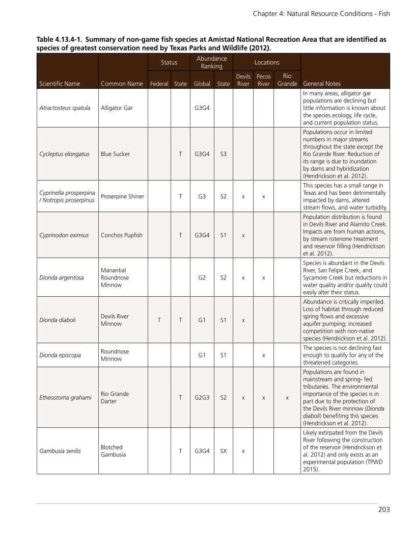
203
Chapter 4: Natural Resource Conditions - Fish
Table 4.13.4-1. Summary of non-game fish species at Amistad National Recreation Area that are identified as species of greatest conservation need by Texas Parks and Wildlife (2012).
Scientific Name Common Name
StatusAbundance
RankingLocations
General NotesFederal State Global StateDevils River
Pecos River
Rio Grande
Atractosteus spatula Alligator Gar G3G4
In many areas, alligator gar populations are declining but little information is known about the species ecology, life cycle, and current population status.
Cycleptus elongatus Blue Sucker T G3G4 S3
Populations occur in limited numbers in major streams throughout the state except the Rio Grande River. Reduction of its range is due to inundation by dams and hybridization (Hendrickson et al. 2012).
Cyprinella prosperpina / Notropis proserpinus
Proserpine Shiner T G3 S2 x x
This species has a small range in Texas and has been detrimentally impacted by dams, altered stream flows, and water turbidity.
Cyprinodon eximius Conchos Pupfish T G3G4 S1 x
Population distribution is found in Devils River and Alamito Creek. Impacts are from human actions, by stream rotenone treatment and reservoir filling (Hendrickson et al. 2012).
Dionda argentosaManantial Roundnose Minnow
G2 S2 x x
Species is abundant in the Devils River, San Felipe Creek, and Sycamore Creek but reductions in water quality and/or quality could easily alter their status.
Dionda diaboliDevils River Minnow
T T G1 S1 x
Abundance is critically imperiled. Loss of habitat through reduced spring flows and excessive aquifer pumping; increased competition with non-native species (Hendrickson et al. 2012).
Dionda episcopaRoundnose Minnow
G1 S1 xThe species is not declining fast enough to qualify for any of the threatened categories.
Etheostoma grahamiRio Grande Darter
T G2G3 S2 x x x
Populations are found in mainstream and spring- fed tributaries. The environmental importance of the species is in part due to the protection of the Devils River minnow (Dionda diaboli) benefiting this species (Hendrickson et al. 2012).
Gambusia senilisBlotched Gambusia
T G3G4 SX x
Likely extirpated from the Devils River following the construction of the reservoir (Hendrickson et al. 2012) and only exists as an experimental population (TPWD 2015).

204
Amistad National Recreation Area: Natural Resource Condition Assessment
Scientific Name Common Name
StatusAbundance
RankingLocations
General NotesFederal State Global StateDevils River
Pecos River
Rio Grande
Hybognathus amarusRio Grande Silvery Minnow
E E G1G2 SX x x
Populations are extirpated from Texas. Status continues to decline and threats include present or threatened destruction, reduction of range and habitat, nonindigenous organisms, hybridization, competition, disease or parasitism, and predation. Distribution originally in Rio Grande and Pecos basins (Hendrickson et al. 2012).
Ictalurus lupusHeadwater Catfish
G3 S2 x x
This species is listed as data deficient because its current distribution and abundance are probably declining, but the rate of decline is unknown.
Macrhybopsis aestivalis
Speckled Chub G3G4 x
This species is of special concern and population decline in lower Rio Grande River is a result of reduced streamflow, channelization, and reservoirs. Extirpated from Upper Rio Grande (Hendrickson et al. 2012).
Moxostoma austrinumMexican Redhorse
G3
This species has special concern status in Texas (Hubbs et al. 2008) and is rare, and possibly extirpated in the U.S.
Notropis amabilis Texas Shiner G4 x xNow extirpated due to dams and impoundments.
Notropis braytoni Tamaulipas Shiner G4 x x
This species is listed as imperiled by the Texas Parks and Wildlife (TPWD 2005) and has declined substantially in abundance (Hubbs et al. 1991).
Notropis chihuahua Chihuahua Shiner T G3 S2 x
Populations are limited to small tributaries of the Rio Grande in the Big Bend region. Populations are subject to fluctuations in the this region due to changes in the water table and exotics. Tributary creeks that are important to breeding and rearing young are severely threatened by water depletion (Hendrickson et al. 2012).
Notropis jemezanusRio Grande Shiner
G3 x
This species is of special concern likely due to habitat modification but causes for population decrease are not distinct
Table 4.13.4-1. Summary of non-game fish species at Amistad National Recreation Area that are identified as species of greatest conservation need by Texas Parks and Wildlife (2012) continued.

205
Chapter 4: Natural Resource Conditions - Fish
construction of Amistad Reservoir, and the subsequent changes in the aquatic habitat and fish community, the species has apparently been extirpated from downstream of Dolan Falls in the Devils River. Devils River minnow was listed as a Federally threatened species in October 1999 (56 FR 58804). USFWS designated critical habitat for the Devils River minnow along 5.6 stream miles of San Felipe Creek in Val Verde County, Texas, and 10.9 stream miles of Pinto Creek in Kinney County, Texas. The critical habitat finding was published in the Federal Register on August 12, 2008 (73 FR 46988, USFWS 2008).
The Rio Grande Silvery Minnow is a state and federally endangered species and populations are presumed extirpated from Texas. Its
original distribution was in the Rio Grande and Pecos basins. TPWD (2012) believes there’s no likelihood of it being rediscovered nor was it identified in any of the NRA’s eight fish inventories but was included in the park’s NPSpecies (2015) list as an historical species.
Critical habitat for the Rio Grande Silvery Minnow was designated by the USFWS on February 19, 2003. All critical habitat was designated within the middle Rio Grande in New Mexico (USFWS 2003).
An additional ten species are also considered to be species of greatest conservation need even though they don’t currently have protected status (TPWD 2012). TPWD defines these species as ones that are either
© C
HA
D TH
OM
AS
Figure 4.13.4-1. The Devils River Minnow (left) is a state and federally threatened species and the Rio Grande Silvery Minnow (right) is state and federally endangered. Credit: TX State University San Marcos.
© C
HA
D TH
OM
AS
Scientific Name Common Name
StatusAbundance
RankingLocations
General NotesFederal State Global StateDevils River
Pecos River
Rio Grande
Rhinichthys cataractae Longnose Dace G5 x
This species is of special concern in the region, but populations are stable in southern U.S. (Hendrickson et al. 2012).
E = endangered species or population
T = threatened species or population
G1 = Critically Imperiled — at very high risk of extinction due to extreme rarity (often 5 or fewer populations), very steep declines, or other factors.
G2 = Imperiled — at high risk of extinction due to very restricted range, very few populations (often 20 or fewer), steep declines, or other factors.
G3 = Vulnerable — at moderate risk of extinction due to a restricted range, relatively few populations (often 80 or fewer), recent and widespread declines, or other factors.
G4 = Apparently Secure — Uncommon but not rare; some cause for long-term concern due to declines or other factors.
G5 = Secure — Common; widespread and abundant.
SX = Presumed Extirpated — Species or community is believed to be extirpated from the nation or state/province. Not located despite intensive searches of historical sites and other appropriate habitat, and virtually no likelihood that it will be rediscovered.
S1 = Critically Imperiled — Critically imperiled in the nation or state/province because of extreme rarity (often 5 or fewer occurrences) or because of some factor(s) such as very steep declines making it especially vulnerable to extirpation from the state/province.
S2 = Imperiled — Imperiled in the nation or state/province because of rarity due to very restricted range, very few populations (often 20 or fewer), steep declines, or other factors making it very vulnerable to extirpation from the nation or state/province.
S3 = Vulnerable — Vulnerable in the nation or state/province due to a restricted range, relatively few populations (often 80 or fewer), recent and widespread declines, or other factors making it vulnerable to extirpation (Texas Parks and Wildlife 2012).
Table 4.13.4-1. Summary of non-game fish species at Amistad National Recreation Area that are identified as species of greatest conservation need by Texas Parks and Wildlife (2012) continued.

206
Amistad National Recreation Area: Natural Resource Condition Assessment
limited in their distributions and/or are declining in population and face the threat of extirpation or extinction but lack legal protection (TPWD 2012). These species, along with those that have protected status are summarized in Table 4.13.4-1.
TPWD (2012) assigned a global and state ranking based on a conservation status system created by NatureServe defining the rarity of each species. The conservation status was designated by a number from one to five, with the lower number representing more critically imperiled and a letter reflecting the appropriate geographic scale (G=Global, S=State). A letter of ‘X’ denoted that the species was presumed to be extirpated, which included the Rio Grande Silvery Minnow and Blotched Gambusia for the NRA.
Overall Condition and TrendThe NRA identified a goal of maintaining the overall health and viable populations of native and endemic fish species that occur within the localized watershed of the Amistad Reservoir (NPS n.d.). This would include conducting fish inventories using standardized sampling on the Rio Grande, Pecos River, and Devils River to determine current status of fisheries and to develop trend data over time.
Nine fish inventories have been conducted at the NRA to document the occurrence of
species, including sports and commercial fish. No subsequent monitoring has occurred since 2006-2007, focusing on the non-game species. Given the fact that 34% have protected status, are extinct, or have been identified by Texas Parks and Wildlife as having greatest conservation need, we consider the condition of non-game fish to be of significant concern, with a likely downward trend but currently unknown, without systematic monitoring. Table 4.13.4-2 summarizes the condition rationale.
Threats/UncertaintiesManaging the introduction of exotic fish species to the Amistad Reservoir and localized watershed continues to be a threat to native fish populations along with decreased water quantity, quality and predation. The NRA identifies the need to follow specific agency criteria when stocking exotics for sport and commercial use to promote native fish populations found in the reservoir.
Non-native fishes including the Redbreast Sunfish (Lepomis auritus), Redear Sunfish (Lepomis microlophus), and Inland Silverside (Menidia beryllina) were intentionally stocked as prey for the sports fish. The Gulf Killifish (Fundulus grandis) was introduced through bait bucket release into Texas (Hillis et al. 1980; Hubbs et al. 1991). The Largespring Gambusia (Gambusia geiseri) was introduced into several localities in Texas as early as 1937 (Hubbs et al. 1991; U.S. Fish and Wildlife Service 1983) and is considered a threat to the existence of Pecos Gambusia (G. nobilis)
Fish
Indicators MeasureSpecies occurrence Presence/Absence
Table 4.13.4-2. Indicator and measure of non-game fish condition.Indicator of Condition
Measure Condition Rationale for Condition.
Species Occurrence
Presence/Absence
Significant Concern
Since the inundation of the Rio Grande in 1968, many native habitats and animals have disappeared from the Amistad National Recreation Area. The Gambusia amistadensis is now extinct as a result of Goodenough Spring being inundated with water. Additional fish species have been potentially extirpated from the park due to the removal of flowing water. Eighteen species are considered by Texas Parks and Wildlife as species of greatest conservation need and one species is now extinct. Over 1/3 of the non-game fishes are either declining and/or limited in their distributions. Overall, we consider the condition of non-game fish to be of significant concern.

207
Chapter 4: Natural Resource Conditions - Fish
(U.S. Fish and Wildlife Service 1983). The goldfish (Carassius auratus) was introduced in Texas in 1883 (Howells 2001, Hubbs 1982 as cited in Howells 2001) but has only been documented in one park survey by Dean and Garrett (2001).
4.13.5. Sources of ExpertiseThis assessment is based on the nine fish surveys conducted within the national recreation area from 1976 - 2007.
4.13.6. Literature CitedBinational Fisheries Management Plan for
Amistad Reservoir. 2006. Contributors: Texas Parks and Wildlife Department, National Park Service, US Fish & Wildlife Service, Secretarfa de Agricultura, Ganaderia, Desarrollo Rural, Pesca y Alimentacion. Instituto Nacional de Pesca. Comision Nacional del Agua. Secretaria de Turismo SCT Gobierno del Estado de Coahuila. 68 pp.
Certified Species List: NPSpecies - The National Park Service Database. IRMA portal version. Available at https://irma.nps.gov/App/Species/Search (certified species list - park status view accessed May 15, 2015).
Dean, J. and Dr. G. Garrett. 2001. Fish Species Checklist for Amistad NRA. Texas Parks and Wildlife Department. Inland Fisheries. Austin, TX.
Hendrickson, Dean A. and Adam E. Cohen. 2012. Fishes of Texas Project and Online Database (www.fishesoftexas.org). Published by Texas Natural History Collection, a division of Texas Natural Science Center, University of Texas at Austin. Accessed (June 11, 2015).
Hillis, L. G., E. Milstead, and S. L. Campbell. 1980. Inland records of Fundulus grandis (Cyprinodontidae) in Texas. Southwest. Nat. 25(2):271-272. Available at http://nas.er.usgs.gov/queries/factsheet .aspx?SpeciesID=687 (accessed July 29, 2015).
Howells, R.G. 2001. Annotated list of introduced fishes, mollusks, crustaceans, and aquatic plants in Texas waters. Texas Parks and Wildlife Department, Management Data Series 57, Austin. 2001 Available at https://tpwd.texas.gov/publications/pwdpubs/media/mds_inland/mds-188.pdf (accessed July 29, 2015).
Hubbs, C. 1982. Occurrence of exotic fishes in Texas waters. Pearce-Sellards Series, Texas Memorial Museum 36:1-19 (As cited in Howells, R.G. Introduced Non-Native Fishes and Shellfishes in Texas Waters: An Updated List and Discussion. Management Data Series No. 188, 2001).
Hubbs, C., R. J. Edwards, and G. P. Garrett. 1991. An annotated checklist of freshwater fishes of Texas, with key to identification of species. Texas Journal of Science, Supplement 43(4):1-56. Available at http://nas.er.usgs.gov/queries/factsheet.aspx?SpeciesID=508%20 (accessed July 29, 2015).
Hubbs, C., R.J. Edwards, and G.P. Garrett. 2008. An annotated checklist of the freshwater fishes of Texas, with keys to identification of species. Texas Journal of Science, Supplement, 2nd edition 43(4):1-87. Available at http://txstate.f ishesoftexas .org/moxostoma%20austrinum.htm (accessed July 29, 2015).
Klym and Garrett. n.d. Texas non-game freshwater fishes. Texas Parks and Wildlife 23 p.
LoBello R.L. 1976: Thesis: Vertebrates if the Lake Amistad National Recreation Area, Texas. Sul Ross State University. Available at file:///Users/kimberlystruthers/Desktop/AMIS_Organized%20Fish%20Files/Assessment/Fish%20List/fishlist.htm (accessed May 3, 2015).
Lucas, M.C., Mercer, T., Peirson, G., Frear, P.A., 2008, Seasonal movements of coarse fish in lowland rivers and their relevance to fisheries management, in Cowx, I.G., ed., Management and Ecology of

208
Amistad National Recreation Area: Natural Resource Condition Assessment
river fisheries, chap. 7: Oxford, United Kingdom., Blackwell Science as cited in Moring (2012).
Moring, J.B., 2012, Water quality and the composition of fish and macroinvertebrate communities in the Devils and Pecos Rivers in and upstream from the Amistad National Recreation Area, Texas, 2005-7: U.S. Geological Survey Scientific Investigations Report 2012–5038, 70 p.
National Park Service. n.d. Goal: Maintain the overall health and viable populations of native and endemic fish species that occur within the localized watershed of the Amistad reservoir. 1 page Word document from computer files.
North American Native Fishes Association. 2013. Texas Freshwater Species Checklist. Available at http://www.nanfa.org/NAN FA re g i on s /t x / Fi sh l i st 4 1 . p d f (accessed March 3, 2015).
Page L. M and Burr. 1991 Petersons Field Guides: Fresh Water Fishes, North America, north of Mexico. Houghton Miffen Company New York, New York. Available at file:///Users/kimberlystruthers/Desktop/AMIS_Organized%20Fish%20Files/Assessment/Fish%20List/fishlist.htm (accessed May 3, 2015).
Texas Parks and Wildlife. 1982. Checklist of Fish Species Collected from Amistad Lake, Texas. Existing Reservoir and Stream Management Recommendations. Federal Aide Project F-30-R-7. Austin, Texas. Available at file:///Users/kimberlystruthers/Desktop/AMIS_Organized%20Fish%20Files/Assessment/Fish%20List/fishlist.htm (accessed May 3, 2015).
Texas Parks and Wildlife. 1983 and 1989. Gill Net Sampling Statistics. 4200 Smith School RD. Austin, Texas 78744. Available
at file:///Users/kimberlystruthers/Desktop/AMIS_Organized%20Fish%20Files/Assessment/Fish%20List/fishlist.htm (accessed May 3, 2015).
Texas Parks and Wildlife Department. 2005. Texas Comprehensive Wildlife Comprehensive Strategy. Austin, Texas. 1116 pp. Available at http://txstate.fishesoftexas.org/notropis%20braytoni.htm (accessed July 29, 2015).
Texas Parks and Wildlife. 2012. Texas conservation action plan. Available at http://tpwd.texas.gov/huntwild/wild/wildlife_diversity/nongame/listed-species/fish.phtml (accessed March 3, 2015).
Texas Parks and Wildlife. 2004. 2003 Survey report Amistad Reservoir. 23 p.
Texas Parks and Wildlife. 2015. Nongame and Rare Species Program: Federal and State Listed Fish Species. Available at http://tpwd.texas.gov/landwater/land/tcap/ (accessed March 3, 2015).
U.S. Fish and Wildlife Service. 1983. Pecos gambusia (Gambusia nobilis) recovery plan. U.S. Fish and Wildlife Service, Albuquerque, NM. iii + 47 pp. Available at http://www.fws.gov/ecos/ajax/docs/recovery_plan/051220a.pdf (accessed March 3, 2015).
U.S. Fish and Wildlife Service. 2003. Endangered and threatened wildlife and plants; designation of critical habitat for the Rio Grande Silvery Minnow. Federal Register / Vol. 68, No. 33.
U.S. Fish and Wildlife Service. 2008. Questions and answers devils river minnow critical habitat. 4p.
United States Geological Survey. 2004. NPS I&M fish field data Excel spreadsheet.

209
Chapter 4: Natural Resource Conditions - Exotic Mussels
4.14. Exotic Mussels
4.14.1. Background and ImportanceZebra mussels (Dreissena polymorpha) and quagga mussels (D. bugensis) are Eurasian species alien to North America that were first detected in Lake St. Clair, Michigan in 1988 (Figure 4.14.1-1). Both mussels are easily spread from infested to non-infested waters by recreational boats being moved between waters. They are now established in all the Great Lakes, most of the large navigable eastern rivers, and in many inland lakes in the Great Lakes region, where they have had significant negative impacts to aquatic ecosystems (Benson 2009, Garetz 2014), and have recently spread to western states. If Lake Amistad was infected, mussels would damage both U.S. and Mexican hydropower generating facilities contained within Amistad Dam, would impair the primary function of the dam of flood control, and impair natural and cultural resources at the park.
Distribution and SpreadQuagga and zebra mussels produce microscopic larvae (called veligers) that passively drift in the water column and can easily be transported in live wells of boats.
Yearlings settle on any stable surface and can detach and drift for short distances. Adult mussels attach to hard surfaces, including recreational boat hulls and trailers, on which they can be transported as boats move between inland lakes and rivers (Garetz 2014).
In January 2007, quagga mussels were discovered at Lake Mead National Recreation Area, marking the first detection of this species in the western United States. Infestations were subsequently found in California, Arizona, Nevada, Utah, Colorado, and New Mexico (Figure 4.14.1-2; USGS 2013). Zebra mussels have been found in California, Utah, Colorado, Oklahoma, Kansas, Nebraska, and in reservoirs on the Red River in Texas, 500 miles from Amistad (USGS 2013, Garetz 2014). The first zebra mussels established in Texas were in Lake Texoma in 2009. In 2012, they were found in Lake Ray Roberts and the Elm Fork of the Trinity River. In 2013, zebra mussels spread to Lakes Bridgeport, Lavon,
Figure 4.14.1-1. Zebra and quagga mussels.
© U
SGS/M
YRIA
H RIC
HERSO
N
Indicators/Measures• Species Occurrence (1 measure)
Condition – Trend – Confidence
Good - Deteriorating - Medium

210
Amistad National Recreation Area: Natural Resource Condition Assessment
Lewisville, and Belton (Figure 4.14.1-3; Texas Department of Parks and Wildlife 2014).
In the seven years since the discovery of invasive mussels in western U.S. waters, quagga and zebra mussels have spread to 48 waterbodies west of the 100th Meridian. Only
the five northwestern states have avoided introductions so far. The rapid infestation of North American waterways by these invasive mussels has been facilitated by their ability to disperse during all life stages.
The NPS Quagga/Zebra Mussel Infestation Planning Guide (NPS 2007) situation analysis rates the risk of infestation to Lake Amistad as High. Boats coming from infested waters is the best indicator of risk of invasion to lakes and reservoirs (NPS 2007). Although most of the boaters using Lake Amistad are from areas with currently uninfested waters, in the five-year period between 2003 and 2008, boats from every state positive for zebra and quagga mussels have launched at Lake Amistad (Garetz 2014). The risk of infestation to the rivers themselves varies. The Rio Grande and Devils rivers have moderate to high risk for quagga infestation and survival, while the Pecos River has a low risk for quagga infestation because of its high sediment load and salinity (Garetz 2014, NPS 2007).
Lake Amistad would provide ideal habitat for invasive mussels if they were introduced. Calcium concentrations in Lake Amistad
Figure 4.14.1-2. Distribution of zebra and quagga mussels. Credit: USGS
Figure 4.14.1-3. Distribution of zebra and quagga mussels in Texas.
© TEX
AS D
EPARTM
ENT O
F PARK
S AN
D W
ILDLIFE
211
Chapter 4: Natural Resource Conditions - Exotic Mussels
place it at high risk for invasion by zebra mussels (Whittier et al. 2008). Water velocity, temperature, and pH values at Lake Amistad are also consistent with physiological tolerances of zebra and quagga mussels (McMahon 1996). Salinity levels vary in different areas of the reservoir depending on proximity to the outflow of the Pecos River (high salinity), and proximity to other inflows with low salinity such as the Devils River and freshwater springs. The salinity at the dam from 2002-2007 was within the physiological tolerance of zebra mussels (salinity ranged 0.409-0.496 ppt, tolerance is 0.5 ppt; Garetz 2014).
Evidence suggests quagga mussels are reproducing three times faster (six times per year rather than just twice per year) in western waters than they did in Lake Michigan (Rogers 2009). The warmer year-round temperatures and the higher calcium concentration in Lake Mead and Lake Mohave seem to be favorable to year-round mussel reproduction. Zebra and quagga mussels have no natural predators in North America. Many species do eat these mussels, including diving ducks, red-eared sunfish and some catfish, but these predators cannot keep up with the explosive reproduction of these invasive mussels to control nor eradicate them (USFWS 2007, Garetz 2014).
Impacts of Exotic MusselsThe impacts of zebra and quagga mussels include:
• disrupting the aquatic food chain and native species
• encrusting submerged cultural resources
• impacting recreational activities such as sport fishing
• fouling boats, boat engines, docks, ramps, and other marina facilities
• clogging raw water intake pipes, increasing maintenance costs
• littering beaches with sharp shells that can smell as the mussels decompose (NPS 2007).
Adult mussels form dense clumps, with shells piled on top of one another. Under ideal conditions in the Great Lakes, zebra mussel densities reach 700,000-800,000 per square meter (Kovalak et al. 1993). Any hard surface that is not toxic can be colonized by zebra mussels. The dam at Amistad NRA would be susceptible to mussel attachment, as would the deep underwater canyons with sheer limestone walls where the Pecos, Rio Grande, and Devils Rivers cut their original water courses. When quagga and zebra mussels form dense colonies on power-producing dam infrastructure, the costs of power operations skyrocket. Water intake pipes can become completely clogged from the mass of mussel bodies stacked on top of each other (Figure 4.14.1-4). The estimated one-time cost for installing zebra mussel control systems at hydroelectric projects could range from the hundreds of thousands of dollars to over a million dollars per facility, and annual maintenance costs could equal that (Phillips et al. 2005, Garetz 2014). The cost to aquatic ecosystems and native species is incalculable (100th Meridian 2005).
Adult mussels primarily feed on phytoplankton filtered from the water, putting it in direct competition with macroinvertebrates and lower levels of the native food web. An adult invasive mussel can filter about one liter of water per day. Nearly all particulate matter, including phytoplankton and some small forms of zooplankton, are removed. These microscopic plants and animals are the base of the food chain. Small fish, such as young sportfish or forage fish, depend on this food for survival and growth. Some of the filtered material is digested by the mussels, the rest is concentrated into pellets called pseudofeces that are deposited on the bottom of lake. As the waste pellets decompose, they create a foul environment; oxygen is used up, the pH becomes very acidic and toxic byproducts are produced (Benson 2009). Their tremendous volume of filter feeding could place invasive mussels in direct competition with macroinvertebrates and lower levels of the

212
Amistad National Recreation Area: Natural Resource Condition Assessment
food web that feed the bass fishery in Lake Amistad. The increased water clarity would also affect community composition, favoring some species and harming others (Garetz 2014).
Policy EnvironmentNPS Management Policies (NPS 2006) identify the responsibility of parks to manage non-native, alien plant and animal species and to cooperate with other agencies with jurisdiction. Highest priority is given to the management of alien species that have, or potentially could have, a substantial impact on park resources. For alien species where management appears to be feasible and effective, park superintendents are directed to (1) evaluate the species’ current or potential impact on park resources; (2) develop and implement exotic species management plans according to established planning procedures; (3) consult, as appropriate, with federal, tribal, local, and state agencies as well as other interested groups; and (4) invite public review and comment, where appropriate. The NPS Planning Guide (NPS 2007) provides the framework and guidance to assist parks in developing site-specific plans for the prevention and response to quagga and zebra mussel infestation in accordance with requirements under NPS Management Policies.
The National Environmental Policy Act (NEPA) provides policies and planning mechanisms to protect and mitigate park
resources from damage. Affected parks will abide by all applicable requirements under NEPA for actions related to quagga/zebra mussel prevention and control. If an invasion of alien mussels came from recreational activities at Amistad, we would be spreading the invasive species across the international boundary, and would be legally liable to Mexico under the Lacey Act (Garetz 2014). Control of established mussel infestations costs millions of dollars annually. Preventing an infestation before it occurs is inexpensive and cost effective by comparison.
Regional coordination and actions are needed to prevent the spread of invasive mussels. Inspection and decontamination standards can vary among states and even within a state. States are critical partners to prevent the spread of invasive species because they have jurisdiction, regulatory authority, and expertise (Western Regional Panel on Aquatic Nuisance Species 2009). Texas recently (as of May 2014) approved new regulations requiring all boats used on public fresh water anywhere in the state to be drained before leaving or approaching another water body. This provision, which took effect July 1, 2014, is intended to prevent the spread of mussels as well as other invasive species (Texas Department of Parks and Wildlife 2014).
4.14.2. Data and MethodsThis limited assessment is based on existing relevant literature. Excerpts have been taken
© ID
AH
O STATE D
EPARTM
ENT O
F AG
RICU
LTURE
© C
ALIFO
RNIA
DEPA
RTMEN
T OF BO
ATS AN
D W
ATERWAY
S
Figure 4.14.1-4. Zebra and quagga mussels can attach to boats and clog pipes.

213
Chapter 4: Natural Resource Conditions - Exotic Mussels
directly from the Amistad NRA project proposal (PMIS 197492; Garetz 2014).
4.14.3. Reference ConditionsThe reference condition for exotic mussels is presence or absence. The absence of mussels indicates good condition; the presence of mussels indicates significant concern. Because of the rapid spread and seriousness of the presence of exotic mussels, there is no moderate condition described.
4.14.4. Condition and Trend An invasive mussel population in Lake Amistad could seed the Rio Grande River basin all the way to the Gulf of Mexico. Amistad is at high risk of invasion both behaviorally (boats from across the nation launch here every year) and ecologically (the high-calcium, low-salinity water would be ideal habitat for mussels). The main focus of Amistad NRA is to prevent the spread to the park (Garetz 2014); mussels have never been successfully eradicated from a large body of water (NPS 2007).
Given the ability of mussel veligers to move downstream, if a breeding population of invasive mussels were established in Lake Amistad, the ensuing invasion could potentially disrupt the function of drinking water, irrigation, and power-generating facilities along the way. A similar scenario happened with quagga mussels in Lake Mead NRA that spread an infestation through the lower Colorado River system (Garetz 2014).
Overall ConditionThe current condition at Amistad NRA is good condition, meaning exotic mussels are currently not found (Table 4.14.4-1).
Because of the rapid spread of exotic mussels in similar environments, the nearby location of exotic mussel populations, and the relative difficulty in keeping mussels out of the system, the trend indicates high risk for declining condition.
4.14.5. Sources of ExpertiseThis section relied on the expertise of Amistad park staff and materials they had prepared, as well as NPS documents, and other available resources.
4.14.6. Literature Cited100th Meridian Initiative. 2005. Zebra Mussels
what are they? Available at: http://www.100thmeridian.org/zebras.asp (accessed August 5, 2014)
Benson, A. J., M. M. Richerson, and E. Maynard. 2009. Dreissena rostriformis bugensis. USGS Nonindigenous Aquatic Species. Available at: http://nas.er.usgs.gov/taxgroup/mollusks/zebramussel/ (accessed July 24, 2014)
Garetz, G. 2014. Prevent invasive quagga/zebra mussel infestation in Lake Amistad. NPS Project Proposal, PMIS #197492.
Kovalak, W., G. Longton, and R. Smithee. 1993. Dispersal mechanisms of the zebra mussel (Dreissena polymorpha), Pages 359-380 in T. F. Nalepa and D. W. Schloesser, eds. Zebra mussels: Biology, impacts, and control. Lewis Publishers:Boca Raton, FL.
McMahon, R. F. 1996. The physiological ecology of the zebra mussel, Dreissena polymorpha, in North America and Europe. American Zoologist 36:339-363. Available online at: http://www.fs.usda.gov/Internet/FSE_D O CUMENTS/fsbdev3_015416.pdf (accessed August 5, 2014)
Exotic Mussels
Indicators MeasureSpecies occurrence Presence/Absence
Table 4.14.4-1. Indicator and measure of exotic mussels condition. Indicator of Condition
Measure Condition Rationale for Condition
Species OccurrencePresence/absence
GoodThe invasive, exotic mussels (zebra and quagga) are not present at Amistad NRA. The trend, however, indicates high risk.

214
Amistad National Recreation Area: Natural Resource Condition Assessment
National Park Service (NPS). 2007. Quagga/zebra mussel infestation prevention and response planning guide. Natural Resources Program Center, Fort Collins, CO.
National Park Service (NPS). 2006. Management Policies 2006. U.S. Department of the Interior, National Park Service. Available at: http://www.nps.gov/policy/mp2006.pdf (accessed August 5, 2014)
Phillips, S., T. Darland, M. Sytsma. 2005. Potential economic impacts of zebra mussels on the hydropower facilities in the Columbia River Basin. Prepared for the Bonneville Power Administration. Pacific States Marine Fisheries Commission, Portland, OR. Available online at: http://www.aquaticnuisance.org/wordpress/wp-content/uploads/2009/01/Phillips-Darland-and-Sytsma.pdf (accessed August 5, 2014)
Rogers, K. 2009. Scientists report on explosive growth of invasive quagga mussels:Habitat called ideal in two lakes. Las Vegas Review-Journal 14 January 2009.
Texas Department of Parks and Wildlife. 2014. Zebra mussel rules now expanded statewide. Press Release May 22, 2014. Available at: http://www.tpwd.state.tx.us/
newsmedia/releases/?req=20140522f (accessed August 5, 2014)
U.S. Fish and Wildlife Service (USFWS). 2007. Western quagga mussels, background information. Available at: http://www.100thmeridian.org/Documents/Talking%20Points%20Regarding%20Western%20Quagga%20Mussels.pdf (accessed August 5, 2014)
U.S. Geological Survey (USGS). 2013. Quagga and Zebra Mussels. Nonindigenous Aquatic Species Program, Gainesville, FL. Available at: http://nas.er.usgs.gov/taxgroup/mollusks/zebramussel/ (accessed August 5, 2014)
Western Regional Panel on Aquatic Nuisance Species. 2009. Quagga-zebra mussel action plan for western U.S. waters. Submitted to the Aquatic Nuisance Species Task Force. Available at: http://www.anstaskforce.gov/QZAP/QZAP_FINAL_Feb2010.pdf (accessed August 5, 2014)
Whittier, T. R., P. L. Ringold, A. T. Herlihy, and S. M. Pierson. 2008. A calcium-based invasion risk assessment for zebra and quagga mussels (Dreissena spp). Frontiers in Ecology and the Environment 6(4):180-184. Available online at: http://www.esajournals.org/doi/abs/10.1890/070073 (accessed August 5, 2014)

215
Chapter 5: Discussion of NRCA Findings and Considerations for Park Planning
Chapter 5: Discussion of Natural Resource Condition Assessment Findings and Considerations for Park Planning5.1. IntroductionAmistad NRA’s Natural Resource Condition Assessment (NRCA) Chapter 5 includes summaries of resource condition findings for each topic assessed in addition to providing a framework that connects the natural resource findings to Amistad National Recreation Areas’s purpose and significance statements listed in Table 5.2-1, and delivering completed National Park Service State of the Park natural resource condition summary tables for each natural resource topic assessed (refer to sections 5.3-5.17).
These Chapter 5 reporting pieces can be used by park managers for a variety of resource planning and other reporting purposes, such as expanded resource briefs for education and interpretation or for the State of the Park report.
5.2. Connecting Natural Resource Condition Assessment Topics to Park Purpose, Significance, and Fundamental Resources & Values
Managing the natural resources at Amistad NRA is inextricably tied to its purpose and significance. It is most often within this interdisciplinary perspective that managers consider potential actions and alternatives when addressing resource issues or needs. During the park’s on-site NRCA scoping meeting, participants reviewed resource topics selected for the condition assessment
For the purposes of Chapter 5, these resources were linked to the park’s purpose and significance statements that were identified in the park’s draft g foundation document (NPS 2016). Table 5.2-1 lists this information and denotes where each assessed natural resource topic ties into the park’s primary reasons for establishment.
Amistad National Recreation Area provides diverse water-based recreational opportunities, including canoeing one of Texas’ most pristine rivers - the Devils River (NPS 2006).
NPS

216
Amistad National Recreation Area: Natural Resource Condition Assessment
Table 5.2-1. Summary of natural resource topic relevance (denoted by black dots) as it relates to Amistad National Recreation Area’s purpose and significance statements identified in the park’s Foundation Document (NPS 2016).
Natural Resource Condition Assessment Topics
Nig
ht S
ky
Air
Qua
lity
Geo
logy
Surf
ace
Wat
er
Qua
lity
Gro
undw
ater
Ripa
rian
Hab
itat
Upl
ands
Veg
Exot
ic P
lant
s
Land
bird
s
Mam
mal
s
Jagu
arun
di
Her
peto
faun
a
Fish
Exot
ic M
usse
ls
I. Park Purpose
Provide for public outdoor recreation use and enjoyment of the lands and waters associated with the United States portion of the reservoir known as Lake Amistad . . . and protect scenic, scientific, cultural, and other values contributing to the public enjoyment of such lands and waters.
• • • • • • • • • • • • • •
II. Park Significance
As one of only two reservoirs managed jointly by the United States and the Republic of Mexico, Lake Amistad commemorates a water conservation partnership between the two nations.
• • • • •
The waters of Lake Amistad provide diverse water-based recreational opportunities, including some of the finest recreational black bass fishing in the southwestern United States.
• • • • •
Amistad National Recreation Area protects and interprets exceptional examples of the area’s distinct Lower Pecos River style rock art, one of the most significant and densest concentrations of Archaic rock art in the world.
•
Amistad National Recreation Area contains hundreds of archeological sites and a museum collection of over 980,000 artifacts including many uncommon perishable artifacts from dry rock shelters. These resources provide important information from over 10,000 years of Native American hunter-gatherer, US military, ranching, and railroad history.
•
Amistad National Recreation Area has a rich biological diversity in part due to the reservoir and its location at the convergence of three ecoregions: the Chihuahuan Desert, the Tamaulipan Thornscrub, and the Edwards Plateau.
• • • • • • •
Amistad National Recreation Area encompasses ruggedly scenic canyonlands associated with three distinct rivers: the Rio Grande, Pecos River and the clear, spring-fed Devils River.
• • • • • •
Amistad National Recreation Area includes one of the largest tracts of public land available for hunting in southwest Texas.
• •

217
Chapter 5: Discussion of NRCA Findings and Considerations for Park Planning
5.3. State of the Park ReportingAs part of the stewardship of national parks for the American people, the NPS has begun to develop State of the Park reports to assess the overall status of each park’s resources.
The key purposes of each State of the Park report are to:
● Provide to visitors and the American public a snapshot of the status and trend in the condition of a park’s priority resources and values.
● Summarize and communicate complex scientific, scholarly, and park operations factual information and expert opinion using non-technical language and a visual format.
● Highlight park stewardship activities and accomplishments to maintain or improve the State of the Park.
● Identify key issues and challenges facing the park to help inform park management planning (NPS 2012).
Table 5.3-1 provides an overall summary of natural resource conditions based upon NRCA findings.
Resource Condition Summary BriefsEach resource condition summary brief, (sections 5.4-5.17) details the condition ratings by including a State of the Park summary table of indicators and measures. Condition rationale, noteworthy highlights, and management opportunities and considerations may also be included in each resource brief.
Table 5.3-1. State of the Park Natural Resource Summary Table.
Priority Resource or Value
Condition Status/Trend
Summary of Overall Condition Rating
Natural Resources
Night Sky
Two indicators were used to assess the condition of night sky: sky brightness (measured by anthropogenic light ratio and zenith sky brightness) and sky quality (measured using the Bortle dark-sky scale). The overall condition of Amistad NRA’s night sky is moderate, with a medium level of confidence. Insufficient data are available to determine trend.
Air Quality
The air quality assessment included visibility, ozone for human and wet deposition for total nitrogen and total sulfur- all of which were in moderate condition based upon the National Park Service’s Air Resources Division reference criteria.
Geology
We used one indicator, geologic resource integrity, to assess the condition of the geologic resources. Level of integrity (condition) is based on the extent of management issues or concerns evident in the park, and whether or not geologic resources and processes are within a natural range of state and function. Geologic resources, including the outstanding paleontological resources, are in good condition at Amistad National Recreation Area, with a low level of confidence. Insufficient data are available to determine trend.
Surface Water Quality
Four indicators and 26 measures were used to assess water quality condition within five river segments in the Rio Grande Basin. Measures were evaluated at the local station and assessment unit levels, as well as within the entire river segment to provide a watershed perspective. Only one river segment, Devils River, was in good condition for all indicators and measures. Metals were of moderate concern within the river segment above the NRA. However several measures in the major ions and nutrients parameter groups were listed in Texas’ 303(d) (2014) impaired waterbodies list, warranting moderate to significant concern.
Groundwater and Springs
We used two indicators and 17 measures to assess the condition of the park’s groundwaterresources. Groundwater elevation was in good condition, but several constituents exceeded maximum contamination levels for groundwater quality resulting in a good to moderate condition rating.

218
Amistad National Recreation Area: Natural Resource Condition Assessment
Priority Resource or Value
Condition Status/Trend
Summary of Overall Condition Rating
Riparian Habitat
Both the Pecos and Devils Rivers riparian resources including hydrology, vegetation, anderosion/deposition characteristics were assessed. The condition ratings for all indicators and all 14 measures were considered to be in good condition.
Upland Vegetation
We used one indicator, biotic integrity, to assess upland vegetation condition The biotic integrity indicator had five measures; four were judged to be of significant concern and one is of moderate concern. Therefore, the overall condition is of significant concern. Three of the sites were judged to be of significant concern and two are of moderate concern. The only individual measure at sites that was considered to be in good condition was the landscape-scale diversity measure at two of the sites. We consider the trend in condition as unchanging at this time, but recognize that management as an NPS unit and cessation of the grazing that occurred in the past are allowing some recovery of the land.
Exotic Plants
We used two indicators, potential to alter native plant communities and prevalence of exotic plants, to assess the condition of exotic plants in the recreation area. The condition for the significance of exotic plant impact measure was of significant concern. Two of the measures for prevalence of exotic plants (extent and distribution) were of significant concern, and the third (density) was of moderate concern. Overall, the condition of exotic plants is of significant concern. The trend is declining.
Landbirds
We used one indicator, species occurrence (presence/absence), in three separate contexts (or measures; temporal, spatial, and conservation), to assess the condition of breeding landbirds at the Recreation Area. For each measure, we found the current condition of breeding landbirds to be good. We do not have sufficient data to justify a trend in the condition at this time.
Mammals
We used one indicator/measure, species occurrence (presence/absence), to assess the condition of mammals. Although a substantial survey effort was conducted in 2003-2004 by Bahm and Mueller (2011), we were unable to assess current condition because there is no current survey information available. However, some concern exists over the presence and effects of three species in particular, the exotic European mouflon sheep, feral pig, and feral cat.
Jaguarundi
We used one indicator/measure, species occurrence (presence/absence), to assess the condition of the jaguarundi. There are no current documented reports of jaguarundis occurring at Amistad NRA or in southern Texas. The last confirmed report of a jaguarundi in Texas was in 1986, in Brownsville. Game cameras have been installed below Amistad Dam on the Rio Grande to try to capture an image of a jaguarundi, but none have been recorded to date. The condition of the subspecies at the park is unknown.
Herpetofauna
We used one indicator/measure, species occurrence (presence/absence), to assess the condition of amphibians and reptiles at the Recreation Area. Although a substantial survey effort was conducted in 2003-2004 by the University of Arizona at the park, we were unable to assess current condition because there is no current information available.
Small Native Fishes
We used one indicator/measure, species occurrence (presence/absence), to assess the condition of small native fishes. Given the fact that 34% of the species have some degree of protected status, are extinct, or have been identified by Texas Parks and Wildlife as having greatest conservation need, we consider the condition of non-game fish to be of significant concern, with a likely downward trend, but currently unknown, without systematic monitoring.
Exotic Mussels
Condition is determined by the presence or absence of exotic mussels. Amistad NRA is good condition, meaning exotic mussels are not currently found. The condition has a medium level of confidence, and while no trend can be assessed with presence/absence, there is a high risk of decline (that is invasion) based on the regional context for this species and the seriousness of its impacts.
Table 5.3.1. State of the Park Natural Resource Summary Table continued.

219
Chapter 5: Discussion of NRCA Findings and Considerations for Park Planning
5.4. Night Sky Resource Condition BriefThe contents of sub-chapter 5.4 were designed to be placed into a stand-alone night sky resource brief at a later date. The final resource brief will follow NPS Graphic Identity Program (http://www.nps.gov/hfc/services/identity/) format and layout policy standards and include the contact information of at least one NPS employee as a point contact for the public.
5.4.1. Noteworthy HighlightsNatural dark skies are a valued resource within the NPS, reflected in NPS management policies that highlight the importance of a natural photic environment to ecosystem function, and the importance of the natural lightscape for aesthetics. The value of night skies goes far beyond visitor experience and scenery. The photic environment affects a broad range of species, is integral to ecosystems, and is a natural physical process. Natural light intensity varies during the day night (diurnal) cycle, the lunar cycle, and the seasonal cycle. Organisms have evolved to respond to these periodic changes in light levels in ways that control or modulate movement, feeding, mating, emergence, seasonal breeding, migration, hibernation, and dormancy. Plants also respond to light levels by flowering, vegetative growth, and their direction of growth
Amistad National Recreation Area (NRA) is enjoyed by visitors for fishing, boating, and diving, among other lake-based recreation activities. Nighttime boating and fishing trips or evenings camped along the river are good times to enjoy the night sky. Protecting the night sky resources benefits the natural resources and is important for visitor experience at the NRA.
5.4.2. Condition RationaleThe overall condition of Amistad NRA’s night sky is moderate, with a medium level of confidence (Table 5.4.2-1). All measures indicated moderate condition due primarily to the significant influence from nearby light domes. Night sky viewing from campgrounds near Del Rio/Acuna was most impacted by light domes and point sources of light from the nearby highway and businesses. The further away from the city (to the north and west) the better the quality of the night sky and the ability to view constellations, the Milky Way, and other celestial bodies.
NPS - SU
NSET AT H
UN
T AREA
1
Sunset over hunt area #1.

220
Amistad National Recreation Area: Natural Resource Condition Assessment
Table 5.4.2-1. Summary of overall night sky condition, indicators and measures, and rationale for assigning condition assessment at Amistad National Recreation Area.
Night Sky
Indicators of Condition Specific MeasuresCondition Status/
TrendRationale
Sky Brightness
Anthropogenic Light Ratio
This measure results from modeled data from the NPS Night Sky Program. Specific thresholds for condition classes have been set by the NPS. In this case, the moderate condition results from the significant light domes of nearby cities. The confidence level in this assessment is medium.
Zenith Sky Brightness
Zenith sky brightness indicates moderate condition, based on the impact from light domes from nearby cities. Confidence level is medium.
Sky Quality Bortle Dark Sky Scale
Night sky viewing from campgrounds near Del Rio/Acuna were most impacted by light domes and point sources of light from the nearby highway and businesses. The further away from the city--to the north and west--the better the quality of the night sky and the ability to view constellations, the Milky Way, and other celestial bodies. Because this measure is qualitative, it has a low confidence level.

221
Chapter 5: Discussion of NRCA Findings and Considerations for Park Planning
5.5. Air Quality Resource Condition BriefThe contents of sub-chapter 5.5 were designed to be placed into a stand-alone air quality resource brief at a later date. The final resource brief will follow NPS Graphic Identity Program (http://www.nps.gov/hfc/services/identity/) format and layout policy standards and include the contact information of at least one NPS employee as a point contact for the public.
5.5.1. Condition RationaleWe used three indicators and four measures to assess air quality condition at Amistad NRA, which included ozone level, visibility, and wet deposition of sulfur and nitrogen (Table 5.5.1-1). All indicators and measures were in moderate condition based on NPS Air Resources Division reference conditions. No trends could be determined since no representative monitors are located within the required distances. Like most airsheds, the park’s air quality is largely influenced by activities and operations that occur outside its boundaries, making its condition dependent on local, regional, and national planning.
NPS
Blue sky view with white clouds above open water.

222
Amistad National Recreation Area: Natural Resource Condition Assessment
Table 5.5.1-1. Summary of overall air quality condition, indicators and measures, and rationale for assigning condition assessment at Amistad National Recreation Area.
Air Quality
Indicators of Condition Specific MeasuresCondition
Status/TrendRationale
Visibility Haze Index
For 2008–2012, estimated average visibility in the NRA was 6.9 deciviews above natural conditions, therefore, the condition status warrants moderate condition based on NPS Air Resource Division benchmarks. No trend information is available because there are not sufficient on-site or nearby visibility monitor stations.
Level of OzoneHuman Health: Annual
4th-Highest 8-hour Concentration
The estimated ozone level for 2008–2012 at the NRA was 69.8 parts per billion, therefore, the condition status warrants moderate concern based on NPS Air Resource Division benchmarks. There are four ozone-sensitive plants in the NRA, with three representing bioindicators. No trend information is available because there are not sufficient on-site or nearby ozone monitor stations.
Wet Deposition
Total N
For 2008–2012, estimated wet nitrogen deposition was 2.0 kilograms per hectare per year, therefore, the condition status warrants moderate concern based on NPS Air Resource Division benchmarks. No NPS-ARD trend information is available for nitrogen.
Total S
For 2008–2012, estimated wet sulfur deposition was 1.5 kilograms per hectare per year, therefore, the resource is in moderate condition based on NPS Air Resource Division benchmarks. No NPS-ARD trend information is available for sulfur.

223
Chapter 5: Discussion of NRCA Findings and Considerations for Park Planning
5.6. Geology Resource Condition BriefThe contents of sub-chapter 5.6 were designed to be placed into a stand-alone geology resource brief at a later date. The final resource brief will follow NPS Graphic Identity Program (http://www.nps.gov/hfc/services/identity/) format and layout policy standards and include the contact information of at least one NPS employee as a point contact for the public.
5.6.1. Noteworthy HighlightsAmistad protects some of the world’s best examples of prehistoric art, notably pictographs. Carbon-14 dating revealed that the oldest pictographs at Amistad are 4,000 years old, from the Lower Pecos River style, but archaeologists surmise that human habitation in the region extends as far back as 10,000 years ago.
Marine fossils from the Cretaceous are embedded in the limestone canyons, and paleontological resources of the Quarternary are preserved within the rock shelters formerly used by indigenous people. These caves, and the continued limestone erosion, provide opportunities to study ancient fauna and flora from the Mesozoic and Cenozoic Eras, the paleoecological record, and archaeological connections to this location.
Based on a 1995 inventory of cave and karst resources at Amistad NRA, 23 significant karst features were noted and a cave management plan was recommended. In 1997 park staff did some preliminary work, but did not finish the plan. Since then investigators and visitors have discovered additional caves, which park staff need to add to the informal dataset of known information; as of April 2008, the count was up to 36. Cavers mapped it in the 1950s and 1960s. The deepest cave—Goodenough Springs—is submerged; its “end” is 76 m (250 ft) below the entrance at the farthest extent of exploration to date; the exploration project is ongoing. Generally, the caves range from small sinkholes to conduits of up to 100 m (330 ft) in length. Typical depths of sinkholes are 11-18 m (35-60 ft). Such sinkholes may be a threat to unwary hunters or other backcountry users because they are not fenced or gated. Additionally, some of the caves contain “bad air” as a result of rotting vegetation (i.e., buildup of organic matter from the lake) that produces carbon dioxide that displaces oxygen. Park managers know of no threats to infrastructure from karst. All caves are presently closed to the public pending completion of a management plan.
NPS
A view of the Pecos Cliffs from the boat ramp.

224
Amistad National Recreation Area: Natural Resource Condition Assessment
5.6.2. Condition RationaleGeologic resources, including the outstanding paleontological resources, are in good condition at Amistad National Recreation Area, with a low level of confidence (Table 5.6.2-1) (a geologic resource evaluation scoping summary was completed in 2008). The park should be vigilant about preventing theft of exposed fossils, but otherwise human disturbances related to the geologic resources are few.
Table 5.6.2-1. Summary of overall geology condition, indicators and measures, and rationale for assigning condition assessment at Amistad National Recreation Area.
Geology
Indicators of Condition Specific MeasuresCondition
Status/TrendRationale
Geologic Integrity None
Generally geologic resources, including the outstanding paleontological resources, are in good condition. The park should be vigilant about preventing theft of exposed fossils, but otherwise human disturbances related to the geologic resources are few. A geologic resource evaluation scoping summary was completed in 2008.

225
Chapter 5: Discussion of NRCA Findings and Considerations for Park Planning
5.7. Surface Water Quality Resource Condition BriefThe contents of sub-chapter 5.7 were designed to be placed into a stand-alone surface water quality resource brief at a later date. The final resource brief will follow NPS Graphic Identity Program (http://www.nps.gov/hfc/services/identity/) format and layout policy standards and include the contact information of at least one NPS employee as a point contact for the public.
5.7.1. Noteworthy HighlightsThe Devils River is considered to be one of the most pristine rivers throughout Texas (TNC 2008) and 40 km (25 mi) are within the national recreation area’s boundary. The river supports a wide diversity of natural and cultural resources, including the largest known population of Texas snowbells (Styrax platanifolius spp. texanus), black-capped vireo (Vireo atricapilla), Devils River minnow (Dionda diaboli), and excellent examples of Native American pictographs (Karges and Bergan 2005, TNC 2008). It also is a significant source of freshwater, improving water quality conditions within the reservoir and the Rio Grande due to the numerous seeps and springs that are located along its banks.
5.7.2. Condition RationaleWe used four indicators and a total of 26 measures at the station, assessment unit, and watershed levels to assess the condition of surface water throughout the national recreation area (Table 5.7.2-1). Conditions are highly varied depending upon the assessment level and upon the indicator group (i.e., core parameters, nutrients, major ions, and metals). Overall, with the exception of high E. coli levels below the reservoir and an increasing trend in lead levels just above the reservoir, both core parameters and metals were found to be in good condition. Several nutrients were listed as concerns in all river segments except for the Devils River and are in moderate condition. The reservoir became listed for total dissolved solids and chloride on TCEQ’s (2014) 303(d) list of impaired waterbodies for the first time for these parameters. High levels of these parameters are also of concern, including sulfate, throughout the entire Rio Grande River segment above the reservoir, warranting significant concern. The overall water quality condition for the park was rated as moderate to significant concern, with a high level of confidence.
NPS
Indian Cliffs along Devils River.
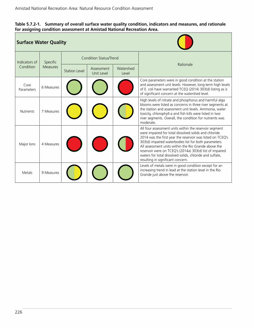
226
Amistad National Recreation Area: Natural Resource Condition Assessment
Table 5.7.2-1. Summary of overall surface water quality condition, indicators and measures, and rationale for assigning condition assessment at Amistad National Recreation Area.
Surface Water Quality
Indicators of Condition
Specific Measures
Condition Status/Trend
Rationale
Station LevelAssessment Unit Level
Watershed Level
Core Parameters
6 Measures
Core parameters were in good condition at the station and assessment unit levels. However, long-term high levels of E. coli have warranted TCEQ (2014) 303(d) listing as is of significant concern at the watershed level.
Nutrients 7 Measures
High levels of nitrate and phosphorus and harmful alga blooms were listed as concerns in three river segments at the station and assessment unit levels. Ammonia, water toxicity, chlorophyll-a and fish kills were listed in two river segments. Overall, the condition for nutrients was moderate.
Major Ions 4 Measures
All four assessment units within the reservoir segment were impaired for total dissolved solids and chloride. 2014 was the first year the reservoir was listed on TCEQ’s 303(d) impaired waterbodies list for both parameters. All assessment units within the Rio Grande above the reservoir were on TCEQ’s (2014a) 303(d) list of impaired waters for total dissolved solids, chloride and sulfate, resulting in significant concern.
Metals 9 Measures
Levels of metals were in good condition except for an increasing trend in lead at the station level in the Rio Grande just above the reservoir.

227
Chapter 5: Discussion of NRCA Findings and Considerations for Park Planning
5.8. Groundwater and Springs Resource Condition BriefThe contents of sub-chapter 5.8 were designed to be placed into a stand-alone groundwater and springs resource brief at a later date. The final resource brief will follow NPS Graphic Identity Program (http://www.nps.gov/hfc/services/identity/) format and layout policy standards and include the contact information of at least one NPS employee as a point contact for the public.
5.8.1. Noteworthy HighlightsGroundwater and springs constitute an important water resource at Amistad NRA, supplying almost a third of the water that enters the reservoir (Purchase et al. 2001). In addition, the unique ecosystems created by springs provide critical aquatic and riparian habitats for a large diversity of organisms and have been known to harbor endemic species found no where else. The springs also have cultural relevance, providing water in a semi-arid environment to prehistoric and historic settlements throughout the region.
5.8.2. Condition RationaleTwo indicators and 17 measures were used to assess the condition of groundwater and springs at the national recreation area (Table 5.8.2-1). The annual groundwater level fluctuation for the period of record (1964-2016) was rarely below the recommended drawdown of 2.1m (7 ft) per year for the Edwards-Trinity (Plateau) (ETP) aquifer except during drought periods. Sixteen constituents were used to evaluate groundwater quality. Nitrate had the highest number of exceedances, which the Texas Water Development Board considers to be of high concern due to it potentially indicating fecal contamination. Additional constituents exceeded the maximum concentration levels. Overall, we rated the groundwater and springs resource to be in good to moderate condition.
NPS - SPRIN
GS IN
IND
IAN
SPRING
S CA
NY
ON
Springs in Indian Springs Canyon.
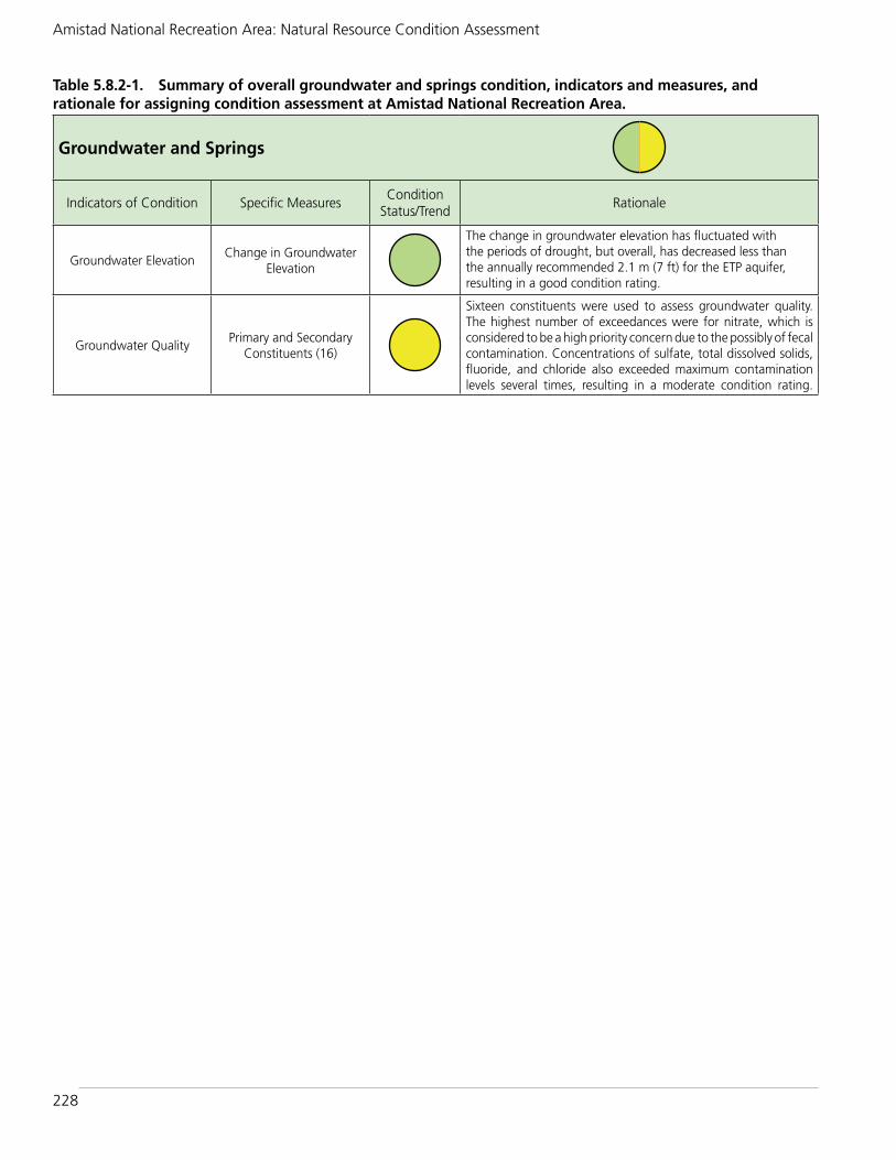
228
Amistad National Recreation Area: Natural Resource Condition Assessment
Table 5.8.2-1. Summary of overall groundwater and springs condition, indicators and measures, and rationale for assigning condition assessment at Amistad National Recreation Area.
Groundwater and Springs
Indicators of Condition Specific MeasuresCondition
Status/TrendRationale
Groundwater ElevationChange in Groundwater
Elevation
The change in groundwater elevation has fluctuated with the periods of drought, but overall, has decreased less than the annually recommended 2.1 m (7 ft) for the ETP aquifer, resulting in a good condition rating.
Groundwater QualityPrimary and Secondary
Constituents (16)
Sixteen constituents were used to assess groundwater quality. The highest number of exceedances were for nitrate, which is considered to be a high priority concern due to the possibly of fecal contamination. Concentrations of sulfate, total dissolved solids, fluoride, and chloride also exceeded maximum contamination levels several times, resulting in a moderate condition rating.
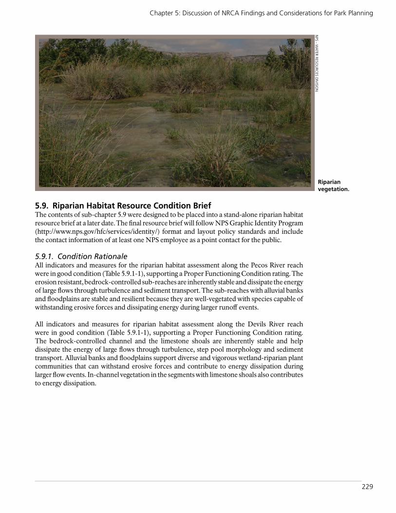
229
Chapter 5: Discussion of NRCA Findings and Considerations for Park Planning
5.9. Riparian Habitat Resource Condition BriefThe contents of sub-chapter 5.9 were designed to be placed into a stand-alone riparian habitat resource brief at a later date. The final resource brief will follow NPS Graphic Identity Program (http://www.nps.gov/hfc/services/identity/) format and layout policy standards and include the contact information of at least one NPS employee as a point contact for the public.
5.9.1. Condition RationaleAll indicators and measures for the riparian habitat assessment along the Pecos River reach were in good condition (Table 5.9.1-1), supporting a Proper Functioning Condition rating. The erosion resistant, bedrock-controlled sub-reaches are inherently stable and dissipate the energy of large flows through turbulence and sediment transport. The sub-reaches with alluvial banks and floodplains are stable and resilient because they are well-vegetated with species capable of withstanding erosive forces and dissipating energy during larger runoff events.
All indicators and measures for riparian habitat assessment along the Devils River reach were in good condition (Table 5.9.1-1), supporting a Proper Functioning Condition rating. The bedrock-controlled channel and the limestone shoals are inherently stable and help dissipate the energy of large flows through turbulence, step pool morphology and sediment transport. Alluvial banks and floodplains support diverse and vigorous wetland-riparian plant communities that can withstand erosive forces and contribute to energy dissipation during larger flow events. In-channel vegetation in the segments with limestone shoals also contributes to energy dissipation.
NPS - W
ATER RESOU
RCES D
IVISIO
N
Riparian vegetation.

230
Amistad National Recreation Area: Natural Resource Condition Assessment
Table 5.9.1-1. Summary of overall riparian habitat condition, indicators and measures, and rationale for assigning condition at Amistad National Recreation Area.
Riparian Habitat
Indicators of Condition
Specific MeasuresCondition
Status/TrendRationale for Pecos River Rationale for Devils River
Hydrology 4 Measures
The erosion resistant, bedrock-controlled sub-reaches are inherently stable and dissipate the energy of large flows through turbulence and sediment transport.
The bedrock-controlled channel and the limestone shoals are inherently stable and help dissipate the energy of large flows through turbulence, step pool morphology and sediment transport.
Vegetation 6 Measures
The sub-reaches with alluvial banks and floodplains are stable and resilient because they are well-vegetated with species capable of withstanding erosive forces and dissipating energy during larger runoff events
Alluvial banks and floodplains support diverse and vigorous wetland-riparian plant communities that can withstand erosive forces and contribute to energy dissipation during larger flow events. In-channel vegetation in the segments with limestone shoals also contributes to energy dissipation
Erosion / Deposition 4 Measures
All of the Pecos River riparian system’s erosion/deposition measures were in balance with the water and sediment being supplied by the watershed.
The balance between the river system and incoming sediment appeared to be in equilibrium throughout the entire Devils River assessment reach. No areas of areas of excessive sediment deposition and/or erosion were observed.

231
Chapter 5: Discussion of NRCA Findings and Considerations for Park Planning
5.10. Uplands Vegetation Resource Condition Brief The contents of sub-chapter 5.10 were designed to be placed into a stand-alone uplands vegetation resource brief at a later date. The final resource brief will follow NPS Graphic Identity Program (http://www.nps.gov/hfc/services/identity/) format and layout policy standards and include the contact information of at least one NPS employee as a point contact for the public.
5.10.1. Noteworthy HighlightsThree Texas ecoregions come together at Amistad NRA, and this is reflected in the park’s vegetation. These ecoregions are the South Texas Plains (also known as Tamaulipan Brushland), Edwards Plateau, and Trans-Pecos (also known as Chihuahuan Desert). The county of Val Verde, including Amistad NRA, experienced a substantial history of grazing by cattle, sheep, goats, and horses. This history (and other related disturbances) resulted in changes to the vegetation and soils. Even with this grazing history, the Recreation Area possesses one of the most diverse floras in the area (Poole 2013). Furthermore, a local Natural Resources Conservation Service (NRCS) expert suggested the park’s upland vegetation is probably among the best in condition in the county (Folts-Zettner 2014). The two sites considered to have the best condition (among the five visited during the field assessment) were described by Smeins (2014) as having potential for restoration and serving as educational/demonstration areas (for restoration) for the public.
5.10.2. Condition RationaleTo assess the condition of uplands at Amistad NRA, we used one indicator (Biotic Integrity) with five measures (Table 5.10.2-1). A rapid field assessment was conducted at five sites. Overall, condition was judged to be of significant concern. For the sites combined, four measures were considered to be of significant concern and one was considered to be of moderate concern. Condition for the measures at individual sites ranged from good to significant concern, but a majority of the measures for individual sites were of significant concern. A condition of good was assessed a total of two times (out of 25); a condition of moderate concern was assessed seven times (out of 25); and a condition of significant concern was assessed 16 times (out of 25). Among the five sites, three were considered of significant concern (when considering all five of their measures), and two were considered of moderate concern. The only individual measure at sites that was considered to be in good condition was the landscape-scale diversity measure (good at two sites). Invasive exotic plants did not appear to be of particular concern at any of
NPS - PITAYA
AN
D PRIC
KLY
PEAR
Pitaya and prickly pear.

232
Amistad National Recreation Area: Natural Resource Condition Assessment
the five sites visited, as exotic species were noted at only one of the sites. Although we consider the condition of upland vegetation as unchanging at this time, we recognize that stewardship of the land as a Recreation Area has provided a level of protection. Natural succession and the cessation of heavy grazing will allow the land some level of recovery over time. Our confidence in the assessment is medium due to uncertainties related to climatic conditions (e.g., drought conditions affecting some components of the vegetation), the qualitative nature of the assessment and the lack of ecological site descriptions at the time of assessment, and the relatively small number of sites visited.
Table 5.10.2-1. Summary of overall uplands vegetation condition, indicators and measures, and rationale for assigning condition at Amistad National Recreation Area.
Uplands Vegetation
Indicators of Condition Specific MeasuresCondition
Status/TrendRationale
Biotic Integrity 5 Measures
Based on the five measures (sites combined), overall condition is of significant concern. Four of the measures were judged to be of significant concern and one was of moderate concern. Based on the five individual sites visited in the Recreation Area, the overall condition is also of significant concern. Three of the sites were judged to be of significant concern (Sites 2, 3, and 5) and two are of moderate concern (Sites 1 and 4). The only individual measure at sites that was considered to be in good condition was the landscape-scale diversity measure at Sites 1 and 5. Invasive exotic plants did not appear to be of particular concern at any of the five sites visited. Exotic species were only noted at one of the sites. Surface soil (A horizon) was missing or heavily impacted at all of the sites visited.

233
Chapter 5: Discussion of NRCA Findings and Considerations for Park Planning
5.11. Exotic Plants Resource Condition BriefThe contents of sub-chapter 5.11 were designed to be placed into a stand-alone exotic plants resource brief at a later date. The final resource brief will follow NPS Graphic Identity Program (http://www.nps.gov/hfc/services/identity/) format and layout policy standards and include the contact information of at least one NPS employee as a point contact for the public.
5.11.1. Condition RationaleThe condition of exotic plants at Amistad National Recreation Area is of significant concern. We evaluated exotic plants using two indicators, with four measures (Table 5.11.1-1). The significance of exotic plant impact measure for the potential to alter native plant communities indicator examined species’ innate ability to become a pest. This measure utilized the ranking system from the Handbook for Ranking Exotic Plants (Heibert and Stubbendieck 1993). Fourteen of the 35 exotic plant species (40%) found during CHDN monitoring and the 2014 rapid assessment were ranked as either highest or high for their significance of exotic plant impact. Fourteen additional species (40%) were of medium concern. Based on the fact that the majority of exotic plant species found in the park are at medium to highest concern for their innate ability to become a pest, we found the condition for this indicator of significant concern. The prevalence of exotic plants indicator had three measures: extent (how often an exotic species was detected during monitoring), density (how many individuals of exotic plant species found per sampling unit) and distribution (where the exotic plants were found). Exotic plants had a wide extent. They were found in more than 56% of the blocks monitored in annual surveying between 2011-2014 and also in more than 56% of the plots sampled in the 2014 rapid assessment. Hence, the extent of exotic plants in the recreation area is of significant concern. Exotic plants were found mostly in medium to low densities in the park indicating a moderate level of concern for this measure. The distribution of exotic plants is also of significant concern. They are found in all areas of the park that were surveyed, including eight species that were found along the majority of high priority vectors and four species found in the majority of the rapid assessment areas. Further, by combining the four measures and evaluating the species on an individual basis, five exotic plant species were in a condition of significant concern, and 10 species were in moderate condition.
NPS - A
FRICA
N RU
E
African rue, a non-native plant.

234
Amistad National Recreation Area: Natural Resource Condition Assessment
Table 5.11.1-1. Summary of overall exotic plants condition, indicators and measures, and rationale for assigning condition assessment at Amistad National Recreation Area.
Exotic Plants
Indicators of Condition Specific MeasuresCondition
Status/TrendRationale
Potential to Alter Native Plant Communities
Significance of Exotic Plant Impact
This measure was based on the premise that species with the highest innate ability to become a pest generally cause the most severe problems in natural ecosystems. Fourteen of the 35 species of exotic plants found during CHDN monitoring were ranked as having the highest or high innate ability to become a pest. Therefore, we consider this measure to be of significant concern.
Prevalence of Exotic Plants
Extent of Exotic
Exotic plants were found in 56.7% of the blocks along high priority vectors. Thirty-five exotic species were found during monitoring between 2011-2014, including 3 species that were found in more than 25% of vector blocks. Fourteen species were found during the 2014 rapid assessment, including three species (Cynodon dactylon, Nicotiana glauca and Tamarix ramosissima) that had a significantly greater extent in rapid assessment plots than vector blocks. Other species were less prevalent in rapid assessment plots including Bothriochloa ischaemum and Cenchrus ciliaris. Exotic plants were present in 56.4% of rapid assessment plots.
Density of Exotic
Most of the exotic species occurrences in Amistad NRA were in moderate to low densities in monitored parts of the site. Species were most often found in density class 2 (scattered patchy), although Cynodon dactylon occurred in density class 3 (patchy) or higher 20.4% of the time.
Distribution of Exotic
Exotic plants were found in widely distributed in the park, especially along the high priority vectors. Two species, Bothriochloa ischaemum and Cenchrus ciliaris, were found along all 13 vectors and in all 6 rapid assessment areas. Cynodon dactylon was found in all rapid assessment areas and monitored vectors except the Nature Trail.

235
Chapter 5: Discussion of NRCA Findings and Considerations for Park Planning
5.12. Landbirds Resource Condition BriefThe contents of sub-chapter 5.12 were designed to be placed into a stand-alone landbirds resource brief at a later date. The final resource brief will follow NPS Graphic Identity Program (http://www.nps.gov/hfc/services/identity/) format and layout policy standards and include the contact information of at least one NPS employee as a point contact for the public.
5.12.1. Noteworthy HighlightsApproximately 260 bird species have been reported to occur at the national recreation area, with 146 of the species observed during the 2010-2013 RMBO surveys. Fifty-three of the species are considered species of conservation concern by one or more organization. Twelve of these 53 species have high conservation potential at the Recreation Area, because they are within their normal breeding ranges and breeding habitat exists for them at the park. One of these twelve species is the Interior Least Tern (i.e., Least Tern, interior population), which is listed under the Endangered Species Act and by the State of Texas (Texas Parks and Wildlife Department) as endangered.
5.12.2. Condition RationaleThe condition of breeding landbirds at the national recreation area was assessed using one indicator, species occurrence (presence/absence), and is good (Table 5.12.2-1). We evaluated species occurrence using three measures/in three contexts (temporal, spatial, and conservation contexts), all of which were determined to be in good condition. Although our assessment was based on limited data (four years of recent RMBO data, one inventory from 1975-1976, two mist-net sampling efforts over 1998-2002, and a few years of BBS data), we found no justification to warrant concern for breeding landbird occurrence at Amistad NRA at this time. The temporal species occurrence comparison found 39 species that were not detected during recent RMBO surveys, but none of the 39 species fall into the “exists” breeding habitat class, in which the habitat at the Recreation Area is characteristic of the habitat(s) where the species would be expected to breed; they fall into the “possibly exists” (eight species) or “limited to none” (31 species) categories. Further, of the “possibly exists” species, all were recorded only in small numbers in the earlier study/studies. Also, 28 different (new) species were observed in recent RMBO surveys but not in the older inventory/surveys. The spatial comparison found that seven species were observed during surveys in the vicinity of the park but not during RMBO surveys. Of these seven species, only one falls into the “exists” breeding habitat class
NPS - W
ILD TU
RKEY
S
Wild turkeys.

236
Amistad National Recreation Area: Natural Resource Condition Assessment
and is within its normal breeding range. This one species is on the NPSpecies List for the park and is described as uncommon. Fifty-three species that have been recorded at the Recreation Area are listed by one or more organization as being of conservation concern. Of these, 12 are considered as having high conservation potential; these are species that are within their normal breeding range, and sufficient habitat exists at the park to support their breeding. All of the species have been observed during recent surveys at the park, with some being observed in relatively high numbers. The condition of landbirds at the Recreation Area is good. Adequate information does not exist at this time to evaluate trends in the condition.
Table 5.12.2-1. Summary of overall landbirds condition, indicators and measures, and rationale for assigning condition at Amistad National Recreation Area.
Landbirds
Indicators of Condition Specific MeasuresCondition
Status/TrendRationale
Species Occurrence
Temporal Context
Out of the birds observed by LoBello (1976) during the March-August period, as well as those recorded by Larson (2004a, b, c) and Larson (2005) in 1998-2002, 39 were not observed on recent RMBO surveys in 2010-2013. However, none of the 39 species are in the “exists” breeding habitat class. The majority of the species are in the “limited to none” habitat class. Additionally, 28 species were observed in the 2010-2013 RMBO surveys that were not observed in the earlier surveys. In a temporal context, the condition of breeding landbirds at the Recreation Area is good. Data are available for a relatively small number of years, so no trend information is available at this time.
Spatial Context
In a comparison of BBSs in the vicinity of the Recreation Area to RMBO surveys within the Recreation Area, there were seven species that were not observed at the park from 2010-2013. However, of these seven species, only one falls into the “exists” breeding habitat class and is within its normal breeding range. Five of the species occur on the NPSpecies list for the park, but four are noted as “uncommon” and one is noted as a migrant. Based on this comparison, the condition of breeding landbirds is good. Because data are available for a relatively small number of years, no trend information is available at this time.
Conservation Context
There are 53 species that have been observed during 2010-2013 and/or older surveys (1975-1976 and 1998-2002) that are listed by one or more organization as being of conservation concern. We believe that 12 of these species have high conservation potential at the Recreation Area. These are species that are within their normal breeding range and sufficient habitat exists at the Recreation Area to support breeding. All of these species have been observed on recent RMBO surveys (in one or more years) or in annual surveys specifically for the Least Tern. Therefore, we consider the condition of species of conservation concern at the Recreation Area to be good. We do not have sufficient data to justify a trend in the condition at this time.

237
Chapter 5: Discussion of NRCA Findings and Considerations for Park Planning
5.13. Mammals Resource Condition BriefThe contents of sub-chapter 5.13 were designed to be placed into a stand-alone mammals resource brief at a later date. The final resource brief will follow NPS Graphic Identity Program (http://www.nps.gov/hfc/services/identity/) format and layout policy standards and include the contact information of at least one NPS employee as a point contact for the public
5.13.1. Noteworthy Highlights:A total of 55 mammal species have been reported (confirmed) to occur at the national recreation area, with an additional 15 that are probably present (Bahm and Mueller 2011). Of the 70 species (including two reported by park staff), over 20 are listed as Texas Species of Greatest Conservation Need, with one of them also being listed as threatened with the State.
5.13.2. Condition Rationale: The current condition of mammals at (native and non-native) at the national recreation area was assessed using one indicator, species occurrence (presence/absence), and condition is unknown (Table 5.13.2-1). There is little current survey information available on mammals at the park. The most recent widespread surveys were conducted by Bahm and Mueller (2011) in 2003-2004. Although condition cannot be determined, the 2003-2004 work, as well as earlier surveys, provides baseline information for future assessment. However, some concern does exist due to the non-native species, especially exotic mouflon sheep and feral pigs and cats.
NPS - FA
WN
AT ROU
GH
CA
NY
ON
PICN
IC SH
ELTER
Fawn at Rough Canyon picnic shelter.

238
Amistad National Recreation Area: Natural Resource Condition Assessment
Table 5.13.2-1. Summary of overall mammal condition, indicators and measures, and rationale for assigning condition at Amistad National Recreation Area.
Mammals
Indicators of Condition Specific MeasuresCondition
Status/TrendRationale
Species Occurrence Presence / Absence
The most recent mammal surveys at the Recreation Area were conducted by Bahm and Mueller (2011) in 2003-2004. Although current condition cannot be determined at this time, the 2003-2004 work (as well as earlier work) provides important information for future monitoring and assessment. One of the 68 species reported by Bahm and Mueller (2011) as occurring/potentially occurring at the park is State listed as threatened. Approximately 20 species are listed as Texas Species of Greatest Conservation Need. Nine of the species (13%) are non-native species, and at least some of them (e.g., European mouflon sheep, feral pigs, and feral cats) negatively impact native wildlife and/or other park resources.

239
Chapter 5: Discussion of NRCA Findings and Considerations for Park Planning
5.14. Jaguarundi Resource Condition BriefThe contents of sub-chapter 5.14 were designed to be placed into a stand-alone jaguarundi resource brief at a later date. The final resource brief will follow NPS Graphic Identity Program (http://www.nps.gov/hfc/services/identity/) format and layout policy standards and include the contact information of at least one NPS employee as a point contact for the public.
5.14.1. Noteworthy HighlightsThe jaguarundi is one of the rarest cats in Texas (along with the jaguar; Texas Parks and Wildlife Department [TPWD] 2011). The Gulf Coast jaguarundi is listed as endangered by both the U.S. Fish and Wildlife Service (USFWS) and the TPWD; it is listed as threatened in Mexico. Jaguarundis have not been confirmed in Texas since 1986, and none have been documented in the literature at Amistad NRA (USFWS 2013). However, the park is approximately 35 miles north of the area that the USFWS considers as the potential jaguarundi range in the U.S.
5.14.2. Condition RationaleThe current condition of jaguarundi at the national recreation area was assessed using one indicator, species occurrence (presence/absence), and condition is unknown (Table 5.14.2-1). Although there have been some reported sightings of the subspecies at the park, they have been unconfirmed. The USFWS (2013) found no substantiated reports of jaguarondis in Texas since 1986, even in the counties in southern Texas bordering Mexico.
©W
IKIM
EDIA
COM
MO
NS
Jaguarundi.
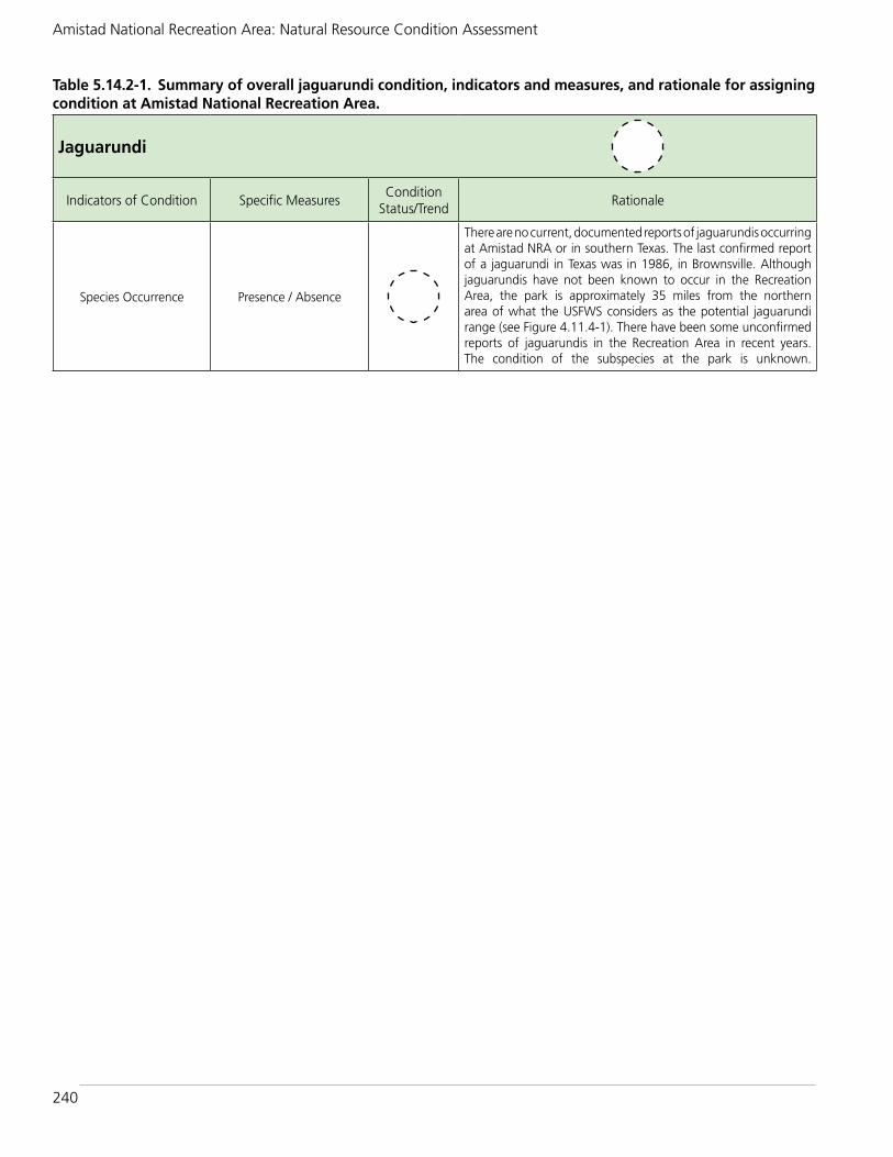
240
Amistad National Recreation Area: Natural Resource Condition Assessment
Table 5.14.2-1. Summary of overall jaguarundi condition, indicators and measures, and rationale for assigning condition at Amistad National Recreation Area.
Jaguarundi
Indicators of Condition Specific MeasuresCondition
Status/TrendRationale
Species Occurrence Presence / Absence
There are no current, documented reports of jaguarundis occurring at Amistad NRA or in southern Texas. The last confirmed report of a jaguarundi in Texas was in 1986, in Brownsville. Although jaguarundis have not been known to occur in the Recreation Area, the park is approximately 35 miles from the northern area of what the USFWS considers as the potential jaguarundi range (see Figure 4.11.4-1). There have been some unconfirmed reports of jaguarundis in the Recreation Area in recent years. The condition of the subspecies at the park is unknown.

241
Chapter 5: Discussion of NRCA Findings and Considerations for Park Planning
5.15. Herpetofauna Resource Condition BriefThe contents of sub-chapter 5.15 were designed to be placed into a stand-alone herpetofauna resource brief at a later date. The final resource brief will follow NPS Graphic Identity Program (http://www.nps.gov/hfc/services/identity/) format and layout policy standards and include the contact information of at least one NPS employee as a point contact for the public.
5.15.1. Noteworthy HighlightsA total of 51 herpetofaunal species have been reported (confirmed) to occur at the national recreation area, with 45 of the species observed during 2003-2004 surveys by the University of Arizona (Prival and Goode 2011). Of the 45 species recorded during the surveys (and six other species observed during 1975-1976 surveys and/or on the NPSpecies list for the park), eight are listed as species of conservation concern (as either state-threatened or Texas Species of Greatest Conservation Need).
5.15.2. Condition RationaleThe current condition of amphibians and reptiles at the national recreation area was assessed using one indicator, species occurrence (presence/absence), and condition is unknown (Table 5.15.2-1). There is no current information available on the herpetofauna of the park. The most recent surveys were conducted by the University of Arizona in 2003-2004 (Prival and Goode 2011). Although condition cannot be determined, the 2003-2004 work, as well as an earlier survey from 1975-1976, provides baseline information for future assessment.
NPS - TEX
AS H
ORN
ED LIZA
RD
Texas Horned lizard.

242
Amistad National Recreation Area: Natural Resource Condition Assessment
Table 5.15.2-1. Summary of overall herpetofauna condition, indicators and measures, and rationale for assigning condition at Amistad National Recreation Area.
Herpetofauna
Indicators of Condition Specific MeasuresCondition
Status/TrendRationale
Species Occurrence Presence / Absence
There is no current information available on amphibians and reptiles at the Recreation Area. The most recent surveys were conducted by Prival and Goode (2011) in 2003-2004. Although condition can not be determined at this time, the 2003-2004 work (as well as earlier work) provides baseline information for future monitoring and assessment. Four of 45 species observed in 2003-2004 are listed as threatened with the State, and four additional species (as well as those threatened) are listed as Texas Species of Greatest Conservation Need.

243
Chapter 5: Discussion of NRCA Findings and Considerations for Park Planning
5.16. Small Native Fishes Resource Condition BriefThe contents of sub-chapter 5.16 were designed to be placed into a stand-alone small native fishes resource brief at a later date. The final resource brief will follow NPS Graphic Identity Program (http://www.nps.gov/hfc/services/identity/) format and layout policy standards and include the contact information of at least one NPS employee as a point contact for the public.
5.16.1. Condition RationaleTo assess the condition of non-game fish, we used one indicator, species occurrence, and one measure, presence/absence (Table 5.16.1-1). A total of 56 non-sport/non-commercial fish were identified for Amistad NRA, with five (8.9%) of those representing introduced species. Eight (14.3%) of the non-game fish were cited in the literature as occurring in the Devils, Pecos, and Rio Grande Rivers prior to inundation of Amistad Reservoir, with one species, Amistad gambusia (Gambusia amistadensis) now extinct (Hendrickson et al. 2012). An additional 10 species are listed as historical and no longer present in the park (NPSpecies 2015), although, Moring (2012) documented three of these ‘historical species’ in the Pecos River and two of those three in the Devils River during the most recent survey (2006-2007 field season). Most of the species identified as historical are species of greatest conservation need. It is for these reasons that we assessed the condition of small native fishes within the national recreation area to be of significant concern.
©C
HA
D TH
OM
AS - RIO
GRA
ND
E SILVERY
MIN
NO
W
Texas Horned lizard.
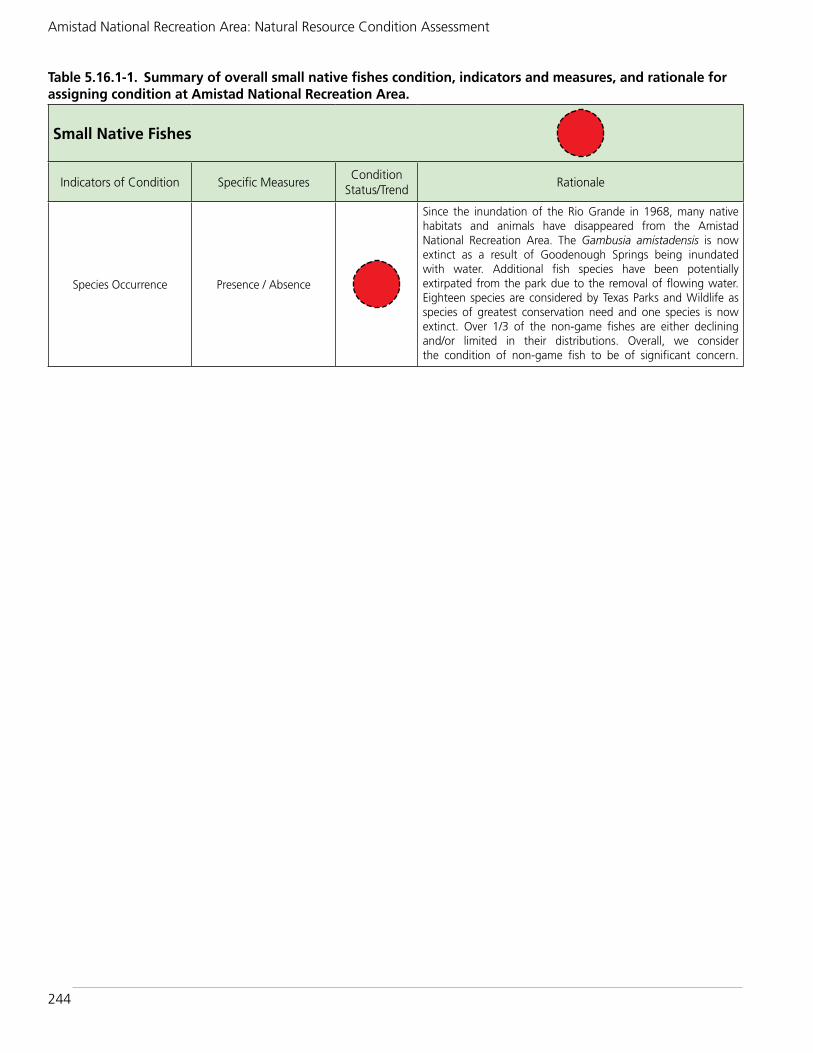
244
Amistad National Recreation Area: Natural Resource Condition Assessment
Table 5.16.1-1. Summary of overall small native fishes condition, indicators and measures, and rationale for assigning condition at Amistad National Recreation Area.
Small Native Fishes
Indicators of Condition Specific MeasuresCondition
Status/TrendRationale
Species Occurrence Presence / Absence
Since the inundation of the Rio Grande in 1968, many native habitats and animals have disappeared from the Amistad National Recreation Area. The Gambusia amistadensis is now extinct as a result of Goodenough Springs being inundated with water. Additional fish species have been potentially extirpated from the park due to the removal of flowing water. Eighteen species are considered by Texas Parks and Wildlife as species of greatest conservation need and one species is now extinct. Over 1/3 of the non-game fishes are either declining and/or limited in their distributions. Overall, we consider the condition of non-game fish to be of significant concern.

245
Chapter 5: Discussion of NRCA Findings and Considerations for Park Planning
5.17. Exotic Mussels Resource Condition BriefThe contents of sub-chapter 5.17 were designed to be placed into a stand-alone exotic mussels resource brief at a later date. The final resource brief will follow NPS Graphic Identity Program (http://www.nps.gov/hfc/services/identity/) format and layout policy standards and include the contact information of at least one NPS employee as a point contact for the public.
5.17.1. Noteworthy HighlightsSince the discovery of invasive mussels in western U.S. waters, quagga and zebra mussels have spread to 48 waterbodies west of the 100th Meridian. Only the five northwestern states have avoided introductions so far. The rapid infestation of North American waterways by these invasive mussels has been facilitated by their ability to disperse during all life stages. A main focus of Amistad NRA staff is to prevent the spread to the park.
5.17.2. Condition RationaleThe condition at Amistad NRA is good (Table 5.17.2-1), meaning exotic mussels are currently not found. Although the invasive, exotic mussels (zebra and quagga) are currently not present at Amistad NRA, regional trends indicate high risk for invasion and serious impacts as a result. An invasive mussel population in Lake Amistad could seed the Rio Grande River basin all the way to the Gulf of Mexico. Amistad is at high risk of invasion both behaviorally (boats from across the nation launch here every year) and ecologically (the high-calcium, low-salinity water would be ideal habitat for mussels).
Quagga and zebra mussels photos and descriptions.
©M
YRIA
H RIC
HERSO
N

246
Amistad National Recreation Area: Natural Resource Condition Assessment
Table 5.17.2-1. Summary of overall exotic mussels condition, indicators and measures, and rationale for assigning condition at Amistad National Recreation Area.
Exotic Mussels
Indicators of Condition Specific MeasuresCondition
Status/TrendRationale
Species Occurrence Presence / Absence
The invasive, exotic mussels (zebra and quagga) are not present at Amistad NRA. The trend, however, indicates high risk.

247
Chapter 5: Discussion of NRCA Findings and Considerations for Park Planning
5.18. Literature CitedBahm, M.A., and J.M. Mueller. 2011. The
mammals of Amistad National Recreation Area, Texas: 2005 final report. Natural Resource Technical Report NPS/CHDN/ NRTR—2011/492. National Park Service, Fort Collins, Colorado.
Certified Species List: NPSpecies - The National Park Service Database. IRMA portal version. Available at https://irma.nps.gov/App/Species/Search (certified species list - park status view accessed May 15, 2015).
Folts-Zettner, T. 2014. Amistad National Recreation Area vegetation assessment notes, June 3-4, 2014. Assessment by F. Smeins, T. Folts-Zettner, S. Howard, and W. Weckesser.
Hendrickson, Dean A. and Adam E. Cohen. 2012. Fishes of Texas Project and Online Database (www.fishesoftexas.org). Published by Texas Natural History Collection, a division of Texas Natural Science Center, University of Texas at Austin. Accessed (June 11, 2015).
Hiebert, R. D. and J. Stubbendieck. 1993. Handbook for Ranking Exotic Plants for Management and Control. Natural Resources Report NPS/NRM, RWO/NRR-93/08. National Park Service, Denver, Colorado.
Larson, D. H. 2004a. 2000 Bird migrationreport for Amistad National RecreationArea. April 2004. National Park Service.
Larson, D. H. 2004b. 2001 Bird bandingreport for Amistad National RecreationArea. April 2004. National Park Service.
Larson, D. H. 2004c. 2002 Bird bandingreport for Amistad National RecreationArea. April 2004. National Park Service.
Larson, D. H. 2005. Summary Report of the Amistad National Recreation Area MAPS Project for 1998-2002. National Park Service.
LoBello, R. L. 1976. Vertebrates of the LakeAmistad National Recreation Area, Texas. M.S. Thesis, Sul Ross State University,Alpine, Texas.
Moring, J.B., 2012, Water quality and the composition of fish and macroinvertebrate communities in the Devils and Pecos Rivers in and upstream from the Amistad National Recreation Area, Texas, 2005-7: U.S. Geological Survey Scientific Investigations Report 2012–5038, 70 p.
National Park Service. 2012. A Call to Action: Preparing for a Second Century of Stewardship and Engagement. Washington, D.C. 28pp
National Park Service. 2016. Amistad National Recreation Area foundation document - E4- post-workshop-initial park review draft. U.S. Department of the Interior. 27 pages.
Poole, J.M. 2013. An inventory of the vascular plants of Amistad National Recreation Area, Val Verde Co., Texas. Lundellia 16:8-82.
Prival, D., and M. Goode. 2011. Chihuahuan Desert national parks reptile and amphibian inventory. Natural Resource Technical Report NPS/CHDN/NRTR—2011/489. National Park Service, Fort Collins, Colorado.
Purchase, Carol E., David Larson, Mark D. Flora, and John Reber. 2001. Amistad National Recreation Area, Texas water resources scoping report. Technical Report NPS/NRWRD/NRTR-2001/295. 106 p.
Smeins, F. 2014. Amistad National Recreation Area vegetation assessment, June 3-4, 2014. Assessment by F. Smeins, T. Folts-Zettner, S. Howard, and W. Weckesser.
Texas Commission on Environmental Quality. 2014. 2014 Texas integrated report of surface water quality- Texas 303(d) List (Category 5) - Assessment results for Basin 23 - Rio Grande River. Available at

248
Amistad National Recreation Area: Natural Resource Condition Assessment
https://www.tceq.texas.gov/waterquality/assessment/14twqi/14txir (accessed November 12, 2015).
Texas Parks and Wildlife Department (TPWD). 2011. Jaguarundi Fact Sheet. Accessed September 14, 2011, as cited
in USFWS (2013). [Still available online June 27, 2014].
U.S. Fish and Wildlife Service. 2013. Gulf Coast jaguarundi (Puma yagouaroundi cacomitli) Recovery Plan, First Revision. U.S. Fish and Wildlife Service, Southwest Region. Albuquerque, New Mexico.

249
Appendix A: Team Members and Subject Matter Experts
Appendix A: Team Members and Subject Matter ExpertsTable A.1. Amistad National Recreation Area NRCA Project Team Members
Amistad NRA NRCA Project Team
Jeff Albright, NPS Water Resources Division’s Coordinator of the NRCA Series
Rob Bennetts, NPS Southern Plains Inventory and Monitoring Network Program Manager
Nina Chambers, Northern Rockies Conservation Cooperative, Writer/Editor
Alan Cox, NPS Amistad NRA Superintendent
Tomye Folts-Zettner, NPS Southern Plains Inventory and Monitoring Network Biologist
Gregory Garetz, NPS Amistad NRA Chief of Education and Resource Management
Sarah Howard, NPS Amistad NRA Biologist
Jack Johnson, NPS Amistad NRA Integrated Resources Program Manager/Park Archeologist
Allyson Mathis, Utah State University Science Writer
Donna Shorrock, NPS Intermountain Region Natural Resource Condition Assessment Regional Coordinator
Heidi Sosinski, NPS Southern Plains Inventory and Monitoring Network Data Manager
Brian Storm, NPS Amistad NRA Archeological Technician
Kim Struthers, Utah State University, Writer/Editor
Patty Valentine-Darby, University of West Florida, Biologist and Writer/Editor
Wendy Weckesser, NPS Amistad NRA Botanist and Biological Science Technician
Table A.2. Amistad National Recreation Area NRCA Subject Matter Experts
Subject Matter Expert Topic Project Deliverables
Jack Johnson, National Park Service Amistad NRA Integrated Resources Program Manager/Park Archeologist
All Park Expert Review
Sarah Howard, National Park Service Amistad NRA Biologist
AllPark Expert Review and assisted with uplands and riparian habitat field assessments
Wendy Weckesser, National Park Service Amistad NRA Botanist and Biological Science Technician
UplandsPark Expert Review and assisted with uplands field assessments
Marcia Wilson, National Park Service Chihuahuan Desert Inventory and Monitoring Network Program Manager
Chapter 2 I&M expert review
Hildy Reiser, National Park Service Chihuahuan Desert Inventory and Monitoring Network Science Advisor (retired)
Chapter 3, Geology, Herpetofauna, Jaguarundi, Landbirds, Night Sky
I&M expert review
Jonathin Horsley, National Park Service Chihuahuan Desert Inventory and Monitoring Network Exotic/Invasive Plant Monitoring Crew Leader
Exotic Plants and Chapter 2
Reviewed exotic plants and chapter 2
Julie Christian, National Park Service Chihuahuan Desert Inventory and Monitoring Network Ecologist - Field Coordinator
Exotic PlantsConsulted with during exotic plants section development.
Chad Moore, National Park Service Natural Sounds and Night Skies Division Night Sky Program Manager
Night SkyNPS guidance on night sky monitoring and reviewed of night sky section
Jeremy White, National Park Service Natural Sounds and Night Skies Division
Night Sky Reviewed night sky section

250
Amistad National Recreation Area: Natural Resource Condition Assessment
Subject Matter Expert Topic Project Deliverables
Colleen Flanagan, National Park Service Air Resources Division Ecologist
Air Quality Reviewed air quality section
Tim Connors, National Park Service Geologic Resources Division, Geologist
Geology Reviewed geology section
Vince Santucci, National Park Service Geologic Resources Division, Senior Paleontologist/GRD Liaison
Geology Reviewed geology section
Michael Martin, National Park Service Water Resources Division Hydrologist
Riparian HabitatConducted on-site riparian habitat rapid assessment and co-authored report from which assessment was based.
Joel Wagner, National Park Service Water Resources Division, Wetlands Program Leader
Riparian HabitatConducted on-site riparian habitat rapid assessment and co-authored report from which assessment was based.
Christine Taliga, Natural Resources Conservation Service Revegetation Technical Specialist
Riparian HabitatConducted on-site riparian habitat rapid assessment and co-authored report from which assessment was based.
Fred Smeins, Texas A&M University, Professor of Ecology in the Department of Rangeland Ecology and Management
Upland VegetationConducted on-site upland vegetation rapid assessment and co-authored field notes from which assessment was based.
Myron Chase, National Park Service - Intermountain Regional Office Regional IPM and Invasive Species Coordinator
Exotic Mussels Reviewed exotic mussels section
Authors Who Served as Subject Matter Experts Topic Project Deliverables
Tomye Folts-Zettner National Park Service SouthernPlains Inventory and Monitoring Network Biologist/Botanist
Upland Vegetation and Exotic Plants
Conducted on-site upland vegetation rapid assessment and co-authored field notes from which assessment was based. Reviewed uplands and exotic plants sections.
Heidi Sosinski, National Park Service Southern PlainsInventory and Monitoring Network Data Manager
All Maps, graphs, and graphics
Table A.2. Amistad NRA NRCA Subject Matter Experts continued.

251
Appendix B: Bortle Dark-Sky Scale
Appendix B: Bortle Dark-Sky Scale

252
Amistad National Recreation Area: Natural Resource Condition Assessment

253
Appendix C: Upland Vegetation Rapid Assessment
Appendix C: Upland Vegetation Rapid Assessment, June 3-4, 2014
This appendix includes two separate components, a three-page report, by Fred Smeins of Texas A&M University, on the June 2014 vegetation assessment (presented first), and two pages of field assessment notes by Tomye Folts-Zettner of the Southern Plains Inventory and Monitoring Network (presented second).
Amistad Vegetation Assessment, June 3-4, 2014By Fred E. Smeins, Rangeland Ecologist, Ecosystem Science and Management Department, Texas A&M University, College Station, Texas
IntroductionA two day observational survey of five sites on the Amistad National Recreation Area (NPS) was conducted to assess the current status of the vegetation of the sites within the Area. Tomye Folts-Zettner, Sarah Howard and Wendy Weckesser participated in the assessment. This report will present two components of the assessment. First a general historical characterization of the vegetation of the Lake Amistad area will be presented to set the stage for the current condition of the vegetation in the area. Second a qualitative view of the condition of the vegetation of the five specific sites will be described.
General Vegetation Condition of the Lake Amistad AreaThe natural vegetation of the area consists of a diverse array of grasses, forbs and shrubs sorted into various growth form and species combinations and amounts across the diverse topographic and soil variation that exists across the area. Generally the topography is a mosaic of upland, relatively flat to gently sloping sites interspersed with moderate to steeply sloping areas and is dissected by small ephemeral and intermittent drainages. Most of the soils are relatively shallow loams and clay loams which are gravelly and/or stony and, where even a minor slope exists, and if the vegetation cover is reduced, they tend to be easily eroded. The area receives on average 18 inches of annual precipitation. More importantly precipitation is highly variable across seasons and years and severe, long term droughts are common. Thus the vegetation has evolved to be naturally responsive to the background topography/soil and weather variation that exists over time and this contributes to the high plant species diversity across the landscape. Details on geology, soils, vegetation and land use are available in the Val Verde County soil survey (Golden et al. 1982 or online at the NRCS website).
While natural herbivory by bison (historically), white-tail deer, lagomorphs, insects, etc. is a common element of this area most of these organisms vary their population numbers up or down in response to changes in weather variation and the corresponding variation in vegetation production and shifts in species composition. To a large extent this weather/herbivory interaction contributes to the evolution of a rather great amount of plant species diversity in the vegetation with considerable niche complimentary expressed in response to the temporal and spatial biotic/abiotic variability that exists. Additionally, periodic fires would burn areas, particularly when years with high precipitation that would produce considerable biomass amounts and continuity were followed by dry years or seasons. These fires would contribute to the continual dance between dominance of the herbaceous and woody components of the vegetation.
The area began to be settled by Europeans in the 1850s and most became ranchers which is the only kind of agriculture that is feasible over most of the region due to the highly variable topographic/soil/weather conditions. The early ranchers brought in domestic cattle, sheep,

254
Amistad National Recreation Area: Natural Resource Condition Assessment
goats and horses as their primary products to be produced from the land. While that is not necessarily a bad thing, if animal numbers are controlled relative to the vegetation production and species composition that exists, but it becomes highly destructive if excessive numbers of grazing and browsing animals are continually kept on the land. This is what occurred on much of the land in this region which resulted in reduction of vegetation cover, change in species composition, often increases in woody species cover and ultimately concomitant loss of soil which lowers the productive capacity of the land. This improper use of the land was often the result of lack of knowledge of how to manage these lands for those who came from the east where higher precipitation and better soils were more forgiving of poor management. Of course, greed may have also been the motivation in some instances. Whatever, the motivation the result has been a lowering of the productive potential of the land and marginalization of many plant species that were previously abundant but now scarce. Also over time this has assisted in the spread of exotic invasive species which are often competitive with the naturally occurring species. Also exotic wildlife species have been added to the grazing/browsing mix on the property. The overall consequence is that the vegetation and environment of the area has become substantially altered from its pre-European condition and in many, if not most, portions of the landscape will be unable to recover to what is once was. Thus the goal of current management must be to stop further degradation and where feasible restore those selected areas that have the soil conditions and species present that will allow recovery to some semblance of the original natural plant communities of the National Recreation Area. In spite of the significant alterations of the vegetation in recent decades the NRA still contains one of the most diverse floras in the area (Poole 2013) as well as a great variety of different plant communities (Cogan Technology, Inc. 2014).
As a characterization of the pre-European vegetation it is generally agreed by experienced observers and by scientific research that many upland plant communities had as major species components sideoats grama (Boutleoua curtipendula, the State grass of Texas), various feathery bluestems (Bothriochloa species), bristlegrasses (Setaria species), Arizona cottontop (Digitaria californica) and other grass and perennial forbs species that are today absent from or of limited abundance in most communities where they were previously dominants. Unfortunately, today many areas where they existed may not support them due to change in soil conditions or lack of seed source to aid in their natural regeneration. Also, many woody species, for example, Ceniza are considered to be much more abundant today than in the past due to changes in soil/vegetation conditions.
Assessment of Five Selected Sites(Details of local and landscape scale species composition, functional types and representative photographs prepared by Folts-Zettner as part of this report)
Site #1-Waypoint 11
Of the five sites assessed this one is one of two sites in relatively good condition. It has a good and relatively diverse ground cover of mid-successional, perennial C4 grasses with limited areas of bare soil. Late-successional perennial grasses and forbs are absent or of limited amounts, but current conditions may make it a candidate area for restoration/reintroduction of some of the late-successional species. Soils of this site are deeper than most soils on the area and appear to be less altered than soils on most others parts of the NRA. This is one of the soils that is generally higher in primary production than other soils on the Area. This site could serve as an educational/demonstration restoration area for the public.

255
Appendix C: Upland Vegetation Rapid Assessment
Site#2-Waypoint 12
This site appears to have suffered heavy grazing use in the past with the resultant loss of surface soil, and currently with much bare soil with rocks and gravel on the surface. Grass cover and diversity is very low and three-awn (Aristida) perennial grasses occur as widely scattered clumps across the site. Cenizo is the dominant shrub along with a good diversity of shrub and cactus species but perennial grasses and forb are few. There may be little practical potential to restore this area.
Site#3-Waypoint 13
This is an atypical site for the Area. It appears to have had past soil erosion and more recently it seems that erosional soil from an adjacent upslope area has been deposited on this site. The site in near the edge of the high flood mark of the reservoir. This along with its landscape position and periodic high water table may have altered its overall hydrology. There are several large mesquite and huisache trees across the site. Herbaceous species diversity is low. There is a fairly good ground cover of perennial grasses, mostly pink pappusgrass which is the dominant understory species.
Site #4-Waypoint 14
This is the second site that has good diversity of plants and is in generally good ecological condition. It occurs on an upland, flat ridge with what appears to be relatively good surface soil conditions although past erosion is evident. It has a good diversity of shrubs and cacti, perennial forbs are lacking, and perennial grasses are diverse but mostly early to mid-successional and occur largely under the canopy of the shrubs. This site may have practical potential for restoration/herbaceous species reintroduction.
Site#5-Waypoint 15
This area is located on a high narrow ridge which drops off to steep rocky slopes on the sides. It has high potential for runoff and erosion and much of the surface soil appears to be absent. Most of the surface is shallow, bare soil with exposed rocks and gravel. Very few perennial grasses and forbs occur but there is a good diversity of shrubs. It is unique in the presence of a large number of ocotillo plants. Its current plant community is likely the best that can develop on the site.

256
Amistad National Recreation Area: Natural Resource Condition Assessment
Amistad Vegetation Assessment, June 3-4, 2014Dr. Fred Smeins, Tomye Folts-Zettner, Sarah Howard, and Wendy Weckesser; By T. Folts-Zettner
Overall Consideration ● Few to no annual grass and forbs present; unknown if due to drought or grazing – possibly
more Fall-oriented phenology, but no seasonal remnants remain. ● From January 2011 through May of 2014, Val Verde County has spent 41 months in severe
to exceptional drought condition, 18 of those months in the extreme to exceptional ranking.
● Historic loss of soil’s A Horizon – local NRCS expert suggests park vegetation/habitat probably best found in county.
SITE #1 – 277 east side – waypoint 11 Moderate ConcernGeneral Notes: Signs of herbivory [especially curly mesquite (Hilaria berlangeri)]. No real evidence of grazing. Dead standing Roosevelt weed (Baccharis neglecta) to lake side of site from inundation, but new sprouts and growth evident.
Landscape Scale - Species Composition: Good. Toeslope just above inundation zone. Structural diversity. Good grass cover.
Local Scale – Species Composition: Moderate. Good diversity of graminoids, shrubs less diverse, few forbs, no annuals. Pink pappusgrass (Pappophorum bicolor) dominant graminoid. Other species: Rio Grande lovegrass (Eragrostis palmeri); Texas wintergrass (Nasella leucotricha), vine mesquite (Panicum obtusum); plains lovegrass (Eragrostis intermedia); dropseed (Sporobolus sp.); tridens (Tridens sp.); bristlegrass (Setaria sp.); honey mesquite (Prosopis glandulosa); Roosevelt weed (Baccharis neglecta); palo verde (Parkinsonia aculeata); huisache (Acacia farnesiana); croton (Croton sp.)
Annual Species Response: Significant concern. Few annual forbs or grasses.
Proportion of Functional Groups: Moderate. Good diversity but perennial forbs diminished in quantity and annual forbs missing. C4 grass > woody >>> perennial forb >> annual forb.
C3 vs. C4: Significant concern. Good C4 grasses but no C3 grasses. Uncertain if due to drought, herbivory or phenology.
SITE #2 – 277 west side – waypoint 12 Significant ConcernGeneral Notes: Cenizo (Leucophyllum frutescens) dominated mixed shrubland.
Landscape Scale – Species Composition: Moderate. Fairly common community throughout area, although somewhat more shrub diversity. Few to no graminoids. Cenizo dominated. Other species: threeawn (Aristida species); hairy tridens (Tridens muticus); pale verde (Parkinsonia aculeate); guayacan (Guaiacum angustifolium); althorn goatbush (Castela erecta ssp. Texana); sacahuiste (Nolina texana); sotol (Dasylirion texanum); perezia (Trixis inula); guajillo (Acacia berlandieri); agarita (Mahonia trifoliate); narrow-leaf heliotrope (Heliotropium torreyi); prickly pear (Opuntia sp.); Torreys yucca (Yucca torreyi); honey mesquite (Prosopis glandulosa); Texas persimmon (Diospyros texana); Dutchman’s breeches (Thamnosma texana); grassland croton (Croton dioicus); Polygala tweedyi.

257
Appendix C: Upland Vegetation Rapid Assessment
Local Scale – Species Composition: Significant concern. Shrubland is diverse; dominated by cenizo. Little to no forbs. Limited grasses.
Annual Species Response: Significant concern. Few to no annual forbs or grasses.
Proportion of Functional Groups: Significant concern. Shrub >>> subshrub>forbs>grass
C3 vs. C4: Significant concern. Few to no grasses and forbs of any type.
Site #3 – VC Trail east end – waypoint 13 Significant ConcernGeneral Notes: Huisache (Acacia minuata) woodland. “A” horizon gone, replaced by deposition/sediment. Good resources but this site is not meeting full potential. On toeslope above inundation zone.
Landscape Scale – Species Composition: Moderate. There are a few examples of this habitat throughout park.
Local Scale – Species Composition: Significant concern. Huisache dominated; few to no other woody species present. Understory dominated by pink pappusgrass (Pappophorum bicolor) and bristlegrass (Setaria species). Few other grass species present. Limited to no forbs.
Annual Species Response: Significant concern. No annual forbs o grasses represented.
Proportion of Functional Groups: Significant concern. Trees > C4 grass >>> forbs
C3 vs. C4: Significant concern. No annual grasses found.
Site #4 – Diablo east – waypoint 14 Moderate ConcernGeneral Notes: Best sight seen, although “A” horizon is mostly gone. Handles herbivory well. No sign of trespass grazing. Was probably grazed prior to park ownership but has recovered well. If grasses continue to fill interstices of shrubland, this should be a good stable community. No exotic species seen within the landscape. Patches of selaginella growing beneath shrubs and good soil crust elsewhere.
Landscape Scale – Species Composition: Moderate. While this area is surrounded by more shrubland, this area shows a great degree of both shrub and grass diversity.
Local Scale – Species Composition: Moderate. In addition to shrub and grass diversity, there is strong diversity of subshrub (Cactaceae). However, annual and perennial forbs are very limited. Pink pappusgrass and bristlegrass are conspicuous in their absence. No one shrub species is dominant.
Annual Species Response: Significant Concern. Few to no annual grasses or forbs found.
Proportion of Functional Groups: Moderate. Shrub > grass> subshrub >>> forbs.
C3 vs. C4: Significant concern. No C3 grasses found.
Site #5 – Hunt area 5 – waypoint 15 Significant ConcernGeneral Notes: Ocotillo (Fouquieria splendens) forest. “A” horizon gone; rocky surface allows for water slowing and some retention in pockets. No sign of active erosion but potential is high. One clump of bufflegrass (Pennisetum ciliare) found in vicinity.

258
Amistad National Recreation Area: Natural Resource Condition Assessment
Landscape Scale – Species Composition: Good. Very unique habitat to the park. Ocotillo is a species most commonly found farther west from the park.
Local Scale – Species Composition: Significant concern. Few grasses or forbs present. Different shrub combo; more acacia species and less cenizo.
Annual Species Response: Significant Concern. Few to no annual grasses or forbs found.
Proportion of Functional Groups: Significant concern. Subshrub >> shrub>>>forbs>grass
C3 vs. C4: Significant concern. No annual forbs or grasses.

259
Appendix D: Upland Vegetation Maps
Appendix D: Ecological Sites and Soils Maps for Vegetation Field Assessment Points at Amistad National Recreation Area, June 3-4, 2014
Figure D-1. Ecological sites and soils in and in the vicinity of Sites 1 and 2 (Waypoints, 11 and 12, respectively). Ecological sites from NRCS (2007) and soils map units from NRCS (2014); full citations presented in Section 4.7.
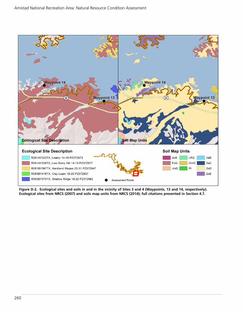
260
Amistad National Recreation Area: Natural Resource Condition Assessment
Figure D-2. Ecological sites and soils in and in the vicinity of Sites 3 and 4 (Waypoints, 13 and 14, respectively). Ecological sites from NRCS (2007) and soils map units from NRCS (2014); full citations presented in Section 4.7.

261
Appendix D: Upland Vegetation Maps
Figure D-3. Ecological sites and soils in and in the vicinity of Site 5 (Waypoint 15). Ecological sites from NRCS (2007) and soils map units from NRCS (2014); full citations presented in Section 4.7.


263
Appendix E: Exotic Plant List
Appendix E: Exotic Plant Species at Amistad NRA
The following table lists exotic species that are and have been documented within Amistad (NPS 2014a, NPS 2014b, NPS 2015a, NPS 2015b, and Poole 2013). Only the species recorded during CHDN monitoring 2011-2014, including the 2014 rapid assessment, were ranked for significance of impact (e.g., the species’ innate ability to become a pest), and for feasibility of management using the Handbook for Ranking Exotic Plants for Management and Control (Hiebert and Stubbendieck 1993). Other species that have been documented in the park were not ranked because they were not found during recent monitoring.
Scientific Name Common NamePoole 2013
NPSpecies(NPS 2015b)
2011-2014 Survey1 (N=3134)
2014 Assess.2 (N=248)
Nox.3 Significance of Impact4
Feasibility of Management5
Anagallis arvensis scarlet pimpernel X X
Arundo donax giant reed X X 1.21% 0.81% X High (35) Difficult (21)
Avena fatua wild oat X X
Bothriochloa ischaemum king ranch bluestem X X 25.62% 13.31% Highest (41) Difficult (16)
Brassica juncea India mustard X
Bromus catharticus rescue brome X X 0.16% 0.40% Low (25) Difficult (16)
Bromus rubens red brome X X
Calibrachoa parviflora mudflat petunia X
Carduus tenuiflorus slender bristlethistle X X
Cenchrus ciliaris buffelgrass X X 40.01% 6.85% Highest (44)Extremely Difficult (11)
Centaurea melitensis Malta starthistle X X 4.15% ND High (36) Difficult (21)
Ciclospermum leptophyllum
slimlobe celery X X
Convolvulus arvensis field bindweed X X 0.77% ND X Highest (46)Extremely Difficult (6)
Cynodon dactylon Bermudagrass X X 25.56% 41.94% High (39)Extremely Difficult (11)
Datura inoxia Indian apple X 0.10% 0.81% Medium (30) Difficult (21)
Dichanthium annulatum Kleberg bluestem X X 0.77% ND Highest (43)Extremely Difficult (6)
Echinochloa colona jungle ricegrass X X 0.06% ND High (35) Difficult (20)
Echinochloa crus-galli6 barnyardgrass 0.06% ND High (36) Difficult (20)
Eleusine indica goosegrass X 0.06% ND Low (29) Difficult (25)
Eragrostis barrelieriMediterranean lovegrass
X X 0.16% ND Highest (40) Difficult (20)
Eragrostis cilianensis stinkgrass X X 0.16% 1.21% Low (27) Difficult (20)
Eragrostis lehmanniana Lehmann lovegrass X X 1.66% ND High (38)Extremely Difficult (6)
Erodium cicutarium redstem stork's bill X X 0.06% ND Medium (31)Extremely Difficult (11)
Eruca vesicaria ssp. sativa rocketsalad X
Gamochaeta falcatanarrowleaf purple everlasting
X
Hemarthria altissima limpograss X X
Hydrilla verticillata hydrilla X X
Kochia scoparia kochia X
Lactuca serriola prickly lettuce X X

264
Amistad National Recreation Area: Natural Resource Condition Assessment
Scientific Name Common NamePoole 2013
NPSpecies(NPS 2015b)
2011-2014 Survey1 (N=3134)
2014 Assess.2 (N=248)
Nox.3 Significance of Impact4
Feasibility of Management5
Linum usitatissimum common flax X
Lolium perenne perennial ryegrass X X
Malva parviflora cheeseweed mallow X
Marrubium vulgare horehound X X 0.03% 0.40% Medium (33) Medium (26)
Medicago arabica spotted bur-clover X X
Melia azedarach Chinaberry X X
Melilotus indicus annual yellow clover X X 0.99% ND Medium (31) Difficult (21)
Morus alba white mulberry X X
Nicotiana glauca tree tobacco X X 7.05% 27.42% Medium (31) Difficult (20)
Nomaphila stricta temple plant X
Panicum antidotale blue panicum X X
Paspalum dilatatum dallisgrass X X 0.41% ND Low (29) Medium (30)
Paspalum urvillei vaseygrass X X 0.03% ND Medium (32) Medium (35)
Peganum harmala7 African rue
Persicaria maculosa spotted ladysthumb X X
Plantago major common plantain X
Poa annua annual bluegrass X
Polypogon monspeliensisannual rabbitsfoot grass
X X 0.73% ND Medium (30) Difficult (20)
Polypogon viridis water bentgrass X X 0.73% ND Low (20) Difficult (20)
Pseudognaphalium luteoalbum
Jersey cudweed X X
Ricinus communis castorbean X X 0.83% 0.40% Medium (33) Difficult (20)
Rorippa nasturtium-aquaticum
watercress X
Rumex crispus curly dock X 0.06% ND Medium (30) Difficult (16)
Salsola tragusprickly Russian thistle
X X 0.03% ND Medium (32) Difficult (21)
Setaria pumila yellow bristlegrass X X 0.06% 0.81% Low (24) Difficult (21)
Setaria verticillata hooked bristlegrass X
Sisymbrium irio London rocket X X 0.10% ND Low (27) Difficult (21)
Sonchus oleraceus common sowthistle X X 0.26% ND Medium (32)Easily Controlled (40)
Sorghum halepense Johnsongrass X X 0.64% 0.40% Highest (45) Difficult (21)
Stenotaphrum secundatum
St. Augustine grass X
Tamarix spp.8 saltcedar X X 3.61% 20.16% X Highest (48) Difficult (21)
Taraxacum officinale6 common dandelion 0.06% ND Medium (34) Medium (35)
Torilis arvensis hedge parsley X X 3.80% ND Medium (31)Easily Controlled (45)
Triadica sebifera Chinese tallow tree X X X
Tribulus terrestris6 puncturevine 0.06% ND Medium (32) Medium (30)
Ulmus pumila Chinese elm X X
Verbascum thapsus common mullein X X
Vitex agnus-castus chastetree X X 5.11% 7.26% High (39) Difficult (16)
X Agropogon littoralis coast agropogon X
ND = Not Detected.

265
Appendix E: Exotic Plant List
1 Data from monitoring of the CHDN Annual Exotic Plant monitoring along high priority vectors 2011 - 2014 (NPS 2014b, NPS 2015a).2 Data from the CHDN 2014 Rapid Assessment (NPS 2014a). 3 Noxious = Texas state noxious status (USDA-NRCS 2014). 4 Significance of Impact measures the species potential to alter native plant communities. This measure was derived the Handbook for Ranking Exotic Plants for Management and Control (Hiebert and Stubbendieck 1993). Significance of Exotic Plant Impact, Innate Ability of Species to Become a Pest is a numerical ranking between 0 and 50. The numerical rankings were assigned into the following categories: 40 - 50 = Highest Concern; 35 - 39 = High Concern; 30 - 34 = Medium Concern; 0 - 29 = Low Concern. Numbers in parentheses after the descriptive ranking are the actual assigned numeric scores. Species that are potentially native were not ranked. Rankings by Kimberly Struthers, Allyson Mathis and Tomye Folts-Zettner.5 Feasibility of Management was derived from the Handbook for Ranking Exotic Plants for Management and Control (Hiebert and Stubbendieck 1993). Species were ranked for this measure excluding some ranking elements (A, Abundance in Park, and B4, Abundance and proximity of propagules near park) in order to evaluate management feasibility independent of population numbers for the exotic species. The measure is a numeric ranking between 0 and 75, with lower values indicating that an infestation of this species is difficult to manage. The numerical rankings were assigned into the following categories: 0 - 15 = Extremely Difficult; 16 - 25 = Difficult; 26 - 35 = Medium; 36 - 75 = Easily Controlled. Numbers in parentheses after the descriptive ranking are the actual assigned numeric scores. Species that are potentially native were not ranked. Rankings by Kimberly Struthers, Allyson Mathis and Tomye Folts-Zettner. 6 Species found during CHDN monitoring 2012-2014 (NPS 2014a, NPS 2014b, 2015a) not previously reported for the recreation area (NPS 2015b and Poole 2013).7 A single plant of Peganum harmala was found on along Spur 406 in 2013, and was vouchered and destroyed (Weckesser 2013).8 Tamarix ssp. includes ramosissima and Tamarix only identified at the genus level in monitoring data (NPS 2014a and 2015a).
Literature Cited
Hiebert, R. D. and Stubbendieck. 1993. Handbook for Ranking Exotic Plants for Management and Control. Natural Resources Report NPS/NRM, RWO/NRR-93/08. National Park Service, Denver, Colorado.
National Park Service. 2014a. AMIS_2014_Rapid_Assessment_Data.xlsx. Excel spreadsheet. Provided by Heidi Sosinki (November 13, 2014).
National Park Service. 2014b. AMIS_Exotics_20141124.xlsx. Excel spreadsheet. Provided by Lauren Lien (November 25, 2014).
National Park Service. 2015a AMIS2014_Master.xlsx. Excel spreadsheet. Provided by Lauren Lien (June 8, 2015).
National Park Service. 2015b. Amistad National Recreation Area Non-native Vascular Plant List. Excel Spreadsheet. Available at https://irma.nps.gov/NPSpecies/Search/Advanced (accessed June 16, 2015).
Poole, Jackie M. 2013. An Inventory of the Vascular plants of Amistad National Recreation Area, Val Verde Co., Texas. Lundellia 16: 8-82. Available at w3.biosci.utexas.edu/prc/pdfs/Poole-Lundellia16.pdf (accessed June 14, 2015).
USDA-NRCS. 2014. Texas state listed noxious weeds. Available at http://plants.usda.gov/java/noxious?rptType=State&statefips=48 (accessed November 18, 2014).
Weckesser, W. 2013. First record of Peganum harmala (Zygophyllaceae) in Val Verde County, Texas, and subsequent eradication treatment. Phytoneuron 2013-71: 1–5. Published 27 September 2013. ISSN 2153 733X. Available at http://www.phytoneuron.net/2013Phytoneuron/71PhytoN-Peganumharmala.pdf (accessed November 11, 2015).


267
Appendix F: Background on Bird Species of Conservation Concern Lists
Appendix F: Background on Bird Species of Conservation Concern Lists
This appendix provides background information on the organizations and efforts to determine species of birds that are in need of conservation. The information presented here supports Section 4.9.2, Data and Methods, of the breeding landbirds section. This appendix contains some of the same, but additional, information as that section of the report.
One component of the landbird condition assessment was to assess species occurrence in a conservation context. We compared the list of species that occur at Amistad National Recreation Area (NRA) (i.e., those detected during Rocky Mountain Bird Observatory [RMBO] surveys at the Recreation Area during 2010-2013, as well as those on the NPSpecies List for the park [NPS 2014]) to lists of species of conservation concern developed by several organizations. There have been a number of such organizations that focus on the conservation of bird species. Such organizations may differ, however, in the criteria they use to identify and/or prioritize species of concern based on the mission and goals of their organization. They also range in geographic scale from global organizations such as the International Union for Conservation of Nature (IUCN), who maintains a “Red List of Threatened Species,” to local organizations or chapters of larger organizations. This has been, and continues to be, a source of confusion and perhaps frustration for managers that need to make sense of and apply the applicable information. In recognition of this, the U.S. North American Bird Conservation Initiative (NABCI) was started in 1999; it represents a coalition of government agencies, private organizations, and bird initiatives in the United States working to ensure the conservation of North America’s native bird populations. Although there remain a number of sources at multiple geographic and administrative scales for information on species of concern, the NABCI has made great progress in developing a common biological
framework for conservation planning and design.
One of the developments from the NABCI was the delineation of Bird Conservation Regions (BCRs) (U.S. North American Bird Conservation Initiative 2014). Bird Conservation Regions (BCRs) are ecologically distinct regions in North America with similar bird communities, habitats, and resource management issues.
The purpose of delineating these BCRs was to:
● facilitate communication among the bird conservation initiatives;
● systematically and scientifically apportion the U.S. into conservation units;
● facilitate a regional approach to bird conservation;
● promote new, expanded, or restructured partnerships; and
● identify overlapping or conflicting conservation priorities.
Conservation Organizations Listing Spe-cies of Conservation ConcernBelow we present a snapshot of some of the organizations that list species of conservation concern and briefly discuss the different purposes or goals of each organization.
U.S. Fish & Wildlife Service
The Endangered Species Act, passed in 1973, is intended to protect and recover imperiled species and the ecosystems upon which they depend. It is administered by the U.S. Fish and Wildlife Service (USFWS) and the Commerce Department’s National Marine Fisheries Service (NMFS). USFWS has primary responsibility for terrestrial and freshwater organisms, while the responsibilities of NMFS are mainly marine wildlife, such as whales, and anadromous fish.
268
Amistad National Recreation Area: Natural Resource Condition Assessment
State of Texas
In 1973, the Texas Parks and Wildlife Department (TPWD) was authorized to develop a list of endangered and threatened animal species in the state. Legal protection of endangered and threatened animals is provided by laws and regulations contained in Chapters 67 and 68 of the Texas Parks and Wildlife Code and Sections 65.171-65.176 of Title 31 of the Texas Administrative Code (TPWD 2014a).
USFWS Birds of Conservation Concern
The USFWS has responsibilities for wildlife, including birds, in addition to endangered and threatened species. The Fish and Wildlife Conservation Act, as amended in 1988, further mandates that the USFWS “identify species, subspecies, and populations of all migratory nongame birds (i.e., Birds of Conservation Concern) that, without additional conservation actions, are likely to become candidates for listing under the Endangered Species Act” (USFWS 2008). The agency’s 2008 effort, Birds of Conservation Concern, is one effort to fulfill the Act’s requirements. The report includes both migratory and non-migratory bird species (beyond those federally-listed as threatened or endangered) that USFWS considers the highest conservation priorities. Three geographic scales are included--National, USFWS Regional, and the NABCI BCRs. The information used to compile the lists came primarily from the following three bird conservation plans: the Partners in Flight North American Landbird Conservation Plan, the U.S. Shorebird Conservation Plan, and the North American Waterbird Conservation Plan. The scores used to assess the species are based on factors such as population trends, distribution, threats, and abundance.
National Audubon Society/American Bird Conservancy
The National Audubon Society and American Bird Conservancy each formerly published their own lists of bird species of concern, but have recently combined efforts into a single “Watch List”. This collaborative effort was
based on a concern by these organizations that there were too many lists with similar purposes (Butcher et al. 2007). Their 2007 WatchList is based on, but not identical to, the Partners in Flight (PIF) approach to species assessment (see below).
The 2007 WatchList has two primary levels of concern: a “Red Watchlist” and a “Yellow WatchList”, although the latter is subdivided into two categories. The Red WatchList identifies what these organizations consider as species of highest national concern. This list overlaps considerably with the IUCNs “Red List” (not presented here), thus, can essentially be considered as a list of globally threatened birds that occur in the United States (Butcher et al. 2007). The Yellow WatchList is made up of species that are somewhat less critical, but serves as an early warning list of birds that have the potential of being elevated to the Red WatchList. Species on this list can be there either because their populations are declining or because they are considered rare.
Partners in Flight
Partners in Flight (PIF) is a cooperative effort among federal, state, and local government agencies, as well as private organizations. One of its primary goals, relative to listing species of conservation concern, is to develop a scientifically based process for identifying and finding solutions to risks and threats to landbird populations. Their approach to identifying and assessing species of conservation concern is based on biological criteria to evaluate different components of vulnerability (Panjabi et al. 2005). Each species is evaluated for six components of vulnerability: population size, breeding distribution, non-breeding distribution, threats to breeding, threats to non-breeding, and population trend. The specific process is presented in detail in the species assessment handbook (Panjabi et al. 2005).
The PIF assessments are conducted at multiple scales. At the broadest scale, the North American Landbird Conservation Plan (Rich et al. 2004) identifies what PIF considers “Continental Watch List Species”

269
Appendix F: Background on Bird Species of Conservation Concern Lists
and “Continental Stewardship Species.” Continental Watch List Species are those that are most vulnerable at the continental scale, due to a combination of small and declining populations, limited distributions, and high threats throughout their ranges (Panjabi et al. 2005). Continental Stewardship Species are defined as those species that have a disproportionately high percentage of their world population within a single Avifaunal Biome during either the breeding season or the non-migratory portion of the non-breeding season.
More recently, PIF has adopted BCRs, the common planning unit under the NABCI, as the geographic scale for updated regional bird conservation assessments. These assessments are available via an online database (http://www.rmbo.org/pif/pifdb.html) maintained by RMBO. At the scale of the individual BCRs, these same principles of concern (sensu Continental Watch List Species) or stewardship (sensu Continental Stewardship Species) are applied at the BCR scale. The intention of this approach is to emphasize conservation of species where it is most relevant, as well as the recognition that some species may be experiencing dramatic declines locally even if they are not of high concern nationally, etc. There are two categories (concern and stewardship) each for Continental and Regional levels. The details of the criteria for inclusion in each can be found in Panjabi et al. (2005), and a general summary is as follows. Note that in the Chapter 4 analysis, we did not use the two Stewardship categories.
Criteria for Species of Continental Im-portance
A. Continental Concern (CC) ● Species is listed on the Continental
Watch List (Rich et al. 2004). ● Species occurs in significant numbers in
the BCR. ● Future conditions are not enhanced by
human activities.
B. Continental Stewardship (CS) ● Species is listed as Continental
Stewardship Species (Rich et al. 2004).
● Relatively high density (compared to highest density regions) and/or a high proportion of the species occurs in the BCR.
● Future conditions are not enhanced by human activities.
Criteria for Species of Regional Impor-tanceRegional scores are calculated for each species according to which season(s) they are present in the BCR. The formulae include a mix of global and regional scores pertinent to each season (see Panjabi et al. 2005 for details). The criteria for each category are:
A. Regional Concern (RC) ● Regional Combined Score > 13 (see
Panjabi et al. 2005 for details). ● High regional threats or moderate
regional threat combined with significant population decline.
● Occurs regularly in significant numbers in the BCR.
B. Regional Stewardship (RS) ● Regional Combined Score > 13 (see
Panjabi et al. 2005 for details). ● High importance of the BCR to the
species. ● Future conditions are not enhanced by
human activities.
Texas Species of Greatest Conservation Need The State of Texas also designated species that, “due to limited distributions and/or declining populations, face the threat of extirpation or extinction but lack legal protection” (TPWD 2014b). The lists were developed for the TPWD’s Texas Conservation Action Plan (TPWD 2012). Species are rated or ranked using a system developed by NatureServe, and lists are available for each of 11 ecoregions in the state.
Literature Cited
Butcher, G.S., D.K. Niven, A.O. Panjabi, D.N. Pashley, and K.V. Rosenberg. 2007. WatchList: the 2007 WatchList for United States birds. American Birds 61:18-25.
270
Amistad National Recreation Area: Natural Resource Condition Assessment
National Park Service. 2014. NPSpecies List for Amistad National Recreation Area. Full list with details. Obtained April 8, 2014 from https://irma.nps.gov/npspecies.
Panjabi, A. O., E. H. Dunn, P. J. Blancher, W. C. Hunter, B. Altman, J. Bart, C. J. Beardmore, H. Berlanga, G. S. Butcher, S. K. Davis, D. W. Demarest, R. Dettmers, W. Easton, H. Gomez de Silva Garza, E. E. Iñigo-Elias, D. N. Pashley, C. J. Ralph, T. D. Rich, K. V. Rosenberg, C. M. Rustay, J. M. Ruth, J. S. Wendt, and T. C. Will. 2005. The Partners in Flight handbook on species assessment. Version 2005. Partners in Flight Technical Series No. 3. Rocky Mountain Bird Observatory website: http://www.rmbo.org/pubs/downloads/Handbook2005.pdf.
Rich, T. D., C. J. Beardmore, H. Berlanga, P. J. Blancher, M. S. W. Bradstreet, G. S. Butcher, D. W. Demarest, E. H. Dunn, W. C. Hunter, E. E. Iñigo-Elias, J. A. Kennedy, A. M. Martell, A. O. Panjabi, D. N. Pashley, K. V. Rosenberg, C. M. Rustay, J. S. Wendt, T. C. Will. 2004. Partners in Flight North American Landbird Conservation Plan. Cornell Lab of Ornithology. Ithaca, NY. Partners in Flight website. http://www.partnersinflight.org/cont_plan/ (VERSION: March 2005).
Texas Parks and Wildlife Department (TPWD). 2012. Texas conservation
action plan 2012-2016: Overview. Editor, Wendy Connally, Texas Conservation Action Plan Coordinator. Austin, Texas. Available at http://www.tpwd.state.tx.us/landwater/land/tcap/documents/tcap_overview_2012.pdf.
Texas Parks and Wildlife Department (TPWD). 2014a. Nongame and rare species program - Texas Threatened and Endangered Species (http://www.tpwd.state.tx.us/huntwild/wild/wildlife_diversity/texas_rare_species/txendangered/). Last accessed February 21, 2014.
Texas Parks and Wildlife Department (TPWD). 2014b. Nongame and rare species program: Species of greatest conservation need (http://www.tpwd.state.tx.us/huntwild/wild/wildlife_diversity/texas_rare_species/sgcn/). Last accessed February 21, 2014.
U.S. North American Bird Conservation Initiative. 2014. Main page. Online. Available at http://www.nabci-us.org. Last accessed July 2, 2014.
U.S. Fish and Wildlife Service. 2008. Birds of Conservation Concern 2008. United States Department of Interior, Fish and Wildlife Service, Division of Migratory Bird Management, Arlington, Virginia. 85 pp. [Online version available at <http://www.fws.gov/migratorybirds/>].

271
Appendix G: Bird Species Recorded by RMBO
Appendix G: Bird Species Recorded by RMBO and Older SurveysThis list consists only of the species recorded by RMBO in 2010-2013. It also shows which of the “RMBO species” were also observed by LoBello (1976), the MAPS (Monitoring Avian Productivity and Survivorship) study in 1998-2002 (Larson 2005), and/or the 2000-2002 mist-net sampling by Larson (2004a, 2004b,
2004c). To get a complete picture of all species that have been recorded at Amistad NRA, also see Appendix I, which lists species that have not been observed by RMBO to date but that appear on the NPSpecies List for the park (NPS 2014) and/or were recorded by earlier surveys.
Common Name2010-2013
Surveys (RMBO)LoBello (1976): 1975-1976 1
MAPS 1998-2002
(Larson 2005)
Larson (2004): 2000-2002
American Avocet X X
American Coot X X
American Kestrel X X
American Pipit X
American Wigeon X X
Ash-throated Flycatcher X X X X
Bank Swallow X
Barn Swallow X X
Bell's Vireo X X X X
Belted Kingfisher X X
Bewick's Wren X X X X
Black Phoebe X X X
Black Vulture X X
Black-chinned Hummingbird X X X X
Black-crowned Night-Heron X X
Black-headed Grosbeak X
Black-tailed Gnatcatcher X X X
Black-throated Sparrow X X X X
Blue Grosbeak X X X X
Blue-gray Gnatcatcher X X X
Blue-winged Teal X X
Bobolink X
Brewer's Blackbird X X
Brewer's Sparrow X X
Bronzed Cowbird X X X
Brown Pelican X
Brown-crested Flycatcher X X X X
Brown-headed Cowbird X X X X
Bullock's Oriole X X X
Cactus Wren X X X
Canvasback X
Canyon Towhee X X
Canyon Wren X X X X
Carolina Wren X X X

272
Amistad National Recreation Area: Natural Resource Condition Assessment
Common Name2010-2013
Surveys (RMBO)LoBello (1976): 1975-1976 1
MAPS 1998-2002
(Larson 2005)
Larson (2004): 2000-2002
Caspian Tern X
Cassin's Kingbird X
Cassin's Sparrow X X X
Cave Swallow X
Cedar Waxwing X X
Chihuahuan Raven X X
Chipping Sparrow X X X
Clay-colored Sparrow X X X X
Cliff Swallow X X
Common Gallinule X
Common Ground-Dove X X X X
Common Loon X
Common Nighthawk X
Common Raven X X
Common Yellowthroat X X X X
Crested Caracara X
Curve-billed Thrasher X X
Double-crested Cormorant X X
Eastern Phoebe X X
Eurasian Collared-Dove X
European Starling X
Forster's Tern X X
Franklin's Gull X
Golden-fronted Woodpecker X X X X
Great Blue Heron X X
Great Egret X X
Great Horned Owl X X
Great Kiskadee X X
Greater Roadrunner X X
Greater Yellowlegs X X
Great-tailed Grackle X X
Green Heron X X
Green-tailed Towhee X X
Green-winged Teal X X
Groove-billed Ani X X
Harris's Hawk X X
Hooded Oriole X X X
House Finch X X X X
House Sparrow X X
House Wren X X X
Indigo Bunting X X
Killdeer X X
Ladder-backed Woodpecker X X X X
Lark Bunting X X
Lark Sparrow X X X X

273
Appendix G: Bird Species Recorded by RMBO
Common Name2010-2013
Surveys (RMBO)LoBello (1976): 1975-1976 1
MAPS 1998-2002
(Larson 2005)
Larson (2004): 2000-2002
Least Flycatcher X X
Lesser Goldfinch X X X
Lesser Nighthawk X X
Lesser Yellowlegs X X
Lincoln's Sparrow X X X X
MacGillivray's Warbler X X X
Mallard X
Marsh Wren X X X
Mourning Dove X X X
Nashville Warbler X X X
Neotropic Cormorant X
Northern Bobwhite X X
Northern Cardinal X X X X
Northern Harrier X X
Northern Mockingbird X X X X
Northern Rough-winged Swallow
X
Olive Sparrow X X X
Orange-crowned Warbler X X
Orchard Oriole X X X X
Osprey X X
Painted Bunting X X X X
Pectoral Sandpiper X
Peregrine Falcon X
Pied-billed Grebe X X
Pine Siskin X
Plumbeous Vireo X
Purple Martin X X
Pyrrhuloxia X X X X
Redhead X X
Red-tailed Hawk X X
Red-winged Blackbird X X X X
Rock Wren X X
Ruby-crowned Kinglet X X X
Rufous-crowned Sparrow X X X X
Savannah Sparrow X X X
Say's Phoebe X X
Scaled Quail X X
Scissor-tailed Flycatcher X X
Scott's Oriole X X
Snowy Egret X X
Solitary Sandpiper X X
Spotted Sandpiper X
Spotted Towhee X X

274
Amistad National Recreation Area: Natural Resource Condition Assessment
Common Name2010-2013
Surveys (RMBO)LoBello (1976): 1975-1976 1
MAPS 1998-2002
(Larson 2005)
Larson (2004): 2000-2002
Summer Tanager X X X X
Swainson's Hawk X X
Swamp Sparrow X X
Turkey Vulture X X
Varied Bunting X X
Verdin X X X X
Vermilion Flycatcher X X X X
Vesper Sparrow X X X
Western Kingbird X X X
Western Sandpiper X X
Western Screech-Owl X
White-crowned Sparrow X X X
White-eyed Vireo X X X X
White-throated Swift X
White-winged Dove X X
Wild Turkey X X X
Wilson's Warbler X X X X
Yellow Warbler X X X X
Yellow-billed Cuckoo X X X
Yellow-breasted Chat X X X X
Yellow-headed Blackbird X X
Yellow-rumped Warbler X X X X
Yellow-throated Vireo X
Yellow-throated Warbler X1 Note that some of the species shown here as recorded by LoBello (1976) may have been recorded by him outside of the March-August period used in the temporal analysis in Chapter 4.

275
Appendix H: Bird Species Not Recorded by RMBO
Appendix H: Bird Species not Recorded by RMBO at Amistad NRA but Recorded in Older Surveys or on NPSpecies List onlyThis list consists only of the species that have been recorded at Amistad NRA that were not recorded by RMBO in 2010-2013. All species are on the NPSpecies List for the park (obtained 4-8-2014; NPS 2014) and were recorded by LoBello (1976), Larson (2005), and/or Larson (2004a, 2004b, 2004c),
or another observation at the Recreation Area. Note that some of these species may have been recorded in periods outside of the breeding season. Also see the preceding appendix for species recorded by RMBO in 2010-2013.
American Bittern
American Goldfinch
American Redstart
American Robin
American White Pelican
Anhinga
Baird's Sandpiper
Bald Eagle
Baltimore Oriole
Barn Owl
Black Tern
Black-and-white Warbler
Black-bellied Plover
Black-bellied Whistling-Duck
Black-crested Titmouse
Black-necked Stilt
Black-throated Blue Warbler
Blue-throated Hummingbird
Bonaparte's Gull
Brown Thrasher
Bufflehead
Burrowing Owl
Bushtit
Cattle Egret
Chestnut-collared Longspur
Chimney Swift
Cinnamon Teal
Clark's Grebe
Common Black-Hawk
Common Grackle
Common Merganser
Common Poorwill
Cooper's Hawk
Couch's Kingbird
Dickcissel
Eared Grebe
Eastern Meadowlark
Eastern Screech-Owl
Eastern Wood-Pewee
Elf Owl
Eurasian Wigeon
Ferruginous Hawk
Field Sparrow
Fox Sparrow
Gadwall
Golden Eagle
Golden-crowned Kinglet
Grasshopper Sparrow
Greater White-fronted Goose
Green Kingfisher
Gull-billed Tern
Hermit Thrush
Herring Gull
Hooded Merganser
Horned Grebe
Horned Lark
Inca Dove
Interior Least Tern
Laughing Gull
Le Conte's Sparrow
Least Sandpiper
Lesser Scaup
Little Blue Heron
Loggerhead Shrike
Common Name

276
Amistad National Recreation Area: Natural Resource Condition Assessment
Long-billed Curlew
Long-billed Dowitcher
Long-billed Thrasher
Louisiana Waterthrush
McCown's Longspur
Merlin
Mississippi Kite
Mountain Bluebird
Northern Flicker
Northern Pintail
Northern Shoveler
Pacific Loon
Red-breasted Merganser
Reddish Egret
Red-shouldered Hawk
Red-throated Loon
Ring-billed Gull
Ringed Kingfisher
Ring-necked Duck
Rock Pigeon
Roseate Spoonbill
Royal Tern
Ruby-throated Hummingbird
Ruddy Duck
Rufous Hummingbird
Rufous-capped Warbler
Sage Thrasher
Sandhill Crane
Sedge Wren
Semipalmated Plover
Semipalmated Sandpiper
Sharp-shinned Hawk
Short-billed Dowitcher
Snow Goose
Snowy Plover
Song Sparrow
Sora
Sprague's Pipit
Swainson's Thrush
Tree Swallow
Tricolored Heron
Upland Sandpiper
Violet-crowned Hummingbird
Virginia Rail
Western Grebe
Western Meadowlark
Western Tanager
Western Wood-Pewee
White-faced Ibis
Willet
Wilson's Phalarope
Wilson's Snipe
Winter Wren
Wood Duck
Worm-eating Warbler
Yellow-crowned Night-Heron
Zone-tailed Hawk
Common Name

277
Appendix I: Sport and C
omm
ercial Fish Species
Appendix I. Summary of sports and commercial fish species in Amistad Reservoir (Binational Fisheries Plan 2006).
Scientific Name Common Name
LoBello (1976)
Texas Parks and
Wildlife (1982)
Texas Parks and Wildlife (1983 & 1989)
Page and Burr (1991)
Dean and
Garrett (2001)
Texas Parks and Wildlife
(2004) Survey:2003-2004
USGS (2004)
Binational Plan
(2006)
Moring (2012)Survey:
2006-2007
NPSpecies List
(2015)
Areas Surveyed
Amistad NRA
Amistad NRA
Amistad NRA
Amistad NRA
Amistad NRA
Amistad NRADevils River
Amistad NRA
Devils River
Pecos River
Amistad NRA
Current Fish Species
Ameiurus melas / Ictalurus melas**
Black Bullhead Catfish
x x x
Ameiurus nebulosas Brown Bullhead x
Aplodinotus grunniens Freshwater Drum x x x x x x x x x
Carpiodes carpio River Carpsucker x
Catostomus comersonni White Sucker x
Cyprinus carpio* Common Carp x x x x x x x x x x
Dorosoma cepedianum Gizzard Shad x x x x x x x x x x
Ictalurus catus White Catfish x
Ictalurus furcatus Blue Catfish x x x x x x x
Ictalurus punctatus Channel Catfish x x x x x x x x x x x
Ictiobus ciprinellus Bigmouth Buffalo x
Lepomis macrochirus / Lepomis macrochirus speciosus
Bluegillx x x x x x
Lepomis microlophus* Redear Sunfish x x x x x x
Lepisosteus oculatus Spotted Gar x x x x x x x x x
Lepisosteus osseus Longnose Gar x x x x x x x x x x x
Micropterus dolomieu* Smallmouth Bass x x x x x
Micropterus punctulatus Spotted Bass x x x
Micropterus salmoides / Micropterus salmoides salmoides
Largemouth Bassx x x x x x
Micropterus salmoides floridaus*
Florida Largemouth Bass
x
Appendix I: Sport and Commercial Fish Species at Amistad NRA

278
Am
istad National Recreation A
rea: Natural Resource C
ondition Assessm
ent
Scientific Name Common Name
LoBello (1976)
Texas Parks and
Wildlife (1982)
Texas Parks and Wildlife (1983 & 1989)
Page and Burr (1991)
Dean and
Garrett (2001)
Texas Parks and Wildlife
(2004) Survey:2003-2004
USGS (2004)
Binational Plan
(2006)
Moring (2012)Survey:
2006-2007
NPSpecies List
(2015)
Areas Surveyed
Amistad NRA
Amistad NRA
Amistad NRA
Amistad NRA
Amistad NRA
Amistad NRADevils River
Amistad NRA
Devils River
Pecos River
Amistad NRA
Current Fish Species
Ameiurus melas / Ictalurus melas**
Black Bullhead Catfish
x x x
Ameiurus nebulosas Brown Bullhead x
Aplodinotus grunniens Freshwater Drum x x x x x x x x x
Carpiodes carpio River Carpsucker x
Catostomus comersonni White Sucker x
Cyprinus carpio* Common Carp x x x x x x x x x x
Dorosoma cepedianum Gizzard Shad x x x x x x x x x x
Ictalurus catus White Catfish x
Ictalurus furcatus Blue Catfish x x x x x x x
Ictalurus punctatus Channel Catfish x x x x x x x x x x x
Ictiobus ciprinellus Bigmouth Buffalo x
Lepomis macrochirus / Lepomis macrochirus speciosus
Bluegillx x x x x x
Lepomis microlophus* Redear Sunfish x x x x x x
Lepisosteus oculatus Spotted Gar x x x x x x x x x
Lepisosteus osseus Longnose Gar x x x x x x x x x x x
Micropterus dolomieu* Smallmouth Bass x x x x x
Micropterus punctulatus Spotted Bass x x x
Micropterus salmoides / Micropterus salmoides salmoides
Largemouth Bassx x x x x x
Appendix I. Summary of sports and commercial fish species in Amistad Reservoir (Binational Fisheries Plan 2006) continued.

279
Appendix I: Sport and C
omm
ercial Fish Species
Scientific Name Common Name
LoBello (1976)
Texas Parks and
Wildlife (1982)
Texas Parks and Wildlife (1983 & 1989)
Page and Burr (1991)
Dean and
Garrett (2001)
Texas Parks and Wildlife
(2004) Survey:2003-2004
USGS (2004)
Binational Plan
(2006)
Moring (2012)Survey:
2006-2007
NPSpecies List
(2015)
Areas Surveyed
Amistad NRA
Amistad NRA
Amistad NRA
Amistad NRA
Amistad NRA
Amistad NRADevils River
Amistad NRA
Devils River
Pecos River
Amistad NRA
Micropterus salmoides floridaus*
Florida Largemouth Bass
x
Morone chrysops / Roccus chrysops*
White Bassx x x x x x x x
Morone saxatilis / Roccus saxatilus*
Striped Bassx x x x x x x x
Morone hybrid Striped x White Bass
x
Notemigonus crysoleucas** Golden Shiner x x x x x x
Oreochromis aureus* Blue Tilapia x x x x
Pimephhales promelas Fathead Minnow x
Pomoxis annularis White Crappie x x x x
Pomoxis nigro-macultatus Black Crappie x x
Pylodictis olivaris Flathead Catfish x x x x x x x x x x x
Sander vitreus / Stizostedion vitreum*
Walleyex x x x x x x
Tilapia mossambica* Mozambique Tilapia
x x
Historical Fish Species as Identified in NPSpecies List (2015)
Esox lucius* Northern Pike x x
Esox masquinongy* Muskellunge x x
* Non-native species
** Represents species documented from the literature as occurring in the Devils,Pecos, and Rio Grande prior to reservoir inundation.
Appendix I. Summary of sports and commercial fish species in Amistad Reservoir (Binational Fisheries Plan 2006) continued.


The Department of the Interior protects and manages the nation’s natural resources and cultural heritage; provides scientific and other information about those resources; and honors its special responsibilities to American Indians, Alaska Natives, and affiliated Island Communities.
NPS 621/134139, September 2016

National Park ServiceU.S. Department of the Interior
Natural Resource Stewardship and Science 1201 Oak Ridge Drive, Suite 150 Fort Collins, Colorado 80525 www.nature.nps.gov
EXPERIENCE YOUR AMERICA™


![Grana acalculia 2006[1]NPS](https://static.fdokumen.com/doc/165x107/6313b81efc260b71020f3816/grana-acalculia-20061nps.jpg)