
amendment-c134--brunswick-activity-centre--milus-pilot ...
188
1
-
Upload
khangminh22 -
Category
Documents
-
view
2 -
download
0
Transcript of amendment-c134--brunswick-activity-centre--milus-pilot ...

1

© 2010 Planisphere 2
Acknowledgements
Department of Planning and Community Development
John Smout Senior Project Officer, Transit Cities, Urban Development
Kate Stapleton Manager, Transit Cities, Urban Development
James Mant Senior Planning Officer, Metro Planning Services
City of Moreland Ian Robertson Manager Activity Centres
Sue Vujcevic Manager Sustainable Development
Liz Nairn Major Projects Strategic Planner
Zoran Jovanovski Coordinator Strategic Planning
Roger Collins Director City Development
Kirsten Costa Director Economic Development
Consultant Study Team
PLANISPHERE URBAN STRATEGY PLANNERS
Lisa Riddle, Director Project Director Kristen Wilkes, Senior Urban Designer / Planner Ashley Mitchell, Urban Designer / Planner Chantal Delcourte, Strategic and Statutory Planner Tina Ngu, Planner / Urban Designer
Project Manager Survey, Mapping, Urban Design Background Research Mapping, Design
URBAN ENTERPRISE PTY LTD Matt Ainsaar, Managing Director Mike Ruzzene, Associate
Market Analysis Market Analysis

© 2010 Planisphere 3
Contents
1.0 Introduction ........................................................................................... 4
PART A : EXISTING CONDITIONS ANALYSIS ................................................ 7
2.0 Strategic Context .................................................................................. 8
3.0 Potential Contamination Issues ........................................................ 20
4.0 Economic Analysis ............................................................................. 22
5.0 Land Use and Built Form Analysis ................................................... 27
6.0 Opportunities and Constraints .......................................................... 41
PART B: CONSULTATION .............................................................................. 44
7.0 Previous Consultation Undertaken ................................................... 45
8.0 Communication for this Project ........................................................ 45
PART C: URBAN DESIGN FRAMEWORK ...................................................... 50
9 Precinct-wide Provisions ................................................................... 51
10 Public Realm ....................................................................................... 54
11 Sub-Precinct A .................................................................................... 61
12 Sub-Precinct B .................................................................................... 64
13 Sub-Precinct C .................................................................................... 66
14 Building Form Map ............................................................................. 72
14 Land Use Map ..................................................................................... 72
PART D: IMPLEMENTATION .......................................................................... 74
15 Implementation Options .................................................................... 75
Appendix A: Project Brief
Appendix B: Document Review
Appendix C: Property and Economic Existing Conditions Analysis
Appendix D: Consultation Notes

© 2010 Planisphere 4
1.0 Introduction 1.1 Brief Planisphere has been commissioned by the Department of Planning and Community Development and Moreland City Council to undertake a number of tasks required to achieve the rezoning of land within one of the industrial precincts identified in the Moreland Industrial Land Use Strategy (MILUS). As a pilot project, a key aim of the project is to develop a concise methodology to be used for other similar areas throughout Moreland.
The primary purpose of the study is to prepare an efficient and effective development and planning framework to guide the rezoning of the identified precinct. This will include providing a concise policy summary, undertaking the necessary background research to determine the sites history and its potential need for an Environmental Audit Overlay and a look at the existing conditions and planning issues surrounding the precinct. A detailed market analysis will provide the necessary demographic context for the study and detailed residential demand and retail/commercial supply studies will assist to inform the rezoning.
An Urban Design Framework for the precinct will provide recommendations for preferred built form and intensity of development, which will detail building heights, setbacks and any new streets, pedestrian links or public open spaces. Identification of infrastructure and amenity improvements is also a key objective of the brief.
The Project Brief is attached to this report at Appendix A.
1.2 Study Area The Primary Study Area identified the pilot project precinct is located within Brunswick in the general area northeast of Lygon Street and Glenlyon Road. More specifically, the Study Area is bound by Victoria Street to the north and Fleming Park to the east, and then incorporates all Business 3 and Mixed Use zoned land in this area.
In recognition that no specific Study Area exists in a ‘vacuum’, a wider Secondary Study Area was identified early in the Project. The surrounding immediate area, including Lygon Street and the residential and open spaces areas to the north, east and south of have an influence upon what can and should occur within the Study Area. The Secondary Study Area includes these areas and the Study has taken into account the potential impacts of changes in and upon these areas, as well as extending consultation into these areas at the Draft UDF stage.
The Primary and Secondary Study Areas are shown on the map over page.
1.3 Structure of this Report This Study Report is divided into four sections
A. Existing Conditions: background research, data, strategic context and opportunities and constraints
B. Consultation: summary of consultation with land owners, occupiers, residents, service authorities, Council officers and state government representatives.
C. Urban Design Framework: analysis and recommendations about land use, built form and public domain improvements in the Precinct.
D. Implementation: examination of implementation options through the planning scheme and otherwise, and recommendations for the proposed methods
A separate report includes a Study Methodology Review: a record and analysis of the methodology and changes made during the Project process, and recommendations for future processes.

© 2010 Planisphere 5

© 2010 Planisphere 6
1.4 Study Methodology The approach for the study was undertaken in 5 stages, including:
♦ Stage 1: Inception and Strategic Context
♦ Stage 2: Analysis, Existing Conditions and Planning Controls
♦ Stage 3: Consultation
♦ Stage 4: Draft Amendment
♦ Stage 5: Streamlined Process Methodology
Upon completion of an inception meeting, site survey and Project Plan for the study, a strategic context was developed for the Study Area. This included reviewing background policies and documents relevant to the Study Area and for industrial land, particularly in Moreland. This Document Review is attached to this report as Appendix B.
A detailed analysis of the Study Area was then undertaken to understand the existing conditions of the site, including layout, built form and ownership and any planning issues identified, including current planning controls, intended land use and interface issues. A demographic analysis, residential demand supply analysis and commercial and retail land supply and demand analysis were undertaken to assist in informing the preferred future direction for the Study Area.
A series of one-on-one and small group meetings with landowners and business owners were then held to inform the local community of the study, as well as to gain local knowledge of the issues within the area, the existing conditions and views about future land uses.
Based on this background work, floorspace recommendations and preferred land uses for the precinct, an Urban Design Framework (UDF) was developed. The UDF addresses both the public realm and private realm by detailing objectives and design guidelines in relation to footpaths and pedestrian links, traffic and car parking, built form and design detail, infrastructure, street trees and parks and setbacks and heights.
Implementation of the UDF is then explored through a range of Planning Scheme tools, including appropriate zones, overlays and funding mechanisms to assist in implementing the identified works for public benefit.
A report to review this methodology and an analysis of what has and has not worked throughout the process will be developed as a separate document.
The Amendment will be exhibited to provide community input to the proposed provisions to implement the Study recommendations.

© 2010 Planisphere 7
PART A : EXISTING CONDITIONS ANALYSIS

© 2010 Planisphere 8
2.0 Strategic Context 2.1 Policies and Strategies There are numerous background policies and strategies that have been reviewed as part of the development of this study. These key strategies and studies listed below provide an outline of the work undertaken, along with identifying the key issues and background information that is relevant to the Study Area in the project.
The key documents summarised here are:
♦ Moreland Industrial Land Use Strategy (2004) – provides direction to Moreland Council about long term planning zoning and redevelopment of ‘industrial land’
♦ Draft Brunswick Structure Plan (2008) – provides strategic land use and built form direction and guidelines for Brunswick
♦ Melbourne @ 5 million (2009) – outlines the current State government directions in relation to accommodating Melbourne’s future population growth
♦ Moreland Affordable Housing Strategy (2006) – outlines a methodology for identifying unmet housing demand and outlines a range of strategic approaches to meeting that demand
♦ Moreland Open Space Strategy (2004) – provides strategic directions and priorities for planning, allocation, design, development and management of open space throughout Moreland.
♦ Moreland City Council Plan 2009-2013 – outlines Council’s key strategic objectives, targets and initiatives
♦ Melbourne’s Inner North Study Area (2008) - provides an economic profile of the municipalities of Moreland and Darebin with a particular emphasis on labour force, employment and land use.
A full summary of all polices and strategies is contained at Appendix B.
Of these documents, the MILUS and the Draft Brunswick Structure Plan are considered to provide the most important strategic direction specific to the Study Area. MILUS has been fully adopted and implemented by the Council in its Municipal Strategic Statement. It therefore has statutory status to guide the outcomes of this Study. While the Draft Brunswick Structure Plan has not been finally adopted by Council or included it the planning scheme as yet, the Council has adopted the document in principle and regards the Structure Plan as the guiding strategic document for the Study Area.
Moreland Industrial Land Use Strategy (2004)
The Moreland Industrial Land Use Strategy (MILUS) was undertaken in August 2004. The purpose of the study was to provide clear direction about the long term planning and zoning of Moreland’s industrial land supply for the next 15 to 20 years. The Strategy focussed on all land within the Industrial 1 and 3, Business 3 and 4, and Mixed Use Zones within the municipality.
The purpose of this strategy is to provide:
♦ an understanding of the pressures affecting industrial zoned land in the City of Moreland;
♦ insight into the future outlook for existing industries in Moreland as well as for possible new employment related uses; and
♦ a clear direction to Council and the community about the long-term planning, zoning and redevelopment of land that is presently included in Industrial 1 and 3, Business 3 and 4, and Mixed Uses Zones throughout the municipality.
The strategy identifies the following implications in regards to planning for industrial zoned land within Moreland:
♦ The demand for industrial zoned land for industrial purposes will continue to decline in Moreland. Whilst demand will remain for industrial land in consolidated industrial areas throughout the municipality, this weakening of demand flexibility will exist to consider opportunities to change the zoning of

© 2010 Planisphere
some of employme
♦ Structural relocate oWhere weto achievesized busprovide an
♦ The outlooonly be mo
♦ The changfor local ebased indoffice use
♦ Poorly locnot rezonecannot bebecome ru
With regards to tfollowing relevandevelopment of in
♦ To provideratio of loc
♦ To retain employmeindustrial r
♦ To provid(including
e
the more peripherent uses or residentia
change and trends overtime will result iell located for future ine premises of high amsinesses. However, n opportunity for land
ok for industrial activoderate due to the sta
ging profile of the muemployment to incre
dustries. This will reqand the like.
cated industrial use laed will most likely bee leased for a sufficiun-down, unleasable
these findings and ot objectives were ddustrial land in Morel
e a mix of land usescal jobs to residents.
and consolidate deent areas as the prredevelopment in Mo
de the opportunity fooffices) to establis
ral areas of industrl activities.
for major manufactuin numerous industrndustrial uses, such smenity that will be susites that are not w
use change.
vities generated by loable population outloo
unicipality’s populatioasingly focus on higquire the provision of
and, for which there isecome blighted. Exisent amount to justifyand will remain vacan
other key influencesdetermined to guideand:
s in Moreland that pro
esignated ‘core’ andrimary areas for conreland.
or a wider range of sh on former indus
rial land to enable
urers to downsize anial sites becoming vsites should be redevuitable for small to mwell suited to indust
ocal / regional demaok for Moreland.
on will provide opportgher skilled and knowf land use opportunit
s little or no demand, sting buildings on sitey ongoing maintenannt.
within the municipalie the future plannin
ovides the highest po
d ‘secondary’ industrntinued industrial us
employment relatedstrial areas designat
other
nd / or vacant. eloped
medium try will
and will
tunities wledge ties for
that is es that
nce will
ity, the ng and
ossible
ry and se and
d uses ted as
♦
♦
♦
♦
♦
♦
In thfuturland uses
In Mland havesupp
‘employment areespecially those in
♦ To provide the opthe redevelopmeprovided they ma
♦ To support the recore and secondaindustrial buildingbusinesses.
♦ To improve the opclose to residentiafor adverse amen
♦ To support the ‘transition – multoccur.
♦ To use the oppoamenity issues an
♦ Not to allow indusit is identified asstrategy.
he context of this studre use of industrial la
use pattern, accesss and any resultant of
Moreland’s situation, tis appropriate as a
e been identified in thport for existing viable
eas’, which have gon the southern parts o
pportunity for a resideent of larger sites intain employment ge
edevelopment of largary industry and emps / complexes suited
perational characterisal properties or other
nity impacts.
continuation of induti use’ whilst allowing
ortunity presented to nd achieve more logic
strial zoned land to bs appropriate for mix
dy, specific guidance and. This includes addibility, interfaces withff-site impacts.
the strategy considermeans of allowing g
he strategy as transite industrial businesses
Brunswick Precinct Industrial Rez
ood main road expof the municipality.
ential component to bewithin designated ‘e
enerating activities on
ger, vacant industrial ployment areas for m
to the needs of sma
stics of industrial and r sensitive uses, to m
strial activities in arg office and residen
rationalise zones tocal and defensible zon
e rezoned to residenxed use or residenti
is provided in respecdressing such issues
h non-industrial and t
rs that site specific regradual change in thtion areas, whilst provs to continue to opera
zoning Model [ Study Report ]
9
osure and access,
e included as part of employment areas’, the site.
sites in designated odern, high amenity ll and medium sized
associated activities inimise the potential
reas designated as ntial development to
o overcome existing ne boundaries.
tial purposes unless ial purposes in this
ct to determining the s as the surrounding he type of industrial
ezoning of industrial e use of areas that viding the maximum ate.
9

© 2010 Planisphere
With regards to thas a ‘Category D: where there is theThe purpose of thand residential ususes, although wh
Industrial and emmust be of a type are to be designed
The site is identifieBrunswick Major access from local
The following Plan
♦ Industrial commerciadevelopme
♦ Business 4
♦ Business 2
♦ Mixed UseTo be usemix of useEnvironmeplanning p
Brunswick Stru
The Brunswick StThe Study Area iscan provide inform
e
he industrial precinct Multi use – residentia
e opportunity to develhis category is to “alloses. It is expected thholly residential develo
ployment generating compatible with resid
d in such a way as to
ed as being part of thActivity Centre. It hand collector roads.
nning and Developme
3 or a Business 3 al, with site specients
4 Zone to provide for
2 Zone - To facilitate
e Zone - To facilitate ed in association withes, only as part of a ent Act (1987) for apermit application.
ucture Plan, Oct 20
tructure Plan was ados referred to on a nu
mation and direction fo
of this study, the straal area’. This categorop a mix of uses inclow areas to change
hat most redevelopmopments on the one l
uses may continue odential uses. Office anhave regard to adjoin
he Lygon/Albert Urbanhas good accessibili
ent controls are recom
Zone where the arfic rezonings to a
bulky goods retailing
a mix of business, ind
a mix of business, inh a Section 173 legarequest under Sectio
a combined planning
008 (Adopted in pr
opted in principle by Cumber occasions withor the purposes of this
ategy classifies the pry applies to industriauding office and residover time to include ents will include resilot are not supported”
or establish in the arnd residential developning industrial uses.
n Village and potentiaty to the PPTN and
mmended to apply:
rea remains predomallow individual resi
and industrial uses.
dustry and residential
dustry and residentiaal agreement specifyion 96A of the Planning scheme amendme
rinciple)
Council on 8 Octoberhin the Structure Plans study.
precinct l areas dential. offices idential ”.
rea but pments
ally the d direct
minantly dential
uses.
al uses. ing the ng and nt and
r 2008. n. This
The visio
Wco
Bght
Ofncpn
The
♦
♦
♦
♦
♦
♦
Folloesta
vision for the precinon for Brunswick was
We value Brunswickcreeks and open spacoffers.
Brunswick’s mosaic ogood model of a susthigher housing denstransport network ena
Our aim in planning Bfor growth that resneighbourhoods that continue to provide prosperous communinecessary to enjoy all
Plan extensively add
♦ Economic restrucmixed use, with a
♦ Broadening of embetter match the s
♦ Nurturing existing
♦ Housing diversity
♦ The future built fbetween Sydney
♦ Management of certainty for futurthe community.
owing a series of blishes a set of strate
nct is outlined in the drafted after extensiv
k for its varied peoplces and for the variet
of housing, industry, tainable Melbourne suities, local employme
able a rewarding and
Brunswick’s future is tspects and enhancewill continue to welcoa range of opportu
ity; neighbourhoods wll that Brunswick has t
resses many issues,
cturing and transition strong focus on enab
mployment opportunitiskills of Brunswick res
g and new niche indus
and affordability.
form of Sydney RoadRoad and the Upfield
built form and guidare investors, and to
technical studies eegies and initiatives to
Brunswick Precinct Industrial Rez
Brunswick Structureve community consulta
le, places, buildings ty of experiences and
commerce, and recreuburb. A fabric of varient and services, anactive life.
to preserve what we les these characteri
ome newcomers; neigunities and choices where a car and a hto offer.
including:
n of some land formbling a significant pop
ies to replace declininsidents with locally av
stries.
d, Lygon Street and d Train Line.
ance on preferred creduce conflict betwe
encompassing manyo be implemented, inc
zoning Model [ Study Report ]
10
e Plan. The overall ation and states:
and streets, for its d opportunities that it
reation, represents a ied neighbourhoods,
nd a comprehensive
love, while providing ristics. This means ghbourhoods that will
for a diverse and high income are not
m from industrial to pulation increase.
ng industries, and to vailable jobs.
the corridor of land
character to ensure een developers and
y issues, the Plan cluding:
0

© 2010 Planisphere
♦ Attracting
♦ Identifying
♦ Providing
♦ Focusing activity co
♦ Focusing o
♦ Targeting
♦ Encouragiaccommod
The Plan includeCentral’ (pg.11-2)
♦ Role - conIt is definindustrial housing. Trelated en
♦ Issues – in the areresultant manage abeing repretailing mprecinct.
♦ Strategiesthe commthe precinremoval o
e
g and retaining knowle
g appropriate sites for
clear direction on the
higher density, multi-rridors (Lygon Street,
on improving pedestr
the addition of approx
ing the developmentdate either housing o
es the majority of th. It provides direction
ntaining a mix of retained mainly to be lar
sites on the LygonThe remaining industrterprises, and automo
includes there being ea; the potential for recreation impacts; amenity and interfacelace by residential u
mix in the area; and th
s – include developinmunity facilities in Flemnct; ensuring office uf any requirement for
edge-intensive industr
r office development.
e redevelopment of red
-use development in , Nicholson Street and
rian amenity.
ximately 5,000 – 10,0
t of multi-use and ‘lor employment uses.
he Study Area undern for the following func
l, wholesale, manufacrge industrial buildinn Street frontage harial activities include wotive repair firms.
a number of Council land use changes
pressures on existine issues; employmenuses; loss of employhere is no central or f
ng a community servicming Park; protectionuses are in the rang
active frontages in th
ries and their workers
dundant industrial lan
the three key transpod Royal Parade).
000 dwellings.
oose-fit’ buildings th
r ‘Precinct B Lygon ctions within this prec
cturing and housing angs, although many ave been redevelopwholesale food, clothi
owned community faaround Fleming Pa
ng industrial businesnt land uses are grayment uses may affefocused retailing area
ces hub; a rationalisan of the ‘as of right ue of options for use
he precinct.
s
nd.
ort and
at can
Street cinct:
activity. of the
ped for ng and
acilities rk and
sses to adually ect the a in the
ation of ses’ in
es; and
Lygocorribothacco
♦
♦
♦
The ‘activStreeaddr
The sum
Melb
Melbsoutof pkilomarea
The with
♦
on Street, and the Ador’, which is describ day and night. Th
ompanied by the follow
♦ Improve interfaceeast and west.
♦ Provide active frsurveillance from
♦ Integrate initiativetrail.
eastern part of the Svity node’. This area et and will be the focressing the park.
recommendations omarised on the map o
bourne @ 5 Million
bourne @ 5 Million hern part of the Cities
public transport and metres of the city. Hoa and traditional manu
Department of Plannmetropolitan Council
♦ freeing up surplucentres;
Albert and Victoria Sbed as streets with a hhe Albert and Victorwing guidelines:
to urban renewal are
ontage to new deveresidential and mixed
es for the cross-Bruns
Study Area abuttingis described as a ped
cus for a community
of the Structure Plaon the following page
identifies the Inner s of Moreland and Dalocal amenities and
use prices and demaufacturing jobs are giv
ning and Communitys to help the sub-regi
us industrial land w
Brunswick Precinct Industrial Rez
Street axis is recognhigh level of amenity aria Street axis within
eas as well as to majo
elopment and ensured-use development.
swick heritage interpr
Fleming Park is idendestrian priority envirhub at Fleming Park
an in relation to th.
North Sub-Region ofarebin. It highlights thd the vibrant activityand for new housing aving way to more in th
y Development is woon reach its full poten
which is located in a
zoning Model [ Study Report ]
11
nised as an ‘activity and sense of safety,
n the Study Area is
or open space to the
e high-level passive
retation trail and arts
ntified as a potential onment along Cross
k and urban renewal
he Study Area are
f Melbourne as the he area’s abundance y centres within 10 are increasing in the
he service sector.
orking in conjunction ntial. This includes:
and around activity
1

© 2010 Planisphere
♦ exploring corridors density ho
♦ improving that the ar
Moreland AfforThis strategy explCity of Moreland. vulnerable and dis
The following goa
♦ To increas
♦ To increas
♦ To encour
♦ To cultivat
♦ To monito
The goals are comof actions, actor oachieving each ac
Of relevance to thaffordable housingaffordable housing
Moreland OpenThis strategy strecommendations
The overall goal fo
e
whether more houand where there are
ousing developments;
public spaces to helprea is changing for the
dable Housing Strlores and documentsIt focuses on the nee
sadvantaged member
ls frame the strategy:
se the supply of afford
se the supply of appro
rage innovation in affo
te a social justice app
or and analyse current
mplemented with a deor agency responsiblection. This ensures an
his study is the strateg projects. Action 1.g sites, which are Cou
n Space Strategy (2tudies the open las for actions towards s
or Moreland’s open sp
using can be accome opportunities for hi and
p stimulate private inve better.”
rategy (2006) s the current housing ed to provide more affrs of the community.
dable housing in More
opriate housing in Mo
ordable and appropria
proach to housing acro
t and future housing n
etailed implementatione for undertaking eacn effective implement
gy to identify land in .5.2 stipulates Councuncil and privately ow
2004) nds throughout thespecific goals and obj
pace system is:
mmodated along traigh quality medium t
vestment as well as to
affordability situationfordable housing optio
eland.
oreland.
ate housing.
oss the municipality.
needs in Moreland.
n plan that includes ach action and the priotation program.
suitable locations forcil should evaluate po
wned.
e municipality to pectives.
ansport to high
o show
n in the ons for
a series ority of
r future otential
roduce
♦
In re
♦
♦
The
6.7
6.8
♦ To develop and spaces in Morelansustainable way.
elation to this study, p
♦ Ensuring that locahouseholds.
♦ Ensuring that necreated by the de
following actions are
Undertake a detadesignated principatarget of local opepriorities opportunitincluding civic place
Investigate the sitesUse Strategy to idprovided in conjunwalking catchment sites.
maintain a high quand that will satisfy cur
riority strategic develo
al parkland for informa
ew residential develovelopment.
of relevance to this s
iled analysis of opeal and major activityen space within 200ties to improve proves.
s designated for residentify whether therection with redevelopanalysis around exi
Brunswick Precinct Industrial Rez
ality, resource-efficierrent and projected co
opments include:
al recreation is acces
opment provides for
study:
en space needs any centres, and urban0 metres of all dwelvision and access to
dential development ine is a need for localpment. Investigationsting open spaces in
zoning Model [ Study Report ]
12
nt network of open ommunity needs in a
ssible to all Moreland
open space needs
nd opportunities in n villages using the lings. Identify and
o local open space,
n the Industrial Land l open space to be
ns should include a n the vicinity of the
2

© 2010 Planisphere
e
Brunswick Precinct Industrial Rezzoning Model [ Study Report ]
13
3

© 2010 Planisphere
Moreland City C
The Moreland CiCouncil. It specifto be undertaken o
Relevant key obje
♦ Facilitate t
♦ Maintain a
♦ Effective appropriat
♦ Facilitate h
Melbourne’s Inn
The Department research into newhousing related sc
In order to undersin the Study AreaThe profile providMoreland and Dar
Key findings identthe following:
♦ Populationincreased
♦ There is acentral M
e
Council Plan 2009-
ty Council Plan estafies the Council’s straover the life of the pla
ectives include:
the development of th
and enhance appropri
use of our land ute to the long term ne
housing that meets th
ner North Study A
of Planning and Cow modes of urban regcenarios, as part of th
stand the potential ecoa, DPCD has commisdes an overview of krebin which comprise
tified from the Econom
n growth has been projected growth to 2
a workforce of aroundelbourne. Unemploym
-2013
ablishes the purposeategic planning framewan.
he local economy and
iate infrastructure and
use and developmeeds of communities.
he needs of the comm
Area (2008)
ommunity Developmegeneration, including he Department’s Trans
onomic impact of incrssioned the preparatikey economic indicato
the Inner North regio
mic Profile for the Inne
modest over the pa2030
87,000 persons manment is similar to th
e, vision and values work and corporate st
d jobs.
d open space.
ent policies for out
munity.
ent (DPCD) is undeconsideration of a rasit Cities program.
reasing population deon of this economic ors for the municipalon.
er North Study Area i
ast 10 years, with s
ny who work in the reghe rest of Melbourne
of the trategy
tcomes
rtaking ange of
ensities profile. ities of
nclude
slightly
gion or e, and
♦
♦
♦
♦
♦
♦
2.2This For Area
Clau
Stratachieenvi
double the percecompared with the
♦ The Study Area (labour force is bethe industry struct
♦ The City of Moapplications for su
♦ Residential propeindustrial property
♦ There appears to job use, such as with the new labo
♦ The average valuthe average valuprovision in the Srezoned to reside
♦ Other impacts ofgrowth as a result
2 Moreland Plasection details the cu
a detailed examinatioa, refer to Section 5: P
use 21 Moreland M
tegic statements for 1eve Moreland’s visioronmental, social and
ntage of workers take Melbourne average
(Moreland and Darebecoming employed inture of previous gene
oreland receives oneubdivision and multi-d
erty prices have beeny prices
be the opportunity tomanufacturing and pur force demographic
ue of residential land e of industrial land,
Study Area were incrential, the value of the
f rezoning would bet of increased residen
anning Schemeurrent relevant policieon of the current ZonPlanning Issues.
Municipal Strategic
10 issues of land use on for the municipad economic perspectiv
Brunswick Precinct Industrial Rez
ke public transport ore.
bin) is becoming morn higher order industrations
e of the highest ndwelling unit developm
n increasing at almos
o reduce the land provrovide higher order jo
cs
in the Study Area is indicating that, if the
eased, and industrial land would be expec
e expected to be inntial land availability.
e es within the Morelandnes and Overlays app
c Statement (MSS)
and development havlity. Each issue is cve, reflecting Council
zoning Model [ Study Report ]
14
r walk/cycle to work
re gentrified and the tries compared with
number of planning ments in Victoria.
st double the rate of
vision for low density obs more in keeping
290% above that of e density of the job land was able to be
cted to increase.
ncreased population
d Planning Scheme. plicable to the Study
ve been prepared to considered from its l’s quadruple bottom
4

© 2010 Planisphere
line approach to commerce relevan
Clause 21.04 – M
The Vision for Mosustainable and lcreation of these and recreating enfocus of change ibetween GlenlyonUrban Village whe
Clause 21.05-1: H
This clause advocurban villages, instructure plan for development be dnearby, and thatencourages a vaaffordable and env
Clause 21.05-2: I
This clause identifto the three pillarsincorporates and a key reference provides a strategCity. As part of thand 4 and Mixed Uwere assessed an
e
decision making. Tnt to this study.
oreland’s Vision and
oreland places emphliveable city. It is bavillages as areas tha
nvironment with a varn the municipality. Th
n Road and Blythe Stere this focus of activi
Housing
cates increased intenncluding the Lygon/A
the area and neighbdesigned to provide t new development ariety of housing forvironmentally sustain
ndustry and Comme
fies the key factors ofs of sustainability – ereferences the Morelfor this Study. The
gic framework to guidhe Strategy, all land inUse Zones, shown onnd given a strategic ca
The 10 issues inclu
Strategic Framework
asis on the desire toased on the concept at provide a complet
riety of choice. Thesehe Strategic Framewreet, encompassing tty and intensity of act
nsity of well designedAlbert Sts urban villag
ourhood character gua high level of amentis integrated into t
r differing lifecycle, able housing.
erce.
f industry and commeenvironmental, econoand Industrial Land U
e Moreland Industriade use and developmn Moreland in the Indn the Industry and Emategory to guide futur
de: housing, industr
Plan
o create an environmof urban villages a
te living, working, she areas are identified work Plan identifies ththe Study Area, as betivity is encouraged.
d residential developmge, within the contexuidelines. It requires tnity for residents andthe neighbourhood.ability and cultural
erce in Moreland with mic and social. This
Use Study (MILUS) wl Land Use Strategy
ment of industrial landdustrial 1 and 3, Busimployment Frameworre use and developme
ry and
mentally nd the opping as the e area
eing an
ment in xt of a that all
d those It also needs,
regard clause
which is y 2004 d in the ness 3 k Plan, ent
The catecatechanusesdeveThe estaresid
This
Industrial and Emplogory ‘D’ = Multi Use gory is “To identify nge over time to inclus. Each new developelopments are not supopportunity remains blish. New employmdential uses.”
Clause includes 5 ke
1. To support and suitable locatioFramework Pla
2. To facilitate theenvironmental i
3. To ensure best operation of ind
4. To reduce andcommercial use
5. To improve the Multi Use – EmAreas to assist
oyment Framework Pl– Residential, and thareas where the op
ude offices (or other pment must be of apported unless in accfor industrial and em
ment generating use
ey Objectives:
encourage employmeons in accordance n.
e opportunity for peopmpacts of car journey
practise environmendustry and commerce.
d manage conflict aes and other more sen
overall appearance aployment, Multi Use –in retaining and attrac
Brunswick Precinct Industrial Rez
lan identifies the Studhe clause states thatpportunity exists for employment uses) a
a ‘mixed use’ naturecordance with an apprmployment generating es must be of a typ
ent-generating businewith the Industry
ple to be employed loys to work.
ntal management in th.
at the interface betwnsitive uses.
and function of Indust– Residential and Tracting new business.
zoning Model [ Study Report ]
15
dy Area as Strategic t the purpose of this the mix of uses to s well as residential
e. Wholly residential roved structure plan. uses to continue or
ype compatible with
esses in Moreland in and Employment
ocally to reduce the
he development and
ween industrial and
try and Employment, nsitional-Residential
5
© 2010 Planisphere
Clause 22: Mor
Clause 22.02: DeVillages
This Policy suppocentres and urbanone of these areaplans be develope
Clause 22.03: Ind
Another key docuclause 21.05-2, thFramework Plan.
Amendment C75 at clause 22.03 foapplies to all landincludes relativelyobjectives and strand the Moreland
Policy objectives uses, supporting commercial uses,areas at strategicrelated uses cloindustrial developresidential amenitvisual character of
The policy also prezoning reques
e
eland Local Plann
evelopment within D
orts the concept of sn villages identified os identified as areas
ed to guide future dev
dustry and Employm
ument relevant to thihis policy applies to al
was gazetted in Novor Industrial developmd identified on the Indy large areas of inrategies of the MorelaIndustrial Developme
include providing fothe continuation of
, retaining and consc locations, providing se to existing com
pments ensuring indty; ensuring efficient f industrial areas.
provides a range of pts and planning p
ing Policy
esignated Activity C
self-sustaining commuon the Strategic Framof change, and the P
velopment of these are
ment
s study, this Local Pll land identified on th
vember 2006, and incments. This new Indusdustry and Employmedustrially zoned lanand Industrial Land Uent Guidelines 1996.
r a diversity of induf industrial and othesolidating designated
opportunities for a wmercial areas, encoustrial development and functional site
performance measurepermit applications,
Centres and Urban
unities focussed on amework Plan. BrunswPolicy requires that streas.
Planning Policy buildse Industry and Emplo
cluded a replacementstry and Employmentent Framework Plan,d. The policy applie
Use Strategy (MILUS
strial and commerciaer employment gene
Industry and emplowider range of emploouraging high quality
does not adversely layouts; and improvi
e to be used in consincluding measure
activity wick is ructure
s upon oyment
t policy t policy which es the
S) 2004
al land erating oyment oyment y new
affect ng the
idering es for
subddeve
♦
♦
♦
♦
Exer
The moreinterthe prop
Whe
♦
♦
♦
division, caretakers elopment and noise se
♦ This clause sets and Decision Guiappropriate:
♦ The purpose anMoreland Industri
♦ The decision guidentified in the M
♦ The decision guGuidelines 1996.
rcising discretion:
assessment of reque than one site, strurfaces. The assessmeMulti Use – Residen
posals on Moreland’s
ere a permit is require
♦ Ensure the propobjectives, as out
♦ Ensure that the Measures.
♦ Ensure developmIndustrial Develop
houses, land use ensitive uses.
out a number of Objidelines. It is policy th
nd application of theal Land Use Strategy
uidelines for determiMoreland Industrial Lan
uidelines set out in
uests for rezoning wiucture plans for the ent of rezoning requ
ntial Areas will considactivity centres.
ed for use and/or deve
posal is consistent tlined in 21.05-2 – Ind
use and developm
ment responds to the dpment Guidelines 199
Brunswick Precinct Industrial Rez
interface, residentia
bjectives, Policy, Perfhat the responsible a
e strategic categoriey, 2004;
ining the future usend Use Strategy, 200
the Moreland Indu
ll take account of thlocality and the creaests and planning peder the implications
elopment it is policy to
with the designatedustry and Employmen
ent satisfies the re
design guidelines set 96.
zoning Model [ Study Report ]
16
al and mixed use
formance Measures, authority consider as
es identified in the
e of industrial land 4; and
ustrial Development
he need to consider ation of problematic ermit applications in for office and retail
o:
ed category policy nt.
levant Performance
out in the Moreland
6

© 2010 Planisphere
Existing Zoning
Study Area
The land within th
The Business 3 Zof encouraging theassociated comme
The Mixed Use Zthat has a frontagresidential, commfunction of the locbut has not been d
Adjacent to Stud
For this project it or abuts, the StudStreet, land is zondevelopment of bentertainment and
Directly adjacent tland zoned PublicParks. The aim ospace, along with
Residential 1 (R1ZStudy Area, alongAlbert Streets. Thof densities with aalong with respeccommunity and a
e
g
e Study Area compris
one (B3Z) applies to e integrated developmercial and industrial u
Zone (MUZ) applies toe to French Avenue.
mercial, industrial andcality to which it is apdeveloped.
dy Area
is also important to ndy Area. Along the wned Business 1 (B1Zbusiness centres for d community uses.
to the eastern and pac Park and Recreationof this zone is to reco
providing for conserv
Z) land abuts the soug with land that is ‘sure aim of this zone is ta variety of dwellings
cting neighbourhood climited range of non-r
ses of two zones, Bus
the vast majority of thment of offices and muses. This zone prohib
o the land at 92-96 AThe aim of this zone
d other uses which cpplied. This land was
note the current zoninwestern boundary of thZ) which has the aim retailing and other c
art of the southern bon (PPRZ) which appliognise the areas for vation and commercia
uthern, south-easternrrounded’ by the Studto provide for residens to meet the housincharacter and allowinresidential uses to se
siness 3 and Mixed U
he Study Area, with tmanufacturing industriebits residential uses.
Albert Street, includine is to provide for a racomplement the mixerezoned in 2006 from
ngs of land that is adjhe Study Area, along to encourage the int
complementary comm
undary of the Study Aes to Fleming and Mpublic recreation and
al uses where appropr
n and northern edgesy Area along Sedgma
ntial development at ang needs of all houseng educational, recrearve local community n
se.
he aim es and
ng land ange of ed use m B3Z,
jacent, Lygon
tensive mercial,
Area is ethven d open riate.
s of the an and
a range eholds, ational, needs.
Brunswick Precinct Industrial Rezzoning Model [ Study Report ]
17
7

© 2010 Planisphere
Existing Overla
There is one exisAudit Overlay (EAthe French Avencontaminated landby any contamina
There are a numinterface with the
The first is the HSedgman, Albert,zoned properties Centre. The aim oand cultural signiaffect the significaprohibited if it assi
Other overlays aresites on Lygon Strof this Overlay is places does not a
DDO5 is applied Methven Park. Thwas to ensure gooits position adjacethe park from the
e
ays
sting overlay applyingAO) located on the Mue frontage. The aid is suitable for a usetion.
mber of other overlayStudy Area.
Heritage Overlay (HO, French Avenues aat 294 (hotel) and 31of this overlay is to cificance along with eance of heritage placists with the conserva
e the two Design andreet, either side of theto ensure that the ddversely affect the he
to the land at the his land contains a recod design and built foent to Methven Park north.
g in the Study Area wMixed Use zoned land
m of this overlay ise which could be sign
ys which also apply
O) which applies to rnd Leinster Grove. 18-324 Lygon Streetonserve and enhanceensuring that develo
ce and allowing a useation of the significanc
d Development Overlae heritage site at 318esign of any new bu
eritage place.
southern end of Frcent townhouse deveorm outcomes for thealong with providing
which is the Environd at 92-96 Albert Stre to ensure that potenificantly adversely a
y to land that has a
residential propertiesIt also applies to tw(Maternal and Child e heritage places of
opment does not adve which would otherwce of the heritage plac
ays. DDO1 is located -324 Lygon Street. Tildings adjacent to he
rench Avenue, adjacelopment. The aim of e development in rela
the pedestrian acce
mental eet and entially ffected
direct
s along wo B1Z
Health natural versely
wise be ce.
at two he aim eritage
cent to DDO5
ation to ss into
Brunswick Precinct Industrial Rezzoning Model [ Study Report ]
18
8

© 2010 Planisphere
2.3 ImplicaThe key opportunidentified below:
Opportunities ♦ Numerous
Area as onuse’ area
♦ There is higher ord
♦ The creatproposal t
♦ The land iforms are
Constraints ♦ Considera
environme
♦ New deve
♦ The impac
♦ New deveheritage s
e
ations for the Pnities and constraints
s strategic planning sne that has the potenover time.
potential to accommder employment oppo
tion of a ‘communityo be further develope
s not subject to heritaunconstrained by exi
ation needs to be givental sustainability in t
elopment must have re
ct of new developmen
elopment should be dites, and residential u
Precinct s presented through
studies and documenttial to change to a mo
modate intensified rertunities than currentl
y hub’ adjoining or ed in the Industrial Pre
age or other overlayssting, specific design
ven to neighbourhoothe design of new dev
egard to the amenity o
nt on public open spac
designed to minimiseuses.
the Strategic Conte
ts have identified theore residential based
esidential developmeny exist.
within Fleming Parecinct Plan.
s and therefore new brequirements.
d character guidelinevelopment.
of nearby residents.
ces must be consider
e impacts on any ad
ext are
e Study ‘mixed
nt and
rk is a
building
es and
red.
djoining
Brunswick Precinct Industrial Rezzoning Model [ Study Report ]
19
9

© 2010 Planisphere 20
3.0 Potential Contamination Issues 3.1 Introduction Consideration of a change in zoning from industrial to a zone that may encourage residential use requires an assessment of the likelihood that these sites may be contaminated by previous uses and activities. This section examines the process to determine land that may require controls to protect future uses from activities in the past that included use of hazardous materials or chemicals, and requirements for land that may contain contaminated land..
3.2 Ministerial Direction No 1- Potentially Contaminated Land
The requirements of Ministerial Direction no. 1 specify that
In preparing an amendment which would have the effect of allowing (whether or not subject to the grant of a permit) potentially contaminated land to be used for a sensitive use, agriculture or public open space, a planning authority must satisfy itself that the environmental conditions of that land are or will be suitable for that use.
‘Potentially contaminated land’ is defined as land used or known to have been used for:
♦ Industry
♦ Mining, or
♦ Storage of chemicals, gas, wastes or liquid fuel (if not ancillary to another use of the land).
A ‘sensitive use’ includes residential use, child care centre, pre-school centre and primary school.
In order to satisfy itself that the environmental conditions of the land are suitable for as sensitive use, the planning authority must either;
♦ Ensure that a certificate of environmental audit is obtained prior to commencement of the use, or
♦ Ensure that a statement is obtained from a suitably qualified professional that the land is not contaminated.
The Environmental Audit Overlay is the tool provided within the Victorian Planning Provisions (VPPS) for application to areas where an Environmental Audit is required. It is therefore important that this Study identify the locations where this Overlay will need to be applied.
The first step in this process was determined to be an examination of records held by the Council in relation to all land within the Study Area.
3.3 Site Histories Understanding the history of past land uses is important when considering land previously used for industrial purposes for rezoning to zones that allow for more sensitive uses, such as the Residential Zone, Mixed Used Zone or Business 1 Zone (among others). In cases where land has been used for the purposes of industrial uses an Environmental Audit Overlay is likely to be required. However, applying the EAO to every site is undesirable due to the time and costs associated with complying with an EAO.
This task has proven to be a challenge. Moreland City Council has provided Planning and Building Permit data back to 1979, with an emphasis on the last 10 years. Researching these archived planning files has proven to be ineffective due to the number of industrial uses not requiring a planning permit under the B3Z and INZ. Locating past files has also proved to be difficult for some sites.
Researching the Council rates archives is another method that can be used to identify past land uses. This includes a lengthy search of Council’s Microfiche records which, for the number of industrial sites in the precinct and for all sites identified in MILUS would be costly and cause time delays.
© 2010 Planisphere
The other optionconsistently sincerequirement. ThiConsequently the
Adopted Approa♦ Visually in
appear to
♦ Identify thconfirm thCouncil raLibrary of
♦ Confirm thnon-pollut
♦ Gain advcontamina
♦ Make decEAO - thoactivity are
♦ Where theincluded in
Of all the residenfound to have posthis report provide
A review of the pincluded in the EAone further properfor the recommen
e
n is to identify sitee occupation, and is option has beefollowing method has
ch nspect all sites withinhave non-industrial /
he land use history hat no potentially pollates and postal recorVictoria.
hose properties that ing uses since first be
vice on the potentiants from adjoining pr
cisions on which propose properties that hae excluded from the E
ere is doubt and theren the EAO.
ntially used parcels ossible industrial uses oes the recommendatio
rocess undertaken bAO was conducted brty that could be excldations of this Report
es that have been exclude them from
en determined as s been adopted for ide
n the precinct to idennon-polluting uses (e
for each property couting activity has tak
rds held by the Public
have had continuoueing developed.
al for sub-soil / groperties from an envi
perties within the preave no history of induEAO.
efore a risk of contam
of land within the pron them in the past. ons for where an EAO
y Planisphere in idenby Coffee Environmeuded from the EAO at.
used for residentia any environmentalthe preferred app
entification of site hist
ntify those land parceeg residential dwelling
onsidered non-pollutken place in the pastc Records Office and
us residential or oth
ground water transpronmental consultant
ecinct will be includedustrial or otherwise po
mination - properties
recinct, only a handfPart D – Implementa
O should be applied.
ntifying the propertiesnts. The Review ideand this has been ac
l uses l audit proach. tory.
els that gs).
ing, to , using d State
herwise
port of t.
d in an olluting
will be
ful was tion, of
s to be entified cepted
Brunswick Precinct Industrial Rezzoning Model [ Study Report ]
21
1

© 2010 Planisphere
4.0 EconThis section outlinpart of the Study.
4.1 DemogKey findings from
♦ It is expecEast and additional
♦ The Brunpopulation(26%) and
♦ The most Education(12.2%) aemployershospitals,
♦ The BrunpopulationMetropolit
♦ The Morehigh rankiArea and t
Future developme
♦ Needs of provision community
e
omic Analynes the findings of theThe full Report is ava
graphic Analysthe demographic ana
cted that over the nexBrunswick State Su5,000 residents;
nswick Local Area n aged between 20 ad Metropolitan Melbou
common industries o and Training (12.6%
and Health and Socias to the North of Meeducation facilities, a
nswick Local Area n who are professioan Melbourne (23%);
eland LGA has a relaings in the south of the Study Area.
ent in the subject prec
professional single aof appropriate reta
y services targeted to
ysis e Property and Econoailable at Appendix C.
sis alysis include:
xt 20 years, the Brunsuburbs) will need to
has a significantly nd 35 years (39%) wurne (22%);
of employment in the%) Professional, Scienal Services (11.1%). elbourne (Carlton andand scientific laborato
has a significantly nals (37%) compare
atively high SEIFA inthe Municipality incl
cinct needs to conside
and dual person housail, local work oppoo these groups.
omic Analysis underta.
swick Local Area (Bruaccommodate at le
higher proportion when compared to Mo
e Brunswick Local Arntific and Technical Se
This coincides withd Parkville) includingries;
greater proportion ed to Moreland (26%
dex score, with partiluding the Brunswick
er:
seholds. This includortunities and socia
aken as
nswick ast an
of the oreland
rea are ervices major major
of the %) and
icularly k Local
des the al and
♦
4.2TherStudtype
Appl
♦
♦
♦
♦
In ad330 apar
Avaifor bbuild
♦
♦
♦
♦ Needs of young secondary markeprovision of commother health care
2 Planning anre have been a total ody Area since 1995. As of developments so
lications of note since
♦ 9-17 Gale Street –centre and underg
♦ 304, 306-310 Lyg
♦ 316 Lygon Street
♦ 240-250 Lygon Sresidential buildin
ddition to these propoLygon Street which d
rtments within a 10 sto
lable Building Permit buildings and works sding and residential ad
♦ Alterations and ad
♦ Buildings and woVictoria and Gale
♦ Change of Useinvestigations app
family and student t for any residential d
munity services cateriservices.
nd Building Apof 30 Planning PermitAn examination of theought over this period
e 2002 include:
– proposal for a six stground car parking
gon Street – 11 storey
– proposal for four st
Street (portion of lot g
osals above, it should directly abuts the Stuorey building and is c
data dates back to 1such as demolition, ndditions and alteration
dditions (1) to a reside
orks with a waiver of Streets
and Buildings andpear to be for one of t
Brunswick Precinct Industrial Rez
households, which development in the arng to these groups su
provals t development applicaese permits provides .
torey office building in
y residential building
torey residential and o
fronting Lygon Stre
be noted that the Elvdy Area, contains aro
currently under constr
979 and contains nunew dwellings, signagns. These include:
ential property on Vict
carparking (2) to ind
d Works (7) whichtwo reasons. The firs
zoning Model [ Study Report ]
22
would constitute a rea. In particular the uch as childcare and
ations for land in the an indication of the
ncluding a child care
office building
eet only)– 11 storey
vera Development at ound 100 residential uction.
merous applications ge, new commercial
toria Street
ustrial properties on
h upon preliminary st is the change from
2

© 2010 Planisphere
a residenindustrial/b
♦ Multi unit was subse
4.3 EconomPrecinc
Discussions with bHistorically the phowever with comanufacture withJ.Boag; however i
There are a smaproducts in the pservice industry (toffices.
The precinct provof the businessesspace they utilise.the manufacturing
Many of the oldelikely to seek alternorthern industriaseek other locatio
Businesses suited
♦ Small offibusinesse
e
tial use to an indusbusiness use.
residential (1) on a sequently withdrawn.
mic Role of ct business owners of threcinct had a strongmpetition from oversin the precinct. Theit too ceased manufac
all number of mediumprecinct; however thtradesman, cabinet m
vides employment in s such as distribution. The precinct has seg industry.
r manufacturing busirnative locations to opl precinct as a likely pns within inner metro
d to the precinct in the
ices. The area is es. The areas prox
strial use, and the s
small residential lot in
the East Bru
he precinct indicate ag role in the provisioseas there are verye largest manufacturcturing in East Brunsw
m sized businesses te predominant use
makers, contractors) s
the above mentionedn and warehousing aeen a large decline in
inesses which have perate their businessprospect. Some of thpolitan Melbourne if a
e future are likely to in
likely to attract smximity to Melbourne
second is for a chan
n Gale Street in 2003
unswick Indus
an industrial area in don of textile manufacy few businesses threr within the precincwick in 2005.
that still manufacturewithin the precinct i
storage and distributio
d industries, howeverare small employers n workers with the dec
the larger landholdin. Most have nominate smaller businesses
available.
nclude:
mall offices and conCBD, combined wi
nge of
3 which
strial
decline. cturing; hat still ct was
e niche is now on, and
r many for the cline of
ngs are ted the
s would
nsulting ith the
♦
Mosvalue
4.4ReseBrunvariedeve
Dem
♦
♦
♦
♦
gentrifying neighbthe CBD and fring
♦ Service industrialthe precinct, as plumbers, cabineMelbourne. The loterm.
t manufacturers are e land and more suita
4 Residential earch indicates that tnswick East. Its proety of shops and selopers alike.
mand for land in Bruns
♦ Significant growthhouse values havunit/apartment va
♦ Strong and rapidlof unit, apartment2007/08 to 443 in
♦ A steady numberEast Industrial lsustained interest
♦ Strong demand ftownhouses and tfrom Real Estate
bourhood are likely toge CBD locations.
. Low impact service many of the existinget makers, contracocation will continue t
likely to leave the prable premises.
Analysis there is strong demanoximity to the city, uservices are reasons
swick East is demonst
h in dwelling values.ve risen by an averaglues have risen by an
y increasing higher-dt and ‘other’ dwelling 2008/09;
r of residential planninand area, indicatingt in developing this ar
for a variety of dwelltraditional detached hagents;
Brunswick Precinct Industrial Rez
o attract offices seeki
industrial is likely to bg service industrial bctors etc service thto attract these busine
recinct in the next 10
nd for high density reniversities, public tras for its popularity
trated by:
In the period 1996 ge of 34.4% per year.n average of 38.3% pe
density development as constructed has inc
ng and building permg that developers hrea even with the exis
ing styles including shousing, according to
zoning Model [ Study Report ]
23
ing lower rents than
be maintained within businesses such as he inner areas of esses in the medium
0 years to find lower
esidential housing in ansport options and with residents and
to 2008 residential . In the same period er year;
activity. The number creased from 270 in
mits in the Brunswick have a strong and sting B3 Zoning;
studios, apartments, anecdotal evidence
3

© 2010 Planisphere
♦ A numbermedium a
♦ Strong for
Residential develo
♦ A mix of profession
♦ Apartment
♦ Off street the key ma
♦ High densnot compe
4.5 Retail AKey findings in rel
♦ The Brunsproviders There are
♦ The existineasy walkretail cent
♦ The poten3,300 per5000m2 oStreet.
Future developmeretail floorspace p
♦ 5,000m2 oprecinct ba
e
r of change of use nd high density reside
recast population grow
opment in the precinc
well appointed one nals and students as a
ts may also provide c
car parking spaces sarket is young profess
sity residential dwellinete with detached res
Analysis ation to office include
swick area has a googenerally located inno supermarkets and
ng supply of supermaking distance of the pre in Nicholson will ch
ntial residential popursons by 2021. Thisof retail floorspace. M
ent of the subject preprovision:
of additional retail floased on an estimated
permit approvals forential dwellings in the
wth.
ct should consider the
and two bedroom aa secondary market;
consideration for home
should be provided fosionals;
ngs need to be priceidential houses.
e:
od supply of retail floon the west of Brunsd limited fresh food re
arkets in the Brunswicrecinct, however the
hange this.
ulation yield of the Ss increase would geMuch of this would be
ecinct should conside
oorspace to service td additional 3,300 res
r the establishment oe subject precinct.
following:
apartments suited to
e-offices uses;
r most dwellings, give
ed at a point where th
orspace, with the foodswick along Sydney etail in East Brunswick
ck Local Area are notproposed supermark
Study Area is estimaenerate demand for ae accommodated on
r the following in rela
the future population idents.
of new
young
en that
hey do
d retail Road.
k.
t within ket and
ated at around Lygon
ation to
of the
♦
♦
♦
♦
♦
4.6Key
♦
♦
♦
♦
♦
♦ The majority of florole as an activity
♦ A small supermaprecinct, there are
♦ Fresh food retail,Street;
♦ Retail floorspace promoted;
♦ Developers shouoffice, residential ground floor shou
6 Office Analysfindings in relation to
♦ A large and increemployed in officeemployed in the M
♦ The proportion of increase with con
♦ Moreland LGA hMelbourne municcontainment rate
♦ Considering the towards residentsopportunity to conthe municipality.
♦ If we assume thawith the median a
oorspace should be dy centre.
arket (up to 2000me suitable site for this
cafes, and restaura
at ground level alo
ld be given the flexiband some retail in C
uld not be a requireme
sis office include:
easing proportion of e based industry sectMelbourne LGA.
residents employed itinued gentrification o
has the lowest officcipality (12%). This for middle Melbourne
future population grs employed in office jontain some office spa
at the subject precincacross the middle LGA
Brunswick Precinct Industrial Rez
directed to Lygon Str
m2) may be accommalong Lygon street;
ants should be accom
ong Lygon Street sho
bility to develop a mCross and Albert Streent outside of Lygon S
the Brunswick Localtors. Most of these wo
in office based industof Brunswick.
e job containment is well below the
e municipalities of 18%
rowth in the local aobs, the subject preciace and thus improve
ct provides office job A’s of Melbourne at 1
zoning Model [ Study Report ]
24
eet to strengthen its
modated within the
mmodated on Lygon
ould continue to be
ix of uses including eet. Retail space at Street.
Area residents are orkers, however, are
try sectors is likely to
rate of any middle average office job
%.
area and the trend inct presents a clear e job containment in
containment in line 18%, there would be
4

© 2010 Planisphere
a requiremthe moder
Future developmeoffice floorspace
♦ Office flooallowancemarket led
♦ Office flooincluding:
− Office
− Stand
− Mixed ♦ Large offic
to other ar
♦ Offices sprovision oaccess the
e
ment for 1,523m2 of orate residential growth
ent of the subject pre
orspace should be ene is not recommended, and developers con
orspace may be incor
attached to a dwellin
along office complex
use development incces should be locatereas of the precinct.
hould have consideof off street bike parke Lygon Street Tram.
office space within thh scenario).
ecinct should conside
ncouraged in the preed. It is preferred tnstruct buildings that p
rporated into the prec
g (with or without sep
x;
corporating retail, officd along Lygon Stree
eration to sustainabking and where possi
e precinct (this is bas
r the following in rela
ecinct, however a mithat office developmprovide flexibility in us
cinct in a number of fo
parate entrance);
ce and residential; t, with home office d
ble transport modesble promote walkabil
sed on
ation to
nimum ent be se.
ormats
irected
s with ity and
4.7If rebaseand
The whicdeve
7 Future Land zoned to Mixed Use
ed on consultation widevelopers and
plan overpage highlich developers haveeloped for residential
Use e Zone the likely outth existing businesse
consideration o
ghts the likely timefraindicated they wouldpurposes if rezoned t
Brunswick Precinct Industrial Rez
comes are identifiedes, discussion with stof the market
ames for developmend develop. Most sitto mixed use.
zoning Model [ Study Report ]
25
below. These are trategic land owners demand analysis.
nt and the heights to tes are likely to be
5

© 2010 Planisphere
e
4.6The
Opp♦
♦
♦
♦
♦
Con♦
♦
6 Implications fkey opportunities and
portunities ♦ There is strong de
♦ Opportunities to apartments suitedas a secondary m
♦ There is the potenStudy Area and th
♦ Additional retail osupermarket, will Study Area.
♦ There is an oppolocal residents, as
straints ♦ Lack of fresh food
♦ Reduced need for
for the Precincd constraints are iden
emand for high densit
provide a mix of wd to young profession
market
ntial to provide some hus improve job conta
of approximately 3,00be required to serve
rtunity for a small rets part of a ‘community
d offering in the area.
r industrial land in the
Brunswick Precinct Industrial Rez
ct tified below:
ty residential housing
well appointed one nals as the primary m
office space in new dainment in the City of
00 sqm, including frese the needs of additio
tail/café function in Cy hub’.
e Precinct.
zoning Model [ Study Report ]
26
in Brunswick East.
and two bedroom market and students
developments in the Moreland.
sh food and a small onal residents in the
Cross Street to serve
6

© 2010 Planisphere
5.0 Land 5.1 ExistingThe existing land commercial premi
The houses are clusters along Gastorey, and rangeprimarily located o
Gale Street presewith numerous paOther streets howresidential street w
Industrial and comwarehousing and at least 4 differenshops’. Some of tand storage.
Adjoining land useand units to the south.
e
Use and Bg Land Uses uses in the Study Areses.
predominantly locateale Street and a few e in era from Victoron long, narrow blocks
ents as an industrial sarked trucks and carswever appear to be awith a few industrial/c
mmercial uses includautomotive repairers
nt firms identified, alothe larger lots/building
es include predominanorth, and south-eas
uilt Form A
ea are a mix of reside
ed along Victoria Strin Albert Street. The
rian workers cottagess.
treet with some resids and open doors wia 50/50 split, or in thommercial uses scatt
e light manufacturings. Clothing manufactuong with auto repairegs along Cross Stree
antly retail along Lygost and large open sp
Analysis
ential houses and indu
eet frontage, with soe houses are mainly s to 1950s brick dw
dential uses along its th machinery visible he case of Albert Sttered around.
g, engineering, wholeuring is a dominant users and general ‘macet are used for wareh
on Street, residential hpace areas to the ea
ustrial /
ome in single
wellings
length, inside. reet, a
esaling, se with chinery ousing
houses ast and
Brunswick Precinct Industrial Rezzoning Model [ Study Report ]
27
7

© 2010 Planisphere
5.2 Access
Pedestrian Netwo
There is excellendue to the grid nincludes excellentStreet. There are both physically an
The Brunswick StStreetscapes’ whirenewal and undea ‘Pedestrian Priopedestrian link beStreet.
Footpaths througconstructed in aspbluestone gutterschanges presentinand driveways. It of Cross Street.
In addition, accesbins are placed particularly in Gapedestrian environ
There are opportredeveloped; howto the existing nar
e
, parking and i
ork / Access
t pedestrian permeanetwork of streets, rt access to areas outopportunities howeve
nd visually restricted, p
tructure Plan identifiech will incorporate im
er-utilised community ority Street’, and theretween Gale Street an
ghout the Study Arphalt and directly adja, numerous power pong trip hazards, steepshould also be noted
sibility for pedestrianout for collection, a
ale Street. All of thenment.
unities to improve thwever there are limitedrrow roadways.
infrastructure
bility throughout the rear laneways and retside/adjacent to the er to improve accessparticularly along Cro
ed Victoria and Albertmprovements that are
facilities. In addition, e may be the potentiand the Maternal Child
rea are generally racent to the roadwayoles and signs in thep pram ramps and nud that there is no foot
s is also further restrand when vehicles pe above factors cont
his situation over timd opportunities to wid
majority of the Studyelatively short blocksStudy Area such as into Fleming Park w
oss Street.
t Streets as being ‘Ccatalyst to integratingCross Street is identi
al to create a new easHealth centre on Bru
relatively narrow (1-y. Other features inclue footpath area, subtlumerous vehicle crostpath along the easte
icted on days when rpark across the footribute to a relatively
me as the area is graden or extend footpat
y Area s. This Lygon
which is
Catalyst g urban fied as st-west nswick
-1.2m), ude the e level
ssovers rn side
rubbish tpaths, y poor
adually hs due
Brunswick Precinct Industrial Rezzoning Model [ Study Report ]
28
8

© 2010 Planisphere
Car Parking
Almost all car parand trucks also Industrial propertiefront setbacks, mresidential properttheir private open
Current car parkincar parking spaceStudy Area have i
Road Network
Many of the roadparked vehicles, aand commercial pvehicles out of thedemands for parkto their historic de
Traffic and parkinbusiness operatorunloading is notedblocked by trucks.
Laneways are a property in the Stua laneway. The laand size of vehiclanes meet at riLaneways are alsclean.
e
rking in the Study Arparking across footpes fronting Cross and
most of which requirties have created parspace.
ng rates required by te is required per ‘loncorporated car park
s throughout the Stuare difficult for truck a
premises. In addition te area to access the king from residential pevelopment pattern an
ng conflicts are the rs in the area. The dd by businesses, and .
major feature of theudy Area north of Alb
aneways themselves acle that can use themght angles, creating
so used for pedestria
rea appears to occurpaths and on natured Sedeman Streets hare reversing onto therking spaces in their f
the Moreland Plannindging room’. Recent
king areas below grou
dy Area are narrow access and present lto this there is no eascity’s freeway networ
properties which do nnd therefore road acce
most frequently noteifficulty of obtaining trresidents note that th
e urban fabric of the bert Street has the oppare narrow (around 3m. This is exacerbateg a ‘tight’ space foran access and need
r ‘on-street’ with mane strips (where they ave car parking arease roadway to exit. front yards, further re
g Scheme indicate tht developments around level.
which causes conflicloading issues for ind
sy or direct access forrk. Added to the mix aot have on-site parkiness is problematic.
ed issues by residenruck access for loadinhe roadways are som
Study Area. Almostportunity for rear acce metres) restricting thed in the areas wher a vehicle to manoto be maintained an
ny cars exist).
s within Some
educing
hat one nd the
cts with dustrial r heavy are the ng due
ts and ng and etimes
t every ess via he type ere two oeuvre. nd kept
Brunswick Precinct Industrial Rezzoning Model [ Study Report ]
29
9

© 2010 Planisphere
Infrastructure Ca
There are three mand sewerage.
In relation to stoexisting site and rto be any substaninfrastructure shou
Three-phase elecunlikely to be any
In relation to sewthe number of paccommodate in tfrom the service p
Gutters throughouchannel. In locatioof the footpath mea trip hazard.
The bluestone gumay exist to incorprain gardens or strees.
e
apacity
main infrastructure ca
ormwater, advice fromroof coverage that exntial increase in stormuld be adequate.
ctricity is currently suneed to augment sup
werage capacity, the spotential additional rethe future. This Repoprovider.
ut the Study Area areons where there is a eans that the gutter li
utters are a visual feporate some water sestormwater harvestin
apacity types to cons
m Melbourne Water xists throughout the S
mwater flows with rede
upplied to the area, pplies should the area
service provider has esidential dwellings rt will be updated onc
a mix of bluestone bdriveway or vehicle cine is extended into t
ature of the Study Aensitive urban design g, particularly for the
sider: stormwater, ele
indicates that due Study Area, there is uevelopment and the e
and advice is that tha be developed furthe
requested an estimathat the Study Area
ce further advice is re
blocks, or concrete kecrossover to a lot, thethe footpath space, cr
Area; however opport(WSUD) measures se current and future
ectricity
to the unlikely existing
here is er.
ation of a may
eceived
erb and e width reating
tunities such as street
Brunswick Precinct Industrial Rezzoning Model [ Study Report ]
30
0

© 2010 Planisphere
Public Transport
Due to the proximpublic transport opsouth travel option
Tram Routes 1 aintervals during banticipated that ththe Study Area.
The nearest train Albert Street. Merare anticipated to services on a freq
The nearest bus and travel east-weservices terminateand Alphington trranging from everroute 506, with the
Apart from the trapublic transport seidentified that manthe tram service m
However it is antithe short term, mthe planning/desig
e
t Access
mity of the Study Areptions available to andns, while buses provid
and 8 travel along Lboth peak (3-7 minuhese services will be
station (Brunswick) irri station is around 2.reduce the likelihooduent basis.
routes are just to theest along Blyth/Victore at Moonee Ponds torain station to the ery 12 minutes to 30 e last service being a
am services along Lygervices for a relativelyny current workers in
may provide an option
cipated that many poay require at least ongn of new buildings.
ea to central Melbourd from the area. Tramde east-west connect
Lygon Street past thutes) and off-peak (the primary public tra
is about 1,200 metre.5 kilometres to the ea
d of people within the
e north (508) and souia Streets and Glenlyo the west, with serviceast. Service frequenminutes. The earliestround 10pm on route
gon Street, there appy inner city location.
n Brunswick are empln for these people.
otential households inne vehicle. This shou
rne, there are a numms and trains provideions.
he Study Area at fre(8-12 minutes) timesansport option for pe
s directly to the westast. Both of these disStudy Area from usin
uth (506) of the Studon Street respectivelyces terminating at Norncies vary during tht service is around 6508.
pears to be relatively The economic analysloyed in the CBD; the
n the Study Area, at luld be taken into acco
mber of e north-
equent s. It is ople in
t along stances ng train
y Area y. Both rthcote e day,
6am on
limited sis has erefore
east in ount in
Brunswick Precinct Industrial Rezzoning Model [ Study Report ]
31
1

© 2010 Planisphere
Access to Open
The Study Area isFleming Park to Brunswick Bowls Nursery/Depot. Acformal path and vSenior Citizens buis also the option to a more multi-fun
Methven Park to ta recent residentaccess. This seclularge open spaceenclosure of the residents. It proprovided by house
It is important to naccessing either accessibility to opthe Cross and Alband Methven Park
e
Space
s extremely well servthe east contains oClub, Senior Citize
ccess to the open spvisibility into the park uilding, and opportunito either remove or rnction and modern fa
the south is accessedtial development hauded park with formaes of Fleming Park,Methven Park is a c
ovides safety for chies that abut it.
note that no part of theFleming or Methven
pen space. In fact, mbert Street intersectionks.
ved by public open soval and passive opns clubrooms and t
pace is poor from Crobeing restricted by t
ities exist to improve refurbish the existing
acility.
d from the Study Areas provided a drivew
al plantings and play e, less than 200 metcharacteristic of the Pildren from traffic, a
e Study Area is more n Park. This repres
many of the larger lotn, are located within
pace for an inner citypen spaces along whe City of Morelandoss Street, due to a he Council nursery aaccess and facilities.Senior Citizens Club
a via French Avenueway/footpath for pedequipment complimentres away. The sePark that is valued band passive surveilla
than 400 metres awasents an area with as in the Study Area a200 metres of both F
y area. ith the
d Plant lack of
and the There
brooms
where estrian nts the nse of y local
ance is
ay from a high around
Fleming
Brunswick Precinct Industrial Rezzoning Model [ Study Report ]
32
2

© 2010 Planisphere
5.3 Built FBuilding Height a
Existing buildings only one building some in clusters athese are mainly 1950s brick struct
The purpose builstructures built to additions. While residential height traditional saw-tooarticulation.
Building Setback
As indicated on ththe precinct, crearesidential propertboundary. Seveaccommodate car
Heritage and Nei
Visual analysis of there do not appcontrols. While a streetscapes are heritage or neighb
e
orm and Form
in the Study Area arextending higher. B
along Gale Street andsingle storey and ra
ures.
lt industrial/commercproperty boundaries, only one or two storof 2-3 storeys. The
othed roof forms, to
ks
he accompanying maating a disjointed anties contain a small la
eral industrial/commer parking.
ghbourhood Charac
the Study Area indicpear to be any addnumber of the buildinnot intact or of suffici
bourhood character qu
re generally within theBuildings along the Vd a few in Albert Streeange in era from Vic
cial premises are a and ranging in era fr
rey in construction the form of these buildio more modern ‘tilt s
ap, there is a mixtured inconsistent street
andscaped front yard,ercial properties have
cter
cates that, in the abseditional sites or buildngs date from the Victient consistency to wualities.
e range of 1-3 storeyVictoria Street frontaget have a dwelling formctorian workers’ cotta
mix of concrete androm the 1960s up to mey are often the equngs is mixed, includi
slab’ construction wit
e of building setbackstscape appearance. while others are builte paved front setba
ence of a full heritagedings that require hetorian or Edwardian e
warrant control to prote
ys, with ge and m, and
ages to
d brick modern uivalent ing the th little
s within Many t to the
acks to
study, eritage
era, the ect the
Issueneedguid
es related to buildingd to be taken into aelines.
g design around inteaccount in the develo
Brunswick Precinct Industrial Rez
erfaces with existing opment of the rezon
zoning Model [ Study Report ]
33
heritage places will nings and built form
3

© 2010 Planisphere
Gale Street looking
Typical rear lanewa
e
north
ay
Cross Street look
Residential interfa
ing south with Bowls
ace with Methven Pa
Club on left
rk
Interface beStreet
Looking wes
Brunswick Precinct Industrial Rez
etween different land
st along Albert Street
zoning Model [ Study Report ]
34
d uses on Gale
4

© 2010 Planisphere
Albert Street looking
Large sites with gAlbert Street
e
g west
ood development pootential on
French Avenue on the left
Large sites wibetween Cross a
looking north with M
th good developmand Sedgman Streets
ixed Use site
ent potential
Victoria Stree
Brunswick Precinct Industrial Rez
et looking east
zoning Model [ Study Report ]
35
5

© 2010 Planisphere
5.4 InterfacThere are essenboundary of the S
♦ Direct intother at this right upalong Gale
♦ Laneway the separmany locaStreet (noLygon Strcases builand visual
♦ Street intThis occuuses on oappearancheavy veh
In this area there / commercial) canissues such as vein poor interface c
In addition to thismay actually resul
The Study Area aMethven Park whand DevelopmentAvenue. The seco
e
ce Issues ntially three differenttudy Area. They are:
erface - where two phe rear or side frontag against the wall of ae Street, and in one lo
interface - where a ration between the pations, including bett in Study Area), and
reet. This does provildings are constructel separation.
erface – where potenrs predominantly alone side and industriace to the streetscapehicle access to industr
is likely to be an accen co-exist to a certainehicular traffic, machinconditions if not mana
, redevelopment of alt in improved interfac
lso has two importanthere a recent resident Overlay which has reond open space interf
t existing interface
potentially conflicting lge. In some cases a w
an industrial use. Thisocation on Albert Stre
narrow access lanewpotentially conflicting tween the heritage to the commercial ande some separation d right to the rear pro
ntially conflicting landong Albert and Frencl commercial on the oe and may present arial properties.
eptance that different n degree, however thenery, vibrations and haged appropriately.
an industrial property ce treatments.
t interfaces with openntial development hasesulted in a pedestriaface with Fleming Par
types in and aroun
and uses directly abuwall of a residential b
s occurs at various loceet.
way at the rear of theland uses. This occ
properties along Sednd retail properties tha
of uses, however inoperty line, limiting ph
d uses occur along a ch Avenues with resiother. This provides aamenity issues surro
uses (residential / inde potential for noise r
hours of operation can
to residential or mixe
n space areas. The firs been subject to a Dan access point from Frk on Cross Street. Ac
nd the
ut each building cations
e lot is curs in dgman at front
n many hysical
street. dential
a mixed unding
dustrial related n result
ed use
rst is to Design French ccess
Brunswick Precinct Industrial Rezzoning Model [ Study Report ]
36
6

© 2010 Planisphere
to the park is limitexistence of the Naccess, as well abuildings along Cr
The design and oof the public reallocations where laand unwelcoming in older industrial
5.5 Lot SizThere is a wide vbeing the existing predominantly locStreet.
The smaller lots particularly when along Cross StreeFleming and Meth
The frontage of aFor example, a sitcreating a more corner sites, sitesaccess. Sites likecase) may be higto Fleming Park.
It should be notearound 100 resideapproximately 1,7
e
ted to the southern paNursery and Bowls Cas potentially openingross Street.
rientation of buildingsm environment. Currarge blank walls, parappearance to the stareas.
zes variation in lot sizes t
residential propertiescated along Cross Str
(<500sqm) are relatithere are larger lots i
et which have fewer dhven Parks.
a lot is also likely to dte with two street fronattractive propositions with dual frontagethose along Cross Shly attractive to deve
d that the Elvera Deential apartments acr00sqm. There is also
art of Cross Street, nClub. Opportunities exg up the visual acces
s can make a substanrently in the Study Arking areas and hightreet. This is (to a cer
throughout the Studys along Gale and Victreet opposite Fleming
vely unlikely to be tain the immediate areadirect interface issues
determine the redeventages provides more n for developers in ses and in some casetreet with dual frontag
elopers, in addition to
evelopment at 330 Lyross 10 storeys is be
o an application for a m
ear Albert Street duexist to improve this pss from upper levels o
ntial difference to the Area there are a numh fencing presents a rtain degree) to be ex
y Area, with the smaltoria Streets. Larger log Park, and south of
argeted for redeveloa south of Albert Stres and have an outloo
elopment potential of access and design o
some cases. This ines sites with rear lages (and 3 frontages
o these sites being ad
ygon Street which coeing constructed on amulti storey residentia
e to the hysical of new
quality mber of
hostile xpected
ler lots ots are f Albert
pment, eet and ok over
a site. options, ncludes aneway
in one djacent
ontains a lot of al
Brunswick Precinct Industrial Rezzoning Model [ Study Report ]
37
7
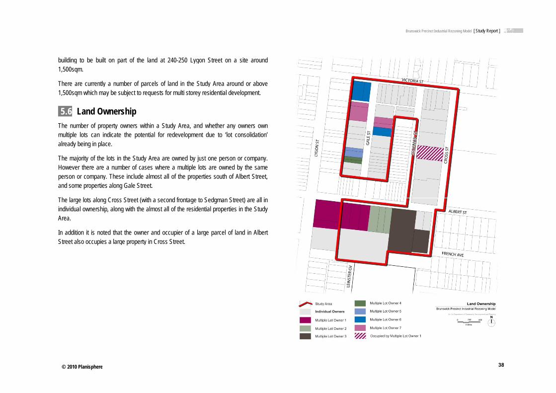
© 2010 Planisphere
building to be bu1,500sqm.
There are current1,500sqm which m
5.6 Land OThe number of pmultiple lots can already being in p
The majority of thHowever there arperson or companand some propert
The large lots alonindividual ownershArea.
In addition it is noStreet also occupi
e
uilt on part of the la
tly a number of parcmay be subject to req
Ownership roperty owners withiindicate the potenti
place.
he lots in the Study Are a number of casesny. These include almies along Gale Street
ng Cross Street (withhip, along with the alm
oted that the owner ies a large property in
and at 240-250 Lygo
cels of land in the Stuests for multi storey
n a Study Area, andal for redevelopmen
Area are owned by jus where a multiple lomost all of the propet.
a second frontage tomost all of the reside
and occupier of a lan Cross Street.
on Street on a site a
tudy Area around or residential developm
d whether any ownert due to ‘lot consoli
st one person or comots are owned by therties south of Albert
o Sedgman Street) arntial properties in the
rge parcel of land in
around
above ent.
rs own dation’
mpany. e same Street,
re all in e Study
Albert
Brunswick Precinct Industrial Rezzoning Model [ Study Report ]
38
8

© 2010 Planisphere
5.7 Public Footpaths throughdirectly adjacent tand signs placed steep pram rampfootpath along therestricted on dayspark across the foto a relatively poo
There is a lack ofmix of types and hthroughout the astreet trees do econtaining vegetathe streetscape.
Along streetscapetrees is problematlack of additional tuse character.
Vehicle crossoverGale and Cross Scrossovers resultsstops and the priv
Laneways are alsnarrow (around 3This is exacerbatevehicle to manoeupresent is poor wbeing common.
e
Realm / Streethout the Study Area ato the roadway. In ain the footpath area
ps and numerous vee eastern side of Cros when rubbish bins aootpaths, particularly ir pedestrian environm
f street trees throughoheights. The narrow rrea restrict opportunexist it is at the expation, usually on resid
es where businesses tic due to access reqtrees in these streets
rs and driveways areStreets. In many cases in a situation wherevate realm begins.
so major feature of t metres) restricting ted where two lanes muvre. Laneways do pr
with uneven bluestone
tscape are relatively narrow,ddition to this there
a, subtle level changehicle crossovers anoss Street. Accessibiliare placed out for coin Gale Street. All of t
ment.
out the area, and whroadways and requirenities for the placempense of footpath wdential properties, pro
are to remain, the inuirements for trucks,
scapes may actually b
e frequent in the Stues the mix of buildinge it is difficult to iden
the public realm. Thethe type and size of meet at right angles, crovide pedestrian acce block surface, high
constructed in asphaare numerous poweres presenting trip ha
nd driveways. There ity for pedestrians is
ollection, and when vethe above factors con
hen they do exist theyements for truck moveent of street trees.
width. Small front seovide additional green
ntroduction of furtherloading and car park
be seen to reflect this
udy Area, particularlyg front setbacks and vntify where the public
e laneways themselvvehicle that can use
creating a ‘tight’ spaccess, but the environm
fences, graffiti and r
alt and r poles azards,
is not further ehicles ntribute
y are a ements Where
etbacks nery in
r street king. A mixed
y along vehicle
c realm
ves are e them. ce for a ment at rubbish
Brunswick Precinct Industrial Rezzoning Model [ Study Report ]
39
9

© 2010 Planisphere
5.8 ImplicatThe key opportuni
Opportunities ♦ The existi
for develo
♦ Options toparks and
♦ Options tthroughou
♦ The potentransport a
♦ Provision
♦ To make Area
Constraints ♦ Numerous
♦ Propertiesthe middle
♦ The existpedestrian
♦ Overshado
e
tions for the Pities and constraints a
ng large lot sizes alopment
o improve the public Lygon Street
o provide improved ut the Study Area
ntial to locate a greatand community servic
of additional dwelling
better use of two exi
s small lots along Gale
s with the Heritage Oe of the Study Area
ting narrow streetsn access.
owing and overlookin
recinct
are identified below:
ong Albert and Cross
realm including footp
car parking and tr
er number of people ces
s and office space in
isting public open sp
e Street restrict redev
Overlay (HO) applied
, footpaths and lan
g issues from the dev
Streets provide oppo
paths, streets and acc
raffic movement out
in close proximity to
a high demand area
aces adjacent to the
velopment options
are directly adjacent
neways limit vehicle
velopment of taller bu
ortunity
cess to
tcomes
public
e Study
and in
e and
uildings
Brunswick Precinct Industrial Rezzoning Model [ Study Report ]
40
0

© 2010 Planisphere
6.0 OppoThe aim of ExistinStudy Area to prov(UDF). As a resubeen identified wsuccessful implem
6.1 OpportuThe opportunitiesredevelopment of uses, to a residenuses to better refThe Study Area isareas and retail, a
As part of the potimprove the public
Key opportunities
♦ NumerousArea as otime, poteemployme
♦ Make bettorder uses
♦ Facilitationcommunity
♦ There is s
e
ortunities anng Conditions analysvide a background to
ult of this analysis, awhich, will need to mentation.
unities contained within the
f the area from a prential area with some flect the changing des located close to cenas well as being servic
tential change of landc realm such as footp
include:
s strategic planning sone that has the poteentially accommodatent opportunities than
ter use of existing wes such as office and r
n of development thy.
trong demand for hig
nd Constraiis is to identify the ex the preparation of th
a number of opportunbe addressed withi
e Study Area are badominantly industrial higher order employmmographics and landntral Melbourne, is clced by public transpo
d uses in the Study Aaths and public open
studies and documentntial to change to a ming residential deve currently exist.
ell located and highly residential.
hat meets the aims
h density residential h
ints xisting conditions withe Urban Design Framnities and constraintsin the UDF to ensu
sed around options area with some resi
ment options such asd use demand for thelose to existing open rt.
Area, further opportunspace are also availa
ts have identified themore ‘mixed use’ arelopment and higher
sought after land for
of Council and the
housing in Brunswick
hin the mework s have ure its
for the dential
s office e area. space
ities to able.
e Study ea over r order
higher
wider
East.
♦
♦
♦
♦
♦
♦
♦
♦
♦
♦
♦
♦
♦ Opportunities to apartments suited
♦ There is the potenStudy Area and th
♦ The existing largefor development.
♦ Options to improvparks and Lygon
♦ Options to provithroughout the St
♦ The potential to lotransport and com
♦ To make better uArea.
♦ To ensure that nethrough providingand designs that i
♦ To widen specififacilitate vehicle mStreet.
♦ Incorporate moresoften the streeresidences. Thesethe eastern side o
♦ Further street treehighlight these im
♦ The opportunity foPark to address
provide a mix of wd to young professiona
ntial to contain some hus improve job conta
e lot sizes along Albe
ve the public realm inStreet.
de improved car paudy Area.
ocate a greater numbmmunity services.
use of two existing pu
ew buildings make ag active frontages, sinvolve a reduction in
c laneways as part movements, particula
e street trees in the etscape appearance,e locations could inclof Sedgman Street.
e planting along Victmportant east-west link
or new buildings fronthe open space th
Brunswick Precinct Industrial Rez
well appointed one als and students as a
office space in new dainment in the City of
ert and Cross Streets
ncluding footpaths, st
arking and traffic m
ber of people in close
ublic open spaces ad
positive contributionspace for vegetation, the number of vehicl
of any further deverly to those developm
roadway in some lo, particularly in streude the western side
oria and Albert Streeks.
nting Cross Street andhrough the placeme
zoning Model [ Study Report ]
41
and two bedroom a secondary market.
developments in the Moreland.
s provide opportunity
treets and access to
movement outcomes
e proximity to public
djacent to the Study
n to the public realm weather protection e crossovers.
elopments to better ments fronting Lygon
ocations, in order to eets dominated by
e of Gale Street, and
ets to recognise and
d adjoining Methven nt of windows and
1

© 2010 Planisphere
balconies ground lev
The Brunswick SStudy Area abuttpotential ‘activity The activity node could be achieveintended for locals
There are a numbinclude:
♦ Refurbishmincorporatdemograp
♦ Incorporatdevelopme
♦ Incorporatin Cross S
♦ A combina
6.2 ConstraThe existing urbconstraints to the potential contaminperiod to the newbusinesses.
e
to encourage passivel should be avoided
Structure Plan (2008)ting Fleming Park. Tnode’ within a pedeis intended to strengtd either through a cs.
ber of opportunities th
ment, reallocation or te a multi-use buphics of the Study Are
tion of small café, meent of sites along Cro
tion of a public commStreet
ation of the above opt
aints an conditions withinredevelopment of th
nation issues arising w land uses doesn’t
ive surveillance of thd.
specifically addressThis area along Crosestrian priority envirothen the character andcommunity facility or
hat present themselve
redevelopment of thuilding reflecting t
ea
edical centre or convoss Street
munity facility within a
tions.
n the Study Area de area. These range from industrial uses
t disadvantage curre
he space. Blank w
ses the eastern part ss Street is identifiednment along Cross d local sense of placea small commercial
es to achieve this aim
e Senior Citizens Cethe anticipated ch
venience store within
new development of
do however present addressing issues s
s, to ensuring the traent and future reside
walls at
of the d as a Street.
e. This facility
m. They
entre to anging
a new
f a site
some uch as
ansition ents or
Key
♦
♦
♦
♦
♦
♦
♦
♦
constraints include:
♦ Encouraging landcurrent land usesvarying opinions economic, social a
♦ Ensuring that pasto new land uses.
♦ Ensuring that dev
♦ Lack of fresh fosupermarket for th
♦ Numerous small l
♦ Properties with ththe middle of the
♦ The existing napedestrian access
♦ Overshadowing buildings.
d use change in an es being incompatible w
of current land useand environmental co
st industrial land uses
velopment is appropria
ood offering in the he potential future po
ots along Gale Street
he Heritage Overlay (Study Area.
arrow streets, footpas.
and overlooking iss
Brunswick Precinct Industrial Rez
existing location presewith new uses, accomers, and addressing onditions.
s do not present an e
ate within the local co
area, including accpulation.
t restrict redevelopme
(HO) applied are dire
aths and laneways
sues from the dev
zoning Model [ Study Report ]
42
ents issues such as mmodating the often
current and future
environmental threat
ontext.
cess to a full line
ent options.
ectly adjacent and in
limit vehicle and
velopment of taller
2

© 2010 Planisphere
6.3 DivergenThis Urban Desigclosely and geneHowever, it has bthat a diversion elements: the hepedestrian link froStreet.
This section discu
Victoria Street H
The Brunswick Stachieved througholimit of 5 storeys is
Upon review, a 5 for this residential
Victoria Street is single storey homscattered througharea lots are gene
A couple of indushowever they rem
Growth along Victheight limit of 4 sto
e
nce from the Sgn Framework has cerally uses it has aeen agreed through tshould be made froight requirements aloom the Maternal and
usses the justification
Heights
tructure Plan sets theout the study area. s recommended.
storey maximum heigstreet in the future.
currently characterimes in relatively goout on the northern s
erally quite narrow res
strial buildings are pmain relatively low in h
toria Street is still anoreys has been provid
Structure Planconsidered the Bruna basis for more dthe project process aom the Structure Plaong Victoria Street ad Child Health Centr
for allowing this diver
e maximum heights thIn relation to Victoria
ght has been decided
sed by low density ood condition. Somside of Victoria Streetstricting their developm
present that have a seight (no more than t
ticipated in the futureded in this UDF.
swick Structure Plandetailed design respnd stakeholder consuan in relation to twoand the inclusion of re on Lygon Street to
rgence.
hat are recommendeda Street, a maximum
d to be an unlikely ou
residential uses, incme unit development, however, within thement potential.
slightly higher front fwo storeys).
e and therefore a ma
n quite ponses. ultation o main a new o Gale
d to be height
utcome
cluding nts are e study
facade,
aximum
Mat
CouGaleidenhavethereStructhe U
♦
♦
♦
♦
♦
Nonelane
ernal and Child He
ncil Officers have reve Street via the Mattified in the Brunswice concluded that theefore intended to recture Plan currently bUDF for the Gale / Cro♦ Council has a lon
site is ideally locpublic transport abuilding are to ma
♦ Longer term plaexpansion is likelonly part of the slocation for a ped
♦ There is no opporbecause a secuaccessible from tthrough or to this
♦ There is some csecluded and uns
♦ The purpose of crto improve accesfuture tram ‘supeGale Street. Howevia Albert and Vstreet in either dstreets is a higher
e of the above excludin future.
ealth Centre Pedes
viewed the need for ternal and Child Heak Structure Plan, Oct
e link is not necessaemove the link frombeing developed andoss Street Precinct. ng term commitment cated in a central poaccess. The buildingaintain it as it is. ans for the building ly to occur to the sousite with sufficient spestrian link. rtunity for a pedestriaure children’s playgthe MCHC rooms. It playground.
concern that a pedessafe. reating a link as indicss to the Maternal aer stop’ in Lygon Strever, on close reviewictoria Streets is gooirection) and that impr priority. des the potential to c
Brunswick Precinct Industrial Rez
strian Link
the pedestrian link fralth Centre (MCHC) ober 2008 (adopted iry, for the reasons o the revised version
d it is not necessary t
to the MCHC site onosition with easy accg is spacious. Imme
include intentions futh of the existing bupace. This would lim
an link to the north of round exists in thiis not desirable to
strian link around th
ated in the Brunswicknd Child Health Cen
reet, from the east aw it is considered that od (approximately 10proving the pedestria
create access to the M
zoning Model [ Study Report ]
43
rom Lygon Street to site. This link was
n principle). Officers outlined below. It is n of the Brunswick to pursue the link in
n Lygon Street. The cess, including good ediate plans for the
for expansion. Any uilding as this is the
mit the space in this
the existing building s location, directly allow public access
he MCHC would be
k Structure Plan was ntre, and a possible and particularly from access to the centre 00m from the cross an amenity of these
MCHC from the rear
3

© 2010 Planisphere
e
PAART B: C
Brunswick Precinct Industrial Rez
CONSULT
zoning Model [ Study Report ]
44
TATION
4

Brunswick Precinct Industrial Rezoning Model [ Study Report ]
© 2010 Planisphere 45
7.0 Previous Consultation Undertaken In 2001 consultation with business and property owners was undertaken to inform the development of the Moreland Industrial Land Use Strategy. This included a detailed survey of all owners/occupiers of land in Moreland used for industrial purposes.
The survey provides insight into the thoughts and future outlook of business owners/occupiers throughout Moreland. Whilst this information is valuable at a broader level and assists in informing the history of the precinct, it was undertaken approximately 8 years ago and was not only directed at the precinct which is the subject of this study.
Therefore, this survey was altered to be redistributed to landowners, industry occupiers and residents within the Study Area at Stage 1 of consultation for this study. The survey is not required to be completed by those who wished to participate in face-to-face consultation.
8.0 Communication for this Project 8.1 Communication and Consultation Strategy A detailed Communication and Consultation Strategy was developed at the commencement of the study. For the purposes of communicating with landowners and occupiers, the Study Area has been named the Gale/Cross Streets Industrial Precinct.
As outlined in the Strategy the communication and consultation objectives for the project are to:
♦ Develop a strong foundation for the Urban Design Framework and Planning Scheme Amendment through landowner and business owner engagement.
♦ Generate interest and understanding for the project.
♦ Gather ideas, background and understanding about the sites, including desired future direction for the sites from the landowners and business owners within the Study Area.
♦ Engage the broader stakeholders in State and local Government in identifying the issues and potential land uses and future of the Study Area.
These objectives will be achieved by:
♦ Obtaining input from directly affected landowners/business owners and as many relevant key stakeholders as possible in the development of the Urban Design Framework and implementation options.
♦ Involving key stakeholders from local and State Government to ensure that all issues and opportunities are covered and explored.
♦ Providing opportunities for landowners and stakeholder involvement at key milestones throughout the project.
♦ Fostering ownership of the outcomes of the study by key stakeholders, including Councillors, Council officers, traders, land owners and business operators.
Communication of the study will include two stages of consultation with landowners and occupiers, project steering group meetings and Council and State government stakeholders. In addition to these formal stages of communication, consultation with infrastructure providers will also be had via telephone meetings to assess the current and future capacity of infrastructure services in and around the precinct.
8.2 Stage 1 Consultation Stage 1 of consultation with the landowners and occupiers involved:
♦ Invitation letters to landowners, industry occupiers and residents, inviting representatives to attend one of four consultation meetings (different letters and meeting times for each).

Brunswick Precinct Industrial Rezoning Model [ Study Report ]
© 2010 Planisphere 46
♦ A survey to landowners/occupiers and residents for those unable to be present at the consultation meeting, but would still like to contribute.
♦ 2 group meetings with landowners.
♦ 1 group meeting with industry occupiers.
♦ 1 group meeting with residents.
♦ one-on-one meetings with larger or prominent business owners and/or landowners.
The aim of this stage of consultation was to inform those directly within the Study Area of the study, the work that has been undertaken to date and future preferred uses, built form and improvements. The meetings allowed owners and occupiers to discuss their thoughts and ideas for the precinct and their individual sites/businesses. Detailed notes from the consultation meetings are contained in Appendix D.
A summary of the outcomes of these meetings is provided below.
Commercial/industrial property owners meetings ♦ Businesses included metal fabrication and products, several clothing
manufacture businesses, and storage.
♦ Most have been in the current location for 5-10 years, but the largest land owner has been in this location since before WWII.
♦ Hours of operation vary between 5am and 5pm (some not noted)
♦ Future plans for the businesses included remaining on site and expanding, with most having a 5-10 year planning horizon. One site was identified as having advanced plans for a residential development, while others stated that relocation could occur, and may be encouraged should the land be rezoned to enable residential development.
♦ Issues identified for business operation included truck access, parking for workers and customers, and drainage issues in Cross Street.
Residents’ meetings A total of ten residents of Gale and Victoria Street attended a meeting held on the evening of Thursday 29th October. An additional two residents of Victoria Street were met separately as they were unable to attend that meeting. The main issues raised at the meeting were:
♦ Building height is a major issue and height restrictions are favoured. Existing heights up to 3 storeys are preferred.
♦ Mixed commercial and residential use and character is preferred for the future of the area.
♦ Industry does not worry the residents in terms of use or design detail and height.
♦ Traffic and car parking are big issues especially with access from Gale Street to buildings fronting Lygon Street.
♦ Parking is a problem and 1 hour parking restrictions are often not observed.
♦ Overlooking / overshadowing from any new buildings (residential or office) is an issue.
♦ The ability of cars to move through the streets is sometimes restricted by large delivery trucks
♦ Transition periods during construction need to respect dwellings.
♦ Residents need off-street parking.
♦ Dedicated bike paths off Lygon Street would be welcomed.
♦ Retain factory fronts on Gale Street with residents behind but only 2 storeys in height.
♦ Retain existing building setbacks.
♦ Improve the laneways but keep blue stone character.
♦ Better sports facilities are needed at the park.

Brunswick Precinct Industrial Rezoning Model [ Study Report ]
© 2010 Planisphere 47
♦ Pedestrian link from Gale / Sedgman to Methven Park would be good.
Survey
A total of 9 survey responses, representing 10 different sites, were received from land owners, residents and business operators. Of the 10 sites, 6 are used for residential purposes and 4 for business.
Business Respondents
The range of respondent businesses include manufacturing, office, and storage. Most had been at the location for between 5-25 years, and most indicted an intention to stay for the medium term (16-20 years) with only one exception. Most employ a number of people (8-16), and expected the business to grow or remain stable in the next 2 years.
All of the businesses that responded to the survey are located near to or adjacent to residential uses. No conflict with these areas appears to have occurred.
Issues and comments that were noted by businesses were:
• Parking permits would be good for residents and businesses. Currently facing substantial parking issues due to building developments in Lygon Street.
• Through traffic shortcutting to the lights at Albert Street needs to be stopped.
Only one business owner indicated that he was considering redeveloping the site for residential use (5 Cross St also included in the Meeting respondents), while another advocated rezoning the sites for Mixed Use to enable greater flexibility in future use.
Resident Respondents
Most of the resident survey respondents were resident owner/occupiers; one was a business operator from the same site and another owned a business on an adjoining site. Most land owners of residential properties indicated that they planned to retain the residential use and were considering redeveloping or extending the residence on the site.
Conclusions
The main conclusions that can be drawn from the consultation are that:
♦ Many existing businesses are viable and intend to remain for some time
♦ Some businesses are considering relocation
♦ Some business land owners are considering residential redevelopment in the near future-medium term
♦ Existing residents value the mixed use character of the area
♦ Most residents prefer the low scale nature of the area, and are concerned about overlooking and overshadowing impacts of large scale development

Brunswick Precinct Industrial Rezoning Model [ Study Report ]
© 2010 Planisphere 48
8.3 Project Steering Group Meetings Project Steering Group meetings have been undertaken at various milestone points throughout the project, including:
♦ Completion of the Existing Conditions Review and to discuss stage 1 consultation.
♦ Post stage 1 consultation to discuss the Draft Urban Design Framework.
♦ Post stage 2 consultation to discuss the Final Urban Design Framework and Draft Planning Scheme Amendment.
♦ During the review of the process and methodology for the pilot study. (3 meetings)
PSG meetings were aimed at providing a forum to discuss the project and its outputs, as well as allow time to sign off on tasks before proceeding to the next stage.
8.4 Stakeholder Workshop A stakeholder workshop was held with both the State Government and with Moreland City Council to provide an opportunity for other officers input into the study and to draw on expert knowledge.
State Government Stakeholder Workshop This workshop was attended by representatives of the following State Government organisations:
♦ Department of Innovation, Industry and Regional Development
♦ Environmental Protection Authority
♦ Department of Transport
♦ Development of Planning and Community Development (including Statutory Systems)

Brunswick Precinct Industrial Rezoning Model [ Study Report ]
© 2010 Planisphere 49
The Department of Sustainability and Environment were the only to be unavailable for this workshop.
The workshop was based around discussion and presentation of the initial constraints and opportunities and the Draft Urban Design Framework. We then asked the group:
♦ What have we got right?
♦ What’s missing?
♦ How can the UDF be achieved?
No issues were identified with the work undertaken to date in this workshop and much of the discussion was based around confirming priorities and methodologies.
It was determined that a workshop such as this may not be necessary for other similar projects, however both the Department of Transport and Department of Innovation, Industry and Regional Development would like to engaged as early as possible in future projects to provide greater input into the information gathering stage.
Moreland City Council Stakeholder Workshop This workshop was attended by a number of Councillor Officers from different departments, such as:
♦ Statutory and Strategic Planning
♦ Economic Development
♦ Sustainable Development
♦ Transport and Engineering
♦ Urban Design
♦ Social Planning
♦ Property Services
♦ Environmental Sustainable Design
This workshop followed a similar structure as the State Government workshop. It was based around discussion and presentation of the initial constraints and opportunities and the Draft Urban Design Framework. We then asked the group:
♦ What have we got right?
♦ What’s missing?
♦ How can the UDF be achieved?
The participants then split into two separate groups and discussed the detail relating to the UDF through the sub-precinct plans and public realm map.
This workshop was found to be very informative, with a lot of further information gathered relating to design detail, existing and future infrastructure, open space improvements, landscape treatments, pedestrian links and other opportunities for the study area.
It was determined that a workshop such as this was quite useful, however most Council departments would like to be brought into the project earlier in the information gathering stage and again at the UDF stage.
8.5 Stage 2 Consultation Stage 2 consultations with the landowners and occupiers were to include revisiting the landowners, industry occupiers and residents to obtain comment and feedback on the draft project recommendations. The original Communication and Consultation Plan also included a wider consultation at this Stage with land owners/occupiers in the Secondary Study Area consulted about the recommendations.
The Draft Urban Design Framework, outlining preferred built form and design responses, preferred land uses, recommendations for improvements to the public environment, including access and streetscapes and a review of the infrastructure provision is to form the basis of the consultation.
Due to the timeframes involved in the Project, and the need for a planning scheme amendment process, it was determined that the consultation phase will be undertaken with the exhibition of the Amendment. This is for further Council consideration.

PART C: URBAN DESIGN FRAMEWORK

© 2010 Planisphere
2 Preci2.1 PrecincThe Precinct Obje
♦ Proactivelmixed use
♦ Encourage
♦ Provide fo
♦ Encourage
♦ Allow for g
♦ Have regaspace, com
♦ Ensure a h
♦ Maintain thigh stand
♦ Create a p
♦ Improve cfacilities.
2.2 StructuThe remainder of Precinct A’, ‘Sub-P
The Public Realmpublic spaces throinfrastructure, ope
e
nct-wide Prct Objectives
ectives are:
y manage the transe area with increased
e higher density, mixe
or a mix of uses that w
e ecologically sustain
growth, development
ard to potential impammunity, residential a
high quality of new ar
the amenity of surroudard of amenity for ne
pedestrian friendly en
connections to local s
ure of the Incothe Incorporated Plan
Precinct B’ and ‘Sub-P
m section details the oughout the precinct, en space interfaces an
rovisions
ition from a predomresidential and office
ed and adaptable use
will create an ‘activity
able development of
and change in approp
acts on surrounding and industrial uses.
rchitecture and public
unding residential neigew residents and work
vironment.
hops, services, open
rporated Plann has been divided inPrecinct C’.
design objectives anincluding streets, pe
nd street interfaces.
inantly industrial are uses.
e buildings
node’ along Cross St
buildings and spaces
priate locations.
land uses including
space design.
ghbourhoods and prokers.
space and public tra
nto ‘Public Realm’ and
nd guidelines relating destrian links, parks,
ea to a
reet.
s.
g open
ovide a
ansport
d ‘Sub-
to the traffic,
Threbeenconsoppo
Thes
♦
♦
♦
ee Sub-Precincts haven identified on the sultation to date, ortunities identified in
se Sub-Precincts are:
♦ A is along Gale industrial, and sdevelopment.
♦ B comprises of currently residenResidential propelikely to restrict la
♦ C is the remaindeSedgman and Crarea contains a dwellings. The opportunities for r
B
e then been identifiedbasis of existing u
development constrthe Existing Conditio
:
Street and includes smaller lot sizes tha
the properties with ntial buildings, usederties are opposite in rge scale developmen
er of the Precinct, comoss Streets and all thmix of industrial, stolot sizes and land
redevelopment.
Brunswick Precinct Industrial Rezon
d in the Precinct. The uses, community anraints and likely fns Analysis.
a mix of uses includat are likely to co
frontage to Victoria almost exclusivelyVictoria Street. Once
nt.
mprising of the dual frhe lots to the south oorage and office useownership holding
ning Model [ Study Report ]
51
Sub-Precincts have nd business owner future development
ding residential and nstrain large scale
a Street which are y for that purpose. e again lot sizes are
ontage lots between f Albert Street. The
es, with one or two are large providing
1

© 2010 Planisphere
e
2.3♦
Precinct Wid♦ Design all new fa
promote visual int
− Utilising a varincrease visua
− Providing clea
− Composing wpromote visua
− Incorporating
B
de Design Guiacades, including sidterest, including:
riation of surfaces andal and tactual interest
ar entry points that are
windows, balconies anal surveillance of the s
any business signage
Brunswick Precinct Industrial Rezon
delines de and rear elevation
d textures through thet.
e accessed from the s
nd other openings thatstreet, laneways and
e into the design of fa
ning Model [ Study Report ]
52
ns (where visible) to
e materials palette to
street level.
t are attractive and adjacent parks.
acades.
2

© 2010 Planisphere
♦ Roof top benclosed feature.
♦ Use graffit
♦ Incorporatdesign of capture an
♦ Provide aattenuatio
♦ Provide realready exaccess to
e
building services, inceither within the bu
ti resistant finishes fo
te innovative environnew development or
nd re-use, water harve
a noise assessmentn measures if necess
ear access to lanewayxists) to encourage tresidential properties
luding air conditioninuilding or masked b
r wall surfaces.
nmentally sustainabler alterations to existinesting and on-site ele
t that recommends sary.
ys from all new devethe use of the lanews.
g and other vents, mby an architectural
e design techniques ng buildings such as
ectricity generation..
measures for appro
lopments (where a laways as the primary v
must be design
in the s water
opriate
aneway vehicle
♦
♦
♦
♦
♦
♦
♦
♦ Address problemrestrictions.
♦ Remove vehicle cfootpath and kerb
♦ New buildings sholaneways along thpoints.
♦ Pedestrian accesusing the car parpedestrian entran
♦ Incorporate low mopen spaces whe
♦ Innovative architefavoured.
♦ Promote the manypedestrian links, u
B
s of overspill parking
crossovers when theyb and channel.
ould be oriented to thhe sides of buildings
s to buildings via car rk. This should be acnces from the street.
maintenance and drouere available.
ectural responses to
y sustainable transpoupgraded footpaths a
Brunswick Precinct Industrial Rezon
g in residential areas
y are no longer requ
he street and avoid thwhich are the primar
parks is discouraged chieved by providing
ught resistant vegetat
the existing site and
ort options in Brunswicnd shady street trees
ning Model [ Study Report ]
53
s by enforcement of
ired and restore the
e creation of access ry pedestrian access
other than for those clear and desirable
ion into ground level
d its context will be
ck through improved s.
3

© 2010 Planisphere
3 Publi3.1 Street s
Design Objectiv♦ Ensure tha
♦ Create a pencouragevehicles.
♦ Enhance t
♦ Increase tland uses
♦ Increase particularly
♦ Incorporatin particula
Design Guidelin
Footpaths ♦ Provide an
of new foo
− East s
− West s♦ Replace t
surface sumaintain, appearanc
e
c Realm spaces
ves at buildings make a p
pedestrian and bicyclee activity on the stree
the pedestrian priority
the usage of rear lanand buildings.
the number and quy in residential domin
te Water Sensitive Urar for treatment of roa
nes
nd upgrade all footpaotpaths at:
side of Cross Street
side of French Avenuhe current range of uch as asphalt. Thisallow easy access
ce and remove potent
positive contribution to
e friendly environmenets and improve acces
y of Cross, Victoria an
neways for vehicle ac
uality of street treesated streetscapes.
rban Design treatmenad, car park and servi
ths throughout the Pr
e. paving treatments ws material should be
to underground sertial trip hazards.
o the public realm.
nt throughout the Precss for those not using
nd Albert Streets.
ccess to existing and
s throughout the Pr
nts throughout the Prce area runoff.
recinct, including insta
ith a simple and cone easy and inexpensrvices, be of a con
cinct to g motor
future
recinct,
recinct,
allation
nsistent sive to
nsistent
♦
♦
♦
♦
Lane♦
♦
♦
♦
♦
♦
♦ Ensure that footrequirements.
♦ Upgrade and instaintersections throu
♦ Investigate optiontrees that are curr
♦ Liaise with propeblocked by parked
eways ♦ Require that vehi
wherever practica
♦ Retain and maintbe undertaken wretaining the blue
♦ Maintain lanewayand pedestrian ac
♦ Improve the pede
− Requiring newsurveillance obalconies.
− Providing ligh
− Ensuring regu♦ Investigate the wi
Street between VLygon Street prop
♦ Improve vehiculaintersections of la
B
tpaths are complian
all appropriately desigughout the Precinct.
ns to remove, consolrently located within th
erty and business owd vehicles.
icle access to new bable.
tain bluestone surfacwhere adjoining landstone.
ys to a standard wherccess.
estrian amenity of lane
w buildings to addressopportunities through
ting at corners and m
ular maintenance andidening of the lanewaVictoria and Albert Sperties.
ar access in all lanewaneways. (Refer to dia
Brunswick Precinct Industrial Rezon
nt with all accessib
gned pram ramps to D
idate or relocate polehe footpath.
wners to ensure tha
uildings be obtained
ce. Resurfacing in thed owners request c
re they can be readil
eways by:
s the lane and provideplacement of window
mid way points.
rubbish clearance. ay at the rear of propeStreets to improve ac
ways by providing tuagram below).
ning Model [ Study Report ]
54
bility standards and
DDA standards at all
es, signs and street
at footpaths are not
from rear laneways
e future should only changes, while still
y used for vehicular
e passive ws, doors or
erties fronting Lygon ccess to the rear of
urning splays at the
4

© 2010 Planisphere
Right of
Street trees ♦ Incorporat
footpaths)
− Along
− Along
− Along
− Along ♦ Incorporat
improve st
♦ Incorporatbuilt form
e
Way Turing Splay
te street tree and where possible to ‘gr
the eastern side of G
the western side of S
the eastern side of F
Victoria and Albert Ste WSUD measures intormwater quality and
te clusters of plantingprecludes any other p
low level plantings reen’ the streetscape
Gale Street
Sedgman Street
rench Avenue, south
treets n conjunction with strd reduce runoff.
gs in areas where cplanting arrangements
in roadways (adjac. In particular:
of Albert Street.
eet trees in the roadw
current or anticipated s
cent to
ways to
future
♦
Buil♦
♦
♦
Pede♦
♦
♦
♦
♦ Choose street tree
− Drought tolera
− Plants with low
− Indigenous ve
ding Design ♦ Where possible e
− Providing opp
− Incorporating streetscapes;
− Articulation of♦ Where fences are
♦ Reduce the numaccess drivewaysdriveways.
estrian Amenity ♦ Provide appropri
lighting in all new
♦ Provide street trepedestrians alonStreets.
♦ Avoid plantings, walkability of the p
♦ Provide appropriaand/or parks.
B
e plant species for en
ant and low water usa
w fertiliser requiremen
egetation to enhance
nsure that new buildin
portunities for visual s
materials and colours
f facades with entriese required ensure that
mber of vehicle crosss is via the rear la
ate pedestrian infra‘off-road’ pedestrian
ee planting with the ng major pedestrian
signage and infraspedestrian network.
ate directional signa
Brunswick Precinct Industrial Rezon
nvironmental benefit b
age species;
nts; and
the biodiversity value
ngs have active fronta
urveillance of the stre
s that provide interest
, windows, balconies t a visually permeable
sovers from streets baneways where poss
structure such as slinks.
aim of increasing shroutes, including V
structure that may
age for community fa
ning Model [ Study Report ]
55
by means of:
es of Moreland
ages by:
eets and laneways;
t to the
etc. e material is used
by ensuring vehicle sible, or by shared
seating, shade and
hade and shelter for Victoria and Albert
interrupt or reduce
acilities, tram stops
5

© 2010 Planisphere
3.2 Cross
Design Objectiv♦ Establish
attractive Victoria St
♦ Create anintersectiocafe/conve
Design Guidelin
Cross Street
Access ♦ Construct
Victoria to
♦ Widen thereservatio
♦ Widen fooVictoria anarea.
♦ Provide nealong east
Intersection of C♦ Provide c
safety.
♦ Extend theof Cross opportunit
e
Street Pedestr
ves Cross Street as a Ppedestrian and cycl
treet, Albert Street, Fl
n ‘activity node' in ton or nearby, throuenience store or med
nes
a 1.5 metre footpato Albert Street within t
e footpath along then by approximately 1
otpaths and construct nd Albert Streets to a
ew DDA compliant patern side of Cross Str
ross and Albert Strerossing points at eith
e raised roadway platStreet to slow traff
ties
rian Link
Pedestrian Priority role link between residleming Park and Meth
he area around the ugh increased comical clinic.
th along the eastern the existing road rese
e western side of Cmetre (retaining a 6.5
raised plateau in Croallow only one vehicle
ath access into Flemreet
eets her end of Cross St
teau from just west offic and provide imp
oute, providing a safdential areas to the hven Park.
Albert and Cross Smunity facilities and
side of Cross Streerve.
Cross Street into the5 metre roadway)
oss Street at intersecte at a time to negotia
ing Park from new fo
treet to improve ped
f French Avenue to juproved pedestrian cr
fe and north,
Streets d/or a
et from
e road
tions of ate this
ootpath
estrian
st east rossing
♦
Fren♦
♦
♦
Acti♦
♦ Install signage on
− Location and
− Facilities avai
nch Avenue ♦ Widen the footpa
road reserve andcrossing
♦ Plant street trees
♦ Install a sign at tand access way to
vity Node ♦ Encourage the es
medical centre, oconjunction with apart of a private d
B
n the north-western co
distance to Fleming a
lable at Fleming and
ath along the westernd reinstate a 1.7 me
along the western sid
he north-eastern corno Methven Park.
stablishment of a smor café outlet within aa consolidated commdevelopment).
Brunswick Precinct Industrial Rezon
orner of the intersectio
and Methven Parks
Methven Parks
n side of the street byetre footpath to repla
de of the street
ner of French Avenue
mall convenience retaa development on Crounity facility (either in
ning Model [ Study Report ]
56
on indicating:
y 0.5 metre into the ace existing vehicle
e indicating location
ail (max. 240 sq.m.), oss Street, and/or in n Fleming Park or as
6

© 2010 Planisphere
e
BBrunswick Precinct Industrial Rezonning Model [ Study Report ]
57
7

© 2010 Planisphere
3.3 Infrastru
Design Objectiv♦ Ensure th
adequatethroughou
♦ Ensure thinfrastruct
♦ Ensure W
Design Guidelin
Electricity ♦ Ensure tha
current vis
♦ Require trequired foas to the r
♦ Negotiate attachmenimprove p
Drainage ♦ Ensure all
through de
♦ Providing rooftops a
♦ Incorporat
♦ Retain the
e
ucture
ves hat infrastructure for to cater for the increa
ut the Precinct for curr
hat new developmeure, without investiga
SUD is incorporated
nes
at the design of new sual clutter created by
that any additional or new developmentsrear, or within develop
with developers tnt of existing powerlinedestrian amenity an
l new buildings incorpevelopment, such as:
for onsite stormwateand hard surface area
te water reuse for was
e bluestone gutters (ke
electricity, drainage ased growths that arerent and anticipated fu
ents do not place ating upgrades if nece
into building design to
developments does ny power poles and wir
electricity infrastrucs are located in visuapments.
to achieve the undnes to the new buildind allow for larger stre
porate Water Sensitiv
er and grey water cs into underground w
shing machines, toilet
erb and channel) thro
and sewerage dispoe discussed within thiuture uses.
a strain on the eessary.
o allow for water reus
not unnecessarily addres throughout the Pre
cture such as subsally discreet locations
dergrounding, bundlg to decrease visual
eet trees.
ve Urban Design tech
capture, via collectionwater tanks.
ts and irrigation purpo
oughout the Precinct.
osal is is UDF
existing
e.
d to the ecinct.
stations s, such
ing or clutter,
niques
n from
oses.
Wate♦
♦
Sew♦
Tele♦
er Sensitive Urban D♦ Investigate the p
measures in Flemongoing wateringand hard surfacethe park area.
♦ Investigate as andevelopments on re-use.
werage ♦ All new developm
direction with Yarundertaken as pa
ecommunications ♦ All new developm
to accommodate Fibre optic main c
B
Design for Public Bepotential to incorpor
ming Park through the of the park. Includes of the senior citize
n alternative to the abCross Street and sen
ment must consider srra Valley Water. If uprt of the development
ments must have statmodern business req
cables are located alo
Brunswick Precinct Industrial Rezon
enefit rate WSUD and sto provision of undergro
es collection of all wans centre and any ne
bove, collection of stnding this water to Fle
sewer and water requpgrades works are ret.
te of the art telecommquirements, including ong Victoria and Alber
ning Model [ Study Report ]
58
ormwater catchment ound water tanks for ater from the rooftop ew developments in
tormwater from new eming Park for water
uirements by liaising equired they must be
munications facilities high speed internet.
rt Streets.
8

© 2010 Planisphere
3.4 Public
Design Objectiv♦ Improve p
♦ Improve thin surroun
♦ Ensure the
♦ Investigatedevelopme
Design Guidelin♦ Ensure ne
providing t
♦ Ensure anproviding t
e
Open Spaces
ves physical and visual acc
he safety of the parksding developments.
e amenity of the parks
e opportunities to uent contributions.
nes ew buildings along Cthe opportunity for pa
ny new buildings frontthe opportunity for pa
cess to Fleming Park
s by providing passiv
s is retained and enh
upgrade the existing
Cross Street are orienassive surveillance of
ting Methven Park areassive surveillance fro
k and Methven Park.
ve surveillance opport
anced.
g adjacent parks th
nted towards Flemingthe Park from upper l
e oriented towards theom all levels.
tunities
hrough
g Park, levels
e Park,
♦
♦
♦
♦
♦
♦ Ensure that overslevel building setb
♦ Ensure that overs
− Appropriate g
− Ensuring that
− Ensuring that ♦ Improve visual li
street tree plantiFrench Avenue.
♦ Investigate the remulti-purpose facCitizens and othe
♦ Should the exisensure a frontagethe new access p
B
shadowing of Flemingback.
shadowing of the Meth
round and upper leve
the playground is not
the Park in total by mnkages between parng along the key pe
edevelopment of the Scility for neighbourhor uses required for th
sting Senior Citizense with passive surveiath into the Park.
Brunswick Precinct Industrial Rezon
g Park is minimised b
hven Park is minimise
el building setbacks
t overshadowed by m
more than 25% at 2pmrks and surroundingedestrian linkages o
Senior Citizens buildiood house, commune new resident popula
s building be refurillance opportunities t
ning Model [ Study Report ]
59
by appropriate upper
ed by:
more than 50%, and
m on 22 June. streets by avenue
of Cross Street and
ng to provide a new nity meeting, Senior ation.
bished/redeveloped, to Cross Street and
9

© 2010 Planisphere
e
BBrunswick Precinct Industrial Rezonning Model [ Study Report ]
60
0

© 2010 Planisphere
4 Sub-PFuture Vision
The area will retamanufacturing, cresidential and opermitted in the ucompact urban forto Lygon Street.
The design and fSiting will be conssetback. Consistetheme. The adjoovershadowing abuilding forms. Tproviding a more movements will possible, and park
Design Objectiv
Use ♦ Retain an
industry alevels.
♦ Encourage
Built Form ♦ Encourage
impacts on
e
Precinct A
ain its mixed use chcommercial, service office development oupper floors of mixed rm and reflect its indu
form of buildings will sistent and provide a
ent maximum heightsoining residential areand overlooking by lThe increased street
pleasant streetscapebe managed by imking and traffic manag
ves
d encourage the mixand manufacturing,
e ground floor office o
e higher built form n adjoining residentia
aracter, including a business and offi
over time. New resuse buildings. The
ustrial and commercia
vary and contribute a unifying feature, ofts of up to 6 storeys ea to the east will belower building heightree planting and imp
e that encourages wamproving and utilising
gement measures.
xed use character of warehousing, office,
or showroom/display a
along Gale Street sal properties.
variety of residential,ice uses, with incrsidential uses will ostreet will retain its e
al background and pro
to the eclectic streetten with a small or nwill also provide a u
e protected from exchts, setbacks and stproved footpaths willalking. Increased veg rear laneways wh
the Precinct, includin and residential at
areas fronting the stre
stepping down to mi
, small reased nly be
existing oximity
tscape. no front unifying cessive tepped l aid in
ehicular herever
ng light upper
eet.
inimise
♦
♦
♦
♦
♦
♦ Maintain the comp
♦ Ensure new devcommercial/businclear entry points.
♦ Ensure new devresidential proper
♦ Ensure any new generated by nea
♦ Respect the on-gdesign and constr
B
pact nature of existing
elopment activates tness uses, no setba.
velopment does not rties fronting Sedgman
residential uses are arby industry, commer
going operations of eruction of new building
Brunswick Precinct Industrial Rezon
g built form.
the street by providiacks, articulated faca
unreasonably overlon, Victoria and Albert
attenuated against trcial activity or traffic.
existing businesses ags.
ning Model [ Study Report ]
61
ng for ground floor ades, windows and
ook or overshadow Streets.
he impacts of noise
and dwellings in the
1

© 2010 Planisphere
Design Guidelin♦ Design bu
as per the
♦ Design buas per the
♦ Design buthe Brunsw
♦ New buildadjoining Street.
e
nes uildings to the west ofe Brunswick Structure
uildings to the east ofe Brunswick Structure
uildings fronting Sedgwick Structure Plan.
dings must provide a(or across a right-o
f Gale Street to a maPlan.
f Gale Street to a maPlan.
gman Street to a max
a transitional height dof-way) residential pr
aximum height of 6 s
aximum height of 5 s
ximum of 4 storeys,
down to two storeys roperties fronting Sed
toreys,
toreys,
as per
where dgman
♦
♦
♦
♦ New buildings froorder to retain thpromote activation
♦ New buildings froof 2 metres consis
♦ Setbacks should articulation of the
B
onting Gale Street arehe existing compact n of the pedestrian lev
nting Sedgman Streestent with the adjoinin
be varied slightly withstreetscape.
Brunswick Precinct Industrial Rezon
e not required to provcharacter of the neivel.
et must provide a minng dwellings.
hin a building design t
ning Model [ Study Report ]
62
ide front setbacks in ighbourhood and to
imum street setback
to provide an overall
2

© 2010 Planisphere
e
BBrunswick Precinct Industrial Rezonning Model [ Study Report ]
63
3

© 2010 Planisphere
5 Sub-PFuture Vision The area will rembusiness and combuildings will usuaof existing buildinhousings styles anappearance of thpedestrian activity
Improved pedestrStreet as a key ePlan. Pedestrian access is encoura
Design Objectiv
Use ♦ Encourage
♦ Encourageresidents.
♦ Encourageresidentia
Built Form ♦ Provide a
anticipatedcharacter
♦ Encourageor medica
e
Precinct B
main primarily residmpatible community oally remain, but wherengs while increasing nd choices. Setbacks
he streetscape and py.
rian amenity is a prioeast-west link and ‘caaccess to developme
aged at the rear of pro
ve
e the provision of affo
e a mix of housing typ
e home business, l uses nearby.
moderate increase ind growth of the precinof Victoria Street.
e new development fol use.
dential in character aor medical use occure new development ocdensity and height t
s are small and contaprovide an environme
iority to demonstrate atalyst streetscape’, aents is clear and facinoperties where there i
ordable housing within
pes and sizes to prov
community or med
n height and developmnct, while respecting t
orms that provide for
and use with some rring on some sites. ccurs it will respect thto provide a greater in landscaping to softent conducive to incr
the importance of Vas outlined in the Str
ng the street, while veis a laneway.
n any large developm
vide for a variety of po
dical use compatible
ment density that reflthe lower scale, ‘stree
home business, com
home Older
he form mix of
ften the reased
Victoria ructure
ehicular
ent.
otential
e with
ect the et level’
munity
♦
Des♦
♦
♦
♦
♦ Promote ‘green’ lapedestrian activity
sign Guidelines ♦ Design buildings f
♦ New buildings muVictoria Street.
♦ New buildings mudwellings through
♦ Incorporate rear la
B
andscaped setbacks y.
fronting Victoria Stree
ust provide a minimu
ust respect the geneh upper level setbacks
aneway access for ve
Brunswick Precinct Industrial Rezon
to soften the streetsc
et to a maximum heig
um landscaped setba
ral siting and height s and privacy screens
ehicles where availab
ning Model [ Study Report ]
64
cape and encourage
ht of 4 storeys.
ck of 2 metres from
of nearby low scale s where necessary.
le.
4

© 2010 Planisphere
e
BBrunswick Precinct Industrial Rezonning Model [ Study Report ]
65
5

© 2010 Planisphere
6 Sub-PFuture Vision The area has largground floor usesStreet and Fleminappropriate (eitheStreet provides thfacility on Fleming
Development inclua strong presenceoffer greater visusetback to step dFrench Avenue.
Streetscapes areconsistent and inAccess to Fleminconstruction of pacycle link is propedestrian movemimprovements entransport, such as
Design Objectiv
Use ♦ Provide fo
nature thro
♦ Provide foa ground f
♦ Encouragemedical ce
e
Precinct C
gely been redevelopes including office and ng Park as a Commuer in the park of privahe community with a
g Park provides a vari
udes well-designed, ee on Cross Street andual surveillance over down towards lower s
e enhanced with then good repair, makinng Park is improvedathways from Cross Sovided from Leinsterment and improved ncourage residents as walking, cycling and
ves
or land use changes oughout the precinct.
or the development offloor level with residen
e active uses such entre, at ground level
ed for the purposes home businesses. I
unity Node, providingate development). A a focal point, and aiety of community use
environmentally sustad Albert Street that eFleming and Methvescale residential area
e planting of shady ng walking around thd, with the removal Street and Victoria Str Avenue to Gale S
access to Methvenand employees to u
d the Lygon Street tram
and development of
f office uses throughontial above.
as office, showroomfronting Cross Street
of residential, with aIt supports the role og community facilitiessmall milk bar/café in
a redeveloped multi-pes.
ainable buildings that nhance street activaten Parks. Developas along Victoria Stre
trees, whilst footpahe area easy and plof the Council nursetreet. A new pedestrStreet, encouraging n Park and beyond.utilise alternative mom.
a predominantly mix
out the precinct, espe
m/display, community t and Albert Street.
a mix of of Cross s where n Cross purpose
provide tion and ment is
reet and
aths are leasant. ery and rian and greater These odes of
xed use
ecially at
use or
Bui
Des
♦ Encourage command Fleming Par
ilt Form ♦ Encourage en
approaches to de
♦ Ensure new deresidential develcharacter of neaLeinster Grove.
♦ Ensure new devethe park and pro
♦ Provide a new Street that promo
♦ Ensure new devepriority link.
♦ Encourage the p
♦ Improve access permeability throAlbert Street.
sign Guidelines ♦ New buildings sh
Structure Plan.
♦ New buildings fdown to two strespect the scale
♦ New buildings sotwo storeys to al
munity or small retail/rk to create a commun
vironmentally sustaesign.
evelopment respectslopment, the existingarby residential areas
elopment opposite orvides an appropriate
pedestrian and cycleotes walkability in the
elopment assists in th
provision of weather p
to Methven Park anough the creation of a
hould be a maximum
fronting Sedgman Storeys where they fre and character of this
outh of Albert Street sl boundaries, except t
Brunswick Precinct Industrial Re
/café use to establishnity node.
ainable developme
s the interface witg pattern of front sets in Sedgman Street
r adjoining Fleming orinterface.
e link between Leinse Precinct and access
he creation of Cross S
rotection along Cross
d encourage greaternew pedestrian link f
of 5 storeys in height
treet should provideront the heritage ress precinct.
should provide transithose lots fronting Lyg
zoning Model [ Study Report ]
66
h fronting Cross Stree
nt with innovativ
h nearby low scaltbacks and residentiat, French Avenue an
r Methven Parks front
ster Grove and Albe to Methven Park.
Street as a pedestria
s Street frontages.
r pedestrian and cyclfrom Leinster Grove t
, as per the Brunswic
a transitional heighsidential properties t
tional heights down tgon Street.
6
et
e
e al d
ts
rt
n
e to
ck
ht o
o

© 2010 Planisphere
♦ New buildSedgman
♦ New buildaccess. Ethrough th
♦ New deveentry poin
♦ Establish French Av
♦ Car parkidevelopme
− Car paStreetcrossi
− For theshouldminim
♦ Encouragethe new ballow for la
e
ings should provide aStreets, French Aven
dings should address Entrances should be dhe placement of awnin
elopment should addts and windows, so a
‘vertical gardens’ alvenue and Sedgman S
ing is to be providents:
ark access to buildingt, with vehicular crossng width per site.
e properties south of d be provided via Frenising vehicle entry poe the undergroundingbuilding to decrease arger street trees.
a ‘landscaped’ setbacnue, Leinster Grove a
Cross and Albert Stdesigned so that they ngs and other design
dress Sedgman Stres to avoid a ‘back-doo
ong the facades of Street.
ded on site, prefer
gs fronting Cross Streeings to be limited to a
Albert Street, accessnch Avenue or Leinste
oints on Albert Street. g, bundling or attachm
visual clutter, impro
ck of 2 metres on Alband Methven Park.
treets for primary pedare able to be easily features.
eet through the provor’ appearance.
new developments
ably underground in
et is to occur from Sea maximum of one sta
to on site car parkinger Grove where availa
ment of existing powerove pedestrian amen
bert and
destrian located
ision of
fronting
n large
edgman andard
g able,
rlines to nity and
−
Brunswick Precinct Industrial Re
zoning Model [ Study Report ]
67
7

© 2010 Planisphere
e
Brunswick Precinct Industrial Rezoning Model [ Study Report ]
68
8

© 2010 Planisphere
Developments fr
♦ New buildStreet, witother weaprovided fadjacent p
♦ New buildfrom the incorporatvisual bulk
♦ The Sedgavoid the residencesminimum o
♦ New buildcreate a s
e
ronting Cross and Se
dings should provide th development beingather protection alongfor levels above 3 spublic open space.
ings along the Sedgmfront boundary. Th
ting vertical gardens k of any new buildings
gman Street facade creation of a large
s on the western sof 2 metres for each s
dings should be consttreet wall on both the
edgman Streets
no front setback fog built to the boundarg the frontage. A s
storeys to ensure min
man Street frontage shis area should be
if possible, that wills and adding some ‘g
should incorporate s sheer wall opposite
side of the street. storey above the seco
tructed with no side Cross and Sedgman
r the lower levels onry, and provide veransetback of 1 metre mnimal overshadowing
should be set back 2e appropriately lands
contribute to softenreen’ to the streetsca
significant stepping de the existing singleUpper level setback
ond level are to be pro
setbacks (at lower len Street frontages.
n Cross dahs or
must be g of the
metres scaped, ning the ape.
down to e storey ks of a ovided.
evels) to
Dev
♦ Side setbacks abof any new build
♦ Vehicular accessmust be from Sedriveways and ga
velopments South o♦ New buildings to
down to two storto surrounding re
♦ Upper level setbabove 2 storeys.
♦ New buildings frsetback to introexisting resident
♦ New buildings froincorporating lanimproving pedesand reflect the se
♦ New buildings sh
♦ Side setbacks abof any new build
bove the ground floorings if necessary to p
s to developments fredgman Street. Accesarages, with a maxim
of Albert Street o the south of Albert Sreys to the Albert Stresidential scale.
backs should be prov
ronting French Avenuduce some ‘green’ iial properties on the e
onting Albert Street sndscaping. This will strian access. In additetback pattern on the
hould be constructed
bove the ground floorings if necessary to p
Brunswick Precinct Industrial Re
r level could be incorpprovide daylight acces
ronting both Cross ass points must be con
mum of one access po
Street should provideeet and French Aven
vided at a rate of 1
ue should incorporatento the street and r
eastern side.
should provide a 2 meassist in ‘greening’
tion to this it will visuanorthern side of the s
with no side setbacks
r level could be incorpprovide daylight acces
zoning Model [ Study Report ]
69
porated into the desigss to habitable rooms.
and Sedgman Streetsnsolidated to minimis
oint per site.
e progressive setbacknue frontages to relat
metre for every leve
e a 2 metre vegetatereduce overlooking o
etre front setback anthe streetscape an
ally open up the streestreet.
s.
porated into the desigss to habitable rooms.
9
n .
s, e
ks e
el
d of
d d et
n .

© 2010 Planisphere
Leinster Grove P
e
Pedestrian Link
♦ Provide a fully pthe existing crosconsistent street
♦ Any proposed vebe subject to dmovement.
♦ Pedestrian and cbe clear, unimpe
♦ Ensure new buillink through thepedestrian entraproviding for pas
♦ Ensure the link abetween Leinste
♦ Provide adequatnight.
♦ Extend the footpalong the properpath.
♦ New buildings arstreet address an
ublicly accessible pes section of Leinster
t tree planting.
ehicular access to/frodetailed traffic analy
cycle access betweeeded and sign posted.
ldings provide active e placement of windances and other suchssive surveillance.
avoids areas of concr Grove and Albert St
te public lighting, as fo
path adjacent to the Frty boundary, linking t
re encouraged to usend for vehicle access
Brunswick Precinct Industrial Re
destrian and cycle linGrove (with a total w
om Albert Street or Lysis and prioritise p
en Leinster Grove and.
frontages on both sidows, balconies, uph design details to th
cealment and providetreet.
or Leinster Grove, for
French Ave developmthe two streets by a
e the pedestrian link (to on-site parking.
zoning Model [ Study Report ]
70
nk, generally reflectinidth of 12 metres) an
Leinster Grove shouledestrian and cyclis
d Albert Street shoul
ides of the pedestriapper level courtyardshe street / link, clearl
es a clear line of sigh
r safe use of the link a
ment to Leinster Grovcontinuous pedestria
(street extension) as
0
g d
d st
d
n s, y
ht
at
e n
a
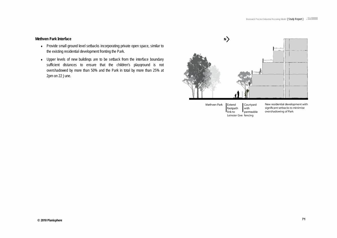
© 2010 Planisphere
Methven Park Int♦ Provide sm
the existin
♦ Upper levsufficient overshado2pm on 22
e
terface mall ground level setbng residential develop
vels of new buildingsdistances to ens
owed by more than 52 June.
backs incorporating pment fronting the Par
s are to be setback fsure that the child50% and the Park in
private open space, sirk.
from the interface bodren’s playground n total by more than
imilar to
oundary is not 25% at
Brunswick Precinct Industrial Rezoning Model [ Study Report ]
71
1

© 2010 Planisphere
7 Built
e
Form Map
Brunswick Precinct Industrial Rezzoning Model [ Study Report ]
72
2

© 2010 Planisphere
8 Land
e
Use Map
Brunswick Precinct Industrial Rezzoning Model [ Study Report ]
73
3

© 2010 Planisphere
e
PARTT D: IMP
Brunswick Precinct Industrial Rez
PLEMENT
zoning Model [ Study Report ]
74
TATION
4

© 2010 Planisphere
15 Imple
This section outlineStatutory planning public infrastructurPlanning Provision
13.1 Zoning The following tableprecincts, by consi
Zone
Residential 1 (R1Z)
mentation O
es options for implemtools examined inclu
re and social housingns.
options e provides a detaileddering the purpose an
Purpose
Residential developmdensities with a variet
Residential developmthe neighbourhood ch
Allows educational, rereligious, community range of other non-reserve local communitappropriate.
Options
menting the UDF throude the Design and g objectives through
d evaluation of the rend section 1 and 3 us
SePe
ment at a range of ty of dwellings.
ment that respects haracter.
ecreational, and a limited
esidential uses to ty needs as
ough the Moreland PlaDevelopment Overlaythe planning scheme
elative advantages anses of each zone.
ection 1 Uses – Not Reermit
Animal keeping
Apiculture
Bed and Breakfast
Circus/ Carnival
Dependent Persons U
Dwelling
Home Occupation
Informal Outdoor Rec
Mineral exploration/ M
Minor Utility Installatio
Place of Worship
Residential Aged care
Telecommunications
Railway/Road/Tramw
anning Scheme. It cy, Environmental Aude is also examined;
nd disadvantages of
equiring a Uses
Unit
creation
Mining
on
e Facility
facility
way
▪ A
▪ A
▪ B
▪ C
▪ Ex
▪ H
▪ In
▪ In
▪ M
▪ O
▪ R
▪ S
▪ Tr
considers various zondit Overlay and Deveas are a number of
utilising the available
Prohibited
musement parlour
nimal boarding/training
rothel
inema/ Nightclub
xtractive industry
orse stables
ndustry/ Warehouse
ntensive animal husband
Motor racing track
Office
Retail premises
aleyard
ransport terminal
Brun
nes and overlays thateloper Contributions Oimplementation mec
e residential, industri
Discussion and
dry
Currently appliedof Brunswick.
Appropriate for sresidential, homewhich are locatedinterface.
swick Precinct Industrial Rezoning
t could be applied to Overlay. The feasibihanisms that sit outs
al and business zone
Recommendation
d extensively across the
ites that will be used prie business or communityd with a substantially res
Model [ Study Report ]
75
the Study Area. lity of achieving
side the Victoria
es for particular
residential areas
imarily for y purposes, and sidential

© 2010 Planisphere
Zone
Residential 2 (R2Z)
Purpose
Residential developmhigher densities to maof the facilities and se
Residential developmthe neighbourhood ch
Educational, recreatiocommunity and a limiother non-residential local community needlocations.
SePe
ment at medium or ake optimum use ervices available.
ment that respects haracter.
onal, religious, ited range of uses to serve
ds in appropriate
ection 1 Uses – Not Reermit
Animal keeping
Apiculture
Bed and Breakfast
Circus/ Carnival
Dependent Persons U
Dwelling
Home Occupation
Informal Outdoor Rec
Mineral exploration/ M
Minor Utility Installatio
Place of Worship
Residential Aged Car
Search for stone
Telecommunications
Railway/Road/Tramw
equiring a Uses
Unit
creation
Mining
on
re Facility
facility
way
▪ A
▪ A
▪ B
▪ C
▪ Ex
▪ H
▪ In
▪ In
▪ M
▪ O
▪ R
▪ S
T
Prohibited
musement parlour
nimal boarding/training
rothel
inema/ Nightclub
xtractive industry
orse stables
ndustry/ Warehouse
ntensive animal husband
Motor racing track
Office
Retail premises
aleyard
ransport terminal
Brun
Discussion and
dry
Appropriate for sresidential, homewhere redevelop
The UDF (and Ststorey developmewould be achievedemolition of exisoccur in the shor
Removal of third by which higher dthis zone.
swick Precinct Industrial Rezoning
Recommendation
ites that will be used prie business or communityment for higher densitie
tructure Plan) recommeent on the Victoria Streeed through site consolidsting stock, and is consirt-medium term.
party appeal rights is thdensity development is
Model [ Study Report ]
76
imarily for y purposes, and
es is encouraged.
ends up to 5 et sites. This ation and idered unlikely to
he primary means encouraged in

© 2010 Planisphere
Zone
Mixed Use (MUZ)
Activity Centre (ACZ)
Purpose
A range of residentialindustrial and other ucomplement the mixethe locality.
Residential developmthe neighbourhood ch
A mixture of uses anddevelopment of an acfocus for business, shhousing, leisure, transcommunity facilities; asustainable urban outmaximises the use ofand public transport.
A diversity of housingdensities to make optfacilities and services
Through good urban attractive, pleasant, wstimulating environme
SePe
l, commercial, ses which
ed-use function of
ment that respects haracter.
d intensive ctivity centre: as a hopping, working, sport and and to support tcomes that f infrastructure
g at higher timum use of s.
design, an walkable, safe and ent.
ection 1 Uses – Not Reermit
Animal keeping
Apiculture
Bed and Breakfast
Circus/ Carnival
Dependent Persons U
Dwelling
Home Occupation
Informal Outdoor Rec
Mineral exploration/ M
Minor Utility Installatio
Place of Worship
Residential Aged care
Telecommunications
Railway/Road/Tramw
Based on a tailored Sthe Zone
equiring a Uses
Unit
creation
Mining
on
e Facility
facility
way
A
B
Ex
Schedule to BS
Prohibited
dult sex bookshop
rothel
xtractive industry
ased on a tailored chedule to the Zone
Brun
Discussion and
Appropriate for sincluding residenindustrial/warehodensity residentia
In order to facilitabe amended to inand Trade suppli
Appropriate for sPlan (MAC or PAfor all areas in th
Allows for a diverdevelopment out
swick Precinct Industrial Rezoning
Recommendation
ites that will incorporatential, office, small light ouse and/or retail; but wal is to be a dominant la
ate a mix of uses the zonclude floor space limitses.
ites within an Activity CeAC) area, and as part of e Structure Plan.
rse mix of land uses, hetcomes.
Model [ Study Report ]
77
e a range of uses,
here higher and use.
ne schedule can s for Office, Shop
entre Structure a wider rezoning
eights and

© 2010 Planisphere
Zone
Industrial 1 (IN1Z)
Purpose
Provide for manufactustorage and distributioassociated uses in a does not affect the saof local communities
SePe
uring industry, the on of goods and manner which
afety and amenity
ection 1 Uses – Not Reermit
Apiculture
Circus/ Carnival
Crop raising
Extensive animal hus
Home Occupation
Industry
Informal Outdoor Rec
Mail centre
Mineral exploration/ M
Minor Utility Installatio
Search for Stone
Service Station
Shipping container st
Telecommunications
Railway/Road/Tramw
Warehouse
equiring a Uses
sbandry
creation
Mining
on
torage
facility
way
A
Cfa
H
In
S
Prohibited
ccommodation
inema entertainment acility
ospital
ntensive animal husband
hop
Brun
Discussion and
dry
Appropriate for sscale industry or for areas where renvisaged in futu
Buffers are requiIndustrial 1 Zone
swick Precinct Industrial Rezoning
Recommendation
ites that will continue towarehouse purposes.
residential use is encouure.
red between many usese and adjacent residentia
Model [ Study Report ]
78
o be used for large Not appropriate raged or
s within the al zones.

© 2010 Planisphere
Zone
Industrial 3 (IN3Z)
Purpose
Provide for industriesuses in specific areasconsideration of the nimpacts of industrial uor to avoid inter-indus
Provide a buffer betw1 Zone or Industrial 2communities, which aindustries and associcompatible with the ncommunity.
SePe
s and associated s where special nature and uses is required stry conflict.
ween the Industrial 2 Zone and local allows for ated uses
nearby
ection 1 Uses – Not Reermit
Apiculture
Circus/ Carnival
Crop raising
Extensive animal hus
Home Occupation
Informal Outdoor Rec
Mail centre
Mineral exploration/ M
Minor Utility Installatio
Search for Stone
Service Station
Shipping container st
Telecommunications
Railway/Road/Tramw
equiring a Uses
sbandry
creation
Mining
on
torage
facility
way
A
Cfa
Ex
H
In
Mfa
M
S
Prohibited
ccommodation
inema entertainment acility
xtractive industry
ospital
ntensive animal husband
Major sports and recreatiacility
Motor racing track
hop
Brun
Discussion and
dry
on
Appropriate for ssmaller scale indfor areas where rfuture.
swick Precinct Industrial Rezoning
Recommendation
ites that will continue toustry or warehouses. Nresidential is encourage
Model [ Study Report ]
79
o be used for Not appropriate ed or envisaged in

© 2010 Planisphere
Zone
Business 1 (B1Z)
Purpose
Intensive developmencentres for retail, comcommercial, entertaincommunity uses.
SePe
nt of business mplementary nment and
ection 1 Uses – Not Reermit
Shop
Restaurant
Food and drink premi
Office
Dwelling
Trade supplies
Informal outdoor recr
Child care
Home Occupation
Apiculture
Betting agency
Caretakers house
Carnival/ Circus
Cinema
Education Centre
Electoral office
Mineral Exploration/ M
Minor Utility Installatio
Postal agency
Railway/ Road/ Tram
Search for Stone
Telecommunications
equiring a Uses
ises
reation
Mining
on
way
facility
C
Ex
In
Mfa
M
Prohibited
orrective institution
xtractive industry
ntensive animal husband
Major sports and recreatiacility
Motor racing track
Brun
Discussion and
dry
on
Appropriate for spurposes that incuses at the grounuses above.
Dwellings and offof the frontage.
swick Precinct Industrial Rezoning
Recommendation
ites that will be primarilyclude mixed retail/commnd level with residential
fices at ground level mu
Model [ Study Report ]
80
y used for mercial/business
and/or office
ust not exceed 2m

© 2010 Planisphere
Zone
Business 2 (B2Z)
Business 3 (B3Z)
(existing zone)
Purpose
Offices and associateuses.
Offices, Manufacturinassociated CommercUses.
SePe
ed commercial
ng Industries and cial and Industrial
ection 1 Uses – Not Reermit
Office
Informal outdoor recr
Home Occupation
Apiculture
Caretakers house
Carnival/ Circus
Mineral Exploration/ M
Minor Utility Installatio
Railway/ Road/ Tram
Search for Stone
Telecommunications
Office
Informal outdoor recr
Home Occupation
Apiculture
Caretakers house
Carnival/ Circus
Industry
Mail Centre
Mineral Exploration/ M
Minor Utility Installatio
Postal Agency
Railway/ Road/ Tram
Search for Stone
Telecommunications
Warehouse
equiring a Uses
reation
Mining
on
way
facility
C
Ex
In
Mfa
M
Ti
reation
Mining
on
way
facility
A
Ex
H
In
Mfa
M
S
Prohibited
orrective institution
xtractive industry
ntensive animal husband
Major sports and recreatiacility
Motor racing track
imber yard
ccommodation
xtractive industry
ospital
ntensive animal husband
Major sports and recreatiacility
Motor racing track
hop
Brun
Discussion and
dry
on
Appropriate for sand commercial aindustry can co-e
dry
on
This is the primaStreets Precinct.
Appropriate for spurposes of office
The zone would accommodate ofthe exception of cprohibited.
swick Precinct Industrial Rezoning
Recommendation
ites that will be primarilyactivity, and where residexist, subject to approva
ry current zoning for the
ites that will be primarilyes, industry and/or ware
be applied to areas thatffice/industry/warehousecaretaker’s houses, acc
Model [ Study Report ]
81
y used for offices dential and al.
e Gale/Cross
y used for the ehouse.
t are intended to e type uses. With commodation is

© 2010 Planisphere
Zone
Business 4 (B4Z)
Purpose
Bulky Goods Retail aIndustry, and associaServices.
SePe
nd Manufacturing ated Business
ection 1 Uses – Not Reermit
Apiculture
Carnival/ Circus
Electoral office
Equestrian supplies
Industry
Informal outdoor recr
Lighting shop
Mail centre
Mineral Exploration/ M
Minor Utility Installatio
Party supplies
Restricted retail prem
Railway/ Road/ Tram
Search for Stone
Service station
Telecommunications
Trade supplies
Warehouse
equiring a Uses
reation
Mining
on
mises
way
facility
A
Ex
H
In
Mfa
M
S
Prohibited
ccommodation
xtractive industry
ospital
ntensive animal husband
Major sports and recreatiacility
Motor racing track
hop
Brun
Discussion and
dry
on
Very similar to thsites that will be good retailing an
Does not provideneed for a permitTherefore would have a strictly bu
swick Precinct Industrial Rezoning
Recommendation
e B3Z, however more aprimarily used for the pud manufacturing.
e the flexibility of office ut and accommodation isbe applied to areas tha
ulky goods/manufacturin
Model [ Study Report ]
82
appropriate for urposes of bulky
uses without the s prohibited. t are intended to
ng focus.

© 2010 Planisphere
Zone
Business 5 (B5Z)
Comprehensive Development Zone (CDZ)
Proposed Zones
Urban DevelopmeThe State GovernDevelopment Zoneindustrial land for m
To date no specificthat the proposed
Purpose
Offices or Multi-Dwellcommon access from
To provide for a rangdevelopment of land with a comprehensiveplan incorporated in t
s
ent Zone nment in March 2010e. The zone is intenmixed use and residen
c information has beezone is intended for
SePe
ling Units with m the street.
e of uses and the in accordance e development the scheme.
0 announced the intnded to facilitate thential purposes.
en released about thelocations such as the
ection 1 Uses – Not Reermit
Apiculture
Caretaker’s house
Carnival/ Circus
Dwelling
Home occupation
Informal outdoor recr
Mineral exploration/ M
Minor Utility Installatio
Office
Railway/ Road/ Tram
Search for stone
Telecommunications
The zone schedule cacustomised to suit thethe comprehensive dplan that forms the bazone provisions.
troduction of a new e redevelopment of f
e proposed zone. It ape Brunswick East ind
equiring a Uses
reation
Mining
on
way
facility
A
A
B
C
Ex
H
In
an be e objectives of evelopment asis of the
Thcuobcodefopr
Urban former
ppears dustrial
area future
As thconsarea
New The three
Prohibited
nimal keeping
nimal training
rothel
orrective institution
xtractive industry
orse stables
ndustry
he zone schedule can bustomised to suit the bjectives of the omprehensive evelopment plan that orms the basis of the zonrovisions.
and will likely represe.
he process of prepasiderable period of tim
continue to proceed
Residential ZonesState Government pr
e new residential zone
Brun
Discussion and
Appropriate for spurposes of office
Does not provideoffice uses within
be
ne
Used to facilitateproposals. Involvdevelopment plamay be replacedprovisions once d
sent an appropriate im
aring and seeking come it is recommendedutilising existing VPP
roposes to replace thees.
swick Precinct Industrial Rezoning
Recommendation
ites that will be primarilyes or dwellings.
e the flexibility of allowinn the same building.
large and/or complex dves the incorporation of n into the planning sche by standard zone and odevelopment has been c
mplementation option
omment on the zoned that the process oftools.
e existing Residential
Model [ Study Report ]
83
y used for the
g residential and
development a comprehensive
eme. The zone overlay completed.
at some time in the
e is likely to take a f rezoning the study
l 1 and 2 zones with

© 2010 Planisphere
One of the draft Neighbourhood Acpromoting higher d
It would also allowpopulation densitybuilt form to reflect
The draft zone prov
It is therefore expethe proposed newdensity and built fo
13.2 Local PlThe Brunswick Stris currently not impStructure Plan theprovide a strategic
zones is intended ctivity Centres and adjdensity housing.
w a limited range of a. There would be tht the preferred new ch
visions suggest that t
ected that R1Z land sw zones are implemeorm objectives of the U
lanning Policyructure Plan (Oct 200plemented into the Moe MSS should be afoundation for the UD
to apply to areas jacent to the Principa
additional uses to serve ability to apply mul
haracter.
taller buildings will be
surrounding the precinented. This will compUDF.
y Framework 00) provides the guidaoreland Planning Schamended to referencDF.
near Principal, Majoal Public Transport Ne
ve an expected increltiple schedules to va
acceptable in this zo
nct would be rezonedplement the land use
ance for this UDF, hoeme. Upon adoption
ce the Structure Pla
or and etwork,
ease in ary the
ne.
d once e mix,
owever of the
an and
The StratEmp
13.3A vaThe mutu
The recomissue
Immepurpo
MSS does, however, tegy 2004 (see Clauloyment Local Policy
3 Overlay optiriety of planning scheobjectives of the ov
ually exclusive.
table below summmendations are maes that are discussed
ediately following theose overlays that are
already include refereuse 21.05-2), which (Clause 22.03).
ions eme Overlay options hverlays vary marked
mmarises the optionade in this table as in more detail in subs
e Built Form Overlayrelevant to the study
Brunswick Precinct Industrial Rez
ence to the Morelandforms the basis fo
have been consideredly and, unlike zones
ns available for bthe choice of overlasequent sections of th
ys table is a discussarea.
zoning Model [ Study Report ]
84
d Industrial Land Use or the Industry and
d for the study area. s, overlays are not
built overlays. No ay will depend upon he report.
sion about specific-

© 2010 Planisphere
Built Form Over
Overlay Pu
Incorporated Plan Overlay (IPO)
To
To andacc
ThIncPla
Thschchato bmareausethircomowexicatsur
rlay Options
urpose
identify areas which req
The form and conditiouse and developmentshown on an incorporbefore a permit can buse or develop the lan
A planning scheme abefore the incorporatebe changed.
exempt an application fd review if it is generallycordance with an incorp
e VPP Practice Note Apcorporate Plan and Devean Overlays (2003) state
e IPO requirement for aheme amendment to incange the plan enables thbe involved in the proceaking or changing the plason, the IPO should noed for sites that are likelrd-party interests and simprising multiple lots in
wnership. Most redevelopisting urban land will falltegory, particularly wherrrounding land use is re
Advan
quire:
ons of future t to be rated plan
be granted to nd.
mendment ed plan can
from notice y in porated plan.
pplying the elopment es:
a planning corporate or third parties ess of lan. For this ormally be ly to affect ites different
pment of l into this re the
esidential.
Fadedeow
Thobplaan
Aldeacde
Scto
Faexapin beinvan
tages
acilitates the implementaetailed, holistic plan that evelopment of land undewnership.
he combined land use abjectives and controls arace, and interrelated witnother.
lows permits to be issueevelopment/use not ‘genccordance with the plan’ecision guidelines.
chedules to the IPO canintroduce new decision
acilitates implementationxempting third party notippeal processes. This iscircumstances where th
een appropriate third pavolvement in the strategnd amended processes.
Disadv
ation of a coordinates
er multiple
nd built form re in one th one
ed for nerally in subject to
n be drafted guidelines.
n by fication and
s appropriate here has rty
gic planning
Caad
Cascam
Leaspapu
Exbepadu
Ream
vantages
an be more complex to dminister than standard
an be inflexible as a placheme amendment is remend the Incorporate Pl
ess transparent than stas the Incorporated Plan,art of the planning schemublished separately.
xclusion of third party pre inappropriate if insufficarty engagement has ocuring strategic planning.
equires a planning schemendment to change th
Conclu
interpret and zones.
anning equired to lan.
andard zones , although me, is
rocesses will cient third ccurred .
eme e plan.
Design
Can incbenefit
Requireamend dependproposaIP and a trans
Brunswick Precinct Industrial Rez
usion
ed for locations with mu
clude specific details of infrastructure objectives
es an amendment procethe plan and therefore
ding on the framing of thals must be generally indo not involve a third paparent process.
zoning Model [ Study Report ]
85
ultiple landowners.
built form and public s.
ess to introduce and can be inflexible,
he Plan. Development n accordance with the arty process. Thus is

© 2010 Planisphere
Overlay Pu
Development Plan Overlay (DPO)
To fordevdevbe
To andacc
ThIncPla
Beappnorprosigselis lsiteresadj
urpose
identify areas which reqm and conditions of futuvelopment to be shown velopment plan before agranted to use or devel
exempt an application fd review if it is generallycordance with a develop
e VPP Practice Note Apcorporate Plan and Devean Overlays (2003) state
ecause the DPO has no proval process for the prmally be applied to devoposals that are not likelgnificantly affect third-palf-contained sites wherelimited to one or two pares that contain no existinsidential population and join established residen
Advan
quire the ure use and on a
a permit can lop the land.
from notice y in pment plan.
pplying the elopment es:
public plan, it should velopment ly to
arty interests, e ownership rties and ing do not
ntial areas.
Thobplaan
FaexapgeDein beinvan
Chnoam
tages
he combined land use abjectives and controls arace and interrelated withnother.
acilitates implementationxempting third party notippeal processes if a proenerally in accordance wevelopment Plan. This iscircumstances where th
een appropriate third pavolvement in the strategnd amendment processe
hanges to the Developmot require a planning schmendment.
Disadv
nd built form re in one h one
n by fication and posal is
with the s appropriate here has rty
gic planning es.
ment Plan do heme
Hacoamtra
Exbepadu
Inprthim
Nediar
vantages
as no public notificationonsultation process in apmending the plan, therefansparency.
xclusion of third party pre inappropriate if insufficarty engagement has ocuring strategic planning.
dividual developers mayressure for incremental e plan which compromi
mplementation.
egotiation of a single plafficult where several lanre involved.
Conclu
or pproving or fore can lack
rocesses will cient third ccurred .
y exert changes to se its
an may be nd owners
Designalthougowners
RequireDPO. Tof the cprepareDevelotime aswith the
The apwith theparty pPlan caThis is leaves
Brunswick Precinct Industrial Rez
usion
ed primarily for sites in sgh can be used where thship.
es an amendment proceThe DPO is designed tocontents of a Developmeed later by land owners.pment Plan can be put
s the Amendment to introe IPO.
proval of a proposal gene Development Plan doerocess. Amendment to an also be made withoutnot as transparent a prothe Plan open to appea
zoning Model [ Study Report ]
86
single ownership, here is multiple
ess to introduce the o introduce an outline ent Plan that is . However a in place at the same oduce the Overlay as
nerally in accordance es not involve a third the Development t a third party process. ocess as the IPO, and al by land owners.

© 2010 Planisphere
Overlay Pu
Design and Development Overlay (DDO)
To spedesdev
urpose
identify areas which areecific requirements relatsign and built form of nevelopment.
Advan
e affected by ting to the ew
Threanthe
He
Se
Pe
La
De
Ot
De
Scto
tages
he DDO can apply specquirements for the follo
nd development elemene precinct:
eights
etbacks
edestrian links
aneway splays
esign guidelines
ther permit requirements
ecision Guidelines
chedules to the DDO caintroduce new decision
Disadv
ific owing design ts relating to
s
an be drafted guidelines.
▪ ThththdeladocoReinfo
▪ Careusof
vantages
he DDO identifies and ae specific requirementse design and built form evelopment. It does notnd use objectives and thoes not outline the full raontrols applicable to the eference must be made relation to land use and
orm controls.
annot be used to adequeinforce the implementatse or public infrastructurf the UDF.
Conclu
applies only relating to of new t combine herefore ange of land.
e to the zone d some built
uately tion of land re objectives
Design
Can incpublic bpropose
RequireIndividupermit aconstru
Needs use direfor pub
Brunswick Precinct Industrial Rez
usion
ed for locations with mu
clude specific details of benefit infrastructure objed new roads.
es an amendment proceual proposals may be suapplications depending
ucted.
to be used in conjunctioections, and negotiationlic infrastructure improv
zoning Model [ Study Report ]
87
ultiple landowners.
built form and limited jectives, such as
ess to introduce. ubject to planning on how the DDO is
on with policy for land n with land developers vements.

© 2010 Planisphere
Public AcquisitiThe Public Acquisacquired by an autto the use or develto be acquired.
Landowners affectauthority, which in be responsible for which it was acquir
Construction of negotiation, whichconstruction beinmechanisms are d
Environmental A
The Environmentafor industrial purpoensure that they contamination.
The overlay requirprior to developmeuses, child care ce
Clause 45.03-1 sta
♦ A certifaccord
♦ An env1970 mthe env
The map below ideon the possibility osites that are unctherefore do not re
on Overlay (PAO) ition Overlay (PAO) ithority or to reserve lalopment of the land d
ted by a PAO would this case would be the works and assoc
red.
streets and lanewah includes designing carried out by iscussed in section tit
Audit Overlay (EAO
l Audit Overlay is reqoses in the past, or a
are suitable for u
res that a landownerent or approval of a sentres, pre-school cen
ates that:
ficate of environmentadance with Part IXD of
vironmental auditor apmust make a statemenvironmental conditions
entifies properties thaof contamination due coloured have only equire the overlay. F
is used to identify lanand for a public purpoo not prejudice the pu
d be compensated fthe Moreland City Cociated costs to devel
ays is usually achng the access link
the developer. Atled ‘Public Benefit Inf
O)
quired to be applied toare suspected of poteuses which could b
r undertake an Envirensitive use. Sensitiv
ntres or primary schoo
al audit must be issuef the Environmental P
ppointed under the Ennt in accordance with s of the land are suita
at require an EAO to bto past uses. Reseaever been used for
Further detail about th
nd which is proposedose, to ensure that churpose for which the l
for the land by the ouncil. Council wouldop this land for the u
ieved through landks into developmenAlternative implemenfrastructure’.
o sites that have beenential soil contaminatbe adversely affecte
ronmental Audit of thve uses include: residols.
ed for the land in Protection Act 1970, o
nvironment ProtectionPart IXD of that Act t
able for the sensitive u
be placed over them, arch has confirmed thr residential purposehe approach that has
d to be hanges land is
public d then use for
downer t and ntation
n used ion, to ed by
he soil dential
or
n Act that use.
based hat the es and s been
appliCoffeexclu
13.4The ident
AffoThe estabaffordState
Recehouswhich
ed to identify these sey Environments to usion of the uncoloure
4 Public Benepotential public bene
tified for consideration
♦ Cross Street an
♦ Leinster Grove
♦ Widening of the
♦ Widening of theturning space
♦ Rainwater harvFleming Park
♦ Inclusion of com
♦ Relocation of o
♦ Footpath widen
♦ Traffic manage
♦ Street tree plan
♦ Footpath throulink.
ordable Housing Planning and Environblish a link between tdable housing. Until e and Federal Govern
ent initiatives have ssing provision. Althouh address affordable
sites is provided at sereview the findings oed sites below from th
efit Infrastructuefit initiatives and strn in the Study Area ar
nd French Avenue str
to Albert Street pede
e laneway between Ly
e laneway splays at th
vesting from Cross S
mmunity housing as p
overhead power lines
ning in Cross St and w
ement measures in Cr
nting
gh Methven Park to
nment Act 1987 and the planning powers recently public hous
nment and provided b
seen the community ugh Councils have dhousing, there is no
Brunswick Precinct Industrial Rez
ection 3.0 of this repof this report. The rehe EAO.
ure Initiativesreetscape improvemere:
reet improvements
estrian link
ygon and Gale Street
he corner of two lane
Street developments
part of the future resid
underground
western part of French
ross and Albert Street
Leinster Grove from
the Victorian Planninof local government sing in Victoria has y the State.
sector become invodeveloped housing s
o statutory planning m
zoning Model [ Study Report ]
88
port. DPCD engaged eport supported the
ents that have been
ts
es to improve vehicle
for water reuse on
dential tenancy mix
h Avenue
ts
the French Avenue
ng Provisions do not and the provision of been co-funded by
olved in community strategies, many of
mechanism by which

© 2010 Planisphere
to require private approach known ov
The Moreland Affogovernment in facCouncil involvemen
The fundamenMunicipal Strasocial justice ato take a primawould enable it
Therefore Couhousing provis
• using its pow
• continuing to
• providing comand advocaprovided;
• looking for accessibility development
• facilitating pinvestment a
Thus, the parsummarised as
• regulation an
• information p
• advocacy (sprovisions);
• project facilit
• Council leade
• research. (pa
development to incverseas as ‘inclusiona
ordable Housing Stracilitating affordable hnt:
ntal policy positions tegic Statement requ
and community well-bary role in delivering t to compel the marke
uncil’s role will necession by:
wers and influence in r
o influence the State G
mmunity leadership ates (mainly in-kind)
creative means to in the private d
t sites; and
projects which delivand commitment.
rameters of Council s:
nd planning (subject to
provision (to housing s
so that the Victorian
ation, funding, resour
ership; and
age 65).
clude a component ary zoning’).
ategy 2006 advocatehousing, but also rec
in the Moreland Couire Council to addrebeing issue. But clearhousing stock, nor haet to perform in particu
sarily be more subtle
relation to planning in
Government;
and assistance in reand ensuring that
encourage affordabdevelopment sector,
ver housing and a
involvement with a
o Victorian Planning P
suppliers, residents a
n Planning Provision
rce contribution and p
of affordable housin
es for a great role focognises the limitatio
ouncil Plan 2005-200ss affordable housingrly Council is not resoas it regulatory poweular directions.
and facilitative, to infl
n the private market;
sourcing housing agenecessary informat
bility, appropriatenessespecially on str
assist in catalysing
affordable housing c
Provisions);
nd interest groups);
ns include more amb
partnership;
ng (an
r local ons to
09 and g as a ourced rs that
fluence
encies tion is
s and rategic
other
an be
bitious
In reby agsmalafforddeve
PossPublipublito adpublinew
Equitthey the inthat propogenethe e
A nuimple
A reainitiadevecann
lation to the study aregreement with individl size of many of thedable housing is like
elopments.
sible Funding Mecic benefit initiatives ac infrastructure either
ddress existing issuesc open space, which development, or to ad
ty issues arise in relainvolve the expendit
nitiative is to be implethe initiative is needosed initiative, and t
erally accepted principentire cost of addressi
umber of important ementation of public b
♦ The initiative m
♦ There must be
♦ There must becontribution anbenefit from thdirectly as a res
♦ The contributioto pay more tha
♦ Collection andtransparent ma
al issue that arises fotive that does not so
eloped localities. Thisnot be expected to fu
ea, the imposition of adual developers is likee properties in the stuely to have an impac
chanisms re aimed at achievingr to mitigate the impas within the locality. A
can serve to both caddress an existing sh
ation to the implementture of public or privaemented by a private ded, that there is a hat the contribution eple, for example, thating existing problems
principles need tobenefit initiatives:
must be legally justified
a strategic justificatio
e a link, or nexus, bnd the proposed inithe initiative; or the isult of a development
on must be equitable an their fair share of t
d expenditure of canner.
or local government ismehow benefit an ex means that an indiv
und public benefit init
Brunswick Precinct Industrial Rez
an affordable housingely to be problematic.udy area any mandact on the economic v
g improvements to cocts of change createdcommon example is
ater for the additional ortfall.
tation of public benefate funds, usually ondeveloper it is neceslink between the de
expected of the devet developers cannot b such as lack of car p
o be considered w
d and enforceable;
on for the initiative;
between the entity wiative (i.e. the entitynitiative addresses at undertaken by the e
(i.e. no single entity he cost of implementa
contributions must b
s that it is rare to idenxisting community, pavidual developer, or gtiatives in their entire
zoning Model [ Study Report ]
89
g element other than Given the relatively tory requirement for viability of proposed
mmunity services or d by development or the provision of new demand created by
fit initiatives because public land. Where
ssary to demonstrate evelopment and the eloper is fair. It is a be expected to bear
parking.
hen assessing the
which is making the y must derive some an issue that arises ntity);
should be expected ation);
be managed in a
ntify a public benefit articularly in densely group of developers, ety. In such cases it

© 2010 Planisphere
usually falls to locand the full cost of
The following discprinciples in mind.does not address part of a planning aand widening of lan
The funding meccontribution made be inequitable, to infrastructure provimprovements alsoengagement, quali
Developer ContribA Developer Contrcontributions to plalevies through an Scheme.
The calculation oRecurrent costs suadministration of tcontributions levy.
DCPs are advantadelivery, integratindevelopers. Howethe Planning Scheof only a portion of
A number of munidrainage works inc
Advantages:
♦ Will nogenera
♦ Can lev
♦ A DCPcontrib
cal government to fill the initiative.
cussion assesses a ra The discussion focuinitiatives proposed t
application, for exampneway splays.
chanisms described by developers to infrexpect that Council
ision. Aside from theo require Council leaty control, and design
bution Plans ribution Plan (DCP) eanned infrastructure n
approved DCP, wh
f the levy is baseduch as maintenance athe DCP cannot be
ageous in respect ofng strategic planninever, disadvantages ome making them timef total funding.
cipalities in metropolcluding Glen Eira, Mar
t levy existing residenal ratepayers’ perspec
vy most infrastructure
P enables infrastructurutors.
the gap between the
ange of implementatuses entirely on publito occur on private laple, the introduction o
below identify oprastructure provision. would be absolved question of funding,adership in terms ofn consistency.
enables a Council toneeded by a future coich is included as a
d on the estimated and operating costs o
included in the calc
f sharing costs among and infrastructureof DCPs include the e consuming and cos
litan Melbourne haveribyrnong and Darebi
nts and therefore morctive.
e items identified.
re costs to be shared
e development contri
ion options with the c realm improvemenand that are negotiat
of new laneway conne
tions for maximisinIt is unrealistic, and from contributing to public realm infrastrf coordination, stake
levy new developmeommunity. Council can overlay in the Pla
cost of the infrastruor costs associated wculation of a develo
ngst multiple users, e programs, certainneed for an amendmtly, and the ability to
e existing DCPs for fun.
re acceptable from the
fairly amongst multip
ibution
above ts and ted as
ections
g the would public
ructure holder
ent for ollects anning
ucture. with the
pment
faster nty for ment to
collect
unding
e
le
Disad
♦ A DCP can endependent updelivery of infrmust satisfy a
♦ A DCP providecontribute will was collected
dvantages:
♦ Need to demodevelopment abroader commdevelopment w
♦ A DCP relies oprojects can obe establisheddoes not havecharged in accdemonstrate n
♦ The DCP musadministration
♦ Infrastructure usage’. For thprojects are shexisting and fucharged for thand costs are new infrastrucportion of the user-pays sys
♦ A DCP is a binCouncil) to prospecification obest suited to is attributed to
♦ DCPs must hashould not excdevelopment i
nable the earlier deliveon general taxes or rarastructure for the comccountability and tran
es developers with cebe accounted for septo provide.
onstrate a direct relatioand the proposed levy
munity so need and newill be difficult to argu
on the justification of only be included in a Dd with a reasonable lee to trigger the need focordance with its projneed.
st be managed over thn resources for Counc
costs must be apporthe purpose of calculathared across all usersuture development. Te whole cost of an infdistributed on a fair a
cture can be charged tcost of providing the item including existing
nding obligation on thovide the infrastructuroutlined in the DCP. Tareas where a high p
o developers.
ave a reasonable timeceed 20-25 years. If tin the early years will
Brunswick Precinct Industrial Rez
ery of infrastructure thates. It also providesmmunity and developensparency principles.
ertainty that the moneparately and spent on
onship (need and nexy. Many of the items exus which links to prue.
infrastructure projectsDCP if use by the futuevel of certainty. A neor new infrastructure, ected share of usage
he period of the plan; cil.
tioned on the basis of ting levies, the costs os. The likely users wi
Therefore, new develofrastructure project thand equitable basis. Hthe levy, a DCP will oinfrastructure as it is dg users.
e infrastructure providre by the date, at the This is a long and cosproportion of infrastruc
e horizon. The time hthe time horizon is nobe paying for infrastr
zoning Model [ Study Report ]
90
han if its provision is s certainty about the ers, because a DCP
ey that they the infrastructure it
xus) between the will benefit the oposed
s. Infrastructure ure community can ew development it can only be
e. This is required to
this requires
f projected ‘share of of infrastructure ill include both opment will not be at others will use However, as only only cover a small determined on a
der (usually cost and to the stly process, usually cture to be delivered
horizon of a DCP ot reasonable, new ructure that will not

© 2010 Planisphere
be delivprecinc
♦ Levies specifiemainte
♦ Long tidifficultTime frunderlia servic
♦ There i($900 c
Section 173 AgreeSection 173 Agreeapplicants for a plaSections 173-184 o
Flexibility is the mlack transparency,
Advantages:
♦ Sectionfocused
♦ AccounDCPs,
Disadvantages:
♦ The necompro
♦ Section
♦ The AgdependCounci
♦ If matteneeded
vered until many yearct is an estimate at be
collected are only to ed in the DCP. This rnance of proper finan
meframes of 20 yearsties when projecting frames beyond this maes DCPs as it may bece that will not be dev
is a maximum levy thacap).
ements ements are voluntaryanning and developmof the Planning and E
main advantage of Seaccountability and m
n 173 Agreements had on particular develo
ntability requirementsmeaning administrati
egotiated nature of a Somises that can lead t
n 173 Agreements, by
greements are enteredds on the goodwill of eil officers/representati
ers are not resolved bd with both time and c
rs later. The time horest.
be used for the provisresponsibility highlighncial accounts.
s or more have the diuture growth rates reqay also diminish the pe considered unreasoveloped for many yea
at can be charged for
y agreements enteredent permit) and Coun
Environment Act 1987
ection 173 Agreemenonitoring can be com
ave the benefit of a wiopments;
are less stringent thaive costs are reduced
Section 173 Agreemeto sub-optimal or rela
y their nature, can als
d into voluntarily and each side and/or on tives
by negotiation, VCAT cost implications.
rizon for the Brunswic
sion of the infrastructuts the importance of t
sadvantage of creatinquired tocalculate lev
principle of equity, whionable to charge a usears to come.
r Community Infrastru
d into by the developncil under Part 9, Divis.
nts, however they caplex.
de and flexible ambit,
an those required for d.
ent can result in atively arbitrary outcom
so lack transparency.
their successful conche negotiation skills o
intervention may be
ck
ure the
ng vies. ich er for
ucture
per (or sion 2,
n also
, albeit
mes.
clusion of
Rate
Gene
The ratep
Geneacceand fundi
Adva
Disad
Spec
The propeproviservirecurincluarran
♦ Council may loparticularly whextended perio
es
eral Rates
majority of a Counpayers according to th
eral Rates systems eptance is not assured
rates are used to fing source.
antages:
♦ Simple admini
♦ Well understoo
♦ Flexibility at C
dvantages:
♦ Public accepta
♦ Rates are viewtherefore putti
♦ Rates are usecapital funding
♦ Existing comminitiators of ch
cial Rates
Local Government Aerties in question wided. Special Rates Sces and facilities withrrent programs and cde schemes for consngements for prov
ose track of works anhere there a large numod of time.
cil’s expenditure, inche relative value of the
are simple, well und as they are often vund Council operatio
istration;
od;
Council’s discretion.
ance is not assured;
wed as a tax rather thng a limit on what Co
ed to fund Council opeg source;
munities contribute to ange.
Act permits Councils twill receive a particuSchemes have typicahin defined areas Cocapital works. Commstructing footpaths, roiding services like
Brunswick Precinct Industrial Rez
d requirements undermber of Agreements i
cluding capital inveseir properties.
nderstood and flexibviewed as an additionons, limiting their po
han a user charge for ouncil can raise throug
erations, limiting their
capital works on an e
to levy additional or ‘slar benefit from the
ally been used for theuncils can use specia
mon examples of specoads, kerbs and chan
promotion, marke
zoning Model [ Study Report ]
91
r Agreements, n force, over an
stment, is borne by
ble, however public al tax by ratepayers
otential as a capital
a direct benefit gh this means;
potential as a
equal basis with the
special’ rates where e works or services e provision of shared al rates to fund both cial rates or charges nnels or drains; and eting or economic

© 2010 Planisphere
development (e.g. Charge Scheme fo
A Special Rates smunicipality. Couhowever, as reside
While a council maCouncil undertakescharges to be levspecial rate or chaworks or services benefit’ is a benefito other people.
For example, befoscheme it will calcfor the adjoining compared with gencouncil will limit ththeir combined sha
In the case of the will be used by the
To implement a spthe infrastructure itexternal landownespecified by the Lo
♦ the wacharge
♦ a desc
♦ the totapower;
♦ the tota
♦ the lan
♦ the maand lev
♦ details force.
for commercial businor levying traders for m
scheme for drainage uncil has had difficuent acceptance is gen
ay set a special rate os, it is limited by prov
vied in proportion to arge, it must estimatethat will be of benefitit that is additional to
ore a council propoculate what share of t
properties (improvedneral benefits to otherhe total proportion of are of the benefits.
Brunswick precinct th whole neighbourhoo
pecial charge schemetems and the level ofers. The study shoocal Government Act:
rds, groups, uses or ae is declared;
ription of the function
al cost of the performa
al amount of the spec
d in relation to which
anner in which the spevied;
of the period for whic
nesses). Port Phillip Cmarketing and econom
infrastructure provisulty implementing th
nerally very low.
or charge for almost visions of the Act whic
special benefits. Bee the proportion of tht to the people who a, or greater than, the
ses a special chargthe benefits of the road drainage, reduced r people (e.g. other dcosts to be paid by
here are a number ood not just the owners
e a study needs to bef demand driven by t
ould include conside
areas for which the sp
to be performed or th
ance of the function o
cial rates and special c
the special rate or sp
ecial rate or special ch
ch the special rate or s
City Council uses a Smic development.
ion exists in the Brimhe Special Rates sy
any type of activity thch require special rateefore a council propohe benefits of the proare liable to pay. A ‘s
e benefit generally ava
ge for a road constrad construction will p
dust, better accessrivers using the road)all the property own
f infrastructure items subject to rezoning.
e undertaken which rehe subject landowne
eration of the followi
pecial rate or special
he power to be exerci
or the exercise of the
charges to be levied;
pecial charge is declar
harge will be assesse
special charge remain
Special
mbank ystem,
hat the es and oses a oposed special ailable
ruction provide s, etc) ). The ners to
which
eviews rs and ng as
sed;
red;
ed
ns in
Adva
Disad
Diffe
DiffeGovelevel systecan bdiffer
The f
In allto lanbaseposs
antages:
♦ Benefits to be improved ameany benefits idin estimating t
♦ A Special Ratebeneficiaries ocosts is requir
dvantages:
♦ The major disaacceptance frobeing that Cou
♦ There are alsoresidents is reelsewhere in t
rential Rates
rential rates refer ternment Act to apply
of equity or efficiencem and vary for eachbe levied, but the highrential rate.
following Local Gover
♦ Knox City Cou
♦ Hepburn Shire
♦ Benalla Counc
♦ Melbourne Cit
♦ City of Greate
l cases identified diffend use. The study te
ed on geographic locsible.
taken into account inenity, safety, environmdentified in the definetotal special benefits a
es Scheme is a targeof the scheme pay forred to be fair and equi
advantage of such scom residents to pay founcil rate revenue sho
o questions of equity tequired to pay for certthe municipality, or in
to the opportunity higher rates to differe
cy. Different categori Council. There is nohest differential rate c
rnments have been id
uncil
e
cil
ty Council
r Dandenong.
erential rates are chaeam is not aware of acation, however unde
Brunswick Precinct Industrial Rez
n a works scheme arement or usage value. Ad purpose should be and total community b
ted funding mechanisr the works and the apitable.
chemes is the politicalor the works, with a could be used for this p
that arise particularly ain types of works thaa different period of t
available to Councent categories of landies of land are basedo limit to the number can be no more than f
dentified as applying d
arged across each muany differential rates ier the Local Governm
zoning Model [ Study Report ]
92
e usually related to As with all schemes, taken into account benefit.
sm in that the pportionment of
l difficulty in gaining ommon argument purpose.
where one group of at other residents in time, do not.
il under the Local d to create a greater d on Council’s rating or type of rates that
four times the lowest
differential rates:
unicipality and relate in existence that are
ment Act this seems

© 2010 Planisphere
Differential rates cathis provides some
Advantages:
♦ Easy to
♦ Adds toprojectmeet th
⎯
⎯
⎯
♦ Provideon cap
Disadvantages:
♦ Does nidentifie
♦ Levies means Area, bratepay
♦ Not usefunding
♦ Links tothat infmay beBrunsw
Open Space ContOpen Space Continfrastructure. Ope
an be altered from yee flexibility.
o implement and linke
o Council’s revenue ps, providing that therehe following equity pri
the benefit or user pto, make more use oservices;
the capacity to pay ppay rates than do ot
the incentive or encbe doing more towasuch as environmen
es the same level of eital improved value.
not usually collect reveed;
all ratepayers equallythat in a precinct with
business, residential eyer has been individu
ed to fund specific infg for specific projects,
o Council’s budget prfrastructure will delivee a long lead time for wick if Council has a 5
tributions tributions allow for ten space contribution
ear to year in line with
ed to council budget p
pool without needing te is justification for itsinciples:
pays principle – someof and benefit more fr
principle – some ratethers with similarly va
ouragement principleards achieving councilntal or heritage protec
equity as a general ra
enue for the specific n
y based on their land h mixed use such as etc will be levied the sally categorised corre
frastructure and May l, if the aim is to fund s
rocess not the developered within the capital
the delivery of infrast5 year capital works p
the collection of leviens can be collected as
h council’s budget pro
process;
to be linked to specific general use: i.e. mus
groups have more acrom specific council
payers have more abalued properties;
– some ratepayers ml goals than others in ction.
ate, in that the rate is b
needs of a small area
use description. ThisEast Brunswick Indus
same, unless each ectly.
lead to a shortfall in specific infrastructure
pment process, this mworks program. The
tructure specific to Eaprogram already ident
es to support open s cash in lieu, which m
ocess,
c st
ccess
bility to
may areas
based
a
s strial
.
means ere ast ified.
space means
that Meth
Unlikitems
Adva
Disad
FunThe availthe ccombpropoCoun
The againprecihighlon aConvappliDeve
a cash contribution hven Park.
ke rating schemes ans of infrastructure from
antages
♦ Developer (as
♦ Minimal stratedevelopment ,open space w
♦ Council can st
dvantages:
♦ Contribution c
♦ For new buildibefore 1989, m
♦ Contributions spaces,
♦ Payment is lin
♦ Contribution m
ding Mechanisms following table providable in Victoria. The circumstances of thbination of tools) inosed, the scale of thencil’s finance and cap
table names each tonst other options. Twinct, the second in rights that while some
a large scale they versely, the adminiscation at a small sca
eloper Contribution Pl
can be collected to
n open space contribm developers, not exis
s initiator of change) p
egic work is required t, however Council sho
will be more intensively
tipulate a cash contrib
can only be collected o
ings only, subdivisionmay be exempt from t
should have some lin
nked to percentage of
must not exceed 5% o
Overview des an overview levysuitability of each tooe case. Factors thaclude the nature ane area to be rezoned
pital works strategies.
ool, provides a brief owo rankings are prorelation to the applice levy options may bbecome too compl
trative costs and coale, while they can beans).
Brunswick Precinct Industrial Rez
support infrastructu
bution collects leviessting residents.
pays, not the general r
o link infrastructure pould generally demony used after than befo
bution of up to 5% of t
once, at subdivision;
of an existing buildinthe contribution;
nk to creating or impro
site value, not to cos
of the site value.
ying development cool, or combination of tat will influence the nd cost of public bd, the number of prop
overview of its meritsovided – the first in cation of the tool to be used effectively ovicated (eg. Section omplexity of some te effectively applied a
zoning Model [ Study Report ]
93
re improvements to
s to support the key
ratepayer base;
rojects with the nstrate that existing ore the subdivision;
total site value.
ng, constructed
oving public open
st of infrastructure.
ontributions currently tools, will depend on
choice of tool (or benefit infrastructure perties affected, and
s, and then ranks it relation to a small a larger area. This
ver a small precinct, 173 Agreements).
tools preclude their at a larger scale (eg.

© 2010 Planisphere
The commentary oequity; transparenc
The rankings conappraisal of the mranked from 1 to 5the sum of the mer(‘=’).
The analysis and rthe tools in the contool the Council wwell as its capital finance and capitaplan and implemenby the contribution
Key issues to be would include:
♦ Infrastrworks;
♦ Counci
♦ Counci
Historically Councdeveloper on a carelation to small improvements on adevelopment contimplement the prog
on merits that is contacy; and opportunities
tained in columns terits, for both a sma
5, with 1 representingrits discussed. Equall
rankings contained in ntext of the Brunswicill also need to consiworks strategy and
al works strategies annt a developer contribs.
addressed by Coun
ructure to be delivered
il’s capital works prog
il’s rating strategy.
cil has negotiated se-by-case basis. Whscale amendments,
a larger scale will reqtributions and to setgram.
ained in the table focufor external review.
hree and four are bll precinct or across the best option in ouly ranked options are
the table are based ok Industrial Strategy. ider its broader ratingprograms. The alignm
nd processes is necesbutions system and t
ncil in determining th
d and the nexus betw
gram and funding stra
development contrihile this approach ca, the effective achiequired further detailedt up the operationa
uses on fitness for pu
based on an ‘on baa larger area. Optiour opinion, having reg
denoted by an equa
on a general assessmIn selecting an appro
g and finance strategment of strategic plassary in order to effeto deliver the works f
e appropriate mix of
ween development and
tegy;
butions directly witn continue to be appevement of capital d analysis in order to al processes necess
rpose;
alance’ ns are
gard to ls sign
ment of opriate gies as anning, ectively funded
f tools
d
th the plied in
works justify
ary to
Brunswick Precinct Industrial Rezzoning Model [ Study Report ]
94

© 2010 Planisphere
Tool
Development ContrOverlay (DCPO)
Public Open Space
Section 173 Agreem
Mer
ributions Plan AppEquinfraTranConCerQuapropViabCou
Contributions AppstreEquTraConCerQuaViafull * W
ment AppEquTranegConleadCerchaQuabe kViab
rits
propriateness – specificauity – applies only when astructure. nsparency – incorporatensistency – applies accortainty – plan can be chaantum of contribution – dposed infrastructure. bility – unlikely to be viauncil or the the area covpropriateness – statutoryeetscape works. uity – applies only to devnsparency – planning snsistency – a consistentrtainty – contribution shoantum of contribution – bility – can be viably userange of public benefit i
Would need to be used in
propriateness – commonuity – applies only whennsparency – Council mu
gotiation process. nsistency – the amount d to inconsistent applicartainty – requires the agallenged at VCAT. antum of contribution – dknown from the outset thbility – can be viably use
ally designed for levyingdevelopment occurs. C
ed into the planning schording to a consistent foallenged at amendment dependent on establishi
ble at a precinct scale; vered by the Brunswick Sy tool specifically design
velopment at the time ofcheme amendment andt contribution should be ould be made in most caquantum may be challeed at precinct level to crinfrastructure proposed.n conjunction with anoth
nly used for developmen development occurs, hust keep a register of ag
and nature of contributioation. reement of the landown
dependent on the negothis may be reduced dured at precinct level, noti
g development contributContribution paid by eac
eme through a planningrmula determined whenstage but should be suping (among other things
may be viable if appliedStructure Plan.. ned for creating and imp
f subdivision. d/or planning permit appattainable provided theases, however percentanged at VCAT. reate and improve publi.
her tool for works un-rela
nt contributions where ahowever there is no certagreements, however the
on will depend on the ne
ner. Depending on the st
tiating skill and position ring the negotiation procng the issues raised ab
ions. ch development is propo
g scheme amendment pn the provision is preparepported at VCAT. s) a nexus between the d
d to the entire MILUS are
proving public open spa
plication processes ensure is sufficient strategic
age of land value may be
c open space, however
ated to public open spac
a DCPO does not apply.ainty that it is applied eqere is no transparent pub
egotiating position and s
tage when the agreeme
of Council. While the qcess. ove.
ortionate to the demand
process. ed.
development and the
ea, across the Moreland
ce. Cannot be used to f
ure transparency. justification. e subject to VCAT chall
cannot be used to fund
ce.
. quitably between develoblic component of the
skill of the Council; this
ent is reached, can be
uantum sought by Coun
Brunswick Precinct Industrial Rez
Small PrecincRanking
on
d City
3
fund
enge.
d the
=1*
opers.
can
ncil will
=1
zoning Model [ Study Report ]
95
ct Large Area Ranking
1
2*
5

© 2010 Planisphere
Tool
Special Charge Sch
Differential Rate Sc
Mer
heme Appto fuEquTraConCerQuaproVia
cheme ApplandEquthatTralocaConrathCerQuadiscViapote
rits
propriateness – can be uund specific works. uity –applies to all ratepansparency – preparationsistency – applies accortainty – affected ratepaantum of contribution – posed infrastructure. bility – can be viably use
propriateness – can be ud use category to raise guity – applies to all land t those with greatest levnsparency – funds colleation. nsistency – levying of raher than a particular arertainty – affected ratepaantum of contribution – cretion. bility – unlikely to be viaentially viable if applied
used to levy specific rat
ayers in an area whethen of scheme requires a ording to a consistent foyers can appeal againstdependent on establish
ed at a precinct level, al
used to rate different cageneral revenue. in the category, whethe
vel of development potenected form part of gener
ate would be consistent a. yers can appeal againstapplication of funds to p
able at precinct level becto the entire MILUS are
epayers to provide for p
er they are developing thstudy of the area and a
ormula determined whent the implementation of ing (among other things
lthough ratepayer accep
ategories of land use, fun
er it is being developed ontial will pay more. ral rates revenue and ar
across the land use typ
t the implementation of public benefit works in s
cause insufficient revenea.
particular works or servic
heir land or not. public process.
n the scheme is preparethe scheme.
s) a nexus between the
ptance is likely to be an
nds form part of genera
or not. On a positive it re
re not necessarily linked
e, i.e. the rate applies to
the scheme. pecific locations would b
ue would be raised with
ces. Applied to a specifi
ed.
development and the
issue.
l revenue. Applied to a b
elates to the value of lan
d to capital works in a sp
o a particular type of lan
be subject to Council
hout a substantial rate ris
Brunswick Precinct Industrial Rez
Small PrecincRanking
c area 2
broad
nd so
pecific
nd use
se;
4
zoning Model [ Study Report ]
96
ct Large Area Ranking
4
3

© 2010 Planisphere
13.10 Summ
The following table
Priorities
Land Use
Building Form/Designand setback)
Public links through p(streets / laneways)
Widened footpaths
Street tree planting
Undergrounding pow
New parks
Affordable / Commun
mary of Implem
e provides an overview
Tools
Plann
Polic
MSS
n (eg. height MSS
private land -
-
MSS
Local
wer lines MSS
Local
MSS
Local
nity housing MSS
Local
mentation Optio
w of the statutory and
s to achieve priorities
ning scheme tool Optio
cy Z
RMINBBB
-
-
-
Policy
-
Policy
-
Policy
P
Policy
-
ons
d funding implementat
ons
Zones
R1Z / R2Z / MUZ / ACZ / N1Z / IN3Z / B1Z / B2Z / B3Z / B4Z / B5Z
PPRZ
tion options available
Overlays
IPO / DPO
IPO / DPO / DDO
IPO / DPO / DDO
PAO / DCPO
IPO / DPO / DDO
IPO / DPO
IPO / DPO
IPO / DPO
-
and discussed in the
Other Provisions
Permit Conditions
Permit Conditions
Permit Conditions
Permit Conditions
Schedule to Clause52.01
Permit Conditions
Permit Conditions
Schedule to Clause52.01
Permit Conditions
Permit Conditions
preceding sections.
Funding Mecha
Standard Tools
-
-
DCPO
PAO
e Open Space Contribution
DCPO
DCPO
e Open Space Contribution
DCPO
Brunswick Precinct Industrial Rez
anism Options
s Negotiatiolandowner
-
-
Section 173
Special Rat
Special Rat
Section 173
Separate Cproject
-
Section 173
zoning Model [ Study Report ]
97
n / r agreement
3
tes Scheme
tes Scheme
3
Council funded
3

© 2010 Planisphere
Priorities
Above average ESD
Water sensitive urba- In public realm- In private realm
Infrastructure Upgrad
Tools
Plann
Polic
features MSS
Local
n design
m
MSS
Local
des -
s to achieve priorities
ning scheme tool Optio
cy Z
Policy
-
Policy
-
-
ons
Zones Overlays
IPO / DPO
DDO
IPO / DPO
DDO
IPO / DPO
Other Provisions
Permit Conditions
Schedule to Clause52.01
Permit Conditions
Permit Conditions
Brun
Funding Mecha
Standard Tools
e Open Space Contribution
DCPO
DCPO
swick Precinct Industrial Rezoning
anism Options
s Negotiatiolandowner
Section 173
Section 173
Developer negotiates service pro
Model [ Study Report ]
98
n / r agreement
3
3
pays and directly with vider

© 2010 Planisphere
Appe
Brun
endix A:
swick Precinct Industrial Rezoning
: Project
Model [ Study Report ]
101
t Brief

Dept of Planning and Community Development Request for Quotation RQF No MILUS 0901 TURP
Confidential Page 1 2/07/2009
DEPARTMENT OF PLANNING ANDCOMMUNITY DEVELOPMENT
RFQ No: MILUS 0901
REQUEST FOR QUOTATION FOR
Brunswick Industrial Land – Preparation ofPlanning Studies and Other Documentation to
Rezone Land on a Precinct Basis (2009)

Dept of Planning and Community Development Request for Quotation RQF No MILUS 0901 TURP
Confidential Page 2 2/07/2009
Brunswick Industrial Land – Rezoning on a Precinct Basis
1. Purpose
The Department of Planning and Community Development and Moreland City Council are seekingproposals from suitably qualified and experienced consultants to carry out planning and urbandesign studies, conduct stakeholder consultation, identify appropriate planning controls anddevelop statutory documentation required to achieve the re-zoning of land within one of theindustrial precincts identified in the Moreland Industrial Land Use Strategy.
The project is intended to help deliver high quality, well designed mixed use, residential, businessand retail development within the Brunswick Structure Plan area.
The purpose of this Request for Quotation is to outline the scope of work for the project and set outthe requirements and outputs to be delivered by the successful contractors (see Section 4).
2. Background
The Melbourne 2030 Audit and recent Melbourne @ 5 Million planning update have reinforced theneed to accommodate more of the expected household / population growth within the establishedareas of the city. Data from the 2006 Census and the Victoria In Future 2008 growth projectionsconfirm that the population of Melbourne is increasing faster than originally forecast, and indicatethe need for an additional 600,000 new dwellings in the next 20 years. About 53% or over 310,000new dwellings are planned to come from re-development in established suburbs. One source ofland for this new development is surplus industrial land.
The Moreland Industrial Land Use Strategy (MILUS) was adopted by Moreland City Council inAugust 2004, and introduced into the Moreland Planning Scheme in November 2006 (AmendmentC75). MILUS provides the framework for the long term planning and rezoning of Moreland’sindustrial land supply for the next 15 to 20 years. It identifies significant areas of well located landthat will become available for residential / mixed use development over time as the strategy isimplemented. The majority of this land is located within the Brunswick Structure Plan area.
DPCD and the Moreland City Council wish to implement MILUS strategically, by avoiding ad hocrezoning of individual parcels of land and ensuring that the interface between industrial and non-industrial land uses is adequately dealt with. For these reasons the implementation of the MILUSwill take place on a precinct basis, ie through development of “whole of precinct” plans and theapplication of appropriate planning controls for whole precincts. This process will allow a morecomprehensive planning approach to be used that will optimise outcomes and minimise land useconflicts.
DPCD and Moreland City Council are working together to develop a streamlined process forprecinct based rezoning of industrial land and the accompanying planning scheme amendmentprocesses. One case study precinct has been identified that will be used as a pilot project area todevelop and refine the process that will then be applied to the remaining precincts.
Substantial strategic work has been done to provide the policy framework within which rezoning ofindustrial land can take place. More detailed planning and urban design will to be done for the casestudy precinct by consultants engaged and managed through this project.

Dept of Planning and Community Development Request for Quotation RQF No MILUS 0901 TURP
Confidential Page 3 2/07/2009
3. Project Objectives
The project has the following objectives:
To carry out the necessary investigation, consultation, design and planning work required toallow one priority MILUS precinct to be successfully re-zoned
To identify a streamlined model rezoning and amendment process that could be applied toother precincts in Moreland and in other municipalities
To prepare the necessary statutory documentation to facilitate the re-zoning of one surplusindustrial precinct, to allow well designed mixed use residential / business / retail developmentwithin the Brunswick Structure Plan area
4. Project Scope
The consultant team will be required to carry out all the tasks necessary to achieve the properplanning of land within one case study precinct and consequent amendment to the PlanningScheme. In broad terms these tasks include:
a) Establish the strategic policy context for rezoning industrial land on a precinct basisb) Carry out required background analysis and existing conditions for a nominated precinctc) Identify land use, urban design and built form considerations appropriate to the precinctd) Identify public benefits and infrastructure improvements to be achieved in
redevelopment of the precincte) Carry out consultation with stakeholdersf) Develop the required statutory amendment documentation to allow rezoning / scheme
amendmentg) Identify a streamlined rezoning / amendment process that can be applied to other
industrial precincts
The project consultants will be required to carry out the following tasks, which have been organisedunder a number of task headings:
a. Strategic context
It will be necessary to create an overview of strategic policy intent that can be used to support therezoning of industrial land on a precinct basis, both in relation to the case study precinct and inother locations throughout the municipality. This work will be informed by the existing policy contextand the Draft Brunswick Structure Plan. It is expected the project consultants will:
Review the State and Local level policy context for industrial land (including MinisterialDirections) and produce a narrative that outlines the strategic context for rezoning surplusindustrial land on a precinct basis
Outputs Succinct summary of key State and Local Government policy settings and intended
outcomes applying to the case study precinct
b. Existing conditions review
The case study precinct (see Figure 1 map below) has been used for industrial and businesspurposes for many decades. It will be necessary to review the existing conditions and activitywithin and around the case study precinct and identify specific factors that will have a bearing on

Dept of Planning and Community Development Request for Quotation RQF No MILUS 0901 TURP
Confidential Page 4 2/07/2009
the future development to be allowed and the planning controls to be applied to the precinct. Theconsultants will be expected to:
Identify the key planning issues for the precinct, including existing and intended land use,current planning controls, site ownership, heritage and urban character considerations
Identify and assess key existing conditions that encourage or limit the re-development ofsites, including land ownership, nearby industrial and other land uses, sensitive uses, noisegenerating uses and any threshold buffer distances of nearby industrial or other activity
Develop a history of the precinct and the land holdings within it to identify if there ispotential for contamination, and recommend whether if an EAO may be required and inwhich specific parts of the precinct
Output A concise summary of existing conditions / constraints that will inform planning decisions
for the redevelopment of the precinct A concise site history for the precinct, and areas within it, that identifies the location and
extent of potential contamination and recommends where an EAO should be applied An analysis of the key planning issues relating to the precinct and justification and
recommendations for the planning controls that should be applied to facilitateredevelopment in the precinct
c. Identify land use, urban design, open space and built form considerations
Analysis will be required of the potential land uses and built form appropriate for the case studyprecinct, and any related planning or urban design issues requiring consideration. The consultantswill:
Identify the preferred land uses for the precinct Identify the key design issues for the precinct, including urban design outcomes, built form,
layout, interface issues, permeability, pedestrian circulation and safety, overshadowing andoverlooking, car parking, access to open space, public amenity and any other issuesrequiring consideration
Carry out a walking catchment analysis for the precinct to determine if there is a need foradditional local open space to be provided in conjunction with redevelopment
Outputs A concise summary of the key land use, urban design, open space and built form issues
relevant to the precinct Recommendations as to the preferred form and intensity of development for the precinct,
including building heights and setbacks and any new streets and/or public pedestrian links. An urban design framework for the precinct
d. Public benefits and necessary infrastructure improvements
As precincts shift from their traditional industrial base to a more residential and mixed useenvironment, there is a need to upgrade supporting infrastructure and ensure new developmentmeets contemporary community expectations for better environmental performance, housingaffordability and increased urban amenity. An important aspect of this project will be to identify thecontemporary standards and public benefits that will be gained through the process of rezoningand redevelopment and recommend the tools and levers that can be used to achieve them. Theconsultants will be expected to:

Dept of Planning and Community Development Request for Quotation RQF No MILUS 0901 TURP
Confidential Page 5 2/07/2009
Provide a high level assessment of the extent, capacity and condition of existinginfrastructure (eg. drainage, sewerage, street network) and identify improvements requiredto support the change to residential / mixed use
Identify the amenity improvements and other public benefits (eg, open space, widenedfootpaths, public links, affordable housing) that can be gained through statutory and non-statutory planning processes and recommend on the appropriate mechanisms to achievethose improvements and benefits
Provide advice on the appropriate mechanisms to be used to secure public benefits andinfrastructure improvements (including discussion of the merits and drawbacks of using thefollowing: Development Contributions Plan, Public Acquisition Overlay, Incorporated PlanOverlay, Development Plan Overlay, Design and Development Overlay, Section 173Agreements, etc) and propose a methodology for how these mechanisms could be put inplace.
Output A concise summary of the infrastructure improvements, amenity improvements and other
public benefits that should be required in conjunction with redevelopment in the precinct Advice on the appropriate planning controls and other mechanisms, to achieve the
improvements and public benefits required
e. Consultation
A targeted consultation process is envisaged that is focused on those stakeholders most relevantto the preparation of a precinct based rezoning proposal. The project consultants will be expectedto carry out necessary consultation to enable the effective preparation of the amendmentdocumentation, including a number of meetings with the Project Steering Group. The MorelandCouncil will conduct the statutory public exhibition period for the Planning Scheme amendmentprocess, so those tasks are not part of the project brief.
Tasks required under this heading include:
Identify stakeholders relevant to the case study precinct , including landowners, businessowners, community, government and industry stakeholders, and develop a framework fortargeted stakeholder consultation appropriate to the process of rezoning an urban precinct
Meet at regular intervals with the joint Council / DPCD Project Steering Group Recommend improvements to proposals to rezone the precinct based on the input gained
through consultation Host a stakeholder workshop with key State Government bodies and agencies
Output Stakeholder consultation strategy for the precinct Consultation activities that implement the agreed consultation strategy Concise summary of the main issues raised in consultations and the initiatives proposed for
the case study precinct that respond to these inputs
f. Amendment documentation
The project will result in a fully developed proposal for a Planning Scheme amendment for the casestudy precinct. Before the amendment documents are drafted the Project Steering Group will bebriefed and discuss the detailed planning provisions to be applied to the precinct. Followingagreement by the Project Steering Group, the consultants will prepare the necessary statutoryamendment documentation.

Dept of Planning and Community Development Request for Quotation RQF No MILUS 0901 TURP
Confidential Page 6 2/07/2009
The consultants will be expected to:
Recommend the appropriate zoning mix and other planning controls, using supportingjustification and analysis, that could be applied to the case study precinct
Obtain agreement of the Project Steering Group to specific planning provisions that will beapplied to the precinct
Prepare all amendment documentation, including explanatory reports, maps, diagrams,zone and overlay provisions, that will facilitate the rezoning of the case study precinct
Output A succinct planning scheme amendment proposal recommending and justifying the
appropriate planning provisions and statutory documentation agreed by the ProjectSteering Group
A pre-authorisation submission to support the planning scheme amendment, including alldocumentation required by DPCD
g. Streamlined amendment process
One objective of the project is to achieve an efficient and timely rezoning / amendment processthat can act as a model for the implementation of other MILUS industrial precincts within Morelandand potentially other municipalities. Based on the experience gained during this project theconsultants, in consultation with Council and DPCD staff, will be in a solid position to outline amodel process that can be used for implementing the rezoning / redevelopment of other industrialprecincts. The project consultants will be required to:
Review the Suggested Standard Methodology to Rezone Industrial Precincts in Morelandand recommend an optimum methodology
Identify the lessons learnt in preparing for the rezoning of case study precinct Outline a streamlined process for rezoning surplus industrial land on a precinct basis Outline the resources required to implement the optimum methodology and streamlined
amendment process, including required skills/expertise, costs associated with each stageand timeframes
Prepare concise text, diagrams and other material that could be used to produce, forexample, a Draft Planning Practice Note
Output A short report and presentation that outlines the documentation and resources required to
facilitate the optimum methodology and amendment process and makes recommendationson how amendments can be processed most expeditiously
Text and other material for use in a draft Planning Practice Note
4.1 – Precinct Location
The case study precinct lies within the proposed Brunswick Structure Plan area in the southernpart of the City of Moreland. For the purposes of this project a precinct is defined as an area ofland containing a group of adjoining or adjacent properties identified as industrial land in theMoreland Industrial Land Use Strategy (2004).
The map below shows the location of the precinct.

Dept of Planning and Community Development Request for Quotation RQF No MILUS 0901 TURP
Confidential Page 7 2/07/2009
Figure 1 - Brunswick Industrial Precinct Targeted for Re-zoning
A more detailed map of the precinct is included in the attachments to this RFQ. Reference shouldalso be made to the maps contained within Appendix 1 of MILUS, and the draft BrunswickStructure Plan, both of which are available from the Moreland City Council web site(http://www.moreland.vic.gov.au/building-and-planning.html).
4.2 - Project Deliverables
The deliverables for this project are those outputs identified under each of the task headings inProject Scope (above). These include:
Background analysis and summaries, reports and recommendations Completed statutory amendment documentation and supporting reports Illustrative maps and diagrams Consultation plans and summary reports of the issues raised by stakeholders
Consultant’s quotations should indicate the specific documentation to be provided.
4.3 - Key Project Milestones
It is anticipated that the project will commence on 20 August 2009 and may take up to six monthsto complete. The milestones set out in the table below reflect the main tasks described in thisproject brief, however it is acknowledged that there are uncertainties that will make it difficult to bedefinitive about delivery dates.

Dept of Planning and Community Development Request for Quotation RQF No MILUS 0901 TURP
Confidential Page 8 2/07/2009
Consultant’s quotations should indicate timeframes for all key stages of the project and proposearrangements that will ensure that delivery deadlines are met.
Suggested Milestone / Deliverable Due Date
1. Project Inception
2. Strategic / Policy context review
3. Background analysis and existing conditions review
4. Recommend precinct planning controls
5. Stakeholder consultation
6. Draft rezoning/amendment submissions completed
7. Recommend streamlined process
8. Project Completion
The deliverables will not be deemed to be complete until signed off by the Project Manager.
4.4 - Project Information Base
DPCD and Moreland Council will provide background information, however this information islimited. The consultants will be required to draw upon publicly available data and documentsrelating to the precinct area.
The consultants will need to carry out their own information scan to ensure that all relevant sourceshave been explored. The consultants may also propose additional research that will improve theanalysis of existing conditions and lead to improved outcomes for the project.
5. RFQ Assessment
The Request for Quotations process will be carried out to the following timeframe:
Request for Quotations distribution 3 July 2009
RFQ submissions closing date 21 July 2009
Short listing completed 31 July 2009
Interviews conducted (if required) 6 Aug 2009
All applicants advised of RFQ outcome 14 Aug 2009
Consultants appointed 17 Aug 2009
Project commencement 20 Aug 2009
6. Project Management
a) Kate Stapleton, Senior Project Manager, will have overall responsibility for direction andacceptance of project deliverables. The Project Manager, John Smout, will manage the projecton a day-to-day basis.

Dept of Planning and Community Development Request for Quotation RQF No MILUS 0901 TURP
Confidential Page 9 2/07/2009
b) A Project Steering Group (PSG) made up of Council and DPCD representatives will beestablished to provide joint governance of the project. The project consultants will be requiredto meet at least four times with the PSG.
c) The Contractor will be required to sign a standard Department of Planning and CommunityDevelopment contract, a copy of which is provided at Attachment A.
d) The Contractor will be required to attend scheduled meetings with the Project Manager andreport regularly by email on the progress of the project.
7. Confidentiality
All aspects of this project are considered confidential by DPCD and consultants will need toexercise discretion in gathering information and discussing the project with others. In responding tothe RFQ consultants are required to outline the protocols and other measures to be used to ensurethe confidentiality of all aspects of the work, including security of data within their internal filing andcomputer systems. Please also see section 11.7 below in this regard.
8. Conflicts of Interest
Bidders must declare to the Department of Planning and Community Development any matter orissue which may be perceived to be or may lead to a conflict of interest regarding their proposal orparticipation in the supply of the goods or services described. Bidders must describe a strategy sothat any conflict of interest will be avoided.
9. Evaluation of Quotations
Experience relevant to the project and a demonstrated capacity to successfully undertake andcomplete projects within timelines and budgets is essential. The names of two referees are also tobe provided.
9.1. Evaluation Criteria
The following criteria will be used for the evaluation of quotations and determination of thesuccessful bidder:
Evaluation Criteria Weighting
1. Value for money 32. Knowledge & experience of the consultant’s nominated Project
Team in relation to the Project Scope2
3. Demonstrated capacity to carry out the work by the projectdelivery date
1.5
4. Demonstrated understanding of the project requirements 1.55. Practical and workable Project Methodology 2
6. Compliance with the Draft Contract Not weighted
9.2. Evaluation Process
Complying proposals will be assessed on a value for money basis. The Department may notaccept the lowest price quotation and may not accept any quotation.

Dept of Planning and Community Development Request for Quotation RQF No MILUS 0901 TURP
Confidential Page 10 2/07/2009
An initial evaluation may be used to shortlist proposals. Following short listing, one or morebidders may be interviewed to provide clarification or further information. All bidders will beadvised of the final outcome of the selection process.
10. Pricing
Quotations inclusive of GST are sought on a fixed price basis. A budget of $70,000 (+ GST) hasbeen set for the project, to cover all tasks and deliverables.
As part of the quotation a breakdown of the proposed resource allocation should be includedindicating what resources are to be provided, time commitment, hourly rates and individualresource cost as well as total project cost.
All prices shall be fixed for at least 90 days from the date of submission of offers.
11. Terms and Conditions
The selection process will be managed in accordance with the terms and conditions set out below:
11.1. GeneralBidders should familiarise themselves with this document and ensure that their bidsconform with the requirements set out in it. Bidders are deemed to have examinedstatutory requirements and satisfied themselves that they are not participating in any anti-competitive, collusive, deceptive or misleading practices in structuring and submitting thebid.
11.2. FinancialThe Department reserves the right to engage a third party to carry out assessments ofbidders’ financial, technical, planning and other resource capability.
11.3. Additional Information RequiredIf additional information is required by the Department of Planning and CommunityDevelopment when bids are being considered, additional written information and/orinterviews may be requested to obtain such information at no cost to the Department.
11.4. Withdrawal from ProcessThe Department of Planning and Community Development reserves the right to withdrawfrom the request for quote process described in this document for whatever reason, prior tothe signing of any agreement/contract with any party for the delivery of goods or servicesdescribed in this document.
11.5. NegotiationThe Department of Planning and Community Development reserves the right to negotiatewith short-listed bidders after the request for quote closing time.
11.6. Part OffersThe Department of Planning and Community Development reserves the right to accept bidsin relation to some and not all of the scope of activity described, or appoint one, more thanone or no organisation on the basis of the bids received.
11.7. ConfidentialityAll bids and any accompanying documents become the property of the Department ofPlanning and Community Development. Ownership of all information, reports or dataprovided by the Department to bidders resides in the State of Victoria. The bidder shall not,without the written approval of the Secretary to the Department of Planning and Community

Dept of Planning and Community Development Request for Quotation RQF No MILUS 0901 TURP
Confidential Page 11 2/07/2009
Development, use the information or reports other than in the development of the bid or thedelivery of the goods or services. Such information, in whatever form provided by theDepartment or converted by the bidder, must be destroyed in a secure fashion followingadvice of the outcome of the request for quote process or at completion of the provision ofthe goods or services.
11.8. Notification of Probity Breach RequiredShould any bidder consider that the request for quote process has failed to accord it fairright to be considered as a successful bidder or that it has been prejudiced by any breachof these Terms and Conditions or other relevant principle affecting the bids or theirevaluation, the bidder must provide immediate notice of the alleged failure or breach to theContact Person. Notification must set out the issues in dispute, the impact on the bidder’sinterests, any relevant background information and the outcome desired.
11.9. Disclosure of Bid and Contract DetailsSubject to this clause and the Conditions of Contract, all documents provided by the bidderwill be held in confidence so far as the law permits. Notwithstanding any copyright or otherintellectual property right that may subsist in the tender documents, the bidder, bysubmitting the bid, licenses the Department of Planning and Community Development toreproduce the whole or any portion of the bid documents for the purposes of bid evaluation.In submitting its bid, the bidder accepts that, in the event that the contract is varied in futureto a value exceeding $100,000, the Department will publish (on the internet or otherwise)the name of the contractor, the value of the contract and the provisions of the contractgenerally.
12. Lodgement
All bids must incorporate the attached response schedules duly completed and endorsed.Quotations can be lodged by email to [email protected] , by Australia Post or handdelivery to:
Kate StapletonSenior Project ManagerUrban DevelopmentDepartment of Planning and Community DevelopmentLevel 3, 55 Collins StreetMelbourne Vic 3000 (or GPO Box 2392, Melbourne VIC 3001)
Submissions must be received by 2pm on Tuesday 21 July 2009. Late or incomplete submissionswill not be considered.
Queries can be directed to:
Contact: John Smout, Senor Project Officer, Urban Development, DPCDEmail: [email protected] No: (03) 8644 8878

Dept of Planning and Community Development Request for Quotation RQF No MILUS 0901 TURP
Confidential Page 12 2/07/2009
Response Schedule
Bidder Details
Full Legal Name
Trading Name
Entity Status(eg: Partnership,Company etc)
Australian CompaniesNumber (ACN)
Registration for GST Yes: No:
Australian BusinessNumber (ABN)
Postal Address
Street Address
Contact Person
Position/Title
Telephone No Facsimile No
E-mail address
Range of servicescurrently delivered
Years of operation inthis capacity
Qualifications and Experience of Key Project Staff [Delete if not Applicable]
Name
Title/Office Held
Qualifications
Previous Experience
Role/functions to beperformed
[Repeat Table as Required]
Referees (please provide at least two)
Company Name
Postal Address
Street Address
Contact Person
Position/Title
Telephone No
Facsimile No

Dept of Planning and Community Development Request for Quotation RQF No MILUS 0901 TURP
Confidential Page 13 2/07/2009
Email Address
Nature of workperformed by bidder
Company Name
Postal Address
Street Address
Contact Person
Position/Title
Telephone No
Facsimile No
Email Address
Nature of workperformed by bidder
[Repeat Table as Required]
Proposal
Overview
Describe how you intend to meet the requirements of the project, including details of how theproject will be implemented, managed and monitored. The extent to which a practical and workableapproach is developed is a key consideration.
Please structure this information against each of the evaluation criteria for this project, as follows:
Evaluation Criteria1
1.2.3.4.5.6.
Response
Compliance with the Proposed Contract
Provide a statement showing clearly that you comply with the Proposed Contract. Where you donot comply list the relevant clauses and details of the non-compliance.
Response
1 To be the same as 7.1

Dept of Planning and Community Development Request for Quotation RQF No MILUS 0901 TURP
Confidential Page 14 2/07/2009
Summary of Costs
Costs (GST Inclusive) ($)1. Pricing schedule
2. Provide details of other costs associated with this contract
Acceptance Of Terms & Conditions
IMPORTANT: An authorised officer of the bidding company must signify acceptance of the termsand conditions of this offer.
If the response is submitted by post, the authorised officer’s signature as indicated in this part, andsubmission of a bid in response to the request for quote, signifies acceptance of all terms andconditions.
If the bid is submitted by e-mail, you must type the words "I ACCEPT" in the signature space tosignify your acceptance of all terms and conditions, and provided the requested samples by post,by the closing date.
Acceptance of Conditions & Endorsement
Signature of AuthorisedOfficer
(sign here or type your acceptance)Name of Authorised Officer
Title/Office Held
Date

© 2010 Planisphere
Apppendix
Brun
B: Docu
swick Precinct Industrial Rezoning
ument R
Model [ Study Report ]
102
Review

Brunswick Precinct Industrial Rezoning Model [ Existing Conditions Report - APPENDIX B]
© 2009 1
State
1. State Planning Policy Framework Relevance: The SPPF encourages the long-term viability of industrial land though encouraging clustering of like uses and providing new industrial land in designated growth areas. Clause 17.02 – Business and Clause 17.03 – Industry, provide objectives with regard to industrial land use.
Clause 12 - Metropolitan Development
Sets out the objectives and strategies for Metropolitan Melbourne in Melbourne 2030, and includes a range of strategies to address matters relating to urban consolidation, including activity centres. This clause aims to ensure that land use and transport planning and investment always contribute to economic, social and environmental goals.
Clause 12.01 – A more compact city
Seeks to facilitate sustainable development that takes full advantage of existing settlement patterns, and investment in transport and communication, water and sewerage and social facilities. Strategies include concentrating new development in activity centres near current infrastructure, with new development to respond to its landscape, valued built form and cultural context and achieve sustainable objectives.
The ‘Housing’ sub-heading sets out objectives relevant to this study, which aim to:
• Locate a substantial proportion of new housing in or close to activity centres and other strategic redevelopment sites that offer good access to services and transport by:
• Increasing the proportion of housing to be developed within the established urban area, particularly at activity centres and other strategic sites;
• Encourage higher density housing development on sites that are well located in relation to activity centres and public transport; and
• Ensuring an adequate supply of redevelopment opportunities with the established urban area to reduce pressure for fringe development.
Clause 12.04 – A more prosperous city:
This clause aims to create a strong and innovative economy.
Strategies held within this clause, specifically, ‘Resource Management’ provides broad direction for industrial land use and land provisions relevant to this study, in particular, objectives aim to:
Maintain access to productive natural resources and an adequate supply of well-located land for energy generation, infrastructure and industry by:
• providing an adequate supply of industrial land in appropriate locations including sufficient stocks of large sites for strategic investment.
• encouraging manufacturing and storage industries that generate significant volumes of freight to locate close to air, rail and road freight terminals.
• preventing the loss of industrial land to uses that are better located in Principal and Major Activity Centres to ensure there is an adequate supply of industrial land for all categories of industry.
Clause 17.02: Business
Objective: To encourage the concentration of major retail, commercial, administrative, entertainment and cultural developments into activity centres (including strip shopping centres) which provide a variety of land uses and are highly accessible to the community.
Clause 17.03: Industry
Objective: To ensure availability of land for industry and to facilitate the sustainable development and operation of industry and research and development activity.
General implementation: Industrial activity in industrial zones should be protected from the encroachment of unplanned commercial, residential and other sensitive uses which would adversely affect industry viability.

Brunswick Precinct Industrial Rezoning Model [ Existing Conditions Report - APPENDIX B]
© 2009 2
2. Ministerial Direction No.1 - Potentially Contaminated Land Relevance: The direction ensures a planning authority is required to satisfy itself that environmental conditions of potentially contaminated land are or will be suitable for sensitive uses proposed under an amendment to allow that use.
Moreland and the Brunswick area has a history of industrial land use, and may therefore have potentially contaminated land issues in or within proximity to the subject study area, dependant on the history and nature of land use on the sites under review. As part of the rezoning process potentially contaminated land may require additional consideration.
The purpose is to ensure that potentially contaminated land is suitable for a use which is proposed to be allowed under an amendment to a planning scheme and which could be significantly adversely affected by any contamination.
This Direction applies to ‘potentially contaminated land’. Defined as: land used or know to have been used for:
• industry
• mining
• storage of chemicals, gas, wastes or liquid fuel (if not ancillary to another use of the land).
Requirement to be met:
In preparing an amendment which would have the effect of allowing (whether or not subject to the grant of a permit) potentially contaminated land to be used for a sensitive use, agriculture or public open space, a planning authority must satisfy itself that the environmental conditions of that land are or will be suitable for that use. ‘Sensitive use’ is defined as: a residential use, a child care centre, a pre-school centre or a primary school.
Explanatory Statement:
Despite our relatively short history, we have witnessed many changes in industrial activity, industrial practices and techniques and in the locations preferred for these
activities. In the same period, our environmental and occupational health standards have significantly improved.
It is therefore not surprising to learn that many sites are contaminated as a result of industrial activities and practices which by today’s standards would be unacceptable. Some of these sites may have been severely contaminated at a time when records of industrial activity were poorly kept or not kept at all. As industrial activity changes and locational requirements change, industrial sites become available for other uses and rezonings are proposed.
What does the direction do?
The Direction therefore requires a planning authority to satisfy itself that environmental conditions of potentially contaminated land are or will be suitable for any of the above uses proposed to be allowed under the amendment.
Because the likelihood of ingestion of contaminated soil by young children is higher, the critical rezonings are those amendments to planning schemes which propose residential use, or a child care centre, pre-school or a primary school. In the Direction, these uses are defined as ‘sensitive uses’.
A planning authority must satisfy itself in tow ways if an amendment proposes to allow a sensitive use:
Option 1:
Before a notice or copy of the amendment is given a certificate of environmental audit must be issued for the land; or an auditor make a statement that the conditions of the land are suitable for the proposed sensitive use.
Option 2:
If testing of land before a copy of the amendment is given is difficult or inappropriate, a planning authority may alternatively require a certificate or an auditor’s statement at a later date. Under this option, the requirement for a certificate or statement to be issued before a sensitive use commences or buildings or works associated with a sensitive use commences must be included in the amendment.

Brunswick Precinct Industrial Rezoning Model [ Existing Conditions Report - APPENDIX B]
© 2009 3
3. Industrial Land Use in Melbourne (DPCD) 2007. Relevance: Part of the subject study area is zoned Business 3. This document does not provide site specific information, or detailed information about Business 3 Zone.
There are 22,663 hectares of zoned industrial land across metropolitan Melbourne. That’s over 4,500 MCG’s 5,145 hectares of this industrial land are vacant. For comparison in Sydney there are approximately 14,800 ha of industrial land. Adelaide has 12,700 ha of which 1,300 ha is vacant.
Industrial land, particularly vacant land, is not evenly distributed across the metropolis. Vacant land is concentrated in specific areas that often transcend Municipal boundaries. The DPCD recognises this and so has developed 6 Industrial Nodes for analytical purposes. The subject study area does not fall within any of the identified Industrial Nodes.
Industry and industrial land at its most basic can be seen as manufacturing and warehousing. However, DPCD are more specific and take a cue from land use, more specifically the planning scheme, and look at what is on land that is zoned industrial. The planning scheme designates what uses are allowed, may be allowed or prohibited on land. This incorporates Industrial 1, 2, 3 and Business 3 Zone.
4. Trends in Industrial Land and Property in VIC (2008) Relevance: Growth trends show slow growth in manufacturing compared with transport, storage and wholesale activities, this reflects the changing demands of occupiers for larger, cheaper industrial land in the outer areas of Melbourne. This potentially provides further justification for rezoning redundant industrial land to match changing trends within Moreland.
Industrial land values in Melbourne have grown steadily over the last five years as institutional investors and developers increased their focus on the industrial sector.
Land value growth has been driven by a combination of factors:
• Competition for existing investment-grade assets limiting the availability of stock for investment.
• Land banking activity by major players and new entrants to Melbourne trying to diversify their portfolios
• Increased demand for industrial land in emerging markets as new transport infrastructure projects that will benefit access to them are first announced, begin construction, and are completed.
Competition from residential development as land becomes scarce inside the urban growth boundary.
The last three years have seen rental growth pick up due to a combination of the completion of several new road infrastructure projects, a relative scarcity of new industrial space in the southeast in a period of rising demand, and a greater focus on the outer suburbs by occupiers.
New sources of development land in the inner-city fringe market are scarce and less affordable, not to mention lot sizes that are too small to cater to the new styles of warehouse development that occupiers demand today.
A new wave of supply has been driven by active developers and investors seeking to capitalise on strong demand from occupiers in the transport and storage, wholesale trade and retail trade sectors. Steady growth in the Australian economy and population base, and Australians appetite for imported goods has increased the national freight task considerably. Many companies have outsourced these functions, which has also driven demand for new, efficient warehouse and distribution space.
5. LMW Research – Melbourne Industrial Land Report (2007) Relevance: Highlights the percentages of industrial developable land by region. Northern region 18.56% of Melbourne’s total. It also highlights that there is significant land still available to be developed for industrial use in the ‘northern industrial node’, situated further north of the subject study area.
This report provides an analysis of industrial land in Melbourne based on 2007 data.
Key points:
• Industrial land consumption levels grew in 2007 with strong demand in the South East and West;

Brunswick Precinct Industrial Rezoning Model [ Existing Conditions Report - APPENDIX B]
© 2009 4
• Demand has since moderated in the face of changing economic conditions;
• The supply of zoned industrial land is most plentiful in the West and the North, with the lowest proportion relative to total stock being in the South East;
• Lot sizes falling, largest located in those areas of supply and affordability.
The level of available zoned developable land continues to decrease in the North, East and Inner regions. Despite this, the unzoned land particularly in the North Industrial Node is quite significant, with 965ha yet to be zoned. The report also notes that the average lot sizes across all regions continue to fall.
6. Colliers International Market Indicators – Melbourne Industrial (2009) Relevance: Most up-to-date document on industrial trends in Melbourne. However, no direct reference to subject study area. The downturn in manufacturing may have implications for industrial land use within and surrounding the subject study area.
The document provides an overview of industrial land market in Melbourne, touching on implications of broader economic issues.
Volatility in global economic conditions has contributed to a slowing of activity in Melbourne’s industrial market. Tightened credit conditions coupled with ailing business confidence have played a key role in the major slowdown of the construction cycle, also lending to the scarcity of significant land and investment transactions throughout 2008.
Outlook
Melbourne’s industrial market has not been spared from the effects of the global economic downturn. Overall, demand has softened, development and construction activity has slowed and major sales transactions have been limited. Despite this, the smaller end of the market has proven resilient in an otherwise inactive market and its performance is expected to remain firm into the first half of 2009.
7. Potentially Contaminated Land (DPCD) Relevance: This document provides a solid overview of contaminated land, relevant policies and obligations when dealing with potential contamination.
Potentially contaminated land has the potential to be a major consideration in a future re-zoning or redevelopment of the subject area based on its past industrial land use and current EAO controls covering part of the study area.
This document is a DSE and EPA practice note which is designed to provide guidance for planners and applicants about:
• How to identify if land is potentially contaminated
• The appropriate level of assessment of contamination for a planning scheme amendment or planning permit application
• Appropriate conditions on planning permits
• Circumstances where the Environmental Audit Overlay should be applied or removed
The Planning and Environment Act 1987 requires a planning authority when preparing a planning scheme or planning scheme amendment to take into account any significant effects which it considers the scheme or amendment might have on the environment or which it considers the environment might have on any use or development envisaged in the scheme or amendment (section 12)
Ministerial Direction No.1 – Potentially Contaminated Land – requires planning authorities when preparing planning scheme amendments, to satisfy themselves that the environmental conditions of land proposed to be used for a sensitive use (defined as residential, child-care centre, pre-school centre or primary school), agriculture or public open space are, or will be, suitable for that use.
If the land is potentially contaminated and a sensitive use is proposed, Direction No. 1 provides that a planning authority must satisfy itself that the land is suitable through an environmental audit.
Clause 15.06 of the State Planning Policy Framework contains State Planning Policy for soil contamination. This Clause refers to Direction No.1 and also states that in

Brunswick Precinct Industrial Rezoning Model [ Existing Conditions Report - APPENDIX B]
© 2009 5
considering applications for use of land used or known to have been used for industry, mining or the storage of chemicals, gas, wastes or liquid fuel, responsible authorities should require applicants to provide adequate information on the potential for contamination to have adverse effects on the future land use.
The Environmental Audit Overlay (EAO) is a mechanism provided in the VPP’s and the planning schemes to ensure the requirement for an environmental audit under Direction No.1 is met before the commencement of the sensitive use or any buildings and works associated with that use.
The application of an EAO ensures the requirement will be met in the future but does not prevent the assessment and approval of a planning scheme amendment.
How is potentially contaminated land identified?
Contamination of land is often a result of current or historical activities that have taken place at a site, or adjacent to it. To identify the potential for contamination a number of steps can assist (outlined in document): inspect the site, consideration of historical activities, EAO present, current and previous zoning, activities carried out on site, any previous investigations or site assessments, EPA records / database.
When is an environmental audit necessary for a planning scheme amendment?
For land that has been identified as potentially contaminated land and where a planning scheme amendment would have the effect of allowing the land to be used for a sensitive use, Direction No.1 requires a planning authority to satisfy itself that the land is suitable for the use by gaining a Certificate of Environmental Audit; or a Statement of Environmental Audit, stating that the environmental conditions of the site are suitable for the sensitive use.
Direction No.1 requires that this be done before notice of a planning scheme amendment is given. It may however, be appropriate to delay this requirement if testing of the land before a notice is of the amendment is given is difficult or inappropriate. Direction No.1 provides for the requirement for an environmental audit to be included in the amendment. This can be done by applying the EAO.
When should an Environment Audit Overlay be applied?
The EAO is a mechanism provided in the VPPs and planning scheme to defer the requirements of Direction No.1 for an environmental audit until the site is to be developed for a sensitive use.
By applying the overlay, the planning authority has made an assessment that the land is potentially contaminated land, and is unlikely to be suitable for a sensitive use without more detailed assessment and remediation works or management.
This document also covers relevant sections:
• What is an environmental audit?
• What information is needed?
• What land uses or activities might indicate potential contamination?
• What level of assessment is required?
• When is an environmental audit necessary for a planning permit application?
8. CKC Hypothetical Contaminated Soil Case Study Relevance: identifies considerable risk and cost in potentially contaminated land sites. This should be a key consideration for this site due to the industrial land use history of the study area.
Factors such as site contamination only serve to increase the project risk and thereby overall cost which adds a deterrent to development.
The key objectives of this report from the DPCD brief are to provide independent advice to:
• Understand the impact of site contamination on the viability of redevelopment projects in the older parts of Melbourne.
• Document information on the real costs of environmental audit and site remediation of former industrial land at varying levels of contamination.

Brunswick Precinct Industrial Rezoning Model [ Existing Conditions Report - APPENDIX B]
© 2009 6
• Identify the most significant costs arising from decontamination / site remediation.
Key Recommendations:
• It may be worthwhile for the DPCD to explore the concept of allowing greater development yield on a site, where the developer can demonstrate the site is contaminated to the extent that it results in an unfeasible development and where a greater development yield will then alter the development to become feasible within a relatively minor relaxation of selected town planning constraints.
• Too often costly decontamination solutions are imposed by Auditors to manage risks that are insignificant. Basic risk management principles should be applied that allow the developer to question the real risk and agree a management plan with the Auditor that realistically determines the risk of contact with any contaminated material.
• Further research could be commissioned to determine the value of a central register to record the quantum of Prescribed Industrial Waste in the form of excavated material removed from development sites. This register would need to detail the site address, know historic use of the site an preferably record a copy of the Auditors Report. Such a register would in time greatly improve the level of accuracy in quantification of decontamination cost risk for development sites.
9. DIIRD Industry Structure and Trends (2008) Relevance: provides broad context of growing and declining industries, employment growth and trends/outlook, may consider in justification for rezoning older industrial land to accommodate changes in industry structure and subsequent land use.
Provides evidence of employment numbers in Victoria per industry, may identify opportunities for change based on trends in employment / this could relate to potential rethink of land use within the study area to accommodate changing industry demands for land.
Identifies Victoria’s primary employment industries, and major industry trends and outlook for selected industries.
Victoria recognised as the fastest growing of the non-mining states.
The five largest Employment Growth industries (2001 – 2006) are:
1. construction
2. health
3. public admin
4. retail
5. education
6. transport, postal and warehousing
About 70% of new employment to 2013 is expected to come from four industries:
1. Health and community services
2. Property and business services
3. Retail trade; and
4. Construction
10. DIIRD Industry Performance Vic (2007) Relevance: Trends in industry and employment. Broad paper, offers no specific reference to the subject study area. Highlights the decline of some manufacturing sectors. Moreland has been subject to this decline in manufacturing demand.
This document provides consolidated analysis of performance of Victorian industries against important economic measures (employment, exports and business R & D) as part of context for priority setting at DIIRD.
This document presents 50 industries that cover 93% of employment and exports within the Victorian economy, noting the biggest and fastest industries. Overview for Employment, Exports, R&D, and overviews of each industry are presented.

Brunswick Precinct Industrial Rezoning Model [ Existing Conditions Report - APPENDIX B]
© 2009 7
Average employment in Vic grew by 16% between 1999-2007, or a very healthy 2.2% p.a. This reflects the strong growth in the Victorian economy over the same period – over the past eight years Victoria’s Gross State Product has grown at an average annual rate of 2.9%, the highest of the non-resource states.
The ten largest industries were all services industries and accounted for 54.3% of 2006-07 average employment. In part this reflects how the 50 industries were chosen but also reflects that the long-term trend is for employment growth to be concentrated in the services industries rather than in more traditional industries such as manufacturing, agriculture and utilities.
However, the ten industries with the highest shares of the national industry were all manufacturing, reflecting Victoria’s strengths in this area.
Only 14 industries (out of the 50) recorded negative growth. Of these 12 were manufacturing industries, which have been dealing with heightened competitive pressures from imports arising from the stronger Australian dollar over the period and the growing role of China. Employment also fell in the Agriculture, Forestry & Fishing industry, most likely a reflection of the impact of the on-going drought.
Conclusions:
DIIRD does not have a single list of priority industries. Rather the focus is on developing opportunities within the Victorian economy (investment, export etc) and overcoming impediments which may be relevant at the industry level.
11. DIIRD Manufacturing Policy (2003) Relevance: highlights the importance of manufacturing in the economy, employment and community. However, also recognises changes in new manufacturing being knowledge-based and export-focused. There was no reference to industrial land use issues
This policy recognises Victorian manufacturing sector as the largest in Australia. In 2003 manufacturing employed 15% of all Victorian jobs and 19% of full-time jobs. The policy notes:
‘Manufacturing is the lifeblood of an innovative economy. It drives advances in technology and design, establishes new markets globally and delivers highly paid value-added employment opportunities’.
‘New manufacturing is knowledge-based and export focused. New manufacturers build networks and value chains and care about the effect they have on the environment and the community’.
12. DIIRD Manufacturing Employment (2008) Relevance: Identifies changes in manufacturing employment numbers between 2001-2006 based on ABS Census data. Moreland, in particular, Brunswick is mentioned as being impacted with significant job losses in the TLCF manufacturing sectors, but some new jobs in the Food Production Manufacturing sector. This may have implications for land use in Moreland and the study area due to changing demand for land for manufacturing purposes if that land is used for a declining sector, or demanded for growing sectors. Provides evidence of decreasing demand for land for the purpose of TLCF manufacturing in Moreland.
Data is derived from the 2001 2006 ABS Census. In 2006,
• Manufacturing was the largest employing industry, accounting for 13%, or 285,681 people in the Victorian work force.
• Food Production Manufacturing was the largest employing sector.
• Employment declined between 2001-2006 in an number of sectors, in particular those exposed to strong competition from imports.
• The subdivisions that recorded the smallest employment declines were those associated with the construction industry such as Fabricated Metal Product Manufacturing, primary metal and metal product manufacturing.
The area’s most affected by manufacturing job losses between 2001 and 2006 were:
• The inner north and western suburbs where most TLCF Manufacturing employment was located, particularly in the Cities of Maribyrnong, Yarra and Moreland.

Brunswick Precinct Industrial Rezoning Model [ Existing Conditions Report - APPENDIX B]
© 2009 8
• Moreland – Brunswick: change in TLCF manufacturing employment numbers-656 jobs (Between 2001-2006)
13. DIIRD Design Industry Fact Sheet Relevance: Presents data identifying the locations of design industries within Melbourne. Opportunities exist to develop emerging sectors such as design and creative industries within Moreland and potentially the subject study area.
Provides an overview of the Design Industry 2001-2006. Presents data form the 2006 ABS Census related to Design Industry.
The largest employing design sector subgroup is Graphic and Web Designers, and Illustrators, followed by engineering Professionals and Industrial, Mechanical and Production Engineers.
Victoria has the greatest number of industrial, mechanical and production engineers and fashion, industrial and jewellery designers out of all the states. This can be explained by Victoria’s manufacturing industry, and the car manufacturers Ford and Toyota in particular.
Regional
16. Inner City North Report (Spade consultants; 2009) Relevance: This report provides a relevant up-to-date assessment of residential intensification trends within the inner northern suburbs. Residential intensification could be part of a rezoning and redevelopment plan for the study area of other identified redundant and transitional sites in Moreland. The report recommends that strategic redevelopment should be proactively promoted by particular sites and having facilitative controls in place.
This project is intended to investigate the market feasibility of residential intensification within the inner northern suburbs of Melbourne (specifically the southern parts of Darebin and Moreland, and make recommendations that might be considered at State and Local Govt. levels to support and encourage private sector investment in residential development.
Executive summary
• The Inner North comprises the southern area of Darebin and Moreland Municipalities. The southern part of the study area includes a number of historic Melbourne suburbs built on a traditional grid with terrace housing being the predominant built form. Further north lost sizes tend to increase. Within the study area are several pockets of industrial land, the Inner North is largely defined by the presence of strong-south arterial roads supported by public transport infrastructure and retail and commercial strip development.
• Comparative socio-economic data reflects an area in transition with rising household incomes, a growing percentage of the population with tertiary education qualifications, a decreasing % of the workforce involved in manufacturing and other indicators all supporting the perception the Inner North is steadily undergoing a process of ‘gentrification’.
• Those stakeholders who contributed to this work all felt that the planning system and processes ought to be improved… … It was common ground that there could be initiatives that better identify locations suited for higher density development and the manner of dealing with proposals including the nature of the developments
Background, Purpose and Direction
The recent Melbourne 2030 Audit and the Victorian Government’s response, “Planning for all of Melbourne”, placed a high priority on encouraging new residential development in the established suburbs of Melbourne.
In response, the DPCD is seeking to identify ‘market ready’ areas within the established parts of Melbourne that have the capacity to accommodate increased housing growth, and to better understand the dynamics of the residential market in those areas.
An Area in Transition
In reviewing the available information there is little doubt that the Inner North Study Area is undergoing a substantial and sustained period of change. The nature of this change bares all the hall marks of change often associated with the term “gentrification”. This view was similarly noted by Essential Economics in the Economic

Brunswick Precinct Industrial Rezoning Model [ Existing Conditions Report - APPENDIX B]
© 2009 9
Profile of the area where it was noted that: “the industry and employment analyses indicate that the Study Area is becoming increasingly gentrified, and that the labour force is becoming increasingly represented in higher order industries compared with the traditional industry structure of a decade ago”
Is the Inner North Development Ready?
Beyond the basic arithmetic, developers inevitably point to protracted delays and the inherent politics of the planning process as well as the difficulties in aggregating suitable sites plus the compounding nature of taxes and levies.
Many developers continue to approach medium and higher density development from a “reverse engineering” position. That is to say, when a land parcel is identified as a potential opportunity the first question asked is “what will the market bear in the particular location?” Given the relatively fixed nature of construction costs, financing or holding costs the land price effectively becomes the primary substantive variable cost in the project. (thus why potentially contaminated land a significant issue).
17. Melbourne’s Inner North, Economic Profile (Essential Economics consultants; 2008) Relevance: Provides up-to-date economic profile of the inner northern suburbs, including Moreland. Identifies a slight increase in population to 2030, changing employment profile, more gentrified, increased employment in higher order industries, increasing residential property prices, and rezoning would be expected to increase residential land availability. These findings should be considered in future rezoning / redevelopment of the subject study area.
The Department of Planning and Community Development (DPCD) is undertaking research into new modes of urban regeneration, including consideration of a range of housing�related scenarios, as part of the Department’s Transit Cities program.
In order to understand the potential economic impact of increasing population densities in the Study Area, DPCD has commissioned the preparation of this economic profile. The profile provides an overview of key economic indicators for the municipalities of Moreland and Darebin which comprise the Inner North region.
Key findings identified from the Economic Profile for the Inner North Study Area include the following:
• Population growth has been modest over the past 10 years, with slightly increased projected growth to 2030
• There is a workforce of around 87,000 persons many who work in the region or central Melbourne. Unemployment is similar to the rest of Melbourne, and double the percentage of workers take public transport or walk/cycle to work compared with the Melbourne average.
• The study area (Moreland and Darebin) is becoming more gentrified and the labour force is becoming employed in higher order industries compared with the industry structure of previous generations.
• The City of Moreland receives one of the highest number of planning applications for subdivision and multi-dwelling unit developments in Victoria.
• Residential property prices have been increasing at almost double the rate of industrial property prices.
• There appears to be the opportunity to reduce the land provision for low density job use, such as manufacturing and provide higher order jobs more in keeping with the new labour force demographics.
• The average value of residential land in the Study Area is 290% above that of the average value of industrial land, indicating that, if the density of the job provision in the study area were increased, and industrial land was able to be rezoned to residential, the value of the land would be expected to increase.
• Other impacts of rezoning would be expected to increased population growth as a result of increased residential land availability.
18. Inner North Profile (id consultants; 2008) Relevance: Provides up-to-date community profile, that may be relevant in considering the rezoning of the study area.
This report provides community profile for the Inner North sub-region based on the 2006 Census of Population and Housing ABS. The report provides detailed

Brunswick Precinct Industrial Rezoning Model [ Existing Conditions Report - APPENDIX B]
© 2009 10
commentary covering basic questions of how many people? who are they? what do they do? and how do they live?.
Local Council presently has a strong policy framework that responds to what it sees as the key issues affecting the municipality. Relevant policies are contained in the following clauses of Council’s Planning Scheme:
Clause: 21.05 – includes municipal wide policies for industry and commerce in Council’s Municipal Strategic Statement
Clause: 22.3 – is a local policy that relates to industrial development within the municipality. It includes as a reference the documents:
• Moreland Industrial Land Use Strategy (2004); and
• Moreland Industrial Development Guidelines (1996)
The policy direction contained in this framework relates to the:
• Significant restructuring of industry that has occurred and the substantial job loses that have resulted, particularly in the traditional manufacturing sector and especially in core activities such as textile, clothing and footwear – Council’s existing policies seek to maintain industry in the municipality as a basis for maintaining employment opportunities for the traditionally blue collar workforce that has resided in Moreland.
• Loss of population that has occurred due to the ageing population and a reduction in household size – Council policies support increased residential densities to stabilise population loss. They introduce concepts such as ‘urban villages’ to promote a greater mix and intensity of land uses in key locations along transport corridors and around local business centres.
The above issues result in a policy framework that on one hand seeks to protect industrial areas from residential encroachment, and on the other seeks to encourage greater densities in and around key transport corridors and business centres. The contradiction that arises in terms of this study, is that many areas in which higher density residential redevelopment is promoted, are the areas in the
southern parts of the municipality that contain the industrial areas Council’s policies seek to retain
Relevant Planning Scheme Amendments:
C055
Update the Municipal Strategic Statement (Clause 21) in response to the statutory 'Review of the Moreland Municipal Strategic Statement' (February 2004) and the 'Moreland Urban Villages Review' (February 2004).
Finished : 21/09/2006
C075
Includes the objectives and strategies of the Moreland Industrial Land Use Strategy, 2004, within the Municipal Strategic Statement and the Local Planning Policy Framework of the Moreland Planning Scheme. Rezones land on the northern edge of the Brunswick Core Industry and Employment Area, between Victoria Street and Hope Street from the Industrial 1 Zone to the Industrial 3 Zone.
19. Moreland City Council Municipal Strategic Statement (MSS) Clause 21 Relevance: Provides broad Council wide policy, including triple-bottom line objectives. Clause 21.05-2 refers to the Industry and Employment Framework Plan setting the framework for industrial land redevelopment and ongoing use.
Clause 21.05 – Key Strategic Statements
Strategic statements for 10 issues of land use and development have been prepared to achieve Moreland’s vision for the municipality. Each issue is considered from its environmental, social and economic perspective, reflecting Council’s quadruple bottom line approach to decision making. The 10 issues include: housing, industry and commerce relevant to this study.
Clause 21.05-2: Industry and Commerce.

Brunswick Precinct Industrial Rezoning Model [ Existing Conditions Report - APPENDIX B]
© 2009 11
This clause forms part of the Municipal Strategic Statement, identifying the key factors of industry and commerce in Moreland with regard to the three pillars of sustainability – environmental, economic and social.
Environmental perspective:
• Council is committed to creating an environment which fosters economic growth and attracts employees and investment from new and existing business. Council believes that this can be partially achieved by enhancing the sustainability, function and amenity of Moreland’s key employment areas. A sustainable economy providing localised employment and services contributes to a reduction in the environmental impacts associated with car-based journeys to work including increased emissions traffic congestion, providing benefit for the whole of metropolitan Melbourne.
Economic perspective:
• Moreland is committed to viable and sustainable industries and other businesses that provide the associated benefit of local employment diversity to match the changing skills of the residential workforce. Council will facilitate a diverse industrial and business sector as old industrial sites are considered for renewal and support the conversion of former industrial land to viable employment generating uses. The industrial sector has long been a key component of Moreland’s economy. However, national and global economic forces, changes in the access and supply of metropolitan industrial land and pressure on industrial activities from residential neighbourhoods have all contributed to a decline in traditional industrial including manufacturing. Industries that have responded positively to these pressures are a very important part of the Moreland economy and Council will assist them to remain viable and competitive.
• Council will also facilitate the use of industrial land for new diverse employment activities to harness positive changes in the industrial sector, the growth of the service sector and the changing characteristics of the local population, providing that they do not undermine the function and sustainability of Moreland’s designated activity centres… ….Some former industrial sites have been identified for redevelopment for residential uses. These sites will provide for residential developments at increased densities.
The associated increase in the residential population is a key factor in improving the economic viability of activity centres by generating an increased demand for local services and retail facilities.
Social perspective:
• industry has long provided a significant part of Moreland’s employment base and has provided the opportunity for people to work locally. However, Moreland’s residents are becoming increasingly less dependant on the industrial / manufacturing sector for employment.
• A broader economic base would generate a greater range of employment opportunities more suited to the changing skills base of the local population. A broader economic base will also increase the range of services available to the local community.
• The opportunity for new housing development on former industrial sites will assist in increasing the diversity of housing types available to Moreland residents in proximity to activity centres and public transport.
Clause 21.05-2 includes an Industry and Employment Framework Plan:
• The Moreland Industrial Land Use Strategy 2004 provides a strategic framework to guide use and development of industrial land in the City. As part of the Strategy, all land in Moreland in the Industrial 1 and 3, Business 3 and 4 and Mixed Use Zones, shown on the Industry and Employment Framework Plan, were assessed and given a strategic category to guide future use and development
The subject study area is identified as strategic category ‘D’ = Multi Use – Residential.
• Multi Use – Residential – To identify areas where the opportunity exists for the mix of uses to change over time to include offices (or other employment uses) as well as residential uses. Each new development must be of a ‘mixed use’ nature. Wholly residential developments are not supported unless in accordance with an approved structure plan. The opportunity remains for industrial and employment generating uses to continue or establish. New employment generating uses must be of a type compatible with residential uses.

Brunswick Precinct Industrial Rezoning Model [ Existing Conditions Report - APPENDIX B]
© 2009 12
This Clause includes 5 key Objectives:
1. To support and encourage employment-generating businesses in Moreland in suitable locations in accordance with the Industry and Employment Framework Plan.
2. To facilitate the opportunity for people to be employed locally to reduce the environmental impacts of car journeys to work.
3. To ensure best practise environmental management in the development and operation of industry and commerce.
4. To reduce and manage conflict at the interface between industrial and commercial uses and other more sensitive uses.
5. To improve the overall appearance and function of Industry and Employment, Multi Use – Employment, Multi Use – Residential and Transitional-Residential Areas to assist in retaining and attracting new business.
Implementation:
Applying zones and overlays appropriate based on the strategic category identified in the Industry and Employment Framework Plan
Relevance: provides objectives and implementation direction for stakeholders when dealing with industrial land and the potential redevelopment of industrial land. Reference is made to another key document the MILUS (see number 30 for further detail). Proposed redevelopment must give regard to the objectives of this clause.
20. Moreland Local Planning Policy (Clause 22) Relevance: builds upon Councils MSS policies providing further direction and detail for developers and stakeholders in considering redeveloping industrial land identified in the Industry and Employment Framework Plan through: setting clear objectives, policy, performance measures and decision guidelines.
Clause 22.03: Industry and Employment
Another key document relevant to this study, this Local Planning Policy builds upon clause 21.05-2, this policy applies to all land identified on the Industry and Employment Framework Plan.
Amendment C75 was gazetted in November 2006, and included a replacement policy at clause 22.03 for Industrial developments. This new Industry and Employment policy applies to all land identified on the Industry and Employment Framework Plan, which includes relatively large areas of industrially zoned land. The policy applies the objectives and strategies of the Moreland Industrial Land Use Strategy (MILUS) 2004 and the Moreland Industrial Development Guidelines 1996.
Policy objectives include providing for a diversity of industrial and commercial land uses, supporting the continuation of industrial and other employment generating commercial uses, retaining and consolidating designated Industry and employment areas at strategic locations, providing opportunities for a wider range of employment related uses close to existing commercial areas, encouraging high quality new industrial developments ensuring industrial development does not adversely affect residential amenity; ensuring efficient and functional site layouts; and improving the visual character of industrial areas.
The policy also provides a range of performance measure to be used in considering rezoning requests and planning permit applications, including measures for subdivision, caretakers houses, land use interface, residential and mixed use development and noise sensitive uses.
Policy Basis:
• Applies the economic and industrial State Planning Policy Framework objectives in clause 17.02 – Business and 17.03 – Industry to local circumstances;
• Builds on the MSS objectives in clause 21.05-2 – Industry and Employment
• Applies the design guidelines of the Moreland Industrial Development Guidelines 1996; and

Brunswick Precinct Industrial Rezoning Model [ Existing Conditions Report - APPENDIX B]
© 2009 13
• Applies the objectives and strategies of the Moreland Industrial Land Use Strategy (MILUS) 2004. The Strategy provides clear direction for the long term planning, zoning and development of industrial zoned land in Moreland.
This clause sets out a number of Objectives, Policy, Performance Measures, and Decision Guidelines.
It is policy that the responsible authority consider as appropriate:
• The purpose and application of the strategic categories identified in the Moreland Industrial Land Use Strategy, 2004;
• The decision guidelines for determining the future use of industrial land identified in the Moreland Industrial Land Use Strategy, 2004; and
• The decision guidelines set out in the Moreland Industrial Development Guidelines 1996.
Exercising discretion:
The assessment of requests for rezoning will take account of the need to consider more than one site, structure plans for the locality and the creation of problematic interfaces.
The assessment of rezoning requests and planning permit applications in the Multi Use – Employment and Multi Use – Residential Areas will consider the implications for office and retail proposals on Moreland’s activity centres
Where a permit is required for use and/or development it is policy to:
• Ensure the proposal is consistent with the designated category policy objectives, as outlined in 21.05-2 – Industry and Employment.
• Ensure that the use and development satisfies the relevant Performance Measures.
• Ensure development responds to the design guidelines set out in the Moreland Industrial Development Guidelines 1996.
21. Moreland Trends Report (2006) Relevance: identifies decline in manufacturing employment sector, but growth in other sectors – potential implications for considering rezoning the subject study area with regard to trends and land use.
This report provides an analysis of trends across 20 indicators. The 20 indicators were selected in order to provide a reasonably comprehensive scan of the environment, and also for their relevance in understanding the strategic position of Council. Moreland Trends utilises both forecasting and scenario analysis wherever possible.
A rationale and commentary is provided for each of the indicators, as well as a list of possible supplementary indicators and suggested further reading.
Indicator 11. Industry of employment:
• There has been a decline in manufacturing employment sector in Moreland/Northern Region over several decades – contrary to metropolitan trends.
• Moreland has high concentration of industries that have been most affected by restructuring – but manufacturing remains the biggest employer.
• Moreland has experienced growth in some sectors, however property and business services employment is relatively low.
22. Moreland Open Space Strategy (2004) Relevance: The strategy considers a range of factors related to open space. Highlights what the community wants in open space – adequate, quality, access, views etc. This strategy could be relevant to this study due to the sites proximity to two parks areas – Fleming Park and Methven Park. These two parks are identified as ‘small/large local parks. A key consideration could be how the current site provides for access and views to the park land and consideration to improve and maintain as part of future redevelopment.
Revised and updated version based on the 1996 MOSS. It identifies priority actions for the next 5 years. The types of open space considered in the strategy include

Brunswick Precinct Industrial Rezoning Model [ Existing Conditions Report - APPENDIX B]
© 2009 14
recognised ‘public open space’ – parks, reserves, playgrounds, sports playing fields, as well as the creek corridors and civic/urban spaces.
Main actions:
- Improving access to informal open space
- Building the right mix of open space types.
- Improving the quality
- Improving community participation with open spaces
- Making places for nature
- Management and maintenance
An open space strategy is a study and analysis of the open lands throughout an area, to produce recommendations for action towards specified goals and objectives.
23. Moreland Integrated Transport Strategy (1998) Relevance: The sites proximity and interaction with transportation networks – public transport, bike routes, roads etc. Implications of any future redevelopment of industrial land on current transport networks.
Council recognises the need to facilitate access to economic and social life in Moreland and acknowledges the impacts of current transport systems on energy-use, greenhouse pollution and the local environment.
“Transport is the means by which people gain access to the social and economic life of wider Melbourne. The transport systems available to us have a great impact on our quality of life”.
“Since around 90% of all travel in Melbourne happens in motor vehicles, attempts to reduce the costs of our transport system will require careful examination of our use of the car. Motor vehicles are a necessary part of our urban transport system”
“An individual or family with access to a car makes many trips for which alternatives do not currently exist. In other cases, the alternatives either do not, at present, offer the
same convenience or time-saving, or established community attitudes and household routines entrenched the use of the car. But Melbourne pays a high financial, human and environmental price for its over-reliance on the car. Moreland City Council is strongly committed to environmental sustainability, to social justice and to improve quality of life. Meeting these commitments means tackling complex problems in relation to the way we move around Moreland and Melbourne.”
The purpose of the Moreland Integrated Transport Strategy (MITS) is to define key practical actions that Moreland City Council can undertake over the next ten to fifteen years to maximise access to social and economic life in Moreland and across Melbourne, while minimising the financial, human and environmental costs of providing that access.
The MITS is based on two equally important objectives:
- Improving access to satisfy social, educational and recreational needs;
- Improving access to work, shops, and for other commercials reasons.
These objectives are threaded through the Strategy and shape its recommended actions.
Aims (pp. 20): To allow for necessary private and commercial trips in and around the municipality in a way which does not undermine the competitive advantages of other transport modes offering greater environmental, social or economic benefits, and in a way which is compatible with other uses of public street space. AND. To protect Moreland residents and businesses from impacts of growing numbers of cars and trucks travelling through the municipality, while protecting the legitimate interests of residents and businesses.
24. Moreland Bike Plan (2000) Relevance: proximity and interaction with bike network.
The Moreland Bike Plan sets out a series of practical steps for implementing the cycling directions set by the Moreland Integrated Transport Strategy (MITS). It includes a full engineering works program for 1999-2004 and beyond, as well as suggestions for promoting cycling in the municipality.

Brunswick Precinct Industrial Rezoning Model [ Existing Conditions Report - APPENDIX B]
© 2009 15
25. Moreland Health, Safety and Well-being in Moreland (2003) Relevance: no direct reference to industrial land, however broad aims and objectives may apply to future development.
The Moreland Municipal Public Health Plan (MPHP) 2003 enables Council, the community and other partners to understand the health, safety and well-being issues in Moreland, and to identify the policy and actions that should, and will be taken for improvement.
The MPHP deals with issues covering 14 elements, including: social and economic circumstances; employment; education; housing; built and natural environment; early years – birth to adolescence; personal well-being and safety; access and availability of services; social inclusion and social support; social participation; political participation; recreation; arts and leisure; transport and information.
Element 5: Built and Natural Environment
Goal - An environmentally sustainable, viable, safe and liveable city, where people can shop, work and socialise locally and that promotes physical activity and social connection.
26. Survey of Residents of Medium and Higher Density Developments (2004) Relevance: potential relevance in relation to higher density development in redevelopment sites. Identifies the demographics of the people living in medium to higher density in the Darebin and Moreland municipalities.
The aim of the survey was to examine who was choosing to live in these new dwelling types; what motivated their decision to live in this type of dwelling how long they planned on staying; what their demographic and socio-economic characteristics are; what are their recreational and retail behaviours, and what are the service requirements of Council.
27. Local business and local jobs. Economic Development Action Plan Relevance: no direct reference to the study area, however, the plan may have relevance in relation to potential economic implications based on future use of the study area.
Moreland is in an exciting phase in its economic development. No longer dependent on older style manufacturing businesses to provide employment. Moreland now has a broad based, integrated and diverse economy that offers a range of possibilities to business, employers and employees.
Recognises growth areas within the Moreland economy, including: arts and culture, café and restaurants, property and businesses services and food processing. Together with the traditional strengths in manufacturing, textile, clothing, footwear and wholesaling, Moreland’s economy is stronger now than ever before.
Moreland is well positioned geographically to take advantage of the economic growth to the north and in the CBD to the south. Both these areas provide employment opportunities for Moreland residents and business opportunities for Moreland companies
The profile of the Moreland workforce is also changing. Moreland residents are now better educated and are able to work in a number of positions across a range of industries.
Council will continue to work with a range of partners to further strengthen the Moreland economy. Council has a number of levers to assist in economic development in Moreland and the northern region. These include land use planning strategies, facilitating local infrastructure improvements, developing local economic development plan and advocating on behalf of local residents and businesses.
Strategic Directions:
• Enhancing Moreland’s retail and commercial centre development
• Business facilitation and support
• Regional economic development

Brunswick Precinct Industrial Rezoning Model [ Existing Conditions Report - APPENDIX B]
© 2009 16
• Building the capacity of Moreland residents
• Sustainable land use planning
28. Moreland – Industrial Land Use Strategy 2004 (MILUS) Relevance: This strategy provides a framework of what existing industrial land could be rezoned for other land uses.
This strategy provides a framework to guide the future planning and development of industrial land in Moreland over the next 10 – 15 years and beyond. It is underpinned by objectives to retain and protect existing viable businesses, to provide the opportunity for a wider range of employment related uses to establish in the municipality and to provide the opportunity for Moreland residents to be employed locally.
The strategy identifies former industrial zoned areas located at the rear of commercial areas fronting main roads such as Lygon Street, Brunswick Road and Nicholson Street, as envisaged for a future mix of land uses supporting service industry, offices and housing. The subject study area is subsequently located at the rear of Lygon Street.
The Moreland Industrial Land Use Strategy (MILUS) was undertaken in August 2004. The purpose of the study was to provide clear direction about the long term planning and zoning of industrial land throughout Moreland.
The Strategy demonstrates:
• an understanding of the pressures affecting industrial zoned land in the City of Moreland
• insight into the future outlook for existing industries in Moreland as well as for possible new employment related issues, and
• clear direction to Council and the community about the long term planning, zoning and redevelopment of land that is presently included in Industrial 1 and 3, Business 3 and 4, and Mixed Use Zones throughout Moreland.
Council adopted the Moreland Industrial Land Use Strategy (MILUS) in August 2004. Amendment C75 was gazetted in November 2006 to translate the MILUS into the Moreland Planning Scheme.
The MILUS provides a framework to guide the long term planning and zoning of Moreland’s industrial land supply for the next 15 to 20 years. The Strategy focussed on all land within the Industrial 1 and 3, Business 3 and 4, and Mixed Use Zones within the municipality.
The MILUS is underpinned by objectives to retain and protect existing viable businesses, to provide the opportunity for a wider range of employment related uses to establish the municipality and to provide the opportunity for Moreland residents to be employed locally.
The need for the MILUS came about for the following reasons:
• A general decline in manufacturing and TCFL industries with businesses closing, moving operations offshore or relocating to new modern premises with improved transport access (regional road network and port)
• An increased number of vacant and underutilised industrial sites
• Changing population characteristics with an increasing diversity in the types of businesses Moreland residents are employed in.
The MILUS establishes a strategic framework – the Industry and Employment Framework – against which to consider redevelopment proposals for industrial sites. The Framework consists of 5 strategic categories that have been applied to all industrial land in the municipality according to the site/precinct specific characteristics of the land and its suitability for industry and/or employment uses.
The Framework protects concentrations of industry with relatively little constraints on operations but provides more flexibility for the redevelopment of industrial land identified as marginal for continued industrial use due to problems such as poor access for industrial related traffic, land use conflicts with nearby residential uses and old redundant building stock.
The Framework recognises that land not well suited to industry may still have the potential to contribute to the employment base of the city, particularly given the changing demographic characteristics of the local workforce. Therefore, consistent with Melbourne 2030 Activity Centre Policy, the Framework identifies that alternative employment generating uses on former industrial land (i.e. office commercial type uses) are best located within or adjacent to Activity Centres.

Brunswick Precinct Industrial Rezoning Model [ Existing Conditions Report - APPENDIX B]
© 2009 17
The purpose of this strategy is to provide:
• an understanding of the pressures affecting industrial zoned land in the City of Moreland
• insight into the future outlook for existing industries in Moreland as well as for possible new employment related uses; and
• clear direction to Council and the community about the long-term planning, zoning and redevelopment of land that is presently included in Industrial 1 and 3, Business 3 and 4, and Mixed Uses Zones throughout the municipality.
The policy direction contained in this framework relates to the:
• Significant restructuring of industry that has occurred and the substantial job losses that have resulted, particularly in the traditional manufacturing sector and especially in core activities such as textile, clothing and footwear – Council’s existing policies seek to maintain industry in the municipality as a basis for maintaining employment opportunities for the traditionally blue collar workforce that has resided in Moreland.
• Loss of population that has occurred due to the ageing population and a reduction in household size – Council policies support increased residential densities to stabilise population loss. They introduce concepts such as ‘urban villages’ to promote a greater mix and intensity of land uses in key locations along transport corridors and around local business centres.
The above issues result in a policy framework that on one hand seeks to protect industrial areas from residential encroachment, and on the other seeks to encourage greater densities in and around key transport corridors and business centres. The contradiction that arises in terms of this study, is that many areas in which higher density residential redevelopment is promoted, are the areas in the southern parts of the municipality that contain the industrial areas Council’s policies seek to retain.
This situation leads to land use conflicts and an increase in pressure between industrial enterprises and residents.
The basis behind the industrial policy also needs to be reviewed as part of this study.
Potential land use conflicts:
• The intensity of land use throughout the municipality (in the southern parts in particular), the proximity to residential areas, access to industrial sites through residential streets, and the high level of residential redevelopment presently occurring, pose the potential for significant constraints on the operation of industry compared to fringe suburban industrial estates.
Implications (pg 15):
• Although Moreland has a heavy reliance on manufacturing, the economy is considerably more diverse than many municipalities in metropolitan Melbourne. Despite the lack of a major retail centre within the municipality’s boundaries, the proportion of the economy associated with retailing is higher than nearly all of the other major industrial regions.
• Overall the picture of the Moreland region is of a large number of loosely connected enterprises. Whilst adequate clustering of industries in clothing manufacturing and motor vehicle related activities appear, remaining industries are satisfying demand from a broader range of metropolitan interests. This scale disadvantage could tend to force businesses to move to other regions.
• This disjointed structure presents issues when considering the future demand for industrial land in Moreland and the appropriateness or otherwise for rezonings. Businesses that meet this profile will tend to be footloose and be relatively free to move to other locations outside Moreland.
• In terms of the profile of the population of the municipality it is apparent that Moreland’s residents are become increasingly less dependant on the industrial / manufacturing sector for employment.
• Council’s industrial planning policies are based on retaining local employment suited to the needs of local residents. This policy remains relevant despite the workforce being mobile and travelling outside the municipality for work. Local employment provides the ‘opportunity’ to work locally, it does not guarantee that will occur. It remains appropriate to retain local industrial jobs wherever possible, given the contribution of industry to the local economy and the still large proportion of residents employed in industrial sectors of the economy. However Council’s industrial policy needs

Brunswick Precinct Industrial Rezoning Model [ Existing Conditions Report - APPENDIX B]
© 2009 18
to change to also facilitate the use of underutilised industrial land for other new non-industrial employment activities that are suited to the emerging needs of its changing labour force. Similarly the policy needs the flexibility to acknowledge the appropriateness of some residential rezonings, where strategic justification exists for such.
Implications for the planning of industrial zoned land include the following:
• The demand for industrial zoned for industrial purposes will continue to decline in Moreland. Whilst demand will remain for industrial land in consolidated industrial areas throughout the municipality, this weakening of demand flexibility will exist to consider opportunities to change the zoning of some of the more peripheral areas of industrial land to enable other employment uses or residential activities etc.
• Structural change and trends for major manufacturers to downsize and / or relocate overtime will result in numerous industrial sites becoming vacant… …Sites that are not well suited to industry will provide an opportunity for land use change.
• The changing profile of the municipality’s population will provide opportunities for local employment to increasingly focus on higher skilled and knowledge based industries. This will require land use opportunities to be provided for office and the like.
• If land that is poorly located for industrial use in the long term and for which there is little or no demand for industrial use, is not rezoned, it is likely the land will become blighted. If existing buildings on the site cannot be leased for a sufficient amount to justify their ongoing maintenance and their eventual upgrading to a standard appropriate for contemporary industry, the buildings will be progressively “run down”, will eventually become unleasable and will remain vacant.
29. Moreland – Rezoning Industrial Land in Moreland (2009) Relevance: This information brochure provides a clear guide for developers and stakeholders, outlining a 10 step process when preparing a planning scheme amendment request. The brochure covers essential factors to consider and directs to
further information held in supporting documents, including the Moreland Planning Scheme, MILUS and Draft Brunswick Activity Centre Structure Plan.
This information brochure provides a summary of how Council will consider requests to rezone industrial land.
The brochure is intended to provide guidance on the info that should be submitted with an amendment request to rezone industrial land and the issues Council will take into account when considering any amendment request affecting industrial land.
Moreland Industrial Land Use Strategy (MILUS) was adopted by Council in August 2004. Amendment to the Planning Scheme, Amendment C75, was gazetted on 30 November 2006.
Clauses 21.05-2 and 22.03 of the Moreland Planning Scheme and the MILUS are the primary policy directions against which Council considers amendments affecting industrial land.
If seeking an amendment affecting industrial land, in addition to reading the brochure, applicants should familiarise themselves with Clauses 21.05-2 and 22.03 of the Scheme and the MILUS. Activity Centre Structure Plans which have been exhibited and adopted by Council may also be of relevance.
Council will only consider planning scheme amendments for precinct rather than site specific rezonings. This allows for a more strategic approach to rezoning of industrial land in the City of Moreland rather than piecemeal redevelopment.
A precinct approach can be done in two ways:
• Contacting you neighbours and requesting a planning scheme amendment as a consortium.
• Applying as an individual property owner / developer but including the neighbouring properties within your precinct in the application.
Pre-application meetings are recommended to assist in providing direction on the most suitable zone for your property and the precinct, and determine specific issues that may apply.

Brunswick Precinct Industrial Rezoning Model [ Existing Conditions Report - APPENDIX B]
© 2009 19
It is recommended that applicants follow the 10 steps in the brochure to ensure that sufficient consideration is given to the objectives and requirements of the MILUS and Clauses 21.05-2 and 22.03 of the Moreland Planning Scheme, as they apply to the precinct amendment request.
10 STEPS:
1. Confirm the strategic category the precinct is designated by referring to the Industry and Employment Framework Plan (Map 5 in Clause 21.05-2 – Industry and Commerce)
2. Prepare a site and neighbourhood context description
3. Respond to broader strategic issues and site context issues
4. Consider the requirements of Clause 22.03 as appropriate
5. Environmental Audit Overlay and sensitive uses – Ref: Clause 45.03 & Ministerial Direction No.1
6. Due consideration must be given to ESD principles
7. Affordable housing opportunities consideration
8. Consideration of greater controls above proposed rezoning. (DDO, DPO, IPO etc) to define acceptable uses or design/development outcomes.
9. Submit amendment request together with required strategic justification, completed amendment docs and fees.
The study area for this project is identified as Strategic Category D Multi Use Residential, as identified in the Moreland Industry and Employment Framework Plan. It states:
• Strategic Category - Areas where the opportunity exists for the mix of uses to change over time to include offices (or other employment uses) as well as residential uses. Each new development should be of a real ‘mixed use’ nature; wholly residential developments should not be supported. The opportunity should remain for industrial uses to continue or establish, provided they are compatible with residential uses.
• Suitable Locations - Smaller pockets of industrial land located at the rear of commercial properties fronting main roads, locations within or adjacent to existing commercial activity or on the ‘fringes’ of Activity Centres, usually located between commercial and residential uses and have access via local residential streets.
• Recommended Zones - Rezoning to B2Z is generally supported. Rezoning to MUZ will be considered if the site is located outside the ‘core’ of Activity Centres. Where necessary, the schedule to the B2Z or the MUZ should be used to specify the maximum combined leasable floor area for office and/or shop to discourage out-of-centre development.
30. Draft Brunswick Structure Plan & Supporting Documents The Brunswick Structure Plan was adopted in principle by Council on 8 October 2008. A number of changes have been made to the draft plan and the need for some further work identified following the community consultation period.
The Structure Plan is still in Draft version. The Draft Brunswick Structure Plan is accompanied by a raft of supporting issues papers and technical papers etc.
VOLUME 1 – Introduction, Background, Vision and Policies
The Structure Plan addresses:
• Retail, commercial and industrial activities;
• Housing;
• Access for all;
• Open space network;
• Transport and movement;
• Public realm;
• Built form;
• Provisions of social services;

Brunswick Precinct Industrial Rezoning Model [ Existing Conditions Report - APPENDIX B]
© 2009 20
• Land configuration and ownership, and
• Municipal and service infrastructure
Part of the study area for this project is recognised within the draft Brunswick Structure Plan as ‘Lygon Street Central’ (pg.12)
Pg 18. Strategic Framework refers to the Moreland Industrial Land Use Strategy (2004) or MILUS, noting – The MILUS established a new approach to industrial land use in Moreland by providing a framework to guide the long-term planning and zoning of Moreland’s industrial land for the next 15 to 20 years.
Its underpinning objectives include:
• the retention and protection of viable businesses;
• the provision of opportunities for a wider range of employment uses; and
• to ensure local employment opportunities for Moreland
The MILUS reviewed all industrial land in Moreland and identified areas to remain in industrial zones, and areas with rezoning and redevelopment potential. The MILUS provided an important understanding of the pressures affecting industrial-zoned land in the Moreland municipality. It also provided insight into the outlook for existing industries and possible new employment uses.
Part of the study area – eastern side abuts Fleming Park. This area is identified as a potential ‘activity node’ – described in pg 25. as a:
• pedestrian priority environment along Cross Street will be the focus for a community hub at Fleming Park and urban renewal addressing the park.
On pg. 44-45 the study area is identified as a potential community hub / activity node
VOLUME 2: Park 2 – Lygon Street
Part of the study area for this project is recognised within the draft Brunswick Structure Plan as ‘Precinct B Lygon Street Central’ (pg.11-2) It provides direction for the following functions:
• Role - containing a mix of retail, wholesale, manufacturing and housing activity. It is defined mainly be large industrial buildings, although many of the industrial sites on the Lygon Street frontage have been redeveloped for housing. The remaining industrial activities include wholesale food, clothing and related enterprises, and automotive repair firms.
• Issues – include there being a number of Council owned community facilities in the area, the potential for land use changes around Fleming Park and resultant recreation impacts, pressures on existing industrial businesses to manage amenity and interface issues, employment land uses are gradually being replace by residential uses, loss of employment uses may affect the retailing mix in the area, there is no central or focused retailing area in the precinct.
• Strategies – include developing a community services hub, a rationalisation of the community facilities in Fleming Park, protection of the ‘as of right uses’ in the precinct, ensuring office uses are in the range of options for uses, and removal of any requirement for active frontages in the precinct.
Background and Issues Report – Planning and Landuse:
Rezoning Industrial Land
• The MILUS developed the Industry and Employment Framework to guide the ongoing consideration of rezoning requests. The MILUS recommended against ‘wholesale rezoning’ initiated by Council because of the overarching objectives to retain employment and to protect the ongoing operations of existing viable industrial businesses…
• Rezoning requests are… … considered on a case by case basis in the context of the overall strategic framework established by MILUS. Part of this consideration includes an assessment of the potential to prejudice the ongoing operation of existing viable industries that desire to remain in the area in the long term and a detailed site analysis to determine the specific public realm outcomes appropriate to each site.
• The approach taken by the strategy has proven successful in a number of cases to date. Specific examples in Brunswick are mentioned (pg 23).

Brunswick Precinct Industrial Rezoning Model [ Existing Conditions Report - APPENDIX B]
© 2009 21
• However, the case by case approach has proven resource intensive. Essentially, the MILUS could be viewed as a ‘land release’ and the number of rezoning requests received by Council has rapidly increased as a result. The Strategic Planning Unit has experienced difficulties managing the increased number of rezoning requests.
• The majority of industrial amendments have been in Brunswick.
Implications for Brunswick Major Activity Centre Structure Planning
• A ‘land supply’ within the Brunswick Activity Centre available for significant change and urban renewal. These sites have the potential to achieve a range of activity centre objectives for mixed uses, increased population and activity densities, increased commercial floorspace, diversity of employment opportunities and significant improvements to the public realm.
Managing the ongoing implementation of MILUS
• The site by site consideration of amendments has proved effective in negotiating public realm benefits and managing interface issues but is resource intensive and is causing resourcing problems for Council.
• Alternative approaches to implementing the MILUS Industry and Employment Framework are currently under discussion with particular consideration being given to the opportunity for Council to initiate some rezoning if industrial land. Such an approach requires further work to be undertaken to ensure Council continues to achieve the MILUS objectives to protect existing businesses and to achieve improved public realm outcomes.
• Further work would include detailed site analysis to ensure interface issues are adequately managed, identify urban design/public realm outcomes and overlay MOSS priority areas for open space and Pedestrian Strategy priority areas for pedestrian links.
31. Moreland Affordable Housing Strategy (2006) Relevance: Rezoning of redundant industrial land for residential and mixed use land could provide opportunities to create affordable housing options within rezoned areas.
The subject study area could be considered for the development of affordable housing in line with Council’s Affordable Housing Strategy.
A key aspect of Council’s involvement in residential development relates to its role as the responsible planning authority for the municipality. Council’s role encompasses both strategic and statutory responsibilities through its land use planning policy settings, planning application assessment and permit process under the Victorian Planning Provisions. Council’s land use planning policy approach is underpinned by the priority of sustainable development.
The Moreland Municipal Strategic Statement (MSS) is the principal strategic document for Council’s land use planning directions and decisions. Within the document, the challenges and opportunities associated with housing are identified as a key issue if Council is to achieve its MSS vision as ‘an environmentally sustainable and livable city’.
Seven key housing objectives are included in the MSS, each one providing strategies to implement the objectives within the municipality. All of the strategies relate to the land use vision for the city, including some specific references to higher density housing and mixed-use developments on some former industrial sites. Such strategies originate from the Moreland Industrial Land Use Strategy 2004 (MILUS).
The MILUS reviewed all industrial land in Moreland and identified those areas with the potential to be re-zoned and redeveloped for alternative uses such as housing. As the housing market is failing to supply dwellings that are affordable for households with below median incomes, Council promotes affordable housing options as part of larger redevelopments e.g. the former Kodak site.
32. Industrial Development Policy (1996) & Industrial Development Guidelines (1996) Relevance: provides little relevance for redeveloping industrial land to other uses such as residential, unless redevelopment of the site was to provide for industrial land then the guidelines with be required.
This policy provides a framework for the planning and design of industrial development within the municipality of Moreland City Council. The Guide sets out performance criteria and planning standards to ensure the amenity, safety and character of an area

Brunswick Precinct Industrial Rezoning Model [ Existing Conditions Report - APPENDIX B]
© 2009 22
is enhanced. The guide is aimed to give guidance to developers/applicants in the submission of their applications for industrial development and subdivision, especially in relation to the Moreland Planning Scheme.
33. Economic Development Strategy Policy (1999) – Under Review Relevance: Rezoning and/or developing the study area could support Council’s fundamental economic development strategies through providing the opportunity for new business and redevelopment of older industrial buildings.
In 1998 Moreland Council commissioned a review of its focus for economic development. The purpose of this review was to provide clear direction in accordance with the Council Plan and to assist in guiding the economic development of the City.
The policy presents 7 strategies to support economic development in Moreland.
Strategy 1 – Enhancing Industrial Capacity:
Council will support the maintenance and development of land use and infrastructure, both public and private, which will enhance the capacity of business to operate in the city.
Programs to achieve the above strategy:
• analysis of the city’s industry infrastructure
• identification and defense of the city’s key industrial assets
• redevelopment of the city’s older industrial estates
• redevelopment and re-use of older industrial buildings
Strategy 2 – Supporting New Business
Council will support the development and attraction of new businesses and other economic entities within the city.
Programs include:
• Business incubator development
• Development of shared service premises
• Attraction of businesses
34. Moreland Employment Strategy Policy (2004) – Under Review Relevance: rezoning industrial land may support Council’s role in supporting emerging strengths of the Moreland economy to provide employment to the wide range of Moreland jobseekers.
The purpose of this strategy is to provide a clear strategic framework for Council’s role in regard to employment issues and to identify actions that Council can undertake to address problems associated with employment and unemployment in Moreland.
Underlying the need for an employment strategy is the fact that historically Moreland has had a higher unemployment rate than the metropolitan average.
Conclusion: the consultation and research undertaken for this strategy have revealed both positive and negative aspects of the employment situation in Moreland.
The negative aspects are that the unemployment rate is higher than the Melbourne average, that sections of the community such as migrants, mature-aged people and some young people are experiencing considerable difficulty in obtaining employment, that geographic and demographic pockets of unemployment are persistent and difficult to change and the some components of the traditional employment based in Moreland – such as textiles, clothing and footwear manufacture – are declining.
The positive aspects are that exciting new employment opportunities are developing in and around Moreland, that the employment rate in Moreland is trending towards the Melbourne average, that job vacancies exist for people with skills and that many groups and agencies are interested in contributing to actions that address unemployment in Moreland.
35. Council Plan 2009-2013 Relevance: provides a target to shift away from car-use to increased public transport use – supports redevelopment of redundant industrial land close to public transport networks. Further provides target for effective use of land, encouraging higher density residential and mixed use development in Activity Centres and along transport corridors, again relevant due to the subject study area’s proximity to public transport.

Brunswick Precinct Industrial Rezoning Model [ Existing Conditions Report - APPENDIX B]
© 2009 23
The Council Plan sets out the Council purpose, vision, strategic statement and strategic focus areas for 2009-2013. The following objectives are relevant to this study:
Key Strategic Objective 3 – Improve transport and mobility
• Measure – proportion of commuters using public transport / non—motor vehicle modes of transport to work
• Target – modal shift away from ‘car as driver’ by 2011 to 49%
Key Strategic Objective 5 – Effective use of our land use an development policies for outcomes appropriate to the long term needs of communities.
• Measure – percentage of higher density residential and mixed use development located in identified Activity Centres and along transport corridors.
• Target – dwelling approvals in Principal and Major Activity Centres and major redevelopment sites to represent 60% of total dwelling approvals by 2012.

© 2010 Planisphere
Appen
ndix C: PProperty
y and Ecoonomic Existing
Brun
g Condit
swick Precinct Industrial Rezoning
tions An
Model [ Study Report ]
103
alysis

389 St Georges Road NORTH FITZROY VIC 3068
Phone (03) 9482 3888 | Fax (03) 9482 3933
www.urbanenterprise.com.au
Brunswick Precinct Industrial Rezoning Model Property and Economic Existing Conditions Analysis
DPCD JULY 2010

Authors
Mike Ruzzene, Paul Shipp, Kate Bailey
Reviewed by
Matt Ainsaar
© Copyright, Urban Enterprise Pty Ltd, August 2008.
This work is copyright. Apart from any use as permitted under Copyright Act 1963, no part may be reproduced without written permission of Urban Enterprise Pty Ltd.
Document Information
Filename: Brunswick Property and Economic Analysis 2 Oct
Last Saved: 6 October 2009 4:27 PM
Last Printed: 23 July 2010 4:36 PM
File Size: 2223 kb
Disclaimer
Neither Urban Enterprise Pty. Ltd. nor any member or employee of Urban Enterprise Pty. Ltd. takes responsibility in any way whatsoever to any person or organisation (other than that for which this report has been prepared) in respect of the information set out in this report, including any errors or omissions therein. In the course of our preparation of this report, projections have been prepared on the basis of assumptions and methodology which have been described in the report. It is possible that some of the assumptions underlying the projections may change. Nevertheless, the professional judgement of the members and employees of Urban Enterprise Pty. Ltd. have been applied in making these assumptions, such that they constitute an understandable basis for estimates and projections. Beyond this, to the extent that the assumptions do not materialise, the estimates and projections of achievable results may vary.

BRUNSWICK PRECINCT INDUSTRIAL REZONING MODEL DPCD
Urban Enterprise Pty LtdJULY 2010
CONTENTS
KEY FINDINGS I
STRATEGIC AND POLICY DOCUMENTS I DEMOGRAPHIC ANALYSIS I RESIDENTIAL II COMMERCIAL II OFFICE III
1. INTRODUCTION 5
1.1. BACKGROUND 5 1.2. DEFINITIONS 5
2. LITERATURE REVIEW 7
2.1. INTRODUCTION 7 2.2. BRUNSWICK STRUCTURE PLAN 7 2.3. ECONOMIC PROFILE FOR MELBOURNE’S INNER NORTH STUDY AREA 7 2.4. MELBOURNE @ 5 MILLION 7 2.5. SURVEY OF RESIDENTS 8 2.6. MORELAND TRENDS 8 2.7. TRENDS IN INDUSTRIAL LAND AND PROPERTY IN VICTORIA 8 2.8. THE MORELAND INDUSTRIAL LAND USE STRATEGY 9 2.9. KEY FINDINGS 9
3. DEMOGRAPHIC ANALYSIS 11
3.1. INTRODUCTION 11 3.2. POPULATION CHANGE 11 3.3. POPULATION PROJECTIONS 11 3.4. AGE 11 3.5. INDUSTRY OF EMPLOYMENT 12 3.6. OCCUPATION 13 3.7. SOCIO-ECONOMIC INDEXES FOR AREAS (SEIFA INDEX) 14 3.8. CONCLUSIONS 15
4. RESIDENTIAL PROPERTY ANALYSIS 16
4.1. INTRODUCTION 16 4.2. SUPPLY ANALYSIS 16 4.3. DEMAND ANALYSIS 21 4.4. CONCLUSIONS 23
5. COMMERCIAL LAND ANALYSIS 25
5.1. INTRODUCTION 25 5.2. SUPPLY OF FOOD RETAIL 25 5.3. RESIDENTIAL CAPACITY OF THE STUDY AREA 27

BRUNSWICK PRECINCT INDUSTRIAL REZONING MODEL DPCD
Urban Enterprise Pty LtdJULY 2010
5.4. RETAIL DEMAND 32 5.5. DEMAND FOR OFFICES 33 5.6. OFFICE JOB CONTAINMENT FOR PROJECTED PRECINCT POPULATION 34 5.7. CONCLUSIONS 36
FIGURES FIGURE 1 AGE PROFILE IN MORELAND, METROPILTAIN MELBOURNE AND THE BRUNSWICK LOCAL AREA 12 FIGURE 2 SEIFA INDEX, MORELAND LOCAL GOVERNMENT AREA 15 FIGURE 3 LOCATION OF HIGH DENSITY DEVELOPMENT, BRUNSWICK AND BRUNSWICK EAST 20 FIGURE 4 MEDIAN RESIDENTIAL DWELLING VALUES- BRUNSWICK EAST 1996-2008 22 FIGURE 5 KEY RETAIL SUPPLY, BRUNSWICK AND BRUNSWICK EAST 26 FIGURE 6 KEY REDEVELOPMENT SITES - STUDY AREA 29
TABLES TABLE 1 POPULATION CHANGE 11 TABLE 2 PROJECTION OF ESTIMATED RESIDENT POPULATION, MORELAND AND BRUNSWICK LOCAL AREA 11 TABLE 3 INDUSTRY OF EMPLOYMENT 13 TABLE 4 OCCUPATION BRUNSWICK CATCHMENT AREA, MORELAND AND METROPOLITAN MELBOURNE 14 TABLE 5 SEIFA INDEX RANKINGS 14 TABLE 6 DWELLING CHARACTERISTICS- BRUNSWICK EAST 16 TABLE 7 DEVELOPMENT APPLICATION AND BUILDING PERMITS APPROVED- STUDY AREA 17 TABLE 8 DEVELOPMENT APPLICATION AND BUILDING PERMITS APPROVED- STUDY AREA 18 TABLE 9 MEDIAN SALES PRICES- BRUNSWICK EAST SUBURB 1996-2008 21 TABLE 10 BUILDING APPROVALS & VALUE OF NEW HOUSES- MORELAND BRUNSWICK SLA 22 TABLE 11 ULTIMATE CAPACITY FOR RESIDENTIAL POPULATION INCREASE - STUDY AREA 28 TABLE 12 ASSUMPTIONS UNDERPINNING CAPACITY ANALYSIS 28 TABLE 13 HIGH GROWTH SCENARIO 30 TABLE 14 MODERATE GROWTH SCENARIO 31 TABLE 15 RETAIL EXPENDITURE POOL AND FLOORSPACE REQUIRED 32 TABLE 16 PLACE OF WORK (LGA) OF BRUNSWICK LOCAL AREA AND MORELAND LGA RESIDENTS EMPLOYED IN ‘OFFICE’ INDUSTRIES 33 TABLE 17 JOB CONTAINMENT FOR RESIDENTS OF MIDDLE LGAS EMPLOYED IN ‘OFFICE’ INDUSTRIES 34 TABLE 18 ESTIMATED LABOUR FORCE CREATED BY PRECINCT DEVELOPMENT 35 TABLE 19 ESTIMATED OFFICE SPACE DEMANDED BY PRECINCT DEVELOPMENT 35 TABLE 20 PROJECTED OFFICE FLOORSPACE REQUIRED BY OFFICE WORKERS LIVING IN REDEVELOPED STUDY AREA 36

BRUNSWICK PRECINCT INDUSTRIAL REZONING MODEL DPCD
i URBAN ENTERPRISE PTY LTDJULY 2010
KEY FINDINGS
STRATEGIC AND POLICY DOCUMENTS Strategic documents and policy provide the following directions relating to former industrial precincts in
Brunswick:
• There is opportunity to accommodate significant population growth in Brunswick through renewal of
former industrial precincts;
• There is a requirement for new employment opportunities that reflect the gentrifying population. This
can be achieved through changing industrial and wholesale uses to office uses;
• There is opportunity to increase housing along tram transport corridors;
• Improving public space may stimulate private sector investment.
DEMOGRAPHIC ANALYSIS Key findings from the demographic analysis include:
• It is expected that over the next 20 years, the Brunswick Local Area (Brunswick East and Brunswick
State Suburbs) will need to accommodate at least an additional 5,000 residents;
• The Brunswick Local Area has a significantly higher proportion of the population aged between 20 and
35 years (39%) when compared to Moreland (26%) and Metropolitan Melbourne (22%);
• The most common industries of employment in the Brunswick Local Area are Education and Training
(12.6%) Professional, Scientific and Technical Services (12.2%) and Health and Social Services
(11.1%). This coincides with major employers to the North of Melbourne (Carlton and Parkville)
including major hospitals, education facilities, and scientific laboratories;
• The Brunswick Local Area has a significantly greater proportion of the population who are
professionals (37%) compared to Moreland (26%) and Metropolitan Melbourne (23%);
• The Moreland LGA has a relatively high SEIFA index score, with particularly high rankings in the south
of the Municipality including the Brunswick Local Area and the study area.
DIRECTIONS Future development in the subject precinct needs to consider:
• Needs of professional single and dual person households. This includes the provision of appropriate
retail, local work opportunities and social and community services targeted to these groups.
• Needs of young family and student households, which would constitute a secondary market for any
residential development in the area. In particular the provision of community services catering to these
groups such as childcare and other health care services.

BRUNSWICK PRECINCT INDUSTRIAL REZONING MODEL DPCD
ii URBAN ENTERPRISE PTY LTDJULY 2010
RESIDENTIAL Research indicates that there is strong demand for high density residential housing in Brunswick East. Its
proximity to the city, universities, public transport options and variety of shops and services are reasons for
its popularity with residents and developers alike.
Demand for land in Brunswick East is demonstrated by:
• Significant growth in dwelling values. In the period 1996 to 2008 residential house values have risen by
an average of 34.4% per year. In the same period unit/apartment values have risen by an average of
38.3% per year;
• Strong and rapidly increasing higher-density development activity. The number of unit, apartment and
‘other’ dwellings constructed has increased from 270 in 2007/08 to 443 in 2008/09;
• A steady number of residential planning and building permits in the Brunswick East Industrial land
area, indicating that developers have a strong and sustained interest in developing this area even with
the existing B3 Zoning;
• Strong demand for a variety of dwelling styles including studios, apartments, townhouses and
traditional detached housing, according to anecdotal evidence from Real Estate agents;
• A number of change of use permit approvals for the establishment of new medium and high density
residential dwellings in the subject precinct.
• Strong forecast population growth.
DIRECTIONS Residential development in the subject precinct should consider the following:
• A mix of well appointed one and two bedroom apartments suited to young professionals and students
as a secondary market;
• Apartments may also provide consideration for home-offices uses;
• Off street car parking spaces should be provided for most dwellings, given that the key market is young
professionals;
• High density residential dwellings need to be priced at a point where they do not compete with
detached residential houses.
COMMERCIAL Modelling for retail and office floorspace requirements is based on high and moderate population growth
scenarios for the subject precinct. These would need to be revised following consultation with landowners
and the completion of the urban design analysis.
RETAIL Key findings relating to the provision of retail space include:
• The Brunswick area has a good supply of retail floorspace, with the food retail providers generally
located in the west of Brunswick along Sydney Road. There are no supermarkets and limited fresh
food retail in East Brunswick.

BRUNSWICK PRECINCT INDUSTRIAL REZONING MODEL DPCD
iii URBAN ENTERPRISE PTY LTDJULY 2010
• The existing supply of supermarkets in the Brunswick Local Area are not within easy walking distance
of the precinct.
• The potential residential population yield of the study area is estimated at between 1,800 and 2,800
persons based on low and high growth population scenarios for the precinct. This increase would
generate demand for around 3,000 – 4,500m2 of retail floorspace – equivalent to a small neighbourhood
centre – considering the capacity of existing and future supply;
DIRECTIONS Future development of the subject precinct should consider the following in relation to retail floorspace
provision:
• A minimum of 3,000m2 of additional retail floorspace to service the future population of the precinct
based on a moderate growth scenario;
• A supermarket, possibly full scale depending on the rate and extent of development in Brunswick East.
At minimum a small IGA would be required.
• Fresh food retail, cafes, and Restaurants;
• Retail floorspace at ground level along Lygon Street;
• Explore the opportunity for new retail floorspace (shopfronts) along Cross Street to take advantage of
the park aspect and pedestrian amenity.
OFFICE Key findings in relation to office include:
• A large and increasing proportion of the Brunswick Local Area residents are employed in office based
industry sectors. Most of these workers, however, are employed in the Melbourne LGA.
• The proportion of residents employed in office based industry sectors is likely to increase with
continued gentrification of Brunswick.
• Moreland LGA has the lowest office job containment rate of any middle Melbourne municipality (12%).
This is well below the average office job containment rate for middle Melbourne municipalities of 18%.
• Considering the future population growth in the local area and the trend towards residents employed in
office jobs, the subject precinct presents a clear opportunity to contain some office space and thus
improve job containment in the municipality.
• If we assume that the subject precinct provides office job containment in line with the median across
the middle LGA’s of Melbourne at 18%, there would be a requirement for 1,523m2 of office space
within the precinct (this is based on the moderate residential growth scenario).
DIRECTIONS Future development of the subject precinct should consider the following in relation to office floorspace
• Provide a minimum of 1500m2 floorspace for offices. This is based on promoting job containment of
the future precinct population to 18%, in line with the average of middle Melbourne municipalities. This
could be higher depending on the extent of development in the local area.
• Office floorspace may be incorporated into the precinct in a number of formats including:

BRUNSWICK PRECINCT INDUSTRIAL REZONING MODEL DPCD
iv URBAN ENTERPRISE PTY LTDJULY 2010
• Office attached to a dwelling (with or without separate entrance);
• Stand along office complex;
• Mixed use development incorporating retail, office and residential;
• Large offices should be located along Lygon Street, with home office directed to other areas of the
precinct.
• Offices should have consideration to sustainable transport modes with provision of off street bike
parking and where possible promote walkability and access the Lygon Street Tram.

BRUNSWICK PRECINCT INDUSTRIAL REZONING MODEL DPCD
5 URBAN ENTERPRISE PTY LTDJULY 2010
1. INTRODUCTION
1.1. BACKGROUND
DPCD has appointed Planisphere and Urban Enterprise to undertake a study into the rezoning of
industrial land in Brunswick.
This report prepared by Urban Enterprise provides and economic and property analysis for
residential and commercial (retail/office) uses in the precinct.
The aim of the economic and property analysis study is to provide direction in terms of land use
for the precinct.
The components of the economic and property analysis include:
• Review of relevant policy and strategies for the precinct;
• Demographic analysis;
• Supply and demand analysis for residential property;
• Supply and demand analysis for commercial property (retail and office).
1.2. DEFINITIONS
THE STUDY AREA
As agreed at project inception the study predominantly constitutes an industrial precinct in East
Brunswick in close proximity to Lygon Street. Areas surrounding the precinct have also been
included in the study to ensure that where synergies exist with surrounding uses these can be
explored. The study area is highlighted below.
STATISTICAL BOUNDARIES
Fore the purpose of this study a number of geographies have been used. These have been
utilised in the demographic analysis and supply and demand analysis. These are described
below:

BRUNSWICK PRECINCT INDUSTRIAL REZONING MODEL DPCD
6 URBAN ENTERPRISE PTY LTDJULY 2010
BRUNSWSICK LOCAL AREA
An area including Brunswick East State Suburb and Brunswick State Suburb. This has been
used for the demographic analysis. The supply analysis for residential and commercial land
generally relates to this area.
MORELAND LGA
The Moreland LGA has been used for comparison with the Local Area to identify differences in
demography. The Moreland LGA is highlighted below.
METROPOLITAN MELBOURNE
Metropolitan Melbourne constitutes all metropolitan LGAs as defined by the Melbourne Statistical
Division.

BRUNSWICK PRECINCT INDUSTRIAL REZONING MODEL DPCD
7 URBAN ENTERPRISE PTY LTDJULY 2010
2. LITERATURE REVIEW
2.1. INTRODUCTION
There s a significant amount of policy and strategy relevant to study area, undertaken by
Moreland City Council and by DPCD. Economic related strategies which are relevant to this
study are reviewed below.
2.2. BRUNSWICK STRUCTURE PLAN
The Brunswick Structure plan for precinct 2B ‘Lygon Central’ asserts that the “precinct has the
capacity to accommodate significant population growth through redevelopment”. The plan
encourages existing use rights to be protected and also promotes offices development.
The area is described as mixed use and has some demand for convenience retail, office and
residential.
2.3. ECONOMIC PROFILE FOR MELBOURNE’S INNER NORTH STUDY AREA
Essential Economics undertook an Economic Profile for Melbourne’s Inner North Study Area
(2008). It found that the area has a strong service sector (retail, wholesale, education, health and
administration) but the manufacturing industry is being depleted and will continue to fall as
industrial sites experience in fill development and become residential areas. There are a large
number of planning applications for subdivision, most involving construction of multi-unit
developments, the majority of which are in Brunswick. The remaining industrial uses in the inner
north are of low intensity when compared with neighbouring municipalities.
The gentrification of local resident labour force has meant that there are now a greater proportion
of higher order industries rather than traditional industries of a generation ago.
The inner north has had an increasing rate of dwelling approvals while property prices rose
strongly between 2001 and 2007 (12% per annum).
The report identified the following opportunities for development in the inner north:
• Increased employment densities to reflect resident profile;
• Rezone surplus industrial land to residential development, thus increasing land values and
population density; and
• Change industrial uses from manufacturing and wholesale to office and mixed use.
2.4. MELBOURNE @ 5 MILLION
Melbourne @ 5 Million identifies the Inner North Sub-Region of Melbourne as the southern part of
the Cities of Moreland and Darebin. It highlights the area’s abundance of public transport and
local amenities and the vibrant activity centres within 10 kilometres of the city. House prices and
demand for new housing are increasing in the area and traditional manufacturing jobs are giving
way to more in the service sector.
The Department of Planning and Community Development is working in conjunction with
metropolitan Councils to help the sub-region reach its full potential. This includes:

BRUNSWICK PRECINCT INDUSTRIAL REZONING MODEL DPCD
8 URBAN ENTERPRISE PTY LTDJULY 2010
• freeing up surplus industrial land which is located in and around activity centres;
• exploring whether more housing can be accommodated along transport corridors and where
there are opportunities for high quality medium to high density housing developments; and
• improving public spaces to help stimulate private investment as well as to show that the area
is changing for the better.”
2.5. SURVEY OF RESIDENTS
Moreland and Darebin City Councils and the Department of Sustainability and Environment
commissioned a Survey of Residents of Medium and High Density Developments in Moreland
and Darebin. The majority (65.7%) of respondents from Moreland were young adults which is
considerably higher than the underlying population of young adults in Moreland (28.4%).
The survey found that more households were group households than the underlying population
and they were often, but not exclusively, student households. However more than 10% of
residents were full time students with a further 11% working and studying. More than half of the
respondents were renting their dwelling.
The respondents of the survey were different in ethnicity than the underlying population with
almost no respondents born in Italy, Greece or Macedonia. There was a reasonable proportion of
the population born in China, Indonesia, India, Malaysia and Hong Kong, representing mainly
international students.
Residents of high and medium density developments were on significantly higher incomes than
the underlying population. They are also more likely to be employed in professional or managerial
‘white collar’ occupations and have university degrees than the underlying population.
Roughly a third of those who plan on moving in the next 5 years state they will move to a
separate house on a block rather than a medium / high density dwelling.
2.6. MORELAND TRENDS
The Moreland Trends 2005 report noted that there has been a decline in the manufacturing
employment sector in Moreland / Northern Region over the past few decades which contrasts
with metropolitan trends. This may be because Moreland has a high concentration of industries
that have been most affected by restructuring. However manufacturing remains the biggest
employer in the municipality.
Population decline in Moreland is being reversed which is mostly a product of in-fill development.
This development is mainly occurring in the southern parts of the municipality due to high levels
of urban renewal.
2.7. TRENDS IN INDUSTRIAL LAND AND PROPERTY IN VICTORIA
In 2008, the Trends in Industrial Land and Property in Victoria report was released. It found that
industrial land values had increased over the previous five years. This growth has been driven by
• Competition for existing investment grade assets;
• Land banking for firms to diversify their portfolios;
• Increased demand for industrial land; and

BRUNSWICK PRECINCT INDUSTRIAL REZONING MODEL DPCD
9 URBAN ENTERPRISE PTY LTDJULY 2010
• Competition from residential development as land becomes scarce within the Urban Growth
Boundary.
The report also noted that the average net rentals in the north ($72/m2 p.a.) are higher than the
west ($68/ m2 p.a.) but lower than the south east ($83/ m2 p.a.).
2.8. THE MORELAND INDUSTRIAL LAND USE STRATEGY
The Moreland Industrial Land Use Strategy, released in 2004, asserted that Melbourne’s medium
density housing boom of the past few years has resulted in significant pressures to rezone
industrial land in the southern parts of Moreland. New transport infrastructure has made
Melbourne’s fringes more appealing for industrial development which has reduced the amount of
industrial land available resulting in a greater amount of business turnover in the southern part of
the municipality.
Moreland has the following quantities of zoned land:
• Industrial 1 and 3 – 308ha
• Business 3 and 4 – 26 ha
• Mixed use – 19 ha
Moreover, Brunswick contains 36ha of industrial land and is identified in the Municipal Strategic
Statement as one of three core industrial areas along with Coburg and Newlands
Industrial output in Moreland is dominated by the textile, clothing and footwear industry,
appliance and photographic manufacturing. Each of these industries are under financial pressure.
Industrial areas in the south of the municipality (east and west of Sydney rd, Brunswick)
experience relatively strong demand, especially for smaller service industries that place
significance on proximity to the CBD.
Moreland, especially the Brunswick area is well placed to accommodate industries and
businesses that service the central city and Docklands area. However, between 18% and 33% of
firms surveyed indicated that they may relocate in the short to medium term with 75% of these
firms indicated they were planning to relocate suggested that they would move out of Moreland.
Residential properties make up 17% of all properties in Industrial 1 Zones and 22% in Industrial 3
Zones. The valid right of industry to continue to operate in multi use areas must be respected.
However, it is appropriate that industries operating close to areas zoned for residential uses
adopt operating standards that respond to the residential amenity of the area.
Industrial Land Use in Melbourne asserted that between 2000 and 2007 industrial land across
Melbourne has been consumed at an average 300 hectares per year.
2.9. KEY FINDINGS
There has been extensive research and strategic planning studies undertaken for the South of
Moreland in recent years. Some of the key findings and directions relevant to this study include:
• There is opportunity to accommodate significant population growth in Brunswick through
renewal of former industrial precincts.
• There is a requirement for new employment opportunities that reflect the gentrifying
population. This can be achieved through changing industrial and wholesale uses to office
uses;

BRUNSWICK PRECINCT INDUSTRIAL REZONING MODEL DPCD
10 URBAN ENTERPRISE PTY LTDJULY 2010
• Medium and high density dwellings predominantly house younger working professionals and
international students.
• There is opportunity to increase housing along tram transport corridors.

BRUNSWICK PRECINCT INDUSTRIAL REZONING MODEL DPCD
11 URBAN ENTERPRISE PTY LTDJULY 2010
3. DEMOGRAPHIC ANALYSIS
3.1. INTRODUCTION
This section provides a demographic analysis of residents in the Moreland Local Government
Area and the Brunswick Local Area (including the State Suburbs of Brunswick and Brunswick
East). Data is sourced from the ABS from the 1996, 2001 and 2006 Census. Data for
Metropolitan Melbourne has also been used to provide a comparison for demographic trends.
3.2. POPULATION CHANGE
Population growth in the Brunswick Local Area was higher than growth in the Moreland LGA
overall. Population growth in Brunswick Inner is high considering it is an existing urban area, this
is predominantly due to newer medium and high density housing development over the 2001-
2006 period.
The rate of population growth increased between 1996 and 2006 in both the Brunswick Local
Area and Moreland LGA.
TABLE 1 POPULATION CHANGE
1996-2001 2001-2006
Moreland LGA 1.0% 2.9%
Brunswick Local Area 3.1% 3.7%
Source: ABS Census 2006 cat no. 2003.0 and DPCD Suburbs in Time 2006
3.3. POPULATION PROJECTIONS
Table 2 shows the estimated resident population of Moreland LGA and the Brunswick Local Area
for the period 2006 – 2026. It is expected that over the next 20 years, the Brunswick Local Area
will need to accommodate an additional 5,089 residents.
TABLE 2 PROJECTION OF ESTIMATED RESIDENT POPULATION, MORELAND AND BRUNSWICK LOCAL AREA
2006 2009 2011 2016 2021 2026
Moreland LGA 142,325 146,197 148,299 153,803 160,567 168,021
Brunswick Local Area 28,189 28,956 29,372 30,462 31,802 33,278
Source: Urban Enterprise 2009, utilising data from Victoria in Future 2008.
3.4. AGE
The Brunswick Local Area’s age profile is considerably different to that of Metropolitan Melbourne
and Moreland. There are a significantly higher proportion of residents aged between 25 and 35

BRUNSWICK PRECINCT INDUSTRIAL REZONING MODEL DPCD
12 URBAN ENTERPRISE PTY LTDJULY 2010
years (27%) and 20 and 24 years (12%) when compared to Moreland (18% and 8% respectively)
and Metropolitan Melbourne (15% and 7% respectively). Conversely, the Brunswick Local Area
has a lower proportion of the population aged over 45 years of age and under 19 years of age
when compared to both Moreland and Metropolitan Melbourne.
FIGURE 1 AGE PROFILE IN MORELAND, METROPILTAIN MELBOURNE AND THE BRUNSWICK LOCAL AREA
Source: ABS Census Data 2006 cat no. 2001.0
3.5. INDUSTRY OF EMPLOYMENT
The most common industry of employment of residents in the Brunswick Local Area is Education
and Training (12.6%), other key industries of employment are Professional Scientific and
Technical Services and Health Care and Social Services. These professions coincide with large
employers in North Melbourne, Carlton and Parkville such as Biological and Scientific
Laboratories, Melbourne University, Royal Women’s Hospital, Royal Melbourne Hospital, Royal
Dental Hospital, Royal Children’s Hospital.
The proportion of residents employed in the Brunswick Local Area is much greater than in
Moreland (9.8%) and Metropolitan Melbourne (7.6%). Conversely, the most common industry of
employment in Metropolitan Melbourne is Manufacturing which employs 12.9% of the workforce.
This number is considerably higher than the Brunswick Local Area (6.9%) and Moreland LGA
(10%), despite the area’s heritage as a manufacturing centre.
0%
5%
10%
15%
20%
25%
30%
0-4 years 5-14years
15-19years
20-24years
25-34years
35-44years
45-54years
55-64years
65-74years
75-84years
85 yearsand over
Brunswick Catchment Area Moreland LGA Melbourne

BRUNSWICK PRECINCT INDUSTRIAL REZONING MODEL DPCD
13 URBAN ENTERPRISE PTY LTDJULY 2010
TABLE 3 INDUSTRY OF EMPLOYMENT
Industry Brunswick Local Area Moreland LGA Metropolitan
Melbourne
Number Percentage Percentage Percentage
Education & training 1,911 12.6% 9.8% 7.6%
Professional, scientific & technical services
1,856 12.2% 8.5% 8.3%
Health care & social assistance 1,687 11.1% 10.2% 10.0%
Retail trade 1,322 8.7% 10.0% 11.4%
Accommodation & food services 1,192 7.9% 6.5% 5.6%
Public administration & safety 1,046 6.9% 6.4% 4.9%
Manufacturing 1,020 6.7% 10.0% 12.9%
Financial & insurance services 788 5.2% 5.1% 4.8%
Information media & telecommunications 613 4.0% 3.0% 2.5%
Administrative & support services 593 3.9% 3.9% 3.5%
Construction 554 3.7% 6.2% 7.3%
Wholesale trade 551 3.6% 4.5% 5.5%
Other services 472 3.1% 3.7% 3.6%
Arts & recreation services 459 3.0% 2.1% 1.7%
Transport, postal & warehousing 445 2.9% 5.2% 4.7%
Rental, hiring & real estate services 167 1.1% 1.2% 1.4%
Electricity, gas, water & waste services 75 0.5% 0.6% 0.7%
Agriculture, forestry & fishing 23 0.2% 0.1% 0.6%
Mining 27 0.2% 0.1% 0.2%
Inadequately described/Not stated 365 2.4% 2.8% 2.7%
Total 15,166 100.0% 100.0% 100.0%
Source: ABS Census 2006 Community Profiles cat no. 2001.0
3.6. OCCUPATION
Table 4 shows that the Brunswick Local Area has a significantly greater proportion of residents
whose occupation is ‘professional’ (37%) compared to Moreland (26%) and Metropolitan
Melbourne (23%), most likely reflecting the labour force status of new residents in the area.
Conversely, Metropolitan Melbourne has a greater proportion of the population who are
employed as ‘Technicians & trades workers’, ‘Machinery operators & drivers’ and ‘Labourers’
compared to the Brunswick Local Area.

BRUNSWICK PRECINCT INDUSTRIAL REZONING MODEL DPCD
14 URBAN ENTERPRISE PTY LTDJULY 2010
TABLE 4 OCCUPATION BRUNSWICK CATCHMENT AREA, MORELAND AND METROPOLITAN MELBOURNE
Brunswick Local Area
Moreland Metropolitan Melbourne
Managers 11% 11% 12%
Professionals 37% 26% 23%
Technicians & trades workers 9% 13% 14%
Community & personal service workers 9% 9% 8%
Clerical & administrative workers 14% 17% 16%
Sales workers 8% 9% 10%
Machinery operators & drivers 3% 6% 6%
Labourers 6% 8% 9%
Inadequately described/Not stated 2% 2% 2%
Total 100% 100% 100%
Source: ABS Census 2006 Community Profiles cat no. 2001.0
3.7. SOCIO-ECONOMIC INDEXES FOR AREAS (SEIFA INDEX)
Brunswick and Brunswick East have relatively high SEIFA index rankings with each suburb
ranked in the 9 Decile. Brunswick and Brunswick East have SEIFA index scores of 1058 and
1065 respectively.
TABLE 5 SEIFA INDEX RANKINGS
Score
Ranking within Australia Ranking within Victoria
Rank Decile Percentile Rank Decile Percentile
Moreland (LGA) 997 534 8 80 56 7 70
Brunswick East (SS) 1065 2090 9 85 540 9 84
Brunswick (SS) 1058 2044 9 83 525 9 82
Source: ABS 2006, SEIFA Index cat no. 2033.0.55.001
Figure 2 maps the SEIFA trends in the Moreland Local Government Area. The areas to the north
of the municipality have the highest levels of social disadvantage. While the study area and
Brunswick Local Area have the lowest levels of disadvantage in Moreland.

BRUNSWICK PRECINCT INDUSTRIAL REZONING MODEL DPCD
15 URBAN ENTERPRISE PTY LTDJULY 2010
FIGURE 2 SEIFA INDEX, MORELAND LOCAL GOVERNMENT AREA
Source: SEIFA, ABS, 2008 cat no. 2033.0.55.001
3.8. CONCLUSIONS
• It is expected that over the next 20 years, the Brunswick Local Area will need to
accommodate at least an additional 5,000 residents;
• The Brunswick Local Area has a significantly higher proportion of the population aged
between 20 and 35 years (39%) when compared to Moreland (26%) and Metropolitan
Melbourne (22%);
• The most common industry of employment in the Brunswick Local Area is Education and
Training (12.6%) Professional, Scientific and Technical Services (12.2%) and Health and
Social Services (11.1%).
• The Brunswick Local Area has a significantly greater proportion of the population who are
professionals (37%) compared to Moreland (26%) and Metropolitan Melbourne (23%).
• The Moreland LGA has a relatively high SEIFA index score, with particularly high rankings in
the south of the Municipality including the Brunswick Local Area and the study area.

BRUNSWICK PRECINCT INDUSTRIAL REZONING MODEL DPCD
16 URBAN ENTERPRISE PTY LTDJULY 2010
4. RESIDENTIAL PROPERTY ANALYSIS
4.1. INTRODUCTION
This section identifies demand and supply indicators for land and dwellings in the Brunswick
area. Data in this section relates primarily to the Brunswick East State Suburb and the Moreland
Brunswick Statistical Local Area (SLA).
A range of indicators have been used in this analysis, including:
• Property Values;
• Dwelling growth;
• Building and Planning approvals; and
• Anecdotal evidence from real estate agents.
4.2. SUPPLY ANALYSIS
4.2.1. DWELLING CHARACTERISTICS Table 6 shows the characteristics of dwellings located in the suburb of Brunswick East. The
number of separate houses has decreased slightly over the period 2001 to 2006. The number of
flats, units and apartments increased significantly over this period, with an additional 297
developed between 2001 and 2006. Separate houses made up less than half of the dwelling
stock in Brunswick East in 2006 (46%), with the remaining 54% ‘other dwellings’. This indicates
strong higher-density and medium density residential development activity in Brunswick East.
TABLE 6 DWELLING CHARACTERISTICS- BRUNSWICK EAST
Dwelling Characteristics
2001 2006 Change 2001-2006
Separate House 1,549 1,518 -31
Semi-detached, row or terrace house, townhouse
784 826 42
Flat, unit or apartment 606 903 297
Other Dwellings/Not Stated 50 36 -14
Total: 2,989 3,283 294
Source: Census, Australian Bureau of Statistics 2001 and 2006.
4.2.2. PLANNING APPROVALS AND BUILDING APPROVALS- STUDY AREA Table 8 shows the number of development permits approved by year in the study area. The
number of development application permits approved each year has stayed relatively stable at
around 4 per year.

BRUNSWICK PRECINCT INDUSTRIAL REZONING MODEL DPCD
17 URBAN ENTERPRISE PTY LTDJULY 2010
The data shows a number of planning permits having been granted for change of use. This as
well as anecdotal evidence from site visits highlights that apartment and unit development is
taking place within the study area despite the Business 3 Zoning.
TABLE 7 DEVELOPMENT APPLICATION AND BUILDING PERMITS APPROVED- STUDY AREA
Year Planning Approvals Building Approvals
1996 4 4
1997 4 4
1998 3 5
1999 3 3
2000 3 3
2001 6 9
2002 4 5
2003 1 2
2004 1 2
2005 3 4
2006 4 4
2007 2 3
2008 5 6
2009 (to September only) 1 1
Source: Moreland City Council, 2009
4.2.3. RECENT AND POTENTIAL DEVELOPMENTS There is significant residential building activity in the Brunswick area. Table 9 shows residential
developments in the vicinity of the study area that are recently completed, under construction or
in planning. Figure 3 shows the location of these residential developments in relation to the study
area.
In total these new developments will contribute at minimum approximately 1118 new dwellings to
the existing supply by 2011. Occupancy of these developments is expected to be close to 100%
by 2011.
The land area required to support these developments is 91,524m2, this equates to around 81m2
per apartment.

BRUNSWICK PRECINCT INDUSTRIAL REZONING MODEL DPCD
18 URBAN ENTERPRISE PTY LTDJULY 2010
TABLE 8 DEVELOPMENT APPLICATION AND BUILDING PERMITS APPROVED- STUDY AREA
Address Development Name Status
Distance from Study Area
Apartments
Site Area (m2)
Townhouses
326 - 350 Lygon Street Elvira Development Early Construction 50 m 100
1994
374-378 Lygon Street Equus Development Complete 200 m 28 1043
380 Lygon Street Under Construction 250 m 30
546
191-193 / 195-197 Lygon Street Complete 300 m 181
3799
149 Glenlyon Street Complete 400 m 17 1058
410 Lygon Street Lygon Crest Development Complete 500 m 70 2190
168 Lygon Street, East Brunswick Construction 500 m 12
238
1-9 O'Connor Street, East Brunswick Complete 500 m 15
942
447 Lygon Street, East Brunswick Complete 600 m 20
529
Ryan Street, East Brunswick Complete 800 m 20 8976 27
21 - 31 Little Phillip Street Construction 800 m 40 910 6
12-20 Miller Street Eden Development Pre Construction 900 m 30
11060 30*
25-37 Nicholson Street Gateview Apartments Development Construction 1.1 km 55
1305
Lux Street, Brunswick Lux Apartments (Stage 1) Complete 1.3 km 39
15370
Lux Street, Brunswick Lux Apartments (Stage 2) Near Completion 1.3 km 50*
Hope Street, Brunswick Hope Street Apartments Complete 1.3 km 10 1598
Dawson Street, Brunswick Brunswick Brickworks Development Part Complete 1.8 km 150
30410 152
108 Union Street, Brunswick Early Construction 1.8 km 120
6124
507 Sydney Road, Brunswick Early Construction 105
695
195 Brunswick Road, Brunswick 195 Apartments Complete 1.3 km 20
1226
221 Brunswick Road, Brunswick Complete 6
1511
TOTAL 1118 91524 152
Potential Developments Site Size (m2)
149 Nicholson Street Nicholson Street Dwellings 9000 500 m
8684
170 Edward Street Tip Top Site 12,521 700 m 12522
15 Thomas Street Fitware Factory 8790 700 m 8791
201-207 Albert Street Fitware Factory 5019 700 m 5019
22-28 Nicholson Street 2678 800 m 2679

BRUNSWICK PRECINCT INDUSTRIAL REZONING MODEL DPCD
19 URBAN ENTERPRISE PTY LTDJULY 2010
20 Hardy Street 5500 900 m 534
69-73 Brunswick Road 1085 1.0 km 1086
207 Sydney Road Currently Brunswick Club Hotel
1344
4 Saxon Street Currently 'Episode' Retailer
1263

BRUNSWICK PRECINCT INDUSTRIAL REZONING MODEL DPCD
20 URBAN ENTERPRISE PTY LTDJULY 2010
FIGURE 3 LOCATION OF HIGH DENSITY DEVELOPMENT, BRUNSWICK AND BRUNSWICK EAST
Pearson & VictoriaPearson & VictoriaPearson & VictoriaPearson & VictoriaPearson & VictoriaPearson & VictoriaPearson & VictoriaPearson & VictoriaPearson & Victoria
Gateview ApartmentsGateview ApartmentsGateview ApartmentsGateview ApartmentsGateview ApartmentsGateview ApartmentsGateview ApartmentsGateview ApartmentsGateview Apartments
Brunswick Brickworks DevelopmentBrunswick Brickworks DevelopmentBrunswick Brickworks DevelopmentBrunswick Brickworks DevelopmentBrunswick Brickworks DevelopmentBrunswick Brickworks DevelopmentBrunswick Brickworks DevelopmentBrunswick Brickworks DevelopmentBrunswick Brickworks Development
Lygon Crest DevelopmentLygon Crest DevelopmentLygon Crest DevelopmentLygon Crest DevelopmentLygon Crest DevelopmentLygon Crest DevelopmentLygon Crest DevelopmentLygon Crest DevelopmentLygon Crest Development
Elvira DevelopmentElvira DevelopmentElvira DevelopmentElvira DevelopmentElvira DevelopmentElvira DevelopmentElvira DevelopmentElvira DevelopmentElvira Development
Equus DevelopmentEquus DevelopmentEquus DevelopmentEquus DevelopmentEquus DevelopmentEquus DevelopmentEquus DevelopmentEquus DevelopmentEquus Development
Eden DevelopmentEden DevelopmentEden DevelopmentEden DevelopmentEden DevelopmentEden DevelopmentEden DevelopmentEden DevelopmentEden Development
Lux ApartmentsLux ApartmentsLux ApartmentsLux ApartmentsLux ApartmentsLux ApartmentsLux ApartmentsLux ApartmentsLux Apartments
108 Union Street108 Union Street108 Union Street108 Union Street108 Union Street108 Union Street108 Union Street108 Union Street108 Union Street
507 Sydney Road507 Sydney Road507 Sydney Road507 Sydney Road507 Sydney Road507 Sydney Road507 Sydney Road507 Sydney Road507 Sydney Road
168 Lygon Street168 Lygon Street168 Lygon Street168 Lygon Street168 Lygon Street168 Lygon Street168 Lygon Street168 Lygon Street168 Lygon Street
Hope Street ApartmentsHope Street ApartmentsHope Street ApartmentsHope Street ApartmentsHope Street ApartmentsHope Street ApartmentsHope Street ApartmentsHope Street ApartmentsHope Street Apartments
195 Apartments195 Apartments195 Apartments195 Apartments195 Apartments195 Apartments195 Apartments195 Apartments195 Apartments
Potential Development Sites
High Density Developments
Subject Site
High Density Development

BRUNSWICK PRECINCT INDUSTRIAL REZONING MODEL DPCD
21 URBAN ENTERPRISE PTY LTDJULY 2010
4.3. DEMAND ANALYSIS
4.3.1. RESIDENTIAL PROPERTY VALUES Table 10 and Figure 4 show median house and unit/apartment values for residential zoned land
in the suburb of Brunswick East from 1996 to 2008.
The median house value for 2008 in Brunswick East was $565,750. The median house value
increased by an average of 34.4% per annum from 1996 to 2008. This is significantly higher than
for Metropolitan Melbourne (24.7%).
The median unit/apartment value in 2008 in Brunswick East was $413,750. The median
unit/apartment value increased by an average of 38.3% per annum from 1996 to 2008. This is
significantly higher than for Metropolitan Melbourne (25%).
TABLE 9 MEDIAN SALES PRICES- BRUNSWICK EAST SUBURB 1996-2008
Year House Unit/Apartment
Median Sales Price
Annual Change (%)
Median Sales Price
Annual Change (%)
1996 $137,000 - $90,000 -
1997 $192,000 40.15% $137,700 53.00%
1998 $219,500 14.32% $129,000 -6.32%
1999 $225,500 2.73% $209,000 62.02%
2000 $255,750 13.41% $190,000 -9.09%
2001 $305,000 19.26% $259,000 36.32%
2002 $355,000 16.39% $273,750 5.69%
2003 $377,500 6.34% $349,000 27.49%
2004 $400,000 5.96% $330,000 -5.44%
2005 $374,000 -6.50% $300,450 -8.95%
2006 $420,000 12.30% $302,500 0.68%
2007 $510,000 21.43% $355,500 17.52%
2008 $565,750 10.93% $413,750 16.39%
Growth per annum 1996 to 2008
$35,729 34.4% $26,979 38.3%
Source: A Guide to Property Values 2009.

BRUNSWMODEL DPCD
4.3.2.
WICK PRECINCT
FIGURE 4
BUILDING
Table 7 id
Brunswick
• The n
year;
• The n
the hi
have
year.
Bruns
• There
TABLE 10
2002/03
2003/04
2004/05
2005/06
2006/07
2007/08
2008/09
Source: 8731.
T INDUSTRIAL R
MEDIAN R
APPROVALS
dentifies the
SLA in the fin
number of new
umber of new
ghest of any
risen from 27
This clearly s
swick area.
e has been stro
BUILDING
Number of nehouses
43
49
50
64
81
57
36
0 Building Approv
REZONING
RESIDENTIAL D
AND VALUE
number and
ancial years 2
w houses app
w ‘other reside
year. ‘Other
0 dwellings in
shows the tre
ong growth in
APPROVALS &
ew Value o
$7
$8
$8
$12
$18
$14
$9
vals, Australian Bu
22
WELLING VALU
OF NEW HO
value of ne
2002/03 to 200
proved in the 2
ential’ dwelling
residential’ dw
n the 2007/08
nd towards h
the value of o
& VALUE OF NE
of new houses
7,079,100
8,273,300
8,899,400
2,215,400
8,838,200
4,835,700
9,551,300
ureau of Statistics
UES- BRUNSWI
USES ew dwellings
08/09. Key find
2008/09 finan
gs approved in
wellings appro
financial year
igher-density
other residentia
EW HOUSES- M
Number of new ‘residential’ dwel
166
135
140
78
250
270
443
2002-2009.
URBAN EN
CK EAST 1996
approved wit
dings are as fo
ncial year was
n the 2008/09
oved (i.e. flat
r to 443 in the
residential de
al dwelling ap
MORELAND BRU
‘other llings
Value residen
$21
$21
$21
$13
$48
$56
$94
NTERPRISE PTYJUL
6-2008
thin the More
ollows:
s the lowest o
financial yea
ts and apartm
e 2008/09 fina
evelopments i
provals.
UNSWICK SLA
of new ‘other ntial’ dwellings
1,547,800
1,000,600
1,935,100
3,408,600
8,708,400
6,108,200
4,350,000
Y LTDLY 2010
eland
of any
r was
ments)
ancial
n the

BRUNSWICK PRECINCT INDUSTRIAL REZONING MODEL DPCD
23 URBAN ENTERPRISE PTY LTDJULY 2010
4.3.3. CONSULTATION WITH REAL ESTATE AGENTS: Urban Enterprise conducted phone interviews with five Real Estate Agents that are active in
Brunswick and Brunswick East. They provided the following observations in relation to demand
for Brunswick and Brunswick East residential property:
• There is strong demand in Brunswick and Brunswick East for new one bedroom apartments
with a car park and study area. Demand for one bedroom apartments is in the $350,000 to
$400,000 price range.
• There is also strong demand in Brunswick and Brunswick East for new two bedroom
apartments with a car park and study area. Apartments with two bathrooms sell quickly.
Demand for two bedroom apartments is in the $450,000 to $500,000 price range.
• There is less demand for three bedroom apartments as buyers looking to spend more than
$500,000 on a property are interested in semi-detached or detached dwellings for use as a
family home. This is verified by the median residential house value in Brunswick of
$565,750.
• Existing apartments generally sell within one month of being advertised. All real estate
agents agreed that the first homebuyers grant as fuelling demand in recent months.
• Demand is stronger for properties which are close to public transport and shops.
• Most new apartments sell prior to construction so buyers can take advantage of stamp duty
savings. Many apartments also sell during construction. Few apartments sell after
completion.
• Whilst the majority of buyers are owner-occupiers, some buyers are investors, including
overseas investors. Investors may enquire about a property themselves or be introduced to
properties through an investment representative.
4.4. CONCLUSIONS
The supply of medium and high density residential housing in Brunswick has increased
significantly in recent years, with this trend likely to continue. New medium and high density
developments in Brunswick constructed between 2006-2011 constitute a housing supply of
approximately 650 dwellings.
The subject industrial precinct has experienced a number of change of use permits, resulting in
new residential developments in former industrial buildings. This has occurred without rezoning
of the land.
All data indicates that there is strong demand for land and dwellings in the Brunswick East
suburb. Its proximity to the city, universities, public transport options and variety of shops and
services are reasons for its popularity with residents and developers alike.
Demand for land in Brunswick East is demonstrated by:
• Significant growth in dwelling values. In the period 1996 to 2008 residential house values
have risen by an average of 12.54% per year. In the same period unit/apartment values
have risen by an average of 13.56% per year.
• Strong and rapidly increasing higher-density development activity. The number of unit,
apartment and ‘other’ dwellings constructed each financial year has increased from 270 in
2007/08 to 443 in 2008/09.

BRUNSWICK PRECINCT INDUSTRIAL REZONING MODEL DPCD
24 URBAN ENTERPRISE PTY LTDJULY 2010
• A steady number of residential planning and building permits in the Brunswick East
Industrial land area, indicating that developers have a strong and sustained interest in
developing this area.
• Strong demand for a variety of dwelling styles including studios, apartments, townhouses
and traditional detached housing, according to anecdotal evidence from Real Estate agents.
The key market for medium and high density residential dwellings is likely to continue to be
younger professionals and international students. The highest demand is for one bedroom
apartments with studio space and car park and two bedroom apartments with a car park. The
cost of three bedroom apartments means that this housing type is competing with unattached
housing which is generally the preferred option for young families.

BRUNSWICK PRECINCT INDUSTRIAL REZONING MODEL DPCD
25 URBAN ENTERPRISE PTY LTDJULY 2010
5. COMMERCIAL LAND ANALYSIS
5.1. INTRODUCTION
The following section provides an analysis of the potential for commercial uses within the study
area and surrounding catchment area, in particular retail and office employment uses. To inform
this analysis, an assessment of the residential capacity of the study area is also provided.
5.2. SUPPLY OF FOOD RETAIL
There are a number of retail nodes in the Brunswick area, predominantly along the north-south
tram routes on Nicholson Street, Lygon Street and Sydney Road. The largest shopping centre in
the area is Barkly Square, which includes a Coles and Safeway Supermarkets, Kmart, a food
court and over 40 specialty shops. Other supermarkets in the area include a Safeway on Albert
Street, Aldi, the Mediterranean Supermarket and Brunswick Supa IGA on Sydney Road, and
Lygon IGA Supermarket on Lygon Street. Piedemontes Supermarket is located further to the
south of the study area in North Fitzroy. The existing supermarkets and food retail supply is
concentrated towards the west of Brunswick, particularly on and around Sydney Road, and there
are no supermarkets in Brunswick East.
The Brunswick area has a good supply of cafes and restaurants, along with clothes, furniture and
discount variety retailing. Lygon Street has a continuous Business 1 Zone corridor from
Brunswick Road in the south to Albion St in the north, including food and non-food retail, offices
and residential uses.

BRUNSWICK PRECINCT INDUSTRIAL REZONING MODEL DPCD
26 URBAN ENTERPRISE PTY LTDJULY 2010
FIGURE 5 KEY RETAIL SUPPLY, BRUNSWICK AND BRUNSWICK EAST
WOOLWORTHS BRUNSWICKWOOLWORTHS BRUNSWICKWOOLWORTHS BRUNSWICKWOOLWORTHS BRUNSWICKWOOLWORTHS BRUNSWICKWOOLWORTHS BRUNSWICKWOOLWORTHS BRUNSWICKWOOLWORTHS BRUNSWICKWOOLWORTHS BRUNSWICK
THE RADICAL GROCERY STORETHE RADICAL GROCERY STORETHE RADICAL GROCERY STORETHE RADICAL GROCERY STORETHE RADICAL GROCERY STORETHE RADICAL GROCERY STORETHE RADICAL GROCERY STORETHE RADICAL GROCERY STORETHE RADICAL GROCERY STORE
PIEDEMONTES SUPERMARKETPIEDEMONTES SUPERMARKETPIEDEMONTES SUPERMARKETPIEDEMONTES SUPERMARKETPIEDEMONTES SUPERMARKETPIEDEMONTES SUPERMARKETPIEDEMONTES SUPERMARKETPIEDEMONTES SUPERMARKETPIEDEMONTES SUPERMARKET
NORTHCOTE PLAZANORTHCOTE PLAZANORTHCOTE PLAZANORTHCOTE PLAZANORTHCOTE PLAZANORTHCOTE PLAZANORTHCOTE PLAZANORTHCOTE PLAZANORTHCOTE PLAZA 1.2 km
BARKLEY SQAURE SHOPPING CENTREBARKLEY SQAURE SHOPPING CENTREBARKLEY SQAURE SHOPPING CENTREBARKLEY SQAURE SHOPPING CENTREBARKLEY SQAURE SHOPPING CENTREBARKLEY SQAURE SHOPPING CENTREBARKLEY SQAURE SHOPPING CENTREBARKLEY SQAURE SHOPPING CENTREBARKLEY SQAURE SHOPPING CENTRE
LYGON SUPERMARKET (IGA)LYGON SUPERMARKET (IGA)LYGON SUPERMARKET (IGA)LYGON SUPERMARKET (IGA)LYGON SUPERMARKET (IGA)LYGON SUPERMARKET (IGA)LYGON SUPERMARKET (IGA)LYGON SUPERMARKET (IGA)LYGON SUPERMARKET (IGA)BRUNSWICK SUPA IGA & LIQUORBRUNSWICK SUPA IGA & LIQUORBRUNSWICK SUPA IGA & LIQUORBRUNSWICK SUPA IGA & LIQUORBRUNSWICK SUPA IGA & LIQUORBRUNSWICK SUPA IGA & LIQUORBRUNSWICK SUPA IGA & LIQUORBRUNSWICK SUPA IGA & LIQUORBRUNSWICK SUPA IGA & LIQUOR
CALTEX SERVICE STATIONCALTEX SERVICE STATIONCALTEX SERVICE STATIONCALTEX SERVICE STATIONCALTEX SERVICE STATIONCALTEX SERVICE STATIONCALTEX SERVICE STATIONCALTEX SERVICE STATIONCALTEX SERVICE STATION
COLES EXPRESS / SHELLCOLES EXPRESS / SHELLCOLES EXPRESS / SHELLCOLES EXPRESS / SHELLCOLES EXPRESS / SHELLCOLES EXPRESS / SHELLCOLES EXPRESS / SHELLCOLES EXPRESS / SHELLCOLES EXPRESS / SHELL
7 ELEVEN7 ELEVEN7 ELEVEN7 ELEVEN7 ELEVEN7 ELEVEN7 ELEVEN7 ELEVEN7 ELEVEN
ALDI BRUNSWICKALDI BRUNSWICKALDI BRUNSWICKALDI BRUNSWICKALDI BRUNSWICKALDI BRUNSWICKALDI BRUNSWICKALDI BRUNSWICKALDI BRUNSWICK
MEDITERANIAN SUPERMARKETMEDITERANIAN SUPERMARKETMEDITERANIAN SUPERMARKETMEDITERANIAN SUPERMARKETMEDITERANIAN SUPERMARKETMEDITERANIAN SUPERMARKETMEDITERANIAN SUPERMARKETMEDITERANIAN SUPERMARKETMEDITERANIAN SUPERMARKET
400 m
Shopping Centres
Supermarkets
Serv ice Stations
Subject Site
Retail

BRUNSWICK PRECINCT INDUSTRIAL REZONING MODEL DPCD
27 URBAN ENTERPRISE PTY LTDJULY 2010
5.3. RESIDENTIAL CAPACITY OF THE STUDY AREA
The study area currently contains a mix of residential and light industrial uses. This section
provides an analysis of the ultimate residential capacity of the study area if it were rezoned to
accommodate residential use. Two scenarios are used in this analysis:
1. High Growth Scenario (High Density Development) – this scenario assumes that:
• Each parcel currently zoned Business 3 is rezoned for residential use;
• A large proportion of these parcels are consolidated;
• Each resulting larger parcel is developed to its full potential (predominantly 3 to 6
storey apartment buildings) within the constraints of local and state planning policy
(including height limits, open space and parking requirements and residential amenity,
particularly for existing lower density dwellings).
2. Moderate Growth Scenario (Medium Density Development) – this scenario assumes that:
• Each parcel currently zoned Business 3 is rezoned for residential use;
• A small proportion of these parcels are consolidated; and
• Most parcels are developed for medium density residential use (townhouses and
units, not more than 2 storeys) within the constraints of local and state planning policy
(including open space and parking requirements and residential amenity).
The resulting estimated residential capacity for each scenario is shown in Table 11. This includes
the future populations of two abutting developments, one of which is under construction (Elvera),
the other of which is the subject of a current permit application.

BRUNSWICK PRECINCT INDUSTRIAL REZONING MODEL DPCD
28 URBAN ENTERPRISE PTY LTDJULY 2010
TABLE 11 ULTIMATE CAPACITY FOR RESIDENTIAL POPULATION INCREASE - STUDY AREA
High Density Medium Density
Population
Study Area 2459 1545
330 Lygon (‘Elvera’) 174 174
240 Lygon 156 156
Total population increase 2789 1875
Sources: Urban Enterprise; Elvera website; Moreland City Council.
Table 12 shows the key assumptions used in calculating the residential capacity of the study
area. These are averages and industry benchmarks for the purposes of estimation.
TABLE 12 ASSUMPTIONS UNDERPINNING CAPACITY ANALYSIS
High Density Medium Density
Assumptions
Open Space 5% 10%
Landscaping, setbacks, access 8% 10%
Area per carspace 28m2 28m2
Internal circulation/ access 30% floorspace 30% floorspace
Average dwelling size 45m2 55m2
Average household size 1.86 persons 2.0 persons
Sources: Moreland City Council; recent development plans; ABS Census 2006

BRUNSWICK PRECINCT INDUSTRIAL REZONING MODEL DPCD
29 URBAN ENTERPRISE PTY LTDJULY 2010
Figure 1 shows the key redevelopment sites within and adjacent to the study area. Existing
dwellings are excluded.
FIGURE 6 KEY REDEVELOPMENT SITES - STUDY AREA
Tables 13 and 14 show detailed calculations of residential capacity, based on the assumptions
and consolidated parcel areas shown in Table 12 and Figure 4.

BRUNSWICK PRECINCT INDUSTRIAL REZONING MODEL DPCD
30 URBAN ENTERPRISE PTY LTDJULY 2010
TABLE 13 HIGH GROWTH SCENARIO
Map Ref.
GDA (m2)
Open Space (m2)
Landscaping, setbacks, site access (m2) NDA (m2) Levels Parking Format
Gross Floorspace (m2)
Car Spaces
Basement parking (m2)
Other parking (m2)
Net Floorspace (m2)
Circulation (m2)
Dwelling floorspace (m2) Dwellings Population
1 957 48 77 833 4 Basement + first 3330 48 666 666 2664 799 1865 41 77
2 3680 184 294 3202 4 Basement + first 12806 177 2561 2401 10405 3122 7284 162 300
3 640 32 51 557 3 Ground - internal 1670 15 0 418 1253 376 877 19 36
4 1330 67 106 1157 4 Basement + first 4628 64 926 868 3761 1128 2632 58 109
5 316 16 25 275 3 Ground - internal 825 7 0 206 619 186 433 10 18
6 960 48 77 835 3 Ground - internal 2506 22 0 626 1879 564 1315 29 54
7 495 25 40 431 3 Ground - internal 1292 12 0 323 969 291 678 15 28
8 6830 342 546 5942 4 Basement + first 23768 329 4754 4457 19312 5794 13518 300 558
9a 2744 137 220 2387 4 Basement + first 9549 132 1910 1790 7759 2328 5431 121 224
9b 4304 215 344 3744 5 Basement + first 18722 241 2996 3744 14978 4493 10485 233 432
9c 6200 310 496 5394 5 Basement + first 26970 347 4315 5394 21576 6473 15103 336 623
Total 28456 1423 2276 24757 106068 1394 18127 20894 85174 25552 59622 1325 2459

BRUNSWICK PRECINCT INDUSTRIAL REZONING MODEL DPCD
31 URBAN ENTERPRISE PTY LTDJULY 2010
TABLE 14 MODERATE GROWTH SCENARIO
Map ref.
GDA (m2)
Open Space (m2)
Landscaping, setbacks, site access (m2) NDA (m2) Levels Parking Format
Gross Floorspace (m2)
Car Spaces
Basement parking (m2)
Other parking (m2)
Net Floorspace (m2)
Circulation (m2)
Dwelling floorspace (m2) Dwellings Population
1 957 96 96 766 2 External - on site 1531 27 0 766 766 77 689 13 25
2 3680 368 368 2944 2 External - on site 5888 105 0 2944 2944 294 5594 102 203
3 640 64 64 512 2 External - on site 1024 18 0 512 512 51 973 18 35
4 1330 133 133 1064 2 External - on site 2128 38 0 1064 1064 106 2022 37 74
5 316 32 32 253 2 External - on site 506 9 0 253 253 25 480 9 17
6 960 96 96 768 2 External - on site 1536 27 0 768 768 77 1459 27 53
7 495 50 50 396 2 External - on site 792 14 0 396 396 40 752 14 27
8 6830 683 683 5464 2 External - on site 10928 195 0 5464 5464 546 10382 189 378
9a 2744 274 274 2195 2 External - on site 4390 78 0 2195 2195 220 4171 76 152
9b 4304 430 430 3443 2 External - on site 6886 123 0 3443 3443 344 6542 119 238
9c 6200 620 620 4960 2 External - on site 9920 177 0 4960 4960 496 9424 171 343
Total 28456 2846 2846 22765 45530 813 0 22765 22765 2276 42488 773 1545

BRUNSWICK PRECINCT INDUSTRIAL REZONING MODEL DPCD
32 URBAN ENTERPRISE PTY LTDJULY 2010
5.4. RETAIL DEMAND
The potential increase in population of between 1,800 and 2,800 residents in the study area and
surrounds would generate substantial new demand for local retail floorspace.
Urban Enterprise’s retail model estimates the floorspace required to service the retail needs of
residents in particular areas, based on the average annual retail expenditure per resident drawn
from the ABS Household Expenditure Survey.
Table 15 shows the total expenditure pools and floorspace required for the two population
scenarios. The potential ultimate population of the study area would generate demand for an
estimated 4,500m2 (medium density) to 6,700m2 (high density) of retail floorspace.
TABLE 15 RETAIL EXPENDITURE POOL AND FLOORSPACE REQUIRED
HIGH GROWTH MODERATE GROWTH
Expenditure Pool Floorspace Required
Expenditure Pool Floorspace Required
Food $ 19,335,142 2,762 m2 $ 12,998,706 1,857 m2
Non Food $ 15,822,349 3,956 m2 $ 10,637,112 2,659 m2
Total $ 35,147,491 6,718 m2 $ 23,635,818 4,516 m2
Existing retail floorspace could be expected to absorb a proportion of this demand, estimated at
around one third. The remaining 3000 – 4500m2 would be required within the local area. This is in
the order of a small neighbourhood centre.
The type of retail development most suited to this location over the development timeframe could
include:
• A small supermarket ;
• Café or restaurant or take away food;
• Specialty shops; and
• Retail services such as hairdressers, drycleaners, etc.
Retail uses should be concentrated at the ground floor of developments along the Albert street
frontage near Lygon Street, and along the Cross Street frontage opposite Fleming Park to reflect
the objectives of the Brunswick Structure Plan.
Redevelopment along the frontage to Cross Street could take advantage of the park aspect for
retail uses (eg. café with al fresco dining).

BRUNSWICK PRECINCT INDUSTRIAL REZONING MODEL DPCD
33 URBAN ENTERPRISE PTY LTDJULY 2010
5.5. DEMAND FOR OFFICES
The study area may also present the opportunity to provide office space, considering the trend
towards residents in the local area who are employed in professional occupations and industries
requiring office space. A significantly higher than average proportion of Brunswick Local Area
residents are employed in the ‘Professional, Scientific and Technical Services’ sector (12%
compared to 6% across Metropolitan Melbourne). This industry is a significant demand driver for
office space. Other industries adding to this demand include ‘Information Media and
Telecommunications’, ‘Financial and Insurance Services’, ‘Rental, Hiring and Real Estate
Services’, ‘Administrative and Support Services’, and ‘Public Administration and Safety’. Table 16
shows that 56% of Brunswick Local Area residents employed in these sectors work in the
Melbourne LGA. Only 10% work in Moreland.
TABLE 16 PLACE OF WORK (LGA) OF BRUNSWICK LOCAL AREA AND MORELAND LGA RESIDENTS EMPLOYED IN ‘OFFICE’ INDUSTRIES
LGA Brunswick & Brunswick East% Moreland LGA %
Melbourne 56% 50%
Moreland 10% 12%
Port Phillip 8% 7%
Yarra 7% 5%
Boroondara 3% 2%
Moonee Valley 2% 4%
No Fixed Address 2% 3%
Darebin 2% 3%
Stonnington 1% 1%
Whitehorse 1% 1%
Other 8% 12%
Source: ABS, 2006 Census of Population and Housing.
When compared with other ‘middle’ municipalities in similar locations with respect to the CBD,
Moreland has the lowest containment rate for ‘office’ based industries (12%). Table 17 shows the
location of work for residents of each middle LGA employed in ‘office’ sectors. The average job
containment rate is 18%. The highest ‘office’ job containment rate is in Boroondara (24%),
followed by Bayside (23%) and Banyule (21%).

BRUNSWICK PRECINCT INDUSTRIAL REZONING MODEL DPCD
34 URBAN ENTERPRISE PTY LTDJULY 2010
TABLE 17 JOB CONTAINMENT FOR RESIDENTS OF MIDDLE LGAS EMPLOYED IN ‘OFFICE’ INDUSTRIES
LGA Own LGA Other Middle LGAs Melbourne LGA Other LGAs
Booroondara 24% 7% 45% 25%
Bayside 23% 10% 39% 28%
Banyule 21% 14% 38% 27%
Stonnington 19% 8% 48% 25%
Glen Eira 18% 12% 40% 31%
Hobsons Bay 18% 11% 42% 29%
Moonee Valley 18% 11% 48% 24%
Darebin 15% 13% 45% 26%
Maribyrnong 13% 12% 49% 26%
Moreland 12% 13% 50% 25%
Middle LGA Average 18% 11% 44% 27%
Source: ABS, 2006 Census of Population and Housing.
There are many benefits associated with a high job containment rate. Being able to work close to
home allows residents to travel shorter distances, thus saving time and money and reducing the
impact on the environment by using less fuel and enhancing the attractiveness of non car-based
modes of travel.
Moreland has the lowest office job containment rate of all middle Melbourne municipalities, and
also has a large and growing proportion of its resident base employed in office based industries.
This presents the opportunity to increase the job containment rate of the municipality by providing
more office space in strategic locations close to public transport and open space. As such, office
space would be an appropriate and desirable land use within the study area.
The demand for, and opportunity to provide office space is furthered by the potential future
population of the study area and nearby residential developments that are planned or under
construction. The characteristics of the future residents of these higher density apartment
buildings are likely to reflect or accelerate the trend towards employment in office based
industries in Brunswick and Brunswick East.
5.6. OFFICE JOB CONTAINMENT FOR PROJECTED PRECINCT POPULATION
Table 18 shows the estimated labour force generated by residential redevelopment in the study
area using low and high population growth scenarios. It is estimated that residential
redevelopment in the study area will lead to an additional 900- 1,500 local residents which are in
the labour force.

BRUNSWICK PRECINCT INDUSTRIAL REZONING MODEL DPCD
35 URBAN ENTERPRISE PTY LTDJULY 2010
TABLE 18 ESTIMATED LABOUR FORCE CREATED BY PRECINCT DEVELOPMENT
HIGH GROWTH MODERATE GROWTH
Population capacity of study area assuming redevelopment 2,459 1,545
Proportion of population aged over 15 years in Moreland (C)- Brunswick SLA 88.3% 88.3%
Projection of population aged over 15 years 2,171 1,364
Proportion of population aged over 15 years and employed 69.05% 69.05%
Projected labour force 1,500 942
Source: Census Data, Australian Bureau of Statistics, 2006.
Table 19 shows that residential redevelopment in the study area will lead to an increase of 300-
500 residents working in industries which require office space. This is based on the existing
proportion of residents employed in industry sectors that require office floorspace.
TABLE 19 ESTIMATED OFFICE SPACE DEMANDED BY PRECINCT DEVELOPMENT
Industry Division: HIGH GROWTH MODERATE GROWTH
% of employees in each industry division
No. of employees working in each industry division
% of total employment
Number of employees working in each industry division
Professional, scientific and technical services 12.2% 183 12.2% 115
Public administration and safety 6.9% 104 6.9% 65
Financial & insurance services 5.2% 78 5.2% 49
Information media & telecommunications 4.0% 60 4.0% 38
Administrative and support services 3.9% 59 3.9% 37
Rental, hiring and real estate services 1.1% 17 1.1% 10
Estimated increase in office workers living in study area 33.3% 500 33.3% 314
Source: Census Data, Australian Bureau of Statistics, 2006.
Table 20 shows the projected floorspace required by office workers living in the study area,
assuming redevelopment. This is based on applying industry standards for floorspace per job.
Approximately 8,500 square metres of office floorspace will be required assuming medium

BRUNSWICK PRECINCT INDUSTRIAL REZONING MODEL DPCD
36 URBAN ENTERPRISE PTY LTDJULY 2010
density redevelopment. Approximately 13,500 square metres of floor space will be required
assuming high density redevelopment.
If we assume that 18% of office jobs should be contained locally – in line with the median for
middle Melbourne Municipalities, there would be a requirement for a minimum of 1,523 m2 of
office floorspace within the subject precinct based on the medium density development scenario.
TABLE 20 PROJECTED OFFICE FLOORSPACE REQUIRED BY OFFICE WORKERS LIVING IN REDEVELOPED STUDY AREA
HIGH GROWTH MODERATE GROWTH
Additional Jobs
Sqm of Floor Space
per job
Floor Space required
(sqm)
Additional Jobs
Sqm of Floor Space
per job
Floor Space required
(sqm)
Professional, scientific and technical services 183 22.1 4,044 115 22.1 2,542
Public administration and safety 104 40.2 4,181 65 40.2 2,613
Financial & insurance services 78 21.0 1,638 49 21.0 1,029
Information media & telecommunications 60 22.1 1,326 38 22.1 840
Administrative and support services 59 30.9 1,823 37 31.9 1,180
Rental, hiring and real estate services 17 25.7 437 10 25.7 257
Total 500 - 13,449 314 - 8,461
Source: Melbourne Census of Land Use
5.7. CONCLUSIONS
The following conclusions can be made based in relation to the supply and demand for
commercial uses in the study area:
• The Brunswick area has a good supply of retail floorspace, with the food retail providers
generally located in the west of Brunswick. There are no supermarkets in East Brunswick;
• The potential residential population yield of the study area is estimated at between 1800 and
2800 persons. This increase would generate demand for around 3,000 – 4,500m2 of retail
floorspace – equivalent to a small neighbourhood centre – considering the capacity of
existing and future supply;
• The recommended retail mix to support the increase in population in the local area would
include a small supermarket, a café, restaurant or takeaway food outlet, 2 to 4 specialty
shops and some retail services such as hairdresser or drycleaners;
• Retail development could be concentrated at the ground floor of developments along Albert
Street and potentially Cross Street to take advantage of the park aspect and pedestrian
amenity;

BRUNSWICK PRECINCT INDUSTRIAL REZONING MODEL DPCD
37 URBAN ENTERPRISE PTY LTDJULY 2010
• A large and increasing proportion of the Brunswick Local Area residents are employed in
office based industry sectors. Most of these workers, however, are employed in the
Melbourne LGA.
• Moreland LGA has the lowest office job containment rate of any middle Melbourne
municipality (12%). This is well below the average office job containment rate for middle
municipalities of 18%.
• Considering the future population growth in the local area and the trend towards residents
employed in office jobs, the subject site presents a clear opportunity to contain office space
and thus improve job containment in the municipality.
• If we assume that the subject precinct provides office job containment in line with the
median across the middle LGA’s of Melbourne at 18%, there would be a requirement for
1523m2 of office space within the precinct (this is based on the lower residential growth
scenario).

© 2010 Planisphere
Apppendix D
Brun
D: Consu
swick Precinct Industrial Rezoning
ultation
Model [ Study Report ]
104
Notes

Brunswick Industrial Rezoning Model [ Consultation Summary ]
© 2009 1
ROUND 1 CONSULTATION MEETING NOTES Land owners / Business operators meeting: 4pm, 28 October, 2009
John Ferella, Forbes Bramac, 55 Albert Street
Background
• Forbes Bramac are the occupier of 55 Albert Street. Forbes has been in business since 1984 and has been in the current location since 1995, prior to this Forbes was located in Clifton Hill.
• Light manufacturing, metal fabrication and products.
• Forbes has the option to continue its operation for the next 5-6 years in the current location. Forbes employs 8 people and operates during the hours of 5am to 4pm weekdays.
• The strategic advantage to the Brunswick location is that Brunswick is central to the customer base.
• Forbes has capacity to increase in size by another 20%, within its existing building.
• They have had no issues with residents since 1995 except for 1 complaint when resident wasn’t happy about an open roller door to let air in and this was resolved.
• Catering for the market in the inner suburbs would be problematic if they moved to the outer suburbs since they would be too far away.
• They use some car parking on Cross and Albert Streets.
Issues and Opportunities
The key issue is the limited availability of parking on the street for both workers and customers.
Future Use
Likely to continue existing use over the next 5-6 years. Any redevelopment therefore would be in the long term 5-10 years.
Anthony Mananov, LMB Knitware, 1 Cross Street
Background
• LMB Knitware is the owner/ occupier of 1 Cross Street. The business manufactures knitted products beanies and scarves for local and export markets.
• The company has been located at the site since 2004, and was previously location on Albert Street. LMB Knitware was established 40 years ago.
• LMB Knitware employs 12 people and operates from 7:30am-7:00pm. (with main operation 8am-5pm with some Saturday morning when very busy).
• One of their labels plays on the local Brunswick tag so they would not move from Brunswick. They do, however, support the rezoning and would be happy to move from this site.
• They produce a humming noise but have received no complaints about it.
• All their parking is located on site.
• 53, 1, 1A and 1B Cross Street used to be the one site, a packaging factory.

Brunswick Industrial Rezoning Model [ Consultation Summary ]
© 2009 2
Issues and Opportunities
Key issues identified are:
• Drainage problems on Albert/Cross Street: the area floods after heavy rain;
• Limited parking and narrow streets. The narrow streets cause some difficulty for truck and car movement, and provide limited scope for parking.
• There may opportunity to capture excess storm water during heavy rain and use it for watering the adjoining park.
Future Use
The owner is open to rezoning and possible future use of the site for residential. Any future development would need to offset the cost of re-establishing the business elsewhere.
Based on the above the timeframe for redevelopment would be medium term: 3-7 years.
Land owners Meeting: 6:30pm, 28 October, 2009
Owner/occupier, 122A Victoria Street
• Industry: PC repairs but no one accesses them directly on site.
• They have occupied the site for 7 years. They are considering installing a roof-top garden.
• 118-122A all require owner / occupancy permits to meet Council requirements.
• Commuters are more of a problem because of parking in the streets. People park and then get on the tram.
• Cars are located on each side of the street making it hard for trucks to pass through.
• Large developments have issues with visitor parking.
• Narrow streets are an issue with blind spots turning into Victoria Street and trying to pass on corners.
• Issues: − Cafés, small retail possible − Very protective of Fleming Park and off-leash area for dogs. − 5 storey maximum. − Bike paths needed. − Bikes speeding through Fleming Park is an issue. − Should the children’s playground be fenced off? − Methven Park – lots of activity/potential − Anything to improve pedestrian amenity would be supported. − Need more large canopy street trees. − Lots of prams
• Cited a park in Carlton example – collecting stormwater and sending it to parks.
Owner/occupier, 88 Albert Street
Industry: Building.
• They have occupied the site for 10 years.

Brunswick Industrial Rezoning Model [ Consultation Summary ]
© 2009 3
Land owners Meeting: 4pm, 29 October, 2009
Cougar Sportswear, owners 5 Cross Street
Background
Cougar Sportswear manufactures sports jumpers, singlets, polo’s and socks. The business has been in operation for over 10 years, and was originally located in Nicholson Street.
• Cougar Sportswear owns the site at 5 Cross Street. The business has grown to a point where it will need to relocate to a larger facility. They could move away but not too far as it would be a drawback for their employees.
• Operation hours: 8am-5pm (with some overtime).
• The main access is from Cross Street with daily freight pick up from the back.
• The site was previously used for clothing and the building built in 1983.
• Their floor area is 700m2
Issues and Opportunities
Parking would be an issue if all industrial sites were being used for business purposes. Cougar utilise next door spaces for overflow parking.
Future Use
The owners of the site would investigate residential use, if the site were to be rezoned. Initially the owners considered a three storey development would be appropriate however, the owners would consider redeveloping the site with a neighbour if the opportunity presented itself. This would allow them to increase the height.
The business would need to be relocated elsewhere, therefore the time frame for development would be short to medium term (2-5 years) if the site were rezoned residential.
Howard McCorkell, Contractors, 1B/1A Cross Street
Background
The site is owned by a contractor/developer and is used primarily for storage purposes. The owner purchased the site three years ago, due to the long term opportunity to develop for residential or mixed use purposes. There is a caretakers house on the site.
The owner also has two other locations to relocate his business to in Altona and Richmond.
Issues and Opportunities
• Contamination has been identified as a likely issue facing the site and the area, due to its previous industrial uses. The developer said that this wouldn’t be enough to deter the development.
• The area presents an opportunity for mixed use – residential and office development.
• More than 5 storeys would be envisaged.
• The owner admitted there may be a requirement for the development to step down in size to Segdman Street, however due to no issues of overlooking or amenity conflicts could be full height along Cross Street.
• Improvements they think should occur: − Better access to the park. − Improved footpaths / naturestrips with developments.

Brunswick Industrial Rezoning Model [ Consultation Summary ]
© 2009 4
Future Use
The owner is supportive of future residential and small office use in the precinct. The owner would consider a development of five or six stories for any development.
Individual Meeting
Paul Delidius, DeGroup 240 Lygon Street
Background
The Degroup has formally submitted a planning application for the front half of 240 Lygon Street which is zoned Business 1 Zone.
The plans include an 11 storey residential building with 4 level basement carpark and retail premises along Lygon Street.
The DeGroup initially would have redeveloped the entire site including the rear section of 240 Lygon Street (zoned Business 3) as one development. An initial Masterplan was prepared by Peddle Thorpe for the entire site. However the rear of 240 Lygon Street required a rezone to a more suitable zone to allow for this to occur. Due to the timely rezoning process, the developers proceeded with preparing plans only for the front half of the site under a Business 1 Zone.
Issues and Opportunities
• The owner acknowledged the opportunity for the site to provide pedestrian links through to Methven Park.
• The owner acknowledged that the rear of 240 Lygon Street would be suitable for up to a six storey residential development.
Future Use
The owner highlighted that DeGroup would develop the entire site (240 Lygon Street) as one, if the site were to be rezoned to a use which would accommodate residential.
The focus for the rear of the site is likely to be residential only. The height which the developer would investigate for the rear is up to 8 stories.
If the site were rezoned, the developer would move immediately on the preparation of plans, building on the initial masterplan for the site.

Brunswick Industrial Rezoning Model [ Consultation Summary ]
© 2009 5
Residents’ Meeting: 6:30pm, 29 October, 2009 • Height is a major issue and height restrictions are favoured. Existing heights (up to 3 storeys)
preferred
• Mixed use is preferred.
• Industry does not worry the residents in terms of use or design detail and height.
• Traffic and car parking are big issues especially with access from Gall Street to buildings fronting Lygon Street.
• Parking is a problem and 1 hour parking restrictions are often not observed.
• Overlooking / overshadowing etc. is an issue.
• Through-traffic is restricted by big trucks.
• Transition periods during construction need to respect dwellings.
• Residents need off-street parking.
• Dedicated bike paths.
• Retain factory fronts on Gale Street with residents behind but only 2 storeys in height.
• Retain existing setbacks.
• Improve laneways but keep blue stone character.
• Better sports facilities at the park.
• Pedestrian link from Gale / Sedgeman to Methven Park
Butcher’s paper notes (J. Smout notes)
General issues
Building heights in the future.
A change of zone to allow residential will allow multi-storey residential buildings.
Perhaps commercial height restrictions should be introduced.
There is already a mixture of business and residential. Zoning that allows both uses is preferred.
Gale Street is mainly small business.
The 2 storey development that is there now is ok.
Traffic, particularly truck traffic, is an existing problem.
The pub generates a lot of parking on back streets until 1:00am.
There are some resident parking permits. These can be made more restrictive. In making them more restrictive, care must be taken not to force business out.
There is the potential for overlooking from high residential buildings with possible overshadowing also.
Local issues
All new buildings should have off street parking.
Through-traffic

Brunswick Industrial Rezoning Model [ Consultation Summary ]
© 2009 6
Trucks in Victoria Street are an issue.
The usual traffic controls like speed bumps could be introduced.
Overlooking – regulation of this
Provide for bike paths off Lygon Street.
Amenity / liveability
• Gale Street: key existing factors, frontages with new building behind
• Keep existing setbacks
• 3 storey limits
• Improve quality of back lanes – drainage surfaces
Built form
Retain the character particular the use of blue stone in back lane.
Increase the amenity around the park.
Increase the facilities and amenity in the parks.
Pedestrian access to parks.
Step back to lower building height behind Lygon Street and then average across.
2 options: higher buildings on Lygon stepping down to park, or higher buildings on Lygon stepping down to low buildings then up again towards park. Second option favoured.
Requests
Show us a “no change” option at the 2nd consultation where the existing zoning is kept.
Consider a mixed use zone, which would gain the protection of residential zone.
A shared meeting with residents and business next time.
Survey A survey was distributed to all landowners, business tenants and residents within the study area. 9 surveys were received in response. 1 respondent was both a landowner and occupier. 6 of the 9 surveys completed were landowners only while 2 were occupants only.
10 different sites were represented in the survey responses. 4 were located on Gale Street, 3 on Albert Street, 2 on Victoria Street and one on Cross Street. 6 of the 10 sites are currently being used for residential and 4 are being used for business.
Business Respondents
Of the site surveys, the business sites are typically used for office or manufacturing and as a warehouse. One site is also used for storage and a showroom. Only 1 of the 4 business sites contains more than one business sharing the space. The years the sites have been used for the current businesses varies between 5 and 25 years. 3 of the sites intend remaining at the site for 16 to 20 more years. The other business may need to relocate after 3 to 4 years so they can grow, even though they do not currently intend to relocate. None of the other businesses currently intend to relocate either. Growth of the other businesses will not require relocation or extension. Half of the businesses expect to grow and half expect to remain stable.

Brunswick Industrial Rezoning Model [ Consultation Summary ]
© 2009 7
Two of the businesses employ 12 full-timers and 2 part-timers. One started off with the same number and intends to employ 2 more full-timers in the next 2 years. The other only started with 7 employees and in the next 2 years intends to drop back down from 14 to 10 employees. These businesses employ people with a range of skills. This includes unskilled labour and skills in sales, administration, management and sewing machinery as well as professional and technical skills.
All of the businesses that responded to the survey are located near to or adjacent to residential uses. No conflict with these areas appears to have occurred.
Issues and comments that were noted by businesses were:
• Parking permits would be good for residents and businesses. Currently facing huge issues with parking due to building developments in Lygon Street.
• Through traffic shortcutting to the lights at Albert Street needs to be stopped.
• Residential uses should be more present (according to the landowner and occupier of a site currently being used for manufacturing who wants to use it for residential).
Residential Respondents
4 of the 6 sites are currently being tenanted. Half of the sites are intended for redevelopment for investment purposes.
Site 1 has been occupied by the home owners who wish to make a small extension to the dwelling for an additional bedroom and a bathroom. The owners of this property commented that they strongly oppose any further large developments along Lygon Street.
Site 2 has been occupied by the home owners’ children for 6 years.
Site 4 and 5 are being leased month by month by the same landowner. One site has been occupied for one year and the other 2 years.

© 2010 Planisphere
Planisphere Urb
L1/160 Johnston SPh: (03) 9419 7226
ban Strategy PlanStreet : Fitzroy : Victor6 : www.planisphere.c
nners
ria : 3065 com.au
Brunswick Precinct Industrial Rezoning Model [ Study Report ]
105