Proceedings of the International Conference on Music Semiotics
Upload
ucriversideCategory
view
0download
0
Ancient Mesoamericahttp://journals.cambridge.org/ATM
Additional services for Ancient Mesoamerica:
Email alerts: Click hereSubscriptions: Click hereCommercial reprints: Click hereTerms of use : Click here
“ALL THAT IS SOLID…”: SACBES, SETTLEMENT, AND SEMIOTICS AT TZACAUIL, YUCATAN
Scott R. Hutson, Aline Magnoni and Travis W. Stanton
Ancient Mesoamerica / Volume 23 / Issue 02 / September 2012, pp 297 311DOI: 10.1017/S0956536112000211, Published online:
Link to this article: http://journals.cambridge.org/abstract_S0956536112000211
How to cite this article:Scott R. Hutson, Aline Magnoni and Travis W. Stanton (2012). “ALL THAT IS SOLID…”: SACBES, SETTLEMENT, AND SEMIOTICS AT TZACAUIL, YUCATAN. Ancient Mesoamerica, 23, pp 297311 doi:10.1017/S0956536112000211
Request Permissions : Click here
Downloaded from http://journals.cambridge.org/ATM, IP address: 187.155.71.170 on 19 Dec 2012

“ALL THAT IS SOLID…”: SACBES, SETTLEMENT, ANDSEMIOTICS AT TZACAUIL, YUCATAN
Scott R. Hutson,a Aline Magnoni,b and Travis W. StantoncaDepartment of Anthropology, University of Kentucky, 211 Lafferty Hall, Lexington, KY 40506-0024bDepartment of Anthropology, Tulane University, 6823 St. Charles Avenue, New Orleans, LA 70118cDepartamento de Antropología, Universidad de las Américas Puebla, Sta. Catarina Mártir. Cholula, Puebla. C.P. 72810 México
Abstract
This paper applies structuration theory and semiotics to interpret the results of a recently completed total coverage pedestrian survey to theeast of Yaxuna, Yucatan. Data from this survey suggest that a social group centered at the site of Tzacauil vied for political clout in the LatePreclassic period through the construction of a triadic acropolis 3 km from Yaxuna. This group also initiated but did not complete a newexperimental construction: a long-distance causeway between the two sites. A central facet of structuration is the instability of socialpractice. Rules can be altered when transposed to new contexts, while durable resources, such as causeways and acropolis groups, do notensure the solidity of the coalitions they are meant to represent. Despite an outlay of labor never again seen to the east of Yaxuna, Tzacauilhad a rather short occupation. Though they never completed the causeway, the people of Tzacauil did succeed in transforming theconventional understanding of causeways. These events support a semiotic approach since they show that materiality is contingent: it has apotential that people may or may not work to realize.
Marx and Engels’ (1967[1872]) quote—“all that is solid melts intoair”—expresses the tendency of the nineteenth-century Europeanbourgeoisie to constantly change aspects of the mode of production.These frequent disturbances create a feeling of uncertainty that dis-tinguishes capitalism and modernity from previous epochs (Berman1988; Harvey 1990:10). Theories of practice emphasize that uncer-tainty characterizes not just capitalism and modernity, but humanityin all epochs. All social systems risk melting if they are not activelyproduced and reproduced. Material culture is an important aspect ofstrategies for producing and reproducing social systems. However,insofar as material culture can be interpreted in multiple ways, itis also less stable and concrete than its physicality suggests(Hodder 1989; Tilley 1991).
In this paper, we report the results of an archaeological survey tothe east of the site of Yaxuna, located in the center of the NorthernMaya Lowlands in the Mexican state of Yucatan (Figure 1). Anintriguing feature of the settlement survey reported below is astone causeway that begins from a massive Late Preclassic (250b.c.–a.d. 250) acropolis among a small scatter of platforms—Tzacauil—and heads in the direction of a large Maya center—Yaxuna—but does not get there. Tzacauil and Yaxuna are distinctsites with unoccupied land between them. Though this causewayis solid, made of rock, it is merely a gesture toward solidity, a provi-sional built feature, not complete. The causeway provides a goodexample of Anthony Giddens’ theory of structuration. As mostarchaeologists know, Giddens defines structure as rules andresources. Structure does not simply constrain action, it is producedin action. Structure is therefore dual, both medium and outcome ofaction (Giddens 1979, 1984:25). If structure is an outcome, it can betransformed in action and is therefore always in the process of
formation. Structuration—the notion that social systems are pro-duced and reproduced in action—is an ongoing process whoseoutcome is never guaranteed. The Tzacauil causeway provides anice example of the uncertainty of outcomes: the fact that it stopsshort of Yaxuna shows that when it was under construction therewas no guarantee that it would make it all the way to Yaxuna. Yetthe Tzacauil causeway should not be seen merely as a failure. Aswe discuss below, the causeway is also an innovation. Regardlessof where it ended, the causeway stretched a full order of magnitudelonger than previous causeways in the region. More than just repro-ducing an existing category of monument, the people of Tzacauiltransformed it, producing a new category.
As an innovation, the Tzacauil causeway did not satisfy anylogistical necessities nor solve any technological problems.Nonelevated paths would have served just as well for crossing thesame terrain, even in the rainy season. These considerations focusour attention on the meaningful symbolic aspects of the causeway.In this paper, we suggest that the data lend themselves to a semioticapproach to meaning. We interpret the development of Tzacauil andits causeway toward Yaxuna not as an inevitable process in the pol-itical evolution of Yaxuna, but as the materialization of a daring pol-itical strategy with mixed results. The political landscape to the eastof Yaxuna is therefore a relic of shifting and uncertain “relations ofauthority created within practices that demarcate difference, hege-mony, exclusion” (Smith 2003:115). In keeping with the theme ofthis paper, we caution that our interpretations are also uncertain.We share these tentative arguments with the hope that they willmotivate further research in the region and inspire archaeologistsworking with data sets from other regions to consider the historicalprocesses that structure and are structured by local political land-scapes. The Tzacauil case study adds to several recent studies thathave shown the potential of this approach (Gillespie 2008; Joyce2004; Pauketat and Alt 2003).
297
E-mail correspondence to: [email protected]
Ancient Mesoamerica, 23 (2012), 297–311Copyright © Cambridge University Press, 2012doi:10.1017/S0956536112000211

CONCEPTUAL FRAMEWORK
When archaeologists engaged seriously with meaning in the early1980s, structuralism provided a readily available approach(Hodder 1982). However, archaeologists immediately recognizedproblems with structuralism (see Conkey 1989). One critique ofstructuralism’s application to material culture arose from the factthat it came to archaeology packaged with a very specific, narrowtheory of meaning: Ferdinand de Saussure’s semiology. In semiol-ogy, the relationship between the signifier (the object) and the sig-nified (the object’s meaning) is arbitrary. For example, there isnothing in the sound or appearance of the word “buffalo” thatrefers to a bovine. Social convention alone stabilizes this arbi-trary/symbolic relation. Yet with material culture (as well as withlanguage) (Silverstein 1976), the relation between an object andits meaning is not always arbitrary (Hodder 1986, 1989). Forexample, the image on the back of an old nickel actually lookslike a buffalo. Charles S. Peirce (1998) used the term “iconic” torefer to this kind of a relation, in which the sign (the image of thebuffalo) actually looks like the object (a bovine) to which the signrefers. In addition to arbitrary/symbolic relations and iconicrelations, Peirce emphasized indexical relations, in which there isa relation of spatiotemporal contiguity between object and sign(Parmentier 1994:6). For example, the hoof print of a buffalo canbe recognized as a sign of the passing presence of a buffalobecause the hoof and the mud were at one point spatio-temporallycontiguous. (An iconic relation is also at work here since the
shape of the hoof print matches the outline of a hoof.)Anthropologists refer to Peirce’s work as a cornerstone in thefield of semiotics, defined broadly as the study of signs (Preucel2006:5). Peircian semiotics has only recently come into broader cir-culation in archaeology (Hodder and Hutson 2003; Preucel 2006;Preucel and Bauer 2001). Therefore, semiotics may seem a bit“bandwagonesque,” the latest in an interminable parade of short-lived trends. Some archaeologists have tired of such trends(Chippindale 1993). This exhaustion would be understandable ifthe use of Peircian semiotics amounted not to new understandingsof the past but to another layer of jargon, such as “dicent indexicallegisign,” to take an example from Peirce. Semiotics, however, isnot merely a passing trend. Since archaeologists cannot talk aboutthe past without implicitly making assumptions about meaning,semiotics always pervades archaeological interpretation. Todiscuss semiotics in the context of central Yucatan is therefore notto impose exotic theory onto local data, but to focus explicit atten-tion on something that has always been of interest: how peopleproduce and understand a meaningfully constituted world.
Semiotics and practice theory fit each other remarkably well.The value of combining them is that semiotics, which deals deftlywith material culture, can address what others have noticed as ashortcoming in practice theory’s treatment of the physical world.To clarify the concept of semiotics and show how it articulateswith practice theory, we now highlight additional differencesbetween semiotics and semiology (see also Keane 2003, 2005;
Figure 1. Map of study region and survey area.
Hutson et al.298

Preucel 2006; Singer 1984). First, Saussure’s model of the sign isdyadic, consisting only of signifier and signified. On the otherhand, Peirce’s theory is triadic. We have already identified twoelements in Peirce’s model: sign and object. The third element isthe “interpretant.” These elements each appear in Peirce’s definitionof the sign: “something which stands to somebody for something”(Peirce Edition Project 1984, quoted in Preucel [2006:54]). Thesign and the object—the first and the second “somethings,” respect-ively, in Peirce’s quote—are easily understood, but the idea of theinterpretant is more difficult to grasp. The interpretant is an effector feeling that the sign produces in an interpreter. The inclusionof an interpreter (the “somebody” in Peirce’s definition of thesign) in the sign relation represents a major breakthrough becausepeople enter the picture. The presence of people brings up anotherfundamental difference between Peirce’s semiotics and Saussure’ssemiology. When people are involved, things get messy, active,and unpredictable. The possibility for change arises, and historicalcontext becomes important. Signs come to life. “Signs have acapacity to generate new signs” because their effect on people(the interpretant, the third part of the sign triad) can get people tocreate new objects and new signs (Bauer 2002; Preucel 2006:55).By contrast, Saussure’s semiology is timeless. When meaning isdyadic (signifier–signified), with no room for a third party to misin-terpret or reinterpret, it is difficult to understand how the meaning ofa sign could ever change. In semiotics, signs are open to interpret-ations that can change their meaning.
As Keane (2005) makes very clear, the open-endedness of signs,their unpredictability, works well with theories of practice.Iconicity, one of three ways in semiotics that signs can relate totheir object, illustrates this compatibility. Though we definediconic relations above using the example of a buffalo nickel, wenow switch to architecture because it is at the center of the casestudy below. An architectural drawing (the icon) shares a resem-blance to an actual building (the object). However, an architectcan make a drawing of a building that does not yet exist. Signs,such as the drawing, therefore have what Keane calls futurity:they have the potential to bring new ideas or relations into being.This potential, however, hinges on whether or not people are dis-posed to recognize it. Realizing potential requires the right interpre-tant: it depends on whether someone can convince people toactually build the building. Thus, whether or not the building getsbuilt depends on how people interpret signs, on whether or not aleader can get people to recognize the value of the leader’s ideas.This is what Keane calls a semiotic ideology. Analyses attuned tothe possible presence of semiotic ideologies permit accounts ofthe past that involve power struggles and tension between differentbackground assumptions, worldviews, and more.
When we as archaeologists look at a completed building, wesometimes overlook the fact that at one point, the building wasjust a plan and had no guarantee of getting built. Looking at a cause-way that never got finished (such as the one at Tzacauil) or a wallthat exists only as fragments (such as the one at Tikal) (Websteret al. 2007) helps us emphasize this and gets us to focus on pro-cesses and practices as opposed to finished products taken forgranted, as if their existence was never in question (see alsoBourdieu [1990:12] on confusing the opus operatum with themodus operandi).
A final difference worth highlighting between semiology andsemiotics is that semiology is modeled after language, whereassemiotics incorporates material culture. Bringing physical thingsinto the picture (as opposed to just words [Saussure’s signifiers]
and concepts [Saussure’s signifieds]) also provides a corrective toearly theories of structuration. Sewell (1992) has shown thatGiddens’ stance on material culture is incomplete. Giddensdefines structure as rules and resources, but in other passages thesolidity of these resources tends to melt away. For example,Giddens (1984:377) makes the arresting claim that “structureexists only as memory traces.” As Sewell clarifies, structurecannot be entirely virtual: resources, such as factories, exist in thereal world. In other words, all that is solid does not melt into air.Buildings have an existence that outlasts the intentions of their crea-tors. As Parmentier (2009) notes, one of the difficulties of semioticanalysis in archaeology is that the analyst is not present at themoment in which ancient features are first interpreted. Yet the per-severance of artifacts is not lost on their creators (Parmentier 2009;Preucel 2006). One of the peculiar features of material culture isthat, unlike Saussure’s signs, they do not so easily disappear. Thisunderscores the need for what John Barrett (1999) calls an archae-ology of inhabitation. Though the Tzacauil causeway did not reachas far as Yaxuna, and eventually fell into disuse, people could notignore it. Thus, in the discussion, we will be attending not just tothe role that the causeway played in the political strategies of itscreators, but to the multiple and sometimes unintended ways inwhich the causeway impacted later processes.
RESEARCH BACKGROUND AND GOALS
The data in this paper come from an intensive survey transect east ofthe site of Yaxuna. Yaxuna first came to archaeologists’ attentionduring the Carnegie Institution of Washington project at ChichenItza, when Alfonso Villa Rojas (1934) confirmed that Yaxunawas indeed the site at the western terminus of a sacbe—a raisedlimestone causeway—that extends 100 km eastward to the site ofCoba (Figure 1). George Brainerd (1958), the first to excavate andpublish a map of the site, noted that Yaxuna had a largePreclassic occupation, now known to extend from 500 b.c. to a.d.
250 (Suhler et al. 1998), as well as a Classic period occupation.From 1986 to 1996, David Freidel directed fieldwork at Yaxuna,focusing on the site’s role in regional politics of the NorthernLowlands (Suhler and Freidel 1998). Archaeologists fromMexico’s National Institute of Anthropology and History continuedwork at Yaxuna after Freidel’s project, consolidating many struc-tures in the site core.
Research in the vicinity of Yaxuna began again in 2007 when theauthors initiated the Proyecto Interacción Política del Centro deYucatan (PIPCY). The chief goal of PIPCY is to build a micro-regional understanding of Terminal Classic political transform-ations. This multi-stage and multi-site project involves documentingthe social, ritual, and political impact of the florescence of nearbyChichen Itza (Stanton et al. 2008). The largest constructions wereport in this paper, however, predate the Terminal Classic period.In fact, research conducted by Freidel’s team confirmedBrainerd’s earlier finding that Late Preclassic (250 b.c.–a.d. 250)constructions account for most of the volume of architecture inYaxuna’s site core (Stanton 2000; Stanton and Ardren 2005;Stanton and Freidel 2005; Suhler et al. 1998).
Tzacauil is a large structure to the east of Yaxuna—a tree-covered artificial construction jutting out from the forest floor,visible from the top of Yaxuna’s East Acropolis as a bump on thehorizon (Figure 2). It became clear on the first day of the 2007field season that Tzacauil, situated 3.2 km from the center ofYaxuna, was an acropolis similar to other acropolis groups at
Sacbes, Settlement, and Semiotics at Tzacauil 299

Yaxuna. It also became clear that a raised limestone causewaydeparted from the west side of the acropolis, heading in the directionof Yaxuna. At the point where the causeway departs from the acro-polis, it lies 276 m north of Sacbe 1, which connects Coba andYaxuna (a distance of 100 km), and runs approximately parallelto the Tzacauil sacbe. At its terminus to the west, the Tzacauil cause-way is only 130 m to the north of Sacbe 1. Sacbe 1 has been shownto date to the Late Classic period (Shaw and Johnstone 2001),which, as discussed below, is well after the abandonment ofTzacauil and its sacbe.
The primary goal of the survey was to clarify the relationbetween Tzacauil and Yaxuna. We needed to know whether settle-ment was continuous between Yaxuna and Tzacauil. We alsoneeded to know where the Tzacauil causeway ended and whatform it took. We needed architectural details of the Tzacauil acropo-lis to compare it with the acropolises of Yaxuna and other sites.Other initial goals were to determine the nature of settlement to
the east of Tzacauil, to document natural resources, and to under-stand patterning between human settlement and such resources.
METHODS
Survey and mapping to the east of Yaxuna took place during thesummers of 2007 and 2008. The boundaries of the survey, shownin Figures 1 and 3, include Sacbe 1 to the south, the Xauil cenote(sinkhole reaching to open, standing water) to the east, arbitraryeast/west lines to the north, and, to the west, the eastern edge ofFreidel’s map of the Yaxuna site core (Freidel et al. 1990). Thisedge lies 500 m east of the Yaxuna site center datum (next to struc-ture 6E-14). In total we surveyed 143 ha. Figure 3 shows three areaswhere we documented structures beyond the bounds of the surveyblock. In two cases, these structures were visible from the edge ofthe boundary. In the third case, workmen led us to mounds 160 mnorth of the survey boundary.
Figure 2. Tzacauil acropolis 3 km in the distance. Photo taken from the East Acropolis at Yaxuna.
Figure 3. Sites (Yaxuna, Joya, Tzacauil, and Xauil), structures, and other features investigated on the survey.
Hutson et al.300

The survey method involved systematically walking across100% of the survey block in teams of three to six people, with10 m spacing between each person. Each walker was thus respon-sible for viewing five meters of terrain to either side. As is thecase with most surveys in the humid lowlands, ceramic sherdswere seldom visible. But the visibility of architecture is excellentin northern Yucatan. Natural sedimentation and soil formation pro-cesses consist mostly of the weathering of bedrock and wind-blowndeposition of volcanic ash and Saharan dust and therefore rarelybury ancient stone foundations and stone platforms (Muhs et al.2007; Perry et al. 2003). Thus, minimal colluviation and theabsence of alluviation, given the generally flat topography, mini-mize the problem of invisible structures (Ashmore 1981; Chase1990; Folan 1983; Johnston 2004; Pyburn 1990). Bioturbationwould affect stone architecture in the northern lowlands, but theshallow biomantle depth limits the degree to which architecturesinks and soil rises. We recognize that nonmounded structuresmade entirely of perishable materials would have been missed,but such structures may have been rare and may not have beendwellings (Tourtellot 1988:437). The close spacing betweenmembers of survey teams and the degree of visibility give us confi-dence in the representativeness of our survey, though no surveys areperfect (Healy et al. 2007:26). The quantity of land covered maypale in comparison to the much larger surveys in arid parts ofMesoamerica, but the more intensive nature of our survey ensureshigher resolution, which enables close consideration of politicalprocesses (O’Brien and Lewarch 1992).
Once structures and other features (sinkholes, wells, naturaldepressions, quarries, stone fence walls, grinding stones) werelocated, they were registered utilizing a geographical positioningsystem (GPS) and mapped with tape and compass. Surface collec-tions were made at a sample of architectural groups. Surface collec-tion methods varied depending on vegetation cover. In cases wherethe ground surface was not obscured by vegetation and sherds werevisible on the surface, all sherds located within three meters of thestructures were collected. In cases where the ground surface wasobscured, 3 × 3 m collection units were established, vegetationcover was removed, and all sherds were collected. Only a small frac-tion of the structures located in the survey were collected in thismanner, and several 3 × 3 m collection units retrieved no diagnosticsherds. Ten off-mound test pits measuring 2 × 1 m were excavatedto bedrock at the center of the Joya site in the summer of 2011,though these excavations yielded few artifacts. These conditionsunderscore the provisional nature of the analysis that follows andthe need for further excavation. We produced digital elevationmodels of a number of features, including the Tzacauil acropolis,two sacbes discovered during the survey, and a natural karst sink-hole classifiable as a rejollada.
RESULTS
The survey located274pre-Hispanic structures (most visible as dots inFigure 3) and a variety of other features.Most features pertain to threesites: Tzacauil, Xauil, and Joya. As discussed below, the extreme lowdensity of structures between these sites enables us to consider themas distinct settlements. We discuss the Tzacauil sacbe separately.
Tzacauil
The Tzacauil acropolis dominates this site. Figures 4a and 5 presentdigital elevation models of the acropolis. The base of the acropolis
consists of a platform that measures 80 × 70 m at the top and 110 ×105 m at the base. The orientation of the long axis is approximately98°. The height of the platform varies from 8 to 8.5 m. A 2 m highbedrock outcrop on the northeast corner of the acropolis indicatesthat builders took advantage of natural rises in the topography.The stairway, approximately 20 m wide, ascends the west side, con-necting with the Tzacauil sacbe at its base.
The structures on top of the acropolis clearly conform to acommon Late Preclassic plan: the triadic group (Hansen 1998).Of the three structures that form the triad, Structure 1 is thecentral structure, reaching an elevation of 6.5 m above the acropolis.Structures 3 and 6, which flank Structure 1 and face each other, risebetween 4 and 3.5 m above the acropolis, respectively. Structures 3and 6 each have low extensions stretching to the west. Three smallerstructures stand atop the acropolis, two of which flank the stairwayon the west side while the third, Structure 2, a split-level structure,lies to the north of Structure 1, at the northeast corner of the acropo-lis. The volume of the acropolis and the structures on top of it barelyexceeds 80,000 m3. Surface collections from the top of the acropolisproduced Late Preclassic ceramics.
Seventeen structures huddle within 150 m of the acropolis,bringing Tzacauil’s total structure count to 28 (Figure 5). Mostof the 17 nonacropolis structures are on the west side of the acro-polis, the direction in which the acropolis faces and the directiontoward which the sacbe runs. Though no surface sherds wereseen around these structures, their close association with the LatePreclassic acropolis suggests they were contemporary with theacropolis. The people who lived here were most likely thesupport population for the acropolis. Thirteen of these 17 structuresform six groups. Four of the groups consist of a basal platform sup-porting a single stone superstructure, most likely a house. Theaverage surface area of the basal platforms is 234 m2, while thevolumes are 86 m3, 176 m3, 206 m3, and 600 m3. The averagesurface area of the other 13 structures, mostly house foundations,is 26 m2.
The structures around the acropolis form a relatively discretegrouping. The closest cluster of structures to the west—a collectionof 147 buildings named Joya (see below)—is nearly 600 m away.Between Tzacauil and Joya lie six scattered structures in a 30 haarea. Settlement density in between these two clusters is therefore20 structures per km2, which is well below what has been con-sidered typical of intersite settlement densities in Yucatan and else-where (Hutson et al. 2008; Rice and Rice 1990). The mostsubstantial of these structures is 15a, a basal platform measuring14.7 × 13 × 1.3 m and supporting one superstructure. The super-structure and the other four structures are substantially smaller:none of these buildings measures more than 8 m on a side norexceeds 30 m3 in volume.
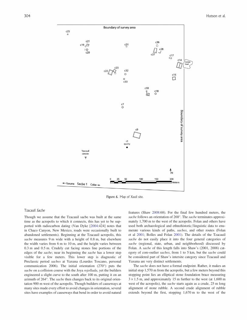
Xauil
To the east of Tzacauil lies a stretch of unoccupied land rangingfrom 200 m to 320 m wide (see Figure 3). At the eastern edge ofthis empty zone begins a cluster of structures that collects arounda cenote (Figure 6), not unlike the water-hole groups documentedethnographically in highland Chiapas by Vogt (1968). The cenoteis part columnar and part covered, following Houck’s classification(2006:63). The cenote lends its name, Xauil, to this site. We mapped25 structures at Xauil, though additional mounds to the east of thesurvey boundary and possibly to the north remain undocumented.Large quantities of slatewares in surface collections at the
Sacbes, Settlement, and Semiotics at Tzacauil 301

C22–C23 group and Puuc-style veneer stones found in one structure(C27) suggest that Xauil dates to the late part of the Classic period,not contemporaneous with the Tzacauil acropolis, which faces to the
west, away from Xauil. Nevertheless, most of Xauil’s architecture isnot chronologically diagnostic. Excavations at groups with nosurface ceramics are needed to refine the chronology.
Figure 4. Topographic maps of the Tzacauil Acropolis and Yaxuna’s East Acropolis.
Hutson et al.302

Although the people living at Xauil form a spatially boundaggregate and share access to water from the cenote, none of thestructures we mapped appear to have hosted administrative orritual activities that would have helped integrate these people intoan interactional community (Yaeger and Canuto 2000:3). Thelargest structure, C14, measuring 16 × 14 × 1 m, is also the closestto the cenote. Although Structure C14 supports a superstructure, itdoes not combine with other mounds to delineate a plaza. Largerstructures or compounds may be present to the east, beyond thesurvey bounds. The average surface area of the 25 structures is61 m2. Removing the two basal platforms (C14, C27) and the C9terraced hilltop gives an average of 37.4 m2. We found a small lime-stone quarry at the southern edge of the site (labeled C5 in Figure 6),though it likely did not serve many households. Another cenote, theTzacauil cenote, classifiable according to folk taxonomies ascubierto, or covered (has only a small opening at the groundsurface; Houck 2006:62–63), sits 220 m southeast of the Tzacauilacropolis and 430 m southwest of the Xauil cenote. Figures 3 and6 show no settlement clusters near this cenote, though peoplehave drawn water from it in recent decades.
Joya
The crescent-shaped settlement cluster to the west of Tzacauilaccounts for most of the features found during the survey(Figure 3). Locals use the name Joya to refer to the large rejollada(a dry karst sinkhole) (Houck 2006) located near the center of thecluster (see Figure 7). A covered cenote and a second rejolladaalso lie near the center of the Joya settlement cluster (seeFigure 3). Joya contains 147 pre-Hispanic structures within0.38 km2, yielding a settlement density of 376 structures per km2.Assuming that the shape of this cluster is truly a crescent, another7 ha of the crescent, containing perhaps another 25 structures, lie
to the north of the survey boundary. To the south, west, and east,areas without settlement delimit the edge of the site. The stretchof unsettled land to the west between Joya and Yaxuna’s east bound-ary measures about 300 m.
Unlike Xauil, Joya has an easily definable center consisting of aplaza measuring 58 × 32 m (Hutson et al. 2012) (Figure 7). Joyahas a sacbe that runs westward from the midpoint of the westside of the plaza. The sacbe’s terminus at the midpoint suggestsit was a formal part of the plaza design. The Joya sacbe joinsthe Tzacauil sacbe and Sacbe 1 as the third of three parallelsacbes to the east of Yaxuna. Like Sacbe 1 and in contrast tothe Tzacauil sacbe, Joya’s sacbe extends into Yaxuna (seeHutson et al. 2012). Eight 3 × 3 m surface collections and ten2 × 1 m test pits were placed among the buildings surroundingthe Joya plaza (Figure 7). These operations yielded very few cer-amics. A small portion of the ceramics date to the LatePreclassic and the Early Classic periods, while most date to theLate Classic period and pertain to the Maxcanu, Arena, andMuna ceramic groups. A few stones on the ground in front ofStructure 27e were carved in the Late/Terminal Classic Puucveneer style. These data suggest that the Joya plaza and the Joyasacbe were built after Tzacauil and its sacbe. Several buildingsbeyond the Joya plaza are well preserved. For example, one ofStructure A55’s platform retaining walls has six courses of stonepreserved up to 1.2 m high for a length of 8 m (Figures 3 and 8).
None of Joya’s structures are monumental. The largest structureby volume—A6, a basal platform supporting other superstruc-tures—measures 30 × 20 × 2 m and is located 150 m west ofJoya’s central plaza. The average surface area and volume ofJoya’s 16 basal platforms are 361 m2 and 408 m3, respectively.These figures are larger than those for Tzacauil. The averagesurface area and volume of the other 131 structures is 53 m2 and31 m3, respectively.
Figure 5. Tzacauil Acropolis and surrounding structures, with structure labels. Darker shades indicate higher elevation.
Sacbes, Settlement, and Semiotics at Tzacauil 303
Tzacauil Sacbe
Though we assume that the Tzacauil sacbe was built at the sametime as the acropolis to which it connects, this has yet to be sup-ported with radiocarbon dating (Van Dyke [2004:424] notes thatin Chaco Canyon, New Mexico, roads were occasionally built toabandoned settlements). Beginning at the Tzacauil acropolis, thissacbe measures 9 m wide with a height of 0.8 m, but elsewherethe width varies from 6 m to 10 m, and the height varies between0.3 m and 0.5 m. Crudely cut facing stones line portions of theedges of the sacbe; near its beginning the sacbe has a lower stepvisible for a few meters. This lower step is diagnostic ofPreclassic period sacbes at Yaxuna (Lourdes Toscano, personalcommunication 2006). The initial orientation (270°) puts thesacbe on a collision course with the Joya rejollada, yet the buildersengineered a slight curve to the south after 100 m, putting it on anazimuth of 264°. The sacbe then changes back to its original orien-tation 900 m west of the acropolis. Though builders of causeways atmany sites made every effort to avoid changes in orientation, severalsites have examples of causeways that bend in order to avoid natural
features (Shaw 2008:68). For the final few hundred meters, thesacbe follows an orientation of 268°. The sacbe terminates approxi-mately 1,700 m to the west of the acropolis. Folan and others haveused both archaeological and ethnohistoric/linguistic data to enu-merate various kinds of paths, sacbes, and other routes (Folanet al 2001; Bolles and Folan 2001). The details of the Tzacauilsacbe do not easily place it into the four general categories ofsacbe (regional, state, urban, and neighborhood) discussed byFolan. A sacbe of this length falls into Shaw’s (2001, 2008) cat-egory of core-outlier sacbes, from 1 to 5 km, but the sacbe couldbe considered part of Shaw’s intersite category since Tzacauil andYaxuna are very distinct settlements.
The sacbe does not have a formal endpoint. Rather, it makes aninitial stop 1,570 m from the acropolis, but a few meters beyond thisstopping point lies an elliptical stone foundation brace measuring3 × 1.5 m, and approximately 15 m further to the west (at 1,600 mwest of the acropolis), the sacbe starts again as a crude, 25 m longalignment of stone rubble. A second crude alignment of rubbleextends beyond the first, stopping 1,670 m to the west of the
Figure 6. Map of Xauil site.
Hutson et al.304

acropolis. Finally, a 10 m long scatter of medium-size stones wasfound at 1,700 m west of the acropolis. This is the last sacbe frag-ment we were able to document, and it is located 1,460 m east ofthe Yaxuna site center datum and 130 m north of Sacbe 1. Thesesmall sacbe fragments may indicate that different work groupswere responsible for constructing different sections (Bolles andFolan 2001:307; Shaw 2008:67). There are no structures in theimmediate vicinity of this uncertain endpoint. The nearest structure
is an 18 × 14 × 0.4 m platform with a superstructure located 55 m tothe northwest. The next closest settlement is a pair of structures60 m to the northeast. These structures represent the western edgeof Joya.
The Tzacauil causeway is not the only one in Yucatan that endsabruptly without connecting to structures, but other examples arerare. Sacbe 26 at Coba is unfinished (Bolles and Folan 2001:307),and several sacbe fragments not connected to sites have been
Figure 7. Map of the Joya site center, showing segments of the Tzacauil and Joya sacbes, the Joya rejollada, the structures around thesite’s central plaza, and the location of 2 × 1 m test pits.
Figure 8. Well-preserved wall of Structure A55, Joya site.
Sacbes, Settlement, and Semiotics at Tzacauil 305

documented in the vicinity of Calakmul (Folan et al. 1995, Figures 3and 4). At Chunchucmil, two sacbes begin from multifamily resi-dential compounds and extend 60 and 100 m away from the sitecenter before stopping (see Hutson et al. 2008, Figure 4c). Alongthe north coast of Yucatan, raised stone walkways begin fromcoastal sites and cross marshy areas to the south but end far shortof nearby sites (Miguel Covarrubias Reyna, personal communi-cation 2008). At Uci (see Figure 1), a sacbe from the center ofthe site runs 1.2 km to the west and stops at a bedrock outcropwith no apparent cultural modification (Hutson 2009).
We now consider the possibility that the Tzacauil sacbe contin-ued further to the west than is visible today, perhaps even to theYaxuna site core, like Sacbe 1. This assertion presumes that thesacbe did not preserve in the vicinity of Yaxuna due to later prehis-toric scavenging for construction material. We contend that scaven-ging leaves a clear material signature and that the Tzacauil sacbelacks this signature at the locale where it ends. The material signa-ture for scavenging shows clearly on other portions of the Tzacauilsacbe. For example, the center of the Joya site was built around aportion of the Tzacauil sacbe. Chronological data discussed abovesuggest that the Joya center postdates the Tzacauil sacbe. As themap in Figure 7 shows, when a platform was built within 5 m ofthe sacbe, there is a gap at that particular spot in the sacbe. Thereare no formal facing stones on the sacbes at the edges of thesegaps: rather, stones are missing, and fill from the sacbe spills intothe void. Parsimony permits the conclusion that the builders ofthe newer platforms created these gaps by taking stone directlyfrom the sacbe and using it for the platforms. If such scavengingoccurred at the western terminus of the Tzacauil sacbe, we shouldsee gaps in the sacbe and newer structures adjacent to these gaps.However, the Tzacauil sacbe disappears almost completely, andthere are no structures close by to suggest scavenging.
DISCUSSION
We now consider political dynamics as inferred from the results pre-sented above, focusing on Tzacauil and its sacbe. We stress againthat these inferences are provisional. As Stark (1999) has framedthe problem, the task is to understand the relation between a monu-mental complex (Tzacauil) and a nearby center (Yaxuna). Onepossibility proposed by Stark (2003) is that the monumentalcomplex is the country estate of landed elites. The complexes dis-cussed by Stark, however, are much smaller in volume thanTzacauil.
Rather than a country estate, Tzacauil may instead representactual dispersal of political power, a possibility Stark also notes.The triadic group atop the Tzacauil acropolis closely resembles con-temporary triadic groups at the core of Yaxuna. A comparison withYaxuna’s East Acropolis (Figure 4b) drives home this point.Tzacauil and Yaxuna’s East Acropolis relate iconically to oneanother. One explanation of this similarity is that Tzacauil was asecondary center charged with the duty of administering Yaxuna’seastern hinterland. The close similarity would be an example of asecondary site replicating institutions at the primary center, as hasbeen argued for Monte Albán’s administrative outposts in theValley of Oaxaca (Blanton et al 1981:89; Marcus and Flannery1996:182–183). Data from the settlement survey suggest thatTzacauil did not carry out administrative duties on behalf ofYaxuna. There is very little Late Preclassic settlement aroundTzacauil in need of administration (chronological data fromnearby Xauil point to a noncontemporaneous Late or Terminal
Classic occupation). Furthermore, in archaeology, the notion of sec-ondary centers acting in concert with primary centers derives fromcentral place models that presume an economizing logic. In centralplace theory, site hierarchies will be organized spatially in such away that different types of work (administration, marketing, etc.)can be performed most efficiently (Johnson 1973). Tzacauil doesnot fit this logic of efficiency. In a central place model, secondarycenters are located in such a way that they can administer popu-lations that are distant from the primary center and therefore not effi-ciently administered by the primary center. Yet Tzacauil is a30-minute walk from Yaxuna; administrators responsible for settle-ment further to the east could just as well have resided at Yaxunaitself. Finally, the construction of the Tzacauil sacbe required alarge expenditure contradictory to any economizing logic.
Other explanations may also account for why a minor center likeTzacauil would be located so close to a major center like Yaxuna.According to Underhill et al. (2008:11), such closeness mayreflect “a deliberate strategy of elites to control labor and the move-ment of subsistence goods (raw materials and/or finished goods) tothe center.” Underhill draws on this explanation to account for theclustering of minor centers such as Dantu only 2 km distancefrom Liangchengzhen, the major center of the Shandong provincein Northeast China during the Early and Middle Longshan period(2600–1900 b.c.).
Explanations involving secondary centers and the control oflabor and goods are top-down in the sense that they would bothexplain Tzacauil with reference to the needs of authorities atYaxuna, the regional center. Such top-down approaches can be sup-plemented by an approach that addresses the dynamic political pro-cesses that create such hierarchical relations between center andperiphery. In central place theories, as deployed by archaeologistswithin evolutionary models, secondary centers appear as the inevi-table and often universal result of the growing needs of the centralplace, be it Early Dynastic Eshnunna in Iraq (Flannery 1972;Johnson 1972), or Late Classic Calakmul in Mexico (Marcus1973). Studies using central place theory often overlook the locallevel processes involved in the constitution of political authority(Smith 2003). There is indeed a place for local level strategiesand dynamics in centralized models. The emergence of eliteexpression beyond the principal group at Copan in the LateClassic period (Fash 2005), for example, suggests that centralizedpolitical landscapes can also contain local strategies not fully dic-tated by the central place (Plank and Maca 2006). Though the quad-ripartite layout of Yaxuna’s site core at the end of the Preclassicperiod (Stanton and Freidel 2005) implies a degree of centralizedcoordination, this does not preclude a less centralized, segmentaryview of Preclassic politics (Fox and Cook 1996; Ringle 1999).
Following a dynamic model of political landscapes, we arguethat Tzacauil’s leaders played an active role in the constitution ofpower. Monuments may be interpreted as indexical signs ofpower since the quantity of stone and labor required to build thempresumes the presence of leaders with great command of resources(Trigger 1990; compare against.Pauketat 2000). Yet this approachdoes not consider the specific history or iconicity of triadicgroups. Recent research on Early Classic carvings from the C-9triadic group at Naranjo, located in the Peten, Guatemala, suggeststhat Naranjo’s dynastic rulers, the Sa’al lords, whose claimedlineage extends to the Preclassic period, identified themselveswith this particular triadic group (Tokovinine and Fialko 2007).Though these historic texts date to the Classic period, the groupitself has a Preclassic period core. The Naranjo data show that the
Hutson et al.306

ancient Maya themselves wrote of the connection between rulershipand triadic groups. The best preserved example of a triadic group isgroup H of Uaxactun, also located in the Peten. The ‘mat’ icons atthe entrance to the group (Valdés 1992) may encode an indexicalrelation to rulership here and elsewhere in the Maya area sincerulers, sometimes glossed as “of the mat,” sit on mats.Furthermore, Group H’s zoomorphic masks permit the interpret-ation of this compound as a stage for royal rituals that create andconsolidate power (Schele and Freidel 1990). Finally, Freidel andothers (Freidel et al. 1993:140; Hansen 1998) note that the triangu-lar arrangement of the three structures in triadic groups is an iconicreference to the three hearthstones of creation. If we accept thepremise that triadic groups recall the creation, leaders whoperform rituals within them can claim to play a role in creationand the birth of maize, thus moving followers to perceive a relation-ship of indebtedness.
Such posturing may have had many different goals. The closesimilarity between Tzacauil’s acropolis and acropolis groups inthe core of Yaxuna suggests the centripetal and centrifugal forcesof the theater state model, in which lesser centers put on ritual per-formances identical to those of greater centers (Geertz 1979). In thismodel, Tzacauil’s goal would be to siphon followers from otherlocales. Tzacauil’s acropolis and triadic group are not, however,smaller versions of those at Yaxuna. There were a number oftriadic groups in Yaxuna’s core during the Preclassic period. Eachof these may have been the headquarters of a faction vying for pres-tige and political control (Lucero 2007; Stanton 2000). By buildingtheir own triadic group, Tzacauil’s leaders may have sought tobecome an equal player in these struggles. Testing these interpret-ations should include broad scale excavations on the Tzacauil acro-polis in order to detect evidence of theater-state performances(Geertz 1979) or competitive feasting (Dietler and Hayden 2001).
One line of evidence already available—the Tzacauil sacbe—suggests that Tzacauil’s leaders did indeed seek inclusion in thehigher stakes power dynamics at Yaxuna, as opposed to contentingthemselves with their station as an outpost. At first glance, thissacbe appears to have been an attempt to connect Tzacauil toYaxuna. This was no ordinary sacbe, however. Understanding thenature of this sacbe requires putting it into historical context.
The vast majority of sacbes in the Maya lowlands are less than200 m long (Shaw 2001). In the Classic period, polities in the north-ern lowlands built longer sacbes, enabling a variety of classifi-cations of sacbes by length and other features (Benavides 1981,Normark 2006, Shaw 2008). In the Late Preclassic period, at thetime when the Tzacauil leaders were building what would becomea 1.6 km-long sacbe, causeways of this length were rare, limited(as far as we know) to the Mirador Basin (Hansen 1991), over300 km to the south of Yaxuna. Thus, to most people in the vicinityof Yaxuna, the kind of long sacbe that the leaders at Tzacauilattempted to construct would have been a novelty. Any discussionof the origins of Tzacauil’s sacbe therefore treads ground consideredby Rosemary Joyce (2004) in her essay on the origins of monumen-tal architecture. Yet whereas Joyce argues that the first monumentalarchitecture in Mesoamerica had no precedent and therefore mayhave been an unintended consequence of building practices, shortcauseways dating back to the Middle Preclassic period did exist atYaxuna (Stanton 2005) as a precedent for the attempted longer cau-seway at Tzacauil in the Late Preclassic period. Thus, the construc-tion of the Tzacauil causeway represents not the creation of a totallynew thing, but an attempt to transpose and transform an alreadyexisting thing (Sewell 1992:17). More specifically, the sacbe as
an architectural form connecting buildings within a site core, aform that had not yet extended more than 300 m at Yaxuna, wasbeing creatively extended to potentially ten times that length to fita new context and cause: connecting one site to another. Tzacauilwas not alone in experimenting with new, sacbe-like features.Anderson’s (2010) recent mapping of Xtobo, a Middle and LatePreclassic site in the northwest corner of Yucatan, has uncovereda unique ring feature, 300 m in diameter, built of what appear tobe sacbe fragments.
But what might such a sacbe have meant in the Late Preclassicperiod? What might the Tzacauil leaders have intended in transpos-ing an older form—the sacbe—to a new purpose—bridging twosites? Combining ethnohistoric, iconographic, archaeological, andother lines of evidence, Bill Ringle (1999) has argued thatPreclassic period causeways were used in processions that enactan ideology of inclusion. Preclassic causeways tend to connectcentral temples with locales slightly beyond the center. Ringlelikens procession along causeways to the common Maya biologi-cal/cosmological trope of the circulation of the life force, or‘ch’ulel,’ from heart to extremities. The circulation of this lifeforce, a metaphorical kind of blood, renews life. Using Turner’sritual process, Ringle equates the circulation from center to periph-ery with a journey from a cultural core to a liminal, natural wilder-ness. Returning from the periphery to the center renews life but alsosynthesizes center and periphery. Procession along the sacbe imi-tates this movement from core to periphery and back. The sacbeas a sign of inclusion works both symbolically and indexically. Itis a symbol because the relation between a stone causeway andthe circulation of the life force is arbitrary. It is an index of inclusionbecause the construction of the causeway physically brought aboutinteraction and contiguity between the sacbe’s two endpoints(center and periphery).
Ringle’s interpretation suggests that, in attempting to connectTzacauil to the Yaxuna core by a sacbe, Tzacauil’s leaders intendedto signify their inclusion in Yaxuna’s circle of political power. Theway this signifying act actually played out encourages a semioticapproach to the builders’ intended meaning. As discussed above,semiotic approaches to meaning are open-ended. The Tzacauilsacbe demonstrates this in two ways. First, signs can lead to newsigns (Keane 2005:186). The Preclassic sacbes in the Yaxuna sitecenter connect triadic groups to the site core. If the leaders ofTzacauil wanted to become a political force or express their statusas one, they may have felt that they, too, needed a sacbe toconnect themselves to the Yaxuna core. In the semiotic triad, thesign is the sacbe, the object of the sign is political connectedness,and the interpretants are Tzacauil’s leaders. The sacbe impresseditself upon the leaders as a way to enact their political aspirationsof playing a role in local authority. But to get to Yaxuna, theleaders of Tzacauil needed a sacbe much longer than thosealready in existence. So they built a much longer one, and in theprocess transformed the category of sacbe from a short avenuewithin the core of a site to a long avenue that stretches betweenand across multiple sites. Thus, refracted through the interpretant,one sign gives life to a new sign.
We now discuss the second way in which the Tzacauil sacbeillustrates the open-endedness that a semiotic approach can give tomaterial culture. In semiotics, interpretation of signs is open-ended;it is a matter of negotiation. Signs have an uncertain future: theydepend on social context to secure their meaning (Bauer 2002). Inthe case of the Tzacauil sacbe, for whatever reason, people didnot finish building the sacbe. Following Keane (2005), the futurity
Sacbes, Settlement, and Semiotics at Tzacauil 307

of this project was never secure. It was open to negotiation and chal-lenge. It reached half the distance to Yaxuna’s site center and, in themiddle of nowhere, faded out in desultory, incomplete segments.There are many potential reasons why the Tzacauil sacbe nevermade it all the way to Yaxuna, none of which can be favored atthis point. An archaeologically invisible, unbuilt path may have con-tinued westward to Yaxuna. War or disease may have halted theproject. Perhaps the Tzacauil leaders decided, in the middle of con-struction, that the sacbe did not need to go all the way to Yaxuna tobe effective as a sign. On the other hand, it may be that leaders atYaxuna forbade the sacbe to get any closer to their site.
Alternatively, as an expression of resistance, the people who pro-vided the labor for constructing the sacbe may have given up on theproject. This speaks to a failed semiotic ideology in which the jus-tifications for completing the causeway were not compelling.Though building the acropolis and causeway seemed compellingwhen construction began, leaders could not convince workers tocomplete the plan, to convert sign to object. In Peirce’s parlance,a new interpretant arose; the meaning of the sign changed as itspread among new people with different experience than theleaders, and the idea of the sacbe was not favorably received inthis new context (Bauer 2002; Parmentier 1994:10). The Tzacauilsacbe resembles the fragmentary, apparently unfinished state ofTikal’s earthworks. Webster et al. (2007) suggest that localleaders were unable to get outlying communities to commit to thework project and perhaps that that the leaders were not as powerfulas once thought (compare against Silverstein et al. 2009).
It should be noted that the volume of stone used to construct theTzacauil acropolis was about 15 times greater than that used to con-struct the sacbe, implying a much smaller labor commitment for thesacbe. Thus, completing the sacbe would have required relativelylittle labor. It would thus seem odd that Tzacauil’s laborers wouldhave put in so much work to complete the acropolis but thenrefused to provide a bit more labor to complete the sacbe. Such dis-obedience, however, might have been an unintended consequence ofthe construction of the acropolis. The acropolis project may havebeen pitched as an undertaking with communal benefits. When com-pleted, however, the laborers may have been alienated from the acro-polis, exposing it as an instrument that created or reinforced theworker’s subordination (i.e., the “tragedy of the commoners”)(Pauketat 2000; see also Clark 2003:61; Joyce et al. 2001).Perhaps this unintended alienation spurred the work stoppage.
Whatever the reason for why it was not completed, the prematuretermination of the Tzacauil sacbe illustrates that transposing an oldform to a new context has risks (Sahlins 1987). By attempting totransform the cultural category of sacbe, the Tzacauil leaders, asSahlins would have put it (1987:x), ceased to become slaves totheir concepts and sought to become masters. Yet modifying a cul-tural category—taking the idea of the sacbe and stretching it at leastten times its normative length so that it extended all the way fromTzacauil to Yaxuna—was a stretch, both literally and figuratively.In the end, the leaders did not master the situation.
Yet even though the sacbe failed to reach a notable destinationand therefore may not have been used as intended, this does notmean that it had no consequences whatsoever. Here we enter anarchaeology of inhabitation, which considers how people engagedwith the built landscape and how old features participated in newprocesses, regardless of why a feature was originally built (Barrett1999; Hendon 2010). In semiotic terms, the sacbe as sign loses itsinitial symbolic meanings (among them a proposal of political con-nectedness) but retains its indexical meanings; indexical signs keep a
meaningful relation to their object even if people cease to recognizethe index as a sign (Parmentier 1994:6). Though unfinished, thesacbe did not melt into air, mutely entering archaeological contextas a forgotten ruin. We propose that the sacbe projected intopeople’s lives even when in disuse and that it motivated new con-structions. The portion of the sacbe that did get built had animpact well after it was built because it regionalized a previouslyunmarked space. For Giddens (1984:118), regionalization trans-forms a less differentiated space into a more differentiated space.The sacbe accomplishes this in many ways. It divides an openspace into two sides: the north side of the sacbe and the southside. The sacbe also directs attention to the east where it beginsand to the west where it ends. To the east, of course, is themassive acropolis. The sacbe, emanating from that acropolis,indexes the strategies and once potent authority of those affiliatedwith the acropolis. Thus, as the sacbe projects westward, politicsand power project themselves as well, materialized by the sacbe.The fact that the sacbe is merely provisional, that it falls short ofits presumed destination, does not reveal itself except at its end point.
When we say that the sacbe motivated new constructions, wepropose that, despite its failure to stabilize Tzacauil’s provisionalclaims to authority, it succeeded in transforming structure.Following the logic of structuration, in which actions produce andreproduce the conventions that guide new actions, the act of experi-menting with the length of sacbes transformed the category of sacbe.In the end, it became possible to build long sacbes that did not existbefore. (Followers of Peirce may recognize this as a sinsign generat-ing a legisign.) The Tzacauil sacbe experiment was not forgotten, butrather served as the model for the Joya sacbe, built parallel to theTzacauil sacbe at a distance of 60 m to the north, which didsucceed in connecting Joya to Yaxuna. Moreover, the Tzacauilsacbe, the first long sacbe in the northern lowlands, may haveserved as a model for even longer sacbes such as Sacbe 1 betweenYaxuna and Coba or the sacbes in the vicinity of Izamal (32, 18,and 12 km long, respectively), located only 60 km to the northwest.Though the Tzacauil sacbe resembles the Tikal earthworks in thesense of its fragmentary, unfinished nature (Webster et al. 2007),the Tikal earthworks contrast sharply in that no later communitiesattempted to build anything quite like them.
CONCLUSION
The survey to the east of Yaxuna documented three new sites(Tzacauil, Xauil, and Joya) and two new sacbes (one anchored atTzacauil, the other at Joya). Both Tzacauil and Joya have evidenceof Late Preclassic occupation, though Joya is larger and longer-lived. Xauil was occupied in the Late and/or Terminal Classicperiod. The most conspicuous structure in the survey is theTzacauil acropolis, which supports a triadic group. A sacbe beganat the western edge of the acropolis and ended 1,700 m to thewest without reaching a clear destination. The fact that a raised cau-seway was not necessary to get from Yaxuna to Tzacauil suggeststhat this sacbe carried political and/or religious meaning. In thispaper, we have argued that the leaders of Tzacauil attempted tobecome a faction vying for authority at Yaxuna, a regional centerduring the Preclassic period. We also argue that the unfinishedsacbe indicates that these attempts were not entirely successful.This result is not a surprise given that the projected sacbe wasmuch longer than any previous sacbe in the area, already exceedingthe expectations of what was intelligible and feasible.
Hutson et al.308

We have used a semiotic approach to interpret the causeway.This approach works particularly well with material culture and,because of its compatibility with structuration theory, provides a fra-mework for understanding innovations such as the unprecedentedappearance of the long sacbe. The sacbe’s abrupt termination high-lights the fact that all practices involve risk, especially those prac-tices that transpose familiar structures to unfamiliar contexts. This
risk exposes an instability that exists on multiple levels. Not onlyare durable aspects of the built environment never guaranteed tobring about the kind of authority intended, but the norms and con-ventions are also subject to being broken or cited in unpredictedways (Butler 1993). Thus, both aspects of structure—rules andresources—risk melting, a condition that characterizes all socialaction.
RESUMEN
Este ensayo presenta una aplicación de la teoría semiótica de C.S. Peirce yla teoría de estructuración de Anthony Giddens a los resultados de un recor-rido sistemático hecho a pie al este del sitio arqueológico de Yaxuna, en elestado de Yucatan. Los datos de este recorrido sugieren que un grupo loca-lizado en el sitio de Tzacauil compitió por la influencia política en la épocapreclásica a través de la construcción de una acrópolis a tres kilómetros deYaxuna. Este grupo también inició, pero no concluyó, una nuevaconstrucción experimental: un sacbé de larga distancia entre Yaxuna y laacrópolis de Tzacauil. Un aspecto central en la teoría de estructuración esla inestabilidad en las prácticas sociales. Las reglas pueden cambiar
cuando se transponen a contextos nuevos. Al mismo tiempo, los recursosduraderos, como son calzadas y grupos de acrópolis, no aseguran la estabil-idad de las coaliciones que se forman para construir estos edificios. A pesardel gasto de recursos y de mano de obra, como nunca antes visto al este deYaxuna, Tzacauil fue eclipsado por un sitio vecino llamado Joya. Aunquenunca terminaron de construir la calzada, la gente de Tzacauil sí tuvo éxitoen transformar el concepto convencional de calzada. Estos acontecimientosapoyan la perspectiva semiótica porque muestran que la materialidad escontingente: tiene el potencial de que la gente involucrada puede o no tra-bajar para lograrlo.
ACKNOWLEDGMENTS
The research discussed in this paper was supported by two separate fundswithin the College of Arts and Sciences at the University of Kentucky, aswell as the Selz Foundation. Carrie Todd, Matt Davidson, Leigh AnneEllison, Henrik Petersson, and Trent Stockton worked hard to helpacquire the data discussed in this paper. We thank Don Ignacio, the comi-sario ejidal of Yaxunah, for facilitating the survey of Yaxunah ejido landand the Consejo de Arqueología (INAH) for permits. Different versions
of this paper were presented at Harvard University, the University ofColorado at Boulder, and the University of Kentucky. Archaeologists atall three of these institutions greatly improved this paper with their valuablefeedback. Hutson thanks Jamie Forde (Colorado) and Jason Ur (Harvard)for facilitating visits to their departments. We thank Elizabeth Grahamand an anonymous reviewer well versed in semiotics for useful suggestionsfor revision.
REFERENCES
Anderson, David2010 Xtobo, Yucatan, Mexico: The Study of a Preclassic Community.Unpublished Ph.D. dissertation, Department of Anthropology, TulaneUniversity, New Orleans.
Ashmore, Wendy1981 Some Issues of Method and Theory in Lowland Maya SettlementArchaeology. In Lowland Maya Settlement Patterns, edited by WendyAshmore, pp. 37–70. University of New Mexico Press, Albuquerque.
Barrett, John C.1999 TheMythical Landscapes of the British IronAge. InArchaeologiesof Landscape: Contemporary Perspectives, edited by Wendy Ashmoreand A. Bernard Knapp, pp. 253–265. Blackwell, Malden, MA.
Bauer, A.A.2002 Is What You See All You Get? Recognizing Meaning inArchaeology. Journal of Social Archaeology 2:37–52.
Benavides Castillo, Antonio1981 Los caminos de Coba y sus implicaciones sociales. InstitutoNacional de Antropologia e Historia, Centro Regional Sureste,Coleccion Cientifica, Mexico City.
Berman, Marshall1988 All that is Solid Melts into Air: The Experience of Modernity.Viking Penguin, New York.
Blanton, Richard E., Stephen A. Kowalewski, Gary M. Feinman, and JillAppel1981 Ancient Mesoamerica: A Comparison of Change in ThreeRegions. Cambridge University Press, Cambridge, MA.
Bolles, David, and William J. Folan2001 An Analysis of Roads Listed in Colonial Dictionaries and theirRelevance to Pre-hispanic Linear Features in the Yucatan Peninsula.Ancient Mesoamerica 12:299–314.
Bourdieu, Pierre1990 The Logic of Practice. Translated by Richard Nice. StanfordUniversity Press, Stanford, CA.
Brainerd, George1958 The Archaeological Ceramics of Yucatan. Anthropological
Records 19. University of California, Berkeley.Butler, Judith1993 Bodies that Matter: On the Discursive Limits of Sex. Routledge,
New York.Chase, Diane Z.1990 The Invisible Maya: Population History and Archaeology at Santa
Rita Corozal. In Pre-Colombian Population History in the MayaLowlands, edited by T. Patrick Culbert and Don S. Rice,pp. 199–214. University of New Mexico Press, Albuquerque.
Chippindale, Christopher1993 Ambition, Deference, Discrepancy, Consumption: The Intellectual
Background to a Post-processual Archaeology. In ArchaeologicalTheory: Who Sets the Agenda?, edited by Norman Yoffee andAndrew Sherratt, pp. 27–36. Cambridge University Press,Cambridge, MA.
Clark, John E.2003 Mesoamerica Goes Public: Early Ceremonial Centers, Leaders,
and Communities. In Mesoamerican Archaeology, edited byRosemary A. Joyce and Julia Hendon, pp. 43–72. Blackwell, London.
Conkey, Margaret W.1989 The Structural Analysis of Paleolithic Art. In Archaeological
Thought in the Americas, edited by C.C. Lamberg-Karlovsky,pp. 135–154. Cambridge University Press, Cambridge, MA.
Dietler, Michael, and Brian Hayden (editors)2001 Feasts: Archaeological and Ethnographic Perspectives on Food,
Politics, and Power. Smithsonian Institution Press, Washington, DC.Fash, William L.2005 Toward a Social History of the Copan Valley. In Copan: The
History of an Ancient Maya Kingdom, edited by E. Wyllys AndrewsIV and William L. Fash, pp. 73–102. School of American Research,Santa Fe.
Sacbes, Settlement, and Semiotics at Tzacauil 309

Flannery, Kent V.1972 The Cultural Evolution of Civilizations. Annual Review of Ecology
and Systematics 3:399–425.Folan, William1983 Archaeological Investigations of Coba: A Summary. In Coba: a
Classic Maya Metropolis, edited by William Folan, Ellen Kintz, andLarraine Fletcher, pp. 1–10. Academic Press, New York.
Folan, William J., Jacinto M. Hau, Joyce Marcus, W. Frank Miller, andRaymundo Gonzalez Heredia2001 Los Caminos de Calakmul, Campeche. Ancient Mesoamerica 12:
293–298.Folan, William J., Joyce Marcus, and W.F. Miller1995 Verification of a Maya Settlement Model through Remote
Sensing. Cambridge Archaeological Journal 5:277–283.Fox, John W., and Garrett W. Cook1996 Constructing Maya Communities: Ethnography for Archaeology.
Current Anthropology 37:811–821.Freidel, David A., Linda Schele, and Joy Parker1993 The Maya Cosmos: Three Thousand Years on the Shaman’s Path.
Quill, New York.Freidel, David A., Charles K. Suhler, and Ruth Krochock1990 Yaxuna Archaeological Survey: A Report of the 1989 Field Season
and Final Report on Phase One. Southern Methodist University,Dallas.
Geertz, Clifford1979 Negara: The Theatre State in Nineteenth-Century Bali. Princeton
University Press, Princeton, NJ.Giddens, Anthony1979 Central Problems in Social Theory. University of California Press,
Berkeley.1984 The Constitution of Society. University of California Press,
Berkeley.Gillespie, Susan D.2008 History in Practice: Ritual Deposition at La Venta Complex A. In
Memory Work: Archaeologies of Material Practice, edited by BarbaraJ. Mills and William H. Walker, pp. 109–137. SAR Press, Santa Fe.
Hansen, Richard D.1991 The Road to Nakbe. Natural History 5(91):8–14.1998 Continuity and Disjunction: The Pre-Classic Antecedents of
Classic Maya Architecture. In Function and Meaning in ClassicMaya Architecture, edited by Stephen D. Houston, pp. 49–122.Dumbarton Oaks, Washington, DC.
Harvey, David1990 The Condition of Postmodernity. Blackwell, Oxford.
Healy, Paul F., Christopher G.B. Helmke, Jaime J. Awe, and Kay S.Sunahara2007 Survey, Settlement, and Population History at the Ancient Maya
Site of Pacbitun, Belize. Journal of Field Archaeology 32:17–39.Hendon, Julia2010 Houses in a Landscape: Memory and Everyday Life in
Mesoamerica. Duke University Press, Durham, NC.Hodder, Ian1982 Theoretical Archaeology: A Reactionary View. In Symbolic and
Structural Archaeology, edited by Ian Hodder, pp. 1–16. CambridgeUniversity Press, Cambridge, MA.
1986 Reading the Past. Cambridge University Press, Cambridge, MA.1989 This is Not an Article about Material Culture as Text. Journal of
Anthropological Archaeology 8:250–269.Hodder, Ian, and Scott R. Hutson2003 Reading the Past. 3rd ed. Cambridge University Press,
Cambridge, MA.Houck, Charles W. J.2006 Cenotes, Wetlands, and Hinterland Settlement. In Lifeways in the
Northern Lowlands: New Approaches to Maya Archaeology, edited byJennifer P. Mathews and Bethany A. Morrison, pp. 56–76. Universityof Arizona Press, Tucson.
Hutson, Scott R.2009 Proyecto Arqueológico Sacbe de Ucí-Cansahcab: Report of the
2009 Field Season. Manuscript submitted to the Consejo deArqueología, Instituto Nacional Antropología e Historia, Mexico City.
Hutson, Scott R., David Hixson, Aline Magnoni, Daniel E. Mazeau, andBruce H. Dahlin2008 Site and Community at Chunchucmil and Ancient Maya Urban
Centers. Journal of Field Archaeology 33:19–40.
Hutson, Scott R., Aline Magnoni, Travis Stanton, Donald Slater, and ScottJohnson2012 Memory and Power at Joya. In Power and Identity inArchaeological Theory and Practice: Case Studies from AncientMesoamerica, edited by Eleanor Harrison-Buck, pp. 39–52.University of Utah Press, Salt Lake City.
Johnson, Gregory A.1972 A Test of the Utility of Central Place Theory in Archaeology. InMan, Settlement, and Urbanism, edited by Peter J. Ucko, RuthTringham, andGeorgeW. Dimbleby, pp. 769–785. Duckworth, London.
1973 Local Exchange and Early State Development in SouthwesternIran. Anthropological Papers No. 51. Museum of Anthropology,University of Michigan, Ann Arbor.
Johnston, Kevin J.2004 The Invisible Maya: Minimally Mounded Residential Settlementat Itzán, Petén, Guatemala. Latin American Antiquity 15:145–175.
Joyce, Arthur A., Laura A. Bustamante, and Marc N. Levine2001 Commoner Power: A Case Study from the Classic Period Collapseon the Oaxaca Coast. Journal of Archaeological Method and Theory 8:343–385.
Joyce, Rosemary A.2004 Unintended Consequences? Monumentality as a NovelExperience in Formative Mesoamerica. Journal of ArchaeologicalMethod and Theory 11:5–29.
Keane, Webb2003 Semiotics and the Social Analysis of Material Things. Languageand Communication 23:409–425.
2005 Signs Are Not the Garb of Meaning: On the Social Analysis ofMaterial Things. In Materiality, edited by Daniel Miller,pp. 182–205. Duke University Press, Durham, NC.
Lucero, Lisa J.2007 Classic Maya Temples, Politics, and the Voice of the People. LatinAmerican Antiquity 18:407–428.
Marcus, Joyce1973 Territorial Organization of the Lowland Classic Maya. Science180:911–916.
Marcus, Joyce, and Kent V. Flannery1996 Zapotec Civilization. Thames and Hudson, London.
Marx, Karl, and Friedrich Engels1967[1872] The Communist Manifesto. Penguin, Middlesex.
Muhs, Daniel R., James R. Budahn, Joseph M. Prospero, and Steven N.Carey2007 Geochemical Evidence for African Dust Inputs to Soils of WesternAtlantic Islands: Barbados, the Bahamas, and Florida. Journal ofGeophysical Research 112(2):F02009.
Normark, Johan2006 The Roads in Between: Causeways and Polyagentive Networks atIchmul and Yo’okop, Cochuah Region, Mexico. Department ofArchaeology, Göteborg University, Göteborg.
O’Brien, Michael J., and Dennis Lewarch1992 Regional Analysis of the Zapotec Empire, Valley of Oaxaca.World Archaeology 23:264–282.
Parmentier, Richard J.1994 Signs in Society: Studies in Semiotic Anthropology. IndianaUniversity Press, Bloomington.
2009 Troubles with Trichotomies: Reflections on the Utility of Peirce’sSign Trichotomies for Social Analysis. Semiotica 177(1/4):139–155.
Pauketat, Timothy R.2000 TheTragedyof theCommoners. InAgency inArchaeology, editedbyMarcia-Anne Dobres and John Robb, pp. 113–129. Routledge, London.
Pauketat, Timothy R., and Susan M. Alt2003 Mounds, Memory, and Contested Mississippian History. InArchaeologies of Memory, edited by Ruth M. Van Dyke and SusanE. Alcock, pp. 151–179. Blackwell, Malden, MA.
Peirce, C.S.1998 The Essential Peirce: Selected Philosophical Writings, Vol. 2(1893–1913). Indiana University Press, Bloomington.
Perry, Eugene, Guadalupe Velazquez-Oliman, and Richard A. Socki2003 Hydrogeology of the Yucatan Peninsula. In The Lowland MayaArea: Three Millennia at the Human-Wildland Interface, edited byArturo Gomez-Pompa, M.F. Allen, Scott L. Fedick, and J.J.Jimenez-Osornio, pp. 115–138. Food Products Press, New York.
Plank, Shannon E., and Allan Maca2006 PAPAC and the Study of Copan’s Urban Renovation under Yax
Hutson et al.310

Pasaj. Paper presented at the 71st Annual Meeting of the Society forAmerican Archaeology, San Juan, Puerto Rico.
Preucel, Robert W.2006 Semiotic Archaeology. Blackwell, Oxford.
Preucel, Robert W., and Alexander. A. Bauer2001 Archaeological Pragmatics. Norwegian Archaeological Review34(2):85–96.
Pyburn, K. Anne1990 Settlement Patterns at Nohmul: Preliminary Results of FourExcavation Seasons. In Precolumbian Population History in theMaya Lowlands, edited by T. Patrick Culbert, and Don S. Rice,pp. 183–197. University of New Mexico Press, Albuquerque.
Rice, Don S., and Prudence M. Rice1990 Population Size and Population Change in the Central Peten LakesRegion, Guatemala. In Pre-Colombian Population History in the MayaLowlands, edited by T. Patrick Culbert and Don S. Rice, pp. 123–148.University of New Mexico Press, Albuquerque.
Ringle, William M.1999 Pre-classic Cityscapes: Ritual Politics among the Early LowlandMaya. In Social Patterns in Pre-Classic Mesoamerica, edited byDavid C. Grove and Rosemary A. Joyce, pp. 183–223. DumbartonOaks, Washington, DC.
Sahlins, Marshall1987 Islands of History. University of Chicago Press, Chicago.
Schele, Linda, and David A. Freidel1990 A Forest of Kings: The Untold Story of the Ancient Maya. WilliamMorrow, New York.
Sewell Jr., William H.1992 A Theory of Structure: Duality, Agency and Transformation.American Journal of Sociology 98(1):1–29.
Shaw, Justine M.2001 Maya Sacbeob: Form and Function. Ancient Mesoamerica 12:261–272.
2008 White Roads of the Yucatan: Changing Social Landscapes of theYucatec Maya. University of Arizona Press, Tucson.
Shaw, Justine M., and David Johnstone2001 The Late Classic at Yaxuná, Yucatán,Mexico.Mexicon23(1):10–14.
Silverstein, Jay, David L. Webster, Horacio Martinez, and Alvaro Soto2009 Rethinking the Great Earthwork of Tikal: A Hydraulic Hypothesisfor the Classic Maya Polity. Ancient Mesoamerica 20:45–58.
Silverstein, Michael1976 Shifters, Linguistic Categories, and Cultural Description. InMeaning in Anthropology, edited by Keith H. Basso and Henry A.Selby, pp. 11–56. University of New Mexico Press, Albuquerque.
Singer, Milton1984 Man’s Glassy Essence: Explorations in Semiotic Anthropology.Indiana University Press, Bloomington.
Smith, Adam T.2003 The Political Landscape: Constellations of Authority in EarlyComplex Polities. University of California Press, Berkeley.
Stanton, Travis W.2000 Heterarchy, Hierarchy, and the Emergence of the NorthernLowland Maya: A Study of Complexity at Yaxuna, Yucatan, Mexico.Ph.D. dissertation, Southern Methodist University, Dallas.
2005 Formative Maya Causeways: Incipient Internal Site Design atYaxuna, Yucatan, Mexico. Mono y Conejo 3:32–35.
Stanton, Travis W., and Traci Ardren2005 The Middle Formative of Yucatan in Context: The View fromYaxuna. Ancient Mesoamerica 16:213–228.
Stanton, Travis W., and David A. Freidel2005 Placing the Centre, Centring the Place: The Influence of Formative
Sacbeob in Classic Site Design at Yaxuna, Yucatan. CambridgeArchaeological Journal 16:225–249.
Stanton, Travis, Scott R. Hutson, and Aline Magnoni2008 Proyecto interacción político en el centro de Yucatan: Primera
temporada de campo. Report submitted to the Consejo deArqueología, Mexico City.
Stark, Barbara L.1999 Formal Architectural Complexes in South-Central Veracruz: A
Capital Zone? Journal of Field Archaeology 26:197–225.2003 Cerro de las Mesas: Social and Economic Perspectives on a Gulf
Center. In El urbanismo en mesoamérica, Vol. 1, edited by William T.Sanders, Alba Guadalupe Mastache, and Robert H. Cobean,pp. 391–421. Instituto Nacional Antropología e Historia, Mexico City.
Suhler, Charles K., Traci Ardren, and David Johnstone1998 The Chronology of Yaxuna: Evidence from Excavation and
Ceramics. Ancient Mesoamerica 9:167–182.Suhler, Charles K., and David A. Freidel1998 Life and Death in a Maya Warzone. Archaeology May/
June:28–34.Tilley, Christopher1991 Material Culture and Text: The Art of Ambiguity. Routledge,
London.Tokovinine, Alexander, and Vilma Fialko2007 Stela 45 of Naranjo and the Early Classic Lords of Sa’aal. PARI
Journal 7(4):1–14.Tourtellot, Gair1988 Excavations at Seibal, Department of Peten, Guatemala:
Peripheral Survey and Excavation Settlement and CommunityPatterns. Memoirs of the Peabody Museum of Archaeology andEthnology, No. 16. Peabody Museum of Archaeology andEthnology, Harvard University, Cambridge, MA.
Trigger, Bruce1990 Monumental Architecture: A Thermodynamic Explanation of
Symbolic Behavior. World Archaeology 22:119–132.Underhill, Anne P., Gary M. Feinman, Linda M. Nicholas, Hui Fang,Fengshi Luan, Haiguang Yu, and Fengshu Cai2008 Changes in Regional Settlement Patterns and the Development of
Complex Societies in Southeastern Shandong, China. Journal ofAnthropological Archaeology 27(1):1–29.
Valdés, Juan A.1992 El crecimiento de la civilización maya del área central durante el
preclásico tardío: Una vista desde el grupo H de Uaxactun. U tz’ib1(2):16–31.
Van Dyke, Ruth M.2004 Memory, Meaning and Masonry: The Late Bonito Chacoan
Landscape. American Antiquity 69:413–431.Villa Rojas, Alfonso1934 The Yaxuna-Coba Causeway. Contributions to American
Archaeology 2(9):187–208.Vogt, Evon Z.1968 Some Aspects of Zinacantan Settlement Patterns and Ceremonial
Organization. In Settlement Archaeology, edited by Kwang C. Chang,pp. 154–173. National Press Books, Palo Alto, CA.
Webster, David L., T. Murtha, Kirk D. Straight, Jay Silverstein, HoracioMartinez, Richard Terry, and Richard Burnett2007 The Great Tikal Earthwork Revisited. Journal of Field
Archaeology 32:41–64.Yaeger, Jason, and Marcello A. Canuto2000 Introducing an Archaeology of Communities. In The Archaeology
of Communities: A New World Perspective, edited by Marcello A.Canuto and Jason Yaeger, pp. 1–15. Routledge, London.
Sacbes, Settlement, and Semiotics at Tzacauil 311
Copyright © 2022 FDOKUMEN