Algonquian Cultures of the Delaware and Susquehanna River ...
364
Algonquian Cultures of the Delaware and Susquehanna River Drainages: A Migration Model PREPARED FOR: Delaware Water Gap National Recreation Area, National Park Service PREPARED BY: William and Mary Center for Archaeological Research
-
Upload
khangminh22 -
Category
Documents
-
view
1 -
download
0
Transcript of Algonquian Cultures of the Delaware and Susquehanna River ...

Algonquian Cultures of the Delaware and Susquehanna River Drainages: A Migration Model
PrePared for:Delaware Water Gap National Recreation Area, National Park Service
PrePared by:William and Mary Center for Archaeological Research

Cover: Artist rendering of the Owasco Migrant group’s first fortification at the Potomac Creek Site (44ST2) along the Potomac River, Stafford County, Virginia (painted by Shelley Pomerleau for WMCAR poster series, 1998).

Algonquian Cultures of the Delaware and Susquehanna River Drainages: A Migration Model
WMCAR Project No. 09–26 NRAP Project No. DEWA 2010 A
PrePared for:Delaware Water Gap National Recreation Area
National Park Service1 River Road
Bushkill, Pennsylvania 18324(540) 869–3051
PrePared by:William and Mary Center for Archaeological Research
The College of William and MaryP.O. Box 8795
Williamsburg, Virginia 23187‑8795(757) 221‑2580
author:Wayne E. Clark
Project director:Joe B. Jones
Printed by: Government Printing Office
Washington, D.C.
2019
This draft report was accomplished with assistance from the U.S. Department of the Interior, National Park Service. The statements, findings, conclusions,
recommendations, and other data in this report are soley those of the author and do not neccessarily reflect the views of the U.S. Department of the Interior, National Park
Service.


i
Contents
Figures ........................................................................................................................................ i Tables .......................................................................................................................................iii Foreword by Joe B. Jones, WMCAR Director ............................................................................... iv Acknowledgments ...................................................................................................................... vii
1: Introduction and Project History ..............................................................................................1
2: The Eastern Algonquian Languages, Cultures, and Their Dispersal ...........................................9
3: Historical and Archaeological Evidence of Algonquian Migrations and Development .............53
4: Pre‑Algonquian Cultures of the Atlantic Drainages ...............................................................123
5. Model Testing for the Algonquian‑Speaking Cultures of the Middle Chesapeake Bay Region ....................................................................165
6: Model Testing for the Algonquian‑Speaking Cultures of the Upper Delaware Region ...........235
7: Summary ..............................................................................................................................293
8: Recommendations.................................................................................................................301
References Cited ...................................................................................................................305
Figures
1.1 Active erosion of Manna Site along Raymondskill Creek in 2013 ............................................21.2 Intersection of Delaware River, Minsi Path, and Minisink Path at the Manna Site ...................41.3 Manna Site and Minisink Island National Historical Landmark ..............................................52.1 Major archaeological sites and historic groups around AD 1600 ............................................102.2 Siebert’s language divisions as sampled by Levy ......................................................................132.3 Lexicostatistical classification of Eastern Algonquian
languages with mean separation rates given as nodes ...........................................................162.4 Siebert’s phonological classifications .......................................................................................172.5 Glottochronological results (nodal) ........................................................................................182.6 Major biotic provinces of the Great Lakes ..............................................................................212.7 Proto‑Algonquian, Central Algonquian, and Eastern Algonquian homelands ........................222.8 First leap‑frog spread of Proto‑Algonquian migrant groups to the South ................................302.9 Northern Iroquoian–speaking cultures ...................................................................................463.1 Archaic traditions/horizons in the study area .........................................................................693.2 Estimated range of copper complexes of Trans‑Appalachian
tradition, PA, and PEA‑language homelands .......................................................................703.3 Meadowood sites with Vinette 1 ware in the Ontario Homeland and
spread of PEA migrant groups in the Northeast and Middle Atlantic regions ......................78

ii
3.4 Onondaga chert exchange routes during the Meadowood phase ............................................793.5 Regional band interaction model ca. 1000 BC from Great Lakes perspective .........................823.6 Distribution of sites and cemeteries associated with Trans‑Appalachian tradition
migrant groups of the Middle Woodland period (500 BC – AD 500) .................................943.7. Distribution of Jack’s Reef points on Kipp Island horizon sites on Delmarva .......................1013.8. Founding and spread of Iroquoian Princess Point complex ..................................................1053.9. Distribution of historic ethnic and linguistic groups in the North Carolina coastal plain .....1103.10 Southern distribution of Mockley ware ca. AD 700 .............................................................1114.1. Distribution of soapstone quarries and geographic range of Terminal
Archaic traditions sites involved in soapstone exchange .....................................................1294.2. Terminal Archaic traditions complexes .................................................................................1314.3. Major Koens‑Crispin sites in the inner coastal plain ............................................................1384.4. Rejected, flat‑bottomed soapstone bowl in situ at a Patuxent
River quarry site in the eastern Piedmont province ............................................................1394.5. Early ceramic traditions and horizons in the Eastern Woodlands .........................................148 4.6. Meadowood habitation and mortuary sites ..........................................................................1504.7. Meadowood site clusters ......................................................................................................1514.8. Pig Point Site (18AN50), plan of ritual area.........................................................................1594.9. Bannerstones of the Terminal Archaic traditions suggesting use of the atlatl ........................1625.1. Algonquian chiefdoms of the Middle Chesapeake based on
John Smith’s 1612 map and later English primary references .............................................1695.2. Distribution of Potomac Creek and Moyaone wares ............................................................1705.3. Distribution of Townsend and Rappahannock wares ...........................................................1705.4. Important archaeological sites and geographic features discussed in this report ....................1715.5. Potomac River villages recorded by John Smith during his 1608 voyage ..............................174 5.6. Historic Location of Indian chiefdoms and tribes in Maryland ............................................1765.7. Historic migrations of Maryland’s Algonquians and Iroquoian Indians ................................1885.8. Winslow Site (18MO9), plan ..............................................................................................2005.9. Alternate hypothesis for origins of Potomac Creek complex .................................................2035.10. Potomac Creek (44ST2) and Accokeek Creek (18BR8) decrease in size over time ...............2105.11. Potomac Creek (44ST2) and Accokeek Creek (18PR8) site plans
showing wattle and daub palisade lines and size decrease over time ....................................2125.12. Potomac Creek Site (44ST2) palisades .................................................................................2135.13. Stages of Potomac Creek Site (44ST2) development ............................................................2285.14. Potomac and Susquehanna trade relations in 1607 ..............................................................232 6.1. Munsee and Unami‑Speakers and selected associated bands .................................................2386.2. Location of recognized bands of Unami and Munsee language‑speakers ..............................2436.3. Faucett Site projectile point stratigraphic battleship curves ..................................................2486.4. Archaeological complexes of the Middle Atlantic region ca. AD 1300–1400 .......................2556.5. Map of Delaware drainage showing Contact‑era tribal names and territories .......................2656.6. Abbott Zoned motifs from Abbott Farm ..............................................................................272

iii
6.7 Sites of the Princess Point complex in Southern Ontario representing Northern Iroquoian migrations after AD 500 ................................................287
7.1. Algonquian and Iroquoian languages of the study area.........................................................2957.2. Selby Bay and Carey Adena phase points, which are fossil indexes of the
Southern Archaic division PEA‑speakers of the Mockley horizon ......................................299
tables
2.1 Classification of Eastern Algonquian .......................................................................................152.2 Percentage of shared cognates and separation dates, Eastern Algonquian languages .................163.1 Regional sequence in Upper Susquehanna Valley .....................................................................573.2 Cosmology of Trans‑Appalachian tradition of the Early
and Middle Woodland periods in the study area ....................................................................673.3 Regional sequence for Atlantic Drainage .................................................................................773.4 New sequence for Algonquian complexes of the Chesapeake/Delaware region .........................923.5 Coastal North Carolina archaeological sequence ....................................................................1093.6 Indian societies and languages as noted by Strachey
(1612) and their archaeological associations ........................................................................1144.1 Merged Terminal Archaic traditions associated wares .............................................................1464.2 Terminal Archaic traditions sequence of ware attributes in the Chesapeake Bay region ..........1495.1 Model of chiefdom development in the Chesapeake region ...................................................1795.2 Archaeological correlates to development of Algonquian‑
speaking chiefdoms in the Chesapeake Bay region ...............................................................1815.3 Sequence for Potomac Creek development ............................................................................2046.1 Archaeological and linguistic sequence for the Middle and Upper Delaware
Valley associated with the Jack’s Reef horizon and Owasco complex ....................................2376.2 Middle and Late Woodland sequence of the Upper Susquehanna valley. ................................283

iv
Foreword
When the William and Mary Center for Archaeological Research (WMCAR) entered into a cooperative agreement with the National Park Service to complete research on the eroding areas of the Manna site, the research design included the proposal to compare the Owasco archaeo‑logical complex in the Upper Delaware Valley to the Potomac Creek archaeological complex in the Middle Chesapeake region, given that they are both regional phases of eastern Algonquian culture groups with indications that they may have been associated with one another. The WMCAR’s previous investigations of a portion of the Potomac Creek type‑site in Stafford County, Virginia had, among other things, amplified some of the intriguing cultural similarities other scholars have observed between the Owasco and Potomac Creek archaeological complexes. Interestingly, most scholars of the Potomac Creek culture agree that it displays indications of an immigrant group that relocated to the Potomac River region from elsewhere in the early Late Woodland period. Though there is not necessarily consensus on the origins of an immigrant Potomac Creek culture, some scholars have proposed late prehistoric migration as one explanation for the provocative parallels between the Potomac Creek and Owasco records and cultures, including strong similarities in pottery types and decorative treatments, and features of village plans and architecture (Schmitt 1965; Kavanagh 1982; Potter 1993). Radiocarbon dates from WMCAR’s work at the Potomac Creek site are consistent with data from other sites with Potomac Creek components in suggesting that if migration does explain the relatively sudden appearance in the Middle Chesapeake region, it would have taken place around AD 1300.
Migration theories were popular drivers of archaeological research sixty years ago. They fell into disfavor during the dominance of proces‑sual archaeology (Martin 2010). Post‑processual approaches to migration have been followed by Luckenbach, Clark and Levy (1987), Fiedel
(1987), and Snow (1995). Given the opportunity to consider relatively recent results of investigation of stratified deposits at the Manna site in light of WMCAR’s investigations at the Potomac Creek site as well as post‑processual approaches to mi‑gration, the WMCAR invited Wayne E. Clark to review and synthesize regional literature. He had previously advanced the concept that the Potomac Creek complex migrated to the Coastal Plain of the Potomac from the Montgomery com‑plex of the Potomac Piedmont province (Clark 1980). In light of 35 years of new data on these archaeological complexes, he welcomed our new Potomac Creek site interpretation. This coopera‑tive agreement was an opportunity to explore the alternate model that posits that both the Potomac Creek and Accokeek Creek palisaded village sites represent new migrant groups of Owasco‑speakers who migrated here from the North Branch of the Upper Susquehanna Valley. This late Algonquian migration was in response to increased pressure from the growing Northern Iroquoian presence in the Northeast. Northern Iroquoian‑speakers mi‑grated to the Middle Susquehanna Valley (Snow 1995) and Southern Ontario (Warrick 2007; Snow 2007). These migrants brought with them intensified cultivation of corn (Stothers 1977).
Explaining the historic distribution of Eastern Algonquian, Northern Iroquoian and Siouan‑speakers from North Carolina to Maine requires a synthesis of regional data that integrates lin‑guistic, historical, archaeological, ecological, and anthropological disciplines. This report states that our interpretation of the historical record, adjusted for bias of European recorders, serves as the best source for direct and general analogies for modeling the archaeological record. Cultural changes and movements are assumed to be major factors shaping the archaeological record. In the eighteenth century, the Mahican, Lenape and Nanticoke Indians all stated that their common ancestor’s primary motivation for migrating to the Hudson, the Delaware and the Chesapeake was to

v
take advantage of more abundant food resources. The Mahicans said they migrated to escape a famine. Significant environmental change as a prime driver of culture change is a core principal of processual archaeology. In the case of climate‑induced famine, some Algonquian bands migrated to new areas.
Central questions for the Middle Atlantic and Northeast regions in the twenty‑first century continue debate that began at the start of the twentieth century. What are the cultural processes that explain the spread of Eastern Algonquian languages and peoples from the St. Lawrence drainage to Albemarle Bay? How did the Pre‑Algonquian‑speakers of the region react to the establishment of Algonquian migrant groups and the expansion of those populations over time? What is the origin and process enabling Iroquoian societies to migrate from a Southern Appalachian Summit homeland to the Northeast? How did the Iroquoian migrant groups affect the Eastern Algonquian cultures whose territories they came to control? Can the archaeological record be cor‑related with these different languages and arrays of historically documented cultures? Are our current taxonomic sequences flexible enough to provide answers to such complex questions? All of these questions are addressed in a model encom‑passing four regions of Eastern North America. The model takes into consideration analysis of data spanning four thousand years of cultural development on both sides of the Appalachian Mountains.
Linguistic evidence for pinpointing the homeland of the Proto‑Algonquians in Southern Ontario, and for tracing the diversification of languages of Proto–Eastern Algonquian is pro‑vided in Chapter Two. A central agreement among archaeologists and linguists is that Proto‑Algonquian‑speakers lived in the Great Lakes region prior to their migration in all cardinal directions. This report focuses on the Eastern Algonquian languages and their archaeologi‑cal fossil indexes. Central Algonquian language and cultural developments are referenced when relevant for advancing the model of Eastern
Algonquian culture history. Chapter 2 focuses on the original migrations of Great Lakes Proto‑Algonquians to the Atlantic Coast. Their second major series of migrations is associated with displacement of Eastern Algonquians by the initial migration of Iroquoians to the Northeast. A third series of migrations is linked to the southern movement of Algonquian‑speaking Owasco cultures to the Chesapeake region. This last migration occurred when agriculture, in the form of bean and maize crops, were of growing importance to native societies.
Chapter 3 provides an archaeological model that correlates linguistic changes over time with archaeological phases, complexes and horizons. A model based on Funk (1993) outlines the archaeological indicators of in situ, migration, and contemporary‑overlapping occupations as best as can be documented by the archaeological record. This model associates Proto‑Algonquian with Glacial Kame and Red Ochre complexes from which the Central Algonquians of the Adena complex and Proto–Eastern Algonquian of the Meadowood complex branched. Both cultures are posited to have continued to visit and engage in trade of sacred and curative objects across the Appalachian Mountains. The sharing of Adena mortuary artifacts and practices in the Middle Atlantic and Northeast regions has long chal‑lenged archaeologists for an explanation. A new interpretation is provided herein, explaining the continued interaction of the Algonquian‑speakers of the Adena and Hopewell complexes with those of various complexes along the East Coast. New phase, complex and horizon definitions are provided. The Hopewell demise is discussed as a factor leading to the Iroquois migration to the Northeast and displacement of the Algonquian cultures of the Jack’s Reef horizon.
Detailed discussion of the Pre‑Algonquian cultures that interacted with the Algonquians over a thousand years of initial spread has been lack‑ing in previous Algonquian migration theories. Chapter 4 explores the diversity of complexes that developed during the Terminal Archaic tra‑ditions of Pre‑Algonquian‑speakers. In the past

vi
century archaeological sequences were created in an orderly fashion, with one complex progressing into the next, based on the assumption of cultural continuity. But the migration model reveals that Algonquian and Pre‑Algonquian societies over‑lapped in adjacent territories for periods spanning hundreds of years. Algonquians brought Vinette 1 pottery with them to the East Coast. This ware distinctively differs from the flat‑bottomed pot‑tery of the Pre‑Algonquians. Pre‑Algonquians and Proto–Eastern Algonquian societies utilized different stone tool technology, lithic preference, and ceramic traditions. These fossil indexes in combination with evidence of their distinct mor‑tuary practices allow for the tracing of migrations and responses from both cultures.
The Middle Chesapeake Bay region is the focus of Chapter 5, with an emphasis on the Late Woodland period. The origins of the Montgomery, Potomac Creek and Townsend complexes are viewed in light of new data. The Montgomery complex is newly proposed to have developed out of the Jack’s Reef horizon. The Townsend complex developed out of the Mockley horizon. The Potomac Creek complex is represented by the migration of Owasco migrant groups from the Upper Susquehanna Valley to the Chesapeake region. A new settlement pat‑tern model for the Potomac Creek complex is provided based on comparing historical accounts to archaeological data.
In order to place the archaeology of the Upper Delaware Valley into this new model, Chapter 6 explores evidence from the Susquehanna, Delaware and Hudson Valleys. The Unami, Munsee and Mahican languages of Medial divi‑sion Algonquians are directly linked to the mi‑grating of small groups of the Jack’s Reef horizon (Fiedel 1987). Ritchie (1944) originally proposed Owasco as being Algonquian. Processual archae‑ologists following the in situ model reassigned Owasco to the Iroquoian‑speakers. But in the
Upper Delaware Valley, Kraft (2001) and Kinsey (1972) demonstrate that the Owasco complex is directly linked to the Minisink Algonquian‑speakers of the historic period. The successful defense of the Delaware Valley by Algonquians allowed these bands to maintain settlements in a non‑fortified manner. The Owasco complex sites in the North Branch of the Susquehanna Valley are correlated with Algonquian‑speakers who migrated south to the Potomac Valley. They are recognized as the Potomac Creek complex. The Owasco complex in the Mohawk Valley is correlated with Algonquian‑speakers who were displaced by the arrival of the Mohawk Iroquois. Since the three Owasco complexes in the Upper Delaware, North Branch and Mohawk Valleys are associated with Algonquian‑speakers, the Owasco complex in the Finger Lakes region may also be associated with Algonquian‑speakers. This is contrary to current theories of Owasco associated with Iroquoian‑speakers.
Wayne Clark has provided an alternative view to Middle Atlantic and Northeast American Indian studies that addresses the central ques‑tions of the history, languages, and cultures of both regions over four thousand years. He applies linguistic and historical data from Algonquian and Iroquoian societies to offer new insights into the archaeological record. Joe Dent (1995:67) notes that his approach represents a “challenge to the dominance of processual archaeology in regional prehistory.” And Wayne Clark asks that all involved in archaeological research take up that challenge by integrating this new approach to future cultural resource management and govern‑ment sponsored research. Culture history, culture ecology, and post‑processual analysis on a regional basis will be required to answer the questions of origins, and to advance our understanding of the history of the Algonquian Indians of the Eastern United States.
Joe B. JonesWMCAR Director

vii
After a lifetime of pondering the origins of the Eastern Algonquian Indian cultures, I was given the opportunity to conduct a synthesis of their migrations and development. Over the past fifty years, many scholars have published considerably on various interpretations, and their efforts are extensively cited. I thank the many profession‑als from varied disciplines and cultures whose publications have influenced my perspective on the American Indian origins of the Eastern United States. This report is written for scholars, cultural resource managers and government of‑ficials responsible for interpreting and preserving knowledge about our American Indian past. Descendents of the Algonquian, Iroquoian and Siouan‑speakers may also find it of interest as they explore another anthropologist’s understanding of their histories.
The Northeast Regional Office of the National Park Service financed the analysis and report preparation. Jim Kendrick, Jim Harmen and Gail Frace, Northeast Regional Office; Brinnen Carter, former Cultural Resource Manager; and Lori Rohrer, Park Museum Technichian at Delaware Water Gap National Recreation Area (DEWA) provided management oversight and support throughout the project. Lori Rohrer and Jennifer Palmer were most helpful in conduct‑ing publication searches at the Anthropological Laboratory at DEWA. The New Jersey State Historic Preservation Office is ably served by Vincent Maresca III who provided library search assistance.
The WMCAR entered into a cooperative agreement with the National Park Service to
aCknowledgments
complete and summarize data recovery investiga‑tions at the Manna site. I was then contracted by the WMCAR to complete the research for this study. Joe B. Jones, Director, has managed the project with a steady hand and provided edito‑rial review. Graphic edits were produced by Eric A. Agin, GIS/Graphics Specialist. David Lewes provided copy editing, layout and formatting for publication. Marcy O. Rosa‑Borges managed the finances. Martin Gallivan of the College of William and Mary provided professional edito‑rial review of the entire manuscript. Comments on relevant chapters were kindly proffered by Stephen Potter of Virginia; Stuart Fiedel, Darrin Lowery, and Al Luckenbach of Maryland; Daniel Griffith of Delaware; and Jeff Graybill of Pennsylvania. I am thankful for discussions pertaining to specific aspects of this report with the following colleagues: Fred Kinsey, Curt Karr, and William Johnson of Pennsylvania; Roger Moeller of Connecticut; Joseph Dent, Maureen Kavanagh and Justine McKnight of Maryland; Michael Barber of Virginia; and Jesse Walker and Sandra Mierbrauer of New Jersey. Each has made significant contributions to the advance‑ment of knowledge about the Algonquian Indians. Jennifer Chadwick‑Moore of the Maryland Historical Trust provided GIS assistance on ce‑ramic ware distributions.
Special thanks goes to my wife, Peggy Clark for supporting the extra effort and time required to produce this synthesis. I appreciate the many authors and publishing institutions for granting permission to include key graphics from their publications. The interdisciplinary support of all involved made this work possible.


1
1: Introduction and Project History
ProjeCt History
The Susquehanna and Delaware River drainages begin in the Appalachian Plateau, a place of “end‑less mountains” and incised valleys. They follow parallel courses through the Ridge and Valley and Piedmont provinces to the Fall Line, south of which lie the richest estuaries in Eastern North America. The Delaware and Chesapeake Bay’s shellfish, fin fish and plant resources are among the most abundant in the world. Both drain‑ages are dominated by oak‑chestnut forest which sustain a wealth of mast foods and a diversity of wildlife. Before English‑speaking people lived in these drainages, the valleys sustained less than one hundred thousand Algonquian, Siouan, and Iroquoian‑speaking Indians.
The Upper Delaware River Valley, located north of the Delaware Water Gap, was occupied by the Algonquian‑speaking Minisink Indians until the 1740s. Their river‑based settlements and earlier occupied sites were intensively inves‑tigated from 1959 to 1978 as a river basin study authorized by the United States Army Corps of Engineers in advance of proposed inundation of the valley by the Tock Island Reservoir. The National Park Service was given the responsibility to contract with various colleges to survey, research and salvage archaeological resources threatened by the reservoir, roads and buildings of the planned Delaware Water Gap National Recreation Area (DEWA). This research resulted in publication which significantly advances our understanding of the archaeological record in the Northeast and Middle Atlantic States (Kinsey 1984; Kraft 1973, 1986, 2001). The reservoir part of this project was cancelled by the Corps of Engineers, preserving
hundreds of identified archaeological sites. The sites are managed by National Park Service in the DEWA. The DEWA became a major tour‑ism attraction for the people of the Northeast region. The National Park Service continues to fund archaeological investigations in advance of construction projects in the DEWA. Sites are monitored for other threats, such as erosion of archaeological sites by the Delaware River and its tributaries.
Two 100‑year floods, Tropical Storm Ivan in September 2004 and the spring flood in April 2005, caused severe erosion to the Manna site (Site 36PI0004), which is located at the conflu‑ence of the Raymondskill Creek and Delaware River. In an effort to prevent further adverse effects of erosion on the significant resources at the Manna site, park managers propose stabiliz‑ing the river bank encompassing and adjacent to the site (Figure 1.1). The Manna site, located on the Pennsylvania side of the Delaware River, is a contributing property within the Minisink Archeological Site National Historic Landmark (National Register No. 93000608).
Due to earlier erosion, the DEWA began data recovery investigations at the Manna site in 2002 to 2004 with the assistance of the Department of Anthropology, Temple University (Perazio et al. 2003). In 2009, the William and Mary Center for Archaeological Research (WMCAR) entered into a cooperative agreement with the National Park Service to complete new data recovery investiga‑tions at the Manna site which were completed in 2010. The stratified deposits of the Manna site were revealed during the 1993 test excavation by Wall and Botwick (1995) as well as Temple University’s field school excavations (Perazio et

2
Figure 1.1. Active erosion of Manna Site along Raymondskill Creek in 2013 (Photograph by the author).
al. 2003). Excavations by Temple and WMCAR at the Manna site focused on portions of the site’s landscape that were being eroded by the Raymondskill Creek near its mouth with the Delaware River (Stewart et al. 2005).
Archaeological excavations exposed dramatic differences in the stratigraphy across the site’s landscape. The southern portion of the site con‑tains cultural deposits spanning the Late Archaic through Contact periods (ca. 3000 BC–seven‑teenth century) of Native American prehistory/history in the upper 2 meters of sediments. In contrast, cultural deposits representing the Woodland through Contact periods (ca. 1000 BC–seventeenth century) are stratified through 3–4 meters of sediments in northern areas of the site. In 2003–2004, site erosion was greatest
on the southern portion of the site, closer to the mouth of Raymondskill Creek (Stewart et al. 2005). From 2004–2005, flooding and stream cutting have eroded over 15 m (linear) of the site fronting Raymondskill Creek. The south stream bank slope of the Raymondskill Creek in this area has been greatly reduced. The greatest impacts on the site continue to be on the southern por‑tions fronting Raymondskill Creek. This is due to Raymondskill Creek flood damage and a shift in the course of the Raymondskill Creek 30 to 50 meters upstream from the Manna site. Pooling of Delaware River floodwaters in the mouth of Raymondskill Creek supersaturates and undercuts taller portions of the terrace/bank edge along the southern bank of Raymondskill Creek, causing them to slump as flood waters recede. This pro‑

3
cess has been very active along the west and south banks of Raymondskill Creek.
Significant aspects of this ongoing research have been included in a variety of presented papers and publications (Messner 2006, 2007, 2008, 2011; Messner and Dickau 2005a, 2005b; Messner et al. 2007; Perazio et al. 2003; Stewart 2003b, 2004b, 2006a, 2006b; Stewart et al. 2005; Stinchcomb et al. 2011). Insights from the National Park Service–sponsored research relates to: geomorphology, archaeological methods and site formation processes; organic residue recovery and archaeological methods; Archaic, Woodland, and Contact period history of Native Americans in the Delaware Valley; and the adoption of maize/bean agriculture by Native Americans in the Middle Atlantic region. The Manna site research adds to the expanding volumes of in‑formation that contribute to new approaches to understanding the cultural development of na‑tive societies of the Delaware and Susquehanna drainages.
The Manna site, located in the heart of the Minisink Indian polity, was strategically placed at the intersection of two important cross‑country footpaths and the crucial canoe transportation corridor of the Delaware River (Figure 1.2). The Minisink Path extended west from the Manna site to the Lackawanna River, down that river to its juncture with the Susquehanna River, and south‑ward to the vicinity of the Susquehannock villages of Iroquoian‑speakers (Wallace 1971:101–102). The Minsi Path went southward from the Minisink polity and followed along the inner western drainage divide of the Delaware River into Lenape territory (see Figure 1.2). The Minsi Path also continued to the Northeast, connecting the Minisink Indians to Algonquian polities in the Hudson drainage and placing them in prox‑imity to maritime resources around Long Island (Wallace 1971:103–104; Kraft 1996:133).
Similar paths to the south connected polities of the Delaware Bay to the Chesapeake Bay (Wallace 1971:36). Interior paths along the Piedmont and Great Valley provinces linked them to the Potomac drainage, and continued as far south as
the Cherokee chiefdoms (Hyland 2010; Mouer n.d.; Miller 2000:247–250; Wallace 1971:105). One explanation for migration and placement of villages of both Algonquian and Iroquoian‑speaking polities will be for their control of access to the intersection of major footpaths with major canoe corridors on navigable rivers. The Manna site and adjacent sites of the Minisink Archaeology National Landmark are strategically placed at the northern entrance to the Minisink Path where it intersects the Delaware River and Minsi Path. The Manna site would be a natural place, at the mouth of Raymondskill Creek, to provide canoe transport for those wishing to cross over the river to the semi‑permanent villages on Minisink Island and the opposite river terraces (Figure 1.3). The Pre and Post‑Contact sites of the Minisink bands of the Upper Delaware reflect this regional network of connectivity between Algonquian and Iroquoian‑speakers of the Northeast and Middle Atlantic regions.
The second part of the contract was to refine linguistic, historical and archaeological models and test those models with data from the Upper Delaware and the Middle Chesapeake drainages. WMCAR contracted with the author in 2014 to complete the regional synthesis. This final report was submitted to the National Park Service in the summer of 2016. After review and edits in 2017 to 2019, the National Park Service agreed to include the report in the NPS Intranet.
new models For exPlaining algonquian regional migrations
A new regional synthesis is required to compare the Upper Delaware Valley archaeological com‑plexes of the Algonquian‑speaking Minisink/Munsee dialect Indians to the archaeological complexes of the Algonquian‑speaking Piscataway and related Indians of the Middle Chesapeake Bay region. Linguistic, historical and archaeological modeling is my focus in Chapters 2 and 3 of this volume. I present evidence for Pre‑Algonquian cultures in Chapter 4. Chapters 5 and 6 test the models by detailed review of the Upper Delaware

4
Figure 1.2. Intersection of Delaware River, Minsi Path, and Minisink Path at the Manna Site (Kraft 1996:113) (Courtesy of John Kraft and Lenape Lifeways Inc.).

5
Figure 1.3. Minisink Island National Historical Landmark (U.S. Geological Survey 1995).

6
and the Middle Chesapeake regions. The vol‑ume concludes in Chapter 7 and the Appendix with recommendations for future directions for research and collections study. The extensive References Cited section reflects the pan‑regional diversity of linguistic, ethnohistorical and ar‑chaeological publications required to advance regional synthesis of the eastern woodlands of North America.
The Lenape origin story tells of canoes of Algonquian explorers traveling down the Hudson, Delaware and Susquehanna Rivers from their Great Lakes drainages homeland (Heckenberger 1876:Chapter 1). Here they found rich natural resources and resident Indians who were not to be feared. Upon hearing the stories of these early travelers, groups of Algonquian Indians began migrating southward. The Algonquian’s origin story (Heckenberger 1876:51) states:
They described the country they had discovered, as abounding in game and various kinds of fruits; and the rivers and bays, with fish, tortoises, etc., together with abundance of water‑foul, and no enemy to be dreaded. They considered the event as a fortunate one for them, and concluding this to be the country destined for them by the Great Spirit, they began to emigrate thither, as yet but in small bodies, so as not to be straitened for want of provisions by the way. . . . they settled on the four great rivers (which we call Delaware, Hudson, Susquehannah, and Potomack) making the Delaware River, to which they gave the name “Lenapewhittuck” (the river or stream of the Lenape) the center of their possessions.
The Mahican Indians of the Hudson River Valley spoke the same Munsee dialect as the Minisink Indians of the upper Delaware Valley and similar to the Lenape’s Unami dialect. The Mahican’s origin history stated that a mighty famine caused them to disperse westward to the Hudson Valley where they found tidal waters and abundant food resources (Aupaumut via Rev. J. C. Pyrlaeus in Dunn 1994:37). They stated that:
Their grandfather (the Lenni Lenape), and the nations or tribes connected with them, were so united, that whatsoever nation attacked the one, it was the same as attacking the whole; all
in such cases would unite and make a common cause. That the long house (council house) of all those who were of the same blood, and united under this kind of tacit alliance, reached from the head of tide, at some distance above Gasschtinck (Albany) now stands, to the head of tidewater on the Potomack. That at each end of this house there was a door for the tribes to enter at (Pyrlaeus in Dunn 1944:42).
The origin histories, as told by eighteenth‑century Algonquian leaders, reveal that past migrations created the historic distribution of Algonquian‑speakers. They also state that the widely distributed polities and cultures of the Eastern Algonquians maintained kinship and alliance relationships over long periods of time. Historical linguistic analysis places the Proto‑Algonquian homeland in the eastern Great Lakes region (Seibert 1967; Campbell 1997:152‑155). Arthur C. Parker (1916), a Seneca Indian, pro‑posed a migration hypothesis for the origin of the Northern Iroquois‑speakers. “He suggests that the Iroquois originated around the mouth of the Ohio River and later moved to their historic locations in the Northeast, overpowering the local Algonquian‑speakers who had been occupying these lands” (Snow 2007:3). Current linguistic research places the Proto‑Iroquoian homeland in the unglaciated portion of the Alleghany Plateau (Mithum 1984; Wykoff 1989). To un‑derstand the historic distributions of the Eastern Algonquian‑speakers, we have to also examine insights provided by Iroquoian studies.
The time has arrived to reevaluate archaeology data generated in the twentieth century to rein‑terpret historical and cultural processes explaining the geographical distribution of native peoples. Hart and Brumbach (2007:87) note that the eth‑nicity noted at the time of European contact is the result of a “dynamic complex of interacting social, economic, and political factors, which themselves should be subjects of research.” We can no lon‑ger assume that the historic distribution of these cultures can be held static backward into time without developing new research on historical, linguistic and archaeological data which includes

7
evaluation of migrations as an explanation. This report follows Snow’s (2007:24) understanding of migrations:
Migrations can progress at various speeds, over broad fronts or as focused thrust. The sizes of migrating units and the mobility provided by available technology might vary greatly. Colonization might involve long leaps over intermediate space, and be complicated by processes of return migration, continuing political dependence, and a continuing need for supplies from the donor population. A migrating group might encounter no earlier inhabitants, meet fierce resistance, or experience something between these two extremes. The consequence of interaction between a resident population and an intrusive one might be annihilation, tolerance, or absorption of one by the other. More likely in specific cases, all of these processes and more occurred together, perhaps changing in proportion over time.
A synthesis involving four regions of the Eastern Woodlands involves citing references for radiocarbon dates that span changes in how those dates are reported and calibrated to a calendar age (Griffith 2010:1–10). Throughout this report I cite dates as reported in the original publications, converting those dates to a BC‑AD format instead of BP (before present) format. Dates published before 1982, when the first calibration curves came out, generally subtract the radiocarbon date from AD 1950 (0 BP). Since the calibration curves of both marine and atmospheric reservoirs are continually refined, I do not apply the most current methodologies to adjust all dates. Such calibration analysis is needed and encouraged to refine models presented in this report. The date ranges provided for the phases, complexes, hori‑zons, traditions and periods discussed may change if such detailed analysis is conducted. Different investigators assign their own interpretations of the duration of the various taxonomic units defined for the four regions of study. I provide references to publications when discussing radio‑carbon dates and taxonomic unit definitions for those interested in taxonomic and chronological refinements of these models.
Linguistic research of Frank Siebert (1967, 1975) on Proto‑Algonquian and Proto–Eastern Algonquian languages and their diversification into Western, Central and Eastern Algonquian families has been the basis for subsequent refine‑ment of historical development models (Goddard 1978a, 1978b, 1978c, 1979, 1996; Proulx 1982; Seeber 1982; Luckenbach et al. 1987; Clark 1992; Fiedel 1987, 1990, 1991, 1994, 1999, 2001, 2013; Foster 1996; Denny 1989). All researchers have been consistent in interpreting the historical aspects of the linguistic data to de‑fine a Proto‑Algonquian homeland in the Great Lakes region in the transition zone between the Carolina and the Canadian Shield Biotic prov‑inces. From this core location, over the past 3000 years, people speaking descendent‑Algonquian languages spread east to the Atlantic Ocean, south to Pamlico Sound, west to the Rocky Mountains; and north to the Hudson Bay.
This migration of Algonquian language‑speak‑ing people occurred in territories already occupied by established societies. I label these established societies as Pre‑Algonquian. Responses of the local polities to the migrations of Algonquian polities was such a complicated and locally‑varied process that archaeologists, linguists and historians at‑tempting to develop general models have offered varied interpretations (Custer 1996, Custer et al. 1990; Snow 1995, 2001, 2007; Fiedel 2013; Gallivan 2010, 2016; Luckenbach 2011, 2013b). Others have continued to accept models, noting that historical and linguistic data is not applicable to archaeological deposits dating to thousands of years before the historic period (Ritchie 1980; Ritchie and Funk 1973; Funk 1993; Kraft 2001; Stewart 2004a; Hart and Brumbach 2007).
Midway through this migration process, Iroquoian‑speaking cultures arrived in the Proto‑Algonquian homeland of the Great Lakes, split‑ting eastern and central Algonquian‑speaking cultures (Proulx 1982; Stothers 1977, 2000; Snow 1996, 2001, 2007). Linguists have placed the Proto‑Iroquoian homeland in the unglaciated Appalachian Mountain region, not in a coastal

8
or Great Lakes homeland (Foster 1996). The Iroquoian‑speakers brought with them intensi‑fied corn agriculture, larger village sizes and a culture distinct from that of the Algonquians of the Great Lakes drainages (Smith 1997). Growing evidence indicates that the many polities of Algonquian‑speakers living in the areas of the expanding Iroquoian migration initially coexisted with the Iroquoian‑speakers before conceding the Proto‑Eastern Algonquian homeland to them. The Iroquoians eventually displaced the eastern Great Lakes Algonquians. The displaced Algonquians migrated westward within the Great Lakes area (Proulx 1982:194–196; Redmond 2013). They also spread southward reaching the Hudson, Delaware, and Chesapeake Bay drain‑ages (Custer et al. 1990; Fiedel 1990:218–221; Lowery 2013b).
This second major Algonquian migration is reflected in the Medial division languages of the Mahican, Minisink – Munsee dialect, Lenape – Unami dialect (Siebert 1975). Oral tradition speaks of Lenape intermingling with the Nanticoke. The Lenape continued to spread to the Western Shore of the Chesapeake Bay, with bands establishing territories from the Potomac to Susquehanna River (Weslager 1948:113). The Western Shore migrants tended to settle in buf‑fer zones along the Fall Line in Piedmont and inner Coastal Plain locations. Migrant groups of Medial division‑speakers may have reached as far south as the James River Fall Line zone and Albemarle Sound (Mouer 1986; Clark 2010).
Both migrations resulted in notable differences in archaeological assemblages, settlement patterns, subsistence and mortuary behavior, all of which are subject to archaeological debate (Luckenbach et al. 1987; Fiedel 1991, 1999; Custer et al. 1990; Custer 1996; Lowery 2012; 2013b; Lowery et al. 2015:56–58; Luckenbach 2013b; Blanton et al. 2004; Herbert 2009). The third major migra‑tion model explains the movement of Owasco groups of the North Branch of the Susquehanna Valley to the Potomac River tidewater where their archaeological remains are labeled the Potomac Creek complex (Blanton et al. 1999; Clark 2010).
My regional modeling posits that the historical and linguistic records are essential for interpreting the archaeological record. I believe strongly in the value of direct historical approach and the use of analogy, drawn from Algonquian and Iroquoian cultures, as essential to informing archaeological interpretation. I explore the role of migration in the region’s development, and the importance of modeling that uses all available data sources to refine regional archaeological interpretation. My unique reevaluation builds upon the compli‑cated topic of Algonquian and Iroquoian origins. These debates have ebbed and flowed since the nineteenth century. Archaeologists, linguists, descendants of the discussed cultures, and histo‑rians will find the analysis of value in informing their perspectives on the origin, development, and changes of the Algonquian and Iroquoian‑speaking Indians of Eastern North America.

9
2: The Eastern Algonquian Languages, Cultures, and Their Dispersal
introduCtion to researCH issues
Language does not spread through distance or time without the active interaction of people (Cooper 1982:17–18). The distribution of Eastern Algonquian languages, as noted in Figure 2.1, can be explained only by the interaction of ethnic groups—either through emigration, migra‑tion, exchange, economic competition, warfare, alliance, intermarriage, capture, or adoption of individuals. Based on historical analogy, all these processes noted during the historic period can be extended directly into the pre‑Colonial era of Eastern North America. From Maine to North Carolina, the spreading of languages of Algonquian‑speaking Indians is the outcome of a complex 3,000–year history. Archaeologists and linguists view this distribution of lan‑guages as a result of the southward migrations of the Algonquian‑speakers from their Proto‑Algonquian homeland around the Great Lakes (Dragoo 1963:286–288; Ritchie 1980:200–302; Siebert 1967, 1975; Seeber 1982; Luckenbach et al. 1987; Fiedel 1991).
Several early scholars began their discussions of Eastern Algonquian language communities with the origin stories of the Delaware Indians. In the eighteenth century, the Delaware related their origin story to Rev. John Heckewelder who worked among them during their dispersal to the Ohio River drainage (Heckewelder 1876:Chapter One). Heckewelder recorded the oral tradition that the Delaware Indians originally came from the far west, migrating to the east and crossing the Mississippi River to the Great Lakes. After they defeated the local inhabitants of the Great Lakes, they continued their migration to the
Atlantic Ocean where they found the Hudson, Susquehanna and Delaware River drainages lightly occupied. They used these rivers to migrate southward to the Potomac valley. They developed a sociopolitical system which facilitated contin‑ued interaction and mutual support to external threats. Archaeologists initially responded to both the origin story and linguistic data to inform their interpretations of archaeological evidence. Their research focus was to confirm the historical and linguistic evidence of migrations of sustainable populations of Algonquian‑speaking groups through analysis of archaeological evidence of changes over time.
Unfortunately a noted naturalist, Constantine Samuel Rafinesque, created a fraudulent Walum Olum document that used the Delaware origin story as told to Rev. Heckewelder (Oestreicher 1995) as its framework. From the 1930s–1950s, Eli Lilly funded research by a team of archaeolo‑gists to test the validity of the Walum Olum. James Griffin was the designated recipient of the findings of the scholars. As local chronological sequences were developed and refined, he began to conclude that the in situ model for Iroquois and Algonquian cultural development were a better explanation to the migration legend of the Walum Olum. He hired Richard MacNeish from 1946–1950 to study every available pottery collection and publi‑cation relating to Iroquois archaeology, and apply the direct historical approach and ceramic seria‑tion analysis to develop a comprehensive ceramic typology for Owasco ceramics. MacNeish focused on ceramic typology and seriation analysis to sup‑port his continuity model, ignoring ethnological and ethnohistory data and dismissing linguistic

10
Figure 2.1. Major archaeological sites (left) and historic groups (right) around AD 1600 (Snow 1978:59) (Courtesy of Dean Snow and the National Museum of Natural History, Smithsonian Institution).

11
data (Carpenter 1953:76). With over 100 ceramic types defined, he documented a detailed case for in situ development of Iroquoian‑speakers in the Great Lakes area (MacNeish 1976:79–85; Jones 1976:L–LV). With these findings, archaeologists, linguists and historians who already suspected that the Walum Olum might be a fake, began to disfavor migration theories. The culture‑ecology, unilineal evolutionary approach of the process‑driven archaeology in the 1960s–1980s resulted in migration theories not being accepted (Carpenter 1953:74–75; Funk 1993:224–228; Cabana 2011:19–21:Kraft 2001:16–20; Thomas 1971, 1976:90–91). Even the Delaware Lenape’s own historical accounts, as recorded by Heckewelder (1876), fell from favor by scholars.
With a new emphasis on processual archae‑ology—on developing archaeological methods and theories to explain the role of changing environments on the evolution of developing cultures,—broad‑based trade networks and dif‑fusion theories became the primary explanation for the locations of different Algonquian‑speaking societies recorded in colonial records and re‑flected in archaeological deposits (Stewart 1994c). Migration theory was not incorporated into the system theory of cultural evolution of processual archaeology (Cabana 2011:21). Since the 1980s, post‑processual scholars have developed various models positing that migration, in concert with trade and interactions, played a significant role in the spread of the languages and the people who spoke them (Cabana and Clark 2011; Rouse 1986). Culture history research once again has an analytical value in the study of population change (Warrick 2008:34–39; Sutton 1995; Anthony 1990, 1992). Martin Gallivan (2010:1), in his review of both approaches, noted:
Archaeological studies of Native American societies in the Chesapeake have recently incorporated a broader range of interpretive frames, including those that emphasize historical contingency and social interaction rather than cultural ecology and cultural materialism. New evidence of Woodland‑period population movements, persistence places, and cycles of
social ranking has prompted historically oriented interpretations that foreground particular configurations of ideology, tradition, ritual, and agency.
This new approach is taken in this sec‑tion to interpret developmental histories of Algonquian and Iroquoian societies in the Eastern Woodlands over the past 3,000 years (Seeber 1982; Luckenbach et al. 1987; Fiedel 1999; Snow 2007:18–27; Warrick 2007:130–134; Warrick 2008:154–165).
There is ongoing discussion on when, why and how these migrations occurred, raising a number of questions: What is the linguistic, historical and archaeological evidence for such migrations? What is the evidence for, and what are the adaptive responses of, the already‑resident native societies interacting with the Algonquian migrants? Historical accounts reveal the fluctu‑ating relationships between Algonquian polities and the adjacent Iroquoian and Siouan‑speaking societies. Recent research has also explored lin‑guistic, historical and archaeological evidence for the migration of the Northern Iroquois cultures into the former area of the posited Proto–Eastern Algonquian homeland in the Great Lakes drain‑age (Snow 1995; 1998; 2001; 2007:Crawford and Smith 2007). What was the timing of this Northern Iroquoian cultures’ migrations (Warrick 2007, 2008; Snow 2007)? What happened to the Algonquian cultures displaced by the Northern Iroquoian‑speakers? What cross‑cultural influ‑ences did Algonquian and Iroquoian‑speaking cultures have during this process of migration, and in subsequent periods of cultural develop‑ment in their new territories (Kraft 2001; Funk 1976)? The Manna site is one of thousands of archaeological sites within the Middle Atlantic, Northeast, Ohio and Great Lakes regions that contain clues to address these questions.
The Manna site is an important component of a series of Woodland period sites in the Upper Delaware Valley historically associated with the Minisink Indians (Kinsey 1972; Kraft 2001; Midtrød 2012; Grumet 2009). The Minisink

12
Indians spoke a northern Munsee language of the Medial division of Eastern Algonquian. Their language was closely related to the Algonquian languages spoken by various polities along the Hudson River and western quarter of Manhattan Island (Goddard 1978a). The Munsee language was related to the Unami dialect of the Lenape who resided southward to the mouth of the Delaware River drainage. All these Delaware Indian‑related languages are referred to as Proto–Eastern Algonquian (PEA) Medial division (Siebert 1975:441). Mahican and Esopus Indians along the Hudson Valley also spoke a version of the Medial division languages (Figure 2.2).
The Medial languages distribution formed a wedge, splitting two PEA‑Archaic Coastal division Algonquian language communities (Luckenbach et al. 1987; Fiedel 1990; Siebert 1975). The PEA‑Boreal division in Maine was the earliest split, with an age estimate of 1200–900 BC (Luckenbach et al. 1987; Fiedel 1987). The PEA‑Archaic Coastal type languages in the seventeenth century where distributed east of the Hudson drainage in New England, and south in the Chesapeake Bay and Albemarle/Pamlico Sounds drainages (see Figure 2.2). The Coastal Archaic division languages dis‑tribution has been correlated with the migration of Proto–Eastern Algonquians during the Early and Middle Woodland periods (800 BC–600 AD) (Luckenbach et al. 1987). The Medial division languages distribution has been correlated with a second major migration associated with the Jack’s Reef horizon during the Middle and Late Woodland periods (500–1000 AD) (Fiedel 1987, 1991, 1994; Custer 1987a; Custer et al. 1990). Looking at the same evidence, Stuart Fiedel pos‑ited two migrations of Algonquian‑speakers, but differs from us on the timing and archaeological correlates.
A third migration, consisting of possible PEA‑Medial language‑speakers, is posited for the Potomac Creek complex of the Chesapeake Bay region (AD 1100–1300) (Blanton et al. 1999:91–96, 102–104). The Piscataway and Patawomeck chiefdoms, whose archaeological signature is the Potomac Creek complex, left insufficient words
for use in a glottochronological study. The sev‑enteenth century English interpreters who spoke Powhatan and Piscataway languages did not note any language difference (Rountree et al. 2007:27, 271–278). Siebert (1975) has included Piscataway with Powhatan as part of the PEA‑ Archaic Coastal type. These archaeological models will be discussed in greater detail in Chapter Three. They are introduced here to frame the hypothesized cor‑relation of archaeological and linguistic models.
glottoCHronologiCal analysis
Frank Siebert (1975:441), who first offered the linguistic model we follow, provides a summary:
As Eastern Algonquian speakers dispersed over a large geographical area during a long period of time, divergence of speech occurred, and each language went its separate way. Later the geographical and linguistic continuity of the PEA‑A (Proto–Eastern Algonquian‑Archaic) division was interrupted by the intrusion of other Proto–Eastern Algonquian groups into the middle coastal region. The new arrivals on the coast evidently comprised a more inland group of Eastern Algonquians and were represented by the modern Delaware and Mahican, whose ancestors would seem to have once occupied central and western New York and Pennsylvania and to have moved eastward and replaced the original PEA‑A peoples along the coast from the Hudson Valley southward to Cape Henlopen.
In our 1987 study, linguist Richard Levy used seven Eastern Algonquian languages for his glot‑tochronological analysis (Luckenbach et al. 1987). Levy noted that the languages selected represent a sample of Siebert’s genetic spread (see Figure 2.2) to insure a maximum spatial variation of the sample. Glottochronology is a lexicostatisti‑cal technique which provides a refined estimate of language diversification in estimated years. Swadesh’s (1955) method provides 100 standard words, but the Eastern Algonquian languages Levy selected for study had from 71 to 100 words available for analysis. Levy was confident in the percentage of shared cognates between these languages (Luckenbach et al. 1987:8). Figure 2.2

13
Figure 2.2. Siebert’s language divisions as sampled by Levy (Luckenbach et al. 1987:4) (Courtesy of Al Luckenbach and Wayne Clark and the Journal of the Middle Atlantic Archeological Conference).

14
shows the major divisions sampled in the 1987 study, Table 2.1 provides the modified classifica‑tion system based on Siebert’s model. Both are included here to form a consistent terminology for this report.
Based on Swadash’s (1955) study of Romance languages, he estimated that a pair of related languages normally retains 86% of the ancestral vocabulary after 1000 years of separate develop‑ment and noted deceasing retention percentages further back in time. Refinements of the method have followed for test cases of Indo‑European, Dravidian, Japanese, Arabic and Turkic languages (Luckenbach et al. 1987:7). Luckenbach and Levy’s (1980) first new world test of retention rates for Aztec has become a standard reference for Meso‑American studies, and builds the case for his retention rates for the Eastern Algonquian study. Their study of Aztec languages found that:
the amount of lexical change displayed by Nahua over this period produced a per millennium rate of retention of 79%, which is in substantial agreement with the rates calculated by Swadesh (1955) and Lees (1956) of 86%.
Their analysis indicated that Swadash’s re‑tention rates derived from Old World language studies were valid for New World languages (Luckenbach and Levy 1980:458). To refine his cognate determination in light of phonological and semantic inadequacies of the selected lan‑guages, Levy added the use of Proto‑Algonquian lexical reconstructions of 81 of the 100 words on Swadesh’s (1955) list.
The results, as presented in Table 2.2, indicate a general diversification of languages from north to south, but do not reflect a simple model of outward radial expansion from their homeland. Rather, the method of dispersion resulting in language separation is more complicated than contiguous geographical proximity would suggest.
Micmac was the earliest diversification, from 1200–900 BC, and appears to have remained relatively isolated from the other languages. Additional discussion of the rates of diversifica‑tion will follow presentation of the statistical data (see Table 2.2).
Given the four hundred year span of different collection dates for the languages chosen for study, Levy used a formula to correct for the disparities in collection dates to produce the divergence dates presented in Table 2.2. This data can also be shown as a dendrogram (Figures 2.3–2.5; see Figure 2.2).
Figure 2.3 and Table 2.2 clearly shows that northernmost PEA, the Micmac (MIC), was the first language to develop out of Proto–Eastern Algonquian with an estimated separation date of 943 BC with a range of 1200 to 600 BC. The Micmac PEA ancestors could have migrated sev‑eral centuries earlier to the Atlantic shore. It takes time for a geographically separated population to develop sufficient dialect differences to make the language difficult to understand. The rate of change depends also on the degree of connec‑tion and communication between the homeland and the migrated groups. Powhatan (POW), the southernmost language studied, shows the next oldest separation rate of 153 BC with a range from 300 to 100 BC. The model provides archaeologi‑cal evidence consistent with both the Micmac and Powhatan dates of separation. Natick (NAT) and Narragansett (NAR) are the geographically closest languages studied and show late separation dates from one another of AD 1267.
As can be seen from Siebert’s study (see Figure 2.4), the New England languages of the Coastal Archaic division and the Chesapeake and Powhatan languages of the same division are closer languages, with the southern languages separated further back in time. Lenape of the Medial di‑vision, Abenaki of the Subboreal division and Micmac of the Boreal division are closely related even though Lenape spread beyond the mouth of the Delaware drainage. The data suggest that the Medial, Subboreal and Boreal division lan‑guages were in regular communication before the Lenape spread south, dividing the New England and Powhatan‑speakers. Because of the histori‑cal nature of Levy’s study, he chose to use mean separation rates rather than shared cognates. As he found Figure 2.3 to be statistically indefensible,

15
POW = Powhatan; NAN = Nanticoke; NAR = Narragansett; NAT = Natick; LEN = Lenape; ABE =Abenaki; MIC = Micmac
Table 2.1. Classification of Eastern Algonquian (from Luckenbach et al. 1987:5–6, as modified from Siebert (1975:444–446) (Courtesy of the Al Luckenbach, Wayne Clark, and Journal of the Middle Atlantic Archeological Conference).
I. Boreal DivisionMicmac*
II. Subboreal DivisionA. Etchemin
1. Malecite-PassamaquoddyB. Abenaki
1. Easterna. Penobscot (most divergent E. Abenaki)b. Caniba
2. Westerna. St. Francis (modern aggregate)*b. Pennacookc. Penticket
III. Medial DivisionA. Taconic
1. Mahican (Stockbridge modern)B. Delaware -Lenape*
1. Munsee (Minsi)2. Unami3. Unalachtigo (?)
IV. Archaic Coastal Division (PEA-A descendants)A. Southern New England (SNE)
1. Eastern SNE (n-languages)a. Massachusee
(1) Massachusetts (N+S)(2) Natick (Central Massachusetts)*(3) Nauset
b. Wampanoagc. Cowesit (N. Narragansett)
2. Western SNE (Brotherton, modern [Y + R])a. y-languages
(1) Narragansett*(a) S. Narragansett(b) Niantic
(2) Mohegan-Pequot (Eastern Connecticut)(3) Montauk (Eastern Long Island)
(a) Monatuk(b) Shinnecock
b. r-languages(1) Wampano (Scaticook, modern)
(a) Quinnipiac(b) Mattabesec(c) Tunxis(d) Siwanoy
(2) Insular Wampano(a) Unquachog
c. l-languages(1) Nipmuck-Pocumtuck (Loup)
B. Chesapeake1. Nanticoke*2. Conoy (Piscataway/Patawomeck)
C. Powhatan*1. Chickahominy2. Nansemond
D. Windgandcon (Northern Coastal [North Carolina])1. Pamlico2. Chowan
*Languages studied by Richard Levy.

16
Table 2.2. Percentage of shared cognates and separation dates, Eastern Algonquian languages (Luckenbach et al. 1987:8) (Courtesy of the authors and Journal of Middle Atlantic Archeology Conference).
Figure 2.3. Lexicostatistical classification of Eastern Algonquian languages with mean separation rates given as nodes (Luckenbach et al. 1987:8) (Courtesy of the authors and Journal of Middle Atlantic Archeology Conference).

17
Figure 2.4. Siebert’s phonological classifications (Luckenbach et al. 1987:9) (Courtesy of the authors and Journal of Middle Atlantic Archeology Conference).
he provided Figure 2.5 based on the results of glottochronology using nodal averages. This still shows an early date of 943 BC for the separation of Micmac from Proto‑Algonquian, with a nodal date of 188 AD for the rest of the language splits for Eastern Algonquian.
Stuart Fiedel’s (1987, 1990, 1991) inde‑pendent glottochronological analysis of both Eastern and Central Algonquian languages has expanded upon our 1987 analysis by including comparisons of Central Algonquian languages. He suggests later dates for the separation of the Eastern Algonquian languages. I concur with his summary findings for two major migrations as the best explanation of the spread of the Eastern Algonquian languages (Fiedel 1991:21). But we disagree on the timing of those splits.
An excerpt from Fiedel’s (1991:18–19) work provides an excellent summary of various findings:
Dates previously proposed by linguists for the breakup of the Proto‑Algonquian speech
community have been based more often on intuitive guesswork than glottochronological analysis. Siebert (1967) suggested 1200–900 BC. Haas (1966) put divergence around 1000 BC–AD 1. Goddard (1978:587) has proposed divergence around 1000–500 BC as a “reasonable guess.” Hockett (1964) offered a later date of around AD 500. Proulx’s (1982) glottochronological date for the breakup of Proto‑Algonquian is around 1000 BC. He estimates 31 centuries’ separation of Abenaki from Montagnais and Arapaho from Mahican, 30 centuries for Abenaki and Arapaho, 29 centuries for Cheyenne and Mahican. Based on glottochronology, Voorhis (cited by Syms 1982) dated the Proto‑Central/Proto–Eastern split between 57 BC and AD 232. He put the breakup of the Central branch between AD 426 and AD 718. (For comparison, Proulx’s date for Menominee‑Fox divergence is ca. AD 750.) Based on glottochronological comparison of Eastern languages, Luckenbach, Clark, and Levy (1987) have dated the Central‑Eastern split at

18
Figure 2.5. Glottochronological results (Nodal) (Luckenbach et al. 1987:9) (Courtesy of the authors and the Journal of the Middle Atlantic Archeological Conference).
1200–900 BC, the divergence of Micmac from the rest of the Eastern group at 943 BC, and the subsequent internal differentiation of the Eastern branch between 150 BC and AD 480 (mean date, AD 188).
My own glottochronological study, . . . , indicates Eastern‑Central divergence around AD 570 and internal differentiation of the Eastern family around AD 680. Micmac is exceptionally divergent from the other languages, with dates ranging from 1100 BC (Pequot) to 220 BC (Cree).
The archaeological implications for these var‑ied dates for language separations have developed into two models. Fiedel (1987, 1991), Custer et al. (1990), and Haas (1966) favor a late migration of Algonquians along the Atlantic coast, from AD 500 to 700. They association this migration with the appearance of the Jack’s Reef horizon, including archaeological assemblages defined as the Webb, Kipp Island and Intrusive Mound complexes (AD 500–900). They acknowledge only the Micmac migration as occurring much
earlier, from 1100 to 900 BC. This migration to the Gulf of Maine and St. Lawrence is associated with the Meadowood complex. The archaeolo‑gists in the Middle Atlantic, who are willing to write about migration possibilities, have focused on the Fiedel’s model tied to the Jack’s Reef ho‑rizon spread. Certain language separation dates in both Fiedel’s and our models correspond with the Jack’s Reef horizon spread along the Atlantic, Great Lakes and Ohio drainages.
Siebert (1967), Luckenbach et al. (1987), Goddard (1978 a) and Proulx (1982) agree with the initial diversification of Proto–Eastern Algonquian from Proto‑Algonquian during a period of 1200 to 1 BC. Glottochronological analysis by Luckenbach, Levy and I indicate a 1200 to 900 BC diversification associated with the Meadowood complex spread from the Great Lakes to the Chesapeake Bay. We see Proto‑Algonquian as being represented by the Old Copper, Glacial Kame and Red Ochre complexes, from which the Meadowood, Middlesex and Adena complexes developed. We associated the formation and

19
spread of Proto–Eastern Algonquian (PEA) with the Meadowood and Middlesex complexes who continued trade and kinship relationships with the Adena complex of the Ohio drainage. As migrant groups of PEA‑speakers were established among Pre‑Algonquian‑speaking bands, archaeological evidence suggests hundreds of years of concur‑rent occupations of different territories. The glottochronological analysis correlate well with the dates of the spread and diversification of the Meadowood, Middlesex and Adena complexes as‑sociated with the southern spread of Algonquian‑speaking migrant groups.
We concur with Fiedel’s model that a sec‑ond major PEA migration of Medial division language‑speakers occurred between AD 500 and 900, associated with the Jack’s Reef horizon. The Manna site has a Jack’s Reef horizon component relating to this second migration. The Manna site also has an Owasco component similar to the Owasco style ceramics of the Montgomery and Potomac Creek complexes along the Potomac River (Blanton et al. 1999). The Owasco ceramics of the Upper Delaware Valley have a clear devel‑opmental history leading to the historic Munsee dialect of Algonquian‑speaking Minisink Indians (Kraft 2001:291–307).
The North Branch of the Susquehanna River is the suggested Owasco homeland for the Algonquian‑speaking migrant groups who settled in the tidal Potomac basin at the Potomac Creek and Accokeek Creek sites, between AD 1100 and 1300 (Blanton et al. 1999). They left behind a lightly occupied buffer zone in the North Branch that appeared to have been utilized by hunting parties of Algonquians and Iroquoian‑speakers from adjacent regions. This buffer zone in the sixteenth century was occupied by the Northern Iroquoian‑speaking Susquehannocks before their ca. AD 1570 southern migration to the Lower Susquehanna Valley (Kent 1984:13–24).
The glottochronological and archaeological correlations for all three major migrations has reviewed evidence for the estimated chronology for major migrations of Algonquian bands from a Great Lakes homeland. To document why the
Great Lakes is the homeland for the Algonquians, analysis turns to other linguistic techniques, correlated with archaeological, historic and eth‑nographic data. The focus will be on linguistic evi‑dence of PA and PEA cultures as interpreted from reconstructed words from those proto‑languages.
Wörter und Sachen teCHnique Linguists have a high degree of confidence that Micmac represents the earliest evidence of the diversification of Proto–Eastern Algonquian, as noted above. Another linguistic technique provides clues to the location of the Proto‑Algonquian homeland in the Great Lakes region, and the Algonquian’s eastern migration to the Atlantic Ocean drainage of the Maritimes and New England. The Wörter und Sachen (words and things) technique searches proto‑word reconstruc‑tions associated with animals and vegetation spe‑cies (Sutton 1991:309–310). By plotting modern and historic distributions of those species, the zones of species overlap help refine the geographi‑cal location of the Proto‑Algonquian homeland. Siebert’s (1967) analysis using this technique for Proto‑Algonquian has withstood challenges and has become generally accepted, with some modifications of the southern boundaries due to varied understanding of the southern distributions of prehistoric tree and animal species (Seeber 1982:137–139).
Increased improvements in identifying carbon‑ized wood samples, analysis of pollen data, starch grain analysis, and phytolith analysis continue to refine our understanding of earlier distributions of plant species, which help redefine the geographic range of the species in the past. The addition of phytoliths (Hart et al. 2003) and starch grain (Messner 2011) analysis to the archaeological tool kit is also helpful to subsistence analysis (Ugent and Cummings 2011). The listing of the species used in this analysis are presented elsewhere and not repeated here (Siebert 1967; Luckenbach et al. 1987:11–13; Seeber 1982:136–139).
The geographical range of some of the key species found in the Proto‑Algonquian vocabu‑

20
lary (Siebert 1975; Seeber 1982; Fiedel 1994) includes: • Harbor seal—found on Atlantic Coast of
New England and St. Lawrence drainage below Niagara Falls, the eastern limits of the homeland.
• Porcupine, moose, caribou, lake trout, smallmouth bass, northern pike—whose southern limits of distribution suggest the southern limits of Proto‑Algonquian homeland being the Finger Lakes, and extending from the Mohawk valley to the New England coast north of Cape Cod.
• Raccoon—whose northern limit suggests a boundary south of the Boreal Forest area of the Hudsonian Biotic province (Figure 2.6).
• White spruce, tamarack, sugar maple, beech, and quaking aspen – whose south‑ern distributions suggest a homeland in the eastern Great Lakes region.
Proto‑Algonquian lexicon has terms for ever‑green trees and deciduous trees (Seeber 1982:138). It also contains terms for specific tree species whose ranges vary due to climate and soil condi‑tions, but whose ranges still indicate a Great Lakes homeland for Proto‑Algonquian. Snow (1976, 1981:233) notes that Proto‑Algonquian languages did not extend very far south of the distribution of the tamarack tree, nor did it stretch north of the distribution of beech trees. This mixed forest zone runs from the lower Great Lakes, upper St. Lawrence River, and through New England and the Maritimes (see Figure 2.6). Words pertaining to bison, which may include woodland bison as well as plains bison, suggest extension of Proto‑Algonquian to the west to include all the Great Lakes (Figure 2.7). This is a broader homeland than the Ontario Peninsula denoted by Siebert, Seeber (1982:138), Luckenbach (et al. 1987), and Fiedel (1994:4–6).
Based on Siebert’s (1967, 1975:138) analysis, the original homeland of the Proto‑Algonquians has been determined to center:
around the eastern part of the Great Lakes region, chiefly between Georgia Bay and Lake Ontario, embracing the region bordered on the north by Lake Nipissing and the Mattawa River, on the east by the Middle Attawa River, and on the south by the Grand River and the Saugeen River. The mixed forest area meets here, it being the southern limit of the evergreen trees and the northern limit of the hardwood, deciduous trees.
The Carolinian‑Canadian Transition Zone has a mix of species from both biotic zones (see Figure 2.6). The Proto‑Algonquian homeland could have been within this mixed zone in the Great Lakes area from Lake Superior and running east to the Finger Lakes (Fiedel 1999:196–198). The homeland could include both Proto‑Algonquian and Proto‑Central Algonquian areas as shown below (see Figure 2.7).
The Proto‑Algonquian‑speakers’ homeland was not in the Hudsonian Biotic province (see Figure 2.6). According to Mason (1981:57–59), this province has short summers and long, hard winters with deep snow. The river and stream system is emerging, with many areas covered in bogs, ponds and lakes. Between bare rocks and thin soil are very thick boreal forests, making for a landscape difficult to transverse on foot and confusing to travel by canoe. Black flies and mos‑quitoes proliferate. Nut bearing trees are absent, as are mammals who depend on plant species of the southern deciduous forest. Game is in relative low density but does include some large mammal species. Moose in this region were hunted in the winter by taking advantage of deep snows. Rogers and Smith (1981:132) discuss Algonquian adapta‑tion to this province.
Mason (1981:58) also discussed the Canadian Biotic province that includes Lake Superior and the northern part of Lake Michigan and Lake Huron (see Figure 2.6). Also heavily glaciated and adding outwash plains of glacial till, the soils are richer and deeper than those of the Hudsonian Biotic province. Long cold winters continue, but are offset by longer summers. Lake Forest tree species are still boreal in character. Deciduous and broadleaf tree clusters support southern

21
animal species, such as deer. Over 300 plant spe‑cies in both the Hudsonian and Canadian Biotic provinces were used by the Algonquian‑speakers, as documented from the historic record (Mason 1981:59). Moose are uncommon in the Canadian Biotic province, and caribou even more scarce. Canoe travel is significantly improved through the Great Lakes and river systems. Native copper is found along the north shore of Lake Superior. Fish resources also increase in this lake environment. The Canadian Biotic province was readily acces‑sible for use as a winter hunting territory by the Proto‑Algonquians who were based in the mixed biotic zone to the south (see Figures 2.6 and 2.7).
The Carolinian Biotic province extends from Wisconsin eastward to the Atlantic Ocean. In the Great Lakes and St. Lawrence drainages, the biotic zone trends south below those major water bodies (see Figure 2.6). Progressing south through the glaciated portion to the non‑glaciated portion of the province, soils increase in richness and thickness, the number of lakes decrease, and rivers and streams become more mature. The large mammals known to the Hudsonian Biotic province (moose and caribou) are replaced by deer. Fish thrive in the lakes. Annual fish runs in the southern drainages are seasonally abundant—
Figure 2.6. Major biotic provinces of the Great Lakes (Cleland 1966; Mason 1981:58) (Courtesy of Charles Cleland and Academic Press of Elsevier Ltd.©).

22
Figure 2.7. Proto-Algonquian, Central Algonquian, and Eastern Algonquian homelands (modified from Luckenbach et al. 1987:12) (Courtesy of the authors and Journal of Middle Atlantic Archeology Conference).

23
having greater quantities of fish in the spring, and fewer in the fall.
The mixed zone between the Carolinian and the Canadian Biotic provinces combined the resources of both with exceptional water trans‑portation corridors. Upland footpaths were also very practical. Once adapted to the mixed zone, the Proto‑Algonquians were perfectly poised to expand in all directions (see Figure 2.7). The number of frost free days to the northern limits of this mixed province is sufficient to support corn, bean and squash agriculture and the soils were sufficient as well. Intensification of agricul‑tural production occurred after AD 500 in the Ontario portion of this mixed province. This was associated with the arrival of Iroquoian‑speaking migrating settlers as reflected in the Princess Point complex (Stothers 1977; Warrick 2007:131–143, 2008:165–168).
Analysis of reconstructed words for species found in Proto–Eastern Algonquian (PEA) which lack counterparts in Proto‑Algonquian, allows us to estimate the spread of Proto‑Algonquian east‑ward to encompass the Maritimes and Northeast Atlantic coast (see Figure 2.7). The location of this PEA homeland extended east to the Ocean due to the addition of the terms for shark and whale, two species not present in Proto‑Algonquian. I have modified the southern boundary to include the Finger Lakes, the Mohawk River Valley and upper Hudson so as to incorporate the southern range for lake trout. Following the same logic, I have extended the southern boundary to Southern New England. Quoting from our previous work (Luckenbach et al. 1987:16):
By comparing Siebert’s (1967) list of species reconstructed for the Proto‑Algonquian to the list of species reconstructed for the Proto–Eastern Algonquian, the continued importance of various Lake Forest animal and plant species becomes apparent. Of the four species of freshwater fish identified in Proto‑Algonquian, the lake trout (Cristivomer namaycush), was probably the most important fish which continued to be exploited by the time of the Proto–Eastern Algonquian divergence. One of
the largest of freshwater fish, the lake trout is confined to the boreal forest region north of the Mohawk River Valley in New York… Harbor seal (which ranged from the St. Lawrence River, Lake Champlain, and the east coast to the Chesapeake Bay), along with a variety of other species distributed throughout the projected area of the initial Proto‑Algonquian adaptive radiation would have decreased the risk to emigrant group by providing familiar resources which could be readily obtained by employing traditional subsistence and settlement strategies within the new territories occupied. The transfer of the term for caribou to deer in various southern Algonquian groups, of freshwater fish names to saltwater fish names, and of northern tree names for southern tree names, indicates that as the emigrant group expanded from the boreal to the deciduous forest, obvious shifts of subsistence emphasis to similar, but more abundant species apparently transpired. Thus, this would prepare the northern‑adapted cultures for a second adaptive radiation along both the estuarine and riverine portions of the deciduous forest extending from Southern New England south to the Middle Atlantic States.
lexiCoCultural reConstruCtions
Continuing the use of the Wörter und Sachen technique, the reconstructed vocabularies of parent languages provide lexical items that shed insight into such aspects of culture as food re‑sources, modes of travel, lineages and kinships, material culture, religion, and political organiza‑tion. Linguists use corresponding sounds to help determine true cognates from loan words. With thousands of reconstructed words and true cog‑nates to select from, archaeologists focus on infor‑mation that can help understand the nature of the PA and PEA cultures (Proulx 1982:Fiedel 1994). They select cognate words to formulate and refine their different archaeological models for migra‑tion and cultures changes over time and space. I look for linguistic evidence to support models for both Algonquian and Iroquoian migrations. The interplay of both major migrations of two large Eastern North American language families is

24
critical to understanding the historic distributions of native cultures in the upper Mississippi, Great Lakes, Northeast and Middle Atlantic regions.
Based on ethnographic analogy using Central language‑speaking Algonquian societies, the first thousand years of language spread occurred while the Algonquians were organized as band level and egalitarian societies (Mason 1981:27–32; Stothers and Abel 1992:50–51). The bands’ diets required seasonal movements to forage, hunt and fish. For most of the year they resided in either seasonal fishing or hunting camps with other families (Stothers and Abel 1993:50–60). These small family units travelled to areas of maximum resource abundance to join other families from local and regional bands (Darnell 1998:98–100). The multiple band communities were mainly located along river, lake or tidal shores. When the multiple band communities were all together, they were organized in lineages that held feasts, gift exchanges, marriages, burial ceremonies; and met for alliance building and other interac‑tions (Callender 1962:105–110). By the historic period, descendent populations were organized in tribes. Exogamous clans focused on ritual and helped incorporate outsiders into the society. Moiety systems were common along with ritual and warrior associations that crosscut the lineage groups (Callender 1978:610; Ritzenthaler and Ritzenthaler 1983:47).
Migration models involving spread of societies with agriculture and tribal—or ranked—chief‑doms, are more generally advanced and accepted here and in Europe (Renfrew 1987; Snow 1995, 2001, 2007). Varied attempts to explain the development and spread of the regional shared mortuary practices of the archaeological com‑plexes have offered explanations that the spread resulted from interaction spheres controlled by tribal or chiefdom levels of political centralization and control (Struever 1977; Dragoo 1976:4–6, 1977; Thomas 1970; 79–81; Stewart 2004a:340–345). The development of Adena and Hopewell complexes has been tied to the expansion of the Eastern Agricultural complex or the acceptance of corn agriculture. But the archaeological evidence
for large, semi‑sedentary, agricultural villages rich with remains of domesticated crops, does not appear throughout the study area until post AD 1100. Pre‑agricultural, lineage based small group migrations account for the initial spread of Algonquian peoples and their languages (Cabana 2011:22–24).
Turning to the linguistic data, Fiedel (1994) has increasingly refined his use of the Wörter und Sachem method for Proto‑Algonquian. I concur with his selection of cognates which provide useful insights into the Proto‑Algonquian society and material culture. His model differs slightly from mine on which archaeological complexes best fit the interpretations derived from linguistic analy‑sis. We share a common goal as archaeologists to embrace, rather than dismiss, the unique insights that linguistic data offers to historical analysis of American Indian societies.
To facilitate model development, I now in‑clude references to ethnographic analogies which focus on Algonquian cultures with varied degrees of closeness to the inferred attributes of the proto‑language communities being studied. John Hart and Hetty Jo Brumbach (2007:87) argue that comparative analysis for such deep time periods which uses ethnographic analysis and linguis‑tics should be abandoned. I feel analog insights have great merit for expanding the interpretive potential of archaeological data. As one of the humanities, archaeology studies all aspects of culture, using the best of interdisciplinary social and hard science tools to revise and refine our interpretation of the past. Reconstructed words and their meanings from proto‑languages is an important data set to aid research on this topic.
imPortanCe oF lakes, rivers and estuaries: FisHeries and sea mammal Hunting
We know the Great Lakes were the homeland for the Proto‑Algonquians based on the distribution of forest and wildlife terms found in that recon‑structed language. But what natural resources did they use to survive and prosper? What cul‑

25
tural systems and material culture did they use, as revealed by words that can be reconstructed? Proto‑Algonquians (PA) lived in this freshwater environment and apparently hunted harbor seals along the interior St. Lawrence River. As they widened their contacts east to the Atlantic coast (through trade, travel and major group move‑ments) they adjusted to a different set of maritime resources. Over several centuries, the expanded geographic spread of speakers led to dialect dif‑ferences which, in time, were sufficiently distinct from the homeland language to be classified as a new language—Proto–Eastern Algonquian (PEA). The abbreviations PA and PEA will be used to facilitate discussion.
The reconstructed terms for canoe and boat are found in PA and PEA (Siebert 1975:318, 322). The word for canoe in PEA was /*akwintenwi/, compared to PA /*akwinte·wi/, meaning, ‘it floats’. The Powhatan and other Coastal Archaic languages have similar terms. The term for boat is different, /messo·t/ , meaning: 'boat', 'ship', 'large watercraft'; plural, /messo·tas/. The root in PA is derived from a term meaning 'big, great'. We should not be surprised that the Proto‑Algonquian and eastern‑speakers used canoes of different sizes and methods of construction, determined by their intended uses on rivers, lakes, bays and ocean. As the Micmac language had become a distinct lan‑guage of PEA by 900 BC, I quote from Martijn (1989:210) who details the variety of canoes and boats they used in the historic period:
The Micmac can be ranked among the most skillful Amerindian seafarers in Northeastern North America as attested to by their lengthy voyages across open water. They constructed at least 4 types of birch bark canoes which served for different purposes, namely, travelling along small inland streams, on larger rivers, on the sea or while going to War (Adney and Chapelle 1964:58–70; Marshall 1986). The Micmac sea canoe ranged in size from 5.5 to 8.5 meters and had considerable “rocker” (i.e., slanting up curved ends) which facilitated cutting through waves and also permitted easier maneuvering in surf when running ashore end‑on. The sides were “hogged,” that is to say, curved upwards at the
center. This design offered some protection from spray and allowed for safer heeling over when heavy objects such as seals were hauled aboard from the water.
Located to the northeast of the Micmac on the east side of the Gulf of St. Lawrence, the Beothuk canoes were of similar design and use. The Beothuk either spoke a unique language, or a language of the Boreal division of Eastern Algonquian. Linguists are still debating this issue due to the limited vocabulary sample available (Reynolds 1978:101–105; Goddard 1979:106–107). The Beothuk maintained hostile relations with both the Algonquians and the Eskimo during the historic period (Kuch et al. 2007). They were fierce defenders of their Newfoundland Island. Newfoundland sites of the Beothuk territory have not yielded pottery, and have not produced Algonquian style artifacts or mortuary features (Wright 1979:50–54). Archaeologists have traced assemblages back 1900 years but have not been able to convincingly link the historic Beothuk with the Maritime Archaic cultures of 5500 to 3000 years ago (Kuch et al. 2007). They were surrounded by Eskimo and Algonquian popula‑tions who migrated to the area from the north and west. With thousands of years of successful adaptation to maritime resources, the Beothuk’s sharing of knowledge with the Micmac is reflected in similarities in such complicated tools as birch bark canoes and harpoon technologies for open sea fisheries. However, harpoon technology was wide spread throughout Old Copper and Red Ochre complexes. I associate both complexes with Proto‑Algonquians while still in their Great Lakes homeland (Pleger and Stoltman 2009:708). DNA analysis of the remains of two of the last Beothuk‑speakers suggests genetic links to the PEA Micmac, Central, and Algonquian‑speakers and Southern Cherokee. The shared haplotypes over such a wide geographic region may or may not result from the effects of an ancestral popula‑tion during the proto‑languages period.
Algonquian‑speaking Indians of Southern New England and Long Island had a combina‑tion of birch bark and dugout log canoes. The

26
birch bark canoes included versions of the rocker and hogged attributes of the Micmac seagoing canoes. The Algonquians to the south of Long Island mostly used dugout canoes, along with elm and tulip bark canoes. Paper birch was preferred when available. Paper birch trees currently grow best in Newfoundland, Quebec and Maine. The southern limits of growth of smaller paper birch trees extend west from Long Island to the southern shores of Lake Erie and the western Great Lakes. Dugout and elm bark designs were in use along the Atlantic Coast for the Delaware, Chesapeake and Pamlico Bays (Kraft 2001:271–273; Rountree 1989:27, 32). A dugout canoes radiocarbon dated to 1600 + 70 BC (uncorrected) has been documented for Savannah Lake in north‑central Ohio (Stothers and Abel 1993:83). The canoe’s archaeological complex association is uncertain.
As I suggest that the PEA language spread includes Southern New England, I quote Salwen (1978:163–164) for important distributional in‑sights about canoe types for Algonquians, based on European colonists’ direct reports:
The distributional ranges of two kinds of watercraft overlapped in Southern New England. Dugout canoes were the basic southern type of boat, but they are reported as far north as Massachusetts Bay, and possibly even from the mouth of the Saco River, if a secondhand account of a 1606 encounter can be accepted (Lescarbot 1928:101). Made of pine, oak, or chestnut, a dugout could be shaped by one man, using stone tools, in 10–12 days. The largest were 40 or 50 feet long and could carry 40 men (Wood 1865:102; Gookin 1970:18; Williams 1936:107). Birch or elm bark canoes, the standard boats of the boreal forest zone, were frequently used in the Massachusetts Bay area, but there are only infrequent references to their use south of that point (see Wolley 1902:56 and Danckærts 1913:162 for coastal New York and New Jersey examples).
In addition to words for canoe and boat, Proto‑Algonquian words and formative sentences have been reconstructed like, *papa:m-a:hw-ekwi-wa, ‘he drifts about’. This formative statement is re‑flected in daughter languages with different but
similar meanings, “it tips over in drifting”, “he is conveyed by canoe”, “he brings him to shore”, “they move on water in single file” (Hewson 1989:156–158). Proto‑Algonquian also has a word sequence for, “he capsizes”, “he paddles, rows”, and for words like: “gum, pitch/resin”, “net, seine”, “islands”, “seaweed”, “paddle thou, paddle ye”, “paddle, oar”, and “they toil not in rowing” (Siebert 1975:412, 421–439). These terms and formative statements speak to well‑developed skill sets and knowledge of the use and challenges of the PA canoeing in lakes, rivers and estuaries.
Given the extensive number of great and smaller freshwater lakes, rivers and streams in the PA and PEA homelands, mastery of canoe‑ing and boating would have been essential for harvesting fish, fowl and sea mammals. They could be used to set their seines and fishing nets, and harvest from the same. They could transport the Algonquians away from wading areas to ac‑cess greater fish concentrations in deeper waters. The Proto‑Algonquian term for ‘fishhook’, *mekeckani, and the formatives, *koxke·wa, ‘he angles’, as well as formatives for ‘fishes with a hook’, ‘fishing line with hook’ and ‘sets hooks for fish’ (Siebert 1975:341) address fishing as an im‑portant activity. Old Copper tradition sites have produced abundant remains of copper fish hooks and harpoons (Pleger and Stoltman 2009:708). During the succeeding Red Ochre complex, the PA archaeological sites have yielded toggle‑head harpoons, fixed‑barb harpoons, fishhooks and possible nets (Pleger and Stoltman 2009:717). PA had words meaning ‘fish scale’, ‘gills’, and ‘fish tail’, and terms for a source of food in the words of, ‘fish egg or roe’ (Siebert 1975:372–373).
Whether the PEA had four different boats like those noted above for the Micmac, is not knowable based on language reconstructions. The diversity of boats recorded historically for the Micmac represent the end product of 3,000 years of development since the inferred PEA ancestors arrived along the coast and Gulf of St. Lawrence. They also represent significant borrowing of the

27
technology from the Beothuk during this same time frame, as discussed above (see Figure 2.1).
Concerning PEA, terms appear for possible tidal ebb and rise which may be an adaptation from PA for terms for the rising and dropping of interior river floods (Siebert 1975:401–402). Maritime species, as noted in PEA words, became more readily available with the use of canoes and boats and included 'oysters', 'eel', 'codfish', 'porpoise', 'shark', 'whale', 'seal', and 'loggerhead turtle' (Siebert 1975; Fiedel 1994:5; Luckenbach et al. 1987:13). The Powhatan caught spawning sturgeon in freshwater shallows by lassoing their tails and pulling them to the shore (Rountree 1989:34). The Powhatan spear fished from ca‑noes, using firelight at night to lure fish to the surface of the water. For northern lakes and fresh‑water rivers, lake trout, smallmouth bass, northern pike and catfish are terms for fish reconstructed for PA. While we have focused on the impor‑tance of lake trout based on linguistic terms, a variety of other fish species’ remains are recovered archaeologically from Algonquian related sites. Remains of sturgeon were found in a Great Lakes grave dating to the Red Ochre complex. Copper and bone barbed harpoons, effective in sturgeon hunting from canoes, were found in Red Ochre cemeteries (Pleger and Stoltman 2009:708, 717). Such barbed harpoons continued to be used by Algonquian‑speakers through the Jack’s Reef hori‑zon in both maritime and riverine settings (Ritchie 1980; Lowery 2013b). Localized archaeological data is the best source for understanding adjust‑ments to subsistence practices as the Algonquians migrated to new territories.
The PEA daughter languages of the Boreal and Northern Coastal Archaic division, Micmac, Narragansett, Pequot and Penobscot all share cog‑nates for the PEA term for whale (Fiedel 1994:8). Fiedel feels that these terms might result from con‑tact between these groups and sixteenth century European whalers. Given the absence of whale remains from archaeological context, he is prob‑ably correct (Sanger 1988:91). However, if the PEA adopted the sea going birch bark canoe from the Maritime Archaic cultures, they may have also
adopted their hunting skills in securing sharks and sea mammals, such as seals. The PEA term for shark in Micmac (and in Nanticoke) means ‘tooth fish’ (Fiedel 1994:5). Fossilized sharks’ teeth were collected and traded by Indians of the Chesapeake Bay area to the Adena, Hopewell and Jack’s Reef complexes from 400 BC–900 AD (Lowery at al. 2011, 2013b:23; Luckenbach 2013b). Sharks’ teeth found in these mortuary contexts have been interpreted as representing icons of spiritual power symbolic of lower world beings and of the preda‑tory power of Algonquian fisherman (Romain 2009:71–73, 140–144). These objects imbued their owners with power to access supernatural forces between the sky world and the earth world through the media of water (Betts et al. 2012; Romain 2009:72).
On the Atlantic shore of the lower Delmarva Peninsula, Middle Woodland period Algonquian sites have yielded the non‑fossilized remains of bull shark, great white shark, and stingray along with other food refuse (Lowery 2003:83–85). Of course the seaworthy birch bark canoes, like those used by the Micmac and northern New England cultures, are not reported historically for the Chesapeake or Delaware Bay Algonquian cultures. The Bay Algonquians had dugout ca‑noes up to 50 feet in length which could hold 40 people (Rountree 1989:34). Great white sharks regularly eat seals and sea turtles; two species also noted in PEA words. Non‑fossilized shark teeth of the man‑eater (Carcharodon carcharias) and blue shark (Prionace glauca) have been found in an archaeological site on the Atlantic shore of Nova Scotia. The level in which the teeth were found has been associated with artifacts assigned to the period of 250 BC–AD 50 (Rojo 1990:89). The archaeological site may have been created by descendants of the Maritime Archaic horizon. The archaeological artifact types represented at the site are not reported in the Rojo (1990) article. Sharks and their teeth were of apparent importance to the PEA culture and their descendant societies.
Based on the merits of finding PEA terms for canoe, boats, shark, seal, and whale; hunting large sea mammals and fish by the PEA is inferred

28
to have been a feasible part of their subsistence base, but not the primary focus of their harvest‑ing of water‑based species. Archaeological sites along the Atlantic Coast of Maine have yielded an abundance of shell and fin fish resources dat‑ing throughout the Woodland period (Sanger 1988:90–93). Sites have also produced swordfish remains which would entail summer open‑ocean hunting (Strauss 1987). The archaeological record from New England indicates a maritime focus on smaller fish species that occur year round, as summarized by Carlson (1988:74–75):
The data on fish exploitation in New England do not fit the anadromous salmon models for the Northwest Coast. Probably what we are seeing in New England is an overwhelming adaptation to the sea fishing, particularly for the Atlantic cod, a species that largely requires hook and line fishing from ocean‑going canoes. This appears to have been augmented by possible weir fishing of flounders and sculpins, with some sturgeon, alewives, and tomcod, depending upon the season, in northern New England (Carlson 1986). In Southern New England, the majority of fish remains that have been reported to date come from Martha’s Vineyard, where the fishing pattern may be somewhat atypical; there, the fish remains are dominated by scup, a small species that infrequently ranges north of Cape Cod, and is easily caught with baited hook and line when the fish move close inshore in schools from May through October (Bigalow and Schroeder 1953:413–416). In Boston Harbor, the pattern of cod fishing is predominant, augmented by probably incidental catches of other bottom‑feeding fish, similar to the northern New England situation. Notably, further north, in the Canadian Maritimes, faunal analysis of sites in Passamaquoddy Bay, from Cape Breton Island, Nova Scotia, and from Miramichi River estuary also shows no evidence of salmon utilization, although sturgeon and striped bass are reported (Stewart 1982).
From a modeling standpoint, this analysis suggests that the Proto–Eastern Algonquian southern expansion was greatly facilitated by the use of birch bark canoes, and the pursuit of riv‑erine and maritime fish resources. Two principal
water transportation corridors facilitated travel to and from the west. The St. Lawrence River to the Gulf of St. Lawrence is a major corridor, requiring some portages around falls and rapids. From the St. Lawrence River, the historical portage south was to Lake Champlain to the upper Hudson River. A second corridor from Lake Erie required portages into and along sections of the Mohawk River drainage. Travel was relatively easy along the Hudson River to the New England coast. Both corridors allowed the expanding groups to retain access to birch trees needed for canoe manufac‑ture. This canoe model for PEA is based in part on Elizabeth Little’s (1987) analysis of travel times, routes and portages for canoe travel along Great Lakes and Northeast drainages by Iroquoian and Algonquian‑speakers during the seventeenth and eighteenth centuries. The distribution of Onondaga chert associated with Meadowood sites also document archaeological evidence for movement of Algonquian‑speakers and lithics along these canoe routes (Granger 1978a, 1978b; Lowery et al. 2015:47, 52; Taché 2011:46–58).
Trade, travel, exchange, and warfare between Proto‑Algonquian and Pre‑Algonquian‑Atlantic shore cultures may have occurred prior to actual group migrations along these corridors. During periods of food scarcity, and taking advantage of opportunities for expanded exploration, trade and exchange, the PEA groups living along the Atlantic drainages would have travelled south in their birch bark canoes to the southern limits of the seal populations. They also canoed south for direct procurement of conch and marginella marine shells. Marginella’s northern limit is at the mouth of the Delaware Bay at Cape Henlopen (Lowery 2012:48–49). The barrier island sys‑tem of interior coastal embayment would have provided sections of protected corridors for safe travel along the Atlantic coast. Once the PEA or their descendants developed the birch bark seagoing style canoes of the Micmac and New England Algonquians, they could easily navigate this coastal route to southern resources in the Carolinian Biotic province. Elm bark and log dug‑out canoes would also suffice for downriver travel.

29
Based on archaeological data, the Delaware and Susquehanna Rivers would have served as secondary transportation corridors. Their nar‑row channels, rocky ledges and number of falls would prevent the use of seagoing‑style birch bark canoes. Currents and ledges would have made return trips in smaller birch bark river style canoes a chore, but not as challenging as with dug‑out log canoes. The greatest challenge was not physical, but cultural. The Algonquians had to travel through multiple territories of band level societies which might be alternately allied with, or hostile to, the PEA travelers. Canoe transportation allowed the Algonquian bands to leap frog over occupied territories to establish migrant groups in under‑populated or buffer zones between Pre‑Algonquian territories. The Pre‑Algonquian groups living along these interior rivers used dugout or more fragile elm or tulip bark canoes. Compared to the lightweight birch bark canoes, the bulkier dugout canoes would have performed at a disadvantage in terms of speed and portage ability. In historic times, Iroquoian raiding and trading parties travelled in birch bark river‑style canoes along the Potomac, Susquehanna and Delaware Rivers. They could transport heavy loads of furs and retreat with war captives more effectively than the southern Algonquian societies which were dependent on dug‑out log canoes.
To sustain regular travel along all three routes, migrant groups of PEA‑speakers would need to establish permanent polities at convenient dis‑tances along the Atlantic Coast and the major interior rivers (shown as dots on Figure 2.8). This leap‑ frog model of population expansion to new territories would mean that, for long periods of time, the Atlantic, Hudson, Delaware and Chesapeake Bay drainages would have both Pre‑Algonquian and PEA‑speaking communities. Some PEA isolated communities expanded at the expense of the Pre‑Algonquian communities. In other areas, the two communities merged over time. And Pre‑Algonquian communities contin‑ued to evolve where Algonquian migrant groups failed or did not establish territories (see Figure
2.8). The successful PEA founding communities, adapted to the unique range of resources and cul‑tural practices acquired from their contacts with Pre‑Algonquian societies. The coastal Atlantic corridor may have remained an essential canoe and boat highway for moving travelers, immi‑grants and migrating groups to the south and north. The Middle Hudson, upper Susquehanna and middle Delaware River corridors, where PEA societies may have failed to initially establish long term polities, resulted in more restricted access to and impeded travel along these corridors. This model reflects the leap‑frog approach for rapid migration over long distances which follow known routes to destinations identified through scouting and trade exchanges (Heckewelder 1876; Anthony 1992:7–8).
Between 100 BC and AD 300, PEA mi‑grant groups increased their occupations in the Delaware and Susquehanna drainages. Based on linguistic and archaeological data, the Pre‑Algonquian cultures of the areas adjacent to the southern PEA migrant groups had either been absorbed or migrated away from the PEA migrant groups. By AD 300, descendant communities of the PEA extended, along a series of abutting territories, all the way from New England to the Chesapeake Bay (see Figure 2.8). The archaeologi‑cal evidence for this New England to Chesapeake Bay distribution of Coastal Archaic division‑speakers is reflected in the continuous distribution of both Mockley ware and associated shared lithic technologies and biface types of the Canoe Point/Fox Creek/Abbott/Carey/Selby Bay complexes. Given the close similarities of all five complexes, I also refer to all five as the “Mockley horizon” (Funk 1968; Kaeser 1968; Ritchie and Funk 1973:120–121, 135–140; Funk 1976:287–294; Funk 1993:200–204; Opperman 1992:30–33; Mayr 1972; Wright 1973:21–22; Handsman and McNett 1974:24–32).
Figure 2.2 shows Coastal Archaic division languages in New England and in the Chesapeake‑Pamlico Bay regions, but not along the interven‑ing Atlantic Coast and Delaware River Valley.

30
Figure 2.8. First leap-frog spread of Proto-Algonquian migrant groups to the South (modified from Luckenbach et al. 1987:14) (Courtesy of the Wayne Clark, Al Luckenbach, and Journal of Middle Atlantic Archeology Conference).

31
Instead, the map shows a wedge of Medial division languages of the Mahican, Minisink, Munsee and Lenape. As noted above by Siebert (1967), this Medial division language distribution along the Hudson, Delaware and Atlantic corridors shows a second time when migrant groups of PEA mi‑grated south, settling between the Coastal Archaic division Algonquian‑speakers. This sharing of the wedge territory may have been a four hundred year process, AD 500–900, during which time the two Algonquian cultures mixed. At the southern edge of the Medial division language spread, the new migrants appeared to have gradually ad‑opted the host languages of the Coastal Archaic division (Piscataway, Nanticoke, Pocomoke and Patawomeck, as examples). Along the Delaware drainage, they retained Medial division languages (Mahican, Munsee dialect of the Minisink, Unalachtigo dialect of the Lenopi, and Unami dialect of the Lenape).
Bilingual skills—or development of an Algonquian trade language—for purposes of communication between the Algonquian lan‑guages communities would facilitate continued communication following the transformations in the languages they spoke. While the forest resources of the uplands of the Carolinian Biotic province contributed significantly to the hunter and gatherer’s diet, the bountiful river and estuary allowed for greater options. Food shortages could be circumvented, allowing their overall popula‑tions to be maintained and increased. Prior to the advent of intensified corn and bean agriculture, this maritime adaptation of the PEA would have been a major reason for long term expansion and defense of territories along the Atlantic seaboard provinces.
imPortanCe oF tHe Carolinian biotiC ProvinCe Forest: Hunting and gatHering One of the advantages of expanding into the forests of the Carolinian Biotic province is the availability of mast trees. Nut producing trees vary
from year to year, and variations are noted be‑tween species in the amount of nuts they produce. The annual nut crops are normally consumed by browsers within two weeks of their groundfall. The PA and subsequent cultures would need to gather them in the fall for long term protected storage, to be consumed during periods of sea‑sonal food shortages (Gardner 1997:170–175). The Powhatan consumed the stored nuts in late spring and early summer (Gardner 1997:161). Hickory nuts were preferred for their dietary properties and ease in processing, as noted by Gardner (1997) and by Keene (1981). A va‑riety of nuts were gathered and stored by the Algonquians during the historic period (Kraft 2001:277–278; Rountree et al. 2007:29–32). The terms for 'acorn', 'chestnut','chinquapin', 'pawpaw', 'persimmon', 'walnut', and just plain 'nut', have been reconstructed for PEA language (Siebert 1975:322–323, 363, 365, 367, 368, 400). A term for 'chestnut' is not found in PA, but one does exist in PEA. Chestnut trees arrived at their northern limits in the Proto‑Algonquian homeland an estimated 1,000 years ago (Seeber 1982:141).
The importance of these nut resources to the Algonquian and Iroquoian cultures of the Great Lakes region is well documented (Keene 1981:54–75). Nuts were an essential part of their diet before the intensive farming of corn and beans. Nuts continued as part of the regular diet, as well as a dependable supplement when corn harvests were poor or the corn crop was com‑promised for some reason (Messner 2011:2–18). The variability of nut crop yields would have contributed to the development of regionally based cooperative networks that provided cultural insurance through kinship and other formalized gift‑giving reciprocity (Mason 1981:27–36). Nuts and root crops required parching before storage to kill bacteria (Keene 1981:83; Gardner 1997:172). Acorns required leaching by place‑ment in streams or by boiling. Baskets, pots or shallow basin pits lined with mats or fur would be warmed by dropping preheated rocks into them.

32
Numerous clusters of fire‑cracked rocks like those found on Terminal Archaic traditions and Early Woodland period sites (Keene 1981:73–75:Wall and Stewart 1996:253–257, 163–172; Kinsey 1972, 1973:224–225; Wall et al. 1996:164–180, 255–256, 267–268). Fire‑cracked rock features may have also been used for drying processed fish or meats. The PEA and Pre‑Algonquians used stone boiling technologies, which diminished but were not abandoned with the shift to ceramic container technologies.
The southern limits of the Eastern Algonquian language distribution (see Figure 2.8) may be reflected in the significant reduction of nut crops in the pinelands of the sand hills south of Pamlico Sound. As the Pre‑Algonquian societies in the Carolinian Biotic province also depended on these nut resources—a finding based on ar‑chaeological evidence— the PEA migrants’ access to the increased number of nut sources did not give them a competitive advantage over that of the local inhabitants. Glottochronology analysis of North Carolina Bays Algonquian languages cannot be reconstructed because of insufficient words (Luckenbach et al. 1987). Archaeological data suggests arrival of Algonquian peoples, manufacturing Mockley ware, during the period of AD 700–800 (Phelps 1983:36–42; Herbert 2008:273).
PA and PEA also have the terms for 'gray' and 'flying squirrel', 'turkey', and 'deer'. All of these species compete with people for the harvesting of the annual nut crop (Siebert 1975:389, 399). This competition would require the Algonquians to focus on nut gathering, processing and stor‑age every fall. Archaeological evidence from the Chesapeake region indicates that deer and turkey, followed by turtles, were the major sources of for‑est species’ meat in the Algonquian diet. Other animal species present in PEA are 'beaver', 'dog', 'muskrat', 'opossum', otter', 'raccoon', 'snake', 'terrapin', and 'wolf' (Siebert 1975:316, 332, 360, 363, 364, 370, 386, 394, 406). PA terms not already mentioned include those for 'mink', 'weasel', 'woodchuck', 'black bear', 'red fox',
'striped skunk', 'porcupine', and 'lynx' (Seeber 1982:138).
While porcupines are not found in the tide‑water portions of the Delaware and Susquehanna drainages, they do appear in the headwaters of those drainages. Porcupine quills were an im‑portant decorative element for the Northeast and Great Lakes Algonquians (Bock 1978:112; Ritzenthaler and Ritzenthaler 1983:19). The quills held potential trade value for homeland Algonquians to trade south to the Algonquians who migrated outside the porcupine’s range. Given the fragile nature of porcupine quills, archaeological evidence for their use is rare. Archaeological evidence of the other species is found north and south along the Atlantic drainages.
The PEA had terms for 'bird', 'bird tail', 'bird feathers', 'eagle', 'goose', 'gull', 'heron', and 'loon' (Siebert 1975:316–317, 393–393, 339, 333, 345, 350, 354). All these species were found in the Carolinian Biotic province as the PEA populations spread to the southern edge of this province. Populations of the bird species varied between tidewater and river habitats, and during various times of the year. Similarly, they would have been available to the Pre‑Algonquian people who inhabited this area prior to the arrival of the Algonquian‑speakers. Various species of birds played important roles for Algonquians as totem spirits and as names for lineages. In the historic pe‑riod, Ojibway clans where named after these and other animal species (Warren 2009:12, 17–25). Bird species are associated with the sky or upper world part of some Algonquian moiety systems (Speck 1915:12–18; Romain 2009:70–84).
Hundreds of plants suitable for food, bas‑ketry, medicine and other uses were known to the Delaware and related Algonquian‑speaking Indians (Tantaquidgeon 1972). Only a few food sources of greatest importance are highlighted here. The PEA term for the Indian 'groundnut' (Apios americana or Apios tuberoa) was a major source of storable food for the historic eastern Algonquians. The roots were gathered in large quantities and

33
stored for winter use. They were either boiled and eaten as potatoes, or ground and made into bread (Siebert 1975:345; Tantaquidgeon 1972:59). The PEA word, 'tuckahoe' (Arrow arum) (Rountree et al. 2007:58) denotes an important springtime food source that became available during the leanest part of the Algonquian’s seasonal round in the Chesapeake. It was one of many freshwater marsh plants of great importance as a staple in their diet. Historically, women were assigned the challenging and muddy task of digging the roots out of the freshwater tidal marshes. Both these major food resources are under‑represented in the archaeological record. Starch grain analysis from an Early Woodland context at the Williamson site in the middle Delaware drainage has revealed starch from water lily and Arrow arum plant roots (Messner 2011:95, 120). And at a site on the Murderkill River in the Lower Delaware Valley, an Early Woodland pit produced starch grain evidence of the duck potato (Sagittaria latifolia), another tidal marsh root (Rue 2012).
Another important seed source from the fresh‑water marshes was 'wild rice' (Zizania aquatica) (Siebert 1975:414). Siebert (1975:415) notes that PA and PEA words for another variety of wild rice, Elymus arenarius, variety villosus, were found along the North Atlantic coast to Penobscot Bay. Lesser amounts were found from Cape Cod to the St. Lawrence Strait and River. Prolific stands of wild rice were found in the many inland lakes, particularly Lake Michigan and Superior. The Algonquians of the Great Lakes used birch back canoes to harvest wild rice from the fresh water marshes (Ritzenthaler and Ritzenthaler 1983:26–28). Limited amounts of wild rice have been reported for Pre‑Late Archaic sites in the Mississippi, Illinois and Tennessee River valleys but this is outside of the area of the PA homeland (Simon 2009:98). The earliest pollen evidence for wild rice in Michigan dates to 500 BC and was found in Red Ochre graves along with remains of lake sturgeon (Pleger and Stoltman 2009:717). Charred wild rice remains have been dated to 400 BC from Michigan’s archaeological sites (Rajnovich 1984:204).
This would be an important seed plant uti‑lized by the Algonquians as they spread east to Cape Cod and to the mouth of the St. Lawrence River. Its freshwater variant would prove valuable to groups migrating southward along the major river drainages. Wild rice pollen has been docu‑mented from the Delaware River valley and found in archaeological context in the Susquehanna and Great Lakes region of New York (Messner 2011:27). Extensive wild rice and tuckahoe plants currently occupy the Patuxent River marsh adjacent to the Pig Point site in Maryland, with its associated burial pits of the Selby Bay Adena/Hopewell phases (McMillan 1974:29–31; Luckenbach 2013a, 2013b).
For the Powhatan Indians of the Chesapeake, Captain John Smith commented on the im‑portance of tuckahoe (Arrow arum) in the sea‑sonal round of the Algonquian‑speaking people (Rountree 1989:44):
In March and April they live much upon their [fishing] Weirs, and feed on Fish, Turkeys, and Squirrels and then as also sometimes in May and June they plant their Fields and sett their Corne, and live after those Monthes most[ly] of[f ] Acrons [sic], Wallnutts, Chesnutts, Chechinquamyns and Fish, but to mend their dyett, some disperse themselves in smale Companies, and live upon such beast as they can kill, with their bowes and arrowes. Upon Crabbs, Oysters, Land Tortoyses, Strawberries, Mulberries and such like; In June, July, and August they feed upon the rootes of Tockohow berryes [wild potatoes], Grownd‑nuts, Fish, and green Wheat [corn], and sometyme upon a kynd of Serpent, or great snake of which our people like wise to eate.
During the historic period, the Micmac sea‑sonal round was tracked with each new moon by a different focus on resources, according to Pierre Biard (Bock 1978:110):
In January they have the seal hunting. . . in the month of February and until the Middle of March, is the great hunt for beaver, otters, moose, bears. . . caribou. . . In the middle of March, fish begin to spawn. . . often so abundantly that everything swarms with them.

34
After the smelt comes the herrings at the end of April; and at the same time bustards [Canada geese]. . . sturgeon, and salmon, and the great search through the Islets for [waterfowl] eggs. . . From the month of May up to the middle of September, they are free from all anxiety about their food; for the cod are upon the coast, and all kinds of fish and shellfish. . . [in September] the eels spawn. . . In October and November comes the second hunt for elks and beavers; and then in December. . . comes a fish called by them ponamo [tomcod] which spawns under the ice.
Additional quotes from those who observed the seasonal round of Algonquians can be pro‑vided, but these, from the northern and southern distribution of eastern Algonquian‑speakers, em‑phasize the ways they adapted to take advantage of the local resources found as they moved to new territories. By the Late Woodland period, tobacco was the only crop grown by the Micmac. In the Chesapeake Bay, chiefdoms depended heavily on corn, beans and squash (Potter 1993:170–173; Rountree and Turner 2002:18–22; McKnight and Gallivan 2007:183–188; Rountree 1989). Corn was less important to the Algonquians of the Lower and Middle Delaware Valley but more abundant in the Upper Delaware Valley (Kinsey 1973:248; Messner 2011:123–125). Even with corn and beans, the Chesapeake Algonquians still relied on groundnuts and tuckahoe as major food sources. Like wild rice and nut crops, non‑culti‑vated crops were essential when cultivated crops failed, or when not abundant for other reasons.
The Algonquian cultures around the Great Lakes used at least 373 native plants, 130 were used for food, with wild rice being of primary importance (Mason 1981:59–60; Ritzenthaler and Ritzenthaler 1983:26–28). For the PEA pe‑riod of language spread of 1200–1 BC, gathering of wild plant resources may have been a major contributor to subsistence. Local variations of gathered plant resources depended on the type of resources available and on the lessons learned about their utilization, processing, storage and trade. Interaction, marriage and adoption of Pre‑Algonquian peoples into PEA society would
contribute to the learning process for new plant resources in new territories.
Based on the Wörter und Sachem analysis presented above, distribution of species noted in the reconstructed words of PA define the original homeland of the Algonquian‑speaking bands in the mixed forest zone of the Great Lakes drain‑age. Prior to 1200 BC, the PA may have inter‑acted with Pre‑Algonquian bands of the Hudson, Susquehanna and Delaware drainages, but they had not yet established migrant groups in those drainages. Based on lexicostatistical analysis, migrant groups of PA‑speakers began to be estab‑lished along the shores of the Gulf of St. Lawrence and in Maine. These migrant groups added new maritime terms to their vocabulary. During this same period of 1200 to 900 BC, migrant groups of PA associated with the Meadowood archaeo‑logical complex also began to be established along the Hudson, Susquehanna and Delaware drain‑ages (Lowery et al. 2015; Rick et al. 2015:29–31; Taché 2011). They adapted well to the rich variety of wild plant resources of the mast forest of the Carolinian Biotic province. Nut, ground root, wild rice and other natural flora resources required a seasonal round of settlement shifts with a focus on riverine macro band settlements during part of the year.
The long distance movement, exchange and migration of bands of Algonquian‑speakers were greatly facilitated by their use of canoes along the major rivers and lakes of the regions. Canoe allowed Algonquian bands to leap frog short and long distances to establish new migrant groups and to return to homelands. The new migrant groups of Algonquian‑speaking bands in the maritime province gained direct access to and control of shellfish and fin fish species important to the regional exchange and to sustaining the new migrant groups in their tidewater territories. Based on the continuity of mortuary systems across re‑gions, kinship and lineage connections between homelands and migrant groups were mostly main‑tained throughout the period of migrations. Some migrant groups, like the Micmac ancestors, appear to have focused instead on connections established

35
with the Maritime Archaic horizon bands. Others bands, like those of the Meadowood complex in the Upper Delaware Valley in the area near the Manna site, interacted with the Pre‑Algonquian bands. The Meadowood complex band estab‑lished a migrant group in the Upper Delaware Valley (Chapter 6). The Meadowood migrant group may have lasted from 800 to 400 BC, after which Orient phase bands reclaimed the valley or both cultures merged to form the Bushkill complex (Kinsey 1972:230–238). The Bushkill complex has attributes of both the Meadowood and the Orient complexes.
The birch or elm bark canoes greatly aided inter‑regional exchange of copper for marine shell and other trade commodities. The PA and PEA bands continued the exchange of lithic and shared mortuary systems and practices while developing regional variation on settlement and subsistence patterns‑ riverine or maritime focused. The long distance trade and travel also facilitated estab‑lishment of PEA migrant groups along Atlantic slope’s rivers, after 800 BC. By this date, sufficient separation of the bands had allowed the develop‑ment of PEA languages distinct from PA.
Remains of seed crops of the Eastern Agricultural complex, other than squash, have not yet been conclusively documented for the Old Copper, Red Ochre or Glacial Kame complexes of the PA homeland area. However, analysis of human remains of the Old Copper tradition in the Great Lakes region have revealed extensive teeth ware, a result probably of eating gritty plant foods. Analysis of bone isotopes suggest meat was the pri‑mary food consumed, with plants contributing up to 40 percent of the diet of some Old Copper tra‑dition people (Pleger and Stoltman 2009:711). By the Red Ochre complex, the PA diet, as revealed by isotope studies, showed an increase dependence of fish resources (Pleger and Stoltman 2009:717). In the Ottawa River Valley, the PEA seasonal round involved estimated travel of 100 to 150 km or 63 to 93 miles (Ellis et al. 2009:825–826). Hunting, gathering and fishing sustained the migrating bands of Algonquian‑speaker during the PA and PEA expansion periods.
tHe initial limited role oF Corn and Cultivated CroPs
Concerning cultivated crops, Proto–Eastern Algonquian includes a term for 'squash or gourd', as well as one for 'pumpkin' (Siebert 1975:345, 370). PA also had the term for 'gourd', whose species is indeterminate. Gourds were used as con‑tainers, net floats, as well as food. Archaeological evidence of gourd remains at sites in the upper Susquehanna and Maine predate PA, and suggest possible wide use and spread of gourds for floats for fishing nets during the Late Archaic period (Hart and Sidell 1997:532–534; Fritz 1999:419, 423–427). Siebert (1975:370) notes that the word for pumpkin, as spoken by the Delaware Indians, was borrowed from the more agriculturally pro‑ductive Nanticoke and Powhatan vocabularies. The Lenape bands depended less on cultivated crops than the Chesapeake region’s chiefdoms.
PEA also has a term for 'seeds' but again, it is difficult to determine species, such as amaranth or chenopodium. These two seeds of the Carolinian Biotic province were initially gathered as wild seeds. Over the past 2000 years, evidence of their and five other seed species domestication is found at Early and Middle Woodland period sites in the Mississippi drainage (Siebert 1975:378–379; Smith 1992a:108–111).
The PA terms for seeds refer to 'seeds being stored for future planting' and for 'sowing'. These terms are excellent indicators of seeds being gath‑ered, stored and planted during the PA period of development. Fiedel and I agree that these terms for seed processing indicate that the PA cultures were involved in the planting and harvesting of a half dozen seed crops, which archaeologists have defined as the Eastern Agricultural complex (Smith 1992a:272–274; Fiedel 1994:4; Simon 2009:95–105). For the PA period of 2000 to 1000 BC, archaeological evidence for domesti‑cation of chenopod (goosefoot), sunflower and sumpweed (marshelder) has been documented for the Mississippi drainage to the south of the PA homeland (Smith 1992a:35–40, 106–108). By the Hopewell complex (50 BC–AD 500), erect

36
knotweed and corn was added to the small gardens (Smith 1992b:208–215). traditional nut, ground root and fruit species continued to be important to the diets (Wymer 1996:39–41, 47). While AMS direct dated corn from AD 200 is associ‑ated with Hopewell, isotope studies on human remains indicate wide scale consumption of corn after AD 800 (Smith 1992b:273–275). West of the Appalachians, the Hopewellian populations of hunter and gatherers were involved in gardening of squash and seed plants for consumption and corn for ceremonial purposes (Smith 1992a:208).
McKnight and Gallivan (2007) have not found evidence of Early or Middle Woodland sites bearing domesticated versions of crops of the Eastern Agricultural complex in Piedmont or Coastal Plain sites in Virginia. Flotation analyses of samples from sites in Delaware have also failed to reveal domesticated versions of the Eastern Agricultural complex (Petraglia et al. 2002:18–20). The abundance of fresh water marsh and other plants in tidewater locations may have contributed to the slow acceptance of plant husbandry in the Middle Atlantic by migrating PEA populations. As sites in the Great Lake’s homeland do not produce clear PA period evidence of domestication of seeds, linguistic and archaeological evidence is at variance.
Two cultivated plant terms from PEA identi‑fied by Siebert have generated much discussion due to the significance of the appearance of corn as a factor enabling the expansion of Algonquian and Iroquoian cultures. 'Hominy', 'grain of parched corn', 'pone', 'roasted corn bread', 'parched corn meal', and 'corncob' are terms from PEA (Siebert 1975:351, 433, 356, 410). Fiedel (1994:3–4) provides a detailed discussion of these terms com‑pared to PEA and Central Algonquian languages. Seeber (1982:142) also reviews the structure and variation of terms for corn. He notes that, for Eastern Algonquian, the morphonemic form, askamon, was the base for the words for maize for the Eastern and Western Abenaki and the Mahican. The base word of, 8iachemanes, is found in the words for corn for the Nipmuck, Niantic and Narragansett. Powhatan has the term, apone,
which again, is different from the corn terms in Central Algonquian languages. Seeber (1982) interprets the references to cornmeal and parched corn as a word‑transference from some other food source made into bread. Corn cannot be consid‑ered as a major factor in PA and PEA communi‑ties’ subsistence patterns, population increase and spread during the period 2000 to 50 BC.
As PEA diversified into different language divisions, people of those divisions became increasingly involved in corn agriculture and developed at least three different terms for corn (Seeber 1982:142). The absence of corn remains from archaeological context in the Chesapeake region until after AD 1050 indicates corn was not a major dietary supplement prior to that time (McKnight and Gallivan 2007; McKnight 2013). However, analysis of dental caries from burials at the Island Field site of the Webb phase, AD 500–900, suggests carbohydrate consumption was higher than most hunting and gathering populations worldwide. Its consumption indices were even higher than those from agricultural societies (Custer et al. 1990:199). This correlates with the Jack’s Reef horizon Dillion site in north central Ohio which produced six‑rowed corn cob remains dating from AD 670–990 (Stothers and Abel 2003:81). Both the Carey and Selby Bay Hopewell complexes were in regular contact with the Ohio Hopewell, who practiced garden horticulture with ceremonial use of corn (Smith 1992a:205–215). Preliminary results of isotope analysis of human remains from the Pig Point site reveal no evidence of corn in the diet of the Selby Bay Adena and Selby Bay Hopewell phase burials from that site (Lowery 2014). Future starch grain, human bone isotope, pollen and ethnobotanical research of Webb complex sites should reveal limited evidence of ceremonial use of corn in the Middle Atlantic for the period AD 500 to 900.
In the Midwest, corn associated with the Hopewell complex has received radiocarbon dates of 80 and 50 BC. Other dates from Hopewell sites with corn remains confirm its presence for this complex (Smith 1992b; 201–215; Ford 1979:234). An Adena mound with corn remains

37
was dated to 280 BC (Yarnell 1976:271). People of the Adena and the Hopewell cultures may have spoken Central Algonquian languages. They participated in direct exchange relations with the PEA language‑speakers in the Finger Lakes and along the Atlantic shore during the period 500 BC to AD 400 (Ritchie and Funk 1973; Ritchie 1980; Thomas 1970, 1976; Luckenbach 2013b; Lowery 2012).
In the Mississippi drainage, corn appears in solid archaeological context as early as 127 to 67 BC with solid dates associated with Ohio Hopewell mounds dating from AD 200 (Fritz 1988:52–53; Smith 1992a:110). Fritz (1988:56), notes that corn “might have been just another starchy seed,” exchanged between gardeners who grew a few corn plants among the old crops. It might, however, have been a special plant from the beginning, perhaps introduced and dispersed via “the Hopewellian exchange network, carrying ritual or social status connotations.” The recovery of maize from Hopewell mound context suggests it played a ceremonial role (Wymer 1996:46–47). During the Adena and Hopewell complexes, maize was apparently restricted for ceremonial or curative purposes. Overtime, reciprocity re‑quirements stemming from maize consumption during community feasting may have increased its production and consumption by a larger part of the population (VanDerwarker et al. 2013:163).
As Hopewellian artifacts were exchanged with the descendant cultures of the PEA and Proto‑Central Algonquians, early introduction of corn for shamans and sacred use is a possibil‑ity. The ethnobotanical remains recovered from wet screening of soil from Adena and Hopewell mortuary pits associated with the Mockley hori‑zon at the Pig Point site along the Patuxent River in Maryland have not yet been studied in detail. Fieldwork observations did not reveal evidence of maize ethnobotanical remains. Corn remains have been recovered from the buried strata at the site dating to AD 1200 (Luckenbach 2011; 2012; 2013a, 2013b). Future research using pollen, starch grain, isotopes analysis on human remains and other techniques, may find limited
use of corn for ceremonial and curative purposes. Ceremonial use of corn may date to the end of the Adena period, ca. 100 BC, for descendent populations of PA and PEA related sites in the Atlantic slope drainages. Sites associated with the late Mockley horizon are predicted to yield limited ceremonial use of corn, given the new evidence that the mortuary system of the Selby Bay and Carey phases Hopewell complex associ‑ated (Luckenbach 2013b; Lowery 2012:50–52).
Dean Snow noted the intensification of corn production in the Great Lakes area post AD 500 in conjunction with the migration of the Iroquoian‑speakers (Snow 1995, 2007). Warrick (2008:165–168) documents evidence for corn intensification by Iroquoian cultures post AD 500 but attribute this to in situ development. He sees evidence for a gradual consumption of maize as part of the diet based on stable carbon and nitrogen isotopes in skeletal populations from Southern Ontario. Isotopes levels for corn were low until after AD 1150 for the Iroquoian‑speaking archaeological populations (Warrick 2008:167–168). The evidence of maize associated with the Iroquoian sites of the Princess Point com‑plex in Southern Ontario date to AD 700–900 Eight‑rowed Northern Flint (Zea mays indurata) was the variety of maize first grown in Southern Ontario (Warrick 2008:165–166).
In the Finger Lakes area, the Point Peninsula complex may have been the ancestors of the Mahican, Munsee and Lenape. They are postulat‑ed to have lived in this area prior to their dispersal following a long period of interaction with migrat‑ing Iroquoian‑speakers. The Point Peninsula com‑plex Algonquian‑speakers may have traded with the Iroquoian‑speakers to acquire corn for special ceremonial use. The Iroquoian and Algonquian‑speakers of the Northeast region consumed corn to supplement their secular diet after AD 1100 (Hart et al. 2003; Messner 2011:123). During the historic period, Algonquians of the Hudsonian province, north of the area that allows corn culti‑vation, traded meat, fish and fur with the Huron and Neutral in exchange for corn, bean, sunflower seeds and oil and tobacco (Wright 1967:185).

38
The Ottawa were intertribal traders, focusing on “corn‑meal, sunflower oil, furs and skins, rugs or mats, tobacco, and medicinal roots and herbs” (Wright 1967:183).
Archaeological sites of the Kipp Island and Intrusive Mound complexes, ca. AD 500–900, have produced evidence of corn in Ohio. This evidence postdates AD 750 (Strothers and Abel 2002:79–84). The Kipp Island complex is posited to be associated with the migration south of the Medial division of Algonquian polities which settled along the lower Hudson, Delaware and upper part of the Chesapeake Bay (see Figure 2.2 and Table 2.1). As corn remains have been found at sites of the preceding Hopewell complex west of the Appalachians, and continued to be used for ceremonial purposes during the Intrusive Mound and Kipp Island complexes, possible ceremonial use at Jack’s Reef horizon sites along the Atlantic drainages is predicted but not yet confirmed (Custer et al. 1990). Intensification of corn for secular use under the control of women was possibly adopted by the Algonquians as a result of regular interaction with the Northern Iroquoian‑speakers. The Mahican and the Lenape bands of the Medial division language practiced matrilineage control of agricultural production during the historic period (Grumet 1989:15, 2009:17–20). They also shared design grammars for ceramics with the Five Nation Iroquois tribes (Kraft 2001:291–303; Brumbach 1995). This indicates regular and sustained cultural interac‑tion, visitation, adoption and trade between the Algonquian and the Iroquoian‑speakers.
Once intensification of corn production was adopted by Algonquian societies after AD 1100, corn cultivation varied significantly. Corn was not cultivated by Algonquian bands living to the north edge of the mixed forest zone of the Great Lakes (Wright 1967:182–186). Corn was a major food source for Algonquian tribes of Southern New England, the tribes of the upper Delaware drainage and the chiefdoms of the Chesapeake and Carolina Sound drainages (Hart et al. 2003; Hasenstab 2000; Kraft 2001; Messner 2011; Rountree 1989; Rountree and Turner 2002;
Phelps 1983). Some of the Northern Algonquians of the Boreal Forest region relied on their southern Iroquoian and Algonquian trade partners to pro‑vide them with corn, beans and tobacco (Wright 1967:182–183). They traded furs, meat, fish, mats and other commodities.
For purposes of this study, corn cultivation did not play an important role in support‑ing the initial post 1200 BC expansion of the Algonquians from their homeland. Nor did corn cultivation play an important subsistence role in post AD 500 migrations of the Medial division Algonquian‑speakers of the Jack’s Reef horizon. While the PEA reconstructed words indicate they cultivated corn, it appears to have been used for curative and ceremonial purposes. The best ex‑planation for the presence of the term in PEA is the restricted use of corn by shamans and chiefs, sometime prior to archaeological evidence of corn in Ohio and Kentucky Hopewell sites dating to AD 200. Limited use for ceremonial feasting of macro‑bands may have been added post AD 500 in association of the spread of the Jack’s Reef horizon. The intensive subsistence‑based planting of corn would come after AD 1100, prompted by Iroquoian influenced methods wherein control of cultivation changed hands from men to women. For some Algonquian bands, this came with the replacement of patrilineal with matrilineal control of domestic crops, except for tobacco, whose cultivation remained under male control. The period of AD 1100 to 1300 is when the Owasco bands from the North Branch of the Susquehanna River brought intensified maize and bean cultivation with them as they migrated to the tidewater Potomac to create the Potomac Creek complex (Blanton et al. 1999:92–96; McKnight 1999:B‑12).
Under female control, the secular value of corn as a supplemental food source became in‑stitutionalized by AD 1300. The plant’s sacred value continued until the historic period (Romain 2009:177–181, 185). The addition of bean as a cultivated crop by AD 1300, further changed the diet, due to complementary aspects of corn and bean to nutritional needs and plant growth. Nuts,

39
ground roots and fruits continue to be gathered. Fiedel (1994:3–4) discusses the variety of words in the daughter languages for 'bean'. The term for bean was not present for PA and PEA. This is consistent with the lack of archaeological evidence of beans prior to AD 1300 in the Northeast region (Hart and Scarry 1999:656–657). However, the Minisink site, across the river from the Manna site, produced bean with a radiocarbon date of AD 1250 (Hall and Botwick 1995:3). Linguistic study of the term indicates that it was borrowed.
Analysis of corn remains in the Late Woodland deposits at the Manna site and its regional impli‑cations were reported by Messner (2011:110). The earliest date for corn for the Upper Delaware region comes from the Trenton Barracks site as‑sociated with Bowmans Brook ware and dating to AD 940 (Wall and Stewart 1996:37). This is consistent with intensification of corn use in the southern areas of Algonquian territories, as noted above. At the Manna site, maize starch was found on artifacts from Feature 49 which was radiocar‑bon dated to AD 1110 +70 during the Pahaquarra phase and from Feature 89 dated to AD 1410 + 70 during the Minisink phase (Messner 2011:110). Two additional features with corn date to the Minisink phase, Feature 1 (AD 1520 + 110) and Feature 4 (AD 1430 + 80). Feature 1 yielded evidence of use of hickory, walnut, acorn, blue‑berry, elderberry, huckleberry, and cultivated corn. Feature 4 yielded squash and maize, perhaps reflecting a different season of backfilling (Wall and Botwick 1995:161–163). My model suggests that, maize may have appeared for ceremonial use during the Kipp Island occupation of the site. The intensification of cultivation was adopted during the Owasco/Pahaquarra complex (AD 1000–1300) with the addition of bean as a crop during the Intermediate and Minisink complexes (AD 1300–1700).
teCHnology and trade
Archaeological discoveries reveal the vital role that copper has played in native cultures over the past five thousand years around the Great Lakes,
and for the past 3,500 years in the Northeast and Middle Atlantic regions. The greatest deposits of copper within bedrock and “drift copper” nuggets have been found in glacial overburden derived from the weathering of this bedrock from around the Lake Superior basin. Extensive native copper mining activities spanning thousands of years were concentrated along the southwest lakeshore and on Isle Royale (Martin 1999:24–25, 159). These deposits fall on the western edge of the Proto‑Algonquian homeland as discussed here (see Figure 2.7). Much smaller bedrock sources of copper are found in the area of PEA expansion, in the St. Lawrence, Bay of Fundy, Connecticut and Delaware River areas. Archaeological evidence for extensive native quarry activities are lacking for these eastern sources (Levine 1999).
The PEA term for copper is derived from PA words translated as 'uneven/jagged stone' (Siebert 1975:329). During the historic period, these copper resources were controlled by Central Algonquian language‑speaking Chippewa‑Ojibwa. Early historic references do not mention copper trade by the Chippewa‑Ojibwa, which im‑plies the quarries may have been neutral for quarry purposes (Wright 1967:187). However, sixteenth century and earlier sites indicate the distribution of Lake Superior copper to Algonquian, Iroquoian and Siouan societies in all cardinal directions. I believe that control of these copper deposits by the Proto‑Algonquian communities occurred prior to the language split. This is based on the root word for copper in PA, and on an archaeo‑logical model that affiliates the Proto‑Algonquian homeland with the Old Copper, Glacial Kame and Red Ochre cultures which centered in the Great Lakes drainages. Copper artifacts from these archaeological complexes found on Atlantic coast sites come primarily from the Lake Superior deposits. Meadowood and Middlesex complexes’ copper appears to include some examples of cop‑per sources east of the Appalachians Mountains (Lattanzi 2008:319–320). We have previously presented the linguistic case for the Meadowood/Middlesex complex being the archaeological

40
complex left by the Proto–Eastern Algonquian‑speakers (Luckenbach et al. 1987:13–21). For those who see PEA forming between 1000–900 BC, this association is consistent (Denny 1989). Fiedel (1994) perceives a much later split of PEA from PA. He sees evidence for migrations dat‑ing to the Point Peninsula complex ca. 200 BC, followed by second major migrations associated with the Kipp Island horizon after AD 500. We both agree that the term for copper occurs in PA and PEA.
Both PA and PEA contain the term for 'earth‑work' and 'entrenchment' (Siebert 1975:334). The daughter languages also indicate this term to mean 'graveyard', 'stronghold and fort'. Mounds are found associated with the Red Ochre culture as well as Meadowood, Middlesex, Adena and Hopewell. Adena and Hopewell people construct‑ed small and large entrenchments which have been interpreted as ceremonial centers rather than forts. A number of Algonquian and Iroquoian cultures share the belief that water barriers can‑not be crossed by supernatural forces that could harm the living (Hall 1976:361–362; Romain 2009:220). By logical reasoning, entrenchments around mounds were used to define sacred space and separate it from secular space. Around forts of secular villages, entrenchments would serve to keep ill spirits from entering the village. The Minisink Indians of the Upper Delaware Valley, settling on Minisink Island opposite the Manna site, would have the assurance of a permanent water barrier (Grumet 2009:3–4).
The Northern Iroquoian and Chesapeake Algonquian societies also dug entrenchments around forts and probable mortuary temples during the Late Woodland period (Blanton et al. 1999; Gallivan 2010; Stephenson et al. 1963). At the Powhatan paramount chief Wahunsenacawh’s village of Werowocomoco, an entrenchment divided his sacred space from the habitation village (Gallivan 2010). At the Buck Farm site on the Chickahominy River, a tributary of the James River in Virginia, researchers found what appears to have been a circular entrenchment around a Late Woodland period mortuary temple
(Gallivan et al. 2009:111–120). Such a concept may extend back to PA and PEA, based on pres‑ence of the word for entrenchment in both proto languages. This represents a 2500 year continuity of Algonquian cosmological beliefs for use of en‑trenchments as water or spatial barriers to separate the spirits of different cosmic realms from that of the living (Hall 1976; Romain 2009:220–221).
Marine shell is another PA and PEA term that affords insights into understanding regional trade of highly symbolic items. PA has terms for fresh‑water shell, translated as “freshwater pearl mussel,” and other terms for “clam” (Siebert 1975:380). PA and PEA also have a distinct term for /*mi.kehsa/, “spiral univalve mollusk,” with the term establishing a root for daughter languages for 'conch', 'whelk', 'shell bead made from a univalve mollusk', and 'wampum bead'. Siebert considers that the term originally applied to freshwater univalves and was adapted to include the saltwater conch shell so important for trade.
The archaeological evidence suggests that conch shells were being traded to the Great Lakes region by 5,000 years ago in exchange for cop‑per and other commodities (Ceci 1989:65–69; Ritchie 1980:132–135; Pleger and Stoltman 2009:709–710). Conch shell beads are recovered from Old Copper tradition cemeteries (Pleger and Stoltman 2009:708–711). The presence of conch shell pendants in Glacial Kame but not in Red Ochre complexes is a key trait that distin‑guishes the otherwise similar complexes (Mason 1981:224). With conch found along the Atlantic coast up to Cape Cod, the initial spread of PEA populations to this area would have included conch habitats within the territory of PEA by 900 BC (Strong 1997:69). Direct control of the source of conch is posited to be a major factor in bringing PA people to trade with Pre‑Algonquian societies along the New England coast. Both Meadowood and Orient complexes (on Long Island primarily) appear to have shared similar mortuary beliefs and practices (Strong 1997:48–52; Ritchie and Funk 1973:96–98). Accessing, and then gain‑ing direct control of marine shell sources would also be a factor in establishing trade relationships

41
and migrant groups in these southern Atlantic drainages. Migrant groups of PEA established residences on Long Island to gain direct control of clam and whelk resources for the shell trade. Their descendents continued to participate in shell bead manufacture and exchange into the seventeenth century (Ceci 1980; 1989). Munsee dialect‑speakers occupied the west end of the Island and Coastal Archaic division‑speakers the central and eastern end of the Island (see Chapter 6).
For the Algonquians of the Chesapeake Bay in historic times, puccoon, (Lithospermum caroliniense), 'Indian paint plant, red dye', was a significant trade item from the interior to the tidewater (Siebert 1975:369; Rountree 1989:56, 76–77). Captain John Smith noted that the root was dug from the mountains and then beaten to turn it into a red powder. Rountree suggests that it grew in the Sand Hills pinelands south of the James River (Rountree and Turner 1998:284). I have not researched its presence in the New Jersey Pine Barrens or the serpentine barrens of the Piedmont region of the upper Chesapeake Bay drainage (Marye 1955; Clark 1976; Sinton and Hartzog 1980). Another red root plant, termed musquaspenne by the Powhatan, was found in rich soils of Virginia and used for painting war shields and mats. In PEA daughter languages, puccoon was interpreted as 'blood'. In Virginia, the rarity of the puccoon plant made it a desirable trade commodity sent to the paramount chief due to its color and magical association (Rountree 1989:76).
Red roots, marine shells, and copper are all indicators of PA and PEA involvement in trade of geographically confined resources which had a shared sociopolitical and religious value among the Algonquians. The relocation of migrant groups away from the homeland may have been motivated, in part, to gain direct access and control over the territories which yielded mari‑time species, lithic sources, rare plants and other resources. Controlling the supply of important resources seems to have been a factor in the spread of Algonquian‑speaking populations east of the Appalachians and south of the Great Lakes. The presence of abundant food resources was a
prime consideration, according to oral traditions of the Medial division‑speaking Algonquians (Heckewelder 1876:51).
The possible incorporation of bow and arrow technology by the PA and PEA is an important topic. By the historic period, all Algonquian societies used the bow and arrow. Some societies employed spears for fishing and big game hunting (moose and caribou) as well. Siebert (1975:319) noted a PA term for 'bow' derived from two words. A verb meaning 'placed in position, set in place', followed by a noun meaning 'cord, string'. He also reconstructed the PA word for arrow (Siebert 1975:313), with various daughter language meanings of 'arrow with a feather' or 'stone or round‑headed arrow'.
Based on archaeological models, the bow and arrow appeared between 3000–1600 BC, reaching the Great Lakes by AD 1, the Southeast by AD 500, and Southwest by AD 600 (Blitz 1988:126–133; Seeman 1992:41–42; Tomka 2013:553; Nassaney and Pyle 1999:243–245). Their research suggests that the bow and arrow would be of greater value over the atlatl for small and medium‑sized game, such as deer. Most ar‑chaeologists associate the appearance of the bow and arrow with the archaeologically defined Jack’s Reef points found across the Great Lakes to the mouth of the Chesapeake Bay (Seeman 1992; Rieth 2013; Goodby 2013; Redmond 2013). Wright (1994:60–62) believes Meadowood points from the St. Lawrence basin exhibit the thicknesses that classify them as arrow points. Seeman (1992:42–42) believes Meadowood and Adena points were spear points used with the at‑latl. These points are found from the Chesapeake Bay to the PA and PEA homeland area of the Great Lakes. The absence of bannerstones for Meadowood and Adena points and other studies indicate production for use with the bow and arrow. Adopting this technology would greatly increase the hunting effectiveness of PEA society as it moved beyond the range of moose, and in‑creased its dependence on deer and other smaller animals of deciduous forests.

42
The bow and arrow also provided military advantage in woodland warfare. It was effec‑tive against human enemies who denied passage through their territories or whose territories were unwillingly given up by Pre‑Algonquian societ‑ies. A biface tip embedded in the vertebrae of an Old Copper tradition burial is the earliest direct evidence in Wisconsin for hostilities (Pleger and Stoltman 2009:711). The archaeological evidence for the Late Archaic period appearance of the bow and arrow continues to be debated (Ellis et al. 2006:820–821).
The spread of PA daughter language popula‑tions to the Boreal forest brought them in contact with the Proto‑Eskimo who introduced the bow and arrow into North America. I agree that the Jack’s Reef points associated with the Medial division of the PEA language spread are evidence of the presence of bow and arrow technology. Further, the linguistic terms’ presence in PA and PEA, along with evidence that Meadowood points display attributes similar to Jack’s Reef points, indicate that the bow and arrow was probably in use during the initial expansion of the PEA to the Atlantic shore. This would be a short term advan‑tage. The Pre‑Algonquian‑speaking populations would have readily adopted the technology once they found themselves at a competitive disadvan‑tage. Piscataway, Rossville and Archaic triangular points found in association with Pre‑Algonquian archaeological complexes suggest that bow and arrow technology was adopted in the same time period as the spread of Meadowood points of the PEA culture, if not earlier. Non‑Algonquian populations in South and North Carolina Piedmont may have adopted bow and arrow use by 500 BC, without the direct influence of contact with expanding Meadowood cultures (Nassaney and Pyle 1999:257). Bow and arrow technology was such an important innovation of subsistence and defensive advantage, that its spread through contact and emulation is an example of a valid diffusion explanation.
Prior to the advent of pottery, the people used soapstone bowls, wooden bowls and baskets.
Stews were heated by dropping hot rocks into the liquid. Once pottery vessels were introduced, direct heating provided an advantage. Also, pot‑tery was more lightweight and did not need to be acquired through long‑distance trade. Soapstone quarries are restricted to the eastern Piedmont re‑gion. Over time, pots became quite large to maxi‑mize storage of food and seeds. Fiedel (1990:216) noted that “Proto‑Algonquian material culture included pottery (PA *axkehkwa, 'pot, kettle', probably derived from *axkyi, 'earth') and 'smok‑ing pipes' (PA * wexpwakana and *wetamakana)” (see also Siebert 1975:368–369). He views the Early Point Peninsula ware and Laurel pottery as that of the Proto‑Algonquians (Fiedel 1990:216, 1991:23–24, 28, 1999:199–202). While I think he is correct in assigning these early ceramics to Algonquian‑speaking cultures, our theory remains that the PEA is reflected in the archaeological record as the Meadowood and Middlesex archaeo‑logical complexes.
The first ceramic ware type introduced into the Great Lakes region, and extending along the Atlantic drainages into to the Chesapeake Bay drainage, is Vinette 1 ware (Taché and Hart 2013; Taché 2005). This exterior‑interior cord‑marked, grit tempered ware was “found to be similar to the Adena type, Fayette Thick, and the Red Ochre type, Marion Thick” (Granger 1978a:22). Vinette 1 is also documented between 1250 to 750 BC in the Upper Susquehanna and Delaware River Valleys (Custer 1987b; Granger 1978a:35; Kinsey 1972; Funk 1993), and along the Atlantic drain‑age of the Delmarva Peninsula (Lowery 2007:48, 2014; Lowery et al. 2015:46–48). As stated above, I attribute the PEA to the Meadowood complex and suggest that the pottery term, as reconstructed for PEA, refers to Vinette 1 ware.
The Algonquians origin stories indicate that a primary reason for their migrations was to move to areas of richer food resources in areas of low popu‑lation densities. They were greatly assisted in their migrations by bark‑covered canoes (Heckewelder 1876). Their exploration and trade relations cre‑ated a knowledge base of potential new areas to

43
resettle. The Algonquians in historic time were involved in extensive regional trade of copper, meats, furs, fishes, mats, rare plants, marine shells and quality lithics. Archaeological discoveries of non‑perishable items of this list indicate a four thousand year continuity of exchange. The Algonquian cultures early adoption of Vinette 1, coil constructed, grit tempered pottery proved useful in internal seasonal round movements and long distance visitation and exchange. Given the mortuary context of Vinette 1 pottery at some cemeteries and the limited number of vessels at residential sites, primary use for ceremonial and feasting purposes is possible (Taché et al. 2008:63–65, 79).
Direct access to marine shell and other tidewater resources of value to sacred rituals of Algonquian society was initially achieved through canoe trips to the tidewater region (Lowery 2013a; Lowery et al. 2015:46–49). As the Meadowood complex progressed, migrant groups were es‑tablished as far south as the tidal Chesapeake, Delaware and Delmarva Atlantic shoreline (Chapter 3 to follow). These migrant groups developed variable words to apply to the marine resources they came to exploit (Fiedel 1994:8). From the Meadowood and Adena complexes to the Jack’s Reef horizon, the Algonquians in the Ohio, Great Lakes, and Atlantic drainages continued to travel, visit, trade and exchange resources along the river highways on both sides of and across the Eastern Continental Divide. Their ability to sustain such interaction spheres was due in part on the shared kinship, lineage and work‑group societies that allowed individuals to receive hospitality and fictive relations among desperate bands and languages of Algonquian‑speakers throughout the regions of study. As the interaction sphere expanded during the Hopewell complex, other non‑Algonquian‑speaking cul‑tures were influenced by and participated in the sacred/curative aspects of the interaction sphere. The Hopewell Interaction Sphere included mul‑tiple languages and cultures, extending Central Algonquian‑speaking contacts to the South Atlantic, Gulf Coast and the Rocky Mountains.
kinsHiP, lineage and otHer soCioPolitiCal organizations
Three thousand years of sociopolitical develop‑ment across such a broad region resulted in a wide variety of ways in which the Algonquian‑speakers formed their society. Fiedel (1994:6–9) provides a synopsis of the linguistic evidence, building on the analysis of Callender (1978) for Proto‑Central Algonquian and Wherry (1979) for Proto–Eastern Algonquian. Detailed ethnographic, linguistic, historical, and archaeological models of kinship and sociopolitical systems have been developed for the different Algonquian languages and their associated societies (Hockett 1964; Aberle 1974). A summary overview of this complex topic is as difficult as the Micmac canoeing across the Gulf of St. Lawrence.
Charles Callender (1962) explored Proto‑Central Algonquian languages for evidence of social organization. James Wherry (1979) con‑ducted similar studies for Eastern Algonquian relationships to Proto‑Algonquian social organi‑zations. Callender’s (1978) synthesis presents a comprehensive study of evidence of two models for the Central Algonquian languages—those populations in the Carolinian/Mixed Zone Biotic provinces and those in the Boreal region. Stu Fiedel (1994) navigated these rapids to begin to determine band population size for the Proto‑Algonquians as well as evidence for chiefs and clans. Because early recorders of Algonquian‑speakers did not pay much attention to clans, lineages, moieties, medicine societies, or organiza‑tional structures; scholars reviewing ethnographic and historical literature have experienced varying degrees of success on these topics for any given daughter language population.
This is an equally challenging effort for PEA descendent populations who were impacted even earlier by Europeans settling the Eastern Woodlands. In the Chesapeake region, the topic of paramount chiefdom governments for the Piscataway and the Powhatan is well covered (Cissna 1986; Gallivan 2003; Potter 1993; Rountree and Davidson 1997). Discussions of

44
clans, lineages and moieties are rare in historical colonial documents (Rountree 1989:92–94). As a consequence, the historical and ethnographic data from Central Algonquian‑speakers of the Great Lakes area provide the best sources for developing an analog model that may trace back to the PA and, by extension, to PEA (Mason 1981:4–36). Callender’s (1978) summary of the Central Algonquian sociopolitical systems stands as a basis for comparison to the archaeological assemblages of the Red Ochre, Old Copper, Glacial Kame and Meadowood complexes. Granger (1978a, 1978b) provides a thorough discourse on the Meadowood archaeological complex.
Turning to the linguistic evidence, terms for chief, clan and village are found in Proto‑Algonquian. For Algonquian societies, the term for 'chief' in PA is, *wekimaawa. In PEA, the term for 'chief' is, *sa·kima·wa. The New England poli‑ties derive the term for chief, sachem and sagamore from this word (Fiedel 1994:8). The term for a chief or leader does not inform anthropological discussion of the level of social stratification—egalitarian or ranked nature—of PA society. Similarly the PA word for a 'town', 'village', 'large camp' is universally found in Algonquian languages. The terms probably derive from a PA verb meaning 'to dwell together as a group or village' (Callender 1978:621). The same word is the root of a Chippewa‑Ottawa term meaning “clan”, “my fellow clan member”, or “my clan totemic animal” (Fiedel 1994:6). One can infer that the PA term for village, per the Chippewa‑Ottawa use of the term, implies that the villages represent the gathering of fellow clan members at a large camp or village (Bishop 1989:52–53). The best evidence for such a system is found in the Central Algonquian societies of the Shawnee, Illinois, Miami, Sauk, Fox, Kickapoo, Potawatomi and Menominee. Their large summer camps along major rivers and lakes were organized by clans, lineages and other structures that linked individual polities and facilitated cooperation, communication, and mutual support beyond the local polity level. Bishop (1989:53–56) presents a convincing case for the early development of clans
among Algonquians due to their early and contin‑ued focus on fisheries in the Great Lakes region.
A quote from Callender (1978:610) intro‑duces the sociopolitical structure that may have extended much further back in time; perhaps providing insights into Central and PEA societies:
The settlement pattern alternated between concentration into semi‑permanent riverine villages in summer and large camps in winter, with dispersal among scattered camps in spring and fall. Kinship systems were of the Omaha type. Their behavioral patterns were generally consistent with strong patrilineal lineages yet showed marked bilateral tendencies. Lineages had corporate functions that regulated marriage and other aspects of social structure but concentrated most heavily in the area of ritual and were largely divorced from the ownership or control of productive property. Each tribe also had a system of patrilineal exogamous clans that similarly emphasized ritual but extended into the political organization and helped integrate outsiders into the society. Moiety systems or dual divisions were common, while ritual societies and warrior associations provided institutions that crosscut the descent groups. All these groups were organized as tribes with a dual political structure consisting of parallel organizations for peace and war, with different sets of officials attached to each.
This brief summary of linguistic evidence for socio‑political organization pertains to the initial period PA and PEA bands as they established new migrant groups in the mixed forest zone and south in the Carolinian Biotic province. Lineages, work groups, societies and even moieties were sufficient to connect dispersed bands across vast territories during the time of their initial territorial expan‑sion. The Carolinian Biotic province provided a rich diversity of forest products, plants and animals, to support stable populations of bands of PA‑speakers. Canoes not only facilitated travel, trade and seasonal movements of settlements, they increased the harvesting potential for both fish and marsh plants resources in the Great Lakes homeland. Establishment of migrant groups in the Atlantic drainages, following the St. Lawrence

45
and Hudson drainages to New England, added to the rich diversity of new species and resources to sustain the expanding Algonquian bands.
The lineage kinship system and political or‑ganization, as summarized in the above quote, kept the diversity of bands in communication and contact over long distances and for over 2,000 years. The spread of Indo‑European languages has been associated with migration of agriculturalist in Asia and Europe (Mallory 1989:257–261). The Algonquian migrations from a Great Lakes’ homeland over vast areas was due to the social and political organization of segmented lineages organized as bands, with the advantage of canoe transport across such a rich resource base. The Algonquian language spread was successfully ac‑complished by egalitarian hunters, gatherers and fisherman in one of the richest habitats for mast forest/maritime/riverine adaptation in the world.
Corn, the leading historic cultivated crop of the Algonquians, was grown by some of bands as early as 100 BC, during the late Adena and Hopewell complexes. Chiefs and shaman, mostly males, may have controlled its production and use, as male Algonquians did for tobacco during the historic period. They apparently used corn for medicine and shamanistic activities and not as a major food supplement. Credit for matrilineal control of corn production for secular use is normally attributed to the Northern Iroquoian‑speaking cultures. They began arriving in Ontario and the Susquehanna drainage after AD 500 (Smith 1997:38). For the following five hundred years, the Algonquians and Iroquoians occupied differ‑ent territories as they experimented with corn as a food supplement to their limited cultivated gar‑dens. To understand the second period of major Algonquian migrations from the PA homeland, the question of the in situ versus migration models for the Northern Iroquoian‑speakers of the Great Lakes drainage has already been introduced. The presence of Iroquoian‑speakers in the posited PA and PEA homelands of the Great Lakes requires a summary of linguistic insights into the possible origins of the Northern Iroquoian‑speakers.
imPaCt oF nortHern iroquoian migrations on Pa and Pea Homelands PoPulations
The Northern Iroquoian languages formed a wedge, dividing Central and Eastern Algonquian societies. In Figure 2.9, the historic distribution of Northern Iroquoians is the darker green area around the two eastern Great Lakes and the upper St. Lawrence River Valley. Central Algonquian‑speakers were adjacent to them to the west, north and east. The Massawomecks are posited to be the same as the Monongahela shown below the Great Lakes on Figure 2.9 (Johnson 2001). Not shown are the locations of the Nottaway, Meherrin and Tuscarora from North Carolina. The Susquehannocks are shown in a northern location, prior to their estimated AD 1560–1575 southern migration (Custer 1986:134–138). The terms “Parker” and “Whittlesey” shown on the map refer to archaeological complexes with as‑sumed Iroquoian cultures but without historic names.
Foster (1996:105–109) and Martin (2008) provides a summary of the contrasting theories for a southern or a northern homeland for Proto‑Iroquoian. In the historic period, Iroquoian groups occupied a large area of the Southern Appalachian uplands who spoke the Southern Branch (Cherokee). Two hundred miles to the east were three languages of Iroquoian‑speakers who lived along the inner Coastal Plain of the Carolina Sound. They spoke a Northern Branch of the language which separated early from the Southern Branch. The other Northern Branch of Iroquoian‑speakers occupied the glaciated Appalachian uplands of the Great Lakes and Susquehanna drainages (see Figure 2.9).
On the basis of historical linguistic analysis, Bernard Hoffman (1959) proposed the following sub‑groupings: 1. Northern Branch
A. Huron Group (Huron‑Tionontati or Wyandot)

46
Figure 2.9. Northern Iroquoian–speaking cultures (Tanner 1987:27) (Courtesy of Charles E. Cleland and the copyright 1987 University of Oklahoma Press. Reproduced with permission. All Rights Reserved).

47
B. Iroquois‑Kwedech Group
1. Kwedech (St. Lawrence Iroquois)
2. Andaste (Susquehannock)*
3. Mohawk‑Oneida
4. Onondaga
5. Cayuga‑Seneca
C. Tuscarora Group (Tuscarora)
D. Nottoway‑Meherrin Group
2. Southern Branch: Cherokee Group
I suggest that Massawomeck is linked to Susquehannock, based on archaeological grounds (Wall and Lapham 2003). Also, three of the four confederated polities had names that were Iroquoian, while the fourth derived from the Algonquian languages (Fleet 1632; Rudes 2006). According to Foster (1996:105), “A glotto‑chronological estimate of 1800–1500 BC for the Northern‑Southern split was determined using the Swadesh’s 200–word test list.” The southern homeland of the Northern Branch of Iroquoian has yet to be identified archaeologically. A comparison of the southern located Tuscarora language with three of the northern located Iroquoian languages yielded a separation date of 400 BC–AD 100. Based on limited archaeological data, the Tuscarora related groups appear to have migrated eastward along the Atlantic drainages, arriving in the Carolina Sound inner Coastal Plain by AD 800 (Phelps 1983:43–47; Herbert 2009:143–144). The Huron group in Ontario may have divided earlier than the Five Nations group, but later than the Tuscarora split (Mithum 1984:263–264). Archaeological evidence sug‑gests they arrived in Ontario by AD 500 (Smith 1997:58–63; Warrick 2008:108–111). The Proto Iroquois and Ontario Iroquois split, based on glot‑tochronology was also around AD 500 (Warrick 2008:158). Finally, the separation dates for the Five Nations Iroquois languages are between AD 550 and 900 (Fiedel 1990:214). Archaeological evidence suggests they arrived after AD 700 in the Middle Susquehanna Valley as the Clemson
Island complex (Snow 1995:74, 2007:42–45; Stewart 1994b:10–11). I agree with Snow that the people of the Clemson Island complex resettled in the Finger Lakes region by AD 1300 to become the ancestors of the Five Nations Iroquois. After the people of the Clemson Island complex mi‑grated to the Finger Lakes region, the people of the Shenks Ferry culture expanded northward to utilize the buffer zone between the two cultures (Kinsey 1977:73–85; Graybill 1989:51–56; Custer 1996:273–286).
The Susquehannock language is lexically close to the Onondaga, and probably belongs to the Five Nations Iroquois group. They ap‑pear to have split from the Onondaga to move to the upper Susquehanna after AD 1500. The Susquehannocks migrated south to the Lower Susquehanna after AD 1570, either drawn to early Algonquian trade in European items and/or to serve as middleman in the trade between Algonquian chiefdoms and Northern Iroquoian (Custer 1986:134–136). Algonquian tribal societies’ statistical and non‑statistical analyses support these language separation dates (Foster 1996:106). The archaeological model agrees roughly with the dates, with the notable lack of research in the southeast in tracing movements of Proto‑Northern Branch after their split with the Southern Branch.
Wörter und Sachen analysis has been applied to address the question of the Proto‑Iroquoian homeland (Foster 1996:107). Analysis was completed for the Proto‑Iroquoian (PI) level, Proto‑Northern Iroquoian (PNI) and for the five languages of the Five Nations Iroquois. PI does not have any terms for conifers, while PNI has only a term for pine. In 1000 BC, the unglaciated Appalachian province at it southern extend was covered in Oak‑Hickory forest, with Southern Pine forest to the southwest (Simon 2009:Figure 4.6). The Southern Branch of Iroquoians occupied this area in historic times and today (Cherokee). The Proto–Five Nations level contains terms for balsam fir and tamarack. The presence of these species in the Proto–Five Nations territory, and

48
their absence in PI and PNI, is a clear indication of southern to northern movement of the Iroquois (Mithun 1984:263–269). If the Huron Group and Five Nations Iroquois had instead originated in the north, given the clear northern origin of Proto‑Algonquian in the same mixed forest zone, one would expect evidence of loan words trans‑lations in both languages. Both languages have only slight influences (Goddard 1978:76–77). PA and PEA have many species terms for animals and plants found in the mixed forest zone of the Great Lakes, unlike the few for the PI and PNI.
The gravity model for language origin also suggests the Iroquoian homeland was in the south‑east. Iroquoian has been classified as being part of Macro‑Siouan, a deeper‑level grouping consisting of Siouan‑Yuchi and Iroquoian‑Caddoan (Foster 1996:107). Goddard (1996:315) has stated that efforts to link Siouan‑Yuchi with Iroquoian and Caddoan are not convincing. Chafe (1979:216) indicates that the evidence to link Iroquoian and Caddoan is weak. Ruhlen (1994:111–126) reviews the competing approaches to historical linguistics by Goddard, Chafe, and Greenberg. Greenberg (1987:162–163, 379–380) agrees with a Macro‑Siouan classification, which he labeled “Keresiouan”. The gravity of these re‑lated languages in the southeast along with the Cherokee and southern coastal Iroquoian lan‑guage distributions tips the scale of evidence in favor of a southeast mountain region origin for the Northern Iroquoian groups. Concerning the possible location of the Proto‑Northern Iroquoian homeland, Snow (1995:74) concludes:
Mithum (1984) has reconstructed proto‑Northern Iroquoian vocabulary that suggests very general Appalachian origins. Wykoff (1989) has advanced a more specific argument for a homeland on the unglaciated portion of the Allegheny Plateau.
Other words reconstructed for Proto‑Northern Iroquoian include, 'bow and arrow', 'corn', 'bread', 'bottle or jar', 'town', 'boat' and 'fishing' (Fiedel 1994:202; Mithum 1979:187). Warrick (2007:124–125) makes a convincing case, based on recent archaeology in Southwest Ontario,
that the Huron (Wendat‑Tionontatè) group of Iroquoian‑speakers arrived in the region by AD 500. Their origin myth noted they came from the south, possibly from Kentucky (Warrick 2008:154; Sioui 1992:14–15). Finlayson (1998:256) offer a variation on the southern ori‑gin model, attributing Princess Point and Glen Meyer to Algonquian‑speakers with Iroquoians arriving after AD 900. The Northern Iroquoians from Ontario gradually spread eastward along the northern shore of the Great Lakes and St. Lawrence River. They brought with them a corn supplemented economy. Their villages were lo‑cated in areas of good agricultural soils. Travel between the agricultural villages in historic times was by upland paths and on the water, using birch bark canoes. If they originally migrated from southern Appalachia, which is beyond the growth of birch trees, they would have travelled north in dugout log or elm bark canoes.
A long period of contact with the Algonquians after the Iroquoians arrived is evidenced by the sharing of ceramic design motifs and rim treatments over time (Brumbach 1995). The Iroquoians may have also influenced the Algonquians in the development of intensified corn agriculture. Iroquoian agriculture was man‑aged by women who also played leadership roles in lineage and clan organizations. The timing for the adoption of clans by a diversity of Algonquian societies is unclear. The Mahican and Minisink Median division Algonquian‑speakers shared ce‑ramic design motifs and matrilineal clan societies with their Iroquoian neighbors, indicating regular interaction between both populations throughout the Late Woodland period (Grumet 2009:17–22). Recent DNA analysis of remains from Mohawk Iroquoian burials and adjacent Algonquian tribe’s burials indicate distinct populations “consistent with a recent intrusion of Iroquoians into the Northeast (Warrick 2008:150; Mahli et al. 2001).
Snow (1995) suggests one migration route for the Iroquoians included the establishment of settlements in the Middle Susquehanna Valley. He interprets the Clemson Island complex, ca.

49
AD 700–1300, as representing the Northern Iroquoians (Stewart 1994b; Martin 2008). I be‑lieve that the four mound clusters of the Clemson Island complex may represent four of the five tribes of what would become the Five Nation Iroquois (Stewart 1994b:27–29). I predict they had resettled to the Finger Lakes area by AD 1300. Based on archaeological analysis, Crawford and Smith (2007) and Warrick (2007) countered Snow by saying the Huron language groups ar‑rived in the Ontario location around AD 500 so they must have been from a different source than the Clemson Island complex. Given this evidence, Snow (2007) revised his time estimate for the Iroquois’ arrival to A.D. 500 in Ontario, but that the Clemson Island complex was still a source for the Finger Lakes Iroquoians. He concurs with us that the Iroquoians migrated into an area formerly occupied by Algonquians. Foster (1996) cautions that the diversity of languages of the Northern Iroquoians in the Great Lakes region suggests a number of Iroquoian languages were being spoken by the various groups who migrated to the Great Lakes territory.
The archaeological complexes associated with the Proto‑Iroquoian homeland and migration stops to the new northern homeland are compo‑nents of a model that still eludes Iroquoian and Algonquian researchers. Iroquoian scholars have worked out in great detail the direct historical approach to link historic Iroquoian polities back to at least AD 1300 in the Great Lakes region.
Archaeologists in the Southeast have not applied the same level of effort to finding ar‑chaeological correlates of the Proto‑Iroquoian homeland in the Appalachian uplands. The Connestee phase of the Appalachian Summit region is a good place to start the search for Proto‑Northern Iroquoian homeland prior to their northward migrations (Keel 1976; Dickens 1976). This phase dates to AD 100–500 and is associated with the Hopewell Interaction Sphere (Chapman and Keel 1979:159–161). The Great Warrior path of the historic period connected the Appalachian Summit of the Southeast to the
Ohio Valley and Fingers Lakes region (Chapman and Keel 1970:161). The path may have been established during the period of the Hopewell Interaction Sphere. The path would have connect‑ed Ohio Hopewell Central Algonquian‑speakers, Squawkie Hill Hopewell Eastern Algonquian‑speakers, and Connestee Hopewellian Northern Iroquoian‑speakers (Lepper 2010:126–127; Ritchie 1980:214–217, 226–228). Regular in‑teractions by the Iroquoians with Algonquian relations and trade partners would prove essential to their migration to the Great Lakes region after the demise of the Hopewellian Interaction Sphere (post AD 500).
While this Iroquoian migration was underway, the Algonquians who remained in the area of the PA and PEA territories were influenced by pottery manufacture and design. Periods of shifting alli‑ances and warfare between the competing societies developed. This would have provided plenty of peaceful and captive opportunities for women to learn the design grammars and manufactur‑ing techniques and styles of each other’s ceramic wares (Brumbach 1995). The Iroquoian tribes began erecting palisades for protection. I think the PEA ancestors of the Mahican, Munsee, Minisink and Lenape—who spoke the Medial division languages—were the native populations living in the Great Lakes when the Northern Iroquoians arrived and settled. The Central Algonquian‑speaking Sauk, Kickapoo, Shawnee and Fox may have also been impacted by Iroquoian migrations. Their origin legend recounts their migration from the east to their seventeenth century territories in the western Great Lakes region.
The archaeological complex associated with this second Algonquian migration away from the PEA homeland is called the Intrusive Mound complex (in the western Great Lakes), Kipp Island complex (in the PEA homeland area), and Webb complex (in the Delmarva area). Collectively they are called the Jack’s Reef horizon. The northern spread of Northern Iroquoian‑speakers and dis‑persal of Medial Algonquian‑speakers is posited to have occurred between the time frame of AD 500–

50
900 (Lowery 2013b; Rieth 2013). I join Fiedel (1990:218–220) and Custer (et al. 1990:56–62) in linking the distribution of Intrusive Mound/Kipp Island/Webb archaeological complexes with a migration of Algonquian‑speakers. Custer con‑tends that this is the most convincing evidence for the posited migration of Algonquians along the Atlantic drainages. Fiedel sees this as a second major migration, the first being associated with Early Point Peninsula (200 BC–AD 200).
The migrations may in part be the result of displaced Algonquian bands, who spokes Medial division languages, taking refuge with Algonquian populations speaking Coastal Archaic division languages. These migrating populations eventu‑ally left behind to the Iroquoians the Erie Ontario Lowlands, the upper St. Lawrence, the Finger Lakes, the Mohawk valley, and the Susquehanna Valley (see Figure 2.9). This was a gradual process, affecting different Algonquian families, groups and bands over a long time period from AD 500 to 1300. Such small group movements over time are typical of migrations of Native Americans (Cabana 2011–23–24; Bernardini 2011:37–38). By AD 1300, the Iroquoians had achieved territo‑rial consolidation approaching that documented during the historic period (except the lower Susquehanna which came under Iroquoian con‑trol by AD 1575 (Kent 1984:19).
We maintain that the first major Algonquian migration was associated with the people of the Meadowood/Middlesex complexes (1200 to 1 BC), followed by the second series of migrations associated with the Intrusive Mound/Kipp Island/ Webb complexes (Luckenbach et al. 1987). I have revised this model to note the first PEA migrations from 1200 to 700 BC, followed by expansion and infilling of territories from 700 BC to 500 AD (Coastal Archaic division languages). With the second series of migrations by bands of the Jack’s Reef horizon, the two Coastal Archaic division populations were divided by bands of Medial division Algonquian‑speakers (Siebert 1975:440–444). Both Algonquian division‑speakers descendent societies occupied different
portions of the regions to the Colonial period and are associated with historic bands, tribes, and chiefdoms (see Figures 2.1 and 2.2).
Ritchie (1980) noted the development of the Hunter Home phase out of the Kipp Island complex. He once felt this was the end of the Algonquian sequence, with the Iroquoian migra‑tion evidence beginning with the Owasco com‑plex. But he later revised his sequence to show continuity from Hunters Home to Owasco to classic Iroquoian development. Kraft (2001) not‑ed the development of Upper Delaware Owasco out of Kipp Island, but posits that Algonquian ceramic motifs paralleled Iroquoian development, while distinct settlement patterns emerged. Since Owasco in the Upper Delaware is accepted as Algonquian, but in the Great Lakes is accepted as Iroquoian, more than ceramic analysis is required to redefine Owasco. What do we do with the Owasco settlements on the North Branch of the Susquehanna River? Are they Algonquians, like those adjacent sites on the Hudson and Upper Delaware, or Iroquoian like those sites on the adjacent Finger Lake drainage? If the Hudson, Upper Delaware and Susquehanna Owasco proves to be Algonquian, than why not the Finger Lakes Owasco, which also appears to develop out of the Kipp Island to Hunters Home continuum? The Owasco complex is the third rail of Iroquoian studies, subject to continued debate (Hart and Brumbach 2007; Martin 2008). For purposes of my model, the Owasco complex, in all areas of its distribution, is associated with Algonquian‑speakers. I will expand on this Owasco affiliation discussion in Chapter 6.
Development of tribal‑like, agricultural, semi‑sedentary societies began after AD 900 for some Algonquian groups which were in regular contact with the Northern Iroquoians. Between AD 1100 and 1300, I believe that Owasco com‑plex Algonquians along the North Branch of the Susquehanna River migrated to the inner Coastal Plain of the Potomac River valley (to be discussed in detail in Chapter 5). Here they established the Accokeek Creek site and Potomac Creek site in

51
the inner Coastal Plain (Blanton et al. 1999). These heavily fortified, palisade villages indicate a hostile take‑over of the Coastal Archaic division‑speakers’ territory of the inner Coastal Plain of the Potomac Valley (Potter 1993:136). Little Round Bay phase sites of the Townsend complex are replaced by Potomac Creek sites in this area, two distinct archaeological complexes. The Owasco migrants were possibly allied with the Medial division‑speakers of the Montgomery complex in the Piedmont province. The Montgomery com‑plex shared a similar but distinct culture which had diverged from Owasco after a Jack’s Reef horizon migration to the Potomac Valley after AD 600 (Israel and Clark 2015). By AD 1450, the Montgomery complex villages were abandoned in the Piedmont province, with some of the refugees joining with their allies of the Potomac Creek complex. This constituted a third major migration of Algonquian‑speakers to and within the study area.
ConClusion
Theories on the origins and development of the Algonquian, Iroquoian and Siouan‑speakers have occupied archaeologists for over a century (Martin 2008). The speakers of these three languages in Eastern North America developed varied cul‑tural adaptations to the Carolinian, Canadian, Hudsonian and Illinoisan Biotic provinces which led to the historic territorial distributions re‑corded by post sixteenth century Europeans (see Figures 2.1 and 2.9). Scholars who believe that archaeological interpretation is based exclusively on archaeological and environmental data and anthropological theory may find little utility to the approach taken in this chapter. I, and other colleagues, feel that linguistic, ethnological and historic data derived from the societies which spoke these three languages are critical sources for building more robust and insightful interpreta‑tions of American Indian historical and cultural development (Gallivan 2010; Cabana and Clark 2011). Analogy is a useful tool for bridging the disciplines of archaeology, history, ethnology and
linguistics. This includes the origin stories and mythology recorded by Europeans and told today by descendant community members. Historical methods developed by linguists provide unique interpretive insights.
The challenge remains to provide an histori‑cal perspective for interpreting the archaeological data recovered from Eastern North America in the vast area occupied by cultures speaking these three languages. This chapter has presented my updated version of a linguistic model first pre‑sented in 1982 and published in 1987. At that time, scholars like Dean Snow (1976, 1981, 1984) were convinced that the Northern Iroquoian‑speakers of the Great Lakes developed in situ from Late Archaic period populations, perhaps extending back to the Early Archaic. But in the intervening decades of research, his analysis of the ever‑expanding database brought forth new insights. In 1995, he published an article explor‑ing the migration of Northern Iroquoians to the Great Lakes ca. AD 900, and has since refined and revised that model (Snow 2001. 2007).
A similar debate continues among those fo‑cused on the area occupied by Algonquian cultures in the historic period. Jay Custer (1984:125–130; 1987b:34) initially developed in situ models for development of the archaeological record of the territory of Algonquian‑speaking cultures of the Delaware River Valley. Custer (1987a, 1987b; 1990) has published on the posited migration of the people of the Kipp Island/Webb complexes, which I associate with the Medial division of the Algonquian languages (Custer et al. 1990). He continues to support in situ models for the archaeological complexes which predate the spread of the Kipp Island and Webb complex (Custer 1996:252–261). Al Luckenbach and I have continued to refine models which correlate archaeological and other evidence to explain the spread of PA and PEA Algonquian communities (Clark 2010; Luckenbach 2011; 2013b). We propose, along with Gary Warrick, Stuart Fiedel and Dean Snow, that migration models are the best fit for explaining the historical distribution

52
of Northern Iroquoian, Central and Eastern Algonquian languages over such a wide geographi‑cal area of Eastern North America.
The next chapter refines this linguistic model based on archaeological analysis. Chapter 4 explores the Pre‑Algonquian cultures of the Terminal Archaic traditions. Chapters 5 and 6 provide more detailed application of the models to four valleys.

53
3: Historical and Archaeological Evidence for Algonquian Migrations and Development
introduCtion
The archaeology model in this chapter will demon‑strate that the spread of the Algonquian language was the result of the migration of Algonquian‑speaking populations over a 4,000 year period. Siebert (1975) placed the PA homeland in the Great Lakes region. From this homeland, the Proto‑Algonquians expanded to the Finger Lakes, St. Lawrence drainage, Atlantic and Ohio drainag‑es. Researchers have linked the earlier Old Copper to latter Red Ochre and Glacial Kame complexes in a shared exchange network and belief system, out of which developed the Adena and Hopewell complexes (Dragoo 1963:224–236, 1977:15–19; Fitting and Brose 1971:41–49; Denny 1989; Seeman 1979; Struever 1977; Stothers and Abel 1993:43–50; Martin 1999:160–167). The PEA language spread is correlated with the Meadowood and Middlesex archaeological complexes. I as‑sociate these archaeological complexes to PA and PEA language evidence and assign a new label of “Trans‑Appalachian tradition” (Luckenbach et al. 1987; Clark 1992).
Sites of the PEA Meadowood and Middlesex complexes are identified by the presence of Vinette 1 and descendent pottery wares (Taché 2005). Meadowood lithic technology of block core flake production continued as the culture spread (Granger 1978a). So did the PEA preference for lithics from the homeland. Onondaga chert was one example of lithics exchanged for over a thou‑sand years (Taché 2011:49–58). As the popula‑tions expanded, the Algonquian bands continued to share core mortuary and curing practices, material culture and alliance relations (Granger 1978a; Taché 2005; 2008; 2011). Some of the
Algonquian migrant groups established in the Atlantic drainages succeeded, while others either failed or merged with Pre‑Algonquian societies (Kinsey 1972:361–364).
East of the Appalachian plateau, the Pre‑Algonquian bands who reacted to this Algonquian expansion manufactured soapstone bowls and a variety of grit tempered, cord impressed descen‑dent wares of the Early Woodland period (Mouer 1991; Klein 1997; Kinsey 1972:352–361; Ritchie 1965; Witthoft 1953). Bands from two traditions were most affected by the Algonquian migrations, the Susquehanna tradition of broad point types and the Mast Forest tradition of narrow point types. Both traditions appeared to have merged during the Orient complex. I will label these related traditions as the “Terminal Archaic tradi‑tions”. Both originated in the Late Archaic period and continued into the Woodland period, ending earlier in the north and later in the south. During the Early Woodland period, the Pre‑Algonquians used Rossville, Lagoon, Piscataway and Calvert type points made from locally available lithic ma‑terials (Stephenson et al. 1963:143–147; Mouer 1991; Ritchie 1997:123–124). In the Atlantic drainages, Pre‑Algonquian and Algonquian cul‑ture shared regions for periods spanning 300 to 500 years (Blanton and Pullins 2004). As both cultures interacted, their territorial boundaries shifted, as did the size and use of the buffer zones.
The stress of this competition resulted in a decrease in overall population in the areas of territorial conflict. This is evidenced by the de‑crease of sites across multiple regions during the Early Woodland period (Fiedel 2001; Steponaitis 1986). After the Algonquian populations became

54
firmly established in their new territories, popula‑tion size stabilized. Populations of Algonquians eventually increased to levels higher than those of the Late Archaic period. The addition of corn and bean agriculture (post AD 1300) resulted in the establishment of semi‑sedentary settlement patterns and circumscribed territories (Gallivan 2003; McKnight and Gallivan 2007). Political organization varied considerably across the three regions. Some Algonquian polities continued as segmented lineage bands. Others developed into lineage and clan based tribes. In the Chesapeake to Pamlico Bay region, incipient chiefdoms and paramount chiefdoms developed (Gallivan 2003; Potter 1993; Kraft 2001; Grumet 2009; Rountree and Turner 1998; Cissna 1986). I will refer to incipient chiefdoms as chiefdoms.
Both the PEA and the Pre‑Algonquian's so‑cieties appear to have been involved in and were influenced by regular interactions that spanned centuries. These interactions produced a compli‑cated archaeological record. Archaeological taxo‑nomic systems developed to define one point type and one pottery ware at any given time period do not facilitate understanding of such complicated historical processes. What are the indices used by archaeologists to model evidence of change over time and space? What type of evidence supports either in situ changes due to diffusion and trade, or changes due to population migrations?
terminology and metHodology All polities have territorial boundaries. Boundaries are fluid or fixed, depending on the culture un‑der study. Expansion to adjacent territories or leaping over territories to a new region involves movements of groups of people to new frontiers. While some define migration as a one way move‑ment of a group, I see migration as subject to two way movements between migrant group and homeland. I define a migrant group as a relocated social group that has moved across the conceived community boundary of their homeland territory. This is consistent with the general definition of migration.
Jeffrey Clark (2011:84) defines migration simply as:
. . . a long term residential relocation by one or more social groups across community boundaries in response to spatially uneven changes in social and economic conditions. While this definition has an intentional degree of ambiguity, particularly with the use of such terms as “long‑term residential relocation,” “community boundaries,” and “social groups,” it excludes short‑term visits and movements by individuals, including those attributed to post‑marital residence patterns. It also excludes localized and scheduled movements such as seasonal rounds by hunter‑gatherers and other nonsedentary groups.
The archaeological record should reflect the intrusive nature of that culture and subsequent parallel development of both the intrusive and native societies. Small relocated groups which are accepted into native societies may not leave a discernible archaeological or linguistic record. Historically, the relationships between competing cultures ranged from acceptance, alliance, warfare, territorial abandonment or merging cultures and languages. Because all politics is local, the inter‑relationships between migrant and native com‑munities will vary. That variation in response to historical decisions of the groups may result in differences in the archaeological and linguistic evidence.
Depending on the time period, Algonquian cultures have been classified as segmented bands, tribes and chiefdoms. These are loaded terms de‑veloped during a time of evolutionary sequencing in anthropology. The terms “bands”, “tribes”, and “chiefdoms” continue to be used in the regional literature. When used in an evolutionary model, they mask significant variations for hundreds of polities that once existed across large regions dur‑ing different time periods. Over the 4,000 year span of the Algonquian spread, the political and social complexity of the polities varied significant‑ly. For the historic period, ethnographic analogy is used based on direct historical evidence linking Algonquian Indian societies to archaeological de‑posits. For deeper time depths, analog reasoning

55
based on historic documentation of native cultures of Algonquian, Iroquoian and Siouan‑speaking cultures is preferred over use of analog compari‑sons to worldwide cultural examples.
I use direct historical and general analog meth‑ods. The historical and anthropological record of descendent cultures from PEA and Central Algonquian‑speakers is the primary source for analogy. The Western Algonquians are of second‑ary value. Denny (1989), Fiedel (1991), Proulx (1982) and Clark (1992) explore possible rela‑tionships and origins of the Western Algonquian migrations. The Great Plains to Pacific Ocean distributions of Siouan and Algonquian languages are an entirely different topic outside this report's purview. The cultures of these related languages may be useful for general analogy sources.
To archaeologists, the context of archaeologi‑cal data is a key to building a taxonomic system to organize the wealth of information we recover from sites. Artifacts collected from the surface of sites are useful if all sites with certain types of index fossil artifacts are studied from a region (Blanton and Pullins 2004:71–78; McConaughy 2013; Redmond 2013; Taché 2011:42–46). The development of artifact types depends upon exca‑vations of in situ strata and features. This context allows for the association of objects which is the basic step for documenting changes of assemblages within and between sites and across time.
A taxonomic system is created by first defin‑ing artifact types based on attribute analysis of artifacts found in situ in undisturbed strata or features. For ceramic typologies, I prefer to use temper and construction method to define ce‑ramic wares. Ceramic types are classified based on the additional attributes of surface treatment and general decorative motifs. Differences in design fields of decorative motifs on vessel rims define ceramic varieties within a type. Types that are diagnostic time or perceived cultural patterns are called time‑markers or index fossils (Rouse 1986:168). The term “component” refers to evi‑dence of different artifact types and assemblages at a specific site. “Phase” or “complex” is defined
by comparing components for similarities and differences in artifact types and commonly occur‑ring assemblages. A “complex” is defined based on traits found in assemblages sufficiently distinct to classify it as unique from other similarly defined units. A complex has a defined geographic and time limit. I use the term “phase” to provide a chronological ordering of changes to artifacts and assemblages within a complex. “Horizon” is conceived as an association of complexes within a defined period and over a larger geographic range. A horizon has complexes with defined connections based on shared cultural systems and developmental history. A “tradition” “ex‑tends from period to period within a single or multiple geographic regions” (Rouse 1986:170). A “period” is an organizing device to study the association of components, phases, complexes, horizons, and traditions within a chronologi‑cal ordering. Periods have been defined on very broad evolutionary or artifact assemblage basis. Periods are defined by most researchers based on the appearance of pottery, the introduction of agriculture, or the perceived development of sociopolitical and mortuary systems. I prefer to use the term simply to study taxonomic units during a part of the time sequence.
Across such large areas as the Great Lakes, Mississippi and Atlantic drainages, the definition and chronological assignment of all these taxo‑nomic terms varies significantly. In the Middle Atlantic region, archaeologists have adopted the Paleo‑Indian to Late Woodland structure of seven major periods (Stewart 2003b:42–43). Each period is tied to key changes in artifacts, subsistence, settlement data or other criteria. Time frames assigned to each period vary, depending on the author. In reviewing the regional literature or quoting from authors, I give preference to for‑mally defined classifications or those in the quote. Different scholars have varied definitions of the terms: “phase”, “complex”, “culture”, “tradition” and “horizon”. They have different methods to define and refine these units of study. These taxonomic tools allow for comparative studies

56
of changes in the patterns of the archaeological record over time and space. All of this method‑ological history and evolution is not detailed here. While index fossils are useful for defining and comparing the taxonomic units, they can be over used in studies of migration or diffusion. Rouse (1986:163–182) provides one useful analysis of the use of taxonomy in interpreting the archaeo‑logical record for evidence of diffusion or migra‑tion. Constant review and revision of taxonomic units is expected with the continued generation of new methods and archaeological data. I recognize the value of earlier taxonomies as the disciplines continue to shift from one paradigm to another.
As an example of a methodological approach of value to this study, Robert Funk (1993) under‑took a twenty year analysis of the archaeological resources of the Upper Susquehanna basin in New York State. After ten years of new field work, he developed a detailed report of the artifact types and assemblages from a variety of components. Components with good context were selected to define or refine various phases, complexes and horizons for the region (Table 3.1). Once he es‑tablished a well‑dated chronological and spatial model for that region, he expanded his analysis to include similarly constructed frameworks from surrounding regions. He developed criteria for using archaeological evidence to test for models of in situ or migration.
Other regional synthesis of archaeological data, published in book length studies, cov‑ers the geographic range of the homeland and spread of PA and PEA languages. Fred Kinsey (1972) and Herbert C. Kraft (2001) published regional chronologies based on context data for the Upper Delaware Valley. R. Michael Stewart (1994a, 1998a, 1998b) has published extensively on the Middle Delaware and Upper Susquehanna Valley. Jay Custer (1984, 1986, 1996) covers the Delmarva and Lower Delaware drainages and Lower Susquehanna Valley (see also Kent (1984). Robert Funk (1993) developed a detailed sequence for the Upper Susquehanna Valley.
Joe Dent (1995) provides a general model for all time periods for the Chesapeake Bay region. Robert Stephenson (et al. 1963) developed ba‑sic typologies of value throughout the Middle Atlantic region as did Henry Wright (1973) for the Severn River. Steve Potter (1993) developed and tested a model based on context data for the Tidewater and Piedmont portions of the Potomac River drainage. Laurie Steponaitis (1980, 1986) focused on development of sedentary societies in the tidewater portion of the Patuxent River drainage. Martin Gallivan (2003, 2016) examined development of semi‑sedentary societies in the tidewater and Piedmont sections of the James and York River drainages.
Joe Herbert (1990, 2009) defines and refines Woodland period archaeological data from the tidewater area of North Carolina. Dean R. Snow (1980) provides a regional overview for the Northeast Atlantic Coast drainage and for the Finger Lakes region for the Iroquois (Snow 1995, 1998). William R. Ritchie (1980) and Ritchie and Funk (1973) provided a regional synthesis of New York State. Joseph E. Granger, Jr. (1978a, 1978b) redefined the Meadowood complex of the lower Great Lakes and Hudson drainages. Karine Taché (2005, 2011) has reviewed and updated informa‑tion about 240 sites of the Meadowood complex in the Great Lake, Northeast and Middle Atlantic regions. Ronald J. Mason (1981) provided a synthesis of Great Lakes archaeology. Dozens of other critical publications and dissertations on archaeological topics will be cited as this analysis unfolds.
This does not include the many books pub‑lished on the topic of the proposed Central Algonquian‑speaking Adena/Hopewell for the Ohio and western Great Lakes drainages (Ritchie and Dragoo 1960; Dragoo 1963; Seeman 1979; Romain 2009). A series of Adena and Hopewell overviews and detailed articles have also been published (Swartz 1971; Caldwell and Hall 1977; Applegate and Mainford 2005; Byers and Wymer 2010). A variety of books are available on specific

57
Table 3.1. Regional sequence in Upper Susquehanna Valley (Funk 1993:157) (Courtesy of Persimmon Press).

58
Algonquian and Iroquoian‑speaking cultures in the study area based on historical, anthropologi‑cal and Native American analysis (Ritzenthaler and Ritzenthaler 1983; Rountree 1989; Calloway 1990; Dunn 1994; Rountree and Davidson 1997; Snow 1998; Grumet 2009). These provide a use‑ful basis for analogies for interpreting the archaeo‑logical and linguistic models. All of these examples of published studies provide the type of detailed archaeological and historical data important to testing new models.
Most of the archaeological studies published after 1970 conclude that diffusion and trade can explain much of the evidence presented (Stewart 2004a; Custer 1987b, 1987c). The archaeologi‑cal sequences are constructed based on a model of a steady rate of change of in situ populations which adapted to the varied environments of the region. Multidisciplinary evidence needed for documenting past migrations is summarized by Sutton (1991:307), citing Harding (1974:8):
1) New physical type; 2) new language; 3) historical records; 4) new burial patterns; 5) new settlement types; 6) new artifact types and 7) new settlement patterns. The latter four of these pertain to the archaeological record but Harding also recognized the value of the historical records (having much greater time depth in Europe).
Funk (1993:217) offered the following indica‑tors for evidence for migrations as reflected in the archaeological record of the Northeast region:
1. The local or regional developmental sequence, as deduced from material remains, is interrupted by the appearance of components manifesting a trait‑complex apparently unrelated to the preceding complex. This interruption may be temporary, with subsequent reappearance of older complexes, or it may be permanent, with the establishment of a different cultural trajectory.
2. Ideally, the new trait‑complex contrasts with immediately preceding complexes in all aspects of culture; technological, economic, ceremonial, and so on. If available for
study, the skeletal remains of the intruding population show important morphological and metrical differences from the resident population. Such osteological data are crucial in cases where the migrating culture shows strong resemblances to the resident cultures.
3. The new or intrusive complex can be identified with a complex from a geographic location outside the study area.
4. The trail of movement of the intrusive complex can be shown in the distribution of sites through areas intervening between the homeland and the study area.
5. Both radiocarbon dates and relative chronologies show that all components evidencing the intrusive trait‑complex are contemporaneous within narrow time limits, and follow closely (perhaps with overlap) upon the preceding resident culture.
6. Alternate explanations such as diffusion, trade, borrowing, and local innovation cannot be shown to better fit the facts than migration. Potential problems include: 1) the possible action of both migrations and diffusion, resulting in gradual rather than abrupt change, 2) The gradual movement of people from one area to another may result in a merger of both genes and culture through time.
In listing these criteria, Funk (1993:218) felt that archaeologists have failed to make a case for migrations in the Northeast. Note also that he does not reference use of linguistic or historic data as listed by Harding and Sutton in the quote above. He goes on to provide criteria to dem‑onstrate the evidence for in situ continuity in a regional sequence:
1. There is not recognizable interruption of the developmental sequence, or of continuity of skeletal morphology. Within the sequence, the cultural unit (phase) under study displays strong correspondences to the immediately preceding unit or units.
2. These correspondences are in all subsystems (technological, sociological, ceremonial) and

59
can be inferred from material remains as well as in skeletal characteristics.
3. Although each cultural unit distinguished from the others by certain differences in traits, some traits represent either carry‑overs or modifications of preceding traits; completely new traits are in a small minority.
4. New traits, or modifications of preexisting traits, can be attributed either to local or regional innovation, or to diffusion from groups in adjacent regions.
5. Innovation is assumed if no sources for given traits can be demonstrated in geographically adjacent and contemporaneous (or slightly older) cultural expressions.
6. Diffusion of a trait is assumed if no prior, ancestral trait existed in the regional sequence and if sources were available in the contemporaneous or immediately preceding groups living in surrounding regions.
Both sets of criteria recognize that during any given time period, two or more cultures may exist in a region. A historical example is the adjacent territories of the Siouan, Iroquoian and Algonquian‑speaking cultures of Coastal North Carolina. Refined archaeological analysis has linked these historic communities to archaeologi‑cal assemblages extending back to at least AD 800 (Herbert 2009:140–145). A similar overlap of Pre‑Algonquian and Algonquian‑speaking cul‑tures is evident for the Coastal Plain portions of the James and York River drainages (Blanton and Pullins 2004:89–90). Recognizing the historical precedent for multiple cultures in a region, Funk (1993:219) listed a final set of criteria for defined contemporaneous entities within a region:
1. The occupation (phases, complexes) can be consistently distinguished from each other on the basis of contrasting traits.
2. All subsystems of each phase are represented in the material remains from a number of sites in the region.
3. Components of each individual phase are radiocarbon dated to the same age. Where
one phase or tradition coexisted for long periods with a sequence of different phases . . . its full range of C‑14 dates will coincide with that of the parallel sequence.
4. On some components, elements of each complex, although usually recorded in separate context, are found together, either intermixed or in separate activity loci. Some components will reflect trait exchange between the original, discrete complexes. Such influence could take the form of traded items and materials, borrowed traits, or elements synthesized from traits of the donor complexes.
5. Components of the respective phases occur both above and below each other in the columns of some stratified sites.
6. There is evidence that components of the respective phases occur as parts of separate, though perhaps intersecting, settlement systems implying different approaches to the exploitation of regional resources. (Note Funk quotes courtesy of Persimmon Press).
Many of the archaeological sequences cited above suggest in situ evidence of non‑overlapping cultures in a given region. The mixing of assem‑blages at a site is normally interpreted as evidence of trade, exchange and diffusion (Stewart 2004a). The rigor of Funk’s criteria provides a useful framework for reinterpreting the sequences in light of new data and approaches. Given the Pan‑Eastern nature of this analysis, I will focus on review of traditions, horizons, complexes and phases with an emphasis on mortuary systems, ceramics wares and points typologies that are convenient index fossils. I also use radiocarbon dates as presented in original reports, to define general time frames for definition of phases, com‑plexes and horizons. Calibrated and direct AMS dating from residues in contact with index fossil artifacts and seed, nut or cultivated plant remains are the best sources for chronological refinement of the model (Smith 1997; Taché and Hart 2013; Lowery 2012; Rick and Lowery 2013).

60
arCHaeologiCal model oF Proto and eastern algonquian develoPmental History
Ethnographic Insights for Proto-Algonquians
The Central Algonquian languages and historic cultures are the best source to search for evidence of the cultural systems of the PA. Callender (1962:76) gave one perspective:
According to one possible reconstruction, Proto‑Central Algonquian speaking societies were divided into small, exogamous, unilateral hunting bands, largely autonomous but seasonally gathering into a larger aggregate within which, as inside the band, behavior was structured by the kinship system and expressed according to the patterns formed by a system of cross‑cousin marriage organized in terms of intermarrying bands. It could be assumed that the initial effects of the factors just surveyed emphasized this multi‑band unit, rather than the bands themselves. The semi‑sedentary villages of the historical Central Algonkians were sometimes very large but their functions were seasonal and during the autumn they broke up into hunting groups in a pattern reminiscent of that described for the Northern Algonkian and similar to that assumed for the ancestral Central Algonkian larger unit, of which they may be direct descendants. This hypothesis may draw support from Kessing’s (1939) interpretation of the Menomini, whose large village of the contact period more or less permanently split up into hunting groups which initially tended to coincide with clans.
Eleanor Leacock’s (1981:190) analysis of the Eastern Cree in the Hudsonian and Canadian Biotic provinces provides details of how this settlement‑subsistence pattern worked for subarc‑tic cultures. She noted the pattern for the winter hunting quarter consisted of 10–20 individuals comprised of two to three extended families who hunted together. The winter band consisted of 35–75 people representing two to three lodge groups. The lodge groups dispersed to allow access to game. They stayed close enough to be able to
seek help from other members of the lodge group in time of need. A named band consisted of two or three winter bands involving 150–300 people. The named bands were related by kinship and marriage. The band derived its name from physi‑cal features of the territory it occupied. Finally, summer gathering groups involved several named bands. They were often joined by non‑kin related bands who assembled along lake and river systems for visiting, trading and marriage negotiations.
Any combination of these associated families could be involved as migrant groups to establish new settlements outside of traditional regional band territories. Once successfully established, such small to larger group polities could grow and expand with additional families from regional homeland bands joining them in the new territo‑ries. Small group migrations to occupy adjacent territories to resident populations in a new area would form the basis for gradual growth and spread. While Rouse (1986:1) sees such migra‑tions resulting in replacement of the resident population by migrant groups, the mixing of groups appears to have been a much more com‑plicated process of historical development than a simple replacement process.
This serves as a useful model for PA and PEA social organization. Such bands and multiple band communities were sufficient to advance the Algonquian’s spread across the Carolinian Biotic province from 4000–2000 years ago. The Eastern Cree historic band‑based subsistence‑settlement system serves as an analog model applicable to the PEA migrating cultures up to as late as AD 900. After that date, the intensification of cultivated crops facilitated the development of tribe and chiefdom type political systems for many, but not all, eastern Algonquian‑speakers.
In the New England to Pamlico Sound Atlantic Coast drainages, historical Algonquian settlement and subsistence round included late spring to summer fishing quarters. A shorter period from November to March was spent in winter hunting quarters. This pattern continued even after the addition of corn and bean based agriculture along the Atlantic Coast. The length

61
of stay in the three settlement types was based on variation of resources and availability of stored plant foods (Clark 2012).
The archaeological record of the Glacial Kame, Red Ochre and Meadowood complexes reflects this proposed pattern of lake and riverside large multi‑band camps. These base camps allowed the processing of seasonally abundant large fish and waterfowl resources from river and lake lo‑cales. Large upland mammals were secured year round. Upland game procurement was aided in winter months by snow cover (Granger 1978a). All three archaeological complexes have a highly developed mortuary system reflective of regional exchange and regular meetings between bands. The multi‑band gatherings involved possible lineage and kinship related activities that included community wide mortuary treatment of remains of the deceased. Similarities in artifact styles and materials across wide networks reinforced social obligations. Regular exchanges strengthened individual relationships and pooled resources in times of famine or threat. The success of lineage networks allowed this form of political leadership to continue into the historic period in certain areas of the Algonquian language spread.
The risk‑averting value of such a hunter‑gatherer social network, as summarized by Jeffries (1996:224–225), applies to the patterns evidenced in the archaeological complexes of Glacial Kame, Red Ochre and Meadowood:
several predictions can be made concerning the development of hunter‑gatherer exchange networks. First, evidence of social integration and exchange will increase as the risks associated with environmental unpredictability and stress rise. Second, great social integration will be reflected by increased evidence for exchange and more stylistic similarity of certain items among interacting groups. Third, groups participating in a risk‑reducing network will be distributed over sufficiently diverse habitats to avoid the same shortfall impacting all network participants. Fourth, the geographic extent of the network will be reflected by the distribution of stylistically similar artifacts.
In historic times, the Algonquians did not limit such trade to only adjacent bands or to individual trade partners. Sometimes entire bands would travel by canoe where “they trade with other tribes more than four or five hundred leagues distant” (Champlain 1929:97–98). A Lenape Indian infor‑mant, Albert Seqaqhnid Anthony, noted that the Lenape travelled across the continent on “a string of white wampum beads which stretched from the Atlantic to the Pacific, and on this white road their envoys traveled from one great ocean to the other, safe from attack” (Brinton 1890:188, in Lepper 2010:119). Lepper (2010:118–120) suggest pos‑sible ties to Hopewellian pilgrims travel to sacred mound and entrenchment centers in the Ohio re‑gion. Denny (1989) provides one linguistic model to explain the distribution of Algonquian‑related languages and biface assemblages from the Pacific to the Atlantic coasts.
The Ottawa were engaged in long distance travel by bands in the 1620s, as noted by Father Gabriel Sagard (1939:67) who stayed at an Ottawa village. He is quoted in Wright (1967:182):
I saw there many women and girls making reed mats extremely well plaited and ornamented in different colors. These they traded afterwards for other goods with the savages of different regions who came to their village. They lead a nomadic life, except that some of their villages plant Indian corn, and they are at war with another tribe called Asistagueronon, meaning Fire people (Potawatomi); . . . there are about 200 leagues, and more distant from them. They go in bands into many regions and countries as far off as 400 leagues or more (so they told me), and there they trade with their goods and exchange them for furs, pigments, wampum, and other rubbish.
Mats were a trade item between the Powhatan and English in Virginia (Rountree 1989:62–63), and were important in the trade of many other Algonquian groups. Archaeological evidence oc‑curs in the form of copper knitting needles that have been found in sites of the Old Copper, Glacial Kame, Meadowood, Middlesex, Adena, Hopewell, Carey, Selby Bay and Fox Creek complexes. Fragments of plaited mats have been

62
found lining mortuary features and preserved by contact with copper salts (Lowery 2012:42). The quote also notes travel for exchange of wampum and pigments. I have already discussed these items as important in the PA language prior to the split into PEA and Central Algonquian languages.
Furs also were important in exchange, but preserve poorly in the archaeological record. Exceptions occur in the cases of contact of fur with copper salts. In the Late Woodland period, the increased presence of bone beamers (used for taking the fat off of hides), is a clue for extensive processing of hides. This trade was particularly im‑portant in the Chesapeake region. Late Woodland period population sizes of the chiefdoms required importing furs from the west for use as clothing and for prestige. The Nanticoke were noted as the best fur traders in the Chesapeake Bay drain‑age (Rountree et al. 2007:213–216). Fur and fabric were trade commodities important to the Algonquian interaction network. The central theme of the above historical observation is the travel of entire bands for up to 400 leagues to trade and visit. Bands accustomed to travelling by canoe for long distance trade and visiting were pre‑adapted to migrate as a group to distant territories. Movement and migration—not stasis—was how they would have viewed the world of opportuni‑ties and challenges.
The social networks allowed for such far rang‑ing visitation and gift giving due to the PEA and Central Algonquian development of lineages along kinship lines. The PA and PEA expansion into new territories already occupied by estab‑lished populations of similar band level organiza‑tions encouraged the development of segmented lineage systems (Sahlins 1961:342). Lineage sys‑tems develop to consolidate coordinated actions by smaller groups against outside societies. In many Algonquian cultures, this system continued to the historic period. An exception may be the Algonquian societies around the Chesapeake Bay estuary, where the lineage system supported in‑stead a non‑egalitarian, ranked political structure of chiefdoms. Even within the Chesapeake region,
the Chickahominy tribes successfully resisted the expansion efforts of the Powhatan paramount chiefdom. They accomplished this with 300 warriors and a lineage and clan based system (Woodward and Moretti‑Langholtz 2009:92–96).
For the historic Potawatomi, lineages were traced bilaterally through the mother’s and father’s ancestry, thereby establishing a moral claim for help from both in time of need (Mason 1981:35). Evidence for lineages appeared early and was expanded by later additions of clans, such as those for the Lenape and Munsee (Grumet 2009:298–299). Clans may have developed early during the PA or PEA period as a result of Algonquian multiple band involvement in fisher‑ies (Bishop 1989:52–55). Mason (1981:35) notes the complexity of the Potawatomi lineage and clan system. He notes how this was a powerful factor in support of tribal unity:
Just as a number of families were related by remembered patrilineal descent and constituted lineages traceable back to an honored male ancestor several generations removed, so the Potawatomi lineages recognized “superfamilies.” These were the clans. Like the lineages, clans prescribed internal marriage; they were exogamous and their members had to find spouses in clans other than their own. Unlike lineages, the patrilineal linkages among families and over generations were assumed by custom rather than demonstrated by genealogy. The clans were named, usually after animals. Although a special relationship might exist with the animal of the clan’s name, members of the clan did not necessarily believe they were in fact descended from that animal and they were not prohibited from killing and eating it. While none of the clan names are unambiguously preserved from the time of the European’s first encounter with the Potawatomi. . . they had such names as Sturgeon, Rabbit, Turtle, Bear, Wolf, and Beaver. Also unlike lineages, which had some tendency to be localized in particular villages, clans cut across settlement boundaries and claimed members throughout the Potawatomi domain. Because a member of, say, the Rabbit clan, could expect to find some

63
Rabbit clansmen in a village he had never visited before, the clan system was a powerful and pervasive influence making for tribal unity.
Artifacts representing various animal designs possibly reflect lineage and later, clan systems. Evidence for both is represented by ceremonial artifacts from the Adena and Hopewell complexes (Romain 2009). Animal motifs found in mortuary context may also be linked to the entire curative arts and rituals associated with shamanism. I follow Romain (2009) in his cognitive interpre‑tation of the range of special classes of artifacts found in Adena and Hopewell ritual context. I agree with his interpretation of how they were possibly derived from medicine societies, lineages and moieties. Romain explores examples of the Hopewell division of lineages into Earth and Sky moieties. He suggests the role of water as transi‑tional between the two.
Various Algonquian societies historically believed that different animals were associated with controlling spirits. Different animals were assigned mythological roles in moieties, clans or lineages. The images of birds incised on Hopewell pottery or in artifact shapes of birdstones, reflect an association with the Sky moiety. An elaborate mythology and religion developed around the controlling spirits. These spirits were viewed as intermediaries between humans and the land‑scape, sky, water, plant and animals. The shared beliefs shaped social structures such as moieties. Moiety membership in dual societies determined who could participate in various activities. People were assigned, based on moiety affiliation, to represent war or peace discussions, opposite sides of competitive gaming, and complementary roles in mortuary ceremonies (Callender 1962:36; Romain 2009:51–115).
The Algonquians of Lake Superior believed in three layers of cosmic order. According to Martin (1999:199), “Human life took place on an island, in the middle level, that was conceived to be floating within opposing domains of sky and water (Phillips 1984). The cosmos was also inhab‑ited by powerful but conflicting entity‑spirits or
essences called manitous (manetoowa in Proto‑Algonquian), who could move from layer to layer at will.” Algonquian Cree and Ojibwa‑speakers in the Canadian and Hudsonian Biotic provinces believed in a cosmic order of four layers: sky, earth, underwater and underground. Manitous and guardian animal spirits played important roles in maintaining order or causing chaos (Rajnovich 1989:182–195).
Historic rituals of the Great Lakes Algonquians created an elaborate mythology around these manitous. Manitous controlled earthly resources (such as copper) and water resources (such as marine shell). Copper and marine shell artifacts were instilled with associated Manitou’s power for the use and protection of their human owners (Martin 1999:199–210). In the case of lineages, lineage leaders were responsible for curation of particularly sacred objects. They were reserved for special use only, and these sacred bundles were handed down across generations. The Central Algonquian ritual packs associated with clans are discussed in Callender (1962:30–31). By anal‑ogy, lineage or clan packs are associated with the Trans‑Appalachian tradition bands.
Algonquian societies east and west of the Appalachians appear to have shared earth and sky moieties. Lineages and their associated arti‑facts reflected animals as part of the cosmology. Examples include the paired linking of: raven (sky), bear (earth), beaver (earth/water), fish (wa‑ter), turtle (earth/water) (Martin 1999; Romain 2009). The mythology of sacred objects evolved over the 4,000 year period of the Algonquian spread. Copper objects were widely used during the period of 4000–2000 BC. The Old Copper tradition people commonly used and discarded worked copper tools at their secular sites. Objects of copper were also deliberately buried, along with red ochre, in cemeteries away from settle‑ments (Pleger and Stoltman 2009:707–712). During the period 2000–1000 BC, copper objects increasingly came to represent sacred use in spiri‑tual and mortuary context (Pleger and Stoltman 2009:715–719). Fewer of these sacred items were

64
found in the everyday refuse of residential sites of the Old Copper, Red Ochre and Glacial Kame complexes. The change from secular to sacred value of copper objects continued during the pe‑riod 1200–500 BC for the Meadowood complex (Taché 2011:63–65).
The sacred use of copper became even more elaborate between 800 BC–400 AD for the Middlesex, Adena and Hopewell complexes (Granger 1978a; Applegate and Mainfort 2005; Byers and Wymer 2010). These elaborations in cosmological beliefs are inferred from clues from the artifacts, mounds and features of these related complexes (Romain 2009). I associate PA, Central Algonquian and PEA‑speakers with Meadowood, Middlesex, Adena and Hopewell. They influenced the Middle Woodland period mortuary systems as the PEA spread. The eastern Algonquians contin‑ued the practice of establishing sacred mortuary temples and burial grounds on high bluffs over‑looking water or on islands (Luckenbach 2013b; Lowery 2012; Ford 1976). These sacred spaces were used repeatedly for periods of from 500 to 900 years. Clear evidence of repetitive use comes from the Island Field site (AD 500–1200:Webb and Slaughter Creek complexes), Pig Point site (300 BC–AD 600; Selby Bay Adena‑Hopewell complexes) and West River site (300 BC–AD 300:Selby Bay Adena‑Hopewell complexes (Custer et al. 1990; Luckenbach 2013b; Ford 1976; Lowery 2012).
The Meadowood, Middlesex, Adena and Delmarva Adena complexes exchanged distinctive artifacts found archaeologically in ritual context. The artifacts and their similar burial treatments suggests shared cosmology, curing practices, lin‑eage and moiety related social systems (Simms 1979). Variations in burial treatments and artifact associations also reflect the diversity of band level societies involved in this spreading Algonquian network. Settlement and subsistence practices in different biotic provinces and to the east and west of the Appalachian divide shared pre‑agricultural, fishing, hunting and gathering settlement pat‑terns. The complexes of this Trans‑Appalachian tradition were also involved to varied degrees
with a variety of other cultures and languages of the Eastern Woodlands. For the PEA spread, the bands most affected by the Algonquians produced the archaeological remains of the Susquehanna and Mast Forest traditions. The decision to migrate to new territories, according to the Nanticoke and Lenape informants, was due primarily to pursue sustainable food resources. But an unstated reason may have involved gaining direct territorial control of resources important to ceremonial activities. If these resources were also important to the Pre‑Algonquian cultures, conflict resulted. Conflicts could be avoided if all cultures held such important locations as neutral territory or buffer zones with agreed‑to access. Migrant groups of Meadowood/Middlesex popu‑lations were established east of the Great Valley by migrating down the Susquehanna, Delaware and Atlantic shore drainages (Lowery et al. 2015). Descendent bands from these migrant groups continued to interact with the Adena/Hopewell and Meadowood/Middlesex cultures west of the Great Valley. While sharing core beliefs, they may have also developed a dual division of cosmologi‑cal order.
Table 3.2 lists some suggested dual divisions or shared beliefs that demonstrate common cul‑tural origins for both east and west archaeological complexes.
With the development of agriculture, this sys‑tem of inter‑regional trade did not end. But shared ceremonial relations do appear to have ended. Copper, fur, mats, shell and rare plant items con‑tinued to be exchanged across the Appalachians and along the East Coast. These items were valued for their powerful spiritual role in na‑tive cosmologies. Fur was valued for clothing by chiefdoms whose populations were over‑hunting deer. Rarer types of fur were used in chiefdoms as status indicators (bear, elk and buffalo for coastal chiefdoms). Post AD 600, lithic types from in the PA and PEA homelands decreased in cosmological importance. Construction of accretion mounds in the Ohio Valley by Algonquian‑speakers ceased. The Late Woodland period cultures developed design motifs on pottery using commonly un‑

65
derstood rules of design. Due to the fluid nature of individual potter’s movements between poli‑ties, design motifs are not as varied as might be predicted. The best way to summarize this de‑velopmental history is to provide definitions and overviews for the traditions, horizons, complexes and phases of the study region.
tHe Pre-algonquian and algonquian arCHaeologiCal traditions deFined The Pre‑Algonquian, pre‑pottery archaeological tradition that extended from Coastal Carolina to Maine and to the lower Great Lakes has been called the “Transitional Archaic period,” “Terminal Archaic period,” “Susquehanna tradi‑tion,” “Savannah River tradition,” “Mast Forest Archaic,” “Frost Island phase,” and “Orient phase” (see Tables 2.3 and 2.5). Various point types serve as index fossils to define a number of associated complexes of the Late Archaic period. Broad spear and narrow projectile points, made primarily from locally available lithic sources, help define the complexes and phases of this horizon. Soapstone bowls are introduced and spread as an early container used for ceremonial and feasting purposes (Sassaman 2000; Klein 1994).
These cultures continued after the introduc‑tion of pottery. The introduction of pottery defines the beginning of the Woodland period in the east. The associated pottery producing com‑plexes have been labeled the Gulf tradition in the Southeast (Jenkins et al. 1986). They define the northern geographic limits of the Gulf tradition to the south of the Carolina Biotic province. I assign the Middle Atlantic and Northeast sectors of the Gulf tradition to the Terminal Archaic traditions. Both traditions are developmentally related. Pottery of the Terminal Archaic tradi‑tions was tempered with a variety of different grits. Plain surface treatments gave way to cord and net paddled surface impressions. Design motifs around the rims never fully developed for complexes of this horizon. The extensive use and
exchange of soapstone bowls span both the end of the Late Archaic and beginning of the Early Woodland periods (Witthoft 1953; Ritchie 1965; 1980; Klein 1997; Mouer 1991; Taché and Hart 2013).
Dean Snow (1980:235–242) labeled this series of complexes as the “Terminal Archaic”. The term “period” has been dropped because the attributes of this tradition span both the Late Archaic and Early‑Middle Woodland periods. The term “tra‑dition” has also been used to define Susquehanna (broad point) and a Mast Forest (narrow point) traditions as possible distinct contemporary Pre‑Algonquian cultures who cohabited the Middle Atlantic and Northeast drainages during the pe‑riod of 2200 to 800 BC. Both traditions appear to merge during the Orient phase, after which narrow points continue in association with a variety of ceramic types. Snow and I define the “Terminal Archaic” to include pre‑ceramic, Late Archaic period sites and ceramic, Early Woodland period sites. Both traditions include Woodland period sites with early ceramics whose archaeo‑logical assemblages indicate cultural continuity of Pre‑Algonquian‑speakers. Given the time span encompassing both Archaic and Woodland periods, I have labeled this the “Terminal Archaic traditions.”
The duration of the tradition varies in relation to its interaction with the PA and PEA popula‑tion spread. The Terminal Archaic traditions ends earliest in the Great Lakes, next in the Northeast, and lastly in the southern Middle Atlantic States. But this is not a cut‑and‑dried case of one popula‑tion replacing another. Contemporaneous entities within a region were more prevalent than the cur‑rent regional sequences suggest. Table 3.1 is an example of sequential phase definitions. In Funk’s sequence, only Meadowood and Orient phases are shown with significant temporal overlaps. As one moves southward, overlaps of complexes of the two traditions extend in time to the Middle Woodland period. The Terminal Archaic tradi‑tions represents the primary Pre‑Algonquian cultures encountered by the PEA. Chapter 4 will

66
expand on discussions of this tradition in greater detail.
This is not the only Pre‑Algonquian tradition involving the early development and spread of PA. Snow (1980) reviews in detail the changing concepts and terms for the four major Archaic period horizons defined for the Great Lakes and Hudson River drainages (see Table 3.1).
The four horizons or traditions include:
• Mast Forest Archaic (2700–800 BC): Carolina Biotic and Mixed Forest Zone, (Tuck 1978; Snow 1980:223–232:Fagan 2000:389–392), which includes Lamoka tradition and narrow points (Ritchie 1980:33–78; Mason 1981:147–160; Fa‑gan 2000:389–391).
The Susquehanna tradition has a southern origin with the Savannah River tradition (Witthoft 1953). It is associated with broad points and merges during the Ori‑ent phase with the Lake Forest tradition (Snow 1980). After the merger, I refer to the merged complexes as part of the Ter‑minal Archaic traditions, as defined above.
• Lake Forest Archaic (3200–1000 BC): Mixed Forest Zone, Canadian Biotic prov‑ince and spreading into Carolina Biotic province (Tuck 1978; Snow 1980:216–222; Fagan 2000:387–389) which includes the Laurentian (3200–2000 BC) & Old Copper tradition (Ritchie 1980; Mason 1981:160–198) and the Trans‑Appala‑chian tradition, as defined below. Funk (1988) reviewed the Laurentian tradition and argues for its validity.
• Maritime Archaic (6000–1000 BC): Mixed Forest Zone, Canadian and Hudsonian Biotic provinces along Atlantic drainages (Tuck 1978; Snow 1980:190–216; Fagan 2000:284–287). The PEA ancestors of the Micmac interacted with these cultures.
• Shield Archaic (5000–300 BC: Hudsonian province (Wright 1972, 1981:88–91); Fagan 2000:383–384). Their territory was
the focus for Central Algonquian‑speaker migrations during the Woodland period.
The Proto‑Algonquian, Proto–Eastern Algonquian and Proto‑Central Algonquian bands that centered on the Great Lakes produced archae‑ological sites I assign to the, Trans‑Appalachian tradition. This tradition may have developed out of the Lake Forest Archaic. After 3000 BC, the tradition is defined by three related complexes associated with PA (Old Copper, Red Ochre and Glacial Kame). Subsequent complexes of this tradition, which I associate with the initial PEA spread, are the Meadowood and Middlesex com‑plexes. Vinette 1 type pottery, grit tempered with interior and exterior cord‑marking, is a fossil in‑dex, associating sites to these complexes (Petersen and Hamilton 1984; Taché 2005). Jenkins (et al. 1986) have defined Vinette 1 and associated ceramics of the Ohio, Great Lakes and Northeast region as the Northern tradition of the Woodland period. I assign their Northern tradition as the Woodland period portion of Trans‑Appalachian tradition. The early tradition’s components reveal a preference for copper and lithics found in the PA and PEA homelands of the Great Lakes and Ohio drainages. They exchanged these materials for ma‑rine shells and other items from the Atlantic Coast for over a thousand years (Lowery 2015:45–50; Taché 2011). This suggests sustained interaction between the homeland bands and Algonquian migrant groups established in the Great Lakes, Ohio River and Atlantic drainages (Table 3.2).
The beginning of the Trans‑Appalachian tradi‑tion is represented by the related Old Copper, Red Ochre, Glacial Kame, Meadowood, Middlesex and Adena complexes. This designation reflects the horizon’s origin in homeland and its ex‑panding interactive network across the Eastern Continental divide as the Algonquian cultures migrated.
The Trans‑Appalachian tradition also in‑cludes the establishment of Adena and Hopewell complexes associated with PA and Proto‑Central Algonquian population spread. The horizon includes the Algonquian related cultures of the

67
Early and Middle Woodland periods. I postulate the tradition’s end at AD 900, the start of the Late Woodland period. The reduction of Trans‑Appalachian shared mortuary ceremonialism and the rise of agriculture are reasons for not continu‑ing this tradition to the Late Woodland period.
I do not include the Western Algonquian cultures as part of the tradition. Denny (1989) provides insights into the origin of Algonquian languages and his rationale for attributing a west‑ern or a Great Lakes homeland for Algonquians. I
continue to support Siebert’s (1975) analysis for a Great Lakes homeland for Algonquian‑speakers. The Western Algonquian‑speakers might logi‑cally be assigned to a Trans‑Mississippian or a Trans‑Continental tradition. I leave that task for others to resolve.
With these eastern woodlands traditions la‑beled, the archaeological horizons and complexes that correlate to the linguistic model are sum‑marized next.
West: Adena and Hopewell complexes and Great Lakes Meadowood/Middlesex
East: Meadowood-Middlesex-Selby Bay/Carey complexes Atlantic drainages
Sky symbolism with above ground mounds - repetitive use
Earth symbolism with below ground mortuary burial cemeteries -repetitive use
Bird and other sky related artifact symbols, birdstones, bird design on pottery, etc.
Very few birdstones or bird images, animal symbolism not as prevalent.
Sunset- Color Red-Copper-Blood-Death-Warfare, also applies to red ochre
Sunrise-White-Marine Shell-life-peaceful alliance. Artifacts also suggest moiety opposites: red ochre, copper and puccoon.
Ceremonial killing of spirit of artifacts and human bones by smashing and cremation. Series of processes for ritual treatment of deceased remains in band and multi-band participation. Sacred cemetery distinct from residential sites.
Same processes. Individual treatments and grave offerings varied depending on role in society: adult/children; men/women; shaman/citizen; lineage leader/citizen. Sacred cemetery distinct from residential sites
Spirit filled lithic types of PA and PEA homeland of important symbolic/curing value, associated with colors green, white, red and others of importance tied to manitou control.
Same processes. By 400 BC, argillite, rhyolite, jasper and other local lithics important to east also traded and exchanged as symbols of new homeland- but not to west.
Blocked-end tube Ohio pipestone used for curing ceremonies along with other items in shaman tool kits, including paint cups, red ochre, fire starting kits- found in graves.
Same processes. Blocked-end tube pipes are used as sucking tubes for extracting ills out of patients, as well as for smoke blowing and water spraying as part of curative practices.
Mica representative of water element and ash representative of sky (smoke) element important in ritual context. Both are used to insure the dead do not return to harm the living.
Shared belief that spirits will not travel below reflection of water (mica) nor cross barrier of ash or red ochre associated with fire. Ash can also be interpreted as water.
Table 3.2. Cosmology of Trans-Appalachian tradition of the Early and Middle Woodland periods in the study area (interpretation influenced by Dye 1995).

68
tHe early ComPlexes oF tHe trans-aPPalaCHian tradition
The core of the PA homeland was centered in the mixed forest zone of all five Great Lakes in the area of Old Copper tradition distributions (Figure 3.1; see Figures 2.6 and 2.7). The west‑ward spread of Old Copper and its diversification into the southern Red Ochre and Glacial Kame complexes reflect the initial development of the Trans‑Appalachian tradition (Figure 3.2). The Old Copper tradition bands around Lake Superior were involved in the cold hammer manufacture of copper tools and decorative objects. These items were exchanged throughout the Great Lakes drainage. The Old Copper culture interacted with cultures of the Shield Archaic, Maritime Archaic, Mast Forest Archaic and Susquehanna traditions (see Figure 3.1). Analysis now turns to review the early archaeological complexes of the Trans‑Appalachian tradition of the PA and PEA‑speakers.
Old Copper Tradition (4000–1000 BC)
The Old Copper tradition is a western part of the Lake Forest tradition (see Figure 3.1). During the early part of the tradition, Brewerton, Otter Creek and other types of points are found in associa‑tion with graves containing typical Old Copper utilitarian tools (Mason 1981:166). From 1500 to 500 BC Turkey‑tail and Adena ritual bifaces are used as grave offerings (Pleger and Stoltman 2009:712–714). The Old Copper tradition is considered to be a mortuary system shared by a number of band level societies with direct access to the copper resources (Mason 1981:185–194). During the Late Archaic period, both vein and drift copper sources were extensively mined and utilized (Martin 1999:162–168; Pleger and Stoltman 2009:707–708). The complex has a core radius of 350 miles centered on the copper deposits of southern Lake Superior (see Figures 3.1 and 3.2). The northern shore of Lake Superior and Isle Royale were also exploited by cultures of the Shield Archaic horizon (Martin 1999:164).
Fagan (2000:388) assigns a narrow date range to the Old Copper tradition of 3000–2500 BC. Fitting (1970:89) notes radiocarbon dates from the Osceola and Reigh sites of 1500 BC and 1710 BC. Martin and Pleger (1999:67–68) suggest a range of 4000–100 BC for sites with copper artifacts in the Lake Superior Basin. The Reigh site inclusion of a gorget (bearing a sandal‑sole shape) in a burial may suggest later Glacial Kame complex affiliation. Mason (1981:194) assigns a date range between 3000 and 1000 BC. Pleger and Stoltman (2009:707) see Old Copper not as a single culture or complex but rather as an industry or tradition of multiple societies spanning the time period of 4000 to 1000 BC. Old Copper tradi‑tion cemeteries have been the focus of research. Habitation sites are “unknown or unrecognized” (Pleger and Stoltman 2009:711).
Dragoo (1963:241–242) provides a summary of the burial aspects of Old Copper:
The burial complex of Old Copper, especially near its end, is of particular interest because there are similarities with Glacial Kame, Red Ochre and Adena (Wittry and Ritzenthaler 1957:310–328). Important traits were cremations, extended burials, flex burials and bundle burials in cemeteries often located on gravel and sand knolls. In several of these cemeteries in association with Old Copper tools were traits such as birdstones, large flint blades, red ochre, columella shell beads, and sandal‑sole gorgets. These traits seem to indicate Glacial Kame cultural influences coming from the east and acting upon late Old Copper groups in Wisconsin (Wittry and Ritzenthaler 1957:326–327). Although the presence of Glacial Kame traits in Old Copper sites is indicative of the partial overlapping in time of these two cultures, it is of particular interest to note that most of the burial practices such as cremation, flexed and extended burials, inclusion of grave goods, and the preference for natural knolls as locations for cemeteries were present in Old Copper prior to contact with Glacial Kame. Thus, it seems quite likely that many of the traits that mark early burial culture may have developed independently and at different times before their eventual inclusion in the burial practices of several groups

69
Figure 3.1. Archaic traditions/horizons in the study area (Fagan 2000:385) (Courtesy of Brain Fagan and © Thames and Hudson Inc., New York, drawn by Sue Cawood).

70
Figure 3.2. Estimated range of copper complexes of Trans-Appalachian tradition, PA and PEA Language Homelands (Point Peninsula 1 equals Meadowood core area (Fitting 1970:88) (Courtesy of James Fitting).

71
living around the Great Lakes, in the Ohio Valley, and in the Northeast at the Late Archaic level.
Mortuary data indicates a “decrease in the in‑clusion of utilitarian copper artifacts in mortuary programs by Red Ochre times (third millennium B.P.)” (Martin and Pleger 1999:69). Earlier cem‑etery burials placed utilitarian tools along with personal adornments across age and gender lines, suggesting egalitarian band level social organiza‑tion. Copper, bone, and stone objects found in graves show indications of wear from use. In later sites, utilitarian copper socketed tools are rare while copper beads are abundant. Exotic chert bifaces were found in greater abundance in Red Ochre cemeteries. More high status good were placed with adult females and children. These changes represented “the development of complex inter‑group interaction systems that may have involved bridewealth exchange arrangements between Red Ochre populations” (Martin and Pleger 1999:69).
The variety and quantity of copper tools of the Old Copper sites is impressive. The Morrison’s Island‑6 site, located between Ontario and Quebec, received a radiocarbon date of around 2750 BC. This site has been assigned to the Brewerton phase of the Laurentian tradition (Mason 1981:195–198). It was a lakeside fishing station that produced more copper in mortuary context than residential sites in the Lake Superior area. The site also yielded evidence of local copper tool manufacture from raw copper imported from sources around Lake Superior. The individual burials from the site yielded a variety of tools including copper “harpoon; awls, eyed needles; fishhooks; the impaling points from probable compound fishhooks; gouges; and punches. Copper ornaments included beads, pendants, bracelets, arm bands and a possible finger ring” (Mason 1981:197). This and other Old Copper sites included adzes, gouges, and a wide variety of different haft elements for spear points. Many of the point styles reflect the lithic preferences of both Laurentian and Maritime Archaic com‑plexes. Some multiple‑notched tanged points
replicate the style of slate points found across New York, Ontario, Quebec, New England, and the Maritime provinces. Toggle‑head harpoons and other maritime Archaic bone style artifacts of this larger area are also rendered in copper. Variation over time and across territories is reflected in a variety of projectile point types, and different combinations of grave goods in burial locations (Mason 1981:181–198; Pleger and Stoltman 2009:705–715).
The cemeteries contained marine shell beads. Likely sources for the conch columella beads would be through trade with the Mast Forest tradition bands in Southern New England and the Susquehanna tradition bands in the Delaware‑Chesapeake Bay region. PA burial sites also produced marginella shell beads. Marginella shell habitats extend today as far north as Cape Henlopen at the mouth of the Delaware Bay (Lowery 2011; 2012:48–49). Old Copper arti‑facts are present, but rarely reported, from the Delmarva region in upland locations (Curry 2002; Lowery 2003; 2007:46, 2013a). They are also rarely reported along the Delaware River Valley and Atlantic Coast in New Jersey (Veit et al. 2004:76–79). Because of sea level rise, most marine object production sites of the early Terminal Archaic traditions have probably been lost to coastal inundation (Dunfield 1999).
The Old Copper tradition received shell beads from the Atlantic shore through down‑the‑line exchange via the Mast Forest and Susquehanna traditions. After development of the Meadowood complex (post 1200 BC), groups from that complex appear to have travelled directly to the Delmarva Peninsula to procure conch and mar‑ginella shell beads (Lowery 2013a, 2014; Lowery et al. 2011, 2015). This is similar to the historical examples of Algonquian winter band sized groups travelling 400 leagues for trade and visiting. Once home, they redistributed the marine shell artifacts to bands of the Old Copper, Red Ochre and Glacial Kame cultures.
Red Ochre, Glacial Kame and Meadowood complexes shared similar artifact types and cer‑emonial practices as those of the Old Copper

72
tradition. Interactions of these cultures with those of the Shield Archaic, Maritime Archaic and Mast Forest‑Susquehanna traditions contributed to evolving social practices of the PA and PEA. The Susquehanna tradition bands in the Finger Lakes area traded marine shell and soapstone to the Old Copper tradition. The early exchange system may have been based on establishing lineage and symbolic kinship relations with Pre‑Algonquian cultures. The mortuary practices of the Maritime Archaic, Terminal Archaic and Trans‑Appalachian traditions also show variations as would be expected for so many bands across diverse habitats (Sciulli et al. 1982).
Red Ochre Complex (also spelled Red Ocher), 1200–500 BC
The Red Ochre complex is centered in Illinois but sites have been found from Indiana to Ohio (see Figure 3.2). The complex was defined based on a mortuary system that paralleled that of the Old Copper tradition to its north and west. Red Ochre complex peoples selected natural ridges for cemetery locations. They also built low mounds over burials. Extended burials are rare or absent (Pleger and Stoltman 2009:715). Flexed burials are in the majority. Bundle burials and cremations were also practiced. Such diversity may reflect the variation of practices of participating bands or lineages (Dragoo 1963:234). Mason (1981:224), as quoted below, provides a summary of the major traits associated with the Red Ochre complex:
The archaeologists who have been most familiar with the core area of Red Ochre sites around the south half of Lake Michigan eastward to the southern Lake Huron have characterized the mortuary complex as comprised of certain major features, several of which are variously combined on most stations, and less distinctive minor traits having special representation and associations common to some other cultural groupings as well. The major Red Ochre characteristics are (a) flexed (but sometimes cremated and bundled) burials intruded into sandy natural prominences; (b) liberal application of red ochre; (c) turkey‑tails and/or “modified” turkey‑trails—usually in
groups; (d) white ceremonial blades—usually singly; (e) caches of up to 400 small ovate‑trianguloid blades; (f ) tubular beads of marine shell from the Atlantic Ocean or Gulf of Mexico; and (g) copper in the form of beads (usually) or awls, celts, knives, or projectile points. The less exclusive associations include circular and ovate marine‑shell gorgets, birdstones, unworked galena cubes, bar amulets, celts, grooved axes, three‑hole rectangular gorgets, and tubular pipes. To this last group may be added rare possible associations of Marion Thick (Vinette 1‑like) “Early Woodland” pottery and occasional interments of human remains in burial mounds.
The Glacial Kame culture has the same traits as the Red Ochre and is distinguished by the ad‑dition of the three‑hole rectangular, conch shell, sandal‑sole shaped gorget. With both cultures, specific lithic types such as the white turkey‑tail blades of Indiana and Illinois flint types, appear to have taken on symbolic importance. As the PA expanded their territories, other lithics such as Flint Ridge flint, Onondaga chert and Mercer chert, were added to the exchange system as sacred valued, stylized bifaces and cache blades. The Red Ochre burials also contained copper awls (or cop‑per pressure flakers) like those of the Old Copper tradition (Liebeknecht 2011:34–35). A number of artifact types are similar to that of the succeeding Adena cultures. The remains of individuals from both complexes suggest physically related people (Dragoo 1963:238).
The Red Ochre burial complex is estimated to extend from corrected dates 1500–400 BC (1200–500 RCYBC dates) (Pleger and Stoltman 2009:715). The practices continue during the Late Red Ochre complex (also called the Leimbach complex) from 500–100 BC (Ozker 1982:212; Mason 1981:227–235). Red Ochre continuation into the Early Woodland Marion phase is a matter of debate (Farnsworth and Asch 1986:350–352). Marion complex and Red Ochre associated artifacts have been documented in stratified context at the Tillmont site in Wisconsin dating to the sixth century RCYBC (Pleger and Stoltman 2009:717). Marion ceramics and

73
Kramer points association with the Red Ochre complex are found in the Illinois valley (Esarey 1986). Duane Esarey’s (1986:232–240) analysis of Red Ochre mound building and Marion phase associations indicate that Marion pottery and Kramer points are associated with Red Ochre sacred sites in Illinois. The Schultz site, as a Red Ochre component, has produced evidence of squash and a variety of mast nut resources. The site produced remains of nuts found with the Marion Thick ceramics associated with the Red Ochre midden (Ozker 1982:72–79). The western Great Lakes early ceramics are similar to Vinette 1 but differ in being flat bottomed. Vinette 1 and Marion wares are part of the Northern tradition (Jenkins et al. 1986).
Within the Great Lakes region, the focus of Red Ochre settlement locations was on lake and river shorelines. The small sites indicate band level societies involved in fishing and possible wild rice gathering. The Dunn site from lower Michigan yielded wild rice remains in a Red Ochre cremation burial (Pleger and Stoltman 2009:717). “Fishing gear, in the form of toggle‑head harpoons, fixed‑barb harpoons, fishhooks, and possibly, nets, was in use by Red Ochre times” (Pleger and Stoltman 2009:715). Isotope study of human bones from Old Copper and Red Ochre cemeteries indicate increase in fish consumption overtime. The Schultz site yielded deer as the pri‑mary mammal remains, and large fish species. The type of fish would have weighed over two pounds in life. They would have been harvested by spear fishing. Smaller mammals, turtles, and freshwa‑ter shellfish also contributed to the diet (Fitting 1972:255). In the Illinois valley, Red Ochre sites include mound construction and burials.
Obsidian trade to the Rockies first appears during the Red Ochre complex, suggesting their involvement in long distance travel and trade (Martin 1999:162). Pleger and Stoltman 2009:716–717). Red Ochre cemeteries include ceremonial bifaces ranging from “double‑pointed ovals to notched and stemmed varieties such as Turkey‑tail and Adena (contracting) stemmed types” (Pleger and Stoltman 2009 716). Finished
ceremonial bifaces were traded from Iowa and Illinois areas. Marine shell ornaments from the Atlantic drainage is also suggested. Vinette 1‑like thick pottery was utilized by this culture, possibly for similar feasting functions (Jenkins et al. 1986). The wide ranging redistribution network of sa‑cred commodities supported a shared cosmology among the PA bands. As with the Old Copper tradition, the sacred objects were used in social networks such as lineages, moieties or medicine societies. Clans may not have developed until later, during the Adena, Hopewell and Middlesex complexes (Byers 2010:282–284).
The blocked‑end tube pipes made their ap‑pearance during this time (Romain 2009:148–149). They were most likely used by shaman to suck illness out of patients and blow smoke or water on the patients (Strong 1997:72; Rafferty 2006:272–281). Charcoal residue in Adena com‑plex blocked‑end tube pipes from the Boucher site on Lake Champlain have been correlated with tobacco signature chemicals (Rafferty 2008:280–283). The Boucher site radiocarbon dates range from 715 BC–AD 105. Direct seed evidence for the use of cultivated tobacco is found as early as AD 120 in Illinois (Rafferty 2006:279). A com‑mon term for tobacco is not found in PA recon‑structions. But the finding of chemical signatures of tobacco on blocked‑end tube pipes documents ritual use of this domesticated crop by the PA Red Ochre and PEA Meadowood complexes. Blocked end tube pipes fell within the sacred realm (Luckenbach et al. 2015:64–65).
The current range estimate for Red Ochre complex (1500–500 BC) makes it contempora‑neous with the Meadowood (1400 to 500 BC) and Middlesex complexes (600–100 BC). Ritchie notes shared traits between Meadowood and Red Ochre:
use of red ochre to cover the burial: flexed, cremated and bundle burial in deep grave pits; large “ceremonial” blades, ellipsoidal in shape; “Turkey Tail” blades of Harrison County, Indiana, flint; large caches of mortuary blades, small and somewhat crude and asymmetrical in the Red Ochre, larger, symmetrical and

74
beautifully made in the Meadowood and to some extent in the Pomranky complex; thick rolled or thinner tubular copper beads; copper awls and celts; bar‑type birdstones; three‑holed rectanguloid gorgets; cigar‑shaped tubular pipes (of stone in the Red Ochre, of pottery in the Meadowood); unworked galena cubes; celts and Early Woodland pottery (in some Red Ochre sites) (Ritchie 1980:200).
Glacial Kame Complex (1400–500 BC)
The Glacial Kame complex is viewed as being contemporaneous with and sharing in the same mortuary belief system as the Red Ochre com‑plex. They are posited to also be part of the PA homeland population. A number of Glacial Kame and subsequent Meadowood complex sites are found in Southern Ontario posited core of the PA homeland. They are closely related to Meadowood sites in the Province of Quebec and in New York State (Spence and Fox:1986:411–16). The settle‑ment and subsistence system of Glacial Kame is not well known (Fitting 1970:82). Both Glacial Kame and Red Ochre are focused in areas of broadleaf forest in the Canadian Carolinian Mixed Forest zone (see Figure 3.2). According to Ritchie (1980:134), “The recognized distribu‑tion has heretofore included southern Michigan, northwestern Ohio, northeastern Indiana, and Southern Ontario from near the Detroit River eastward to Picton.” Glacial Kame cemeteries tend to be located on glacial gravel hillocks (Mason 1981:224). The Glacial Kame cemetery burial at the Isle La Motte site in northern Lake Champlain extends their distribution two hundred miles east along the St. Lawrence drainage. Galena, a sig‑nificant ore of lead and silver, is found in Glacial Kame burials and comes from the northwestern Adirondacks in the St. Lawrence drainage (Mason 1981:270). The continued presence of copper in the cemeteries of the Glacial Kame complex sug‑gests maintenance of canoe based travel and trade along the Great Lakes corridors.
The marginella shells found in graves were received as exchanges via two potential corridors: 1) down the Ohio Valley to the Potomac Valley
to the Delaware Bay, and 2) from the Delaware Bay along the Susquehanna or Delaware corridors to the Hudson and the Finger Lakes to the Great Lakes. Glacial Kame interaction with Meadowood sites in the Lake Champlain drainage is indicated by the recovery of conch shell sandal‑sole shaped gorgets from the Meadowood cemetery at the Isle La Motte site (Ritchie 1980:132–135). Four other Meadowood cemetery sites are also reported from Lake Champlain (Loring 1985; Taché 2013). The Boucher cemetery site (near the Isle La Motte site) has produced excellent insights into the Meadowood and Middlesex complexes (Heckenberger et al. 1990). The Glacial Kame bands appear to have received marginella beads via the Susquehanna and Delaware corridors.
On the Delmarva Peninsula, Lowery (2013a) reports a rare finding of three hole rectanguloid gorgets. He has documented Glacial Kame‑style banded slate birdstones from the head of the Chesapeake Bay. The best evidence comes from a Meadowood whelk shell processing site near Ocean City, Maryland, as reported by Lowery (2013a, 2014). The South Point site (18WO220) also yielded Vinette 1 pottery, classic Meadowood Corner Notched points and cache bifaces, and Onondaga flint debitage (Lowery 2015:45–49). The Meadowood group at the South Point site manufactured sandal‑sole shaped gorget preforms and columella beads from conch shells. The san‑dal‑sole gorget is the hallmark artifact distinguish‑ing Glacial Kame from Red Ochre complexes. The South Point site has radiocarbon corrected dates on conch shell and charcoal that range from 1000–800 BC (Lowery et al. 2015:47).
Lowery (2013a) also reports a Meadowood component at the Savage Neck site, located on the lower Chesapeake Bay side of Delmarva Peninsula. The site has produced radiocarbon date ranges of 1100–800 BC (Rick and Lowery 2013:576–578). The Savage Neck site has Meadowood points, Vinette 1 ware, and limited evidence of whelk shell use. The site also yielded scallop shell‑tempered Mockley‑like ware (Rick et al. 2015:28–29. This is the earliest date yet known

75
for shell‑tempered ware on the east coast (Rick and Lowery 2013). Scallop shell‑tempered Mockley‑like ware has also been dated to 500–400 BC at the Middle Ridge site along the lower Atlantic sea coast of the Delmarva Peninsula (Lowery 2010). Other shell‑tempered wares found near the mouth of the Chesapeake Bay and which date to the same period, are Currituck and Waterlily Plain (900–400 BC). Lowery hypothesizes that Meadowood groups travelled in canoes from the Finger Lakes down the Susquehanna basin, to the Chesapeake Bay, and over to the Atlantic shore. They directly procured and manufactured marine shell artifacts for redistribution in the Great Lakes and Ohio drainages. After returning to their homeland, the Meadowood people exchanged these marine shell objects with Red Ochre, Glacial Kame and other coexisting cultures (Simms 1979:34–38).
Ritchie (1980:200) notes shared traits between the Glacial Kame and Meadowood complexes:
the bar birdstone; tubular pipe (as in Red Ochre); copper celt and adz (some with gouge‑shaped lip); bead and awl; shell disk bead; rectanguloid gorget (of stone only in the Meadowood); red Ochre with burials in deep pits and the practice of cremation.
The appearance of large cache bifaces features in burial context suggests that many individuals contributed to the cache during multiple band gatherings (Fitting 1970:89). This is based on the assumption that such cache, when found in cemetery context, did not represent the wealth of the individual. Rather, the blades may have been contributed by participants in the specific ceremo‑nial burial. The PA periodically returned to sacred cemeteries over the course of centuries. A wide network of affiliated bands participated in elabo‑rate stages in the treatment of the remains of their deceased members. This Meadowood Interaction Sphere maintained alliance, trade, kinship and lineage relations between migrant groups of PEA as they spread from the Great Lakes homeland to the southern territories in the Chesapeake and Delaware Bays region (Taché 2011:42–44, 49; Lowery 2012; Lowery et al. 2015).
Ritchie (1980) assigned the Glacial Kame complex to a tentative date of 1600–1000 BC. This range overlaps with the beginning of the Meadowood complex (1400–500 BC). Given the new evidence for the manufacture of sandal‑sole shaped conch shell gorgets, both cultures over‑lapped in time and directly interacted with one an‑other. Meadowood is seen to have developed out of Glacial Kame and Red Ochre. I view Glacial Kame and Red Ochre as PA and Central division Algonquian‑speakers, and Meadowood as PEA. All three originated out of PA Old Copper bands.
Two cemetery sites in Illinois show close as‑sociations between Red Ochre and Glacial Kame complexes. The Beake site burials included clas‑sic red ochre staining, turkey‑tail points, and a white ceremonial biface. The Doetsch site, sev‑eral miles away, yielded burials with two marine shell sandal‑sole gorgets and a handful of marine shell beads (Mason 1981:226). Red Ochre is also found in mortuary context with contemporane‑ous complexes of the Maritime, Mast Forest and Susquehanna traditions (Strong 1997:48–52).
Denny (1991:117) also equates these com‑plexes with PA:
The hypothesis under consideration is that the settlement of the Proto‑Algonquians in the Midwest shows up as Red Ochre/Glacial Kame. The thousand‑year history of these twinned traditions, roughly 1400–400 BC, is ample time for the Central languages they originally spoke to differentiate into the descendant languages. . . . These two burial complexes appear to have originated in a single culture, in the Illinois and adjacent drainage where they both occur, because they have many similarities and few distinctive traits (Morse and Morse 1964). They also seem to be contemporaneous: the earliest widely‑accepted date for Red Ochre is 1220 BC with late dates around 400 BC (Stoltman 1986). The only two dates available for Glacial Kame fall in the middle of this period, 950 BC (Spence and Fox 1986) and 980 BC (Power 1989).
The Meadowood complex also overlaps in dates from 1400–500 BC and is further to the east of the Red Ochre and Glacial Kame (see Figure

76
2.11). The data suggests three chronological over‑laps of related PA communities developed in a Great Lakes homeland (Spence and Fox 1986:15–31). They continued close contacts, visits, and population movements within Algonquian‑speaking multiple‑band communities. They also had extensive contact with surrounding cultures which were not Algonquian‑speaking. Is there linguistic evidence for early divisions among PA populations?
Frank Siebert (1975:303–305) noted that the cardinal numerals of PA:
… are based on a primeval digital enumeration in which the hands were customarily held in proration. Individual surviving Algonquian languages show a blending of three original numeral systems, an archaic quinary system, a decimals system, and a protean and surrogate descriptive system. . . . Eastern Algonquian deviated very early, but follows the quinary pattern. . . . The Proto‑Algonquian language was not a uniform speech, and not only were there distinctions in the number systems, but also frequent doublets and multiple reconstructible lexical items with the same meaning.
Siebert speculates on why the PA had three nu‑merical systems. He suggests the variation reflects differences: (1) between different social strata; (2) between men and women, or (3) between adults and children. The Red Ochre, Glacial Kame and Meadowood cultures may have each developed different dialects and variations in number sys‑tems. But since they appear to have descended from PA Old Copper tradition, they would have shared the same numerical system. The PA may have incorporated three counting methods to facilitate the many transactions and exchanges needed for their extensive trade networks. They may have adopted elements of three different numerical systems from the Shield Archaic, the Maritime Archaic, and the Terminal Archaic tra‑ditions. At minimum, the original PA numerical method incorporated two other language’s nu‑merical systems from cultures they were involved with in the copper and shell exchange. This tripartite numerical system was in place prior to
the development of PEA and Central languages. A trade language using all three numerical systems of the participating cultures could have also influ‑enced PA numerical structure. This is a matter for future study. From an archaeological perspective, the three numerical systems in PA indicate their incorporating two other numerical systems from alliances and trade partners who did not speak PA. This would have occurred early in the develop‑ment of the Trans‑Appalachian tradition before PA began to diversify into distinct languages.
Meadowood Complex (1400–500 BC)
The Meadowood complex dates from 1200 to 500 BC (Snow 1980:275). Recent AMS corrected radiocarbon dates on Vinette 1 pottery suggests the complex may extend back to 1400 BC (Taché and Hart 2013:366). The core of sites was in central and western New York State around Lake Erie and extending to the Mohawk valley of the Hudson River drainage (Table 3.3 and Figure 3.3). The Meadowood PEA homeland (1400–900 BC) was in the area on the Onondaga chert de‑posits south of Lake Ontario (Taché 2013). The Middlesex complex dates from 600 to 100 BC with a distribution in eastern New York State, Lake Champlain, New England and along the St. Lawrence River and Maine (Ritchie and Funk 1973:97; Funk 1976:278, 1993:268; Spence and Fox 1986:31–33). The mortuary elements of both complexes are closely related, with the absence of Meadowood points from Middlesex mortu‑ary sites a defining difference (Snow 1984:245; Heckenberger et al. 1990:137–140).
Meadowood bands travelled through the St. Lawrence and Hudson drainages to the Atlantic Coast. The evidence for trade and exchange between the PEA Meadowood complex and the Orient complex in the Northeast suggest that in‑teractions may have been peaceful. Both cultures shared burial practices (Funk 1993:198–200; Kinsey 1972:257–264; Granger 1978a:38). These interactions enriched the Algonquian’s knowledge of the resources of the new territories. PEA began to diversify as a separate language by 900 BC in

77
Table 3.3. Regional sequence for Atlantic Drainage (Funk 1993:Figure 26) (Courtesy of Persimmon Press).

78
the Gulf of St. Lawrence. Band also migrated to New England and the Hudson Valley, as reflected in sites of the Meadowood complex (see Figure 3.3).
The PEA expeditions along the Atlantic Coast probably identified buffer areas, desirable resource locations, and opportunities for trade with Pre‑Algonquian societies. Their knowledge would have informed decisions on where to re‑locate migrant groups. Residential and cemetery sites are found in outlying areas that include: Lake Huron, Saginaw Bay, Lake Erie, Southern Ontario, the St. Lawrence drainage around Lake Champlain and Gulf of St. Lawrence south shore (Taché 2011). These migrations occurred between 1000 BC to AD 200. They settled among the Pre‑Algonquian‑speakers along the St. Lawrence, Hudson, Connecticut, Delaware and Susquehanna drainages. During the period of 500 to 1 BC, PEA migrant groups were established in
the Middle and Lower Delaware Valley, lower and mid Delmarva and mid‑Chesapeake Bay drainages (Granger 1978a:44–45; Loring 1985; Lowery 2013b; Lowery et al. 2015). The Pre‑Algonquian populations successfully defended their territories in some areas, such as the inner Coastal Plain of the Chesapeake Bay Western Shore region (Blanton and Puller 2004; Mouer 1991:65–69).
These eastern Algonquian communities con‑tinued to be involved in lineage, kinship and trade relations with Central Algonquian‑speakers in the Great Lakes region. Evidence for this contact is reflected in the distribution of artifacts of the Meadowood and Middlesex complexes (Taché 2005). Meadowood points made out of Onondaga chert maintained stylistic consis‑tency. The lithic manufacturing process of the Meadowood complex focused on production of large flake blanks from either quarry source blocks or from large cobbles (Granger 1978a:284–287).
Figure 3.3. Meadowood sites with Vinette 1 ware in the Ontario Homeland and spread of PEA migrant groups in the Northeast and Middle Atlantic regions. Taché interprets distribution of sites as local cultures participation in a Meadowood Interaction Sphere. I interpret the distribution as the establishment of PEA migrant groups in the areas depicted (map from Taché 2011:42) (Courtesy of Karine Taché and Canadian Journal of Archaeology).

79
These flake blanks were reduced into biface blanks by lateral and basal reduction. Biface blades were massively produced for extensively trading (Figure 3.4). The blades were modified into various tool types and contributed as mortuary offerings in burials and cached for sacred burial or potential future secular use (Granger 1978b:3–5; Taché 2011:49–55). The method of lithic manufacture and preferences and mortuary use represent fossil indexes of the Trans‑Appalachian tradition.
The Augustine Mound is a Meadowood mortuary site in the Gulf of St. Lawrence (Tuck 1984:60–69). I associate the Augustine Mound with a PEA migrant group (see Figure 3.3). The mound contained artifacts related to both
the Meadowood and Middlesex complexes. Affinities with Red Ochre and Glacial Kame are also a possibility (Turnball 1976:57–61). The Augustine Mound and the McKinley site cemeteries were in use between 1000–800 BC. These early Meadowood dates correspond with the divergence glottochronology date of 953 BC for the Micmac (see Table 2.1). The migrant group of PEA Algonquian established themselves in the area of the Maritime Archaic horizon bands. The Augustine Mound assemblage does not include slate points typical of the earlier burials of the Maritime Archaic horizon. Slate point manufacture appeared to have ended prior to the date of the mound (Tuck 1984:90–94).
Figure 3.4. Onondaga chert exchange routes during the Meadowood phase (modified from Granger 1978b:117) (Courtesy of Joseph Granger).

80
Vinette 1 ceramics associated with PEA are dated to as early as 700 BC at Meadowood residen‑tial sites on an Island in Penobscot Bay, Gulf of Maine (Sanger 1988:87–90). This migrant group of PEA bands and the one in the Gulf of St. Lawrence that became isolated, developed the first PEA divergent language (Micmac). Their descendents maintained a maritime focus like that of the Maritime Archaic horizon (see Figure 2.1:Micmac). The coastal adaptation occurred early in the PEA spread to the Middle Atlantic and Northeast regions.
Gaining control of bedrock argillite sources of the Triassic formation and maintaining close proximity to them may have factored into the establishment of PEA migrant groups in the Augustine Mound territory. Middlesex complex migrant groups may have also controlled argillite quarries in the Connecticut River valley and the Middle Delaware Valley (Didier 1975:92–94). Argillite would play an important role in the lithic technologies of the subsequent Canoe Point, Fox Creek, Abbott, Carey and Selby Bay complexes of the Trans‑Appalachian traditions (Mayr 1972; Wright 1973).
Preference for Onondaga chert is documented at Meadowood sites in the Lower, Middle, and Upper Delaware drainage (Bello et al. 1997:64–66; Kinsey 1972:361–364; Liebeknecht 2011; Lowery 2013a; Lowery et al. 2015; Taché 2011:45, 49–51). In the Upper Susquehanna Valley, an early date for a Meadowood site is 1230 + 95 BC (Funk 1998:58; Snow 1980:27). The North and West Branch of the Upper Susquehanna Valley also produced Meadowood sites revealing a preference for Onondaga chert (Funk 1993:224–224, 318; Stewart 2003a:12, 16–17; Taché 2011:49–58). A recent AMS date from residue on Vinette 1 pottery corrected to 1010 ± 20 BC from the Zimmerman site is also early for the Upper Delaware Valley (Taché and Hart 2013:361). Since the Faucett site in the same area yielded an uncorrected date of 810 ± 110 BC on an Orient complex layer, use of the Upper Delaware by both cultures for a two hundred
year period is implied (Kinsey 1972:358) (see Table 3.3).
Kinsey (1972:363) interprets the Meadowood sites presence in the Upper Delaware Valley to trade and travel. Meadowood complex groups travelled directly to the Delaware and Chesapeake Bays through this corridor (see Figure 3.4). A pure Meadowood assemblage reported at the South Point site on the Atlantic Ocean shore‑line of Delmarva yielded Meadowood points of Onondaga chert. Debitage from this site was comprised of 98% Onondaga chert and 2% jasper. The shell midden of conch and clam shells also yielded a banded slate birdstone, cop‑per beads, various stages in the manufacture of conch shell beads and sandal‑sole shaped gorgets. Radiocarbon dates (corrected) on shell and charcoal range from 1020–880 BC (Lowery 2007:49, 51, 54; 2013a; Lowery et al. 2015:47). This matched the dates for Meadowood sites in the Upper Delaware Valley.
Meadowood points fashioned from Onondaga chert are reported in a ca. 785 ± 75 BC and 495 ± 100 BC (uncorrected) grave at the Nassawango site (18WO23) in the Chesapeake drainage (Lowery 2012:28–29). This cemetery was subsequently used by Middlesex/Delmarva Adena cultures, suggesting an early establish‑ment of permanent migrant groups (Lowery 2015:41). The Savage Neck site (44NH478) on lower Delmarva Chesapeake Bay is a shell midden Meadowood site. Various organics from the Savage Neck site radiocarbon dated the oc‑cupation from 1050–880 BC. The site yielded Meadowood points and two cache blades of Onondaga chert and black chert (Lowery et al. 2015:46–49). Black chert is found in the Upper Delaware Valley in the vicinity of four Meadowood sites (Kinsey 1972). These early dates suggest visitation by bands from 1100 to 800 BC, with settlement by PEA Meadowood bands by 800 to 600 BC. The appearance of Meadowood graves at the Nassawango site in the Pocomoke River drainage is an indicator of settlement instead of visitation. That same cemetery was revisited and

81
maintained through the subsequent Carey Adena phase of the Mockley horizon.
Funk (1976:278) reported that “Meadowood elements apparently lived in the Mohawk, Schoharie and Middle Hudson Valleys.” A mi‑grant group also appears to have been established in the Lake Champlain drainage of the upper Saint Lawrence valley (Taché 2011:44, 49, 54, 58–61). Lake Champlain was 200 miles east of the PEA homeland. This location provided access to the Meadowood complex sites in the Gulf of Maine and Gulf of St. Lawrence. An easy portage connected the Lake Champlain corridor to the Hudson drainage. Thus began a pattern of establishing new migrant groups along major canoe routes to facilitate Algonquian group travel, exchange, and social interactions. Another Meadowood occupation occurred in the lower Connecticut River valley in an area of lithic resources and annual fish runs (see Figure 3.3) (Heckenberger et al. 1990; Taché 2011:45–50).
As noted in Stothers and Abel (1993), a num‑ber of cultures were involved in the exchange of lithic, shell, copper, and other commodities around 1000 BC (Figure 3.5). They offer an alternate model for in situ development for the time period 3000–1 BC. Their model recognizes band and multiple band societies but argues that the shared mortuary systems were the result of diffusion. They suggest lithic materials used in residential sites were imbued with greater sacred value when involved in pan‑regional exchange (Strothers and Abel 1993:81). Taché (2005; 2011:66–67) reviews three models‑ the diffusion of a burial cult; the development of shared desire for agreed to exchange items as a risk‑buffeting strategy; and, the role of traders or leaders to sus‑tain prestige status of a few individuals involved in control of regional exchange. She prefers exchange, interaction and diffusion among local societies over the model proposed here of migra‑tion being the salient explanation.
I suggest migration and a process of contin‑ued contact formed the basis for this exchange network. Beginning with the Adena and greatly expanding during the Hopewell Interaction
Sphere, the ritual, ceremonial, and alliance building value of this Algonquian‑based network extended to other language and cultural groups, eventually widening interactions with a diversity of language groups throughout the Southeast to the Rocky Mountains. Materials from the Great Lakes and Mississippian drainages continued to be traded across the Appalachians in exchange for shell and other coastal commodities even after the lithic exchange ended around AD 900 (see Figures 3.4 and 3.5).
The Selby Bay and Carey complexes of the Chesapeake and Delaware drainages were in‑volved in direct travel and trade with Adena and Hopewell complexes via the Potomac River cor‑ridor. A variety of lithic types from west of the Great Valley, noted in Figure 3.5, were exchanged with the Selby Bay and Carey complexes. Sites east of the Great Valley in contact with Adena and Hopewell complexes have produced artifacts made from the lithic types of Upper Mercer, Flint Ridge, Indiana Hornstone, Knife River, Novaculite, Deepkill/Normanskill/Coxsackie, copper, mica, banded slate and Ohio Pipe stone.(Luckenbach 2013b; Lowery 2012). Sites west of the continental divide received a limited number of Fox Creek type rhyolite, argillite, or white quartz blades manufactured by the eastern Algonquians (Lowery 2013a, 2014; Lowery et al. 2015:56). Rhyolite found in Ontario Middlesex sites probably came from New England sources. The western Algonquians’ focus was on trade of a variety of western lithic artifacts for marine shell objects, thousands of which ended up in the mounds and cemetery sites of the Trans‑Appalachian tradition of the Ohio and Great Lakes drainages.
The Meadowood complex Vinette 1 ware was the earliest pottery in the Northeast and Great Lakes region (Taché and Hart 2013). Its attributes include interior and exterior cord‑marking, thick vessel bodies, and grit temper. This pottery tradi‑tion appears to have mirrored the conical shapes of basketry. From the beginning, construction was by the coil method, perhaps emulating coil constructed basketry. The task of basket making

82
Figure 3.5. Regional band interaction model ca. 1000 BC from Great Lakes perspective (Stothers and Abel 1993:26) (Courtesy of Arthur Stothers, Timothy Abel, and Archaeology of Eastern North America).

83
in historic Algonquian societies was assigned to women. The implication is that Vinette 1 pot‑tery was also manufactured by women. This is in contrast to the postulated manufacture of flat bot‑tom, trough‑shaped pottery of the Susquehanna tradition by men. In Iroquoian and Algonquian societies men made wooden bowls and troughs. Soapstone bowls are assumed to have been mod‑eled upon the design of wooden troughs. Early flat bottom style pottery of the Susquehanna tradition appears to have been produced by men. Susquehanna tradition women may have taken over the task, an occurrence marked by the in‑troduction of coil constructed, conical shaped, grit tempered vessels. They may have been influ‑enced by interaction with PA/PEA bands were women manufactured Vinette 1 style pottery. The post 700 BC diminishing of the soapstone bowl exchange, and change from soapstone to grit tempered pottery by 800 BC, may have also facilitated the change in ceramic manufacture task and shift from sacred to secular use (Taché and Hart 2013:366–367).
Use of Vinette 1 ware continued in parts of the Northeast from 1100–300 BC based on recent AMS corrected dates. At the 95 percent level of confidence the ware dates from between 1495–1313 BC to 395–261 BC (Taché and Hart 2013:366). These new dates may push back the start of the Meadowood complex to 1500– 1300 BC. Smoothing over the paddle cord impressions may be a later attribute, as was a greater variety of surface paddle impressions, which has been clas‑sified as Vinette 2 ware (Petersen and Hamilton 1984:414–416). Vinette 1 has been found in both Meadowood and Middlesex sites. After 500 BC, during Middlesex times, local adaptations and new wares originated from Vinette ware. In the Chesapeake Bay region, the evolution of local types occurs with the replacement of grit with scallop and oyster shell temper between 1000–400 BC. Scallop and oyster shell tempered pottery of the Currituck/Waterlily Plain type from Coastal North Carolina is the earliest shell tempered pottery in the Eastern United States
(Lowery 2014; Rick and Lowery 2013:577; Rick et al. 2015:29). Scallop shell is widely replaced by oyster shell temper after 400 BC. Oyster shell‑tempered, net and cord impressed pottery is classified as Mockley ware on the Delmarva and outer Western Shore (Rick and Lowery 2013:46). This experimentation with types of temper is also evident for Vinette 1 ware west of the Great Valley in the Appalachian plateau of Maryland and Pennsylvania (Taché 2005:185, 193). In this area, temper of Vinette 1‑like pottery includes crushed quartz, limestone, chert and rhyolite (see Figure 3.3). Vinette 1 is part of the Northern tradition of early ceramics (Jenkins et al. 1986), distinct from the Gulf tradition which leads to the Terminal Archaic traditions pottery wares (see Figure 4.5 in Chapter 4, below).
As noted in the ethnographic and linguistic model, the Meadowood and Middlesex com‑plexes shared a series of social processes. Data on residential sites for the Middlesex complex is still elusive. Snow (1984 253–254) links residential sites of the Canoe Point complex to Middlesex mortuary sites. At mortuary centers, multiple bands gathered for reburials, feasting, visitation, marriage, and gift exchange. Planning for form‑ing peaceful alliances, revenge raids, sustained hostilities, or trade voyages were conducted at these large gatherings during historic times by Algonquian societies in the Great Lakes region (Crerar 1992). Detailed analysis of a few well excavated Meadowood cemeteries in Ontario suggests egalitarian inclusion of grave goods, varia‑tion in status based on age, sex and achievement, and fluid band level populations intermarriages resulting in osteological variability (Spence and Fox 1986:30).
Granger (1978a, 1978b) has reconstructed a settlement pattern for the Meadowood phase of larger multiple band summer community gatherings of up to 500 members. More recent analysis of cemetery data suggests core band size of 30–60 people (Spence and Fox 1986:23–30). Strothers and Abel (1993:50–64) have offered a general settlement pattern model for the western

84
Great Lakes which builds on Granger’s (1978a) and other models:
Five functional variable site types have been defined for the “coalescence/dispersal” pattern. Regional Centers are defined as areas of regional band interaction, which include a cemetery and several scattered but related habitation loci. Local Centers are defined as areas of local band interaction, which include a cemetery and several related habitation sites. Nuclear-family Hunting and Collecting Camps are characterized by sites exhibiting lithic scatters and perhaps one or several habitation structures. Non‑habitation, special‑purpose loci include cache deposit sites, quarry sites, and task-specific extractive sites.
Variations in settlement and subsistence pat‑terns across the widely distributed Meadowood and Middlesex sites is too complicated to sum‑marize here. Granger (1978b:102–106) posits that the major multiple band gatherings occurred at mortuary sites located between bands territo‑rial boundaries. He does not see evidence for these gatherings at their summer riverside fishing communities. Instead he hypothesizes that winter hunting camps served as base settlements while summer fishing camps functioned as smaller extractive locations. This runs contrary to the ethnographic pattern among various Great Lake Algonquian bands.
As the Meadowood complex populations spread along the Atlantic tidal drainages they focused on the higher salinity estuaries. They favored the mid river‑tidal zones demarcating salt and fresh water, where shellfish, migratory fish species, and freshwater marsh plants of di‑etary importance were abundant (Rountree et al. 2007:29–33). They captured fish with hook, net, and spear technologies. Their trade and ceremonial interactions with populations of the Mast Forest and Susquehanna traditions societ‑ies introduced them to Pre‑Algonquianspeakers successful subsistence practices for utilizing tidal zone plant and marine resources. These were critical skills that would inform the PEA bands as they migrated to the tidal zones along the Middle Atlantic and New England coasts.
Middlesex Complex (600–100 BC)
From 800–400 BC, the PEA Middlesex bands at‑tempted to establish migrant groups in important resource areas of the Atlantic drainage. These are recognized by the continued presence of lithic tools made from Onondaga and other cherts of the Great Lakes drainage. Sites of the Middlesex complex contain Vinette 1 and 2 wares. Mortuary sites reflect social and cosmological beliefs they shared with the Meadowood and Adena com‑plexes. The Lower Hudson, Upper Delaware and Upper Susquehanna Valleys experienced a period of population decline for the after the Orient phase of the Terminal Archaic traditions. This decline was due primarily to the impact of expansion of Meadowood and Middlesex bands. Others have attributed the population decline to the end of the warm period or the replacement of Terminal Archaic traditions bands by the Meadowood complex bands (Fiedel 2001). This pattern is repeated for drainages to the south in the Middle Atlantic region as Pre‑Algonquian and PEA bands competed for territory over a thousand year period of alternating alliances, accommoda‑tion and hostilities.
The Bushkill complex may provide an example of the survival of a Terminal Archaic traditions culture in the Upper Delaware Valley until around 50 BC (Kinsey 1972:364–369). Cultural continu‑ity between the Orient and Bushkill complexes is suggested by the retention of the Rossville and Piscataway type points. Piscataway points have been radiocarbon dated from 1500–200 BC. (Mounier and Martin 1994:130–135). Quartz and quartzite pebbles were used predominantly at some sites. At others, block flake cores were made from argillite, chert, or jasper. Quartz and quartz‑ite preferences indicate a Terminal Archaic tradi‑tions association. Argillite block‑core technology suggests influence from the Trans‑Appalachian tradition. So is the presence of crude side notch points like the Selby Bay Side Notched type (Kraft 2001:179). Interior and exterior cord‑marking on Bushkill complex Brodhead ceramics reflects influences from Middlesex potters who made

85
Vinette 1 and 2 wares. The Bushkill complex exhibits influences from both Middlesex and Terminal Archaic traditions cultures. Both com‑plexes may have been contemporaneous as late as 100 BC. After that date, Trans‑Appalachian tradition sites are prevalent in the Upper Delaware and Upper Susquehanna as part of the Canoe and Fox Creek complexes (Funk 1993; 197–205; Kraft 2001:168–193).
Kinsey (1972) reports four res iden‑tial Meadowood components in the Upper Delaware Valley which date to 750 BC. Taché (2011:45) notes 17 sites that include biface cache, Meadowood points and scrapers and Vinette 1 pottery. The sites have not produced copper, birdstones or marine shell artifacts. Only one of the seventeen sites had a Meadowood burial. Use of this area for transport, travel and hunting is suggested instead of an Algonquian migrant group being established there from at 1000–600 BC. Kinsey suggests that the sites represent Meadowood visitation, but not settlement, in the upper valley. The Bushkill complex (500–50 BC) was in contact with the Middlesex com‑plex. Evidence for interaction has already been discussed. Three theories are offered and will be further discussed in the next chapter:
1. The Bushkill complex was a continuation of the Middlesex complex, with Middlesex representing the mortuary system;
2. The Bushkill complex represents the re‑turn of Terminal Archaic traditions bands to riverside settlements; or
3. The Bushkill complex may represent the melding of both cultures.
The Rosenkrans site, located in the middle Delaware drainage, has been radiocarbon dated to 610+120 to 450+60 BC (Kraft 2001:23) (see Figure 3.3). The site contained a cemetery typi‑cal of the Middlesex complex. Cremated remains were placed in graves along with copper, gorgets, celts, marginella and conch shell beads, blocked‑end tubes and bannerstones (Kraft 1991:29, 1998). Its ten burials were recovered in a 250
foot area. The site did not yield any ceramics to help associate it with residential sites. Inclusion of marginella beads, possibly from the Cape Henlopen area, and Olivella shells, possibly from the northern species range in Albemarle Sound, suggest Rosenkrans bands served as middlemen in exchanging marine shell from the south to cultures in the Northeast and Great Lakes region (Mounier 2006:7). The PEA migrant group at Rosenkrans also aided travel and visitation by groups of people whose lineages and kinship connections facilitated exchange and cooperation.
The Abbott Farm and other sites in New Jersey include evidence of Meadowood and Middlesex mortuary burials (Mounier 2006:7–9). By 400 BC, a PEA migrant group is suggested for the Middle Delaware Valley, most evident at the Abbott Farm complex. Having control of the ar‑gillite quarries and access to limited native copper sources would be prime reasons for establishing this migrant group. It is situated near the mod‑ern fall line (see Figure 2.1). Such zones have a high carrying capacity for migratory fisheries and bread‑basket marshes (Stewart 1998a). Lower sea level 3,000 years ago would have affected local resource types available.
This mid‑drainage location for Algonquians travelling along the Delaware transportation cor‑ridor could sustain multiple band lineage gather‑ings. Another migrant group is suggested for the Middlesex Adena related sites in Gloucester County, New Jersey. This lower drainage loca‑tion provided access to marine whelk shells. Inconclusive evidence exists for a migrant group at the Lower Susquehanna Valley. If estab‑lished, the migrant group would control access to Beach Bottom slate, soapstone quarries and muscovite mica (Parris and Williams 1986:1–2). Historically, this area served as a short portage between the Delaware and Chesapeake Bay drain‑age divides (Kent 1984).
In higher salinity zones of the Delmarva re‑gion, the Meadowood and Middlesex complexes established migrant groups of PEA‑speakers (see Figure 3.3). The migrant groups in the central Chesapeake Bay and Delaware Bay provided direct

86
control of maritime resources. In the Delmarva region, by 800 BC, scallop shell‑tempered cord‑impressed pottery began to replace Vinette 1 grit tempering in the Meadowood complex sites. This new ceramic ware is found in association with Onondaga Meadowood points and debitage. Jasper appears to gradually replace Onondaga chert for the manufacture of Meadowood points and cache bifaces (Lowery 2013a; Lowery et al. 2015:52). Year‑round migrant groups are inferred from the presence of burials at the Nassawango mortuary site on the upper Pocomoke drain‑age. The site has radiocarbon dates spanning 785+75–240+70 BC (Custer 1984:183; Lowery et al. 2015:42‑43). That site produced mostly Mockley ware from the early Middle Woodland component.
This is a multi‑component site, with Terminal Archaic traditions artifacts of Dames Quarter, Accokeek Cord, and Wolfe Neck wares. The Middlesex‑Adena burials at the site have been reportedly associated with Coulbourn ware. But only 12 sherds of Coulbourn ware have been recorded, in contrast to 831 sherds of Mockley ware (Maryland Historical Trust 2013). Use of the cemetery began during the Meadowood/Middlesex complex. Burials continued during the Carey Adena phase (400–1 BC). Carey Adena phase sites, like the Middle Ridge site along Delmarva’s Atlantic sea coast, have produced the earliest evidence of Fox Creek/Selby Bay points, knapped from argillite and rhyolite (Lowery 2013a). These early Fox Creek/Selby Bay point forms were associated with features containing scallop shell tempered Mockley‑like ceramics. The features produced radiometric dates between 500–400 BC (Lowery 2010). Together, these findings indicate that bands of PEA‑speakers were established in the Chesapeake Bay region by 800 BC. The earliest date for divergence of the Coastal Archaic division language separation is 210 BC for the Powhatan (see Table 2.2).
In the Northeast, the Connecticut River valley may have had a relocated band of the Middlesex complex (see Figure 3.3). The Connecticut valley could have provided a source for lithics and cop‑
per. However, its local copper resources have not been shown to have been exploited. Chemically tested copper from Middlesex sites tends to originate from Lake Superior sources. The Lake Superior copper deposits are among the richest exposed copper sources in the world. The com‑position of its copper allowed for cold hammering into various forms of artifacts.
Cord twist direction, as preserved on Vinette 1 and Fayette Thick ceramics of the Middlesex and Adena complexes, is another trait that helps us trace possible relationships between these cultures. Detailed analysis of ceramics from both complexes by Petersen and Hamilton (1984:430) concludes:
Z twist cordage and twined fabrics or basketry with Z wefts only occur in contexts which are clearly not attributable to classic Adena or Adena related Middlesex phase contexts. Adena and Middlesex perishable fiber industries share a highly preferred usage of S‑twist cordage and twined fabrics or basketry with S wefts. Thus, an intriguing technological correlation seems apparent between Adena and Middlesex fiber industries, a correlation which is borne out by a variety of other more commonly noted aspects of their respective technological inventories, such as use of Ohio fire clay tubular pipes, native copper beads and lithic tools manufactured from Midwestern raw materials.
These findings parallel those for the Meadowood complex where sites in the interior of Maine, Vermont and New Hampshire have yielded Vinette 1 pottery with 80% S‑twist and 20% Z‑twist (Taché 2005:190). However, coastal Maine sites reveal a pattern of 65% of Z‑twist and 35% of S‑twist cordage on Vinette 1 pottery. In the PA homeland of Ontario, the Bruce Boyd site Meadowood cemetery yielded Vinette 1 pottery with initial ply S‑twist with paired cord twist of 84% Z‑twist (Spence and Fox 1986:25–26). This suggests that cord twist learned manufac‑turing methods varied across regions from Z to S‑twist cordage manufacture techniques. These variations may reflect, in part, influences from the Pre‑Algonquian cultures with whom they were in contact, competition, adoption or alliance.

87
For the Middle Atlantic region, Mockley and Coulbourn wares, associated with Trans‑Appalachian tradition Algonquians, are both final S‑twists (Petraglia et al. 2002:2–14). Associated wares of the Adena, Middlesex, Selby Bay, Carey and Coulbourn complexes were marked with predominately S‑twist cordage. Z‑twist may have predominated in the homeland but S‑twist became a defining attribute of the Trans‑Appalachian tradition as it spread away from a Great Lakes homeland. In contrast, Accokeek and Pope’s Creek wares of the Terminal Archaic traditions were impressed with Z‑twist cord and net paddled impressions (Davis et al. 1993:66). Varina and Stony Creek wares of the Terminal Archaic traditions from the inner Coastal Plain of Virginia’s Western Shore are a combination of S and Z twist cordages.
The major indicators of the Algonquian‑speaking Selby Bay complex replacing the Pre‑Algonquian‑speaking Pope’s Creek complex on the Western Shore are:
1. Pope’s Creek grit temper ware being re‑placed by Mockley Shell‑Tempered Ware;
2. Pope’s Creek Z‑twist cord technol‑ogy being replaced by Mockley S‑twist cord manufacture;
3. Pope’s Creek local quartz and quartzite cobble technology being replaced by Selby Bay complex block flake core technology utilizing exotic lithics from bedrock quar‑ries (rhyolite, argillite, jasper, and Ohio and New York flints);
4. Pope’s Creek point types of Piscataway, Calvert, Rossville, and Vernon being replaced by uniform Selby Bay complex of Selby Bay Lanceolate, Stemmed and Side Notched type points (Steponaitis 1980:30–31)
Pope’s Creek mortuary practices are unknown. The Selby Bay and Carey complexes were contem‑poraneous with and similar to those of Adena and Middlesex complexes. The ceremonial inclusion
of symbolic artifacts in mortuary context reflects how Middlesex societies continued the elaborate mortuary and medicine society belief systems of their Meadowood predecessors. Individual and regional bands developed variations in mortu‑ary practices. Some shared practices between Middlesex, Adena, Carey and Selby Bay com‑plexes include:
• Separation of sacred mortuary temples and cemeteries from secular residences;
• Persistent use of sacred cemetery spaces over hundreds of years;
• Ceremonial breaking or cremation of ar‑tifacts and human remains to release the spirits of the objects and the deceased. This was particularly important for shamans whose spirits might prove harmful to so‑ciety should they linger in the realm of the living. The same may apply to treatment of band chiefs, whose remains and sacred artifacts may have been ceremonially killed as part of a world renewal ceremony associ‑ated with ritualized reburial in the sacred cemetery. Unbroken ceremonial objects occur in individual burials in sacred cem‑eteries located away from residential sites. These may be the preferred burial inclu‑sions for individuals who are neither chief nor shaman.
• Red ochre, copper, red Flint Ridge lithics, pyrite and flint fire starter kits, ash layer and other objects associated with the sky moiety, the west, and death;
• White marine shell beads, white chert and quartz, mica, sharks teeth and other objects associated with the earth moiety, water element, the east, and life;
• Blocked‑end tube pipes, one hole pen‑dants, paint cups, gorgets and other medicine society associated artifacts used for healing ceremonies by shaman;

88
• Local cultural items of value such as points of rhyolite, argillite, white quartz, Peach Bottom slate gorgets for the Chesapeake/Delaware tidewater/piedmont regions;
• Other materials exchanged across Al‑gonquian societies and non‑Algonquian societies participating in the regional and mortuary ceremonies.
Earlier interpretive efforts for such an elaborate exchange system sought evidence of cultigens of the Eastern Agricultural complex supporting the development of a regional interaction sphere. Some scholars offer the analogies of the “big man model” and chiefdom level development, to or‑ganize the labor necessary for Adena mound and entrenchment construction and maintenance. My model suggests that the PA and PEA band level polities accomplished all of this through a robust social system of lineages, medicine societies and moiety. Egalitarian, kinship and lineage exchange and visitation sustained cultural interactions be‑tween homelands and migrant groups of PA and PEA descendent polities as they migrated outward from a Great Lakes homeland.
Adena Complex (600 BC–AD 100)
Significant similarities of the mortuary system and associated sacred artifact types are evident for the Trans‑Appalachian tradition complexes. These complexes include the Middlesex, Meadowood, Red Ochre, Glacial Kame, Late Old Copper and Adena (Simms 1979:34–39). Earlier stud‑ies comparing the Adena and Hopewell to the Middlesex and Delmarva Adena sites empha‑size a list of traits showing degrees of similarity between the two regions (Ritchie and Dragoo 1960; Dragoo 1963; Swartz 1971). These early regional syntheses concluded that migrant groups of Ohio Adena bands travelled from a central homeland, down the Monongahela Valley to the Potomac Valley; then across the Chesapeake Bay to the Delaware Bay. These migrant groups were perceived to be the source of Meadowood and Middlesex Adena artifacts found along the Atlantic slope from Delaware Bay to the Gulf of
St. Lawrence (Ritchie and Dragoo 1960:27–28). Such early studies lacked the benefit of refined chronologies and taxonomic revisions to regional sequences (Funk 1993; Granger 1978a; Mouer 1991; Potter 1993; Lowery 2012; Taché 2011; Taché and Hart 2013).
Recent studies suggest that the PA Algonquian migration was in the opposite direction—Central Algonquian‑speakers from the Great Lakes southward to the Ohio and PEA independent movement southward along the Atlantic drain‑ages (Taché 2011). Taché (2011:43–50) docu‑mentation of Meadowood site artifact density and mortuary sites suggest the Meadowood homeland was in the Ontario‑Erie Lowlands and included an early inclusion of the Upper St. Lawrence Valley. The earliest AMS corrected radiocarbon dates (1397–1026 BC) for Vinette 1 pottery come from the Ontario‑Erie Lowlands region (Taché and Hart 2013:361–362). This corresponds with our and others’ glottochronological estimates for the development of PEA between 1200 and 900 BC (see Chapter 2).
The Great Lakes‑based Central Algonquian‑speakers of the Red Ochre and Glacial Kame complexes expanded southward into the Ohio River drainage. The new migrant groups de‑veloped into the Adena archaeological complex (Potter 1971:4–6; Ritchie 1980:200–201). Direct interaction between the Ohio River Algonquians and the PEA in the Chesapeake and Delaware drainages was established by 400 BC. These interactions continued until the end of the Hopewell archaeological complex (Lowery 2012:43–51; Luckenbach 2011a, 2011b, 2013b, 2013c; Thomas 1971; Dragoo 1963:282–292). The direct historical approach in the Ohio drain‑age area indicates that the descendent cultures from Hopewell may be the speakers of Central Algonquian languages (Stothers and Graves 1985:160–164).
Vinette 1 pottery is found at sites in the Upper Potomac Valley, as are stone‑covered burials of the Adena complex (JPPM Artifact Website, Vinette 1:2013; Taché 2005:185; Stewart 1980:79, 1981). Vinette 1 is not reported from the tidal

89
Patuxent or Potomac Valleys (Stephenson et al. 1963; Potter 1993; Wanser 1982; Steponaitis 1980, 1986). The Mockley horizon sites were established after the transition from Vinette 1 to Mockley ware. Sites of the Selby Bay Adena phase reveal evidence of direct contact with the Ohio Adena complex. The Selby Bay Hopewell phase in the Patuxent Valley continued to interact with the Ohio Hopewell complex (50 BC–AD 400). The seasonal round of the Mockley horizon on the Western Shore involved travel to the rhyolite quarries in the Catoctin Mountains and use of the Piedmont province for hunting (Curry and Kavanagh 1991). Variations in settlement pat‑terns and resources available between the Eastern and Western Shores suggest maintenance of the Selby Bay and Carey complex distinctions for taxonomic purposes.
The Mockley horizon rhyolite processing settlements in the Blue Ridge Mountains may date to as early as 200 BC (Ballweber 1994). The South Mountain quarries may have also been a secondary source for native copper since such deposits are present in this area today (Levine 2000:197–198). Evidence of native copper min‑ing or artifacts have yet to be found at these cop‑per deposits. The Catoctin Mountain rhyolite quarries were only three to five days’ travel to the Adena and Hopewell complexes of the Ohio drainages (Dragoo 1963:277–238; Trader 2005). Trips along the corridor are inferred by finding exchanged items in both regions (Lepper et al. 2001:70–71). Future DNA analysis of human remains may document genetic connections. Genetic linkages have been demonstrated for the Hopewell populations of the Illinois and Ohio regions (Bolnick and Smith 2007:640).
The Western Shore bands exchanged rhyo‑lite, copper, and Ohio and Finger Lakes’ lithics with bands on the Eastern Shore of the Carey phases. The people of the Carey phases provided the people of the Selby Bay phases with marine shell objects, lithics from the Delaware drain‑age, and possibly puccoon (Curry and Kavanagh 1991:13–22; Lowery 2012). The trans‑Appala‑
chian exchange between the Hopewell complex and the Chesapeake Algonquians diminished with the demise of the Hopewell interaction sphere between AD 450–550 (Lowery 2011:106).
Recent research in the Delaware and Chesapeake Bays’ drainages requires a refine‑ment of regional sequences and taxonomy. Darrin Lowery’s research on Delmarva and Al Luckenbach’s efforts at the Pig Point site on the tidal Patuxent River link Mockley horizon settlement patterns to Adena cemetery sites in the Chesapeake and Delaware drainages (Lowery 2012, 2013a, 2013b; Luckenbach 2013a, 2013b; Luckenbach and Sharpe 2013; Luckenbach et al. 2015; Rick and Lowery 2013; Rick et al. 2015). The mortuary systems of the Selby Bay Adena phase and Ohio Adena complex developed out of a common PA mortuary system of the Trans‑Appalachian tradition. A major difference is that the east of the Atlantic drainages Algonquians did not undertake Adena‑like mound and en‑trenchment construction. The PEA Meadowood and descendent Mockley complexes constructed reverse mound burial pits and did not build embankments. “Reverse mounds” are defined as large, deep, subsurface, circular pits that were peri‑odically reused for final stage reburial ceremonies. The above ground and subsurface reverse mound differences may represent a pan‑regional cosmol‑ogy that views the west with the sky moiety and the east with the earth moiety (Table 3.2). The Adena and Hopewell cosmology is very complex and includes ceremonial embankments and elabo‑ration of mortuary systems. But the complexes of both regions appear to share medicine, lineage and mortuary systems necessitating a continuous exchange of sacred, medicine society and lineage‑leadership objects.
As the Adena and Hopewell complexes devel‑oped elaborate sacred mound and entrenchment works west of the Atlantic drainages, they main‑tained a semi‑sedentary, band level subsistence base of fishing, hunting, and gathering, with the introduction of corn in minor amounts during the Hopewell complex. Sacred and ceremonial spaces

90
were kept separate from residential space and other areas of secular activities. Ceremonial spaces were the centers for multiple‑band visitations, trade fairs, feasts, and funerary and other activities involving sacred elements (Byers 2010:282–292). East of the Ridge and Valley province, the PEA descendent communities in the Chesapeake and Delaware Bay drainages also shared the cosmology of dividing sacred space and activities from secular settlements and their activities. They continued to operate as band level societies, assembling at multi‑band residential sites near sacred areas to conduct visits, exchanges and ceremonies.
For the Selby Bay Adena and Hopewell phases, the large community sites were located along the freshwater estuary portions of rivers that provided fish and marsh seed and root crop resources to support their larger populations (Woodward 1969; Croney et al. 1976; Stephenson et al. 1963; Gardner et al. 1989; Opperman 1992). The Selby Bay seasonal round also includes a variety of other types of sites such as winter upland hunting quarters (Mayr 1972, Steponaitis n.d.), spring shell fishing quarters (Wright 1973; Ballweber 1991; Gibbs and Hines 1997; Ballweber 1994; Robinson and Bulback 2005), rhyolite quarry processing stations (Stewart 1980, 1984, 1987; Kavanagh 1982; Geasey and Ballweber 1992, 1999), and rockshelter transport camps (Israel 1998; Inashima and Clark 2003). The tidewater Selby Bay and Carey complexes depended on the rich variety of shellfish, bonefish and freshwater marsh resources (Opperman 1992:19, 56–78; Sperling 2008:32–33). The development of stor‑age pits and recovery of plant remains suggests continued dependence on wild seed, nut and ground root resources. The abundance of natural resources in the tidewater area may explain why the Eastern Algonquians continued traditional wild food procurement for a longer time period than the western Algonquians.
The western Adena and Hopewell led in the intensive gathering of seed, nut, and ground root plant resources to provide stored foods to supplement diets during spring’s starving time. The Ohio sites produce evidence of domesticated
versions of seed plants of what archaeologists have termed the Eastern Agricultural complex, while sites from the tidewater area do not (McKnight and Gallivan 2007). By the time of the Hopewell complex, western bands were fully involved in gardening, using plants of the Eastern Agricultural complex while continuing heavy dependence of nut crops (Ford 1979:234–237). Corn is found at Hopewell sites, but mostly in a sacred context, suggesting limited use for ceremonial purposes (Wymer 1996:40–43). The tidewater Algonquians enjoyed an added advantage of having nearby maritime and freshwater marsh resources. Presumably, this delayed their need for gardening. The presence of large storage pits during the Selby Bay phase suggests underground preservation of wild ground roots, seeds and nuts (Gardner et al. 1989). Large storage pots common to the Selby Bay phase reinforce the notion of un‑derground storage of root, nut and seed harvests. The paleobotanical record confirms the use of nuts in the Chesapeake region, but not seeds or root resources (McKnight and Gallivan 2007).
The migrations of Medial division Algonquian‑speakers were a major factor in the diversification of adaptive systems and languages. The Coastal Archaic division Algonquian‑speakers retained their territories in Southern New England and the Carolina Sounds regions (Siebert 1975). Medial division Algonquians extended from the Rappahannock‑Potomac drainages, along the Delaware Chesapeake drainage to the Hudson drainage (see Figure 2.2). A summary redefini‑tion of complexes and phases for the Chesapeake/Delaware Bay regions is presented next.
Lowery (2013b) recommends renaming Delmarva Adena to the Delmarva Adena‑Hopewell. His suggestions is based largely on the fact that both Adena and Hopewell diagnostics are included within single cemeteries and that the densest accumulation of Ohio Valley trade items are located at sites on the Delmarva Peninsula. Luckenbach (2013b) maintains that the term “Delmarva” no longer applies, since the Selby Bay Adena and Hopewell mortuary and settlement systems extend from the Bay’s Western Shore

91
to the Blue Ridge Mountains. I note also that Mockley horizon sites extend from the western Chesapeake Bay shoreline to the Fall Line from the Susquehanna to the James River drainages. For the Middle Atlantic region, the newly renamed complexes and phases of the Trans‑Appalachian tradition are listed in Table 3.4.
From AD 600–900, the Webb complex con‑tinues across‑Appalachian Mountains exchange of jasper, shark’s teeth, shell, and copper with the Intrusive Mound complex (Lowery 2013b). The core Trans‑Appalachian tradition system contin‑ues until AD 900. The pan‑Algonquian network broke down due to a number of possible factors:
• The circumscription of territories with the advent of stable Algonquian popula‑tions and increased dependence on corn agriculture;
• The divisive impact of the Iroquoian occu‑pation of the PA and PEA homelands. The inter‑linguistic warfare led to hardened territory defenses and increased width of buffer zones. This post AD 500 migration of Iroquoian‑speakers to the Great Lakes drainages was a primary factor. Initial alli‑ances between language groups turned to fighting, followed by flight. The outward migration of the Algonquians from the PA and PEA homeland occurred when bands joined other Algonquian bands, or moved into under‑occupied territories such as buffer zones. The exchange network from the Chesapeake to the Hudson broke down between remaining Coastal Archaic division‑speakers. Trans‑Appalachian exchange continued through the Late Woodland to the historic periods.
Mockley Horizon: Carey Adena Phase (400 BC – AD 100)
Mockley Ware was originally defined by Stephenson (et al. 1963) based on Middle Woodland artifacts recovered from the Accokeek Creek site at Piscataway Creek on the tidal
Potomac River. The Mockley horizon has come to be used to cover those sites that produced Mockley Net and Cord wares from the period 400 BC to AD 900 and extending from North Carolina to Southern New England (Custer 1987b:106–111; Griffith 2010:20; Handsman and McNett 1974; Herbert 2008, 2009; Klein 1994:73–94; Potter 1993:62–77; Thurman 1985:20–24; Wright 1973:21–22). In the Northeast, the complex is known as the Canoe Point, Fox Creek and Abbott complexes (Funk 1968; Kaeser 1968; Ritchie and Funk 1973:349–351; Kraft 2001:184–193; Funk 1976:287–294; 1993:289). The Canoe Point, Fox Creek, Abbott, Selby Bay and Carey complexes are what I collectively label as being part of the “Mockley horizon”. The spanning of 1300 years and three regions of Eastern North America classifies these related complexes as a horizon. It is the Middle Woodland period part of the Trans‑Appalachian tradition. The Mockley horizon is the result of the growth, development and continued interaction of PEA populations of Coastal Archaic division‑speakers.
New evidence from Delmarva indicates the term “Carey Adena phase” should replace the name of the Carey complex as defined by Custer (1984:130–135). The complex dates from 400– 1 BC (Lowery 2001:76–82; Lowery et al. 2015; Rick et al. 2015). Major attributes include oyster tempered Mockley ware and Fox Creek points made of rhyolite, argillite, jasper, and flints from New York. Archaeologists on the Eastern Shore use the term Fox Creek. Those practicing on the Western Shore use the term Selby Bay (Mayr 1972; Wright 1973). The mortuary complex for the Carey Adena phase is what has been called the Delmarva Adena complex. They are both part of the Mockley horizon. I recommend the use of the term “Selby Bay” type points for this region to differentiate them from sites in the Upper Susquehanna, Delaware, and Hudson Valleys and New England drainages. The manufacturing technology and style of both defined types is the same, and is consistent with Canoe Point and Fox Creek typologies of the Northeast region (Ritchie 1980; Funk 1993; Handsman and McNett 1974).

92
Complex Phase Eastern Shore Phase Western Shore Phase
Meadowood* Early Meadowood 1200–900 BC 1200–900 BC
Meadowood- Middlesex*
Late Meadowood 900–400 BC 900–400 BC
Mockley* See regions to right Carey Adena400 BC – AD 100
Selby Bay Adena400 BC-AD 100
Mockley* See regions to right Carey HopewellAD 1–500
Selby Bay HopewellAD 1–500
Mockley* See regions to right Late CareyAD 500–900
Late Selby BayAD 500–900
Townsend* See regions to right Slaughter CreekAD 900–1600
Little Round BayAD 900–1300
Sullivan CoveAD 900–1670
Webb** Webb and Nomini WebbAD 500–900
Western Webb - AD 500–900Nomini - AD 700–900
Richmond - AD 700–900
Various** Minguannan, ShenksFerry, Montgomeryand Potomac Creek
MinguannanAD 900–1660
Shenks FerryAD 1300–1575
MontgomeryAD 900–1450
Potomac CreekAD 1100–1730
* Coastal Archaic Division languages** Medial Division language speakers
Table 3.4. New sequence for Algonquian complexes of the Chesapeake/Delaware region.

93
The oyster shell tempered Mockley ceram‑ics appears between 400–300 BC. This pottery ware developed in the Delmarva region and the outer coastal plain of the Western Shore of the Chesapeake Bay (Lowery 2013a; Rick and Lowery 2013). traditionally, the Carey and Selby Bay complexes have been assigned a date of AD 50–900 (Griffith 2010:20). At the Point Lookout site at the mouth of the Potomac River, AMS dates on Mockley sherds ranged from 155 BC–AD 65. The dates were not corrected for reservoir effect of shell. Radiocarbon dates were taken from shell in Mockley ceramics and are uncorrected dates. Selby Bay type points were also recovered; all from beach finds (Robinson and Bulhack 2006:6–7). Site 18CV272, at the mouth of the Patuxent River, produced a date from a large storage pit of 70 ± 130 BC (Gardner et al. 1989:38). The Ruf site on the Patuxent River produced a date on an acorn of 450+150 BC (Wright 1973:29). A series of new radiocarbon dates developed by Rick and Lowery (2013) documents the 400 BC start of Mockley ware of the Mockley horizon (Rick et al. 2015). These dates make the Ruf site date acceptable. The Carey Adena phase sites have similar early dates on cemetery sites.
The Selby Bay type points from these early sites were made from argillite, quartz, rhyolite and jasper. Adena and Middlesex bifaces were made from exotic Ohio and Great Lakes chert and flint types. This newly named Carey Adena phase occupied larger estuarine camps to exploit marine fish, shellfish and marsh roots. Fall nut gathering and winter interior hunting camps con‑sisted of smaller family groups. On the Virginia Eastern Shore, Carey Adena complex sites were established initially in the outer, higher salinity zones along the barrier island system and the lower Chesapeake Bay (see Figure 2.15). Initially, Western Shore migrant groups clustered in the outer Coastal Plain. They utilized a wide variety of shellfish including oyster, soft‑shell clam, hard clam, razor clam, periwinkle, whelk, mussel and bay scallop. Forest species reliance included elk, deer, beaver, turtle, muskrat, turkey, and wood‑chuck (Lowery 2003:72–74). Their mortuary
system was reflective of the Middlesex complex of the Northeast and the Ohio Adena complex. Radiocarbon dates for the mortuary sites spanned the period 300 BC– AD 600 (Luckenbach et al. 2012; Luckenbach 2013b, 2013c; Luckenbach and Sharpe 2013). They were contemporary with resident cultures of the Wolfe Neck complex of the Terminal Archaic ttaditions.
The mortuary reburial pits at the Pig Point site on the Patuxent River produced rhyolite and argillite Selby Bay points associated with Mockley, Pope’s Creek and Accokeek wares. Accokeek is believed to be from a previous occupation. Pope’s Creek ware would have been from a contemporary Terminal Archaic traditions, Pre‑Algonquian occupation (Luckenbach 2013a, 2013b, 2013c; Luckenbach and Sharpe 2013:32–33). Lowery’s review of collections of Delmarva Adena mortu‑ary sites on the Eastern Shore reveals a number of instances of Selby Bay type points found in burials with Adena materials (Lowery 2003; 2012:39, 45). Deepkill and other flints continue to be trad‑ed with Middlesex complex cultures in the PEA homeland on the Ontario‑Erie Lowlands. Trade of marine shell, rhyolite, argillite, Peach Bottom slate gorgets, and other commodities continue to the northeast along the Delaware drainage. Down‑the‑line exchange and direct procurement from the Ohio Adena complex is evident.
The initial PEA migrant groups in the eastern region began to expand beyond the founding band’s territories (see Figures 2.7 and 2.8). The expanding bands overtook territories formerly controlled by Mast Forest, Susquehanna and Terminal Archaic traditions populations. The Eastern Shore settlement systems included different Atlantic Ocean and Bay saltwater marsh and estuarine habitats not present on the Western Shore (Figure 3.6). I have retained the Carey complex as geographically distinct from Selby Bay, Abbott, Fox Creek or Canoe Point complexes. All five are part of a continuum of Coastal Archaic division Algonquian‑speakers of the Mockley horizon (Herbert 2009). They shared a general culture and all spoke PEA derived languages. Local variations in adapting to the

94
Figure 3.6. Distribution of sites and cemeteries associated with Trans-Appalachian tradition migrant groups of the Middle Woodland period (500 BC – AD 500) (Lowery 2012: 47) (Courtesy of Darren Lowery and Archaeology of Eastern North America).
different resources in their region and interacting with remaining Pre‑Algonquian bands resulted in settlement and subsistence variation between the complexes. Carey Adena complex followed the PA and PEA practice of separation of sacred activities from residential activities. They appear to have been egalitarian band organized lineages involved in extensive regional visitation, exchange and migration. Trade of marine shell resources resulted in direct contacts along an east west travel corridor from the Atlantic Shore to the Adena
complex in the Ohio valley (see Figure 3.6) and along the Delaware drainage to the Abbott/Fox Creek/Middlesex complexes.
Mockley Horizon - Selby Bay Adena Phase (400 BC – AD 100)
Mockley ware was originally defined for sites on the Western Shore of the Chesapeake Bay (Stephenson et al. 1963). Thomas Mayr defined the Selby Bay phase based on a collection from Selby Bay, a tributary of the South River. He in‑

95
cluded artifacts from the upland hunting camp, Ruf and Beck Northeast sites on the Patuxent River (Mayr 1972; Steponaitis n.d.). Henry Wright (1973:29) dated a charred acorn from the Ruf site excavations to 450+150 RCYBC. The Selby Bay phase definition was expanded by Wright (1973) to include the maritime shell mid‑dens aspects of the settlement pattern. Opperman (1992) added interior and fresh water estuary sites to the settlement round. Ford (1976) defined the Delmarva Adena mortuary aspects based on the West River site, which is located on the Rhode River. The West River and Pig Point mortuary sites radiocarbon dates ranged from 350 BC–AD 600 (Luckenbach 2013a, 2013b, 2013c; Ford 1976). Recent detailed radiocarbon dating of shell middens on the Rhode River reveals a range of dates on Mockley ware from 400–1 BC. These shell midden sites also produced Selby Bay type points and lithics made from argillite and rhyolite (Rick and Lowery 2013; Lowery 2012:46, 2013a; Gibbs and Hines 1997).
The Pig Point site’s Adena mortuary features, the Point Lookout site’s Mockley ceramics, and rhyolite processing stations associated with Selby Bay artifacts all possess radiocarbon dates from this time range (Luckenbach 2013b, 2013c; Luckenbach and Sharpe 2013; Ballweber 1994; Robinson and Bulhack 2005; Gardner et al. 1989). Shell midden sites are concentrated on the outer Coastal Plain of the Chesapeake Bay (Robinson and Bulhack 2005; Lowery 2003; Wright 1973; Gardner et al. 1989; Potter 1993). These sites represent non‑shell middens as well as small and large size shell middens (Potter 1993:104‑107). The sites may have served as family quarters for the gathering of marsh plant, shellfish and fishing in the spring months from March to July (Ballweber 1994:12–14).
As previously discussed, the settlement pattern expands during this phase to include control of the Potomac and Patuxent Piedmont drainages and the rhyolite quarries of the Catoctin Mountains (Ballweber 1994; Curry and Kavanagh 1991; Geasey and Ballweber 1999; Johnson 1991). Multiple band rhyolite processing centers and
family hunting quarters, rock shelter transport way stations, and interior winter hunting quar‑ters were added to the expanded territories con‑trolled by the coastal‑based Algonquian societies (Ballweber 1991:23–27). Elm bark canoes may have been used to transport lithics, furs, meats, and other commodities across drainage divides of the Monocacy, Patuxent, Patapsco and Bush River systems. Rockshelters became convenient staging area stops during these transport trips (Inashima and Clark 2003; Israel 1998).
Based on the presence of Fox Creek points of rhyolite (dated from shell sites in the Coastal Plain), people of the Selby Bay Adena phase may have taken control of the Piedmont and Blue Ridge portions of the Potomac and Patuxent drainages as early as 300 BC. The Burall site on the Monocacy River features a large Selby Bay Adena rhyolite processing settlement. Charcoal from a hearth with no associated artifacts radio‑carbon dated to 210 ± 80 BC (Ballweber 1991:22, 1994:14). It is tempting to associate that date with the Selby Bay phase occupation of the site. The Coastal Plain based Selby Bay Adena polities trav‑elled to multiple band based rhyolite processing camps to prepare block flakes into cache blades. The cache blades were transported back to the Coastal Plain (Curry and Kavanagh 1991:13–22; Ballweber 1994:14). Coxsackie‑Deepkill flint, Flint Ridge flint, Mercer flint, Wyandotte horn‑stone, copper, blocked‑end tube pipes, and other Middlesex and Adena items were exchanged with both the Selby Bay and Carey Adena complexes (Lowery 2012:36–48). Mica is present in the eastern sites, though not as prevalent as in the Ohio Adena complex (Lowery 2012:41, 2013a).
The Middle Chesapeake Bay Algonquians travelled from these western territories to visit and trade with the Adena complex in Ohio (Ford 1976; Lowery 2012:43–49; Luckenbach 2013b, 2013c) (see Figure 3.6). Ohio Adena representa‑tives may have travelled to the Carey complex territories, given the diversity and quantity of Adena symbolic items at Carey Adena mortuary sites (Lowery 2012, 2014; Lowery et al. 2015; Thomas 1976). Cultures on both sides of the

96
Appalachian divide exchanged valued objects symbolic of clans, lineages or moieties. X‑ray diffraction and infrared spectroscopy analysis of blocked end tube pipe fragments from the Pig Point site has proven that the materials matches with Fuert Hill Quarry in the Scioto Valley in the Ohio River Valley (Luckenbach 2011b:29). Packs (lineage‑specific sacred objects) may have been maintained by leaders of the clans and lin‑eages (Callender 1962:80). Chiefs and shaman used these objects during burial, feasting and other community events. Selby Bay Adena com‑plex sites received artifacts made from a variety of flints from PA, PEA and Central Algonquian territories (Luckenbach 2011a, 2011b; 2013b, 2013c:10; Lowery 2012). Purple argillite from the Abbott‑Middlesex complex on the Delaware River was extensively traded to the Chesapeake and lower Delaware drainages in exchange for rhyolite. Thomas Mayr (1972) used these exotic northeast lithic materials (Coxsackie‑Deepkill “green jasper’) and the preference for rhyolite and argillite as additional defining attributes of the Selby Bay phase. The same fossil indexes apply to defining the Carey Adena phase.
Areas still occupied by Terminal Archaic tradi‑tions bands, such as the Pope’s Creek complex, do not produce Adena related mortuary burials or artifacts. At the Accokeek Creek site on the tidal Potomac River, individual Selby Bay phase burials were found in a cemetery location (Stephenson et al. 1963). Thurman (1987) notes that the Accokeek Creek site cemetery is suggestive of a mortuary temple with individual interments different in form to the cremation and large pit burials of other Delmarva Adena sites. Because the Terminal Archaic traditions is posited to have retained control of the inner Potomac Coastal Plain (in the form of the Pope’s Creek complex), the Mockley horizon cemetery at the Accokeek Creek site may date to the subsequent Selby Bay Hopewell phase (post AD 200). The Mockley burial features from the site remain undated. The individual graves may represent the primary burial stage prior to removal for secondary treat‑
ment and reburial in large pits like those at the Pigs Point site.
On the Western Shore of Virginia, the Selby Bay Adena phase appears to be limited to the higher salinity, outer Coastal Plain province (see Figure 3.6). Adena mortuary artifacts are rare south of the Potomac drainage. Mortuary sites with Adena or Hopewell related artifacts are not known (Opperman 1992:27–28). Popes Creek, Prince George, Chesterfield and Varina wares of the Terminal Archaic traditions dominate the inner and outer Coastal Plain during the 400 to 1 BC time frame. This explains the absence of Selby Bay Adena migrant groups, who did not appear until the Selby Bay Hopewell complex development (McLearen 1987:144–151; Brown and Hunter 1987:143–144; Blanton and Pullins 2004:75–78). The Selby Bay Adena and the Popes Creek complexes were contemporary, interact‑ing and competing for territorial control of the Western Shore Chesapeake Bay tidewater region.
Mockley Horizon-Carey Hopewell Phase (AD 1–500)
After AD 1, western Hopewell influences inter‑acted with the Adena populations west of the Great Valley, resulting in an Ohio Hopewell complex. The Ohio Algonquian‑speakers con‑tinue to interact with the Selby Bay and Carey complexes to the end of the Hopewell complex. The Carey Hopewell phase may extend to AD 500. The Late Carey complex after AD 500 interacted with the Webb complex. The Webb complex introduced Jack’s Reef points, platform pipes and other Northeast and post‑Hopewell influences. During the period AD 1–400, the Coastal Archaic division‑speaking Algonquian bands spread to encompass the entire tidal zone of Delmarva. By AD 500, the remaining Terminal Archaic traditions, Pre‑Algonquian‑speaking populations of the inner Coastal Plain were replaced or absorbed by the Coastal Archaic division‑speakers. By AD 200, Mockley‑like shell tempered wares were adopted from the lower Susquehanna to the middle Delaware and to

97
New England. Fox Creek projectile point types and point manufacturing technology became uniform, even though archaeologists call the same point types by various names —Fox Creek, Canoe Point, and Selby Bay (Funk 1968; Kaeser 1968; Ritchie and Funk 1973; Funk 1993; Kraft 2001; Potter 1993; Wright 1973). Lithic preferences for argillite, rhyolite and jasper for residential use continued along with import of ceremonial related lithics from the west and northeast.
The Carey‑Hopewell phase mortuary system has not been as well defined as the Carey‑Adena phase mortuary system because researchers in the past have focused on the Delmarva “Adena” types of artifacts (Dragoo 1976:5). Additional reexami‑nation of collections, like that of Lowery (2012), will result in greater separation of burial artifacts associated with either the Adena or Hopewell time frames. The burial pits of some sacred cemeteries in the east were reused for over 900 years (300 BC – AD 600). The unsystematic removal by citizens of many of the Carey Adena and Hopewell cemeteries failed to preserve valuable context data. Early professional documentation at sites like St. Jones by Thomas (1976) helped provide the context for large mortuary basins reused over hundreds of years. The work of Ford (1976) at the West River site and Luckenbach (2011, 2013b) and his team at the Pig Point site provide the type of context data that will help refine the separation of the Adena and Hopewell assemblages for the Selby Bay phases and by extension, to the Carey phases.
Residential sites of the Carey Hopewell phase are found along the Atlantic shoreline at Mockhorn Island at the Upper Ridge site (44 NH 440). The site produced Hopewell and Mockley artifacts including micro blades and drills of Flint Ridge materials (Lowery 2009). In middle Delmarva, four sites producing Hopewell artifacts are found along the Tuckahoe River. Two sites produced Hopewell vessel fragments (Lowery 2009). Hopewell artifacts in collections on the Western Shore and the Eastern Shore have been under reported until recent efforts to search for examples (Luckenbach 2013b; Lowery 2004:28).
Moving to the Northeast, Strong (1997:73–76) sees a solid connection between the ceramics and mica use at Abbott Farm with Hopewell com‑plex interaction. Stewart (1994b:62–64) suggests that Abbott Zoned ceramics are not influenced by the Hopewell complex and Thurman (1988) concurs with his conclusion. Parris and Williams (1986:5) are inconclusive on Hopewellian influ‑ences of mica found at the Abbott Farm site’s Fox Creek components. Mica and ash was used during the Adena and Hopewell complexes for sacred separation of burials from the living. The presence of blocked‑end tube pipes, copper and exotic Ohio lithics and point types are more salient evidence for Adena and Hopewell interac‑tions at the Abbott Farm complex.
Abbott Zoned pottery is found at sites from the Middle Delaware to the Lower Hudson Valleys and in the tidewater James and York Valleys in the Chesapeake region (Kaeser 1974:284–286; Custer 1987b:109–111; Stewart 1998a). We have not documented the presence of Abbott Zoned pottery for the northern Chesapeake Bay or Delmarva Peninsula. But it does occur on Mockley horizon sites on the outer Coastal Plain of the James and York drainages. The absence of Abbott Zoned pottery in the Potomac to St. Jones River corridor, where we have the best ex‑amples of direct Hopewell and Carey/Selby Bay Hopewell interactions, is odd. Did the Mockley horizon cultures outside this central trade cor‑ridor have independent access to the Adena and Hopewell interaction sphere west of the Great Valley? Design motifs influenced by Hopewell complex ceramics occur in the Middle Delaware, Lower Hudson, and Lower James and York River Valleys (Stewart 1998a).
The Squawkie Hill phase of Central New York shows even stronger Hopewellian interac‑tion (Ritchie 1980:214–217). They constructed mortuary mounds like the Hopewell (Ritchie and Funk 1973:351–352). Snow (1980:274–275; 1984:252–253) suggests that the residential sites of the Canoe Point phase are close to the mound sites of the Squawkie Hill phase. Radiocarbon

98
dates from both overlap around AD 200. Even though the mounds do not contain local ceramics or point types, Snow concludes that the Squawkie Hill phase is the mortuary system of the residential Canoe Point phase. This parallels the association of Carey and Selby Bay material culture with Hopewell material culture in the Chesapeake and Delaware Bays region.
Perhaps the Mockley horizon sites in the Hudson, Delaware and Susquehanna Valleys interacted both with the Squawkie Hill phase to the north and the Selby Bay and Carey phases to the south? The next challenge will be to fine conclusive evidence that the Middlesex Adena complex mortuary system, which currently is not linked to residential sites, will be linked to the Fox Creek and Abbott complexes residential sites of the time period from 500 to 1 BC. The Middlesex collections need to be reexamined to determine if Hopewell complex artifacts are represented. New analysis and discoveries should build on the northern and southern associations of Hopewell mortuary systems with local residential sites for the rest of the Atlantic slope drainages of the Mockley horizon.
Mockley Horizon: Selby Bay Hopewell Phase (AD 1–500)
Similar to the Carey Hopewell phase, mortuary systems continue to reflect interaction with the Ohio Hopewell complex. Coxsackie‑Deepkill flints from the Finger Lakes remain an important trade item (Wright 1973; Mayr 1972; Woodward 1969). This is the traditional time period, as de‑fined by Mayr (1972), for continuing the local exchange system of rhyolite, argillite and jasper. These point types and lithics were exchanged from the Chesapeake Bay to Southern New England (Handsman and McNett 1974). The settlement round of the Selby Bay Hopewell phase included:
1. Spring quarters for use of marine fish, shellfish and marsh plants;
2. Interior winter hunting quarters;
3. Summer‑to‑fall multiple band sites with separate locations for but associated mor‑tuary centers, demonstrating continuity with the preceding Meadowood and Middlesex/Adena complexes settlement and mortuary systems;
4. Upland rhyolite quarry and hunting quarters in the Blue Ridge and Piedmont provinces.
5. Transport sites located along these seasonal and trade movement routes.
6. Travel to Ohio Hopewell ceremonial cen‑ters and hosting Ohio Hopewell travelers on their way to the Atlantic Ocean as pos‑sible pilgrimages and exchange of sacred objects.
Multiple band base camps, like the Dorr site on the upper tidal Patuxent, often had large stor‑age pits for processed foods (Croney et al. 1976; Woodward 1969). The site was adjacent to a bread basket freshwater marsh in the area of sea‑sonal fish migrations. The settlement was a twenty minute walk to the ceremonial Pig Point mortuary center (Luckenbach 2013b). Some residents may have remained year round at the multiple band base camps in the areas of high carrying capacity or/and mortuary centers. During this period, large circular storage pits five to ten feet in diameter and five feet deep appeared at these multiple band community sites. Increased dependence on stored plant food is indicated by their presence (Gardner et al. 1989). Parched cultivated seeds, nuts and root tubers may have been stored. Mockley ware continued to be produced for uses in cooking and in‑ground storing of seed, ground root and nut meat and oil harvests. Large capacity Mockley vessels were used for in‑ground storage, a prac‑tice which began with Vinette 1 ware during the Meadowood complex (Taché et al. 2008). These Selby Bay Hopewell phase pits have not produced evidence for domesticated plants of the Eastern Agricultural complex, or for corn.
Other examples of Mockley horizon prefer‑ence for breadbasket marshes in river transition

99
tidal zones include the Maycock’s Point site on the James River (Opperman 1992:79–88) and Abbott Farm complex in the Fall Line zone of the Middle Delaware Valley (Stewart 1998a, 1998b). Both of these sites share the presence of ceremonial Abbott Zoned ware. Abbott ware has not been reported in areas between these three clusters (Stewart 1995 a:190–191). Stewart (1998:190–213) and Thurman (1978) do not deem Abbott Zoned Incised motifs as being di‑rectly influenced by Hopewell. This ware is not present in the Potomac, Patuxent, Choptank and St. Jones River corridor at either residential sites or mortuary centers.
Mockley horizon bands began moving into the former upper tidal Potomac River territory of the Pope’s Creek complex during the begin‑ning of the Selby Bay Hopewell phase. Evidence includes an early date of AD 10 for the Taft site on the inner Coastal Plain of the Potomac River (Norton and Baird 1994:101–102). The Taft site was occupied by both the Selby Bay Hopewell and earlier Pope’s Creek complexes as fishing quarters. The Pope’s Creek complex bands were faced with a decision of either merging with the Algonquians or migrating away from them. The presence of Pope’s Creek sites in the inner Coastal Plain of the York and James drainages from AD 100–300 suggests they had the option to move south to join with the Varina and Prince George complexes of the Terminal Archaic traditions (McLearen 1987:144–151; Brown and Hunter 1987:141–148). The inner Coastal Plain Accokeek Creek site and Piscataway site on the Potomac also had sizable Mockley horizon components (Woodward 1973). The Accokeek Creek site serves as the type site for Mockley ware. This ware was found in individual burials at a Selby Bay Hopewell phase component located at Mockley Point (Stephenson et al. 1963; Thurman 1985:20–25).
Selby Bay projectile point styles and manu‑facturing methods continue the usage of flake block core reduction as first developed during the Meadowood complex (Granger 1978a). Hopewell style bifaces (of Flint Ridge flint and
other Ohio lithics) continue to be exchanged by the Hopewell cultures in the Ohio Valley for fossilized shark’s teeth and marine shell artifacts from the Chesapeake Bay and Atlantic drainages (Luckenbach 2011a, 2013b, 2013c; Lowery et al. 2011:105–106; Lowery 2012, 2013b). In the Potomac Valley, the entire Piedmont was accessible for seasonal interior hunting use and for multiple band rhyolite processing stations. The processing settlements were in the foot‑hills below the major rhyolite quarries in the Blue Ridge Mountains (Kavanagh 1983:49–51; Curry and Kavanagh 1991; Ballweber 1994). As with the preceding period, cyclical visitation to the Ohio Hopewell area continued to provide Hopewell copper, gorgets and biface artifacts in exchange for marine shell and other Atlantic Coast items (Lepper 2011:13; Dragoo 1977:31–33; Luckenbach 2011a, 2013b, 2013c; Lowery et al. 2011, 2012; Gallup and Luckenbach 2013; Melton and Luckenbach 2013).
The Selby Bay Hopewell phase sites in the York and James drainages spread west across the interior Coastal Plain to the Fall Line zone. This marks the demise of Terminal Archaic tradi‑tions descendent communities (Blanton et al. 2004; Gallivan 2010:6–11). The earlier bands either adopted Algonquian language and mate‑rial culture, or dispersed to become the Siouan or Iroquoian societies existing south of Pamlico Sound or in the inner Coastal Plain of North Carolina (Herbert 2008, 2009; Phelps 1983). The Selby Bay Hopewell phase settlements occupa‑tion of the inner Coastal Plain of the James and York Rivers did not provide direct access to the Hopewell heartland in Ohio because of the con‑tinued occupation of the Piedmont province by Siouan‑speaking cultures. Access to the Hopewell heartland is inferred via the Chesapeake Bay to the Potomac River drainage as discussed above.
Mockley Horizon: Late Carey and Late Selby Bay Phases
The Late Carey phase was originally defined as producing Mockley pottery and continuation of

100
the Carey Hopewell phase’s settlement and sub‑sistence systems. Fox Creek and Selby Bay points continued to be made from argillite and rhyolite. Jack’s Reef points made from Pennsylvania jasper found at Mockley horizon sites may be as a re‑sult of small group interactions between the two Algonquian‑speaking cultures. After AD 700, Lavanna triangular points became increasingly popular. The mortuary and social influences of the Jack’s Reef horizon Medial division‑speakers with the local Coastal Archaic division‑speaking societies led to the cessation of large mortuary pits of the Carey Hopewell phase. They were replaced by individual burials and varied burial treatments (Custer 1984). Late Carey complex bands may have also participated with the Webb complex in exchange of Kipp Island horizon mortuary items and burial practices (Custer and Doms 1984; Thomas 1987:45–46; Lowery 2012:11, 2013a). The Webb phase cultures appear to have taken over the trans‑Appalachian exchange network by AD 700 (Custer et al. 1990).
In southwestern Delaware (Upper Nanticoke Valley) the number of Late Carey sites repre‑sents a significant decline from the previous phase. According to Lowery (2012, 2013a), the Nanticoke Valley has a high density of Kipp Island horizon, Webb phase occupations (Figure 3.7). There are fewer Late Carey sites in northern Delaware, and more in southern Delaware and the Miles and Choptank drainages (Custer and Mellin 1989:33–35, 41–42; Lowery 2013a). This is linked to a greater presence of Webb complex sites in northern and middle Delaware, and fewer sites in southern Delaware (Lowery 2013b:19). The Murderkill and St. Jones River drainages have the highest density of Webb complex sites of the Jack’s Reef horizon (see Figure 3.7). Late Carey and Jack’s Reef cultures interacted over a three hundred year period. The Oxford site on the Chesapeake drainage yielded Mockley pot‑tery, Jack’s Reef points and Kipp Island horizon individual burials (Custer and Doms 1984). Calibrated AMS dates on bone collagen from a Webb complex feature yielded a date of AD
619+22 (Lowery 2013b:11). This suggests inter‑action between Mockley horizon cultures with aspects of the latter migrating Jack’s Reef horizon cultures of the Webb complex.
The Late Carey complex polities continued to receive rhyolite and argillite from the Late Selby Bay, Abbott, and Fox Creek phases to the west and north. But with the settlement of Jack’s Reef horizon cultures along the Fall Line zone from the Potomac to the Hudson drainages, interac‑tion with western Central Algonquian‑speakers and northern Coastal Archaic division‑speakers diminished. The Medial division‑speakers, flee‑ing famine, began relocating along the Hudson, Delaware and Susquehanna River drainages. These migrants from the PEA homeland appear to have allied with the Coastal Archaic division Algonquian‑speakers. Based on oral traditions, during a famine they sought and received refuge and alliances with their fellow Algonquians. After AD 600, the Late Selby Bay, Late Carey, Late Abbott complexes of Southern Coastal Archaic division cultures shared the Delaware and Chesapeake Bays with migrating groups of the Webb phase, Jack’s Reef horizon.
In Southern New England, Kipp Island complex sites are found in association with Fox Creek complex sites at shell middens like the Cunningham site (Ritchie and Funk 1973:358). Ritchie and Funk (1973:357) see the Fox Creek and Kipp Island complexes merging over time. I interpret this as an alliance type relationship be‑tween the two populations of Coastal Archaic and Medial division Algonquian‑speakers. In south‑eastern New England, the Coastal Archaic divi‑sion Algonquian languages prevailed. In western New England, the Medial division Algonquian languages of the Mahican, Esopus and Minisink prevailed.
The Selby Bay and Carey phase populations thrived in the higher salinity, tidal portions of the Coastal Plain. On the Western Shore, shellfish gathering activity focuses on oyster harvesting. On the Eastern Shore oyster, clam, and conch were collected. In the later sites a trend toward decreas‑

101
ing use of periwinkle, soft shell clam and ribbed mussel is evidenced. Webb complex sites tended to also exist in these areas from AD 500–700, and from AD 700–900 they expanded along the Fall Line zone of the Chesapeake. Late Selby Bay and Carey phase cultures continued making shell tempered pottery. Medial division‑speakers of the Webb complex made quartz/grit tempered pottery known now as Hell Island ware. Abbott Zoned incising designs influenced motifs on both grit tempered and shell tempered wares that developed during the Late Woodland period from both the Mockley and the Jack’s Reef horizons.
The Oxford site on the Choptank River is as‑sociated with the Late Carey complex based on the abundance of Mockley ware, absence of Hell Island Ware, importance of Jack’s Reef points and individual burials with Kipp Island horizon associated sacred artifacts (Lowery 2013b:11–12). This one site begins to suggest a model where the Late Carey and Selby Bay complex Algonquians continued their traditional settlement and subsis‑tence practices but adopted the individual burial and mortuary practices of the migrating Kipp Island horizon bands, at least on the Delmarva Peninsula and Potomac to Susquehanna Western
Figure 3.7. Distribution of Jack’s Reef points on Kipp Island horizon sites on Delmarva (Lowery 2013b:19) (Courtesy of Darren Lowery and Archaeology of Eastern North America).

102
Shore of the Chesapeake Bay. The absence of Jack’s Reef horizon burials from the James to the Rappahannock Rivers suggest less influence of and involvement with this second series of Jack’s Reef horizon migrations.
Cord twist direction on Mockley ware from both Carey and Selby Bay complexes is pre‑dominately S‑twist (Hayden 2009:102–103; Petraglia et al. 2002:20–17; Johnson and Speedy 1992:98–100). This attribute is associated with the Coastal Archaic division Algonquian‑speaking cultures. By contrast, cordage on ceramics of the Kipp Island and Webb complexes of the Medial division Algonquian‑speakers is predominately Z‑twist. On the Delmarva, the Pre‑Algonquian Wolfe Neck ware was over 90% S‑twist (Petraglia et al. 2002:20–17).
In the York and James River areas, cord twist decorations for Terminal Archaic traditions ce‑ramic grit and sand tempered wares in the inner Coastal Plain were initially final Z‑twist and latter both Z and S‑twist. Those Pre‑Algonquians in contact with Mockley ware settlements produced half final Z and half final S‑twist. Pope’s Creek and Accokeek wares of the Pre‑Algonquian‑speakers were Z‑twist. The analysis of cord‑twist for the James and York River drainages suggests that the migrating Algonquians who produced Mockley ware brought a uniform S‑twist mo‑tor habit. The Pre‑Algonquian cultures had a diversified cord technology of both Z and S final‑twist directions. They also made three types of wares; Prince George, Varina, and Pope’s Creek. Over time, the interior river areas controlled by Terminal Archaic traditions related polities, through regular interaction with the Mockley ho‑rizon peoples, moved toward both twist methods (Hayden 2009:102–103).
The Late Carey phase developed into the Slaughter Creek phase on the Eastern Shore. On the Western Shore, the Late Selby Bay phase developed into the Townsend complex, Little Round Bay and Sullivan Cove phases (Potter 1993:77; Wright 1973). Stemmed and notched Selby Bay points and Jack’s Reef points were
replaced by Lavanna triangular points from AD 700–900. With the addition of agriculture, the shared mortuary systems became regionally diver‑sified. Secondary reburial of deceased individuals in community cemeteries was replaced by the practice of primary burial at residential Slaughter Creek and Townsend complex sites (Thomas 1987). Inter‑Algonquian warfare increased. Siouan and Algonquian warfare continued along the Fall Line zone south of the Potomac River and Pamlico River. The pan‑regional lineages ceremonial network evolved into a trade network for exotic goods to reinforce the prestige and con‑tinued effectiveness of chiefs and shaman.
During the subsequent Late Woodland period, the exchanges reinforced increasingly politically complex systems like tribes and chiefdoms. The lineage, moiety and clan system that had solidified a thousand years of cooperation between mul‑tiple band societies now competed with tribal and chiefdom political systems. The individual polities made decisions on what type of social and political adaptations they found acceptable. All the Algonquians faced the challenges and op‑portunities brought about by cultivated crops, increasing populations, and the weakening of regional lineages and moiety systems. The Lenape of the Medial division elected to retain band‑level political organization. Their lineage and clan system strengthened mutual support between bands for defense against Iroquois threats. The Chickahominy maintained a tribal type govern‑ment. The Powhatan, Nanticoke, and Piscataway elected to develop paramount chiefdoms. The Southern New England Algonquians formed tribes united through changing membership in different confederations (Johnson 1995). Late Woodland period developments are explored in Chapters 5 and 6 for the Delaware and Chesapeake Bay drainages.
Jack’s Reef Horizon: Webb Complex
The Webb complex dates from AD 500–900 in the Delaware and Chesapeake Bay regions (Lowery 2013b:8–10, 17). The complex was first

103
defined by Thomas and Warren (1970:21–24) based on the excavation of the cemetery at the Island Field site and artifact study from cemeteries at the Riverton and Oxford sites in Maryland. The Island Field site cemetery charcoal samples and hu‑man bone have yielded calibrated dates that range from AD 429 to 1285 (Custer et al. 1990:157). The dates on bone are not corrected for shell res‑ervoir effect. The post AD 900 date is related to the Slaughter Creek complex component at the site. In New York, Jack’s Reef horizon sites date from AD 100–900 (Rieth 2013:98–99). Jack’s Reef Pentagonal, Corner Notched and Lavanna points from Delmarva show a preference for jasper from Pennsylvania quarries. Points are also made from Onondaga chert, Knife River Flint and black flint (Thomas and Warren 1979:17–19). In New York the points are made from Onondaga chert, Normanskill chert and Deepkill chert, showing continuity to the lithic preferences of the Fox Creek complex (Rieth 2013:100–101). Upper Mercer chert and materials from Flint Ridge is preferred for Jack’s Reefs from Ohio (Redmond 2013:121). The focus for lithic use appears to become localized, although lithic types from these three regions show up as minority percentages of bifaces in each region. At the Island Field site cemetery, lithics where included that came from these various regions. A biface of possible Knife River flint from North Dakota was found at the Island Field site cemetery (Thomas and Warren 1970:17). Ramah chert at Riverton and Upper Ridge sites in the Chesapeake speak to far ranging down the line exchange networks still operative during the Jack’s Reef horizon. Ramah chert ori‑gin is in Southern Labrador with artifacts found in the Gulf of Maine Jack’s Reef horizon occupations (Lowery 2013a, 2013b:25– 27).
Sites of the Webb complex are recognized by the presence of Hells Island Cord and Fabric Impressed ware with Z‑twist cord impressions. Hell Island ware starts out as crushed quartz tempered with mica flecks in the clay and fine cord paddled surfaces with no rim decorations. Cord and dentate design motifs are added toward
the end of the period (Custer 1984:137; Custer et al. 1990:55–56; Lowery 2013b). Cemeteries contain individual burials with varied treatments. Cemetery placement continued to be in none‑residential locations. Cemetery reuse continued throughout the duration of the Webb complex. Platform pipes, biface cache, antler combs, marine shell beads, shark teeth, flint‑knapping cache, and other types of artifacts and animal remains with symbolic value link the Webb complex to Kipp Island and Intrusive Mound complexes of the Great Lakes and Ohio drainages (Custer et al. 1990:56–62; Thomas and Warren 1970; Custer and Doms 1984:Lowery 2013b). These related complexes developed after the demise of the Hopewell complex. The inter‑regional contacts and exchange between the Algonquian partici‑pants of the former Hopewell Interaction Sphere continued in the form of the Jack’s Reef horizon.
The migration of Jack’s Reef bands was con‑temporaneous with the migration of Iroquoian‑speaking societies from the southeast into the area of the PA and PEA homeland (Seeman 1979). I have not resolved the archaeological migra‑tion routes of the Northern Iroquoian Princess Point sites that arrived in the Great Lakes after AD 500. Linguistic analysis indicates that the Proto‑Iroquoian homeland was in the unglaci‑ated Appalachian Summit in the vicinity of the historic Cherokee (see Chapters 2 and 6). The Hopewell interaction sphere involved a variety of linguistic and cultural societies across the Eastern Woodlands and has been various assigned to Siouan, Iroquoian and Algonquian‑speakers (Griffin 1979:277). Given the pan‑eastern extend of the Hopewell network, multiple language groups were involved.
The Connestee and preceding phases in the Appalachian Summit of Eastern Tennessee and western North Carolina in the area of the his‑toric Southern Iroquoian‑speaking Cherokee were involved in interaction with Adena and Hopewell complexes in Ohio (Chapman and Keel 1979:159–161). The Connestee phase appears to be a major source of mica traded

104
in the Hopewell network. The relationship of subsequent Mississippian development out of Hopewell (Richardson 1996:43–45) and the Proto‑Iroquoian homeland associated with phases of the Early and Middle Woodland periods of the southern Appalachian Summit (Chapman and Keel 1979) is beyond the scope of this study. The Connestee phase is the best place to start to seek a Northern Iroquoian homeland.
The Northern Iroquoian‑speakers appear to ar‑rive first in the Ontario area (Figure 3.8, blue site clusters). Overlapping of Kipp Island and Princess Point complexes occurred from AD 500–900. The Algonquian and Iroquoian migrants oc‑cupied different parts of the territory (St. Pierre 2001). The Intrusive Mound and Kipp Island complexes were most affected by this migration. The Northern Iroquoian‑speakers brought the advantage of corn agriculture, matrilineal kinship, clans, and tribal level political organizations. They started out in smaller hamlets but soon began to cluster into nucleated communities. The intensi‑fication of agriculture, along with nucleated and palisaded villages, helped the Iroquoians expand their population and territorial control (Curtin 2004). By AD 1100, Iroquoian sites appear throughout the former PA and PEA homeland territories of the eastern Great Lakes (see Figure 3.8). Owasco has been associated with both Algonquian and Iroquoian sites.
From AD 700–1300, another group of Northern Iroquoian‑speakers occupied the Susquehanna basin from the Juniata River north‑ward to the Susquehanna headwaters (Stewart 1994b:5, 10; Snow 1995). They arrived initially as hunter‑gatherers and corn farmers living in small hamlets along riverine settings. After AD 1100, the populations increasingly clustered in circular villages. Called the Clemson Island complex, they manufactured cord impressed and decorated Clemson ware with a predominant cord pattern of S‑twist (Stewart 1995:22). In contrast, a predominant Z‑twist occurs in Shenks Ferry, Hell Island, Minguannan and Potomac Creek ceramics, the latter three being associated with
the Medial division Algonquian‑speakers. The early Northern Iroquoian‑speakers’ movement to the Ontario and Middle Susquehanna regions influenced decisions by Algonquian‑speakers of this region to migrate to safer territories.
This was a factor in the dispersal of the Kipp Island complex to the west and southwest to join the descendents of the Intrusive Mound complex. Migrating groups to the south and southeast in‑termingled with the Mockley horizon bands to create the Webb complex. Recent research sug‑gests that the Webb complex developed out of the Carey Hopewell complex with mortuary elements adopted from the Jack’s Reef horizon migrating groups (Lowery 2013b). The Kipp Island complex was contemporaneous with the Fox Creek com‑plex in New York (Rieth 2013:100–103). The greatest number of sites occurs in Central and Eastern New York. In Western New York sites of the Kipp Island complex are rare, particularly during the early period of AD 300–600 (Rieth 2013:91, 99). This rarity of Kipp Island sites in western New York may have been a factor lead‑ing the Northern Iroquoian‑speakers to select the Ontario‑Erie Lowland for establishment of their initial Princess Point complex sites around AD 500 (see Figure 3.8). Taking advantage of buffer zones and lightly settled territories was a practical decision for Iroquoians looking to leapfrog to a new territory adjacent to well established popula‑tions of the Jack’s Reef horizon in the Great Lakes.
Returning to the Jack’s Reef horizon, from AD 400–900, aspects of their ceremonial and social interactions continue between the Intrusive Mound, Kipp Island and Webb complexes (Thomas and Warren 1970; Lowery 2013b; St‑Pierre 2001; Custer et al. 1990, Fiedel 1990; Redmond 2013). Post AD 900, sacred practices and social boundaries diversify. Increased compe‑tition between Algonquian societies reduced the diversity of items exchanged, particularly lithic artifacts for bifaces. Trans‑Appalachian tradition trade continues between the Chesapeake and Ohio drainages for marine shell, copper, furs and other precious items. Sacred commodities remain

105
important for shaman practices, and as symbols of chiefly leadership (Stothers 2000:52–53; Lapman and Johnson 2002).
The major impetus for abandoning the PEA homeland was famine driven by cool/dry condi‑tions followed by the appearance of Northern Iroquoian polities in the Great Lakes region. The Northern Iroquoian‑speaking groups brought corn agriculture which gave them a competitive edge. In the Ontario area, intensification of corn agriculture after AD 1200 led to significant popu‑lation increases and adjacent territorial expansion of the Northern Iroquoians. Eventually their large populations consolidated into nucleated villages; better for withstanding Algonquian and
Iroquoian raids. They may have also contributed to the migration of Five Nations Iroquois tribes around the Finger Lakes and Mohawk River valley. But the principal source for Five Nation Iroquois is postulated to have been the Clemson Island complex of the Middle Susquehanna Valley (Snow 1995). The Clemson Island complex ended in the Susquehanna Valley by AD 1300 when the tribes relocated to the Finger Lakes region.
Algonquian cultures of the Intrusive Mound complex (AD 700–1100) continue to the west in the Lake Erie and Ohio River drainages (Redmond 2013:113–115). The sites are smaller and indicate a settlement pattern shift from nucleated villages to small, seasonally‑reoccupied
Figure 3.8. Founding and spread of Iroquoian Princess Point Complex (Blue outlines = Iroquoian Princess Point complex (AD 500–1000) site clusters; Black outlines = Site clusters of post AD 1000 Iroquoian spread north of the lakes (modified from Warrick 2007:134-149) (Courtesy of Gary Warrick, The Journal of World Prehistory, and Springer Nature).

106
quarters. In the Ohio region, Upper Mercer chert is the preferred lithic choice for Jack’s Reef points (Redmond 2013:116). Evidence for corn agriculture is found at Jack’s Reef horizon sites post AD 750 in the form of carbonized remains and high stable carbon isotope levels (Redmond 2013:119). The Great Lakes region data is variable in adaptation and subsistence practices. For the Great Lakes and Ohio drainages, the Jack’s Reef horizon is summarized by Redmond (2013:113) based on Seeman (1992:44–45):
The Jack’s Reef horizon is presented as the archaeological signature of highly mobile foragers and is most clearly marked by: 1) the appearance of the first true arrow points in the form of thin, light‑weight, notched bifaces; 2) scattered burials in open‑air settings and as intrusions in earlier Woodland burial mounds; 3) mortuary treatments featuring the inclusion of bone, antler, and stone (arrow‑making?) tool kits, red ochre, and ornaments of shell and copper; 4) small seasonal habitations consisting of small clusters of cooking pits and little or no evidence of structures; 5) the use of non‑local chert resources; and 6) rather thick, cord‑marked and collared ceramics, some with cord‑impressed decorations resembling types from the central New York.
In the Susquehanna drainage, sites with Jack’s Reef points appear associated with the Northern Iroquoian‑speaking Clemson Island culture (Snow 1995; McConaughy 2013:39). I interpret this interaction as evidence of trade and exchange relationships between the Medial division‑speaking Algonquians with the Northern Iroquoian‑speakers of the Clemson Island com‑plex. Certainly the exchange of marine shell and marine food, mica, domesticated crops and other commodities brought both cultures into regular interaction. The analysis from McConaughy (2013) suggests similarities in site locations near major rivers for both the Ohio and Delaware drainages of Pennsylvania. Only 67 Jack’s Reef components for the Delaware drainage are known, while the Ohio drainage contains 123 sites (McConaughy 2013). For the Jack’s Reef sites reported from New Jersey, sites are greatest
along the Delaware River and much less as you move toward the interior drainages of the Pine Barrens (Walker 2013:49).
Returning to the Webb complex of the Chesapeake‑Delaware region, sites of this com‑plex occupy certain drainages (see Figure 3.7) while other drainages continue to be occupied by Late Selby Bay and Late Carey phase bands. The Webb phase migrants settled in the fresh water zone on both sides of the Fall Line zone, along the St. Jones to Nanticoke River corridor, and along the Atlantic shore drainage to the tip of Delmarva (Lowery 2013a, 2013b). The Nanticoke of his‑toric times represent a mixing of Kipp Island and Late Carey complexes. They appear to have retained the Southern Coastal Archaic division language of the Late Carey complex. The Kipp Island settlements on the lower Delaware Valley developed into the historic Lenape, who spoke the Medial division language.
From the Delmarva region northward along the Atlantic drainages, a maritime adaptation was added to the settlement and subsistence systems of the Jack’s Reef horizon sites (Lowery 2013b; Goodby 2013). The Jack’s Reef horizon migrants must have intermarried with and incorporated maritime culture adaptation from the Late Carey and Fox Creek complexes. The territories they occupied provided direct access and control of both conch and marginella shells and fresh and fossil shark teeth (Lowery 2013b:23) (see Figure 3.7). As discussed earlier, maritime shell from the coastal Jack’s Reef bands continued to be exchanged with the Ohio and Great Lakes Jack’s Reef bands. The trade of soapstone for the manufacture of platform pipes continued (Lowery 2013:21–23). The Webb complex is intricately allied with the contemporaneous Late Carey and Late Selby Bay phases, as indicated by oral tradi‑tions of the Nanticoke Indians.
The Coastal Archaic division‑speakers are equated with the archaeological remains of the Carey and Selby Bay complexes. Central Algonquian‑speakers may have been associated with the Intrusive Mound complex. The Medial division‑speakers are associated with the Kipp

107
Island and Webb complexes. Webb and Selby Bay complexes completed the population and language spread to the Pamlico Bay drainage from AD 700–1000 (Clark 2010; Lowery et al. 2011:97–106; Herbert 2009; Stewart 1990:243). The Webb complex spread along the Fall Line of the Western Shore of the Chesapeake Bay from AD 600–900 (Knepper et al. 2006). An increase in archaeological indicators of population growth during this period suggests that the Jack’s Reef horizon expansion focused on filling territorial buffers between existing societies (Fiedel 2001). The addition of corn agriculture (AD 1100) and bean crops (AD 1300) led to increased successful food storage for lean times. Bean, corn, and squash became important to the diets of Algonquian, Iroquoian and Siouan societies (Fiedel 2001:111–118; McKnight and Gallivan 2007:188; Snow 1995; Gallivan 2003; Potter 1993; Smith 1997). Sustained warfare among the Algonquians, and with surrounding Siouan and Iroquoian societies, increased after AD 1300.
Historically, external threats from non‑Algon‑quian cultures unified responses from expanded alliances of Algonquian polities. A Mahican elder told Heckewelder (1876:60) how this process worked for Medial division‑speakers. They had a tacit alliance extending from the Mahican in the Middle Hudson to the Lenape of the Delaware Valley, and to the Piscataway of the Potomac drainages:
They said their grandfather (the Lenni Lenape), and the nations or tribes connected with them, were so united, that whatsoever nation attacked the one, it was the same as attacking the whole; all in such cases would unite and make a common cause. That the long house (council house) of all those who were of the same blood, and united under this kind of tacit alliance, reached from the head of tide, at some distance above where Gaaschtinick (Albany) now stands, to the head of the tide water on the Potomack. That at each end of this house there was a door for the tribes to enter at.
The Jack’s Reef horizon migration along the Atlantic drainages was largely completed with the cooperation of the resident Algonquian bands.
The intermixing of both Algonquian societies results in a puzzled archaeological record. The subsequent Late Woodland period lays witness to the adherence to segmented lineage bands in some areas and the development of tribes and chiefdoms in the Chesapeake region. Algonquian and Iroquoian agricultural societies successfully defended their territories as they positioned them‑selves to control regional trade networks. Some polities were forced to flee from repeated attacks. A third migration of Algonquian agriculturalists from the Northeast region to the Potomac Valley occurred from AD 1100–1300 (Blanton et al. 1990). Group migrations in response to stress, opportunity, and to preserve their way of life, continued during the Colonial period (Weslager 1948, 1978a, 1983; Grumet 2009:251–286).
Group migrations during the historic pe‑riod are well documented for the Algonquians (Weslager 1948, 1978a, 1983; Cissna 1986; Clark 2012; Grumet 2009:251–286). Migration models are once again accepted as valid methods for in‑terpreting archaeological, linguistic and historical data (Cabana and Clark 2011). Much work re‑mains to link archaeological deposits to languages and to historical native societies. Such links need to be more firmly established and refined. Once firmly established, the links between historical, linguistic and archaeological data will be criti‑cal to understanding the development of both Algonquian and Pre‑Algonquian cultures (Turner 2004). The direct historical approach for a region is the best way to make those links. Chapter 5 for the Chesapeake drainage and Chapter 6 for the Delaware drainage will expand on discussions of regional analysis linking historic societies to the archaeological record. To demonstrate this process for the PEA migration archaeology model, I turn to the southern edge of the Algonquian spread.
sPread oF algonquians to tHe Carolina Coast (ad 700–1600)The last part of this migration model focuses on the southern geographical extent of the Algonquian language spread. The Algonquians

108
began arriving along the North Carolina coast after AD 700. This is based on the appearance of artifacts from both the Late Selby Bay and Webb complexes.
Joe Herbert (1990, 2008, 2009:176–185), Mark Mathis (1999:31–32) and David Phelps (1983:36–40) identify the shell tempered Mockley ware of the Middle Woodland period at sites in the north coastal estuaries (see Figure 3.5). The succeeding (1983:16), shell‑tempered Colington and White Oak ware of the Townsend series of the Late Woodland period is associated with the southern‑most migration of Algonquian‑speakers (Table 3.5).
In the Carolina Sound region, Mockley ware frequency distributions suggest a migrant group was established in the estuary of the Tar River of Pamlico Sound. A larger migrant group oc‑cupied a territory at the mouth of Albemarle Sound (Herbert 2009:178–180). These Mockley associated sites appear in the region from AD 700–800. Mockley ceramics extend from this location northward to the southern coast of New York (Herbert 2008:269–270).
I associate the Mockley horizon as part of the Trans‑Appalachian tradition, Coastal Archaic division Algonquian‑speakers. Siebert (1975) studied the 33 Algonquian words recorded by the English colonists. He assigned the Algonquian lan‑guage to the Coastal Archaic divisions. Mockley ware developed into Colington and White Oak ware. Both wares are now identified as part of the Townsend series (Herbert 2008:270–271). The Townsend series extends ever further south, to the Atlantic coastline of Cape Fear River (Herbert 2009:184). During the subsequent Colington and White Oak complexes, evidence of agricul‑tural, semi‑sedentary villages and ossuary burials develops (Herbert 2008; 2009; Ward and Davis 1999:210–226).
Ward and Davis (1999:222) state:Just how far south did the territory of the coastal Algonkians extend? Although we have noted minor distinctions between the pottery of the Colington and White Oak phases, there are many more similarities than differences. The
archaeological and ethnohistoric records also show many similarities in house types, as well as village size and internal organization. Both phases show evidence of a mixed economy with a heavy reliance on shellfish and other marine resources. Similarities also exist in the size, form, and content of the mortuary remains, including large and small ossuaries, bundle burials, and a few primary interments. And finally, when the skeletal remains from the White Oak phase ossuaries had been analyzed, they appeared to be Algonkian because of their large size and robusticity (Loftfield 1990; Ward 1982). Current evidence suggests that the Algonkian culture spread as far south as the Onslow‑Pender counties.
As shown in Figure 3.9, the southern Algonquian cultures occupied the outer Coastal Plain, while the inner Coastal Plain was populated by the southern branch of Northern Iroquoian‑speakers (being the Tuscarora, Meherrin and Nottoway). Archaeologists determined that Cashie ware was produced by the southern branch of Northern Iroquoian‑speakers (Phelps 1983:43–47; Ward and Davis 1999:223–226). Oak Island ware, found south of the Algonquians and Iroquoians, was produced by the Waccamaw, who were Siouan‑speakers (Figure 3.10). These three cultures and language communities lived in different territories throughout the Late Woodland period (AD 800–1600).
Ward and Davis (1999:225) noted that Cashie phase sites in the Tuscarora’s historic territory bear radiocarbon dates beginning at AD 673. Herbert (2009:143) says the earliest dates for Cashie ware are AD 800. Foster’s (1996:105–106) glottochronological analysis estimates the separa‑tion of the Tuscarora’s language from the Great Lakes Northern Iroquoian languages between 400 BC–AD 100. The Tuscarora’s ancestors’ migration route prior to arrival in the Roanoke River drainage has not been investigated. Available data suggests that ancestors of the Iroquoian‑speakers arrived from the west about the same time the Algonquians arrived from the north, ca. AD 700–800. Both displaced Siouan‑speakers of the Mount Pleasant archaeological complex.

109
Table 3.5. Coastal North Carolina archaeological sequence (Phelps 1983:16) (Courtesy of the North Carolina Division of Archives and History).

110
Figure 3.9. Distribution of historic ethnic and linguistic groups in the North Carolina coastal plain (Phelps 1983:37) (Courtesy of North Carolina Division of Archives and History).

111
Waccamaw and other Siouan‑speakers success‑fully defended their territories to the south and west (see Figure 3.9 and Table 3.5).
Ossuary burials of the Algonquians represent a long tradition of Trans‑Appalachian tradition mortuary behavior. Remains of the deceased un‑derwent various stages of ceremonial treatment through a period of grieving and societal ritual cy‑cles concluding with their placement in a central, sacred cemetery. Multiple polities participation in ossuary reburial maintained societal cohesion, mutual caring, and shared religious beliefs and practices (Curry 1999, 2015; Jirikowic 1990; Monahan 1995:59; Phelps 1983:40–42). Both Coastal Archaic division‑speaking Algonquian and Northern Iroquoian‑speaking cultures used ossuary burials. Considerably fewer individuals were placed in the Iroquoian graves (two to five individuals) as compared to numerous individuals interred in the ossuary of the Algonquians (38–58
individuals) (Phelps 1983:42; Ward and Davis 1999:224). Phelps believes that the Cashie phase burials resulted from family unit interment. The Algonquians ossuaries reflect multi‑family and multi‑community burials.
The historic record indicates that the southern Algonquians were incipient chiefdoms (Rountree and Turner 2002). Without the surviving his‑torical record of the Roanoke and Jamestown English migrant groups, we would be challenged to identify archaeological evidence for such chief‑doms. The eastern Algonquians did not construct mounds, as is the case for the Mississippian chiefdoms. The larger Algonquian ossuaries, rep‑resenting the burial of individuals from multiple communities, reflect the development of incipient chiefdoms.
These incipient chiefdoms were able to main‑tain territory integrity while engaging in regional exchanges with the Iroquoian and Siouan cul‑
Figure 3.10. Southern distribution of Mockley ware ca. AD 700 (Herbert 2008:269) (Courtesy of Joseph Herbert and Southeastern Archaeology).

112
tures. Marginella shell beads commonly found in Cashie phase ossuaries suggest trade with the coastal Algonquians to the east. Close relation‑ships between the Cashie and Colington phases is reflected in shared ceramic surface treatments. Both cultures exchanged whelk shell, Marginella beads, and diamondback terrapin carapaces (Phelps 1983:44). The northern range of Olivella shells occurs in these southern Bays. Olivella was traded both to the west and to the Finger Lakes Iroquoian. The Colington phase received copper objects from the Northern Iroquoians in ex‑change. Historic accounts note that the Mangoaks (Tuscarora) had great abundance of native copper that they secured some 40 days journey on the other side of the mountains (Quinn 1985:110).
This brief review notes the direct historical association of Coastal Carolina Algonquian‑speakers with the Colington and White Oak wares of the Townsend ceramic series and associated Townsend complex. The Townsend complex de‑veloped wares with the speakers of Coastal Archaic division languages (see Figure 3.9). Medial division‑speakers produced the Kipp Island and Webb complexes. The 33 words recorded in Carolina Algonquian vocabularies indicate a well developed adaptation to a maritime and forest plant‑and‑animal subsistence base, supplemented by corn/bean/squash agriculture (Geary 1955).
Archaeological evidence suggests that some members of the Medial division‑speakers of the Webb complex reached the Carolina coast during the same time period as members of the Coastal Archaic division, Mockley horizon cultures (Figure 3.10).
Mortuary evidence from the Hand site in a buffer zone between the Cashie and Colington complexes reveals a Webb complex burial with a radiocarbon date of RCYAD 740+50. The burial contains evidence of fire ceremony, two elk antler combs and 32 shark’s teeth. The burial is typical for Kipp Island burials in New York and related Webb complex burials in Delmarva (Custer et al. 1990; Mudar et al. 1994). Mockley and Townsend wares extend along the outer Coastal Plain to New York (Handsman and McNett
1974:24–31), except where interrupted by ceram‑ics of the Jack’s Reef horizon.
Five other Webb phase burials at the site produced triangular Lavanna type points, slate gorgets, slate pendant, shell pendant, shell discs, platform clay and soapstone pipes, and an antler bone flaker. These are traits of the mortuary system of the Webb complex of the Jack’s Reef horizons. The Hand site cemetery was first used during the Webb complex (Algonquian‑Medial division). It was next occupied as a single palisade village during the Cashie complex (Southern Branch of Northern Iroquoian). Its final use was as a multiple palisaded village during the Colington complex (Algonquian‑Coastal Archaic division) (Clark 2010). These overlapping settlements, all using the same cemetery, show a continuity of knowledge of this sacred place by three cultures as their territorial boundaries shifted over time. The three archaeological assemblages meet Funk’s criteria for multiple complexes existing in the same region and competing for the same buffer zone territory.
The archaeological, linguistic and historical ev‑idence from the southern edge of the Algonquian spread reveals a direct historical connection be‑tween these cultures and the archaeological assem‑blages that they left behind (see Table 3.4). The language spoken in the sixteenth century, as par‑tially recorded by the English colonists at Roanoke Island, is classified by Siebert as that of the PEA ‑ Southern Coastal Archaic division (see Figure 2.2 and Table 2.1). Mockley and Townsend wares have been demonstrated by various authorities to have been produced by these Algonquian‑speakers (Potter 1993; 200–204; Rountree and Turner 2002:42–47). In the Carolina Sound region, Mockley ware sites appear after AD 700 and de‑veloped into the White Oak and Colington wares. After AD 850, shell tempering continues, but surface decorations of cord and net are replaced by fabric surface paddling and rim incised design motifs of the Townsend series ceramics.
In 1607, Captain John Smith and William Strachey, during the initial Jamestown settlement period of 1607–1610, provided written accounts

113
of the Algonquian, Siouan, and Iroquoian‑speaking cultures, including observations on dif‑ferences in their spoken languages (see Table 3.4). Archaeological research helps refine connections between the cultures and their material remains. William Strachey (1612:608), who copied heav‑ily from Captain John Smith’s 1612 publication, observed language differences in the region as follows:
Amongst those people are thus many several nations of sundry languages which environ Powhatan’s territories: The Chawonocks, the Mangoaugs, the Monacans, the Mannahocks, the Susquesahanoughs, the Acquanachuks, the Tockwoughs, and the Kuscarawaoks. Of all these not anyone understandeth another but by interpreters.
I have provided Table 3.6 to tie the different languages, as classified by Siebert (1975), to ar‑chaeological complexes and associated majority ceramic types. Some areas have multiple ceramic types associated with an archaeological complex and language. I show the major ceramic type for a defined archaeological complex. For example, sites in the Monacan territory on the James River Piedmont, while producing mostly Albemarle ware, also have Potomac Creek, Townsend and Gaston as minority wares (Gallivan 2003). Potomac Creek complex sites predominate in the Eastern Piedmont of the Rappahannock River while Albemarle complex sites predominate in the western Piedmont (Hantman and Klein 1992:140, 145–148; Hantman 2001:109–115; Svokos 2004). This is further evidence of shift‑ing territorial boundaries and buffer zones be‑tween Piedmont Siouan‑speakers and Tidewater Algonquian‑speakers (Bushnell 1935).
The Nanticoke and Piscataway paramount chiefdoms of the Middle Chesapeake Bay area are classified by Siebert (1975) as part of the Coastal Archaic division. In the Nanticoke paramount chiefdom territory on the Middle Eastern Shore, a majority of the ceramics are Townsend ware. But a minority of sherds consists of Potomac Creek ware (Hughes 1980:48–53, 191–217). The Nanticoke and Pocomoke spoke the same
Algonquian language. The language was close to, yet distinct from, the Piscataway and Powhatan paramount chiefdoms’ shared language (Rountree et al. 2007:27, 117; Mackie 2006). They are clas‑sified as Coastal Archaic‑speakers. They may rep‑resent the result of mixed populations of Lenape Unami and Coastal Archaic‑speakers.
The Tockwogh on the Sassafras River at the head of the Chesapeake Bay spoke a form of Algonquian language distinct from that of the Powhatan and that of the Iroquoian‑speaking Susquehannocks. Insufficient words were record‑ed by Captain John Smith to assign this group to a particular division of Algonquian languages. A Unami dialect of the Lenape language is probable, based on geographic proximity. As the archaeo‑logical remains of the Tockwogh’s 1608 village have not been found, the type of ceramics found in the upper Bay suggests either Minguannan or displaced Shenks Ferry complexes populations. When the Susquehannocks took over the Shenks Ferry territory at the mouth of the Susquehanna River, the Shenks Ferry population, in an effort to remain in the region, probably moved south into the Minguannan complex buffer zone. The Shenks Ferry complex may have created the vil‑lages of Tockwough and Ozinies. The Tockwogh served in a tributary status to the more powerful Susquehannocks. They functioned as a buffer between coastal Algonquians and the Northern Iroquoian Susquehannocks. My and others’ ef‑forts to find the village of Tockwogh along the southern shore of the Sassafras River remain unsuccessful, possibly due to twentieth‑century recreational home development of Kenwick Beach (Seidel 2008; Lowery 2013a).
Areas where Medial division languages were spoken during the historic period produced quartz and grit tempered pottery. Grit tempered wares developed out of the Webb and Kipp Island complexes. Late Woodland wares included Minguannan, Riggins, Overpeck, Bowman Brook, Kelso, Owasco and Munsee, to name the most prominent (Stewart 1998a:159–160; Kraft 2001:291–309; Snow 1978:62–64). These de‑

114
Strachey's Name
Historic Name
Language Language Division
ArchaeologyComplex
Pottery Ware
Chawonocks Chowonoc AlgonquianCoastal Archaic
Colington Colington
Mangoaugs Tuscarora Iroquoian Northern - Tuscarora
Cashie Cashie
Monacans Monacans Siouan Southeastern*
Albemarle Potomac Creek**
Albemarle Potomac Creek**
Mannahocks Mannahocks Siouan Southeastern*
Albemarle- Potomac
Creek
Albemarle Potomac Creek**
Massawomecks Massawomecks Iroquoian/
Algonquian
Northern *- Susquehannock
Central*
Schultz & Monongahela
unknown
Varieties
unknown
Susquesohanough Susquehannock Iroquoian Northern-
SusquehannockSchultz -
Washington Boro
Schultz-Washington
Boro
Acquianachucks Lenape Algonquian Medial Minguannan -
Riggins Minguannan-
Riggins
Tockwough Tockwogh Algonquian Medial* Minguannan-Shenks Ferry?
Minguannan-Shenks Ferry?
Kuscarawoaks Nanticoke AlgonquianCoastal Archaic
Slaughter Creek & Potomac
Creek
Townsend & Potomac
Creek
Accohanock Occohannock AlgonquianCoastal Archaic
Slaughter Creek
Townsend
Accowmack Accomac AlgonquianCoastal Archaic
Slaughter Creek
Townsend
Tsenacommacah Powhatan
(Paramount Chiefdom)
Algonquian Coastal Archaic
Townsend, Potomac
Creek
Townsend Gatson, Roanoke
*Insufficient words to formally assign to classification - assignment based onarchaeological association and proximity to languages with sufficient words recorded. ** Potomac Creek sites in Fall Line zone suggest shifting territorial boundaries, while sherds found in Siouan Mounds suggest participation in mortuary ceremonies. Only Albemarle appears directly associated with core Siouan-speakers of the Piedmont.
Table 3.6: Strachey's Indian Societies, Languages and Archaeological Associations. Table 3.6. Indian societies and languages as noted by Strachey (1612) and their archaeological associations.

115
fined wares, found along the Delaware River and Hudson River drainages, were produced by the Mahican, Munsee, Minisink, Lenape and Lenopi.
Further northeast, Siebert (1975) classified the language of Southern New England as Coastal Archaic division. The area produced shell tem‑pered Mockley and Townsend‑related wares (Handsman and McNett 1974:27–31). These and other wares were produced by Algonquians who spoke languages of the Northern Coastal Archaic division (see Table 2.1). The Algonquian‑speakers included the Massachusetts, Pequot, Narragansett, Nipmuck and Pokanoket (Salwen 1978). Late Woodland period shell tempered ce‑ramics of the Windsor complex are found in the outer Coastal Plain. Ceramics more influenced by Owasco motifs are found in the interior drainages (Snow 1978).
The above summary of the southern area of the Algonquian language distribution is based on archaeological, linguistic and historical data. The missionaries Zeisberger (1910:141) and Heckewelder (1876:122) learned from the Lenape how to speak their language. They point out that the language of the Nanticoke is very similar to the Lenape. They note that the Nanticoke refer to the Lenape as “Grandfathers”, denoting a fictive kin‑ship acknowledgment of the ancestral relation to the Lenape (Weslager 1948:115). Also important is the origin story of the Nanticoke as recorded by Heckewelder in the eighteenth century.
I conclude this archaeological model with the clarity of the voice of an eighteenth‑century Nanticoke Indian informant, Robert White. When asked about the origin of the Nanticoke, his response informs this discussion on the relation‑ship of the Medial division and Coastal Archaic division‑speakers of the Lenape and Nanticoke Indians. At the time of the missionaries’ work among these Algonquians (AD 1750s–1790s), the displaced Lenape, Munsee, Nanticoke and Piscataway were migrating westward across Pennsylvania and into Ohio.
Here is the explanation given by Robert White to Heckewelder, with italics added by me for em‑phasis, as noted in Weslager (1948:113):
Every Indian being at liberty to pursue what occupation he pleases, White’s ancestors, after the Lenape came into their country, preferred seeking a livelihood by fishing and trapping along the rivers and bays to pursuing wild game in the forest; they therefore detached themselves, and sought the most convenient places for their purpose. In process of time they became very numerous, partly by natural increase, and partly in consequence of being joined by a number of the Lenape, and spread themselves over a large tract of country. Thus they became divided into separate bodies, distinguished by different names; the Canai (Piscataway) they say sprung from them, and settled at a distance on the shores of the Potomac and Susquehanna; where they lived when the first white people first arrived in Virginia; but they removed farther on this account, and settled higher up the Susquehanna not far from where John Harris afterwards established a ferry. The main branch or the Nanticoke proper were then living on what is now called the Eastern Shore of Maryland (Heckewelder 1876:90–91).
With recent advances in linguistic, archaeo‑logical and historical research, I interpret this quote to mean that the Nanticoke originally separated from the PEA “Lenape” to pursue a maritime focus to the south, eventually settling in the Middle Chesapeake region. They preferred this form of subsistence over that of a heavy reli‑ance on hunting in the forest for a larger part of the seasonal round. I attribute this initial spread with the Meadowood and Middlesex migration during the Early Woodland period. During the Middle Woodland period, these relocated multiple‑lineage bands developed a regional maritime adaptation reflected in the Mockley horizon. Once established in the tidal regions of the Chesapeake and Delaware drainages, the Coastal Archaic division‑speakers spread as a result of natural increase. Over hundreds of years, they absorbed or displaced the Pre‑Algonquian bands of the Terminal Archaic traditions.
After AD 500, a large number of Lenape from the PA and PEA homeland areas migrated south and joined the Nanticoke. The added popula‑

116
tion facilitated the spread of the Algonquians to the Pamlico Sound. This spread is represented archaeologically by the appearance of Mockley horizon sites after AD 800. Since the Nanticoke language is classified by Siebert (Table 2.1) as Coastal Archaic division, this can only mean that the Medial division‑speakers of the Lenape who joined the Nanticoke, adopted the Coastal Archaic language of the Nanticoke. This explains the 500 year difference between the separations of Powhatan from Lenape (ca. 298 BC) compared to the separation of Nanticoke from Lenape (ca. AD 345). The later separation date of Nanticoke reflects this addition of Lenape‑speakers into the Nanticoke polities. The combined populations created a language having words and structure closer to the Medial division than the Powhatan Coastal Archaic division language. The end result was a language sufficiently different from Powhatan to require an interpreter to understand it.
Due to the Lenape (Webb phase) joining the resident Nanticoke (Late Carey phase), the spreading population became divided into differ‑ent polities, including the Montgomery complex. The Webb phase initially spread west to occupy the territory from the Susquehanna River to the Potomac River along the Fall Line zone. This spread appears to have begun after AD 700, as evidenced by the Whitehurst site at Rock Creek. The Western Webb phase on the Western Shore resulted in the subsequent development of the Montgomery and Minguannan/Riggins com‑plexes. Both complexes expanded with nucle‑ated agricultural villages in the buffer zone of the Piedmont province. The final migration of Medial division‑speakers was post AD 1100, with the arrival of the Owasco tribes of the Potomac Creek complex. This complex extended from the Patapsco to the Rappahannock Rivers, and cen‑tered on the Potomac River, as noted by Robert White (Heckewelder 1876:91).
I interpret the related Minguannan complex, being situated around the tidal headwaters of the Chesapeake Bay, as seasonal winter hunting quarters of the Medial division‑speakers of the
Riggins complex. The Riggins complex occupied year round hamlets focused on fish and limited corn agriculture at sites along the shores of the Delaware Bay. Their winter hunting quarters were situated in the serpentine barrens in the eastern Piedmont area (Marye 1955). Their small upland sites have been classified as the Minguannan com‑plex. Serpentine barrens were wide grasslands. Grasslands resulted from the droughty thin soils over serpentine deposits. Trees were replaced by grass when these soils were subjected to repeated firing of the woods by the Algonquians (Marye 1955:Patterson and Sassaman 1988). Use of fire for deer drives, clearing of garden plots, and plant management was typical of Algonquians from the Chesapeake Bay to New England. Jay Custer’s (1984:154–157) alternate interpretation is that the Minguannan complex represents band level societies which did not adopt agriculture. However Brett and Custer (2008:41–43) sub‑sequently suggest that Minguannan and Riggins should be classified as the same ware, but with different types and varieties. Most Minguannan sites lack corn and are small in size. Such attributes are more suggestive of their being winter hunting quarters of the Riggins complex.
late woodland Period
The region wide uniformity of cultural connec‑tions, communication and cooperation of the Middle Woodland period, as reflected by the Mockley horizon and Jack’s Reef horizon, broke down during the Late Woodland period. In the Hudson and upper Delaware regions, Medial division Algonquian‑speakers interacted on a regular basis with the Iroquoians in the upper Susquehanna and Great Lake drainages. Both Late Woodland period cultures share corded and incised decorative motifs and vessel forms (Kraft 1970:33; 2001). Cord decorated motifs were developed first by cultures of the Medial division‑speakers associated with the Intrusive Mound, Kipp Island and Western Webb complexes (Stewart 1998a). In the tidal areas of Algonquian‑speakers, ceramics begin to develop incised design

117
motifs, influenced by the Coastal Archaic‑speakers who manufactured Abbott Zoned Incised variety of ceramics. Abbott Zoned Incised wares devel‑oped in the lower Chesapeake, middle Delaware and Long Island regions. Similar design gram‑mars and motifs of the Late Woodland shell and grit tempered wares from both traditions suggest sustained interaction (Griffith 1977).
Trade in copper, marine shell and perishable items helped sustain visitation, contacts and alli‑ance among the Algonquians. Argillite and rhyo‑lite ceased to be regional exchange items beyond a core area around the quarries (Stewart 1998c:3). The lithic technology of the Webb complex is dif‑ferent from that of the Selby Bay complex (Lowery 2013a). After the Webb complex ends, the people of the Late Woodland complexes focus on locally available lithics. The use of local lithic sources and the development of a variety of pottery design motifs suggest circumscribed territories. Still, for the Delaware Valley and Delmarva overall, settle‑ment systems continue to be dispersed. Palisade villages and large settlements do not develop. This suggests that the area of the Medial Algonquian spread involved a common defense response to outside threats. The response to attack may have been the same as for the Lenape ‑ flee, take refuge among kin/lineage connections, built coalitions for revenge, return and rebuild, and seek revenge of the offending attackers in their homeland.
Post AD 900, the Northeast Algonquians were influenced by the Northern Iroquoians to varying degrees. Those migrating away from the Iroquoians, like the Minisink and Mahican, made cord impressed pottery very similar to that of the Owasco complex (to be discussed in detail in Chapter 5 and 6). They increased the planting of corn, but maintained a more traditional dispersed clan and lineage band level settlement system (Kraft 2001:291–303). The Lenape focused on non‑cultivated crops, dispersed villages, and possibly strengthened lineages and clans. They used their tacit pan‑Algonquian alliance and local confederations to maintain territorial integrity (Johnson 1995:3–17).
The tidewater pattern for the Delaware drainage also extended to coastal Southern New England, as Mulholland summarizes (1988:149):
Because they were situated on the richest and most productive land within the entire drainage, the major territorial concerns of coastal groups were threefold: (1) to maintain control over their own prime land so that they had adequate resources for survival, (2) to restrict access to coastal shellfish resources by outsiders in order to minimize overexploitation of those critical resources, and (3) to minimize the threat of warfare from without.
Several different strategies would be appropri‑ate for maintaining control of puccoon (Rountree and Turner 1998:282–284) and other com‑modities. The intensification of agriculture by AD 1300, with the addition of beans, led to the three part settlement system of historic times. Part of the population stayed in semi‑sedentary agricultural villages. Family sized units left these settlements for winter hunting quarters and spring‑to‑early summer fishing quarters (Chesapeake Bay region). The Medial division language‑speakers along the middle Delaware and Hudson drainages did not have as nucleated semi‑sedentary villages. They may have depended on lineage, clan, warrior and medicine linked societies to protect their territories.
Agriculture allowed groups to settle in the Piedmont and Ridge and Valley floodplains where they benefitted from excellent agricultural soils and by controlling the trade of commodities to Late Woodland and Mississippian fringe societies to the west. By AD 1200, the southern Coastal Archaic division‑speakers developed semi‑seden‑tary agricultural villages (Gallivan 2003; Potter 1993). The Chesapeake and lower Delaware drainages developed into more than 60 chiefdoms, except for the Chickahominy who retained tribal level, lineage based alliances (Rountree and Turner 1998; Woodward and Moretti‑Langholz 2009). At least four paramount chiefdoms developed in the Chesapeake Bay region: (1) Powhatan; (2) Piscataway; (3) Nanticoke; and, (4) Assateague/

118
Pocomoke (Rountree and Davidson 1997:42–44, 96; Potter 1993:179–183).
summary oF arCHaeology model
This overview is based on analog reasoning from historic Algonquian band to chiefdom level soci‑eties of the Great Lakes, Northeast and Middle Atlantic regions; insights on lineages from linguis‑tic data; and archaeological evidence of canoes, mortuary ceremonies, pottery, copper, shell and lithic exchange and site settlement data.
Three thousand years ago, the resident popu‑lations in the Great Lakes Proto‑Algonquian homeland were comprised of small communi‑ties—likely egalitarian bands based on ethno‑graphic analogy—involved in fishing, hunting and gathering, with limited cultivation of gourd plants. They traveled by canoe and footpaths for a variety of purposes such as trading for food, clothing, lithics, mats, fur, copper, shell, and other items. Certain items are hypothesized to have been valued as powerful tools for healing, reinforcing societal and spiritual beliefs, and binding related bands with outside alliances through shared con‑cepts about the objects they exchanged or gifted to each other (Mason 1981:197–198, 212, 217–219; Romain 2009:119–145). Reciprocity was practiced in these transactions. These practices supported formalized structures such as lineages, moieties, and medicine societies. Clans would have been adopted later in time. The organizations allowed polities to form alliances, work groups, and community connections that sustained their cultures in times of dietary resource variability and scarcity. The edge zone adaptation was enhanced by the exceptional water transportation corridors of the Great Lakes homeland. It enabled different groups of Proto‑Algonquian‑speakers to expand outward over the next 2000 years.
Linguistic analysis and reconstructions provide useful insights into the cultures of PA and PEA. The linguistic model has informed my correla‑tion of evidence with archaeological analysis to refine the locations of PA and PEA homelands. The PA homeland archaeological manifestations
are correlated with the Old Copper, Red Ochre and Glacial Kame complexes. These band level societies centered in the mixed forest zone of the Great Lakes were involved in regional visitation and exchange with copper from Lake Superior deposits being of pan‑regional value. Travel to the Atlantic drainages to secure fish and maritime shell resources eventually led to establishment of PA migrant groups in the Gulf of Maine to New England. This trade and migration period that led to the diversification of PEA languages is cor‑related with the Meadowood complex (Granger 1978a). Once adapted to the maritime resources of the Northeast, the Meadowood complex popu‑lations leapfrogged south down the Delaware and Susquehanna drainages to establish successful migrant groups in areas of southern maritime resources (Granger 1978b; Lowery 2012; Lowery et al. 2015; Luckenbach 2013b). Descendents of these migrant groups are correlated with the Selby Bay‑Mockley horizons and Southern Coastal Archaic division Algonquian‑speakers (Potter 1993; Herbert 2009). The Northern Coastal Archaic division Algonquian‑speakers are corre‑lated with the Lagoon and Fox Creek complexes in Coastal New England (Ritchie and Funk 1973).
As the Algonquian‑speaking bands expanded into new areas, they adapted to the resources and topography of each biotic province. Historically documented distributions of Algonquians show that they radiated north, west, and east into the Hudsonian Biotic province; east and south into the Carolinian Biotic province; and southwest into the Illinoisan Biotic province (see Figure 2.1, 2.7, 2.8). These migrations varied over time, in complexity, in success and failure of new mi‑grant groups, and other historical details as can be inferred from analysis of linguistic, historic, and archaeological data. The Proto‑Algonquian and southeastern parts of the Proto‑Central and Proto–Eastern Algonquian territories encom‑passed what would become the territorial bound‑aries of the historic Northern Iroquoian‑speaking polities (see Figures 2.7 and 2.9). Based on the geographical and glottochronological analysis, the

119
PA and PEA homelands do not include the ter‑ritories of historic Eastern Algonquian‑speaking polities of the Delaware, Chesapeake, Albemarle, and Pamlico Bay drainages of the Middle Atlantic States region. These regions were occupied by band level cultures represented archaeologically by the Terminal Archaic traditions.
The PEA language separation dates for the ini‑tial eastward migration falls within the period of 1200–900 BC (Luckenbach et al. 1987). During this period they adaptively refined their maritime culture which was based on a well‑developed hunting, fishing and gathering subsistence cycle. The Micmac’s ancestors interacted with, and adapted practices of, the Maritime Archaic ho‑rizon cultures of the Pre‑Algonquian societies. In the New England area, the interaction was with coastal Mast Forest and Susquehanna tradi‑tions bands. They all appear to have been bands with varied adaptations. Regular expeditions for trade, raids and direct procurement introduced the Proto–Eastern Algonquians to the natural resources and to the different cultures spread along the Atlantic Coast. They learned of the location of critical resources central to their eco‑nomic, sacred, curative and mortuary practices. Knowledge obtained from their travels was used to ascertain where to establish migrant groups from New England to the southern edge of the Carolinian Biotic province. The success of the new migrant groups varied regionally. Some migrant groups, such as the Micmac, succeeded. Other Algonquian bands, such as in the lower Hudson, initially failed. Resistance of Pre‑Algonquian soci‑eties would have been a major factor to failure of Algonquian‑speaking bands (see Figures 2.7–2.8).
The migrations involved a multifaceted histori‑cal process whose interpretive details will occupy generations of researchers. Detailed archaeological complex analysis (Granger 1978a) and regional detailed sequence taxonomy are critical to this type of study (Ritchie 1980; Ritchie and Funk 1973; Kent 1984; Potter 1993; Kraft 2001; Custer 1996). From these studies, certain fossil index ar‑tifact types can be defined as key indicators of PA and PEA spread. During the initial spread of PA
and PEA, Vinette 1 pottery and a flake core lithic technology of the Meadowood complex (Granger 1978a, 1978b; Taché 2005, 2011) are two artifact index fossils that represent the population spread. Another prime indicator of PA and PEA spread is the preference for Onondaga chert and other Great Lakes lithics. Joe Granger’s (1978a) detailed synthesis for the Meadowood complex builds on similar complex and phase definitions by Ritchie (1980) and Ritchie and Funk (1973). I correlate the PEA homeland with the distribution of the Meadowood complex sites from the Finger Lakes to the Hudson Valley (Taché 2011:43, 49). Taché continues to refine ceramic, lithic and chronologi‑cal analysis of the Meadowood Interaction Sphere (Taché 2005, 2008, 2011; Taché and Hart 2013; Taché et al. 2008). I will interpret her analysis of distributional data of the Meadowood complex in greater detail in Chapters 4 and 6.
The Algonquian migrant groups along the southern Atlantic drainages coexisted with Pre‑Algonquian societies in areas like the Coastal Plain of the Chesapeake Bay region. The Pre‑Algonquian societies produced a variety of point types and grit tempered ceramic wares distinct from that of the PEA migrant groups. Recent work by Darrin Lowery has documented evi‑dence for establishment of Meadowood migrant groups in the Delmarva region, from which subsequent Mockley horizon cultures developed (Lowery 2012; 2013b; Lowery et al. 2015). This patchwork of band level polities from very dif‑ferent cultures, speaking different languages but having similar settlement and subsistence prac‑tices, created an intricate archaeological record. Concurrent Algonquian and Pre‑Algonquian cultures interacted over a 400 to 600 year period in different areas of the Great Lakes, Northeast and Middle Atlantic states regions.
The successful southern Algonquian migrant groups introduced shell temper into their Vinette 1 type pottery (1000‑800 BC). This innova‑tion of scallop shell tempered ware and oyster shell tempered Mockley ware developed in the Chesapeake drainage and spread north to New England (Custer 1987b; Herbert 2009; Lowery

120
2012; Rick et al. 2015). By AD 700, Mockley ware spread southward with the establishment of Algonquian migrant groups in the Carolina Sound tidewater (Herbert 2009). The PEA mi‑grant groups gained territorial control of sources for rhyolite, argillite, Peach Bottom slate, and Iron Hill and other jasper sources, which were traded widely between the Coastal Archaic divi‑sion language bands. They controlled the source of marine shell and fossilized shark’s teeth which were traded in exchange for PA, PEA and Central Algonquian spiritually‑charged objects from the Great Lakes and Ohio drainages.
The PEA migrant groups of the Chesapeake and Delaware drainages initial lineage and alliance relationships focused to the north. After 400 BC, along the St. Jones‑Choptank‑Patuxent‑ Potomac River corridor, they added direct relations to their Central Algonquian‑speaking relatives of the Adena and Hopewell complexes (Lowery 2012:48–50; Luckenbach 2013b). They shared cosmological, curative, lineage and other adap‑tive practices and representational objects. The Central Algonquian bands constructed mounds west of the Appalachians, but the PEA in the Atlantic drainage created reverse, sub‑surface conical pit burials on high bluffs overlooking rivers or bays (Luckenbach 2011, 2013b). Trade of marine shell in exchange for copper contin‑ued across the Appalachians after the end of the Hopewell complex and into the Jack’s Reef hori‑zon (Lowery 2013b).
Within a century following the demise of the Hopewell complex, migrating bands of Iroquoian‑speaking societies from the southeast Appalachian Summit began settling the region of the PEA homeland. This migrant group is identified archaeologically as the Princess Point complex (Warrick 2007, 2008). Their first settlements were in the Ontario Erie Lowlands. A second di‑vision settled in the Middle Susquehanna Valley as the Clemson Island complex (Snow 1995; Stewart 1994b). They subsequently migrated to establish Iroquoian settlements in the Finger Lakes area (Snow 2007). Because of the diversity of Northern Iroquoian languages and polities in
historic times, multiple Iroquoian‑speaking poli‑ties were involved in this northward migration. These bands and/or tribes of Iroquoian‑speakers prompted the dislocation and migrations of resi‑dent PEA homeland populations. Archaeologists recognize this second Algonquian migration from sites of the Intrusive Mound, Kipp Island and Webb complexes of the Jack’s Reef horizon (AD 500–1000).
The arrival of Northern Iroquoian‑speakers in the Great Lakes region resulted in contem‑porary Iroquoian and Algonquian occupations of different sections of the region. The period of overlap corresponds with a pan‑Eastern spread of the Jack’s Reef horizon complexes across the Mississippian, Great Lakes and Atlantic drain‑ages. Migrating Algonquian bands of the Jack’s Reef horizon formed a wedge of Medial division Algonquian‑speakers between the earlier Coastal Archaic division Algonquian‑speaking communi‑ties (Siebert 1975) (see Figure 2.2). Jack’s Reef horizon development to the west is associated with dispersal of Central Algonquian‑speakers during this period (Halsey and Brashler 2013; Evans and Fortier 2013; Fiedel 2013).
As the Iroquois occupations expanded, the Algonquian individuals and polities of the PA homeland would have an array of responses—ranging from forming alliances and trade relations to warfare, coexistence, increasing buffer zones between competing cultures, and vacating the region over time to resettle with allied Algonquian groups in all cardinal directions. By AD 1300, the Iroquoians were in control of the former ter‑ritory of the PEA in the Finger Lakes area (Snow 1995; Warrick 2007). They had displaced the Algonquian‑speakers of the Owasco complex of the North Branch of the Susquehanna region and the Mohawk Valley of the Hudson drainage. The Owasco complex tribes of the Upper Susquehanna Valley (North Branch) migrated down river to establish migrant groups as the Potomac Creek complex on the tidal Potomac River (Blanton et al. 1999).
The advent of intensive corn agriculture was a factor in some Algonquian polities forming tribes

121
and chiefdoms. Others maintained band level societies. By AD 1200, warfare was widespread, leading to clustering of populations in semi‑sedentary villages along major rivers (Potter 1993; Funk 1993; Gallivan 2003). Along the middle and upper Delaware drainage, the Algonquian alliances formed by lineage, clan, moiety and work groups allowed retention of egalitarian band level societies as effective barriers to Iroquoian expan‑sion (Kraft 2001). In Southern New England fortifications were not needed in areas of high population densities of Algonquians living in dispersed settlements but strengthened by mem‑bership in confederations (Johnson 1995). In the lower Delaware and Chesapeake drainages, Algonquian tribal and chiefdom level societies developed. Migration continued to be an adap‑tive response up to and after the contact period with Europeans.
ConClusion
The archaeological model focuses on key archaeo‑logical index fossils of points, lithic types, pottery and mortuary systems, following the example of Taché (2011). I did not emphasize settlement and subsistence practices which normally are the focus of archaeological discourse. Settlement and subsistence patterns varied significantly both archaeologically and historically from the Gulf of St. Lawrence to the Pamlico Sound. While shared Algonquian subsistence patterns do emerge, the fresh water, lake and maritime adaptations are too complicated to detail. The PA and PEA cosmol‑ogy, viewing their world from a secular‑residential and sacred‑mortuary perspective, has long chal‑lenged archaeologists. The artifacts found at Trans‑Appalachian tradition mortuary sites are rarely found at residential sites. Mortuary mounds and cemeteries rarely include secular point or pottery types used in everyday living at residential sites. Only since 2012 do we have solid contextual data from the Chesapeake region to confirm that the Mockley horizon residential sites support the Adena and Hopewell influenced cemetery sites (Lowery 2012; Luckenbach 2011, 2013b).
I have not elaborated upon the development of Algonquian‑speaking Adena and Hopewell societies. Few archaeologists have attempted to link these complexes with descendent Indian communities or to specific languages or language divisions. Many feel that such an effort is not pos‑sible, given the time depth of Adena and Hopewell complexes. I have presented a summary case for linking Adena and Hopewell to the Algonquian language, and specifically to Central Algonquian languages. This is a topic worthy of more exten‑sive analysis. The focus of my research has been on the PEA; not the Central Algonquian related archaeological complexes. Early researchers sought a Meso‑American origin of Adena and Hopewell. Mid‑twentieth‑century scholars sought to prove in situ development out of Late Archaic period cultures. They linked Old Copper, Red Ochre, Glacial Kame and Meadowood complexes as the sources of the Adena and Hopewell origins (Ritchie 1980; Dragoo 1963; Snow 1980).
The refinement of this model will require researchers working in the Great Lakes, Ohio drainage, Northeast and Middle Atlantic states to give equal weight to both in situ and migration models. The high quality of new data produced in both published and unpublished cultural resource management reports, combined with new GIS and DNA analysis, enable such new approaches. I ask academics, cultural resource managers and museum professionals and state SHPO staff to give this paradigm equal billing in their analyses. New model review is essential for our understanding of historical developments of the Iroquoian, Siouan and Algonquian‑speaking cultures. As with any model, my hypothesis on the association of a specific component, phase or complex with an Algonquian society or language may prove to be in error. But such a refinement of a part of the model should not be sufficient to toss out the entire model. Archaeology as a profession will not benefit from continuing to summarily dismiss the linguistic and historical evidence of migrations. The process of revising our interpretation of the archaeological record to reflect linguistic and historical data will prove

122
difficult but insightful (Curtin 2004; Smith 1997; Snow 1995, as examples).
In the twenty‑first century, as was the case in the nineteenth century, we are challenged to explain the historic distribution of Iroquoian and Algonquian societies in the Eastern Woodlands (see Figure 2.1). How and when did the Algonquian language spread from a Proto‑Algonquian homeland in the Great Lakes to extend from the Rocky Mountains to the Atlantic shoreline? What are the archaeological correlates to the Pre‑Algonquian cultures that responded to the migrating Algonquians? How
did the Northern Iroquoian‑speakers spread from a Southern Appalachian homeland to oc‑cupy the Carolina Sound, Upper Potomac River, Susquehanna River and Great Lakes drainages (see Figures 2.9 and 3.9)? How could Owasco ceram‑ics have been produced by both Algonquian and Iroquoian‑speakers? How do the Kipp Island and Owasco occupations of the Manna site fit into this larger model? Answers to these key questions are now possible and vital to our interpretation of the archaeological record. The Manna site in the Upper Delaware Valley is reinterpreted in Chapter 6 based on this migration model.

123
4: The Pre‑Algonquian Cultures of the Atlantic Drainages
introduCtion
William Ritchie (1932) defined the Archaic period in New York as a way of life which was pre‑Algonquian, pre‑ceramic, and pre‑agriculture; whose small, scattered sites suggest band‑level societies typical of the boreal forest Algonquian hunters of historic times (Fitzhugh 1972:1–3). Since then, archaeologists have refined the se‑quences of the Early, Middle and Late Archaic periods through the use of stratified data and improved radiocarbon dating (Kinsey 1972; Ritchie and Funk 1973; Funk 1976, 1993; Snow 1980; Mason 1981; Kraft 1970b, 2001; Granger 1978a, 1978b; Mouer 1990, 1991; Potter 1993; Custer 1996; Taché 2005, 2011). The Late Archaic period has numerous point types which are fossil indexes for named phases, complexes, horizons, traditions and periods. The multiplic‑ity of defined taxonomic units tends to obscure as well as advance studies of this time period (Fitzhugh 1972:3; Snow 1980:186–190). A gen‑eral introduction sets the stage for more detailed discussions of the evidence for Algonquian and Pre‑Algonquian relationships that changed over time and place.
The linguistic model presented in Chapter 2 states that the Proto‑Algonquian‑speakers settlements were concentrated in the Great Lakes region prior to 1500 BC. From this homeland they travelled, feasted and traded with other language‑speakers to the east and south along the Atlantic drainages. The language of these other speakers is difficult to judge. This is because the Pre‑Algonquian‑speakers were eventually ab‑sorbed, displaced or adopted the language and cultures of the Algonquians who migrated from
their homeland to as far south as Albemarle Sound. Rouse (1986) notes that successful migra‑tions of groups occur when the migrating group replaces the native population of a territory. But the archaeological record for the Northeast and the Middle Atlantic regions indicates otherwise.
The rich maritime, riverine and forest re‑sources of the Carolina Biotic province was able to sustain both migrating and resident populations for hundreds of years of contemporary occupa‑tions of different territories within both regions. Successful defense by bands of Pre‑Algonquians in their traditional territories created opportunities for innovation and culture change derived from interactions with their Algonquian guest, trade partners and new neighbors. Over periods of 300 to 500 years, the tapestry of contemporary cultures from different traditions and languages involved trade, rituals and feasting, intermarriage, alliances and warfare. Development of trade languages and multi‑language‑speakers are documented historic processes which facilitated communication and interaction of contemporary language and cultures of both traditions. The presence of artifacts as minority percentages from one tradition in other tradition's contemporary sites document this in‑teraction. Or mixing of assemblages may denote the shifting boundaries of territories, depending on the context of the discoveries.
Movement of Proto‑Algonquian‑speakers as individuals or families constitute immigration and trade. Such minor movements would leave artifact evidence in the archaeological record but not settlement or mortuary pattern changes. The Algonquians bands of the historic period in the Great Lakes region would travel hundreds of miles

124
in the summer for purposes of visitation, trade, feasting, alliance building and intermarriage. The hunting, gathering and fishing economy of the Proto‑Algonquians allowed them great mobility to relocate outside of their homeland. Interactions with the Pre‑Algonquians in the Carolina Biotic province facilitated the Algonquians adaptation to the mast forest and maritime resources of the province. Such interactions gave them the plan‑ning, adaptive knowledge and alliance relation‑ships to facilitate migration of the band or part of the band to new territories along their trade routes. The migrating bands of Algonquians maintained lineage, ceremonial and trade relationships with bands who remained behind in the Great Lakes homeland. Two way relocations of band members between homeland and migrant group territories is a normal process of migrating populations. Evidence of this continued interaction rest with over 1500 years of continuity in the exchange of sacred items associated with curative and mortu‑ary practices and extensive lithic exchanges from primary quarry sources.
The cosmology of the Algonquians involved material representations of the believes and prac‑tices in support of lineages and kinship based curative, ritual and feasting activities (see Chapter 2 and 3). Onondaga chert from the homeland of the Proto–Eastern Algonquians was extensively exchanged for functional tools as well as cer‑emonial bifaces placed in burials (Taché 2011). Copper played a similar role, changing from utili‑tarian value to decorative and symbolic value over time. Birdstones, gorgets, large bifacial ceremonial blades of exotic lithics (possibly associated with lineage packs or sacred bundles handed down over generations) made for a unique material culture.
Archaeologist have used this material culture to define a series of related complexes based primar‑ily on the sacred and curative evidence. The Old Copper, Glacial Kame, and Red Ochre complexes represent, in this model, the evidence for Proto‑Algonquian homeland. The Meadowood complex represents their migration to the Carolina Biotic province where they developed a new language as Proto–Eastern Algonquian‑speakers. All of these
related complexes shared mortuary ceremonialism practices which created clear divisions between the sacred and secular spaces and activities of their societies (Dragoo 1963; Granger 1978a). Participation in the sacred activities involved regional travel and feasting between bands. The Meadowood Interaction Sphere involved trade and travel using the lakes and rivers for long trips by canoe (Taché 2011). The same routes were used to relocate bands to distant territories rich in the resources, food and materials, required to sustain a growing population of Algonquians. The Carolina Biotic province was already occupied by hundreds of Pre‑Algonquian bands, whose reaction to these migrations varied over time and territory.
The Pre‑Algonquians from Maine to North Carolina appear to represent two major traditions. The Mast Forest tradition (popular name: small point tradition) is poorly defined in the Middle Atlantic region but better refined in the Northeast. The Susquehanna tradition (popular name: broad point tradition) is more fully understood in both regions (Dent 1995:176–186; Snow 1980:223–230, 239–242). For this report, I call the Archaic and Woodland period complexes associated with both traditions, the Terminal Archaic traditions. Both traditions appear to merge during the Orient complex, after which soapstone vessels are gradu‑ally replaced by various types of ceramic vessels.
The introduction of broad point technology in the Middle Atlantic region by 2200 BC and the Northeast by 1900 BC has been interpreted as the result of diffusion, migration, or pan‑eastern adaptive change to an expanding fishing economy (Mouer 1990, 1991; Sassaman 2000:77; Taché and Hart 2013:363). The broad point tradition cultures, whether by migration or long distance trade, brought soapstone bowl technology from the Southeast region to the Northeast region (Witthoft 1953; Kinsey 1972; Sassaman 2000). These bowls appear to have been valued and ex‑changed as part of ritual and community feasting instead of secular use for everyday cooking (Klein 1997). Other exchange items include rhyolite,

125
jasper and argillite used in the manufacture of broad point knives and atlatl points in the Middle Atlantic region (Custer 1996). These items ended up in burials as offerings and were used in every‑day living. The Pre‑Algonquian cultures of both traditions did not include copper objects in buri‑als. Marine shell beads are rarely included in buri‑als, even though they may have traded marine shell to the Algonquians. The narrow point and broad point traditions of the Pre‑Algonquian‑speakers makes for a complicated archaeological record as one explores for evidence of the migration of Algonquian‑speakers into the Atlantic drainages (Dent 1995; Mouer 1991; Snow 1980).
The broad point tradition cultures in the Southeast developed the use of soapstone, first as cooking rocks for boiling foods in organic containers, and subsequently as soapstone carved vessels for feasting and ritual use (Sassaman 2006:43–5; Klein 1997). The soapstone vessel technology spread, along with the broad points technology, to the northeast in the Gulf of Maine and the Finger Lakes regions. Ceramic technol‑ogy also developed early in the Southeast region as part of the Gulf ceramic tradition (Jenkins et al. 1986). The ceramic technology spread to the Middle Atlantic and Northeast between 1500 to 1200 BC. (Taché and Hart 2013:366). The concept of ceramics manufacture of the Gulf tradition spread up the Atlantic drainage to as far north as Lake Erie and the Gulf of Maine. The Pre‑Algonquian cultures of the narrow point and broad point traditions adopted the ceramic technology of slab built, trough shaped vessels designed after the soapstone and wooden troughs. The open mouth design of the vessels allowed for continuation of hot rock boiling of the contents.
The adoption of soapstone bowl use by the narrow point tradition cultures is most evident by the time of the Orient complex (1200–700 BC). The Orient complex extended from Southern New England to the Middle Chesapeake Bay region, with Orient Fishtail points rarely found along the James River drainage (Mouer 1991:40). The complex appears to be the merging of popula‑
tions of both the broad point and narrow point traditions of Pre‑Algonquian‑speakers. The bands experimented with different ceramic vessel slab construction, vessel shapes and temper. The ves‑sels allowed the continuation of hot rock boiling.
Their interactions with the Proto–Eastern Algonquians introduced the method of coil constructed, conical shaped vessels with cord im‑pressed surfaces. The Algonquians, who did not participate in the soapstone bowl exchange, began experimenting with ceramic production for ritual and feasting use between 1400 to 1200 BC (Taché and Hart 2013:367). They based their design on basketry and not wooden troughs (Taché et al. 2008:64–65). The vessels were coil constructed with the coils melded by cord wrapped paddling. The conical vessels allowed direct cooking in the fire, a much different process than the Pre‑Algonquian practice of hot rock boiling. By 900 BC, the Pre‑Algonquian bands began experiment‑ing with the Algonquian ceramic technology. They adopted the manufacture of coil constructed, cord paddled vessels used in direct heat cooking. In the Middle Atlantic region, temper initially included large percentages of crushed soapstone, but soon included a variety of other lithics (Klein 1997; Mouer 1991). Gradually soapstone vessels and the ceramic copies ceased to be manufactured by the Pre‑Algonquian descendent cultures, disappearing from the archaeological record between 700 BC and AD 100 (Taché and Hart 2013:367).
Another major difference between the Pre‑Algonquian and the Algonquians was the prefer‑ence of the Algonquians for the production of stone tools from lithic quarry locations (Granger 1978a). The Algonquians of the Meadowood complex manufactured and traded preforms and finished tools throughout the distribution network (Granger 1978b; Taché 2011). The narrow point tradition Pre‑Algonquian preferred local lithic outcrops and cobble deposits for their points (Snow 1980:231, 251). Quartzite and quartz was a preferred material. In the James River basin, quartz was the preferred material of narrow point tradition bands and quartzite the

126
preferred material of the broad point tradition bands (Mouer 1991:15). The broadspear tradition south of the Potomac preferred quartzite from cobble sources. But as the culture expanded north of the Potomac, they utilized and traded preforms and finished tools made of rhyolite, argillite, jasper, Onondaga chert and other primary lithic deposits. As the Algonquian migrants took over the territories of these major lithic deposits, the remaining Pre‑Algonquian bands focused on the use of local cobble deposits for tool production, with an emphasis on quartz and quartzite.
The Algonquian and Pre‑Algonquians prac‑ticed different methods of manufacture, style of points, lithic preferences and extend of regional exchange. Variation in stone tool technologies, in vessel manufacture and style and in mortuary and ritual ceremonialism allows archaeologists to define taxonomic units and assign them to different traditions of cultural development. Settlement and subsistence patterns are similar between these band level societies so are not as useful in denoting difference. The exception is the distribution of types in different parts of geo‑graphic space, which begins to document evidence for contemporary bands maintaining territories in distinct parts of a given region (Snow 1980; Dent 1995; Mouer 1990; 1991:14–16). The multiethnic nature of the archaeological record has been obscured by the taxonomic sequences built on stratigraphic excavations which were not adjusted to reflect geographic variations across the landscape (Sassaman 2006:52–53). The greatly expanded data base of site data with radiocarbon dates from a variety of locations, allows testing of models of contemporary occupations of differ‑ence traditions in Northeast and Middle Atlantic regions (Blanton and Pullins 2004). This chapter expands on Chapter 3 discussion on the nature of the Pre‑Algonquian bands who occupied the regions that the Algonquians‑speakers eventually came to control as a result of a series of migrations from their Great Lakes homeland.
arCHaeology evidenCe oF Pre-algonquian bands In the Great Lakes and Northeast regions, two traditions of Pre‑Algonquian‑speakers have been classified as the Mast Forest Archaic, commonly defined as a tradition of narrow point manufac‑ture (Snow 1980:223–233). The Susquehanna tradition, commonly defined as the introduction of broad points (Snow 1980:244–257), is viewed as intrusive or as a result of shared technological innovations. Both traditions are contemporary, Pre‑Algonquian societies extending from the Northeast through the Middle Atlantic region. The cultural complexity of the Great Lakes and Northeast region is further complicated by the definition of the Shield Archaic, Lake Forest Archaic, and the Maritime Archaic traditions which share participation in the distribution of copper and other lithic tools (see Figure 3.1). The Lake Forest tradition is associated with produc‑tion of copper utilitarian tools and decorative objects. The Old Copper, Glacial Kame and Red Ochre complexes have been assigned to the Lake Forest tradition, which our model equates with Proto‑Algonquian (PA) speakers (see Figure 3.2). These Proto‑Algonquians were involved in the manufacture and distribution of copper tools across the Great Lakes region to Pre‑Algonquian societies (Pleger and Stoltman 2009:707–709). Although they participated in the copper ex‑change, the Shield Archaic, the Mast Forest and the Maritime Archaic traditions are designated as Pre‑Algonquian cultures based on differences in material culture from that of the Glacial Kame and Red Ochre complexes of the Lake Forest tradition.
Bands from the Lake Forest, Shield and Maritime Archaic traditions exchanged copper, slate, and other commodities during the Late Archaic period. Cultures from these three tradi‑tions and the Mast Forest tradition practiced cremation ceremonial burials involving red ochre and grave offerings. Elements of these mortu‑ary practices continue with the development of

127
the Proto‑Algonquian Red Ochre and Glacial Kame complexes from which the Proto–Eastern Algonquian (PEA) Meadowood complex devel‑oped (Pleger and Stoltman 2009:715). Riverine sites of the Lake Forest tradition extend to the St. Lawrence drainage and islands in the Ottawa River. The Ottawa River was one passageway for transporting copper from Lake Superior to the St. Lawrence. The islands of the Ottawa River have Late Archaic period sites yielding remains of eel, fish, and beaver (Chapdelaine and Clermont 2006:195–197).
The language of Pre‑Algonquian Indians remains uncertain in the Northeast region. Woodland period migrations of Algonquian bands and Iroquoian tribes displaced, absorbed, or transformed the unique Pre‑Algonquian cultures. For example, the Maritime Archaic traditional cultures centered on the St. Lawrence River Valley and Gulf, Newfoundland and the Bay of Fundy (see Figures 2.1 and 3.1). Newfoundland was the historic homeland of the Beothuk. The language of the Beothuk is uncertain. Few words of the language have survived, making classification dif‑ficult (Campbell 1997:155; Goddard 1978a:77). The Beothuk were a maritime oriented culture which defended their Newfoundland Island homeland from Algonquian and Eskimo expan‑sion during the historic period (Reynolds 1978). DNA analysis of Beothuk human remains show matching sequence stems from individuals of PEA, Central and Western Algonquian‑speaking populations, but common ancestry links cannot be concluded (Kuch et al. 2007:9). A definitive archaeological sequence linking Beothuk to the Maritime Archaic tradition has not been estab‑lished. The Algonquian Micmac shared aspects of the Beothuk material culture, such as birch bark sea‑going canoes, but were enemies of the Beothuk during the historic period (Bock 1978). The Beothuk and Micmac had a long association resulting in shared aspects of culture.
The Micmac language was the first PEA dis‑tinct language to develop, representing a degree of isolation from the other Algonquian migrant and
homeland groups. This language developed be‑tween 1200 and 900 BC (see Figure 2.3 and Table 2.2). The Meadowood complex is the archaeo‑logical evidence for this migration. The Micmac adopted a marine focus and seasonal round simi‑lar to that of the Beothuk. The Micmac's focus on fisheries was distinct to that of surrounding Algonquian's reliance on hunting, fishing, and wild plant gathering (Reynolds 1978; Goddard 1978a Kuch et al. 2007). The early migration of the Meadowood complex to the Bay of Fundy area and the historic distribution of the Micmac is in the territory formerly occupied by bands of the Maritime Archaic tradition. Maine is also the northern extend of the migration of Susquehanna tradition cultures, so both Pre‑Algonquian societ‑ies may have interacted with the migrating ances‑tors of the Micmac Algonquians.
South of Maine in the Atlantic drainage, the Mast Forest and Susquehanna tradition Pre‑Algonquian cultures depended upon the atlatl as their principal weapon. They interred atlatl weights (bannerstones) and other ground stone tools with their deceased (Kraft 2001:124–127). Bannerstones of varied shapes and materi‑als extended throughout the distribution of Susquehanna tradition sites from Maine to the Savannah River (Sassaman 2006:60–71). Bannerstones, associated broad points and soapstone bowls are defined fossil indexes of Pre‑Algonquian‑speakers.
The Proto–Eastern Algonquian (PEA) cem‑eteries of the Meadowood complex, lack ban‑nerstones as grave offerings. Neither are they found at Meadowood residential sites. The PEA Meadowood and Pre‑Algonquian cultures continue to occupy the landscape for an overlap period of 300–600 years. During this time frame, point types remain distinct as both cultures ad‑opted narrow point styles. As PEA has terms for the bow and arrow, and as Meadowood points are the right size and weight to serve as arrow points, this technological innovation appears to date to the period of initial spread southward of the Algonquians (see Chapter 2).
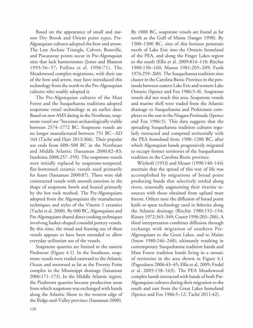
128
Based on the appearance of small and nar‑row Dry Brook and Orient point types, Pre‑Algonquian cultures adopted the bow and arrow. The Late Archaic Triangle, Calvert, Rossville, and Piscataway points occur in Pre‑Algonquian sites that lack bannerstones (Jones and Blanton 1993:56–57; Pullins et al. 1996:71). The Meadowood complex migrations, with their use of the bow and arrow, may have introduced this technology from the north to the Pre‑Algonquian cultures who readily adopted it.
The Pre‑Algonquian cultures of the Mast Forest and the Susquehanna traditions adopted soapstone vessel technology at an earlier date. Based on new AMS dating in the Northeast, soap‑stone vessel use “becomes archaeologically visible between 2574–1772 BC. Soapstone vessels are no longer manufactured between 751 BC – AD 164 (Taché and Hart 2013:366). Their popular use ends from 600–500 BC in the Northeast and Middle Atlantic (Sassaman 2000:82–83; Inashima 2008:257–259). The soapstone vessels were initially replaced by soapstone‑tempered, flat‑bottomed ceramic vessels used primarily for feasts (Sassaman 2000:87). These were slab constructed vessels with smooth exteriors in the shape of soapstone bowls and heated primarily by the hot rock method. The Pre‑Algonquians adopted from the Algonquians the manufacture techniques and styles of the Vinette 1 ceramics (Taché et al. 2008). By 600 BC, Algonquians and Pre‑Algonquians shared direct cooking techniques involving basket‑shaped conoidal pottery vessels. By this time, the ritual and feasting use of these vessels appears to have been extended to allow everyday utilitarian use of the vessels.
Soapstone quarries are limited to the eastern Piedmont (Figure 4.1). In the Southeast, soap‑stone vessels were traded eastward to the Atlantic Ocean and westward as far as the Poverty Point complex in the Mississippi drainage (Sassaman 2006:171–173). In the Middle Atlantic region, the Piedmont quarries became production areas from which soapstone was exchanged with bands along the Atlantic Shore to the western edge of the Ridge‑and‑Valley province (Sassaman 2000).
By 1800 BC, soapstone vessels are found as far north as the Gulf of Maine (Sanger 1998). By 1500–1300 BC, sites of this horizon penetrate north of Lake Erie into the Ontario homeland of the PEA, and along the Finger Lakes region to the south (Ellis et al. 2009:814–118; Ritchie 1980:150–160; Mason 1981:205–209; Funk 1976:259–260). The Susquehanna tradition sites cluster in the Carolina Biotic Province in the pen‑insula between eastern Lake Erie and western Lake Ontario (Spence and Fox 1986:5–8). Soapstone vessels did not reach this area. Soapstone vessels and marine shell were traded from the Atlantic drainage to Susquehanna and Perkiomen com‑plexes to the east in the Niagara Peninsula (Spence and Fox 1986:5). This data suggests that the spreading Susquehanna tradition cultures regu‑larly interacted and competed territorially with the PEA homeland from 1500–1200 BC, after which Algonquian bands progressively migrated to occupy former territories of the Susquehanna tradition in the Carolina Biotic province.
Witthoft (1953) and Mouer (1990:140–144) ascertain that the spread of this way of life was accomplished by migrations of broad point producing bands that selectively settled along rivers, seasonally augmenting their riverine re‑sources with those obtained from upland mast forests. Others note the diffusion of broad point knife or spear technology used in fisheries along the Atlantic drainage (Ritchie 1980:152–154; Kinsey 1972:343–349; Custer 1996:203–206). A third interpretation combines diffusion through exchange with migration of southern Pre‑Algonquians to the Great Lakes, and to Maine (Snow 1980:246–248); ultimately resulting in contemporary Susquehanna tradition bands and Mast Forest tradition bands living in a mosaic of territories in the area shown in Figure 4.1 (Pagoulatos 2006:43–45; Ellis et al. 2009; Fiedel et al. 2005:158–163). The PEA Meadowood complex bands interacted with bands of both Pre‑Algonquian cultures during their migration to the south and east from the Great Lakes homeland (Spence and Fox 1986:5–12; Taché 2011:42).

129
Figure 4.1. Distribution of soapstone quarries and geographic range of Terminal Archaic traditions sites involved in soapstone exchange (Sassaman 2000:76; courtesy of Kenneth Sassaman, Mary Ann Levine, Michael Nassaney, and Bergen & Garvey Press).

130
susqueHanna and mast Forest tradition band interaCtions
Pre‑Algonquian‑speaking people of Susquehanna, Mast Forest and Maritime Archaic traditions vied for trade and territory maintenance in the Northeast. This trade included the exchange of maritime resources for copper and lithic ceremo‑nial items. Kinsey (1972) depicts the broad point distribution as a northward diffusion of influences from the Savannah River to the Finger Lakes and into Southern New England (Figure 4.2). The Terminal Archaic traditions broad point styles originated south of the Carolina Biotic Province in the Savannah River complex (Sassaman 2006; Mouer 1991). The northward spread of the broad point style (see Figure 4.2) parallels the northward spread of oak‑chestnut species in this biotic prov‑ince (Witthoft 1953).
The Susquehanna tradition includes the complexes of the Savannah River, Susquehanna Broadspear, Perkiomen, Lehigh, Koens‑Crispin, Snook Kill and Frost Island. The fossil index of the complexes are broad point with type names the same as the complexes names. The Mast Forest tra‑dition includes Dry Brook, Orient, and Wayland complexes and point types (Kraft 1970b:55–73; see Figure 4.2). Ritchie (1980:156–164) defines a Frost Island phase as the northern expression of the Susquehanna Soapstone tradition. Broad point types serve as the index fossils for the phase. He defines a subsequent Orient phase by its smaller, narrow points of the Dry Brook and Orient Fishtail types. During this phase, carved soapstone vessels were replaced by ceramic vessels fashioned in flat‑bottomed and conoidal shapes (Ritchie 1980:164–178). Snow (2000) suggests the Orient phase represents the merging of Mast Forest with Susquehanna cultures.
The Susquehanna tradition cultures in the Finger Lakes area were the first to lose territorial control to the eastern expansion of the PA. This process can be seen in the replacement of the Frost Island phase by the Meadowood complex by 1200 BC (Spence and Fox 1986:5–6). A similar process is later evidenced along the Atlantic Coast
as Frost Island phase populations merge with, or are displaced by, Meadowood migrant groups (Ritchie 1980:164; Leslie 1973:56–57, 60–64; Snow 1980:257–258).
The spread of the PEA migrant groups from 1200–900 BC caused the language of the east‑ern Algonquians to change significantly enough from Proto‑Algonquian to become classified as PEA (Goddard 1978a:70). As the PEA expanded down the St. Lawrence, Hudson and Atlantic Rivers Valleys, they interacted with Maritime, Mast Forest and Susquehanna traditions bands of various archaeological complexes. These con‑temporaries had an interwoven history of trading, alliances, emigration and immigration, as well as raids and warfare. They alternatively shared, or competed for, the rich plant, animal and lithic resources of the Atlantic drainages.
Evidence of alliances in the Northeast is sug‑gested by shared attributes of the contemporary Meadowood and Orient complexes’ ceremonial practices for treating the dead (Dincauze 1968:77, 85–90; Ritchie 1980:173–178; Snow 1980:242–244, 251). While the type of artifacts vary in the graves of both cultures, shared practices include the use of red ochre, marine shell, cremation treatment, repeated use of large mortuary pits, and positioning of cemeteries on high knolls away from residential sites. Participation of members of both cultures in the periodic reburial ceremonies affords a distinct opportunity for forming fictive kinship and lineage relationships. The absence of broad point types after the end of the Orient phase suggests that the Mast Forest and Susquehanna cultures merged during the Dry Brook and Orient phases. Following the merger of Pre‑Algonquian cultures, the descendent bands produced a variety of ceramic types derived from influences from the Gulf tradition (Dincauze 1968:83; Ritchie 1969; Dent 1995:178–214; Sassaman 2000:89–91; Snow 1980:248–258).
The similarity of cemetery practices be‑tween Orient phase cultures of New England and Meadowood complex cultures suggests a period of contemporary cultures sharing in one another ritual as trade partners. In the southern

131
Figure 4.2. Terminal Archaic traditions complexes (Kinsey 1972:359) (Courtesy of Frederick Kinsey and Pennsylvania Historical and Museum Commission).
Susquehanna and Delaware drainages, Orient phase cemeteries like those in Southern New England are absent. Certain Pre‑Algonquian bands may have welcomed PEA cooperation in opposing shared Pre‑Algonquian enemies. A con‑dition for successful resettlement of new migrant groups is to first explore and establish trade, fictive kinship and other cultural bridging methods prior to moving outside their traditional territory. The
archaeological record is replete with evidence for Pre‑Algonquian and PEA contemporary interac‑tions over hundreds of years as the bands from different cultures crafted varied responses to the changing cultural landscape.
Rouse (1986:12–13) see migration as when “people of one area expands into another area replacing the latter’s population.” Work in the Southwest and the theories advanced in this re‑

132
port view migrating groups mixing with resident populations, creating varied avenues for culture change for both populations. Cabana (2011:24) notes that:
“cultures” break up during large migration processes with myriad small migrant units moving to multiple destinations, generating numerous co‑residences contexts with local groups. This mixing brings socially distant groups into close proximity, requiring new social institutions that are more encompassing (either consensual or hierarchical/coercive) in order to form communities.
The Lenape origin stories reflect this process of establishing relationships with cultures in new areas followed by migration of small groups to those areas over time.
lenaPe origin stories oF Pre-algonquian interaCtions
The Lenape origin story as related to Heckewelder (1876:47–51), notes that the Algonquians came from the west to the Mississippi River in two groups, both seeking new homelands to settle (see Chapter 2). They encountered a well‑estab‑lished nation of people called the Talligewi. The northern group of Algonquians (Mengwe) settled north of the Great Lakes drainages. Heckewelder interpreted the Mengwe as being Iroquoian. The Lenape group settled in the Ohio drainage. Both groups had to first contend with the Pre‑Algonquian populations occupying this territory. The origin story called the Pre‑Algonquians the Talligewi.
The Talligewi initially granted the Lenape per‑mission to traverse their territory to the east. On seeing that there were thousands of Algonquians, the Talligewi launched a surprise attack that killed many. The Lenape bands were faced with retreat to the west or fighting against a superior number of enemies. They developed an alliance with the Mengwe and fought a protracted war with the Talligewi—a conflict that spanned centuries. The combined Lenape and Mengwe efforts succeeded when the Talligewi abandoned their territory and
migrated south down the Mississippi, never to return. The Lenape occupied the territory south of the Great Lakes, and the Mengwe occupied the territory of the Great Lakes drainage. This allowed the populations of the Lenape and Mengwe to increase.
As population increased, the Lenape ancestors explored the Appalachian and Ridge‑and‑Valley provinces to the Atlantic Ocean and south to the Chesapeake Bay. According to Heckewelder’s (1876:51) Lenape informant, east of the moun‑tains, they found a country:
as abounding in game and various kinds of fruits; and the rivers and bays, with fish, tortoises, etc, together with abundance of water‑fowl, and no enemy to be dreaded (editor). They considered the event as a fortunate one for them, and concluding this to be the country destined for them by the Great Spirit, they began to emigrate thither, as yet but in small bodies (editor), so as not to be straitened for want of provisions by the way, some even laying by for a whole year; at last they settled on the four great rivers (which we call Delaware, Hudson, Susquehannah, and Potomack) making the Delaware River, to which they gave the name “Lenapewhittuck” (the river or stream of the Lenape) the centre of their possessions.
Heckewelder (1876:48–49) added his own in‑terpretation of this war between the Algonquians and Pre‑Algonquians. He felt that the centuries of warfare explained the burial mounds full of the battlefield dead. He interpreted the Hopewell hilltop entrenchments as evidence of military fortifications and Hopewell mounds of cemeteries of the dead resulting from centuries of hostili‑ties. Neither of his theories are viewed as valid. Subsequent researchers interpreted the Talligewi to be Iroquoian. Others suggested they were Siouan. The Pre‑Algonquians of the Susquehanna tradition is my best guest for the Talligewi of the Lenape origin story.
Most have interpreted the Mengwe not as Algonquians but as Iroquoian‑speakers, since translation of the term is 'Iroquoian‑speakers' (Richter 1992:1). This interpretation supports

133
the in situ model of Iroquoian development in the Great Lakes region. Another plausible expla‑nation would be that the Mengwe were another unknown language group associated with the Shield Archaic, Lake Forest Archaic, or Maritime Archaic who became allies of the Lenape’s ances‑tors. After the Iroquoians migrated to the Great Lakes region post AD 500, the term may have been applied to them.
The Iroquoians could not be the Talligewi or the Mengwe of the first part of the origin story due to their southern Appalachian summit homeland. Linguistic evidence places the Iroquoian home‑land in the unglaciated Appalachian region south of the Great Lakes (Mithun 1984:263–265). Archaeological evidence indicates a post AD 500 migration of Iroquoian‑speakers to the Great Lakes region (Warrick 2008:143). Eliminated the Iroquoians from consideration leave the unknown language groups of the Shield Archaic or Maritime Archaic traditions, both of which are outside of the area of the Proto‑Algonquian Great Lakes homeland (see Figure 3.1). The Siouan‑speakers are possibly descended from the Talligewi, who were displaced to a southern and western refuge. The Talligewi were well established in the Great Lakes region when the Algonquians spread east‑ward. They migrated south after a long period of warfare with the Algonquians. The Susquehanna tradition had its origin in the Southeast, an area historically controlled by Eastern Siouan‑speakers. The Susquehanna tradition bands conceded their territories in a north to south chronological order as the Meadowood and Middlesex complexes expanded in a southern and eastern direction. I equate the Talligewi to Pre‑Algonquian bands whose archaeological signature is the Susquehanna and the Mast Forest traditions and whose lan‑guage may have been Proto‑Siouan. The Pre‑Algonquian, Mast Forest tradition bands were adjacent to and south of the Proto‑Algonquian bands of the Lake Forest tradition (see Figures 3.1 and 3.2). Much more research is required to test this speculative theory.
The origin story’s discussion of scouts explor‑ing the major Atlantic valleys, assessing resource
locations, and then small bodies of Algonquians migrating to avoid depleting the resource base or alarming the resident populations. Multiple mi‑grations of small groups fits Anthony’s (1992:6–7) criteria for leap‑frog migrations covering long distances, followed by in filling over time of the intervening region. And its fit Cabana’s (2011:21) observation, quoted above, that large migrations result from multiple small groups travelling to a variety of locations to establish co‑residences with existing populations.
The Nanticoke origin story noted that their ancestors, after the Lenape came into their coun‑try, preferred a livelihood of fishing and trapping along the rivers and bays instead of the Lenape preference of pursuing wild game in the forest. They separated from the Lenape and migrated to convenient places that supported this prefer‑ence. In time, the Nanticoke population grew by natural means, and by adding Algonquian Lenape groups which decided to join them. The Lenape spread over a wide territory, including the Piscataway chiefdoms which occupied the area from the Susquehanna to the Potomac Rivers (Heckewelder in Weslager 1948:113). The first migration pertains to the PA Old Copper, Red Ochre and Glacial Kame complexes which spread to the Ohio and St. Lawrence drainages. These migrant groups were followed by the PEA Meadowood bands migrating from the Great Lakes and New England region and down the Chesapeake and Delaware Valleys. Nanticoke ancestors arrived during the first migrations. A thousand years later, a second series of small group migrations involved the Medial division Algonquian language‑speakers. They were band level societies with an emphasis on hunting and gathering, supported by fishing activities. Their descendents were the Mahican, Minisink and Unami and Munsee language‑speakers of the Lenape and related bands.
The Nanticoke origin story recalled the Lenape southern migration to the Delmarva Peninsula and the Western Shore of the Chesapeake Bay. The Nanticoke account notes that they

134
welcomed the migrating Lenape as allies. They became contemporary, coresident societies, with the Nanticoke pursuing a maritime focus while the Lenape focused on hunting. The Lenape in the Delmarva area spread westward to occupy the territory along the Eastern Piedmont, from the Susquehanna to the Potomac Rivers. Pre‑Algonquian bands of this Eastern Piedmont area had been displaced earlier by members of the Archaic Coastal division Algonquian‑speakers of the Mockley complex. The first migration southward was conducted by small Algonquian bands that interacted with Pre‑Algonquian resi‑dent bands. The second migration involved allied Algonquian bands cooperating with each other in a time of displacement resulting from famine and from subsequent Iroquoian‑speaker migra‑tions to the Northeast region. The combined origin stories are consistent with linguistic and archaeological evidence of the first and second major Algonquian migrations, as discussed in Chapters 2 and 3. Chapter 6 will elaborate on the second migration, consisting of Medial division Algonquian‑speakers resettlement in the Delaware and Susquehanna drainages during the end of the Middle Woodland period.
PoPulation deCline due to Cultural ConFliCts during PoPulation migrations
Because the cultures of Meadowood complex and Mast Forest and Susquehanna traditions were similarly adapted, settlement and subsistence data for the period 1200–700 BC is not useful in documenting major cultural differences. In all three cultures, the settlement patterns reflect seasonal, family‑sized resource camps periodically assembling into hamlets for macro‑band feast‑ing. Over time, the Pre‑Algonquian populations declined in numbers due to competition for resources with the well established PEA migrant groups. Settlement patterns and territories of Pre‑Algonquian societies shifted as they strived to maintain cultural continuity. Initially they interacted with migrant groups of Algonquian
bands. Progressively, the Algonquian populations spread throughout the Hudson, New England, Delaware and Susquehanna drainages. By the Late Woodland period, Algonquian‑related site numbers reached Late Archaic period, Pre‑Algonquian levels.
Stuart Fiedel (2001) noticed a pattern in the number of archaeological sites in the Northeast. During the Mast Forest and Susquehanna tradi‑tions, peaking around 800 BC, the numbers of sites increase significantly. This is also reflected by recovery of greater numbers and variety of point types and early pottery. During the Early Woodland period of 800–200 BC, ar‑chaeological data indicate a significant decline of Pre‑Algonquian traditions sites across the regions—and a corresponding increase in PEA Meadowood and Middlesex complex occupa‑tions in the same region (Snow 1980:257–258; Taché 2005). The reduction of Early to Middle Woodland sites in the Middle Atlantic region is additional evidence of the Pre‑Algonquian’s response to the migrating groups of PEA (Funk 1993:200, 288; Steponaitis 1986:286; Galke 2000:7–9).
Fiedel offers a number of explanations for this decline in sites: environmental stress, pre‑Columbian epidemics, and the demise of the Savannah River to Orient trade networks and cultures. He suggests that this demise afforded an opportunity for the Meadowood, Middlesex, and Adena cultures to expand (Fiedel 2001:118–131). His interpretation echoes the Lenape’s statements that their ancestors found bands that they did not fear in the Hudson, Susquehanna, and Delaware drainages. They opted to migrate in small groups to these river systems to minimize stress on re‑sources. The smaller bands would be of sufficient size to defend their new migrant groups from the resident Pre‑Algonquian bands, but not be so large as to overstrain the resource base.
For hundreds of years, PEA settlers shared these river systems with societies of the Susquehanna tradition (Frost Island phase) and Mast Forest tradition (Dry Brook and Orient phases). Stewart (2003a:9) and Funk (1993:198–200) note an

135
abundance of Orient phase sites, followed by far fewer Early Woodland complexes in the Susquehanna drainage (see Figure 3.3). The Lower and Middle Susquehanna Valley have a limited number of Meadowood sites, mostly concentrated along the North Branch of the valley (Trubowitz 1983:86–96; Taché 2011). On the southern Chesapeake’s western shore (James‑York drainages), Pre‑Algonquian popu‑lations retained territorial control of the Inner Coastal Plain until around AD 500. The bands of Pre‑Algonquian’s gradually became absorbed or were displaced by the Mockley horizon bands to the Fall Line (Blanton and Pullins 2004:88–91). Pre‑Algonquians bands in the Piedmont province from the Potomac to Susquehanna Rivers were also displaced by Mockley horizon bands that used the area for lithic procurement and hunt‑ing. Subsequent Algonquian‑related sites in the Coastal Plain and Piedmont of the Chesapeake region increased in numbers throughout the Late Woodland periods (Steponaitis 1986; Johnson 1991; Potter 1993; Galke 2000).
As the Meadowood complex populations ra‑diated east and southward, they interacted with populations of the Orient phase (see Tables 2.3 and 2.5), gradually replacing or absorbing them. During the historic period, Algonquian societ‑ies engaged in warfare amongst themselves, and against surrounding Iroquoian and Siouan societ‑ies (Hantman 1993:100–103; Richter 1992:50–75). Low level raiding, revenge raids, and resource camp attacks allowed males to attain status while defending honor and territory. Historic period warfare necessitated defending cornfields and agricultural villages. Defense of fixed assets did not pertain to the mobile lifestyle of pre‑agricultural societies (Newcomb 1970:54–58). When defense failed, the next best response was flight. Through lineage and kinship networks, refuge would be granted until counter raids could be mounted. The displaced people returned to their settlement if they could continue to defend their reclaimed traditional territory. Otherwise, they relocated farther from the zone of conflict, merged with
their host allies or accepted tributary status to the dominate foe.
Reasons for continuing cycles of peace and warfare are well documented in historical lit‑erature (Rountree 1989:84–87, 119–125). The Algonquian cultures employed lineage, clan, and alliances in forming a cooperative defense (Dye 2009:69–87). Even the post AD 500 Iroquoian migrations to the Great Lakes region did not immediately result in village and population nucleation for defensive success (Warrick 2007, 2008). The Algonquian bands of the Great Lakes region would find value in exchange of goods for corn, fur and meats obtained from the migrant Iroquoian tribes. Increased hostilities and defense of fixed assets resulted in increased village nucle‑ation as cultivated crops intensified, post AD 1000. By AD 1300 Iroquoian and Algonquian societies in territorially contested zones relied on village nucleation, fortified defenses, and en‑hanced political alliances. Some bands preferred a non‑nucleated settlement pattern, thus maintain‑ing traditional methods of alliance and defense. In the Delaware drainage, Lenape and Minisink bands upheld their traditional dispersed settle‑ment lifestyle into historic times (Kraft 2001; Grumet 2009; see Chapter 6).
When pressed by repeated attacks, either from Iroquoian or Algonquian enemies, the Algonquians sometimes moved to the opposite side of larger rivers. They would then flee to the interior uplands when their shoreline‑dispersed villages were threatened. This was the case for the Mohican along the Hudson River during their seventeenth‑century war with the Mohawk Iroquoian‑speakers (Dunn 1994:99). The same response is seen when the Algonquian chiefdoms of the Rappahannock River relocated to the north shore when confronted by the expansion of the Powhatan paramount chiefdom from the south (Potter 1993:10, 19). Such historic insights into Algonquian responses to territorial expansion of Iroquoian cultures provides general analo‑gies for understanding possible Pre‑Algonquian responses to earlier expansion of Proto–Eastern

136
Algonquian bands. Eastern Siouan practices in the Chesapeake Piedmont are not as well understood, other than massed and formalized warfare with the Algonquians in the Fall Line buffer zone (Hantman 1993, 2001). The Siouan and Algonquian hostilities had become shared ritualized warfare after 2,000 years of alternat‑ing alliances and hostilities between the two adjacent language families in the Chesapeake and Albemarle Sound regions (see Figure 3.9).
Pre-algonquian arCHaeologiCal ComPlexes
The archaeological complexes associated with Pre‑Algonquian societies must be defined to contrast them with complexes associated with Algonquian‑speakers. To understand migra‑tions, attention must be given to both native and migrating groups. Discussion begins during the Proto‑Algonquian period (1800–1200 BC) which equates to the end of the Late Archaic period. The Early Woodland periods (1200–500 BC) witnessed major migrations of PEA bands into Pre‑Algonquian territories. During this time, both societies developed different ceramic technologies, one based on coiled basketry design and direct placement on the fire, the other on soapstone bowl design and hot rock heating. Fossil indexes of ceramics, lithic technologies, styles and mate‑rials, and mortuary ceremonialism and regional interaction patterns are used to assign archaeo‑logical complexes to PA, PEA or Pre‑Algonquian‑speakers. Settlement and subsistence practices, while helpful to cultural ecology studies, are less useful for cultural historical analysis during this earlier time period.
The band level societies of both PEA and Pre‑Algonquian‑speakers, and the contemporary occupation and interaction of their bands over hundreds of years, make their settlement and subsistence practices challenging to differentiate. This pertains to the first series of Algonquian mi‑grations. During the second series of Algonquian migrations, settlement and subsistence practices
is increasingly an important tools for determin‑ing linguistic affiliations of the Iroquoian and Algonquian cultures. Differences in house types, village nucleation, burial practices, ceramic types and varieties of design motifs for vessels and pipes, cultivated crops and trade patterns allow for more confident affiliation of archaeological and linguis‑tic evidence during the Late Woodland period.
Savannah River, Koens-Crispin and Lehigh Complexes
Important Pre‑Algonquian‑speaking cultures are associated with the Broadspear or Susquehanna Soapstone tradition (Witthoft 1953); called the Frost Island phase by Ritchie (1980). The Susquehanna tradition is defined based on sites from the Susquehanna Valley. Witthoft recog‑nized its earlier development from the Savannah River tradition in the greater Southeast region (Sassaman 2000; Mouer 1990). Savannah River Stemmed points are widely distributed along the Atlantic Coast from Florida to Cape Cod. South of the Mason Dixon line, sites extend from the Atlantic Shore to the Eastern Continental Divide (Justice 1987:163–167; Mouer 1990:208–216; 1991:12–13; Fiedel et al. 2005:161–163; Bedell et al. 2008:24; Knepper et al. 2014:156–158). The Savannah River tradition has a range of radiocar‑bon dates in the southeast, dating from 2900–745 BC (Inashima 2008:249–251). In the Upper Delaware Valley, Savannah River‑like stemmed points are called Lehigh and Koens‑Crispin types. They date from 2500–1700 BC (Inashima 2008:222; Kraft 1972:30–31; Custer 2001:37). The Savich Farm cemetery site, associated with the Koens‑Crispin complex, has been radiocarbon dated to 2050–1620 BC (Kraft 2001:133). I assign all these point types and associated com‑plexes to Pre‑Algonquian‑speakers, and label the taxonomic unit as the Susquehanna tradition (see Chapter 3). Since early broad points of this tradition predate the use of soapstone and later complexes of the tradition includes ceramics in the Middle Atlantic, I drop the term “Soapstone” in the title of the tradition. South of the Potomac

137
River, the Susquehanna tradition is called the Savannah River tradition (Mouer 1990, 1991; Sassaman 2006). For purposes of this synthesis, Susquehanna tradition is assigned to all related assemblages from the Southeast to the Northeast and Great Lakes regions.
The Koens‑Crispin and Lehigh points are the earliest broadspear phases in the Upper Delaware, Susquehanna, and Hudson drainages (Kinsey 1972:349–353; Figure 4.3). Both Pre‑Algonquian cultures extended south of the Proto‑Algonquian homeland during a period before the differentia‑tion of the Proto–Eastern Algonquian language. The Proto‑Algonquian contemporary culture would be the Old Copper complex of the Lake Forest Archaic, which was involved in trade for marine shell at this early date.
The pattern of sites of the Koens‑Crispin complex in the middle Delaware drainage, sug‑gests hunting and fishing camps along the riverine portion of the Delaware. The interior drainage divides between the Atlantic and Delaware drain‑ages were selected for macro‑band base camps, and occupied in the fall when nuts were harvested and stored. The upland drainage divide area is also the location for rituals and feasting during cremation burial ceremonies (Hunter Research 1989:2–2; Figure 4.4).
A study of Lehigh and Koens‑Crispin points from the Delaware drainage (Custer and Mellin 1986:11) reveals a preference for argillite obtained from quarries in the Triassic Lowlands section of the Piedmont portion of the drainage (see Figure 4.3). Rhyolite from the Blue Ridge province to the west was the next highest lithic preference, followed by quartzite. Wear pattern and attribute analysis suggest primary use as cutting tools such as knives. Kraft (2001:137) associates the points with atlatl counterweights (bannerstones) in hu‑man burials at the Savich Farm site (see Figure 4.4). The larger point causes a wider wound that more quickly kills bear, deer, and elk. Kinsey (1972:346) suggests they were used as harpoons for capturing larger fish. Broad points and ban‑nerstones indicate Pre‑Algonquian use of atlatls instead of bows and arrows. The stylistically re‑
lated Lehigh Broad points of jasper and the Snook Kill points of flint contrast mostly in their lithic preference (Kraft 1970b:129).
The pattern of sites and the subsistence data recovered indicate a primary emphasis on hunting and nut gathering for the bands of this complex. Storage pits producing plentiful hickory, and mi‑nor amounts of walnut and acorn, are document‑ed for the Savich Farm residential and cemetery sites. Both sites are located on the drainage divide between the Delaware and Atlantic (see Figure 4.3). No fish remains or net sinkers have been recovered from sites of these complexes in the Delaware drainage. Koens‑Crispin style points are found from the Delmarva Peninsula (Custer and Mellin 1986:16–18) along the Delaware River to Martha’s Vineyard, and the lower Hudson drainages of the Raritan and Millstone Rivers (Kraft 1970:129; Brennan 1991:17–18). One point was found in a feature at the Miller Field site in the Upper Delaware in association with Perkiomen Broad points. That feature yielded an uncorrected radiocarbon date of 1720+120 BC (Kraft 1970:130).
Lehigh and Snook Kill sites are distributed to the Great Lakes and Southern New England area (Dincauze 1968; Ritchie 1980; Snow 1980:236–237). The northward spread of the broadspear technology appears to correlate with the northern spread of the chestnut trees and ex‑pansion of marsh habitats (Mikolic and Albright 2012:8–14). A riverine focus combined with wide use of upland resources is consistent with vari‑ous phases of the broadspear types. In areas were the Mast Forest (narrow point) tradition bands continued to utilize the interior drainages, the Susquehanna tradition bands focused on riverine resources (Mouer 1991).
The Koens‑Crispin burial process is better un‑derstood than that of the Savannah River, Lehigh and Snook Kill complexes. They were distinct from the PA cosmology of the Old Copper hori‑zon (Pleger and Stoltman 2009:707–712). Savich Farm, Koens‑Crispin and Red Valley cemeteries (see Figure 4.3) are all located in drainage divides (Kraft 2001:133–137; Pagoulatos 2006:35;

138
Figure 4.3. Major Koens-Crispin sites in the inner coastal plain (Hunters Research, Inc 1989:2-2, based on a map in Widner 1964:8) (Courtesy of Robert Hunter).

139
Figure 4.4. Rejected, flat-bottomed soapstone bowl in situ at a Patuxent River quarry site in the eastern Piedmont province (Photograph by the author).
Burrow 1997:39–41; Walker and Cushman 2009:3–3, 3–5). Attributes of the Koens‑Crispin complex cemeteries can be described as follows:
• Cemeteries are located in a defined area near residential settlements in upland drainage divide settings, not on a high hill overlooking a body of water like PA.
• Cremation of primary remains was con‑ducted away from the cemetery, with no evidence of secondary curation prior to cremation.
• One to several sets of remains placed in individual graves with artifacts included for all ages and genders, suggest egalitarian treatment of the deceased.
• Red ochre was included with the remains.
• Copper and marine shell offerings are absent; a major contrast to their presence in PA Old Copper, Red Ochre and Glacial Kame complexes’ cemeteries.
• Koens‑Crispin points of argillite and bannerstones of soapstone suggest local movements and more distant travel to trade these materials.
• Grave offerings include three‑quarter grooved axes, adzes, and gouges for wood working (such as for making dug‑out canoes), petrified wood, stone shaft‑smoothers, turtle shell rattle, and pestle (but no mortar or grinding stones).
• Grave offerings were not ceremonially killed, other than fire damage from the cremation process.

140
The first complexes of the Susquehanna tradi‑tion (Savannah River, Koens‑Crispin, Snook Kill and Lehigh) were not greatly influenced by inter‑action with PA Old Copper related complexes of the Great Lakes region. Old Copper utilitar‑ian tools are rarely found in the Delaware and Susquehanna drainages during this time period, as noted in Chapter 3. Koens‑Crispin mortuary practices are distinct. Their hunters continue to use the atlatl with bannerstones serving as counter‑weights on the atlatl throwing stick. PA sites lack bannerstones, an indicator of the production of Meadowood points for use with arrows and bows.
Extensive use of shellfish resources has not been documented. This could be attributed to site loss from sea level rise and urban develop‑ment. Or it may reflect an emphasis on hunting and gathering subsistence with supplementary fishing during part of the seasonal cycle. Proto‑Algonquian complexes positioned their multiple band settlements along river and lake shorelines, with sacred cemeteries situated on natural knolls overlooking large bodies of water. In contrast, the Koens‑Crispin complex focused their multiple band settlements in interior drainage divides ac‑cessible to nut and game resources. Their sacred cemeteries were adjacently located in the same upland areas. The PA and Pre‑Algonquians had distinct mortuary and settlement practices during this time period (2500–1600 BC).
The beginning complexes of the Susquehanna tradition continued to develop after 1700 BC with new point types and the spread of soapstone vessel technology and trade. The PA did not participate in the Pre‑Algonquian bands’ exchange for soap‑stone flat‑bottomed vessels. They did, however, receive marine shell from the Pre‑Algonquians through a down‑the‑line type exchange network from the coast to the Great Lakes homeland. I will not go into detail about the Perkiomen and Susquehanna complexes which are prevalent in the Susquehanna and Delaware drainages (Witthoft 1953; Kinsey 1972:343–355; Funk 1993). Instead we will consider the southern development of soapstone bowl technology and its subsequent spread to the Northeast.
Soapstone Tool Manufacture and Exchange
Soapstone use first appears in the Delaware drain‑age with the manufacture of bannerstones of the Koens‑Crispin complex. But the earliest docu‑mented use of soapstone for tools occurs in the Southeast. Soapstone cooking slabs first appeared at sites associated with the Guilford complex, dating from 4500 BC. Soapstone slabs with holes developed by 3600 BC (Sassaman 2006:44–47). As time passed, these slabs were refined to include “pendants with holes.” Such pendants and slabs served the same purpose—heating liquids. I sus‑pect that utilitarian soapstone slabs were replaced by pendants used in medicinal and ceremonial contexts. This ceremonial use of soapstone was extended to include carved soapstone flat‑bottomed vessels (Klein 1994). Pendants persist through the Frost Island complex of the Terminal Archaic traditions. Soapstone bowl association is problematic for the PEA ceremonial feasting of the Meadowood complex. The Algonquian Meadowood complex Vinette 1 conoidal vessels are contemporaneous with Pre‑Algonquian use of soapstone vessels (Taché and Hart 2013:362–363, 366–367). Conoidal‑shaped, grit‑tempered, inte‑rior‑and‑exterior cord‑impressed Vinette 1 ware is a major index fossil of the PEA‑speakers. Slab constructed, plain surfaced, trough‑shaped clay vessels are an index fossil of the Pre‑Algonquians (Egghart et al. 2014:5–7).
Trough‑shaped vessels were manufactured by Susquehanna tradition societies from soapstone quarries located in the eastern Piedmont (see Figures 4.1 and 4.4). The vessels were traded to cultures in the Mississippi drainages to the west. These vessels reached the Frost Island bands in the Finger Lakes (see Figure 4.2). Soapstone vessels were not traded to the bands of the Susquehanna complex that lived in southern Ontario. Down‑the‑line trading moved soapstone and lithics between Susquehanna and Mast Forest traditions bands along the Atlantic drainages. Soapstone vessels appear not to have been adopted by the more distant Shield Archaic or Maritime Archaic traditions.

141
In Southern New England and the Finger Lake region, the Orient (1200–700 BC) and Meadowood (1200–500 BC) complexes par‑ticipated in each other’s mortuary activities (Dincauze 1968:85–90; Taché 2005. 187). Both cultures selected cemetery locations on sandy knolls where they excavated deep circular burial pits. Various treatments of human remains were placed in graves along with red ochre, deliber‑ately killed grave goods, two‑hole gorgets, celts, caches of burial offerings, and projectile points. Orient cemeteries, but not Meadowood, yield ritually killed soapstone bowls and fire‑making kits. Orient cemeteries contain grooved axes and bannerstones not found in Meadowood complex cemeteries. Meadowood cemeteries included bird‑stones, shaman curing bundles, gorgets, diverse ceremonial bifaces, and cache blades (Ritchie 1980:175–178,196–200; Snow 1980:244–251; Taché 2011). This suggests an initial period of alliance, cooperation and participation of bands in the feasting and reburial ceremonies of the other’s culture. For a time (1400–1000 BC), the Frost Island phase cultures distributed marine shell from the south to the Great Lakes. Meadowood complex migrant groups in the Chesapeake and Delaware Bays assume this critical role between 1000–800 BC. Their PEA descendents continued the marine shell trade with fellow Algonquians through the Colonial period (see Chapters 5–6).
Mounds were not constructed in Southern New England cemetery sites of the Orient phase. Rather, they dug deep oval‑shaped pits (18’ long by 30’ wide) for receipt of remains. Beside the pits were crematory hearths with red ochre and various artifact caches (Pagoulatos 2012:294–295). In the Chesapeake region, Algonquians excavated large circular burial pits and adjacent individual caches and fire pits at the Pig Point site, dating to the later Selby Bay Adena phase (Luckenbach 2013a, 2013b). There is some indication that the Pope’s Creek complex bands (Pre‑Algonquian) along the Inner Coastal Plain of the Potomac River participated in the Selby Bay Adena mortuary cer‑emonies at this Patuxent River site (Luckenbach
2013a, 2013b; Luckenbach and Sharpe 2013). Researchers found a cremated burial with Pope’s Creek ware adjacent to the Selby Bay Adena large mortuary Pit 1. Mockley and Pope’s Creek wares have been recovered from the mortuary pits. No other known sites in the Chesapeake Bay region reveal evidence of Orient or descendent Pope’s Creek phase mortuary ceremonies.
Orient and Meadowood cemeteries in the Northeast are usually located apart from, but close to, habitation sites. Meadowood cemeteries are smaller in size than Middlesex cemeteries (Ritchie and Funk 1973:348). Middlesex cemeteries are also found at a distance from habitation sites (Pagoulatos 2012:319). If Orient cemeteries were located in isolated settings away from habitation sites, they have escaped discovery by the limited testing of Orient phase residential sites in the Chesapeake and Lower Delaware Valley.
No burial sites associated with the Terminal Archaic traditions have been found in the Upper Delaware Valley (Kraft 1991:27). Counterweights in the form of winged bannerstones show contin‑ued use of the atlatl by Orient phase hunters. But the smaller point sizes might also indicate that the atlatl and bow and arrow were being used contemporaneously by the Orient bands. Dry Brook and Orient type points and knives were manufactured from quartzite in the south, and made from rhyolite and argillite in the north. Log or bark canoes were used to transport stone tools from these quarries; particularly heavy soapstone bowls traded in finished form.
A log dugout canoe found in Savannah Lake in north‑central Ohio received a radiocarbon date of 1600 + 70 BC. The canoe was 6.9 meters long by 1.1 meter abeam. It could carry an estimated 530 kilograms with a crew of two (Stothers and Abel 1993:83). Pre‑Algonquian bands used river trans‑port of heavy biface blanks and soapstone vessels along the Susquehanna, Delaware, Hudson, and Atlantic coast. They may have used bark canoes for portaging lithics across the drainage divides to the Finger Lakes, Lake Champlain, and St. Lawrence drainage. Proto‑Algonquian traders

142
from a southern Ontario homeland would have followed similar practices and waterways to obtain marine shell and other coastal commodities of in‑terest to them. These travels also allowed them to create fictive kinships with Pre‑Algonquian bands, scout areas for potential new migrant groups, and participate in ceremonial feasting and mortuary activities.
Orient phase cultures along the Southern New England coast relied heavily on shellfish and fish. Their sites show little evidence of interior hunting camps which are more typical of the Frost Island cultures along the Hudson River Valley (Ritchie and Funk 1973:244–346; Schaper and Brennan 1991:13–15). Snow (1980:232–242) believes that the hunting part of the Orient phase seasonal round is represented by sites located farther up the Hudson and Southern New England river drain‑ages. Along the lower Hudson, shellfish from Pre‑Algonquian sites have been radiocarbon dated as early as 5000 BC (Claassen 1995:13, 137). These shell dates are not corrected for reservoir effect. Shellfish gathering continued through subsequent occupations of Late Archaic and Orient phase, Mast Forest tradition. The greatest number of radiocarbon dates falls between 3500–2000 BC. The two largest shell midden sites date to around 500 BC, a time of transition from Pre‑Algonquian to PEA control of the Lower Hudson Valley (Claassen 1995:138).
Orient phase site sizes were small, lacking evi‑dence of multiple band community villages like the Meadowood complex river based settlements or the Koens‑Crispin complex interior drainage divide macro‑band sites. Trading, travelling, and feasting with the Pre‑Algonquian Orient complex bands, would prove of great value to the PEA Meadowood complex bands. Such interactions would impart knowledge about capturing, pre‑serving, and storing marine resources. The PEA bands’ interactions with Pre‑Algonquian bands prepared the PEA for establishing migrant groups from the Gulf of Maine to the Chesapeake Bay.
The Frost Island phase, Susquehanna tradition has a riverine focus with greater dependence on in‑terior hunting. This phase extended from Central
New York to the Hudson River (see Figure 4.2). According to Ritchie and Funk (1973:345):
Our data indicate an essentially riverine orientation of the Frost Island phase. The rather cumbersome soapstone vessels would most easily have been transported by canoe. The small size of the camps, the limited quantities of refuse, and the absence of data on substantial dwellings and storage pits, point to the organization of Frost Island groups into little bands. These bands may have been identical to preceding Archaic groups in structure and composition, since there is no evidence for significant change in way of life. Basic activities were evidently hunting, fishing, and butchering, fire‑making, cooking, flintknapping, the fabrication of stone pots and probably of canoes.
Concerning the period 2500–1200 BC, cop‑per and marine shell artifacts are rarely noted in Savannah River complex sites on the Western Shore of the Chesapeake Bay. On the Eastern Shore, occasional surface find artifacts from the Old Copper complex consist of socketed copper spear points and crescent knives (Curry 2002; Lowery 2004:20). Old Copper socketed copper spear points are seldom found in surface collec‑tions from the upper, middle and lower Delaware River area of New Jersey and Cape May. A site from Cape May is a possible source for conch and other marine shell artifacts (Abbott 1885:775; Veit et al. 2004:78–81). The abundance of conch shell artifacts in the northern Old Copper/Glacial Kame/Red Ochre complexes suggests down-the-line exchange initially with Susquehanna tradition band extending from the Atlantic shoreline to the Allegheny Plateau. Such exchange transpired between 2500 and 1000 BC. Post 1200 BC, the Meadowood culture played a middleman role. By 800 BC Meadowood groups who migrated east and south secured direct access to marine resources (Lowery et al. 2015; Rick et al. 2015). This represents the first major PEA migration (see Figures 2.7, 2.8, 3.2, and 3.4).
The Proto‑Algonquian distribution net‑work went through territories controlled by Susquehanna and Mast Forest tradition bands.

143
The Savich Farm site, situated in the Middle Delaware drainage, is the southernmost example of mortuary ceremonialism (see Figure 4.3). It had a few shared attributes with the Old Copper com‑plex (Kraft 2001:133–137; Burrow 1997:35–39). If the Koens‑Crispin complex bands passed ma‑rine shell along to the Old Copper complex, they did not retain shells for use in their own mortu‑ary ceremonies. In Southern New England, the succeeding Orient phase mortuary practices were similar to those of the PEA Meadowood complex (Snow 1980:242–243). The Meadowood and Orient complexes were involved with one another in trade, feasting and mortuary ceremonies.
Mortuary practices of the Savannah River, Susquehanna, and Orient complexes of the Chesapeake drainage are poorly documented (Mouer 1990, 1991). Evidence from the Potomac River suggests a riverine focus for Susquehanna tradition and an upland focus for the Savannah River tradition (Fiedel et al. 2005:159–163). Research in the Potomac Coastal Plain suggest continuation of the Orient phase, Mast Forest tradition as late as the Pope’s Creek complex (Monroe et al. 2012:74–77). Mouer (1991:4–10) and McLearen (1991:93–94) note a similar pat‑tern of continued upland use by the Mast Forest tradition while Savannah River tradition settle‑ments were riverine focused. Dent (1995:178–188, 200–214) provides a detailed summary of this debate as it pertains to the Chesapeake Bay region. Pre‑Algonquian broad point and narrow point traditions competition extended all the way to the northern edge of the Carolina Biotic Province (Sassaman 2000:90; Ellis et al. 2009; Mouer 1990).
Detailed documentation exists for a series of sites belonging to the subsequent complexes of the Susquehanna tradition. These complexes extend from the Potomac River basin to the southern Great Lakes. The Genesee and Snook Kill point types (1900–1600 BC) are similar in style, and overlap in time, with the Savannah River points. Funk (1993:195–196) asserts they are derived from the Savannah River complex and are regional expressions similar to the Koens‑Crispin/Lehigh
point types in the Delaware drainage. Frost Island phase and later Dry Brook and Orient phases have soapstone carved vessels, fire‑cracked rock clusters, and fishing and riverine‑oriented subsistence (Kinsey 1972:354–361; Snow 1980:235–259).
The Mast Forest tradition, Orient phase appears to have developed in situ in Southern New England (see Figure 4.3). But in northern New England, the populations appear to have migrated to new territories, displacing bands of Maritime and Lake Forest Archaic traditions (Snow 1980:146, 249–250). Researchers in New England believe that a 500–year overlap of Frost Island phase of the Susquehanna tradition and Mast Forest tradition cultures resulted in the development of the Orient cultures (Sassaman 2000:89–91). This observation is based on the lithic preferences, narrow point styles, and flat‑bottom soapstone and ceramic vessel continu‑ity, as well as mixing of mortuary practices. I include the Orient phase in the Mast Forest tradition based on the use of narrow points and the abandonment of the broad points of the Susquehanna tradition. After the Orient phase, Pre‑Algonquian‑speakers no longer manufactured broad points and adopted ceramics for use in both sacred and utilitarian purposes. While reduced use of soapstone vessels continued as late as AD 100 in descendant Pre‑Algonquian populations, extensive soapstone bowl trading ceased at the end of the Orient phase. Snow (1980) was insightful to say that the Orient phase marks the merging of narrow point and broad point tradition popula‑tions. These populations continued to focus on cobble tool production and developed a variety of pottery types derived from a Gulf tradition base.
Orient phase sites in the lower Susquehanna and Delaware drainages have produced no evi‑dence of mortuary ceremonialism. Orient phase sites in Southern New England indicate adop‑tion of some PEA Meadowood influences. Snow (1980:251) notes that:
Orient points tend to be made of quartz or quartzite, as were the narrow stemmed point types of the earlier Mast Forest Archaic and the

144
successor Lagoon and Rossville points of the period following 700 B.C.
The religious subsystem clearly derives from that of the preceding Mast Forest system. Large pits contain smaller secondary pits that in turn hold cremations and lenses of greasy black soil. Grave goods include red ochre, soapstone pots, fire‑making kits, paint stones, gorgets and projectile points. Pots are often deliberately holed, and all classes of grave goods are frequently broken and/or damaged by fire. We can infer burial programs that involved cremation or at least ceremonial fires, as well as ceremonial killing of objects placed in the graves. The spread of these practices northward with an expanding population of Southern New England people produced a striking discontinuity with the earlier Maritime Archaic practices in Maine, a discontinuity that can be observed in other cultural subsystems.
I focus on the mortuary system of the period 1200–700 BC for the Orient phase which mirrors the practices of the Meadowood complex (Ritchie 1980:175–178, 196–200). Shared practices be‑tween the two complexes include:
• Cemetery on a high ridge overlooking water at a distance from residential sites
• Large mortuary pits (approximately 20–30 feet in diameter, and 5–9 feet deep) that were used over multiple generations. Smaller individual pits with isolated sec‑ondary burials were also used.
• Multiple stage treatment of the deceased’s remains.
• Sometimes the remains were symbolically covered with a layer of ash.
• Both deliberate breaking of artifacts to kill their indwelling spirits as well as burials with undamaged artifacts included.
• Continuation of red ochre inclusion in the graves
• Inclusion of gorgets, projectile points, and fire‑starting kits
Evidence indicates that these contemporary cultures were involved in trade networks and attended each other’s mortuary rituals and cer‑emonies. In Southern New England, the Orient phase bands adopted the lineage‑based mortu‑ary and feasting systems of the Meadowood complex (Kinsey 1972:364–369). Bands of the Bushkill and Lagoon complexes (600–100 BC) may have resisted territorial expansion of the PEA. These cultures interacted with the Adena/Middlesex bands without becoming absorbed by them. They show no preference for PEA lithic materials. Bushkill and Lagoon cultures produced Lagoon and Rossville points, knapped from local lithic materials (Kinsey 1991:12–13). In contrast, Meadowood points were produced using Onondaga chert and other exotic lithic materials. The Lagoon and Bushkill complexes may represent a continuation of Pre‑Algonquian societies in a region increasingly dominated by PEA migrant groups. The Bushkill complex may also exemplify the mixing and merging of Proto–Eastern Algonquian (PEA) and Pre‑Algonquian populations in the Upper Delaware Valley.
The soapstone bowl manufacturers of the Terminal Archaic traditions experimented with soapstone‑tempered, flat‑bottomed, slab con‑structed pottery (Kraft 1970:113–120). This pottery appears to have been made by the men, and modeled after wooden and soapstone troughs (Klein 1997:143–149). Ayers (1972:118) found Marcey Creek Plain and Selden Island Corded wares in stratified context with Orient Fishtail points in the Potomac Piedmont floodplain. Kraft felt that the Orient phase should be extended to 800 BC to incorporate both flat‑bottomed and conoidal shaped vessels. Kraft (1970) documented the same association of Orient Fishtail and Marcey Creek ware in the Upper Delaware Valley at the Miller Field site.
Soapstone vessels found in mortuary context for Orient phase sites in New England support the belief that they served a feasting function. Both the Mast Forest and Susquehanna traditions are posited to have traded the vessels for this use (Klein 1997:149–152). Soapstone outcroppings,

145
limited to the eastern edge of the Piedmont prov‑ince, were initially controlled by cultures of the Terminal Archaic traditions (see Figures 4.2–4.4). Susquehanna and Mast Forest tradition people copied the PEA bands’ Vinette 1 ceramic technol‑ogy. They eventually abandoned making slab con‑structed, flat bottom vessels in favor of the PEA’s conoidal shaped, coil constructed, grit‑tempered, exterior cord‑paddled styles. Early forms of Pre‑Algonquian conoidal wares of the Chesapeake and Delaware drainages include Selden Island, Dames Quarter, Accokeek, Williamson, Ware Plain, and Elk Island (Ayers 1972:118–119; Mouer 1991). Over time, both cultures developed conoidal ves‑sels for cooking and storage. These ceramic types are a hallmark which defines the Early Woodland period of development in both cultures.
Cooking continued to be dominated by hot rock heating methods. Extensive rock hearths indicate spring camps set up to process and preserve fish and their oils during their annual runs (Cavallo 1984). In the Inner Coastal Plain, the hearths could also be used for the heating of tuckahoe to parch it before storage. Tuckahoe and other root crops required parching to remove the acidity and prepare them for storage (Gardner 1982:9–10).
ComPlexes oF tHe terminal arCHaiC traditions, early woodland Period
In the Southeast, soapstone heating stones over‑lapped with the introduction of fiber‑tempered pottery, ca. 2500 BC (Justice 1987; Sassaman 1996:68–73). Use of soapstone heating rocks did not extend to the Chesapeake region even though soapstone bowl manufacture was adopted. Two theories are proposed for the spread of point types and soapstone technology: (1) the Savannah River to Orient complexes of the Late Archaic period developed in situ or, (2) the technology spread as a result of migration (Mouer 1990:136–144)
The lithic industry of the Savannah River complex focused on use of quartzite cobbles for
the broad blade points. Later point types were made of quartz and quartzite. Chert and jasper were rarely used, except for Perkiomen points from the Great Valley and Dismal Swamp ar‑eas which were made from jasper (McLearen 1991:94–9). The Perkiomen complex developed in the middle Susquehanna and Delaware region in the area of primary jasper quarries, and spread to the north and south from that location (Ritchie 1980:154–155). Terminal Archaic cultures north of the Potomac drainage included rhyolite as a major lithic type.
In the Middle Delaware Valley the Williamson site produced grit‑tempered Williamson Flat‑Bottomed ware AMS‑dated as 1250–850 BC. This is also the type site for Williamson Corded ware, which is conoidal in shape and AMS dated as 1260–990 BC (Hummer 2007:80–88). Also in the Middle Delaware Valley, the Ware site produced Ware Plain flat‑bottomed ware which is quartz and sand‑tempered (Morris et al. 1996:18–20). The Upper Delaware Valley has produced flat‑bottomed grit‑tempered ves‑sels that date from 1380–790 BC (Morris et al. 1996:19). Marcey Creek soapstone‑tempered flat‑bottomed ware is also found as minority pot‑tery at sites throughout Delaware Valley (Kraft 1979:15–16). Dames Quarter flat‑bottomed grit‑tempered vessels from the Lower Delaware Valley fall is similar date ranges (Egghart et al. 2014:1, 4). I associate all these ceramic types with Pre‑Algonquian‑speakers.
Soapstone‑tempered Marcey Creek ware, shaped into trough formed vessels, develops out of the Savannah River complex and Susquehanna tradition in the Chesapeake and Delaware Bays (1300–900 BC). The flat‑bottomed shapes were replaced with conoidal shaped vessels of varied types (Table 4.1). The Pre‑Algonquian may have learned about coil constructed, cord wrapped paddle, conoidal shaped pottery construction through their contacts and interaction with PEA who manufactured Vinette 1 ware. Custer (1987b:101–102) also notes these influences, but attributes the interaction to trade and exchange and not migration.

146
Researchers see the various Early Woodland flat‑bottomed ware complexes as developing out of the Orient complex, which represents the merger of Susquehanna and Mast Forest tradi‑tions. The first ceramics consist of flat‑bottomed wares that mimic the flat‑bottomed shape of soapstone bowls made by the Orient complex. Marcey Creek ware, with its soapstone temper, is found from the James River to the Upper Delaware Valley. It is thought that bands of both Pre‑Algonquian traditions received the concept of pottery from the southeast Savannah River complex, where fiber‑tempered pottery dates to as early as 2500 BC (Sassaman 2000:91–93). Table 4.1 lists the wares associated with the merged Terminal Archaic traditions associated wares of Pre‑Algonquian‑speakers in the Chesapeake and Delaware Bays region.
Variations in temper types and vessel shapes across the Terminal Archaic traditions reflect local differences in adapting the new technology by various bands. People of the Terminal Archaic traditions in the Chesapeake, Delaware, Hudson, Great Lakes, and Atlantic drainages were suf‑ficiently involved in regional exchange to convey resources and concepts across territorial bound‑aries. They appear to have lacked pan‑regional cooperative alliances. The possible disunity of their bands would provide opportunities for the Trans‑Appalachian tradition PEA‑speakers to eventually gain control of various regions over a 1,000 year period (Figure 4.5). Over centuries, the PEA displaced various Pre‑Algonquian soci‑eties. Some Pre‑Algonquian societies may have converted their material culture and language over time to Algonquian, which may have been the case
Table 4.1. Merged Terminal Archaic traditions associated wares (based on Inashima 2008: 232; Egloff and Potter 1982:95-97; Painter 1988; Griffith 1982, 2010; Stevens and Klein 1993; Curry and Kavanagh 1993, 1994; Egghart et al. 2014; McLearen 1987; Brown and Hunter 1987; Blanton and Pullins 2004).
BAY MERGED TERMINAL ARCHAIC
TRADITIONS WARES DURATION
C H E S A P E A K E
Bushkill 1200 BC
Marcey Creek & Croaker Landing 1300 – 900 BC
Currituck 1000 – 800 BC
Selden Island 1000 –800 BC
Accokeek 1000 – 450 BC
Elk Island 900 – 500 BC
Prince George 500 BC – AD 300
Pope's Creek 550 BC – AD 400
Varina AD 100 – 500
D E L A W A R E
Dames Quarter
Marcey Creek
1400 – 1000 BC
1300 – 1000 BC
Selden Island
Wolfe Neck
1200 – 800 BC
800 – 100 BC

147
for the Pre‑Algonquian cultures of the Bushkill complex. Table 4.2 shows the sequence of ware attributes and ceramic developmental continuity for the merged Terminal Archaic traditions in the Chesapeake and Delaware Bay regions.
Vinette 1 wares extend from the Great Lakes to Delmarva (Lowery et al. 2015; Taché 2005). The PEA producers of Vinette 1 ware are the source of technological influences prompting the conversion from flat‑bottomed to conoidal shape, and from soapstone to grit tempering in the vessels of the Pre‑Algonquian cultures. Vinette 1, Swannanoa, Fayette Thick, and Marion wares of the Trans‑Appalachian tradition define a Northern tradition of ceramics associated with the spread of PA populations (Jenkins et al. 1986; see Figure 4.5). In contrast, the Pre‑Algonquian, Terminal Archaic traditions ceramics developed from influences from the Gulf tradition in the Southeast (see Figure 4.5). The flat ‑bottomed ceramic wares of the Terminal Archaic traditions represent a northern extension of the Gulf tradi‑tion from the Southeast to the Northeast. The degree of ceramic manufacture influences from groups of the Gulf tradition vs. the Northern tradition will continue to require local compara‑tive studies.
Bushkill Complex of the Upper Delaware Valley (550 BC – AD 50)
In the Upper Delaware Valley, research from 1959 to 1975 was funded by the National Park Service in advance of the Tock Island Dam project. It provided Fred Kinsey (1972:264–269) with the stratigraphic data needed to define the Bushkill complex. Based primarily on the Faucett site com‑ponent, the complex was also found in stratified context at the Brodhead‑Heller, Brodhead, Miller Field, and Zimmermann sites. Local lithic materi‑als such as black chert and quartz were used for the Rossville and Lagoon narrow point types found in association with Brodhead Net‑Impressed pot‑tery. Lagoon points increase in frequency to the east, and are associated with shell midden sites in Southern New England. Rossville points are
commonly associated with Early Woodland pe‑riod, Terminal Archaic traditions sites throughout the Delaware and Chesapeake drainages (Kraft 1975:49, 2001:180–181). Mounier (1972) and Kraft (2001:180–183) defined a Cadwalader complex as representing a “coalescence of Marcey Creek/Ware Plain pottery from the south, and Vinette 1 ceramics from the north”.
In the Chesapeake, Rossville points are found associated with diamond shaped Piscataway points and square‑stemmed Calvert points; all of which are preferentially manufactured from quartz (Stephenson et al. 1963; Mouer 1991:58; Jones and Blanton 1993:28, 36–37, 57). Given this preference for using local lithics, combined with the absence of Adena points in Bushkill compo‑nents, Kinsey (1972:367) deduced that there was little interaction between the Middlesex Adena and the Bushkill complex even though they were contemporaries in the Upper Delaware Valley.
House patterns are circular to oval, measuring 25–30 feet in diameter (Kinsey 1972:197; Kraft 2001:179). One house pattern is clearly associated with a Rossville and a Lagoon point and several Brodhead pottery types. Other recovered items include a bola stone, a net sinker, a hammerstone and workshop of flint flakes (Kinsey 1972:192). Shallow basin food processing pits were also found. Graves have not been found associated with residential sites of the Bushkill complex. Other artifact types of the complex include sub‑rectangular gorgets, adzes, net sinkers, grinding stones, mullers, pestles, hoes, teshoas, choppers, celts, anvils, and pitted stones (Kinsey 1972:196).
In the Upper Delaware Valley, Exterior Corded/Interior Smoothed ware is grit‑tempered and conoidal‑shaped, dating from 800–500 BC. In stratigraphic sequence, the pottery appears to originate with the Orient complex; later being replaced by the Brodhead Net‑Impressed ware of the Bushkill complex (Kinsey 1972:168–170, 360–362, 454–455). Brodhead Net Impressed pottery bears net impressions in the vessel’s inte‑rior and exterior, indicating interaction with the PEA migrant group in the area that produced

148
TerminalArchaicTradition
VinetteVinette
Vinette
Vinette
WilliamsonWare Plain
Marcey Creek
CroakerLanding
(Trans-Appalachian Tradition)
Accokeek-Elk Island
Marion
Wheeler
Refuge
Norwood St.Johns
Fayette Thick
Swannanoa
NORTHERN TRADITION
LATE ARCHAIC
GULF TRADITION
CERAMIC TRADITIONS1200 - 600 BC
PovertyPoint
ThomsCreek
Figure 4.5. Early ceramic traditions and horizons in the Eastern Woodlands (modified from Jenkins et al. 1986: 547) (Courtesy of Ned J. Jenkins, David H. Dye, John A Walthall, and Center for American Archeology).

149
Marcey Creek Ware soapstone-tempered flat-bottomed
Selden Island Ware soapstone-tempered conoidal & cord-impressed
Accokeek/Elk Island Ware quartz-tempered conoidal & cord-impressed
Pope's Creek/Prince George Ware Quartz & grit-tempered conoidal & cord- or net-impressed
Table 4.2. Terminal Archaic traditions Sequence of Ware Attributes in the Chesapeake Bay Region (based on Bedell et al. 2009:25-30; Mouer 1990: 213-219, 1991:47-60).
Vinette 1 pottery. Vinette 1 pottery and Brodhead Net‑Impressed are found in association at the Miller Field site in stratified context (Kinsey 1972:367). At the Faucett site, Exterior Corded/Interior Smoothed ware is found associated with Orient complex artifacts as well as the Meadowood component, suggesting contemporaneous compo‑nents of both (Kinsey 1972:168–170, 253–256). The Bushkill components occur stratigraphically above the PEA Meadowood components that produced the Vinette 1 pottery and Meadowood points. Other Bushkill complex influences from the Meadowood interaction include the adop‑tion of gorgets and the absence of bannerstones. Bannerstones absence suggests that the atlatl was replaced with the bow and arrow in both Meadowood and Bushkill complexes.
The Pre‑Algonquian Bushkill complex does not extend to the adjacent upper Susquehanna drainage which was lightly occupied during this part of the Middle Woodland period. Such light occupation was due to the presence of a Meadowood migrant group of PEA‑speakers (Funk and Rippeteau 1977:32, 36; Taché
2011:45; Figure 4.6). Very few sites produce Rossville points in the Upper Susquehanna Valley. The components identified as Bushkill complex by Funk (1993:288) yield Adena points and Vinette 1 pottery, representing the presence of the Middlesex/Adena complex bands. The Mohawk and Middle Hudson Valleys have a stronger Meadowood/Middlesex presence (see Figure 4.6). The same area lacks a Bushkill complex as reviewed by Funk (1976).
Based on my interpretation of Taché’s Meadowood attribute distribution analysis (see Figure 4.6), the Bushkill complex did not develop outside the Middle‑Upper Delaware Valley due to the presence of migrant groups of Meadowood and Middlesex bands in the other valleys (Taché 2011:42–45). PEA migrant groups were established in the North Branch of the Susquehanna, Lake Champlain, Mohawk Valley, Lower Hudson Valley, and Connecticut Valley (Figure 4.7). These clusters of Meadowood sites represent local cultures participating in the Meadowood Interaction Sphere (Taché 2011). In my model, the cluster of sites indicates the

150
establishment of PEA migrant groups in tidal and riverine Atlantic drainages. The Upper Delaware Valley Meadowood migrant group may have co‑existed with Orient phase bands along the Middle Delaware Valley and in the Appalachian uplands. They may have shared in mortuary ceremonies at the Rosenkrans site. From 450 BC–AD 50, the Bushkill complex represents the final phase of the Terminal Archaic traditions in the Upper Delaware Valley, after which the valley may have served as a buffer zone between Algonquian cul‑tures (Chapter 3 and 6).
Meadowood Migrant group in the Upper Delaware and Susquehanna Valleys
Karine Taché (2005, 2011) has examined references and collections from hundreds of Meadowood sites to develop a detailed regional distribution analysis of Vinette 1, Meadowood lithics, copper, marine shell, birdstones, and other
aspects of this PEA complex (see Figure 4.7). She has developed the Meadowood Interaction Sphere model wherein diverse cultures par‑ticipate in the exchange of ceremonial objects. The interaction sphere includes Glacial Kame, Red Ochre, Meadowood and Orient complexes (Taché 2011:42). Because she supports the in situ approach, she cautions against the use of her dis‑tribution analysis in support of migration theories like the one I advance in this report. She builds upon Joe Granger’s (1978a; 1978b) detailed complex definitions for Central and Western New York by greatly expanding comparative analyses of sites from the Northern Middle Atlantic, Northeast, and Great Lakes drainages. Granger, who also supports an in situ model, attributes the distribution network to economic factors of leadership control of status mortuary items and utilitarian exotic lithics.
Taché (2011:42) refines Granger’s analysis by defining 8 provinces and 28 subregions which
Figure 4.6. Meadowood habitation and mortuary sites (Taché 2011:45) (Courtesy of Karine Taché and American Antiquity).

151
yielded significant concentrations of Meadowood sites (see Figure 4.7). Based on recent advances by Lowery and Luckenbach in clarifying a Meadowood presence in the southern Middle Atlantic, I suggest adding a ninth province—Chesapeake Delmarva Coastal, with subregions (29) Delmarva, and (30) Western Chesapeake Shore (Lowery 2012; Lowery et al. 2015; Luckenbach 2013b). The Chesapeake Delmarva Coastal province is the source for marine shell and sharks’ teeth which are central to the cosmology of the Trans‑Appalachian tradition (Lowery et al. 2011; Lowery 2013b, 2014). Meadowood migrant groups in subregions 29 and 30 received copper, banded slate, bifaces of exotic materials, blocked‑end tube pipes, and other ceremonial objects from the PEA Southern Ontario‑Erie homeland (see Figure 4.7:Provinces 1 and 2).
Based on similar cemeteries and other artifact assemblages (Taché 2008, 2011), some of the successful PEA migrant groups include:
• Middle Delaware (Bello et al. 1997:66; Morris et al. 1996:20–22);
• Murderkill/St. Jones Rivers of the Delaware (Dragoo 1963; Custer 1984:133–134; Lowery 2012; Thomas 1971, 1976);
• Rhode River/Patuxent River on the Middle Chesapeake (Ford 1976; Luckenbach 2013b);
• Lower Delmarva in areas of high salinity ( Lowery 2012; Lowery et al. 2015; Rick and Lowery 2013);
• Upper Hudson Valley and Lake Cham‑plain drainage (Funk 1976);
Figure 4.7. Meadowood site clusters (Taché 2011:Figure 1) (Courtesy of Karine Taché and American Antiquity).

152
• Upper Susquehanna North Branch (Funk 1993); and
• Gulf of St. Lawrence and Gulf of Maine (Taché 2011).
New AMS dating of residue on Vinette 1 ceramics has been reported by Taché and Hart (2013:366). The earliest acceptable age estimate for Vinette 1 is 1160 + 20 BC from a Quebec site. The latest acceptable age estimate for Vinette 1 also came from a site in Quebec that dated to 335 + 20 BC. Vinette 1 ceramics of the Meadowood complex overlap exceptionally well with the date range for Orient complex conoidal wares. This includes Williamson Corded ware of the Middle Delaware Valley and Exterior Corded/Interior Smoothed ware of the Upper Delaware Valley, both appearing to have stemmed from the Orient complex. They were contemporary cultures inter‑acting with one another, as PEA bands migrated from their Great Lakes homeland to the Atlantic drainage.
Due to lack of significant accumulation of midden and features, Kinsey (1972) thinks Meadowood groups were migratory through the Upper Delaware Valley and did not settle in the valley. However, the Rosenkrans site in the Upper Delaware has a Middlesex Adena cemetery which dates from 620–450 BC, suggesting continuity of a Meadowood band in that area during the initial development of the Bushkill complex. Intermarriage, alliance, trade, joined feasting and ceremonial activities are implied. The lithics technology of the Bushkill complex is consistent with the earlier Orient culture. The Brodhead ware ceramic technology reflects Meadowood culture influences of interior and exterior cord marking of Vinette 1 ware. The Bushkill complex results from this interaction. It represents either a merged culture, or a Pre‑Algonquian band which returned to occupy the upper valley until AD 50.
The Tock Island phase of the Bushkill complex is lightly represented in the upper valley and ends by AD 300 (Kraft 1991:50–54). Possibly, dur‑ing the Early Woodland period, Pre‑Algonquian bands controlled the Piedmont portion of the
river (Ware and Williamson site examples), with Meadowood migrant groups controlling the Fall Line zone and upper valley. Detailed research is needed to determine which interpretation has greater validity. If the Bushkill complex proves to be Pre‑Algonquian in affiliation, than that long tradition came to a close as a result of competition with the expanding Canoe Point and Fox Creek complexes. Mockley horizon complexes spread to the upper valley from New England and the Delmarva Peninsula.
Post-Meadowood Sequence for the Middle Woodland and Late Woodland Periods
Canoe Point and Fox Creek complexes of the Middle Woodland period are found in the Great Lakes, Hudson Valley and New England. Fox Creek sites are distributed throughout the outer Coastal Plain, interior drainage divide, and the Lower‑Middle Delaware Valley of New Jersey. Canoe Point and Fox Creek points are poorly rep‑resented in the Upper Delaware Valley (Petrosky 1988; Mounier and Martin 1992:6–9; Cresson n.d.). An outer Coastal Plain site (28GL171) pro‑duced a Fox Creek feature dating to 100+ 60 BC. Shell midden sites with quartz‑tempered Mockley‑like ware and Fox Creek points date from AD 140–420 (Cresson n.d., 2014). At the Harry Farm site, Kraft (1970:58) noted a component with a radiocarbon date of AD 290+90 associated with possible Abbott Horizontal Dentate ware. The period of 100 BC–AD 600 is poorly documented for the Upper Delaware. Kinsey (1972) does not recognize a well defined complex for this period (Custer 1996:254–255). Kraft (1991) defines a Tock Island phase dating to the same time period as Canoe Point. The absence of major sites of the Abbott complex in the Upper Delaware Valley suggests this area served as a buffer zone from AD 100–500. Buffer zones are lands adjacent to and between territories controlled by specific polities which served for resource management conservation and military defense (Hammett 1997:197). The Upper Delaware Valley has not produced evidence of Hopewell interactions or

153
Fox Creek/Abbott residential occupations for the second half of the Middle Woodland period. This area was repopulated with bands of Medial divi‑sion Algonquian‑speakers during the Jack’s Reef horizon migration; the subject of more detailed discussion in Chapter 6.
The impact of competing cultures in the Upper Susquehanna Valley result in changes in the number of sites left behind. The upper valley has 1247 Late Archaic sites. Only 236 sites (708 adjusted for time) date to the Early Woodland period. Populations rebuild slowly during the Middle Woodland (Wyatt 2003:43–44). Diminished population size may have encouraged Clemson Island Iroquoian‑speaking groups to migrate to the Middle Susquehanna Valley after AD 600. Clemson Island sites are ten times more abundant than Fox Creek complex sites. A pattern of culture conflict resulting in site number de‑creases repeats itself throughout the spread of the PA and PEA into territories of Terminal Archaic traditions occupations (Fiedel 2001; Steponaitis 1986:270–289).
tHe Fate oF tHe terminal arCHaiC traditions in tHe CHesaPeake/delmarva region
The Savannah River complex of the Terminal Archaic traditions in the Chesapeake region was contemporary with a Mast Forest (narrow point) tradition (Dent 1996:167–214). South of the Potomac, the lithic preference for the Savannah River complex was quartzite that they obtained from cobble deposits. North of the Potomac Valley, rhyolite, argillite and jasper were the pre‑ferred lithics. They were obtained from geographi‑cally restricted quarry locations in the Piedmont and Ridge‑and‑Valley Provinces. The Potomac Valley included Susquehanna, Perkiomen, Dry Brook, and Orient complexes which focused on the riverine and estuarine settings. Bands of the Mast Forest tradition remained in the interior up‑lands. The Mast Forest tradition in the Potomac Valley has not had phases defined for the various
projectile point types. This complicates efforts to understand differences and interactions between the two Pre‑Algonquian traditions.
The Susquehanna and Mast Forest traditions participated in mining stone bowls in soapstone quarries in the eastern Piedmont that extend from the James to the Susquehanna drainages. Soapstone was traded to bands to the east in the Delmarva Peninsula, and to the west to the Ohio drainage. Soapstone vessels, rhyolite, argillite and jasper were exchanged from the Great Valley to the Atlantic shoreline. Given the weight of soapstone bowls, dug‑out and bark canoes are as‑sumed to have aided in the exchange of lithics in the tidewater region. The Dry Brook and Orient cultures produced narrow point styles and were heavily involved in the lithic exchange network. These complexes may represent the merging of populations of the narrow point and broad point traditions, as appears to have been the case in Southern New England.
Pottery manufacture appeared in the Chesapeake during the Dry Brook complex, by 1300 BC (see Table 4.2). The Savannah River complex spread to the Chesapeake from the Gulf ceramic tradition in the Southeast (Sassaman 2000:91–94). Nearly a dozen experimental flat‑bottom and conoidal wares with a variety of grit tempers were developed by Pre‑Algonquian bands in the Chesapeake and Delaware Bay drainages (see Tables 4.1–4.2). If tempered with soapstone, their flat‑bottomed vessels have been classified as Marcey Creek ware. Vessels with different grit tempers have been assigned other designations. Like Williamson Flat‑Bottomed and Williamson Corded (Conoidal) ware of the Middle Delaware Valley, the Chesapeake region transitions from Marcey Creek and Dames Quarter flat‑bottomed to Selden Island conoidal vessel wares. In the Chesapeake, the change of temper in conoidal vessels from soapstone to grit results in the clas‑sification of Elk Island (James‑York), Accokeek ware (Rappahannock‑Susquehanna) and Dames Quarter (Delmarva) (Stephenson et al. 1963; Mouer 1990; Stevens and Klein 1993; Egghart et

154
al. 2014). In the Middle and Upper Delaware, the transition is to the grit‑tempered Exterior Corded/Interior Smoothed ware (Kinsey 1972). The di‑versity in local Pre‑Algonquian pottery continues with Middle Woodland period grit‑tempered cord or net impressed wares which vary over different drainages of the Chesapeake and Delaware (see Table 4.2). Local Pre‑Algonquian bands experi‑ment with a variety of tempers as they transition from flat‑bottomed to conoidal vessel shapes.
These varieties of wares, which serve as fossil indexes for the Terminal Archaic traditions, con‑tinued to be made in the Inner Coastal Plain of the James/York drainages to as late as AD 500 (Varina ware). Pope’s Creek is dated in the Potomac drain‑age from 550–100 BC and continues in the James drainage to AD 300 (McLearen 1987:145). Pope’s Creek appears to be affiliated with Pre‑Algonquian bands. Pope’s Creek bands occupied the western, interior Coastal Plain at the same time that PEA bands of the Meadowood, Middlesex and Selby Bay Adena complexes established migrant groups in the eastern, estuarine Coastal Plain. A period of cooperation and competition followed, resulting in the eventual loss of the interior Coastal Plain territories to the Selby Bay Adena and Selby Bay Hopewell cultures.
Pope’s Creek bands appear to have relocated to the Inner Coastal Plain of the James‑York drain‑age where sites bearing this pottery date from 100 BC–AD 400 (see Table 4.1). Meadowood bands were first established along the lower estuaries and Bay stems of the Delaware and Chesapeake drainages (Lowery 2014). Once adapted to local resources, these PEA bands gradually expanded their territorial control along major rivers to the Fall Line zone. Those bands of the Terminal Archaic traditions in the James‑York drain‑ages which retained territories in interior settings were completely replaced or absorbed by AD 500 (McLearen 1987; 142–143; Brown and Hunter 1987; Blanton and Pullins 2004:78). The Mount Pleasant wares, (also estimated to be Pre‑Algonquian) survive in coastal North Carolina un‑til AD 800. The PEA descendent Webb complex
and Late Selby Bay/Carey complexes, arrived in Carolina Sound and took over the Mount Pleasant complex’s territory after that date (see Chapter 3).
This summary suggests cultural continuity of Pre‑Algonquian societies in the Chesapeake region from 2200 BC–AD 500 in the tidewater area. The Pre‑Algonquian bands were gradually displaced, replaced, mixed or merged with the Algonquian bands during the period from 800 BC–AD 500. After AD 500 Pre‑Algonquian societies continued until historic times in Siouan territories south of the Carolina Biotic province. They also continued west of the Fall Line in the Piedmont Province—south of the Potomac Valley. Algonquians con‑trolled the Piedmont and Blue Ridge north of the Rappahannock valley. The Siouan bands in the Piedmont province north of the Rappahannock Valley were displaced by the Algonquians at the early date of 300 BC. The competition between the Siouan‑speakers of the Piedmont with the Algonquian polities of the tidewater has a history extending back two thousand years. I will discuss the developmental sequence for the James River Valley where Siouan society continued until the historic period in the Piedmont Province.
James-York River Drainages of the Chesapeake Bay
The Savannah River complex with its riverine focus becomes prevalent in the Coastal Plain and Piedmont by 2200 BC (Mouer 1990:93). The culture uses soapstone bowls and shows a lithic preference for quartzite in their production of Savannah River Broadspear points. This contrasts with the preference for rhyolite in the manufac‑turing of Susquehanna, Dry Brook and Orient points in the Potomac drainage. Points of these three types made from rhyolite are rarely found in the James River drainage (Mouer 1990:98). Perkiomen points of jasper and continued use of soapstone appear in the Great Dismal Swamp area (Mouer 1990:98). In the James and York drainages, the large Savannah River points are replaced by a smaller variety. The soapstone pot‑tery is replaced by grit‑tempered flat‑bottomed

155
and conoidal wares. Savannah River points are contemporaneous with the narrow points (Halifax complex of the Mast Forest tradition). Both com‑plexes utilize the riverine resources of the Coastal Plain and Piedmont. The Savannah River bands focused primarily on riverine resources. The bands of the Halifax complex produced sites demonstrat‑ing mixed use of upland and riverine resources (Mouer 1990:103–123).
Mouer (1990:140–144) presents a case for the Savannah River bands establishing migrant groups in the James and York drainages from a southern homeland. The migrant groups took over some territories of the Halifax complex, while other territories remained under control by the Halifax complex. Halifax complex peoples continued to occupy a series of small sites in the interior drainage, affording limited access to the river. Savannah River complex bands controlled the resources of the river corridors. Whether they shared or competed for control of soapstone quar‑ries is unresolved. Eventual replacement of the Halifax complex by the Savannah River complex occurred without producing the Orient complex assemblages. Instead, the merged cultures pro‑duced Savannah Small points, and continued the use of soapstone manufacture and flat‑bottomed ceramics (Mouer 1990).
Pottery manufacture of flat‑bottomed ves‑sels began between 1300–1200 BC. A variety of tempers and vessel shapes were developed by the different bands living within the James‑York drainages. Marcey Creek and Selden Island soap‑stone‑tempered wares are primarily restricted to the Piedmont province (Mouer 1990:175–180). In the Coastal Plain, a variety of pottery types have been defined. The vessels that were constructed from slabs of clay had flat‑bottoms; a stylistic reflection of wooden troughs. Coil‑constructed, conoidal shaped vessels had lug handles and flat bottoms. These are experimental wares which merge the Pre‑Algonquian preference for flat‑bottomed vessels with the PEA preference for conoidal vessels of Vinette 1 ware. Tempers encompass grog, sand, pebbles, fiber (moss), and shell; solely and in combination (Mouer
1990:181–186). The McCary complex includes Croaker Landing, Bushnell Plain and Ware Plain wares dating from 1200–900 BC in the interior Coastal Plain (Egloff et al. 1988:17–32).
On the outer Coastal Plain, Currituck complex sites are associated with maritime use of shellfish and finfish resources in higher salinity areas of the York, James, and Dismal Swamp areas. The Currituck complex first introduces shell temper to the region and includes Meadowood/Middlesex related bannerstones, conch shell beads and tu‑bular straight pipes (Painter 1977:57–60; Mouer 1991:36–37; Lowery et al. 2015:51–52). If Pre‑Algonquian, the Currituck complex evidence sug‑gests interactions with the Meadowood/Middlesex complex Algonquians of the Chesapeake Bay re‑gion during the period 800–400 BC. The absence of stone points associated with the complex makes taxonomic affiliation assignment difficult. This outer part of the Chesapeake Bay tidewater was the first areas to be taken over by migrant groups of the Proto–Eastern Algonquians of the Trans‑Appalachian tradition.
After 900 BC, Elk Island, Accokeek, and related wares in Virginia have a wide distribu‑tion—extending from the Chesapeake Bay to the Great Valley (Mouer 1991:26–29). Accokeek and Elk Island are basically the same ware pro‑duced by Pre‑Algonquian‑speakers. They are quartz‑and‑grit‑tempered, coil constructed, cord‑marked, smooth interiors and conoidal in shape. They mirror PEA Vinette 1 ware in their coil methods of construction, vessel shapes, grit tempers, and cord impressions. The replacement of flat‑bottomed wares by conoidal wares by the Pre‑Algonquians occurred at the same time that the PEA Meadowood complex established migrant groups along the Delmarva Peninsula. The Vinette 1 pottery of the Meadowood complex predates by 300 years the adoption of coil constructed, conoidal vessel manufacture by the Pre‑Algonquians of the Savannah River complex. Interactions between the bands of the two language groups led to the transition of Pre‑Algonquian pottery manufacture from flat‑bottomed to conoidal vessels.

156
Coil constructed and conoidal shaped vessels have functional advantages over flat bottomed ware (Klein 1994). Flat‑bottomed ware allowed for continuation of hot rock cooking meth‑ods throughout the Savannah River complex. Conoidal vessels allowed for direct fire heating of bowl contents and for the manufacture of larger vessels of value for food storage. Flat‑bottomed vessels appear to have served primarily for feasting and ceremonial events. They were manufactured by males, based on the male’s role in the manu‑facture of wooden troughs. Female manufacturing of conoidal vessels for utilitarian and sacred use is suggested by the production of coil baskets by women in historic times. By the time of Pope’s Creek and Prince George ware, large coil‑ con‑structed, conoidal vessels were being manufac‑tured for underground food storage. The collapse of the sacred use of soapstone for vessels further weakened regional exchange systems among Terminal Archaic traditions bands. As PEA migrant groups spread, the remaining Terminal Archaic traditions bands became increasingly restricted to upland or interior riverine drainages in the Coastal Plain and Piedmont Provinces of the Chesapeake Bay region. The restricted bands placed greater emphasis on exploiting local re‑sources—from lithics, to deer and upland nut resources, and upriver shellfish.
In the James‑York drainages, Terminal Archaic traditions bands used local cobble sources of quartz and quartzite to manufacture Calvert, Piscataway and Vernon type points (McLearen 1987:149; Norton and Baird 1994:98–99; Stephenson et al. 1963). Pope’s Creek, Prince George, and Varina wares are found in stratified context with these point types. They are associated with a quartz lithic industry of Piscataway, Rossville and Vernon points (McLearen 1987:144–148). Mouer (1991) documents these and other Early Woodland wares from the Inner Coastal Plain and Piedmont. He interprets the evidence as repre‑senting in situ development out of the Savannah River complex of the Late Archaic period. The Early Woodland sites in the southern interior Coastal Plain and Piedmont provinces maintain
stable numbers to the end of the Early Woodland period (500 BC). The Terminal Archaic traditions complexes maintain control of the Inner Coastal Plain until AD 500. After that date, Mockley ware and associated lithic types are found all the way to the Fall Line zone from the James River to the Rappahannock River (Blanton and Pullins 2004:88–90). In the Piedmont, Pre‑Algonquian societies may have continued as Siouan‑speakers of the Albemarle complex, but that hypothesis requires new research (Hantman and Klein 1992).
The James and York River drainages show a fivefold increase in Mockley sites over sites of the previous Terminal Archaic traditions. Pre‑Algonquian sites with Pope’s Creek, Varina and Prince George wares appear in the interior Coastal Plain on non‑shell midden sites 82% of the time. Algonquian sites represented by Mockley ware occur 62% of the time at tidewater shell mid‑dens (Blanton and Pullins 2004:75). Again, the expanding Algonquian‑speaking populations ap‑pear to have focused their settlements in the more productive riverine and estuarine settings. Further research is required to define territorial control of contemporary Pre‑Algonquian and Algonquian bands from 800 BC–AD 500.
Blanton and Pullins’ (2004:88) conclusions on this period presage those of this model:
All of the archaeological evidence from the James‑York peninsula compiled by this study is supportive of the suggestion that a Mockley‑using population emerged, coexisted for a time with already present Varina/Prince George ceramics users, and then effectively replaced the latter population. At present the process of replacement appears to have been a gradual one. This is most strongly supported by the lengthy period of overlap between AD 200–500 as shown by radiocarbon‑dated components. Prior to this span lithic‑tempered types were in more or less exclusive use, just as shell‑tempered wares were after about AD 600. The rate of change may have been moderated by the general spatial segregation of the two groups that is increasingly apparent. In other words, eventual replacement of indigenous groups by the Mockley population could have been deterred for some time as a

157
function of the Mockley focus on the estuarine zone and the Varina/Prince George focus on the interior setting. More direct competition could arguably have meant more rapid assimilation of one group by another.
The Potomac River Drainage of the Chesapeake Bay
Descendent polities of the Terminal Archaic traditions, such as Wolfe Neck, Pope’s Creek, Prince George and Varina complexes, existed in decreasing territories based on pottery distribu‑tion estimates (Jefpat.org/ diagnostic web site; Accokeek, Wolfe Neck, Pope’s Creek ware). The wide Coastal Plain of the York and James Rivers witnessed the development of the PEA Selby Bay complex in the estuarine outer zone. In the Middle Chesapeake region, the Selby Bay Adena complex initially occupied the Patuxent, Rhode and West River drainages. They gradually displaced the indigenous Pope’s Creek complex populations both there and in the Potomac outer tidal zone (Wanser 1982:150; Steponaitis 1986, 1980:30–31; Sperling 2008:27–33). The riverine Inner Coastal Plain continued to be occupied by Terminal Archaic traditions cultures of the Pope’s Creek complex. The Pope’s Creek complex may have also continued in the Severn and South River Valleys to AD 200 (Sperling 2008:30). The Terminal Archaic traditions bands producing Pope’s Creek, Prince George and Varina wares retained control of the Inner Coastal Plain in the James‑York Valleys until AD 500 (Hunter et al. 1993:14–26; Blanton and Pullins 2004:89–91; Curry and Kavanagh 1993:38–40, 1994:29–31).
The Pope’s Creek complex settlement pattern includes oyster processing camps at the western edge of oyster availability, and the eastern edge of the Pope’s Creek territory. The Pope’s Creek site (see Figure 2.1) extended over many acres and was over 20 feet thick with oysters. The Pope’s Creek complex bands also had seasonal fishing camps along rivers and freshwater marshes toward the Fall Line zone. Upland hunting camps were located in the forests for exploiting nut and game
resources (Gardner 1982:9–11). From 500–100 BC the Inner Coastal Plain of the Potomac basin was dominated by sites of the Pope’s Creek com‑plex (Handsman and McNett 1974:2–5; Curry and Kavanagh 1993). Only after the demise of the Pope’s Creek complex in the Potomac basin do we see sites of the Selby Bay Hopewell complex spreading to the Fall Line zone of the Potomac River (Johnson 1991).
Pope’s Creek bands may have also controlled the Outer Coastal Plain, eastern Potomac Valley up to 300 BC. This interpretation is based on the uncorrected shell radiocarbon date from a Pope’s Creek component at the Abells Wharf site (18ST52:Curry and Kavanagh 1993:38). The Point Lookout Selby Bay Adena sites (18ST728 &729) at the mouth of the Potomac River re‑ceived an uncorrected shell radiocarbon date of 80 BC (Robinson and Bulhack 2005:6–7). This indicates that the Outer Coastal Plain changed from a Pope’s Creek territory to a Selby Bay Adena territory between 300 and 100 BC. One small cemetery of the Selby Bay Adena complex which produced blocked‑end tube pipes and copper beads was found eroding from the mouth of the Wicomico River near its juncture with the Potomac River (Lowery 2012, 2013a; see Figure 3.6). A Selby Bay Hopewell complex pit with Mockley ware, a Selby Bay point, and small sherds of Pope’s Creek ware were found intrusive to the Accokeek/Pope’s Creek shell midden at the Abells Wharf site (Curry and Kavanagh 1993:38). The uncorrected shell date from that pit was AD 385+90, indicating Selby Bay occupation of a site formerly within the territory of the Accokeek and Pope’s Creek complexes.
Sites producing Pope’s Creek, Prince George, and Varina wares are restricted to the Inner Coastal Plain and eastern Piedmont (Blanton and Pullins 2004:69–85; Mouer 1990; 1991). In the Fall Line zone of the Potomac River Valley, Johnson (1991:49–55) associates Pope’s Creek ware with Piscataway and Rossville points. During the Pope’s Creek phase, Pope’s Creek/Rossville/Piscataway sites were abundant (103 sites). Their settlement pattern distribution shows use of

158
river valley, stream, and upland locations. This is similar to the pattern of the earlier Terminal Archaic traditions sites. With the spread of the Algonquian’s migrant groups producing Mockley ware of the Selby Bay Hopewell phase, the num‑ber of sites in Fairfax County, Virginia drops (33 sites). The sites cluster mostly in the tidal river location, with a few interior hunting quarters. Part of this drop results from the expansion of the seasonal round of the Algonquians to include the entire Potomac River Valley from its mouth to the Monocacy Valley. The Piedmont area has few Pope’s Creek sites, and increased number of Selby Bay complex sites. As the Algonquians displaced or absorbed the indigenous bands, the Algonquian populations increased; assuming we can equate population increase with num‑ber of sites. Late Woodland period Algonquian sites (141 sites) exceed Early Woodland period population estimates. The Potomac Creek and Townsend complexes also utilize all landscapes in their seasonal round (Johnson 1991).
Graves associated with the Pope’s Creek com‑plex have not been excavated in the Potomac, Severn or South River drainages (Sterling 2005:28–30; Curry and Kavanagh 1993; Wright 1973). Remaining Pope’s Creek complex bands in those drainages may have interacted with the Selby Bay Adena bands which occupied the Patuxent, Rhode and West River drainages. Both cultures produced large size storage vessels (3–4 feet deep). From 300 BC – AD 200, Pre‑Algonquian and Algonquian bands occupied a patchwork of ter‑ritories. Pope’s Creek sites are extremely rare in the Patuxent drainage, which appears to have been the focus of the initial spread of the Selby Bay Adena complex (Sperling 2005:26–33).
The Patuxent Coastal Plain has produced one Selby Bay Adena mortuary center at the Pig Point site (Luckenbach 2013b:13; 2014). On the hill‑top ridge overlooking the floodplain there were a minimum of five large mortuary pits reused over a 400 to 900 year period by the Selby Bay Adena and Hopewell complexes. Mortuary pit number 1 has produced to radiocarbon dates of 20 BC
and AD 100 (two sigma). Adjacent to it were two isolated and shallow graves containing only Pope’s Creek pottery (Figure 4.8). The features (number 307 and 323), which dated to 290 BC (2 sigma), was located within 10 feet of the 15 by 22 foot diameter Selby Bay Adena mortuary Pit 1 (Luckenbach and Sharp 2013:33) . Both Popes Creek features had a bundle burial of selected bones. They produced Popes Creek pottery with one copper bead suggestive of shared activities with the Selby Bay Adena activities. The data available suggests either an earlier Popes Creek cemetery taken over by the Selby Bay Adena groups or two cultures participating in unique ways in joint mortuary activities at the site.
The large mortuary Pit 1 yielded a majority of Mockley ware (Luckenbach 2013b:8). Other large mortuary pits at the site yielded Accokeek (accidental inclusion as fill from previous occupa‑tions), Pope’s Creek and a majority of Mockley ceramics. The occurrence of both wares in the large mortuary pits at Pig Point suggests that mul‑tiple bands from different languages participated in regional mortuary ceremonies. The absence of Adena‑related artifacts, and rarity of Selby Bay Adena related point styles and exotic lithics at Pope’s Creek residential sites, suggests they maintained separate cultural practices. Diplomatic or fictive kinship relations were formed if both cultures shared sacred feasting and mortuary activities. After AD 200, Selby Bay complexes dominate the territories from the Potomac to the Susquehanna River in the Coastal Plain and Piedmont provinces.
By 400–300 BC, the Eastern Algonquian migrant groups shared a common desire for spiritually valuable artifacts which they obtained from the Ohio Adena complex (Lowery 2012; Luckenbach 2013b). They changed Vinette 1 pottery by adding locally sourced shell temper, the addition of net‑impressed surfaces, and a combination of smaller and larger vessel sizes—all reflecting the addition of storage and cooking functions. Ceramics were now in common use at residential sites. Meadowood migrant groups

159
Figure 4.8. Pig Point Site (18AN50), plan of ritual area (Luckenbach and Sharpe 2013:30) (Courtesy of Al Luckenbach, Shawn Sharp, and Archaeological Society of Maryland).

160
on the Delmarva Peninsula were initially con‑centrated in mid‑Bays drainages (see Figure 3.6). Other sections of the Bays remained under the control of bands of the Terminal Archaic tradi‑tions, Pre‑Algonquian‑speakers (Lowery 2013a; Rick and Lowery 2013).
Between 300 and 100 BC, the Algonquians gained control of the quarries for rhyolite, argil‑lite, and Iron Hill jasper (Curry and Kavanagh 1991; Ballweber 1994:23–26). From the rhyolite quarries the Algonquians were only three day’s travel to visit Adena populations in the Ohio drainage. They reestablished regular travel and trade between Chesapeake PEA populations and Central Algonquian‑speakers of the Adena complex in Ohio. The Ohio travel route crossed the eastern continental divide to the Potomac River, over to the Monocacy River, eastward to the Patuxent River, then to the Rhodes River, crossing the Chesapeake Bay to the Choptank River, and across the Delmarva drainage divide to the Murderkill and St. Jones Rivers (Lowery 2012:50 Luckenbach 2011b:30, 2013b). This route avoided the inner Coastal Plain territory controlled by the people of the Pre‑Algonquian Popes Creek complex. The people of the Selby Bay and Carey Adena complexes redistributed rhyolite, argillite, jasper and marine shell to other Algonquian migrant groups from the mouth of the Chesapeake to Long Island Sound. By AD 300, shell and quartz‑tempered, cord and net im‑pressed ware, and the associated Fox Creek/Selby Bay/Abbott/Canoe Point types were adopted by the Coastal Archaic division, PEA‑speakers from the Chesapeake Bay to the Hudson River Valley (Handsman and McNett 1974:20–33; Funk 1968; Funk and Hoagland 1972).
In the Lower Delaware Valley, Mockley ho‑rizon residential sites date from AD 200 to 900, with earlier marine focus sites possibly lost to sea level rise (Griffith 2010; 2014). Carey Adena phase cemeteries representing the sacred sector of the Carey Adena phase were repeatedly reused for over 500 years. The Frederica Adena site and Hopewell burials have two radio carbon dates of 455+cal80 AD and 338+cal65 BC (Lowery
2012:28, 35, 43). The St. Jones site Adena burials had one radiocarbon date of 380+ 80 BC. These ca. 300–400 BC dates for Carey Adena cemetery sites document the presence of the Mockley horizon at that early date in Delaware, even if residential sites have been dated post 200 AD. In New Jersey’s Atlantic drainages, Mockley ware with shell temper is limited to the Cape May area, while quartz‑tempered Mockley‑like pottery as‑sociated with Fox Creek lithics extend from Cape May to the Hudson Bay (Cresson 2014, n.d.). The distribution of similar point styles, lithic preference, copper, marine shell, and pottery from the Chesapeake to Long Island reflects the origi‑nal distribution of Coastal‑Archaic division PEA languages of the Trans‑Appalachian tradition.
The initial migrant groups of the PEA Meadowood complex had spread to occupy New England and the Middle Atlantic drainages through a thousand years of interaction with Pre‑Algonquian bands. The subsequent north‑ward migration of Iroquoian‑speakers would displace many of these descendent Algonquian populations, causing a new series of Medial divi‑sion Algonquian‑speakers to migrate out of the area of historic Northern Iroquoian distribution. That topic will be discussed in Chapter 5 and 6, covering in greater detail the Middle Chesapeake to the Hudson Valleys.
ConClusions
The Algonquian small group migrations resulted in contemporaneous occupations and eventual, displacement or absorption of Pre‑Algonquian, Susquehanna, Mast Forest, and merged Terminal Archaic traditions populations in the Middle Atlantic, Northeast, and Great Lakes regions. Stress from this process resulted in a reduction of sites, restricted territories, creation of buffer zones, and other adaptive responses. This created a mosaic of archaeological components, phases, complexes, and horizons of the competing tradi‑tions. Our typologies, based on one point type or pottery ware per time segment, is gradually being replaced by refined sequences and new fossil index

161
types which allow for interpreting contemporary occupations by different cultures and associated languages. Researchers are again attempting to reclassify and refine the variations within archaeo‑logical phases, complexes and horizons to explain cultural change. In situ evolutionary sequences whereby one complex is replaced by another are no longer a viable taxonomic device for explain‑ing the changes in attributes over space and time.
Terminal Archaic traditions cultures that defended their homelands include makers of the wares labeled North Beach, Lagoon, Koens‑Crispin Plain, Brodhead, Dames Quarter, Bushnell, Ware Plain, Williamson Flat‑Bottomed, Wolfe Neck, Accokeek, Pope’s Creek, Elk Island, Croaker Landing, Marcey Creek, Selden Island, Prince George, Varina, and Mount Pleasant (Egloff and Potter 1982; Morris et al. 1996:18–20; Blanton and Pullins 2004; McConaughy 2012:39–31; Griffith and Artusy 1977:14–23; Griffith 2010; Stephenson et al. 1963). Most of these wares are fossil indexes for phases and complexes, helping to organize the array of archaeological deposits. I posit that these wares, phases and complexes develop from bands of Pre‑Algonquian‑speakers.
The Pre‑Algonquian bands were competing with each other for territorial control. The nature of that competition is slowly being understood. Interaction between the Susquehanna tradition and Mast Forest tradition technologies extended across the Northeast and Middle Atlantic regions. While involved in regional exchange of lithic materials, these bands manufactured a variety of pottery and point types, suggesting cultural diversity. As Algonquian migrant groups moved southward, the Pre‑Algonquian bands competed with, allied with, or repulsed the Algonquian bands in specific areas for 200 to 500 years. The Algonquians’ initial focus on estuary settings allowed the Pre‑Algonquian to continue in the Inner Coastal Plain and Piedmont portions of the Chesapeake Bay and Delmarva region.
Bands of the Pre‑Algonquian‑speakers oc‑cupied seasonal camps along major river flood‑plains of the Atlantic, Delaware and Chesapeake drainages, joining bands for lithic exchange, kin‑
ship and other activities (Mouer 1991:23–25). In addition to large river‑based, multiple band camps, smaller family size extractive camps were distributed across the upland forests (Johnson 1991:49–55). Broadspear complexes appear to have concentrated along riverine settings while narrow point complexes retained control of upland settings and select parts of riverine set‑tings. They both utilized bannerstones which suggest dependence on the atlatl (Figure 4.9). The Algonquians followed a similar pattern of focusing initial settlements along the bay and river systems, while the Terminal Archaic tradi‑tions bands moved to the interior Coastal Plain and its uplands.
On Delmarva, the Terminal Archaic tradi‑tions ceramics include Dames Quarter and Ware Plain flat‑bottomed, slab‑constructed, and grit‑tempered wares (Egghart et al. 2014). These wares appear to have been contemporaneous with those of the Marcey Creek and Selden Island phases. The shape, coil manufacture method, and cord paddled technique seen in Selden Island ware reveal exposure to, and copying of, the Vinette 1 ceramics of the PA and PEA (Griffith 1982; Custer 1984:86–87). They did not copy the Vinette 1 potter’s technique of cord marked in‑teriors (Griffith 2014). Early evidence of contact was via travel and exchange.
Vinette 1 ceramics on Delmarva date to the Meadowood complex for the time range of 1000–500 BC (Rick and Lowery 2013). Meadowood complex migrants groups experimented with and perfected shell tempering techniques between 1000 and 600 BC. They used first scallops as temper, followed by other shell types, ending with oyster tempered Mockley ware by 400 to 300 BC (Lowery et al. 2015; Rick and Lowery 2013; Rick et al. 2014:19, 2015:35). Post AD 200, Mockley shell tempering techniques spread to the Middle Delaware Valley and Southeast Coastal Plain through the Mockley horizon, PEA kinship and exchange network.
Terminal Archaic traditions bands continued as the Wolfe Neck complex until 100 BC. The presence of occasional Delmarva Adena‑related

162
Figure 4.9. Bannerstones of the Terminal Archaic traditions suggesting use of the atlatl, in Charles Carter Collection from dredged underwater site, Chester River, Kent County, Maryland (photograph by the author).
artifacts at Wolfe Neck sites indicates that they interacted with bands of the Carey Adena complex which produced Mockley ware. Coulbourn wares are localized in the lower Delaware Bay drainage (Griffith 2010:14) and may represent the merg‑ing of Wolfe Neck and Mockley cultures. The mortuary system of the Delmarva Adena complex was associated with residential sites producing Vinette 1, Mockley and Coulbourn wares. Secular residential sites of the Carey Adena complex also had few exotic lithics or ceremonial objects from the Delaware, Chesapeake, Ohio and Great Lakes drainages. Like the Ohio Adena, the Carey and Selby Bay Adena complexes maintained a distinct separation between sacred and secular activities and ceremonies. As a result, it has taken a longer
time for researchers in both the Ohio and Middle Atlantic regions to connect the residential com‑plexes with the mortuary complexes of the Trans‑Appalachian tradition.
On the Western Shore of the Chesapeake Bay, the burial practices of the Pope’s Creek complex remain poorly known. Evidence at the Pig Point site suggests Pope’s Creek complex people may have participated in Selby Bay Adena mortuary events on the Patuxent River (Luckenbach and Sharp 2013). The overlapping of both cultures from BC 400–AD 200 provided numerous oppor‑tunities for interaction and intermarriage. In the Middle Chesapeake Western Shore, the Terminal Archaic traditions sites do not postdate AD 200, suggesting those populations were either absorbed

163
by, or moved away from, the Trans‑Appalachian tradition Algonquian bands.
The Pre‑Algonquian‑speaking peoples of the Hudson, Delaware and Chesapeake Bay drainages continued to occupy portions of the drainages as PEA migrant groups were established and spread. For a thousand years, contemporary societies of different cultural traditions and languages competed for and exchanged the rich resources of the region. These were lineage based, pre‑agricultural societies. They were well adapted to hunting, fishing, and gathering; seasonally shift‑ing their settlements. The gradual expansion of the Algonquian controlled territories restricted and hindered the territories and trade networks of the Pre‑Algonquian bands. Competition between bands of the Pre‑Algonquian societies may have further weakened their ability to resist Algonquian territorial expansion. By AD 500, Coastal Archaic division Algonquian languages of the PEA were spoken by bands extending along the Hudson, Delaware and Susquehanna River Valleys and Bays. The Pre‑Algonquian‑speakers of the Albemarle Bay began to be displaced southward starting around AD 800. By AD 1600, the Siouan‑speakers of the Sand Hills south of the Carolina Biotic province and in the western Piedmont of the Lower Chesapeake Bay may rep‑resent the surviving members of Pre‑Algonquians whose descendents produced the Susquehanna and Mast Forest traditions cultures. The Siouan
societies of the Atlantic drainages have a long and complicated history, a challenge for scholars in the Southeast to understand.
I have focused on the Eastern Algonquian languages and population spread from 1200 BC–AD 900. The Pre‑Algonquian‑speakers and associated archaeological complexes of the areas of the Mississippi drainages is beyond the scope of this report. The next two chapters will discuss evidence from the Middle Atlantic region of post AD 600 interactions between resident Coastal Archaic division Algonquians and migrant Medial division Algonquians displaced by the Iroquoian migrations to the Great Lakes region. Chapter 5 focuses on evidence for the second and third major migrations of Algonquian Medial division‑speakers to the Chesapeake Bay region. For this later time period, ethnographic analogy based on the direct historical approach is a useful tool for interpreting evidence derived from archaeological and linguistic analyses. Chapter 6 explores the sec‑ond major migration of Medial division‑speakers in the Delaware Valley, starting with the Jack’s Reef horizon. Evidence from the Hudson and Upper Susquehanna Valleys is also reviewed. Both chapters reveal the contrast of the development of tribal and chiefdom level Algonquian polities in the Chesapeake compared to the continuation of band level polities in the Delaware and Hudson drainages.

164

165
5: Model Testing for the Algonquian‑Speaking Cultures of the Middle Chesapeake Bay Region
arCHaeology, History and analogy
This chapter places the Potomac Creek archaeo‑logical complex of the Middle Chesapeake region into a cultural perspective by utilizing the methods of direct historic analogies and general analogy. The primary data base of archaeology is comprised of the material remains of past cultures placed within their contexts of time, space, and envi‑ronment. Archaeologists studying the Potomac Creek complex greatly benefit from the availability of historical records of local Algonquian Indian cultures in the Chesapeake Bay region. The use of primary historical documents and ethnographic comparisons allows investigators to advance beyond simply presenting the empirical data. It enables us to correct for the bias of contempo‑rary American perceptions of Algonquian Indian societies during the colonial period. Reasoning by analogy allows for a measured comparison of different sets of data.
Analogical reasoning is present when hypoth‑eses are formed concerning the relationships between the form and distribution of items of material culture and sociocultural patterns based on ethnographic examples (Charlton 1981:143). Analogy works by documenting a case for cultural similarities and differences between two indepen‑dent sets of anthropological data. The stronger the case for cultural similarities, the higher the probability that the hypothesis presented is cor‑rect. Selective use of analogy to interpret a par‑ticular cultural trait without a fuller discussion of its cultural context may be useful for hypothesis generating, but is more likely to result in faulty interpretation.
Another approach uses analogy to construct “analogue models which in turn furnish hy‑potheses and inferences but not confirmation” (Charlton 1981:131). This approach has tradi‑tionally used ethnographic or ethnohistoric data to development explanatory models which are then tested by comparison to the archaeological assemblage under study. The testing and refine‑ment of models increases the changes for a correct interpretation of data, but can never prove that the interpretation is correct.
In the middle Chesapeake region, Steve Potter (1982, 1993) constructs a historical model for Algonquian tidewater society and tests it against archaeological data from a specific area of the tidal Potomac drainage. Potter's model relies on his‑torical sources pertaining to the entire Powhatan paramount chiefdom. He had insufficient histori‑cal references to develop a model specific to the Chicacoan chiefdom of the Townsend complex on the lower Potomac River. He recognizes that the Chicacoan Indians were distinct from the Patawomeck of the Potomac Creek complex on the upper tidal Potomac. The scarcity of data on the Chicacoan requires him to use historical data from the Patawomecks and the Powhatan to develop his analogue model. He uses direct historic analogy to create a model based on the limited historic data available on the Chicacoan chiefdom and the Powhatan paramount chiefdom whose authority encompassed the Chicacoan ter‑ritory. Direct historic analogy is “structured on the basis of direct historic connections between the archaeological remains and the present culture” (Charlton 1981:133). If he instead developed a model for the Chesapeake cultures based on

166
ethnographic data from the Isleta Indians of New Mexico, he would have been employing general analogy. General analogy “is developed on the basis of cultural data derived from cultures with no known direct connections to the archaeological cultures in question” (Charlton 1981:133).
Frederick Fausz's (1985, 1988) Anglo‑Indian alliances model for the seventeenth‑century Chesapeake is also useful to examine the changing responses of the chiefdoms to changing political power, trade relations, hostility and alliances. These historical studies underline varied responses to historical events and processes from the dozens of different chiefdoms in the Chesapeake. His balanced approach to understanding the Anglo‑Indian relationships demonstrates the value of social history research. It covers the period from 1607 to the 1650s, after which competition for lands for tobacco production far surpassed dimin‑ishing profits for the colonists still involved in the beaver trade (Fausz 1988:87–89).
Of the two approaches, direct historic anal‑ogy is the most useful to archaeologists in the Chesapeake region. The tidal Algonquian cul‑tures between the James and the Patuxent Rivers were not uniform. They were instead composed of over thirty chiefdoms in Virginia and eleven chiefdoms along Maryland’s western tidewater region. Helen Rountree's (1989) ethnography of the Powhatan Indians is an important his‑torical model for the thirty Virginia chiefdoms of the Powhatan paramount chiefdom. Both archaeological and historical analyses indicate significant and sustained interaction between various chiefdoms throughout the Chesapeake region (Rountree 1993). The archaeological and historical data available on any given chiefdom is limited while that on paramount chiefdoms is more extensive (Cissna 1986; Rountree and Davidson 1997; Rountree and Turner 2002). By examining relevant data from the archaeological complexes and historic documentation of chief‑doms, the developmental history of the Potomac River region will be revised.
On the Western Shore of the Chesapeake Bay, the social, political, religious and economic sys‑
tems of these Algonquian‑speaking Indians of the Potomac Creek and Townsend complexes were recorded by colonists from AD 1607 to the 1740s.
Paul Cissna (1986), building on the work of William Marye (1935), Raphael Semmes (1937) and Alice and Henry Ferguson (1960), provides historical summaries of the English and Piscataway interactions for the period up to the 1790s. James Axtell (1988:73–85) gives an overview of the early Jesuit missionary work (1634–1645) among the chiefdoms of the Piscataway paramount chief‑dom in Maryland. My article (Clark 2012) and the report by Alex Flick (et al. 2012) document the response of the Piscataway paramount chief‑dom to the creation of a reservation system. We discuss the attacks on the Southern Maryland chiefdoms by the Five Nations Iroquois and their Susquehannock and Minisink allies. This research covers the period of the AD 1650s to 1711.
Contemporary American Indians in Maryland and Virginia trace their ancestry to the archaeo‑logical assemblages in the tidal Potomac (Cissna 1986; Curry 1999; Porter 1984; Potter 1993; Seib and Rountree 2014; Stephenson et al. 1963; Svokos 2004). Early historical and anthropologi‑cal studies among the Nanticoke descendants in Delaware, and Powhatan descendants in the lower Chesapeake region gathered insightful ethno‑graphic data pertinent to interpreting the pre‑con‑tact archaeological remains of the region (Porter 1979:47–54, 1981:61–62, 1984; Rountree and Davidson 1997; Rountree and Turner 2002; Weslager 1948, 1983). Modern American Indian perspectives and experiences challenge anthropol‑ogists by questioning the relevance of our research, by proposing questions we might not otherwise raise, and by directly sharing their perspectives with the public (Axtell 1988:247; Tayac 1988; Wood 2008; Gallivan 2016). The use of direct analogy helps define the cultural processes which form the archaeological record of the Potomac Creek complex. The link between the historic Potomac River Algonquian‑speaking societies and the Potomac Creek archaeological complex will be reviewed.

167
geograPHiC area oF tHe PotomaC Creek ComPlex
The pottery of the Potomac Creek, Moyaone, and Camden wares characterizes the geographical core area and maximum extent of the Potomac Creek complex. These three pottery wares are the index fossil that denotes sites of interest for establishing chronology, settlement, subsistence and mortuary systems of the Potomac Creek complex. A revised ceramic typology based on design motifs has also been developed and employed for geographi‑cal distributions of motifs from all three wares (Svokos 2004:25–32). The presence of small tri‑angular quartz Potomac type points is a secondary index fossil (MacCord 1969; Stephenson et al. 1963:145–146, 191–198). Diachronic divisions (i.e., phase definitions) for the Potomac Creek complex are developed but not in common use by archaeologists (McNett and Gardner 1975; Clark 1976, 1980). These phase definitions require considerable refinement and publication prior to becoming insightful tools for regional analysis. They are not employed in this analysis.
One hundred years ago, William Henry Holmes named and illustrated Potomac Creek pottery based on sherds that he obtained from the Potomac Creek site in Virginia (Holmes 1903:155–158). Potomac Creek ware was first formally defined by James B. Griffin based on the sherds recovered from the Keyser Farm site in Page County, Virginia (Manson et al. 1944:411–413). In the 1930s and 1940s, T. Dale Stewart's (1992) extensive excavations at the Potomac Creek site (44ST2) in Virginia and Alice Ferguson's excavations at the Accokeek Creek site (18PR8) in Maryland (Ferguson 1941; Ferguson and Ferguson 1960), inspirited analyses which led to the definition of the Potomac Creek complex (Schmidt 1952; 1965; Stephenson et al. 1963). Work by Howard MacCord (1969) at the Camden site on the Rappahannock River defines Camden ware, which is the historic period ware of the Potomac Creek complex.
Archaeologists debate the hypothesis that Potomac Creek ware developed out of Shepard
ware of the Montgomery complex when villag‑ers moved from the Potomac Piedmont to the Potomac tidewater (McNett and Gardner 1975; Schmitt 1952; Clark 1976, 1980; Manson and MacCord 1985; MacCord 1992; Slattery and Woodward 1992; Potter 1993; Dent 1995; Stevens 1998, 1999; Dent and Jirikowic 2001). The Montgomery complex developed out of the Jack's Reef complex which had spread along the Fall Line zone from the Susquehanna to the James River during the period AD 700–900. They may have spread from the Webb phase occupations on the Eastern Shore (AD 500–900). They brought with them Jack’s Reef and Lavanna points and Hells Island ware. The early sites are poorly known. Earlier pits found in later sites suggest evidence of minor fishing combined with major hunting, supplemented with a developing corn/squash/nut/root subsistence base. Village nucle‑ation began after AD 1100. Radiocarbon dates for palisaded villages range from AD 1300–1450. The Montgomery complex tribes may have migrated down river to join the Potomac Creek complex after AD 1400. The Piedmont‑based tribes were contemporary with the Potomac Creek complex for the period of AD 1100 to 1450.
Blanton (et al. 1999) champions the hypothesis that the Potomac Creek complex people migrated to the Potomac tidewater from the northeast to settle in fortified villages at the Accokeek Creek and Potomac Creek sites. In this chapter, I will demonstrate that the Owasco complex origin hypothesis is the most reasonable. The Potomac Creek complex represents the migration of tribes from the Owasco complex from the North Branch of the Susquehanna River region to the tidewater Chesapeake after AD 1100. The relocated Owasco complex populations expanded their territory when they accepted tribes from the Montgomery complex to form a paramount chiefdom after AD 1400. The geographic distribution of Shepard and Potomac Creek wares varied in response to these larger historical processes.
Shepard wares (radiocarbon dated from AD 900 to 1450) from the Montgomery complex sites are reported from the Potomac and Monocacy

168
drainages in the Piedmont province to the Shenandoah and Potomac drainages in the Ridge and Valley province (Stewart 1980:387; Moore 1994:18–19; Kavanagh 2001:3–6). Potomac Creek wares from the Potomac Creek complex (AD 1100–1740) are concentrated in the riverine portion of the tidal Potomac in the territories of the Potapaco, Nanjemoy, Mattawoman, Piscataway, Anacostan, Patawomeke and Doege chiefdom territories (Clark and Rountree 1993; Dent and Jirikowic 2001:47, 52). In these areas (Figures 5.1–5.3), Potomac Creek pottery is the dominant ware of the Late Woodland period sites. For purposes of this study, the postulated historic territories of these seven chiefdoms will be considered the core area of the Potomac Creek complex in Maryland and Virginia for the historic period (see Figure 5.1 and 5.2).
The secondary area of the Potomac Creek com‑plex is defined by Potomac Creek ceramics found in minor percentages at primarily Townsend ware occupations (see Figure 5.3). This secondary area (see Figure 5.2) begins in the south in the Fall Line zone of the James River (Mouer 1983:32, 34, 1986:19). Potomac Creek pottery is found next in the riverine tidal Rappahannock River and eastern Piedmont in the Fall Line zone (Bushnell 1935; Clark 1980:9; MacCord 1984:17; Potter 1993:154–161). It occurs as percentages at Townsend complex sites along the lower estuarine Potomac (Wanser 1982:172). Minority percent‑ages of this ware are found at Townsend complex sites to the north in the riverine tidal Patuxent (Steponaitis 1980:32–34), West River (Johnson 1994), South and Severn Rivers (Wright 1973:24; Peck 1976:41–42, 1977:26–29), tidal Patapsco and Magothy rivers (Clark 1970; Stearns 1943) and inner Piedmont Patapsco (Clark 1976:134–138; Hoffman et al. 1996:11, 35–36).
On the Middle Eastern Shore, Potomac Creek ware is found in minor percentages along the Pocomoke River (Hughes 1980:201–213; see Figure 5.2). Steve Potter (1993) provides an overview of the development of the Townsend/Rappahannock complex from the Mockley com‑plex. He reviews in greater detail archaeological
evidence for the appearance of the Potomac Creek complex in the fresh water inner coastal zone from the Rappahannock to the Patuxent River region. We both share the opinion that Potomac Creek complex did not develop in situ out of the Townsend complex. It was the result of migrations of populations with Owasco migrations from the north, later joined by tribes of the Montgomery complex from the Piedmont region.
In the Piedmont and Ridge and Valley prov‑inces of the Potomac Valley, minor percentages of Potomac Creek ware occurs at Montgomery complex villages (Dent 2005:22; see Figure 5.2). I attribute this to trade, visitation and feasting at the riverside Piedmont villages and joint hunting quarters in the Ridge and Valley uplands. To the far west, minor percentages of Potomac Creek ware are reported with Keyser Cord‑Marked pottery at Luray complex sites (Schmidt 1952; Manson et al. 1944) on the outer Piedmont and Ridge and Valley portions of the Potomac River drainage (MacCord 1992:166–168). McNett and Gardner’s (1975) study of the “Potomac Creek” pottery from the Keyser Farm site (Figure 5.4) finds it to be mostly of granite temper typical of Shepard ware, but with design motifs more char‑acteristic of early Potomac Creek ware (Svokos 2004). Svokos focuses on design motifs and not temper to define his types and varieties of Potomac Creek ware. He notes matches of design motifs from the Keyser site’s Potomac Creek ware to those of other tidewater Potomac Creek sites. Griffin’s type descriptions for Potomac Creek ware derived from sherds from the Keyser Farm site applies to Potomac Creek motifs with Shepard ware temper (Manson et al. 1944).
The Keyser Farm site data indicates that after AD 1400, pottery of the Potomac Creek complex document continued interaction between the Luray and Potomac Creek complexes. A minor‑ity percentage of Potomac Creek ware at Luray complex sites indicates exchanges between the two cultures. The Luray complex was involved in trans‑Appalachian trade of marine shell, copper, fur and other commodities. This bought expedi‑

169
Figure 5.1. Algonquian chiefdoms of the Middle Chesapeake based on John Smith’s 1612 map and later English primary references, courtesy of Nancy Kurtz (Maryland Historical Trust), Wayne Clark and University Press of Virginia.

170
Figure 5.2. Distribution of Potomac Creek and Moyaone wares from Maryland Historical Trust GIS Site Files, data by Jennifer Chadwick-Moore (Wayne E. Clark©).
Figure 5.3. Distribution of Townsend and Rappahannock wares from Maryland Historical Trust GIS Site Files data by Jennifer Chadwick Moore (Wayne E. Clark©).

171
Mart
ins M
ead
ow
An
tieta
m C
reek
Devilb
iss
Big
gs F
ord
Ro
sen
sto
ck
Fry
e
Go
reK
ern
s
Keyser
Cab
in R
un
Cam
den
Po
tom
ac C
reek
Rap
idan
Mo
un
d
Taft
Gra
nt
Pain
ters
Mill
Elk
rid
ge
Ob
rech
t
Po
sey
Nan
jem
oy
Po
tap
aco
Cu
mb
erl
an
d
Zekia
h T
ow
n
Acco
keek C
reek
Fis
her
Go
ose C
reek
Win
slo
w
Hu
gh
es
Sh
ep
ard
GR
EAT
VALL
EY
AD
17
00
CO
NA
ST
OG
A P
AT
H
CA
RO
LIN
A P
AT
H
AD
13
00
CO
NA
ST
OG
A P
AT
H
Po
tom
ac
Cre
ek
Sit
es
Mo
ntg
om
ery
Sit
es
To
wn
se
nd
Sit
es
Alb
erm
arl
e S
ite
s
Lu
ray
Sit
es
Kir
by F
arm
Figu
re 5
.4. I
mpo
rtan
t arc
haeo
logi
cal s
ites a
nd g
eogr
aphi
c fe
atur
es d
iscus
sed
in th
is re
port
(m
odifi
ed b
y th
e au
thor
from
St
even
s 199
8, c
ourt
esy
of th
e Jo
urna
l of M
iddl
e A
tlant
ic A
rcha
eolo
gy).

172
tions of the Potomac Creek complex groups west to visit and trade at the Luray complex villages.
The Luray complex occupied the former territories of the Montgomery complex and sometimes at their formal settlements (Biggs Ford site) (see Figure 5.4). They lived in fortified villages such as the Hughes site (18M01) (Dent 2009:23–24). With double to triple fortification lines, these villages were designed to withstand seizes including attempts by attackers to burn the palisade. The subsistence pattern was also focused on near‑village resource use instead of the wider ranging practices of the Montgomery complex (Dent 2009:20–22; Moore 1994:273–284). The Hughes site location was strategically selected to control the northern end of the Carolina Path (Clark 2008) (see Figure 5.4). Prior to the Luray complex take‑over, the Montgomery complex settlements provided control by the allied Algonquians of the northern end of the Carolina Path and the southern end of the Conestoga Path (Hyland 2010; Clark 1976:224–226; Marye 1920:114, 117). The Carolina Path connected in turn to the Occaneechee Trail that extended to the Saponi, Cherokee and Catawba southeast chiefdoms (Mouer n.d.; Briceland 1987:32, 154,186–187).
The abundance of chunky stones (discoidals) found on Montgomery complex sites in the Potomac Piedmont region is one indicator of a gaming practice adopted from these Southeast chiefdoms as a result of trade connections along this path (Marshall 1992; Slattery and Woodward 1992:66). Their control was lost with the settle‑ment of the Hughes site. This Luray complex site dated to AD 1400–1430, based on eight calibrated radiocarbon dates (Dent 2009:23). Three of the Luray complex sites in the Potomac Valley occur adjacent to former Montgomery complex villages. This association appears purposeful, taking over old fields and trail connections of Montgomery complex villages (Marye 1920:360–370; Dent 2005, 2009:5).
The Mason Island complex appears associated with the Siouan limestone tempered pottery of the Page series. Palisaded villages were established in
the lower Monocacy and western Piedmont sec‑tion of the Potomac. In addition to the different ceramic wares, Page complex tribes buried their dead within the villages in primary, extended burial positions, as opposed to the flexed buri‑als within houses evident for the Montgomery complex. The Mason Island complex time of occupation of this territory is uncertain, with available radio‑carbon dating suggesting a core range of AD 1200 to 1450 (Dent 2005). The Mason Island territory was contemporary with the adjacent territories of the Montgomery com‑plex in the eastern Piedmont and the Middle Monocacy Valleys. This implies that the two Algonquian Montgomery complex tribes may have formed a confederation with the Siouan Mason Island tribes to sustain their involvement in the regional interaction sphere. Both complexes would have gradually abandoned their territories with the arrival of the Luray complex tribes into the Potomac Piedmont and Monocacy Valley (Peck 1980:13–17; Moore 1994:77–79; Stevens 1998:98–103; Dent 2005:43–47, 2009:12–13, 2010:10, 32–34).
This competition for control of trade routes and prime agricultural soils may be the primary reasons for the Montgomery complex tribes to abandon the Piedmont portions of the Monocacy and Potomac Valleys (Clark 1980, 2008). They may have relocated gradually between AD 1300–1450, as suggested by Dent (2005:46–47) and Mansion and MacCord (1985). The presence of Shepard ware in early stratified context at the heavily palisaded Potomac Creek site indicates ref‑uge families being incorporated into the tidewater village population (Manson and MacCord 1985; Blanton et al. 1999:91–97). The combined allied polities of the Montgomery and Potomac Creek complexes continued to be involved in the trans‑Appalachian shell, copper and fur trade through the seventeenth century. The Anacostan chiefdom of the Potomac Creek complex attempted to maintain this middleman trade role in the early seventeenth century with the Massawomecks (see Figure 5.1). The Massawomecks had taken over the former territory of the Luray complex by the

173
end of the sixteenth century (Wall and Lapham 2003). They were in a state of warfare with the Piscataway in 1608. By 1632 they had enticed the Anacostans to serve as middleman in the tidewater trade (Fleet 1632; Pendergast 1991; Rountree et al. 2007:40–44, 231–232).
A small percentage of Potomac Creek pot‑tery was found in the Rapidan Mound in the Piedmont Rappahannock drainage (see Figure 5.4). This suggests peoples of the Potomac Creek complex may have participated in Siouan mortu‑ary activities (Hantman 2001:114). The Carolina Path travelled through Siouan Piedmont territory of the Mannahoac and Monacan (see Figure 5.4). Good relations were important to contin‑ued trade success. Both Hell Island and Shepard ware is found in the Piedmont James dating to the Richmond and Montgomery‑Potomac Creek complexes as defined by Mouer (1983:31–32). Both the Rappahannock and James River sites support the archaeological model of an earlier mi‑gration of Jack’s Reef horizon groups in the buffer zone between Coastal Algonquian and Piedmont Siouan societies. The migration occurred some‑time around AD 700–900. This remained a fluctuating buffer zone between linguistic groups, contested from AD 500 to the 1660s (Hantman 2001; Rountree et al. 2007:295–298; Gallivan 2003:31–36; see Chapter 4).
In the northern Chesapeake region, Jay Custer defines a variant of Potomac Creek ware, called Minguannan ware. The ware suggests a mixing of Townsend and Potomac Creek ware design motifs on crushed rock tempered vessels (Custer 1984:149–157). He notes the distribu‑tion of Minguannan ware overlaps that of Hells Island ceramics in the upper Chesapeake region (Custer 1984:149). The Minguannan complex evolved from Hell Island ceramics from the Webb phase. He now sees Minguannan ware as a variety of Riggins ware (Brett and Custer 2011:40–42). The rarity of sites with Potomac Creek, Shepard and Townsend ware in the northern Chesapeake drainages reflect territory control by the Minguannan and Riggins com‑
plexes (see Figures 5.2 and 5.3). Most authors agree to a northern Owasco influence for the temper, corded design motifs and vessel forms for Minguannan, Montgomery and Potomac Creek complexes (Stewart 1994b:183–204; Custer et al. 1990:56–63; Moore 1993:121–122; Kavanagh 2001; Dent and Jirikowic 2001).
The Potomac Creek complex centers on the inner Coastal Plain of the Potomac River in Maryland and Virginia. The Potomac Creek complex tribes brought with them a corn/bean cultivation system with a focus on deer hunt‑ing, supplemented by wild plant, finfish and freshwater shell fish gathering. Oysters were not harvested in great numbers, as was the case for the Townsend complex. Instead they focused on plants and animals of fresh water marshes, such as tuckahoe (Figure 5.5). They occupied territories of the Townsend complex Algonquians in the inner Coastal Plain and Siouan societies in the eastern Piedmont region of the Rappahannock.
From this core area, the Algonquian Indians of the early Potomac Creek complex directly interacted with the Algonquian Indians of the Townsend, Slaughter Creek, Shenks Ferry and Minguannan complexes. They continued to trade and interact with the Clemson Island Iroquoian in the Middle Susquehanna. Two way group movement and exchange may have continued with their kin‑related Owasco Algonquians of the North Branch of the Susquehanna River. They also traded with the Sioux Indians of the Albemarle complex and the historically unknown Indians of the Mason Island complex (McNett and Gardner 1975). The Potomac Creek complex contacts extended throughout the Chesapeake drainage and beyond to the Atlantic Shore, to the southeast chiefdoms and across the Eastern Continental Divide. Trade followed paths along the Lancaster Lowlands to the Susquehanna River. Their wide travels by canoe and paths left a minor percentages of Potomac Creek ware over much of the Middle and Upper Chesapeake Bay region (Potter 1993:158–161; see Figure 5.2).

174
The development of a paramount chiefdom of the Potomac Creek complex may have oc‑curred post AD 1400. This was when some of the Montgomery complex tribes may have relocated to tidewater in alliance with the Potomac Creek complex. The oral tradition of the Piscataway states that the first Tayac came from one of the Eastern Shore chiefdoms, presumably the Nanticoke paramount chiefdom (Dent and Jirikowic 2001:50). The post AD 1300 addi‑tion of beans to the corn agricultural base may have been a contributing factor to population stability and growth for both the Montgomery and Potomac Creek complexes. Competition
Figure 5.5. Potomac River villages recorded by John Smith during his 1608 voyage (map courtesy of John Wolf, Chesapeake Bay Gateway Office, and the National Park Service).
for prime agricultural soils and control of major intersections of trade corridors may have contrib‑uted to alternating warfare and alliances between Algonquian, Iroquoian and Siouan societies in the Chesapeake region.
HistoriCal relationsHiPs between CHieFdoms oF tHe PotomaC Creek and townsend ComPlexes
The historically documented chiefdoms on the upper tidal Potomac are identified archaeological‑ly as part of the Potomac Creek complex. Before discussing the settlement, subsistence and mortu‑

175
ary systems of these cultures, historical analysis of sociopolitical associations of the chiefdoms of the Potomac Creek complex are summarized based on the work of previous researchers (McNett and Gardner 1975; Clark 1980, 2012; MacCord 1984; Cissna 1986; Johnson 2009; Potter 1993; Clark and Rountree 1993; Moore 1993; Blanton et al. 1999).
The Algonquian‑speaking Indians of the tidal Potomac were first recorded by Captain John Smith in 1608 (Smith 1986:57–58; Rountree et al. 2007). Generally friendly, but sometimes hostile relations were maintained with the Virginia colonists. The two societies traded for food, furs and military alliances against neigh‑boring Algonquian, English and Iroquoian enemies (Fausz 1985, 1988). After the found‑ing of Maryland in 1634, relations were based on alliances for mutual defense and commerce. One of the best sources of information about the historical cultures of the Potomac Creek complex comes from Henry Spelman, who lived with the Patawomecks and Powhatan for two years. He was sent to the Powhatan as a young man to learn their language and culture. Upon his return to English society in 1610, he served as an interpreter for and trader with the Potomac River Algonquians. He was killed by the Anacostans in 1623 in re‑taliation for English support of the Patawomecks attacks (Spelman 1613; Ferguson and Ferguson 1960:25).
On the Maryland side of the river, we have the writings of the Jesuit, whose missionaries worked with the Piscataway and Patuxent (Hall 1910; Axtell 1988). Maryland has preserved detailed historical data in the Maryland Archives, which provide insight into the chiefdoms of the Potomac Creek complex (Fausz 1985:247–255; Clark and Rountree 1993; Clark 2012; Flick et al. 2012). The Jesuits writings on the Piscataway language allows modern scholars to note the similarity of this language with that spoken by the Nanticoke and Lenape (Mackie 2006:96, 108).
In the first half of the seventeenth century, the Piscataway paramount chiefdom was comprised of five chiefdoms extending along the northern shore
of the Potomac River. Their territory extended 130 miles, from the Fall Line to the Port Tobacco River (see Figures 5.1 and 5.5). The werowances of the five chiefdoms recognized the supreme authority of the Piscataway Tayac. Based on John Smith’s 1612 map, these chiefdoms included the Anacostans (Nacotchtanck), Piscataway (Moyaone), Mattawoman (Pamacocack), Nanjemoy (Nussamek) and the Potapaco (Potapaco) (Calvert 1638:158–159) (see Figure 5.5). In the middle of the seventeenth century, additional names of the Pamunkey, Accokeek, Doege (Tauxenent) and Moyaone are associ‑ated with the Piscataway paramount chiefdom (see Figures 5.1 and 5.5). Other villages allied to the Piscataway include the Mikikiwomans, Manasquesend, Chingwawateick, Sacayo (Zekiah) and Pangayo (Feest 1978:240; Maryland Archives 1887b:34).
The Zekiah were part of the Piscataway who retained year‑round use of their hunting preserve by staying at an unfortified town in the Zekiah Manor, established for their use by Governor Calvert. The Pangayo were part of the Potapaco, who also received a preserve which they occu‑pied year‑round to retain use as hunting quar‑ters (Clark 2012). A number of small hunting quarters of the Potomac Creek complex were found along the Zekiah swamp interior drainages (Wanser 1982). The Zekiah Indian Town in the Piscataway hunting preserve and Piscataway Fort were located within Zekiah Manor (Clark 2012; Flick et al. 2012; see Figure 5.4). Zekiah Swamp is hypothesized to have served as a buffer zone (see Figure 5.1) and hunting reserve. The Coastal Plain swamp reserve was shared between the Townsend complex of the Lower Potomac and the Potomac Creek complex of the Upper Potomac Valley (Clark 2012:284–287; Wanser 1982:172–177).
While other authors have assigned the Yoacomoco and Choptico chiefdoms to the Piscataway paramount chiefdom (Robinson 1988:88), neither archaeological nor historical evidence supports this assignment for the period prior to 1666 (Feest 1978:240; Hall 1910:72–76; Maryland Archives 1885:281; Pogue 1967:3).

176
The Choptico and Yoacomoco chiefdoms (Figure 5.6) of the Lower Potomac Valley area are as‑sociated with the Townsend complex by their shell tempered pottery, chert and jasper lithic preference, and more dispersed semi‑sedentary villages (Wanser 1982:172–177; Reeves 1992; King 2014). Potomac Creek complex ceramics are present on the Lower Potomac, but only as minority wares in the territories of the Yoacomoco and Choptico chiefdoms (see Figures 5.2, 5.3, and 5.6).
After 1642, the Yoacomoco moved to Virginia to join with the Machotick (Maryland Archives 1885:281, 1887a:176–177; Pogue 1967:3). The Choptico allied with the Patuxent River chief‑doms (see Figures 5.1 and 5.6). All of these chief‑doms produced primarily shell tempered wares of the Townsend complex with origins dating back to the Mockley complex. The Choptico expanded
their alliance to the Piscataway in the 1666 treaty with the Maryland English (Maryland Archives 1887b:34; Rountree and Clark 1993:245). While maintaining a new political alliance with the Piscataway Tayac, the Choptico chiefdom stayed within its traditional territory. They selected their own werowance and acted independently with the English on various legal disputes. When instructed by the Maryland English to move into the Piscataway Fort in 1681 for defense against the Iroquois (Maryland Archives 1899:384), they relocated only for a few months during the height of the Iroquois attacks (Clark 2012:285). When other groups under the Tayac of the Piscataway moved from Maryland in the spring of 1696, the Choptico stayed behind in their traditional terri‑tory (Maryland Archives 1900:522).
Soon after the Piscataway and allied chiefdoms left the Potomac tidewater in 1692, individual
Figure 5.6. Historic Location of Indian chiefdoms and tribes in Maryland, courtesy of Wayne E. Clark and Maryland Online Encyclopedia 2005.

177
Piscataway and Accokeek families returned to Maryland (Maryland Archives 1902:308, 329, 390). The Pamonkey and Mattawoman chiefdoms populations returned to the tidal Potomac between 1697 and 1699 (Maryland Archives 1903:185–186). The initial joining of the Piscataway, Mattawoman, Accokeek and Pamonkey in one village on Heaters Island in 1696 is an example of a restricted chiefdom. This restricted chiefdom diminished after 1697, losing families and petty chiefdoms who returned to their tidal territories instead of migrating with the Tayac beyond the Maryland frontier.
The remaining Tayac followers of the com‑bined Piscataway and Accokeek chiefdoms left Heater Island in the Piedmont Potomac in 1711 to migrate to the Lower Susquehanna Valley (Ferguson and Ferguson 1960:42–44; Kent 1984:70–78). They were tributary to the Iroquois Five Nations who referred to them by their Iroquois name, the Conoy (Ferguson and Ferguson 1960:42–42). Once the Conoy’s restricted chiefdom moved to Pennsylvania, the Maryland government no longer considered the remaining Indian chiefdoms on Maryland’s Western Shore to be part of an independent Indian political organization. In the early eigh‑teenth century, Maryland authorities considered those Indians as being subject to the sole authority of the colonial government (Porter 1980:49). The Choptico and Patuxent Indians still remembered their chiefdom affiliation and ethnic identity, even if the English failed to recognize them politically (Cissna 1986:191–210). The last historic refer‑ence to a Patuxent Indian was to individuals living on the Eastern Shore at the Choptank Indian res‑ervation during the Revolutionary War (Rountree et al. 2007:260–261; see Figure 5.6).
On the southern shore of the Potomac River, opposite the Piscataway paramount chiefdom, were two chiefdoms: the Doege and Patawomeck (Waselkov 1983) (see Figure 5.6). Both were part of the Potomac Creek complex (Blanton et al. 1999; Moore 1993). The Doege and Patawomeck may have initially belonged to the Piscataway paramount chiefdom. The expansion of the
Powhatan paramount chiefdom after AD l550 may have facilitated their gaining independence from the Piscataway. By 1608, the Powhatan paramount chiefdom exerted some control over the Patawomecks. They appointed Powhatan’s relatives as werowances. Pocahontas married a Patawomecks warrior named Kocoum (Rountree 1989:117; Holler 1993:74). The level of the Patawomeck or Powhatan control over the Doege is unknown (Cissna 1986:111–112; Moore 1993:128–130; Potter 1982:43–44). Following the Virginia English defeat of the Powhatan para‑mount chiefdom in the 1640s and destruction of the Patawomeck chiefdom in 1666, the Doege became allied with the Piscataway paramount chiefdom (Maryland Archives 1884:25; Semmes 1937:720).
In the early seventeenth century, the Patawomeke were perceived by Virginia au‑thorities as being more powerful than the Doege. Historical accounts indicate that the Patawomeke and the Piscataway, but not the Doege, may have once been allies (Maryland Archives 1885:402–403). From 1608 to 1634, the Patawomeke were “mortal enemies” with the Piscataway paramount chiefdom (Fausz 1985:247). Even so, these two societies exhibit close archaeological similarities (Schmitt 1965; Stephenson et al. 1963; Potter 1993; Ubelaker 1994; Blanton et al. 1999; Svokos 2004). The Doege apparently had a friendly association with the Piscataway (Potter 1993:180). They relocated to Maryland during the 1650s to 1670s (Maryland Archives 1883:332, 1884:25, 1887:34; Waselkov 1983:22; Cissna 1986:111–112).
In 1666, the Patawomeck were defeated by the Virginia English who waged war against them (Rountree 1990:122). The Patawomecks moved south to the Rappahannock tidewater (Potter 1993:194; MacCord 1969; Henry 1992:38). Archaeological findings at the Camden ware sites down river of Port Royal (see Figure 5.4) indicate that they joined with the Machotick on the Rappahannock River (MacCord 1969). The discovery of the “King of the Machotick” and the “King of the Patawomeck” silver medallions

178
in association with the Camden sites suggests combined occupation at this location after 1666 (MacCord 1969; Waselkov 1983:23–28; Moore 1993:124). The Camden sites clearly associate Camden ware as the colonial period pottery of the Potomac Creek complex (MacCord 1969; Henry 1992:38; Flick et al. 2012).
In the late seventeenth century, the Doege are shown on Augustine Herrman’s map of 1673 as being located on the Rappahannock River west of the present town of Dogue (Clark and Rountree 1993:Figure 5.3). From 1714 to 1720, they last appeared on the upper reaches of the Mattaponi River, at the westernmost limit of colonial settle‑ment (Waselkov 1983:29). The Potapaco Indians similarly shifted between Maryland and Virginia until settling along the Rappahannock River at the Indiantown site in the area of Portobacco Bay (Waselkov 1983:28–29; Rountree 1990:118–120). These are just a few summary statements of the varied responses of a sample of the chiefdoms of the Potomac Creek complex to native and English interactions post AD 1607. They docu‑ment alternative strategies in response to changing historical circumstances.
As evidenced by the historical record, inclusion or exclusion of individual chiefdoms within the Piscataway paramount chiefdom varied over time in response to shifting external and internal factors and alliances (Clark and Rountree 1993:112–118). Some chiefdoms successfully resisted ef‑forts to consolidate and leave their traditional territories. Other chiefdoms moved entire village populations around the region when such a strat‑egy was necessary for their cultural advancement or survival (Potter 1993:193–197). Relationships within the Potomac Creek complex chiefdoms varied from independent, allied to hostile. The shifting situation would have extended prior to AD 1607 during the earlier development of the Nanticoke, Piscataway and Powhatan paramount chiefdoms (Cissna 1986; Potter 1993; Rountree and Davidson 1997; Rountree and Turner 2002).
The historical record allows for a detailed understanding of the paramount chiefdom form of government for the Piscataway people and the
rights of individual chiefdoms to join or leave that paramountcy. A larger question is how and when did chiefdoms develop in the Chesapeake region? Why did some Algonquian societies, such as the Lenape, continue as bands organized by lineages and clans? How did the Chickahominy retain the tribal form of government with paired moieties even when surrounded by a powerful paramount chiefdom? What role did the post AD 1100 intensification of corn and post AD 1300 intensification of bean agriculture play in the changes to settlement and subsistence patterns and population growth? What was the impact of migrating populations, conflict over territorial control, and competition for middleman status for key trade routes?
a develoPmental model oF sedentary soCiety
Algonquian societies in historic times in the Delaware and Chesapeake Bay drainages varied in types of government structures. They ranged from multiple‑lineages bands, to tribes, to in‑dependent and paramount chiefdoms. Gallivan (2010:14–18) tests a model for the development of sedentary societies in the James and Potomac River valleys. He concludes that sedentary agri‑cultural supplemented societies developed by AD 1200 with increased hostility and nucleated settle‑ments by AD 1400. To understand the political structure of the various archaeological complexes of the Chesapeake, I (Clark 1997) presented a model of chiefdom development which started with segmented bands. The model is summarized in Tables 5.1 and 5.2. Mary Ann Niemczycki’s (1984) model for the evolution of tribal society for the Seneca and Cayuga along Lake Ontario in New York provides a useful general analogy model. The Iroquois tribes of Southern Ontario interacted for over 800 years with the Algonquian Kipp Island to Owasco complexes in the Upper Delaware and Susquehanna Valleys. The Owasco complex trade and visitation to the Chesapeake involved exchange of copper and marine shell.

179
level oF ComPlexity exPeCted settlement Pattern and PoPulation
Multi-lineage coMMunitieS *Semi‑sedentary/sedentary *Dispersed hamlets spread up to a half mile along river floodplains, corn
added after AD 900, bean after AD 1300; timing depending on decision of individual polities
*Villages averaging less than 1/2 acre *Village distinctiveness *Winter‑spring‑early summer family size subsistence camps
*Population 150‑400
tribeS *Semi‑sedentary villages with corn agriculture practiced *Villages clustered or within a defined territory on floodplains or upland
settings—if needed for defense *Beginning of population nucleation and village fortification in areas of
good agricultural soils *Inter‑village homogeneity *Winter‑spring‑early summer family size subsistence camps *Evidence of individual family control of food storage
*Population 200‑500
inciPient chiefdoMS *Semi‑sedentary or/and semi‑permanent villages *Villages clustered or within defined territory with 6‑9 mile wide buffer
zones between adjacent territories *Nucleated villages averaging between 1 to 2 acres, with fortification of
werowance or territorial edge villages *Evidence of corn and bean agriculture *Village or lineage control of food surplus and rare items shared with
werowances. *Inter‑village homogeneity *Differential architecture for members of priestly and political class, elite
control of redistribution of wealth, ossuary burials for commoners, temples for elites.
*Communal planting of werowance’s fields by commoners *Multi‑village fall hunting camps in buffer zones *Winter‑spring‑early summer family size hunting and fishing quarters
*Population 200–700
ParaMount chiefdoMS *Semi‑permanent sedentary *Villages more dispersed within defined territory with 3 mile buffer zones
between allied adjacent territories *Tayac village average from 2 to 4 acres, associated with sacred places, pos‑
sibly linked to ancestor settlements. *Inter‑territory homogeneity
Table 5.1 (pt. 1 of 2). Model of chiefdom development in the Chesapeake region.

180
level oF ComPlexity exPeCted settlement Pattern and PoPulation
ParaMount chiefdoMS (cont’d) *Differential architecture for members of priestly and political class and elite control of redistributed wealth
*Ossuary system of burial for commoners and mortuary temple treatment for elite, multiple chiefdoms ossuaries
*Communal planting and processing of corn fields for Tayac and werow‑ances
*Multi‑chiefdom fall hunting camps in buffer zones *Multiple families’ hunting and fishing quarters
*Population 1,400‑22,000
reStricted chiefdoMS *Gradual lost of territory ownership to European colonies *Semi‑permanent sedentary. Year round residence required to retain pos‑
session of reserved lands. *Residual populations of individual chiefdoms joining for mutual defense
in palisaded or nucleated villages *Ossuary system of burials and native beliefs giving way to individual
interments and Christian beliefs *Move of villages away from major waterways or outward migration away
from traditional territory *Multi and single family winter‑spring‑early summer subsistence camps in
reservation areas, at colonial plantations, or beyond colonial settlements *Participation in cash economy, bi‑lingual in English and Algonquian
*Population 200‑500
creolized-iSolated coMMunity *Individual family households living in upland, bread‑basket marsh or Indian reservations along river
*Maintenance of Indian kinship, social cohesion and community ties, but loss of political autonomy
*Involvement in cash economy with initial emphasis on traditional skills (farming, hunting, fishing, crafts)
*Gradual replacement of Algonquian language by English, Christian religion incorporated as major part of native religion, and other transformations of culture.
aMericanized coheSive coMMunity *Maintenance of kinship, social communities, secret society *Adoption of Catholic (MD) or Protestant (VA) religion *Distinct schools or social organizations formed when allowed by
dominant culture (segregation period). *Adoption of dominant culture language, rural economic life ways,
political systems, and other elements. *Post‑segregation efforts to gain state and federal recognition of na‑
tive heritage and to shape public support for and participation in matters pertaining to their history and full participation in Ameri‑can society as equals.
Table 5.1 (pt. 2 of 2). Model of chiefdom development in the Chesapeake Region.

181
Table 5.2 (pt. 1 of 2). Archaeological correlates to development of Algonquian-speaking chiefdoms in the Chesapeake Bay region.
SOCIAL-POLITICAL
SYSTEM
TIME PERIOD
(AD)ARCHAEOLOGICAL
COMPLEX
LOCATION
Multi‑lineagebands
600–900 Mockley complex: LateCarey/Selby Bay
Chesapeake/Delaware Roanoke tidewater
500–1000 Jack's Reef Horizon:Kipp Island
Finger Lakes, Hudson, Delaware River, NorthBranch‑Susquehanna
500–900 Jack's Reef Horizon:Webb
Delmarva, Western Shore Chesapeake, AlbemarleSound
900–1100 Montgomery Piedmont and Ridge and Valley Potomac
900–1300 Pahaquarra/Owasco Upper‑ Middle Delaware
900–1650 Minguannan/Riggins Upper Delmarva, Lower Susquehanna
AlgonquianTribes
900–1300 Owasco complex Finger Lakes, North Branch‑Susquehanna
1300–1740 Minisink Upper Delaware
1100–1450 Montgomery Potomac Piedmont & Ridge and Valley
1300–1550 Shenks Ferry Lower Susquehanna
900–1300 Slaughter Creek Mid‑Lower Delmarva
900–1300 Townsend/Colington Albemarle to mid‑Western Shore & Lower Delmarva
1100–1300 Potomac Creek Potomac‑Patapsco
SiouanTribes
900–1400 Albemarle Piedmont James to Rappahannock
IroquoianTribes
1575–1765 Susquehannock Lower Susquehanna‑Upper Chesapeake
1575–1638 Massawomeck Appalachian Potomac & Monongahela
AlgonquianChiefdoms
1300–1660 Potomac Creek Rappahannock ‑Patapsco
1300–1690 Colington, Townsend,Slaughter Creek Albemarle, James‑Patapsco, Delmarva
SiouanChiefdoms
1400–1660 Albemarle Piedmont James‑Rappahannock
AlgonquianParamountChiefdoms
1300–1740s(Nanticoke)
Slaughter Creek Mid‑Lower Delmarva
1400–1690s(Piscataway)
Potomac Creek Inner Coastal Plain‑ Potomac
1550–1660s(Powhatan)
Townsend/Gatson/Roanoke/Potomac Creek
James‑York‑ Potomac southern shore
RestrictedChiefdoms
1660–1696(Patawomecks)
Camden Inner Coastal Potomac‑Rappahannock
1692–1793(Piscataway)
Conoy Potomac Basin to Great Lakes
1650s– 1740s(Nanticoke)
Slaughter Creek Mid and Lower Delmarva
1660–1740(Powhatan)
Townsend/Gatson/Roanoke
James‑York‑Potomac

182
This interaction continued after the Owasco Algonquian colonies were established along the Potomac to form the Potomac Creek complex.
The models of Chesapeake Algonquian cul‑tures developed by Randy Turner (1976), Steve Potter (1982; 1993), Helen Rountree (1989), Paul Cissna (1986) and Laurie Steponaitis (1986) are used to define the characteristics of the indi‑vidual and paramount chiefdom levels of social organization as they apply to the Potomac Creek and related complexes. For the definition of settle‑ment systems, I adopt Janet Rafferty’s (1985) approach for the recognition of sedentism and its implications as reflected in the archaeological record. I expand upon her work to describe the historical changes to the Algonquian‑speaking chiefdoms after AD 1607.
The developmental model for the Cayuga and Seneca tribes is derived from decades of detailed phase definitions and inter‑site comparisons of at‑tributes. This has resulted in the tracing of village movements of Iroquois tribes from the historic into the pre‑contact periods. For the Chesapeake region, we have not developed detailed phase
definitions for the various complexes. Nor have we documented the sequence of village establish‑ment and abandonment as evident by the series of Montgomery complex villages along the Potomac and Monocacy Rivers (see Figure 5.5). Continued research on the Late Woodland period complexes of the Potomac River basin has greatly expanded data important to refining chronological, subsis‑tence, settlement and mortuary systems. Sufficient research has been conducted to outline a develop‑mental model that will require refinement. Debate continues on the utility of this approach and the need to not impose evolutionary sequences to such constructs (Niemczycki 1984:79–80; Creamer and Haas 1985:738–739; Turner 1976:1–8).
Generalized models cannot reflect the his‑torical reality that individual polities regularly adopt different approaches to deal with similar historical processes. Nor do models account for historical events which uniquely affected indi‑vidual societies. The changes brought about by the adoption of corn/bean/squash agriculture during the Late Woodland period varied at dif‑ferent paces and processes. Some of this variation
SOCIAL-POLITICAL
SYSTEM
TIME PERIOD
(AD)ARCHAEOLOGICAL
COMPLEX
LOCATION
CreolizedIsolatedCommunities
1711–1820(Patawomeck& Piscataway)
Unnamed (Camden)(Anglo pottery)
Upper Tidal Potomac (MD‑VA)
1740s–1820(Powhatan)
Unnamed (Townsend‑Anglo pottery)
James to Lower Tidal Potomac
1740s–1820(Nanticoke)
Unnamed (SlaughterCreek)
Lower and Middle Delmarva
AmericanizedCohesiveCommunities
1820–present(Piscataway‑Patawomecks)
Unnamed (AngloPottery)
Upper Tidal Potomac (MD and VA)
1820–present(Nanticoke)
Unnamed Mid‑Delmarva, Virginia Western Shore
1820–present(Powhatan)
Table 5.2 (pt. 2 of 2). Archaeological correlates to development of Algonquian-speaking chiefdoms in the Chesapeake Bay region.

183
was still conspicuous after 1607, as reflected in the diversity of bands, tribes, chiefdoms, and paramount chiefdoms. With all available histori‑cal and archaeological data, we are only beginning to understand variations and similarities between the 50 distinct sociopolitical Algonquian Indian societies of the Chesapeake Bay region. The same can be said for a similar number of Unami and Munsee dialect‑speaking bands of the Delaware and Hudson drainages.
This model outlines a sequence of sociopoliti‑cal organization which begins with egalitarian so‑cieties of the multi‑lineage bands (see Table 5.1). Some of these earlier forms of polities continued into the historic period in the Delaware drainage. It defines evidence for ranked societies of incipi‑ent and paramount chiefdoms in the Chesapeake Bay region. During the historic period, these chiefdoms became restricted due to native and English cultural interactions, lost of population due to illness and territory restriction, migration, and other factors. Surviving Algonquian‑speaking people who stayed in the Chesapeake region lived in isolated communities without formal political recognition by the English governments (Rountree and Davidson 1997:155–165; Seib and Rountree 2014:133‑143). The Algonquians added English, which eventually became their dominate language, due to its value in interactions with English colonists. They retained a sense of community and history which has continued to this day (Tayac 1988; Seib and Rountree 2014). Rountree and Davidson (1997:203–215) provide a summary of the historical processes pertaining to the various chiefdoms of the Eastern Shore. Cissna (1986) provides a detailed analysis for historical processes pertaining to the Piscataway paramount chiefdom and associated Potomac Creek complex of the Western Shore.
Following Table 5.1, I provide a summary overview that correlates the model to historically known cultures and archaeological complexes (see Table 5.2). This is not a sequential, evolutionary model, since bands, tribes and chiefdoms form of political organization continued into the post‑contact period for various PEA descendent com‑
munities along the Atlantic drainages. The focus of the model is on the Chesapeake and Delaware River drainages with an emphasis on archeological complexes correlated with Algonquian‑speakers based on the direct historical approach. Iroquoian and Siouan‑speaking cultures in contact with these Algonquians have similar but varied at‑tributes which are not incorporated into the model. For example, Iroquoian fortified villages are much larger in size and evidence for fishing and hunting quarters is not as conclusive as data for Algonquian villages and quarters.
Multi-Lineage Communities
Segmented lineages, clans, moieties and work groups may have played a vital role in the suc‑cessful migration of PA and PEA across a wide geographical area (see Chapters 2 and 3). The Lenape, Minisink, Munsee and Mahican of the Medial division Algonquian‑speakers successfully used this system of governance to defend their territory against Iroquoian tribes to the west (Grumet 2009:4–23). To the south, speakers of the Coastal Archaic division developed chiefdoms based on influences from the Mississippian societ‑ies of the southeast and west. Others developed and retained a tribal form of leadership (Gallivan et al. 2009).
The multi‑lineage communities have a long history extending back to the beginning of the Woodland period. Niemczycki (1984:84) states:
Multi‑lineage communities are autonomous groups composed of intermarrying lineages. According to Service (197l:57–58), if a patrilocal band becomes large enough, “when the food supply is of the kind that permits relatively permanent villages, then it can become a marriage isolate, including exogamous groups within itself, and has thus ascended to a higher level of integration.” Steward (1976:171) also describes the consolidation of several lineages into the same community as part of the process of evolution leading to a higher level of integration than the band.
She further states that these societies “do not become tribal unless mechanisms capable of

184
integrating much larger populations composed of multiple lineages are developed” (Niemczycki 1984:84). The adoption of clans would be one such integrating process. The multi‑lineage com‑munity was still an egalitarian society composed of multiple band villages as well as seasonally reoccupied and special purpose extractive camps. Evidence of semi‑sedentary houses, storage fa‑cilities, and the intensification of agriculture is predicted. Membership in the community is suf‑ficient to prevent internal segmentation, but not so large as to require ascribed status to maintain order (Niemczycki 1984:85).
Tribes
According to Service (1962:1–4), a tribe is an egalitarian society, lacking political hierarchies, with political offices achieved through accom‑plishment or influence and the leaders lacking real power. Intensification of production of do‑mesticated crops as a more substantial part of the subsistence base would have increased the food production and storage capacities and permitted the aggregation of more people in smaller ter‑ritories (Service 1971:101). The multi‑lineage communities within the tribe are “generally con‑sisting of individual communities or extended kin units, are largely independent of one another economically, but are politically and ceremonially interdependent” (Creamer and Haas 1985:739).
Creamer and Haas (1985:739) note that production for tribes is at the subsistence level. Any limited surplus would be maintained at the household, village or lineage level rather than being centralized for use by all within the tribe. Storage of food surplus in pits within individual houses would indicate a tribal level of develop‑ment. Surplus resources are used to support populations during periods of resource scarcity.
Surplus can also be used for reciprocity ex‑changes to establish alliances within communi‑ties of the tribe, or between tribal societies. But trade between tribal societies is limited mostly to status goods and non‑essential resources, and is conducted in an egalitarian fashion. While
sharing one’s surplus can be used to advance a donor’s status in the society, leadership selection occurs on an egalitarian and not on an inherited basis. Decisions affecting the tribe are made by a consensus of community leaders. Some status stratification does result from accumulation of wealth, as well as from achievements in leader‑ship, warfare or by demonstrating specialized skills. Leadership status is achieved, not inherited (Creamer and Haas 1985:739).
Chiefdoms
Elaborate discussion of chiefdoms in the Chesapeake is provided in the work of Turner (1976), Potter (1982, 1993), Cissna (1986), Gallivan (2003) and Steponaitis (1986). The fol‑lowing definition of chiefdoms by Creamer and Haas (1985:74) matches the historically docu‑mented Piscataway, Patawomeke and the other chiefdom of the Potomac tidewater.
Chiefdoms are socially and politically centralized societies composed of economically interdependent communities. They are also characterized by clearly defined social hierarchies exhibiting significant differences in status between the upper and lower levels. These status differences are manifested and indeed maintained by the restricted and conspicuous use of sumptuary goods by chiefs and their kin. . . . Chiefs may also enhance their status through the systematic exchange or trade of sumptuary goods with chiefs from other areas.
The first chiefdoms probably arose after AD 1200 in response to the need for expanded leader‑ship to manage increases in population and social complexity (Gallivan 2003:52–59, 156–160). The addition of beans to corn agriculture may have contributed to better nourishment. As the size of the tribal sedentary society increased, a leader was needed as a “manager of internal in‑teraction between components of the social unit, adjudicators of internal conflict, and managers of foreign affairs” (Creamer and Haas 1985:740). In the example of the Piscataway paramount chief‑dom, the Tayac was able to centralize decision making by surrounding himself with the werow‑

185
ances, shaman, wiso, speaker, and cockoroose advisors (Cissna 1986:62–74). This fits Sahlins’ (1968:26) definition of a chiefdom as “a system of chieftainships, a hierarchy of major and minor authorities holding forth over major and minor subdivisions of the tribe; a chain of command linking paramount to middle‑range and local level elders.” The werowance form of hierarchy bases its managerial power “primarily on controlling information coming in from different parts of the system” (Creamer and Haas 1985:740). In assum‑ing leadership over political issues, “the chief also assumes authority in the realm of religion, warfare, communal labor projects, internal exchange, and external trade” (Creamer and Haas 1985:740).
The other forms of political control and social organization are elaborated upon elsewhere in this chapter and are not repeated here. The peoples and societies of the Potomac Creek, Townsend, and other complexes continued past 1607. In my 1997 paper, I summarized the post contact period changes to political systems as listed in Table 5.1 above. I will not repeat the explanation here. The focus of this chapter is on the origin of the Potomac Creek complex from an Owasco heartland and its pre‑contact development. Much additional work is required to apply taxonomic classification to post 1607 native cultural de‑velopment within the context of archaeological modeling (Kent 1984). Such modeling should be developed to remove the artificial barrier of pre‑contact and contact history pertaining to American Indian societies in the Middle Atlantic, Northeast, and Great Lake regions (Gallivan 2010). In Table 5.2, I link archaeological com‑plexes to social‑political systems as described in Table 5.1.
PolitiCal struCture oF tHe PotomaC Creek ComPlex CHieFdoms
All seven of the Potomac Creek complex chief‑doms of the Potomac River tidewater shared a common archaeological assemblage. They all produced quartz as well as sand tempered Potomac Creek and Moyaone type pottery. The
types exhibited similar decorative motifs of cord‑impressed and incised designs (Stephenson et al. 1963:113–12; Schmitt 1965:22–25; Svokos 2004). Response to English ceramic styles and involvement in the colonial English economy re‑sulted in the evolution of these wares into Camden ware by the mid‑seventeenth century. Camden ware was replaced with European ceramics in the eighteenth century (Kent 1984:270, 398; MacCord 1969).
The lithic industries depended primarily upon the use of quartz. Potomac type triangular points knapped from quartz were used, along with antler and fish bone points (Hall 1910:86; Stephenson et al. 1963:145–146). Bronze and iron metal points were present at the Posey site (ca. 1650–1700) (Barse 1985). They were also found at the Zekiah Indian town site for the period 1660s to 1692 (Clark 2012; Flick et al. 2012). After the 1675 defeat of the Susquehannocks by the combined Anglo‑Piscataway‑Catholic alliance, the Maryland authorities reversed policy. They allowed powder, shot, and firearms to be traded with the Piscataway Indians for defense against the Susquehannock and their Iroquois allies (Semmes 1937:275, 771). The Posey site had few quartz lithics but excava‑tors did recover a pistol flint, various sizes of shot, and English flint flakes. The Zekiah Town site also had lead shot and gun flint evidence (Flick et al. 2012). The trade of highly desired European items was initially controlled by the werowances and Tayac, but chiefly control eroded consider‑ably after the 1650s (Potter 1989:167).
The werowance villages were semi‑permanent, nucleated, palisaded villages in floodplain settings adjacent to the main channel of the tidal Potomac. The inferred founding villages of the Potomac Creek and Accokeek Creek sites have been exten‑sively excavated. The archaeological record reveals at least three and maximum of eight successive palisade lines. A comparison of 148 traits found at these two sites reveals an 80% concurrence of traits (Schmitt 1965:25). The Potomac Creek Site (44ST0002) is inferred to be the werowance village of the Patawomeke before 1608, dating from AD 1300 to 1550 (Blanton et al. 1999).

186
The Accokeek Creek Site (18PR8) is inferred to be the werowance village of the Piscataway, dat‑ing from AD 1100 to 1400 (Dent and Jirikowic 2001:45–47; Potter 1993:205–207). These are the only semi‑permanent palisaded Potomac Creek complex villages excavated to date. In addi‑tion to these villages, seasonal hunting and fishing quarters are documented in the archaeological record. Excavation of hamlet‑type Potomac Creek sites have been limited.
We assume the chiefdoms of the Potomac Creek complex had a political structure similar to that of the Piscataway paramount chiefdom. Each was ruled by a werowance whose inheritance was traced matrilineally, like that of the Powhatan (Cissna 1985:67–68). It is quite possible that the Piscataway paramount chiefdom began when an individual related to a Tallak of the Eastern Shore was accepted as a Tayac for the Piscataway. That Tayac and his successors may have in turn ap‑pointed relatives as werowance for separate chief‑doms that came under their influence (Calvert 1638:158–159; Rountree 1989:117).
In Patawomeke society, the werowance’s fields were planted and harvested by laborers from villages throughout his territory (Spelman 1613:cxii). For the Powhatan, tribute to the werowance was bestowed in the form of “skins, beads, copper, pearl, deer, turkey, wild beasts, and corn” (Smith, in Arber 1910:81). The amount of tribute extracted by the werowances and Tayac created conditions of food scarcity among the commoners. Part of the population dispersed in winter and in summer to subsist on traditional hunting, gathering, and fishing skills until the domesticated crops matured in mid‑August. This practice is indicated by the presence of both horticultural villages and specific resource‑focused seasonal procurement camps for the Potomac Creek complex. The Tayac village at Piscataway probably supported a large population in year‑round residence who helped defend the tribute storehouses. The Tayac redistributed surpluses obtained from the tribute system to werowances whose allied chiefdoms recognized his authority.
The word werowance has been assigned varied meanings of “war captain” or “he is wealthy.” As such, it was his responsibility to lead warring, hunting, and other major expeditions, as well as to command village concerns (Beverley 1705:266). Trade for prestige goods was strictly controlled by the werowance until undermined by Maryland and Virginia authorities in the 1650s (Potter 1989). The werowance possessed considerable wealth, the accumulation of which was for sharing with members of the chiefdom and the Tayac. As the werowances’ responsibilities required much reciprocity, werowances practiced polygamy. Multiple wives supported hospitality and diplo‑matic requirements of the chiefdom (Smith, in Arber 1910:22). With conversion to the Catholic faith, the Tayac and some werowances of the Piscataway paramount chiefdom adopted mo‑nogamy (Axtell 1988:78; Hall 1910:131–132).
For the Piscataway paramount chiefdom, the werowances were advised by wisos and cock‑orooses who were “chief men of accomplishment” (Anonymous 1635:73). The wiso and cockoroose positions were achieved and not inherited. Wisos were appointed as counselors by the werowances. Cockorooses also served as special advisors to the werowance. Their selection and status was achieved by acts of courage (Anonymous 1635:84; Cissna 1986:70–71). The cockorooses acted as captains in time of war. The wiso and cockoroose councils may have represented a carryover from the past, when these societies were organized in a tribal form of government.
The Piscataway and Patawomeke were a war‑rior society with male advancement in all aspects of social and political life tied to success in the hunt and in warfare (Rountree 1989:84–87). In recognizing particularly noteworthy deeds, the werowance and Tayac gave the cockoroose gifts of shell beads, copper objects and other high‑prestige items (Potter 1989:153; Spelman 1613). Marine beads and native copper were not native to the Potomac area. Shell had to be obtained from the Nanticoke and Pocomoke chiefdoms to the east. Copper was traded down‑the‑line from the Great

187
Lakes region to the people of the Montgomery, Shenks Ferry, Susquehannock, Luray, and Mason Island complexes in the Piedmont province. Shell beads of two types, roanoke and peake, continued as the medium for exchange between the Indians and the colonists in payment for trade items. Shell beads were given in retribution for injustices borne against one another (Semmes 1937:65–67).
The Powhatan and, by analogy, the Patawomeke and Piscataway, went to war not for territorial ac‑quisition or goods, but rather to acquire women and children, and to avenge their traditional enemies. In Powhatan warfare, the rules of en‑gagement included the killing of male enemies and the capture, bringing home, and adopting of enemy women, children, and rulers (Rountree 1989:121). Many of these raids consisted of small parties led by a war captain, and involved ambush and surprise. Large massed attacks were conducted in tall reeds, cornfields, or in woods; not in the open (Rountree 1989:122–123). From these historical accounts, the assimilation of captive women occurred on a regular basis. This provides one explanation for the development of shared ceramic motifs between Townsend and Potomac Creek complex sites in the region. Trade and mar‑riage between allied chiefdoms of both complexes is another equally valid explanation.
Five werowances accepted the rule of the Piscataway Tayac, except when it was advanta‑geous for them to act independently. The Tayac’s right to rule passed through a matrilineal line of descent going back 13 generations to the first Tayac who “came from the eastern shore” (Maryland Archives 1885:188). According to the Jesuits in 1639 (Hall 1910:125):
Their kingdoms are generally circumscribed by the narrow confines of a single village and the adjacent country; though the Tayac has a more extensive dominion, stretching about one hundred and thirty miles, to whose empire also other inferior chieftains (ed. werowances) are subject.
The Tayac enjoyed the same rights and privileges of the werowances, which included the power of deciding the fate of violators of code of
conduct and of the terms of the tribute systems. Major decisions were made by the Tayac in conference and consensus with the werowances, wisos, and cockorooses.
At the village of the Tayac, we can expect to find evidence of the largest number of burials in the ossuaries, a larger chief’s house, sizable year round resident populations, and large longhouses with above ground storage for food, all protected by a palisade (Potter 1982:53–55). Tribute of food surplus from the different chiefdoms was high, but families in the werowances village were able to retain corn in surpluses in baskets stored in their houses. Whether this was to be tapped by the werowances for the common good is not stated by observers. The tribute system of the Tayac, by depleting individual family horticultural reserves, would have forced most of the commoners to shift settlements seasonally. The seasonal family quar‑ters allowed harvest of wild food resources until the farm harvest was well underway. The Accomac and Occohannock of lower Delmarva paid shell beads as tribute to Powhatan but were able to retain their crop yields. They were considered by the English to be more sedentary and richer in food surplus than the Western Shore chief‑doms under the control of Powhatan (Davidson 1993:144–148, 150).
In 1641, the clear line of direct descent for the Tayac was lost and the colonists started to appoint the Tayac upon recommendation from the Piscataway (Cissna 1986:144). This practice of selection of the Tayac by the Piscataway for confirmation by the Governor of Maryland con‑tinued until the Piscataway left Maryland in 1711 (Figure 5.7). The Piscataway entered into a peace agreement with the Iroquois in 1682, and again in 1685 (Kent 1984:72). By the 1680s, some of the remaining chiefdoms’ populations had consoli‑dated into a minimum of three fortified villages of the Piscataway, Potapaco and Mattawoman. The Anacostans, Accokeek and Pamonkey were also chiefdoms under the control of the Tayac at this time. Living as tenants on colonial plantations and in isolated areas away from English settlements,

188
Figure 5.7. Historic migrations of Maryland’s Algonquians and Iroquoian Indians, courtesy of Wayne Clark and Maryland Online Encyclopedia 2005.

189
detached families of Indians resided outside of the nucleated settlements.
In 1681, the Maryland government granted permission for various Piscataway populations to consolidate into one fortified village under the control of the Tayac. Not all the chiefdoms con‑solidated at Zekiah Fort. The Zekiah Fort of the Piscataway was occupied until 1692, after which they migrated to the Fall Line. They later moved to Heaters Island adjacent to the trade path to the Siouan Indians to the south (see Figures 5.4 and 5.7). Pennsylvania and Iroquois authorities grant‑ed the Tayac permission to move his followers to Pennsylvania (Kent 1984). The Tayac’s follow‑ers relocated to the Susquehanna Valley by 1711 (see Figure 5.7). After 1711, these consolidated peoples of various former chiefdoms were known by both of their Iroquois term, the Ganowese, or Anglicized form, Conoy, and by their Algonquian name, Piscataway (Kent 1984:72). This remnant population from at least two formal chiefdoms, the Piscataway and Accokeek, represents a restrict‑ed chiefdom. They still recognized the authority of the Piscataway Tayac.
The Potomac Creek and Townsend complexes peoples who remained in the tidal Potomac basin of Southern Maryland, the Choptico, Pamonkey and Mattawoman, functioned as restricted chiefdoms. They were joined by isolated fami‑lies of other Algonquian chiefdoms, such as the Patuxent, who decided not to migrate north. These remaining groups formed multi‑lineage creolized communities. They maintained their sense of community even as they became assimi‑lated into the colonial and American societies of Maryland and Virginia (Porter 1979; Cissna 1986; Seib and Rountree 2014). They also main‑tained visitation and individual movement to the Algonquian reservations on the Eastern Shore (Rountree and Davidson 1997:99–155).
Figure 5.7 shows the documented routes of the movement of Algonquians by canoe to new territories, when the decision was made to move beyond the boundaries of their territory. Note that the Susquehannocks may have moved their popu‑lation along the Carolina Path when they escaped
from the seize of their fort by the Maryland and Virginia English in 1675 (Ferguson and Ferguson 1960:35–38). Given the cargo carrying capacity of canoes, the preference, was to move village populations by canoes. But when escaping from the attack of a village, the population may not have had access to the canoes, so they migrated out of danger by following traditional paths. The Nanticoke migrated north over a period of several decades, travelling by canoe to establish villages progressively up the Susquehanna Valley (Weslager 1983:149–164; see Figure 5.7).
These migrations should not be viewed as unique adaptive responses to the English invasion of the Chesapeake region. Rather they are histori‑cally documented examples of the complicated individual native society responses to changing circumstances. They serve as a model for migra‑tions of Iroquoians and Algonquians in the pre‑contact period when such local moves or leap frogging major moves were in the best interest of the people. Cultural continuity and survival was a major historical consideration in making the decisions to relocate villages beyond the frontier of one’s traditional territory. Most migrations were well planned, coordinated with allies, and transpired with relative success. If part of the population stayed behind, regular visitation and communication continued, facilitating returning families and migration of homeland families to the new colonies. This happened historically with the Piscataway, Nanticoke, Unami, Munsee and Mahicans (Cissna 1986; Rountree and Davidson 1997; Grumet 2009). I surmise the same applies to the pre‑contact period.
arCHaeologiCal reevaluation oF tHe develoPment oF tHe montgomery and PotomaC Creek ComPlexes
Trans-Appalachian Horizon Migration
The first major migration of PEA bands to the Chesapeake was associated with the Meadowood and Middlesex complexes (see Chapter 2–4).

190
Successful colonies of PEA bands developed into the Mockley complex. The Mockley complex established a colony ca. 200 BC near the mouth of the Potomac River during the Selby Bay Adena phase. Early dates for Mockley ware at the Point Lookout sites and an Adena eroded burial site suggest this early colony (Robinson and Bulhack 2006:7; Lowery et al. 2011; Lowery 2013a). This population spread upriver, replacing the Popes Creek complex by AD 200 (Potter 1993:62–91; Curry and Kavanagh 1993:34–40; see Chapter 4). By AD 700, the entire river was occupied by Algonquians producing the Townsend complex or the Jack’s Reef horizon‑Nomini complex. Linguistic evidence for this Early and Middle Woodland period migration and population expansion is reflected in the Coastal Archaic divi‑sion languages of Southern New England and the Chesapeake Bay regions (Siebert 1975) (see Figure 2.2). The second major period of Algonquian migrations of Medial division‑speakers is corre‑lated with the Jack’s Reef horizon, which led to the development of the Montgomery complex in the Piedmont.
The Jack’s Reef Horizon: Webb and Richmond Complexes
The Jack’s Reef horizon represents the ripple effects of the demise of the Hopewell complex and the appearance of the Northern Iroquoian‑speakers in the Great Lakes region, post AD 500. The Jack’s Reef horizon continuity with the Hopewell complex includes trade in soapstone platform pipes, shark teeth, moose antler combs, and marine shell beads. The culture also preferred high quality cryptocrystalline lithics and a flake core manufacturing process (Lowery 2013b:17). The Jack’s Reef Corner‑Notched and Pentagonal type points are fossil indexes of the complex. Elk antler combs are also found in mortuary context. East of the Great Valley, pentagonal bifacial knifes were placed in a mortuary context. Mortuary sys‑tems involved staged processes of a varied nature (Thomas 1971; Custer et al. 1990). Individual remains were placed in old mound or sacred
cemetery context, separate from the occupation sites. Ceramic types varied greatly but included grit temper and cord wrapped paddle surface treat‑ment, with a Z‑twist cord on most wares. In the Chesapeake region and Southern New England, the Webb and Kipp Island phases sites yielded plentiful shellfish and fish remains (Lowery 2013b:27). But, lake side and river valley settle‑ment focus occurred along the Fall Line zone and west of the Great Valley. Jack’s Reef sites appear across much of Eastern North America, indicat‑ing wide spread trade interactions. The spread of Jack’s Reef populations also reflect migrations of displaced cultures from the PEA homeland in the Northeast (Halsey 2013).
The 2013 issue of the Archaeology of Eastern North America is devoted to statewide surveys of Jack’s Reef horizon sites, with states spanning the Great Lakes, Northeast and Middle Atlantic re‑gions. For the Chesapeake region, Darrin Lowery (2013b) provides a synthesis of recent data on the Webb phase for sites in the Delmarva Peninsula. Webb phase sites are abundant in such areas as the Nanticoke, Smith Island, Mockhorn Island and St. Jones and Murderkill drainages (Lowery 2013a, 2013b). He notes the east to west trade process of copper, marine shell and shark teeth trade with the Ohio Hopewell (Lowery et al. 2011). This exchange continued during the Webb phase and Intrusive Mound complexes. To the north, Jack’s Reef horizon sites are more abundant in the Delaware and the Ohio drainages than in the Susquehanna drainage (McConaughy 2013:32). This is due in part to the post AD 700 migration of the Clemson Island complex, Northern Iroquoian‑speakers to the Juanita and West Branch of the Middle Susquehanna Valley (Snow 1995; Stewart 1994b). The Iroquoian migration limited Algonquian settlements to the Lower and North Branch of the Susquehanna River valley, which will be discussed in Chapter 6.
While the Webb phase is well defined for the Delmarva Peninsula (Custer et al. 1990; Lowery 2013b), the Western Shore distribution is poorly documented due to urbanization and taxonomic confusion. Evidence from a number of sites west

191
of the Chesapeake Bay is sufficient to define a Western Webb phase, to distinguish it from the Webb phase of the Bay’s Eastern Shore. The discovery of a Webb phase burial at the Ramp 3 site along Rock Creek at the Whitehurst Freeway project in Washington, D.C. has turned greater attention to the presence of the Webb phase in the Potomac River Fall Line zone (Knepper et al. 2006). The burial (Site 51NW117:Feature 283) is a classic Webb phase site, as described in Bedell (et al. 2008:7):
Feature 283 was a burial containing the remains of an adult, probably a 30‑ to 40‑year old women. . . . Along with the bones were a comb carved from the antler; two stone pendants, one slate, one schist, each with a single drilled hole; a carved sandstone phallus; a triangular knife of black chert; 14 great white shark teeth, 12 fossilized and two apparently recent; a bone from a large bird; six antler disks; a wooden bead; and textiles woven of fibers from pawpaw and some kind of grassy plant. Radiocarbon dates put this burial at AD 640 to 790.
The Whitehurst Freeway West site, located 150 feet from the Ramp 3 site on the same buried land surface, yields a Hell Island Fabric‑Impressed sherd radiocarbon dated to 1180+50 BP, calibrated AD 720 to 735 and 760 to 985 (almost 90 percent probability of falling in the latter range). This is further evidence for the presence of a Webb phase occupation with Hell Island ware associated with a nearby Webb phase burial. The investigators did not recognize the quartz‑tempered, fabric‑impressed sherd as being of the Hell Island type (Fiedel et al. 2008:25).
The Whitehurst Freeway West site produced Townsend complex features with Townsend Incised ware dating to ca. AD 950. The Townsend complex feature produced pokeweed, hickory nut, walnut, raspberry, blackberry, grasses and a potato‑like tuber (Fiedel et al. 2008:24–25). This suggests use during the Townsend phase as summer fishing quarters. The nearby Peter House site (51NW103) also produced Hell Island Fabric and Cord Impressed sherds with radiocarbon AMS dates of 850+40 BP and 980+60, suggest‑
ing a calibrated occupation range of AD 975 to 1275. Near Little Falls on the Potomac at Maddox Creek, both Townsend and Hell Island/Shepard ware are reported from sites at the major portage stopover around the falls (Fiedel et al. 2008:66–80). The historic density of migratory fish below the falls was tremendous (Tilp 1978:13–24). Perhaps both complexes joined labor efforts to process the abundance of fish, much as they may have joined in communal deer drives in the late fall. The overlapping dates for the same territory for sites of both cultures indicate joint use of the buffer zone between allies of the Webb‑Early Montgomery and the Late Mockley and early Townsend complexes.
Hell Island Cord and Fabric‑Impressed type pottery is associated with the Webb and Western Webb phases in the Delaware and Chesapeake drainages (Griffith 1982:55). The pottery is well fired with a clay texture and finely crushed quartz temper. Mica from Piedmont province clays is another unique attribute. Cord or incised decorative motifs are not assigned to the original type description. The cordage used to paddle the pottery was much thinner than Accokeek ware cordage and was made with the Z‑twist method. The pottery is associated with radiocarbon dates from AD 500 to 900 (Lowery 2013b). In the Potomac River inner tidal zone, Stephenson (et al. 1963:100–103) assigned Hell Island ware from the Accokeek Creek site to Albemarle ware. This was before Hell Island ware was defined for the region. He noted grit temper for the ware, fine cord impressions or fabric impressions, and angu‑lar breakage. Fiedel (et al. 2005:17) assigns Hell Island ware from the Shepherds’ Field site, associ‑ated with Lavanna type points, to Albemarle ware.
Henry Wright (1973) fails to recognize this ware for the Severn River valley. The Obrecht’s site (18AN113), at the head of tide of the Severn River (see Figure 5.4), produced 314 sherds of Hell Island ware which were incorrectly classified as Albemarle ware (Maryland Historical Trust Archaeological Synthesis Database 2013). The site produced two Jack’s Reef Corner‑Notched

192
and two Jack’s Reef Pentagonal type points. The largest assemblage dated to the Selby Bay and the Townsend phases, but Potomac Creek ware was also present. In Anne Arundel County, phase II and III surveys have produced 17 sites with Jack’s Reef points, indicating a Webb complex use of the inner Coastal Plain (Maryland Historical Trust phase II and III database 2013).
In the inner Coastal Plain of the Patuxent drainage, the Beck/Ketcef site produced ten Jack’s Reef Pentagonal points and 15 Selby Bay points. A Late Selby Bay and Webb phase mixed occupation is suggested by the limited data avail‑able (Maryland Historical Trust Archaeological Synthesis Database 2013). Laurie Steponaitis (1980) lists 131 Jack’s Reef Pentagonal points and 133 Jack’s Reef Corner‑Notched points from sur‑face collections of the tidal Patuxent River. Only one percent was made from jasper. Jeffrey Wanser (1982) noted a similar pattern of local material used to make the 13 Jack’s Reef Pentagonal points from the Wicomico River drainage of the lower Potomac River.
The Elkridge site near the tidal headwaters of the Patapsco River produced Jack’s Reef Corner‑Notched points and associated jasper debitage (Clark 1970:46, 48, 50). The Hell Island ware was not recognized during this study. All quartz‑tem‑pered, cord marked pottery was classified as being Accokeek‑like. At the head of the Chesapeake Bay in Cecil and Harford counties, Paul Cresthull (1974) reports Jack’s Reef points from a number of sites. The most significant of these points comes from the Bush River at site 18HA2. This site produced part of a platform pipe and 17 Jack’s Reef Corner‑Notched points. Most of the points were made from jaspers from quarries of the Vera Cruz‑Macungie area (Cresthull 1974:19). Many flakes and scrapers were also made from jasper. Platform pipes further up the Susquehanna drain‑age are thinly represented (Smith 1979:14–16).
Jack’s Reef points are reported from the Monocacy River drainage (Kavanagh 1982). Researchers in this area have not identified Hell Island ware, given the close appearance of this ware to the Albemarle ware of the Siouan‑speakers
of the Virginia Piedmont region. Shepard ware is posited to have developed out of Hell Island ware with the addition of corded design motifs. Both wares were made using primarily Z‑twist cords to impress the pottery (Johnson 2009:1–2). Classification of sherds from both wares will re‑quire feature or midden context analysis. Custer (1984:138) also recognizes Hell Island ware as the technological precursor to Minguannan ware found in the upper Chesapeake Bay drainages. Fiedel (1990:219) provides the case that the Webb complex represents an Algonquian migration into the region. Lowery (2013b) demonstrates that the thrust of this migration extended initially along the higher salinity areas of the Delaware and Chesapeake Bay drainages.
Evidence of early Western Webb complex sites on the Western Shore continues to be confused with Albemarle ceramics (Stevens 1998). The State of Maryland diagnostic artifacts web site (Jefpat.org 2013) does not list Hell Island ware as one of the ceramic wares for Maryland. Mouer (1983, 1986) was the first to point out the possible association of AD 700–900 ceramics on the James River with Hell Island ware instead of Albemarle ware. Through the taxonomic fog of the Western Shore, a clearer picture is emerging for a Western Webb phase occupation centered along western edge of the Coastal Plain and Piedmont province from the James River to the Susquehanna River. The mica in the Hell Island ware appears to be derived from clay sources prevalent in the Eastern Piedmont and Fall Line zone. The amount of mica suggests deliberate inclusion in the clay. Similar to the Eastern Shore, the Wetsern Webb phase oc‑cupations settled in restricted territories between territories still occupied and controlled by the Coastal Archaic division Algonquian‑speakers of the Late Selby Bay phase. The Selby Bay phase bands appear to have been successful in retain‑ing their territories on the higher salinity, outer Coastal Plain locations.
A site (18PR1024) on Paint Branch, a tribu‑tary of the Anacostia River in the Potomac Fall Line zone, revealed a possible hunting quarter of either the Late Selby Bay and the Webb complex

193
(Irvin 2013:8). The entire site produced rhyolite flakes and Mockley ware of the Late Selby Bay phase (McKnight 2013:18PR1024). A part of the site had a concentration of jasper flakes, a jasper Jack’s Reef Corner‑Notched point, and a cobble feature with fire–cracked rocks and Mockley ware. The jasper area, 25 by 35 feet, and location in the upper drainage are suggestive of a family’s hunting quarters. A hunting quarters is also indicated by the recovery of hickory and walnut shells which would have been stored and taken to the quarters as a basic part of the winter diet (McKnight 2013:18PR1024). The presence of Mockley ceramics of the Late Selby Bay phase and Jack’s Reef points of the Western Webb complex suggests possible mixed families of both complexes sharing this small hunting quarter. A similar pattern has been noted for the Late Carey phase on the Delmarva Peninsula.
The Western Shore appears to have been set‑tled by Medial division Algonquian‑speakers start‑ing around AD 500. After AD 900, corded design motifs were introduced to the Chesapeake region through interaction with migrating groups from the Hunters Home phase and Owasco complex in the Northeast. The migrating Owasco bands may have also introduced the intensification of corn‑based agriculture. The Clemson Island and Princess Point complexes of Northern Iroquoians intensified corn and seed garden cultivated. Corn may have been present for ceremonial use during the Jack’s Reef horizon, but the Medial division Algonquian‑speakers did not intensify corn pro‑duction until after AD 1100, during the Owasco complex.
These changes resulted in the Montgomery complex, which occupied sites from the Potomac to the Monocacy drainages (see Figure 5.4). Agriculture appears to have not played as sig‑nificant a role for the Minguannan and Riggins complex from the Susquehanna to Delaware drainages. By AD 1100, intensive corn agriculture was adopted by the Montgomery and Townsend complexes. The absence of nucleated, fortified settlements for the Late Selby Bay, Townsend, Western Webb and early Montgomery complexes
(ca. AD 600–1100) indicates a possible peaceful alliance. The eighteenth‑century oral traditions of the Nanticoke and Lenape Indian informants clearly state peaceful relations (Heckewelder 1876:51, 90).
Village nucleation begins to appear as a de‑fensive response to increasingly circumscribed territories of tribal societies. The nucleation of Western Webb complex settlements in the Piedmont Potomac region, with the addition of ceramic design motifs for Shepard ware, defines the development of the Montgomery complex. Large Lavanna triangular points, first developed during the Western Webb phase, continued into the Montgomery complex. The point sizes decreased over time while the incurvate bases con‑tinued to be the style (Graybill 2014). The houses have storage pits for protection of a portion of the corn, seed, and nut surplus. Mortuary systems changed, with individual burials no longer placed in sacred cemeteries but rather buried within the houses of the Montgomery complex.
Moore (1993:130–132) argues, unconvinc‑ingly in my estimation, that the Doege of the Potomac Creek complex were Siouan‑speakers. He suggests that the Montgomery complex were possibly Iroquoian‑speakers, based on ceramic similarities to the wares of Iroquoian population of the Great Lakes region. Stevens (1998:121) attempts to demonstrate a continuum linking Siouan‑speakers who produced the Albemarle ware with Algonquian‑speakers who produced Sheppard and Potomac Creek ware. He misidenti‑fies Hell Island ware as being Albemarle ware. His continuum should have been from Hell Island to Shepard wares. Such reclassification resolves the matter of continuity of ware types and as‑sociated Algonquian language‑speakers. Most studies conclude that Potomac Creek complex sites are associated with the historic Algonquian‑speakers, not Iroquoian or Siouan languages as implied by others (Potter 1993:120–125; Curry 1999:22–52; Dent and Jirikowic 2001:53–55). Alternating alliances and hostilities between the Algonquians, Siouan and Iroquoians resulted in individual movements, marriage, captives, adop‑

194
tions and other interactions between the diverse polities of the region.
Hell Island ware was first defined by Ron Thomas in 1966 and refined in 1976 by Artusy. They and Griffith (1982:55; 2010) note the geographic distribution as limited to central and northern Eastern Shore of the Delaware River drainage. The geographic distribution for Hell Island ware needs to be expanded to include the inner Coastal Plain of the Western Shore, the Maryland portion of the Piedmont province (Israel and Clark 2015) and lower Delmarva (Lowery 2013a). Stephenson (et al. 1963:100–103) assigns Hell Island ware from the Accokeek Creek site to the Albemarle ware. Perhaps this Hell Island ware came from the single palisade vil‑lage close to the Accokeek Creek site. This would explain the possible affiliation of this undated village. Reexamination of the Western Shore col‑lections from the James to the Susquehanna Fall Line zone is required to reclassify the ceramics in light of these findings for the sites dating from AD 500 to 1000.
In summary, the linguistic model of PEA migration indicates a second major migration of Medial division Algonquian language‑speakers of the Jack’s Reef horizon from New York, beginning around AD 500 (Fiedel 1989, 1990:218–220). As noted by the Nanticoke informant, Robert White, the Nanticoke and the Potomac River chiefdoms had a long term alliance (Heckewelder 1876:90). The people of the Late Carey phase apparently provided refuge for the post AD 500 migration of Algonquian bands of the Webb complex. The Webb complex represented the southern extend of Lenape Unami dialect‑speaking populations to the Chesapeake region. The combination of both societies resulted in population expansion.
Post AD 700, both societies established new bands in Pamlico Sound (Chapter 3). Webb complex populations settled the Fall Line zone from the Susquehanna River to the James River on the Western Shore (Bushnell 1935; Mouer 1983, 1986). In the James River Fall Line area, Mouer (1986:31–32) defines this occupation
as the Richmond complex. He sees this colony developing into the Black Branch phase of the Montgomery/Potomac Creek complex (Mouer 1986:32). Again, they appear to have occupied the buffer zone between the coastal Townsend com‑plex (Algonquian) and the Piedmont Albemarle complex (Siouan). They may have settled in the buffer zone, serving as middleman in the exchange network and as a defensive alley for the coastal Algonquians against the Piedmont‑based Siouan.
In the northern Chesapeake, the Western Webb complex multiple‑lineage bands along the Fall Line zone developed into the Montgomery and Minguannan complexes (Stevens 1999:7–8; Brett and Custer 2011). These latter complexes continued to make Kipp Island horizon Lavanna points, practice Z‑twist cordage, and use grit for temper in their various wares. Webb com‑plex bands also occupied various river systems in between Townsend complex polities on the Eastern Shore (Lowery et al. 2011, 2013a, 2013b). Continued interaction with Kipp Island horizon cultures is suggested by shared changes in ceramic design motifs and exotic trade goods exchange (Custer et al. 1990; Thomas 1970).
In the North Branch of the Susquehanna Valley, the Kipp Island complex developed into the Owasco complex (Funk 1993). They main‑tained this territory during the initial period of migrations of Northern Iroquoian language‑speakers to Middle Susquehanna Valley. The Iroquoian Clemson Island complex introduced intensified cultivation, mound covered cemeter‑ies and distinct ceramics. They settled along the Juniata River to the Western Branch (Snow 1995, 2001:266–268; Stewart 1994b). After AD 950, they began to occupy the territory of the PEA homeland in the Finger Lakes region (Snow 1995). I suggest this migration from the Middle Susquehanna Valley to the Finger Lakes region by the Iroquoians occurred beginning around AD 1200.
Other tribes of Northern Iroquoian‑speakers occupied areas north of Lake Erie and Ontario (see Figure 2.9). From AD 500 to 900, these tribes

195
spread to the St. Lawrence River region (Snow 1995, 2001, 2007; Warrick 2007:125–135). The Princess Point complex introduced Iroquoian agri‑culture, distinctive pottery, pipes, and chert small triangular Madison type points. By AD 1300, the Princess Point and Clemson Island Iroquoians dislocated PEA descendent populations that pro‑duced Owasco ceramics in the Finger Lakes and North Branch of the Susquehanna River regions. A portion of the Owasco complexes populations from these regions took refuge among other Algonquians in the Delaware and Chesapeake drainages (see Chapter 3).
The Clemson Island complex Iroquoians ceases in the Middle Susquehanna Valley after they migrated to the Finger Lakes region by AD 1300. The Clemson Island complex de‑veloped into the Northern Iroquoian‑speaking Five Nations Iroquois, Susquehannocks and Massawomecks (Snow 1995, 2001). The differ‑ent Iroquois tribes spoke a distinct and related language of Northern Iroquoian. By AD 1570, the Susquehannocks migrated to the lower Susquehanna drainage, taking over the territory of the Shenks Ferry complex (Witthoft and Farver 1971:428–431; Custer 1996:306–312). A related branch, called the Massawomecks, split off from the Susquehannocks. They occupied the upper Potomac drainage (Wall and Lapham 2003:169–171), competing with the Susquehannocks for control of the trans‑Appalachian exchange net‑work (Fleet 1632).
The Massawomecks formed a confederation with the culture of the Monongahela complex (Johnson and Means 2007). Due to the absence of European trade goods at Luray complex sites, that culture appears to have been displaced by the Massawomeck whose villages occupied some of their abandoned old fields (Wall and Lapham 2003:152–155; Johnson and Means 2007:3–9). The Massawomecks and Susquehannocks al‑ternated between hostile attacks and select alli‑ances with the coastal Algonquians chiefdoms of the Chesapeake (Rountree et al. 2007:40–41, 231–232). They deprived both the Townsend and Potomac Creek complexes of direct trade with
the Great Lakes and Ohio cultures, taking over the redistribution role formerly controlled by the tidewater Algonquians.
The Montgomery Complex
The Montgomery complex dates from the pe‑riod AD 900 to 1450. The geographic range of the Montgomery complex is from the Piedmont province of the Potomac drainage, Monocacy Valley and eastern part of the Ridge and Valley province (see Figure 5.4). The late addition of corn to the Webb complex subsistence base fos‑tered the selection of rich floodplain settings for the subsequent Montgomery complex sites. Small hamlets and dispersed farm fields of the period of AD 900–1100 are predicted for the Montgomery complex. The Fisher site (44LD4) has an earlier Montgomery component radiocarbon dating to AD 1025+70. The site was reoccupied by the Montgomery complex as a palisaded, nucleated village. A radiocarbon date of corn remains from the palisade line yielded a calibrated, 2–sigma date of AD 1300–1420 (Pullins and Lewes 2002:48–51). Research has focused on the post AD 1300 nucleated villages and not on the smaller dispersed settlements. The corn reported at the Shepard, Winslow, Fisher and Rosenstock sites provides evidence of the presence of horticulture (Curry and Kavanagh 1991:3). The recovery of acorn and hickory nuts from pits suggests continuing use of wild plant foods. During the historic pe‑riod, walnuts, chestnuts, acorns and hickory nuts harvested during the fall were dried and served during the winter and spring months (Potter 1982:79). Any horticulture surplus during the Montgomery complex supplemented these tradi‑tion nut and other resources gathered from the natural environment.
The semi‑sedentary villages were located on the terrace adjacent to the major rivers in areas of broad floodplains with highly productive ag‑ricultural soils. At these Montgomery complex village sites, deep storage pits suggest control of food surplus at the family level. Storage pits were probably in all of the houses of the village. Below

196
ground storage allowed food preservation and protection by families who lived in the village throughout the year, while other families travelled to winter hunting quarters. The presence of thick middens but only one palisade line at the Shepard site suggests that the village was occupied year round and for a period not exceeding 30 years.
Smaller sites were discovered by surface sur‑vey methods by Maureen Kavanagh (1982:73, 2001:2–6). A majority of these smaller sites are located adjacent to the Monocacy River. They may represent multi‑lineage communities in hamlet type occupations dating to the early Montgomery complex. Only a minor number of reported sites are from the upland divide loca‑tions. Montgomery complex sites have not been found in the Piedmont portion of the Patuxent drainage (Inashima and Clark 2003). A number of sites producing Shepard ware have been found in the Great Valley to the west of the Monocacy Valley (Kavanagh 2001:5). Perhaps the hunting quarters of the Montgomery complex were in the Great Valley, away from the semi‑sedentary villages of the Potomac and Monocacy Valleys. Insufficient data exists to clearly define hunting quarters for the Montgomery complex in the Great Valley.
Fauna analysis of the major semi‑sedentary sites supports the possibility that village popula‑tions did not travel to fishing quarters and con‑ducted most of their hunting, fishing, farming and gathering activities from these villages. As summarized by Moore (1994:273–274):
During the Montgomery complex, hunting a large variety of animals from many habitats was occurring throughout the year at all the sites examined. Deer, the most important animal in the diet, were hunted with specific strategy at the Rosenstock site, a strategy that maximized meat return for time and effort put into hunting. The individuals that were of maximum meat‑yielding age and size were the ones more frequently hunted while individuals from other age groups were hunted more proportionately to their distribution in a natural population. At the Winslow site, the strategy for deer hunting was just the opposite, with
younger and older animals being taken more frequently than the prime‑aged two‑to‑three year olds. Finally, during the Montgomery complex, seasonally available resources such as fish and migrating birds were targeted for exploitation as they became available. As an overall pattern, the occupation of these sites appears to have maximized the exploitation of many, if not all of the animal resources found in the area.
What factors would have caused the multi‑lineage populations to come together in larger, semi‑sedentary, nucleated tribal communities? Certainly the intensification of horticultural and expanding population played a role. It was imper‑ative that the villagers produce a food surplus to offset food scarcity during the periods of minimal resource availability. The Piedmont cultures did not have access to tuckahoe, wild rice, migratory fish and other tidewater maritime resources, re‑quiring a greater reliance on nut, limited fish and eel, fresh water shellfish, hunting and upland and riverine resources. Based on historic analogy, the period of greatest food scarcity would have been from December through March, with a focus on hunting as a mainstay of the diet. From April to mid August, a focus on fishing and fowling would not have provided the same food yields as that from the tidewater region. The over 100 foot drop of the Potomac at Great Falls stopped migratory fish runs. Sturgeon did not migrate west of the Little Falls (Tilp 1978:24). Eels man‑aged to traverse the falls (Lippson 1973). For the Montgomery complex, the variety of nuts and other wild plant and animal remains suggests that a diffuse subsistence system was supplemented, though not supplanted, by a focal system of swid‑den horticulture (Moore 1994).
These semi‑sedentary villages would have been egalitarian in nature, with the food surplus held in storage pits controlled by individual households but shared within lineage groups. In a multi‑lineage system, distribution of a household’s food surplus during times of overall need may have been at the direction of the lineage leaders who cooperated with the tribal council of each village. The families of the Montgomery complex may

197
have voluntarily shared their surplus with lineage and tribe, but would have done so expecting fu‑ture reciprocity, not as payment of tribute.
Multi‑lineage communities with a swidden horticulture base undergo population growth due to a combination of factors, particularly lower death rates, increased birth rates, and im‑proved nutrition (Rafferty 1985:138). As village populations multiplied, fusion of populations and alliances through tribal affiliation may have maintained peaceful coexistence between neigh‑boring villages in the Piedmont region. But, further population growth and external pres‑sures from other horticultural societies increased natural resources scarcity and competition for prime river floodplain soils. The most produc‑tive soils for swidden horticulture were located in limited areas of the floodplains of major rivers (see Figure 5.5). Increased competition for re‑sources in more restricted territories led to more raiding, further heralded a need for population consolidation for mutual defense. The adoption of tribal sociopolitical systems by multi‑lineage communities would have expanded the alliances of kinship based populations. Tribal govern‑ments would have allowed affiliated populations of the Montgomery complex to coexist within narrower territories along the floodplains of the Potomac and Monocacy River (see Figure 5.4), with secondary use of the Great Valley (Kavanagh 2001:4–6).
Defense of limited prime farmland locations for sedentary villages, fostered alliances for mu‑tual defense, coexistence and cooperation. The need to control interaction with villages of the Montgomery complex would inspire centraliza‑tion of leadership in individuals who excelled in the skills necessary to resolve societal problems of a growing population. By AD 1400, competition for limited floodplain areas increased with the ap‑pearance of alien societies (i.e., Luray complex). Warfare between different linguistic groups would further shift populations to palisaded communi‑ties. Warfare with the Luray complex solidified alliances between tribes of the Montgomery
complex and led to their migration to join with Algonquian allies of the Potomac Creek complex.
The archaeological evidence suggests that the Montgomery complex sociopolitical organization did not advance beyond the tribal level while in the Piedmont province. The Rosenstock site on the Monocacy River dates to the end of the Montgomery complex (AD 1450). The site has storage pits for food and primary burials located within individual houses (Clark 1997; Slattery and Woodward 1992; Curry and Kavanagh 1991, 2004). The practices of individual household storage of food and household burial of the dead suggest a tribal level of government.
A previous study (Clark 1980:8) compares at‑tributes from the Montgomery complex to those of the Potomac Creek complex. My early conclu‑sions support those of previous authors that the Montgomery complex evolved into the Potomac Creek complex (Clark 1980:17–20). Karl Schmitt (1952) first proposed that the Piscataway and Patawomeke Indians of the Potomac Creek com‑plex developed from the Montgomery complex when tribes from the Piedmont relocated to the Potomac tidewater. This evolutionary sequence was reinforced by the arguments of Schmitt (1965:30); MacCord, Slattery and Schmitt (1957:25, 28); Witthoft (1963:65–67); and McNett and Gardner (1975). The sequence hy‑pothesis was critically examined by Clark (1992); MacCord (1984, 1992:161–168); Manson and MacCord (1985); Cissna (1986); Johnson (2009); Moore (1993); Potter (1993); Stevens (1998, 1999); Curry and Kavanagh (1991); Kavanagh (2001); Dent and Jirikowic (2001); and Dent (1995). These latter studies determine that both complexes were contemporary and not sequential. This revision is supported by data from additional excavations and radiocarbon dates (Blanton et al. 1999:21–25, 89; Dent and Jerikowic 2001:51–54; Stevens 1998:98–102). The Montgomery and Potomac Creek complexes are now demonstrated to be contemporary, living in different parts of the Potomac Valley from AD 1100 to 1450. They

198
were merged societies, living in the inner Coastal Plain after AD 1450.
The decision of the Owasco complex colonies to settle at the Accokeek Creek and Potomac Creek sites was at the expense of the territories of Townsend complex cultures. The inner Coastal Plain was occupied by people of the Townsend complex. These tidewater Algonquians lived in dispersed farming, fishing, hunting, and gath‑ering villages and seasonal quarters. They did not live in nucleated, fortified villages like the Potomac Creek or Montgomery complexes. The intensive competition between the Owasco and Iroquoian (Clemson Island) cultures would have fostered increase tribal council control of religion, communal labor projects, internal exchange and external relations (Creamer and Haas 1985:740). Over the period AD 1100 to 1300, the arriving Potomac Creek populations, interacted with both the Montgomery complex to the west, and the Townsend complex to the east. They apparently adopted the chiefdom form of government from their Townsend complex allies on the Eastern Shore.
The first werowance of the first chiefdom of the Potomac Creek complex could have passed on leadership through adopting inheritance rules for chiefly succession. He could have been a voluntary or captive werowance from an already formed chiefdom. He could have been a tribal council leader who married into a leadership family of an already formed chiefdom and adopted matrilineal inheritance rules for chiefly succession. Based on the Powhatan and Piscataway oral histories, the first paramount chiefs were sought or came from a distant chiefdom. The practice of ossuary burials may have been derived from either the Nanticoke or the Northern Iroquois. Such a change to inherited leadership reflected the need to cen‑tralize control to better manage the increasingly complex relations among larger populations in circumscribed or restricted territories (Niemczycki 1984:84). The importance of regional trade rela‑tions and control of trade routes access to prestige goods was another key factor.
While becoming more politically complicated, the Algonquians of the Potomac Creek complex tended to retain their traditional institutional power structures. The Tayac and werowances of the Piscataway paramount chiefdom made major decisions only after consulting with the wiso and cockoroose council of great men (Cissna 1986:68–71). Made up of members who had achieved their position by accomplishment, the council of great men may have been a holdover of the tribal council system of both the Owasco and the Montgomery complexes. The Susquehannock tribal society, ruled by the consensus of the five great men at tribal council, proved a highly ef‑fective and aggressive form of territory control and expansion. I surmise that the Piscataway and Patawomeke chiefdoms also retained lin‑eages and/or clan structures with the merger of the tribal populations of the Montgomery complex. Unfortunately, English writers did not speak much about lineages or clans within the Piscataway, Patawomeke or Powhatan chiefdoms (Rountree 1989:92–94).
For archaeological sites, ceramic variation clus‑tered in distinct parts of a village is one indicator of different lineages living in different sections of the village. Ceramic design motifs are an indicator of residence rules which could point to the pres‑ence of a moiety system. Insufficient typological refinement of Shepard Cord Marked pottery prevents spatial analysis of design motif types and varieties at the Montgomery complex sites. For purposes of this analysis, the term “multi‑lineage” is consistently used for clarity of discussion. The establishment of moieties within the village and clans to establish alliance between the villages is one such mechanism for larger social interaction (Loring 1985:104–105). Lineage and clans are suspected but not proven for the Montgomery complex.
Detailed ceramic and lithic analysis is needed to discover evidence of residential and marriage rules of the Montgomery and Potomac Creek complexes. This analysis has not been conducted for the excavated villages of the Montgomery com‑

199
plex (Dent 2003, 2005; Woodward and Slattery 1992). The Fisher, Winslow, and Rosenstock sites were nucleated, semi‑sedentary villages averaging 260 feet in diameter (Clark 1997:Figure 1‑3). A central plaza surrounded by a ring of houses is inferred for each village. Attribute analysis of ceramic design motifs within each village is needed to determine what patterns, if any, can be determined for multi‑lineage associations. At the Winslow site (Figure 5.8), the temper in the Shepard Cord Marked pottery (70 percent crushed granite vs. 24 percent crushed quartz) is not as important as possible differences in ceramic design motifs. The different ceramic tempers probably reflect the gradual replacement of quartz by granite as the preferred temper in Montgomery complex pottery. Alternate hypothesis of two tribes, located in the Potomac Piedmont and Monocacy region, show a differential preference for rhyolite vs. quartz for triangular Lavanna type points (Dent 2010).
In summary, the villages of the Montgomery complex were semi‑sedentary villages. They were occupied for a number of years but, on occasion, their inhabitants had to relocate. The Gore site (18MO20) on Selden Island on the Potomac Piedmont bared clear evidence of one palisade line (MacCord 1992:163). The Winslow site also had one palisade line which was exposed in a forty foot long section of the excavation (Dent 2005; see Figure 5.8). The palisade consisted of a gentle arch of post, secured by cobbles, placed upright in a four‑inch deep and four‑inch wide trench below the plow zone. Slattery and Woodward (1992) suggest that the rocks composed the chinking be‑tween the palisade’s posts. An occupation period of twenty years is implied, based on estimates of village duration of the Onondaga Iroquois in New York (Tuck 1971:3).
The circular single family winter houses were for those families who stayed behind to sustain the village while other families moved to winter hunting quarters (see Figure 5.8). The long houses were for multiple families sharing throughout the year. Long houses were on average 22 feet wide
and 44 feet long with two hearths equal distance from both rounded ends of the houses. A storage pit was placed in the community plaza side of the house for preservation of next year’s seed stock and other commodities that were not stored above ground in the house. In the life of the village, these pits were filled and new pits excavated four or five times, or every 3–5 years, corresponding with the estimated duration of the village for 20–30 years. This duration is based on the absence of evidence for rebuilding the houses or stockade. The plaza side of the house may have been conceived as public space while the palisade side of the house considered as private space.
Burials of deceased family members were placed in the palisade side of the house in a flexed, primary position, without a series of secondary treatments of the remains. Mortuary temples of chiefdoms of the Powhatan and Patawomeck later followed a similar pattern of activities in the front of the temple and curation of remains of chiefs and shaman in the back side of the temple. This is not to say that two families shared both spaces which were used for ceremonial and public roles as the occasions warranted. The community plaza was open to all for use and shared activities, feast and ceremonies. A tribal form of government is implied with achieved leadership but maintenance of food surplus by the lineage or family members. Sharing was on an egalitarian basis and not on the tribute system, which would develop as part of the acceptance of chiefdom form of leadership by the merged members of the Montgomery and Potomac Creek complexes.
The nucleation of houses into a compact vil‑lage surrounded by a palisade indicates increased warfare. Warfare increased in response to such factors as population growth within restricted territorial boundaries, group defense of food sur‑plus and trade paths, and achieved status through warrior activities. The Montgomery complex semi‑sedentary, multi‑lineage and tribal horticul‑tural societies allowed them to readily integrate with the Potomac Creek complex. Both societies appear to have adopted secondary treatment of

200
Co
mm
un
ity O
pe
n P
laza
Win
ter
Sin
gle
Fa
mily
Circu
lar
Ho
use
s
Palis
ade D
itch
Win
ter
Exte
rio
r S
tora
ge
Pits
Se
qu
en
ce
of In
terio
r S
tora
ge
Pits
Inte
rio
r H
ou
se
Bu
ria
ls
Ye
ar
Ro
un
d E
xte
nd
ed
Fa
mily
Lo
ng
Ho
use
s
Pro
jecte
d P
alis
ad
e
Figu
re 5
.8. W
inslo
w S
ite (
18M
O9)
, pla
n (D
ent 2
005:
11, m
odifi
ed b
y au
thor
to sh
ow lo
ng h
ouse
loca
tions
) (C
ourt
esy
of Jo
e D
ent a
nd th
e A
rcha
eolo
gica
l Soc
iety
of
Mar
ylan
d).

201
the deceased for latter placement in ossuaries as a custom that bound villages as members of one society. The Owasco complex was influenced by the Iroquoians of Ontario who both practiced secondary treatment of the deceased. As they migrated to the Chesapeake region, the Owasco tribes adopted ossuaries practices modeled after the tidewater Algonquians of the Eastern Shore. A brief review of the Owasco complex will advance this analysis.
owasCo ComPlex migration to beCome tHe PotomaC Creek ComPlex
A period of coexistence between the Medial division‑speaking Algonquians and the Northern Iroquoians in the Great Lakes drainage occurred from AD 500 to 1000 (Warrick 2007). For the period of AD 500–800, the archaeological com‑plex associated with the homeland Algonquian‑speakers is posited to be the Kipp Island complex (Ritchie 1980:228–253). The Kipp Island com‑plex continued in the form of the Hunters Home phase (Ritchie 1980:253–266). While originally defined as two phases, recent work suggests that Kipp Island should simply be extended to AD 1000 with minor changes over time (St‑Pierre 2001). When Ritchie defined the Owasco com‑plex in the 1930s, he saw it as developmental out of the Point Peninsula, Kipp Island horizon. He felt that this “Algonquian” pattern continued to AD 1300, after which Iroquois migrants entered the region. Later, with the shift of paradigms to in situ models, he revised his interpretation to argue for continuity from Point Peninsula, to Owasco and into Iroquoian development (Schulenburg 2007:49–52). That model was adopted by Iroquoian scholars until challenged by migration theories (Stothers 1977; Snow 1995).
Herb Kraft (2001) notes parallel developments between ceramic designs between the Algonquians of the Upper Delaware Valley and Iroquoians of the Finger Lakes region. He attributes to Algonquian‑speakers the Owasco ceramics found
on upper Delaware sites dating from AD 1000 to 1300. I see the Owasco complex in the North Branch of the Susquehanna River as representing Algonquian and not Iroquoian cultural devel‑opment (see Chapter 6). The Medial division‑speaking Algonquians of this area began migrating south to the Potomac River valley during the Kipp Island horizon. They continued in contact and visitation through the subsequent phases of the Hunters Home‑Carpenter Brook‑Canandaigua and Castle Creek phases.
Most scholars of Iroquoian studies concur with the in situ model that equates Owasco ceramics and the three phases in New York with Iroquoian cultures. Some feel we should not correlate ar‑chaeological complexes with language groups and ceramic wares (Hart and Brumbach 2007:82–85). They argue that Owasco and Iroquoian complex ceramics have been demonstrated to have been produced by both Algonquians in the upper Delaware and by Iroquoian in the Finger Lakes region. Regular interaction between the two language groups over 600 years produced similar ceramic designs which are difficult to assign to one or another language group.
In the context of detailed comparative analysis, the Owasco complex of the North Branch is not the source for Iroquois development in the Finger Lakes. Instead I propose this population was the source for Algonquian migrants who travelled down the Susquehanna to the Chesapeake Bay. The migrants created the Potomac Creek com‑plex. The origin of the Finger Lakes Iroquoian populations is attributed to the Clemson Island complex from the Middle Susquehanna (Snow 2007). Population in the Lake Eire lowlands west of the Finger Lakes came from the Princess Point‑Glen Meyer‑Uren‑Pickering phases from the Ontario area (Warrick 2007). The Owasco sequence for the Finger Lakes area also reflects Iroquoian development, but not cultural continu‑ity from the preceding Kipp Island complex. My primary insight is that the Owasco complex sites in the Upper Delaware, Hudson and the North

202
Branch of the Susquehanna drainage represent Algonquian‑speakers of the Medial division.
Based on analogy from the historical record, this transfer of territory was mostly the result of ac‑tive warfare between Algonquians and Iroquoians. As evident by the Algonquian‑speaking polities and allies of the Huron Iroquoian‑speaking tribes, long term cooperation between both language groups was also possible (Forbes 1970; Keener 1999). During the period AD 500–1000, the Algonquian‑speakers of the Kipp Island complex lived in smaller villages located along major water‑ways. They were involved in hunting, gathering and fishing (Hasenstab 1996:17–20). Eastern Agricultural complex crops and tobacco may have been cultivated, but was not a dominant part of the subsistence practices. From AD 900 to 1100, those Owasco complex Algonquians who stayed in the region shifted to nucleated, none‑palisade villages in more defensible glacial kames. After AD 1100, the tribes of the Finger Lakes and the Algonquians of the North Branch both built single or stronger double‑walled palisade villages (Keener 1999:781–782).
The Iroquoians occupied upland locations away from canoe and portage routes while the Algonquians occupied river and lake based settle‑ments with access to canoe travel (Hasenstab 1996:20–23). The Iroquoians focused on inten‑sive use of limestone soils supportive of bean and corn cultivation. Their upland villages had greater frost free days and higher participation rates than the lowland village locations of Algonquians (Hasenstab 1996:20–23). The Algonquians practiced raiding and territorial retention through sustained conflict. They balanced lineage and kin‑ship ties that maintained alliances and regularized interactions internally and externally (Dye 2009).
The Owasco complex Algonquian‑speakers, originally from the North Branch, arrived after AD 1100 in the Potomac River drainage to cre‑ate the double and triple‑walled, large nucleated villages that they learned to construct in the upper Susquehanna drainage (Figure 5.9). The Accokeek Creek and Potomac Creek sites preserved evidence of their initial appearances in the inner Tidal
Potomac area (Blanton et al. 1999; Stephenson et al. 1963; Stewart 1992; Dent and Jirikowic 2001). Both sites are unique so far in the Chesapeake re‑gion in the sophistication of the multiple defensive palisades and bastions and the semi‑permanent nature of their village occupation. The Accokeek Creek site is the earliest (AD 1160) four acre multiple palisaded village built by migrants of the Owasco complex of Algonquian‑speakers from the North Branch of the Susquehanna River. The site size suggests that 250 to 350 people travelled by canoe from their northern territories to establish heavily fortified palisaded villages of the Potomac Creek complex (Blanton et al. 1999:93).
The case for migration is supported by the similarities of ceramic design and manufacture techniques, Madison type projectile points, agri‑cultural settlement in semi‑permanent palisaded villages, and secondary burial treatments in com‑munity cemeteries. While the Accokeek Creek site is unique for the period AD 1100–1300, smaller fishing and hunting quarters sites for the Potomac Creek complex date to this period for a territory from the Patapsco to the Potomac Valley (Dent and Jerikowic 2001; Clark 1970, 1976; Hoffman et al. 1996; Norton and Baird 1994). Major migrations appear to end around AD 1300 with the establishment of an Owasco colony at the Potomac Creek site (Stewart 1992; Blanton et al. 1999).
The migration of tribes from the North Branch of the Susquehanna River to the Middle Chesapeake region occurred between AD 1100 and 1300 (Table 5.3; see Figure 5.9). The Owasco complex also developed out of the Kipp Island horizon, whose developmental history has been divided into four phases (Hunter Home to Castle Creek). The Owasco tribes of the North Branch of the Susquehanna River were Algonquian‑speakers, not Iroquoian, as commonly perceived (Chapter 3). The North Branch of the Susquehanna region does not contain major agricultural villages after AD 1400, suggesting that the Owasco complex populations had all migrated away from this re‑gion by that late date (Snow 2001:171).

203
Figure 5.9. Alternate hypothesis for origins of Potomac Creek complex (Blanton et al. 1999:103; courtesy of WMCAR and the Virginia Department of Historic Resources).

204
When the Owasco complex began arriving in the tidal area of the Potomac region, ca. AD 1100, they shared many but not all attributes with the Montgomery complex. The Montgomery com‑plex Algonquian‑speakers may have welcomed them as allies to settle to the east, in the Fall Line buffer zone. The historic center of the Piscataway paramount chiefdom appears to be associated with the earliest dated palisaded village of the Potomac Creek complex, the Accokeek Creek site. The radiocarbon date from the Accokeek Creek site is AD 1160 + 50 (Dent and Jirikowic 2001:45–47). The area was formerly controlled by participants in the Townsend complex (Woodward and Phebus 1973; Stephenson et al. 1963:109–113; Veatch 1974). The displacement of the Townsend complex occurred early, when the ceramics were incised instead of cord marked motifs which developed in greater percentages latter in time (Griffith 1982).
This core paramount chiefdom would have expanded territorial control with the addition of populations of the Montgomery complex after
AD 1400. The paramount chief may have as‑signed these populations to the western tidewater, to eventually become the Doege and Anacostans chiefdoms. Such a placement of the migrat‑ing tribes of the Montgomery complex would protect the western territorial boundaries of the paramount chiefdom. It would also allow them to maintain a middleman trade role and direct access to their formal Piedmont province territories. The other chiefdoms of the Potomac Creek complex may have absorbed families of the Montgomery complex, as suggested by Shepard ware found in the lower strata at the Potomac Creek site (Mansion and MacCord 1985). Such occurrences could also be from visitation or intermarriage dur‑ing the overlap period of AD 1300 to 1450. The sequence for this model is found in Table 5.3.
The first appearance of heavily fortified settlements of the Potomac Creek complex in the territory of the Townsend complex suggests that the coastal Algonquians were not receptive to their migration. As the territorial boundaries of the Potomac Creek and Accokeek Creek sites
*Key1 = Two‑way interaction between Webb and Kipp Island complexes; 2 = Two‑way interaction between North Branch Owasco and Montgomery complexes in Potomac;3 = Migration of Owasco tribes to Accokeek and Potomac Creek sites4 = Migrations continue, North Branch abandoned by Algonquians, served as buffer zone with light use by Iroquoians of Oak Hill phase5 = New Chesapeake colonies established and expand in buffer between Piedmont and Coastal societies;6 = Restriction of territories due to expansion of territories of the Luray complex (Central Algonquian), Mannahoac (Eastern Siouan), Massawomeck and Susquehannocks (Northern Iroquoian) and Powhatan (PEA‑ Coastal Archaic‑speakers).
Table 5.3. Sequence for Potomac Creek development.
Complex Phase Time Range (AD)
Territory Migration*
Point Peninsula Kipp Island 500–900 North Branch-Susquehanna 1Point Peninsula Hunters Home 900–1000 North Branch 2Owasco Carpenter Brook 1000–1100 North Branch 2Owasco Canandaigua 1100–1200 North Branch to Potomac 3Owasco Castle Creek 1200–1300 North Branch to Potomac 4Iroquois Oak Hill 1300–1450 North Branch (Iroquoian) 4Potomac Creek 1100–1300 Inner Tidal Potomac-Patapsco 5Potomac Creek 1200–1400 Piedmont Rappahannock–Fall
Line Patapsco5
Potomac Creek 1400–1575 Potomac-Rappahannock Tidal 6

205
populations became secure, the village popula‑tions moved to hamlet type settlements. The populations in the founding villages decreased, resulting in shrinking of the settlement’s fortifi‑cations at each site (Blanton et al. 1999:95–96). Both sites may have become the sacred residence of the werowance, with associated shaman’s mor‑tuary temples and ossuary burials. Placement of ossuaries in the center of occupied regular villages appears contrary to the religious/political system which provided access to the mortuary temples to only the shaman, Tayac, werowances and other leaders (Blanton et al. 1999; Stewart 1992).
The Potomac Creek complex populations were supplemented after AD 1400 when Montgomery complex populations joined them (MacCord 1992; Kavanagh 2001:11). The Montgomery complex Algonquians abandoned the Piedmont province to the Keyser complex populations (see Figure 5.4). The Keyser complex tribes migrated in order to dominate major transportation in‑tersections of the crossing of the Conestoga and Carolina Paths with the Potomac River in the Piedmont province (Clark 2008; Hyland 2010). The Keyser complex produced S‑twist cordage. Both Montgomery and Potomac Creek com‑plexes produced Z‑twist cordage. This suggest two distinct populations. The Montgomery and Potomac Creek complexes shared design gram‑mars for the decorative motifs of their ceramics. Keyser complex ceramics had strap handles and different decorative motifs. The Luray complex represented a new culture that migrated to the Potomac Valley.
The Montgomery complex produced egalitar‑ian, in house individual primary burials and in ground and in house storage pits. The Potomac Creek complex practiced ossuary burials of bun‑dles of remains from individual houses, placed in a sacred cemetery on a periodic basis (Jirikowic 1990). The Potomac Creek complex villagers stored their food surpluses in baskets in above ground storage. They did not dig storage pits within their houses. The Montgomery complex depended on below ground storage. The Potomac Creek complex families offered a portion of their
food surplus as tribute to the werowances and the Tayac. Food surplus appears to have been retained at the lineage or household level for the Montgomery complex, based on the presents of household storage pits.
George Svokos (2004) developed the type and variety definitions for Potomac Creek pottery motifs. He compared Potomac Creek ware motifs from the Rappahannock River Piedmont to those of the Inner Coastal Plain of the Potomac River. His analysis builds a case for contemporary oc‑cupations of the Accokeek Creek and the Potomac Creek sites during the overlapping period of site use. He also notes that populations from both villages were in contact with and may have con‑tributed to the seasonal occupations of winter hunting quarters and spring fishing quarters. J. Sanderson Stevens (1998) contrasts ceramics of the Montgomery complex to the Potomac Creek complex and observes that they were contempo‑rary cultures interacting with one another.
Dennis Curry (1999) compares the ossuaries of the Townsend complex of the Nanticoke and Choptank chiefdoms to those of the ossuaries of the Potomac Creek complex of the Piscataway and Patawomeck chiefdoms. Dennis Blanton (et al. 1999) reports on new dates and fieldwork at the Potomac Creek site. He poses the origins of this complex as a result of migrations from the upper Susquehanna Owasco complex (see Figure 5.9). Elizabeth Moore (1994) examines the evidence of animal resource use during the Late Woodland period in the Potomac Valley, comparing Montgomery to Potomac Creek complex assemblages. Lisa Mackie (2006) reviews surviving Piscataway language texts that docu‑ment close connections between the Piscataway and Nanticoke languages. Anyone working on the Potomac Creek sites of the historic period should refer to these studies for a historical framework to interpret this time of significant transformation.
A final theory of migration for the Potomac Creek complex is referred to as the Eastern Shore hypothesis (see Figure 5.9). Cissna (1986:65) and Dent (1995:279) reference the historic Piscataway Indian statement that their first Tayac was a chief

206
from the Eastern Shore who established control over Piscataway, Patawomeke and other groups on the Western shore of the Bay. As discussed elsewhere, (Clark and Rountree 1993:128–130), the historical reference in question states that the first Tayac of the Piscataway came from the Eastern Shore, not that the Piscataway people came from the Eastern Shore (Maryland Archives 1885:403). The term werowance has been inter‑preted to mean “he is rich”, “he is of influence”, “he is wise” or “commander”. Based on these defi‑nitions, the initial chiefs (werowances) were wisos or cockorooses who achieved supreme authority roles through accumulation of wealth, influence and power (Potter 1989:152; Rountree 1989:16). Once adopted, this system of government was continued through the inheritance of leadership based on matrilineal descent from the first werow‑ance. In cases where a relative of a werowance became the chief of a neighboring tribe, the first werowance of that newly created chiefdom would have been appointed by inheritance instead of by achievement. Once the office of the werowance was established, the systems of tribute, ritual, re‑sponsibility and authority were elaborated upon over time, perpetuating the chiefdom.
Anthropologists equate the Piscataway Tayac and Nanticoke Tall!ak to the concept of a paramount chief who had authority over werow‑ances of more than two chiefdoms. The kinship authority for the Piscataway’s Tayac was appar‑ently derived from an individual in the lineage which produced the Tall!ak for the Nanticoke paramount chiefdom on the Eastern Shore (Clark and Rountree 1993:129; Dent and Jirikowic 2001:50–51; Maryland Archives 1885:302–303). The first Tayac of the Piscataway came from the Eastern Shore thirteen generations before 1660. Assuming a generation equals twenty years, the Tayac form of paramount chiefdom would have begun around AD 1400 for the Potomac Creek complex.
The Nanticoke informant, Robert White, stat‑ed that the Nanticoke welcomed the Lenape mi‑grants to the Eastern Shore as allies (Heckewelder
1876:90). White noted that the Lenape preferred hunting over fishing. Groups of them migrated to the Fall Line of the Potomac where their descendents became known as the Piscataway paramount chiefdom. I correlate this oral tradi‑tion with the migration to the Potomac region of Webb complex bands along the Fall Line zone. The Montgomery complex developed out of these Western Webb complex bands in the Piedmont and Great Valley portions of the Potomac drainage. So part of the Potomac Creek complex associated with the Piscataway Indians of the historic period relates to the Western Webb complex populations that developed into the Montgomery complex. The tribes of the Montgomery complex joined the Potomac Creek complex by AD 1450 to become affiliated polities of the paramount chiefdom. From the Nanticoke perspective, these merged populations would have all been considered Lenape descendents from the PEA homeland. The Owasco tribal colonies in the Potomac drainage would have borrowed the concept and authority for chiefdoms from the Nanticoke, along with their practice of os‑suary burials and special mortuary temples. The Montgomery complex was also involved with long distance trade with the southeast chiefdoms. They appear to have retained tribal level leadership until they became part of the Potomac Creek complex paramount chiefdom.
a HistoriCal subsistenCe based settlement Pattern model
The chiefdoms of the Potomac Creek complex subsisted on a mixture of swidden horticulture, hunting, gathering, and fresh water fishing. Because they lived below the blockage of Great Falls, they controlled territories rich with high densities of spring and fall spawning fisheries (Tilp 1978:13–24). Fish weirs provided daily access to yields of regular tidal fisheries along with a diversity of plant foods from fresh river marshes (Rountree et al. 2007:31, 194–195, 266–267). This abundance of fish and plant

207
resources allowed for the crops to be stored as surplus for tribute to the werowances and Tayac of the paramount chiefdom (see Figure 5.5). Unlike their Townsend complex neighbors, they did not depend on oysters to supplement their diets, fresh water shellfish was their preference (Johnson 1991). The Townsend complex chief‑doms controlled territories in areas of the highest yields in oysters. The Townsend complex may have included dried oysters as part of the regional exchange network.
The historical record for both the Powhatan and Piscataway paramount chiefdoms indicates at least three types of residences during the annual settlement round: (1) semi‑permanent hamlet or nucleated agricultural village, (2) communal and extended family winter hunting quarters, and (3) spring‑ summer fishing quarters. Archaeological examples of the three settlement types have been excavated and will be discussed below. This settlement pattern model is drawn from histori‑cal accounts of the Algonquian societies of the Western Shore of the Chesapeake Bay. To the extent possible, direct references to the practices of the chiefdoms of the Potomac Creek complex are cited.
A sacred place, the mortuary temple, was placed in either the villages of the werowances and Tayac or in isolated locations. Near the Accokeek Creek site is an example of an ossuary in an iso‑lated locations away from everyday interaction with commoners of the chiefdom (Stephenson et al. 1963:34, Ossuary No. 4). The temple activities were driven by religious considerations including maintenance of the past leadership corpses and of lineages packages of sacred objects. Other activi‑ties at the temples included religious ceremony and storage of tribute (Stephenson et al. 1963; Stewart 1992; Ubelaker 1974; Jirikowic 1990; Rountree 1989). One possible mortuary temple, associated with ossuaries from the Nanjemoy chiefdom, has been tested (Ubelaker 1974; Smith and Meltzer 1982:6; Curry 1999:44–45).
Jirikowic (1990) provides an excellent review of the historical and archaeological data pertaining
to the mortuary system and how it reinforced the political system of the Potomac Creek complex. Blanton (et al. 1999) and Stewart (1992) discuss how the founding village of Potomac Creek changed over time. It went from a large heavily fortified village of a new colony to a smaller sacred place reserved for use of the werowance and sha‑man. When people of that village moved to Indian Point (44ST1), the Potomac Creek site became a sacred burial cemetery for ossuary burials for the Patawomeck chiefdom.
Semi-permanent Hamlets and Nucleated Village
Based on historical data (Rountree 1989), exten‑sive corn fields were located in proximity to the villages and hamlets. Semi‑permanent occupa‑tions were situated adjacent to springs along the shore of major tidal tributaries and rivers. For the Powhatan paramount chiefdom, each community planted large fields of from 20 to 200 acres of corn, beans and squash. For hamlets, family gardens av‑eraging 100 to 200 feet were interspersed between the houses. A variety of plants were cultivated in these household plots; among them were squash, tobacco, and sunflowers (Potter 1982:69).
For paramount chiefdoms, 80 percent of the food surplus from the harvest was collected as trib‑ute for the werowances and Tayac (Patawomeck and Powhatan). The percent of tribute paid to the Tayac and werowances of the Piscataway para‑mount chiefdom was not recorded. The Powhatan secured the foodstuffs in large storehouses in or near their villages. The Patawomeck stored the food in village houses of the werowance and as‑sociated villages. The Patawomeck’s corn surplus was placed in large baskets for above ground stor‑age (Spelman 1613:cxii). The werowance villages and Tayac village, in addition to encompassing the longhouses of commoners, had storehouses and a larger chief’s house.
Longhouses of different sizes and shapes were favored at the hamlets and nucleated villages of the Powhatan paramount chiefdom (Hodges and Hodges 1994:50–59; Dent 1995:252). For the

208
Piscataway paramount chiefdom, we have not recovered solid archaeological evidence of house types. The Potomac Creek and Accokeek Creek sites were occupied for centuries, resulting in a confused density of postmolds lacking distinct house patterns. The Maryland English stayed in native houses at the Yoacomoco village in 1634 and visited the Piscataway paramount chiefdom villages They noted (Anonymous 1635:86) that:
Their houses are made like our arbores, covered some with mats, other with bark of trees, which defend them from injury of the weather: the fires are in the midst of the house, and a hole in the top for the smoke to go out at. In length some of them are 20, others 40, some a 100 feet; and in breadth about 12 feet.
The semi‑permanent villages and hamlets were continuously occupied during the year by a segment of the population. In early spring, the families who had wintered at their hunting quarters rejoined those who had remained in the villages and hamlets to help prepare the spring fields. After mid‑June, a segment of the village population remained at the village and hamlets to maintain the fields and to protect the village. Other families moved away from the village or hamlet to exploit the natural plant and animal resources at their summer fishing quarters (Smith 1986:162).
The semi‑permanent villages were again occu‑pied by the entire population from September to mid‑November. The return of the fishing groups was timed to coincide with the seasonal harvest of the domesticated crops and nuts. Spelman (1613) noted that the Patawomeck stored surplus foods in large baskets that filled the Algonquian long houses. Walnuts, chestnuts, acorns and hickory nuts were harvested and dried during the fall. These stored foods provided dietary supple‑ments for use through the winter and into the spring (Potter 1993:42). This is confirmed by the absence of large storage pits at Potomac Creek complex sites (Blanton et al. 1999; Stephenson et al. 1963). During the fall harvest, the villagers feasted, conducted ceremonies, and prepared food for storage (Smith 1986:157–158). These autumn
feasts were organized by the werowances under the direction of the paramount chief (Tayac). Rituals demanding reciprocity encouraged social interac‑tion. They united the villagers of the incipient and paramount chiefdoms into a larger society. The timing of ossuary burials is uncertain, whether timed to the abundance of the late summer or fall harvest or to the naming of a new Tayac (Ubelaker 1974:8–11).
After the autumn feasts the old, infirm, and selected able‑bodied males, women and children stayed in the village or hamlet. Other able‑bodied men, along with their wives and children, estab‑lished winter hunting quarters in the interior areas and the buffer zones between the chiefdoms (Potter 1993:42). After mid‑November, com‑munal deer drives were held by warriors from various chiefdoms (Spelman 1613). With the return of the hunting families in early spring, the reunited villager again became involved in preparing the fields, planting, fishing, gathering and other village and hamlet activities. After the final planting, select families dispersed to summer fishing quarters.
The term semi‑permanent village or hamlet is used throughout this discussion to indicate a settlement pattern component of the Piscataway and Patawomeke chiefdoms. As indicated by the Accokeek Creek and Potomac Creek sites, a semi‑permanent village is defined as having multiple palisade lines and evidence of house rebuilding within a nucleated village. These villages were occupied for multi‑generations. Semi‑permanent hamlet also contains evidence of rebuilding and multi‑generational occupations, but lacks evidence of a palisade. It is defined by a more dispersed arrangement of house patterns located adjacent to a river. These hamlets con‑sisted of individual houses distributed within the horticultural fields along the rivers (Hodges and Hodges 1994:51). Semi‑permanent hamlet type occupations are predicted for the Potomac Creek complex.
A semi‑sedentary village is defined as a nucle‑ated village of houses, with or without a palisade, exhibiting little or no evidence of rebuilding—

209
suggesting a more limited occupation, usually less than one generation (20 years or fewer). Henry Spelman (1613:cvi, cxi) notes smaller villages, with their greatest town having only 20 to 30 houses. The corn fields were planted about their houses with the trees debarked to kill them. The semi‑sedentary dispersed villages were more typical of the early Montgomery complex in the Maryland Piedmont, and the Townsend complex sites along the lower tidal Potomac and Patuxent drainages.
A Potomac Creek complex, single palisade, nucleated village was located adjacent to the Accokeek Creek site. While semi‑sedentary in character, its close proximity to the multiple pali‑saded Accokeek Creek site suggest it was either (1) a semi‑sedentary village built after the main village was abandoned; or (2) a semi‑sedentary village built before the main village was occupied, or; (3) a contemporaneous village constructed adjacent to the main village to accommodate refugees from hamlet villages during a period of hostility (Stephenson et al. 1963:32, 42). The Accokeek Creek village was 4 acres in size compared to the 1.4 acres for the smaller single palisade village. Single palisades of this smaller size are typical of the Montgomery complex. So this might be an eastern occupation of the Montgomery complex (Dent and Jirikowic 2001:54–55). Perhaps the Owasco complex tribe selected the location of a former Montgomery complex village. Another factor was the presence of a possible Townsend complex sacred cemetery which was incorporated within the boundaries on the Accokeek Creek site. Placement of the new colonies village over the sacred cemetery of the Townsend complex was another way to reinforce the change in political control of both the secular and sacred realm of the former Townsend complex territory.
Potomac Creek Complex: Semi-Sedentary and Semi-Permanent Villages
The Montgomery complex semi‑sedentary nucle‑ated villages lacked palisades or had only one palisade line of upright post (see Figure 5.8).
The palisades at the sites of the Montgomery sites consisted of posts three to four inches in di‑ameter set individually or in a continuous trench and chinked with rocks. They were occupied for only 20 to 30 years. The semi‑permanent palisaded villages of the Potomac Creek complex were fixed villages on the landscape (Figure 5.10). They were occupied for over 150 years. The site was used later as a sacred site for ossuary burials. The development in both complexes of nucleated farming villages reflects a more sedentary way of life (Gallivan 2010:14–20).
The village of the werowances and Tayac of the Potomac Creek complex were semi‑permanent at the Accokeek Creek and Potomac Creek sites (see Figure 5.10). The periodic abandonment and reuse of swidden fields on a rotating basis was sufficiently developed to allow the populations of the werowance villages of the Potomac Creek complex to occupy one location for hundreds of years (Clark l976:193–194). These two villages did not increase in size over time but the reverse. As the territories of the chiefdoms became secure, the founding village decreased in size as groups established hamlets along the upper reaches of the estuaries of the werowance’s village. Growing Potomac Creek populations moved out to hamlets or formed new chiefdoms in adjacent territories. For the Patawomeck chiefdom, Captain John Smith (1986) noted the presence of nine hamlets in addition to the werowance village (see Figures 5.1 and 5.5). The werowance continued to reside at the Indian Point site (44ST1) adjacent to the founding village of Potomac Creek. The former werowance village of Potomac Creek site was transformed into a sacred place for ossuary burials and a mortuary temple. For both chiefdoms, the growing population was supported by increasing the resource base with tidewater resources, with superior fortifications, and effective chiefdom control of resources and coordinated action (Rafferty 1985:139).
Coinciding with the establishment of semi‑permanent villages were organizational changes that fostered the development of ranked societies and the incorporation of chiefdoms into a para‑

210
Figure 5.10. Potomac Creek (44ST2) and Accokeek Creek (18BR8) decrease in size over time (Blanton et al. 1999:95; courtesy of WMCAR and the Virginia Department of Historic Resources).

211
mount chiefdom. The area of the Accokeek Creek site on the northern shore is the possible location for the paramount chief’s village. The Accokeek Creek site was the larger of the two villages, be‑ing four acres in size, compared to the two acres of the Potomac Creek site. Potter (1993:207) concludes that “the majority of people living within the village walls were the proto‑historic Piscataway Tayac, their families and kinfolk, elite supporters, and the priests.” The same could be said for the Potomac Creek site, except the elite ruler would have been the werowance and not a Tayac. With the addition of the Montgomery complex populations, additional territories could be assigned and successfully defended from the Fall Line zone to the Port Tobacco River basin (see Figures 5.1 and 5.2).
The 1996 excavations of the northwest quarter of the Potomac Creek site revealed evidence for three types of palisades during the long occupa‑tion of the site (Figure 5.11; see Figure 5.10). The three construction techniques evidenced were: (1) individually set posts in corresponding holes; (2) individually set posts in pre‑dug trenches, and, (3) individually set posts in pre‑dug trenches associated with the clay borrow trench which provided daub for the palisade (Figure 5.12; see Figure 5.11). The same technique of digging a trench and chinking the palisade posts is recorded for Potomac Creek and Montgomery complex sites (see Figure 5.8). This technique was used at the Townsend complex Cumberland Palisaded Village site located in the Lower Patuxent Valley (Rountree et al. 2007:250–251; Smolek 1986:3–5; see Figure 5.4). A similar trench and palisade was found on the Chickahominy River at the Buck Farm site (44CC0037) (Gallivan et al. 2009:115–122). The ceramics from the site are mostly of the Townsend complex.
The borrow trench at these sites were dug to obtain clay to plaster the palisade. The posts were woven with brush or waddle before being covered with clay They were reinforced by bark and saplings interwoven in the lower half of the palisade. The technique of daubing the wattle and
post palisades was introduced from the northeast by Owasco colonist at the Accokeek Creek site. They also introduced the triple pale and the use of bastions at the AD 1300 Potomac Creek site (Blanton et al. 1999:22) (see Figures 5.11 and 5.12).
According to Beverley (1705:177), the Powhatan’s fortifications at the end of the seven‑teenth century consisted of “a Palisade, of about ten or twelve foot high; and when they would make themselves very safe, they treble the Pale. They often encompass their whole Town.” By “treble the pale,” Beverley indicates that multiple palisade lines were employed for greater defense. In 1609, the English purchased the village of Powhatan, which was described as a “Salvage Fort, ready built, and prettily fortified with poles and barks of trees” (Smith, in Arber 1910:483). The mention of poles and bark is suggestive of a wattle technique as discussed above. The concept of triple the pale was introduced to the Townsend complex Algonquians by the Owasco colonies who built the Potomac Creek and Accokeek Creek sites. The Montgomery complex appears to have built wattle palisades without the daubing technique (no clay borrow trenches). Given the contemporary dates of Montgomery and Potomac Creek palisades, the Potomac Creek cultures may have introduced the practice to the Montgomery complex. Based on archaeological evidence of bor‑row trenches, wattle and daub palisades were built by the Patawomeke, Piscataway, Patuxent, and Rappahannock chiefdoms and the Chickahominy tribes.
I have already discussed factors influenc‑ing decisions for larger, clustered populations protected by fortifications. Fortified sites of the Montgomery complex included the Winslow site, the Gore site (18M020) and possibly the Montgomery complex component of the Biggs Ford site (18FRl4) (MacCord 1992:162–163). In the Piedmont province along the floodplain of the Potomac River, recent work at the Luray complex Hughes site reveals a palisade for this nucleated village (Jirikowic 1995). The Hughes

212
Figure 5.11. Potomac Creek (44ST2) and Accokeek Creek (18PR8) site plans showing wattle and daub palisade lines and size decrease over time (Blanton et al. 1999:94; courtesy of WMCAR and the Virginia Department of Historic Resources).

213
Figu
re 5
.12.
Pot
omac
Cre
ek S
ite (
44ST
0002
) pa
lisad
es (
Bla
nton
et a
l. 19
99:2
7; c
ourt
esy
of W
MC
AR
and
the V
irgi
nia
Dep
artm
ent o
f Hist
oric
Res
ourc
es).

214
site is located between the Winslow and the Gore sites (Slattery and Woodward 1992) (Figure 5.4). This part of the Potomac River floodplain was contested as the trail crossing of the Carolina Conestoga Paths. This was equal to the I‑95 land transportation intersection with the trans‑Appalachian canoe corridor.
The above data on fortifications suggests that population consolidation for mutual defense was a major factor in the development of tribal and chiefdom communities in riverine floodplain set‑tings of the Potomac River region. This defensive settlement pattern contrasts with the non‑nucleat‑ed midden sites of the Townsend complex in the Coastal Plain. The smaller and larger Townsend complex sites in the Middle Chesapeake are “in‑terpreted as representing the periodic movement of a number of small groups between predomi‑nantly shellfish gathering and possibly horticul‑tural localities” (Wright 1973:23–25). Cultivated crops intensification in the Coastal Plain did lead to increases in component size of occupations adjacent to major rivers (Steponaitis 1986:258). The lack of extensive excavations of Townsend complex sites in Maryland has limited additional discoveries of palisaded villages.
The Cumberland palisade village site of the Patuxent chiefdom was at the southern canoe entrance to the chiefdom’s territory. The site was occupied during a time when the Patuxent chiefdom was being attacked by canoes full of Massawomecks and Susquehannocks. These patterns suggest fortification of the werowance village to separate the sacred from the common and fortification of the territorial boundary vil‑lages. The Townsend complex people preferred unfortified, dispersed hamlets for a majority of the population. The 1–2 acre Piscataway site (18PR7) was a thick midden of occupation spanning the Mockley and Townsend complexes. The site lacks evidence of palisades. It does demonstrate conti‑nuity of development from Mockley to Townsend complexes. The site may have served as a hamlet like settlement for the Townsend complex prior to the territory being taken over by the Potomac Creek complex (Woodward and Phebus 1973).
Based on the available data, the first ap‑pearances of Montgomery complex palisaded semi‑sedentary horticultural villages were due to increased competition for limited river flood‑plain soils in the Piedmont and Ridge and Valley provinces. Such competition was intensified by the availability of surplus food between August and December, which became the time for major intertribal warfare. Males had the time in the fall to lead warrior‑related intertribal raids for pur‑poses of advancement, honor, revenge, female and children capture, and self defense. These and other factors promoted male aggression in historic Algonquian societies of the Chesapeake (Rountree 1989:79–87).
The Potomac Creek complex migrants also required heavy fortification at their initial semi‑permanent villages as they expanded into the ter‑ritories of Townsend complex chiefdoms. Patterns of inter‑community conflict were set during this early stage of horticultural intensification. It con‑tinued through the seventeenth century. Cultural survival in an increasingly aggressive region may have been a contributing factor in the develop‑ment of chiefdoms. Consolidation and centralized control of expanding populations was essential for conflict resolution between related villages as they positioned themselves for trade advantage and territorial stability with adjacent Siouan, Iroquoian and Algonquian societies. Adoption of integrating mortuary practices was also a major factor in chiefdom development (Jirikowic 1990).
Most of the semi‑sedentary villages of the Potomac Creek complex were hamlet type oc‑cupations and not palisaded villages (see Figures 5.1 and 5.2). The large population of warriors, made possible by the 130‑mile‑long chiefdom, allowed the populations to live in dispersed vil‑lages with the houses among the agricultural fields. It allowed for three related families to travel to unfortified fishing quarters and hunting quarters. Travel for fire‑aided deer drives in buffer zones between chiefdoms still required massing of 200–300 participants for defense and for effective mass hunting methods.

215
Ultimately, the Montgomery complex popula‑tions decided to abandon the Piedmont for the inner Coastal Plain. They continued as allies and became part of the Piscataway paramount chiefdom. These combined populations provided greater protection against the Townsend complex in the outer Coastal Plain and the Luray and Albemarle complexes in the Piedmont region. They were able to successfully defend their new territory against Algonquian, Siouan, and Iroquois domination from AD 1400 to 1682. During the historic period, the Townsend complex chiefdoms that remained were neutral to or allied with the Piscataway paramount chiefdom. They were all under attack by both the Massawomecks and Susquehannock Iroquoian‑speakers. In the 1690s, the Piscataway paramount chiefdom lost political authority and territory control. This was due to English expansion, population decline due to war‑fare and illness. The final factor was the Iroquois raids of revenge following the 1675 attack by the Piscataway and English on the Susquehannock Fort at Accokeek Creek (Clark 1984:77–78; Ferguson and Ferguson 1960).
Through the trade corridor of the Potomac drainage and the Carolina and connecting paths, the Montgomery and Potomac Creek complexes were involved in complicated exchange of prestige goods. This prestige goods exchange networks involved chiefdoms of the Mississippian com‑plexes to the Southeast and Fort Ancient culture to the west. Also involved were Iroquoians and Central Algonquian‑speakers in the Great Lakes region. Warfare was part of this interaction net‑work which reinforced the movement toward paramount chiefdoms in the Chesapeake region (Dye 1995). Hostilities and trade control also contributed to the development of confederations of allied tribes in the Great Lakes and Iroquoian region (Dye 2009:99–123). The transition from tribal to chiefdom level societies in the Potomac basin can be traced by the type of evidence for food storage, the sedentary nature of village life and mortuary systems.
Storage Technology at Semi-permanent Villages
The Accokeek Creek and Potomac Creek sites lack storage pits for storage of surplus foods in hidden cache. This absence of storage pits reflects sedentary populations secure in their palisaded villages and unafraid of lost of food reserves to potential attackers. The villages were protected by triple palisades and the collective response of the larger chiefdom population. Spelman (1613:cv) notes that the Patawomeke stored their corn in large above ground baskets in their houses. The individual households were also responsible for providing tribute in corn and other commodities to the werowances and Chief Powhatan.
For both the Powhatan and for the Patawomeke, commoners planted, tended, harvested, dried and stored in the werowance storehouse all of the corn planted in the chief’s fields (Rountree 1989:144; Spelman 1613:cxii). The records do not reveal the percentage of the corn from the common‑ers’ fields which were given to the Piscataway or Patawomeke chiefs. The food surplus was used for daily subsistence, community feasting, sharing in time of need and as trade for foreign exchange. The presence of storage pits in individual house‑holds of the Montgomery complex may reflect egalitarian practices of tribes. The family or lin‑eage controlled food surpluses, not werowances or the Tayac. They also reflect the less defensible nature of these villages. The single palisade at Montgomery complex villages was sufficient to allow villagers time to mount an organized defense and to arrange for a strategic relocation of family members away from the conflict. Buried cache of seed and surplus foods were a hedge against lost of food surplus from accidental fire or village attack and abandonment.
During the historic period, the werowances and Tayac controlled surplus and prestige goods for redistribution. The archaeological correlate of this would be the absence in individual houses of storage pits for surplus foods. Commoners of the Patawomeke Indians stored surplus foods in their

216
homes. Tribute of food to the werowance was stored in a special storehouse at the werowance village (Potter 1982:87). Spelman (1613:cxii) notes that the commoners at Patawomeke dried their corn on mats and, when sufficiently dry:
they pile it up in their houses, dayly as occasion serueth wringing the ears in pieces between their hands, and so rubbing out the corn do put it to a great Baskets which taketh up the best part of sum of their houses, all this is chiefly the women’s work for the men do only hunt to get skins in winter and do treat or dress them in summer.
The dichotomy between the absence of stor‑age pits in the Potomac Creek complex and the abundance of storage pits in the Montgomery complex sites leads some authors to state that the two complexes are not directly descended from one another. New radio carbon dates support the contemporary nature of both complexes for the period AD 1100 to 1450. In the Montgomery complex, the uniformity of pit sizes in houses within the village indicates egalitarian storage of buried food.
While clear evidence of postmolds for a Montgomery complex house is lacking, analysis of other features indicates that houses were clustered around a central plaza (Clark 1997; see Figure 5.8). Each house is estimated to have had a mini‑mum of one below ground storage pit at a time. Ethnographic data on the nineteenth‑century Hidatsa Indians, who lived in agricultural villages along the Missouri River, provides a useful general analogy on food cache (Wilson 1985:87–97). Storage pits of the Hidatsa were sometimes lo‑cated in the houses. However, they were usually located outside of the house because “mice were found inside the lodge, and they were apt to be troublesome” (Wilson 1985:97). When mice invaded the cache it was abandoned, filled with dirt, and a new cache was excavated. The pit was lined with grass and skins placed on the floor and above the corn to help control damp conditions. The surface of the pit was deliberately hidden to frustrate discovery by enemies of the village. The pit was used to store food for winter, but in
spring “we put into a cache pit two big packages of dried meat and a bladder full of bone grease. We did not take them out until about August or a little earlier. . . . A cache pit lasted for a long time, used year after year” (Wilson 1985:95). Sufficient seeds were saved each year for the next two years of planting. These seeds were placed in water proof containers and buried in the cache pits (Wilson 1985:80). The same practices may explain the function of storage pits of the Townsend and Montgomery complexes.
At the Winslow site, based on the above anal‑ogy, the pits would have initially been filled in the fall with the dried corn, parched nuts, nut oil in pots and squash. In pottery vessels, critical seed corn for next year’s planting would be included. By mid November, following preparation of the fall harvest for winter storage, some of the families left the village for their winter hunting grounds. Additional food surplus was probably carried to the winter quarters. The few winter quarters’ sites of the Potomac Creek complex that have been excavated failed to yield storage pits (Clark 1976; Hoffman et al. 1996). The absence of storage pits at hunting quarters suggests that food surplus was carried to and stored in the houses in baskets. Upon returning to the village in early April, the reunited hunting and resident families would use the stored food as needed. Dried meat from the winter hunts and bear grease may have been added to the cache for use during the summer months. Summer activities focused on horticul‑tural pursuits, fishing and gathering of wild plants. Hunting continued to be a major focus for the Montgomery complex (Moore 1994).
Cache pits in individual households were present at all excavated Montgomery complex nucleated village sites (Curry and Kavanagh 1991; Slattery and Woodward 1992). This uniform practice suggests that the Montgomery com‑plex consisted of a number of culturally similar egalitarian tribal societies. Storage and control of surplus food at the household level is typical of a tribal form of government. Lineage leaders may have stored additional surpluses in baskets in their houses. Access to such surplus may have

217
been more egalitarian then with the chiefdom level governments of the Potomac Creek complex.
The Owasco culture from the North Branch of the Susquehanna River lacked storage pits during the Carpenter Brook and Canandaigua phases (AD 1000–1200). This is consistent with the Owasco migrants who occupied the Accokeek Creek site (ca. AD 1100–1200), which also lacked below ground storage pits. During the Castle Creek phase (AD 1200–1300), the heavily forti‑fied Castle Creek site occupants changed from above ground storage to major below ground storage (Prezzano 1996:10–11). This suggests a failing confidence in the ability of the Algonquians to mount a hard defense against increasingly effec‑tive Iroquoian attacks. It may also reflect a change to a tribal form of government. The Castle Creek site was moved to a more defensible glacial kame knoll location, adjacent to the floodplain. Three wattle and daub palisades were constructed for layers of defense. The occupants excavated 275 storage pits, with some lined with mold retardant grasses (Prezzano 1996:11).
If this population migrated to the Potomac Creek site after they abandoned the North Branch in AD 1300, they felt secure enough at their new southern location to abandon below ground storage. Since they used the same type of defensive works, security appears to have contin‑ued as a concern. The absence of below ground storage suggests storage instead in baskets inside the houses within the fortification. The inconsis‑tency between above ground storage evident at the Potomac Creek site and use of storage pits at Montgomery and Owasco villages continues to denote major differences. Another explanation may be the differences between tribal and chief‑dom social level of organization and the control of food surpluses. Differences in above ground or below ground storage of food surplus are im‑portant changes whose explanation continues to evolve. Chiefdom elite control of food storage and mortuary practices leading to unified territory se‑curity is the best explanation for the changes noted for the Potomac Creek complex storage systems.
Communal Deer Drives in the Interior Forest and Winter Hunting Quarters: Historical Evidence
The annual communal deer drives employed the fire‑surround method. They were conducted far away from the semi‑permanent villages. As many as 200–300 people from different chiefdoms par‑ticipated. This practice was observed for both the Powhatan and the Patawomeke (Smith 1986:118; Spelman 1613). The initial winter communal deer drives were conducted after the harvest was in and the feasting was completed (Rountree 1989:42). Communal hunts may have been intermittently conducted when necessary to provide fresh and dried meats to sustain the semi‑permanent village populations. Other motivations for the commu‑nal hunts were to procure the deerskins which were the primary source of clothing. They were also paid in tribute to the Tayac and werowances (Rountree 1989:38). After the 1620s, deerskins were processed for sale to the English. Within the Powhatan paramount chiefdom, the communal deer drives were located in the major swamp areas or in the Fall Line buffer zone.
Henry Spelman (1613:cvi‑cvii) stayed at Paspatanzie, one of the outlying hamlets in the Potomac Creek drainage. Spelman (in Haile 1998:487–488) provides the best account of Potomac Creek complex chiefdom’s deer drives and the winter hunting quarters:
But in that time when they go a‑hunting the women goes to a place appointed before to build houses for their husbands to lie in at night, carrying mats with them to cover their houses withal. And as the men goes further a‑hunting, the women [goes before] follows to make houses, always carrying their mats with them. Their manner of their hunting is this: [where] they meet sum 2 or 300 together, and having their bows and arrows and every one with a fire‑stick in their hand they beset a great thicket round about. Which done, every one set fire on the rank grass [and] which the Deer seeing fleeth from the fire. And the men, coming in by a little and little, encloseth their game in a narrow room, so as with their bows and arrows they kill

218
them at their pleasure, taking their skins, which is the greatest thing they desire, and some flesh for their provision.
Hunting territories of the Potomac Creek complex included interior fresh water swamps, like Zekiah and Mattawoman Swamps, and the barrens of the eastern Piedmont province (Clark 1976:21, 218–219, 2012). In the historic period, these hunting quarters were called “hunting or winter quarters” by the Maryland English. I use the term “hunting quarters” to refer to this settle‑ment type of the seasonal round. Smith notes that for the Powhatan, “Their hunting houses are not so labored, substantial nor artificial as their other, cast over head with Mats, which the women bear after them, as they carry likewise Corn, Acorns, Mortars, and all bag and baggage to use” (Smith 1986:118).
Smith (Arber 1910:70) comments that these winter hunting quarters were situated by the head of the river. They were reached after 3–4 days’ journey from the village. Such distance lo‑cations were chosen because the area around the village was depleted of game due to the pressure of constant hunting. Smith states that the winter hunting houses were like English Arbors covered with mats. The English arbor was a lattice of small diameter limbs. Thus, the winter hunting houses were lightly constructed into a sapling lat‑ticework and covered with mats brought from the village by the women. Within these houses, the women stashed baskets of stored corn and nuts, along with the mortars for food processing. The hunting quarters would be periodically moved by the women to new locations as their husbands pursued new hunting ranges.
The small family hunting quarters continued to be a seasonal settlement pattern throughout the seventeenth century. Edward Boothby states that in Maryland, the Indians usually hunted in companies which seldom consisted of more than two or three warriors and their families (Semmes 1937:15). His observations concern the use of summer hunting quarters from June through August in the 1690s. These were located in the Piedmont Fall Line zone. They housed the fami‑
lies while they procured furs for later sale to the English (Maryland Archives 1900:190–19). The English colonists in Maryland were required to obtain a license from the Governor to employ Indians to hunt for them. Such hunting was con‑ducted primarily in the fall when Indians would come amongst the English plantations to hunt as was their right by treaty (Semmes 1937:18–19). In the treaties between the Indians and the English, the werowances demanded that “the privilege of crabbing, fowling, hunting and fishing shall be preserved to the Indians inviolably” (Semmes 1937:21). The winter hunting quarters, as well as their summer fishing, fowling, and‑crabbing quarters, were critical to the subsistence cycle of the Indians. By direct analogy, this was also the case for the Potomac Creek complex.
Potomac Creek Complex Winter Hunting Quarters: Archaeological Evidence
A distribution archaeological analysis of sites at‑tributed to winter hunting quarters has not been conducted. Wanser (1982) and Flick (et al. 2012) document a number of small Potomac Creek pottery producing sites in the Zekiah Swamp drainage of the Potomac tidewater (see Figure 5.4). These appear to reflect winter hunting quarters in the buffer areas between chiefdoms of the Piscataway paramount chiefdom and those of the Townsend complex. Another study area is the territory of the Doege chiefdom along the upper tidal and Piedmont Potomac in Fairfax County, Virginia. Distribution analysis of Potomac Creek pottery and projectile points also reveals a number of sites in upland settings which could qualify as winter hunting camps (Johnson 1991:Figures 7 and 11). Details on these sites have not yet been published. The pattern of distribution suggests extensive hunting along the interior drainages of the upper Potomac area by the Potomac Creek complex populations.
Two Potomac Creek complex sites in the Fall Line zone of the Piedmont Patapsco drainage have been more extensively tested. The Painters Mill site (18BA106) along the Gwynns Falls River

219
yielded both Potomac Creek and Townsend ce‑ramics from controlled surface collections (Clark 1976:135–141). Townsend Incised, Townsend Corded Horizontal, Potomac Creek Cord Impressed, Potomac Creek Corded Horizontal, and Moyaone Incised ceramics were recovered. Plowing during the past 200 years caused post‑depositional down slope movement of artifacts. These post‑depositional changes makes distri‑butional analysis difficult, complicated further by the lack of a sufficient sample size of artifacts for statistical analyses (Kavanagh 1983:16–26). A positive correlation of Potomac Creek with Townsend ceramics is documented for the site. The presence of both ceramic wares at a minimum of four locations at the site is apparent by exam‑ining the basic surface distribution of vessels and sherds (Clark 1976:158–159). While not statis‑tically significant, these four clusters of ceramics suggest the possibility of several resident units at the site. The low density of ceramics, the absence of features from the Late Woodland period, and the small site size suggest joint hunting use by families of the Townsend and Potomac Creek complexes.
A mile from the Painters Mill site is the un‑plowed Potomac Creek complex winter hunting quarter, the Grant site (18 BA 444). It is located on a tributary of the Gwynns Falls (see Figure 5.4). Radiocarbon dates range from AD 1100 to 1300, which makes it one of the earliest known Potomac Creek sites (Hoffman et al. 1996). The unplowed deposits and extensive phase I–III ex‑cavations make this the type site for the Potomac Creek winter hunting quarter settlement pattern.
The entire Grant site is only 60 by 120 feet. Within its boundary was a distinct concentration of Townsend ware and a distinct concentration of Potomac Creek ware. The available distribution maps indicate a correlation of Townsend ware with rhyolite debitage within a 20 by 20 foot area of the site. In the area of greatest concentration of Potomac Creek ware, also of similar size, the highest concentration of quartz artifacts occur. Quartz and rhyolite artifacts extend from both
core areas to an adjacent area which may be a processing and central meeting location for the inhabitants of this small site (Hoffman et al. 1996:Figure II‑9, II‑12, II‑16). The artifact loca‑tion data from this site has not been subjected to statistical analysis applied to the Painters Mill site (Kavanagh 1983:12–16). The context data clearly indicate contemporary occupation by people of both complexes at this site.
The six features associated with the Townsend and Potomac Creek occupations consisted of shallow fire crack rock and two possible hearth clusters (Hoffman et al. 1996:11–13). Features 6 and 9 were located next to one another in the probable food processing area. They produced quartz and rhyolite debitage, one Townsend sherd and a Madison projectile point. The other three shallow features were distributed in the area of the highest concentration of Potomac Creek pottery. Potomac Creek pottery was found in each feature. Extensive excavation of the unplowed site failed to reveal post mold patterns or food storage pits. This absence of post molds on such a well preserved site supports the historic observation that the houses of the hunting quarters were lightly built and covered with mats carried to the quarters. The absence of storage pits indicates that village food surplus carried to the site for winter use would have been stored in baskets and not below ground.
Analysis of the distribution of artifacts indi‑cates two possible locations of residential activity in the Potomac Creek core area. Analysis of the distribution of rhyolite flakes, functional tools and Townsend ware indicates one residential loca‑tion in the Townsend core area. The Grant site report does not provide a distribution map of fire cracked rock, an artifact type critical for helping to pinpoint possible house locations. Based on the artifact distribution, one Townsend hunter quarter house and two Potomac Creek houses were present. Robert Hoffman feels that the Townsend and Potomac Creek occupations were synchronous (Hoffman et al. 1996:III‑1). Such a pattern is consistent with historical observations of “two or three” warriors and their families going

220
to the winter quarters. Data from the Grant and Painter Mill sites suggests that Potomac Creek and Townsend complex families of the Patapsco River chiefdoms may have joined at these winter hunting quarters.
The Painters Mill and the Grant sites could have been just two of a number of hunting camps occupied simultaneously by 200 to 300 Indians during the annual fall communal deer drives. Located within several miles of the serpentine barren grasslands of Soldier’s Delight, these sites were ideally situated for access to high deer concentrations (Marye 1955). You want your hunting quarters to be away from fires set in the grasslands to drive the deer for easy slaughter (Clark 1976:24–29). Because of the geology of the serpentine barrens, annual burning of the woods by the Indians resulted in a stunted blackjack oak forest with extensive open grasslands. These edge areas were ideal deer habitat. The practice of firing the woods for driving game continued into the historic period by both the Indians and the colonists (Marye 1955).
Serpentine barrens were recorded as extend‑ing from the Rappahannock to the Susquehanna River in the seventeenth century. The Conestoga and Carolina Paths also travelled through these barrens, providing north to south travel in addi‑tion to the east to west travel along the Piedmont drainages (see Figure 5.4). The Piedmont Barrens were a prime location for communal and winter hunting quarters for families from the Potomac Creek and allied Townsend complexes. Townsend and Potomac Creek villages sites are absent from the Piedmont portions of the Patuxent and Patapsco Valleys. This reinforces the use of the Piedmont as winter hunting quarters.
The detailed analysis of the Grant and Painters Mill sites correlates with the site type “winter hunting quarter”, as postulated from historic observations of the Algonquian Indians from the seventeenth‑century Western Shore. We can expect other sites of this nature to be present in the buffer zones between the chiefdoms in the
tidewater area, such as along Zekiah Swamp (Wanser 1982; Steponaitis 1986; Clark 2012). The distribution data of upland Potomac Creek sites in the area of the Doege chiefdom (Johnson 1991) provides additional archaeological affirma‑tion of the existing of winter hunting quarters as a valid settlement type within the core area of the Potomac Creek complex.
A similar situation may apply for the reported grasslands of the Great Valley. The family hunt‑ing quarters and fire drives of the Montgomery complex may have been several day travel to the west. Repeating firing of the Great Valley would account for the grasslands in the otherwise rich limestone soils. The Montgomery complex may have also established hunting quarters to the east in the Lancaster Lowlands of the western Piedmont. Big Pipe Creek, an eastern tributary of the Monocacy River, has a series of Montgomery complex triangular point sites which lack pottery (Kavanagh 1982). In 2014, Steve Israel and I tested the Kirby Farm site (18CR281) on upper Big Pipe Creek. The site produced both Shepard Cord Marked and Shenks Ferry Blue Rock phase pottery associated with Lavanna Small points of rhyolite. Two fire crack rock clusters were found in the five test squares excavated (Israel and Clark 2015). Like the Grant site, the Kirby Farm site was unplowed. Both sites failed to reveal house pat‑terns or storage pits. Light frame house construc‑tion may be an explanation for lack of post molds. Initial data suggests that families from both the Montgomery and Shenks Ferry complexes shared winter hunter quarters at the Kirby Farm site. The Shenks Ferry villages were located in the Lancaster Lowlands along the Susquehanna River while the Montgomery complex villages were located along the Monocacy River. The Shenks Ferry and Montgomery complexes overlapped during the period AD 1250 to 1450. The Kirby Farm site produced a calibrated date of AD 1241 ± 17 from a Montgomery complex feature (Israel and Clark 2015).

221
Fishing-Fowling-Crabbing-Gathering Summer Quarters: Historical Evidence
John Smith (1986:157, 162) noted that: In March and April they live much upon their fishing wears, and feed on fish, turkeys and squirrels. In April they begin to plant, but their chief plantation is in May, and so they continue till the midst of June. In May and June they plant their fields, and live most on Acorns, walnuts, and fish.
A third type of settlement, “fishing quarters”, were riverine‑based family settlements occupied before and after the planting of the crops around the villages. Only part of the population dispersed from the village to these smaller settlements along the river. The fishing quarter and village popula‑tions depended upon fishing weirs and other cap‑ture techniques in the summer months (Wharton 1957:10). Depletion of the past year’s harvest required certain families to disperse. When peri‑odic droughts further reduced food inventories, their stay at such fishing quarters may have been extended. John Smith (1986:162) described the reason for and focus of these quarters or camps as follows:
But to mend their diet, some disperse themselves in small companies and live upon fish, beasts, crabs, oysters, land Tortoises, strawberries, mulberries, and such like. In June, Julie, and August, they feed upon the roots of Tocknough, berries, fish, and green wheat.
Tuckahoe (Arrow arum) grows in the fresh tidal bread‑basket marshes. It was a principal root crop collected by the women at the riverine sum‑mer camps (see Figure 5.5). Toxic unless roasted, it was baked in the form of bread (Smith in Arber 1910:58). Archaeological features for this process should appear as shallow roasting pits at sites adjacent to or near freshwater marshes. The sum‑mer quarters would have been located close to or within easy canoe travel to the freshwater marshes in riverine portions of the tidal rivers (Rountree and Davis 1997:15–17, 275–277.
The fish harvested at these summer quarters was either boiled and consumed fresh, or dried
over a spit. This preserved the meat for over a month (Smith, in Arber 1910:63; Wharton 1957:4). A variety of capture techniques for fish included stationary weirs, nets, bow and arrow and fish hooks (Smith, in Arber 1910:69). By the end of the seventeenth century, the Powhatan and Nanticoke Algonquians made V‑shaped fish narrows with a pot of reeds that would trap the fish (Beverley 1705:148). Also in the shallows, the men would clap a noose over the tail of a sturgeon and drag it to shore. On the tidal creeks, fish weirs were fashioned as mazes with various chambers to entrap fish. The fish were harvested at low tide from canoes (Rountree 1989:34–35; Rountree et al. 2007:194–195). Weirs yield a constant supply of fish in a time of plant food scarcity. Shell fish were also gathered—fresh water species for the Potomac Creek complex and salt water species for the Townsend complex.
Beverley (1705:154) states that they ob‑tained waterfowl primarily by use of the bow and arrow. During the summer months the Powhatan used canoes to reach the offshore waterfowl. Potter (1993:153) points out that three of the Potomac River villages identified in Smith’s 1612 map are names that denote fish‑ing camps: “Namassingakent, Assaomeck, and Namoraughquend.” They are translated “fish—plenty of”, “middle fishing place”, and “fishing place”. The English did not describe these summer fishing quarters with the same degree of detail as they did the winter hunting quarters.
We do not know the shape of houses built at the summer fishing quarters. Longhouses were used at the semi‑permanent villages. Lightly built circular houses comprised the winter quarters. Both house types were covered with reed mats carried by the women from one location to the other (Spelman 1613). The most likely housing choice for the summer fishing quarters would have been a smaller version of the longhouse; one that was more lightly constructed and covered with mats. Whether the summer fishing quarters con‑sisted of clustered or dispersed houses probably depended upon the degree of security felt by the

222
occupants within the territory of their chiefdom. Frequent canoe trips visitations between summer fishing quarter families and the family members who stayed in the semi‑sedentary villages is sus‑pected. Pottery design motifs from the fishing quarter sites and the semi‑permanent agricultural sites are the same for the Potomac Creek complex (Svokos 2004).
Summer Fishing Quarters: Archaeological Evidence
The historical record for the Powhatan paramount chiefdom notes that during the period from March to April and late June to August, many Algonquian families left their semi‑permanent vil‑lage to occupy fishing quarters. Historic accounts do not record the number of families residing at summer fishing quarters. The summer fish‑ing quarters were located in areas that provided tuckahoe, wild rice, fishing and fowling resources. Tuckahoe was vital root crop during times of food shortage and grows only in fresh water parts of estuaries. The summer fishing quarters of the Potomac Creek complex may have been located adjacent to freshwater marshes along tidal tribu‑taries in prime locations for fish weirs. On the upper tidal rivers from the Rappahannock to the Patapsco, fresh water marshes were located adja‑cent to the main rivers (see Figure 5.5). Potomac Creek complex summer fishing quarters were found in this zone at the Elkridge site on the Patapsco, the Obrecht site on the Severn, and the Taft site on the Potomac River (Clark 1970:44; Wright 1973:24; Peck 1976; Norton and Baird 1994:113).
In the upper tidal Patapsco River drainage, the Elkridge site (18AN32) is located at the mouth of two streams known for their annual fish runs (Stoney Run and Deep Run). The site contains a small component of the Potomac Creek complex which may represent a summer fishing quarter (see Figure 5.4). The Elkridge site has more widespread Townsend complex artifacts. Gravel quarrying destroyed part of the site, making component size analysis difficult (Clark 1970).
Renewed excavations of the remaining section of the Elkridge site in 1996 revealed that the Potomac Creek component was more restricted in area than previously thought. Oyster or fresh water clam shells were not present at the site. Acidic soils at the site limited fauna and flora preservation. A report on the 1996 work has not been published.
The Potomac Creek complex occupation of the Elkridge site is considered to be a summer fishing quarter instead of a semi‑permanent village as pre‑viously thought (Clark 1970:52). Potomac Creek pottery from this site has identical incised design motifs as pottery found at the Grant site (Clark 1970:Plate IV, 14; Hoffman et al. 1976:Plate II‑18, II‑19). The Grant site could be one of the winter hunting quarters and the Elkridge site one of the summer fishing quarters of the Patapsco River chiefdom. A semi‑permanent nucleated vil‑lage site for that chiefdom has not been reported. It may have been destroyed by extensive gravel removal throughout the valley floodplain during the twentieth century. The Patapsco chiefdom did not survive to 1608 due to warfare with both the Iroquoian‑speaking Susquehannock and Massawomeck tribes. Algonquian refuges from the chiefdom are assumed to have taken refuge in the Potomac or Patuxent valleys (Clark 1976).
According to Wright (1973:24), the Obrecht site (18AN113), located near the tidal headwater of the Severn River, is the largest of several sites producing Potomac Creek pottery in the Severn Valley (see Figure 5.4). Most sites along the Severn and South Rivers are of the Townsend complex. Testing of the site in 1976 revealed an extensive Townsend component and a smaller Potomac Creek component (Peck 1976:104). The pot‑tery types recovered include Townsend Fabric‑Impressed, Townsend Incised and Townsend Corded Horizontal, Potomac Creek Cord Impressed, Potomac Creek Cord‑Marked and Potomac Creek Plain (Peck 1976:36–38, 40–42). Only 20 percent (215 sherds) of the pottery re‑covered were of Potomac Creek ware, compared to 46% of Townsend ware (Peck 1976:104).

223
Features were not found associated with the Potomac Creek occupation. Acidic soils resulted in poor preservation of fauna and flora remains. The Potomac Creek component was a summer fishing camp in an area of fresh tidal marshes and massive spawning runs. Oyster shells were found on the site but may date to the Townsend and earlier Mockley components.
The Taft site (44FX544) is the type site for Potomac Creek complex summer fishing quarters (see Figure 5.4). Located along the upper tidal Potomac River, the site is upstream from the mouth of the Occoquan River in the territory of the Doege chiefdom (see Figure 5.1). This is another unplowed site (Norton and Baird 1994). Located only three miles from the Fall Line, the site area teemed with runs of anadromous fish species such as sturgeon, shad and herring. Freshwater mussels (but not oyster) were abun‑dantly available, as well as tuckahoe from the nearby marshes. These conditions were ideal for supporting the subsistence activities at a summer fishing quarters.
Occupied throughout the Woodland period, the Taft site accreted complicated stratified de‑posits. The primary Late Woodland occupation was of the Potomac Creek complex (584 sherds), with a minor component of the Townsend com‑plex (20 sherds). The few Townsend sherds were likely gained through trade, an adopted female captive, or from visiting families to an otherwise Potomac Creek complex summer fishing camp. This interpretation is reinforced by the presence of only seven sites with Townsend ware in Fairfax County, compared to 43 sites with Potomac Creek ware (Johnson 1991:Figures 6 and 7).
The Taft site was a fishing quarter as evidenced by archaeological remains suggesting fishing, fowling and gathering. Evidence of hunting was limited. At the Taft site “There is a dearth of projectile points, of any variety . . . associated with Potomac Creek ware” (Norton and Baird 1994:102). This lack of hunting weapons corre‑lates with the decreased findings of deer or other mammal remains (Otter 1994:113). Features
clearly dating to the Potomac Creek complex pro‑duced catfish, gar, box turtle, snapping turtle, and only one deer bone fragment. The two Potomac Creek features also produced freshwater mussels, but no oyster shell; a pattern also observed at the semi‑permanent occupations of the Accokeek Creek and Potomac Creek sites. Floral analysis reveals a few butternut shells and a fragment of a cherry or plum pit. Despite extensive flotation, the site divulged no bean, corn or squash remains (French 1994:115). This diet is as predicted based on historic analogy for summer fishing quarters. Occupants of this site were oriented toward sub‑sisting on wild resources. They were not engaged in horticultural activity at the fishing quarters. Cultivated crops were cared for back at the semi‑permanent village. Similar sites of the Potomac Creek complex along the shores of the Potomac River are predicted for the other chiefdoms of the area (Johnson 1991:Figures 7 and 11).
Feature 2 from the Taft site is attributed to the Potomac Creek complex. It yielded two ra‑diocarbon dates on charcoal (AD 1160 + 50 and 1560 + 130). Another feature with Potomac Creek and Popes Creek ware dated to AD 1560 + 60 (Norton and Baird 1994:102). The authors of the Taft report assign the Potomac Creek component to the AD 1160 date. This correlates with the AD 1160 date for the Accokeek Creek site. The Taft site appears to have been a summer fishing quarters for some of the families who resided at the Accokeek Creek site. The analysis of decora‑tive motifs from Potomac Creek pottery found at both sites support this suggestion (Svokos 2004).
The Posey site on Mattawoman Creek in the tidal Potomac Valley could be the remains of ei‑ther a summer fishing camp or part of a larger non‑nucleated hamlet (see Figure 5.4). This is one of the few seventeenth‑century Potomac Creek com‑plex habitation sites excavated in Maryland which date to the AD 1650 to 1680 period (Anonymous n.d.). The site falls within the Pamunkey Indian reservation along the Mattawoman Creek as shown on Augustine Herrman’s map of 1673. The Pamunkey and Mattawoman were chiefdoms
224
under the control of the Piscataway paramount chiefdom. The Pamunkey reserve was established by the Maryland government in the 1666 treaty. Members of the Mattawoman chiefdom remained in the reserve until the eighteenth century, after deciding not to migrate to Pennsylvania with the Tayac and his followers.
This analysis has focused on the most exten‑sively excavated and best preserved examples of the three types sites which define the seasonal round of the Potomac Creek complex. The semi‑permanent nucleated village, the winter hunting quarters, and the summer fishing quarters are represented by clear archaeological examples in the Potomac and Patapsco Rivers valleys. We still have not excavated a clear example of a non‑werowance, non‑Tayac nucleated palisaded village or a non‑nucleated hamlet for the Potomac Creek complex. Such sites are predicted to be present at one of the many sites reported (see Figure 5.2). The Zekiah Town site in the Piscataway Hunting preserve of Zekiah Manor has been tested. This was a former hunting quarters converted to a per‑manent town to retain the reservation granted to the Piscataway by the Maryland Governor (Clark 2012; Flick et al. 2012). Transport sites between settlements are also suspected at rock shelters in the Piedmont province (Inashima and Clark 2003:203–224; Israel 1998). Mortuary temples was another settlement type.
Changing Practices in the Treatment of the Deceased
The previous discussion of the mortuary system of the Potomac Creek complex summarizes how the ranked society of the Algonquian chiefdoms of the Piscataway and Patawomeke practiced a dual system of treatment of the dead for commoners and for the elite. The commoners were taught that they did not have life after death but the werow‑ances and Tayac did. When a commoner died, the family treated and cared for their remains in a temporary grave or scaffold located away from the village. After a year, the remains of common villagers were processed, wrapped in new mats and
placed in the rafters of the family home (Spelman 1613). Chiefdom wide ceremonies were called by the leadership, at which time the remains were taken from the homes and placed in an ossuary for burial interment. Remains of chiefs were not placed in ossuary but were cared for in the mortu‑ary temples by the shaman of the chiefdom.
Evidence from the Potomac Creek and Accokeek Creek sites suggests that as those vil‑lages decreased in size to simply accommodate the werowance and the sacred functions of the chiefdoms, they began to be used for chiefdom‑wide ossuary burials. The Accokeek Creek site also had an ossuary placed far removed from the village site, which may have been the location of the shaman’s mortuary temple. This may have served as the temple when the village was first occupied. The mortuary temple was considered to be a sacred area, closed to commoners. Exceptions may have been for the ossuary burial ceremony and the huskanaw ceremony. These practices helped promote a sense of common community among the participating villages of the chief‑dom. It reinforced the inherited authority of the werowances and Tayac by preserving the physical remains and sacred packs of the former leaders (Jirikowic 1990).
The mortuary systems, religious beliefs and social practices went through four significant changes from AD 600 to 1740 for the Indian societies associated with the Potomac Creek complex. The first mortuary system dates to the Kipp Island/Hunter Home complexes from New York and Pennsylvania and Webb complexes from Delaware and Maryland Eastern Shore (ca. AD 600–900). These are the possible ancestral popu‑lations from which the Montgomery and Owasco/Potomac Creek complexes developed. The Kipp Island and Hunter Homes cultures placed their dead as primary (in‑flesh), individual burials within a communal cemetery located away from the villages. Within the cemeteries, individuals and small ossuary burials included grave goods for individuals (Ritchie and Funk 1973:157, 161). Webb complex burials were also placed in

225
communal cemeteries away from the villages. The remains were placed in individual graves, some of which were accompanied by grave goods of utili‑tarian or status value (Custer et al. 1990). Primary and secondary treatments were practiced. Grave goods were an indicator of egalitarian access to wealth and belief in an afterlife for commoners. These practices display continuity of previous PEA burial practices. Continuity is also reflected in the reuse of these cemeteries throughout the du‑ration of the Jack’s Reef horizon (AD 500–1000).
The second mortuary system dates to the Montgomery complex (AD 900–1450). They adopted a new practice of placement of primary flexed burials below the floors of the houses within the semi‑sedentary villages (see Figure 5.8). Some burials at the early Montgomery complex sites contained grave offerings. Most burials at later sites lacked them. The presence of graves offer‑ings indicates both egalitarian access to wealth and belief in an afterlife. The early graves were both the initial and final resting place of deceased family members. By the end of the Montgomery complex, evidence of secondary treatment of remains reappears. The deceased were placed in graves and their bones later removed for curation in the rafter of the houses (Slattery and Woodward 1992:27–28, 133–135). Such a shift of body treat‑ment practices set the stage for abandonment of primary burials beneath the houses to secondary treatment and burial of the remains in a commu‑nity cemetery away from the village. This shift in practices was underway before the Montgomery complex joined with the Potomac Creek complex in the tidewater area.
The mortuary practices of the Hunters Home phase included a shared community cemetery with individual and family grave associations and mortuary offerings like the preceding Kipp Island complex. By the Carpenter Brook phase of the Owasco culture, individual interments of primary burials were placed in the village and not in separate cemeteries. This practice parallels that of the Montgomery complex. During the subsequent three phases of the Owasco complex,
several Owasco sites yielded no graves, indicating maintenance of the practice of separate cemeteries away from the habitation sites. Other sites yield far fewer graves than the village size and period of oc‑cupation would indicate. This suggests continued use of none‑village cemeteries (Ritchie 1980:296). The burial practices varied between the tribes of the Owasco complex.
The third mortuary system developed in con‑cert with the move of the Owasco complex to create the Potomac Creek complex. The Owasco complex migrants to the Potomac region con‑tinued to practice secondary treatment of the deceased and final interment in none‑village cemetery settings. They adopted ossuary burial practices from the Eastern Shore Algonquians or from Iroquoian influences. The new chiefdoms continued the families caring for their dead at the household level, and final placement of the remains in a village cemetery. The chiefdom’s ossuaries were located outside the commoner’s villages. Ossuaries were also placed in the village of the werowance, and in the founding village location of the chiefdom. Shell and copper beads in children graves were included during the initial treatment of the deceased on scaffolds or in tem‑porary graves. They may have been transferred to the bundles when the remains were cleaned and rewrapped for storage in the houses. Grave goods, except by accident or individual choice, were not included when the bundle burial placed in the ossuary (Curry 1999). The remains of the werow‑ances and Tayac were cared for by the shaman in the mortuary temples. Lineages packs and chief‑dom prestige goods were cared for in the mortuary temples (Jerikowic 1990; Ubelaker 1974).
The forth mortuary system, dating to the his‑toric period, reflects the weakening of the author‑ity of the leadership of ranked societies. Gradual adoption of Christian beliefs resulted from Jesuit missionary work among the Algonquians (Axtell 1988). During the early and mid‑seventeenth century, the werowance faced the double chal‑lenge of excessive goods available to all and con‑version of commoners to the Christian belief of

226
an afterlife for everyone. By the early eighteenth century, the paramount chiefdoms were replaced with restricted chiefdoms. Ossuary burials ceased to be practiced in favor of primary burials follow‑ing English methods. By the nineteenth century, they buried their deceased in segregated sections of the church cemeteries (Porter 1984:85–86; Savoy 2006).
Egalitarian Tribal Mortuary Practices of the Montgomery Complex
Returning to the early Montgomery complex mortuary systems, the Shepard site may be one of the earliest sites. This chronological placement is based on ceramic seriation that shows that the site has the highest percentage of granite tem‑pered pottery. If this is the earliest site, the burial practices should be similar to the Webb phase cultures. Like both cultures, burials were placed in individual graves with primary, in‑flesh burials be‑ing the preferred treatment. But instead of being placed in a cemetery separate from the village, the burials are found beneath the floor of the houses within the village. This is the only Montgomery complex site that has a high incident of grave goods, a practice consistent with the Webb phase. Jay Custer (1984:126–130) states that grave goods are an indication of status of the individuals. Stephen Loring (1985:104) believes “that burial goods may reflect the essentially egalitarian social climate” that allowed grave goods to be placed in the grave by the family of the individual.
Through interaction with the Potomac Creek complex and Slaughter Creek phase cultures, the Shepard site occupants may have acquired marine shell beads which were included in some burials. The grave offerings consisted of shell and bone beads sewn into the clothing or simply placed in the grave. Other items appeared to have been used in everyday life. Shell beads and everyday life items were also placed in individual graves interred in communal mound cemeteries of the Lewis Creek Mound complex of the Shenandoah River valley (MacCord 1986). The concept of an afterlife is suggested for early villages of the Montgomery
complex. The return to community cemeteries may have come from multiple influences via the alliances and trade network.
By the late Montgomery complex, mortuary system developed the tradition of no grave goods and the belief in the absence of an afterlife for commoners. The Fisher, Kern, Rosenstock and Winslow sites do not have grave goods (see Figure 5.4). Primary burial within houses continued. Toward the end of the Montgomery complex, some individuals were placed in primary burials and subsequently exhumed for secondary treat‑ment. This may reflect the beginning of the shift from individual burial within the village to com‑munal reburial outside of the village. As long as all of the multi‑lineages considered the village to be the communal cemetery of the entire population, individual burials could continue to be placed in houses within the village.
Primary burials within the village continued throughout the Montgomery complex. Evidence for secondary treatment of remains indicates the shift to placement of remains in a location out‑side the village. Based on this model, the elite of the later Montgomery complex were placed in a common location shared by all villages within the tribe. Such an elite mortuary location could conceivably have been a mortuary temple for the leadership remains and a communal cemetery for commoners. Such isolated cemetery sites away from the villages leave very little archaeological evidence. Each chiefdom is assumed to have had a mortuary temple. The remains of mortu‑ary temples have been located at one Potomac Creek complex site (Ubelaker 1974, 1984) and one Townsend complex site (Luckenbach 2009, 2013b) (see Figure 4.8).
Chiefdom Mortuary Practices of the Potomac Creek Complex
During the Potomac Creek complex, specialized mortuary temples controlled by the werowances and shaman were located in isolated locations for the preservation of the bodies of the elite. Beverley (1705:196–198) examines the inside and outside

227
of a “Quioccasan” or mortuary house which was in the woods away from the Indian settlement. It was 18 feet wide by 30 feet long with a partition clos‑ing off the altar area 10 feet from the back of the temple. A fire hearth in the middle of the temple, a smoke hole, and a door where also noted. On a shelf in this hallowed area were three bundles; one containing the remains of the deceased, one containing sacred and prestige goods, and one containing the carved image of Okee, their prin‑cipal god. The principal god of the Patawomeke was not Okee, but Quioquascacke (Spelman 1613:cv). The Powhatan had other gods, called Quiyoughcosughes. This is a much different word from the Lenape term for other gods, “Manitous” (Smith in Arber 1910:78). The Patawomeke and Piscataway may have adopted the term for Gods from the Coastal Archaic division‑speakers from whom they may have adopted the practice of os‑suary burials.
Around the temple were posts with carved images which served to warn commoners from entering this sacred area. Smith notes that the temples were 60–100 feet long, 20 feet wide, and contained the werowance’s tribute among the re‑mains of the dead elite (Potter 1993:26). Virginia mortuary houses were reported in isolated loca‑tions away from settlements. In Maryland, the Nanjemoy Creek site (18CH89) of the Potomac Creek complex was a village located away from the mortuary temple at the Juhle site. The Juhle site contained three confirmed ossuaries. Between two ossuaries was post mold evidence of a long house with a circular end. This is the best evidence to date for a Potomac Creek mortuary temple (Curry 1999:40–45, 2015; Ubelaker 1974:12–17).
Mortuary practices for commoners of the Patawomeke occurred in or near the semi‑per‑manent villages. Upon death, the commoners were placed on scaffolds. Instead of grave goods, their kin contributed shell beads to distribute among the villagers. The personal property of the deceased was passed to the spouse(s) and their children (Spelman 1613:cx). Once the body on the scaffold was “consumed as nothing is left but
bones, they take those bones from the scaffold and put them into a new mat, hangs them in their houses” (Spelman 1613:cx).
The same process can be assumed to have applied to the members of the Piscataway para‑mount chiefdom. Archaeological evidence from the Accokeek Creek site shows a southeaster cluster of individual burials (Stephenson et al. 1963:38–39). The southeastern cemetery contains Potomac Creek pottery and has extensive evidence of burial, exhumation and reuse of the old pits for subsequent temporary burials. A number of the individual burials were not exhumed (Stephenson et al. 1963:60–64). The grave shafts went through the palisade ditch of the earlier village. Bodies were placed in pits or on scaffolds outside of the village. The remains were removed and cleaned, wrapped in new shrouds, and placed in the rafters of the house prior to ossuary burial (Stephenson et al. 1963:60–64). Ossuary graves represents more individuals than could reasonably be expected from a single village. Chiefdom‑wide participation in ossuary burials is implied.
At both the Accokeek Creek and Potomac Creek sites, the abandoned founding villages were subsequently used for placement of ossuary pits (Blanton et al. 1999:96–98; Figure 5.13). The ossuary pits at both sites were placed within the inner most palisade, suggesting that the village during the last period of occupation was retained for use by the werowances and shaman. The final palisade may have formed both a defense work and a sacred barrier. This would be in keeping with historical practices on placing the mortuary temples away from the occupation sites. The vil‑lage had great symbolic value as a founding village. The large number of burials in the ossuaries are consistent with the Huron practice of all villages of the society contributing to the ossuaries in a community‑wide ceremony. One ossuary at the center of the Accokeek Creek site contained over 600 individuals. This may represent contributions from all the villages and chiefdoms within the paramount chiefdom (Stephenson et al. 1963:73).
Spelman and other seventeenth‑century au‑thors did not record the final step of placing the

228
remains of commoners into an ossuary pit. The placing of commoners of the Potomac Creek complex in ossuaries explains why individual graves are not found beneath the houses in the village (Jirikowic 1990). Allied chiefdoms prob‑ably hosted the ossuary ceremony on a rotating basis, as was the case with the Huron (Ubelaker 1974:8–9).
Chiefdom Mortuary Practices of the Townsend Complex
The Townsend complex adopted ossuary burials early on the Eastern Shore and along the James River tidewater (Curry 1999). The system of werowances, mortuary temples, and ossuaries
dates to AD 1200 along the James River. The earliest dated ossuaries are found at Mockley complex sites on the Chickahominy River, dating to AD 500‑600 (Gallivan 2016:120‑121. The os‑suary method of burial was a powerful statement of the renewal of village kinship and community ties on a periodic basis. These early ossuaries are small in size, reflective of the smaller populations contributing to them. As the size of the chiefdom populations increased, the size of the ossuaries increased. With the formation of paramount chiefdoms, even more villages contributed to the ossuary ceremony.
The Pig Point site (18AN50) mortuary com‑plex is located on a hill away from residential sites in a fresh water bread‑basket marsh area of
Figure 5.13. Stages of Potomac Creek Site (44ST2) development (Blanton et al. 1999:96; courtesy of WMCAR and the Virginia Department of Historic Resources).

229
the Patuxent River (Luckenbach 2012, 2013a, 2013b). The mortuary temple maintained by shaman was repeatedly rebuilt. The temple was oval in shape with rounded ends and an average of 16 by 12 feet The temple location was repeat‑edly occupied during the Mockley and Townsend complexes. Radiocarbon dates spans the period AD 230–1540. The small size of the structures indicates they may have served as the homes of shaman instead of the store house of werowances. The shaman lived in the mortuary center away from the residential villages and within 200 feet of the long serving Algonquian cemetery (see Figure 4.8). The house form is very conservative over a thousand year period. During which time the political organization changed from multi‑lineage bands to incipient chiefdoms. During the seven‑teenth century, the Patuxent River chiefdoms were not part of a paramount chiefdom (Rountree et al. 2007:248–253). Variation between chiefdoms of the Potomac Creek and Townsend complexes is suggested by these historic and archaeological examples of mortuary temples and cemeteries on the Western Shore of the Chesapeake Bay.
The Powhatan paramount chiefdom does not appear to have enforced this system of social integration on all thirty chiefdoms under its dominion. Virginia English observers noted that the chiefdoms of the Powhatan core area buried the commoners in individual graves while plac‑ing the dead werowances and paramount chief in mortuary temples. With an expansion from five to over 30 chiefdom, Powhatan and his father may not have had the ability to impose this mortuary system on all the individual societies that they led.
The Piscataway, Nanticoke, Choptank and the Assateague paramount chiefdoms adopted ossuary burial practices. Ossuaries are found in the Middle Chesapeake in areas corresponding to the terri‑tories of these four paramount chiefdoms (Curry 1999, 2015; Ubelaker 1974:10–12). Except for the Potomac Creek site, which was probably once part of the Piscataway paramount chiefdom, os‑suaries have not been found in the territories of chiefdoms along the Patuxent, lower Potomac, Rappahannock Rivers or lower Eastern Shore of
Maryland. The Chickahominy Tribes practiced ossuary burials from AD 500 to 1600 (Gallivan 2016:121‑123).
Role of Mortuary Practices in Chiefdom Development and Change
The role that the mortuary system played in the sociopolitical cohesion of this society is effectively discussed by Christine Jirikowic (1990). Curry (1999:32) suggests that ossuaries do not date before AD 1400. Yet he notes the appearance of early ossuaries at Townsend complex sites on the lower James that dated to AD 1200, and oth‑ers in coastal North Carolina Algonquian sites that appeared after AD 1300 (Curry 1999:3–4, 2015). Elizabeth Monahan (1995) addresses the far‑reaching social implications of ossuary burials in North Carolina:
Burial in an ossuary is a symbolic event. By commingling the remains of more than one individual in a single burial pit, a society affirms the cohesion and equality of the group. A common burial pit reinforces group identity and community (Bloch 1971). If the ossuary contains the remains of individuals from more than one village, it may symbolize cooperation, the need for mutual support, or perhaps group ownership of area resources (Trinkaus 1995). If the ossuary contains the remains of individuals from a single village, this may reinforce the equality of the group and the cooperation among kin groups. An ossuary containing the dead of a single kin group separates that group from the others in the village and symbolizes allegiances to family (Goldstein 1995). Burial on kin lands reinforces and legitimizes the kin group’s ties to and ownership of that land (Loring 1995).
For the period AD 1300–1650, Christine Jirikowic (1990) offers an excellent model for the political and social implications of ossuary burials. I concur with her analysis and reasoning. A summary of her interpretations of the Potomac Creek complex ossuaries is as follows (Jirikowic (1990:368):
the Potomac ossuary burials may be seen as evidence of a cultural practice which was part

230
of the process by which these people defined themselves as a group distinct from other groups, aligned themselves with certain selected “others,” divided themselves into socially distinct sub‑groups, and laid permanent claim to particular territories. This practice may also be seen as part of the process by which wealth, status and authority were increasingly stratified over time. As such, it was a powerful ideological means of legitimizing relations of inequality.
The Powhatan and Patawomeke believed that life after death existed only for the priest and the werowances (Rountree 1989:139). The Jesuit Annual Letter of 1639 stated that the Piscataway “rarely thought about the immortality of the soul, or of the things that are to be after death” (Hall 1910:130). This explains the overall lack of grave goods in Potomac Creek ossuaries and late Montgomery complex burials. Possessions were included with the body when it was placed on the scaffold or temporary burial pit . Accidental inclu‑sion of shell beads are associated with pre‑contact period ossuary burials (Curry 1999:7, 11; Stewart 1992:9–10, 29–32). Burial offerings placed with the commoners during the first two stages of the ritual were redistributed during the final ossuary ceremony. The redistribution paid the shaman for services, honored those close to the deceased, and provided an inheritance to the spouse and children (Jirikowic 1990:362–364:Spelman 1613:cv).
Ossuaries, dating from the 1630s to the 1660s, contain an increase in directly buried grave goods. This increase is attributed to the adoption of the Christian belief of immortality for commoners as preached by the Jesuits. At least 150 members of the Piscataway paramount chiefdom underwent Christian baptism between the years 1638–1645 (Axtell 1988). During this period, the werow‑ances and Tayac experienced diminished control over the villagers’ access to prestige goods. They were faced with the ineffectiveness of traditional curing practices due to the higher mortality rates from introduced English illnesses. These factors help explain the ready availability of prestige items and their placement in the ossuary (Potter 1989; Stewart 1992; Curry 1999).
Ossuary burials continue for the Patawomeke and Piscataway chiefdoms into at least the 1660s (Curry 1999:Stewart 1992). Much reduced by illness, the Piscataway and Accokeek members of the Piscataway restricted chiefdom retreated from Maryland with the Tayac to settle at the Conoy Town site on the Susquehanna River. They stayed there until at least 1745. During this period, they reverted to individual burials in a communal cemetery located away from the village. Burials included an abundance of grave goods, including Christian crosses (Kent 1984).
The paramount chiefdom of the Piscataway consolidated into a single village composed of a mixed association of individuals from different restricted chiefdoms. Native beliefs were heavily influenced by Christianity. The authority of the Tayac was still recognized by English authorities. Most decisions continued to be made in coordina‑tion with the native councils. As the entire popula‑tion lived in one village, ossuary burials were not needed to unify multiple villages and chiefdoms. Persistence of native beliefs can be seen in burial of individuals in bundle and in flexed positions. The influence of Christianity is evidenced in the extended primary burials.
Religious beliefs and mortuary practices can be very conservative. Over the course of a thousand years, the religion of the Algonquians underwent transformations. This was certainly the case with the Potomac Creek complex, its antecedents and descendants. Changes in mortuary practices and religious beliefs helped transform egalitarian tribal societies into chiefdom level ranked societ‑ies. As historical factors reduced the people in Chesapeake chiefdoms, the remaining population ceased ossuary burials and returned to individual interments in isolated cemeteries.
This system of beliefs and associated mortuary practices is once again in the process of change. Since the 1970s the three major groups of the Piscataway Indians have been involved in a cul‑tural revitalization movement. They succeeded in 2012 in gaining formal state recognition of their social authority which was effectively lost in 1696

231
(Seib and Rountree 2014:182). Turkey Tayac (Phillip Proctor) was a lifelong champion of this revitalization movement. After Turkey Tayac’s death, Billy Tayac secured an Act of Congress to allow placement of his father’s remains in an unexcavated ossuary at the Accokeek Creek site. The three Piscataway communities in Southern Maryland share a common goal, to rebury the human remains from Potomac Creek complex sites excavated by archaeologists. Once again, re‑ligious beliefs and mortuary practices are of value to reinforce the social and political needs of the descendants of the Potomac Creek complex. The contemporary Piscataway Indians in Southern Maryland continue a long tradition of change to insure cultural survival in the face of internal and external forces.
Summary of the Potomac Creek Complex and Historic Chiefdoms
John Smith’s and other historic maps provide the names and locations of Algonquians chiefdoms, allowing associations of archaeological complexes to historic Algonquian societies (Potter 1993:204–210; Barse 1985:157–159; Mitchell and Miller 1996; Moore 1993:124–127; Curry 1999). By the early seventeenth century, people of the Potomac Creek complex are represented by the chiefdoms of the Anacostan, Piscataway, Mattawoman, Pamunkey, Potapaco, Nanjemoy, Patawomeck, Tauxenent, Doege and Cuttatawomen II. On the Rappahannock, they occupied the last Algonquian controlled territory adjacent to the buffer zone between Algonquian‑speakers and the Siouan‑speakers of the Piedmont province (Bushnell 1935) (Figure 5.14, see Figure 5.1).
The Piedmont province of the Potomac in the early seventeenth century was devoid of semi‑sedentary agricultural settlements due to the com‑bined raids of both the Massawomecks and the Susquehannock Iroquoian‑speakers (Fleet 1632). The province was used instead by the Coastal Algonquian‑speakers as a buffer zone for hunting and for travel. The annual firing of the woods during deer drives resulted in a grass land with a
width of five to seven miles, called “the Barrens” (Marye 1955) These barrens of grassland were located in the eastern section of the Piedmont province (Marye 1955). The Conestoga Path fol‑lowed these barrens from the Susquehanna River to the Potomac River (Marye 1920). The Carolina Path continued to the southeast chiefdoms along the Piedmont province (Hyland 2010). The de‑velopment of chiefdom level Algonquian societies in the Chesapeake region increased competition for access to good agricultural, natural resource and prestige items traded throughout the Potomac River and Chesapeake corridors (see Figure 5.14).
The Piscataway and affiliated polities that produced Potomac Creek pottery came to speak a similar language as the Chicacoan, Patuxent and other adjacent chiefdoms of the Townsend complex. English interpreters did not note dif‑ferences between the Algonquian languages of the Rappahannock, Potomac and Patuxent River chiefdoms (Fleet 1632). Linguistic analysis of sur‑viving Piscataway words from seventeenth century records demonstrate a historical connection to both Nanticoke and Lenape languages (Cissna 1986:46–48; Mackie 2006). This may reflect dialect differences between the Piscataway and the Powhatan languages, or this may be the result of a pidgin Piscataway language being recorded, similar to the pidgin Lenape language used for in‑teractions between Algonquian language‑speakers (Mackie 2006:95–96, 111–112).
Both the archaeological and historical data suggests that the Medial division‑speakers who migrated along both shores of the Chesapeake Bay maintained contact, trade and inter‑mar‑riages between the Eastern and Western Shores (Davidson 1993:147). Individuals within the greater Algonquian society also selected marriage partners from chiefdoms across the Bay during the historic period (Clark and Rountree 1993:132). The Coastal Archaic division‑speakers of the Townsend complex in the Virginia section of Delmarva retained the language spoken by their ancestors of the Mockley complex. They and the Powhatan spoke the same Coastal Archaic

232
Figure 5.14. Potomac and Susquehanna trade relations in 1607 (Wayne E. Clark©).

233
division language. Along the fluid boundaries of Medial and Coastal Archaic division‑speakers, which language prevailed was the result of historic decisions of the societies engaged. The Potomac Creek complex in the historic period was involved in interaction networks from the Atlantic Ocean to the Great Lakes (see Figure 5.14).
ConClusions
Using analogues, this synthesis has introduced and refined models by relating the historical descriptions of the Piscataway, Patawomeke and other chiefdoms to the associated archaeological data from the Montgomery and Potomac Creek complexes. The analysis has generated new perspectives on the development of sedentary societies during the Late Woodland period in the Middle Chesapeake Bay region. The models define and discuss the subsistence, settlement, and mortuary systems over a period of 1,100 years (AD 600–1740). During this period, the Algonquian Indians changed from tribal to para‑mount chiefdoms.
The Montgomery complex origin rest with the Webb/Kipp Island/Hunter Home phases (ca. AD 500–1000). These egalitarian, multi‑lineage societies lived in hamlets before consolidating into nucleated villages as they relocated to the Potomac River Piedmont province. Nucleation of multi‑lineage communities helped defend terri‑tory and protect crops and stored foods surpluses. The Montgomery complex’s successful territorial defense and expanding stored plants surplus, al‑lowed significant increases in population. As the population grew beyond a level that could be tolerated in a nucleated village, new villages were established along the floodplains of the rivers. Each village had an estimated 100–200 people in them. As satellite villages were established, they required a more controlling form of leadership. The tribal form of leadership was adopted. The tribal council was composed of members who earned their positions through their accomplish‑ments. Food storage and mortuary practices remained at the household level until the end of
the Montgomery complex, when new systems of community integration were adopted
The egalitarian council form of government of the tribes of the Montgomery complex was incorporated into the stratified, inherited form of government of the paramount chiefdoms of the Potomac Creek complex. The tribal council posi‑tions became advisors, called wisos and cockoroos‑es in historic time, whose consensus and opinion was sought by the werowance. The werowances consolidated their authority by exercising control over all significant systems—economic, political, religious and social within the chiefdoms. Those tribes which did not develop this stratified form of government were either absorbed by chiefdoms, migrated out of the Chesapeake Bay region or, in the case of the Minguannan complex, became dominated by the powerful tribal society of the Susquehannock. Only the Chickahominy Indians on the James River and the Minquannan complex societies in the upper Chesapeake region appeared to have retained a tribal council form of govern‑ment by 1607.
The Owasco complex out‑migrated from the North Branch of the Susquehanna began and established the Accokeek Creek site in the former territory of the Townsend complex. Another Owasco complex migration established the village of the Potomac Creek site by AD 1300. These Potomac Creek complex chiefdoms became part of paramount chiefdoms when the tribal polities of the Montgomery complex joined them post AD 1400. The increased defensive value of be‑ing part of a paramount chiefdom was effective in defending the territory against Algonquian, Iroquois, and Sioux societies in the fifteenth and early sixteenth centuries.
The Iroquoian and English societies of the late sixteenth and seventeenth centuries brought a va‑riety of complicated challenges. Major population reduction resulted from the effects of European diseases and continued intertribal warfare. With high English population growth in the 1650s, the Piscataway paramount chiefdom accepted consolidated reservation lands in the core area of

234
their territory in 1666. This was the same year that the Patawomeck chiefdom was defeated and dispersed by the Virginia English. The paramount chiefdom was replaced by a restricted chiefdom in 1696. Maryland authorities decided that the remaining chiefdoms on Maryland’s Western Shore no longer had recognized political author‑ity. Individual families from different former chiefdoms continued living in isolated communi‑ties, marrying among themselves, and gradually adjusting to the new realities of the dominating English government and religion. On the Eastern Shore, chiefdoms continued to be recognized by the English to the end of the eighteenth century.
This model for the development of sedentary society in the Middle Chesapeake region provides a new perspective. The model links the historical data base with the archaeological data base and clarifies a North Branch origin for the Potomac Creek complex. The time has arrived to move beyond the concept of “prehistory and history”. Archaeology is a powerful tool when used in con‑cert with historical and linguistic data. Significant
advances in Middle Atlantic archaeology have been made by exploring the theoretical limits of specific paradigms. In the past thirty years, scholars have practiced under the methodologies of culture process, culture history, culture ecol‑ogy, post‑processual, direct historical approach, historical linguistics, ethnogenesis and social history. The analog model presented here has attempted to build upon insights gained from multiple perspectives.
The Potomac Creek complex resulted from the migration of tribes from the North Branch of the Susquehanna Valley to the Middle Chesapeake re‑gion. The Owasco complex left the North Branch due to increased warfare with the Clemson Island and Princess Point Iroquoian complexes. The Minisink Algonquians of the Upper Delaware Valley successfully defended their territory. Model testing turns next to the Algonquians of the Susquehanna, Delaware and Hudson Valleys. What was their origins and how did they respond to the migration of Northern Iroquoian language‑speakers to the Northeast?

235
6: Model Testing for the Algonquian Speakers of the Upper Delaware Valley
introduCtion
The Lenape journeyed westward in the eighteenth century. As they migrated away from the expand‑ing English populations in their Delaware Valley homeland, they recounted to the missionary, Heckewelder (1876:51), their original migra‑tion to the Delaware, Hudson and Susquehanna valleys:
they described the country that they had discovered, as abounding in game and various kinds of fruits; and the rivers and bays, with fish, tortoises, etc., together with abundance of water‑fowl, and no enemy to be dreaded. They considered the events as a fortunate one for them and concluding this to be the country destined for them by the Great Spirit, they began to emigrate thither, as yet in small bodies, so as not to be straitened for want of provisions by the way. . . at last they settled on the four great rivers (which we call Delaware, Hudson, Susquehanna, and Potomack).
Recent advances in the interpretation of the linguistic, ethnohistoric and archaeological re‑cord, as modeled in Chapters 2 and 3, correlate the origin story of the Lenape with multiple PEA migrations spanning the time period 1200 BC–AD 1300. The first major series of migrations is represented by the Meadowood/Middlesex com‑plexes which developed into the Mockley horizon. Coastal Archaic division Algonquian‑speakers in New England and the Middle Atlantic represent descendent populations from these first migra‑tions. The “small bodies” of original Algonquians migrating to the region equate to the earlier spread of bands speaking the Coastal Archaic division languages. Migrant groups of PEA Meadowood
complex bands were established along major rivers in areas of high carrying capacity and unique lithic or marine shell resources. They explored these rivers by canoe along trade and exchange routes. Migrant groups appear to have been established at intervals of 80 miles (two days of canoe travel). One such migrant group was established from 1000–500 BC in the Upper Delaware Valley. The rivers were already occupied by Pre‑Algonquian‑speaking bands, whom the Lenape regarded as “no enemy to be dreaded.”
The second major series of migrations involved ancestors of the Unami, Munsee, and Mahicans language‑speakers (AD 500–900). Their dispersal resulted in three major dialects of Medial divi‑sion Eastern Algonquian languages. According to Goddard (1978a:75), “these three languages may descend from an intermediate proto‑language that did not split up until sometime after the Proto–Eastern Algonquian period.” The linguistic evidence correlates with the archaeological spread of the Jack’s Reef horizon of the Medial division‑speakers. The wedge of Medial division‑speakers along the Hudson and Delaware drainages sepa‑rated the Coastal Archaic division Algonquian‑speakers who were formerly part of the Mockley horizon. The Jack's Reef horizon second major migrations, are linked to their displacement by the arrival of the Northern Iroquoian‑speakers in the Great Lakes, Middle Susquehanna, and Mohawk drainages. The Iroquoian northern migrations occurred from AD 500–1300. In the seventeenth century, over 40 bands of Medial divi‑sion Algonquian‑speakers occupied 16,000 square miles extending along the Susquehanna, Delaware and Hudson drainages (Kinsey 1973:246).

236
Prior to the first series of Algonquian migra‑tions, in the Delaware Valley, Pre‑Algonquians consisted of bands represented by the Orient com‑plex (Table 6.1). The Pre‑Algonquian descendent bands continued to live in the Piedmont portion of the river in competition or alliance with the new PEA migrants. The period of contemporary occupations of Pre‑Algonquian and PEA bands lasted anywhere from 200 to 500 years, resulting in a complicated archaeological record across all three drainages (Chapter 4). In the Upper Valley, the Bushkill complex (500 BC–AD 50) represents the reestablishment of Pre‑Algonquian populations. One theory is that their culture changed from the Orient complex as a result of intermarriage and adoption of certain practices from the Meadowood‑Middlesex migrant groups. Or a gradual merging of Meadowood and Orient bands in the Upper Delaware Valley resulted in the Bushkill complex. Mixing and merging of polities interacting during group migrations are as prevalent as resident population displacement and replacement by migrant groups.
Over the centuries, the successful migrant groups of Algonquian‑speakers of the Coastal Archaic division (Meadowood/Middlesex com‑plexes) developed into the Mockley horizon. Contributing complexes of this horizon include; Canoe Point, Fox Creek, Abbott, Carey and Selby Bay (see Table 6.1). A regional PEA kin‑ship, ceremonial, and trade network unified the archaeological material culture with the exchange of argillite, rhyolite, marine shell, copper and other commodities of sacred and secular value. Interactions continued across the Appalachian Mountains with their distant relatives, the Central Algonquian‑speakers of the Adena complex in the Ohio drainage (500 BC – AD 1). The Adena exchange and visitation process continued for some PEA migrant groups during the subsequent Hopewell Interaction Sphere (100 BC – AD 550).
The Upper Delaware Valley Middlesex Adena migrant group interred their dead at the Rosenkrans cemetery site from 600–400 BC. The Bushkill complex discontinued trade with the Ohio and Delmarva Adena after 400 BC.
The Bushkill bands' Brodhead Net‑Impressed pottery was influenced by the preceding PEA migrant group's production of Vinette 1 ware. Brodhead pottery, like Vinette 1, has interior and exterior wrapped paddle impressions (Kinsey 1972:453–457). Bushkill complex bands con‑tinued to trade for argillite, but their point styles were distinct (Lagoon and Rossville types). By AD 50, the Bushkill complex decline left the Upper Delaware Valley as a buffer zone (Figure 6.1). It was utilized as a resource buffer area during the Mockley horizon (Hopewell/Abbott/Fox Creek complexes, AD 50–550).
Various explanations have been given for the end of the Hopewell Interaction Sphere from AD 400–550. The Mahicans noted that severe famine drove their migration to the Hudson drainage. The Lenape and Nanticoke stated that they migrated to the Atlantic drainages due to the abundant food resources available in a time of scarcity in their original homelands. The spread of the Jack's Reef horizon represents continued interaction and relocation of some bands involved in the former Hopewell Interaction Sphere. The Manna and other sites in the Upper Delaware Valley, contain evidence of occupation during the Jack's Reef horizon.
The Southern and Northern Iroquoian lan‑guage groups in the southern Appalachian prov‑ince were involved in the Hopewell Interaction Sphere. Some Iroquoians migrated to the north‑east after AD 500. These bands or tribes are associ‑ated with the Princess Point complex in Southern Ontario, and the Clemson Island complex in the Middle Susquehanna Valley. They displaced Algonquian bands associated with the Jack’s Reef horizon and Owasco complex. Consequently, the Medial division Algonquian‑speaking bands migrated south along the Hudson, Susquehanna and Delaware drainages. They displaced, coexisted or mixed with Coastal Archaic division‑speaking Algonquians of the Mockley horizon.
The Manna site contains components span‑ning the development of Medial division‑speakers from the Jack’s Reef to the Minisink complexes, including evidence of corn crops by AD 1000

237
Upper Delaware Valley I Middle Delaware ValleyTime Complex Language Note Complex Language Note
AD 1400–1750
Minisink
Munsee dialect; Medial Div. (for Minisink and Esopus refuges)
Cultigens dependent; collared incised ware; no fortified villages
Overpeck-Riggins
Unami dialect; Medial Div. (Lenape and Lenopi refugees)
Cultigens supplement to wild foods; no evidence of fortified, nucleated villages
AD 1300–1400
Intermediate Munsee dialect
Bean crop; Corded design ware changes to incised
Overpeck-Riggins
Unami dialect
Continuity with addition of bean crop; dispersed hamlets and resource camps
AD 1000–1300
Pahaquarra-Owasco
Munsee dialect
Corn and seed crops; corded design ware
Overpeck-Riggins
Unami dialect
Corn added to mixed forest and maritime resources diet
AD 900–1000
Hunters- Home
Medial Division
Change to individual burials in villages
Overpeck-Riggins
Medial Division dominant
Merged Abbott/Riggins population
AD 500–900
Kipp Island, Jack's Reef Horizon
Medial Division
Migrating bands to live in former buffer zone
Kipp Island and Abbott merge
Medial and Coastal Archaic languages merge
Kipp Island bands migrate to Abbott bands' area; jasper preferred over argillite and rhyolite
AD 0–500
Bushkill ends AD 50, buffer use until AD 300, limited Fox Creek-Abbott use
Pre-Algonquian, ends AD 50; Limited use by Coastal Archaic Div.
Buffer zone shared by Algonquian bands for travel and hunting
Abbott-Hopewell
Coastal Archaic Div.
Mockley, Fox Creek, Abbott, Hopewell interaction sphere; argillite quarries' control maintained
500–0 BC
Bushkill Pre-Algonquian
Pre-Algonquian bands reclaim river valley
Abbott, Middlesex, Adena
Coastal Archaic Div.
Local lithic resources added to exchange & visitation network
800–500 BC
Meadowood, Middlesex
Coastal Archaic Div.
Meadowood migrant group in valley
Meadowood, Middlesex Migrant group
Coastal Archaic Div.
Meadowood migrant group in Fall Line zone
1200–800 BC
Orient ----------------
Meadowood
Pre- Algonquian --------------
Coastal Archaic Div.
Control of river valley -------------
travel, trade, migrant group 800–500 BC
Orient ---------------
Meadowood
Pre- Algonquian -------------
Coastal Archaic Div.
Control of river valley to 900 BC
-------------------
trade and travel, with migrant group around 800 BC
Table 6.1. Archaeological and linguistic sequence for the Middle and Upper Delaware valley associated with the Jack’s Reef horizon and Owasco complex.

238
Figure 6.1. Munsee and Unami-Speakers and selected associated bands (Kraft 1984:2) (Courtesy of John Kraft and Lenape Lifeways Inc.).

239
(see Table 6.1). The Pahaquarra‑Owasco and Minisink occupations of the Manna and Upper Valley sites successfully incorporated cultigens, including beans, by AD 1300. This allowed the population to grow and to defend its territory without resorting to village nucleation or fortifi‑cation. Algonquians in the Upper Valley readily adopted cultigens because they lacked easy access to the same freshwater marsh resources that were more conveniently situated to their counterparts in the Middle and Lower Delaware Valleys. Adding cultigens to the diet transformed the Upper Valley from a resource‑limited to a resource‑enriched area, promoting Algonquian settlement, stability and gradual population growth.
Historic accounts document that the Minisink bands were involved with Algonquian bands to their east, and Iroquoian tribes to their west and north. This is buttressed by shared ceramic wares and associated design motifs. Joint hunting and trade interactions with their relatives to the south continued in the area of the Lehigh Valley buf‑fer zone (see Figure 6.1). In the Upper Delaware Valley fertile floodplain, the Minisink bands harvested gardens and wild plant resources. They gathered nuts from upland oak‑chestnut forests. Natural topographic features—high mountains to the east and west, and the constricted valley and rapids at the Delaware Water Gap—afforded a degree of protection from enemies. The Minisink bands retained control of this inland location until the 1740s.
The Upper Valley became a refuge for Algonquian societies displaced from the Hudson drainage (Esopus and others) and beyond (Shawnee refugees). The migration of displaced Algonquian bands to the Upper Delaware Valley helped maintain strength and stabilize indigenous populations reduced by warfare and illness. After selling their lands to Europeans in the 1730s, Minisink, Munsee, and Shawnee allies migrated to the Ohio drainage in the eighteenth century (Weslager 1978a; Grumet 2009). Migration as a method for cultural survival was not limited to the historic period. Migrations ensured cultural sur‑vival through times of famine and cultural stress.
The Algonquian dispersal also established reliable trade and resource control areas throughout the Atlantic drainages.
With funding from the National Park Service, research in the Upper Delaware Valley has pro‑duced a rich data base to support, refute, or offer new interpretations of Native American’s cultural development in the Middle Atlantic, Northeast and Great Lakes drainages. This chapter reviews the linguistic, historic, and archaeological data for the Minisink bands of the Upper Valley. Evidence for PEA‑speaking populations in the Hudson, Susquehanna, and Middle and Lower Delaware Valley is also summarized. The Upper Susquehanna Valley Owasco and Clemson Island occupations are discussed. The Owasco population of the North Branch of the Upper Susquehanna Valley is the predicted source population for the Potomac Creek complex in the Chesapeake region (see Chapter 5). This represents the third major southern migrations of Algonquians. The Clemson Island population is the predicted source for the Five Nations Iroquois populations in the Finger Lakes and Mohawk River drainages.
linguistiC insigHts
The combination of Minisink bands with refugee bands from the Hudson Valley resulted in the Munsee dialect, still spoken by Algonquian de‑scendents living in Canada (Goddard 1978a:72–73; Farris 2009:106–113). Munsee means “People of the Minisink”; Minisink means “on the island,” referring to the Upper Delaware Valley Minisink occupations at island loca‑tions. Minisink Island and adjacent terraces, such as the Manna site location, have a high density of semi‑permanent Minisink complex sites (Grumet 1989:25; Goddard 1978c:237) (see Figure 1.3). The term Minisink is similar to the word Manhattan, meaning “hilly island” (Kraft 1993:73; Grumet 2009:290). Another eighteenth‑century interpretation recorded by Heckewelder noted that the Munsee defined the term Minisink as meaning “peninsula people”

240
(Grumet 2009:291). This may have been a refer‑ence to the Minisink origin story telling that they came from a lake region before migrating to the Upper Delaware (Grumet 2009:290). That story is consistent with linguistic data linking the PEA homeland to the peninsula between Lake Erie and Lake Ontario (see Figure 2.7).
The Unami dialect of the Lenape and Lenopi populations of the Middle and Lower Delaware Valley is still spoken by descendents in Oklahoma (Goddard 1978a:73; Weslager 1978a:39; Becker 1988b:46–47). Unami means “Downriver People;” pertaining to the bands that lived in the inner and outer Coastal Plain and Piedmont Provinces of the Delaware Valley (Goddard 1978c:236–237; Grumet 1989:25–26). The term may have first been applied to Lenopi bands that moved to the Lehigh Valley buffer zone in the 1730s; thus the term’s meaning, they are “downriver people” (Becker 1988b:42). Goddard (1978c:235–236), indicates the former existence of southern and northern Unami‑dialects. The Lenape called their homeland Lenapehoking “Land of the Lenapes,” with Lenape translated to “ordinary or common people” (Grumet 1989:13).
A third dialect of Unami was Unalachtigo, which Goddard (1978c:236) interprets as bands of Lenopi displaced to the buffer zone of the Lehigh River Valley. Their dialect was distinct from Unami and Munsee dialects (Goddard 1978c:236; Weslager 1975). Unalachtigo bands merged with the northern Unami‑speakers dur‑ing the western migrations of the historic pe‑riod (Becker 2010b:25–26; Speck 1931:15–16). Linguists ascribe Unami as the language of the Unalachtigo and Lenape dialects. A pidgin trade language, based on Unami, was spoken by various bands in both the Delaware and Hudson drainages (Schutt 2007:57). This trade language would facilitate communication between bands of the Unami, Munsee and Mahicans Medial division languages. Based on extensive evidence of continued trade and exchange, Algonquian trade languages were used for thousands of years by the expanded migrant groups and their PEA homeland lineages. Some bands maintained con‑
tact with Central Algonquian‑speakers west of the Appalachian Mountains.
In 1794 the dialect differences between bands in the Upper and Lower Delaware Valleys were noted by the United Brethren missionary, George Loskiel (Weslager 1953:119):
The dialect of the Monsys, who formerly lived in Mennissing, beyond the Blue Mountains, differs so much from the former (Unami, editor), that they would hardly be able to understand each other, did they not keep up a continual intercourse… The dialect spoken by the Unamis and Wunalachtikos (Unalachtigo, editor) is peculiarly grateful to the ear, and much more easily learnt by a European, than that of the Monsys, which is rougher and spoken with a broad accent.
Historical evidence indicates that the Lehigh Valley (a.k.a. the Forks of the Delaware) served as the buffer zone (see Figure 6.1) between the Unami dialect to the south, and the Munsee dialect to the north (Becker 1983:5–10). The Lenape, in their land deals with Pennsylvania, confirmed that they utilized the area from Duck Creek (Leipsic River) northward to the Lehigh River (Becker 1983:7, 1988:81). The Tattemy band of the Lenopi people of New Jersey moved to this buffer area in the 1730s. Other bands of Unalachtigo‑speakers followed as they migrated away from English settlements in the Lower Valley (Becker 1983:7–13).
Three different languages were spoken by various bands on Long Island. In this area west‑ern bands spoke the Munsee dialect (Grumet 2009:297). The Coastal Archaic division‑speakers retained control of the eastern part of the island with the greatest density of marine shell habitat (Ceci 1980:78). Goddard (1978c:237) demon‑strates that other bands living along the Lower Hudson Valley spoke Munsee, not Mahicans (Grumet 2009:297). The Mahicans also spoke a related language categorized as Medial divi‑sion of PEA (Siebert 1975). The Medial division consists of very conservative languages close to PEA and with very intimate connections to Sauk, Fox, Kickapoo, and Shawnee of the

241
Central Algonquian languages (Wherry 1979:96). According to Goddard (1978a:76):
Munsee is phonologically very conservative and there are thus few changes available for comparison. (Since modern Munsee phonology is little changed from Proto–Eastern Algonquian, clearly the phonology of the common Delaware ancestor of Munsee and Unami must have been less changed).
The Mahicans, who spoke the Medial divi‑sion of Algonquian, noted that their name, Muhheakunnuk, means “a country with great water that ebbs and flows”. From this west‑ern homeland, they migrated east; much as the similar origin story of the Lenape. One of the literate Mahicans, Hendrick Aupaumut, (Dunn 1994:36–37) went on to convey that the Muhheakunnuk people:
were more civilized than what Indians are now in the wilderness; as it was said that they lived in towns, and were very numerous, until there arose a mighty famine which obliged them to disperse throughout the regions of the wilderness after sustenance, and at length lost their ways of former living, and apostatized. As they were coming from the west, they found many great waters, but none of them flowing and ebbing like Muhheakunnuk until they came to Hudson’s river: then they said to one another, this is like Muhheakunnuk our nativity. And when they found grain was very plenty in that country, they agreed to kindle fire there and hang kettle, whereof they and their children after them might dip out their daily refreshment.
One can interpret this origin story as convey‑ing the role of the Algonquians in the mortuary feasting of band gatherings of the Adena and Hopewell. Instead of “towns”, the Adena and Hopewell residential sites were dispersed ham‑lets of lineage‑based family groups. Ceremonial mounds may have been considered as central plac‑es for these bands, which the historic Mahicans equated to their later adaptation to nucleated villages. Around AD 500–550, the end of the Hopewell Interaction Sphere might be correlated with the origin story of dispersal due to severe famine.
Such migrations are correlated in my model with the spread of the Jack’s Reef horizon, begin‑ning around AD 500. In AD 536 an atmospheric dust veil from a cataclysmic explosion of Krakatoa in the Sunda Strait of Indonesia deflected so much sunlight that it plunged Europe into days of darkness and caused a year without summer (Keys 2000). Another massive tropical eruption in AD 540 was followed by a smaller but substantial eruption in AD 547. Significant summer cooling caused by these eruptions correlated with a solar minimum (Büntgen et al. 2016:2–3). Longer lasting impacts included great droughts on some continents and floods in others, seven years of crop failures, and stunted growth of trees for the next 15 years. The loss of the autumn nut harvest for a number of years in a row would trigger a famine for the Algonquian societies. The impact of the Krakatoa volcanic eruption and two others on the climate of the Ohio basin and Northeast regions has not been detailed. In areas of written records, cultural chaos was caused by seven years of crop failure, great droughts, and floods (Büntgen et al. 2016:4–5).
Heckewelder (1876:44) added to this origin story by reporting that:
The Mahicansni or Mohicans, in the east, a people who by intermarriage had became a detached body, mixing two languages together and out of the two forming a dialect of their own: choosing to live by themselves, they had crossed the Hudson River, naming it Mahicansnituck River after their assumed names, and spread themselves over all that country which now composes the eastern states. New tribes again sprung from them who assumed distinct names.
Of most interest is his reference to the mix‑ing of two languages which became one, and was a distinct dialect of Algonquian from those related Eastern Algonquian languages. The anal‑ogy would posit the mixing of populations of Northern Coastal Archaic division with Medial Algonquian division languages. Along the Southern New England coast the Mahicans mixed with various tribes who spoke languages of the

242
Coastal Archaic division of PEA (see Figures 2.1 and 2.2). Archaeological evidence reveals the mix‑ing of Kipp Island/Webb complexes of the Jack’s Reef horizon with the Abbott/Fox Creek/Carey/Selby Bay complexes of the Mockley horizon. Some bands from both cultures merged while other bands maintained their distinct language, material culture and territorial control in the Susquehanna, Delaware and Hudson drainages.
The Lenape believe that they are the old‑est of the Algonquian polities, and from them the Central and Eastern Algonquians derived their degree of relationship. According to Speck (1931:33), Zeisberger recorded that the Lenape:
call the following tribes “grand children,” Shawnee, Potawatomi, Sauk and Fox, Ioway, Tonkawa, Sioux, Ottawa, Kickapoo, Miami, Peoria, Chippewa, Menomini, Winnebago. And these, in turn, call the Delawares, Wabanaki, or else “Grandfathers,”. . . These are the Nanticoke, Mahikan, Munsee and Iroquois who are called brothers, relative age not specified, in spite of the fact that the Delawares assume to be older than they.
Heckewelder differs from Zeisberger in not‑ing that the Nanticoke and Mahicans also called the Lenape “grandfather” (Speck 1931:33). At a conference in 1758, a Seneca chief referred to the Minisink as “cousins,” while the Lenopi chief, Teedyescung, referred to the Minisink as our “nephews” (Kraft 1977:2).
Heckewelder’s statement is consistent with the linguistic, archaeological and oral history origin myths linking the Unami, Munsee and Mahicans languages and cultures. The close relationship of the Lenape to the Central Algonquian‑speakers is reflected in the conservative nature of the Medial division language. The Central Algonquian‑speakers in the Ohio and Great Lakes drain‑ages referred to the Lenapes and other Eastern Algonquian‑speakers as Woapanachke, which means “Easterners” (Grumet 1989:26). Oral his‑tory is consistent with the archaeological evidence of the initial PEA migration from a Great Lakes homeland. Oral history accounts and linguistic analysis support the Lenape‑related Medial divi‑
sion language bands leaving their Great Lakes, Mohawk and North Branch territories to establish new migrant groups. Climate induced famine in these territories caused some of the medial division Algonquian bands to move to more resource‑rich areas. The reduction of Algonquian population and creation of vacant areas provided opportuni‑ties for northward migrating Iroquoian‑speakers. The Upper Delaware Valley is a good case study to expand on these interpretations.
minisink and related munsee-sPeakers oF delaware and Hudson valleys
Various bands that spoke the Munsee dialect occupied a homeland of 12,000 square miles in the Hudson and Upper Delaware drainages (see Figure 6.1). The bands’ territories included the Coastal Plain, Piedmont, Ridge and Valley Provinces, and the glaciated Appalachian uplands (Grumet 2009:4). Figures 6.1 and 6.2 show the Munsee‑speaking bands which regularly inter‑acted with the Minisink of the Upper Delaware Valley (Grumet 2009:5). According to Grumet (2009:4):
Their country took in the westernmost reaches of Long Island Sound, and present‑day Connecticut, extended across New York Harbor and its adjoining hinterland, and reached over the Hudson Highlands and through the Great Valley of southeastern New York and Northern New Jersey to the northeastern Pennsylvania’s Pocono Plateau and Lehigh Valley. The Catskill Mountains marked its northern borders; the Berkshires, the Taconic Mountains, and central Long Island’s Pine Barrens framed the territory’s eastern limits. New Jersey’s pinelands stood watch over the southern frontiers. The uplands divide separating the Delaware and the Susquehanna River drainages formed its western boundary.
Population density of the individual bands is difficult to reconstruct. Bands had fluid social boundaries, seasonally shifting between villages and resource procurement quarters. Varied meth‑

243
Figure 6.2. Location of recognized bands of Unami and Munsee language-speakers (Kraft 2001:2) (Courtesy of John Kraft and Lenape Lifeways Inc.).

244
ods of European observations make band size estimates unreliable (Grumet 2009:14–15). The historically reported size of these bands varied from 100 to 1,000 members, leading Thurman (1973:126–128) to present a case for the presence of tribes. Given the small sizes of the hamlets (based on archaeological research), multiple vil‑lages would be necessary to accommodate a popu‑lation exceeding 300 members. Multiple villages governed by a central leader may reflect tribal society. Most researchers continue to interpret the available historic and archaeological data as evidence for bands.
Significant population reductions in the sev‑enteenth century due to epidemics and warfare resulted in a possible 90% loss, making inter‑pretation of pre‑colonial political organization a challenge. During the Dutch war (1640–1645), the Dutch estimated killing 1,000 to 2,000 Munsee‑speaking Indians (Grumet 2009:15). Early colonial period Algonquian population density is estimated to be 0.66 persons per square mile. This places the Munsee on par with popula‑tion density estimates for the Northern Iroquois (Grumet 2009:16). These estimates suggest that the Munsee sustained a large population by cul‑tivating and gathering plant foods, fishing, and hunting extensively.
John Heckewelder (1876) noted that the Minisink deliberately decided to live to the west of the Blue Mountains and upriver of the Unami. In their Upper Delaware Valley homeland, they were “considered the most warlike and active branch of the Lenape” (Weslager 1953:120). The Lenape held them in “high esteem for their former brav‑ery” (Speck 1931:18). Their isolated Delaware Valley, accessible by trails and hindered by the sheer walls and rapids of the Delaware Water Gap, became a refuge for many displaced Munsee dialect bands after 1701 (Grumet 2009:206–207). Based on the limited historical references avail‑able, individuals and families regularly travelled as part of their seasonal rounds, diplomatic and lineage ceremonies, or as temporarily displaced refugees during periods of hostility (Grumet 2009:207–208). Such reasons for visitation and
relocation can be extended into the Pre‑Contact period.
Unlike the chiefdoms of the Chesapeake, the multiple lineage community bands in Munsee and Unami territories were egalitarian, coop‑erative, and kin based groups that were open to regular movements of individuals between bands (Grumet 2009:17). During the historic period, alliances and warfare patterns changed according to historic circumstances. The Minisink bands were allies of the Esopus of the Hudson drainage (see Figure 6.2). They sent warriors to aid in their defense against the Dutch, and were involved in trade and diplomatic relations (Grumet 1991:184, 197–198; Schutt 2007:49–50). One of the Minisink sachems was related to a Haverstraw sa‑chem; the Haverstraw bands being located below the Esopus bands in the Lower Hudson Valley (Schutt 2007:50) (see Figure 6.2).
The Esopus built forts during the Dutch war. The Esopus stated that the forts were manned by their warriors, while their wives, children, older men, and captives were dispersed in small groups. These small groups were hidden for their safety in interior locations where they could not be seen from the river, or they lived among other Algonquian bands (Schutt 2007:50). This same pattern of dispersal of the population to more secure settings away from attacking forces was followed by the Lenape when threatened by the Iroquoian Susquehannocks (Schutt 2007:53). The clan and lineage networks cross‑cut Lenape, Minisink, Mahicans, and other Algonquian bands; facilitating assistance for defense, revenge, and refuge in time of need.
The Esopus neighbors to the northeast of the Minisink lived on a tributary which pro‑vided ready access between the Lower Hudson and Upper Delaware Valleys (see Figure 6.1). Territories of their five bands extended to the Catskills from the Hudson Valley (Kraft 1996:61). A pond called Maratangie, located at the headwaters of the Shawangunk Kill (River) marked the boundary between the Minisink and Esopus. At the outset of the hunting season, those Minisink or Esopus families arriving first would

245
secure use of the pond throughout the season (Midtrød 2012:47). This is one of the few refer‑ences to the Minisink’s hunting quarters locations in the buffer area between bands at drainage divide locations. The Minisink seasonal round involved semi‑permanent village and dispersed family fish‑ing quarters along Delaware River floodplains combined with family hunting quarters in upper stream drainages.
The Esopus were allied for mutual defense with the Minisink, Haverstraw and Wappinger bands (Schutt 2007:48–50). The Esopus sent their women and children to the Catskill bands for protection during the Dutch conflict. Following their defeat by the Dutch in 1664, some of the survivors of five Esopus bands migrated to Minisink territory. The merged bands became known by the term of Munsee, a name they re‑tained as they began a westward migration after the 1730s. In 1694, the merged community provided temporary refuge to the Shawnee, who moved from the Upper Chesapeake Bay drainage. The Shawnee tribes subsequently followed their own migration path westward across Pennsylvania (Weslager 1953:125). The Shawnee were Central Algonquian‑speakers. Based on the language grav‑ity model, their homeland was originally in the Great Lakes or Ohio drainages.
As noted by a Nanticoke informant, the Lenape focused their subsistence on hunting, foraging, and farming; and not on harvesting maritime resources (Grumet 2009:4). In 1634 an English explorer noted that the Lenape near the Delaware Fall Line zone were allies of the natives in the Upper Delaware Valley. Before they were warring with the Susquehannocks, these Lenape bands reported hunting elk in the Upper Delaware Valley (Puniello and Williams 1978:132). This activity may have occurred in the buffer area north of the Lehigh Valley. Deer and elk remains are more frequently recovered from Minisink com‑plex pits than those of other animals (Puniello and Williams 1978).
The Unami, Munsee, and Unalachtigo shared a system of three clans with associated animal spirits. All three divisions had a Turkey and a
Wolf clan, while the Unami and Unalachtigo had a Turtle clan (Weslager 1953:118–125; 1978b:34; Grumet 1989:16). Most modern scholars have dropped Unalachtigo as a European construct. Hunter (1978:35–38) suggests that the Unalachtigo were the eastern Lenape of New Jersey whom Becker labeled as the Lenopi. Animal names assigned to clans or lineages may instead represent a moiety system of two complimentary phratries that changed in size, complexity and number at different times (Speck 1931:74–76; Grumet 2009:254).
Hendricks Aupaumut, a Mahicans himself, wrote in the 1790s that the Mahicans had three clans— represented by the Bear, Wolf and Turtle (Dunn 1994:236; Midtrød 2012:25). Other re‑ports suggest the three major clans were the Wolf, Turtle and Turkey whose images are all found on land deeds. Many land deeds have the image of the deer, which may be another clan that was not reported in the historic record (Dunn 1994:236–238). In the early twentieth century, the Lenape recognized three clans, the Wolf, Turtle and Fowl (Dean 2008:64). ). The cosmological world view of sky (Turkey/Fowl), earth (Wolf/Deer) and underground (Turtle/Bear) is consistent with both Central and Eastern Algonquian‑speaking cultures. Representation of animal clan totems on land transfer documents may have denoted that the sachem was acting on behalf of the entire clan rather than as a chief (Dunn 1994:46).
Hospitality, diplomacy and visitations were greatly facilitated by rules of clan responsibility for individuals travelling throughout the Hudson and Delaware Algonquian territories (Midtrød 2012:26). The Iroquois Mohawk and Oneida tribes also had a three clan system of the Turtle, Wolf, and Bear. Sharing clan structure with the Mahicans may have facilitated peaceful alliances based on real and fictive kin and clan relationships across linguistic boundaries (Curtin 2004:10).
Settlement and subsistence practices vary between Medial division dialects. The Munsee dialect‑speakers of the Upper Delaware and Hudson Valleys placed greater subsistence em‑phasis on crop cultivation than did the Unami

246
dialect‑speakers of the Lower and Middle Delaware Valleys. Each culture exploited annual fish runs. Bands centered along higher salinity estuaries depended on shellfish and fin fish dur‑ing periods of food scarcity. After spring plant‑ing, families would return to river based fishing/gathering camps until the summer crops began to produce. Autumn was spent harvesting and preparing the crops of corn, beans, and squash for storage. Nuts, fish, fruit, and root crops were added to storage (Moeller 1991:120–122). At the onset of winter, certain families moved to hunting quarters. Others stayed behind in the floodplain villages to live off their stored foods and any animals they could harvest from the adjacent areas (Grumet 1989:17–19). Local ad‑aptations to the varied resources prevalent in each geographical province created differences between bands. The Algonquian’s network encouraged continued interaction, visitation, and trade from the Minisink bands to Iroquoian and Algonquian societies in the Finger Lakes, Hudson, Delaware and Susquehanna drainages.
Minisink Bands’ Relations with Hudson River Algonquians
The Mahicans territory extended 75–85 miles along both sides of the Upper Hudson Valley. Beyond the river valley, a vague “two day” jour‑ney (80 miles) defined the edge of their hunting territories to the west (Brumbach and Bender 2002:229). Their western neighbors were the Mohawk, whom the Mahicans were either allied with, or at war against, at different times in the seventeenth century. The pre‑epidemic popula‑tion estimate of the Mahicans is about 5,000 to 8,000 people (Cook 1976:76–77; Brumbach and Bender 2002:229). A Mahicans informant in the late eighteenth century said the Mahicans, before epidemics took their toll, could turn out 1,000 warriors in time of need (Midtrød 2012:4). With a ratio of four family members to one warrior, this suggests a pre‑epidemic population of 5,000 Mahicans.
During the third quarter of the seventeenth century, the Minisink had an estimated 300 warriors, and the Esopus had from 400 to 600 warriors (Midtrød 2012:6–7). Using the same ratio as for the Mahicans, this suggests a Minisink population of 1500, and Esopus population of 2,000 to 3,000. Reportedly, the Esopus had five bands. The Hudson Valley and eastern Southern New England Algonquian populations in the early seventeenth century are estimated to range from 60,000 to 80,000 people, with a mean estimate of 72,000 (Cook 1976:84).
Such large Algonquian numbers allowed them to live in non‑nucleated villages. They posed a significant challenge to Iroquoian intrusions. Together, the similar languages, shared culture, and population density allowed Algonquian‑speakers sufficient security that they did not need to construct nucleated, palisaded villages. They dispersed to neighboring Algonquian allies when unable to defend band territories from attacks by large forces of European or Iroquoian warriors. Hostility was not limited to immediate neighbors. In 1681, Mahicans and allied Munsee Indians joined their Susquehannock allies to attack the Piscataway paramount chiefdom of Southern Maryland. They killed at least five, and returned with captives to be adopted into their society (Grumet 2009:153).
The Susquehannocks had stirred up Iroquoian attacks of the Piscataway due to the 1675 killing of their five tribal leaders by a joint force of English and Piscataway (Clark 1984, 2012:299; Ferguson and Ferguson 1960:35–41). The Mahicans and Minisink were allies of the Susquehannock, which factored into their decision to participate. Possibly, the Mahicans held an ancient animos‑ity with the Piscataway whose ancestors migrated from the Upper Susquehanna Valley to the Potomac Valley Coastal Plain. The migration placed the Piscataway in competition for trading marine shell with the Great Lakes’ Algonquians and Iroquoian‑speakers (Neutral, Erie, and Huron). The migration of the Owasco complex from the North Branch of the Susquehanna River

247
placed the Mahicans on the front line of defense against the growing Iroquoian populations to the west and northwest. The Mahicans became the defenders of the western gateway, due to their position as the northwesternmost bands on the Hudson. The Minisink served a similar defensive role in the Delaware Valley, being the northwest‑ern most bands there.
During Late Woodland and Colonial periods, the Minisink, Mahican, and Piscataway were also rival middlemen for the trans‑Appalachian exchange network. The Lenape stated metaphori‑cally that the Medial division‑speakers’ longhouse extended from the Potomac to the Hudson, recognizing the linguistic, kin, and clan based similarities between their cultures. These similari‑ties, derived from a common origin in the Jack’s Reef horizon migrations, informed decisions for establishing alliances or hostilities. Individual bands responded in their own self interest to historical events and circumstances. Individual and allied bands made decisions to migrate away from enemies, or join forces for mutual defense.
tHe arCHaeology oF algonquians in tHe uPPer delaware valley
The Minisink bands of the Upper Delaware Valley occupied the region until the mid‑eigh‑teenth century, resulting in clear association of the Minisink archaeological complex with the historic Algonquian‑speaker’s occupations of the drainage (Kraft 1978; Sieg 2008). The Minisink complex developed from the Owasco complex which in turn represented continuity from the Kipp Island complex through the Hunters Home phase. All of these archaeological complexes and phases are associated with the second major migration of Medial division‑speakers (see Table 6.1).
The first major series of Algonquian migra‑tions has a more complex history in the Upper Delaware Valley (see Chapters 3 and 4). This initial spread occurred with the establishment of the Meadowood complex trade with the Pre‑Algonquian Orient phase bands of the merged Terminal Archaic traditions (1200–1000 BC).
A migrant group of Meadowood people became established in the Upper Delaware Valley between 1000–800 BC. This migrant group, based on the dates from the Rosenkrans cemetery, continued until as late as 450 BC. Vinette 1 pottery of the Meadowood complex introduced coiled con‑structed, conoidal vessel shapes to Pre‑Algonquian societies. Orient phase bands continued to live in the valley until 700 BC. These Pre‑Algonquians replaced their flat‑bottomed vessels with more durable conoidal‑shaped, coil constructed ves‑sels with grit temper (Custer 1987b:102–104; Carman 2001:53; Hummer 2007:80–82).
The archaeological record suggests contem‑porary occupations of the Middle and Upper Delaware Valley by both Orient and Meadowood complex bands. The data also suggests the pos‑sible merger of Orient and Meadowood cultures, resulting in the development of the Bushkill complex. The subsequent development of the Canoe Point and Fox Creek complexes are poorly represented in the archaeological record of the Upper Valley. The sparse number of sites may reflect a reduced residential population. During the Fox Creek/Abbott complex the Upper Valley may have been a buffer zone between Medial and Coastal Archaic division‑speaking populations (AD 100–500). Post AD 500, the Upper Valley was settled with bands of the Kipp Island complex of the Jack’s Reef horizon (see Table 6.1).
Meadowood Complex
At the Faucett site, a buried Meadowood compo‑nent extended 220 feet across the excavation area. Meadowood points were found in association with midden charcoal that received a date of 750+100 BC years (uncorrected). The Meadowood points and debitage were of Onondaga chert (Figure 6.3). This chert is one of the fossil indexes of this complex when found outside of the quarry related sites of the Lake Erie basin (Kinsey 1972:190–191; Granger 1978a:35, 274–277, 287). The site did not produce evidence of human burials in the residential area, which is consistent with other Meadowood sites reported throughout the

248
Figure 6.3. Faucett Site projectile point stratigraphic battleship curves (Kinsey 1972:16) (Courtesy of Frederick Kinsey and Pennsylvania Museum and History Commission).
Northeast. The pottery found in direct associated with Meadowood points was conoidal coil con‑structed, grit tempered and exterior cord marked with smooth interiors. This differs from the lower strata examples of Vinette 1 pottery which had exterior and interior cord marking. The sequence for pottery development would be:
• Vinette 1 ware, Interior‑Exterior Corded: 1200–700 BC
• Exterior Corded ‑Interior Smoothed ware: 800–500 BC
• Brodhead Net ware, Interior–Exterior Net: 550 BC– AD 50
Point types from the Faucett site, shown in stratigraphic relation (see Figure 6.3), demon‑strate that Meadowood points co‑occur with Orient phase points. Orient points are absent when the Meadowood points are at their high‑est numbers. Both point types are absent as the Bushkill complex type points increase in numbers (Kinsey 1972:177). This and similar discover‑ies at other sites suggests that the Orient and Meadowood complexes coexisted in the Delaware Valley for hundreds of years (see Figure 6.3 and Table 6.1). The Orient complex radio carbon dates range from 1280 to 810 BC (uncorrected: Kinsey 1972:360). A Meadowood migrant group

249
appears to have controlled the valley from 800 to 450 BC. The Bushkill complex (500 BC – AD 50) may represent the return of Pre‑Algonquian bands to the valley floodplain. Or the Bushkill complex may reflect Pre‑Algonquian bands incorporation of Meadowood band members, forming a merged society in the Upper Delaware Valley.
The Zimmerman site also contains a com‑ponent of the Meadowood complex with the same association of Meadowood points with Onondaga chert, interior smoothed and exterior corded Vinette 1 like pottery and walnut remains (Kinsey 1972:262). The Beisler site yielded a Meadowood component along with an Adena‑like point and two postmolds (Puniello and Williams 1978:62– 64). The Miller Field site contained a small Meadowood component. A buried layer produced Rossville points of argillite, Brodhead Net‑Marked, and Vinette 1 pottery. The uncor‑rected radiocarbon date for the strata was 480+ 80 BC (Kraft 1970c:55). Kinsey (1972:361) re‑ported three Meadowood components in stratified context and nine surface sites, a light occupation. He attributes the pattern to trade groups moving through the valley.
I agree that early Meadowood bands initially traded and traveled through an Orient controlled valley. In time, the Meadowood complex es‑tablished a migrant group in the Upper Valley. I base the presence of a migrant group on the number of components with Vinette 1 ware and Meadowood points made from Onondaga chert (see Figure 4.6). Other evidence includes the postmolds at the Beisler site, the Middlesex cemetery at the Rosenkrans site and the presence of Meadowood migrant groups in the Middle and Lower Delaware Valley and the Chesapeake Bay region. This evidence and the stratigraphic sequence (see Figure 6.3) suggest the Orient complex bands were displaced by a Meadowood migrant group. That migrant group either merged with Orient bands or was displaced by the return of a Bushkill complex band to the Upper Valley.
The Rosenkrans site on the eastern side of the Upper Delaware Valley is attributed by Kinsey (1972:363) to the Middlesex‑Adena complex. The
radiocarbon date of 610+100 BC (uncorrected) and associated artifacts indicate a continuation of Meadowood complex occupation of the site to that date (Kraft 1998:71). Kinsey (1972:263) hints that the diversity of mortuary objects may range from Early Adena to Hopewell. The absence of platform pipes and presence of blocked‑end tube pipes indicate an earlier use, but one span‑ning hundreds of years.
The burials from the Rosenkrans site produced over 700 copper beads distributed across the base of the burial pit, a copper necklace, and brace‑lets (Mounier 2006:7). Marine shell beads were also strung as necklaces and included gastropod (Olivella minuta), marginella, and whelk shell bead necklaces (Kraft 1991:29). Red ochre, gor‑gets, pendants, celts, boatstones, blocked‑end tube pipes and Ohio and other exotic bifaces typical of the Adena complex were found in the graves (Kraft 1998; Mounier 2003:177–180).
Kraft (2001) had chemical test run on the copper and found it to be from a Lake Superior source. This is consistent with Meadowood com‑plex sites from the Lake Champlain area which contained copper from the Lake Superior mines (Martin 1999:191). While local sources of cop‑per are available, exchange of marine shell for Lake Superior copper appeared to have facilitated continued connections to meet cosmological and medical curative needs of the Algonquians. The historic Delaware and Central Algonquian bands associated copper with spirit connections to mani‑tous (Martin 1999:200–205, 212; Lattanzi 2008).
Kraft (1991:28) attributes the marine shell beads to a Gulf of Mexico source. The whelk and marginella shell beads probably were traded from the Chesapeake and Delaware Bay regions which is much closer than that Gulf region (Lowery 2012, 2014; Lowery et al. 2015). The Olivella shells were traded from the North Carolina re‑gion via the Meadowood and Middlesex‑Adena migrant groups in the Delmarva Peninsula (Kraft 1998:87; see Chapter 3). This reinforces the interpretation of the Upper Delaware Valley as the location of a Meadowood/Middlesex migrant

250
group. They were involved in the movement of sa‑cred mortuary shell and copper with secular lithic materials from the Great Lakes to the Atlantic shoreline. Their cemetery was located away from but near their residential sites, a typical PEA and Proto‑Central Algonquian pattern.
Whelk shells could have also come from trade and travel with the Meadowood migrant groups in Southern New England (see Figure 4.7). In the Connecticut Valley, a Meadowood migrant group is suggested by the similar association of Meadowood, Orient and Adena‑like points from mixed context. One feature radiocarbon dated to 720+70 BC suggests contemporary intermixing of both cultures (Heckenberger et al. 1990:139). Three possible Meadowood migrant groups may have existed in the Long Island Sound, Connecticut Valley and Cape Cod area of the northern range of whelk (Taché 2005:45, 49, 54).
Burials have not been discovered at either Meadowood‑Middlesex Adena or Bushkill com‑plex residential sites (Kinsey 1973:236). Both cultures appear to have separated the sacred from the residential. The lack of exotic Ohio Adena or Meadowood lithic preference in Bushkill complex sites suggests the Rosenkrans cemetery’s use was discontinued as the Bushkill complex developed.
Two other Middlesex cemeteries have been reported from Coastal Plain province settings in New Jersey (Mounier 2003:180–182; 2006:8). The sixteen individual burials from one site rep‑resented all age groups and genders. The remains buried in the cemetery were cared for elsewhere prior to reburial (Mounier 2003:180–181). A to‑tal of nine Middlesex burial sites are documented for all of New Jersey (Pagoulatos 2012:301–302). These cemeteries served as ritualized sacred places away from habitation sites. The small bands of hunter and gatherers of the Meadowood‑Middlesex complex would maintain “a stable point of reference of ritual time and space, which reinforced their attachment to the cemetery, their ancestral kin, and the surrounding landscape” (Pagoulatos 2012:318–319).
I agree with Snow (1980:262–263, 1984:253) that Meadowood and Middlesex should be viewed
as the same archaeological complex. Some varia‑tion is noted like the absence of blocked‑end tube pipes at Meadowood sites and the low number of Meadowood points in Middlesex burials (Loring 1985:95). Middlesex is an eastern and later ver‑sion of Meadowood which reflected continued interaction with the Ohio Adena complex people during the period 500 to 1 BC. Both Meadowood and Middlesex sites people practiced the divi‑sion of space into sacred cemetery and secular residential spaces (Pagoulatos 2012:319). In the Northeast, Meadowood and Middlesex developed into the Canoe Point and Fox Creek complexes (Snow 1984:249–255). In the Chesapeake and lower Delaware drainages, Meadowood and Middlesex developed into the Abbott, Carey, and Selby Bay complexes. People of these later complexes continued to view the cosmos as a dual division of the sacred and secular realms. The Meadowood‑Middlesex migrant group in the Upper Delaware Valley shared in this cosmol‑ogy until either replaced by or merged with Pre‑Algonquian bands to form the Bushkill complex.
Bushkill Complex
Kinsey (1972:364–269) defined the Bushkill complex based on stratified data from the Upper Delaware Valley excavations at the Faucett, Zimmermann, Brodhead‑Heller, and Brodhead sites. He assigns a date range from 500 to 100 BC, later revised to 560 BC to AD 35 (Fischler and French 1991:147). Fossil indexes for this complex include Rossville and Lagoon points and interior‑exterior net‑impressed Brodhead Net‑marked ware (Handsman and McNett 1974:17–18, 21). An isolated strata at the Zimmerman site yielded; “Lagoon, Rossville, small broad‑stemmed points (Lagoon?): dentate‑stamped, Vinette 1, Exterior Corded/Interior Smoothed and Wiped pottery: pitted stones; knives; two hearths, and a flint workshop” (Kinsey 1972:266). Freshwater mol‑lusk shells are absent, suggesting hunting, gather‑ing and fishing orientation (Kinsey 1972:369). The Bushkill complex sites yield evidence of fishing in the form of net‑sinkers.

251
The Brodhead site has the same association of index fossil artifacts and generalized side‑notched points. The side‑notched points found at Bushkill and Lagoon complex sites are similar in style to the side‑notched Fox Creek or Selby Bay type points (Kinsey 1972:367). The Faucett site was dominated by Rossville points made of locally available black flints and argillaceous shale. Lagoon points manufacture methods are precur‑sors of the Fox Creek and Selby Bay Stemmed and Lanceolate type points of the subsequent complexes. The Bushkill complex is distinct from the Mockley‑Adena complex and ends before the Mockley‑Hopewell complex develops to the south (Thurman 1985:21). The Brodhead site yielded a possible oval house pattern, measuring 25–30 feet.
The Bushkill complex residential sites did not produce evidence of Onondaga chert bifaces or debitage or other exotic lithics associated with the mortuary cemetery of the Rosenkrans site. The pattern of separation of sacred objects from everyday activities at residential sites was typical of Meadowood, Middlesex and Adena practices in the Chesapeake, Delmarva and Great Lake drainages. The residential sites also contained mullers, adzes, celts and teshoas choppers used in woodworking. The sub‑rectangular gorgets were used in the Middlesex Adena context. I think gorgets were sacred objects used in curing ceremonies and not spear‑thrower weights as sug‑gested by Kinsey (1972:368). I interpret gorgets as sacred objects broken by shaman for distribution to the living relatives of the deceased who retained them in individual medicine bundles (Melton and Luckenbach 2013).
The ceramics of the Bushkill complex suggests development from the Meadowood occupation of the valley through the Middlesex/Adena complex. The point typology and preference for local lith‑ics suggests continuity from the Orient complex. The presence of the Rosenkrans cemetery and the absence of burials at the Meadowood and the Bushkill components, suggest a period of overlap. Contemporary bands of Pre‑Algonquian and Algonquians participated in the mortuary
ceremonies at the cemetery site. Joining of both populations in a periodic reburial ceremony may have led eventually to the merging of the Orient and Meadowood populations, resulting in the unique bands of the Bushkill complex. Another hypothesis suggests that the Meadowood Algonquian migrant group was displaced by descendent bands of the Orient complex of Pre‑Algonquian‑speakers. Both explanations require further testing.
Tock Island Phase of the Bushkill Complex
The Tock Island phase is found at a limited num‑ber of sites in the Upper Valley. Fossil indexes include the Tock Island point, possible Abbott Horizontal Dentate and Brodhead Net Marked and Exterior Corded/Interior Smoothed wares (Fischler and French 1991:148, 155). The Tock Island points were made from local black flints and cherts as well as minor percentages of Onondaga flint, jasper and Deepkill flint (Kraft 1975:52). The Tock Island point haft and blade elements suggest transitional styles between Meadowood and Jack’s Reef Corner‑Notched. The phase is defined based on Zone 2 of the Harry’s Farm site. The component also produced shallow basin pits as well as a large fire‑cracked rock plat‑form with abundant evidence of charcoal (Kraft 1991:50–54). The rock platform may have been used as an earth oven for plant food steaming or a heated rock platform for parching root crops. A radiocarbon date, uncorrected, on charcoal from a feature dates to AD 290+95. This is contemporary with the Canoe Point phase in central and western New York. The data suggests continuation of the Bushkill complex in the Upper Valley to AD 300, but with a declining population during that period (Fischler and French 1991:155–156).
Canoe and Fox Creek Complexes
By assigning the Rosenkrans cemetery to the Middlesex Adena complex, Kinsey (1972:372–373) does not identify sites of the Canoe and Fox Creek complexes in the Upper Delaware Valley. Fox Creek components (300–600 AD)

252
are found as small horizontal areas within larger Late Woodland sites (Goldberg 1974:64; Parry 1974:61–64). Graybill (1973:42) documents strata with Fox Creek points, Brodhead Net and one possible Abbott shell tempered sherd at the Michael No. 4 site. He notes the rarity of Fox Creek complex sites in the Upper Valley. Small components were recorded at the Michael #4, Ten Mile River Rock Shelter, Camp Ministerium site and upper levels of the Faucett site (Graybill 1973:43; Kinsey 1973:239–240; Fischler and French 1991:148–149). The Tock Island phase of the Bushkill complex (AD 50 to 300) was a period of significant reduction in the number of sites. By the end of the Tock Island phase, the Upper Valley appears to serve as a buffer zone used for hunting, possibly by Abbott complex bands to the south. The Upper Valley sites lack Mockley or Abbott shell tempered wares of the Abbott complex (Fischler and French 1991:156).
Mounier (2003:25–27) notes the concentra‑tion of Fox Creek complex sites in the Middle Delaware Valley around the Abbott Farm sites and elsewhere in the Atlantic coast and Lower Delaware Valley. The use of the Upper Valley as a buffer zone and hunting territory by the Fox Creek and Abbott complexes is suggested. The limited occupation in the Upper Valley made it a prime location for settlement of Jack’s Reef horizon bands after AD 500.
Kipp Island Complex of the Jack’s Reef Horizon
A Minisink Island site to the east of the Manna site yielded a Kipp Island complex cremation burial. The burial contained bone antler combs, two perforated shark’s teeth and a fragmentary straight‑based platform pipe of soapstone (Kinsey 1972:372). Level 2 at the Zimmerman site pro‑duced a Jack’s Reef Corner‑Notched, Jack’s Reef Pentagonal and prismatic flake knives, end scrap‑ers, triangular knives and notched net sinkers as well as a slate pendant. A radiocarbon date, uncor‑rected, of AD 790+120 at the Faucett site may be
associated with a Jack’s Reef horizon component (Kinsey 1972:428).
At the Manna site, Point Peninsula Corded and Jack’s Reef Corded pottery of the Hunter’s Home phase was found (Kinsey 1972:372, 439; Fischler and French 1991:158). Testing of the site by Wall and Botwick (1995:145) yielded grit tempered, dentate stamping and stab and drag design motifs similar to Abbott Zoned Dentate Stamped of the Middle Delaware Valley. I assign this type of pottery to the Jack’s Reef horizon oc‑cupation of the site. The Manna site produced 26 Jack’s Reef Pentagonal points, making it one of the larger Jack’s Reef occupations in the Upper Valley. The site also produced Jack’s Reef Corner Notched points and Lavanna triangular points. This represents a highly significant Medial divi‑sion Algonquian‑speaking population controlling a prime trade and travel location. The site was located at the junction of two regional paths con‑necting the Lower and Upper Delaware Valleys to the Hudson and to the Susquehanna Valleys (see Figure 2.2).
Directly across the river from the Manna site, the Minisink Island site yielded a Jack’s Reef ho‑rizon cremation burial which suggests a cemetery distinct from habitation sites (Walker 2013:49). Major cemeteries of Jack’s Reef occupation are not reported from New Jersey. Residential sites are reported from the Upper, Middle and Lower Delaware Valley. Radiocarbon dates for Jack’s Reef components reflect temporary overlap for the period AD 600 to 900 with components of Mockley horizon sites (Walker 2013:48–50). The lithic technologies for both horizons are distinct (Walker 2013:55). The preference of Jack’s Reef horizon for jasper and cherts and of Mockley complexes for argillite and rhyolite is well documented throughout the region. This is another indicator of two contemporary cultures cooperating with and competing for the resources of the Delaware Valley.
In the Northeast and Ohio drainages, Lavanna points appear after AD 700 in association with sites of the Jack’s Reef horizon (Seeman 1992:43–

253
44). Kinsey (1972:442) did not recognize Lavanna points as being associated with the Kipp Island and Hunters Home phases. He assigned these points to the Owasco phase of Late Woodland period. Lavanna points have since been demonstrated to continue from AD 700 to 1300 from the Kipp Island, Hunter Homes and Owasco complexes. Lavanna styles were replaced by Madison points during the Minisink complex (Morin 2001:85). Kraft (1978:58) found at the Minisink site that Madison points were rare. Lavanna points made from local cherts may have continued to the historic period. At the Harry’s Farm site, Kraft (1971:27) noted so much attribute overlap be‑tween the two types, that he was “disinclined to separate these triangular points into Lavanna and Madison types.” At the Miller Field site, Kraft (1970c:9) reported Madison Points found in asso‑ciation with Lavanna points from deep storage pits of the Minisink component. He noted Ritchie’s suggestion that Madison points were associated with Iroquoian sites. By implication, Lavanna points may have continued in production longer in areas where the Algonquians maintained ter‑ritorial control, which was the case in the Upper Delaware Valley.
Kinsey (1972:372) attributes the meager evi‑dence for Jack’s Reef horizon surface or buried components to be the result of the Delaware Valley serving as a trade route linking the Delmarva Peninsula to the Great Lakes region. The small size and limited evidence of occupation of the Kipp Island sites in the Upper Delaware Valley suggests a shift to hunting and gathering focus for the Medial division‑speakers arriving in the area. The 67 known Jack’s Reef horizon sites from the Pennsylvania portion of the val‑ley are mostly found on floodplain and terrace locations (McConaughy 2013:41). The Upper Valley has limited evidence of Fox Creek com‑plex settlements. Fox Creek complex sites are well represented in the tidewater section of the Delaware and Atlantic drainages (Cresson n.d.). The Upper Valley may have been a buffer zone between competing Medial and Coastal Archaic
division Algonquian‑speakers. The buffer zone was subsequently resettled by Jack’s Reef horizon groups of Medial division Algonquian‑speakers.
The people of the Kipp Island phase of the Jack’s Reef horizon arrived as bands with an em‑phasis on hunting and gathering. Fishing served as a supplement to subsistence activities in the Upper Valley. The Manna site component, at the juncture of two historic trails, suggests a role in the trade and visitation network for the Jack’s Reef horizon. The Manna site also was occupied during the Hunters Home phase (AD 900–1000) which developed out of the Kipp Island com‑ponent (Fischler and French 1991:149). With the addition of corn after AD 1000, these bands increased in population. The intensification of gardening is a defining attribute of the subsequent Pahaquarra‑Owasco complex. The addition of beans post AD 1300 corresponds with the begin‑ning of the Minisink complex.
Pahaquarra-Owasco Complex
This complex has been radiocarbon dated from 900 to 1300 AD (Fischler and French 1991:157). It includes the Hunter Home phase and the three phases of the Owasco complex as defined by Ritchie (1980). Kraft defined this as the Pahaquarra complex to reflect its association with Algonquian‑speaking cultures. This contrasts to the in situ models which associate the Owasco wares with Iroquoian‑speakers. Cord‑Impressed decorations without evidence of collared rims are major attributes of the ceramic types (Fischler and French 1991:159).
A number of sites of this complex of the Late Woodland period were discovered during the Upper Valley investigations from 1959 to 1975. The salvage nature of this work initially involved mechanical stripping of plow zone from the Late Woodland period sites without screening or sys‑tematic surface collections (Puniello and Williams 1978:4–6). Excavations focused on over 1700 pit features found below the plow zone (Kinsey 1972:373). The pit content was not screened until toward the end of this period (Graybill 2014). A

254
hundred pits at the Faucett site were processed by the flotation method (Moeller 1991:108). An estimated 90 percent of information about Late Woodland occupation was derived from pit content (Kinsey 1972:373). A majority of the pits yielded very little artifact data. The sites often had hundred of pits representing 700 years of recurrent occupations during the Late Woodland period.
Kinsey (1972:373–375) had a challenge in assigning the pits to the Owasco (AD 900–1300) or Tribal (Kraft’s Minisink) complexes (AD 1300–1740). Moeller (1991; 2014) believes most of these pits were used for food processing. The pits processing involved fish steaming or cooking, leaching and parching plant foods. They may have also been used for short term storage or discarded food remains (Moeller 2014). Earth ovens were used by the Powhatan of the Chesapeake region to process out the acidic taste of root crops (Messner 2011:73). A similar earth oven role may explain the number of pits of a shallow nature at Upper Valley sites (Black and Thoms 2014:206–209). Kinsey (1972; 2014) noted a wide variety of pit shapes and depths whose functional variation could not be resolved. He assigns a storage func‑tion of seasonal fall harvest of nut and corn crops, for latter winter and spring consumption.
A variety of pottery types are assigned to the Owasco occupations. Owasco wares are distinct in the use of cord decorated treatment of the rim areas. Kinsey and other researchers in the Upper Valley adopted the Ritchie typology for classification of Owasco wares. Kraft (2001:208) summarizes the Owasco pottery as: “characterized by round‑or oval‑bodied, collarless pottery vessels with cord‑marked external surfaces and straight, everted, or constricted rims decorated with cord‑impressed designs.” Occasional vessels of wares from Unami‑dialect‑speaking Algonquians from the Middle and Lower Delaware Valley are found on sites in the Upper Valley. Kraft (1978:85–88; 1984:7) saw evidence of more shared attributes between Munsee region sites with those of other Owasco sites in other drainages. He did not see
as close a match of design elements from wares of the Unami sites to the south. Unami related wares at upper Delaware sites included occasional vessels of Bowmans Brook, Overpeck, Riggins and Indian Head ceramics (Kraft 1978:85–88; Kraft 2001:300). These Unami related wares appear to have developed from the Abbott Zoned Dentate ware of the Lower and Middle Delaware Valley (Cross 1953:10). The Unami and Munsee‑dialect differences correlate with ceramic differences along the Delaware Valley.
Clemson Island ware is present in limited numbers at Upper Delaware Valley sites. Clemson Island ware is recognized, in part, by punctuations around the rim or neck (Kraft 2001:293). Cord design motifs on Clemson Island ware parallel that of Owasco wares. The Clemson Island migrant groups on the Middle Susquehanna Valley were Northern Iroquoian‑speakers. The similarity in design and vessel shapes between the Iroquoians and Algonquian wares indicates regular commu‑nication, trade and interaction. Such interactions would have alternated between peaceful and hos‑tile, during the period of AD 750 to 1300. Figure 6.4 show the location of the various archaeological complexes in the region at AD 1300–1400.
Fresh water mussels are found in a limited number of Owasco complex pit features. The abundance of shell suggests the pits were cre‑ated for steaming those shellfish for easy access to the meat. The shells were discarded in the pit to mask the smell from potential animal preda‑tors (Kraft 2001:276–277; Moeller 1991:122; 1992:60–61; 2014). According to Puniello and Williams (1978:xv) the Minisink complex at the Bell‑Browning site demonstrated greater use of cultigens, river mussel and fish with evidence of greater sedentism. A number of caches of 20 to 40 net sinkers match historic accounts for Lenape fish nets 420 to 480 feet in length with stone weights and wooden floats (Kraft 1991:36). Weir and net capture, which implies continuous spring to fall harvest, was favored over line fishing. Fish hooks are absent from the many pits excavated in the Upper Delaware Valley (Kraft 1991:37).

255
Atlantic
Ocean
Hudson R
iver
Susquehanna River
Susquehanna River
Potomac River
Potomac River
Delaw
are River
Delaw
are Bay
Chesapeake B
ayYork River
Rappahannock River
James River
Blackwater River
44ST218PR8
18AN30
TOWNSEND
SHENKS FERRY
OVERPECK
PAHAQUARA
OWASCO
MONONGAHELA
CLEMSON ISLAND
ALBERMARLE
MONTGOMERY
MASON ISLAND
POTOMAC CREEK
MINQUANAN/RIGGINS
VILLAGE
MOUNDS
0 50 miles
0 50 kilometers
WINDSOR
Figure 6.4. Archaeological complexes of the Middle Atlantic region ca. AD 1300–1400 (modified from Blanton et al. 1999; courtesy of WMCAR and the Virginia Department of Historic Resources).

256
Cosmological believes of Algonquians may have compelled the Minisink people to return fish bone and remains to the river out of respect for the manitous who resided in the middle level of the cosmos.
The deeper strata at the Manna site revealed corn starch residue with an associated C‑14 date ranging from AD 1030 to 1280 (Messner 2011:93). This was found in association with Owasco complex ceramics. The upper strata of the site had corn starch evidence dating to the time period of the Minisink complex. Two features and buried strata at the site yielded corn kernels with direct AMS dates that range from AD 1030 to 1200 (Sidell 2008:1). The Manna and three other sites in the Upper Delaware Valley yielded starch evidence of corn. A burnt corn cob from the Boehme III site has been determined to be of the type northern flint (maiz de Ocho) (Asch and Asch 1983:2). The corn associated sites also yielded evidence of wild‑type chenopod and marshelder, suggesting gathering of wild seed crops associated with abandoned agricultural fields (Messner 2011:129). The Smithfield Beach site in the Upper Valley revealed squash remains dating to AD 1050+60 (Fischler and French 1991:160). Evidence for corn is found in the Middle Delaware Valley from sites dating from AD 900 to 1000 (Stewart 1998b:5). Cultigens played in increasingly important role throughout the Pahaquarra/Owasco complex, the Minisink complex, and for the historic Minisink bands (Fischler and French 1991:160–161).
Little Barley is another seed possibly gathered during the Owasco complex in both the Upper Susquehanna and Upper Delaware Valleys. Little Barley has the benefit of being harvested in the spring, long before the fall cultigens become avail‑able. Little Barley was found at the Chenango Point site at the juncture of the West and North Branch of the Susquehanna River and at the Iroquoian period Brompton 2 site in western New York (Kuhn 1994:75, 80–81). The Manna site Late Woodland levels yielded nut remains
of black walnut, hickory, beechnut, and acorn. Seed remains of greatest economic importance included goosefoot, with minor examples of giant ragweed, false buckwheat and hog peanut (Sidell 2008:1–4). Large and deep storage pits during the Minisink phase helped protect a portion of the cultigens, wild seed, root and nut surplus. The stored food surplus was prepared in the fall and utilized throughout the winter and spring months (Kraft 2001:208–212; 226).
The Owasco settlements in the Upper Valley were not palisaded (Stewart 1998b:6; Kraft 1991:33). They were semi‑permanent hamlets for cultivated crops along with fishing and plant gath‑ering by family units. Excavation at the Minisink site revealed hundreds of pits. A diversity of wares from those pits indicates continuous occupation of the same site throughout the Late Woodland period. The site contained so many pit features that they interrupted post mold patterns of houses (Kraft 1978:23–28).
Based on historical accounts, the Minisink bands were respected warriors who protected the northwest section of the Delaware Valley from Iroquoian intrusions. The Late Woodland period dense concentration of storage pits suggest large, semi‑permanent, river focused bands. The absence of fortification indicates effective cooperation for mutual defense. Lenape oral tradition speaks of the various Munsee and Unami‑dialect‑speakers as unified in protecting the symbolic alliance of the “long house” of the Algonquian polities. Anyone attacking a band of the association would face a response of many bands of the Algonquian alli‑ance network. The shared moieties, lineages, and clans allowed for individuals to freely travel for marriage, trade and feasting. Alliances responded to ever changing internal and external threats and opportunities. For the Upper Delaware Valley, cultural processes were effective in defending the Minisink territory without depending upon nucleated and palisaded villages. These semi‑per‑manent hamlet settlements continued through the Minisink complex and into the Colonial period.

257
Minisink Complex
Kraft assigns the Minisink complex to the period AD 1400 to 1650. His defined Intermediate phase (AD 1300–1400) includes a combination of decorative wares transitional between Owasco collarless cord‑impressed and Minisink collared incised wares (Puniello and Williams 1978:85–87). There is a demonstrated progression of body paddle treatment from cord‑impressed for Owasco, wiped‑over cord for Intermediate and smoothed surfaces for Minisink wares (Puniello and Williams 1978:90). The Intermediate phase was a transition phase developed by Kraft to support cultural continuity between Owasco to Minisink. His analysis supports such continuity. I include the Intermediate phase as part of the Minisink complex, extending from AD 1300 to 1740.
Excavations of two Minisink complex pits at the Minisink site yielded corn remains. Eight‑row dent variety corn cobs were found at the Miller Field site (Kraft 1978:44). Some deep storage pits at the Miller Field site produced quantities of charred beans, corn kernels, corn cobs, corn husk and nuts (Kraft 1970c:12). The addition of beans after AD 1300 was a major expansion of a nutritional balance that complemented the values of corn (Messner 2011:37). Bean, squash and pumpkin seeds were found in pits at the Minisink site (Kraft 1978:44). Wall and Botwick (1995:161–162) testing of the Manna site revealed one feature radiocarbon dating to AD 1520+120. Flotation of the contents revealed “hickory, walnut, acorn, blueberry, elderberry, huckleberry and maize”. Squash and corn remains were found at the bottom of the pit (Wall and Botwick 1995:163). Study of burials from the Minisink site revealed abundant examples of den‑tal caries indicative of a high corn and starch diet (Mounier 2006:10). The flora remains suggests continued utilization of wild nut and fruit storage even as corn consumption and storage increased.
The Faucett and Michael No. 4 sites in the Upper Valley were subject to flotation analysis of pit fill from Late Woodland period features
(Moeller 1991, 1992). The carbonized wild spe‑cies seeds recovered from pits are from plants that are currently present in the floodplains of both sites (Moeller 1974:42). The plants sug‑gest occupation from May to November with greatest representation for late summer available seeds (Moeller 1992:62–65). Fauna remains in‑clude varied proportions of deer, bear, elk, turtle, frog, chipmunk, bird, fish and mussel (Moeller 1974:42–43). Of these species, only elk may not have been readily available in the daily catchment zone of the sites (Moeller 1992:64).
Both sites appear to have been horticultural hamlets. The occupants balanced cultigens with wild plants, limited fish and fresh water mussel, and nearby forest game resources. Plant foods were processed for storage and winter and spring consumption. The wide variety of pit features with very little artifact, fauna and flora remains suggests late summer and fall food processing, short term storage and burial of refuge (Moeller 1991:122–124). The processed plant foods would be transported to the hunting quarters of some families. Other families remained behind in the floodplain hamlets during the winter and early spring seasons.
The Minisink site, located within miles of the Faucett and Miller Field sites, produced a similar range of fauna and flora remains. At the Miller Field site (see Figure 2.1), only eight of the 417 pit features produced fish remains in the Late Woodland period features (Kraft 1978:37). The site yielded 172 net‑sinkers from 55 pits, with more net‑sinkers found in the plowzone. The presence of so many net‑sinkers indicate that the fishing nets could be placed across the nar‑row river section to the east of Minisink Island, providing daily yields of fish from the fish weirs. Kraft (1978:37) suggests that fish bones and guts were removed at the weir site or tossed back into the river to minimize animal scavengers near the hamlet. The rarity of fish bones in so many pits, the high isotope readings for fish in the human remains, the limitations of fish runs in this sec‑tion of the river, all combine to suggest daily

258
consumption of fish but return of fish bones to the water. The harvest and preservation of shad during spawning in the spring did not occur in the Upper Valley.
The 1959 to 1975 survey efforts were confined to below the 400 foot contour, resulting in limited coverage of tributary streams and Appalachian uplands (see Figure 1.3). Upland hunting quarters sites remain poorly studied (Puniello and Williams 1978:iv‑v). Recent survey work of these interior areas were confined to sample transects within the lands of the National Park Service (Wall and Botwick 1995). The few upland sites discovered reflect local resource procurement activities from residents living at the floodplain hamlet locations. Hunting quarters are predicted to be located two or more days travel away from the valley. These sites may be located in drainage divides, in buf‑fer zones, and in areas of high deer, bear, elk and other species availability. A hunting quarter was reported historically for the Minisink territory at Hudson/Delaware drainage divide location shared with the Esopus bands. The winter hunting quar‑ters for the Minisink bands are predicted to be like other Algonquian bands, comprised of an average of three nuclear families periodically moving the quarters as resources warranted.
The period from AD 1350 to 1650 wit‑nessed increased growth of Five Nation Iroquois populations in the Finger Lakes and Mohawk drainages. The Iroquois incised pottery design influences affected the vessel shape and vessel collar development of the Algonquian‑speakers. The Algonquian’s Owasco ceramics use of low collars and cord designs were replaced with high collars and incised designs (Lattanzi 2009:1–4, 12–13). This implies that the Algonquians of the Upper Delaware Valley continue to interact with the Iroquois in alternating trade alliance and hostility, depending on shifting historical processes. Semi‑permanent hamlets were present during the Minisink phase. The Minisink success‑fully defended their territory without resorting to fortification of those settlements (Stewart 1998:6; Kraft 1970c:28; 1984:6).
The Miller Field site has one of the best pre‑served post‑mould house‑patterns. One pattern is of a long house measuring 60 feet by 20 feet with rounded ends (Kraft 1970c, 1991:35; Schutt 2007:16). The posts were doubled, an indica‑tor of the use of bark for the sides and roof of the house. The outer layer of post held the bark in place (Kraft 2001:223–225). Post moulds for benches, interior divisions and pits and fire hearths were present within the houses. Three of the seven house patterns at the Miller Field and Harry’s Farm sites were long houses. Four were circular houses (Moeller 1992:67; Kraft 2001:35). A circular house at the Minisink site was 15 feet in diameter with evidence of a back bench. One storage pit feature was located outside of the house (Kraft 1978:22). At the Harry’s Farm site, excavations documented a 32 by 15 foot long house with circular ends and a series of storage pits in the interior (Kraft 1971:11–15). Storage pits of similar size were found outside the house that dated to the early Minisink complex (Kraft 1971:14).
Historically, the Central Algonquian‑speakers of the Great Lakes and Eastern Algonquian‑speakers of the Chesapeake Bay regions occupied bark or mat‑covered long houses in the summer and circular dome‑shaped hunting quarters in winter (Kraft 1970c:26; Chapter 5). Munsee‑dialect‑speaking Nyack bands in the coastal New York Brooklyn area lived in long houses consist‑ing of seven or eight families of twenty to twenty two people living in a house (Kraft 1991:35). Archaeological data from the Upper Delaware Valley indicate use of oval to circular smaller fam‑ily winter quarters and long houses in river settings for summer to fall extended family occupation. Those families spending the winter in the riverside villages may have stayed in smaller circular houses, like those at the Minisink site. Deer remains from the Minisink site document local procurement of deer and transport of the entire deer back to the hamlet for processing (Kraft 1978:44). If dried deer meat and hides from winter hunter quarters was transported back to families in the floodplain

259
villages, evidence of processed meat and furs would rarely survive in the archaeological record.
The sites in the Minisink National Historic Landmark have produced a high density of 755 pit features. The pit features have been interpreted as use for food processing (Moeller 2014), food storage (Kraft 2001) or refuge disposal (Lenik 1996:55). The density of pit features appears to be the result of 700 years of semi‑permanent smaller river hamlets instead of large nucleated villages of 30 years duration. Given the intersection of the Minsi and the Minisink tails at this location, the Minisink Island area would have served as a central place for macro‑bands and families from other bands travelling within and beyond the Minisink territory.
Minisink Island is directly across the Delaware River from the Manna site (see Figure 1.3). The Island appears to have been continuously oc‑cupied throughout the Late Woodland period. The quantity and variety of European items found in Minisink complex graves exceeded grave offerings in historic burials in the Middle and Lower Delaware Valley. Many of the objects were of English manufacture, suggesting trade via the Minisink Path to the Esopus on the Lower Hudson Valley and to the Susquehannocks via the Minisink Path (Philhower 1954:4–5; Kraft 1989:89, 96–97, 1977:15; Wallace 1971). In 1685, Thomas Budd reported that Lenape bands also travelled by canoe up the Delaware River to Minisink, perhaps to receive furs in exchange for English trade goods (Kraft 1989:89).
In 1748, merged populations of Munsee‑speakers in the Upper Valley manufactured items for the English trade. They made and traded “black ash gnarl bowls, split baskets, corn‑husk mats, splints for chair bottoms as well as mats or cord beds, splint brushes and barn brooms, hickory tree‑trunk mortars and stone pestles” (Philhower 1954:2). Of all the items listed, only the stone pestles would be reflected in Minisink complex archaeological sites. For the sale of these commodities, the Munsee received “tubular wampum, duffels of coarse woolen cloth, mantle
and match cloth for match coats, guns, kettles, needles, iron hatchets, axe heads, files and knives” (Philhower 1954:2).
The Manna site would have served as a trans‑port place for travelers along the western trails to cross over to the Minisink Island and Minisink site on the eastern shoreline of the river (see Figures 1.2 and 1.3). Burial have not been found at the Manna site. Such interments probably incurred instead on Minisink Island and the adjacent Minisink site. Minisink and refuge bands of Munsee‑dialect Algonquians continued to live and were buried on the Island and adjacent mainland terraces until the AD 1750s (Philhower 1954:1–2; Kraft 1996:100–101). The Minisink sold their lands to the English from AD 1730s–1740s. They undertook their westward migrations from AD 1740s–1750s.
The Minisink area sites contained over 30 buri‑als spanning the time period of at least AD 1200 to 1740 (Kraft 1989:90–91; Lenik 1996:55). Individual burials occurred in the semi‑permanent residential villages among the houses and pits (Becker 1984:21). Individual, primary, flexed burials were interred in residential settings at the Miller Field site. The Owasco‑Pahaquarra and Minisink complexes buried the deceased in resi‑dential locations. Historic period Minisink burials have been found in cemeteries located away from residential sites (Cushman 2007:155–156). Grave offerings with both dog and bear images suggests association with both the Bear and Wolf clans. Both animal spirits were included in Lenape and Munsee mythology (Cushman 2007:156–158). Minisink Island may have been perceived as a sacred place with long use as a cemetery. The Algonquian cosmology noted islands as safe places. The river water barriers separated the living from the spirits of the dead (see Chapter 3). Thirty‑two dog burials and a primary bear burial also speak to possible symbolic interments (Lenik 1996:55). The shift away from village burials during the historic period was a return to the practices of placement of deceased in sacred cemeteries during the Jack’s Reef horizon (Kraft 1970c:15; 1978; Santone 1999:23–26). It may

260
also represent inclusion of Christian beliefs in the cosmology of the Minisink bands.
Effigy faces of Masked Being or Living Solid Face were incorporated into ceramic vessel and pipe designs, pecked on cobbles, and made into pendants (Kraft 1978:77–81; 1991:38–39). They reflect Munsee believes in Mësingw spirits of vari‑ous associations for the historic Delaware (Lenik 1996:57). The historic period burials produced some of the earliest evidence of color symbolism. Different colored copper, marine shell and glass beads are found in association with children, men and women (Pietak 1999:5–6, 12–15). Evidence for color symbolism associated with copper, shell and lithic materials of Algonquian sites go back to PEA sites (see Chapter 3).
Ritchie (1980:300) originally assigned Owasco to Algonquian‑speakers based on data from the Bell‑Philhower site at Minisink Island. After thirty years of defending the Algonquian affiliation for Owasco, he switched over to the in situ model based on the results of MacNeish’s (1976:80–84) ceramic typologies (Ritchie and Funk 1973:167). Kraft wished to denote a different complex for the Owasco pottery, which he entitled the Pahaquarra phase (AD 1000–1350). He used the types as‑signed to the three Owasco phases to parallel his interpretation of the Upper Delaware Valley ceramic sequence. Kraft (2001:208) defined an “Intermediate phase” (AD 1300 to 1400) based on: “small to medium‑size pottery vessels with low collars ornamented with cord‑impressed, incised, or interrupted linear designs, with cord‑wrapped or check‑stamped bodies.” This was followed by the Minisink phase (AD 1350–1650), when ce‑ramic vessels had: “well defined collars or, rarely, double collars on generally smooth‑surfaced ves‑sels. These collars are ornamented with incised linear geometric designs and occasionally with effigy faces” (Kraft 2001:208).
Kinsey and other authors have chosen to retain the Owasco complex and three associated phases for the Upper Delaware Valley. His term of Tribal phase has not been commonly adopted. Most researchers have accepted Kraft’s Minisink phase. Debate continues on whether the Minisink
design motifs influenced or were influenced by regular interactions with Northern Iroquoians in the Great Lakes and in the Middle Susquehanna Valley. The complicated incised designs may have also been derived from wares of the Unami‑dialect Algonquians in the Middle and Lower Delaware Valley (Lattanzi 2009:11–12). The Minisink complex wares are clearly associated with the historic Minisink bands. And Minisink associated wares developed from Owasco wares. Owasco wares from the North Branch of the Susquehanna and from the Hudson drainage are derived from Algonquian cultures and not from Iroquoian‑speakers.
Hudson valley arCHaeology summary
In the first quarter of the 1600s, colonists noted that the Hudson River Algonquian natives “live in summer mostly on fish” (Becker 2006:33). This follows the pattern of the Chesapeake Algonquians who planted their crops in May. They returned as family groups to summer fishing quarters to live upon fish, shellfish, fowl and wild plant resources until their cultivated crops matured (see Chapter 5). The Mahicans men and boys worked their fish weirs and collected freshwater mussels, using both dug‑out log and bark‑covered canoes (Brasser 1978:199). The harvest was smoked and stored for winter use. The women planted cultigens and gathered wild plants. After the men helped the women gather and prepare the crops for stor‑age, the men went on trade and warfare missions (Brasser 1978:199). They returned in the late fall for deer drives and some families relocated to winter hunting quarters. The dispersed families returned to the hamlets in mid‑winter to attend to a bear‑sacrifice ritual (Brumbach and Bender 2002:229). Historic land deals revealed many cleared garden lands on large islands, Hudson and tributary floodplains, and around large lakes (Brumbach and Bender 2002:227). Riverside hamlets were displaced to the east side of the Hudson Valley by seventeenth‑century wars with the Iroquoian‑speaking Mohawks.

261
The archaeology of the Hudson Valley can be summarized as including a well developed Pre‑Algonquian occupation of the Mast Forest and Susquehanna traditions which merged during the Orient phase (Funk 1976:264–267). Orient complex sites and cemeteries on Long Island were contemporary with early Meadowood occupa‑tions. Meadowood and Middlesex migrant groups were established in the Lower and Middle Hudson Valley, along Lake Champlain, and in the nearby Connecticut Valley (Funk 1976:275–276; Taché 2005:166–169; 2011:10, 42, 45, 49, 61–65; et al. 2008:64). Both Orient and Meadowood cultures interred their dead in large burial pits located away from residential sites. They both included red ochre and other burial offerings distinct to each culture. A number of shared mortuary practices suggest the possibility that both cultures encour‑aged participation in their mortuary observations and reburial as a way to solidify alliances (Chapter 3 and 4).
PEA cultural continuity proceeded from the Middlesex complex through the Canoe Point to the Fox Creek complex (Funk 1976:309–310). Funk (1976:287–294) defined the Fox Creek complex based on analysis of site data from the Hudson Valley in comparison to Southern New England. His analysis also demonstrated the sequential development of the Kipp Island (Jack’s Reef horizon) occupation from a Fox Creek base. He documented the replacement of Fox Creek and Greene points by Jack’s Reef and later Lavanna points (Funk 1976:294–296). The Jack’s Reef horizon continued as the Hunters Home phase (AD 900–1000). The Jack’s Reef horizon practice of individual burials at sacred cemeteries changed during the Owasco complex to individual interments in residential settings (Funk 1976:300–302, 310). The Owasco sites are associated with the development of the Munsee and Mahicans languages. Algonquian‑speaking cultures continued to develop in the lower Hudson and Long Island drainages with the manufacture of Bowmans Brook Incised and Overpeck Incised pottery (Lopez 1961:31; Mounier 1980:119–121).
The Oak Hill, Chance and Garoga phases associated with Iroquoian‑speakers are found in territories which the Algonquian‑speakers had abandoned (Funk 1976:311). In the area of the historic Mohawk, the Iroquoian nucleated, palisaded sites were well established by AD 1400. The main stem of the Hudson Valley contains similar Owasco and Iroquoian wares but dis‑persed hamlet settlement and house types of the Algonquian‑speakers. The pattern of Algonquian cultural continuity from the Meadowood to the Owasco complex was disrupted in the Mohawk Valley by Iroquoian migrants. Algonquian bands continued to the historic period in the main stem of the Hudson drainage (see Figure 6.2). Medial division and Coastal Archaic division‑speaking Algonquian bands also maintained control of the marine shell manufacture and trade on Long Island (Ceci 1980).
Archaeology of the Mahicans-speakers
The Mahicans territory included both sides of the Middle and Upper Hudson Valley and the Housatonic Valley of Massachusetts and Connecticut (Dunn 2004:2). The language of the Mahicans is classified as the Medial division of Eastern Algonquians. Proulx (1982:194–195) notes the number of shared innovations between Mahican and Blackfoot languages suggesting they were once neighbors. He suggests that the Iroquoian expansion of populations in the Greats Lakes region was initially peaceful but as their population increased, the Blackfoot began their westward migration. The Mahican attribute their migration to the Hudson to the quest for sustain‑able food resources.
The Mahicans and Minisink shared a three clan system. The Mahicans focused on garden plots in riverine settings, organized as bands unit‑ed in confederation. Their origin can be traced to the Squawkie Hill/Canoe Point complex, which developed after AD 500 into the Kipp Island complex (Snow 1984:252‑254). They developed from the Fox Creek complex or settled along the Hudson during the second migration of Medial

262
division‑speakers of the Jack’s Reef horizon. The Hudson Valley archaeological sites display the same sequence of Kipp Island to the Owasco complexes. The Lavanna points continued in use for both complexes (Curtin 2004:8). The Mahicans and Minisink lived in similar small, none‑fortified, riverine focused hamlets. After the fall harvest, selected families relocated to interior drainage and upland hunting quarters some two days journey from the river. These upland hunting quarters are poorly documented in the archaeo‑logical record.
The Mahicans located the horticultural villages to take advantage of the best soils and to subsist on fish, plants and animals until the harvest came in (Curtin 2004:13). Their flexible clan and lineage system of fluid mobility and inter‑band support allowed them to retain territorial control while living in dispersed settlements. No palisaded villages have been documented archaeologically in either the Hudson or the Delaware Valleys. Such fortified villages have been suggested by seventeenth‑century historic reports and maps (Curtin 2004:8–9; Kraft 2001:220–223).
The Mahicans appear to have lived in small, dispersed hamlets with one or two houses sur‑rounded by cultivated fields in floodplain settings (Dunn 1994:231–232). In the Upper Hudson Valley territory of the Mahicans, the Goldkrest site produced the first clear house patterns for this culture (Lavin 1996:125–127). The longhouses were rectangular in shape with squared ends (12 by 33 feet) and ovoid in shape with rounded ends (24 by 33 feet). Based on ceramic and radiocarbon date ranges, the two houses may represent differ‑ent occupations during early Owasco and latter Chance phase occupations (Lavin 1996:119–123). The area of the house pattern produced Lavanna points and incised and cord‑wrapped stick ceram‑ics. Plant resources recovered included summer to fall fruits such as berries and grapes and grains; grasses such as goosefoot, millet, buckwheat and smartweed; butternut and hickory; and corn (Lavin 2004:21). The site produced fish bones and scales, sturgeon plates and freshwater mussel
shells. Radiocarbon dating suggests a range of AD 1450 to 1650 (Lavin 2004:22). Historic trade goods of brass and glass indicate post contact oc‑cupation of the settlement. The two types of end treatments of the houses may indicate different settlement periods. Circular ends to long houses reflect Algonquians practices. Flat ends to long houses equate to Iroquoian practices.
The subsistence remains indicate that the Algonquian families selected this floodplain lo‑cation for planting, tending and harvesting their garden while they remained at the site to subsist on fish, shellfish and local plant and animal re‑sources. Large in ground storage pits were not excavated because the floodplain of the site is inundated during spring thaws (Lavin 2004:23). The Esopus bands to the south stored surplus corn in pits which were subject to looting by the colonists (Schutt 2007:49). During the winter to early spring, the families would move to the interior of the Hudson drainage. This might be where they transported food surplus for use at their hunting quarters.
Peter Hasenclever in 1765 described Algonquian seasonal movements in the Long Island Sound interior drainages (Lenik 1989:115). Women were responsible for moving all the camp materials to the hunting quarters and to assist in bark peeling to cover the structures. Possible lean‑to structures covered in bark may have been used at transport stations. Houses in the hunt‑ing quarters, built for use by several families, were circular with a fireplace in the center and benches covered with furs of value during winter use. Contact period rock shelters have also been reported for the interior Piedmont and highlands of the Hudson drainage (Lenik 1989:106–114). These may have served as convenient transport camp shelters.
A possible winter hunting quarters was found in the Middle Hudson Valley in the historic area of the Esopus bands. The Grapes site is located in an upland setting and yielded a ride range of animal and nut remains along with maize. Two long houses were found at the site with one being

263
about 96 feet by 27 feet in area. A house three times the size of the summer hamlet houses im‑plies fusion of larger groups at the winter hunting quarters. Such a large house would accommodate the population needed for deer drives and in times of warfare, where enemies attack of hunting quarters was common practice (Lavin 2004:25).
In the early seventeenth century, European explorers and colonist observed the Algonquians practicing fire drives in the early spring and in the fall, after the leaf‑fall (Schutt 2007:16–18). As many as 100 Algonquians participated in these hunts. The fires could be observed from sailing vessels along the Hudson, indicating the pos‑sible location of the winter quarters within the Hudson drainage. Later historic evidence hint of hunting quarters to the east, in the buffer area be‑tween the Mahicans and Southern New England Algonquians of the Connecticut River region (Schutt 2007:43). The larger community popula‑tion at the Grapes site may have provided greater defense when populations were concentrated closer to buffer zones between band territories.
The Algonquian village patterns of the Owasco and Minisink complexes contrast with the post AD 1350 Oak Hill and Chance phase patterns of the Mohawks and other Five Nation tribes. Oak Hill wares contain cord‑marked decora‑tions while wares of the Chance phase include increased collars and zoned, incised decorative motifs as first seen in Ontario Iroquoian sites. The incised and collar influences appear to arrive from expanding populations from the earlier Ontario Iroquoian migrants as they moved east and south of Lake Erie (Curtin 2004:9). Both phases are associated with large, fortified villages, moderate to exceptionally large long houses, and village nucleation, fortification and evidence of violent deaths in some burials (Curtin 2004:8). Some of the Iroquois houses were over 300 feet long, three times the size of the largest long houses in Algonquian areas (Lavin 2004:26). The villages are also located in upland, interior settings away from canoe routes. These are defensive locations that provide better limestone‑derived soils and more frost free days for successful gardening.
In the Mohawk drainage, the Chance phase Getman site is located on a hill, with a double palisade and tightly packed long houses of the Iroquoian pattern. The Nahrwold site of the Castle Creek and Oak Hill phases is located in a floodplain setting. It was an unfortified hamlet of small, oblong houses of the Algonquian pattern (Curtin 2004:9–10). My interpretation is that the Algonquians maintained control of the Mohawk drainage, as evidenced by the Nahrwold site, until displaced by the Iroquoian‑speaking Mohawks. The Mohawks settled in well defended nucleated villages post AD 1400. The Owasco complex of the Mohawk and Hudson drainage is interpreted as being Algonquian derived. The arrival of the Iroquois in the Mohawk and Finger Lakes areas occurred not during the Owasco complex, but rather during the Oak Hill and Chance phases.
Lavin (2004:26) stated:The nucleated, highly structured Iroquois matrilineal matrilocal socio‑settlement pattern surely helped to foster the tightly ordered political character of each member nation of the Iroquois League, as well as the League itself. In contrast, Algonquian communities appear more independent. Alliances seem to have been more loosely organized, apparently a function of their dispersed settlement pattern (Salwen 1978).
The Iroquois practiced intensive swidden farming while the Mahicans and Minisink ap‑pear to have used cultigens as a supplement to wild plant and animal resources. Looking beyond ceramic wares to the differences in settlement and subsistence practices provides greater clarity. The Owasco complex of the Hudson, Mohawk, Delaware and Upper Susquehanna drainages is associated with Algonquian, and not Iroquoian‑speakers. By extension, the same model would apply to the Owasco occupation of the Finger Lakes area. Under this model, the Finger Lakes and Mohawk Valley Iroquoian tribes arrived in these drainages post AD 1300 from the Clemson Island complex to the south. Some of the tribes may also represent post AD 1200 expansion of Iroquois‑speakers from the Ontario area (Ritchie

264
1944:10; Niemczycki 1984:9, 12, 30, 33, 37, 50; Curtin 2004:9; Bursey 1994:48–50).
This new model is contrary to decades of consensus that the Owasco complex in the Finger Lakes, Mohawk and Upper Susquehanna drain‑ages was produced by the first Northern Iroquoian migrants to the region (Snow 1984:254–257; 2001). Ritchie (1944) appears to have been cor‑rect in his initial association of the Point Peninsula to Owasco sequence as Algonquians who were re‑placed by migrant groups of Northern Iroquoian‑speakers. The argument about the origin of the Northern Iroquoians has turned back to migration explanations. Considerable research is required to verify when, where and how those Northern Iroquoian‑speaking migrations occurred in the Great Lakes, Susquehanna, St. Lawrence and Hudson drainages (Snow 2007; Warrick 2008; Crawford and Smith 2007; Kent 1984).
unami-sPeakers oF tHe middle and lower delaware
The Lenape bands territories occupied the west‑ern Coastal and Piedmont provinces shoreline of the Delaware River (Figure 6.5). The bands controlled the territory beginning at Duck Creek (Leipzig River), north to Tohiccon Creek, south of the Lehigh River Valley, west to the drainage divide boundary with the Susquehanna River (Becker 1976:25; Becker 2006:30). Becker (1976) has identified 13 bands in this territory (see Figure 6.2). The Lenape and Lenopi bands spoke the Unami‑dialect of the Medial division of Eastern Algonquian (see Figures 6.2 and 6.5). The Minisink and refuge bands in the Upper Valley spoke the Munsee‑dialect. The chiefdom of the Sekonese may have spoken either the Coastal Archaic division or the Unami‑dialect of the Medial division. The Sekonese territory to the south is associated with the Townsend wares of the Slaughter Creek complex (Coastal Archaic division affiliation).
Becker (2006:30) believes Tohiccon Creek to the north and Leipsic River to the south and the tributaries in between represent concentrations
of annual spawning runs of fish (see Figure 6.5). The Upper Delaware Valley historically did not have all species of anadromous fish but rather included shad and sea lamprey (Becker 2006:32). The abundance of fish in the Delaware drainage south of the Lehigh Valley is well documented. Historical references to Lenape fishing methods are rare (Becker 2006:34). Records occasionally mention fish sales by the Lenape to the various colonists of Swedish, Dutch or English (Becker 2006:35). Lenape Indian fishing was documented in 1642 as the focus of men from April through May. They used long fish weirs to harvest the annual fish runs. Women focused on plant gath‑ering and garden planting and maintenance. The fish were dried in the sun on flat bark sheets and placed in hemp bags stored in their houses for winter consumption (Kraft 1992:13).
According to Linderström (1925:170) the seventeenth century Lenapes “have their dwellings side by side one another.” Linderström journal was recorded while he was in the Swedish colony (1654–56). Linderström provided description of Indian customs and a map showing distribution of villages (Weslager 1978b:9–10). He described a number of separated communities each led by a sachem. The natives he observed lived along the Delaware and Schuylkill River region in the area of today’s Trenton and Philadelphia. This is the area of the Abbott Farm archaeological site cluster and of the Overpeck complex (see Figure 6.4). Linderström noted that each tribe consisted of several hundred men, women and children (Becker 1976:25).
Johannes Campanius in 1642 made notes of his observation of Lenape in the area of the Schuylkill River region southward (Becker 1976:26). The Lenape prepared bread made of maize but were subject to food shortage and fam‑ine. They practiced a shifting seasonal round of summer’s spend along the rivers and winter “up into the country where they find abundance of venison” (DuPonceau 1834:123).
According to William Penn, nuclear fami‑lies travelled to winter hunting quarters while leaving behind older members of the family

265
Figure 6.5. Map of Delaware drainage showing Contact-era tribal names and territories (Becker 2011:65) (Courtesy of Marshall Becker and the Journal of the Middle Atlantic Archaeology).

266
in the river‑side settlements (Schutt 2007:18). Archaeological evidence of hunter quarters in upper drainage areas is limited mostly to tool types and not settlement pattern data (Mounier 2003:148–150). The summer villages were not fixed as permanent towns but rather are inferred to be semi‑sedentary, shifting in location over the years. Some of these summer villages were pali‑saded for defense, according to Campanius, but archaeological examples have not been found. In the Chesapeake region, the horticultural hamlets and palisaded towns were occupied year round by part of the population (Chapter 5). Individual families dispersed to spring‑summer fishing quar‑ters and winter hunting quarters.
These observations of shifting settlements were recorded when the Lenape were involved in beaver, deer and other skins trades with compet‑ing European and Iroquoian powers, perhaps requiring increased pressure on hunting and fur processing (Becker 1976:28–29). They intensi‑fied the production of corn for trade during the period 1640 to 1660 (Becker 1999:61–63). The Schuylkill River bands continued to sell food in addition to fur to the English settlers for the pe‑riod 1682–1700. They sold venison, wild fowl, corn, peas, beans, and fish (Becker 1976:4). For estuarine‑based bands of the Atlantic Shore and Lower Delaware Valley, Van der Donck reported “Sometimes towards the spring of the year, they come in multitudes to the sea shores and bays, to take oysters, clams and every kind of shell fish” (in Schutt 2007:20). This mirrors the pattern observed for the Chesapeake Algonquians who returned from winter hunting quarters to occupy spring and summer fishing quarters while travel‑ling back and forth to maintain gardens in their summer to fall settlements (see Chapter 5).
According to Becker (1976:39):In 1685 Budd (1967:28) notes that women planted corn and carried loads, and men did the hunting, fishing, and fowling in addition to performing the vital task of protecting the group from incursions in a limited warfare situation.
The Lenopi bands on the east side of the Delaware River occupied a series of territories extending from the river to the Atlantic shore. In 1681, Samuel Smith (1965:138) observed that the bands east of the Delaware and the Schuylkill River section depended upon:
hunting, fishing, and fowling, making canoes, bowls, and other wooden and earthen ware… Their women’s business chiefly consisted in planting Indian corn, parching or roasting it, pounding it to meal in mortars, or breaking it between stones, making bread . . . they also make mats, ropes, hats, and baskets (some very curious) of wild hemp and roots, or slits of tree.
Smith (1965:139–143) in Becker (1976:27) noted that they lived chiefly on maize, beans and peas:
but the woods and rivers afforded them the chief of their provisions. . . . Their houses or wig‑wams were sometimes together in towns but mostly moveable, and occasionally fixed near a spring or other water, according to the conveniences for hunting, fishing, basket making… and build with poles laid on forked sticks in the ground, with bark, flags, or bushes on the top and sides, with an opening to the south, their fire in the middle.
During this period of English observations, the fur trade had depleted beaver and a variety of other animals were heavily exploited for their furs. The Lenape also sold food to the colonists including: “all kinds of wild animals, fowls, birds, fish, and fruits” (Holms 1834:131). Other prod‑ucts of baskets, wooden bowls, mats, canoes and pottery were sold commercially by the Lenopi and Lenape bands. They offered such services as hunting, bounty hunting (animal and human), mail delivery, and scouting (Becker 1976:28–30; 2011:64). They continued to make commodities for sale as they migrated westward all the way to their Oklahoma settlements (Becker 1976:40). Much of the items they produced for trade were of a perishable nature which would not preserve well in the archaeological record.
By 1745, possible displaced bands of the Lenopi were living higher up on the Lehigh River

267
in the former buffer zone between the Lenape and Minisink bands. William Reichel (1872) observed the bands were involved in shad fishing by damning the stream with stones that opened onto a spillway. Indians in canoes dragged a lat‑tice work downstream, forcing the fish into the spillway were they were caught by hand (Becker 2006:34).
Clan membership was passed down through succeeding generations of women, and every per‑son belonged to the same clan as his or her mother. This type of clan system in which kinship is traced through the mother’s family, is called a matrilin‑eal descent group or matrilineage. All members of a person’s father’s family, including the father himself, were considered in‑laws. Lenape matri‑lineages held all rights to households and clan lands. Thus women, who tended to the fields, longhouses, and wigwams of Lenapehoking, owned those lands and lodges in trust for their clan. The practice of matrilocality required a newly married husband to move in with his wife’s family. This custom enabled women from the same clan to stay together on shared land over the course of a number of generations (Grumet 1989:14–15; Schutt 2007:22–23).
These matrilineal linked households belonged to dual systems of phratries. Members of a lineage or clan could not marry members of the same phratries. Lineages or clans and phratries sup‑ported individual mobility and alliances between the various bands whose memberships changed regularly depending of marriage relationships (Grumet 2009:18–19). “They came together, moved apart, and gathered again into different social, political and ritual groups in different places at different times. Horizontally distributed and vertically organized, they ordered their society at different levels of what some anthropologists call sociopolitical integration” (Grumet 2009:19).
Chiefs or sackema were advised by councils of elders and others who had earned the right to participate in decisions involving community is‑sues, peace, trade and warfare (Penn 1970:35– 36; Newcomb 1970:52). The leadership had dual di‑visions of Village or Peace Chiefs and War Chiefs
(Weslager 1978a:91; Newcomb 1970:52–53). The Mahicans also had peace and war chiefs (Midtrød 2012:9). When a Lenape chief received colonial goods for land sales, he divided them equally among families, keeping only his propor‑tional share (Penn 1970:31; Weslager 1953:50). These were egalitarian leaders who ruled by example, persuasion, redistributed wealth, and kinship ties (Leacock 1979; Newcomb 1970:51–53; Schutt 2007:25–27). In 1655, one Dutch observer said that the Lenape are “free by nature, and will not bear any domineering or lording over them” (Grumet 1989:13). Governor Penn (1970:35) observed that the status of chief was inherited from one’s mother’s clan with the line of succession passing through her lineage (Newcomb 1970:50). Chiefs could be replaced if they failed in competence or violation of expected generosity or other customary leadership behavior (Weslager 1978:91–95; Grumet 1989:22–23; 2009:22–23.
Women could become sachems if male hairs on the female line of descent were not available. Such appointments were rare in band level Algonquian societies (Weslager 1978:173; Grumet 2009:299; Midtrød 2012:10). Brothers serving as sachems of different bands is consistent with segmented lineages with brothers marrying into matri‑lineages extended the degree of cooperation and authority (Grumet 2009:299). For the Munsee and Mahicans‑speakers, major decisions required consulting with various age and gender organiza‑tions, not just a council (Midtrød 2012:8–10).
Archaeology of Fall Line-Piedmont Portion of Delaware Valley
The Williamson site in the Middle Delaware Valley has a deeply buried Early Woodland period occupation of the Orient complex of the Pre‑Algonquian, Terminal Archaic tradi‑tions (Hummer 2003, 2005, 2007). The site documents the transition from Williamson Flat‑Bottomed ware to Williamson Corded (conoidal) ware (Hummer 2007:81). I assign both wares to Pre‑Algonquian‑speakers. The influence for the transition from flat‑bottomed to conoidal wares

268
is found with the presence of Vinette 1 conoidal ware. The site yielded associated Meadowood and related Hellgrammite points (Hummer 2003, 2007). The one Meadowood point is made from Onondaga chert from New York. The related Hellgrammite points are made from locally avail‑able cherts. Only one Orient point was found. This suggests an interaction of Meadowood local bands with local bands of the Orient phase during the time period of 1300 to 800 BC. Hellgammite point style may have replaced Orient points of the Pre‑Algonquian peoples in the Middle Delaware Valley. Interaction of both populations is evident.
ASM dating of residue on Williamson site ves‑sels and from charcoal from sealed strata associated with these vessels indicate that both flat‑bottomed and corded conoidal vessels were manufactured during the Orient complex (Hummer 2007:80– 81). Looking at the ceramic and lithic data, the site appears to be transitional, showing a merg‑ing of the Pre‑Algonquian Orient complex with the migrants of the Meadowood complex. This process of merging cultures is also evident in the Upper Delaware Valley with the interaction of Orient and Meadowood complexes leading to the development of the Bushkill complex (see Chapter 4).
The Bushkill complex extended south of the Water Gap to the northern portion of the Piedmont province. The Lower Black’s Eddy site (36BU23) is situated on a terrace of the Delaware River in the Triassic Lowlands of the Piedmont province (Schuldenrein et al. 1991:25). Tohiccon Creek enters the Delaware just north of the site (see Figure 6.5). This is an area of Oak Chestnut forest in well drained uplands and maple‑beech‑hemlock on floodplain margins. An AMS date from residue of a Brodhead Net‑Marked pot yielded a date of 590+ BC (Schuldenrein et al. 1991:32–33). It is also the northern reaches of spawning areas for a variety of fishes. It historic times Tohiccon Creek was the northern bound‑ary of the Lenape‑Unami‑dialect‑speakers, with Minisink‑Munsee‑dialect‑speaker occupations to the north (see Figure 6.5).
The Lehigh valley experienced a large popula‑tion drop during the Abbott/Mockley horizon, which may be the beginning of the area serving as a buffer zone (Siegel et al. 2001:49–50). People of the southern Overpeck complex began utiliz‑ing the Lower Lehigh Valley area at the Oberly Island site by AD 1050 (Siegel et al. 2001:50–52). Occupation sites are modest in number and size, suggesting possible buffer zone use of the area by the time of the Overpeck and Owasco complexes.
Moving south to the Fall Line of the Delaware Valley, the Bushkill complex is sparsely represented. At the Abbott Farm National Historic Landmark, various sites hint of association of Rossville and Piscataway points of the Terminal Archaic tradi‑tions found in strata with Meadowood and Fox Creek points and Mockley ceramics (Wall et al. 1996:260, 262, 299, 313). Piscataway and Rossville points date to the Orient complex and continue in the Upper Delaware into the Bushkill complex (500 BC – AD 50). The absence of a significant Bushkill complex at the Abbott Farm sites suggests that the Pre‑Algonquian‑speakers of the Fall Line zone were displaced. They did not make a major contribution to the development of the Meadowood/Middlesex migrant group at this location and the subsequent Fox Creek/Abbott complex bands.
The Abbott Farm National Historic Landmark is located at the northern end of the Coastal Plain province just south of the Fall Line zone near Trenton (see Figure 2.1). A number of sites have been the focus of long term investigation and analysis. Previous hypothesis suggest this area was a center of trade and exchange during the Middle Woodland period (McNett and Handsman 1974:19; Stewart 1982, 1998c; Wall et al. 1996). A Middlesex Adena or Fox Creek Hopewell grave, cremation burial No. 12, was found at Excavation 14. The burial contained remains of four cremated individuals in a 9 by 17 foot pit (Cross 1956:178). Powdered red ochre covered this and other graves. One of the bifaces found with the burial was made from Ramah chalcedony, which was obtained from deposits

269
along the coast of northern Labrador (Lowery 2013b:16). The burial pit below the ash layer produced 1000 copper beads, including evidence of bracelet and necklace, and three copper boat‑stones (Thurman 1978:74–75). As with Ohio Adena burials, an ash layer capped the burial. This could have symbolically sealed the deceased from the living and may have been a part of an Adena‑influenced world renewal ritual (Mounier 2006:7; Romain 2009:156–158). This interpre‑tation is reinforced by the recovery of turtle and bird bones representative of sky, water, and earth manitous. Hickory nuts were well represented, as is the case for Ohio Hopewell mound burials. The combination of attributes suggests ceremonies to insure bountiful nut and other plant resources renew (Romain 2009:158–159).
A cache of eight bifaces found at Abbott Farm in 1882 is in the collection of the National Museum of the American Indian (Lowery 2014). It includes two Robbins Stemmed bifaces of Flint Ridge chert, three Flint Ridge leaf blades, and argillite patella bifaces covered in red ochre. The association of local argillite cache bifaces with Ohio Flint Ridge cache bifaces is consistent with Carey and Selby Bay Adena complex cemeteries to the south. Fox Creek points have been found in stratified context in association with Meadowood points at the White House West site (Wall et al. 1996:267). The site also has two types (1‑A and V‑A) of Vinette 1 ware which is associated with the Meadowood and Middlesex Adena occupations (Stewart 1998a:33–34, 55–56, 164–167). This suggests possible development from Meadowood to Fox Creek, as has now been documented for sites in the Delmarva region (see Chapter 3).
Detailed analysis of points from the Coastal Zone revealed Late Archaic through Middle Woodland extensive use of argillite within a 40 mile radius of the argillite quarries along the Delaware River. A series of argillite outcrops at the Lockatong formation is present only six miles from the Abbott Farm sites (Stewart 1994c:61). Beyond the 40 mile radius, the use of argillite falls off dramatically (Wall et al. 1996:110).
During the Middle Woodland period, argillite was exchanged with Carey and Selby Bay complex sites throughout the Delmarva Peninsula and Chesapeake Bay Coastal Plain (Mayr 1972). Fox Creek and Selby Bay points made out of rhyolite came from quarries to the west in the Monocacy River drainage (Curry and Kavanagh 1991:13–14, 21). Residence of the Middle Delaware Valley were engaged in one day travel to argillite and multiple day portage to the rhyolite quarries work stations on the Monocacy River (Stewart 1982:27). Elm bark canoes would allow for such portage and transport of processed argillite and rhyolite bifaces and flake cores. The Great Valley and adjacent Monocacy Valley would serve as natural northeast to southwest valley corridor.
By AD 800, the Jack’s Reef horizon prefer‑ence for jasper and chert prevailed, with dramatic decreases in the use of argillite for points. The production of argillite and rhyolite cache bifaces for regional exchange greatly diminished (Wall et al. 1996:232–233; Stewart 1998b:3). Coastal Archaic division‑speakers of late Mockley horizon sites throughout the Chesapeake and Delaware drainages were affected by the Medial division‑speakers gaining control of the argillite quarry locations. Jack’s Reef and Lavanna type points were found associated with Abbott Dentate wares at the Abbott Farm sites (Stewart 1998:169). The Abbott Farm series of sites have Jack’s Reef horizon occupations, Mockley horizon occupa‑tions and melding of artifact types indicating a merging of Medial and Coastal Archaic division Algonquian bands.
The fresh water tidal marsh location was ideal for gathering root and seeds. Starch grain analysis on remains on Abbott Zoned Dentate ware from Excavation 14 at Abbott Farm yielded evidence of American lotus and Poaceae, with an associated AMS date of AD 310+40 (Messner 2008:306). Historic patterns in the Chesapeake involved the Algonquians focusing on gather‑ing wild rice, tuckahoe (arrow arum), and other plant species available in the early spring and summer (Rountree et al. 2007:29–32). The fire

270
cracked rock platforms and steaming pits at the various sites could have been used for parching and steaming root crops as well as fish processing. Such resource abundance would have supported larger gatherings of multiple bands for feasting, exchange, marriage and alliance renew. The Mockley horizon remains of the Excavation 14 site are associated in my model with the Coastal Archaic division‑speakers of PEA.
The streams and river were filled with spawn‑ing fish in the spring and fall seasons. Chemical analysis of bones from the burials at the Excavation 14 site yielded high strontium levels indicative of a diet comprised largely of fish or mollusks (Wall et al. 1996:174–178). Earlier excavations of the sites revealed remains of sturgeon, shad and catfish. Sturgeon mass in great numbers in Fall Line locations and are available for harvest from spring to fall. Antler barbed‑harpoons found in Middle Woodland context at Excavation 12 and 14 may be associated with spearing sturgeon from canoes (Cavallo 1984:126–127). In the warmer months, a variety of fish were regularly available for immediate consumptions (Schindler 2008). The model of extensive fish processing and prepa‑ration of surplus for storage is consistent with the historic record which recorded Lenape children and men catching fish while the women focused on cultigens and wild plants (Schindler 2008:7). In the historic period, heavy dependence of fish and mollusks occurred in the spring and summer months as the Algonquians tended cultivated gar‑dens. The Abbott Farm sites have not produced evidence of cultigens associated with Middle Woodland period occupations. So the pattern of seasonal dependence on riverine resources may have varied from the historic model.
Rick and Lowery (2013:575–578) have found scallop shell tempered, net‑impressed pottery in the Delmarva region which dates from 1000 to 600 BC (Rick et al. 2015:28‑29). This first shell tempered ware was associated with Meadowood complex assemblages. The early shell temper appears on vessels which otherwise look like grit tempered, Vinette 1 ware. By 450 BC, the net‑impressed, shell tempered ware has surface
net marked treatments of Mockley ware. The early Mockley ware is found in associated with lithic assemblages of the Carey and Selby Bay Adena complexes (Lowery 2013a; Lowery et al. 2015:23). The spread of Mockley ware appears to be from the Chesapeake and Delmarva PEA populations’ that developed out of the earlier establishment of Meadowood migrant groups (see Chapter 3).
The Abbott Farm sites have yielded evidence of a major Mockley horizon with oyster shell tempered Mockley ware (Cross 1953:8–9; Stewart 1998:34–36). Abbott Zoned Incised and Abbott Zoned Net‑Impressed are varieties of Mockley ware (Cross 1953:8–9; Stewart 1998:193). The Net‑Impressed Mockley ware shares attributes to the south of large vessel sizes placed for in ground storage for processed oils or seed and nut surplus (Griffith and Artusy 1977:21; Wall et al. 1996:173–181; Stewart 1998:168). Complicated incised design motifs are shared with the Abbott Zoned‑Mockley ware and the Abbott Zoned Dentate‑Hell Island ware.
Debate continues of whether the Abbott Zoned ceramics represent participation in the Hopewell Interaction Sphere with the Delaware Valley bands focusing on marine shell and shark teeth exchange (Pollack 1971; Custer 1987b:111; Stewart 1982:27, 1994c:85–87). Both wares are on conoidal vessels of the Mockley ware shape instead of the flat‑bottom and tri‑leg vessels of classic Hopewell vessels. The design motifs are an‑gular instead of the curvilinear motifs of Hopewell wares (Figure 6.6). The Abbott Zoned Dentate wares appear to have been a local adaptation of Hopewell design elements. Hopewell influ‑ences from sites in the Ohio drainage from AD 50 to 550 may be the most direct source (Cross 1956:195; McConaughy 2013:33).
Abbott Zoned ware is found in the lower Chesapeake (Steadman 2008) but not in the Carey and Selby Bay Hopewell complexes of Delmarva. Lopez and Pollak felt that Abbott Zoned motif designs were influenced by the incised in‑filled designs of Ohio and New York Hopewell wares. Stewart (1982, 1994c) and

271
Wall and colleagues (1996) follow Thurman (1987) in disagreeing with Lopez (1961:7, 10) and Pollak (1971). The angular design elements of Abbott ware (see Figure 6.6) and the conoidal vessel shapes contrast with Hopewell curvilinear design with flat‑bottom and tripod‑legged vessels. Steadman (2008:85) suggests continued contacts between the Middle Delaware Abbott complex and York‑James River Mockley horizon bands but not the exchange of actual vessels. His conclusions are based on chemical comparison of clays from vessels from both regions. Argillite found at these lower Chesapeake sites and the sharing of Abbott Zoned ceramic motifs between the bands of both regions is evidence of regular contact.
Lowery (2012:45–50) has developed a travel and trade model extending from the Delmarva to Ohio Hopewell regions along a Middle Chesapeake trade corridor. Abbott complex travel to the Ohio Hopewell may have occurred follow‑ing visitation to rhyolite quarries through a Great Valley and Triassic Lowland route. Alternate in‑fluences may have been derived through trade and visitation to the Squawkie Hill Hopewell complex in western and central New York. In the Great Lakes area, Hopewell curvilinear decorations are evident (Lopez 1961; Jacobson 1961:3‑4, 8; Wyatt 2003:36; Stewart 1998:176).
Lowery’s reexamination of collections from Ohio’s North Benton mound revealed a whelk cup that isotope analysis determined came from the Middle Atlantic region. The same mound revealed Fox Creek style points but made out of Mercer chert (Lowery 2014). A new radiocarbon date run by Lowery (2014) on deer bone asso‑ciated with the Fox Creek points dated to AD 486+43, representing a late end of the Hopewell complex. The finding of Fox Creek style points in an Ohio Hopewell mound is further evidence of travel and exchange between the people of Ohio Hopewell and Middle Atlantic Mockley and Abbott complexes.
Given the new evidence of the Selby Bay Hopewell complex of the Chesapeake and Delaware Bay regions, the Abbott Zoned and Abbott Zoned Dentate wares appear to have
derived design motif techniques from the Ohio Hopewell and Squawkie Hill ceremonial ceramic designs (Ritchie 1980:227–228). The Mockley horizon at the Abbott Farm sites also yielded mica sheets. They were probably obtained from eastern Piedmont province deposits on the Lower Delaware Valley (Parris and Williams 1986:1–2; Stewart 1994c:62). Mica was part of the cos‑mology of Ohio Hopewell. They used mica to represent water as a reflective barrier to contain the spirits of the deceased (Romain 2009:167, 170–172). Mica found at Ohio Hopewell sites was possibly imported from the Connestee phase cultures in the southern Appalachian Summit (Wright 2014:290–292). Source analysis testing is required to resolve if the mica at Abbott Farm came from the Appalachian Summit via the Great Valley corridor or from local Piedmont sources. Pollak (1971) saw the use of mica sheets as a major indicator of Hopewellian influences on the Fox Creek complex occupations of the Excavation 14 site. Crushed mica was also added to ceramics of the Hells Island, Abbott Zoned Dentate and Abbott Fabric‑Impressed wares (Cross 1956:147, 151). Hopewell complex shaman may have used the reflective properties of mica to represent water as a division between plains of existence. The inclusion of mica in Hell Island and Abbott Zoned Dentate ware vessels would symbolically protect the contents from malevolent practices of shaman or enemies (Kraft 1968:56–57; Romain 2009:70–72, 170–172). This would be par‑ticularly important for highly decorated feasting vessels whose contents were shared during sacred activities. Abbott Zoned Dentate ware has come from Jack’s Reef horizon sites in the Hudson, Delaware and James Rivers drainages (Stewart 1998d).
I associate Jack’s Reef horizon assemblages with Ohio and New York post‑Hopewellian complexes. The migration of bands of the Jack’s Reef horizon, Medial division Algonquian‑speakers from the Upper to Lower Delaware Valley, resulted in the mixing of Algonquian Coastal Archaic and Medial division‑speakers and cultures. In the Chesapeake Bay area, Jack’s

272
Figure 6.6. Abbott Zoned motifs from Abbott Farm (Cross 1956) (Courtesy of the New Jersey State Museum).
Reef horizon sites dating from 500 to 900 AD are abundant in the Nanticoke to Pocomoke drainages. The Choptank drainage has many Late Carey sites of the Mockley horizon (Lowery 2013a). Contemporary occupation of the Late Carey and the Jack’s Reef horizon populations continued from 500 to 900 AD. Mockley wares developed into Townsend wares of the Slaughter Creek complex.
The quartz tempered Abbott Zoned Dentate ware is seen as the source for the development of Riggins Fabric‑Impressed and Bowman Brook Incised wares during the Late Woodland period (Wall et al. 1996:200–222) (see Figure 6.2). Overpeck Incised has a similar developmental history in the Lower Hudson and Long Island drainage (Mounier 1980:119–121). The de‑velopmental history from Jack’s Reef horizon to Riggins‑Minguannan is discussed in the Lower Delaware River section below (Custer
1987b:115). Given that the Lenape bands of the historic period spoke the Unami‑dialect of Medial division Algonquian languages, the resi‑dent Mockley horizon Algonquians of the region eventually adopted the Lenape language. This was the language spoken by the Lenape and Lenopi bands in the Middle Delaware Valley and Atlantic drainage.
In the Middle and Upper Susquehanna Valley, the Jack’s Reef horizon populations were contemporary with the Princess Point and Clemson Island Iroquoian complexes. Fiedel (1990:218–223) associates both complexes with southern Appalachian Hopewellian complexes. People of the Connestee complex (1–500 AD) of the southern Appalachian Summit participated in the Hopewellian Interaction Sphere. Based on plant and animal species words reconstructed for Proto‑Iroquoian, I suggest that this Connestee complex may represent the Proto‑Northern

273
Iroquoian homeland (Keel 1976). Others have suggested Illinois Hopewell as a possible Northern Iroquoian homeland. The interaction of Central Algonquian Ohio Hopewellian cultures with Iroquoian related Hopewellian cultures would pre‑establish alliances for post‑Hopewellian mi‑grations. These Iroquoian‑speaking migrants may have travelled along the Great Valley and the Ohio drainage to settle in the Middle Susquehanna and Ontario Peninsula regions from AD 500 to 700.
The Jack’s Reef horizon occupations of the Middle and Lower Delaware drainages have recently been summarized by Lowery (2013), McConaughy (2013), and Walker (2013). The sites associated with the Jack’s Reef hori‑zon represent the migration of Medial division Algonquian‑speakers. They merged with or displaced Algonquian‑speakers of the Mockley horizon, Coastal Archaic division Algonquian‑speakers. Their descendents composed the Lenape and Lenopi bands of Unami dialect‑speakers who continued to occupy the Middle and Lower Delaware Valley into the historic period.
Brandywine Band of Lenape (Minguannan/Riggins Complex)
In the second quarter of the seventeenth century (1638), a Swedish colonist (in Weslager 1953:12) stated:
that the Delaware Indians live at Minguannan about nine miles from the head of Elk River & fifteen miles from Christeen & thirty miles from the Susquehannah & and are about Three hundred red men & and are tributary to the Senecars and Susquehannahs, fifty of them living at Minguhanan & the rest upon Brandywine and Upland Creeks.
Another document states that there were 40 warriors at Minguannan (Weslager 1953:23). If the ratio is one warrior to four family members, the Minguannan band would be 200 members. The size of the hunting territory of the Brandywine band was documented in 1684 as including the area east of the Elk River to the Delaware River and including the Brandywine drainage. The
custom of the Lenape Indians was that, “No one Nation was or is to hunt in any part of the others territory without License first obtained” (Weslager 1953:23; Hall 1910:440–441).
Deer hides for clothing became increasingly a factor in exchange as agricultural contributed to growing population sizes. Anthropologists estimate 4.5 deer hide per person per year were needed. In the Carolina Biotic province a 4 square mile block, 18 deer could be taken without sig‑nificant inroads into the breeding stock (Gramly 1977:602–604). The hunting territory of the Lenape and Brandywine bands would be much greater than the floodplain settlements and five mile radius of daily gathering activities estimated for a village of Minguannan. In the Brandywine bands hunting territories, annual firing of the Piedmont woods to drive deer herds to slaughter resulted in extensive grass barrens (Marye 1955). The grasslands sustained an expanded deer popu‑lations needed to meet the clothing and trade pelts requirements of the Brandywine band.
The Brandywine band also depended on fish‑ing as a source of food. In 1691 the Sachems of the Brandywine formerly requested that the Governor agreed to breach mill dams to allow passage of the fish as was their right by treaty terms (Weslager 1953:56). This problem only became worst over time so that by 1725 (Weslager 1953:72), the Brandywine Sachems noted:
Brandywine Creek is so obstructed with dams, that the fish cannot come up to our habitations. We desire you to take notice that we are a poor people, and want the benefit of the fish, for when we are out hunting, our children with their bows and arrows used to get fish for their sustenance, therefore we desire that these dams be removed, that the fish may have their natural course.
Further discovery on this request by the General Assembly clarified that the dams blocked the migration of rock and shad, which they de‑pended upon for a considerable part of the year (Weslager 1953:75). Archaeological discoveries along this drainage have been limited, requir‑ing researchers to look to the Upper Delaware

274
Valley or the Chesapeake for comparative insights (Becker 1980:20–26).
Becker (1976; 1980:20) estimated that an av‑erage Lenape band of southeastern Pennsylvania consisted of a small patrilineal‑patrilocal group of about 25 members. They gathered at river‑based settlements in the summer and split into winter family hunting quarters. Such a small group is consistent with ethnographic cases of three family winter hunting quarters as noted for the Piscataway chiefdom (see Chapter 5). But his‑torical accounts of Lenape and Lenopi bands vary from 150 to 500 individuals. Evidence is provided above for the Brandywine band as consisting of 200 to 300 members. I support the population of a band as ranging from 150 to 500 individuals in the Delaware drainage.
Becker (1984:28–29) provides a summary of archaeological efforts to find elusive historic sites of the Brandywine band. The Brandywine Indian sites and historical data are estimated to pertain to the Minguannan and Riggins archaeological complexes. I assign the Minguannan and Riggins complexes to the Unami‑dialect of Median divi‑sion Algonquian‑speakers. They were the south‑ern most of the Lenape bands on the west side of the tidal Delaware River. One site produced Funk Incised ware of the Shenks Ferry complex centered on the Lower Susquehanna valley. With only one percent of the drainage professionally surveyed, the 300 sites vary in topographic set‑ting and interpretive value. I am not aware of any that are clearly associated with historic materials found in a Brandywine Indian site context (Siegel et al. 2014).
A buffer zone centered along the Duck Creek, now called the Leipzig River, separated the Brandywine Band of Lenape from the Sekonese chiefdom (see Figure 6.5). The Sekonese chief‑dom controlled villages in the Slaughter Creek, St. Jones and Murderkill drainages. They produced the shell tempered Townsend pottery of the Slaughter Creek phase (Custer 1984:157–171; Griffith 1977; 2010:18, 23). The Townsend complex developed out of the Late Carey phase
of the Mockley horizon, which I associate with Coastal Archaic division Algonquian‑speakers.
Archaeology of the Lower Delaware Valley
The Ware site (28SA3) in the Lower Delaware Valley in New Jersey has both a Late Woodland Riggins occupation and an Early Woodland Terminal Archaic traditions component with flat‑bottomed and conoidal wares (Morris et al. 1996:17–20). The earlier conoidal ware has exte‑rior corded and interior smooth surfaces similar to Selden Island, Elk Island and Accokeek wares to the south (Bedard 2011:134–138). These wares are assigned to the Pre‑Algonquian, Terminal Archaic traditions cultures.
The site also produced Vinette 1 interior and exterior corded vessels which suggest interaction with southern migrant groups of Meadowood bands in the Lower Delaware Valley (Morris et al. 1996:21–22). Vinette 1 ware is reported through‑out the Atlantic and Delaware drainages of New Jersey (Cresson 1974:20–21). Contemporary oc‑cupations of Mast Forest and Susquehanna tradi‑tions and the Meadowood complex in the Lower Delaware Valley are suggested. Marcey Creek flat‑bottomed ware is distributed in the Piedmont and Inner Coastal Plain provinces of New Jersey (Kraft 1974:15–16). Meadowood sites are scat‑tered across locations in central and southern New Jersey (Bello et al. 1997; Bello 1992). Like in the Upper Valley, Meadowood sites in the rest of New Jersey evident preference for Onondaga chert. Onondaga chert Meadowood points are in‑creasingly being recognized in sites from Delaware (Liebeknecht 2011; Lowery 2004:48–51; Lowery et al. 2015:44‑47).
At the Ware site, Mockley Cord‑Marked ware indicates a Fox Creek complex occupation. Grog tempered, net impressed Coulbourn ware is also associated with the Middle Woodland Fox Creek complex (Griffith and Artusy 1977:15–18, 22–23; Griffith 2010:14, 28). Custer (1984:113) associated Coulbourn ware with Rossville points found with lithic materials of Ohio exotics. In my model, Coulbourn association with both Carey

275
Adena and Pre‑Algonquian Rossville points sug‑gests possible local cultures adopting Algonquian language and life ways (Custer 1984:113). The Barkers Landing complex and Wolfe Neck complex sites yield local pottery associated with Rossville points and limited Adena lithic materials (Custer 1984:113–117). I assign these complexes to Pre‑Algonquian populations.
Thurman (1987:133) and Luckenbach (et al. 1987:20–24) postulated that Mockley ware is associated with both the Adena and Hopewell mortuary systems of the Carey and Selby Bay com‑plexes. This association has now been confirmed by the work of Luckenbach (2012, 2013a, 2013b) and Lowery (2012:44–46; Lowery et al. 2015:56‑58). In New York, Snow (1984:249‑254) has noted the same correlation between Meadowood and Canoe Point which have shared attributes with Adena and Hopewell mortuary systems. The Mockley, Canoe Point and Fox Creek complexes developed out of the Meadowood‑Middlesex migrant groups. These bands of Algonquian‑speakers interacting with and eventually replacing or absorbing Pre‑Algonquian populations of the Barkers Landing, Wolfe Neck and Coulbourn complexes.
Returning to the Ware site, Riggins Fabric Impressed, which is similar to Hell Island Fabric Impressed, indicates the occupation of a Jack’s Reef horizon band of Medial division Algonquian‑speakers (Morris et al. 1996:25). Associated with this occupation are vessels of Abbott Zoned Dentate ware with quartz and mica temper and design elements. These complicated design ele‑ments continued in the subsequent Indian Head Incised design motifs of Riggins ware (Mounier 1980:125–127; Morris et al. 1996:31). This one site demonstrations the replacement of Pre‑Algonquian flat bottomed and conoidal wares by Coastal Archaic division Algonquian‑speakers producing Vinette 1 and succeeding Mockley horizon ceramics. Mockley Zoned Dentate wares are replaced with Abbott Dentate, which devel‑oped into Hell Island ware. Mixture and merger of Mockley and Jack’s Reef horizon populations is inferred.
The Cape May Peninsula, located between Delaware and Atlantic drainages, has produced Mockley horizon shell middens with changes in shellfish species preference over time (Cresson n.d.). The Pennella site (AD 140–420), produced remains of “bony fish, reptiles, turtles, snakes, duck and geese, chipmunks, beaver, muskrat, mice, black bear, deer and dog with suggestions of warm weather occupation” (Mounier 1997:5). The Tuckerton shell mound yielded mostly hard shell clams (quahog) with limited qualities of oyster and a Middle Woodland date of AD 420 (Mounier 1997:5). In Cape May County, site 28CM25 contained large pit features back filled with oysters, clams, whelk and minor amounts of mussel shells. The conch remains appear to have been processed for the manufacture of shell beads. The site dated to AD 240+70, a time frame of the Carey Hopewell complex (Mounier 1997).
The feature with that date produced both chert Rossville‑like and a small argillite Fox Creek biface fragment and argillite debitage (Cresson n.d.). Rossville points have been found at Middle Woodland sites in the interior drainages. These upland sites may indicate continuation of Narrow Point tradition, Pre‑Algonquian bands in the interior of today’s Pine Barrens region. The dis‑tribution of Teardrop (Piscataway) points is also throughout the tidewater and Piedmont provinces of New Jersey (Blenk 1974:13–14). Piscataway, Rossville and Lagoon points are suggestive of a Pre‑Algonquian population continuation in re‑duced territories during the period of Algonquian migrations and spread. This issue has not been investigated in detail to refine the hypothesis of contemporary Pre‑Algonquian and Algonquian bands extending over hundreds of years.
Dozens of Fox Creek shell midden sites have been recorded from Cape May to Manahawkin Creek (Bierbrauer 2014; Cresson n.d.). The Atlantic drainage shell midden sites (Bierbrauer 2014) of the Fox Creek period have produced a variety of shell fish (oyster, whelk, ribbed mussel, periwinkles and clam) and forest species (deer, muskrat, otter, raccoon, bear and a variety of

276
turtle species). Most of the tidewater Fox Creek sites have Mockley‑like Net‑Impressed exterior treatment, with quartz instead of shell temper. Site 28GL171 in the Lower Delaware Valley received a radiocarbon date of 60 BC associated with quartz tempered Mockley‑like Net Impressed pottery and Fox Creek points (Cresson 2014). In the inner Coastal Plain of the Delaware tidewater, interior hunting quarters are abundant at mid and lower rank stream confluences.
Possible oval long house patterns 60 by 10 feet are reported at several of these sites, suggesting extended family occupations (Cresson n.d.). This is the same maximum size of Minisink complex Algonquian longhouse patterns documented in the Upper Delaware Valley (Kraft 2001:223–228). A pattern of Algonquian longhouses with rounded ends has emerged extending from the James to the Upper Delaware Valleys. The long houses lengths ranged from 30 to 60 feet with widths from 10 to 20 feet. These long houses were occupied by extended families in areas of horticultural activity in river terrace settings. Circular houses for this wide region appear to have been used by the Algonquians for winter hunt‑ing quarters, for fishing quarters, and for those families who stayed behind in the horticultural settlements throughout the year.
The Algonquian shifting of settlements based on a seasonal round developed during the Mockley horizon for areas with coastal resources (Griffith 1974:78–79; Custer 1984:130–133). Due to the absence of evidence of corn during the Mockley horizon, the interior hunting loca‑tions may have been occupied for longer time periods. Absence of stored cultigens would mean increased dependence on nut, root, wild seed and game resources. The refinement of a maritime focus during the Mockley horizon is consistent with similar subsistence practices in Delaware and Chesapeake Bay drainages (Wright 1973; Handsman and McNett 1974; Lowery 1992:17).
By AD 500, the resident Coastal Archaic division Algonquian populations of the Mockley horizon appear to have welcomed bands of Medial division‑speakers of the Jack’s Reef horizon.
Based on site distribution data, Late Mockley horizon sites (AD 600–900) continued to oc‑cupy maritime sites. Jack’s Reef horizon sites were abundant in interior Atlantic/Delaware drainage divides (Cresson n.d.). Jack’s Reef sites are rare in coastal settings. This pattern reflects the Nanticoke eighteenth‑century report that the migrating Lenape were focused on hunting and forest products while the Nanticoke focused on shellfish, fish and maritime resources (Weslager 1948). More detailed distributional analysis is needed to detect settlement pattern differences of the two complexes.
Over time some of the ancestors of the his‑toric Lenape people appear to have merged with resident Coastal Archaic division‑speakers of the Mockley horizon. Except for the Cape May area, Mockley‑like ceramics in New Jersey are net and cord‑impressed and quartz tempered and tend to be S‑twist cordage (Cresson n.d., 2014). Hell Island‑like ceramics of the Jack’s Reef horizon are fabric and cord impressed with Z‑twist cord‑age and quartz and mica temper. The area also contains some sites with Abbott Zoned Dentate ceramics, which introduces incised design motifs that continue with the development of Riggins ware (Mounier 1980:125–126; Thurman 1988:23–25; Stewart 1998c:172–173).
Riggins and Minguannan ware are now con‑sidered part of the same cultural complex (Brett and Custer 2011:40–43). I classified both as developmental out of the Hell Island ceramics of the Jack’s Reef horizon. Minguannan and Riggins ware is distinct from the adjacent wares of the Shenks Ferry complex, even though the cultures were contemporary for three hundred years (Custer 1987a:14–20). I associate Shenks Ferry with Algonquian‑speakers. Custer (1987a:21) once suggested they may have been Iroquoian or Siouan‑speakers. His recent analysis of de‑sign motifs indicates that Shenks Ferry display Algonquian ware attributes instead of Iroquoian (Brett and Custer 2011:40). Brett and Custer (2011) design grammar studies of decorative mo‑tifs demonstrate varied relations of the Riggins, Minguannan, Bowmans Brook and Indian Head

277
wares of the Medial division Algonquian‑speakers. They also examined the degree of shared designs with the Rappahannock, Townsend and Killen wares of the Coastal Archaic division Algonquian‑speakers (Griffith 2010). Such design grammar and type and variety ceramic classification is needed for the Owasco and Minisink complexes in the Upper Delaware Valley (Lattanzi 2009).
By the historic period, Unami‑dialects of the Lenape and Lenopi can be associated with the cul‑tures producing Riggins, Indian Head, Overpeck and Bowmans Brook ceramics (Lopez 1961; Staats 1974; Mounier 1980) (see Figure 6.2). These Medial division Algonquian‑speakers replaced or merged with Carey and Fox Creek complexes’ Coastal Archaic division languages over the period from AD 500 to 1600. Given the “Grandfather” status of the Lenape bands, the “trade jargon” status of their Unami‑dialect and the regular interaction between both cultures, conversion to Lenape occurred east of the Susquehanna Valley and north of the Sekonese chiefdom.
Exchange Networks from the Delmarva Peninsula
Trade for marine shell resources is interpreted as being a factor in the establishment of the Meadowood bands systematic exchange with Pre‑Algonquian societies. The Pre‑Algonquian societies continue to make a variety of ceramics such as Pope’s Creek, Accokeek, Wolfe Neck, Marcey Creek, Selden Island, Dames Quarter and Ware Plain (Custer 1987b:104–105). Control of marine shell and maritime food resources led to the establishment of Meadowood and Middlesex migrant groups in Delmarva from 800 to 400 BC (see Chapter 3). After 400 BC, the Carey Adena complex expanded direct trade and travel to Ohio Adena complexes. Mortuary sites and activities were kept separate from residential activities in a similar manner as that practiced in the Ohio Adena region to the west. The lithic industry of the Mockley horizon involved the extensive trade of argillite from the Piedmont Delaware region and rhyolite from the Monocacy drainage, Blue
Ridge Mountains. Also traded was completed ceremonial bifaces from the Ohio and Great Lake lithic resources controlled by Adena and Hopewell complexes (Custer 1989:280–288; Lowery 2012; Lowery et al. 2015).
Custer (1987 b:111, 1987c:34, 40–42) de‑veloped an in situ model to explain this trade and exchange within the Middle Atlantic region and to the Ohio Adena region. He uses a general analogy of the Melanesian “big‑man” system to equate with the traditional cult and economic explanations for exchange. My analog model uses instead evidence from Central and Eastern Algonquian descendent societies (see Chapter 2). I propose kinship and lineage driven interactions of members of PEA‑speaking bands who shared cosmological and mortuary system practices across the Appalachian divide with Central Algonquian‑speakers. The exotic artifacts made by Ohio Adena and Hopewell societies where exchanged for marine shell, shark teeth and other artifacts from the Chesapeake and Delaware drainages (Lowery 2004:22–26, 2012, 2013a; Lowery et al. 2015).
By AD 500, the Webb complex, Medial division Algonquian‑speakers migrated to the Delmarva region with an apparent north to south intrusive spread (Custer 1990:279). Webb complex sites are concentrated in the St. Jones and Murderkill drainages, the former central territory of Carey Adena and Carey Hopewell mortuary activities (Lowery 2013b). Custer (et al. 1990:201–207) studied the mortuary items associated with Jack’s Reef horizon cemeteries and suggests a possible homeland for this horizon in the Finger Lakes and Southern Ontario area. The Island Field cemetery was used as a sacred burial location throughout the Webb phase, with burial offering representing a continuation of trade, exchange and visitation between the Lower Delaware and Great Lakes regions. Placed near the junction of the Murderkill and St. Jones Rivers, the Island Field cemetery and nearby village controlled the two major drainages of the Delmarva Atlantic drainage (Griffith 2014). Whoever controlled the St. Jones and Murderkill

278
River mouths controlled a central Delmarva cor‑ridor for westward trade and travel.
Based on Nanticoke oral tradition conveyed by Robert White (Weslager 1948:113), their ancestors welcomed the Lenape migrants. The Lenape continued to focus on hunting and for‑est gathering (Webb complex), in contrast to the maritime focus of the Nanticoke (Late Carey complex). The Webb complex appears to have displaced the Late Carey complex in the St. Jones and Murderkill drainage (Griffith 2010:14, 16, 20, 2014). In the Middle and Upper Nanticoke Valley, Late Carey sites show a significant de‑crease in number during this period. The area became a possible buffer zone between Mockley horizon and Webb complex occupations (Custer 1990:274). Webb and Late Carey complex sites share considerable mixing of attributes from both cultures, which reflect their three hundred years of interaction.
Given the north to south migration of the Proto‑Lenape bands, continued lineage and kin‑ship relations shifted exchange and visitation from an east to west to a new south to north orientation. Marine shell, shark teeth and other commodities were exchanged for exotic lithics from the Lenape homeland in the Northeast and Great Lakes region (Custer et al. 1990:56–62; Lowery et al. 2011:101–103, 2013b). The Jack’s Reef horizon migrations eventually resulted in the ceasing of the argillite and rhyolite trades by participants in the Late Carey complex (Stewart 1990:239). The Webb complex bands preferred Pennsylvania jasper for the manufacture of Jack’s Reef Corner‑Notched, Pentagonal and Lavanna triangular points. Between AD 900 to 1000, Lavanna points replaced both Jack’s Reef and Fox Creek/Selby Bay point styles for descendent populations of both complexes.
The Webb complex Hell Island ware was also distinct, with quartz and mica temper and Z‑twist cord and fabric impressions. The related Abbott Zoned Dentate pottery is surprisingly absent from Delmarva collections. Burial sites continued to be separate from habitation sites. Individual burials replaced multiple interment mortuary pits of the
Carey Hopewell phase. The Riverton, Oxford, and the Island Field sites on Delmarva are major Webb complex cemeteries (Custer 1989:294–295; Lowery 2013a). The Island Field cemetery was used as a sacred place from AD 410–1180 by the Webb complex and the Slaughter Creek com‑plex (Custer et al. 1990:157). Given the different developmental histories of both complexes, the Slaughter Creek complex bands use of the earlier cemetery demonstrate local knowledge of sacred spaces of the Webb complex. The Slaughter Creek complex established a residential settlement at this location and interred their dead in the former cemetery of the Webb complex.
Across Delmarva, Slaughter Creek complex burials are found as individual interments in residential settings. With the development of chiefdoms, burial processes returned to second‑ary treatment and periodic group interment in ossuaries located away from residential settle‑ments (Thomas 1987:44–46). The adoption of elaborated mortuary treatment of deceased remains and periodic burial in an ossuary pit once again integrated the contributing families from villages of chiefdoms and paramount chiefdoms (Jerikowic 1990).
Historic evidence suggests chiefdoms existed in the lower Delaware Bay called the Ciconicin (Siconese, Sekonese) chiefdom (see Figure 6.5). Ciconicin is probably derived from Ciconisink which can be translated as “place of the Sekonese” (Becker 2010b:27). The members of this chief‑dom had access to ten species of spawning fish as well as whales and other marine mammals (Becker 2006:33). The growing season supported maize, bean and squash horticulture, which were affected by prolonged periods of drought in the sandy soils of the region. In 1654, Linderström referred to them as a powerful nation, rich in maize planta‑tions. The chiefdom included a number of vil‑lages in 1629. Twelve leaders from those villages constituted a council who met in discussions with the Dutch (Dunlap and Weslager 1958:4). The Groote (Dutch: “Great”) Ciconicin chiefdom centered in the Lewis Creek drainage near Lewis, Delaware. The Kleine (Dutch: “Small”) Ciconicin

279
were located on the east side of the Delaware around Raccoon Creek (Weslager 1954:11–12). One could infer the Great Ciconicin referenced the chiefdom and the Small Ciconicin may have been a band, the degree of political connections not being mentioned in the historic record. Becker (2010b:27) feels the Great Ciconicin were a chief‑dom with the chief having great power over the people of the multiple villages.
In contrast, the Minguannan‑Riggins com‑plex appears to have maintained a band level of political organization. The Minguannan complex emerged from the Webb complex bands and is as‑sociated with Algonquian‑speakers of the Medial division (Custer 1987b:114). The Brandywine band, discussed above, may have produced Minguannan/Riggins wares. The Slaughter Creek complex emerged from the Late Carey complex bands and is associated with Coastal Archaic division Algonquian‑speakers. The restricted territory of the Late Carey and Late Selby Bay bands as a result of the Webb complex migrations may be one explanation for the decrease in dated Mockley horizon sites from AD 650–850 (Gleach 1988:93–97).
The people of the Slaughter Creek complex, associated with the historic Sekonese chiefdom, expanded northward to include the St. Jones and Murderkill drainages (see Figure 6.5). Corn and bean remains are rare from these sites, although the sites produce large silo‑like storage pits (Custer 1989:326–328). Oysters and clams account for over ninety percent of the shell fish species found at maritime location sites of this complex (Custer 1989:328). Evidence for chiefdoms in the Lenopi area of New Jersey has not been demonstrated by historical research. The absence of ossuaries east of the Delaware River correlates with the absence of historical evidence of chiefdoms in New Jersey.
Control of the St. Jones and Murderkill drain‑ages shifted between competing language‑speakers:
• Marcey Creek, Selden Island, Dames Quarter and Wolfe Neck of Terminal Ar‑chaic traditions (Pre‑Algonquian‑speakers; 1800–100 BC)
• Meadowood ‑Middlesex‑Carey Adena and Hopewell complexes (Coastal Archaic division Algonquian‑speakers; BC 400 to AD 500).
• Webb complex of the Jack’s Reef horizon (Medial division Algonquian‑speakers; AD 500–1000)
• Slaughter Creek complex (Coastal Archaic division‑speakers; AD 900–1800)
The archaeological, historical and linguistic re‑cord is beginning to be interpreted to refine differ‑ences and similarities across the 3000 year record of Pre‑Algonquian, Algonquian and Iroquoian so‑cieties. The Delaware drainage has not produced evidence of Iroquoian migrant groups like those documented for the Susquehanna, Great Lakes and Mohawk Valleys. But to understand the cul‑tural sequences in the Delaware and Chesapeake drainages, the Susquehanna Valley development will be reviewed.
uPPer susqueHanna valley ComParative analysis
Due west of the Upper Delaware Valley is the Upper Susquehanna Valley (see Figure 6.4). Both drainages consist of dissected Glaciated Allegheny Plateau. The upland soils supported a combina‑tion of Oak‑Chestnut forest and Hemlock‑White Pine‑Northern Hardwoods forest on the valleys slopes (Funk and Kirkland 1993:45–46). The lat‑ter forest association is equal to the definition of the vegetation of the Carolinian Biotic province as summarized in Chapter 3. Some upland soils, but mostly alluvial flats, provided the best soils for cultivated crops during the Owasco complex (AD 1000–1300). About 70 species of fish are found in the Upper Susquehanna Valley of which one is anadromous, the herring (shad). Year round avail‑able fish such as bullhead, pike, catfish and sucker appear in archaeological remains in the Upper Susquehanna Valley (Starna and Funk 1993:61). The Upper Susquehanna Valley had fresh water clam mollusks. Remains of them are rarely found in sites, unlike the case for Late Woodland period

280
occupations in the Upper Delaware Valley (Starna and Funk 1993:61). Net sinkers are also rare in upper Susquehanna sites, again contrasting to their abundance at Woodland period sites in the Upper Delaware Valley. An emphasis on hunting and gathering is indicated for Early and Middle Woodland period sites. Corn production was expanded post AD 1000 for Owasco complex settlements.
The Upper Susquehanna Valley does not have recorded historical bands or tribes that can be linked in time to earlier archaeological complexes found in the valley (Gillette and Funk 1993). This interior portion of the Middle Atlantic was not well explored by Europeans in the seventeenth century. Historical documents of the eighteenth century reveal that the valley served as a refuge for displaced Iroquoian and Algonquian‑speaking peoples migrating away from European en‑croachments along the Atlantic coast (Rippeteau 1978:131–134). Prior to their migration down the Susquehanna Valley (Rippeteau 1978:140–143), the Susquehannocks apparently occupied a series of hamlets in Tioga County, New York and Bradford County, Pennsylvania (Gillette and Funk 1993:Kent 1984). From AD 1300 to 1450, this area apparently served as an Iroquoian hunt‑ing buffer zone. These Proto‑Susquehannock sites date from AD 1450 to 1575. The few Iroquoian‑speaking sites in the valley that date to this period are interpreted as the remains of small hunting camps (Funk 1993:293). Surface collections in the region rarely produce Madison points of this pe‑riod (Rippeteau 1978:130). This buffer area was created after AD 1300 when the Owasco complex tribes migrated south. They travelled down the Susquehanna drainage to form the Potomac Creek complex that extended from the Patapsco to the Rappahannock Rivers (see Figure 6.4).
Based on this model, the historical record of the Piscataway and related chiefdoms of the Chesapeake is the best source for insights into the Owasco culture in the Upper Susquehanna Valley. Both cultures focused on horticulture, hunting and gathering of traditional foods in a riverine setting. They both utilized fish resources,
more so in the Potomac due to the rich diversity of spawning runs in the interior Coastal Plain setting. Limited use of fresh water clams is evi‑dent for both. The Potomac Creek complex sites lack oyster harvesting and processing, unlike the evidence for contemporary Townsend complex Algonquians. Oysters are an acquired taste and the Townsend complex controlled the best oyster beds in the Potomac Valley.
The Owasco ceramics share lip treatment, design motif, shape and grit temper attributes. Potomac Creek and Owasco sites produce small triangular Madison/Potomac Creek type points. Village nucleation and palisade construction for defense in warfare developed in the Upper Susquehanna Valley. Multiple palisades, bastions, wattle and daub walls and daub trench construc‑tion were introduced into the Chesapeake Bay region when two Owasco tribes migrated to the Potomac Valley and constructed the palisade vil‑lages at the Accokeek Creek and Potomac Creek sites (see Chapter 5). A significant change was the burial ceremonialism. The Owasco complex burial of individuals by families gave way to fam‑ily care of deceased individual remains until the members of the chiefdom gathered on a periodic basis for ossuary burial in a sacred cemetery loca‑tion (Jirikowic 1990; see Chapter 5).
Early and Middle Woodland Period Utilization of the Upper Susquehanna Valley
The Upper Susquehanna Valley had an abundance of sites of the Frost Island complex, representing the greatest density of sites of the Late Archaic period (Funk 1993:311–312). But the subsequent Orient phase, dating from 1200 to 700 BC, is sparsely represented in the Upper Susquehanna Valley (Funk and Rippeteau 1977:31–32; Funk 1993:198, 311). Orient phase sites in the West Branch valley are small in size. Limited artifact data suggests a focus on gathering nut crops and hunting (Petraglia 1998:30–33). Only the Rose site has produced a layer containing Dry Brook points but no associated radiocarbon dates. Orient

281
Fishtail type points found in surface collections come primarily from floodplain locations, not the uplands. This pattern of site number decline from the Dry Brook to the Orient phase is also reported for the Genesee valley in the Great Lakes drainage (Funk 1993:311). I equate Orient phase sites to the merging of the Susquehanna and Mast Forest traditions of the Pre‑Algonquians‑speakers of the Northeast and Middle Atlantic states (see Chapter 3 and 4). The continued development of an Orient or subsequent Bushkill complex occupation of the Terminal Archaic traditions did not occur in the Upper Susquehanna Valley. Instead the Pre‑Algonquians bands were replaced by migrating Algonquian‑speaking bands of the Meadowood complex.
The Meadowood complex migrant group in the Upper Susquehanna Valley was established at an early date of 1230 + 95 BC uncorrected radiocarbon years (Funk and Rippeteau 1977:32; Funk 1993:199). Meadowood components are found in the same strata as Dry Brook phase, Frost Island components at several sites in the area. This suggests a period of contemporary interaction between the two cultures, perhaps from 1200 to 1000 BC. Additional stratified data is needed to confirm this period of proposed overlap of bands of the Dry Brook and Orient phases and early migrant groups of the Meadowood complex.
The Meadowood complex appears at over a dozen sites in the Upper Susquehanna Valley (Taché 2011:45). Ten of these sites cluster in the North Branch River of the Susquehanna River drainage. The North Branch valley is south of the Meadowood migrant groups in the adjacent Finger Lakes and Mohawk Valleys and west of the Meadowood migrant group in the Upper Delaware Valley (see Figure 4.4). Distributional data of Onondaga chert items from the Meadowood homeland in Southern Ontario and the Finger Lakes suggest movement of people and exchange items through the Mohawk Valley to the upper Susquehanna and Delaware migrant groups (Taché 2011:49). Cache of Meadowood
bifaces are reported from habitation sites in both upper valleys.
The Upper Susquehanna Valley has not yet yielded mortuary sites of the Meadowood/Middlesex complex, as have been reported for the Upper Delaware Valley (Funk 1993:199; Taché 2011:54). Blocked‑end tube pipe fragments used for curing ceremonies have been found in a limited number of surface collections (Funk and Rippeteau 1977:32; Funk 1993:199). The great‑est concentration of blocked‑end tube pipes come from the Western Branch, followed by the Lower Susquehanna Valley (Smith 1979:12). These rare finds may have been associated with shaman’s curing practices, although pipes are also found in burials. Neither upper valley contained evidence of marine shell, native copper or banded slate at residential and mortuary sites (Taché 2011:61).
Only three habitation sites in the western area of the North Branch have produced Vinette 1 ceramics of the Meadowood complex (Taché et al. 2008:64). The Western Branch Valley pro‑duces Meadowood points but site data is limited (Stewart 2003a:12). The North Branch Valley was occupied by Meadowood bands, resulting in the lack of development of both the Orient complex and subsequent Bushkill complex. The Western Branch may have served as a buffer area between the Meadowood bands of the North Branch and eastern Great Lakes region.
What meager evidence is provided by Funk (1993:200, 288) for a Bushkill complex in the Upper Susquehanna Valley applies instead to the Adena/Middlesex complex. Only five com‑ponents with Adena/Middlesex materials were recorded by Funk, four in the floodplain and one in the uplands (1993:288). The excavated Adena/Middlesex components at the Kuhr No. 1 and Gardepe sites yielded evidence of nut gath‑ering and hunting. Meadowood points, a single blocked‑end tube pipe fragment, and a single net sinker were recovered (Funk 1993:288). The Bushkill complex index fossils of Rossville, Lagoon and side notched points, and Brodhead Net‑Marked pottery are rare in the Upper

282
Susquehanna Valley. The evidence suggests use as a buffer zone during the period of the Middlesex/Adena and Bushkill complexes (Lawrence et al. 2003:164, 184).
Use as a buffer zone continued for the Canoe Point complex of the Middle Woodland period (100 BC to AD 250). Canoe Point complex occupations are very rare (Funk and Rippeteau 1977:32–33). The rare sites represent seasonal use as hunting camps in the buffer zone. In the Great Lakes area of New York, Snow (1984:252–254) has presented a convincing case for residential sites of the Canoe Point phase to be part of the settlement pattern of the Squawkie Hill Hopewell complex. The separation of the sacred (Squawkie Hill) from the secular (Canoe Point) site locations is consistent with Selby Bay, Carey and Abbott Hopewell complexes mortuary and settlement data from the Delaware and Chesapeake Bay regions (see Chapter 3).
A similar separation of sacred from secular ac‑tivities continued during the Fox Creek complex. Re‑occupation of the Upper Valley by residential Algonquian‑speakers occurred during the Fox Creek complex (AD 250–650). Fox Creek pro‑jectile points are found in higher frequency in surface collections. Very few of these sites have been professionally studied (Funk 1993:202, 289). Lithic preference for the Fox Creek points is argillite, obtained from quarries in the Middle Delaware Valley (Funk 1993:203).
Excavation of the Fredenburg site suggested a hunting camp function with no evidence of fishing or gathering. Two other sites with Fox Creek strata yielded uncorrected radiocarbon dates of AD 360+100, 475+ 75 and 630+150 years (Funk and Rippeteau 1977:33; Funk 1993:204). A number of Fox Creek and Kipp Island components have been found in stratified context as a result of cultural resource manage‑ment work along the North Branch and Middle Susquehanna Valley (Wyatt 2003:37–42). These sites mark an expansion of settlements following the declines noted during the Early Woodland period. The Fox Creek complex, Coastal Archaic division Algonquian‑speakers were in the process
of expanding settlements in the Upper Valley when Medial division‑speakers of the Jack’s Reef horizon began their migrations to the valley.
Funk (1993:205) sees the numerous Kipp Island sites in the Upper Susquehanna Valley as developing from the Fox Creek complex. Snow (1984:254) notes for Great Lake sites the contin‑ued division of sacred from secular, the absence of mound burials, and a greater emphasis on indi‑vidual burials. Radiocarbon dates from Jack’s Reef horizons stratified components range from as early as AD 475+ 90 to AD 830+90 years at the Fortin Locus 2 location (Funk 1993:206). This implies contemporary, shared use of the Upper Valley for the period AD 450–650. The Fox Creek complex either merged with the Jack’s Reef migrants or left the Upper Valley by AD 650. The area was occupied from AD 650 to 1000 by bands of the Jack’s Reef horizon ‑ Kipp Island complex and Hunters Home phase (Table 6.2).
Both the Upper Susquehanna and Upper Delaware Valleys have a number of sites of the Jack’s Reef horizon. At the Port Dickerson site in the Chenango Valley, small oval‑to‑round single‑family structures were found. This indicates recurring occupation of the flood plain (Prezzano 1996:10). Funk explains the Jack’s Reef replace‑ment of Fox Creek lithic types and technologies and ceramic motifs as reflecting possible influ‑ences, through diffusion and exchange, with the Hopewellian Snyder points from the Ohio re‑gion. Such interaction is inferred to be through the Hopewellian Squawkie Hill complex (Funk 1993:228; Ritchie 1980:214–227). He notes continuity of mortuary ceremonial practices of the Squawkie Hill complex and the Kipp Island complex (Funk 1993:228). The linking of the Fox Creek complex habitation sites to Squawkie Hill and post Hopewellian mortuary develop‑ment has not been possible in the northeast (Ritchie and Funk 1973:357)until recently (Snow 1984:252‑254).
The Kipp Island complex appears to extend to include the Hunters Home phase, which con‑tinued into the succeeding Owasco occupations of both the Upper Delaware and Susquehanna

283
Table 6.2. Middle and Late Woodland sequence of the Upper Susquehanna valley.
Period Language Complex Phase Date (AD)
Historic Algonquians and Northern Iroquoian-Susquehannock
Potomac Creek, Slaughter Creek, etc
Unnamed-Various refuge polities
1630–1780
Proto-Historic Northern Iroquoian Susquehannock Schultz 1550–1600
Late Woodland North Iroquoian Proto-Susquehannock
Early Schultz,Richmond, Quiggle
1450–1575
Iroquoian Hunting area
Iroquois Buffer Zone
Oak Hill-Chance 1350–1450
Medial Division:Algonquian
Owasco Castle Creek 1200–1300
Medial Division Owasco Canandaigua 1100–1200
Medial Division Owasco Carpenter Brook 1000–1100
Medial Division Jack’s Reef Horizon
Hunters Home 900–1000
Middle Woodland
Medial Division Jack’s Reef Horizon
Kipp Island 450–900
Southern Archaic Division:Algonquian
Fox Creek Complex
Fox Creek Phase 250–650
Valleys (Funk 1993:228, 290). The Hunter Home phase sites have produced primary flexed burials with limited grave goods in residential locations, suggesting a shift from secondary treat‑ment of remains for placement in isolated sacred cemeteries (Funk 1993:290; Ritchie and Funk 1973:167). Subsistence data indicated continued preference for wild gathered plant resources with an emphasis on hunting (Funk 1993:290). House forms continued to be small and oval in shape, able to accommodate two families (Puniello and Williams 1978:10).
Settlement patterns included hunting quarters occupied on a seasonal basis in back‑country
locations along smaller streams of the drainage. Deer remains from the White site represent 90 percent of the mammals harvested. The deer were killed in the fall, with some evidence of limited summer harvest of deer. The site yielded shallow basins and no storage pits. Storage would have been above ground in the winter hunting quarter. An oval house pattern was 33 by 21 feet in size. The abundance of projectile points at the White site supports a hunter quarter interpretation. This and other Hunter Home sites produced Lavanna points, which continued in use from the previous Kipp Island phase (Prezzano and Rieth 2001:169–170). Lowland occupations in

284
the floodplains were dispersed hamlets and not nucleated villages. Palisade evidence is lacking. One small circular house pattern suggests summer fishing quarters, rather than evidence of a horti‑cultural village (Prezzano and Rieth 2001:170).
During the late Kipp Island and Hunter Home complexes (AD 700–1000), Iroquoian‑speaking cultures of the Clemson Island complex migrated to the Middle Susquehanna Valley. They be‑came southern neighbors of the Medial division Algonquian‑speakers of the North Branch. The first Iroquoian horticulturalists to settle in the Susquehanna drainage brought intensified cultiva‑tion of corn, squash and seed crops. Sites on the West Branch have produced maize, chenopodium and polygonum seeds dating to as early as AD 700 to 800 (Hart 2003:74; Wyatt 2003:41). The cultivated crops supplemented continued depen‑dence on nut, root and other plant resources. The migrating Iroquoian tribes brought a mortuary system of mound burials. If they constructed a central mound for each of the tribes that settled in this region, four tribes participated in the mi‑gration (see Figure 6.4).
During this initial period of settlement, they appear to have been allied with the Algonquians as trade partners. They probably provided cul‑tivated products to the Algonquians (Chapter 2). Early residential sites for both the Clemson Island and Kipp Island complexes were none‑nucleated, dispersed hamlet type occupations. Sites were found along the floodplains for spring to fall occupation. Jack’s Reef points are found in association with Clemson Island residential sites. Points have not been found in the sacred context of Clemson Island mounds (Wyatt 2013:40). Seventy five Jack’s Reef sites are reported from the Susquehanna drainage in Pennsylvania, most from a floodplain setting, with none found in rock shelters (Wyatt 2013:38).
Eventually, the Hunter Home complex popu‑lation may have begun adoption of corn and seed crops as addition to their subsistence base. The Chenango Point site has yielded corn remains dat‑ing to AD 900 (Prezzano and Rieth 2001:173). After AD 1100, maize is found in a number of
sites in the Upper Susquehanna Valley (Prezzano and Rieth 2001:173). Even with the appearance of corn at these Owasco sites, village nucleation and palisade defense does not begin until after AD 1100. This is when hostility accelerated between the Iroquoian Clemson Island and Algonquian Owasco complexes. With the Algonquians now growing their own corn in increasing quantity, they no longer depended on trade alliances with the Iroquoians for their cultivated crops. This and other factors, such as competition for control of trade of copper and marine shells, contributed to the hostilities.
Late Woodland Period Occupation of the Upper Susquehanna Valley
The Carpenter Brook phase (AD 1000–1100) of the Owasco complex developed out of the Hunters Home phase (Prezzano 1978:10). Sites of this phase are located directly on the floodplain or the first river terrace. The Roundtop site yielded evidence of oblong, overlapping multifamily houses indicating semi‑sedentary use of the site. Longhouses began to assume the standard width of 20 feet that would continue during subsequent periods (Prezzano 1996:10). The site produced early evidence of a single palisade. Features are shallow basin and probably used for food pro‑cessing instead of storage (Prezzano and Rieth 2001:170–171). Seasonal occupation, possibly associated with cultivation of corn, is suggested for the site.
The Boland site, located on the east bank of the Chenango River, also produced two long houses within a single palisade. The site dates to AD 1010+ 80 from a feature which also produced Carpenter Brook ware (Kuhn 1994:75–77). This site produced corn and bean remains associ‑ated with Carpenter Brook phase features. The Carpenter Brook phase was contemporary with the Clemson Island complex. The appearance of palisaded, nucleated Carpenter Brook phase communities at the above referenced sites suggests increasing competition with the Clemson Island

285
neighbors in the Middle Susquehanna Valley (see Figure 6.4).
During the Owasco complex, Castle Creek phase (AD 1200–1300), the Algonquian‑speakers consolidated into nucleated settlements placed in defensible kame knoll locations. They still used the adjacent floodplain for corn cultivation. Villages were located along the Lower Chenango and main branch of the Susquehanna Rivers (Prezzano and Rieth 2001:171). The Castle Creek site had triple palisade defenses and wattle and daub trench construction (Prezzano 1996:11). This was a semi‑sedentary village occupied year round by a portion of the population. With over 250 storage pits, some as deep as six feet, the Algonquian occupants hedged against the possi‑bility of a breached defense. They buried a portion of their annual plant food surplus and seed stock. Triple palisades with wattle and daub construc‑tion documents Owasco responses to Iroquoian seize methods that employed fire to breach the wooden palisades.
Human remains produced evidence of hostil‑ity (Prezzano and Rieth 2001:171). Warfare with Northern Iroquoian‑speakers of the Clemson Island complex or with Ontario Iroquoians of the Princess Point complex is one explanation of the consolidation of the Owasco settlements into well defended fortified villages able to withstand seize. Increased raiding to acquire stored foods may also have resulted from crop failures associated with a severe drought in the Northeast during the pe‑riod of AD 1280 to the early 1300s (Hasenstab 1996:21). Famine has been demonstrated to be a central reason for Algonquians to migrate to new territories at a distance from their current homeland. Increased warfare with expanding Iroquoian populations was a contributing factor to the decision of the Owasco tribes to migrate by canoe to the Chesapeake Bay region (AD 1100 to 1300). These relocated Algonquian tribes of Medial division‑speakers are correlated with the Potomac Creek complex (Blanton et al. 1999).
Longhouses continued in use during the Carpenter Brook phase of the Owasco complex
(Prezzano 1996:11). The Algonquians move to more defensible kame terrace areas, develop‑ment of sophisticated fortification methods, and increase in food storage in cache pits all indi‑cate significant increases in violence (Prezzano 1996:13). Corn, bean, squash as well as wild plant foods have been recovered from these storage pits. The increased warfare led to the abandonment of the Upper Susquehanna Valley by Algonquian‑speakers who migrated to the Potomac River region (Blanton et al. 1999). The Clemson Island complex of Northern Iroquoian‑speakers also abandoned the Middle Susquehanna Valley, moving north to the Finger Lakes region. Their descendents formed the core of what became the historic Five Nations Iroquois (Snow 1995, 2001, 2007). The Finger Lakes Iroquoian settlements of the Oak Hill and Chance phases were placed in defensible upland locations away from portage and canoe routes of the Algonquians and Ontario Iroquoians. The semi‑sedentary villages where placed on good soils and increased frost free days supportive of their heavy dependence on cultigens (Hasenstab 1996:19–22).
After the departure of both Clemson Island and Owasco complex people, the Upper Susquehanna Valley became a buffer zone, utilized primarily by Northern Iroquoian‑speakers for trade and hunting (Prezzano and Rieth 2001:171–172). The Northern Iroquoian‑speakers of the Proto‑Susquehannocks reestablished semi‑sedentary, nucleated, palisaded villages in the North Branch valley during the period of AD 1450 to 1575. Only one such site is known from the West Branch valley (Kent 1984:15–18, 307–312). The West Branch may have continued as a buf‑fer zone between the Finger Lakes Proto‑Iroquois and Proto‑Susquehannocks on the North Branch. In the seventeenth century, the Upper Valleys became a Five Nations Iroquois buffer zone used for the resettlement of refuge polities under tribu‑tary status to the Iroquois (Kent 1984:104–108). Its interior northern location allowed relocated Iroquoian and Algonquian tributary polities under the dominion of the Six Nations Iroquois

286
to continue to live in the Upper Valley until the end of the Colonial period.
Northern Iroquoian-speakers of the Clemson Island Complex of the Middle and Western Susquehanna Drainage
Archaeologists have generated numerous combi‑nations of interpretations to explain the origins of Northern Iroquoian‑speakers in the Great Lakes and Susquehanna drainages during the historic period (Carpenter 1953:72–76). The linguistic and archaeological models presented in Chapters 2 and 3 places the homeland of the Northern Iroquoian cultures in the unglaciated Appalachian province of the Mississippi River drainages. Stothers (1977) derives the Iroquoian‑speaking peoples from Havana Hopewell groups via a western homeland. I agree with Stothers and Graves (1985:162–164) analysis which associ‑ates Havana Hopewell with Central Algonquian language‑speakers. If Clemson Island is affiliated with post‑Hopewell migrations, I assign their ori‑gins to the southern Appalachian Summit region. The Connestee phase provided crystal quartz and mica in exchange for Ohio Hopewell ceremo‑nial objects (Wright 2014; Keel 1976:219–226). Proto‑Iroquoian forest and animal species words include those found in the southern Appalachian Summit region of western North Carolina (Keel 1976:7–10). Proto‑Northern Iroquoian and Proto‑Five Nations languages contain progres‑sively greater references to Great Lakes forest species (Mithun 1984:279; Snow 2007:46).
Proto‑Iroquoian was a single language com‑munity about 4000 years ago when the Cherokee (Southern Iroquoian) and Proto‑Northern Iroquoians became distinct languages (Mithun 1984:263–265; Goddard 1996:105–107). Proto‑Northern Iroquoian continued as a single language community until 2000 years ago. The first to leave the Proto‑Northern Iroquoian were the ancestors of the coastal branch, the Tuscarora, Meherrin and Nottoway. The migrant groups locations between 2000 to 1200 years ago remains a mystery. Between AD 800 to 1000, the south‑
ern Northern Iroquoian‑speakers arrived in the inner Coastal Plain of the North Carolina coast in the form of the Cashie complex (see Chapters 2 and 3).
The second polity to leave the Northern Iroquoian homeland were the ancestors of the Huron of Ontario (Chafe 1984:308). The Proto‑Northern Iroquoians migrations to the Great Lakes consisted of a series of sustainable bands or tribes relocating over time (Ramsden 2006:29). The ancestors of the Huron migrated to the Grand River Valley of Southern Ontario, between Lake Erie and Lake Ontario (Smith and Crawford 2002:99–100; Crawford and Smith 2007:31–37; Figure 6.7). Their appearance is recognized archaeologically as the Princess Point complex (Trigger 1980:17–20). The Princess Point complex developed after AD 500 (see Figure 6.7). The Princess Point complex produced oval houses in small settlements lacking evidence of nucleation, fortification or matrilineal residence rules (Warrick 2007:157). During the period AD 500–800, the Princess Point Iroquoians and Point Peninsula Algonquians may have cohabited at different parts of the peninsula, practicing similar settlement and seasonal rounds (Smith and Crawford 2002:110).
The archaeological evidence correlates with the lexicostatistical analysis for divergent dates of Northern Iroquoian languages between AD 550 and 900 (Fiedel 1990:214). The Princess Point complex in Ontario arrival date is from AD 500 to 700 (see Figure 6.7). They settled along the Grand River and spread out over time from that valley (see Figure 3.8). The earlier Princess Point sites contain limited evidence of corn, predicted to have been used in feasting, curing, burial and cere‑monial activities (Smith and Crawford 2002:113; Stothers and Abel 2002:81, 89, 92–93).
Words relating to corn were absent from Proto Iroquoian and Proto‑Northern Iroquoian (Campbell 1997:152). Corn and bean terms were prominent in Proto‑Five Nations Iroquoian (Mithum 1984:271–273). Isotope analysis of burials from Princess Point sites reveal that 20 percent of the diet was from corn, which supple‑
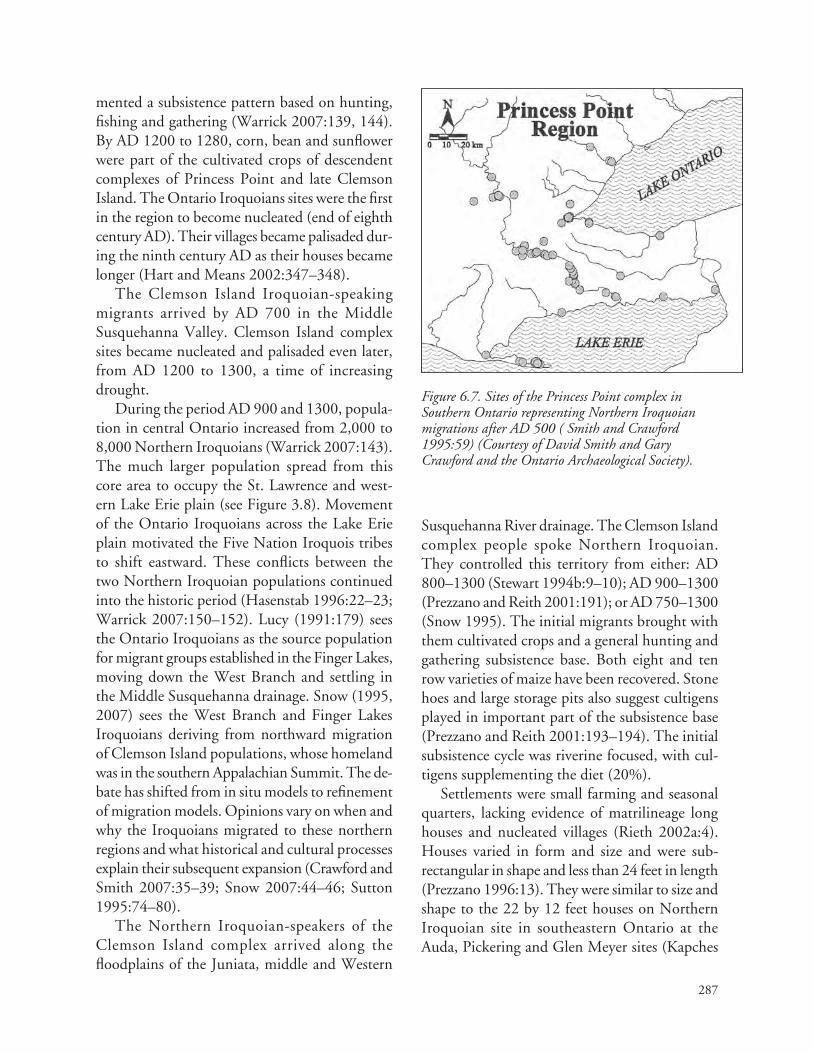
287
Figure 6.7. Sites of the Princess Point complex in Southern Ontario representing Northern Iroquoian migrations after AD 500 ( Smith and Crawford 1995:59) (Courtesy of David Smith and Gary Crawford and the Ontario Archaeological Society).
mented a subsistence pattern based on hunting, fishing and gathering (Warrick 2007:139, 144). By AD 1200 to 1280, corn, bean and sunflower were part of the cultivated crops of descendent complexes of Princess Point and late Clemson Island. The Ontario Iroquoians sites were the first in the region to become nucleated (end of eighth century AD). Their villages became palisaded dur‑ing the ninth century AD as their houses became longer (Hart and Means 2002:347–348).
The Clemson Island Iroquoian‑speaking migrants arrived by AD 700 in the Middle Susquehanna Valley. Clemson Island complex sites became nucleated and palisaded even later, from AD 1200 to 1300, a time of increasing drought.
During the period AD 900 and 1300, popula‑tion in central Ontario increased from 2,000 to 8,000 Northern Iroquoians (Warrick 2007:143). The much larger population spread from this core area to occupy the St. Lawrence and west‑ern Lake Erie plain (see Figure 3.8). Movement of the Ontario Iroquoians across the Lake Erie plain motivated the Five Nation Iroquois tribes to shift eastward. These conflicts between the two Northern Iroquoian populations continued into the historic period (Hasenstab 1996:22–23; Warrick 2007:150–152). Lucy (1991:179) sees the Ontario Iroquoians as the source population for migrant groups established in the Finger Lakes, moving down the West Branch and settling in the Middle Susquehanna drainage. Snow (1995, 2007) sees the West Branch and Finger Lakes Iroquoians deriving from northward migration of Clemson Island populations, whose homeland was in the southern Appalachian Summit. The de‑bate has shifted from in situ models to refinement of migration models. Opinions vary on when and why the Iroquoians migrated to these northern regions and what historical and cultural processes explain their subsequent expansion (Crawford and Smith 2007:35–39; Snow 2007:44–46; Sutton 1995:74–80).
The Northern Iroquoian‑speakers of the Clemson Island complex arrived along the floodplains of the Juniata, middle and Western
Susquehanna River drainage. The Clemson Island complex people spoke Northern Iroquoian. They controlled this territory from either: AD 800–1300 (Stewart 1994b:9–10); AD 900–1300 (Prezzano and Reith 2001:191); or AD 750–1300 (Snow 1995). The initial migrants brought with them cultivated crops and a general hunting and gathering subsistence base. Both eight and ten row varieties of maize have been recovered. Stone hoes and large storage pits also suggest cultigens played in important part of the subsistence base (Prezzano and Reith 2001:193–194). The initial subsistence cycle was riverine focused, with cul‑tigens supplementing the diet (20%).
Settlements were small farming and seasonal quarters, lacking evidence of matrilineage long houses and nucleated villages (Rieth 2002a:4). Houses varied in form and size and were sub‑rectangular in shape and less than 24 feet in length (Prezzano 1996:13). They were similar to size and shape to the 22 by 12 feet houses on Northern Iroquoian site in southeastern Ontario at the Auda, Pickering and Glen Meyer sites (Kapches

288
1987:155–160). Village nucleation began after AD 1200 prior to abandonment of the area by AD 1300. The none‑fortified, none‑nucleated nature of these smaller Iroquoian settlements suggests ter‑ritorial security. This contrasts with the increased evidence of fortification and village nucleation within the Owasco Algonquian occupations on the North Branch.
During this time, the Clemson Island and Owasco settlements in different parts of the Susquehanna Valley developed similar ceramic design motifs and vessel forms. Ceramics of both complexes have a number of shared attributes including cord‑wrapped stick and paddle de‑sign motifs, flat and out‑flaring rims, and use of paddle and anvil and coiling techniques. Clemson Island wares have nodes and punctates around the interior and exterior rim and over‑stamping on the neck and body (Rieth 2002b:135). A wide variety of lithic types are used for temper in Clemson Island wares while Owasco wares in the Upper Valley trend toward the use of chert (Rieth 2002b:137–138). Analysis of clay samples indicate possible sharing of clay sources in buffer areas between the cultures. My interpretation is that Clemson Island derived from a southeastern Appalachian Iroquoian homeland and Owasco is derived from PEA local sequence out of the Jack’s Reef horizon. I suggest that the Clemson Island migrants adopted local design motifs to add to their punctates of rims. Punctates are traits they may have brought from their southern Appalachian homeland (Keel 1976:106–111).
The Clemson Island complex migrants brought with them mound construction and buri‑als representing southern Hopewellian influences (Fiedel 1990:221–223). Each mound appears to have served a tribe whose territory may have in‑cluded a thirty mile diameter around the mounds (see Figure 6.4). Shared mortuary practices, the close proximity of the mounds, and the absence of village nucleation and fortification indicate a peaceful alliance among the Iroquoian tribes. Such an early confederation of interest would prove an effective territory defense against the bands
of Algonquians who surrounded the Clemson Island complex. After AD 1100, mound burials ceased and burial shifted to within village loca‑tions (Rieth 2002b:136).
The loss of group solidarity brought about by sacred cemetery reburial of cooperating polities indicate possible increased internal competition of the Northern Iroquoian migrant groups in the Middle Susquehanna Valley. This was also the period of increased fortification of Owasco Algonquian settlements, leading to their eventu‑ally abandonment of the North Branch away from the region of conflict (Prezzano 1996:10–13). By AD 1300 the Clemson Island Northern Iroquoian‑speakers abandoned the middle and Western Branch Susquehanna territories to establish new settlements dispersed across different drainages in the Finger Lakes region (Snow 2001:267–271, 2007:26). The Clemson Island four mound clusters may one day be cor‑related with Proto‑Seneca, Mohawk, Oneida and Onondaga tribes. The Cayuga tribe of the Five Nation Iroquois migrated away from the Proto‑Northern Iroquoian communities even before the Huron split. The Cayuga rejoined the other four Northern Iroquois becoming closest to the Seneca language (Mithum 1979:158–161).
During the period AD 700 to 1300, the Lower Susquehanna Valley appear to have served as a buf‑fer area, used for hunting purposes by bands of the Algonquian‑speakers of the Minguannan/Riggins complex. The abandonment by the Clemson Island complex of the Middle Susquehanna Valley after AD 1300 may have resulted from the arrival of tribes of the Shenks Ferry complex in the Lower Susquehanna Valley (see Figure 6.4). The origin of the Shenks Ferry complex remains uncertain (Kent 1984:124–127). Some see it as develop‑ing out of the southern Montgomery complex (Graybill 2014). Others suggest a possible Siouan origin out of the Albemarle complex of Piedmont Virginia (Custer 1987a:20–23). Given the gap of occupation from AD 900 to 1300, few see the culture developing in situ from Middle Woodland archaeological complexes in the Lower Valley. I

289
associate Shenks Ferry with yet to be identified Central Algonquian‑speakers from west of the Atlantic drainages. Much work is needed to refine the homeland of the Shenks Ferry culture.
The appearance of the Shank Ferry complex in the Lower Susquehanna Valley may have been another incentive for the northward migration of the Clemson Island culture to the Finger Lakes re‑gion of New York (see Figure 6.4). The Northern Iroquoians found themselves wedged between two aggressive Algonquian cultures on the North Branch and Lower Susquehanna Valley. With the Clemson Island abandonment of the Juniata and West Branch valleys, Shenks Ferry smaller hunt‑ing quarters and floodplain farming hamlets were established, as evidenced by the Stewart phase. Overtime, the smaller settlements were aban‑doned for nucleated and palisaded villages (Kent 1984:124–129). This appears to be the defensive responses to the eastward expansion of the McFate complex, a possible Iroquoian culture. The abandonment of the West and Middle Branches by the Shenks Ferry complex was completed by the end of AD 1400 (Kent 1984:128). After that date, Shenks Ferry tribes continued in the Lower Susquehanna Valley until they were displaced by the Susquehannocks from AD 1550 to 1600.
The Shenks Ferry tribes relocation to the northern Chesapeake to become the Tockwogh on the Sassafras River and Ozinies on the Chester River is a hypothesis requiring archaeological confirmation (Rountree et al. 2007:117–118, 228–229). The Tockwogh spoke an Algonquian language distinct from Powhatan, which sug‑gests a Medial division Unami‑dialect or central Algonquian language. The Tockwogh were tributary to the Susquehannocks. They occu‑pied a key territory to funnel European trade items from both Delaware and Chesapeake Bay European migrant groups. John Smith reported that the Tockwogh lived in a multiple palisade village and were enemies of the Massawomecks (Northern Iroquoian‑speaking enemies of the Susquehannocks). Smith description of the Tockwogh village appears similar to the Murray
site, which was the last confirmed Shenks Ferry palisaded village site on the Susquehanna River (Custer 1996). Efforts to locate archaeological remains from the Tockwogh or Ozinies villages have been unsuccessful as of 2015.
ConClusions
The Jack’s Reef horizon, Owasco, and Minisink complexes developed from the second migration of Medial division Algonquian‑speakers to the Upper Delaware Valley. Cultural continuity for these Algonquians extended from AD 500 to the 1740s. The Manna site’s stratified deposits represent Jack’s Reef horizon, Hunters Homes, Pahaquarra‑Owasco and Minisink complexes Algonquian‑speakers occupations. Major cul‑tural influences during this period were not down river. Munsee‑dialect groups regular interacted with Algonquian bands and Iroquoian tribes in the Hudson and Mohawk drainages and com‑munities in the Upper Susquehanna Valley. The Jack’s Reef horizon bands in the Middle and Lower Delaware Valley developed into a distinct Riggins/Minguannan complex. Sufficient differ‑ences over time resulted in separate development of the Unami and Munsee‑dialects of Medial division languages. Kraft (2001) realized that the Hunters Home, Owasco, Minisink, and historic Minisink sequence documented a direct connec‑tion of Owasco ceramic attributes to Algonquian‑speakers. He defined the Pahaquarra complex based on this correlation. The Pahaquarra com‑plex lacked nucleated, fortified villages through‑out the Late Woodland period. This made them distinct from the Iroquoian fortified villages to the north and the west.
The absence of evidence of fortification is a major reason why the source of the Potomac Creek complex could not be from the Upper Delaware Valley. The heavily fortified found‑ing villages of the Accokeek Creek and Potomac Creek sites indicate that the relocated Owasco cul‑tures had a well developed defensive approach to frontier settlement that they brought with them.

290
Radiocarbon dates from Potomac Creek sites date this period of migration from AD 1100 to 1300 (Dent and Jirikowic 2001:45–47; Blanton et al. 1999:102–104). The Upper Susquehanna Valley Owasco sequence began with single palisaded vil‑lages in AD 1000 and ended with triple palisade villages with bastions by AD 1300. The Owasco complex people of the Upper Susquehanna are the most likely source for the Potomac Creek complex migrants. The Accokeek Creek site migrant group was established from AD 1100 to 1200 when they built a double palisaded village with wattle and daub fortification methods. The founding of the Potomac Creek site by AD 1300 brought the additional defensive Owasco innovations of mul‑tiple bastions and triple palisade construction (see Chapter 5). The migration of tribes from of the Owasco complex from the Upper Susquehanna Valley by AD 1300 left it as a buffer zone used for hunting parties.
These movements represented the third major migration of Algonquian‑speakers from a north‑ern homeland to southern migrant groups that can be documented based on linguistic, historical and archaeological evidence. The shift of Montgomery complex populations from the Piedmont to the Coastal Plain from AD 1350 to 1450 further ex‑panded the Potomac Creek complex populations and territorial control in the tidewater region (Clark 1980; Potter 1993). The formation of the Piscataway paramount chiefdom, based on oral tradition, began around AD 1400. Based on oral tradition, the Piscataway kinship‑leadership au‑thority was derived from the Eastern Shore, prob‑ably from the Nanticoke paramount chiefdom (see Chapter 5). Potomac Creek ceramics found in minority percentages in the Nanticoke drainage reflect continued trade, travel and exchange rela‑tions between the Nanticoke and the Piscataway paramount chiefdoms (Hughes 1980). The Nanticoke interacted with the Piscataway in the exchange of furs, marine shell, native copper and other commodities from the Atlantic Coast to the Great Lakes along the Potomac and Ohio trade corridor (Clark and Rountree 1993:128–130; Rountree et al. 2007:212–216; see Figure 5.14).
Migrations of Algonquian and Iroquoian polities increased in frequency during the Late Woodland and Colonial periods in efforts to control trans‑Appalachian trade, support devel‑oping coastal chiefdoms, protect stored cultigens and other factors. The historic Minisink bands and Piscataway paramount chiefdom were an‑cient allies when both cultures occupied adjacent river valleys. The migration of the Susquehanna Owasco bands to the Chesapeake region left the North Branch as a buffer zone, to which the Proto‑Susquehannocks migrated in the fifteenth century. The defense of the Algonquian’s western frontier fell to the Minisink bands. These Algonquians were allied with the Susquehannocks against the Five Nations Iroquois in the seventeenth century. This alliance may have extended back to the fif‑teenth century when the Proto‑Susquehannocks migrated to the Upper Susquehanna buffer zone.
In the historic period, the Susquehannock and their Minisink allies became competitors with other tribes for control of the trans‑Appalachian trade of furs, copper and shell beads to interior societies in the Great Lakes, Finger Lakes and Ohio drainages. The Minisink tribes were allied with the Susquehannock tribes to the south and Algonquian bands on the Hudson drainage. In 1608, the Piscataway paramount chiefdom was en‑emies of the Iroquoian‑speaking Susquehannocks and Massawomecks who competed with them for control of the trans‑Appalachian trade. The Unami‑dialect Lenape and Lenopi bands of the Middle and Lower Delaware also alternated as allies and enemies of the Susquehannocks. The Piscataway and Minisink shared a similar origin in the Owasco culture of the northeast. After their regional separation, they developed unique settle‑ment pattern, mortuary, and political organiza‑tion. They adapted to historical circumstances in unique ways which resulted in differences in the archaeological record.
The descendents of the Potomac Creek complex migrant groups returned to the Upper Susquehanna Valley after they left the Potomac Valley in 1711 (see Chapter 5). They became tributary to the Five Nations Iroquois. The fol‑

291
lowers of the Tayac ending up along the Grand River with the resettled Nanticoke and Six Nation Iroquois in Southern Ontario (see Figures 5.7 and 6.7). After a long journey spanning 1,000 years, the Piscataway returned to the heart of the homeland of their Proto–Eastern Algonquian ancestors (see Figure 2.7).

292

293
7: Summary
In the past, three major approaches have in‑terpreted changes in the archaeological record for the Northeast and Middle Atlantic regions. Prior to the 1970s, archaeologists developed culture histories which incorporated Iroquoian and Algonquian origin stories and linguistic evi‑dence. Using the direct historical approach, they linked historic native cultures to archaeological sequences (Carpenter 1953). The taxonomic system developed during this period was refined during the subsequent era of processual studies. With the advent of quantitative methods of the processual school of environmental archaeology, archaeologists promoted evolutionary laws and analytical methods inspired by the biological sciences (MacNeish 1976). The study of “pre‑historic archaeology” developed—minimizing or ignoring references to linguistics, oral history, and the direct historical approach. In the twenty‑first century, some post‑processual researchers have integrated previous methodologies to reexamine Algonquian, Siouan, and Iroquoian languages and cultures of the Eastern United States. New approaches have been encouraged by discussions with descendent members of native communities. Native Americans are involved with archaeologists in the management of the archaeological legacy of their ancestors (Martin 2010; Fiedel 2013).
This report deliberately focuses on migration theory without elaborating on the vast quantity of environmental archaeology models which abound throughout the Middle Atlantic region’s cultural resource management and professional literature. The past 50 years of cultural resource management and academic research has promoted interpreta‑tions based on the assumption that local archaeo‑
logical assemblages reflect thousands of years of in situ development. Major changes evident in the archaeological sequences were attributed to cul‑tural responses to environmental stimuli, regional interaction spheres, and burial cults shared by stable populations in fixed territories. Reasoning by use of analogy to Algonquian and Iroquoian historical cultures was largely avoided or dismissed in the Middle Atlantic region (Becker 2011). Scientific research required an emphasis on in situ models of gradual, sequential, evolutionary cul‑ture change (Carpenter 1953; MacNeish 1976). This stasis approach promoted environmental change as the major factor compelling cultures to adapt. Regional mortuary practices, changes in artifact styles, and presence of exotic materials were attributed to diffusion resulting from trade and exchange networks (interaction sphere mod‑els). Others suggested diffusion through sharing of religion (burial cults). Some leading researchers of this approach (Snow 1980, 1984) later became dissatisfied with failures to explain inconsistencies in the in situ model for Iroquoian development (Snow 1995, 2007). Custer (1984, 1987a:20–23; et al. 1990) is among those who turned from a focus on culture ecology in situ modeling to one which explores the migration of Algonquian cultures associated with the Jack’s Reef horizon.
For Iroquoian studies, Stothers (1977), Sutton (1995) and Snow (1995) returned to a refined migration modeling approach. They correlated ecological, historical, linguistic and archaeologi‑cal evidence to explain the apparent intrusion of Northern Iroquoians, splitting the territories of Central and Eastern Algonquian language‑speakers. Building upon the foundation research

294
of Siebert (1969, 1975), Luckenbach (et al. 1987) and Fiedel (1987) developed models for earlier Algonquian migrations from their Great Lakes homeland. In the Middle Atlantic region, cultural resource management and academic publications acknowledge the possibility of migrations, but continue to depend on in situ cultural ecology models.
The in situ models continue to pervade cul‑tural resource management and government sponsored research of the Middle Atlantic region. Managers use stasis models as a basis for their determination of National Register eligibility and in developing state and regional synthesis (Dent 1995:64–65). Guidelines for cultural resource management research encourage and reinforce the cultural ecology approach. Based on the results of this study, processual modeling should no longer be the enforced and dominant paradigm for the Middle Atlantic and Northeast regions. Taxonomic systems require revision to reflect the complexity of contemporary cultures sharing different parts of a local area for 200 to 500 years. The time has arrived to accept and re‑fine migration models to explain the origins and development of the Algonquian, Iroquoian and Siouan‑speaking societies. New models, such as outlined in this report, will extend their histories back through time. Iroquoian specialists in the Northeast region continue to search for origins and development of Northern Iroquoian cultures. They have published a vast literature which ex‑plores both migration and in situ archaeological models, incorporating historic and linguistic data. The same balanced approach is required for Algonquian and Siouan related archaeological complexes of the Middle Atlantic region.
While all archaeologists recognize the seasonal subsistence movement of bands, tribes or chief‑doms, our interpretations are still biased toward stasis models. Few explore extra‑territorial mobil‑ity and migration as a standard adaptive response. Cultures migrate when it is in their interest to do so. Entire Algonquian bands in the Great Lakes region engaged in summer travel over hundreds of miles for the purpose of real and fictive kinship
visits, feasting, and exchange. Extensive waterways and effective dugout and bark‑covered canoes facilitated travel, exchange, seasonal settlement shifts, and long distance migrations. Algonquian Indians' seasonal movements and long distance migrations during the historic period provide use‑ful analogies for earlier times. For four thousand years, the Algonquian Indians made strategic deci‑sions to migrate to new territories. Their descen‑dents stated that the migrations were in response to stress from famine, and to take advantage of abundant food resources in areas occupied by bands which were not “to be feared.” My research indicates that they also migrated to control ter‑ritories with critical marine and lithic resources imbued with spiritual value. With the advent of cultivated crops in the Late Woodland period, migrations continued, revealing a preference for locating villages in floodplains at the juncture of trade paths and canoe routes. The decisions they made created the archaeological record and historic tribal locations (Figure 7.1)
We need not look around the globe for ethno‑graphic models to interpret archaeological data in the Eastern Woodlands. We have a vast and varied linguistic, historical, and ethnographic record to draw from to refine our archaeological models of past cultures (see Figure 7.1). Culture ecological studies have enriched our understanding of the changes to the natural resource base caused by climate variations, sea level rise and other factors. Cultural resource management offers opportuni‑ties for new directions beyond culture ecology due to new analytical studies, improved dating methods, and excellent contextual analyses of thousands of new sites reported in the gray litera‑ture. New discoveries await those who embrace the best of the three paradigms that have framed our archaeological models of American Indian heritage in the Eastern Woodlands.
Pre-algonquian-sPeakers oF tHe terminal arCHaiC traditions
The Shield Archaic, Maritime, Mast Forest, Susquehanna and other Late Archaic traditions

295
Figure 7.1. Algonquian and Iroquoian languages of the study area (Campbell 1997:374) (Courtesy of Lyle Campbell, Oxford University Press, National Museum of Natural History, Smithsonian Institution, redrawn from Snow 1978: ix).

296
of Pre‑Algonquian‑speakers represent a range of adaptations by a variety of local bands to the diverse environments of the Northeast, Great Lakes, and Middle Atlantic regions (see Chapter 3). The Pre‑Algonquian‑speakers of the Mast Forest tradition consist of small bands that made narrow points and used local resources as they moved through a series of seasonal camps in river and upland settings (Kinsey 1972:342–343). They competed for hundreds of years with bands that embraced broadspear points and soapstone technologies derived from the Savannah River/Susquehanna traditions bands whose broad point styles originated in the Southeast region. Cultures of the Susquehanna tradition concentrate settle‑ments in river valleys (Kinsey 1972:347). The Orient phase (1200–700 BC) probably represents a merging of elements from the Mast Forest and Susquehanna traditions. The Savannah River tradition did not develop an Orient phase, being at the southern limits of these merged traditions. Extending from the Potomac to Southern New England, the Orient phase is riverine focused; involving a hunting, gathering, and limited fishing subsistence base (Ritchie 1980:164–174).
People of the Orient phase of the merged Terminal Archaic traditions were the first Pre‑Algonquian‑speakers to experiment with pottery making. In the Eastern Woodlands, ceramic tech‑nology was introduced from the southeast Gulf tradition and spread northward through interact‑ing cultures of both the Susquehanna and Mast Forest traditions (Mouer 1990, 1991; Bedard 2011:129–131). In the Delaware and Chesapeake drainages, a variety of tempers were tested in mak‑ing slab‑built flat‑bottomed wares. The trough shape of bowls, both wooden and soapstone, served as the stylistic influence spanning sev‑eral hundred years of ceramic vessel manufacture (1200–900 BC). Historically, Algonquian and Iroquoian‑speaking males manufacture wooden troughs. By analogy, making soapstone bowls and flat‑bottomed ceramic vessels by the Pre‑Algonquian cultures may have fallen within the domain of men (Stewart 1998d:7). The use of both ceramic and soapstone flat‑bottomed vessels
in feasting and ritual contexts has been proposed by various researchers (Bedard 2011:138–139). Flat‑bottomed soapstone bowls predominate dur‑ing the first half of the Orient phase, and continue during its second half, as producers continue to develop and refine their ceramic technology (Ritchie 1980:173).
Later Orient phase sites also produce conoidal shaped, coil constructed, cord impressed and grit tempered pottery. This style was influenced by coiled baskets which, historically, were con‑structed by women. The development of coil manufacture, conoidal pottery is attributed to the PEA Meadowood complex bands. This Vinette 1 ware appears to have been used in ritual and feast‑ing context (Taché 2005, 2008). The Williamson and Ware sites in the Middle and Lower Delaware Valley provide clear evidence of the sequence in which flat bottomed wares were being replaced by conoidal pottery tempered with local grit. Both sites also yield a small percentage of Vinette 1 sherds, indicating interaction between the Pre‑Algonquian and PEA bands (Hummer 2007).
In the Chesapeake and Delaware Bay regions, Pre‑Algonquian societies continued to coexist with PEA colonies well past the time that the Pre‑Algonquian bands of the Northeast were re‑placed by PEA bands. The Pre‑Algonquian bands produced a variety of flat‑bottomed, conoidal with flat‑bottoms, and conoidal vessel shapes. Use of soapstone temper gave way to a variety of grit tempers. This replacement also marked a change in function of ceramics—leading away from a sacred to a secular context, from hot rock boiling to direct fire cooking, and manufacture transferring from a male to a female role (Bedard 2011:138 140). Surface decorations changed over time from plain to corded then to both corded and net impressed. S and Z cord twist variations reflect different motor habits for cord manufac‑ture by Pre‑Algonquian bands. Pre‑Algonquians of the Popes Creek complex in the Potomac Basin maintained territorial control to 50 BC (Curry and Kavanagh 1993, 1994). They were replaced by expanding populations of the Selby Bay Adena phase. In the James and York River interior drain‑

297
ages the Pre‑Algonquian bands produced Popes Creek, Prince George, and Varina wares. After AD 300–500 (Blanton and Pullins 2004), the inner Coastal Plain Pre‑Algonquian territories came under the control of Algonquian‑speakers producing Mockley ware. By AD 800, Pre‑Algonquian bands to the south of the Chesapeake surrendered territorial control to both Algonquian and Iroquoian migrations (Herbert 1990, 2008) (see Chapter 2). Pre‑Algonquians in the Piedmont province of the Rappahannock to Roanoke River region retained territorial control until the his‑toric period (Hantman 1993, 2001). They were tribes or chiefdoms whose members spoke Siouan languages. In the Chesapeake region, the devel‑opmental sequences and historic distributions suggests that Pre‑Algonquians of earlier periods were Siouan‑speakers.
The major finding of this study is that the Pre‑Algonquian and Algonquian cultures have iden‑tifiably independent ceramic traditions. To make such attributions, their lithic preferences, lithic manufacturing methods, and point styles are also critical fossil indexes (Chapter 4). Participation in trans‑Appalachian exchange of mortuary and curative artifacts is another means for linking archaeological complexes to PEA‑speakers. The southward migration of PEA bands did not oc‑cur as a wave causing progressive north‑to‑south collapse of Pre‑Algonquian bands. Instead, their migration was a process of leapfrogging past Pre‑Algonquian bands as they established PEA sustainable polities in areas where food, lithics, and marine resources were more abundant. A mosaic of broadspear and narrow point tradition Pre‑Algonquians and Meadowood PEA bands co‑occupied the regions for hundreds of years. Eventually PEA bands expanded to take over Pre‑Algonquian territories throughout the Hudson, Delaware and Susquehanna drainages.
Proto-algonquian-sPeakers oF tHe trans aPPalaCHian tradition
The Appalachian Plateau served as a drainage di‑vide for Native Americans, and as a research divide
for archaeologists, historians and linguists. In the early seventeenth century, Central Algonquian languages were spoken west of the divide, and Eastern Algonquian languages were spoken to its east. Iroquoian migrations to the Great Lakes from the southern Appalachian Summit displaced and separated both Algonquian populations. Ohio Adena and Hopewell complex mounds and cer‑emonial earthworks developed out of the Great Lakes Red Ochre and Glacial Kame complexes. Red Ochre and Glacial Kame was the source of the Meadowood, Middlesex, Adena and Hopewell complexes in the east, minus the elaborate mound and ceremonial earthworks. Even with increasing evidence of shared mortuary systems and sacred artifacts between regions, researchers continue to dismiss or marginalize connections evident in the archaeological record.
In noting shared Adena and Hopewell mortu‑ary practices and artifacts with complexes in the Delaware and Chesapeake drainages, Dragoo (1963) and Ritchie (1960), suggest that Ohio bands migrated down the Potomac Valley and then gradually expanded northward. Our model (Luckenbach et al. 1987) presents evidence that the Great Lakes PEA populations established their colonies along the Delaware and Chesapeake drainages during the Meadowood complex. Bands of the Mockley horizon gained territorial control of the Blue Ridge Mountain rhyolite deposits from 400–300 BC. Algonquians travelling to rhyolite processing settlements were only a few days additional journey from the Ohio Adena Central Algonquian‑speakers’ settlements. Eastern Algonquian‑speakers provided marine shell and shark’s tooth items as part of the interaction net‑work. Their involvement in the trans‑Appalachian network continued through the end of the Ohio Hopewell complex (AD 500).
The concept of a Trans Appalachian tradition unites parallel developmental sequences of the Central Algonquian and Eastern Algonquian‑speakers in certain aspects of their beliefs and practices. From 1200 BC–AD 500, Algonquians on both sides of the mountains separated secular activities of residential sites from sacred activities

298
practiced at mortuary sites. Sacred objects such as blocked‑end tubes, and beads of copper and marine shell are extremely rare at residential sites. Pottery is extremely rare at sacred mounds. Only in the past thirty years have new excavations and analyses been able to link mortuary patterns with settlement patterns on both sides of the moun‑tains. We can now state with confidence that the Adena and Hopewell mortuary patterns of the eastern region are linked with the residential pat‑terns of the Canoe Point, Fox Creek, Squawkie Hill, Abbott, Carey, and Selby Bay complexes. Across the Middle Atlantic region, all these phases of the Mockley horizon have in common their ceramic types, lithic technology, and Greene and Fox Creek point styles (Figure 7.2).
Isotope analysis of marine shell from the Middle Atlantic sources found in Hopewell mounds in Ohio prove connections between the two populations (Lowery 2014). Researchers rec‑ognize that the Ohio Adena and Hopewell groups brought lithics, copper, and Ohio pipestone (kaolinite) procured west of the Appalachians to cultures of the eastern region. Researchers pro‑moting the cultural ecology paradigm explain this exchange as reflecting in situ groups in the east adopting burial cult and commodity exchange of valued objects through a “Big Man” cargo cult type model. My model is based on analogy to the bands, tribes, and chiefdoms of the Central and Eastern Algonquian societies as a direct analogy for interpreting the Meadowood, Adena, and Hopewell complexes.
I encourage greater trans‑Appalachian com‑munication and exchange of research. The 2013 issue of Archaeology of Eastern North America focuses on trans‑Appalachian evidence of the Jack’s Reef horizon. Jack’s Reef horizon is cor‑related with the post‑Hopewell interactions of Central and Eastern Algonquian cultures across the Appalachian Mountains. The appearance of Northern Iroquoian‑speakers in the Great Lakes, Mohawk, and Susquehanna drainages forced additional migrations of Eastern Algonquians. This second migration of Medial division Algonquian‑speakers has been proposed as the
primary explanation for the historic distributions of Algonquian‑speakers (Custer et al. 1990; Fiedel 2013). A third migration of Owasco tribes from the Upper Susquehanna Valley has also been discussed as the origin of tribes that created the Potomac Creek complex in the Chesapeake Bay region (Blanton et al. 1999).
owasCo medial division algonquian-sPeakers
In the 1980s, researchers in the Northeast had nearly reached universal acceptance of the in situ development of the Iroquoian Owasco complex. They rejected Ritchie’s (1944, 1960) associa‑tion of Owasco with Algonquian cultures. More recently, research clarifies that Owasco is clearly associated with Algonquian‑speakers. Herb Kraft (2001) was steadfast in all his publications in pointing out the Upper Delaware Valley evidence. He demonstrates how the Owasco developed from Jack’s Reef horizon, continuing through the Minisink phase to the Algonquian‑speaking Minisink Indians of the historic period. Blanton (et al. 1999) also notes that the Potomac Creek complex has its origin in Algonquian popula‑tions which migrated from Owasco territories in the north. Other research, as reviewed in this report, indicates that the Algonquian‑speaking Owasco populations in the North Branch of the Susquehanna and the Mohawk River area were displaced by Northern Iroquoian‑speakers after AD 1300. The Clemson Island complex of the Middle Susquehanna Valley is now seen as the source population for the Iroquoian settlements in the Finger Lakes area. Iroquoian settlements north of the Great Lakes are associated with a post AD 500 migration linked to the Princess Point complex. These new correlations support that William Ritchie was correct in assigning the Owasco complex to Algonquian‑speakers.
Owasco complex sites of the Finger Lakes region continue to be associated with the ap‑pearance of Northern Iroquoians in the region. However the Finger Lake Owasco pottery types are the same as Owasco pottery types of the Upper

299
Figure 7.2. Selby Bay and Carey Adena phase points, which are fossil indexes of the Southern Archaic division PEA-speakers of the Mockley horizon (photograph by the author of artifacts from the Chester River Valley, Delmarva Peninsula in the Charles Carter Collection, Dover, Delaware).
Delaware Valley. This is one of the inconsisten‑cies that the in situ model does not satisfactorily explain. The sequence of Jack’s Reef’s horizon to Owasco complex is also noted in the Hudson Valley which was occupied by historic Algonquian bands. Owasco site excavations reveal the use of long houses (averaging 20 by 60 feet) and circular houses (averaging 15 feet in diameter), indicating seasonal shifts in use of the two different house forms. This pattern is repeated for Algonquian sites in the Chesapeake and New England regions. Consequently, Owasco is best associated with Algonquian, and not Iroquoian‑speakers.
The interaction of Iroquoian‑speakers of the Clemson Island and Princess Point complexes with Algonquians of the Owasco complex led
to similarities in their ceramic vessel shapes and decorative motifs during the period AD 1300–1650. Evidently, the high collared, incised vessels of this late period were being made by both language groups. Ancestors of the Five Nations Iroquois of the Finger Lakes region migrated there from the middle Susquehanna colonies of the Clemson Island complex. The Clemson Island complex, in turn, represents the migra‑tion of post Hopewellian groups whose home‑land may prove to originate in the Connestee complex of the southern Appalachian Summit. The Connestee complex peoples participated in the Hopewell Interaction Sphere (AD 1–500). These Iroquoian‑speakers were in regular con‑tact with the Ohio Hopewell Algonquians. The

300
Adena Interaction Sphere appears to have primar‑ily involved Algonquian‑speakers of the Trans Appalachian tradition. The Hopewell Interaction Sphere encompassed a much larger area, includ‑ing a diversity of languages and cultural groups.
ConClusion
These are summary generalizations for a multifac‑eted reconstruction of Eastern Woodland cultural development. The linguistic and origin myth data clearly indicate that Eastern Algonquians reached their historical territorial distribution through a series of migrations. The Central and Eastern Algonquian territories were subsequently split by Iroquoian migrations to the Great Lakes region. Robert Funk (1973) supported in situ models. At the same time, he established a logical framework for identifying migrations versus in situ evidence for cultural development (see Chapter 3). By reintroducing migration theory into the debate and supporting it with archaeological, historic and linguistic data, some of the major inconsistencies of the in situ models are resolved.
Over the next decade, I trust a new genera‑tion of researchers will critically examine this and
other migration models (Luckenbach et al. 1987; Siebert 1975; Stothers 1977; Proulx 1982; Denny 1989; Custer et al. 1990; Fiedel 2013; Snow 2007; Gallivan 2016). They can contrast the mi‑gration approach to the array of in situ models. Linguistic, historical, ecological and archaeologi‑cal data collected across Eastern North America provide a wealth of interpretive potential. Herb Kraft’s (2001) processual analysis of the Lenape and Minisink Indians incorporates his life’s work researching historic, ethnographic and archaeo‑logical data. His analysis provides a deeper under‑standing of the history and culture of the Medial division Algonquian‑speakers. I have offered a model linking archaeological phases, complexes, horizons and traditions to specific languages and historically documented native societies. The history of Algonquian and Iroquoian cultures should be interpreted using all available sources of data. Specialists from a variety of disciplines and regions will refine our models using new scientific methods and theoretical approaches. The four thousand year history of Algonquian, Iroquoian, and Siouan migrations and development await those who will bridge the divide between regions, disciplines, and paradigms.

301
8: Recommendations
Since 1959 the National Park Service has funded investigations of the Upper Delaware Valley, contributing significantly to our understanding of both the Northeast and Middle Atlantic regions. From 1959 to 1975, planned inundation of the valley by the waters behind the Tock Island Dam drove research and recovery methodologies. Work focused on Late Woodland period sites found through surface survey of cultivated fields along with documentation of amateur collections. Large areas of select sites were stripped of plow zone, exposing over 1700 features. Field methodology evolved from no screening of pit fill to flotation of pit fill, greatly increasing the analytical value of the research. At five sites, deeper excavations revealed stratified sequences of dated components. The stratified excavations helped refine and de‑fine Native American archaeological complexes spanning the Late Archaic to Colonial periods. Paleo‑Indian to Middle Archaic site data was mostly limited to surface collected data from non‑stratified sites on the upper terraces (Kinsey 1972).
The sampling strategy focused on surface col‑lections and not systematic deep terrace testing in areas scheduled for inundation by the planned reservoir. The upland archaeological portions of the settlement and subsistence patterns remain poorly understood. Archaeologists did not focus on information about European Colonial period settlements. The research revealed burials from the Late Woodland period Algonquian occupa‑tions. Burial analysis linked the historic Minisink Indians to the Minisink and Owasco archaeo‑logical complexes (Sieg 2008:188–189). The data supported the continuity of Owasco to the previous Kipp Island and Hunter Home phases.
Human remains and associated burial offerings have been reburied after a successful consulta‑tion process with descendent Native American communities. The remaining collections from fifty years of research have been consolidated at the Anthropological Laboratory at the Delaware Water Gap National Recreation Area (DEWA) in Bushkill, Pennsylvania.
The Manna site is an important resource of the Minisink Archaeological Sites National Historic Landmark. The Landmark contains a small sample of over 500 sites owned or managed by the National Park Service within the DEWA. The research conducted at DEWA during the reservoir planning period (1959 to 1978) proved essential to our understanding of American Indian cultures in the Susquehanna and Delaware drain‑ages. New approaches to interpreting Algonquian and Iroquoian cultural development will continue to benefit from collection studies, fieldwork, and reports funded by the National Park Service.
tHe Conservation etHiC and Continued Field researCH
The primary mission of DEWA is to provide preservation and recreational opportunities for rural and metropolitan populations in the Northeast region. The National Park Service has a responsibility to mitigate adverse impacts on significant archaeological resources resulting from natural erosion or construction activities within DEWA. The cultural resource managers of National Park Service and the State Historic Preservation Offices (SHPO) follow regulations requiring Native American Grave Protection and

302
Repatriation Act (NAGPRA) considerations and consultation with affiliated Algonquian Indian descendent communities. DEWA managers are faced with annual budget competition with other National Park Service priorities during a sustained time of budget reductions. Resource managers balance natural and cultural resource preservation with their central mission to provide recreational activities at DEWA. These factors focus new fieldwork in DEWA on required site monitoring and mitigation‑related activities. On occasion, the National Park Service may fund research projects which contribute to the public interpretation of the cultural resources of DEWA.
Monitoring: DEWA is encouraged to continue to use in‑house staff for monitoring and updating current conditions of the 500 known archaeo‑logical sites on National Park Service property. The monitoring work is vital to refining site information, and discovering and prosecuting any antiquity violators. Surveys of actively erod‑ing shorelines, the impact of chisel plowing on features, tree planting, forest harvesting, and after major flooding are vital for site management and resource recovery requirements. The archaeologi‑cal resources of DEWA also require retaining a full time archaeological manager's position to oversee Section 106 compliance, site monitor‑ing, development of interpretive literature and public programs, and other normal duties. The greatest funding will continue to be allocated to Section 106 compliance work in the DEWA. The migration model provided in this study should prove of value in establishing a regional context for the National Register eligibility of the cultural resources discovered. Park Rangers will also find it useful for public interpretation.
Section 106 Compliance: The model provided in this report spans the development of Algonquian and Iroquoian cultures from Michigan to Maine, and from Ontario to North Carolina over a 4,000 year time span. Currently, professionals at State Historic Preservation Offices determine National Register eligibility based on in situ models of culture ecology within the structure of cultural
historical sequences. The best funding for revising cultural historical sequences and for testing migra‑tion and in situ models will come from Section 106 compliance investigations. Cultural resource management firms, project sponsors and SHPO Section 106 managers are encouraged to welcome migration model application in addition to in situ models in the compliance reports and in their determination of National Register eligibility.
Publication of this report will make it avail‑able for reference by government managers, cultural resource management firms, descendent communities, and others. In addition, I recom‑mend placement of the report at the SHPO of‑fices in New York, Vermont, New Hampshire, Connecticut, Pennsylvania, Ohio, New Jersey, Delaware, Maryland, Virginia, West Virginia, and North Carolina. The National Park Service is encouraged to issue a limited printing of this report for placement at key depositories in these states. Making digital copies of the report available on the intranet is also recommended to provide access to a wider audience.
DEWA Long Term Research: The research conducted at DEWA and the diversity of ar‑chaeological remains makes this a critical resource for advancing our understanding of the Native and European development in the Northeast. The reservoir related research focused on Native American sites of the Late Woodland period. The reservoir research recorded sites through survey of plowed fields and reports from amateur col‑lectors. They focused on recording known sites and completing site forms on newly discovered sites found by random surface collection survey methods. Except for sites that received follow‑up testing, most sites surveyed were given general site boundaries based on field impressions. Systematic shovel testing, control surface collection and random and systematic statistical sampling of these sites were not the norm until the 1980s. On a limited number of sites, stratified excava‑tions revealed well preserved components which proved critical to revisions of cultural sequences and phase definitions

303
This is not a criticism of the reservoir phase work of Charles McNett, Herbert Kraft (2001), or Fred Kinsey (1972). Kinsey (2014) and his Franklin and Marshall College staff accomplished amazing work on a $75,000 budget. These limited funds supported ten years of excellent survey and mitigation work. Russ Handsman, Jay Custer, Roger Moeller, Curt Carr and Jeff Graybill were five of the students whose reservoir work was the beginning of excellent careers in Middle Atlantic archaeology. We owe thanks to all the researchers for their analysis and publications.
Stratified Deposits Discovery and Documentation: Interdisciplinary research is needed along the floodplain and terraces of the DEWA property to document and interpret the existence of other stratified archaeological deposits below the plow zone. The National Park Service is encouraged to seek funding and to allow academic/cultural resource management partners to undertake soil science and archaeological stratigraphic testing of the DEWA to test known surface sites and discover new buried sites with in situ deposits. Mechanical coring, bank profile strata cuts, ground penetrating radar and systematic shovel test pitting to a depth of one meter would greatly expand the number of National Register signifi‑cant sites in the DEWA area.
Organic preservation overall is not great for the DEWA due to acidic soil conditions. Discovery of in‑context deposits of plant and animal remains would aid in site significance determination and research progress. Limited test excavations using standard size three meter test units, like those ex‑cavated at the Manna site, will yield data that can be studied with new methods of analysis (starch grain, ASM dating, isotope studies, blood residue on stone tools, food residue on ceramics, etc).
Controlled Surface Collection and Sites Boundaries Documentation. Farming continues within the floodplain and terraces of the DEWA. Systematic survey and surface collection of the plow zones of these fields is encouraged to dis‑covery new sites and refine known site boundar‑ies and content. This will also be another way to
monitor newly plowed fields to document and stop antiquity violations. Relocating the datum at all sites excavated between 1959 to 1978 should be a high priority. Documentation of European and African American sites is another reason to conduct surface survey and sub‑surface sampling, as funding permits.
ColleCtions management and researCH
DEWA currently has one full time collections manager and one full time archaeological resource manager, with part time assistants available as funding permits. Significant progress has been made since the 1980s in returning collections from cultural resource management and academic institutions to the Anthropology Laboratory at DEWA. The placement of teaching collections at partner academic institutions should continue. The current lab is at 70 percent storage capacity. Better use of space and extension of the curation capacity of the collections storage can be secured with improved shelving units. Over 80% of the collections catalog has been updated and digitized. Programs are needed to allow the database to be searched for selected artifact types. The cardboard boxes are in need of upgrade to polypropylene boxes. The plastic bags within the boxes are degrading and need selected replacement with 4 mil or thicker polyethylene bags and archival‑quality tags.
The 1996 collections assessment calls for the completion of a detailed collections management plan. The collections manager scans all relevant reports and records to insure backup off‑site. This growing digital reference collection is of great value to cultural resource management firms, researchers and resource managers. National Park Service collections cataloging standards are in place and provide standard procedures for col‑lections upgrades and future research. Additional staff assistance is needed on an annual basis to advance collection management plans. The National Park Service has completed NAGPRA

304
inventory, documentation and return of Native American remains and associated objects. Native American communities have conducted reburials of the remains and associated objects (Sieg 2008).
Type Collections Development
The DEWA sites contain valuable collections con‑taining dozens of Native American wares; whose types and varieties span 3,000 years of cultural development. The Anthropological Laboratory needs to develop a type collection of pottery, projectile points, and lithic materials for DEWA. Few professional archaeologists practicing today have the ability to classify the ceramic types rep‑resented in the DEWA collection without the aid of a type collection. A systematic review of published site data from DEWA investigations is needed to identify which artifacts should be placed in the type collection at the Laboratory. Research on unstudied samples of plant species would prove useful to the natural and cultural interpretive mission of the DEWA. Websites for DEWA and the regional National Park Service offices can highlight the type collections and educational value of the research. Working with the SHPO archaeologists of Pennsylvania and New Jersey, DEWA can foster their development of ceramic and point typologies for ready access on state websites.
Specialized Collections Research
Advances in analytical procedures ensure the importance of the DEWA collections. Starch grain analysis on unwashed artifacts is useful for understanding the development of plant use in
the Upper Delaware Valley. Efforts have begun to refine older ceramic typologies with new type and variety analysis of design motifs. Type and variety refinements of existing wares, studies of cord twist directions on pottery, and ASM direct dating of organics adhering to ceramic sherds are research efforts that should be supported by the National Park Service. AMS dating on nuts, seeds and corn is now possible; refining the subsistence models for the region. A study using AMS dating on im‑portant strata and features will further refine the archaeological sequence. Macro‑botanical analysis of the Manna site collection and other unstudied plant remains from DEWA sites is highly recom‑mended. Future Section 106 research should include these specialized studies, based on the quality of the data discovered during survey and testing of the sites. I am confident DEWA man‑agers will continue to encourage research and publication to advance our understanding of the rich cultural heritage of the National Park Service property and the upper valley.
Isotope studies on human remains and DNA testing require NAGPRA coordination with de‑scendent Native American representatives of the Delaware Nation, Delaware Tribe of Oklahoma, and Stockbridge‑Munsee Community (Sieg 2008:26–28). Isotope studies are important for understanding changing diets. DNA studies are necessary to document kinship connections within Algonquian societies and intermarriage with Iroquoian societies. As human remains from previous investigations at DEWA have been rein‑terred, such techniques are recommended to be part of the NAGPRA discussions for future new burial discovery, recovery and reburial.

305
References Cited
Abbott, Charles C.1885 The Use of Copper by the Delaware Indians.
The American Naturalist, August edition, pp. 774–777. Peabody Academy of Sciences, Salem.
Adney, Edwin, and Howard Chapelle1964 The Bark Canoes and Skin Boats of North
America. National Museum, Bulletin 230. Smithsonian Institution, Washington D.C.
Alberle, David P.1974 Historical Reconstructions and its Explana‑
tory Role in Comparative Ethnology, A Study in Method. In Comparative Studies by Harold E. Driver and Essays in His Honor, edited by Joseph G. Jorgensen, pp. 63–67. HRAF Press, New Haven.
Alexander, Edward P. 1971 An Indian Vocabulary from Fort Christina,
1716. Virginia Museum of History and Bi-ography 71:303–313.
Anonymous 1635 Relations of Maryland, 1635. In Original
Narratives of Early Maryland, 1635–1684, edited by Clayton Coleman Hall, pp. 70–112, Reprint 1967. Barnes and Noble, Inc., New York.
n.d. Uncovering History: A Native American House Site. Popular brochure produced for the Indian Head Division, Naval Surface Warfare Center by the Jefferson Patterson Park and Museum. Printed by the Southern Maryland Studies Center, Charles County Community College, Waldorf.
Anthony, David W.1990 Migration in Archaeology: The Baby and
the Bathwater. American Anthropologist 92(4):895–914.
1992 Modeling Migrations in the Eastern Woodlands: The Rules of the Game. Pa‑per presented at the session “Correlating Archaeology and Linguistics: Algonquians and Iroquoians.” 57th Annual Meeting of the Society for American Archaeology. Pittsburgh.
Applegate, Darlene, and Robert C. Mainfort, Jr. (editors)
2005 Woodland Period Systematics in the Middle Ohio Valley. The University of Alabama Press, Tuscaloosa.
Arber, Edward, editor1910 Travel and Works of Captain John Smith,
President of Virginia, and Admiral of New England, 1580–1631. Burt Franklin Re‑search and Source Works Series, Number 110. Burt Franklin, New York.
Artusy, Richard E.1976 An Overview of the Proposed Ceramic Se‑
quence for Southern Delaware. Maryland Archeology 12(2):1–15.
Asch, David L., and Nancy B. Asch1983 Carbonized Plant Remains from Late
Woodland Sites in the Delaware Water Gap National Recreation Area, Sussex and Warren Counties, Northwestern New Jersey. Ms. on file at the Anthropological Labora‑tory, Delaware Water Gap Recreation Area, National Park Service, Bushnell.
Axtell, James1988 After Columbus: Essays in the Ethnohistory of
Colonial North America. Oxford University Press, New York.

306
Ayers, Harvard1972 The Archeology of the Susquehanna Tradition
in the Potomac Valley. Ph.D. dissertation, Department of Anthropology, Catholic University.
Ballweber, Hettie L.1991 The Burall Site (18FR628):A Rhyolite Pro‑
cessing Site in Frederick, County, Maryland. Maryland Archeology 27(2):3–30.
1994 Return to the Luce Creek Site (18AN143). Maryland Archeology 30(1):17–28.
Barse, William P.1985 A Preliminary Archeological Reconnaissance
Survey of the Naval Ordnance Station, In‑dian head, Maryland. Maryland Historical Trust Manuscript Series, No. 40, Crownsville.
2002 An Archaeological Survey, Inventory and Evaluation Study and Data Recovery for the Fletcher’s Boathouse Site (51NW13), C&0 Canal National Historical Park, Washing‑ton, DC. Report submitted to the National Park Service, National Capital Region, by URS Corporation. Washington, D.C.
Becker, Marshall Joseph1976 The Okehocking: A Remnant Band of
Delaware Indians. Pennsylvania Archaeology 46(3):24–61.
1980 Lenape Archaeology: Archaeological and Ethnohistoric Considerations in Light of Recent Excavations. Pennsylvania Archaeol-ogy 50(4):19–30.
1983 The Boundary between the Lenape and Munsee: The Forks of the Delaware as a Buffer Zone. Man in the Northeast 26:1–20.
1984 The Lenape Bands Prior to 1740:The Identification of Boundaries and Processes of Change Leading to the Formation of the “Delawares”. In The Lenape Indian: A Symposium, edited by Herbert C. Kraft, pp. 19–32. Seton Hall University, South Orange, New Jersey.
1988a A Summary of Lenape Socio‑Political Orga‑nization and Settlement Pattern at the Time of European Contact: The Evidence for Collecting Bands. Journal of Middle Atlantic Archaeology 4:79–83.
1988b Native Settlements in the Forks of Dela‑ware, Pennsylvania, in the 18th Century: Archaeological Implications. Pennsylvania Archaeologist 58(1):33–60.
1999 Cash Cropping by Lenape Foragers: Pre‑liminary Notes on Native Maize Sales to Swedish Colonists and Cultural Stability during the Early Colonial period. Bulletin of the Archaeological Society of New Jersey 54:45–68.
2006 Anadromous Fish and the Lenape. Pennsyl-vania Archaeologist 76(2):28–40.
2010a “Late Woodland” (CA. 1000–1740 CE) Foraging Patterns of the Lenape and Their Neighbors in the Delaware Valley. Pennsyl-vania Archaeologist 80(1):17–31.
2010b The Armewamus Band of New Jersey: Other Clues to Differences between the Lenopi and Lenape. Pennsylvania Archaeologist 80(2):61–72.
2011 Lenape Culture History: The Transition of 1660 and Its Implications for the Archaeol‑ogy of the Final Phase of the Late Woodland period. Journal of Middle Atlantic Archaeol-ogy 27:53–72.
Bedard, Justin2011 The Appearance of Steatite Tempered Ce‑
ramics in the Southern Mid‑Atlantic: Social Compromise and the Dependent Invention of Ceramic Technology. Journal of Middle Atlantic Archaeology 27:129–142.
Bedell, John, Stuart Fiedel, and Charles LeeDecker2008 “Bold, Rocky, and Picturesque”: Archaeo‑
logical Overview and Assessment and Identification and Evaluation Study of Rock Creek Park, District of Columbia, Final Report, Volume 1. Report prepared for the National Capital Region, National Park Service, Washington, D.C.

307
Bello, Charles A.1992 Three Adena‑related Artifacts from an Al‑
leged Gloucester County Burial. Bulletin of the Archaeological Society of New Jersey 47:83–85.
Bello, Charles A., John H. Cresson, and Richard Veit
1997 A Meadowood Cache from the Rancocas Creek Drainage, Burlington County. Bul-letin of the Archaeological Society of New Jersey 52:63–67.
Bernardini, Wesley R.2011 Migration in Fluid Social Landscapes. In
Rethinking Anthropological Perspectives on Migration, pp. 31–44. Edited by Graciela S. Cabana and Jeffery J. Clark, University of Florida Press, Gainesville.
Bernard, Justin2008 The Appearance of Steatite Tempered Ce‑
ramics in the Southern Mid‑Atlantic: Social Compromise and the Dependent Invention of Ceramic Technology. Journal of Middle Atlantic Archaeology 27:129–142.
Betts, Matthew W., Susan E. Blair, David W. Black2012 Perspectivism, Mortuary Symbolism, and
Human‑Shark Relationships on the Mari‑time Peninsula. American Antiquity 77(4).
Beverley, Robert1705 The History of the Present State of Virginia,
edited by Louis B. Wright. 1947 edition. University of North Carolina Press, Chapel Hill.
Bierbrauer, Sandra H.2014 Personnel Communication to Wayne Clark
at Middle Atlantic Archaeology Conference, Bucks County, Pennsylvania
Bigalow, H. B., and W. C. Schroeder1953 Fishes of the Gulf of Maine. Bulletin of the
U.S. Department of Fisheries, No. 40. Wash‑ington, D.C.
Bishop, Charles A.1989 The Question of Ojibwa Clans. In Actes du
Vingtième Congrès des Algonquinistes, edited by William Cowan, pp. 43–61. Carleton University, Ottawa.
Black, Stephen L., and Alston V. Thoms2014 Hunter‑Gatherer Earth Ovens in the Ar‑
chaeological Record: Fundamental Con‑cepts. American Antiquity 79(2):204–226.
Blanton, Dennis B., and Stevan C. Pullins2004 Middle Woodland Settlement and Environ‑
ment in the Chisel Run/Powhatan Creek Drainage: Archaeological Data Recovery at Sites 44JC127 and 44JC850 Associated with the Route 199 project, James City County, Virginia. Report submitted to the Virginia Department of Transportation, Richmond.
Blanton, Dennis B., Stevan C. Pullins, and Veronica L. Deitrick
1999 The Potomac Creek Site (44ST2) Revisited. Virginia Department of Historic Resources Research Report Series, No. 10. Richmond.
Blenk, Michael H.1974 The Teardrop Point. Bulletin of the Archaeo-
logical Society of New Jersey 29:13–14.
Blitz, John H. 1988 Adoption of the Bow in Prehistoric North
America. North American Archaeologist 9(2):123–146.
Bloch, M.1971 Placing the Dead: Tombs, Ancestral Villages,
and Kinship Organization in Madagascar. Seminar Press, London.
Bock, Phillip K.1978 Micmac. Handbook of North American Indi-
ans, Volume 15, edited by Bruce C. Trigger, pp. 109–112. Smithsonian Institution Press, Washington, D.C.
Bolnick, Deborah A., and David Glenn Smith2007 Description and Analysis of Decorated Rig‑
gins Late Woodland Ceramic Sherds From the Ware Site, Salem County, New Jersey. Journal of the Middle Atlantic Archaeology 27:29–52.
Brasser, T. J.1978 Mahicans. Handbook of North American
Indians, Volume 15, edited by Bruce C. Trig‑ger, pp. 198–212. Smithsonian Institution Press, Washington, D.C.

308
Brennan, Louis A.1991 The Lower Hudson: The Archaic. Reprinted
in the Archaeology and Ethnohistory of the Lower Hudson Valley and Neighboring Re-gions: Essays in Honor of Louis A. Brennan, Occasional Publications in Northeastern Anthropology, No. 11, edited by Herbert C. Kraft, pp. 11–22. Archaeological Services.
Brett, Perry A., and Jay F. Custer2011 Description and Analysis of Decorated
Riggins Late Woodland Ceramic Sherds from the Ware Site, Salem County, New Jersey. Journal of Middle Atlantic Archaeology 27:29–52.
Briceland, Alan Vance1987 Westward from Virginia: The Explanation of
the Virginia-Carolina Frontier, 1650–1710. University of Virginia Press, Charlottesville.
Brinton, Daniel G.1890 Folk‑lore of the Modern Lenape. In Essays
of an Americanist, edited by D. G. Briton, pp. 181–192. David McKay, Philadelphia.
Brown, Marley R., III, and Robert R. Hunter, Jr.1987 Phase II Evaluation Study of Archaeological
Resources Within the Proposed Route 199 Ex-tension Corridor Alternate A Revised and A-2. Department of Archaeological Research, Colonial Williamsburg Foundation, Wil‑liamsburg, Virginia. Submitted to Virginia Department of Transportation, Richmond.
Brumbach, Hetty Jo1995 Algonquian and Iroquoian Ceramics in the
Upper Hudson River Drainage. Northeast Anthropology 49:55–66.
Brumbach, Hetty Jo, and Susan Bender2002 Woodland Period Settlement and Subsis‑
tence Change in the Upper Hudson River Valley. In Northeast Subsistence-Settlement Change A.D. 700–1300, edited by John P. Hart and Christina B. Rieth, pp. 227–239. New York State Museum Bulletin 496, Al‑bany.
Budd, Thomas1967 Good Order Established in Pennsylvania and
New Jersey. March of America Facsimile series, reprint of 1685 edition printed by William Bradford, Philadelphia. University Microfilms, Ann Arbor.
Büntgen, Ulf, Vladimir S. Myglan, Fredrik Charpentier Ljungqvist, Michael McCormick, Nicola Di Cosmo, Michael Sigl, Johann Jungclaus, Sebastian Wagner, Paul J. Krusic, Jan Esper, Jed O. Kaplan, Michiel A. C. de Vaan, Jürg Luterbacher, Lukas Wacker, Willy Tegel, and Alexander V. Kirdyanov
2016 Cooling and Societal Change during the Late Antique Little Ice Age from 536 to around 660 AD. In Letters, 8 February 2016, Nature Geoscience, www.nature.com/naturegeoscience
Burrow, Ian1997 The Savich Farm Site: An Archaeological
Survey for Phase 1 of the Long‑Term Man‑agement Plan. Bulletin of the Archaeological Society of New Jersey 52:35–50.
Bursey, J. A.1994 The Transition from the Middle to Late
Woodland Periods: A Re‑evaluation. In Origins of the People of the Longhouse: Pro-ceedings of the 21st Annual Symposium of the Ontario Archaeological Society Inc., edited by André Bekerman and Dr. Gary Warrick, pp. 43–54. The Ontario Archaeological Society, North York.
Bushnell, David I. Jr.1935 The Mannahoac Tribes in Virginia, 1608.
Smithsonian Miscellaneous Collections 94(8). Smithsonian Institution, Washing‑ton, D.C.
Byers, A. Martin2010 The “Heartland” Woodland Settlement
System: Cultural Traditions and Resolving Key Puzzles. In Hopewell Settlement Patterns, Subsistence, and Symbolic Landscapes, edited by A. Martin Byers and DeeAnne Wymer, pp. 276–306. University Press of Florida, Gainesville

309
Byers, A. Martin, and DeeAnne Wymer2010 Hopewell Settlement Patterns, Subsistence,
and Symbolic Landscapes. University Press of Florida, Gainesville.
Cabana, Graciela S.2011 The Problematic Relationship between Mi‑
gration and Culture Change. In Rethinking Anthropological Perspectives on Migration, edited by Graciela S. Cabana and Jeffery J. Clark, pp. 16–30. University Press of Florida, Gainesville.
Cabana, Graciela S., and Jeffery J. Clark, editors2011 Rethinking Archaeological Perspectives on
Migration. University Press of Florida, Gainesville.
Caldwell, Joseph R., and Robert L. Hall, editors1977 Hopewellian Studies. Illinois State Museum,
Scientific Papers, Volume XII. Springfield (reprint of 1964 original).
Callahan, Errett C.1979 The Basics of Biface Knapping in the Eastern
Fluted Point Tradition: A Manual for Flint‑knappers and Lithic Analysts. Archaeology of Eastern North America 7(1):1–179.
Callender, Charles1962 Social Organization of the Central Algon‑
kian Indians. In Milwaukee Public Museum, Publications in Anthropology, Number 7. Milwaukee Public Museum, Milwaukee.
1978 Great Lakes‑River Sociopolitical Organi‑zation. In Handbook of North American Indians, Northeast, Volume 15, edited by Bruce C. Trigger, pp. 610–621. Smithsonian Institution Press, Washington, D.C.
Calloway, Colin G.1990 The Western Abenakis of Vermont, 1600–
1800:War, Migration, and the Survival of an Indian People. University of Oklahoma Press, Norman.
Calvert, Leonard1638 Letter of Governor Leonard Calvert to Lord
Baltimore, 1638. In Narratives of Maryland, edited by Clayton C. Hall, pp. 150–159. 1967 Reprint. Barnes and Nobles, New York.
Campbell, Lyle1997 American Indian Languages: The Historical
Linguistics of Native Americans. Oxford University Press, , Oxford.
Carlson, Catherine C.1986 Maritime Catchman Area: An Analysis of
Prehistoric Fishing Strategies in the Boothbay Region of Maine. M.S. Thesis, Institute for Quaternary Studies, University of Maine, Orono.
1988 “Where's the Salmon?” A Reevaluation of the Role of Anadromous Fisheries in Aboriginal New England. In Holocene Hu-man Ecology in Northeastern North America, edited by George P. Nicholas, pp. 47–80. Plenum Press, New York.
Carman, Alan2001 Mended Pots and Their Relation to Ves‑
sel Function and Construction. Bulletin of the Archaeological Society of New Jersey 56:51–60.
Carneiro, Robert L.1998 What Happened at the Flashpoint? Conjec‑
tures on Chiefdom Formation at the Very Moment of Conception. In Chiefdoms and Chieftaincy in the Americas, edited by Elsa M. Redmond, pp. 28–41. University Press of Florida, Gainesville.
Carpenter, Edmund S.1953 Iroquois Prehistory: A Book Review of Iro-
quois Pottery Types: A Technique for the Study of Iroquois Prehistory, by Richard MacNeish.Pennsylvania Archaeologist 13(2):72–78.
Cavallo, John A.1984 Fish, Fires and Foresight: Middle Wood‑
land Economic Adaptations in the Abbott Farm National Landmark. North American Archaeologist 5(2):111–138.
Ceci, Lynn1980 Locational analysis of Historic Algonquian
Sites in Coastal New York: A Preliminary Study. Proceedings of the Conference on North-eastern Archaeology, Research Report 19, Paper 7.

310
1989 Tracing Wampum's Origins: Shell Bead Evi‑dence from Archaeological Sites in Western and Coastal New York. In Proceedings of the 1986 Shell bead Conference: Selected Papers, edited by Charles F. Hayes III and Lynn Ceci, pp 63–80. Rochester Museum and Science Center, Research Records No. 20, Rochester.
Chafe, Wallace L.1979 Caddoan. In The Languages of Native Amer-
ica: Historical and Comparative Assessments, edited by Lyle Campbell and Marianne Mithun, pp. 213–235. University of Texas Press, Austin.
1984 How to Say They Drank in Iroquois. In Extending the Rafters: Interdisciplinary Ap-proaches to Iroquoian Studies, edited by Mi‑chael K. Foster, Jack Campisi and Marianne Mithun, pp. 301–312. State University of New York, Albany.
Champlain, Samuel de1929 Voyages and Discoveries Made in New
France, from the Year 1615 to the end of the Year 1618 by the Sieur de Champlain Ordinary for the King in the Western World, (original 1618), translated and edited by H. H. Langton and W. F. Ganong. The Cham-plain Society, Volume 3, Toronto.
Chapdelaine, Claude, and Norman Clermont2006 Adaptation, Continuity and Change in
the Middle Attawa Valley: A View from the Morrison and Allumettes Island Late Archaic Sites. In The Archaic of the Far Northeast, edited by David Sanger and M. A. P. Renouf, pp. 191–219. The University of Maine Press, Orono.
Chapman, Jefferson, and Bennie C. Keel1979 Candy‑Creek‑Connestee Components
in Eastern Tennessee and Western North Carolina and Their Relationship with Adena‑Hopewell. In Hopewell Archaeology: The Chillicothe Conference, edited by David S. Brose and N’omi Greber, pp. 157–161. Kent State University Press, Kent.
Charlton, Thomas H. 1981 Archaeology, Ethnohistory, and Ethnology:
Interpretive Interfaces. In Advances in Ar-chaeological Method and Theory, Volume 4, edited by Michael B. Schiffer, pp. 129–176. Academic Press, New York.
Cissna, Paul1986 The Piscataway Indians of Southern Mary-
land: An Ethnohistory from Pre-European Contact to the Present. Ph.D. dissertation, Department of Anthropology, American University.
Claassen, Cheryl1995 Dogan Point: A Shell Matrix Site in the
Lower Hudson Valley. Occasional Publica-tions in Northeastern Anthropology, No. 14, edited by Cheryl Claassen, pp. 129–150.
Clark, Jeffery J.2011 Disappearance and Diaspora: Contrast‑
ing Two Migrations in the Southern U.S. Southwest. In Rethinking Anthropological Perspectives on Migration, edited by Graciela S. Cabana and Jeffery J. Clark, pp. 84–107. University Press of Florida, Gainesville.
Clark, Wayne E.1970 The Elkridge Site: Initial Excavation
and Interpretation. Maryland Archeology 6(2):32–57.
1976 The Application of Regional Research Designs to Contract Archaeology: The Northwest Transportation Corridor Archaeological Survey Project. M.A. thesis, Department of Anthro‑pology, The American University.
1980 The Origins of the Piscataway and Related Indian Cultures. Maryland Historical Maga-zine 75(1):8–22.
1984 The Susquehannock Fort: A Historical Overview. In The Accokeek Creek Complex and the Emerging Maryland Colony, edited by Elmer S. Biles, pp. 61‑82. Alice Ferguson Foundation, Accokeek.

311
1992 A Middle Atlantic Perspective on Eastern Algonquian Migrations and Evolution. Paper presented at the session “Correlating Linguistic and Archaeological Models for Algonquian Migrations and Cultural Devel‑opment”. Society for American Archaeology Annual Meeting, Pittsburgh.
1997 Comparative Analysis of the Evolution of the Potomac Creek Complex. Paper presented at the session “Problems and Prospects in Potomac Creek Archaeology”, Middle At‑lantic Archaeological Conference.
2008 A New Perspective on the 1000 Year History of the Piscataway and Related Algonquian‑Speaking Indians of the Potomac River Val‑ley. Paper presented at the Annual Meeting of the Archaeological Society of Maryland, Frederick.
2010 The Hand Site Historic Marker: A Middle Atlantic Perspective. Ms. on file at the Vir‑ginia Department of Historical Resources, Richmond.
2012 The Zekiah Town and Fort of the Piscataway Indians, 1665–1692. Maryland Historical Magazine 107(3):279–304.
Clark, Wayne E., and Helen C. Rountree1993 The Powhatan and the Maryland Mainland.
In Powhatan Foreign Relations: 1500–1722, edited by Helen C. Rountree, pp. 112–135. University of Virginia Press, Charlottesville.
Cleland, Charles1966 The Prehistoric Animal Ecology and Ethno‑
zoology of the Upper Great Lakes Region. Anthropological Papers, Museum of Anthropol-ogy, University of Michigan, No. 29.
Cook, Sherburne F.1976 The Indian Population of New England in the
Seventeenth Century. University of California Press, Berkeley.
Cooper, Robert L.1982 A Framework for the Study of Language
Spread. In Language Spread: Studies in Dif-fusion and Social Change, edited by Robert L. Cooper, pp. 5–36. Indiana University Press, Bloomington.
Crawford, Gary W., and David G. Smith2007 Migrations in Prehistory: Princess Point and
the Northern Iroquoian Case. In Archaeology of the Iroquois: Selected Readings & Research Sources, edited by Jordan E. Kerber, pp. 30–40. Syracuse University Press, Syracuse.
Creamer, Winfried, and Jonathan Haas1985 Tribe Versus Chiefdom in Lower Central
America. American Antiquity 50(4):738–754.
Crerar, Jacqueline E. M.1992 Assets and Assemblages: The Neutral Eco‑
nomic Approach to Inter‑Cultural Rela‑tions. Proceedings of the 1992 People to People Conference, Selected Papers, edited by Charles F. Hayes III, Connie Cox Bod‑ner and Lorraine P. Saunders, pp. 37–49. Rochester Museum & Science Center, Research Records No. 23.
Cresson, Jackn.d. The Invisible, Obscure and Far Flung
Middle Woodland. Manuscript shared with Wayne E. Clark.
1974 Vinette 1 Pottery. Bulletin of the Archaeologi-cal Society of New Jersey 31:20–21.
2014 Personal Communication at Middle‑Atlan‑tic Archaeology Conference, Bucks County, Pennsylvania
Cresthull, Paul1974 Terminal Middle Woodland Points in Mary‑
land. Maryland Archeology 10(1–2):19–29.
Croney, John S., Harold L. Moors, and Ray W. Korman
1976 An Experience in Archaeology, Anne Arun‑del County, Maryland. Site Report: Further Excavations on the Dorr Property, Janu‑ary–April 1976. Private printing. Report on file at the Maryland Historical Trust, Crownsville.
Cross, Dorothy1953 Delaware and Related Horizons in New
Jersey. Bulletin of the Archaeological Society of New Jersey 6:7–11.
312
1956 Archaeology of New Jersey, Volume 2. Archeo‑logical Society of New Jersey and New Jersey State Museum, Trenton.
Curry, Dennis C.1999 Feast of the Dead: Aboriginal Ossuaries in
Maryland. The Archaeological Society of Maryland and the Maryland Historical Trust Press, Crownsville.
2002 The Old Copper Culture in Maryland? Maryland Archaeology 38(2):33–34.
2015 Ossuary Burials in Middle Atlantic Land‑scapes. Archaeology of Eastern North America 43:1‑22.
Curry, Dennis C., and Maureen Kavanagh1991 The Middle to Late Woodland Transition
in Maryland. North American Archaeologist 12(1):3–28.
1993 A New Radiocarbon Date for Pope's Creek Ware. Maryland Archeology 29(1&2):31–42.
1994 Update on the Radiocarbon Date from the Chapel Point Site (18CH79). Maryland Archeology 30(1):29–32.
2004 Excavations at the Rosenstock Village Site (18FR18), Frederick County, Maryland: A Preliminary Report. Maryland Archeology 40(1):1–38.
Curtin, Edward V.2004 The Ancient Mohicans in Time, Space and
Prehistory. Mohican Seminar 1, The Con-tinuance – An Algonquian Peoples Seminar, edited by Shirley W. Dunn, pp. 5–18. New York State Museum Bulletin 501, Albany.
Cushman, R. Dustin2007 The Context of Death: Burial Ritual in
the Delaware Valley. Archaeology of Eastern North America 35: 153–160.
Custer, Jay1984 Delaware Prehistoric Archaeology. University
of Delaware Press, Newark.
1986 Late Woodland Cultures of the Middle Atlantic Region, edited by Jay Custer. University of Delaware Press, Newark.
1987a Late Woodland Ceramics and Social Bound‑aries in Southeastern Pennsylvania and the Northern Delmarva Peninsula. Archaeology of Eastern North America 15: 13–28.
1987b Problems and Prospects in Northeastern Prehistoric Ceramic Studies. North American Archaeologist 8(2):97–123.
1987c New Perspectives on the Delmarva Adena Complex. Midcontinental Journal of Archae-ology 12(1):33–53.
1989 Prehistoric Cultures of the Delmarva Penin-sula: An Archaeological Study. University of Delaware Press, Newark.
1990 The Woodland I‑Woodland II transition in the Delmarva Peninsula and Southeast Pennsylvania. North American Archaeologist 11(3):273–287.
1996 Prehistoric Cultures of Eastern Pennsylvania. Anthropological Series, Number 7. Pennsyl‑vania Historical and Museum Commission, Harrisburg.
2001 Classification Guide for Arrowheads and Spearpoints of Eastern Pennsylvania and the Central Middle Atlantic. Pennsylvania Historical and Museum Commission, Har‑risburg.
Custer, Jay F., and Keith R. Doms1984 Analysis of Surface Collections from the
Oxford Site (18TA3), Talbot County, Mary‑land. Maryland Archaeology 20(1):11–16.
Custer, Jay F., and George Galasso1980 Lithic Resources of the Delmarva Peninsula.
Maryland Archaeology 16(2):1–13.
Custer, Jay F., and Glen R. Mellin
1986 Analysis of “Broadspears” from Delaware: Form, Function, and Distribution. Bulletin of the Archaeological Society of Delaware 22:1–29.
1989 Archaeological Survey in Southwestern Delaware, 1987–1988. Bulletin of the Ar-chaeological Society of Delaware 26, New Series.

313
Custer Jay F., Karen R. Rosenberg, Glenn Mellin and Arthur Washburn
1990 An Update on New Research at the Island Field Site (7K‑F‑17) Kent County, Dela‑ware. Bulletin of the Archaeological Society of Delaware 27, New Series.
Danckærts, Jasper1913 Journal of Jasper Danckærts, 1679–1680,
edited by Bartlett B. James and J. Franklin Jameson. C. Scribner’s Sons, New York. Reprinted 1959:Barnes and Noble, New York.
Darnell, Regina1997 Rethinking the Concepts of Band and Tribe,
Community and Nation: An Accordion Model of Nomadic Native American Social Organization. Papers of the 29th Algonquian Conference, pp. 90–105.
Davidson, Thomas E.1993 Relations Between the Powhatan and
the Eastern Shore. In Powhatan Foreign Relations: 1550–1722, edited by Helen Rountree, pp. 136–153. University Press of Virginia, Charlottesville.
Davis, Thomas W., L. Hirrell, T. Heumanna, T. Silvia, K. Federlijne, J. Woodard, C. Polglase
1993 Phase II Archeological Evaluation of Sites 18CV61 and 18CV62, Calvert County, Maryland. CRM report on file, Maryland Historical Trust, Crownsville.
Dean, Nora Thompson2008 Nora Thompson Dear Interview 1968 In
Long Journey Home: Oral Histories of Con-temporary Delaware Indians, edited by James W. Brown and Rita T. Kohn, pp. 61–68. Indiana University Press, Bloomington.
Denny, J. Peter1989 Algonquian Connections to Salishan
and Northeastern Archaeology. Actes du Vingtième Congrès des Algonquinistes, edited by William Cowan, pp. 86–107. Carleton University, Ottawa.
Dent, Richard J.1995 Chesapeake Prehistory: Old Traditions and
New Directions. Plenum Press. New York.
2003 Excavations at a Late Woodland Village in the Middle Potomac Valley: Theory and Practice at the Winslow Site. Journal of Middle Atlantic Archaeology 19:3–24.
2005 The Winslow Site: Household and Com‑munity Archeology in the Middle Potomac Valley. Maryland Archeology 71(1–2):1–51.
2009 Excavations at the Hughes Village Site: Life on the Middle Potomac valley Bottomland. Maryland Archeology 45(1&2):1–28
2010 Claggett Retreat: Formative Settled Life in the Middle Potomac Valley. Maryland Archeology 46(1–2):1–37.
Dent, Richard J., and Christine A. Jirikowic2001 Accokeek Creek: Chronology, the Potomac
Creek Complex, and Piscataway Origins. Journal of Middle Atlantic Archaeology 17:39–58.
Dickens, Roy S., Jr. 1976 Cherokee Prehistory: The Pisgah Phase in the
Appalachian Summit Region. The University of Tennessee Press, Knoxville.
Didier, Mary Ellen1975 The Argillite Problem Revisited: An Ar‑
chaeological and Geological Approach to a Classical Archaeological Problem. Archaeol-ogy of Eastern North America 3:90–100.
Dincauze, Dena Ferran1968 Cremation Cemeteries in Eastern Massa-
chusetts. Papers of the Peabody Museum of Archaeology and Ethnology, Harvard University 19 (1). Cambridge.
Dragoo, Don W.1963 Mounds for the Dead: An Analysis of the Adena
Culture. Annals of the Carnegie Museum, Volume 37. Pittsburgh.
1976 Adena and the Eastern Burial Cult. In Ar-chaeology of Eastern North America 4:1–9.
1977 The Development of Adena Culture and Its Role in the Formation of Ohio Hopewell. In Hopewell Studies, Illinois State Museum Sci-entific Papers, Volume 12, edited by Joseph R. Caldwell and Robert L. Hall, pp. 3–34. Springfield.

314
Dunfield, Frederick J.1999 Paleoenvironmental Context for the Middle
Archaic Occupation of Cape Cod, Mas‑sachusetts. In The Archaeological Northeast, edited by Mary Ann Levine, Kenneth E. Sassaman, and Michael S. Nassancy, pp. 39–54. Bergin & Garvey, Westport.
Dunlap, A. R., and C. A. Weslager1958 Toponymy of the Delaware Valley as Re‑
vealed by an Early Seventeenth‑Century Dutch Map. Bulletin of the Archeological Society of New Jersey 15–16:1–13.
Dunn, Shirley W.
1994 The Mohicans and Their Land, 1609–1730. Purple Mountain Press, Fleischmanns.
2004 Introduction. Mohican Seminar 1, The Con-tinuance – An Algonquian Peoples Seminar, edited by Shirley W. Dunn, pp. 1–4. New York State Museum Bulletin 501, Albany.
DuPonceau, Peter S.1834 A Short Description of the Province of New
Sweden. Translated from the Swedish from the 1702 publication of Thomas Campanius Holm, of the writings of Thomas Campa‑nius. McCarty and Davis, Philadelphia.
Dye, David H.2009 War Paths Peace Paths: An Archaeology of
Cooperation and Conflict in Native Eastern North America. Alta Maria Press, Lanham.
Egghart, Christopher, Christopher Bowen, and Dennis Knepper
2014 The Blackbird Creek Site (7NC‑J‑195D):An Early Ceramic Occupation Along Blackbird Creek in New Castle County, Delaware. Journal of the Middle Atlantic Archaeology 30:1–16.
Egloff, Keith T., and Stephen R. Potter1982 Indian Ceramics from Coastal Plain of Vir‑
ginia. Archaeology of Eastern North America 10:95–117.
Egloff, Keith T., Mary Ellen N. Hodges, Jay F. Custer, Keith R. Doms, and Leslie D. McFaden
1988 Archaeological Investigations at Croaker Landing, 44JC70 and 44JC71. Research Report Series No. 4. Virginia Department of Historic Landmarks, Richmond.
Ellis, Christopher, Peter A. Timmins, and Holly Martelle
2009 At the Crossroads and Periphery: The Ar‑chaic Archaeological Record of Southern Ontario. In Archaic Societies: Diversity and Complexity Across the Midcontinent, edited by Thomas E. Emerson, Dale I. McElrath, and Andrew C. Fortier, pp. 787–840. State University of New York, Albany.
Esarey, Duane1986 Red Ochre Mound Building and Marion
Phase Associations: A Fulton County, Illinois Perspective. Early Woodland Ar-chaeology, Center for American Archeology, Kampsville Seminars in Archeology, Volume 2, edited by Kenneth B. Farnsworth and Thomas E. Emerson, pp. 231–243. Center for American Archeology Press, Kampsville.
Evans, Madeleine G., and Andrew C. Fortier2013 The Jack’s Reef Horizon: Its Arrival and
Distribution During the Late Woodland Period in Illinois. Archaeology of Eastern North America 41:193–220.
Fagan, Brain M.2000 Ancient North America: The Archaeology of a
Continent, 3rd Edition. Thames & Hudson, London.
Farnsworth, Kenneth B., and David L. Asch1986 Early Woodland Chronology, Artifact Styles,
and Settlement Distribution in the Lower Illinois Valley Region. Early Woodland Ar-cheology, Center for American Archeology, Kampsville Seminar in Archeology, Volume 2, edited by Kenneth B. Farnsworth and Thomas E. Emerson, pp. 326–457. Center for American Archeology Press, Kampsville.
Farris, Neal2009 The Archaeology of Native-Lived Colonialism:
Challenging History in the Great Lakes. The University of Arizona Press, Tucson.

315
Fausz, Frederick1985 Patterns of Anglo‑Indian Aggression and
Accommodation Along the Mid Atlantic Coast, 1584–1634. In Cultures in Contact: The European Impact on Native Cultural Institutions in Eastern North America, A.D. 1000–1800, edited by William W. Fitzhugh, pp. 225–268. Anthropological Society of Washington Series. Smithsonian Institution Press, Washington, D.C.
1988 Merging and Emerging Worlds: Anglo‑In‑dian Interest Groups and the Development of the Seventeenth‑Century Chesapeake. In Colonial Chesapeake Society, edited by Lois Green Carr, Philip D. Morgan and Jean B. Russo, pp. 47–98. University of North Carolina Press, Chapel Hill.
Feest, Christian F.1978 Nanticoke and Neighboring Tribes. In
Handbook of North American Indians, North-east, Volume 15, edited by Bruce G. Trigger, pp. 282–289. Smithsonian Institution Press, Washington, D.C.
Ferguson, Alice L. L.1941 The Susquehannock on Piscataway Creek.
Maryland Historical Magazine 36 (1):1–9.
Ferguson, Alice L. L., and Henry G. Ferguson1960 The Piscataway Indians of Southern Mary-
land. Alice Ferguson Foundation, Accokeek.
Fiedel, Stuart J.1987 Algonquian Origins: A Problem in Archae‑
ological‑Linguistic Correlation. Archaeology of Eastern North America 15: 1–12.
1990 Middle Woodland Algonquian Expansion: A Refined Model. North American Archaeolo-gist 11(3):209–230.
1991 Correlating Archaeology and Linguistics: The Algonquian Case. Man in the Northeast 41:9–32.
1994 Some Inferences Concerning Proto‑Al‑gonquian Economy and Society. Northeast Anthropology 48:1–11.
1999 Algonquians and Iroquoians: Taxonomy, Chronology, and Archaeological Implica‑tions. In Taming the Taxonomy: Toward a New Understanding of Great Lakes Archae-ology, edited by Ronald F. Williamson and Christopher M. Watts, pp 193–204. The Ontario Archaeological Society, Inc. East‑endbooks, Toronto.
2001 What Happened to the Early Woodland? Archaeology of Eastern North America 29:101–142.
2013 Are Ancestors of Contact Period Ethnic Groups Recognizable in the Archaeological Record of the Early Late Woodland? Archae-ology of Eastern North America 41:221–230.
Fiedel, Stuart, John Bedell, and Charles LeeDecker2005 Cohongorooto: The Potomac Above the
Falls: Archaeological Identification and Evaluation Study of C&0 Canal National Historical Park, Rock Creek to Sandy Hook (mile Markers –59), Final Report, Volume 2. Report prepared for the National Capital Region, National Park Service, by The Louis Berger Group, Inc., Washington, D.C.
Fiedel, Stuart, John Bedell, Charles LeeDecker, Jason Shellenhamer, Eric Griffitts
2008 “Bold, Rocky, and Picturesque”: Archaeo‑logical Overview and Assessment and Identi‑fication and Evaluation Study of Rock Creek Park, District of Columbia, Final Report, Volume 2. Report prepared for the National Capital Region, National Park Service, by The Louis Berger Group, In., Washington, D.C.
Finlayson, William D.1998 Iroquoian Peoples of the Land of Rocks and
Water, A.D. 1000–1650:A Study in Settle-ment Archaeology. Special Publication 1, Volume 1. London Museum of Archaeology, London.

316
Fischler, Benjamin R., and Jean W. French1991 The Middle Woodland to Late Woodland
Transition in the Upper Delaware Valley: New Information from the Smithfield Beach Site (36Mr5). In The People of Minisink: Papers from the 1989 Delaware Water Gap Symposium, edited by David G. Orr and Douglas V. Campana, pp. 145–174. Mid‑Atlantic Office, National Park Service, Philadelphia.
Fitting, James E.1970 The Archaeology of Michigan: A Guide to the
Prehistory of the Great Lakes. The American Museum of Natural History. The Natural History Press, Garden City.
1972 Occupational History. In The Schultz Site at Green Point: A Stratified Occupation Area in the Saginaw Valley of Michigan, edited by James E. Fitting, pp. 253–266. Memoirs of the Museum of Anthropology, Number 4. University of Michigan, Ann Arbor.
Fitting, James E., and David S. Brose1971 The Northern Periphery of Adena. In Adena:
The Seeking of an Identity: A Symposium Held at Kitselman Conference Center, edited by B. K. Swartz, Jr., pp. 29–55. Ball State University, Muncie.
Fitzhugh, William1972 The Eastern Archaic: Commentary and
Northern Perspective. Pennsylvania Archae-ologist 42(4):1–25.
Fleet, Henry1632 A Breife Journall of A voyage made in the
Barque Warwick to Virginia and other partes of the Continent of America anno 1631. Feb. 22, 1632/22, MS 688/19, fols. 2–4,7, 11, Lambeth Palace Library, transcribed by Helen Rountree for the Massawomeck Conference, 2006.
Flick, Alex J., Skylar A. Bauer, Scott M. Strickland, D. Brad Hatch, and Julia A. King
2012 “…a place now known unto them:” The Search for Zekiah Fort. Report on file at St. Mary’s College, St. Mary’s City.
Forbes, Allan, Jr. 1970 Two and a Half Centuries of Conflict: The
Iroquois and the Laurentian Wars. Pennsyl-vania Archaeology 40 (3–4):1–20.
Ford, Richard I.1979 Gathering and Gardening: Trends and Con‑
sequences of Hopewell Subsistence Strate‑gies. Hopewell Archaeology: The Chillicothe Conference, edited by David S. Brose and Naomi Greber, pp. 234–238. The Kent State University Press.
Ford, T. Latimer, Jr.1976 Adena Sites on Chesapeake Bay: West
River Site, 18AN18, Anne Arundel County, Maryland. Archaeology of Eastern North America 4:63–89.
Foster, Michael K.1996 Language and the Culture History of North
America. Handbook of North American Indians, Volume 15, edited by William C. Sturtevant, pp. 64–116. Smithsonian Insti‑tution, Washington, D.C.
French, Jean W.1994 Excavated Botanical Samples from the Taft
site (44FX544). In The Taft Site: A Middle and late Woodland Assemblage from the Virginia Coastal Plain. Archaeology of Eastern North America 22:115.
Fritz, Gayle J.1988 Early and Middle Woodland Period Paleo‑
ethnobotany. In Foraging and Farming in the Eastern Woodlands, edited by C. Margaret Scarry, pp. 39–56. The University Press of Florida, Gainesville.
1999 Gender and the Early Cultivation of Gourds in Eastern North America. American Antiq-uity 64(4):417–429.
Funk, Robert E.1968 A New Middle Woodland Complex in
Eastern New York. The New York State Ar-cheological Association, The Bulletin 44:1–26.
1976 Recent Contributions to Hudson Valley Prehis-tory. New York State Museum, Memoir 22. The University of the State of New York, Albany.

317
1988 The Laurentian Concept: A Review. Archae-ology of Eastern North America 16:1–42.
1993 Archaeological Investigations: The Upper Susquehanna Valley, New York State, Volume I. Persimmon Press Monographs in Archae‑ology. Partners' Press, Buffalo.
1998 Archaeological Investigations: The Upper Susquehanna Valley, New York State, Volume II. Persimmon Press Monographs in Archae‑ology. Partners' Press, Buffalo.
Funk, Robert E., and Hoagland, H.1972 The Davenport Creamery Site, Delaware
County, New York. New York State Archeo-logical Association Bulletin 56:11–22.
Funk, Robert E., and James T. Kirkland1993 Chapter 3:General Geography and Geol‑
ogy. In Archaeological Investigations in the Upper Susquehanna Valley, New York State, Volume 1, edited by Robert E. Funk, pp. 43–50. Persimmon Press Monographs in Archaeology, Partners’ Press, Buffalo.
Funk, Robert E., and Bruce E. Rippeteau1977 Adaptation, Continuity and Change in
Upper Susquehanna Prehistory. Occasional Publications in Northeastern Anthropology, No. 3. Man in the Northeast, Inc.
Funk, Robert E., and Van Epps‑Harley1968 A New Middle Woodland Complex in East‑
ern New York. New York State Archaeological Association, the Bulletin 44:1–7.
Galke, Laura J.2000 Inferring Prehistoric Settlement Patterns
Using Phase I Archeological Data from the Naval Air Station. Maryland Archeology 36(2):1–10.
Gallivan, Martin2002 Measuring Sedentariness and Settlement
Population: Accumulations Research in the Middle Atlantic Region. American Antiquity 67(2):535–557.
2003 James River Chiefdoms: The Rise of Social Inequality in the Chesapeake. University of Nebraska Press, Lincoln.
2009 The Chickahominy River Survey: Native Communities in Tidewater Virginia A.D. 200 – 1600. Department of Anthropology, Archaeological Research Report Series, Number 2. College of William and Mary, Williamsburg.
2010 The Archaeology of Native Societies in the Chesapeake: New Investigations and Inter‑pretations. Published on line, DOI 10.1007/s10814‑010‑9048‑4, Springer Science + Media, LLC.
2016 The Powhatan Landscape: An Archaeological History of the Algonquian Chesapeake. Uni‑versity Press of Florida, Tallahassee.
Gallup, Jasmine, and Al Luckenbach2013 Temporal Variability in Delmarva Adena
Copper Beads at Pig Point. Maryland Ar-cheology 49(2):15–20.
Gardner, Paul S.1997 The Ecological Structure and Behavioral
Implications of Mast Exploitation Strate‑gies. In People, Plants, and Landscapes Stud-ies in Paleoethnobotany, edited by Kristen J. Gremillion, pp. 161–178. The University of Alabama Press. Tuscaloosa.
Gardner, William M.1982 Early and Middle Woodland in the Middle
Atlantic: An Overview. Paper presented at the 1982 Middle Atlantic Archeological Conference, Rehoboth Beach.
Gardner, William M., Carole L. Nash, Joan M. Walker, and William P. Barse
1989 Excavations at 18CV272. CRM report on file at the Maryland Historical Trust, Crownsville.
Geary, James A1955 The Language of the Carolina Algonkian
Tribes. In The Roanoke Voyages: 1584–1590, Volume II, edited by David Beers Quinn, pp. 873–900. Reprint 1990, Dover Publica‑tions, Inc., Mineola.

318
Geasey, Spencer O., and Hettie L. Ballweber1992 Archeological Investigations at the Shelter
Rock Rock Shelter (18FR431), Frederick County, Maryland. Maryland Archeology 28(2):1–16.
1999 A Study of Two Prehistoric Sites Associated with the Highland Metarhyolite Quarry, Frederick County, Maryland. Maryland Archeology 35(2):9–26.
Gibb, James G., and Anson H. Hines1997 Selby Bay Strategies at the Smithsonian
Pier Site, Anne Arundel County, Maryland. Maryland Archeology 33(1–2):59–76.
Gillette, Charles E., and Robert E. Funk1993 Europeans Come to the Upper Susque‑
hanna. In Archaeological Investigations in the Upper Susquehanna Valley, New York State, Volume 1, edited by Robert E. Funk, pp 85–91. Persimmon Press Monographs in Archaeology, Buffalo.
Gingerich, J. A. M.2004 Shawnee‑Minisink Revisited: New Exca‑
vations of the Paleoindian Level. Current Research in the Pleistocene 21:4–41.
2006 Picking up the Pieces: New Paleoindian Re‑search in the Upper Delaware Valley. Paper presented at the 73rd Annual Eastern States Archaeological Federation Conference, Fitchburg, Massachusetts.
Gingerich, J. A. M., and M. R. Waters2007 New Dates from the Shawnee‑Minisink
Site, Pennsylvania. Current Research in the Pleistocene 24:9–92.
Gleach, Frederic W.1988 A Rose by any other Name: Questions on
Mockley Chronology. Journal of Middle Atlantic Archaeology 4:85–98.
Goddard, Ives1978a Eastern Algonquian Languages. Handbook of
North American Indians: Northeast, Volume 15, edited by Bruce G. Trigger, pp. 7–77. Smithsonian Institution, Washington, D.C.
1978b Central Algonquian Languages. In Hand-book of North American Indians: Northeast, Volume 15, edited by Bruce G. Trigger, pp. 583–587. Smithsonian Institution, Wash‑ington, D.C.
1978c Delaware. In Handbook of North American Indians: Northeast, Volume 15, edited by Bruce G. Trigger, pp. 213–239. Smithsonian Institution, Washington, D.C.
1979 Comparative Algonquian. The Languages of Native America: Historical and Comparative Assessment, edited by Lyle Campbell and Marianna Mithun, pp. 7–132. University of Texas Press, Austin.
1996 The Classification of the Native Languages of North America. Handbook of North Amer-ican Indians: Languages, Volume 17, edited by Ives Goddard, pp. 29–323. Smithsonian Institution, Washington, D.C.
Goldberg, Joseph1974 Late Woodland and Middle Woodland
Settlement. Archaeological Excavations: Upper Delaware Valley, 1974, edited by W. Fred Kinsey, III, pp. 65–72. North Museum Publication No. 2. Franklin and Marshall College, Lancaster.
Goldstein, L. G.1995 Landscapes and Mortuary Practices: A
Case for Regional Perspectives. In Regional Approaches to Mortuary Practices, edited by L. Beck, pp. 101–121. Plenum Press, New York.
Goodby, Robert G.2013 Jack’s Reef Points in Northern New England:
Exotic Lithics and Long‑distance Interaction at the Post‑Hopewell Northeast. Archaeology of Eastern North America 40:59–68.
Gookin, Daniel1970 Historical Collections of the Indians in New
England (1792). Edited by Jeffrey H. Fiske. Towtaid.

319
Gramly, Richard Michael1977 Deerskins and Hunting Territories: Compe‑
tition for a Scarce Resource of the North‑eastern Woodlands. American Antiquity 42(4):60–605.
Granger, Joseph E.1978a Meadowood Phase Settlement Pattern in the
Niagara Frontier Region of Western New York State. Anthropological Papers, No. 68. Museum of Anthropology, University of Michigan, Ann Arbor.
1978b Cache Blades, Chert and Communication: A Reappraisal of Certain Aspects of Meado‑wood Phase and the Concept of a Burial Cult in the Northeast. In Essays in North-eastern Anthropology in Memory of Marian E. White, edited by William E. Engelbrech and Donald K. Grason, pp 78–122. Occasional Publications in Northeastern Archaeology, Department of Anthropology. Franklin Peirce College, Ridge.
Graybill, Jeffrey R.1973 Michaels No. 4 Site. In Archaeological
Excavations: Upper Delaware Valley, 1972, edited by W. Fed Kinsey, III, pp. 39–52. North Museum Publication No. 1. Franklin and Marshall College, Lancaster.
1989 The Shenks Ferry Complex Revisited. In New Approaches to Other Pasts, edited by W. Fred Kinsey, III and Roger W. Moeller, pp 51–60. Archaeological Services, Bethlehem.
2014 Personal Communication to Wayne Clark, Middle Atlantic Archaeology Conference, Bucks County, Pennsylvania
Greenberg, Joseph H.1987 Language in the Americas. Stanford Univer‑
sity Press, Stanford.
Griffin, James B.1979 An Overview of the Chillicothe Hopewell
Conference. In Hopewell Archaeology: The Chillicothe Conference, edited by David S. Brose and N’iomi Greber, pp 266–280. Kent State University Press, Kent.
Griffith, Daniel R.1974 Ecological Studies of Prehistory. Transactions
of the Delaware Academy of Sciences 5: 63–81.
1977 Townsend Ceramics and the Late Woodland in Southern Delaware. Masters Thesis, Depart‑ment of Anthropology, American University.
1982 Prehistoric Ceramics in Delaware (An Over‑view). Archaeology of Eastern North America 10:46–68.
2010 Delaware American Indian Ceramics Radio‑carbon Dates. The Bulletin of the Archaeologi-cal Society of Delaware 47, New Series: 1–38.
2014 Personal Communication to Wayne Clark, Eastern States Archaeology Federation Meeting, Solomons, Maryland.
Griffith, Daniel R., and Richard E. Artusy, Jr.1977 Middle Woodland Ceramics from Wolfe
Neck, Sussex County, Delaware. The Ar-cheolog 28(1):1–28.
Grumet, Robert S. 1989 The Lenapes. Indian of North America, ed‑
ited by Frank W. Porter III. Chelsea House, New York.
1991 The Minisink Settlements: Native Ameri‑can Identity and Society in the Munsee Heartland, 1650–1778. In The People of Minisink: Papers from the 1989 Delaware Water Gap Symposium, edited by David G. Orr and Douglas V. Campana, pp. 175–250. Mid‑Atlantic Region, National Park Service, Philadelphia.
2009 The Munsee Indians: A History. University of Oklahoma Press, Norman.
Haas, M. R.1966 Historical Linguistics and the Genetic Re‑
lationship of Languages. In Current Trends in Linguistics, Volume 3, edited by T. A. Sebeok, pp. 113–153. Mouton, The Hague.
Haile, Edward Wright, editor1998 Jamestown Narratives: Eyewitness Accounts
of the Virginia Company, The First Decade: 1607–1617. Round House, Champlain.
320
Hall, Charlie2014 Annual Field Session Preview: The Biggs
Ford site. Power Point Presentation, Mary‑land Workshop in Archaeology, Maryland Historical Trust, Crownsville.
Hall, Clayton C. (editor)1910 Narratives of Early Maryland, 1633–1684,
edited by Clayton C. Hall, 1967 reprint. Barnes and Nobel, Inc., New York.
Hall, Robert L.1976 Ghosts, Water Barriers, Corn, and Sacred
Enclosures in the Eastern Woodland. Ameri-can Antiquity 41(3):36–364.
Halsey, John R.2013 After Hopewell: The Jack’s Reef Horizon and
Its Place in the Early Late Woodland Mortu‑ary and Settlement Patterns in Northeastern North America. Archaeology of Eastern North America 41:1–4.
Halsey, John R., and Janet G. Brashler 2013 More Than Grave Lots?: The Jack’s Reef
Horizon in Michigan. Archaeology of Eastern North America 41:145–192.
Hammett, Julia E.1997 Interregional Patterns of the Land Use and
Plant management in Native North Amer‑ica. People, Plants and Landscapes: Studies in Paleoethnobotany. Edited by Kristen J. Gremillion, pp. 195‑216. University of Alabama Press.
Handsman, Russell C., and Charles W. McNett1974 The Middle Woodland in the Middle Atlan‑
tic: Chronology, Adaptation, and Contact. Paper given at the 5th Middle Atlantic Con‑ference, Baltimore. On file at the Maryland Historical Trust, Crownsville.
Hantman, Jeffrey L.1993 Powhatan's Relations with the Piedmont
Monacans. In Powhatan Foreign Relation: 1500–1722, edited by Helen C. Rountree, pp 94–111. The University Press of Virginia, Charlottesville.
2001 Monacan Archaeology of the Virginia Inte‑rior, A.D. 1400–1700. In Societies in Eclipse: Archaeology of the Eastern Woodlands Indians, A.D. 1400–1700, edited by David S. Brose, C. Wesley Cowan, and Robert C. Mainfort, Jr., pp. 107–123. Smithsonian Institution Press, Washington.
Hantman, Jeffrey L., and Michael J. Klein1992 Middle and Late Woodland Archaeology
in Piedmont Virginia. In Middle and Late Woodland Research in Virginia: A Synthesis, edited by Theodore R. Reinhart and Mary Ellen N. Hodges, pp. 137–164. Archeologi‑cal Society of Virginia, Special Publication No. 29. Richmond.
Harding, D. W.1974 The Iron Age in Lowland Britain. Rutledge
and Kegan Paul, London.
Hart, John P.2003 Rethinking the Three Sisters. Journal of
Middle Atlantic Archaeology 19:73– 82.
Hart, John P., and Hetty Jo Brumbach2007 The Death of Owasco. In Archaeology of
the Iroquois: Selected Readings & Research Sources, edited by Jordan E. Kerbe, pp. 67–88. Syracuse University, Syracuse.
Hart, John P., and Bernard K. Means2002 Maize and Villages: A Summary and Critical
Assessment of Current Northeast Early Late Prehistoric Evidence. Northeast Subsistence-Settlement Change A.D. 700–1300, edited by John P. Hart and Christina B Rieth, pp. 345–358. New York State Museum Bulletin 496, Albany.
Hart, John P., and C. Margaret Scarry1999 The Age of Common Beans (Phaseolus
vulgaris) in the Northeastern United States. American Antiquity 64(4):652–665.
Hart, John P., and Nancy Asch Sidell1997 Additional Evidence for Early Cucurbit Use
in the Northern Eastern Woodlands East of the Allegheny Front. American Antiquity 62(3):523–537.
321
Hart, John P., and Robert G. Thompson, and Hetty Jo Brumbach
2003 Phytolith Evidence for Early Maize (ZEA MAYS) in the Northern Finger Lakes Region of New York. American Antiquity 68(4):619–640.
Hasenstab, Robert J.1996 Aboriginal Settlement Patterns in Late
Woodland Upper New York State. Journal of Middle Atlantic Archaeology 12:17–26.
2000 Fishing, Farming, and Finding the Village Sites: Centering Late Woodland New Eng‑land Algonquians. In The Archaeological Northeast, edited by Mary Ann Levine, Ken‑neth E. Sassaman, and Michael S. Nassaney, pp. 139–153. Bergin & Garvey, Westport.
Hayden, Anna2009 Middle Woodland Cordage Twist on the
Chickahominy and James Rivers. Journal of Middle Atlantic Archaeology 25: 97 104.
Heckenberger, Michael J., James B. Petersen, Louise A. Bassa, Ellen R. Cowie, Arthur E. Spiess, and Robert E. Stuckenrath
1990 Early Woodland Period Mortuary Cer‑emonialism in the Far Northeast: A View from the Boucher Cemetery. Archaeology of Eastern North America 18:109– 144.
Heckewelder, John1876 History, Manners, and Customs of the Indian
Nations who once inhabited Pennsylvania and the Neighboring States, New and Revised Addition. Introduction and notes by Wil‑liam C. Reichel. The Historical Society of Pennsylvania, Philadelphia.
Henry, Susan L. 1992 Physical, Spatial, and Temporal Dimensions
of the Colono Ware in the Chesapeake, 1600–1800. The South Carolina Institute of Archaeology and Anthropology, The University of South Carolina, Volumes in Historical Archaeology XXII. The Conference of Historic Sites Archaeology, Columbia.
Herbert, Joseph M.1990 Prehistoric Pottery Taxonomy and Sequences
on the Southern Coast of North Carolina. North Carolina Archaeologist 48:3–59.
2008 The History and Practice of Shell Tempering in the Middle Atlantic: A Useful Balance. Southeastern Archaeology 27 (2):265–285.
2009 Woodland Potters and Archaeological Ceramics of the North Carolina Coast. The University of Alabama Press, Tuscaloosa.
Hewson, John1989 Computer Analysis of Proto‑Algonquian
Word Formatives. In Actes du Congrès des Algonquinistes, edited by William Cowan, pp. 154–160. Carleton University, Ottawa.
Hockett, C. F.1964 The Proto Central Algonquian Kinship Sys‑
tem. In Explorations in Cultural Anthropol-ogy: Essays in Honor of George Peter Murdock, edited by W. H. Goodenough, pp. 239–257. McGraw‑Hill, New York.
Hodges, Mary Ellen N., and Charles T. Hodges, editors
1994 Paspahegh Archaeology: Data Recovery Investigations of Site 44JC308 at the Governor’s Land at Two Rivers, James City County, Virginia. Report on file at the Vir‑ginia Department of Historical Resources, Richmond.
Hoffman, Bernard G.1955 The Historical Ethnography of the Micmac
of the Sixteenth and Seventeenth Centuries. Ph.D. dissertation. University of California, Berkeley.
1959 Iroquois Linguistic Classification from His‑torical Materials. Ethnohistory 6:16–185.
Hoffman, Robert F., Daniel Wagner, and Roger Moeller
1996 Phase III Archaeological Data Recovery at the Grant Site (18BA444), a Single Com‑ponent Late Woodland Prehistoric Archaeo‑logical Site Located near Owings Mills, in Baltimore County, Maryland. MAAR Associates, Inc. Newark. Report on file at Maryland Historical Trust, Crownsville.
Holler, Anne1993 North American Indians of Achievement:
Pocahontas Powhatan Peacemaker. Chelsea House Publishers, New York.

322
Holmes, William Henry1903 Aboriginal Pottery of the Eastern United
States. In The Archaeology of William Henry Holmes, edited by David J. Meltzer and Rob‑ert C. Dunnell, 1992, pp. 1–200. Classics of Smithsonian Anthropology, Smithsonian Institution Press, Washington, D.C.
Holms, Thomas Campanius1834 A Short Description of the Province of New
Sweden. Translated by Peter S. DuPonceau. McCarty and Davis, Philadelphia.
Horsley, Tom2014 Remote Sensing: Archaeological Prospec‑
tion in Maryland. Power Point presenta‑tion, Maryland Workshop in Archaeology, Maryland Historical Trust, Crownsville.
Hughes, Richard B.1980 A Cultural and Environmental Overview of
the Prehistory of Maryland’s Lower Eastern Shore Based Upon a Study of Selected Arti‑fact Collections. Maryland Historical Trust Manuscript Series, Number 26. Annapolis.
Hume, Noël I. 1991 A Guide to Artifacts of Colonial America. Vin‑
tage Books, New York. Originally published 1969, Alfred A. Knopf, Inc., New York.
Hummer, Chris C.2003 Hellgammite Points and the Early Wood‑
land in New Jersey. Bulletin of the Archaeo-logical Society of New Jersey 58:45–48.
2005 Early Woodland Points from the Williamson Site, Hunterdon County, New Jersey. Bul-letin of the Archaeological Society of New Jersey 60:2–26.
2007 Early Woodland Pottery from the William‑son Site, Hunterdon County, New Jersey. Bulletin of the Archaeological Society of New Jersey 62:8–92.
Hunter, Robert R., Jr., Mary Ellen N. Hodges, Dennis B. Blanton, Jane Smith, Thomas F. Higgins II, Anne Smart Martin, and Martha W. McCartney
1993 A Study of the Interior Coastal Plain Settle‑ment: Phase III Data Recovery of Significant Archaeological Resources within the Pro‑posed Route 199 Extension Corridor, James City County, Virginia; Part 1:Summary of Research for Prehistoric Components. Vir-ginia Department of Transportation, Technical Report Series, No. 13. Richmond.
Hunters Research, Inc.1989 The Savich Farm Site (28‑Bu‑56) Evesham
Township, Burlington County, New Jersey: An Archaeological Survey for Phase I of the Long‑term Management Plan. CRM report on file at the New Jersey SHPO Office, Trenton.
Hunter, William A. 1978 Documented Subdivisions of the Delaware
Indians. Bulletin of the Archaeological Society of New Jersey 35: 2–39.
Hyland, Tom2010 The Carolina Road: From a Primitive 17th
Century Indian Trading Path to a Primary Pioneer Settlement and Inter‑Colony Trad‑ing Route: A Preliminary Report. Manu‑script on file at Loudoun Archaeological Foundation, Centerville.
Inashima, Paul Y.2008 Establishing a Radiocarbon Date Based
Framework for Northeastern Virginia. Archeological Society of Virginia Quarterly Bulletin 63(4):187–290.
Inashima, Paul Y., and Wayne E. Clark2003 Archaeological Investigations within the
Duckett and Triadelphia Reservoirs – Wash‑ington Suburban Sanitary Commission. Report for the Washington Suburban Sani‑tary Commission on file at the Maryland Historical Trust, Crownsville.
Irvin, Richard2013 The ICC Project Encounters Interesting
Middle Woodland Site. Maryland State Highway Administration, Cultural Resources Bulletin 4(4):8.

323
Israel, Stephen S.1998 Archeological Investigations at the Clipper
Mill Road Rockshelter (18BA2), Baltimore County, Maryland. Maryland Archeology 34(1):15–32.
Israel, Stephen S., and Wayne E. Clark2015 Archaeological Investigations Kirby Farm
Site (18CR281), Carroll County, Maryland: A Middle and Late Woodland Period Hunt‑ing Quarter. Maryland Archaeology (in press).
Jacobson, Jerome1961 Archaeology at Tottenville, Staten Island,
New York. Bulletin of the Archeological Soci-ety of New Jersey 18–19:1–6.
Jefferson Patterson Park Museum2013 Jefferson Patterson Park Museum website.
http://www.jefpat.org/diagnostic/Prehis‑toricCeramics/Maps.htm
Jefferies, Richard W.1996 The Emergence of Long‑Distance Exchange
Networks in the Southeastern United States. In Archaeology of the Mid-Holocene Southeast, edited by Kenneth E. Sassaman and David G. Anderson, pp. 222–234. University Press of Florida, Gainesville.
Jenkins, Ned J., David H. Dye, and John A. Walthall
1986 Early Ceramic Development in the Gulf Coastal Plain. In Early Woodland Archaeol-ogy, edited by Kenneth B. Farnsworth and Thomas E. Emerson, pp. 546–563. Center for American Archeology, Kampsville Semi‑nars in Archeology, Volume 2. Center for American Archeology Press, Kampsville.
Jirikowic, Christine1990 The Political Implications of a Cultural
Practice: A New Perspective on Ossuary Burial in the Potomac Valley. North Ameri-can Archaeologist 11(4):353–374.
Johnson, Michael F.1991 Middle and Late Woodland Settlement
Systems in the Interior Fall Line Zone of the Potomac Valley: Not a Live Oyster in Sight. North American Archaeologist 12(1):29–60.
Johnson, Richard1994 Personal communication to Wayne Clark on
the Zang Site (18AN348) in Anne Arundel County, Lothian, MD.
Johnson, Steven F.1995 Ninnuock (The People): The Algonkian People
of New England. Bliss Publishing Company, Inc., Marlborough.
Johnson, William C.2001 The Protohistoric Monongahela and the
Case for an Iroquois Connection. In So-cieties in Eclipse: Archaeology of the Eastern Woodlands Indians, A.D. 1400-1700, edited by David S. Brose, C. Wesley Cowan, and Robert C. Mainfort, Jr., pp. 67‑82. Smith‑sonian Institution Press, Washington D.C.
2009 Population Continuity and Replacement during the Late Woodland Period in the Po‑tomac River Inner Coastal Plain, Piedmont, and Great Valley of Maryland, Virginia, and Pennsylvania: Who Were Those Gals? Paper Presented at the Annual Meeting of the Archaeological Society of Virginia, Fredericksburg.
Johnson, William C., and Bernard K. Means2007 The World Beyond Jamestown: Reexam‑
ining the Massawomeck‑Monongahela Connections. Paper presented to the Sixty‑Seventh Annual Meeting of the Archeologi‑cal Society of Virginia, Williamsburg.
Johnson, William C., and D. Scott Speedy1992 Cultural Continuity and Change in the
Middle and Late Woodland Periods in the Upper James Estuary, Prince George County, Virginia. Journal of Middle Atlantic Archaeology 8:91–106.
Jones, Joseph B., and Dennis B. Blanton1993 Phase III Archaeological Data Recovery
for Mitigation of Adverse Effects to Site 44HN204 Associated with the VNG Me‑chanicsville to Kingsmill Lateral Pipeline, Hanover County, Virginia. William and Mary Center for Archaeological Research, Technical Report Series, No. 16. Williams‑burg.

324
Jones, Olive, and Catherine Sullivan1985 The Parks Canada Glass Glossary. Natural
History Parks and Sites Branch, Parks Canada, Ontario.
Jones, Volney H.1976 James Bennett Griffin, Archaeologist. In
Cultural Change and Continuity: Essays in Honor of James Bennett Griffin, edited by Charles E. Cleland, pp. xxxix–lxxvi. Aca‑demic Press, New York.
Justice, Noel D.1987 Stone Age Spear and Arrow Points of the
Midcontinental and Eastern United States: A Modern Survey and Reference. Indiana University Press, Bloomington.
Kaeser, Edward J.1968 The Middle Woodland Placement of Steu‑
benville‑Like Projectile Points in Coastal New York’s Abbott Complex. New York State Archaeological Association, the Bulletin, Number 44:8–26.
1974 The Oakland Lake Site (Har‑13‑4). New York State Archaeological Society Bulletin, No. 60. Reprinted in Readings in Long Island Archaeology and Ethnohistory, Volume 2, pp 263–288 (1978 reprints). Suffolk County Archaeological Association, Stony Brook.
Kapches, Mima1987 The Auda Site: An Early Pickering Iroquois
Component in Southeastern Ontario. Archaeology of Eastern North America 15: 155–175.
Kavanagh, Maureen1982 Archeological Resources of the Monocacy
River Region, Frederick and Carroll Coun‑ties, Maryland. Division of Archaeology, File Report No. 164. Maryland Geological Survey, Baltimore.
1983 Phase II Archaeological Investigations at the Painters Mill Site (18BA106) and the Gwynns Falls Site (18BA112), Northwest Expressway, Baltimore County, Maryland. Division of Archaeology, File Report 181, Maryland Geological Survey, Baltimore.
2001 Late Woodland Settlement in the Mono‑cacy River Region. Maryland Archaeology 37(1):1–12.
Keel, Bennie C.1976 Cherokee Archaeology: A Study of the Appala-
chian Summit. The University of Tennessee Press, Knoxville.
Keene, Arthur S.1981 Prehistoric Foraging in a Temperate Forest: A
Linear Programming Model. Academic Press. New York.
Keener, Craig S. 1999 An Ethnohistorical Analysis of Iroquois
Assault Tactics Used Against Fortified Settle‑ments of the Northeast in the Seventeenth Century. Ethnohistory 46(4):777–807.
Kessing, Felix M.1939 The Menomini Indians of Wisconsin. Ameri‑
can Philosophical Society Memoir 10.
Kent, Barry C.1984 Susquehanna's Indians. In Anthropological
Series, Number 6. The Pennsylvania Histori‑cal and Museum Commission. Harrisburg.
Keys, David2000 Catastrophe! Secrets of the Dead, Interview
on a PBS Program. www.pbs.org.
King, Julia2014 Personal communication to Wayne Clark on
finding of Townsend Ware at Indiantown sites at the Choptico Indians Reservation, St. Mary’s County.
Kinsey, W. Fred III1972 Archaeology in the Upper Delaware Valley,
edited by W. F. Kinsey, pp. 199–223. An‑thropological Series Number 2, Pennsylva‑nia Historical and Museum Commission, Harrisburg.
1973 The Faucett and Byram Sites: Prehistoric Chro-nology and Settlement in the Delaware Valley with Relationships to the Archaeology of the Northeast. Ph.D. dissertation, Anthropologi‑cal Studies No. 23, The Catholic University of America. University Microfilms, Ann Arbor.

325
1977 Lower Susquehanna Indians. Privately printed by W. Fred Kinsey, III.
1991 A Trip Down Memory Lane: Digging Along the Delaware: 1964 to 1974. In The People of the Minisink: Papers from the 1989 Delaware Water Gap Symposium, edited by David G. Orr and Douglas V. Campana, pp. 1–20. Mid Atlantic Region, National Park Service. Philadelphia.
2014 Personal Communication to Wayne Clark, Middle Atlantic Archaeological Conference, Bucks County, Pennsylvania
Klein, Michael J.1994 An Absolute Seriation Approach to Ceramic
Chronology in the Roanoke, Potomac and James River Valleys, Virginia and Maryland. Ph.D. dissertation, Department of Anthro‑pology, University of Virginia.
1997 The Transition from Soapstone Bowls to Marcey Creek Ceramics in the Middle Atlantic Region: Vessel Technology, Eth‑nographic Data, and Regional Exchange. Archaeology of Eastern North America 25: 143–158.
Knepper, D, J. Rutherford, D. Hayes, C. Shields, and C. Bowen.
2006 The Archaeology of Urban Landscape, the Whitehurst Freeway Archaeological Project, Prehistoric Sites, Volume 1. CRM report prepared for the District of Columbia, De‑partment of Transportation, Washington, D.C.
Knepper, Dennis, Christopher Egghart, and Christopher Bowen
2000 The Black Diamond Site (7NC‑J‑225):A Single‑Component Late Archaic Settlement in the Delaware Coastal Plain Uplands. Journal of the Middle Atlantic Archaeology 30:153–168.
Kraft, Herbert C.1968 The Religion of the Delaware Indians.
New Jersey Academy of Science, The Bulletin 13(1):47–59.
1970a Indian Prehistory of New Jersey. In A Dela-ware Indian Symposium, edited by Herbert C. Kraft, pp. 1–56. The Pennsylvania Mu‑seum and Historical Commission, Anthro‑pological Series, No. 1. Harrisburg.
1970b The Miller Field Site, Warren County, N.J.: A Study in Prehistoric Archaeology, Part 1, the Archaic and Transitional Stages. The Seton Hall University Press.
1970c The Miller Field Site: Part 2, The Early to Late Woodland Components and Contact Period. Seton Hall University Press, South Orange.
1971 Second Preliminary Report, Harry's Farm Site, Warren County, New Jersey. Report for National Park Service by Seton Hall Univer‑sity Museum. Ms. on file at Delaware Water Gap Recreation Area Laboratory, National Park Service, Bushnell.
1972 The Miller Field Site, Warren County, New Jersey. In Archaeology in the Upper Delaware Valley, edited by W. Fred Kinsey III, pp. 1–54. The Pennsylvania Historical and Mu‑seum Commission, Anthropological Series Number 2. Harrisburg.
1974 Marcey Creek Pottery. Bulletin of the Ar-chaeological Society of New Jersey 29:15–16.
1977 The Minisink Settlements: An Investigation into a Prehistoric and Early Historic site in Sussex County, New Jersey. Archaeological Research Center, Seton Hall University Museum, South Orange.
1978 The Minisink Site: A Revaluation of a Late Prehistoric and Early Historic Contact site in Sussex County, New Jersey. Archaeological Research Center, Seton Hall University Museum, South Orange.
1979 Marcey Creek Plain Pottery. Bulletin of the Archaeological Society of New Jersey 34:15–16.
1984 The Northern Lenape in Prehistoric and Early Colonial Times. The Lenape Indians: A Symposium, edited by Herbert C. Kraft, pp. 1–10. Seton Hall University, South Orange.

326
1989 Evidence of Contact and Trade in the Middle Atlantic Region and With the Minisink Indians of the Upper Delaware River Valley. Journal of the Middle Atlantic Archaeology 5: 77–102.
1991 The Minisink Indians. In The People of the Minisink: Papers from the 1989 Delaware Water Gap Symposium, edited by David G. Orr and Douglas V. Campana, pp. 21–46. Mid‑Atlantic Region, National Park Service, Philadelphia.
1992 Of Fish, Nets, and Sinkers. Bulletin of the Ar-chaeological Society of New Jersey 47:11–19.
1993 The Minisink Site: A National Historical Landmark. Bulletin of the Archaeological Society of New Jersey 48:73–80.
1996 The Dutch, the Indians, and the Quest for Copper: Pahaquarry and the Old Mine Road. Seton Hall University Museum, South Or‑ange.
1998 The Rosenkrans site, An Adena‑related Mortuary Complex in the Upper Delaware Valley, New Jersey. Bulletin of the Archaeo-logical Society of New Jersey 53:69–97.
2001 The Lenape-Delaware Indian Heritage, 10,000 BC to AD 2000. Lenape Books.
Kuch, Melanie, Darren R. Grochke, Martin C. Knyf, M. Thomas P. Gilbert, Man Younghusband, Terry Young, Ingebord Marshall, Eske Willerslev, Mark Stoneking, and Hendrick Poinar
2007 A Preliminary Analysis of the DNA and Diet of the Extinct Beothuk: A Systematic Ap‑proach to Ancient DNA. American Journal of Physical Anthropology 132:1–11.
Kuhn, Robert D.1994 Recent CRM Contributions to Iroquoian
Archaeology in New York State. Archaeology of Eastern North America 22:73–88.
Lapham, Heather A., and William C. Johnson2002 Protohistoric Monongahela Trade Relations:
Evidence from the Foley Farm Phase Glass Beads. Archaeology of Eastern North America 30:97–120.
Lattanzi, Gregory D.2008 Elucidating the Origin of Middle Atlantic
Pre‑Contact Copper Artifacts Using Laser Ablation ICP‑MS. North American Archae-ologist 29(3–4) 297–326.
2009 “Watchoo Talkin' Bout Potsherd?”: Insights into Upper Delaware Valley Late Woodland Ceramics. Journal of Middle Atlantic Archae-ology 25: 1–14.
Lavin, Lucianne1996 The Goldkrest Site: An Undisturbed, Multi‑
component Woodland Site in the Heart of the Mahicans Territory. Journal of Middle Atlantic Archaeology 12:113–129.
2004 Mohican/Algonquian Settlement Patterns: An Archaeological Perspective. Mohican Seminar 1, The Continuance – An Algon-quian Peoples Seminar, edited by Shirley W. Dunn, pp. 19–28. New York State Museum Bulletin 501, Albany.
Lawrence, John W., David L. Weinberg, and Daniel R. Hayes
2003 Alternative Mitigation to the Interstate Fair‑grounds Site (36BR210:S.R. 1056, Section 001, Athens Bridge Replacement Project, Athens Township, Bradford County, Penn‑sylvania. CRM Report for the Pennsylvania Department of Transportation, Montours‑ville.
Leacock, Eleanor1979 Ethnohistorical Investigations of Egalitarian
Politics in Eastern North America. In The Development of Political Organization in Native North America: 1979 Proceedings of the American Ethnological Society, edited by Elizabeth Tooker and Morton H. Fried, pp. 17–31. The American Ethnological Society.
1981 Seventeenth‑century Montagnais Social Relations and Values. Handbook of North American Indians, Subartic, Volume 6, ed‑ited by June Helm, pp. 19–195. Smithson‑ian Institution, Washington, D.C.
Lees, H. W.1956 Shiro Hattori on Glottochronology and
Proto‑Japanese. American Anthropologist 58:176–177.

327
Lenik, Edward J.1989 New Evidence on the Contact Period in
Northeastern New Jersey and Southeastern New York. Journal of Middle Atlantic Archae-ology 5: 103–120.
1996 The Minisink Site as Sacred Space. Bulletin of the Archaeological Society of New Jersey 51:53–63.
Lepper, Bradley T.2010 The Ceremonial Landscape of the Newark
Earthworks and the Raccoon Creek Valley. In Hopewell Settlement Patterns, Subsistence, and Symbolic Landscapes, edited by A. Mar‑tin Byers and DeeAnne Wymer, pp. 97–127. University Press of Florida, Gainesville.
2011 Ohio – “The Heart of It All” For Over 15,000 Years. Journal of Ohio Archaeology 1:1–21.
Lepper, Bradley T. Richard W. Yerkes, and William H. Pichard
2001 Prehistoric Flint Procurement Strategies at Flint Ridge, Licking County, Ohio. Midcon-tinental Journal of Archaeology 26(1):53–78.
Lescarbot, Marc 1928 Nova Francia, or a Description of Acadia
(1606), edited by Henry P. Biggar. George Routledge and Sons, London.
Leslie, Vernon1973 Faces in Clay: The Archaeology and Early His-
tory of the Red Man in the Upper Delaware Valley. T. Emmett Henderson, Middletown.
Levine, Mary Ann1999 Native Copper in the Northeast: An
Overview of Potential Sources Available to Indigenous Peoples. In The Archaeological Northeast, edited by Mary Ann Levine, Ken‑neth E. Sassaman, Michael S. Nassaney, pp. 183–199. Bergin & Garvey, Westport.
Liebeknecht, William B.2011 The Meadowood Culture in Delaware.
The Bulletin of the Archaeological Society of Delaware, New Series 48:29–40.
Linderström, Peter1925 Geographia Americae with an Account of the
Delaware Indians, edited and translated by Amadeus Johnson. The Swedish Colonial Society, Philadelphia.
Lippson, Alice Jane1973 The Chesapeake Bay in Maryland: An Atlas
of Natural Resources. The Johns Hopkins University Press, Baltimore.
Little, Elizabeth A.1987 Inland Waterways in the Northeast. Midcon-
tinental Journal of Archaeology 12 (1):55–76.
Loftfield, Thomas C.1990 Ossuary Interments and Algonkian Expan‑
sion of the North Carolina Coast. Southeast-ern Archaeology 9(2):116–123.
Lopez, Julius1961 The Areal Distribution and Complexities of
“Abbott” Ceramics. Bulletin of the Archeo-logical Society of New Jersey 18&19:7–11.
Loring, Stephen1985 Boundary Maintenance, Mortuary Ceremo‑
nialism and Resource Control in the Early Woodland: Three Cemetery Sites in Ver‑mont. Archaeology of Eastern North America 13:93–127.
Lowery, Darrin L.1992 The Distribution and Function of Prehis‑
toric Sites within the Lower Bay Hundred District, Talbot County, Maryland. Journal of Middle Atlantic Archaeology 8:11–40.
2001 Archaeological Survey of the Chesapeake Bay Shorelines Associated with Accomack County and Northampton County, Virginia. Virginia Department of Historical Resources, Survey and Planning Report Series, No. 8, Rich‑mond.

328
2003 A Landscape Sculpted by Wind and Water: Archaeological and Geomorpho‑logical Investigations at the Upper Ridge Site (44NH440) on Mockhorn Island in Northampton County, Virginia. Chesa‑peake Bay Watershed Archaeological Re‑search Foundation, Tilghman. Report on File at the Virginia Department of Historical Resources, Richmond.
2004 Archaeological Survey of the Fishing Bay and the Fairmount Wildlife Management Areas within Dorchester and Somerset County, Maryland. Chesapeake Bay Watershed Ar‑chaeological Research Foundation, Easton. Report on file at the Maryland Historical Trust, Crownsville.
2007 The Archaeology of Sea Level Rise: Geo‑archaeological and Geomorphological Investigations along Messongo Creek in Accomack County, Virginia. Chesapeake Bay Watershed Archaeological Research Foundation, Easton.
2009 Personnel Communication to Wayne Clark and Al Luckenbach on 9.29.2009 during collection study at Chesapeake Watershed Archaeological Research.
2010 The Late Quaternary Geology and Ar‑chaeology of Mockhorn Island, Virginia: A summary of 2009 and 2010 Research. Manuscript prepared by the Chesapeake Bay Watershed Archaeological Research Foundation for the Virginia Department of Historic Resources, Threatened Sites Program, Portsmouth, Virginia.
2012 The Delmarva Adena Complex: A Study of the Frederica Site, Kent County, Dela‑ware. Archaeology of Eastern North America 40:27–58.
2013a Personal communication to Wayne Clark.
2013b Jack’s Reef in the Chesapeake and Delmarva Region: Research into the Coastal Archaeol‑ogy of the Era Between Circa cal A.D. 480 and cal A.D. 900. Archaeology of Eastern North America 40:5–30.
2014 Personal Communication to Wayne Clark.
Lowery, Darrin L., Stephen J. Godfrey, and Ralph Eshelman
2011 Integrated Geology, Paleontology, and Ar‑chaeology: Native American Use of Fossil Shark Teeth in the Chesapeake Bay Re‑gion. Archaeology of Eastern North America 39:93–108.
Lowery, Darrin, Torben Rick, Michael Barber, John Wah, and Michael Madden
2015 Meadowood South of the Mason‑Dixon Line: An Early Woodland Presence on the Delmarva Peninsula. Archaeology of Eastern North America 43:39‑60.
Luckenbach, Al2011a Hopewellian Isolates from Anne Arundel
County, Maryland. Maryland Archeology 47(2):15–21.
2011b Sourcing Two Adena Stone Tube Pipes from Pig Point (18AN50). Maryland Archeology 46(1):28–30.
2012 A Sacred Place Revealed. In Letters from Lost Towns. Anne Arundel County Trust for Preservation, Parole, Maryland.
2013a Personal Communication to Wayne E. Clark on findings of Pig Point site mortuary fea‑tures.
2013b A “Delmarva Adena” Mortuary Complex at Pig Point on the Patuxent River, Mary‑land. Journal of Middle Atlantic Archaeology 29:1–22.
2013c A “Delmarva Adena” Mortuary Complex at Pig Point. Maryland Archeology 49(2):3–20.
Luckenbach, Al, and Richard S. Levy1980 The Implications of Nahua (Aztecan) Lexical
Diversity for Mesoamerican Culture His‑tory. American Antiquity 43(3):455–461.
Luckenbach, Al, Wayne E. Clark, and Richard S. Levy
1987 Rethinking Cultural Stability in Eastern North American Prehistory: Linguistic Evidence from Eastern Algonkian. Journal of Middle Atlantic Archaeology 3:1–34.

329
Luckenbach, Al, Mandy Melton, and Shawn Sharpe2015 Prehistoric Pipes and the Patterning of Ritual
Behavior at Pig Point. Archaeology of Eastern North America 43:61‑74.
Luckenbach, Al, and Shawn Sharpe2013 Ceramics from the Delmarva Adena Ritual
Pits at Pigs Point. Maryland Archeology 49(2):28–36.
Lucy, C. L.1991 The Owasco Culture: An Update. Journal
of Middle Atlantic Archaeology 7:169–188.
MacCord, Howard A., Sr.1969 Camden: A Post Contact Indian Site in
Caroline County. Archeological Society of Virginia, Quarterly Bulletin 24 (1):1–55.
1984 Evidence for a Late Woodland Migration from Piedmont to Tidewater in the Potomac Valley. Maryland Archeology 20(2):7–18.
1986 The Lewis Creek Mound Culture in Virginia. Private printing, Richmond.
1992 Recent Potomac Valley Archeological Work and Its Relationship to the Montgomery Focus. In The Montgomery Focus: A Late Woodland Potomac River Culture, edited by Richard G. Slattery and Douglas R. Wood‑ward, pp. 161–168. Archeological Society of Maryland Bulletin, Number 2.
2008 How Deep is Our Archeological Knowl‑edge?? Archeological Society of Virginia Quarterly Bulletin 62(1):1–5.
MacCord, Howard A., Sr., Richard G. Slattery, and Karl Schmitt
1957 The Shepard Site Study, (18 MO3) Mont‑gomery County, Maryland. Archeological Society of Maryland, Bulletin 1. Baltimore.
Mackie, Lisa2006 Fragments of Piscataway: A Preliminary
Description. Master of Philosophy Thesis, Oxford University.
MacNeish, Richard S.1976 The In Situ Iroquois Revisited and Re‑
thought. Cultural Change and Continuity: Essays in Honor of James Bennett Griffin, edited by Charles E. Cleland, pp. 79– 98. Academic Press, New York.
Mahli, R. S., B.A. Schultz, and D. G. Smith2001 Lineages among Native American Tribes of
Northeastern North America. Human Biol-ogy 73:17–55.
Mallory, J.P.1989 In Search of the Indo-Europeans: Language,
Archaeology and Myth. Thames and Hudson. London.
Manson, Carl P., Howard A. MacCord, Sr., and James B. Griffin
1944 The Culture of the Keyser Farm Site. In Papers of the Michigan Academy of Sciences, Arts and Letters, No. 27:375–418.
Mansion, Carl P., and Howard A. MacCord, Sr.1985 The Stratigraphic Sequence at Patawomeke.
In Fall Zone Archeology in Virginia, edited by Howard A. Mac Cord, Sr., pp. 13–40. Private printing, Richmond.
Marshall, A. Ray1992 Discoidals and the Game of Chunkey. In The
Montgomery Focus: A Late Woodland Potomac River Culture, edited by Richard G. Slattery and Douglas R. Woodward, pp. 169–171. Bulletin Number 2 of the Archeological Society of Maryland.
Marshall, Ingeborg1986 Le canot de haute mer des Micmacs. In Les
Micmacs et la Mer, edited by Charles A. Mar‑tijn, pp. 29–48. Recherches Amerindiennes au Quebec. Montreal.
Martin, Scott W. J.2008 Language Past and Present: Archaeological
Approaches to the Appearance of Northern Iroquoian Speakers in the Lower Great Lakes Region of North America. American Antiquity 73(2):441–463.

330
Martin, Susan R.1999 Wonderful Power: The Story of Ancient Copper
Working in the Lake Superior Basin. Wayne State University Press. Detroit.
Martin, Susan R., and Thomas C. Pleger1999 The Complex Formerly Known as a Culture:
The Taxonomic Puzzle of “Old Copper”. In Taming the Taxonomy: Toward a New Under-standing of Great Lakes Archaeology, edited by Ronald F. Williamson and Christopher M. Watts, pp. 61–70. Ontario Archaeological Society, Inc. Eastendbooks, Toronto.
Martijn, Charles A.1989 An Eastern Micmac Domain of Islands. In
Actes du Vingtième Congrès des Algonquinistes, edited by William Cowen, pp. 208–231. Carleton University, Ottawa.
Marye, William B.1920 The Old Indian Road. Maryland Historical
Magazine 15: 107–124, 208–229, 345–395.
1935 Piscataway. Maryland Historical Magazine 30(3):183–240.
1955 The Great Maryland Barrens: I. Maryland Historical Magazine 50 (1):1–23.
Maryland Archives1883 Proceedings and Acts of the General Assembly of
Maryland, January 1637/8–September 1664, Volume 1, edited by William H. Browne. Maryland Historical Society, Baltimore.
1884 Proceedings and Acts of the General Assembly of Maryland, April 1666–June 1676, Volume 2, edited by William H. Browne. Maryland Historical Society, Baltimore.
1885 Proceedings and Acts of the General Assembly of Maryland, 1636–1667, Volume 3, edited by William H. Browne. Maryland Historical Society, Baltimore.
1887a Judicial and Testamentary Business of the Provincial Court, 1637–1650, edited by William H. Browne. Maryland Historical Society, Baltimore.
1887b Proceedings of the Council of Maryland, 1667–1687/8, Volume 5, edited by William H. Browne. Maryland Historical Society, Baltimore.
1899 Proceedings and Acts of the General Assembly of Maryland, September 1693 – June 1697, Volume 19, edited by William H. Browne. Maryland Historical Society, Baltimore.
1900 Proceedings of the Acts of the General Assembly of Maryland, 1693 – 1696/7, Volume 20, edited by William H. Browne. Maryland Historical Society, Baltimore.
1902 Proceedings of the Acts of the General Assembly of Maryland, March 1697/8 – July 1699, Volume 22, edited by William H. Browne. Maryland Historical Society, Baltimore.
1903 Proceedings and Acts of the General Assembly of Maryland, 1696/7 – 1698, Volume 23, edited by William H. Browne. Maryland Historical Society, Baltimore.
Maryland Historical Society2005 Maryland Online Encyclopedia (Interac‑
tive website). Maryland Historical Society, Baltimore.
Maryland Historical Trust2013 Archaeological Synthesis Project website.
http://mht.maryland.gov/archaeologysyn‑thesis.shtml
Mason, Ronald J. 1981 Great Lakes Archaeology. Academic Press,
New York.
Mathis, Mark A.1999 Oak Island: A Retiring Type. North Carolina
Archaeology 48:18–36.
Mayr, Thomas1972 Selby Bay in Retrospect. Maryland Archeol-
ogy 8(1) 2–5.
McConaughy, Mark A.2012 The Middle Woodland: Western Pennsylva‑
nia vs. Eastern Pennsylvania. Pennsylvania Archeologist 82(2):17–33.
2013 The Jack’s Reef Horizon in Pennsylva‑nia. Archaeology of Eastern North America 40:31–46.

331
McKnight, Justine1999 Potomac Creek Archaeobotany: Analysis of
Flotation‑Recovered and Hand‑Collected Plant Remains from the Potomac Creek Site (44ST2). In The Potomac Creek Site (18ST2) Revisited, pp. B‑3–B‑23. Virginia Department of Historic Resources, Research Report Series, No. 10. Richmond.
2013 A 20,000 Year History of People & Plants in Maryland. http://www.jefpat.org/archeobot‑any. Jefferson Patterson Park and Museum Website. St. Leonard.
McKnight, Justine, and Martin Gallivan2007 The Virginia Archeobotanical Database
Project: A Preliminary Synthesis of Chesa‑peake Ethnobotany. Archeological Society of Virginia, Quarterly Bulletin 62(4):181–189.
McLearen, Douglas C.1987 Archaeology in Henrico 5. Report submit‑
ted to the Department of Public Utilities, County of Henrico, by Virginia Common‑wealth University, Richmond.
1991 Late Archaic and Early Woodland Material Culture in Virginia. In Late Archaic and Ear-ly Woodland Research in Virginia: A Synthesis, edited by Theodore R. Reinhart and Mary Ellen N. Hodges, pp. 89–137. Archeological Society of Virginia, Richmond.
McMillan, Barbara1974 Some Archaeological Problems in the Lower
Patuxent. Ms. on file at the Maryland His‑torical Trust, Crownsville.
McNett, Charles W., Jr. (editor)1985 Shawnee-Minisink: A Stratified Paleoindian-
Archaic Site in the Upper Delaware Valley of Pennsylvania. Academic Press, Orlando.
McNett, Charles W., Jr., and William M. Gardner1975 Archaeology of the Lower and Middle Po‑
tomac. Ms. on file, Department of Anthro‑pology, American University, Washington, D.C.
Melton, Mandy, and Al Luckenbach2013 The Ritual Killing of Slate Gorgets at the Pig
Point Site (18AN50). Maryland Archeology 49(2):21–27.
Messner, Timothy C.2006 Starch Grain Analysis: Methodology and
Applications in the Northeast and Middle Atlantic Regions. Paper presented at the An‑nual meeting of the Eastern States Archaeo‑logical Federation Conference, Fitchburg, Massachusetts.
2007 More Than Meets the Eye: Starch Grain Analysis and Its Utility for Understanding Prehistoric Plant Use in Pennsylvania and Beyond. Annual Meeting of the Society for Pennsylvania Archaeology, Allentown, Pennsylvania.
2008 Starch Grain Analysis Provides New Insight into Plant Resource Exploitation in the Middle Atlantic Region of North America. Ph.D. dissertation, Department of Anthropology, Temple University, Philadelphia.
2011 Acorns and Bitter Roots: Starch Grain Research in the Prehistoric Eastern Woodlands. Univer‑sity of Alabama Press, Tuscaloosa.
Messner, Timothy, and Ruth Dickau2005a New Directions, New Interpretations: Paleo‑
ethnobotany in the Upper Delaware Valley and the Utility of Starch Grain Research. Presented at the Annual Meeting of the Middle Atlantic Archaeological Conference, Rehoboth Beach, Delaware.
2005b New Directions, New Interpretations: Paleoethnobotany in the Upper Delaware Valley and the Utility of Starch Grain Re‑search. Journal of Middle Atlantic Archaeology 21:71–82.
Messner, Timothy, Ruth Dickau, and Jeff Harbison2007 Starch Grain Analysis: Methodology and
Applications in the Northeast. In Current Northeast Paleoethnobotany Volume II, edited by John Hart, pp. 111–128, State Museum Bulletin Series 512, Albany.
Midtrød, Tom Arne2012 The Memory of All Ancient Customs: Native
American Diplomacy in the Colonial Hudson Valley. Cornell University Press, Ithaca, New York.

332
Mikolic, Frank G., and Brian M. Albright2012 Data Recovery Archaeological Investigation
Readers Creek West Site (28Me360). I-95 Scudder Falls Bridge Improvement Project, Ewing Township, Mercer County, New Jersey, Volume 1. CRM Report for Delaware River Joint Toll Bridge Commission, on file at New Jersey SHPO Office, Trenton.
Miller, Lee2000 Roanoke: Solving the Mystery of the Lost
Colony. Penguin Books, New York.
Mitchell, Ruth, and Henry M. Miller1996 A Phase 1 Archaeological Survey of Por‑
tions of the St. Mary’s College of Maryland Campus in St. Mary’s City, Maryland. Ms. on file at St. Mary’s City Commission, St. Mary’s City.
Mithum, Marianne1979 Iroquoian. In The Languages of Native Amer-
ica: Historical and Comparative Assessments, edited by Lyle Campbell and Marianne Mithun, pp. 133–212. University of Texas Press, Austin.
1984 The Proto‑Iroquoian: Cultural Reconstruc‑tion from Lexical Materials. In Extending the Rafters: Interdisciplinary Approaches to Iroquoian Studies, edited by M. K. Foster, J. Campisi and M. Mithun, pp. 259–281. State University of New York Press, Albany.
Moeller, Roger W.1974 Plant and Seasonality: Some Observations
and Comparisons. Archaeological Excava‑tions: Upper Delaware Valley, 1974, edited by W. Fred Kinsey, III, pp. 38–44. North Museum Publication, No. 2. Franklin and Marshall College, Lancaster.
1991 A New Interpretation of Late Woodland Period Features. Journal of Middle Atlantic Archaeology 7:107–126.
1992 Analyzing and Interpreting Late Woodland Features. Occasional Publications in North‑eastern Anthropology, No. 12. Franklin Peirce College, Bethlehem.
2014 Personal Communication to Wayne Clark, Middle Atlantic Archaeology Conference, Bucks County, Pennsylvania.
Monahan, Elizabeth I.1995 Bioarchaeological Analysis of the Mor‑
tuary Practices at the Broad Beach site (31CR218), Coastal North Carolina. South-ern Indian Studies 44:37–69.
Monroe, Elizabeth J., Kevin Goodrich, and Joe B. Jones
2012 “…They Live Much Upon Oysters Getting Vast Quantities of ‘Em and so Roast ‘Em in a Fire: Archaeological Data Recovery at Site 44WM0304, Associated with the Route 205 Project, Westmoreland County, Virginia. Wil‑liam and Mary Center for Archaeological Research, Williamsburg, Virginia. Submit‑ted to Virginia Department of Transporta‑tion, Richmond.
Moore, Elizabeth A.1994 Prehistoric Economies During the Late Wood-
land Period of the Potomac Valley: An Exami-nation of Animal Resources Utilization. Ph.D. dissertation, Department of Anthropology, the American University, Washington, D.C. University Microfilm, Ann Arbor.
Moore, Lawrence E.1993 Piscataway, Doeg, and the Potomac Creek
Complex. Journal of Middle Atlantic Archae-ology 9:117–137.
Morin, Eugène2001 Early Late Woodland Social Interaction in
the St. Lawrence River Valley. Archaeology of Eastern North America 29:65–100.
Morris, George J., Wilbert F. Reed, Cindy Karageanes, and Guy DiGiugno
1996 The Ware Site Ceramics: A Proposed Chronological Sequence. Bulletin of the Ar-chaeological Society of New Jersey 51:17–34.
Morse, Dan, and Phyllis Morse1964 1962 Excavations at the Morse Site: A Red
Ochre Cemetery in the Illinois Valley. The Wisconsin Archaeologist 45:79–99.

333
Mouer, L. Daniel n.d. The Occaneechee Connection: Social Net‑
works and Ceramics at the Fall Line in the 16th and 17th centuries. Paper presented at the Middle Atlantic Archaeological Confer‑ence.
1983 A Review of the Archeology and Ethnohis‑tory of the Monacans. In Piedmont Archaeol-ogy, edited by J. Mark Wittkofski and Lyle E. Browning, pp. 21–39. Archeological Society of Virginia, Special Publication No. 10. Richmond.
1986 A Ceramic Temporal Typology in Progress for Central Virginia. In Archaeology in Hen-rico, Volume 2, edited by L. Daniel Mouer, pp. 119–149. Virginia Commonwealth University, Richmond.
1990 The Archaic to Woodland Transition in the Piedmont and Coastal Plain Sections of the James River Valley, Virginia. P.h.D. disserta‑tion, Department of Anthropology, Univer‑sity of Pittsburgh, Pittsburgh.
1991 The Formative Transition in Virginia. In Late Archaic and Early Woodland Research in Virginia: A Synthesis, edited by Theodore R. Reinhart and Mary Ellen N. Hodges, pp. 1–88. Archaeological Society of Virginia, Special Publication No. 23, Richmond.
1993 Chesapeake Creoles: The Creation of Folk Culture in Colonial Virginia. In The Ar-chaeology of 17th Century Virginia, edited by Theodore R. Reinhart and Dennis J. Pogue, pp. 105–166. Archeological Society of Virginia, Special Publications, No. 30. Richmond.
Mounier, R. Alan1972 An Archaeological Survey of the Union Lake
Area, Millville, N.J. Vineland Historical Magazine 49:1–46.
1980 The Late Woodland Period in Southern New Jersey. In History, Culture and Archeology of the New Jersey Pine Barrens: Essays from the Third Annual Pine Barrens Research Confer-ence, edited by John W. Sinton and Sandra Hartzog, pp. 116–138.
1997 Archaeological Data Recovery: Avalon Golf Resort and Country Club, Middle Township, Cape May County, New Jersey. Bulletin of the Archaeological Society of New Jersey 52:1–23.
2003 Looking Beneath the Surface: The Story of Archaeology in New Jersey. Rutgers University Press, New Brunswick.
2006 Aboriginal Burial Landscapes in New Jersey. Bulletin of the Archaeological Society of New Jersey 61:1–17.
Mounier, R. Alan, and John W. Martin1992 Report of Archaeological Data Recovery:
Route 55 Freeway, Section 2, Franklin and Elk Townships, Gloucester County, New Jersey. CRM report prepared for New Jersey Department of Transportation, on file at New Jersey SHPO Office, Trenton.
1994 For Crying Out Loud!: News About Tear‑drops. Journal of Middle Atlantic Archaeology 10:125–140.
Mudar, Karen M., Erica B. Jones, and John W. Verano
1994 Inventory and Assessment of Human Remains from the Hand Site (44SN22), Southampton County, Virginia. Survey and Planning Series, Report Number 87‑003. Ms. of file at Repatriation Office, National Museum of Natural History, Smithsonian Institution, Washington, D.C.
1998 Cultural Identity and Mortuary Behavior: An Examination of the Hand Site Cemetery (44SN22), Southampton County, Vir‑ginia. Archaeology of Eastern North America 26:133–162.
Mulholland, Mitchell T.1988 Territoriality and Horticulture: A Perspec‑
tive for Prehistoric Southern New England. In Holocene Human Ecology in Northeastern North America, edited by George P. Nicho‑las, pp. 137–166. Plenum Press, New York.

334
Nassaney, Michael S., and Kendra Pyle1999 The Adopting of the Bow and Arrow in
Eastern North America: A View from Central Arkansas. American Antiquity 64(2):243–263.
Nelson, Lee H.1968 Nail Chronology as an Aid to Dating Old
Buildings. Technical Leaflet 48, American Association for State and Local History, Nashville.
Newcomb, William, W., Jr.1970 The Culture and Acculturation of the
Delaware Indians. Anthropological Papers, Museum of Anthropology, University of Michi-gan, No. 10. University of Michigan, Ann Arbor.
Newman, Rico2014 It’s in the Land. In To Endure to World’s End:
Exploring Maryland’s Indian Landscapes, edited by Julie A. King, pp. 3. Maryland Archaeology Month 2014, State Highway Administration, Baltimore.
Niemczycki, Mary Ann Palmer1984 The Evolution of the Tribe. In The Origin
and Development of the Seneca and Cayuga Tribes of New York State, edited by Charles F. Hayes, III, pp. 79–95. Rochester Museum and Science Center, Research Records, No. 17. Rochester.
Norton, Robert F., and Edith A. Baird1994 The Taft Site: A Middle and Late Wood‑
land Assemblage from the Virginia Coastal Plain. Archaeology of Eastern North America 22:89–133.
Oestreicher, David M. 1995 Text Out of Context: The Arguments that
Created and Sustained the Walum Olum. Bulletin of the Archaeological Society of New Jersey 50:32–52.
Opperman, Antony Frank1992 Middle Woodland Subsistence at Maycock’s
Point (44PG40), Prince George County, Vir-ginia. Thesis for the University of Tennessee, Knoxville.
Otter, Edward1994 Faunal Analysis. In The Taft Site: A Middle
and Late Woodland Assemblage from the Virginia Coastal Plain. Archaeology of Eastern North America 22:105–114.
Ozker, Doreen1982 An Early Woodland Community at the
Schultz Site 20SA2 in the Saginaw Valley and the Nature of the Early Woodland Adaptation in the Great Lakes Region. Mu-seum of Anthropology, University of Michigan, Anthropological Papers, No. 20. Ann Arbor.
Pagoulatos, Peter2006 Late Archaic Settlement Patterns of New
Jersey. Bulletin of the Archaeological Society of New Jersey 61:29–49.
2012 Early Woodland Mortuary Patterns in the Northeastern United States. North American Archaeologist 33(3):291–327.
Painter, Floyd1977 The Beaker Makers of Currituck Sound.
Archaeology of Eastern North America 5: 43–61
1988 Two Terminal Archaic Cultures of S.E. Virginia and N.E. North Carolina. Journal of Middle Atlantic Archaeology 4:25–38.
Parker, Arthur C.1916 The Origin of the Iroquois as Suggested by
Their Archaeology. American Anthropolo‑gist 18:479‑507.
Parris, David C., and Lorraine E. Williams1986 Possible Sources of Mica from the Abbott
Farm Site, Mercer County, New Jersey. Bul-letin of the Archaeology Society of New Jersey 40:1–6.
Parry, William J.1974 Lithic Analysis: Quantification and Density.
Archaeological Excavation Upper Delaware Valley, 1974, edited by W. Fred Kinsey, III, pp. 54–64. North Museum Publication No. 2, Franklin and Marshall College, Lancaster.

335
Patterson, William A. III, and Kenneth E. Sassaman1988 Indian Fires in the Prehistory of New Eng‑
land. In Holocene Human Ecology in North-eastern North America, edited by George P. Nicholas, pp 107–135. Plenum Press, New York.
Peck, Donald W.1976 The Obrecht Site. Ms. produced for
Maryland Geological Survey. On file at the Maryland Historical Trust, Crownsville.
1977 Aboriginal Ceramics at the Obrecht Site (18AN113). Maryland Archeology 13(1):13–32.
1980 Test Excavations at the Nolands Ferry Site, Frederick County, Maryland. Maryland Archeology 16(1):2–18.
Pendergast, James F. 1991 The Massawomeck: Raiders and Traders
into the Chesapeake Bay in the Seventeenth Century. Transactions of the American Philosophical Society 81(2).
Penn, William1970 William Penn's Own Account of the Lenni
Lenape or Delaware Indians, Revised Edi-tion, edited by Albert Cook Myers, original publication 1683. Middle Atlantic Press, Moorestown.
Perazio, Philip, R. Michael Stewart, and Timothy Messner
2003 The Manna Site (36Pi4):Preliminary Report of the Temple University Field School. Pa‑per presented at the Annual Meeting of the Eastern States Archaeological Federation, Mt. Laurel, New Jersey.
Petersen, James B., and Nathan D. Hamilton1984 Early Woodland Ceramic and Perishable
Fiber Industries from the Northeast: A Sum‑mary and Interpretation. Annals of Carnegie Museum, Volume 35: 413–445.
Petraglia, Michael1998 The Nature of Prehistoric Activities on Ket‑
tle Creek, An Upland Tributary of the West Branch of the Susquehanna River. Journal of Middle Atlantic Archaeology 14:13–38.
Petraglia, Michael D., Susan L. Bupp, Sean P. Fitzell, and Kevin W. Cunningham
2002 Hickory Bluff: Changing Perceptions of Delmarva Archaeology. Delaware Depart-ment of Transportation Archaeology Series, No. 175. Dover.
Petrosky, Eugene R.1988 The Joanna Site, Morris County, New Jersey.
Bulletin of the Archaeological Society of New Jersey 43:35–44.
Phelps, David Sutton1983 Archaeology of the North Carolina Coast
and Coastal Plain: Problems and Hypoth‑eses. In The Prehistory of North Carolina: An Archaeological Symposium, edited By Mark A. Mathis and Jeffrey J. Crow, pp 1–49. North Carolina Department of Cultural Resources, Raleigh.
Philhower, Charles A.1954 The Historic Minisink Country, Part II.
Bulletin of the Archeological Society of New Jersey 8:1–7.
Phillips, Ruth B. 1984 Patterns of Power: The Jasper Grant Collec-
tion and Great Lakes Indian Art of the Early Nineteenth Century. McMichael Canadian Collection, Kleinberg, Ontario.
Pietak, Lynn Marie1999 Bead Color Symbolism Among Post‑Con‑
tact Delaware and Munsee Groups. Journal of Middle Atlantic Archaeology 1999:3–19.
Pleger, Thomas C., and James B. Stoltman2009 The Archaic Tradition in Wisconsin. In
Archaic Societies: Diversity and Complexity Across the Midcontinent, edited by Thomas E. Emerson, Dale L. McElrath, and Andrew C. Fortier, pp. 697–724, State University of New York, Albany.
Pogue, Robert E.1967 The Last of the Southern Maryland Indians.
Chronicles of St. Mary’s 15(7). St. Mary’s Historical Society, Leonardtown.

336
Pollak, Janet1971 The Abbott Phase: A Hopewellian Manifes‑
tation in the Delaware Valley. Master Thesis, Department of Anthropology, Temple Uni‑versity, Philadelphia.
Porter, Frank1979 Indians in Maryland and Delaware: A Critical
Bibliography. The Newberry Library Center, Bibliographical Series. Indiana University Press, Bloomington.
1980 Behind the Frontier: Indian Survivals in Maryland. Maryland Historical Magazine 75(1):42–54.
1981 The Foundations of Archeology and An‑thropology in Maryland: A Summary Essay. Man in the Northeast 21:61–74.
1984 Indian Communities in Southern Mary‑land. In The Accokeek Creek Complex and the Emerging Maryland Colony, edited by Elmer S. Biles, pp. 83–91. Alice Ferguson Foundation, Accokeek.
Potter, Martha A.1971 Adena Culture Content and Settlement. In
Adena: The Seeking of an Identity, edited by B. K. Swartz, Jr. pp. 4– 11. A Symposium Held at the Kitselman Conference Center, Ball State University.
Potter, Stephen R.1982 An Analysis of Chicacoan Settlement Patterns.
Ph.D. dissertation, Department of An‑thropology, University of North Carolina. University Microfilms, Ann Arbor.
1989 Early English Effects on Virginia Exchange and Tribute Systems in the Seventeenth Century: An Example from the Tidewater Potomac. In Powhatan’s Mantle: Indians in the Colonial Southeast, edited by P. Wood, G. Waselkov, and T. Hatley, pp. 151–172. University of Nebraska Press, Lincoln.
1993 Commoners, Tributes, and Chiefs: The De-velopment of the Algonquian Culture in the Potomac Valley. University Press of Virginia, Charlottesville.
Power, Marjory1989 The Isle LaMotte Site: A Revisionist's Look
at Glacial Kames. Paper read at the Society for American Archaeology, Atlanta.
Prezzano, Susan C. 1996 Household and Community: The Devel‑
opment of Iroquois Agricultural Village Life. Journal of Middle Atlantic Archaeology 12:7–16.
Prezzano, Susan C., and Christina B. Rieth2001 Late Prehistoric Cultures of the Upper
Susquehanna Valley. In Archaeology of the Appalachian Highlands, edited by Lynne P. Sullivan and Susan C. Prezzano, pp. 168–197. The University of Tennessee Press, Knoxville.
Proulx, P.1982 The Linguistic Evidence on the Algonquian‑
Iroquoian Encounter. In Approaches to Algonquian Archaeology, Proceedings of the 13th Annual Conference of the Archaeological Association of the University of Calgary, ed‑ited by M. G. Hanna and B. Kooyman, pp. 189–211. University of Calgary, Calgary.
Pullins, Steven C., James B. Stoltman, Veronica L. Deitrick, Dennis B. Blanton, and Anna L. Gray
1996 Ceramic Technology Early Woodland Settlement and Enfield Plantation: Phase III Archaeological Data Recovery for Mitiga‑tion of Effects to Site 44KW81 Associated with the Route 629 Bridge Replacement, King William County, Virginia. William and Mary Center for Archaeological Research, Technical Report Series No. 21, Williams‑burg.
Pullins, Steven C., and D. Lewes2002 The Fisher Site Revisited: Archaeology at a
Montgomery Focus Village on the Potomac River: An Archaeological Assessment of a Portion of Site 44 LD4, Loudoun County, Virginia. Prepared by the William and Mary Center for Archaeological Research for the Virginia Department of Historic Resources Research Report Series, No. 10. Richmond.

337
Puniello, Anthony J., and Lorraine E. Williams1978 Late Woodland Occupation in the Upper
Delaware Valley: Final Report: 1974 In‑vestigations at the Bell‑Browning, Zipser Lower Field, Beisler, Heater II and Heater V Sites. CRM Report on file at the National Park Service, Delaware Water Gap National Recreation Area Laboratory, Bushkill.
Quinn, David Beers1985 Set Fair for Roanoke: Voyages and Colonies,
1584–1606. University of North Carolina Press, Chapel Hill.
Rafferty, Janet E.1985 The Archaeological Record on Sedentari‑
ness: Recognition, Development and Im‑plications, edited by Michael B. Schiffer, pp. 113–150. In Advances in Archaeological Method and Theory, Volume 8. Academic Press, New York.
2006 Evidence of Early Tobacco in Northeastern North America? Journal of Archaeological Science 33:453–458.
Rajnovich, Grace1984 A Study of Possible Prehistoric Wild Rice
Gathering of Lake of the Woods, Ontario. North American Archaeologist 5(2):197–216.
1989 Visions in the Quest for Medicine: An In‑terpretation of the Indian Pictographs of the Canadian Shield. Midcontinental Journal of Archaeology 14(2):179–225.
Ramsden, Peter2006 But Once the Twain did Meet: A Speculation
about Iroquois Origins. In From The Arctic to Avalon: Papers in Honor of Jim Tuck, edited by Peter Ramsden and Lisa K. Rankin, pp 27–31. BAR International Series 1507.
Redmond, Brain G.2013 Intrusive Mound, Western Basin, and Jack’s
Reef Horizon: Reconsidering the Late Woodland Archaeology of Ohio. Archaeol-ogy of Eastern North America, 41:113–144.
Reeves, Stuart A.1992 Changes in Time: A Seriation Chronology
for Southern Maryland Projectile Points. Journal of the Middle Atlantic Archaeology 8:107–138.
Reichel, William Cornelius1872 Crown Inn, near Bethlehem, Pennsylvania,
1745. King and Baird, Philadelphia.
Renfrew, C.1987 Archaeology and Language: The Puzzle of
Indo-European Origins. Jonathan Cape, London.
Reynolds, Barrie1978 Beothuk. In Handbook of North American
Indians, Northeast, Volume 15, edited by Bruce G. Trigger, pp. 101–108. Smithsonian Institution Press, Washington, D.C.
Rhodes, Richard1982 Algonquian Trade Languages. In Papers of
the Thirteenth Algonquian Conference, edited by William Cowan, pp. 1–10. Carleton University, Ottawa.
Richardson, James B., III1996 The Petroglyphs Speak: Rock Art and Iro‑
quois Origins. Journal of the Middle Atlantic Archaeology 12:43–51.
Richter, Daniel K.1992 The Ordeal of the Longhouse: The Peoples of
the Iroquois League in the Era of European Colonization. University of North Carolina Press, Chapel Hill.
Rick, Torben C., Michael B. Barber, Darrin Lowery, John Wah, and Michael J. Madden
2015 Early Woodland Coastal Foraging at the Savage Neck Shell Midden (44NH478), Chesapeake Bay, Virginia. Archaeology of Eastern North America 43:23‑38.
Rick, Torben C., and Darrin L. Lowery2013 Accelerator Mass Spectrometry 14C Dating
and the Antiquity of Shell‑Tempered Ce‑ramics from the Chesapeake Bay and Middle Atlantic. American Antiquity 48(3):57–79.

338
Torben C. Rick, Leslie A. Reeder‑Myers, C. Jane Cox, Stephanie T. Sperling, Alex Jansen, and Anson H. Hines
2014 Shell Middens, Cultural Chronologies, and Coastal Settlement on the Rhode River Sub‑Estuary of Chesapeake Bay, Maryland, USA. Geoarchaeology 29:371–388.
Rieth, Christina B.2002a Introduction. In Northeast Subsistence-
Settlement Change A.D. 700–1300, edited by John P. Hart and Christina B. Rieth, pp. 1–9. New York State Museum Bulletin 496, Albany.
2002b Early Late Prehistoric Settlement: A View from Northcentral Pennsylvania. In North-east Subsistence-Settlement Change A.D. 700–1300, edited by John P. Hart and Christina B. Rieth, pp. 135–152. New York State Museum Bulletin 496, Albany.
2013 Space, Time and the Middle Woodland “Jack’s Reef Horizon” in New York. Archaeol-ogy of Eastern North America 40:91–112.
Rippeteau, Bruce E.1978 The Upper Susquehanna Valley Iroquois: An
Iroquoian Enigma. In Essays in Northeastern Anthropology in Memory of Marian E. White, Occasional Publications in Northeastern Anthropology, No. 5, edited by William E. Engelbrecht and Donald K. Grayson, pp. 123–151. The Peterborough Transcript, Peterborough.
Ritchie, William A.1932 The Lamoka Lake site. Researches and Trans-
actions of the New York State Archaeological Association 7(4).
1944 The Pre-Iroquoian Occupations of New York State. Rochester Museum Memoir No. 1, Rochester.
1965 The Stony Brook Site and its Relation to Archaic and Transitional Cultures on Long Island. New York Museum and Science Ser-vices, Bulletin 372 (reprint). Albany.
1969 The Archaeology of Martha’s Vineyard. Natu‑ral History Press, New York.
1980 The Archaeology of New York State: Revised Edition. The Natural History Press, New York.
1997 New York Projectile Points: A Typology and Nomenclature. New York State Museum, Bulletin 384 (Reprint of 1971 Revised). Albany.
Ritchie, William A., and Don W. Dragoo1960 The Eastern Dispersal of Adena. New York
State Museum and Science Service, Bulletin, Number 379. Albany.
Ritchie, William A., and Robert E. Funk1973 Aboriginal Settlement Patterns in the North‑
east. New York State Museum and Science Service, Memoir 20. Albany.
Ritzenthaler, Robert E., and Pat Ritzenthaler1983 The Woodland Indians of the Western Great
Lakes. Milwaukee Public Museum, Milwau‑kee.
Robinson, Johnna, and Lynne Bulhack2006 An Analysis of Fabric Impressions on the
Surfaces of Early Mockley Sherds from the Point Lookout State Park, Maryland (18ST728 and 18ST 729). Maryland Ar-cheology 41(1):1–8.
Robinson, W. Stitt1988 Conflicting View of Landholding: Lord
Baltimore and the Experience of Colonial Maryland with Native Americans. Maryland Historical Magazine 83 (2):85–97.
Rogers, Edward S., and James G. E. Smith1981 Environment and Culture in the Shield and
Mackenzie Borderlands. In Handbook of North American Indians, Subarctic, Volume 6, edited by June Helm, pp. 13–168. Smith‑sonian Institution Press, Washington, D.C.
Rojo, Alfonso L. 1990 Faunal Analysis of Fish Remains from Cel‑
lar's Cover, Nova Scotia. Archaeology of Eastern North America 18:89–108.
Romain, William F.2009 Shamans of the Lost World: A Cognitive Ap-
proach to the Prehistoric Religion of the Ohio Hopewell. Rowman & Littlefield, Lanham.

339
Rountree, Helen C.1989 The Powhatan Indians of Virginia: Their
Traditional Culture. University of Okla‑homa Press, Norman
1990 Pocahontas’s People: The Powhatan Indians of Virginia through Four Centuries. University of Oklahoma Press, Norman.
1993 Powhatan Foreign Relations: 1500–1722, edited by Helen C. Rountree. University of Virginia Press, Charlottesville.
Rountree, Helen, C., and Thomas E. Davidson1997 Eastern Shore Indians of Virginia and Mary-
land. University Press of Virginia. Charlot‑tesville.
Rountree, Helen C., and E. Randolph Turner III1998 The Evolution of the Powhatan Paramount
Chiefdom in Virginia. In Chiefdoms and Chieftaincy in the Americas, pp. 265–296. University Press of Florida, Gainesville.
2002 Before and After Jamestown: Virginia's Pow-hatans and their Predecessors. University Press of Florida, Gainesville.
Rountree, Helen C., Wayne E. Clark, Kent Mountford
2007 John Smith's Chesapeake Voyages: 1607–1609. University of Virginia Press, Charlottesville.
Rouse, Irving1986 Migrations in Prehistory: Inferring Popula-
tion Movement from Cultural Remains. Yale University Press, New Haven and London.
Rudes, Blair2006 Personal Communication to Helen Roun‑
tree for Massawomeck Conference, Shepard‑town, West Virginia. Wayne Clark's minutes of Conference.
Rue, David J.2012 Starch Grain and Phytolith Evidence of Seed
and Tuber Processing from the Gray Farm Site (7K‑F‑aa/159) on the Murderkill River in Central Delaware. Paper presented at the 13th Annual Byways to the Past Confer‑ence in Lancaster, Pennsylvania. Electronic version available at website of DelDOT Cultural Resources, Dover.
Ruhlen, Merritt1994 On the Origin of Languages: Studies in Lin-
guistic Taxonomy. Stanford University Press. Stanford.
Sagard, Father Gabriel1939 The Long Journey to the Country of the Huron,
edited by G. M. Wrong and translated into English by H. H. Langton. The Champlain Society, Toronto.
Sahlins, Marshall D.1961 The Segmentary Lineage: An Organization
of Predatory Expansion. American Anthro-pologist 63:322 –345.
Salwen, Bert1978 Indians of Southern New England and
Long Island: Early Period. In Handbook of North American Indians, Northeast, Volume 15, edited by Bruce G. Trigger, pp 16–176. Smithsonian Institute Press, Washington, D.C.
Sanger, David1988 Maritime Adaptation in the Gulf of Maine.
Archaeology of Eastern North America 16:81–99.
Santone, Lenore1999 Selective Change and Cultural Continuity
Among the Munsee on the Colonial Fron‑tier. Journal of Middle Atlantic Archaeology 15: 21–34.
Sassaman, Kenneth E. 1996 Technological Innovations in Economic and
Social Contexts. In Archaeology of the Mid-Holocene Southeast, edited by K. E. Sassaman and D. G. Anderson, pp. 37–74. University Press of Florida, Gainesville.
2000 A Southeastern Perspective on Soapstone Vessel Technology in the Northeast. In The Archaeological Northeast, edited by Mary Ann Levine, Kenneth E. Sassaman and Michael S. Nassaney, pp. 75–97. Bergin & Garvey.
2006 People of the Shoals: Stallings Culture of the Savannah River Valley. University Press of Florida, Gainesville.

340
Savoy, Mervin2006 Piscataway descendent leader, personal com‑
munication to Wayne Clark.
Schaper, Hans F., and Louis A. Brennan1991 Prehistoric Indians at the Requa Site. In The
Archaeology and Ethnohistory of the Lower Hudson Valley and Neighboring Regions: Es-says in Honor of Louis A. Brennan, edited by Herbert C. Kraft, pp. 153–158. Occasional Publications in Northeastern Anthropology, No. 11. Archaeological Services.
Schindler, Bill2008 Rethinking Middle Woodland Settlement
and Subsistence Patterns in the Middle and Lower Delaware Valley. North American Archeologist 29(1):1–12).
Schmitt, Karl1952 Archeological Chronology of the Middle
Atlantic States. In Archeology of the Eastern United States, edited by James B. Griffin, pp. 59–70. The University of Chicago Press, Chicago.
1965 Patawomeke: An Historic Algonkian Site. Archeological Society of Virginia Quarterly Bulletin 20:1–36.
Schuldenrein, Joseph2003 Landscape Change, Human Occupation,
and Archaeological Site Preservation at the Glacial Margin: Geoarchaeological Perspec‑tives from the Sandts Eddy Site (36Nm12), Middle Delaware Valley, Pennsylvania. In Geoarchaeology of Landscapes in the Glaciated Northeast, edited by David L. Cremens and John P. Hart, pp. 181–210. New York State Museum Bulletin 497, Albany.
Schuldenrein, J., R. G. Kingsley, J. A. Robertson, L. Scott‑Cummings, and D. R. Hayes
1991 Archaeology of the Lower Black’s Eddys Site, Bucks County, Pennsylvania: A Pre‑liminary Report. Pennsylvania Archaeologist 61(1):19–75.
Schulenburg, Janet K.2007 New Dates for Owasco Pots. In Archaeology
of the Iroquois, Selected Readings & Research Sources, edited by Jordan E. Kerber, pp. 48–66. Syracuse University Press, Syracuse.
Schutt, Amy C.2007 People of the River Valleys: The Odyssey of the
Delaware Indians. University of Pennsylva‑nia Press, Philadelphia.
Sciulli, Paul W., Bruce W. Aument, and Leonard R. Piotrowski
1982 The Williams (33W07a) Red Ochre Ceme‑tery: Preliminary Descriptive and Compara‑tive Analysis of Acquired Dental Pathology. Pennsylvania Archaeologist 52(3–4):17–24.
Seeber, Paulenna M.1982 Eastern Algonquian Prehistory: Correlating
Linguistics and Archaeology. In Approaches to Algonquian Archaeology, edited by Mar‑garet G. Hanna and Brain Kooyman, pp. 135–146. University of Calgary Archaeo‑logical Association, Calgary.
Seeman, Mark F.1979 The Hopewell Interaction Sphere: The Evi-
dence for Interregional Trade and Structural Complexity. Indiana Historical Society, Pre‑history Research Series, Number 2. India‑napolis.
1992 The Bow and Arrow, the Intrusive Mound Complex, and a Late Woodland Jack’s Reef Horizon in the Mid‑Ohio Valley. In Cultural Variability in Context: Woodland Settlements of the Mid-Ohio Valley, edited by Mark F. Seeman, pp. 41–51. MCJA Special Paper, No. 7. The Kent State University Press, Kent.
Seib, Rebecca, and Helen Rountree2014 Indians of Southern Maryland. Maryland
Historical Society, Baltimore.
Seidel, John2008 Personal Communication at Washington
College to Wayne Clark.
Semmes, Raphael1937 Captains and Mariners of Early Maryland.
1979 reprint, Arno Press, New York.
Service, Elman R. 1971 Primitive Social Organizations: An Evolution-
ary Perspective. 2nd. ed. Random House, New York.

341
Sidell, Nancy Asch2008 Manna Site (36PI4) Flora Remains. Ms. on
file at Delaware Water Gap Recreation Area Laboratory, National Park Service, Bushkill.
Siebert, Frank T., Jr.1967 The Original Home of the Proto‑Algonqui‑
an People. In Contributions to Anthropology: Linguistics I, National Museum of Canada Bulletin 214:13–47.
1975 Resurrecting Virginia Algonquian from the Dead: The Reconstituted and Histori‑cal Phonology of Powhatan. In Studies in Southeastern Languages, edited by James M. Crawford, pp. 285–453. The University of Georgia Press, Athens. Sieg, Lauren
Sieg, Lauren2008 Assessment of Cultural Affiliation of Human
Remains and Funerary Objects from the Delaware Water Gap National Recreation Area. Northeast Region, National Park Service, Bushkill and Boston.
Siegel, Peter E., Robert G. Kingsley, and Todd L. Benedict
2001 Oberly Island: Trend and Tradition in the Lower Lehigh Valley. Pennsylvania Archae-ologist 71(2):16–59.
Siegel, Peter E., Douglas C. Kellogg, Robert G. Kingsley
2014 Section 4.0:Prehistoric Settlement Patterns in Upland Settings: An Analysis of Site Data in a Sample of Exempted Watersheds: Bran‑dywine Creek Water shed (Watershed H), Chester, Lancaster, and Delaware Counties, Pennsylvania. Web site source: http://www.pennarchcouncil.org/spgrant‑4.htm.
Simms, Steven R.1979 Changing Patterns of Information and Ma‑
terial Flow at the Archaic‑Woodland Transi‑tion in the Northeastern U.S. Pennsylvania Archaeologist 49(4):3–44.
Simon, Mary L.2009 A Regional and Chronological Synthesis of
Archaic Period Plant Use in the Midcon‑tinent. In Archaic Societies: Diversity and Complexity Across the Midcontinent, edited by Thomas E. Emerson, Dale J. McElrath, and Andrew C. Fortier, pp. 81–114. State University of New York, Albany.
Sinton, John W., and Sandra Hartzog, editors1980 History, Culture and Archeology of the New
Jersey Pine Barrens: Essays from the Third Annual Pine Barrens Research Conference. Center for Environmental Research, Stock‑ton State College, Pomona, New Jersey.
Sioui, G. E.1992 For an Amerindian Autohistory. Ontario:
McGill‑Queen's University Press. Montreal, Quèbec.
Slattery, Richard G., and Douglas R. Woodward1992 The Montgomery Focus: A Late Woodland
Potomac River Culture. The Archeological Society of Maryland Bulletin, Number 2.
Smith, Bruce D.1992a Prehistoric Plant Husbandry in Eastern
North America. In The Origin of Agricul-tural: An International Perspective, edited by C. Wesley Cowan and Patty Jo Watson, pp. 101–119. The Smithsonian Institution Press, Washington, D.C.
1992b Rivers of Change: Essays on Early Agriculture in Eastern North America. Smithsonian In‑stitution Press, Washington, D.C.
Smith, David G.1997 Radiocarbon Dating the Middle to Late
Woodland Transition and Earliest Maize in Southern Ontario. Northeast Anthropology 54:37–66.
Smith, David, and Gary Crawford1995 The Princess Point Complex and the Origins
of Iroquoian Societies in Ontario. In Origins of the People of the Longhouse: Proceedings of the 21st Annual Symposium of the Ontario Archaeological Society, Inc, edited by André Bekerman and Gary Warrick, pp. 55–70. The Ontario Archaeological Society, Inc., North York.

342
Smith, Ira F. III1979 Early Smoking Pipes in the Susquehanna
River Valley. Pennsylvania Archaeologist 49(4):9–23.
Smith, John1986 A Map of Virginia (1612). In The Complete
Works of Captain John Smith, Volume 1, edited by Philip L. Barbour, pp. 119–289. University of North Carolina, Chapel Hill.
Smith, Samuel1965 The History of the Colony of Nova-Caesaria,
or New Jersey. James Parker, Burlington.
Smolek, Michael A.1986 The Cumberland Palisaded Village Site: A
(Very) Preliminary Report. Ms. on file at the Jefferson Patterson Park and Museum, St. Leonard.
Snow, Dean R.1976 The Archaeological Implications of the
Proto‑Algonquian People. In Papers of the Seventh Algonquian Conference, edited by William Cowen, pp. 229–346. Carleton University, Ottawa.
1978 Late Prehistory of the East Coast. In Hand-book of North American Indians, Northeast, Volume 15, edited by Bruce G. Trigger, pp. 58–69. Smithsonian Institution, Washing‑ton, D.C.
1980 The Archaeology of New England. Academic Press, New York
1984 Iroquois Prehistory. In Extending the Rafters: Interdisciplinary Approaches to Iroquoian Studies, edited by Michael K. Foster, Jack Campisi and Marianne Mithun, pp. 241–257. State University of New York, Albany.
1995 Migrations in Prehistory: The Northern Iroquois Case. American Antiquity 60 (1):59–79.
1998 The Iroquois. Oxford, UK: Blackwell, re‑print.
2001 The Lessons of Northern Iroquoian De‑mography. In Archaeology of the Appalachian Highlands, edited by L. P. Sullivan and S.C. Prezzano, pp. 264–277. Knoxville: Univer‑sity of Tennessee Press.
2007 More on Migrations in Prehistory: Accom‑modating New Evidence. In Archaeology of the Iroquois: Selected Readings & Research Sources, edited by Jordan E. Kerber, pp. 41–47. Syracuse University Press, Syracuse.
Speck, Frank G.1915 Family Hunting Territories and Social Life of
Various Algonkian Bands of Ottawa Valley. Canada Department of Mines, Memoir 70, Anthropological Series No. 8. Ottawa. In A Northern Algonquian Source Book: Papers by Frank G. Speck, edited by Edward S. Rogers, 1985 edition. Garland Publishing, Inc. New York.
1931 A Study of the Delaware Indian Big House Ceremony: In Native Text Dictated by Witapanóxw, Volume 2. Publication of the Pennsylvania Historical Commission, Har‑risburg.
Spelman, Henry1613 Relation of Virginia, edited by John Smith,
pp. ci–xxiv. In The Travels and Works of Cap-tain John Smith, edited by Philip L. Barbour, pp. 119–289. University of North Carolina Press, Chapel Hill.
Sperling, Stephanie Taleff2008 The Middle Woodland Period in Central
Maryland: A Fresh Look at Old Questions. Maryland Archeology 44(1):22–36).
Spence, Michael W., and William A. Fox1986 The Early Woodland Occupation of South‑
ern Ontario. In Early Woodland Archaeol-ogy, edited by Kenneth B. Farnsworth and Thomas E. Emerson, pp. 4–46. Center for American Archeology, Kampsville.
Staats, F. Dayton1974 A Fresh Look at Bowmans Brook and
Overpeck Incised Pottery. Bulletin of the Archaeological Society of New Jersey 30:1–7.

343
Starna, William A., and Robert E. Funk1993 Chapter 4; Floral and Faunal Resource
Potential. In Archaeological Investigations in the Upper Susquehanna Valley, New York State, Volume 1, edited by Robert E. Funk, pp. 51–81. Persimmon Press Monographs in Archaeology. Partners’ Press, Buffalo.
Steadman, Laura2008 Uncovering the Origins of Abbott Zoned
Incised Pottery in Coastal Plain Virginia: An LA‑ICP‑MS Study. Journal of Middle Atlantic Archaeology 24:79–86.
Stearns, Richard E.1943 Some Indian Village Sites of Tidewater
Maryland. The Natural History Society of Maryland Proceedings, No. 9, Baltimore.
Stephenson, Robert L., Alice L. L. Ferguson, and Henry Ferguson
1963 The Accokeek Creek Site: A Middle Atlantic Seaboard Cultural Sequence. Museum of Anthropology, University of Michigan, An-thropological Papers, No 20. Ann Arbor.
Steponaitis, Laurie C.n.d. Analysis of a Controlled Surface Collection
from the Beck Northeast Site (18AN65). Paper on file at the Maryland Historical Trust, Crownsville.
1980 A Survey of Artifact Collections from the Patuxent River Drainage, Maryland. Maryland Historical Trust Monograph Series, Number 1. Annapolis.
1986 Prehistoric Settlement Patterns in the Lower Patuxent Drainage, Maryland. Ph.D. disser‑tation, Department of Anthropology, State University of New York, Binghamton.
Stevens, J. Sanderson1998 Examination of Shepard and Potomac
Creek Wares at a Montgomery Complex Site (44LD521). Journal of Middle Atlantic Archaeology 14:95–126.
1999 Is the Montgomery/Potomac Creek/Algon‑quian Continuum Realistic? Examination of Ceramic Attributes and Stylistic Variability in the Potomac Valley. Paper presented at the Middle Atlantic Archaeological Conference, Harrisburg.
Stevens, J. Sanderson, and Michael J. Klein1993 Continuity with Change: Views from an
Accokeek Phase Occupation, Prince Georges County, Maryland. Paper presented at the Middle Atlantic Archaeological Conference, Ocean City.
Stewart, F.1982 Seasonal Movements of Indians in Acadia as
Evidenced by Faunal Remains and Histori‑cal Documents. Paper presented at the 15th Annual Meeting of the Canadian Archaeo‑logical Association, Hamilton, Ontario, Canada.
Stewart, Julian H.1976 Theory of Culture Change: The Methodology of
Multilinear Evolution. University of Illinois Press, Chicago.
Stewart, R. Michael1980 Prehistoric Settlement and Subsistence Patterns
and the Testing of Predictive Site Location Models in the Great Valley of Maryland. Ph.D. dissertation, The Catholic University of America, Anthropological Studies Number 42. University Microfilms, Ann Arbor.
1981 Prehistoric Burial Mounds in the Great Valley of Maryland. Maryland Archeology 17(1):1–16.
1982 The Middle Woodland of the Abbott Farm: Summary and Hypothesis. Practicing Environmental Archaeology: Methods and Interpretations. Occasional Papers Number 3, edited by Roger W. Moeller, pp. 19–28. American Indian Archaeological Institute, Washington.

344
1984 South Mountain Meta‑Rhyolite: A Perspec‑tive on Prehistoric Trade and Exchange in the Middle Atlantic Region. In Prehistoric Lithic Exchange Systems in the Middle At-lantic Region, edited by Jay F. Custer, pp. 14–44. Center for Archaeological Research Monograph, No. 3. University of Delaware, Newark.
1987 Rhyolite Quarry and Quarry‑related Sites in Maryland and Pennsylvania. Archaeology of Eastern North America 15: 1–57.
1990 The Middle to Late Woodland Transition in the Lower/Middle Delaware Valley. North American Archaeologist 11(3):231–254.
1991 Paleoenvironments and Delaware River Basin Stratigraphy. Current Research in the Pleistocene 8:44–45.
1994a Stratigraphic Sequences and Archaeological Sites in the Delaware Valley: Implications for Paleoenvironmental Change in the Middle Atlantic Region. Bulletin of the Archaeologi-cal Society of New Jersey 49:99–105.
1994b Prehistoric Farmers of the Susquehanna Valley: Clemson Island Culture and the St. Anthony Site. Occasional Publications in Northeastern Anthropology, No. 13.
1994c Late Archaic through Late Woodland Exchange in the Middle Atlantic Region. In Prehistoric Exchange Systems in North America, edited by Timothy G. Baugh and Jonathon E. Ericson, pp. 73–98. Plenum Press, New York.
1995 The Status of Woodland Prehistory in the Middle Atlantic. Archaeology of Eastern North America 23:177–206.
1998a Ceramics and Delaware Valley Prehistory: Insights from the Abbott Farm. In Trenton Complex Archaeology, Report 14. Louis Berger and Associates, Inc. East Orange.
1998b The Status of Late Woodland Research in the Delaware Valley. Bulletin of the Archaeologi-cal Society of New Jersey, No. 53:1–12.
1998c Unraveling the Mystery of Zoned Decorated Pottery: Implications for Middle Woodland Society in the Middle Atlantic Region. Journal of Middle Atlantic Archaeology 14:161–182.
1998d Thoughts on the Origins of Ceramic Use and Variation. Journal of Middle Atlantic Archaeology 14:1–12.
2003a Regional Perspective on Early and Middle Woodland Prehistory in Pennsylvania. In Foragers and Farmers of the Early and Middle Woodland Periods in Pennsylvania, edited by Paul A. Raber and Berne L. Cowin, pp.1–33, Recent Research in Pennsylvania Archaeol‑ogy, Number 3, Pennsylvania Historical and Museum Commission.
2003b Seek and Ye Shall Find: The Promise of Geomorphology and Pedology in Regional Archaeology. Paper presented at the Annual Meeting of the Middle Atlantic Archaeologi‑cal Conference, Virginia Beach, Virginia.
2004a Changing Patterns of Native American Trade in the Middle Atlantic Region and Chesapeake Watershed: A World Systems Perspective. North American Archaeologist 25(4):337–356.
2004b Indian Prehistory of the Delaware Valley. Invited lecture, Annual Meeting of the New Jersey Historic Preservation Conference, Trenton, New Jersey.
2006a An Archaeological Perspective on Native American and European Contact in Penn‑sylvania and Surrounding Areas. Invited lecture for the symposium, Exploring Penn‑sylvania’s Native American Heritage. The State Museum of Pennsylvania, Harrisburg.
2006b Discussant for the Symposium: Down in the Valley: New Approaches to the Study of Delaware Valley Prehistory, annual meeting of the Eastern States Archaeological Federa‑tion, Fitchburg, Massachusetts.

345
Stewart, R. Michael, Jay F. Custer, and Donald Kline
1991 A Deeply Stratified Archaeological and Sedi‑mentary Sequence in the Delaware River Valley of the Middle Atlantic Region, Unit‑ed States. Geoarchaeology 6(2):169–182.
Stewart, R. Michael, Philip Perazio, and Timothy Messner
2005 Reinvigorating Indian Archaeology in the Upper Delaware Valley. Paper presented at the Annual Meeting of the Society for Pennsylvania Archaeology, Morgantown, Pennsylvania.
Stewart, T. Dale1992 Archeological Exploration of Patawomeke:
The Indian Town Site (44ST2) Ancestral to the One (44St1) Visited in 1608 by Captain John Smith. Smithsonian Contributions to Anthropology, Number 36. Smithsonian Institution Press, Washington, D.C.
Stinchcomb, Gary2008 Soil Geomorphology of the Delaware River
Valley Mid‑Atlantic, USA: A Possible Re‑sponse to Millennial‑Scale Climate Changes During the Mid‑ to Late Holocene. Proposal submitted for Scientific Research Permit, Delaware Water Gap NRA, on file.
Stinchcomb, G. E., T. C. Messner, S. G. Driese, L. C. Nordt, and R. Michael Stewart
2011 Pre‑colonial (AD 110–1600) Sedimentation Related to Prehistoric Maize Agriculture and Climate Change in Eastern North America. Geology 39 (4):363–366.
Stoltman, James B.1986 The Archaic Tradition. The Wisconsin Ar-
chaeologist 67:207–238.
Stothers, David M.1977 The Princess Point Complex. National
Museum of Man, Archaeological Survey of Canada Mercury Series 58.
2000 The Protohistoric Time Period in the Southwestern Lake Erie Region: European Derived Trade Material, Population Move‑ment and Cultural Realignment. In Cultures Before Contact: The Late Prehistory of Ohio and Surrounding Regions, edited by Robert A. Genheimer, pp. 52–94. The Ohio Ar‑chaeological Council, Columbus.
Stothers, David M., and Timothy J. Abel1993 Archaeological Reflections of the Late Ar‑
chaic and Early Woodland Time Periods in the Western Lake Erie Region. Archaeology of Eastern North America 21:25–109.
2002 The Early Late Woodland in the Southeast‑ern Lake Erie Littoral Region. In Northeast Subsistence‑Settlement Change A.D. 70–1300, edited by John P. Hart and Christina B. Reith, pp. 73–96, New York State Museum Bulletin 496.
Stothers, David M., and James R. Graves1985 The Prairie Peninsula Co‑Tradition: An
Hypothesis for Hopewellian to Upper Mis‑sissippian Continuity. Archaeology of Eastern North America 13:153 –169.
St‑Pierre, Christian Gates2001 Two Sites, But Two Phases? Revisiting Kipp
Island and Hunter's Home. Northeast An-thropology 62:31–53.
Strachey, William1953 The Historie of Travell into Virginia Britania[1612] Edited by Louis B. Wright and Virginia
Freund, Set. 2, Vol. 103. Cambridge: Hak‑luyt Society. First book also published (1998) with modernized spelling, in Jamestown Nar-ratives: Eyewitness Accounts of the Virginia Company: The First Decade:1607–1617, edited by Edward W. Haile, pp. 569–589. Champlain, VA: Round House.
Strauss, Alan E.1987 Magic and Ritual on the Open Ocean.
Archaeology of Eastern North America 15: 125–136.
Strong, John A1997 The Algonquian Peoples of Long Island from
Earliest Times to 1700. Empire State Books, Interlaken.

346
Struever, Stuart1977 The Hopewell Interaction Sphere in River‑
ine‑Western Great Lakes Culture History. In Hopewellian Studies, edited by Joseph R. Caldwell and Robert L. Hall, pp. 86–106. Illinois State Museum, Scientific Papers, Volume 12. Springfield.
Sutton, Mark Y.1991 Approaches to Linguistics Prehistory. In
North American Archaeologist 12(4):303–324.
1995 New Approaches for Identifying Prehis‑toric Iroquoian Migrations. In Origins of the People of the Longhouse, Proceedings of the 21st Annual Symposium of the Ontario Archaeological Society, Inc., edited by Andre Bekerman and Gary Warrick, pp. 71–85. The Ontario Archaeological Society, Inc, North York.
Svokos, George2004 Potomac Creek Rim Decorations: A Motif
Typology. Master Thesis, Department of Anthropology, American University. Wash‑ington, D.C.
Swadesh, Morris1955 Toward Greater Accuracy in Lexicostatistic
Dating. International Journal of American Linguistics 21:121–137.
Swartz, B. K., Jr. (editor)1971 Adena: The Seeking of an Identity: A Sympo-
sium Held at the Kitselman Conference Center. Ball State University, Muncie, Indiana.
Swartz, Deborah1985 A Reevaluation of the Late Woodland
Cultural Relationships in the Susquehanna Valley in Pennsylvania. Man in the Northeast 29:29–55.
Syms, E. L.1982 Identifying Prehistoric Western Algonqui‑
ans: A Holistic Approach. In Approaches to Algonquian Archaeology. Proceedings of the 13th Annual Conference of the Archaeological Association of the University of Calgary, edited by M.G. Hanna and B. Kooyman, pp. 1–34. University of Calgary, Calgary.
Taché, Karine2005 Explaining Vinette 1 Pottery Variability: The
View from the Batiscan Site, Quèbec. Ca-nadian Journal of Archaeology 29:165–233.
2008 Southern and Regional Diversity of the Meadowood Interaction Sphere. Ph.D. dissertation. Department of Archaeology, Simon Fraser University. Burnaby, British Columbia.
2011 New Perspectives on Meadowood Trade Items. American Antiquity 76(1):41–80.
Taché, Karine, and John P. Hart2013 Chronometric Hygiene of Radiocarbon
Databases for Early Durable Cooking Vessel Technologies in Northeastern North Amer‑ica. American Antiquity 78(2):359–372.
Taché, Karine, Daniel White, and Sarah Seelen2008 Potential Functions of Vinette 1 Pottery:
Complementary Use of Archaeological and Pyrolysis GC/MC Data. Archaeology of Eastern North America 36:63–90.
Tanner, Helen Hornbeck1987 Atlas of Great Lakes Indian History. The
University of Oklahoma Press, Norman.
Tantaquidgeon, Gladys1972 Folk Medicine of the Delaware and Related
Algonkian Indians. The Pennsylvania His-torical and Museum Commission, Anthropo-logical Series, No. 3. Harrisburg.
Tayac, Gabrielle1988 “So Intermingled with This Earth”: A Pis‑
cataway Oral History. Northeast Indian Quarterly 5(4):4–17.
Thomas, Ronald A.1966 7NC‑F‑7, the Hell Island Site. Bulletin
of the Archaeological Society of Delaware, 2(2):1–18.
1971 Adena Influence in the Middle Atlantic Coast. In Adena: The Seeking of an Identity, edited by B. K. Swartz, Jr., pp. 56–87. Ball State University, Muncie.
1976 A Re‑evaluation of the St. Jones River site. Archaeology of Eastern North America 4:89–110.

347
1987 Prehistoric Mortuary Complexes of the Del‑marva Peninsula. Journal of Middle Atlantic Archaeology 3:35–47.
Thomas, Ronald A., and Nancy H. Warren1970 A Middle Woodland Cemetery in Central
Delaware: Excavations at the Island Field Site. Bulletin of the Archaeological Society of Delaware 8:1–27.
Thurman, Melburn D.1973 Delaware Social Organization. In A Dela-
ware Indian Symposium, edited by Herbert C. Kraft, pp. 111–152. Anthropological Pa‑pers Number 4. The Pennsylvania Historical and Museum Commission, Harrisburg.
1978 The Hopewellian Occupation of the Abbott Farm: A Demurer. Archaeology of Eastern North America 6:72–78.
1985 A Cultural Synthesis of the Middle Atlantic Coastal Plain: Part I: “Culture Area” and Re‑gional Sequence. Journal of Middle Atlantic Archaeology 1:7–32.
1987 “A Funny Thing Happened to Archaeo‑logical Data Coming Back from Delaware”: Some Models for Middle Atlantic Archaeol‑ogy. Journal of Middle Atlantic Archaeology 3:125–141.
Tilp, Frederick1978 This Was Potomac River. Privately published,
Alexandria.
Tomka, Steve A.2013 The Adoption of the Bow and Arrow: A
Model Based on Experimental Performance Characteristics. American Antiquity 78 (3):553–569.
Trader, Patrick D.2005 Building Woodland Archaeological Units in
the Kanawha River Basin, West Virginia. In Woodland Period Systematics in the Middle Ohio Valley, edited by Darlene Applegate and Robert C. Mainfort, Jr., pp. 197–230. The University of Alabama Press, Tuscaloosa.
Trigger, Bruce G.1981 Prehistoric Social and Political Organization:
An Iroquoian Case Study. Foundations of Northeast Archaeology, edited by Dean R. Snow, pp. 1–50. Academic Press, New York.
Trinkaus, K. M.1995 Mortuary Behavior, Labor Organization
and Social Rank. In Regional Approaches to Mortuary Analysis, edited by L. Beck, pp. 53–76. Plenum Press, New York.
Trubowitz, Neal L. 1983 Highway Archeology and Settlement Study in
the Genesee Valley. Occasional Publications in Northeastern Anthropology No. 8. Pub‑lished by Franklin Pierce College, Rindge New Hampshire.
Tuck, James A.1971 Onondaga Iroquois Prehistory: A Study in
Settlement Archaeology. Syracuse University Press, Syracuse.
1978 Regional Cultural Development, 3000 to 300 B.C. In Handbook of North American Indians, Northeast, Volume 15, edited by Bruce G. Trigger, pp. 28–42. Smithsonian Institution, Washington, D.C.
1984 Maritime Provinces Prehistory. Archaeologi‑cal Survey of Canada, National Museum of Man, National Museum of Canada, Ottawa.
Turnbull, Christopher J.1976 The Augustine Site: A Mound from the
Maritimes. Archaeology of Eastern North America 4:5–62.
Turner, E. Randolph, III1976 An Archaeological and Ethnohistorical Study
on the Evolution of Rank Societies in the Virginia Coastal Plain. Ph.D. dissertation, Pennsylvania State University.
2004 Virginia Native Americans During the Con‑tact Period: A Summary of Archaeological Research Over the Past Decade. Archeologi-cal Society of Virginia Quarterly Bulletin 59 (1):14–23.

348
Ubelaker, Douglas H.1994 Reconstruction of Demographic Profiles from
Ossuary Skeletal Samples: A Case Study from the Tidewater Potomac. Smithsonian Con‑tributions to Anthropology, Number 18. Washington.
Ugent, Don, and Linda Scott Cummings.2011 Phytolith and Starch Analysis. paleoresearch.
com. PaleoResearch Institute, Inc., 27 April 2011.
U.S. Geological Survey1995 Milford, PA‑NJ quadrangle. 7.5‑minute
topographical series. USGS, Reston, Vir‑ginia.
VanDerwarker, Amber M., Gregory D. Wilson, and Dana N. Bardolph
2013 Maize Adoption and Intensification in the Central Illinois River Valley: An Analysis of Archaeolobotanical Data from the Late Woodland to Early Mississippian Periods (A.D. 60–1200). Southeastern Archaeology 32(2):147– 168.
Veatch, Betty1974 The Farmington Landing Site: A Cultural
Sequence of the Maryland Coastal Plain. Master Thesis on file with the Department of Anthropology, American University, Washington, D.C.
Veit, Richard F., Gregory D. Lattanzi, and Charles A. Bello
2004 More Precious Than Gold: a Preliminary Study of the Varieties and Distributions of Pre‑Contact Copper Artifacts in New Jersey. Archaeology of Eastern North America 32:73–88.
Volney, Constantine F. C. de1804 A View of the Soil and Climate of the United
States of America. J. Conrad and Son, Phila‑delphia.
Walker, Jesse2013 An Examination of Jack’s Reef in New Jer‑
sey. Archaeology of Eastern North America 40:47–58.
2014 Personal Communication to Wayne Clark, Middle Atlantic Archaeology Conference, Bucks County, Pennsylvania
Walker, Jesse, and Laura Cushman2009 Archaeological Data Recovery at the Gully
Site (28‑Mo‑351), Township of Manalapan, Monmouth County, New Jersey. CRM Report on File at New Jersey SHPO Office, Trenton.
Wall, Robert D., and Bradford Botwick1995 Archaeological Survey of the Milford Tran‑
sect, Delaware Water Gap National Recre‑ation Area, Pennsylvania and New Jersey, Volume II, Appendices. Report on file at the Mid‑Atlantic Regional Office, National Park Service. The Cultural Resources Group, Louis Berger and Associations.
Wall, Robert D., and Heather Lapham2003 Material Culture of the contact Period in
the Upper Potomac Valley: Chronological and Cultural Implications. Archaeology of Eastern North American 31:151–178.
Wall, Robert D., and R. Michael Stewart1996 Sturgeon Pond Site (28Me114), Data Recov-
ery. Trenton Complex Archaeology: Report 10. The Cultural Resource Group, Louis Berger & Associates, Inc., East Orange, New Jersey. Prepared for the Federal High‑way Administration and the New Jersey Department of Transportation, Bureau of Environmental Analysis, Trenton.
Wall, Robert D., R. Michael Stewart, John Cavallo, Douglass McLearen, Robert Foss, Philip Perazio, and John Dumont
1996 Prehistoric Archaeological Synthesis. Trenton Complex Archaeology, Report 15. The Cultural Resource Group, Louis Berger & Associates, Inc., East Orange, New Jersey. Prepared for the Federal Highway Admin‑istration and the New Jersey Department of Transportation, Bureau of Environmental Analysis, Trenton.
Wallace, Paula A. W.1971 Indian Paths of Pennsylvania. The Pennsyl‑
vania Historical and Museum Commission, Harrisburg.

349
Wanser, Jeffrey C.1982 A Survey of Artifact Collections from
Central Southern Maryland. Maryland Historical Trust Manuscript Series, Number 23. Crownsville.
Ward, H. Trawick1982 Archaeology Salvage of the Jarrett’s Point
Ossuary, 0n304. Ms. on file, Research Laboratories of Archaeology, University of North Carolina, Chapel Hill.
Ward, H. Trawick, and R. P. Stephen Davis, Jr.1999 Time Before History: The Archaeology of North
Carolina. University of North Carolina Press. Chapel Hill.
Warren, William W.2009 History of the Ojibway People, Second Edition,
edited by Theresa Schenck, First Printing in 1885. Minnesota Historical Press, Canada.
Warrick, Gary A.2007 The Precontact Iroquoian Occupation of
Southern Ontario. In Archaeology of the Iro-quois: Selected Readings & Research Sources, edited by Jordan E. Kerber, pp. 269–286. Syracuse University Press. Syracuse.
2008 A Population History of the Huron-Petun, A.D. 50–1650. Cambridge University Press, Cambridge.
Waselkov, Gregory1983 Indians of Westmoreland County. In West-
moreland County, Virginia: 1673–1982, edited by Walter Briscoe Norris, pp. 15–33. Westmoreland County Commission for History and Archaeology, Montross.
Weslager, C.A.1948 The Nanticoke Indians, a Refugee Tribal
Group of Pennsylvania. Pennsylvania Histori‑cal and Museum Commission, Harrisburg.
1953 Red Men on the Brandywine. Hambleton Company, Inc. Wilmington.
1954 Robert Evelyn's Indian Tribes and Place‑Names of New Albion. Bulletin of the Ar-chaeological Society of New Jersey 9:1–14.
1975 More About the Unalachtigo. Pennsylvania Archaeologist 45(3):4–43.
1978a The Delaware Indian Westward Migration: With the Texts of Two Manuscripts (1821-22) Responding to General Lewis Cass's Inquiries about Lenape Culture and Language. The Middle Atlantic Press, Wallingford.
1978b The Delawares: A Critical Bibliography. Newberry Library Center for the History of the American Indians Bibliographical Series, Indiana University Press, Bloomington.
1983 The Nanticoke Indians – Past and Present. University of Delaware Press, Newark.
Wharton, James1957 The Bounty of the Chesapeake: Fishing in Co-
lonial Virginia. Virginia 350th Anniversary Celebration Corporation, Williamsburg.
Wherry, James1979 Eastern Algonquian Relationships to “Proto‑
Algonquian” Social Organization. In Occa-sional Papers in Anthropology, No. 5. Saint Mary's University, Halifax.
Widmer, Kemble 1964 The Geology and Geography of New Jersey. D.
Van Nostrand Company, Princeton.
Williams, Rogers1936 A Key into the Language of America (1643).
5th edition. The Rhode Island and Provi‑dence Plantation Tercentenary Commis‑sion, Providence. Reprinted. Wayne State University Press, Detroit, 1973.
Wilson, Gilbert L.1985 Buffalo Bird Woman’s Garden: Agriculture of
the Hidatsa Indians. Minnesota Historical Society Press, St. Paul.
Witthoft, John1953 Broad Spear Points and the Transitional
Period Cultures. Pennsylvania Archaeologist 23 (1):4–31.
Witthoft, John, and S. S. Farver1971 Two Shenks Ferry Sites in Lebanon County,
Pennsylvania. Foundations of Pennsylvania Prehistory, edited by Barry C. Kent, Ira F. Smith, III and Catherine McCann, pp 425–466, Anthropological Series of the Penn-sylvania Historical and Museum Commission, Number 1. Harrisburg.

350
Wittry, Warren, and Robert Ritzenthaler1957 The Old Copper Complex: An Archaic
Manifestation in Wisconsin. Wisconsin Archaeologist 38(4):311–329.
Wolley, Charles1902 A Two Year's Journal in New York and Part
of its Territories in America (1701), edited by Edward G. Bourne. Burrows Brothers, Cleveland.
Wood, Karenne (editor)2008 The Virginia Indian Heritage Trail, Second
Edition. The Virginia Foundation for the Humanities, Richmond.
Wood, William1865 Wood's New England's Prospect (1634).
Publication of the Prince Society 1. Boston. Reprinted by Burt Franklin, New York, 1967.
Woodward, B., and D. Moretti‑Langholtz2009 “They Will Not Admitt of Any Werowance
from Him To Governe over Them.” The Chickahominy in Context: A Reassessment of Political Configuration. Journal of Middle Atlantic Archaeology 25:85–96.
Woodward, Douglas H.1969 Exploratory Excavations of the Dorr Prop‑
erty, Anne Arundel County, Maryland. Mis-cellaneous Paper of the Archeological Society of Maryland, Number 8.
Woodward, Douglas H., and George Phebus, Jr.1973 The Piscataway Site: A Stratified Wood‑
land Site in Tidewater Maryland (18PR 7), Prince Georges Co., Maryland, Part I. Report on file at Jefferson Patterson Park and Museum, St. Leonard.
Wright, Alice2014 History, Monumentality, and Interaction in
the Appalachian Summit Middle Woodland. American Antiquity 79(2):277–294.
Wright, Gary A.1967 Some Aspects of Early and Mid‑Seventeenth
Century Exchange Networks in the Western Great Lakes. The Michigan Archaeologist 13(4):181–197.
Wright, Henry T.1973 An Archeological Sequence in the Middle
Chesapeake Region, Maryland. Maryland Geological Survey, Archeological Studies1. Baltimore.
Wright, James V.1972 The Shield Archaic. National Museums of
Canada Publications in Archaeology No.3. Ottawa.
1979 Quebec Prehistory. National Museum of Man, National Museums of Canada. T. H. Best Printing Company Limited, Scarbor‑ough, Canada.
1981 Prehistory of the Canadian Shield. In Hand-book of North American Indians: Subarctic, Volume 6, edited by William C. Sturtevant, pp. 86–96. Smithsonian Institution, Wash‑ington.
1994 The Prehistoric Transportation of Goods in the St. Lawrence River Basin. In Prehistoric Exchange Systems in North America, edited by T. G. Baugh and J. E. Ericson, pp. 47–71. Plenum Press, New York.
Wyatt, Andrew2003 Early and Middle Woodland Settlement
Data for the Susquehanna Basin. In Foragers and Farmers of the Early and Middle Wood‑land Periods in Pennsylvania, edited by Paul A. Raber and Verna L. Cowin, pp. 35–48, Recent Research in Pennsylvania Archaeology, Number 3. Pennsylvania Historical and Museum Commission.
Wykoff, M. W.1989 Iroquoian Prehistory and Climate Change:
Notes for Empirical Studies of the Eastern Woodlands. Ph.D. dissertation, Department of Anthropology, Cornell University, Ithaca, New York.

351
Wymer, Dee Anne1996 The Ohio Hopewell Econiche: Human‑
Land Interaction in the Core Area. In A View from the Core: A Synthesis of Ohio Hopewell Archaeology, edited by Paul J. Pacheco, pp. 38–52. The Ohio Archaeological Council, Columbus.
Yarnell, Richard A1976 Early Plant Husbandry in Eastern North
America. Cultural Change and Continuity: Essays in Honor of James Bennett Griffin, edited by Charles E. Cleland, pp. 265–273. Academic Press, New York.
Zeisberger, David1910 History of the North American Indians,
edited by A.B. Hulbert and W. N. Schwarze, pp. 1–189. Ohio Archaeological and Histori-cal Publications 19, Columbus.

352