Agenda Water Issues Committee Meeting with Board of ...
504
1 AGENDA WATER ISSUES COMMITTEE MEETING WITH BOARD OF DIRECTORS * ORANGE COUNTY WATER DISTRICT 18700 Ward Street, Fountain Valley, CA 92708 Wednesday, April 12, 2017, 8:00 a.m. - Boardroom * The OCWD Water Issues Committee meeting is noticed as a joint meeting with the Board of Directors for the purpose of strict compliance with the Brown Act and it provides an opportunity for all Directors to hear presentations and participate in discussions. Directors receive no additional compensation or stipend as a result of simultaneously convening this meeting. Items recommended for approval at this meeting will be placed on the April 19, 2017 Board meeting Agenda for approval. ROLL CALL ITEMS RECEIVED TOO LATE TO BE AGENDIZED RECOMMENDATION: Adopt resolution determining need to take immediate action on item(s) and that the need for action came to the attention of the District subsequent to the posting of the Agenda (requires two-thirds vote of the Board members present, or, if less than two-thirds of the members are present, a unanimous vote of those members present.) VISITOR PARTICIPATION Time has been reserved at this point in the agenda for persons wishing to comment for up to three minutes to the Board of Directors on any item that is not listed on the agenda, but within the subject matter jurisdiction of the District. By law, the Board of Directors is prohibited from taking action on such public comments. As appropriate, matters raised in these public comments will be referred to District staff or placed on the agenda of an upcoming Board meeting. At this time, members of the public may also offer public comment for up to three minutes on any item on the Consent Calendar. While members of the public may not remove an item from the Consent Calendar for separate discussion, a Director may do so at the request of a member of the public. CONSENT CALENDAR (ITEMS NO. 1 –14) All matters on the Consent Calendar are to be approved by one motion, without separate discussion on these items, unless a Board member or District staff request that specific items be removed from the Consent Calendar for separate consideration. 1. MINUTES OF WATER ISSUES COMMITTEE MEETINGS HELD FEBRUARY 8 AND MARCH 8, 2017 RECOMMENDATION: Approve minutes as presented 2. AGREEMENT TO GIROUX GLASS INC. FOR REPLACEMENT OF ANNEX BUILDING WINDOW GLASS RECOMMENDATION: Agendize for April 19 Board meeting: Authorize issuance of agreement to Giroux Glass, Inc. for replacement of Annex Building window glass
-
Upload
khangminh22 -
Category
Documents
-
view
3 -
download
0
Transcript of Agenda Water Issues Committee Meeting with Board of ...

1
AGENDA WATER ISSUES COMMITTEE MEETING
WITH BOARD OF DIRECTORS * ORANGE COUNTY WATER DISTRICT
18700 Ward Street, Fountain Valley, CA 92708 Wednesday, April 12, 2017, 8:00 a.m. - Boardroom
* The OCWD Water Issues Committee meeting is noticed as a joint meeting with the Board of Directors
for the purpose of strict compliance with the Brown Act and it provides an opportunity for all Directors to hear presentations and participate in discussions. Directors receive no additional compensation or stipend as a result of simultaneously convening this meeting. Items recommended for approval at this meeting will be placed on the April 19, 2017 Board meeting Agenda for approval.
ROLL CALL
ITEMS RECEIVED TOO LATE TO BE AGENDIZED RECOMMENDATION: Adopt resolution determining need to take immediate action on item(s) and
that the need for action came to the attention of the District subsequent to the posting of the Agenda (requires two-thirds vote of the Board members present, or, if less than two-thirds of the members are present, a unanimous vote of those members present.)
VISITOR PARTICIPATION Time has been reserved at this point in the agenda for persons wishing to comment for up to three minutes to the Board of Directors on any item that is not listed on the agenda, but within the subject matter jurisdiction of the District. By law, the Board of Directors is prohibited from taking action on such public comments. As appropriate, matters raised in these public comments will be referred to District staff or placed on the agenda of an upcoming Board meeting. At this time, members of the public may also offer public comment for up to three minutes on any item on the Consent Calendar. While members of the public may not remove an item from the Consent Calendar for separate discussion, a Director may do so at the request of a member of the public. CONSENT CALENDAR (ITEMS NO. 1 –14) All matters on the Consent Calendar are to be approved by one motion, without separate discussion on these items, unless a Board member or District staff request that specific items be removed from the Consent Calendar for separate consideration.
1. MINUTES OF WATER ISSUES COMMITTEE MEETINGS HELD FEBRUARY 8 AND MARCH 8, 2017 RECOMMENDATION: Approve minutes as presented 2. AGREEMENT TO GIROUX GLASS INC. FOR REPLACEMENT OF ANNEX BUILDING
WINDOW GLASS RECOMMENDATION: Agendize for April 19 Board meeting: Authorize issuance of
agreement to Giroux Glass, Inc. for replacement of Annex Building window glass
2
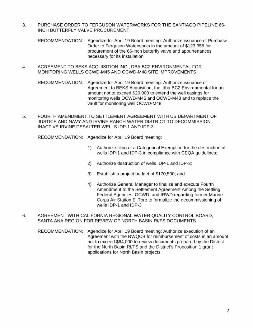
3. PURCHASE ORDER TO FERGUSON WATERWORKS FOR THE SANTIAGO PIPELINE 66-INCH BUTTERFLY VALVE PROCUREMENT
RECOMMENDATION: Agendize for April 19 Board meeting: Authorize issuance of Purchase
Order to Ferguson Waterworks in the amount of $123,356 for procurement of the 66-inch butterfly valve and appurtenances necessary for its installation
4. AGREEMENT TO BEKS ACQUISITION INC., DBA BC2 ENVIRONMENTAL FOR
MONITORING WELLS OCWD-M45 AND OCWD-M48 SITE IMPROVEMENTS RECOMMENDATION: Agendize for April 19 Board meeting: Authorize issuance of
Agreement to BEKS Acquisition, Inc. dba BC2 Environmental for an amount not to exceed $20,000 to extend the well casings for monitoring wells OCWD-M45 and OCWD-M48 and to replace the vault for monitoring well OCWD-M48
5. FOURTH AMENDMENT TO SETTLEMENT AGREEMENT WITH US DEPARTMENT OF
JUSTICE AND NAVY AND IRVINE RANCH WATER DISTRICT TO DECOMMISSION INACTIVE IRVINE DESALTER WELLS IDP-1 AND IDP-3
RECOMMENDATION: Agendize for April 19 Board meeting: 1) Authorize filing of a Categorical Exemption for the destruction of
wells IDP-1 and IDP-3 in compliance with CEQA guidelines; 2) Authorize destruction of wells IDP-1 and IDP-3; 3) Establish a project budget of $170,500; and 4) Authorize General Manager to finalize and execute Fourth
Amendment to the Settlement Agreement Among the Settling Federal Agencies, OCWD, and IRWD regarding former Marine Corps Air Station El Toro to formalize the decommissioning of wells IDP-1 and IDP-3
6. AGREEMENT WITH CALIFORNIA REGIONAL WATER QUALITY CONTROL BOARD,
SANTA ANA REGION FOR REVIEW OF NORTH BASIN RI/FS DOCUMENTS RECOMMENDATION: Agendize for April 19 Board meeting: Authorize execution of an
Agreement with the RWQCB for reimbursement of costs in an amount not to exceed $64,000 to review documents prepared by the District for the North Basin RI/FS and the District’s Proposition 1 grant applications for North Basin projects
3
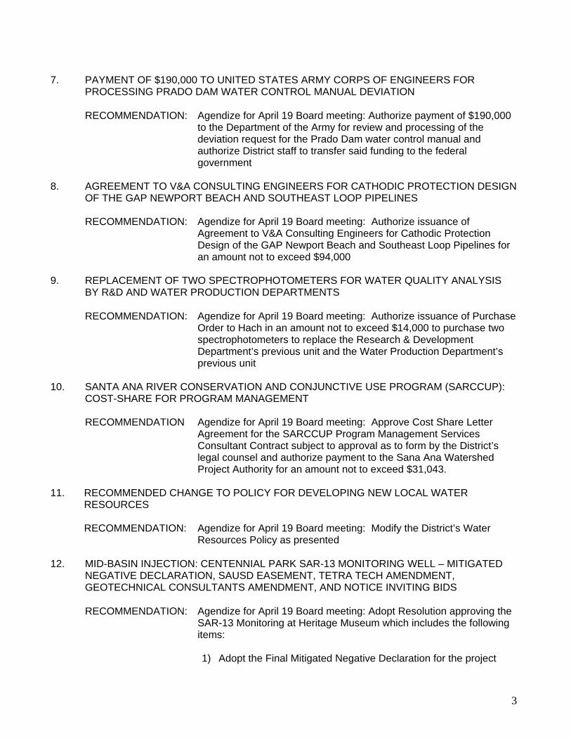
7. PAYMENT OF $190,000 TO UNITED STATES ARMY CORPS OF ENGINEERS FOR
PROCESSING PRADO DAM WATER CONTROL MANUAL DEVIATION RECOMMENDATION: Agendize for April 19 Board meeting: Authorize payment of $190,000
to the Department of the Army for review and processing of the deviation request for the Prado Dam water control manual and authorize District staff to transfer said funding to the federal government
8. AGREEMENT TO V&A CONSULTING ENGINEERS FOR CATHODIC PROTECTION DESIGN
OF THE GAP NEWPORT BEACH AND SOUTHEAST LOOP PIPELINES RECOMMENDATION: Agendize for April 19 Board meeting: Authorize issuance of
Agreement to V&A Consulting Engineers for Cathodic Protection Design of the GAP Newport Beach and Southeast Loop Pipelines for an amount not to exceed $94,000
9. REPLACEMENT OF TWO SPECTROPHOTOMETERS FOR WATER QUALITY ANALYSIS
BY R&D AND WATER PRODUCTION DEPARTMENTS RECOMMENDATION: Agendize for April 19 Board meeting: Authorize issuance of Purchase
Order to Hach in an amount not to exceed $14,000 to purchase two spectrophotometers to replace the Research & Development Department’s previous unit and the Water Production Department’s previous unit
10. SANTA ANA RIVER CONSERVATION AND CONJUNCTIVE USE PROGRAM (SARCCUP):
COST-SHARE FOR PROGRAM MANAGEMENT RECOMMENDATION Agendize for April 19 Board meeting: Approve Cost Share Letter
Agreement for the SARCCUP Program Management Services Consultant Contract subject to approval as to form by the District’s legal counsel and authorize payment to the Sana Ana Watershed Project Authority for an amount not to exceed $31,043.
11. RECOMMENDED CHANGE TO POLICY FOR DEVELOPING NEW LOCAL WATER
RESOURCES RECOMMENDATION: Agendize for April 19 Board meeting: Modify the District’s Water
Resources Policy as presented 12. MID-BASIN INJECTION: CENTENNIAL PARK SAR-13 MONITORING WELL – MITIGATED
NEGATIVE DECLARATION, SAUSD EASEMENT, TETRA TECH AMENDMENT, GEOTECHNICAL CONSULTANTS AMENDMENT, AND NOTICE INVITING BIDS
RECOMMENDATION: Agendize for April 19 Board meeting: Adopt Resolution approving the
SAR-13 Monitoring at Heritage Museum which includes the following items:
1) Adopt the Final Mitigated Negative Declaration for the project

4
2) Authorize execution of Easement Deed with Santa Ana Unified School District
3) Authorize Amendment No. 2 to Agreement with Tetra Tech 4) Authorize Amendment No. 1 to Agreement with Geotechnical
Consultants 5) Authorize Notice Inviting Bids for Contract MBI-2017-2, SAR-13
Monitoring Well at Heritage Museum 6) Authorize filing of the Notice of Determination
13. CONSTRUCTION OF MONITORING WELLS FOR NORTH BASIN REMEDIAL
INVESTIGATION RECOMMENDATION Agendize for April 19 Board meeting: Adopt resolution that contains
the following determinations and actions: 1) The Initial Study/Mitigated Negative Declaration determined that
all potential impacts associated with the proposed project are less than significant or less than significant with the implementation of mitigation measures;
2) The Initial Study/Mitigated Negative Declaration reflects the
independent judgment and analysis of the Board of Directors of the District, as the lead agency for the project under CEQA;
3) Prior to approving the project, the Board of Directors of the
District has considered the Initial/Mitigated Negative Declaration together with any comments received during the public review process, and any responses to such comments;
4) Approve Geologist’s Report; 5) Approve a project budget of $1,500,000; 6) Determine the project to be feasible, necessary and beneficial to
the lands of the District, and declare it duly instituted; 7) Authorize issuance of Notice Inviting Bids for construction of the
project monitoring wells; and 8) Authorize filing of a Notice of Determination 14. POLICY FOR DIRECTLY SELLING GWRS WATER RECOMMENDATION: Agendize for April 19th Board meeting: Modify the OCWD policy for
the use of GWRS water supplies by the Groundwater Producers as presented
END OF CONSENT CALENDAR
MATTERS FOR CONSIDERATION

5
15. AUTHORIZE PAYMENT TO THE DEPARTMENT OF THE ARMY FOR EXPENSES TO
PREPARE THE PRADO BASIN FEASIBILITY STUDY AND RELATED OCWD CONSULTANT EXPENSES
RECOMMENDATION: Agendize for April 19 Board meeting: 1) Authorize the General Manager to sign the April 4, 2017 letter
from the Corps indicating the District’s concurrence with the cost increase for the Prado Basin Feasibility Study;
2) Authorize payment of $731,393 to the federal government for the
Prado Basin Feasibility Study, and authorize District staff to transfer said funding to the federal government;
3) Authorize execution of Amendment No. 1 to Agreement No. 1222
with Scheevel Engineering for technical support for an amount not to exceed $90,818 to support the Prado Basin Feasibility Study;
4) Authorize Work Order to Psomas under existing on-call
environmental services Agreement No. 0675 for an amount not to exceed $21,690 for traffic analyses
16. PROPOSED FISCAL YEAR 2017-18 WATER PURCHASE BUDGET RECOMMENDATION: Agendize for April 19 Board meeting: Provide comments and direction CHAIR DIRECTION AS TO ITEMS IF ANY TO BE AGENDIZED AS MATTERS FOR
CONSIDERATION AT THE APRIL 19 BOARD MEETING DIRECTORS’ ANNOUNCEMENTS/REPORTS GENERAL MANAGER’S ANNOUNCEMENTS/REPORTS ADJOURNMENT
6
WATER ISSUES COMMITTEE MEMBERS Committee Members Cathy Green Philip Anthony Bruce Whitaker James Vanderbilt Vicente Sarmiento Alternates Shawn Dewane Steve Sheldon Dina Nguyen Roger Yoh Denis Bilodeau
In accordance with the requirements of California Government Code Section 54954.2, this agenda has been posted at the guard shack entrance and in the main lobby of the Orange County Water District, 18700 Ward Street, Fountain Valley, CA and on the OCWD website not less than 72 hours prior to the meeting date and time above. All written materials relating to each agenda item are available for public inspection in the office of the District Secretary. Backup material for the Agenda is available at the District offices for public review and can be viewed online at the District’s website: www.ocwd.com Pursuant to the Americans with Disabilities Act, persons with a disability who require a disability-related modification or accommodation in order to participate in a meeting, including auxiliary aids or services, may request such modification or accommodation from the District Secretary at (714) 378-3233, by email at [email protected] by fax at (714) 378-3373. Notification 24 hours prior to the meeting will enable District staff to make reasonable arrangements to assure accessibility to the meeting. As a general rule, agenda reports or other written documentation has been prepared or organized with respect to each item of business listed on the agenda, and can be reviewed at www.ocwd.com. Copies of these materials and other disclosable public records distributed to all or a majority of the members of the Board of Directors in connection with an open session agenda item are also on file with and available for inspection at the Office of the District Secretary, 18700 Ward Street, Fountain Valley, California, during regular business hours, 8:00 am to 5:00 pm, Monday through Friday. If such writings are distributed to members of the Board of Directors on the day of a Board meeting, the writings will be available at the entrance to the Board of Directors meeting room at the Orange County Water District office.

1
MINUTES OF BOARD OF DIRECTORS MEETING WATER ISSUES COMMITTEE
ORANGE COUNTY WATER DISTRICT February 8, 2017 @ 8:00 a.m.
Vice Chair Anthony called the Water Issues Committee meeting to order at 8:00 a.m. in the District Boardroom. The Secretary reported a quorum of the Committee as follows.
Cathy Green CONSENT CALENDAR Director Green requested that Item No. 8, Resolution of Support for a California Water Fix and Ecosystem Restoration Program, be removed from the Consent Calendar. The remainder of the Consent Calendar was then approved upon motion by Director Dewane, seconded by Director Flory and carried [5-0]. [Ayes – Anthony, Dewane, Sheldon, Flory, Green /Noes – 0] 1. Minutes of Meeting The Minutes of the Water Issues Committee meeting held January 11, 2017 were approved as presented. 2. Amendment to Agreement No. 1067 with Habitat West for Maintenance Services and
Restoration on OCWD Sites In Orange County Recommended by Committee for approval at February 15 Board meeting: Authorize issuance of Amendment 1 to Agreement No. 1067 with Habitat West, Inc. to increase the annual cost limit to $130,000 for maintenance and other habitat restoration services on designated sites in Orange County and extend the Agreement end date to February 18, 2020. 3. Amendment to Agreement with Ninyo & Moore for Sunset Gap Seawater Intrusion Investigation Geotechnical Investigation Recommended by Committee for approval at February 15 Board meeting : Authorize issuance of Amendment No. 2 to Agreement No. 1087 with Ninyo & Moore in the amount of $20,789 for additional out-of-scope geotechnical services required for the OCWD-BS13 well site geotechnical investigation.
Committee Members Denis Bilodeau (arrived 8:15 a.m.) Phil Anthony Shawn Dewane Dina Nguyen (not present) Vicente Sarmiento (not present) Alternates Steve Sheldon Jan Flory James Vanderbilt (not present) Roger Yoh (not present) Cathy Green
OCWD Mike Markus - General Manager Joel Kuperberg - General Counsel Judy-Rae Karlsen – Assistant District Secretay
2/8/2017
2
4. Amendment to Encroachment License to City of Anaheim Adding North Basin Remedial Investigation Monitoring Wells AM-54A, AM-54B, and AM-54C
Recommended by Committee for approval at February 15 Board meeting : Authorize issuance of First Amendment to City of Anaheim Encroachment License No. ENC 2015-00153 for the purpose of constructing, monitoring, and maintaining North Basin remedial investigation monitoring wells AM-54A, AM-54B, and AM-54C in City of Anaheim right-of-way. 5. Agreement to Pacific Equipment Safety for Fall Protection in Green Acres Project Building Recommended by Committee for approval at February 15 Board meeting : Authorize execution of Agreement to Pacific Equipment Safety for a cost not to exceed $22,362 for fall protection installation for the Green Acres Project building. 6 Alamitos Barrier Improvement Project Injection Well Improvements – Notice Inviting Bids Recommended by Committee for approval at February 15 Board meeting : Authorize publication of Notice Inviting Bids for Contract No. AB-2016-1 Alamitos Barrier Improvement Project Injection Well Improvements. 7. Project Funding Agreement with Water Environment and Reuse for Research Study to Validate New Analytical Method for Measuring NDMA in Water Recommended by Committee for approval at February 15 Board meeting : Authorize execution of the Master Research Contract for Project No. U3R16 with the Water Environment and Reuse Foundation in support of the project, “Utility Validation of Alternative Method for NDMA Analysis Requiring Less Time, Cost, and Sample Volume” through which OCWD will receive $75,000 grant funding and pay subcontractors a total of $14,000 from this award. 8. Resolution of Support for a California Water Fix and Ecosystem Restoration Program This matter was removed from the Consent Calendar and considered separately. 9. Purchase Order for Agilent Cary 60 UV/Visible Spectrophotometer for the Advanced Water
Quality Assurance Laboratory Recommended by Committee for approval at February 15 Board meeting: Authorize issuance of Purchase Order to Agilent Technologies for the amount of $8,578.25 for Agilent Cary 60 UV/Visible Spectrophotometer. ITEM REMOVED FROM THE CONSENT CALENDAR FOR CONSIDERATION 8. Resolution of Support for a California Water Fix and Ecosystem Restoration Program Director Green requested that staff distribute large environmental reports to Directors earlier than agenda packets when possible to provide Directors with additional time to review the documents. Upon motion by Director Flory, seconded by Director Dewane and carried [4-0-1] with Director Green abstaining, the Committee recommended that the Board at its February 15 Board meeting: Adopt resolution of support for the California Eco Restore and California Water Fix Preferred Alternative (No. 4A). [Ayes –Anthony, Dewane, Sheldon, Flory /Noes – 0/Abstain-Green] Director Bilodeau joined the meeting at 8:15 a.m. during the following discussion.

2/8/2017
3
MATTERS FOR CONSIDERATION 10. Request for Proposals for Design of the GWRS Final Expansion Project GWRS Program Manager Sandy Scott-Roberts reported that OCWD and Orange County Sanitation District (OCSD) conducted a joint economic feasibility study that focused on the expansion of the GWRS facility from a treatment capacity of 100 million gallons per day (mgd) to 130 mgd. She stated the Engineers Report for the GWRS Final Expansion project was approved in September 2016 and that staff has prepared a Request for Proposals for the designs of the project components within the GWRS Final Expansion Project. Ms. Scott reviewed the coordination of agency efforts and stated OCSD will manage the design and construction for the P2 Headworks Modification Project ($44.7 million) and will issue the RFP for that project. She advised the remaining projects have a $16.7 million budget for design phase services and staff is seeking authorization to issue the RFP for these design services. The Committee discussed the total project budget, the project schedule, funding options and contingency estimates. Irvine Ranch Water District representative Peer Swan stated his support for the GWRS Final Expansion project and suggested a parallel study with alternative source water proposals. The Committee then took the following action. Upon motion by Director Dewane, seconded by Director Flory and carried [5-0] the Committee recommended that the Board at its February 15 Board meeting: Authorize issuance of Request for Proposals for design phase services for the GWRS Final Expansion Project. [Ayes –Bilodeau, Anthony, Dewane, Sheldon, Flory /Noes – 0] 11. Update on Approaches for Integrated Regional Water Management in Orange County Executive Director Greg Woodside reviewed the activities related to the Integrated Regional Water Management (IRWM) program in Orange County. He reminded the Committee that the California Department of Water Resources (DWR) administers the state’s IRWM program and grant funds are distributed in fixed amounts among state-created funding areas. He advised there are currently two funding areas in Orange County: o The Santa Ana Funding Area includes the northern and central areas of Orange County o The San Diego Funding Area includes the southern area of Orange County
Mr. Woodside reported that in order to receive grant funds, the state requires stakeholders within the funding areas to form one or more “Regions” led by a Regional Water Management Group and furthermore, in order to become a region, the stakeholders are required to create a governance process, adopt an IRWM plan, and develop a process to prioritize projects for funding. He reported the Santa Ana Funding Area has one state-recognized region that is administered by Santa Ana Watershed Project Authority (SAWPA). Mr. Woodside advised that the District and the County of Orange (County) met with DWR in Sacramento to discuss the possibility of forming a North/Central Orange County Region within the Santa Ana Funding Area that would compete for IRWM grant funds. The Committee discussed the development of the governance process of the North/Central Orange County Region within the Santa Ana Funding Area, the need for a consulting firm to prepare the North/Central Orange County IRWM plan, and the terms and conditions within the cost share agreement. The Committee then took the following actions. Upon motion by Director Dewane, seconded by Director Anthony and carried [5-0] the Committee recommended that the Board at its February 15 Board meeting: 1) Authorize agreement in an amount not to exceed $58,288 to Landstedt Consulting to prepare the
2/8/2017
4
North/Central Orange County Integrated Regional Wate r Management Plan; and 2) Authorize execution of a cost-share agreement with the County of Orange, Orange County Sanitation District, and Newport Bay Watershed Executive Committee to reimburse OCWD for agencies respective cost-shares of preparing the updated plan, subject to approval as to form by District legal counsel. [Ayes –Bilodeau, Anthony, Dewane, Sheldon, Flory /Noes – 0] 12. Metropolitan Water District Regional Recycled Water Program Executive Director John Kennedy reviewed the findings of the feasibility study conducted by Metropolitan Water District for the construction of an indirect potable reuse (IPR) type project at the Carson plant that will purify and create new water supplies to be used to replenish local and regional groundwater basins in Southern California. He reported that MWD staff has determined the project is feasible and MWD has indicated the District (via a contract) could receive up to 65,000 acre-feet per year of water to recharge the groundwater basin, and furthermore, MWD would construct the necessary pipelines to deliver the water. General Manager Mike Markus advised that OCSD and OCWD approved a joint resolution of support for the project and at this time staff will arrange with MWD staff for a time to officially present that resolution. The Committee discussed the cooperative relationship with MWD, the timeline for the completion of the indirect potable reuse project, and the potential term sheet. Staff was requested to draft a letter for the coalition of three agencies (OCWD, OCSD, MWD) regarding emergency drought regulations and related legislative issues. The Committee requested that the draft letter be agendized for further discussion at the March Communications and Legislative Liaison Committee meeting. Director Sheldon expressed his objection to presenting the resolution to MWD until negotiations with MWD are finalized. The Committee then took the following action. Upon motion by Director Dewane, seconded by Director Anthony and carried [4-1] with Director Sheldon voting “No”, the Committee recommended that the Board at its February 15 Board meeting: 1) Arrange with MWD for presentation of OCWD/OCSD Joint Resolution of Support; and 2) Draft letter from OCSD, OCWD and MWD regarding emergency drought legislative issues and agendize for further consideration at the March Communications and Legislative Liaison Committee meeting [Ayes –Bilodeau, Anthony, Dewane, Flory /Noes – Sheldon] INFORMATIONAL ITEMS 13. Santa Ana River Conservation and Conjunctive Use Program (SARCCUP): Progress Update Recharge Manager Adam Hutchinson presented an update on the activities of the Santa Ana River Conservation and Conjunctive Use Program and advised that water bank modeling simulations are being conducted and there are final modeling decisions to be made. He noted that issues related to water bank contributions, allocations, costs and operational issues will be evaluated and presented later in the year. Mr. Markus noted that the estimated allocation of 12,000 acre feet of water (per year for three years) is considered “extraordinary water”. 14. La Palma Recharge Basin Project: ASCE Outstanding Water Project and OCEC Engineering
Project Achievement Awards Mr. Markus reported that the District received the following awards: The American Society of Civil Engineers (ASCE) Outstanding Water Project award for the La Palma Recharge Basin project, and the Orange County Engineering Council (OCEC) Engineering Project Achievement Award. He suggested that President Bilodeau attend the meetings to accept the awards on behalf of the District.

2/8/2017
5
ITEM TO BE AGENDIZED AS A MATTER FOR CONSIDERATION A T THE FEBRUARY 15 BOARD MEETING It was agreed to agendize Item No. 10, Request for Proposals for Design of the GWRS Final Expansion Project, as a Matter for Consideration at the February 15 Board meeting. VERBAL REPORTS/ANNOUNCEMENTS Director Flory announced that Bruce Whitaker has been appointed to represent the City of Fullerton at the February 15 Board meeting. ADJOURNMENT There being no further business, the meeting was adjourned at 9:05 a.m. _________________________ Director Denis Bilodeau, Chair

MINUTES OF BOARD OF DIRECTORS MEETING WATER ISSUES COMMITTEE
ORANGE COUNTY WATER DISTRICT March 8, 2017 @ 8:00 a.m.
Director Green called the Water Issues Committee meeting to order at 8:00 a.m. in the District Boardroom. The Recording Secretary reported a quorum of the Committee as follows.
CONSENT CALENDAR The Consent Calendar was approved upon motion by Director Anthony, seconded by Director Whitaker and carried [4-0]. [Ayes - Green, Anthony, Whitaker, Nguyen /Noes – 0] 1. Purchase Order to Agilent Technologies for Renewal of Support Service Agreement for GC
and GC/MSin the Laboratory Recommended by Committee for approval March 15 Board meeting: Authorize issuance of Purchase Order to Agilent Technologies in the amount of $84,110 for renewal of Support Service Agreement for Gas Chromatographs (GC) and Gas Chromatographs/Mass Spectrometers (GC/MS) in the Laboratory, with prepayment option commencing March 21, 2017 to cover specified analytical systems used within the laboratory 2. Accept Completion of Contract No. SG-2016-1 with BEKS Acquisition Inc. dba BC2
Environmental for Monitoring Well OCWD-BS24C Construction Recommended by Committee for approval March 15 Board meeting: Accept completion of work and authorize Notice of Completion for Contract No. SG-2016-1 for the construction of monitoring well OCWD-BS24C. 3. East Newport Mesa Groundwater Investigation Monitoring Well Installations: Award Contract
GBM-2017-1 to ABC Liovin Drilling, Inc. Recommended by Committee for approval at March 15 Board meeting : 1). Receive and File Affidavit of Publication of Notice Inviting Bids for Contract GBM-2017-1; and 2). Accept bid and award Contract No. GBM-2017-1 to ABC Liovin Drilling, Inc. for an amount not to exceed $62,419.
Committee Members Cathy Green Phil Anthony Bruce Whitaker James Vanderbilt (absent) Vicente Sarmiento (absent) Alternates Shawn Dewane (absent) Steve Sheldon Dina Nguyen Roger Yoh (absent) Denis Bilodeau (absent)
OCWD Mike Wehner – Assistant General Manager Joel Kuperberg - General Counsel John Kennedy - Executive Director Christina Fuller- Recording Secretary
2
4. Amendment to Agreement with Ruth Villalobos and Associates to Support the Prado Basin Feasibility Study ___________________________________
Recommended by Committee for approval at March 15 Board meeting : Authorize execution of Amendment No. 1 to Agreement No. 1170 with Ruth Villalobos and Associates for an amount not to exceed $60,000 to support the Prado Basin Feasibility Study. MATTERS FOR CONSIDERATION 5. La Palma Recharge Basin Project: Authorize Notice of Completion to Los Angeles Engineering,
Inc. and Ratify Change Orders 1-4____________________________________________ Engineer Ben Smith reported that construction of the La Palma Recharge Basin by Los Angeles Engineering, Inc. was completed in February 2017. He advised of issuance of Change Order Nos. 1-4, and presented staff’s recommendation that the Board accept completion of the Project. Upon motion by Director Anthony, seconded by Director Whitaker and carried [4-0], the Committee recommended at its March 15 Board meeting: 1) Ratify issuance of Change Order Numbers 1 – 4 to Los Angeles Engineering, Inc. for a total amount of $77,543; and2) Accept completion of work and authorize filing a Notice of Completion for Contract No. LPRB-2015-1: La Palma Recharge Basin. [Ayes –Green, Anthony, Whitaker, Nguyen /Noes – 0] 6. South Basin Remedial Investigation: Award Contract GBM-2017-3 to Yellow Jacket Drilling,
and authorize Amendment to Agreement with Aquilogic, Inc. for Database Management_ Chief Hydrogeologist Roy Herndon reported that bids for monitoring well construction in support of the South Basin Groundwater Protection Project remedial investigation were received on February 22, 2017. He stated that staff recommends awarding the contract to the lowest responsive bidder, Yellow Jacket Drilling, and amending the current agreement with Aquilogic, Inc. to continue to update and maintain the South Basin project database for 12 months. Mr. Herndon gave a brief overview of the history of the project. After a brief discussion, the Committee then took the following action. Upon motion by Director Anthony, seconded by Director Whitaker and carried [4-0], the Committee recommended at its March 15 Board meeting: 1) Prior to approving the well construction contract award, the Board of Directors of the District has considered and determined that Addendum No. 1 to the Final Mitigated Negative Declaration adequately analyzes proposed changes to the project; 2) Accept bid and award Contract No. GBM-2017-3 to Yellow Jacket Drilling for $442,525; 3) Authorize Amendment No. 3 to Agreement No. 0827 with Aquilogic, Inc. in the amount of $58,100 for services to update and maintain the South Basin project database for 12 months and provide access to Hargis + Associates; and 4) Authorize filing of a Notice of Determination. [Ayes –Green, Anthony, Whitaker, Nguyen /Noes – 0] Director Sheldon arrived at 8:35 a.m. during discussion of the following item. 7. Proposed Fiscal Year 2017-18 Water Purchase Budget____ ____ Executive Director John Kennedy reviewed the proposed FY 2017-18 water purchase budget. He stated staff’s recommends a proposed water budget of $49.7 million, with the largest expense for 65,000 acre-feet of Metropolitan Water District (MWD) untreated full service water. He reviewed the Groundwater Basin’s accumulated overdraft and the FY 2017-18 Groundwater Basin water balance. After a brief discussion on this item, no action was taken.

3
ITEMS TO BE AGENDIZED ON CONSENT CALENDAR AT THE MARCH 15 BOARD MEETING It was agreed to place items No. 1 - 7 on the Consent Calendar for the March 15 Board Meeting. ADJOURNMENT There being no further business, the meeting was adjourned at 8:45 a.m. _________________________ Director Cathy Green, Chair

2
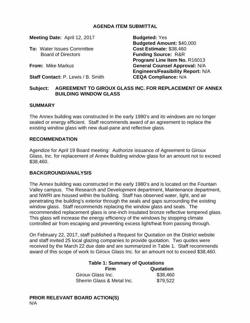
AGENDA ITEM SUBMITTAL Meeting Date: April 12, 2017 Budgeted: Yes Budgeted Amount: $40,000 To: Water Issues Committee Cost Estimate: $38,460 Board of Directors Funding Source: R&R Program/ Line Item No. R16013 From: Mike Markus General Counsel Approval: N/A Engineers/Feasibility Report: N/A Staff Contact: P. Lewis / B. Smith CEQA Compliance: N/A Subject: AGREEMENT TO GIROUX GLASS INC. FOR REPLACEM ENT OF ANNEX
BUILDING WINDOW GLASS SUMMARY The Annex building was constructed in the early 1980’s and its windows are no longer sealed or energy efficient. Staff recommends award of an agreement to replace the existing window glass with new dual-pane and reflective glass. RECOMMENDATION Agendize for April 19 Board meeting: Authorize issuance of Agreement to Giroux Glass, Inc. for replacement of Annex Building window glass for an amount not to exceed $38,460. BACKGROUND/ANALYSIS The Annex building was constructed in the early 1980’s and is located on the Fountain Valley campus. The Research and Development department, Maintenance department, and NWRI are housed within the building. Staff has observed water, light, and air penetrating the building’s exterior through the seals and gaps surrounding the existing window glass. Staff recommends replacing the window glass and seals. The recommended replacement glass is one-inch insulated bronze reflective tempered glass. This glass will increase the energy efficiency of the windows by stopping climate controlled air from escaping and preventing excess light/heat from passing through. On February 22, 2017, staff published a Request for Quotation on the District website and staff invited 25 local glazing companies to provide quotation. Two quotes were received by the March 22 due date and are summarized in Table 1. Staff recommends award of this scope of work to Giroux Glass Inc. for an amount not to exceed $38,460.
Table 1: Summary of Quotations Firm Quotation
Giroux Glass Inc. $38,460 Sherrin Glass & Metal Inc. $79,522
PRIOR RELEVANT BOARD ACTION(S) N/A

3
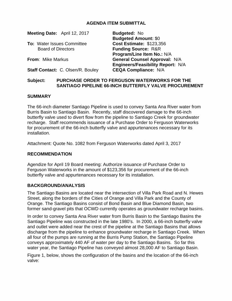
AGENDA ITEM SUBMITTAL Meeting Date: April 12, 2017 Budgeted: No Budgeted Amount: $0 To: Water Issues Committee Cost Estimate: $123,356 Board of Directors Funding Source: R&R Program/Line Item No.: N/A From : Mike Markus General Counsel Approval: N/A Engineers/Feasibility Report: N/A Staff Contact: C. Olsen/R. Bouley CEQA Compliance: N/A Subject: PURCHASE ORDER TO FERGUSON WATERWORKS FOR T HE
SANTIAGO PIPELINE 66-INCH BUTTERFLY VALVE PROCUREMENT SUMMARY The 66-inch diameter Santiago Pipeline is used to convey Santa Ana River water from Burris Basin to Santiago Basin. Recently, staff discovered damage to the 66-inch butterfly valve used to divert flow from the pipeline to Santiago Creek for groundwater recharge. Staff recommends issuance of a Purchase Order to Ferguson Waterworks for procurement of the 66-inch butterfly valve and appurtenances necessary for its installation. Attachment: Quote No. 1082 from Ferguson Waterworks dated April 3, 2017 RECOMMENDATION Agendize for April 19 Board meeting: Authorize issuance of Purchase Order to Ferguson Waterworks in the amount of $123,356 for procurement of the 66-inch butterfly valve and appurtenances necessary for its installation. BACKGROUND/ANALYSIS
The Santiago Basins are located near the intersection of Villa Park Road and N. Hewes Street, along the borders of the Cities of Orange and Villa Park and the County of Orange. The Santiago Basins consist of Bond Basin and Blue Diamond Basin, two former sand-gravel pits that OCWD currently operates as groundwater recharge basins.
In order to convey Santa Ana River water from Burris Basin to the Santiago Basins the Santiago Pipeline was constructed in the late 1980’s. In 2000, a 66-inch butterfly valve and outlet were added near the crest of the pipeline at the Santiago Basins that allows discharge from the pipeline to enhance groundwater recharge in Santiago Creek. When all four of the pumps are running at the Burris Pump Station, the Santiago Pipeline conveys approximately 440 AF of water per day to the Santiago Basins. So far this water year, the Santiago Pipeline has conveyed almost 28,000 AF to Santiago Basin.
Figure 1, below, shows the configuration of the basins and the location of the 66-inch valve:

Figure 1 – Santiago Basins
The 66-inch butterfly valve on the Santiago Pipeline is direct buried, approximately thirty (30) feet below the surface. Recently, the mechanism that opens and closes the valve has begun to fail. The valve has an electronic actuator that closes and opens the valve; however staff has to manually turn the valve operator well past the “closed” and “open” stop indicators to seal or open the valve. This indicates that something within the valve or the actuator is not working properly. Due to the depth of the valve below ground and the inaccessibility that this creates, it is not possible to examine the valve actuator to determine the cause without a significant cost for excavation.
The existing valve is now seventeen years old. In addition, the cost of excavation to examine the valve is almost equal to the cost of a new valve. In order to assure functionality of the valve and make maintenance and repairs feasible in the future, staff recommends installing a new valve and constructing a vault around the valve using R&R Funds. This project has been identified in the proposed FY 2017/18 budget. The lead time to purchase and fabricate the replacement valve is approximately 5 – 8 months. Since failure of the valve could prevent conveyance of up to 440 AF of water per day between Burris Basin and the Santiago Basins, staff recommends authorizing issuance of a purchase order for the replacement valve and appurtenances in advance of the construction contract. Pre-purchasing the long lead time materials and providing the valve to the selected Contractor will eliminate Contractor markup that the District
Bond Basin
Blue Diamond Basin
66-Inch Butterfly Valve and Santiago Creek Discharge
Santiago Pipeline

pays for materials in a construction contract, and will minimize the delay in completing the valve replacement.
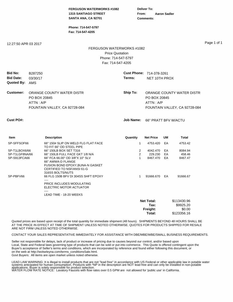
Staff requested quotes for the replacement 66-inch butterfly valve and appurtenances from multiple vendors. Due to the size of the valve, staff received quotes from two vendors. The quotes are shown in Table 1, below:
Table 1 – Quotes Received
Company Price Ferguson Waterworks $123,356 Western Waterworks Supply Company $127,792
Based upon the quotes received and the need to complete replacement of the valve prior to the next rainy season, staff recommends issuance of a Purchase Order to Ferguson Waterworks for the replacement valve and appurtenances for the Santiago Pipeline 66-Inch Butterfly Valve Replacement Project. Staff anticipates that the valve will be delivered in approximately 5-8 months. Staff will return to the Board at a later date with a request to authorize bidding the vault construction and valve replacement work.
The proposed project schedule is shown below in Table 2, below:
Table 2 – Project Schedule
Milestone Date Authorize Material Purchase April 19, 2017 Authorize Construction Bid July 5, 2017 Award Construction Contract Aug 16, 2017 Issue Notice to Proceed Sept 6, 2017 Take Delivery of Valve Sept 27, 2017 Construction Sept – Nov 2017
PRIOR RELEVANT BOARD ACTION(S) None
FERGUSON WATERWORKS #1082
1315 SANTIAGO STREET
SANTA ANA, CA 92701
Phone: 714-547-5797
Fax: 714-547-4205
Deliver To:
From: Aaron Sadler
Comments:
12:27:50 APR 03 2017FERGUSON WATERWORKS #1082
Price QuotationPhone: 714-547-5797
Fax: 714-547-4205
Bid No: B287250Bid Date: 03/30/17Quoted By: AMS
Cust Phone: 714-378-3261Terms: NET 10TH PROX
Customer: ORANGE COUNTY WATER DISTRPO BOX 20845ATTN : A/PFOUNTAIN VALLEY, CA 92728-084
Ship To: ORANGE COUNTY WATER DISTRPO BOX 20845ATTN : A/PFOUNTAIN VALLEY, CA 92728-084
Cust PO#: Job Name: 66" PRATT BFV W/ACTU
Page 1 of 1
Item Description Quantity Net Price UM Total
SP-SFFSOF66 66" 150# SLIP ON WELD FLG FLAT FACE 1 4753.420 EA 4753.42TO FIT 66" OD STEEL PIPE
SP-T1LBOX6/66 66" 150LB BOX SET T316 2 4042.470 EA 8084.94SP-T1LGF8NA/66 66" 150LB FULL FACE GKT 1/8 N/A 2 229.230 EA 458.46SP-S913FCA66 66" FCA 66.00" OD 3/8"X 10" SLV 1 8467.470 EA 8467.47
66" AWWA-D FLANGE FUSION BOND EPOXY,BUNA-N GASKET CERTIFIED TO NSF/ANSI 61-G316SS BOLTS/NUTS
SP-PBFV66 66 FLG 150B BFV DI 304SS SHFT EPOXY 1 91666.670 EA 91666.67----PRICE INCLUDES MODULATINGELECTRIC MOTOR ACTUATOR----LEAD TIME - 18-20 WEEKS
Net Total: $113430.96Tax: $9925.20
Freight: $0.00Total: $123356.16
Quoted prices are based upon receipt of the total quantity for immediate shipment (48 hours). SHIPMENTS BEYOND 48 HOURS SHALL BEAT THE PRICE IN EFFECT AT TIME OF SHIPMENT UNLESS NOTED OTHERWISE. QUOTES FOR PRODUCTS SHIPPED FOR RESALE
CONTACT YOUR SALES REPRESENTATIVE IMMEDIATELY FOR ASSISTANCE WITH DBE/MBE/WBE/SMALL BUSINESS REQUIREMENTS.
ARE NOT FIRM UNLESS NOTED OTHERWISE.
http://wolseleyna.com/terms_conditionsSale.html.
LEAD LAW WARNING: It is illegal to install products that are not "lead free" in accordance with US Federal or other applicable law in potable water systems anticipated for human consumption. Products with *NP in the description are NOT lead free and can only be installed in non-potable applications. Buyer is solely responsible for product selection. WATER FLOW RATE NOTICE: Lavatory Faucets with flow rates over 0.5 GPM are not allowed for 'public use' in California.
Seller not responsible for delays, lack of product or increase of pricing due to causes beyond our control, and/or based uponLocal, State and Federal laws governing type of products that can be sold or put into commerce. This Quote is offered contingent upon theBuyer's acceptance of Seller's terms and conditions, which are incorporated by reference and found either following this document, oron the web at Govt Buyers: All items are open market unless noted otherwise.

4
AGENDA ITEM SUBMITTAL Meeting Date: April 12, 2017 Budgeted: Yes Budgeted Amount: $20,000 To: Water Issues Committee Cost Estimate: $20,000 Board of Directors Funding Source: General Fund Program/Line Item No.: 1075.57016.9908 From : Mike Markus General Counsel Approval: N/A Engineers/Feasibility Report: N/A Staff Contact: R. Herndon, D.Field CEQA Compliance: N/A Subject: AGREEMENT TO BEKS ACQUISITION INC., DBA BC2
ENVIRONMENTAL FOR MONITORING WELLS OCWD-M45 AND OCWD-M48 SITE IMPROVEMENTS
SUMMARY Surface water caused by recent rains has intruded into the well casings at OCWD monitoring wells OCWD-M45 (M45) and OCWD-M48 (M48). To protect against surface water intrusion and potential associated unrepresentative water chemical detections, the well casings at M45 and M48 need to be elevated, and the vault at M48 needs to be replaced. After requesting cost quotes from several firms, staff recommends selection of BEKS Acquisition Inc. dba BC2 Environmental to conduct this work. Attachment: Figure 1 – Well Location Map RECOMMENDATION Agendize for April 19 Board meeting: Authorize issuance of Agreement to BEKS Acquisition, Inc. dba BC2 Environmental for an amount not to exceed $20,000 to extend the well casings for monitoring wells OCWD-M45 and OCWD-M48 and to replace the vault for monitoring well OCWD-M48. BACKGROUND/ANALYSIS Multi-depth monitoring well M45 was constructed in 2005 for water quality monitoring and waste discharge permit compliance for the GWRS. The well is located in the parking lot of the Founder’s Village Senior and Community Center in Fountain Valley (Figure 1). Multi-depth monitoring well M48 was constructed in 2002 to monitor seawater intrusion in the Newport Mesa area (Figure 1). That well is located in the parking lot of the Vanguard University in Costa Mesa. Wells M45’s and M48’s stainless steel casings and screens are in good condition, and the wells provide essential water level and water quality data used to demonstrate GWRS permit compliance, Talbert Barrier performance, and coastal groundwater quality conditions. Based on field electrical conductivity measurement, staff found that surface water during recent rains had seeped into the well M45 and M48 vaults and casings. Because

accurate and representative water quality data measurements from these wells are an absolute necessity, staff recommends elevating the well casings at monitoring wells M45 and M48 farther above the bottom of the vaults where water can pool. Staff also recommends replacing the vault at M48 with one that is more water tight. Staff sent a Request for Quote (RFQ) for these site improvements to four contractors. In response to the RFQ, two written proposals were received from two firms:
x BEKS Acquisition, Inc. dba BC2 Environmental $20,000 x W.A. Rasic Construction Company, Inc. $22,916 x Cascade Drilling Declined x Gregg Drilling No Response
Both responsive firms are capable of conducting the requested work, and both have a good track record conducting this type of work for the District. Staff recommends issuing an Agreement to BEKS Acquisition, Inc. dba BC2 Environmental, the firm with the lowest proposed costs, to complete the M45 and M48 site improvements. PRIOR RELEVANT BOARD ACTIONS None

Figure 1 Location Map

5
AGENDA ITEM SUBMITTAL Meeting Date: April 12, 2017 Budgeted: Partial Budgeted Amount: $70,000 To: Water Issues Committee Cost Estimate: $170,500 Board of Directors Funding Source: R&R Program/ Line Item No.: R15019 From : Mike Markus General Counsel Approval: Obtained Engineers/Feasibility Report: N/A Staff Contact: R.Herndon, D.Field CEQA Compliance: Categorical Exemption
to be filed upon project approval. Subject: FOURTH AMENDMENT TO SETTLEMENT AGREEMENT WITH US
DEPARTMENT OF JUSTICE AND NAVY AND IRVINE RANCH WATER DISTRICT TO DECOMMISSION INACTIVE IRVINE DESALTER WELLS IDP-1 AND IDP-3
SUMMARY The purpose of the Fourth Amendment to the 2001 Settlement Agreement with the U.S. Departments of Justice and Navy and Irvine Ranch Water District (IRWD) is to formally authorize decommissioning of inactive and unneeded Irvine Desalter Project (IDP) production wells IDP-1 and IDP-3. These wells are a component of the original IDP, a portion of which constitutes the remedy to the VOC contamination emanating from the former Marine Corps Air Station (MCAS) El Toro. Staff has determined that these wells no longer serve any purpose and should be properly destroyed. Attachment: Fourth Amendment to the Settlement Agreement Among the Settling
Federal Agencies, OCWD, and IRWD to formalize the decommissioning wells IDP-1 and IDP-3 (Draft).
RECOMMENDATION Agendize for April 19 Board meeting: 1. Authorize filing of a Categorical Exemption for the destruction of wells IDP-1 and
IDP-3 in compliance with CEQA guidelines;
2. Authorize destruction of wells IDP-1 and IDP-3;
3. Establish a project budget of $170,500; and
4. Authorize General Manager to finalize and execute Fourth Amendment to the Settlement Agreement Among the Settling Federal Agencies, OCWD, and IRWD regarding former Marine Corps Air Station El Toro to formalize the decommissioning of wells IDP-1 and IDP-3.
BACKGROUND/ANALYSIS Wells IDP-1, IDP-2, IDP-3, and IDP-4 were installed by OCWD in 1992 and 1993. The original purpose of these wells was to extract and contain groundwater with volatile organic compound (VOC) contamination emanating from the former MCAS El Toro, as well as groundwater with high total dissolved solids (TDS) that resulted from past farming activities. Under the 2001 Settlement Agreement, the Navy reimbursed OCWD for the costs of constructing the IDP production wells. The IDP wells were installed under a previous design concept whereby the water would be treated to remove VOCs and TDS, and then discharged to IRWD’s potable distribution system. Subsequently following community input, the IDP design was modified to two components – potable and non-potable – which have been successfully operating since 2006. The new design did not utilize the four original IDP wells. Although the IDP wells installed by OCWD were never put into production, IRWD initially requested that OCWD maintain the wells in case they decide to use them in the future. In 2004, IRWD purchased the property on which well IDP-4 was located, thereby acquiring ownership of IDP-4. IRWD determined that IDP-4 was not suitable for use and destroyed the well in 2011. In 2004, OCWD converted IDP-2 from a production well to a monitoring well (IDP-2R) which remains active to date. Staff has had recent discussions with IRWD staff, and both agree that the two remaining IDP wells have no future purpose. Existing OCWD and Navy monitoring wells in that area provide adequate monitoring of groundwater conditions. Consequently, staff recommends destruction of the remaining wells IDP-1 and IDP-3. In 2001, OCWD approved the Settlement Agreement and Shallow Groundwater Unit Contract with the U.S. Departments of Justice and Navy and IRWD. These agreements established the scope, responsibilities, and cost allocation for construction and operation of portions of the IDP to clean up contaminants from the former MCAS El Toro. Because IDP-1 and IDP-3 are part of the 2001 Settlement Agreement, the U.S. Departments of Justice and Navy have requested to have the decommissioning of these wells addressed in the form of the attached Fourth Amendment to the Settlement Agreement (Draft). Staff recommends Board authorization for the General Manager to finalize and execute the Fourth Amendment to the Settlement Agreement. Time is of the essence to conduct the well destruction, as the area surrounding the wells is currently being redeveloped into transportation corridors, providing further rationale for destroying these wells. The table below summarizes the proposed budget based on the geologist’s estimated costs for destruction of IDP-1 and IDP-3.

Task Cost Estimate
IDP-1 & IDP-3 Destructions1 $ 155,000 Destruction Inspection Services2 0
SUBTOTAL: 155,000 CONTINGENCY: 15,500
TOTAL: $ 170,500 1IDP-1 est. $15,000 well vault and pipeline destruction costs will be reimbursed by IRWD. 2Inspection services to be completed in-house by OCWD geologists.
Staff budgeted $70,000 for destroying IDP-3 only; however, due to ongoing development near the IDP-1 site, destruction of IDP-1 has been added to this project increasing the proposed budget to $170,500. PRIOR RELEVANT BOARD ACTIONS 6/20/12 R12-6-64 Approve and authorize execution of the Third Amendment to the Settlement Agreement Among the Settling Federal Agencies, OCWD, and IRWD regarding former MCAS El Toro to formalize the decommissioning of Well IDP-4. 11/3/04 R04-11-137 Authorize the General Manager to execute second amendment to the Settlement Agreement with Settling Federal Agencies and IRWD. 9/15/04 R04-9-124 Approve proposed project modifications and environmental assessment findings, as described in Addendum No. 3 to the Final Environmental Impact Report for the Irvine Desalter Project. 6/6/01 R01-6-85 Approve and authorize execution of Second Amended and Restated Agreement with IRWD regarding the Irvine Desalter Project, addressing responsibilities for design, construction, financing, operations and maintenance, cost of water, liabilities of both parties, and exemption from water produced by IDP from payment of BEA to cover IRWD's water treatment costs. 6/6/01 R01-6-84 Approve Settlement Agreement with Settling Federal Agencies and IRWD regarding MCAS El Toro groundwater remediation. 6/6/01 R01-6-83 Approve Addendum No. 2 to the EIR on the Irvine Desalter Project providing for separate potable and reclaimed groundwater production and treatment facilities. 6/6/01 R01-6-82 Determine groundwater produced from Irvine Desalter Project Water Producing Facility Nos. (to be determined) to be unsuitable for domestic or agricultural purposes, and exempting water produced from said facilities from the levy of the basin equity assessment. 5/19/93 R93-5-85 Approve Addendum No. 1 to the EIR on the Irvine Desalter Project providing for relocation of the treatment facilities site.

9/2/92 R92-9-167 Award Irvine Desalter Production Well Contract IDP-92-1 to McCalla Water Well Services Company. 5/16/90 R90-5-120 Certify Final Environmental Impact Report for Irvine Desalter Project and adopt findings and statement of overriding considerations.
Well Location Map
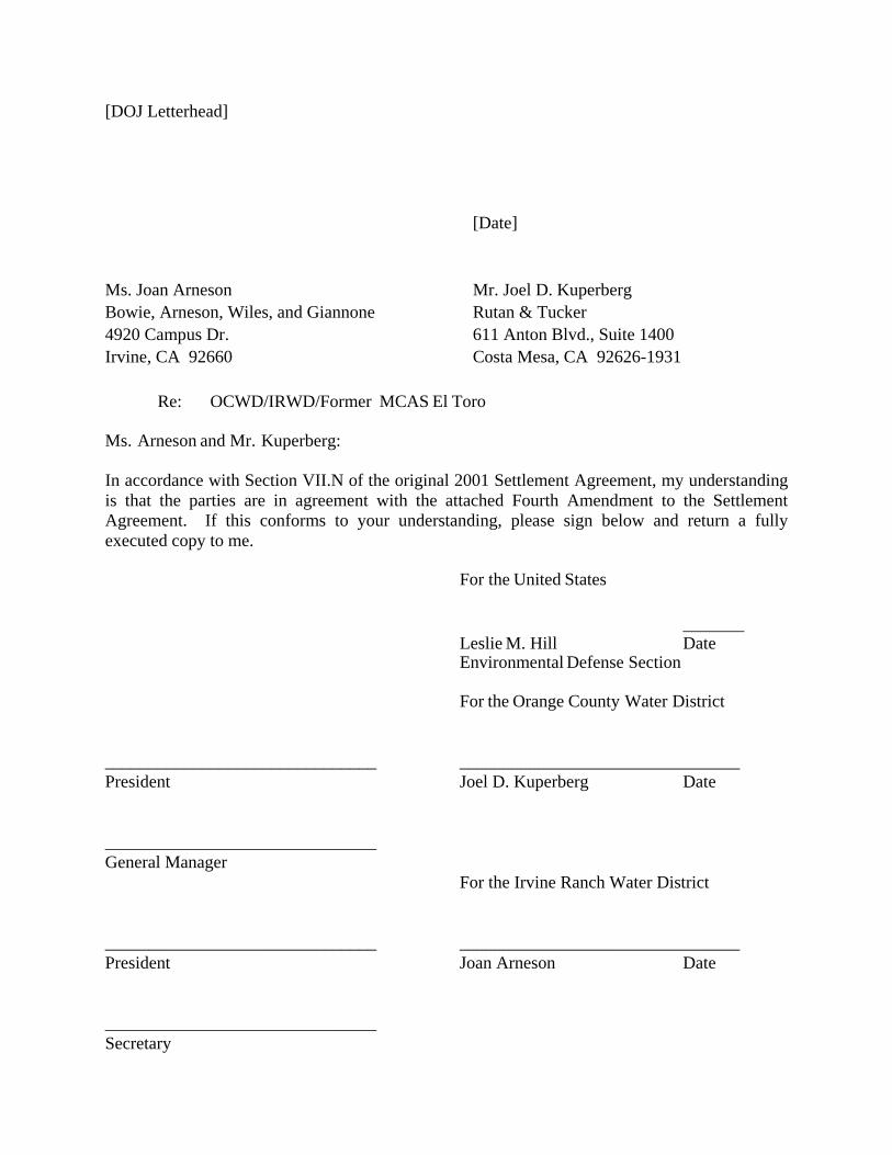
[DOJ Letterhead] [Date] Ms. Joan Arneson Mr. Joel D. Kuperberg Bowie, Arneson, Wiles, and Giannone Rutan & Tucker 4920 Campus Dr. 611 Anton Blvd., Suite 1400 Irvine, CA 92660 Costa Mesa, CA 92626-1931 Re: OCWD/IRWD/Former MCAS El Toro Ms. Arneson and Mr. Kuperberg: In accordance with Section VII.N of the original 2001 Settlement Agreement, my understanding is that the parties are in agreement with the attached Fourth Amendment to the Settlement Agreement. If this conforms to your understanding, please sign below and return a fully executed copy to me. For the United States _______ Leslie M. Hill Date Environmental Defense Section
For the Orange County Water District _______________________________ ________________________________ President Joel D. Kuperberg Date _______________________________ General Manager For the Irvine Ranch Water District _______________________________ ________________________________ President Joan Arneson Date _______________________________ Secretary
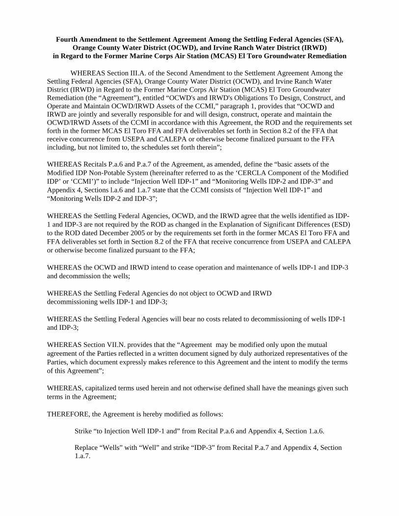
Fourth Amendment to the Settlement Agreement Among the Settling Federal Agencies (SFA), Orange County Water District (OCWD), and Irvine Ranch Water District (IRWD)
in Regard to the Former Marine Corps Air Station (MCAS) El Toro Groundwater Remediation
WHEREAS Section III.A. of the Second Amendment to the Settlement Agreement Among the Settling Federal Agencies (SFA), Orange County Water District (OCWD), and Irvine Ranch Water District (IRWD) in Regard to the Former Marine Corps Air Station (MCAS) El Toro Groundwater Remediation (the “Agreement”), entitled “OCWD's and IRWD's Obligations To Design, Construct, and Operate and Maintain OCWD/IRWD Assets of the CCMI,” paragraph 1, provides that “OCWD and IRWD are jointly and severally responsible for and will design, construct, operate and maintain the OCWD/IRWD Assets of the CCMI in accordance with this Agreement, the ROD and the requirements set forth in the former MCAS El Toro FFA and FFA deliverables set forth in Section 8.2 of the FFA that receive concurrence from USEPA and CALEPA or otherwise become finalized pursuant to the FFA including, but not limited to, the schedules set forth therein”; WHEREAS Recitals P.a.6 and P.a.7 of the Agreement, as amended, define the “basic assets of the Modified IDP Non-Potable System (hereinafter referred to as the ‘CERCLA Component of the Modified IDP’ or ‘CCMI’)” to include “Injection Well IDP-1” and “Monitoring Wells IDP-2 and IDP-3” and Appendix 4, Sections l.a.6 and 1.a.7 state that the CCMI consists of “Injection Well IDP-1” and “Monitoring Wells IDP-2 and IDP-3”; WHEREAS the Settling Federal Agencies, OCWD, and the IRWD agree that the wells identified as IDP-1 and IDP-3 are not required by the ROD as changed in the Explanation of Significant Differences (ESD) to the ROD dated December 2005 or by the requirements set forth in the former MCAS El Toro FFA and FFA deliverables set forth in Section 8.2 of the FFA that receive concurrence from USEPA and CALEPA or otherwise become finalized pursuant to the FFA; WHEREAS the OCWD and IRWD intend to cease operation and maintenance of wells IDP-1 and IDP-3 and decommission the wells; WHEREAS the Settling Federal Agencies do not object to OCWD and IRWD decommissioning wells IDP-1 and IDP-3; WHEREAS the Settling Federal Agencies will bear no costs related to decommissioning of wells IDP-1 and IDP-3; WHEREAS Section VII.N. provides that the “Agreement may be modified only upon the mutual agreement of the Parties reflected in a written document signed by duly authorized representatives of the Parties, which document expressly makes reference to this Agreement and the intent to modify the terms of this Agreement”; WHEREAS, capitalized terms used herein and not otherwise defined shall have the meanings given such terms in the Agreement; THEREFORE, the Agreement is hereby modified as follows:
Strike “to Injection Well IDP-1 and” from Recital P.a.6 and Appendix 4, Section 1.a.6. Replace “Wells” with “Well” and strike “IDP-3” from Recital P.a.7 and Appendix 4, Section 1.a.7.

6

1
AGENDA ITEM SUBMITTAL Meeting Date: April 12, 2017 Budgeted: Yes (FY17-18) Budgeted Amount: $90,000 To: Water Issues Committee Board of Directors
Cost Estimate: $64,000
Funding Source: General Fund Program/ Line Item No.: 1075.51112.9985 From : Mike Markus General Counsel Approval: Yes Engineers/Feasibility Report: N/A Staff Contact: W. Hunt/R. Herndon/ D. Mark
CEQA Compliance: N/A
Subject: AGREEMENT WITH CALIFORNIA REGIONAL WATER QUALITY
CONTROL BOARD, SANTA ANA REGION FOR REVIEW OF NORTH BASIN RI/FS DOCUMENTS
SUMMARY District staff has negotiated and recommends Board approval of a cost-reimbursement agreement with the California Regional Water Quality Control Board, Santa Ana Region (RWQCB) for their review of documents prepared as part of the remedial investigation and feasibility study (RI/FS) to address groundwater contamination in the North Basin area. The agreement would also allow cost reimbursement for RWQCB review of the District’s Proposition 1 Grant applications for North Basin projects. Attachment: x Agreement with RWQCB
RECOMMENDATION Agendize for April 19 Board meeting: Authorize execution of Agreement with the RWQCB for reimbursement of costs in an amount not to exceed $64,000 to review documents prepared by the District for the North Basin RI/FS and the District’s Proposition 1 grant applications for North Basin projects. BACKGROUND/ANALYSIS In 2014, the Board authorized staff to develop strategies to remediate groundwater contamination in the North Basin area consistent with the National Contingency Plan (NCP). The District initiated a RI/FS in cooperation with and under the direction of the U.S. Environmental Protection Agency (EPA) to address the groundwater contamination. For the RI/FS, the District’s consultants, AECOM and Intera, will be preparing several key documents, including an RI report, groundwater modeling reports, human health risk assessment, several technical memoranda, and an FS. The NCP requires State involvement during the RI/FS, including review of the key documents. State acceptance of the proposed remedy is considered by EPA in selecting the

2
remedy. The Administrative Settlement Agreement between EPA and OCWD requires OCWD to submit the key RI/FS documents to the State, specifically both the RWQCB and the Department of Toxic Substances Control (DTSC). In addition to reviewing the RI/FS documents, at the request of the State Water Resources Control Board, RWQCB staff reviewed OCWD’s Proposition 1 grant applications for North Basin. OCWD submitted two Proposition 1 grant applications for North Basin: a Planning Grant for the RI/FS, and an Implementation Grant for the extraction well EW-1 project, both of which have received preliminary approval of grant funding. This agreement allows the RWQCB to recover their costs for review of those grant applications. In keeping with the District’s policy to implement the North Basin RI/FS in an NCP-compliant manner, staff recommends Board approval of the cost reimbursement agreement with RWQCB. The attached agreement is in final form. PRIOR RELEVANT BOARD ACTIONS 9/7/16, R16-9-115 - Approve and authorize execution of the revised Administrative Settlement Agreement with the USEPA to oversee the District’s performance of the RI/FS for groundwater contamination in the North Basin area. 7/20/16, R16-7-106 - Authorize General Manager to negotiate the final terms of the Administrative Settlement Agreement and execute, subject to approval as to form by legal counsel, committing the District to perform the RI/FS Statement of Work under USEPA oversight. 6/15/16, M16-89 - Direct staff to finalize the terms of the Administrative Settlement Agreement with the USEPA for the North Basin RI/FS, and return to the Board for approval of such Agreement. 3/12/15, M15-50 - Authorize staff to negotiate a draft Agreement with the USEPA to establish the USEPA as the regulatory oversight agency for the District’s North Basin technical activities. 3/19/14, R14-3-00 - Direct staff to agendize the consideration of initiating the NCP process on the North Basin Groundwater Protection Project.
3
ATTACHMENT 1
AGREEMENT BETWEEN OCWD AND THE
SANTA ANA REGIONAL WATER QUALITY CONTROL BOARD
Santa Ana Regional Water Quality Control Board
March 10, 2017
Mr. William T. Hunt Director of Special Projects Orange County Water District 18700 Ward Street Fountain Valley, CA 92708 ([email protected])
OVERSIGHT COST REIMBURSEMENT FOR SITE CLEANUP PROGRAM (SCP) -ORANGE COUNTY WATER DISTRICT'S NORTH BASIN, FULLERTON/ANAHEIM, CALIFORNIA
Dear Mr. Hunt,
Eo\lUNO G. BROWN JH. �,ovr;:u,,;:,n
The California Water Code (Porter-Cologne), Section 13365 addresses the billing process for the Regional Board to recover reasonable expenses for overseeing investigation of illegal discharges, contaminated properties, and other unregulated releases that may adversely affect the State's waters.
Data indicate that the following constituents have caused degradation of water quality in the northern portion of the Orange County Groundwater Basin (North Basin) of the Orange County Water District (District): • Chlorinated Volatile Organic Compounds (CVOCs); • 1,4-Dioxane.
To date 17 individual sources (sites) in the North Basin have been identified as responsible or potentially responsible for illegal discharges of waste containing one or more of the abovementioned chemicals into the groundwater. Different phases of environmental work are currently being conducted at the majority of these sites, under the oversight of our Regional Board staff (Board staff) or staff from the California Department of Toxics Substances Control (DTSC).
Most of the impacted groundwater plume in North Basin is located east of Freeway 57 and north of Freeway 91, beneath the cities of Fullerton and Anaheim. The entire plume is within the Orange County Groundwater Management Zone. The beneficial uses of the groundwater within the Orange County Groundwater Management Zone include Municipal and Domestic Supply (MUN), Agricultural Supply (AGR), Industrial Service Supply (IND), and Industrial Process Supply (PROC). Based on the information obtained by Board staff, it is evident that discharges of waste at multiple sites have impacted, or threaten to impact, one or more of the beneficial uses of the Orange County Groundwater Management Zone. Therefore, pursuant to PorterCologne Sections 13267 and 13365, it is our intent to recover costs for regulatory oversight
Mr. William T. Hunt - 2 - March 10, 2017
work in the District's North Basin conducted by Board staff under the Cost Recovery for Regulatory Oversight of Cleanups program.
The U.S. EPA is currently evaluating the level of impact to the groundwater resources due to the regional/comingled plume. Both the U.S. EPA and the District have requested that Board staff provide technical support and consultation for the District's investigation and remedial efforts within the North Basin. More specifically, the District has applied for financial assistance through California's Proposition 1 groundwater grant program. This grant program is managed by staff from the State Water Resources Control Board, Division of Financial Assistance (SWRCB - DFA). One of the requirements for awarding these funds is that the applicant's work during both planning and implementation phases will be subject to review by a technical committee in which one or more staff from the Regional Water Board is a key member.
In accordance with AB 2507, this letter is being sent to provide you with the following information regarding costs for regulatory oversight work:
1. A detailed estimate of the work to be performed or services to be provided. 2. A statement of the expected outcome of that work. 3. The billing rates for all individuals and classes of employees expected to engage in the
work. 4. An estimate of all expected charges to be billed to you by this agency.
Estimate of Work to Be Performed
Regional Board staff's activities may include, but shall not be limited to: • Attending meetings and participating in conference calls as requested by the District; • Evaluating and responding to the District's inquiries; • Providing technical consultation and written comments regarding work that is proposed or
undertaken by the District in connection with the North Basin, including but not limited to the following: a) Draft Investigation and Characterization Work Plans, b) Environmental Checklist for California Environmental Quality Act (CEQA) c) Draft Initial Study and Mitigated Negative Declaration d) Draft Remedial Investigation Report, e) Draft Feasibility Study Report -
i. Proposed Remediation Action Objectives, ii. Pilot Study Work Plan(s) & Report(s), iii. Groundwater Flow and Transport Modeling, iv. Applicable, Relevant, and Appropriate Requirements (ARARs).
f) Draft Proposed Plan, g) Installation report for extraction well EW-1, h) Monitoring reports for extraction well EW-1.
Board staff estimates that the following work will be performed during the remainder of fiscal year 2016/2017 and 2017/2018:
• Review technical reports pertaining to the North Basin. • Written correspondence and telephone communications with the U.S. EPA and District's
technical staff, other representatives, and interested third parties. • Conduct internal communications (meetings, memos, etc.) regarding the project.
Mr. William T. Hunt - 3 - March 10, 2017
• Meetings with the U.S. EPA and District's technical staff, other representatives, and interested third parties.
• Site visits.
This Agreement may be amended to address any mutually-agreed upon modifications to, or expansions of, this Sco'pe of Work.
Statement of Expected Outcome
The following is the expected outcome of work that will be performed during the remainder of fiscal year 2016/2017 and 2017/2018:
• Preparing and posting meeting notes. • Providing oral and written comments on technical proposals and reports. • Assessing progress of the RI/FS preparation. • Making presentations to members of the public and the Regional Board.
Billing Rates
Enclosures 1 and 2 describe the billing procedure and the billing rates for employees expected to perform the work. The names and classifications of employees that charge time to this site will be listed on the invoices. The average billing rate is about $160.00 per hour. The rate will vary depending on the salaries of the individuals responsible for conducting the oversight work as noted in the billing rate enclosure.
Estimation of Expected Charges
Staff expects to charge about 400 hours of work related to the North Basin during fiscal years 2016/201\76 and 2017/2018. This is an estimate, and the actual time needed may be less or greater depending on the nature and extent of the work that is necessary. Based on the average billing rate of $160 per hour, the estimated billing charge for the North Basin during the remainder of fiscal year 2016/2017 and 2017/2018 is about $64,000.
Acknowledgment
As indicated above, a detailed description of the billing procedure and billing rates are enclosed (Enclosures 1 and 2). By March 31, 2017, please acknowledge your intent to reimburse regulatory oversight work as stated in the enclosures, by returning the enclosed Acknowledgement of Receipt of Oversight Cost Reimbursement Account Letter (Enclosure 4) with your signature. The District will soon begin receiving bills for costs associated with the Regional Board's ongoing regulatory activities related to the site. Those bills will include charges incurred as of January 1, 2017.
Other Requirements
Electronic Submittals
Regulations requiring the electronic submittal of information (ESI) went into effect on January 1, 2005. As of July 1, 2005, paper copies of reports are no longer required upon submittal of the

Mr. William T. Hunt -4 - March 10, 2017
electronic copy unless the Regional Board staff specifically requires the paper copy to be submitted (Enclosure 5).
If you have any questions, please contact Nick Amini, Chief of the Site Cleanup Program, at (951) 782-7958 or by e-mail at [email protected] or you may call Ann Sturdivant, Chief of our Groundwater and Regulatory Division, at (951) 782-4904, or send e-mail to [email protected].
Sincerely,
Kurt V. Berchtold Executive Officer
Enclosures:
1. Reimbursement Process for Regulatory Oversight 2. Billing Rates Description 3. Acknowledgment of Receipt of Oversight Cost Reimbursement Account Letter 4. Regulations - Electronic Submittal of Information
cc: Tracy Lotz - SWRCB, DAS (tracy/[email protected]) Julie Macedo - SWRCB, Office of Enforcement ([email protected]) Dave Mark - OCWD ([email protected]) Roy Herndon - OCWD ([email protected]) Wayne Praskins - U.S. EPA ([email protected]) John Scandura - DTSC ([email protected])
H:\NAmini\OCWD\North Basin\OCWD North Basin_Cost Recovery Letter_031017
Enclosure 1
REIMBURSEMENT PROCESS FOR REGULATORY OVERSIGHT
We have identified your facility or property as requiring regulatory cleanup oversight. Pursuant to the Porter-Cologne Water Quality Control Act, reasonable costs for such oversight can be recovered by the Regional Water Quality Control Board (RWQCB) from the responsible party. The purpose of the enclosure is to explain the oversight billing process structure.
INTRODUCTION The Porter-Cologne Water Quality Control Act authorizes the State Water Resources Control Board (SWRCB) to set up Cost Recovery Programs. The Budget Act of 1993 authorized the SWRCB to establish a Cost Recovery Program for the Site Cleanup Program (SCP). The program is set up so that reasonable expenses incurred by the SWRCB and RWQCBs in overseeing cleanup of illegal discharges, contaminated properties, and other unregulated releases adversely impacting the State's waters can be reimbursed by the responsible party. Reasonable expenses will be billed to responsible parties and collected by the Fee Coordinator at the SWRCB in the Division of Clean Water Programs (DCWP).
THE BILLING SYSTEM Each cost recovery account has a unique charge number assigned to it. Whenever any oversight work is done, the hours are billed to the account number on the employee's time sheet. The cost of staff hours is calculated by the State Accounting System based on the employee's salary and benefit rate and the SWRCB overhead rate.
SWRCB and RWQCB Administrative charges for work such as accounting, billing preparation, general program meetings and program specific training cannot be charged directly to an account. This work will be charged to Administrative accounting codes. The Accounting Office totals these administrative charges for the billing period and distributes them back to all of the accounts based on the number of hours charged to each account during that billing period. These charges show as SWRCB Program Administrative Charges and RWQCB Program Administrative Charges on the Invoice.
The overhead charges are based on the number of labor hours charged to the account. The overhead charges consist of rent, utilities, travel, supplies, training, and accounting services. Most of these charges are paid in arrears. Therefore, if there is no labor charged during the billing period, there still may be overhead charges associated with previous months services. The Accounting Office keeps track of these charges and distributes them back monthly to all of the accounts based on the number of hours charged to each account. Therefore, the quarterly statements could show no labor hours charged for that billing period, but some overhead costs could be charged to the account.
Invoices are issued quarterly, one quarter in arrears. If a balance is owed, a check is to be remitted to the SWRCB with the invoice remittance stub within 30 days after receipt of the invoice. The Accounting Office sends a report of payments to the Fee Coordinator on a quarterly basis. Copies of the invoices are sent to the appropriate RWQCBs so that they are aware of the oversight work invoiced. Questions regarding the work performed should
1
Enclosure 1
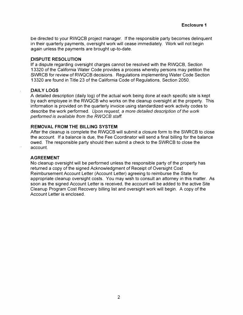
be directed to your RWQCB project manager. If the responsible party becomes delinquent in their quarterly payments, oversight work will cease immediately. Work will not begin again unless the payments are brought up-to-date.
DISPUTE RESOLUTION If a dispute regarding oversight charges cannot be resolved with the RWQCB, Section 13320 of the California Water Code provides a process whereby persons may petition the SWRCB for review of RWQCB decisions. Regulations implementing Water Code Section 13320 are found in Title 23 of the California Code of Regulations, Section 2050.
DAILY LOGS A detailed description (daily log) of the actual work being done at each specific site is kept by each employee in the RWQCB who works on the cleanup oversight at the property. This information is provided on the quarterly invoice using standardized work activity codes to describe the work performed. Upon request, a more detailed description of the work performed is available from the RWQCB staff.
REMOVAL FROM THE BILLING SYSTEM After the cleanup is complete the RWQCB will submit a closure form to the SWRCB to close the account. If a balance is due, the Fee Coordinator win send a final billing for the balance owed. The responsible party should then submit a check to the SWRCB to close the account.
AGREEMENT No cleanup oversight will be performed unless the responsible party of the property has returned a copy of the signed Acknowledgment of Receipt of Oversight Cost Reimbursement Account Letter (Account Letter) agreeing to reimburse the State for appropriate cleanup oversight costs. You may wish to consult an attorney in this matter. As soon as the signed Account Letter is received, the account will be added to the active Site Cleanup Program Cost Recovery billing list and oversight work will begin. A copy of the Account Letter is enclosed.
2
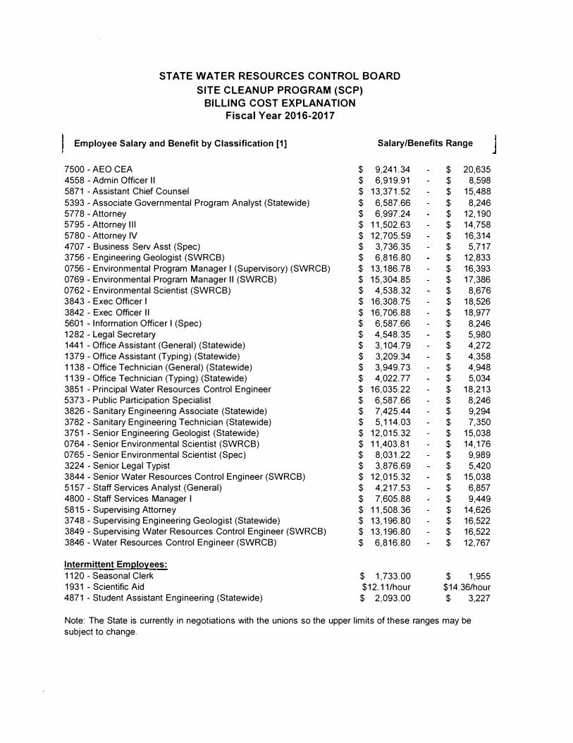
STATE WATER RESOURCES CONTROL BOARD SITE CLEANUP PROGRAM (SCP)
BILLING COST EXPLANATION Fiscal Year 2016-2017
Employee Salary and Benefit by Classification [1] Salary/Benefits Range
7500 - AEO CEA $ 9,241.34 $ 20,635 4558 -Admin Officer II $ 6,919.91 $ 8,598 5871 -Assistant Chief Counsel $ 13,371.52 $ 15,488 5393 -Associate Governmental Program Analyst (Statewide) $ 6,587.66 $ 8,246 5778 - Attorney $ 6,997.24 $ 12,190 5795 -Attorney Ill $ 11,502.63 $ 14,758 5780 -Attorney IV $ 12,705.59 $ 16,314 4707 - Business Serv Asst (Spec) $ 3,736.35 $ 5,717 3756 -Engineering Geologist (SWRCB) $ 6,816.80 $ 12,833 0756 -Environmental Program Manager I (Supervisory) (SWRCB) $ 13,186.78 $ 16,393 0769 - Environmental Program Manager II (SWRCB) $ 15,304.85 $ 17,386 0762 - Environmental Scientist (SWRCB) $ 4,538.32 $ 8,676 3843 -Exec Officer I $ 16,308.75 $ 18,526 3842 -Exec Officer II $ 16,706.88 $ 18,977 5601 - Information Officer I (Spec) $ 6,587.66 $ 8,246 1282 -Legal Secretary $ 4,548.35 $ 5,980 1441 -Office Assistant (General) (Statewide) $ 3,104.79 $ 4,272 1379 -Office Assistant (Typing) (Statewide) $ 3,209.34 $ 4,358 1138 - Office Technician (General) (Statewide) $ 3,949.73 $ 4,948 1139 -Office Technician (Typing) (Statewide) $ 4,022.77 $ 5,034 3851 -Principal Water Resources Control Engineer $ 16,035.22 $ 18,213 5373 - Public Participation Specialist $ 6,587.66 $ 8,246 3826 - Sanitary Engineering Associate (Statewide) $ 7,425.44 $ 9,294 3782 - Sanitary Engineering Technician (Statewide) $ 5,114.03 $ 7,350 3751 - Senior Engineering Geologist (Statewide) $ 12,015.32 $ 15,038 0764 - Senior Environmental Scientist (SWRCB) $ 11,403.81 $ 14,176 0765 -Senior Environmental Scientist (Spec) $ 8,031.22 $ 9,989 3224 - Senior Legal Typist $ 3,876.69 $ 5,420 3844 - Senior Water Resources Control Engineer (SWRCB) $ 12,015.32 $ 15,038 5157 -Staff Services Analyst (General) $ 4,217.53 $ 6,857 4800 -Staff Services Manager I $ 7,605.88 $ 9,449 5815 - Supervising Attorney $ 11,508.36 $ 14,626 3748 -Supervising Engineering Geologist (Statewide) $ 13,196.80 $ 16,522 3849 -Supervising Water Resources Control Engineer (SWRCB) $ 13,196.80 $ 16,522 3846 -Water Resources Control Engineer (SWRCB) $ 6,816.80 $ 12,767
Intermittent Em12lo:tees:
1120 -Seasonal Clerk $ 1,733.00 $ 1,955 1931 -Scientific Aid $12.11/hour $14.36/hour 4871 -Student Assistant Engineering (Statewide) $ 2,093.00 $ 3,227
Note: The State is currently in negotiations with the unions so the upper limits of these ranges may be subject to change.
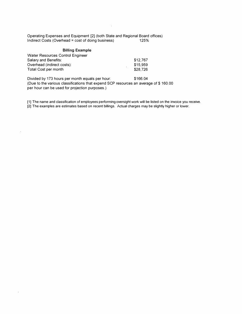
Operating Expenses and Equipment [2] (both State and Regional Board offices) Indirect Costs (Overhead= cost of doing business) 125%
Billing Example
Water Resources Control Engineer Salary and Benefits: Overhead (indirect costs): Total Cost per month
$12,767 $15,959 $28,726
Divided by 173 hours per month equals per hour: $166.04 (Due to the various classifications that expend SCP resources an average of $ 160.00 per hour can be used for projection purposes.)
[1] The name and classification of employees performing oversight work will be listed on the invoice you receive.
[2] The examples are estimates based on recent billings. Actual charges may be slightly higher or lower.
ACKNOWLEDGMENT OF RECEIPT OF
OVERSIGHT COST REIMBURSEMENT ACCOUNT LETTER
Enclosure 3
I, ------------------' acting within the authority vested in me as an
authorized representative of acknowledge that I have received and
read a copy of the attached REIMBURSEMENT PROCESS FOR REGULATORY OVERSIGHT and the
cover letter dated March 10, 2017, concerning cost reimbursement for Regional Board staff costs
involved with oversight of cleanup and abatement efforts at the Orange County Groundwater Basin,
North Basin. The address for this site is Fullerton/ Anaheim, California.
I understand the reimbursement process and billing procedures as explained in the letter. The
undersigned is willing to participate in the cost recovery program and pay all subsequent billings in
accordance with the terms in your letter and its attachments, and to the extent required by law. I also
understand that signing this form does not constitute any admission of liability, but rather an intent to pay
for costs associated with oversight, as set forth above, and to the extent required by law. Billings for
payment of oversight costs should be mailed to the following individual and address:
Staff: MG
BILLING CONTACT
BILLING ADDRESS
TELEPHONE NO.
RESPONSIBLE PARTY'S SIGNATURE
DATE:
(Signature)
(Title)
Electronic Submittal of Information
Geo Tracker Reporting Requirements
Enclosure 4
What are the State Water Board electronic data submittal requirements?
The Electronic Reporting Regulations (Chapter 30, Division 3 of Title 23 & Division 3 of Title 27, CCR) require electronic submission of any report or data required by a regulatory agency from a cleanup site. Submission dates are set by a Regional Water Board or by a regulatory agency. Once a report/data is successfully uploaded, as required, you have met the reporting requirement (i.e. the compliance measure for electronic submittals is the actual upload itself). The upload date should be on or prior to the regulatory due date.
What this means:
• Lab Data: Analytical data (including geochemical data) for all soil, vapor and water samples that are collected for the purpose of subsurface investigation or remediation are required to be submitted in specified EDF format to a regulatory agency. These data are required to be submitted in electronic format to the State Water Board's Geotracker system via the Internet. Groundwater, soil and vapor samples include: monitor well samples, borehole samples, gas and vapor samples, groundwater grab samples, piezometer samples, stockpile samples and samples from drinking water wells.
• Boring Logs and Well Screen Intervals: Boring logs must be prepared by an appropriate registered professional and need to be submitted in PDF format. If a monitor well is installed, the screen depth and interval must be reported.
• Depth to Water Data: Monitor wells need to have the depth-to-water information reported in the GEO _WELL file whenever the data is collected, even if the well is not actually sampled during the sampling event. Drinking water wells generally do not need to have the depth to water reported unless they are surveyed as permanent sampling points. A permanent sampling point is defined as a point that is sampled for more than a 30-day period.
• Locational Data: If samples from the permanent sampling locations are included in a regulatory report to a regulatory agency as part of a cleanup program, these sampling points must be surveyed. This would typically include any groundwater or similar monitoring points at the site or any drinking water wells that are included in the regulatory report. The surveyed locational information for

Enclosure 4
these sampling points should be submitted using the Geo_XY file. Transient or one-time sampling points (e.g. direct push technologies, piezometers, or grab samples often used for rapid site characterization, stockpile sampling points ... ) do not need to be surveyed. Permanent influent/effluent sampling locations do need to be surveyed as well. Transient sampling point (a point that is sampled for less than 30 days) are not required to be surveyed.
• Elevation Data: Elevation measurements to the top of groundwater well casings are required for all groundwater monitoring wells (to be submitted as part of the GEO_Z file). Drinking water wells included in the report, do not need to have the elevation reported unless they are identified as permanent sampling points.
• Site Map: An electronic generalized site plan map is required to be submitted into the State database (GEO _MAP). Site map should display tank locations, streets bordering the facility, and sampling locations for all soil, water and vapor samples. The site map is a stand-alone document that may be submitted in various formats. Additional updated site map may be submitted at any time.
• Paperless Reporting Requirement: As of January 1, 2005, a complete copy of all clean-up and monitoring reports must be submitted to GeoTracker. This uploaded PDF report may include the signed transmittal letter, professional certification and all data that are uploaded into the GeoTracker.
The survey data (latitude/longitude and elevation), depth-to-water, and site map information files must be submitted as required to the SWRCB's GeoTracker database via the Internet in accordance with the Geotracker XYZ survey Guidelines and Restrictions.
For more information and guidelines for submittal of data and documents go to State Water Resources Control Board's website on Electronic Submittal of Information at http://www.waterboards.ca.gov/ust/electronic submittal/index.shtml

7
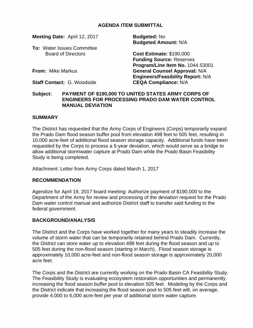
AGENDA ITEM SUBMITTAL Meeting Date: April 12, 2017 Budgeted: No Budgeted Amount: N/A To: Water Issues Committee Board of Directors Cost Estimate: $190,000 Funding Source: Reserves Program/Line Item No. 1044.53001 From: Mike Markus General Counsel Approval: N/A Engineers/Feasibility Report: N/A Staff Contact: G. Woodside CEQA Compliance: N/A Subject: PAYMENT OF $190,000 TO UNITED STATES ARMY CORPS OF
ENGINEERS FOR PROCESSING PRADO DAM WATER CONTROL MANUAL DEVIATION
SUMMARY The District has requested that the Army Corps of Engineers (Corps) temporarily expand the Prado Dam flood season buffer pool from elevation 498 feet to 505 feet, resulting in 10,000 acre-feet of additional flood season storage capacity. Additional funds have been requested by the Corps to process a 5-year deviation, which would serve as a bridge to allow additional stormwater capture at Prado Dam while the Prado Basin Feasibility Study is being completed. Attachment: Letter from Army Corps dated March 1, 2017 RECOMMENDATION Agendize for April 19, 2017 board meeting: Authorize payment of $190,000 to the Department of the Army for review and processing of the deviation request for the Prado Dam water control manual and authorize District staff to transfer said funding to the federal government.
BACKGROUND/ANALYSIS The District and the Corps have worked together for many years to steadily increase the volume of storm water that can be temporarily retained behind Prado Dam. Currently, the District can store water up to elevation 498 feet during the flood season and up to 505 feet during the non-flood season (starting in March). Flood season storage is approximately 10,000 acre-feet and non-flood season storage is approximately 20,000 acre feet. The Corps and the District are currently working on the Prado Basin CA Feasibility Study. The Feasibility Study is evaluating ecosystem restoration opportunities and permanently increasing the flood season buffer pool to elevation 505 feet. Modeling by the Corps and the District indicate that increasing the flood season pool to 505 feet will, on average, provide 4,000 to 6,000 acre-feet per year of additional storm water capture.
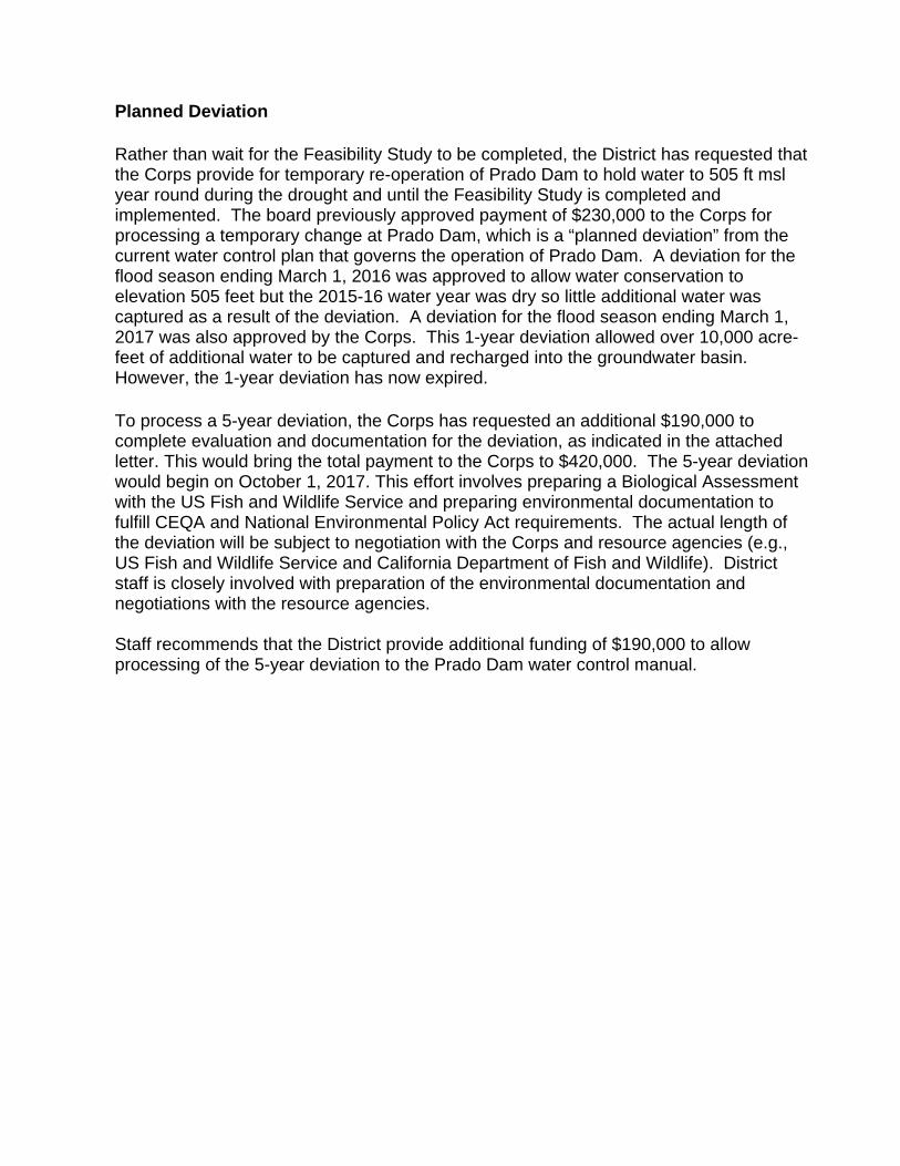
Planned Deviation Rather than wait for the Feasibility Study to be completed, the District has requested that the Corps provide for temporary re-operation of Prado Dam to hold water to 505 ft msl year round during the drought and until the Feasibility Study is completed and implemented. The board previously approved payment of $230,000 to the Corps for processing a temporary change at Prado Dam, which is a “planned deviation” from the current water control plan that governs the operation of Prado Dam. A deviation for the flood season ending March 1, 2016 was approved to allow water conservation to elevation 505 feet but the 2015-16 water year was dry so little additional water was captured as a result of the deviation. A deviation for the flood season ending March 1, 2017 was also approved by the Corps. This 1-year deviation allowed over 10,000 acre-feet of additional water to be captured and recharged into the groundwater basin. However, the 1-year deviation has now expired. To process a 5-year deviation, the Corps has requested an additional $190,000 to complete evaluation and documentation for the deviation, as indicated in the attached letter. This would bring the total payment to the Corps to $420,000. The 5-year deviation would begin on October 1, 2017. This effort involves preparing a Biological Assessment with the US Fish and Wildlife Service and preparing environmental documentation to fulfill CEQA and National Environmental Policy Act requirements. The actual length of the deviation will be subject to negotiation with the Corps and resource agencies (e.g., US Fish and Wildlife Service and California Department of Fish and Wildlife). District staff is closely involved with preparation of the environmental documentation and negotiations with the resource agencies. Staff recommends that the District provide additional funding of $190,000 to allow processing of the 5-year deviation to the Prado Dam water control manual.
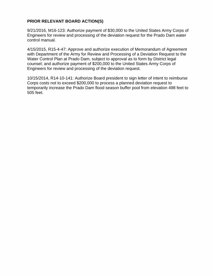
PRIOR RELEVANT BOARD ACTION(S) 9/21/2016, M16-123: Authorize payment of $30,000 to the United States Army Corps of Engineers for review and processing of the deviation request for the Prado Dam water control manual. 4/15/2015, R15-4-47: Approve and authorize execution of Memorandum of Agreement with Department of the Army for Review and Processing of a Deviation Request to the Water Control Plan at Prado Dam, subject to approval as to form by District legal counsel; and authorize payment of $200,000 to the United States Army Corps of Engineers for review and processing of the deviation request. 10/15/2014, R14-10-141: Authorize Board president to sign letter of intent to reimburse Corps costs not to exceed $200,000 to process a planned deviation request to temporarily increase the Prado Dam flood season buffer pool from elevation 498 feet to 505 feet.
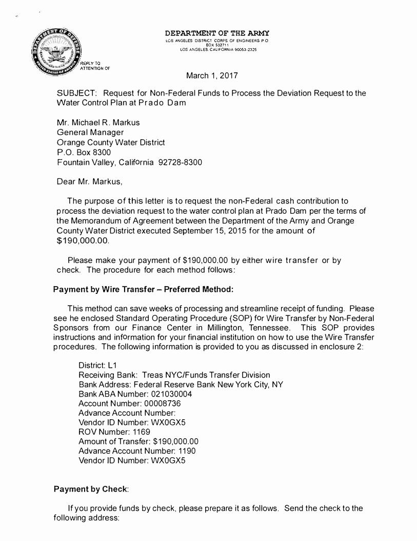
DEPARTMENT OF THE ARMY LOS �NGELES DISTRICT CORPS OF ENGINEERS P 0
BOX S3271 1 LOS ANGELES. CALIFORNIA 90053-2325
March 1 , 201 7
SUBJECT: Request for Non-Federa l Funds to Process the Deviation Request to the Water Control P lan at P r a d o D a m
Mr. Michael R . Markus Genera l Manager Orange County Water District P .O . Box 8300 Founta in Val ley, Ca l iforn ia 92728-8300
Dear Mr. Markus ,
The purpose of th is letter is to request the non-Federa l cash contribution to p rocess the deviation request to the water control p lan at Prado Dam per the terms of the Memorandum of Agreement between the Depa rtment of the Army and Orange County Water District executed September 1 5, 20 1 5 for the amount of $1 90,000.00.
Please make your payment of $ 1 90,000.00 by e ither w i re t r a n sfe r or by c heck. The procedu re for each method fol lows :
Payment by Wire Transfer - Preferred Method :
This method can save weeks of processing and streaml ine receipt of funding . Please see he enclosed Standard Operating Procedure (SOP) for Wire Transfer by Non-Federal S ponsors from our F inance Center i n Mi l l i ngton, Ten nessee . This SOP provides instructions and information for you r financia l institution on how to use the Wire Transfer p rocedures. The fol lowing i nformation is provided to you as d iscussed i n enclosure 2 :
D istrict: L 1 Receiving Bank: Treas NYC/Funds Transfer Division Bank Address: Federal Reserve Bank New York City, NY Bank ABA Number: 02 1 030004 Account N umber: 00008736 Advance Account Number: Vendor ID Number: WXOGX5 ROV Number: 1 1 69 Amount of Transfer: $ 1 90,000.00 Advance Account Number: 1 1 90 Vendor ID Number: WXOGX5
Payment by Check:
If you provide funds by check, p lease prepare it as fol lows . Send the check to the fol lowing address:
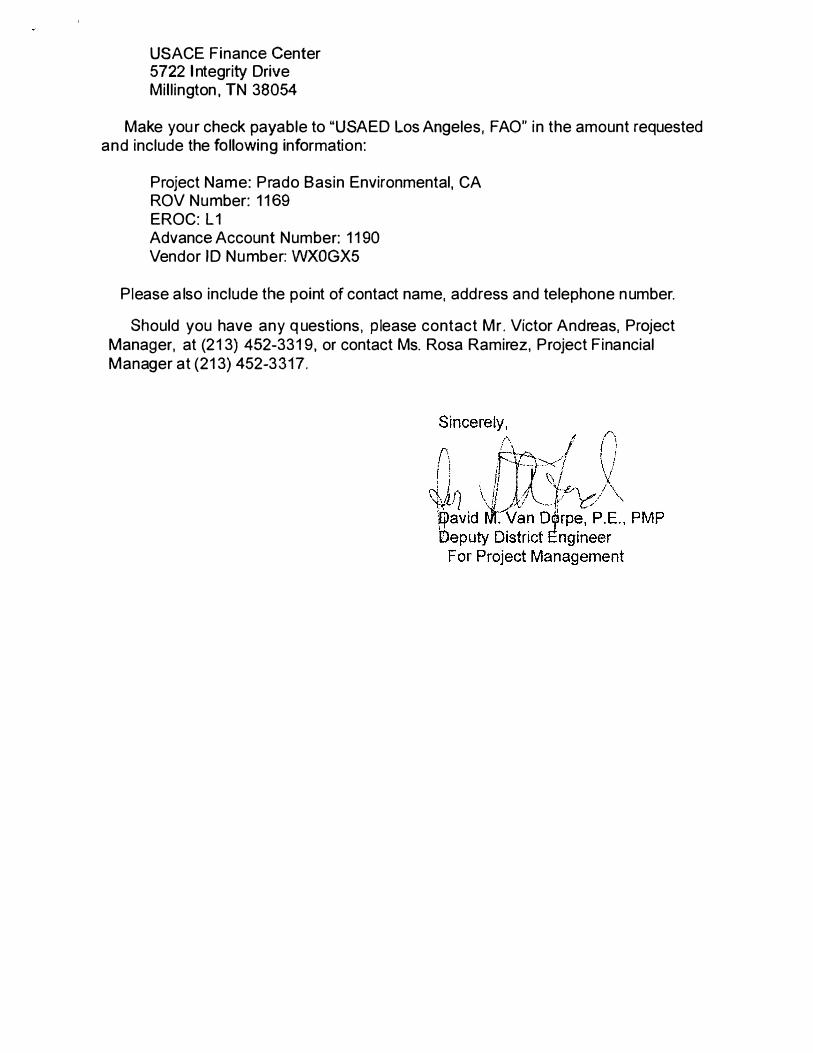
USACE Finance Center 5722 I ntegrity Drive Mil l ington , TN 38054
Make you r check payable to "USAED Los Angeles, FAO" in the amount requested and include the following information:
Project Name: Prado Basin Environmental, CA ROV Number: 1 1 69 EROC: L1 Advance Account Number: 1 1 90 Vendor ID Number: WXOGX5
Please a lso include the point of contact name, address and telephone number.
Should you have any q uestions, p lease contact Mr . Victor Andreas, Project Manager, at (21 3) 452-331 9, or contact Ms. Rosa Ramirez, Project Financial Manager at (21 3) 452-3317.

8

AGENDA ITEM SUBMITTAL Meeting Date: April 12, 2017 Budgeted: Yes Budgeted Amount: $100,000 To: Water Issues Committee Cost Estimate: $94,000 Board of Directors Funding Source: R&R Program/Line Item No. R15018 From: Mike Markus General Counsel Approval: N/A Engineers/Feasibility Report: N/A Staff Contact: C. Olsen/B. Smith CEQA Compliance: N/A Subject: AGREEMENT TO V&A CONSULTING ENGINEERS FOR CATHODIC
PROTECTION DESIGN OF THE GAP NEWPORT BEACH AND SOUTHEAST LOOP PIPELINES
SUMMARY A Request for Proposals (RFP) for a Cathodic Protection Design of the Green Acres Project (GAP) Newport Beach and Southeast Loop Pipelines was issued in February 2017. Five proposals have been received and evaluated. Staff recommends awarding the project design to V&A Consulting Engineers for an amount not to exceed $94,000. RECOMMENDATION Agendize for April 19 Board meeting: Authorize issuance of Agreement to V&A Consulting Engineers for Cathodic Protection Design of the GAP Newport Beach and Southeast Loop Pipelines for an amount not to exceed $94,000. BACKGROUND/ANALYSIS OCWD has numerous facilities that are made of ferrous metal that have a possibility of corroding due to the soil they are buried within and if not monitored, they could leak or breakdown prematurely. OCWD facilities that require cathodic protection to reduce corrosion have either a passive system or impressed current system. The facilities that have a passive system require periodic inspections to assure that a corrosive environment is not occurring. The systems with an impressed current protection require monthly readings on the rectifiers to ensure that the electrical readings remain constant and therefore the facility remains protected. Corrosion surveys of District pipelines have most recently been completed in 2016 and 2011. Several portions of District pipeline have been identified to need cathodic protection because their potential readings indicate they are being actively corroded. Staff will direct the design and construction of these pipelines with an incremental approach. The next pipeline portion to have cathodic protection designed for it is a part of the GAP distribution system in Newport Beach, Costa Mesa, and Santa Ana. A Request for Proposals (RFP) for cathodic protection design was issued in February 2017 via publication to the District website and direct invitation of eight consulting firms. Five proposals were received by the due date of March 23, 2017. The proposals were
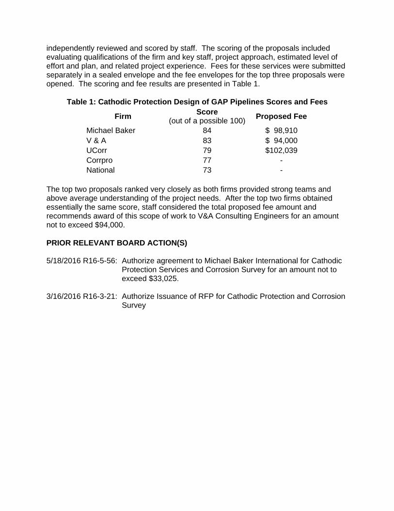
independently reviewed and scored by staff. The scoring of the proposals included evaluating qualifications of the firm and key staff, project approach, estimated level of effort and plan, and related project experience. Fees for these services were submitted separately in a sealed envelope and the fee envelopes for the top three proposals were opened. The scoring and fee results are presented in Table 1.
Table 1: Cathodic Protection Design of GAP Pipelines Scores and Fees
Firm Score (out of a possible 100) Proposed Fee
Michael Baker 84 $ 98,910 V & A 83 $ 94,000 UCorr 79 $102,039 Corrpro 77 - National 73 -
The top two proposals ranked very closely as both firms provided strong teams and above average understanding of the project needs. After the top two firms obtained essentially the same score, staff considered the total proposed fee amount and recommends award of this scope of work to V&A Consulting Engineers for an amount not to exceed $94,000. PRIOR RELEVANT BOARD ACTION(S) 5/18/2016 R16-5-56: Authorize agreement to Michael Baker International for Cathodic
Protection Services and Corrosion Survey for an amount not to exceed $33,025.
3/16/2016 R16-3-21: Authorize Issuance of RFP for Cathodic Protection and Corrosion
Survey

9

1
AGENDA ITEM SUBMITTAL Meeting Date: April 12, 2017 Budgeted: No Budgeted Amount: $0 To: Water Issues Committee Cost Estimate: $14,000 Board of Directors Funding Source: General Reserves Program/ Line Item No. From : Mike Markus General Counsel Approval: N/A Engineers/Feasibility Report: N/A Staff Contact: M. Plumlee/M. Patel CEQA Compliance: N/A Subject: REPLACEMENT OF TWO SPECTROPHOTOMETERS FOR W ATER
QUALITY ANALYSIS BY R&D AND WATER PRODUCTION DEPARTMENTS
SUMMARY The Research & Development (R&D) Department seeks to purchase a new Hach DR 6000 UV Vis Spectrophotometer to replace an older model that was purchased in 2004 and is no longer operating correctly. Similarly, the Water Production Department seeks to purchase the same spectrophotometer to replace an older, non-functioning model. Both departments routinely use the instruments for water quality analysis. Attachment(s): Quote No. 100143779v6 from Hach for two DR 6000 UV Vis Spectrophotometers, dated 5/15/2017. RECOMMENDATION Agendize for April 19 Board meeting: Authorize issuance of Purchase Order to Hach in an amount not to exceed $14,000 to purchase two spectrophotometers to replace the Research & Development Department’s previous unit and the Water Production Department’s previous unit. BACKGROUND/ANALYSIS The Research & Development (R&D) Department seeks to purchase a new Hach DR 6000 UV Vis Spectrophotometer to replace an older model that was purchased in 2004 and is no longer operating correctly. R&D staff routinely use the Hach spectrophotometer for several ongoing studies. The spectrophotometer will be located in the R&D laboratory. Current projects in R&D that make use of the Hach spectrophotometer include grant- funded studies on formation of the disinfection byproduct NDMA during water treatment, destruction of trace organics such as pharmaceuticals and 1,4-dioxane during the ultraviolet/advanced oxidation process (UV/AOP), and prevention of microfiltration fouling. Specifically, the Hach spectrophotomer is used by R&D to make the following water quality measurements in a much more rapid and efficient manner as compared to bringing samples to the District’s main laboratory for traditional analysis:

2
x Total chlorine x Chloramine x Free chlorine
x Ammonia x Nitrate x Nitrite
In addition, the Water Production Department seeks to purchase the same model for their own use, to replace an older spectrophotometer that recently became non-functional. The new spectrophotometer will be located in the Water Production Department’s Operations Laboratory located near the Control Room. The Operations Chemist makes weekly water quality measurements at sampling locations in the Advanced Water Purification Facility (AWPF) to monitor plant performance. This includes analysis of iron and phosphate, ammonia, calcium, UV transmittance, and other constituents. The Hach DR 6000 UV Vis Spectrophotometer provides high speed wavelength scanning across the UV and visible spectrum, and comes with over 250 pre-programmed methods including many common water quality constituents. The standard purchase price is approximately $9,000 per unit; however, staff has negotiated a 30% discount. Staff obtained a quote from Hach for $12,360 for the two units (net unit price of $6,180 each), attached. Accounting for sales tax and shipping, the estimated total expenditure is approximately $14,000. PRIOR RELEVANT BOARD ACTION(S): None

6,180.00 12,360.00
12,360.00
Quotation
Quote Number: 100143779v6Use quote number at time of order to ensurethat you receive prices quoted
HachPO Box 608Loveland, CO 80539-0608Phone: (800) 227-4224Email: [email protected]: www.hach.com
Quote Date: 09-Feb-2017 Quote Expiration: 15-May-2017
Orange County Water District18700 Ward StreetFOUNTAIN VALLEY, CA 92708 Name: Jana SafarikPhone: (714) 378-3282Email: [email protected]
Customer Account Number : 105388
Sales Contact: Mark Cowdell Email: [email protected] Phone: 714-222-1741
PRICING QUOTATION
Line Part Number Descript ion Qty Net Unit Price Extended Price
1 LPV441.99.00012
DR 6000 UV VIS SPECTROPHOTOMETER W RFID TECHNOLOGY, successor ofDR 5000 photometer item.-no. DR5000-03, same technology like DR 3900item no. LPV440.99.00012 but having additionally UV capability, deuteriumlamp.
2
Grand Total $
TERMS OF SALE
Freight: Ground Prepay and Add FCA: Hach's facility
All purchases of Hach Company products and/or services are expressly and without limitation subject to Hach Company's Terms & Conditions of Sale ("Hach TCS"), incorporatedherein by reference and published on Hach Company's website at www.hach.com/terms . Hach TCS are contained directly and/or by referen ce in Hach's offer, order acknowledgment,and invoice documents. The first of the following acts constitutes an acceptance of Hach's offer and not a counteroffer and creates a contract of sale "Contract" in accordance with theHach TCS: (i) Buyer's issuance of a purchase order document against Hach's offer; (ii) acknowledgement of Buyer's order by Hach; or (iii) commencement of any performance by Hach pursuant to Buyer's order. Provisions contained in Buyer's purchase documents (including electronic commerce interfaces) that materially alter, add to or subtract from the provisions of the Hach TCS are not part of the Contract.
Due to International regulations, a U.S. Department of Commerce Export License may be required. Hach reserves the right to approve specific shipping agents. Wooden boxes suitablefor ocean shipment are extra. Specify final destination to ensure proper documentation and packing suitable for International transport. In addition, Hach may require : 1). A statementof intended end-use; 2).Certification that the intended end-use does not relate to proliferation of weapons of mass destruction (prohibited nuclear end use, chemical / biologicalweapons, missile technology); and 3). Certification that the goods will not be diverted contrary to U.S. law.
ORDER TERMS: Terms are Subject to Credit Review Please reference the quotation number on your purchase order. Sales tax is not included. Applicable sales tax will be added to the invoice based on the U.S. destination, if applicable provide a resale/exemption certificate. Shipments will be prepaid and added to invoices unless otherwise specified. Equipment quoted operates with standard U.S. supply voltage. Hach standard terms and conditions apply to all sales. Additional terms and conditions apply to orders for service partnerships. Prices do not include delivery of product. Reference attached Freight Charge Schedule and Collect Handling Fees. Standard lead time is 30 days.This Quote is good for a one time purchase.
Page 1 of 2

Sales Contact: Prepared By:Name: Mark Cowdell Name: Stephanie HarstadTitle: Regional Sales Manager Title: Field Sales Support SpecialistPhone: 714-222-1741 Phone: 800-227-4224Email: [email protected] Email: [email protected]
Page 2 of 2
HACH COMPANY Headquarters U.S.A. Remittance
Quotation Addendum
P.O. Box 389 5600 Lindbergh Drive Loveland, CO 80539-0389 Purchase Orders PO Box 608 Loveland, CO 80539-0608 WebSite : www.hach.com
Phone: 800-227-4224 Fax: 970-669-2932 E-Mail: [email protected] [email protected] [email protected] Export Phone: 970-669-3050 Fax: 970-461-3939 Email: [email protected]
2207 Collections Center Drive Chicago, IL 60693 Wire Transfers Bank of America 231 S. LaSalle St. Chicago, IL 60604 Account: 8765602385 Routing (ABA): 071000039
ADVANTAGES OF WORKING WITH HACH
Technical Support SIRR Delivery Program Hach WarrantyPlus™ Upgrade
Provides post-sale instrumentation and application support
9 Hach’s highly skilled Technical Support staff is dedicated to helping you resolve technical issues before, during and after the sale.
9 Available via phone, e-mail, or live online chat at Hach.com!
9 Toll-free phone: 800-227-4224 9 E-mail: [email protected]
The Scheduled Inventory Reagent Replacement (SIRR) Program offers an uninterrupted supply of reagents
9 Lower inventory costs and fresh supplies 9 Reduced paperwork – one purchase
order for the entire year 9 Automatic shipments on your schedule 9 Easier budgeting
Instrument Protection and Service
9 Savings of more than 20% versus a “pay as you go” approach
9 Freedom from maintenance 9 Worry-free compliance with Hach’s
certification 9 Fixed maintenance budget for the
entire year
www.Hach.com www.Hach.com/sirr www.Hach.com/warrantyplus ADVANTAGES OF SIMPLIFIED SHIPPING AND HANDLING
Safe & Fast Delivery Save Time – Less Hassle Save Money
9 Receive tracking numbers on your order acknowledgement
9 Hach will assist with claims if an order is lost or damaged in shipment
9 No need to set up deliveries for orders or to schedule pickup
9 Hach ships order as product is available, at no additional charge, when simplified shipping and handling is used.
9 No additional invoice to process – save on time and administrative costs
9 Only pay shipping once, even if multiple shipments are required
STANDARD SIMPLIFIED SHIPPING AND HANDLING CHARGES 1, 2, 3 Pricing Effective 10/3/2016 Collect 4
Total Price of Merchandise Ordered
Standard Surface
(Mainland USA)
Second Day Delivery
(Mainland USA)
Next Day Delivery
(Mainland USA)
Second Day Delivery
(Alaska & Hawaii)
Next Day Delivery
(Alaska & Hawaii)
Handling Fee Effective
10/3/2016
$0.00 - $49.99 $11.99 $29.99 $54.99 $44.95 $85.45 $7.98
$50.00 - $149.99 $17.79 $52.45 $98.97 $71.64 $136.19 $8.21
$150.00 - $349.99 $30.89 $79.43 $161.79 $100.23 $195.06 $8.72
$350.00 - $649.99 $41.67 $108.95 $216.68 $136.20 $263.73 $9.18
$650.00 - $949.99 $52.77 $114.40 $239.39 $141.65 $267.00 $9.50
$950.00 - $1,999.99 $66.39 $141.16 $298.48 $167.98 $325.04 $10.37
$2,000.00 - $3,999.99 $76.27 $151.01 $305.84 $173.67 $330.31 $11.99
$4,000.00 - $5,999.99 $88.42 $155.77 $320.61 $174.47 $339.85 $14.76
$6,000.00 - $7,999.99 $104.48 $176.56 $355.05 $192.45 $371.02 $17.22
$8,000.00 - $9,999.99 $119.79 $201.60 $393.94 $215.71 $409.10 $19.87
Over $10,000 2% of Net
Order Value 4% of Net
Order Value 6% of Net
Order Value 4% of Net
Order Value 6% of Net
Order Value $30.43
1 Shipping & Handling charges shown are only applicable to orders billing and shipping to U.S. destinations. Shipping & Handling charges will be prepaid and added to invoice. Shipping & Handling for the Reagent Delivery Program is charged on each shipment release and is based on the total price of each shipment release. Shipping & Handling charges are subject to change without notice.
2 Additional Shipping & Handling charges will be applied to orders containing bulky and/or especially heavy orders. Refrigerated and all weather Samplers do not qualify for simplified Shipping & Handling charges, and are considered heavy products. Dissolved Oxygen Sensors can be damaged if exposed to temps below freezing, causing sensor failure. Must be shipped over night or 2nd day air during the cold weather months.
3 Orders shipping to Alaska or Hawaii: Additional Shipping & Handling charges may be applied at time of order processing. Second Day and Next Day delivery is not available to all destinations.
4 Hach Company will assess a collect handling fee on orders with collect shipping terms. This handling fee covers the additional costs that Hach Company incurs from processing and managing collect shipments.
SALES TAX
Sales Tax is not included in the attached quotation. Applicable sales and usage taxes will be added to your invoice, at the time of order, based on U.S. destination of goods, unless a valid resale/exemption certificate for destination state is provided to the above address or fax number, attention of the Tax Dept.

TERMS & CONDITIONS OF SALE FOR HACH COMPANY PRODUCTS AND SERVICES
1
This document sets forth the Terms & Conditions of Sale for goods manufactured and/or supplied, and services provided, by Hach Company of Loveland, Colorado (“Hach”) and sold to the original purchaser thereof (“Buyer”). Unless otherwise specifically stated herein, the term “Hach” includes only Hach Company and none of its affiliates. Unless otherwise specifically stated in a previously-executed written purchase agreement signed by authorized representatives of Hach and Buyer, these Terms & Conditions of Sale establish the rights, obligations and remedies of Hach and Buyer which apply to this offer and any resulting order or contract for the sale of Hach’s goods and/or services (“Products”). 1. APPLICABLE TERMS & CONDITIONS: These Terms & Conditions of Sale are contained directly and/or by reference in Hach’s offer, order acknowledgment, and invoice documents. The first of the following acts constitutes an acceptance of Hach’s offer and not a counteroffer and creates a contract of sale (“Contract”) in accordance with these Terms & Conditions: (i) Buyer’s issuance of a purchase order document against Hach’s offer; (ii) acknowledgement of Buyer’s order by Hach; or (iii) commencement of any performance by Hach pursuant to Buyer’s order. Provisions contained in Buyer’s purchase documents (including electronic commerce interfaces) that materially alter, add to or subtract from the provisions of these Terms & Conditions of Sale are not a part of the Contract. 2. CANCELLATION: Buyer may cancel goods orders subject to fair charges for Hach’s expenses including handling, inspection, restocking, freight and invoicing charges as applicable, provided that Buyer returns such goods to Hach at Buyer’s expense within 30 days of delivery and in the same condition as received. Buyer may cancel service orders on ninety (90) day’s prior written notice and refunds will be prorated based on the duration of the service plan. Inspections and re-instatement fees may apply upon cancellation or expiration of service programs. Seller may cancel all or part of any order prior to delivery without liability if the order includes any Products that Seller determines may not comply with export, safety, local certification, or other applicable compliance requirements.
3. DELIVERY: Delivery will be accomplished FCA Hach’s facility located in Ames, Iowa or Loveland, Colorado, United States (Incoterms 2010). For orders having a final destination within the U.S., legal title and risk of loss or damage pass to Buyer upon transfer to the first carrier. For orders having a final destination outside the U.S., legal title and risk of loss or damage pass to Buyer when the Products enter international waters or airspace or cross an international frontier. Hach will use commercially reasonable efforts to deliver the Products ordered herein within the time specified on the face of this Contract or, if no time is specified, within Hach’s normal lead-time necessary for Hach to deliver the Products sold hereunder. Upon prior agreement with Buyer and for an additional charge, Hach will deliver the Products on an expedited basis. Standard service delivery hours are 8 am – 5 pm Monday through Friday, excluding holidays.
4. INSPECTION: Buyer will promptly inspect and accept any Products delivered pursuant to this Contract after receipt of such Products. In the event the Products do not conform to any applicable specifications, Buyer will promptly notify Hach of such nonconformance in writing. Hach will have a reasonable opportunity to repair or replace the nonconforming product at its option. Buyer will be deemed to have accepted any Products delivered hereunder and to have waived any such nonconformance in the event such a written notification is not received by Hach within thirty (30) days of delivery. 5. PRICES & ORDER SIZES: All prices are in U.S. dollars and are based on delivery as stated above. Prices do not include any charges for services such as insurance; brokerage fees; sales, use, inventory or excise taxes; import or export duties; special financing fees; VAT, income or royalty taxes imposed outside the U.S.; consular fees; special permits or licenses; or other charges imposed upon the production, sale, distribution, or delivery of Products. Buyer will either pay any and all such charges or provide Hach with acceptable exemption certificates, which obligation survives performance under this Contract. Hach reserves the right to establish minimum order sizes and will advise Buyer accordingly. 6. PAYMENTS: All payments must be made in U.S. dollars. For Internet orders, the purchase price is due at the time and manner set forth at www.hach.com. Invoices for all other orders are due and payable NET 30 DAYS from date of the invoice without regard to delays for inspection or transportation, with payments to be made by check to Hach at the above address or by wire transfer to the account stated on the front of Hach’s invoice, or for customers with no established credit, Hach may require cash or credit card payment in advance of delivery. In the event payments are not made or not made in a timely manner, Hach may, in addition to all other remedies provided at law, either: (a) declare Buyer’s performance in breach and terminate this Contract for default; (b) withhold future shipments until delinquent payments are made; (c) deliver future shipments on a cash-with-order or cash-in-advance basis even after the delinquency is cured; (d) charge interest on the delinquency at a rate of 1-1/2% per month or the maximum rate permitted by law, if lower, for each month or part thereof of delinquency in payment plus applicable storage charges and/or inventory carrying charges; (e) repossess the Products for which payment has not been made; (f) recover all costs of collection
including reasonable attorney’s fees; or (g) combine any of the above rights and remedies as is practicable and permitted by law. Buyer is prohibited from setting off any and all monies owed under this from any other sums, whether liquidated or not, that are or may be due Buyer, which arise out of a different transaction with Hach or any of its affiliates. Should Buyer’s financial responsibility become unsatisfactory to Hach in its reasonable discretion, Hach may require cash payment or other security. If Buyer fails to meet these requirements, Hach may treat such failure as reasonable grounds for repudiation of this Contract, in which case reasonable cancellation charges shall be due Hach. Buyer grants Hach a security interest in the Products to secure payment in full, which payment releases the security interest but only if such payments could not be considered an avoidable transfer under the U.S. Bankruptcy Code or other applicable laws. Buyer’s insolvency, bankruptcy, assignment for the benefit of creditors, or dissolution or termination of the existence of Buyer, constitutes a default under this Contract and affords Hach all the remedies of a secured party under the U.C.C., as well as the remedies stated above for late payment or non-payment. See ¶22 for further wire transfer requirements. 7. LIMITED WARRANTY: Hach warrants that Products sold hereunder will be free from defects in material and workmanship and will, when used in accordance with the manufacturer’s operating and maintenance instructions, conform to any express written warranty pertaining to the specific goods purchased, which for most Hach instruments is for a period of twelve (12) months from delivery. Hach warrants that services furnished hereunder will be free from defects in workmanship for a period of ninety (90) days from the completion of the services. Parts provided by Hach in the performance of services may be new or refurbished parts functioning equivalent to new parts. Any non-functioning parts that are repaired by Hach shall become the property of Hach. No warranties are extended to consumable items such as, without limitation, reagents, batteries, mercury cells, and light bulbs. All other guarantees, warranties, conditions and representations, either express or implied, whether arising under any statute, law, commercial usage or otherwise, including implied warranties of merchantability and fitness for a particular purpose, are hereby excluded. The sole remedy for Products not meeting this Limited Warranty is replacement, credit or refund of the purchase price. This remedy will not be deemed to have failed of its essential purpose so long as Hach is willing to provide such replacement, credit or refund. 8. INDEMNIFICATION: Indemnification applies to a party and to such party’s successors-in-interest, assignees, affiliates, directors, officers, and employees (“Indemnified Parties”). Hach is responsible for and will defend, indemnify and hold harmless the Buyer Indemnified Parties against all losses, claims, expenses or damages which may result from accident, injury, damage, or death due to Hach’s breach of the Limited Warranty. This indemnification is provided on the condition that the Buyer is likewise responsible for and will defend, indemnify and hold harmless the Hach Indemnified Parties against all losses, claims, expenses or damages which may result from accident, injury, damage, or death due to the negligence or misuse or misapplication of any goods or services by the Buyer or any third party affiliated or in privity with Buyer. 9. PATENT PROTECTION: Subject to all limitations of liability provided herein, Hach will, with respect to any Products of Hach’s design or manufacture, indemnify Buyer from any and all damages and costs as finally determined by a court of competent jurisdiction in any suit for infringement of any U.S. patent (or European patent for Products that Hach sells to Buyer for end use in a member state of the E.U.) that has issued as of the delivery date, solely by reason of the sale or normal use of any Products sold to Buyer hereunder and from reasonable expenses incurred by Buyer in defense of such suit if Hach does not undertake the defense thereof, provided that Buyer promptly notifies Hach of such suit and offers Hach either (i) full and exclusive control of the defense of such suit when Products of Hach only are involved, or (ii) the right to participate in the defense of such suit when products other than those of Hach are also involved. Hach’s warranty as to use patents only applies to infringement arising solely out of the inherent operation of the Products according to their applications as envisioned by Hach’s specifications. In case the Products are in such suit held to constitute infringement and the use of the Products is enjoined, Hach will, at its own expense and at its option, either procure for Buyer the right to continue using such Products or replace them with non-infringing products, or modify them so they become non-infringing, or remove the Products and refund the purchase price (prorated for depreciation) and the transportation costs thereof. The foregoing states the entire liability of Hach for patent infringement by the Products. Further, to the same extent as set forth in Hach’s above obligation to Buyer, Buyer agrees to defend, indemnify and hold harmless Hach for patent infringement related to (x) any goods manufactured to the Buyer’s design, (y) services provided in accordance with the Buyer’s instructions, or (z) Hach’s Products when used in combination with any other devices, parts or software not provided by Hach hereunder. 10. TRADEMARKS AND OTHER LABELS: Buyer agrees not to remove or alter any indicia of manufacturing origin or patent numbers contained on or within the Products, including without limitation the serial numbers or trademarks on nameplates or cast, molded or machined components.
v. 2015-06-03
2
11. SOFTWARE. All licenses to Hach’s separately-provided software products are subject to the separate software license agreement(s) accompanying the software media. In the absence of such terms and for all other software, Hach grants Buyer only a personal, non-exclusive license to access and use the software provided by Hach with Products purchased hereunder solely as necessary for Buyer to enjoy the benefit of the Products. A portion of the software may contain or consist of open source software, which Buyer may use under the terms and conditions of the specific license under which the open source software is distributed. Buyer agrees that it will be bound by any and all such license agreements. Title to software remains with the applicable licensor(s). 12. PROPRIETARY INFORMATION; PRIVACY: “Proprietary Information” means any information, technical data or know-how in whatever form, whether documented, contained in machine readable or physical components, mask works or artwork, or otherwise, which Hach considers proprietary, including but not limited to service and maintenance manuals. Buyer and its customers, employees and agents will keep confidential all such Proprietary Information obtained directly or indirectly from Hach and will not transfer or disclose it without Hach’s prior written consent, or use it for the manufacture, procurement, servicing or calibration of Products or any similar products, or cause such products to be manufactured, serviced or calibrated by or procured from any other source, or reproduce or otherwise appropriate it. All such Proprietary Information remains Hach’s property. No right or license is granted to Buyer or its customers, employees or agents, expressly or by implication, with respect to the Proprietary Information or any patent right or other proprietary right of Hach, except for the limited use licenses implied by law. Hach will manage Customer’s information and personal data in accordance with its Privacy Policy, located at http://www.hach.com/privacypolicy. 13. CHANGES AND ADDITIONAL CHARGES: Hach reserves the right to make design changes or improvements to any products of the same general class as Products being delivered hereunder without liability or obligation to incorporate such changes or improvements to Products ordered by Buyer unless agreed upon in writing before the Products’ delivery date. Services which must be performed as a result of any of the following conditions are subject to additional charges for labor, travel and parts: (a) equipment alterations not authorized in writing by Hach; (b) damage resulting from improper use or handling, accident, neglect, power surge, or operation in an environment or manner in which the instrument is not designed to operate or is not in accordance with Hach’s operating manuals; (c) the use of parts or accessories not provided by Hach; (d) damage resulting from acts of war, terrorism or nature; (e) services outside standard business hours; (f) site prework not complete per proposal; or (g) any repairs required to ensure equipment meets manufacturer’s specifications upon activation of a service agreement.
14. SITE ACCESS / PREPARATION / WORKER SAFETY / ENVIRONMENTAL COMPLIANCE: In connection with services provided by Hach, Buyer agrees to permit prompt access to equipment. Buyer assumes full responsibility to back-up or otherwise protect its data against loss, damage or destruction before services are performed. Buyer is the operator and in full control of its premises, including those areas where Hach employees or contractors are performing service, repair and maintenance activities. Buyer will ensure that all necessary measures are taken for safety and security of working conditions, sites and installations during the performance of services. Buyer is the generator of any resulting wastes, including without limitation hazardous wastes. Buyer is solely responsible to arrange for the disposal of any wastes at its own expense. Buyer will, at its own expense, provide Hach employees and contractors working on Buyer’s premises with all information and training required under applicable safety compliance regulations and Buyer’s policies. If the instrument to be serviced is in a Confined Space, as that term is defined under OSHA regulations, Buyer is solely responsible to make it available to be serviced in an unconfined space. Hach service technicians will not work in Confined Spaces. In the event that a Buyer requires Hach employees or contractors to attend safety or compliance training programs provided by Buyer, Buyer will pay Hach the standard hourly rate and expense reimbursement for such training attended. The attendance at or completion of such training does not create or expand any warranty or obligation of Hach and does not serve to alter, amend, limit or supersede any part of this Contract. 15. LIMITATIONS ON USE: Buyer will not use any Products for any purpose other than those identified in Hach’s catalogs and literature as intended uses. Unless Hach has advised the Buyer in writing, in no event will Buyer use any Products in drugs, food additives, food or cosmetics, or medical applications for humans or animals. In no event will Buyer use in any application any Product that requires FDA 510(k) clearance unless and only to the extent the Product has such clearance. Any warranty granted by Hach is void if any goods covered by such warranty are used for any purpose not permitted hereunder. 16. EXPORT AND IMPORT LICENSES AND COMPLIANCE WITH LAWS: Unless otherwise specified in this Contract, Buyer is responsible for obtaining any required export or import licenses. Hach represents that all Products delivered hereunder will be produced and supplied in compliance with all applicable laws and regulations. Buyer will comply with all laws and regulations applicable to the installation or use of all Products, including applicable import and export control laws and regulations of the U.S., E.U. and any other country having proper jurisdiction, and will obtain all necessary export licenses in connection with any subsequent export, re-export, transfer and use of all Products and technology delivered hereunder. Buyer will not sell, transfer, export or re-export any Hach
Products or technology for use in activities which involve the design, development, production, use or stockpiling of nuclear, chemical or biological weapons or missiles, nor use Hach Products or technology in any facility which engages in activities relating to such weapons. Buyer will comply with all local, national, and other laws of all jurisdictions globally relating to anti-corruption, bribery, extortion, kickbacks, or similar matters which are applicable to Buyer’s business activities in connection with this Contract, including but not limited to the U.S. Foreign Corrupt Practices Act of 1977, as amended (the “FCPA”). Buyer agrees that no payment of money or provision of anything of value will be offered, promised, paid or transferred, directly or indirectly, by any person or entity, to any government official, government employee, or employee of any company owned in part by a government, political party, political party official, or candidate for any government office or political party office to induce such organizations or persons to use their authority or influence to obtain or retain an improper business advantage for Buyer or for Hach, or which otherwise constitute or have the purpose or effect of public or commercial bribery, acceptance of or acquiescence in extortion, kickbacks or other unlawful or improper means of obtaining business or any improper advantage, with respect to any of Buyer’s activities related to this Contract. Hach asks Buyer to “Speak Up!” if aware of any violation of law, regulation or our Standards of Conduct (“SOC”) in relation to this Contract. See http://danaher.com/integrity-and-compliance and www.danaherintegrity.com for a copy of the SOC and for access to our Helpline portal. 17. FORCE MAJEURE: Hach is excused from performance of its obligations under this Contract to the extent caused by acts or omissions that are beyond its control of, including but not limited to Government embargoes, blockages, seizures or freeze of assets, delays or refusals to grant an export or import license or the suspension or revocation thereof, or any other acts of any Government; fires, floods, severe weather conditions, or any other acts of God; quarantines; labor strikes or lockouts; riots; strife; insurrections; civil disobedience or acts of criminals or terrorists; war; material shortages or delays in deliveries to Hach by third parties. In the event of the existence of any force majeure circumstances, the period of time for delivery, payment terms and payments under any letters of credit will be extended for a period of time equal to the period of delay. If the force majeure circumstances extend for six months, Hach may, at its option, terminate this Contract without penalty and without being deemed in default or in breach thereof. 18. NON ASSIGNMENT AND WAIVER: Buyer will not transfer or assign this Contract or any rights or interests hereunder without Hach’s prior written consent. Failure of either party to insist upon strict performance of any provision of this Contract, or to exercise any right or privilege contained herein, or the waiver of any breach of the terms or conditions of this Contract will not be construed as thereafter waiving any such terms, conditions, rights, or privileges, and the same will continue and remain in force and effect as if no waiver had occurred.
19. LIMITATION OF LIABILITY: None of the Hach Indem nified Parties will be liable to Buyer under any circumstances for any spe cial, treble, incidental or consequential damages, including without limitation , damage to or loss of property other than for the Products purchased here under; damages incurred in installation, repair or replacement; lost profit s, revenue or opportunity; loss of use; losses resulting from or related to downtim e of the products or inaccurate measurements or reporting; the cost of s ubstitute products; or claims of Buyer’s customers for such damages, howso ever caused, and whether based on warranty, contract, and/or tort (i ncluding negligence, strict liability or otherwise). The total liability of the Hach Indemnified Parties arising out of the performance or nonperformance hereunder or Hach’s obligations in connection with the design, manufacture, sale, deli very, and/or use of Products will in no circumstance exceed in the aggr egate a sum equal to twice the amount actually paid to Hach for Products delivered hereunder.
20. APPLICABLE LAW AND DISPUTE RESOLUTION: The construction, interpretation and performance hereof and all transactions hereunder shall be governed by the laws of the State of Colorado, without regard to its principles or laws regarding conflicts of laws. If any provision of this Contract violates any Federal, State or local statutes or regulations of any countries having jurisdiction of this transaction, or is illegal for any reason, said provision shall be self-deleting without affecting the validity of the remaining provisions. Unless otherwise specifically agreed upon in writing between Hach and Buyer, any dispute relating to this Contract which is not resolved by the parties shall be adjudicated in order of preference by a court of competent jurisdiction (i) in the State of Colorado, U.S.A. if Buyer has minimum contacts with Colorado and the U.S., (ii) elsewhere in the U.S. if Buyer has minimum contacts with the U.S. but not Colorado, or (iii) in a neutral location if Buyer does not have minimum contacts with the United States. 21. ENTIRE AGREEMENT & MODIFICATION: These Terms & Conditions of Sale constitute the entire agreement between the parties and supersede any prior agreements or representations, whether oral or written. No change to or modification of these Terms & Conditions shall be binding upon Hach unless in a written instrument specifically referencing that it is amending these Terms & Conditions of Sale and signed by an authorized representative of Hach. Hach rejects any additional or inconsistent Terms & Conditions of Sale offered by Buyer at any time, whether or not such terms or conditions materially alter the Terms & Conditions herein and irrespective of Hach’s acceptance of Buyer’s order for the described goods and services.
* * *
v. 2015-06-03

TERMS AND CONDITIONS OF SALE FOR HACH® PRODUCTS
v. 2015-06-03
Additional Provisions 22. WIRE TRANSFERS: Buyer and Hach both recognize that there is a risk of wire fraud when individuals impersonating a business demand immediate payment under new wire transfer instructions. To avoid this risk, Buyer must verbally confirm any new or changed wire transfer instructions by calling Hach at +1-970-663-1377 and speaking with Hach’s Credit Manager before transferring any monies using the new wire instructions. Both parties agree that they will not institute wire transfer instruction changes and require immediate payment under the new instructions but will instead provide a ten (10) day grace period to verify any wire transfer instruction changes before any outstanding payments are due using the new instructions.
* * *

10
AGENDA ITEM SUBMITTAL Meeting Date : April12, 2017 Budgeted: Yes Budgeted Amount: $32,000 To: Water Issues Committee Cost Estimate: $31,043 Board of Directors Funding Source: General Fund Program/Line Item No. 1044.53001 From: Mike Markus General Counsel Approval: Yes Engineers/Feasibility Report: N/A Staff Contact: G. Woodside/A. Hutchinson CEQA Compliance: N/A Subject: SANTA ANA RIVER CONSERVATION AND CONJUNCTI VE USE
PROGRAM (SARCCUP): COST-SHARE FOR PROGRAM MANAGEMENT
SUMMARY
The District is participating in the planning of the Santa Ana River Conservation and Conjunctive Use Program (SARCCUP) with the other four Santa Ana Project Watershed Authority (SAWPA) member agencies. SAWPA retained RMC Water to manage the program with all five program participants sharing equally the cost. SAWPA has requested that the participating agencies contribute money to provide funding to cover anticipated expenses over the next six to nine months of SARCCUP planning and implementation.
Attachment:
x Cost Sharing Letter Agreement, SARCCUP Program Management Services Consultant Contract
RECOMMENDATION Agendize for April 19 Board meeting: Approve Cost Share Letter Agreement for the SARCCUP Program Management Services Consultant Contract subject to approval as to form by the District’s legal counsel and authorize payment to the Sana Ana Watershed Project Authority for an amount not to exceed $31,043.
BACKGROUND/ANALYSIS In May 2015, the Board authorized participation with the San Bernardino Valley Municipal Water District (Valley District), Eastern Municipal Water District (EMWD), Inland Empire Utilities Agency (IEUA), and Western Municipal Water District (WMWD) (collectively “Agencies”) in planning the watershed-scale SARCCUP, which is being partially funded by a $55 million Proposition 84 grant. The SARCCUP program provides multiple, regional benefits to the Santa Ana River Watershed and is made up of three elements: 1. A large-scale, conjunctive use project that utilizes unused storage space in the
watershed’s groundwater basins allowing the banking of wet year supplies for use in dry years, facilitating the augmentation of drought and emergency water supplies.
2. Habitat restoration for the Santa Ana Sucker, a threatened species and arundo removal, an invasive plant species that consumes large amounts of water.
3. Water use efficiency (WUE) measures to lower water demands in the watershed. The WUE element includes extending the Proposition 84 2014 Drought Round WUE program for technical support for conservation programs and public outreach.
SARCCUP actions taken to date and estimated future actions are summarized in Table 1 below.
Table 1. SARCCUP Timeline Date Activity
May 2014 MOU created Santa Ana River Watermaster Action Team to collaborate on watershed-scale projects
May 2015 MOU amendment for planning of SARCCUP
December 2015 x $100M SARCCUP Prop 84 grant application x $55M awarded
February 2016 Cost sharing agreement with Valley District for Decision Support Modeling
June 2016 x MOU for program implementation x Project Agreement 23 with SAWPA x Cost sharing agreement with IEUA for EIR
April 2017 Cost sharing agreement for SARCCUP Program Manager
June 2017 (est) Completion of Decision Support Modeling
September 2017 (est)
Completion of Environmental Impact Report (EIR)
November 2017 (est)
Presentation to OCWD Board of: x Engineers Report x Environmental Impact Report x SAWPA-OCWD Sub-grantee Agreement
SARCCUP Program Management One of the tasks in the SARCCUP scope of work is Direct Project Administration which will be partially grant funded. Under this task, the SAWPA Project Agreement 23 committee (PA 23) recently hired RMC through a competitive selection process to be the Program Manager. The Program Manager will generally oversee program administration, project implementation and grant administration. The total value of the five-year contract with RMC is $1,284,488. Of this amount, $284,488 is covered by the grant, with the remaining $1M covered by the local match. This local match will be divided evenly among the five participants, resulting in a total contribution per agency of $200,000. Over the five years of the contract, the annual contribution is $40,000 per agency. Before OCWD can enter into a sub-grantee agreement with SAWPA, the EIR needs to be completed and an Engineer’s Report presented to the OCWD Board for consideration. According to the current schedule, this may not occur until this Fall (see Table 1). Due to the time lag between execution of the sub-grantee agreement and ongoing work by RMC, PA23 is recommending that the first six to nine months of Program Manager costs be paid using the local share. Other agencies will be executing their sub-grantee agreements with SAWPA at different times over the course of the next few months. Program Manager

expenses until the sub-grantee agreements are in place have been estimated to be $155,215, or $31,043 per agency. The PA 23 is asking each of the Agencies to provide $31,043 of their local share to be used to cover costs for the next six to nine months of Program Manager costs. A letter agreement provided by SAWPA for this local share is attached. Staff recommends approval of Cost Share Letter Agreement for the SARCCUP Program Management Services Consultant Contract subject to approval as to form by the District’s legal counsel and authorize payment to the Sana Ana Watershed Project Authority for an amount not to exceed $31,043.
PRIOR RELEVANT BOARD ACTION(S) 6/15/16, R16-6-83 Approve and authorize execution of the SARCCUP Memorandum of Understanding for Program Implementation subject to approval as to form by the District’s legal counsel; Approve and authorize execution of Santa Ana Watershed Project Authority Project Agreement 23 (PA23) subject to approval as to form by the District’s legal counsel; and, Approve and authorize Cost Share Letter Agreement for the SARCCUP Program Environmental Impact Report subject to approval as to form by the District’s legal counsel and authorize payment to the Inland Empire Utilities Agency for an amount not to exceed $68,080. 2/17/16, M16-23 - Authorize payment to San Bernardino Valley Municipal Water District for cost share for support model for the Santa Ana River Conservation and Conjunctive Use Program (SARCCUP). 5/20/2015, R15-5-68 - Approve and authorize execution of Memorandum of Understanding for the Santa Ana River Conjunctive Use Project, subject to approval as to form by District legal counsel; and authorize payment of $17,830 to the San Bernardino Valley Municipal Water District for the District’s cost share in the Santa Ana River Watermaster Action Team evaluation of watershed-scale conjunctive use projects and water use efficiency and preparation of Proposition 84 grant funding submittal, bringing the District’s total contribution to $67,120. 3/19/2014, M14-49 - Authorize payment of $36,238 to the San Bernardino Valley Municipal Water District for the District’s cost share in the Santa Ana River Watermaster Action Team evaluation of watershed-scale conjunctive use projects and water use efficiency 7/24/2013, M13-102 - Authorize payment of $13,052 to the San Bernardino Valley Municipal Water District for the District’s cost share in the Santa Ana River Watermaster Action Team evaluation

1
Paul Jones General Manager Eastern Municipal Water District P.O. Box 8300 Perris, CA 92572-8300 Joe Grindstaff General Manager Inland Empire Utility Agency P.O Box 9020 Chino Hills, CA 91709 Mike Markus General Manager Orange County Water District P.O. Box 8300 Fountain Valley, CA 92728-8300 Doug Headrick General Manager San Bernardino Valley Municipal Water District 380 East Vanderbilt Way San Bernardino, CA 92408 John V. Rossi General Manager Western Municipal Water District 14205 Meridian Parkway Riverside, CA 92518 Re: Letter Agreement - Cost Sharing for Cash Flow Purposes to Fund the First Six
Months of Santa Ana River Conservation & Conjunctive Use Program (“SARCCUP”) Program Management Services Consultant Contract
This Cost Sharing Letter Agreement ("Agreement") sets forth the understanding between the undersigned parties regarding the need for cash flow for the first six-month phase of SARCCUP specifically for consultant program management services. All subsequent local share funding will be included in the SubGrantee agreements between SAWPA and the SAWPA member agencies. Per the approval by the Project Agreement 23 Committee, the Santa Ana Watershed Project Authority (“SAWPA”) has engaged RMC Water (“Consultant”) for program management services for SARCCUP implementation. The Scope of Services which is the subject of this Agreement is set forth in Exhibit "A" ("Scope of Services").
2
The SAWPA member agencies have also agreed through Amendment No. 1 to the 2014 Memorandum of Understanding to share equally in providing the matching funds for SARCCUP implementation. SAWPA and the other undersigned parties (collectively referred to as “Parties” and individually as “Party”) hereby agree to share the cost of the support services pursuant to the provisions set forth below. 1. Scope of Services Consultant will address the implementation of program management responsibilities for the SARCCUP as a whole. A portion of the Consultant’s program management costs will be funded by Proposition 84 IRWM 2015 Round State grant funding for SARCCUP and the balance will be funded from local cost share by the Parties, excluding SAWPA. The grant funding will not exceed $284,488 and will be paid as reimbursement of expenditures made under this Agreement. In order to ensure timely payment of the Consultant monthly costs, SAWPA has been asked by the Parties to establish and manage a dedicated interest bearing account consisting of funding contributions provided by the Parties necessary to pay Consultant monthly invoices in a timely manner. This fund is being established to ensure that any delays in State reimbursement of costs with grant funding reimbursement can be addressed and will not result in monthly payment delays from SAWPA to the Consultant.
2. Cost Sharing
(a) Cost of Services SAWPA has entered into a five-year contract (“Contract”) with Consultant for performance of the Scope of Services with a not-to-exceed cost of $1,284,488.
(b) Cost Sharing Between the Undersigned Parties For Six-Month Phase Under this Agreement, the Parties, excluding SAWPA, shall each be responsible for upfront payment of one-fifth of the projected first six-month phase of the Contract. This amount shall be $31,043 per Party. SAWPA will invoice each of the Parties for these Consultant costs following the execution of this Agreement. The following payment conditions shall apply:
(i) Parties will pay their funding share within 30 calendar days upon invoice
by SAWPA.
(ii) SAWPA shall be responsible for payment to Consultant for amounts due and owing.
(iii) This Agreement does not modify Sub-Grantee agreements between
SAWPA and the Parties under the State/SAWPA Grant Agreement for SARCCUP, although the funding will be counted against the local cost share for the Consultant Contract.
3
(c) Remaining Costs for Consultant SAWPA will seek grant funds in reimbursement for expenditures under this Agreement, and any funds received will be applied to future payments to the Consultant. Once grant funding of $284,488 has been received and reapplied to the Consultant Contract, the remaining funds needed to fulfill the Consultant’s Contract shall be provided by SAWPA member agencies. That amount of funding will be specified in Sub-Grantee agreements between SAWPA and the SAWPA member agencies.
(d) SAWPA Administrative Costs under this Agreement SAWPA will bear the administrative costs associated with the management of this fund including all financial and administrative costs of budgeting, invoicing and Consultant payment and will be reimbursed for this activity from grant funding provided for SARCCUP Project Management under Task 1 of the State/SAWPA Grant Agreement for SARCCUP.
3. Effective Date and Term This Agreement shall be effective when executed by all of the Parties. The term of this Agreement shall extend to the date of execution of the Sub-Grantee agreements among SAWPA and the SAWPA member agencies for the implementation of SARCCUP. 4. General Provisions
(a) Indemnification Each Party hereby agrees to defend, indemnify and hold free and harmless the other Parties from and against any and all liability, expense, including defense costs and legal fees, and claims for damages of any nature whatsoever, arising from or connected that Party’s activities under this Agreement.
(b) Notices
Correspondence to be given to any Party may be sent by first-class mail, addressed and delivered as set forth below in the signature blocks for each Party, or by email.
(c) Representation of Authority
Each Party represents to the other that it has the authority to enter into this Agreement and that the individual signing this Agreement on behalf of their respective Parties has the authority to execute this Agreement and to bind their respective Parties to the terms and conditions of this Agreement.
BY SIGNING BELOW, THE PARTIES AGREE TO BE BOUND BY THE PROVISIONS OF THIS AGREEMENT
4
SANTA ANA WATERSHED PROJECT AUTHORITY By: ______________________________ Celeste Cantú, General Manager Dated: _____________________________ 11615 Sterling Avenue Riverside, CA 92503-4979

5
EASTERN MUNICIPAL WATER DISTRICT By: ______________________________ Paul Jones, General Manager Dated: _____________________________ P.O. Box 8300 Perris, CA 92572-8300
6
INLAND EMPIRE UTILITY AGENCY By: ______________________________ Joe Grindstaff, General Manager Dated: ____________________________ P.O Box 9020 Chino Hills, CA 91709
7
ORANGE COUNTY WATER DISTRICT By: ______________________________ Mike Markus, General Manager Dated: _____________________________ P.O. Box 8300 Fountain Valley, CA 92728-8300
8
SAN BERNARDINO VALLEY MUNICIPAL WATER DISTRICT By: ______________________________ Doug Headrick, General Manager Dated: _____________________________ 380 East Vanderbilt Way San Bernardino, CA 92408
9
WESTERN MUNICIPAL WATER DISTRICT By: ______________________________ John V. Rossi, General Manager Dated: ___________________________ 14205 Meridian Parkway Riverside, CA 92518

11
AGENDA ITEM SUBMITTAL Meeting Date: April 12, 2017 Budgeted: N/A Budget Amount: N/A To: Water Issues Committee. Cost Estimate: N/A Board of Directors Funding Source: N/A Program/Line Item No.: N/A From: Mike Markus General Counsel Approval: N/A Engineers/Feasibility Report: N/A Staff Contact: J. Kennedy CEQA Compliance: N/A Subject: RECOMMENDED CHANGE TO POLICY FOR DEVELOPIN G NEW
LOCAL WATER RESOURCES SUMMARY The District established the attached Water Resources Policy in May 2013 to ensure that adequate water supplies are always available to its service territory. Staff recommends broadening the policy as shown to expand the types of projects and programs that could be considered. Attachment: Recommended Changes to Local Water Resources Policy RECOMMENDATION Agendize for April 19 Board meeting: Modify the District’s Water Resources Policy as provided in this report. DISCUSSION/ANALYSIS Staff recommends broadening the existing Water Resources Policy to allow the consideration of other types of programs and projects such as groundwater banking and exchange programs, conjunctive use and additional amber tinted water treatment. Staff would bring any concepts to develop new water supplies and/or storage programs to the Board for consideration before any detailed discussions would occur with other parties.
PRIOR RELEVANT BOARD ACTION(S) N/A
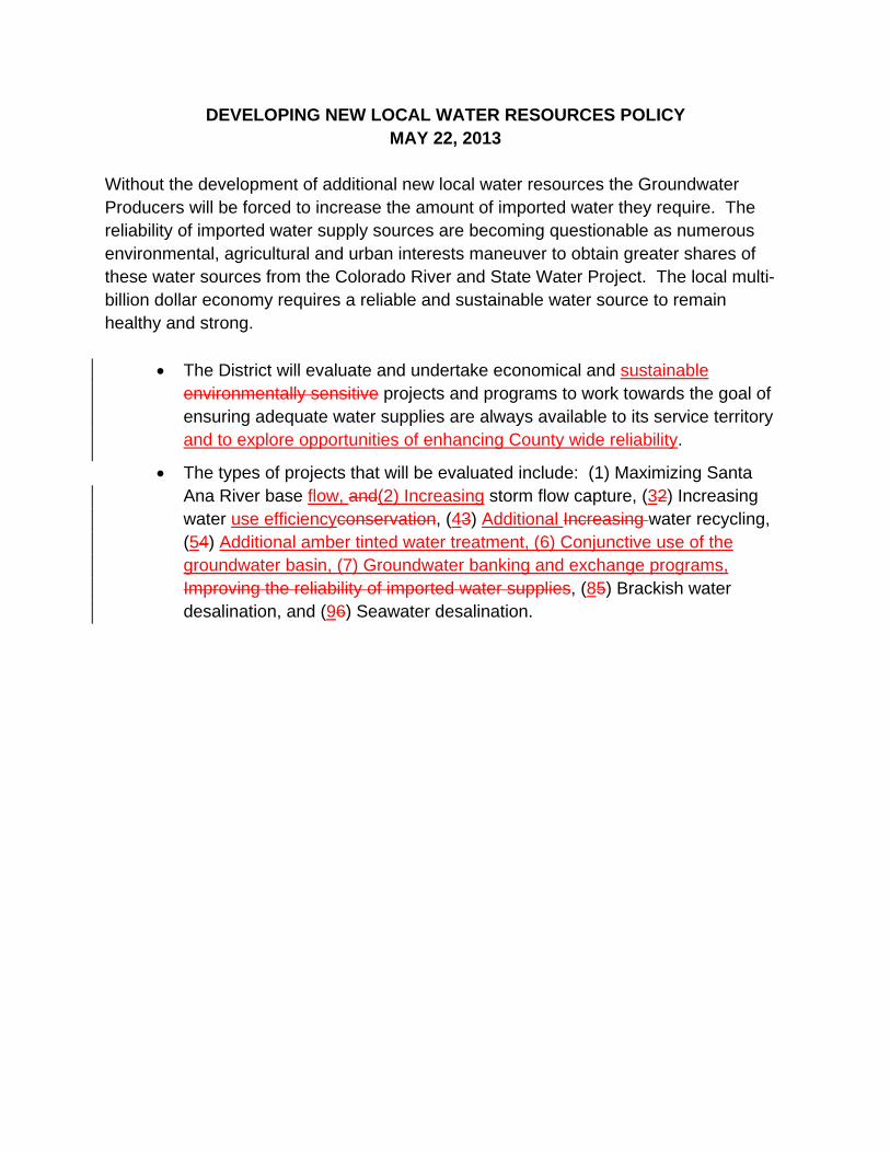
DEVELOPING NEW LOCAL WATER RESOURCES POLICY MAY 22, 2013
Without the development of additional new local water resources the Groundwater Producers will be forced to increase the amount of imported water they require. The reliability of imported water supply sources are becoming questionable as numerous environmental, agricultural and urban interests maneuver to obtain greater shares of these water sources from the Colorado River and State Water Project. The local multi-billion dollar economy requires a reliable and sustainable water source to remain healthy and strong.
x The District will evaluate and undertake economical and sustainable environmentally sensitive projects and programs to work towards the goal of ensuring adequate water supplies are always available to its service territory and to explore opportunities of enhancing County wide reliability.
x The types of projects that will be evaluated include: (1) Maximizing Santa Ana River base flow, and(2) Increasing storm flow capture, (32) Increasing water use efficiencyconservation, (43) Additional Increasing water recycling, (54) Additional amber tinted water treatment, (6) Conjunctive use of the groundwater basin, (7) Groundwater banking and exchange programs, Improving the reliability of imported water supplies, (85) Brackish water desalination, and (96) Seawater desalination.

12
AGENDA ITEM SUBMITTAL Meeting Date: April 12, 2017 Budgeted: Yes Proposed Budget: $195,760 To: Water Issues Committee Cost Estimate: $195,760 Board of Directors Funding Source: CIP/State Loan/Grant Program/Line Item No.: C14004 From: Mike Markus General Counsel Approval: Yes Engineers/Feasibility Report: Complete Staff Contact: D. Bott / B. Smith CEQA Compliance: Complete Subject: MID-BASIN INJECTION: CENTENNIAL PARK SAR- 13 MONITORING
WELL – MITIGATED NEGATIVE DECLARATION, SAUSD EASEME NT, TETRA TECH AMENDMENT, GEOTECHNICAL CONSULTANTS AMENDMENT, AND NOTICE INVITING BIDS
SUMMARY
The construction contract for the Mid-Basin Injection Centennial Park Project is currently out for bid. Staff has been notified by state regulators that a second monitoring well is required prior to operation of the new injection wells. Staff has completed a CEQA analysis, easement negotiation, and collected amendments from the design and construction management firms to facilitate bid and construction of the additional monitoring well.
Attachments:
a. Resolution of the Board of Directors of the Orange County Water District
b. Orange County Water District Heritage Museum SAR-13 Monitoring Well Project, Draft Initial Study/Mitigated Negative Declaration & CEQA-Plus Federal Consultation Review
c. Orange County Water District Heritage Museum SAR-13 Monitoring Well Project, Final Mitigated Negative Declaration Mitigation Monitoring Program
d. Easement Deed, Santa Ana Unified School District Heritage Museum SAR-13 Monitoring Well
RECOMMENDATION
Agendize for April 19 Board meeting: Adopt Resolution approving the SAR-13 Monitoring at Heritage Museum which includes the following items: 1) Adopt the Final Mitigated Negative Declaration for the project 2) Authorize execution of Easement Deed with Santa Ana Unified School District 3) Authorize Amendment No. 2 to Agreement with Tetra Tech 4) Authorize Amendment No. 1 to Agreement with Geotechnical Consultants 5) Authorize Notice Inviting Bids for Contract MBI-2017-2, SAR-13 Monitoring Well
at Heritage Museum 6) Authorize filing of the Notice of Determination
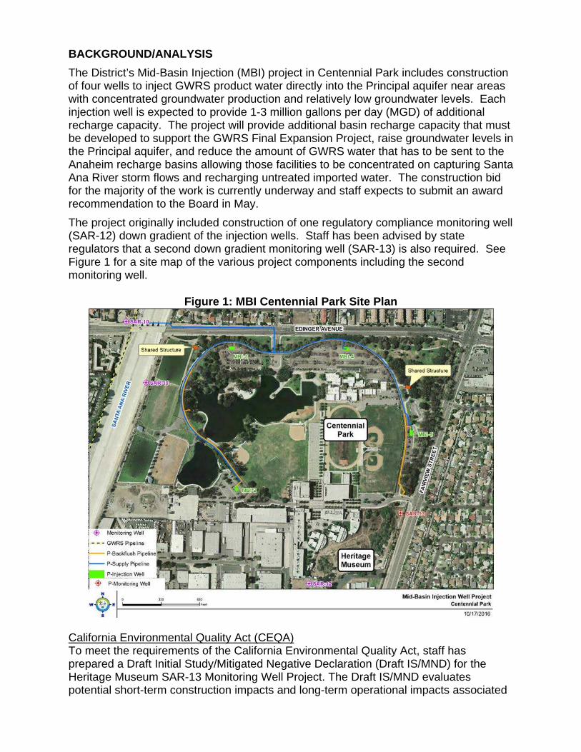
BACKGROUND/ANALYSIS
The District’s Mid-Basin Injection (MBI) project in Centennial Park includes construction of four wells to inject GWRS product water directly into the Principal aquifer near areas with concentrated groundwater production and relatively low groundwater levels. Each injection well is expected to provide 1-3 million gallons per day (MGD) of additional recharge capacity. The project will provide additional basin recharge capacity that must be developed to support the GWRS Final Expansion Project, raise groundwater levels in the Principal aquifer, and reduce the amount of GWRS water that has to be sent to the Anaheim recharge basins allowing those facilities to be concentrated on capturing Santa Ana River storm flows and recharging untreated imported water. The construction bid for the majority of the work is currently underway and staff expects to submit an award recommendation to the Board in May.
The project originally included construction of one regulatory compliance monitoring well (SAR-12) down gradient of the injection wells. Staff has been advised by state regulators that a second down gradient monitoring well (SAR-13) is also required. See Figure 1 for a site map of the various project components including the second monitoring well.
Figure 1: MBI Centennial Park Site Plan
California Environmental Quality Act (CEQA) To meet the requirements of the California Environmental Quality Act, staff has prepared a Draft Initial Study/Mitigated Negative Declaration (Draft IS/MND) for the Heritage Museum SAR-13 Monitoring Well Project. The Draft IS/MND evaluates potential short-term construction impacts and long-term operational impacts associated
with the construction, operation and maintenance of a monitoring well on the Heritage Museum.
The Draft IS/MND was initially circulated for public review from February 15, 2017 to March 15, 2017. The Draft IS/MND determined that all potential impacts associated with the proposed project would be less than significant or less than significant with the implementation of mitigation measures. During the public review period, no public comment letters were received on the Draft IS/MNSD.
In accordance with Section 15132 of the CEQA Guidelines, staff has prepared the Final Mitigated Negative Declaration for the Heritage Museum SAR-13 Monitoring Well Project, which includes the Draft IS/MND and the Project Mitigation Monitoring Program.
Santa Ana Unified School District Easement Staff attempted to obtain a site for the second monitoring well from several property owners south of Centennial Park, but was unsuccessful in finding any interested private land owners. The site for the second monitoring well is within the same property as the first well, Santa Ana Unified School District’s (SAUSD) property currently under lease to the Heritage Museum of Orange County. In order to obtain property rights to construct and operate the monitoring well, additional easements are being added to those included in the first easement deed from SAUSD. In exchange for the easement, OCWD shall pay SAUSD $25,200 and OCWD shall construct site improvements that include decomposed granite, irrigation, electrical receptacles, greenhouse, sink, raised beds, concrete pavers, fencing, planting of trees, and an educational panel.
Design and Construction Management Amendments The engineering design of this project has been led by Tetra Tech with OCWD performing the well designs in-house. Tetra Tech has provided a quotation of $56,200 to provide design services for the additional monitoring well site including several site improvements included with the easement negotiations.
Geotechnical Consultants (GTC) has been hired by the District for construction management services related to the drilling, construction, and development of the four injection wells and one monitoring well. GTS has provided a quotation of $114,360 to oversee these aspects of construction for the additional monitoring well.
Notice Inviting Bids The site improvement design associated with SAR-13 is expected to be completed by Tetra Tech in mid-April. OCWD has already prepared the in-house portion of design for the wells. Staff recommends authorizing Publication of the Notice Inviting Bids for Contract No. MBI-2017-2, SAR-13 Monitoring Well at Heritage Museum. Staff would like to advertise this construction in April and bring an award recommendation to the Board in June. This timeline will allow the current schedule for the remainder of the project to remain as-is.
Project Budget and Schedule The project budget of $33 million is summarized in Table 1. The construction cost estimate has not been increased at this time. Instead, funds from the project contingency have been allocated to the new easement, amendments, and construction costs. If the construction bids exceed the estimate, then staff will request additional funds from the Board. Staff expects to receive a Green Project Grant and State
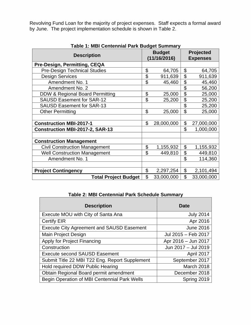
Revolving Fund Loan for the majority of project expenses. Staff expects a formal award by June. The project implementation schedule is shown in Table 2.
Table 1: MBI Centennial Park Budget Summary
Description Budget (11/16/2016)
Projected Expenses
Pre-Design, Permitting, CEQA Pre-Design Technical Studies $ 64,705 $ 64,705 Design Services $ 911,639 $ 911,639 Amendment No. 1 $ 45,460 $ 45,460 Amendment No. 2 $ 56,200 DDW & Regional Board Permitting $ 25,000 $ 25,000 SAUSD Easement for SAR-12 $ 25,200 $ 25,200 SAUSD Easement for SAR-13 $ 25,200 Other Permitting $ 25,000 $ 25,000
Construction MBI-2017-1 $ 28,000,000 $ 27,000,000 Construction MBI-2017-2, SAR-13 $ 1,000,000 Construction Management Civil Construction Management $ 1,155,932 $ 1,155,932 Well Construction Management $ 449,810 $ 449,810 Amendment No. 1 $ 114,360 Project Contingency $ 2,297,254 $ 2,101,494
Total Project Budget $ 33,000,000 $ 33,000,000
Table 2: MBI Centennial Park Schedule Summary
Description Date
Execute MOU with City of Santa Ana July 2014 Certify EIR Apr 2016 Execute City Agreement and SAUSD Easement June 2016 Main Project Design Jul 2015 – Feb 2017 Apply for Project Financing Apr 2016 – Jun 2017 Construction Jun 2017 – Jul 2019 Execute second SAUSD Easement April 2017 Submit Title 22 MBI T22 Eng. Report Supplement September 2017 Hold required DDW Public Hearing March 2018 Obtain Regional Board permit amendment December 2018 Begin Operation of MBI Centennial Park Wells Spring 2019
PRIOR RELEVANT BOARD ACTION(S) 11/16/16, R16-11-157: Authorize Notice Inviting Bids for contract MBI-2017-1 Mid-Basin
Injection: Centennial Park, and authorize agreement to DDB Engineering for project permit assistance
6/15/16, R16-6-81: Approve agreements for Mid-Basin Injection: Centennial Park
project: Agreement to Butier Construction Managers for an amount not to exceed $1,155,932 for Civil Construction Management Service; Agreement to Geotechnical Consultants, Inc. for an amount not to exceed $449,810 for Well Construction Management Service; and Amendment No. 1 to Agreement No. 1090 with Tetra Tech, Inc. for an amount not to exceed $45,460 for additional utility exploration and architectural treatments.
6/15/16, R16-6-80: Approve Mid-Basin Injection: Centennial Park project Easement
from Santa Ana Unified School District and License Agreement with City of Santa Ana
5/18/16, R16-5-65: Adopt Resolutions for the Clean Water State Revolving Fund Loan
application for Mid-Basin Centennial Park Injection Project: Resolution Establishing a Designee to Authorize Execution of the Financing Agreements with the State Water Resources Control Board; Resolution Establishing Dedicated Source of Revenue for Repayment of the State Revolving Fund Loan for Board approved capital improvement projects; and Reimbursement Resolution
4/20/16, R16-4-52: Adopt Resolution approving the Mid-Basin Injection: Centennial
Project which includes the following items: Certifying the Final Environmental Impact Report for the Project; Adopting the Findings of Fact and the Mitigation Monitoring Reporting Program; Approve the Project and establish the Project budget of $33,000,000; Receive and File Revised Engineer’s Report; and Authorize filing of Notice of Determination.
3/16/16, M16-45: Authorize Request for Proposals for Civil and Well Construction
Management of the Mid-Basin Injection: Centennial Park Project 6/17/15, R15-6-89: Authorize Agreement to Tetra Tech Inc. for Mid-Basin Injection:
Centennial Park Project Design Services 4/15/15, R15-4-48: Receive and file Engineer’s Report for Mid-Basin Injection:
Centennial Park Project and declare project duly instituted, and authorize issuance of RFP for project design services
7/16/14, R14-7-100: Approve MOU with the City of Santa Ana for Construction and
Operation of Injection Wells at Centennial Park
1
RESOLUTION NO. 17-4-___ ADOPTING FINAL IS/MND FOR THE HERITAGE MUSEUM SAR-13 MONITORING
WELL PROJECT, AUTHORIZING EXECUTION OF SAUSD EASEMENT, AUTHORIZING AMENDMENTS TO TETRA TECH AND GEOTECHNICAL CONSULTANTS, AND
ISSUANCE OF A NOTICE INVITING BIDS FOR WELL CONSTRUCTION WHEREAS, the District has proposed the construction and operation of four injection wells at Centennial Park and a monitoring well at the Heritage Museum, and has previously certified the Final Environmental Impact Report / Environmental Assessment (EIR/EA); and WHEREAS, the District subsequently received notification from the Division of Drinking Water that a second down gradient monitoring well (SAR-13) is required prior to injection operations; and WHEREAS, District staff has prepared a Draft Initial Study / Mitigated Negative Declaration (IS/MND) to evaluate short-term construction related impacts and long-term operational impacts that could result from the construction and operation of SAR-13; and WHEREAS, the Draft IS/MND determined that all potential impacts associated with the proposed SAR-13 would be less than significant or less than significant with the implementation of mitigation measures; and WHEREAS, the Draft IS/MND was circulated to the public, responsible agencies and other interested persons for review and comments from February 15, 2017 to March 15, 2017, and the Staff received no public comment letters; and WHEREAS, the Board of Directors of the Orange County Water District has reviewed and considered the information and recommendations of the Final IS/MND, at a regularly scheduled board meeting held on April 19, 2017; and WHEREAS, the District staff negotiated an Easement Deed with the Santa Ana Unified School District (SAUSD) and its lessee the Heritage Museum of Orange County for use of land to construct and operate SAR-13; and WHEREAS, the District staff has obtained a quotation for additional design work from the project’s engineering firm and a quotation for additional construction management work from the project’s well construction manager; and WHEREAS, the District staff further recommended issuance of a Notice Inviting Bids to construction the SAR-13 monitoring well; and NOW, THEREFORE, the Board of Directors of the Orange County Water District does hereby resolve as follows: Section 1: The Board of Directors does hereby find that:

2
i) The Initial Study identifies that all potential impacts associated with the proposed SAR-13 monitoring well would be less than significant or less than significant with the implementation of mitigation measures;
ii) The Initial Study/Mitigated Negative Declaration reflects the independent judgment
and analysis of the Board of Directors of the District, as the lead agency for the project; and
iii) Prior to approving the project, the Board of Directors of the District has considered the
Initial Study/Mitigated Negative Declaration together with any comments received during the public review process, and any responses to such comments;
Section 2: The Final Initial Study/Mitigated Negative Declaration for the Heritage Museum SAR-13 Monitoring Well Project is hereby adopted. Section 3: The project is determined feasible, necessary and beneficial to the lands of the District, and is declared duly instituted. Section 4: Easement Deed with and one-time payment of $25,200 to the Santa Ana Unified School District for the Heritage Museum SAR-13 Monitoring Well, subject to non-substantive changes approved by the General Manager and General Counsel, is approved and authorized for execution. Section 5: Amendment No. 2 to Agreement No. 1090 with Tetra Tech, Inc. for an amount not to exceed $56,200 for SAR-13 monitoring well and site improvements design services at Heritage Museum is authorized. Section 6: Amendment No. 1 to Agreement No. 1164 with Geotechnical Consultants, Inc. for an amount not to exceed $114,360 for SAR-13 monitoring well construction management services is authorized. Section 7: Issuance of Notice Inviting Bids for Contract No. MBI-2017-2, SAR-13 Monitoring Well at Heritage Museum is authorized. Section 8: Filing of a Notice of Determination by staff is authorized.
Orange County Water District Heritage Museum SAR-13 Monitoring Well Project
Draft Initial Study/Mitigated Negative Declaration & CEQA-Plus Federal Consultation Review
Prepared By
Orange County Water District 18700 Ward Street Fountain Valley, CA 92708 Contact: Daniel Bott
February 2016

Table of Contents
Orange County Water District Heritage Museum SAR-13 Monitoring Well Project Draft Initial Study/Mitigated Negative Declaration & CEQA-Plus Federal Consultation Review i
Section Page
SECTION 1.0 INTRODUCTION ................................................................................ 1-1
1.1 Purpose of Environmental Review ................................................................. 1-1
1.2 Statutory Authority and Requirements ........................................................... 1-1
SECTION 2.0 PROJECT DESCRIPTION ................................................................. 2-1
2.1 Proposed Project ........................................................................................... 2-1
2.2 Background ................................................................................................... 2-1
2.3 Study Area ..................................................................................................... 2-1
2.4 Project Description ........................................................................................ 2-4
2.5 Construction Activities ................................................................................... 2-4
2.6 Monitoring Well Long Term Operation and Maintenance Activities ............. 2-10
2.7 Permits and Approvals ................................................................................ 2-10
SECTION 3.0 ENVIRONMENTAL CHECKLIST EVALUATIONS ............... ............. 3-1
SECTION 4.0 ENVIRONMENTAL ANALYSIS ............................ ............................. 4-1
4.1 Aesthetics ...................................................................................................... 4-1
4.2 Agricultural Resources/Forest Resources ..................................................... 4-2
4.3 Air Quality ...................................................................................................... 4-3
4.4 Biological Resources ................................................................................... 4-20
4.5 Cultural Resources ...................................................................................... 4-31
4.6 Geology/Soils .............................................................................................. 4-40
4.7 Greenhouse Gas Emissions ........................................................................ 4-43
4.8 Hazards/Hazardous Materials ..................................................................... 4-46
4.9 Hydrology/Water Quality .............................................................................. 4-50
4.10 Land Use/Planning ...................................................................................... 4-60
4.11 Mineral Resources ....................................................................................... 4-61
4.12 Noise ........................................................................................................... 4-61
4.13 Population/Housing ..................................................................................... 4-82
4.14 Public Services ............................................................................................ 4-83
4.15 Recreation ................................................................................................... 4-83
Table of Contents
Orange County Water District Heritage Museum SAR-13 Monitoring Well Project Draft Initial Study/Mitigated Negative Declaration & CEQA-Plus Federal Consultation Review ii
4.16 Transportation/Traffic .................................................................................. 4-84
4.17 Tribal Resources ......................................................................................... 4-87
4.18 Utilities/Service Systems ............................................................................. 4-88
SECTION 5.0 CEQA-PLUS FEDERAL CONSULTATION REVIEW ............. ........... 5-1
5.1 Purpose ......................................................................................................... 5-1
5.2 Federal Endangered Species Act (ESA), Section 7 ....................................... 5-1
5.3 Magnuson-Stevens Fishery Conservation and Management Act, Essential Fish Habitat: .................................................................................................. 5-4
5.4 National Historic Preservation Act, Section 106 ............................................ 5-4
5.5 Federal Clean Air ........................................................................................... 5-9
5.6 Coastal Zone Management Act ................................................................... 5-12
5.7 Coastal Barriers Resources Act ................................................................... 5-12
5.8 Farmland Protection Policy Act .................................................................... 5-12
5.9 Flood Plain Management ............................................................................. 5-12
5.10 Migratory Bird Treaty Act ............................................................................. 5-13
5.11 Protection of Wetlands ................................................................................ 5-13
5.12 Wild and Scenic Rivers Act ......................................................................... 5-15
5.13 Safe Drinking Water Act, Sole Source Aquifer Protection ........................... 5-15
5.14 Environmental Justice ................................................................................. 5-15
SECTION 6.0 REFERENCES ................................................................................... 6-1 Figures Figure 1: Regional Location Map ................................................................................. 2-2�Figure 2: Local Vicinity Map ......................................................................................... 2-3�Figure 3: SAR-13 Monitoring Well ................................................................................ 2-5�Figure 4: Site Improvements ........................................................................................ 2-6�Figure 5: Heritage Museum Vegetation Map .............................................................. 4-21�Figure 6: Area of Potential Effects .............................................................................. 4-35�Figure 7: FEMA Flood Hazard Area ........................................................................... 4-59�Figure 8: Existing Noise Contours .............................................................................. 4-66�
Table of Contents
Orange County Water District Heritage Museum SAR-13 Monitoring Well Project Draft Initial Study/Mitigated Negative Declaration & CEQA-Plus Federal Consultation Review iii
Tables Table 1: Construction Equipment Mix Phase 1 Installation of Temporary Noise Barrier
Walls ............................................................................................................... 2-7�Table 2: Construction Equipment Mix Phase 2 Conductor Casing Installation, Phase 3
Monitor Well Borehole Drilling and Phase 4 Monitor Well Construction .......... 2-8�Table 3: Construction Equipment Mix Phase5 Well Development Equipment Mix ....... 2-8�Table 4: Phase 4 Site Clean-up and Well Vault Construction ...................................... 2-9�Table 5: Construction Equipment Mix Phase 7a and 7b 5 Site Improvements
Construction Equipment Mix ........................................................................... 2-9�Table 6: Monitoring Well Sampling and Redevelopment Equipment Mix ................... 2-10�Table 7: Project Permits and Approvals ..................................................................... 2-11�Table 8: South Coast Air Basin Attainment Status ....................................................... 4-8�Table 9: SCAQMD Regional Air Quality Significance Thresholds .............................. 4-10�Table 10: SCAQMD Localized Significance Thresholds ............................................. 4-10�Table 11: Construction-Related Regional Criteria Pollutant Emissions ...................... 4-13�Table 12: Construction-Related Local Criteria Pollutant Emissions Prior to Mitigation .... 4-14�Table 13: Mitigated Construction-Related Local Criteria Pollutant Emissions ............ 4-15�Table 14: Operational Well Sampling and Redevelopment Regional Criteria Pollutant
Emissions ................................................................................................... 4-15�Table 15: Operational Well Sampling and Redevelopment Local Criteria Pollutant
Emissions ................................................................................................... 4-16�Table 16: Heritage Museum Plant List ....................................................................... 4-22�Table 17: List of Federal/State Special Status Plant Species ..................................... 4-23�Table 18: List of Federal Special Status Wildlife Species ........................................... 4-25�Table 19: Cultural Resource Investigations within One Mile of the Project Area ........ 4-36�Table 20: Project Related Greenhouse Gas Annual Emissions ................................. 4-45�Table 21: Beneficial Uses ........................................................................................... 4-53�Table 22: Beneficial Uses Santa Ana River/Orange County Groundwater Basin ....... 4-55�Table 23: Water Quality Objectives (mg/L) ................................................................. 4-55�Table 24: FTA Construction Noise Criteria ................................................................. 4-63�Table 25: City of Santa Ana Municipal Code Exterior Noise Standards ..................... 4-64�Table 26: City of Santa Ana Municipal Code Interior Noise Standards ...................... 4-64�Table 27: Existing Modeled Noise Levels at Nearby Sensitive Receptors ................. 4-65�Table 28: Well Construction Equipment Inventory and Reference Noise Levels ........ 4-68�Table 29: Phase 1 Temporary Noise Barrier Construction Activities Noise Levels .... 4-69�Table 30: Phase 2 Conductor Casing Installation Construction Activities Noise Levels .. 4-70�Table 31: Phase 3 Borehole Drilling Activities Noise Levels ...................................... 4-71�Table 32: Phase 4 Monitor Well Construction Activities Noise Levels ........................ 4-72�Table 33: Phase 5 Monitor Well Development Construction Activities Noise Levels .. 4-73�
Table of Contents
Orange County Water District Heritage Museum SAR-13 Monitoring Well Project Draft Initial Study/Mitigated Negative Declaration & CEQA-Plus Federal Consultation Review iv
Table 34: Phase 6 Site Clean-Up and Vault Installation Activities Noise Levels ........ 4-74�Table 35: Phase 7a Site Improvements Grading Activities Noise Levels ................... 4-75�Table 36: Phase 7b Site Improvements Other Improvements Activities Noise Levels 4-76�Table 37: Operational Monitor Well Sampling Activities Noise Levels........................ 4-77�Table 38: Operational Monitor Well Redevelopment Activities Noise Levels ............. 4-77�Table 39: Vibration Source Levels for Construction Equipment ................................. 4-81�Table 40: Federal Listed Plant Species ........................................................................ 5-2�Table 41: Federal Listed Wildlife Species .................................................................... 5-3�Table 42: Cultural Resource Investigations One Mile of the Project Area .................... 5-6�Table 43: De Mimimis Levels ..................................................................................... 5-10�Table 44: SIP Conformity Evaluation .......................................................................... 5-11�
Appendices
Appendix A: Air Quality Greenhouse Gas Analysis, Vista Environmental, December 2016
Appendix B: Phase 1 Cultural Resource Report, Bonterra/Psomas, December 2016
Appendix C: Noise Analysis, Vista Environmental, December, 2016

Section 1
Orange County Water District SAR-13 Heritage Museum SAR-13 Monitoring Well Project Draft Initial Study/Mitigated Negative Declaration & CEQA-Plus Federal Consultation Review 1 -1
SECTION 1.0 INTRODUCTION
1.1 Purpose of Environmental Review
The California Environmental Quality Act (CEQA) requires that all state and local government agencies consider the environmental consequences of projects over which they have discretionary authority before taking action on those projects. This Initial Study has been prepared to disclose and evaluate short-term construction related impacts and long-term operational impacts associated with the implementation of the Orange County Water District Heritage Museum SAR-13 Monitoring Well Project (Proposed Project). Pursuant to Section 15367 of the State CEQA guidelines, the Orange County Water District (OCWD) is the Lead Agency and has the principal responsibility for approving and implementing the Proposed Project. As the Lead Agency, OCWD is required to ensure that the project complies with CEQA and that the appropriate level of CEQA documentation is prepared. Through preparation of an Initial Study as the Lead Agency, OCWD would determine whether to prepare an Environmental Impact Report (EIR), Negative Declaration or Mitigated Negative Declaration (MND) for the project. If the Lead Agency finds that there is no evidence that the project, either has proposed or as modified to include mitigation measures identified in the Initial Study prior to its public circulation, would not cause a significant effect on the environment, the Lead Agency shall prepare a Negative Declaration or Mitigated Negative Declaration for the project. Section 15382 of CEQA Guidelines defines a “significant effect on the environment” as a substantial, or potentially substantial adverse change in any of the physical conditions within the area affected by the project including land, air water, mineral, flora, fauna, ambient noise, aesthetic environment and objects of cultural significance. Based on the conclusions of this Initial Study, OCWD has determined that the appropriate level of environmental documentation for the Heritage Museum SAR-13 Monitoring Well Project would be a Mitigated Negative Declaration.
1.2 Statutory Authority and Requirements
This Initial Study/Mitigated Negative Declaration has been prepared in accordance with the CEQA, Public Resources Code Section 21000 et seq., State CEQA Guidelines, and the OCWD CEQA Environmental Procedures. The environmental analysis for the proposed project is based on OCWD Environmental Checklist Form. The Checklist Form is consistent with Initial Study requirements provided in Section 15063 of the State CEQA Guidelines.
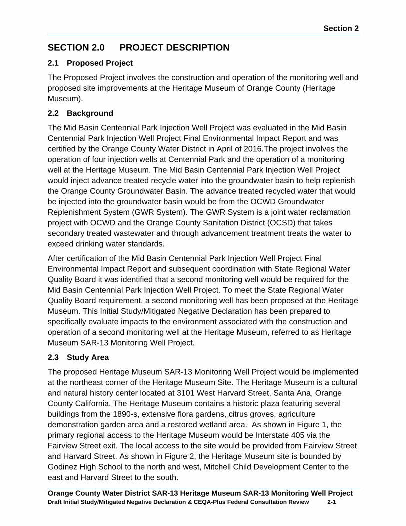
Section 2
Orange County Water District SAR-13 Heritage Museum SAR-13 Monitoring Well Project Draft Initial Study/Mitigated Negative Declaration & CEQA-Plus Federal Consultation Review 2 -1
SECTION 2.0 PROJECT DESCRIPTION
2.1 Proposed Project
The Proposed Project involves the construction and operation of the monitoring well and proposed site improvements at the Heritage Museum of Orange County (Heritage Museum).
2.2 Background
The Mid Basin Centennial Park Injection Well Project was evaluated in the Mid Basin Centennial Park Injection Well Project Final Environmental Impact Report and was certified by the Orange County Water District in April of 2016.The project involves the operation of four injection wells at Centennial Park and the operation of a monitoring well at the Heritage Museum. The Mid Basin Centennial Park Injection Well Project would inject advance treated recycle water into the groundwater basin to help replenish the Orange County Groundwater Basin. The advance treated recycled water that would be injected into the groundwater basin would be from the OCWD Groundwater Replenishment System (GWR System). The GWR System is a joint water reclamation project with OCWD and the Orange County Sanitation District (OCSD) that takes secondary treated wastewater and through advancement treatment treats the water to exceed drinking water standards.
After certification of the Mid Basin Centennial Park Injection Well Project Final Environmental Impact Report and subsequent coordination with State Regional Water Quality Board it was identified that a second monitoring well would be required for the Mid Basin Centennial Park Injection Well Project. To meet the State Regional Water Quality Board requirement, a second monitoring well has been proposed at the Heritage Museum. This Initial Study/Mitigated Negative Declaration has been prepared to specifically evaluate impacts to the environment associated with the construction and operation of a second monitoring well at the Heritage Museum, referred to as Heritage Museum SAR-13 Monitoring Well Project.
2.3 Study Area
The proposed Heritage Museum SAR-13 Monitoring Well Project would be implemented at the northeast corner of the Heritage Museum Site. The Heritage Museum is a cultural and natural history center located at 3101 West Harvard Street, Santa Ana, Orange County California. The Heritage Museum contains a historic plaza featuring several buildings from the 1890-s, extensive flora gardens, citrus groves, agriculture demonstration garden area and a restored wetland area. As shown in Figure 1, the primary regional access to the Heritage Museum would be Interstate 405 via the Fairview Street exit. The local access to the site would be provided from Fairview Street and Harvard Street. As shown in Figure 2, the Heritage Museum site is bounded by Godinez High School to the north and west, Mitchell Child Development Center to the east and Harvard Street to the south.

CentennialPark
HeritageMuseum
SANTAANA
FOUNTAINVALLEY
WARNER AVE
EU
CL
ID S
T
SEGERSTROM AVE
FA
IRV
IEW
ST
EDINGER AVE
HA
RB
OR
BLV
D
MC FADDEN AVE
MACARTHUR BLVD
SUNFLOWER AVE
BR
IST
OL S
T
TALBERT AVE
HY
LA
ND
AV
E
DYER RD
Regional Location Map0 2,000 4,000
Feet
Heritage Museum SAR-13 Monitoring Well Project
Figure 1
Pa
th:
I:\S
S\B
ott
\Ce
nte
nn
ialP
ark
\Au
g1
5F
igu
res\F
1_R
egio
na
l.m
xd
City Boundaries
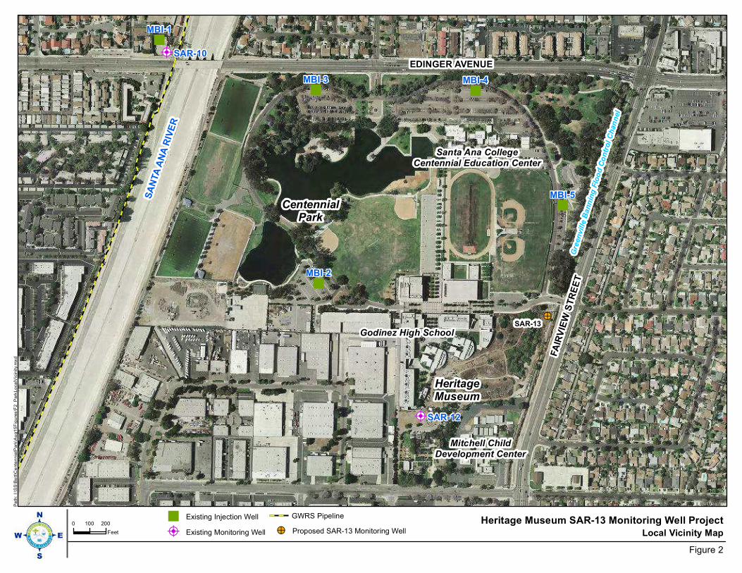
Ç$
Ç$
«
«
« «
«
EDINGER AVENUE
SA
NTA
AN
A R
IVE
R
FA
IRV
IEW
ST
RE
ET
Godinez High School
Gre
en
ville
Ban
nin
g F
loo
d C
on
tro
l C
han
nel
Mitchell ChildDevelopment Center
CentennialPark
HeritageMuseum
Santa Ana CollegeCentennial Education Center
!>SAR-13
SAR-12
SAR-10
MBI-5
MBI-4MBI-3
MBI-2
MBI-1
Local Vicinity Map0 100 200
Feet
Heritage Museum SAR-13 Monitoring Well Project
Figure 2
Pa
th:
I:\S
S\B
ott
\Ce
nte
nn
ialP
ark
\Au
g1
5F
igu
res\F
2_P
ark
Lo
ca
lVic
inity.
mxd
« Existing Injection Well
Ç$ Existing Monitoring Well
GWRS Pipeline
!> Proposed SAR-13 Monitoring Well

Section 2
Orange County Water District SAR-13 Heritage Museum SAR-13 Monitoring Well Project Draft Initial Study/Mitigated Negative Declaration & CEQA-Plus Federal Consultation Review 2 -4
2.4 Project Description
The Proposed Project involves the construction and operation of a monitoring well and site improvements to the Heritage Museum community garden.
Monitoring Well
The proposed SAR-13 Monitoring Well would be a below ground monitoring well that would be constructed in the northeast corner of the Heritage Museum. Presently, the proposed well site is vacant and contains concrete rubble and discarded building materials that appear to be from the demolition of Mountain View High School, which was formerly located on a portion of the Heritage Museum site.
As shown in Figure 3, the monitoring well would be housed in an underground vault with a 2’ x 3’ metal cover and 10’ x 10’ concrete apron. The monitoring well would include 4, 4-inch diameter stainless steel casings installed in a 22-inch diameter borehole that would drilled to depths up to 1,050 feet below ground surface (bgs). The proposed well would be a nested monitoring well and would be drilled by reverse circulation drilling equipment and would occur 24 hours a day over a four week period and 12 hours a day over another two week period. A 15,000 square foot area would be needed to construct the monitoring well. To construct the proposed monitoring well, construction equipment would take access along an existing dirt pathway along the community garden area of the Heritage Museum site. Existing fencing and existing raised garden beds at the community garden area would be temporarily removed to allow access to the monitoring well site. Equipment would be staged in this area until the monitoring well is constructed. After construction of the monitoring well all temporary removed structures would be replaced. After the well construction is completed the well site would be resurfaced with decomposed granite.
Heritage Museum Site Improvements
As shown in Figure 4, a series of site improvements would be constructed at the Heritage Museum after the proposed monitoring well is constructed. A 12 foot wide by 500 foot long paver walkway and 3,000 square feet of decomposed granite would be installed to provide access to the well site. Additionally, a series of onsite amenities would be provided in the community garden including; a greenhouse, outdoor sink, raised garden beds, citrus tree grove, drip irrigation system, electrical receptacles, fencing and fence screening.
2.5 Construction Activities
The proposed construction activities would occur in seven construction phases. Phase 1 involves the installation of the temporary noise barrier walls, Phase 2 involves conductor casing installation, Phase 3 monitor well borehole drilling, Phase 4 monitor well construction, Phase 5 monitor well development, Phase 6 site clean-up and vault installation, Phase 7a site grading improvements, and Phase 7b site improvements.
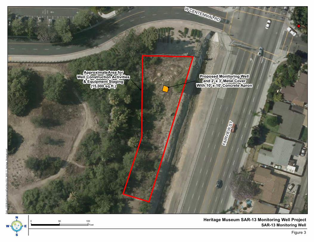
G!.
ApproximateArea forWell Construction Activities
& Equipment Staging(15,000 sq.ft.)
FA
IRV
IEW
ST
W CENTENNIAL RD
Proposed Monitoring Welland 2' x 3' Metal Cover
With 10' x 10' Concrete Apron
SAR-13 Monitoring Well0 50 100
Feet
Heritage Museum SAR-13 Monitoring Well Project
Figure 3
Pa
th:
I:\S
S\B
ott
\Ce
nte
nn
ialP
ark
\No
v1
6\X
_S
AR
-13_
Heri
tag
e_
Mu
se
um
.mxd

!(
!(
!(
Drip 1
st
Drip 1
st
Easem
ent
Drip 1
st
Drip 1
st
Connect to Upstream2" PVC Provided in
1st Easement
FA
IRV
IEW
ST
Relocate boulderto Location A
Location A
Monitoring WellSAR-13
Site Improvements
0 70 140
Feet
Heritage Museum SAR-13
Monitoring Well Project
Figure 4
Pa
th:
I:\S
S\B
ott
\Ce
nte
nn
ialP
ark
\No
v1
6\X
_M
useu
mP
roje
ct.
mxd
!( Sink
!( Receptacle
175' Fence
630' Fence Screen
Raised Beds to be Removed and Replaced
Upstream 2" PVC
New 2" PVC
Fence Removal
Fence Removal and Replacement
12' x 18' Greenhouse
12' x 500' Paver Walkway
4' x 8' Raised Bed w/ Drip
3,000 sq ft Decomposed Granite

Section 2
Orange County Water District SAR-13 Heritage Museum SAR-13 Monitoring Well Project Draft Initial Study/Mitigated Negative Declaration & CEQA-Plus Federal Consultation Review 2 -7
Phase 1: Temporary Noise Barrier Wall Construction
Phase 1 involves the installation of the temporary noise wall. The noise barrier walls would be 24 feet in height and would enclose the entire well site during drilling, construction, and development of the monitoring well. Upon completion of well installation, the noise barrier wall would be removed. The equipment mix for temporary noise barrier wall construction is shown in Table 1.
Table 1: Construction Equipment Mix Phase 1 Install ation of Temporary Noise Barrier Walls
Activity Equipment Pieces of Equipment
Hours of Operation
Days of Operation
Horsepower
Noise Barrier Wall Installation and Removal Equipme nt
Installation Back-hoe w/auger attachment
1 10 4 90
Installation Man-lift 1 10 4 70
Installation Forklift 1 10 4 90
Removal Back-hoe w/auger attachment
1 10 4 90
Removal Man-lift 1 10 4 70
Removal Forklift 1 10 4 90
Construction Trips, 1 trip mobilizing 1 trip demobilizing. All trips assumed 25 miles.
Phase 2: Conductor Casing Installation
Phase 2 construction activities would include installation of a 28-inch diameter mild steel conductor casing installed in a 36-inch diameter borehole drilled to a depth of 65 feet below ground surface. The construction equipment mix for Phase 2 Conductor Casing Installation is shown in Table 2.
Phase 3: Monitor Well Borehole Drilling
Phase 3 construction activities would include drilling of a 22-inch diameter borehole to an estimated depth of up to 1,050 feet below ground surface. The borehole drilling activities would be required to operate 24-hours per day 7 days a week until completion of the borehole drilling in order to prevent a collapse of the borehole. The construction equipment mix for Phase 3 Monitor Well Borehole Drilling is shown in Table 2.
Phase 4: Monitor Well Construction
Phase 4 construction activities would include installation of four 4-inch diameter stainless steel casings installed into the borehole drilled during Phase 3. The well construction activities would be required to operate 24-hours per day 7 days a week until completion of the well construction in order to prevent a collapse of the borehole.
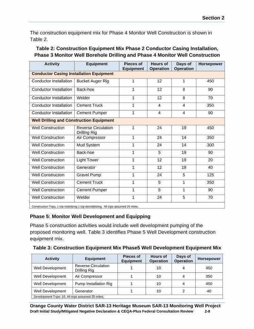
Section 2
Orange County Water District SAR-13 Heritage Museum SAR-13 Monitoring Well Project Draft Initial Study/Mitigated Negative Declaration & CEQA-Plus Federal Consultation Review 2 -8
The construction equipment mix for Phase 4 Monitor Well Construction is shown in Table 2.
Table 2: Construction Equipment Mix Phase 2 Conduct or Casing Installation, Phase 3 Monitor Well Borehole Drilling and Phase 4 Monitor Well Construction
Activity Equipment Pieces of Equipment
Hours of Operation
Days of Operation
Horsepower
Conductor Casing Installation Equipment
Conductor Installation Bucket Auger Rig 1 12 1 450
Conductor Installation Back-hoe 1 12 8 90
Conductor Installation Welder 1 12 8 70
Conductor Installation Cement Truck 1 4 4 350
Conductor Installation Cement Pumper 1 4 4 90
Well Drilling and Construction Equipment
Well Construction Reverse Circulation Drilling Rig
1 24 19 450
Well Construction Air Compressor 1 24 14 350
Well Construction Mud System 1 24 14 300
Well Construction Back-hoe 1 5 19 90
Well Construction Light Tower 1 12 19 20
Well Construction Generator 1 12 19 40
Well Construction Gravel Pump 1 24 5 125
Well Construction Cement Truck 1 5 1 350
Well Construction Cement Pumper 1 5 1 90
Well Construction Welder 1 24 5 70
Construction Trips, 1 trip mobilizing 1 trip demobilizing. All trips assumed 25 miles.
Phase 5: Monitor Well Development and Equipping
Phase 5 construction activities would include well development pumping of the proposed monitoring well. Table 3 identifies Phase 5 Well Development construction equipment mix.
Table 3: Construction Equipment Mix Phase5 Well Dev elopment Equipment Mix
Activity Equipment Pieces of Equipment
Hours of Operation
Days of Operation Horsepower
Well Development Reverse Circulation Drilling Rig 1 10 4 450
Well Development Air Compressor 1 10 4 350
Well Development Pump Installation Rig 1 10 4 450
Well Development Generator 1 10 2 40 Development Trips: 10, All trips assumed 25 miles.
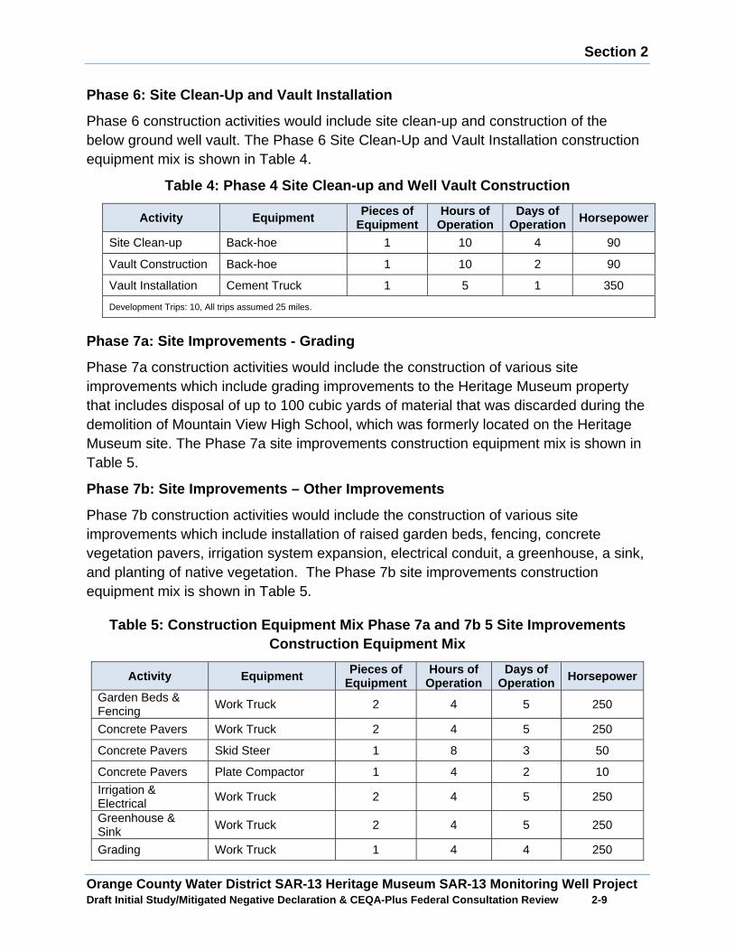
Section 2
Orange County Water District SAR-13 Heritage Museum SAR-13 Monitoring Well Project Draft Initial Study/Mitigated Negative Declaration & CEQA-Plus Federal Consultation Review 2 -9
Phase 6: Site Clean-Up and Vault Installation
Phase 6 construction activities would include site clean-up and construction of the below ground well vault. The Phase 6 Site Clean-Up and Vault Installation construction equipment mix is shown in Table 4.
Table 4: Phase 4 Site Clean-up and Well Vault Const ruction
Activity Equipment Pieces of Equipment
Hours of Operation
Days of Operation Horsepower
Site Clean-up Back-hoe 1 10 4 90
Vault Construction Back-hoe 1 10 2 90
Vault Installation Cement Truck 1 5 1 350
Development Trips: 10, All trips assumed 25 miles.
Phase 7a: Site Improvements - Grading
Phase 7a construction activities would include the construction of various site improvements which include grading improvements to the Heritage Museum property that includes disposal of up to 100 cubic yards of material that was discarded during the demolition of Mountain View High School, which was formerly located on the Heritage Museum site. The Phase 7a site improvements construction equipment mix is shown in Table 5.
Phase 7b: Site Improvements – Other Improvements
Phase 7b construction activities would include the construction of various site improvements which include installation of raised garden beds, fencing, concrete vegetation pavers, irrigation system expansion, electrical conduit, a greenhouse, a sink, and planting of native vegetation. The Phase 7b site improvements construction equipment mix is shown in Table 5.
Table 5: Construction Equipment Mix Phase 7a and 7b 5 Site Improvements Construction Equipment Mix
Activity Equipment Pieces of Equipment
Hours of Operation
Days of Operation Horsepower
Garden Beds & Fencing Work Truck 2 4 5 250
Concrete Pavers Work Truck 2 4 5 250
Concrete Pavers Skid Steer 1 8 3 50
Concrete Pavers Plate Compactor 1 4 2 10
Irrigation & Electrical Work Truck 2 4 5 250
Greenhouse & Sink Work Truck 2 4 5 250
Grading Work Truck 1 4 4 250
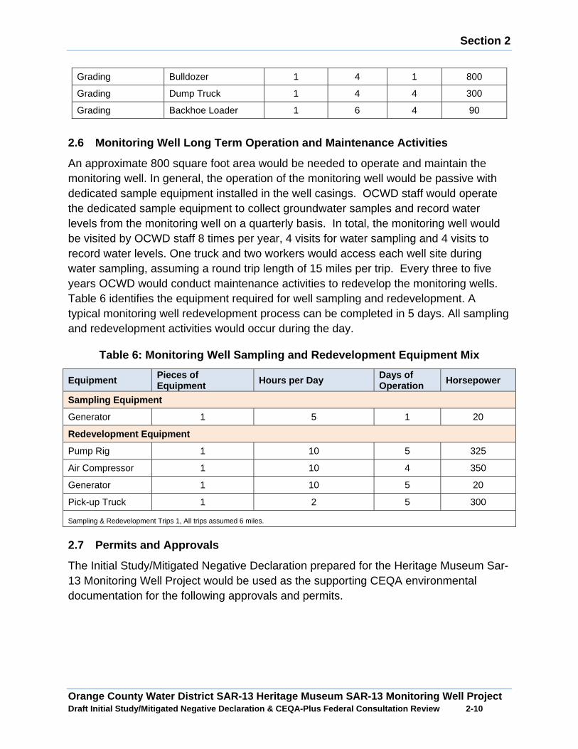
Section 2
Orange County Water District SAR-13 Heritage Museum SAR-13 Monitoring Well Project Draft Initial Study/Mitigated Negative Declaration & CEQA-Plus Federal Consultation Review 2 -10
Grading Bulldozer 1 4 1 800
Grading Dump Truck 1 4 4 300
Grading Backhoe Loader 1 6 4 90
2.6 Monitoring Well Long Term Operation and Mainten ance Activities
An approximate 800 square foot area would be needed to operate and maintain the monitoring well. In general, the operation of the monitoring well would be passive with dedicated sample equipment installed in the well casings. OCWD staff would operate the dedicated sample equipment to collect groundwater samples and record water levels from the monitoring well on a quarterly basis. In total, the monitoring well would be visited by OCWD staff 8 times per year, 4 visits for water sampling and 4 visits to record water levels. One truck and two workers would access each well site during water sampling, assuming a round trip length of 15 miles per trip. Every three to five years OCWD would conduct maintenance activities to redevelop the monitoring wells. Table 6 identifies the equipment required for well sampling and redevelopment. A typical monitoring well redevelopment process can be completed in 5 days. All sampling and redevelopment activities would occur during the day.
Table 6: Monitoring Well Sampling and Redevelopment Equipment Mix
Equipment Pieces of Equipment Hours per Day Days of
Operation Horsepower
Sampling Equipment
Generator 1 5 1 20
Redevelopment Equipment
Pump Rig 1 10 5 325
Air Compressor 1 10 4 350
Generator 1 10 5 20
Pick-up Truck 1 2 5 300
Sampling & Redevelopment Trips 1, All trips assumed 6 miles.
2.7 Permits and Approvals
The Initial Study/Mitigated Negative Declaration prepared for the Heritage Museum Sar-13 Monitoring Well Project would be used as the supporting CEQA environmental documentation for the following approvals and permits.
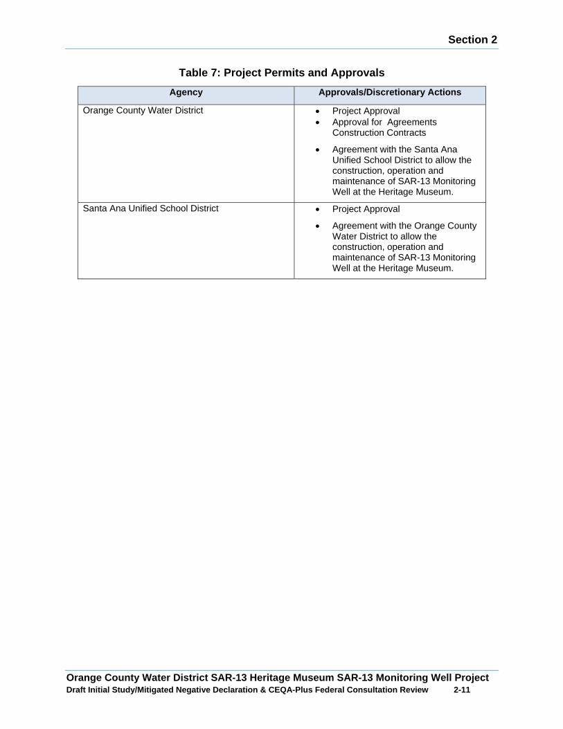
Section 2
Orange County Water District SAR-13 Heritage Museum SAR-13 Monitoring Well Project Draft Initial Study/Mitigated Negative Declaration & CEQA-Plus Federal Consultation Review 2 -11
Table 7: Project Permits and Approvals
Agency Approvals/Discretionary Actions
Orange County Water District x Project Approval x Approval for Agreements
Construction Contracts
x Agreement with the Santa Ana Unified School District to allow the construction, operation and maintenance of SAR-13 Monitoring Well at the Heritage Museum.
Santa Ana Unified School District x Project Approval
x Agreement with the Orange County Water District to allow the construction, operation and maintenance of SAR-13 Monitoring Well at the Heritage Museum.
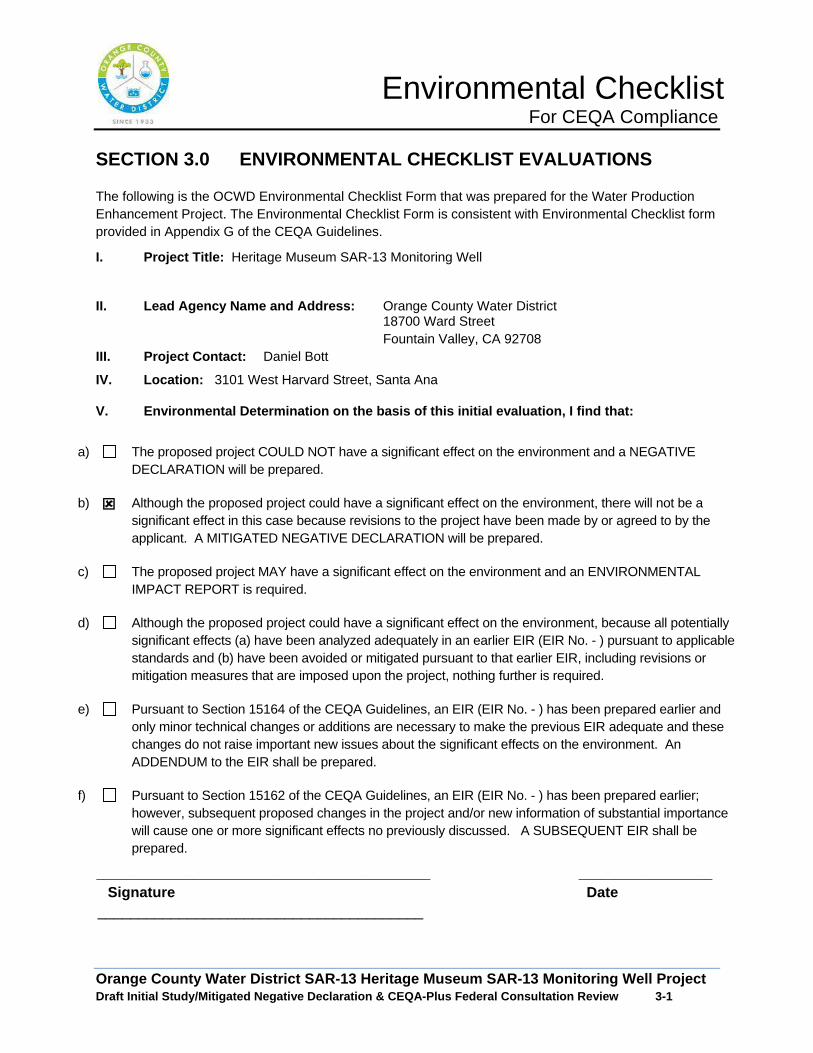
Environmental Checklist For CEQA Compliance
Orange County Water District SAR-13 Heritage Museum SAR-13 Monitoring Well Project Draft Initial Study/Mitigated Negative Declaration & CEQA-Plus Federal Consultation Review 3 -1
SECTION 3.0 ENVIRONMENTAL CHECKLIST EVALUATIONS
The following is the OCWD Environmental Checklist Form that was prepared for the Water Production Enhancement Project. The Environmental Checklist Form is consistent with Environmental Checklist form provided in Appendix G of the CEQA Guidelines.
I. Project Title: Heritage Museum SAR-13 Monitoring Well
II. Lead Agency Name and Address: Orange County Water District 18700 Ward Street Fountain Valley, CA 92708
III. Project Contact: Daniel Bott
IV. Location: 3101 West Harvard Street, Santa Ana
V. Environmental Determination on the basis of this initial evaluation, I find that:
a) The proposed project COULD NOT have a significant effect on the environment and a NEGATIVE DECLARATION will be prepared.
b) : Although the proposed project could have a significant effect on the environment, there will not be a significant effect in this case because revisions to the project have been made by or agreed to by the applicant. A MITIGATED NEGATIVE DECLARATION will be prepared.
c) The proposed project MAY have a significant effect on the environment and an ENVIRONMENTAL IMPACT REPORT is required.
d) Although the proposed project could have a significant effect on the environment, because all potentially significant effects (a) have been analyzed adequately in an earlier EIR (EIR No. - ) pursuant to applicable standards and (b) have been avoided or mitigated pursuant to that earlier EIR, including revisions or mitigation measures that are imposed upon the project, nothing further is required.
e) Pursuant to Section 15164 of the CEQA Guidelines, an EIR (EIR No. - ) has been prepared earlier and only minor technical changes or additions are necessary to make the previous EIR adequate and these changes do not raise important new issues about the significant effects on the environment. An ADDENDUM to the EIR shall be prepared.
f) Pursuant to Section 15162 of the CEQA Guidelines, an EIR (EIR No. - ) has been prepared earlier; however, subsequent proposed changes in the project and/or new information of substantial importance will cause one or more significant effects no previously discussed. A SUBSEQUENT EIR shall be prepared.
_____________________________________________ __________________ Signature Date
________________________________________

Environmental Checklist For CEQA Compliance
Orange County Water District SAR-13 Heritage Museum SAR-13 Monitoring Well Project Draft Initial Study/Mitigated Negative Declaration & CEQA-Plus Federal Consultation Review 3 -2
Potentially Significant
Impact
Less Than Significant
with Mitigation
Incorporated
Less Than Significant
Impact No
Impact
I. AESTHETICS – Would the project:
a) Have a substantial adverse effect on a scenic vista? :
b) Damage scenic resources, including but not limited to, trees, rock outpourings and historic buildings within a state highway?
:
c) Substantially degrade the existing visual character or quality of the site and its surroundings?
:
d) Create a new source of substantial light or glare which would adversely affect day or nighttime views in the area?
:
II. AGRICULTURAL AND FOREST RESOURCES: In determining whether impacts to agricultural resources are significant environmental effects, lead agencies may refer to the California Agricultural Land Evaluation and Site Assessment Model prepared by the California Department of Conservation as an optional model to use in assessing impacts on agricultural farmland. In determining whether impacts to forest resources, including timerberland, are significant environmental effects, lead agencies may refer to information compiled by the California Department of Forestry and Fire Protection regarding the state’s inventory of forest land, including the Forest and Range Assessment Project and the Forest Legacy Assessment project; and forest carbon measurement methodology provided in Forest Protocols adopted by the California Air Resources Board. Would the project:
a) Convert Prime Farmland, Unique Farmland or Farmland of Statewide Importance (Farmland) to non-agricultural use? (The Farmland Mapping and Monitoring Program in the California Resources Agency, Department of Conservation, maintains detailed maps of these and other categories of farmland.)
:
b) Conflict with existing zoning for agricultural use or a Williamson Contract?
:
c) Conflict with existing zoning for, or cause rezoning of, forest land (as defined in Public Resources Code section 12220(g), timberland (as defined by Public Resources Code section 4526), or timberland zoned Timberland Production (as defined by Government Code section 51104(g))
:
d) Result in the loss of forest land or conversion of forest land to non-forest use?
:
e) Involve other changes in the existing environment which, due to their location or nature, could individually or cumulatively result in loss of Farmland, to non-agricultural use or conversion of forest land to non-forest use?
:
III. AIR QUALITY –Would the project: a) Conflict with or obstruct implementation of applicable
Air Quality Attainment Plan? :
Environmental Checklist For CEQA Compliance
Orange County Water District SAR-13 Heritage Museum SAR-13 Monitoring Well Project Draft Initial Study/Mitigated Negative Declaration & CEQA-Plus Federal Consultation Review 3 -3
Potentially Significant
Impact
Less Than Significant
with Mitigation
Incorporated
Less Than Significant
Impact No
Impact
b) Violate any stationary source air quality standard or contribute to an existing or projected air quality violation?
:
c) Result in a cumulatively considerable net increase of any criteria pollutant for which the project region is non-attainment under an applicable federal or state ambient air quality standard (including releasing emissions which exceed quantitative thresholds for ozone precursors)?
:
d) Expose sensitive receptors to substantial pollutant concentrations?
:
e) Create objectionable odors affecting a substantial number of people?
:
IV. BIOLOGICAL RESOURCES – Would the project:
a) Have a substantial adverse impact, either directly or through habitat modifications, on any species identified as a candidate, sensitive or special status species in local or regional plans, policies or regulations or by the California Department of Fish and Game or U.S. Fish and Wildlife Services?
:
b) Have a substantial adverse impact on any riparian habitat or natural community identified in local or regional plans, policies, and regulations or by the California Department of fish and Game or U.S. Fish and Wildlife Service?
:
c) Adversely impact federally protected wetlands (including, but not limited to, marsh, vernal pool, coastal, etc.) either individually or in combination with the known or probable impacts of other activities through direct removal, filling hydrological interruption, or other means?
:
d) Interfere substantially with the movement of any native resident or migratory fish or wildlife species or with established native resident or migratory wildlife corridors, or impede the use of native wildlife nursery sites?
:
e) Conflict with any local policies or ordinances protecting biological resources, such as tree preservation policy or ordinance?
:
f) Conflict with the provisions of an adopted Habitat Conservation Plan, Natural Community Conservation Plan, or other approved local, regional, or state habitat conservation plan?
:
Environmental Checklist For CEQA Compliance
Orange County Water District SAR-13 Heritage Museum SAR-13 Monitoring Well Project Draft Initial Study/Mitigated Negative Declaration & CEQA-Plus Federal Consultation Review 3 -4
Potentially Significant
Impact
Less Than Significant
with Mitigation
Incorporated
Less Than Significant
Impact No
Impact
V. CULTURAL RESOURCES – Would the project:
a) Cause a substantial adverse change in the significance of a historical resource as defined in Section 15064.5?
:
b) Cause a substantial adverse change in the significance of a unique archaeological resource pursuant to define Section 15064.5?
:
c) Directly or indirectly disturb or destroy a unique paleontogical resource or site?
:
d) Disturb any human remains, including those interred outside of dedicated cemeteries?
:
VI. GEOLOGY AND SOILS – Would the project:
a) Expose people or structures to potential substantial adverse effects, including the risk of loss, injury, or death involving:
1. Rupture of a known earthquake fault, as delineated on the most recent on the most recent Alquist-Priolo Earthquake Fault Zoning map issued by the State Geologist for the area or based on other substantial evidence of a known fault?
:
2. Strong seismic ground shaking? :
3. Seismic-related ground failure, including liquefaction?
:
4. Landslides? :
b) Would the project result in substantial soil erosion or the loss of topsoil?
:
c) Be located on a geologic unit or soil that is unstable or that would become unstable as a result of the project and potentially result in on-or off-site landslide, lateral spreading, subsidence, liquefaction or collapse?
:
d) Be located on expansive soil, as defined in Table 18-1-B of the Uniform Building Code (1994), creating substantial risks to life or property?
:
e) Have soils incapable of adequately supporting the use of septic tanks or alternative waste disposal systems where sewers are not available for the disposal of wastewater?
:
VII. GREENHOUSE GAS EMISSIONS — Would the project?
a) Generate greenhouse gas emissions, either directly or indirectly, that may have a significant impact on the
:
Environmental Checklist For CEQA Compliance
Orange County Water District SAR-13 Heritage Museum SAR-13 Monitoring Well Project Draft Initial Study/Mitigated Negative Declaration & CEQA-Plus Federal Consultation Review 3 -5
Potentially Significant
Impact
Less Than Significant
with Mitigation
Incorporated
Less Than Significant
Impact No
Impact environment?
b) Conflict with an applicable plan, policy or regulation adopted for the purpose of reducing the emissions of greenhouse gases?
:
VIII. HAZARDOUS AND HAZARDOUS MATERIALS – Would the project:
a) Create a significant hazard to the public or the environment through the routine transport, use or disposal of hazardous materials?
:
b) Create a significant hazard to the public or environment through reasonably foreseeable upset and accident conditions involving the release of hazardous materials into the environment?
:
c) Emit hazardous emissions or handle hazardous or acutely hazardous materials, substance or waste within one-quarter mile of an existing or proposed school?
:
d) Be located on a site which is located on a list of hazardous materials sites compiled pursuant to Government Code Section 659662.5 and, as a result, would it create a significant hazard to the public or the environment?
:
e) For a project located within an airport land use plan or where such a plan has not been adopted, within two miles where of a public airport or public use airport, would the project result in a safety hazard for people residing or working in the project area?
:
f) For a project within the vicinity of a private airstrip, would the project result in a safety hazard for people residing or working in the project area?
:
g) Impair implementation of or physically interfere with an adopted emergency response plan or emergency evacuation plan?
:
h) Expose people or structures to a significant risk of loss, injury, or death involving wildland fires, including where wildlands are adjacent to urbanized areas or where residences are intermixed with wildlands?
:
VIX. HYDROLOGY AND WATER QUALITY – Would the project:
a) Violate any water quality standards or waste discharge requirements?
:
b) Substantially deplete groundwater supplies or interfere substantially with groundwater recharge such that there would be a net deficit in aquifer volume or a lowering of the local groundwater table
:
Environmental Checklist For CEQA Compliance
Orange County Water District SAR-13 Heritage Museum SAR-13 Monitoring Well Project Draft Initial Study/Mitigated Negative Declaration & CEQA-Plus Federal Consultation Review 3 -6
Potentially Significant
Impact
Less Than Significant
with Mitigation
Incorporated
Less Than Significant
Impact No
Impact level (e.g., the production rate of pre-existing nearby wells would drop to a level which would not support existing land uses or planned uses for which permits have been granted)?
c) Substantially alter the existing drainage pattern of the site or area, including through the alteration of the course of stream or river, in a manner which would result in substantial erosion or siltation on- or off-site?
:
d) Substantially alter the existing drainage pattern of the site or area, including through the alteration of the course of a stream or river, or substantially increase the rate or amount of surface runoff in a manner which would result in flooding on- or off-site?
:
e) Create or contribute runoff water which would exceed the capacity of existing or planned stormwater drainage systems or provide substantial additional sources of polluted runoff?
:
f) Otherwise substantially degrade water quality? :
g) Place housing within a 100-year flood hazard area as mapped on a federal Flood Hazard Boundary or Flood Insurance Rate Map or other flood hazard delineation map?
:
h) Place within a 100-year flood hazard area structures which would impede or redirect flood flows?
:
i) Expose people or structures to a significant risk of loss, injury, or death involving flooding, including flooding as a result of the failure of a levee or dam?
:
(j) Inundation by seiche, tsunami, or mudflow? :
X. LAND USE AND PLANNING – Would the project:
a) Physically divide an established community? :
b) Conflict with any applicable land use plan, policy, or regulation of an agency with jurisdiction over the project (including, but not limited to the general plan, specific plan, local coastal program, or zoning ordinance) adopted for the purpose of avoiding or mitigating an environmental effect?
:
c) Conflict with any applicable habitat conservation plan or natural community conservation plan?
:
XI. MINERAL RESOURCES – Would the project:
a) Result in the loss of availability of a known mineral resource that would be of value to the region and the residents of the state?
:
Environmental Checklist For CEQA Compliance
Orange County Water District SAR-13 Heritage Museum SAR-13 Monitoring Well Project Draft Initial Study/Mitigated Negative Declaration & CEQA-Plus Federal Consultation Review 3 -7
Potentially Significant
Impact
Less Than Significant
with Mitigation
Incorporated
Less Than Significant
Impact No
Impact
b) Result in the loss of availability of a locally-important mineral resource recovery site delineated on a local general plan, specific plan, or other land use plan?
XII. NOISE – Would the project result in:
a) Exposure of persons to or generation of noise levels in excess of standards established in the local general plan or noise ordinance, or applicable standards of other agencies?
:
b) A substantial permanent increase in ambient noise levels in the project vicinity above levels existing without the project?
:
c) A substantial temporary or periodic increase in ambient noise levels in the project vicinity above levels existing without project?
:
d) For a project located within an airport land use plan or where such a plan has not been adopted, within two miles of a public airport or public use airport, would the project expose people residing or working in the project area to excessive noise levels?
:
e) For a project within the vicinity of a private airstrip, would the project expose people residing or working in the project area to excessive noise levels?
:
f) Exposure of persons to or generation of excessive groundborne vibration or groundborne noise levels?
:
XIII. POPULATION AND HOUSING – Would the project:
a) Induce substantial population growth in an area, either directly (for example, by proposing new homes and business) or indirectly (for example, through extension of roads or other infrastructure)?
:
b) Displace substantial numbers of existing housing, necessitating the construction of replacement housing elsewhere?
:
c) Displace substantial numbers of people, necessitating the construction of replacement housing elsewhere?
:
XIV. PUBLIC SERVICES
a) Would the project result in substantial adverse physical impacts associated with the provision of new or physically altered governmental facilities, need for new or physically altered governmental facilities, the construction of which could cause significant environmental impacts, in order to maintain acceptable service rations, response times
:

Environmental Checklist For CEQA Compliance
Orange County Water District SAR-13 Heritage Museum SAR-13 Monitoring Well Project Draft Initial Study/Mitigated Negative Declaration & CEQA-Plus Federal Consultation Review 3 -8
Potentially Significant
Impact
Less Than Significant
with Mitigation
Incorporated
Less Than Significant
Impact No
Impact or other performance objectives for any of the public service:
Fire protection?
Police protection?
Schools?
Parks?
Other public facilities?
XV. RECREATION
a) Would the project increase the use of existing neighborhood and regional parks or other recreational facilities such that substantial physical deterioration of the facility would occur or be accelerated?
:
b) Does the project include recreational facilities or require the construction or expansion of recreational facilities which might have an adverse physical effect on the environment?
:
XVI. TRANSPORTATION/TRAFFIC Would the project:
a) Conflict with an applicable plan, ordinance or policy establishing measures of effectiveness for the performance of the circulation system, taking into account all modes of transportation including mass transit and non-motorized travel and relevant components of the circulation system, including but not limited to intersections, streets, highways and freeways, pedestrian and bicycle paths, and mass transit?
:
b) Conflict with an applicable congestion management program, including but limited to level of service standards and travel demand measures, or other standards established by the county congestion management agency for designated roads or highways?
:
c) Result in a change in air traffic patterns, including either an increase in traffic levels or a change in location that results in substantial safety risks?
:
d) Substantially increase hazards to a design feature (e.g. sharp curves or dangerous intersections) or incompatible uses (e.g. farm equipment)?
:
e) Result in inadequate emergency access? :
f) Conflict with adopted policies, plans, or programs regarding public transit, bicycle, or pedestrian facilities, or otherwise decrease the performance or
:
Environmental Checklist For CEQA Compliance
Orange County Water District SAR-13 Heritage Museum SAR-13 Monitoring Well Project Draft Initial Study/Mitigated Negative Declaration & CEQA-Plus Federal Consultation Review 3 -9
Potentially Significant
Impact
Less Than Significant
with Mitigation
Incorporated
Less Than Significant
Impact No
Impact safety of such facilities?
XVII TRIBAL CULTURAL RESOURCES
Would the project cause a substantial adverse change in the significance of a tribal cultural resource, defined in Public Resources Code section 21074 as either a site, feature, place, cultural landscape that is geographically defined in terms of the size and scope of the landscape, sacred place, or object with cultural value to a California Native American tribe, and that is:
a) Listed or eligible for listing in the California Register or Historical Resources, or in a local register of historical resources as defined in Public Resources Code section 5020.1(k), or
:
b) A resource determined by the lead agency, in its discretion and supported by substantial evidence, to be significant pursuant to criteria set forth in subdivision (c) of Public Resources Code Section 5024.1. In applying the criteria set forth in subdivision (c) of Public Resource Code Section 5024.1, the lead agency shall consider the significance of the resource to a California Native American tribe.
:
XVIII. UTILITIES AND SERVICE SYSTEMS – Would the project:
a) Exceed wastewater treatment requirements of the applicable Regional Water Quality Control Board?
:
b) Require or result in the construction of new water or wastewater treatment facilities or expansion of existing facilities, the construction of which could cause significant environmental effects?
:
c) Require or result in the construction of new storm water drainage facilities or expansion of existing facilities, the construction of which could cause significant environmental effects?
:
d) Are sufficient water supplies available to serve the project from existing entitlements and resources or are new or expanded entitlements needed?
:
e) Result in the determination by the wastewater treatment provider which serves or may serve the project that it has adequate capacity to serve the project’s projected demand in addition to the provider’s existing commitments?
:
f) Is the project served by a landfill with sufficient permitted capacity to accommodate the project’s sold waste disposal needs?
:
g) Comply with federal, state and local statutes and regulations related to solid waste?
:
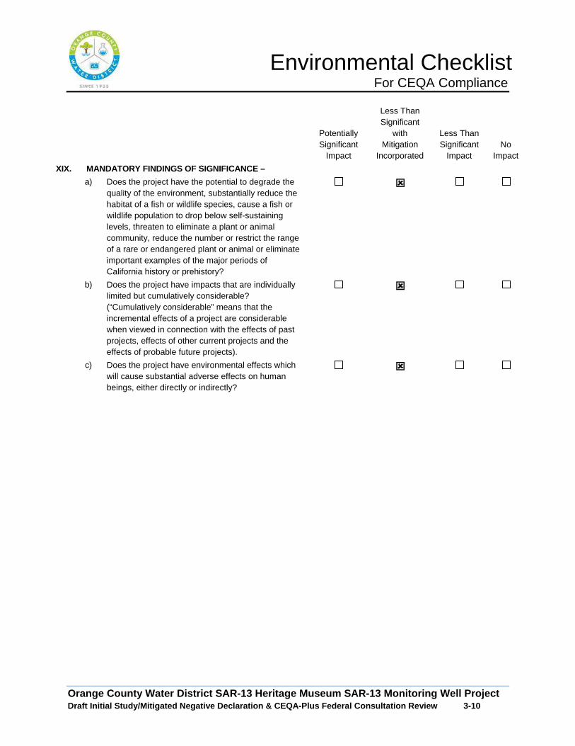
Environmental Checklist For CEQA Compliance
Orange County Water District SAR-13 Heritage Museum SAR-13 Monitoring Well Project Draft Initial Study/Mitigated Negative Declaration & CEQA-Plus Federal Consultation Review 3 -10
Potentially Significant
Impact
Less Than Significant
with Mitigation
Incorporated
Less Than Significant
Impact No
Impact
XIX. MANDATORY FINDINGS OF SIGNIFICANCE –
a) Does the project have the potential to degrade the quality of the environment, substantially reduce the habitat of a fish or wildlife species, cause a fish or wildlife population to drop below self-sustaining levels, threaten to eliminate a plant or animal community, reduce the number or restrict the range of a rare or endangered plant or animal or eliminate important examples of the major periods of California history or prehistory?
:
b) Does the project have impacts that are individually limited but cumulatively considerable? (“Cumulatively considerable” means that the incremental effects of a project are considerable when viewed in connection with the effects of past projects, effects of other current projects and the effects of probable future projects).
:
c) Does the project have environmental effects which will cause substantial adverse effects on human beings, either directly or indirectly?
:
Section 4
Orange County Water District SAR-13 Heritage Museum SAR-13 Monitoring Well Project Draft Initial Study/Mitigated Negative Declaration & CEQA-Plus Federal Consultation Review 4 -1
SECTION 4.0 ENVIRONMENTAL ANALYSIS
The following analysis responds to the environmental issues listed on the OCWD CEQA Checklist Form. The analysis identifies the level of anticipated impact and where needed includes the incorporation of mitigation measures to reduce potentially significant impacts to the environment to a less than significant level.
4.1 Aesthetics
The Heritage Museum is a cultural and natural history center that is situated within an open space park like setting. The primary visual elements at Heritage Museum are historical structures, gardens and natural open space. The site is visually separated into two areas. The southern portion of the site is occupied with several historical buildings that are surrounded by fruit trees, ornamental landscaping and a large court yard. The northern portion of the Heritage Museum consists predominately of natural open space. A rolling hill with a walking path is situate in the center of the site that provides scenic vistas of the Heritage Museum site and distant views of the Santa Ana Mountains. The site contains a series trails and public vistas that provide views of the open space and cultural resources amenities at the Heritage Museum.
A: Would the project have a substantial adverse ef fect on a scenic vista?
Less than Significant Impact: The proposed monitoring well would be constructed below ground at the northeast corner of the Heritage Museum. The only exposed portion of the monitoring well would be a metal cover and concrete apron which would be at grade and would not interfere with existing scenic vistas within the Heritage Museum. No potential long term adverse impacts to scenic vistas within Heritage Museum would occur.
The construction of the monitoring well would temporary replace existing scenic vistas at the Heritage Museum with construction activity and equipment. The potential construction impacts to scenic vistas would be for approximately 3 months. Once the construction operations are completed, existing views within Heritage Museum would be returned to their pre-project condition. Because the temporary construction impacts would be for a short period of time, potential construction related adverse impacts to scenic vistas would be less than significant. No mitigation measures are required.
B. Would the project damage scenic resources, inclu ding but limited to, trees, rock outpourings, and historic buildings within a S tate Highway?
No Impact: According to the California Department of Transportation Scenic Highways Program, the closest State Scenic Highway to the Heritage Museum would be the segment of State Route 91 located east of State Route 55, which is a proposed eligible State Scenic Highway. This segment of State Route 91 is located over 10 miles from the Heritage Museum and would not be within the view shed of motorist. The
Section 4
Orange County Water District SAR-13 Heritage Museum SAR-13 Monitoring Well Project Draft Initial Study/Mitigated Negative Declaration & CEQA-Plus Federal Consultation Review 4 -2
construction and operation of the proposed monitoring well would not have an adverse impact on any scenic resources along a State Scenic Highway. No mitigation measures are required.
C. Would the project substantially degrade the exis ting visual character or quality of the site and its surrounding?
Less than Significant Impact: The proposed monitoring well site is situated in a passive park like setting. The monitoring well would be located underground and would not result in long-term adverse changes to the visual character of the Heritage Museum. The proposed construction activities for the monitoring well and site improvements would be confined to the east side of the Heritage Museum. The construction activities would temporarily alter the existing park like setting in that portion of the Heritage Museum. Once the construction activities are completed, the areas that were disturbed by the construction activities would be returned to their pre-project condition. Because the construction activities would occur in a relatively small area of the Heritage Museum for a short period of time and the disturbed areas would be returned to their pre-project condition, potential short-term construction impacts would be less than significant.
D. Would the project create a new source of substantial light or glare which would adversely affect day or nighttime views in the area .
Less than Significant Impact with Mitigation: The proposed monitoring well at the Heritage Museum would not permanently introduce new sources of light and glare into the study area. No long term light and glare impacts would occur. The proposed well drilling activities at the Heritage Museum would occur during the day and night. To ensure safe working conditions during the night time, floodlights would be used to light the work area. Sensitive receptors within the line of sight of the flood lights during night time construction activities could be adversely impacted from spill over light and glare impacts. To avoid adverse spill over light and glare impacts, the floodlights would be shielded and directed to the work area. With the implementation of Mitigation Measures AR-1 and AR-2 potential construction related light and glare impacts would be less than significant.
Mitigation Measure
A-1: All onsite lighting will be directed away from residential uses.
A-2: If needed, during construction OCWD will implement corrective measures to resolve the issue. Such corrective measures may include providing additional shielding on light fixtures, relocating lighting fixtures and reducing the intensity of lighting.
4.2 Agricultural Resources/Forest Resources
A. Would the project convert Prime Farmland, Unique Farmland or Farmland of Statewide Importance to non-agriculture uses?
Section 4
Orange County Water District SAR-13 Heritage Museum SAR-13 Monitoring Well Project Draft Initial Study/Mitigated Negative Declaration & CEQA-Plus Federal Consultation Review 4 -3
No impact. According to the State of California Farmland Mapping and Monitoring Program, the study area does not contain any Prime Farmland, Unique Farmland, or Farmland of Statewide Importance. Therefore, no adverse impacts to Prime Farmland, Unique Farmland, or Farmland of Statewide Importance would occur from the implementation of the Proposed Project. No mitigation measures are required.
B. Would the project be in conflict with existing z oning for agriculture use or a Williamson Contract?
No Impact. According to the City of Santa Ana Zoning Code, the study area is not zoned for agriculture uses. Additionally, the City’s General Plan does not identify that there are any existing Williamson Contracts on the property. Therefore, implementation of the Proposed Project would not be in conflict with any existing agriculture zoning. No mitigation measures are required.
C. Would the project be in conflict with existing z oning for, or cause rezoning of forest land or timberland.
No Impact. According to the City of Santa Ana General Plan, the study area is not zoned for forest land or timberland. Therefore, implementation of the Proposed Project would not cause change of zone of existing forest or timberland to other land uses. No mitigation measures are required.
D. Would the project result in the loss of forest l and or conversion of forest land to non-forest use?
No Impact: The study area is not located on forest land. Therefore, the implementation of the Proposed Project would not convert existing forest land to non-forest land. No mitigation measures are required.
E. Would the project involve other changes in the e xisting environment which, due to their location or nature, could result in co nversion of Farmland to non-agriculture use or conversion of forest land to non-forest use?
No Impact. The study area is not located on forest land. Therefore, the implementation of the Proposed Project would not directly or indirectly result in the loss of any forest land or result in the conversion forest lands to non-forest lands. Additionally, the implementation of the Proposed Project would not convert existing farmlands within the study area to non-agriculture land uses. No mitigation measures are required.
4.3 Air Quality
The following analysis is based on an Air Quality and Greenhouse Gas Report prepared for the Heritage Museum SAR-13 Monitoring Well Project by Vista Environmental in December of 2016. The Air Quality and Greenhouse Gas Report are presented in Appendix A.
Section 4
Orange County Water District SAR-13 Heritage Museum SAR-13 Monitoring Well Project Draft Initial Study/Mitigated Negative Declaration & CEQA-Plus Federal Consultation Review 4 -4
Setting
The project site is located within the central costal portion of Orange County in the City of Santa Ana, which are part of the South Coast Air Basin (Air Basin). The Air Basin includes all of Orange County as well as the non-desert portions of Los Angeles, Riverside, and San Bernardino Counties. The proposed monitoring well would be located on the Heritage Museum, approximately 150 feet southwest of the intersection of West Centennial Road and Fairview Street and approximately 0.5 miles east of the Santa Ana River.
Regulatory Framework
Air pollutants are regulated at the national, state and air basin level. Each agency has a different level of regulatory responsibility. The United States Environmental Protection Agency (EPA) regulates at the national level. The California Air Resources Board (CARB) regulates at the state level and the South Coast Air Quality Management District (SCAQMD) regulates at the air basin level.
Federal Regulations
As required by the Federal Clean Air Act (CAA), the U.S. Environmental Protection Agency (USEPA) has identified criteria pollutants and has established National Ambient Air Quality Standards (NAAQS) to protect public health and welfare. NAAQS have been established for ozone (O3), carbon monoxide (CO), nitrogen dioxide (NO2), sulfur dioxide (SO2), particulate matter (PM10 and PM2.5), and lead (Pb). These pollutants are called “criteria” air pollutants because standards have been established for each of them to meet specific public health and welfare criteria. The NAAQS establish the level for an air pollutant above which detrimental effects to public health or welfare may result. The NAAQS are defined as the maximum acceptable concentrations that, depending on the pollutant, may not be equaled or exceeded more than once per year or in some cases as a percentile of observations.
The General Conformity Rule (40 CFR Part 93) requires that federal agencies demonstrate that federal actions conform with the applicable State Implementation Plan (SIP) in order to ensure that federal activities do not hamper local efforts to control air pollution. The EPA general conformity rule applies to federal actions occurring in nonattainment or maintenance areas when the total direct and indirect emissions of nonattainment pollutants (or their precursors) exceed specified thresholds. The de minimis emission thresholds are based on the attainment status of each air basin. Since the Proposed Project is located in an air basin that is designated attainment for all federal criteria pollutants, it is not subject to the General Conformity emissions thresholds.
Section 4
Orange County Water District SAR-13 Heritage Museum SAR-13 Monitoring Well Project Draft Initial Study/Mitigated Negative Declaration & CEQA-Plus Federal Consultation Review 4 -5
State
A State Implementation Plan (SIP) is a document prepared by each state describing air quality conditions and measures that would be followed to attain and maintain NAAQS. The SIP for the State of California is administered by the ARB, which has overall responsibility for statewide air quality maintenance and air pollution prevention. The ARB also administers California Ambient Air Quality Standards (CAAQS), for the ten air pollutants designated in the California Clean Air Act (CCAA). The ten state air pollutants include the six national criteria pollutants and visibility reducing particulates, hydrogen sulfide, sulfates and vinyl chloride.
South Coast Air Quality Management District
SCAQMD develops rules and regulations, establishes permitting requirements for stationary sources, inspects emission sources, and enforces such measures through educational programs or fines, when necessary.
SCAQMD is directly responsible for reducing emissions from stationary, mobile, and indirect sources. It has responded to this requirement by preparing a sequence of Air Quality Management Plans (AQMPs). The 2007 AQMP demonstrated attainment with the 1997 8-hour ozone (80 ppb) standard by 2023, through implementation of future improvements in control techniques and technologies. These “black box” emissions reductions represent 65 percent of the remaining NOx emission reductions by 2023 in order to show attainment with the 1997 8-hour ozone NAAQS. Given the magnitude of these needed emissions reductions, additional NOx control measures have been provided in this AQMP even though the primary purpose of this AQMP is to show compliance with 24-hour PM2.5 emissions standards.
The Final 2012 Air Quality Management Plan (2012 AQMP) was adopted by the SCAQMD Board on December 7, 2012 and was adopted by CARB via Resolution 13-3 on January 25, 2013. The 2012 AQMP was prepared in order to meet the federal Clean Air Act requirement that all 24-hour PM2.5 non-attainment areas prepare a SIP, that were required to be submitted to the U.S. EPA by December 14, 2012 and demonstrate attainment with the 24-hour PM2.5 standard by 2014. The 2012 AQMP demonstrates attainment of the federal 24-hour PM2.5 standard by 2014 in the Air Basin through adoption of all feasible measures, and therefore, no extension of the attainment date is needed.
The 2012 AQMP is designed to satisfy the California Clean Air Act’s (CCAA) emission reductions of five percent per year or adoption of all feasible measures requirements and fulfill the EPA’s requirement to update transportation conformity emissions budgets based on the latest approved motor vehicle emissions model and planning assumptions. The 2012 AQMP updates and revises the previous 2007 AQMP. The 2012 AQMP was prepared to comply with the Federal and State CCAA and amendments, to accommodate growth, to reduce the high pollutant levels in the Air

Section 4
Orange County Water District SAR-13 Heritage Museum SAR-13 Monitoring Well Project Draft Initial Study/Mitigated Negative Declaration & CEQA-Plus Federal Consultation Review 4 -6
Basin, to meet Federal and State ambient air quality standards, and to minimize the fiscal impact that pollution control measures have on the local economy. The purpose of the 2012 AQMP for the Air Basin is to set forth a comprehensive program that would lead this area into compliance with all federal and state air-quality planning requirements.
The 2012 AQMP builds upon the approaches taken in the 2007 AQMP for the attainment of federal PM and ozone standards, and highlights the significant amount of reductions needed and the need to engage in interagency coordinated planning of mobile sources to meet all of the federal criteria pollutant standards. Compared with the 2007 AQMP, the 2012 AQMP utilizes revised emissions inventory projections that use 2008 as the base year. On-road emissions are calculated using CARB EMFAC2011 emission factors and the transportation activity data provided by SCAG from their 2012 Regional Transportation Plan (2012 RTP). Off-road emissions were updated using CARB’s 2011 In-Use Off-Road Fleet Inventory Model. Since the 2007 AQMP was finalized new area source categories such as LPG transmission losses, storage tank and pipeline cleaning and degassing, and architectural colorants, were created and included in the emissions inventories. Composting waste was revised and now includes the emissions from green waste composting covered under SCAQMD Rule 1133.3. The 2012 AQMP also includes analysis of several additional sources of GHG emissions such as landfills and could also assist in reaching the GHG target goals in the AB32 Scoping Plan.
The control measures in the 2012 AQMP consist of three components: 1) Basin-wide and episodic short-term PM2.5 measures; 2) Section 182(e)(5) implementation measures; and 3) Transportation control measures. Many of the control measures are not based on command and control regulations, but instead focus on incentives, outreach, and education to bring about emissions reductions through voluntary participation and behavioral changes. More broadly, a transition to zero- and near-zero emission technologies is necessary to meet 2023 and 2032 air quality standards and 2050 climate goals. Many of the same technologies will address both air quality and climate needs.
In June 2016, the SCAQMD released a draft of its forthcoming 2016 Air Quality Management Plan. The plan will develop integrated strategies and measures to meet the following standards:
x 8-hour Ozone (75 ppb) by 2032 x Annual PM2.5 (12 µg/m3) by 2021-2025 x 8-hour Ozone (80 ppb) by 2024 (updated from the 2007 and 2012 AQMPs) x 1-hour Ozone (120 ppb) by 2023 (updated from the 2012 AQMP) x 24-hour PM2.5 (35 µg/m3) by 2019 (updated from the 2012 AQMP)
Section 4
Orange County Water District SAR-13 Heritage Museum SAR-13 Monitoring Well Project Draft Initial Study/Mitigated Negative Declaration & CEQA-Plus Federal Consultation Review 4 -7
Although SCAQMD is responsible for regional air quality planning efforts, it does not have the authority to directly regulate air quality issues associated with plans and new development projects throughout the Air Basin. Instead, this is controlled through local jurisdictions in accordance to the California Environmental Quality Act (CEQA). In order to assist local jurisdictions with air quality compliance issues the CEQA Air Quality Handbook (SCAQMD CEQA Handbook), prepared by SCAQMD, 1993, with the most current updates found at http://www.aqmd.gov/ceqa/hdbk.html, was developed in accordance with the projections and programs detailed in the AQMPs. The purpose of the SCAQMD CEQA Handbook is to assist Lead Agencies, as well as consultants, project proponents, and other interested parties in evaluating a proposed project’s potential air quality impacts. Specifically, the SCAQMD CEQA Handbook explains the procedures that SCAQMD recommends be followed for the environmental review process required by CEQA. The SCAQMD CEQA Handbook provides direction on how to evaluate potential air quality impacts, how to determine whether these impacts are significant, and how to mitigate these impacts. The SCAQMD intends that by providing this guidance, the air quality impacts of plans and development proposals will be analyzed accurately and consistently throughout the Air Basin, and adverse impacts would be minimized.
SCAQMD Rules and Regulations
All projects are subject to SCAQMD rules and regulations in effect at the time of construction. Specific rules applicable to the construction anticipated under the proposed project would include the following:
Rule 401: Visible Emissions A person shall not discharge into the atmosphere from any single source of emission whatsoever any air contaminant for a period or periods aggregating more than three minutes in any 1 hour that is as dark or darker in shade as that designated No. 1 on the Ringelmann Chart, as published by the United States Bureau of Mines.
Rule 402: Nuisance A person shall not discharge from any source whatsoever such quantities of air contaminants or other material that cause injury, detriment, nuisance, or annoyance to any considerable number of persons or to the public, or that endanger the comfort, repose, health, or safety of any such persons or the public, or that cause, or have a natural tendency to cause, injury or damage to business or property. The provisions of this rule do not apply to odors emanating from agricultural operations necessary for the growing of crops or the raising of fowl or animals.
Rule 403: Fugitive Dust This rule is intended to reduce the amount of particulate matter entrained in the ambient air as a result of anthropogenic (human-made) fugitive dust sources by requiring actions to prevent, reduce, or mitigate fugitive dust emissions. Rule 403 applies to any activity or human-made condition capable of generating fugitive dust.

Section 4
Orange County Water District SAR-13 Heritage Museum SAR-13 Monitoring Well Project Draft Initial Study/Mitigated Negative Declaration & CEQA-Plus Federal Consultation Review 4 -8
Rule 1113: Architectural Coatings No person shall apply or solicit the application of any architectural coating within the SCAQMD with VOC content in excess of the values specified in a table incorporated in the Rule.
Existing Air Quality
SCAQMD maintains monitoring stations within district boundaries that monitor air quality and compliance with associated ambient standards. The study area is located in air monitoring area 17, which covers the northwest coastal portion of Orange County. Since not all monitoring stations measure all of the tracked pollutants, the data from the following two monitoring stations, listed in the order of proximity to the project site have been used; Costa Mesa-Mesa Verde Monitoring Station (Costa Mesa Station) and Anaheim-Pampas Lane Monitoring Station (Anaheim Station). The air pollutants of primary concern in the study area are ozone and particulate matter (PM10 and PM2.5).
Both CARB and USEPA use this type of monitoring data to designate areas according to their attainment status for criteria air pollutants. The purpose of these designations is to identify the areas with air quality problems and thereby initiate planning efforts for improvement. The three basic designation categories are nonattainment, attainment, and unclassified. Unclassified is used in an area that cannot be classified on the basis of available information as meeting or not meeting the standards. In addition, the California designations include a subcategory of nonattainment-transitional, which is given to nonattainment areas that are progressing and nearing attainment. The current attainment status for the SCAB is provided in Table 8.
Table 8: South Coast Air Basin Attainment Status
Attainment Status
Pollutant California Standards Federal Standards
Ozone Extreme Nonattainment Severe Nonattainment CO Attainment Unclassified/ Attainment NO2 Attainment Unclassified/ Attainment SO2 Attainment Attainment PM10 Nonattainment Attainment PM2.5 Nonattainment Nonattainment Lead Attainment Nonattainment
Toxic Air Contaminant Levels in the Air Basin
In order to determine the Air Basin-wide risks associated with major airborne carcinogens, the SCAQMD conducted the Multiple Air Toxics Exposure Study (MATES) studies. According to the SCAQMD’s MATES-IV study, the project site has an estimated cancer risk of 815 per million chance of cancer. In comparison, the average
Section 4
Orange County Water District SAR-13 Heritage Museum SAR-13 Monitoring Well Project Draft Initial Study/Mitigated Negative Declaration & CEQA-Plus Federal Consultation Review 4 -9
cancer risk for the Air Basin in 991 per million persons, which is based on the use of age-sensitivity factors detailed in the OEHHA Guidelines (OEHHA, 2015).
In order to provide a perspective of risk, it is often estimated that the incidence in cancer over a lifetime for the U.S. population ranges between 1 in 3 to 4 and 1 in 3, or a risk of about 300,000 per million persons. The MATES-III study referenced a Harvard Report on Cancer Prevention, which estimated that of cancers associated with known risk factors, about 30 percent were related to tobacco, about 30 percent were related to diet and obesity, and about 2 percent were associated with environmental pollution related exposures that includes hazardous air pollutants.
Sensitive Receptors
Sensitive receptors are individuals who are considered more sensitive to air pollutants than others. The reasons for greater than average sensitivity could include pre-existing health problems, proximity to emissions sources, or duration of exposure to air pollutants. Schools, hospitals, and convalescent homes are considered to be relatively sensitive to poor air quality because children, elderly people, and the infirm are more susceptible to respiratory distress and other air quality-related health problems than the general public. Residential areas are considered sensitive to poor air quality because people usually stay home for extended periods of time, with associated greater exposure to ambient air quality. Recreational uses are also considered sensitive due to the greater exposure to ambient air quality conditions because vigorous exercise associated with recreation places a high demand on the human respiratory system. The nearest sensitive receptors are single-family homes located as near as 200 feet to the east of the proposed well site. The nearest schools are Godinez High School and Mitchell Elementary School.
Significant Impact Threshold
The OCWD and the City of Santa Ana have not developed specific air quality thresholds for air quality impacts. However, as stated in Appendix G of the CEQA Guidelines, the significance criteria established by the applicable air quality management or air pollution control district may be relied upon to make the above determinations. As such, the significance thresholds and analysis methodologies in SCAQMD’s CEQA Air Quality Handbook are used in evaluating project impacts. SCAQMD has established daily mass thresholds for regional pollutant emissions, which are shown in Table 9.
Aside from regional air quality impacts, projects in the SCAB are also required to analyze local air quality impacts. As discussed previously, SCAQMD has developed LSTs that represent the maximum emissions from a project that are not expected to cause or contribute to an exceedance of the most stringent applicable federal or state ambient air quality standards, and thus would not cause or contribute to localized air quality impacts. LSTs are developed based on the ambient concentrations of that
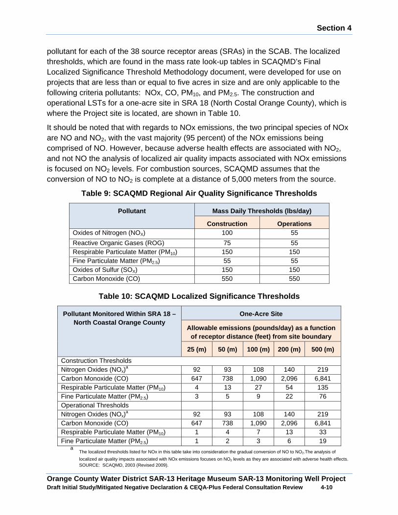
Section 4
Orange County Water District SAR-13 Heritage Museum SAR-13 Monitoring Well Project Draft Initial Study/Mitigated Negative Declaration & CEQA-Plus Federal Consultation Review 4 -10
pollutant for each of the 38 source receptor areas (SRAs) in the SCAB. The localized thresholds, which are found in the mass rate look-up tables in SCAQMD’s Final Localized Significance Threshold Methodology document, were developed for use on projects that are less than or equal to five acres in size and are only applicable to the following criteria pollutants: NOx, CO, PM10, and PM2.5. The construction and operational LSTs for a one-acre site in SRA 18 (North Costal Orange County), which is where the Project site is located, are shown in Table 10.
It should be noted that with regards to NOx emissions, the two principal species of NOx are NO and NO2, with the vast majority (95 percent) of the NOx emissions being comprised of NO. However, because adverse health effects are associated with NO2, and not NO the analysis of localized air quality impacts associated with NOx emissions is focused on NO2 levels. For combustion sources, SCAQMD assumes that the conversion of NO to NO2 is complete at a distance of 5,000 meters from the source.
Table 9: SCAQMD Regional Air Quality Significance Thresholds
Pollutant Mass Daily Thresholds (lbs/day)
Construction Operations Oxides of Nitrogen (NOX) 100 55
Reactive Organic Gases (ROG) 75 55 Respirable Particulate Matter (PM10) 150 150 Fine Particulate Matter (PM2.5) 55 55 Oxides of Sulfur (SOX) 150 150 Carbon Monoxide (CO) 550 550
Table 10: SCAQMD Localized Significance Thresholds
Pollutant Monitored Within SRA 18 – North Coastal Orange County
One-Acre Site
Allowable emissions (pounds/day) as a function of receptor distance (feet) from site boundary
25 (m) 50 (m) 100 (m) 200 (m) 500 (m)
Construction Thresholds Nitrogen Oxides (NOx)
a 92 93 108 140 219 Carbon Monoxide (CO) 647 738 1,090 2,096 6,841 Respirable Particulate Matter (PM10) 4 13 27 54 135 Fine Particulate Matter (PM2.5) 3 5 9 22 76 Operational Thresholds Nitrogen Oxides (NOx)
a 92 93 108 140 219 Carbon Monoxide (CO) 647 738 1,090 2,096 6,841 Respirable Particulate Matter (PM10) 1 4 7 13 33 Fine Particulate Matter (PM2.5) 1 2 3 6 19
a The localized thresholds listed for NOx in this table take into consideration the gradual conversion of NO to NO2.The analysis of
localized air quality impacts associated with NOx emissions focuses on NO2 levels as they are associated with adverse health effects.
SOURCE: SCAQMD, 2003 (Revised 2009).
Section 4
Orange County Water District SAR-13 Heritage Museum SAR-13 Monitoring Well Project Draft Initial Study/Mitigated Negative Declaration & CEQA-Plus Federal Consultation Review 4 -11
A. Would the project be in conflict with or obstruct implementation of the applicable air quality plan or congestion management plan?
Less than Significant Impact: The California Environmental Quality Act (CEQA) requires a discussion of any inconsistencies between a project and applicable General Plans and regional plans. The regional plan that applies to the Proposed Project includes the SCAQMD Air Quality Management Plan (AQMP). Therefore, this section discusses any potential inconsistencies of the Proposed Project with the AQMP.
The purpose of this discussion is to set forth the issues regarding consistency with the assumptions and objectives of the AQMP and discuss whether a project would interfere with the region’s ability to comply with Federal and State air quality standards. If the decision-makers determine that the project is inconsistent, the lead agency may consider project modifications or inclusion of mitigation to eliminate the inconsistency.
The SCAQMD CEQA Handbook states that "New or amended General Plan Elements (including land use zoning and density amendments), Specific Plans, and significant projects must be analyzed for consistency with the AQMP." A project should be considered to be consistent with the AQMP if it furthers one or more policies and does not obstruct other policies. The SCAQMD CEQA Handbook identifies two key indicators of consistency:
(1) Whether the project would result in an increase in the frequency or severity of existing air quality violations or cause or contribute to new violations, or delay timely attainment of air quality standards or the interim emission reductions specified in the AQMP.
(2) Whether the project would exceed the assumptions in the AQMP or increments based on the year of project buildout and phase.
Both of these criteria are evaluated in the following sections.
Criterion 1 - Increase in the Frequency or Severity of Violations?
As shown in Table 11, construction air emissions would not result in significant impacts based on SCAQMD regional thresholds of significance. Additionally, the ongoing operation of the Proposed Project would generate air pollutant emissions that are inconsequential on a regional basis and would not result in significant impacts based on SCAQMD thresholds of significance as shown in Table 14. The analysis for long-term local air quality impacts showed that local pollutant concentrations would not be projected to exceed the air quality standards. Therefore, no long-term impact would occur and no mitigation would be required. Therefore, based on the information provided above, the Proposed Project would be consistent with the first criterion.
Section 4
Orange County Water District SAR-13 Heritage Museum SAR-13 Monitoring Well Project Draft Initial Study/Mitigated Negative Declaration & CEQA-Plus Federal Consultation Review 4 -12
Criterion 2 - Exceed Assumptions in the AQMP
Consistency with the AQMP assumptions is determined by performing an analysis of the Proposed Project with the assumptions in the AQMP. The emphasis of this criterion is to insure that the analyses conducted for the Proposed Project are based on the same forecasts as the AQMP. The AQMP is developed through use of the planning forecasts provided in the RTP/SCS and FTIP. The RTP/SCS is a major planning document for the regional transportation and land use network within Southern California. The RTP/SCS is a long-range plan that is required by federal and state requirements placed on SCAG and is updated every four years. The FTIP provides long-range planning for future transportation improvement projects that are constructed with state and/or federal funds within Southern California. Local governments are required to use these plans as the basis of their plans for the purpose of consistency with applicable regional plans under CEQA. For this project, the City of Santa Ana General Plan defines the assumptions that are represented in the AQMP.
The project site is designated as Institutional (INS) in the City of Santa Ana General Plan and is zoned Open Space (O) in the City’s Zoning map. Since well drilling is an allowed use in all land use designations, the Proposed Project would be consistent with the current land use designations and would not require a General Plan Amendment or zone change. Therefore, the Proposed Project would not be anticipated to exceed the AQMP assumptions for the project site and would be found to be consistent with the AQMP for the second criterion. Based on the above, the Proposed Project would not result in an inconsistency with the SCAQMD AQMP. Therefore, a less than significant impact would occur in relation to implementation of the AQMP.
B. Would the project violate any air quality standa rd or contribute substantially to an existing or projected air quality violation?
Construction Emissions
The construction emissions have been analyzed for both regional and local air quality impacts as well as potential toxic air impacts.
Regional Air Quality Impacts
Less than Significant Impact: As shown in Table 11, for each phase of well construction activities none of the analyzed criteria pollutants would exceed the regional emissions thresholds. Therefore, construction-related regional criteria pollutant emissions would be less than significant.

Section 4
Orange County Water District SAR-13 Heritage Museum SAR-13 Monitoring Well Project Draft Initial Study/Mitigated Negative Declaration & CEQA-Plus Federal Consultation Review 4 -13
Table 11: Construction-Related Regional Criteria Po llutant Emissions
Pollutant Emissions (pounds/day)
Activity VOC NOx CO SO2 PM10 PM2.5 Temporary Noise Barrier Wall Construction On-Site1 0.70 6.97 5.88 0.01 0.50 0.46 Off-Site2 0.04 0.19 0.52 0.00 0.08 0.02 Total 0.74 7.16 6.39 0.01 0.58 0.48 Conductor Casing Installation On-Site 2.26 27.97 26.03 0.05 1.42 1.38 Off-Site 0.04 0.06 0.65 0.00 0.15 0.04 Total 2.30 28.03 26.68 0.05 1.57 1.42 Monitor Well Drilling On-Site 5.88 84.37 81.32 0.17 3.26 3.25 Off-Site 0.05 0.07 0.75 0.00 0.17 0.05 Total 5.93 84.44 82.08 0.17 3.43 3.29 Monitor Well Construction On-Site 5.91 65.22 67.08 0.12 3.39 3.34 Off-Site 0.07 0.09 1.00 0.00 0.23 0.06 Total 5.98 65.31 68.08 0.12 3.62 3.40 Monitor Well Development On-Site 2.88 38.06 35.53 0.06 1.56 1.51 Off-Site 0.03 0.04 0.50 0.00 0.11 0.03 Total 2.91 38.11 36.03 0.06 1.67 1.54 Site Clean-Up and Vault Installation On-Site 0.73 7.59 5.00 0.01 0.38 0.35 Off-Site 0.02 0.02 0.23 0.00 0.06 0.02 Total 0.75 7.61 5.23 0.01 0.44 0.37 Site Improvements - Grading On-Site 2.38 24.12 11.31 0.03 3.89 2.51 Off-Site 0.09 0.83 1.13 0.00 0.18 0.06 Total 2.47 24.95 12.44 0.03 4.07 2.56 Site Improvements - Other On-Site 0.76 7.23 3.96 0.01 0.30 0.28 Off-Site 0.03 0.04 0.46 0.00 0.11 0.03 Total 0.79 7.27 4.42 0.01 0.41 0.31 SCAQMD Thresholds 75.00 100.00 550.00 150.00 150.00 55.00 Exceeds Thresholds? No No No No No No Notes: 1 Onsite emissions from equipment not operated on public roads. 2 Offsite emissions from vehicles operating on public roads. Source: CalEEMod Version 2013.2.2.
Localized Air Quality Impacts
Less than Significant Impact with Mitigation: Construction-related air emissions may have the potential to exceed the State and Federal air quality standards in the study area, even though these pollutant emissions may not be significant enough to create a
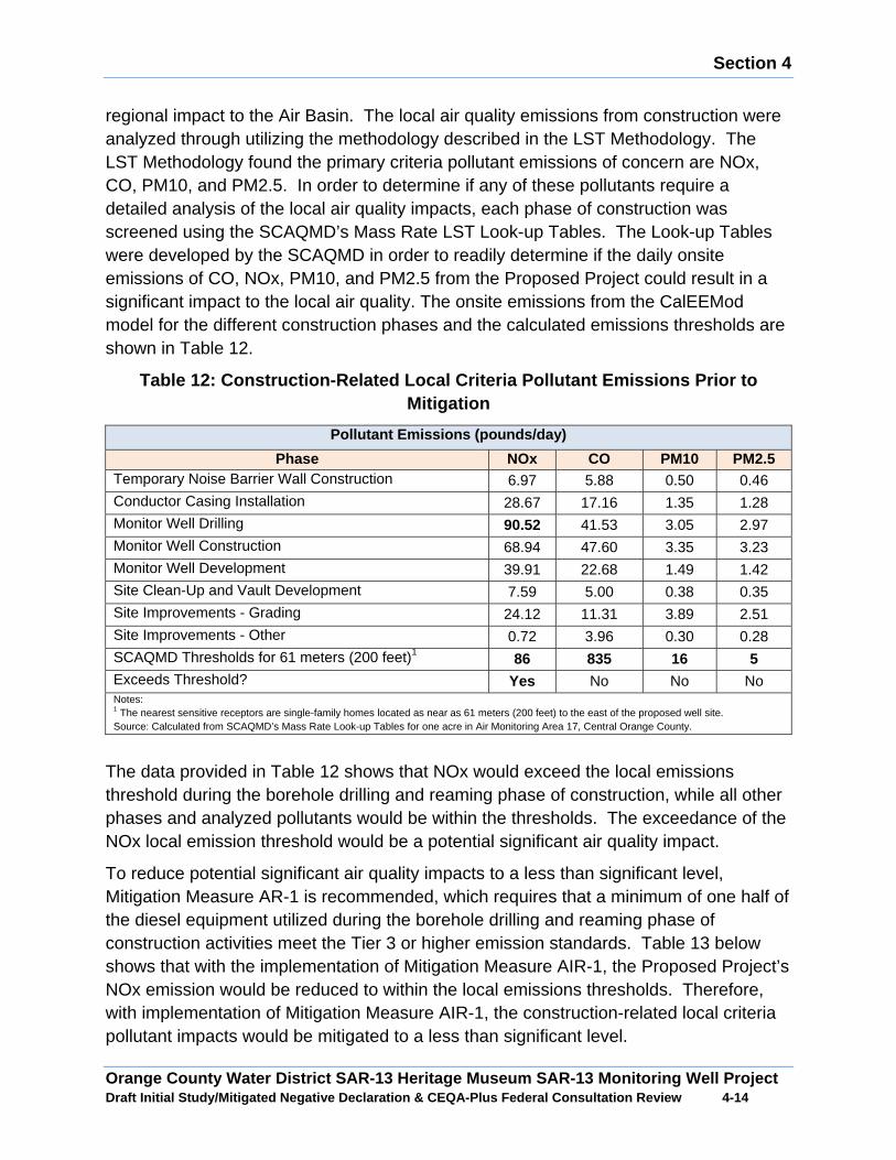
Section 4
Orange County Water District SAR-13 Heritage Museum SAR-13 Monitoring Well Project Draft Initial Study/Mitigated Negative Declaration & CEQA-Plus Federal Consultation Review 4 -14
regional impact to the Air Basin. The local air quality emissions from construction were analyzed through utilizing the methodology described in the LST Methodology. The LST Methodology found the primary criteria pollutant emissions of concern are NOx, CO, PM10, and PM2.5. In order to determine if any of these pollutants require a detailed analysis of the local air quality impacts, each phase of construction was screened using the SCAQMD’s Mass Rate LST Look-up Tables. The Look-up Tables were developed by the SCAQMD in order to readily determine if the daily onsite emissions of CO, NOx, PM10, and PM2.5 from the Proposed Project could result in a significant impact to the local air quality. The onsite emissions from the CalEEMod model for the different construction phases and the calculated emissions thresholds are shown in Table 12.
Table 12: Construction-Related Local Criteria Pollu tant Emissions Prior to Mitigation
Pollutant Emissions (pounds/day)
Phase NOx CO PM10 PM2.5 Temporary Noise Barrier Wall Construction 6.97 5.88 0.50 0.46 Conductor Casing Installation 28.67 17.16 1.35 1.28 Monitor Well Drilling 90.52 41.53 3.05 2.97 Monitor Well Construction 68.94 47.60 3.35 3.23 Monitor Well Development 39.91 22.68 1.49 1.42 Site Clean-Up and Vault Development 7.59 5.00 0.38 0.35 Site Improvements - Grading 24.12 11.31 3.89 2.51 Site Improvements - Other 0.72 3.96 0.30 0.28 SCAQMD Thresholds for 61 meters (200 feet)1
86 835 16 5 Exceeds Threshold? Yes No No No Notes: 1 The nearest sensitive receptors are single-family homes located as near as 61 meters (200 feet) to the east of the proposed well site. Source: Calculated from SCAQMD’s Mass Rate Look-up Tables for one acre in Air Monitoring Area 17, Central Orange County.
The data provided in Table 12 shows that NOx would exceed the local emissions threshold during the borehole drilling and reaming phase of construction, while all other phases and analyzed pollutants would be within the thresholds. The exceedance of the NOx local emission threshold would be a potential significant air quality impact.
To reduce potential significant air quality impacts to a less than significant level, Mitigation Measure AR-1 is recommended, which requires that a minimum of one half of the diesel equipment utilized during the borehole drilling and reaming phase of construction activities meet the Tier 3 or higher emission standards. Table 13 below shows that with the implementation of Mitigation Measure AIR-1, the Proposed Project’s NOx emission would be reduced to within the local emissions thresholds. Therefore, with implementation of Mitigation Measure AIR-1, the construction-related local criteria pollutant impacts would be mitigated to a less than significant level.
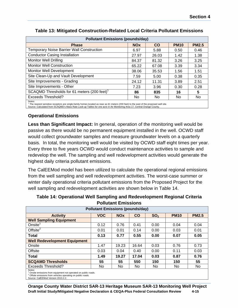
Section 4
Orange County Water District SAR-13 Heritage Museum SAR-13 Monitoring Well Project Draft Initial Study/Mitigated Negative Declaration & CEQA-Plus Federal Consultation Review 4 -15
Table 13: Mitigated Construction-Related Local Criteria Pollutant Emissions
Pollutant Emissions (pounds/day)
Phase NOx CO PM10 PM2.5 Temporary Noise Barrier Wall Construction 6.97 5.88 0.50 0.46 Conductor Casing Installation 27.97 26.03 1.42 1.38 Monitor Well Drilling 84.37 81.32 3.26 3.25 Monitor Well Construction 65.22 67.08 3.39 3.34 Monitor Well Development 38.06 35.53 1.56 1.51 Site Clean-Up and Vault Development 7.59 5.00 0.38 0.35 Site Improvements - Grading 24.12 11.31 3.89 2.51 Site Improvements - Other 7.23 3.96 0.30 0.28 SCAQMD Thresholds for 61 meters (200 feet)1
86 835 16 5 Exceeds Threshold? No No No No Notes: 1 The nearest sensitive receptors are single-family homes located as near as 61 meters (200 feet) to the east of the proposed well site. Source: Calculated from SCAQMD’s Mass Rate Look-up Tables for one acre in Air Monitoring Area 17, Central Orange County.
Operational Emissions
Less than Significant Impact: In general, operation of the monitoring well would be passive as there would be no permanent equipment installed in the well. OCWD staff would collect groundwater samples and measure groundwater levels on a quarterly basis. In total, the monitoring well would be visited by OCWD staff eight times per year. Every three to five years OCWD would conduct maintenance activities to sample and redevelop the well. The sampling and well redevelopment activities would generate the highest daily criteria pollutant emissions.
The CalEEMod model has been utilized to calculate the operational regional emissions from the well sampling and well redevelopment activities. The worst-case summer or winter daily operational criteria pollutant emissions from the Proposed Project for the well sampling and redevelopment activities are shown below in Table 14.
Table 14: Operational Well Sampling and Redevelopment Regional Criteria Pollutant Emissions
Pollutant Emissions (pounds/day)
Activity VOC NOx CO SO2 PM10 PM2.5 Well Sampling Equipment Onsite1 0.12 0.76 0.41 0.00 0.04 0.04 Offsite2 0.01 0.01 0.14 0.00 0.03 0.01 Total 0.13 0.77 0.55 0.00 0.07 0.05 Well Redevelopment Equipment Onsite 1.47 19.23 16.64 0.03 0.76 0.73 Offsite 0.03 0.04 0.40 0.00 0.11 0.03 Total 1.49 19.27 17.04 0.03 0.87 0.76 SCQAMD Thresholds 55 55 550 150 150 55 Exceeds Threshold? No No No No No No Notes: 1 Onsite emissions from equipment not operated on public roads. 2 Offsite emissions from vehicles operating on public roads. Source: CalEEMod Version 2013.2.2.
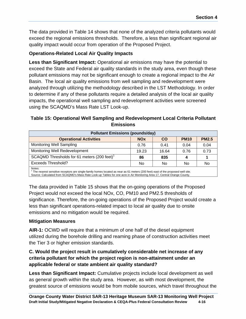
Section 4
Orange County Water District SAR-13 Heritage Museum SAR-13 Monitoring Well Project Draft Initial Study/Mitigated Negative Declaration & CEQA-Plus Federal Consultation Review 4 -16
The data provided in Table 14 shows that none of the analyzed criteria pollutants would exceed the regional emissions thresholds. Therefore, a less than significant regional air quality impact would occur from operation of the Proposed Project.
Operations-Related Local Air Quality Impacts
Less than Significant Impact: Operational air emissions may have the potential to exceed the State and Federal air quality standards in the study area, even though these pollutant emissions may not be significant enough to create a regional impact to the Air Basin. The local air quality emissions from well sampling and redevelopment were analyzed through utilizing the methodology described in the LST Methodology. In order to determine if any of these pollutants require a detailed analysis of the local air quality impacts, the operational well sampling and redevelopment activities were screened using the SCAQMD’s Mass Rate LST Look-up.
Table 15: Operational Well Sampling and Redevelopme nt Local Criteria Pollutant Emissions
Pollutant Emissions (pounds/day)Operational Activities NOx CO PM10 PM2.5
Monitoring Well Sampling 0.76 0.41 0.04 0.04 Monitoring Well Redevelopment 19.23 16.64 0.76 0.73 SCAQMD Thresholds for 61 meters (200 feet)1
86 835 4 1 Exceeds Threshold? No No No No Notes: 1 The nearest sensitive receptors are single-family homes located as near as 61 meters (200 feet) east of the proposed well site. Source: Calculated from SCAQMD’s Mass Rate Look-up Tables for one acre in Air Monitoring Area 17, Central Orange County.
The data provided in Table 15 shows that the on-going operations of the Proposed Project would not exceed the local NOx, CO, PM10 and PM2.5 thresholds of significance. Therefore, the on-going operations of the Proposed Project would create a less than significant operations-related impact to local air quality due to onsite emissions and no mitigation would be required.
Mitigation Measures
AIR-1: OCWD will require that a minimum of one half of the diesel equipment utilized during the borehole drilling and reaming phase of construction activities meet the Tier 3 or higher emission standards.
C. Would the project result in cumulatively considerable net increase of any criteria pollutant for which the project region is non-attainment under an applicable federal or state ambient air quality standard?
Less than Significant Impact: Cumulative projects include local development as well as general growth within the study area. However, as with most development, the greatest source of emissions would be from mobile sources, which travel throughout the
Section 4
Orange County Water District SAR-13 Heritage Museum SAR-13 Monitoring Well Project Draft Initial Study/Mitigated Negative Declaration & CEQA-Plus Federal Consultation Review 4 -17
local area. Therefore, from an air quality standpoint, the cumulative analysis would extend beyond any local projects and when wind patterns are considered and would cover an even larger area. Accordingly, the cumulative analysis for the project’s air quality must be generic by nature. The study area is out of attainment for ozone and PM10 and PM2.5 particulate matter. In accordance with CEQA Guidelines Section 15130(b), this analysis of cumulative impacts incorporates a three-tiered approach to assess cumulative air quality impacts.
x Consistency with the SCAQMD project specific thresholds for construction and operations;
x Project consistency with existing air quality plans; and
x Assessment of the cumulative health effects of the pollutants.
Construction-Related Impacts
The study area is located in the South Coast Air Basin, which is currently designated by the EPA as a non-attainment area for ozone and PM2.5 and designated by CARB as a non-attainment area for ozone, PM10, and PM2.5. As shown in Table 11 regional ozone, PM10, and PM2.5 emissions associated with the Proposed Project would be less than significant. Therefore, a less than significant cumulative impact would occur from construction of the Proposed Project.
Operational-Related Impacts
In general, operation of the proposed monitoring well would be passive as there would be no permanent equipment installed in the wells. OCWD staff would collect groundwater samples and measure groundwater levels from the wells on a quarterly basis. In total, the monitoring well would be visited by OCWD staff eight times per year. Every three to five years OCWD would conduct maintenance activities to sample and redevelop the well and the sampling and well redevelopment activities would generate the highest daily criteria pollutant emissions. As shown in Table 15 less than significant regional emissions of the precursors to ozone, PM10, and PM2.5 would occur during operational well sampling and redevelopment activities. Therefore, a less than significant cumulative impact would occur from operation of the Proposed Project.
Consistency with Air Quality Plans
The project site is designated as Institutional (INS) in the City of Santa Ana General Plan and is zoned Open Space (O). Well drilling would be an allowed use in all land use designations therefore the Proposed Project would be consistent with the current land use designations and would not require a General Plan Amendment or zone change. Therefore, the Proposed Project would not result in an inconsistency with the current land use designation. The Proposed Project would not be anticipated to exceed

Section 4
Orange County Water District SAR-13 Heritage Museum SAR-13 Monitoring Well Project Draft Initial Study/Mitigated Negative Declaration & CEQA-Plus Federal Consultation Review 4 -18
the AQMP assumptions for the project site would be found to be consistent with the AQMPs for the Air Basin.
Cumulative Health Impacts
The Air Basin is designated as nonattainment for ozone, PM10, and PM2.5, which means that the background levels of those pollutants are at times higher than the ambient air quality standards. The air quality standards were set to protect public health, including the health of sensitive individuals (elderly, children, and the sick). Therefore, when the concentration of those pollutants exceeds the standard, it is likely that some sensitive individuals in the population would experience health effects. The regional analysis in Table 11 and Table 15 show that the Proposed Project would not exceed the SCAQMD regional significance thresholds for VOC and NOx (ozone precursors), PM10 and PM2.5. Therefore, the Proposed Project would result in a less than significant cumulative health impact.
D. Would the project expose sensitive receptors to substantial pollutant concentrations?
Less than Significant Impact with Mitigation: The local concentrations of criteria pollutant emissions produced in the nearby vicinity of the Proposed Project, which may expose sensitive receptors to substantial concentrations for both construction and operations are discussed below. The discussion also includes an analysis of the potential impacts from toxic air contaminant emissions.
Construction-Related Sensitive Receptor Impacts
The nearest offsite sensitive receptors to the proposed well site are single-family homes located approximately 200 feet to the east and the Godinez High School approximately 330 feet to the west. As shown in Table 12, NOx would exceed the local emissions threshold during the borehole drilling and reaming phase of construction and would result in a potential significant air quality impact. Table 13 shows that with application of Mitigation Measure AIR-1, the Proposed Project’s NOx emission would be reduced to within the local emissions thresholds. Therefore, with implementation of Mitigation Measure AIR-1, the construction-related impacts to sensitive receptors from criteria pollutants would be mitigated to a less than significant level.
The greatest potential for toxic air contaminant emissions would be related to diesel particulate emissions associated with heavy equipment operations during construction of the Proposed Project. According to SCAQMD methodology, health effects from carcinogenic air toxics are usually described in terms of “individual cancer risk”. “Individual Cancer Risk” is the likelihood that a person exposed to concentrations of toxic air contaminants over a 70-year lifetime would contract cancer, based on the use of standard risk-assessment methodology. Given the relatively limited number of heavy-duty construction equipment and the short-term construction schedule, the Proposed

Section 4
Orange County Water District SAR-13 Heritage Museum SAR-13 Monitoring Well Project Draft Initial Study/Mitigated Negative Declaration & CEQA-Plus Federal Consultation Review 4 -19
Project would not result in a long-term (i.e., 70 years) substantial source of toxic air contaminant emissions and corresponding individual cancer risk. Therefore, no significant short-term toxic air contaminant impacts would occur during construction of the Proposed Project. As such, with implementation of Mitigation Measure AIR-1, construction of the Proposed Project would result in a less than significant exposure of sensitive receptors to substantial pollutant concentrations.
Operations-Related Sensitive Receptor Impacts
In general, operation of the monitoring well would be passive as there would be no permanent equipment installed in the wells. OCWD staff would collect groundwater samples and measure groundwater levels from the well on a quarterly basis. Every three to five years OCWD would conduct maintenance activities to sample and redevelop the well and the sampling and well redevelopment activities would generate the highest daily criteria pollutant emissions. Table 15 shows that none of the analyzed criteria pollutants would exceed the local emissions thresholds for the operational well sampling and redevelopment activities.
The greatest potential for toxic air contaminant emissions would only occur during the well sampling and redevelopment activities that are limited to approximately one week every three to five years. Given, the infrequent activity schedule, the Proposed Project would not result in a long-term (i.e., 70 years) substantial source of toxic air contaminant emissions and corresponding individual cancer risk. Therefore, no significant short-term toxic air contaminant impacts would occur during operation of the Proposed Project.
Mitigation Measures
Mitigation Measure AIR-1 is required.
E. Would the project create objectionable odors aff ecting a substantial number of people?
Less than Significant Impact: Individual responses to odors are highly variable and can result in a variety of effects. Generally, the impact of an odor results from a variety of factors such as frequency, duration, offensiveness, location, and sensory perception. The frequency is a measure of how often an individual is exposed to an odor in the ambient environment. The intensity refers to an individual’s or group’s perception of the odor strength or concentration. The duration of an odor refers to the elapsed time over which an odor is experienced. The offensiveness of the odor is the subjective rating of the pleasantness or unpleasantness of an odor. The location accounts for the type of area in which a potentially affected person lives, works, or visits; the type of activity in which he or she is engaged; and the sensitivity of the impacted receptor.
Section 4
Orange County Water District SAR-13 Heritage Museum SAR-13 Monitoring Well Project Draft Initial Study/Mitigated Negative Declaration & CEQA-Plus Federal Consultation Review 4 -20
Sensory perception has four major components: detectability, intensity, character, and hedonic tone. The detection (or threshold) of an odor is based on a panel of responses to the odor. There are two types of thresholds: the odor detection threshold and the recognition threshold. The detection threshold is the lowest concentration of an odor that would elicit a response in a percentage of the people that live and work in the immediate vicinity of the project site and is typically presented as the mean (or 50 percent of the population). The recognition threshold is the minimum concentration that is recognized as having a characteristic odor quality this is typically represented by recognition by 50 percent of the population. The intensity refers to the perceived strength of the odor. The odor character is what the substance smells like. The hedonic tone is a judgment of the pleasantness or unpleasantness of the odor. The hedonic tone varies in subjective experience, frequency, odor character, odor intensity, and duration.
Construction-Related Odor Impacts
Potential sources that may emit odors during well construction activities include the extraction of drilling mud and from emissions from diesel equipment. The objectionable odors that could be produced during the construction process would be temporary and would not likely be noticeable for extended periods of time beyond the project site’s boundaries. Due to the transitory nature of construction odors, a less than significant odor impact would occur and no mitigation would be required.
Potential Operations-Related Odor Impacts
In general, operation of the monitoring well would be passive as there would be no permanent equipment installed in the well. OCWD staff would collect groundwater samples and record water levels from the well on a quarterly basis. Potential sources that could emit odors during well sampling and redevelopment activities include the extraction of materials from the wells and from emissions from diesel equipment. The objectionable odors that could be produced during the well sampling and redevelopment activities would be temporary and would not likely be noticeable for extended periods of time beyond the project site’s boundaries. Due to the transitory nature of these odors, a less than significant odor impact would occur and no mitigation would be required.
4.4 Biological Resources
The following analysis was prepared by the Orange County Water District Natural Resources Department in September of 2016.
Biological Setting
The Heritage Museum contains a combination of historical strictures, interpretive education classrooms and natural open space. The vegetation communities and land cover at the Heritage Museum are shown in Figure 5.
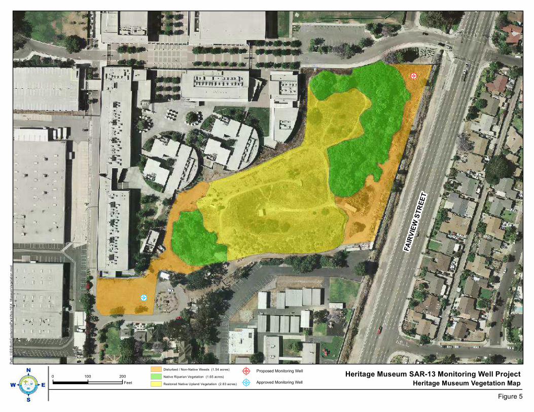
FA
IRV
IEW
ST
RE
ET
Heritage Museum Vegetation Map0 100 200
Feet
Heritage Museum SAR-13 Monitoring Well Project
Figure 5
Pa
th:
I:\S
S\B
ott\C
ente
nn
ialP
ark
\Nov16
\X_M
useu
mV
ege
tation
.mxd
Disturbed / Non-Native Weeds (1.54 acres)
Native Riparian Vegetation (1.65 acres)
Restored Native Upland Vegetation (2.83 acres)
Proposed Monitoring Well
Approved Monitoring Well
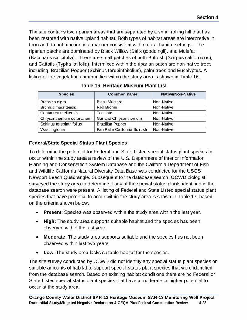
Section 4
Orange County Water District SAR-13 Heritage Museum SAR-13 Monitoring Well Project Draft Initial Study/Mitigated Negative Declaration & CEQA-Plus Federal Consultation Review 4 -22
The site contains two riparian areas that are separated by a small rolling hill that has been restored with native upland habitat. Both types of habitat areas are interpretive in form and do not function in a manner consistent with natural habitat settings. The riparian patchs are dominated by Black Willow (Salix gooddingii), and Mulefat (Baccharis salicifolia). There are small patches of both Bulrush (Scirpus californicus), and Cattails (Typha latifolia). Intermixed within the riparian patch are non-native trees including; Brazilian Pepper (Schinus terebinthifolius), palm trees and Eucalyptus. A listing of the vegetation communities within the study area is shown in Table 16.
Table 16: Heritage Museum Plant List
Species Common name Native/Non-Native
Brassica nigra Black Mustard Non-Native Bromus madritensis Red Brome Non-Native Centaurea melitensis Tocalote Non-Native Chrysanthemum coronarium Garland Chrysanthemum Non-Native Schinus terebinthifolius Brazilian Pepper Non-Native Washingtonia Fan Palm California Bulrush Non-Native
Federal/State Special Status Plant Species
To determine the potential for Federal and State Listed special status plant species to occur within the study area a review of the U.S. Department of Interior Information Planning and Conservation System Database and the California Department of Fish and Wildlife California Natural Diversity Data Base was conducted for the USGS Newport Beach Quadrangle. Subsequent to the database search, OCWD biologist surveyed the study area to determine if any of the special status plants identified in the database search were present. A listing of Federal and State Listed special status plant species that have potential to occur within the study area is shown in Table 17, based on the criteria shown below.
x Present : Species was observed within the study area within the last year.
x High: The study area supports suitable habitat and the species has been observed within the last year.
x Moderate : The study area supports suitable and the species has not been observed within last two years.
x Low : The study area lacks suitable habitat for the species.
The site survey conducted by OCWD did not identify any special status plant species or suitable amounts of habitat to support special status plant species that were identified from the database search. Based on existing habitat conditions there are no Federal or State Listed special status plant species that have a moderate or higher potential to occur at the study area.

Section 4
Orange County Water District SAR-13 Heritage Museum SAR-13 Monitoring Well Project Draft Initial Study/Mitigated Negative Declaration & CEQA-Plus Federal Consultation Review 4 -23
Table 17: List of Federal/State Special Status Plan t Species
Federal State CNPS General Habitat
On Site Habitat Conditions
Potential Occurrence
Abronia villosa aurita (Chaparral Sand Verbena)
NL NL
1B.1 Coastal Salt Marsh
Lack of suitable habitat
Low
Aphanisma blitoides (Aphanisma) NL NL 1B.2 Coastal
Bluff Scrub Lack of suitable habitat
Low
Astragalus pycnostachyus var. (Ventura Marsh Milk-Vetch
E E 1B.1 Coastal Bluff Scrub
Lack of suitable habitat
Low
Atriplex coulteri (Coulter’s Saltbush) NL NL 1B.2 Coastal
Bluff Scrub Lack of suitable habitat
Low
Atriplex pacifica (South Coast Saltscale) NL NL 1B.2 Coastal
Bluff Scrub Lack of suitable habitat
Low
Atriplex serenana var. davidsonii (Davidson’s Saltscale)
NL NL 1B.2 Coastal Bluff Scrub
Lack of suitable habitat
Low
Centromadia parryi ssp. Australis (Southern Tarplant)
NL NL 1B.1 Marshes, Swamps, Vernal Pools
Lack of suitable habitat
Low
Cordylanthus maritmus ssp. Maritmus (Salt Marsh Birds Beak)
E E 1B.2 Coastal Salt Marsh
Lack of suitable habitat
Low
Dudleya multicaulis (Many-Stemmed Dudleya)
NL NL 1B.1 Coastal Bluff Scrub
Lack of suitable habitat
Low
Eryngium aristulatum var. parishii (San Diego Button-Celery)
E E
1B.1 Vernal Pool Complex
Lack of suitable habitat
Low
Helianthus nuttallii ssp. Parishii (Los Angeles Sunflower)
NL NL 1.A Marshes, Swamps,
Lack of suitable habitat
Low
Isocoma menziesii var. decumbens (Decumbent Goldenbush)
NL NL 1B.2 Coastal Bluff Scrub
Lack of suitable habitat
Low
Lasthenia glabrata ssp. Coulteri (Coulter’s Goldfield)
NL NL 1B.1 Coastal Salt Marsh
Lack of suitable habitat
Low
Nasturtium gambelii (Gambel’s Water Cress)
E T 1B.1 Marshes and Swamps
Lack of suitable habitat
Low
Navarretia prostrate (Prostrate Vernal Pool Navarretia)
NL NL 1B.1 Coastal Bluff Scrub,
Lack of suitable habitat
Low
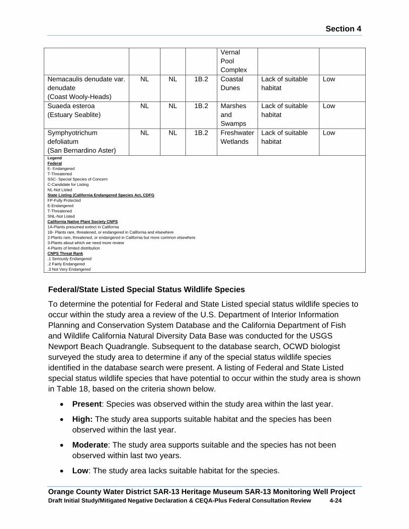
Section 4
Orange County Water District SAR-13 Heritage Museum SAR-13 Monitoring Well Project Draft Initial Study/Mitigated Negative Declaration & CEQA-Plus Federal Consultation Review 4 -24
Vernal Pool Complex
Nemacaulis denudate var. denudate (Coast Wooly-Heads)
NL NL 1B.2 Coastal Dunes
Lack of suitable habitat
Low
Suaeda esteroa (Estuary Seablite)
NL NL 1B.2 Marshes and Swamps
Lack of suitable habitat
Low
Symphyotrichum defoliatum (San Bernardino Aster)
NL NL 1B.2 Freshwater Wetlands
Lack of suitable habitat
Low
Legend Federal E- Endangered T-Threatened SSC- Special Species of Concern C-Candidate for Listing NL-Not Listed State Listing (California Endangered Species Act, C DFG FP-Fully Protected E-Endangered T-Threatened SNL-Not Listed California Native Plant Society CNPS 1A-Plants presumed extinct in California 1B- Plants rare, threatened, or endangered in California and elsewhere 2-Plants rare, threatened, or endangered in California but more common elsewhere 3-Plants about which we need more review 4-Plants of limited distribution CNPS Threat Rank .1 Seriously Endangered .2 Fairly Endangered .3 Not Very Endangered
Federal/State Listed Special Status Wildlife Specie s
To determine the potential for Federal and State Listed special status wildlife species to occur within the study area a review of the U.S. Department of Interior Information Planning and Conservation System Database and the California Department of Fish and Wildlife California Natural Diversity Data Base was conducted for the USGS Newport Beach Quadrangle. Subsequent to the database search, OCWD biologist surveyed the study area to determine if any of the special status wildlife species identified in the database search were present. A listing of Federal and State Listed special status wildlife species that have potential to occur within the study area is shown in Table 18, based on the criteria shown below.
x Present : Species was observed within the study area within the last year.
x High: The study area supports suitable habitat and the species has been observed within the last year.
x Moderate : The study area supports suitable and the species has not been observed within last two years.
x Low : The study area lacks suitable habitat for the species.
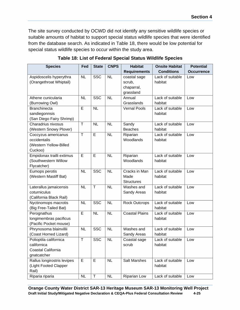
Section 4
Orange County Water District SAR-13 Heritage Museum SAR-13 Monitoring Well Project Draft Initial Study/Mitigated Negative Declaration & CEQA-Plus Federal Consultation Review 4 -25
The site survey conducted by OCWD did not identify any sensitive wildlife species or suitable amounts of habitat to support special status wildlife species that were identified from the database search. As indicated in Table 18, there would be low potential for special status wildlife species to occur within the study area.
Table 18: List of Federal Special Status Wildlife S pecies
Species Fed State CNPS Habitat Requirements
Onsite Habitat Conditions
Potential Occurrence
Aspidoscelis hyperythra (Orangethroat Whiptail)
NL SSC NL coastal sage scrub, chaparral, grassland
Lack of suitable habitat
Low
Athene cunicularia (Burrowing Owl)
NL SSC NL Annual Grasslands
Lack of suitable habitat
Low
Branchinecta sandiegonnsis (San Diego Fairy Shrimp)
E NL Vernal Pools Lack of suitable habitat
Low
Charadrius nivosus (Western Snowy Plover)
T NL NL Sandy Beaches
Lack of suitable habitat
Low
Coccyzus americanus occidentalis (Western Yellow-Billed Cuckoo)
T E NL Riparian Woodlands
Lack of suitable habitat
Low
Empidonax trailli extimus (Southwestern Willow Flycatcher)
E E NL Riparian Woodlands
Lack of suitable habitat
Low
Eumops perotis (Western Mastiff Bat)
NL SSC NL Cracks in Man Made Structures
Lack of suitable habitat
Low
Laterallus jamaicensis coturniculus (California Black Rail)
NL T NL Washes and Sandy Areas
Lack of suitable habitat
Low
Nyctinomops macrotis (Big Free-Tailed Bat)
NL SSC NL Rock Outcrops Lack of suitable habitat
Low
Perognathus longimembras pacificus (Pacific Pocket mouse)
E NL NL Coastal Plains Lack of suitable habitat
Low
Phrynosoma blainvillii (Coast Horned Lizard)
NL SSC NL Washes and Sandy Areas
Lack of suitable habitat
Low
Polioptila californica californica Coastal California gnatcatcher
T SSC NL Coastal sage scrub
Lack of suitable habitat
Low
Rallus longirostris levipes (Light Footed Clapper Rail)
E E NL Salt Marshes Lack of suitable habitat
Low
Riparia riparia NL T NL Riparian Low Lack of suitable Low
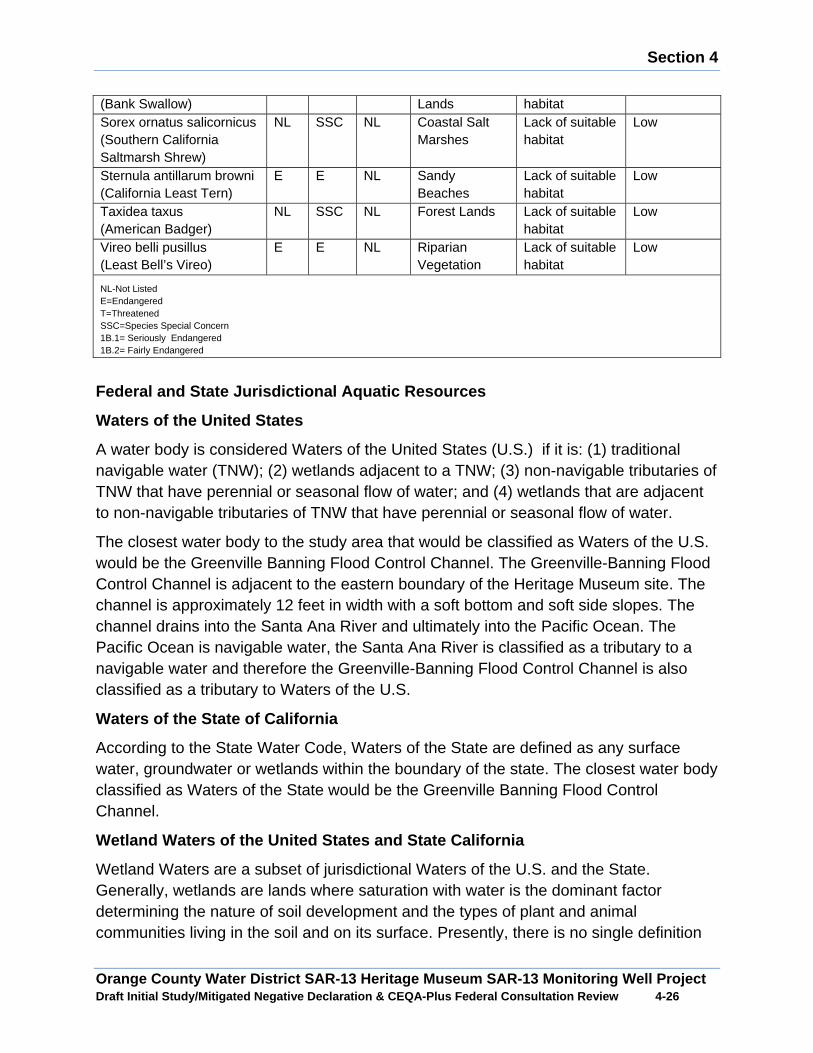
Section 4
Orange County Water District SAR-13 Heritage Museum SAR-13 Monitoring Well Project Draft Initial Study/Mitigated Negative Declaration & CEQA-Plus Federal Consultation Review 4 -26
(Bank Swallow) Lands habitat Sorex ornatus salicornicus (Southern California Saltmarsh Shrew)
NL SSC NL Coastal Salt Marshes
Lack of suitable habitat
Low
Sternula antillarum browni (California Least Tern)
E E NL Sandy Beaches
Lack of suitable habitat
Low
Taxidea taxus (American Badger)
NL SSC NL Forest Lands Lack of suitable habitat
Low
Vireo belli pusillus (Least Bell’s Vireo)
E E NL Riparian Vegetation
Lack of suitable habitat
Low
NL-Not Listed E=Endangered T=Threatened SSC=Species Special Concern 1B.1= Seriously Endangered 1B.2= Fairly Endangered
Federal and State Jurisdictional Aquatic Resources
Waters of the United States
A water body is considered Waters of the United States (U.S.) if it is: (1) traditional navigable water (TNW); (2) wetlands adjacent to a TNW; (3) non-navigable tributaries of TNW that have perennial or seasonal flow of water; and (4) wetlands that are adjacent to non-navigable tributaries of TNW that have perennial or seasonal flow of water.
The closest water body to the study area that would be classified as Waters of the U.S. would be the Greenville Banning Flood Control Channel. The Greenville-Banning Flood Control Channel is adjacent to the eastern boundary of the Heritage Museum site. The channel is approximately 12 feet in width with a soft bottom and soft side slopes. The channel drains into the Santa Ana River and ultimately into the Pacific Ocean. The Pacific Ocean is navigable water, the Santa Ana River is classified as a tributary to a navigable water and therefore the Greenville-Banning Flood Control Channel is also classified as a tributary to Waters of the U.S.
Waters of the State of California
According to the State Water Code, Waters of the State are defined as any surface water, groundwater or wetlands within the boundary of the state. The closest water body classified as Waters of the State would be the Greenville Banning Flood Control Channel.
Wetland Waters of the United States and State Calif ornia
Wetland Waters are a subset of jurisdictional Waters of the U.S. and the State. Generally, wetlands are lands where saturation with water is the dominant factor determining the nature of soil development and the types of plant and animal communities living in the soil and on its surface. Presently, there is no single definition
Section 4
Orange County Water District SAR-13 Heritage Museum SAR-13 Monitoring Well Project Draft Initial Study/Mitigated Negative Declaration & CEQA-Plus Federal Consultation Review 4 -27
of wetlands recognized by the state and the federal government. However, the state and federal definitions do share common terms and concepts. For purposes of this classification, wetlands must have one or more of the following three attributes: (1) at least periodically the land supports wetland vegetation; (2) the substrate is predominantly undrained hydric soil; and (3) the substrate is non-soil and is saturated with water or covered by shallow water at some time during the growing season of each year.
Project Impacts
A. Would the project have a substantial adverse imp act, either directly or through habitat modifications, on any species identified as a candidate, sensitive or special status species in local or regional plans, policies or regulations or by the California Department of Fish and Game or U.S. Fish and wildlife Services?
No Impact: As shown in Table 17 and Table 18 there would be low potential for special status plant or special status wildlife species to occur within the study area. Therefore implementation of the Proposed Project would not result in adverse impacts to any special status plant or special status wildlife species. No mitigation measures are required.
B. Would the project have a substantial adverse imp act on any riparian habitat or natural community identified in local or regional p lans, policies, and regulations or by the California Department of Fish and Game or U.S. Fish and Wildlife Service?
Less than Significant Impact with Mitigation: As shown in Figure 5 the location where the proposed monitoring well would be constructed is currently in a disturbed condition that contains concrete rubble, discarded building materials and overgrown non-native weeds. There are no sensitive vegetation communities on the well site that are recognized as sensitive vegetation communities by California Department of Fish and Wildlife or by the U.S. Fish and Wildlife Service. Therefore, implementation of the Proposed Project would not result in the direct loss of any sensitive vegetation communities.
The study area is adjacent to native riparian vegetation which would be considered a sensitive vegetation community by the California Department of Fish and Wildlife and the U.S. Fish and Wildlife Service. Construction activities associated with the Proposed Project could indirectly result in the temporary degradation of adjacent sensitive vegetation communities from the generation of fugitive dust, increased vehicle traffic and increased anthropogenic activities. A series of mitigation measures would be incorporated into the construction activities to avoid potential indirect construction-related impacts to sensitive vegetation communities near the well site. With the
Section 4
Orange County Water District SAR-13 Heritage Museum SAR-13 Monitoring Well Project Draft Initial Study/Mitigated Negative Declaration & CEQA-Plus Federal Consultation Review 4 -28
implementation of Mitigation Measures BIO-1, BIO-2, BIO-3, and BIO-4 potential indirect impacts to sensitive vegetation communities would be less than significant.
The long term operation of the Proposed Project would involve a small truck periodically accessing the well site for water quality sampling and maintenance activities. The truck would gain access to the well site along a vegetated paver access way. Additionally, the well site would be surrounded by decomposed granite and would have sufficient area to park and turn around without disturbing any sensitive vegetation communities near the well site. During water sampling and maintenance activities the monitoring well would backwashed. The backwash water would be high quality groundwater and would be discharged into riparian areas near the well site that presently has no source of water. The backwashed well water would have a beneficial effect on the riparian vegetation.
Mitigation Measures
BIO-1: Final construction plans will clearly delineate limits of grading and will avoid impacts to sensitive vegetation communities.
BIO-2: Construction activities near sensitive vegetation communities will be monitored to ensure that non-native vegetation is removed.
BIO-3: Construction equipment staging areas, storage of materials and temporary stockpiling of soil will be located in previously disturbed areas and outside of where sensitive vegetation communities are located.
BIO-4: Unpaved areas as needed will be watered to control dust.
C. Would the project have a substantially adverse e ffect on federally protected wetlands as defined by Section 404 of the Clean Wat er Act through direct removal, filling hydrological interruption, or other means?
Water of U.S./State
No Impact: The closest Waters of the U.S./State would be the Greenville Banning Flood Control Channel. The channel is located outside of the project area of impact and there is no construction activities proposed that would directly or indirectly modify the flood control channel. No impacts to Waters of the U.S./State would occur.
Wetland Waters/U.S./State
Less than Significant Impact with Mitigation : To determine the presence of Wetland Waters of the U.S./State within the study area a wetland assessment was conducted in the study area in accordance with the Regional Supplement to the U.S. Army Corps of Engineers Wetland Delineation Manual Arid Region West, based on the three attributes of wetland vegetation, hydric soils and onsite hydrology.
Section 4
Orange County Water District SAR-13 Heritage Museum SAR-13 Monitoring Well Project Draft Initial Study/Mitigated Negative Declaration & CEQA-Plus Federal Consultation Review 4 -29
Wetland Vegetation
The proposed well site is covered with concrete rubble, discarded concreate and surplus fill from previous construction activities occurring on the Heritage Museum site. Presently, the proposed well site contains non-native weeds and grasses that are not classified as wetland plant indicator species. The vegetation on the project site would not meet the wetland vegetation attribute.
Hydric Soils
Given the current disturbed condition of the well site, it would unlikely that the existing onsite soils could to support wetland vegetation. The surface soils on the well site would not meet the hydric soils attribute.
Hydrology
There are no water bodies or drainages that would provide a potential water source to the proposed well site. The only water source to the well site would season rainfall, which would typically not be an adequate water source to saturate the groundcover during the growing season. The well site would not meet the hydrology attribute.
Wetland Determination
The proposed well site lacks all of the required attributes to classify it as Wetland Waters of the U.S./State. Therefore, no direct impacts to Wetland Waters of the U.S./State would occur. The well site study is adjacent to native riparian vegetation which would be classified as Wetland Waters of the U.S./State by the California Department of Fish and Game and the U.S. Fish and Wildlife Service. Construction activities associated with the Proposed Project could indirectly result in the temporary degradation of adjacent wetland vegetation from the generation of fugitive dust, increased vehicle traffic and increased anthropogenic activities. To avoid potential indirect construction-related impacts to wetland vegetation adjacent to the well site Mitigation Measures BIO-1, BIO-2, BIO-3, and BIO-4 would be implemented.
D. Would the project interfere substantially with t he movement of any native resident or migratory fish or wildlife species or with established native resident or migratory wildlife corridors, or impede the use of native wildlife nursery sites?
Wildlife Movement Corridors
No Impact: Typically, wildlife corridors and linkages that facilitate regional wildlife movement are generally centered near water ways, ridgelines, riparian corridors, and flood control channels that are contiguous to riparian habitat and upland habitat. Different types of wildlife movement corridors provide specific types of functions pending on the landscape of the area and habitat conditions. The common element among all wildlife movement corridors is connectivity to suitable habitat. While the
Section 4
Orange County Water District SAR-13 Heritage Museum SAR-13 Monitoring Well Project Draft Initial Study/Mitigated Negative Declaration & CEQA-Plus Federal Consultation Review 4 -30
Heritage Museum site does contain suitable open space to support some wildlife Species, the site is essentially an open space island that is surrounded by developed land uses. The site lacks connectivity to other open space areas that contain suitable habitat. The Greenville Banning Flood Control Chanel does provide a potential travel corridor for certain species. The proposed well construction activities would be confined to the Heritage Museum site and would not have any impacts on the Greenville Banning Flood Control Chanel that would hinder local wildlife movement. No mitigation measures are required.
Migratory Bird Treaty Act
Less than Significant Impact with Mitigation : The Migratory Bird Treaty Act implements international treaties between the United States and other nations that protect migratory birds, including their nests and eggs, from killing, hunting, pursuing, capturing, selling and shipping unless expressly authorized or permitted.
The proposed well site lacks suitable habitat for nesting migratory birds. Therefore, no direct impacts to nesting migratory birds would occur. However, within the vicinity of the proposed well site is suitable nesting habitat for migratory birds. If construction activities occur during nesting season there would be the potential indirect construction noise impacts could discourage migratory birds from nesting or cause existing nesting migratory birds to flush from their nests. The disruption of the nesting patterns of migratory birds would be a significant impact. To avoid potential adverse indirect construction noise impacts to nesting migratory birds, the proposed monitoring well construction activities would occur outside of nesting season. With the implementation of Mitigation Measure BIO- 5 potential construction noise impacts to nesting migratory birds would be less than significant.
Mitigation Measure
BIO-5: All construction activities near riparian habitat will be conducted outside of the migratory bird season from March 15 to September 15.
E. Would the project conflict with any local policies or ordinances protecting biological resources, such as tree preservation pol icy or ordinance?
No Impact: The construction activities associated with the Proposed Project would not remove any vegetation or trees that that are protected by local, State or Federal regulations or policies. No mitigation measures required.
F. Would the project be in conflict with the provisions of an adopted Ha bitat Conservation Plan, Natural Community Conservation P lan, or other approved local, regional, or state habitat conservation plan ?
No Impact: The study area is not included within an adopted Natural Community Conservation Plan or Habitat Conservation Plan. No mitigation measures required.
Section 4
Orange County Water District SAR-13 Heritage Museum SAR-13 Monitoring Well Project Draft Initial Study/Mitigated Negative Declaration & CEQA-Plus Federal Consultation Review 4 -31
4.5 Cultural Resources
The following analysis is based on a Phase 1 Cultural Resource Report prepared by Bonterra/Psomas in December of 2016. The Phase 1 Cultural Resource Report is presented in Appendix B.
Introduction
Cultural resources include prehistoric archaeological sites, historic archaeological sites, historic structures, and artifacts made by people in the past.
Prehistoric archaeological sites are places that contain the material remains of activities carried out by the native population of the area (Native Americans) prior to the arrival of Europeans in Southern California. Artifacts found in prehistoric sites include flaked stone tools such as projectile points, knives, scrapers, and drills; ground stone tools such as manos, metates, mortars, and pestles for grinding seeds and nuts; and bone tools.
Historic archaeological sites are places that contain the material remains of activities carried out by people during the period when written records were produced after the arrival of Europeans. Historic archaeological material usually consists of refuse, such as bottles, cans, and food waste, deposited near structure foundations.
Historic structures include houses, commercial structures, industrial facilities, and other structures and facilities more than 50 years old.
Regulatory Setting
National Register of Historic Places
Cultural resources are considered during federal undertakings chiefly under Section 106 of the National Historic Preservation Act (NHPA) of 1966 (as amended) through one of its implementing regulations (36 CFR 800). Properties of traditional religious and cultural importance to Native Americans are considered under Section 101(d)(6)(A) of the NHPA.
Section 106 of the NHPA (16 USC 470f) requires federal agencies to take into account the effects of their undertakings on any district, site, building, structure, or object that is included in or eligible for inclusion in the NRHP and to afford the Advisory Council on Historic Preservation (ACHP) a reasonable opportunity to comment on such undertakings (36 CFR 800.1). Under Section 106, the significance of any adversely affected cultural resource is assessed and mitigation measures are proposed to reduce the impacts to a less than significant level. Significant cultural resources are those that are listed in or are eligible for listing in the NRHP in accordance with the criteria stated at 36 CFR 60.4, which are listed below.

Section 4
Orange County Water District SAR-13 Heritage Museum SAR-13 Monitoring Well Project Draft Initial Study/Mitigated Negative Declaration & CEQA-Plus Federal Consultation Review 4 -32
The quality of significance in American history, architecture, archaeology, engineering, and culture is present in districts, sites, buildings, structures, and objects that possess integrity of location, design, setting, materials, workmanship, feeling and association and
(a) that are associated with events that have made a significant contribution to the broad patterns of our history; or
(b) that are associated with the lives of persons significant in our past; or
(c) that embody the distinctive characteristics of a type, period, or method of construction, or that represent the work of a master, or that possess high artistic values, or that represent a significant and distinguishable entity whose components may lack individual distinction; or
(d) that have yielded, or may be likely to yield, information important in prehistory or history.
California Register of Historical Resources
CEQA requires a lead agency to determine whether a project would have a significant effect on one or more historical resources. A “historical resource” is defined as a resource listed in or determined to be eligible for listing in the California Register of Historical Resources (CRHR) (California Public Resources Code [PRC], Section 21084.1); a resource included in a local register of historical resources (14 California Code of Regulations [CCR], Section 15064.5[a][2]); or any object, building, structure, site, area, place, record, or manuscript that a lead agency determines to be historically significant (14 CCR 15064.5[a][3]).
Section 5024.1 of PRC, Section 15064.5 of the State CEQA Guidelines (14 CCR), and Sections 21083.2 and 21084.1 of the CEQA Statutes were used as the basic guidelines for the cultural resources study. PRC 5024.1 requires evaluation of historical resources to determine their eligibility for listing on the CRHR. The purposes of the CRHR are to maintain listings of the State’s historical resources and to indicate which properties are to be protected from substantial adverse change. The criteria for listing resources in the CRHR were expressly developed to be in accordance with criteria developed for listing in the National Register of Historic Places (NRHP) (per the criteria listed in the Code of Federal Regulations [CFR], Title 36, Section 60.4) and include those listed below.
A resource may be listed as an historical resource in the California Register if it meets any of the following National Register of Historic Places criteria:
Section 4
Orange County Water District SAR-13 Heritage Museum SAR-13 Monitoring Well Project Draft Initial Study/Mitigated Negative Declaration & CEQA-Plus Federal Consultation Review 4 -33
(1) Is associated with events that have made a significant contribution to the broad patterns of California’s history and cultural heritage.
(2) Is associated with the lives of persons important in our past.
(3) Embodies the distinctive characteristics of a type, period, region, or method of construction, or represents the work of an important creative individual, or possesses high artistic values or
(4) Has yielded, or may be likely to yield, information important in prehistory or history.
According to Section 15064.5(a)(3)(A–D) of the State CEQA Guidelines (14 CCR), a resource is considered historically significant if it meets the criteria for listing in the NRHP (per the criteria listed at 36 CFR 60.4, previously discussed). Impacts that affect those characteristics of the resource that qualify it for the NRHP or that would adversely alter the significance of a resource listed in or eligible for listing in the CRHR are considered to have a significant effect on the environment. Impacts to cultural resources from a project are thus considered significant if the project (1) physically destroys or damages all or part of a resource; (2) changes the character of the use of the resource or physical feature within the setting of the resource that contributes to its significance; or (3) introduces visual, atmospheric, or audible elements that diminish the integrity of significant features of the resource. The purpose of a cultural resources investigation is to evaluate whether any built environment cultural resources are present in or near the project area or can reasonably be expected to exist in the subsurface. If resources are discovered, management recommendations would be included that require evaluation of the resources for NRHP or CRHR eligibility.
Human Remains
Section 7050.5 of the California Health and Safety Code provides for the disposition of accidentally discovered human remains. Section 7050.5 states that, if human remains are found, no further excavation or disturbance of the site or any nearby area reasonably suspected to overlie adjacent remains shall occur until the County Coroner has determined the appropriate treatment and disposition of the human remains.
Section 5097.98 of the PRC states that, if remains are determined by the Coroner to be of Native American origin, the Coroner must notify the Native American Heritage Commission within 24 hours which, in turn, must identify the person or persons it believes to be the most likely descended from the deceased Native American. The descendants shall complete their inspection within 48 hours of being granted access to the site. The designated Native American representative would then determine, in consultation with the property owner, the disposition of the human remains.

Section 4
Orange County Water District SAR-13 Heritage Museum SAR-13 Monitoring Well Project Draft Initial Study/Mitigated Negative Declaration & CEQA-Plus Federal Consultation Review 4 -34
Area of Potential Effects
The Area of Potential Effects (APE) consists of the impact and staging area, as well as the Heritage Museum Monitoring Well site. This area is approximately 0.34 acre in size. An aerial photograph depicting the APE boundary and project site is shown in Figure 6.
Archaeological Resources Records Search
A records search and literature review of documents on file at the South Central Coastal Information Center (SCCIC) at California State University, Fullerton was conducted on May 7, 2015. It was reviewed by BonTerra Psomas prior to the fieldwork. The SCCIC is a designated branch of the California Historical Resources Information System and houses records regarding archaeological and historic resources in Orange, Los Angeles, Ventura and San Bernardino Counties. The review consisted of an examination of the U.S. Geological Survey’s (USGS) 7.5-minute Newport Beach Quadrangle to determine if any sites were recorded on or if any cultural resources studies have been conducted on or within a ½-mile radius of the project site. Data sources consulted at the SCCIC included archaeological records, Archaeological Determinations of Eligibility (DOE), historic maps, and the Historic Property Data File (HPDF) maintained by the Office of Historic Preservation (OHP). The HPDF contains listings for the CRHR and/or the NRHP, California Historical Landmarks (CHL), and California Points of Historical Interest (CPHI).
Archaeological Field Survey
On November 10, 2016, BonTerra Psomas Director of Cultural Resources, Patrick Maxon, M.A., RPA conducted a pedestrian survey of the project site and APE. The entire APE was examined on foot.
Cultural Resources Records Search Results
The record search at the SCCIC showed that seven cultural resource studies have been conducted within a one-mile radius of the project site. Those studies consisted of pedestrian field surveys and cultural resource evaluations, or were research oriented and did not involve field work. Three of those involved the Santa Ana River immediately west of Centennial Park. Table19 lists the studies that were conducted near the project site.
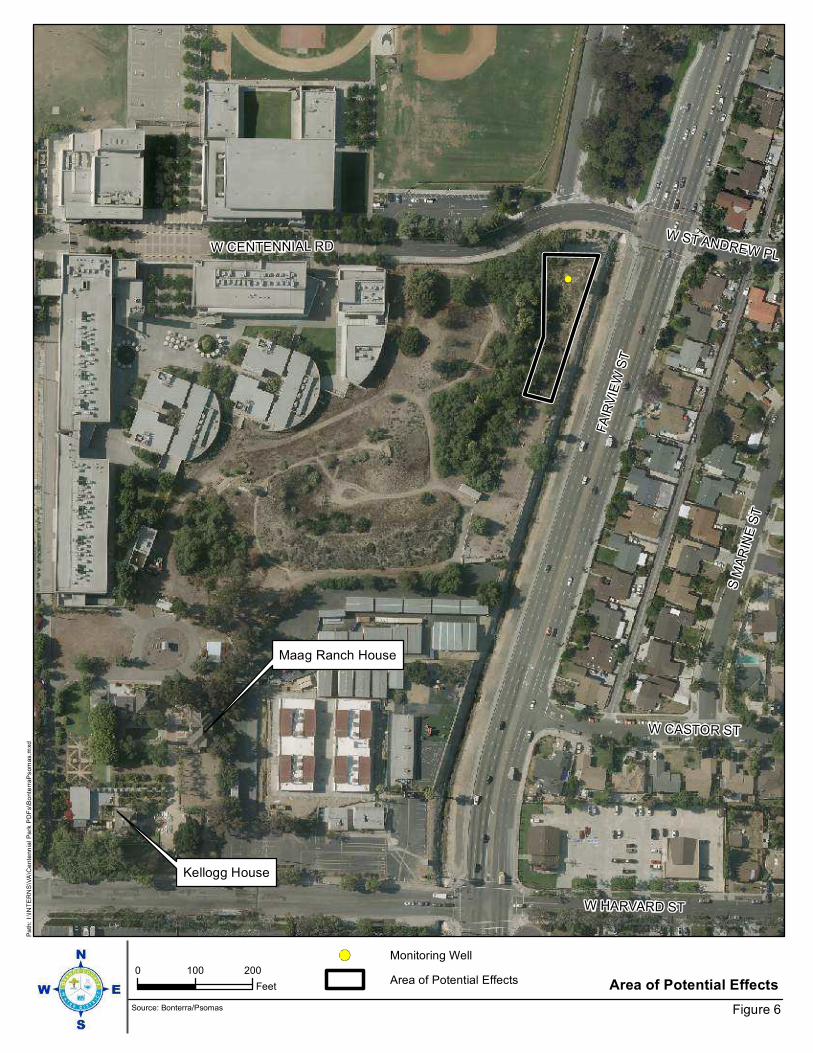
Kellogg House
Maag Ranch House
FA
IRV
IEW
ST
W CENTENNIAL RD
S M
AR
INE
ST
W HARVARD ST
W CASTOR ST
W ST ANDREW PL
0 100 200
Feet Area of Potential Effects
Figure 6
Pa
th:
I:\IN
TE
RN
S\V
A\C
ente
nn
ial P
ark
PD
Fs\B
onte
rraP
som
as.m
xd
Source: Bonterra/Psomas
Monitoring Well
Area of Potential Effects
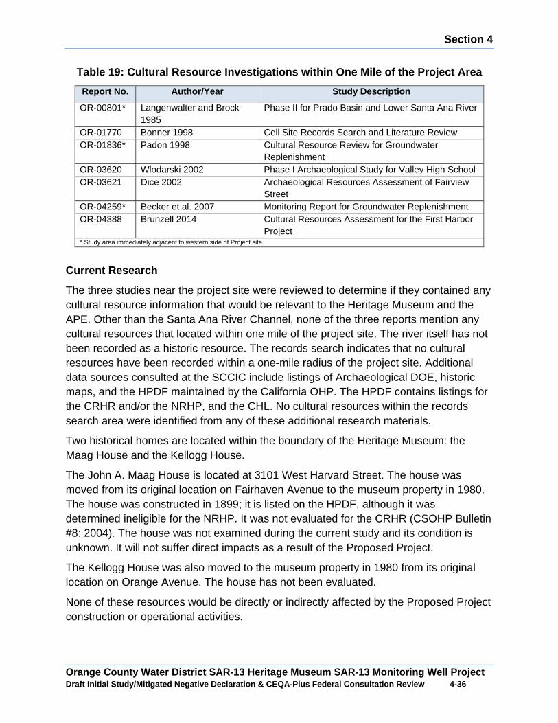
Section 4
Orange County Water District SAR-13 Heritage Museum SAR-13 Monitoring Well Project Draft Initial Study/Mitigated Negative Declaration & CEQA-Plus Federal Consultation Review 4 -36
Table 19: Cultural Resource Investigations within O ne Mile of the Project Area
Report No. Author/Year Study Description
OR-00801* Langenwalter and Brock 1985
Phase II for Prado Basin and Lower Santa Ana River
OR-01770 Bonner 1998 Cell Site Records Search and Literature Review OR-01836* Padon 1998 Cultural Resource Review for Groundwater
Replenishment OR-03620 Wlodarski 2002 Phase I Archaeological Study for Valley High School OR-03621 Dice 2002 Archaeological Resources Assessment of Fairview
Street OR-04259* Becker et al. 2007 Monitoring Report for Groundwater Replenishment OR-04388 Brunzell 2014 Cultural Resources Assessment for the First Harbor
Project * Study area immediately adjacent to western side of Project site.
Current Research
The three studies near the project site were reviewed to determine if they contained any cultural resource information that would be relevant to the Heritage Museum and the APE. Other than the Santa Ana River Channel, none of the three reports mention any cultural resources that located within one mile of the project site. The river itself has not been recorded as a historic resource. The records search indicates that no cultural resources have been recorded within a one-mile radius of the project site. Additional data sources consulted at the SCCIC include listings of Archaeological DOE, historic maps, and the HPDF maintained by the California OHP. The HPDF contains listings for the CRHR and/or the NRHP, and the CHL. No cultural resources within the records search area were identified from any of these additional research materials.
Two historical homes are located within the boundary of the Heritage Museum: the Maag House and the Kellogg House.
The John A. Maag House is located at 3101 West Harvard Street. The house was moved from its original location on Fairhaven Avenue to the museum property in 1980. The house was constructed in 1899; it is listed on the HPDF, although it was determined ineligible for the NRHP. It was not evaluated for the CRHR (CSOHP Bulletin #8: 2004). The house was not examined during the current study and its condition is unknown. It will not suffer direct impacts as a result of the Proposed Project.
The Kellogg House was also moved to the museum property in 1980 from its original location on Orange Avenue. The house has not been evaluated.
None of these resources would be directly or indirectly affected by the Proposed Project construction or operational activities. �

Section 4
Orange County Water District SAR-13 Heritage Museum SAR-13 Monitoring Well Project Draft Initial Study/Mitigated Negative Declaration & CEQA-Plus Federal Consultation Review 4 -37
Project Impacts
A. Would the project cause a substantial adverse ch ange in the significance of a historical resource as defined in Section 15064.5 o f the CEQA Guidelines?
Less than Significant Impact with Mitigation: The records on file at the SCCIC indicate that the Heritage Museum and its ancillary structures have undergone cultural resource evaluations. Neither the museum nor the Maag and Kellogg residences are eligible for listing in the NRHP. The pedestrian survey of the APE did not identify any
cultural resources that merited recordation. No known or recorded cultural resources are located within the APE. Therefore, the potential for the discovery of historical resources would be low. However, because historical resources have been discovered in the vicinity of the APE, there would be the potential that currently unknown and unrecorded historical resources could be present in the subsurface and could be uncovered during construction activities and potentially damaged, resulting in adverse impacts to historical resources. To avoid impacts to unknown historical resources a halt condition would be incorporated into the construction activities for the Proposed Project. With the implementation of Mitigation Measure CR-1 potential adverse impacts to historical resources would be avoided.
Mitigation Measure
CR-1: Should archaeological resources be found during ground-disturbing activities for the Project, an Archaeologist shall be retained to first determine whether it is a “unique archaeological resource” pursuant to Section 21083.2(g) of the California Public Resources Code (PRC) or a “historical resource” pursuant to Section 15064.5(a) of the State CEQA Guidelines. If the archaeological resource is determined to be a “unique archaeological resource” or a “historical resource”, the Archaeologist shall formulate a mitigation plan in consultation with the OCWD that satisfies the requirements of the above-referenced sections. If the Archaeologist determines that the archaeological resource is not a “unique archaeological resource” or “historical resource”, s/he may record the site and submit the recordation form to the California Historic Resources Information System at the South Central Coastal Information Center at California State University, Fullerton.
B. Would the project cause a substantial adverse ch ange in the significance of an archaeological resource pursuant to Section 15064.5 of the CEQA Guidelines?
Less than Significant Impact with Mitigation: Bases on a review of a record search of cultural resources of the APE and a pedestrian survey conducted on the project site, it been determined that there would be low potential for the discovery of archaeological resources. However, because archaeological resources have been discovered in the vicinity of the APE, there would be the potential that currently unknown and unrecorded archaeological resources could be present and could be uncovered during construction
Section 4
Orange County Water District SAR-13 Heritage Museum SAR-13 Monitoring Well Project Draft Initial Study/Mitigated Negative Declaration & CEQA-Plus Federal Consultation Review 4 -38
activities and potentially damaged, resulting in adverse impacts to archaeological resources. To avoid impacts to unknown archaeological resources a halt condition would be incorporated into the construction activities for the Proposed Project. With the implementation of Mitigation Measure CR-1 potential adverse impacts to archaeological resources would be avoided.
C. Would the project disturb any human remains, including those interre d outside of formal cemeteries?
Less than Significant Impact with Mitigation: No human remains or cemeteries are known to exist within or near the APE. However, there is always the potential that subsurface construction activities associated with the Proposed Project could potentially damage or destroy previously undiscovered human remains. Accordingly, this is a potentially significant impact. In the event of the accidental discovery or recognition of any human remains, CEQA Guidelines Section 15064.5; Health and Safety Code Section 7050.5; Public Resources Code Section 5097.94 and Section 5097.98 must be followed. With the implementation of Mitigation Measure CR-2 potential impacts to human remains would be less than significant.
Mitigation Measure
CR-2: If human remains are encountered during excavation activities, all work shall halt in the vicinity of the remains and the County Coroner shall be notified (California Public Resources Code, Section 5097.98). The Coroner will determine whether the remains are of forensic interest. If the Coroner, with the aid of a qualified Archaeologist, determines that the remains are prehistoric, s/he will contact the Native American Heritage Commission (NAHC). The NAHC will be responsible for designating the most likely descendant (MLD), who will be responsible for the ultimate disposition of the remains, as required by Section 7050.5 of the California Health and Safety Code. The MLD shall make his/her recommendation within 48 hours of being granted access to the site. If feasible, the MLD’s recommendation should be followed and may include scientific removal and non-destructive analysis of the human remains and any items associated with Native American burials (California Health and Safety Code, Section 7050.5). If the landowner rejects the MLD’s recommendations, the landowner shall rebury the remains with appropriate dignity on the property in a location that will not be subject to further subsurface disturbance (California Public Resources Code, Section 5097.98).
D. Would the project directly or indirectly disturb or destroy a unique paleontological resource or site?
Less than Significant Impact with Mitigation: The Natural History Museum of Los Angeles County (NHMLAC) was contacted and requested to review their topographical maps for the study area to determine the geology underlying the project site, the
Section 4
Orange County Water District SAR-13 Heritage Museum SAR-13 Monitoring Well Project Draft Initial Study/Mitigated Negative Declaration & CEQA-Plus Federal Consultation Review 4 -39
sensitivity of the site for the presence of fossils, and if any fossil-bearing localities had been recorded.
The NHMLAC reviewed geological maps of the study area to determine the relative paleontological sensitivity of the project site and if known fossil localities were recorded. According to NHLMAC, the entire project site has surface deposits of younger Quaternary alluvium, derived as fluvial deposits from the Santa Ana River that flows through the western portion of the proposed study area. There are no fossil vertebrate localities anywhere nearby from these deposits, and they are unlikely to contain significant vertebrate fossils, at least in the uppermost layers.
Older Quaternary deposits may occur in the study area at unknown depth, however, and contain significant fossil vertebrate remains. The closest vertebrate fossil locality from these older Quaternary deposits is LACM 1339, southwest of the study area, east of the Santa Ana River near the top of the mesa bluffs along Adams Avenue. This produced fossil specimens of mammoth (Mammuthus) and camel (Camelidae) bones from sands approximately 15 feet below the top of the mesa, which is overlain by shell-bearing silts and sands. Further south and east, locality LACM 4219, along the Newport Freeway near Santa Isabel Avenue, produced fossil specimens of turtle (Testudinanta) and camel (Camelidae). A little further due south of the study area, locality LACM 3267, near the intersection of 19th Street and Anaheim Avenue, produced a specimen of a fossil elephant (Proboscidea).
Surface grading or shallow excavations on the project site would probably not uncover significant vertebrate fossil remains. Excavations that extend down into the older Quaternary deposits, however, could encounter significant fossil vertebrate specimens. Any substantial excavations below the uppermost layers on the project site should be monitored closely to quickly and professionally recover any fossil remains discovered while not impeding development. Sediment samples should also be collected and processed to determine the small fossil potential in these deposits. Any fossils recovered during mitigation should be deposited in an accredited and permanent scientific institution for the benefit of current and future generations. With the implementation of Mitigation Measure CR-3 potential impacts to paleontological resources would be avoided.
Mitigation Measure
CR-3: Section 15064.5(f) of the State CEQA Guidelines states that a lead agency “should make provisions for historical or unique archaeological resources accidentally discovered during construction”. In the absence of language specific to paleontological resources, fossils must be evaluated as historical resources under eligibility Criterion 4 (potential to yield important information). Therefore, in the event that paleontological resources are inadvertently unearthed during excavation, the contractor shall
Section 4
Orange County Water District SAR-13 Heritage Museum SAR-13 Monitoring Well Project Draft Initial Study/Mitigated Negative Declaration & CEQA-Plus Federal Consultation Review 4 -40
immediately cease all earth-disturbing activities a reasonable distance from the area of discovery. OCWD shall retain a qualified paleontologist to evaluate the significance of the discovery and determine an appropriate course of action.
4.6 Geology/Soils
Existing Setting
Regional Geologic Setting
The project site is located within the floodplain of the Santa Ana River and is underlain by over 1,000 feet of alluvium deposited by the ancestral Santa Ana River. The alluvial deposits underlying the project site are estimated to be Late Pleistocene to Holocene in age and typically consist of sand, silt and clay in the upper 25 feet below grade.
Faulting and Seismicity
There are no known active faults traversing the project site and the site is not located within a State of California designated Alquist-Priolo Earthquake fault Zone. The project site is located within an active seismic region and would be susceptible to ground shaking impacts from known active and potentially active faults in the region, including the San Joaquin Hills Blind Thrust, Newport Inglewood, Puente Hills Blind Thrust and the Elsinore Fault.
Liquefaction Hazards
According to the California Department of Geologic Survey Seismic Hazard Zone Map, the project site is located within an area that would be susceptible to the occurrence of liquefaction.
Landslide Hazards
According to the California Department of Geologic Survey Landslide Hazard Map, the project site is not located within an area that would be susceptible to landslide impacts.
Project Impacts
A1. Would the project expose people or structures t o potential substantial adverse effects, including the risk of loss, injury or death involving rupture of an unknown earthquake fault, as delineated on the most Alquuist-Priolo Earthquake Fault Zoning Map?
No Impact: According to the California Geologic Survey Seismic Hazard Zone Map, the project site is not located within a designated Fault-Rupture Hazard Zone. Therefore, the potential for surface rupture impacts would be unlikely. No mitigation measures are required.
Section 4
Orange County Water District SAR-13 Heritage Museum SAR-13 Monitoring Well Project Draft Initial Study/Mitigated Negative Declaration & CEQA-Plus Federal Consultation Review 4 -41
A2. Would the project expose people or structures t o potential substantial adverse effects, including the risk of loss, injury or death involving strong seismic ground shaking?
Less than Significant Impact with Mitigation: The project site is located in a seismically active region and could be subject to seismic shaking impacts from active faults in the region. The highest risks to the project site would be from Newport Inglewood Fault, Puente Hills Blind Thrust and the Whittier Fault all which have the potential to cause moderate to large earthquakes. In the event of a moderate or large earthquake, the project site could experience seismic shaking impacts possibly of considerable intensity. The seismic risks at the project site would be similar to other areas in southern California and the implementation of the Proposed Project would not substantially increase the risk or exposure of people to adverse seismic shaking impacts over the current condition. The Proposed Project would be designed to meet the California Department of Water Resources Well Standards to withstand potential seismic shaking impacts caused by an earthquake within an acceptable level of risk. With the implementation of Mitigation Measure GEO-1 the potential risk of seismic shaking impacts would be less than significant.
Mitigation Measure
GEO-1: The OCWD will ensure that proposed monitoring well is designed and constructed in compliance with California Department of Water resources Well Standards Bulletin 74-90 and Bulletin 74-81.
A3. Would the project expose people or structures t o potential substantial adverse effects, including the risk of loss, injury or death involving liquefaction?
Less than Significant Impact with Mitigation: Liquefaction is known to generally occur in saturated or near saturated cohesion-less soil at depths shallower than 50-feet below the ground surface. According to the California Geologic Survey Seismic Hazard Zone Map for the Newport Quadrangle, the project site is located within an area where historic occurrence of liquefaction has occurred. To minimize liquefaction risks, the proposed monitoring well would be designed to meet the California Department of Water Resources Well Standards to withstand potential liquefaction impacts caused by an earthquake within an acceptable level of risk. With the implementation of Mitigation Measure GEO-1 the potential risk of liquefaction impacts would be less than significant.
Mitigation Measure
Mitigation Measure GEO-1 required.
A4. Would the project expose people or structures t o potential substantial adverse effects, including the risk of loss, injury or death involving landslides?

Section 4
Orange County Water District SAR-13 Heritage Museum SAR-13 Monitoring Well Project Draft Initial Study/Mitigated Negative Declaration & CEQA-Plus Federal Consultation Review 4 -42
No Impact: According to the California Geologic Survey Hazard Zone Map, the project site is not located within a Landslide Hazard Zone. No mitigation measures are required.
B. Would the project result in substantial soil ero sion or the loss of topsoil?
Less than Significant Impact with Mitigation: Erosion can occur by varying processes and may occur where bare soil is exposed to wind or moving water. The processes of erosion are generally a function of material type, terrain steepness, rainfall or irrigation levels, and surface water drainage conditions. The grading activities associated with the Proposed Project would uncover soils which could increase the potential for water erosion and wind erosion impacts to occur. Additionally, construction equipment mobilization/demobilization and construction worker traffic could transport soil to streets and into local and regional drainage systems. The earthwork activities for the Proposed Project would not disturb over one acre of area. To minimize potential erosion impacts, Best Management Practices would be incorporated into the construction activities for the Proposed Project. With implementation Mitigation Measure GEO-2 potential erosion impacts would be less than significant.
Mitigation Measure
GEO-2: During earthwork activities onsite Best Management Practices will be implemented to minimize water and wind erosion impacts. Onsite Best Management Practices would include, but would not be limited to; watering of uncovered soils, erosion control blankets, straw waddles, rumble racks, wheel washers and the covering of exposed stockpiles of soil.
C. Would the project be located on a geologic unit or soil that is unstable or that would become unstable as a result of the project and potentially result in on or off site landslide, lateral spreading, subsidence, liquefaction or collapse?
Liquefaction
Less than Significant Impact with Mitigation : The California Geologic Survey Seismic Hazard Zone Map indicates that the project site lies within a Liquefaction Hazard Zone. The Proposed Project would be designed to meet to meet the California Department of Water Resources Well Standards to withstand potential liquefaction impacts caused by an earthquake within an acceptable level of risk. With the implementation of Mitigation Measure GEO-1 the potential risk of liquefaction impacts would be less than significant.
Subsidence
No Impact: Subsidence is characterized as a sinking of the ground surface relative to surrounding areas and can generally occur where deep alluvial soil deposits are present in valley and basin areas. Subsidence could potentially result in ground fractures that
Section 4
Orange County Water District SAR-13 Heritage Museum SAR-13 Monitoring Well Project Draft Initial Study/Mitigated Negative Declaration & CEQA-Plus Federal Consultation Review 4 -43
could cause damage to surface improvements. Subsidence is typically associated with groundwater withdrawal. No subsidence has been documented on the project site and the Proposed Project does not involve the extraction of groundwater. Therefore, no potential subsidence impacts associated with the Proposed Project would be unlikely to occur. No mitigation measures are required.
Landslide
According to the California Department of Geologic Survey Landslide Hazard Map, the project site is not located within an area that would be susceptible to landslides. No mitigation measures are required.
Mitigation Measure
Mitigation Measure GEO-1 required.
D. Would the project be located on expansive soil, as defined in Table 18-1-B of the uniform Building Code, creating substantial ris ks to life or property?
Less than Significant Impact with Mitigation: Expansive soils are characterized as specific clay materials with the capacity to shrink, swell or otherwise significantly change volume due to variations in moisture content. Expansive soils could cause excessive cracking and heaving of structures with shallow foundations and concrete. The soils on the project site are characterized has having a moderate-to-high shrink-swell potential. Construction activities conducted for the Proposed Project would be in compliance with the California Department of Water Resources Well Standards. With the implementation of Mitigation Measure GEO-1 potential soil constraints associated with construction of the Proposed Project would be less than significant.
Mitigation Measure
Mitigation Measure GEO-1 is required.
E. Would the project have soils incapable of adequa tely supporting the use of septic tanks or alternative waste disposal systems where sewers are not available for the disposal of wastewater?
No Impact: The Proposed Project does not involve the construction of septic tanks or alternative disposal systems. Therefore, the construction and operation of the Proposed Project would not result in adverse impacts in regards to the use of septic tanks or alternative disposal systems.
4.7 Greenhouse Gas Emissions
The following analysis is based on the Air Quality and Greenhouse Gas Analysis Report prepared by Vista Environmental in December 2016. The Air Quality and Greenhouse Gas Analysis Report is presented in its entirety in Appendix A.

Section 4
Orange County Water District SAR-13 Heritage Museum SAR-13 Monitoring Well Project Draft Initial Study/Mitigated Negative Declaration & CEQA-Plus Federal Consultation Review 4 -44
Background
Greenhouse Gas Emissions (GHGs) are comprised of atmospheric gases and clouds within the atmosphere that influence the earth’s temperature by absorbing most of the infrared radiation that rises from the sun-warmed surface and that would otherwise escape into space. This process is commonly known as the “Greenhouse Effect”. GHGs are emitted by natural processes and human activities. GHGs, include carbon dioxide (CO2), methane (CH4), nitrous oxide (N2O), hydrofluorocarbons (HFCs), perfluorocarbons (PFCs), and sulfur hexafluoride (SF6). Other greenhouse gases include water vapor, ozone, and aerosols. Water vapor is an important component of our climate system and is not regulated. Although there could be health effects resulting from changes in the climate and the consequences that can bring about, inhalation of greenhouse gases at levels currently in the atmosphere will not result in adverse health effects, with the exception of ozone and aerosols (particulate matter). The potential health effects of ozone and particulate matter are discussed in air quality criteria pollutant analyses. At very high indoor concentrations (not at levels existing in outside areas), carbon dioxide, methane, sulfur hexafluoride, and some chlorofluorocarbons can cause suffocation as the gases can displace oxygen.
Regulatory Framework
California Air Resources Board (CARB) has proposed interim statewide CEQA thresholds for GHG emissions and released Recommended Approaches for Setting Interim Significance Thresholds for Greenhouse Gases under the California Environmental Quality Act, on October 24, 2008 that has been utilized by the SCAQMD’s GHG Significance Threshold Stakeholder Working Group in their framework for developing SCAQMD’s draft GHG emissions thresholds. The State currently has no regulations that establish ambient air quality standards for GHGs. However, the State has passed laws directing CARB to develop actions to reduce GHG emissions. The following is a listing of relevant State laws to reduce GHG emissions. Detail discussion of each State Law is presented in Appendix A.
x Executive Order B-30-15, Senate Bill 32 and Assembly Bill 197 x Assembly Bill 1493 x Executive Order S-3-05 x Assembly Bill 32 x Executive Order S-1-07 x Senate Bill 97 x Senate Bill 375 x Assembly Bill 341 and Senate Bills 939 and 1374 x California Code of Regulations (CCR) Title 24, Part 11

Section 4
Orange County Water District SAR-13 Heritage Museum SAR-13 Monitoring Well Project Draft Initial Study/Mitigated Negative Declaration & CEQA-Plus Federal Consultation Review 4 -45
South Coast Air Quality Management District
Since neither CARB nor the OPR has developed GHG emissions threshold, the SCAQMD formed a Working Group to develop significance thresholds related to GHG emissions. At the September 28, 2010 Working Group meeting, the SCAQMD released its most current version of the draft GHG emissions thresholds, which recommends a tiered approach that either provides a quantitative annual thresholds of 3,500 MTCO2e for residential uses, 1,400 MTCO2e for commercial uses, and 3,000 MTCO2e for mixed uses. An alternative annual threshold of 3,000 MTCO2e for all land use types is also proposed.
Project Impacts
A. Would the project generate GHG emissions, either directly or indirectly, that may have a significant impact on the environment?
Less than Significant Impact: The Proposed Project would generate GHG emissions from a variety of sources. First, GHG emissions would be generated during construction of the Proposed Project. Once fully operational, the operations would generate GHG emissions from the operation of construction equipment and mobile sources associated with maintenance activities.
Construction Emissions
The proposed project would result in the construction and operation of a monitoring well. A summary of the GHG emissions from the construction and operation of the monitoring well is shown in Table 20.
Table 20: Project Related Greenhouse Gas Annual Emi ssions
Pollutant Emissions (pounds/day)
Operational Activities NOx CO PM10 PM2.5 Monitoring Well Sampling 0.76 0.41 0.04 0.04 Monitoring Well Redevelopment 19.23 16.64 0.76 0.73 SCAQMD Thresholds for 61 meters (200 feet)1
86 835 4 1 Exceeds Threshold? No No No No Notes: 1 The nearest sensitive receptors are single-family homes located as near as 61 meters (200 feet) east of the proposed well site. Source: Calculated from SCAQMD’s Mass Rate Look-up Tables for one acre in Air Monitoring Area 17, Central Orange County.
The data provided in Table 20 shows that the Proposed Project would create 6.08 MTCO2e per year. According to the SCAQMD draft threshold of significance, a cumulative global climate change impact would occur if the GHG emissions created from a project activity would exceed 3,000 MTCO2e per year. The Proposed Project would generate less than 3,000 MTCO2e per year. The Proposed Project would not generate GHG emissions, either directly or indirectly, that would result in a significant impact on the environment. Therefore, a less than significant impact from the

Section 4
Orange County Water District SAR-13 Heritage Museum SAR-13 Monitoring Well Project Draft Initial Study/Mitigated Negative Declaration & CEQA-Plus Federal Consultation Review 4 -46
generation of greenhouse gas emissions would occur from construction and operation of the proposed monitoring well.
B. Would the project be in conflict with an applica ble plan, policy or regulation adopted for the purpose of reducing the emissions o f greenhouse gases?
No Impact: The Proposed Project would not conflict with any applicable plan, policy or regulation of an agency adopted for the purpose of reducing GHG emissions. The Proposed Project would consist of the construction and operation of a single monitoring well. In general, operation of the monitoring well would be passive as there will be no permanent equipment installed in the wells. OCWD staff would collect groundwater samples and record water levels from the well on a quarterly basis. In total, the monitoring well would be visited by OCWD staff eight times per year. Every three to five years OCWD will conduct maintenance activities to sample and redevelop the well.
The Proposed Project is anticipated to create an average of 6.08 MTCO2e per year, which would be well below the SCAQMD draft threshold of significance of 3,000 MTCO2e per year. The SCAQMD developed this threshold through a Working Group, which also developed detailed methodology for evaluating significance under CEQA. At the September 28, 2010 Working Group meeting, the SCAQMD released its most current version of the draft GHG emissions thresholds, which recommends a tiered approach that provides a quantitative annual threshold of 3,000 MTCO2e for all land use type projects. Although the SCAQMD provided substantial evidence supporting the use of the above threshold, they have not been formally adopted because the SCAQMD was awaiting the outcome of the State Supreme Court decision of the California Building Industry Association v. Bay Area Air Quality Management District (BAAQMD), which was filed on December 17, 2015. Therefore, the Proposed Project would not conflict with any applicable plan, policy or regulation of an agency adopted for the purpose of reducing the emissions of greenhouse gases.
4.8 Hazards/Hazardous Materials
Existing Setting
Exposure Hazardous Materials
Title 22 of the California Code of Regulations (CCR), Division 4.5, Chapter 11, Article 3 classifies hazardous materials into the following four categories based on their properties: toxic (causes human health effects), ignitable (has the ability to burn), corrosive (causes severe burns or damage to materials), and reactive (causes explosions or generates toxic gases). Hazardous materials have been and are commonly used in commercial, agricultural and industrial applications as well as in residential areas to a limited extent. Hazardous wastes are hazardous materials that no longer have practical use, such as substances that have been discarded, discharged, spilled, contaminated, or are being stored prior to proper disposal. The health impacts of
Section 4
Orange County Water District SAR-13 Heritage Museum SAR-13 Monitoring Well Project Draft Initial Study/Mitigated Negative Declaration & CEQA-Plus Federal Consultation Review 4 -47
hazardous materials exposure are based on the frequency of exposure, the exposure pathway, and individual susceptibility.
Contaminated Soils
A record search was conducted for the Heritage Museum site as part of the environmental evaluation for the Mid Basin Centennial Park Injection Well Project EIR to determine if there were any potential hazardous substance concerns at Centennial Park and at the Heritage Museum. The only potential concern identified was that the Centennial Park property was listed by the State Department Toxic Substance Control (DTSC) in 2001, as a proposed school investigation site subject to an investigation, due to past usage as agriculture land. After preparation of Preliminary Endangerment Assessment, DTSC determined that no further action was required and the site was subsequently developed with Godinez High School.
Fire Hazard
According to the City of Santa Ana General Plan the project site is not located in a high fire hazard zone.
Airport Hazards
The Airport Land Use Commission (ALUC) of Orange County assists local agencies to ensure that here are no direct conflicts with land uses, noise or other issues that would impact the functionality and safety of airport and heliport operations. The ALUC requires that local jurisdictions general plans and zoning ordinances are consistent with Airport Environs Land Use Plans (AELUP’s), which contain noise contours, restrictions for types of construction and building heights in navigable air space, as well as requirements impacting the establishment or construction of sensitive uses within close proximity to airports. The closest public airport is John Wayne Airport located approximately 5 miles from the study area and relevant plan would be John Wayne Airport Environs Land Use Plan.
A. Would the project create a significant hazard to the public or the environment through the routine transport, use or disposal of h azardous materials?
Less than Significant Impact with Mitigation: Presently, the Heritage Museum does not store or use hazardous materials as part of their ongoing operation. The long term operation of the Proposed Project would not involve the routine use, transportation or disposal of hazardous substances. The construction and maintenance operations associated with the Proposed Project would involve the handling of incidental amounts of hazardous substances, such as fuels and oil. To avoid public exposure to hazardous materials, the Proposed Project would be required to comply with local, state and federal laws and regulations regarding the handling and storage of hazardous materials.

Section 4
Orange County Water District SAR-13 Heritage Museum SAR-13 Monitoring Well Project Draft Initial Study/Mitigated Negative Declaration & CEQA-Plus Federal Consultation Review 4 -48
With the implementation of Mitigation Measure HAZ-1 potential hazardous material safety impacts would be avoided.
Mitigation Measure
HAZ-1: Any use of hazardous materials involved with the project must be conducted in accordance with applicable federal, state and local regulations.
B. Would the project create a significant hazard to the public or environment through reasonably foreseeable upset and accident c onditions involving the release of hazardous materials into the environment ?
Less than Significant Impact with Mitigation : During construction and maintenance activities limited quantities of hazardous materials would be required to operate equipment and vehicles. To avoid the release of hazardous materials into the environment, the handling, storage and transportation of hazardous materials would be done in compliance local, state and federal laws and regulations. Additionally, during construction and maintenance operations Best Management Practices would be implemented that would include hazardous substances spill prevention and management measures to minimize the accidental release of hazardous materials into the environment. With the implementation of Mitigation Measure HAZ-1 and HAZ-2 the potential impact associated with the accidental release of hazardous materials into the environment would be less than significant.
Mitigation Measure
Mitigation Measure HAZ-1 required.
HAZ-2: During Construction and operation of the project Best Management Practices will be implemented to minimize the risk of accidental release of hazardous substances into the environment. The Best Management Practices will include, as applicable, the preparation and implementation hazardous substance management and spill prevention and clean-up plans, implementation of construction equipment delivery and storage procedures and routine vehicle and equipment maintenance.
C. Would the project emit hazardous emissions or handle hazardous or acu tely hazardous materials, substance or waste within one- quarter mile of an existing or proposed school.
Less than Significant Impact with Mitigation : The closest school within a ¼ mile of the study area would Godinez High School and Mitchel Elementary School. The long-term operation of the Proposed Project would not emit hazardous emissions, or involve the handling of acutely hazardous substances. The construction and maintenance activities for the Proposed Project would involve the handling and storage of small amounts of hazardous substances, such as fuels, oil and solvents. To avoid the release of hazardous materials into the environment, the handling, storage and transportation of

Section 4
Orange County Water District SAR-13 Heritage Museum SAR-13 Monitoring Well Project Draft Initial Study/Mitigated Negative Declaration & CEQA-Plus Federal Consultation Review 4 -49
hazardous materials would be done in compliance local, state and federal laws and regulations. Additionally, during construction and maintenance operations Best Management
Practices would be implemented that would include hazardous substances spill prevention and management measures to minimize the accidental release of hazardous materials into the environment. With the implementation of Mitigation Measure HAZ-1 and HAZ-2 the small amounts of hazardous substances that would be involved with construction and maintenance activities would not pose safety hazards to nearby school sites.
Mitigation Measure
Mitigation Measure HAZ-1 and HAZ-2 is required.
D. Would the project be located on a site which is included on a list of hazardous material sites compiled pursuant to Government Code Section 65962.5 and as a result, would create significant hazard to the public or the environment?
No Impact: There is not any known hazardous material sites, pursuant to Government Code Section 65962.5 located on the project site that would create a significant hazard to the public. No mitigation measures are required.
E. For a project located within an airport land use plan or where such a plan has not been adopted, within two miles of a public airport or public use airport, would the project the result in a safety hazard for peopl e residing or working within the project area?
Less than Significant Impact: The closest public airport facility to the project site is John Wayne Airport. According to the Airport Environs Land Use Plan for John Wayne Airport, the project site is not located within a Clear Zone or Accident Potential Zone. Therefore, implementation of the Proposed Project would not result in airport related safety hazards to people working at the project site. No mitigation measures are required.
F. For a project within the vicinity of a private a irstrip, would the project result in a safety hazard for people residing or working in t he project area?
No Impact: There are not private air strips within the vicinity of the project site. Therefore, no potential safety hazards associated with us of a private air strip would occur. No mitigation measures are required.
G. Would the project impair implementation of or physically interfere with an adopted emergency response plan or emergency evacua tion plan?
No Impact: The Proposed Project would be constructed and operated on the Heritage Museum. The construction activities for the Proposed Project would not require any
Section 4
Orange County Water District SAR-13 Heritage Museum SAR-13 Monitoring Well Project Draft Initial Study/Mitigated Negative Declaration & CEQA-Plus Federal Consultation Review 4 -50
offsite road closures that could adversely interfere with adopted emergency plans or result in delays to emergency response times. No mitigation measures are required.
H. Would the project expose people or structures to a significant risk of loss, injury or death involving wild land fires, including where wildlands are adjacent to urbanized areas or where residences are intermixed with wildlands?
No Impact: According to the City of Santa Ana General Plan, the project site is not subject to wild land fire risks. Additionally, the project site is not adjacent to or intermixed with wild lands. Therefore, implementation of the Proposed Project would not expose people or structures to wild land fire risks. No mitigation measures are required.
4.9 Hydrology/Water Quality
Existing Setting
The project site is located in the lower Santa Ana River Watershed. Surface water bodies/drainages within the vicinity of the project site would include Greenville-Banning Flood Control Channel. The primary downstream receiving water body would be the Santa Ana River. The study area also overlies the Orange County Groundwater Basin.
Santa Ana River
The Santa Ana River is the most prominent hydrologic feature within the watershed. The Santa Ana River is over 100 miles in length and has over 50 contributing tributaries. The headwaters for the Santa Ana River are in the San Bernardino Mountains to the north. The river extends westerly through the Santa Ana Valley to the Prado Basin where it is joined by several tributaries near Prado Dam. Downstream of Prado Dam, the Santa Ana River flows through the Santa Ana Mountain Canyon into Orange County before discharging into the Pacific Ocean. Within Orange County, there are two reaches of the Santa Ana River. Reach 1 extends from the Tidal prism to 17th Street in the City of Santa Ana and Reach 2 extends from 17th Street to Prado Dam.
The flows of the Santa Ana River consist of storm flows and perennial flow (base flow) that increases in the winter and decreases in the summer. The base flow of the Santa Ana River consists almost entirely of treated wastewater discharged from upstream waste water treatment plants. The base flow of the Santa Ana River is the primary source of water to recharge the Orange County Groundwater Basin. Since 1933, OCWD has been diverting water from the Santa Ana River for groundwater recharge. Surface water flows of the Santa Ana River are diverted into a series of recharge basins to replenish the groundwater basin. Virtually all of the base flow of the Santa Ana River is captured by OCWD for groundwater recharge and only a portion of the total storm flow of the Santa Ana River is captured by OCWD for groundwater recharge. The storm water that is not captured by OCWD is lost to the ocean.
Section 4
Orange County Water District SAR-13 Heritage Museum SAR-13 Monitoring Well Project Draft Initial Study/Mitigated Negative Declaration & CEQA-Plus Federal Consultation Review 4 -51
Greenville Banning Flood Control Channel
The Greenville- Banning Flood Control Channel is a regional flood control facility that is located adjacent to the eastern boundary of the Heritage Museum. The Greenville- Banning Flood Control Channel is owned and operated by the County of Orange The flood control channel drains approximately an 8 acre area primarily within the Cities of Santa Ana and Costa Mesa. The segment of the flood control channel along the Heritage Museum site is approximately 12 feet in width with rip rock siding and a soft bottom. Downstream of the Heritage Museum the flood control channel transitions into a 12 foot by 12 foot reinforced concrete box channel. The Greenville- Banning Flood Control Channel drains into the Santa Ana River approximately 1.3 miles from the tidal prism.
Orange County Groundwater Basin
The Orange County Groundwater Basin underlies central and northern Orange County and is bordered by the Santa Ana Mountains to the east, the Pacific Ocean to the west, the Newport-Inglewood Fault to the southwest and Coyote Hills to the north. The basin is contiguous and directly connected with the Central Basin of Los Angeles County to the northwest. The basin reaches depths of over 2,000 feet and is comprised of a complex series of interconnected sand and gravel deposits. The aquifer is divided into three sections, shallow, principal and deep. Most of the water in the basin is extracted from the principal aquifer.
Regulatory Programs
Federal
Clean Water Act
The objectives of the Clean Water Act are to restore and maintain the chemical, physical, and biological integrity of Waters of the United States. The Clean Water Act establishes basic guidelines for regulating discharges of pollutants into the Waters of the United States and requires states to adopt water quality standards to protect health, enhance the quality of water resources and to develop plans and programs to implement the Act. Below is a discussion of sections of the Clean Water Act that would be relevant to the Proposed Project.
Clean Water Act Section 303 (d)
Under Section 303 (d) of the Clean Water Act, the State Water Resources Control Board (SWRCB) is required to develop a list of impaired water bodies and each Regional Water Quality Control Board (RWQCB) is responsible for establishing priority rankings and developing action plans, referred to as total maximum daily loads (TMDLs) to improve water quality of water bodies included in the 303(d) list. The Santa Ana River
Section 4
Orange County Water District SAR-13 Heritage Museum SAR-13 Monitoring Well Project Draft Initial Study/Mitigated Negative Declaration & CEQA-Plus Federal Consultation Review 4 -52
Reach 1 (Pacific Ocean to 17th Street in Santa Ana) and the Greenville-Banning Flood Control Channel are both not listed as impaired.
Section 402: Section 402 of the Clean Water Act established the National Pollution Discharge Elimination System (NPDES) to control water pollution by regulating point sources that discharge pollutants into Waters of the United States. In the State of California, the EPA has authorized the State Water Resources Control Board (SWRCB) as the permitting authority to implement the NPDES program. The SWRCB issues two baseline general permits, one for industrial discharges and one for construction activities (General Construction Permit). Additionally, the NPDES Program includes the long-term regulation of storm water discharge from medium and large cities (MS4 Permit). The County of Orange is the primary permit holder of the MS4 Permit and the City of Santa Ana is a co-permittee.
Short-Term Storm Water Management
Storm water discharges from construction sites with a disturbed area of one or more acres are required to either obtain individual NPDES permits for storm water discharges or be covered by a Construction General Permit. Coverage under the Construction General Permit requires filing a Notice of Intent with the State Water Resources Control Board and preparation of storm water pollution prevention plan (SWPPP). Each applicant under the Construction General Permit must ensure that a SWPPP would be prepared prior to grading and implemented during construction. The primary objective of the SWPPP is to identify, construct, implement, and maintain Best Management Practices (BMPs) to reduce or eliminate pollutants in storm water discharges and authorized non-storm water discharges from the construction site during construction. BMPs include: programs, technologies, processes, practices, and devices that control, prevent, remove, or reduce pollution.
Long-Term Storm Water Management
The Heritage Museum SAR-14 Monitoring Well Project would be implemented in the City of Santa Ana. The City of Santa Ana is a co-permittee to the County of Orange NPDES MS4 Storm Water Permit and is responsible for the implementation of the permit requirements. Under the NPDES MS4 Storm Water Permit, construction projects are defined as Priority Projects or Non-Priority Projects based on the type of project and/or level of development intensity. Projects that do not require a discretionary permit are exempt of the Priority Project and Non-Priority Project Water Plan requirements.
Priority Projects
Projects that are determined to be a Priority Project are required to prepare a Priority Project WQMP based on the County of Orange Model WQMP. The Priority Project WQMP is required to demonstrate that a project would be able to infiltrate, harvest, evapotranspire or otherwise treat runoff generated from an 85th percentile storm over a
Section 4
Orange County Water District SAR-13 Heritage Museum SAR-13 Monitoring Well Project Draft Initial Study/Mitigated Negative Declaration & CEQA-Plus Federal Consultation Review 4 -53
24 hour period. The Model WQMP requires that Low Impact Development (LID) site design principles be incorporated into the project to reduce and retain runoff to the maximum extent practicable. Such LID site design principles include, but are not limited to, minimizing impervious areas, and designing impervious areas to drain to pervious areas.
Non-Priority Projects
Certain projects that do not meet the Priority Project criteria are considered Non-Priority Projects and require preparation of Non-Priority Project Plans (NPP). The Non-Priority Project Plan requires documentation of the selection of site design features, source control and any other BMPs included in a project.
State
Porter Cologne California Water Quality Control Act
The Porter Cologne Water Quality Act of 1967 requires the SWRCB and the nine RWQCBs to adopt water quality criteria for the protection and enhancement of Waters of the State of California, including both surface waters and groundwater. The SWRCB sets statewide policy and together with the RWQCB, implements state and federal water quality laws and regulations. Each of the nine regional boards adopts a Water Quality Control Plan. The applicable Water Control Plan for the Proposed Project would be the Santa Ana Region Basin Plan (Basin Plan).
Regional Water Quality Control Board
Beneficial Uses
The Basin Plan designates beneficial uses for waters in the Santa Ana River watershed and provides quantitative and narrative criteria for a range of water quality objectives to certain receiving water bodies in order to protect beneficial uses. The beneficial uses established in the Basin Plan are described in Table 21.
Table 21: Beneficial Uses
Abbreviation Beneficial Use
GWR Groundwater Recharge waters are used for natural or artificial recharge of groundwater for purposes that may include, but are not limited to, future extraction, maintaining water quality or halting saltwater intrusion into freshwater aquifers.
REC 1 Water Contact Recreation waters are used for recreational activities involving body contact with water where ingestion of water is reasonably possible. These uses may include, but are not limited to swimming, wading, water skiing, skin and scuba diving, surfing, whitewater activities, fishing and use of natural hot springs.
REC 2 Non-Contact Water Recreation waters are used for recreational activities involving proximity to water, but not normally body contact with water where ingestion of water would be reasonably possible. These uses may include, but are not limited to picnicking,

Section 4
Orange County Water District SAR-13 Heritage Museum SAR-13 Monitoring Well Project Draft Initial Study/Mitigated Negative Declaration & CEQA-Plus Federal Consultation Review 4 -54
sunbathing, hiking, beachcombing, camping, boating, tide pool and marine life study, hunting, sightseeing and aesthetic enjoyment in-conjunction with the above activities.
WARM Warm waters support warm water ecosystems that may include but are not limited to, preservation and enhancement of aquatic habitats, vegetation, fish, and wildlife, including invertebrates.
LWARM Limited Warm Freshwater Habitat waters support warm water ecosystems which are severely limited in diversity and abundance.
COLD Cold Freshwater habitat waters support coldwater ecosystems.
BIOL Preservation of Biological Habitats of Special Significance waters support designated areas of habitats.
WILD Wildlife Habitat waters support wildlife habitats that may include, but are not limited to the preservation and enhancement of vegetation and prey species used by waterfowl and other wildlife.
RARE Rare, Threatened or Endangered Species (RARE) waters support habitats necessary for the survival and successful maintenance of plant or animal species designated under state or federal law as rare, threatened or endangered.
MUN Municipal and Domestic Supply waters are used for community, military, municipal or individual water supply systems. These uses may include, but are not limited to drinking water supply.
AGR Agricultural Supply waters are used for farming, horticulture or ranching. These uses may include, but are not limited to irrigation, stock watering, and support of vegetation for range grazing.
IND Industrial Service Supply waters are used for industrial activities that do not depend primarily on water quality. These uses may include, but are not limited to mining, cooling water supply, hydraulic conveyance, gravel washing, fire protection and oil well depressurization.
PROC Industrial Process Supply waters are used for industrial activities that depend primarily on water quality. These uses may include, but are not limited to, process water supply and all uses of water related to product manufacture or food preparation.
NAV Navigation waters are used for shipping, travel, or other transportation by private, commercial or military vessels.
POW Hydropower Generation waters are used for hydroelectric power generation.
COMM Commercial and Sportfishing waters are used for commercial or recreational collection of fish or other organisms
EST Uses of water that support estuarine ecosystems including, but not limited to preservation or enhancement of estuarine habitats, vegetation, fish, shell fish or wildlife.
MAR Use of water that support marine ecosystems including, but not limited to, preservation or enhancement of marine habitats, vegetation such as kelp, fish, shell fish or wildlife.
SPWN Use of water that support high quality aquatic habitats suitable for reproduction and early development of fish.
SHELL Use of water that support habitats suitable for the collection of filter-feeding shellfish for human consumption, commercial or sports purposes.
As shown in Table 22, the Basin Plan establishes beneficial uses for Reach 1 the Santa Ana River and for the Orange County Groundwater Basin. Presently, no beneficial uses have been established for the Greenville Banning Flood Control Channel.
Section 4
Orange County Water District SAR-13 Heritage Museum SAR-13 Monitoring Well Project Draft Initial Study/Mitigated Negative Declaration & CEQA-Plus Federal Consultation Review 4 -55
Table 22: Beneficial Uses Santa Ana River/Orange Co unty Groundwater Basin
Beneficial Uses Reach 1 Orange County Groundwater Basin
Municipal Supply Waters NL X Agriculture Supply Waters NL X Industrial Process Supply Waters NL X Industrial Service Supply Waters NL X Recreation 1 X NL Recreation 2 X NL Warm Water Habitat I NL Wild Water Habitat I NL NL-Not Listed, X-Present I-Intermittent Use
Water Quality Objectives
The Basin Plan establishes Water Quality Objectives for water bodies to ensure the protection of Beneficial Uses. As shown in Table 23, the Basin Plan establishes water quality objectives for only the Orange County Groundwater Basin.
Table 23: Water Quality Objectives (mg/L)
Reach TDS HARD Na CI TIN SO4 COD B
Orange County Groundwater Basin 580 NL NL NL NL NL NL NL
(1)- Five year moving average, NL-Not Listed
Project Impacts
A. Would the project violate Regional Water Quality Control Board Water Quality standards or waste discharge standards?
As shown in Table 22 and Table 23, the Basin Plan identifies Beneficial Uses for Reach 1 of the Santa Ana River and for the Orange County Groundwater Basin and Water Quality Objectives for the Orange County Groundwater Basin. There are no 303 D Listed Impaired water Bodies within the study area. The following analysis evaluates if the Proposed Project would conflict with Beneficial Uses and Water Quality Objectives established in the Basin Plan.
Beneficial Uses
No Impact: The Greenville Banning Flood Control Channel is not designated for Beneficial Uses in the Basin Plan. As shown in Table 22, Reach 1 of the Santa Ana River is designated for Rec 1, Rec 2, Warm Water Habitat and Wild Water Habitat Beneficial Uses. The construction and operation of the proposed monitoring well and associated site improvements would not discharge any water into the Greenville-Banning Flood Control Channel or the Santa Ana River. Therefore, no conflicts with beneficial uses established for the Santa Ana River would occur
Section 4
Orange County Water District SAR-13 Heritage Museum SAR-13 Monitoring Well Project Draft Initial Study/Mitigated Negative Declaration & CEQA-Plus Federal Consultation Review 4 -56
The proposed monitoring well would be used to ensure that the GWRS water injected at Centennial Park would maintain the travel time buffer requirement from closest production well. The GWRS recycled water would be used to replenish the Orange County Groundwater Basin and would help maintain Municipal Water Supply, Agriculture, Industrial and Industrial Processes Beneficial Uses established in the Basin Plan for the Orange County Groundwater Basin.
Water Quality Objectives
No Impact: As shown in Table 23, the Basin Plan establishes a TDS water quality objective for the Orange County Groundwater Basin. The construction, operation and maintenance activities for the proposed monitoring well would not discharge elevated levels of TDS into any water body that would be in conflict with the water quality objectives established for the Orange County Groundwater Basin.
B. Would the project substantially deplete groundwater supplies or interfere substantially with groundwater recharge such that t here would be a net deficit in aquifer volume or a lowering of the local groundwat er table level?
No Impact: The proposed monitoring well would be used to ensure that the GWRS water injected at Centennial Park would maintain the travel time buffer requirement from closest production well. The GWRS recycled water would be used to replenish the Orange County Groundwater Basin to help increase local groundwater water supplies.
C. Would the project substantially alter the existi ng drainage pattern of the site or area, including through the alteration of the course of a stream or river, in a manner which would result in substantial erosion or siltation on or off site?
Less than Significant impact with Mitigation: The grading activities associated with the Proposed Project would uncover soils which could increase the potential for water erosion and wind erosion impacts to occur. Additionally, construction equipment mobilization/demobilization and construction worker traffic could transport soil to streets and into local and regional drainage systems. To minimize potential erosion impacts, Best Management Practices would be incorporated into the construction activities for the Proposed Project. Onsite Best Management Practices would include, but would not be limited to; watering of uncovered soils, erosion control blankets, straw waddles, rumble racks, wheel washers and the covering of exposed stockpiles of soil. With implementation Mitigation Measure GEO-2 potential erosion impacts would be less than significant.
Mitigation Measure
Mitigation Measure GEO-2 required.
Section 4
Orange County Water District SAR-13 Heritage Museum SAR-13 Monitoring Well Project Draft Initial Study/Mitigated Negative Declaration & CEQA-Plus Federal Consultation Review 4 -57
D. Would the project substantially alter the existi ng drainage pattern of the site or area, including through the alteration of the course of a stream or river, or substantially increase the rate or amount of surfac e runoff in a manner which would result in flooding on or offsite?
Less than Significant impact: The Proposed Project would construct approximately 100 feet of new impervious surfaces. The amount of new impervious surfaces would slightly increase the existing rates of surface water runoff generated from the site. The slight increase in surface water runoff would not increase the risk for flooding on or offsite.
E. Would the project create or contribute runoff wh ich would exceed the capacity of existing or planned storm water drainage systems or provide substantial additional sources of polluted runoff?
Less than Significant Impact with Mitigation: The construction and operation of the Proposed Project could generate short-term construction related surface runoff impacts and long-term surface runoff impacts.
Construction Surface Water Runoff Management
The Proposed Project construction activities would disturb approximately .34 acre of area. To minimize degraded surface water impacts generated from the construction activities, Best Management Practices would be incorporated into the Proposed Project. The Best management Practices would include, but would not be limited to; watering of uncovered soils, erosion control blankets, straw waddles, rumble racks, wheel washers and the covering of exposed stockpiles of soil. With implementation Mitigation Measure GEO-2 potential construction related surface water impacts would be less than significant.
Long Term Surface Water Runoff Management
A maximum of 100 square feet of existing roadways surfaces would be replaced at the well site. The amount of replacement impervious surfaces at the well site would not exceed the criteria for a Priority Project under the County of Orange 4th term Municipal NPDES Permit and would not require the preparation of Priority Water Quality Management Plan. Additionally, because the Proposed Project would not require a discretionary permit from the City of Santa Ana a Non-Priority Project Water Quality Plan would also not be required. No mitigation measures are required.
Mitigation Measures
Mitigation Measure GEO-2 required.
F. Would the project otherwise degrade water qualit y?

Section 4
Orange County Water District SAR-13 Heritage Museum SAR-13 Monitoring Well Project Draft Initial Study/Mitigated Negative Declaration & CEQA-Plus Federal Consultation Review 4 -58
Less than Significant Impact with Mitigation: During construction and maintenance activities for the proposed monitoring well Best Management Practices would be implemented to maintain water quality. With the implementation of Mitigation Measures GEO-2 and HAZ-2 potential adverse water quality impacts would be less than significant.
Mitigation Measures
Mitigation Measure GEO-2 and HAZ-2 required.
G. Would the project place housing within a 100-yea r floodplain, as mapped on a federal Flood Hazard Boundary or Flood insurance Ra te map or other flood hazard delineation map?
No Impact : The Proposed Project does not involve construction of residential housing. Therefore, implementation of the Proposed Project would not subject any housing to potential flood risks. No mitigation measures are required.
H. Would the project place within a 100-year floodp lain structures which impedes or redirect flows?
No Impact: As shown in Figure 7, the project site is not located within a 100-year flood plain. The proposed project would not construct any structures or conduct any activities that would impact the flood control capacity of the Santa Ana River or the Greenville Banning Flood Control Channel that would impede or re-direct flood flows. No mitigation measures are required.
I. Would the project expose people or structures to a significant risk of loss, injury or death involving flooding, including, floo ding as a result of the failure of a levee or dam?
Less than Significant Impact: The project site is located downstream of Prado Dam. Improvements implemented at Prado Dam and at Seven Oaks Dam and along the Santa Ana River have been designed to provide flood control protection up to a 190 year storm event. The Proposed Project would not involve the construction of any structures or involve any facilities that would adversely impact the flood control capacity or increase flood risks at Prado Dam or along the Santa Ana River. Therefore, potential impacts in regards to risk levee failure would be less than significant. No mitigation measures are required.
J. Could the project site be inundated by a seiche, tsunami, or mudflow?
No Impact: According to the City of Santa Ana General Plan the project site is not located in a Tsunami Run-Up Area. The likelihood that a tsunami would be large enough to inundate the project site would be low.
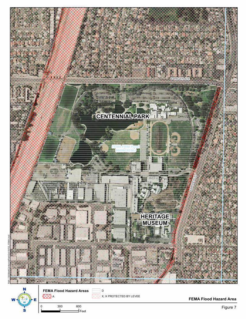
FEMA FIRM Panel06059C0256J
EDINGER AVE
FA
IRV
IEW
ST
FEMA Flood Hazard Area
0 300 600
FeetFigure 7
Pa
th:
I:\S
S\B
ott
\Ce
nte
nn
ialP
ark
\Oct1
5\F
22_
FE
MA
.mxd
FEMA Flood Hazard Areas
A
D
X; X PROTECTED BY LEVEE
CENTENNIAL PARK
HERITAGEMUSEUM
Section 4
Orange County Water District SAR-13 Heritage Museum SAR-13 Monitoring Well Project Draft Initial Study/Mitigated Negative Declaration & CEQA-Plus Federal Consultation Review 4 -60
The project site and surrounding area does not contain any slopes, hillsides or mountains that pose the threat for mudflow impacts. Therefore, potential mudflow impacts would be less than significant. No mitigation measures are required.
4.10 Land Use/Planning
A. Would the project physically divide an establish ed community?
Less than Significant Impact with Mitigation: The construction and operation of the monitoring well would be confined to the Heritage Museum and would not physically impact any offsite existing residential communities, businesses or industries within the study area. Construction operations for the proposed monitoring well would result in temporary noise impacts to some land uses within the study area. Mitigation measures have been incorporated into the construction operations to ensure that the noise impacts would be less than significant. To keep the public informed when construction activities for the Proposed Project would occur, OCWD would implement a community outreach program that would inform the public on upcoming construction activities. With the implementation of Mitigation Measure LU-1 potential construction impacts would be further minimized.
Mitigation Measure
LU-1: Prior to start of construction activities, OCWD will provides residents and business owners with notifications of upcoming construction activities.
B. Would the project be in conflict with any applic able land use plan, policy or regulation of an agency with jurisdiction over the project adopted for the purpose of avoiding or mitigating an environmental effect?
Less than Significant Impact with Mitigation : The City of Santa Ana Municipal Cope Chapter 39, Article IV identifies the permitting requirements for wells proposed in the City of Santa Ana. The Municipal Code requires coordination with the County of Orange Health Care Agency and compliance with State Department of Water Resources well siting requirements. With the implementation of Mitigation Measure LU-2 potential land use conflicts would be avoided.
Mitigation Measure
LU-2: OCWD will coordinate with the County of Orange Health Care Agency and comply with State Department of Water Resources well siting requirements.
C. Would the project be in conflict with any applic able habitat conservation plan or natural community conservation plan?
No Impact: There are not any habitat management plans or natural community conservation plans established on the Heritage Museum site or within the surrounding
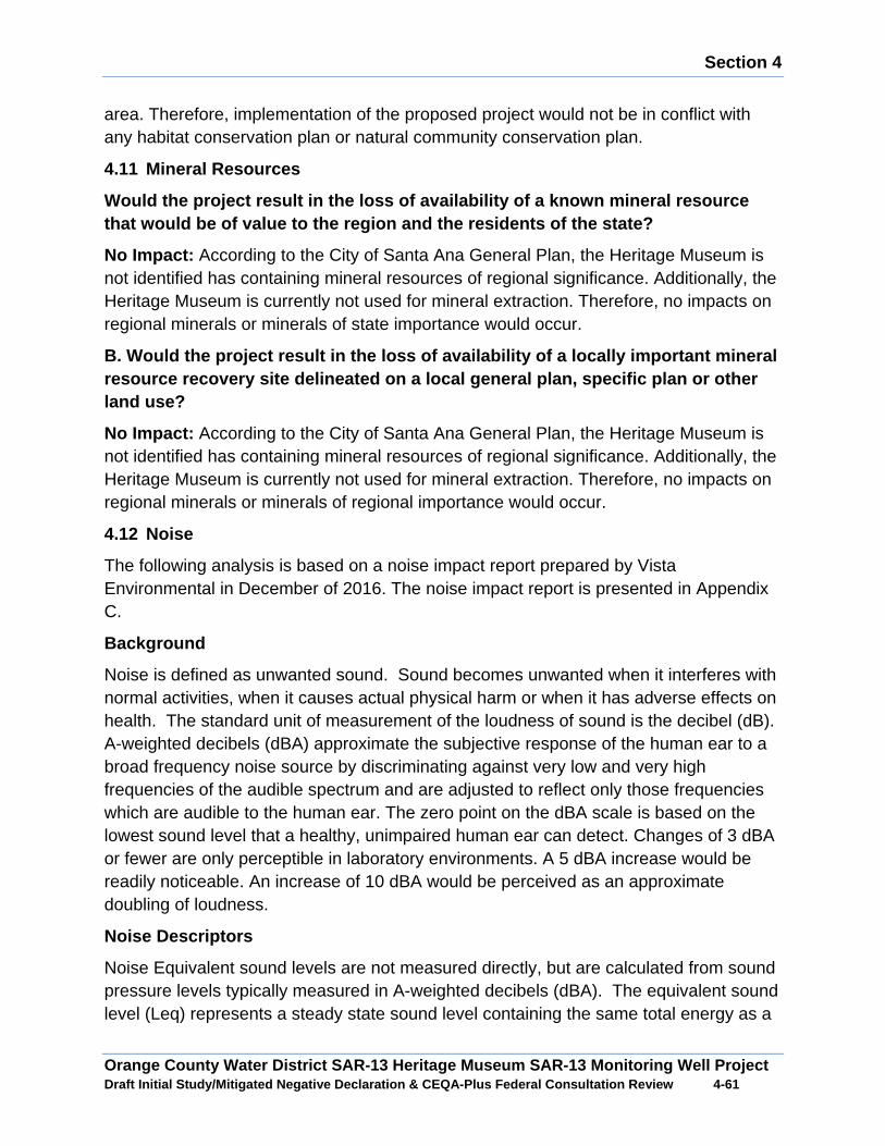
Section 4
Orange County Water District SAR-13 Heritage Museum SAR-13 Monitoring Well Project Draft Initial Study/Mitigated Negative Declaration & CEQA-Plus Federal Consultation Review 4 -61
area. Therefore, implementation of the proposed project would not be in conflict with any habitat conservation plan or natural community conservation plan.
4.11 Mineral Resources
Would the project result in the loss of availabilit y of a known mineral resource that would be of value to the region and the reside nts of the state?
No Impact: According to the City of Santa Ana General Plan, the Heritage Museum is not identified has containing mineral resources of regional significance. Additionally, the Heritage Museum is currently not used for mineral extraction. Therefore, no impacts on regional minerals or minerals of state importance would occur.
B. Would the project result in the loss of availabi lity of a locally important mineral resource recovery site delineated on a local genera l plan, specific plan or other land use?
No Impact: According to the City of Santa Ana General Plan, the Heritage Museum is not identified has containing mineral resources of regional significance. Additionally, the Heritage Museum is currently not used for mineral extraction. Therefore, no impacts on regional minerals or minerals of regional importance would occur.
4.12 Noise
The following analysis is based on a noise impact report prepared by Vista Environmental in December of 2016. The noise impact report is presented in Appendix C.
Background
Noise is defined as unwanted sound. Sound becomes unwanted when it interferes with normal activities, when it causes actual physical harm or when it has adverse effects on health. The standard unit of measurement of the loudness of sound is the decibel (dB). A-weighted decibels (dBA) approximate the subjective response of the human ear to a broad frequency noise source by discriminating against very low and very high frequencies of the audible spectrum and are adjusted to reflect only those frequencies which are audible to the human ear. The zero point on the dBA scale is based on the lowest sound level that a healthy, unimpaired human ear can detect. Changes of 3 dBA or fewer are only perceptible in laboratory environments. A 5 dBA increase would be readily noticeable. An increase of 10 dBA would be perceived as an approximate doubling of loudness.
Noise Descriptors
Noise Equivalent sound levels are not measured directly, but are calculated from sound pressure levels typically measured in A-weighted decibels (dBA). The equivalent sound level (Leq) represents a steady state sound level containing the same total energy as a
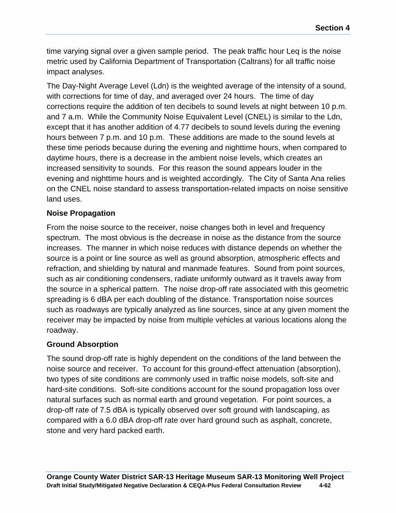
Section 4
Orange County Water District SAR-13 Heritage Museum SAR-13 Monitoring Well Project Draft Initial Study/Mitigated Negative Declaration & CEQA-Plus Federal Consultation Review 4 -62
time varying signal over a given sample period. The peak traffic hour Leq is the noise metric used by California Department of Transportation (Caltrans) for all traffic noise impact analyses.
The Day-Night Average Level (Ldn) is the weighted average of the intensity of a sound, with corrections for time of day, and averaged over 24 hours. The time of day corrections require the addition of ten decibels to sound levels at night between 10 p.m. and 7 a.m. While the Community Noise Equivalent Level (CNEL) is similar to the Ldn, except that it has another addition of 4.77 decibels to sound levels during the evening hours between 7 p.m. and 10 p.m. These additions are made to the sound levels at these time periods because during the evening and nighttime hours, when compared to daytime hours, there is a decrease in the ambient noise levels, which creates an increased sensitivity to sounds. For this reason the sound appears louder in the evening and nighttime hours and is weighted accordingly. The City of Santa Ana relies on the CNEL noise standard to assess transportation-related impacts on noise sensitive land uses.
Noise Propagation
From the noise source to the receiver, noise changes both in level and frequency spectrum. The most obvious is the decrease in noise as the distance from the source increases. The manner in which noise reduces with distance depends on whether the source is a point or line source as well as ground absorption, atmospheric effects and refraction, and shielding by natural and manmade features. Sound from point sources, such as air conditioning condensers, radiate uniformly outward as it travels away from the source in a spherical pattern. The noise drop-off rate associated with this geometric spreading is 6 dBA per each doubling of the distance. Transportation noise sources such as roadways are typically analyzed as line sources, since at any given moment the receiver may be impacted by noise from multiple vehicles at various locations along the roadway.
Ground Absorption
The sound drop-off rate is highly dependent on the conditions of the land between the noise source and receiver. To account for this ground-effect attenuation (absorption), two types of site conditions are commonly used in traffic noise models, soft-site and hard-site conditions. Soft-site conditions account for the sound propagation loss over natural surfaces such as normal earth and ground vegetation. For point sources, a drop-off rate of 7.5 dBA is typically observed over soft ground with landscaping, as compared with a 6.0 dBA drop-off rate over hard ground such as asphalt, concrete, stone and very hard packed earth.
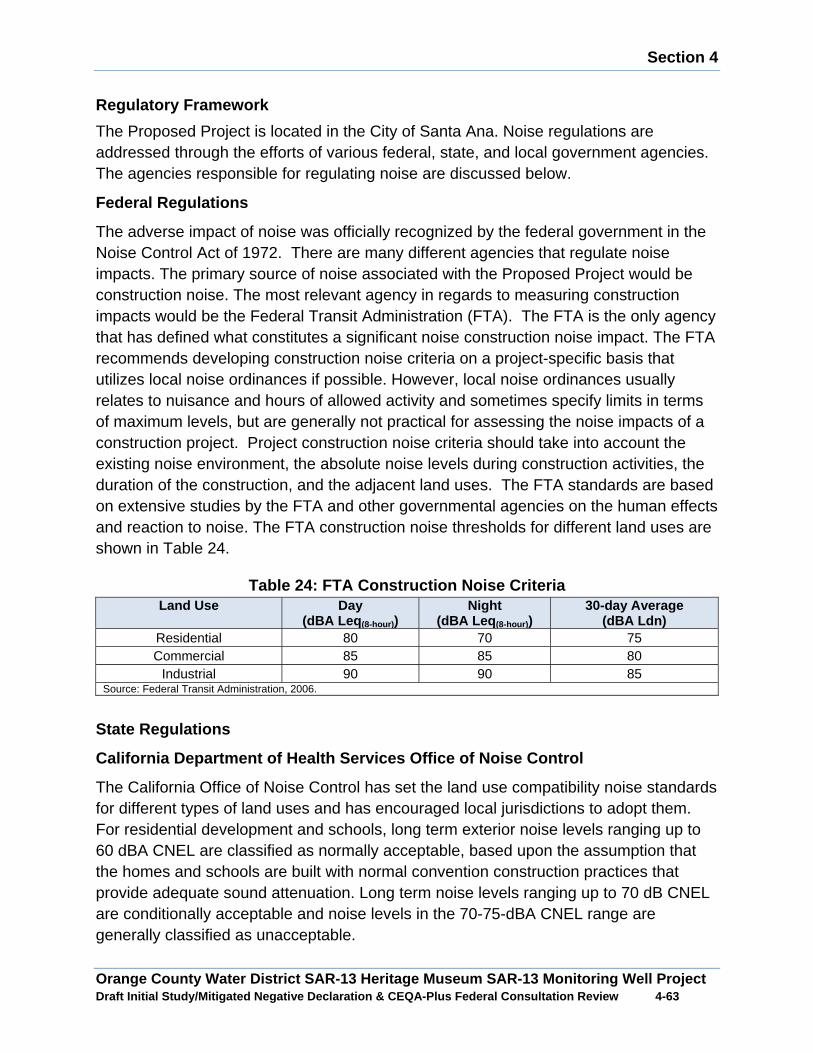
Section 4
Orange County Water District SAR-13 Heritage Museum SAR-13 Monitoring Well Project Draft Initial Study/Mitigated Negative Declaration & CEQA-Plus Federal Consultation Review 4 -63
Regulatory Framework
The Proposed Project is located in the City of Santa Ana. Noise regulations are addressed through the efforts of various federal, state, and local government agencies. The agencies responsible for regulating noise are discussed below.
Federal Regulations
The adverse impact of noise was officially recognized by the federal government in the Noise Control Act of 1972. There are many different agencies that regulate noise impacts. The primary source of noise associated with the Proposed Project would be construction noise. The most relevant agency in regards to measuring construction impacts would be the Federal Transit Administration (FTA). The FTA is the only agency that has defined what constitutes a significant noise construction noise impact. The FTA recommends developing construction noise criteria on a project-specific basis that utilizes local noise ordinances if possible. However, local noise ordinances usually relates to nuisance and hours of allowed activity and sometimes specify limits in terms of maximum levels, but are generally not practical for assessing the noise impacts of a construction project. Project construction noise criteria should take into account the existing noise environment, the absolute noise levels during construction activities, the duration of the construction, and the adjacent land uses. The FTA standards are based on extensive studies by the FTA and other governmental agencies on the human effects and reaction to noise. The FTA construction noise thresholds for different land uses are shown in Table 24.
Table 24: FTA Construction Noise Criteria Land Use Day
(dBA Leq (8-hour )) Night
(dBA Leq (8-hour )) 30-day Average
(dBA Ldn) Residential 80 70 75
Commercial 85 85 80
Industrial 90 90 85
Source: Federal Transit Administration, 2006.
State Regulations
California Department of Health Services Office of Noise Control
The California Office of Noise Control has set the land use compatibility noise standards for different types of land uses and has encouraged local jurisdictions to adopt them. For residential development and schools, long term exterior noise levels ranging up to 60 dBA CNEL are classified as normally acceptable, based upon the assumption that the homes and schools are built with normal convention construction practices that provide adequate sound attenuation. Long term noise levels ranging up to 70 dB CNEL are conditionally acceptable and noise levels in the 70-75-dBA CNEL range are generally classified as unacceptable.
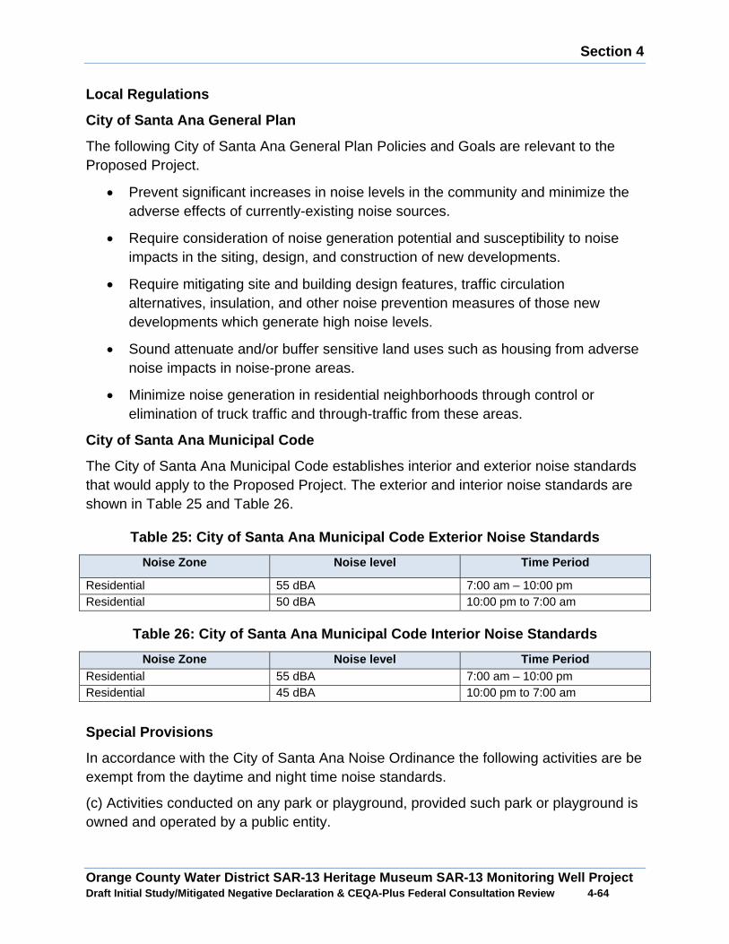
Section 4
Orange County Water District SAR-13 Heritage Museum SAR-13 Monitoring Well Project Draft Initial Study/Mitigated Negative Declaration & CEQA-Plus Federal Consultation Review 4 -64
Local Regulations
City of Santa Ana General Plan
The following City of Santa Ana General Plan Policies and Goals are relevant to the Proposed Project.
x Prevent significant increases in noise levels in the community and minimize the adverse effects of currently-existing noise sources.
x Require consideration of noise generation potential and susceptibility to noise impacts in the siting, design, and construction of new developments.
x Require mitigating site and building design features, traffic circulation alternatives, insulation, and other noise prevention measures of those new developments which generate high noise levels.
x Sound attenuate and/or buffer sensitive land uses such as housing from adverse noise impacts in noise-prone areas.
x Minimize noise generation in residential neighborhoods through control or elimination of truck traffic and through-traffic from these areas.
City of Santa Ana Municipal Code
The City of Santa Ana Municipal Code establishes interior and exterior noise standards that would apply to the Proposed Project. The exterior and interior noise standards are shown in Table 25 and Table 26.
Table 25: City of Santa Ana Municipal Code Exterior Noise Standards
Noise Zone Noise level Time Period
Residential 55 dBA 7:00 am – 10:00 pm Residential 50 dBA 10:00 pm to 7:00 am
Table 26: City of Santa Ana Municipal Code Interior Noise Standards
Noise Zone Noise level Time Period Residential 55 dBA 7:00 am – 10:00 pm Residential 45 dBA 10:00 pm to 7:00 am
Special Provisions
In accordance with the City of Santa Ana Noise Ordinance the following activities are be exempt from the daytime and night time noise standards.
(c) Activities conducted on any park or playground, provided such park or playground is owned and operated by a public entity.
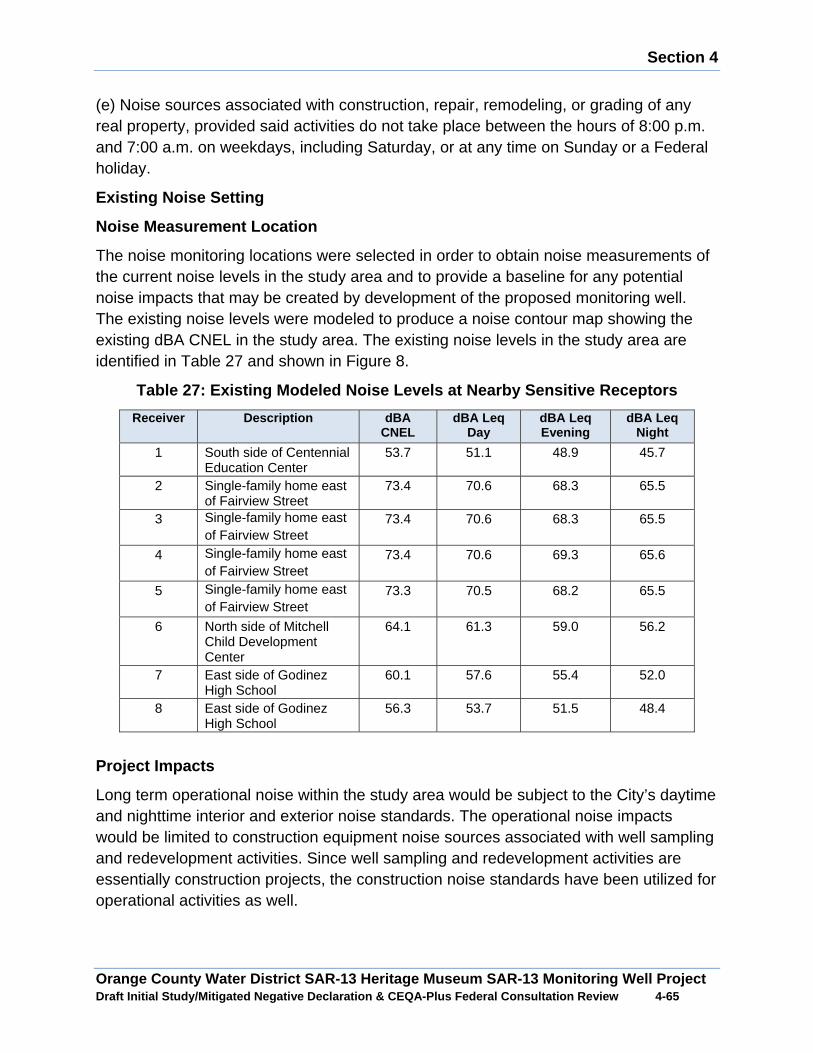
Section 4
Orange County Water District SAR-13 Heritage Museum SAR-13 Monitoring Well Project Draft Initial Study/Mitigated Negative Declaration & CEQA-Plus Federal Consultation Review 4 -65
(e) Noise sources associated with construction, repair, remodeling, or grading of any real property, provided said activities do not take place between the hours of 8:00 p.m. and 7:00 a.m. on weekdays, including Saturday, or at any time on Sunday or a Federal holiday.
Existing Noise Setting
Noise Measurement Location
The noise monitoring locations were selected in order to obtain noise measurements of the current noise levels in the study area and to provide a baseline for any potential noise impacts that may be created by development of the proposed monitoring well. The existing noise levels were modeled to produce a noise contour map showing the existing dBA CNEL in the study area. The existing noise levels in the study area are identified in Table 27 and shown in Figure 8.
Table 27: Existing Modeled Noise Levels at Nearby S ensitive Receptors
Receiver Description dBA CNEL
dBA Leq Day
dBA Leq Evening
dBA Leq Night
1 South side of Centennial Education Center
53.7 51.1 48.9 45.7
2 Single-family home east of Fairview Street
73.4 70.6 68.3 65.5
3 Single-family home east of Fairview Street
73.4 70.6 68.3 65.5
4 Single-family home east of Fairview Street
73.4 70.6 69.3 65.6
5 Single-family home east of Fairview Street
73.3 70.5 68.2 65.5
6 North side of Mitchell Child Development Center
64.1 61.3 59.0 56.2
7 East side of Godinez High School
60.1 57.6 55.4 52.0
8 East side of Godinez High School
56.3 53.7 51.5 48.4
Project Impacts
Long term operational noise within the study area would be subject to the City’s daytime and nighttime interior and exterior noise standards. The operational noise impacts would be limited to construction equipment noise sources associated with well sampling and redevelopment activities. Since well sampling and redevelopment activities are essentially construction projects, the construction noise standards have been utilized for operational activities as well.
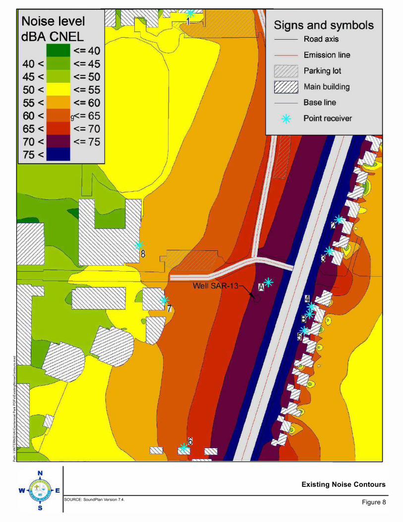
Existing Noise Contours
Figure 8
Pa
th:
I:\IN
TE
RN
S\V
A\C
ente
nn
ial P
ark
PD
Fs\E
xis
tin
gN
ois
eC
on
tou
rs.m
xd
SOURCE: SoundPlan Version 7.4.
No ise leve l
d BA CNEL
40 <
45 <
50 <
55 <
60 <
65 <
70 <
75 <
w
<= 40
<= 45
<= 50
<= 55
<= 60
Signs and symbols Road axis
Emiss ion l ine
� Park ing lot
� Main bui ld i ng
Base l ine
Point rece iver
/ !

Section 4
Orange County Water District SAR-13 Heritage Museum SAR-13 Monitoring Well Project Draft Initial Study/Mitigated Negative Declaration & CEQA-Plus Federal Consultation Review 4 -67
The City of Santa Ana, similar to most jurisdictions exempts construction noise from the indoor and outdoor noise standards if it occurs between 7:00 a.m. and 8:00 p.m. Monday through Saturday, excluding holidays. To determine potential significant noise impacts, noise generated from the operation and construction of the Proposed Project has been compared to the City’s daytime and nighttime exterior noise standards. Since the exterior and interior noise standards only differ by 5 dBA and a typical home provides a minimum of 15 dBA exterior to interior attenuation, the analysis was limited to the exterior noise standards.
As identified previously, there are several locations within the vicinity of the project site where the existing noise levels are higher than the City’s noise standard. The CEQA Guidelines do not define the levels at which a temporary increases in existing noise levels are considered significant. As discussed previously, a noise level increase of 3 dBA would be barely perceptible to the human ear, a 5 dBA increase would be readily noticeable and a difference of 10 dBA would be perceived as a doubling of loudness. To determine a potential significant noise impact when the existing noise levels are higher than the noise standard, a 3 dBA increase over the existing noise level would be the threshold to determine a potential significant noise impact. In cases where the existing noise level is below the City’s noise standard, the City’s noise standard would be the threshold to determine a potential significant noise impact. Additionally, the FTA Construction Noise Criteria would also be utilized to identify how substantial the construction noise impacts would be.
A. Would the project expose persons to or generatio n of noise levels in excess of standards established in the local general plan or noise ordinance, or applicable standards of other agencies?
Less than Significant Impact with Mitigation: The primary source of noise impacts would be emitted from the operation of heavy construction equipment. In order to determine the anticipated noise impacts created from the Proposed Project construction activities, noise measurements were taken of various pieces of equipment during construction of OCWD’s Mid Basin Monitoring Well SAR-11. For equipment pieces that were not measured as part of the construction for Monitoring Well SAR-11, the equipment noise levels provided in the FHWA’s Roadway Construction Noise Model (RCNM) were utilized. The results of the measured reference noise levels and operating times of each piece of equipment utilized during each phase of well construction activities are shown in Table 28.
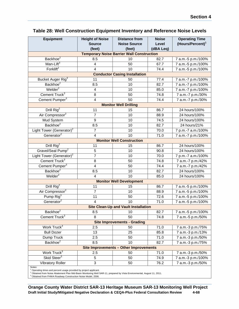
Section 4
Orange County Water District SAR-13 Heritage Museum SAR-13 Monitoring Well Project Draft Initial Study/Mitigated Negative Declaration & CEQA-Plus Federal Consultation Review 4 -68
Table 28: Well Construction Equipment Inventory and Reference Noise Levels
Equipment Height of Noise Source (feet)
Distance from Noise Source
(feet)
Noise Level
(dBA Leq)
Operating Time (Hours/Percent) 1
Temporary Noise Barrier Wall Construction Backhoe2 8.5 10 82.7 7 a.m.-5 p.m./100% Man-Lift3 4 50 67.7 7 a.m.-5 p.m./100% Forklift2 4 10 74.4 7 a.m.-5 p.m./100%
Conductor Casing Installation Bucket Auger Rig3 11 50 77.4 7 a.m.-7 p.m./100%
Backhoe2 8.5 10 82.7 7 a.m.-7 p.m./100% Welder2 4 10 85.0 7 a.m.-7 p.m./100%
Cement Truck3 8 50 74.8 7 a.m.-7 p.m./30% Cement Pumper3 4 50 74.4 7 a.m.-7 p.m./30%
Monitor Well Drilling Drill Rig2 11 15 86.7 24 hours/100%
Air Compressor2 7 10 88.9 24 hours/100% Mud System 9 10 74.5 24 hours/100%
Backhoe2 8.5 10 82.7 24 hours/21% Light Tower (Generator)2 7 10 70.0 7 p.m.-7 a.m./100%
Generator2 4 10 71.0 7 a.m.-7 p.m./100% Monitor Well Construction
Drill Rig2 11 15 86.7 24 hours/100% Gravel/Seal Pump2 5 10 90.8 24 hours/100%
Light Tower (Generator)2 7 10 70.0 7 p.m.-7 a.m./100% Cement Truck3 8 50 74.8 7 a.m.-7 p.m./42%
Cement Pumper3 4 50 74.4 7 a.m.-7 p.m./42% Backhoe2 8.5 10 82.7 24 hours/100% Welder2 4 10 85.0 24 hours/100%
Monitor Well Development Drill Rig2 11 15 86.7 7 a.m.-5 p.m./100%
Air Compressor2 7 10 88.9 7 a.m.-5 p.m./100% Pump Rig3 11 50 72.6 7 a.m.-5 p.m./100% Generator2 4 10 71.0 7 a.m.-5 p.m./100%
Site Clean-Up and Vault Installation Backhoe2 8.5 10 82.7 7 a.m.-5 p.m./100%
Cement Truck3 8 50 74.8 7 a.m.-5 p.m./50% Site Improvements - Grading
Work Truck3 2.5 50 71.0 7 a.m.-3 p.m./75% Bull Dozer 13 25 85.8 7 a.m.-3 p.m./13%
Dump Truck 2.5 50 71.0 7 a.m.-3 p.m./50% Backhoe2 8.5 10 82.7 7 a.m.-3 p.m./75%
Site Improvements – Other Improvements Work Truck3 2.5 50 71.0 7 a.m.-3 p.m./50% Skid Steer3 5 50 74.9 7 a.m.-3 p.m./100%
Vibratory Roller 3 50 76.2 7 a.m.-3 p.m./50% Notes: 1 Operating times and percent usage provided by project applicant. 2 Obtained from Noise Abatement Plan Mid-Basin Monitoring Well SAR-11, prepared by Vista Environmental, August 11, 2011. 3 Obtained from FHWA Roadway Construction Noise Model, 2006.
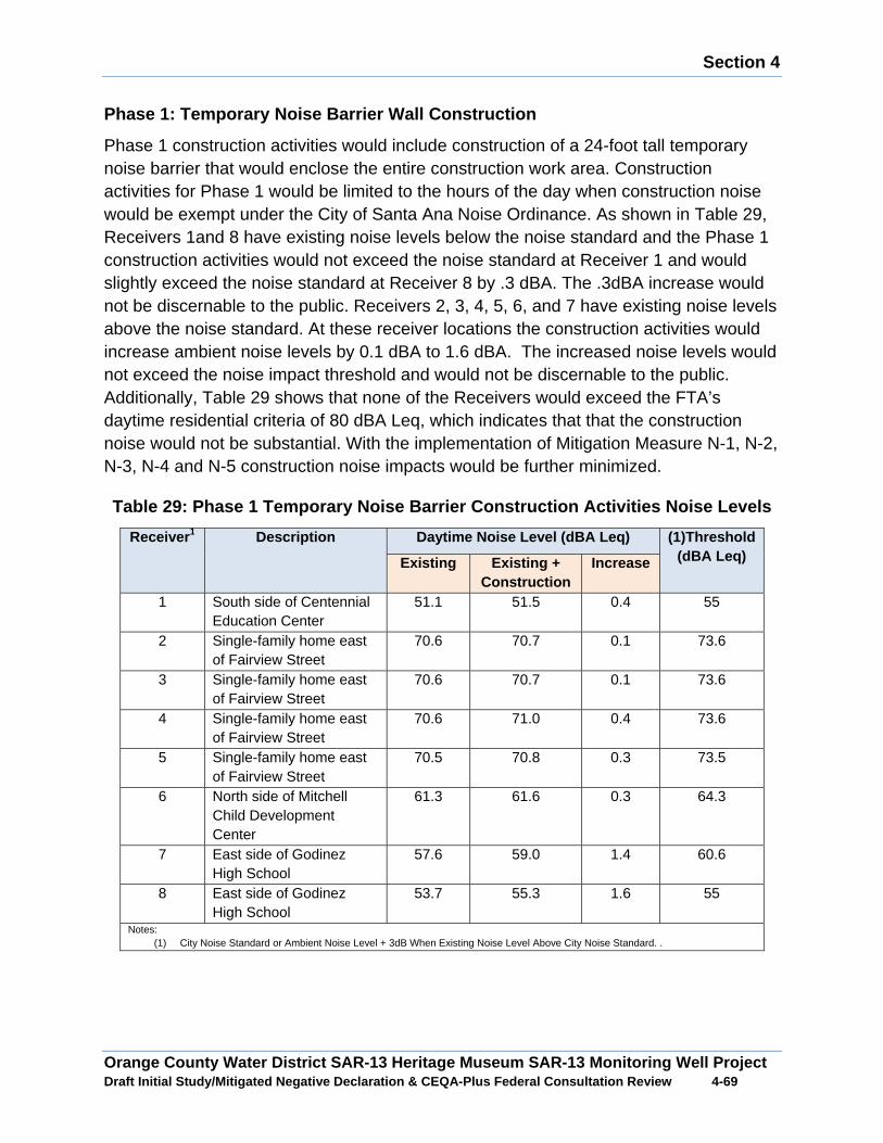
Section 4
Orange County Water District SAR-13 Heritage Museum SAR-13 Monitoring Well Project Draft Initial Study/Mitigated Negative Declaration & CEQA-Plus Federal Consultation Review 4 -69
Phase 1: Temporary Noise Barrier Wall Construction
Phase 1 construction activities would include construction of a 24-foot tall temporary noise barrier that would enclose the entire construction work area. Construction activities for Phase 1 would be limited to the hours of the day when construction noise would be exempt under the City of Santa Ana Noise Ordinance. As shown in Table 29, Receivers 1and 8 have existing noise levels below the noise standard and the Phase 1 construction activities would not exceed the noise standard at Receiver 1 and would slightly exceed the noise standard at Receiver 8 by .3 dBA. The .3dBA increase would not be discernable to the public. Receivers 2, 3, 4, 5, 6, and 7 have existing noise levels above the noise standard. At these receiver locations the construction activities would increase ambient noise levels by 0.1 dBA to 1.6 dBA. The increased noise levels would not exceed the noise impact threshold and would not be discernable to the public. Additionally, Table 29 shows that none of the Receivers would exceed the FTA’s daytime residential criteria of 80 dBA Leq, which indicates that that the construction noise would not be substantial. With the implementation of Mitigation Measure N-1, N-2, N-3, N-4 and N-5 construction noise impacts would be further minimized.
Table 29: Phase 1 Temporary Noise Barrier Construct ion Activities Noise Levels
Receiver 1 Description Daytime Noise Level (dBA Leq) (1)Threshold(dBA Leq) Existing Existing +
Construction Increase
1 South side of Centennial Education Center
51.1 51.5 0.4 55
2 Single-family home east of Fairview Street
70.6 70.7 0.1 73.6
3 Single-family home east of Fairview Street
70.6 70.7 0.1 73.6
4 Single-family home east of Fairview Street
70.6 71.0 0.4 73.6
5 Single-family home east of Fairview Street
70.5 70.8 0.3 73.5
6 North side of Mitchell Child Development Center
61.3 61.6 0.3 64.3
7 East side of Godinez High School
57.6 59.0 1.4 60.6
8 East side of Godinez High School
53.7 55.3 1.6 55
Notes: (1) City Noise Standard or Ambient Noise Level + 3dB When Existing Noise Level Above City Noise Standard. .
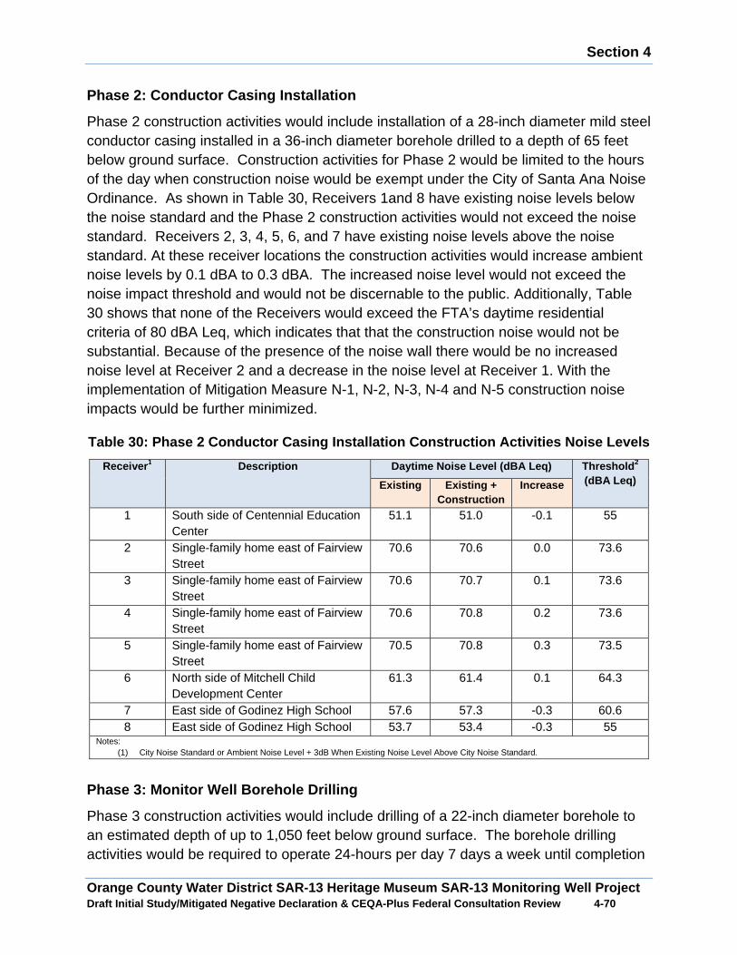
Section 4
Orange County Water District SAR-13 Heritage Museum SAR-13 Monitoring Well Project Draft Initial Study/Mitigated Negative Declaration & CEQA-Plus Federal Consultation Review 4 -70
Phase 2: Conductor Casing Installation
Phase 2 construction activities would include installation of a 28-inch diameter mild steel conductor casing installed in a 36-inch diameter borehole drilled to a depth of 65 feet below ground surface. Construction activities for Phase 2 would be limited to the hours of the day when construction noise would be exempt under the City of Santa Ana Noise Ordinance. As shown in Table 30, Receivers 1and 8 have existing noise levels below the noise standard and the Phase 2 construction activities would not exceed the noise standard. Receivers 2, 3, 4, 5, 6, and 7 have existing noise levels above the noise standard. At these receiver locations the construction activities would increase ambient noise levels by 0.1 dBA to 0.3 dBA. The increased noise level would not exceed the noise impact threshold and would not be discernable to the public. Additionally, Table 30 shows that none of the Receivers would exceed the FTA’s daytime residential criteria of 80 dBA Leq, which indicates that that the construction noise would not be substantial. Because of the presence of the noise wall there would be no increased noise level at Receiver 2 and a decrease in the noise level at Receiver 1. With the implementation of Mitigation Measure N-1, N-2, N-3, N-4 and N-5 construction noise impacts would be further minimized.
Table 30: Phase 2 Conductor Casing Installation Con struction Activities Noise Levels
Receive r1 Description Daytime Noise Level (dBA Leq) Threshold 2
(dBA Leq) Existing Existing + Construction
Increase
1 South side of Centennial Education Center
51.1 51.0 -0.1 55
2 Single-family home east of Fairview Street
70.6 70.6 0.0 73.6
3 Single-family home east of Fairview Street
70.6 70.7 0.1 73.6
4 Single-family home east of Fairview Street
70.6 70.8 0.2 73.6
5 Single-family home east of Fairview Street
70.5 70.8 0.3 73.5
6 North side of Mitchell Child Development Center
61.3 61.4 0.1 64.3
7 East side of Godinez High School 57.6 57.3 -0.3 60.6 8 East side of Godinez High School 53.7 53.4 -0.3 55
Notes: (1) City Noise Standard or Ambient Noise Level + 3dB When Existing Noise Level Above City Noise Standard.
Phase 3: Monitor Well Borehole Drilling
Phase 3 construction activities would include drilling of a 22-inch diameter borehole to an estimated depth of up to 1,050 feet below ground surface. The borehole drilling activities would be required to operate 24-hours per day 7 days a week until completion
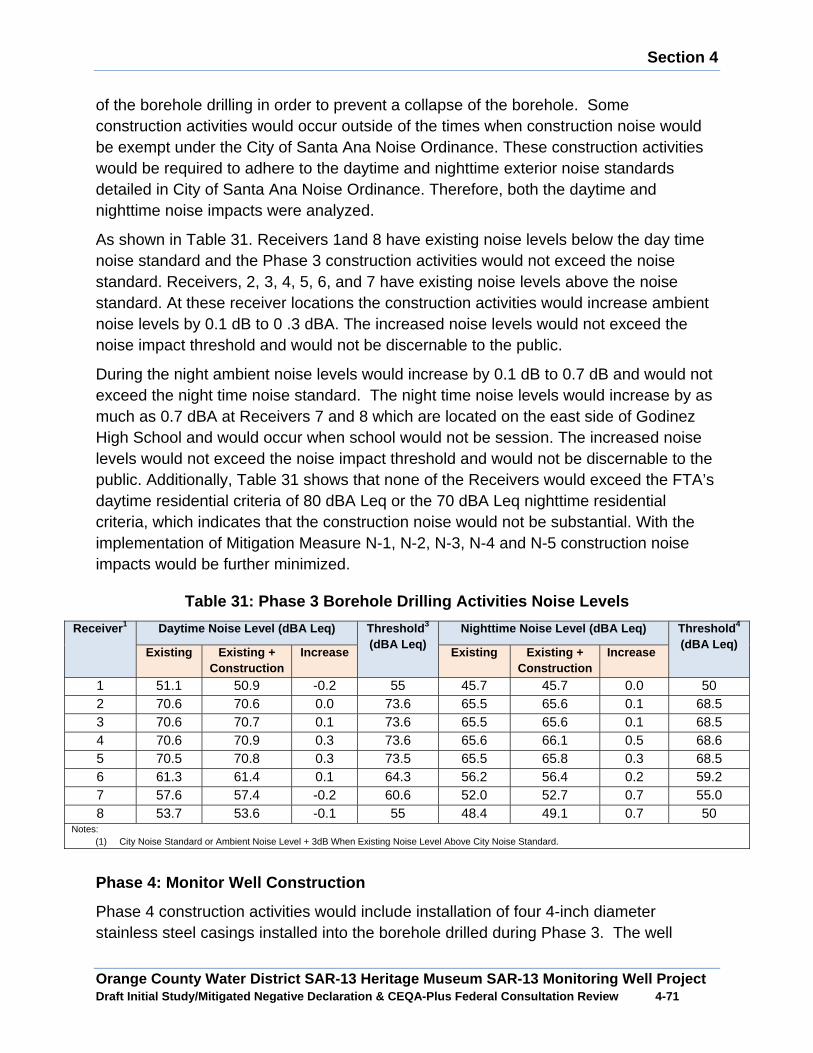
Section 4
Orange County Water District SAR-13 Heritage Museum SAR-13 Monitoring Well Project Draft Initial Study/Mitigated Negative Declaration & CEQA-Plus Federal Consultation Review 4 -71
of the borehole drilling in order to prevent a collapse of the borehole. Some construction activities would occur outside of the times when construction noise would be exempt under the City of Santa Ana Noise Ordinance. These construction activities would be required to adhere to the daytime and nighttime exterior noise standards detailed in City of Santa Ana Noise Ordinance. Therefore, both the daytime and nighttime noise impacts were analyzed.
As shown in Table 31. Receivers 1and 8 have existing noise levels below the day time noise standard and the Phase 3 construction activities would not exceed the noise standard. Receivers, 2, 3, 4, 5, 6, and 7 have existing noise levels above the noise standard. At these receiver locations the construction activities would increase ambient noise levels by 0.1 dB to 0 .3 dBA. The increased noise levels would not exceed the noise impact threshold and would not be discernable to the public.
During the night ambient noise levels would increase by 0.1 dB to 0.7 dB and would not exceed the night time noise standard. The night time noise levels would increase by as much as 0.7 dBA at Receivers 7 and 8 which are located on the east side of Godinez High School and would occur when school would not be session. The increased noise levels would not exceed the noise impact threshold and would not be discernable to the public. Additionally, Table 31 shows that none of the Receivers would exceed the FTA’s daytime residential criteria of 80 dBA Leq or the 70 dBA Leq nighttime residential criteria, which indicates that the construction noise would not be substantial. With the implementation of Mitigation Measure N-1, N-2, N-3, N-4 and N-5 construction noise impacts would be further minimized.
Table 31: Phase 3 Borehole Drilling Activities Nois e Levels
Receive r1 Daytime Noise Level (dBA Leq) Threshold 3
(dBA Leq) Nighttime Noise Level (dBA Leq) Threshold 4
(dBA Leq) Existing Existing +
Construction Increase Existing Existing +
Construction Increase
1 51.1 50.9 -0.2 55 45.7 45.7 0.0 50 2 70.6 70.6 0.0 73.6 65.5 65.6 0.1 68.5 3 70.6 70.7 0.1 73.6 65.5 65.6 0.1 68.5 4 70.6 70.9 0.3 73.6 65.6 66.1 0.5 68.6 5 70.5 70.8 0.3 73.5 65.5 65.8 0.3 68.5 6 61.3 61.4 0.1 64.3 56.2 56.4 0.2 59.2 7 57.6 57.4 -0.2 60.6 52.0 52.7 0.7 55.0 8 53.7 53.6 -0.1 55 48.4 49.1 0.7 50
Notes: (1) City Noise Standard or Ambient Noise Level + 3dB When Existing Noise Level Above City Noise Standard.
Phase 4: Monitor Well Construction
Phase 4 construction activities would include installation of four 4-inch diameter stainless steel casings installed into the borehole drilled during Phase 3. The well
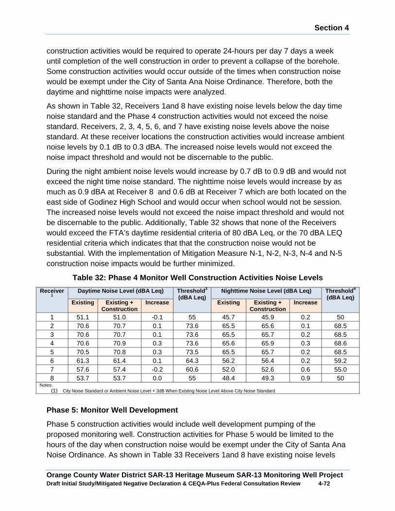
Section 4
Orange County Water District SAR-13 Heritage Museum SAR-13 Monitoring Well Project Draft Initial Study/Mitigated Negative Declaration & CEQA-Plus Federal Consultation Review 4 -72
construction activities would be required to operate 24-hours per day 7 days a week until completion of the well construction in order to prevent a collapse of the borehole. Some construction activities would occur outside of the times when construction noise would be exempt under the City of Santa Ana Noise Ordinance. Therefore, both the daytime and nighttime noise impacts were analyzed.
As shown in Table 32, Receivers 1and 8 have existing noise levels below the day time noise standard and the Phase 4 construction activities would not exceed the noise standard. Receivers, 2, 3, 4, 5, 6, and 7 have existing noise levels above the noise standard. At these receiver locations the construction activities would increase ambient noise levels by 0.1 dB to 0.3 dBA. The increased noise levels would not exceed the noise impact threshold and would not be discernable to the public.
During the night ambient noise levels would increase by 0.7 dB to 0.9 dB and would not exceed the night time noise standard. The nighttime noise levels would increase by as much as 0.9 dBA at Receiver 8 and 0.6 dB at Receiver 7 which are both located on the east side of Godinez High School and would occur when school would not be session. The increased noise levels would not exceed the noise impact threshold and would not be discernable to the public. Additionally, Table 32 shows that none of the Receivers would exceed the FTA’s daytime residential criteria of 80 dBA Leq, or the 70 dBA LEQ residential criteria which indicates that that the construction noise would not be substantial. With the implementation of Mitigation Measure N-1, N-2, N-3, N-4 and N-5 construction noise impacts would be further minimized.
Table 32: Phase 4 Monitor Well Construction Activities Noise Levels
Receive r1
Daytime Noise Level (dBA Leq) Threshold 3
(dBA Leq) Nighttime Noise Level (dBA Leq) Threshold 4
(dBA Leq) Existing Existing +
Construction Increase Existing Existing +
Construction Increase
1 51.1 51.0 -0.1 55 45.7 45.9 0.2 50 2 70.6 70.7 0.1 73.6 65.5 65.6 0.1 68.5 3 70.6 70.7 0.1 73.6 65.5 65.7 0.2 68.5 4 70.6 70.9 0.3 73.6 65.6 65.9 0.3 68.6 5 70.5 70.8 0.3 73.5 65.5 65.7 0.2 68.5 6 61.3 61.4 0.1 64.3 56.2 56.4 0.2 59.2 7 57.6 57.4 -0.2 60.6 52.0 52.6 0.6 55.0 8 53.7 53.7 0.0 55 48.4 49.3 0.9 50
Notes: (1) City Noise Standard or Ambient Noise Level + 3dB When Existing Noise Level Above City Noise Standard.
Phase 5: Monitor Well Development
Phase 5 construction activities would include well development pumping of the proposed monitoring well. Construction activities for Phase 5 would be limited to the hours of the day when construction noise would be exempt under the City of Santa Ana Noise Ordinance. As shown in Table 33 Receivers 1and 8 have existing noise levels
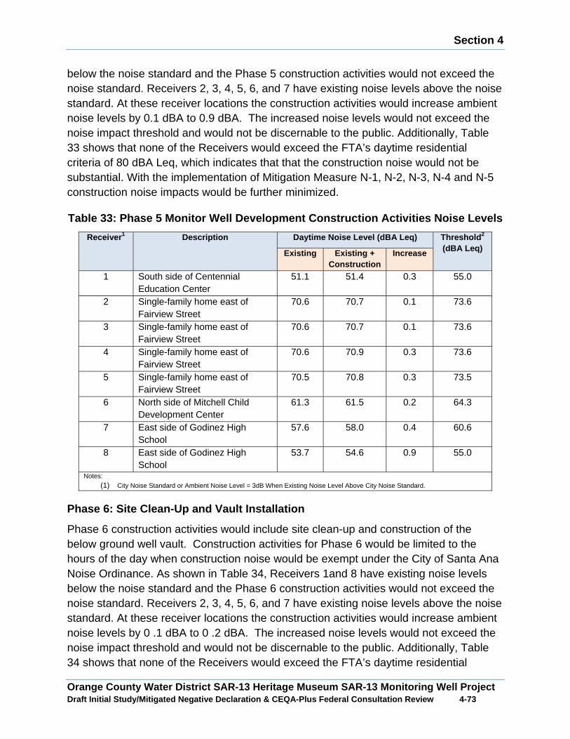
Section 4
Orange County Water District SAR-13 Heritage Museum SAR-13 Monitoring Well Project Draft Initial Study/Mitigated Negative Declaration & CEQA-Plus Federal Consultation Review 4 -73
below the noise standard and the Phase 5 construction activities would not exceed the noise standard. Receivers 2, 3, 4, 5, 6, and 7 have existing noise levels above the noise standard. At these receiver locations the construction activities would increase ambient noise levels by 0.1 dBA to 0.9 dBA. The increased noise levels would not exceed the noise impact threshold and would not be discernable to the public. Additionally, Table 33 shows that none of the Receivers would exceed the FTA’s daytime residential criteria of 80 dBA Leq, which indicates that that the construction noise would not be substantial. With the implementation of Mitigation Measure N-1, N-2, N-3, N-4 and N-5 construction noise impacts would be further minimized.
Table 33: Phase 5 Monitor Well Development Construction Activities Noise Levels
Receive r1 Description Daytime Noise Level (dBA Leq) Threshold 2
(dBA Leq) Existing Existing + Construction
Increase
1 South side of Centennial Education Center
51.1 51.4 0.3 55.0
2 Single-family home east of Fairview Street
70.6 70.7 0.1 73.6
3 Single-family home east of Fairview Street
70.6 70.7 0.1 73.6
4 Single-family home east of Fairview Street
70.6 70.9 0.3 73.6
5 Single-family home east of Fairview Street
70.5 70.8 0.3 73.5
6 North side of Mitchell Child Development Center
61.3 61.5 0.2 64.3
7 East side of Godinez High School
57.6 58.0 0.4 60.6
8 East side of Godinez High School
53.7 54.6 0.9 55.0
Notes:
(1) City Noise Standard or Ambient Noise Level = 3dB When Existing Noise Level Above City Noise Standard.
Phase 6: Site Clean-Up and Vault Installation
Phase 6 construction activities would include site clean-up and construction of the below ground well vault. Construction activities for Phase 6 would be limited to the hours of the day when construction noise would be exempt under the City of Santa Ana Noise Ordinance. As shown in Table 34, Receivers 1and 8 have existing noise levels below the noise standard and the Phase 6 construction activities would not exceed the noise standard. Receivers 2, 3, 4, 5, 6, and 7 have existing noise levels above the noise standard. At these receiver locations the construction activities would increase ambient noise levels by 0 .1 dBA to 0 .2 dBA. The increased noise levels would not exceed the noise impact threshold and would not be discernable to the public. Additionally, Table 34 shows that none of the Receivers would exceed the FTA’s daytime residential
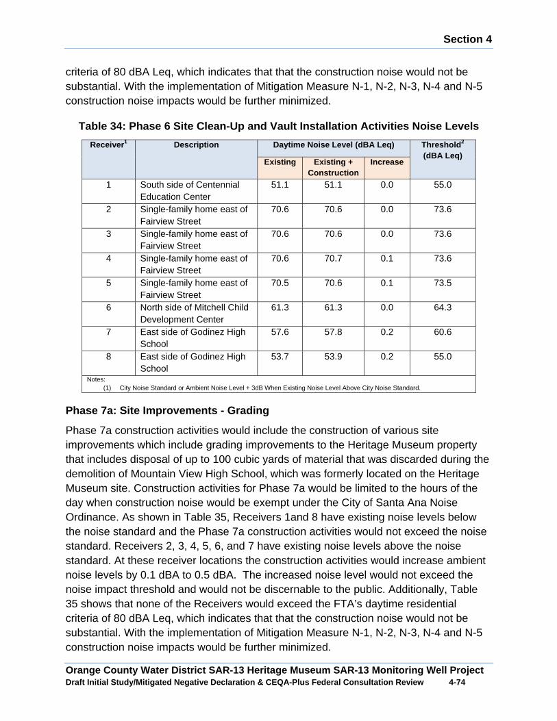
Section 4
Orange County Water District SAR-13 Heritage Museum SAR-13 Monitoring Well Project Draft Initial Study/Mitigated Negative Declaration & CEQA-Plus Federal Consultation Review 4 -74
criteria of 80 dBA Leq, which indicates that that the construction noise would not be substantial. With the implementation of Mitigation Measure N-1, N-2, N-3, N-4 and N-5 construction noise impacts would be further minimized.
Table 34: Phase 6 Site Clean-Up and Vault Installat ion Activities Noise Levels
Receive r1 Description Daytime Noise Level (dBA Leq) Threshold 2
(dBA Leq) Existing Existing +
Construction Increase
1 South side of Centennial Education Center
51.1 51.1 0.0 55.0
2 Single-family home east of Fairview Street
70.6 70.6 0.0 73.6
3 Single-family home east of Fairview Street
70.6 70.6 0.0 73.6
4 Single-family home east of Fairview Street
70.6 70.7 0.1 73.6
5 Single-family home east of Fairview Street
70.5 70.6 0.1 73.5
6 North side of Mitchell Child Development Center
61.3 61.3 0.0 64.3
7 East side of Godinez High School
57.6 57.8 0.2 60.6
8 East side of Godinez High School
53.7 53.9 0.2 55.0
Notes: (1) City Noise Standard or Ambient Noise Level + 3dB When Existing Noise Level Above City Noise Standard.
Phase 7a: Site Improvements - Grading
Phase 7a construction activities would include the construction of various site improvements which include grading improvements to the Heritage Museum property that includes disposal of up to 100 cubic yards of material that was discarded during the demolition of Mountain View High School, which was formerly located on the Heritage Museum site. Construction activities for Phase 7a would be limited to the hours of the day when construction noise would be exempt under the City of Santa Ana Noise Ordinance. As shown in Table 35, Receivers 1and 8 have existing noise levels below the noise standard and the Phase 7a construction activities would not exceed the noise standard. Receivers 2, 3, 4, 5, 6, and 7 have existing noise levels above the noise standard. At these receiver locations the construction activities would increase ambient noise levels by 0.1 dBA to 0.5 dBA. The increased noise level would not exceed the noise impact threshold and would not be discernable to the public. Additionally, Table 35 shows that none of the Receivers would exceed the FTA’s daytime residential criteria of 80 dBA Leq, which indicates that that the construction noise would not be substantial. With the implementation of Mitigation Measure N-1, N-2, N-3, N-4 and N-5 construction noise impacts would be further minimized.
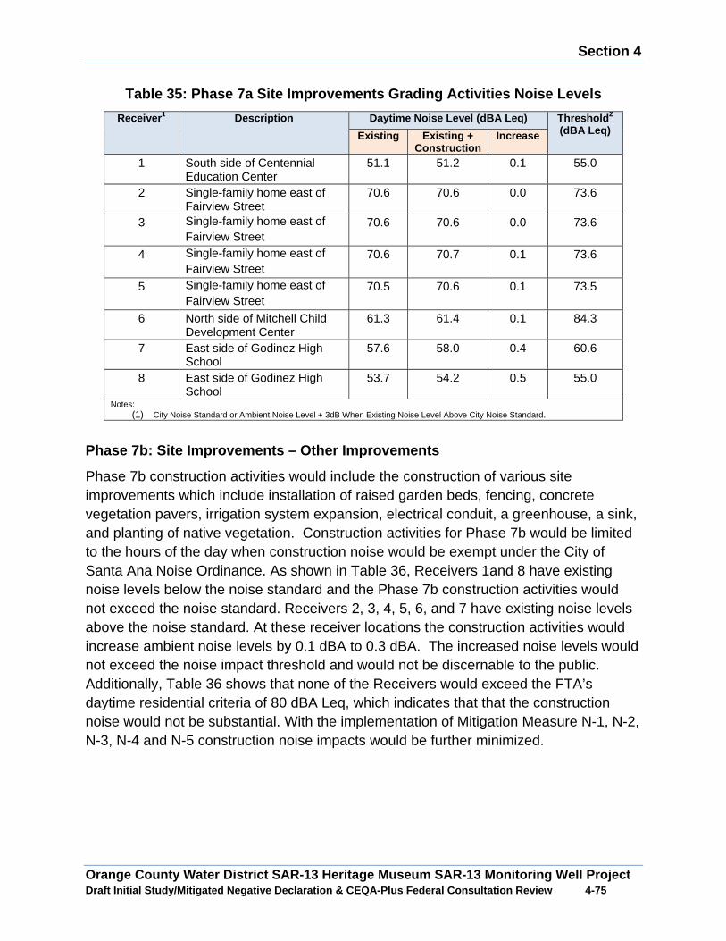
Section 4
Orange County Water District SAR-13 Heritage Museum SAR-13 Monitoring Well Project Draft Initial Study/Mitigated Negative Declaration & CEQA-Plus Federal Consultation Review 4 -75
Table 35: Phase 7a Site Improvements Grading Activities Noise Levels
Receive r1 Description Daytime Noise Level (dBA Leq) Threshold 2
(dBA Leq) Existing Existing + Construction
Increase
1 South side of Centennial Education Center
51.1 51.2 0.1 55.0
2 Single-family home east of Fairview Street
70.6 70.6 0.0 73.6
3 Single-family home east of Fairview Street
70.6 70.6 0.0 73.6
4 Single-family home east of Fairview Street
70.6 70.7 0.1 73.6
5 Single-family home east of Fairview Street
70.5 70.6 0.1 73.5
6 North side of Mitchell Child Development Center
61.3 61.4 0.1 84.3
7 East side of Godinez High School
57.6 58.0 0.4 60.6
8 East side of Godinez High School
53.7 54.2 0.5 55.0
Notes: (1) City Noise Standard or Ambient Noise Level + 3dB When Existing Noise Level Above City Noise Standard.
Phase 7b: Site Improvements – Other Improvements
Phase 7b construction activities would include the construction of various site improvements which include installation of raised garden beds, fencing, concrete vegetation pavers, irrigation system expansion, electrical conduit, a greenhouse, a sink, and planting of native vegetation. Construction activities for Phase 7b would be limited to the hours of the day when construction noise would be exempt under the City of Santa Ana Noise Ordinance. As shown in Table 36, Receivers 1and 8 have existing noise levels below the noise standard and the Phase 7b construction activities would not exceed the noise standard. Receivers 2, 3, 4, 5, 6, and 7 have existing noise levels above the noise standard. At these receiver locations the construction activities would increase ambient noise levels by 0.1 dBA to 0.3 dBA. The increased noise levels would not exceed the noise impact threshold and would not be discernable to the public. Additionally, Table 36 shows that none of the Receivers would exceed the FTA’s daytime residential criteria of 80 dBA Leq, which indicates that that the construction noise would not be substantial. With the implementation of Mitigation Measure N-1, N-2, N-3, N-4 and N-5 construction noise impacts would be further minimized.
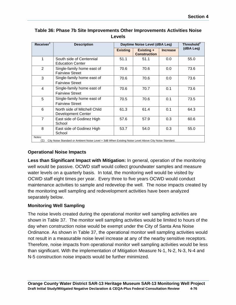
Section 4
Orange County Water District SAR-13 Heritage Museum SAR-13 Monitoring Well Project Draft Initial Study/Mitigated Negative Declaration & CEQA-Plus Federal Consultation Review 4 -76
Table 36: Phase 7b Site Improvements Other Improvem ents Activities Noise Levels
Receive r1 Description Daytime Noise Level (dBA Leq) Threshold 2
(dBA Leq) Existing Existing + Construction
Increase
1 South side of Centennial Education Center
51.1 51.1 0.0 55.0
2 Single-family home east of Fairview Street
70.6 70.6 0.0 73.6
3 Single-family home east of Fairview Street
70.6 70.6 0.0 73.6
4 Single-family home east of Fairview Street
70.6 70.7 0.1 73.6
5 Single-family home east of Fairview Street
70.5 70.6 0.1 73.5
6 North side of Mitchell Child Development Center
61.3 61.4 0.1 64.3
7 East side of Godinez High School
57.6 57.9 0.3 60.6
8 East side of Godinez High School
53.7 54.0 0.3 55.0
Notes: (1) City Noise Standard or Ambient Noise Level = 3dB When Existing Noise Level Above City Noise Standard.
Operational Noise Impacts
Less than Significant Impact with Mitigation: In general, operation of the monitoring well would be passive. OCWD staff would collect groundwater samples and measure water levels on a quarterly basis. In total, the monitoring well would be visited by OCWD staff eight times per year. Every three to five years OCWD would conduct maintenance activities to sample and redevelop the well. The noise impacts created by the monitoring well sampling and redevelopment activities have been analyzed separately below.
Monitoring Well Sampling
The noise levels created during the operational monitor well sampling activities are shown in Table 37. The monitor well sampling activities would be limited to hours of the day when construction noise would be exempt under the City of Santa Ana Noise Ordinance. As shown in Table 37, the operational monitor well sampling activities would not result in a measurable noise level increase at any of the nearby sensitive receptors. Therefore, noise impacts from operational monitor well sampling activities would be less than significant. With the implementation of Mitigation Measure N-1, N-2, N-3, N-4 and N-5 construction noise impacts would be further minimized.

Section 4
Orange County Water District SAR-13 Heritage Museum SAR-13 Monitoring Well Project Draft Initial Study/Mitigated Negative Declaration & CEQA-Plus Federal Consultation Review 4 -77
Table 37: Operational Monitor Well Sampling Activit ies Noise Levels
Receive r1 Description Daytime Noise Level (dBA Leq) Threshold 2
(dBA Leq) Existing Existing +
Operations Increase
1 South side of Centennial Education Center
51.1 51.1 0.0 55.0
2 Single-family home east of Fairview Street
70.6 70.6 0.0 73.6
3 Single-family home east of Fairview Street
70.6 70.6 0.0 73.6
4 Single-family home east of Fairview Street
70.6 70.6 0.0 73.6
5 Single-family home east of Fairview Street
70.5 70.5 0.0 73.5
6 North side of Mitchell Child Development Center
61.3 61.3 0.0 64.3
7 East side of Godinez High School 57.6 57.6 0.0 60.6 8 East side of Godinez High School 53.7 53.7 0.0 55.0
Notes: (1) City Noise Standard or Ambient Noise Level + 3 dB When Existing Noise Level Above City Noise Standard.
Monitor Well Redevelopment
The well redevelopment activities would be limited to the hours of the day when construction noise would be exempt under the City of Santa Ana Noise Ordinance. As shown in Table 38, the operational monitor well redevelopment activities would increase noise levels by as much as 4.1 dBA at Receiver 8 which is located on the east side of Godinez High School. The increase in noise would exceed the daytime noise standard, but because it would occur during the day the construction noise would be exempt under the City of Santa Ana Noise Ordinance and would be less than significant. While construction noise would be exempt, the noise impact would still be discernable. To minimize noise impacts at Godinez High School, the well redevelopment activities would occur when school would not be in session. With the implementation of Mitigation Measure N-1, N-2, N-3, N-4, N-5 and N-6 noise impacts would be further minimized.
Table 38: Operational Monitor Well Redevelopment Ac tivities Noise Levels
Receive r1 Description Daytime Noise Level (dBA Leq) Threshold 2
(dBA Leq) Existing Existing + Operations
Increase
1 South side of Centennial Education Center
51.1 52.8 1.7 55.0
2 Single-family home east of Fairview Street
70.6 70.8 0.2 73.6
3 Single-family home east of Fairview Street
70.6 70.9 0.3 73.6
4 Single-family home east of Fairview 70.6 71.5 0.9 73.6
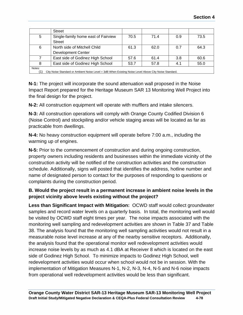
Section 4
Orange County Water District SAR-13 Heritage Museum SAR-13 Monitoring Well Project Draft Initial Study/Mitigated Negative Declaration & CEQA-Plus Federal Consultation Review 4 -78
Street 5 Single-family home east of Fairview
Street 70.5 71.4 0.9 73.5
6 North side of Mitchell Child Development Center
61.3 62.0 0.7 64.3
7 East side of Godinez High School 57.6 61.4 3.8 60.6 8 East side of Godinez High School 53.7 57.8 4.1 55.0
Notes: (1) City Noise Standard or Ambient Noise Level = 3dB When Existing Noise Level Above City Noise Standard.
N-1: The project will incorporate the sound attenuation wall proposed in the Noise Impact Report prepared for the Heritage Museum SAR 13 Monitoring Well Project into the final design for the project.
N-2: All construction equipment will operate with mufflers and intake silencers.
N-3: All construction operations will comply with Orange County Codified Division 6 (Noise Control) and stockpiling and/or vehicle staging areas will be located as far as practicable from dwellings.
N-4: No heavy construction equipment will operate before 7:00 a.m., including the warming up of engines.
N-5: Prior to the commencement of construction and during ongoing construction, property owners including residents and businesses within the immediate vicinity of the construction activity will be notified of the construction activities and the construction schedule. Additionally, signs will posted that identifies the address, hotline number and name of designated person to contact for the purposes of responding to questions or complaints during the construction period.
B. Would the project result in a permanent increase in ambient noise levels in the project vicinity above levels existing without the project?
Less than Significant Impact with Mitigation: OCWD staff would collect groundwater samples and record water levels on a quarterly basis. In total, the monitoring well would be visited by OCWD staff eight times per year. The noise impacts associated with the monitoring well sampling and redevelopment activities are shown in Table 37 and Table 38. The analysis found that the monitoring well sampling activities would not result in a measurable noise level increase at any of the nearby sensitive receptors. Additionally, the analysis found that the operational monitor well redevelopment activities would increase noise levels by as much as 4.1 dBA at Receiver 8 which is located on the east side of Godinez High School. To minimize impacts to Godinez High School, well redevelopment activities would occur when school would not be in session. With the implementation of Mitigation Measures N-1, N-2, N-3, N-4, N-5 and N-6 noise impacts from operational well redevelopment activities would be less than significant.
Section 4
Orange County Water District SAR-13 Heritage Museum SAR-13 Monitoring Well Project Draft Initial Study/Mitigated Negative Declaration & CEQA-Plus Federal Consultation Review 4 -79
C. Would the project result in a substantial temporary or periodic inc rease in ambient noise levels in the project vicinity above levels existing without the project?
Mitigation Measures
Mitigation Measures N-1, N-2, N-3, N-4, and N-5 are required.
N-6: Well development and maintenance activities will occur when school is not in session at Godinez High School.
Less than Significant Impact with Mitigation: The State CEQA Guidelines do not define the levels at which increases in ambient noise levels are considered “substantial temporary.” A change in noise levels of 3 dBA is considered to be a barely perceivable difference, while a change in noise levels of 5 dBA is considered to be a readily perceivable difference. A change in noise levels of 10 dBA is considered to be doubling of the perceived loudness. For the purpose of conducting a conservative noise analysis, an increase in the noise environment of 3 dBA or greater at an off-site sensitive receptor during proposed construction activities would be considered a significant noise impact with regards to a temporary substantial increase in ambient noise levels.
As shown in Table 29 through Table 36, the construction activities for the Proposed Project would not exceed the City of Santa Ana noise standards and would not substantially increase ambient noise levels in the study area vicinity. With the implementation of Mitigation Measures N-1, N-2, N-3, N-4, and N-5 a less than significant temporary noise level increase would occur from construction operations for the Proposed Project.
D. For a project located within an airport land use plan or where such a plan has not been adopted, within two miles of a public airport or public use airport, would the project expose people residing or working in th e project area to excessive noise levels?
Less than Significant Impact: The closest airport to the study area would be John Wayne Airport located approximately four miles from the study area. According to the John Wayne Airport Land Use Compatibility Plan the study area would not be impacted by aircraft noise levels that would exceed local, state or federal standards. In addition, the Proposed Project would not introduce new sensitive receptors to the study area. Based on the fact the site is not impacted with elevated levels of aircraft noise and the Proposed Project would not introduce new sensitive receptors to the study area, there would be no significant impacts from airport noise associated with the project. No mitigation measures are required.
E. For a project within the vicinity of a private a irstrip, would the project expose people residing or working in the project area to e xcessive noise levels?
Section 4
Orange County Water District SAR-13 Heritage Museum SAR-13 Monitoring Well Project Draft Initial Study/Mitigated Negative Declaration & CEQA-Plus Federal Consultation Review 4 -80
No Impact: There are no private airstrips within the study area. Therefore, the study area would not be adversely impacted from aircraft noise from a private air strip.
F. Would the project expose persons to or generatio n of excessive groundborne vibration or groundborne noise levels?
Background
Less than Significant Impact: California Administrate Code 15000, Title 14 requires that all state and local agencies implement the California Environmental Quality Act (CEQA) Guideline, which requires an exposure analysis of persons to excessive groundborne vibration impacts. Common sources of vibration impacts from construction activities include; blasting, pile-driving and operation of heavy earth-moving equipment. Sensitive receptors for vibration include structures (especially older masonry structures, people and vibration sensitive equipment.
There are several different methods that are used to quantify vibration amplitude such as the maximum instantaneous peak in the vibrations velocity, which is known as the peak particle velocity (PPV) or the root mean square (rms) amplitude of the vibration velocity. Due to the typically small amplitudes of vibrations, vibration velocity is often expressed in decibels and is denoted as (Lv) and is based on the rms velocity amplitude. A commonly used abbreviation is “VdB”, which in this text, is when Lv is based on the reference quantity of 1 micro inch per second.
Typically, developed areas are continuously affected by vibration velocities of 50 VdB or lower. These continuous vibrations are not noticeable to humans whose threshold of perception is around 65 VdB. Off-site sources that may produce perceptible vibrations are usually caused by construction equipment, steel-wheeled trains, and traffic on rough roads, while smooth roads rarely produce perceptible ground-borne noise or vibration.
The propagation of ground-borne vibration is not as simple to model as airborne noise. This is due to the fact that noise in the air travels through a relatively uniform median, while ground-borne vibrations travel through the earth which may contain significant geological differences. There are three main types of vibration propagation; surface, compression, and shear waves. Surface waves, or Rayleigh waves, travel along the ground’s surface. These waves carry most of their energy along an expanding circular wave front, similar to ripples produced by throwing a rock into a pool of water. P-waves, or compression waves, are body waves that carry their energy along an expanding spherical wave front. The particle motion in these waves is longitudinal (i.e., in a “push-pull” fashion). P-waves are analogous to airborne sound waves. S-waves, or shear waves, are also body waves that carry energy along an expanding spherical wave front. However, unlike P-waves, the particle motion is transverse or “side-to-side and perpendicular to the direction of propagation.”
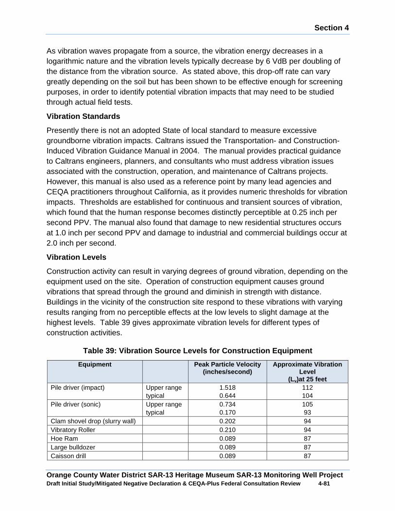
Section 4
Orange County Water District SAR-13 Heritage Museum SAR-13 Monitoring Well Project Draft Initial Study/Mitigated Negative Declaration & CEQA-Plus Federal Consultation Review 4 -81
As vibration waves propagate from a source, the vibration energy decreases in a logarithmic nature and the vibration levels typically decrease by 6 VdB per doubling of the distance from the vibration source. As stated above, this drop-off rate can vary greatly depending on the soil but has been shown to be effective enough for screening purposes, in order to identify potential vibration impacts that may need to be studied through actual field tests.
Vibration Standards
Presently there is not an adopted State of local standard to measure excessive groundborne vibration impacts. Caltrans issued the Transportation- and Construction-Induced Vibration Guidance Manual in 2004. The manual provides practical guidance to Caltrans engineers, planners, and consultants who must address vibration issues associated with the construction, operation, and maintenance of Caltrans projects. However, this manual is also used as a reference point by many lead agencies and CEQA practitioners throughout California, as it provides numeric thresholds for vibration impacts. Thresholds are established for continuous and transient sources of vibration, which found that the human response becomes distinctly perceptible at 0.25 inch per second PPV. The manual also found that damage to new residential structures occurs at 1.0 inch per second PPV and damage to industrial and commercial buildings occur at 2.0 inch per second.
Vibration Levels
Construction activity can result in varying degrees of ground vibration, depending on the equipment used on the site. Operation of construction equipment causes ground vibrations that spread through the ground and diminish in strength with distance. Buildings in the vicinity of the construction site respond to these vibrations with varying results ranging from no perceptible effects at the low levels to slight damage at the highest levels. Table 39 gives approximate vibration levels for different types of construction activities.
Table 39: Vibration Source Levels for Construction Equipment
Equipment Peak Particle Velocity (inches/second)
Approximate Vibration Level
(Lv)at 25 feet Pile driver (impact) Upper range
typical 1.518 0.644
112 104
Pile driver (sonic) Upper range typical
0.734 0.170
105 93
Clam shovel drop (slurry wall) 0.202 94 Vibratory Roller 0.210 94 Hoe Ram 0.089 87 Large bulldozer 0.089 87 Caisson drill 0.089 87
Section 4
Orange County Water District SAR-13 Heritage Museum SAR-13 Monitoring Well Project Draft Initial Study/Mitigated Negative Declaration & CEQA-Plus Federal Consultation Review 4 -82
Loaded trucks 0.076 86 Jackhammer 0.035 79 Small bulldozer 0.003 58
Impacts
Vibration impacts from construction and operational activities associated with the Proposed Project would be a function of the vibration generated by construction equipment, equipment location, sensitivity of nearby land uses, and the timing and duration of the construction activities. The nearest sensitive receptors are single-family homes located as near as 200 feet to the east of the proposed well site and the Godinez Fundamental High School is located as near as 330 feet west of the proposed well site.
The Caltrans guidance defines the threshold of perception from transient sources at 0.25 inch per second PPV. Table 39 provides a list of construction equipment that is known sources of vibration. Of the equipment listed in Error! Reference source not found. Table 39, a vibratory roller would be the piece of equipment that would be utilized by the Proposed Project with the highest vibration level, at 0.21 inch per second PPV at 25 feet. Based on typical propagation rates, the vibration level at the nearest offsite receptor (200 feet) would be 0.02 inch per second PPV. The vibration level at the nearest offsite receptor would be below the 0.25 inch per second PPV threshold human perception threshold and well below the threshold for structural damage. Therefore, a less than significant vibration impact is anticipated to occur from construction and operation of the Proposed Project. No mitigation measures are required.
4.13 Population/Housing
A. Would the project induce substantial population growth in an area, either directly or indirectly?
No Impact: The Proposed Project would help to meet planned water supply needs and would not involve the extension of any new infrastructure or provide new water supplies to any undeveloped areas that would facilitate new growth. The Proposed Project would assist in accommodating planned growth in the OCWD service area and would not induce more growth than what has been planned for by local and regional planning agencies. No mitigation measures are required.
B. Would the project displace substantial numbers o f existing housing, necessitating the construction of replacement housi ng elsewhere?
No Impact: The Proposed Project would be operated and constructed on the Heritage Museum property. The implementation of the Proposed Project would not displace any existing housing. The construction of the Proposed Project would generate short-term construction job opportunities. It is anticipated that the majority of the employment opportunities would be expected to be filled by the local employed and unemployed

Section 4
Orange County Water District SAR-13 Heritage Museum SAR-13 Monitoring Well Project Draft Initial Study/Mitigated Negative Declaration & CEQA-Plus Federal Consultation Review 4 -83
labor force and would not increase population levels that would increase housing demand in the study area. No mitigation measures are required.
C. Would the project displace substantial numbers o f people, necessitating the construction of replacement housing elsewhere?
No Impact: The implementation of the Proposed Project would not displace any households or individuals for any period of time. No mitigation measures are required.
4.14 Public Services
A. Would the project result in substantial adverse physical impacts associated with the provision of new or physically altered gov ernmental facilities, need for new or physically altered governmental facilities, the construction of which could cause significant environmental impacts, in order to maintain acceptable service ratios, response times or other performance objecti ves for fire protection police protection, schools, parks or other public faciliti es.
No Impact: The proposed monitoring well would be operated and maintained by OCWD. The operation of the monitoring well would not increase demands for public services over the current level of demand within the study area or require the construction of additional public service facilities. No mitigation measures required.
4.15 Recreation
A. Would the project increase the use of existing n eighborhood and regional parks or other recreational facilities such that su bstantial physical deterioration of the facility would occur or be accelerated?
Less than Significant Impact: The Proposed Project would not generate new households or generate a substantial amount of new employees that would increase the use of existing neighborhood and regional parks within the study area.
During construction the area within the Heritage Museum where the proposed monitoring well would be located would not be accessible to the public. This area is currently in a disturbed condition and provides no public recreation facilities and the temporary closure of the area would not substantially increase recreation pressure on other areas of the Heritage Museum where it would result in the deterioration of existing facilities. In-conjunction with the construction and operation of the monitoring well, there several site improvements proposed which would increase recreation and educational activities at the Heritage Museum site. Potential impacts to existing recreation facilities would be less than significant. No mitigation measures are required.
B. Does the project include recreational facilities or require the construction or expansion of recreational facilities which might have an adverse physical effect on the environment.
Section 4
Orange County Water District SAR-13 Heritage Museum SAR-13 Monitoring Well Project Draft Initial Study/Mitigated Negative Declaration & CEQA-Plus Federal Consultation Review 4 -84
Less than Significant Impact with Mitigation: In-conjunction with the construction and operation of the monitoring well, there several site improvements proposed at the Heritage Museum that would increase recreation and educational activities. Potential impacts associated with the proposed recreation and educational improvements have been evaluated in this initial study and mitigation measures have been incorporated into the project to reduce potential adverse impacts to a less than significant level.
4.16 Transportation/Traffic
Project Impacts
A. Would the project be in conflict with an applica ble plan, ordinance or policy establishing measures of effectiveness for the perf ormance of the circulation system, taking into account all modes of transporta tion including mass transit and non-motorized travel and relevant components of the circulation system, including but not limited to intersections, streets, highways and freeways, pedestrians and bicycle paths.
Less than Significant Impact with Mitigation: The operation of the proposed monitoring well would not generate daily additional traffic trips within the study area. Periodically, the well site would be visited by OCWD staff for water sampling and maintenance activities. The amount of water sampling and maintenance activity trips would be minimal and would not reduce the level of service of any study area intersections and roadway segments. Therefore, no long term adverse traffic impacts would occur.
The construction operations for the Proposed Project would generate short-term traffic trips which would include, hauling trips, worker traffic trips, delivery traffic trips, and traffic trips. Additionally, construction traffic would be generated from the mobilization and demobilization of construction equipment. To minimize potential construction traffic impacts, construction equipment mobilization and demobilization would occur during non-peak traffic periods. With the implementation of Mitigation Measures T-1 potential traffic construction impacts would be less than significant.
Mitigation Measures
T-1: Construction equipment mobilization and demobilization activities will occur during non-peak traffic periods.
B. Would the project be in conflict with an applicable congestion management program, including, but not limited to level of ser vice standards and travel demand measures, or other standards and travel dema nd measures, or other standards established by County congestion manageme nt agency for designated roads and highways.
Section 4
Orange County Water District SAR-13 Heritage Museum SAR-13 Monitoring Well Project Draft Initial Study/Mitigated Negative Declaration & CEQA-Plus Federal Consultation Review 4 -85
Less than Significant Impact: The Orange County Transportation Agency is responsible for the implementation of the County of Orange Congestion Management Program (CMP). The CMP is designed to reduce traffic congestion and to provide a mechanism for the coordination of land use and transportation decisions. When a project generates more than 100 peak trips along a CMP highway or 51 or more trips through a CMP intersection, the project would be required to prepare a traffic impact study to evaluate the impacts on the CMP highway and intersection.
There are no CMP highways or CMP intersections within the study area. During construction there is the potential that some traffic could utilize CMP highways or intersection from other areas in the County to travel to the project site. The amount of traffic trips would be minimal and would not exceed 100 peak trips along a CMP highway or 51 or more trips through a CMP intersection. No potential conflicts with the County of Orange Congestion Management Program would occur. No mitigation measures are required.
C. Would the project result in a change in air traf fic patterns, including either an increase in traffic levels or a change in location that results in substantial safety risks?
No Impact. According to the John Wayne Airport Land Use Consistency Plan, the study area is not within a clear zone or accidental potential zone. Implementation of the Proposed Project would not increase the level of air traffic within the regional area. Additionally, the proposed monitoring well would be underground and would not encroach into navigable air space causing a change to air traffic patterns. No mitigation measures are required.
D. Would the project increase hazards to a design f eature or incompatible uses or equipment?
Less than Significant Impact with Mitigation: The construction and operation of the Proposed Project would occur on the Heritage Museum. The Proposed Project would not involve any construction activities along a public roadway that would increase traffic hazards.
The Proposed Project would require the movement of heavy construction equipment within the study area during mobilization and demobilization periods. The weight of the heavy construction could potentially damage the surfaces of study area roadways. All heavy truck traffic generated from the Proposed Project would be required to use a designated truck route for access to and from the project site. By directing truck traffic to specifically designated truck routes potential damage to study area roadway surfaces would be minimized.
Section 4
Orange County Water District SAR-13 Heritage Museum SAR-13 Monitoring Well Project Draft Initial Study/Mitigated Negative Declaration & CEQA-Plus Federal Consultation Review 4 -86
During mobilization and demobilization of heavy construction equipment, turning movements into the Heritage Museum site could require temporary lane closures. The lane closure would occur during non-peak traffic periods and if needed a flag men would be provided to safely direct traffic. With the implementation of Mitigation Measures T-1 and T-2 potential hazards associated with the mobilization and demobilization of construction equipment would be reduced to less than significant.
Mitigation Measure
Mitigation T-1 is required.
T-2: OCWD will be responsible for preparing adequate detour and access plans to ensure the safe movement of vehicles and pedestrians during the construction period.
E. Would the project result in inadequate emergency access?
Less than Significant Impact with Mitigation: The construction and operation of the Proposed Project would not cause any road closures that would adversely impact emergency access routes and emergency response times to the study area. The mobilization and demobilization of heavy construction equipment could result in some temporary traffic congestion near the Heritage Museum. The impact would be short-term and if needed flag men would be available to ensure emergency access would be maintained at all times. With the implementation of Mitigation Measure T-1, potential emergency access impacts would be less than significant.
Mitigation Measure
Mitigation Measure T-2 is required.
F. Would the project be in conflict with adopted policies, plans, or pr ograms regarding public transit, bicycle, or pedestrian fa cilities or otherwise decrease the performance or safety of such facilities?
Less than Significant Impact with Mitigation: The construction and operation of the Proposed Project would not require the long term closure of public transportation, bicycle or pedestrian circulation systems. The mobilization and demobilization of construction equipment could require the temporary closure of onsite street bike lanes near the Heritage Museum entrance. The closure would be limited to the time of the mobilization and demobilization activity which in most cases would be less than 30 minutes and if needed flag men would be provided to safely direct traffic. With the implementation of Mitigation Measure T-2 potential conflicts with public transportation systems would be less than significant.
Mitigation Measure
Mitigation Measure T-2 is required.

Section 4
Orange County Water District SAR-13 Heritage Museum SAR-13 Monitoring Well Project Draft Initial Study/Mitigated Negative Declaration & CEQA-Plus Federal Consultation Review 4 -87
4.17 Tribal Resources
A. Would the project cause a substantial adverse ch ange in the significance of a tribal cultural resource as either a site, feature, place, cultural landscape that is geographically defined in terms of the size and sco pe of the landscape, sacred place, or object with value to a California Native American Tribe and that is listed or eligible for listing in the California Register or Historical Resources, or in a local register of historical resources.
The following analysis is based on a Phase One Cultural Resources Report prepared Bonterra/Psomas in December of 2015. The Phase One Cultural Resources Report is presented in Appendix B.
Less than Significant Impact with Mitigation: The Native American Heritage Commission (NAHC) was notified of the Proposed Project on May 7, 2015, and requested to review its Sacred Lands Files for the presence of any cultural resources on or near the project site. The NAHC review of the Sacred Lands Files was completed on June 4, 2015. The review failed to indicate the presence of Native American cultural resources on or near the project site. The NAHC acknowledged that its records might not contain all information relevant to Native American sites in the study area and advised BonTerra Psomas to contact various local tribes. The NAHC provided a list of tribes affiliated with the project site. Each tribe on the list was notified in writing of the proposed project on November 23, 2016, and invited to provide any information they may have regarding cultural resources on or near the project site. No responses have been received to date.
On November 10, 2016, OCWD, contacted the two tribes that have requested to be informed of OCWD projects under AB 52: Joyce Stanfield Perry, Tribal Manager, Juaneño Band of Mission Indians, Acjachemen Nation and Andrew Salas, Chairman, Gabrieleno Band of Mission Indians, Kizh Nation. Ms. Perry responded on November 10, 2016, and stated that the tribe has no concerns at this time, but would like to be kept updated if any changes occur. Chairman Salas responded on November 28, 2016. He expressed concern regarding the nearby presence of ancestral territories and the high sensitivity of the area for containing significant resources. He recommends Native American monitoring during all ground-disturbing activities.
On February 1, 2017 upon the request of Santa Ana Unified Scholl District, OCWD also coordinated with Thomas Tortez, Chairperson of the Torres Martinez Cahuilla Indians and requested if the tribe would like to consult on the project. To date no comments have been received.
Based on the record search of the APE and pedestrian survey conducted on the project site it has been determined that there would be low potential to encounter tribal resources. Because of the low potential to encounter cultural resources and one of the
Section 4
Orange County Water District SAR-13 Heritage Museum SAR-13 Monitoring Well Project Draft Initial Study/Mitigated Negative Declaration & CEQA-Plus Federal Consultation Review 4 -88
coordination tribes has indicated they have no concerns for the project, it has been determined that onsite mitigation monitoring would not be warranted. However, because cultural resources have been recorded in the vicinity, there is a possibility that currently unknown and unrecorded cultural resources could be present in the subsurface and could be uncovered during construction activities. To avoid adverse to unknown tribal resources a halt conditions requirement has been incorporated into the Proposed Project construction activities. With the implementation of Mitigation Measure CR-1 and CR-3 potential impacts to historical resources would be less than significant.
Mitigation Measure
Mitigation Measure CR-1 is required.
B. Would the project cause a substantial adverse ch ange in the significance of a tribal cultural resource as either a site, feature, place, cultural landscape that is geographically defined in terms of the size and sco pe of the landscape, sacred place, or object with value to a California Native American Tribe and that is a resource determined by the lead agency in its discr etion and supported by substantial evidence to be significant and which the lead agency considers the significance of the resource to a California Native American tribe.
Less than Significant Impact with Mitigation: Based on coordination with California Native American Heritage Commission and local tribes to the study area, it has been determined that no Native American resources are known to occur within the APE. To avoid impacts to unknown cultural resources mitigation measures have been incorporated into the Proposed Project that would require construction activity to cease in the unlikelihood unknown Native American resources are encountered. With the implementation of Mitigation Measure CR-1 and CR-3 potential impacts Native American resources would be less than significant.
Mitigation Measures
Mitigation Measure CR-1 and CR-3 is required.
4.18 Utilities/Service Systems
A. Would the project exceed wastewater treatment re quirements of the applicable Regional Water Quality Control Board?
No Impact. The Proposed Project would not generate additional wastewater flows from the Heritage Museum. No mitigation measures are required.
B. Would the project require or result in the const ruction of new water or wastewater treatment facilities or expansion of exi sting facilities, the construction of which could cause significant environmental effects?
Section 4
Orange County Water District SAR-13 Heritage Museum SAR-13 Monitoring Well Project Draft Initial Study/Mitigated Negative Declaration & CEQA-Plus Federal Consultation Review 4 -89
No Impact: The Proposed Project would be constructed and operated on the Heritage Museum site and would not require the expansion or construction of any off site facilities that would result in significant impacts to the environment. No mitigation measures are required.
C. Would the project require or result in the const ruction of new storm water drainage facilities or expansion of existing facili ties, the construction of which could cause significant environmental effects?
No Impact: The Proposed Project would not require the construction of new storm water drainage facilities. No mitigation measures are required.
D. Are sufficient water supplies available to serve the project from existing entitlements and resources or new or expanded entit lements needed?
No Impact. No additional water supply entitlements or expanded water supply entitlements are needed to the implement the Proposed Project. No mitigation measures are required.
E. Would the project result in the determination by the wastewater treatment provider which serves or may serve the project that it has adequate capacity to serve the project’s projected demand in addition to the providers existing commitments.
No Impact: Wastewater treatment would be provided by the Orange County Sanitation District (OCSD).The Proposed Project would not expand existing wastewater demands and would not have an adverse impact on the capacity of OCSD treatment facilities. No mitigation measures are required.
F. Is the project served by a landfill with suffici ent permitted capacity to accommodate the project solid waste disposal need?
Less than Significant Impact with Mitigation: The long term operation of the Proposed Project would not increase the demand for solid waste disposal over the current level of demand. Construction operations associated with the Proposed Project would generate limited amounts of solid waste. The closest landfill to Plant No. 2 would be the Frank R. Bowerman Landfill located at 11002 Bee Canyon Access Road in the City of Irvine. The Frank R. Bowerman Landfill has a remaining capacity of 59,411,872 cubic yards. The Proposed Project would comply with federal, state and local statues and regulations related to solid waste and where possible would recycle discarded construction materials and other solid waste. The amount of construction related solid waste generate from Proposed Project would have a de minimize impact on the capacity of Frank R. Bowerman Landfill. To minimize solid waste disposal demands OCWD would investigate all available alternatives, and then select the best method of solid waste disposal and reduction of solid waste stream. With the implementation of
Section 4
Orange County Water District SAR-13 Heritage Museum SAR-13 Monitoring Well Project Draft Initial Study/Mitigated Negative Declaration & CEQA-Plus Federal Consultation Review 4 -90
Mitigation Measure U-1 potential solid waste disposal needs would be less than significant.
Mitigation Measure
U-1: OCWD will investigate all available alternatives, and then select the best method of solid waste disposal and reduction of solid waste stream as required in the California Integrated Waste Management Act prior to the start of construction.
G. Would the project comply with federal, state and local statutes and regulation s related to solid waste?
Less than Significant Impact with Mitigation : Any solid waste generated by the Proposed Project would be hauled from the site, diverted and recycled, in accordance with the California Integrated Waste Management Act of 1989. If any hazardous materials are encountered, the OCWD would coordinate with the City of Santa Ana and the Orange County Health Care Agency’s Certified Unified Program Agency to ensure that all hazardous wastes would be disposed of properly in accordance with local, state and federal laws. No mitigation measures are required. With the implementation of Mitigation Measure U-1 potential conflicts with federal, state and local statutes and regulations related to solid waste would be less than significant.
Mitigation Measure
Mitigation Measure U-1 required.
MANDATORY FINDINGS OF SIGNIFICANCE
A. Does the project have the potential to degrade t he quality of the environment, substantially reduce the habitat of fish or wildlife species, cause a fish or wildlife population to drop below self-sustaining levels, th reaten to eliminate a plant or animal community, reduce the number or restrict the range of a rare or endangered plant or animal or eliminate important examples of the major periods of California history or prehistory.
Less than Significant Impact with Mitigation: The construction and operation of the Proposed Project would occur on the Heritage Museum. The location where the proposed improvements would occur is devoid of sensitive habitat, wildlife and plant species and cultural resources. The Proposed Project would implement mitigation measures to avoid impacts to unknown cultural resources in the unlikely event they are encountered during construction operations. The implementation of the Proposed Project would not reduce the habitat of fish or wildlife to self-sustaining levels and would not impact any known cultural resources.
B. Does the project have impacts that are individua lly limited but cumulatively considerable?

Section 4
Orange County Water District SAR-13 Heritage Museum SAR-13 Monitoring Well Project Draft Initial Study/Mitigated Negative Declaration & CEQA-Plus Federal Consultation Review 4 -91
Less than Significant Impact with Mitigation: The Proposed Project would comply with local and regional planning programs, applicable codes and ordinances, state and federal laws and regulations and project mitigation measures. Compliance with the applicable codes, planning programs and project mitigation measures would reduce the project’s incremental contributions to cumulative impacts to a less than significant level.
C. Does the project have environmental effects whic h will cause substantial adverse effects on human beings, either directly or indirectly?
Less than Significant Impact with Mitigation: The Proposed Project would not have any substantial adverse effects on human beings. The Proposed Project would comply with local and regional planning programs, applicable codes and ordinances, state and federal laws and regulations and project specific mitigation measures to insure that long term operational activities and short-term construction activities associated with the proposed project would not result in direct or indirect adverse impacts to human beings.
Section 5
Orange County Water District SAR-13 Heritage Museum SAR-13 Monitoring Well Project Draft Initial Study/Mitigated Negative Declaration & CEQA-Plus Federal Consultation Review 5 -1
SECTION 5.0 CEQA-PLUS FEDERAL CONSULTATION REVIEW
5.1 Purpose
The CEQA-Plus Federal Consultation Review requirements that have been established by the U.S. Environmental Protection Agency are intended to supplement the CEQA Guidelines with specific requirements for environmental documents acceptable to the State Water Resources Control Board when reviewing applications for SRF loans. This CEQA-Plus Federal Consultation Review analysis has been prepared to supplement Initial Study/Mitigated Negative Declaration prepared for the Orange County Water District Heritage Museum SAR-13 Monitoring Well Project.
5.2 Federal Endangered Species Act (ESA), Section 7
Does the project involve any direct effects from co nstruction activities, or indirect effects such as growth inducement that may affect f ederally listed threatened or endangered species or their critical habitat that a re known, or have a potential, to occur on-site, in the surrounding area, or in the s ervice area?
:No. Discuss why the Project will not impact any federally listed special status species:
The Heritage Museum is located on USGS Newport Beach Quadrangle Township 5 South, Range 10 West, and Section 22. The latitude and longitude coordinates for the Heritage Museum are 33-43-16 and 117- 54-37. The Heritage Museum contains a combination of historical strictures, interpretive education classrooms and natural open space. The vegetation communities and land cover at the Heritage Museum are shown in Figure 5. The site contains two riparian areas that are separated by a small rolling hill that has been restored with native upland habitat. Both types of habitat areas are interpretive in form and do not function in a manner consistent with natural habitat settings. The riparian patchs are dominated by Black Willow (Salix gooddingii), and Mulefat (Baccharis salicifolia). There are small patches of both Bulrush (Scirpus californicus), and Cattails (Typha latifolia). Intermixed within the riparian patch are non-native trees are present including Brazilian Pepper (Schinus terebinthifolius), palm trees and Eucalyptus.
Federal Listed Plant Species
To determine the potential for Federal Listed plant species to be present within the study area, a database search with the United States Fish and Wildlife information and Planning Database and the California Department Fish and Wildlife (CDFW) Natural Diversity Database was conducted. A listing of Federal Listed plant species with potential to occur within the Newport Beach USGS Quadrangle is shown in Table 40. Subsequent to the database search, a survey of the study area was conducted to determine the presence of plant species identified in the database searches. The
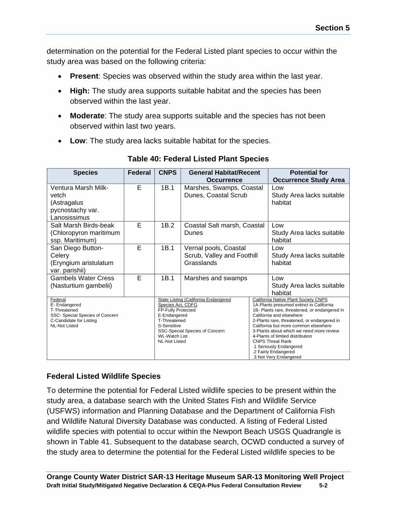
Section 5
Orange County Water District SAR-13 Heritage Museum SAR-13 Monitoring Well Project Draft Initial Study/Mitigated Negative Declaration & CEQA-Plus Federal Consultation Review 5 -2
determination on the potential for the Federal Listed plant species to occur within the study area was based on the following criteria:
x Present : Species was observed within the study area within the last year.
x High: The study area supports suitable habitat and the species has been observed within the last year.
x Moderate : The study area supports suitable and the species has not been observed within last two years.
x Low : The study area lacks suitable habitat for the species.
Table 40: Federal Listed Plant Species
Species Federal CNPS General Habitat/Recent Occurrence
Potential for Occurrence Study Area
Ventura Marsh Milk-vetch (Astragalus pycnostachy var. Lanosissimus
E 1B.1 Marshes, Swamps, Coastal Dunes, Coastal Scrub
Low Study Area lacks suitable habitat
Salt Marsh Birds-beak (Chloropyron maritimum ssp. Maritimum)
E 1B.2 Coastal Salt marsh, Coastal Dunes
Low Study Area lacks suitable habitat
San Diego Button-Celery (Eryngium aristulatum var. parishii)
E 1B.1 Vernal pools, Coastal Scrub, Valley and Foothill Grasslands
Low Study Area lacks suitable habitat
Gambels Water Cress (Nasturtium gambelii)
E 1B.1 Marshes and swamps
Low Study Area lacks suitable habitat
Federal E- Endangered T-Threatened SSC- Special Species of Concern C-Candidate for Listing NL-Not Listed
State Listing (California Endangered Species Act, CDFG FP-Fully Protected E-Endangered T-Threatened S-Sensitive SSC-Special Species of Concern WL-Watch List NL-Not Listed
California Native Plant Society CNPS 1A-Plants presumed extinct in California 1B- Plants rare, threatened, or endangered in California and elsewhere 2-Plants rare, threatened, or endangered in California but more common elsewhere 3-Plants about which we need more review 4-Plants of limited distribution CNPS Threat Rank .1 Seriously Endangered .2 Fairly Endangered .3 Not Very Endangered
Federal Listed Wildlife Species
To determine the potential for Federal Listed wildlife species to be present within the study area, a database search with the United States Fish and Wildlife Service (USFWS) information and Planning Database and the Department of California Fish and Wildlife Natural Diversity Database was conducted. A listing of Federal Listed wildlife species with potential to occur within the Newport Beach USGS Quadrangle is shown in Table 41. Subsequent to the database search, OCWD conducted a survey of the study area to determine the potential for the Federal Listed wildlife species to be
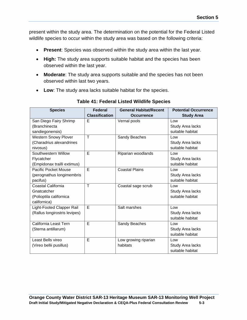
Section 5
Orange County Water District SAR-13 Heritage Museum SAR-13 Monitoring Well Project Draft Initial Study/Mitigated Negative Declaration & CEQA-Plus Federal Consultation Review 5 -3
present within the study area. The determination on the potential for the Federal Listed wildlife species to occur within the study area was based on the following criteria:
x Present : Species was observed within the study area within the last year.
x High: The study area supports suitable habitat and the species has been observed within the last year.
x Moderate : The study area supports suitable and the species has not been observed within last two years.
x Low : The study area lacks suitable habitat for the species.
Table 41: Federal Listed Wildlife Species
Species Federal Classification
General Habitat/Recent Occurrence
Potential Occurrence Study Area
San Diego Fairy Shrimp (Branchinecta sandiegonensis)
E Vernal pools
Low Study Area lacks suitable habitat
Western Snowy Plover (Charadrius alexandrines nivosus)
T Sandy Beaches
Low Study Area lacks suitable habitat
Southwestern Willow Flycatcher (Empidonax trailli extimus)
E Riparian woodlands
Low Study Area lacks suitable habitat
Pacific Pocket Mouse (perognathus longimembris pacifus)
E Coastal Plains
Low Study Area lacks suitable habitat
Coastal California Gnatcatcher (Polioptila californica californica)
T Coastal sage scrub
Low Study Area lacks suitable habitat
Light-Footed Clapper Rail (Rallus longirostris levipes)
E Salt marshes
Low Study Area lacks suitable habitat
California Least Tern (Sterna antillarum)
E Sandy Beaches Low Study Area lacks suitable habitat
Least Bells vireo (Vireo bellii pusillus)
E Low growing riparian habitats
Low Study Area lacks suitable habitat
Section 5
Orange County Water District SAR-13 Heritage Museum SAR-13 Monitoring Well Project Draft Initial Study/Mitigated Negative Declaration & CEQA-Plus Federal Consultation Review 5 -4
Critical Habitat
The Federal Endangered Species Act requires the federal government to designate Critical Habitat for any species it lists under the Federal Endangered Species Act. Critical Habitat is defined as 1) specific areas within the geographical area occupied by the specie at the time of listing, if they contain physical or biological features essential to conservation, and those features may require special management considerations or protection and 2) specific areas outside the geographical area occupied by the species if the agency determines that the area itself is essential for conservation. According to the of USFWS Information, Planning, and Conservation System Database and the California Department of Fish and Wildlife Natural Diversity Database, the study area is not located on lands that are designated as Critical Habitat.
Project Impacts
Onsite Impacts
Less than Significant Impact: Based on a review of databases from United State Fish and Wildlife Service and California Department of Fish and Wildlife and biological surveys conducted within the study area, it has been determined that there would be low potential for special status plant species or special status wildlife species to be present on the project site. As shown in Table 40 and Table 41, the project site lacks suitable habitat to support special status plant species or special status wildlife species that were identified in the database search. Additionally, no indications were found that any special status species were ever present. Therefore, implementation of the Proposed Project would not result in adverse impacts to any special status plant species or special status wildlife species. No mitigation measures are required.
5.3 Magnuson-Stevens Fishery Conservation and Manag ement Act, Essential Fish Habitat:
Does the project involve any direct effects from co nstruction activities, or indirect effects such as growth inducement that may adversel y affect essential fish habitat?
: No. Discuss why the project will not impact essential fish habitat:
According to review of the National Marine Fisheries Service Essential Fish Habitat Map for the Pacific Ocean, there is no essential fish habitat in the surface water bodies near the study area. Therefore, the construction and operation of the Proposed Project would not result in adverse impacts to any Essential Fish Habitat.
5.4 National Historic Preservation Act, Section 106
Identify the area of potential effects (APE), inclu ding construction, staging areas, and depth of any excavation. (Note: the APE is thre e dimensional and includes all

Section 5
Orange County Water District SAR-13 Heritage Museum SAR-13 Monitoring Well Project Draft Initial Study/Mitigated Negative Declaration & CEQA-Plus Federal Consultation Review 5 -5
areas that may be affected by the project, including the surface area and extending below ground to the depth of any project excavations).
Area of Potential Effects
The Area of Potential Effects (APE) consists of the impact and staging area, as well as the Heritage Museum Monitoring Well site. This area, approximately 0.34 acre in size, includes the access path from the south, the impact and staging areas in the vicinity of the well, and the well location itself. Exhibit 6 shows the APE in an aerial photograph depicting the APE boundary and project.
Archaeological Resources Records Search
A records search and literature review of documents on file at the South Central Coastal Information Center (SCCIC) at California State University, Fullerton was conducted on May 7, 2015. It was reviewed by BonTerra Psomas prior to the fieldwork. The SCCIC is a designated branch of the California Historical Resources Information System and houses records regarding archaeological and historic resources in Orange, Los Angeles, Ventura and San Bernardino Counties. The review consisted of an examination of the U.S. Geological Survey’s (USGS) 7.5-minute Newport Beach Quadrangle to determine if any sites are recorded on or if any cultural resources studies have been conducted on or within a ½-mile radius of the project site. Data sources consulted at the SCCIC included archaeological records, Archaeological Determinations of Eligibility (DOE), historic maps, and the Historic Property Data File (HPDF) maintained by the Office of Historic Preservation (OHP). The HPDF contains listings for the CRHR and/or the NRHP, California Historical Landmarks (CHL), and California Points of Historical Interest (CPHI).
Archaeological Field Survey
On November 10, 2016, BonTerra Psomas Director of Cultural Resources, Patrick Maxon, M.A., RPA conducted a pedestrian survey of the project site and APE. The entire APE was examined on foot.
Cultural Resources Records Search Results
The record search at the SCCIC showed that seven cultural resource studies have been conducted within a one-mile radius of the project site. Those studies consisted of pedestrian field surveys and cultural resource evaluations, or were research oriented and did not involve field work. Three of those involved the Santa Ana River Channel immediately west of Centennial Park. Table 42 lists the studies that were conducted near the project site.
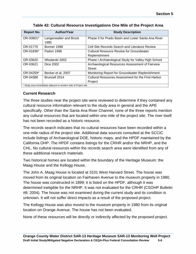
Section 5
Orange County Water District SAR-13 Heritage Museum SAR-13 Monitoring Well Project Draft Initial Study/Mitigated Negative Declaration & CEQA-Plus Federal Consultation Review 5 -6
Table 42: Cultural Resource Investigations One Mile of the Project Area
Report No. Author/Year Study Description
OR-00801* Langenwalter and Brock 1985
Phase II for Prado Basin and Lower Santa Ana River
OR-01770 Bonner 1998 Cell Site Records Search and Literature Review OR-01836* Padon 1998 Cultural Resource Review for Groundwater
Replenishment OR-03620 Wlodarski 2002 Phase I Archaeological Study for Valley High School OR-03621 Dice 2002 Archaeological Resources Assessment of Fairview
Street OR-04259* Becker et al. 2007 Monitoring Report for Groundwater Replenishment OR-04388 Brunzell 2014 Cultural Resources Assessment for the First Harbor
Project * Study area immediately adjacent to western side of Project site.
Current Research
The three studies near the project site were reviewed to determine if they contained any cultural resource information relevant to the study area in general and the APE specifically. Other than the Santa Ana River Channel, none of the three reports mention any cultural resources that are located within one mile of the project site. The river itself has not been recorded as a historic resource.
The records search indicates that no cultural resources have been recorded within a one-mile radius of the project site. Additional data sources consulted at the SCCIC include listings of Archaeological DOE, historic maps, and the HPDF maintained by the California OHP. The HPDF contains listings for the CRHR and/or the NRHP, and the CHL. No cultural resources within the records search area were identified from any of these additional research materials.
Two historical homes are located within the boundary of the Heritage Museum: the Maag House and the Kellogg House.
The John A. Maag House is located at 3101 West Harvard Street. The house was moved from its original location on Fairhaven Avenue to the museum property in 1980. The house was constructed in 1899; it is listed on the HPDF, although it was determined ineligible for the NRHP. It was not evaluated for the CRHR (CSOHP Bulletin #8: 2004). The house was not examined during the current study and its condition is unknown. It will not suffer direct impacts as a result of the proposed project.
The Kellogg House was also moved to the museum property in 1980 from its original location on Orange Avenue. The house has not been evaluated.
None of these resources will be directly or indirectly affected by the proposed project.�

Section 5
Orange County Water District SAR-13 Heritage Museum SAR-13 Monitoring Well Project Draft Initial Study/Mitigated Negative Declaration & CEQA-Plus Federal Consultation Review 5 -7
Proposed Project Impacts
Historical Resources
The records on file at the SCCIC indicate that the Heritage Museum and its ancillary structures have undergone cultural resource evaluations. Neither the museum nor the Maag and Kellogg residences are eligible for listing in the NRHP. The pedestrian survey of the APE did not identify any cultural resources that merited recordation. No known or recorded cultural resources are located within the APE. Therefore, the potential for the discovery of historical resources would be low. However, because of the presence of cultural resources in the vicinity of the project site, there is a possibility that currently unknown and unrecorded cultural resources could be present in the subsurface and could be uncovered during construction activities. To avoid impacts to unknown historical resources, a halt condition requirement would be incorporated into the construction activities in the event historical resources are encountered. With the implementation of Mitigation Measure CR-1 potential impacts to historical resources would be less than significant.
Archaeological Resources
Bases on a review of cultural resource record search of the APE and a pedestrian survey conducted on the project site, it been determined that there would be low potential for the discovery of archaeological resources. However, because of the presence of cultural resources in the vicinity of the project site, there is a possibility that currently unknown and unrecorded cultural resources could be present in the subsurface and could be uncovered during construction activities. To avoid impacts to unknown archeological resources, a halt condition requirement would be incorporated into the construction activities in the event historical resources are encountered. With the implementation of Mitigation Measure CR-1 potential impacts to archaeological resources would be less than significant.
Native American Resources
The Native American Heritage Commission (NAHC) was notified of the proposed project on May 7, 2015, and requested to review its Sacred Lands Files for the presence of any cultural resources on or near the project site. The NAHC review of the Sacred Lands Files was completed on June 4, 2015. The review failed to indicate the presence of Native American cultural resources on or near the project site. The NAHC acknowledged that its records might not contain all information relevant to Native American sites in the project area and advised BonTerra/Psomas to contact various local tribes. The NAHC provided a list of tribes affiliated with the project site. Each tribe on the list was notified in writing of the proposed project on November 23, 2016, and invited to provide any information they may have regarding cultural resources on or near the project site. No responses have been received to date.
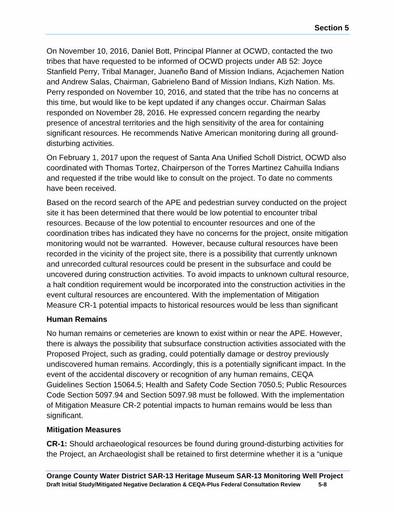
Section 5
Orange County Water District SAR-13 Heritage Museum SAR-13 Monitoring Well Project Draft Initial Study/Mitigated Negative Declaration & CEQA-Plus Federal Consultation Review 5 -8
On November 10, 2016, Daniel Bott, Principal Planner at OCWD, contacted the two tribes that have requested to be informed of OCWD projects under AB 52: Joyce Stanfield Perry, Tribal Manager, Juaneño Band of Mission Indians, Acjachemen Nation and Andrew Salas, Chairman, Gabrieleno Band of Mission Indians, Kizh Nation. Ms. Perry responded on November 10, 2016, and stated that the tribe has no concerns at this time, but would like to be kept updated if any changes occur. Chairman Salas responded on November 28, 2016. He expressed concern regarding the nearby presence of ancestral territories and the high sensitivity of the area for containing significant resources. He recommends Native American monitoring during all ground-disturbing activities.
On February 1, 2017 upon the request of Santa Ana Unified Scholl District, OCWD also coordinated with Thomas Tortez, Chairperson of the Torres Martinez Cahuilla Indians and requested if the tribe would like to consult on the project. To date no comments have been received.
Based on the record search of the APE and pedestrian survey conducted on the project site it has been determined that there would be low potential to encounter tribal resources. Because of the low potential to encounter resources and one of the coordination tribes has indicated they have no concerns for the project, onsite mitigation monitoring would not be warranted. However, because cultural resources have been recorded in the vicinity of the project site, there is a possibility that currently unknown and unrecorded cultural resources could be present in the subsurface and could be uncovered during construction activities. To avoid impacts to unknown cultural resource, a halt condition requirement would be incorporated into the construction activities in the event cultural resources are encountered. With the implementation of Mitigation Measure CR-1 potential impacts to historical resources would be less than significant
Human Remains
No human remains or cemeteries are known to exist within or near the APE. However, there is always the possibility that subsurface construction activities associated with the Proposed Project, such as grading, could potentially damage or destroy previously undiscovered human remains. Accordingly, this is a potentially significant impact. In the event of the accidental discovery or recognition of any human remains, CEQA Guidelines Section 15064.5; Health and Safety Code Section 7050.5; Public Resources Code Section 5097.94 and Section 5097.98 must be followed. With the implementation of Mitigation Measure CR-2 potential impacts to human remains would be less than significant.
Mitigation Measures
CR-1: Should archaeological resources be found during ground-disturbing activities for the Project, an Archaeologist shall be retained to first determine whether it is a “unique
Section 5
Orange County Water District SAR-13 Heritage Museum SAR-13 Monitoring Well Project Draft Initial Study/Mitigated Negative Declaration & CEQA-Plus Federal Consultation Review 5 -9
archaeological resource” pursuant to Section 21083.2(g) of the California Public Resources Code (PRC) or a “historical resource” pursuant to Section 15064.5(a) of the State CEQA Guidelines. If the archaeological resource is determined to be a “unique archaeological resource” or a “historical resource”, the Archaeologist shall formulate a mitigation plan in consultation with the OCWD that satisfies the requirements of the above-referenced sections. If the Archaeologist determines that the archaeological resource is not a “unique archaeological resource” or “historical resource”, s/he may record the site and submit the recordation form to the California Historic Resources Information System at the South Central Coastal Information Center at California State University, Fullerton.
CR-2: If human remains are encountered during excavation activities, all work shall halt in the vicinity of the remains and the County Coroner shall be notified (California Public Resources Code, Section 5097.98). The Coroner will determine whether the remains are of forensic interest. If the Coroner, with the aid of a qualified Archaeologist, determines that the remains are prehistoric, s/he will contact the Native American Heritage Commission (NAHC). The NAHC will be responsible for designating the most likely descendant (MLD), who will be responsible for the ultimate disposition of the remains, as required by Section 7050.5 of the California Health and Safety Code. The MLD shall make his/her recommendation within 48 hours of being granted access to the site. If feasible, the MLD’s recommendation should be followed and may include scientific removal and non-destructive analysis of the human remains and any items associated with Native American burials (California Health and Safety Code, Section 7050.5). If the landowner rejects the MLD’s recommendations, the landowner shall rebury the remains with appropriate dignity on the property in a location that will not be subject to further subsurface disturbance (California Public Resources Code, Section 5097.98).
5.5 Federal Clean Air
Air Basin: South Coast Air Basin
Local Air District: South Coast Air Quality Management District
Is the project subject to a State Implementation Pl an (SIP) conformity determination?
: Yes. The project is in a non-attainment area or attainment area subject to maintenance plans for a federal criteria pollutant. Include information to indicate the non-attainment designation (e.g. moderate, serious, severe, or extreme), if applicable. If estimated emissions (below) are above the federal de minimis levels, but the project is sized to meet only the needs of current population projections that are used in the approved SIP for air quality, then quantitatively indicate how the proposed capacity increase was calculated using population projections.
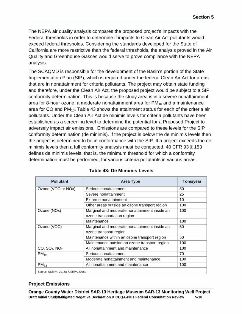
Section 5
Orange County Water District SAR-13 Heritage Museum SAR-13 Monitoring Well Project Draft Initial Study/Mitigated Negative Declaration & CEQA-Plus Federal Consultation Review 5 -10
The NEPA air quality analysis compares the proposed project’s impacts with the Federal thresholds in order to determine if impacts to Clean Air Act pollutants would exceed federal thresholds. Considering the standards developed for the State of California are more restrictive than the federal thresholds, the analysis proved in the Air Quality and Greenhouse Gasses would serve to prove compliance with the NEPA analysis.
The SCAQMD is responsible for the development of the Basin’s portion of the State Implementation Plan (SIP), which is required under the federal Clean Air Act for areas that are in nonattainment for criteria pollutants. The project may obtain state funding and therefore, under the Clean Air Act, the proposed project would be subject to a SIP conformity determination. This is because the study area is in a severe nonattainment area for 8-hour ozone, a moderate nonattainment area for PM10 and a maintenance area for CO and PM10. Table 43 shows the attainment status for each of the criteria air pollutants. Under the Clean Air Act de minimis levels for criteria pollutants have been established as a screening level to determine the potential for a Proposed Project to adversely impact air emissions. Emissions are compared to these levels for the SIP conformity determination (de minimis). If the project is below the de minimis levels then the project is determined to be in conformance with the SIP. If a project exceeds the de minimis levels then a full conformity analysis must be conducted. 40 CFR 93 § 153 defines de minimis levels, that is, the minimum threshold for which a conformity determination must be performed, for various criteria pollutants in various areas.
Table 43: De Mimimis Levels
Pollutant Area Type Tons/year
Ozone (VOC or NOx) Serious nonattainment 50 Severe nonattainment 25 Extreme nonattainment 10 Other areas outside an ozone transport region 100
Ozone (NOx) Marginal and moderate nonattainment inside an ozone transportation region
100
Maintenance 100 Ozone (VOC) Marginal and moderate nonattainment inside an
ozone transport region 50
Maintenance within an ozone transport region 50 Maintenance outside an ozone transport region 100
CO, SO2, NO2 All nonattainment and maintenance 100 PM10 Serious nonattainment 70
Moderate nonattainment and maintenance 100 PM2.5 All nonattainment and maintenance 100
Source: USEPA, 2016a, USEPA 2016b
Project Emissions
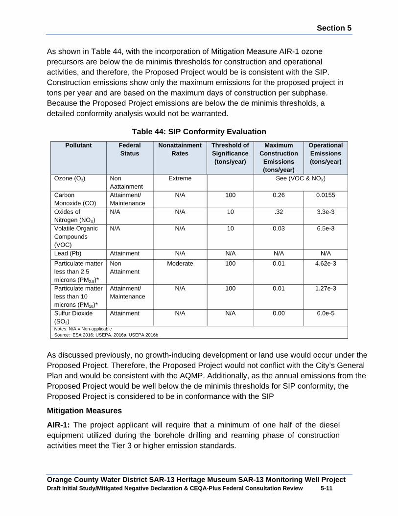
Section 5
Orange County Water District SAR-13 Heritage Museum SAR-13 Monitoring Well Project Draft Initial Study/Mitigated Negative Declaration & CEQA-Plus Federal Consultation Review 5 -11
As shown in Table 44, with the incorporation of Mitigation Measure AIR-1 ozone precursors are below the de minimis thresholds for construction and operational activities, and therefore, the Proposed Project would be is consistent with the SIP. Construction emissions show only the maximum emissions for the proposed project in tons per year and are based on the maximum days of construction per subphase. Because the Proposed Project emissions are below the de minimis thresholds, a detailed conformity analysis would not be warranted.
Table 44: SIP Conformity Evaluation
Pollutant Federal Status
Nonattainment Rates
Threshold of Significance (tons/year)
Maximum Construction
Emissions (tons/year)
Operational Emissions (tons/year)
Ozone (O3) Non Aattainment
Extreme See (VOC & NOX)
Carbon Monoxide (CO)
Attainment/ Maintenance
N/A 100 0.26 0.0155
Oxides of Nitrogen (NOX)
N/A N/A 10 .32 3.3e-3
Volatile Organic Compounds (VOC)
N/A N/A 10 0.03 6.5e-3
Lead (Pb) Attainment N/A N/A N/A N/A
Particulate matter less than 2.5 microns (PM2.5)*
Non Attainment
Moderate 100 0.01 4.62e-3
Particulate matter less than 10 microns (PM10)*
Attainment/ Maintenance
N/A 100 0.01 1.27e-3
Sulfur Dioxide (SO2)
Attainment N/A N/A 0.00 6.0e-5
Notes: N/A = Non-applicable Source: ESA 2016; USEPA, 2016a, USEPA 2016b
As discussed previously, no growth-inducing development or land use would occur under the Proposed Project. Therefore, the Proposed Project would not conflict with the City’s General Plan and would be consistent with the AQMP. Additionally, as the annual emissions from the Proposed Project would be well below the de minimis thresholds for SIP conformity, the Proposed Project is considered to be in conformance with the SIP
Mitigation Measures
AIR-1: The project applicant will require that a minimum of one half of the diesel equipment utilized during the borehole drilling and reaming phase of construction activities meet the Tier 3 or higher emission standards.
Section 5
Orange County Water District SAR-13 Heritage Museum SAR-13 Monitoring Well Project Draft Initial Study/Mitigated Negative Declaration & CEQA-Plus Federal Consultation Review 5 -12
5.6 Coastal Zone Management Act
Is any portion of the project site located within the coastal zone?
The project site is located outside of the coastal zone.
5.7 Coastal Barriers Resources Act
Will the project impact or be located within or nea r the Coastal Barrier Resources System or its adjacent wetlands, marshes, estuaries , inlets, and near-shore waters? Note that since there is currently no Coast al Barrier Resources System in California, projects located in California are not expected to impact the Coastal Barrier Resources System in other states. If there is a special circumstance in which the project may impact a Coastal Barrier Reso urce System, indicate your reasoning below.
:No. The Project will not impact or be located within or near the Coastal Barrier Resources System or its adjacent wetlands, marshes, estuaries, inlets, and near-shore waters.
According to the United States Fish and Wildlife Service Official Coastal Barrier Resource System Maps there are not any coastal barriers within or near the study area. Therefore, the Proposed Project would not be in conflict with Coastal Barrier Resources Act.
5.8 Farmland Protection Policy Act
Is any portion of the project located on important farmland?
: No. The project will not impact farmland.
The study area is located in a highly urbanized area. The study area doesn’t contain any existing agriculture land uses. According to the California Farmland Mapping and Monitoring Program, there is no Prime Farmland, Unique Farmland or Farmland of Statewide Importance within the study area. The study area is zoned for urbanized land uses and there are no existing Williamson Act Contracts recorded within the study area. The construction and operation of the Proposed Project would not impact any important farmland resources.
5.9 Flood Plain Management
Is any portion of the project located within a 100-year fl oodplain as depicted on a floodplain map or otherwise designated by the Feder al Emergency Management Agency?
: No. Provide a description of the project location with respect to streams and potential floodplains:
Section 5
Orange County Water District SAR-13 Heritage Museum SAR-13 Monitoring Well Project Draft Initial Study/Mitigated Negative Declaration & CEQA-Plus Federal Consultation Review 5 -13
As shown in Figure 7, the FEMA Flood Hazard Rate Insurance Map 06059CO256J, the Heritage Museum site is located designated Flood Zone X.
5.10 Migratory Bird Treaty Act
Will the project affect protected migratory birds that are known, or have a potential, to occur on-site, in the surrounding are a, or in the service area?
: No. Provide an explanation below.
The proposed well site lacks suitable habitat for nesting migratory birds. Therefore, no direct impacts to nesting migratory birds would occur. However, within the vicinity of the proposed well site is suitable nesting habitat for migratory birds. If construction activities occur during nesting season there would be the potential indirect construction noise impacts could discourage migratory birds from nesting or cause existing nesting migratory birds to flush from their nests. To avoid potential adverse indirect construction noise impacts to nesting migratory birds, the proposed monitoring well construction activities would occur outside of nesting season. With the implementation of Mitigation Measure BIO- 5 potential construction noise impacts to nesting migratory birds would be less than significant.
Mitigation Measure
BIO-5: Construction activities will be conducted outside of the migratory bird season from March 15 to September 15.
5.11 Protection of Wetlands
Does any portion of the project boundaries contain areas that should be evaluated for wetland delineation or require a perm it from the United States Army Corps of Engineers?
The closest Waters of the U.S./State would be the Greenville Banning Flood Control Channel. The channel is located outside of the study area and there is no construction activities proposed that would directly or indirectly modify the flood control channel. No impacts to Waters of the U.S./State would occur.
Wetland Waters/U.S./State
Less than Significant Impact with Mitigation : To determine the presence of Wetland Waters of the U.S./State on the project site a wetland assessment was conducted in the study area in accordance with the Regional Supplement to the U.S Army Corps of Engineers Wetland Delineation Manual Arid Region Wes, based on the three attributes of wetland vegetation, hydric soils and onsite hydrology.
Section 5
Orange County Water District SAR-13 Heritage Museum SAR-13 Monitoring Well Project Draft Initial Study/Mitigated Negative Declaration & CEQA-Plus Federal Consultation Review 5 -14
Wetland Vegetation
The project site contains non-native weeds and grasses that are not classified as wetland plant indicator species. The vegetation on the project site would not meet the wetland vegetation attribute.
Hydric Soils
The project site is covered with concrete rubble, discarded concreate and surplus fill from previous construction activities occurring on the Heritage Museum site. Given the disturbed condition of the well site, it would unlikely that the onsite soils could to support wetland vegetation. The well site does not meet the hydric soils attribute.
Hydrology
There are no water bodies or drainages that would provide a potential water source to the proposed well site. The only water source to the well site would season rainfall, which would typically not be an adequate water source to saturate the groundcover during the growing season. The well site would not meet the hydrology attribute.
Wetland Determination
The proposed monitoring well site lacks all of the required attributes to classify it as Wetland Waters of the State. Therefore, no direct impacts to Wetland Waters of the U.S./State would occur.
The study area is adjacent to native riparian vegetation which is classified as Wetland Waters of the U.S./State by the California Department of Fish and Game and the U.S. Fish and Wildlife Service. Construction activities associated with the Proposed Project could indirectly result in the temporary degradation of adjacent wetland vegetation from the generation of fugitive dust, increased vehicle traffic and increased anthropogenic activities. To avoid potential indirect construction-related impacts to wetland vegetation adjacent to the project site Mitigation Measures BIO-1, BIO-2, BIO-3, and BIO-4 would be implemented.
Mitigation Measures
BIO-1: Final construction plans will clearly delineate limits of grading and will avoid impacts to sensitive vegetation communities.
BIO-2: Construction activities near sensitive vegetation communities will be monitored to ensure that non-native vegetation is removed.
BIO-3: Construction equipment staging areas, storage of materials and temporary stockpiling of soil will be located in previously disturbed areas and outside of where sensitive vegetation communities are located.
BIO-4: Unpaved areas as needed will be watered to control dust.

Section 5
Orange County Water District SAR-13 Heritage Museum SAR-13 Monitoring Well Project Draft Initial Study/Mitigated Negative Declaration & CEQA-Plus Federal Consultation Review 5 -15
5.12 Wild and Scenic Rivers Act
Is any portion of the project located within a wild and scenic river?
: No. The project is not located near a wild and scenic river.
The study area is located in the Santa Ana River Watershed. Within the Santa Ana River Watershed there are no Wild and Scenic Rivers. Therefore, the construction and operation of the Proposed Project would not result in adverse impacts to any wild and scenic rivers.
5.13 Safe Drinking Water Act, Sole Source Aquifer Protection
Is the project located in an area designated by the United States Environmental Protection Agency, Region 9, as a Sole Source Aquif er?
: No. The project is not within the boundaries of a sole source aquifer.
The closest sole source aquifer to the project site would be Campo/Cotton Creek Aquifer in San Diego County. Therefore, the construction and operation of the Proposed Project would not result in adverse impacts to any sole source aquifers.
5.14 Environmental Justice
Does the project involve an activity that is likely to be of particular interest to or have particular impact upon minority, low-income, o r indigenous populations, or tribes?
:No. Selecting “No” means that this action is not likely to be of any particular interest to or have an impact on these populations or tribes. Explain.
The purpose of the Proposed Project is to provide additional monitoring well for the Mid Basin Centennial Park Injection Well Project. The purpose of the Mid Basin Centennial Park Injection Well Project is to increase groundwater supplies within the Orange County Groundwater Basin to ensure that adequate amounts of underground water are available for Orange County residents including low-income households. By maintaining adequate groundwater supplies, less water would have to be imported into Orange County which is significantly higher in costs and which could have a higher economic impact on lower income households. The Proposed Project would implement the Mid Basin Centennial Park Injection Well Project and would help reduce costs for water for low income households in OCWD service area.
Section 6
Orange County Water District SAR-13 Heritage Museum SAR-13 Monitoring Well Project Draft Initial Study/Mitigated Negative Declaration & CEQA-Plus Federal Consultation Review 6 -1
SECTION 6.0 REFERENCES
California Department Fish and Game Natural Diversity Database, Accessed June 2015.
California Department of Transportation Scenic Highways Program Web Site Access, September 2015.
California Environmental Quality Act. 2015.
California Environmental Quality Act, State CEQA Guidelines, 2015.
California Farmland Mapping Monitoring Program, Web Site Access September 2015.
California Geologic Survey Seismic Hazard Zone Map Newport Quadrangle, Accessed September 2014.
California Native Plant Society Inventory of Rare and Endangered Plants Database, Accessed June 2015.
California Uniform Building Code, 2016
California Water Code, 2014.
City of Santa Ana, General Plan, Web Access June 2016
City of Santa Ana Municipal Code, Web Access, June 2016
City of Santa Ana Zoning code, Web Site Access, June 2016
County of Orange Congestion Management Program, Web Site Access June 2016
County of Orange Model Water Quality Management Plan, 2011.
County of Orange, 4th term municipal NPDES permit for Areawide Urban Storm Water Runoff, 2014.
Federal Transit Agency, Noise Associated with Typical construction Equipment, 1995.
Federal Transit Agency, Transit Noise and Vibration Assessment, 2006.
John Wayne Airport Environs Land Use Plan, 2014.
Melville C. Branch and R. Dale Beland, Noise Levels and Human Response, 1970.
National Water Research Institute Santa Ana River Water Quality and Health Study, 2004.
Orange County Water District Groundwater Management Plan, 2014.
Regional Water Quality Control Board, Santa Ana River Basin Plan, January 1995.
U.S. Army Corps of Engineers List of Wetland Plants, 2008.
U.S. Army Corps of Engineers Regional Supplement to the Corps of Engineers Wetland Delineation Manual Arid West Region, September 2008.
Orange County Water District Heritage Museum SAR 13 Monitoring Well Project Final Mitigated Negative Declaration Mitigation Monitoring Program State Clearinghouse No. 2017021046
Prepared By Orange County Water District 18700 Ward Street Fountain Valley, CA 92708 Contact: Daniel Bott
April 2017
Table of Contents
�
Orange County Water District Heritage Museum SAR 13 Monitoring Program Final Mitigated Negative Declaration Mitigation Mon itoring Program i
Section Page
SECTION 1.0 INTRODUCTION ................................................................................... 1-1
SECTION 2.0 PROJECT DESCRIPTION .................................................................... 2-1
2.1 Proposed Project ............................................................................................. 2-1
2.2 Project Location .............................................................................................. 2-1
2.3 Mitigation Monitoring Reporting Program ........................................................ 2-1
Table
Table 1: Heritage Museum SAR 13 Monitoring Well Mitigation Monitoring Program ... 2-2
Introduction
�
Orange County Water District Heritage Museum SAR 13 Monitoring Program Final Mitigated Negative Declaration Mitigation Mon itoring Program 1-1
SECTION 1.0 INTRODUCTION
The following is a Mitigation Monitoring Report Program (MMP) for the Orange County Water District Heritage Museum SAR 13 Monitoring Well Project Final Mitigated Negative Declaration prepared pursuant to Section 15097 of the CEQA Guidelines and Section 21081.6 of the Public Resources Code. This MMP lists all applicable mitigation measures from the Draft Initial Study/Mitigated Negative Declaration (IS/MND) identified for the Orange County Water District Heritage Museum SAR 13 Monitoring Well Project.
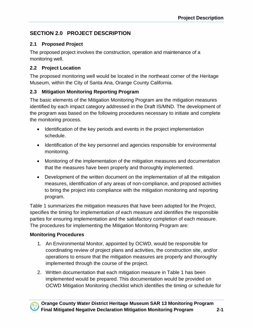
Project Description
�
Orange County Water District Heritage Museum SAR 13 Monitoring Program Final Mitigated Negative Declaration Mitigation Mon itoring Program 2-1
SECTION 2.0 PROJECT DESCRIPTION
2.1 Proposed Project
The proposed project involves the construction, operation and maintenance of a monitoring well.
2.2 Project Location
The proposed monitoring well would be located in the northeast corner of the Heritage Museum, within the City of Santa Ana, Orange County California.
2.3 Mitigation Monitoring Reporting Program
The basic elements of the Mitigation Monitoring Program are the mitigation measures identified by each impact category addressed in the Draft IS/MND. The development of the program was based on the following procedures necessary to initiate and complete the monitoring process.
x Identification of the key periods and events in the project implementation schedule.
x Identification of the key personnel and agencies responsible for environmental monitoring.
x Monitoring of the implementation of the mitigation measures and documentation that the measures have been properly and thoroughly implemented.
x Development of the written document on the implementation of all the mitigation measures, identification of any areas of non-compliance, and proposed activities to bring the project into compliance with the mitigation monitoring and reporting program.
Table 1 summarizes the mitigation measures that have been adopted for the Project, specifies the timing for implementation of each measure and identifies the responsible parties for ensuring implementation and the satisfactory completion of each measure. The procedures for implementing the Mitigation Monitoring Program are:
Monitoring Procedures
1. An Environmental Monitor, appointed by OCWD, would be responsible for coordinating review of project plans and activities, the construction site, and/or operations to ensure that the mitigation measures are properly and thoroughly implemented through the course of the project.
2. Written documentation that each mitigation measure in Table 1 has been implemented would be prepared. This documentation would be provided on OCWD Mitigation Monitoring checklist which identifies the timing or schedule for
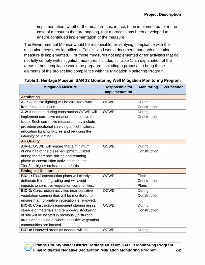
Project Description
�
Orange County Water District Heritage Museum SAR 13 Monitoring Program Final Mitigated Negative Declaration Mitigation Mon itoring Program 2-2
implementation, whether the measure has, in fact, been implemented, or in the case of measures that are ongoing, that a process has been developed to ensure continued implementation of the measure.
The Environmental Monitor would be responsible for verifying compliance with the mitigation measures identified in Table 1 and would document that each mitigation measure is implemented. For those measures not implemented or for activities that do not fully comply with mitigation measures included in Table 1, an explanation of the areas of noncompliance would be prepared, including a proposal to bring those elements of the project into compliance with the Mitigation Monitoring Program.
Table 1: Heritage Museum SAR 13 Monitoring Well Mitigation Monitori ng Program
Mitigation Measure Responsible for Implementation
Monitoring Verification
Aesthetics A-1: All onsite lighting will be directed away from residential uses.
OCWD During Construction
A-2: If needed, during construction OCWD will implement corrective measures to resolve the issue. Such corrective measures may include providing additional shielding on light fixtures, relocating lighting fixtures and reducing the intensity of lighting.
OCWD During Construction
Air Quality AIR-1: OCWD will require that a minimum of one half of the diesel equipment utilized during the borehole drilling and reaming phase of construction activities meet the Tier 3 or higher emission standards.
OCWD During Construction
Biological Resources BIO-1: Final construction plans will clearly delineate limits of grading and will avoid impacts to sensitive vegetation communities.
OCWD Final Construction Plans
BIO-2: Construction activities near sensitive vegetation communities will be monitored to ensure that non-native vegetation is removed.
OCWD During Construction
BIO-3: Construction equipment staging areas, storage of materials and temporary stockpiling of soil will be located in previously disturbed areas and outside of where sensitive vegetation communities are located.
OCWD During Construction
BIO-4: Unpaved areas as needed will be OCWD During
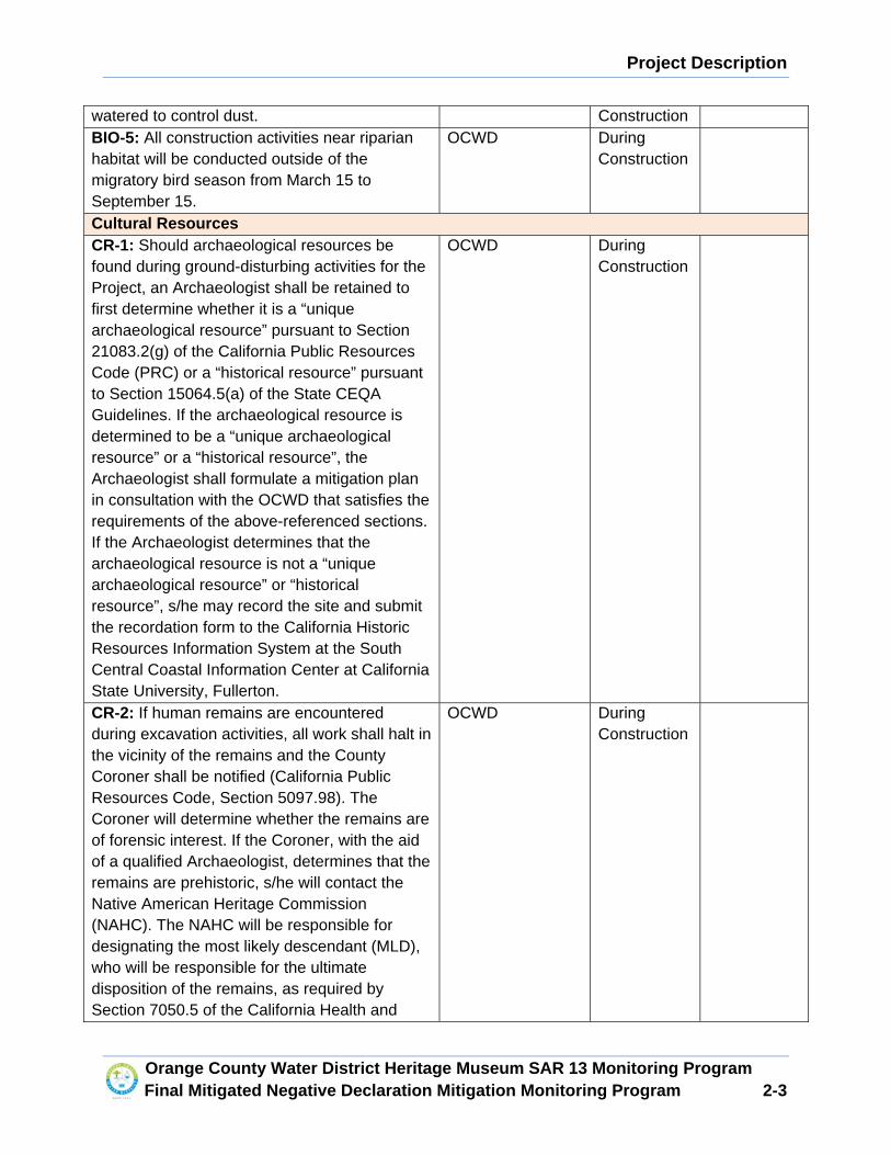
Project Description
�
Orange County Water District Heritage Museum SAR 13 Monitoring Program Final Mitigated Negative Declaration Mitigation Mon itoring Program 2-3
watered to control dust. Construction BIO-5: All construction activities near riparian habitat will be conducted outside of the migratory bird season from March 15 to September 15.
OCWD During Construction
Cultural Resources CR-1: Should archaeological resources be found during ground-disturbing activities for the Project, an Archaeologist shall be retained to first determine whether it is a “unique archaeological resource” pursuant to Section 21083.2(g) of the California Public Resources Code (PRC) or a “historical resource” pursuant to Section 15064.5(a) of the State CEQA Guidelines. If the archaeological resource is determined to be a “unique archaeological resource” or a “historical resource”, the Archaeologist shall formulate a mitigation plan in consultation with the OCWD that satisfies the requirements of the above-referenced sections. If the Archaeologist determines that the archaeological resource is not a “unique archaeological resource” or “historical resource”, s/he may record the site and submit the recordation form to the California Historic Resources Information System at the South Central Coastal Information Center at California State University, Fullerton.
OCWD During Construction
CR-2: If human remains are encountered during excavation activities, all work shall halt in the vicinity of the remains and the County Coroner shall be notified (California Public Resources Code, Section 5097.98). The Coroner will determine whether the remains are of forensic interest. If the Coroner, with the aid of a qualified Archaeologist, determines that the remains are prehistoric, s/he will contact the Native American Heritage Commission (NAHC). The NAHC will be responsible for designating the most likely descendant (MLD), who will be responsible for the ultimate disposition of the remains, as required by Section 7050.5 of the California Health and
OCWD During Construction
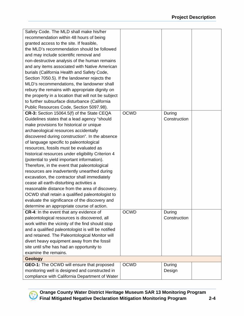
Project Description
�
Orange County Water District Heritage Museum SAR 13 Monitoring Program Final Mitigated Negative Declaration Mitigation Mon itoring Program 2-4
Safety Code. The MLD shall make his/her recommendation within 48 hours of being granted access to the site. If feasible, the MLD’s recommendation should be followed and may include scientific removal and non-destructive analysis of the human remains and any items associated with Native American burials (California Health and Safety Code, Section 7050.5). If the landowner rejects the MLD’s recommendations, the landowner shall rebury the remains with appropriate dignity on the property in a location that will not be subject to further subsurface disturbance (California Public Resources Code, Section 5097.98). CR-3: Section 15064.5(f) of the State CEQA Guidelines states that a lead agency “should make provisions for historical or unique archaeological resources accidentally discovered during construction”. In the absence of language specific to paleontological resources, fossils must be evaluated as historical resources under eligibility Criterion 4 (potential to yield important information). Therefore, in the event that paleontological resources are inadvertently unearthed during excavation, the contractor shall immediately cease all earth-disturbing activities a reasonable distance from the area of discovery. OCWD shall retain a qualified paleontologist to evaluate the significance of the discovery and determine an appropriate course of action.
OCWD During Construction
CR-4: In the event that any evidence of paleontological resources is discovered, all work within the vicinity of the find should stop and a qualified paleontologist is will be notified and retained. The Paleontological Monitor will divert heavy equipment away from the fossil site until s/he has had an opportunity to examine the remains.
OCWD During Construction
Geology GEO-1: The OCWD will ensure that proposed monitoring well is designed and constructed in compliance with California Department of Water
OCWD During Design
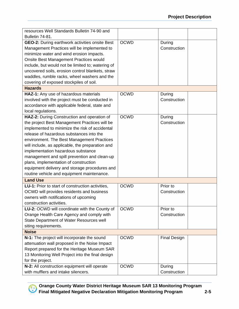
Project Description
�
Orange County Water District Heritage Museum SAR 13 Monitoring Program Final Mitigated Negative Declaration Mitigation Mon itoring Program 2-5
resources Well Standards Bulletin 74-90 and Bulletin 74-81. GEO-2: During earthwork activities onsite Best Management Practices will be implemented to minimize water and wind erosion impacts. Onsite Best Management Practices would include, but would not be limited to; watering of uncovered soils, erosion control blankets, straw waddles, rumble racks, wheel washers and the covering of exposed stockpiles of soil.
OCWD During Construction
Hazards HAZ-1: Any use of hazardous materials involved with the project must be conducted in accordance with applicable federal, state and local regulations.
OCWD During Construction
HAZ-2: During Construction and operation of the project Best Management Practices will be implemented to minimize the risk of accidental release of hazardous substances into the environment. The Best Management Practices will include, as applicable, the preparation and implementation hazardous substance management and spill prevention and clean-up plans, implementation of construction equipment delivery and storage procedures and routine vehicle and equipment maintenance.
OCWD During Construction
Land Use LU-1: Prior to start of construction activities, OCWD will provides residents and business owners with notifications of upcoming construction activities.
OCWD Prior to Construction
LU-2: OCWD will coordinate with the County of Orange Health Care Agency and comply with State Department of Water Resources well siting requirements.
OCWD Prior to Construction
Noise N-1: The project will incorporate the sound attenuation wall proposed in the Noise Impact Report prepared for the Heritage Museum SAR 13 Monitoring Well Project into the final design for the project.
OCWD Final Design
N-2: All construction equipment will operate with mufflers and intake silencers.
OCWD During Construction
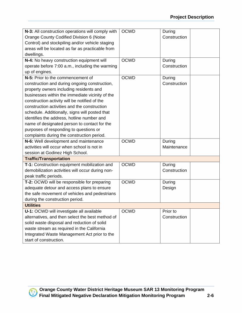
Project Description
�
Orange County Water District Heritage Museum SAR 13 Monitoring Program Final Mitigated Negative Declaration Mitigation Mon itoring Program 2-6
N-3: All construction operations will comply with Orange County Codified Division 6 (Noise Control) and stockpiling and/or vehicle staging areas will be located as far as practicable from dwellings.
OCWD During Construction
N-4: No heavy construction equipment will operate before 7:00 a.m., including the warming up of engines.
OCWD During Construction
N-5: Prior to the commencement of construction and during ongoing construction, property owners including residents and businesses within the immediate vicinity of the construction activity will be notified of the construction activities and the construction schedule. Additionally, signs will posted that identifies the address, hotline number and name of designated person to contact for the purposes of responding to questions or complaints during the construction period.
OCWD During Construction
N-6: Well development and maintenance activities will occur when school is not in session at Godinez High School.
OCWD During Maintenance
Traffic/Transportation T-1: Construction equipment mobilization and demobilization activities will occur during non-peak traffic periods.
OCWD During Construction
T-2: OCWD will be responsible for preparing adequate detour and access plans to ensure the safe movement of vehicles and pedestrians during the construction period.
OCWD During Design
Utilities U-1: OCWD will investigate all available alternatives, and then select the best method of solid waste disposal and reduction of solid waste stream as required in the California Integrated Waste Management Act prior to the start of construction.
OCWD Prior to Construction
���
5HFRUGLQJ�5HTXHVWHG�E\�DQG�ZKHQ�
5HFRUGHG�0DLO�WKLV�'HHG�DQG�0DLO��7D[�6WDWHPHQW�WR���
25$1*(�&2817<�:$7(5�',675,&7�
������:DUG�6WUHHW�
3��2��%R[�������
)RXQWDLQ�9DOOH\��&$������������
�
([HPSW�IURP�)HH��3XEOLF�$JHQF\�
�*RYHUQPHQW�&RGH�6HFWLRQ������� � � �
BBBBBBBBBBBBBBBBBBBBBBBBBBBBBBBBBBBBBBBBBBBBBBBBBBBBBBBBBBBBBBBBBBBBBBBBBBBBBBBBBBBBBBBBBBBBBBBBBBBBBB��63$&(�$%29(�)25�5(&25'(56�86(�21/<�
�
�
($6(0(17�'(('�� 6DQWD�$QD�8QLILHG�6FKRRO�'LVWULFW�
+HULWDJH�0XVHXP�6$5����0RQLWRULQJ�:HOO��
�
)25� $� 9$/8$%/(� &216,'(5$7,21�� WKH� UHFHLSW� DQG� DGHTXDF\� RI� ZKLFK� LV� KHUHE\�
DFNQRZOHGJHG����
6$17$�$1$�81,),('�6&+22/�',675,&7��D�SXEOLF�FRUSRUDWLRQ��WKH��*UDQWRU��
RU�³6$86'´�KHUHLQ���
�
KHUHE\�*5$176�$1'�&219(<6�WR�WKH�
�
25$1*(�&2817<�:$7(5�',675,&7��D�SROLWLFDO�VXEGLYLVLRQ�RI�WKH�6WDWH�RI�&DOLIRUQLD�RUJDQL]HG�XQGHU�&KDSWHU�����RI�WKH�6WDWXWHV�RI�������DV�DPHQGHG��WKH��*UDQWHH��
KHUHLQ���DQG�LWV�VXFFHVVRUV�DQG�DVVLJQV���
�
D�QRQ�H[FOXVLYH�SHUPDQHQW�HDVHPHQW�DQG�ULJKW�RI�ZD\� WR� LQVWDOO��FRQVWUXFW�� UHFRQVWUXFW�� UHGHYHORS��
UHPRYH�DQG�UHSODFH��LQVSHFW��PDLQWDLQ��DQG�RSHUDWH�D�EHORZ�JUDGH�JURXQGZDWHU�PRQLWRULQJ�ZHOO�DQG�ZHOO�V\VWHP�DSSXUWHQDQFHV�� IHQFLQJ��JDWHV��DQG�ORFNV��WKH��:HOO�6LWH��KHUHLQ���DQG�FRQVWUXFW�DQG�
LQVWDOO�+HULWDJH�0XVHXP�RI�2UDQJH�&RXQW\� �+02&��FRPPXQLW\�JDUGHQ�DPHQLWLHV�� LQ��RQ��DORQJ��
DQG�XQGHU�WKH�UHDO�SURSHUW\�VLWXDWHG�LQ�WKH�&LW\�RI�6DQWD�$QD��&RXQW\�RI�2UDQJH��6WDWH�RI�&DOLIRUQLD��
LQFOXGLQJ� D� 0DLQWHQDQFH� DQG� 7HPSRUDU\� &RQVWUXFWLRQ� (DVHPHQW� �KHUHLQDIWHU�� FROOHFWLYHO\� WKH�
�(DVHPHQW�$UHD���DQG�LQJUHVV�WR�DQG�HJUHVV�IURP�WKH�(DVHPHQW�$UHD�IURP�DQ�H[LVWLQJ�GLUW�SDWKZD\�DOO� PRUH� SDUWLFXODUO\� GHVFULEHG� LQ� ([KLELW� �$��� DQG� VKRZQ� LQ� ([KLELW� ³%�´� ZKLFK� H[KLELWV� DUH�
DWWDFKHG�KHUHWR�DQG�PDGH�D�SDUW�KHUHRI���
�
� 7KH�ULJKWV�EHLQJ�JUDQWHG�KHUHLQ�LQFOXGH�WKH�ULJKW�WR�HQWHU�XSRQ�DQG�WR�SDVV�DQG�UHSDVV�RYHU�
DQG� DORQJ� WKH� (DVHPHQW� $UHD�� DQG� WR� GHSRVLW� WRROV�� LPSOHPHQWV� DQG� RWKHU� PDWHULDOV� WKHUHRQ� E\�*UDQWHH�RU�LWV�VXFFHVVRUV�DQG�DVVLJQV��LWV�RIILFHUV��DJHQWV�DQG�HPSOR\HHV��DQG�E\�SHUVRQV�RU�HQWLWLHV�
XQGHU�FRQWUDFW�ZLWK�*UDQWHH�� LWV�VXFFHVVRUV�DQG�DVVLJQV��ZKHUHYHU�DQG�ZKHQHYHU�QHFHVVDU\�IRU� WKH�
SXUSRVH� RI� OD\LQJ�� FRQVWUXFWLQJ�� UHFRQVWUXFWLQJ�� UHGHYHORSLQJ�� UHQHZLQJ�� LQVSHFWLQJ�� PDLQWDLQLQJ��
UHSDLULQJ��XVLQJ�DQG�RSHUDWLQJ�WKH�:HOO�6LWH��LQFOXGLQJ�WKH�WDNLQJ�RI�ZDWHU�VDPSOHV���
��
�
�
��� ,W�LV�XQGHUVWRRG�DQG�DJUHHG�WKDW�WKH�HDVHPHQWV�DQG�ULJKW�RI�ZD\�JUDQWHG�KHUHLQ�DUH�VXEMHFW�WR�WKH�ULJKWV�RI�*UDQWRU��LWV�VXFFHVVRUV�DQG�DVVLJQV�WR�XVH�WKH�VXUIDFH�RI�WKH�ODQG�ZLWKLQ�WKH�ERXQGDULHV�
RI� WKH�(DVHPHQW�$UHD� LQ� DQ\� DQG� DOO�ZD\V�QRW� LQFRQVLVWHQW�ZLWK� WKH�QRQ�H[FOXVLYH� ULJKWV�JUDQWHG�
KHUHE\��SURYLGHG��KRZHYHU��WKDW�QR�EXLOGLQJV�RU�VWUXFWXUHV�VKDOO�EH�FRQVWUXFWHG��LQVWDOOHG�RU�VLWXDWHG�
ZLWKLQ�WKH�(DVHPHQW�$UHD��DQG�QR�ORDGV�PD\�EH�SODFHG�RQ�RU�RYHU�WKH�ZHOO�YDXOW�LQ�H[FHVV�RI��������
OEV��DQG�SURYLGHG�IXUWKHU��WKDW�QR�HDUWK�PD\�EH�UHPRYHG�IURP�WKH�FRYHU�RI�WKH�:HOO�6LWH����
�
� 7KH�0DLQWHQDQFH�(DVHPHQW�LV�IRU�WKH�SXUSRVH�RI�UHGHYHORSLQJ�RU�UHIXUELVKLQJ�WKH�ZHOO�DQG�
WDNLQJ�ZDWHU�VDPSOHV���7KH�0DLQWHQDQFH�(DVHPHQW�VKDOO�DOORZ�*UDQWHH�DFFHVV�WR�WKH�ZHOO�WR�SHUIRUP�
JURXQGZDWHU�VDPSOLQJ�DFWLYLWLHV���6DPSOLQJ�DFWLYLWLHV�PD\�RFFXU�DV�IUHTXHQWO\�DV�EL�ZHHNO\�EXW�DUH�
H[SHFWHG� WR� RFFXU� TXDUWHUO\� DIWHU� WKH� ZHOO� KDV� EHHQ� LQ� RSHUDWLRQ� IRU� WKUHH� ���� \HDUV�� � &ROOHFWLQJ�VDPSOHV� IURP� WKH�ZHOO�ZLOO� UHTXLUH�*UDQWHH� WR�SXUJH�ZDWHU�RXW�RI� WKH�ZHOO�� � ,W� LV� DJUHHG� WKDW� WKH�
*UDQWHH�PD\�GLVFKDUJH� WKH� SXUJHG�ZDWHU� IURP� WKH�PRQLWRULQJ�ZHOO� LQWR� WKH�*UDQWRU¶V� H[LVWLQJ�
RSHQ�VSDFH�DUHDV��7\SLFDO� IORZ�UDWHV� IRU�ZHOO�SXUJLQJ�GR�QRW�H[FHHG����JDOORQV�SHU�PLQXWH�IRU�
GXUDWLRQ� RI� QR� PRUH� WKDQ� �� KRXUV�� 7KH� *UDQWHH� VKDOO� FRRUGLQDWH� ZLWK� *UDQWRU¶V� RU� *UDQWRU¶V�
OHVVHH��WKH�+02&��DW�OHDVW����KRXUV�SULRU�WR�D�UHTXHVWHG�VDPSOLQJ�HYHQW����
,W� LV�DQWLFLSDWHG� WKDW� WKH�ZHOO�ZLOO�SHULRGLFDOO\� UHTXLUH� WKH�XVH�RI�D�ZHOO�GHYHORSPHQW�SXPS�ULJ� WR�
SHUIRUP�WKLV�PDLQWHQDQFH�� � ,W� LV�DQWLFLSDWHG� WKDW� WKH�0DLQWHQDQFH�(DVHPHQW�ZLOO�EH�UHTXLUHG� WR�EH�
XVHG�DSSUR[LPDWHO\�RQFH�HYHU\�ILYH�\HDUV���+RZHYHU��GXH�WR�WKH�QDWXUH�RI�WKH�ZDWHU�ZHOO��*UDQWHH�
UHVHUYHV�WKH�ULJKW�WR�UHDVRQDEO\�GHWHUPLQH�ZKHQ�WKH�XVH�RI�VXFK�0DLQWHQDQFH�(DVHPHQW�LV�QHFHVVDU\��ZKLFK�PD\� EH� OHVV� WKDQ� HYHU\� ILYH� \HDUV��*UDQWHH� VKDOO� QRWLI\�*UDQWRU� DQG�*UDQWRU¶V� OHVVHH�� WKH�
+02&��DW�OHDVW����GD\V�LQ�DGYDQFH�RI�PDLQWHQDQFH�DFWLYLWLHV�WKDW�XWLOL]H�D�ZHOO�GHYHORSPHQW�SXPS�
ULJ���0DLQWHQDQFH�RI�WKH�ZHOO�VKDOO�EH�FRQGXFWHG�DW�*UDQWHH¶V�VROH�FRVW�DQG�H[SHQVH��
�
� 7KH� 7HPSRUDU\� &RQVWUXFWLRQ� (DVHPHQW� LV� IRU� WKH� SXUSRVH� RI� FRQVWUXFWLQJ� WKH�:HOO� 6LWH��LQFOXGLQJ� EXW� QRW� OLPLWHG� WR� WKH� XVH� RI� D� ZHOO� GHYHORSPHQW�SXPS� ULJ� DQG� RWKHU� HTXLSPHQW�� DQG�
FRQVWUXFWLQJ�DQG�LQVWDOOLQJ�WKH�+02&�FRPPXQLW\�JDUGHQ�DPHQLWLHV��7KH�7HPSRUDU\�&RQVWUXFWLRQ�
(DVHPHQW�VKDOO�FRPPHQFH�XSRQ�ZULWWHQ�QRWLFH�IURP�*UDQWHH�WR�*UDQWRU�DQG�VKDOO�WHUPLQDWH�QLQHW\�
���GD\V�IURP�WKH�GDWH�*UDQWHH� LVVXHV�D�QRWLFH�RI�FRPSOHWLRQ�RI�FRQVWUXFWLRQ�RI� WKH�:HOO�6LWH�DQG�
FRPPXQLW\�JDUGHQ�DPHQLWLHV��7KH�FRQVWUXFWLRQ�DFWLYLWLHV�DUH�H[SHFWHG�WR�RFFXU����KRXUV�SHU�GD\�IRU�IRXU� ����ZHHNV�����KRXUV�SHU�GD\� IRU� WZR�����ZHHNV�DQG���KRXUV�SHU�GD\�IRU� IRXU� ����ZHHNV��7KH�
FRQILJXUDWLRQ�RI� WKH�7HPSRUDU\�&RQVWUXFWLRQ�(DVHPHQW� LV�GHVFULEHG� LQ�([KLELW�³$´�DQG�VKRZQ�LQ�
([KLELW�³%´��
�
� 3ULRU�WR�VWDUW�RI�FRQVWUXFWLRQ��*UDQWHH�VKDOO�LQVWDOO�����IHHW�RI�SULYDF\�IHQFH�DORQJ�WKH�ZHVWHUQ�IHQFH�RI�WKH�+02&�SURSHUW\�� �'XULQJ�WKH�FRQVWUXFWLRQ�RI�WKH�:HOO��*UDQWHH�VKDOO�KDYH�D�GULOO�ULJ��
VXSSRUW�WUXFN��RWKHU�VXSSRUWLQJ�HTXLSPHQW��DQG�D�ZHOO�GHYHORSPHQW�ULJ�RQ�VLWH�WR�GULOO��FRQVWUXFW��DQG�
GHYHORS�WKH�ZHOO��$����IRRW�WHPSRUDU\�VRXQG�ZDOO�ZRXOG�EH�LQVWDOOHG�DURXQG�WKH�ZRUN�DUHD�WR�UHGXFH�
WKH�QRLVH�JHQHUDWHG�GXULQJ�WKH�ZHOO�FRQVWUXFWLRQ�SRUWLRQ���
�
�
��
�
� �3XUFKDVH�3ULFH���,Q�FRQVLGHUDWLRQ�IRU�WKH�JUDQW�RI�WKLV�(DVHPHQW��0DLQWHQDQFH�(DVHPHQW��DQG�WKH�7HPSRUDU\�&RQVWUXFWLRQ�(DVHPHQW�WR�*UDQWHH��*UDQWHH�VKDOO�SD\�WR�*UDQWRU�WKH�VXP�RI�
7:(17<�),9(�7+286$1'�7:2�+81'5('�'2//$56� ������������� �KHUHLQDIWHU�� WKH�
³3XUFKDVH�3ULFH´��SD\DEOH�E\�*UDQWHH�WR�*UDQWRU�SULRU�WR�HQWHULQJ�WKH�(DVHPHQW�$UHD�XQGHU�WKLV�(DVHPHQW�� �7KLV�(DVHPHQW� VKDOO� EH� IRU� WKLUW\�RQH� �����\HDUV� IURP� WKH�GDWH� WKLV� LQVWUXPHQW�KDV�
EHHQ�H[HFXWHG�DV�VHW�IRUWK�EHORZ���
�
,QGHPQLW\�� *UDQWHH� VKDOO� LQGHPQLI\� DQG� KROG� *UDQWRU�� LWV� RIILFHUV�� GLUHFWRUV�� HPSOR\HHV��UHSUHVHQWDWLYHV�DQG�YROXQWHHUV�KDUPOHVV�IURP�DQG�DJDLQVW�DQ\�DQG�DOO�DFWLRQV��FODLPV��GHPDQGV��
MXGJPHQWV�� DWWRUQH\V¶� IHHV�� FRVWV�� GDPDJHV� WR� SHUVRQV� RU� SURSHUW\�� SHQDOWLHV�� REOLJDWLRQV��
H[SHQVHV� RU� OLDELOLWLHV� RI� DQ\� NLQG� WKDW� PD\� EH� DVVHUWHG� RU� FODLPHG� E\� DQ\� SHUVRQ� RU� HQWLW\�
�LQFOXGLQJ��EXW�QRW�OLPLWHG�WR��DQ\�HPSOR\HH��DJHQW��FRQWUDFWRU��FXVWRPHU��RU�LQYLWHH�RI�*UDQWHH��
LQ� DQ\� ZD\� DULVLQJ� RXW� RI� RU� LQ� FRQQHFWLRQ� ZLWK� WKLV� (DVHPHQW�� WKH� RSHUDWLRQV� FDUULHG� RQ� E\�
*UDQWHH� RQ� WKH� (DVHPHQW� $UHD� RU� DQ\� ODQGV� WR� ZKLFK� *UDQWHH� KDV� DFFHVV� KHUHXQGHU�� RU� WKH�RFFXSDWLRQ� RU� XVH� RI� WKH� (DVHPHQW� $UHD� E\� *UDQWHH� RU� DQ\� SHUVRQ� RU� HQWLW\� KROGLQJ� XQGHU�
*UDQWHH��FROOHFWLYHO\��³&ODLPV´���ZKHWKHU�RU�QRW�WKHUH�LV�FRQFXUUHQW�DFWLYH�RU�SDVVLYH�QHJOLJHQFH�
RQ� WKH� SDUW� RI� *UDQWRU�� DQG�RU� DFWV� IRU� ZKLFK� WKH� *UDQWRU� ZRXOG� EH� KHOG� VWULFWO\� OLDEOH�� EXW�
H[FOXGLQJ�&ODLPV�FDXVHG�E\�WKH�VROH�DFWLYH�QHJOLJHQFH�DQG�ZLOOIXO�PLVFRQGXFW�RI�*UDQWRU�����
$UHD�5HVWRUDWLRQ��*UDQWHH� VKDOO� UHVWRUH� DQG� UHSODFH� DQ\� VWUXFWXUHV� RU� DUHDV� GLVWXUEHG� GXULQJ�ZHOO�FRQVWUXFWLRQ� WR� WKH� JHQHUDO� FRQGLWLRQ� WKDW� H[LVWHG� SULRU� WR� HQWU\� ZLWKLQ� ��� GD\V� RI� FRPSOHWLQJ�
FRQVWUXFWLRQ�RU��LI�D�GLVWXUEDQFH�WR�DQ\�VWUXFWXUHV�RU�DUHDV�RFFXUV�GXULQJ�*UDQWHH¶V�H[HUFLVH�RI�DQ\�
ULJKWV�XQGHU�WKLV�(DVHPHQW�DIWHU�FRPSOHWLQJ�FRQVWUXFWLRQ��ZLWKLQ����GD\V�RI�WKH�GLVWXUEDQFH����
2WKHU�&RQVLGHUDWLRQV��*UDQWHH� VKDOO� FRRUGLQDWH�ZLWK�*UDQWRU¶V� OHVVHH�� WKH�+02&�� WR�SURYLGH�DQG�LQVWDOO�WKH�IROORZLQJ��DV�VKRZQ�LQ�([KLELW�³&´��
�
��� $SSUR[LPDWHO\�������VTXDUH�IHHW�RI�GHFRPSRVHG�JUDQLWH�RQ�WKH�JURXQG�VXUIDFH�DURXQG�WKH�
PRQLWRULQJ�ZHOO�VLWH��
�
��� ([WHQG�+02&�FRPPXQLW\�JDUGHQ�LUULJDWLRQ�V\VWHP��7KH�V\VWHP�LV�H[SHFWHG�WR�LQFOXGH�
DSSUR[LPDWHO\�����IHHW�RI�EXULHG���LQFK�39&�SLSH��YDOYHV���DQG�D�GULS�LUULJDWLRQ�V\VWHP�WR�
FRPPXQLW\�JDUGHQ�UDLVHG�JDUGHQ�EHGV�DQG�LQ�JURXQG�DJULFXOWXUH�EHGV���
�
��� ��HOHFWULFDO�FLUFXLWV�WR�+HULWDJH�0XVHXP�FRPPXQLW\�JDUGHQ�FRPPHQFLQJ�DW�WKH�H[LVWLQJ�
HOHFWULFDO�SDQHO�DQG�WHUPLQDWLQJ�LQ�RXWOHW�UHFHSWDFOHV���
�
��� 0RGHO�5LYHUVWRQH����IW��[���IW��7KRUHDX�3UHPLXP�(GXFDWLRQDO�*UHHQKRXVH�
�
��� 0RGHO�$GYDQFH�7DEFR�6/%���F�/LWH�7KUHH�&RPSDUWPHQW�6WDLQOHVV�6WHHO�%DU�6LQN�ZLWK�
7ZR�'UDLQ�ERDUGV����LQFK�[����LQFK�����
�
��
�
��� ���UDLVHG�UHGZRRG�JDUGHQ�EHGV�PHDVXUHG���IHHW�E\���IHHW��
�
��� ���IHHW�LQ�ZLGWK��E\�����IHHW�LQ�OHQJWK�FRQFUHWH�SDYHUV�DORQJ�FRPPXQLW\�JDUGHQ�YHKLFOH�
DFFHVV�ZD\��
�
��� :RRG�VSOLW�UDLO�IHQFH�DORQJ�FRPPXQLW\�JDUGHQ�DSSUR[LPDWHO\�����IHHW�LQ�OHQJWK�
PHDVXUHG������IHHW�E\���IHHW��
���� ����IHHW�RI�SULYDF\�IHQFH�VFUHHQ���
�
����*UDSKLF�LOOXVWUDWLQJ�ZLQGPLOO�SXPSLQJ�ZDWHU��6L]H�RI�JUDSKLF�WR�EH�VSHFLILHG�E\�+HULWDJH�
0XVHXP�RI�2UDQJH�&RXQW\��
�����3XUFKDVH�DQG�GHOLYHU����2UDQJH�7UHHV�����7DQJHULQH�7UHHV�����/HPRQ�7UHHV����
3HUVLPPRQ�7UHHV��DQG���)LJ�7UHHV��
�
����&RRUGLQDWH�ZLWK�WKH�6$86'�DQG�+HULWDJH�0XVHXP�GXULQJ�FRQVWUXFWLRQ�WR�PLQLPL]H�
GLVUXSWLRQV�DW�WKH�+02&���
�
����$Q\�QHFHVVDU\�UHSODFHPHQW�RI�DOO�ODQGVFDSLQJ�RU�DVSKDOW�DUHDV�DQG�+02&�DPHQLWLHV�WKDW�
PD\�EH�GDPDJHG�GXULQJ�*UDQWHH¶V�H[HUFLVH�RI�DQ\�ULJKWV�JUDQWHG�E\�WKLV�HDVHPHQW��DQG��
�
����3UHSDUH�DQG�UHFRUG�DQ�$PHQGPHQW�WR�(DVHPHQW�GHVFULELQJ�WKH�ILQDO�FRQILJXUDWLRQ�RI�WKH�
(DVHPHQW�$UHD�LQ�WKH�HYHQW�WKDW�WKH�ILQDO�FRQILJXUDWLRQV�RI�WKH�(DVHPHQW�$UHD�FKDQJHV�
IURP�LWV�GHVFULSWLRQ�LQ�([KLELWV�³$´�RU�³%�´�
�
1RWLFHV�� �$Q\�QRWLFH��SD\PHQW�RU� LQVWUXPHQW�UHTXLUHG�RU�SHUPLWWHG� WR�EH�JLYHQ�RU�GHOLYHUHG�E\�WKLV�(DVHPHQW�PD\�EH�JLYHQ�RU�GHOLYHUHG�E\�SHUVRQDO�GHOLYHU\�RU�E\�GHSRVLWLQJ�WKH�VDPH�LQ�DQ\�
8QLWHG�6WDWHV�PDLO�GHSRVLWRU\��ILUVW�FODVV�SRVWDJH�SUHSDLG��DQG�DGGUHVVHG�DV�IROORZV��
�
�,I�WR�*UDQWHH��
,I�E\�PDLO�� � 25$1*(�&2817<�:$7(5�',675,&7�
3�2��%R[������
)RXQWDLQ�9DOOH\��&$�������������
$WWQ���3URSHUW\�0DQDJHPHQW��
,I�E\�SHUVRQDO� � 25$1*(�&2817<�:$7(5�',675,&7�
'HOLYHU\�� � ������:DUG�6WUHHW�
)RXQWDLQ�9DOOH\��&$��������
$WWQ���)DFLOLWLHV�'HSDUWPHQW��
��
�
�
,I�WR�*UDQWRU�� � � 6$17$�$1$�81,),('�6&+22/�',675,&7�� � � � �����(��&KHVWQXW�$YH��
� � 6DQWD�$QD��&$������������
� � ���������������
� � � � $WWQ��)DFLOLWLHV�3ODQQLQJ���
�
:LWK�D�FRS\�WR�� � +HULWDJH�0XVHXP�RI�2UDQJH�&RXQW\�
� � � � �����:��+DUYDUG�$YHQXH�
� � � � 6DQWD�$QD��&$�������
� � � � ���������������
� � � � $WWQ��([HFXWLYH�'LUHFWRU��
� � �
RU� VXFK� RWKHU� SHUVRQ� RU� DGGUHVV� DV� HLWKHU� SDUW\� PD\� GLUHFW� LQ� ZULWLQJ� WR� WKH� RWKHU�� SURYLGHG��
KRZHYHU�� WKDW� VXFK� QHZ� RU� GLIIHUHQW� SHUVRQ� RU� DGGUHVV� VKDOO� QRW� EHFRPH� HIIHFWLYH� XQWLO�
DFNQRZOHGJHG� LQ� ZULWLQJ� E\� WKH� SDUW\� WR� ZKR� GLUHFWHG�� � ([FHSW� ZKHUH� VHUYLFH� LV� E\� SHUVRQDO�GHOLYHU\�RU�E\�UHJLVWHUHG�RU�FHUWLILHG�PDLO��UHWXUQ�UHFHLSW�UHTXHVWHG��VHUYLFH�RI�DQ\�LQVWUXPHQW�RU�
ZULWLQJ�VKDOO�EH�GHHPHG�FRPSOHWHG� IRUW\�HLJKW� �����KRXUV�DIWHU�GHSRVLW� LQ�D�8QLWHG�6WDWHV�PDLO�
GHSRVLWRU\��
�
:DUUDQW\�RI�$XWKRULW\����(DFK�RIILFHU�RI�*UDQWRU�DQG�*UDQWHH�DIIL[LQJ�KLV�RU�KHU�VLJQDWXUH�WR�WKLV�(DVHPHQW�ZDUUDQWV�DQG�UHSUHVHQWV�E\�VXFK�VLJQDWXUH�WKDW�KH�RU�VKH�KDV�WKH�IXOO�OHJDO�DXWKRULW\�WR�
ELQG�KLV�RU�KHU�UHVSHFWLYH�SDUW\�WR�DOO�RI�WKH�WHUPV��FRQGLWLRQV��DQG�SURYLVLRQV�WKHUHLQ��WKDW�KLV�RU�
KHU� UHVSHFWLYH� SDUW\� KDV� WKH� IXOO� OHJDO� ULJKW�� SRZHU�� FDSDFLW\�� DQG� DXWKRULW\� WR� HQWHU� LQWR� WKLV�
(DVHPHQW� DQG� SHUIRUP� DOO� RI� LWV� SURYLVLRQV� DQG� REOLJDWLRQV�� DQG� WKDW� QR� RWKHU� DSSURYDOV� RU�
FRQVHQWV�DUH�QHFHVVDU\�LQ�FRQQHFWLRQ�WKHUHZLWK���+HDGLQJV�� �7KH� WLWOHV� DQG�KHDGLQJV�RI�6HFWLRQV�DQG�3DUDJUDSKV�RI� WKLV�(DVHPHQW�� DV�KHUHLQ� VHW�
IRUWK��KDYH�EHHQ�LQVHUWHG�IRU� WKH�VDNH�RI�FRQYHQLHQFH�RQO\��DQG�DUH�QRW� WR�EH�WDNHQ��GHHPHG�RU�
FRQVWUXHG� WR�EH�DQ\�SDUW�RI� WKH� WHUPV��FRYHQDQWV�RU�FRQGLWLRQV�RI� WKLV�(DVHPHQW��RU� WR�FRQWURO��
OLPLW�RU�PRGLI\�DQ\�RI�WKH�WHUPV��FRYHQDQWV�RU�FRQGLWLRQV�KHUHRI���
7LPH� RI� (VVHQFH�� � 7LPH� LV� RI� WKH� HVVHQFH� RI� WKLV� (DVHPHQW�� )DLOXUH� WR� FRPSO\� ZLWK� DQ\�UHTXLUHPHQW��LQFOXGLQJ�EXW�QRW�OLPLWHG�WR�DQ\�WLPH�UHTXLUHPHQW��RI�WKLV�(DVHPHQW�VKDOO�FRQVWLWXWH�
D�PDWHULDO�EUHDFK�RI�WKLV�(DVHPHQW���,QWHJUDWLRQ��&RQVWUXFWLRQ�DQG�$PHQGPHQW���7KLV�(DVHPHQW�FRQWDLQV�WKH�HQWLUH�XQGHUVWDQGLQJ�RI�
WKH� SDUWLHV� KHUHLQ� DQG� VXSHUVHGHV� DQ\� DQG� DOO� RWKHU�ZULWWHQ� RU� RUDO� XQGHUVWDQGLQJV� DV� WR� WKRVH�
PDWWHUV� FRQWDLQHG� WKHUHLQ�� DQG� QR� SULRU� RUDO� RU�ZULWWHQ� XQGHUVWDQGLQJ� VKDOO� EH� RI� DQ\� IRUFH� RU�
HIIHFW� ZLWK� UHVSHFW� WR� WKRVH� PDWWHUV� FRYHUHG� WKHUHE\�� � 7KLV� (DVHPHQW� VKDOO� EH� FRQVWUXHG� DQG�LQWHUSUHWHG�ZLWK��DQG�VKDOO�EH�JRYHUQHG�DQG�HQIRUFHG�LQ�DOO�UHVSHFWV�DFFRUGLQJ�WR��WKH�ODZV�RI�WKH�
6WDWH�RI�&DOLIRUQLD�DQG�DV� LI�GUDIWHG�E\�ERWK�*UDQWRU�DQG�*UDQWHH�� �1R�DPHQGPHQW��FKDQJH��RU�
��
�
PRGLILFDWLRQ�RI�WKLV�GRFXPHQW�VKDOO�EH�YDOLG�XQOHVV�LQ�ZULWLQJ��VWDWLQJ�WKDW�LW�DPHQGV��FKDQJHV�RU�
PRGLILHV�WKLV�(DVHPHQW��VLJQHG�E\�DOO�RI�WKH�SDUWLHV�KHUHWR���
6XFFHVVRUV���7KLV�HDVHPHQW�DQG�WKH�SURYLVLRQV�FRQWDLQHG�KHUHLQ�VKDOO�EH�ELQGLQJ�XSRQ�DQG�LQXUH�WR�
WKH� EHQHILW� RI� *UDQWRU�� *UDQWHH�� DQG� WKHLU� UHVSHFWLYH� KHLUV�� H[HFXWRUV�� DGPLQLVWUDWRUV�� SHUVRQDO�
UHSUHVHQWDWLYHV��VXFFHVVRUV��DQG�DVVLJQV��
�
3DUWLDO� ,QYDOLGLW\�� � ,I�DQ\�WHUP��FRYHQDQW��FRQGLWLRQ��RU�SURYLVLRQ�RI� WKLV�(DVHPHQW�LV�KHOG�E\�D�FRXUW�RI�FRPSHWHQW�MXULVGLFWLRQ�WR�EH�LQYDOLG��YRLG��LOOHJDO��RU�XQHQIRUFHDEOH��WKH�UHPDLQGHU�RI�WKH�
SURYLVLRQV� KHUHRI� VKDOO� UHPDLQ� LQ� IXOO� IRUFH� DQG� HIIHFW� DQG� VKDOO� LQ� QR� ZD\� DIIHFW�� LPSDLU�� RU�
LQYDOLGDWH�DQ\�RWKHU�WHUPV��FRYHQDQW��FRQGLWLRQ��RU�SURYLVLRQ�FRQWDLQHG�LQ�WKLV�(DVHPHQW��
�)XUWKHU�$VVXUDQFHV���(DFK�RI�WKH�SDUWLHV�KHUHWR�VKDOO�H[HFXWH�DQG�GHOLYHU�DQ\�DQG�DOO�DGGLWLRQDO�
SDSHUV�� GRFXPHQWV�� DQG� RWKHU� DVVXUDQFHV� DQG� VKDOO� GR� DQ\� DQG� DOO� DFWV� DQG� WKLQJV� UHDVRQDEO\�
QHFHVVDU\�LQ�FRQQHFWLRQ�ZLWK�WKH�SHUIRUPDQFH�RI�WKHLU�REOLJDWLRQV�KHUHXQGHU�DQG�WR�FDUU\�RXW�WKH�
LQWHQW�RI�WKH�SDUWLHV�KHUHWR��
�
$WWRUQH\¶V� )HHV�� � 6XEMHFW� WR� DQ\� RWKHU� SURYLVLRQ� VWDWHG� KHUHLQ�� LQ� DQ\� DFWLRQ� RU� SURFHHGLQJ�EHWZHHQ� WKH� SDUWLHV� KHUHWR� VHHNLQJ� LQWHUSUHWDWLRQ� RU� HQIRUFHPHQW� RI� DQ\� RI� WKH� WHUPV� DQG�
SURYLVLRQV� RI� WKLV� (DVHPHQW� RU� LQ� FRQQHFWLRQ�ZLWK� WKH�(DVHPHQW�$UHD�� WKH� SUHYDLOLQJ� SDUW\� LQ�
VXFK� DFWLRQ� RU� SURFHHGLQJ� VKDOO� EH� HQWLWOHG� WR� KDYH� DQG� WR� UHFRYHU� IURP� WKH� RWKHU� SDUW\� LWV�
UHDVRQDEOH� DWWRUQH\¶V� IHHV� DQG� RWKHU� UHDVRQDEOH� H[SHQVHV� LQ� FRQQHFWLRQ� ZLWK� VXFK� DFWLRQ� RU�
SURFHHGLQJ�LQ�DGGLWLRQ�WR�LWV�UHFRYHUDEOH�FRXUW�FRVWV���
7HUPLQDWLRQ�RI�(DVHPHQW���$W�VXFK�WLPH�DV�ZKHQ�*UDQWHH�GHWHUPLQHV�WKH�:HOO�6LWH�LV�QR�ORQJHU�QHHGHG�� DQG� LQ� DFFRUGDQFH� ZLWK� WKH� &DOLIRUQLD� 6WDWH�:DWHU�:HOO� 6WDQGDUGV� %XOOHWLQ� ������ DV�
DPHQGHG�E\�%XOOHWLQ�������DQG�DW�*UDQWHH¶V�VROH�FRVW�DQG�H[SHQVH��*UDQWHH�VKDOO���L��GHVWUR\�WKH�ZHOO� LQ� DFFRUGDQFH�ZLWK�DOO� DSSOLFDEOH�&LW\�DQG�RU�&RXQW\� UXOHV�DQG� UHJXODWLRQV� LQ�HIIHFW�� � �LL��
UHPRYH�DOO�HTXLSPHQW�DQG�IDFLOLWLHV�IURP�WKH�:HOO�6LWH��DQG��LLL��UHVWRUH�WKH�VXUIDFH�DUHD�WR�WKH�
JHQHUDO�FRQGLWLRQ�WKDW�H[LVWHG�SULRU�WR�WKH�FRQVWUXFWLRQ�RI�WKH�:HOO�6LWH�ZLWKLQ����GD\V�IURP�WKH�
GHVWUXFWLRQ� RI� WKH� ZHOO�� � $IWHU� WKH� ZHOO� KDV� EHHQ� GHVWUR\HG� DQG� WKH�:HOO� 6LWH� UHVWRUHG� WR� WKH�
JHQHUDO�FRQGLWLRQ�WKDW�H[LVWHG�SULRU�WR�HQWU\��*UDQWHH�VKDOO�TXLW�FODLP�LWV�LQWHUHVW�LQ�WKH�(DVHPHQW�$UHD�WR�WKH�*UDQWRU���
>6,*1$785(6�21�1(;7�3$*(@�

��
,1�:,71(66�:+(5(2)��WKLV�LQVWUXPHQW�KDV�EHHQ�H[HFXWHG�RQ�BBBBBBBBBBBBBBBB�������
³*5$1725´�
6$17$�$1'�81,),('�6&+22/�',675,&7��
D�SXEOLF�FRUSRUDWLRQ��
%\��BBBBBBBBBBBBBBBBBBBBBBBBBBBBBBBBBBBB�
7LWOH��BBBBBBBBBBBBBBBBBBBBBBBBBB��
'DWH��BBBBBBBBBBBBBBBBBBBBBBBBBB�
$33529('�$6�72�)250�
6DQWD�$QD�6FKRRO�'LVWULFW�$WWRUQH\��
%\�BBBBBBBBBBBBBBBBBBBBBBBBBBBBBBBBBBBBB�
7LWOH��BBBBBBBBBBBBBBBBBBBBBBBBBBB�
'DWH��BBBBBBBBBBBBBBBBBBBBBBBBBBB�
³*5$17((´�
25$1*(�&2817<�:$7(5�',675,&7�
SROLWLFDO�VXEGLYLVLRQ�RI�WKH�6WDWH�RI�&DOLIRUQLD��
RUJDQL]HG�XQGHU�&KDSWHU�����RI�WKH�6WDWXWHV�RI�� $33529('�$6�72�)250�
������DV�DPHQGHG� 5XWDQ��7XFNHU�//3�
%\��BBBBBBBBBBBBBBBBBBBBBBBBBBBBBBBBBBBBB� %\��BBBBBBBBBBBBBBBBBBBBBBB�
3UHVLGHQW� *HQHUDO�&RXQVHO��2UDQJH�
&RXQW\�:DWHU�'LVWULFW�
%\�BBBBBBBBBBBBBBBBBBBBBBBBBBBBBBBBBBBBBB�
�����������*HQHUDO�0DQDJHU
��
(;+,%,7�³$´�
/(*$/�'(6&5,37,21�
:HOO�6LWH�
0DLQWHQDQFH�(DVHPHQW�
7HPSRUDU\�&RQVWUXFWLRQ�(DVHPHQW�
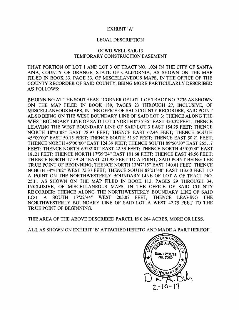
EXHIBIT 'A'
LEGAL DESCRIPTION
OCWD WELL SAR- 1 3
TEMPORARY CONSTRUCTION EASEMENT
THAT PORTION OF LOT 1 AND LOT 3 OF TRACT NO. 1 024 IN THE CITY OF SANTA
ANA, COUNTY OF ORANGE, STATE OF CALIFORNIA, AS SHOWN ON THE MAP
FILED IN BOOK 33, PAGE 33 , OF MISCELLANEOUS MAPS, IN THE OFFICE OF THE
COUNTY RECORDER OF SAID COUNTY, BEING MORE PARTICULARLY DESCRIBED
AS FOLLOWS:
BEGINNING AT THE SOUTHEAST CORNER OF LOT 1 OF TRACT NO. 3236 AS SHOWN
ON THE MAP FILED IN BOOK 1 89, PAGES 23 THROUGH 27, INCLUSIVE, OF
MISCELLANEOUS MAPS, IN THE OFFICE OF SAID COUNTY RECORDER, SAID POINT
ALSO BEING ON THE WEST BOUNDARY LINE OF SAID LOT 3 ; THENCE ALONG THE
WEST BOUNDARY LINE OF SAID LOT 3 NORTH 0°3 5 '35" EAST 450.32 FEET; THENCE
LEAVING THE WEST BOUNDARY LINE OF SAID LOT 3 EAST 1 54.29 FEET; THENCE
NORTH 1 8°43 '08" EAST 78.97 FEET; THENCE EAST 67.44 FEET; THENCE SOUTH
45°00'00" EAST 50. 1 5 FEET; THENCE SOUTH 5 1 .97 FEET; THENCE EAST 50.2 1 FEET;
THENCE NORTH 45°00'00" EAST 1 24.39 FEET; THENCE SOUTH 89°50'30" EAST 255 . 1 7
FEET; THENCE NORTH 69°02' 0 1 " EAST 42.33 FEET; THENCE NORTH 45°00'00" EAST
1 8 .21 FEET; THENCE NORTH 1 7°39'24" EAST 1 0 1 .68 FEET; THENCE EAST 48.56 FEET;
THENCE NORTH 1 7°39'24" EAST 23 1 .98 FEET TO A POINT, SAID POINT BEING THE
TRUE POINT OF BEGINNING; THENCE NORTH 1 3°47' 1 5" EAST 1 40 .8 1 FEET; THENCE
NORTH 34°4 1 '02" WEST 75.37 FEET; THENCE SOUTH 88°5 1 '48" EAST 1 1 3 .60 FEET TO
A POINT ON THE NORTHWESTERLY BOUNDARY LINE OF LOT A OF TRACT NO.
25 1 1 AS SHOWN ON THE MAP FILED IN BOOK 1 1 3 , PAGES 29 THROUGH 34,
INCLUSIVE, OF MISCELLANEOUS MAPS, IN THE OFFICE OF SAID COUNTY
RECORDER; THENCE ALONG THE NORTHWESTERLY BOUNDARY LINE OF SAID
LOT A SOUTH 1 7°22'44" WEST 205 .87 FEET; THENCE LEAVING THE
NORTHWESTERLY BOUNDARY LINE OF SAID LOT A WEST 42.75 FEET TO THE
TRUE POINT OF BEGINNING.
THE AREA OF THE ABOVE DESCRIBED PARCEL IS 0.264 ACRES, MORE OR LESS.
ALL AS SHOWN ON EXHIBIT 'B' ATTACHED HERETO AND MADE A PART HEREOF.
EXHIBIT 'A'
LEGAL DESCRIPTION
OCWD WELL SAR-1 3
MAINTENANCE EASEMENT
THAT PORTION OF LOT 1 OF TRACT NO. 1 024 IN THE CITY OF SANTA ANA,
COUNTY OF ORANGE, STATE OF CALIFORNIA, AS SHOWN ON THE MAP FILED IN
BOOK 33, PAGE 33 , OF MISCELLANEOUS MAPS, IN THE OFFICE OF THE COUNTY
RECORDER OF SAID COUNTY, BEING MORE PARTICULARLY DESCRIBED AS
FOLLOWS:
BEGINNING AT THE SOUTHEAST CORNER OF LOT 1 OF TRACT NO. 3236 AS SHOWN
ON THE MAP FILED IN BOOK 1 89, PAGES 23 THROUGH 27, INCLUSIVE, OF
MISCELLANEOUS MAPS, IN THE OFFICE OF SAID COUNTY RECORDER, SAID POINT
ALSO BEING ON THE WEST BOUNDARY LINE OF LOT 3 OF TRACT NO. 1 024;
THENCE ALONG THE WEST BOUNDARY LINE OF SAID LOT 3 NORTH 0°35 '35" EAST
450. 32 FEET; THENCE LEAVING THE WEST BOUNDARY LINE OF SAID LOT 3 EAST
1 54 .29 FEET; THENCE NORTH 1 8°43 '08" EAST 78.97 FEET; THENCE EAST 67.44 FEET;
THENCE SOUTH 45°00'00" EAST 50. 1 5 FEET; THENCE SOUTH 5 1 .97 FEET; THENCE
EAST 50.2 1 FEET; THENCE NORTH 45°00'00" EAST 1 24.39 FEET; THENCE SOUTH
89°50'30" EAST 255 . 1 7 FEET; THENCE NORTH 69°02 '0 1 " EAST 42.33 FEET; THENCE
NORTH 45°00'00" EAST 1 8 .2 1 FEET; THENCE NORTH 1 7°39'24" EAST 1 0 1 .68 FEET;
THENCE EAST 48.56 FEET; THENCE NORTH 1 7°39'24" EAST 23 1 .98 FEET; THENCE
NORTH 1 3°47' 1 5" EAST 1 02.8 1 FEET TO A POINT, SAID POINT BEING THE TRUE
POINT OF BEGINNING; THENCE CONTINUING NORTH 1 3°47' 1 5" EAST 38 .00 FEET;
THENCE NORTH 1 0°44'26" EAST 6 1 .99 FEET; THENCE SOUTH 88°5 1 '48" EAST 59. 1 5
FEET TO A POINT ON THE NORTHWESTERLY BOUNDARY LINE OF LOT A OF
TRACT NO. 25 1 1 AS SHOWN ON THE MAP FILED IN BOOK 1 1 3 , PAGES 29 THROUGH
34, INCLUSIVE, OF MISCELLANEOUS MAPS, IN THE OFFICE OF SAID COUNTY
RECORDER; THENCE ALONG THE NORTHWESTERLY BOUNDARY LINE OF SAID
LOT A SOUTH 1 7°22'44" WEST 1 1 6 .39 FEET; THENCE LEAVING THE
NORTHWESTERLY BOUNDARY LINE OF SAID LOT A NORTH 72° 1 1 '33" WEST 47.24
FEET TO THE TRUE POINT OF BEGINNING.
THE AREA OF THE ABOVE DESCRIBED PARCEL IS 0. 1 28 ACRES, MORE OR LESS.
I
2.. - l � - t1
��
�
��
(;+,%,7�³%´��
3/$7�2)�($6(0(17���
:HOO�6LWH��
0DLQWHQDQFH�(DVHPHQW��
7HPSRUDU\�&RQVWUXFWLRQ�(DVHPHQW�
- - - - - - --j
I - - - - - - -1
I
EX H I B I T ' B ' OCWD / WELL SAR- 1 3
TEMPORARY CONSTRUCTION EASEMENT
EAST 6 7.44' S45"00'00"E 50. 1 5'
N 1 8" 43'08"E 78 .97'
EAST 1 54.29'
�WEST BOUNDARY L INE LOT 3
w l ':.n I
� I I
POINT OF BEGINN ING SE COR LOT 1 TRACT NO. 3236
- - -- - - -- - - -- - - -- - - --N0'35'35"E 42 .00'
t<� :�� AREA = 0. 264 ± ACRES
2 - 1 0- 1 7 WE LL SAR 1 2 . DWG
G)- souTH 5 1 .97 ' W EAST 50 .2 1 '
SCALE : 1 " = 1 oo·
N
SHEET 1 OF 2
SCALE: 1 " = 1 00 '
EXH I B I T ' B ' OCWD / WELL SAR- 1 3
TEMPORARY CONSTRUCTION EASEMENT
N 1 3' 4 7 ' 1 5 "E 1 40 .8 1 '
I � / I I
I � I ,' I I I
I /
I
I I �--i -1� - -- - - - - - - - - - - - - - - -TRUE POINT OF BEGINNING
I
(D- WEST 42 . 75' . I fJ; -· I ;J
kl I � /
,, ; / I /i_ , It; I ; IQ;' I & � /
� / I
I � 0· V)
I � <: 0 ,.._ / / Qj <...>
/ I -� g/ I � I I � :S;:
N 1 7'39'24"E / 55 · ,' I ·* 1 0 1 .68' 4Q ' I ......._
N45'00'0o"E 1 8.2 1 ' / 1 I I ::::::'.
N69'02 '0 1 "E 42 .33' I [::;j / , <J : rssg·s�·=- _ _ ��7:_ _ _ ___r - - - JI j-1 O
/ I �
/ I I
i / / / I <., ;' / w / � � I
� / / '"' I <if I I
�� \ ,' � I I ' d) I -.....J
I
-""-" �· , { / I C,4s� �� I � I ,!-._}_ - t OR I [} / I SlRfif - -----
I I
2- 1 0- 1 7 WELLSAR 1 2.DWG SHEET 2 OF 2
I
EXH I B IT ' B ' OCWD / WELL SAR- 1 3 MAINTENANCE EASEMENT
- - - - - - --; EAST 67.44 '
I
EAST 1 54.29'
---- - - -,
r--WEST BOUNDARY L INE LOT 3
I
.w
I
� I POINT OF BEGINNING SE COR LOT 1 TRACT NO. 3236 - - -- - - --
No·35'35"E 42.00' - - -- - - �- - - �-
-- - -:J t, --Nlls·44 's2"\V [90. 1 6� TO rAJRV1Ew smEEr +-� 1 � C /L HARVARD STREET � 1 �
� AREA = 0. 1 28± ACRES
2 - 1 0- 1 7 WELLSAR 1 2 . DWG
(D- SOUTH 5 1 . 97' @- EAST 50.2 1 '
SCALE: 1 " = 1 00 '
N
SHEET 1 OF 2
I � I I
EX H I B I T ' B ' OCWD / WELL SAR- 1 3 MAINTENANCE EASEMENT S88"5 1 '48"E
59. 1 5 '
I � I
' 3 / I .--+::-.:-�� I
SCALE: 1 " = 1 oo·
TRUE POINT OF BEGINNING
N 1 3'47 ' 1 5"E 1 02 .8 1 '
_;:
0) / 0v "') ·"' <ci I
I " --Ci ..._ I
I I
I I
I
- - - - - - - - - - - - - - - - - - � I I
�- -1- -1- - -,.._ I I
• C) /
G)- N72" 1 1 '33"W 47.24' cc, / � , ::: --;
I :JJ (',j I � ..._ � ..,,.. ....., iv
:; I t;; / � o· , ;' /; � / � � � I �
,<:\J I S QI � f! I , & g I V) � I /f I
I EAST 48.56' I <' I � I I
I
I 4J 55 ·
I S;:
I / 4Q ' �
N 1 7'39 '24"E 1 1 � 1 0 1 .68 ' / 1
I I N45"00'00"E 1 8. 2 1 ' /
1 �
N69"02'0 1 "E 42 .33'
/ f;:/ / ' <...> : r- S89"5�"=- _ _ -=-5�
7-- _ _ _j - - - ! I j-1 O
/ I �
� / //
/ <:, / / w /
� /
� I ;?f!: t
� I
1/ ,
4, ' / ; ,, / -�· �· , [ / L__c4s�0 �v
, � , , _ , 1 R
I fl/ I srR(ff - ---
2 - 1 0- 1 7 WELLSAR 1 2 .DWG SHEET 2 OF 2

���
�
(;+,%,7�³&´��
27+(5�&216,'(5$7,216��
��
!(
!(
!(
Drip
1st
Drip
1st
Eas
emen
t
Drip
1st
Drip
1st
Connect to Upstream2" PVC Provided in
1st Easement
FAIR
VIE
W S
T
Relocate boulderto Location A
Location A
Monitoring WellSAR-13
Site Improvements
0 70 140
Feet
Heritage Museum SAR-13 Monitoring Well Project
Exhibit C
Pat
h:
I:\S
S\B
ott\
Ce
nte
nn
ialP
ark\
No
v16
\X_
Mu
seum
Pro
ject
.mxd
!( Sink
!( Receptacle
175' Fence
630' Fence Screen
Raised Beds to be Removed and Replaced
Upstream 2" PVC
New 2" PVC
Fence Removal
Fence Removal and Replacement
12' x 18' Greenhouse
12' x 500' Paver Walkway
4' x 8' Raised Bed w/ Drip
3,000 sq ft Decomposed Granite

���
�

���
�
�
&(57,),&$7(�2)�$&&(37$1&(�
��*RYHUQPHQW�&RGH�6HFWLRQ��������
7+,6�,6�72�&(57,)<�WKDW�WKH�LQWHUHVW�LQ�UHDO�SURSHUW\�FRQYH\HG�E\�'HHG�RU�*UDQW�GDWHG�BBBBBBBBBBBB�������IURP��6$17$�$1'�81,),('�6&+22/�',675,&7��D�SXEOLF�FRUSRUDWLRQ�WR�WKH�25$1*(�&2817<�:$7(5�',675,&7��D�SROLWLFDO�VXEGLYLVLRQ�RI�WKH�6WDWH�RI�&DOLIRUQLD�RUJDQL]HG�XQGHU�&KDSWHU�����RI�WKH�6WDWXWHV�RI��������DV�DPHQGHG��LV�KHUHE\�DFFHSWHG�E\�WKH�XQGHUVLJQHG�RIILFHU�RQ�EHKDOI�RI�WKH�25$1*(�&2817<�:$7(5�',675,&7�SXUVXDQW�WR�WKH�DXWKRULW\�FRQIHUUHG�E\�UHVROXWLRQ�RU�RUGLQDQFH�RI�WKH�%2$5'�2)�',5(&7256�2)�7+(�25$1*(�&2817<�:$7(5�',675,&7�DGRSWHG�RQ�BBBBBBBBBBBBBBBBB�������DQG�WKH�*UDQWHH�FRQVHQWV�WR�UHFRUGDWLRQ�WKHUHRI�E\�LWV�GXO\�DXWKRUL]HG�RIILFHU�����'DWHG��BBBBBBBBBBBBBB������� �%<�BBBBBBBBBBBBBBBBBBBBBBBBBBBBBBBBBBBB����
�
�

13
AGENDA ITEM SUBMITTAL Meeting Date: April 12, 2017 Budgeted: Yes Budgeted Amount: $1,500,000 To: Water Issues Committee Cost Estimate: $1,500,000 Board of Directors Funding Source: CIP/PAYGO Program/ Line Item No.: C16007 From : Mike Markus General Counsel Approval: N/A Engineers/Feasibility Report: Yes Staff Contact: W. Hunt, D. Mark
R. Herndon CEQA Compliance: Mitigated Negative Declaration filed upon project approval.
Subject: CONSTRUCTION OF MONITORING WELLS FOR NORTH BASIN
REMEDIAL INVESTIGATION SUMMARY Per the executed Administrative Settlement Agreement (ASA) with the U.S. Environmental Protection Agency (EPA), the District agreed to conduct a remedial investigation and feasibility study (RI/FS) to support the development and performance monitoring of an Interim Remedy to contain parts of the Volatile Organic Compound (VOC) plumes that pose the greatest threat to local groundwater resources in the North Basin area. The scope of work in the ASA includes the construction of 14 monitoring wells at 8 locations. Staff has refined the general monitoring well locations included in the ASA, and prepared and circulated an Initial Study/Mitigated Negative Declaration (IS/MND). Attachments: x Resolution adopting the Mitigated Negative Declaration x Figure 1 - Proposed Well Location Map x Initial Study/Mitigated Declaration for OCWD North Basin Groundwater Monitoring
Well Project, January 2017 Response to Comments, and Mitigation Monitoring Plan RECOMMENDATION Agendize for April 19 Board meeting: Adopt resolution that contains the following determinations and actions: 1) The Initial Study/Mitigated Negative Declaration determined that all potential
impacts associated with the proposed project are less than significant or less than significant with the implementation of mitigation measures;
2) The Initial Study/Mitigated Negative Declaration reflects the independent judgment
and analysis of the Board of Directors of the District, as the lead agency for the project under CEQA;
3) Prior to approving the project, the Board of Directors of the District has considered the Initial/Mitigated Negative Declaration together with any comments received during the public review process, and any responses to such comments;
4) Approve Geologist’s Report; 5) Approve a project budget of $1,500,000; 6) Determine the project to be feasible, necessary and beneficial to the lands of the
District, and declare it duly instituted; 7) Authorize issuance of Notice Inviting Bids for construction of the project monitoring
wells; and 8) Authorize filing of a Notice of Determination. GEOLOGIST’S REPORT The District’s ASA with the USEPA for the North Basin RI/FS includes the general locations of 14 proposed monitoring wells at 8 locations (see Figure 1). The purpose of the monitoring wells is to support the development and performance monitoring of an Interim Remedy. The Interim Remedy will involve hydraulic containment of parts of the VOC plumes that pose the greatest threat to local groundwater resources. OCWD and EPA staff worked together and mutually agreed on the number of monitoring wells, their approximate locations, and their target depths. Staff has subsequently refined the monitoring well locations based on access and constructability. Pending securing access for a well located on private property and adjacent to the Fullerton-Anaheim boundary (FM-30A), 10 or 11 wells will be located in the City of Fullerton, and three or four will be located in the City of Anaheim. The target depths and justification for the monitoring wells are summarized in Table 1. This Table is included in the Statement of Work to the ASA. The wells will be drilled using the direct-mud-rotary drilling method. Drilling is expected to take 10 months. Staff is exploring the possibility of using two drill rigs concurrently to shorten that duration. CALIFORNIA ENVIRONMENTAL QUALITY ACT Based on the refined locations, and to meet the requirements of the California Environmental Quality Act, staff prepared and circulated a Draft IS/MND (attached) for the North Basin Groundwater Monitoring Well Project. The locations of the monitoring wells are shown on Figure 1. At two well locations that involve private property owners, and where access was not definitely secured, two optional well locations were evaluated in the MND to provide flexibility. The Draft IS/MND evaluates potential short-term construction impacts and long-term operational impacts associated with the construction, operation and maintenance of 14

monitoring wells within the Cities of Anaheim and Fullerton to help evaluate the nature extent of groundwater contamination within the northern portion of the Orange County Groundwater Basin.

Table 1. Planned Groundwater Monitoring Wells – No rth Basin Remedial Investigation
Well No. Target Depth(s) of
Screened Interval (a)
Justification/Notes
FM-7B 250-270 To evaluate the benefits of hydraulically containing contaminated groundwater at or near the
FM-7 location. Adjacent FM-7A and FM-7 have shown decreasing VOC concentrations since they
were installed in 2009. Vertical extent and presence of VOCs in the Principal Aquifer in this area is
unknown.
FM-29A
FM-29B
FM-29C
110-130,
175-195,
240-260
To characterize the lateral and vertical extent of groundwater contamination in the vicinity of
one-time grab samples MW-GW01, MW-GW02, OW-GW01, and OW-GW02Principal Aquifer well
(FM-29C, 250-ft depth) may be eliminated if down-gradient Principal Aquifer well at FM-7B does
not exhibit VOCs at concentrations greater than MCL/NL.
FM-30A 140-160 To characterize the extent of shallow groundwater contamination between the FM-7 and FM-23
locations
FM-31A
FM-31B
130-150
230-250
To characterize the lateral and vertical extent of groundwater contamination down-gradient of
FM-10, between the FM-11 and FM-15 locations.
FM-24B 320-340 To characterize the vertical extent of Principal Aquifer contamination observed in FM-24
(screened 271-291), which exhibits significantly higher VOC concentrations that adjacent Shallow
Aquifer monitoring well FM-24A (screened 154-174).
FM-22B 310-330 To characterize the vertical extent of Principal Aquifer contamination observed in FM-22
(screened 242-262), which exhibits significantly higher VOC concentrations than adjacent Shallow
Aquifer monitoring well FM-22A (screened 150-170). Provides data to evaluate the possible need
to pump from deeper parts of the Principal Aquifer.
FM-33A
FM-33B
FM-33C
170-190,
270-290,
340-360
To characterize the lateral and vertical extent of groundwater contamination in the Shallow and
Principal Aquifers, including helping to define the lateral down-gradient extent of Principal
Aquifer contamination observed in FM-19C.
FM-34A
FM-34B
140-160,
255-275
To characterize the extent of groundwater contamination downgradient of FM-18A/18.
Additional downgradient monitoring may be needed if elevated VOCs are detected at this
location.
Note: (a) Assume 20-ft-long screened intervals. Actual length and depth of screened intervals will depend on observed lithology.
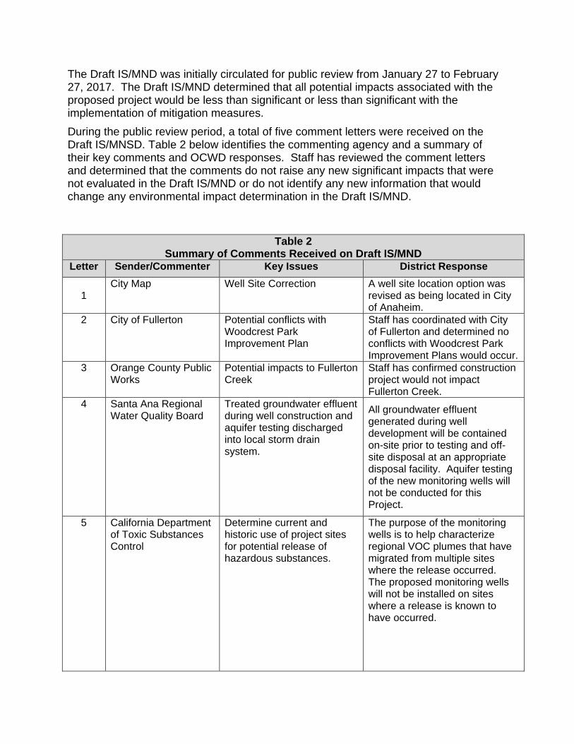
The Draft IS/MND was initially circulated for public review from January 27 to February 27, 2017. The Draft IS/MND determined that all potential impacts associated with the proposed project would be less than significant or less than significant with the implementation of mitigation measures.
During the public review period, a total of five comment letters were received on the Draft IS/MNSD. Table 2 below identifies the commenting agency and a summary of their key comments and OCWD responses. Staff has reviewed the comment letters and determined that the comments do not raise any new significant impacts that were not evaluated in the Draft IS/MND or do not identify any new information that would change any environmental impact determination in the Draft IS/MND.
Table 2 Summary of Comments Received on Draft IS/MND
Letter Sender/Commenter Key Issues District Response
1
City Map Well Site Correction A well site location option was revised as being located in City of Anaheim.
2 City of Fullerton Potential conflicts with Woodcrest Park Improvement Plan
Staff has coordinated with City of Fullerton and determined no conflicts with Woodcrest Park Improvement Plans would occur.
3 Orange County Public Works
Potential impacts to Fullerton Creek
Staff has confirmed construction project would not impact Fullerton Creek.
4 Santa Ana Regional Water Quality Board
Treated groundwater effluent during well construction and aquifer testing discharged into local storm drain system.
All groundwater effluent generated during well development will be contained on-site prior to testing and off-site disposal at an appropriate disposal facility. Aquifer testing of the new monitoring wells will not be conducted for this Project.
5 California Department of Toxic Substances Control
Determine current and historic use of project sites for potential release of hazardous substances.
The purpose of the monitoring wells is to help characterize regional VOC plumes that have migrated from multiple sites where the release occurred. The proposed monitoring wells will not be installed on sites where a release is known to have occurred.
Table 2 Summary of Comments Received on Draft IS/MND
Letter Sender/Commenter Key Issues District Response
Potential for cross contamination between aquifers. Recommendation to cease if soil and/or groundwater contamination is encountered.
OCWD has determined that the potential for cross-contamination is considered negligible and no other measures are needed.
Encountering contaminated soil is not expected. However, if unexpected hazardous drilling conditions are encountered, drilling with cease, the property owner and EPA (i.e., the lead oversight agency) will be contacted, and appropriate action will be taken.
Final Mitigated Negative Declaration - North Basin Groundwater Monitoring Well Project
In accordance with Section 15132 of the CEQA Guidelines, Staff has prepared the Final Mitigated Negative Declaration for the North Basin Groundwater Monitoring Well Project, which includes the Draft IS/MND, public comments received on the Draft IS/MND, OCWD responses to comments on the Draft IS/MND, and the Project Mitigation Monitoring Program.
CEQA Recommendation
At this time the OCWD has complied with all CEQA requirements and staff recommends the Board approve the following actions:
x Adopt the Final Mitigated Negative Declaration for the North Basin Groundwater Monitoring Well Project.
x Authorize Staff to file the Notice of Determination for the Final Mitigated Negative
Declaration for the North Basin Groundwater Monitoring Well Project.
MONITORING WELL INSTALLTION BUDGET The budget for the proposed North Basin monitoring well installations is $1,500,000, as shown in Table 3.

Table 3. Budget for Proposed North Basin Monitoring Wells
Task Cost Estimate
Pre-Construction Activities Encroachment Permits (6 locations) $ 42,000 Easement or License Agreement (2 locations) 10,000 Monitoring Well Construction Well Construction (14 depth-discrete wells at 8 locations) 850,000 Dedicated sampling pumps and pressure transducers/data loggers 49,000 Well Construction Field Oversight, Reporting, and Sampling (2 rounds) - AECOM 274,000 Surveying 25,000 Contingency (20%) 250,000
Total: $ 1,500,000 PRIOR RELEVANT BOARD ACTIONS: 9/21/16, 16-09-127 - Authorize issuance of Agreement to AECOM for the North Basin RI/FS, authorize issuance of Agreement to Senior Environmental Strategists to provide third-party oversight services for the North Basin RI/FS, approve a budget and authorize payment of invoices for regulatory oversight expenses by the EPA, and establish a capital project budget of $1.5 million for construction of 14 monitoring wells. 7/20/16, 16-7-106 - Authorize execution by the General Manager of the Administrative Settlement Agreement with the EPA for the North Basin RI/FS. 6/15/16, M16-89 - Direct staff to finalize the terms of the Administrative Settlement Agreement with the US EPA for the North Basin Remedial Investigation and Feasibility Study (RI/FS), and return to the Board for approval of such Agreement. 3/12/15, M15-50 - Authorize staff to negotiate a draft Agreement with the US EPA to establish the USEPA as the regulatory oversight agency for the District’s North Basin technical activities.
RESOLUTION NO. 17-4-XX APPROVING NORTH BASIN MONITORING WELL PROJECT: ADOPTING FINAL
IS/MND, APPROVING GEOLOGIST’S REPORT, AND AUTHORIZING ISSUANCE OF A NOTICE INVITING BIDS FOR WELL CONSTRUCTION
WHEREAS, the District has previously identified the existence of groundwater contamination consisting of volatile organic compounds (“VOC”) at concentrations in excess of Maximum Contaminant Levels and Notification Levels for drinking water in the northern part of the Basin underlying the City of Fullerton and the City of Anaheim, generally west of SR-57, north of SR-91, east of Brookhurst Street, and south of Commonwealth Avenue (“North Basin”); and WHEREAS, the District has executed an Administrative Settlement Agreement with the U.S. Environmental Protection Agency whereby the District committed to conducting a Remedial Investigation and Feasibility Study (“RI/FS”) for an Interim Remedy to address VOCs in groundwater in the North Basin area; and, the RI scope of work includes the installation of fourteen monitoring wells at eight locations; and WHEREAS, the District has undertaken an Initial Study in accordance with guidelines established under Article VI of the California Environmental Quality Act (CEQA) Cal. Admin. Code Section 15000, et. seq., and determined that a Mitigated Negative Declaration is the appropriate CEQA document with respect to the potential environmental impacts associated with the construction and sampling of groundwater monitoring wells; and WHEREAS, such Initial Study/Mitigated Negative Declaration has determined that although the proposed project could have a significant effect on the environment, there will not be a significant effect in this case because revisions to the project have been made by or agreed to by the applicant; and WHEREAS, the District staff has further recommended issuance of a Notice Inviting Bids to retain a driller to install 14 monitoring wells in 8 locations; and NOW, THEREFORE, the Board of Directors of the Orange County Water District does hereby resolve as follows: Section 1: The Board of Directors does hereby find that:
i) The Initial Study identifies potentially significant effects on the environment, but (A) revisions in the project plans or proposals made by, or agreed to by, the District as the applicant before the proposed negative declaration and initial study were released for public review would avoid the effects or mitigate the effects to a point where clearly no significant effect on the environment would occur, and (B) there is no substantial evidence, in light of the whole record before the lead agency, that the project, as revised, may have a significant effect on the environment;

ii) The Initial Study/Mitigated Negative Declaration reflects the independent judgment and analysis of the Board of Directors of the District, as the lead agency for the project; and
iii) Prior to approving the project, the Board of Directors of the District has considered the
Initial Study/Mitigated Negative Declaration together with any comments received during the public review process, and any responses to such comments;
Section 2: The Final Initial Study/Mitigated Negative Declaration for the North Basin Groundwater Monitoring Well Project is hereby adopted. Section 3: The Geologist’s Report is hereby approved. Section 4: A project budget of $1,500,000 is hereby established. Section 5: The project is determined feasible, necessary and beneficial to the lands of the District, and is declared duly instituted. Section 6: Issuance of a Notice Inviting Bids for construction of the project, including 14 monitoring wells, is authorized. Section 7: Staff is authorized to file a Notice of Determination.

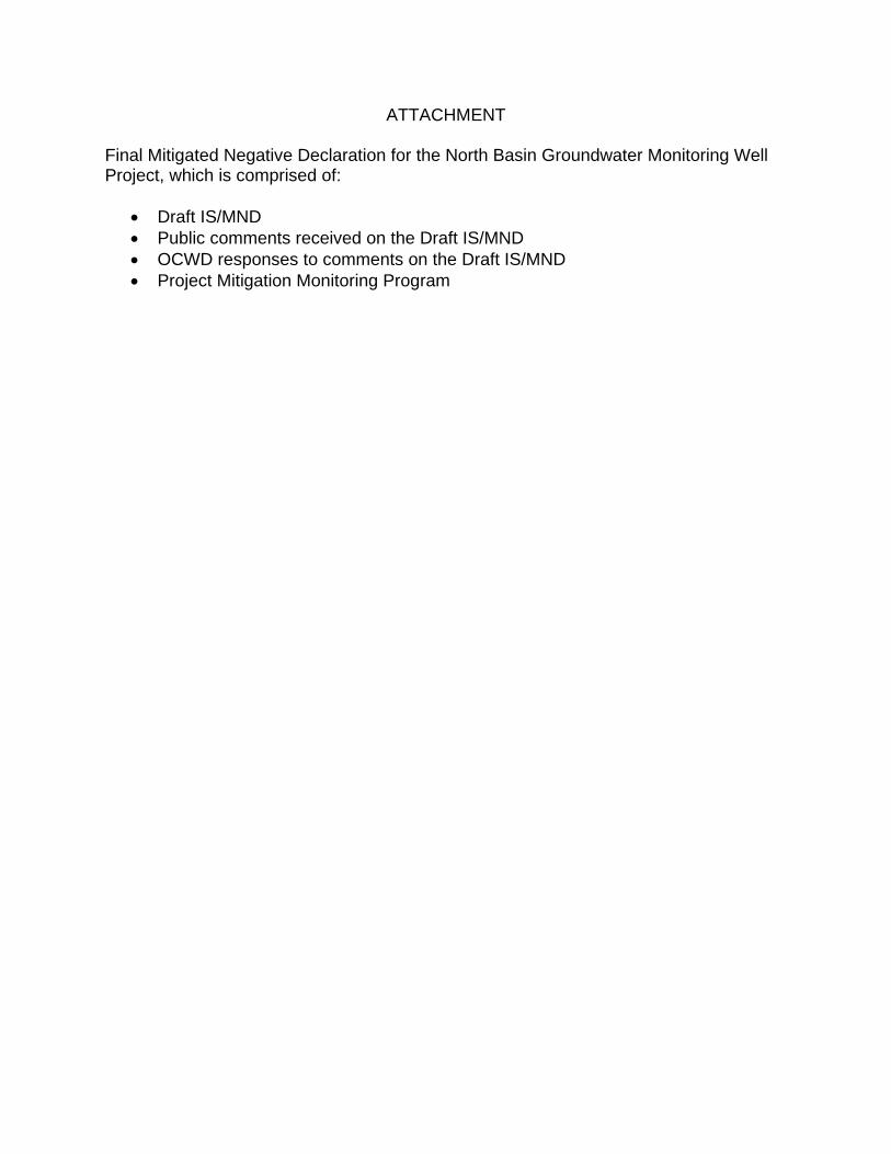
ATTACHMENT Final Mitigated Negative Declaration for the North Basin Groundwater Monitoring Well Project, which is comprised of:
x Draft IS/MND x Public comments received on the Draft IS/MND x OCWD responses to comments on the Draft IS/MND x Project Mitigation Monitoring Program
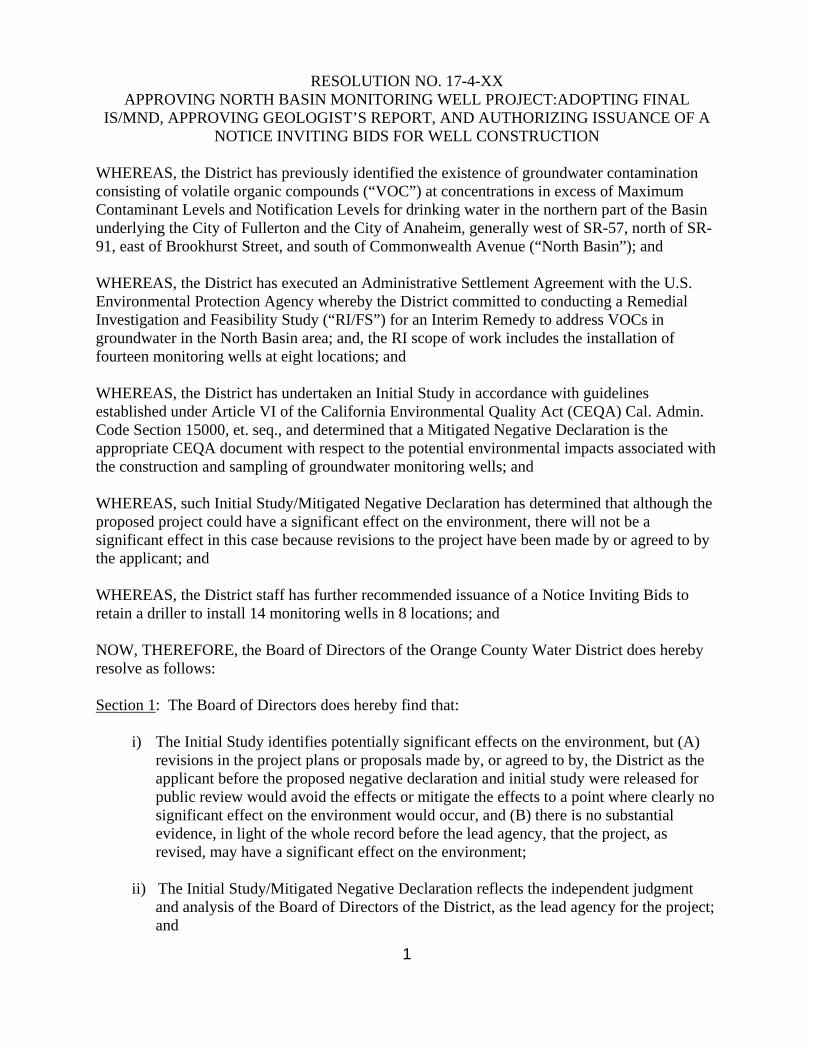
1
RESOLUTION NO. 17-4-XX APPROVING NORTH BASIN MONITORING WELL PROJECT:ADOPTING FINAL
IS/MND, APPROVING GEOLOGIST’S REPORT, AND AUTHORIZING ISSUANCE OF A NOTICE INVITING BIDS FOR WELL CONSTRUCTION
WHEREAS, the District has previously identified the existence of groundwater contamination consisting of volatile organic compounds (“VOC”) at concentrations in excess of Maximum Contaminant Levels and Notification Levels for drinking water in the northern part of the Basin underlying the City of Fullerton and the City of Anaheim, generally west of SR-57, north of SR-91, east of Brookhurst Street, and south of Commonwealth Avenue (“North Basin”); and WHEREAS, the District has executed an Administrative Settlement Agreement with the U.S. Environmental Protection Agency whereby the District committed to conducting a Remedial Investigation and Feasibility Study (“RI/FS”) for an Interim Remedy to address VOCs in groundwater in the North Basin area; and, the RI scope of work includes the installation of fourteen monitoring wells at eight locations; and WHEREAS, the District has undertaken an Initial Study in accordance with guidelines established under Article VI of the California Environmental Quality Act (CEQA) Cal. Admin. Code Section 15000, et. seq., and determined that a Mitigated Negative Declaration is the appropriate CEQA document with respect to the potential environmental impacts associated with the construction and sampling of groundwater monitoring wells; and WHEREAS, such Initial Study/Mitigated Negative Declaration has determined that although the proposed project could have a significant effect on the environment, there will not be a significant effect in this case because revisions to the project have been made by or agreed to by the applicant; and WHEREAS, the District staff has further recommended issuance of a Notice Inviting Bids to retain a driller to install 14 monitoring wells in 8 locations; and NOW, THEREFORE, the Board of Directors of the Orange County Water District does hereby resolve as follows: Section 1: The Board of Directors does hereby find that:
i) The Initial Study identifies potentially significant effects on the environment, but (A) revisions in the project plans or proposals made by, or agreed to by, the District as the applicant before the proposed negative declaration and initial study were released for public review would avoid the effects or mitigate the effects to a point where clearly no significant effect on the environment would occur, and (B) there is no substantial evidence, in light of the whole record before the lead agency, that the project, as revised, may have a significant effect on the environment;
ii) The Initial Study/Mitigated Negative Declaration reflects the independent judgment
and analysis of the Board of Directors of the District, as the lead agency for the project; and

2
iii) Prior to approving the project, the Board of Directors of the District has considered the
Initial Study/Mitigated Negative Declaration together with any comments received during the public review process, and any responses to such comments;
Section 2: The Final Initial Study/Mitigated Negative Declaration for the North Basin Groundwater Monitoring Well Project is hereby adopted. Section 3: The Geologist’s Report is hereby approved. Section 4: A project budget of $1,500,000 is hereby established. Section 5: The project is determined feasible, necessary and beneficial to the lands of the District, and is declared duly instituted. Section 6: Issuance of a Notice Inviting Bids for construction of the project, including 14 monitoring wells, is authorized. Section 7: Staff is authorized to file a Notice of Determination.
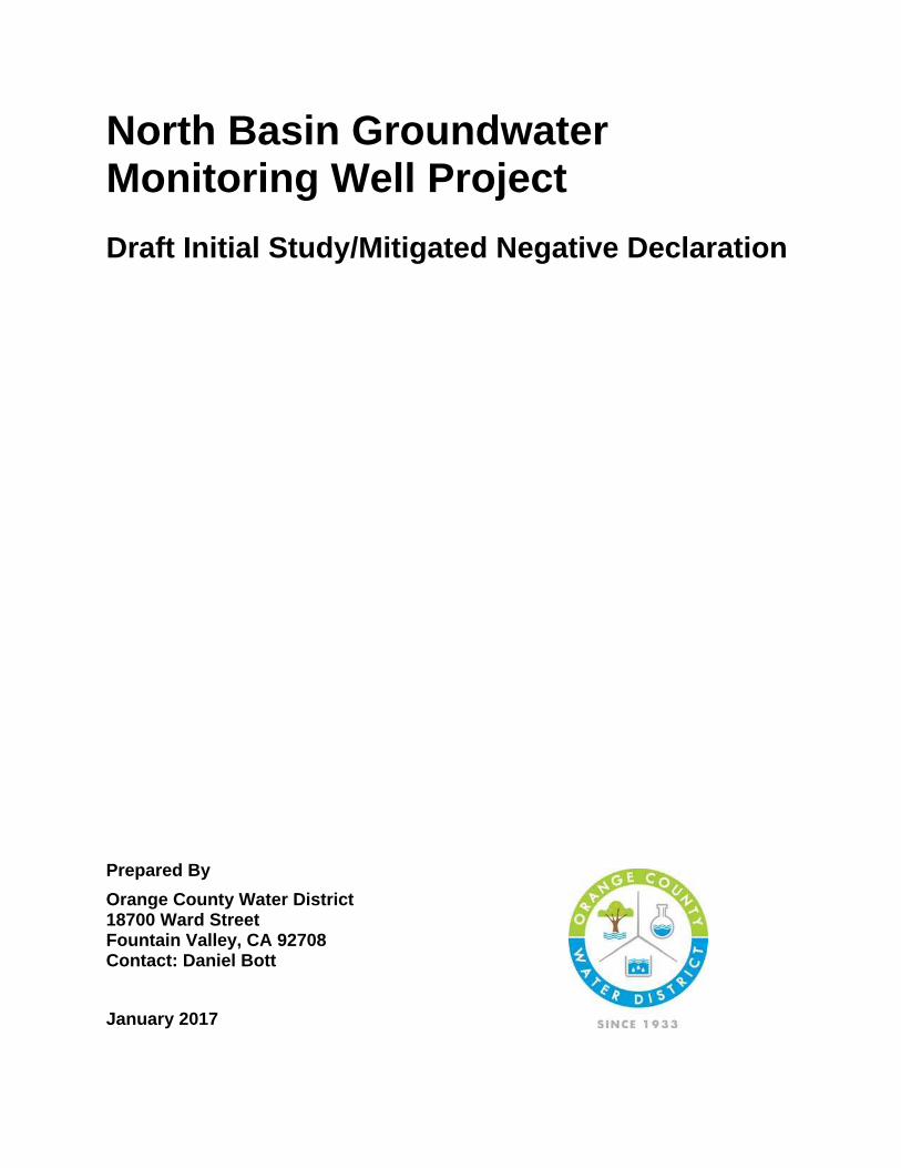
North Basin Groundwater Monitoring Well Project
Draft Initial Study/Mitigated Negative Declaration
Prepared By
Orange County Water District 18700 Ward Street Fountain Valley, CA 92708 Contact: Daniel Bott
January 2017
Table of Contents
North Basin Groundwater Monitoring Well Project Draft Initial Study/Mitigated Negative Declaration i
Section Page
SECTION 1.0� INTRODUCTION ..................................................................................... 1-1�
1.1� Purpose of Environmental Review ......................................................................... 1-1�
1.2� Statutory Authority and Requirements ................................................................... 1-1�
1.3� Technical Information and Studies ........................................................................ 1-1�
SECTION 2.0� PROJECT DESCRIPTION ...................................................................... 2-1�
2.1� Background ............................................................................................................ 2-1�
2.2� Well Site Locations ................................................................................................ 2-2�
2.3� Construction Activities ......................................................................................... 2-14�
2.4� Project Schedule and Equipment Overlap ........................................................... 2-15�
2.5� Monitoring Well Long Term Operation and Maintenance Activities ..................... 2-15�
2.6� Permits and Approvals ......................................................................................... 2-16�
SECTION 3.0� ENVIRONMENTAL CHECKLIST EVALUATIONS ............... .................. 3-1�
SECTION 4.0� ENVIRONMENTAL ANALYSIS ............................ .................................. 4-1�
4.1� Aesthetics .............................................................................................................. 4-1�
4.2� Agricultural Resources/Forest Resources ............................................................. 4-3�
4.3� Air Quality .............................................................................................................. 4-5�
4.4� Biological Resources ........................................................................................... 4-19�
4.5� Cultural Resources .............................................................................................. 4-24�
4.6� Geology/Soils ....................................................................................................... 4-29�
4.7� Greenhouse Gas Emissions ................................................................................ 4-33�
4.8� Hazards/Hazardous Materials ............................................................................. 4-36�
4.9� Hydrology/Water Quality ...................................................................................... 4-40�
4.10� Land Use/Planning .............................................................................................. 4-53�
4.11� Mineral Resources ............................................................................................... 4-55�
4.12� Noise .................................................................................................................... 4-56�
4.13� Population/Housing .............................................................................................. 4-64�
4.14� Public Services .................................................................................................... 4-65�
4.15� Recreation ............................................................................................................ 4-66�
4.16� Transportation/Traffic ........................................................................................... 4-67�
4.17� Tribal Cultural Resources .................................................................................... 4-72�
4.18� Utilities/Service Systems ..................................................................................... 4-74�
4.19� Mandatory Findings of Significance ..................................................................... 4-77�
SECTION 5.0� REFERENCES ........................................................................................ 5-1�

Table of Contents
North Basin Groundwater Monitoring Well Project Draft Initial Study/Mitigated Negative Declaration ii
Tables Page Table 1: Well Drilling/Construction Equipment Mix ........................................................... 2-14�Table 2: Well Development Equipment Mix ....................................................................... 2-15�Table 3: Monitoring Well Sampling and Redevelopment Equipment Mix.......................... 2-16�Table 4: Construction-Related Regional Criteria Pollutant Emissions .............................. 4-11�Table 5: Construction-Related Local Criteria Pollutant Emissions .................................... 4-12�Table 6: Operational Well Sampling and Redevelopment Regional Criteria Pollutant
Emissions ............................................................................................................ 4-13�Table 7: Operational Well Sampling and Redevelopment Local Criteria Pollutant Emissions 4-14�Table 8: Special Status Species List ................................................................................. 4-20�Table 9: Summary of Record Search ................................................................................ 4-25�Table 10: Project Related Greenhouse Gas Annual Emissions ........................................ 4-34�Table 11: 303 (D) Listed Impaired Water Bodies .............................................................. 4-42�Table 12: Beneficial Use Descriptions ............................................................................... 4-44�Table 13: Study Area Water Body/Drainage Facilities Beneficial Uses ............................ 4-46�Table 14: Downstream Receiving Water Bodies Beneficial Uses ..................................... 4-46�Table 15: Water Quality Objectives ................................................................................... 4-46�Table 16: City of Fullerton Exterior Noise Level Standards ............................................... 4-57�Table 17: Well Construction Equipment Inventory Noise Levels ....................................... 4-57�Table 18: Estimated Noise Levels ..................................................................................... 4-58�
Figures Page Figure 1: Proposed Monitoring Well Sites .................................................................................. 2-4�Figure 2: Monitoring Well AM-54 Site ........................................................................................ 2-5�Figure 3: Monitoring Well FM-7B Site ........................................................................................ 2-6�Figure 4: Monitoring Well FM-22B Site ...................................................................................... 2-7�Figure 5: Monitoring Well FM-24B Site ...................................................................................... 2-8�Figure 6: Monitoring Well FM-29 Site ........................................................................................ 2-9�Figure 7: Monitoring Well FM-30A Option A, Option B Sites ................................................... 2-11�Figure 8: Monitoring Well FM-31 Site ...................................................................................... 2-12�Figure 9: Monitoring Well FM-32 A/B Option A, Option B ........................................................ 2-13�
Appendices
A. Air Quality and Greenhouse Gas Emission Report, Vista Environmental, December 2016
B. Cultural Resource/Paleontological Resource Record Search/Tribal Coordination
Section 1
North Basin Groundwater Monitoring Well Project Draft Initial Study/Mitigated Negative Declaration 1-1
SECTION 1.0 INTRODUCTION
1.1 Purpose of Environmental Review
The California Environmental Quality Act (CEQA) requires that all state and local government agencies consider the environmental consequences of projects over which they have discretionary authority before taking action on those projects. This Initial Study has been prepared to disclose and evaluate short-term construction related impacts and long-term operational impacts associated with the implementation of the North Basin Monitoring Well Project (Proposed Project). Pursuant to Section 15367 of the State CEQA guidelines, the Orange County Water District (OCWD) is the Lead Agency and has the principal responsibility of approving and implementing the Proposed Project. As the Lead Agency, OCWD is required to ensure that the Proposed Project complies with CEQA and that the appropriate level of CEQA documentation is prepared. Through preparation of an Initial Study as the Lead Agency, OCWD would determine whether to prepare an Environmental Impact Report (EIR), Negative Declaration or Mitigated Negative Declaration (MND). If the Lead Agency finds that there is no evidence that a project activity either as proposed or as modified to include the mitigation measures identified in the Initial Study prior to its public circulation, would not cause a significant effect on the environment, the Lead Agency may prepare a Negative Declaration or Mitigated Negative Declaration. Based on the conclusions of this Initial Study, OCWD has recommended that the appropriate level of environmental documentation for the North Basin Monitoring Well Project is a Mitigated Negative Declaration.
1.2 Statutory Authority and Requirements
This Initial Study/Mitigated Negative Declaration has been prepared in accordance with the CEQA, Public Resources Code Section 21000 et seq. State CEQA Guidelines and OCWD CEQA Environmental Procedures.
1.3 Technical Information and Studies
The following technical studies and information have been incorporated in the environmental impact evaluation prepared for the North Basin Monitoring Well Project.
x Air Quality and Greenhouse Gas Emission Report, Vista Environmental, 2016
x Cultural Resource/Paleontological Resource Record Search/Tribal Coordination, 2016
Section 2
North Basin Groundwater Monitoring Well Project Draft Initial Study/Mitigated Negative Declaration 2-1
SECTION 2.0 PROJECT DESCRIPTION
2.1 Background
The Orange County Groundwater Basin provides 70% to 75% of the potable water supply for over 2.4 million people in central and northern Orange County. One of the primary responsibilities of OCWD is to manage and protected the groundwater basin. The northern portion of the Orange County Groundwater Basin which includes cities of Fullerton and Anaheim has been impacted by volatile organic compounds (VOCs) at concentrations well above primary drinking water standards. This portion of the Orange County Groundwater Basin is referred to as the North Basin area. The predominant VOCs present in the North Basin area are trichloroethylene (TCE), tetrachloroethylene (PCE), 1,1-dichloroethylene (1,1-DCE), and 1,4-dioxane. The co-mingled VOC plumes with concentration above drinking water standards (i.e., California Maximum Contaminant Levels [MCLs] for TCE, PCE and 1,1-DCE, and the Notification Level [NL] for 1,4-dioxane) are approximately five miles long, two miles wide, and locally over 450 feet deep.
To date, four production wells have been destroyed due to VOC contamination, and more wells would be threatened by the uncontrolled spread of contaminated groundwater. The production wells destroyed due to VOC contamination include two wells owned by the City of Fullerton (F-KIM1 and F-FS13), one well owned by the City of Anaheim (A-23), and a private well that was used for manufacturing soda and bottled water (BAST-F). Additionally, the North Basin VOC plume is threatening additional production wells in that area.
OCWD has been working on implementing projects that protect the North Basin area from the continued leaching and migration of VOCs. OCWD had started implementing a regional groundwater containment project named the North Basin Groundwater Protection Project. Initial work on the project included the installation of approximately 70 monitoring wells, 6 large extraction wells and the implementation of a variety water quality studies that focused on mapping the plume, capturing the contamination and preventing its continued spreading both horizontally and vertically. Several years ago, work on the project was temporarily delayed in response to legal entanglements and unfavorable court rulings. In response to the difficulties, the OCWD Board of Directors adopted new policies calling for National Contingency Plan (NCP) methods and a request for U.S. Environmental Protection Agency (USEPA) regulatory oversight. Soon after assuming regulatory responsibility for the area, the USEPA called for the design and installation of 14 additional monitoring wells at eight locations. At some locations adjacent monitoring wells would be installed at different depths to characterize the vertical extent of contamination. These new wells are needed to develop remedial alternatives, and to help with monitoring the performance of the eventually selected
Section 2
North Basin Groundwater Monitoring Well Project Draft Initial Study/Mitigated Negative Declaration 2-2
remedy. The approximate locations of the 8 well sites were selected by the US EPA for specific purposes and were accepted by the OCWD. The general well locations are included in USEPA’s Administrative Settlement Agreement with OCWD for the Remedial Investigation/Feasibility Study of the Orange County North Basin.
2.2 Well Site Locations
The Proposed Project involves the construction and operation of 14 new monitoring wells at eight locations within the cities of Anaheim and Fullerton. At four locations, only one monitoring well would be installed. At the remaining locations, two or three adjacent monitoring wells would be installed. The clustered wells would be approximately 10 feet apart. A total of 17 potential monitoring well sites have been selected for evaluation. Based on final design and final site acquisition, 14 well sites would ultimately be selected for well construction. The regional location of the proposed 8 monitoring well locations is shown in Figure 1.
Each well site would require an approximate 20 foot wide by 100 foot long work area to construct each well and to stage construction equipment. A temporary six foot high fence would be installed around the perimeter of each well site to prevent public access to the work area. During the night when construction activities are not occurring onsite security would be provided. The perimeter fencing and onsite security would be maintained during the entire construction period. Depending on the well site, the construction period would range from approximately two weeks to one month. The descriptions of the proposed monitoring well locations are summarized below.
Monitoring Wells AM-54A, AM-54B, AM-54C
As shown Figure 2, Monitoring Wells AM-54A, AM-54B, and AM-54C are located in the cul-de-sac of Durst Road approximately 10 feet north of the centerline of Durst Road and 1,200 feet east of the centerline of Lemon Street in the City of Anaheim. The well sites are located on USGS Anaheim Quadrangle Map, Township 4 South, Range 10 West and Section 3. The closest sensitive receptor would be residential land uses located approximately 1,200 feet to the north. The construction period would be approximately one month and would require the temporary closure of a traffic lane along a portion of Durst Road. The construction activities would not restrict vehicle driveway access, but would temporary displace some on-street parking along Durst Road.
Monitoring Well FM-7B
As shown on Figure 3, Monitoring Well FM-7B is located on the south side of Orangefair Avenue approximately 20 feet south of the centerline of Orangefair Avenue and 400 feet west of the centerline of Lemon Street in the City of Fullerton. FM-7B would be located adjacent to two existing OCWD monitoring wells. The well site is located on USGS Anaheim Quadrangle Map, Township 4 South, Range 10 West, and Section 3. The
Section 2
North Basin Groundwater Monitoring Well Project Draft Initial Study/Mitigated Negative Declaration 2-3
closest sensitive receptor would be residential condominiums located approximately 25 feet to the north. The construction period would be approximately two weeks and would require the temporary closure of a traffic lane along a portion of Orangefair Avenue. The construction activities would not restrict driveway vehicle access or result in the loss of parking area.
Monitoring Well FM-22B
As shown Figure 4, Monitoring Well FM-22B is located in the parking area of Woodcrest Park in the City of Fullerton. The well site is located approximately 90 feet south of the centerline of Orangethorpe Avenue and 410 feet east of the centerline of Richman Avenue. FM-22B would be located adjacent to two existing OCWD monitoring wells. The well site is located on USGS Anaheim Quadrangle Map, Township 4 South, Range 10 West and Section 4. The closest sensitive receptor would be residential land uses located approximately 180 feet to the north. The construction period would be approximately two weeks and would temporary displace nine parking spaces including one handicap parking space. The construction activities would not restrict public access to Woodcrest Park.
Monitoring Well FM-24B
As shown Figure 5, Monitoring Well FM-24B is located in the cul-de-sac of West Houston Avenue approximately centered in the cul-de-sac and 700 feet east of the intersection of Richman Avenue and Houston Avenue in the City of Fullerton. TFM-24B would be located adjacent to two existing OCWD monitoring wells. The well site is located on USGS Anaheim Quadrangle Map, Township 4 South, Range 10 West and Section 4. The closest sensitive receptor would be residential land uses approximately 85 feet to the east. The construction period would be approximately two weeks and would require the temporary closure of a portion of the Houston Avenue cul- de-sac. The construction activities would not restrict access to the emergency gate that provides emergency access to adjacent residential community. The temporary closure of a portion of the cul-de-sac would also temporary displace some on-street parking.
Monitoring Wells FM-29A, FM-29B, FM-29C
As shown Figure 6, Monitoring Wells FM-29A, FM-29B, FM-29C are located in the cul-de-sac of West Oak Avenue approximately 20 feet south of the centerline of West Oaks Avenue and 140 feet east of the centerline of South Adams Avenue in the City of Fullerton. The well sites are located on USGS Anaheim Quadrangle Map, Township 3 South, Range 10 West and Section 33. The closest sensitive receptor would be residential land uses located approximately 50 feet to the west. The construction period would be approximately one month and would require the temporary closure of a portion of the Oak Avenue cul-de-sac. The construction activities would not restrict driveway access, but would temporary displace some on-street parking.
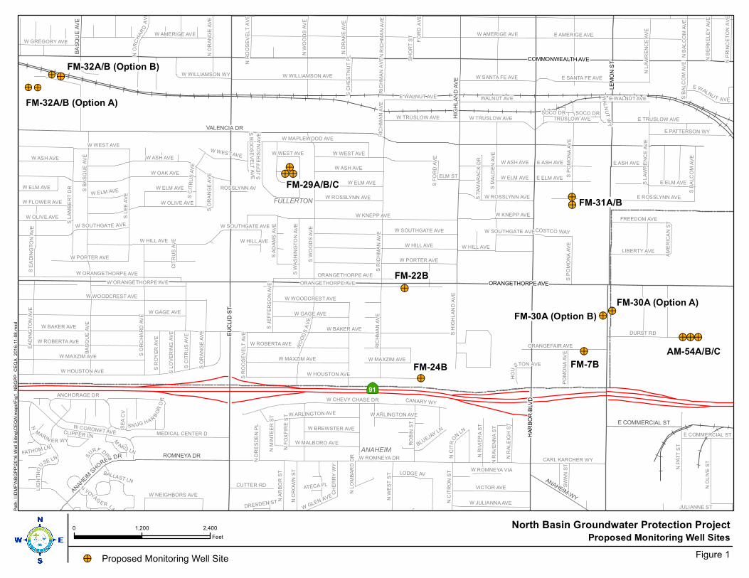
!>
!>
FM-29A/B/C
!>
FM-22B
!>
FM-24B
FM-31A/B
!>FM-30A (Option B)
!>
FM-7B
!>
AM-54A/B/C
!>FM-32A/B (Option B)
!>
!>!>
!>
!>!>
!>!>
FM-32A/B (Option A)
FM-30A (Option A)
!>
|ÿ91
FULLERTON
ANAHEIM
VALENCIA DR
HIG
HL
AN
D A
VE
ROMNEYA DR
ANAHEIM WY
E COMMERCIAL ST
ANAHEIM
SH
ORES DR
BA
SQ
UE
AV
E
EU
CL
ID S
T
HA
RB
OR
BLV
D
COMMONWEALTH AVE
ORANGETHORPE AVE
LE
MO
N S
T
W ROMNEYA DR
W BAKER AVE
W KNEPP AVES L
EE
AV
E
S W
OO
DS
AV
E
W HOUSTON AVE
W WEST AVE
S R
ICH
MA
N A
VE
W ELM AVE
WO
OD
SA
VE
ORANGETHORPE AVE
W WILLIAMSON AVE
S L
AM
BE
RT
DR
W CORONET AVE
W CHEVY CHASE DR
E ELM AVE
BA
SQ
UE
AV
E
DURST RD
RIC
HM
AN
AV
E
N O
LIV
E S
T
S M
AL
DE
N A
VE
E TRUSLOW AVE
VICTOR AVE
W ASH AVE
RO
BIN
ST
W MAPLEWOOD AVE
WALNUT AVE
EA
DIN
GT
ON
AV
E
S O
RC
HA
RD
AV
E
S B
AS
QU
E A
VE
MEDICAL CENTER D
S L
AW
RE
NC
E A
VE
W ARLINGTON AVE
W MALBORO AVE
E AMERIGE AVE
LIBERTY AVE
ORANGEFAIR AVE
W JULIANNA AVE
W AMERIGE AVE
E ROSSLYNN AVE
N W
ES
T S
T
W SANTA FE AVE
W TRUSLOW AVE TRUSLOW AVE
E PATTERSON WY
FREEDOM AVE
CANARY WY
W OLIVE AVE
N A
RB
OR
ST
LIG
HT
HO
U
SE LN
W ORANGETHORPE AVE
LODGE AV
N C
RO
WN
ST
CARL KARCHER WY
CUTTER RD
S E
AD
ING
TO
N A
VE
SW
AN
ST
N C
ITR
ON
ST
W ROSSLYNN AVE
S B
ALC
OM
AV
E
W GREGORY AVE
S H
IGH
LA
ND
AV
E
N L
AW
RE
NC
E A
VE
E ASH AVE
S A
DA
MS
AV
E
W FLOWER AVE
ANCHORAGE DR
W HILL AVE
N R
IVIE
RA
ST
W MAXZIM AVE
E WALNU T AVE
N R
AL
EIG
H S
T
N D
RA
KE
AV
E
S R
OY
ER
AV
E
BLUEJAY LN
W WILLIAMSON WY
SN UG HA R
BO
RD
R
S P
OM
ON
A A
VE
N
MARIN ER WY
W NEIGHBORS AVE
N B
AL
CO
M A
VE
S W
AS
HIN
GT
ON
AV
E
N W
OO
DS
AV
E
S J
EF
FE
RS
ON
AV
E
CH
ER
RY
WY
SE
A C
V
ELM ST
COSTCO WAY
WGLEN AVE
E COMMERCIAL ST
NC
ITR
O
NLN
S C
ITR
US
AV
E
W ROBERTA AVE
N O
RA
NG
E A
VE
N R
ICH
MA
N A
VE
N B
ER
KE
LE
Y A
VE
PO
MO
NA
AV
E
NO
RC
HA
RD
AV
E
N R
AV
EN
NA
ST
NP
RI N
CE
TO
NA
VE
S L
OV
ER
ING
AV
E
S R
OO
SE
VE
LT
AV
E
N D
RE
SD
EN
PL
S O
RA
NG
E A
VE
JULIANNE ST
NR
OO
SE
VE
LT
AV
E
S
URF D
R
S C
HE
ST
NU
T P
L
SH
OR
T S
T
FO
RD
AV
E
SOCO DR
NF
OX
FIR
ES
T
M
AKO LN
W SOUTHGATE AVE
AM
ER
ICA
N S
T
NVO
YAGE R LN
N M
INT
EE
R S
T
CLIPPER LN
WA
LN
UT
WY
N L
OM
BA
RD
DR
S F
OR
D A
VE
FATHOM LN
HO
U
STON AVE
W PORTER AVE
CIT
RU
S A
VE
DRESDEN ST
BALLAST LN
W GAGE AVE
ROSSLYNN AV
S T
AM
AR
AC
K D
R
W ROMNEYA VIA
ATECA PL
W BREWSTER AVE
W WOODCREST AVE
W OAK AVE
E SANTA FE AVE
N P
AT
T S
T
W ELM AVE S P
OM
ON
A A
VE
S R
OO
SE
VE
LT
AV
E
W WEST AVE
W ASH AVE
E ELM AVE
W OLIVE AVE
W HILL AVE
W ORANGETHORPE AVE
W HILL AVE
W MAXZIM AVE
W BAKER AVE
W PORTER AVE
E WALNUT AVE
SOCO DR
W MAXZIM AVE
W SOUTHGATE AVE
E WALNUT AVE
W ELM AVE
W GAGE AVE
RIC
HM
AN
AV
E
W AMERIGE AVE
W WOODCREST AVE
W HOUSTON AVE
S O
RA
NG
E A
VE
W KNEPP AVE
W ASH AVE
W SOUTHGATE AVE
W ELM AVE
W WEST AVE W WEST AVE
ORANGETHORPE AVE
E ASH AVE
W HILL AVE
W ROBERTA AVE
W ROSSLYNN AVE
S B
ALC
OM
AV
E
W SOUTHGATE AVE
RIC
HM
AN
AV
E
W TRUSLOW AVE
W ASH AVE
W ARLINGTON AVE
S J
EF
FE
RS
ON
AV
E
W ELM AVES
CIT
RU
S A
VE
Proposed Monitoring Well Sites0 1,200 2,400
Feet
North Basin Groundwater Protection Project
Figure 1
Pa
th:
I:\D
MF
\NB
GP
P\2
016
Well S
itin
g\C
EQ
A\m
aps\F
ig1
_N
BG
PP
_C
EQ
A_2
01
6-1
1-0
8.m
xd
!> Proposed Monitoring Well Site
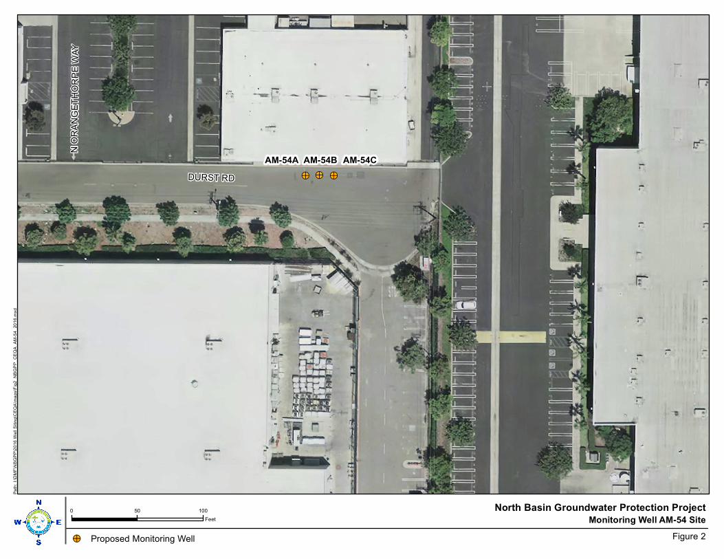
!>
AM-54A
!>!>
AM-54B AM-54C
DURST RD
N O
RA
NG
ET
HO
RP
E W
AY
Monitoring Well AM-54 Site0 50 100
Feet
North Basin Groundwater Protection Project
Figure 2
Pa
th:
I:\D
MF
\NB
GP
P\2
016
Well S
itin
g\C
EQ
A\m
aps\F
ig2
_N
BG
PP
_C
EQ
A_A
M-5
4_
20
16.m
xd
!> Proposed Monitoring Well
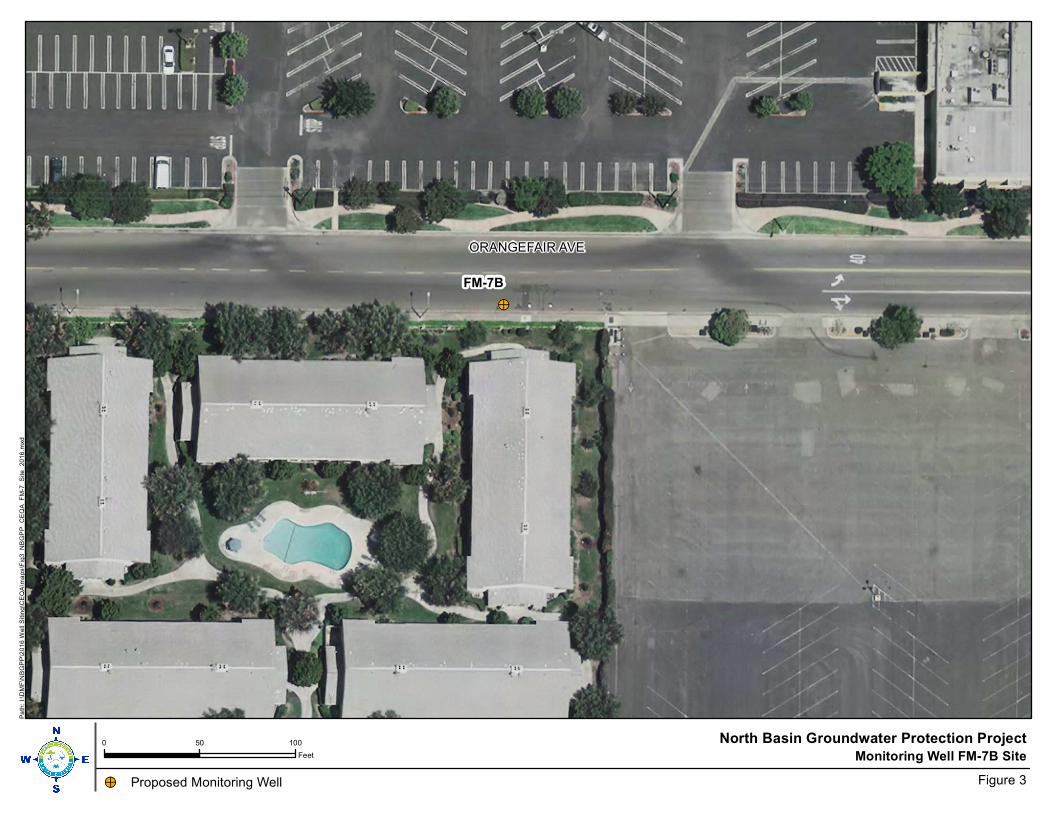
!>
FM-7B
ORANGEFAIR AVE
Monitoring Well FM-7B Site0 50 100
Feet
North Basin Groundwater Protection Project
Figure 3
Pa
th:
I:\D
MF
\NB
GP
P\2
016
Well S
itin
g\C
EQ
A\m
aps\F
ig3
_N
BG
PP
_C
EQ
A_F
M-7
_S
ite
_20
16
.mxd
!> Proposed Monitoring Well
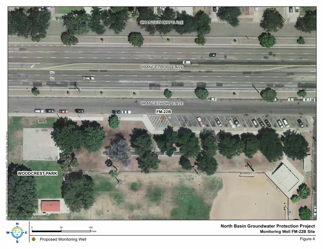
!>
FM-22B
WOODCREST PARK
ORANGETHORPE AVE
ORANGETHORPE AVE
ORANGETHORPE AVE
Monitoring Well FM-22B Site0 50 100
Feet
North Basin Groundwater Protection Project
Figure 4
Pa
th:
I:\D
MF
\NB
GP
P\2
016
Well S
itin
g\C
EQ
A\m
aps\F
ig4
_N
BG
PP
_C
EQ
A_F
M-2
2B
_S
ite_
20
16.m
xd
!> Proposed Monitoring Well
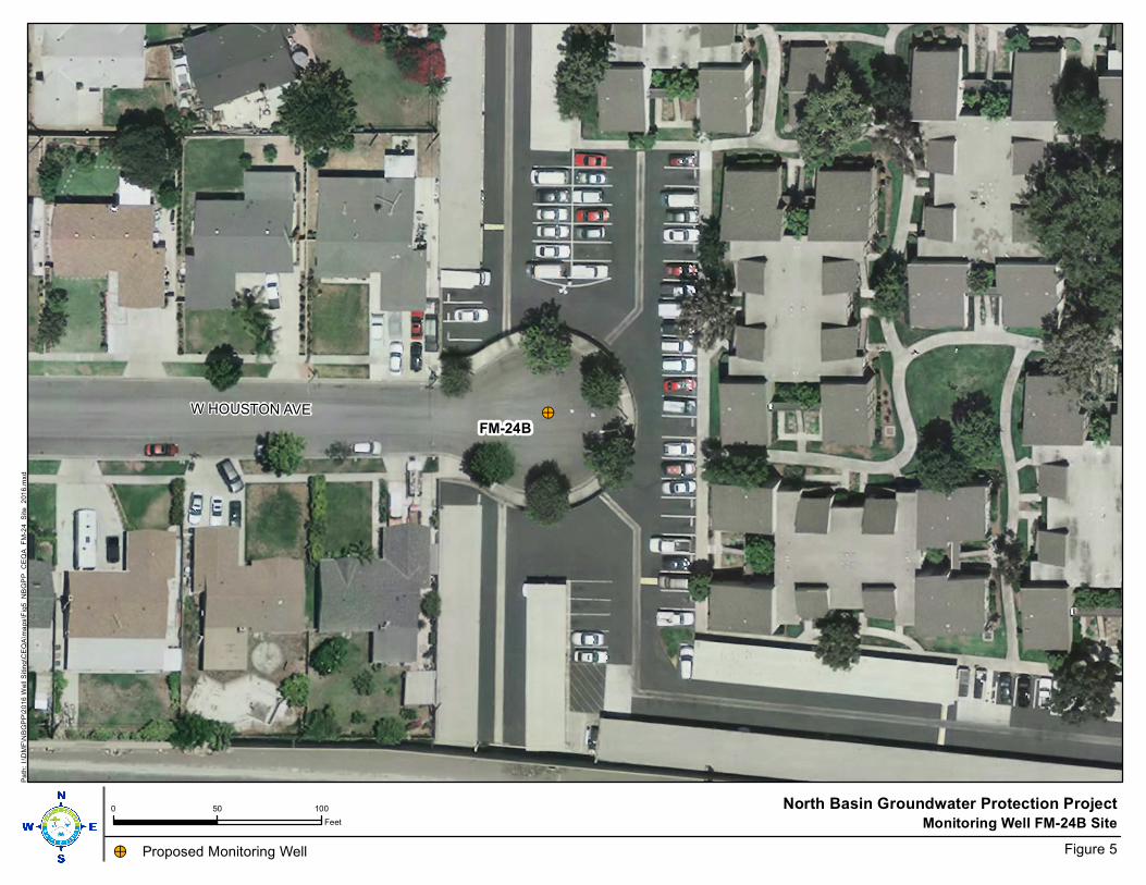
!>FM-24B
W HOUSTON AVE
Monitoring Well FM-24B Site0 50 100
Feet
North Basin Groundwater Protection Project
Figure 5
Pa
th:
I:\D
MF
\NB
GP
P\2
016
Well S
itin
g\C
EQ
A\m
aps\F
ig5
_N
BG
PP
_C
EQ
A_F
M-2
4_
Site
_2
01
6.m
xd
!> Proposed Monitoring Well
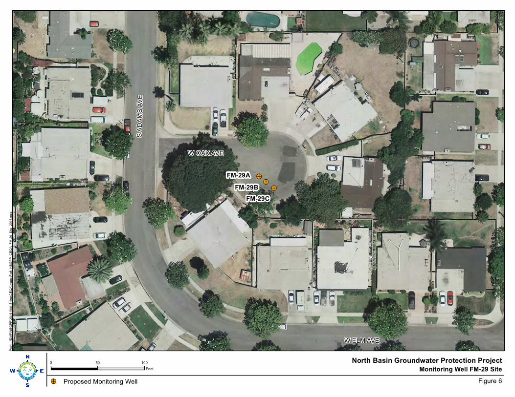
!>
FM-29A!>
!>
FM-29B
FM-29C
S A
DA
MS
AV
E
W ELM AVE
W OAK AVE
Monitoring Well FM-29 Site0 50 100
Feet
North Basin Groundwater Protection Project
Figure 6
Pa
th:
I:\D
MF
\NB
GP
P\2
016
Well S
itin
g\C
EQ
A\m
aps\F
ig6
_N
BG
PP
_C
EQ
A_F
M-2
9_
Site
_2
01
6.m
xd
!> Proposed Monitoring Well
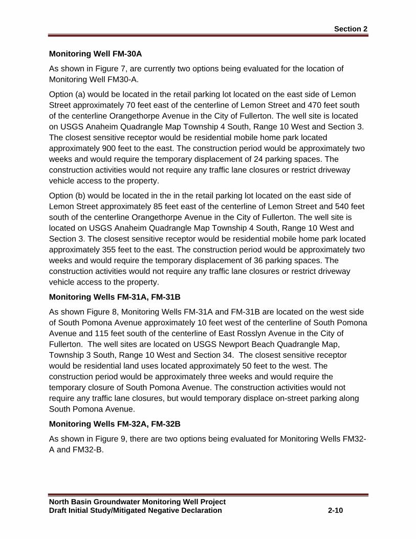
Section 2
North Basin Groundwater Monitoring Well Project Draft Initial Study/Mitigated Negative Declaration 2-10
Monitoring Well FM-30A
As shown in Figure 7, are currently two options being evaluated for the location of Monitoring Well FM30-A.
Option (a) would be located in the retail parking lot located on the east side of Lemon Street approximately 70 feet east of the centerline of Lemon Street and 470 feet south of the centerline Orangethorpe Avenue in the City of Fullerton. The well site is located on USGS Anaheim Quadrangle Map Township 4 South, Range 10 West and Section 3. The closest sensitive receptor would be residential mobile home park located approximately 900 feet to the east. The construction period would be approximately two weeks and would require the temporary displacement of 24 parking spaces. The construction activities would not require any traffic lane closures or restrict driveway vehicle access to the property.
Option (b) would be located in the in the retail parking lot located on the east side of Lemon Street approximately 85 feet east of the centerline of Lemon Street and 540 feet south of the centerline Orangethorpe Avenue in the City of Fullerton. The well site is located on USGS Anaheim Quadrangle Map Township 4 South, Range 10 West and Section 3. The closest sensitive receptor would be residential mobile home park located approximately 355 feet to the east. The construction period would be approximately two weeks and would require the temporary displacement of 36 parking spaces. The construction activities would not require any traffic lane closures or restrict driveway vehicle access to the property.
Monitoring Wells FM-31A, FM-31B
As shown Figure 8, Monitoring Wells FM-31A and FM-31B are located on the west side of South Pomona Avenue approximately 10 feet west of the centerline of South Pomona Avenue and 115 feet south of the centerline of East Rosslyn Avenue in the City of Fullerton. The well sites are located on USGS Newport Beach Quadrangle Map, Township 3 South, Range 10 West and Section 34. The closest sensitive receptor would be residential land uses located approximately 50 feet to the west. The construction period would be approximately three weeks and would require the temporary closure of South Pomona Avenue. The construction activities would not require any traffic lane closures, but would temporary displace on-street parking along South Pomona Avenue.
Monitoring Wells FM-32A, FM-32B
As shown in Figure 9, there are two options being evaluated for Monitoring Wells FM32-A and FM32-B.
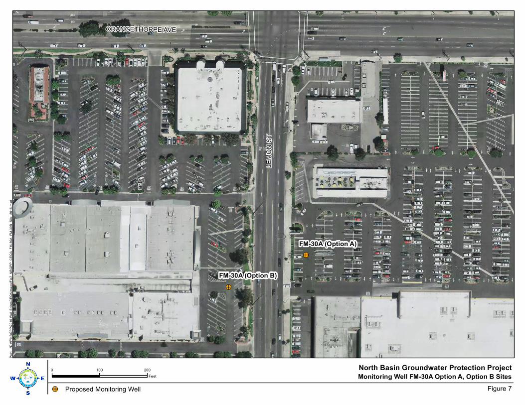
!>
FM-30A (Option A)
!>
FM-30A (Option B)L
EM
ON
ST
ORANGETHORPE AVE
Monitoring Well FM-30A Option A, Option B Sites0 100 200
Feet
North Basin Groundwater Protection Project
Figure 7
Pa
th:
I:\D
MF
\NB
GP
P\2
016
Well S
itin
g\C
EQ
A\m
aps\F
ig7
_N
BG
PP
_C
EQ
A_F
M-3
0A
_F
M-3
0B
_S
ite
_2
016
.mxd
!> Proposed Monitoring Well
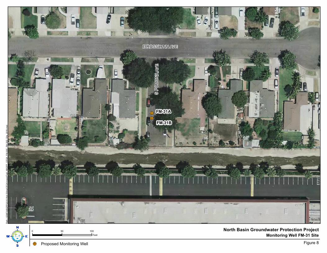
!>
FM-31A!>
FM-31B
FULLERTON
E ROSSLYNN AVE
S P
OM
ON
A A
VE
Monitoring Well FM-31 Site0 50 100
Feet
North Basin Groundwater Protection Project
Figure 8
Pa
th:
I:\D
MF
\NB
GP
P\2
016
Well S
itin
g\C
EQ
A\m
aps\F
ig8
_N
BG
PP
_C
EQ
A_F
M-3
0C
_F
M-3
0D
_S
ite_
20
16
.mxd
!> Proposed Monitoring Well

!>
FM-32A/B (Option A)
RANCHOFULLERTON
!>
FM-32A/B (Option B)
S B
AS
QU
E A
VE
Monitoring Well FM-32 A/B Option A, Option B0 50 100
Feet
North Basin Groundwater Protection Project
Figure 9
Pa
th:
I:\D
MF
\NB
GP
P\2
016
Well S
itin
g\C
EQ
A\m
aps\F
ig9
_N
BG
PP
_C
EQ
A_F
M-3
1_
Site
_2
01
6.m
xd
!> Proposed Monitoring Well
!> !>

Section 2
North Basin Groundwater Monitoring Well Project Draft Initial Study/Mitigated Negative Declaration 2-14
Option (a) would be located within an existing parking lot, located south of South Basque Avenue in the City of Fullerton. The well sites are located on USGS Anaheim Quadrangle, Township 3 South, Range 10 West and Section 33. The closest sensitive receptor would be residential mobile home park located 240 feet to the west. The construction period would be approximately three weeks and would require the temporary displacement 17 parking spaces.
Option (b) would be located approximately 15 feet south of the centerline of South Basque Avenue and 80 feet west of the centerline of South Basque Avenue in the City of Fullerton. The well site is located on USGS Anaheim Quadrangle, Township 3 South, Range 10 West and Section 33. The closest sensitive receptor would be residential mobile home park located 250 feet to the west.
2.3 Construction Activities
The proposed construction activities would occur in three construction phases. Phase 1 of the Proposed Project involves surveying the well site for possible underground utilities, the installation of a temporary six- foot high fence around the perimeter of the well site work area, and then drilling and construction of the monitoring wells. Phase 2 involves development of the monitoring wells. Phase 3 involves site clean-up and vault installation. All construction operations would occur between the hours of 8:00 a.m. and 5:00 p.m. Monday through Friday or as otyherwise specified in the City Encroachment Permits.
Phase 1: Monitor Well Drilling and Construction
Phase 1 of the Proposed Project involves the drilling and construction of the monitoring wells. The equipment mix for well drilling is shown in Table 1. The proposed monitoring wells would be drilled by the direct mud rotary drilling method. The monitoring wells would include 4-inch diameter PVC casing installed in a 10-inch diameter borehole to depths up to approximately 370 feet below ground surface (bgs). Once the well drilling is completed, the well would be constructed. The depth of the borehole, and e depth of the well and well screened interval would be based on lithology observed during drilling and geophysical logging of the borehole.
Table 1: Well Drilling/Construction Equipment Mix
Activity Equipment Pieces of Equipment
Hours of Operation
Days of Operation Horsepower
Well Drilling & Construction Equipment Well Drilling & Construction
Direct Mud Rotary Drilling Rig 1 9 35 550
Well Drilling & Construction Mud Tank 1 9 35 75
Well Drilling & Construction Forklift 1 2 35 75
Construction Trips, 1 trip mobilizing 1 trip demobilizing, 7 trips between sites. All tips assumed 50 miles.
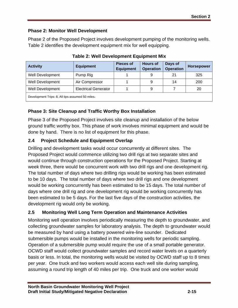
Section 2
North Basin Groundwater Monitoring Well Project Draft Initial Study/Mitigated Negative Declaration 2-15
Phase 2: Monitor Well Development
Phase 2 of the Proposed Project involves development pumping of the monitoring wells. Table 2 identifies the development equipment mix for well equipping.
Table 2: Well Development Equipment Mix
Activity Equipment Pieces of Equipment
Hours of Operation
Days of Operation
Horsepower
Well Development Pump Rig 1 9 21 325
Well Development Air Compressor 1 9 14 200
Well Development Electrical Generator 1 9 7 20
Development Trips: 8, All tips assumed 50 miles.
Phase 3: Site Cleanup and Traffic Worthy Box Instal lation
Phase 3 of the Proposed Project involves site cleanup and installation of the below ground traffic worthy box. This phase of work involves minimal equipment and would be done by hand. There is no list of equipment for this phase.
2.4 Project Schedule and Equipment Overlap
Drilling and development tasks would occur concurrently at different sites. The Proposed Project would commence utilizing two drill rigs at two separate sites and would continue through construction operations for the Proposed Project. Starting at week three, there would be concurrent work with two drill rigs and one development rig. The total number of days where two drilling rigs would be working has been estimated to be 10 days. The total number of days where two drill rigs and one development would be working concurrently has been estimated to be 15 days. The total number of days where one drill rig and one development rig would be working concurrently has been estimated to be 5 days. For the last five days of the construction activities, the development rig would only be working.
2.5 Monitoring Well Long Term Operation and Mainten ance Activities
Monitoring well operation involves periodically measuring the depth to groundwater, and collecting groundwater samples for laboratory analysis. The depth to groundwater would be measured by hand using a battery powered wire-line sounder. Dedicated submersible pumps would be installed in the monitoring wells for periodic sampling. Operation of a submersible pump would require the use of a small portable generator. OCWD staff would collect groundwater samples and record water levels on a quarterly basis or less. In total, the monitoring wells would be visited by OCWD staff up to 8 times per year. One truck and two workers would access each well site during sampling, assuming a round trip length of 40 miles per trip. One truck and one worker would
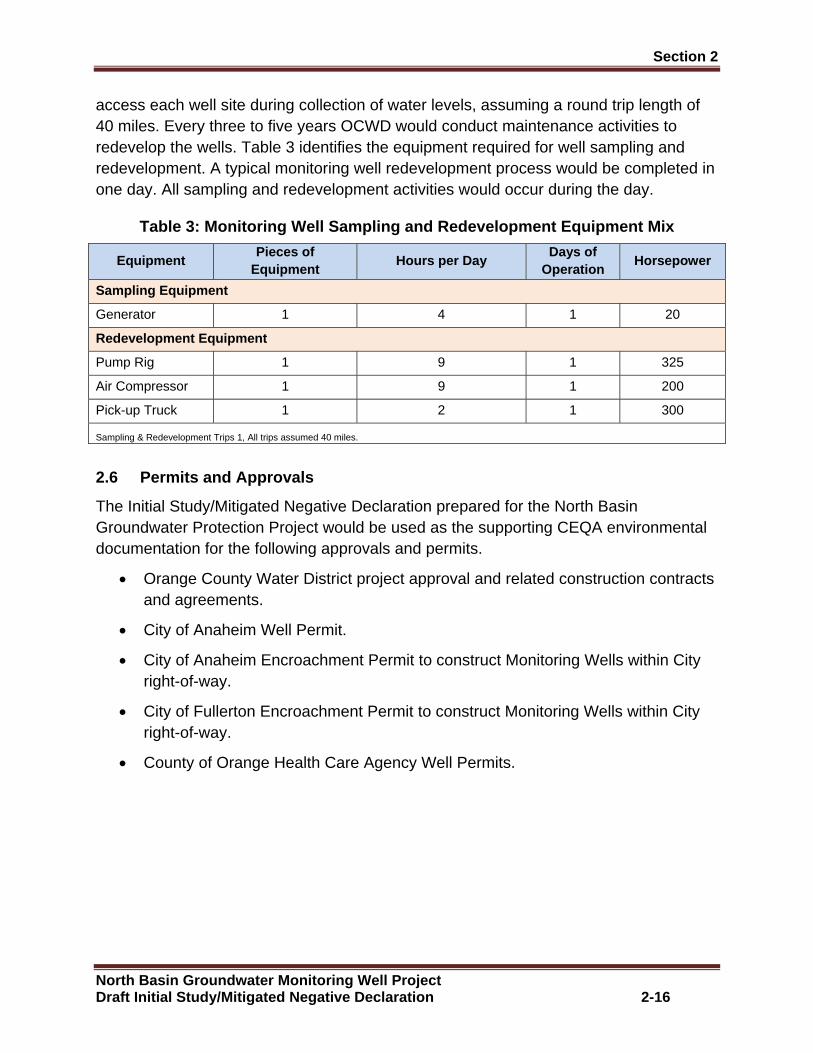
Section 2
North Basin Groundwater Monitoring Well Project Draft Initial Study/Mitigated Negative Declaration 2-16
access each well site during collection of water levels, assuming a round trip length of 40 miles. Every three to five years OCWD would conduct maintenance activities to redevelop the wells. Table 3 identifies the equipment required for well sampling and redevelopment. A typical monitoring well redevelopment process would be completed in one day. All sampling and redevelopment activities would occur during the day.
Table 3: Monitoring Well Sampling and Redevelopment Equipment Mix
Equipment Pieces of
Equipment Hours per Day
Days of Operation
Horsepower
Sampling Equipment
Generator 1 4 1 20
Redevelopment Equipment
Pump Rig 1 9 1 325
Air Compressor 1 9 1 200
Pick-up Truck 1 2 1 300
Sampling & Redevelopment Trips 1, All trips assumed 40 miles.
2.6 Permits and Approvals
The Initial Study/Mitigated Negative Declaration prepared for the North Basin Groundwater Protection Project would be used as the supporting CEQA environmental documentation for the following approvals and permits.
x Orange County Water District project approval and related construction contracts and agreements.
x City of Anaheim Well Permit.
x City of Anaheim Encroachment Permit to construct Monitoring Wells within City right-of-way.
x City of Fullerton Encroachment Permit to construct Monitoring Wells within City right-of-way.
x County of Orange Health Care Agency Well Permits.
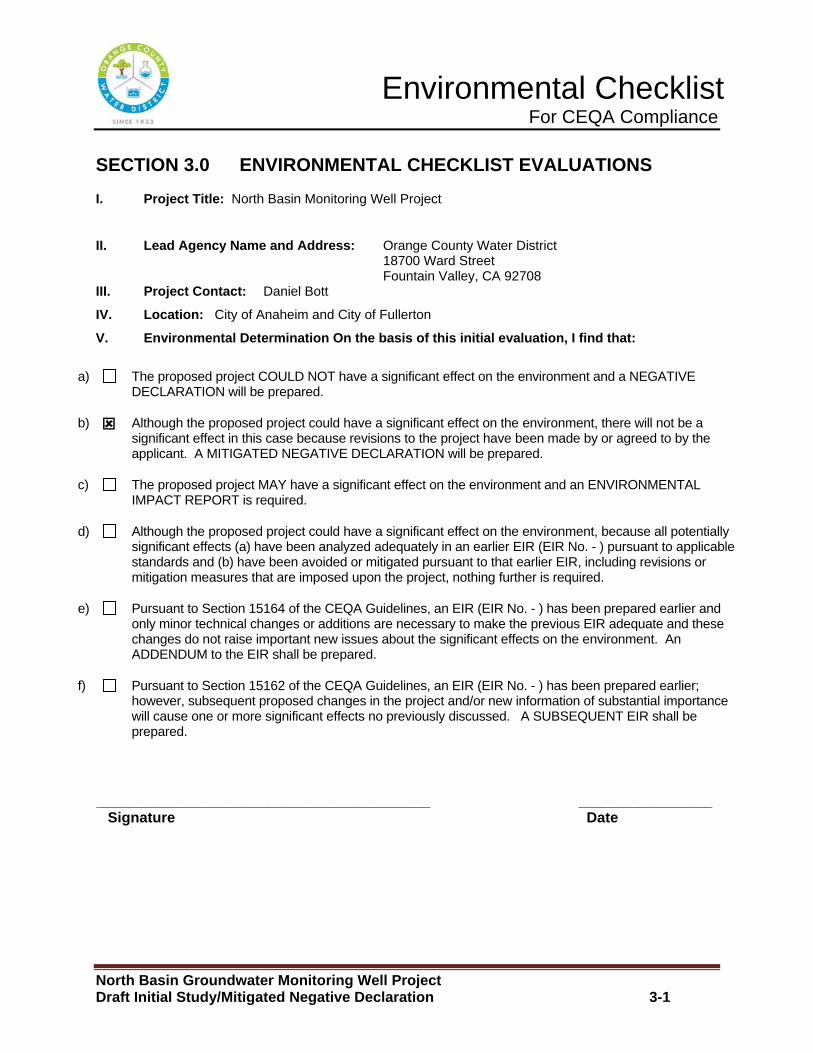
Environmental Checklist For CEQA Compliance
North Basin Groundwater Monitoring Well Project Draft Initial Study/Mitigated Negative Declaration 3-1
SECTION 3.0 ENVIRONMENTAL CHECKLIST EVALUATIONS
I. Project Title: North Basin Monitoring Well Project
II. Lead Agency Name and Address: Orange County Water District 18700 Ward Street Fountain Valley, CA 92708
III. Project Contact: Daniel Bott
IV. Location: City of Anaheim and City of Fullerton
V. Environmental Determination On the basis of this initial evaluation, I find that:
a) The proposed project COULD NOT have a significant effect on the environment and a NEGATIVE DECLARATION will be prepared.
b) :�Although the proposed project could have a significant effect on the environment, there will not be a significant effect in this case because revisions to the project have been made by or agreed to by the applicant. A MITIGATED NEGATIVE DECLARATION will be prepared.
c) The proposed project MAY have a significant effect on the environment and an ENVIRONMENTAL IMPACT REPORT is required.
d) Although the proposed project could have a significant effect on the environment, because all potentially significant effects (a) have been analyzed adequately in an earlier EIR (EIR No. - ) pursuant to applicable standards and (b) have been avoided or mitigated pursuant to that earlier EIR, including revisions or mitigation measures that are imposed upon the project, nothing further is required.
e) Pursuant to Section 15164 of the CEQA Guidelines, an EIR (EIR No. - ) has been prepared earlier and only minor technical changes or additions are necessary to make the previous EIR adequate and these changes do not raise important new issues about the significant effects on the environment. An ADDENDUM to the EIR shall be prepared.
f) Pursuant to Section 15162 of the CEQA Guidelines, an EIR (EIR No. - ) has been prepared earlier; however, subsequent proposed changes in the project and/or new information of substantial importance will cause one or more significant effects no previously discussed. A SUBSEQUENT EIR shall be prepared.
_____________________________________________ __________________ Signature Date
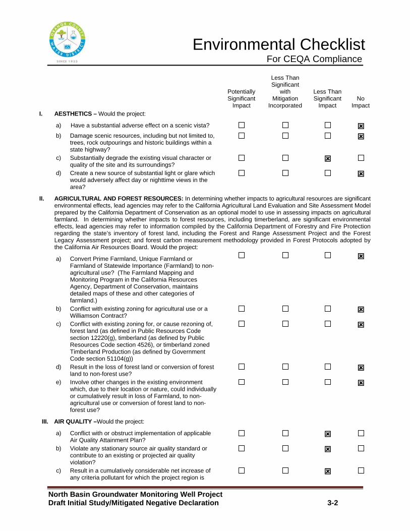
Environmental Checklist For CEQA Compliance
North Basin Groundwater Monitoring Well Project Draft Initial Study/Mitigated Negative Declaration 3-2
Potentially Significant
Impact
Less Than Significant
with Mitigation
Incorporated
Less Than Significant
Impact No
Impact I. AESTHETICS – Would the project:
a) Have a substantial adverse effect on a scenic vista? : b) Damage scenic resources, including but not limited to,
trees, rock outpourings and historic buildings within a state highway?
:
c) Substantially degrade the existing visual character or quality of the site and its surroundings?
:
d) Create a new source of substantial light or glare which would adversely affect day or nighttime views in the area?
:
II. AGRICULTURAL AND FOREST RESOURCES: In determining whether impacts to agricultural resources are significant environmental effects, lead agencies may refer to the California Agricultural Land Evaluation and Site Assessment Model prepared by the California Department of Conservation as an optional model to use in assessing impacts on agricultural farmland. In determining whether impacts to forest resources, including timerberland, are significant environmental effects, lead agencies may refer to information compiled by the California Department of Forestry and Fire Protection regarding the state’s inventory of forest land, including the Forest and Range Assessment Project and the Forest Legacy Assessment project; and forest carbon measurement methodology provided in Forest Protocols adopted by the California Air Resources Board. Would the project:
a) Convert Prime Farmland, Unique Farmland or Farmland of Statewide Importance (Farmland) to non-agricultural use? (The Farmland Mapping and Monitoring Program in the California Resources Agency, Department of Conservation, maintains detailed maps of these and other categories of farmland.)
:
b) Conflict with existing zoning for agricultural use or a Williamson Contract?
:
c) Conflict with existing zoning for, or cause rezoning of, forest land (as defined in Public Resources Code section 12220(g), timberland (as defined by Public Resources Code section 4526), or timberland zoned Timberland Production (as defined by Government Code section 51104(g))
:
d) Result in the loss of forest land or conversion of forest land to non-forest use?
:
e) Involve other changes in the existing environment which, due to their location or nature, could individually or cumulatively result in loss of Farmland, to non-agricultural use or conversion of forest land to non-forest use?
:
III. AIR QUALITY –Would the project:
a) Conflict with or obstruct implementation of applicable Air Quality Attainment Plan?
:
b) Violate any stationary source air quality standard or contribute to an existing or projected air quality violation?
:
c) Result in a cumulatively considerable net increase of any criteria pollutant for which the project region is
:

Environmental Checklist For CEQA Compliance
North Basin Groundwater Monitoring Well Project Draft Initial Study/Mitigated Negative Declaration 3-3
Potentially Significant
Impact
Less Than Significant
with Mitigation
Incorporated
Less Than Significant
Impact No
Impact non-attainment under an applicable federal or state ambient air quality standard (including releasing emissions which exceed quantitative thresholds for ozone precursors)?
d) Expose sensitive receptors to substantial pollutant concentrations?
:
e) Create objectionable odors affecting a substantial number of people?
:
IV. BIOLOGICAL RESOURCES – Would the project:
a) Have a substantial adverse impact, either directly or through habitat modifications, on any species identified as a candidate, sensitive or special status species in local or regional plans, policies or regulations or by the California Department of Fish and Game or U.S. Fish and Wildlife Services?
:
b) Have a substantial adverse impact on any riparian habitat or natural community identified in local or regional plans, policies, and regulations or by the California Department of fish and Game or U.S. Fish and Wildlife Service?
:
c) Adversely impact federally protected wetlands (including, but not limited to, marsh, vernal pool, coastal, etc.) either individually or in combination with the known or probable impacts of other activities through direct removal, filling hydrological interruption, or other means?
:
d) Interfere substantially with the movement of any native resident or migratory fish or wildlife species or with established native resident or migratory wildlife corridors, or impede the use of native wildlife nursery sites?
:
e) Conflict with any local policies or ordinances protecting biological resources, such as tree preservation policy or ordinance?
:
f) Conflict with the provisions of an adopted Habitat Conservation Plan, Natural Community Conservation Plan, or other approved local, regional, or state habitat conservation plan?
:
V. CULTURAL RESOURCES – Would the project:
a) Cause a substantial adverse change in the significance of a historical resource as defined in Section 15064.5?
:
b) Cause a substantial adverse change in the significance of a unique archaeological resource pursuant to define Section 15064.5?
:
c) Directly or indirectly disturb or destroy a unique paleontogical resource or site?
:
d) Disturb any human remains, including those interred outside of dedicated cemeteries?
:
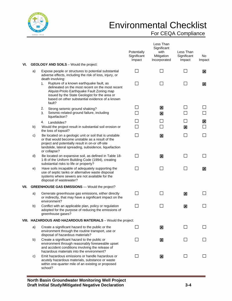
Environmental Checklist For CEQA Compliance
North Basin Groundwater Monitoring Well Project Draft Initial Study/Mitigated Negative Declaration 3-4
Potentially Significant
Impact
Less Than Significant
with Mitigation
Incorporated
Less Than Significant
Impact No
Impact VI. GEOLOGY AND SOILS – Would the project:
a) Expose people or structures to potential substantial adverse effects, including the risk of loss, injury, or death involving:
:
1. Rupture of a known earthquake fault, as delineated on the most recent on the most recent Alquist-Priolo Earthquake Fault Zoning map issued by the State Geologist for the area or based on other substantial evidence of a known fault?
:
2. Strong seismic ground shaking? :
3. Seismic-related ground failure, including liquefaction?
:
4. Landslides? : b) Would the project result in substantial soil erosion or
the loss of topsoil? :
c) Be located on a geologic unit or soil that is unstable or that would become unstable as a result of the project and potentially result in on-or off-site landslide, lateral spreading, subsidence, liquefaction or collapse?
:
d) Be located on expansive soil, as defined in Table 18-1-B of the Uniform Building Code (1994), creating substantial risks to life or property?
:
e) Have soils incapable of adequately supporting the use of septic tanks or alternative waste disposal systems where sewers are not available for the disposal of wastewater?
:
VII. GREENHOUSE GAS EMISSIONS — Would the project?
a) Generate greenhouse gas emissions, either directly or indirectly, that may have a significant impact on the environment?
:
b) Conflict with an applicable plan, policy or regulation adopted for the purpose of reducing the emissions of greenhouse gases?
:
VIII. HAZARDOUS AND HAZARDOUS MATERIALS – Would the project:
a) Create a significant hazard to the public or the environment through the routine transport, use or disposal of hazardous materials?
:
b) Create a significant hazard to the public or environment through reasonably foreseeable upset and accident conditions involving the release of hazardous materials into the environment?
:
c) Emit hazardous emissions or handle hazardous or acutely hazardous materials, substance or waste within one-quarter mile of an existing or proposed school?
:
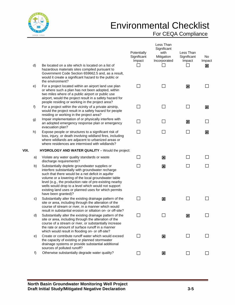
Environmental Checklist For CEQA Compliance
North Basin Groundwater Monitoring Well Project Draft Initial Study/Mitigated Negative Declaration 3-5
Potentially Significant
Impact
Less Than Significant
with Mitigation
Incorporated
Less Than Significant
Impact No
Impact d) Be located on a site which is located on a list of
hazardous materials sites compiled pursuant to Government Code Section 659662.5 and, as a result, would it create a significant hazard to the public or the environment?
:
e) For a project located within an airport land use plan or where such a plan has not been adopted, within two miles where of a public airport or public use airport, would the project result in a safety hazard for people residing or working in the project area?
:
f) For a project within the vicinity of a private airstrip, would the project result in a safety hazard for people residing or working in the project area?
:
g) Impair implementation of or physically interfere with an adopted emergency response plan or emergency evacuation plan?
:
h) Expose people or structures to a significant risk of loss, injury, or death involving wildland fires, including where wildlands are adjacent to urbanized areas or where residences are intermixed with wildlands?
:
VIX. HYDROLOGY AND WATER QUALITY – Would the project:
a) Violate any water quality standards or waste discharge requirements?
:
b) Substantially deplete groundwater supplies or interfere substantially with groundwater recharge such that there would be a net deficit in aquifer volume or a lowering of the local groundwater table level (e.g., the production rate of pre-existing nearby wells would drop to a level which would not support existing land uses or planned uses for which permits have been granted)?
:
c) Substantially alter the existing drainage pattern of the site or area, including through the alteration of the course of stream or river, in a manner which would result in substantial erosion or siltation on- or off-site?
:
d) Substantially alter the existing drainage pattern of the site or area, including through the alteration of the course of a stream or river, or substantially increase the rate or amount of surface runoff in a manner which would result in flooding on- or off-site?
:
e) Create or contribute runoff water which would exceed the capacity of existing or planned stormwater drainage systems or provide substantial additional sources of polluted runoff?
:
f) Otherwise substantially degrade water quality? :
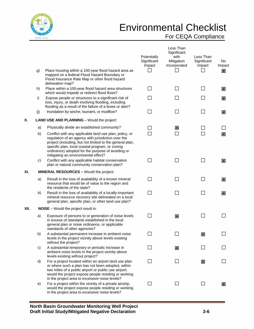
Environmental Checklist For CEQA Compliance
North Basin Groundwater Monitoring Well Project Draft Initial Study/Mitigated Negative Declaration 3-6
Potentially Significant
Impact
Less Than Significant
with Mitigation
Incorporated
Less Than Significant
Impact No
Impact g) Place housing within a 100-year flood hazard area as
mapped on a federal Flood Hazard Boundary or Flood Insurance Rate Map or other flood hazard delineation map?
:
h) Place within a 100-year flood hazard area structures which would impede or redirect flood flows?
:
i) Expose people or structures to a significant risk of loss, injury, or death involving flooding, including flooding as a result of the failure of a levee or dam?
:
(j) Inundation by seiche, tsunami, or mudflow? :
X. LAND USE AND PLANNING – Would the project:
a) Physically divide an established community? :
b) Conflict with any applicable land use plan, policy, or regulation of an agency with jurisdiction over the project (including, but not limited to the general plan, specific plan, local coastal program, or zoning ordinance) adopted for the purpose of avoiding or mitigating an environmental effect?
:
c) Conflict with any applicable habitat conservation plan or natural community conservation plan?
:
XI. MINERAL RESOURCES – Would the project:
a) Result in the loss of availability of a known mineral resource that would be of value to the region and the residents of the state?
:
b) Result in the loss of availability of a locally-important mineral resource recovery site delineated on a local general plan, specific plan, or other land use plan?
:
XII. NOISE – Would the project result in:
a) Exposure of persons to or generation of noise levels in excess of standards established in the local general plan or noise ordinance, or applicable standards of other agencies?
:
b) A substantial permanent increase in ambient noise levels in the project vicinity above levels existing without the project?
:
c) A substantial temporary or periodic increase in ambient noise levels in the project vicinity above levels existing without project?
:
d) For a project located within an airport land use plan or where such a plan has not been adopted, within two miles of a public airport or public use airport, would the project expose people residing or working in the project area to excessive noise levels?
:
e) For a project within the vicinity of a private airstrip, would the project expose people residing or working in the project area to excessive noise levels?
:

Environmental Checklist For CEQA Compliance
North Basin Groundwater Monitoring Well Project Draft Initial Study/Mitigated Negative Declaration 3-7
Potentially Significant
Impact
Less Than Significant
with Mitigation
Incorporated
Less Than Significant
Impact No
Impact f) Exposure of persons to or generation of excessive
groundborne vibration or groundborne noise levels? :
XIII. POPULATION AND HOUSING – Would the project:
a) Induce substantial population growth in an area, either directly (for example, by proposing new homes and business) or indirectly (for example, through extension of roads or other infrastructure)?
:
b) Displace substantial numbers of existing housing, necessitating the construction of replacement housing elsewhere?
:
c) Displace substantial numbers of people, necessitating the construction of replacement housing elsewhere?
:
XIV. PUBLIC SERVICES
a) Would the project result in substantial adverse physical impacts associated with the provision of new or physically altered governmental facilities, need for new or physically altered governmental facilities, the construction of which could cause significant environmental impacts, in order to maintain acceptable service rations, response times or other performance objectives for any of the public service:
:
Fire protection? Police protection? Schools? Parks? Other public facilities?
XV. RECREATION
a) Would the project increase the use of existing neighborhood and regional parks or other recreational facilities such that substantial physical deterioration of the facility would occur or be accelerated?
:
b) Does the project include recreational facilities or require the construction or expansion of recreational facilities which might have an adverse physical effect on the environment?
:
XVI. TRANSPORTATION/TRAFFIC Would the project:
a) Conflict with an applicable plan, ordinance or policy establishing measures of effectiveness for the performance of the circulation system, taking into account all modes of transportation including mass transit and non-motorized travel and relevant components of the circulation system, including but not limited to intersections, streets, highways and
:
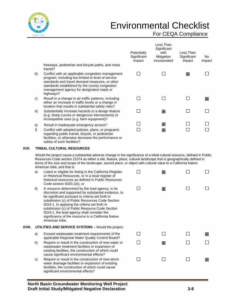
Environmental Checklist For CEQA Compliance
North Basin Groundwater Monitoring Well Project Draft Initial Study/Mitigated Negative Declaration 3-8
Potentially Significant
Impact
Less Than Significant
with Mitigation
Incorporated
Less Than Significant
Impact No
Impact freeways, pedestrian and bicycle paths, and mass transit?
b) Conflict with an applicable congestion management program, including but limited to level of service standards and travel demand measures, or other standards established by the county congestion management agency for designated roads or highways?
:
c) Result in a change in air traffic patterns, including either an increase in traffic levels or a change in location that results in substantial safety risks?
:
d) Substantially increase hazards to a design feature (e.g. sharp curves or dangerous intersections) or incompatible uses (e.g. farm equipment)?
:
e) Result in inadequate emergency access? :
f) Conflict with adopted policies, plans, or programs regarding public transit, bicycle, or pedestrian facilities, or otherwise decrease the performance or safety of such facilities?
:
XVII. TRIBAL CULTURAL RESOURCES
Would the project cause a substantial adverse change in the significance of a tribal cultural resource, defined in Public Resources Code section 21074 as either a site, feature, place, cultural landscape that is geographically defined in terms of the size and scope of the landscape, sacred place, or object with cultural value to a California Native American tribe, and that is:
a) Listed or eligible for listing in the California Register or Historical Resources, or in a local register of historical resources as defined in Public Resources Code section 5020.1(k), or
:
b) A resource determined by the lead agency, in its discretion and supported by substantial evidence, to be significant pursuant to criteria set forth in subdivision (c) of Public Resources Code Section 5024.1. In applying the criteria set forth in subdivision (c) of Public Resource Code Section 5024.1, the lead agency shall consider the significance of the resource to a California Native American tribe.
:
XVIII. UTILITIES AND SERVICE SYSTEMS – Would the project:
a) Exceed wastewater treatment requirements of the applicable Regional Water Quality Control Board?
:
b) Require or result in the construction of new water or wastewater treatment facilities or expansion of existing facilities, the construction of which could cause significant environmental effects?
:
c) Require or result in the construction of new storm water drainage facilities or expansion of existing facilities, the construction of which could cause significant environmental effects?
:
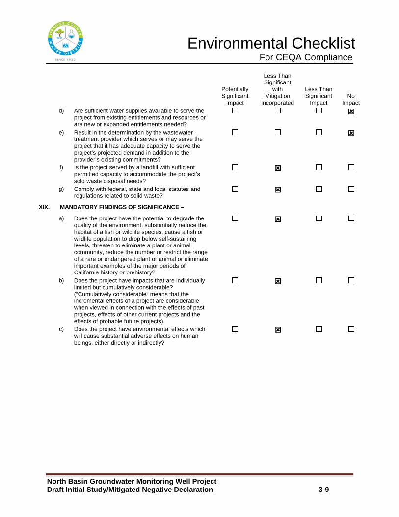
Environmental Checklist For CEQA Compliance
North Basin Groundwater Monitoring Well Project Draft Initial Study/Mitigated Negative Declaration 3-9
Potentially Significant
Impact
Less Than Significant
with Mitigation
Incorporated
Less Than Significant
Impact No
Impact d) Are sufficient water supplies available to serve the
project from existing entitlements and resources or are new or expanded entitlements needed?
:
e) Result in the determination by the wastewater treatment provider which serves or may serve the project that it has adequate capacity to serve the project’s projected demand in addition to the provider’s existing commitments?
:
f) Is the project served by a landfill with sufficient permitted capacity to accommodate the project’s sold waste disposal needs?
:
g) Comply with federal, state and local statutes and regulations related to solid waste?
:
XIX. MANDATORY FINDINGS OF SIGNIFICANCE –
a) Does the project have the potential to degrade the quality of the environment, substantially reduce the habitat of a fish or wildlife species, cause a fish or wildlife population to drop below self-sustaining levels, threaten to eliminate a plant or animal community, reduce the number or restrict the range of a rare or endangered plant or animal or eliminate important examples of the major periods of California history or prehistory?
:
b) Does the project have impacts that are individually limited but cumulatively considerable? (“Cumulatively considerable” means that the incremental effects of a project are considerable when viewed in connection with the effects of past projects, effects of other current projects and the effects of probable future projects).
:
c) Does the project have environmental effects which will cause substantial adverse effects on human beings, either directly or indirectly?
:
Section 4 �
North Basin Groundwater Monitoring Well Project Draft Initial Study/Mitigated Negative Declaration 4-1
SECTION 4.0 ENVIRONMENTAL ANALYSIS
The following environmental analysis responds to the environmental issues listed on the OCWD CEQA Checklist Form. The analysis identifies the level of anticipated impact that would occur at each well site and where needed includes the incorporation of mitigation measures to reduce potentially significant impacts to the environment to a less than significant level. In cases where all well sites share common constraints or lack of common constraints, all of the well sites have been evaluated together. In cases where issues are specific to a particular well site, the well site has been evaluated separately.
4.1 Aesthetics
A. Would the project have a substantial adverse eff ect on a scenic vista?
City of Anaheim
Monitoring Wells AM-54 A, B, C
City of Fullerton
Monitoring Well FM-7B, Monitoring Well FM-22B, Moni toring Well FM-24B, Monitoring Well FM-29A, B, C, Monitoring Well FM-30 A (Options a and b), Monitoring Wells FM-31 A, B, and Monitoring Wells F M-32 A, B (Options a and b)
No Impact: The proposed monitoring well sites are located within urbanized areas and are surrounded by developed land uses. There are no scenic resources near the locations where the proposed monitoring wells would be constructed. Additionally, the City Anaheim General Plan and the City of Fullerton General Plan both do not identify any scenic vistas near the proposed monitoring well sites. The construction and operation of the Proposed Project would not adversely impact existing vistas. No mitigation measures are required.
B. Would the project damage scenic resources, inclu ding but limited to, trees, rock outpourings, and historic buildings within a S tate Highway?
City of Anaheim
Monitoring Wells AM-54 A, B, C
City of Fullerton
Monitoring Well FM-7B, Monitoring Well FM-22B, Moni toring Well FM-24B, Monitoring Well FM-29A, B, C, Monitoring Well FM-30 A (Options a and b), Monitoring Wells FM-31 A, B, and Monitoring Wells F M-32 A, B (Options a and b)
Section 4 �
North Basin Groundwater Monitoring Well Project Draft Initial Study/Mitigated Negative Declaration 4-2
No Impact : According to the California Department of Transportation Scenic Highways Program, the closest designated and/or eligible State Scenic Highway to the study area would be the segment of State Route 91 located east of State Route 55. This segment of State Route 91 is a little over 5 miles from the closest well site. At this distance the closest well site would not be within the view shed of motorist, which would also imply that the remainder of the proposed monitoring wells would also not be within the view shed of motorist. Therefore, construction and operation of the Proposed Project would not have any adverse impact on existing scenic resources located along a State Scenic Highway. No mitigation measures are required.
C. Would the project substantially degrade the exis ting visual character or quality of the site and its surrounding?
City of Anaheim
Monitoring Wells AM-54 A, B, C
City of Fullerton
Monitoring Well FM-7B, Monitoring Well FM-22B, Moni toring Well FM-24B, Monitoring Well FM-29A, B, C, Monitoring Well FM-30 A (Options a and b), Monitoring Wells FM-31 A, B, and Monitoring Wells F M-32 A, B (Options a and b)
Less than Significant Impact: The City of Anaheim General Plan and the City of Fullerton General Plan both do not identify any specific design guidelines at any of the proposed monitoring well site locations. The proposed monitoring wells would be located in areas that are developed with residential, commercial and industrial land uses. The proposed monitoring wells would be located underground and under existing roadways and parking areas and would not have a visual presence that would be in conflict with the study area existing aesthetic character. During construction, the visual character of the study area would be temporary altered with construction activity. The construction activity at each well site would be approximately 1 week and once construction operations are completed the well sites would be returned to their pre-project condition. Because of the short period of construction activity occurring at each well site, the potential short term construction impacts to the visual character of the study area would be less than significant. No mitigation measures are required.
D. Would the project create a new source of substantial light or glare which would adversely affect day or nighttime views in the area .
City of Anaheim
Monitoring Wells AM-54 A, B, C
City of Fullerton
Section 4 �
North Basin Groundwater Monitoring Well Project Draft Initial Study/Mitigated Negative Declaration 4-3
Monitoring Well FM-7B, Monitoring Well FM-22B, Moni toring Well FM-24B, Monitoring Well FM-29A, B, C, Monitoring Well FM-30 A (Options a and b), Monitoring Wells FM-31 A, B, and Monitoring Wells F M-32 A, B (Options a and b)
No Impact: The proposed monitoring wells would be located underground and would not require any permanent on-site lighting. The construction operations and other uses for the monitoring wells would only occur during the day. Therefore, no temporary night lighting would be required. No long term operational or short term construction related adverse light and glare impacts would occur. No mitigation measures are required.
4.2 Agricultural Resources/Forest Resources
A. Would the project convert Prime Farmland, Unique Farmland or Farmland of Statewide Importance to non-agriculture uses?
City of Anaheim
Monitoring Wells AM-54 A, B, C
City of Fullerton
Monitoring Well FM-7B, Monitoring Well FM-22B, Moni toring Well FM-24B, Monitoring Well FM-29A, B, C, Monitoring Well FM-30 A (Options a and b), Monitoring Wells FM-31 A, B, and Monitoring Wells F M-32 A, B (Options a and b)
No Impact: The State of California Farmland Mapping and Monitoring Program, indicates that there is no Prime Farmland, Unique Farmland or Farmland of Statewide Importance on any of the proposed monitoring well sites. Therefore, the construction and operation of the Proposed Project would not result in adverse impacts to Prime Farmland, Unique Farmland or Farmland of Statewide Importance. No mitigation measures are required.
B. Would the project be in conflict with existing z oning for agriculture use or a Williamson Contract?
City of Anaheim
Monitoring Wells AM-54 A, B, C
City of Fullerton
Monitoring Well FM-7B, Monitoring Well FM-22B, Moni toring Well FM-24B, Monitoring Well FM-29A, B, C, Monitoring Well FM-30 A (Options a and b), Monitoring Wells FM-31 A, B, and Monitoring Wells F M-32 A, B (Options a and b)
No Impact: The City of Anaheim Zoning Map and the City of Fullerton Zoning Map both show that none of the proposed monitoring well sites are zoned for agriculture land uses. Therefore, the construction and operation of the Proposed Project would not be in conflict with any existing agriculture zoning or existing agriculture leases or contracts on the property. No mitigation measures are required.
Section 4 �
North Basin Groundwater Monitoring Well Project Draft Initial Study/Mitigated Negative Declaration 4-4
C. Would the project be in conflict with existing z oning for, or cause rezoning of forest land or timberland.
City of Anaheim
Monitoring Wells AM-54 A, B, C
City of Fullerton
Monitoring Well FM-7B, Monitoring Well FM-22B, Moni toring Well FM-24B, Monitoring Well FM-29A, B, C, Monitoring Well FM-30 A (Options a and b), Monitoring Wells FM-31 A, B, and Monitoring Wells F M-32 A, B (Options a and b)
No Impact: The City of Anaheim and City of Fullerton Zoning Map both show that none of the proposed monitoring well sites are zoned for forest or timberland. The implementation of the Proposed Project would not cause change of zone to existing forest or timberlands. No mitigation measures are required.
D. Would the project result in the loss of forest l and or conversion of forest land to non-forest use?
City of Anaheim
Monitoring Wells AM-54 A, B, C
City of Fullerton
Monitoring Well FM-7B, Monitoring Well FM-22B, Moni toring Well FM-24B, Monitoring Well FM-29A, B, C, Monitoring Well FM-30 A (Options a and b), Monitoring Wells FM-31 A, B, and Monitoring Wells F M-32 A, B (Options a and b)
No Impact: There is not existing farmland on any of the proposed monitoring well sites. Therefore, the construction and operation of the Proposed Project would not convert forest land to non-forest land. No mitigation measures are required.
E. Would the project involve other changes in the e xisting environment which, due to their location or nature, could result in co nversion of Farmland to non-agriculture use or conversion of forest land to non-forest use?
City of Anaheim
Monitoring Wells AM-54 A, B, C
City of Fullerton
Monitoring Well FM-7B, Monitoring Well FM-22B, Moni toring Well FM-24B, Monitoring Well FM-29A, B, C, Monitoring Well FM-30 A (Options a and b), Monitoring Wells FM-31 A, B, and Monitoring Wells F M-32 A, B (Options a and b)

Section 4 �
North Basin Groundwater Monitoring Well Project Draft Initial Study/Mitigated Negative Declaration 4-5
No Impact: Currently there is not existing farmland on any of the proposed monitoring well sites. Therefore, the construction and operation of the Proposed Project would not directly or indirectly result in the loss of any forest land or result in the conversion forest lands to non-forest lands. No mitigation measures are required.
4.3 Air Quality
The following analysis is based on an Air Quality and Greenhouse Gas Analysis Report prepared by Vista Environmental in December 2016. The Air Quality and Greenhouse Gas Analysis Report are presented in its entirety in Appendix A.
Setting
The study area is located in the South Coast Air Basin (SoCAB). The SoCAB includes Orange County in its entirety and the non-desert portions of Los Angeles, San Bernardino, and Riverside Counties.
Regulatory Framework
Air pollutants are regulated at the national, state and air basin level. Each agency has a different level of regulatory responsibility. The United States Environmental Protection Agency (EPA) regulates at the national level. The California Air Resources Board (ARB) regulates at the state level and the South Coast Air Quality Management District (SCAQMD) regulates at the air basin level.
Federal Regulation
The EPA handles global, international, national and interstate air pollution issues and policies. The EPA sets national vehicle and stationary source emission standards, oversees approval of all State Implementation Plans, conducts research, and provides guidance in air pollution programs and sets National Ambient Air Quality Standards (NAAQS), also known as federal standards. There are six common air pollutants, called criteria air pollutants, which were identified resulting from provisions of the Clean Air Act of 1970. The six criteria pollutants are Ozone, Particulate Matter (PM10 and PM 2.5), Nitrogen Dioxide, Carbon Monoxide, Lead and Sulfur Dioxide. The NAAQS were set to protect public health, including that of sensitive individuals.
State Regulation
A State Implementation Plan (SIP) is a document prepared by each state describing air quality conditions and measures that would be followed to attain and maintain NAAQS. The SIP for the State of California is administered by the ARB, which has overall responsibility for statewide air quality maintenance and air pollution prevention. The ARB also administers California Ambient Air Quality Standards (CAAQS), for the ten air pollutants designated in the California Clean Air Act (CCAA). The ten state air pollutants include the six national criteria pollutants and visibility reducing particulates, hydrogen sulfide, sulfates and vinyl chloride.
Section 4 �
North Basin Groundwater Monitoring Well Project Draft Initial Study/Mitigated Negative Declaration 4-6
South Coast Air Quality Management District
SCAQMD develops rules and regulations, establishes permitting requirements for stationary sources, inspects emission sources, and enforces such measures through educational programs or fines, when necessary.
SCAQMD is directly responsible for reducing emissions from stationary, mobile, and indirect sources. It has responded to this requirement by preparing a sequence of Air Quality Management Plans (AQMPs). The 2007 AQMP demonstrated attainment with the 1997 8-hour ozone (80 ppb) standard by 2023, through implementation of future improvements in control techniques and technologies. These “black box” emissions reductions represent 65 percent of the remaining NOx emission reductions by 2023 in order to show attainment with the 1997 8-hour ozone NAAQS. Given the magnitude of these needed emissions reductions, additional NOx control measures have been provided in this AQMP even though the primary purpose of this AQMP is to show compliance with 24-hour PM2.5 emissions standards.
The Final 2012 Air Quality Management Plan (2012 AQMP) was adopted by the SCAQMD Board on December 7, 2012 and was adopted by CARB via Resolution 13-3 on January 25, 2013. The 2012 AQMP was prepared in order to meet the federal Clean Air Act requirement that all 24-hour PM2.5 non-attainment areas prepare a SIP, that were required to be submitted to the U.S. EPA by December 14, 2012 and demonstrate attainment with the 24-hour PM2.5 standard by 2014. The 2012 AQMP demonstrates attainment of the federal 24-hour PM2.5 standard by 2014 in the Air Basin through adoption of all feasible measures, and therefore, no extension of the attainment date is needed.
The 2012 AQMP is designed to satisfy the California Clean Air Act’s (CCAA) emission reductions of five percent per year or adoption of all feasible measures requirements and fulfill the EPA’s requirement to update transportation conformity emissions budgets based on the latest approved motor vehicle emissions model and planning assumptions. The 2012 AQMP updates and revises the previous 2007 AQMP. The 2012 AQMP was prepared to comply with the Federal and State CCAA and amendments, to accommodate growth, to reduce the high pollutant levels in the Air Basin, to meet Federal and State ambient air quality standards, and to minimize the fiscal impact that pollution control measures have on the local economy. The purpose of the 2012 AQMP for the Air Basin is to set forth a comprehensive program that would lead this area into compliance with all federal and state air-quality planning requirements.
The 2012 AQMP builds upon the approaches taken in the 2007 AQMP for the attainment of federal PM and ozone standards, and highlights the significant amount of reductions needed and the need to engage in interagency coordinated planning of mobile sources to meet all of the federal criteria pollutant standards. Compared with the

Section 4 �
North Basin Groundwater Monitoring Well Project Draft Initial Study/Mitigated Negative Declaration 4-7
2007 AQMP, the 2012 AQMP utilizes revised emissions inventory projections that use 2008 as the base year. On-road emissions are calculated using CARB EMFAC2011 emission factors and the transportation activity data provided by SCAG from their 2012 Regional Transportation Plan (2012 RTP). Off-road emissions were updated using CARB’s 2011 In-Use Off-Road Fleet Inventory Model. Since the 2007 AQMP was finalized new area source categories such as LPG transmission losses, storage tank and pipeline cleaning and degassing, and architectural colorants, were created and included in the emissions inventories. Composting waste was revised and now includes the emissions from green waste composting covered under SCAQMD Rule 1133.3. The 2012 AQMP also includes analysis of several additional sources of GHG emissions such as landfills and could also assist in reaching the GHG target goals in the AB32 Scoping Plan.
The control measures in the 2012 AQMP consist of three components: 1) Basin-wide and episodic short-term PM2.5 measures; 2) Section 182(e)(5) implementation measures; and 3) Transportation control measures. Many of the control measures are not based on command and control regulations, but instead focus on incentives, outreach, and education to bring about emissions reductions through voluntary participation and behavioral changes. More broadly, a transition to zero- and near-zero emission technologies is necessary to meet 2023 and 2032 air quality standards and 2050 climate goals. Many of the same technologies will address both air quality and climate needs.
In June 2016, the SCAQMD released a draft of its forthcoming 2016 Air Quality Management Plan. The plan will develop integrated strategies and measures to meet the following standards:
x 8-hour Ozone (75 ppb) by 2032 x Annual PM2.5 (12 µg/m3) by 2021-2025 x 8-hour Ozone (80 ppb) by 2024 (updated from the 2007 and 2012 AQMPs) x 1-hour Ozone (120 ppb) by 2023 (updated from the 2012 AQMP) x 24-hour PM2.5 (35 µg/m3) by 2019 (updated from the 2012 AQMP)
Although SCAQMD is responsible for regional air quality planning efforts, it does not have the authority to directly regulate air quality issues associated with plans and new development projects throughout the Air Basin. Instead, this is controlled through local jurisdictions in accordance to the California Environmental Quality Act (CEQA). In order to assist local jurisdictions with air quality compliance issues the CEQA Air Quality Handbook (SCAQMD CEQA Handbook), prepared by SCAQMD, 1993, with the most current updates found at http://www.aqmd.gov/ceqa/hdbk.html, was developed in accordance with the projections and programs detailed in the AQMPs. The purpose of the SCAQMD CEQA Handbook is to assist Lead Agencies, as well as consultants, project proponents, and other interested parties in evaluating a proposed project’s

Section 4 �
North Basin Groundwater Monitoring Well Project Draft Initial Study/Mitigated Negative Declaration 4-8
potential air quality impacts. Specifically, the SCAQMD CEQA Handbook explains the procedures that SCAQMD recommends be followed for the environmental review process required by CEQA. The SCAQMD CEQA Handbook provides direction on how to evaluate potential air quality impacts, how to determine whether these impacts are significant, and how to mitigate these impacts. The SCAQMD intends that by providing this guidance, the air quality impacts of plans and development proposals will be analyzed accurately and consistently throughout the Air Basin, and adverse impacts would be minimized.
Local – Cities of Anaheim and Fullerton
Local jurisdictions, such as the Cities of Anaheim and Fullerton, have the authority and responsibility to reduce air pollution through its police power and decision-making authority. Specifically, the Cities are responsible for the assessment and mitigation of air emissions resulting from its land use decisions. The Cities are also responsible for the implementation of transportation control measures as outlined in the 2007 AQMP and 2012 AQMP. In accordance with the CEQA requirements, the Cities do not, however, have the expertise to develop plans, programs, procedures, and methodologies to ensure that air quality within the Cities and region would meet federal and state standards. Instead, the Cities rely on the expertise of the SCAQMD and utilize the SCAQMD CEQA Handbook as the guidance document for the environmental review of plans and development proposals within its jurisdiction.
Project Impacts
While the final determination of whether a project is significant is within the purview of the Lead Agency pursuant to Section 15064(b) of the CEQA Guidelines, SCAQMD recommends that its quantitative air pollution thresholds be used to determine the significance of project emissions. If the Lead Agency finds that the project has the potential to exceed these air pollution thresholds, the project should be considered to have significant air quality impacts.
A. Would the project be in conflict with or obstruct implementation of the applicable air quality plan or congestion management plan?
City of Anaheim
Monitoring Wells AM-54 A, B, C
City of Fullerton
Monitoring Well FM-7B, Monitoring Well FM-22B, Moni toring Well FM-24B, Monitoring Well FM-29A, B, C, Monitoring Well FM-30 A (Options a and b), Monitoring Wells FM-31 A, B, and Monitoring Wells F M-32 A, B (Options a and b)
Section 4 �
North Basin Groundwater Monitoring Well Project Draft Initial Study/Mitigated Negative Declaration 4-9
Less than Significant Impact: The California Environmental Quality Act (CEQA) requires a discussion of any inconsistencies between a proposed project and applicable General Plans and regional plans (CEQA Guidelines Section 15125). The regional plan that applies to the Proposed Project would be the SCAQMD AQMP. Therefore, this section discusses any potential inconsistencies of the Proposed Project with the AQMP.
The purpose of this discussion is to set forth the issues regarding consistency with the assumptions and objectives of the AQMP and discuss whether the Proposed Project would interfere with the region’s ability to comply with Federal and State air quality standards. If the decision-makers determine that the Proposed Project is inconsistent, the lead agency may consider project modifications or inclusion of mitigation to eliminate the inconsistency.
The SCAQMD CEQA Handbook states that "New or amended General Plan Elements (including land use zoning and density amendments), Specific Plans, and regionally significant projects must be analyzed for consistency with the AQMP." Strict consistency with all aspects of the plan is usually not required. A proposed project should be considered to be consistent with the AQMP if it furthers one or more policies and does not obstruct other policies. The SCAQMD CEQA Handbook identifies two key indicators of consistency:
(1) Whether the project would result in an increase in the frequency or severity of existing air quality violations or cause or contribute to new violations, or delay timely attainment of air quality standards or the interim emission reductions specified in the AQMP.
(2) Whether the project would exceed the assumptions in the AQMP or increments based on the year of project buildout and phase.
Both of these criteria are evaluated in the following sections.
Criterion 1 - Increase in the Frequency or Severity of Violations?
As shown in Table 4 and Table 5, based on the air quality modeling analysis contained in this report, short-term regional construction air emissions would not result in significant impacts based on SCAQMD regional thresholds of significance or local thresholds of significance. As shown in Table 6 and Table 7 the ongoing operation of the Proposed Project would generate air pollutant emissions that are inconsequential on a regional basis and local basis and would not exceed SCAQMD thresholds of significance. Therefore, no long-term impact would occur and no mitigation would be required. Therefore, based on the information provided above, the Proposed Project would be consistent with the first criterion.
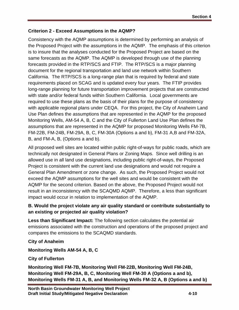
Section 4 �
North Basin Groundwater Monitoring Well Project Draft Initial Study/Mitigated Negative Declaration 4-10
Criterion 2 - Exceed Assumptions in the AQMP?
Consistency with the AQMP assumptions is determined by performing an analysis of the Proposed Project with the assumptions in the AQMP. The emphasis of this criterion is to insure that the analyses conducted for the Proposed Project are based on the same forecasts as the AQMP. The AQMP is developed through use of the planning forecasts provided in the RTP/SCS and FTIP. The RTP/SCS is a major planning document for the regional transportation and land use network within Southern California. The RTP/SCS is a long-range plan that is required by federal and state requirements placed on SCAG and is updated every four years. The FTIP provides long-range planning for future transportation improvement projects that are constructed with state and/or federal funds within Southern California. Local governments are required to use these plans as the basis of their plans for the purpose of consistency with applicable regional plans under CEQA. For this project, the City of Anaheim Land Use Plan defines the assumptions that are represented in the AQMP for the proposed Monitoring Wells, AM-54 A, B, C and the City of Fullerton Land Use Plan defines the assumptions that are represented in the AQMP for proposed Monitoring Wells FM-7B, FM-22B, FM-24B, FM-29A, B, C, FM-30A (Options a and b), FM-31 A,B and FM-32A, B, and FM-A, B, (Options a and b).
All proposed well sites are located within public right-of-ways for public roads, which are technically not designated in General Plans or Zoning Maps. Since well drilling is an allowed use in all land use designations, including public right-of-ways, the Proposed Project is consistent with the current land use designations and would not require a General Plan Amendment or zone change. As such, the Proposed Project would not exceed the AQMP assumptions for the well sites and would be consistent with the AQMP for the second criterion. Based on the above, the Proposed Project would not result in an inconsistency with the SCAQMD AQMP. Therefore, a less than significant impact would occur in relation to implementation of the AQMP.
B. Would the project violate any air quality standa rd or contribute substantially to an existing or projected air quality violation?
Less than Significant Impact: The following section calculates the potential air emissions associated with the construction and operations of the proposed project and compares the emissions to the SCAQMD standards.
City of Anaheim
Monitoring Wells AM-54 A, B, C
City of Fullerton
Monitoring Well FM-7B, Monitoring Well FM-22B, Moni toring Well FM-24B, Monitoring Well FM-29A, B, C, Monitoring Well FM-30 A (Options a and b), Monitoring Wells FM-31 A, B, and Monitoring Wells F M-32 A, B (Options a and b)
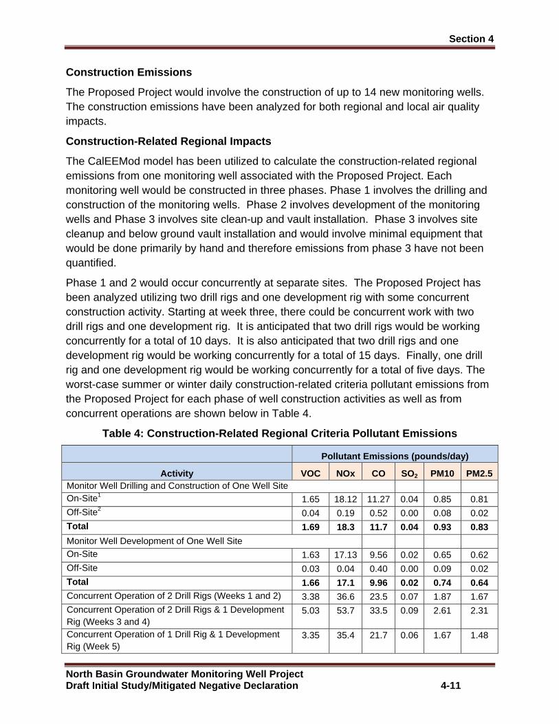
Section 4 �
North Basin Groundwater Monitoring Well Project Draft Initial Study/Mitigated Negative Declaration 4-11
Construction Emissions
The Proposed Project would involve the construction of up to 14 new monitoring wells. The construction emissions have been analyzed for both regional and local air quality impacts.
Construction-Related Regional Impacts
The CalEEMod model has been utilized to calculate the construction-related regional emissions from one monitoring well associated with the Proposed Project. Each monitoring well would be constructed in three phases. Phase 1 involves the drilling and construction of the monitoring wells. Phase 2 involves development of the monitoring wells and Phase 3 involves site clean-up and vault installation. Phase 3 involves site cleanup and below ground vault installation and would involve minimal equipment that would be done primarily by hand and therefore emissions from phase 3 have not been quantified.
Phase 1 and 2 would occur concurrently at separate sites. The Proposed Project has been analyzed utilizing two drill rigs and one development rig with some concurrent construction activity. Starting at week three, there could be concurrent work with two drill rigs and one development rig. It is anticipated that two drill rigs would be working concurrently for a total of 10 days. It is also anticipated that two drill rigs and one development rig would be working concurrently for a total of 15 days. Finally, one drill rig and one development rig would be working concurrently for a total of five days. The worst-case summer or winter daily construction-related criteria pollutant emissions from the Proposed Project for each phase of well construction activities as well as from concurrent operations are shown below in Table 4.
Table 4: Construction-Related Regional Criteria Pol lutant Emissions
Pollutant Emissions (pounds/day)
Activity VOC NOx CO SO2 PM10 PM2.5 Monitor Well Drilling and Construction of One Well Site On-Site1 1.65 18.12 11.27 0.04 0.85 0.81 Off-Site2 0.04 0.19 0.52 0.00 0.08 0.02 Total 1.69 18.3 11.7 0.04 0.93 0.83
Monitor Well Development of One Well Site On-Site 1.63 17.13 9.56 0.02 0.65 0.62 Off-Site 0.03 0.04 0.40 0.00 0.09 0.02 Total 1.66 17.1 9.96 0.02 0.74 0.64 Concurrent Operation of 2 Drill Rigs (Weeks 1 and 2) 3.38 36.6 23.5 0.07 1.87 1.67 Concurrent Operation of 2 Drill Rigs & 1 Development Rig (Weeks 3 and 4)
5.03 53.7 33.5 0.09 2.61 2.31
Concurrent Operation of 1 Drill Rig & 1 Development Rig (Week 5)
3.35 35.4 21.7 0.06 1.67 1.48
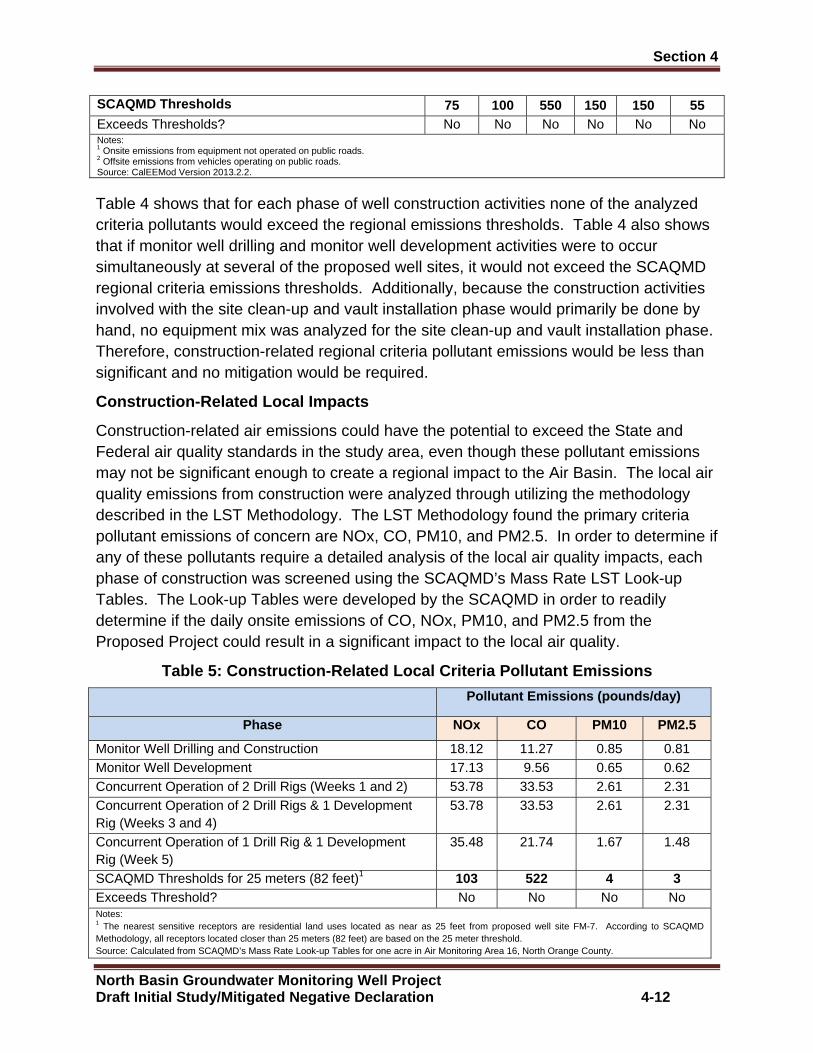
Section 4 �
North Basin Groundwater Monitoring Well Project Draft Initial Study/Mitigated Negative Declaration 4-12
SCAQMD Thresholds 75 100 550 150 150 55 Exceeds Thresholds? No No No No No No Notes: 1 Onsite emissions from equipment not operated on public roads. 2 Offsite emissions from vehicles operating on public roads. Source: CalEEMod Version 2013.2.2.
Table 4 shows that for each phase of well construction activities none of the analyzed criteria pollutants would exceed the regional emissions thresholds. Table 4 also shows that if monitor well drilling and monitor well development activities were to occur simultaneously at several of the proposed well sites, it would not exceed the SCAQMD regional criteria emissions thresholds. Additionally, because the construction activities involved with the site clean-up and vault installation phase would primarily be done by hand, no equipment mix was analyzed for the site clean-up and vault installation phase. Therefore, construction-related regional criteria pollutant emissions would be less than significant and no mitigation would be required.
Construction-Related Local Impacts
Construction-related air emissions could have the potential to exceed the State and Federal air quality standards in the study area, even though these pollutant emissions may not be significant enough to create a regional impact to the Air Basin. The local air quality emissions from construction were analyzed through utilizing the methodology described in the LST Methodology. The LST Methodology found the primary criteria pollutant emissions of concern are NOx, CO, PM10, and PM2.5. In order to determine if any of these pollutants require a detailed analysis of the local air quality impacts, each phase of construction was screened using the SCAQMD’s Mass Rate LST Look-up Tables. The Look-up Tables were developed by the SCAQMD in order to readily determine if the daily onsite emissions of CO, NOx, PM10, and PM2.5 from the Proposed Project could result in a significant impact to the local air quality.
Table 5: Construction-Related Local Criteria Pollut ant Emissions
Pollutant Emissions (pounds/day)
Phase NOx CO PM10 PM2.5
Monitor Well Drilling and Construction 18.12 11.27 0.85 0.81 Monitor Well Development 17.13 9.56 0.65 0.62 Concurrent Operation of 2 Drill Rigs (Weeks 1 and 2) 53.78 33.53 2.61 2.31 Concurrent Operation of 2 Drill Rigs & 1 Development Rig (Weeks 3 and 4)
53.78 33.53 2.61 2.31
Concurrent Operation of 1 Drill Rig & 1 Development Rig (Week 5)
35.48 21.74 1.67 1.48
SCAQMD Thresholds for 25 meters (82 feet)1 103 522 4 3 Exceeds Threshold? No No No No Notes: 1 The nearest sensitive receptors are residential land uses located as near as 25 feet from proposed well site FM-7. According to SCAQMD Methodology, all receptors located closer than 25 meters (82 feet) are based on the 25 meter threshold. Source: Calculated from SCAQMD’s Mass Rate Look-up Tables for one acre in Air Monitoring Area 16, North Orange County.
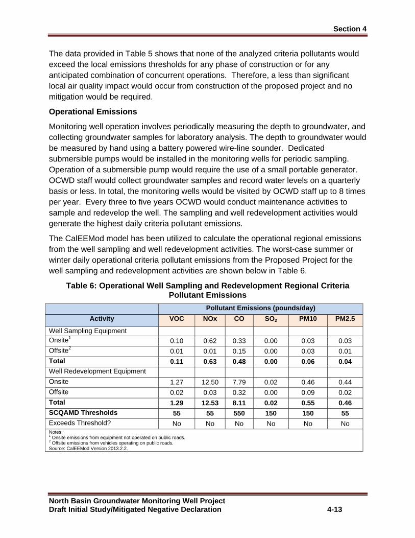
Section 4 �
North Basin Groundwater Monitoring Well Project Draft Initial Study/Mitigated Negative Declaration 4-13
The data provided in Table 5 shows that none of the analyzed criteria pollutants would exceed the local emissions thresholds for any phase of construction or for any anticipated combination of concurrent operations. Therefore, a less than significant local air quality impact would occur from construction of the proposed project and no mitigation would be required.
Operational Emissions
Monitoring well operation involves periodically measuring the depth to groundwater, and collecting groundwater samples for laboratory analysis. The depth to groundwater would be measured by hand using a battery powered wire-line sounder. Dedicated submersible pumps would be installed in the monitoring wells for periodic sampling. Operation of a submersible pump would require the use of a small portable generator. OCWD staff would collect groundwater samples and record water levels on a quarterly basis or less. In total, the monitoring wells would be visited by OCWD staff up to 8 times per year. Every three to five years OCWD would conduct maintenance activities to sample and redevelop the well. The sampling and well redevelopment activities would generate the highest daily criteria pollutant emissions.
The CalEEMod model has been utilized to calculate the operational regional emissions from the well sampling and well redevelopment activities. The worst-case summer or winter daily operational criteria pollutant emissions from the Proposed Project for the well sampling and redevelopment activities are shown below in Table 6.
Table 6: Operational Well Sampling and Redevelopment Regional Criteria Pollutant Emissions
Pollutant Emissions (pounds/day)
Activity VOC NOx CO SO2 PM10 PM2.5
Well Sampling Equipment Onsite1
0.10 0.62 0.33 0.00 0.03 0.03 Offsite2
0.01 0.01 0.15 0.00 0.03 0.01 Total 0.11 0.63 0.48 0.00 0.06 0.04 Well Redevelopment Equipment Onsite
1.27 12.50 7.79 0.02 0.46 0.44 Offsite
0.02 0.03 0.32 0.00 0.09 0.02 Total 1.29 12.53 8.11 0.02 0.55 0.46 SCQAMD Thresholds 55 55 550 150 150 55 Exceeds Threshold? No No No No No No Notes: 1 Onsite emissions from equipment not operated on public roads. 2 Offsite emissions from vehicles operating on public roads. Source: CalEEMod Version 2013.2.2.

Section 4 �
North Basin Groundwater Monitoring Well Project Draft Initial Study/Mitigated Negative Declaration 4-14
The data provided in Table 6 shows that none of the analyzed criteria pollutants would exceed the regional emissions thresholds. Therefore, a less than significant regional air quality impact would occur from operation of the Proposed Project and no mitigation is required.
Operations-Related Local Air Quality Impacts
Operational air emissions could have the potential to exceed the State and Federal air quality standards in the study area vicinity, even though these pollutant emissions may not be significant enough to create a regional impact to the Air Basin. The local air quality emissions from well sampling and redevelopment were analyzed through utilizing the methodology described in the LST Methodology. In order to determine if any of these pollutants require a detailed analysis of the local air quality impacts, the operational well sampling and redevelopment activities were screened using the SCAQMD’s Mass Rate LST Look-up Tables. Table 7 shows the onsite emissions from the CalEEMod model for the operational well sampling and redevelopment activities.
Table 7: Operational Well Sampling and Redevelopmen t Local Criteria Pollutant Emissions
Pollutant Emissions (pounds/day)
Operational Activities NOx CO PM10 PM2.5
Well Sampling 0.62 0.33 0.03 0.03 Well Redevelopment 12.50 7.79 0.46 0.44 SCAQMD Thresholds for 25 meters (82 feet)1
103 522 1 1 Exceeds Threshold? No No No No Notes: 1 The nearest sensitive receptors are residential land uses located as near as 25 feet from proposed well sites FM-7. According to SCAQMD Methodology, all receptors located closer than 25 meters (82 feet) are based on the 25 meter threshold.
The data provided in Table 7 shows that the on-going operations of the Proposed Project would not exceed the local NOx, CO, PM10 and PM2.5 thresholds of significance. Therefore, the on-going operations of the Proposed Project would create a less than significant operations-related impact to local air quality due to onsite emissions. No mitigation would be required.
C. Would the project result in cumulatively considerable net increase of any criteria pollutant for which the project region is non-attainment under an applicable federal or state ambient air quality standard?
City of Anaheim
Monitoring Wells AM-54 A, B, C
City of Fullerton
Monitoring Well FM-7B, Monitoring Well FM-22B, Moni toring Well FM-24B, Monitoring Well FM-29A, B, C, Monitoring Well FM-30 A (Options a and b), Monitoring Wells FM-31 A, B, and Monitoring Wells F M-32 A, B (Options a and b)
Section 4 �
North Basin Groundwater Monitoring Well Project Draft Initial Study/Mitigated Negative Declaration 4-15
Less than Significant Impact: The Proposed Project would not result in a cumulatively considerable net increase of any criteria pollutant for which the study area is non-attainment under an applicable Federal or State ambient air quality standard (including releasing emissions which exceed quantitative thresholds for ozone precursors).
Cumulative projects include local development as well as general growth within the study area. However, as with most development, the greatest source of emissions would be from mobile sources, which travel throughout the local area. Therefore, from an air quality standpoint, the cumulative analysis would extend beyond any local projects and when wind patterns are considered would cover an even larger area. Accordingly, the cumulative analysis for the project’s air quality must be generic by nature. The study area is out of attainment for ozone and PM10 and PM2.5 particulate matter. In accordance with CEQA Guidelines Section 15130(b), this analysis of cumulative impacts incorporates a three-tiered approach to assess cumulative air quality impacts.
x Consistency with the SCAQMD project specific thresholds for construction and operations;
x Project consistency with existing air quality plans; and
x Assessment of the cumulative health effects of the pollutants.
Construction-Related Impacts
The project site is located in the South Coast Air Basin, which is currently designated by the EPA as a non-attainment area for ozone and PM2.5 and designated by CARB as a non-attainment area for ozone, PM10, and PM2.5. The regional ozone, PM10, and PM2.5 emissions associated with the proposed project have been calculated and are shown in Table 4. The analysis showed that development of the Proposed Project would result in less than significant regional emissions of the precursors to ozone, PM10, and PM2.5 during construction of the Proposed Project. Therefore, a less than significant cumulative impact would occur from construction of the Proposed Project.
Operational-Related Impacts
Monitoring well operation involves periodically measuring the depth to groundwater, and collecting groundwater samples for laboratory analysis. The depth to groundwater would be measured by hand using a battery powered wire-line sounder. Dedicated submersible pumps would be installed in the monitoring wells for periodic sampling.
Operation of a submersible pump would require the use of a small portable generator. OCWD staff would collect groundwater samples and record water levels on a quarterly basis or less. In total, the monitoring wells would be visited by OCWD staff up to 8 times per year. Every three to five years OCWD would conduct maintenance activities to
Section 4 �
North Basin Groundwater Monitoring Well Project Draft Initial Study/Mitigated Negative Declaration 4-16
sample and redevelop the well. The sampling and well redevelopment activities would generate the highest daily criteria pollutant emissions.
The regional ozone, PM10 and PM2.5 emissions associated with the well sampling and redevelopment activities have been calculated and are shown in Table 6. The analysis shows that development of the Proposed Project would result in less than significant regional emissions of the precursors to ozone, PM10, and PM2.5 during operational well sampling and redevelopment activities for the Proposed Project. Therefore, a less than significant cumulative impact would occur from operation of the Proposed Project.
Consistency with Air Quality Plans
All of the proposed well sites are located within public right of ways for public roads, which are technically not designated in General Plans or Zoning Maps. Since well drilling is an allowed use in all land use designations, the Proposed Project is consistent with the current land use designations and would not require a General Plan Amendment or zone change. As such, the Proposed Project is not anticipated to exceed the AQMP assumptions for the project sites and is found to be consistent with the AQMPs for the Air Basin.
Cumulative Health Impacts
The Air Basin is designated as nonattainment for ozone, PM10, and PM2.5, which means that the background levels of those pollutants are at times higher than the ambient air quality standards. The air quality standards were set to protect public health, including the health of sensitive individuals (elderly, children, and the sick). Therefore, when the concentration of those pollutants exceeds the standard, it is likely that some sensitive individuals in the population would experience health effects. The regional analysis in Table 4 shows that the Proposed Project would not exceed the SCAQMD regional significance thresholds for VOC and NOx (ozone precursors), PM10 and PM2.5. As such, the Proposed Project would result in a less than significant cumulative health impact.
D. Would the project expose sensitive receptors to substantial pollutant concentrations?
City of Anaheim
Monitoring Wells AM-54 A, B, C
City of Fullerton
Monitoring Well FM-7B, Monitoring Well FM-22B, Moni toring Well FM-24B, Monitoring Well FM-29A, B, C, Monitoring Well FM-30 A (Options a and b), Monitoring Wells FM-31 A, B, and Monitoring Wells F M-32 A, B (Options a and b)
Section 4 �
North Basin Groundwater Monitoring Well Project Draft Initial Study/Mitigated Negative Declaration 4-17
Less than Significant Impact: The Proposed Project would not expose sensitive receptors to substantial pollutant concentrations. The local concentrations of criteria pollutant emissions produced in the nearby vicinity of the proposed well sites, which may expose sensitive receptors to substantial concentrations have been calculated for both construction and operations, which are discussed separately below. The discussion below also includes an analysis of the potential impacts from toxic air contaminant emissions.
Construction-Related Sensitive Receptor Impacts
The nearest sensitive receptors to the proposed well site sites occur at well site FM-7B where residential land uses are located as close as 25 feet from the proposed well site. The analysis in Table 5 shows that none of the analyzed criteria pollutants would exceed the local emissions thresholds for any phase of construction.
The greatest potential for toxic air contaminant emissions would be related to diesel particulate emissions associated with heavy equipment operations during construction of the Proposed Project. According to SCAQMD methodology, health effects from carcinogenic air toxics are usually described in terms of “individual cancer risk”. “Individual Cancer Risk” is the likelihood that a person exposed to concentrations of toxic air contaminants over a 70-year lifetime will contract cancer, based on the use of standard risk-assessment methodology. Given the relatively limited number of heavy-duty construction equipment and the short-term construction schedule, the proposed project would not result in a long-term (i.e., 70 years) substantial source of toxic air contaminant emissions and corresponding individual cancer risk. Therefore, no significant short-term toxic air contaminant impacts would occur during construction of the Proposed Project. As such, construction of the Proposed Project would result in a less than significant exposure of sensitive receptors to substantial pollutant concentrations.
Operations-Related Sensitive Receptor Impacts
Monitoring well operation involves periodically measuring the depth to groundwater, and collecting groundwater samples for laboratory analysis. The depth to groundwater would be measured by hand using a battery powered wire-line sounder. Dedicated submersible pumps would be installed in the monitoring wells for periodic sampling. Operation of a submersible pump would require the use of a small portable generator. OCWD staff would collect groundwater samples and record water levels on a quarterly basis or less. In total, the monitoring wells would be visited by OCWD staff up to 8 times per year. Every three to five years OCWD would conduct maintenance activities to sample and redevelop the well. The sampling and well redevelopment activities would generate the highest daily criteria pollutant emissions. The analysis in Table 7 shows that none of the analyzed criteria pollutants would exceed the local emissions thresholds for the operational well sampling and redevelopment activities.

Section 4 �
North Basin Groundwater Monitoring Well Project Draft Initial Study/Mitigated Negative Declaration 4-18
Also, as detailed above for construction, the greatest potential for toxic air contaminant emissions would only occur during the well sampling and redevelopment activities that are limited to approximately one week every three to five years. Given, the infrequent activity schedule, the Proposed Project would not result in a long-term (i.e., 70 years) substantial source of toxic air contaminant emissions and corresponding individual cancer risk. Therefore, no significant short-term toxic air contaminant impacts would occur during operation of the Proposed Project. As such, operation of the Proposed Project would result in a less than significant exposure of sensitive receptors to substantial pollutant concentrations. Therefore, operation of the Proposed Project would result in a less than significant exposure of sensitive receptors to substantial pollutant concentrations.
E. Would the project create objectionable odors aff ecting a substantial number of people?
City of Anaheim
Monitoring Wells AM-54 A, B, C
City of Fullerton
Monitoring Well FM-7B, Monitoring Well FM-22B, Moni toring Well FM-24B, Monitoring Well FM-29A, B, C, Monitoring Well FM-30 A (Options a and b), Monitoring Wells FM-31 A, B, and Monitoring Wells F M-32 A, B (Options a and b)
Less than Significant Impact: The Proposed Project would not create objectionable odors affecting a substantial number of people. Potential odor impacts have been analyzed separately for construction and operation activities.
Individual responses to odors are highly variable and can result in a variety of effects. Generally, the impact of an odor results from a variety of factors such as frequency, duration, offensiveness, location, and sensory perception. The frequency is a measure of how often an individual is exposed to an odor in the ambient environment. The intensity refers to an individual’s or group’s perception of the odor strength or concentration. The duration of an odor refers to the elapsed time over which an odor is experienced. The offensiveness of the odor is the subjective rating of the pleasantness or unpleasantness of an odor. The location accounts for the type of area in which a potentially affected person lives, works, or visits; the type of activity in which he or she is engaged; and the sensitivity of the impacted receptor.
Sensory perception has four major components: detectability, intensity, character, and hedonic tone. The detection (or threshold) of an odor is based on a panel of responses to the odor. There are two types of thresholds: the odor detection threshold and the recognition threshold. The detection threshold is the lowest concentration of an odor that will elicit a response in a percentage of the people that live and work in the immediate vicinity of the project site and is typically presented as the mean (or 50

Section 4 �
North Basin Groundwater Monitoring Well Project Draft Initial Study/Mitigated Negative Declaration 4-19
percent of the population). The recognition threshold is the minimum concentration that is recognized as having a characteristic odor quality this is typically represented by recognition by 50 percent of the population. The intensity refers to the perceived strength of the odor. The odor character is what the substance smells like. The hedonic tone is a judgment of the pleasantness or unpleasantness of the odor. The hedonic tone varies in subjective experience, frequency, odor character, odor intensity, and duration.
Construction-Related Odor Impacts
Potential sources that may emit odors during well construction activities include the extraction of drilling mud and from emissions from diesel equipment. The objectionable odors that may be produced during the construction process would be temporary and would not likely be noticeable for extended periods of time beyond the project site’s boundaries. Due to the transitory nature of construction odors, a less than significant odor impact would occur and no mitigation would be required.
Potential Operations-Related Odor Impacts
Monitoring well operation involves periodically measuring the depth to groundwater, and collecting groundwater samples for laboratory analysis. The depth to groundwater would be measured by hand using a battery powered wire-line sounder. Dedicated submersible pumps would be installed in the monitoring wells for periodic sampling. Operation of a submersible pump would require the use of a small portable generator. OCWD staff would collect groundwater samples and record water levels on a quarterly basis or less. In total, the monitoring wells would be visited by OCWD staff up to 8 times per year. Every three to five years OCWD would conduct maintenance activities to sample and redevelop the well.
Potential sources that could emit odors during well sampling and redevelopment activities would include the extraction of materials from the wells and from emissions from diesel equipment. The objectionable odors that could be produced during the well sampling and redevelopment activities would be temporary and would not likely be noticeable for extended periods of time beyond the well site boundaries. Due to the transitory nature of these odors, a less than significant odor impact would occur and no mitigation would be required.
4.4 Biological Resources
A. Would the project have a substantial adverse imp act, either directly or through habitat modifications, on any species identified as a candidate, sensitive or special status species in local or regional plans, policies or regulations or by the California Department of Fish and Game or U.S. Fish and wildlife Services?
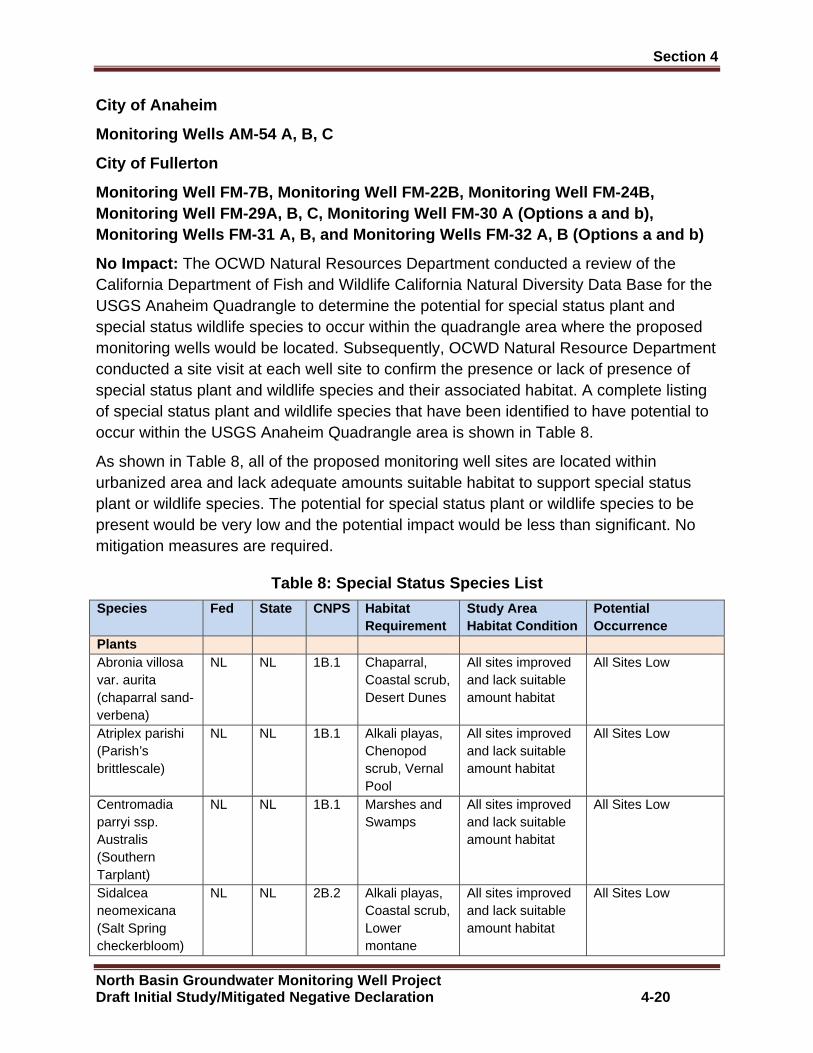
Section 4 �
North Basin Groundwater Monitoring Well Project Draft Initial Study/Mitigated Negative Declaration 4-20
City of Anaheim
Monitoring Wells AM-54 A, B, C
City of Fullerton
Monitoring Well FM-7B, Monitoring Well FM-22B, Moni toring Well FM-24B, Monitoring Well FM-29A, B, C, Monitoring Well FM-30 A (Options a and b), Monitoring Wells FM-31 A, B, and Monitoring Wells F M-32 A, B (Options a and b)
No Impact: The OCWD Natural Resources Department conducted a review of the California Department of Fish and Wildlife California Natural Diversity Data Base for the USGS Anaheim Quadrangle to determine the potential for special status plant and special status wildlife species to occur within the quadrangle area where the proposed monitoring wells would be located. Subsequently, OCWD Natural Resource Department conducted a site visit at each well site to confirm the presence or lack of presence of special status plant and wildlife species and their associated habitat. A complete listing of special status plant and wildlife species that have been identified to have potential to occur within the USGS Anaheim Quadrangle area is shown in Table 8.
As shown in Table 8, all of the proposed monitoring well sites are located within urbanized area and lack adequate amounts suitable habitat to support special status plant or wildlife species. The potential for special status plant or wildlife species to be present would be very low and the potential impact would be less than significant. No mitigation measures are required.
Table 8: Special Status Species List
Species Fed State CNPS Habitat Requirement
Study Area Habitat Condition
Potential Occurrence
Plants Abronia villosa var. aurita (chaparral sand-verbena)
NL NL 1B.1 Chaparral, Coastal scrub, Desert Dunes
All sites improved and lack suitable amount habitat
All Sites Low
Atriplex parishi (Parish’s brittlescale)
NL NL 1B.1 Alkali playas, Chenopod scrub, Vernal Pool
All sites improved and lack suitable amount habitat
All Sites Low
Centromadia parryi ssp. Australis (Southern Tarplant)
NL NL 1B.1 Marshes and Swamps
All sites improved and lack suitable amount habitat
All Sites Low
Sidalcea neomexicana (Salt Spring checkerbloom)
NL NL 2B.2 Alkali playas, Coastal scrub, Lower montane
All sites improved and lack suitable amount habitat
All Sites Low
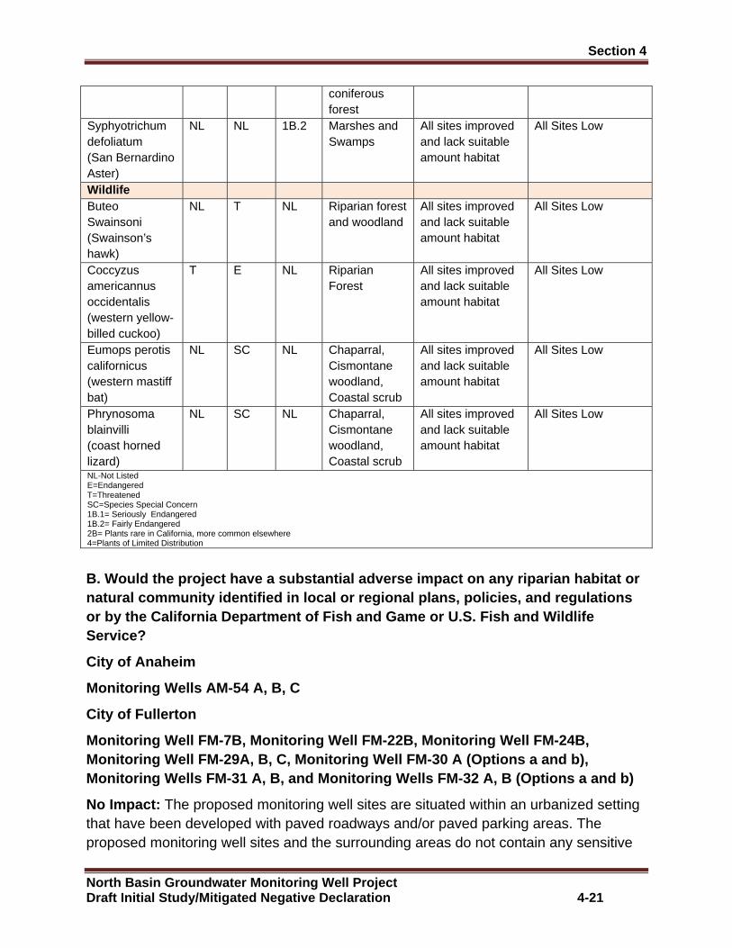
Section 4 �
North Basin Groundwater Monitoring Well Project Draft Initial Study/Mitigated Negative Declaration 4-21
coniferous forest
Syphyotrichum defoliatum (San Bernardino Aster)
NL NL 1B.2 Marshes and Swamps
All sites improved and lack suitable amount habitat
All Sites Low
Wildlife Buteo Swainsoni (Swainson’s hawk)
NL T NL Riparian forest and woodland
All sites improved and lack suitable amount habitat
All Sites Low
Coccyzus americannus occidentalis (western yellow-billed cuckoo)
T E NL Riparian Forest
All sites improved and lack suitable amount habitat
All Sites Low
Eumops perotis californicus (western mastiff bat)
NL SC NL Chaparral, Cismontane woodland, Coastal scrub
All sites improved and lack suitable amount habitat
All Sites Low
Phrynosoma blainvilli (coast horned lizard)
NL SC NL Chaparral, Cismontane woodland, Coastal scrub
All sites improved and lack suitable amount habitat
All Sites Low
NL-Not Listed E=Endangered T=Threatened SC=Species Special Concern 1B.1= Seriously Endangered 1B.2= Fairly Endangered 2B= Plants rare in California, more common elsewhere 4=Plants of Limited Distribution
B. Would the project have a substantial adverse imp act on any riparian habitat or natural community identified in local or regional p lans, policies, and regulations or by the California Department of Fish and Game or U.S. Fish and Wildlife Service?
City of Anaheim
Monitoring Wells AM-54 A, B, C
City of Fullerton
Monitoring Well FM-7B, Monitoring Well FM-22B, Moni toring Well FM-24B, Monitoring Well FM-29A, B, C, Monitoring Well FM-30 A (Options a and b), Monitoring Wells FM-31 A, B, and Monitoring Wells F M-32 A, B (Options a and b)
No Impact: The proposed monitoring well sites are situated within an urbanized setting that have been developed with paved roadways and/or paved parking areas. The proposed monitoring well sites and the surrounding areas do not contain any sensitive
Section 4 �
North Basin Groundwater Monitoring Well Project Draft Initial Study/Mitigated Negative Declaration 4-22
vegetation communities that would be regulated by the California Department Fish and Wildlife, or United States Fish and Wildlife Service. The construction and operation of the Proposed Project would not result in adverse impacts to any sensitive vegetation communities. No mitigation measures are required.
C. Would the project have a substantially adverse e ffect on federally protected wetlands as defined by Section 404 of the Clean Wat er Act through direct removal, filling hydrological interruption, or other means?
City of Anaheim
Monitoring Wells AM-54 A, B, C
City of Fullerton
Monitoring Well FM-7B, Monitoring Well FM-22B, Moni toring Well FM-24B, Monitoring Well FM-29A, B, C, Monitoring Well FM-30 A (Options a and b), Monitoring Wells FM-31 A, B, and Monitoring Wells F M-32 A, B (Options a and b)
No Impact: A preliminary wetland assessment was conducted at the proposed monitoring well site locations in accordance with Regional Supplement to the U.S. Army Corps of Engineers (Corps) Wetland Delineation Manual Arid Region West. Based on the Corp’s Wetland Delineation Manual a three parameter approach was used to identify potential Wetland Waters of the U.S. and State. These parameters include the presence of wetland vegetation, presence of hydrology and the presence of hydric soils. The preliminary wetland assessment showed that all of the proposed monitoring well sites lacked the required parameters that define Wetland Waters of the United States and State. Based on the absence of wetlands, the construction and operation of the Proposed Project would not result in adverse impacts to Wetland Waters of the U.S./State. No mitigation measures are required.
D. Would the project interfere substantially with t he movement of any native resident or migratory fish or wildlife species or with established native resident or migratory wildlife corridors, or impede the use of native wildlife nursery sites?
City of Anaheim
Monitoring Wells AM-54 A, B, C
City of Fullerton
Monitoring Well FM-7B, Monitoring Well FM-24B, Moni toring Well FM-29A, B, C, Monitoring Well FM-30 A (Options a and b), Monitori ng Wells FM-31 A, B, and Monitoring Wells FM-32 A, B (Options a and b)
Less than Significant Impact: The proposed monitoring well sites are situated within an urbanized environment. There are no open space linkages or corridors that provide for wildlife movement. Several of the monitoring well sites are near ornamental trees.
Section 4 �
North Basin Groundwater Monitoring Well Project Draft Initial Study/Mitigated Negative Declaration 4-23
OCWD Biologist conducted a biological survey to determine the potential for migratory birds to occur within the study area. Based on the highly urbanized environment and the lack of suitable habitat there would low potential for migratory birds to occur. The construction and operation of the Proposed Project would not interfere with the movement of any native resident or migratory fish, birds or other wildlife species. No mitigation measures required.
Monitoring Well Site FM-22B
Less than Significant Impact with Mitigation: The proposed well site is located on paved parking lot at Woodcrest Park. The park site is situated in an urbanized area and provides no open apace linkages or corridors that provide wildlife movement. The construction and operation of the Proposed Project would not interfere with the movement of any wildlife species.
The park site is landscaped with ornamental grasses and trees. There are a few trees in close proximity to the proposed well site that could provide nesting opportunities for migratory birds. The construction activities for the Proposed Project would not involve the removal of any trees. Therefore, potential direct impacts to nesting migratory birds would be avoided. If nesting migratory birds are present when well construction activities are occurring, there would be the potential that indirect construction noise impacts could cause nesting birds to flush, disrupting their breeding patterns. To avoid potential impacts to nesting migratory birds, a biologist would survey the trees to identify if nesting birds are present and if the well construction noise impacts would disrupt their nesting patterns. If the biologist determines that the well construction noise impacts could adversely impact nesting birds, well construction activities would not be allowed to proceed until nesting birds are no longer present. With the implementation of Mitigation Measure BIO-1 potential impacts to nesting migratory birds would be less than significant.
Mitigation Measure
BIO-1: If well drilling and well construction activities are proposed at Monitoring Well Site FM-22B during the nesting season, OCWD biologist will survey the study area to determine if nesting birds are present. The survey will occur no more than 3 days prior to the start of construction activities. If nesting birds are present and the biologist determines that the construction noise could adversely impact nesting birds, construction activity at the well will not proceed until nesting birds are no longer present.
E. Would the project conflict with any local policies or ordinances protecting biological resources, such as a tree preservation p olicy or ordinance?
City of Anaheim
Monitoring Wells AM-54 A, B, C

Section 4 �
North Basin Groundwater Monitoring Well Project Draft Initial Study/Mitigated Negative Declaration 4-24
City of Fullerton
Monitoring Well FM-7B, Monitoring Well FM-22B, Moni toring Well FM-24B, Monitoring Well FM-29A, B, C, Monitoring Well FM-30 A (Options a and b), Monitoring Wells FM-31 A, B, and Monitoring Wells F M-32 A, B (Options a and b)
No Impact. The implementation of the Proposed Project would not remove any vegetation or trees that would be locally protected by the City of Anaheim or City of Fullerton. No conflicts with local policies that provide for the protection of biological resources would occur. No mitigation measures are required.
F. Would the project be in conflict with the provisions of an adopted Ha bitat Conservation Plan, Natural Community Conservation P lan, or other approved local, regional, or state habitat conservation plan ?
City of Anaheim
Monitoring Wells AM-54 A, B, C
City of Fullerton
Monitoring Well FM-7B, Monitoring Well FM-22B, Moni toring Well FM-24B, Monitoring Well FM-29A, B, C, Monitoring Well FM-30 A (Options a and b), Monitoring Wells FM-31 A, B, and Monitoring Wells F M-32 A, B (Options a and b)
No Impact. None of the proposed well sites are included within an adopted Habitat Management Plan or Natural Community Conservation Plan. No mitigation measures are required.
4.5 Cultural Resources
Introduction
Cultural resources include prehistoric archaeological sites, historic archaeological sites, historic structures, and artifacts made by people in the past.
Prehistoric archaeological sites are places that contain the material remains of activities carried out by the native population of the area (Native Americans) prior to the arrival of Europeans in Southern California. Artifacts found in prehistoric sites include flaked stone tools such as projectile points, knives, scrapers, and drills; ground stone tools such as manos, metates, mortars, and pestles for grinding seeds and nuts; and bone tools
Historic archaeological sites are places that contain the material remains of activities carried out by people during the period when written records were produced after the arrival of Europeans. Historic archaeological material usually consists of refuse, such as bottles, cans, and food waste, deposited near structure foundations.
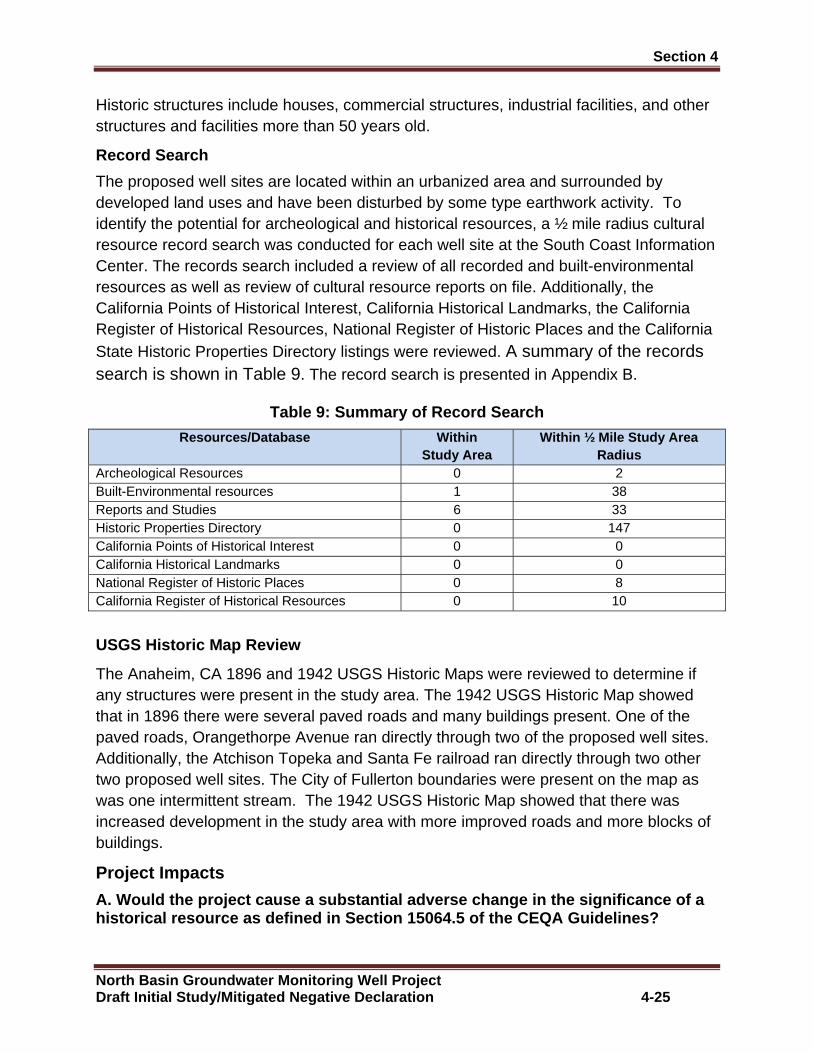
Section 4 �
North Basin Groundwater Monitoring Well Project Draft Initial Study/Mitigated Negative Declaration 4-25
Historic structures include houses, commercial structures, industrial facilities, and other structures and facilities more than 50 years old.
Record Search
The proposed well sites are located within an urbanized area and surrounded by developed land uses and have been disturbed by some type earthwork activity. To identify the potential for archeological and historical resources, a ½ mile radius cultural resource record search was conducted for each well site at the South Coast Information Center. The records search included a review of all recorded and built-environmental resources as well as review of cultural resource reports on file. Additionally, the California Points of Historical Interest, California Historical Landmarks, the California Register of Historical Resources, National Register of Historic Places and the California State Historic Properties Directory listings were reviewed. A summary of the records search is shown in Table 9. The record search is presented in Appendix B.
Table 9: Summary of Record Search
Resources/Database Within Study Area
Within ½ Mile Study Area Radius
Archeological Resources 0 2 Built-Environmental resources 1 38 Reports and Studies 6 33 Historic Properties Directory 0 147 California Points of Historical Interest 0 0 California Historical Landmarks 0 0 National Register of Historic Places 0 8 California Register of Historical Resources 0 10
USGS Historic Map Review
The Anaheim, CA 1896 and 1942 USGS Historic Maps were reviewed to determine if any structures were present in the study area. The 1942 USGS Historic Map showed that in 1896 there were several paved roads and many buildings present. One of the paved roads, Orangethorpe Avenue ran directly through two of the proposed well sites. Additionally, the Atchison Topeka and Santa Fe railroad ran directly through two other two proposed well sites. The City of Fullerton boundaries were present on the map as was one intermittent stream. The 1942 USGS Historic Map showed that there was increased development in the study area with more improved roads and more blocks of buildings.
Project Impacts
A. Would the project cause a substantial adverse ch ange in the significance of a historical resource as defined in Section 15064.5 o f the CEQA Guidelines?
Section 4 �
North Basin Groundwater Monitoring Well Project Draft Initial Study/Mitigated Negative Declaration 4-26
City of Anaheim
Monitoring Wells AM-54 A, B, C
City of Fullerton
Monitoring Well FM-7B, Monitoring Well FM-22B, Moni toring Well FM-24B, Monitoring Well FM-29A, B, C, Monitoring Well FM-30 A (Options a and b), Monitoring Wells FM-31 A, B, and Monitoring Wells F M-32 A, B (Options a and b)
Less than Significant Impact with Mitigation: Based on review of the records search, none of the proposed well sites are considered archaeologically sensitive. However, the records search review did identify that were several cultural resources recorded in the study area and within ½ mile radius of the study area. Because all of the proposed well sites are located in areas where the natural ground surface has been disturbed by urban development, a field survey of the study area would not yield reliable data. Even though the well sites have been previously disturbed, because cultural resources have been recorded in the study area, there would still be the potential for the discovery of historical cultural resources. Therefore, it is recommended that a halt condition should be in place when ground-disturbing activities are occuring. With the implementation of Mitigation Measure CR-1 potential adverse impacts to unknown historical resources would be less than significant.
Mitigation Measure
CR-1: In the event that any evidence of cultural resources is discovered, all work within the vicinity of the find should stop until a qualified archaeological consultant can assess the find and make recommendations.
B. Would the project cause a substantial adverse ch ange in the significance of an archaeological resource pursuant to Section 15064.5 of the CEQA Guidelines?
City of Anaheim
Monitoring Wells AM-54 A, B, C
City of Fullerton
Monitoring Well FM-7B, Monitoring Well FM-22B, Moni toring Well FM-24B, Monitoring Well FM-29A, B, C, Monitoring Well FM-30 A (Options a and b), Monitoring Wells FM-31 A, B, and Monitoring Wells F M-32 A, B (Options a and b)
Less than Significant Impact with Mitigation: Based on review of the records search, none of the proposed well sites are considered archaeologically sensitive. However, the records search review did identify that there were several cultural resources recorded in the study area and within ½ mile radius of the study area. It is recommended that a halt condition should be in place when ground-disturbing activities are occurring. With the
Section 4 �
North Basin Groundwater Monitoring Well Project Draft Initial Study/Mitigated Negative Declaration 4-27
implementation of Mitigation Measure CR-1 potential adverse impacts to unknown archaeological resources would be less than significant.
Mitigation Measure
Mitigation Measure CR-1 required.
C. Would the project disturb any human remains, including those interre d outside of formal cemeteries?
City of Anaheim
Monitoring Wells AM-54 A, B, C
City of Fullerton
Monitoring Well FM-7B, Monitoring Well FM-22B, Moni toring Well FM-24B, Monitoring Well FM-29A, B, C, Monitoring Well FM-30 A (Options a and b), Monitoring Wells FM-31 A, B, and Monitoring Wells F M-32 A, B (Options a and b)
Less than Significant Impact with Mitigation: No human remains or cemeteries are known to exist on the proposed well sites. However, because cultural resources have been recorded within the study area, there is always the potential that subsurface construction activities associated with the Proposed Project could potentially damage or destroy previously undiscovered human remains. In the event of the accidental discovery or recognition of any human remains, CEQA Guidelines Section 15064.5; Health and Safety Code Section 7050.5; Public Resources Code Section 5097.94 and Section 5097.98 must be followed. With the implementation of Mitigation Measure CR-2 potential impacts to human remains would be less than significant.
Mitigation Measure
CR-2: If human remains are encountered during excavation activities, all work shall halt in the vicinity of the remains and the County Coroner shall be notified (California Public Resources Code, Section 5097.98). The Coroner will determine whether the remains are of forensic interest. If the Coroner, with the aid of a qualified Archaeologist, determines that the remains are prehistoric, s/he will contact the Native American Heritage Commission (NAHC). The NAHC will be responsible for designating the most
likely descendant (MLD), who will be responsible for the ultimate disposition of the remains, as required by Section 7050.5 of the California Health and Safety Code. The MLD shall make his/her recommendation within 48 hours of being granted access to the site. If feasible, the MLD’s recommendation should be followed and may include scientific removal and non-destructive analysis of the human remains and any items associated with Native American burials (California Health and Safety Code, Section 7050.5). If the landowner rejects the MLD’s recommendations, the landowner shall rebury the remains with appropriate dignity on the property in a location that will not be
Section 4 �
North Basin Groundwater Monitoring Well Project Draft Initial Study/Mitigated Negative Declaration 4-28
subject to further subsurface disturbance (California Public Resources Code, Section 5097.98).
D. Would the project directly or indirectly disturb or destroy a unique paleontological resource or site?
City of Anaheim
Monitoring Wells AM-54 A, B, C
City of Fullerton
Monitoring Well FM-7B, Monitoring Well FM-22B, Moni toring Well FM-24B, Monitoring Well FM-29A, B, C, Monitoring Well FM-30 A (Options a and b), Monitoring Wells FM-31 A, B, and Monitoring Wells F M-32 A, B (Options a and b)
Less than Significant Impact with Mitigation: The Natural History Museum of Los Angeles County (NHMLAC) was contacted and requested to review their topographical maps for the study area to determine the geology underlying the study area, the sensitivity of the well sites for the presence of fossils, and if any fossil-bearing localities had been recorded.
Surficial sediments within the study area consist of younger terrestrial Quaternary Alluvium, with older terrestrial Quaternary sediments occurring at various depths, resulting from floodplain deposits from the Santa Ana River that currently flows to the east and alluvial fan deposits from the Coyote Hills to the north via Fullerton Creek and from the Puente Hills to the northeast via Carbon Canyon Creek. These deposits typically do not contain significant vertebrate fossils. Deeper excavations that extend into older sedimentary deposits could have potential to contain vertebrate fossil remains. Similar deposits that contain younger terrestrial Quaternary Alluvium and older terrestrial Quaternary sediments have produced vertebrate fossil specimen of a sheep on the west side of the Santa Ana River along Rio Vista Avenue, south of Lincoln Avenue and vertebrate fossil specimen of a horse east of the Santa Ana River, along Fletcher Avenue and east of Glassell Street. Because there could be potential that older sedimentary deposits could be encountered, a halt condition should be in place when ground-disturbing activities are occurring. With the implementation of Mitigation Measure CR-3 potential adverse impacts to unknown paleontological resources would be less than significant.
CR-3: In the event that any evidence of paleontological resources is discovered, all work within the vicinity of the find should stop and a qualified paleontologist will be notified and retained. The Paleontological Monitor will divert heavy equipment away from the fossil site until s/he has had an opportunity to examine the remains.
Section 4 �
North Basin Groundwater Monitoring Well Project Draft Initial Study/Mitigated Negative Declaration 4-29
4.6 Geology/Soils
A1. Would the project expose people or structures t o potential substantial adverse effects, including the risk of loss, injury or death involving rupture of an unknown earthquake fault, as delineated on the most recent Alquist-Priolo Earthquake Fault Zoning Map?
City of Anaheim
Monitoring Wells AM-54 A, B, C
City of Fullerton
Monitoring Well FM-7B, Monitoring Well FM-22B, Moni toring Well FM-24B, Monitoring Well FM-29A, B, C, Monitoring Well FM-30 A (Options a and b), Monitoring Wells FM-31 A, B, and Monitoring Wells F M-32 A, B (Options a and b)
No Impact: According to the City of Anaheim General Plan and the City of Fullerton General Plan there is not a Alquist-Priolo Earthquake Fault Zone on or near any of the proposed monitoring well sites. Therefore, it is unlikely that the proposed monitoring wells would be subject to ground rupture impacts. No mitigation measures are required.
A2. Would the project expose people or structures t o potential substantial adverse effects, including the risk of loss, injury or death involving strong seismic ground shaking?
City of Anaheim
Monitoring Wells AM-54 A, B, C
City of Fullerton
Monitoring Well FM-7B, Monitoring Well FM-22B, Moni toring Well FM-24B, Monitoring Well FM-29A, B, C, Monitoring Well FM-30 A (Options a and b), Monitoring Wells FM-31 A, B, and Monitoring Wells F M-32 A, B (Options a and b)
Less than Significant Impact with Mitigation: All of the proposed monitoring well sites are located in a seismically active area that could be subject to seismic shaking impacts from several surrounding active earthquake faults situated within the region. The highest seismic risks to the proposed monitoring well sites would be from the Whittier-Elsinore Fault Zone and the Newport-Inglewood Fault Zone. Each of these faults would have the potential to cause moderate to large earthquakes in excess of 7.0 on the Richter Scale. In the event a moderate to large earthquake occurs, the proposed monitoring wells could have the potential for periodic shaking, possibly of considerable intensity. The risk for seismic shaking impacts at all of the proposed monitoring well sites would be similar to other areas in the southern California region. The proposed monitoring wells would be designed to meet the California Department of Water Resources Well Standards to withstand anticipated ground shaking caused by an

Section 4 �
North Basin Groundwater Monitoring Well Project Draft Initial Study/Mitigated Negative Declaration 4-30
earthquake within an acceptable level of risk. With the implementation of Mitigation Measure GEO-1 potential seismic shaking impacts would be less than significant.
Mitigation Measure
GEO-1: The OCWD will ensure that the proposed monitoring wells are designed and constructed in compliance with California Department of Water Resources Well Standards Bulletin 74-90 and Bulletin 74-81.
A3. Would the project expose people or structures t o potential substantial adverse effects, including the risk of loss, injury or death involving liquefaction?
City of Anaheim
Monitoring Wells AM-54 A, B, C
City of Fullerton
Monitoring Well FM-7B, Monitoring Well FM-22B, Moni toring Well FM-24B, Monitoring Well FM-29A, B, C, Monitoring Well FM-30 A (Options a and b), Monitoring Wells FM-31 A, B, and Monitoring Wells F M-32 A, B (Options a and b)
Less than Significant Impact with Mitigation: Liquefaction is the phenomenon in which loosely deposited soils located within the water table undergo rapid loss of shear strength due to excess pore pressure generation when subjected to strong earthquake induced ground shaking. Liquefaction is known generally to occur in saturated or near-saturated cohesion- less soil at depths shallower than 50-feet below the ground surface.
According to the City of Anaheim General Plan and the City of Fullerton General Plan, the proposed monitoring well sites are within a liquefaction hazard area. The monitoring wells would not be subject to damage as a result of liquefaction. To minimize liquefaction risks, the proposed monitoring wells would be designed to meet the California Department of Water Resources Well Standards to withstand potential liquefaction impacts caused by an earthquake at an acceptable level of risks. With the implementation of Mitigation Measure GEO-1 potential seismic shaking impacts would be less than significant.
Mitigation Measures
Mitigation Measure GEO-1 is required.
A4. Would the project expose people or structures t o potential substantial adverse effects, including the risk of loss, injury or death involving landslides?
City of Anaheim
Monitoring Wells AM-54 A, B, C
City of Fullerton
Section 4 �
North Basin Groundwater Monitoring Well Project Draft Initial Study/Mitigated Negative Declaration 4-31
Monitoring Well FM-7B, Monitoring Well FM-22B, Moni toring Well FM-24B, Monitoring Well FM-29A, B, C, Monitoring Well FM-30 A (Options a and b), Monitoring Wells FM-31 A, B, and Monitoring Wells F M-32 A, B (Options a and b)
No Impact: The areas that are most susceptible to earthquake-induced landslides are steep slopes in poorly cemented or highly fractured rocks, areas underlain by loose, weak soils and areas on or adjacent to existing landslide deposits. According to the City of Anaheim General Plan and the City of Fullerton General Plan, the proposed monitoring well sites are not located in areas that would be subject to landslide risks. No mitigation measures are required.
B. Would the project result in substantial soil ero sion or the loss of topsoil?
City of Anaheim
Monitoring Wells AM-54 A, B, C
City of Fullerton
Monitoring Well FM-7B, Monitoring Well FM-22B, Moni toring Well FM-24B, Monitoring Well FM-29A, B, C, Monitoring Well FM-30 A (Options a and b), Monitoring Wells FM-31 A, B, and Monitoring Wells F M-32 A, B (Options a and b)
Less than Significant Impact: The drilling operations associated with the construction of the proposed monitoring wells would occur on paved surfaces. No substantial amounts soils would be exposed that would cause significant water and/or wind erosion impacts. Potential erosion impacts would be less than significant.
C. Would the project be located on a geologic unit or soil that is unstable or that would become unstable as a result of the project and potentially result in on or off site landslide, lateral spreading, subsidence, liquefaction or collapse?
City of Anaheim
Monitoring Wells AM-54 A, B, C
City of Fullerton
Monitoring Well FM-7B, Monitoring Well FM-22B, Moni toring Well FM-24B, Monitoring Well FM-29A, B, C, Monitoring Well FM-30 A (Options a and b), Monitoring Wells FM-31 A, B, and Monitoring Wells F M-32 A, B (Options a and b)
Less than Significant Impact with Mitigation: The primary geologic concerns at the proposed monitoring well sites would be potential seismic shaking impacts and liquefaction impacts. As previously identified, the proposed monitoring wells would be designed to meet the California Department of Water Resources Well Standards to withstand potential liquefaction and seismic shaking impacts caused by an earthquake at an acceptable level of risks. Compliance with the California Department of Water
Section 4 �
North Basin Groundwater Monitoring Well Project Draft Initial Study/Mitigated Negative Declaration 4-32
Resources Well Standards would reduce potential liquefaction and seismic shaking impacts to a less than significant level. With the implementation of Mitigation Measure GEO-1 potential seismic shaking impacts would be less than significant.
Mitigation Measure
Mitigation Measure GEO-1 is required.
D. Would the project be located on expansive soil, as defined in Table 18-1-B of the uniform Building Code, creating substantial ris ks to life or property?
City of Anaheim
Monitoring Wells AM-54 A, B, C
City of Fullerton
Monitoring Well FM-7B, Monitoring Well FM-22B, Moni toring Well FM-24B, Monitoring Well FM-29A, B, C, Monitoring Well FM-30 A (Options a and b), Monitoring Wells FM-31 A, B, and Monitoring Wells F M-32 A, B (Options a and b)
Less than Significant Impact with Mitigation: Expansive soils are characterized as specific clay materials with the capacity to shrink, swell or otherwise significantly change volume due to variations in moisture content. Expansive soils could cause excessive cracking and heaving of structures with shallow foundations and concrete. Preliminary investigations conducted by OCWD did not identify any soil constraints that would increase the risks for damage. The proposed monitoring wells would be designed to meet the California Department of Water Resources Well Standards to avoid adverse soil expansion impacts. With the implementation of Mitigation Measure GEO-1 potential soil expansion impacts would be less than significant.
Mitigation Measure
Mitigation Measure GEO-1 is required.
E. Would the project have soils incapable of adequa tely supporting the use of septic tanks or alternative waste disposal systems where sewers are not available for the disposal of wastewater?
City of Anaheim
Monitoring Wells AM-54 A, B, C
City of Fullerton
Monitoring Well FM-7B, Monitoring Well FM-22B, Moni toring Well FM-24B, Monitoring Well FM-29A, B, C, Monitoring Well FM-30 A (Options a and b), Monitoring Wells FM-31 A, B, and Monitoring Wells F M-32 A, B (Options a and b)

Section 4 �
North Basin Groundwater Monitoring Well Project Draft Initial Study/Mitigated Negative Declaration 4-33
No Impact: The construction of the proposed monitoring wells would not include the construction of septic tanks, or other alternative wastewater disposal systems. No mitigation measures are required.
4.7 Greenhouse Gas Emissions
The following analysis is based on the Air Quality and Greenhouse Gas Analysis Report prepared by Vista Environmental in December 2016. The Air Quality and Greenhouse Gas Analysis Report are presented in its entirety in Appendix A.
Background
Greenhouse Gas Emissions (GHGs) are comprised of atmospheric gases and clouds within the atmosphere that influence the earth’s temperature by absorbing most of the infrared radiation that rises from the sun-warmed surface and that would otherwise escape into space. This process is commonly known as the “Greenhouse Effect”. GHGs are emitted by natural processes and human activities. GHGs, include carbon dioxide (CO2), methane (CH4), nitrous oxide (N2O), hydrofluorocarbons (HFCs), perfluorocarbons (PFCs), and sulfur hexafluoride (SF6). Other greenhouse gases include water vapor, ozone, and aerosols. Water vapor is an important component of our climate system and is not regulated. Although there could be health effects resulting from changes in the climate and the consequences that can bring about, inhalation of greenhouse gases at levels currently in the atmosphere will not result in adverse health effects, with the exception of ozone and aerosols (particulate matter). The potential health effects of ozone and particulate matter are discussed in air quality criteria pollutant analyses. At very high indoor concentrations (not at levels existing in outside areas), carbon dioxide, methane, sulfur hexafluoride, and some chlorofluorocarbons can cause suffocation as the gases can displace oxygen.
Regulatory Framework
California Air Resources Board (CARB) has proposed interim statewide CEQA thresholds for GHG emissions and released Recommended Approaches for Setting Interim Significance Thresholds for Greenhouse Gases under the California Environmental Quality Act, on October 24, 2008 that has been utilized by the SCAQMD’s GHG Significance Threshold Stakeholder Working Group in their framework for developing SCAQMD’s draft GHG emissions thresholds. The State currently has no regulations that establish ambient air quality standards for GHGs. However, the State has passed laws directing CARB to develop actions to reduce GHG emissions. The following is a listing of relevant State laws to reduce GHG emissions. Detail discussion of each State is presented in Appendix A.
x Executive Order B-30-15, Senate Bill 32 and Assembly Bill 197 x Assembly Bill 1493 x Executive Order S-3-05
Section 4 �
North Basin Groundwater Monitoring Well Project Draft Initial Study/Mitigated Negative Declaration 4-34
x Assembly Bill 32 x Executive Order S-1-07 x Senate Bill 97 x Senate Bill 375 x Assembly Bill 341 and Senate Bills 939 and 1374 x California Code of Regulations (CCR) Title 24, Part 11
South Coast Air Quality Management District
Since neither CARB nor the OPR has developed GHG emissions threshold, the SCAQMD formed a Working Group to develop significance thresholds related to GHG emissions. At the September 28, 2010 Working Group meeting, the SCAQMD released its most current version of the draft GHG emissions thresholds, which recommends a tiered approach that either provides a quantitative annual thresholds of 3,500 MTCO2e for residential uses, 1,400 MTCO2e for commercial uses, and 3,000 MTCO2e for mixed uses. An alternative annual threshold of 3,000 MTCO2e for all land use types is also proposed.
Project Impacts
A. Would the project generate GHG emissions, either directly or indirectly, that may have a significant impact on the environment?
City of Anaheim
Monitoring Wells AM-54 A, B, C
City of Fullerton
Monitoring Well FM-7B, Monitoring Well FM-22B, Moni toring Well FM-24B, Monitoring Well FM-29A, B, C, Monitoring Well FM-30 A (Options a and b), Monitoring Wells FM-31 A, B, and Monitoring Wells F M-32 A, B (Options a and b)
Less than Significant Impact: The Proposed Project would result in the construction and operation of 14 new monitoring wells. The CalEEMod model was utilized to calculate the GHG emissions from each phase of construction activities from one monitoring well associated with the Proposed Project. Additionally, the CalEEMod model was also utilized to calculate the GHG emissions from the operational well sampling and redevelopment activities. A summary of the GHG emissions results is shown below in Table 10.
Table 10: Project Related Greenhouse Gas Annual Emi ssions
Greenhouse Gas Emissions (Metric Tons per Year)
Category CO2 CH4 N2O CO2e
Construction Monitor Well Drilling and Construction for One 57.95 0.02 0.00 58.26

Section 4 �
North Basin Groundwater Monitoring Well Project Draft Initial Study/Mitigated Negative Declaration 4-35
Well Site
Monitor Well Development for One Well Site 21.52 0.00 0.00 21.59 Total Construction Emissions of 19 Well Sites 1,509.89 0.29 0.00 1,517.31 Amortized Construction Emissions (30 years)1
50.33 0.01 0.00 50.58 Operations Well Sampling and Water Levels One Well Site (8 times per year)
0.38 0.00 0.00 0.38
Well Redevelopment for One Well Site 1.03 0.00 0.00 1.04 Amortized Well Redevelopment Emissions (3 years)2
0.34 0.00 0.00 0.35
Total Operational Emission for 19 Well Sites 13.82 0.00 0.00 13.86 Total Annual Emissions (Construction & Operations)
64.15 0.01 0.00 64.43
SCAQMD Draft Threshold of Significance 3,000 Notes: 1 Construction emissions amortized over 30 years as recommended in the SCAQMD GHG Working Group on November 19, 2009. 2 Well Redevelopment amortized over 3 years as that is the worst-case schedule for well redevelopment. Source: CalEEMod Version 2013.2.2.
The data provided in Table 10 shows that the Proposed Project would create 64.43 MTCO2e per year. According to the SCAQMD draft threshold of significance, a cumulative global climate change impact would occur if the GHG emissions created from the proposed project would exceed 3,000 MTCO2e per year. Therefore, a less than significant generation of greenhouse gas emissions would occur from construction and operation of the Proposed Project.
B. Would the project be in conflict with an applica ble plan, policy or regulation adopted for the purpose of reducing the emissions o f greenhouse gases?
City of Anaheim
Monitoring Wells AM-54 A, B, C
City of Fullerton
Monitoring Well FM-7B, Monitoring Well FM-22B, Moni toring Well FM-24B, Monitoring Well FM-29A, B, C, Monitoring Well FM-30 A (Options a and b), Monitoring Wells FM-31 A, B, and Monitoring Wells F M-32 A, B (Options a and b)
Less than Significant Impact: The Proposed Project would consist of the construction and operation of 14 new monitoring wells in the Cities of Anaheim and Fullerton. Monitoring well operation involves periodically measuring the depth to groundwater, and collecting groundwater samples for laboratory analysis. The depth to groundwater would
be measured by hand using a battery powered wire-line sounder. Dedicated submersible pumps would be installed in the monitoring wells for periodic sampling. Operation of a submersible pump would require the use of a small portable generator. OCWD staff would collect groundwater samples and record water levels on a quarterly basis or less. In total, the monitoring wells would be visited by OCWD staff up to 8 times
Section 4 �
North Basin Groundwater Monitoring Well Project Draft Initial Study/Mitigated Negative Declaration 4-36
per year. Every three to five years OCWD would conduct maintenance activities to sample and redevelop the well.
The Proposed Project would be anticipated to create an average of 64.43 MTCO2e per year, which would be well below the SCAQMD draft threshold of significance of 3,000 MTCO2e per year. The SCAQMD developed this threshold through a Working Group, which also developed detailed methodology for evaluating significance under CEQA. At the September 28, 2010 Working Group meeting, the SCAQMD released its most current version of the draft GHG emissions thresholds, which recommends a tiered approach that provides a quantitative annual threshold of 3,000 MTCO2e for all land use type projects. Although the SCAQMD provided substantial evidence supporting the use of the above threshold, as of December 2016, the SCAQMD Board has not yet considered or approved the Working Group’s thresholds. Originally SCAQMD had stated that they were waiting to approve the Working Group’s thresholds dependent on the outcome of the State Supreme Court decision of the California Building Industry Association v. Bay Area Air Quality Management District (BAAQMD), which was filed on December 17, 2015. However, since that court decision has been decided for some time now, the most likely time for the SCAQMD Board to consider the Working Group thresholds will be in combination with the consideration of the updated CEQA Air Quality Handbook that is currently being revised by SCAQMD staff. Therefore, the Proposed Project would not conflict with any applicable plan, policy or regulation of an agency adopted for the purpose of reducing the emissions of greenhouse gases.
4.8 Hazards/Hazardous Materials
A. Would the project create a significant hazard to the public or the environment through the routine transport, use or disposal of h azardous materials?
City of Anaheim
Monitoring Wells AM-54 A, B, C
City of Fullerton
Monitoring Well FM-7B, Monitoring Well FM-22B, Moni toring Well FM-24B, Monitoring Well FM-29A, B, C, Monitoring Well FM-30 A (Options a and b), Monitoring Wells FM-31 A, B, and Monitoring Wells F M-32 A, B (Options a and b)
Less than Significant Impact with Mitigation: The State of California defines hazardous materials as substances that are toxic, ignitable, flammable, reactive,
corrosive, and show high acute or chronic toxicity, are carcinogenic, have bio-accumulative properties that are persistent in the environment or are water reactive. The long-term operation of the proposed monitoring wells would not involve the routine transportation, disposal or emission of hazardous materials or waste. Therefore, the implementation of the Proposed Project would not result in the long term exposure of
Section 4 �
North Basin Groundwater Monitoring Well Project Draft Initial Study/Mitigated Negative Declaration 4-37
hazard materials to the public or the environment. Construction and maintenance operations associated with the proposed monitoring wells would involve the handling of incidental amounts of hazardous materials, such as fuels, oils and solvents. The construction and maintenance activities would be required to comply with local, state and federal laws and regulations regarding the handling and storage of hazardous materials. Monitoring wells would not be constructed on the sites where VOCs were released. Consequently, soil cuttings would not be expected to contain VOCs at concentrations that would exceed hazardous waste thresholds. Also VOC concentrations in groundwater generated during well construction would be tested prior to disposal. With the implementation of Mitigation Measures HAZ-1 potential hazardous material safety impacts would be less than significant.
Mitigation Measure
HAZ-1: All construction activities involving the handling of hazardous substances will be conducted in accordance with local, State and Federal laws and regulations.
B. Would the project create a significant hazard to the public or environment through reasonably foreseeable upset and accident c onditions involving the release of hazardous materials into the environment ?
City of Anaheim
Monitoring Wells AM-54 A, B, C
City of Fullerton
Monitoring Well FM-7B, Monitoring Well FM-22B, Moni toring Well FM-24B, Monitoring Well FM-29A, B, C, Monitoring Well FM-30 A (Options a and b), Monitoring Wells FM-31 A, B, and Monitoring Wells F M-32 A, B (Options a and b)
Less than Significant Impact with Mitigation : The long-term operation of the proposed monitoring wells would not involve the routine transportation, disposal or emission of hazardous materials or waste. Construction and maintenance activities associated with the proposed monitoring wells would involve the handling of incidental amounts of hazardous materials, such as fuels and oils. During construction operations Best Management Practices would be implemented that would include hazardous material spill prevention and management practices to minimize the accidental release of hazardous materials into the environment. With the implementation of Mitigation Measures HAZ-2 potential hazardous material safety impacts would be less than significant.
Mitigation Measure
HAZ-2: During construction and maintenance activities Best Management Practices will be implemented to avoid accidental release of hazardous materials into the
Section 4 �
North Basin Groundwater Monitoring Well Project Draft Initial Study/Mitigated Negative Declaration 4-38
environment. The Best Management Practices will include, as applicable, the preparation and implementation hazardous material management and spill prevention and clean-up plans, implementation construction equipment delivery and storage procedures and routine vehicle and equipment maintenance.
C. Would the project emit hazardous emissions or handle hazardous or acu tely hazardous materials, substance or waste within one- quarter mile of an existing or proposed school.
City of Anaheim
Monitoring Wells AM-54 A, B, C
City of Fullerton
Monitoring Well FM-7B, Monitoring Well FM-22B, Moni toring Well FM-24B, Monitoring Well FM-29A, B, C, Monitoring Well FM-30 A (Options a and b), Monitoring Wells FM-31 A, B, and Monitoring Wells F M-32 A, B (Options a and b)
Less than Significant Impact with Mitigation : The operation of the monitoring wells would not emit hazardous emissions, or involve the handling of acutely hazardous substances. Construction and maintenance activities associated with the proposed monitoring wells would involve the handling of incidental amounts of hazardous materials, such as fuels and oils. The handling of these substances would be in compliance with local, state and federal laws and regulations. Additionally, to minimize the inadvertent release of hazardous substances, Best Management Practices would be employed onsite when construction and maintenance activities are occurring. With the implementation of Mitigation Measures HAZ-1 and HAZ-2 potential hazardous emission impacts would be less than significant.
D. Would the project be located on a site which is included on a list of hazardous material sites compiled pursuant to Government Code Section 65962.5 and as a result, would create significant hazard to the public or the environment?
City of Anaheim
Monitoring Wells AM-54 A, B, C
City of Fullerton
Monitoring Well FM-7B, Monitoring Well FM-22B, Moni toring Well FM-24B, Monitoring Well FM-29A, B, C, Monitoring Well FM-30 A (Options a and b), Monitoring Wells FM-31 A, B, and Monitoring Wells F M-32 A, B (Options a and b)
No Impact: The purpose of the Proposed Project is to monitor the groundwater quality within the North Basin area of the Orange County Groundwater Basin to help develop remedial action plan that would remove hazardous contaminates from the groundwater basin. No mitigation measures are required.
Section 4 �
North Basin Groundwater Monitoring Well Project Draft Initial Study/Mitigated Negative Declaration 4-39
E. For a project located within an airport land use plan or where such a plan has not been adopted, within two miles of a public airport or public use airport, would the project the result in a safety hazard for peopl e residing or working within the project area?
City of Anaheim
Monitoring Wells AM-54 A, B, C
City of Fullerton
Monitoring Well FM-7B, Monitoring Well FM-22B, Moni toring Well FM-24B, Monitoring Well FM-29A, B, C, Monitoring Well FM-30 A (Options a and b), Monitoring Wells FM-31 A, B, and Monitoring Wells F M-32 A, B (Options a and b)
Less than Significant Impact: The Airport Land Use Commission (ALUC) of Orange County assists local agencies to ensure that there are no direct conflicts with land uses, noise or other issues that would impact the functionality and safety of airport and heliport operations. The ALUC requires that local jurisdiction’s general plans and zoning ordinances are consistent with Airport Environs Land Use Plans (AELUP’s), which contain noise contours, and restrictions for types of construction and building heights in navigable air space, as well as requirements impacting the establishment or construction of sensitive uses within close proximity to airports.
The closest airport to the proposed monitoring well sites would be Fullerton Municipal Airport. According to the Fullerton Municipal Airport AELUP all of the proposed monitoring well sites are outside of the Safety Hazard Zone. Additionally, the proposed monitoring wells would be underground and would not encroach into any navigable air space. The proposed monitoring wells would be a compatible utility and the construction and maintenance activities for the proposed monitoring wells would not cause any airport safety related hazards. No mitigation measures are required.
F. For a project within the vicinity of a private a irstrip, would the project result in a safety hazard for people residing or working in t he project area?
City of Anaheim
Monitoring Wells AM-54 A, B, C
City of Fullerton
Monitoring Well FM-7B, Monitoring Well FM-22B, Moni toring Well FM-24B, Monitoring Well FM-29A, B, C, Monitoring Well FM-30 A (Options a and b), Monitoring Wells FM-31 A, B, and Monitoring Wells F M-32 A, B (Options a and b)
No Impact: There is not private air strips located within the study area. Therefore, the study area would not be subject to aircraft safety hazards from a private air strip facility. No mitigation measures are required.

Section 4 �
North Basin Groundwater Monitoring Well Project Draft Initial Study/Mitigated Negative Declaration 4-40
G. Would the project impair implementation of or physically interfere with an adopted emergency response plan or emergency evacua tion plan?
City of Anaheim
Monitoring Wells AM-54 A, B, C
City of Fullerton
Monitoring Well FM-7B, Monitoring Well FM-22B, Moni toring Well FM-24B, Monitoring Well FM-29A, B, C, Monitoring Well FM-30 A (Options a and b), Monitoring Wells FM-31 A, B, and Monitoring Wells F M-32 A, B (Options a and b)
Less than Significant Impact with Mitigation: The construction and maintenance of the proposed monitoring wells would occur within existing roadways and parking areas. The construction operations could potentially require temporary closure of travel lanes and access ways. To avoid emergency access conflicts, at all times emergency access would be maintained and if needed traffic control devices would be in place to direct traffic through the construction area. With the implementation of Mitigation Measure HAZ-3 potential emergency access impacts would be less than significant.
Mitigation Measure
HAZ-3: During construction and maintenance activities emergency access will be maintained at all times.
H. Would the project expose people or structures to a significant risk of loss, injury or death involving wild land fires, including where wildlands are adjacent to urbanized areas or where residences are intermixed with wild lands?
City of Anaheim
Monitoring Wells AM-54 A, B, C
City of Fullerton
Monitoring Well FM-7B, Monitoring Well FM-22B, Moni toring Well FM-24B, Monitoring Well FM-29A, B, C, Monitoring Well FM-30 A (Options a and b), Monitoring Wells FM-31 A, B, and Monitoring Wells F M-32 A, B (Options a and b)
No Impact: According to the City of Anaheim General Plan and the City of Fullerton General Plan, the proposed monitoring well sites are not adjacent to or intermixed with wild lands and would not be susceptible wild land fire impacts. No mitigation measures are required.
4.9 Hydrology/Water Quality
The primary receiving surface water bodies/drainage facilities within the study area would include; Carbon Creek, Fullerton Creek, and Coyote Creek. The downstream
Section 4 �
North Basin Groundwater Monitoring Well Project Draft Initial Study/Mitigated Negative Declaration 4-41
receiving water bodies would include the San Gabriel River, Alamitos Bay and the Pacific Ocean. The study area also overlies the Orange County Groundwater Basin.
Carbon Creek
Carbon Creek is a regional flood control facility that drains approximately 20 square miles of urbanized watershed in the northwest part of Orange County. Carbon Creek passes through the Cities of Los Alamitos, Cypress, Buena Park, Anaheim, and Fullerton before emptying into the San Gabriel River.
Fullerton Creek
Fullerton Creek drainage area below Fullerton Dam drains approximately 10,000 acres of area. The watershed includes parts of the cities of Fullerton, Anaheim, Buena Park, and La Palma. Fullerton Creek is tributary to Coyote Creek.
Coyote Creek
Coyote Creek Channel is a major tributary of the San Gabriel River. At its confluence with the San Gabriel River, its tributary area is approximately 100,000 acres. Tributaries of Coyote Creek include North Coyote Creek, Brea Creek Channel, Fullerton Creek Channel, and Carbon Creek.
San Gabriel River
The San Gabriel River flows 43 miles through Los Angeles County and Orange County. It forms a boundary between both counties for a brief stretch before merging with Coyote Creek, one of its main tributaries, near the City of Los Alamitos. The river eventually becomes tidal and empties into the outlet of Alamitos Bay. The reach of the San Gabriel River that the study area would drain into would be Reach 1.
San Gabriel River Estuary
The San Gabriel River Estuary is approximately 3.4 miles long with a soft bottom and concrete rip rap sides and receives flows from Reach 1 of the San Gabriel River.
Alamitos Bay
Alamitos Bay is an inlet on the Pacific Ocean between the cities of Long Beach and Seal Beach and outlet of San Gabriel River Estuary.
Pacific Ocean
The Pacific Ocean is the downstream receiving water for surface water flows from San Gabriel River and Alamitos Bay.
Orange County Groundwater Basin
The Orange County Groundwater Basin underlies central and northern Orange County and is bordered by the Santa Ana Mountains to the east, the Pacific Ocean to the west,

Section 4 �
North Basin Groundwater Monitoring Well Project Draft Initial Study/Mitigated Negative Declaration 4-42
the Newport-Inglewood Fault to the southwest and Coyote Hills to the north. The basin is contiguous and directly connected to the Central Basin of Los Angeles County to the northwest. The basin reaches depths of over 2,000 feet and is comprised of a complex series of interconnected sand and gravel deposits. The study area is situated within the North Basin area of the Orange County Groundwater Basin.
Regulatory Setting
The following is discussion of Federal, State and local water resource programs that are applicable to the Proposed Project.
Clean Water Act
The objectives of the Clean Water Act are to restore and maintain the chemical, physical, and biological integrity of Waters of the United States. The Clean Water Act establishes basic guidelines for regulating discharges of pollutants into the Waters of the United States and requires states to adopt water quality standards to protect health, enhance the quality of water resources and to develop plans and programs to implement the Act. Below is a discussion of sections of the Clean Water Act that are relevant to the proposed project.
Section 303 (d) Water Bodies
Under Section 303 (d) of the Clean Water Act, the State Water Resources Control Board (SWRCB) is required to develop a list of impaired water bodies. Each of the individual Regional Water Quality Control Boards are responsible for establishing priority rankings and developing action plans, referred to as total maximum daily loads (TMDLs) to improve water quality of water bodies included in the 303(d) list. A list of the study area receiving water bodies that have been listed as 303 (d) impaired water bodies is shown in Table 11.
Table 11: 303 (D) Listed Impaired Water Bodies
Water Body Impairment
San Gabriel River Indicator Bacteria
San Gabriel River Estuary Copper
Alamitos Bay Indicator Bacteria
Section 402
Section 402 of the Clean Water Act established the National Pollution Discharge Elimination System (NPDES) to control water pollution by regulating point sources that discharge pollutants into Waters of the United States. In the State of California, the EPA has authorized the State Water Resources Control Board (SWRCB) to be the permitting authority to implement the NPDES program. The SWRCB issues two baseline general

Section 4 �
North Basin Groundwater Monitoring Well Project Draft Initial Study/Mitigated Negative Declaration 4-43
permits, one for industrial discharges and one for construction activities (General Construction Permit). Additionally, the NPDES Program includes the long-term regulation of storm water discharges from medium and large cities through the MS4 Permit Program.
Short-Term Storm Water Management
Storm water discharges from construction sites with a disturbed area of one or more acres are required to either obtain individual NPDES permits for storm water discharges or be covered by a General Construction Permit. Coverage under the General Construction Permit requires filing a Notice of Intent with the State Water Resources Control Board and preparation of Storm Water Pollution Prevention Plan (SWPPP). Each applicant under the Construction General Permit must ensure that a SWPPP would be prepared prior to grading and implemented during construction. The primary objective of the SWPPP is to identify, construct, implement, and maintain Best Management Practices (BMPs) to reduce or eliminate pollutants in storm water discharges and authorized non-storm water discharges from the construction site during construction. BMPs include: programs, technologies, processes, practices, and devices that control, prevent, remove, or reduce pollution.
Long-Term Storm Water Management
The North Basin Groundwater Protection Program would be implemented in the City of Anaheim and the City of Fullerton. Both the City of Anaheim and the City of Fullerton are co-permitttees to the County of Orange NPDES MS4 Storm Water Permit and would be responsible for the implementation of the permit requirements. Under the NPDES MS4 Storm Water Permit, construction projects are defined as Priority Projects or Non-Priority Projects based on the type of project and/or level of development intensity.
Priority Projects
Projects that are determined to be a Priority Project are required to prepare a Priority Project WQMP based on the County of Orange Model WQMP. The Priority Project WQMP is required to demonstrate that a project would be able to infiltrate, harvest, evapotranspire or otherwise treat runoff generated from an 85th percentile storm over a 24 hour period. The Model WQMP requires that Low Impact Development (LID) site design principles be incorporated into the project to reduce and retain runoff to the maximum extent practicable. Such LID site design principles include, but are not limited to, minimizing impervious areas, and designing impervious areas to drain to pervious areas.
Non-Priority Projects
Certain projects that do not meet the Priority Project criteria are considered Non-Priority Projects and require preparation of Non-Priority Project Plans (NPP). The Non-Priority
Section 4 �
North Basin Groundwater Monitoring Well Project Draft Initial Study/Mitigated Negative Declaration 4-44
Project Plan requires documentation of the selection of site design features, source control and any other BMPs included in a project.
State of California Porter Cologne Water Quality Co ntrol Act
The Porter Cologne Water Quality Act of 1967 requires the SWRCB and the nine RWQCBs to adopt water quality criteria for the protection and enhancement of Waters of the State of California, including both surface waters and groundwater. The SWRCB sets statewide policy and together with the RWQCB, implements state and federal water quality laws and regulations. Each of the nine regional boards adopts a Water Quality Control Plan or Basin Plan. The study area is included within the Santa Ana Region Basin Plan and the Los Angeles Region Basin Plan.
Basin Plan
Beneficial Uses
The Santa Ana Region Basin Plan and the Los Angeles Region Basin Plan (Basin Plan) designates beneficial uses for waters for the Santa Ana River Watershed and the downstream San Gabriel Watershed and identifies quantitative and narrative criteria for a range of water quality constituents applicable to certain receiving water bodies in order to protect these beneficial uses. Specific criteria are provided for the larger water bodies within the region as well as general criteria or guidelines for ocean waters, bays and estuaries, inland surface waters, and groundwater basins. The beneficial uses in the Basin Plan are described in Table 12.
Table 12: Beneficial Use Descriptions
Abbreviation Beneficial Use
GWR Groundwater Recharge waters are used for natural or artificial recharge of groundwater for purposes that may include, but are not limited to, future extraction, maintaining water quality or halting saltwater intrusion into freshwater aquifers.
REC 1 Water Contact Recreation waters are used for recreational activities involving body contact with water where ingestion of water is reasonably possible. These uses may include, but are not limited to swimming, wading, water skiing, skin and scuba diving, surfing, whitewater activities, fishing and use of natural hot springs.
REC 2 Non-Contact Water Recreation waters are used for recreational activities involving proximity to water, but not normally body contact with water where ingestion of water would be reasonably possible. These uses may include, but are not limited to picnicking, sunbathing, hiking, beachcombing, camping, boating, tide pool and marine life study, hunting, sightseeing and aesthetic enjoyment in-conjunction with the above activities.
WARM Warm waters support warm water ecosystems that may include but are not limited to, preservation and enhancement of aquatic habitats, vegetation, fish, and wildlife, including invertebrates.
LWARM(1) Limited Warm Freshwater Habitat waters support warm water ecosystems which are severely limited in diversity and abundance.
COLD Cold Freshwater habitat waters support coldwater ecosystems. BIOL(1) Preservation of Biological Habitats of Special Significance waters support
Section 4 �
North Basin Groundwater Monitoring Well Project Draft Initial Study/Mitigated Negative Declaration 4-45
Abbreviation Beneficial Use
designated areas of habitats. WILD Wildlife Habitat waters support wildlife habitats that may include, but are not
limited to the preservation and enhancement of vegetation and prey species used by waterfowl and other wildlife.
RARE Rare, Threatened or Endangered Species (RARE) waters support habitats necessary for the survival and successful maintenance of plant or animal species designated under state or federal law as rare, threatened or endangered.
MUN Municipal and Domestic Supply waters are used for community, military, municipal or individual water supply systems. These uses may include, but are not limited to drinking water supply.
AGR Agricultural Supply waters are used for farming, horticulture or ranching. These uses may include, but are not limited to irrigation, stock watering, and support of vegetation for range grazing.
IND Industrial Service Supply waters are used for industrial activities that do not depend primarily on water quality. These uses may include, but are not limited to mining, cooling water supply, hydraulic conveyance, gravel washing, fire protection and oil well depressurization.
PROC Industrial Process Supply waters are used for industrial activities that depend primarily on water quality. These uses may include, but are not limited to, process water supply and all uses of water related to product manufacture or food preparation.
NAV Navigation waters are used for shipping, travel, or other transportation by private, commercial or military vessels.
POW(1) Hydropower Generation waters are used for hydroelectric power generation. COMM Commercial and Sportfishing waters are used for commercial or recreational
collection of fish or other organisms EST Uses of water that support estuarine ecosystems including, but not limited to
preservation or enhancement of estuarine habitats, vegetation, fish, shell fish or wildlife.
WET(2) Uses of water that support wetland ecosystems, including but not limited to preservation or enhancement of wetland habitats, vegetation, fish, shellfish, or wildlife, and other unique wetland functions which enhance water quality, such as providing flood and erosion control, stream bank stabilization, and filtration and purification of naturally occurring contaminants.
MAR Use of water that support marine ecosystems including, but not limited to, preservation or enhancement of marine habitats, vegetation such as kelp, fish, shell fish or wildlife.
MIGR(2) Uses of water that support habitats necessary for migration, acclimatization between fresh and salt water, or other temporary activities by aquatic organisms, such as anadromous fish.
SPWN Use of water that support high quality aquatic habitats suitable for reproduction and early development of fish.
SHELL Use of water that support habitats suitable for the collection of filter-feeding shellfish for human consumption, commercial or sports purposes.
As shown in Table 13 and Table 14, the Basin Plan identifies beneficial uses for Carbon Creek, Coyote Creek, San Gabriel River, San Gabriel Estuary, Alamitos Bay and the Orange County Groundwater Water Basin.
Section 4 �
North Basin Groundwater Monitoring Well Project Draft Initial Study/Mitigated Negative Declaration 4-46
Table 13: Study Area Water Body/Drainage Facilities Beneficial Uses
Beneficial Use Carbon Creek Coyote Creek Orange County Groundwater Basin
Municipal X X X Groundwater X NL X Agriculture NL NL X Industrial NL NL X Industrial Processes NL NL X Recreation 1 X X NL Recreation 2 X X NL Warm Waters X X NL Wild Waters X X NL Rare Waters X NL NL L- Not Listed, X- Present or Potential Use, I- Intermittent Beneficial Use
Table 14: Downstream Receiving Water Bodies Benefic ial Uses
Beneficial Use San Gabriel River
San Gabriel Estuary Alamitos Bay
Municipal P NL X Industrial NL NL X Recreation 1 X X X Recreation 2 X X X Commercial NL X NL Warm Waters P X NL Wild Waters P X X Rare Waters NL X X SPAWN NL X NL MAR NL X X SHEL NL P P EST NL X NL Industrial NL X NL NAV NL X NL MIGR NL X NL Wet NL NL X NL- Not Listed, X- Present or Potential Use, I- Intermittent Beneficial Use
Water Quality Objectives
The Basin Plan establishes water quality objectives to ensure the protection of beneficial uses. The water quality objectives for study area water bodies/drainages are shown in Table 15.
Table 15: Water Quality Objectives
Reach TDS HARD Na CI TIN SO4 COD
Carbon Creek NL NL NL NL NL NL NL Coyote Creek NL NL NL NL NL NL NL Orange County Groundwater Basin 580 NL NL NL NL NL NL San Gabriel River NL NL NL NL NL NL NL San Gabriel Estuary NL NL NL NL NL NL NL
Section 4 �
North Basin Groundwater Monitoring Well Project Draft Initial Study/Mitigated Negative Declaration 4-47
Alamitos Bay NL NL NL NL NL Nl NL
NL- Not Listed, (1) Five year moving Average Concentrations in Units of Milligrams Per Liter TDS= Total Dissolved Solids, HARD=Hardness, Na= Sodium, TIN= Total Inorganic Nitrogen, CI=Choride, SO4=Sulfate, COD=Chemical Oxygen Demand
Project Impacts
A. Would the project violate Regional Water Quality Control Board Water Quality standards or waste discharge standards?
City of Anaheim
Monitoring Wells AM-54 A, B, C
City of Fullerton
Monitoring Well FM-7B, Monitoring Well FM-22B, Moni toring Well FM-24B, Monitoring Well FM-29A, B, C, Monitoring Well FM-30 A (Options a and b), Monitoring Wells FM-31 A, B, and Monitoring Wells F M-32 A, B (Options a and b)
Less than Significant with Mitigation: As shown in Table 13 and Table 14, the Basin Plans identifies Beneficial Uses for Carbon Creek, Fullerton Creek, Coyote Creek, San Gabriel River, Alamitos Bay and the Orange County Groundwater Basin and water quality objectives for the Orange County Groundwater Basin. Additionally, as shown in Table 11, San Gabriel River, San Gabriel River Estuary and Alamitos Bay have been identified as 303 (d) Impaired Water Bodies. The following analysis evaluates if the Proposed Project would conflict with beneficial uses and water quality objectives established in the Basin Plans and if the Proposed Project would further impair any listed 303 (d) Impaired Water Body.
Beneficial Uses
During construction there would be the potential that degraded surface water could be generated from the well sites and conveyed into local drainage facilities. All of the proposed monitoring wells would eventually drain into Carbon Creek or Fullerton Creek before draining into Coyote Creek, San Gabriel River, San Gabriel Estuary and Alamitos Bay. Depending on the constituents in the surface water, the water quality for beneficial uses for downstream water bodies could be reduced. During construction, operation and maintenance of the proposed monitoring wells, Best Management Practices would be implemented to minimize degraded surface water runoff impacts. Such measures could include placement of sand bags and or waddles near drainages, use of rumble racks or wheel washers or other measures to avoid sediment transport. With the implementation of Mitigation Measure HWQ-1 potential construction related storm water impacts would be less than significant.
Section 4 �
North Basin Groundwater Monitoring Well Project Draft Initial Study/Mitigated Negative Declaration 4-48
The long term operation of the monitoring wells would periodically involve water sampling and maintenance activities. During water quality sampling and maintenance activities the water in the monitoring well casing would have to be pumped and back washed. There is the potential that the effluent from the back washing could contain constituents that could reduce the water quality for beneficial uses in study area water bodies and downstream receiving water bodies. To avoid potential beneficial use conflicts, the groundwater effluent generated during sampling and maintenance activities would be treated onsite to remove contaminants prior to being discharged into the local storm drain system. With the implementation of Mitigation Measure HWQ-2 potential conflicts with beneficial uses would be avoided.
Water Quality Objectives
As shown in Table 15, the only water body within the study area that has water quality objectives would be the Orange County Groundwater Basin The purpose of the Proposed Project is to evaluate the extent and nature of groundwater contamination within the North Basin area of the Orange County Groundwater Basin. The implementation of the Proposed Project would not conflict with beneficial uses or water quality objectives established for the Orange County Groundwater Basin.
Section 303 (d) Impaired Water Bodies
The RWQCB lists San Gabriel River and Alamitos Bay has impaired for indicator bacteria and San Gabriel River Estuary impaired for copper. It is very unlikely that the construction activities for the monitoring wells would introduce elevated levels of indicator bacteria or copper into any the study drainages or downstream receiving water bodies. During the operation of the monitoring well the groundwater effluent generated during sampling and maintenance activities would be treated onsite to remove contaminants prior to being discharged into the local storm drain system. With the implementation of Mitigation Measure HWQ-1and HWQ-2 potential conflicts with impaired water bodies would be avoided.
Mitigation Measures
HWQ-1: During construction operations Best Management Practices will be used to minimize surface water runoff impacts. Such measures could include; sandbagging, straw waddle, rumble racks and wheel washers or other measures that reduce surface water runoff and sediment transport.
HWQ-2: Groundwater effluent generated during sampling and maintenance activities will be treated onsite to remove contaminants prior to being discharged into the local storm drain system.
B. Would the project substantially deplete groundwater supplies or interfere substantially with groundwater recharge such that t here would be a net deficit in aquifer volume or a lowering of the local groundwat er table level?
Section 4 �
North Basin Groundwater Monitoring Well Project Draft Initial Study/Mitigated Negative Declaration 4-49
City of Anaheim
Monitoring Wells AM-54 A, B, C
City of Fullerton
Monitoring Well FM-7B, Monitoring Well FM-22B, Moni toring Well FM-24B, Monitoring Well FM-29A, B, C, Monitoring Well FM-30 A (Options a and b), Monitoring Wells FM-31 A, B, and Monitoring Wells F M-32 A, B (Options a and b)
No Impact: The purpose of the Proposed Project is to monitor the water quality within the North Basin area of the Orange County Groundwater Basin. The implementation of the Proposed Project would ultimately help to increase ground water supplies for the OCWD service area, which includes both the City of Anaheim and Fullerton. No mitigation measures are required.
C. Would the project substantially alter the existi ng drainage pattern of the site or area, including through the alteration of the course of a stream or river, in a manner which would result in substantial erosion or siltation on or off site?
City of Anaheim
Monitoring Wells AM-54 A, B, C
City of Fullerton
Monitoring Well FM-7B, Monitoring Well FM-22B, Moni toring Well FM-24B, Monitoring Well FM-29A, B, C, Monitoring Well FM-30 A (Options a and b), Monitoring Wells FM-31 A, B, and Monitoring Wells F M-32 A, B (Options a and b)
Less than Significant Impact with Mitigation: All construction activities would be confined to each well site and would not alter any existing drainage patterns. The drilling operations associated with the construction of the proposed monitoring wells would occur on paved roadway surfaces. A minimal amount if any soil would be exposed that could be subject to water and/or wind erosion impacts. There would be the potential that construction equipment could track sediment from the well site and transport to other locations that could drain into local and/or drainage facilities. To minimize the potential for sediment transport, Best Management Practices would be implemented at the well site during construction, well sampling and maintenance activities. With the implementation of Mitigation Measure HWQ-1 potential sediment transport impacts would be less than significant.
Mitigation Measure
Mitigation Measure HWQ-1 required.
D. Would the project substantially alter the existi ng drainage pattern of the site or area, including through the alteration of the course of a stream or river, or
Section 4 �
North Basin Groundwater Monitoring Well Project Draft Initial Study/Mitigated Negative Declaration 4-50
substantially increase the rate or amount of surfac e runoff in a manner which would result in flooding on or offsite?
City of Anaheim
Monitoring Wells AM-54 A, B, C
City of Fullerton
Monitoring Well FM-7B, Monitoring Well FM-22B, Moni toring Well FM-24B, Monitoring Well FM-29A, B, C, Monitoring Well FM-30 A (Options a and b), Monitoring Wells FM-31 A, B, and Monitoring Wells F M-32 A, B (Options a and b)
Less than Significant Impact: The construction of the proposed monitoring wells would occur on existing roadways and parking lots. There would be no increase of impervious surfaces constructed at any of the well sites. Existing rates of surface water runoff and flood risks within the study area would not increase over the current condition.
E. Would the project create or contribute runoff wh ich would exceed the capacity of existing or planned storm water drainage systems or provide substantial additional sources of polluted runoff?
Construction Surface Water Management
City of Anaheim
Monitoring Wells AM-54 A, B, C
City of Fullerton
Monitoring Well FM-7B, Monitoring Well FM-22B, Moni toring Well FM-24B, Monitoring Well FM-29A, B, C, Monitoring Well FM-30 A (Options a and b), Monitoring Wells FM-31 A, B, and Monitoring Wells F M-32 A, B (Options a and b)
Less than Significant with Mitigation: Onsite construction activities associated with the Proposed Project could generate degraded surface water runoff from the well sites into local drainage facilities and downstream receiving water bodies. To prevent degraded storm water runoff pollutants from entering into existing drainage systems, Best Management Practices would be implemented during construction operations to control the surface water runoff and to minimize the potential for it to be conveyed into onsite or offsite drainage systems. With the implementation of Mitigation Measure HWQ-1 potential degraded surface water runoff impacts would be less than significant.
Long Term Surface Water Management
City of Anaheim
Monitoring Wells AM-54 A, B, C
Section 4 �
North Basin Groundwater Monitoring Well Project Draft Initial Study/Mitigated Negative Declaration 4-51
Less than Significant Impact: The proposed monitoring well is located within the City of Anaheim and would be required to comply with the County of Orange 4th term Municipal NPDES Permit, as implemented by the City of Anaheim. A maximum of 4 square feet of existing roadways surfaces would be replaced at the well site. The amount of replacement impervious surfaces at the well site would not exceed the criteria for a Priority Project under the County of Orange 4th term Municipal NPDES Permit and would not require the preparation of Priority Water Quality Management Plan. Because the Proposed project would not involve any discretionary actions from the City of Anaheim, the Proposed Project would also not require preparation of Non-Priority Project Water Quality Plan. Potential long term surface water runoff impacts would be less than significant. No mitigation measures are required.
City of Fullerton
Monitoring Well FM-7B, Monitoring Well FM-22B, Moni toring Well FM-24B, Monitoring Well FM-29A, B, C, Monitoring Well FM-30 A (Options a and b), Monitoring Wells FM-31 A, B, and Monitoring Wells F M-32 A, B (Options a and b)
Less than Significant Impact : The proposed monitoring wells are located within the City of Fullerton and would be required to comply with the County of Orange 4th term Municipal NPDES Permit, as implemented by the City of Fullerton. At each well site a maximum of 4 square feet of existing roadways surfaces would be replaced at each well site, totaling 72 square feet. The amount of replacement impervious surfaces replaced would not exceed the criteria for a Priority Project under the County of Orange 4th term Municipal NPDES Permit and would not require the preparation of Priority Water Quality Management Plan. Because the Proposed project would not involve any discretionary actions from the City of Fullerton, the Proposed Project would also not require preparation of Non-Priority Project Water Quality Plan. Potential long term surface water runoff impacts would be less than significant. No mitigation measures are required.
Mitigation Measure
Mitigation Measure HWQ-1 required.
F. Would the project otherwise degrade water qualit y?
City of Anaheim
Monitoring Wells AM-54 A, B, C
City of Fullerton
Monitoring Well FM-7B, Monitoring Well FM-22B, Moni toring Well FM-24B, Monitoring Well FM-29A, B, C, Monitoring Well FM-30 A (Options a and b), Monitoring Wells FM-31 A, B, and Monitoring Wells F M-32 A, B (Options a and b)
Section 4 �
North Basin Groundwater Monitoring Well Project Draft Initial Study/Mitigated Negative Declaration 4-52
Less than Significant Impact: The purpose of the Proposed Project is to monitor the groundwater quality within the North Basin area of the Orange County Groundwater Basin. The long operation of the Proposed Project would assist in the remediation of groundwater in the North Basin area of the Orange County Groundwater Basin to help increase local groundwater supplies. To avoid adverse water quality impacts during construction and during maintenance of the monitoring wells Best Management water quality measures would be employed onsite. With the implementation of Mitigation Measures HWQ-1 and HWQ-2 potential degraded water quality impacts would be less than significant.
Mitigation Measures
Mitigation Measures HWQ-1 and HWQ-2 are required.
G. Would the project place housing within a 100-yea r floodplain, as mapped on a federal Flood Hazard Boundary or Flood insurance Ra te map or other flood hazard delineation map?
City of Anaheim
Monitoring Wells AM-54 A, B, C
City of Fullerton
Monitoring Well FM-7B, Monitoring Well FM-22B, Moni toring Well FM-24B, Monitoring Well FM-29A, B, C, Monitoring Well FM-30 A (Options a and b), Monitoring Wells FM-31 A, B, and Monitoring Wells F M-32 A, B (Options a and b)
No Impact : According to the City of Anaheim General Plan and City of Fullerton General Plan the proposed well sites are not within a 100-year floodplain. No mitigation measures are required.
H. Would the project place within a 100-year floodp lain structures which impede or redirect flows?
City of Anaheim
Monitoring Wells AM-54 A, B, C
City of Fullerton
Monitoring Well FM-7B, Monitoring Well FM-22B, Moni toring Well FM-24B, Monitoring Well FM-29A, B, C, Monitoring Well FM-30 A (Options a and b), Monitoring Wells FM-31 A, B, and Monitoring Wells F M-32 A, B (Options a and b)
No Impact: The proposed well sites are not within a 100-year floodplain. Additionally, the proposed monitoring wells would be constructed at grade and would not redirect or impede any surface water flows. No mitigation measures are required.

Section 4 �
North Basin Groundwater Monitoring Well Project Draft Initial Study/Mitigated Negative Declaration 4-53
I. Would the project expose people or structures to a significant risk of loss, injury or death involving flooding, including flood ing as a result of the failure of a levee or dam?
City of Anaheim
Monitoring Wells AM-54 A, B, C
City of Fullerton
Monitoring Well FM-7B, Monitoring Well FM-22B, Moni toring Well FM-24B, Monitoring Well FM-29A, B, C, Monitoring Well FM-30 A (Options a and b), Monitoring Wells FM-31 A, B, and Monitoring Wells F M-32 A, B (Options a and b)
No Impact: The Proposed Project involves the construction of below ground monitoring wells and would not expose people or structures to flood risks. No mitigation measures are required.
J. Could the project site be inundated by seiche, t sunami or mudflow?
City of Anaheim
Monitoring Wells AM-54 A, B, C
City of Fullerton
Monitoring Well FM-7B, Monitoring Well FM-22B, Moni toring Well FM-24B, Monitoring Well FM-29A, B, C, Monitoring Well FM-30 A (Options a and b), Monitoring Wells FM-31 A, B, and Monitoring Wells F M-32 A, B (Options a and b)
No Impact: The City of Anaheim and the City of Fullerton General Plan both indicate that the proposed well sites would not be located within a tsunami run up area and would not be within the vicinity of any impounded water that could be subject to potential seiche impacts. Additionally, there are no slopes within the vicinity of the well sites that would pose mudflow risks. No mitigation measures are required.
4.10 Land Use/Planning
A. Would the project physically divide an establish ed community?
City of Anaheim
Monitoring Wells AM-54 A, B, C
City of Fullerton
Monitoring Well FM-7B, Monitoring Well FM-22B, Moni toring Well FM-24B, Monitoring Well FM-29A, B, C, Monitoring Well FM-30 A (Options a and b), Monitoring Wells FM-31 A, B, and Monitoring Wells F M-32 A, B (Options a and b)
Less than Significant Impact with Mitigation: The proposed monitoring wells would be constructed and operated underground on public and private property within the City
Section 4 �
North Basin Groundwater Monitoring Well Project Draft Initial Study/Mitigated Negative Declaration 4-54
of Anaheim and the City of Fullerton. The long term presence of the monitoring wells would not divide any established communities or result in any long term land uses incompatibilities. The construction operations for the Proposed Project would result in short term construction related impacts. The impacts would be for a short period of time and with the incorporation of mitigation measures short-term construction impacts would be less than significant. To keep the public informed when construction activities for the Proposed Project would occur, OCWD would conduct a community outreach program on the upcoming construction activities. With the implementation of Mitigation Measure LU-1 potential construction impacts to existing land uses would be less than significant.
Mitigation Measure
LU-1: Prior to construction activities at each well site, OCWD will provide residents and business owners with notifications of upcoming construction activities.
B. Would the project be in conflict with any applic able land use plan, policy or regulation of an agency with jurisdiction over the project adopted for the purpose of avoiding or mitigating an environmental effect?
City of Anaheim
Monitoring Wells AM-54 A, B, C
City of Fullerton
Monitoring Well FM-7B, Monitoring Well FM-22B, Moni toring Well FM-24B, Monitoring Well FM-29A, B, C, Monitoring Well FM-30 A (Options a and b), Monitoring Wells FM-31 A, B, and Monitoring Wells F M-32 A, B (Options a and b)
Less than Impact with Mitigation : The Proposed Project would be located within the City of Anaheim and the City of Fullerton. For those well sites proposed in public right-of-way an encroachment permit would be required from either the City of Anaheim or the City of Fullerton. For wells proposed in the City of Anaheim approval of a well permit would be required. Additionally, to construct the proposed monitoring wells OCWD would be required to coordinate with the County of Orange Health Care Agency and comply with State Department of Water Resources well siting requirements. With the implementation of Mitigation Measures LU-2, LU-3 and LU-4 potential land use conflicts would be avoided.
Mitigation Measure
LU-2: Prior to the start of construction, OCWD will coordinate with City of Anaheim or and City of Fullerton encroachment permits for monitoring wells that are proposed in public right-of-way.
LU-3: OCWD will coordinate with County of Orange Health Care Agency and comply with State Department of Water Resources well siting requirements for all wells proposed in the North Basin Groundwater Protection Project.
Section 4 �
North Basin Groundwater Monitoring Well Project Draft Initial Study/Mitigated Negative Declaration 4-55
LU-4: Prior to the start of construction, OCWD will receive a well permit from the City of Anaheim.
C. Would the project be in conflict with any applic able habitat conservation plan or natural community conservation plan?
City of Anaheim
Monitoring Wells AM-54 A, B, C
City of Fullerton
Monitoring Well FM-7B, Monitoring Well FM-22B, Moni toring Well FM-24B, Monitoring Well FM-29A, B, C, Monitoring Well FM-30 A (Options a and b), Monitoring Wells FM-31 A, B, and Monitoring Wells F M-32 A, B (Options a and b)
No Impact: The proposed well sites are not included within an approved habitat conservation plan or natural community conservation plan. No mitigation measures are required.
4.11 Mineral Resources
A. Would the project result in the loss of availabi lity of a known mineral resource that would be of value to the region and the reside nts of the state.
City of Anaheim
Monitoring Wells AM-54 A, B, C
City of Fullerton
Monitoring Well FM-7B, Monitoring Well FM-22B, Moni toring Well FM-24B, Monitoring Well FM-29A, B, C, Monitoring Well FM-30 A (Options a and b), Monitoring Wells FM-31 A, B, and Monitoring Wells F M-32 A, B (Options a and b)
No Impact: According to the City of Anaheim General Plan and the City of Fullerton General Plan the lands where the proposed monitoring wells would be constructed are not known to contain regionally important mineral deposits. No mitigation measures are required.
B. Would the project result in the loss of availabi lity of a locally important mineral resource recovery site delineated on a local genera l plan, specific plan or other land use?
City of Anaheim
Monitoring Wells AM-54 A, B, C
City of Fullerton

Section 4 �
North Basin Groundwater Monitoring Well Project Draft Initial Study/Mitigated Negative Declaration 4-56
Monitoring Well FM-7B, Monitoring Well FM-22B, Moni toring Well FM-24B, Monitoring Well FM-29A, B, C, Monitoring Well FM-30 A (Options a and b), Monitoring Wells FM-31 A, B, and Monitoring Wells F M-32 A, B (Options a and b)
No Impact: According to the City of Anaheim General Plan and the City of Fullerton General Plan, the lands where the proposed monitoring wells would be constructed are not known to contain locally important mineral deposits. No mitigation measures are required.
4.12 Noise
Background
A decibel (dB) is a unit of measurement that indicates the relative intensity of a sound. The zero point on the dB scale is based on the lowest sound level that a healthy, unimpaired human ear can detect. Changes of 3 dB or fewer are only perceptible in laboratory environments. An increase of 10 dB represents a 10-fold increase in acoustic energy, while 20 dB is 100 times more intense, and 30 dB is 1,000 times more intense. Each 10 dB increase in sound level is perceived as approximately a doubling of loudness.
Regulatory Programs
State Office of Noise Control Standards
The California Office of Noise Control has set long term land use compatibility noise standards for different types of land uses and has encouraged local jurisdictions to adopt them. The Proposed Project would not result in long term noise impacts. Therefore, the State Office of Noise Control long term noise standards would not be applicable.
Local Regulations
The City of Anaheim and the City of Fullerton establishes the following exterior and interior noise standards, exemptions and special provisions for the regulation of noise.
City of Anaheim Municipal Code
The following lists the City of Anaheim Municipal Code regulations that are applicable to all construction projects in the City.
Sound Pressure Levels
Section 6.70.010 of the City’s Municipal Code restricts the creation of noise levels to 60 dBA at any point on the property line. Section 6.70.010 exempts construction noise that occurs between 7:00 a.m. and 7:00 p.m. from the 60 dBA stationary noise standard. Section 6.70.010 also provides an exemption for governmental units and their contractors from the 60 dBA stationary noise standard.
Section 4 �
North Basin Groundwater Monitoring Well Project Draft Initial Study/Mitigated Negative Declaration 4-57
City of Fullerton
The City of Fullerton Noise Ordinance establishes exterior and interior noise standards for residential properties impacted by noise. Below in Table 16 are the exterior and interior noise standards for residential properties.
Table 16: City of Fullerton Exterior Noise Level St andards
Land Use 7:00 a.m. to 10:00 p. m 10:00 p.m. to 7:00 a.m.
Exterior 55 dBA 50 dBA
Interior 55 dBA 45 dBA
Exemptions to Noise Ordinance Standards
The City of Fullerton Noise Ordinance identifies several activities that would be exempted from City’s exterior and interior noise standards. The following applicable activities would be exempted from the above noise standards.
x Noise sources associated with construction, repair, remodeling or grading of property provided it takes place between the hours of 7:00 a.m. and 8:00 p.m. on any day except Sunday or City recognized holiday.
Project Impacts
A. Would the project expose persons to or generatio n of noise levels in excess of standards established in the local general plan or noise ordinance, or applicable standards of other agencies?
Less than Significant Impact with Mitigation: This impact discussion analyzes the potential for the Proposed Project to cause an exposure of persons to or generation of noise levels in excess of City of Anaheim and City of Fullerton noise standards. The noise levels in the study area would be influenced by well construction activities and from periodic well sampling and well maintenance activities.
Construction Equipment Noise Levels
In order to determine the anticipated noise impacts created from well construction equipment, noise measurements were taken of various pieces of equipment during construction of OCWD’s Monitoring Well SAR-11. The results of the measured reference noise levels are shown below in Table 17.
Table 17: Well Construction Equipment Inventory Noi se Levels
Equipment Actual Measured at 50 feet (dBA)
Drill Rig 77 Backhoe 78
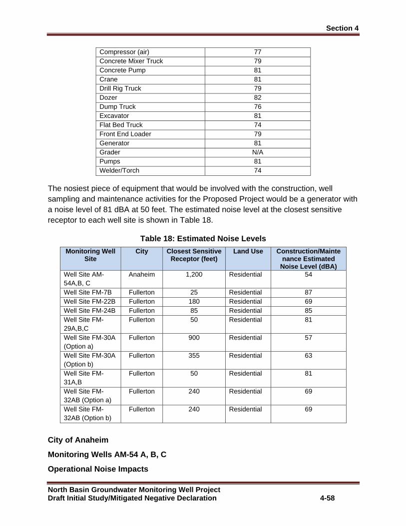
Section 4 �
North Basin Groundwater Monitoring Well Project Draft Initial Study/Mitigated Negative Declaration 4-58
Compressor (air) 77 Concrete Mixer Truck 79 Concrete Pump 81 Crane 81 Drill Rig Truck 79 Dozer 82 Dump Truck 76 Excavator 81 Flat Bed Truck 74 Front End Loader 79 Generator 81 Grader N/A Pumps 81 Welder/Torch 74
The nosiest piece of equipment that would be involved with the construction, well sampling and maintenance activities for the Proposed Project would be a generator with a noise level of 81 dBA at 50 feet. The estimated noise level at the closest sensitive receptor to each well site is shown in Table 18.
Table 18: Estimated Noise Levels
Monitoring Well Site
City Closest Sensitive Receptor (feet)
Land Use Construction/Maintenance Estimated
Noise Level (dBA) Well Site AM-54A,B, C
Anaheim 1,200 Residential 54
Well Site FM-7B Fullerton 25 Residential 87 Well Site FM-22B Fullerton 180 Residential 69 Well Site FM-24B Fullerton 85 Residential 85 Well Site FM-29A,B,C
Fullerton 50 Residential 81
Well Site FM-30A (Option a)
Fullerton 900 Residential 57
Well Site FM-30A (Option b)
Fullerton 355 Residential 63
Well Site FM-31A,B
Fullerton 50 Residential 81
Well Site FM-32AB (Option a)
Fullerton 240 Residential 69
Well Site FM-32AB (Option b)
Fullerton 240 Residential 69
City of Anaheim
Monitoring Wells AM-54 A, B, C
Operational Noise Impacts
Section 4 �
North Basin Groundwater Monitoring Well Project Draft Initial Study/Mitigated Negative Declaration 4-59
The proposed monitoring well would be equipped with submersible pumps for quarterly (or less frequent) sampling. A small generator would be used to power the pump. The infrequent and short-term duration noise emitted from the generator would not increase long term ambient noise levels within the study area.
Construction/Maintenance Noise Impacts
The City of Anaheim Noise Ordinance establishes daytime exterior noise standard of 60 dBA. As shown in Table 18, the construction noise levels for all proposed monitoring wells, except for Monitoring Well FM-30C, would be below the 60 dB exterior noise standard. The proposed well construction and maintenance activities for Monitoring Well FM-30C would occur during the hours of the day when construction noise would be exempt under the City of Anaheim Noise Ordinance. By limiting the well construction activities to the hours when construction activity would be allowed under the Noise Ordinance, no conflicts with the City of Anaheim standards would occur. With the implementation of Mitigation Measure N-1, N-2, N-3, N-4, N-5 and N-6 potential construction noise impacts would be less than significant.
City of Fullerton
Monitoring Well FM-7B, Monitoring Well FM-22B, Moni toring Well FM-24B, Monitoring Well FM-29A, B, C, Monitoring Well FM-30 A (Options a and b), Monitoring Wells FM-31 A, B, and Monitoring Wells F M-32 A, B (Options a and b)
Operational Noise Impacts
The proposed monitoring well would be equipped with submersible pumps for quarterly (or less frequent) sampling. A small generator would be used to power the pump. The infrequent and short-term duration noise emitted from the generator would not increase long term ambient noise levels within the study area.
Construction/Maintenance Noise Impacts
The City of Fullerton Noise Ordinance establishes daytime exterior noise standard of 55 dBA. As shown in Table 18, the construction noise level for all monitoring wells would exceed the 55 dBA exterior noise standard. The proposed well construction and maintenance activities would occur during the hours of the day when construction noise would be exempt under the City of Fullerton Noise Ordinance. With the implementation of Mitigation Measure N-1, N-2, N-3, N-4, N-5 and N-6 potential construction noise impacts would be less than significant.
Mitigation Measure
N-1: All construction activities and maintenance activities will occur during the hours of day when construction noise is exempt under the City of Anaheim and City of Fullerton Noise Ordinance.
Section 4 �
North Basin Groundwater Monitoring Well Project Draft Initial Study/Mitigated Negative Declaration 4-60
N-2: All construction operations will comply with Orange County Codified Division 6 (Noise Control) and stockpiling and/or vehicle staging areas will be located as far as practicable from dwellings.
N-3: All construction equipment will operate with mufflers and intake silencers.
N-4: No heavy construction equipment will operate before 7:00 a.m., including the warming up of engines.
N-5: Barriers will be installed around noise sources or directly between the construction area and the nearest residential home to shield residents from direct noise exposure from construction activities.
N-6: Prior to the commencement of construction and during ongoing construction, property owners including residents and businesses within the immediate vicinity of the construction activity will be notified of the construction activities and the construction schedule. Additionally, signs will posted that identifies the address, hotline number and name of designated person to contact for the purposes of responding to questions or complaints during the construction period.
B. Would the project result in a permanent increase in ambient noise levels in the project vicinity above levels existing without the project?
City of Anaheim
Monitoring Wells AM-54 A, B, C
City of Fullerton
Monitoring Well FM-7B, Monitoring Well FM-22B, Moni toring Well FM-24B, Monitoring Well FM-29A, B, C, Monitoring Well FM-30 A (Options a and b), Monitoring Wells FM-31 A, B, and Monitoring Wells F M-32 A, B (Options a and b)
Less than Significant Impact: The proposed monitoring well would be equipped with submersible pumps for quarterly (or less frequent) sampling. A small generator would be used to power the pump. The infrequent and short-term duration noise emitted from the generator would not increase long term ambient noise levels within the study area.
C. Would the project result in a substantial temporary or periodic inc rease in ambient noise levels in the project vicinity above levels existing without the project?
City of Anaheim
Monitoring Wells AM-54 A, B, C
City of Fullerton

Section 4 �
North Basin Groundwater Monitoring Well Project Draft Initial Study/Mitigated Negative Declaration 4-61
Monitoring Well FM-7B, Monitoring Well FM-22B, Moni toring Well FM-24B, Monitoring Well FM-29A, B, C, Monitoring Well FM-30 A (Options a and b), Monitoring Wells FM-31 A, B, and Monitoring Wells F M-32 A, B (Options a and b)
Less than Significant Impact with Mitigation: The construction, water sampling and maintenance activities operations associated with the proposed monitoring wells would temporarily increase ambient noise levels within the study area. All of these activities would occur during day when the construction noise would be exempt under the City of Anaheim Noise Ordinance and the City of Fullerton Noise Ordinance. With the implementation of Mitigation Measure N-1 N-2, N-3, N-4, N-5 and N-6 temporary noise impacts would be less than significant.
Mitigation Measure
Mitigation Measure N-1 N-2, N-3, N-4, N-5 and N-6 are required.
D. For a project located within an airport land use plan or where such a plan has not been adopted, within two miles of a public airport or public use airport, would the project expose people residing or working in th e project area to excessive noise levels?
City of Anaheim
Monitoring Wells AM-54 A, B, C
City of Fullerton
Monitoring Well FM-7B, Monitoring Well FM-22B, Moni toring Well FM-24B, Monitoring Well FM-29A, B, C, Monitoring Well FM-30 A (Options a and b), Monitoring Wells FM-31 A, B, and Monitoring Wells F M-32 A, B (Options a and b)
Less than Significant: The closest airport to the proposed monitoring wells would be Fullerton Municipal Airport. The Fullerton Municipal Airport Land Use Compatibility Plan identifies 65 CNEL and 60 CNEL noise impact zones around the airport where elevated levels of aircraft noise would occur. The proposed well sites are located outside of the airport’s noise impact zones. No mitigation measures are required.
E. For a project within the vicinity of a private a irstrip, would the project expose people residing or working in the project area to e xcessive noise levels?
City of Anaheim
Monitoring Wells AM-54 A, B, C
City of Fullerton
Monitoring Well FM-7B, Monitoring Well FM-22B, Moni toring Well FM-24B, Monitoring Well FM-29A, B, C, Monitoring Well FM-30 A (Options a and b), Monitoring Wells FM-31 A, B, and Monitoring Wells F M-32 A, B (Options a and b)
Section 4 �
North Basin Groundwater Monitoring Well Project Draft Initial Study/Mitigated Negative Declaration 4-62
No Impact: There is not a private air strip located within the study area. Therefore, the study area would not be adversely impacted by aircraft noise from a private air strip.
Vibration
Background
California Administrate Code 15000, Title 14 requires that all state and local agencies implement the California Environmental Quality Act (CEQA) Guideline, which requires an exposure analysis of persons to excessive groundborne vibration impacts. Common sources of vibration impacts from construction activities include; blasting, pile-driving and operation of heavy earth-moving equipment. Sensitive receptors for vibration include structures (especially older masonry structures, people and vibration sensitive equipment.
There are several different methods that are used to quantify vibration amplitude such as the maximum instantaneous peak in the vibrations velocity, which is known as the peak particle velocity (PPV) or the root mean square (rms) amplitude of the vibration velocity. Due to the typically small amplitudes of vibrations, vibration velocity is often expressed in decibels and is denoted as (Lv) and is based on the rms velocity amplitude. A commonly used abbreviation is “VdB”, which in this text, is when Lv is based on the reference quantity of 1 micro inch per second.
Typically, developed areas are continuously affected by vibration velocities of 50 VdB or lower. These continuous vibrations are not noticeable to humans whose threshold of perception is around 65 VdB. Off-site sources that may produce perceptible vibrations are usually caused by construction equipment, steel-wheeled trains, and traffic on rough roads, while smooth roads rarely produce perceptible ground-borne noise or vibration.
As vibration waves propagate from a source, the vibration energy decreases in a logarithmic nature and the vibration levels typically decrease by 6 VdB per doubling of the distance from the vibration source. As stated above, this drop-off rate can vary greatly depending on the soil but has been shown to be effective enough for screening purposes, in order to identify potential vibration impacts that may need to be studied through actual field tests.
Vibration Standards
Presently there is not local threshold that quantifies the level at which excessive groundborne vibration occurs. Caltrans issued the Transportation- and Construction-Induced Vibration Guidance Manual in 2004. This manual provides practical guidance to Caltrans engineers, planners, and consultants who must address vibration issues associated with the construction, operation, and maintenance of Caltrans projects. This manual is also used as a reference point by many lead agencies and CEQA practitioners throughout California, as it provides numeric thresholds for vibration
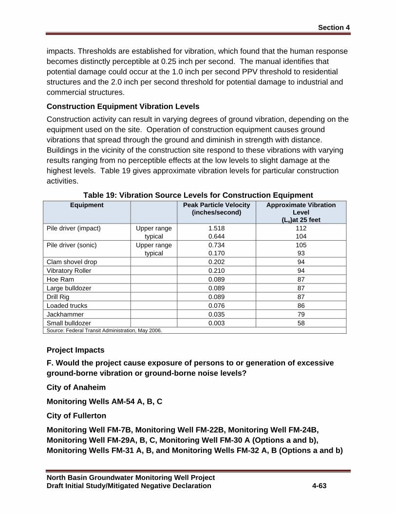
Section 4 �
North Basin Groundwater Monitoring Well Project Draft Initial Study/Mitigated Negative Declaration 4-63
impacts. Thresholds are established for vibration, which found that the human response becomes distinctly perceptible at 0.25 inch per second. The manual identifies that potential damage could occur at the 1.0 inch per second PPV threshold to residential structures and the 2.0 inch per second threshold for potential damage to industrial and commercial structures.
Construction Equipment Vibration Levels
Construction activity can result in varying degrees of ground vibration, depending on the equipment used on the site. Operation of construction equipment causes ground vibrations that spread through the ground and diminish in strength with distance. Buildings in the vicinity of the construction site respond to these vibrations with varying results ranging from no perceptible effects at the low levels to slight damage at the highest levels. Table 19 gives approximate vibration levels for particular construction activities.
Table 19: Vibration Source Levels for Construction Equipment Equipment Peak Particle Velocity
(inches/second) Approximate Vibration
Level (Lv)at 25 feet
Pile driver (impact) Upper range typical
1.518 0.644
112 104
Pile driver (sonic) Upper range typical
0.734 0.170
105 93
Clam shovel drop 0.202 94 Vibratory Roller 0.210 94 Hoe Ram 0.089 87 Large bulldozer 0.089 87 Drill Rig 0.089 87 Loaded trucks 0.076 86 Jackhammer 0.035 79 Small bulldozer 0.003 58 Source: Federal Transit Administration, May 2006.
Project Impacts
F. Would the project cause exposure of persons to o r generation of excessive ground-borne vibration or ground-borne noise levels ?
City of Anaheim
Monitoring Wells AM-54 A, B, C
City of Fullerton
Monitoring Well FM-7B, Monitoring Well FM-22B, Moni toring Well FM-24B, Monitoring Well FM-29A, B, C, Monitoring Well FM-30 A (Options a and b), Monitoring Wells FM-31 A, B, and Monitoring Wells F M-32 A, B (Options a and b)

Section 4 �
North Basin Groundwater Monitoring Well Project Draft Initial Study/Mitigated Negative Declaration 4-64
Less than Significant Impact: Potential vibration impacts from construction and operational activities associated with the Proposed Project would be a function of the vibration generated by construction equipment, equipment location, sensitivity of nearby land uses, and the timing and duration of the construction activities.
The City of Anaheim and the City of Fullerton Municipal Code or General Plan does not provide a quantifiable vibration threshold. To measure potential vibration impacts, Caltrans guidance was utilized, which defines the threshold of perception from transient sources at 0.25 inch per second PPV for potential human perception per second and 2.0 inch per second PPV for potential damage to industrial and commercial buildings occur at 1.0 inch per second for potential damage to residential structures
Table 19 provides a listing of construction equipment that is known sources of vibration. Of the equipment listed in Table 19, a rotary drill rig would be the piece of construction equipment that would be utilized by the Proposed Project with the highest vibration level, at 0.089 inch per second PPV at 25 feet. The closest well site to a structure would be Monitoring Wells AM-54A, B, C, at 25 feet from an existing industrial/commercial building and FM-7B at 25 feet from an existing residential condominium structure. At this distance the vibration level at these well sites would be .089 inch per second PPV, which would be below the 0.25 inch per second threshold for human perception and the 2.0 inch per second threshold for potential structural damage for industrial and commercial buildings and the 1.0 inch per second PPV threshold for potential damage to residential structures. All of the other well sites are greater than 25 feet from a structure and would not exceed the 0.25 inch per second PPV threshold for potential human perception, 1.0 inch per second PPV threshold for potential damage to residential structures or the 2.0 inch per second threshold for potential damage to industrial and commercial structures. Therefore, less than significant vibration impacts are anticipated to occur from construction and operation of the Proposed Project. No mitigation measures are required.
4.13 Population/Housing
A. Would the project induce substantial population growth in an area, either directly or indirectly?
City of Anaheim
Monitoring Wells AM-54 A, B, C
City of Fullerton
Monitoring Well FM-7B, Monitoring Well FM-22B, Moni toring Well FM-24B, Monitoring Well FM-29A, B, C, Monitoring Well FM-30 A (Options a and b), Monitoring Wells FM-31 A, B, and Monitoring Wells F M-32 A, B (Options a and b)
Section 4 �
North Basin Groundwater Monitoring Well Project Draft Initial Study/Mitigated Negative Declaration 4-65
No Impact: The Proposed Project would not extend new infrastructure into any undeveloped area and would not provide underground water supplies to any undeveloped areas. Implementation of the Proposed Project would not induce any substantial population growth into the study area. No mitigation measures are required.
B. Would the project displace substantial numbers o f existing housing, necessitating the construction of replacement housi ng elsewhere?
City of Anaheim
Monitoring Wells AM-54 A, B, C
City of Fullerton
Monitoring Well FM-7B, Monitoring Well FM-22B, Moni toring Well FM-24B, Monitoring Well FM-29A, B, C, Monitoring Well FM-30 A (Options a and b), Monitoring Wells FM-31 A, B, and Monitoring Wells F M-32 A, B (Options a and b)
No Impact: The implementation of the Proposed Project would not displace any existing housing and therefore would not require the construction of any replacement housing. No mitigation measures are required.
C. Would the project displace substantial numbers o f people, necessitating the construction of replacement housing elsewhere?
City of Anaheim
Monitoring Wells AM-54 A, B, C
City of Fullerton
Monitoring Well FM-7B, Monitoring Well FM-22B, Moni toring Well FM-24B, Monitoring Well FM-29A, B, C, Monitoring Well FM-30 A (Options a and b), Monitoring Wells FM-31 A, B, and Monitoring Wells F M-32 A, B (Options a and b)
No Impact: The implementation of the Proposed Project would not displace any households and therefore would not require the construction of any replacement housing. No mitigation measures are required.
4.14 Public Services
A. Would the project result in substantial adverse physical impacts associated with the provision of new or physically altered gov ernmental facilities, need for new or physically altered governmental facilities, the construction of which could cause significant environmental impacts, in order to maintain acceptable service ratios, response times or other performance objectives for fire protection police protection, schools, parks or other public faciliti es.
City of Anaheim
Monitoring Wells AM-54 A, B, C

Section 4 �
North Basin Groundwater Monitoring Well Project Draft Initial Study/Mitigated Negative Declaration 4-66
City of Fullerton
Monitoring Well FM-7B, Monitoring Well FM-22B, Moni toring Well FM-24B, Monitoring Well FM-29A, B, C, Monitoring Well FM-30 A (Options a and b), Monitoring Wells FM-31 A, B, and Monitoring Wells F M-32 A, B (Options a and b)
No Impact: The Proposed Project would be operated and maintained by OCWD and would not increase the demand for public services over the current level of demand and would not require the construction of any new governmental facilities. No mitigation measures are required.
4.15 Recreation
A. Would the project increase the use of existing n eighborhood and regional parks or other recreational facilities such that su bstantial physical deterioration of the facility would occur or be accelerated?
City of Anaheim
Monitoring Wells AM-54 A, B, C
City of Fullerton
Monitoring Well FM-7B, Monitoring Well FM-24B, Moni toring Well FM-29A, B, C, Monitoring Well FM-30 A (Options a and b), Monitori ng Wells FM-31 A, B, and Monitoring Wells FM-32 A, B (Options a and b)
No Impact . The implementation Proposed Project would not involve any activities that would increase the use of existing neighborhood parks or recreation facilities. No mitigation measures are required.
City of Fullerton
Monitoring Well FM-22B
Less than Significant Impact: The construction activities for the proposed monitoring well would temporary displace nine parking spaces from the Woodcrest Park parking lot over a two week period. The temporary loss of parking spaces would not significantly restrict public access to the park causing the public to seek alternative recreation facilities. Implementation of the Proposed Project would not increase the use of existing recreation to where physical deterioration of the facilities would occur.
B. Does the project include recreational facilities or require the construction or expansion of recreational facilities which might have an adverse physical effect on the environment.
City of Anaheim
Monitoring Wells AM-54 A, B, C
City of Fullerton
Section 4 �
North Basin Groundwater Monitoring Well Project Draft Initial Study/Mitigated Negative Declaration 4-67
Monitoring Well FM-7B, Monitoring Well FM-22B, Moni toring Well FM-24B, Monitoring Well FM-29A, B, C, Monitoring Well FM-30 A (Options a and b), Monitoring Wells FM-31 A, B, and Monitoring Wells F M-32 A, B (Options a and b)
No Impact . The Proposed Project does not propose new recreation facilities or proposes to expand existing recreation facilities. Therefore, no adverse impacts associated with the construction of new recreation facilities would occur. No mitigation measures are required.
4.16 Transportation/Traffic
A. Would the project be in conflict with an applica ble plan, ordinance or policy establishing measures of effectiveness for the perf ormance of the circulation system, taking into account all modes of transporta tion including mass transit and non-motorized travel and relevant components of the circulation system, including but not limited to intersections, streets, highways and freeways, pedestrians and bicycle paths.
City of Anaheim
Monitoring Wells AM-54 A, B, C
City of Fullerton
Monitoring Well FM-7B, Monitoring Well FM-22B, Moni toring Well FM-24B, Monitoring Well FM-29A, B, C, Monitoring Well FM-30 A (Options a and b), Monitoring Wells FM-31 A, B, and Monitoring Wells F M-32 A, B (Options a and b)
Less than Significant Impact with Mitigation: The operation of the Proposed Project would not generate any long term traffic trips. Therefore, no long term adverse traffic impacts would occur. The construction operations for the Proposed Project would involve the mobilization and demobilization of construction equipment which if occurred during peak traffic periods could result in short-term adverse traffic congestion impacts along some roadway segments and intersections within the study area circulation system. To avoid potential short-term traffic congestion impacts, the construction equipment mobilization and demobilization activities would occur during non-peak traffic periods.
OCWD periodically would visit each well site and collect water samples. Additionally, every three to five years OCWD would conduct maintenance activities to redevelop the wells. The operation of the Proposed Project would generate a minimal amount of traffic trips and would not reduce the level of service of any project area roadway segment or intersection. To avoid potential short-term traffic congestion impacts, water sampling activities and well redevelopment activities would also occur during non-peak traffic periods. With the implementation of Mitigation Measure T-1 potential short-term traffic impacts would be less than significant.
Section 4 �
North Basin Groundwater Monitoring Well Project Draft Initial Study/Mitigated Negative Declaration 4-68
Mitigation Measure
T-1: Construction equipment mobilization and demobilization and water sampling activities and well redevelopment activities will occur outside of peak traffic periods.
B. Would the project be in conflict with an applicable congestion management program, including, but not limited to level of ser vice standards and travel demand measures, or other standards and travel dema nd measures, or other standards established by County congestion manageme nt agency for designated roads and highways.
City of Anaheim
Monitoring Wells AM-54 A, B, C
City of Fullerton
Monitoring Well FM-7B, Monitoring Well FM-22B, Moni toring Well FM-24B, Monitoring Well FM-29A, B, C, Monitoring Well FM-30 A (Options a and b), Monitoring Wells FM-31 A, B, and Monitoring Wells F M-32 A, B (Options a and b)
Less than Significant Impact: The Orange County Transportation Agency is responsible for the implementation of the County Congestion Management Program (CMP). The CMP is designed to reduce traffic congestion and to provide a mechanism for the coordination of land use and transportation decisions. The CMP identifies deficit highway and intersections in the County of Orange Circulation System and identifies planned performance standards. When a project generates more than 100 peak hour traffic trips along a CMP highway or 51 or more vehicle trips through a CMP intersection, the project is required to prepare a traffic impact study to evaluate the impacts on the CMP highway and intersection. If the amount of traffic trips generated by the project does not require the preparation of a traffic impact study, the traffic would be considered to have a de minimis impact on the CMP circulation system.
The operation of the Proposed Project would not generate any long term traffic trips. Therefore the operation of the Proposed Project would not be in conflict County of Orange Congestion Management Plan. The construction activities and periodic maintenance and well sampling activities would generate a minimal amount of traffic trips. There would be the potential that access to the proposed well sites could require travel along CMP highways and intersections. However, the Proposed Project would not generate 100 peak hour trips or generate 51 peak trips through a CMP intersection. Therefore, the Proposed Project would not require preparation of a traffic impact study and would be considered to less than significant impact on the CMP circulation system. No mitigation measures are required.

Section 4 �
North Basin Groundwater Monitoring Well Project Draft Initial Study/Mitigated Negative Declaration 4-69
C. Would the project result in a change in air traf fic patterns, including either an increase in traffic levels or a change in location that results in substantial safety risks?
City of Anaheim
Monitoring Wells AM-54 A, B, C
City of Fullerton
Monitoring Well FM-7B, Monitoring Well FM-22B, Moni toring Well FM-24B, Monitoring Well FM-29A, B, C, Monitoring Well FM-30 A (Options a and b), Monitoring Wells FM-31 A, B, and Monitoring Wells F M-32 A, B (Options a and b)
No Impact: The Fullerton Municipal Airport AELUP identifies that the proposed monitoring well sites are outside of the AELUP Height Restriction Zone. Additionally, the proposed monitoring wells would be underground and would not encroach into any navigable air space and would not cause a change air traffic patterns that would increase aviation safety risks. No mitigation measures are required.
D. Would the project increase hazards to a design f eature or incompatible uses or equipment?
City of Anaheim
Monitoring Wells AM-54 A, B, C
City of Fullerton
Monitoring Well FM-7B, Monitoring Well FM-22B, Moni toring Well FM-24B, Monitoring Well FM-29A, B, C, Monitoring Well FM-30 A (Options a and b), Monitoring Wells FM-31 A, B, and Monitoring Wells F M-32 A, B (Options a and b)
Less than Significant Impact with Mitigation: The construction activities for the Proposed Project would require an approximate 20 foot by 100 foot construction footprint foot work area. Depending on the well site, the construction activities for the Proposed Project would temporary require travel lane closures and displacement of onsite parking areas within the study area. A summary of the temporary impacts to roadways and parking spaces that would occur from the implementation of the Proposed Project are shown in Table 20.
Table 20: Roadway and Parking Area Impacts
Monitoring Well Site Impact Duration
AM-54A,B,C Temporary traffic lane closure along 225 foot segment Durst Road, west of cul-de-sac.
1 Month
FM-7B Traffic lane closure along 350 foot segment Orangefair Drive, approximately between south Pomona Road and well site.
2 Weeks
FM-22B Temporary displacement 9 parking spaces, including handicap 2 Weeks

Section 4 �
North Basin Groundwater Monitoring Well Project Draft Initial Study/Mitigated Negative Declaration 4-70
space. FM-24B Temporary closure portion West Houston Avenue cul-de-sac. Two Weeks FM-29,A,B,C Temporary closure portion West Oak Avenue cul-de-sac. 1 Month FM-30A (Option a) Temporary displacement 24 on-site parking spaces. 2 Weeks FM-30A (Option b) Temporary displacement 36 on-site parking spaces. 2 Weeks FM-31A,B Temporary closure South Pomona Avenue. 3 Weeks FM-32A,B (Option a) Temporary displacement 17 on-site parking spaces. 3 weeks FM-32A,B (Option b) Temporary traffic lane closure along 225 foot segment along
South Basque Avenue. 3 Weeks
Temporary Traffic Lane Closure
The construction activities at Monitoring Well Sites AM-54A, B, C, FM-7B, FM-31A, FM-31A, B and FM-32A,B (Option b) would require temporary closure of a traffic lane in the immediate vicinity of the well site. If needed to ensure safe access during peak traffic periods traffic detour control measures and flagman would be used to direct traffic around the construction area. Additionally, signage would be provided identifying temporary lane closures. With implementation of Traffic Control Plan potential vehicle access hazard impacts would be reduced to a less than significant level.
Temporary Displacement of Parking
The construction activities at Monitoring Well Sites FM-22B, FM-30A (Options a and b) , and FM-32A,B (Option a) would temporarily displace onsite parking spaces at the well site locations. For well sites that are located on commercial and industrial properties, prior two weeks before of the start of construction, OCWD would notify property owners when construction activities would begin and what parking areas would be temporarily impacted by construction. Additionally, OCWD would install temporary signage identifying which parking areas on the property would be temporary closed and the duration of the closure. For well sites located within residential areas, residents within the vicinity of the well site would be notified of upcoming construction schedule and temporary roadway closures and temporary loss of on-street parking near the well site. With the implementation of Mitigation Measures T-2, T-3, T-4 and T-5 potential traffic constraints associated with Proposed Project would be less than significant.
Mitigation Measures
T-2: Prior to issuance of encroachment permit for Monitoring Well Sites AM-54 A, B, C, FM-7B, OCWD will coordinate with the City of Anaheim and the City of Fullerton on the need to prepare a Traffic Management that identifies traffic control measures to ensure safe vehicle access through the construction area.
T-3: Prior to two weeks of the start of construction on well sites FM-22B, FM-30A (Options a and b) and FM-32A,B (Option a), OCWD will notify property owners of the upcoming construction schedule construction activities and what parking areas would
Section 4 �
North Basin Groundwater Monitoring Well Project Draft Initial Study/Mitigated Negative Declaration 4-71
be temporarily impacted by construction and will install temporary signage that identifies which parking areas would be temporary closed.
T-4: Prior to two weeks of the start of well construction within residential areas, OCWD will notify property owners within the vicinity of the well site of the upcoming construction schedule and temporary roadway closures and temporary loss of on-street parking near well sites.
T-5: Prior to the start of construction of Monitoring Well FM-22B, one the existing parking spaces at Woodcrest Park would temporary identified as a handicap parking space.
E. Would the project result in inadequate emergency access?
City of Anaheim
Monitoring Wells AM-54 A, B, C
City of Fullerton
Monitoring Well FM-7B, Monitoring Well FM-22B, Moni toring Well FM-24B, Monitoring Well FM-29A, B, C, Monitoring Well FM-30 A (Options a and b), Monitoring Wells FM-31 A, B, and Monitoring Wells F M-32 A, B (Options a and b)
Less than Significant Impact with Mitigation: The construction and operation of the Proposed Project would not require the closure of any streets or driveways that would impede emergency access. Traffic Control Management Plans or other measures would be implemented to ensure that during construction activities adequate emergency access would be maintained at all times. With the implementation of Mitigation Measure T-2 potential emergency safety impacts would be less than significant.
Mitigation Measures
Mitigation Measure T-2 is required.
F. Would the project be in conflict with adopted policies, plans, or pr ograms regarding public transit, bicycle, or pedestrian fa cilities or otherwise decrease the performance or safety of such facilities?
City of Anaheim
Monitoring Wells AM-54 A, B, C
City of Fullerton
Monitoring Well FM-7B, Monitoring Well FM-22B, Moni toring Well FM-24B, Monitoring Well FM-29A, B, C, Monitoring Well FM-30 A (Options a and b), Monitoring Wells FM-31 A, B, and Monitoring Wells F M-32 A, B (Options a and b)

Section 4 �
North Basin Groundwater Monitoring Well Project Draft Initial Study/Mitigated Negative Declaration 4-72
Less than Significant Impact with Mitigation: The operation of the Proposed Project would not require closure of public transportation, bicycle or pedestrian circulation systems. During construction the mobilization and demobilization of heavy construction equipment and construction activities at the well sites could result in the temporary closure and detouring of pedestrian sidewalks and/or bike lanes near the work area for safety reasons. The closure would be temporary and an alternative pedestrian access would be provided if needed. With the implementation of Mitigation Measure T-2 potential conflicts with mass transit, pedestrian and bicycle facilities would be less than significant.
Mitigation Measure
Mitigation Measure T-2 is required.
4.17 Tribal Cultural Resources
A. Would the project cause a substantial adverse ch ange in the significance of a tribal cultural resource as either a site, feature, place, cultural landscape that is geographically defined in terms of the size and sco pe of the landscape, sacred place, or object with value to a California Native American Tribe and that is listed or eligible for listing in the California Register or Historical Resources, or in a local register of historical resources.
City of Anaheim
Monitoring Wells AM-54 A, B, C
City of Fullerton
Monitoring Well FM-7B, Monitoring Well FM-22B, Moni toring Well FM-24B, Monitoring Well FM-29A, B, C, Monitoring Well FM-30 A (Options a and b), Monitoring Wells FM-31 A, B, and Monitoring Wells F M-32 A, B (Options a and b)
Less than Significant Impact with Mitigation: Based on review of the records search conducted by the South Coast Information Center, none of the proposed well sites are considered culturally significant. Additionally, the Native American Heritage Commission (NAHC) was notified of the proposed project on November 11, 2016, and requested to review its Sacred Lands Files for the presence of any cultural resources on or near the project site.
The records search review and NAHC coordination identified that there were no cultural resources or Native American Sacred lands on the proposed well sites, but that were several cultural resources that have been recorded within ½ mile radius of the study area.
On November 10, 2016, Daniel Bott, Principal Planner at OCWD, contacted the two tribes that have requested to be informed of OCWD projects under AB 52: Joyce Stanfield Perry, Tribal Manager, Juaneño Band of Mission Indians, Acjachemen Nation
Section 4 �
North Basin Groundwater Monitoring Well Project Draft Initial Study/Mitigated Negative Declaration 4-73
and Andrew Salas, Chairman, Gabrieleno Band of Mission Indians, Kizh Nation. Ms. Perry responded on December 6, 2016, and stated that the tribe has no concerns at this time, but would like to be kept updated if any changes occur. Chairman Salas has not responded to date.
The cultural resource record search conducted for the study area indicated that the proposed well sites have low cultural resource sensitivity. However, because cultural resources have been recorded in the study area vicinity, there is the potential that unknown and unrecorded cultural resources could be present in the subsurface and could be uncovered during construction activities. With the implementation of Mitigation Measure CR-1 and CR-3 potential impacts to tribal resources would be less than significant.
Mitigation Measure
Mitigation Measure CR-1 and CR-3 is required.
B. Would the project cause a substantial adverse ch ange in the significance of a tribal cultural resource as either a site, feature, place, cultural landscape that is geographically defined in terms of the size and sco pe of the landscape, sacred place, or object with value to a California Native American Tribe and that is a resource determined by the lead agency in its discr etion and supported by substantial evidence to be significant and which the lead agency considers the significance of the resource to a California Native American tribe.
City of Anaheim
Monitoring Wells AM-54 A, B, C
City of Fullerton
Monitoring Well FM-7B, Monitoring Well FM-22B, Moni toring Well FM-24B, Monitoring Well FM-29A, B, C, Monitoring Well FM-30 A (Options a and b), Monitoring Wells FM-31 A, B, and Monitoring Wells F M-32 A, B (Options a and b)
Less than Significant Impact with Mitigation: Based on coordination with local tribes to the study area, it has been determined that no Native American resources are known to occur within the study area. To avoid impacts to unknown cultural resources mitigation measures have been incorporated into the Proposed Project that would require construction activity to cease in the unlikelihood unknown Native American resources are encountered. With the implementation of Mitigation Measure CR-1 and CR-3 potential impacts Native American resources would be less than significant.
Mitigation Measures
Mitigation Measure CR-1 and CR-3 is required.

Section 4 �
North Basin Groundwater Monitoring Well Project Draft Initial Study/Mitigated Negative Declaration 4-74
4.18 Utilities/Service Systems
A. Would the project exceed wastewater treatment re quirements of the applicable Regional Water Quality Control Board?
City of Anaheim
Monitoring Wells AM-54 A, B, C
City of Fullerton
Monitoring Well FM-7B, Monitoring Well FM-22B, Moni toring Well FM-24B, Monitoring Well FM-29A, B, C, Monitoring Well FM-30 A (Options a and b), Monitoring Wells FM-31 A, B, and Monitoring Wells F M-32 A, B (Options a and b)
No Impact: Groundwater generated during pumping and sampling of the monitoring wells would be treated and discharged under a NPDES permit issued to OCWD by the Santa Ana RWQCB.
B. Would the project require or result in the const ruction of new water or wastewater treatment facilities or expansion of exi sting facilities, the construction of which could cause significant environmental effects?
City of Anaheim
Monitoring Wells AM-54 A, B, C
City of Fullerton
Monitoring Well FM-7B, Monitoring Well FM-22B, Moni toring Well FM-24B, Monitoring Well FM-29A, B, C, Monitoring Well FM-30 A (Options a and b), Monitoring Wells FM-31 A, B, and Monitoring Wells F M-32 A, B (Options a and b)
Less than Significant Impact with Mitigation: The Proposed Project involves the construction of 14 new monitoring wells. As identified in the initial study, mitigation measures have been incorporated into the Proposed Project to reduce potentially significant impacts to the environment to a less than significant level.
C. Would the project require or result in the const ruction of new storm water drainage facilities or expansion of existing facili ties, the construction of which could cause significant environmental effects?
City of Anaheim
Monitoring Wells AM-54 A, B, C
City of Fullerton
Monitoring Well FM-7B, Monitoring Well FM-22B, Moni toring Well FM-24B, Monitoring Well FM-29A, B, C, Monitoring Well FM-30 A (Options a and b), Monitoring Wells FM-31 A, B, and Monitoring Wells F M-32 A, B (Options a and b)

Section 4 �
North Basin Groundwater Monitoring Well Project Draft Initial Study/Mitigated Negative Declaration 4-75
No Impact: The Proposed Project would not involve construction of new storm water drainage facilities or expansion of existing storm water drainage facilities. No mitigation measures are required.
D. Are sufficient water supplies available to serve the project from existing entitlements and resources or new or expanded entit lements needed?
City of Anaheim
Monitoring Wells AM-54 A, B, C
City of Fullerton
Monitoring Well FM-7B, Monitoring Well FM-22B, Moni toring Well FM-24B, Monitoring Well FM-29A, B, C, Monitoring Well FM-30 A (Options a and b), Monitoring Wells FM-31 A, B, and Monitoring Wells F M-32 A, B (Options a and b)
No Impact. The purpose of the Proposed Project is to evaluate the extent and nature of groundwater contamination within the North Basin area of the Orange County Groundwater Basin to help develop remedial action plan that would remove contaminates from the groundwater basin. The operation of the Proposed Project would not require ongoing water supplies or service. No mitigation measures required.
E. Would the project result in the determination by the wastewater treatment provider which serves or may serve the project that it has adequate capacity to serve the project’s projected demand in addition to the providers existing commitments.
City of Anaheim
Monitoring Wells AM-54 A, B, C
City of Fullerton
Monitoring Well FM-7B, Monitoring Well FM-22B, Moni toring Well FM-24B, Monitoring Well FM-29A, B, C, Monitoring Well FM-30 A (Options a and b), Monitoring Wells FM-31 A, B, and Monitoring Wells F M-32 A, B (Options a and b)
No Impact: The Proposed Project does not include any plans to construct wastewater treatment facilities. Therefore, the implementation of the Proposed Project would not have any impact on the capacity of wastewater treatment providers to the area. No mitigation measures required.
F. Is the project served by a landfill with suffici ent permitted capacity to accommodate the project solid waste disposal need?
City of Anaheim
Monitoring Wells AM-54 A, B, C
Section 4 �
North Basin Groundwater Monitoring Well Project Draft Initial Study/Mitigated Negative Declaration 4-76
City of Fullerton
Monitoring Well FM-7B, Monitoring Well FM-22B, Moni toring Well FM-24B, Monitoring Well FM-29A, B, C, Monitoring Well FM-30 A (Options a and b), Monitoring Wells FM-31 A, B, and Monitoring Wells F M-32 A, B (Options a and b)
Less than Significant Impact with Mitigation: The closest landfill to the study area 2 would be the Brea Olinda Landfill which accepts up to 8,000 tons per day. The long term operation of the Proposed Project would not increase the demand for solid waste disposal over the current level of demand. Construction operations associated with the Proposed Project would generate limited amounts of solid waste. The proposed project would comply with federal, state and local statues and regulations related to solid waste and where possible would recycle discarded construction materials and other solid waste. The amount of construction related solid waste generate from Proposed Project would have a less than significant impact on the capacity of the landfill. To minimize solid waste disposal demands OCWD would investigate all available alternatives, and then select the best method of solid waste disposal and reduction of solid waste stream. With the implementation of Mitigation Measure U-1 potential solid waste disposal needs would be less than significant.
Mitigation Measure
U-1: OCWD will investigate all available alternatives, and then select the best method of solid waste disposal and reduction of solid waste stream as required in the California Integrated Waste Management Act prior to the start of construction.
G. Would the project comply with federal, state and local statutes and regulations related to solid waste?
City of Anaheim
Monitoring Wells AM-54 A, B, C
City of Fullerton
Monitoring Well FM-7B, Monitoring Well FM-22B, Moni toring Well FM-24B, Monitoring Well FM-29A, B, C, Monitoring Well FM-30 A (Options a and b), Monitoring Wells FM-31 A, B, and Monitoring Wells F M-32 A, B (Options a and b)
Less than Significant Impact with Mitigation : Any solid waste generated by the proposed project would be hauled from the site, diverted and recycled, in accordance with the California Integrated Waste Management Act of 1989. If any hazardous materials are encountered, the OCWD would coordinate with the Cities of Anaheim and Fullerton and the Orange County Health Care Agency’s Certified Unified Program Agency to ensure that all hazardous wastes would be disposed of properly in accordance with local, state and federal laws. No mitigation measures are required.
Section 4 �
North Basin Groundwater Monitoring Well Project Draft Initial Study/Mitigated Negative Declaration 4-77
With the implementation of Mitigation Measure U-1 potential conflicts with federal, state and local statutes and regulations related to solid waste would be less than significant.
Mitigation Measure
Mitigation Measure U-1 is required.
4.19 Mandatory Findings of Significance
A. Does the project have the potential to degrade t he quality of the environment, substantially reduce the habitat of fish or wildlife species, cause a fish or wildlife population to drop below self-sustaining levels, th reaten to eliminate a plant or animal community, reduce the number or restrict the range of a rare or endangered plant or animal or eliminate important examples of the major periods of California history or prehistory.
City of Anaheim
Monitoring Wells AM-54 A, B, C
City of Fullerton
Monitoring Well FM-7B, Monitoring Well FM-22B, Moni toring Well FM-24B, Monitoring Well FM-29A, B, C, Monitoring Well FM-30 A (Options a and b), Monitoring Wells FM-31 A, B, and Monitoring Wells F M-32 A, B (Options a and b)
Less than Significant with Mitigation: Implementation of the Proposed Project would not result in direct impacts to sensitive plans, wildlife or habitat. The Proposed Project would also not result in any impacts to any known cultural resources and the potential to encounter unknown cultural resources would be very low. Mitigation Measures have been incorporated into the Proposed Project to avoid significant impacts to unknown cultural resources in the unlikely event they are encountered.
B. Does the project have impacts that are individua lly limited but cumulatively considerable?
City of Anaheim
Monitoring Wells AM-54 A, B, C
City of Fullerton
Monitoring Well FM-7B, Monitoring Well FM-22B, Moni toring Well FM-24B, Monitoring Well FM-29A, B, C, Monitoring Well FM-30 A (Options a and b), Monitoring Wells FM-31 A, B, and Monitoring Wells F M-32 A, B (Options a and b)
Less than Significant Impact with Mitigation: The Proposed Project would comply with local and regional planning programs, applicable codes and ordinances, State and Federal laws and regulations and project specific mitigation measures. Compliance with
Section 4 �
North Basin Groundwater Monitoring Well Project Draft Initial Study/Mitigated Negative Declaration 4-78
these programs would reduce the Proposed Project’s incremental contributions to cumulative impacts to a less than significant level.
C. Does the project have environmental effects whic h will cause substantial adverse effects on human beings, either directly or indirectly?
City of Anaheim
Monitoring Wells AM-54 A, B, C
City of Fullerton
Monitoring Well FM-7B, Monitoring Well FM-22B, Moni toring Well FM-24B, Monitoring Well FM-29A, B, C, Monitoring Well FM-30 A (Options a and b), Monitoring Wells FM-31 A, B, and Monitoring Wells F M-32 A, B (Options a and b)
Less than Significant Impact with Mitigation: The Proposed Project would comply with local and regional planning programs, applicable codes, and ordinances, State and Federal laws and regulations and project specific mitigation measures to insure that long term operation activities and short term construction activities associated with the proposed project would not result in direct, or indirect adverse impacts to human beings.

Section 5 �
North Basin Groundwater Monitoring Well Project Draft Initial Study/Mitigated Negative Declaration 5-1
SECTION 5.0 REFERENCES
Bowler, P.A. and M.E. Elvin, 2003The Vascular Plant Checklist for the University of California Natural Reserve System San Joaquin Marsh
California Department Fish and Game Natural Diversity Database, Accessed 2015
California Department of Transportation Scenic Highways Program Web Site Accessed, 2016
California Environmental Quality Act, State CEQA Guidelines, 2016.
California Farmland Mapping Monitoring Program, Web Site Access, 2016.
California Geologic Survey Seismic Hazard Zone Map Tustin, Orange Quadrangle, Accessed October 2016.
California Native American Heritage Commission Record Search, 2016.
California Native Plant Society Inventory of Rare and Endangered Plants Database, Accessed 2016
City Anaheim General Plan, Site Access 2016.
City of Anaheim Municipal Code, Site Access October 2016.
City of Fullerton General Plan Site Access October 2016.
City of Fullerton Municipal Code Site Access October 2016.
County of Orange Model Water Quality Management Plan, 2011.
Federal Transit Agency, Noise Associated with Typical construction Equipment, 1995.
Federal Transit Agency, Transit Noise and Vibration Assessment, 2006
Melville C. Branch and R. Dale Bland, Noise Levels and Human Response, 1970.
National Water Research Institute Santa Ana River Water Quality and Health Study, 2004.
Orange County Water District Groundwater Management Plan, 2009.
Regional Water Quality Control Board, Santa Ana River Basin Plan, January 1995.
U.S. Army Corps of Engineers Regional Supplement to the Corps of Engineers Wetland Delineation Manual Arid Wet Region, September 2008.
Orange County Water District North Basin Groundwater Monitoring Well Project Final Mitigated Negative Declaration Response to Comments/Mitigation Monitoring Program State Clearinghouse No. 2017011068
Prepared By Orange County Water District 18700 Ward Street Fountain Valley, CA 92708 Contact: Daniel Bott
April 2017
Table of Contents
�
Orange County Water District North Basin Groundwate r Monitoring Well Project Final Mitigated Negative Declaration Response to Co mments Mitigation Monitoring Program i
Section Page SECTION 1.0 PURPOSE ......................................................................................... 1-1
SECTION 2.0 MITIGATION MONITORING PROGRAM .......................................... 2-1 2.1 Introduction ..................................................................................................... 2-1
2.2 Project Description .......................................................................................... 2-1 2.3 Development of Mitigation Monitoring Reporting Program .............................. 2-1
2.4 Requirement to Approve and Implement Mitigation Monitoring Plan ............... 2-2 Table Table 1: List of Comment Letters ................................................................................. 1-2
Table 2: North Basin Groundwater Monitoring Well Project ......................................... 2-3
Purpose
�
Orange County Water District North Basin Groundwate r Monitoring Well Project Final Mitigated Negative Declaration Response to Co mments Mitigation Monitoring Program 1-1
SECTION 1.0 PURPOSE
In compliance with the requirements of the California Environmental Quality Act (CEQA) Public Resources Code Section 21000 et seq. and the CEQA Guidelines, the Orange County Water District (OCWD) has prepared a Draft Initial Study/Mitigated Negative Declaration (Draft IS/MND) for the North Basin Groundwater Monitoring Well Project (State Clearinghouse No. 2017011068). The Draft IS/MND was circulated for public review from January 27, 2017 to February 27, 2017. During the public review period, comments were received on the Draft IS/MND which have been addressed in the North Basin Groundwater Monitoring Well Project Response to Comment/Mitigation Monitoring Plan Document. The North Basin Groundwater Monitoring Well Project Draft Initial Study/Mitigated Negative with public comments, OCWD response to comments and the Mitigation Monitoring Plan constitute the Final Mitigated Negative Declaration for the North Basin Groundwater Monitoring Well Project.

Purpose
�
Orange County Water District North Basin Groundwate r Monitoring Well Project Final Mitigated Negative Declaration Response to Co mments Mitigation Monitoring Program 1-2
RESPONSES TO COMMENT LETTERS
In accordance with Section 15088 of the CEQA Guidelines, the OCWD as the Lead Agency has evaluated the comments received on the South Basin Additional Groundwater Monitoring Program Draft IS/MND. In accordance with CEQA Guidelines, the OCWD has prepared responses for each comment received. Below is a listing of the public agencies that provided comments on the Draft IS/MND. Each comment letter and individual comments are numbered so that can be cross referenced with responses.
Table 1: List of Comment Letters
Letter Sender Date Received
1 City Anaheim March 1, 2017
2 City of Fullerton March 1, 2017
C Orange County Public Works March 2, 2017
D Santa Ana Regional Water Quality Control Board March 2, 2017
E California Department Toxic Substance Control February 27, 2017
City of Anaheim PLANNING & BUILDING DEPARTMENT
200 S. Anaheim Blvd. Suite #162 Anaheim, CA 92805 Tel: (714) 765-5139 Fax: (714) 765-5280 www.anaheim.net
March 1, 2017 Dan Bott, Principal Planner By e-mail to: [email protected] Orange County Water District 18700 Ward Street Fountain Valley, CA 92708 Subject: Notice of Intent to Adopt a Mitigated Negative Declaration for the North
Basin Monitoring Well Project Dear Mr. Bott: Thank you for the opportunity to review and comment on the above-referenced document. The Planning Services Division provides the comments below. No other comments have been received from the City’s interdepartmental review group. a) There is a discrepancy in the location of Proposed Monitoring Well Sites FM-30A,
Options (a) and (b). Figures 1 and 7 show Option (a) on the east side of Lemon Street, in the City of Anaheim, and Option (b) on the west side of Lemon Street, in the City of Fullerton. The City boundary lies in the easterly limit of Lemon Street.
b) The text describing Monitoring Well FM-30A is also inconsistent with what is depicted in Figures 1 and 7, identifying both Options (a) and (b) on the east side of Lemon Street in the City of Fullerton. As depicted in the figures, Option (a) is on the east side of Lemon Street in the City of Anaheim and Option (b) is on the west side of Lemon Street in the City of Fullerton.
c) Please revise the document and figures to accurately and consistently depict the
locations of sites FM-30A, Options (a) and (b). If you have any questions regarding these comments, please do not hesitate to contact Christine Saunders at (714) 765-5238 or me at (714) 765-4958. Sincerely, Susan Kim, AICP, LEED AP ND Principal Planner
Purpose
�
Orange County Water District North Basin Groundwate r Monitoring Well Project Final Mitigated Negative Declaration Response to Co mments Mitigation Monitoring Program 1-4
City of Anaheim Comment Letter March 1, 2017
Comment
The summited comment references that Draft Initial Study/Mitigated Negative Declaration does not accurately depict the location of Monitoring Well FM-30A (Now referred to as AM-55A) within the City of Anaheim.
Response to Comment
Page 2-10, Figure 1 and Figure 7 of the Draft Initial Study/Mitigated Negative Declaration has been revised to reflect the accurate location of Monitoring Well AM-55A.
Monitoring Well AM-55A �
As shown in Figure 7, there are currently two options being evaluated for the location of Monitoring Well AM-55A.
Option (a) would be located in the retail parking lot located on the east side of Lemon Street approximately 70 feet east of the centerline of Lemon Street and 470 feet south of the centerline Orangethorpe Avenue in the City of Anaheim. The well site is located on USGS Anaheim Quadrangle Map Township 4 South, Range 10 West and Section 3. The closest sensitive receptor would be residential mobile home park located approximately 900 feet to the east. The construction period would be approximately two weeks and would require the temporary displacement of 24 parking spaces. The construction activities would not require any traffic lane closures or restrict driveway vehicle access to the property.
Option (b) would be located in the in the retail parking lot located on the east side of Lemon Street approximately 85 feet east of the centerline of Lemon Street and 540 feet south of the centerline Orangethorpe Avenue in the City of Fullerton. The well site is located on USGS Anaheim Quadrangle Map Township 4 South, Range 10 West and Section 3. The closest sensitive receptor would be residential mobile home park located approximately 355 feet to the east. The construction period would be approximately two weeks and would require the temporary displacement of 36 parking spaces. The construction activities would not require any traffic lane closures or restrict driveway vehicle access to the property.
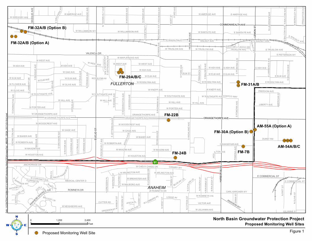
!>
!>
FM-29A/B/C
!>
FM-22B
!>
FM-24B
FM-31A/B
!>FM-30A (Option B)
!>
FM-7B
!>
AM-54A/B/C
!>FM-32A/B (Option B)
!>
!>!>
!>
!>!>
!>!>
FM-32A/B (Option A)
AM-55A (Option A)
!>
|ÿ91
FULLERTON
ANAHEIM
VALENCIA DR
HIG
HL
AN
D A
VE
ROMNEYA DR
ANAHEIM WY
E COMMERCIAL ST
ANAHEIM
SH
ORES DR
BA
SQ
UE
AV
E
EU
CL
ID S
T
HA
RB
OR
BLV
D
COMMONWEALTH AVE
ORANGETHORPE AVE
LE
MO
N S
T
W ROMNEYA DR
W BAKER AVE
W KNEPP AVES L
EE
AV
E
S W
OO
DS
AV
E
W HOUSTON AVE
W WEST AVE
S R
ICH
MA
N A
VE
W ELM AVE
WO
OD
SA
VE
ORANGETHORPE AVE
W WILLIAMSON AVE
S L
AM
BE
RT
DR
W CORONET AVE
W CHEVY CHASE DR
E ELM AVE
BA
SQ
UE
AV
E
DURST RD
RIC
HM
AN
AV
E
N O
LIV
E S
T
S M
AL
DE
N A
VE
E TRUSLOW AVE
VICTOR AVE
W ASH AVE
RO
BIN
ST
W MAPLEWOOD AVE
WALNUT AVE
EA
DIN
GT
ON
AV
E
S O
RC
HA
RD
AV
E
S B
AS
QU
E A
VE
MEDICAL CENTER D
S L
AW
RE
NC
E A
VE
W ARLINGTON AVE
W MALBORO AVE
E AMERIGE AVE
LIBERTY AVE
ORANGEFAIR AVE
W JULIANNA AVE
W AMERIGE AVE
E ROSSLYNN AVE
N W
ES
T S
T
W SANTA FE AVE
W TRUSLOW AVE TRUSLOW AVE
E PATTERSON WY
FREEDOM AVE
CANARY WY
W OLIVE AVE
N A
RB
OR
ST
LIG
HT
HO
U
SE LN
W ORANGETHORPE AVE
LODGE AV
N C
RO
WN
ST
CARL KARCHER WY
CUTTER RD
S E
AD
ING
TO
N A
VE
SW
AN
ST
N C
ITR
ON
ST
W ROSSLYNN AVE
S B
ALC
OM
AV
E
W GREGORY AVE
S H
IGH
LA
ND
AV
E
N L
AW
RE
NC
E A
VE
E ASH AVE
S A
DA
MS
AV
E
W FLOWER AVE
ANCHORAGE DR
W HILL AVE
N R
IVIE
RA
ST
W MAXZIM AVE
E WALNU T AVE
N R
AL
EIG
H S
T
N D
RA
KE
AV
E
S R
OY
ER
AV
E
BLUEJAY LN
W WILLIAMSON WY
SN UG HA R
BO
RD
R
S P
OM
ON
A A
VE
N
MARIN ER WY
W NEIGHBORS AVE
N B
AL
CO
M A
VE
S W
AS
HIN
GT
ON
AV
E
N W
OO
DS
AV
E
S J
EF
FE
RS
ON
AV
E
CH
ER
RY
WY
SE
A C
V
ELM ST
COSTCO WAY
WGLEN AVE
E COMMERCIAL ST
NC
ITR
O
NLN
S C
ITR
US
AV
E
W ROBERTA AVE
N O
RA
NG
E A
VE
N R
ICH
MA
N A
VE
N B
ER
KE
LE
Y A
VE
PO
MO
NA
AV
E
NO
RC
HA
RD
AV
E
N R
AV
EN
NA
ST
NP
RI N
CE
TO
NA
VE
S L
OV
ER
ING
AV
E
S R
OO
SE
VE
LT
AV
E
N D
RE
SD
EN
PL
S O
RA
NG
E A
VE
JULIANNE ST
NR
OO
SE
VE
LT
AV
E
S
URF D
R
S C
HE
ST
NU
T P
L
SH
OR
T S
T
FO
RD
AV
E
SOCO DR
NF
OX
FIR
ES
T
M
AKO LN
W SOUTHGATE AVE
AM
ER
ICA
N S
T
NVO
YAGE R LN
N M
INT
EE
R S
T
CLIPPER LN
WA
LN
UT
WY
N L
OM
BA
RD
DR
S F
OR
D A
VE
FATHOM LN
HO
U
STON AVE
W PORTER AVE
CIT
RU
S A
VE
W LOMBARD PL
DRESDEN ST
BALLAST LN
W GAGE AVE
ROSSLYNN AV
S T
AM
AR
AC
K D
R
W ROMNEYA VIA
ATECA PL
W BREWSTER AVE
W WOODCREST AVE
W OAK AVE
E SANTA FE AVE
N P
AT
T S
T
W ELM AVE
W ELM AVE
W HILL AVE
S P
OM
ON
A A
VE
S C
ITR
US
AV
E
W HILL AVE
W MAXZIM AVE
W ASH AVE
W WEST AVEW WEST AVE
W HOUSTON AVE
W MAXZIM AVE
W PORTER AVE
E WALNUT AVE
S O
RA
NG
E A
VE
W SOUTHGATE AVE
E WALNUT AVE
W ROSSLYNN AVE
W GAGE AVE
E ELM AVE
W AMERIGE AVE
W WOODCREST AVE
S J
EF
FE
RS
ON
AV
E
S R
OO
SE
VE
LT
AV
E
W KNEPP AVE
W ASH AVE
W ELM AVE
W SOUTHGATE AVE W SOUTHGATE AVE
W WEST AVE
W OLIVE AVE
W BAKER AVE
ORANGETHORPE AVE
RIC
HM
AN
AV
E
W ROBERTA AVE
W ORANGETHORPE AVE
S B
ALC
OM
AV
E
SOCO DR
RIC
HM
AN
AV
E
W TRUSLOW AVE
E ASH AVEW ASH AVE
W HILL AVE
W ARLINGTON AVE
W ELM AVE
Proposed Monitoring Well Sites0 1,200 2,400
Feet
North Basin Groundwater Protection Project
Figure 1
Pa
th:
I:\C
ON
TR
AC
T\G
BM
-20
17
-2 N
BG
PP
Mon
ito
rin
g W
ells
\CE
QA
\ma
ps\F
ig1
_N
BG
PP
_C
EQ
A_2
01
7-0
3-1
0v2
.mxd
!> Proposed Monitoring Well Site
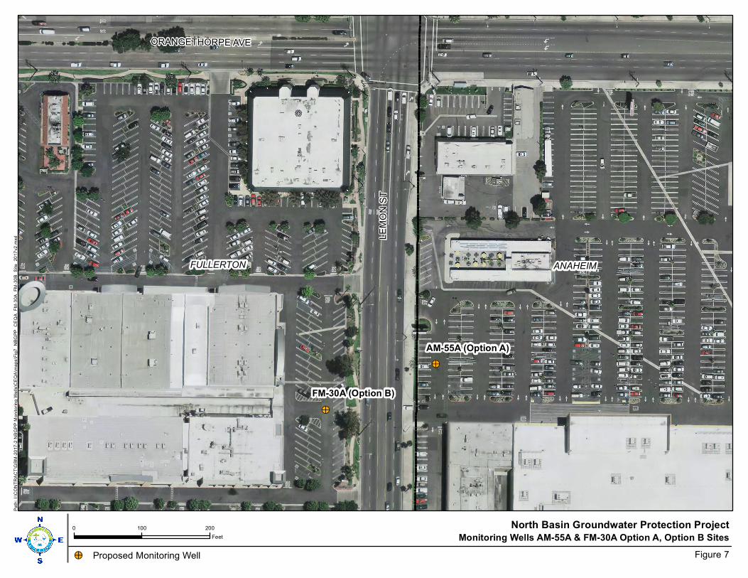
!>
AM-55A (Option A)
!>
FM-30A (Option B)
ANAHEIMFULLERTON
LE
MO
N S
T
ORANGETHORPE AVE
Monitoring Wells AM-55A & FM-30A Option A, Option B Sites0 100 200
Feet
North Basin Groundwater Protection Project
Figure 7
Pa
th:
I:\C
ON
TR
AC
T\G
BM
-20
17
-2 N
BG
PP
Mon
ito
rin
g W
ells
\CE
QA
\ma
ps\F
ig7
_N
BG
PP
_C
EQ
A_F
M-3
0A
_F
M-3
0B
_S
ite_
20
17
v2
.mxd
!> Proposed Monitoring Well
CITY OF FULLERTON
Community Development Department
March 1, 2017
Daniel Bott
Orange County Water District
18700 Ward St.
Fountain Valley, CA 92708
Subject: I n itial Study/Negative OCWD North Basin Monitoring Well Project
Dear Mr. Bott,
Sent via email to:
The City of Ful lerton has reviewed the Initial Study and Negative Declaration for the above referenced
project and has the following comment:
• The Parks and Recreation Department is currently working on a plan to improve and change the
layout of Woodcrest Park. The location of the proposed monitoring well in Woodcrest Park may
need to be modified. Please coordinate with Doug Pickard, Parks Projects Specialist, at (714)
738-3330 to determine the best location for the well. The park improvement project is
scheduled to begin in the fall of 2017. Attached is the latest conceptual improvement p lan.
Thank you for the opportunity to review the documents and to comment on potential issues that may
affect the City of Fullerton. If you should have questions regarding this response, please feel free to
contact me at (714) 738-6837 or [email protected] lerton.ca.us.
Sincerely,
� L!wf/ Joan Wolff, AICP
Senior Planner
....
303 West Commonwealth Avenue, Ful lerton, California 92832-1 775 (714) 738-6547 • Fax (7 1 4) 738-31 1 0 • Web Site: www.ci .fullerton.ca.us
Purpose
�
Orange County Water District North Basin Groundwate r Monitoring Well Project Final Mitigated Negative Declaration Response to Co mments Mitigation Monitoring Program 1-8
City of Fullerton Comment Letter
March 1, 2017
Comment
The submitted comment letter references that park improvements are planned for Woodcrest Park and that the monitoring well site proposed at the park may require relocation.
Response to Comment
Orange County Water District (OCWD) staff reviewed the City of Fullerton tentative plans for improvements to Woodcrest Park, and met with City of Fullerton staff from the Parks and Recreation Department and the Public Works Department. It was determined that the proposed monitoring well, which is adjacent to two existing monitoring wells, would be located in a parking area and would not be in conflict with the City of Fullerton park improvement plans and would not need require relocation.

Public Works Integrity, Accountability, Service, Trust
Shane L. Silsby, Director
March 2, 201 7
Daniel Bott Orange County Water District 1 8700 Ward Street Fountain Valley, CA 92708
NCL-17-016
Subject: Notice of Intent to Adopt a Mitigated Negative Declaration for the North Basin Monitoring Well Project
Dear Mr. Bott:
Thank you for the opportunity to comment on the Notice of Intent to Adopt a Mitigated Negative Declaration for the North Basin Monitoring Well Project. Flood Programs on behalf of the Orange County Flood Control District (OCFCD) offers the following comments on the Initial Study for the Notice to Intent to Adopt a �itigated Negative Declaration:
1 . Monitoring well FM-32 A/8 (Option A) site appears to be adjacent to OCFCD Fullerton Creek Channel (A03) right-of-way. Work associated with drilling and construction of the well and the proposed project's potential impacts, if any, to OCFCD facilities (hydraulics, structures, access, operations and maintenance, etc.) should be identified and properly mitigated. All work in the vicinity of OCFCD right-of-way should be performed in a manner that will not adversely impact the OCFCD facilities.
Thank you for the opportunity to review this document. Please direct any questions to Anna Brzezicki at (71 4) 647-3989 or Robert McLean at (714) 647-3951 in OC Infrastructure/Flood Programs or Linda Smith at (714) 667-8848 in OC Development Services.
Sincerely
Lar e Alo so, Manager, Planning Division OC 4..bli� Works Service Area/QC Development Services 300 North Flower Street Santa Ana, California 92702-4048 [email protected]
cc: Robert McLean, QC Infrastructure/Flood Programs Anna Brzezicki, QC Infrastructure/Flood Programs
300 N. Flower Street, Santa Ana, CA 92703
P.O. Box 4048, Santa Ana, CA 92702-4048
www.ocpublicworks.com
71 4.667.8800 I [email protected]
Purpose
�
Orange County Water District North Basin Groundwate r Monitoring Well Project Final Mitigated Negative Declaration Response to Co mments Mitigation Monitoring Program 1-10
Orange County Public Works March 2, 2017
Comment
The submitted comment references that Monitoring well FM-32 A/B appears to be adjacent to Orange County Flood Control District (OCFCD) Fullerton Creek Channel right-of way and that any activity in the right-of-way should be evaluated and mitigated, as necessary.
Response to Comment
The submitted comment is correct that Monitoring Well FM-32 A/B is near the Fullerton Creek Channel. However, no activities are proposed within the right-of-way and no construction activities are proposed in Fullerton Creek. Therefore, Draft IS/MND has not identified any potential impacts to Fullerton Creek.
Santa Ana Regional Water Qual ity Control Board
March 2 , 201 7
Daniel Bott Orange County Water District 1 8700 Ward Street Fountain Valley, CA 92708 (dbott@ocwd .com)
� EnMUNO G . BROWN J R . �v G0Vt:Otf0K
NORTH BASIN GROUNDWATER MONITORING WELL PROJECT, DRAFT INITIAL STUDY
MITIGATED NEGATIVE DECLARATION, ANAHEIM AND FULLERTON, ORANGE COUNTY WATER DISTRICT, SCH# 201 701 1 068
Dear Mr. Bott:
We have received and reviewed the Draft I n itial Study/Mitigated Negative Declaration (Draft MND) for the Orange County Water District's (OCWD) North Basin Groundwater Mon itoring Well Project (Project) . Located in the northern portion of the Orange County Groundwater Basin, the North Basin is an area approximately 5 miles long by 2 miles wide in the Cities of Ful lerton and Anaheim, with several water-bearing zones that are impacted by volatile organic compounds (VOCs) . The contaminant plumes in the Project area have already impacted production wells in the Principal Aquifer. The primary VOC contaminants include: trichloroethene (TCE), tetrach loroethene (PCE), 1 , 1 -dichloroethene (DCE), and 1 ,4-dioxane.
The Un ited States Environmental Protection Agency (USEPA) is the lead agency requesting the proposed Project, which includes the installation, monitoring , and sampling of 1 4 monitoring wells at eight locations within the North Basin. The Project is proposed to fi l l existing g roundwater monitoring and sampling data gaps, to assist in the development of remedial alternatives for the North Basin , and better protect the potable water supply.
COMMENTS
Based on our review of the Draft Ml'JD, we request that the following item be addressed in the Final MND: · .
l 1 . I n Section 4.9 Hydrology/Water Qual ity, under Mitigation Measures , H�
Q-2 states that g roundwater effluent generated during the Project wil l be treated and ischarged into the local storm drain system. Prior to implementing this mitigation measure an commencing any d ischarges, OCWD must obtain authorization for the discharge of tre
�a ed groundwater in
accordance with the terms and cond itions of the Reg ional Water Qual i y Control Board's Order No. RS-201 2-0027, National Pollutant Discharge El imination System o. CAG91 1 01 1 -"General Groundwater Cleanup Permit for Discharges to Surface Wat · rs of Extracted and Treated Groundwater Resulting from the Cleanup of Groundwater Po+ted by Petroleum Hydrocarbons, Solvents, Metals and/or Salts. 11 The OCWD's current authorization under Order No. RS-201 5-0004-001 for de minimus discharges is not appl icable to � ischarges of treated
WILLIAM RUH, CHAIR I KURT V. BERCHTOLD, EXECUTIVE OFFICER
3737 Main St .. Suite 500, R,verside, CA 92501 I www.waterboards.ca.gov/santaana
t') RECYCLED PAPER
Purpose
�
Orange County Water District North Basin Groundwate r Monitoring Well Project Final Mitigated Negative Declaration Response to Co mments Mitigation Monitoring Program 1-12
Santa Ana Regional Water Quality Control Board Comm ent Letter March 2, 2017
Comment
The submitted comment letter references that prior to OCWD implementing Mitigation Measure HWQ-2, OCWD must obtain authorization for the discharge of treated groundwater into the local storm drain system.
Response to Comments
Section 4.9, Hydrology/Water Quality, Mitigation Measure HWQ-2, of the Draft IS/MND states that groundwater effluent generated during the Project will be treated and discharged into the local storm drain system. This statement applies to long-term periodic well sampling conducted by OCWD. The statement does not apply to groundwater effluent generated during well construction activities. All groundwater effluent generated during well development will be contained on-site prior to testing and off-site disposal at an appropriate disposal facility. Aquifer testing of the new monitoring wells will not be conducted for this Project.

e Department of Toxic Substances Control
Matthew Rodriquez Secretary for
Environmental Protection
February 27, 201 7
Mr. Daniel Bott Orange County Water District 1 8700 Ward Street
. Fountain Valley, California 92708
Barbara A Lee, Director 5796 Corporate Avenue
Cypress, California 90630
Edmund G. Brown Jr. Governor
INITIAL STUDY AND PROPOSED MITIGATED NEGATIVE DECLARATION (ND) FOR NORTH BASIN MONITORING WELL PROJECT (SCH# 201701 1 068)
Dear Mr. Bott:
The Department of Toxic Substances Control (DTSC) has reviewed the subject ND. The following project description is stated in the ND: "The proposed project involves the construction and operation of 14 monitoring wells at 8 locations within the cities of Anaheim and Fullerton."
Based on the review of the submitted document DTSC has the following comments:
1 . The ND should identify and determine whether current or historic uses at the project site may have resulted in any release of hazardous wastes/substances. Such information would be helpful in identifying whether installation of wells might cause cross contamination between aquifers thus compromising the integrity of well monitoring data. A Phase I Environmental Site Assessment may be appropriate to identify any recognized environmental conditions.
2 . Section 3 . VI I I . d . Hazardous Waste, asks if the project is located on a site which is located on a list of hazardous materials sites which could create a significant hazard to the public or environment. For this item, the ND states "No Impact". Also, in Section 4.8.D. , the ND further explains that the Proposed Project is to monitor groundwater quality in order to develop a remedial action plan. DTSC agrees that the project location is not specifically located on a hazardous waste site however; hazardous substances are present in groundwater, as indicated in the project description, and some additional precautionary measures should be taken during project implementation. Due to the presence of trichloroethylene (TCE), tetrachloroethylene (PCE), 1 , 1 -dichloroethylene (1 , 1 -DCE), and 1 ,4-dioxane, additional precautionary measures may need to be taken during well
@ Printed on Recycled Paper
Purpose
�
Orange County Water District North Basin Groundwate r Monitoring Well Project Final Mitigated Negative Declaration Response to Co mments Mitigation Monitoring Program 1-14
California Department of Toxic Substance Control Co mment Letter February 27, 2017
Comment 1 The comment l references that Draft IS/MND should determine if current or historic uses at the project site may have resulted in any releases of hazardous wastes/substances. Response to Comment
The purpose of the monitoring wells is to help characterize regional volatile organic compound (VOC) plumes that have migrated from multiple sites where the release occurred. The proposed monitoring wells will not be installed on sites where a release is known to have occurred. All of the wells will be installed in city streets, possibly except for two: FM-30A may be installed in commercial shopping center parking lot adjacent to Lemon Street, and FM-32A/B will be installed in either a city street or a Fullerton School District parking lot. Furthermore, the direct mud-rotary drilling method will be used which results in the development of a low-permeability bentonite mud cake coating the borehole wall; only one well will be installed in a borehole; the screened intervals will be designed such that they do not cross a clay or silt aquitard; and, the annular seal will be comprised of bentonite extending five feet above the filter pack, overlain by neat cement containing two to five percent bentonite extending to the surface. Nested monitoring wells will not be constructed. Consequently, the potential for cross-contamination is considered negligible.
Comment 2
The submitted comment acknowledges that the proposed well sites are not located on a hazardous waste site. But because hazardous substances are present in the groundwater, the determination in the Draft IS/MND Checklist should be changed from “No Impact” to “Less than Significant Impact” and that precautions should be made to ensure that cross contamination between aquifers does not occur.
Response to Comment
As identified in Response to Comment 1 the potential for cross-contamination is considered negligible and no precautions need to be made to ensure that cross contamination between aquifers does not occur.
Comment 3
The submitted comment references that during construction and demolition of the project, if soil and/or groundwater contamination is suspected, construction and

Purpose
�
Orange County Water District North Basin Groundwate r Monitoring Well Project Final Mitigated Negative Declaration Response to Co mments Mitigation Monitoring Program 1-15
demolition activities should cease and that appropriate health procedures should be implemented.
Response
As previously discussed, the monitoring wells will not be installed on a site where a release is known to have occurred. Consequently, encountering contaminated soil is not expected. However, if unexpected hazardous drilling conditions are encountered, drilling with cease, the property owner and the U.S. Environmental Protection Agency (i.e., the lead oversight agency) will be contacted, and appropriate action will be taken. VOC-contaminated groundwater is expected to be encountered, but at concentrations below hazardous waste thresholds. The purpose of the monitoring wells is to support the development of remedial alternatives.
Mitigation Monitoring Program
�
Orange County Water District North Basin Groundwate r Monitoring Well Project Final Mitigated Negative Declaration Response to Co mments Mitigation Monitoring Program 2-1
SECTION 2.0 MITIGATION MONITORING PROGRAM
2.1 Introduction
The following is a Mitigation Monitoring Report Program (MMRP) for the Orange County Water District North Basin Groundwater Monitoring Well Project Final Mitigated Negative Declaration (FMND) prepared pursuant to Section 15097 of the CEQA Guidelines and Section 21081.6 of the Public Resources Code. This MMRP lists all applicable mitigation measures from the Draft IS/MND for the Orange County Water District North Basin Groundwater Well Project. The appropriate timing of implementation and responsible party are identified to ensure proper enforcement of the mitigation measures from the Draft IS/MND.
2.2 Project Description
Project Location
The proposed monitoring wells that would be utilized for the North Basin Groundwater Monitoring Project would be located within the City of Anaheim and City of Fullerton, Orange County California.
Project Description
OCWD has proposed to construct and sample 14 new monitoring wells at 8 locations within the cities of Anaheim and Fullerton. The U.S. Environmental Protection Agency has specified the general locations of the monitoring wells. A total of 17 potential well sites have been identified for evaluation. Based on final design and final site acquisition, 14 well sites would ultimately be selected for well construction.
Purpose
The purpose of the Proposed Project is to install monitoring wells that would be used to evaluate the nature extent of groundwater contamination within the northern portion of the Orange County Groundwater Basin (referred to as North Basin). The Initial Study/Mitigated Negative Declaration is limited to the evaluation of potential environmental impacts associated with the construction and operation of the monitoring wells. Data from the monitoring wells would support the development of a future groundwater remediation project for the area. Environmental considerations of a future groundwater remediation project are not part of the evaluation of the proposed monitoring well installations.
2.3 Development of Mitigation Monitoring Reporting Program
The basic elements of the Mitigation Monitoring and Reporting Program are the mitigation measures identified by each impact category addressed in the Draft IS/MND.

Mitigation Monitoring Program
�
Orange County Water District North Basin Groundwate r Monitoring Well Project Final Mitigated Negative Declaration Response to Co mments Mitigation Monitoring Program 2-2
The development of the program was based on the following procedures necessary to initiate and complete the monitoring process.
x Identification of the key periods and events in the project implementation schedule.
x Identification of the key personnel and agencies responsible for environmental monitoring.
x Monitoring of the implementation of the mitigation measures and documentation that the measures have been properly and thoroughly implemented.
x Development of the written document on the implementation of all the mitigation measures, identification of any areas of non-compliance, and proposed activities to bring the project into compliance with the mitigation monitoring and reporting program.
2.4 Requirement to Approve and Implement Mitigation Monitoring Plan
The OCWD has the authority to require and enforce the provisions of California Resource Code Section 21081.6. The OCWD will be responsible for approving the Mitigation Monitoring and Reporting Program and for preparing the written report documenting the implementation of project mitigation measures.
Table 1 summarizes the mitigation measures that have been adopted for the Project, specifies the timing for implementation of each measure and identifies the responsible parties for ensuring implementation and the satisfactory completion of each measure. The procedures for implementing the Mitigation Monitoring and Reporting Program are:
Monitoring Procedures
1. An Environmental Monitor, appointed by OCWD, will be responsible for coordinating review of project plans and activities, the construction site, and/or operations to ensure that the mitigation measures are properly and thoroughly implemented through the course of the project.
2. Written documentation that each mitigation measure in Table 1 has been implemented will be prepared. This documentation can be on an OCWD mitigation monitoring checklist or a similar form that clearly indicates the timing or schedule for implementation, whether the measure has, in fact, been implemented, or in the case of measures that are ongoing, that a process has been developed to ensure continued implementation of the measure.

Mitigation Monitoring Program
�
Orange County Water District North Basin Groundwate r Monitoring Well Project Final Mitigated Negative Declaration Response to Co mments Mitigation Monitoring Program 2-3
Reporting Procedures
1. The Environmental Monitor appointed by OCWD on this project will be responsible for periodically reviewing the program in Table 1 with the OCWD Environmental Compliance Advisor.
2. The Environmental Monitor will prepare a written report for the OCWD documenting the completion of the implementation of all the mitigation measures. For those measures not implemented or for activities that do not fully comply with mitigation measures included in Table 1, an explanation of the areas of noncompliance will be prepared, including a proposal to bring those elements of the project into compliance with the Mitigation Monitoring and Reporting Program.
The following table will be used by the Project Manager to enforce mitigation measures during each phase of the Project pursuant to Section 15097 of the State CEQA Statues and Guidelines and Public Resources Code Section 21081.6.
Table 2: North Basin Groundwater Monitoring Well Project Mitigation Monitoring Plan Reporting Program
Mitigation Measure Responsible for Implementation
Monitoring Verification
Biological Resources
BIO-1: If well drilling and well construction activities are proposed at Monitoring Well Site FM-22B during the nesting season, OCWD biologist will survey the study area to determine if nesting birds are present. The survey will occur no more than 3 days prior to the start of construction activities. If nesting birds are present and the biologist determines that the construction noise could adversely impact nesting birds, construction activity at the well will not proceed until nesting birds are no longer present.
OCWD Prior to Construction
Cultural Resources
CR-1: In the event that any evidence of cultural resources is discovered, all work within the vicinity of the find should stop until a qualified archaeological consultant can assess the find and make recommendations.
OCWD During Construction
CR-2: If human remains are encountered during excavation activities, all work shall halt in the vicinity of the remains and the County Coroner shall be notified (California Public
OCWD During Construction

Mitigation Monitoring Program
�
Orange County Water District North Basin Groundwate r Monitoring Well Project Final Mitigated Negative Declaration Response to Co mments Mitigation Monitoring Program 2-4
Resources Code §5097.98). The Coroner will determine whether the remains are of forensic interest. If the Coroner, with the aid of a qualified Archaeologist, determines that the remains are prehistoric, s/he will contact the Native American Heritage Commission (NAHC). The NAHC will be responsible for designating the most likely descendant (MLD), who will be responsible for the ultimate disposition of the remains, as required by Section 7050.5 of the California Health and Safety Code. The MLD shall make his/her recommendation within 48 hours of being granted access to the sites. If feasible, the recommendation of the MLD shall be followed and may include scientific removal and non-destructive analysis of the human remains and any items associated with Native American burials (California Health and Safety Code §7050.5). If the landowner rejects the recommendations of the MLD, the landowner shall rebury the remains with appropriate dignity on the property in a location that will not be subject to further subsurface disturbance (California Public Resources Code §5097.98).
CR-3: In the event that any evidence of paleontological resources is discovered, all work within the vicinity of the find should stop and a qualified paleontologist is will be notified and retained. The Paleontological Monitor will divert heavy equipment away from the fossil site until s/he has had an opportunity to examine the remains.
OCWD During Construction
Geology/Soils
GEO-1: The OCWD will ensure that the proposed monitoring wells are designed and constructed in compliance with California Department of Water Resources Well Standards Bulletin 74-90 and Bulletin 74-81.
OCWD During Design and Construction
Hazards
HAZ-1: All construction activities involving the handling of hazardous substances will be conducted in accordance with local, State and Federal laws and regulations.
OCWD During Construction
HAZ-2: During construction and maintenance activities Best Management Practices will be
OCWD During Construction

Mitigation Monitoring Program
�
Orange County Water District North Basin Groundwate r Monitoring Well Project Final Mitigated Negative Declaration Response to Co mments Mitigation Monitoring Program 2-5
implemented to avoid accidental release of hazardous materials into the environment. The Best Management Practices will include, as applicable, the preparation and implementation hazardous material management and spill prevention and clean-up plans, implementation construction equipment delivery and storage procedures and routine vehicle and equipment maintenance.
and Maintenance
HAZ-3: During construction and maintenance activities emergency access will be maintained at all times.
OCWD During Construction and Maintenance
Hydrology/Water Quality
HWQ-1: During construction operations Best Management Practices will be used to minimize surface water runoff impacts. Such measures could include; sandbagging, straw waddle, rumble racks and wheel washers or other measures that reduce surface water runoff and sediment transport.
OCWD During Construction
HWQ-2: Groundwater effluent generated during sampling and maintenance activities will be treated onsite to remove contaminants prior to being discharged into the local storm drain system.
OCWD During Well Sampling and Maintenance
Land Use
LU-1: Prior to construction activities at each well site, OCWD will provide residents and business owners with notifications of upcoming construction activities.
OCWD Prior to Construction
LU-2: Prior to the start of construction, OCWD will coordinate with City of Anaheim or and City of Fullerton encroachment permits for monitoring wells that are proposed in public right-of-way.
OCWD Prior to Construction
LU-3: OCWD will coordinate with County of Orange Health Care Agency and comply with State Department of Water Resources well siting requirements for all wells proposed in the North Basin Groundwater Protection Project.
OCWD During Design Prior to Construction
LU-4: Prior to the start of construction, OCWD will receive a well permit from the City of
OCWD Prior to Construction
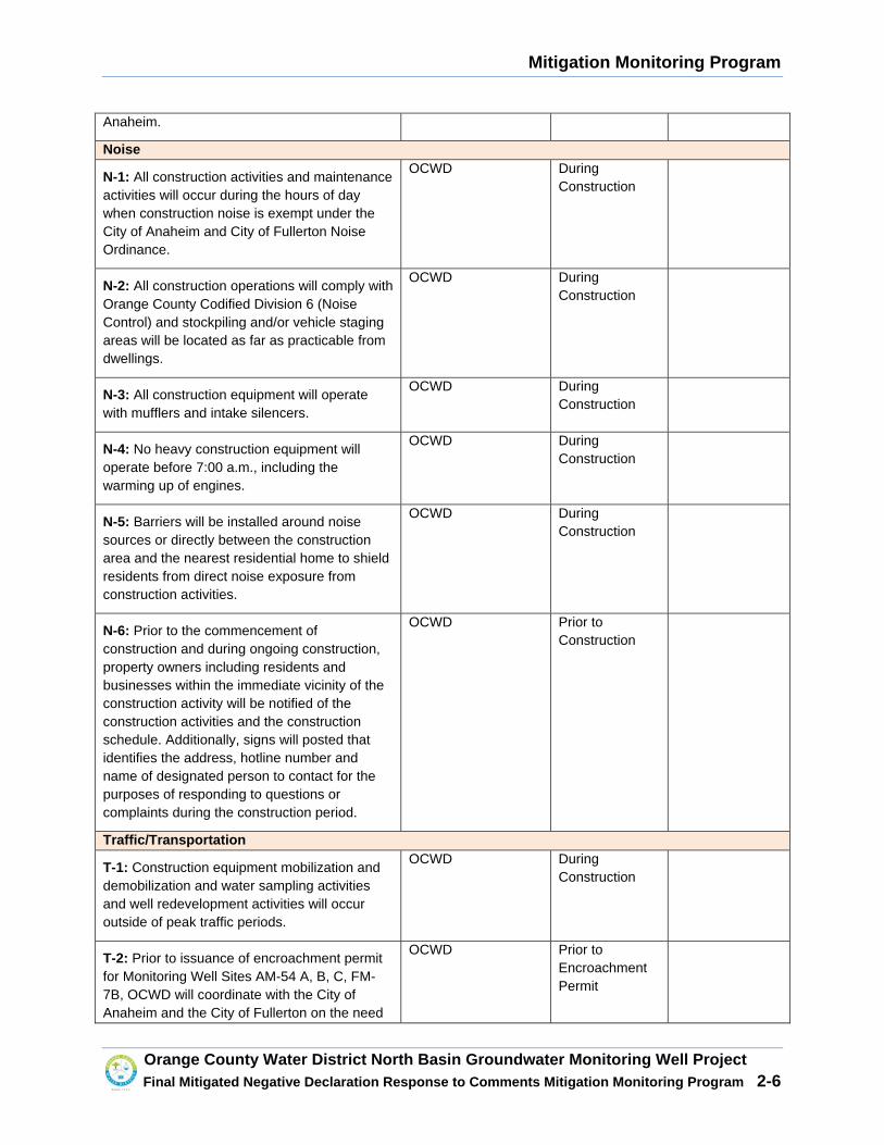
Mitigation Monitoring Program
�
Orange County Water District North Basin Groundwate r Monitoring Well Project Final Mitigated Negative Declaration Response to Co mments Mitigation Monitoring Program 2-6
Anaheim.
Noise
N-1: All construction activities and maintenance activities will occur during the hours of day when construction noise is exempt under the City of Anaheim and City of Fullerton Noise Ordinance.
OCWD During Construction
N-2: All construction operations will comply with Orange County Codified Division 6 (Noise Control) and stockpiling and/or vehicle staging areas will be located as far as practicable from dwellings.
OCWD During Construction
N-3: All construction equipment will operate with mufflers and intake silencers.
OCWD During Construction
N-4: No heavy construction equipment will operate before 7:00 a.m., including the warming up of engines.
OCWD During Construction
N-5: Barriers will be installed around noise sources or directly between the construction area and the nearest residential home to shield residents from direct noise exposure from construction activities.
OCWD During Construction
N-6: Prior to the commencement of construction and during ongoing construction, property owners including residents and businesses within the immediate vicinity of the construction activity will be notified of the construction activities and the construction schedule. Additionally, signs will posted that identifies the address, hotline number and name of designated person to contact for the purposes of responding to questions or complaints during the construction period.
OCWD Prior to Construction
Traffic/Transportation
T-1: Construction equipment mobilization and demobilization and water sampling activities and well redevelopment activities will occur outside of peak traffic periods.
OCWD During Construction
T-2: Prior to issuance of encroachment permit for Monitoring Well Sites AM-54 A, B, C, FM-7B, OCWD will coordinate with the City of Anaheim and the City of Fullerton on the need
OCWD Prior to Encroachment Permit

Mitigation Monitoring Program
�
Orange County Water District North Basin Groundwate r Monitoring Well Project Final Mitigated Negative Declaration Response to Co mments Mitigation Monitoring Program 2-7
to prepare a Traffic Management that identifies traffic control measures to ensure safe vehicle access through the construction area.
T-3: Prior to two weeks of the start of construction on well sites FM-22B, FM-30A (Options a and b) and FM-32A,B (Option a), OCWD will notify property owners of the upcoming construction schedule construction activities and what parking areas would be temporarily impacted by construction and will install temporary signage that identifies which parking areas would be temporary closed.
OCWD Prior to Construction
T-4: Prior to two weeks of the start of well construction within residential areas, OCWD will notify property owners within the vicinity of the well site of the upcoming construction schedule and temporary roadway closures and temporary loss of on-street parking near well sites.
OCWD Prior to Construction
T-5: Prior to the start of construction of Monitoring Well FM-22B, one the existing parking spaces at Woodcrest Park would temporary identified as a handicap parking space.
OCWD Prior to Construction
Utilities
U-1: OCWD will investigate all available alternatives, and then select the best method of solid waste disposal and reduction of solid waste stream as required in the California Integrated Waste Management Act prior to the start of construction.
OCWD Prior to Construction

14
AGENDA ITEM SUBMITTAL Meeting Date: April 12, 2017 Budgeted: N/A Budgeted Amount: N/A To: Water Issues Cte Cost Estimate: N/A Board of Directors Funding Source: N/A From: Mike Markus Program/Line Item No. N/A General Counsel Approval: N/A Staff Contact: J. Kennedy Engineers/Feasibility Report Approved: N/A CEQA Compliance: N/A Subject: POLICY FOR DIRECTLY SELLING GWRS WATER SUMMARY The District established the attached policy for directly selling GWRS water from the pipeline that travels from the treatment plant up to the recharge basins in the city of Anaheim in October 2007. Staff recommends adding a new condition to the policy (Condition # 11) to give the District additional flexibility in managing the system depending upon future water supply conditions and regulations. Attachment(s): OCWD Policy for the Use of GWR System Water Supplies by the Groundwater Producers RECOMMENDATION Agendize for April 19th Board meeting: Modify the OCWD policy for the use of GWRS water supplies by the Groundwater Producers as shown BACKGROUND/ANALYSIS The District maintains the discretion to allow new users to connect to the GWRS pipeline on a case by case basis. The City of Anaheim currently has two users of GWRS water; they are the Anaheim Regional Transportation Intermodal Center (ARTIC) and the Canyon Power Plant. The District can expect to receive future requests to directly take GWRS water which could include a combination of users such as industrial use, toilet flushing, and/or landscape irrigation. The city of Anaheim is currently considering such a request. With these request water users are replacing their potable water demand use with GWRS water. One benefit of directly selling GWRS water is that less GWRS water then needs to be recharged at the District’s spreading facilities in Anaheim. This “frees-up” recharge capacity for other sources of water such as imported and Santa Ana River water. The current California State Water Resources Control Board emergency drought regulations require individuals to reduce their water use. However individuals connected to reclaim water systems that use such water for landscape irrigation do not have to restrict their water use
2
under the State’s regulations. The State’s emergency regulations have created an incentive for individuals to connect to the GWRS pipeline. The State is working with the water community in attempt to develop a new long-term framework for conservation and water regulations that would be used for future drought cycles. These new regulations may remove the current incentive for individuals to connect to the GWRS pipeline. Staff recommends modifying the existing policy to sell GWRS water to give the District additional flexibility in managing the system for the following reasons:
1. Providing GWRS water, which receives reverse osmosis treatment, for landscape irrigation is generally not a preferred use of the water;
2. The District may or may not want to encourage more users to connect to the GWRS pipeline in the future;
3. GWRS water that is recharged into the groundwater basin raises the Basin Production Percentage for all Groundwater Producers;
4. GWRS water that is recharged into the groundwater basin lowers the total dissolved solids concentration of the basin;
5. The State’s current emergency drought regulations, although temporary, have prioritized reclaimed water used for landscape irrigation above water consumed by residents; and
6. Future state regulations could change how the District desires to manage the GWRS system.
PRIOR RELEVANT BOARD ACTION(S) N/A
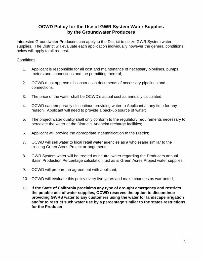
3
OCWD Policy for the Use of GWR System Water Supplie s by the Groundwater Producers
Interested Groundwater Producers can apply to the District to utilize GWR System water supplies. The District will evaluate each application individually however the general conditions below will apply to all request. Conditions
1. Applicant is responsible for all cost and maintenance of necessary pipelines, pumps, meters and connections and the permitting there of;
2. OCWD must approve all construction documents of necessary pipelines and
connections; 3. The price of the water shall be OCWD’s actual cost as annually calculated. 4. OCWD can temporarily discontinue providing water to Applicant at any time for any
reason. Applicant will need to provide a back-up source of water; 5. The project water quality shall only conform to the regulatory requirements necessary to
percolate the water at the District’s Anaheim recharge facilities; 6. Applicant will provide the appropriate indemnification to the District; 7. OCWD will sell water to local retail water agencies as a wholesaler similar to the
existing Green Acres Project arrangements; 8. GWR System water will be treated as neutral water regarding the Producers annual
Basin Production Percentage calculation just as is Green Acres Project water supplies; 9. OCWD will prepare an agreement with applicant;
10. OCWD will evaluate this policy every five years and make changes as warranted;
11. If the State of California proclaims any type o f drought emergency and restricts
the potable use of water supplies, OCWD reserves th e option to discontinue providing GWRS water to any customers using the wat er for landscape irrigation and/or to restrict such water use by a percentage s imilar to the states restrictions for the Producer.

15
AGENDA ITEM SUBMITTAL Meeting Date: April 12, 2017 Budgeted: No Budgeted Amount: N/A To: Water Issues Committee Cost Estimate: $843,901 Board of Directors Funding Source: Reserves Program/Line Item No. 1044.53001.9978 From: Mike Markus General Counsel Approval: Required Engineers/Feasibility Report: N/A Staff Contact: G. Woodside CEQA Compliance: N/A Subject: AUTHORIZE PAYMENT TO THE DEPARTMENT OF TH E ARMY FOR
EXPENSES TO PREPARE THE PRADO BASIN FEASIBILITY STU DY AND RELATED OCWD CONSULTANT EXPENSES
SUMMARY The District is working with the Army Corps on the Prado Basin Feasibility Study which is evaluating ecosystem restoration, sediment management, and increased water conservation at Prado. The Corps has requested additional funding for the Corps’ expenses to prepare the Study. Additional funding is also needed for consultants the District needs to support the Study. Attachment(s):
x Presentation x Letter from Army Corps dated April 4, 2017 x Scheevel Engineering proposal dated March 31, 2017 x Psomas proposal dated March 30, 2017 x Army Corps draft summary report for TSP Milestone
RECOMMENDATION Agendize for April 19 Board meeting: 1) Authorize the General Manager to sign the April 4, 2017 letter from the Corps
indicating the District’s concurrence with the cost increase for the Prado Basin Feasibility Study;
2) Authorize payment of $731,393 to the federal government for the Prado Basin Feasibility Study, and authorize District staff to transfer said funding to the federal government;
3) Authorize execution of Amendment No. 1 to Agreement No. 1222 with Scheevel Engineering for technical support for an amount not to exceed $90,818 to support the Prado Basin Feasibility Study; and
4) Authorize Work Order to Psomas under existing on-call environmental services Agreement No. 0675 for an amount not to exceed $21,690 for traffic analyses.
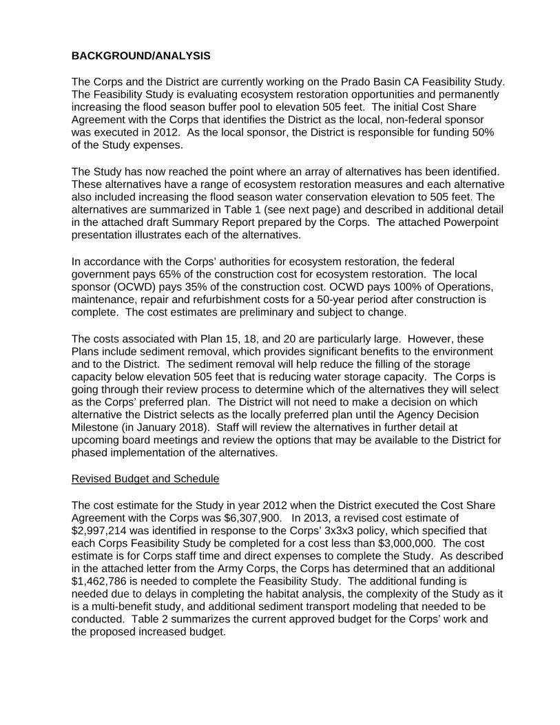
BACKGROUND/ANALYSIS The Corps and the District are currently working on the Prado Basin CA Feasibility Study. The Feasibility Study is evaluating ecosystem restoration opportunities and permanently increasing the flood season buffer pool to elevation 505 feet. The initial Cost Share Agreement with the Corps that identifies the District as the local, non-federal sponsor was executed in 2012. As the local sponsor, the District is responsible for funding 50% of the Study expenses. The Study has now reached the point where an array of alternatives has been identified. These alternatives have a range of ecosystem restoration measures and each alternative also included increasing the flood season water conservation elevation to 505 feet. The alternatives are summarized in Table 1 (see next page) and described in additional detail in the attached draft Summary Report prepared by the Corps. The attached Powerpoint presentation illustrates each of the alternatives. In accordance with the Corps’ authorities for ecosystem restoration, the federal government pays 65% of the construction cost for ecosystem restoration. The local sponsor (OCWD) pays 35% of the construction cost. OCWD pays 100% of Operations, maintenance, repair and refurbishment costs for a 50-year period after construction is complete. The cost estimates are preliminary and subject to change. The costs associated with Plan 15, 18, and 20 are particularly large. However, these Plans include sediment removal, which provides significant benefits to the environment and to the District. The sediment removal will help reduce the filling of the storage capacity below elevation 505 feet that is reducing water storage capacity. The Corps is going through their review process to determine which of the alternatives they will select as the Corps’ preferred plan. The District will not need to make a decision on which alternative the District selects as the locally preferred plan until the Agency Decision Milestone (in January 2018). Staff will review the alternatives in further detail at upcoming board meetings and review the options that may be available to the District for phased implementation of the alternatives. Revised Budget and Schedule The cost estimate for the Study in year 2012 when the District executed the Cost Share Agreement with the Corps was $6,307,900. In 2013, a revised cost estimate of $2,997,214 was identified in response to the Corps’ 3x3x3 policy, which specified that each Corps Feasibility Study be completed for a cost less than $3,000,000. The cost estimate is for Corps staff time and direct expenses to complete the Study. As described in the attached letter from the Army Corps, the Corps has determined that an additional $1,462,786 is needed to complete the Feasibility Study. The additional funding is needed due to delays in completing the habitat analysis, the complexity of the Study as it is a multi-benefit study, and additional sediment transport modeling that needed to be conducted. Table 2 summarizes the current approved budget for the Corps’ work and the proposed increased budget.
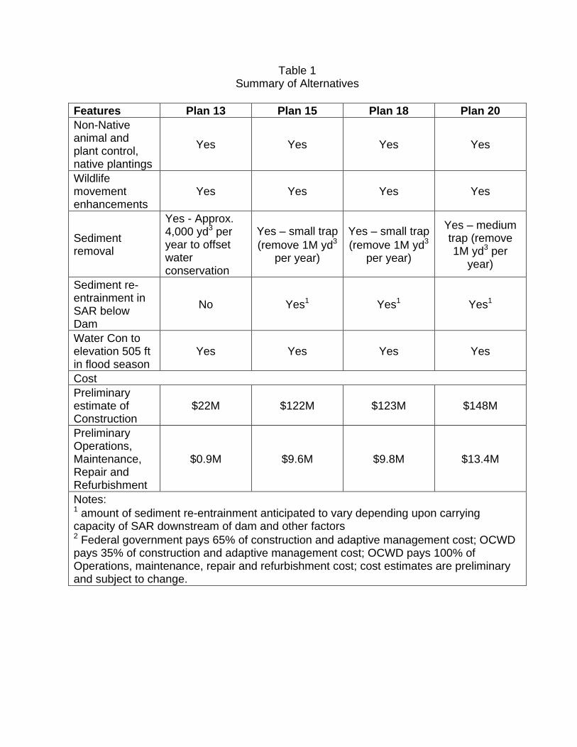
Table 1
Summary of Alternatives Features Plan 13 Plan 15 Plan 18 Plan 20 Non-Native animal and plant control, native plantings
Yes Yes Yes Yes
Wildlife movement enhancements
Yes Yes Yes Yes
Sediment removal
Yes - Approx. 4,000 yd3 per year to offset water conservation
Yes – small trap (remove 1M yd3
per year)
Yes – small trap (remove 1M yd3
per year)
Yes – medium trap (remove 1M yd3 per
year)
Sediment re-entrainment in SAR below Dam
No Yes1 Yes1 Yes1
Water Con to elevation 505 ft in flood season
Yes Yes Yes Yes
Cost Preliminary estimate of Construction
$22M $122M $123M $148M
Preliminary Operations, Maintenance, Repair and Refurbishment
$0.9M $9.6M $9.8M $13.4M
Notes: 1 amount of sediment re-entrainment anticipated to vary depending upon carrying capacity of SAR downstream of dam and other factors 2 Federal government pays 65% of construction and adaptive management cost; OCWD pays 35% of construction and adaptive management cost; OCWD pays 100% of Operations, maintenance, repair and refurbishment cost; cost estimates are preliminary and subject to change.
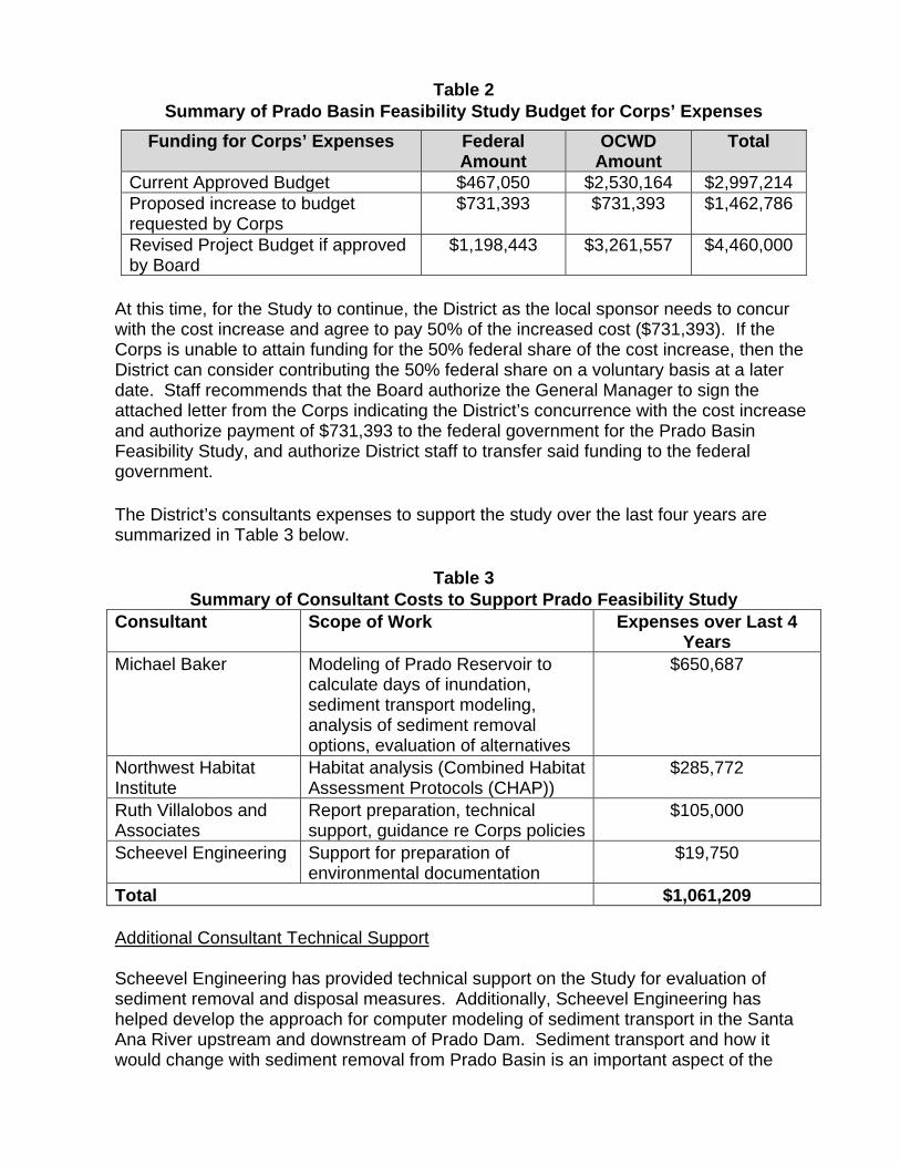
Table 2 Summary of Prado Basin Feasibility Study Budget for Corps’ Expenses
Funding for Corps’ Expenses Federal Amount
OCWD Amount
Total
Current Approved Budget $467,050 $2,530,164 $2,997,214 Proposed increase to budget requested by Corps
$731,393 $731,393 $1,462,786
Revised Project Budget if approved by Board
$1,198,443 $3,261,557 $4,460,000
At this time, for the Study to continue, the District as the local sponsor needs to concur with the cost increase and agree to pay 50% of the increased cost ($731,393). If the Corps is unable to attain funding for the 50% federal share of the cost increase, then the District can consider contributing the 50% federal share on a voluntary basis at a later date. Staff recommends that the Board authorize the General Manager to sign the attached letter from the Corps indicating the District’s concurrence with the cost increase and authorize payment of $731,393 to the federal government for the Prado Basin Feasibility Study, and authorize District staff to transfer said funding to the federal government. The District’s consultants expenses to support the study over the last four years are summarized in Table 3 below.
Table 3 Summary of Consultant Costs to Support Prado Feasib ility Study
Consultant Scope of Work Expenses over Last 4 Years
Michael Baker Modeling of Prado Reservoir to calculate days of inundation, sediment transport modeling, analysis of sediment removal options, evaluation of alternatives
$650,687
Northwest Habitat Institute
Habitat analysis (Combined Habitat Assessment Protocols (CHAP))
$285,772
Ruth Villalobos and Associates
Report preparation, technical support, guidance re Corps policies
$105,000
Scheevel Engineering Support for preparation of environmental documentation
$19,750
Total $1,061,209 Additional Consultant Technical Support Scheevel Engineering has provided technical support on the Study for evaluation of sediment removal and disposal measures. Additionally, Scheevel Engineering has helped develop the approach for computer modeling of sediment transport in the Santa Ana River upstream and downstream of Prado Dam. Sediment transport and how it would change with sediment removal from Prado Basin is an important aspect of the
Study. Environmental benefits associated with sediment removal, such as improved habitat for the Santa Ana Sucker fish, are likely a primary factor why the federal government may be willing to consider funding sediment removal measures. In the scope of work from Scheevel Engineering, a subcontracting firm Golder Inc is included for preparing documentation of sediment transport modeling that has been conducted for the Study. Initial modeling work by Golder was completed under an existing agreement the District had with Michael Baker but it is proposed that the documentation of the modeling be completed with Golder under contract to Scheevel Engineering. The scope of work also includes technical support by Scheevel Engineering for preparing environmental documentation, preparing the Adaptive Management Plan, assisting the Corps with the Engineering Appendix, and additional sediment transport modeling that is anticipated to be needed in a later stage of the Study. A copy of the proposal from Scheevel Engineering is attached.
Staff recommends the Board authorize execution of Amendment No. 1 to Agreement No. 1222 with Scheevel Engineering for technical support for an amount not to exceed $90,818 to support the Prado Basin Feasibility Study. District staff is leading the preparation of the environmental documentation for the Study. A traffic analysis needs to be prepared for the Study, since sediment removal from Prado Basin may involve a large number of truck trips to haul sediment from Prado Basin. Additionally, the traffic study needs to assess traffic impacts from deposition of sediment in the lower Santa Ana River below the 405 freeway if sediment is re-entrained into the river below Prado Dam. A portion of the re-entrained sediment may deposit in the lower Santa Ana River and need to be subsequently removed. An initial work order was authorized to Psomas under the District’s existing on-call environmental services agreement with Psomas under the General Manager’s authority to collect background information. Preparation of the traffic study is estimated to cost $21,690, as described in the attached proposal from Psomas. The District and Psomas have an on-call environmental services agreement that the proposed work would be conducted under. The work would be conducted by Kunzman Associates as a subconsultant to Psomas. Staff recommends the Board authorize a work order to Psomas under existing on-call environmental services Agreement No. 0675 for an amount not to exceed $21,690 for traffic analyses and preparation of the traffic report for the Study. Should the board approve the additional expenses for the work by Scheevel Engineering and Psomas, the updated consultants cost summary is shown in Table 4.
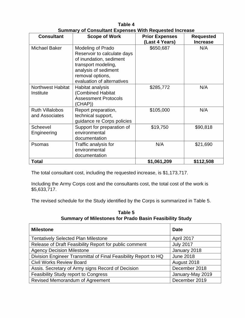
Table 4 Summary of Consultant Expenses With Requested Incre ase
Consultant Scope of Work Prior Expenses (Last 4 Years)
Requested Increase
Michael Baker Modeling of Prado Reservoir to calculate days of inundation, sediment transport modeling, analysis of sediment removal options, evaluation of alternatives
$650,687 N/A
Northwest Habitat Institute
Habitat analysis (Combined Habitat Assessment Protocols (CHAP))
$285,772 N/A
Ruth Villalobos and Associates
Report preparation, technical support, guidance re Corps policies
$105,000 N/A
Scheevel Engineering
Support for preparation of environmental documentation
$19,750 $90,818
Psomas Traffic analysis for environmental documentation
N/A $21,690
Total $1,061,209 $112,508 The total consultant cost, including the requested increase, is $1,173,717. Including the Army Corps cost and the consultants cost, the total cost of the work is $5,633,717. The revised schedule for the Study identified by the Corps is summarized in Table 5.
Table 5 Summary of Milestones for Prado Basin Feasibility S tudy
Milestone Date
Tentatively Selected Plan Milestone April 2017 Release of Draft Feasibility Report for public comment July 2017 Agency Decision Milestone January 2018 Division Engineer Transmittal of Final Feasibility Report to HQ June 2018 Civil Works Review Board August 2018 Assis. Secretary of Army signs Record of Decision December 2018 Feasibility Study report to Congress January-May 2019 Revised Memorandum of Agreement December 2019
The District is pursuing a 5-year deviation to allow water conservation to elevation 505 feet in the flood season due to the current Dam Safety Action Class (DSAC) rating for Prado Dam. The DSAC rating of 3 for Prado Dam does not allow for a permanent change in operation of Prado Dam until the DSAC is raised to a minimum of 4. Implementation of measures requiring a permanent change in dam operations, such as raising the flood season buffer pool elevation to 505 feet, could only be implemented after the DSAC rating has been increased, which will occur when the Santa Ana River Mainstem flood risk management project is completed. In the interim, the Corps has approved temporary deviations to allow water conservation to elevation 505 feet in the flood season. The last feature to be completed in the SAR Mainstem project is raising the Prado Dam spillway. Prior to raising the spillway, other features of the project need to be completed such as levees located near the perimeter of Prado Basin (near 566 ft elevation) and purchase of lands between elevation 556 feet and 566 feet. The SAR Mainstem project is estimated to be completed in 2022, but is dependent upon receiving adequate funding through the federal budget.
PRIOR RELEVANT BOARD ACTION(S) 3/15/2017, R17-3-35: Authorize execution of Amendment No. 1 to Agreement No. 1170 with Ruth Villalobos and Associates for an amount not to exceed $60,000 to support the Prado Basin Feasibility Study. 6/15/2016, R16-6-79: Authorize execution of Agreement with Ruth Villalobos and Associates for an amount not to exceed $45,000 to support the Prado Basin Feasibility Study. 4/20/2016, R16-4-45: Authorize issuance of Amendment No. 3 to Agreement No. 0911 with Northwest Habitat Institute for an amount not to exceed $45,232 to conduct additional tasks for habitat assessment and modeling for the Prado Basin CA Feasibility Study bringing the total Agreement to $288,194. 3/21/2012, R12-3-28: Approve and authorize revised Agreement with the Department of the Army for the Prado Basin, California Study for the evaluation of water conservation and ecosystem restoration opportunities in Prado Basin
Prado Basin Feasibility Study
Water Issues CommitteeApril 12, 2017

Prado Basin Feasibility Study• Agreement with Army Corps established District as
non-federal (local) sponsor• Feasibility Study includes
– Ecosystem restoration– Water conservation (temporary stormwater capture)– Sediment management
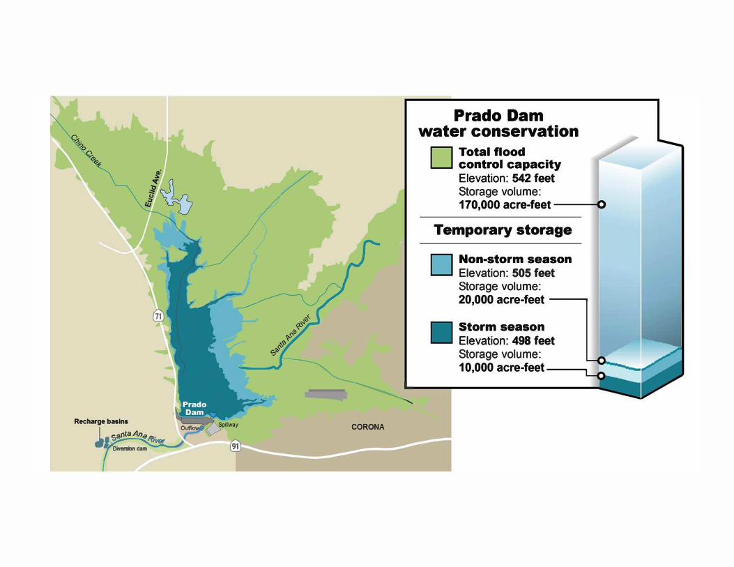
Recharge basins
I _ c:.arita An�,...
, 1
� Or1ersion dam
---�--------� CORONA
91
Prado Dam
water conservation
D Total flood control capacity
E levation : 542 feet Storage volume : 1 70,000 acre-feet O
Temporary storage
D Non-storm season
Elevation : 505 feet Storage volume : 20,000 acre-feet --......
Storm season Elevation : 498 feet Storage volu me : 1 0 ,000 acre-feet --......
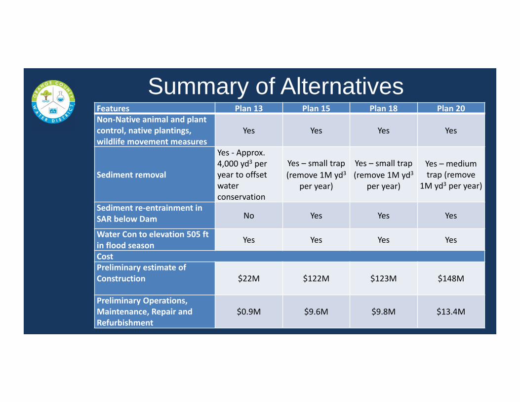
Summary of AlternativesFeatures Plan�13 Plan�15 Plan�18 Plan�20
NonrNative�animal�and�plant�
control,�native�plantings,�
wildlife movement�measures
Yes Yes Yes Yes
Sediment�removal
Yes�r Approx.�
4,000�yd3 per�
year�to�offset�
water�
conservation
Yes�– small�trap
(remove�1M�yd3
per�year)
Yes�– small�trap
(remove�1M�yd3
per�year)
Yes�– medium�
trap�(remove�
1M�yd3 per�year)
Sediment�rerentrainment�in�
SAR�below�Dam No Yes Yes Yes
Water�Con�to�elevation�505�ft�
in�flood�seasonYes Yes Yes Yes
Cost
Preliminary�estimate�of�
Construction $22M $122M $123M $148M
Preliminary�Operations,�
Maintenance,�Repair�and�
Refurbishment
$0.9M $9.6M $9.8M $13.4M
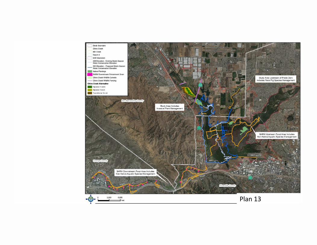
Plan�13�����������������������
:-_-_-_-: Study Bou ndary Chino Creek Mill Creek Reach 9
:-_-_-_-: SAR Ma1nstem 498 Elevatlon - Existing Stomi Season Waler Conservation Elevallon 505 Elevauon - Proposed Storm Season Water Conservation Elevation
- Native Plantll'lgs � SARM Downstream Entra1nmeot Grom
Chino Creek w,dhfe Culverts -- Chino Creek Wildlife Fenciig Chi no Creek Alternative
•• • 0 3,000 6,000
w Feel

Plan�15����������������������
�-_-_-_-: Study Boundary Chmo Creek MIU Creek
: Reach 9 ·: SAR Ma1nstem
498 Elevation - Existng Storm Season Water Conseivauon Elevation 505 Elevation . Proposed Storm Season
-- Waler Conserva11on Elevatton - Nabve Plantngs - SARM Downsueam Emranment Grom
Chino Creek w•d11re Culverts -- Chino Creek W�dhfe Fenc11g Chi no Creek Alternative D - Ripanan Forest - Ripanan Scrub - Trans111onal Scrub SARM Deep Small D Deep T,ap - SMALL
..., Manage R1panan Edge Habitat - OCWOWetlands P1lot Chan nel Invert
- OCWD Wetlands Pilot Chan nel Side SJopes
- SARM US - B10-Engmeered Entrain ment Gron
� Sediment Spreadng Basins and Stockp�e SkJrry Pipeline Transillonal Channel - Invert
••• 0 3,000 6,000
w Feel

Plan�18�����������������������
:· _-_-_·: Study Boundary Chmo Creek Mill Creek
_ , Reach 9 :· _-_-_·: SAR Mainstem
498 Elevation - Ex1stmg Storm Season Water Conservation Elevation 505 Elevation - Proposed Storm Season
-- Water Conservation Elevat10n - Native Plant11gs
- SARM Downstream Entranmeni Grom Chmo Creek w•dhfe Culverts
-- Chmo Creek W�dllle Fencing Chino Creek Alte matlve C - Riparian Forest - Riparian Scrub - Transrtional Scrub SARM Deep Small c::J Deep Trap . SMALL
Manage R1panan Edge Habitat - OCWD Wetlands Pilot Chan nel - Invert
- OCWO Wetlands Pilot Channel - Side SIOpes
- SARM US - Bio-Engmeered Entrain ment Gron
� Sediment Spreading Basins and Stockpie Slurry Pipeline
3,000 6,000 ---11111:==::::::IFeet
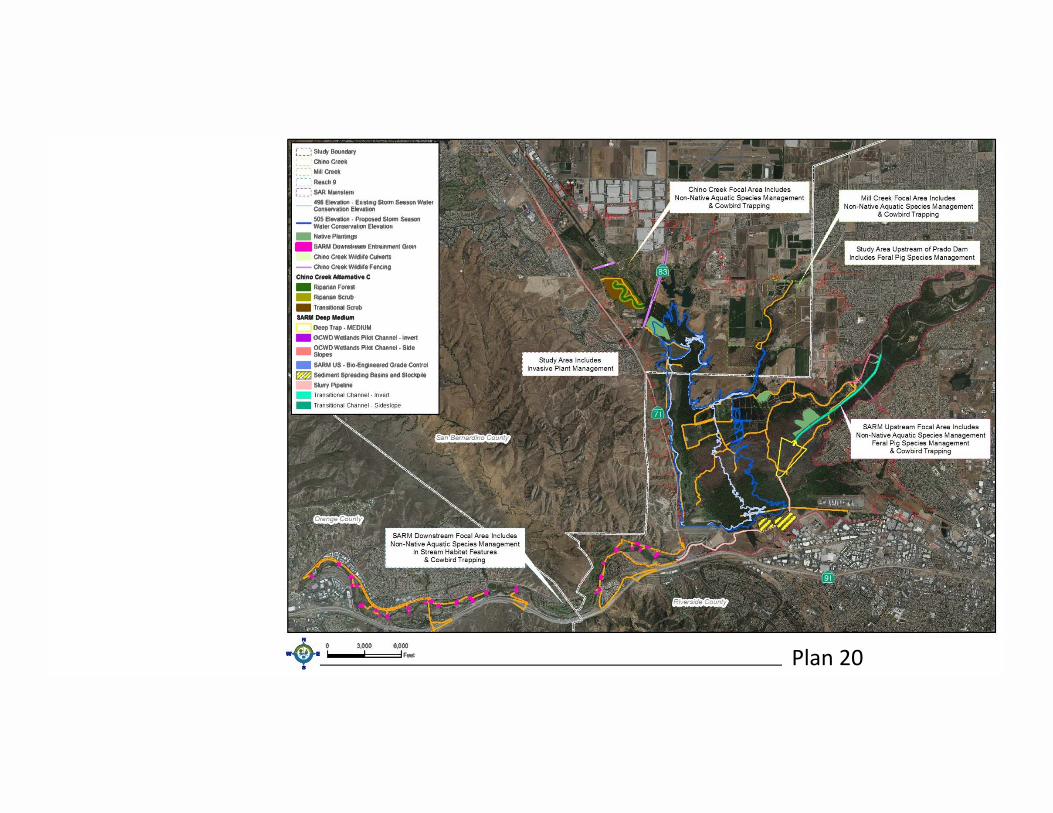
Plan�20�����������������������
;-_-_-_-: Study Boundary Chino Creek M11t Oeek Reach 9
c_-:_-: SAA Mamstem 498 Elevation - Ex1s1ng Slorm Season Water Conservation Elevation 505 Elevation - Proposed Storm Season
-- Water Conserva1100 Elevat10n - Nauve Plantings � SARM Downstream Entra11ment Grom
Chino Creek Widhfe CulverlS -- Chino Creek Wfdl1fe Fencrig Chino Creek Alternative C - Riparian Forest - Riparian Scrub - Transitional Scrub SARM Deep Medium
Deep Trap · MEDIUM
- OCWD WeUands Pi lot Channel - Invert
-OCWD Wetlands Pi lot Channel . Side Slopes
- SAAM US - Bm-Engmeered Grade Control � Sediment Spreading Basins and Slockp�e
Sluny P1pehne
• 0 - -
-�• F�
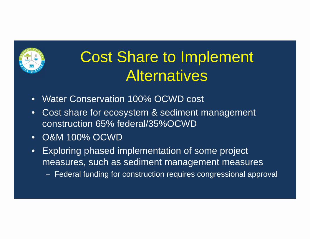
Cost Share to Implement Alternatives
• Water Conservation 100% OCWD cost• Cost share for ecosystem & sediment management
construction 65% federal/35%OCWD• O&M 100% OCWD• Exploring phased implementation of some project
measures, such as sediment management measures– Federal funding for construction requires congressional approval
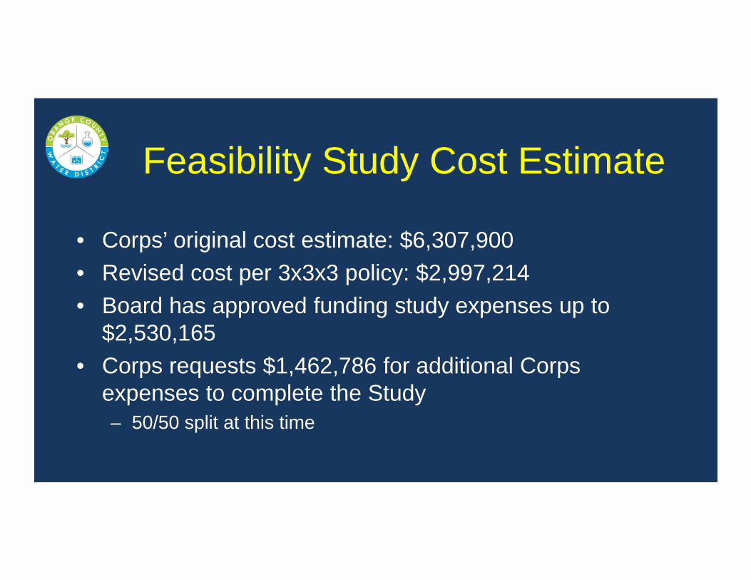
Feasibility Study Cost Estimate
• Corps’ original cost estimate: $6,307,900• Revised cost per 3x3x3 policy: $2,997,214• Board has approved funding study expenses up to
$2,530,165• Corps requests $1,462,786 for additional Corps
expenses to complete the Study– 50/50 split at this time
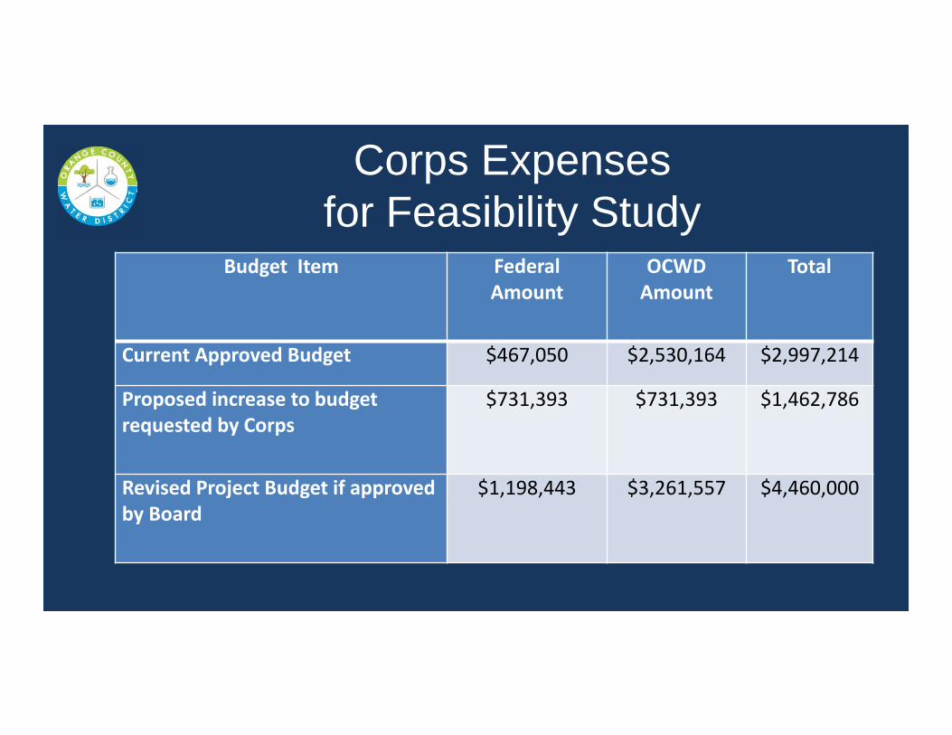
Corps Expenses for Feasibility Study
Budget��Item Federal�
Amount
OCWD�
Amount
Total
Current�Approved�Budget $467,050 $2,530,164 $2,997,214
Proposed�increase�to�budget�
requested�by�Corps
$731,393 $731,393 $1,462,786
Revised�Project�Budget�if�approved�
by�Board
$1,198,443 $3,261,557 $4,460,000

Additional Consultant Support Needed
• Technical support by Scheevel Engineering for preparing environmental documentation, Adaptive Management Plan, assisting Corps with Engineering Appendix, and additional sediment transport modeling
• Traffic analyses by Kunzman Associates as subconsultant to Psomas

Updated Prado FS Schedule
Milestone Date
Tentatively�Selected�Plan April�2017
Public�Comment�Period�for�CEQA/NEPA AugustrSept�2017
Agency Decision�Milestone January�2018
Submit Final�Report�to�Corps�HQ June�2018
Civil�Works�Review�Board August�2018
Assistant�Sec�of�Army�signs Record�of�Decision December�2018
Feasibility�Study�Report�to�Congress JanrMay�2019
Revised�MOA December 2019
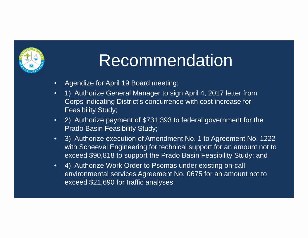
Recommendation• Agendize for April 19 Board meeting: • 1) Authorize General Manager to sign April 4, 2017 letter from
Corps indicating District’s concurrence with cost increase for Feasibility Study;
• 2) Authorize payment of $731,393 to federal government for the Prado Basin Feasibility Study;
• 3) Authorize execution of Amendment No. 1 to Agreement No. 1222 with Scheevel Engineering for technical support for an amount not to exceed $90,818 to support the Prado Basin Feasibility Study; and
• 4) Authorize Work Order to Psomas under existing on-call environmental services Agreement No. 0675 for an amount not to exceed $21,690 for traffic analyses.
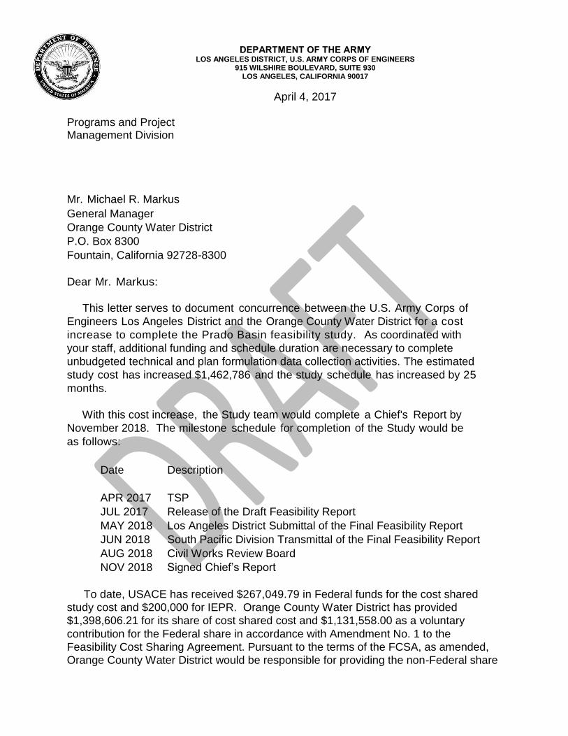
DEPARTMENT OF THE ARMY LOS ANGELES DISTRICT, U.S. ARMY CORPS OF ENGINEERS
915 WILSHIRE BOULEVARD, SUITE 930 LOS ANGELES, CALIFORNIA 90017
April 4, 2017
Programs and Project Management Division Mr. Michael R. Markus General Manager Orange County Water District P.O. Box 8300 Fountain, California 92728-8300 Dear Mr. Markus:
This letter serves to document concurrence between the U.S. Army Corps of Engineers Los Angeles District and the Orange County Water District for a cost increase to complete the Prado Basin feasibility study. As coordinated with your staff, additional funding and schedule duration are necessary to complete unbudgeted technical and plan formulation data collection activities. The estimated study cost has increased $1,462,786 and the study schedule has increased by 25 months.
With this cost increase, the Study team would complete a Chief's Report by November 2018. The milestone schedule for completion of the Study would be as follows: Date Description APR 2017 TSP JUL 2017 Release of the Draft Feasibility Report MAY 2018 Los Angeles District Submittal of the Final Feasibility Report JUN 2018 South Pacific Division Transmittal of the Final Feasibility Report AUG 2018 Civil Works Review Board NOV 2018 6LJQHG�&KLHI¶V�5HSRUW
To date, USACE has received $267,049.79 in Federal funds for the cost shared study cost and $200,000 for IEPR. Orange County Water District has provided $1,398,606.21 for its share of cost shared cost and $1,131,558.00 as a voluntary contribution for the Federal share in accordance with Amendment No. 1 to the Feasibility Cost Sharing Agreement. Pursuant to the terms of the FCSA, as amended, Orange County Water District would be responsible for providing the non-Federal share
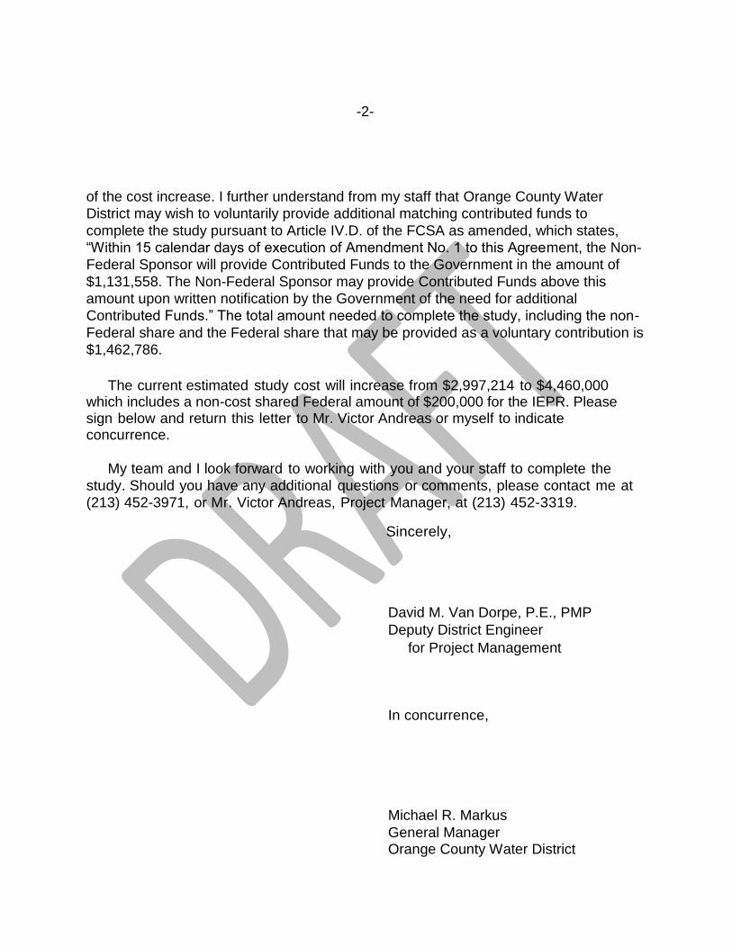
-2-
of the cost increase. I further understand from my staff that Orange County Water District may wish to voluntarily provide additional matching contributed funds to complete the study pursuant to Article IV.D. of the FCSA as amended, which states, ³:LWKLQ����FDOHQGDU�GD\V�RI�H[HFXWLRQ�RI�$PHQGPHQW�1R����WR�WKLV�$JUHHment, the Non-Federal Sponsor will provide Contributed Funds to the Government in the amount of $1,131,558. The Non-Federal Sponsor may provide Contributed Funds above this amount upon written notification by the Government of the need for additional ContrLEXWHG�)XQGV�´�7KH�WRWDO�DPRXQW�QHHGHG�WR�FRPSOHWH�WKH�VWXG\��LQFOXGLQJ�WKH�QRQ-Federal share and the Federal share that may be provided as a voluntary contribution is $1,462,786.
The current estimated study cost will increase from $2,997,214 to $4,460,000 which includes a non-cost shared Federal amount of $200,000 for the IEPR. Please sign below and return this letter to Mr. Victor Andreas or myself to indicate concurrence.
My team and I look forward to working with you and your staff to complete the study. Should you have any additional questions or comments, please contact me at (213) 452-3971, or Mr. Victor Andreas, Project Manager, at (213) 452-3319.
Sincerely,
David M. Van Dorpe, P.E., PMP
Deputy District Engineer for Project Management
In concurrence, Michael R. Markus General Manager
Orange County Water District
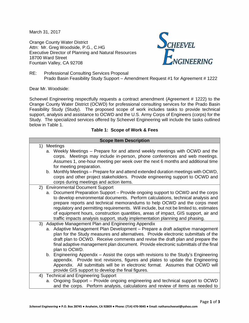
Page 1 of 3 Scheevel Engineering ·�WXKX��}Æ�îôóðñ ·��v�Z�]uU����õîôìõ�·�WZ}v�W�~óíð��ðóì-õìðñ�·��u�]oW�v��Z�v��Z��À�o�Ç�Z}}X�}u
March 31, 2017 Orange County Water District Attn: Mr. Greg Woodside, P.G., C.HG Executive Director of Planning and Natural Resources 18700 Ward Street Fountain Valley, CA 92708 RE: Professional Consulting Services Proposal Prado Basin Feasibility Study Support ± Amendment Request #1 for Agreement # 1222 Dear Mr. Woodside: Scheevel Engineering respectfully requests a contract amendment (Agreement # 1222) to the Orange County Water District (OCWD) for professional consulting services for the Prado Basin Feasibility Study (Study). The proposed scope of work includes tasks to provide technical support, analysis and assistance to OCWD and the U.S. Army Corps of Engineers (corps) for the Study. The specialized services offered by Scheevel Engineering will include the tasks outlined below in Table 1.
Table 1: Scope of Work & Fees
Scope Item Description 1) Meetings
a. Weekly Meetings ± Prepare for and attend weekly meetings with OCWD and the corps. Meetings may include in-person, phone conferences and web meetings. Assumes 1, one-hour meeting per week over the next 6 months and additional time for meeting preparation.
b. Monthly Meetings ± Prepare for and attend extended duration meetings with OCWD, corps and other project stakeholders. Provide engineering support to OCWD and corps during meetings and action items.
2) Environmental Document Support a. Document Preparation Support ± Provide ongoing support to OCWD and the corps
to develop environmental documents. Perform calculations, technical analysis and prepare reports and technical memorandums to help OCWD and the corps meet regulatory and permitting requirements. Will include, but not be limited to, estimates of equipment hours, construction quantities, areas of impact, GIS support, air and traffic impacts analysis support, study implementation planning and phasing.
3) Adaptive Management Plan and Engineering Appendix a. Adaptive Management Plan Development ± Prepare a draft adaptive management
plan for the Study measures and alternatives. Provide electronic submittals of the draft plan to OCWD. Receive comments and revise the draft plan and prepare the final adaptive management plan document. Provide electronic submittals of the final plan to OCWD.
b. Engineering Appendix ± Assist the corps with revisions to the Study¶s Engineering appendix. Provide text revisions, figures and plates to update the Engineering Appendix. All submittals will be in electronic format. Assumes that OCWD will provide GIS support to develop the final figures.
4) Technical and Engineering Support a. Ongoing Support ± Provide ongoing engineering and technical support to OCWD
and the corps. Perform analysis, calculations and review of items as needed to
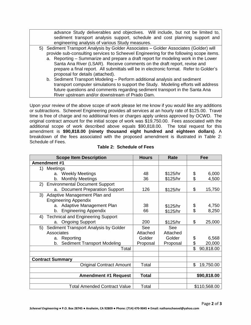
Page 2 of 3 Scheevel Engineering ·�WXKX��}Æ�îôóðñ ·��v�Z�]uU����õîôìõ�·�WZ}v�W�~óíð��ðóì-õìðñ�·��u�]oW�v��Z�v��Z��À�o�Ç�Z}}X�}u
advance Study deliverables and objectives. Will include, but not be limited to, sediment transport analysis support, schedule and cost planning support and engineering analysis of various Study measures.
5) Sediment Transport Analysis by Golder Associates ± Golder Associates (Golder) will provide sub-consulting services to Scheevel Engineering for the following scope items. a. Reporting ± Summarize and prepare a draft report for modeling work in the Lower
Santa Ana River (LSAR). Receive comments on the draft report, revise and prepare a final report. All submittals will be in electronic format. Refer to Golder¶s proposal for details (attached).
b. Sediment Transport Modeling ± Perform additional analysis and sediment transport computer simulations to support the Study. Modeling efforts will address future questions and comments regarding sediment transport in the Santa Ana River upstream and/or downstream of Prado Dam.
Upon your review of the above scope of work please let me know if you would like any additions or subtractions. Scheevel Engineering provides all services at an hourly rate of $125.00. Travel time is free of charge and no additional fees or charges apply unless approved by OCWD. The original contract amount for the initial scope of work was $19,750.00. Fees associated with the additional scope of work described above equals $90,818.00. The total request for this amendment is $90,818.00 (ninety thousand eight hundred and eighteen dollars) . A breakdown of the fees associated with the proposed amendment is illustrated in Table 2: Schedule of Fees.
Table 2: Schedule of Fees
Scope Item Description Hours Rate Fee Amendment #1
1) Meetings a. Weekly Meetings b. Monthly Meetings
48 36
$125/hr $125/hr
$ 6,000 $ 4,500
2) Environmental Document Support a. Document Preparation Support
126
$125/hr
$ 15,750 3) Adaptive Management Plan and
Engineering Appendix a. Adaptive Management Plan b. Engineering Appendix
38 66
$125/hr $125/hr
$ 4,750 $ 8,250
4) Technical and Engineering Support a. Ongoing Support
200
$125/hr
$ 25,000 5) Sediment Transport Analysis by Golder
Associates a. Reporting b. Sediment Transport Modeling
See Attached Golder
Proposal
See Attached Golder
Proposal
$ 6,568 $ 20,000
Total $ 90,818.00 Contract Summary
Original Contract Amount Total $ 19,750.00
Amendment #1 Request Total $90,818.00
Total Amended Contract Value Total $110,568.00
Page 3 of 3 Scheevel Engineering ·�WXKX��}Æ�îôóðñ ·��v�Z�]uU����õîôìõ�·�WZ}v�W�~óíð��ðóì-õìðñ�·��u�]oW�v��Z�v��Z��À�o�Ç�Z}}X�}u
Scheevel Engineering FDQ� PHHW� RU� H[FHHG� 2&:'¶V� insurance requirements. Scheevel Engineering is prepared to continue work on the project immediately. Thank you for the opportunity to provide professional consulting services to OCWD. Sincerely, Scheevel Engineering
Nate Scheevel, P.E. President/Principal Engineer
March 30, 2017 P1776341
Mr. Nathan Scheevel, PE Scheevel Engineering, LLC P.O. Box 28745 Anaheim, California 92809
RE: PRADO BASIN FEASIBILITY PROJECT SEDIMENT MODELI NG – TASKS 3 AND 4 SCOPE OF WORK AND COST ESTIMATE
Dear Nathan:
Golder Associates Inc. (Golder) is pleased to present this scope of work (SOW) and cost estimate to Scheevel Engineering, LLC, to develop project reporting for Tasks 1 and 2 in support of the Orange County Water District (OCWD) and U.S. Army Corps of Engineers (USACE) Prado Basin Feasibility Study. Golder submitted a SOW for Tasks 1 and 2 previously.
1.0 INTRODUCTION
The USACE is preparing a feasibility study at Prado Basin in Riverside County, California. OCWD is assisting USACE as the local sponsor. The study area includes Prado Basin and the Santa Ana River below Prado Dam to the Pacific Ocean (approximately 30 miles). The purpose of the study is to analyze effects of removing sediment from the Prado Basin and re-entraining the sediment in the water released from the dam in the Lower Santa Ana River (LSAR) to improve the ecosystem both in the Prado Basin and in the LSAR, promote higher infiltration in the LSAR, and increase storage capacity in the Prado Basin. Golder has completed Tasks 1 and 2, which was composed of sediment transport modeling upstream, and downstream of the Prado Basin based on assumptions of re-entrainment rates and sediment trap geometry. A slope analysis in the LSAR was also conducted to estimate the slope, which may develop over the course of sediment re-entrainment.
2.0 SCOPE OF WORK
2.1 Task 3 – Report
As part of this task, a comprehensive report will be developed for the sediment transport modeling and slope analysis in the LSAR, which was conducted as part of Tasks 1 and 2. Memoranda have been provided previously describing the analysis and results of the work performed upstream of Prado Basin. The report will outline the slope analysis methodology and results and long-term HEC-RAS modeling methodology, inputs, and results. Dr. George W. Annandale, PE will provide independent technical review of the report. One (1) draft version of this report will be submitted electronically to OCWD for review and comments. Golder will address one (1) set of comments and deliver a final, electronic copy of the report to OCWD. For budgetary purposes, it is assumed that the comments received from OCWD will not require additional technical analysis.
2.2 Task 4 – Additional Hydraulic Modeling
A task for additional sediment transport hydraulic modeling is included as part of this scope. This task is yet to be defined. As requested, there is a $20,000 budget as a placeholder for this undefined task.
I:\PROP2017\P1776341\Rev0\P1776341 PROP PradoTransportModeling 30MAR17.docx
Golder Associates Inc. 44 Union Boulevard, Suite 300
Lakewood, CO 80228 USA Tel: (303) 980-0540 Fax: (303) 985-2080 www.golder.com
Golder Associates: Operations in Africa, Asia, Aust ralasia, Europe, North America and South America
Golder, Golder Associates and the GA globe design are trademarks of Golder Associates Corporation
Mr. Nathan Scheevel, PE March 30, 2017 Scheevel Engineering, LLC 2 P1776341 3.0 COST ESTIMATE AND SCHEDULE
The cost estimate for these tasks is $26,570 and a detailed estimate of the labor and costs is included in Table 1. The labor rates within the budget are based on Golder’s 2017 billing rates for the Denver, Colorado office. We anticipate that, for Task 3, the draft report can be provided within approximately 2 weeks after receiving a notice to proceed. A final report can be provided within approximately 1 week after the receipt of comments from OCWD, assuming that no additional analysis is required. Work in excess of the authorized fee will not be completed without written authorization from OCWD.
4.0 CONTRACT
The work will be conducted in accordance with the attached subconsultant agreement between Scheevel Engineering and Golder. Please contact us with any questions regarding this proposal. We look forward to working with you on this project.
Sincerely,
GOLDER ASSOCIATES INC.
Craig P. Baxter, PE Cameron Beul, PE Senior Project Engineer Associate
Attachment: Table 1 – Cost Estimate for Prado Feasibility Project Sediment Modeling – Tasks 3 and 4
I:\PROP2017\P1776341\Rev0\P1776341 PROP PradoTransportModeling 30MAR17.docx

TABLE
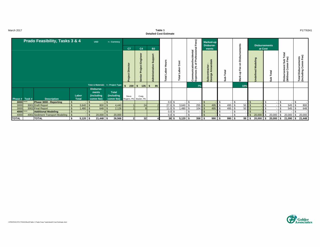
March 2017 Table 1Detailed Cost Estimate
P1776341
USD <-- Currency1 1 3
C7 C4 B3
Pro
ject
Dire
ctor
Sen
ior
Pro
ject
Eng
inee
r
Adm
inis
trat
ive
Sup
port
Sub
cont
ract
or -
G
eorg
e A
nnan
dale
Und
efin
ed M
odel
ing
Sub
Tot
al
Time & Materials <-- Project Type 230$ 135$ 85$ 7% 10%
Phase # Task # DescriptionLabor Total
Disburse-ments
(including comm fee)
Total(including comm fee)
Steve Rogers, PE
Craig Baxter, PE
3000 **** Phase 3000 - Reportin g -$ -$ -$ 0.0 -$ -$ -$ -$ -$ -$ -$ -$ -$ 3000 3001 Draft Report 3,640$ 800$ 4,440$ 1 24 2 27.0 3,640$ 255$ 495$ 495$ 50$ -$ -$ 545$ 800$ 3000 3002 Final Report 1,480$ 648$ 2,128$ 1 8 2 11.0 1,480$ 104$ 495$ 495$ 50$ -$ -$ 545$ 648$ 4000 **** Additional Modelin g -$ -$ -$ 0.0 -$ -$ -$ -$ -$ -$ -$ -$ -$ 4000 4001 Sediment Transport Modeling -$ 20,000$ 20,000$ 0.0 -$ -$ -$ -$ -$ 20,000$ 20,000$ 20,000$ 20,000$
TOTAL TOTAL 5,120$ 21,448$ 26,568$ 2 32 4 38 5,120$ 358$ 990$ 990$ 99$ 20,000$ 20,000$ 21,090$ 21,448$
Prado Feasibility, Tasks 3 & 4
Tot
al D
isbu
rsem
ents
(Inc
ludi
ng C
omm
Fee
)
Com
mun
icat
ion/
Inci
dent
al
Exp
ense
s (%
of P
rofe
ssio
nal F
ees)
Tot
al L
abor
Cos
t
Mar
k-up
Fee
on
Dis
burs
emen
ts
Sub
-Tot
al
Tot
al L
abor
Hou
rs
Dis
burs
emen
t Sub
Tot
al(W
ithou
t Com
m F
ee)
Marked-up Disburse-
ments Disbursements
at Cost
I:\PROP2017\P1776341\Rev0\Table 1 Prado Feas Tasks3and4 Cost Estimate.xlsm
�
�
3 Hutton Centre Drive
Suite 200
Santa Ana, CA 92707
Tel 714.751.7373
www.Psomas.com
0DUFK����������
�
�
�
'DQLHO�%RWW� 9,$�(0$,/�
3ULQFLSDO�3ODQQHU� GERWW#RFZG�FRP�
2UDQJH�&RXQW\�:DWHU�'LVWULFW�
������:DUG�6WUHHW�
)RXQWDLQ�9DOOH\��&DOLIRUQLD�������
6XEMHFW�� 3URSRVDO�IRU�$GGLWLRQDO�7UDIILF�$QDO\VLV�6HUYLFHV�IRU�WKH�3UDGR�%DVLQ�)HDVLELOLW\�6WXG\�
'HDU�0U��%RWW��
7KDQN�\RX�IRU�WKLV�RSSRUWXQLW\�WR�SURYLGH�3KDVH�,,�7UDIILF�$QDO\VLV�VHUYLFHV��WKURXJK�.XQ]PDQ�
$VVRFLDWHV���D�VXEFRQVXOWDQW��LQ�VXSSRUW�RI�WKH�3UDGR�%DVLQ�)HDVLELOLW\�6WXG\��3VRPDV�XQGHUVWDQGV�WKDW�
WKLV�SKDVH�RI�ZRUN�LQFOXGHV�WKH�IROORZLQJ�SURSRVHG�VWXG\�DUHDV�DQG�VHYHUDO�DOWHUQDWLYH�SODQV�ORFDWHG�
ZLWKLQ�WKHVH�WKUHH�IRFDO�DUHDV��
��� 7KH�0LOO�&UHHN�ORFDWLRQ���� 7KH�&KLQR�&UHHN�$OWHUQDWLYH�'�ORFDWLRQ���� 'RZQVWUHDP�6$50���3UDGR�'DP�WR�:HLU�&DQ\RQ�VHJPHQW�
7KH�3UDGR�%DVLQ�6DQWD�$QD�5LYHU��8SVWUHDP�6$50��IRFDO�DUHD�LV�LQFOXGHG�LQ�D�VHSDUDWH�SURSRVDO�
SUHYLRXVO\�VXEPLWWHG��7KH�IROORZLQJ�VFRSH�RI�ZRUN�KDV�EHHQ�GHYHORSHG�WR�VWXG\�WKH�WUDIILF�DQDO\VLV�
LPSOLFDWLRQV�IRU�WKHVH�WKUHH�IRFDO�DUHDV��
)2&86('�75$)),&�$1$/<6,6�±�.81=0$1�$662&,$7(6�
.XQ]PDQ�ZLOO�SUHSDUH�D�IRFXVHG�WUDIILF�DQDO\VLV�LQ�DFFRUGDQFH�ZLWK�DFFHSWHG�SURIHVVLRQDO�WUDQVSRUWDWLRQ�
HQJLQHHULQJ�VWDQGDUGV��7KH�ILQDO�LOOXVWUDWHG�UHSRUW�ZLOO�VXPPDUL]H�WKH�IRFXVHG�WUDIILF�DQDO\VLV�ILQGLQJV��
PHWKRGRORJ\��DQG�VXSSRUWLYH�GDWD��,W�ZLOO�TXDQWLI\�H[LVWLQJ�WUDIILF�FRQGLWLRQV��WUDIILF�FRQGLWLRQV�ZLWK�
SURMHFW�FRQVWUXFWLRQ��DQG�UHFRPPHQG�PLWLJDWLRQ�PHDVXUHV��
7KH�IRFXVHG�WUDIILF�DQDO\VLV�VFRSH�RI�VHUYLFHV�LQFOXGHV�����GLVFXVVLQJ�WKH�SURSRVHG�GHYHORSPHQW�ZLWK�WKH�
FOLHQW������UHYLHZLQJ�WKH�ODWHVW�WUDIILF�VWXG\�JXLGHOLQHV�DQG�VLJQLILFDQFH�FULWHULD�IRU�WKH�DIIHFWHG�
MXULVGLFWLRQV��L�H���5LYHUVLGH�&RXQW\��2UDQJH�&RXQW\��&RURQD��1RUFR��&DOLIRUQLD�'HSDUWPHQW�RI�
7UDQVSRUWDWLRQ��HWF��������FRQGXFWLQJ�D�VWXG\�DUHD�ILHOG�VXUYH\�RI�LQWHUVHFWLRQ�WUDIILF�FRQWURO�GHYLFHV��
LQWHUVHFWLRQ�DSSURDFK�ODQHV��DQG�URDGZD\�VHJPHQW�WKURXJK�WUDYHO�ODQHV������GRFXPHQWLQJ�H[LVWLQJ�WUDIILF�
FRQGLWLRQV������REWDLQLQJ�DYHUDJH�ZHHNGD\����KRXU�WXEH�FRXQWV�RQ�WKH�VWXG\�DUHD�URDGZD\V�IRU�HDFK�IRFDO�
DUHD������UHYLHZLQJ�WKH�DYDLODEOH�&DOLIRUQLD�3HUIRUPDQFH�0DQDJHPHQW�6\VWHP��3(06��GDWD�IRU�IUHHZD\�
PDLQOLQH�VHJPHQWV������GHWHUPLQLQJ�SURMHFW�WULS�JHQHUDWLRQ�EDVHG�XSRQ�KDXOLQJ�VWDIILQJ�WLPHIUDPH�
LQIRUPDWLRQ�SURYLGHG�E\�WKH�FOLHQW������GLVWULEXWLQJ�WKH�SURMHFW�WULS�JHQHUDWLRQ�WR�WKH�VWUHHW�
V\VWHP������DQDO\]LQJ�VWXG\�DUHD�URDGZD\�VHJPHQW�YROXPH�WR�FDSDFLW\�UDWLRV�ZLWKRXW�DQG�ZLWK��
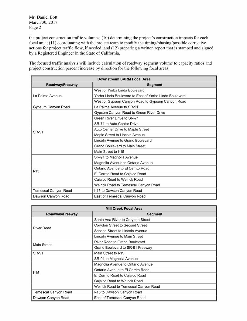
0U��'DQLHO�%RWW�
0DUFK����������
3DJH���
�
WKH�SURMHFW�FRQVWUXFWLRQ�WUDIILF�YROXPHV�������GHWHUPLQLQJ�WKH�SURMHFW¶V�FRQVWUXFWLRQ�LPSDFWV�IRU�HDFK�
IRFDO�DUHD�������FRRUGLQDWLQJ�ZLWK�WKH�SURMHFW�WHDP�WR�PRGLI\�WKH�WLPLQJ�SKDVLQJ�SRVVLEOH�FRUUHFWLYH�
DFWLRQV�IRU�SURMHFW�WUDIILF�IORZ��LI�QHHGHG��DQG������SUHSDULQJ�D�ZULWWHQ�UHSRUW�WKDW�LV�VWDPSHG�DQG�VLJQHG�
E\�D�5HJLVWHUHG�(QJLQHHU�LQ�WKH�6WDWH�RI�&DOLIRUQLD��
7KH�IRFXVHG�WUDIILF�DQDO\VLV�ZLOO�LQFOXGH�FDOFXODWLRQ�RI�URDGZD\�VHJPHQW�YROXPH�WR�FDSDFLW\�UDWLRV�DQG�
SURMHFW�FRQVWUXFWLRQ�SHUFHQW�LQFUHDVH�E\�GLUHFWLRQ�IRU�WKH�IROORZLQJ�IRFDO�DUHDV��
'RZQVWUHDP�6$50�)RFDO�$UHD�
5RDGZD\�)UHHZD\� 6HJPHQW�
/D�3DOPD�$YHQXH�
:HVW�RI�<RUED�/LQGD�%RXOHYDUG�
<RUED�/LQGD�%RXOHYDUG�WR�(DVW�RI�<RUED�/LQGD�%RXOHYDUG�
:HVW�RI�*\SVXP�&DQ\RQ�5RDG�WR�*\SVXP�&DQ\RQ�5RDG�
*\SVXP�&DQ\RQ�5RDG� /D�3DOPD�$YHQXH�WR�65����
65����
*\SVXP�&DQ\RQ�5RDG�WR�*UHHQ�5LYHU�'ULYH�
*UHHQ�5LYHU�'ULYH�WR�65����
65����WR�$XWR�&HQWHU�'ULYH�
$XWR�&HQWHU�'ULYH�WR�0DSOH�6WUHHW�
0DSOH�6WUHHW�WR�/LQFROQ�$YHQXH�
/LQFROQ�$YHQXH�WR�*UDQG�%RXOHYDUG�
*UDQG�%RXOHYDUG�WR�0DLQ�6WUHHW�
0DLQ�6WUHHW�WR�,����
,����
65����WR�0DJQROLD�$YHQXH�
0DJQROLD�$YHQXH�WR�2QWDULR�$YHQXH�
2QWDULR�$YHQXH�WR�(O�&HUULWR�5RDG�
(O�&HUULWR�5RDG�WR�&DMDOFR�5RDG�
&DMDOFR�5RDG�WR�:HLULFN�5RDG�
:HLULFN�5RDG�WR�7HPHVFDO�&DQ\RQ�5RDG�
7HPHVFDO�&DQ\RQ�5RDG� ,����WR�'DZVRQ�&DQ\RQ�5RDG�
'DZVRQ�&DQ\RQ�5RDG� (DVW�RI�7HPHVFDO�&DQ\RQ�5RDG�
�
0LOO�&UHHN�)RFDO�$UHD�
5RDGZD\�)UHHZD\� 6HJPHQW�
5LYHU�5RDG�
6DQWD�$QD�5LYHU�WR�&RU\GRQ�6WUHHW�
&RU\GRQ�6WUHHW�WR�6HFRQG�6WUHHW�
6HFRQG�6WUHHW�WR�/LQFROQ�$YHQXH�
/LQFROQ�$YHQXH�WR�0DLQ�6WUHHW�
0DLQ�6WUHHW�5LYHU�5RDG�WR�*UDQG�%RXOHYDUG�
*UDQG�%RXOHYDUG�WR�65����)UHHZD\�
65���� 0DLQ�6WUHHW�WR�,����
,����
65����WR�0DJQROLD�$YHQXH�
0DJQROLD�$YHQXH�WR�2QWDULR�$YHQXH�
2QWDULR�$YHQXH�WR�(O�&HUULWR�5RDG�
(O�&HUULWR�5RDG�WR�&DMDOFR�5RDG�
&DMDOFR�5RDG�WR�:HLULFN�5RDG�
:HLULFN�5RDG�WR�7HPHVFDO�&DQ\RQ�5RDG�
7HPHVFDO�&DQ\RQ�5RDG� ,����WR�'DZVRQ�&DQ\RQ�5RDG�
'DZVRQ�&DQ\RQ�5RDG� (DVW�RI�7HPHVFDO�&DQ\RQ�5RDG�
�

0U��'DQLHO�%RWW�
0DUFK����������
3DJH���
�
7LGDO�)ODWV�)RFDO�$UHD�
5RDGZD\�)UHHZD\� 6HJPHQW�
1HZKRSH�6WUHHW� ,�����WR�7DOEHUW�$YHQXH�
7DOEHUW�$YHQXH� 1HZKRSH�6WUHHW�WR�+\ODQG�$YHQXH�
0DF$UWKXU�%RXOHYDUG� +\ODQG�$YHQXH�WR�+DUERU�%RXOHYDUG�
+DUERU�%RXOHYDUG�
0DF$UWKXU�%RXOHYDUG�WR�6XQIORZHU�$YHQXH�
6XQIORZHU�$YHQXH�WR�&RDVW�'ULYH�
&RDVW�'ULYH�WR�,�����
,�����
(XFOLG�6WUHHW�WR�+DUERU�%RXOHYDUG�
+DUERU�%RXOHYDUG�WR�65����
65����WR�%ULVWRO�6WUHHW�
%ULVWRO�6WUHHW�WR�65����
65����WR�0DF$UWKXU�%RXOHYDUG�
0DF$UWKXU�%RXOHYDUG�WR�-DPERUHH�%RXOHYDUG�
-DPERUHH�%RXOHYDUG�WR�&XOYHU�'ULYH�
&XOYHU�'ULYH�WR�8QLYHUVLW\�'ULYH�
8QLYHUVLW\�'ULYH�WR�6DQG�&DQ\RQ�$YHQXH�
6DQG�&DQ\RQ�$YHQXH�WR�65�����
65�����
,�����WR�%DUUDQFD�3DUNZD\�
%DUUDQFD�3DUNZD\�WR�,���
,���WR�,UYLQH�%RXOHYDUG�
,UYLQH�%RXOHYDUG� 65�����WR�6DQG�&DQ\RQ�$YHQXH�
6DQG�&DQ\RQ�$YHQXH� ,UYLQH�%RXOHYDUG�WR�3RUWROD�3DUNZD\�
3RUWROD�3DUNZD\� 6DQG�&DQ\RQ�$YHQXH�WR�%HH�&DQ\RQ�$FFHVV�5RDG�
%HH�&DQ\RQ�$FFHVV�5RDG� 1RUWK�RI�3RUWROD�3DUNZD\�
�
&KLQR�&UHHN�)RFDO�$UHD�
5RDGZD\�)UHHZD\� 6HJPHQW�
3LQH�$YHQXH�3RPRQD�5LQFRQ�5RDG�WR�(O�3UDGR�5RDG�
(O�3UDGR�5RDG�WR�(XFOLG�$YHQXH��65�����
(XFOLG�$YHQXH��65�����3LQH�$YHQXH�WR�3RPRQD�5LQFRQ�5RDG�
3RPRQD�5LQFRQ�5RDG�WR�65����
65���� (XFOLG�$YHQXH��65�����WR�65����
65����
65����WR�$XWR�&HQWHU�'ULYH�
$XWR�&HQWHU�'ULYH�WR�0DSOH�6WUHHW�
0DSOH�6WUHHW�WR�/LQFROQ�$YHQXH�
/LQFROQ�$YHQXH�WR�*UDQG�%RXOHYDUG�
*UDQG�%RXOHYDUG�WR�0DLQ�6WUHHW�
0DLQ�6WUHHW�WR�,����
,����
65����WR�0DJQROLD�$YHQXH�
0DJQROLD�$YHQXH�WR�2QWDULR�$YHQXH�
2QWDULR�$YHQXH�WR�(O�&HUULWR�5RDG�
(O�&HUULWR�5RDG�WR�&DMDOFR�5RDG�
&DMDOFR�5RDG�WR�:HLULFN�5RDG�
:HLULFN�5RDG�WR�7HPHVFDO�&DQ\RQ�5RDG�
7HPHVFDO�&DQ\RQ�5RDG� ,����WR�'DZVRQ�&DQ\RQ�5RDG�
'DZVRQ�&DQ\RQ�5RDG� (DVW�RI�7HPHVFDO�&DQ\RQ�5RDG�
�
0U��'DQLHO�%RWW�
0DUFK����������
3DJH���
�
$�GLJLWDO�3')�YHUVLRQ�RI�WKH�IRFXVHG�WUDIILF�DQDO\VLV�ZLOO�EH�SUHSDUHG�DQG�VXEPLWWHG�WR�2&:'��$�
0LFURVRIW�:RUG�YHUVLRQ�RI�WKH�UHSRUW�WH[W�DQG�0LFURVRIW�([FHO�YHUVLRQ�RI�WKH�UHSRUW�WDEOHV�ZLOO�DOVR�EH�
PDGH�DYDLODEOH��2QH�����KDUG�FRS\�RI�WKH�IRFXVHG�WUDIILF�DQDO\VLV�FDQ�EH�SURYLGHG�IRU�JRYHUQPHQWDO�
DJHQF\�DSSURYDO��.XQ]PDQ�ZLOO�UHYLHZ�RQH�VHW�RI�FOLHQW�FRPPHQWV��ZKHWKHU�YHUEDO�RU�ZULWWHQ��DQG�UHYLVH�
WKH�GUDIW�IRFXVHG�WUDIILF�DQDO\VLV��LI�QHFHVVDU\���5HYLVLRQV�UHTXHVWHG�E\�WKLUG�SDUWLHV��H�J���JRYHUQPHQWDO�
DJHQFLHV�DQG�RU�HQYLURQPHQWDO�FRQVXOWDQWV��DUH�QRW�LQFOXGHG�LQ�WKLV�VFRSH�RI�VHUYLFHV��,I�WKHVH�DUH�UHTXLUHG�
DQG�UHTXHVWHG��DGGLWLRQDO�UHVSRQVHV�WR�FRPPHQWV�ZLOO�EH�ELOOHG�RQ�D�WLPH�DQG�PDWHULDOV�EDVLV��
,W�LV�HVWLPDWHG�WKDW�WKH�IRFXVHG�WUDIILF�DQDO\VLV�ZLOO�EH�VXEPLWWHG�WR�WKH�FOLHQW�IRU�UHYLHZ�ZLWKLQ�
DSSUR[LPDWHO\����ZRUNLQJ�GD\V�IURP�WKH�GDWH�RI�DXWKRUL]DWLRQ�DQG�VXEVHTXHQW�UHFHLSW�RI�DOO�UHTXHVWHG�
GDWD�HVVHQWLDO�IRU�WKH�VWXG\��$GGLWLRQDOO\��DQ\�GHOD\V�UHVXOWLQJ�IURP�FLUFXPVWDQFHV�EH\RQG�.XQ]PDQ¶V�
FRQWURO�VXFK�DV��EXW�QRW�OLPLWHG�WR��LOOQHVV��HTXLSPHQW�PDOIXQFWLRQ��ZHDWKHU��RU�HPSOR\HH�GHSDUWXUH��VKDOO�
H[WHQG�WKH�WLPH�VFKHGXOH��
7KH�SURSRVHG�IHH�GRHV�QRW�LQFOXGH�DWWHQGDQFH�E\�.XQ]PDQ�DW�SXEOLF�KHDULQJV�PHHWLQJV�WKDW�PD\�EH�
UHTXLUHG�WR�VHFXUH�DSSURYDO�RI�WKH�SURMHFW��,I�SXEOLF�KHDULQJ�PHHWLQJ�DWWHQGDQFH�LV�UHTXLUHG�DQG�UHTXHVWHG�
E\�2&:'��WKLV�ZLOO�EH�ELOOHG�RQ�D�WLPH�DQG�PDWHULDO�EDVLV��
352-(&7�0$1$*(0(17�
7KH�3VRPDV�3URMHFW�0DQDJHU��3DWULFN�0D[RQ��ZLOO�PDQDJH�WKLV�VXEFRQWUDFWRU�DQG�FRQWUDFW�DV�QHFHVVDU\�WR�
HQVXUH�WKH�SURMHFW�LV�FRPSOHWHG�RQ�WLPH�DQG�ZLWKLQ�EXGJHW��7KLV�WDVN�LQFOXGHV�PDQDJHPHQW��
DGPLQLVWUDWLYH��DQG�DFFRXQWLQJ�WLPH��
Total Traffic Analysis Professional Fees and Direct Expenses $21,690.00
7KH�IHH�GRHV�QRW�LQFOXGH�SHUPLW�VXEPLWWDO�IHHV��7KH�IHH�ZLOO�EH�EDVHG�RQ�KRXUV�ZRUNHG�DQG�LV�D�PD[LPXP�
QRW�WR�EH�H[FHHGHG�ZLWKRXW�SULRU�DSSURYDO�IURP�2&:'��,I�DGGLWLRQDO�VHUYLFHV�DUH�UHTXHVWHG�RU�UHTXLUHG��
RU�WKH�VFRSH�RI�WKH�SURMHFW�FKDQJHV�IURP�WKDW�GHVFULEHG�DERYH��WKRVH�VHUYLFHV�ZLOO�EH�RQ�D�WLPH�DQG�
PDWHULDO�EDVLV���
:H�ORRN�IRUZDUG�WR�\RXU�FRQVLGHUDWLRQ�RI�RXU�SURSRVDO��3OHDVH�GR�QRW�KHVLWDWH�WR�FRQWDFW��
3DWULFN�0D[RQ��0�$���53$�DW��������������RU�3DWULFN�0D[RQ#SVRPDV�FRP�VKRXOG�\RX�KDYH�DQ\�
TXHVWLRQV�UHJDUGLQJ�WKH�FRQWHQWV�RI�WKLV�SURSRVDO���
6LQFHUHO\��
3 6 2 0 $ 6 ��
�
�
.DWKOHHQ�%UDG\��$,&3� 3DWULFN�2��0D[RQ��0�$���53$�
9LFH�3UHVLGHQW��(QYLURQPHQWDO�3ODQQLQJ� 'LUHFWRU��&XOWXUDO�5HVRXUFHV�
�
�5�?3URMHFWV?2&?2&:B2&:'?�2&:������?62:?62:�3UDGRB)HDVLELOLW\�6WXG\�3K����������GRF[�
PRADO BASIN ECOSYSTEM RESTORATION STUDY SAN BERNARDINO, RIVERSIDE AND ORANGE COUNTIES,
CALIFORNIA
DRAFT REPORT SUMMARY FOR THE TENTATIVELY SELECTED PLAN MILESTONE
APRIL 2017

Report Summary for Prado Basin, California Study – March 2017
1
1.0 Stage of Planning Process
This is an ongoing multi-purpose Ecosystem Restoration and Water Conservation general investigation feasibility study developing an array of alternatives based on existing observations, historical data and model results. The upcoming milestone for the study is identification of the Tentatively Selected Plan.
2.0 Timeline
Feasibility Cost Sharing Agreement Signed 26 Mar 2012
Alternatives Milestone 12 Mar 2013
Tentatively Selected Plan Milestone 21 Apr 2017
Agency Decision Milestone 18 Jan 2018
Division Engineer Transmittal 12 Jun 2018
Civil Works Review Board 14 Aug 2018
30-Day S&A Review start 29 Aug 2018
30-Day S&A Review end 28 Sep 2018
FEIS filed with EPA 28 Sep 2018
3.0 Study Authority
The Prado Basin, California study was authorized by study resolution dated May 8, 1964 by the Committee on Public Works, U.S. House of Representatives as follows:
“Resolved by the Committee on Public Works of the House of Representatives, United States, that the Board of Engineers for Rivers and Harbors is hereby requested to review the reports on (a) San Gabriel River and Tributaries, published as House Document No. 838, 76th Congress, 3d Session; and (b) Santa Ana River and Tributaries, published as House Document No. 135, 81st Congress, 1st Session.”
In addition, Section 401(a) of the Water Resources Development Act of 1986, which authorized the Santa Ana River Mainstem project for flood control, states that "if a non-Federal sponsor agrees to pay at least 50 percent of the cost of such investigation, the Secretary is authorized to investigate the feasibility of including water supply and conservation storage at Prado Dam." This provision of Section 401(a) provides the authority for inclusion of water conservation in this study
4.0 Non-Federal Sponsor
The non-Federal sponsor is Orange County Water District (OCWD). A Feasibility Cost Share Agreement (FCSA) for this study was executed in March 2012.
5.0 Study Purpose and Need
There are two independent purposes to this feasibility study: (1) ecosystem restoration and (2) water conservation. The paragraphs below detail the purpose and need for each.
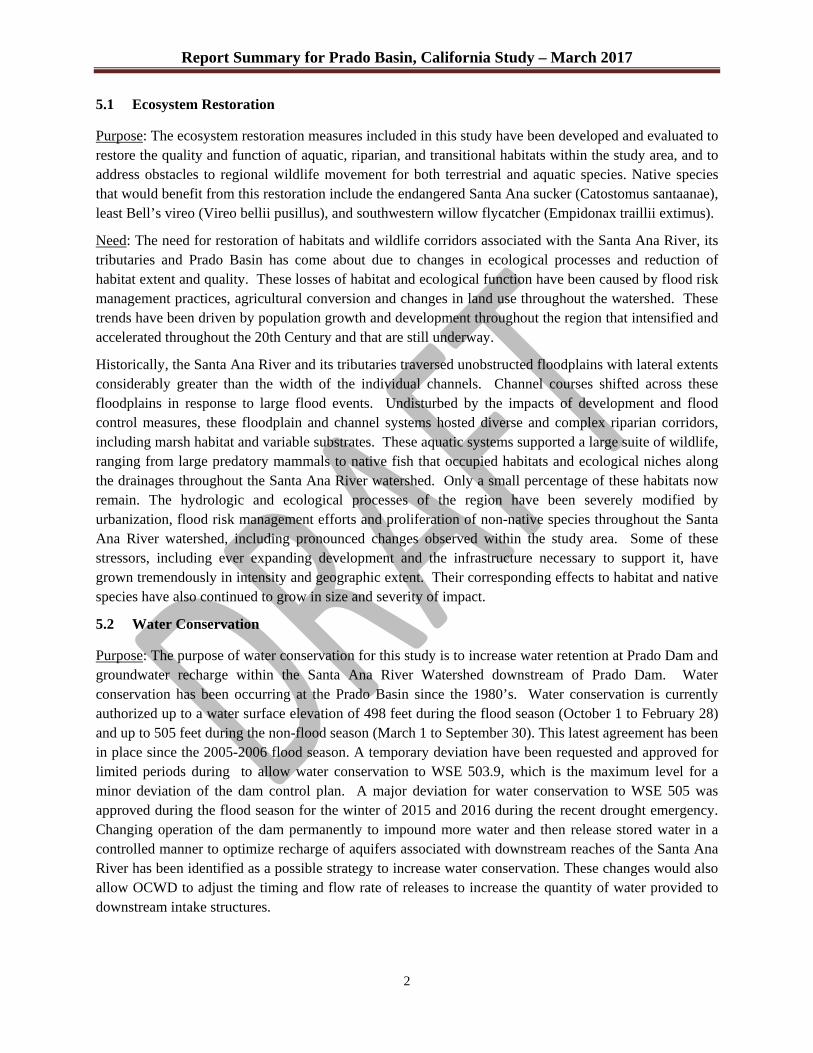
Report Summary for Prado Basin, California Study – March 2017
2
5.1 Ecosystem Restoration
Purpose: The ecosystem restoration measures included in this study have been developed and evaluated to restore the quality and function of aquatic, riparian, and transitional habitats within the study area, and to address obstacles to regional wildlife movement for both terrestrial and aquatic species. Native species that would benefit from this restoration include the endangered Santa Ana sucker (Catostomus santaanae), least Bell’s vireo (Vireo bellii pusillus), and southwestern willow flycatcher (Empidonax traillii extimus).
Need: The need for restoration of habitats and wildlife corridors associated with the Santa Ana River, its tributaries and Prado Basin has come about due to changes in ecological processes and reduction of habitat extent and quality. These losses of habitat and ecological function have been caused by flood risk management practices, agricultural conversion and changes in land use throughout the watershed. These trends have been driven by population growth and development throughout the region that intensified and accelerated throughout the 20th Century and that are still underway.
Historically, the Santa Ana River and its tributaries traversed unobstructed floodplains with lateral extents considerably greater than the width of the individual channels. Channel courses shifted across these floodplains in response to large flood events. Undisturbed by the impacts of development and flood control measures, these floodplain and channel systems hosted diverse and complex riparian corridors, including marsh habitat and variable substrates. These aquatic systems supported a large suite of wildlife, ranging from large predatory mammals to native fish that occupied habitats and ecological niches along the drainages throughout the Santa Ana River watershed. Only a small percentage of these habitats now remain. The hydrologic and ecological processes of the region have been severely modified by urbanization, flood risk management efforts and proliferation of non-native species throughout the Santa Ana River watershed, including pronounced changes observed within the study area. Some of these stressors, including ever expanding development and the infrastructure necessary to support it, have grown tremendously in intensity and geographic extent. Their corresponding effects to habitat and native species have also continued to grow in size and severity of impact.
5.2 Water Conservation
Purpose: The purpose of water conservation for this study is to increase water retention at Prado Dam and groundwater recharge within the Santa Ana River Watershed downstream of Prado Dam. Water conservation has been occurring at the Prado Basin since the 1980’s. Water conservation is currently authorized up to a water surface elevation of 498 feet during the flood season (October 1 to February 28) and up to 505 feet during the non-flood season (March 1 to September 30). This latest agreement has been in place since the 2005-2006 flood season. A temporary deviation have been requested and approved for limited periods during to allow water conservation to WSE 503.9, which is the maximum level for a minor deviation of the dam control plan. A major deviation for water conservation to WSE 505 was approved during the flood season for the winter of 2015 and 2016 during the recent drought emergency. Changing operation of the dam permanently to impound more water and then release stored water in a controlled manner to optimize recharge of aquifers associated with downstream reaches of the Santa Ana River has been identified as a possible strategy to increase water conservation. These changes would also allow OCWD to adjust the timing and flow rate of releases to increase the quantity of water provided to downstream intake structures.
Report Summary for Prado Basin, California Study – March 2017
3
Need: Additional water conservation is needed to provide greater access to cost-effective water sources for OCWD service areas. Costs of imported water supplies continue to increase while at the same time allocations are being reduced in response to chronic excess demand on those supplies. Alternative sources, such as desalination, are even more expensive and are also energy intensive. Optimizing water conservation operations at Prado Dam can provide additional water to existing OCWD facilities located on the Santa Ana River. The region also needs to increase reliability of water supplies for the OCWD service area, given the vulnerability of supplies from the State Water Project and Colorado River to extensive, multi-year droughts that have affected the western U.S. over the last four decades. Imported water is also vulnerable to disruption by earthquakes or other catastrophic events that could damage long-distance conveyance infrastructure.
6.0 Federal Interest.
The primary Federal interest is contribution to National Ecosystem Restoration (NER) through restoration of degraded ecosystem structure, function, and dynamic processes to a less degraded, more natural condition in Prado Basin and the Santa Ana River downstream of the dam. Federal interest in ecosystem restoration is based on resource significance as identified through technical, institutional, and public recognition. Federal interest in in water supply and conservation is based upon contributions to national economic development, which are increases in the net value of the national output of goods and services, expressed in monetary units, and are the direct net benefits that accrue in the planning area and the rest of the Nation.
6.1 Technical Recognition
Several criterion for evaluating technical merit are reviewed in this section including: habitat scarcity, biodiversity, status and trends, special status species, hydrologic and geomorphic character, connectivity, and limiting habitat.
Habitat Scarcity – The Prado Basin is home to the largest riparian forest in southern California. The portion of the project area location downstream of Prado Dam in the Santa Ana Canyon, referred to by the USACE as Reach 9, has approximately 8 linear miles of western cottonwood-willow forest within its floodplain. This habitat type has been identified as one of the rarest forest types in North America (Krueper 1995), and one of the most endangered ecosystems in the United States (Noss and Peters 1995).
Biodiversity – The project area is situated within the California Floristic Province which is considered a biodiversity hotspot (Stein et al 2000) or one of the world’s 25 most biologically rich and threatened terrestrial ecoregions (Myers et al. 1999). The 25 hotspots only account for approximately 1.5 percent of the earth’s land surface, but they account for on the order of 60 percent or more of the remaining diversity of life on the planet (Myers et al 1999). The scarce riparian habitats of the arid southwestern United States are crucial for species persistence due to the high temperatures and dry conditions that occur beyond the riparian ecosystem (Levick 2008). Approximately 80 percent of all wildlife utilize the riparian ecosystem at some life stage, with more than 50 percent of bird species nesting primarily in riparian habitats (Krueper 1993). The riparian corridors and core habitats are an essential component of ensuring the aquatic and riparian-upland transitional habitats function as a holistic ecosystem. Over 393 species of vascular plants, 7 species of amphibians, 13 species of reptiles, 23 mammalian species and over 308 bird species have been identified within the Prado Basin and Reach 9. Over 126 of these avian species breed in

Report Summary for Prado Basin, California Study – March 2017
4
the project area. The Prado Basin is also home to one of the top two populations of the endangered least Bell’s vireo anywhere.
Status and Trends – Less than 10 percent of the surface area that was once home to wetlands remains in California. The rest of the county has experienced loss of approximately 50 percent of wetland acreage (Dahl 1990). This staggering loss up upwards of 90 percent of the acreage attributed to wetlands is coupled with the loss of over 90 percent of riparian habitat in the region (Faber et al 1989) and over 95 percent of the region’s wetlands including freshwater marsh have been lost (Dahl 1990). The current spread of riparian communities persist as a remnant of what was once a vast, interconnected system of rivers, streams, marshes, and vegetated washes (Krueper 1995). This trend is apparent within the project area. These factors have and continue to limit the amount, type, and quality of habitat that remain. The area occupied by riparian communities downstream of Prado Dam is expected to decrease as the river incises, which drives the groundwater table deeper, leaving roots perched and decreases the permeability in the landscape for wildlife to move across the floodplain. Aggradation upstream has flattened the river gradient which has led to the simplification of the aquatic habitat and the covering of cobbles and other larger sediment grain sizes by a lens of sands and other finer sediment grain sizes. This homogenization of aquatic habitat has led to a homogenization of freshwater biota, which is a threat to overall biodiversity in altered systems like the Santa Ana River (Ball et al. 2013).
Hydrologic and Geomorphic Character - Developments and associated roadway and flood risk management features that have been, and continue to be constructed, have limited the ability of the Santa Ana River and its tributaries to migrate across the floodplain as it once did. Surface flows are also becoming scarcer, especially within tributaries, as more emphasis is put on water recycling and groundwater recharge in drought prone southern California.
The construction of the Prado Dam in 1941 presented major changes to the hydrology and geomorphology of the Santa Ana River. The seasonally impounded water has given way to the largest riparian forest in southern California. It has also contributed to changes in the sediment transport regime that have led to aggradation upstream of the dam and incision downstream of the dam that have influenced the type, quality, and amount of natural habitat observed today.
Connectivity – River channels in arid regions provide wildlife movement corridors that are essential to species survival due to the continuous ribbons of vegetation and nearby water that wildlife use for cover and food that may be more limited in drier upland habitats (Levick et al 2008). Culverts spanning with width of State Route 91 and 71 also provide important movement routes for wildlife moving in and out of the project area from core habitats in the Cleveland National Forest, Chino Hills State Park, and the Prado Basin, itself. Strategically placed fencing funnels wildlife to these culverts and keeps them from attempting at-grade crossings of these highways. Euclid Avenue, a heavily trafficked road that crosses Chino Creek within the project area does not have adequate fencing or options for safe passage resulting in frequent mortality for wildlife that attempt at-grade crossings. Pine Avenue, which is projected to connect to State Route 71, will provide the same issues for connectivity as Euclid unless improvements are made.
The homogenization of the aquatic habitat both up and downstream of Prado Dam, as well as the dam itself, have created discontinuities for native aquatic fauna, including the Santa Ana sucker. Improvements to the sediment transport regime would help connect populations of native aquatic species that are currently isolated due to habitat inadequacies.
Report Summary for Prado Basin, California Study – March 2017
5
The project area is also an important stop over for some, and seasonal destination for other bird species migrating along the Pacific Flyway. As was noted previously, over 300 bird species have been documented within the project area and over 125 of those are known to breed in it.
Limiting Habitat – Non-native plant and animal species, severe droughts, development are a few of the stressors that limit the quantity and quality of habitat within the project area. For example, giant reed (Arundo donax) forms dense, monotypic stands that crowd out native riparian habitat that has little habitat value for native wildlife, makes the riparian area more susceptible to fire, and utilizes tremendous amounts of water. This non-native plant and several others that behave similarly present serious threats to the amount and quality of remaining riparian and aquatic habitats and ecosystem function.
Several non-native wildlife species also limit the functionality of habitats within the basin. These include: feral pigs, which root up and trample stream banks, making them susceptible to erosion and invasion from non-native plant species like giant reed; brown-headed cowbird, a notorious brood parasite; and a host of large non-native predatory fish and crayfish that consume native fauna associated with aquatic environments, including federally listed species like the Santa Ana sucker.
6.2 Institutional Recognition
Five species occur within the project area have the designation of endangered or threatened under the Federal Endangered Species Act. These species are the Santa Ana sucker, the southwest willow flycatcher (Empidonax traillii), least Bell’s vireo (Vireo bellii pusillus), yellow-billed cuckoo (Coccyzus americanus), and the coastal California gnatcatcher (Polioptila californica californica). Each of these species has designated critical habitat that also occurs within the project area. There are several other species afforded protection by the State of California Endangered Species Act, as well. Several species covered by the Western Riverside County Multiple Species Conservation Plan (WRCMSHCP) also occur within the project area. Several high priority wildlife corridors designated by the WRCMSHCP also occur connect to the project area. Cleveland National Forest, which is located adjacent to the project area’s southern border in Reach 9 has a Land Management Plan, which guides management of plant and wildlife resrouces. Several of the species managed by this plan spend time in the national forest and the project area. The Chino Hills State Parks is actively restoring a wildlife corridor at Coal Canyon, within Reach 9. The State Park manages lands immediately north of Reach 9 and west of the Prado Basin. Regional land use plans for communities in Orange, Riverside and San Bernardino counties also have placed priorities on preservation of open space, wildlife habitat and ecosystem services in their jurisdictions.
6.3 Public Significance
The geographic setting of the project area makes it visible and accessible and therefore of interest to the public. It is situated roughly at the intersection of two heavily traversed highways, State Routes 91 and 71, in the heavily populated Inland Empire. The riparian forests are visible from the highways and are used for various forms of recreation, study, and aesthetic comfort by thousands on a regular basis. Several grass roots support groups are interested in the well-being of the natural resources within the project area. Here’s a short, and undoubtedly incomplete, list of some of the groups that strive to defend and maintain and improve the beauty and function of the Prado Basin and Santa Ana Canyon: Santa Ana Watershed Association, Friends of the Santa Ana River, Endangered Habitats League, and Center for Biological Diversity. Audubon California has identified the majority of the area within the project area
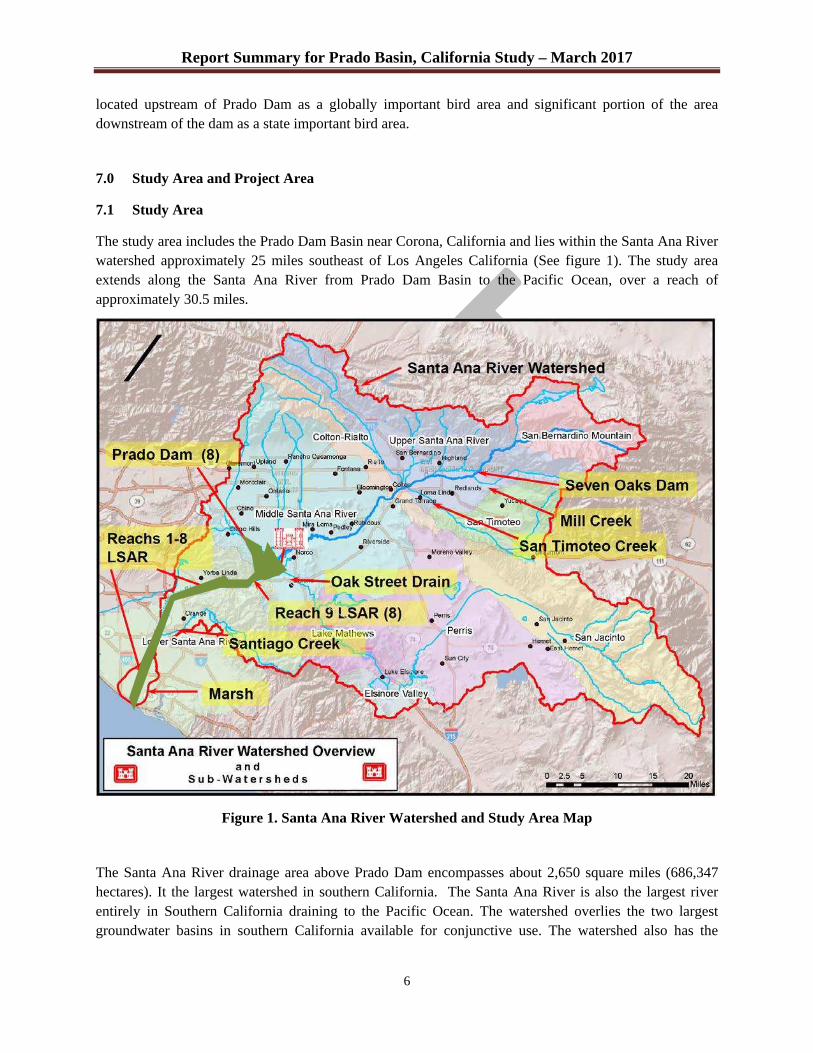
Report Summary for Prado Basin, California Study – March 2017
6
located upstream of Prado Dam as a globally important bird area and significant portion of the area downstream of the dam as a state important bird area.
7.0 Study Area and Project Area
7.1 Study Area
The study area includes the Prado Dam Basin near Corona, California and lies within the Santa Ana River watershed approximately 25 miles southeast of Los Angeles California (See figure 1). The study area extends along the Santa Ana River from Prado Dam Basin to the Pacific Ocean, over a reach of approximately 30.5 miles.
Figure 1. Santa Ana River Watershed and Study Area Map
The Santa Ana River drainage area above Prado Dam encompasses about 2,650 square miles (686,347 hectares). It the largest watershed in southern California. The Santa Ana River is also the largest river entirely in Southern California draining to the Pacific Ocean. The watershed overlies the two largest groundwater basins in southern California available for conjunctive use. The watershed also has the
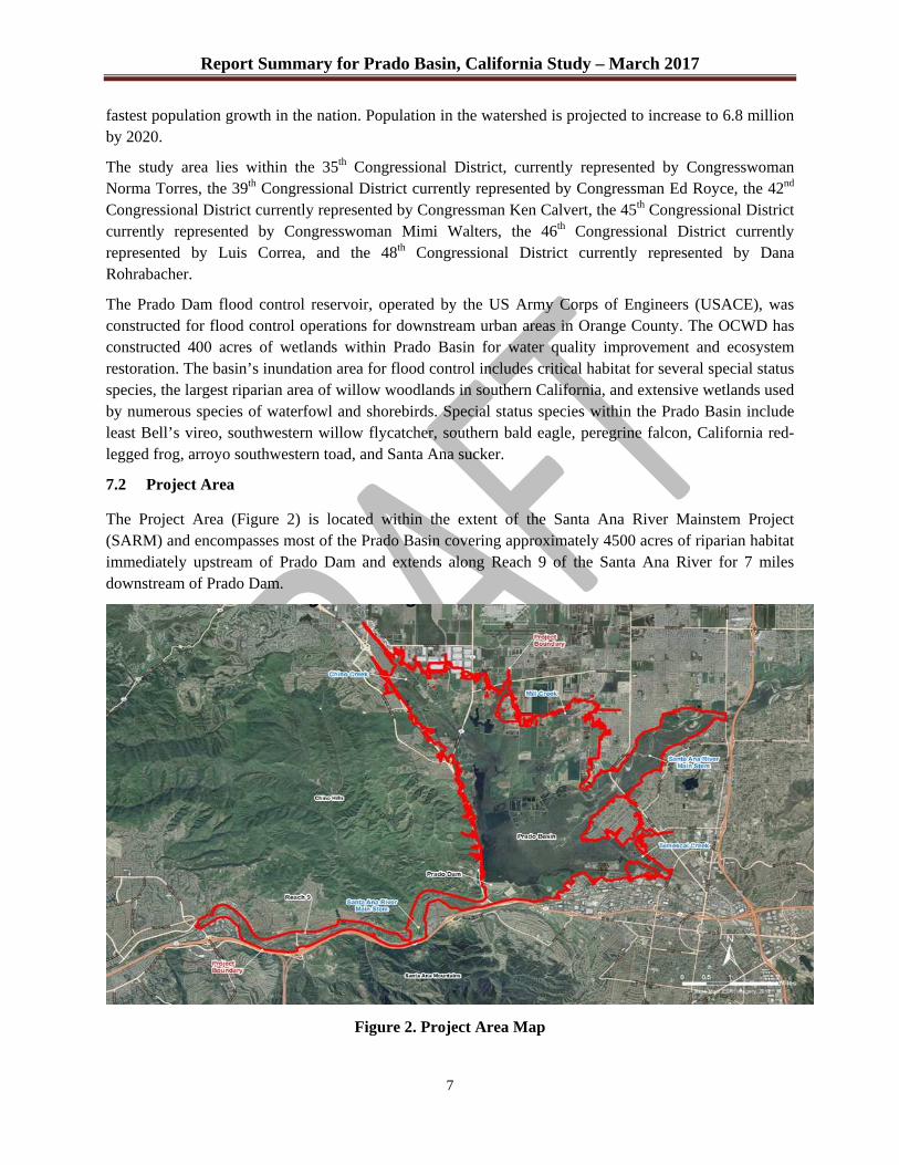
Report Summary for Prado Basin, California Study – March 2017
7
fastest population growth in the nation. Population in the watershed is projected to increase to 6.8 million by 2020.
The study area lies within the 35th Congressional District, currently represented by Congresswoman Norma Torres, the 39th Congressional District currently represented by Congressman Ed Royce, the 42nd Congressional District currently represented by Congressman Ken Calvert, the 45th Congressional District currently represented by Congresswoman Mimi Walters, the 46th Congressional District currently represented by Luis Correa, and the 48th Congressional District currently represented by Dana Rohrabacher.
The Prado Dam flood control reservoir, operated by the US Army Corps of Engineers (USACE), was constructed for flood control operations for downstream urban areas in Orange County. The OCWD has constructed 400 acres of wetlands within Prado Basin for water quality improvement and ecosystem restoration. The basin’s inundation area for flood control includes critical habitat for several special status species, the largest riparian area of willow woodlands in southern California, and extensive wetlands used by numerous species of waterfowl and shorebirds. Special status species within the Prado Basin include least Bell’s vireo, southwestern willow flycatcher, southern bald eagle, peregrine falcon, California red-legged frog, arroyo southwestern toad, and Santa Ana sucker.
7.2 Project Area
The Project Area (Figure 2) is located within the extent of the Santa Ana River Mainstem Project (SARM) and encompasses most of the Prado Basin covering approximately 4500 acres of riparian habitat immediately upstream of Prado Dam and extends along Reach 9 of the Santa Ana River for 7 miles downstream of Prado Dam.
Figure 2. Project Area Map
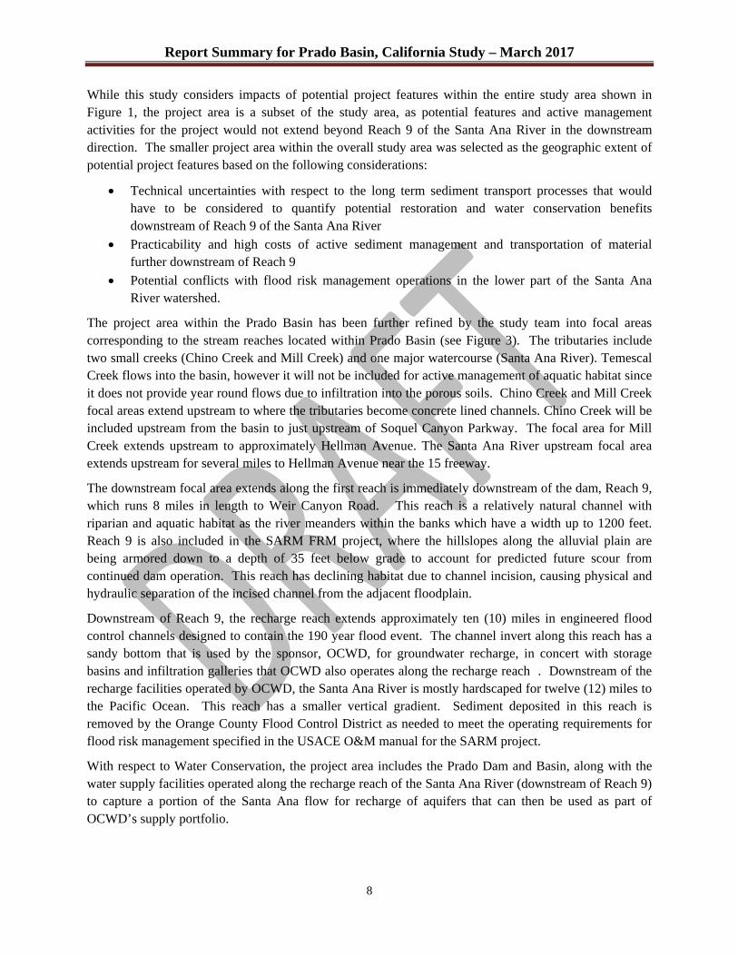
Report Summary for Prado Basin, California Study – March 2017
8
While this study considers impacts of potential project features within the entire study area shown in Figure 1, the project area is a subset of the study area, as potential features and active management activities for the project would not extend beyond Reach 9 of the Santa Ana River in the downstream direction. The smaller project area within the overall study area was selected as the geographic extent of potential project features based on the following considerations:
x Technical uncertainties with respect to the long term sediment transport processes that would have to be considered to quantify potential restoration and water conservation benefits downstream of Reach 9 of the Santa Ana River
x Practicability and high costs of active sediment management and transportation of material further downstream of Reach 9
x Potential conflicts with flood risk management operations in the lower part of the Santa Ana River watershed.
The project area within the Prado Basin has been further refined by the study team into focal areas corresponding to the stream reaches located within Prado Basin (see Figure 3). The tributaries include two small creeks (Chino Creek and Mill Creek) and one major watercourse (Santa Ana River). Temescal Creek flows into the basin, however it will not be included for active management of aquatic habitat since it does not provide year round flows due to infiltration into the porous soils. Chino Creek and Mill Creek focal areas extend upstream to where the tributaries become concrete lined channels. Chino Creek will be included upstream from the basin to just upstream of Soquel Canyon Parkway. The focal area for Mill Creek extends upstream to approximately Hellman Avenue. The Santa Ana River upstream focal area extends upstream for several miles to Hellman Avenue near the 15 freeway.
The downstream focal area extends along the first reach is immediately downstream of the dam, Reach 9, which runs 8 miles in length to Weir Canyon Road. This reach is a relatively natural channel with riparian and aquatic habitat as the river meanders within the banks which have a width up to 1200 feet. Reach 9 is also included in the SARM FRM project, where the hillslopes along the alluvial plain are being armored down to a depth of 35 feet below grade to account for predicted future scour from continued dam operation. This reach has declining habitat due to channel incision, causing physical and hydraulic separation of the incised channel from the adjacent floodplain.
Downstream of Reach 9, the recharge reach extends approximately ten (10) miles in engineered flood control channels designed to contain the 190 year flood event. The channel invert along this reach has a sandy bottom that is used by the sponsor, OCWD, for groundwater recharge, in concert with storage basins and infiltration galleries that OCWD also operates along the recharge reach . Downstream of the recharge facilities operated by OCWD, the Santa Ana River is mostly hardscaped for twelve (12) miles to the Pacific Ocean. This reach has a smaller vertical gradient. Sediment deposited in this reach is removed by the Orange County Flood Control District as needed to meet the operating requirements for flood risk management specified in the USACE O&M manual for the SARM project.
With respect to Water Conservation, the project area includes the Prado Dam and Basin, along with the water supply facilities operated along the recharge reach of the Santa Ana River (downstream of Reach 9) to capture a portion of the Santa Ana flow for recharge of aquifers that can then be used as part of OCWD’s supply portfolio.
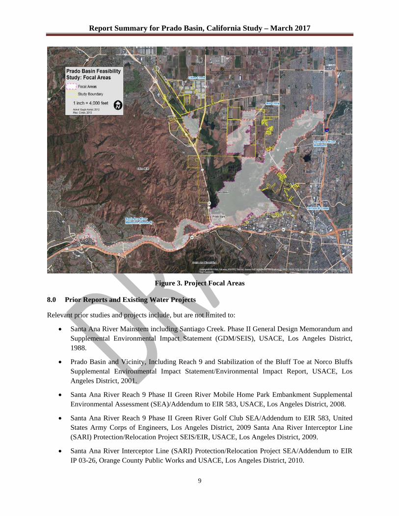
Report Summary for Prado Basin, California Study – March 2017
9
Figure 3. Project Focal Areas
8.0 Prior Reports and Existing Water Projects
Relevant prior studies and projects include, but are not limited to:
x Santa Ana River Mainstem including Santiago Creek. Phase II General Design Memorandum and Supplemental Environmental Impact Statement (GDM/SEIS), USACE, Los Angeles District, 1988.
x Prado Basin and Vicinity, Including Reach 9 and Stabilization of the Bluff Toe at Norco Bluffs Supplemental Environmental Impact Statement/Environmental Impact Report, USACE, Los Angeles District, 2001.
x Santa Ana River Reach 9 Phase II Green River Mobile Home Park Embankment Supplemental Environmental Assessment (SEA)/Addendum to EIR 583, USACE, Los Angeles District, 2008.
x Santa Ana River Reach 9 Phase II Green River Golf Club SEA/Addendum to EIR 583, United States Army Corps of Engineers, Los Angeles District, 2009 Santa Ana River Interceptor Line (SARI) Protection/Relocation Project SEIS/EIR, USACE, Los Angeles District, 2009.
x Santa Ana River Interceptor Line (SARI) Protection/Relocation Project SEA/Addendum to EIR IP 03-26, Orange County Public Works and USACE, Los Angeles District, 2010.
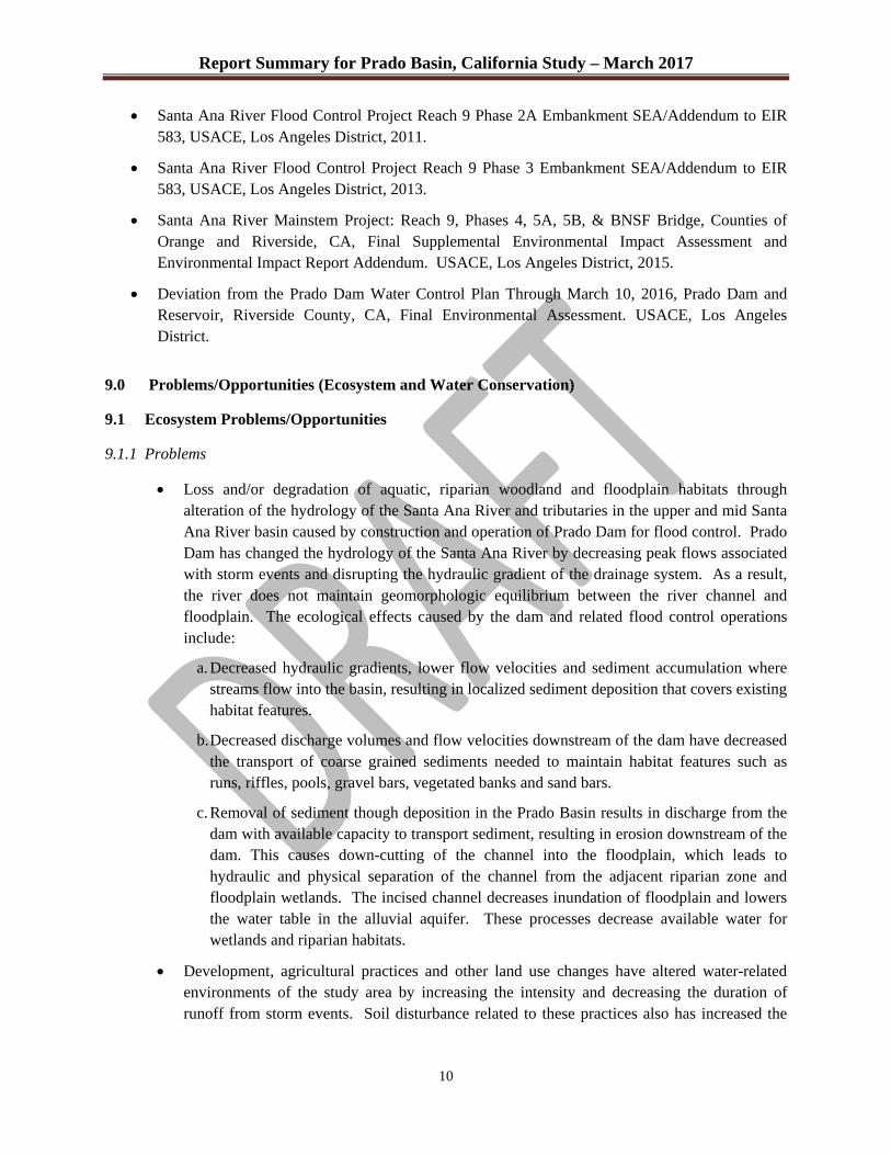
Report Summary for Prado Basin, California Study – March 2017
10
x Santa Ana River Flood Control Project Reach 9 Phase 2A Embankment SEA/Addendum to EIR 583, USACE, Los Angeles District, 2011.
x Santa Ana River Flood Control Project Reach 9 Phase 3 Embankment SEA/Addendum to EIR 583, USACE, Los Angeles District, 2013.
x Santa Ana River Mainstem Project: Reach 9, Phases 4, 5A, 5B, & BNSF Bridge, Counties of Orange and Riverside, CA, Final Supplemental Environmental Impact Assessment and Environmental Impact Report Addendum. USACE, Los Angeles District, 2015.
x Deviation from the Prado Dam Water Control Plan Through March 10, 2016, Prado Dam and Reservoir, Riverside County, CA, Final Environmental Assessment. USACE, Los Angeles District.
9.0 Problems/Opportunities (Ecosystem and Water Conservation)
9.1 Ecosystem Problems/Opportunities
9.1.1 Problems
x Loss and/or degradation of aquatic, riparian woodland and floodplain habitats through alteration of the hydrology of the Santa Ana River and tributaries in the upper and mid Santa Ana River basin caused by construction and operation of Prado Dam for flood control. Prado Dam has changed the hydrology of the Santa Ana River by decreasing peak flows associated with storm events and disrupting the hydraulic gradient of the drainage system. As a result, the river does not maintain geomorphologic equilibrium between the river channel and floodplain. The ecological effects caused by the dam and related flood control operations include:
a. Decreased hydraulic gradients, lower flow velocities and sediment accumulation where streams flow into the basin, resulting in localized sediment deposition that covers existing habitat features.
b. Decreased discharge volumes and flow velocities downstream of the dam have decreased the transport of coarse grained sediments needed to maintain habitat features such as runs, riffles, pools, gravel bars, vegetated banks and sand bars.
c. Removal of sediment though deposition in the Prado Basin results in discharge from the dam with available capacity to transport sediment, resulting in erosion downstream of the dam. This causes down-cutting of the channel into the floodplain, which leads to hydraulic and physical separation of the channel from the adjacent riparian zone and floodplain wetlands. The incised channel decreases inundation of floodplain and lowers the water table in the alluvial aquifer. These processes decrease available water for wetlands and riparian habitats.
x Development, agricultural practices and other land use changes have altered water-related environments of the study area by increasing the intensity and decreasing the duration of runoff from storm events. Soil disturbance related to these practices also has increased the
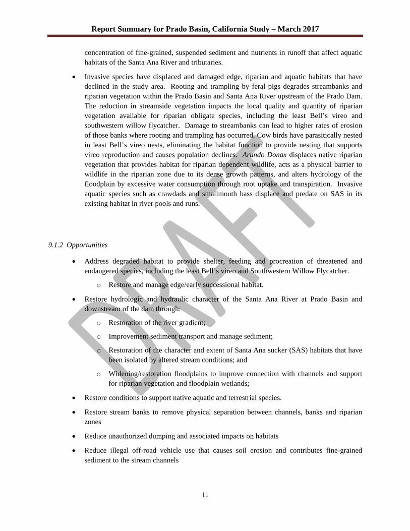
Report Summary for Prado Basin, California Study – March 2017
11
concentration of fine-grained, suspended sediment and nutrients in runoff that affect aquatic habitats of the Santa Ana River and tributaries.
x Invasive species have displaced and damaged edge, riparian and aquatic habitats that have declined in the study area. Rooting and trampling by feral pigs degrades streambanks and riparian vegetation within the Prado Basin and Santa Ana River upstream of the Prado Dam. The reduction in streamside vegetation impacts the local quality and quantity of riparian vegetation available for riparian obligate species, including the least Bell’s vireo and southwestern willow flycatcher. Damage to streambanks can lead to higher rates of erosion of those banks where rooting and trampling has occurred. Cow birds have parasitically nested in least Bell’s vireo nests, eliminating the habitat function to provide nesting that supports vireo reproduction and causes population declines. Arundo Donax displaces native riparian vegetation that provides habitat for riparian dependent wildlife, acts as a physical barrier to wildlife in the riparian zone due to its dense growth patterns, and alters hydrology of the floodplain by excessive water consumption through root uptake and transpiration. Invasive aquatic species such as crawdads and smallmouth bass displace and predate on SAS in its existing habitat in river pools and runs.
9.1.2 Opportunities
x Address degraded habitat to provide shelter, feeding and procreation of threatened and endangered species, including the least Bell’s vireo and Southwestern Willow Flycatcher.
o Restore and manage edge/early successional habitat.
x Restore hydrologic and hydraulic character of the Santa Ana River at Prado Basin and downstream of the dam through:
o Restoration of the river gradient;
o Improvement sediment transport and manage sediment;
o Restoration of the character and extent of Santa Ana sucker (SAS) habitats that have been isolated by altered stream conditions; and
o Widening/restoration floodplains to improve connection with channels and support for riparian vegetation and floodplain wetlands;
x Restore conditions to support native aquatic and terrestrial species.
x Restore stream banks to remove physical separation between channels, banks and riparian zones
x Reduce unauthorized dumping and associated impacts on habitats
x Reduce illegal off-road vehicle use that causes soil erosion and contributes fine-grained sediment to the stream channels
Report Summary for Prado Basin, California Study – March 2017
12
9.2 Water Conservation Problems/Opportunities
9.2.1 Problems
x Decreasing availability of imported water and increasing cost of municipal and industrial water supply sources to meet demand in the study area.
o Sediment deposition in Prado Basin decreases water conservation storage capacity.
o Long-term drought and climate patterns are reducing the availability of water from imported sources, such as the California State Water Project and the Colorado River Aqueduct. Imported water sources are also at risk of being interrupted by catastrophic events such as earthquakes and or failure of long-distance conveyances such as canals or aqueducts.
o Imported water is a high cost source of water supply within the Study Area, and is relied on only the extent necessary to meet demand that exceeds lower cost supply sources, including groundwater.
9.2.2 Opportunities
x Increase water conservation in the project area
o Increase recharge of the alluvial aquifer of Santa Ana River downstream of the basin
o Increase storage capacity of water conservation pool at Prado Basin
o Restore percolation rate through stream bed(s), reducing infiltration of fine-grained silt and clay into the stream bed
o Increase overall cost-effectiveness of water supplies for the region as measured by costs of water supplied to the OCWD
o Reduce demand for imported water sources by increasing local, sustainable supplies
x Reduce water supply risks associated with catastrophic events such as earthquakes and/or levee failures that disrupt water supplies from other regions
x Reduce energy required for long-distance transport of water from imported sources
x Reduce impacts of regional water transfers from other river systems for supply to distribution systems in the study area
10.0 Planning Goals/Objectives
The planning objectives for the study are based on the overall effects and outcomes that would address the project purposes. The planning objectives provide the basis for determining the relevance and usefulness of measures that are considered for inclusion in plan alternatives. Objectives should be met through project outputs that are provided over the period of analysis for the study.

Report Summary for Prado Basin, California Study – March 2017
13
The planning objectives for ecosystem restoration include:
x Improve hydraulic and fluvial geomorphic functions to promote habitat growth and wildlife connectivity to regionally significant core habitats at Prado Basin and associated main watercourses (except Temescal Creek) within the project area.
o Reduce predicted scour downstream of Prado Dam to facilitate expansion of riparian corridor, encourage restoration of aquatic habitat function and complexity for native aquatic species and other native species that rely on the aquatic zone, and to facilitate crossing of the Santa Ana River by terrestrial wildlife.
o Improve aquatic habitat function and complexity to support survival and reproductive requirements for aquatic fauna including food, water, shelter, breeding, and dispersal, including but not limited to the federally listed Santa Ana sucker (Catostomus santaanae).
o Restore overbank flooding to the remaining floodplain to promote growth of a wider riparian habitat corridor.
o Restore wildlife connectivity by providing culverts or other engineered structures for safe passage across existing obstructions.
o Reduce mortality of native fauna associated with at-grade crossings of roadways. x Restore riparian and riparian associated habitats suitable to native species within the
project area o Restore and manage floodplain as structurally diverse riparian woodland, riparian scrub,
and transitional riparian habitats consisting of herbaceous, shrub, and tree layers to support survival and reproductive requirements for riparian obligate and other species, including the Federally endangered least Bell’s vireo (Vireo bellii pusillus) and southwestern willow flycatcher (Empidonax traillii extimus).
o Remove and manage non-native, invasive plants. Non-native plant management shall be implemented to reduce potential for re-infestation from sources within the project area.
o Restore transitional riparian habitats to facilitate survival and reproductive requirements for fauna and to buffer restored riparian woodland and scrub areas from invasions of non-native plants.
� Restore and manage transitional riparian buffers at the riparian woodland and scrub habitat along riverine associated riparian corridors.
x Reduce presence and effects of non-native wildlife on habitat suitability and function for native wildlife species.
o Targeted removal and management of non-native aquatic fauna to allow native fauna to re-colonize or increase in population size at restored streambed or stream elements or other areas that have structural components necessary to facilitate life history requirements of native species.
o Manage non-native and parasitic terrestrial and avian fauna to improve and maintain suitability of habitat for foraging, shelter, breeding, and dispersal of native species.
The study objective for water conservation is to:
The objective is to provide for increased groundwater capture at downstream recharge facilities to address regional demand.

Report Summary for Prado Basin, California Study – March 2017
14
10.1 Planning Constraints and Considerations
During the plan formulation workshops and value engineering exercises conducted between 2012 and 2014, planning constraints were identified for the water conservation and ecosystem restoration purposes of the project. Planning constraints are potential changes in conditions of the study area or potential outcomes of the project that must be avoided. Constraints are outcomes or conditions that are unacceptable for any reason, practical, legal, policy or acceptability to the public. Measures or plans that violate constraints are either modified to avoid the constraint or eliminated from further consideration. The planning constraints for the Prado Basin study include:
x Measures cannot increase flood risk. Requirements for flood operations at Prado and Seven Oaks Dams are also planning constraints that cannot be violated. The recommended plan cannot increase the risk of failure or inadequate operation of the dam or increase flood risks downstream of the dam.
x The current Dam Safety Action Class (DSAC) rating of 3 does not allow for changes in operation of Prado Dam until the DSAC is raised to a minimum of 4. Implementation of measures requiring a change in dam operations could only be implemented after the DSAC rating has been increased.
x Prado Dam cannot be removed.
x Existing major flood control, transportation and utility infrastructure (including bank protection features, BNSF railroad, State Route (SR) -91, SR-71 and a regional brine transfer pipeline) cannot be removed or relocated.
x Threatened and endangered species in the project area cannot be negatively impacted in any way that would violate requirements of the Endangered Species Act.
x Cultural resource sites should not be negatively affected without acceptable conservation and recovery efforts to address impacts.
x Sediment in Prado Basin cannot be excavated below an elevation of 470’, which is the elevation of the outlet invert. Excavation below that depth would result in unacceptable impacts to stability and safe operation of the dam and use of the basin for impoundment of water for flood risk management.
x Existing mitigation features cannot be disrupted or displaced by project features.
Planning considerations are similar to constraints, in that they represent limitations on possible measures being considered for a project. While constraints result in absolute limits on project features, planning considerations represent conflicts or concerns that should be minimized where possible, but that do not completely prohibit certain features or activities. Planning considerations identified for the study include:
x Sediment accumulation downstream of Prado Dam resulting from re-introduction of sediment should not significantly increase the maintenance requirements of the flood control system that are the responsibility of the OCDPW.
x Sediment stockpiling and transport activities should not decrease the ecosystem functions of the restoration features or other mitigation activities being conducted in Prado Basin or along the Santa Ana River and tributaries in the study area.

Report Summary for Prado Basin, California Study – March 2017
15
x Construction activities within the basin should not impact critical habitat of the SAS when water is present and the aquatic habitat is occupied by SAS. These activities should not reduce or displace other habitat values within the project area once construction has been completed and construction-related restoration activities, such as revegetation, have been completed.
x Target public lands and, to the extent practicable, avoid private lands for location of project features and benefits.
x Minimize adverse impacts to remaining lease holds.
x Minimize operations and maintenance (O&M) needs; aim for self-sustainability.
x Future decline of dry weather flows expected at Temescal Creek would reduce the channel flows such that extended periods of dry channel conditions would limit the effectiveness of aquatic habitat restoration features in that portion of the basin.
x Alternatives will conform to USACE policy regarding vegetation on levees.
x Alternatives must consider accessibility for O&M activities.
x Alternatives should minimize any structural, mechanical or electrical modifications to the flood control structures.
11.0 Inventory and Forecast
The period of analysis, for inventory and forecast of future without project conditions and the output of alternatives is 50 years. 11.1 Water Resources
Prado Dam provides flood risk management and water conservation storage for Orange County, California. It is the downstream element of the Santa Ana River flood control system. The purpose of the dam is to collect runoff from the uncontrolled drainage areas upstream along with releases from other storage facilities. Releases from the dam are coordinated with the OCWD and are based upon the capacity of their groundwater recharge facilities and agreements with other agencies. If the water surface in the reservoir exceeds the top of the buffer pool, flood control releases commence. The objective of the flood risk management operation is to drain the reservoir back to the top of the buffer pool as quickly as possible without exceeding the capacity of the channel downstream.
Modifications to Prado Dam were recently completed where the main embankment has been raised from 566 feet, NGVD, to elevation 594.4 feet, NGVD. A new outlet works structure was also constructed to allow for increased release capabilities from the dam. The new outlet works structure has a maximum controlled release capacity of 30,000 cfs (850 cubic meters per second [cms]), which cannot yet be fully utilized due to the ongoing construction of the SARM Project to improve the downstream channel. When the Reach 9 Project has been completed, the downstream channel capacity immediately downstream of the dam will increase to over 30,000 cfs (850 cms). These improvements will enable the dam to take full advantage of the improved channel capacity downstream and will greatly increase the level of flood risk management to the communities in Orange County that are located within the Santa Ana River floodplain.
Report Summary for Prado Basin, California Study – March 2017
16
Since 1941, data suggests that at least 25,000 acre-feet (af) (31 million cubic meters [m3]) of storage below 505 feet mean sea level (153.9 meters) has been lost due to sediment accumulation behind the dam. If the storage loss continues unabated at this rate of about 360 af/year (0.44 million m3/year), ultimately all water conservation storage will be lost. Eventually, the design life of the flood control project will be reached and the dam’s flood control capacity reduced. Without sediment management the Prado Basin will continue to aggrade, resulting in large financial and environmental impacts to raise the dam after the dam’s design life is reached or to perform mass sediment removal. Further raising the dam and construction of higher dikes and levees around the reservoir may be limited in the future due to physical and social constraints.
The sediment accumulation in Prado Basin has altered high value wetland habitat to lower value dry-land habitat and, in some locations, has provided fertile ground for Arundo donax invasion, which further degrades the habitat.
In the soft bottom portions of the lower Santa Ana River, scour continues, uncovering the SARI line in places, causing destruction of habitat, degradation of water quality, and reduction of infiltration capacity. The degradation and, in some reaches, elimination of riparian habitat has reduced or eliminated the presence of endangered or threatened species from the lower Santa Ana River watershed.
Channel incision will continue to occur throughout the 8 mile long segment of reach 9 downstream of Prado Dam due to the lack of sediment laden water released from the dam. Channel incision limits the stream’s natural ability to form braided flows and meander from bank to bank across the 1000 foot wide streambed. A lowering of the water table will also occur which further compounds the potential for decline of habitat. A continued decline of riparian habitat will occur throughout hundreds of acres of the reach 9 segment.
Sediment upstream of Prado Dam has accumulated at a high rate since the dam was constructed and will continue to do so. The predicted inflow of sediment over the 50 year life of the proposed completed SARM project is 112 million cubic yards. Sediment build up behind the dam will continue to flatten out the topography causing the flood water attenuation to spread further into the basin. This will allow for continued decline of riparian habitat. Heavy development within the basin around the perimeter of the existing habitat does not allow for habitat to naturally spread as water levels increase. Thus, decline in habitat will be permanent.
The sediment accumulating in the basin has also caused sediment to accumulate for several miles upstream along the Santa Ana River. The invert gradient has been reduced and sand has filled in where natural cobbles used to exist which has an adverse impact to the Santa Ana Sucker Fish habitat.
Climate change effects in California are expected to bring warmer year-round temperatures and potentially wetter winters. The Mediterranean seasonal precipitation pattern is expected to continue (cal-adapt.org). This will lead to acceleration of the existing sediment transport problems causing a more rapid decline in habitat.
Water shortages due to increased demand, caused by growth in the region, will result in implementation of additional water conservation requirements (e.g. limiting irrigation days and runoff amounts) aimed at reducing urban runoff. The perennial nature of streams in dry season could become intermittent. Discharge into streams from treatment plants may be reduced as water recycling continues to be implemented by water suppliers in the project area. These reductions to dry weather flows will impact the project area by reducing the availability of water in channel and riparian habitats during the dry season.

Report Summary for Prado Basin, California Study – March 2017
17
11.2 Water Conservation
The OCWD relies upon the Santa Ana River flows to be detained at Prado Dam and released at rates that are efficient for the OCWD recharge areas. The predicted sediment inflow of the life of the SARM project upstream of the dam is 112 million cubic yards. This will have a detrimental impact to water conservation since sediment volumes will displace the storage capacity presently utilized for water conservation behind the dam.
Downstream recharge areas will continued to be impacted by fine grained sediment deposition. OCWD operates groundwater recharge areas that have undergone reduced infiltration rates due to the Dam blocking the passage of well graded sediment. Lack of well graded sediment results in deposition of silts and clays from suspended load carried by the river. As the flows reach the recharge basins, the fines penetrate into the pore spaces of river bed sediments, reducing the porosity and lowering the infiltration rate.
11.3 Fish and Wildlife Resources Considerations
The Prado Basin is home to a diverse array of wildlife. Several species listed as endangered or threatened on the Federal and California Endangered Species are residents within the study area. The federally threatened Santa Ana sucker (Catostomus santaanae) is a fish known to occur within the Santa Ana River both up- and downstream of Prado Dam. The federally endangered least Bell’s vireo (Vireo bellii pusillus) and southwestern willow flycatcher (Empidonax trailii extimus) are known to breed in the riparian forest found within Prado Basin. The least Bell’s vireo also breeds in similar habitats in Reach 9. The flycatcher has not been documented in Reach 9 in recent years. The federally threatened coastal California gnatcatcher (Polioptila californica) is found in coastal sage scrub associated habitats within the study area. Designated critical habitat for all four of these species occurs within the study area. In addition to these species the project area is located along the Pacific flyway which seasonally brings a host of migratory bird species to the area. The project area is also situated uniquely amongst the urban matrix of the greater LA Basin between thriving core habitat areas located in the Santa Ana Mountains and Chino/Puente Hills, which makes the undeveloped project area important for regional wildlife connectivity.
Measures considered by this study are expected to have a net positive benefit for fish and wildlife resources and thus are not expected to necessitate mitigation. Sediment management related measures are expected to help improve habitat for native fish both within and beyond the boundaries of the study area and maintain and restore riparian forest habitat within Reach 9. Removing sediment from upstream of Prado Dam and re-entraining it downstream is expected to help ameliorate issues associated with a perceived flattening of the river invert upstream of the dam due to the sequestration of sediment behind the dam. Re-entrainment downstream is expected to help reverse the effects of predicted scour from relatively sediment starved water being released from Prado Dam. The reduction in invert degradation is expected to allow more in stream habitat diversity and reconnect the floodplain to the river which can allow for a wider riparian habitat corridor which would benefit a host of riparian obligate species, including but certainly not limited to the least Bell’s vireo. Reoperation of the dam for water conservation also provides incidental ecosystem restoration benefits for the focal areas within Prado Basin, and also increases the restoration outputs for some ecosystem restoration measures beyond the outputs expected
Report Summary for Prado Basin, California Study – March 2017
18
for the measures implemented without changes in dam operations, based primarily on the increased availability of water to support riparian and aquatic habitats.
12.0 Key Uncertainties
The key uncertainties are discussed in detail in the Prado Basin, CA Risk Register and include, but are not limited to:
x Coordination with resource agencies pertaining to threatened and endangered species in the study area, especially the Santa Ana sucker and least Bell’s vireo. This is a plan formulation risk. The potential consequence is that the US Fish and Wildlife Service and other resource agencies may question assumptions in the study regarding self-mitigation of some restoration features and potential outcomes for critical habitats of endangered species, particularly reaches of the Santa Ana River that are designated critical habitat for the Santa Ana Sucker. Objections by the resource agencies could delay completion of the study and increase study costs, while also requiring modification of aspects of the proposed project. The study team is minimizing the probability of these consequences by ongoing consultation and collaboration with the resource agencies in the study process.
x Discovery of previously unknown cultural resources beneath accumulated sediment in the basin. This is an execution risk for the project. If cultural resources are detected during construction, recovery and preservation efforts would add to the construction costs and extend the schedule. While the consequences could be significant for project execution, the probability is considered low, as previous surveys and activities in the project area have not encountered significant cultural resources.
x Requirement for the DSAC rating of Prado Dam to operations at the dam will impact timing of any proposed water conservation implementation. The rating can only be increased upon the completion of spillway improvements at the dam. This is a plan formulation risk and an execution risk for the project. The DSAC rating can only be improved after completion of the upgrade of the dam spillway, which is currently scheduled for completion in 2021. Any delay would result in a postponement of economic benefits from water conservation, which would differ from the analysis used to justify the water conservation component of the project. Similarly, a delay in operations for water conservation would be an execution risk. The resources committed to the spillway upgrade indicate the probability of such delay is low, and the consequences of a delay would be dependent on the length of time involved in the delay. A delay of one or two years in the start of the project component for water conservation would not be considered a high-consequence impact.
x Uncertainties associated with sediment transport downstream of the dam and limitations of sediment transport models. This is a study risk, in that uncertainty of sediment transport modeling may result in under- or over-estimation of ecosystem restoration benefits provided by sediment re-entrainment downstream of Prado Dam. This risk is addressed by adaptively managing sediment re-entrainment. Based on sediment accumulation rates observed in Prado Basin, a surplus of sediment will be available that exceeds the requirements for the maximum potential re-entrainment rate. If sediment transport results in excess accumulation, the re-entrainment rate can be decreased. Conversely, if less sediment accumulation is observed than predicted by the sediment transport modeling, adaptive management can be used to increase the rate of re-

Report Summary for Prado Basin, California Study – March 2017
19
entrainment to achieve the desired level of output for addressing channel incision and restoration of channel bedforms for aquatic species.
x Impacts from climate change. Climate change projections for the study area and the surrounding region indicate that more variability in climate conditions are expected, along with more intense storm events, longer periods of drought, and increased overall temperatures. The risks posed by climate change are plan formulation risks, in that realized benefits may differ from projections. The most severe consequences of climate change would result from lack of available stream flows to support restored habitats, particular where restored channel reaches have low flow conditions and high infiltration because of porous soils and sediments. The highest risks from climate change were identified for aquatic habitat restoration at Temescal Creek. In response, the study team eliminated stream restoration measures from this focal area because of the high risk that the restoration would not perform as intended based on climate change projections. Potential effects of climate change and project resilience will be addressed in the IFR.
13.0 Formulating Alternative Plans
13.1 Management Measures
Initial plan formulation was accomplished through Feasibility Kick-Off Workshops, PDT meetings and follow-on efforts by the Lead Planner in December 2012 and January 2013. Workshops included participation of the USACE PDT, the Agency Technical Review (ATR) Co-Leaders, a SMART Planner, the non-Federal sponsor (OCWD), U.S. Fish and Wildlife Service, California Department of Fish and Wildlife (formerly Fish and Game), the City of Ontario, the Regional Water Quality Control Board, the Santa Ana Watershed Authority and the Riverside-Corona Resource Conservation District.
The measures were initially evaluated for their relative cost and effectiveness in meeting the purposes and associated objectives. The team listed out all potential measure by purpose and then ranked them against their performance in meeting the objectives for each purpose. A ranking of high, medium or low was assigned by the workshop team of experts. Then, the measures were ranked by the initial qualitative evaluation of their potential performance and cost-effectiveness. See Section 13.2 for details on measures that were screened out from further consideration in the plan formulation process.
After the Alternatives milestone, the preliminary array of reduced measures was developed into alternative design features. The design alternatives were developed to a sufficient level of detail to ensure technical feasibility, establish boundary footprints for grading, designate riparian habitat planting areas, determine avoidance requirements for existing and proposed infrastructure, and to provide a basis for detailed cost estimates.
13.1.1 Measures to Restore Habitat Conditions
x Invasive Plant Management: The Invasive Plant Management Measure includes activities to remove the initial biomass of invasive plants and follow on spray and biomass removal techniques for a period of five years.
x Wildlife Movement: The Wildlife Movement Measure would involve the improvement of features that contribute to permeability in the landscape or provide a means to avoid at-grade
Report Summary for Prado Basin, California Study – March 2017
20
crossings of roadways that experience high traffic volumes. Culverts would be used to provide passage below roads. Fencing would also be installed to funnel wildlife to the culverts for safe passage and to minimize chances of mortality from at-grade crossings by wildlife .
x Native Plantings: Under this measure, very little invasive plant removals would occur at a site prior to restoration with native plants. Plantings would include seeding, pole staking, and planting of container plants at a particular site.
x Feral Pigs Management: This measure would provide for the control of feral pigs through a combination of trapping, telemetry and other population control techniques. Feral pigs will be trapped using box traps, corral traps, panelized corral traps or other similar methods. A portion of the trapped pigs would be removed from the system and others would be fitted with a satellite collar equipped with GPS receivers and released to track populations.
x Raise Invert and Braided Channel: The measure would involve the construction of a new braided channel parallel to existing, degraded channel reaches. The braided channel would force water out of the creek and onto the existing flood plain, allowing the water to spread out and promote riparian growth over areas that currently do not receive enough water to support riparian habitat. A portion of the existing channel will be filled in order to force the water into the new braided shallow channel. This Measure would include the construction of a diversion pipe and bio-engineered invert stabilizers.
x Non-Native Aquatic Species Management: This measure includes activities to control and/or remove invasive aquatic species. The focus would be on large predatory fish species, such as carp, bass, and catfish that prey on native fish such as the Santa Ana sucker and arroyo chub. A combination of removal techniques such as netting, seining or electroshocking would be used.
x Sediment Management: Sediment would be removed from Prado Basin and re-entrained into the lower Santa Ana River below Prado Dam by a combination of sediment traps, transition channels, connector channels, sediment storage areas, and sediment re-entrainment systems. Small or medium scale traps would be constructed, depending on the scale implemented for a particular alternative. Transport will be done by slurry pipelines. Execution methods considered for moving the excavated sediment included trucking, slurry pipelines, and conveyor belt system. Trucking and conveyor systems were considered too expensive and had higher environmental impacts so only the slurry pipeline was included as a sediment transfer method.
x In-Stream Habitat Features: This measure would enhance habitat for native fish such as the Santa Ana sucker and arroyo chub. Features incorporated into this measure include 15 rock groins, measuring 10 ft. x 45 ft. (450 sq. ft.) to 70 ft. x 100 ft. (7,000 sq. ft.) would be constructed. These groins would create localized pools by exposing existing gravel beds and cobbles that are presumed to be buried under sand deposits in the stream bed. The groins would help combat observed and expected channel incision. They would be composed of various sediment grain sizes ranging from boulders to gravel.
x Restore riparian edge habitat The measure includes invasive plant removal, native plantings, vegetation trimming and maintenance to maintain a thriving riparian edge habitat for neo-tropical migratory birds and to provide a buffer to more interior riparian habitats from impacts of non-riparian areas.
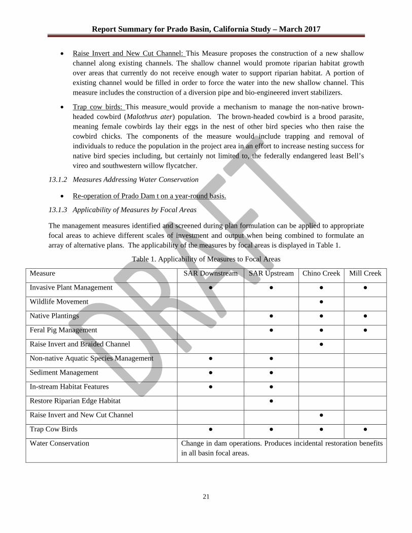
Report Summary for Prado Basin, California Study – March 2017
21
x Raise Invert and New Cut Channel: This Measure proposes the construction of a new shallow channel along existing channels. The shallow channel would promote riparian habitat growth over areas that currently do not receive enough water to support riparian habitat. A portion of existing channel would be filled in order to force the water into the new shallow channel. This measure includes the construction of a diversion pipe and bio-engineered invert stabilizers.
x Trap cow birds: This measure would provide a mechanism to manage the non-native brown-headed cowbird (Malothrus ater) population. The brown-headed cowbird is a brood parasite, meaning female cowbirds lay their eggs in the nest of other bird species who then raise the cowbird chicks. The components of the measure would include trapping and removal of individuals to reduce the population in the project area in an effort to increase nesting success for native bird species including, but certainly not limited to, the federally endangered least Bell’s vireo and southwestern willow flycatcher.
13.1.2 Measures Addressing Water Conservation
x Re-operation of Prado Dam t on a year-round basis.
13.1.3 Applicability of Measures by Focal Areas
The management measures identified and screened during plan formulation can be applied to appropriate focal areas to achieve different scales of investment and output when being combined to formulate an array of alternative plans. The applicability of the measures by focal areas is displayed in Table 1.
Table 1. Applicability of Measures to Focal Areas
Measure SAR Downstream SAR Upstream Chino Creek Mill Creek
Invasive Plant Management � � � �
Wildlife Movement �
Native Plantings � � �
Feral Pig Management � � �
Raise Invert and Braided Channel �
Non-native Aquatic Species Management � �
Sediment Management � �
In-stream Habitat Features � �
Restore Riparian Edge Habitat �
Raise Invert and New Cut Channel �
Trap Cow Birds � � � �
Water Conservation Change in dam operations. Produces incidental restoration benefits in all basin focal areas.
Report Summary for Prado Basin, California Study – March 2017
22
13.2 Screening of Measures
13.2.1 Ecosystem Restoration Measures
During the measures development process, some measures were screened out due to technical infeasibility. Some measures were screened out based on the experts’ opinion that they offered minimal benefit compared to other measures that were more cost effective in terms of dollars and/or environmental impacts.
Construction of a fish by-pass/ladder was eliminated because it was not feasible. The fish by-pass/ladder would have to be so long that it would take up more area than available in our project area downstream of Prado Dam.
Re-introductions and/or releases of native fish were screened out as an ecosystem restoration measure because the habitat within the Prado Basin is not suitable for native species and the habitat in Reach 9 needs to be improved before it would make sense to put effort into translocation of native fish species. The purpose of the measures described in this feasibility study are intended to improve the habitat and would support native fish one day recolonizing the project area, either naturally or through translocations. Prado Basin is not a suitable location to re-introduce the Santa Ana sucker or chub due to the lacustrine habitat that exists along with the tremendous abundance of large predatory fish that occur in the reservoir. Reach 9 could become a potential translocation option in the future after water quality and habitat concerns are addressed. Past translocation efforts in Reach 9 have proven unsuccessful.
Traditional invert stabilizers were screened out because of the potential impact to aquatic and terrestrial habitats resulting from construction and maintenance of the structures. They would also act as a barrier to movement for most native fish species. Given this is an ecosystem restoration effort this type of bed stabilization measure was screened out.
The scale of the sediment trap on the Santa Ana River was refined during the screening process. The larger scale traps were screened from consideration because of the extensive construction-related impacts and initial construction costs. Only the small and medium scale versions of the sediment trap were carried forward in plan formulation.
13.2.2 Water Conservation Measures
Re-operation of Prado Dam to capture retain and release additional water volumes impounded during flood risk management operations were evaluated to provide for additional water conservation beyond those provided under current operations. The existing water conservation component of the Prado Dam Control Plan allows water conservation to retain water to 498 WSE during flood season, and to 505 WSE during non-flood season. Based upon the 2005 water conservation feasibility report, there are substantially greater costs and impacts of implementing water conservation to elevations higher than WSE 505, including environmental impacts and flooding impacts both within the basin and downstream. For elevations between 498' and 505', the costs are minimal, with the primary cost being increased operation and maintenance requirements associated with the revised operation. Since it was assumed that increases in benefits through successive elevations between 498' and 505' would far outweigh these minor costs, a decision was made at the Alternatives Milestone Conference, through coordination and agreement with the vertical team, to focus the water conservation analysis on only the 505 WSE.
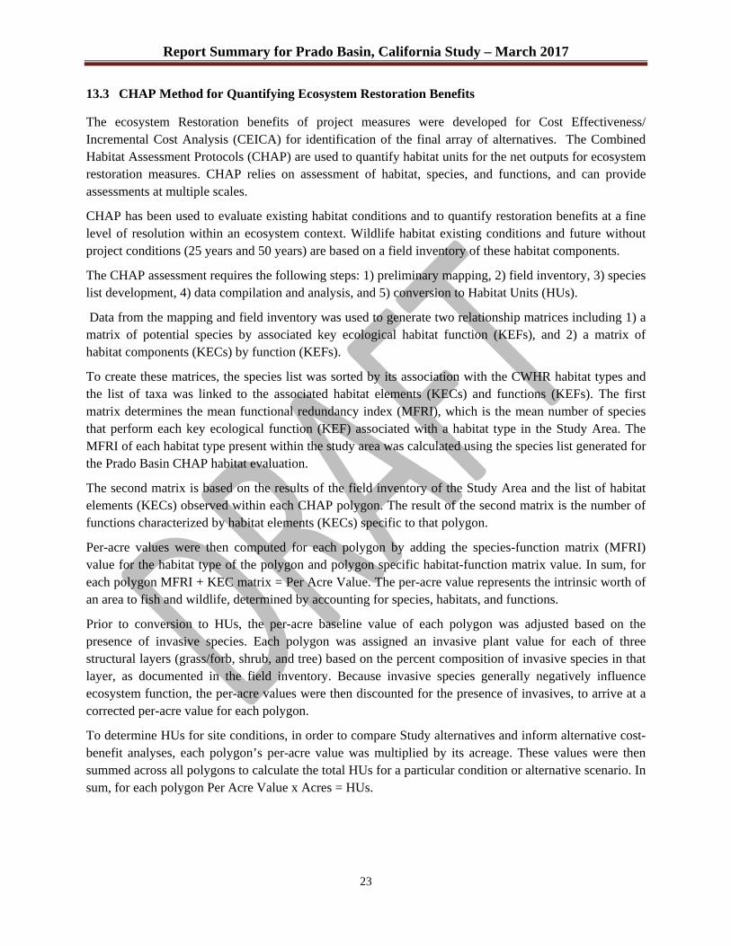
Report Summary for Prado Basin, California Study – March 2017
23
13.3 CHAP Method for Quantifying Ecosystem Restoration Benefits
The ecosystem Restoration benefits of project measures were developed for Cost Effectiveness/ Incremental Cost Analysis (CEICA) for identification of the final array of alternatives. The Combined Habitat Assessment Protocols (CHAP) are used to quantify habitat units for the net outputs for ecosystem restoration measures. CHAP relies on assessment of habitat, species, and functions, and can provide assessments at multiple scales.
CHAP has been used to evaluate existing habitat conditions and to quantify restoration benefits at a fine level of resolution within an ecosystem context. Wildlife habitat existing conditions and future without project conditions (25 years and 50 years) are based on a field inventory of these habitat components.
The CHAP assessment requires the following steps: 1) preliminary mapping, 2) field inventory, 3) species list development, 4) data compilation and analysis, and 5) conversion to Habitat Units (HUs).
Data from the mapping and field inventory was used to generate two relationship matrices including 1) a matrix of potential species by associated key ecological habitat function (KEFs), and 2) a matrix of habitat components (KECs) by function (KEFs).
To create these matrices, the species list was sorted by its association with the CWHR habitat types and the list of taxa was linked to the associated habitat elements (KECs) and functions (KEFs). The first matrix determines the mean functional redundancy index (MFRI), which is the mean number of species that perform each key ecological function (KEF) associated with a habitat type in the Study Area. The MFRI of each habitat type present within the study area was calculated using the species list generated for the Prado Basin CHAP habitat evaluation.
The second matrix is based on the results of the field inventory of the Study Area and the list of habitat elements (KECs) observed within each CHAP polygon. The result of the second matrix is the number of functions characterized by habitat elements (KECs) specific to that polygon.
Per-acre values were then computed for each polygon by adding the species-function matrix (MFRI) value for the habitat type of the polygon and polygon specific habitat-function matrix value. In sum, for each polygon MFRI + KEC matrix = Per Acre Value. The per-acre value represents the intrinsic worth of an area to fish and wildlife, determined by accounting for species, habitats, and functions.
Prior to conversion to HUs, the per-acre baseline value of each polygon was adjusted based on the presence of invasive species. Each polygon was assigned an invasive plant value for each of three structural layers (grass/forb, shrub, and tree) based on the percent composition of invasive species in that layer, as documented in the field inventory. Because invasive species generally negatively influence ecosystem function, the per-acre values were then discounted for the presence of invasives, to arrive at a corrected per-acre value for each polygon.
To determine HUs for site conditions, in order to compare Study alternatives and inform alternative cost-benefit analyses, each polygon’s per-acre value was multiplied by its acreage. These values were then summed across all polygons to calculate the total HUs for a particular condition or alternative scenario. In sum, for each polygon Per Acre Value x Acres = HUs.

Report Summary for Prado Basin, California Study – March 2017
24
13.4 Final Array of Alternative Plans
Plan formulation requires formulation of alternatives from management measures by focal area, which are referred to as features. The three steps to this process are: 1) identify outputs and costs of each feature; 2) identify management measure relationships; and 3) add costs and outputs of combinations. To accomplish these steps each feature is separately assessed for habitat output then assessed for combinability with other features, dependency on other features, and synergy from combining features. When two or more management measures are dependent, that relationship is entered into IWR Plan and dependent measures are considered together as an increment in the plan formulation process. When management measures are not combinable, that relationship is specified in IWR Plan. In this manner only mutually exclusive and independent alternatives are formulated, which is a requirement of plan formulation. These criteria were entered in to IWR Plan to establish all possible combinations of features and associated habitat outputs and costs. These combinations established by the criteria entered in to IWR Plan become the alternative plans. Dependency, combinability, and synergy have been developed by biologists and retained in the environmental appendix of the Integrated Feasibility Report. See that source for additional details on determining habitat outputs and establishing relationships among features. Table 2 below shows the dependencies and non-combinable measures. Measures not included in Table 2 are completely independent of other measures. Independent measures could be added tor or removed from an alternative without conflicting with or changing the function of other measures.
Table 2. Dependencies and Non-Combinable Measures Identification
Measure Not Combinable with: Solution Dependent on:
Small Trap Medium Trap Riparian Edge Mgmt Small or Medium Trap
Raise Invert & New Cut Channel
Raise invert & Braided Channel Sediment Mgmt System+ Pipe
Medium Trap
Widen Chino & New Cut Channel
Raise invert & Braided Channel OR Raise Invert & New Cut Channel
Sediment Mgmt System + Pipe
Small Trap
Widen Chino Creek Raise invert & Braided Channel OR Widen Chino & New Cut Channel OR Raise Invert & New Cut Channel OR New Cut Channel
Plans were formulated in a three step process because the number of features, 39, exceeded the number of features IWR Plan can perform computations on, 26. To get around this limitation, features located in SARM upstream and downstream were used to generate the first set of alternative plans. A second set was generated for features within Chino and Mill Creek. Chino/Mill Creek did not contain any measures with dependencies. This kept all measures with dependencies and the corresponding dependent measures within the SARM grouping. Non-combinable measure pairings also did not extend beyond either SARM or Chino/Mill Creek ensuring that all non-combinable measures are accounted for. From these two sets of alternative plans the best buy plans were retained and run through IWR Plan to formulate plans for the overall study area. This method allowed the programming limitations to be overcome while still being able to identify cost effective and efficient plans for the overall study area. The results of the CE/ICA
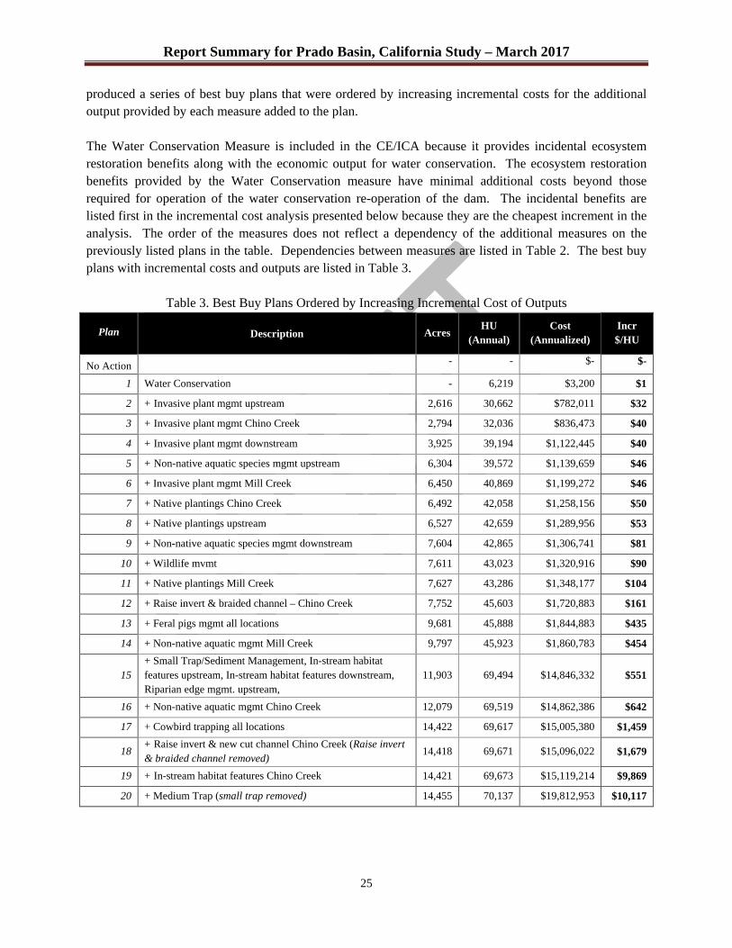
Report Summary for Prado Basin, California Study – March 2017
25
produced a series of best buy plans that were ordered by increasing incremental costs for the additional output provided by each measure added to the plan. The Water Conservation Measure is included in the CE/ICA because it provides incidental ecosystem restoration benefits along with the economic output for water conservation. The ecosystem restoration benefits provided by the Water Conservation measure have minimal additional costs beyond those required for operation of the water conservation re-operation of the dam. The incidental benefits are listed first in the incremental cost analysis presented below because they are the cheapest increment in the analysis. The order of the measures does not reflect a dependency of the additional measures on the previously listed plans in the table. Dependencies between measures are listed in Table 2. The best buy plans with incremental costs and outputs are listed in Table 3.
Table 3. Best Buy Plans Ordered by Increasing Incremental Cost of Outputs
Plan
Description Acres
HU (Annual)
Cost (Annualized)
Incr $/HU
No Action - - $- $-
1 Water Conservation - 6,219 $3,200 $1
2 + Invasive plant mgmt upstream 2,616 30,662 $782,011 $32
3 + Invasive plant mgmt Chino Creek 2,794 32,036 $836,473 $40
4 + Invasive plant mgmt downstream 3,925 39,194 $1,122,445 $40
5 + Non-native aquatic species mgmt upstream 6,304 39,572 $1,139,659 $46
6 + Invasive plant mgmt Mill Creek 6,450 40,869 $1,199,272 $46
7 + Native plantings Chino Creek 6,492 42,058 $1,258,156 $50
8 + Native plantings upstream 6,527 42,659 $1,289,956 $53
9 + Non-native aquatic species mgmt downstream 7,604 42,865 $1,306,741 $81
10 + Wildlife mvmt 7,611 43,023 $1,320,916 $90
11 + Native plantings Mill Creek 7,627 43,286 $1,348,177 $104
12 + Raise invert & braided channel – Chino Creek 7,752 45,603 $1,720,883 $161
13 + Feral pigs mgmt all locations 9,681 45,888 $1,844,883 $435
14 + Non-native aquatic mgmt Mill Creek 9,797 45,923 $1,860,783 $454
15 + Small Trap/Sediment Management, In-stream habitat features upstream, In-stream habitat features downstream, Riparian edge mgmt. upstream,
11,903 69,494 $14,846,332 $551
16 + Non-native aquatic mgmt Chino Creek 12,079 69,519 $14,862,386 $642
17 + Cowbird trapping all locations 14,422 69,617 $15,005,380 $1,459
18 + Raise invert & new cut channel Chino Creek (Raise invert & braided channel removed)
14,418 69,671 $15,096,022 $1,679
19 + In-stream habitat features Chino Creek 14,421 69,673 $15,119,214 $9,869
20 + Medium Trap (small trap removed) 14,455 70,137 $19,812,953 $10,117

Report Summary for Prado Basin, California Study – March 2017
26
While cost effectiveness and incremental cost analysis are important criteria for establishing economically rational alternatives, other decision guidelines need to be applied to determine the National Ecosystem Restoration (NER) Plan. These considerations include:
• Output targets • Output thresholds • Cost limits • Breakpoints in incremental cost/output graph • Unintended consequences
These considerations were used along with the criteria of completeness, effectiveness, efficiency and acceptability to determine the Final Array Plans to carry forward and identify the Tentatively Selected Plan. The results of the evaluation of the best buy plans using the considerations and criteria identified four best buy plans to include in the final array. The PDT determined that Best Buy Plan 13 was the smallest plan that provided sufficient benefits for inclusion in the final array, as failure to control feral pigs was determined to be a significant threat to existing and restored habitat within Prado Basin. In addition, the PDT determined that it would be useful to include one plan that did not provide sediment management capabilities for comparison, because of the large initial investment required for all of the sediment management measures. The remaining alternatives in the final array were selected based on the range of benefits and incremental costs represented in the best buy plans, with the upper bound represented by inclusion of Best Buy 20 with the medium sediment trap.
Best Buy Plan 13 – This plan was the plan determined to minimally meet planning objectives. It provides 45,888 AAHUs and restores 9,681 acres. The total first cost is approximately $21.6 million, with an average annual cost of about $1.85 million. The incremental AAC/AAHU is $435, which represents a substantial increase over smaller Best Buy Plans, but still low compared to larger scale plans. It is the first plan to include feral pig management in all of the focal areas. It provides significant riparian restoration throughout all of the focal areas, although it only provides limited aquatic riverine habitat suitable to native species within the project area.
Table 4. Best Buy Plan 13 Measures Summary
Measure SAR Downstream SAR Upstream Chino Creek Mill Creek
Invasive Plant Management � � � �
Wildlife Movement �
Native Plantings � � �
Feral Pig Management � � �
Raise Invert and Braided Channel
�
Non-native Aquatic Species Management
� �
Restore Riparian Edge Habitat �
Water Conservation Change in dam operations. Produces incidental restoration benefits in all basin focal areas.
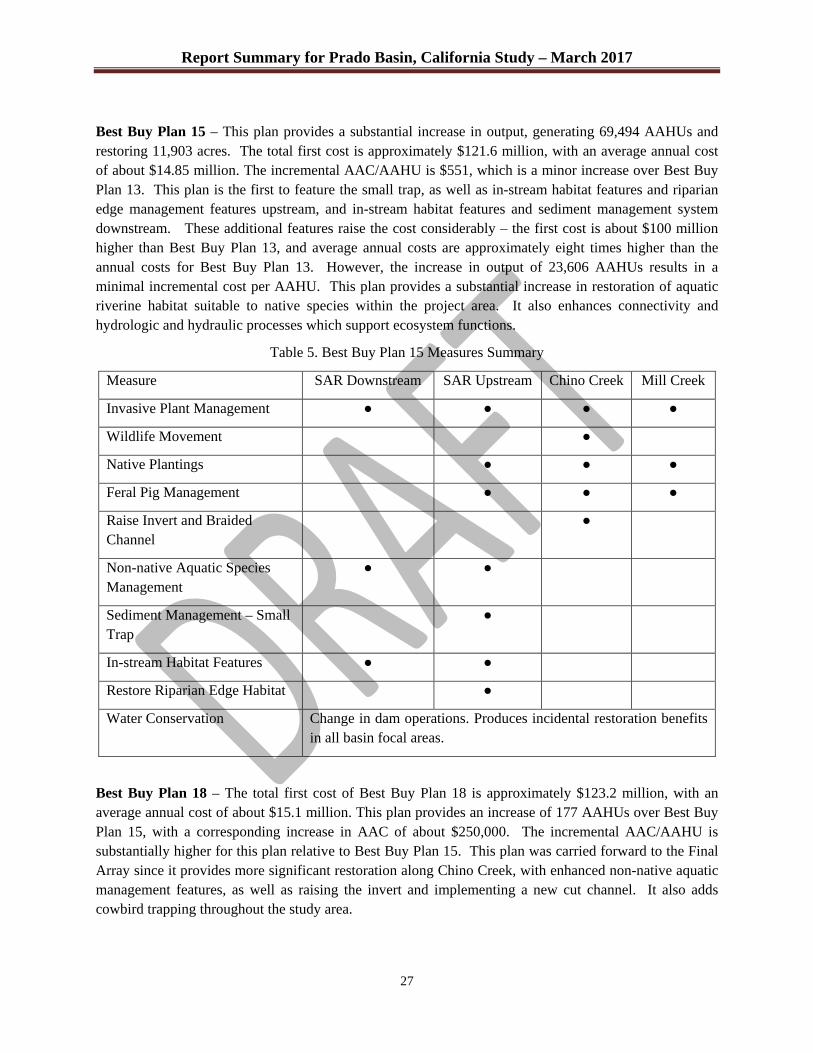
Report Summary for Prado Basin, California Study – March 2017
27
Best Buy Plan 15 – This plan provides a substantial increase in output, generating 69,494 AAHUs and restoring 11,903 acres. The total first cost is approximately $121.6 million, with an average annual cost of about $14.85 million. The incremental AAC/AAHU is $551, which is a minor increase over Best Buy Plan 13. This plan is the first to feature the small trap, as well as in-stream habitat features and riparian edge management features upstream, and in-stream habitat features and sediment management system downstream. These additional features raise the cost considerably – the first cost is about $100 million higher than Best Buy Plan 13, and average annual costs are approximately eight times higher than the annual costs for Best Buy Plan 13. However, the increase in output of 23,606 AAHUs results in a minimal incremental cost per AAHU. This plan provides a substantial increase in restoration of aquatic riverine habitat suitable to native species within the project area. It also enhances connectivity and hydrologic and hydraulic processes which support ecosystem functions.
Table 5. Best Buy Plan 15 Measures Summary
Measure SAR Downstream SAR Upstream Chino Creek Mill Creek
Invasive Plant Management � � � �
Wildlife Movement �
Native Plantings � � �
Feral Pig Management � � �
Raise Invert and Braided Channel
�
Non-native Aquatic Species Management
� �
Sediment Management – Small Trap
�
In-stream Habitat Features � �
Restore Riparian Edge Habitat �
Water Conservation Change in dam operations. Produces incidental restoration benefits in all basin focal areas.
Best Buy Plan 18 – The total first cost of Best Buy Plan 18 is approximately $123.2 million, with an average annual cost of about $15.1 million. This plan provides an increase of 177 AAHUs over Best Buy Plan 15, with a corresponding increase in AAC of about $250,000. The incremental AAC/AAHU is substantially higher for this plan relative to Best Buy Plan 15. This plan was carried forward to the Final Array since it provides more significant restoration along Chino Creek, with enhanced non-native aquatic management features, as well as raising the invert and implementing a new cut channel. It also adds cowbird trapping throughout the study area.
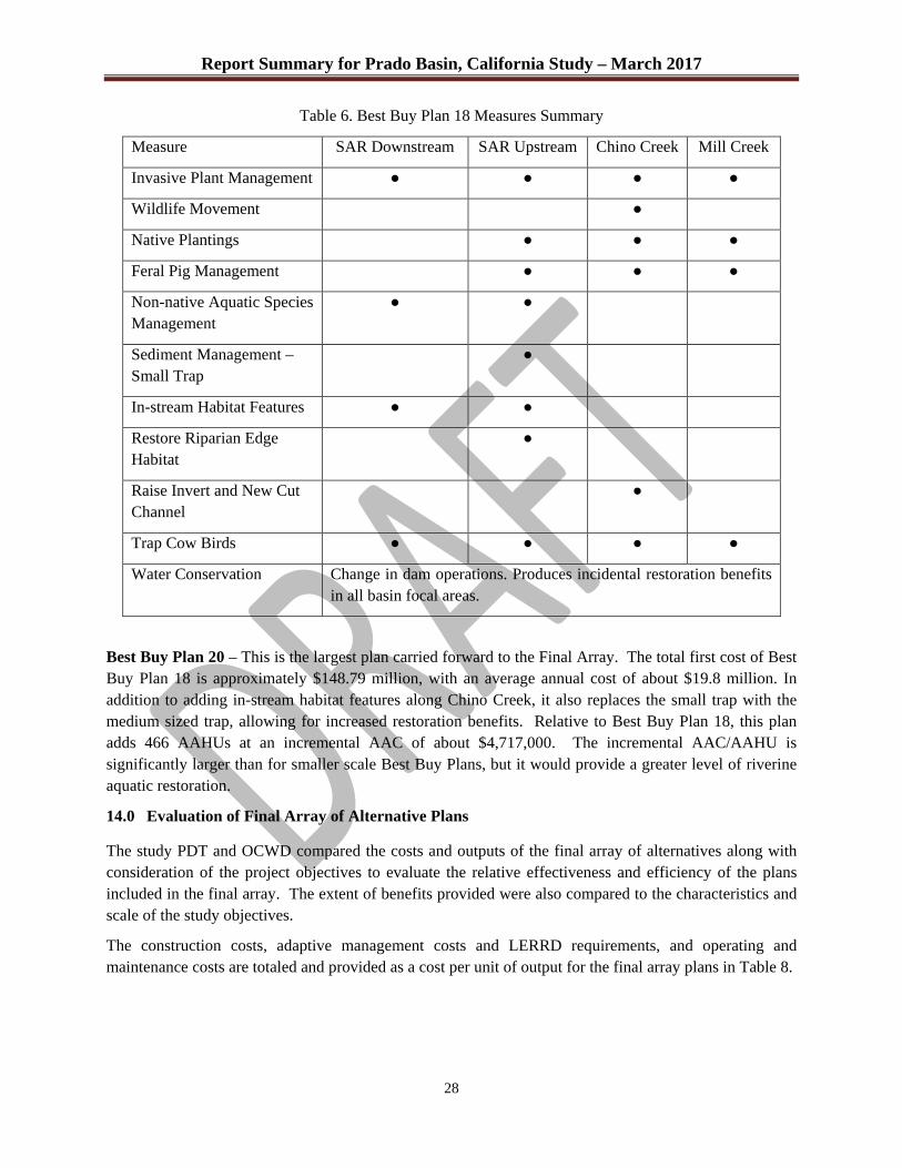
Report Summary for Prado Basin, California Study – March 2017
28
Table 6. Best Buy Plan 18 Measures Summary
Measure SAR Downstream SAR Upstream Chino Creek Mill Creek
Invasive Plant Management � � � �
Wildlife Movement �
Native Plantings � � �
Feral Pig Management � � �
Non-native Aquatic Species Management
� �
Sediment Management – Small Trap
�
In-stream Habitat Features � �
Restore Riparian Edge Habitat
�
Raise Invert and New Cut Channel
�
Trap Cow Birds � � � �
Water Conservation Change in dam operations. Produces incidental restoration benefits in all basin focal areas.
Best Buy Plan 20 – This is the largest plan carried forward to the Final Array. The total first cost of Best Buy Plan 18 is approximately $148.79 million, with an average annual cost of about $19.8 million. In addition to adding in-stream habitat features along Chino Creek, it also replaces the small trap with the medium sized trap, allowing for increased restoration benefits. Relative to Best Buy Plan 18, this plan adds 466 AAHUs at an incremental AAC of about $4,717,000. The incremental AAC/AAHU is significantly larger than for smaller scale Best Buy Plans, but it would provide a greater level of riverine aquatic restoration.
14.0 Evaluation of Final Array of Alternative Plans
The study PDT and OCWD compared the costs and outputs of the final array of alternatives along with consideration of the project objectives to evaluate the relative effectiveness and efficiency of the plans included in the final array. The extent of benefits provided were also compared to the characteristics and scale of the study objectives.
The construction costs, adaptive management costs and LERRD requirements, and operating and maintenance costs are totaled and provided as a cost per unit of output for the final array plans in Table 8.

Report Summary for Prado Basin, California Study – March 2017
29
Table 7. Best Buy Plan 20 Measures Summary
Measure SAR Downstream SAR Upstream Chino Creek Mill Creek
Invasive Plant Management
� � � �
Wildlife Movement �
Native Plantings � � �
Feral Pig Management � � �
Raise Invert and Braided Channel
�
Non-native Aquatic Species Management
� �
Sediment Management – Medium Trap
�
In-stream Habitat Features
� �
Restore Riparian Edge Habitat
�
Raise Invert and New Cut Channel
�
Trap Cow Birds � � � �
Water Conservation Change in dam operations. Produces incidental restoration benefits in all basin focal areas.
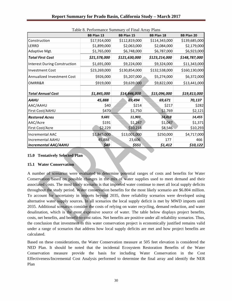
Report Summary for Prado Basin, California Study – March 2017
30
Table 8. Performance Summary of Final Array Plans BB Plan 13 BB Plan 15 BB Plan 18 BB Plan 20
Construction $17,914,000 $112,819,000 $114,343,000 $139,685,000
LERRD $1,899,000 $2,063,000 $2,084,000 $2,179,000
Adaptive Mgt. $1,765,000 $6,748,000 $6,787,000 $6,923,000
Total First Cost $21,578,000 $121,630,000 $123,214,000 $148,787,000
Interest During Construction $1,691,000 $9,224,000 $9,324,000 $11,343,000
Investment Cost $23,269,000 $130,854,000 $132,538,000 $160,130,000
Annualized Investment Cost $926,000 $5,207,000 $5,274,000 $6,372,000
OMRR&R $919,000 $9,639,000 $9,822,000 $13,441,000
Total Annual Cost $1,845,000 $14,846,000 $15,096,000 $19,813,000
AAHU 45,888 69,494 69,671 70,137
AAC/AAHU $40 $214 $217 $282
First Cost/AAHU $470 $1,750 $1,769 $2,121
Restored Acres 9,681 11,903 14,418 14,455
AAC/Acre $191 $1,247 $1,047 $1,371
First Cost/Acre $2,229 $10,218 $8,546 $10,293
Incremental AAC $1,845,000 $13,001,000 $250,000 $4,717,000
Incremental AAHU 45,888 23,606 177 466
Incremental AAC/AAHU $40 $551 $1,412 $10,122 15.0 Tentatively Selected Plan
15.1 Water Conservation
A number of scenarios were evaluated to determine potential ranges of costs and benefits for Water Conservation based on possible changes in the mix of water supplies used to meet demand and their associated costs. The most likely scenario is that imported water continue to meet all local supply deficits throughout the study period. Water conservation benefits for the most likely scenario are $6.804 million. To account for uncertainty in imports beyond 2035, three reliability scenarios were developed using alternative water supply sources. In all scenarios the local supply deficit is met by MWD imports until 2035. Additional scenarios consider the costs of relying on water recycling, demand reduction, and water desalination, which is the most expensive source of water. The table below displays project benefits, costs, net benefits, and benefit-to-cost ratios. Net benefits are positive under all reliability scenarios. Thus, the conclusion that investment in this water conservation project is economically justified remains valid under a range of scenarios that address how local supply deficits are met and how project benefits are calculated.
Based on these considerations, the Water Conservation measure at 505 feet elevation is considered the NED Plan. It should be noted that the incidental Ecosystem Restoration Benefits of the Water Conservation measure provide the basis for including Water Conservation in the Cost Effectiveness/Incremental Cost Analysis performed to determine the final array and identify the NER Plan
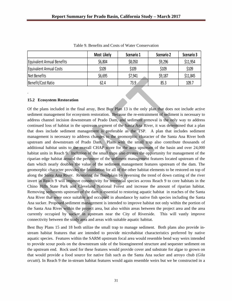
Report Summary for Prado Basin, California Study – March 2017
31
Table 9. Benefits and Costs of Water Conservation
Most Likely Scenario 1 Scenario 2 Scenario 3
Equivalent Annual Benefits $6,804 $8,050 $9,296 $11,954
Equivalent Annual Costs $109 $109 $109 $109
Net Benefits $6,695 $7,941 $9,187 $11,845
Benefit/Cost Ratio 62.4 73.9 85.3 109.7
.
15.2 Ecosystem Restoration
Of the plans included in the final array, Best Buy Plan 13 is the only plan that does not include active sediment management for ecosystem restoration. Because the re-entrainment of sediment is necessary to address channel incision downstream of Prado Dam, and sediment removal is the only way to address continued loss of habitat in the upstream segment of the Santa Ana River, it was determined that a plan that does include sediment management is preferable as the TSP. A plan that includes sediment management is necessary to address changes to the geomorphic character of the Santa Ana River both upstream and downstream of Prado Dam. Plans with the small trap also contribute thousands of additional habitat units to the overall CHAP score for the area upstream of the basin and over 24,000 habitat units in Reach 9. Inclusion of the small traps also creates the opportunity for management of the riparian edge habitat around the perimeter of the sediment management features located upstream of the dam which nearly doubles the value of the sediment management features upstream of the dam. The geomorphic character provides the foundation for all of the other habitat elements to be restored on top of along the Santa Ana River. Restoring the floodplain by reversing the trend of down cutting of the river invert in Reach 9 will improve connectivity for terrestrial species across Reach 9 to core habitats in the Chino Hills State Park and Cleveland National Forest and increase the amount of riparian habitat. Removing sediments upstream of the dam is essential to restoring aquatic habitat in reaches of the Santa Ana River that were once suitable and occupied in abundance by native fish species including the Santa Ana sucker. Proposed sediment management is intended to improve habitat not only within the portion of the Santa Ana River within the project area, but also within areas between the project area and the area currently occupied by sucker in upstream near the City of Riverside. This will vastly improve connectivity between the study area and areas with suitable aquatic habitat.
Best Buy Plans 15 and 18 both utilize the small trap to manage sediment. Both plans also provide in-stream habitat features that are intended to provide microhabitat characteristics preferred by native aquatic species. Features within the SARM upstream focal area would resemble bend way weirs intended to provide scour pools on the downstream side of the bioengineered structure and sequester sediment on the upstream end. Rock used for these features would provide cover and substrate for algae to grown on that would provide a food source for native fish such as the Santa Ana sucker and arroyo chub (Gila orcutti). In Reach 9 the in-stream habitat features would again resemble weirs but we be constructed in a

Report Summary for Prado Basin, California Study – March 2017
32
manner to encourage deposition of re-entrained material within Reach 9 to provide aquatic habitat as well as correct the incising invert.
Both of these plans also restore the available water conservation capacity by reducing the amount of sediment being sequestered upstream of the dam. The removal of sediment from upstream of the dam and re-entrainment of it downstream of the dam restored storage capacity behind the dam and contribute coarser sediment to preserve the infiltration capabilities of downstream recharge areas.
The PDT determined that the additional invasive species management measures and the more intensive restoration approach for the Chino Creek channel provided by Best Buy 18 are worthwhile, as the additional costs were a small increase over Best Buy 15 and represent a more complete and realistic implementation strategy. Best Buy 18 provides the opportunity for management of brown-headed cowbirds which has proven to be one of the most important measures to ensuring successful breeding conditions for numerous bird species, including the federally endangered least Bell’s vireo and southwestern willow flycatcher. A more robust non-native species management regime reduces the risks to restored and existing habitats that would be posed by continued propagation and displacement by invasive species.
The PDT considered Best Buy Plan 20 should be carried forward into the final array to ensure that the potential value of a large scale plan was considered in the analysis. Larger scale sediment management measures than those included in Best Buy Plan 20 had already been considered and eliminated, based on the planning constraint of unacceptable impacts to investments in bank stability already made for the Santa Ana River Mainstem project. Compared to Plan 18, the larger trap for Best Buy Plan 20 would have a larger construction footprint, and would therefore have more construction related impacts that would further offset ecosystem outputs, since those would be needed for self-mitigation of the larger trap construction. In addition, more extensive head cutting upstream of the trap may have provided additional SAS habitat restoration, but uncertainty associated with sediment transport modeling may also have required the trap to be scaled back through adaptive management of the sediment management system. The Cost Effectiveness/Incremental Cost Analysis comparison of Best Buy Plans 18 and 20 reveal that Best Buy 20 requires a 22% increase in first costs and has an average cost per annualized unit of output 30% higher than Best Buy Plan 18.
Given the performance risks that may require scaling back of sediment management from the full extent called for to implement the larger sediment trap and the greater incremental costs for the additional benefits provided, the PDT decided that Best Buy Plan 20 could not be supported as the NER Plan.
Based on these considerations, the study team identified Best Buy Plan 18 as the NER plan and the TSP.
16.0 Key Social and Environmental Factors
16.1 Stakeholder Perspectives and Differences
The non-Federal views and preferences regarding ecosystem restoration and water conservation measures, and the problems they addressed, were obtained through coordination with the local sponsor during the plan formulation process, and included consideration of the sponsor’s prior experience and investments in water conservation and ecosystem restoration and mitigation efforts that had already been undertaken in the study area. Plan formulation processes also included subject matter experts and considered the
Report Summary for Prado Basin, California Study – March 2017
33
positions and input of other local and regional entities, and the natural resource agencies. Public participation included meetings held during the reconnaissance and feasibility phases, and through comments received from the public on the study NEPA scoping meeting was advertised in Federal Register on November 16, 2012 (Fed. Reg. 77[222]). Representatives from a variety of Federal, State, and local agencies also participated, including the U.S. Fish and Wildlife Service (USFWS), the Regional Water Quality Control Board (RWQCB), California Department of Fish and Game (CDFG), Santa Ana Watershed Association (SAWA), and the City of Ontario. Interested parties present at the scoping meeting presented comments, concerns and ideas for the study.
Comments, concerns and ideas from the public covered a wide range of interests. Topics ranged from land ownership and land use, to whether or not the dual purposes of the project were mutually exclusive, to restoration ideas for specific species and habitat in general.
17.0 Environmental Compliance
The Integrated Feasibility Report (IFR) is currently being drafted. This document will include all of the information and analyses necessary for compliance with the National Environmental Policy Act (NEPA) and the California Environmental Quality Act (CEQA). A Biological Assessment will also be prepared to evaluate effects to Federally listed threatened and endangered species and Federally designated critical habitat in compliance with the Endangered Species Act. Based on the analyses completed to date, it is anticipated that the proposed change in water conservation may adversely affect least Bell's vireo by potentially resulting in redistribution of territories higher in the basin during wet years. This effect has already been at least partially offset by previous and ongoing restoration and vireo management efforts conducted by Orange County Water District, separate from this study.
At this time there is not an expectation that additional mitigation would be required for water conservation, although coordination with the USF&WS on this issue is continuing. Ecosystem restoration measures may also result in adverse effects to vireo and other species during construction. No mitigation would be required for these temporary impacts, as the long-term benefits would outweigh any adverse effects. The Biological Assessment and the IFR will be sent to the USFWS during the public review period along with a request for formal consultation on the Tentatively Selected Plan. The USFWS will prepare a Biological Opinion that will be included in the Final IFR. In compliance with Clean Water Act requirements, the IFR will also include a 404(b)(1) Evaluation that will be used to determine the Least Damaging Practicable Alternative, and a request for Section 401 Certification will be forwarded to the California Regional Water Quality Control Board, Santa Ana Region (CRWQCB). That agency, however, will not be able to complete the certification process until after the IFR is finalized and the CEQA document is certified by the Non-Federal Sponsor's governing board.

Report Summary for Prado Basin, California Study – March 2017
34
REFERENCES
Ball, Joan E., Beche, Leah A., Mendez, Patina K., and Resh, Vincent H., Biodiversity in Mediterranean- climate streams of California, Hydrobiologia (2013) 719:187–213
Dahl, T.E. 1990. Wetlands Losses in the United States: 1780’s to 1980’s. Report to Congress. U.S. Fish and Wildlife Service. National Wetlands Inventory. St. Petersburg, FL.
Faber, P.A., E. Keller, A. Sands, and B.M. Massey. 1989. The ecology of riparian habitats of the Southern California coastal region; a community profile. U.S. Fish Wildl. Serv. Biol. Rep. 85(7.27). 152pp.
Krueper, D.J. 1993. Conservation priorities in naturally fragmented and human-altered riparian habitats of the arid West. USDA Forest Service. General Technical Report RM-43. Available online: www.birds.cornell.edu/pifcapemay/krueper.htm.
Krueper, D.J. 1995. Effects of Livestock Management on Southwestern riparian ecosystems. In: Desired future conditions for Southwestern riparian ecosystems: Bringing interests and concerns together. D.W. Shaw, and D.M. Finch, tech cords. Sept. 18-22, 1995; Albuquerque, NM. General Technical Report RM-GTR-272. Fort Collins, CO: U.S. Department of Agriculture, Forest Service, Rocky Mountain Forest and Range Experiment Station, 359 p.
Levick, L., J. Fonseca, D. Goodrich, M. Hernandez, D. Semmens, J. Stromberg, R. Leidy, M. Scianni, D. P. Guertin, M. Tluczek, and W. Kepner. 2008. The Ecological and Hydrological Significance of Ephemeral and Intermittent Streams in the Arid and Semi-arid American Southwest. U.S. Environmental Protection Agency and USDA/ARS Southwest Watershed Research Center, EPA/600/R-08/134, ARS/233046, 116 pp.
Myers, N, R.A. Mittermeier, C.G. Mittermeier, C.G., G.A.B. da Fonseca, J. Kent. 1999. Biodiversity Hotspots for Conservation Priorities. Nature, 403. December
Noss, R. F., R.L. Peters. 1995. Endangered Ecosystems: A Status Report on America’s Vanishing Habitat and Wildlife. Defenders of Wildlife. Washington, DC
Stein, B. A., L. S. Kutner, and J. S. Adams, eds. 2000. Precious Heritage: The Status of Biodiversity in the United States. New York: Oxford University Press.

16
AGENDA ITEM SUBMITTAL
Meeting Date: April 12, 2017 Budgeted: N/A
Budget Amount: $49.7 Million
To: Water Issues Committee Cost Estimate: $49.7 Million
Board of Directors Funding Source: Water Budget
Program/Line Item No: N/A
From: Mike Markus General Counsel Approval: N/A
Engineers/Feasibility Report: N/A
Staff Contact: J. Kennedy / R. Fick CEQA Compliance: N/A
Subject: PROPOSED FISCAL YEAR 2017-18 WATER PURCHASE BUDGET
SUMMARY The proposed FY 2017-18 water budget totals $49.7 million which provides for the purchase of 67,000 acre-feet of water. The largest expense is for 65,000 acre-feet of Metropolitan Water District (MWD) untreated full service water. Staff is also discussing with MWD and the Municipal Water District of Orange County (MWDOC) the possibility of purchasing up to an additional 30,000 acre-feet of water next year. With this additional water purchase, the District should be able to reduce the accumulated overdraft (further refill the groundwater basin) by about 52,000 acre-feet. Staff will discuss this plan and other options to more aggressively refill the groundwater basin. Attachment(s):
Presentation
RECOMMENDATION
Agendize for April 19 Board meeting: Provide comments and direction
DISCUSSION/ANALYSIS The proposed FY 2017-18 water budget calls for the purchase of 65,000 acre-feet of MWD untreated full service water to help support the recommended 75% Basin Production Percentage (BPP). The MWD volumetric rate for this water is currently $666/acre-foot for calendar year 2017 and will increase to $695/acre-foot on January 1, 2018. In addition to the volumetric rate approximately an additional $80 per acre-foot can be added to the cost of MWD water due to the separate readiness-to-serve and capacity charges. By annually purchasing untreated imported water from MWD and recharging it into the groundwater basin, the Groundwater Producers eventually avoid paying for treated MWD full service water which currently cost $979/acre-foot. The MWD treatment surcharge is currently $313/acre-foot. The Producers do incur about $97/acre-foot in variable cost for water pumped out of the ground. However there is a significant overall savings to the service territory which is estimated at $216/acre-foot ($313/acre-foot – $97/acre-foot). The District operates in a manner to maximize MWD untreated full service water purchases.

The current FY 2016-17 budget calls for purchasing 50,000 acre-feet of MWD untreated water. Increasing the water budget up to 65,000 acre-feet by itself would cause the Replenishment Assessment (RA) to increase from the current $402/acre-foot up to $452/acre-foot. However due to other offsetting factors the recommended RA for FY 2017-18 is $445/acre-foot. Accumulated Overdraft
The Basin’s accumulated overdraft began this fiscal year at 379,000 acre-feet and is expected to decrease to approximately 320,000 acre-feet by June 30, 2017 as shown below.
Groundwater Basin Accumulated Overdraft
FY2017-18 Water Balance The proposed FY 2017-18 water budget would reduce the accumulated overdraft by about 22,000 acre-feet assuming a slightly dry hydrology, 65,000 acre-feet of MWD water is received and recharged, and a BPP of 75%. If the District experiences a very dry year (SAR Storm Flows and Natural Incidental Recharge are a combined approximately 50,000 acre-feet less than budgeted), the accumulated overdraft would increase by about 28,000 acre-feet by June 30, 2018. The following table summarizes expected sources of water to recharge the groundwater basin under slightly dry conditions.
6/30/17 Projection
s
Target Overdraft Range
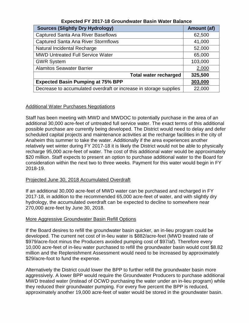
Expected FY 2017-18 Groundwater Basin Water Balance
Sources (Slightly Dry Hydrology) Amount (af)
Captured Santa Ana River Baseflows 62,500
Captured Santa Ana River Stormflows 41,000
Natural Incidental Recharge 52,000
MWD Untreated Full Service Water 65,000
GWR System 103,000
Alamitos Seawater Barrier 2,000
Total water recharged 325,500
Expected Basin Pumping at 75% BPP 303,000
Decrease to accumulated overdraft or increase in storage supplies 22,000
Additional Water Purchases Negotiations Staff has been meeting with MWD and MWDOC to potentially purchase in the area of an additional 30,000 acre-feet of untreated full service water. The exact terms of this additional possible purchase are currently being developed. The District would need to delay and defer scheduled capital projects and maintenance activities at the recharge facilities in the city of Anaheim this summer to take the water. Additionally if the area experiences another relatively wet winter during FY 2017-18 it is likely the District would not be able to physically recharge 95,000 acre-feet of water. The cost of this additional water would be approximately $20 million. Staff expects to present an option to purchase additional water to the Board for consideration within the next two to three weeks. Payment for this water would begin in FY 2018-19. Projected June 30, 2018 Accumulated Overdraft If an additional 30,000 acre-feet of MWD water can be purchased and recharged in FY 2017-18, in addition to the recommended 65,000 acre-feet of water, and with slightly dry hydrology, the accumulated overdraft can be expected to decline to somewhere near 270,000 acre-feet by June 30, 2018. More Aggressive Groundwater Basin Refill Options If the Board desires to refill the groundwater basin quicker, an in-lieu program could be developed. The current net cost of in-lieu water is $882/acre-feet (MWD treated rate of $979/acre-foot minus the Producers avoided pumping cost of $97/af). Therefore every 10,000 acre-feet of in-lieu water purchased to refill the groundwater basin would cost $8.82 million and the Replenishment Assessment would need to be increased by approximately $29/acre-foot to fund the expense. Alternatively the District could lower the BPP to further refill the groundwater basin more aggressively. A lower BPP would require the Groundwater Producers to purchase additional MWD treated water (instead of OCWD purchasing the water under an in-lieu program) while they reduced their groundwater pumping. For every five percent the BPP is reduced, approximately another 19,000 acre-feet of water would be stored in the groundwater basin.
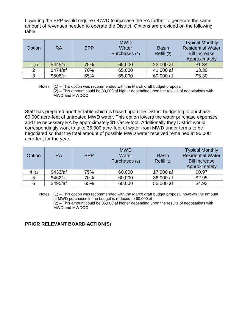
Lowering the BPP would require OCWD to increase the RA further to generate the same amount of revenues needed to operate the District. Options are provided on the following table.
Option
RA
BPP
MWD Water
Purchases (2)
Basin
Refill (2)
Typical Monthly Residential Water
Bill Increase Approximately
1 (1) $445/af 75% 65,000 22,000 af $1.34
2 $474/af 70% 65,000 41,000 af $3.30
3 $508/af 65% 65,000 60,000 af $5.30
Notes (1) – This option was recommended with the March draft budget proposal.
(2) – This amount could be 30,000 af higher depending upon the results of negotiations with MWD and MWDOC
Staff has prepared another table which is based upon the District budgeting to purchase 60,000 acre-feet of untreated MWD water. This option lowers the water purchase expenses and the necessary RA by approximately $12/acre-foot. Additionally they District would correspondingly work to take 35,000 acre-feet of water from MWD under terms to be negotiated so that the total amount of possible MWD water received remained at 95,000 acre-feet for the year.
Option
RA
BPP
MWD Water
Purchases (2)
Basin
Refill (2)
Typical Monthly Residential Water
Bill Increase Approximately
4 (1) $433/af 75% 60,000 17,000 af $0.97
5 $462/af 70% 60,000 36,000 af $2.95
6 $495/af 65% 60,000 55,000 af $4.93
Notes (1) – This option was recommended with the March draft budget proposal however the amount
of MWD purchases in the budget is reduced to 60,000 af. (2) – This amount could be 35,000 af higher depending upon the results of negotiations with MWD and MWDOC
PRIOR RELEVANT BOARD ACTION(S)
Review of FY2017-18 Proposed
Water Purchase Budget
Water Issues Committee
April 12, 2017
1
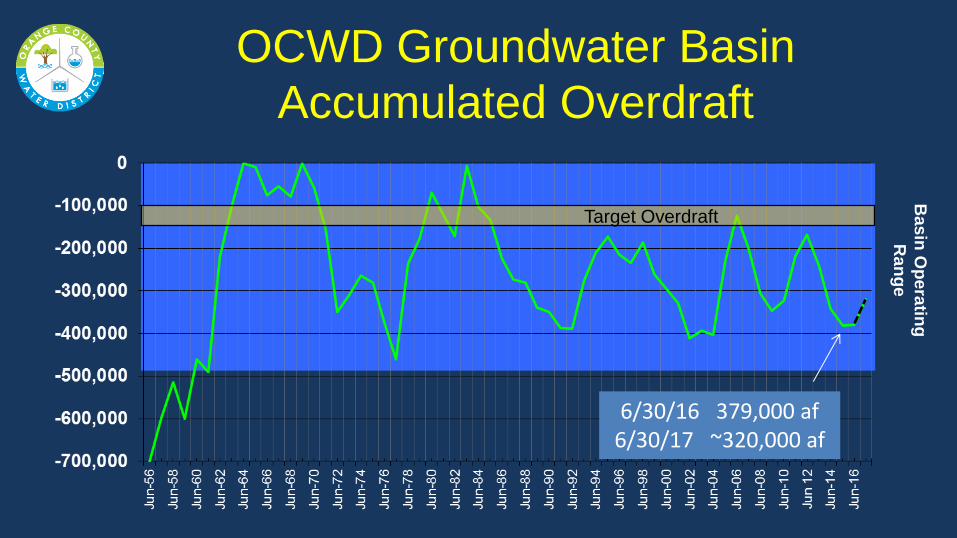
OCWD Groundwater Basin
Accumulated Overdraft
Basin
Op
era
ting
Ra
ng
e
Target Overdraft
6/30/16 379,000 af 6/30/17 ~320,000 af
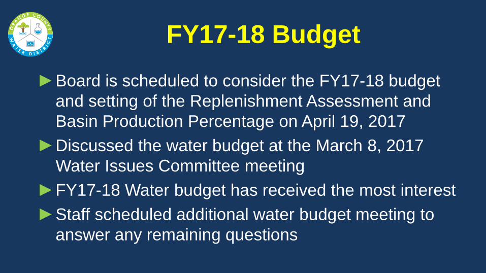
FY17-18 Budget
►Board is scheduled to consider the FY17-18 budget
and setting of the Replenishment Assessment and
Basin Production Percentage on April 19, 2017
►Discussed the water budget at the March 8, 2017
Water Issues Committee meeting
►FY17-18 Water budget has received the most interest
►Staff scheduled additional water budget meeting to
answer any remaining questions
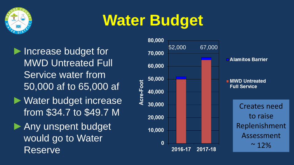
Water Budget
52,000 67,000
► Increase budget for
MWD Untreated Full
Service water from
50,000 af to 65,000 af
►Water budget increase
from $34.7 to $49.7 M
►Any unspent budget
would go to Water
Reserve
Creates need to raise
Replenishment Assessment
~ 12%
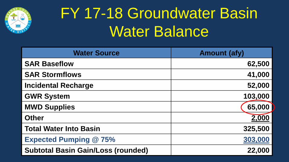
FY 17-18 Groundwater Basin
Water Balance
Water Source Amount (afy)
SAR Baseflow 62,500
SAR Stormflows 41,000
Incidental Recharge 52,000
GWR System 103,000
MWD Supplies 65,000
Other 2,000
Total Water Into Basin 325,500
Expected Pumping @ 75% 303,000
Subtotal Basin Gain/Loss (rounded) 22,000
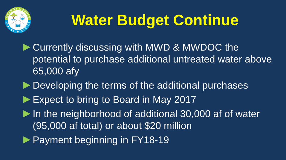
Water Budget Continue
►Currently discussing with MWD & MWDOC the
potential to purchase additional untreated water above
65,000 afy
►Developing the terms of the additional purchases
►Expect to bring to Board in May 2017
► In the neighborhood of additional 30,000 af of water
(95,000 af total) or about $20 million
►Payment beginning in FY18-19

OCWD Groundwater Basin
Accumulated Overdraft
Basin
Op
era
ting
Ra
ng
e
Target Overdraft
6/30/16 379,000 af 6/30/17 ~320,000 af 6/30/18 ~270,000 af
~145,000

Purchasing Additional Water in
FY17-18
• Has to be by In-lieu method – no OCWD
recharge capacity remaining
• Producers pump less than a 75% BPP and take
increased amounts of MWD treated water -
OCWD buys the MWD water
• More expensive water - $979/af (treated) vs
$666/af (untreated)
• Capacity to take ~ 10,000 af/month

Purchasing Additional In-Lieu Water
in FY17-18
• OCWD Water Cost of $979/af - $97/af (Producers
pay OCWD avoided GW pumping cost) = $882/af
• 145,000 af of water = $128 million
• Could take water over a few years to ease
financial hit or finance purchases using
commercial paper program
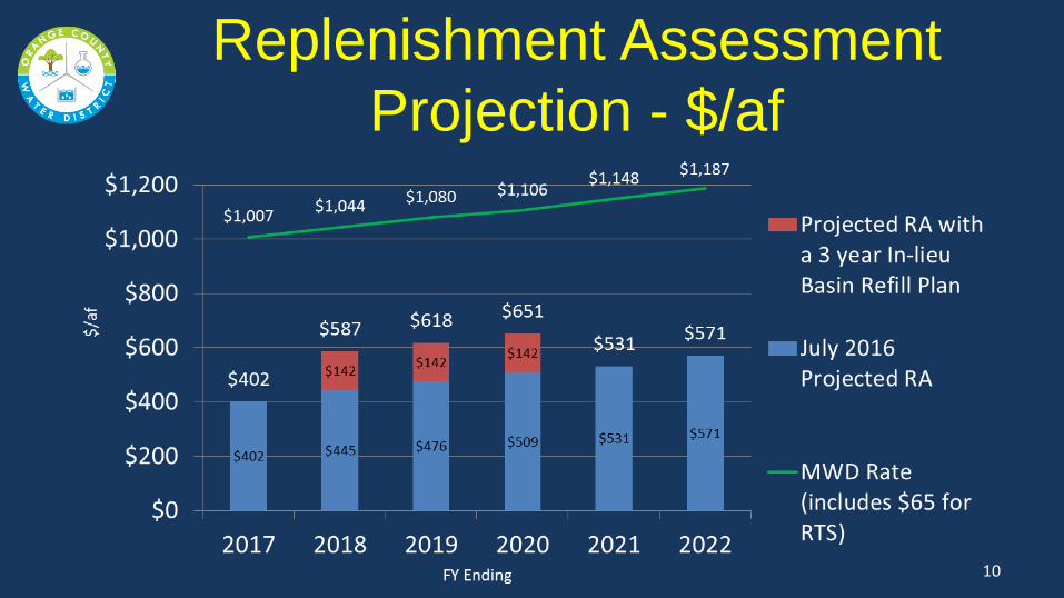
Replenishment Assessment
Projection - $/af
10

Lower the BPP to Refill the
Groundwater Basin
• Groundwater Producers purchase increased
amounts of MWD treated water
• OCWD Replenishment Assessment will need
to increase to generate same amount of
revenue with lower water sales
• OCWD Policy to maintain 75% BPP to
minimize Producers annual water supply cost

FY2017-18 RA & BPP Options (FY16-17 RA = $402/af, BPP = 75%)
Options
BPP
RA
MWD Water
Purchases (2)
Basin
Refill (2)
Monthly Water Bill Increase (3)
1 (1) 75% $445/af 65,000 22,000 af $1.34
2 70% $474/af 65,000 41,000 af $3.30
3 65% $508/af 65,000 60,000 af $5.30
Notes (1) Original staff recommendation (2) Potential to be 30,000 af higher (3) Estimated increase to a typical residential monthly water bill
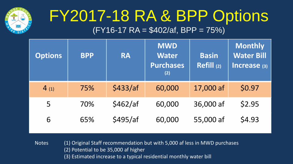
FY2017-18 RA & BPP Options (FY16-17 RA = $402/af, BPP = 75%)
Options
BPP
RA
MWD Water
Purchases (2)
Basin
Refill (2)
Monthly Water Bill Increase (3)
4 (1) 75% $433/af 60,000 17,000 af $0.97
5 70% $462/af 60,000 36,000 af $2.95
6 65% $495/af 60,000 55,000 af $4.93
Notes (1) Original Staff recommendation but with 5,000 af less in MWD purchases (2) Potential to be 35,000 af higher (3) Estimated increase to a typical residential monthly water bill
Recommendations
• Received Committee comments
14

End of Presentation
15
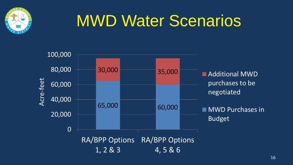
MWD Water Scenarios
16
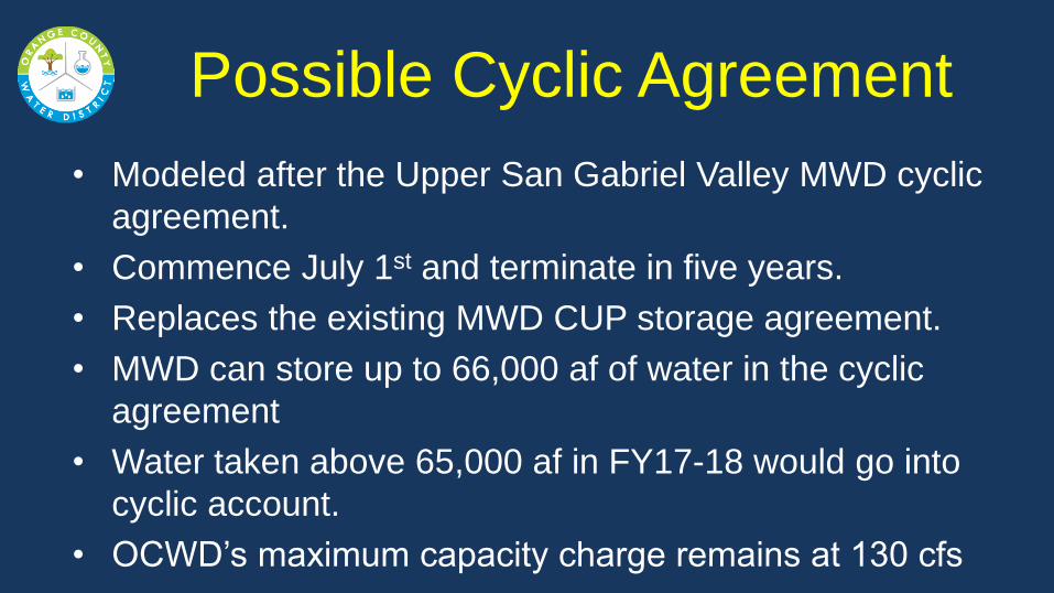
Possible Cyclic Agreement
• Modeled after the Upper San Gabriel Valley MWD cyclic
agreement.
• Commence July 1st and terminate in five years.
• Replaces the existing MWD CUP storage agreement.
• MWD can store up to 66,000 af of water in the cyclic
agreement
• Water taken above 65,000 af in FY17-18 would go into
cyclic account.
• OCWD’s maximum capacity charge remains at 130 cfs
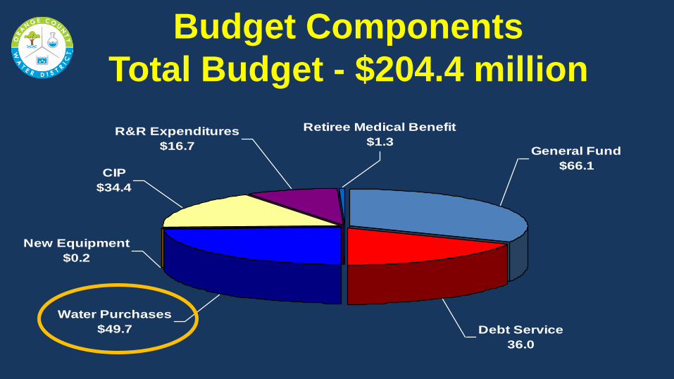
Budget Components
Total Budget - $204.4 million
R&R Expenditures
$16.7
Retiree Medical Benefit
$1.3General Fund
$66.1
Debt Service
36.0
Water Purchases
$49.7
New Equipment
$0.2
CIP
$34.4
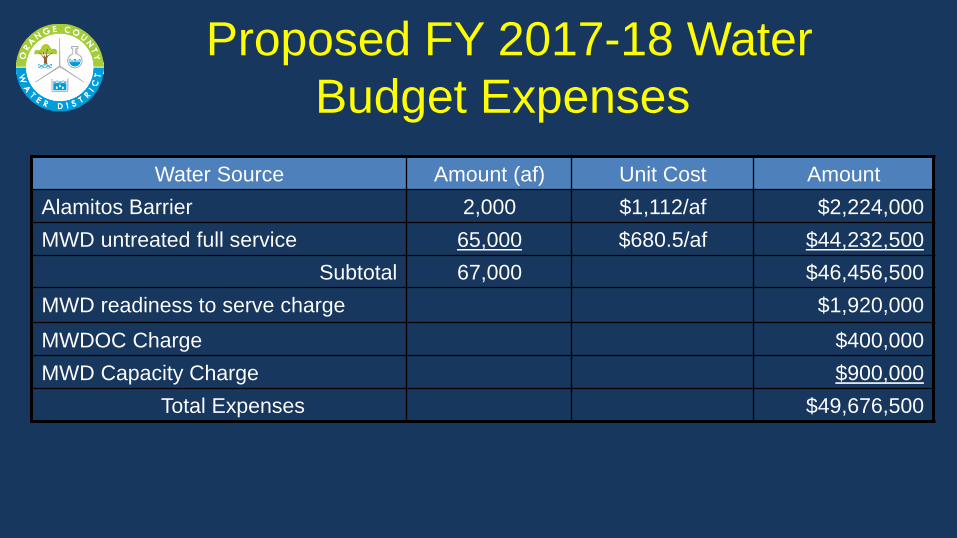
Proposed FY 2017-18 Water
Budget Expenses
Water Source Amount (af) Unit Cost Amount
Alamitos Barrier 2,000 $1,112/af $2,224,000
MWD untreated full service 65,000 $680.5/af $44,232,500
Subtotal 67,000 $46,456,500
MWD readiness to serve charge $1,920,000
MWDOC Charge $400,000
MWD Capacity Charge $900,000
Total Expenses $49,676,500

Savings by OCWD Purchasing
Untreated Full Service MWD Water
$/af
20

FY 17-18 Groundwater Basin
Production Estimate (afy)
Total Water Demands 395,000
Reclamation (Title 22) 20,000
Net Total Water Demands 375,000
75% x 378,000 281,000
WQ projects pumping above BPP 22,000
Total Estimated Pumping @ 75% 303,000
Water Quality BEA
Exemption Production
Producer Project Amount (afy)
MCWD 6,000
IRWD IDS 8,000
IRWD Wells 21 & 22 7,000
Tustin 1,000
Total Estimated Pumping 22,000
MWD Volumetric Rate Components
Rate Components 1/1/2017 1/1/2018
Tier 1 Supply Rate $201 $209
System Access Rate $289 $299
Water Stewardship Rate $52 $55
System Power Rate $124 $132
Total Tier I untreated $666 $695
Treatment Surcharge $313 $320
Total Tier I $979 $1,015
MWD Storage Reserves
24
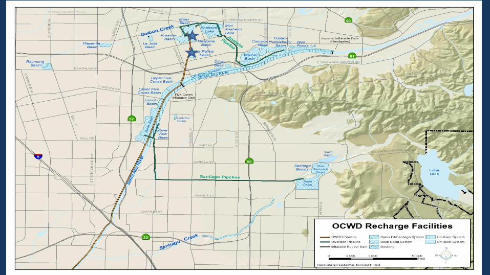
1,100 acres of recharge
facilities (44km2)
~ 250,000 afy of recharge
into groundwater basin
(308 million m3/year)
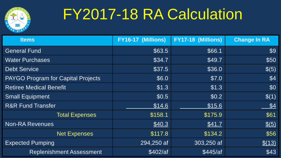
FY2017-18 RA Calculation
Items FY16-17 (Millions) FY17-18 (Millions) Change In RA
General Fund $63.5 $66.1 $9
Water Purchases $34.7 $49.7 $50
Debt Service $37.5 $36.0 $(5)
PAYGO Program for Capital Projects $6.0 $7.0 $4
Retiree Medical Benefit $1.3 $1.3 $0
Small Equipment $0.5 $0.2 $(1)
R&R Fund Transfer $14.6 $15.6 $4
Total Expenses $158.1 $175.9 $61
Non-RA Revenues $40.3 $41.7 $(5)
Net Expenses $117.8 $134.2 $56
Expected Pumping 294,250 af 303,250 af $(13)
Replenishment Assessment $402/af $445/af $43
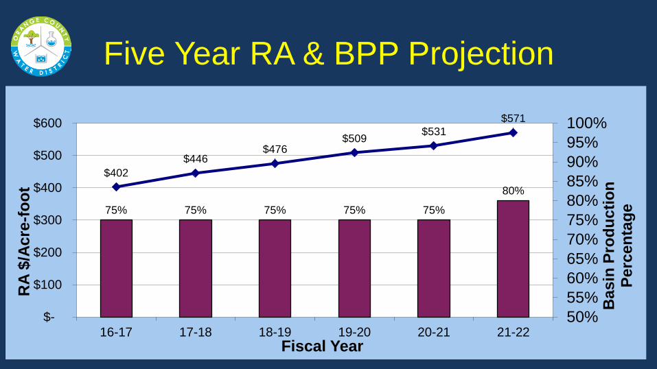
Five Year RA & BPP Projection
75% 75% 75% 75% 75%
80%
$402
$446 $476
$509 $531
$571
50%
55%
60%
65%
70%
75%
80%
85%
90%
95%
100%
$-
$100
$200
$300
$400
$500
$600
16-17 17-18 18-19 19-20 20-21 21-22
Basin
Pro
du
cti
on
P
erc
en
tag
e
RA
$/A
cre
-fo
ot
Fiscal Year