ABSTRACTS - Association of Applied Geochemists
150
THE 16TH INTERNATIONAL GEOCHEMICAL EXPLORATION SYMPOSIUM THE 5TH CHINESE EXPLORATION GEOCHEMICAL SYMPOSIUM ABSTRACTS BEIJING, CHINA 1 -6 SEPTEMBER 1993
-
Upload
khangminh22 -
Category
Documents
-
view
0 -
download
0
Transcript of ABSTRACTS - Association of Applied Geochemists

THE 16TH INTERNATIONAL GEOCHEMICAL EXPLORATION SYMPOSIUM THE 5TH CHINESE EXPLORATION GEOCHEMICAL SYMPOSIUM
ABSTRACTS
BEIJING, CHINA 1 -6 SEPTEMBER 1993

CONTENTS
PART I
Abstracts from countries and districts outside China-----------------------------------( 1)
List of authors from countries and districts outside China------------------------( 196)
Author's index-----------------------------------------------------------------------------------( 199)
PART II
Abstracts from China--------------------------------------------------------------------------------( l)
Au thor's index--------------------------------------------------------------------------------------( 1 5 2)
•

PART I
Abstracts from countries and districts outside China
List of authors from countries and districts outside China
Author's index
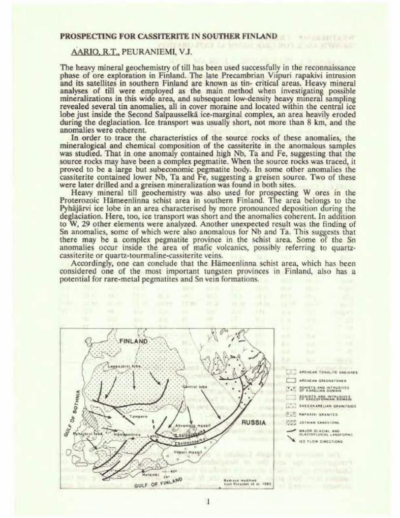
PROSPECTING FOR CASSITERITE IN SOUTHER FINLAND
AARIO. R.T .. PEURANIEMI, V.J.
The heavy mineral geochemistry of till has been used successfully in the reconnaissance phase of ore exploration in Finland. The late Precambrian Viipuri rapakivi intrusion and its satellites in southern Finland are known as tin- critical areas. Heavy mineral analyses of till were employed as the main method when investi~ating possible mineralizations in this wide area, and subsequent low-density heavy mmeral sampling revealed several tin anomalies, all in cover moraine and located within the central ice lobe just inside the Second Salpausselka ice-marginal complex, an area heavily eroded during the deglaciation. Ice transport was usually short, not more than 8 km, and the anomalies were coherent.
In order to trace the characteristics of the source rocks of these anomalies, the mineralogical and chemical composition of the cassiterite in the anomalous samples was studied. That in one anomaly contained high Nb, Ta and Fe, suggesting that the source rocks may have been a complex pegmatite. When the source rocks was traced, it proved to be a large but subeconomic pegmatite body. In some other anomalies the cassiterite contained lower Nb, Ta and Fe, suggesting a greisen source. Two of these were later drilled and a greisen mineralization was found in both sites.
Heavy mineral till geochemistry was also used for prospecting W ores in the Proterozoic Hameenlinna schist area in southern Finland. The area belongs to the Pyhajarvi ice lobe in an area characterised by more pronounced deposition during the deglaciation. Here, too, ice transport was short and the anomalies coherent. In addition to W, 29 other elements were analyzed. Another unexpected result was the finding of Sn anomalies, some of which were also anomalous for Nb and Ta. This suggests that there may be a complex pegmatite province in the schist area. Some of the Sn anomalies occur inside the area of mafic volcanics, possibly referring to quartzcassiterite or quartz-tourmaline-cassiterite veins.
Accordingly, one can conclude that the Hameenlinna schist area, which has been considered one of the most important tungsten provinces in Finland, also has a potential for rare-metal pegmatites and Sn vein formations.
Bedro ck modi l1ed from P •1 r a 1ne n et al , 19g2
L[J ARCHEAN TONA LITE GNE ISSES
(=:J ARCHEA N GREEN S TONE S
r=:~ ~~H~~1~l~~2 hNJ~~~~ VES
[I ~1~~Jgo~~~~~~1A~~~~~~~ C SVECOK ARELIAN GRANITOIDS
~~ ~APAKIVI G RANITES
~ JOT NIAN S ANDSTON E
__., MAJO R GL ACIAl AND '-. GL ACIO FLUVIAL LANDF ORMS
~ tCE FLOW OIRtCTtON S

WEATHERING CRUSTS IN FINNISH LAPLAND AND BANGLADESHSIGNIFICANCE FOR GEOCHEMICAL EXPLORATION
AARIO. R.T.. PEURANIEMI, V.J., ISLAM, MD.R.
The existence of a soft preglacial weathering crust in central Finnish Lapland pas been known since the early days of the gold rush iri the late 19th century. Systematic Quaternary geological and geochemical surveys have shown that almost the whole area of the former ice divide of central Lapland is underlain by this weathering crust. The main ore prospecting method in Finland has been till geochemistry, samples being taken with vanous types of percussion drill. Some of the samples from central Finnish Lapland were taken from the weathering crust and some from the till and this has created problems in interpreting the results.
In order to decipher the nature of the weathering and the dispersion of elements, a comparative survey was carried out in Finnish Lapland and Bangladesh. Finnish Lapland is situated in the temperate climate zone north of the Arctic Circle, so that the weathering crust there can be regarded as fossilized, while Bangladesh is situated in the subtropical and tropical climate zones and the weathering crust is recent.
TABLE 1. Chemical composition ( wt %) of the representative samples from Finnish Lapp land and Bangladesh. Compared to the typical sandstone analyses (7-8).
1 2 3 4 5 6 7 8 9 10 11 Si02 61.43 68.64 37.91 58.85 45.50 70.91 95.40 86.10 87.36 80.56 83 .88 Al203 19.86 15.42 21.87 15.97 20.10 12.23 1.10 5.45 6.40 8.55 7.64 MgO 2.93 2.15 6.29 3.63 3.10 0.17 0.10 0.61 0.15 0.22 0.18 CaO 0.37 1.56 1.85 2.00 1.12 1.04 1.60 0.98 0.14 0.03 0.15 Na20 0.99 3.34 0.56 0.94 0.17 2.76 0.10 0.55 0.34 0.15 0.44 K20 4.68 2.43 0.61 0.40 0.61 3.04 0.20 0.96 1.56 1.12 ·J.78 Fe203 7.03 4.03 21.61 11.35 18.03 6.29 0.60 2.61 2.28 4.43 2.78 Ti02 0.78 0.58 0.60 1.37 2.16 0.38 0.20 0.74 0.25 0.76 0.27 Moo 0.04 0.04 0.29 0.14 0.21 0.19 0.06 0.02 0.04 0.03 P205 0.03 0.08 0.07 0.12 0.14 0.08 0. 14 0.04 0.07 0.04 LOI 1.28 1.54 3.85 4.39 7.24 1.90 0.30 1.37 1.45 3.12 1.83 Total 99.42 99.81 95.51 99.16 98.38 98.99 99.60 99.57 99.99 99.05 99.02 Crppm 127 n.d. 312 164 162 14 n.d. n.d. 95 425 389 Co " n.d. n.d. 124 76 90 78 n.d. n.d. 168 10 5 Ni " 71 n.d. 129 88 207 15 n.d. n.d. 22 22 28 Cu" n.d. n.d. 149 81 84 30 n.d. n.d. 9 15 12 Zn " n.d. n.d. 278 141 272 138 n.d. n.d. 22 20 20 Pb " n.d. n.d. 43 34 30 22 n.d. n.d. 16 9 24 Au l!J::!b n.d. n.d. 3 6 n.d. 1 n.d. n.d. n.d. n.d. 5
Fresh bedrock l . Sillimanite-garnet granulite rock, Kuttura area (H<>rmann et al. 1980). 2. Biotite gneiss, Inari area (Merilainen, 1976). 7. Orthoquartzite (Pettijohn,1963). 8. Sublithic arenite (Pettijohn, 1975).
Weathering crust: 3. Lauttaoja, 4. Ponukuru, 5. Tankavaara Gold Museum, 6. Vuotso air field. (Crushed samples) (4-5 granulite, 6. granite gneiss, from Finnish Lapland).
9. Mainamoti-Garurhat, Cornilla. 10. Gaurisankar, Jaintapur, Sylhet. 11. Shaloshahar, Chitagong (9-11 sandstones from Bangladesh). n.d. = not determined
The bedrock in Finnish Lapland is composed .of metamorphosed rock types of Precambrian age and that of Bangladesh of sedimentary rocks of Tertiary and Quaternary age. Table 1 shows the results of chemical analyses of some representative samples from both areas. As one can see, Si has been depleted and AI, Fe and trace elements enriched in the weathering process. Table 2 shows the behaviour of some
2

trace elements m the weathering of phyllite at one survey site in western Finnish
TABLE 2. Trace element values in unweathered bedrock and weathering crust in trench I at Mantovuoma.
1 2 3 Unweathered Weathering Unweathered Weathering Unweathered Weathering bedrock crust bedrock crust bedrock crust
Cuppm 340 1022 77 3010 80 1231 Znppm 13 88 15 59 29 93 Nippm 34 55 26 73 44 125 Co ppm 8 39 12 57 20 79 MOEEID 2 14 2 75 2 1
Lapland. Copper has been enriched most markedly, the enrichment coefficient being 40 in places, and Mo also shows pronounced enrichment in some samples.
The main clay minerals found in the samples from Finnish Lapland are kaolinite, halloysite and vermiculite, whereas kaolinite, chlorite and gibbsite are the main clay minerals in the samples from Bangladesh.
When making comparisons . between Finnish Lapland and Bangladesh one must remember that also the surficial parts of the weathenng crust also exist in Bangladesh, whereas in Finnish Lapland the continental glaciation in the Quaternary swept away the soft surficial parts and only the roots have survived under the glacial cover.
3
~uantit ati ve utatist;icul 111 torpre t a Li on of Regional
Geochemica l Explorat: i.on lJa t;u. for Gold in the
Ife-Ilesa J chis t Belt of 3o ~J. Nigeria
By
T. R. tt jayi
Department of Geology
Obafemi .Awolowo University,
Ile-Ife, Nigeria.
(Extended ithstr.Rct)
Alluvial and prima ry gold rJ Ppos jts o~cul:' in the Ife
Ilesa Proterozoic Schis t Belt vrlt: ll t hP. former showing a
strong spatial relation '.-!lLh tlw amphibolite complex.
Go.ld. production from this area c ontributed significantly
to the national output since mj.njng started in 1942 with
peaked production between 1943 and 1946. The Ife-Ilesa gold
field has remained the only gold field where active mining
activities continued though intermitently until present and
with a steady declinin~ produc t i ono
Regional geochemical exploration for gold dates back
to 1965. Since them, both active stream sediment and soil
surveys have been carried outo However, qualitative inter
pretations of the resultinG .geochP.mical data were inconclusive
in delineating potential areas of gold mineralizationo
Recently, ~uantita,ive statistical interpretational
techniques (viz populqtion sorti.n c.~ , multivariate statistics,
factor analysis, data smoothing and trend surface analysis)
were employed in the interpretation of multielement regional
soil (450) and active stream sediment (350) geochemical data.
The main objective is to evaluate the effectiveness of these
techniques in delineatinG potential areas of gold mineraliaation.
4 .. /2

The results of cumulat ive prnb~bil i ty p lot s r evea l t h a t
it is a more objective and effective method of re c ognizing
geochemical population and anomalies. Also, H-mod e factor
analysis identified four factors with similar and comparab.Le
metal association in the stre a m s e diments and soils. These
are Mn-vo-Fe, ~n-Pb-Cu, JVJg-ic a.nd Cr in the str eam sediments;
Co-Mn-Cu, Ni-Cu and Zn-Pb in the soils. ·rhese metal associations
and their factor scores distribution t oge ther show that lithology
is the dominant factor eontrn l.l iug me t a l dispersion in this
tropical surficial enviroHuii:: Il L wi t h ~ubtle but notable contri-
butions from both environ10e11t;al aml mineralization factors.
The smoothin~ rnappinb u1c L h od .rrouuc~ "Smoother" and
"Cleaner" geochemical maps cunq_..,ar ed to the manually drawn maps
of the raw data.
Trend surface studies f; u m J !;hat low orde r s urface fi t tings
prove to be a mo r~::: e f fe~,.; L i vn tc .l •!l i11 n;v P. u. l i nt;; the ma in re c:; i onal
trends in t h e soi l ULa.La l. k111 t.l!n sl: r· e u.m r; c d iment da ta. In the
later, only tlw f i.r· s t t o !' ; · . . , ,• +: I t o ;·df>r Co , .fi r s t a n J ·s econd o rder
from random at 0. 0 5 h:v ~; L. t"l. J w "'V• ; ! ·, a.il th e c ompu t ed t r·end s for
soil exc ept .first t o .fni Jt·Lit ) ~ · · : ,.:; 1· Z. n; Lh i rd 0 1·der· Cr , l ·b, Cd and
level. 'rhe re s ult .i.ug l; o~.; it: i ·_r .; r...::Jichw.l s J'rom these surfac es
representine; "non-rando Ln" t;!; ;:) O -.; llel.:~ Lc al va .r·iat i oEs in the data,
reveal significant anomalous t l ' :lC P. e le 1~en t c;eoche rnical pat terns
which show strong spa t; i CJ. .l r'eL '-l. t.;i o ns hi.p w i ~ . h poten tial areas of
gold mineraliza t i on a w i c;0 n l •1gy . :'!1'=' ;Jiferall re s ult s de r:wns t r a te
the ei'fec t i venesG n f t lte .s e i r: t. ~ :·v rc.: t: n t: i " ~t :. : J. te(; hniqu r;~ us i)Otent ial
and essential t ools parLic tllo.r'l.Y iH :J.Cf~ :J. ~ ; s uc h a s t.; hi s v,.•he r e
anomaly /back!;!;rouud co ut r·:.J ;,.~ t s c :, ~ g, •:ue :··.l :..) ln·.-: .
5

Chromium contamination of aquifer s from natural sources
M. A. Ar'mienta1• R.
t 1 Aguayo • F. Juarez .
~ Rodr 1guez •
1Instituto de Geof1$ica. UNAM.
A. 2 Quer·e • N.
Ci~cuito Exterior
04510 D. F .• M$xico. z Facultad de Quimica. WNAM. M&xico D.F .• Mexico.
1 Ceniceros • A.
C. U. • M~x.i co
Leon. a city in the state of Guanajuato. central Mexico, is
one of the important urban centers of the country. Its economy
depends mainly on the tanning and shoe-making industries . Most of'
the tanneries (about 85Y.) use chromium in their processes and
dispose of their waste waters wi lhout treatment directly into the
Leon river through the sewage system. This practice was thought to
be the source of chromium in Leon aquifer· .
In 1987 a research project was undertaken to evaluate the
levels of chromium, the contaminant, distribution in groundwater
and the pollution sources in the Leo n-Guanajuato valley.
Sampling was performed in 90 wells distributed throughout the
valley. The water was analyzed for physico-chemical parameters.
CrCVI) and Cr . The analysis of the data. together with the lola.l
hydrogeological and geological framework. clarified the chromium
contamination problem.
Chromium was detected above the detectable level (0 . 004 mg/1)
in most of the sampled wells (around 90~-'0) . Nevertheless. the
concentrations were below the potable water limit CO.OSmg/1)
except in one small area located to the southwest of the valley,
where concentrations as great as 50 mg/ 1 were determined.
The wells to the east and south of the valley showed chromium
concentrations with a maximum value of 0.04mg/ l. The presence of
chromium in this area may be associated with two sources: one
anthropogenic and one natural.
In this region there are many small brick factories which use
leather residues as a combustible . The combustion of leather may
oxidate the CrCIII) used for tanning to Cr-CVI). The residual ashes
considered as fertilizer. are dispersed over the surrounding
lands. Finally the action of rain and irrigation makes chromium
6

leachi~g possible and consequentl y pr ovok e s aqu~fer contami n at i on.
To the eas t. of the v alley ther·e is a n outc r op of ultramafic
rocks. pyroxenites. with a high c hr o mium c ontent C1525 ppm). A
chemical characteristic of these types of rock s is their high
concentration of magnesium c 2 6 . 4~-~ for samples of Leon
pyroxeni tes). The alteration of these rocks h a s p roduc ed t heir
serpentinization. Soils der i ved t ·r·om s er· pentines are the highest
in chromium , with an average concent.rat, i on of 2000-3500ppm.
In view of the fact that. pyroxenites give chro mium and
magnesium as weathering products, a correlation between these
species in the groundwaters of t he area near the outcrop was
expected. The correlation index between these elements and also
between saturation indices of mi ner·al s c ontaining magnesium
(dolomite and magnesite). as indicators of high magnesium levels
and chromium concentration was determined for the wells located to
the east of the valley near the outcrop and also for a number of
wells located far from it. A c or rel ation index of 0.93 was
obtained between chromium and dolomite and of 0.82 between
chromium and magnesite for wells loc ated near the outcrop having
high magnesium levels C>30mg./l ) and of 0.19 for chromium and
dolomite and -0. 14 for chromium and magnesite f or all the other
wells. Those correlations may be cons1dered an indication of the
origin of
pyroxeniles
chromium in thls area, since
produces magnesium, ca lcJum
products through the following reaction:
2CaMgFeAl Si 0 + 1 / 20 + 11 H 0 + 8CO 2 a 12 z -.: 2
lhe
and
weathering
bicarbonate
2-t· . 2t 2Al Si 0 C OH) + 2FeC OH) + 2Ca + .:!Mg + 2S.i 0 + 8HCO
2 25 • 9 2 9
of
as
These results allow us to infer that the presence of chromium
in this area is associated with the ulll' amafic rocks. We also take
into account the !'act that during weathering c hromium lends to
oxidize easily. This togheter· with lhe fact t hat there are no
anthropogenic sources nearby. and the g1·oundwater in this zone
!'lows down !'rom the mountains, where the pyr·oxenites are located.
to the valley leads us to this conclusion.
The higher chromium values obla~ned fr·om the wells located to
the southwest of the valley about 13.5km from Leo n are associated
with the operation of' a chromate fa , : L.or·y .
7

THE IMPACT OF OVERBURDEN TYPES AND OF SOIL GEOCHEMISTRY ON
. THE SURFACE WATER QUALITY IN WESTERN FINLAND
ASTROM, M., BJORKLUND, A.
In the coastal regions of western Fi.nland extensive and deep ditching of till, peat and
sulfide sediments has increased the soil depth of many areas. This has resulted in enlarged
leaching of metals and of hydrogen ions which has deteriorated the water quality of many
streams. The ~hemical components are most effectively leached out during the autumn rains
and after the snow melt period in spring and, therefore, the water of many streams has a low
pH (<4.5) and a high electrical conductivity (>300 mS/m) on these occasions. The affect of
acid rains on the stream water quality is probably of minor importance in this part of Finland.
Ten streams with catchments ranging from 12 km2 to 100 km2 were studied. At three
occasions; during the autumn rains, after the snow had melted in spring and during the dry
period in the summer, pH and electrical conductivity were measured at several sites in each
of the streams and in many of the feeder streams. In the autumn, in addition to the
measurements, water samples were collected in the streams and in the feeder streams and later
analyzed for 28 metals by ICP-MS at the chemical laboratory of the Geological Survey of
Finland. The two largest streams '.vere studied in more detail. In addition to the above
mentioned measurements and analyses, the waters of these were analysed for total organic C
contents. In the catchments of the two streams, till samples and clay/silt sediments were also
collected and later analysed for the contents of 30 elements. The main purpose of the
investigation was to study the impact of overburden and of soil geochemistry on the stream
water quality.
The pH of most of the streams was low in spring and in autumn but much higher during
the dry summer. This was mainly a result of more extensive leaching of humic acids from
the peatlands and of sulfuric acid from the sulfate soils on the former occasions. In addition,
in autumn and in spring the waters were cold (5-1 0°C) which inhibited buffering by organic
activity.
The total organic C content (TOC) of the waters was very high in the upper parts of the
two streams studied, >30 mg/1 and >50 mg/1, respectively. Downstreams the TOC contents
decreased and at the outlet there was <10 mg/1 and <20 mg/1 of total organic C, respectively,
in the two streams. In the upper parts of the catchments large areas are covered with peat.
From these areas high amounts of humic- and fulvic acids are leached which resulted in the
observed dark colour and the high organic C content of the waters. In the lower parts of the
catchments acid sulfate soils, which have developed on sulfide-bearing sediments, becomes
more important. From these soils acidic waters with high contents of cations are discharged
8
which results in a decrease of pH and in a rise of the conductivity of the stream waters but
also in flocculation of the humic mateial. The decrease in TOC contents downstream was
mainly a result of this flocculation.
Tht; metal contents were very high m most of the streams studied. For example in
Riddardiket, which is mainly draining acid sulfate soils, the contents of AI, Cd and Zn were
95 mg/1, 5.4 pg/1 and 1950 pg/1, respectively.
The high contents in the stream waters of several of the elements studied (Zn, AI , Ni. Co.
Cd, Mn, Ca and Mg) seemed mainly to be a result of extensive leaching from the acid sulfate
soils while other elements (Fe, Pb and As) were leached in approximately equal amounts from
the acid soils and from the soils developed on till. Only one element, V, was enriched in the
waters from till and peat compared to the streams in acid sulfate soils. There are al so
indications that the element contents of the stream waters are not only related to the
overburden types in the catchments but also to the geochemistry of the overburden and of the
soils.
9

GEOCHEMICAL AND MINERALOGICAL STUDIES ON SOME WEATHERED
GRANITIC ROCKS,UMM TAGHIR AREA, EASTERN DESERT, EGYPT
BY
'ii(;AMAL M. ATIA AND MOHAME.D S. ATTIA Geology depatment,faculty of science, Menoufia University,
EGYPT ABSTRACT: During weathering there are maby mineralogical
and chemical changes which lead finally to complete cha
nge even in the chemical percentages of different eleme
nts. The mineralogical end - product suggests humid cli
matic conditions as in Egypt. The main 0 weathering prod
ucts of the granitic rocks are kaolinite, illite, chlor
ite and gibbsite. Through weathering processes, elements
as Na and K are leached, others as Ca and Mg are concen
trated. From this study, we can diffrentiate between two
distinct and different processes; exit of elements from
the structure of the mineral which acts the destruction
and weathering of that mineral; and the concentration
and leaching of an element which depends on its geochem
ical behaviour and have no ralation with the weathering
of minerals included.
* Correspondence auther.
10

Mineral Exploration Prodedures and Geochemical Exploration in Australia
M. Aubrey and J.J. Xie
In general, an exploration project involves following stages·
1) Literature search 2) Exploraion Licence (EL) application 3) Reconnaissance field work 4) Follow-up, and 5) Evaluation of e><ploraliun <..lata
Of course, a particular project ma-.,.· not Include all the above stages and can be terminated at any time. Geochemica l exp1ora1ton methods are used at every stage ot an exploraion project. During reconlla ls~~n~~e stage, stream sediment sampling, satellite imagery interpretation, airborne georhysics are the most popular tools for quick covering of a large area Wt11le on a prospect scale. so1l , rock chip and ground _geophysics are often used. Based on tt1e results of surface work, it will be decided if a drilling programme will be carried out
Statistics on the exploration projects earned out in Australia will reveal the trends of Australian exploration s1nce 1950's. This Will cover tollow1ng aspects of m1neral exploration:
1 )Geochemical methods used 2)Targeted mineral deposit types 3)Deposit ages 4)Geographical distribution over Australia 5)Hosting lithologies, and 6)Structure controls.
11

ECOLOGICAL-GEOCHEMICAL MAPPING I N THE LANDSCAPES OF THE SOUTH SIBERIA (IRKUTSK- SHELEKHOV REGION)
BELOGOLOVA G.A . , KOVAL P.V.
G~ochemical mapping is one of the most reliable approaches , aimed at pollution assessment and monitoring of the environment. The survey from . dispersion flows is particularly significant under study of large areas, though some methodological aspects of this approach should be developed.
Geochemical survey has· been accomplished from dispersion flows in Irkutsk and its surroundings with the aim to select the express ecological-geochemical mapping approach ( 3. 500 sq. km, 1 sampling point per 16 km2). The bottom (0.25, 0.25-1 , 1-3 mm fractions), overbank (0.25 , 0 . 25-1mm) sediments, surface waters and plants (birch, willow, moss) were sampled.
The most part of the region is composed of the Jurassic terrigenous sequences from the southern margin of the Siberian Platform. The small part of the mapped area is occupied by the Precambrian magmatic and metamorphic complexes. · The predominant relief is the moderately dissected hilly plain of denudation.
The considered experiment can be divided into 3 stages: 1) sampling, expre ss semiquantitati ve (partly quantitative) OES a nalysis (Ag, Pb, Zn, Cu, As, Ni, Cr, Co, V, Ti , Mo, Li, Ga, Ge, Sn , Mn , P , B, F, v , Hg) of the samples,combined by compil ing the set of geochemical maps; 2) analysis of the samples by t he quantitative methods and compilation of diff erent geochemical maps ; 3) sampling of soil profiles ( 50 km) a nd s ections of t he over flood sediments ( 15 sites) .
The" Mul ti- dimens i onal field " computer programme was used f or data processing. It provides the statistical parameters, the singleelement maps, determination of geochemical classes ( associations of elements) and geochemical(multielement) classes maps . The pattern of the latter significantly depends on the chosen background .
By the content of the majority of trace elements the average compositions of waters and alluvial sediments correlate with those for other regions of the world . The overbank sediments, particularly their fine fraction) are enriched in t he majority of trace elements, though the compositions of different fractions of the same alluvial facies are similar. The anomalies in the fine fraction of the overbank sediments are mainly vast and contrast . They well coincide with the hydrogeochemical and biogeochemical anomalies. The pollution anomalies correlate with i ndustrial and economic activity: industrial-settled zone of Irkutsk (Ag, cu , Zn , Pb, Hg, Ni, Cr); zone around Shelekhov with aluminium plant ( F, V, cu , Mo , Pb, Cr, Ni); agricultural zone (Ni , Co, Ti, V, P, F, U, Mn, Hg).
The different horizons (Ao, A1, B) leaves and branches of birches and mos s are sampled at the base stations. In case, the cor relation between geochemical anomalies of t he horizon (Ao- A1) and B one, possessi ng lower contents of the associated e l ements (Be , Hg, Pb , Cd, F etc . ), is not available, t he a nomalous concent r ations in the soils result from the man-made aff ects. I t is confirmed by the correlation of such anomalies with c e rtain pol lution sour ces.
12
The intensive accumulati on ( up to 2-3 t i mes) of heavy metals ( Hg, Cd , Pb, Ag, Au) a r e observed i n the upper part (0-10 to 20-30 ern) of the overflood sediments within the zone of man-made anomalies . The significantly increased concentrations (up to 2-3 times) are evident deeper than 70 ern, which is, possibly, due to secondary contami nation of t~e terrace sediments by the ground waters .
The analysis of the obtained data indicate that the geochemical mapping from fine dispersion flows, based on cheap and express semi-quantitative analysis, which is preferable than the mapping from the overbank sediments, can be widely applied for express geochemical assessment of pollution by metals, planning of territory use and more detailed ecological works.
The assessment of anthropogenic influence intensity may be given using (1) change of natural chemical element associations; ( 2) cornparati ve study of different geochemical media, facies and fractions; (3) comparative analysis of geochemical maps with the maps of zoning and industrial use; (4) traditional approach i.e. application of geochemical indicators of change and state of the environment.
13

POSSIBLE EFFECTS OF IRON COATING IN THE RECOVERY OF GOLD IN A DRAINAGE SURVEY
~.BHEEMALINGESWARA
13 ~tre~~ sediment samples about 5 kg each, of minus 20 mesh size were collected, as part of a drainage survey, from an area of known Precambrian multi-metal deposit (Cu,Au,W etc.) located in Central India. The aim of the survey was to standardise the geochemical exploration methodology for gold. · The samples were ·dried and sieved to obtain -30+50, -50+80, -80+120, -120+2U~ and -200 mesh size fractio ns. Since the quantity of the finer fractions (from -50 mesh onwards) was not sufficient to make required number of aliquots, only the -30+50 mesh size fraction was considered in the present study. One half of the fraction was processed for heavy mineral concentrate using bromoform and run in Isodynamic separator (I.S) at different ampere ranges of 0.4, 0.8 & 1.2. Other half was directly run in I.S at similar settings. All the magnetic (collected at 0.4, 0.8 & 1.2A) and non-magnetic (a t 1.2A) fractions of both mineral · concentra te and bulk sample were analysed for Au using AAS. Contrary to expectation much higher values ranging from 0.3 to 1 ppm were recorded in magneti c and negli g ible values , from 0 . 1 to 0.3ppm, in non-ma gnetic fractions in both the ca ses. To confirm the data, all the fractions were scanned under stereo-zoom microscope. The minera l identifi cdtion in the case of magnetic fraction was difficult du~ to the presence of heavy iron coating. The non-magnetic fraction, on the other hand, was weakly coated and contained ma inly q ua rtz. mica t feldspar l?tc.
All the magnetic fractions of heavy concentrate & bulk samp le were combined (to avoid repetition), treated with 10-20% HCl to remove the coating a nd were re-run in the I.S at similar ampere ranges. More than 50% of the ma terial was found to be nonmagnetic a t l.2A. The gra ins were clea r and were a gain scanned under stereo-z oom microscope . Expectedly, two gold nuggets each {large st being 700 ~m) were found in the non-magnetic fractions from both the bulk s a mple and hea vy mineral concentrate. Chemical analysis of these fractions c o nfirmed the above observation . Gold values upto 1.5 ppm were recorded in the non-magnetic and <O.lppm in the magnetic fractions .
The higher gold concentrations recorded in the magnetic fractions were thus due to the presence of heavy iron coating. The secondary iron coating has influenced pact of the non-magnetic material including gold nuggets (while running in I.S) to move towards the magnetic fraction, thereby diluting gold values, expected to be higher in non-magnetic fractions. The results obtained in the study prove . that there is a need for modification in "the sample processing procedure for the panned concentrates when the non-magnetic fraction is used for chemical analysis.
A scheme is suggested for sample prepdration in situations where presdnc~ of iron COdting is conspicuous. This method not only enhanc es Au concentration in the f ra ct ion to be dna lysed but also helps in the maximum recovery of gold present in the sample.
GEOLOGY DEPARTMENT, UNIVERSITY OF DELHI, DELHI-110 007, INDIA
14
DISPERSION OF GOLD AND ASSOCIATED ELEMENTS IN THE LATERITIC REGOLITH, MT. PERCY, KALGOORLIE, WESTERN AUSTRALIA
C.R.M. BUTI
Division of Exploration Geoscience, CSIRO, Private Bag, PO, Wemblcy, Western Australia, 6014
ABSTRACT
The dispersion of gold and over 40 other elements in the lateritic regolith has heen studied at the MI. Percy gold mine, near Kalgoorlie, Western Australia. Primary Au mineralization in the Mystay Zont.: at Mt. Percy occurs in fuchsite-carbonate alteration zones at the contact with porphyries intruding chloritic talc carbonate ultramafic rocks. The mincraliLcd sequence has been deeply weathered and is concealed beneath an almost complete lateritic regolith over 60 m thick. The regolith consists or saprolite (50 m), which is clay-rich in the top I 0 m, plasmic and mottled clays, and surficial horitons of lateritic gravels, lateritic duricrusts and pisolitic soils. The surt1dal hori10ns contain pedogenk carbonates and alunite is present in the upper saprolite. Samples from two <;ections arruss the Mystery Zone were collected at 1 or 2 m intervals at eat:h 2.5 m level throughout Ute regolith as mining progressed. Samples of fresh rocks were obtained from diamond drill core. A selection of these samples, including a complete section through the primary mineraliLation. wa.., analyst.:d to illustrate element distributions in the fresh and weathered rocks. The clemt:nts as~udatcd with primary Au mineralizaUon appear to be S, Ag, W, As, Sb, Te and, possihly, Ba. K and Ph, hut except for Ag and Tc, none has a very direct correlation with Au.
The Au distribution in the regolith is typical l(>r the region, with minor cru·it.:hment and wide lateral dispersion in surficial gravels and duricrust (in part associated with pedogenic carbonates). leach.ing and depletion in the underlying clay-rich horizons, and some secondary concentration and minor dispersion in the saprolite. Examination of panned concentrates indicates that Au occurs as elccuum and Au tellurides in the primary mineralization, whereas in the regolith most of the Au appears to he secondary, consisting of grains and crystals of pure Au with very low Ag contents (<CJ.5'/r Ag). Tellurium and Ag contents in primary mineralization arc hoth in the range 0.25-1 Y ppm, with the ratio Agrre= 1; these abundances are maintained in Ute lower saprolite , below about 40 m, hut both elements are strongly leached above this depth. TI1e occurrence of substantial secondary remobilization is marked by the presence or complex mixed grains of Au, Ag and/or Tc, hoth elemental and as chlorides and bromides. Primary and saprolitic Au mineralization is indicated h)' a broad super:jacent Au anomaly (100-5000 ppb) in the soils and lateritic horitons, and by hi gh concentrations of W (5-60 ppm), Sb ~7-25 ppm) and As ( 10-400 ppm). High K contents, corresponding to resistant muscovite, give surface exprcs~ion to the alteration 10ne. Although Au contents are <100 pph in the underlying clay-rich horizons, Sb, W and. to a lesser extent , As rt.:main anomalous; high Ba, and K contents indicate the porphyries and altl!rat.ion zones, respectively.
The porphyries and ultramafic rocks can be discriminated throughout much of the regolith hy rdativc abundances and ratios of Ti, Zr, Ba and K. However, the lateritic horizons over thl! ultramatic rocks have abnonnal geochemical signatures. They have low Cr contents (<1000 ppm), because primary Cr is present in weatherahle chlorite rather than resistant chrom.ite, but are enriched in "immohilc" clements derived from the porphyries. The distribution patterns of the elements arc the result ot the regolith developing and evolving under changing conditions. The lateritic regolith formed dming an early warm humid period of strong leaching, and ha.•.; heen modified in more recent arid phases, during which the water-table declined, groundwaters have hecome saline and minerals :-.uch as calci tt.: and alunite have precipitated in upper horizons or the profile. Physical erosion has resulted in minor topographic inversion.
15

Acknowledgements lllis research was conducted as part of Project P241 of the Australian Mineral Industries Research Association. The sponsors of the project are thanked for their financial support. The research was only poss1ble with the assistance and advice of Dr P.C.C. . Sauter of Kalgoorlie Consolidated Gold Mines Ltd.
16

GEOCHEMISTRY AND GEOSTATISTICS USED AS AN EXPLORATION TOOL FOR VOLCANOGENIC MASSIVE SULPHIDES DEPOSITS: THE CASE OF THE MILLENBACH DEPOSIT, ROUYN-NORANDA, QUEBEC. CANADA
QARIGNAN. J.
The study of the global geochemical environment and more precisely of the systematic spatial variations in and around alteration pipes with geostatistical techniques has led to the development of a geochemical exploration technique useful in the search for volcanogenic ore deposits. The area studied is the immediate and proximal environment of the Millenbach mine near Noranda, Quebec. 'fhe ore deposit is part of the Abitibi volcanic belt and more precif\ely of the Dufault calc·alkaline unit. It is a classical example of a volcanogenic Cu-Zn massive sulphides deposit.
The results obtained a re based on 368 samples analyzed for major elements qnd 24 minor elements. Variograms were used to determine the best sampling interval for drill holes of the studied environment, that is 25 meters. Migrntion of elements can be noted further than visible alteration. like dalmatianite, following the available plumbery such as porosity or degree of breciation of the host rock.
The data treatment is done on a molecular base and nearly all elements are mobile. Correspondf'nce analysis and classical profiles show close to deposit an increase of l•'e, Mg, K , H20 and a decrease of Si, Ca, Na for major elements, an cruichment of Cu, Zn, Ag, Cd, Ph, Au, As and a depletion of Mn, Li, Ba for minor· clements.
The best anonwlies are at the "Amulet rhyolite"-QFP contact even though the deposit is a t the higher QFP-andesite contact. These anomalies are shown by the u :-;e of an alteration index (QA1203 + QFeO + QMgO + Qh20 -QNa20- QSi02/Qtotal) and a mineralization index (ln Cu + In Zn + ln Cd + ln Ag - ln Mn - 111 I ,i - In Ba). These indices are bsed on a correlation study and arc normalized for each type of rock. Variations extend mostly between 100 a nd 275m from t.lw mineralized pipe but some traces were foWld up to 500 m .
All these conrl u sions are compatible with the fumerolic origin of volcanogenic zuassive sulphides deposits in agreement with the results obtained · from tht ~ microthermometric study of fluid inclusions. The minimum temperature of the mineralizing fluid is around 150 °C and the salinity is from 15 to 20% eq. NaCl.
All these observations have led us to establish a logical shcmc for an exploration program.
17
GEOCHEMICAL MODIFICATIONS OF AN AQUIFER RELATED TO WATER PUMPING: TilE NIOBEC MINE. QUEBEC, CANADA
CAJiiGNAN, J., MARTIN. A.
The Niobec mine (a niobium deposit in carbonatite) is a good example of a brine in a carbonated environment. The interactions at the surface of the cone of depression between the surfacial recharge and the upflow of deep brines induced by pumping can be quantified by a geochemical characterization of the aquifer. with a proper modeling of the rock-water interactions.
The salinity (TDS == 2 gil to 80 gil) implies some corrections to estimate the carbonates saturation. The activity coefficients must be estimated; the salinity correction must be applied to the pH and the two acidity constants of CO2; all the chemical equilibrium constants must be corrected for all temperature differences and finally the ionic complexes contents can be calculated. It is seen that ionic complexes can increase the solubility of carbonates by a factor of 1 to 20. ·
Surficial recharge waters in the cone of depression are under-saturated in calcite and dolomite. In the deep aquifer (300 meters or more), calcite is saturated, even over-saturated because of the pressure effect. The pressure has been calculated and the value coincide with the one measured by injection in drill-holes. Dolomite has the same behaviour. Gypsum is greatly over-saturated everywhere.
A first population of samples is characterized by a weak ionic strenght (less than 0,15) and is composed of surficial infiltrations circulating in a karstic network . A second population represents the upper part of the aquifer Wlder the recent influence of recharge waters and is characterized by ionic s trenghts between 0,2 and 0,4 but also by abundant sulfate complex (200-800 ppm). The third population corresponds to the deep aquifer sensu stricto. Sulfate complex abundance is a lot lower (less than 100 ppm). The ionic strenght is higher than 0,5 and increases rapidly with depth. Strontium is abondant (300-1000 ppm). It originates from calcite whone solubility greatly increases with pressure.
The sulfate complex is the result of sulphides oxydation in the desaturated zone of the carbonatite. In terms of Eh·pH, the stable species of 8ulfur in the zone is effectively the sulfate complex. It is transported by surficial infiltrations, accumulated at the surface of the cone of depression and precipitated with strontium in celestite. The sulfate complex is a good marker of the interface between the desaturated and the saturated systems. Ferrous iron in the sulfurous species is also oxydated in ferric iron and it colours the fractures surfaces in which there is phreatic circulations. The acidity induced by the ferric hydroxydes precipitation is neutralized by the carbonates, pH being between 7 and 8.
The salinity gradient with depth can be related to the dilution of a very deep original brine saturated in halite. The dilution waters are meteoritic and the dilution rate decreases with depth. This dilution is at a regional scale and
18

acted · for millions of years. The original salinity migrated upward by diffusion on hectometric, even kilometric distances.
Nevertheless. the salinity gradient, far more important at Niobec than in any other drill sampled locations in the Precambrian shield, suggests important ascent of deep brines due to 25 years of water pumping at the mine. The dilution water is the surficial recharge infiltrated in the cone of depression. The dilution rate, estimated by the salinity of surface water, is about one to one.
The influence of surface waters· on the geochemistry of deep brines, induced by pumping, is confirmed by seasonal variations of the aquifer temperature at a depth of 300 meters.
19

DISCOVERY OF RADON POTENTIAL IN THE RINCON SHALE, CALIFORNIA -A CASE HISTORY OF DELIBERATE EXPLORATION
DONALD CARLISLE AND .HAYDAR AZZOUZ
Elevated indoor levels of radon gas (Rn 222} are associated with excess lung cancer in. humans. Risk estimates are currently deriv ed from probability samples of houses over large regions and do not detect radon-prone subareas.
Geological exploration incorporating aeroradiometric data, soil-gas radon and soil-gas permeability has identified an unsuspected belt of abnormal indoor radon in southern California. Roughly 74% of houses on the Rincon Shale and soils derived f rom the Rincon exceed the US EPA guideline of 4 pCi/1 (148 Bqjm3) and 26% exceed 20 pCi/ 1 (740 Bq/ mJ } in standardized "closed-house" screening tests. Fifty three percent exceed 4 pCi /1 in longer-term measurements under normal ventilation conditions.
Strong corre lations between aeroradiometric data, soil-gas radon (adjusted for soil permeability), geology, and indoor radon reflect the unaltered character of sedimentary host rocks and a consequent tendency for anomalous uranium to occur throughout given rock units rather than in epigenetic mineralized zones. Under these circumstances, deliberate geological exploration may be a more efficient approach to indoor radon r isk identification than simple random sampling or non- random testing of houses. By the same token geological parameters can facilitate radon risk assessment on undeveloped lands . Attention is drawn to multiple populations within radon test samples and the consequent problems in estimating regional parameters.
Proposed Abstract by Donald Carlisle and Haydar Azzouz Department of Earth and Space Sciences University of California Los Angeles Los Angeles, California. U.S.A. 90024
20
ULTRA-TRACE RARE EARTH ELEMENT ANALYSIS OF GEOCHEMICAL REFERENCE SAMPLES USING A RECYCLING NEBULIZATION SYSTEM WITH A DISPOSABLE SPRAY CHAMBER BY INDUCTIVELY COUPLED PLASMA-MASS SPECTROMETRY
Zhon&xing Chen, Brian J. Fryer and Henry P. Longerich Department of Earth Sciences and Centre for Earth Resources Research, Memorial University of Newfoundland, St. John's, Newfoundland, Canada AlB 3X5
In recent years, the precise and accurate determination of rare earth elements (REEs) in a range of rock types has became increasingly important. Interpretation of the REE geochemistry of igneous and metamorphic rocks and minerals is a prerequisite for the development of many petrogenetic models. Inductively coupled plasma-mass spectrometry (ICP-MS) is a multi-element analytical method having detection limits across the whole mass range which are superior to most conventional techniques, particularly for heavy elements. However, there are samples in which the REE concentrations are below the detection limits (0.01-0.1 ppm) of whole rock procedures (1) in which samples are prepared at 0.5 g rock per kg solution (0.1 g per 200 g solution). A procedure, such as ion exchange, which increases the concentration of the REE's while maintaining the total dissolved solids at less then 0.1% is required.
In this study, 15 ultra-trace rare earth elements have been determined in 5 international geochemical reference samples at ultra-trace levels, PCC-1 (USGS), AL-l (GIT-IWG), FK-N (ANRT), NBS70a and NBS99a, using a recycling nebulization system with a disposable spray chamber by inductively coupled plasma-mass spectrometry (2), after preconcentrating the REEs from a 100 mg sample using cation exchange. Samples were dissolved, and a REE separate was obtained using 10 ml of cation exchange resin in a quartz column. Major elements were eluted using a 1.13 M HN03-0.63 M HCI solution. The REE were collected using 8 M HN03• The solution containing the REE's was evaporated to dryness, the residue dissolved in HN03, and diluted to a final weight of 2 g using 0.2 M HN03 • Solid limits of detection are 0 .01-1 ppb. Precision, accuracy and sample heterogeneity are addressed.
(1) W. Doherty, Spectrochim. Acta, 44B: 263-280. (2) Z. Chen, H.P. Longerich and B.J. Fryer, J. Anal . At. Spectrom., 7: 905-913 (1992).
21

DETERMINATION OF PRECIOUS METALS IN SULPIDDE AND MAGNETITE MINERALS BY INDUCTIVELY COUPLED PL~MA-MASS SPECTROMETRY AFTER PRECONCENTRATION USING CATION EXCHANGE
Zhon&xing Chen, Brian J. Fryer, Henry P. Longerich and Simon E. Jackson Department of Earth Sciences and Centre for Earth Resources Research, Memorial University of Newfoundland, St.- John's, Newfoundland, Canada AlB 3X5
The determination of the natural concentrations of precious metals must take into consideration their occurrence in rare, discrete, and inhomogeneously distributed minerals. The analysis of rocks and ores for these elements is often performed on large (10-60 g) samples using fire-assay collection to obtain representative bulk concentrations. To examine the distribution of these elements within and between minerals requires analytical techniques using a more specific microsampling technique.
Serious interferences of base metal-argon polyatomic ions and matrix effects that hampered the accurate determination of precious metals by inductively coupled plasmamass spectrometry (ICP-MS), require quantitative separations of precious metals from base metals. Solvent extraction (1) or Te precipitation (2) have been used for the separation of precious metals from the matrix elements in samples. These methods are not applicable for the milligram weights of samples due to the high reagent blanks.
A method for the separation of seven precious metals (Ru, Rh, Pd, Re, Ir, Pt, and Au) from large amounts associated base metals in dilute hydrochloric acid solutions using a strongly acidic cation exchange resin, Amberlite CG-120 is described. The method has successively b~n applied to the determination of precious metals in small quantities (2-20 mg) of high purity sulphide and magnetite minerals by high sensitivity of inductively coupled plasma-mass spectrometry using an automated 2 speed peristaltic pump speed controller for controlling sample solution uptake rate for analysis of small sample volumes (3). Solid limits of detection for a 20 mg of sample are less than 4 ppb for Ru, Rh, Re, Ir, Pt, and Au, and 29 ppb for Pd. Analysis of nickel sulphide fire assay beads of the reference material, SARM-7, shows good agreement with certified values with relative standard deviations of less than 8%. Poor accuracy for Au are due to sample heterogeneity of small samples of the nickel sulphide bead used for analysis.
Data from the analysis of sulphide and magnetite minerals from Sudbury coppernickel sulphide ores demonstrate the ability of the method to make useful determinations of precious metals for the study of ore genesis.
(1) A.D. Shrendrekan and E. Berg, Anal. Chim. Acta, 50: 382 (1968). (2) B.J. Fryer and R. Kerrich, Atomic Absorption Newsletter, 17: 4-6 (1978). (3) H.P. Longerich, Submitted for publication in J. Anal. Atom. Spectrom. (1992).
22

A GEOCHEMISTRY DATABASE FOR THE HAURAKI GOLDFIELD, NORTH ISLAND, NEW ZEALAND
CHRISTIE, A.B.
Stream sediment geochemical analyses from exploration surveys of the Hauraki Goldfield, North Island, New Zealand, carried out by private mining companies, have been collated and assembled in a relational database termed REGCHEM. The database operates on an IBMcompatible PC microcomputer using an application programmed in d.BASE IV. Data for more than 6000 stream sediment samples have been entered to date, giving a total of about 30,000 separate elemental analyses.
A study was made of analyses from a set of 1400 samples collected by AMOCO Minerals (NZ) Ltd during their exploration of a 200 km2 area in the north-east part of the region (Whangapoua-Mahakiraua area). The prospect consists of Late Tertiary volcanic and intrusive rocks of intermediate composition and contains several epithermal deposits with small past productions of gold and silver. Sets of Cu, Ph, Zn and Mo geochemical analyses were statistically analysed using PROBPLOT (Association of Exploration Geochemists special volume 14). Thresholds separating background and anomalous sub-populations were determined as follows: 37 ppm Cu, 31 ppm Ph, 112 ppm Zn, and 2.3 ppm Mo. The largest anomalies are attributable to previously mined epithermal gold-silver deposits, whereas several smaller anomalies relate to areas of known alteration associated with past epithermal or porphyry style hydrothermal systems. This left a few isolated anomalous values to be explained. Molybdenum was the best pathfinder for the known epithermal deposits.
23

APPLICATION OF AN ENZYME-LEACH TECHNIQUE TO DETECT THE BURIED MAG AND CLAY PIT ORE DEPOSITS, GETCHELL TREND, NEVADA, USA
Clark, J.R., Kretschmer, E.L.
Significant areas of bedrock in the Basin and Range Province of North America are buried by transported sediments. In this region selective chemical analysis of soils, which determines the amount of a trace element that has been added to the overburden rather than the total amount of that element in the overburden sample, is a technique that may detect mineralized bedrock. In arid climates trace elements released by oxidation of sulfide minerals at depth can migrate up through overburden by capillary action or diffusion of volatile compounds. These elements may be trapped in manganese- and iron-oxide coatings on mineral grains in the overlying soil.
Amorphous manganese dioxide, which is commonly a very small part of the total manganese oxides in soils, is one of the most efficient natural traps for trace elements that are moving in the surface and near-surface environment. A glucose oxidase leach has been used to preferentially leach and enhance anomalies associated with amorphous manganeseoxide coatings on mineral grains. This enzyme reacts with dextrose in the leach solution to produce trace amounts or hydrogen peroxide and gluconic acid. DilutP. hydrogen peroxide readily re(juces and dissolves amorphous manganese dioxide, releasing trace elements trapped in that compound, while crystalline Mn0 2 phases are only weakly attacked.
The Enzyme Leach technique was tested on B-horizon soils collected over the Mag and Clay Pit deposits, which are pediment-covered epithermal, Carlin-type disseminated-gold deposits in the Getchell Trend, northeast of 'vVinnt:mucca, Nevada. Both deposits are hosted by Paleozoic shales and carbonates. The Mag ore body dips steeply to the east and is covered with about 60 meters of basin-fill gravel. The Clay Pit deposit is covered by approximately 60 meters of post-ore ash-flow tuffs and basalt, which are intensely argillized and are capped by about 7 meters of gravel and sand. B-horizon soil samples were collected along two traverses over each of the deposits, and the samples were analyzed for 56 elements.
Anomalous As, Br, Cl, I, Mo, Sb, U, V, and W concentrations were
J .R. Clark, Enzyme Leo en, Beij ing AEG Con!. 24

found along both traverses at the Mag deposit. For samples collected along a traverse crossing the surface projection of the ore body, these
anomalies were strongest at both edges of the deposit, and a central area of suppressed to weakly anomalous trace-element values occurs direct ly over the subcrop of the mineralized body. For this traverse the anomaly on the up-dip side of the deposit had a relatively low contrast and was restricted . Much stronger anomalies were found over a broader area on the down-dip side of the ore body. The anomaly at the south end of the Mag ore body seemed to be centered over a down-dip extension of unoxidized, mineralized rock.
Strong As, Br, Ce, Cl, I, La, Mo, Sb, Th, U, V, and W anomalies w ere found at both edges of the Clay Pit deposit along one of the traverses. However, the analysis of samples from the second traverse did not reveal any anomalies. This second traverse provides an excellent example of how an ore body can be missed because of a poor sampling design.
The Enzyme Leach technique was effective in locating these two buried gold deposits. We thus recommend that the technique be considered for geochemical exploration programs searching for buried gold deposits in other arid regions.
J .R. Clark, U.S. Geological Survey, MS 973, Denver, CO 80225, USA E.L. Kretschmer, P.O. Box 1274, Winnemucca, NV 89446, USA
J .R. Cle rk, Enzymf Le ac'"\, BetllnQ AEG Co"f 25
THE SIMULTANEOUS DETERMINATION OF ALUMINIUM, IRON (IT) AND IRON (III) IN A FLOW INJECTION SYSTEM
NICHOLAS CLARKE and LARS-GORAN DANIELSSON
Aluminium and iron are elements of great geochemical and toxicological importance. We have tested the possibility of determining Al, Fe (II) and Fe (lll) simultaneously using complexation by.various reagents in a flow injection system, using a fast scanning spectrophotometer as the detector. A multivariate analytical method, Partial Least Squares, was used to separate the contributions to the signal from aluminium, iron (Ill) and iron (II).
Preliminary results showed that, using 8-hydroxyquinoline-5-sulphonic acid as the reagent, our system was able to measure iron (Ill) and aluminium correctly in each other's presence, but could only measure iron (II) correctly in the presence of aluminium if present at high concentrations. The sampling frequency was 100 injections/hour with a reaction time of 16.4 s. Serious interference was caused by humus, while ca2+ and Mg2+ may also be present in natural fresh waters in quantities large enough to interfere. It's potentially possible to use the method for the speciation of aluminium and a more detailed speciation of iron. This can be done by choosing the reaction time such that only labile forms of the metals have time to react.
26

D EVELOPMENT OF SYNTHETIC CHEMICAL STANDARDS FOR USE IN EXPLORATION AND ENVIRONMENTAL GEOCHEMISTRY
D.R COHEN and R W. BECK
In a range of exploration and environmental geochemical applications, it is essential that a high degree of accuracy is maintained for trace metal analysis. This is particularly true for environmental assessments associated with mining or exploration activities given the increasing stringency of environmental regulations. The determination of accuracy and precision for trace elemer.t analysis in geological materials is partly dependent on the monitoring of suitable geochemical reference materials or standards. As comparative analytical techniques such as ICP-MS and INAA are subject to a variety of matrix interferences, standards should ideally contain trace element concentrations and matrix compositions similar to the samples being analysed, exhibit the required level of homogeneity, and display long term physical and chemical stability.
It is difficult to achieve adequate levels of homogeneity in solid geochemical standards developed by milling rock, ore, sediment or vegetation samples. Gold presents special problems due to its ability to resist conuninution and the particle scarcity effect. There is also the problem of preventing segregation of components of varying density or particle sizes within standards.
Establishment of the true element contents of "natural" standards is generally based on a statistical assessment of analytical data derived from one or more techniques. Reported data in collaborative programs are generally highly incoherent and often result in severely skewed distributions. A comparison of published data on gold contents of USGS standards BHVO.l, BIR-1 and DNC-1 using fire assayINAA indicates relative standard deviations exceed 50% in some cases, at the 1g sulrsample size. Certified values for (natural) standards may closely estimate the true values but the true value is an iGea: which cannot be perfectly known.
Silica gel techniques, based on an organo-silica reagent, have been used to create synthetic or partially synthetic standards whose chemical and mineralogical compositions are similar to soils or sediments. Two types of standards have tx.oen developed- high purity formulations and standard additions to geological materials such as quartz sand, iron oxides and lateritic soil.
Synthetic standards may be produced at relatively low cost compared with the cost of milling and mixing large quantities of natural materials. Titis allows for their routine use in monitoring within-batch analytical precision and accuracy.
SEM work indicates the trace metals (or their salts) are present as thin coatings on silica particles in the 0.1 to 5 micron size range. In the second type of standard, the silica gel particles are themselves loosely attached to the substrate rock or soil particles. The trace metals are readily attacked by acids. The effective gold particle size in the standards has been estimated as generally less than 0.2 mm by the GOLDCALC sizing method. . ..
For most elements investigated, the relative standard deviation for analyses of sul:r samples in the O.lg to 30g range is less than 1%. The formulation of multielement standards presents some problems due to chemical interactions between species. An alternative method involving mixing of single-element standards to obtain the required composition appears feasible.
27

THE ROLE . OF THE YELLOH-CLAYEY TOPSOILS ( LATOSOLS) FOR GOLD GEOCHEMICAL EXPLORATION IN LATERITIC TERRAINS: AMAZON ftEGION, ·BRAZIL.
COSTA . .i1......J....., ANGELICA, R.S.
One of the most Inte rest ing features related to laterite research and geochemical exPloration In low-latitude regions, m a 1 n 1 y 1 n t 11 e B r a z 1 1 1 an Am a z o n r e g 1 o n a n d 1 n we s t A f r I c a , a r e the widely spread yello w-cla y'ey topsoils, whlcll can be residual or locally transported latosols. Tttey occur Invariably covering older complete or trunc ated laterite prof I 1es In both regions. In the Amazon region, where t11ey are regionally distributed, several works deal lng with the origin of these latosols have been done general IY showing a good correlation with bauxitebearing profiles. Tile alloctllonlsts authors suggest d iff erent h4 Ahotests for their origin: marine sedimentation; mud-flow depo si ts under semJ - arlu c limate ; terrestrial sedimentation _and also as term1te activity products. The autocthonlsts authors sugge s t . t11at these soi 1 prof i les developed by chemical de9r a~ atlon from the former horizons (Iron crust, bauxite and sapr ol lt e> under tropical climate during the present and also I n · t tf'e 1 ate T e r t1 a r· y • Me an w 1·11 I e , t h I s mate r I a I r e c e I v e d no direct attention of geoiO !~ I sts to understand tt1e distribution
, <concentration and dl s~ers l on) ot the chemical elements for practical use In geochemi cal exploration.
In tne Amazon region, these latosols are cal led "Bel terra Clay". They can t.J e correlated wltl'l the topsot l s from lateritic p r o f 1 1 e s o f w e s t A f r 1 c a , d e s c I' I b e tl a I s o a s H 1 o r I o o s e - c I a y horizon by French geologists. Because these materials are found everywhere on the lanosurface In lat~rltlc terrains, they a r e t h e m o s t c o mm o n a n d 1 m p o ;· t a n t sam p I I n 9 me d I a I n 9 eo c h em I c a I soli surveys . Tiley s11ow a typical yet lowlsh co l or, eartt1y aspect free of structures ~nd are composed by kaol lnlte, quartz, Al-goetll lte and variai.Jie contents of gibbsite. In the Amazon region, thi S sol 1 cover can reach up to 20m depth and In such situation t hey seem to nave been shortly transported and present a t hin pe~I.J ie seq uence composed of I ron crust and/or baux 1 te fra9mer1ts At th e I.Jase of the prof II e, as stone li ne s. These topsoils generally occur on old peneplanfzeo and dissected landsurfaces (plateaus). They fulfl 1 narrow paleocanals and other depressions. On the center of tne plateaus they are some times absent and on hi I I 1n9 lowlands thin and may contain Iron co ncretions and nodules as wei I as s ton e I I n e s . T t1 e o r I g I n o ·f tIt i s mate r I a I i s c I e a r I y r e I ate d to c hemical and bloloylcal weathering of the former top horizons from either mature or 11mnature laterite profiles, desiccated during the periods of dissection and peneplanlzatlon to the pre-existing depressions developed on the late r lc terrains. o n t h 1 s t r a n s p o r t e d b v e r b u r d e n 1 t I s p o s s 1 b 1 e t o d e 1 ·i n e a t e significant geochemical signatures u_s1n9 the low gold concentrations. Where tt l gh gold content persist even In overburden composed by desrocated soils, primary mineralization with the similar c ontent can be found.
The geochemt ca 1 d 1 sper·s 1 on lla I oes in such so II s wl II depend
28

f r om w h 1 c h p a r t o f t t1 e p r· u f 1 1 e t 11 e s o 1 i s d e r 1 v e d a n d o f c ou r s e , f r om tr1e t1me o"f turrnatlon, and their degree of t r a n s p o r t . T 11 e o 1 s p e ,. s I u n It a I o Ill e a s u r e <.1 f r om t 11 e f o r me r contac t betwe e n rHi nt cHY tnln e rai1 Zat 1on a n d sur r ound1n g r· ucl< s I' e a c 11 e s 1 0 0 m f o r t II e s o 1 I u c r· 1 v e u f r o m 1 r o n c r u s t o r tJ a u x 1 t e I
an d a s l ess as 20 m t t1e f o r t11ose uer 1ved from s aprolite. G e o c h e m 1 c a I s u r v e y s c tl n Ll u c t e d o n s u c 11 t o J.> s o i 1 s a n d
p a I e o s o 1 I s 1 n t 11 e A m a z o n r· e g 1 o n I we r e o tJ t a I n e d 1 n t 11 e c a s s 1 p o r e r e g I o n I w I t t1 t:J a u x I t 1 c I o t r. r 1 t e s I 1 n t tt e C a I' a J {I s r e g 1 o n I w 1 t 11 l ater l tl ·zed gossans an d 111 tile 1p1t1 n ga river with tater·ltes and gossan s as wei I as i n two older golu produzer reg1uns: T apaJ6s r1ver· witt! late rite and yos sans and Gur· up l reg ron m o s t I y w I t 11 I a t e r 1 t P. s o f d r f f e r e n t c o m p o s 1 t 1 o n . I n a I 1 t h e s e r e g 1 o n s t h e s o 1 1 s c o v e r· 1 a t e r· 1 t e p r o f r 1 e s w 1 t 11 u 1 f f e r e n t d e g r· e e of truncat i on . The r· e sul l s rev e al ttlat t h e l oo s e- cla yey t o p s o 1 1 s < a n d p a 1 e o s o 1 s ) o P r 1 v e u f ,. o 111 t 11 e w e a t n e 1· 1 n y o f t h e f o r me r 1 a te r 1 t e ~ r o f 1 1 r. s 111 r~ y IJ e u s e f u 1 1 u a e t e c t u n d e r 1 y 1 n 9 supergene ( 1a t er1 te or yoss Hn> and / or primary gola mineraliz a tion.
COSTA 1 M.L. , DeJ.J a l· tmen t o f G t~uc11e n11 s try a nd Petro 1 ogy Federa l Univer si ty of Par a , C. P . 1611 66095-900 Be l~ m P ar~ Br a z l I
A N G E L I c A I R • s . I c o m P a n 11 1 a 1J e P e s q u 1 s a d e R e c u r s o s M 1 n e r a 1 s CPRM , Av . Or. Fre 1 tas 36<l5 6 6 0 9 5-11 0 Be I em P C1 r a B I ' n Z I I

International Geochemical Mapping: present and future.
A.G.Darnley Geological survey of Canada Ottawa, Ontario, Canada.
Systematic geochemical maps of the land surface are an essential component of any comprehensive geoscience database. Geochemical maps are directly relevant to economic and environmental problems involving minerals and mineral exploration, soil science, agriculture, forestry, animal and human health, and land-use planning. The data are needed by both developed and developing countries.
International Geochemical Mapping began as IGCP Project 259 in 1988 in response to the fact that the presently available database concerning the geochemical composition of the Earth's surface is substantially incomplete and inconsistent. In order to find ways to remedy the situation, existing methodologies have been reviewed, computer-based experiments have been undertaken with existing large regional data sets, and new experimental field surveys completed. From these studies comprehensive recommendations have been prepared by the project's Steering Committee* to guide organizations which are, or may become, involved in the collection of large quantities of geochemical data. The recommendations relate to a proposed global network of geochemical reference samples and radiometric profiles, with sample collection and preparation specifications, analytical requirements and standards, and data management procedures.
International geochemical mapping is achievable in stages . It has been demonstrated through IGCP 259 that properly controlled widespaced sampling is valid and useful . Wide-spaced sampling is crucial to the concept of international geochemical mapping because it offers speed, economy and relative simplicity in execution. Supplemented by suitably located transects and radiometric profiles it provides a practical way of obtaining a global overview and providing a reference network for comparing detailed surveys in differ ent areas. Work undertaken during the project by Xie, Bolviken, Bjorklund, Garrett, Davenport, Ridgway and others has demonstrated that to obtain representivity in the sampling of large areas it is possible to use materials which provide natural composite samples (e.g. flood plain sediment, till, or water) or materials (e.g. stream or lake sediment) where the sampling pattern can be statistically designed to provide representivity.
It is proposed that the acquisition and analysis of reference materials should be the first step towards ·establishing global geochemical baselines. A 160 x 160 km unit cell is proposed for the collection of specified reference materials (regolith, drainage sediment, water where available), requiring 5000 site-clusters worldwide. These samples will be split, part retained in the
30
count ry of origin, part analysed according to a strict protocol i n international laboratories. The samples will provide analytica l data and serve as future reference material. Wide-spaced sampling and transects are of high priority in regions of the world where there is a low probability of obtaining conventional geochemical surveys in the near future. However, a global reference network requires systematic wide-spaced sampling over all the Earth's land surface.
To produce atlas-scale maps and baseline data for environmental and geoscience purposes, the primary cells must be subdivided and sampled (later if necessary) in smaller blocks (e.g. 40 x 40 km, 20 x 20 etc.) according to the spatial definition thar. is required. Ultimately 70+ elements will be determined in solid samples, us i ng methods which will provide total content and ensure detection limits significantly below the clarke. Digital data management procedures are prescribed in the recommendations, to allow maximum flexibi lity in the format of products, with map scales determined by sampling density.
Appropriate institutional arrangements to facil i tate continuing close international collaboration will be essential to accomplish t h ese tasks. It is recommended that they should be initiated as Pha se II of the International Geochemical Mapping project .
* The following members of the IGCP 259 Steering Committee participated directly in the final discussi on leading to the recommendations; others have also made significant contributions:
A.J.B j orklund, Abo Akademi, Abo, Finland, leader Global sampling Committee; B.Bolviken, Geologica l Survey of Norway, Trondheim, l e ader Fennoscandian Regional Committee; A.G.Darnley, Geological Survey of Canada, Chairman , also representing North American Regional Committee; N.Gustavsson, Geological Survey of Finland, Helsinki, leader Data Management Committee; P.Koval, Rus sian Academy of Sciences, Irkutsk, co-leader Russian Regional Committee; J.A.Plant, British Geological Survey, Nottingham , leader European Community Regional Committee; A.Steenfelt, Geological Survey of Greenland, Copenhagen, leader Field Methods Committee; M.Tauchid, International Atomic Energy Agency, Vienna, leader Radiometric Methods Committee; Xie Xuejing, Academy of Sciences, Beijing, leader Analytical Methods Committee and Chinese Regional Committee.
31

WATER QUALITY CHARACTERISTICS ASSOCI ATED WITH FLUORITE MINING IN THE KERIO VALLEY, AREA, WESTERN KENYA
ABSTRACT
T.C. Davies Departme nt of Ge ology University of Nai robi P . O. Box 30197 Nairobi, Kenya.
This work aims at establishing the extent to which fluorite
min i ng and t he disposal of mine waste influe nce surface and
groundwater quality in the Kerio Valley area. Several hydro -
c hemical parameters and their inter-relationships have been
de ter mined in or der to identify pollution types and t ranspor t
mechanisms. Adsorption and complex formation are shown to b e
i mportant processes governing the behaviour of metals in these
waters ; the dissolved metal fraction is consequently often
l ow and of limited toxicological significance. The levels of
nutrients such as nitrates and phosphates are also within
acceptable limi ts in relation to · the quality of ecosystem that
these waters can sustain . Because of the ·relatively high rate
of soi l eros i on a nd leaching o f a ssociated bedrock, however ,
r a t her e levat ed value s are found for dissolved solids, electr i cal
conductivity and alkalinity. Indices of organic pollution
s uch as biochemical oxygen demand (BOD) are up to 10 times their
maximum per missible limits for domestic water supply . Organi c
pollu t i on is attribut ed mainly to reagents used in ore process ing.
32

THE APPLICATION OF LITHOGEOCHE~HSTRY TO GOLD EXPLORATIO'\
IN THE CASA BERARDI AREA, N'Y QUEBEC
Davies, J. P.E. and Nichol , Ian .
The Casa Berardi gold deposits. situated in the Abitibi greensrone belt, nor~h-,\ e~r~rn
Quebec, were discoyered in the mid 1980's as a result of an intensiw diamond a!~d overburde1.
drilling programme carried out to follow up regional geophysical anomab::s. The area is
characterised by thick glacial overburden, with few outcrops, <J fearurc that hinders t-;o..plor3.ti .-m.
In addition, it has been found that the ore lenses are commonly boudinaged ar1d dislocated b~
the strong deformation that has affected the area, further compJ:, ati ng r !~ c geology. An
investigation was therefore carried out in mder to determine whether lithogt>,Xllemi::,try ruu 1J b~
used to improve rhe efficiency of exploraiion, w!1ich currently i1wolves e . .;pc'nsivc d~c:.mc, ::d
drilling of geophysical anomalies.
The Casa Berardi gold deposits are ho~te<.l by clastic ard c!:e-r.:ical sedi:::f' r, ts. pyrod;,st i~,;
units, volcanic flows and s~.;b -volcanic intrusives of !ov.-er to lliid-grecnschis.t :~ ·· r..~.morphi<.: fa..:i~'·
referred to as the Golden Pond Sequen;:-e. Gold mineralizatic:l prin..::ipa!:y c:c r: r~ ir. ~ .. <:.- z
carbonate veins and altered wall rock, spatblly :1ssociatcd wit l~ the Ca')a Be:-,;,_rc! , fault. \\ !thF· thc
regionally extensive east-west trending Casa Berardi Dt"forr.-a ti011 Zon:: \\'hi\·h hosh ori:e
significant miner3.l deposits such as the Es1 r<1des polyntctaT..: dqo5-it .
The wallro.:ks to gold mi ncr:1lization 2.: Casa Berardi ~re c:~::~ r,:t~ l l." r·.zeJ bv Zl)ll...'d
alteration, grading from sericite-ankerite ?.iteration adjacent to mineraEz.;.:ion. th :-m:gh ~c·( ( ite
chlorite-ankerite and calcite-chlorite alteration to unaltered greemchist mineral a- selnhl:tg.~5.
Microprobe analysis wa5 used to confirm the zonation of ;;oa!'bor.::. te mi:.eral s o.s c:.:termi:.f'(: b:
staining techniques, and to determine \v lk~th~r silica:e miner2ls di sp:<'.yc>J comp~"·i r i ond l \ aria:_o .. ..,
related to mineralization. Sericite did not display systemat:.: variation- \vith respect ·o
mineralization, whereas chlorite \vas fo~tnd ro vary from ~1g-ri.::h compo~it:o:.s ;n \\'c~kl ) al tcr.:d
rocks to strongly Fe-rich composition. in o!·e c;amplcs.
Ore-grade samples from Ca~a Berardi a:-e .:h:: :·a.:-tc:-i zed b) t~,e p :·~ :;t-r.c·c> v! P:· 1 i te ,::. c!
arsenopyrite, and commonl) contain minor base rnetal sulphide mi11eral~ . Rc('og:-:it. c>n of tr:l
occurrence o~· base metal sulphides in high grade ore zones can be used Js ~ rou6h gui,k tn :\I t
33

grades during core logging, and petrographic examination has revealed that sulphides from ore
zones conta1n more in lusions of base metal sulph1des than those from weakly mineralized
samples. An attempt was therefore made to separate sulphide minerals from samples of
mineralized and unmineralized wallrocks in order to determine whether dispersion haloes of base
metals exist, and could be detected by geochemical analysis of such separates and this feature
used in exploration. Results obtained indicate that weakly altered rocks distal to mineralization
contained very little separable sulphide, necessitating the collection of large volumes of sample
in order to obtain sufficient separable. sulphide to analyze. Separates obtained from ore-grade
samples contained relatively high concentrations of base metals (Cu, Zn , Pb, Sb). but uo distinct
dispersion halo was noted; in contrast there appeared to be a depletion of base metals in sulphide
separates from samples collected at distance~ from 5 to 50 metres away from ore-grade
mineralization. As part of the same study sulphide separates prepared from ~ample collected
from various other lode gold and VMS deposits were analyzed, and disrinct variations were noted
between trace element concentrations of sulphides from different deposits. ln particular. Se/S
ratios and Co, Cr and Ni concentrations differed markedly between VMS and lode gold deposits.
Geochemical whole rock variations in the rocks hosting the Casa Berardi West deposit
are consistent with the mineralogical patterns observed. A halo of > 100 ppb Au exrending for
up to 100 metres around the deposit. had previously been described, and was continn~d in this
study but found to be erratic on the hand specimen scale. Dispersion haloes of Ag , As, Sb and
W were also noted; however these were found to have a lesser areal extent rhan the Au
dispersion halo due to the greater sensitivity of Au analysis. These pathfnder elements could
however be used in addition to routine Au analysis in order to reduce uncertainty caused b) th~
nugget effect, and provide greater confidence during exploration by diamond dri lling.
Geochemical trace element analysis was also carded out, and the data used to assist in
lithological discrimination of altered wnllrock, and to study alteration processes related to
mineralization in order to obtain an improved understanding of the metallogenesis of the deposit.
In conclusion, lithogeochemistry was found to provide additional information which could be
used to improve the confidence of geological interpretation during exploration.
34

EFFECT OF SOIL pH ON ALUMINIUM A V AILABILJTY IN SOILS AND
ITS UPTAKE BY THE SOYBEAN PLANT (Giycme max)
DEMING DONG l , MICHAEL H. RAMSEY2 and lAIN THORNTON I
Environmental Geochemistry Research 1Centre for Environmental Technology. and2Department of Geology
Imperial College of Science. Technolog) and Medicine
Prince Consort Koad. London SW7 2BP. U.K.
A greenhouse experiment \\ as designed to investigate the effects of soil pH and other soi l properties on th~.:
availability of aluminium and its uptake by the soybean plant. Si.\. soils \\ ere compared that '' ere de' eloped
over six contrasting bedrock types ranging \\ idely in their total alumimum content and other ehcm~t.:al and
physicaJ characteristics. These soils were a sill loam developed over the Oxford Cia~ . a loam oyer Chalk. a slit
loam over Lower Lias Cia) . a sand~ loam O\ er Devonian Shale. a sand) loam O\'er Granite and a loa rn~ ~and
over the Lower Greensand. The natural pH of the soils ranged from -l.2 to 8.0 and each soil \\as also amended
to give two other pH le\'cls using elemental sulphur and /or calcium ca rbonate.
The solubilit~ of the aluminium in the soils and hence its a' a ilabilit~ to the plants " as cstrmated u~ing extraction with 0.02M CaCI2 and 0.05M EDT A prior to determination b~ ICP-AES. Aluminium concentration!>
in the plant materials were similar!) determined after acid digestion "ith concentrated nitric and perchloric
acid. The quality of the estimates of aluminium concentration " as assessed by estimation of the systematic and
random errors originating from the sampling and a nal~ tical procedures using a Sampling Ctnd Anal: t ~<.:a l
Quality Control Scheme (Ramsey et aJ. I 992). A method \\ aS de,·elopcd to estimate senu-quantitati\ ci: . the
proportion of the aluminium in the herbage that is contributed b~ soil or dust particles that can contaminall: the
plant materials. either during the life of the plant or during chemical anal~ sis.
In the comparison between t\o\O empirical extractants. the best predictor of soil aluminium :nail able for uptake into the soybean plant was found to be 0.02M CaC'l2. This relationship appears lo be linear "rth a
correlation coefficient of 0. 9-l (p = 0.00 I). The amow1ts of extractable aluminium in the soils and the uptake of
:Jltuninium by the so~bean plants both increased as the soil pH decreased. These relationships arc both non
linear with marked increases in extractability and uptake when the soil pH falls beiO\\ -U. It is concluded that
the speciation of aluminium in the soils changes at this pH value. and that the specie of aluminium taken up b~
soybean plants is the Al3+ ion, which is the only stable aJuminium ion at a pH less than -U. Soil pH hCts been
identified as the major factor that controls the uptake of aluminium from soil into the so~ bean plimt
Reference: Ramsey M.H .. Thompson M. and Hale M. 1992. Objecli\'e c\'aluation of precisron requi rement~ for
geochemicaJ analysis using robust analysis of Yariance. In: Hall G.E.M. (ed.). Geoanai:SJS. J. Geochcnr
Explor .. -l4: 23-:~6 .
35
OVERBANK SEDIMENT, TILL AND STREAM WATER AS GLOBAL SAMPLING MEDIA
PETER EDEN AND ALF BJORKLUND ABO AKADEMI UNIVERSITY, DEPT. OF GEOLOGY
. SF-20500 ABO, FINLAND
A geochemical survey of overbank stream sediment, till, .stream water and humus from 49 large catchment basins (500-7000 km2) in Fennoscandia was conducted at Abo Akademi University. The main objective was to test the usefulness of different sampling media at extremely low sampling densities (1 station/23 000 km2) in glaciated areas as a pilot study for a geochemical mapping of the whole globe. Results. of humus are described in a separate contribution.
Overbank sediment and water were sampled from the downstream apex of each basin. One sediment sample was collected at the surface and another at depth (40-100 em). Stream water was sampled once a month during one year. Within each basin till and humus were sampled from 10-20 randomly selected sites.
The fine fraction of the surface samples of overbank sediment are anthropogenically contaminated at some stations, especially where there are mining activities, whereas the samples from depth normally reflect the natural composition of the entire catchment basin. The element contents of the latter samples form regional patterns, only a few of which coincide with the major geological domains. For most elements the patterns and content levels are very similar to those displayed by till. The main difference is, that the contents of Mn, Fe and the supposedly co-precipitated Ba, Cu and Zn are higher in the sediment.
The content patterns of most elements in overbank sediment and till coincide closely with those of previous regional surveys at higher sampling densities, e.g., the geochemistry of till in Finland and Sweden and of overbank sediment in Norway. This coincidence is better for geochemistry based on total contents than that of Aqua Regia soluble contents.
Due to the large region investigated and the large basins sampled there are numerous factors affecting water composition and this results in a large variation within and between the basins. Such factors are climate, topography, bedrock and soil, atmospheric deposition, industries, population, agriculture, etc. Therefore, the contents of chemical elements in stream water do not form patterns related to geology. Only in anthropogenically unaffected environments effects of geology can be seen in the behaviour of elements in waters.
Most elements in water display broad anomaly patterns of contents, which correlate positively with the areal distributions of clays and arable land. High contents of easily soluble elements in clay and cultivation of these sediments are the probable causes of elevated contents in water. Also, many major and trace elements, including several heavy metals, are added to the cultivated soils with fertilizers, lime, sewage sludges and pesticides, which apparently contributes to this correlation. Atmospheric deposition is a large contributor of many elements, which is seen in the geochemistry of of the waters of especially southern Fennoscandia.
With regard to the factors governing the regional variation of metal contents in overbank sediment and till, the low number of samples used does not allow far-reaching conclusions to be made. Contents in both media form distinct patterns for most elements analyzed and in general the patterns iu the deep sediment agree reasonably well with the patterns found in the composited till samples, although there are some detailed differences. For the surface samples of the sediment patterns are affected by anthropogenic sources. Content variation in river water in Fennoscandia seem to be more related to land use, contamination and physiography than to bedrock lithology. For geochemical mapping at a global scale all three media dealt with, could be used for delineation of major geochemical provinces. The regional geochemistry of overbank sediment reasonably well depicts that of the fine fraction of till in the glaciated area studied. Water of streams could be a suitable medium for environmental purposes at a global scale, but for large areas of the globe considerable seasonal variation in content levels could require repetitions of the sampling during a year.
36

CAN CHLORINE STABLE ISOTOPE RATIO VARIATIONS B_E USED IN MINERAL EXPLORATION?
-Introduction
H.G.M. EGGENKAMP Departm ent of geoc h emis try, University of Utrecht,
P. O. Box 80.021, 3508 TA Utrec ht. The Netherlan d s .
T he stable isotopes of chlorine C5Cl and 37C l) usually do not fractionate very much. A d eviatio n larger than l%o from the standard (S.M.O.C., sta nda rd me a n ocean chloride) is considered as large (e .g. KA UFMANN 19~4) . Most measured valu es of na tural (wate r) sample s, are negative re lative to thi s standard (EGGENKAMP in prep.) . T his paper presents the first accurate 6 37C I data o n minerals.
-Materials and methods 16 diffe rent minerals were me asu red f o r chlorine iso topes. The~e mineraJ<..
represent different mineral-fo rming processes i.e. evaporites. fumaroles. magmatic mineral s and oxidation zone minerals. Minera ls were di sso lved in water (evaporites and fumarole s), molten NaOH (silicates) o r nitric acid (ot he r ). To this solutio n AgN03 was added to precipitate AgC I. This so lid was reacted with CH) to form CH3CI. w hich could be measured o n a mass spectrometer (after TAYLOR & GRIMSRUD 1969, KAUFMANN !9~4. E<iGENKAMP in prep.).
-Results Results are presented in the following t a bl e. In ge nera l it is fou.nd that the
oxid a tio n zone minerals have positive 6 37 Cl values, w hile the othe r min era ls have negative va lues.
Oxidation -zone mine rals
A taca mite Boleitc Cone llitc Mimetitc Nadorite Paralaurionite Py rom or phi tc
-Discussion
+ 5 .9(a 0. 17%o + 1.66 ±0. 32%o + 1.12±0.16%o + O.Og ±0.20%o + O.OR±0.22%o -0 .05 ±0.03%o + 0.25±0.20%o
Non- ox ida ti on -;one min c.:rab
A mphihok Boracite Carna llit e Chl orapati tc Cot unnite E udia litc Halite · \at Am moniac Soda litc
-0 .2(l±0.l2%o/ -tl.M :t 0.02%o + O.lll±0.21%o -0.4~ ± !l.07%o
-0.04 ::0.1 R%o -0.4(l ±O.O:'i%o -0 .2~ :t. O.OX%o
-0 . 1<1±0.09%o - -l .XX :<: O .O~%o
+ 0. 1 ~ ±0.06%o
T he oxidation zone mine ral s generally co nta in la rge amounts of eco nomic important metals (Ag, C u , Pb). Me as uring 637C I va lues possibly provide a new too l to explore for such oxidation zone minera ls. As m e nti o ned before the 6 17CI va lu es of these minerals are ge nera lly positive re lat ive to seawater. E:-.pec ia lly in the important group of oxych lo rides (atacamite, ho le ite, conellite) o·17C I is fou nd to be ve ry high (6 37C I > + l%o) . These m inerab can dissolve rel a tive ly easy and because they have a high chloride content they w ill dis~olve preferentially and increase the 637C l va lu e of water. Sampling water from depos it s containing
. 37

these minerals and measuring its 6 37C I might therefore be used as a prospectian tool.
This method needs to be tested on several well defined deposits. It is expected that water that has been in contact with the oxychlorides has 637C I
·values that correspond with those of the minerals. If such a 637Cl relationship will be found this method could be useful for mineral exploration. A potential problem is to obtain enough water for the 637Cl measurements since the oxychlorides generally occur in (very) dry places (deserts). The measurement of 637Cl is relatively easy, it can he performed in serial analysis. On the other
. hand it is relatively time consuming and an advanced laboratory equipment is necessary. The analysis of 20 samples takes about 4 days.
-Conclusions It is suggested that the method described in this paper can give valuable
additional information in case of exploration for oxidation zone minerals. It seems worth while to test the method and establish the problems and benefits involved.
-Acknowledgments The author wishes to thank the Nation~tal Natuurhistorisch Museum, Leiden and B.P. Dam for
providing the samples. The Netherlands Organization for Scientific Research financially supported this research (A WON grant 751.355.014).
-References EGGF.NKAMP H.G.M. (in prep.) Stable chlorine isotope geochemistry. Ph.D. Thesis. KAUFMANN R.S . (1984) Chlorine in ground water: Stable isotope distribution. Ph.D. Thesis
University of Arizona . 137 pp. TAYLOR J .W. & GRIMSRUD E.P. (1969) Chlorine isotope ratios by negative ion mass spectrometry.
Anal. Chem. 41 805-810
38
MOL YBDENOSIS IN AN AREA UNDERLAIN BY URANIUM-BEARING LIGNITES IN THE NORTHERN GREAT PLAINS, U.S.A.
ERDMAN. JAMES A.
In the fall of 1975, cattle grazing to the north of an abandoned uranium mine on Flint Butte in Harding County, South Dakota, showed signs of molybdenosis, a disease due to molybdenum-induced copper deficiency. To identify the source of the problem, plant, water, and soil samples were collected on a grid design over a 16 km2 ( -9 miles2) area around Flint Butte. Uranium, molybdenum, and copper concentrations were determined in western wheatgrass (Agropyron smithii) and sweetclover (Melilotus officinalis); molybdenum and copper concentrations and pH were determined in pond waters; and the pH of soils was determined. Ratios of copper to molybdenum in the forage were found to be below 2:1, the lowest value considered safe for cattle. Molybdenum concentrations in some surface waters were extremely high. These conditions are related to the outcrop of uranium- and molybdenum-bearing lignites at Flint Butte and in the nearby Flint Hills. Similar lignites are widespread, and it is likely that nutritional problems of the type encountered in the Flint Butte area exist in similar geologic terrain over a broad region of the northern Great Plains.
39

A NEW.APPROACH TO GE01HERMAL EXPLORATION- INTEGRATING GEOCHEMISTRY Willi REMOTE SENSING .
ERDMAN, I.A., HINKLE, M.E., WATSON, KEN, GALLAGHER, A.J., AGER, C.M., AND SMITH, K.S.
A geochemical study and remote-sensing study of two adjacent known geothermal resource areas (KGRAs) in the northern San Luis Valley, Colorado (U.S.A.), were linked to seek surface evidence of any possible extensions of these partially concealed geothermal areas. The San Luis Valley is an east-dipping half graben, the geomorphic expression of the Rio Grande Rift in southern Colorado, and contains a complex system of aquifers. One KGRA, Mineral Hot Springs, occurs in valley fill between low foothills of the San Juan Volcanic Field to the west and the steeply rising Sangre de Cristo Range to the east. The other KGRA, Valley View Hot Springs, lies on the bounding fault of the Sangre de Cristo Range. Scarps of a series of Holocene-age faults, the Villa Grove fault zone, trend across the valley to the northwest.
In 1992, 139 samples of rabbitbrush (genus Chrysothamnus), which dominates this high semiarid valley, were collected in an approximate grid. More closely-spaced sample sites were positioned along traverses across the mapped faults or fault zones that may serve as conduits for mineralizing and geothermal fluids. At the same time, 120 soil-gas and soil samples were taken at 0.1-mi (160-m) intervals, mostly over several of the fault traverses where plants had been collected. Plan t samples were analyzed by extended-count instrumental neutron activation analysis (INAA) for 35 elements, prompt-gamma INAA for boron, and inductively coupled plasma-atomic emission spectroscopy (ICP-AES) for 30 elements. Soils were analyzed for 10 elements by a partial-extraction ICP-AES method that used a concentrated HC1-H20 2 digestion. The soil gases were analyzed for C02, 0 21 and N2 by gas chromatography, and for He by mass spectrometry.
A large airbor;.1e imaging spectrometer data set-about 6.7x109 bits-covering the visible and near-infrared region of the electromagnetic spectrum was acquired in the hot-springs areas in August 1992. Imaging spectrometer data have been used to detect a large variety of minerals (many OH-bearing minerals, mostly clays; Fe-bearing minerals; and carbonates) and for vegetation studies (to examine stress). In this phase of the study we hope to identify certain epithermal minerals and vegetation effects that indicate geothermal activity. We are currently correcting and calibrating the imaging-spectrometer data.
High Li, B, and Mn concentrations in rabbitbrush combined with high soil-Hg concentrations and high C02 concentrations in the associated soil gases collected nearby suggest that a geothermal heat source may occur in the low hills of Lower Proterozoic granites just west of Mineral Hot Springs. Several other distinct geochemical spatial patterns, probably unrelated to geothermal activity, were also revealed. These include anomalous concentrations of Fe, AI, Sc, and the light rare-earth elements La, Ce, and Sm in rabbitbrush with a corresponding depression of the soil gases C02, 0 2, and N2 along the Villa Grove fault zone. This depression in soil-gas concentrations may have resulted from fault-zone
40

plugging due to water saturation and/or mineralization. The corresponding element anomalies in rabbitbrush could have been caused by the oxidation of pyrite, which generates acidic solutions. Low-pH systems are known to dissolve rare-earth elements contained in surrounding rocks and thus make them available for hydromorphic transport to the near-surface environment. Significant Cd and Zn anomalies also occurred in rabbitbrush in an area where carbonate rocks of Paleozoic age are highly brecciated, altered, and faulted. Finally, Br-enriched rabbitbrush was located in presumably deep valley fill, an area where soils and soil gases were not sampled. Bromine is highly mobile under all pH/Eh conditions in the supergene environment. Two sources are likely: (i) tuff-laden lacustrine clays of the Neogene Alamosa Formation, which also consists of unconsolidated sands; and (ii) biogenic gases in the same formation or oil seeps in the underlying Precambrian rocks, which may have created redox conditions that are known to produce Br and I anomalies in soils.
41

THE CONCEPT OF GLOBAL GEOCHEMICAL BASE-LINE SAMPLING: A PILOT STUDY OFTHEAPPLICABILITY IN PORTUGAL.
A.M.FERREIRA, A.BJORKLUND AND M.PINTO
A large number of soil and stream-sediment samples has been collected in Portugal for local a.1d semi-regional purposes of mineral exploration and environmental research but no low-density geochemical data of total national coverage exist. The usefulness of such multipurpose data has been demonstmted elsewhere. Therefore, the concept of national geochemical mapping as an integrated part of a Global Geochemical Base-line Sampling program, proposed by IGCP Project 259, was tested in a pilot study in Portugal. The funds provided by the National Board of Scientific and Technological Investigation allowed only for a restricted sampling program and the use or only one of the media proposed by IGCP 259.
The basins of Mira River (1600 km2) in southern and Vouga River (3000 km2) · in central-northern Portugal were chosen for stream-sediment sampling. These represent different lithologies and in both basins mineralized provinces and contrasting bedrock geology occur. Samples from 17 sites, each com posited from 5 grabs along 200m of the stream, were collected at an average density of about one site I 270 km2 from streams draining areas averaging 150 km2 in size. Each site was sampled in duplicate for composite samples big enough to produce 200 g of each of the fractions 180 )Am (80 mesh) and 60 )Am (230 mesh). Both fractions were analysed with ICP after digestion for one hour in hot Aqua Regia For quality control all duplicate sarnoles of each fraction were analysed twice and, in addition,the analysis of one fraction of each of three samples was repeated seven times.
The error variance of 20 elements out of 32 repOited by the laboratory was significanly lower then the total variance in the data. No major difference in the error variation was found between the two grain-size fractions. For 18 elements the mean contents were significanly higher in the finer fraction, while the opposite was true only forTi. The higher contents of Ag, As, Cd, U, and W in the finer fraction gave a significantly better anomaly pattern than in the coarser one. The mean contents of 10 elements differed significantly between the basins. In the Vouga basin the high contents of Ag, As, Co, Cu, Ni and Zn are in a province of sulfide mineralization and anomalous contents of K, La, Ti, Th, and W, are in a Sn-W province while samples anomalouly high in U occur in a uranium province. An Fe-Mn province in the Mira basin is indicated by anomaluosly high contents of Fe, Mn, Ba, Zn As, Sr, Ca, and P. The different lithological units in the Vouga basin are depicted by different content levels of AI, As, B, Cd, K, Mn, P, Sr, Th, Ti, V, and W. There is an apparent relationship of the variation of Cr, P and Pb to pollution.
The results of the study indicate that sampling of stream sediments at a density of one site I 200 km2, giving some 450 sites for Portugal,would give a content-variation pattern of most elements, which could be related to lithology, mineralized provinces and features of pollution. Inclusion of other media proposed by IGCP 259 (alluvium, non-alluvial soil, and water) and a diversified analytical program would certainly give substantial new and valuable information on the geochemistry of the secondary environment in Portugal. Proper planning would enable part of such samples to be included in a future set of Global Geochemical Base-line Samples.
42

USE OF A SENSITIVE ANALYTICAL METHOD AND THE -53 JJ.m FRACTION OF STREAM SEDIMENTS IN EXPLORATION FOR GOLD IN NORTHERN THAILAND
W. K. FLETCHERl, R.LAHIRI2 B. L. CAUGfll..IN2AND H. BLOK2
Heavy mineral concentrates (SG > 3.3) from the Huai Hin Laep, Thailand, contain strongly anomalous concentrations of gold (Paopongsawan and Fletcher, in press) . In contrast, the gold content of the associated -212 Jlm and -53 Jlm fractions of the sediment is generally less than the 5 ppb detection limit of fire assay-atomic absorption. Failure to detect the gold anomaly in the sediments is apparently caused by dilution of the sediments with large amounts ofbarren silt and clay that results from increased erosion of lateritic soils as a result of deforestation and agricultural land usage. Because of the costs and unreliability associated with the use of heavy mineral concentrates, it would be an obvious advantage if gold content ofthe sediments could be determined directly. We have therefore developed an analytical procedure that uses acid digestion, followed by preconcentration of the gold on a column and its determination with a new type of spectrometer which optimizes baseline analysis. This provides a detection limit of 0.1 ppb gold with a 30 to 50 g sample. Here we report results obtained using this procedure for determination of gold in the -53Jlm fraction of sediments from the Huai Hin Laep.
Gold content ofthe -53 Jlm fraction ranges from 1.0 to 2.9 ppb versus concentrations that typically range from 10,000 to 50,000 ppb in the heavy mineral concentrates. However, despite gold concentrations several orders of magnitude lower than those in the heavy mineral concentrates, the downstream dispersion patterns are remarkably similar with gold concentrations increasing downstream away from the supposed source. This similarity in downstream dispersion of gold in the -53 ~Lm fraction and gold content ofthe sand-sized heavy mineral fractions is also shown: (i) directly, by a strong correlation between the gold content of the -53 1-1m fraction and the gold content of all three heavy mineral fractions; and (ii) indirectly, by the correlations between gold content ofthe -53 J.Lm fraction, bed roughness, and stream width and velocity.
These results confirm the presence of a greatly diluted gold anomaly in the -53 ~m of the sediments and show that transport and deposition of this fine grained gold is controlled by the same sedimentological factors that control the behaviour of gold in the sand size range. Most important for exploration purposes, by using a sufficiently sensitive analytical method, it is possible to recognize the presence of meaningful gold dispersion patterns at concentrations less than 5 ppb. Insofar as use of a more sensitive analytical method can avoid the need to collect bulk samples and prepare heavy mineral concentrates, this has the potential to provide gold exploration programmes with very major savings in both field sampling and analytical costs.
1 Department of Geological Sciences, University of British Columbia, Vancouver, B.C. , Canada
2 Chemex Labs Ltd. , North Vancouver, B.C., Canada
43

QUALITATIVE TIME TREND ANALYSIS OF GROUND WATER MONITORING NETWORKS: EXAMPLE FROM THE NETHERLAl'll>S
Frapporti. G., Vriend S.P. Department of Geochemistry, University of Utrecht, P.O. Box 80021, 3508 TA Utrecht.
The detection of (short term) trends is one of the prime goals of groWid water monitoring networks. These trends can be used to recognize threats and to discern active geochemical processes that affect the ground water composition. Few case histories have been published, describing the difficulties and traps that occur in trend studies. In this paper a qualitative time trend analysis wa.c; perfom1ed on macrochemical parameters of the dataset of the Dutch Ground Water Quality Monitoring Network. This network is operative since 1979 and monitors the ground water composition at 350 locations at two depths (about 10 and 25 m below surface level). Samples are analyzed yearly for electro-conductivity (Ec ), pH, Na, K, Mg, Ca, NH4,
HC03, Cl, N03, S04, and Total P (van Duijvenbooden, 1987). Prior to the trend analysis, the dataset was divided into homogeneous groups with the aid of
fuzzy c-means clustering (Frapporti et aJ., 1993). Each group is characterized by its distinct source of the ground water (seawater, surface water or precipitation) and its specific combination of dominating geochemical processes (mineralization of organic matter, carbonate dissolution and cation exchange).
To determine whether or not two variables are related an association statistic is commonly used. In this case the sampling date and the concentration of a parameter of groWid water quality are correlated to study trends qualitatively. The nonparametric and outlier insensitive Spearman rank correlation coefficient is calculated per well screen per parameter. Combining the Spearman correlation coefficients of an individual wells within a homogeneous group, a distribution of correlation coefficients is formed. This distribution is tested for deviations of a theoretical zero
. correlation distribution (r-0) by use of the Kolmogorov-Smirnov one sample test (Frapporti et al., 1990). One Kolmogorov-Smimov statistic is obtained per group of welts. The characteristics of the deviations from the zero correlation distribution can be found in the histogram of the Spearman rank correlation coefficients (see figure l ).
~ ~ ! l ~ :,r
1 1
0 -1.0 -0.3 0.3
Cl N~1
1.0
30 NOa N=41
20
10
o ' -1.0
-~
.0.3 0.3 1.0 Spearman rank correlation coefficient Speannan nmk correllltlon ooeftldont
Figure 1: Histograms of Spearman rank correlation coefficients of chloride and nitrate of well screens allocated to the polluted cluster.
Most groups show statistically significant qualitative trends, many of which are caused by changes in sampling and analytical procedures. After equalizing detection limits, which varied in time for N03, total P, and NH4, many trends were eliminated. In some clusters trends for alkalinity, pH, Ec, total P and SO~ can be explained by the variations in the procedures used, e.g. varying storage periods. Other parameters show statistically significant trends, which can be explained by geochemical processes. In most cases quantitatively smal1, these trends are not necessarily linear, and should be closely monitored in the future.
44

The most interesting trends arc found in a water type characterized by infiltrating rainwater with agncultural contaminants, the 'polluted cluster' . Surprisingly chloride decreases strongly in this water type, while nitrate increases, as illustrated in figure 2.
(330
40 .... 1. rT.
If I I T
·r i1TI1l -........ J .. r 1 ~- 1 1 _,
I - - I ~ X l l lT
15
-10 c:: z C)
.5. o(f) z
5
1 r T
~ lOE
··--r- ·J·· 7 -r--::-·· T···!· t 1 • ·· : ' j . 1 .... 1 1 r * ~
.. .. j .... t.l·* J... , ~ ·.- ·I ;~ ........ J·t-J ·· lx . \ .. 1 t- ....
1 .~ . ,·. .. I l.
1980 1985 1990 1980 1985 1990
Rgure 2: Annual geometric mean with standard error of mean of chloride and nitrate for the polluted cluster.
Increasing trends in nitrate are commonly explained as agricultural pollution by leaching of manure. From this study it seems that the lowering of the ground water tables plays an important role (figure 3). Nitrate produced through the mineralization of aerated organic matter in the enlarged unsaturated zone can not be taken up by vegetation. It is therefore leached into the ground water. Conservative parameters, like chloride, decrease because at lower ground water levels a smaller fraction of the infiltrated water is evapotranspirated.
Referenees van Duijvenbooden W . (1987) Groundwater quality monitorins network.~: design and results. in: Vulnerability of soil and ground water to pollutants, edited by W. van Duijvenbooden and H.G. van Waegeningh. 179-191. Frapporti G., Linnartz L.A.M. Rod Vriend S.P. (1991 ) Speannen -A dBase program for computation and testing of Spearman rank correlation coefficient distributions, Comp. and Geosc .. Vol. 17. no. 4. 569-589. Frapporti G., Vriend S.P. and van Gaans, P.F.M. (1993) Hydrogeochemistry of the shallow Dutch ground water: interpretation of the national ground water quality monitoring network. Wat. Res Res , in pre~s.

GOLD MOBILITY IN EQUATORIAL RAIN FOREST LATERITIC PROFILES: THE EXAMPLE OF YAOU DEPOSIT (FRENCH GUIANA).
FREYSSJNET Ph., LASSERRE J.L. and LOWELL J.
The gold cycle in supergene environments and particularly in lateritic zones is relatively complex due to its mobility in various type of profiles. Thus the gold signal is rather difficult to interpret. The aim of this work consisted to study in detail the gold
. distribution in rain forest conditions in . terms of pedogenic processes and mass balance calculation.
The Yaou deposit is situated NW of French Guiana in Amazonian rain forest. The studied part of the deposit is composed of a sub-vertical trondjemite body intruded in mafic Precambrian schists. The morphology is of "half orange" type. The oxidized part of the mineralized body is made of a truncated profile at the top of the saprolite. An ochrecoloured ferralitic soil, characteristic of Amazonian rain forest zones is developing under the present equatorial climate.
The profile is composed of 3 main horizons from the bottom to the top: a saprolite (25-35m thick) with preserved primary textures, a uniform ochre-coloured horizon composed of kaolinite, gibbsite and goethite (2-4 m thick) and a humic layer (I m thick) .
The gold mass balance calculation at the top of the profile has been estimated using the average gold content of the saprolite as reference. Gold shows an average absolute enrichment of 60% in the ochre horizon in comparison to the average gold concentration in the underlying saprolite. The gold accumulation mostly occurs at the contact between the ochre horizon and the top of the saprolite where the absolute enrichment can reach 200% up to 300 %. The humic layer is slightly depleted in gold in regard to the ochre horizon. The gold mass balance at the top of the profile shows a remobilization front where gold is leached in the humic layer and accumulated at the base of the ochre horizon. The gold accumulation at the contact ochre horizon - saprolite is mainly controlled by a decrease of the total porosity and the vanishing of the macro-porosity towards the saprolite. The textural change at this interface implies a decrease in permeability and probably less oxidizing conditions permitting gold reprecipitation .
Around 1000 samples obtained from a grid of vertical drill holes through the regolith enabled a well-established calculation of the gold mass balance in terms of depths within the saprolite with respect to the primary mineralization. About 40 to 50 % of the initial gold stock is leached in the saprolite. The loss of gold stock occurs at the weathering front. Leaching is not increased in higher parts of the saprolite. Local enrichments are noticed in the middle of the saprolite corresponding to Mn-enrichments. A good correlation between Mn and Au in the gold enriched levels indicate that Au is probably adsorbed by Mn-oxides. This phenomenon in relation with recent water table movements indicate post-lateritic migration of gold.
The global mass balance calculation for the Yaou gold deposit shows a loss of gold during the regolith formation of about 40% compared to the primary stock.
In conclusion, rain forest lateritic profiles are composed of two major remobilization fronts of gold: the top soil where rain forest pedogenic . processes lead to absolute gold accumulation and the weathering front where 40% of the gold is leached out of the system.
In equatorial conditions, the gold accumulation effect in rain forest soils inust be taken into account when selecting exploration targets.
46
HYDROTHERMAL PROCESSES ANO SHIFTING ELEMENT ASSOCIATION PATTERNS IN THE W-SN ENRICHED GRANITE OF REGOUFE, PORTUGAL
Gatms, P.F.M. van, Vriend, S.P. and Poorter, R.P.E., DepartmenJ of Geochemistry, Institute of Earth Sciences, UfiWers.Uy of Utrecht, Budapesdaan 4, 3584 CD UtrechJ, The Netherlands.
Combined research in rock geochemistry and mineral chemistry of the hydrothermally altered, W -Sn specialized granite of Regoufe and its derivatives in Portugal was undertaken to gain insight in the mineralogical changes associated with hydrothermal processes and in the interaction of hydrothermal fluid and mineralogical rock composition within a single granite cupola. To this aim use was made of automated X-ray tluorescence spectrometry of unpolished rock sections (Integral Rock Analysis) and electron-probe micro-analysis on part of the same sections purposely selected on the basis of their rock chemistry. The study focuses on selected elements of interest that are measurable with the chosen techniques .
Major pervasive alteration within the Regoufe granite is virtually contemporaneous with mineralization in the form of Sn- or W-bearing quartz veins. Two phases of hydrothermal activity are discerned, characterized by different element-associations in the fluid . Fluids of the first phase are especially rich in Sn, Cs and F, whereas the second phase is marked by a W-Ta-Nb-Rb association and presumably carried less F. P (phosphorus) probably was an imponant fluidcomponent in both phases . The fluids are inferred to have fractionated from related magma at depth .
Sn, W, Nb and Ta are largely related to (inclusions in) biotite in the least altered part of the Regoufe granite. Tantalo-niobian rutile is an important phase for the mineralogical distribution of Nb. Sn occurs in rutile and rarely as cassiterite. Muscovitization causes leaching of Ti and Zr from the granite. Sn, supplied or mobilized by the hydrothem1al fluids , behaves differently from W, Nb and Ta. In the most altered rocks muscovite hosts significant amounts of Sn. Whereas Sn is still related to C3 cmd Ti , which clcmcnto probably rcprcocnt altered biotite, \V, Ta and Nb an; rcl~t.;d to newly
formed Rb-rich muscovite. Columbo-tantalite was detected embedded in late muscovite. The fluidsupplied W, however, is predom.inantly deposited as wolframite in quartz-veins, the altered granite is not enriched in W compared to the r.elatively unaltered rocks.
Sr is preferentially hosted by K-feldspar in least altered granite, Ca in this rocktype is still partly contained in albite. Sr and Ca are released on increased albitization and muscovitization and are at least partly bound in newly formed apatite. Primary magmatic apatites have near ideal formula compositions. Mobilization of P during hydrothermal activity resulted in the formation of Mn-rich apatite in all parts of the granite, Mn-. Sr- and probably Li-rich apatites were fonned in the most altered rocks . Eosphorite, and scorodite as the oxidation product of arsenopyrite are also fonned as a result of P·mobility .
In the least altered rocks Cs is mainly contained in biotite. Cs-and Rb-enrichrnent in the most altered granite and aptitic rocks is evenly distributed over K-feldspar and micas . The processes that lead to increased Rb contents are partly independent of the Cs-enrichment, and apparently related to the W -Nb-Ta mineralization event separate from the preceding Sn-mineralization.
47

GEOCHEMICAL DATA FROM FLUID INCLUSION STUDIES Ab EXPLORATION TOOL FOR GOLD DEPOSITS
GARCIA IGLESIAS, J., LOREDO, J.
Gold in many types of deposits has bee n transporte~ by ' hydrot6ermal fluid s, where some fraction of the gold p-recipitated to yield an orebody. Some fluid inclusion in gangue minerals contemporary to gold in these deposits will be a ~ample of the ore-forming fluids, preserved in the mineral for millions of years.
Independently of their use to the knowledge of parameters as .temperature, pressure and density of ore- forming fluids , the study of these fluid inclusions give i nformation about geochemical data of ore-forming flu i ds, and these data can help to the understanding of the processes that have been involved in the formation of many gold deposits and hence they can be useful in exploration.
In terms of understanding the geochemistry of the ore-forming processes, will be very important to have information about concentrations of the major solvents : H20, C02 , CH4 , ••• , and the major solute ions: Na, K, Ca, Mg, . . . , between others. ·
A method to determine the chemical composition of fluids trapped as fluid inclusions in minerals, is the extraction of fluids from inclusions. These can be opened by fine grinding of the sample, which is leached with pure water; the leachate is then analyzed for such solutes : Na , K, ca , Mg, S04 and Cl (Roedder, 1958) . Because of the . very small size of fluid inclusion and the common occurrence of several different generations of fluid inclusions in a given sample, the problems of loss orjand contamination of fluids provide a major source of errors. Some qualitative and semiquantitative geochemical data can be obtained by identification under the polarizing microscope of any solids that have been formed inside the inclusion upon cooling by saturation of the fluids (i.e. daughter minerals) (Roedder, 1984a) .
The composition of mixed fluid inclusion -H20, C02 , CH4 , and others-can be determined under the microscope by freezing procedures (Burruss, 1981; Roedder, 1984b). Raman microprobe is a powerful tool for such studies (Rosasco et al . , 1975; Dhamelincourt and Schubnel, 1977; Guilhaumou, 1982). In the same way salinity of fluid inclusions expressed as NaCl wt. % equivalent, refers to the concentration of NaCl that corresponds to the observed depression of the freezing point in the NaCl-H20 theoretical system.
Because C02 seems to be an almost universal constituent of the fluids involved in the transport and deposition of gold, the identification of C02-rich fluids will be very useful in exploration of gold deposits.
' Another significant application of fluid inclusion geochemical data in exploration of gold deposits lies in the recognition of boiling of fluids, through the presence of presumably cogenetic vapour- rich and vapour-poor fluid inclusions, because in some deposits big changes in geochemistry of ore-forming fluids as results of boiling phenomena may be responsible for the deposition of gold (Kamilli and Ohmoto, 1977; Buchanan, 1981).
Therefore fluid inclusion geochemical data can be very useful
48

tool in the recognition of vertical or lateral salinity gradients within an ore-deposit or a mining district .
In spite of their limitations, fluid inclusion studies can help to the understanding of the processes that have been i nvolved in the formation of many gold deposits and pr9vided that they give interesting geochemical data at very low cost, the studies of fluid inclusions in minerals can be actually considered as a very useful tool in exploration for many types of gold deposits.
References : Buchanan, L.J. (1981}. "Precious metal deposits associated with
volcanic environments in the southwest". Ariz. Geol. Soc . Dig ., 14, 237 - 262.
Burruss, R.C. (1981) . Analysis of fluid inclusions: phase equilibria at constant volume" . Am. J. Sci., 281, 1104-1126 .
Guilhaumou, N. (1982}. "Analyse ponctuelle des inclusions fluides par ·microsonde moleculaire a laser (Mole} et microthermometrie". Trav . Lab. Geol. , 14 , Presses de l ' Ecole Normale Superieure . Paris.
Dhamelincourt, P ., Schubnel , H.J. (1977}. "The laser molecular microprobe and its application to mineralogy and gemmology". Rev. Gemmologie, 52, 11-14 .
Kamilli, R.J., Ohmoto , H. (1977} . "Paragenesis, zoning , fluid inclusion and isotopic strudies of the Finlandia vein, Colqui district, Central Peru". Econ . Geol. , 72, 950-982.
Roedder, E. (1958). Technique for the extraction and partial chemical analysis of fluid-filled inclusions from minerals! . Econ . Geol ., 53 , 235-269 .
Roedder, E. (1984a). "Fluid inclusion evidence bearing on the environments of gold deposition". In: "Gold'82: The geology, geochemistry and genesis of gold deposits" . R. P . Foster Ed., 129-163. Balkema Ed. , Rotterdam.
Roedder , E . (1984b}. "Fluid inclusions". Reviews of Mineralogy , 12, Am. Mineral. Soc., Blacksburg .
Rosasco, G. J. , Roedder, E. , Simmons, J . H. (1975}. "Laser activated Raman spectroscopy for nondestructive partial analysis of individual phases in fluid inclusions in mine~als" . Science, 190, 557-560.
49

Ultra-Low Density Geochemical Mapping on the Canadian Prairie
Robert G. Garrett Applied Geochemistry Subdivision
Mineral Resources Division, GSE ottawa
In 1991 two 1500 km orientation survey traverses were made across the Canadian Prairie, one roughly east-west (Winnipeg-Calgary) and one northwest-southeast (Edson/EdmontonWinnipeg). Ap and C horizon soils were collected at sites randomly selected in 40 km
traverse sections. One section in every 4 was selected at random and an additional site sampled, this sample was split and analyzed in duplicate. Mappable geochemical variations were detected using the ultra-low density sampling procedures and the analysis of the for many elements statistically significant variation was present between the means of 160 km sections.
In 1992 a systematic Ap and C horizon soil survey was undertaken across 850,000 km2 of
central North America. The majority of the sampling was undertaken in Alberta ,
Saskatchewan and Manitoba(735,000 km2). In cooperation with the u.s.· Geological Survey an 80 km wide strip was also sampled immediately south of canada in Minnesota, North
Dakota and Montana (115,000 km2) . The soils are donimantly Chernozemic and have developed for the most part on glacial tills and sediments. A stratified random sampling design was employed where 4 40x40 km cells were blocked into 80x80 km super-cells. Two sites in separate 20x20 km cells were randomly selected in 3 of the 40x40 km cells, in the randomly selected fourth cell an additional 3 sites were sampled. This design permits the variablility of the data to be studied at the 40x40, 20x20,1 Ox1 O,within 1 Ox1 0 km cell, and sample site and analysis levels. Ap samples were were collected from 0-20 em, and C
horizon samples were collected from, on average, depths greater than 50 em from a total of
1331 sites, at a density of no less than 2 sites per 1600 km2. After dryin, the <2mm fraction of the soils was retained and a 50 g sub-sample ball milled. The total sample suite, with analytical duplicates and Control Reference materials; comprises 1447 samples. Aliquots of 88 USGS Ap horizon soils were included from their earlier surveys to facilitate data
integration in support of IGCP Project 259 objectives. Instrumental Neutron Activation, Atomic Absorption Spectrophotometry (total decomposition), and x-ray Fluorescence techniques are being used to determine some 50 element in the soils.
The upper level of this design, 80x80 km, conforms to one of the proposed IGCP 259 Samping densities, and the computed cell means will correspond to a composite of between 8 and 11 randomly selected sites (the uncertainty is due to the hierarchical spatial design, i.e., multiple samples in a single 20x20 km cell) .
Regional geochemical maps based on 80x80 km cell means arising from this survey will be presented, and the results discussed in terms of their relationship to geochemical and metallogenic provinces, and environmental considerations. The results will also be reviewed in order to assess the appropriateness of the IGCP 259 recommendations implemented.
50

DIFFERENT-SCALE GEOCH~ICAL MAPPING OF THE ENDOGENIC GEOCHEMICAL FIELDS OF THE KARIISK ORE KNOT (EASTERN TRANSBAIKAL REGION)
GNILUSHA V.A., SPIRIDONOV A.M.
The revealed pattern of the geochemical field distributions within the ore zone, genetic nature , analysis of the associated haloes enable the geochemical methods to be applied for the assessment of ore-bearing potential of the area and revealing the hidden mineralization. In this connection the geochemical mapping was done. As a result,the series of the monoelement and polyelement maps of different scales was compiled .
The considered region is located in the north-western segment of the chamber dome-like structure. The area is composed of the granitoids of different ages (from the Proterozoic to the Mesozoic), effusive rocks and the dykes from acid to basic compositions. The mineralization are veins and veinlet-disseminated zones.
The main productive mineral associations, containing gold, are the following (from early to late ones): quartzpyrite-tourmaline, quartz-actinolite-magnetite and quartzarsenopyrite. The analysis of the medium scale maps (1:200 000 -1:100 000) indicates that the formation of the regional geochemical field is associated with the dome-like structure generation. The morphology of the geochemical fields results from the structural-tectonic features, while the element composition is due to the composition of the dispersed mineralization . Gold and the associated Bi, W, Ag, Cu, As, B, Pb, Mo and Zn form a weakly-contrast field. This field rounds the central granitoid massif (rigid structure core) and possesses the fan-shaped pattern of the structure, which is associated with the radial and concentric fractures, controlling mineralization.
The observed zonation results in the displacement of geochemical fields relative to each other and to the central intrusion on the whole and is determined by the influence of the thermal field. The alteration of the element association from the center to the peripheral parts indicates the regular change of high-temperature parageneses to mediumtemperature ones and is represented by the series: (W, Mo, Cu)-(Bi, Ag, Pb, B)-(As, B, Au)-(Ag-Zn).
The geochemical mapping of large scales (1 : 50 000 1 : 25 000) indicates the complicated inner structure of the regional field, which involves the anomalies of different types. These anomalies are charac terized in addition to high element concentrations by different element composition . They are formed due to the substance concentration and redistribution under mineralization. The high-contrast geochemical fields spatially coincide with the distribution of the main mineral associations , which correspond to the successive mineralization stages. They are · mar ked by the spectrum of typomorphic elements with the determined contrast coefficients (CC*): quartz-pyritetourmaline, quartz- actinolite-magnetite, quartz-a rsenopyrite. The separat i on of the productive mineral ass ociations within the ore knot, which are mainly distributed on the separa te site s (deposits) results from the pulse-like
51

development of the common ore-bearing center. The detailed geochemical mapping (1:10 000 ) enables the
specific features of gold and the associated element distri'butions to be revealed within the deposits, orebearing locations and separate · ore intervals. The distinguished pattern probably corresponds to the deposition zonation within one stage. The zonation is observed relative to the center of the corresponding mineralization and depends on the composition of the predominant
. one. Bi, W and Cu are located n~ar the gold concentration fields, Ag and As are observed further and Pb, Zn occur in the peripheral parts. The similar pattern is evident vertically, as well.
Thus, the interpretation of data of different-scale geochemical surveys and the study of the element distribution features in the endogenic fields provide development of the geochemical model of the ore deposit formation, which may be applied for the assessment of the ore-bearing potential and forecast of gold mineralization . .
* Contrast coefficient indicates ratio of the average element concentration in the paragenetic association to the background content.
52

IS GOLU HEALLY UEIIA VINC AS A NOULE METAl. IN SOILS'!
D.J . GRAY and M.J . LINTERJ'!.
CSIRO Division of ExploratiOn G~.:oscicnce, Wcmbley, Australia, 60 14 .
The nature, mobility and dispersion of At! in soils is generally poorly understood, despite Lhe extensive use of soi"l sampling in Au exploration. Selective extractions and incubations with iodide and water have been used to examine the chemistry of Au in two common soils in semi-arid, inland western Australia. The soils were (I) a calcareous, kaolinitic red clay, in which Au is strongly associated w11J1 pedogenic carbonate and (2) a ferruginous, lateritic soil with little carbonate, both were collected from the Bounty Au deposit.
Coarse (jaw-<:rushed) and fine (pulverized) soil samples were shaken with potassium iodide (0. 1 M. pH 7.5) for 24 hours. Results showed:
(i) in the Fe-rich soil, iodide extracted more Au from the fine samples; (ii) in the Ca-rich soil, iodide extracted more Au from the coarse samples;
(iii) iodide was more effective in c>..1racting Au from Ca-rich than the Fe-rich soiL
The results suggest that Au is more mobile in the C'a-rich than the Fe-rich soil , but when adsorption sites are exposed (e.g., by pulverizing), it may be readily immobilized.
Soil material was incubated in water for periods of up to 6 months following a series of treatments saturation with C02 (so as to simulate root and microb1al respiration); Irradiation (to remove the effect of biological activity); inoculation of irradiated samples with untreated material (to test further the effect of biological activity). Untreated samples were used as controls. A duplicate set of samples was similarly treated but, in addition, were spiked with Au chloride solution. Results showed:
(i) significant quantities of Au may be dissolviXI by water alone: 5- I 0 ppb was dissolved after one week and up to 140 ppb after six months. Thl.! results indicate the potentially rapid and high mobility of Au in these soils;
(ii) considerably more Au was dissolved from madiatiXI san1ples, indicating that b1ological activity reduces Au mobility. Saturation with \02 strongly suppressed Au dissolution in samples containing more organic matter, possibly because it altered biolog1cal activity in the soil;
(iii) Au dissolution was greatest from the Ca-rich samples for all treatments and increased with time even for non-irradiated samples, with little effect due to C02;
(iv) in non-irradiated treatments, added Au precipitated within one day for organic-rich samples and within one week for Ca-rich samples. However, after one week the Au began to redissolve. For irradiated treatments. added Au also precipitated. but dissolution was considerably slower, implying that biological act1vit ) is promotmg redissolution.
The.rcsu lts suggest that biological activity 1s important 111 the long tenn dispersion of Au away from an ore body and indicate that the dispersion mechantstll IS likely to he cumplcx and dcpcndant on several factors, including the level of biological activll ~· , tunc and soli type.
TI1e high solubility of Au in the weak extra<.:tants md1catcs that it should not be considered as a "noble" metal in the soil environment. Indeed, Au may not be beha vmg as a metal ion at all. but he tightly bound to organically-derived rnokculcs such cyan1de, t11iosulphatc or amino acids Furthermore, adsorption sites and/or biological activity present in the soil may immobilize or otherwise influence the solubility of Au. Gold present in Ca-rich soils appears to be the most mobile yet paradoxically, Au accumula tes in the pedogenic carbonate horizon. One explanation is that Au distribution is at least partially controlled by cvapotranspirative processes. Thus, after rainfall, Au may be mobilized in upper soil horizons, with biologically generated ligands but, as it percolates down the soil profile, it is immobilized when water is gradually removed from the soil by vegetation in much the same manner as Ca itself. Thus, the primary controls on Au distribution in these · soils arc postulated to be biological and physical, rat11er than purely chemical.
This research was conducted as part of Project 241 of the Australian Mineral Industries Research Association. The sponsors of the Project arc thanked for their fmancial support .
53

CORRELATION OF ORE COMPOSITIONS AND THEIR PHYSICAL-CHEMICAL PARAMETERS, EXEMPLIFIED BY THE KOMMUNAR GOLD DEPOSIT (EASTERN SIBERIA)
GREB~NSCHIKOVA V.I., PROKOF'EV V.YU.
The Kommunar gold deposit is located in the central part of the Kuznetskii-Altai gold bel~, stretching for about 200 km. The common term is usually applied for a series of the separate deposits, which are similar by ore-bearing structure or ore fields and represented by the veined bodies, stockworks and dykes, containing gold mineralization.
Three productive stages of mineralization are revealed: gold-quartz, gold-quartz-pyrite (pyrrhotite) and goldquartz-tellurobismuth.
The more productive gold-quartz mineralization is spatially and genetically associated with the Riphean tholeiitic basalts with low chrome contents and comagmatic gabbro-diabases. The ore bodies are stockwork zones. The host rocks, distributed near the ore bodies, are weakly altered (actinolite, albite). High Au/Ag values (>10), low Te, Se concentrations (Fig.1) as well as other elements are common to the ores of this type. It differs these ores from the ores of other types, distributed in ore field.
The analysis of separate fluid inclusions (primary and primary-secondary) in the quartz from gold deposits was carried out using thermo- and cryometric methods. The obtained data indicate that the gold-quartz ores were crystallized from chloride magnesium-sodium solutions with salt concentrations up to 12-14.5 mas% equal to NaCl. High Co2 concentrations (up tp 5.6 molfkg of the solution) and low CH4 contents (0.3 molfkg) and maximum C02/CH4 values are observed (Fig.2). The temperature range of mineralization is 340-310°C, pressure - 3.5-16 kQar.
The majority of the deposits within the ore field are ore veins with gold-quartz-sulfide (pyrite, pyrrhotite) association. Fresh actinolite, chlorite, epidote, albite, quartz, pyrite, carbonate are observed in the near-ore altered rocks (basalts, gabbro-diabases, schists). The low Au/Ag (<10) and increased TefSe (>0.1) values are typical of these ores. The concentration increase of a number of elements (Cu, Zn, Ag, As, S), which are mainly concentrated in the sulfide minerals (pyrite, pyrrhotite, chalcopyrite), is evident . The homo2enization temperature of ore quartz decreases to 310-210 c, while pressure decreases up to 1.9-1.1 kbar. CH4 is more significant as opposed to C02 in the gaseous component.
Quartz-chalcopyrite-tellurium-bismuth mineralization is not typical of the Kommunar ore field, but it is common to other deposits of this region. The increased sulfide concentrations in the ore bodies, beresite occurrences, distribution within the zones of the rock increased permeability, spatial and genetic association with the granitoid batholiths of the andesite type are characteristic of these deposits. As compared to the above deposits, Au/Ag values are equal to 1 and Te, Bi, Sb, Ag, Cu concentrations increase. The supplementary deep source of the hydrothermal fluids is supposed.
54

01 01
Au/Ag
100.0
10.0
1.0
0.1
0.01
0.01 0.1 1.0 10.0 too.o Te/Se
Fi g.1. Au/Ag a nd Te/Se correla t i on i n ore s from the Kommuna r depo sit
P, Kbar
J
2
1
10 15
Fi g. 2. C0 2/ CH4 and P correl ation under f orma tion of ore quar t z on the Kommunar deposit

The fluid inclusion investigations indicate low fluid pressure (1.7-0.9 kbar) as well as low solution density under fluid formation . The homogenization temperature of fluids is stable, equal to 330-310°C . The dissolved gas contents vary in a wide range : C02 = 4.6-0.6 moljkg, CH4 -2.5-0.7 moljkg, which indicates variability of physicalchemical setting under formation of similar deposits.
The obtained geochemical data on distribution patterns of Au/Ag and TejSe ra.tios as well as other elementsatellites in gold ores well correlate with the thermobarometric parameters of their formation . The hightemperature productive ore deposits were formed within the early stage under the increased pressure (up to 3.5 kbar), high C02/CH4 values ( up to 16) and low TejSe values (<0 . 01) in the ore-bearing fluid. The main thermobarometric parameters (T, P) dec~ease and the deep hydrothermal fluid supply, enriched with Ag , Te, CH4 , are observed to the end of ore stage . Wide range of the main parameters variations is connected with variability conditions of fluid inclusion . The revealed pattern of the Kommunar ore-magmatic system development enables prospecting and assessment within the ore regions.
56
GEOLOGICAL-GEOCHEMICAL FEATURES OF THE ZUN-KHOLBA GOLD DEPOSIT
GREBENSCHIKOVA V.I., SHMOTOV A.P .
The Zun- Kholba gold deposit is one of the deposits within 100 kilometer gold zone in the south-eastern part of the Eastern Sayan. This gold location is spatially confined to the ophiolite belt , which is controlled by the deep fractures (Dobretsov et al ., 1989; Feofilaktov, 1992) .
The Zun-Kholba deposit is located within the rocks of the Riphean layer , occurring between the Archean granitegneiss block (polymetamorphic rocks of the plagioplerogneiss formation) and the Paleozoic granitoid batholith. The country rocks are diverse by composition and age: amphibolites, gneisses , plerogneisses and granite-gneisses of the Archean age, the Proterozoic carbonate-terrigenous rocks ( marbled limestones with the "coal schist" layers , quartzites), the Riphean ultrabasites and the Paleozoic granitoids. The near ore metasomatites occur within the above rocks and refer to different mineral associations of the beresite-listvenite formation. The connection of ore bodies with cleavage fractures and rupture zones , surrounding the deep fractures, results in blastomylonite and mylonite structure of the metasomatites. The intensive cataclasis is common to the rocks of the ore field (Shmotov, 1977) .
The ore bodies are steeply dipping veins and mineralized zones of gold-sulfide formation. The age of ore bodies is estimated to be 1700-400 Ma. but it should be refined . The ore bodies are composed of quartz, carbonate, pyrite, galenite, sphalerite, tellurides, molybdenite and tourmaline.
The reverse correlation is observed between the concentrations of gold in the rocks and those in the metasomatites (Fig.1). It, probably, results from different physical- mechanic properties of the rocks . The rocks, primarily enriched with gold (ultrabasites , amphibolites, gneiss-granites), are intensively metasomatically altered on the contacts with ore bodies (serpentinites, serpentinitetalc-chlorite-carbonate metasomatites). As a result of it, gold is removed and enriches hydrothermal fluids. On the other hand , carbonate rocks and schists, originally containing gold in lesser concentrations, are enriched with carbon during the near-ore metasomatism, resulting from the deep hydrothermal fluids, and become good gold concentrators on the ore stage (Fig.1). High gold concentrations (up to 4 ppm) in such metasomatites significantly increase ore reserves.
The increased Bi ( up to 80 ppm), Sb (up to 30 ppm), Pb (up ton%), Te (up to 40 ppm) concentrations, which are in accordance with the mineral associations, are observed in the ore bodies of the Zun-Kholba deposit . Au/Ag and Te/Se ratios are > 1. According to geochemical classification of gold deposits (Grebenschikova, 1990; Troshin, Grebenschikova, 1991), the considered deposit refers to gold-tellurium type , which is typical of the locations with the widely spread magmatism of femic type and deep fractures. On the triangle classification S-Se-Te diagram
57

0'1 ex>
Au, rock ppm
1000
100
10
1
•
S/to*
pyroxenite
• granite gneiss
• plagiogra.nite
• schist • limestone Au
f 10 100 1000 Au, Se 50 Te ppm
meta somsiH:e Fig.1. Correlation of gold concentrations in fresh rocks and metasomatites of the
Zun-Kholba ore field..
Fig. 2. S-Se-Te diagram for some Siberian gold a.epo:n 1.::;.
Rhombes indicate composition of ores from the Zun
Kholba deposit.

(Fig . 2} the points of the compositions of the Zun-Kholba ores are close to Te-S side, distributing regularly. The deposits of such geochemical type are available in the Urals, Kuznetsky Alatau and other locations.
In addition to the above elements , the increased Ni (up to 200 ppm}, cr (up to 40 ppm) and Co (up to 50 ppm) concentrations are observed in the ore bodies of the ZunKholba deposit. The platinoids and chrome are observed in the gold nugget from the ore bodies (Dobretsov et al., 1989). These data indicate the influence of the rocks from the ophiolite belt on the ore process features . The reliable information on spatial and genetic association between mineralization and ultrabasites can be obtained via detailed geochemical investigations.
59

GEOCHEMICAL MAPS OVER FINLAND AND SWEDEN
GUSTAVSSON, N., IAMPIO, E., NILSSON, B., NORBIAD, G., ROS, f. and SALMINEN. R.
Finland and Sweden belong to the same geological unit: The Fennoscandian Shield. The glaciological history has been the same in both countries: during the Weichselian Ice Age the whole area was covered by a till blanket. Most of the till blanket was derived from unweathered or only slightly chemically weathered bedrock. In this respect an exception makes the northernmost part of Finland, where the ice divide was situated and where the glacial erosion was therefore weaker.
Regional geochemical mapping programmes were carried out independently in Finland and Sweden during the 1980's using the same field methods and analytical procedures. Altogether 83 400 samples were collected using sampling densities 1 sample/4 km2
• 1 sample/16 km2• The primary data sets consist of analytical results
after aqua regia leaching of the fmest fraction of till. The data sets from th~ two countries were put together and a common data set was compiled. The results from 14 elements (AI, Au, Ba, Ca, Co, Cu, Fe, K, Mg, Mn, Ni, P, Ti, and Zn) were accepted for this presentation. Map production methods developed at the Geological Survey of
. Finland were applied and shaded coloured surface maps were produced from the common data set.
The raw data were adjusted within both countries to avoid undesired effects and · patterns caused by analytical fluctuations between batches. The corrections were based
on data from regional transition zones along known or visually detected borders of batches. No attempts were made to adjust the large data sets to match the same level along the common border. Discordance across the border was visually inspected from dot maps of data covering a zone along the border. Most elements did not show any artificial discordance and could be treated uniformly on the final maps. Elements, which showed an apparently unnatural step across the border, were treated separately for both countries and are jointly presented on the same map.
The data were smoothed and interpolated to yield a regular grid with a distance of 1 km between adjacent points. The smoothing was based on the moving weighted median, (Bjorklund and Lummaa, 1983), computed within circular windows centered at the grid points. The window radius, 20 km, was constant over the whole area and for all elements. Each data point was assigned a weight according to its distance from the window centre. The bell-shaped weight function of Butterworth type, (Gonzales and Winz, 1987), was used. The smoother outlook of the surfaces on the Finnish side is due to a higher point density.
The compilation of the maps shows that combining of two independently created _geochemical mapping data - in spite of same kind of field and laboratory methods applied - is not without problems. All analyzed elements could not be used in the compilation of maps because of differenent concentration levels due to very small differences in used procedures.
The tectono-stratigraphic features of the bedrock are the strongest control of geochemical anomaly patterns. This is seen especially clearly in the major anomaly
60

patterns of the li~ophilic elements. Good examples of this correspondence are the Ladoga-Bothnian Bay zone and the Skellefte field, which both are connected with the boundaries of some major tectonostratigraphic units described by Gaal and Gorbatschev (1987), for example.
It is remarkable, that most of the main large lithological units do not coincide with the till geochemical anomaly patterns. The strong Ladoga-Bothnian Bay geochemical anomaly zone in Finland continues from the area of Proterozoic schists without any disruption over the contact to the area of Archaean granitoids. Only some Palaeozoic sedimentary rocks cause anomaly patterns, which differ distinctly from the surroundings: there are smaller sandstone areas in Finland showing very low heavy metal concentrations and limestone areas in Sweden showing exceptionally high Ca-concentrations.
These maps seem most useful for delineating target areas for gold. All known gold fields in Finland are situated in the areas of gold anomaly patterns. The situation is the same in Sweden, where the known gold ores cause nice anomalies. Single small mineralizations of vein type situated outside the anomaly zones cannot be detected in this scale and by this kind of mapping. Very remarkable is the gold anomaly zone ( 600 km), which continues from SW-Finland to northwest in Sweden. In this zone economical gold deposits were recently discovered in Sweden as well as new showings of possibly economic gold deposits in Finland.
The maps of the larger area (together 470 000 km2) shows the relations of anomaly
patterns better than those of each country alone. The geochemical features are easier to understand and the maps are believed to be an excellent material for preliminary planning of exploration operations.
References
Bjorklund, A. and Lummaa, M., 1983. Representation of regional, local and residual variability of geochemical data by means of filtering techniques. Proc. of the 2nd Internat. Symp. on Methods of Prospecting Geochemistry. Irkutsk, USSR. pp. 25-34. (Translated in Russian). Gaiil, G. and Gorbatschev, R., 1987. An outline of the Precambrian evolution of the Baltic Shield. Precambrian Res., 35:15-52. Gonzales, R.G. and Winz, P., 1987. Digital Image Processing. Addison-Wesley, Reading, Second Edition. 503 pp.
61
MULTI-PURPOSE GEOCHEMICAL MAPPING OF BOTTOM SEDIMENTS OF ~B BAIKAL
GVOZDKOV A.N., WILLIAMS D.F., KARABANOV E.B., PAMPURA V.D
Bottom sediments of water reservoirs reflect the geochemical situation not only in the water reservoir itself but also on its ~atershep area. In addition, a sequence of correlative horizons characterizes the variability of geoecological parameters in space and time.
Multi-purpose geochemical mapping is achieved by a rational use of analytical methods and determination of a wide spectrum of chemical, physical and biological parameters of bottom sediments.
Modern cartographic techniques can then be applied for studies of bottom sediments to provide both a visual and digital pattern of the spatial distribution of the present environment parameters and to perform the respective · of older geosystems.
In the period from 1989 to 1992, surface bottom sediments were sampled at 120 stations on Lake Baikal to measure major and trace elements, rations of stable carbon and nitrogen isotopes, and the content of some biogenic phases (biogenic silica, organic carbon and organic nitrogen) . Cores of some stations were studied by radioisotope methods (Pb-210, C-14 and Cs-137) to define recent sedimentation rates.
These maps contain estimates of background geochemical parameters and demonstrate the geochemical classifications, geochemical and biochemical zonations of bottom landscapes of different hierarchic levels, including regions of antropogenic pollution.
Combination of some analytical maps resulted in synthetical geochemical maps reflecting the chemical and phase compositions of bottom sediments, the mechanism of their formation , and the intensity and character of sedimentations processes. This synthesis may be considered as a static model of the recent sedimentations in Lake Baikal. In addition this map may be used to create forecast , retrospective and scenery maps as well as for environmental paleoreconstructions and to establish the model of sedimentation on Lake Baikal .
Analysis of available geochemical data suggests the following conclusions : 1. Though morphologically divided into three depressions, Lake Baikal is a single basin of terrigenous-biogenic sedimentation with different rates of biogenic sedimentation in different basins with a similar composition of the terrigenous component of pelagic sediments. This is explained by a similarity of physico-geographic conditions, climate included, over the grater part of the watershed area. 2. Estimation of the trophic based on petrochemical data oligotrophic conditions at a of the northern basin.
level of the three lake basins is the evidence of similar
somewhat higher trophic level
62
ULTRATRACE WATER ANALYSIS- ANEW FRONTIER IN GEOCHEMISTRY
GWENDY E.M. HALL
In the past several years the Analytical Method Development Section at the Geological Survey of Canada has been active in both designing and applying methodologies to determine, precisely and accurately, trace elements in surface waters at their 'natural' ppb and ppt (ng 1-1) levels. Analysis is divided into 'packages ' of compatible elements, all based on the technique of inductively coupled plasma mass spectrometry (ICP-MS) but grouped according to different pretreatments and sample introduction mechanisms. Detection limits as low as 1-2 ppt are achieved, for the rare earth (REE) and first row transition elements as well as for Pb and Cd, by fully automated preconcentration using a chelating resin and nebulization into an ICP mass spectrometer. The elements As, Sb, Se, Te and Bi are determined by flow injection hydride generation ICP-MS where potential interferences are removed by separation of the gaseous analyte from its liquid matrix. Speciation studies to quantify the amounts of element bound to organic ligands and present as free inorganic ions in different valency states are in progress. Both chemical and UV irradiation oxidation methods to liberate organically bound elements are under examination.
These methods are described in this poster together with the results of hydrogeochemical surveys conducted in the Baie Verte and Baie d'Espoir regions of Newfoundland Canada. Two objectives of these surveys are to: (1) establish a database of elemental concentrations in stream and lake waters largely unaffected by anthropogenic input, particularly for parameters (e.g. ,REEs) hitherto unmeasured due to analytical limitations; and (2) ascertain the factors (e.g., underlying geology, till cover, bulk water composition, sediment character) controlling the distribution of these elements in solute form. Terbium (and other REEs), for example, in the lakes of the Baie d'Espoir region delineates the bedrock geology clearly, even at the low and narrow range of 1-20 ppt. Subtle though definite anomalies in such gold pathfinder elements as Te and Bi are seen in streams collected in areas of high gold potential in Baie Verte. Daily variations in trace element composition of fast flowing streams have been found to. be minimal, while spatial variation within a slow moving stream can be significant. These findings and considerations of sample preservation and in-lab contamination are discussed in this poster.
63

THE DIAGNOSTIC CAPABILITIF.S OF SELECTIVE LEACHES IN ANOMALY RECOGNITION
HALL, G.E.M. AND KASZYCKI, C.
Interest in the use of selective extractions in exploration geochemistry was rekindled several years ago in Canada when a joint venture was formed between Scintrex (Concord, Ont.) and Rudgeofizika of the former USSR in order to demonstrate their 'geoelectrochemical' methods over different types of mineralisation in Ontario. Two of these . methods are essentially selective leaches for (1) metals bound as humate and fulvate complexes in humus, and (2) metals adsorbed by the highly scavenging properties of amorphous Fe and Mn oxides and hydroxides present in soils and tills. The geochemical pattern thus obtained would then reflect that portion of element which had been present in a relatively labile (free ion) state as a result of secondary dispersion, as distinguished from that portion bound in insoluble organic matter (humin), sulphides, carbonates, crystalline oxides, refractory minerals, etc. The Analytical Method Development Section at the Geological Survey of Canada has refined these two leaches, based on the displacement properties of pyrophosphate (for soluble organics) and the reducing action of hydroxylamine hydrochloride (to liberate Fe/Mn oxyhydroxides), and has continued to develop a sequential procedure to also identify those metals/metalloids held in the following phases: (1) carbonate/exchangeable/adsorbed; (2) crystallin~ Fe oxides; (3) sulphides and 'insoluble' organics; and (4) silicates. It must be borne in mind that the results obtained are 'operationally defined', that is their accuracy and precision depends on the rigors of the experimental conditions applied; classifications used in describing the phases must accordingly be somewhat general.
This poster describes these leaches and demonstrates their diagnostic usefulness in their application to humus, soil and till collected at the Chisel Lake mine (Zn-Cu mineralisation) in northern Manitoba, Canada. At a spacing of ca. · 200 m, samples of humus, B-horizon glacial till (soil) and C-horizon glacial till (parent material) were taken at each site. Sequential extraction (five phases) was carried out on both the -80 mesh and 2J.Lm fraction of soil and till and on the -80 mesh fraction of humus (six phases) . Samples of C-horizon till reflect primary mechanical erosion and transport of mineralised bedrock. B-horizon till samples have been subjected to secondary chemical processes in the near surface environment and, as a result, may be depleted or enriched in metals relative to the Chorizon, depending on site specific weathering mechanisms. Humus reflects a combination of surficial geochemical, biogeochemical and atmospheric processes. At each site, the distribution of metals bound in various phases for each of the three sediment types was compared and interpreted with respect to location and type. Based on these observations, distinct geochemical signatures have been identified for anomalies created by glacial disj)ersal, hydromorphic/biogenic dispersion and surface contamination.
64

GEOCHEMICAL PROSPECT[NG FOR GOLD IN THE EL SUKARI GOLD MINE , EASTERN OESER~. EGYPT
ABSTRACT
HASSAN Z. 1£1\RRhZ Department of Geology, Faculty of Science
Tanta Uni versity, Egypt.
~nd
ARNE OJ0RI.YKKE Department of Geo logy.Institute for Geology,
UnivP-rsity of Oslo, Oslo-Norway
El · sukari gold lode is houserl along fractures in a granite and metavolcanic-meta~edimentary r ocks, being largely controlled by a NE-SW trending fracture systems that affected the Eastern Desert . During these deformational events. fnulting seems to have resulted in hydraulic fracturing. Thes~ hydraulic fractures have acted as favo~ra~le sites of loca l izing t h~ go ld-bearing quartz veins.
Primary dispersion hal0es o f 1\ t.t. Tl.g. S , 'As. Hg. Cu, Mo, Zn. Pb, Sn, Be, Ni, Co and Ba were studied in the El Sukari gold mine area, Eastern Desert of Egypt. The study is b<:tsed on 187 bedrock and 78 quartz vein Samples . COllected along twe) VP tr~VerSe6 a CrOSS the mineralized ZOneS, where Au-bearing quartz veins o~~~~r at the southwestern contact between a : granitic body and the me t avo l can ic-me~asediments. Anomalous gold in the surface samples is mostly obsP.rved over the shear zones containing ~uartz-c~rbonate-chlorite materi nl s , or within albitized granite in the eastern part of the graniti c b0dy . Gold-content varied · over a wide range (< 0 . 01-27 ppm). The resu l ts showed that S. Ag , Cu and Zn form ~elatively wide primary ha l oes on the surface, reflecting their useful ness as pathfinders in dt:> t e1·m i n jng the extent of Au-concentration in primary haloes that influiO'n r t?d by superficial processes, in the eastern Egypt.
To study the variation of trace Plement contents with depth, 95 samples were collected from underground working at the El Sukari gold mine . The distribution of Au and 'A g exhibited a high concentration in the l -ateral as compared with the Vf':'l~tical directions. ··Gold contents as high as 179 ppm were obtained fr0m t hP. quartz vein samples. In addition th.~ Au-conten.t range was h1gh (5 . 8 and 20 ppm) in some of the altered gr~nitic host · ~ock samples coll~ c ted from level I and shaft no . A. l . although values sharply decn:·~!=ied with depth. Thus, exploration activity should extend t o quartz, vf':'in and wallrock alteration materials enriched by Au and Ag . instead of being restricted to the quartz vein material alone.
65

Zinc Distribution Model in Wallrocks of Emarat Pb-Zn Mine and Potential Applicability in Local Exploration
by
Ali . A.Hassani Pak*
Abstract
The Emarat Pb-Zn mine is located at about 50 miles south of the city of Arak , Iran . This Pb-Zn ore deposit has been classified as a lower-Cretaceous stratiform deposit . Thick bedded silicified limestone and yellowish limestone with shale and aboundant of calcite veins make the footwall ·and hanging wall of the ore body respectively . Some evidence of recrystallization occure all over the area of study .
In the present mine-scale lithogeochemical survey 56 hanging wall samples and 37 footwall samples were taken from exploratory tunnels, drillholes and open pit.All samples were taken in the range of 0-40m from ore layer . The samples were analyzed only for Pb and Zn content . After statistical treatment of the obtained data,the relationship between three variables including concentrations of Pb and Zn in wallrock , distance from , and thickness of ore layer were investigated by plotting two sorts of scatter diagrams : (a) Plotting concentration versus distance for each sample while the thickness is constant; (b) Plotting thickness versus distance for each sample while the concentration is constant.
The Zn distribution model in footwall and hangingwall show the same trend , with about four times higher concentrations in footwall . The Zn distribution model curves ranging from 300 to 600 PPM shows a potential applicability in localscale exploration while the Pb distribution model curves due to irregularity and lack of enough ordering is useless for such a purpose . By measuring Zn content in enough wallrock samples along the same path in tunnels or drillholes , and using the established Zn distribution model in the wallrocks , one can predict the distance from vein and the thickness of it .
*Associate Professor of Mining Eng.,Tehran University, P.O.Box 11365-4563, Tehran, Iran, FAX:98-21-6461024

Regional-Scale Lithogeochemical Survey in Alvand Plutonic Complex,Hamedan,Iran
b.v
Ali.A.Hassani Pak*
Abstract
The Alvand plutonic complex located in middle west part of Iran , just south of Hamedan . It is also one of the plutonic complex which has been emplaced east of Zagross Range . The evaluation of ore-bearing potential or productivity of thi s complex and gen e tic relation to possible mineralizati on were the main aims of the pre se nt study . Granitic r oc ks and associated pegmatites are among the mo st frequent intru s i ve rock types in this complex .
Twenty eight pegmatite sample s and fourteen grani ti c sample s were taken and analyzed for 10 major element s and 13 trace eleme nt s including B, Ba,Co,Cr,Cu,Ga,La,Pb,Sc,Sr , V,Y a nd Li . Statistical analyses of single and mult i - ele ment s var iables such as Li,Mg/Li,Na20/Si02,FeO(total)+MgO+MnO+Ti02 wer e performed . Also relative comparison of th e value of the above mentioned variables with those of barren and productive plutonic complexes were carried o ut The re s ults indi cate that Alvand plutonic complex could be considered a s a productive o ne.
To determine the genetic cla ss ification of these granitic r oc ks A1 = (Na20/Si02)1000 , A2 = FeO(total)+ MgO+ MnO+ TiO~ diagram was plotted. Eleven out o f fourteen samples indi ca te the presence of I-type granitic rocks and only thre e sample ~ where consistent with S-type granite.
*Assoc iate Profe ss or o f Mining Eng. ,Te hran Unive rs ity Te hran , Iran . P.O.Box 11365-45 63, fa x 98-21 -6461024
67

G E OCH E MICAL EXPLClAATJ:ON F~ BASE METAL AND GOLD Ml:NERAL:I:ZAT:I:ON I N LOEJ:
REGIC>N, NE Tl-tAI LAND
JUMNQNGTHAI M. and NUCHANONG T . Econom i c Geology Di vision , Department of Mineral Resources , Tha il and 10400 , Fax no. 66-2-2459855
Loei region, NE Thailand, is well known as one of the most i nteresting area for base metal and gold mineralization. Series of geochemica l exploration programs had begun in the Loei region since 1979 by Geochemical Exploration Section, Economic Geology Division, Department of Mineral Resources, covering the area of more than 8,300 sq km. The Loei reg i on is underlain geologically by sedimentary and l ow grade metamorphic rocks of Palaeozoic age which were injected by Permian- Triassic volcan i c and granit i c rocks.
The stream sediment geochemical su r vey was undertaken i n nine sub-areas and a tot a 1 of 11 , 688 act i ve stream sediments we r e co 1 l e c t e d us i n g 2 0 o-5o o m sam p 1 e i n t e r v a 1 s . I n add it i on , field panning survey for gold was car r ied out during the program.
The geochemical distribution patterns of Cu, Pb, Zn, Sb, and As show the anomalous patterns related to several base metal and gold prospects. The presence of visible gold grains in field panned concentrates are widespread and lead to the discovery of many primary gold occurrences .
The overall results of the geochemical exploration program in the Loei region indicated that a) geochemical anomalous patterns in stream sediments related to 12 copper, 22 lead, 4 zinc, 1 antimony, 29 barite and 6 prjmary gold occurrences, b) stream sediment geochemical survey in Loei region is very effective for base metal and gold exp l oration. Consequently , four special prospecting license areas (covering area of 2,400 sg km) were granted to private sectors for evaluation of these gold and base m~tal prospects.
68
HUMUS AS A MEDIUM FOR LOW-DENSITY SAMPLING
KAJ LAX , PETER EDEN AND ALF BJORKLUND ABO AKADEMI UNIVERSITY, DEPT. OF GEOLOGY SF-20500 ABO, FINLAND
Various types of geochemical media were sampled from 49 large catchment basins in Finland , Sweden and Norway as a pilot study within IGCP Project 259 "International Geochemical Mapping", which averages one basin pe r 23 000 km2. A total of 523 humus samples were collected, ashed , leached in hot Aqua Regia for 1 h and analysed for 30 elements by ICP. The contents of the chemical elements were expressed on the dry weight basis and the median contents fo r each basin were plotted on maps. An attempt was made to corre late the chemical features of the humus-layer with geological factors and atmospheric deposition revealed by moss analyses.
High contents of Ca and Sr are closely related to the occurence of limestones and do lomites. The low contents of Ca in humus from southern Sweden and Norway may be a result of leaching caused by acid rain . Chromium contents display a regional pattern that can be related to anthropogenic as well as natural sou rces. High concentrations were found main ly in the northern parts of Finland. where some of the basins recieve anthropogenic Cr well reflected by contents m moss analyses whereas in other basins high concentrations reflect anomalous Cr in the underlying bedrock and till. Of the analysed elements Cr has the hig hest correlation between humus and till (r=0,48).
Contents of Pb, Bi , Cd, As and Sb are all hig hly elevated in the southern parts of the countries , especially in Sweden and Norway. The anomalous patt ern s follow those of moss analyses and are therefore considered as anthropog en ic . The source may be deposit ion due to long-range transport as well as po llution caused by a high populat ion density in the area. The pattern of the contents of V comcides part ly with that of moss analyses and may therefore to some extent be of anthropogenic orig in. Zinc acts as a micronutrient and the refore 1t also reflects uptake by plants and internal cycl ing in the ecosystems to a certain degree which may explain the somewhat unclear pattern of this metal. This is also true for the Cu contents, which fo rm no clearly defined patterns.
Concentrations of Na and Mg are high in Norway probably as a result of windblown sea salts from the At lantic Ocean. The pattern of B seems to ref lect both anthropogenic and sea salt deposition .
The distribution of the P and AI contents does not display features that cou ld be explained by factors such as the geochem1stry of till and bedrock. Th e low concentrations found throughout the southern part of the area might suggest leaching result ing from acid rain.
High contents of Ag are found in the southern and middle parts of Norway and in the middle and northern parts of Sweden, whe reas high contents of Mn occur in southern Sweden. No explanation for the areal distribution of the contents of these and a number of other metals (e. g. Sa, Ni , Th and Ti) has so far been found.
The geochemistry of the humus horizon was found to ref lect enviro nmenta l changes , even at th e very low sampling density used and may even reflect deposit1on of various elements wh ich took place many years ago . Humus is an essential part of the ecosystems and it does not add much to the costs of geochemica l suNeys because it is easy to sample. Therefore th1s matenal should be included in mu ltimedia suNeys at low sampling dens1ties.
69

GF.OC 'HE~If STRY OF A SEDI~!F.NT CORF: AND APPLICATIONS OF CLUSTER ANALYSIS IN
I t'J'l'r HPf<~~· I' A·T I NG DATA
KAIWASSI, A. R.
r:lemPntal concentrations (Cu. Zn. Pb. Ni, Co, Mn, Fe, Aland Ca), Loss
On J ~nition (LOll and Ma~neti c Susceptibility (Xm) of a sediment core
(GC-1 I from West Coast of India were de termined . Dendro~ram of ~eochemical
a nd physical parameters of core GC-1 was drawn through
Group method of c luster analysis (Fig. 1).
Weighted Pair
1·0
0 ·9
0 ·8
0·?
0 ·6
0·5
0·4
0·3
0·2
0 ·1
- 0 ·4
AI Zn Fe Cu T
T J ~ Co Ni Mn LOI Pb Xm Co
~ ,._..., I a
I
u Fig. DENDROGRAM OF GEOCHEMICAL AND PHYSICAL
PARAMETERS OF SEDIMENT CORE GC-1.
Aluminium. Cu , Zn. Fe. Co, Ni and Mn cluster at very hi~h similarit~ rnPffid ents I>O . B61 indicntin~ t hat these elements have a principally Litho~enous source. ComparP.d to the hi~h similarity coefficient for snbclust.E'r " " 1'\ • LOI and Pb .ioin nt low similarity coefficients of 0. 45 and 0.35 to form cluster "A". Therefore, or~anic matter does not silnifirantlv contribute base elements, nor does calcareous shells.
70
~la!!netic s usceptibili ty (Xm) and Ca fo rm c luster "B" at a negative
si mi l a ri ty coeffi cient of -0 . 16 . The t wo c luster ,join at an even more
negative simi larity coefficient of -0.30. Magnetic minerals do not appear
to be de r ived from detrital sources.
Down-core variations o f the paramPters studied a r e contro ll ed b:v
thP sed imPnt type: SR.nrl~· si lt (top 10 Cm) has lowe r elemental contents
( P'<rr•nt Ph !\nd C:l I comnar<>rl to c l avev sedime nts 1n the r est o f \.hP
('() l 'P , The ahu ndan t shP il fra!!ments at 7'1. C'm dPnth are su!!!!Pstive of
71

SHALLOW GOLD DEPOSIT FEATURES AND THEIR PROSPECTING IN THE INTERMONTANE DEPRESSIONS
KITAEV N.A.
1. Gold mineralization in the zones of the Mesozoic tectonic-magmatic reactivation ( the Mongol-Okhotsk belt) is subdivided into three formations according to the depth i . e. middle-depth formations (Lyubavinsky), subvolcanic (Darasun, Ilinsk) and near-surface (Baleisky) ones. Each formation is located ac~ording to the main structural elements of gold-bearing belts and their erosion shear. The near-surface deposits are structurally associated with the intermontane depressions.
2. The rich gold deposits of the Baleisky type are mainly observed in the depressions. However, the prospecting of such deposits is very difficult, as these deposits are hidden and overlapped by the recent loose sediments. The geochemical methods were not applied as the prospecting from stream sediments was considered to be not efficient. The small-scale geochemical survey from the stream sediments of the solid (fine fraction) and liquid phases is appropriate to distinguish depressions and to discriminate the metallogenic types, using the statistical parameters of ore and rare element distributions . The inner pattern of the given structures is exemplified by the Undin-Dain depression with the near surface deposits.
3. The lateral zonation of the ore region is evident from the geochemical survey of the depression at 1:50 ooo scale. It involves the successive changing of the major element associations with the displacement to the subsiding region part and decrease of deposit formation depth ( from the deposits, formed at the median depth, to near surface ones) in the following order: W5-4oBe5-1oMo3-5Au5-20 Au15-1oooAs5-15oAg1o-3oB5-1oBi3-5Te Ag5-4oAu3-3oAs5-10 BiPb2-3 · Au15-3ooAg5- 10Assb3- 5 ( The numbers indicate average contrast coefficients of the elements i.e. ratio of element average concentration to the background content)
The data unite all facies types of mineralization into the common ore series and connect this series not with the certain intrusive bodies, but with the zonation features.
4 . The near surface deposits are diverse by structure and composition as well as by the type of association with the volcanic structures. The structure of ore fields is exemplified by the Balei and Nizhneangarsk deposits, as the common features as well as the differences of the geological-structural, morphological, mineralogical and geochemical features are evident here. The patterns of the deposit primary haloes and ore fields ( qualitative and quantitative compositions, morphology, zoning) are presented. The total pattern of the substance differentiation on the deposits of near-surface formation and the summarized vertical zonation of the metasomatic column are considered.
5. The recognized geological-geochemical specific features of the depos~ts , zonation of the ore fields and ore regions in the intermontane depressions allow the revealing of the criteria of near- surface deposit prospecting:
72

metallogenic ( to distinguish depressions and to reveal t he formation); structural (relations of mineralization structures of all ore zones); magmatic (polycycle pattern of ore-magmatic system development) ; geophysical ( gra:.r:i tat ion and magnetic anomalies); mineralogical ( occurrence ~ ~ mineralization zone and quartz near-surface formations); geochemical (formation relation of geochemical anomalies, qualitative alteration of element associations and quantitative composition, ore element ratio Ag/Au, (As + Sb) /Au, As/Ag as well as zonation of dispersion haloes of ore region, ore fields and deposits) .
' 73
MICROORGANISM PARTICIPATION IN GOLD TRANSFORMATION ON THE DEPOSITS AND GOLD EXTRACTION PROCEDURES
KOROBUSHKINA E. D.
The obtained data change the concept of gold migration in the hypergenesis zone of gold and placer deposits. The pattern of hypergene gold migration on gold-silfide deposits and its concentration in the secondary gold subzone and i n the zone of gold-sulfide enrichment, considering the microorganism geochemical activity , is represented for the first time. In the ecological niches of hypergene sulfides , microorganism biomass ( sulfate-recovery bacteria, microscopic fungi , yeast, organotrophic bacteria) contains up to 70-120 ppm of gold . Biomass of ironbacteria (Metallogenium) concentr ates gold up to 49 ppm. Gold i n the b iomass is mai nly fine - disper sed ( from 2 to 40 mkm) . In the cells gold migrates and after their lysis it is removed to different rocks and mineral s. The metal mi gration boundaries are found to be extended . Biocenosis and speci al mi croorgani sm significance in gold transformat i on i s considered. The mechanism of gold transportation and gold origin in the Thipbacil l us ferrooxidans cells, which are very active i n the formation of ox idation zone , a s we l l as in the yeast cells Candida utilis, which are the main g o l d concentrators , is studied for the first t i me . The main featur es of i onic , colloid , fine-dispersed and native gold inf luence on the physiological state of the bacteri a cells are revealed. The data on mechanism and kinetics of process on bacter i a solution, accumulation and "new" gold formation in the cells as well as on the surface of its pri mary particles are given. The obtained data are used for problems of fundamental and applied gold geochemistry.
Under microbiological and chemical sulfide oxidation, gold is extracted and dissolved as tiosulfate, halogen, gol d-organic complexes , associated with i ron oxi des Comparison of thermodynamic characteristics indicates that gold-organic complexes are stable (Eh from +0.7V - 0 . 2-0 . SV) in a wider range as compared to tiosulfate (Eh from · +0 . 4 + 0.8V) ones of the oxidation-reduction potential. The sulfates are reduced under the presence of sulphate-reducing bacteria, the complex gold compounds are destroyed and form the zone of secondary gold-sulfide enrichment .
It is shown , that gold was concentrated mainly via the biogenic method . It is proved by the prevalence of fine gold , associated with the sulfides, which results in the intensive sulfate reduction and gold solution. The majority of fine-dispersed biogenic gold mainly concentrates in the biomass and ore substance after cell destruction.
The microorganism geochemical significa nce is s t udi ed on Nizhne-Koshelevsk deposit of steam hydrothermae as wel l as on the recent gold-polymetallic deposit of active volcanism occurrences of the southern Kamchatka. The obtained data indicate that the formation of the recent voclanic- ore deposits is associated with calde r a microorganism activity. Alga- bacteria assemblages contribute to formation of gold concentration fields i n the hypergenesis zone and are the active agents in gold solut ion a nd recovery, which is accompanied by the " ne w" gold
74
formation and its grain coarseni ng. The study on ge ochemical mi croorganism a c t ivity in gold
transformation on the deposits of Siberia and Southern Kamchatka, are the basis for development of gold and silver extraction procedures i.e. mi crobiol ogi cal leaching of fine dispersed gold f r om quartz-feldspar ores and sands, oxidized r emains with fine gold; biological extract ion of fine-disseminated gold from gold and silver-bea ring ores and c oncentrates using the combined culture Thiobacillus ferrooxidans a nd Thiobacillus thioxidans. This culture enables the increasing of technologica l procedures under the decreased t emperatures; deve l opment of the recent procedures with high extract ion of dissolved a nd fi ne gold using the convective dry b iomass of the microorganisms from the technological solutions, untraditional gold-bearing substance.
The new e co l ogically safe procedures decrease the loss of fine gold to 20-60%, and in some cases they will enable almost the complete gold extract i on from t he untraditional gold-bearing s ubstances, t hough the unde r up-to-date procedures the reworking of such mat erial is i mpossible. The reserves of fine gold on e ach deposit are l arge .
75

MONITORING OF THE SNOW COVER AND SUPPL Y OF HEAVY METALS INTO THE SOIL, EXEMPLIFIED BY THE SOUTH BAIKAL REGION.
Koroleva G.P., Pampoura V.D., Arsenteva A.G., Belogo lova G.A.
The main go a l of the snow cover survey is as se ssment of pollution of near-surface atmosphere, waters, so ils. The sampling of monitoring profiles are syst ematica lly conducted in agroindustrial zone of the Irkutsk region, starting from 1988. It is aimed at reliabil ity of · geochemical data on technogenic anomalies, the i r parameter s and pollution of soils by the components of the snow cover. One o f the pro files is observed in the south-ea st ern part of the regi o n through the c ente rs of heavy indu str y and agr i cultural zones . Ano ther one occurs i n the northweste r n part of the Irkutsk region and eros se s the large Brat sk water reservoir .
The wat er phase o f the pro file snow cover i s repre sented by low mi ne ralized waters of hydrocarbona te- s ulfide and hydrocarbona te-ch l oride-calcium-magnes ium compositions . The water s i n Shelekhov and its vic i nities are marked by high fluoride contents .
The solid phas e of the snow c over is a complex mixtu re of silicate - coal -carbonate composit i on with high s ilica ( to 69%) , alumina ( t o 26%), calcium to 9%) contents and high los s of v olat i le element s under ignit ion. The concent r ations of microeleme nts ar e higher than the backg r o und c o n t ents fo r podsolic soil s o f the taiga f ore s t ( zinc (t o 590 ppm), c opper ( to 36 0 ppm), lead (to 390 ppm), bor on (to 180 ppm), s ilve r (to 1.4. ppm)).
Des pite the s ignificant differenc e in minera lizatio n of t h e s no w wate rs, depending on year o f sampling ( fr om 10-1 36 mg/ 1 t o 5- 7 5 mg/ 1), the increase of mic ro- and macroelement c ontents is obse rved for the indust rial centers and agricultural zones .
The bulk c ontent of heavy metals, supplied with liquid and sol i d phases of the s now c o v er during the winter wa s calculated pe r unit of area. The Table gives the data on h ea v y metals suppl y (Q) and heavy metal contents i n the humus horizon in the p lace s o f maximum man- made impact.
Mic roelement s Q soild phase Q liquid phase Content s in g/km:z g/ km:z h umu s hori zon
Pb 556.8 - 1667.0 10.0-34..0 100.0 - 150.0
Cu 576.6-3327.0 202.0 -562.0 100.0-300.0
Zn 556.0-4000.8 3 04.0 - 2050.0 10 0 .0 -600.0
Cr 253.2-4000.8 15. 0 - 3 1.0 80 . 0 - 150. 0
76

PROGRAMMES: "GEOECOLOGY OF RUSSIA" AND "GEOCHEMICAL MAP OF RUSSIA" (1991-2005)
KOVAL P.V., BURENKOV E. K., GOLOVIN A.A .
The concept of "Multipurpose geochemical mapping (MPGM) of Russia at 1 : 1 000 000, 1 : 200 000 and 1:50 000 scales has been recently developed by IMGRE (Moscow) jointly with VSEGEI (Sankt Petersburg), Vinogradov Institute of Geochemistry (Irkutsk), DVIMS (Khabarovsk) and other institutes as a basis for the programmes "Geoecology of Russia" and "Geochemical map of Russia".
The main goal of the programmes is to compile the set of multipurpose geochemical and geoecological maps, which can be used for the environmental studies, mineral exploration,soil geochemistry, geochemistry of geoecological formation and also for the nature exploration planning .
Considering the fact, that the recent activity of the humanity has an environmental influence on geological scale, the main subject to be investigated is additive geochemical fields, which are formed by both natural and anthropogenic processes . The concept of geoecosystem is introduced as a geological media and man environment, related by substance, energy and information exchange. The geoecosystems of different scales are the main objects of integrated geochemical studies in the considered programmes. The sampling media are stream sediemnts , surficial watres,
soils , bedrocks, plants , snow, atmospheric dust, biosubstratums. This list can be reduced after the pilot stage of the project and detailed investigations.
The recommended sampling density is 1 sample per 1 sq.cm. of the designed map . The design of the sampling strategy is recommended to be based on a quasi-uniform network of the sites, selected using the following preparatory maps: landscape- geochemical regionalization; functional zoning; structural-formation and metallogenic regionalization.
Before carrying out systematic geochemical mapping of Russia, the map of different geochemical landscapes will be compiled at 1:5 m scale. Initially, orientation studies must be carried out for both programmes . The orientations project entitled "Polygons of Russia" ("Polygon") is aimed at the development of multipurpose geochemical and geoecological mapping procedures.
The coordinated system of the analysis and quality control will be required for MPGM of Russia. The database and computer data management system should also be developed.
The experience advantages from other national and International Projects, particularly IGCP 259 one, are intended to be followed.
Both programmes are Geology and Utilization
Orientation studies Kola, Moscow, Altai , Primorsky.
The main objectives to recommend techniques
funded by the State Committee on of Mineral Resources. began in 1991 mainly in 6 polygons: Baikal, East Trans baikalian and
of the "Polygon" stage (1991 - 1995) are for multipurpose geochemical mapping
77

in different landscapes of the country and to prepare a set of the legends and map formats for 3 groups of geochemi cal and geoecologi cal maps . They are as follows : ~ . preparatory maps: - inventory-geochemical regionalization; - functional zoning ; - structural- formation and metallogenic regionalization; 2. intermediate maps: - single elements maps ; - miltielement maps; 3. final maps: - geochemical quality of the environment; - geochemical specialization of soils and the identification of agrogeochemical zones; - geochemical characterization of the primary geological formations; - geological-ecological ; - land-use planning.
Standard models of the legends and map formats have been designed .
The most important feature of the "Polygon" orientation study is the flexibility and diversity of approaches on different polygons. The scientists involved are also free to develop and conduct their own experiments.
15 regional Geological Surveys a nd 10 Institutes, participating in the "Polygon" stage of MPGM are coordinated by the interorganizational coordinating Council .
More details in "Polygon" Project are given in abstract devoted to the Baikal polygon subproject.
78

MULTIPURPOSE GEOCHEMICAL MAPPING IN THE BAIKAL GEOECOLOGICAL POLYGON, RUSSIA
KOVAL P.V., RYABYKH E.M., ZHBANOV E.F ., MYASNIKOV A.A.
The Baikal geoecological polygon is one of the several testing areas, chosen for realization of the initial stage (1991-1995) within the programmes "Geoecology of Russia" and "Geochemical map of Russia, funded by the State Committee on Geology and Utilization of Mineral Resources.
The principal aim of the programme is to develop scientific procedures for compiling multipurpose geochemical and geoecological maps (scales 1:1000 ooo , 1:200 000 and 1:50 000) as the basis for : the assessment of environmental pollution; the identification of mineral deposits; comparison of the distribution of chemical elements in coexisting natural media, including bedrock, soil and stream sediments, waters and botanical samples; land use with particular reference to agricultural and forestry, environmental geochemistry and health; the de velopment of a system of geoecological monitoring ; implementation of sampling and quality control procedures; coordination with national and international projects such as "Global environment and climate changes", IGCP 259 "International geochemical mapping", etc.
The initial stage of the above programmes, entitled "Polygons of Russia" is scheduled for 5 years (c ompleting in 1995). Initially, data will be collected for compiling maps at 1:1 000 000 scale and then at 1:200 000 (1993-1994) and 1 :50 000 scales(1994-1995) . The results will be summed up in 1993-1995.
Establishments executing the programme: Vinogradov Institute of Geochemistry, Irkutsk; Irkutsk Geological Survey; Buryat Geological Survey; Sosnov Geological Survey.
The Baikal polygon is one o5 the biggest polygons, included in the programme ( 10 km ) . The unique fresh-water Lake Baikal is situated in this testing area. The polygon is characterized by a wide range of different geological settings, including platform structures, their basement and folded framing of different ages, orogenic depressions and troughs, both recent and paleorifts; a wide distribution of metalliferous and non-metalliferous mineral deposits; high seismic activity of a number of regions; a diversity of landscapes; a number of man-made water reservoirs, associated with hydropower stations; the frontier position; high industrial development of the considerable part of the territory. The pollution degree varies from minimum along part of the Baikal coast to extremely high in the vicinity of such towns as Shelekhov, Angarsk, Zima.
At the preliminary stage (1991 - 1992), a series of auxiliary maps was compiled to inventory the scope of geochemical studies, geological structures, landscapegeochemical zonation, functional zonation as well as the sampling , all used for planning works and selection of the sampling sites. Sampling is intended to be carried out at two site types: "ordinary" and "base" stations (sites). Spacing of ordinary sampling sites is accepted to be close to 1 point per 1 em of the map to be compiled.
79

The active stream sediments (-0.18 mm fraction for analysis , 1 mm fraction for storing and experiments), stream water , 2 soils ( one sample is from the floodplain, another one - from the slope, A and (B-C) horizons) as well as bedrocks (0.5-1kg) are sampled at ordinary sites for the maps at 1:1000 000 scale. The number of samples, collected at the base station is higher. In addition to the above mentioned, the sandy-gravel fractions of stream sediments, the branches of birches .and willows, water mosses are also sampled. More detailed analytical and methodological studies are carried out at the base stations (repeated sampling, seasonal observations, study of distribution of the substance between fractions of the media to be sampled, comparison of different sampling techniques and different treatment and analysis procedures). A number of base stations is not less th.an 1/10 of the total station number. The base stations are of different levels, according to the problems to be solved: single sampling and repeated samp!ing (monitoring). The base stations should cover all typical landscapes, geological and anthropogenic settings and be consistent with the aims of the Global Geochemical Sampling ( IGCP 259 Project) .
Other studies also include : systematic geochemical study and mapping of the snow
cover; - experiments on biological testing of diverse environments; - aerosol air and on-land survey; - experimental survey of over- flood sediments;
studies on geochemistry of water runoff and bottom sediments on Lake Baikal ; - geochemical study of bottom sediments and water of the water reservoir of the Angara River cascade.
The samples are analyzed for more than 40 chemical elements (OES, AAS, RFA, etc . ) . The field of application of different analytical techniques, including the approximately quantitative OES have to be assessed.
To provide the quality control, each batch of 33 samples will include: (i) one field duplicate ( parallel sampling), (ii) one laboratory duplicate (iii) one reference sample .
The results of 1991-1992 are illustrated with the set of auxiliary and geochemical maps at scales 1:1 000 000.
80

THE NONBARRIER BIOGEOCHEMICAL PROSPECTING (NBP)- THE NEW DIRECTION IN THE SEARCHING GEOCHEMICAL EXPLORATION
ON THE DAY'S SURFACE
KOVALEVSKII A.L.
Litho-, hydro- and biogeochemical searching explorations on the day's surface have
the aim to reveal the perspective areas for the detailed geological-prospecting works
with using of mine works - diggings, ditches, tranches and drilling cores. The most
detail scale of such geochemical works is usually I :I 0000 and very seldom I :5000.
The nonbarrier biogeochemical prospecting (NBP) is the detailed biogeochemical
exploration in the perspective squares in prospecting scales 1 :200-1 :2000. They have
the aims to reveal and to contour separated ore bodies and deposits and to evaluate the
geological prognostic resources of the useful components in them.
NBP is based on the revealed, studied and approbated by the author linear
correlation between the contents of chemical elements in nonbarrier bioobjects of
plants and in their rootinhabited zone of soils, rocks and ores (Kovalevskii, 1978-
1992). This dependence is established by us and other investigations for Pb, Ag, Au,
Ra, U, Be, Mo, W, F. The preliminary data are received for Sn, Cd, Tl, As, Sb, Bi, Pt,
La, Ce, Zr. It is undoubted that by the further special investigations the similar
dependences would be established for other ore elements.
The elaboration of the concrete methods of NBP is possible only in the next
conditions: 1) the presence in the dominant plants of the investigated landscapes the
nonbarrier bioobjects for ore elements which are the objects of searching works; 2) the
forming of the ore biogeochemical haloes by the lithobiogeochemical model of the root
nutrition (Kovalevskii, 1991 in Russian; Kovalevskii, I991 in English); 3) the
displacing of the root nutritive horizon in the upper parts (in the undisplaced elubium)
of ore bodies, which have contact with the lower parts of the investigated plants root
systems.
The every elaboration of the concrete method ofNBP is NOW HOW. It have great
value as it make possible to reveal, contour and evaluate the geological prognostic
8I

resources of separated ore bodies and deposits with the minimal expenditures of time
and money. The important dignity of the NBP is its ecologity as when using it take
place the minimal disturbances of soil and vegetable covers which connected with the
digging of short ditches for the verification of the supposed ore biogeochemical
anomalies (SOBA) of the various geochemical types.
By the experience of our 15 years works the next modes of the NBP treatments are
recommended. 1) The sampling of the nonbarrier bioobjects of plants by the crossed
system of profiles . over 20-60 m for simultaneous revealing ore bodies various
directions. 2) The sampling of these bioobjects in the stripes to 40-60 m width for
quaranteeng of the middle interval between samples in profiles 1-3 m. 3) The
thickening of the sampling points to scales 1:200-1:500 when detailizing the SOBA of
ore elements. 4) Opening by short ditches various geochemical types of the SOBA
which are determined by the relations between ore elements and their companions. The
aims of these openings are the verification of the SOBA, the receiving data on the
plant-ore coefficients (POC) and the determination of the opened ore bodies and
orebearing zones streaching. 5) The construction of the maps and sketch-maps of the
nonbarrier biogeochemical haloes, anomalies and SOBA of the ore elements and their
companions for separated localities. In these constructions the revealed direction of
streaching is taken into account when anomalies on the neighbour profiles are
correlated. 6) The constructions of the generalized biogeochemical maps and sketch
maps which make it possible to reveal the general structural plan of ore fields. The aim
of these constructions is the choosing of the squares for the further searching works
with using ofNBP. 7) The complexing ofNBP with other methods.
Our experience of the NBP for base metals, molybdenum, gold and silver is
published partly. The most interesting results concern the NBP of the veined silverore
bodies and deposits in the investigated by us region where early 4 times were
conducted the detailed geological, soil-geochemical and geophysical exploration for
silver in the scale 1:10000 by the Industrial Geologic Organization (I GO). Here with
the help ofNBP we have reveal 160 SOBA of silver with its contents from 70 to 3 000 82
ppm in the background 0.5 ppm in the ash of Pinus sibirica and Larix dahurica old
stumps. On 3 thickenings with 51, 3 5 and 18 SOBA here we prognoze small deposits
of silver with approximately corresponding quantities of silverore bodies. This
experience would be discussed in details in this symposium.
NBP must be considered as the new direction in the searching geochemical
exploration on the day' s surface. It is stipulated by the fact that the geochemical works
in the prospecting scales of 1 :200-1 :2000 early were not conducted. Taking into
account high effectivity and perspectivity of NBP it is necessary to organize the
elaboration and approbation of the concrete methods of NBP in various conditions of
the earth's globe. NBP is of special interest for developing countries as it is the right ,
quick, economic and ecologic method.
83

BIOGEOCHEMICAL EXPLORATION AND PROSPECTING IN VARIOUS GEOLOGICAL AND _GEOGRAPHICAL CONDITIONS
KOVALEVSKII A.L.
More than 50 years of the biogeochemical exploration and prospecting elaboration and application show that they may be used in various geological and geographical conditions with
vegetation covers. In the last years three main models of the biogeochemical
exploration were established. They are lithobiogeochemical, hydrobiogeochemical and atmobiogeochemical. In the practice the lithobiogeochemical and the complex lithohydrobiogeochemical models are predominant. Other ·combinations of the three main models are possible (Kovalevskii, I99I in Russian; Kovalevskii, I99I in English).
The lithobiogeochemical model take place when plant root s reach ore bodies or their eluvium and the water-tight horizons in the rootinhabited zone are absent. In these conditi ons the accumulation of ore elements and their companions take place by contact absorbing with the help of the acid root secretions. In our 35 year experimental works in the s outh of Siberia lithobiogeocnemical model was ob s erved in mor e than 9 0% of the investigated localities. When using the nonbarr i er biological objects of plants in the lithobiogeochemical model the quantitative interpretation of the used analytical data is possible. This possibility was established for beryllium, molybdenum, lead, gold and silver (Kovalevskii, I 978, I 984, I 988, I 99I in Russian; Kovalevskii, I987, I99I in English).It is un9oubted that by further investigations it woold b e established for other ore elements.
The hydrobiogeochemical model take place when plants accumulate indicator elements from ore hydrogeochemical haloes contacting with the lowest parts of root systems. By the factual data in the Canada and the China the depth of the hydrobiogeochemical exploration reach 200 m. By theoretical data it may reach IOOO m (Kovalevskii, I975, I 99I in Russian).
Atmobiogeochemical model take place when plants accumulate indicator elements from their gaseous forms which are disposed in the rootinhabited zone. For the present time this model is most investi~ated for mercury (Kovalevskii, I 983,I984, I986, I989, I99I in Russian; Kovalevskii, I984, I986, I 987 in
~

English) and approb a t ed f or hydrocarbon gas e s (Stadnik , 1984
in Russi an) and h elium (Yu r in, Stadnik, 198 5 in Rus s i an).
The experi mental works with mercuryb i ogeo ch emi stry i n 28
various ore d eposit s of Sib eria s how that more than a hal f of
mercurybiogeo chemical haloes and anomalies are not accompani e d
by soil-ge ochemical ones, i. e . they have atmob i ogeochemi cal
origin. Many mercurybio geochemical haloes are accompani e d by
Cd, Zn, Cu, Ag, Au, Tl, Sn, Pb, As, Sb, Bi. Thi s may suppose
their j oint with mercury upward mi grat i on in the e arth' s cru s t
and in l oo s e covers i n t h e form of their amalgames. Be caus e of
thi s atmobiogeochemical model may b e possib l e for t hi s compl ex
and oth er ch emical e l ements. Very impor t ant ar e our dat a that
the contrast and the informativity of gasmercury anomali es i n
the underground soil a i r usually ar e much l e ss er than mer cury
b i ogeochemi c a l ones (Koval evs ki i, 198 9 , I 99 I i n Russian ; Ko
val evskii , 1986 in Englis h) , i. e . mercuryb i ogeochemica l expl o
ration have many predominances compare d with s oil gas mercury.
By the theoreti cal data maxi mal depth of atmob i o g eochemi c al
expl orati on may reach 2-4 k m. I n the pres ent time in Si beri a
it s e s tabli s hed d epth is I00-200 m.
As it i s seen from the dis cr ipti on of the main mod e l s the
most i mportance have geol ogi c a l condi tion s , geo ch emi c al and
mi neral ogical p eculi ar i t i es o f ores whi ch are obj e ct s o f exp
l orati on works; upward migrati on of indicator e l ement s i n wa
ter and gaseous phas e s; the d epth and composition o f l oose co
v ers; t he hydrog eo l ogy of underground wat ers. Th ey d e t ermine
the effectivene s , t h e reli ability and the d epth o f the bi o g eo
chemical expl oration and prosp e cti ng - their main technical
indices. Geographical and paleogeographical conditi on s whi c h
determine the climat e , the condit i ons of native r o cks a nd or e s
weathering and the charact er of the vegetation cov ers have s i
gni f i cance i n the choi c e of the indi cat or el ement s and in t h e
choice of b i ogeoch emical sampling objects . Th ey have an infl u
ence a l s o on the depth o f bi o geochemi cal expl oration connect e d
wi t h the l eaching of ore el ements from s oils and upper l ayers
o f l oose covers .
The geo ch emica l peculiarities of or es determine the choi c e
of main indi cator elements. By they may be not basic componen
t s of ores which have contents to tens of p ercentages, but
their expensive components which determine the ore cost . The
characteristic exampl es of this are precious met als of polyme-8f

tallic, copper and sulphide ores. This is concerned als o to some expensive rare el ements .
Mi~eralogical p eculiarities of or es also determine the choice of the main indicator el ement s as ·the chemi cal el ement s availability to plants dep ends from their mineral forms i n the rootinhabited zone (Koval evskii, I 974, I 984, I 99I in Rus sian; Kovalevskii, I 974, I 979, I 987 in English). In connection with this by the main biogeochemical indicators may b e n ot main components of ores but their companions more easily availabl e to plants. Examples of this may be using of molybdenum and fluorine in biogeochemical exploration for tungst en or es be cause of the unavailability of tungst en to plants when weathering crusts are absent (Kovalevskii, I 978 in Rus s ian) and using of cadmium, silver, lead and mer cury in exploration for lead-zinc ores in presence of the deep crust s weathering in Ozernoe pyrit e-polymetallic deposit (Kovalevskii, I 974, I 984, I 99I in Russian; Koval evskii, I 979 , I 987 in English). This important question need special miner al ogical investigati ons of t he r oo tinhabit ed zone of soils, l oose cov er s and ox idation zones of native rocks , ores and their primary haloes.
The depth and composition of l oose cov er s det er mi ne in many cas es the biogeochemical exploration conducti ng exp edi ency. When loose covers abs ent or have little depth and eluvi al typ e which not prev ent the open ed seco ndary lithogeochemi cal haloes f orming more eff ective and exp edi ent are expl orati on by s oilgeo chemi cal, eluvi al or primary lithogeo ch emi cal haloes . Contact of plant s with or es and their d eeply buri ed lithogeo ch emi cal haloes i s absent when d epth of l oos e cov er s i s s ignificant l y mor e than maximal d epth of sampl ed plants r oot syst ems and when wat er - bearing horizon s are absent. Be cause of thi s bi ogeo chemical exploration in su ch conditions i s and unexpedi ent.
unef fe ctive
The upward migr ation of i ndi cat or el ements in wat er and ga-seous phases is a fa ctor which en cr ease s ignificantly the d epth of biogeo chemi cal exploration . I n thi s cases the f orming of the or e biogeoch emi cal hal oes take place by the model s of the hydrobiogeo ch emical and the atmobiogeochemical root's nutrition. The question about the r ole of chemical ·elements upward migration in their a ccumulation by plants from d eep s ituated
sources was discussed detaily in the last author ' s monograph (Kovalevskii , I99I in Russian).
86

Biogeochemical exploration and pros~ecting are expedi ent only when using high informative , nonbarrier and pract i cally nonbarri er bioobject s of p l ants . They ar e reveal ed on the base of the syst ematic determinations of the quantitative barri er charact eri sti cs (QBCh) of plant speci es bioobject s suitable for sampling in expl orat i on. These d eterminations were conducted in the present time for 24 indi cator el ements and 60-500 plant bioobj ects of Sib eria (Koval evskii, I99 I i n Russian). Determinations of the QBCh are started in China and must be organized in all countri es where deep biogeochemical exploration and prospecting are possib l e and expedient. The practi c e show that nonbarri er bioobjects may be r ev eal ed i n any geographical conditions with v egetation covers.
Geographical and paleogeographical conditi ons have the mo st influence on the biogeochemical expl oration and ~respect ing
effectivity connected with the peculiariti es of the geoch emical landscapes as t h ey det ermine the peculiarities Jf soi l f orming and also geo chemical and mineralogi cal characteristi cs of the upp er rootinhabit ed horizons of the weatheri ng crus t s and oxidation zones of rocks and ores . Because of this the i ~
vestigat i ons of geochemical landscapes must be the constitutiv e part of the biogeochemical expl or ation and prosp ecting. In the stage of planning these landscapes ar e us ed for the choi ce of the territories wher e bi ogeochemical explorati o~ are exp edient and during their conducting - for the i nt erpretation of the revealed bi ogeochemical anomalies. The main aid of thi s interpretation is dividing the supposed ore biogeochemical anomalies from nonore landscape ones in geochemical barriers and dete~minati on of biogeochemi cal anomalies displacing beca~ use of their migration down slopes. This is co~c erning exn ecially to hydrobiogeo chemical anomali es on the s l opes and to hydrobiogeochemical streams of di spersion in vallies .
Thus the effectivity of the biogeochemical expl oration and ~respecting are depended mo stly from geological and partly from geographical including paleogeographical conditions . The knowledge and the accounting of these conditions are the necessary factor of the effectivity in exploration and prospecting for various minerals. The studiing of the concret e geol ogical and geographical conditions must be conduct ed simultaineously with any biogeochemical works and their r esults must
be used in all stages of these works.
87

NONBARRIER BIOGEOCHEMICAL PROSPECTING FOR SILVER IN THE LANDSCAPES OF THE TRANSBAIKAL SOUTH TAIGA
KOVALEVSKII A.L., KOVALEVSKA YA O.M.
The general scientific foundations of the detailed· biogeochemical exploration with the geologic prognostic resources evaluation by the nonbarrier bioobjects of plants (the nonbarrier biogeochemical prospecting - NBP) for ore deposits as a new direction in the geochemical investigations on the day's surface are discussed in the special report of this symposium. The method of NBP is elaborated best for silverore bodies and deposits in the landscapes of the Transbaikal south taiga where our investigations were starter in 1984.
The investigated silverbearing zone 20 km in the length is situated in the very favorable econmoic conditions. The distance from the railway station and the enriching factory is 20-40 km and 4-10 km from the asphalt rode. In the south part of this zone the significant volumes of detailed investigations were conducted. They include biogeochemical, soil-geochemical, lithogeochemical, hydrogeochemical, briogeochemical, geophysical, biogeophysical (biolocation or dowsing), geobotanic, phytopatogenic, geoarchaeological, geoethnic and other. Notwithstanding that here in 1970-1985 years by the Industrial Geological Organization were conducted 4 t imes detailed soil geochemical and geophysical explorations for silver in the scale 1: 10000 we have received principally new scientific data concerning geology, geochemistry, biogeochemistry, geobotany and other scientrific problems of silver and also concerning methods of the nonbarrier biogeochemical exploration (NBE) and the NBP for silver ore bodies and deposits. Because of this we recommend to organize here the International investigating, testing and training polygone (HTTP).
In the elaboration of the NBP for silver in the investigating zone it was sampled and analysed for 47-70 chemical elements close to 20000 biogeochemical and more 3000 lithogeochemical and other samples, it was revealed 160 supposed ore biogeochemical anomalies (SOBA) of silver, 23 ditches are finished and new ones are conducted for the verification of silver SOBA. The drilling and exploration works are planning in which may take place foreign companies and firms.
In the process of NBP elaboration . it was resolved here in consecutive order the range of problems. 1) It were revealed the quantitatively informative, non barrier bioobjects of dominant plants species. They are the suberized cones of Pinus silvestris and the wood of the Pinus silvestris and Larix dahurica old including rotten stumps. 2) By these bioobje~ts were reveales 160 local SOBA of silver to 8 m width and 20-200 m length with contents of silver in the wood of stumps ash from 70 to 3000 ppm. its increase the local background 0,5 ppm of silver are unique. Such concentrations of silver in plants were not known on the earth globe early. 3) In the arcshaped geological structure with area close to 2 km2 it were revealed and contured 6 zones of thickenings areas 150-300 x 200-400 m with 51, 35, 19, 16, 9 and 6 SOBA of silver. 4) The rational nets system and intervals between lithobiogeochemical samples were established. It is recommended the crossed system of profiles with interval 40-60 m for the simulaineously revealing of the various directions probable ore bearing zones, the sampling of plants in the stripes to 40-60 m width along the profiles fastened on the investigated localities by pegs with 30-100 samples on 100 linear meters of the profile, i.e. with middle interval along profile 1-3 m. 5) Three approximations of the main
88

interpretation parameter - plant-ore coefficient (POC) were determined. This coefficient is calculated as the relation of the silver content in the plant ash and in the prospecting channal samples from the bottom of ditches 2-4 m depth. It is established that POC is depended from contents of silver in channal samples. It have maximal value (2.0) for poor ore with 20 ppm of silver ; it have value 1.0 for the limit content of rich ores with 200 ppm and decreased approximately to 0.5 for the most rich investigated ores with 6000 ppm. 6) It is established that the investigated silverbearing zone is situated in the limits of regional Vitim-Dzhida deep breaking more 1 000 km of length. 7) By the verification of silver SOBA in ditches were opened 18 silverore bodies with contents of silver from 200 to 1700 ppm and more 40 silverbearing zones. The established reliability of the silverbearing zones revealing under SOBA of silver is equal 100% and of the rich ore bodies revealing under the SOBA with contents of silver 200-3000 ppm- 60%.
89

PECULIARITIES OF THE SCINTILLATION EMISSION SPECTRAL ANALYSIS (SESA) OF GEOCHEMICAL SAMPLES ON PLATINOIDS
KOVALEVSKII A.L., PROKOPCHUK S.I.
Analyses of ores, rocks, soils and plants for platinoids are the most complicated problem comparing with other ore elements. The platinoids in weights ~I-3 g.
especial complication have determinations of biogeochemical samples as they have small·
Beginning in I986 y ear scintillation emission spectral analyses (SESA) of various geochemical samples show that very characteristic for them is the presence of mineral forms -particles with sizes order 3-30 mkm which may be easily registered by the standard SESA. Such particles of platinoids ~ their microbioliths wer e revealed al so in some bioobjects of plants (Kovalevskii et al., 199 2 in Russian; Koval evskii, Prokopchuk, I 99 2 in English).
The revealing of microbioliths of platinoids in plants open the possibility t o use the automatized SESA in the very perspective biogeochemical exploration and prospecting for platinoids ore bodies and deposits. Microbioliths of platinoids are established mainly in the old dead plant parts - outer layers of trunk tree cork, in suberized cones of coniferous and in the wood of old including rotten stumps of conif erous. They are reveal ed also in branches of some tree species but are absent in young green parts of plants. Similar peculiarities of the microbioliths distribution were established for gold (Kovalevskii, Prokopchuk, I 978, 1990 in Russian; Kovalevskii, Prokopchuk, I98I, I992 in English).
Data r eceived for the present time show that microbioliths of platinoids in plants have smaller s iz es comparing with r ocks and ores. Because of this the sensitivity of their d eterminations may be increased and the detection limit decreased by registration microbioliths of lesser sizes than it i s done in the standard SESA which registers platinoids with calculated diamet ers 2-4 mkm. This possibility was established for platinum and iridium.
The contemporary SESA (Prokopchuk, I992, I993) have nejt peculiarities when analysing geo chemical samples on platinoids.
I. Detection limits of various platinoids are not equal. 90

The least detection limit was established for palladium (order 2-5 ppb) and maximal - for platinum, ruthenium and rhodium (I0-30 ppb). The idential quantity of registered platinoids particles correspond to their various contents. Because of this it is necessary careful standartizing SESA for ~arious
types and series of investigat ed samples. 2. The right correlation between contents and quantities
of various platinoids particles in cuttings of .rocks and in biogeochemical profiles usually is absent. Because of this it is necessary to determine in the investi~ated samples all 6
platinoids. I
3. The analyses of interplatinoids minerals by registering in SESA the pairs of coinsided platinoids particles are complicated but solved problem. In the experiences of osmium-iridium particles registering in lithogeochemical samples have been received very reassuring results. SESA in combination with mineralogical investigations is very perspective dealing.
4. The real way for increasing the sensibility of SESA is the registration of small er mineral particles. This is possible in the present time only fo r biogeochemical samples as they have homogenous composition comparing with lithogeochemical ones. The first experienc e of platinum and iridium microbioliths of 0, 5-I mkm size registering was very reassuring. In these investigations it was established however the hightened unstability in time of the apparatus and the hightened influence of interfering chemical elements, for example lead on determinations of iridium.
5. In connection with the fact that the SESA give very valuable informati on ab out the sizes of platinoids and interplatinoids particles in various geochemical samples SESA should be used in mineralogical invest igati0ns. The main aid of this must be the choice of sampl es with the biggest sizes of platinoids suitable for l abour-consuming and high expensive mineralogical investigations.
The automatized SESA open the possibility of the mass determinations of platinoids as one analytist may analyse I00-200 samples during 8 hours. By the present time after the main investigation works we have done close to 50000 SESA on .
platinoids. 91

SCIN1'ILLATION EMISSION SPEC'fRAL ANA.LYBIS (:::JESA) - 'l'IIE PROBABLE DECISION OF 'l'HE MASS ANALYSES OF GEOCHEMICAL SAMPLES ON GOLD AND PLA'J~INOIDS
KOVALEVSKII A.L., PROKOPCHUK S.I.
Scintillation emission spectral analys i s (SESA) registers
the analytical lines of studied ch emical elements flashes of lights from t heir separat ed particles. Because of this SESA
give information ab out cont ent s of the analysed el ements mineral forms. It i s suit abl e for analyses of every samples which contain parti cl es of studiing el ement s s izes of which
increase the detection limit of t he apparatus. Thes e sizes for the standard SESA i s eqna1 2 - LI wkm. By sp ecial methods
they may be decreas ed to 0.3-I mkm. SESA without chemical
preparing of poudered samples was approbated for determinati
ons of Au, As, Ag, Pt, Ir, Os , Pd, ill1 , Ru, Nb, Ta, Zr , Pb
(Prokopchuk, I990, I 993) . In the l ast time our SESA apparatus was automatized. This increas e the ob jectivity and productivity of the received data. By SESA ar.e d et ermined simultaineou~
sly three selected el ement s with d et ermining f or every of
them 2-5 sized of parti cl es . After quantity and s izes of far
ticles the contemporary SESA r egi s t eres the coinsided impul
ses of two-three var i ou s el ements whi. ch may be used for the
determinations of quantities and sizes of mineral particl es containing the analy sed ch emi ca l dements . 'l'hi s possibility
may be used in geochemi cal and mi neral ogi cal investigations. By the present time we have much experi ence of the regist ering of coinsided i mpulses of gold ann arsenicmn (goldcontaini
ng arsenopyrite), of gold and s ilv(:; r (el ect rum , 1m.stelit and goldb earing silver ) with d <.:t t~ r·wi.noti ons of gold s tandard, and
also preliminary exp eri enc e of the i nt erplatinoids particles
registration. Aur I6 years investigatiouti of vari ou s geochemi cal samples
- rocks,ores,soils, t h ey var i ous fr a ctions and a l so plant' s ash and their unashed phytoshlichs s how that gold i s presen~
ted in them fully or partly in separated particles which are
· registered by SESA (Kovalevskii, Pr okopchuk, I978 1 I 990 in
Russian; Prokopchnk, I990, I 99 2 in Russian; Kovalevskii, Pro
kopchuk, I98I, I992 in English). In the last time it was es
tablished for the most hardly-determined platinoids.Very im~ portant are determination in plant ash of osmium which for a
92

long time could not be c1Pl:0.nnined by other methods. In connec
tion with this it was supposed that osmium vol ati l es signifi
cantly during the ashing of b i ogeoch emical sampl es. Osmium
determinations make i t possibl e t o finish the SESA el aborat i on
f or all 6 p l atinoids and to begi n studiing the peculiarit i es
of SESA on p lat inoids and i nterpl at ino ids compounds in p l ants,
soi ls, r ock s , and ores. 'l'he resul ts of these investigations
would be discussed in the special rep ort of this symposium.
Be cause of t h e high sensitivity (order 3 - 30 ppb) and produ
ctivity (order I00- 200 during a day for one anal yt i st) t h e d e
terminations of precious metal s by SESA may be recommended for
mass analyses on gol d and p l atinoids which n eed highexpensivP
chemical preparing for other analyt i cal methods. As for the
present t i me SESA is appr0xi mat el y - quantit a tive method i t
should be used f or the qui ck and economi cal r eveal ing of samp
les with hight ened And hi gh contents of anal ysed e l ernent s . For
some h omogenou s serinms o f S<'lmpl es SESA have indices approac h
ing quantitative methods . HecRU SP of thi s the neares t a i d of
SESA must be i ts standartizing for homogenous samples and gra
dual manuf acturing of stand ard s wi th deter mined s izes of th e
analysed el ements mi neral particl es.
I n our i nvestigat i ons SESA i s mas s anal yti cal method on pre
c i ous met a l s. During 16 ;years after sci ent i f i c works we have
anal ysed on gold more 100000 variou s sampl es inc l uding appro
x imatel y 1 5000 sampl es of p l ant ash . Beginn ing in 1985 year t o
t h e present time_ were anal ysed c l ose t o 50000 sampl es on p l a
tinoids. 'l'h e number of SESA on p l at inoi ds only in 199 2 year
was c l ose t o 15000 of v ar i ous geochemical sampl es i ncluding
more 5000 sampl es of p l ant ash with weight 0.2 ~-
Ln the present time automatized SESA on precious met al s i s
conducted by some ch osen programmes . 'l' iley i ncl ud e the determi
nations of the quant ity and the 2- 5 s iz es of t hr ee choiced ch e
mical el ement s for exampl e Au+Ag+As, Ft+0s+1r, Pt+Os+Rh,
Pt+Pd+Rh and so on and at the same time the quantity of the
analysed el ements co i ns i ded parti clPs.
Our experi ence make it possi b l e t o recomend SESA for wi de
using i n geochemical and mi neral ogi cal inves tigati ons on pre
cious metal s tens of thousand s various samples for on e analy
t _ica l apparatus . 'l'h ey promis e to reveal and contour their geo
chemi cal anomalies qui ckly and with the minimal expenditures
and t o choose the most int eresti ng sampl es with high cont ent s
of analysed element s for much more expens ive quantitative and
mineral ogical anal yses . 93

Application of limited Fuzzy-Clusters for anomaly recognition in complex geological environments
U.Kramar
In geochemical mapping and exploration projects material from different geological environments is taken in most cases. Changing geological units, weathering- and climatologic conditions are modifying the geochemical background. Basic problems of data processing in geochemical exploration and mapping are to determine the different levels of background and to discriminate between background and anomalies. Non-hierarchical cluster analysis is often used to classify geochemical data by their taxonomic distance. The data set is divided into different clusters (groups). Each sample is then assigned to the nearest of these clusters (groups). In geological sense each cluster will represent a geological unit or a group of anomalous samples. One sample can be assigned to one cluster only.
In stream-sediment and soil surveys a part of the samples will be a mixture of components from different geological environments. Such mixed samples will be misclassified using convential hard cluster methods. Fuzzyclustering (BEZDEK et al., 1984) avoids these problems of misclassification. In Fuzzy-Clustering each sample is allowed to belong to several clusters. Starting from convential hard clusters the contribution of each cluster to each sample is calculated. Cluster-centers and contributions are iteratively recalculate~ until the system remains stable. Using this procedure for each cluster a contribution value between 0 and 1 is assigned to a sample. Similar to element concentrations, these cluster contributions can be displayed in contour maps (e.g. Kriging- maps). The amount of an element that is explained by the cluster contribution and element residuals can be calculated. The modified Fuzzy- clustering algorithm called "limited FuzzyClusters" used in this paper avoids negative residuals.
Stream-sediment data of Sierra de San Carlos/ Tamaulipas/Mexico are used to demonstrate the possibilities of limited Fuz:zy-clustering in geochemical exploration and mapping. The Sierra de San Carlos is located 150 km southeast of Monterrey and covers an area of ca. 300 km2
. The Sierra consists of dioritic to gabbroitic rocks. Skarn deposits in the northern part of the Sierra
94

have been exploited extensively at the beginning of this century. From the different drainage systems 681 stream sediment samples were taken and analysed for 24 element.
A nineteen- element data set was used to divide the samples into I 0 hard clusters. Starting from the centres of these clusters, limited Fuzzy clusters and element residuals were calculated. The contribution values for the clu
sters and element residuals are displayed in contour- maps. All geological units were outlined by the cluster- contributions. Extended anomalies are characterised by an own cluster. Small anomalies are clearly identified from the element residuals.
BEZDEK.C.J .. EHRLICH.R. & FULL.W. (1984): FCM : the fuzzy c-means clustering algorithm. - Comput.Geosci .. 10: 191-203 .
95

MINERALOGICAL-GEOCHEMICAL ~ONATION IN PROSPECTING AND ASSESSMENT OF GOLD-SILVER ~~POSITS (NORTH-EAST OF RUSSIA)
KRAVTSOVA R.G.
The study of geochemical fields on gold-silver deposits within the different structural-metallogenic zones of the Okhotsk-Chukotsk .volcanogenic belt indicates that different mineralization types of the · considered formation are marked by own mineralogical-geochemical zonation pattern. This pattern differs in the composition , structure and scale of near-ore metasomatite distribution (petrographic data, data of silicate chemical analysis as well as those of XRF) and anomalous concentration fields of ore elements (FAAS, AAS, OES, semi-quantitative OES data).
Three types of zonation are distinguished : zonation within the single ore stage monostage); zonation, resulting from the multi-stage pattern of ore association development ( polystage) and the zonation, typical of the zones with the telescoped development of the differentformation ores (polyformation). The monostage zonation is observed in the separate ore bodies, infrequently in the zones. The simple component composition and local pattern of the development is common to such zonation. The polystage geochemical associations possess the more complicated field compositions, the increased contrast coefficients and the increased degree of the metasomatic changes . The polyformation pattern of ore and halo distributions influence much on the vertical zonation of the deposits. The allogenic geochemical and metasomatic associations are widely distributed on the telescoping sites. They are marked by more complicated composition and structure.
The element distributions are expressed through different zonation indicators, which are based on the analysis of monoelement maps and sections. It is not always effective, particularly, on the deposits with the complicated polycomponent compositions of ores and haloes (polyformation type of zonation). The multidimensional geochemical field analysis is particularly efficient in these cases as it permits the element correlation to be made, polyelement maps and sections to be compiled. The geochemical element associations are used as the zonation markers. On the considered deposits, the zonation pattern of the haloes results from the alteration of the geochemical associations along the ore zones. When the zonation is monostage, the sub-ore intervals are Pb Ag (Zn), lower-oreAg Mo Pb (As, Au), middle-ore- Au Ag As Mo (Sb, Hg, Pb), upper-ore -Ag As Sb Hg (Au), super-ore - As Ag(Hg).
When the zonation is polystage the intervals are the following: Pb Ag [As'](Zn, Cu) - Ag Mo Pb[Ag', As'] -Au Ag As Mo [Ag1 , As1 , Sb1 ] - Ag Au As Sb(Hg)-Ag As (Sb, Hg).
Under the polyformation zonation the intervals are: As Pb Ag Zn Cu Sn Bi Mn (Cd) - Ag As Mo Mn Sn Pb (W, Cu, Bi) -Ag Au As Mo Mn (W, Pb, Sn, Cu, Bi) - Ag Au As Hg Sb(Bi) - Ag As Sb Hg.
The main typomorphic element-indicators of gold-silver mineralization are Au, Ag, As, Sb, Hg, Pb, Mo, to lesser extent Zn.
The summarized zonation series for gold-silver deposits

is : (Zn)Pb-Mo- Au-As-Sb-Hg. The location of a number of elements in the zonation
series may significantly vary with the depth of gold-silver mineralization. In the deep settings Mo haloes, being very intensive, are distributed within the whole zone (under the low-ore locations of maximums) , while in the near-surface ones, they are spread not higher than the middle-ore interval. As opposed to above mentioned, Sb , Hg, As, common to upper horizons, are more intensive in the near-surface settings and observed up to the sub-ore horizons. The observed deviations in the location of a number of elements probably result from difference of the thermodynamic conditions of the halo formation.
The zonal distribution of ore elements in the haloes well correlates with the metasomatic zonation, which indicates their similar genetic origin. The successive change of quartz-kaolin-hydromica, quartz-sericite-hydromica, quartz-adular, quartz-sericite-carbonate and epidote-chlorite-propilite associations are observed along the direction of the ore-bearing zone dip. The observed change of the metasomatic associations is typical of not only the studied deposits of the region but for the deposits of the considered formation of other regions (Trans-Baikal area, Kazakhstan) . It indicates the common origin of the ore systems of such type. As opposed to the ore zonation, the metasomatic one is more stable. It permits the petrogenic and the associated rare element distribution patterns to be used for prospecting.
The study of the mode of element occurrences in the ores and endogenic haloes (mineragraphic and microprobe study, phase chemical analysis, AAS, OES) may increase the reliability of the revealed criteria and supplement the data on the vertical geochemical zonation, particularly, in case, with the polyformation ores. The changes of gold, silver and mercury mode of occurrences are evident with the depth. The fine dispersed native gold, proustite and pyrargyrite are common to upper ore horizons; electrum, argenite are typical of middle ore horizons and stromeyerite and tennantite - of lower ore ones. The gold, associated with the sulfide minerals, is significant on the lower ore horizons. It is considered to be the non-metallic form of gold occurrence into the sulfide (primarily pyrite) lattice . The maximum metallic mercury concentrations (including the isomorphous one) are observed in the upper horizons. The sulfide mercury occurs mainly in the regions of halo pinching out i . e. in the lower horizons. The zonal distribution of mineral forms (chemical compound groups) well correlates with the geochemical zonation.
97

BNDOGENI C HALOES OF ALKALINE ELEMENTS IN PROSPECTING AND ASSESSMENT OF SILVER MINERALIZATION I N THE NORTH-EAST OF RUSSIA
KRAVTSOVA R. G., SHANGINA N.N., SHATKOV N.G.
study of geochemical fields on the veined gold- silver and silver- polymetallic deposits, occurring in the Cretaceous volcanogenic formations of acid and intermediate composition indicate that the majority of the deposits possess the
· complicated polychrone pattern of mineralization and halo development. It hinders the study of composition and endogenic geochemical field structures, complicates anomaly type interpretations and the revealing of zonation , based on traditional ore- for ming and halo-forming elements. The investigation of the haloes of such alkaline elements as K, Na, Rb, Li, Cs is significant . Distribution and concentration of these elements strictly correlate with the compositions of the metasomatic paregeneses.
Under the processes of hydrothermal rock alteration K (4-10%) supply and Na (0 . 01-2.5%) removal are observed in the zone of gold-silver mineralization. In addition to potassium , the metasomatites are enriched with Rb ( 52 - 50 ppm) , Cs (2-25 ppm) and Li(25-60 ppm). Potassium concentration changes along the ore zones correspond to alteration of the prevalent low-temperature carbonate-sericite (propylite) complex in the lower parts of the section to quartz-sericite-adular in the middle parts and quartz-sericite-hydromica (illite) in the upper ones. Metasomatic process was developed under different K activity with maximum in the middle adultery part. K, Au and Ag concentrations increase from the lower parts of the section to the upper ones . The zones of maximum Au and Ag concentrations are displaced to the upper parts relative to the maximum K contents. Na distribution in the near-ore zone area results from the primary plagioclase stability . The complete plagioclase destruction and Na removal from the lower parts to upper ones are observed in the mineralization zones . Rb distribution fully correlates with the specific features of potassium behavior. The moderate supply to all zones of syn-ore metasomatites typical of Cs. Maximum contents are observed in the quartz-sericite-hydromica zones while the minimum ones are typical of sub-ore propylite zones. The increased Li concentrations are observed in the supra- ore quartz-hydromica zones . Thus, the distribution of alkaline elements in the near ore area possesses the vertical zonation pattern: K, Rb-Cs-(Li). The values of K/Rb and K/Li + Cs ratios are steady , increasing with the depth (230-380 and 350-1600, correspondingly). They are the representative of sub-ore, supra-ore pattern of gold-silver mineralization development .
The near-ore metasomatites and ores of silverpolymetallic deposits as opposed to gold- silver ones a r e marked by insignificant K supply (2 . 7- 4 . 2%), the increased Rb (120-400 ppm) , Cs (4 - 40 ppm) , Li (25- 200 ppm) and lesser i ncreased Na (0 .12- 2.5 %) r emoval . The dynamics behavior of Na and Rb signif i cantl y changes. In the zones of silverpolymatallic minerali zation the heterodromous patter n i n K and Na behavior is insignificant and Rb distribution correlation with the K distribution is not distinctive.
98

The zones of maximum Rb concentrations are significantly displaced to the upper parts relative to potassium . Markedly high Rb precipitation from the solutions is associated with the decreased K contents. The maximum Cs and Li contents are removed to the uppermost horizons. Alkaline element distributions along the silver-polymetallic mineralization zones possess the zonation pattern ( K-Rb-Cs-Li) and well correlate with the composition and zonation structure of the near-ore metasomatites. Maximum K concentrations are confined to the carbonate-quartz-chlorite(lower middle-ore intervals), Rb contents - to the quartz-chlorite-sericite (middle-ore), Cs- to the quartz-hydromica-sericite (average upper-ore), Li- to quartz (montmorillonite) hydromica ( upper ore) argillizites.
The K/Rb and K/Li + Cs values on the silver-polymetallic deposits are markedly lower as compared to gold-silver ones. It permits their using under the revealing of the anomaly type interpretation. They increase correspondingly with the depth : super- ore intervals - 75 and 125, upper-middle-ore -160 -330, lower-sub-ore -230 and 870. Thus, K/Rb and K/Li +Cs values are the markers of the zonation, which indicate the level of mineralization zone shear.
The alkaline elements, primarily K and Na indicate the genetic nature of the observed features and like ore elements are associated with the physical-chemical conditions of ore formation. It may be presumed, that the features of alkaline element distributions such as stability, which is closely connected with the composition and structure of near-ore metasomatites and zonation are common to the majority of endogenic ( hydrothermal) ore systems. In this sense, the developed methodological approach to anomaly type interpretation and zonation revealing is of common character and may be applied for prospecting and assessment in any ore region.
99

F ORMS OF OGG'U:i ,ENCE OF TECHNOGENIC HADIONUCLIDE3
AND Tllliffi ThANSFORMATIONS IN LANDSC.u.PES
-v .A.Kuznetsov, V .... i.Gener a l ova , V .P . l.0ln ·.:1lkov Institute of Geology, Geochemistry and Geophysics • .Academy of s -ciences of Belarus. N.insk,I\epublic of Belarus.
Various classifications of forms of cheiLical eleu.ent occurence, methods of their detection and analysis are pr· esently used including those based on chewical extractions. Belarus scientists have developed a method of succes s ive extractions, which makes it possible to distinguish seven forms of the element occurence: water soluble, readily exchangeable, carbonaceous, bonded to the organic matter and some sulphides, sorbed by iron hydroxides, hardly soluble, and resistant silicate compounds.
Differences in the forms of occurence of radionuclides related to global (observations of 1984) and accidental (Chernobyl, 1986) fallout have been revealed. The wain form of global 90sr is exchangeable - 46,1-71,0% of the total content, carbonaceous form -no greater than 38,1, organic and alliorphous - inconsiderable - 7,6-16,5, resistant forms range within not detected - 23,7%. For 137cs the ratio of forms is analogous: exchangeable form dominates - 37,5-87,5%, carbonaceous -less· than 28,5, and resistant form varies within not decected -54,1%.
Radionuclide forms during the Chernobyl accident were subject to primary differentiation , which was due to the reactor state, chemism of substances u sed for the e1uission inhibition, conditions and distance of wind transportation of radioisotopes. For accidental 90sr, the amount of exchangeable form constituted 0,7-57,2%, caxbonaceous - 1,8-40,7, and resistant - 9,6-50,~, i.e. in lliost cases the content of the later increased, the first - decreased, interwediate forms show high variations.
Fallen radioactive isotopes essentially transforllied the radiogeocheruico.l environment of the region and formed a techo
genic province of a com!)lex structure with highly anorr1alous concentrations of radionuclides. Accidental radionuclides, involved in the modern geological and landscape - geochemical processes, were subject to : the secondary migration, disper-
100

' uion and accuruulation uccoiUpanied by the transformation of their forms.
It was shown that if <luring the occident concentrations of the carbonaceous form of 90sr u1 va.lley soils were as high
as 16,4-40,7% cmd were due to the dolou.ite application for the reactor ewission inhibition, then by '\988 their content became
1, 5-2 times lower because of a non-stability of carbonaceous
COlllpounds with this isotope ·i:u. c! Cid 1uediuw. of l andscapes. The
Ohernobyl range of radionuclide fortus will approach with time
to the present range of the ir forms from global fallout. We distinguish the following aspects of the radionuclide
forms transfor~ation depending on the geochemical environment
behaviour: facies, soil, biog eoceonologic ones and that of
geochemical barriers. In silts within the .30 km zone, 9°sr shows sii!!ilar con
tents of the w<:tter s oluble form in sediments of the channel
and oxbow facies averaging 2-4%, but sharply different from
that in flood plain sediments - about 0,7%. Concentrations of the exchangeable and acid soluble for llls occupy the inter.aedi
ate position between the wtlter soluble and resistant forms,
but differ by increased liuti"i:i l.ng <:llld <~V ·::Jr.:.t. :se v a lues in a facies
series: "channel - fl.occl 1;1. .. j 11 · • oxbo\,''. 'J' h c latter is therewith htgher th~n th e fir ::;t one , especially in silts of the
first two . environ111ents; it doiuinates over the other for rr.s and averages .37,7-7.3,8%, buG its content · decre a sooin the
above facies series. This i s due to the "hot" particle weathering, w~ich is very active under geochewical conditions of oxbow · lakes _and leads to the increase of exchangeable foriU. 1 .37os shows the do lltination of the resistcmt form exceeding 90%, its concentrations t~nding to the decrease in a facies
series however remaining at similar levels. This is explained by caesium involving in "hot" particles and fixation in the
exchangeable and acid coluble forllis in the crystal lattice of clay minerals. The behaviour of ~~4iQnuclide forms range within the north-eastern trcl.il shows siruilar regular trends.
The difference in the content o:f sou1e :formsthere is due to a peculiar pattern of the priiJjary fallout in the remote zone
(readily exchangeable .forms average 20-3 5% in the chru·me 1 and 1.3-.37% in the flood plain facies sediments, etc.).
' 101

The transforlllation o:f J.,adiouu clide forms in t he soil cover shows the decrease of the e:x:changeable and increase of acid ~oluble . form of 'l3·7cs, and increase of the e:x:changeable 9?sr,
' ""/. 9 240 1Qh.. growth of a proportion of lltobj_le forms o:f c. :; ' ~, I<u, 144ce. These form transitions depend on ·pedogeocheruical conditions COIU1ected with soil types, depth of radionuclide penetration to humus and other hor.izons, fuel particles leaching, pedogeochemical barrier.
Transformations of radionuclide forms due to the processes occuring at geocheu1ical barriers conform to the above pattern, however show some peculiar features. The experiments performed for I'evealing the relation between radionuclides with the organic matter, carbonate and u·on compounds made it possible to explain the dynaruics of their forms in landscape.
Results of studying the radionuclide migration in landscapes o! Belarus based on f nr rus of their occurence contributed to the solution of sotue applied problems ot radiogeo.chemical survey, water supply, efficient nature management, medicine and agriculture in contaminated territorieso
102

LANDSCAPE - GEOCHEIHCAL STUDIES OF SYNERGY OF
NI TROGEN COMPOUNDS AND RADIONUCLIDES
V .AoKuznetsov, f,1.P.Onosl).ko
Institute of Geology, Geochemistry and Geophys i cs
of the Academy o f Sciences of Belarus. I1linslc,
Republic of Belarus
Sirrru.l taneous action of the r a d i a tion and chemical factors
on t he human ore;anism can essent ially change t he r esponse , nhich
is part icularly sho\'ffi by t he syner gy effect . ·r~e ciata avai l abl e
indicate t he. t a combine d a cticn o f nitrogen compounds 2.21d ioni
zing r adi at ion is r e sulted in t he formation o f hi~hly act i ve
carcinogenic substanc es vfit h a s i mul taneous incree.se o f meta
haemoglobin concentrations in the organism. We stud.y the prob
l em of synergy of radionuclides and nitrat e s from in the con
text of'landscape geochemi stry using the data obtained before
and .after the Chernobyl ac c ident .
Nitrat e s and nitrites are of pa r t icul a r int er est amo:·1g
chemical compounds cont:L11.uously a ffect i ng human organiGmo In
some regions of Bel arus bef ore 1986 reliable links wer e es
t ablished between mal ignant tumours cases and contents of nit
r ates in landscapes (soils and waters), as well as in foo d s
(milk, potatoes). Areas with an increa sed, nu :.1be r of oncoloc ic
cases .show the higher concentrations o f nitra t e .! itro6en. ~Ii .::;h
nitr ate contents o f d.rinl::ing water o f 3 elarus cru1 r e sult in
metahae:no,slobinemia.
Under the effect o f e c onomic a ct ivites , n i t r o ;:-;en conc cnJcr ~.
tions s!iarply :Li1.crease in all the l an dscape c onstituent , e speci
ally within populate d a r eas , v1hich result i11 t h e pollution of
drinking water e.n d f oods by nitrates, and somet i mP- s - by ::::l i "'c
rites . About 80-% of drinking water samples show nitrat e con
tents which are 2-3 times ·: he standard va lue ( !;.5 :!1,:;/l) o :r;atr<, te
.concentrations of 1;rouad C.r ii1i:i..'1C ··:.:o.~t.Ts G:::ow a ·~c:1Cl 0::1c~r f ··;:'
:::. o.ccreas e from the Sou t~er.a to r·:orthern geochemical provinc e .
Natura l r ad i oact ivity of cover sediment s and soil :r12.. rked
by a l ow backgr ound value and subclark concentrations of radionuclides, as distinct from nitrates, was somewhate higher ~or
the Northern province. Its mini:nal values were t ypical fo r sedi
ments o f the Southern province. In all sites where natural radio-
activity was r elatively high, cover sediments are r epresent ed by morainic loams and sandy loams, and where it was lowby glaciofluvial and alluvial s~~ds. Average -activity values of soil samples from allotment gardens were lower and, · -activ i ty values - higher than those of rocks of the appropriate province in general.
It is suggested to estimate the geochemical field of the above in,dices by the coefficient K
8, which show the relation
ship between radioactivity (no10-9 Ci/kg) ~~d nitrate nitrogen (mg/kg).
Calculations made from the data of pre-accident observation show that average value of K
8 for loams within studied a reas
of the Northern geochemical province is 5,5, for Central - 3,0; this value is considerably lower for loessial loams- 1,1o
This coefficient value sharply decreases in allotment plots, where nitrate nitrogen content is 1,5-8,0 times great er than in natural lands with an equal natural background radiation. For sandy loam soils from allotment plots of the .Horthern and Southern provinces this coefficient is 0,4g for Central 0,5.
'.Cher e is a difference in K values in test and carc i nogc-s
nous allotment plotso In all three provinces this co efficient is 1,5-3 times less in carcinogenous plots. A comparison of plots with different siclmess rates assumes that with i;he coefficient value of 0, 50 and above the synersistic eff ect ;·,1..mif (;S
tati on is hiGhly improbabl e , from 0,50 to 0,30 - ;Jrobable, and below 0 , 30 - more probable.
To check up the proposed coefficient, sL~ce 1987 observations s r e carried out in a landscape-geochemical stationary charact erized by a mL1.imal oncologic siclmess rat e in "c!'le prea ccident .JCriod ~l1d occurin.z now . in the r egion e.dj a~ent to the 30 km zone with a high r adiocontaminat ion l evel from 15 to 40 C . ' 1 2 l; em •
The analysis has shovm that the Ks value for soils of · a llotment plots within t he stationary is 1,03 and synergis tic effect is theoretica lly hi ghly improbableo However, high conc entrations of nitrates in foods and drinking water examined there (nitrate load is 1, 7 times gr·eE!ter than the permissible stress value) in addition to a constantly high background radia-
104

tion are themselves dangerous for human health, especially for children.
The synergy manifestations are studied in the follovli.ng ways: correlation of levels of eeochemical indices of soils, waters and foods, on the one lw.nd, and temporal dynamics of the oncologic siclmess rate, on t he other hand; determination of the importance of modes of radionuclides occurence in landscapes and foodchain; assessment of the influence of landscape . concentrations of trace elerncnt::: re:Jponsible for endemic phenomena within the territory of Belaruso A network of lan&scapegeochemical test grounds was created within the north-western, western and north-eastern trails of t he Chernobyl radionuclide fallout. The data of recent observat ions are discussed.
105

GE00.HEMICJi.L P.ROCE:3 8~0 L~ AGROLANDSCAPES
\ti:rH INTENS r..rB LIVB-S10CK FARJ,1D·TG
V.AoKuzne tsov, AoL.Zhukhovitskaya, VoS.Brezgunov Institute of Geology, Geochemistry and Geophysics of the Academy of Scienc es of Belarus. Minsk, Republic of Belarus
Agrolandscapes of the northern humid zone typically are subjected to technogenic stresses of two types due to crop and cattle 'farmingo Landscapes of the Belarus territory show the prevalence of drained soils and highly developed livestock farming.
Ameliorated lands are used under cereal and hay crops with appropriate agricultural technology and chemicalization. Their impact upon the environment involves erosional losses (sediment runoff) and removal of untaken chemical ameliorants, which include nutrients - nitroBen, phosphorus, potassium, as well as admixtures - chlorides, trace el ements as dissolved and suspended substanc es.
Dispersed a e:roc hemical pollutants though increase the total salt cont ent of natural waters and background conc entration, but do not exc eed maximum - allowable concentrations under existing chemicalization l evel.
Agricultural landscapes with developed live-stock farming are peculiar by a local effec t of farm wastes upon waters, soils and plants. The volume of ma.nure slurries, which are applied there every year are estimat ed at 500 m3/ha. Each cubic metre of manure slurries from pig - br e edL'Ylg f a rms wi~h 54 to 108 thousand pi.::;s includes 0 , 7 l:c ni trogcn, 0 , 4 kg phosphorus, 0,6 kg potassium, 5 kg salts, ru1d up to 3,5 kg organic materials. Sewage waters contain as Hell IDB.nganese - up to 0,4 mg/1, z1.nc - 0,3, copper - 0 ,1, etc. '.rhe content of the above elements in wastes from cattle - breeding farms with 10 thousand cows ill 2-3 times greater'. .
Manure slurries are utilized in agricultural irrigated lands (AIL) using sludge sprinklers, and mobile irrigators. Nutrients are intaken by soils and plants, so the nutrition value of sewages is utilized however not completely due to their excessive volumeso There-fore, the agrolandscapes discus-
106

I Ill t;
- ,-- -
sed are territorie s with anomalous teclmogenic l evels o f n i t ro
gen, phosphorus, salts in v1at ers, their c oncentrat ions a rc t ens
and hundreds time s the hydro-chemical background value o.nd ther e
is the soil salinization hazard during drought s easons. Return
waters from irrigated lands come to s pecial drainage systems
and are accumulated in set tling basins for repeated u tilization
and natural purificat ion be f ore their disclle.r;;e to 't.; 2le end r e
ceiving streams - river s o f the 3rd and 2nd ordero
Hydroc h emical monitoring relates t he chemica l e l e ment flor;s,
disp ersion, and concentrations to technolog ica l peculia rities
of enterprises and natural conditions, as well as controls the
regimes o !: .he system func tioning and ec ological envi:-onmcr..t .
Ex. gr., it vvas established that the ammonium concentration in
the River Kabischanka - a receiving stream of the pig - br 0dine
farm "Gorodoksky" - is as h i c;h a s 5 mG;'l ( 12 t i ;ae; s the : ~:~ xi-
mum - allowable concentration), which is an evidence of a :::'l c._;a
ti ve ecological situation o f these \'forks. During the invest i;~e..
tions it was found the pollut ion of AIL r eturn waters by non
utilized \'iaterwastes, silting and secondary pollut ion o f set
tling basins, where the photosyn the sis proc es ses are d.cpre: s secl ,
salts, h eavy metals and b i ogenic products are e.ccu:nul::tted o ::,u
ring the v egetation period o f ~ry 1992 , fro~ 20 t o 280 tons of
salts , incluG.ing sal t a :n:nonium - v.p to 2 t, ::;, i tra "c e s - 30, pho .s
phor..ts - 4, etc, He'Z'e removed from AIL to rece i ·vin g scr ee.ms ·J f
pig-breeding farr:1s without appropri ate t ecl:'l.Ylology o f .;mri f i c c.
tion. A ;?art of d i ssolved subste.nces i.s inta:~en by :12-~uro.l
v egetation of wat e r bocl i e s (mac rophytes). :Jnd.er s pec ific co~1di
t i ons clue to \'las t ewater s , t~ere a r e ::::o111e speci e s r:hich can in
f luence the content of pollutantsa fhis is u~: c:>d fo r ~.iolocical
treatment of sewage waterso
r he co;71po s i tion of AIL so il s che.l1(;t:.s <-~ s ::: :2cs-..;l t of lons
t e rn irrigationo Disso lved e l e ments satu:·c.te the o.b .sor 'b irlG '; or:1-
plex, increase the con centrations of phosphorus, rlitroGcn, po ~ae
sium, calc ium, trace e l ements, change the mcc!1a::-1.ism and l:inct ic .s
of processes contri·uuting to the renoval of one E: lements, a nd
accumulation of the other in the ~lo\'/ ing and s ubsu rfe.c e layers.
Soil phosphatization is observed, as well as the microel cment
redistribution d epending on the vmstewater application season,
types of soils and their peculiaritieso
107

Mod.es of accurence of me.nganesc, .cobalt, chromium, vanadium and other trace elements were s tudied in peaty boggy and . .
soddy podzolic soils irrigo·t ed by wastewaterso Some differences in the mobility of trace el ellt8nts were d8termined: participation of easy-soluble, exchangeable, and organic-bound compounds increases; soils are saturated with biologically useful elements; portion of amorphous forms increases in peaty and loam sandy soils. Utilization of manure s lurr i es results in the soil enrichment with microorganisms, foJ.·mation of new microcoenoseB.
Detailed studies within these territory make it possible to distinguish them as peculiar l andscap es and efficiently contribute to the optimization of their ecological situation.
108

THE APPLICATION OF REGIONAL ROCK GEOCHEMICAL DATA IN PREDICfiNG FAVOURABLE AREAS FOR MINERAL EXPWRATION: A CASE STUDY FROM TAMPERE-HAMEENLINNA AREA, SOUTHERN FINLAND
LAHTINEN. R., LESTINEN, P.
A rock geochemical pilot study was conducted in the Tampere-Hameenlinna area during 1989 to develop sampling strategies and methods, analytical methods and interpretation methods for the Rock Geochemistry Research Project (RGRP) begun by the Geological Survey of Finland in 1991. There are 403 samples included in this pilot study from an area of 9600 km2
, with an average sampling density of one sample per 24 km2• The analytical methods included XRF, ICP, GAAS and INAA.
Gold and Ni mineralizations are the most prominent metallogenic features, but the study area is also known to have some Cu, W, Zn, Fe, Ti, Mo, U and rare-metal (Be, Ce, Cs, Li, Nb, REE, Sn, Ta and Y) potential. Exploration activity at present is focused on gold and many promising Au prospects have been located.
The background values of ore-related elements between different rock types vary markedly. For example, pelitic sediments are enriched in a number of elements and black schists in particular are rich in Mo, Te and Pd. In defining samples that may be indicative of ore grade mineralization, the background values of different rock types have been used.
The variation in Co, Ni and Zn data in this study is mainly attributed to differences in different rock type, and there appear to be only a few anomalous samples with mineralization effects. The Cu data show similar variation, but the tholeiitic volcanic association in the Hameenlinna Schist Belt (HSB) contains higher values. Gold, As and Te data have many anomalous values forming potential areas that in part coincide with known gold occurrences. A noticeable feature is the possible zoning of Au+ Te and As, especially in the western part of Tampere Schist Belt (TSB). Palladium contents are normally below detection limit, but there are some higher values associated with elevated Au concentrations in mafic rocks. Lithium data also indicate several anomalies including two earlier unknown potential areas, one in the HSB and one at the boundary of the HSB and the Microcline granite Complex (MC) to the south. The S-type microcline granites are considered to have potential for Sn mineralization and one possible target area from MC has been identified in this study. Some anomalous U and Pb values have been found for the microcline granites, too. Silver, Bi and Sb also show some anomalies, but their behaviour is rather irregular. Antimony is concentrated in calc-alkaline volcanics whereas the highest Bi values are recorded from S-type pegmatites and granites in the MB. Molybdenum and W contents are normally near or below the detection limits, but some anomalous values are observed.
Mineralized samples are normally avoided during sampling in this study and thus the anomalous samples probably represent extensive and pervasive mineralization effects and are reliable in a regional sense. This is seen in the combination map where anomalous trends and areas for elements such as Au, Te, As, Li and Sn are apparent. However, the low sampling density in most cases prevents the direct application of this data in exploration. This is especially, the case with magmatogenic Ni occurrences, where mineralization processes have not formed extensive alteration haloes. On the other hand, the recognition of plutons of depleted mantle nature in association with MORB-affinity volcanics could show regional scale potential areas. These samples have been combined with modified regional till geochemical data, which then delineates areas with a higher mafic component in till and areas of 'mineralized' mafic affinity.
109

ROCK GEOCHEMISTRY RESEARCH PROJECf (RGRP): A NEW REGIONAL RESEARCH PROGRAM
LAHTINEN. R., LESTINEN, P., KORKIAKOSKI, E., SALMINEN, R., SANDSTROM, H., SA VOLAINEN, H., V ALUUS, H.
The Rock Geochemistry Research Project (RGRP) iniated by the Geological Survey of Finland (GSF) in 1991 is a seven year regional research program covering the whole of Finland. The main obj~ctive of the RGRP is to acquire a geochemical data base from different bedrock types in order to classify them into different tectono-magmatic and genetic groups with interpretations of their metallogenic significance. This data is also applied to combined till and rock geochemical data, and in studying the geochemical features of crustal evolution and origin of rock types.
The samples are taken from outcrops and the sampling density varies from one sample per 30 km2 to one sample per 120 km2 depending on the degree of lithological variation. Eventually total of 7000-8000 samples will be collected and analyzed. Sampling strategy is based on the available bedrock maps and all the major rock types are included. The sampling sites are distributed as evenly as possible and sampling is carried out by portable mini-drill with a diamond bit. Each sample is composed of five sub-samples all taken from the same lithological unit. Four sub-samples are used for analysis and the fifth is for petrophysical and petrographical studies. The sampling includes a detailed outcrop description with sample unit classification. The samples are analyzed in the GSF chemistry laboratory for over 50 elements including REE's, the main analytical methods being XRF, ICP-MS, ICP-AES and GAAS. As the sampling and analytical stages are critical an efficient quality control is used. Assessment of contamination during sampling and sample pretreatment are controlled by quartz samples. Systematic duplicate analysis system has been introduced including field and laboratory duplicates and a batch of control samples from the first year samples analyzed repeatedly every year, in order to eliminate the effect of possible annual drift and make the results comparable for the whole duration of the project. The results will be published as regional reports in the GSF report series. The field and analytical data including petrophysical data, are stored in the Alkemia-data base, enabling the simultaneous study of a large number of samples from a wide area and particularly, access to data from specific localities.
At present, about 3700 samples have been collected covering approximately 50% of Finland. Sampling is expected to be completed in 1995 and final results are to be published during 1997. The first sub-regional reports will be published in 1994.
110

I l
l
,.
BRYOGEOCHEMIOAL PROSPECTING FOR GOLD IN YAKUTIA
LAP.AEV, GoP.
Bryogeochemical investigations in Yakutia were initiated in 1963 . To the present for the search purposes more than 93000 samples of mosses have been collected on the area of 26000 km2
0
Bryogeochemical prospecting for gold started from 1984
have been carried out on the area of 156000 km2 and during that more than 55000 moss samples have been c~llected. Sampling density varied from 1~5-4 sample per 1 km2 to 1 sample per 25 km2 • Weight of dry moss sample was on the average 2C-30 g . Its ashing was made by 480° C. Au content was determined by GFAAS after aqua regia digestion with an oil sulphide extraction. Also, the samples were analysed for 35
elements by arc-source emission spectrography . The background values of Au are from 1 . 5- 2 up to 4. ) ppb
of different regions. A great number of bryogeochemical anomalies of Au and its pathfinders such as As, Sb, Pb, Zn, ~1,
w, Cu, Bi and others was delineated. r\~aximum values of Au content do not usually exceed some ppm and sometimes they reach some tens of ppm.
Some tens of promising targets for Au have been 'discovered in Yakutia. Unfortunately, most of them has not a recor...naissance. The report has a description of some areas investigated.
The most interesting promising targets have been disco vered in a district betrieen rivers Yana and Omoloy. ~he area investigated is nearly 6000 lan2 • 85% of it is covered v1ith overburden of diverse composition, thickness and source. Bryogeochemical anomalies of Au, Pb , Zn , As, Tl forr:1 joi.ntl ,y two large-scale zones. The central part of the first zone covers the known mineralized area involved several occurrences and placers of gold. The second previously totally unknown zone is discovered in the northern part of searching
area and is covered fully with overburden. It is absolutely
analogous to the first one. It is recommended to use aquatic mosses for solving prob
lems of prospecting and environmental geochemistry.
111

TECHNOLOGICAL-GEOCHEMICAL CYCLES AND SPECIFIC FEATURES OF MICROELEMENT BALANCE FORMATION UNDER SULFATE-CELLULOSE MANUFACTURE ON THE SELENGA CELLULOSE PLANT
LEONOVA G.A.
The procedures of different manufactures, studied by geochemical methods combined with the balance calculations, are significant. Such approach permits not assessing the consequences of manufacture influence on the environment separateiy, but revealing the specific features of their interaction.
The manufacture of sulfate cellulose is accompanied by the great amount of liquid and solid waste. The development of approaches, aimed at decreasing pollution, is impossible without analyzing geochemistry of waste. The following questions should be answered: is there toxic effect in the procedure itself or in the used chemicals; is it appropriate to change the procedure o~ to collect toxic compounds from the sewage and smokes.
As a result of conducted investigations, the pattern of mass transfer in the technologic cycle is developed. This pattern includes the outlet and inlet zones for chemical reagents, raw material, manufacture products and waste. The simplified pattern enables revealing the main sources of microelement supply into the technological cycle, their redistribution under the manufacture as well as substance-concentrators of the polluting agents.
The balance calculations indicate that the main sources of microelement supply into manufacture are raw material (wood) and chemical substances,used under the manufacture. The major part of Zn, Mn, Sr, Cd are supplied into the technologic cycle with the raw material. The major part of Al, cu, Pb, Li, Fe are supplied with the chemicals.
The technological-geochemical background, the lower limit of which, results from the primary raw material composition,is revealed for sulfate-cellulose production. The toxic metal concentrations in chemical reagents may be decreased via preliminary cleaning but the microelement concentrations, supplied with the raw material cannot be controlled. Thus, the microelement concentrations in the wood is responsible for technologic-geochemical background formation. The background cannot be decreased without application of expensive and power-intensive procedures.
The toxic metals,when supplying into the technological cycle from raw material and chemicals, are redistributed and concentrated in solid waste (slime-lignin, redundant active mud, causticization. waste) in the amount, significantly exceeding the technologic-geochemical background of the production (Table 1). The solid waste, being the reservoir of the accumulated toxic metals,is the main source of environment pollution. The concentrations of the heavy metals, discovered in the solid waste of the Selenga cellulose plant, should be controlled. our data indicate that Pb, Cu, Zn, Cd concentrations in the plants, growing in the vicinity of sites of waste burial , are on the background level. As the places of solid waste burial are the alkaline landscapes, devoiding vegetation, the
112

above microelements are less mobile and inaccessible for the plants.The accumulation of molybdenum and boron is observed in some plants .
The proposed procedure on conducting toxic metals technological cycles and balance of chemical manufactures may be geoecology.
investigations of the creating the widely applied in
Table 1
Concentrations of heavy metals in the waste of the Selenga cellulose plant as compared to technological-geochemical background of the manufacture (mgfkg of dry mass)
Micro Analyzed objects elements
wood slime- active technologic causticization lignin mud slime waste
Cu 0 . 66 31.0 33 . 0 94.0 44.0
Zn 8 . 0 61.0 87.0 202.0 192.0
Pb 0.07 3.3 1.7 12.8 7.5
Hg n.d. 0.008 0.008 0.015 0.01
Cd 0.023 0.15 0.27 1.7 1.8
Sr 16.5 48.0 63 . 6 196.0 450 . 0
Li 0 . 12 2 . 9 4.4 34 . 8 2.0
Mn 48.0 259.0 445.0 1224 . 0 1900.0
Al 37 . 0 41673.0 25606 . 0 106493 . 0 9000.0
Fe 28.0 4630 . 0 9383.0 5997.0 9800.0
113

FOR 16TH INTERNATIONAL GEOCHEMICAL EXPLORATION SYMPUSIUM !Sept. 3-5. 1993. Beijing)
THE CHEMICAL AND MINERALOGICAL BEHAVIOR OF Pb IN POLLUTED SOILS
FROM SHOOTING-RANGE AREAS IN MIDDLE SWEDEN
Zhixun Lin and Ulf Qvarfort
Environmental Geology and Hydrology, Institute of Earth Sciences, Uppsala University, S-751 22 UPPSALA, Sweden
ABSTRACT
High Lead concentrations, up to 2300g Pb/ m2, are found in some shooting range areas near Orebro, middle
Sweden. The corresponding contamination from atmospheric deposition will only increase the Lead-content
up to about 30 gj m2 relative to background content in the surface soils. Lead pellets & bullets can readily ·
decompose and transform into Pb-bearing minerals in contact with soil. The newly formed minerals are mainly
Lead carbonate hydroxides (PbC03-nH20) in soil environment having pH value from 3-6.5. In neutral soil
emvironment the transformation can produce cerussite (PbC03) . Compared with soils in Danish shooting areas,
the Swedish acid soil environment is favourable for the formation of Lead sulfate (PbS04) as well. Organic
substances have a rather large capacity for degradation of Lead pellets & bullets. The degradation rate is
environmentally dependent and is more rapid in soils rich in organic substances.
Soil minerals have however various capacities for adsorption of Lead in soil. Al-hydroxides are capable of
retaining Pb via adsorption as an inner-sphere complex during their formation which causes more stable
bonding of metal-mineral. Clay minerals, especially smectite and mixed layer chlorite, can be capable of
adsorbing Pb via an outer-sphere surface complex. The EDTA eJ(tractable Pb in·soil suggests the adsorption
on the surface of clay minerals. The Lead pollutants appear to accumulate in surface soil horizons and the
enrichment occurs within top several tens of centimeters. Adsorbed Pb on soil particles via ion-diffuse can be
readily released into soil solution and can be mobilized down the profile by percolating water. From the soil
profile studied it ca be seen that there are smaller concentration of Pb in leached horizon(A) and slightly larger
in accumulated horizon(B).
A special complexion of Lead compounds was also found. The introduction of Lead into microstructure of
soil particles can prevent the leaching of Pb from soil and the subsquent formation of new Pb-bearing minerals.
114

PEDOGENIC CARBONATE - AN IMPORTANT SAMPLING MEDIUM FOR GOLD EXPLORATION IN SEMI-ARID AREAS
M.J. LINTERN AND C. R.M . BUTT
CSIRO Division of Exploration Geoscience, Wemblcy, Austra lia, 60 14.
Soil geochemical studies at several sites in the Archaean Yilgam Craton of semi-arid south western Australia have shown a specific, highly significant and unequivoca l association between Au and pedogenic carbonates. The region is characterized by the widespread development of a deep Iaterit1c regolith which formed under humid, probably warm conditions during the early Tertiary and has been modified under subsequent arid climates that continue to the present. Although the rcgoltth was strongly leached during the init ial phase of weathering, the upper few metres arc now commonly infused by pedogenic carbonates precipitated as evaporites in voids and as coatings, nodules and cements. Supergene Au deposits have developed in the ferruginous lateritic horizons and deeper in the saprolite, overlying primary mineralization. These have a strong surface expression where the latcntc outcrops. Where the residual profile is partly truncated or buried. mineralization may be concealed by many metres of barren sediments and/or leached saprolite. Past exploration has relied on deep drilling. but such deposits can have a surface expression if soils are sampled correctly.
At the Bounty mine. the lateritic profile has been t runcated and soils have developed from cla~·-nch
saprolite. Gold is intimately and almost exclusively associated "~th the pedogenic carbonates (concentrations 50->500 ppb) that have developed in the top 2 m of the profile. Below th.:: carbonate. the Au content declines to < 10 ppb . A similar association occurs at the Panglo deposit. 250 km NE of Bounty. where significant supergene mineralization occurs at a depth of 40 m beneath strongly k:ached saprolite. Thin (< l m) colluvial and alluvial sediments overlie much of the deposit. but to the south. the saprolite is buried by I 0- 15 m of barren ferruginous gravels. sands and cia~ . Mineralization 1s expressed by Au enrichments (50-1 50 ppb) in the carbonates in the top metre of soils on both the colluvium and the gravels. The Au distribution is more complex at Mullinc. II 0 km NW of Panglo. where the ferruginous lateritic horizon is being altered and partially dis integrated by carbonate precipitation. Dispersion of Au from primary mineralization has created a surficial halo characteristic of lateritic deposits but. in addition, Au is also present in the carbonates. so that both phases rna,· contain up to I ppm Au.
Gold and carbonate not only have very similar distributions in soil profi les. but the Au assoc1at.::d with the carbonate is very soluble. This suggests that the1r dispcrs1on IS controlled b~· s1mlla r processes. A possible mechanism is that Au. Ca and Mg arc brought to the surface bv dlX!p-rooted trees and arc subsequently re-cycled in the soils. Calcium and Mg react with C02 produced b' root and microbial respiration and Au forms a soluble complex. probably with organic matter. and all precipitate when the soil water is removed by evapotranspiration .
The strong association between Au and pedogenic carbonate suggests that the carbonate horizon should be identified and preferentially sampled during exploration. particula rlv where soils an.: developed from highly leached and/or transported substrates . Sampling that docs not spccificall~ select this horizon may be inappropriate because this restricted expression of Au mineralization rna~ b~: missed. The depth and thickness of the carbonate horizon may vary. but it is generally with in I to 2 m of the surface and may readily be identified using dilute HCI. The most cost-effective sampl ing procedure is by power auger drilling and compositing the cuttings through the carbonate honzon. Anomalies are, however, limited in lateral extent, so that close cross-strike sampling intervals should be used. This procedure has been successfully used throughout the southern Yilgam C raton and should be applicable in equivalent terrains elsewhere.
This research was conducted as part of Project P241 of the Australian Mineral Industries Research Association. The sponsors of the pr~ject arc thanked fvr their financia l support.
115

THE STUDY OF HYDROCARBON DISTRIBUTION IN MARINE CYANOBACTERIAL MATS
LIU, CHIN-TOU1; OUNG, JUNG-NAN2; SHIEA. JENTAIE1
i Dept. of Chemistry, Natl. Sun Yat-sen Univ., Kaohsiung, Taiwan Inst. of Marine Geology, Natl.. Sun Yat-sen Univ., Kaohsiung, Taiwan
Microbial mat has been · recognized as living fossil for its structural similarity with the ancient stromatolite. Thus, the study of chemical composition, especially the hydrocarbon in living microbial mat becomes very important in understanding the original input and transformation of hydrocarbon found in ancient stromatolite and fossil fuel. In this study, the distribution of hydrocarbon in a lagoonal cyanobacterial mat which was collected from Baffin Bay, Texas was studied by gas chromatography/mass spectrometry (GC/MS). Because of the irregularly seasonal and wind-generated tides, the intermittent growth of cyanobacteria at the bottom of the lagoons and the accumulation of mud brought into the lagoons by flooding have led to alternate organic-rich and mineral-rich layers. It is believed that the buried organic compounds were decomposed mainly by fermentative microorganism living in the mat. For this reason , the mat becomes a good model to study the change of hydrocarbon distribution owing to biodegradation effects in the environment.
The biomarkers from cyanobacteria such as n-heptadecane, monomethyl-hexadecanes and -heptadecanes, and heptadecene are the predominant compounds found in the upper part of the living mat (0-0.4 em) . However, with the depth increasing, the quantity of these compounds decreasing gradually. Decreasing the quantity of these Hydrocarbon with depth in the mat implies that the effects of microbial degradation can heavily and rapidly alter the originally chemical composition in the environment.
It is interesting to find that a series of even-carbon number normal alkanes (from n-tetradecane to n-octadecane) were the predominant compounds in the bottom part of the living mat (0 . 9-2.0 em). Similar compounds have been found in several marine sediments, therefore, the possible sources for these compounds may come from cyanobacteria or the bacteria lived in the mat.
C28 hopane (the number refers to the carbon number) is the predominant compound found in the buried mats . The possible sources of this compound may come from the cell decomposition of the cyanobacteria or other bacteria living in the buried mat.
116
GEOCHEMICAL MAPPING OF STREAM SEDIMENTS OF THE BAIKAL LAKE BAIKAL TRIBUTARIES
LOMONOSOV I . S ., GAPON A. E., GVOZDKOV A.N .
Geochemical mapping of the stream sediments from the Baikal lake tributaries was aimed at study of river drift influence on the recent sediments in the littoral and for the large tributaries for pelagic part of the lake bottom .
One of the main goal of the geochemical mapping is geochemical classification of the stream sediments of the near-mouth parts of the Baikal tributaries.
The sandy-clay fraction ( 0.5 mm in diameter) of the stream sediments was sampled from 250 constant tributaries of the Lake Baikal . The collected samples were analyzed for macroelements via the X-ray analysis and for microelements by atomic emission quantitative and semiquantitative analyses.
The data were interpreted via multidimensional field analysis as it enables the distribution patterns of chemical elements to be revealed i.e. the polyelement geochemical associations and geochemical types of sediments to be distinguished on the quantitative basis.
The study of macroelement distributions is particularly significant as they serve as the markers of phase and granulometric composition features, which determine the microelement composition of the deposits. The rate-setting of oxide sum of major elements to 100% were made to remove the irregularities in macroelement distributions. Then the oxide concentrations were calculated into element concentrations.
50% of the accumulated frequency was used as the background concentrations.
The background element concentrations in the stream sediments of the Baikal tributaries for the macroelements (weight percentages) are: Si -28.05; Ti - 0.42; Al -7.94; Fe - 3.70; Mn - 0 . 08; Mg - 1.51; Ca - 2.36; Na -1.71; K -1.91; P- 0 . 10; S- 0.07; Ba- 00.7·; for the microelements (ppm): Ag - 0.06; Pb- 6; zn -so;cu - 27;Ni - 10; co - 8; Mo - 2.0; Cr - 40 , Li - 1; B - 10 .
The polyelement geochemical map-scheme of the stream sediments of the Baikal tributaries.
Geochemical element association (in brackets are the contrast coefficients):
1. Li(13)B,Cu,Ni(1 . 8) Mn,Ti(1.2) Mg,Si,Al,Fe(1.1) Ca(0.7) Na(0.7)
2 . B(2.2) Ag(1.6)Cr(1.5) Mo(1.4) Mn,Mg,Si,Ti(1.1) K,Al,Fe (1.0)
3. Sr(1.4)Na,Ba(1.3)Ca(1.2)Si(1.1) 4. Ba(11) Cu(2.1)S,Sr(1.9) Ca(1.7)Mn,Mg,Ti,P,Mo,Ag,V(1.5)
Fe(1.3) 5. Li(20) 8(1.6) Pb(1.4)Mn(1.3)Fe(1.2)Ca,P,Mg,K(1.1)Ti,Al
(1.1)Si(1.0) 6. Cu(2.8) Ni,V(2.3) Mg(2.0)Ti(1.9)Mn(1.7) Fe(1.6)Ca(1.3)
Na(1.1) 7. S(6) P(3.4)Mn(1.9) Ca(1.7)Fe(1 . 2)Al(1.2) Si,Ti,K, (1 . 0)
Na,Mg(0.9) 8. Ag(108) Pb(5.7)Ni(2 .6 ) Ca(2.4)Mg(1.8)Na(1.4)Mn(1.3) Fe,
Ni(1.2)Al(1.1)Si(0.9)K(0.5) 117

For all distinguished groups, coefficients were calculated . It revealed groups in detail (group numbers on the figure).
the main petrochemical permits t o describe the numbers correspond to the
groups (Na2o +CaO) (Na20+K20) (Al~03+TiO~+Fe203 ) AI2o 3 AI2o3 102
1 1. 67 0.251 0 .379 2 2.19 0.291 0.345 3 3.02 0.353 0 . 344 4 5.06 0.251 0 . 444 5 2.16 0 . 264 0 . 427 6 4.94 0.261 0 . 518 7 3 . 33 0.243 0 . 451 8 9 . 68 0.265 0 . 486
The petrochemical features of characterize the stream sediments tributaries as clay- sandy aleurites , the main phase ratio.
the · revealed groups of the Baikal Lake
which are different in
Thus , the stream sediments of the tributaries similar by geochemical features. It results from similarities of the landscape-climate conditi ons of drainage basin . 118
are the the

CONTRIBUTION OF MASS BALANCE TECHNIQUE TO THE KNOWLEDGE OF GOLD ENRICHMENT IN GOSSANS: APPLICATION TO IBERIAN PYRITE BELT.
LOREDO, J., GARCIA IGLESIAS, J .
Gold-rich gossans are formed as weathering products of primary sulphide deposits containing native gold, which is a stable mineral under supergene conditions, and it is ussually retained in the gossan as residual mineral. Gold is an immobile element, however some transport of small-size gold particles is possible (Boyle, 1979; Plyusnin et al., 1981; Webster and Mann, 1984) . In these conditions must not be underestimated a gold transport in solution as complex ions, provided that the solubility of gold under supergene conditions is known (Maichairas, 1967; Warren, 1982; Cloke and Kelly, 1964; Lakin et al. , 197 4; Boyle, 1979) . In conditions of supergenic alteration some protore minerals turn unstable and happen the solubilization of chemical elements. In these conditions the geochemical behaviour of the different elements is function of the mineralogical stability and the geochemical mobility of each one . So elements as Ti or Zr, which minerals are very stable in these conditions behave as inmobile elements and they conserve their mass. Elements as Cu, Pb and Zn solubilize in these conditions, and some of them - Pb and Zn- have a great mobility and leave the system . Elements of low mobility as Fe, reprecipite and neoform stable minerals - iron oxides- in these conditions .
The weathering of protore can be described as a closed chemical system assuming as simplification that lateral flux of elements is negligible . In this conditions the !CI3.ss of an inmobile chemical element contained in a protore volume, will remain retained in this volume after their transformation ln gossan.
On the basis of that meteoric water flux and transport of elements are vertical, in moderate homogene ore deposits is possible to use mass balance models (Brimhall et al., 1985 ; Brimhall and Dietrich, 1987), which combines data about bulk density , chemical composition and volumetric properties (strain) of weathering products to those of the protore. Defining the strain (s) as the difference between gossan length (Hi_g ) and protore length (Hi_p) divided by protore length :
s= (Hi_g-Hi.p) /Hi.p• In this case the residual enrichment factor (C .. ~ /Ci . r) for
retention of an immobile element ( i) from protore (C .. r) -to gossan (Ci~ ) during weathering, is a function of the deformation of the system (Hi _p /Hi.g = 1/1+s) and the density ratio (Dr/D~) of the protore (Dp) to that of the gossan (Dg) :
(Ci.g /Ci_p) = (1/1+s)x(Dp/Dg) Gold enrichment in gossans occurs by isovolumetric residual
concentration as it is retained in the weathering products as an immobile element and effectively enriched by complete depletion of sulfur and partial depletion of iron in solution. Iron is locally mobile and is transported a nd partially reprecipi tated by oxidation as goethite and hematite. Other elements are more mobile such as copper, lead and zinc, and are leached from the gossan . Titanium was assumed to behave as an immobile element and used to compute the amount of strain due
11 9

to dissolutional collapse of the porous ferrogenous matrix. The weathering of massive sulfide deposits from Iberian
Pyrite Belt have produced ferruginous gossans with reduction of bulk dry density and average mineral grain density and increase of rock porosity by dissolution of minerals containing mobile elements. Residual enrichment of Ti and Au occurs, and is ccasionally augmented by enrichment due to volume loss by dissolutional collapse.
References : Boyle , R . W. (1979). The geochemistry of gold and its deposits" .
Geol. Surv. Canada Bull. , 280, 584p. Brimhall, G., Dietrich, w. (1987). "Constitutive mass balance
relations between chemical composition, · volume, density, porosity and strain in metasomatic hydrochemical systems: results on weathering and pedogenesis". Geochem. Cosmochim. Acta, 51, 567-587.
Brimhall, G., Alpers, c., cunningham, A. (1985). "Analysis of supergene ore-forming processes and ground-water solute transport using mass balance principles". Econ. Geol.,ao, 1227-1256.
Cloke, P.L., Kelly, w.c. (1964). "Solubility of gold under inorganic supergene conditions". Econ. Geol ., 59, 259-270.
Lakin, M.W., Curtin, G.C., Hubert, A.E. (1974). "Geochemistry of gold in the weathering cycle". U.S. Geol. Surv . Bull., 1330, sop .
Maichairas, G. (1967). "Disolution et rAcristallisation de l'or primaire pendant l'oxydo-reduction des sulfures aurifAres". Bur. Rech. Geol. Min. Fr., V.79. Paris .
Plyusnin, A.M., Pogrelnyak, Yu.F., Mironov, A.G., Zhmodic, S.M. (1981). "The behavior of gold in the oxidation of goldbearing sulphides''· Geochem. Intern., 18, 116-123.
Warren, H.V. (1982). "The significance of a discovery of gold crystals in overburden". In: Precious metals in the northern Cordillere. Assoc. Expl. Geochem., 45-51.
Webster, J.G., Mann, A.M. (1984) • . "The influence ·of climate, geomorphology and primary geology on the supergene migration of gold and silver". J. Geochem. Explor., 22, 21-42.
120

Application of artificial sorbents in prospecting
V.K.Lukashev Institute of Geochemistry and Geophysics of the Belarus Academy of Sciences, Zhodinskaya, 7,
Minsk 220600, Republic of Belarus
Adsorption and ion exchange onto cclloidal particles is one of the major processes governing the mobility of chemical
elements in the surficial environment. For more than 15 years artificial sorbents have been deve
loped by the author for studying natural processes and for applied geochemical prospecting and environment monitoring.
We successfully combined the hydrogeochemical, atmochemical and lithogeochemical methods by the use of absorbing material. The method allows the fixing of the mobile forms of many elements by cation- and anion-exchangers, in order to estimate th~ir contents more confidently. It also permits the selection of sorbents with highly selective properties. Cellulose polyphosphate, as well as other sorbents were used (carbon fibers, zeolites, ion-exchange resins etc.). These sorbents were submerged in streams or buried in the ground, or they were left for a period of time in soil at a depth of about 1 m at stations 25-200 m apart in regions where prospecting was going on. In some experiments we attached sorbents to branches of trees 1-3 m above soil level. Several case histories illustrate some of the different environments where the use of artificial sox
bents was compared with other prospecting ~ethods. Artificial sorbents were used to search dispersion patte
rns of gold in soils and water streams from small- and averagesized sulphide-gold-quartz ore deposits in Archean-Proterozoic and Paleozoic granites in treeless mountain landscapes of Siberia. Glaciers, stone streams,solifluction, and glacial and fluvio-glacial ~eposits were widely developed here. After 3 months of keeping sorbents in soils the~ mncentrations of gold above the ore manifestation were 30-40 times the background. Anomalies of silver were not so clear.
In 1986, during the 44th expedition of the research vessel
121
"Akademic Kurchatov" in the Baltic Sea, the author tested sox
bents for measuring metal contents in gas-liquid fluids eman~ting onto the seafloor from craters (pockmarks) and other features. A series of experiments was carried out with artificial sorbents that were: 1) attached to· a rope and pulled by the vessel in its passage; 2) sub~erged for four days in plastic tanks containing5·liters of seawater from gas-crater zone; 3) submerged in the sea to different depths on ropes attached to buoys (floats). The distribution of Be, Ti, Cr, Mn, Ni, Cu, Zn, Y, Yb, Pb was studied in bottom sediments and waters around gas seepageso Differences in the contents of Ni, Cr, Mn, Ti
were detected, which may be related to deep thermal sources a~d presence .of oil.
Other experiments were carried out under difficult prospecting conditions in a region of the Byelorussian crystalline shield covered with 150-200 m of overburden (sandstones, chalk and tills). Here several geophysical anomalies with (iron, graphite and sulphide) mineralization have been proven by drill datao We have carried out investigation by burying sorbents in soil for periods of 3 to 12 months. Increased content of Ni and Gr observed on the sorbents are thought to be from magnetite, as well as pyroxenes and garnets, which are closely associated with iron ore in the deposits. Concentration of these metals in the ore zone are ten times greater than those of background. Anomalies of chalcophile elements (zinc and copper) which are seven times the background value are thought to be from burried sulphide minerals. Anomalies of gases (carbon dioxide and helium), which were also detected, are thought to be the main carriersof these metals to the surfaceo
Recent investigations show that the gases can transport finely dispersed metals or volatile compounds such as metal cyanides·, carbonylic complexes etc. Bubles discharging from an ore body can carry on their surface certain metals and organic compounds.
Some other factors are also involved: deep weathering; the activity of microbes in pore solutions, movement of metals in water films in clay strata and in frozen ground; and electrochemical processes. The mode of occurrence of elements in the
secondary environments require further thorough investigation.
122

GEOCHEMICAL MAPPING AND TERRITORY ZONATION OF QUARTERNARY DEPOSITS IN BYELORUSSIA
V.K.Lukashev (Institute of Geochemistry and Geophysics, Acad. Sci. of Byelorussia, Zhodinskaya Str., 7, Minsk, Belarus )
In Byelorussia the investigations on geochemistry of Quartenary deposits and lithogenesis were carried out by K.Lukashev and his collaborators for more than 40 years. In this region Quarternary deposits cover the whole terri tory and exceed 350 m in thicknesse The key problems were:
a) geochemical pecularities of different genetic types of sediments (till, loess~lacustrine sediments etc.);
b) study of soils, vegetation, water chemical composition and zoogeochemistry;
c) mapping and territory zonation;
d) applied geochemical problems (prospecting, medicine, agriculture, env-ironmental protection, Chernob~' l f a lJ -o~_;t e t c .).
In Byelorussia three geochemical provinces are distinguished which differ in the content of some essential and trace elements (Ti, Cr, Ni, Mn etc.). The origin of these provinces is due to bedrocks, techtonics, glacial history, weathering processes and landscape geochemistry after the deglaciation.
A statistical treatment of 900 mechanical and 700 cheill ical analysis of loess, silt (sand loam and loam), and clays of moranic, alluvial and limno-glacial origin was made.
In Byelorussia, loess covers about 10 percent of the t erritory which is equal to 2Cf7,000 square kilometres. The thickness of the loess sheet is variable form 0.5 to 12 meters. As a rule, Byelorussia loess is macroporus. Its average porosity va lue is 42 percent. The loess deposits are commonly nonstratified and unc onsolidated, but some of them have well-laminated features. Loess rock originated in periglacial regions and their formation was due chiefly to washout and eolian differentiation of other Quarternary deposits.
A comparison of the data shows that the Byelorussia loess sediments are characterized by very good grading, by predominance of 0.01 to 0.005 mm size fraction, by a high content of Si02 and by low content of Fe2o
3•
The comparison of data also shows that silt and clay of
123
alluvial ~ype are the closest to loess by their granulometr~c and chemical composition, moraine sediments chiefly by their chemical composition, and limno-glacial deposits only by their granul.ometric composition. Loess rocks from different areas of Byelorussia vary in trace ele.ments content (Ti, Cr, Ni, Mn, Cu etc.). The mineral and chemical compositions of loess in Byelorussia and Central Asia have been also examined and their physical and mechanical properties compared. As a result, material has been ga ther·ed characterizing the influence of zonal factors upon the lithogeochemical properties of loess in both regions. EnviroiliLlental factors affects the some properties of loess rocks, especially the content of carbonates and easily leaching components. Loess deposits cover vast area of the Earth surface , including that with arid and semiarid clima tes where irregular river streams sediments and undeveloped soils are sometimes not good sampling media for successful mapping and comparison with other regions. The geochemical mapping of world loesses may be a new important branch or subproject in framework of the IGCP project 259.
124

TILL GRINDING EXPERIMENTS AND SOME GUIDELINES FOR INTERPRETING TILL GEOCHEMICAL DATA
MAKINEN, J.E.M.
Several types of till from Central Finland were sampled for grinding experiments aimed at simulating the genesis of the natural fine fraction (FF) (< 64 ~) under different physico-chemical conditions. A Fritsch-P-5 centrifugal mill with zircon oxide chambers and balls was used. Before wet grinding a feed was sieved into 64 - 8000 ~ fraction.
It was observed that the production of artificial fine fraction (AFF) increased as the grain-size distribution of the feed was coarsened, i.e. 60 g of the fraction 64 - 500 ~ was replaced by the fraction 500 - 8000 ~· The proportion of micas relative to quartz and feldspar also increased significantly, reflecting the growth of Co-, Cu-, Fe-, Mn-, Ni- and Zn-concentrations and decrease of UW (Fig. 1).
Decrease of pH also promoted the production of AFF, but mineralogical and geochemical trends were less unambiguous as than the coarsening of the grain-size-distribution (Fig. 2) . Comparisons between AFF produced in neutral and acid solutions reveal that geochemical scatter was greatest for Co and Cu.
Increase of redox-potential and NaCl-concentration also promoted production of AFF.
On the basis of these observations mechanical and physicochemical models were formulated to explain the genesis and composition of the fine fraction in glacial circumstances.
In the mechanical model the relation between boulder entrainment and the velocity of ice flow controls the quantity and composition of FF (Fig : 3). When the boulder entrainment is large in relation to the velocity of the ice flow, production of FF is effective, and micas are enriched in the FF relative to quartz and feldspar . That is reflected in high Co-, Cu-, Fe-, Mn-, Ni- and Zn-concentrations and low uwvalue in FF. The converse applies when boulder entrainment is low in relation to the velocity of the ice flow. The boulder entrainment has usually been great in areas of compressive flow (e.g. rogen moraines) and smaller in areas of fast free flow of ice (e.g. drumlin fields).
In the physico-chemical model the production of FF is promoted by decreasing pH, increasing redox-potential and electrolyte concentration (Fig . 4). These factors are moreover dependent on the mineralogical and geochemical composition of the basal debris which acts as an ion exchanger.
The experiments revealed the inter dependencies between the geochemical and mineralogical composition of the AFF and physico-chemical conditions during grinding. The latter corresponds partly to glacial activity, and interpretation o f the geochemical data therefore requires separation of the information derived from the bedrock and glacial geology. This can be partially achieved by using data processing based on element ratios or by standardizing the values by uw . Separation of the data according to glacial subareas is also recommended because better correlation exists between till and bedrock composition in the case of A than in the case of B (Fig. 3) .
125

R
2.4~------------------------------------------------,
2.2
2
1.8
1.6
1.4
1.2
0.8
X
X
X
X
lE
~ ~
* X
~ ~ X
X X
X
X
X
X X
X X X X
X ~ ~ I ~
~ ~ ~ ~ X
X
X X I X
0.6+---~~---+----~----~----+---~-----+----~--~
Co Cu Fe Mn Ni Zn UW WE
Figure 1. The ratio (R) of Co-, Cu- , Fe-, Mn-, Ni- and Znconcentrations, unit weight (UW) and weight (WE) between AFF produced by coarsened and normal till samples. The v alue is calculated between experiments having the same production of AFF. UW expresses the amount of micas to quartz and feldspar. UW decrease as the proportion of micas increase.
1.6 X X
1.5 X X
1.4 X
1.3 X X X X
1.2 X X
R ~ X ~ ~ X
1.1 X X X ~
* X
~ X I X 1 >: )(
X ~ X X X X X X
0.9 lE X X
~ lE X X
~ X
0.8 X X
0.7 Co Cu Fe Mn Ni Zn uw WE
Figure 2 . The ratio (R) of Co-, Cu-, Fe-, Mn-, Ni- and Zn-concentrations, UW and WE between AFF produced at pH 4 and at pH 7. See explanations in Fig . 1.
126

A
3 0 mtn
800 r 1 m1n
< 0.06 mm
B
v . . . .
~
CD t
(J1
Figure 3 . Mechanical model explaining the variations in the quality and quantity of the fine fraction of till. The magnitude of debris entrainment is great (A), minor (B) relative to the ice flow velocity - upper part in the figure .
The average grain size of the feed in A is greater than in B. The same energy supply produces more fine fracti on in A than in B. Proportion of micas relative to quartz and feldspar is also greater in A (black) than in B (gray) -lower part in the figure.
H + I /
rl -----
Figure 4. The physico-chemical model representing the effect of pH on the quantity of fine fraction in till. Weathered sulphides increase the H•-concentration in the glacier along with the effect of glacial comminution. Production of the fine fraction increases concomitantly .
127

ENVIRONMENTAL MONITORING OF COMBINED HEAVY METAUORGANIC POLLUTION IN CENTRAL, EUROPE -AN
INTEGRATED MINERALOGICAL-GEOCHEMICAL APPROACH IN THE BITTERFELD-HALLE INDUSTRIAL REGION.
G.MATHEIS, C.SCHREIER, A.SIAD 1, A.UTKE 2,W.GLAESSER 3 1-Te~hn. Univ.Berlin/Appl. Geochemistry 2- Beguma Environm. Counsultants Berlin 3- Environmental Research Centre Halle
In order to assess both anorganic and organic pollution patterns as the first step to improve the ecological situation around large industrial agglomerates in Central Europe, geocheical monitoring in surface media is considered to be the primary tools. A case study in the flooding plane of river Saale around the city of Halle is presented on the basis of 3 50 sampling locations providing the -200u fraction of A-horizon and the -80u fraction ofB-horizon, respectively.
Regional assessment of the degree of pollution in relation to nationally fixed concentration levels is based on a standard extraction procedure by aqua regia (German Industrial Norm) which allows to correlate data sets from different areas. However, variations of heavy metal background values due to differing local Clarkes and/or mineralogical composition of the samplingmedia are normally not considered in standard environmental assessment. Similarly, seasonal changes in mineralogical and geochemical concentrations, which are particularly sensitive in drainage surveys, are hardly monitored.
Such inventories have to incorporate at least semiquantitative information on the mineral composition (clay species, Fe/ Al/Mn-oxideslhydroxides) of stream sediments, floats and soils, respectively, as one of the most important- and usually neglected factors to understand chemical speciation and adsorption effects. Regional monitoring prevents the application of the traditional mineralogical analytical tools as XRD and IR-Spectrometrie, however, factor analysis of XRF main element concentrations from powder pellets provides sufficiant information on such mineralogical dispersion patterns.
In addition to XRF screening of the main element range plus 21 trace elements (Bhorizon) and the standard aqua regia leaching for both A- and B-horizon (always the -80u fraction), the following selective extractions were applied to distinguish specific element mobilities wich are critical in the system surface-water/soiVgroundwater: --citric acid leaching to evaluate on both horizons the adsorbad, easily exchangeable heavy emtals only; --hydrogen-peroxide leaching on the A-horizon fraction to determine the heavy metal proportions fixed on organic material. Similar sample treatment on selected soil profiles to about 2 metres depth in addtion to detailed mineralogical studies (XRD & FTIR) are providing the required base data for the vertical migration.
The resulting data sets are sufficiant for statistical and gee-mathematical treatment and interpretations targeted both on the regional environmental pollution levels and the critical interaction between flooding plain and hydromorphic dispersion respectively. Cartographic networking and display of the data sets is achieved through integration into a gee-information system.
128

COMPARISON BETWEEN STREAM SEDIMENT (Sll..T) AND HEAVY MINERAL GEOCHEMISTRY IN REGIONAL SURVEYS
MAURICE. Y.I.
Extracting and analyzing heavy mineral concentrates (HMCs) from stream alluvium is undeniably a more costly means of carrying out regional geochemistry than the more commonly used silt surveys. However, it is well documented that when the target is gold and/or platinum group element deposits, heavy minerals show greater contrast and clearer dispersal patterns than those from silts, making them a superior medium. When it comes to other metals, though, both media show different, but often equally useful aspects of the geochemical landscape.
In this paper we compare the signals (statistical data, distribution patterns, etc.) of both media for about 20 elements, based on a 3200 Jcm2, 310-sample regional heavy mineral I silt drainage survey in the Appalachians of southern Quebec. The area was heavily glaciated and is characterized by a wide variety of mineral occurrences and lithological units ranging in composition from arkosic and carbonaceous sediments to basic volcanics and serpentinites. The HMCs and the silt samples were collected at the same sites.
The differences that can be observed in the geochemical signals are attributed to differences in element abundance, mobility, dispersal mechanism and/or mineralogy. Elements such as Cr and the rare earths, which occur mostly as detrital resistate minerals, tend to show similar patterns but the highest contrast in concentrations between the two media. The base metals, on the other hand, which are mobile with a strong tendency to disperse hydromorphically, show very distinct dispersal patterns with much less contrast in their concentrations. Other elements, such as Ba, occur in different mineral phases in HMCs (barite) and in silts (replacing K in feldspars) giving rise to similar concentration range values but highly contrasting distribution patterns. The influence of glacial dispersal is recognizable in the distribution patterns of most elements in both media, but it is more easily interpreted in the HMCs because of the absence of an hydromorphic component. On the other hand, the silt data displays numerous anomalies (hydromorphic?) which are not found in the HMCs but which could be important to the explorationists.
129

THE DEVELOPMENT AND APPLICATION OF AN ANALYTICAL METHOD FOR THE DETERMINATION OF GOLD IN GROUND WATER
MCHUGH, J . B., AND GRIMES, D.J.
An analytical technique was developed to determine low levels of gold in ground water samples collected around disseminated gold deposits in Nevada. A one-liter water sample is filtered, acidified, and brominated , and the goldcomplex is extracted with an anion resin. The gold on the resin is eluted with an acetone/nitric acid solution and evaporated to dryness. The evaporite is taken up with a hydrobromic acid/bromine solution and extracted with methyl isobutyl ketone . The extract is electrothermally atomized in an atomic-absorption spectrophotometer . The limit of determination is 1-part-per-trillion.
Ground water samples were collected from drill holes near the Pinson , Rabbit Creek , and Summer Camp disseminated gold deposits in northern Nevada . The water samples were analyzed for gold at the 1-part-per- trillion level to determine if gold is being hydromorphically mobilized from these deposits. Analytical results indicate the presence of hydromorphic dispersion anomalies of gold in the ground water associated with the buried disseminated gold deposits.
130
GEOCHEMICAL SPECIALIZATION OF HYD~OTHE~MAL - METASOMATIC FO~MATIONS OF THE ALDANIAN SHIELD
MOLCHANOV A. V·
The Aldanian shield is an exposed pa~t of c~ystalline base of the south - east pa~t of Siberian platform. Tectonic histo~y of the shield is divided into 4 stages <A~~, ARt, PRt, MZ> eve~y of which is cha~acterized by its own set of hyd~othe~mal -metasomatic ~ock associations <HMRA> jointed in 4 genetic ~ock association se~ies <GRAS> co~~esponded with tectonic stages. Geochemical and metallogenic cha~acte~istics of HMRA and GRAS a~e shown in the Table. Howeve~, there is direct correlation between geochemical and metallogenic patte~ns of HMRA and initial geochemical patte~ns of hosted ~ocks being especially distinct fo~ such elements as u, Th, Au, Ag, Cr, and Co. Investigations of behaviou~ of some o~e -forming elements <U, Th, Au, Ag, Tn, polymetAlles etc.) show hydrothermal - metasomatic processes to be leading to intensive activity of above mentioned elements, their transfer and subsequent concentration in favourable the~modynamic <high temperature for TR, Sn, Nb, Th, U and low temperature for Au, Ag, Cr, Co, U> conditions and structu~al (zones of brecciation and intensive f~acturing, volumetric cataclasis, structural -stratigraphic unconformities) position. The result of this p~ocassas is formation of natu~aly obse~ved metallogenic zonality of the region.
Usage of the method of A.A.Marakushev fo~ determination of acidic -alkaline pa~amete~s of rocks in qumbeite HMRA allow us to show that gumbeites contain alkaline <mostly adula~ic) as well as acidic <mostly qua~tz- adula~ic) subdivisions with ~lea~ tendency of concentration of uranium in the fo~mer and that of gold in the latter. During formation of GRAS of hyd~othermal -metasomatic rocks significant changes in cha~acte~ of shape of concentrations of o~e - fo~ming elements (in pa~ticula~, u~anium> took place. For example, it is established t~ansition from hosted ~ocks to high - tempe~ature silicium- alkaline <qua~tz- plagioclase- orthoclasic or qua~tz- albite- microclinic or phenites> metasomatites and to low- tempe~ature alkaline and subalkaline (gumbeites, zeolitites etc.) correlates with transition from dispersed u~anium and tho~ium - bea~ing mine~als to stockwo~ks and viens of u~anium- bearing mine~als as well as with changes in characte~ of correlation between uranium and othe~ elements.
Study of geochemical cha~acte~istics of HMRA of Aldanian shield as well as behaviou~ of some o~e - fo~ming elements allow to establish hyd~othermal -metasomatic activity as the main facto~ of ore genesis in the ~egion•
131

Tabla of hydrothermal - metasomatic: ·tol"'Dations of the AldAnian shield and their geochemical specialization.
RAGS and geochemical specialization their age HMRA Core deposits>
u1o Th1o S1"1o Pb1o yl~
zeolttites 5,9 3,9 2,fu 2,0 I,
Zr,~P Zn /,B Yb~,0 ( zaol i te -phosphol"us-radtoacttva>
Bigs Sa50 AsiOO Ata2W.4 u2lt~ tactol\tc- •t.'t (" i.i~' ~. •t w~~ co ::, Mo~ n 56 Ga~ -mapatic gumbeites y• V11 • Nb~o· Pb2 •
2, 2. ,I ~ acttvizatton Sc 1ll P1.~ Sn1~~ Zl'~ < go 1 d <Uppal' -rare metals-l"a toacttve>
Jul"assic-?15 ~0 ~~ 35 Lotta I' Pl"opylites As"!)S Pb2,1 Zl"1." Mo1, Ba1.~
Cl"ataceous> Ti~~ Cpolymatalltc>
10 bO \1)8 100 IOU Sb~ Nb~ A95 Z!'37 IID>l Sn ~ Be 2 Ga~~ U~ ' T!\71°1'
phenites G 1~ ~ ' Pb1, Zn,, Ge1,o Y 1, Cpolymetallic-l"al"e metals -l"are earth>
Ybf Th~5 U 7~ La2° Cu 10
co
aseites Mo~~ Pb~i C~ ~ w6~ Ar~ Sc2\ Sn 1 Zn, Be Y
10 • 10 • 15 • V1,1 N i 11 91"1,11 < iron ol"e PI"Oto- -phosphorus-l"adioactive>
tectohic--magmatic u"5 Nb5~ Pb10 Th~q, La~s !>. !>, 3, ' ."!>
activization Pl"opylites Cu~~ Be l Mo\_'3_ Sc ~~ Y~,P C Lmtel'
Zl"\~o Sn~~ < iron Ol"e >
Pl"otarozoic> qual"tz-albite Sc~\ u6o 8825 Ga~~ Th~~ 2,158 1,5 '· '· m i c l"oc 1 in i c sn&'S cu,, < l"are meta 1 s 1,1
metasomatites -l"al"e eal"th-radioactive>
Pl"Oto- quartz-plagioclase Y bSS Zn ~\0 Sn &~ Cu \00 Nb 10 geostnclinal 01"thoc:lasic 5~ &5 . ' · .1 1;7 Th•" u," Uppal' Al'chean metasomatites '·"' . <l"al"e ea1"th-1"adioactive>
qual"tz-plagioclase Yt~ Sn~~ Ga~~ 81"~.~ u~ nuclear 01"thoclasic Ti 115 Th 10a \0 1,()
metasomatites C1"a1"e ea1"th-1"adtoactive> C Lcntel"
Al"chean> magnesian- Cl""~ Ni~.~ Ge~~ Co~t Zng\) 9, ~~· 5g !>,D -il"on-calcium Mo~0 Sc2~ sn•oo 2,'2. 2 , 1,1 yl v, metasomatites < i I"On c1"e >
. . Jewel" index in geochemical fol"mulas shows cla1"k of the
element concent1"ation whel"eas uppe" one shows coefficient of va1"iation.
132

J. C van Moort and Aung Pwa Geology Department, University of Tasmania, Hobart, Australia
The integrated use of electron paramagnetic resonance spectroscopy (EPR) and trace element analysis by particle induced gamma ray emission (PIG ME) and
particle induced x-ray emission (PIXE) of quartz and altered wallrock in ~xploration geochemistry.
Several types of natural quartz can be characterised by their electron paramagnetic resonance powder spectra and/or their trace element content, if properly purified prior to analysis. For example EPR spectra from various types of gold, zinc, copper and tin mineralisation and associated trace element distributions are typical for these types of deposits. More importantly the intensity of the spectra and the trace element of the quartz increases when the quartz contains or is close to ore. It was found through experience that silicious wallrock may be used as an alternative to quartz. This makes the integrated use of EPR spectroscopy and trace element studies much more generally applicable.
Quartz is an ideal material for electron paramagnetic resonance observations, which can be made with a conventional analogue EPR spectrometer. Because of the low level of trace elements encountered in quartz and of the inherent difficulty in dissolving the material without losing elements, either through precipitation or through volatilisation, we used particle induced gamma ray emission (PIGME) and particle induced x-ray emission (PIXE) conducted on pressed quartz pellets bonded with spectrographically pure graphite. The method allows simultaneous determination of up to sixty elements down to ppm level.
Because of its economic importance a large data bank was created of 3800 EPR spectra and 800 corresponding PIXE/PIGME analyses of quartz and silicious rocks, mainly associated with several types of mineralisation. A persistent positive correlation emerged between EPR signals and some trace elements, usually K,Na Li and Ge, sometimes Mn, Fe, Cu and also Ti and Sr. Individual assemblages of other elements allo'.v further chemical grouping. The EPR spectra show also considerable variations, but always consistent with the geological and petrological variations in the quartz or silicous rocks studied. Both EPR spectra and trace element concentrations can be linked to approximity of the samples to a mineralisation.
The explanation of these observations is that quartz associated with mineral deposits grows rapidly and usually in concentrated solutions. Similarly wallrock alteration products are generated in hydrothermal brines rich in trace elements. The resulting anomalous electron paramagnetic resonance spectra are either directly or indirectly the result of lattice substitutions in the quartz.
A large number of epithermal- (Waihi, Karangahake, Rodalquilar), mesothermal (Beaconsfield,Bendigo) and replacement gold (Carlin) gold deposits, VMS ziric-lead deposits (Rosebery, Hellyer) and some tin deposits
133
(NE Tasmania) have been studied in detail. As an example may serve the Rosebery VMS deposit. A survey based on whole rock geochemist.ry as determined by XRF analyses was conducted on the mine lease by Naschwitz and van Moort (1991) at a density of 5 samples per km2. A pattern of Si, K and Rb enrichment with an associated pattern of Na, Ca and Sr depletion was observed over an area of 2 x 0.7 km. After having been leached with hot concentrated HN03, the same samples were reanalysed by PIXE/PIGME and also EPR (Aung Pwa et al.,1992). Unexpectedly a far better definition was obtained of the position of the orebody within the previously defined broad alteration zone. Two types of EPR and geochemical haloes were detected. The first type, related with primary massive sulphide and wallrock alteration processes, trends NE-SW and consists of an enhanced electron paramagnetic resonance [Al04]0 centre, chemical Na-Ca-Sr depletion patterns (feldspar destruction) and K-Rb enrichment patterns (sericite formation) , measures 2 x 1.5 km and extends 500 m into the hanging and footwall .. The second type of haloes is probably not only related to primary processes but also to late stage remobilisation of elements. This second type of haloes trends NS, consists of enhanced spectroscopic Mn2+ EPR signals and chemical Ba and Mn enrichment patterns, measures 3 x 1.2 km and extends 700 m into hanging and footwall. It is likely that a similar definition of the orebody would have been achieved by XRF analysis if the original material had also been acid leached. The simple EPR analysis proved to be the most efficient and accurate method compared with the supporting trace element study.
References Aung Pwa, Naschwitz, W., Hotchkis, M. and van Moort, J.C. (1992):
Exploration rock geochemistry in the Rosebery mine area, western Tasmania. Bull.Geol.Surv.Tasmania 70:7-16.
Naschwitz. W. and van Moort. J.C. (1991): Geochemistry of wallrock alteration, Rosebery, Tasmania, Australia. Appl. Geochem. 6:267-278.
134

·THE JOINT USE OF GEOSTATISTICS AND IMAGE ANALYSIS IN THE
INTERPRETATION OF GEOCHEMICAL AND REMOTE SENSING IMAGERY
Muge,F*; Vairinho,M**; Sousa,A.J.*; Pina,P*; Mariano,C*
J¥3STRACT
A methodology based on the joint use of geostatistical and image analysis
techniques is presented in thi s paper applied to the interpretation of
geochemical and TM LANDSAT images.
In order to highlight spatial features of the data, several smoothing and
filtering methods were used. The first group of methods concern the use of
moving average filters and robust alternat i ves such as the median fi l ter
and ATM filter.
The second group of methods is based on the calculation of variograms in
order to model the spatia l variability (detection of anisotropies,etc .. . ).
These variogram models were used to perform ordinary kriging as well as
factorial kriging that allows the decomposition of each variable into 3 or
more spatial components.
In order to evaluate the ability of both methods to highlight significa~t
geochemical patterns as well as to reveal subtle features that were over
locked before (linear features related to bedrock structures, alteration
along a linear zone, etc.) , image analysis techniques were used to
transform the geochemjcal as well as the TM images produced by cech method
stressing and quantifying those spatial patterns.
The second part of t he work intends to study the spatial correlation
between the geochemical and the Landsat TM images. In a first step , PCA
was used in order to identify the combination of TM channels best corre
lated with the geochemical variables . In a second step, cross - variograms
were calculated in order to model the cross-regiona l ization between the TM
and geochemical data.
* Institute Superior Tecnico - Centro de Valoriza~ao de Recursos Minerais
** Direc9ao Geral de Geologia e Minas 135

In this study the resulting images were also compared from the morpho
logical. point of vue by calculating morphological parameters obtained
through morphology based image analysis techniques in order to take into
account spatial continuities.
The study was carried out on geochemical data (Cu and Zu in soils), coming
from Exploration Surveys undertaKen by DGGM/SFM, covering an area of about
50 Km2 in between Moura and Ficalho villages in Alentejo, South of Portugal at_ the Magnetitic-zinciferous Belt, metalogenic province within
the Ossa Morena Zone.
The area contains mainly Zn-Pb (Cu) sulfide mineralizations hosted in
Cambrian Dolomites. The oxidation of some sulfide deposits has led to significant gossan devellopment during which enrichment reached economic
values (Pregui9a, Vila Ruiva).
136

•
GEOCHEMICAL MAPS- TOPICS, TYPES AND PROBLEM
Werner PALCHEN, Gunter RANK and Peter OSSENKOPF
Saxonia Board of Environment and Geology, Dept. Soil end Geology .
Helsbrucker StreBe 31 a, D·0-9200 Freibefg, Germany
The totality of chemical phenomena of a determined part of the earth's cr'='st is defined
as its geochemical field. In distinction from geophysical fields (e.g. gravity, magnetism)
the geochemical field is always bound to a rnedium (rocks, soils, water etc.)
Geochemical maps allow to reflect only c~rtain features or some ·~omponents of this
geochemical field, but never the whole of it. Commonly contents of chemical elements
or compounds are represented in maps, but also composed or derived parametees as
quotients or factors are used. In primary environment the contents mostly fefer to the
whole rock , whereas In secondary environment such regard often is impossible. The use
of different fractions of superficial formations (a. g. grain size fract ions, chemical
extracts of soils or stream sediments) effects that geochemical maps created on that
base, show only special, but nevertheless essential ttspects of the geochemical field .
Standardization of applied fractions and used fractionation technique& is necessary t o
attain equivalence of results and comparability of geochemical maps.
Geochemical mapping is a complicated process of sampling, analysis and data handling .
Concerning the sampling two main procedures can be distinguished: statistic sampling
of the whole area or sampling within subareas previously selected after non·
geochemical criteria (geological units, rock formations, pedological units, land use areas,
catchment basins administration units etc.). In the first case the resulting maps are
llogeochemlcal maps, in the s~cond case maps are called semigeochemical. In the
.atest mentioned maps subareas are characterized as homogeneous, whereas internal
inhomogenitles are not reflected. In this case results are strongly influenced by the
criterion of subdivision. The achlerment of total new knowledges by this method is
limited. Nevertheless both types are applicable and useful in geochemical practice In
dependence on the foreseen purpose. Some examples of different types of geochemical
maps are demonstrated .
137

·DETECTION OF PLATINUM GROUP ELEMENT DEPLETION IN LAYERED MAFIC INTRUSIONS: A POTENTIAL AID TO EXPLORATION FOR PGE DEPOSITS.
PERRY. B. J., SPELLER, D. V., BAREFOOT, R. R., V / .N LOON,]. C.
In layered mafic intrusions, economic PGE deposits are the result of the collection of PGE's from the silicate melt by NiS droplets, and subsequent settling accumulation of PGE-bearing NiS droplets. An important consequence of NiS collection of PGE's from a silicate melt is PGE and Au depletion of the silicate melt. The ability to recognize PGE depletion in rocks crystallized from a depleted melt would be useful in exploration for PGE deposits. PGE depletion could be used to discriminate between favorable environments (those containing ·PGE depleted silicates) and unfavorable environments (those that did not experience NiS collection of PGE's).
Dry-chlorination was applied to drill core samples of the Fox River Sill (Canada) in order to remove metallic minerals. The remaining (silicate) fraction of each sample was digested by microwave heating in a mixture of HF-HCl-HN03. The digestates were evaporated to dryness, re-digested in aqua regia, and reconstituted in distilled de-ionized water. The solutions were analyzed by inductively coupled plasma mass spectrometry for PGE's and Au. For PGE's and Au in the silicate remainders, the detection limits by this method are sub-ppb.
Relative to PGE content of silicate fractions of samples collected from non-mineralized horizons, the PGE content of silicate fractions of samples collected from the mineralized horizon is significantly depleted of PGEs and Au. The presence of PGE depletion in the silicate phase distinguishes the mineralized layer from the non-mineralized layers.
138

CHANGES OF :l'HE LANDSCAPE - ~COLOGICAL AND GEOCHEMICAL
ENVmONMENT IN ~HE RIV1~R l)RIPYA'r BASIN
N.N.Petukhova, I':i . P .Onoshko, L. N.Rjabova, AQB.Nikitin Institute of Geology, Geochemistry and Geophysics of the Academy of Sciences of Belarus. Minsk, Republic of Belarus
In recent years, t he ecological situation in the River Pripyat basin in the south of t he Republic of Belarus changed considerably. '.rhe · increase of int ensity of land use was accompanied by the drainag~ ameliora t i on of vast overmoisten.ed and marshy lands, constr~ction of big drainage systems, live-stock farms, etc.
Before 8J1. intensive· clevelopment of valley bottom lands, the ec~logical situation in t he ~ripyat valley was in a relative equilibrium. Effective:; f c:> r l; ility of pr evailing sandy soils is mainly due to hunru.s hori zon its thiclmess · ranging from several centim.entres. - in the n ear-channel areas to 40 em - in the central and terrace floodplain. The content of humus varies bct·11een 01 5-9,3%. Soils are more oft en a cid, or weakly acid (pH averages 5,0) with a low absorbing capacity, poor in exchangeable calcium, magnesi~m and potassium. Silica dominates (averaging 86 , 10%); the content of other macro el emcnts is low: AL2o3 - 3;62%, Fe2e3 - 1,25, CaO - 0,"45, MgO - 0,39, K20 - 0,65, Al2o - O,JO%. Concentrations of microelements are low. Peat lands of the floodplain valley usually occur at a small depth and are un_derlE7in by sands, have a small absorbing capacity, , acidic and weakly acidic reactio~, low ·content of nutrients a.nd trace elements.
Hydrochemical enviroilrnc::J.t is characterized by hydrocarbonate -calcic COfi1position nnd a l on salt content (from less than 100 to 300-400 mg/1) o :.::he quality of the .Pripyat water is described by the following indices ( summer - autumn low:.. water period) : · salt content - 300, suspended substances - 15, soluble oxygen - 9,5, iron- 0,2, phosphorus- 0,01, sulphates- 20, chlorides- 15, ammonium nitrogen - 0,25, nitrate nitrogen - 0,20.
A widespread boe occurence in this territory greatly in
fluences the hydrochemical environment: waters of high bogs are less mineralized t han those of low - level bogs (6-75 and 150-160 mg/1, respectively), l ess hard (alkaline-earth element content is 3-20 against 20- ?50 me/1), l e ss ferr~einated (iron concentrations
139

•
are 0,1-2,5 and 0,3-6,0 mg/1), include small er contents of ~olubl e
organics (.1 20-560 and 130-995 mg/1, r espec t ively). Economic development of the r egion gave ris e to ecologica l
problems involving the enviTonmental deterior e.tion: mo s t of n.mcl i orated lands were overclrained, wind erosion of sandy and peaty soils increased, as well a s Hat er sa liniza tion, t hickness of f ertile humus horizon decreased, radical changes in the 11atural course of geochemical processes in landscapes and in the natural background of geochemical environment became evident.
The floodplain topography noticeably changed, uiJ.derlaying sand outcrop and deflation increased, shape and course of water streams changed, plant associations show s ome alt ernations, deep geochemical transformation of soil, rock, plant, river and ground water contents occur. So, the drainage ameliora tion and intensive cultivation, of peat soils within 1961-1985 resulted li1 t h e land degradation: 46% decrease of t he peat layer t hickness, increas e of the ash content in the organic lay~r from 7,8 to 80 ,5%, and growth of its bulk density from 0,1 to 1,0 g/cm3, decrease of t hc organic content from 810 to 648 t/ha, 6 times decrease of the peat moisture capacity, increase of mobile fo rms of phosphorus from 4 to 75 mg P2o5
;100 g of soil 9 potassium - f r om 9 t o 66 mg K20/100 g of soil, decrease of total nitro6en from 20,3 to 16,3 t/ha. Drained peat soils lose annually as much as 1,5 t of naterials from a hectare with wat er runoff, and in addition 3-16 t -due to soil mineralization, v.,rhich results sometimes within 25- .30 years in a comp1ete exhaust ion of a f ertile layero
Geochemical changes occuring in mineral dra i..'1. ed floo d:_:J lain soils should be no ·~ ed tooo rhese changes st imulat e t he or ganic material mineraliza tiono It is especially e.c t ive in tl1e f irst years after the virein l and development. ·:;ithlil t E;n ye2rs a f ter the floodplain banking and soil utilization under perrenia l .:;r a s s es the .humus content decreased .by 1-2%, and under crops - by 3-4;; • Chemical indices of soils change considerably, which r esult in
increase of soil acidity, decrease of absorbing capacity by 2-3 meg, exchangeable calcium end. 1~1asne siuE1 by 2- 1.,. 2.nd 0,5-0,5 .::eb/1 0·') g soil resp ect ively; the ratio of these el ements increases, and soil percentage saturation with bases decreases by 7-11 ~0 o l.:obile forms of potassium, phosphorus, 11itrogen are removed from the soil profile, as well as copper, cobalt, manganese and other biolocically important trace elements; bound forms of silicon and alumll1ium are accumulated , iron content of drained soils increaseso
140
Live-stock :LarmG un.fA.v onra'uly influence the floodplain eco-' logy. So, after the land i r:,:i:_:ation with manure slurries the soil
content of nitrate nitrogen increases by a factor of 3-4, potassium - 10, phosphorus - 5-7, calcium and magnesium.:. 2-3. Dep ending · on the salt accumulation charac ter, the s odium, chloride, sulphate and mixed salting types o. r e ui st inguished. Chemicalization of lands resulted in t he incrcnsn of t he Pripyat water concentration of sulphates by a f a ctor of 2 , chlorides - more than 3. p ·times sodium and 6 times potassium increase is noted sometimes in river and ground water.
·rhe data stated above indicate by far that during a large -scale drainage amelioration CA.rried out in the Pripyat basin, several natural, especially ceochemical processes were neglected, which negatively impacted the ecological situationo Efficient nature management r equires at present a systematic control of the environmental quality dynamics in order to reach a good agreement between the man economic activities and natural processes.
141
LANDSCAPE-GEOCHEMICAL MAPPTIJG OF 'fERRI'l'ORIES CO!'fl'AMTI~kl'ED BY RADIO!IITJCLIDES AS A RESUIJr OF
THE CHERNOBYL ACCIDENT
N.N.Petukhova, S.L.Romanov, Yaoi.Anoshko Institute of Geology, Geochemistry and Geophysics; Institute for Problems of I'Jatural Resources Utilization and Ecology; Academy of Scienc es of Belarus.
Minsk, Republic of Belarus
Measures f or the elioinat i on of t~1 e Cl:cr n obJl acc i den t consequences nec ess i t at e tile use of v2.1~j_.xls .1:aps , r:hich Give a comprehensive pr esentat ion of na t u:ral, ;:;ocial- econ o!::ic, and r a dioa ctive situation within con t a mi na ted territories. At pr esent, the most important task of works involves t he more detailed spatial study of r edistribut ion and secondary migration of radionuclides within contaminated areas vd th regard for modes of their occurence and mobility due to na~ural conditions.
Landscape-geochemical investigation da ta r epresented as maps make possibl e an assessment of the radionuclide mi gration and can be used for a djusting the stress values depending on specific natural features o f t erritories.
Special - purpose middl e- end l a r ge-scal e l andsca pe- zeoc hemical mapping a imed at f orecast i...'lg the r a dionuclide mi e rat ion ·.vith the recognition of zon es of their secondary ::'licration and dispersion i s necessary to give a comprehens ive e.s s essment of the Chernobyl acc i dent consequenc es. '.lhe l'esul ts obtai ned can be a ground for both making subs tantia t ed decisions, and carr ying out works for the contamina t ed t erritory managcmento
A landscape-geochemical map on a scal e of 1: 200 000 was compil ed for a part o f the Belarus territory subj ect to radionuclide contamination a s a r esult of the Cl1ernobyl a cc i dent. '..Che map represents the real vmys and pattern of land - u se , mat erial ~ss transfer, distribut ion patt ern, modes of occur ence and migration of artif icial radi onuclidcs and its varia
tion in landscapes. As the migration of radionuclide·s dep ends on many factors
and is observed in various natural environment, so, to assess the environmental conditions of the r egion, the information from a series of source maps which iclude topographic, geo-
142

logical, hydro8eological, geomorpholog~ca~J. -~drographic, s olid was us~
runoff, vegetation, soil and landscapeone~o Aqueo - p~1ys ice.l
and ch emica l s oil indices controllli1g the range and condi t i ons
of the r adi onuclid e mic;rat i on in landscape s vw r e consider t:. d to o •
.rhe mi 8;r c:. t i on of radionuclide s in landscapes ·;;as stud:. cd
in three aspects:
- migration o f e lements c,n d c;eochemica l barrier s lat er e.lly;
- mi_zratioi1 of rad.iona clid c s in 7 er t ica l 11rofile c.nd _·.:·ochl'-
micc.l bur:..' i crs il1 soils;
- bi omi ,:;r e.tion , l' emoval of r c.C:. i onuclidcs r; i t h v c:;c:·,;c.·c i on , -~:n o.
b iog Gochcmica l barr i e r so
Bas:ing on the above indic es, :fi·1c t~-p es of gcochcn j_ca l
landscapes charact erized by s imilar processe s and con ditions
of the rad ionuclide mi.;ration have been distinguis h ed:
Ell!_ Via~--~-(~52!~~l clomin~n t). A d.om:inant proc ess is re,noval of r a S. ionuclid.c s ':: i t h ~:'"J.::o~: .f
an d 'u i o:..-Jas s o f &.:r i c'-ll t u r a l ;? lants . _' h i s 2.w.1d sce.:1c ~ ~-~ r:: r:."'.:l i:; !:
::·e le. "..:; c d. to t er::..~it orie s s llo':ri:l_s a r::od. r re. t R sc J. : - )u: ·;_ :. :.c ;;_ .;;i .. c_
rra;.1~~2.uviaJ-.._!Y.P..U!:£~1'lsi tion d~~1inan!L MaY..imal radionuclide r emoval with s urface and n1~off is
observed L~ s lopes of morainic plains. Crop removal of rad i o
nuclides from arable lands is mor e active thcr e , tr~n in elu
vial landsca_? es. Lands cape s of morainic :pl a in s lopes a :::'e ccrri
tories wi th t he high est s elf - pu r i f i ca tion capacity , e nd ~ ~o s e
of second floodplain ter::ce.ces o f big .:md med ium rivers are c o~:di
tionally related to g eochen ical landscapes with a hie;h, E' ... nd
under forests - moderat e Delf - ~urification capac ity.
Super a.aqa tic _( accumulation domL~e.nt)
Radionuclide removal with agricultural biomas s i s rat her
active. '.ihe ir secondar y a ccumulation in the sod c over and l i tt e r
should be notedo S imila r landscapes can be related to ·:crri t ori e s
with moderate, more s e l dom poo r s e lf - purification ca pacity.
p eraqua tic landscapes be:ing P.reas of possible accumulation o f
fall en radicn:..1.cliue s :..:.r c at t !.1e same time t erritories of -:; }t ,~ :~ r
- .. , .., f""\ ...., - ' - • ( -'- • r ... - .1- : .., ,... .nl , 0 r"' , .... 1 .- ; -1 \ '-'--D.:. ,·U 2.v lC OUvSl'-'- '-.; u __ ~,; .J. _ O ·~- ;.; .: ~.....!) 0 • • • • ... • • • - .. • - - • - ,. - - • ---- - • • • • - • - .. • •
·" i thin C.rained lands the radionuclide removal from the
143
~·- . ..; a -

landscape is pos:.:;iblc U.uc ~o wind ero oion and amelioration
flowo In nonagricultural lands there is a danger of radio
nuclide washing by groundvmters . ·rheir accumulation in the
sod cover and litter is not ed.
Subaquatic (flo~d~£l~inl Accumulation and. trans:Ltion of radionuclides with flood
waters are typical . Removal vlith agricultural biomass is poor.
Self-purification is due to fleod nater wash-outo
· The E1.11D.lys is cn.T'l'i cd ~m t permi·ts to conclude that the
type of a landscape dep enQc on tl1e rate, direction a nd condi
tions of removal r-md Hc cwqulntion of r a dionuclides in soils
and plants, which are d tte in t heir turn to both natural land
scape properties, an<l ;,;<! Ochc!mical peculiarities of migrating
clements thc tnr:~clv(~ n. An :iJnpor~ant problem of the secondary
redistribu t ion of l'8.d i onuclidc8 ce.n be solved only with consi-
. dering the le.ndscnpe - c eochemi cal pat tern of contaminate~ .
t'erritories.
144

USE OF REGIONAL AND DETAILED TILL GEOCHEMISTRY IN EXPLORATION FOR TUNGSTEN IN SOUTHERN FINLAND
PEURANIEMI, V.J., AARIO. R.T.
Heavy mineral till geochemistry was used for tungsten exploration in the volcanicsedimentary schist area of Hameenlinna in southern Finland. The area falls within the Pyhajarvi ice lobe and was predominantly characterized by deposition during the deglaciation. Two of the sites are in cover moraine, one within ground moraine and one in hummocky active-ice moraine. Altogether 3500 heavy mineral till samples were gathered from a depth of 0.5-1 metre from an area of 2700 kJn2 using a sparse sampling grid. Some deeper test pits were also dug using a tractor excavator, mainly in ore-cntical areas. A denser sampling grid was employed in areas where ore boulders or mineralized outcrops were known to occur.
The heavy minerals were concentrated in the field by sluicing with a riffle box and then pannin~. The wet-sieved -2 mm fraction was concentrated, dried and sieved into two subfractwns: -0.5 nun and 0.5-2 nun, and the number of scheelite grains present was counted. The concentrations of 30 elements were analyzed by XRF.
Conventional fine fraction till geochemistry was used in the detailed phase of the exploration. In some places a very dense sampling grid was adopted (point spacing 5 m) in order to obtain an exact picture of the dispersal pattern.
24' 30' ,-------~~~ --~~---!. . ·Hie ron-· • . . • ·: . . · · .
· · .. · m~k.i· .· · · · ··· ... . . . . · . . .. ;: .. ·:.; .··
.. . 9 • • . ... . •. • •
! . • . . . .
• . A~lango~jiirvi ...... . • . • 10
•: . . . ·
.. ·.).,,. ~. ':- .• . . · ·:·.~ · ...... 1~ma·;~;-:i. .··. ·1<a ium·o'l ,arv; · ; ·. · · · ··:
HAMEENLINNA · : : )-4 ... .' ·. · . .. . ,:-". ·. · .' _6 1' 00 KotkaJa rvl· .. · . · . · . : . . ~ ......... ... ~:_.· e.:·: ·.·:~:. ·.:.· .. : . . : Tak~jar~ i· · .. >.y~~'Joft2'
. ~ .· . . : .,. ... . . . . .. ,: ... ··.· .· · .. . : . · . .-... ,. · . Re nka ja rvi,A · · · · · ;' · : : ·
J". 12 . . . •• • ~.2 •• ...,,. ··.· . . •
. . •23 ·. · ·. · . r- -- ·-~· ·
... . ' . . + ..... .. ,· ..• 27 ·• . •
· : ..
. . ·, • •• K~n-~~i a.rv t · ·' 2•.
.~.: .... . ·.~ ·: .·· HEAVY -MINERAL CONCENTRATE N .......... . ...:: 2~ . . . , \• . ·'· .....
NUMBER OF SCHEELITE GRAINS
<2 2 - 4
• • 5-6
•• . . . • 7 - 9 ., . 25 >9 ' :
0 Sk m " • L ~-----
The hea~ mineral geochemistry results showed that the sampling density used (0.5-2 samples/km ) was generally satisfactory, so that at least one sampling point would hit the dispersal train. One scheelite deposit known earlier from an outcrop (Hieronmaki) was nevertheless not found by means of this regional sampling grid. This deposit is located in the cover moraine area, where the glaciogenic dispersal was from 10-30 metres to 200 metres.
Another scheelite prospect, also situated in the cover moraine area (Vahervuori; not on the map), was found in the form of a one-sample heavy mineral anomaly. A narrow,
145

coherent fan-shaped tungsten anomaly 600 metres long was located in the fine fraction of the till as a result of detailed prospecting.
One of largest and most intensive scheelite anomalies ever found in Finland occurs around Lake Tomajarvi. The area can be regarded as a ground moraine with a moderate thickness of till. The small drumlin field nearby is indicative of an active ice flow. The tungsten content was highest in the fine fraction of some of the sieved till samples from Tomajarvi and in the coarser fractions of some others. Thus the behaviour of scheelite in the face of glacial milling differs from that of sulphide minerals, which are very quickly ground to a fine grain size, as also seen at Tomajarvi. The influence of sampling density on the form and size of the predicted heavy mineral anomaly could also be tested at Tomajarvi.
The heavy mineral survey revealed a clear scheelite dispersal train in the active-ice hummocky moraine· area of Kanajarvi, whereas the dispersal pattern in the fine fraction of the till was quite incoherent.
Several promising scheelite occurrences were found as a result of geochemical exploration. The scheelite deposits of the Hameenlinna area are mainly of two types: 1. Scheelite in skarn rocks withm the basic volcanics, and 2. Scheelite disseminations and parallel bands in the basic volcanics. It may be said on the strength of this research that the Hameenlinna volcanite area is one of the principal tungsten provinces in Finland.
Heavy mineral till geochemistry is a fast and reliable method for exploring vast areas of glaciated terrain for scheelite and also for other weathering- resistant heavy ore and industrial minerals.
146
DISTRIBUTION OF SELECTED MAJOR AND TRACE ELEMENTS IN THE VOLCANIC HOST ROCKS OF THE RIO TINTO MASSIVE SULPHIDE DEPOSITS
PIANTONE P. , FREYSSINET Ph. , SOBOL F. LEISTEL J.M.
Available data on the study of hydrothermal haloes shows that numerous geochemical indicators can serve as mineral exploration guidelines. This work presents the results of a lithogeochemical study carried out on the mineralogical and geochemical signatures of the basal volcanic formations (footwall) in the vicinity of the Rio Tinto massive sulphide deposit (part of the South Iberian Pyrite Belt of late Proterozoic) . The behaviour of K, Mg, Ba, Tl, Sb, Se and Rb in the proximal and distal host rocks of the massive sulphide body was studied.
The massive sulphide bodies in Rio Tinto are hosted by acidic volcanic formations (rhyolite to dacite) made up of pyroclastite, breccia and lava flows and domes that crop out in an east-west anticline. Samples, were colleted solely in the footwall of the mineralized bodies from the mineralized zone outward for several kilometres . The neogenic minerals formed after the deposition and emplacement of the volcanic rocks result from two successive events : (i) a hydrothermal alteration related to the massive sulphide emplacement, and (ii) a greenschist-type metamorphic alteration.
Three major alteration facies are distinguished on the basis of petrographic studies and whole-rock chemical analyses: (1) a feldspathic facies (albite and/or K-feldspar) with subordinate white mica, (2) a mica-(chlorite) facies, and (3) a mica-abundant facies corresponding to the inner haloes of hydrothermal alteration around the massive sulphide body.
Many elements in the footwall volcanics show significant anomalies related to the hydrothermal alteration and sulphide deposition. The highest concentrations of the chalcophile elements (Mo, As, Cu, etc.) are located in the inner part of the halo, close (0-500 m) to the massive sulphide body; their distribution is very erratic and shows a "nugget effect".
The elements in the aluminosilicates and carbonates show more regular positive anomalies (e.g. Mg) or negative anomalies (e.g. Na) extending over several kilometres. The Na, Mg and K distribution anomalies are explained by a leaching of the volcanic rocks in the hydrothermal zones with a partial redistribution due to mineral neogenesis. The Mg anomalies in the outer zone of the hydrothermal halo can be explained by a precipitation of sea-water Mg in alteration phyllosilicates.
A second type of anomaly with Sb and Se representative of a probable scarce distributed sulphide phase appears as well kilometric regular haloes superposed on the Mg anomaly.
Tl represents a valuable proximity pathfinder. But two contrasted Tl behaviour can be distinguished: stro¥ proximal anomaly w~th Tl/R~ = 0.25 and ~eak distal anomaly with Tl/Rb = 0.6 x w- . The first group (mtcas earners) was obtamed from rock that had been strongly altered under high-temperature conditions with high water/ rock ratios . The second group (micas and K-fedspars carriers) derives from rocks which are weakly or not disturbed by the feeder zone.
The lithogeochemical study has revealed several hydrothermal-alteration pathfinders that resisted to later metamorphic events. In a homogeneous lithological background , the positive (Mg, Sb, Se, Tl) and negative (Na) anomalies resulting from hydrothermal alteration around the Rio Tinto massive sulphide deposit are sufficiently strong to be used as pathfinders of hydrothermalism in the footwall formations. The haloes show: (i) an inner zone (0-500 m) in wich the rhyodacite has been leached of Na (total feldspars breakdown) in favour of Mg and K (strong aluminous white micas neogenesis), (i i) an outer zone (1000-2500 m) characterized by stronger Fe-Mg white mica neogenesis, albite , as well as the presence of Sb and Se enriched sulphides.
147