Movement trajectory classification using supervised machine ...
Upload
khangminh22Category
view
6download
0
HAL Id: hal-02139371https://hal.archives-ouvertes.fr/hal-02139371
Submitted on 24 May 2019
HAL is a multi-disciplinary open accessarchive for the deposit and dissemination of sci-entific research documents, whether they are pub-lished or not. The documents may come fromteaching and research institutions in France orabroad, or from public or private research centers.
L’archive ouverte pluridisciplinaire HAL, estdestinée au dépôt et à la diffusion de documentsscientifiques de niveau recherche, publiés ou non,émanant des établissements d’enseignement et derecherche français ou étrangers, des laboratoirespublics ou privés.
TripCube: A Trip-oriented vehicle trajectory dataindexing structure
Tao Xu, Xihui Zhang, Christophe Claramunt, Li Xiang
To cite this version:Tao Xu, Xihui Zhang, Christophe Claramunt, Li Xiang. TripCube: A Trip-oriented vehicle trajectorydata indexing structure. Computers, Environment and Urban Systems, Elsevier, 2018, 67, pp.21-28.�10.1016/j.compenvurbsys.2017.08.005�. �hal-02139371�
TripCube: A Trip-oriented vehicle trajectory data indexing structure
Tao Xu a,b, Xihui Zhang c, Christophe Claramunt d, Xiang Li a,⁎a Key Laboratory of Geographical Information Science, Ministry of Education, East China Normal University, 500 Dongchuan Road, Shanghai 200241, Chinab Key Laboratory of Analysis and Processing on Big Data of Henan Province, Henan University, 85 Minglun Road, Kaifeng, Henan 475001, Chinac Department of Computer Science & Information Systems, College of Business University of North Alabama, Florence, Alabama, United Statesd Naval Academy Research Institute, Brest, France
a b s t r a c ta r t i c l e i n f o
Article history:Received 19 November 2016Received in revised form 10 August 2017Accepted 12 August 2017Available online 9 September 2017
With the dramatic development of location-based services, a large amount of vehicle trajectory data are availableand applied to different areas, while there are still many research challenges left, one of thembeing data access is-sues. Most of existing tree-shape indexing schemes cannot facilitate maintenance and management of very largevehicle trajectory data. How to retrieve vehicle trajectory information efficiently requires more efforts. According-ly, this paper presents a trip-oriented data indexing scheme, named TripCube, for massive vehicle trajectory data.Its principle is to represent vehicle trajectory data as trip information records and develop a three-dimensionalcube-shape indexing structure to achieve trip-oriented trajectory data retrieval. In particular, the approach is im-plemented and applied to vehicle trajectory data in the city of Shanghai including N100 million locational recordsper day collected from about 13,000 taxis. TripCube is compared to two existing trajectory data indexing structuresin our experiments, and the result exhibits that TripCube outperforms others.
Keywords:Spatio-temporal data managementIndexing structureVehicle tripVehicle trajectory data
1. Introduction
With the dramatic development of location-based services, vastamount of vehicle trajectory data can be easily gathered with GPS re-ceivers equipped on vehicles. The abundance of trajectory data presentsa valuable opportunity for scholars to discover previously unknown butpotentially valuable information about vehiclemovements and traffic sit-uations, such as developing trajectory data mining methods (Dodge,Weibel, and Forootan, 2009; Izakian, Mesgari, and Abraham, 2016; Liuand Karimi, 2006; Pfoser and Theodoridis, 2003; Zhou et al., 2015), infer-ring residents travel characteristics and patterns (Hu,Miller, and Li, 2014;Kang, Liu, and Wu, 2015; Liu, Wang, Xiao, and Gao, 2012; Torrens et al.,2012), discovering spatio-temporal features of traffic flow (Ge et al.,2010; Liu and Ban, 2012; Wang, Wang, Song, and Raghavan, 2017; Wei,Zheng, and Peng, 2012; Zheng, Liu, Yuan, and Xie, 2011), and predictingtravel time (Chen and Rakha, 2014; Jiang and Li, 2013). In themeantime,such data analysis avenues bring novel challenges, a crucial one being thedevelopment of appropriate solutions for themost efficientmanagementof vehicle trajectory data (Jiang and Li, 2013; Kwan, 2016). Efficient datastructures and algorithms need to be tailored for vehicle trajectory data(Jiang and Yao, 2006; Katal, Wazid, and Goudar, 2013).
As themoving of vehicles is usually constrained by road network, thespatial distribution of vehicle trajectory data is linear alongwith road seg-ments. With predefined spatio-temporal granularity, original trajectorydata can be divided into trajectory segments. Many indexing structures
based on trajectory segments have been proposed. Most of them employR-tree-based indexing structure and set some spatial attributes (e.g., lon-gitude and latitude) as keywords to index vehicle trajectory points orsegments. The principle of R-tree (Guttman, 1984) is to group nearby ob-jects based on their spatial locations and to represent them with theirMinimum Bounding Rectangles (MBRs) stored in tree nodes. However,in urban road network, long-term and massive vehicle trajectory datamust generate a great number of overlapping or redundant MBRs andthe corresponding indexing structure must be a bloated multilevel R-tree. Such a R-tree indexing structure is difficult to maintain, which dra-matically increases operational cost and reduces query efficiency.
Different from tree-shape indexing structure, the size of cube-shapeindexing structure is controllable by predefining spatio-temporal dimen-sions, whereas the depth and breadth of tree-shape indexing structuresextend continuously. Most of cube-shape indexing approaches divide tra-jectory data into segments by fixed spatial granularity or fixed distance,andaggregate trajectory segmentswith the same spatio-temporal featuresinto cells of cube. Trajectory segment retrieval can bemade from the cubewith given query conditions. However, such trajectory segmentationwithfixed granularity is only beneficial to trajectory retrieval under given gran-ularity. Moreover, it splits the semantic integrity of vehicle trajectory thatbrings obstacle to trajectory retrieval by given origin and destination.
In this paper, we attempt to explore a flexible indexing scheme forvehicle trajectory data with cube structure. Generally, a vehicle trajecto-ry indicates vehicle driving process and can be divided bymeaningful or-igin-destination pairs (e.g., the pick-up anddrop-off points of taxicab, theentrances and exits of express road system, etc.) to represent vehiclemo-bility. Therefore, instead of fixed spatial granularity, we define vehicle
⁎ Corresponding author.E-mail addresses: [email protected] (T. Xu), [email protected] (X. Li).
http://dx.doi.org/10.1016/j.compenvurbsys.2017.08.005

trip to represent a travel casewith an origin-destination pair and tomakeflexible trajectory segmentation. Moreover, we design a trip-orientedcube structure with three dimensions, namely origin, destination, anddeparture time, to index vehicle trajectory data and achieve efficienttrip information retrieval.
Accordingly, this research introduces a vehicle trajectory dataindexing scheme for trip information retrieval. A trip-orientedvehicle tra-jectory data indexing structure, named TripCube, is developed and imple-mented. TripCube consists of a three dimensional index cube and a set oftrip information record. It is designed to evaluate queries on trip informa-tion between any pair of origin and destination locations at any time. Theapproach is applied to a large taxi trajectory data set in the city of Shang-hai, and performance tables and figures as well as comparison to twoexisting methods are presented. Our contributions can be summarisedas follows:
• TripCube is developed to address the challenge of organizing andindexing massive vehicle trajectory data.
• Different frommost existing tree-shape indexing structures, TripCubeis based on a cube-shape indexing structure and allocates indexingstorage space before inserting new entries in order to facilitate main-taining complicated indexing structure when data volume dramati-cally increases.
• TripCube is especially applicable to long-term andmassive vehicle tra-jectory data confined to a given road network.
• Compared with two existing trajectory-segment-based indexingstructures, TripCube exhibits more excellent query efficiency.
The rest of this paper is organized as follows. The next section gives adetailed review of related works. TripCube is developed in Section 3 andis validated in Section 4 through a series of experiments. The last sectionconcludes the paper.
2. Related works
In past few years, many research works for vehicle trajectory dataindexing have beenmade. R-tree (Guttman, 1984) is themost commonone. R-Tree and its variants, e.g., R + tree (Sellis, Roussopoulos, andFaloutsos, 1987), R*-tree (Beckmann, 1990), X-tree (Berchtold, Keim,and Kriegel, 1996), RT-tree (Xu, Han, and Lu, 1990), HR-tree(Nanopoulos, Theodoridis, and Manolopoulos, 2006), B dual-Tree (Yiu,Tao, and Mamoulis, 2008),R k-d Tree (Anandhakumar, Priyadarshini,Monisha, Sugirtha, and Raghavan, 2010),Vor-Tree (Sharifzadeh andShahabi, 2010),HTPR*-Tree (Fang, Cao, Wang, Peng, and Song,2012),and HBSTR-Tree (Ke et al., 2014), are often retained as theindexing structure of vehicle trajectory data. They use the MinimumBounding Rectangle (MBR) to cluster spatial objects and create theheight-balanced tree to index spatial objects. The spatial range retrievalbased on MBR can be made with logarithmic query performance. How-ever, maintaining such indexing structure is considerably complex, andinsertion, update, and deletion operations, whichmight change the cor-relation and the volume of tree nodes, are time-consuming compared todata retrieval queries (Guttman, 1984). Although vehicle trajectory dataare usually managed as a sort of “append-only record set”with only in-sertion operations but no update or deletion operations, the rapidgrowth of data volume still leads to a significant challenge for treeindex maintenance, which not only expands the index space, but alsolengthens the index query execution time.
As such, some existing solutions about trajectory segmentation havealready tried to deal with the data volume challenges of vehicle trajec-tory data to some extent. Brakatsoulas, Pfoser, and Tryfona (2004) pro-poses a trajectory data management scheme to model, store, and minemoving object database. In this schema, vehicle trajectory is dividedinto segments corresponding to the edge of road network. Leonardi etal., (2014) deigns a spatio-temporal hierarchies framework, and decom-poses a complete trajectory into trajectory segments with respect togiven distance and time. In addition, trajectory segment can be
delineated according to spatial region and time (Leonardi, Marketos,Frentzos, and Giatrakos, 2010; Masciari, 2012; Masciari, 2015; Pelekisand Theodoridis, 2014; Surya Prakash, 2014). With predefined spatio-temporal granularities, these approaches split trajectory data as trajec-tory segments with fixed distance or fixed range and index trajectorysegments with tree-shape indexing structure (B-tree, or R-tree). Thiscan reduce the complexity of tree indexing structure to some extentand facilitate trajectory segment retrieval under the defined spatio-temporal granularity. However, the fixed trajectory segmentation maybreak the semantic integrity of vehicle trajectory and cause data errorsand losses inevitably (Masciari, 2015). The challenges caused by thelarge vehicle trajectory data have not been solved yet.
As the description of a travel case, vehicle trip from an origin to a des-tination contains complete semantic information. Using vehicle trip in-formation from vehicle trajectory data, many research works havebeen made to predict travel time (Jiang and Li, 2013; Xu, Li, andClaramunt, 2017; Xu, Xu, Hu, and Li, 2017), analyze driving behavior(Ren, Tao, and Xiang, 2014), and reveal traffic patterns (Dai, Yang, Guo,and Ding, 2015; Izakian et al., 2016; Liu and Ban, 2012), etc. How to re-trieval vehicle trip information efficiently has become a critical issue.Therefore, it is very valuable to trajectory segmentation based on vehicletrip for the management and application of vehicle trajectory data.
Since vehicle trip can be easily identified by origin, destination, anddeparture time, a controllable indexing space can be designed with spa-tial features (origin and destination points) and temporal features (de-parture time). A cube structure can directly map the relationship ofspatio-temporal data, and some research results (Cao et al., 2015; Lins,Klosowski, and Scheidegger, 2013; Pelekis and Theodoridis, 2014;Surya Prakash, 2014) about cube structures for the management ofspatio-temporal data have been presented. Based on them, we attemptto develop a novel trip-oriented trajectory data indexing scheme,named TripCube, to support themaintenance and retrieval of vehicle tra-jectory data. The TripCube consists of a three-dimensional indexing cubeand a set of vehicle trip information records. Vehicle trajectory data areorganized as vehicle trip information records and indexed by the cubestructure on its attributes (i.e., origin, destination, and departure time).
3. Methodology
3.1. Principles
TripCube is a two-level indexing structure, i.e., a trip level and a cubelevel. At the trip level, we define trip information record as vts to repre-sent trip information from raw vehicle trajectory data, where vts is acomposite structure that includes vehicle ID, origin, destination, depar-ture time, travel route, travel time, and vehicle trajectory, etc. At thecube level, a three dimensional index cube, consisting of one origin di-mension, one destination dimension, and one time dimension, is gener-ated to manage vtswith specific origin, destination, and departure time.The origin and destination of a trip represent the travel starting and end-ing positions, which can be determined by application purposes, e.g., thepick-up/drop-off points of taxicab, the entrances and exits of expressroad system, and commuter destinations, etc. TripCube converts vehicletrajectory data to vts and indexes it by origin, destination, and departuretime. By this means, TripCube is not a typical spatial indexing structure.Instead of performing a spatial search for vehicle trajectory points,TripCube retrieves the set of vehicle trips with explicitly encoded spatialand temporal query conditions (e.g., origin, destination, and departuretime). The structure of TripCube, its initialization procedure, and retrievalalgorithms are presented in the remaining part of this section.
3.2. Vehicle trip structure
To extract trip information from raw vehicle trajectory data, we de-fine vehicle trip structure to represent trip information and correspondinglocational sample points.

Assume that raw vehicle trajectory data consist of massive samplepoints and each sample point contains vehicle ID, timestamp, longitude,latitude, speed, and matched location in road network. Raw vehicle tra-jectory data are stored as a file on disk, and all sample points are sortedby vehicle ID and timestamp. Let traj(s,num) defined by Eq. (1) representa trajectory of a vehicle with length num (the number of sample points)from ith to (s+ num-1)th sample points in a rawdata file, whereℙ is theraw vehicle trajectory data set, and pi is a sample point from ℙ.
traj s;numð Þ ¼ ⋃sþnum−1
i¼spi;pi∈ℙ ð1Þ
Let vehicle trip structure (in short, vts), defined as Eq. (2), represent avehicle traveling case from an origin to a destination, where o is the ori-gin of the trip, d is the destination of the trip, t is departure time, tt is trav-el time, r is travel route, and s and num are position parameters of vehicletrajectory data in ℙ defined by Eq. (1).
vts ¼ vehicle ID; o; d; t; tt; r; s;numf g ð2Þ
vts is a composite structure with rich trip information and is a light-weight structure since vts does not contain massive sample points,while the position parameters, s and num, indicate corresponding trajec-tory data. Moreover, as shown in Eq. (3), letVTbe the complete set of vtsto represent all travel cases from ℙ. Therefore, raw trajectory data are or-ganized as trip information set, and detailed trip information and corre-sponding trajectory data are retrieved by VT.
VT ¼ ⋃vtsi ð3Þ
The creation ofVT is shown in Algorithm 1. Its input includes the rawvehicle trajectory data set (ℙ) and the predefined origin and destinationset (ODs), and the output is the complete setVT. The time complexity ofAlgorithm1 isΟ(n), and its running time is directly related to the volumeof ℙ. Algorithm 1 traverses ℙ to search every time-continuous or posi-tion-continuous trajectory series (traj), creates vts and inserts it in VT.The key step is to determinewhether the sample point pi is in the currenttrajectory series (traj) by the continuity of time or position between piand the last sample point of traj (line 5). If two points are continuous,the length of traj plus 1 in line 6, and otherwise, vts is generated fromtraj and added in VT in line 9 to 10. Origin (o) and destination (d) ofvts can be matched by the predefined origin and destination set (ODs).Departure time (t) is the timestamp of the fist sample point of traj. Traveltime (tt) is the difference between the timestamp of the first samplepoint and the last sample point of traj. Travel route (r) is the sorted setof matched road segments of traj.
Algorithm 1. CreateVT (ℙ, ODs).
With vts, raw vehicle trajectory data ℙ are organized as trip casesfrom origin node to destination node in road network.
3.3. Three dimensional index cube
In order to achieve a fast access to vts from the vts set (VT), trip indexis created on o, d, and t of vts. Then, using the quadruple group (oi,dj,ts,te),trip information can be retrieved with the ith origin, the jth destination,and the departure time range [ts ,te). Accordingly, we define a three di-mensional index cube structure to indexVTand retrieve trip informationwith query conditions (oi,dj, ts,te), i.e. origin, destination, and departuretime range.
As shown in Eq. (4), ℂ½O�½D�½T� denotes a three dimensional cubestructure consisting of one origin dimension ðOÞ, one destination dimen-sion ðDÞ, and one time dimension ðTÞ, whereO:count andD:count are thenumber of origin nodes and destination nodes, respectively, andT:countis determined by the time granularity and the time span of raw vehicletrajectory data. cijk is defined as a cell with the ℂ coordinates of i, j, k.Since the size of the cube ℂ is the product of O:count, D:count, and T:count, the volume of ℂ is affected by the size of O, D, and T.
ℂ O½ � D½ � T½ � ¼ cijk� ��0≤ i≤O:count;0≤ i≤D:count;0≤ i≤T:count; g ð4Þ
As shown in Eq. (5), each cell (cijk) of ℂ contains some pointers (gwijk)to vts, where gwijk denotes thewth pointer in cijk. The asterisk (*) symbol isa pointer operator, and vtsv is the vth vts inVT. Itmeans that, gwijk points tovtsv with origin node (oi), destination node (dj), and departure timerange [tk ,tk+1)
cijk ¼ gijkw jw≥0; �gijkw ¼ vtsvn o
ð5Þ
The creation of three dimensional index cubeℂ is given in Algorithm2. Its inputs include the vts setVT, the predefined origin and destinationset (ODs), and time granularity tg, and its output is the three dimensionalindex cube ℂ. In line 1 to 3, Algorithm 2 generates origin dimension (O)and destination dimension (D) by ODs; set the time dimensionTwith tg
and the time span of ℙ; and then, create a blank cube structureℂ. In line4 to 11, for each vts, get the address pointer (g) with the fetch (&) sym-bol, the origin (oi), the destination (dj), and the departure time (tk). Then,insert g into the specific cube cell cijk. The time complexity of Algorithm 2is Ο(n3), and its running time is directly related to the size of ℂ.
Algorithm 2. Createℂ (VT, ODs, tg).
The origin dimension (O) and the destination dimension (D) ofℂ arefrom the predefined origin-destination pairs (ODs). The time dimensionT is determined by tg. With the fixed time span of ℙ, tg is related to thecapacity of elements of ℂ, and negatively related to the number ofelements.
Using the complete index cubeℂ, we can directly access specific tripinformation with the query conditions, i.e. the ith entrance (oi), the jthexit (dj), and departure time range [ts ,te).
3.4. TripCube structure
Based on the above mentioned vts set (VT) and three dimensionalindex cube (ℂ), we propose a vehicle trajectory data indexing structure,
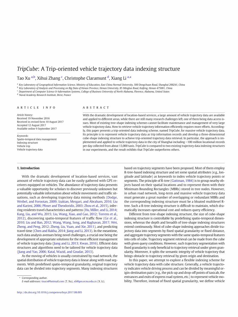
named TripCube. As shown in Eq. (6), TripCube denotes the proposedindexing structure including a vts set (VT) and a cube structure (ℂ).
TripCube ¼ bVT;ℂN ð6Þ
TripCube is a trip-oriented two level indexing structure including atrip level and a cube level. The trip level is a vts set (VT), and the cubelevel is a three dimensional cube structure (ℂ) which consists of one or-igin dimension ðOÞ, one destination dimensionðDÞ, and one timedimen-sion ðTÞ . By recognizing vehicle trajectory series from origin todestination in road network, trip information are organized by vts andraw vehicle trajectory data set (ℙ) can be indexed by the vts set (VT).Moreover, TripCube employs index pointer (gw) to mark the locationof vts inVT and these pointers are stored in specific cells of ℂwith con-straint conditions of origin, destination, and departure time.
By integrating Algorithms 1 and 2, TripCube initialization, as shown inAlgorithm3, creates the vts set (VT) and the cube indexing structure (ℂ),and inserts all vts and its pointers (gw) into them, respectively. The inputsof Algorithm 3 are the raw vehicle trajectory data set (ℙ), the predefinedorigin and destination set (ODs), and the time granularity (tg). The out-put is the complete TripCube. Inheriting fromAlgorithm 2, the time com-plexity of Algorithm 3 is also Ο(n3), and its running time is directlyrelated to the size of ℂ.
Algorithm 3. TripCube initialization (ℙ, ODs, tg).
In addition, TripCube has good scalability for the continuously in-creasing raw vehicle trajectory data. Theoretically, the structure ofTripCube is extensible, and its volume is only limited by memory capac-ity. Therefore, for trajectory data newly added in ℙ, ℂ needs to be ex-panded to create more cells, and new vts and its pointer g aregenerated to update VT and ℂ.
To create TripCube, all vehicle trip information and trip index pointersare sorted in TripCubewith the form of vts and pointer (gw), and TripCubeis ready for retrieval. A schematic overview of TripCube is shown in Fig. 1.The retrieval process is divided into three steps. First, based on queryconditions (oi,dj,ts,te), read pointer gw in cijk fromcube structureℂdirect-ly; then, fetch vts from VT; finally, use s and num to extract trajectorysample points from ℙ, and then integrate trip information and samplepoints to answer trip-oriented vehicle trajectory retrieval.
Based on Fig. 1, trip-oriented queries can be answered with the algo-rithm of trip retrieval shown in Algorithm 4. The inputs of Algorithm 4are retrieval conditions, i.e. the ith entrance (oi), the jth exit (dj), and
departure time range [ts, te). The outputs are the retrieval results, i.e.trip information set, named TRIP, and corresponding vehicle trajectoryseries set, named TRAJ. First, generate retrieved cells set Cs from ts,te,and tg (line 1). Then, traverse every pointer gw of every cell of Cs to ex-tract trip information TRIP from VT and extract sample points TRAJ fromℙ (line 2 to 11).
Algorithm 4. TripCube retrieval (oi,dj,ts,te).
Theoretically, as long as tg is short enough, the volume of cijkwill be 1and the time complexity of Algorithm 4will beΟ(n×m). n is the numberof cells of Cs, and m is the number of pointer of cell. It indicates that theretrieval performance of TripCube is directly related to the span of query
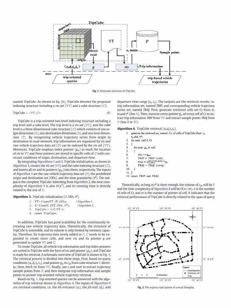
Fig. 2. The express road system of central Shanghai.
Fig. 1. Schematic overview of TripCube.

time and the number of cells of TripCube. However, with the space com-plexityΟ(n3), such tg is unacceptable and unfeasible because of a dramat-ic increase in the volume of ℂ and limited memory usage. Moreover,same to Algorithm 2, the space complexity of Algorithm 4 is Ο(n3).
The main idea of the TripCube is to generate and maintain the three-dimensional index cube (ℂ) and the vts set (VT) to realize the storageand retrieval of trip information from raw vehicle trajectory data. More-over, TripCube is a flexible and extensible data indexing scheme fittingformassive trajectory data,while its volume is limited bymemory capac-ity. Finally, TripCube can achieve good retrieval performance because ituses cube structure and vts set to read trip information and vehicle tra-jectory sample points directly without traversing. Moreover, querybased on specific vehicles is also supported by TripCube. Based on the re-trieval mechanism of TripCube, vehicle information between a specifiedOD pair can be retrieved, where vehicles' identifications (e.g., ID) havebeen included. For example, “how many vehicles passed by this ODpair last month?”, “how many times did the vehicle with vehicle ID‘12345’ travel between this OD pair last year?” and so on.
4. Experiments
4.1. Data
The express road system of Shanghai central city, China, provides thespatial layout of experiments. As shown in Fig. 2, the express road systemcovers about 680 km2 including 240 entrances and 246 exits. The totallength of road segments in the system is about 370 km. We define theentrances and exits as the origins and destinations of vehicle trips anduse them to fill the ODs.
Vehicle trajectory data are from about 13,000 taxies covering the ex-press road system for onemonth. In order to extract specific vehicle tra-jectory data of the express road system, map matching of vehicle
trajectory data has been previously performed (Li, Li, Tang, and Xu, X.,2010). Each sample point of vehicle trajectory consists of vehicle ID,timestamp, longitude, latitude, speed, and matched location in the ex-press road system. The average sampling rate of records is 0.1 Hz, andthe average number of records is about 14 million per day.
4.2. Implementation
All experiments are conducted with a computer equipped with Inteli5, 3.4 GHz CPU, 4GB RAM, and Windows 10 64-bit operation system.
As mentioned in Section 4.1, ℙ is a set of locational sample pointsmatched on road segments. It is a continuously growing dataset, withvery large amount of taxi trajectory data streaming into it per day. Partofℙ (30days) fromApril 1, 2015 to April 30, 2015 is used in the followingexperiments. In addition, to avoid the interference from commercial da-tabase inherent indexing structures, ℙ is stored in a hard drive as textfiles. The total capacity of ℙ file is about 12.9 GB, and the number of loca-tional sample points is about 500 million.
To generate TripCube, its size is confirmed first. Because of the dailyperiodicity change of taxi services, one whole day is a proper time gran-ularity forTof TripCube, andT ¼ ftijApril 1;2015≤ti ≤April 30;2015; 1≤i≤30g. Moreover, the origins and destinations of vehicle trip are suppliedby the entrances and exits of the express road system, whereO ¼ foij 1≤ i≤240g,D ¼ fdij 1≤ i≤246g. Therefore, the size of TripCube used for thefollowing experiments is about 1.77million (30×240×246=1771200).
4.3. Performance of TripCube
Based on the given tg (one whole day) and the raw vehicle trajectorydata set ℙ, Algorithm 3 (see Section 4.4) generates VT from ℙ, creates ablank cube structure ℂ, and stores each index pointer gw into ℂ. Fig. 3shows the time consumption of TripCube initialization. The vertical axisrepresents running time (unit: seconds), while the horizontal axis
Fig. 6. The relationship between time granularity (tg) and retrieval time.
Fig. 5. Retrieval time of TripCube.
Fig. 4. Storage space of TripCube.
Fig. 3. Time for generating TripCube.

represents the number of vehicle trajectory sample points (unit: mil-lions). Black points are the time of TripCube initialization. It is observedthat the trend of initialization time is linear, and the formula of trendline is y=0.6163x, which indicates the time of TripCube initialization isdirectly related to the volume of ℙ and about 0.6163 s permillion samplepoints.
Fig. 4 shows the storage space of TripCube with different data vol-umes. It takes about 0.52 MB storage space for each million samplepoints, and the blank cube structure (ℂ) occupies about 10 MB storagespace.When the number of sample points is about 500million, the num-ber of vehicle trips inVT is 2,848,289, and the number of cells in the cubestructure (ℂ) is about 1,771,200.
With query conditions (origin, destination, and departure timerange), vehicle trip information and trajectory sample points are re-trieved by Algorithm 4. The time consumption is given in Fig. 5. Retrievaltime is changing in a near linear fashion. It takes about 19.09 s permillionsample points.
Since the size ofℂ in TripCube is variedwith time granularity (tg) andthenumber of entrances and exits, the relationship between the size ofℂand retrieval performance is explored.
Fig. 6 illustrates the relationship between time granularity (tg) (from6 to 720 h) and retrieval time. Black points represent consuming timefor retrieving threemillions sample points and corresponding trip infor-mationwith random retrieval conditions. Gray points represent the sizeof ℂwith different time granularity (tg). The trend of retrieval time canbe divided into three stages. The first stage has smaller tg in 6 or 12 h.With the increase of tg, the size of ℂ becomes smaller and the retrievaltime is reduced slowly. It means smaller tg produces larger cube struc-ture (ℂ) and larger retrieved cell set Cs (see Algorithm 4) for massivetrajectory data retrieval. Therefore, smaller tg (6 or 12 h) leads to largeroverhead for cell operation. The second stage hasmoderate tg from24 to144 h (6 days) and has the best retrieval performance than other stages.The third stage has larger tg from 240 (10 days) to 720 h (30 days). Thelarger tg reduces the number of cells of ℂ and increases the volume ofcells, which leads to the increase of the time to traverse pointers of vtsin cells. Especially, when tg is 720 h, all pointers of vts in each entranceexit pair are stored in one cell, andℂ degenerates into a two-dimension-al structure. Only specific vtswith departure time range [ts, te) can be ob-tained by traversing all time pointers with oi and dj. The retrieval time ismaximum and 121 s. As a result, we suggest that a moderate tg is neces-sary for high performance TripCube.
Fig. 7 shows the relationship between the number of origin-destina-tion pairs and retrieval time. Similar with Fig. 6, black points representconsuming time for retrieving three millions sample points and corre-sponding trip information with 24-hour granularity tg and random re-trieval conditions. Gray points represent the size of ℂ with sevenorders of magnitude of entrance-exit pairs. With the increase of thenumber of entrance-exit pairs, the size of ℂ becomes larger, and the re-trieval time is stationary on about 54 s. It indicates that the spatial distri-bution of vehicle trajectory data (the number of entrance-exit pairs)does not affect the retrieval performance of TripCube if the storagespace is sufficient to operate TripCube.
4.4. Comparative analysis
In view of the application targets ofmanaging andmaintaining vehi-cle trajectory data, TripCube takes vehicle trip as a unit to create vts, anduses origin, destination, and departure time to index trip informationand vehicle trajectory sample points. To evaluate the performance ofTripCube, two of trajectory data indexing schemes based on trajectorysegments are employed, and comparative analysis between TripCubeand them are made. They are proposed by Brakatsoulas et al. (2004),named Brakatsoulas method, and Leonardi et al. (2014), named Leonardimethod, respectively.
Brakatsoulas method is a scheme of managing vehicle trajectory data,in which, vehicle trajectory is divided into trajectory segments to storeand index. A trajectory segment corresponds to an edge of road networkand is defined as Eq. (7), where ts represents trajectory segments,trajectory_id and edge_id are the identification of vehicle trajectory andthe edge of road network, time1 and time2 are the time vehicle entersthe edge and leaves the edge. The initialization of Brakatsoulas methodis to create the set of ts from ℙ and to store it as table using Oracle™ 11DBMS suite with B-tree index on edge_id, time1, and time2. Trip informa-tion retrievalwith Brakatsoulasmethod is to traverse the table of tswith agiven route anddeparture time range to get a set of ts, and then, integratets with the same trajectory_id to generate output results, i.e. vehicle tripinformation and trajectory data.
ts ¼ trajectory id; edge id; time1; time2f g ð7Þ
Similar to Brakatsoulas method, Leonardi method treats vehicle trajec-tory as a series of trajectory segments to build a framework for modelingtrajectory data. The difference is that Leonardi method defines a flexiblespatio-temporal granularity and hierarchies, and decomposes a com-plete trajectory into trajectory segments with designated spatio-tempo-ral granularity. Then, set the edge of road network as the spatialgranularity and 24 h as the temporal granularity to model ℙ. The initial-ization of Leonardimethod is to create four tables usingOracle™ 11DBMSsuite. They are: POINT_T storing raw sample points, SPACIAL_T storingthe position of each trajectory segment in POINT_T and indexed by spa-tial granularity (the edge of the express road system), TEMPORAL _Tstoring the position of each trajectory segment in POINT_T and indexedby the temporal granularity (24 h), and FACT_T storing trajectory seg-ment information (e.g. start time, end time, speed, etc.). With respectto a given route and departure time range, trip information retrievalwith Leonardi method is to traverse SPACIAL_T and TEMPORAL_T to getthe set of trajectory segments, and then, generates trip informationfrom FACT_T and integrates vehicle trajectory from POINT_T.
Table 1Features of the three indexing approaches.
Scheme Indexed object Indexed domain Retrieval conditions
TripCube Trajectory segments of multiple edges Space and time Origin, destination, and departure time.Brakatsoulas method Trajectory segments of one edge Space Route and departure timeLeonardi method Trajectory segments of one edge Space and time Route and departure time
Fig. 7. The relationship between the number of entrances and exits and retrieval time.

Features of the three indexing approaches are given in Table 1. Com-parisons aremade from three perspectives, i.e. generation, storage space,and trip retrieval.
• Generation
Fig. 8 demonstrates the comparison results of generation time.Brakatsoulas method needs to split a vehicle trajectory to edge-based tra-jectory segments with B-tree index in edge_id, time1, and time2 (see Eq.7). Leonardi method uses spatio-temporal granularity to generate trajec-tory segments from ℙ and extracts trajectory segment information to fillFACT_T. TripCube creates a vts set (VT) and a cube structure (ℂ). As indi-cated in Fig. 8, the generation time of TripCube is the shortest. Note thatBrakatsoulas method and Leonardi method are based on Oracle™ 11DBMS. Additional time consumption caused by Oracle's own mechanicshas been eliminated (e.g. time consumption of creating table space, cre-ating data file, etc.). Time values of the two methods shown in Fig. 8 areactual generation time (including CPU time, and I/O time, etc.).
• Storage space
Comparison results of storage space are given in Fig. 9. Note that thestorage space involved in the comparison does not include the storagespace of raw trajectory sample points. Brakatsoulasmethod and Leonardimethod store raw vehicle trajectory data as tables in Oracle, and ℙ ofTripCube are text files. Brakatsoulas method takes the largest space tostore B-tree structure on trajectory segments. Leonardi method needs738 MB to create three tables to index trajectory segments. TripCube'sstorage space is the smallest than others.
• Trip retrieval
As shown in Table 1, retrieval conditions of TripCube are the originand destination of a trip, and departure time,whereasBrakatsoulasmeth-od and Leonardi method are the route of a trip and departure time. As
indicated in Fig. 10, thousands of vehicle trips are retrieved, TripCube isthe best than others. Furthermore, the retrieval time of TripCube in-creases much less slowly with the increase of the number of trips thanBrakatsoulas method and Leonardi method. This is because TripCube candirectly read trip information,whereas Brakatsoulasmethod and Leonardimethod need to decompose the route to the edges set, search trajectorysegments of each edge, and then, compose trajectory segments to gener-ate trip information.
5. Discussion and conclusion
This paper introduces a novel indexing structure, TripCube, to main-tain and retrieve very large vehicle trajectory data. TripCube uses athree-dimensional cube structure and a vts set to initialize and index ve-hicle trajectory data. Efficient vehicle trip retrieval can be achieved byspecific query conditions including origin, destination, and departuretime range. The proposed approach is applied to a large vehicle trajectorysample points set covering Shanghai express road system. A series of ex-periments are conducted to evaluate the performance of TripCube. Twoother existing approaches are implemented and compared to the pro-posed one. According to the comparison results, TripCube outperformsothers in terms of generation, storage space, and trip retrieval.
When applying it to vehicle trajectory data, TripCubemakes it possi-ble to analyze traffic volumes and commuting patterns between anypair of origin and destination in large-scale road networks. Future ef-forts will be made in the following three directions. First, the spatio-temporal scalability of TripCube will be examined with larger datasets.Second, the size of three-dimensional cube cannot grow unlimitedly;as such, a partitioned indexmay be an alternative. Third, the fundamen-tal structure of TripCube may be revisited to explore the possibility offurther improving its performance.
Acknowledgments
This research was sponsored by the National Natural Science Foun-dations of China (Grant No.41271441 and 41771410). The authors alsowould like to show their gratitude to editor and anonymous reviewersfor their constructive comments that greatly improved the manuscript.
References
Anandhakumar, P., Priyadarshini, J., Monisha, C., Sugirtha, K., & Raghavan, S. (2010). Loca-tion based hybrid indexing structure— R k-d tree. Proceedings of the first internationalconference on integrated intelligent computing, 140–145.
Beckmann, N. (1990). The R*-tree: An efficient and robust access method for points andrectangles. SIGMOD Record (ACM Special Interest Group on Management of Data),19(2), 322–331.
Berchtold, S., Keim, D. A., & Kriegel, H. -P. (1996). The X-tree: An indexing structure forhigh-dimensional data. Proceedings of the 22th international conference on very largedata bases (pp. 28–39).
Brakatsoulas, S., Pfoser, D., & Tryfona, N. (2004). Modeling, storing andminingmoving ob-ject databases. Proceedings of the 2004 engineering and applications symposium(pp. 68–77).
Fig. 10. Trip retrieval comparisons.
Fig. 9. Storage space comparison.
Fig. 8. Generation time comparison.

Cao, G., Wang, S., Hwang, M., Padmanabhan, A., Zhang, Z., & Soltani, K. (2015). A scalableframework for spatiotemporal analysis of location-based social media data. ComputEnviron Urban Syst, 51, 70–82.
Chen, H., & Rakha, H. A. (2014). Real-time travel time prediction using particle filteringwith a non-explicit state-transition model (Part 1, Special Issue on Short-term TrafficFlow Forecasting). Transportation Research Part C: Emerging Technologies, 43, 112–126.
Dai, J., Yang, B., Guo, C., & Ding, Z. (2015). Personalized route recommendation using bigtrajectory data. IEEE, International Conference on Data Engineering, 543–554.
Dodge, S., Weibel, R., & Forootan, E. (2009). Revealing the physics of movement: Compar-ing the similarity of movement characteristics of different types of moving objects.Comput Environ Urban Syst, 33(6), 419–434.
Fang, Y., Cao, J., Wang, J., Peng, Y., & Song, W. (2012). HTPR*-Tree: An efficient index formoving objects to support predictive query and partial history query. Internationalconference on web-age information management. Vol.7142. (pp. 26–39).
Ge, Y., Xiong, H., Tuzhilin, A., Xiao, K., Gruteser, M., & Pazzani, M. (2010). An energy-effi-cient mobile recommender system. Proceedings of the 16th ACM SIGKDD InternationalConference on Knowledge Discovery and Data Mining (pp. 899–908).
Guttman, A. (1984). R-trees: A dynamic indexing structure for spatial searching. ACMSIGMOD Rec, 14(2), 47–57.
Hu, Y., Miller, H. J., & Li, X. (2014). Detecting and analyzingmobility hotspots using surfacenetworks. Trans GIS, 18(6), 911–935.
Izakian, Z., Mesgari, M. S., & Abraham, A. (2016). Automated clustering of trajectory datausing a particle swarm optimization. Comput Environ Urban Syst, 55, 55–65.
Jiang, B., & Yao, X. (2006). Location-based services and gis in perspective. Comput EnvironUrban Syst, 30(6), 712–725.
Jiang, Y., & Li, X. (2013). Travel time prediction based on historical trajectory data. Ann GIS,19(1), 27–35.
Kang, C., Liu, Y., & Wu, L. (2015). Delineating Intra-urban spatial connectivity patterns bytravel-activities: a case study of Beijing, China. Proceedings of the 23th InternationalConference on GeoInformatics (pp. 1–7).
Katal, A., Wazid, M., & Goudar, R. H. (2013). Big data: Issues, challenges, tools and goodpractices. Proceedings of the sixth international conference on contemporary computing(pp. 404–409).
Ke, S., Gong, J., Li, S., Zhu, Q., Liu, X., & Zhang, Y. (2014). A hybrid spatio-temporal dataindexing method for trajectory databases. Sensors, 14(7), 12990–13005.
Kwan, M. -P. (2016). Algorithmic geographies: Big data, algorithmic uncertainty, and theproduction of geographic knowledge. Annals of the American Association ofGeographers, 106(2), 274–282.
Leonardi, L., Marketos, G., Frentzos, E., & Giatrakos, N. (2010). T-Warehouse: Visual OLAPanalysis on trajectory data. International conference on data engineering, ICDE 2010,March 1–6, 2010. Vol.41. (pp. 1141–1144). Long Beach, California, USA: DBLP.
Leonardi, L., Orlando, S., Raffaetà, A., Roncato, A., Silvestri, C., Andrienko, G., et al. (2014). Ageneral framework for trajectory data warehousing and visual olap. GeoInformatica,18(2), 273–312.
Li, X., Li, X., Tang, D., & Xu, X. (2010). Deriving features of traffic flow around an intersectionfrom trajectories of vehicles. International conference on Geoinformatics, 2 (pp. 1–5).
Lins, L., Klosowski, J. T., & Scheidegger, C. (2013). Nanocubes for real-time exploration ofspatiotemporal datasets. IEEE Transactions on Visualization & Computer Graphics,19(12), 2456–2465.
Liu, X., & Ban, Y. (2012). Uncovering urban mobility patterns with massive floating cardata. Comput Environ Urban Syst.
Liu, X., & Karimi, H. A. (2006). Location awareness through trajectory prediction. ComputEnviron Urban Syst, 30(6), 741–756.
Liu, Y., Wang, F., Xiao, Y., & Gao, S. (2012). Urban land uses and traffic ‘source-sink areas’:Evidence from GPS-enabled taxi data in Shanghai. Landsc Urban Plan, 106(1), 73–87.
Masciari, E. (2012). Warehousing and querying trajectory data streams with error estima-tion. Fifteenth international workshop on data warehousing and Olap (pp. 113–120).ACM.
Masciari, E. (2015). An end to end framework for building data cubes over trajectory datastreams. J Intell Inf Syst, 45(2), 1–34.
Nanopoulos, A., Theodoridis, Y., & Manolopoulos, Y. (2006). Indexed-based density biasedsampling for clustering applications. Data Knowl Eng, 57(1), 37–63.
Pelekis, N., & Theodoridis, Y. (2014). Preparing for mobility data exploration.Mobility datamanagement and exploration (pp. 121–141). Springer New York.
Pfoser, D., & Theodoridis, Y. (2003). Generating semantics-based trajectories of movingobjects. Comput Environ Urban Syst, 27(3), 243–263.
Ren, H., Tao, X. U., & Xiang, L. I. (2014). Driving behavior analysis based on trajectory datacollected with vehicle-mounted gps receivers.Wuhan Daxue Xuebao, 39(6), 739–744.
Sellis, T. K., Roussopoulos, N., & Faloutsos, C. (1987). The R+−tree: A dynamic index formulti-dimensional objects. Proceedings of the 13th international conference on verylarge data bases (pp. 507–518).
Sharifzadeh, M., & Shahabi, C. (2010). Vor-tree: R-trees with voronoi diagrams for efficientprocessing of spatial nearest neighbor queries. Proceedings of the Vldb Endowment, 3(1–2), 1231–1242.
Surya Prakash, K. (2014). Data mining and warehousing for temporal data objects. IJRCCT,3(1), 123–127.
Torrens, P. M., Nara, A., Li, X., Zhu, H., Griffin, W. A., & Brown, S. B. (2012). An extensiblesimulation environment and movement metrics for testing walking behavior inagent-based models. Comput Environ Urban Syst, 36(1), 1–17.
Wang, J., Wang, C., Song, X., & Raghavan, V. (2017). Automatic intersection and traffic ruledetection by mining motor-vehicle gps trajectories. Comput Environ Urban Syst, 64,19–29.
Wei, L. -Y., Zheng, Y., & Peng, W. -C. (2012). Constructing popular routes from uncertaintrajectories. Proceedings of the 18th ACM SIGKDD international conference on knowl-edge discovery and data mining (pp. 195–203).
Xu, T., Li, X., & Claramunt, C. (2017). Trip-oriented travel time prediction (TOTTP) with his-torical vehicle trajectories. Front Earth Sci. http://dx.doi.org/10.1007/s11707-016-0634-8.
Xu, T., Xu, X., Hu, Y., & Li, X. (2017). An entropy-based approach for evaluating travel timepredictability based on vehicle trajectory data. Entropy, 19(4), 165.
Xu, X., Han, J., & Lu,W. (1990). RT-tree: An improved R-tree indexing structure for spatio-temporal data. Proceedings of the 4th international symposium on spatial data handling(pp. 1040–1049).
Yiu, M. L., Tao, Y., & Mamoulis, N. (2008). The b, dual, -tree: Indexing moving objects byspace filling curves in the dual space. VLDB J, 17(3), 379–400.
Zheng, Y., Liu, Y., Yuan, J., & Xie, X. (2011). Urban computing with taxicabs. Proceedings ofthe 13th international conference on ubiquitous computing (pp. 89–98).
Zhou, Y., Zhang, Y., Ge, Y., Xue, Z., Fu, Y., Guo, D., et al. (2015). An efficient data processingframework for mining the massive trajectory of moving objects. Comput EnvironUrban Syst, 61, 129–140.
Copyright © 2022 FDOKUMEN