Analysis of tourism concessions models in protected areas in ...
Upload
independentCategory
view
0download
0
1
Institute forDigital Image Processing
W2GISW2GIS20062006
Alexander Almer
JOANNEUM RESEARCHForschungsgesellschaft mbH
A Tourism Information SystemA Tourism Information Systemfor Rural Areasfor Rural Areas
based on a Multi Platform Conceptbased on a Multi Platform Concept
Alexander AlmerAlexander AlmerJoanneum ResearchJoanneum ResearchInstitute Institute forfor Digital Image Digital Image ProcessingProcessing
W2GISW2GISDecDec. 4. 4--5, 20065, 2006
HongHong KongKong, China, China

2
Institute forDigital Image Processing
W2GISW2GIS20062006
Alexander Almer
Content
IntroductionIntroduction
Technical ConceptTechnical Concept
GeoGeo--multimedia multimedia InformationsystemInformationsystem
Data ManagementData Management
Visualisation technologies and platformsVisualisation technologies and platforms
Conclusion Conclusion -- outlookoutlook

3
Institute forDigital Image Processing
W2GISW2GIS20062006
Alexander Almer
Geo-Information and TourismAnalogueAnalogue MapsMapsHiking Map Scale 1:50.000
& digital Media& digital Media

4
Institute forDigital Image Processing
W2GISW2GIS20062006
Alexander Almer
Requirements for „GIS“ in Tourism
● Easy to use data management● Thematic oriented data management● Flexible adaptation to different areas and themes● Data management for geo data as well as
multimedia data● Easy access to information for the end user● Open interfaces to existing tourism
information systems ● Providing data on different
presentation platforms● Interactive geo-visualisation● Thematical and geographical
data access for the end user

5
Institute forDigital Image Processing
W2GISW2GIS20062006
Alexander Almer
Tourism Information Management
GeoGeo--TISTISManagementManagement
InfosysCollection
AnalysisCRM
Back-Office
Mobile Applications
Navigation Services LBS …
Linked Platforms
eCards Themes KM …
MM…Event
WebSolutions
2D/3D

6
Institute forDigital Image Processing
W2GISW2GIS20062006
Alexander Almer
System Overview
PresentationsPresentations
Data ManagementData Management
GeoGeo--multimediamultimedia InformationsystemInformationsystem

7
Institute forDigital Image Processing
W2GISW2GIS20062006
Alexander Almer
System Overview
PresentationsPresentations
Plat-forms
WMS WFS
Mobile DevicesPDA, GPS,
Smartphone
Info Terminals
DVD
MultimediaWeb
Applikation
GeoGeo--multimediamultimedia InformationsystemInformationsystem
Data ManagementData Management

8
Institute forDigital Image Processing
W2GISW2GIS20062006
Alexander Almer
System Overview
PresentationsPresentations
Plat-forms
WMS WFS
Mobile DevicesPDA, GPS,
Smartphone
Info Terminals
DVD
MultimediaWeb
Application
WebServicesPacket GeneratorCustom Interfaces
etc.GeoGeo--multimediamultimedia InformationsystemInformationsystem
WMSWFS
ExternalDB
Geo-multimediaDatabase
Tourism Information
OGC
DataData ManagementManagement

9
Institute forDigital Image Processing
W2GISW2GIS20062006
Alexander Almer
System Overview
Data Management ToolTextsImagesMoviesVoiceetc.
Aerial ImagesSat ImagesDigital Maps
etc.PDA GPS
Data ManagementData Management
WebServicesPacket GeneratorCustom Interfaces
etc.GeoGeo--multimediamultimedia InformationsystemInformationsystem
WMSWFS
ExterneDB
Geo-multimediaDatabase
Tourism Information
PresentationsPresentations
Plat-forms
WMS WFS
Mobile DevicesPDA, GPS,
Smartphone
Info Terminals
DVD
MultimediaWeb
Application
OGC

10
Institute forDigital Image Processing
W2GISW2GIS20062006
Alexander Almer
Data Management ToolTextsImagesMoviesVoiceetc.
Aerial ImagesSat ImagesDigital Maps
etc.PDA GPS
Data ManagementData Management
WebServicesPacket GeneratorCustom Interfaces
etc.GeoGeo--multimediamultimedia InformationsystemInformationsystem
WMSWFS
ExterneDB
Geo-multimediaDatabase
Tourism Information
PresentationsPresentations
Plat-forms
WMS WFS
Mobile DevicesPDA, GPS,
Smartphone
Info Terminals
DVD
MultimediaWeb
Application
OGC
Geo-multimedia Informationsystem

11
Institute forDigital Image Processing
W2GISW2GIS20062006
Alexander Almer
● Interfaces to external databasesWebServices
Packet GeneratorCustom interfaces
WMS - WFS
Core Components● Geo-multimedia database
Geo-multimedia Informationsystem
PostGIS
WebServicesPackage GeneratorCustom Interfaces
WMSWFS

12
Institute forDigital Image Processing
W2GISW2GIS20062006
Alexander Almer
Data Management ToolTextsImagesMoviesVoiceetc.
Aerial ImagesSat ImagesDigital Maps
etc.PDA GPS
Data ManagementData Management
WebServicesPacket GeneratorCustom Interfaces
etc.GeoGeo--multimediamultimedia InformationsystemInformationsystem
WMSWFS
ExterneDB
Geo-multimediaDatabase
Tourism Information
PresentationsPresentations
Plat-forms
WMS WFS
Mobile DevicesPDA, GPS,
Smartphone
Info Terminals
DVD
MultimediaWeb
Application
OGC
Data Management

13
Institute forDigital Image Processing
W2GISW2GIS20062006
Alexander Almer
Data Management I
Core Features● User-friendly and intuitive GUI● Central PostGIS database and decentral clients
Modules:● 1. Data import (GPS, PDA)● 2. Geo-data manipulation ● 3. Multimedia data manipulation ● 4. Export
Generation of „data packages“ for DVDs, mobile devicesExport to external platforms – e.g. hiking-, biking-, accommodation-, booking platforms

14
Institute forDigital Image Processing
W2GISW2GIS20062006
Alexander Almer
Data Management II

15
Institute forDigital Image Processing
W2GISW2GIS20062006
Alexander Almer
Presentations
Data Management ToolTextsImagesMoviesVoiceetc.
Aerial ImagesSat ImagesDigital Maps
etc.UMPC PDA
GPSData ManagementData Management
WebServicesPacket GeneratorCustom Interfaces
etc.GeoGeo--multimediamultimedia InformationsystemInformationsystem
WMSWFS
ExterneDB
Geo-multimediaDatabase
Tourism Information
PresentationsPresentations
Platt-forms
WMS WFS
Mobile DevicesPDA, GPS,
Smartphone
Info Terminals
DVD
MultimediaWeb
Application
OGC

16
Institute forDigital Image Processing
W2GISW2GIS20062006
Alexander Almer
Online Solution
Features● Selection of tourism themes
● Geographic and theme based approach
● Geographic data visualisationInteractive 2D/3D presentationDigital map presentationAerial and satellite images
● Multimedia presentationTextual descriptionsImagesMovies
● Download of GPS-Tracks

17
Institute forDigital Image Processing
W2GISW2GIS20062006
Alexander Almer
2D Presentation
● JR - 2D presentation
● Google Maps

18
Institute forDigital Image Processing
W2GISW2GIS20062006
Alexander Almer
3D Presentation● Google Earth
Satellite imagesDigital mapsLimited GUI customisationNo regional / local restrictations
● Shockwave 3DSatellite imagesDigital mapsProject related GUIcustomisationRegional/localgeographical solution
19
Institute forDigital Image Processing
W2GISW2GIS20062006
Alexander Almer
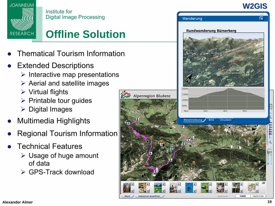
Offline Solution● Thematical Tourism Information● Extended Descriptions
Interactive map presentationsAerial and satellite imagesVirtual flightsPrintable tour guidesDigital Images
● Multimedia Highlights● Regional Tourism Information
● Technical FeaturesUsage of huge amount of dataGPS-Track download

20
Institute forDigital Image Processing
W2GISW2GIS20062006
Alexander Almer
Mobile Solution I
Fields of application:● Data presentation● Data acquisition (end user)
Features:● Request information based on the
current position - e.g. infrastructure
● Theme based presentationBiking, hiking, etc.2D- and 3D-mapsTexts, images, voice, videos
● Individual recording of tours
● Digital Diary

21
Institute forDigital Image Processing
W2GISW2GIS20062006
Alexander Almer
Mobile Solution II
Audio
Virtual flights

22
Institute forDigital Image Processing
W2GISW2GIS20062006
Alexander Almer
Conclusion - Outlook
Tourism is an information businessSpatial data allows location based services andconsequently an intelligent data selectionEconomic geo-data management is a major factor for tourism service providersInnovative and sophisticated visitor-serviceData usage for different devices
Next steps:Combination of the mobile solution and the DMT to support the data acquisition for the service provider Community support
Individual data space (web server)Data synchronisation of the digital diary

23
Institute forDigital Image Processing
W2GISW2GIS20062006
Alexander Almer
ThankThank youyou forfor youryour attentionattention

24
Institute forDigital Image Processing
W2GISW2GIS20062006
Alexander Almer
Contact
JOANNEUM RESEARCH ForschungsgesellschaftInstitute for Digital Imageprocessing
Wastiangasse 6, 8010 Graz, Austria
DI Alexander [email protected].: ++43 / 316 876 1738Fax: ++43 / 316 876 1720E-Fax: ++43 / 316 876 91738Mobil: ++43 / 699 1876 1738

25
Institute forDigital Image Processing
W2GISW2GIS20062006
Alexander Almer
Forschungsgesellschaft Joanneum ResearchInstitut für Digitale BildverarbeitungDI Alexander AlmerWastiangasse 6; 8010 Graz, AustriaEmail: [email protected]: www.joanneum.ac.atPhone: ++43 / 316 876 1738Fax: ++43 / 316 876 1720E-Fax: ++43 / 316 876 91738
Kontakt
Copyright © 2022 FDOKUMEN