A Study of 3D Digitisation Modalities for Crime Scene ... - MDPI
30
Article A Study of 3D Digitisation Modalities for Crime Scene Investigation George Galanakis 1, * , Xenophon Zabulis 1 , Theodore Evdaimon 1 , Sven-Eric Fikenscher 2 , Sebastian Allertseder 2 , Theodora Tsikrika 3 and Stefanos Vrochidis 3 Citation: Galanakis, G.; Zabulis, X.; Evdaimon, T.; Fikenscher, S.-E.; Allertseder, S.; Tsikrika, T.; Vrochidis S. A Study of 3D Digitisation Modalities for Crime Scene Investigation. Forensic. Sci. 2021, 1, 56–85. https://doi.org/10.3390/ forensicsci1020008 Academic Editor: Mary Aiken Received: 31 May 2021 Accepted: 27 July 2021 Published: 30 July 2021 Publisher’s Note: MDPI stays neutral with regard to jurisdictional claims in published maps and institutional affil- iations. Copyright: © 2021 by the authors. Licensee MDPI, Basel, Switzerland. This article is an open access article distributed under the terms and conditions of the Creative Commons Attribution (CC BY) license (https:// creativecommons.org/licenses/by/ 4.0/). 1 Foundation for Research and Technology Hellas, Institute of Computer Science, N. Plastira 100, Vassilika Vouton, 70013 Heraklion, Greece; [email protected] (X.Z.); [email protected] (T.E.) 2 Hochschule für den öffentlichen Dienst in Bayern, Fachbereich Polizei, Fürstenfelder Str. 29, 82256 Fürstenfeldbruck, Germany; [email protected] (S.-E.F.); [email protected] (S.A.) 3 Centre of Research and Technology Hellas, Information Technologies Institute, 6th km Harilaou-Thermi, 57001 Thessaloniki, Greece; [email protected] (T.T.); [email protected] (S.V.) * Correspondence: [email protected] Abstract: A valuable aspect during crime scene investigation is the digital documentation of the scene. Traditional means of documentation include photography and in situ measurements from experts for further analysis. Although 3D reconstruction of pertinent scenes has already been explored as a complementary tool in investigation pipelines, such technology is considered unfamiliar and not yet widely adopted. This is explained by the expensive and specialised digitisation equipment that is available so far. However, the emergence of high-precision but low-cost devices capable of scanning scenes or objects in 3D has been proven as a reliable alternative to their counterparts. This paper summarises and analyses the state-of-the-art technologies in scene documentation using 3D digitisation and assesses the usefulness in typical police-related situations and the forensics domain in general. We present the methodology for acquiring data for 3D reconstruction of various types of scenes. Emphasis is placed on the applicability of each technique in a wide range of situations, ranging in type and size. The application of each reconstruction method is considered in this context and compared with respect to additional constraints, such as time availability and simplicity of operation of the corresponding scanning modality. To further support our findings, we release a multi-modal dataset obtained from a hypothetical indoor crime scene to the public. Keywords: 3D reconstruction; 3D digitisation; crime scene investigation; digital forensics; LIDAR; laser scanning; photogrammetry 1. Introduction A crime scene is considered as any location that may be associated with an offence that has been committed and where forensic evidence may be gathered. This work presents 3D digitisation approaches related to the aforementioned scenes but also considers crime prevention planning and education of LEAs to address possible security threats in both indoor and outdoor. In this work, we refer to all of these locations simply as scenes and investigate the appropriate digitisation tools for each type of use-case. The digitisation, or 3D reconstruction of a scene, can be categorised into three types of use-cases , which are as follows. 1. The prevention and study of a scene prior to and during an event; 2. Analysis and documentation of a scene after an event; 3. THe provision of 3D content in educational simulations that are based on Extended Reality technologies (i.e., Virtual Reality). Digitisation is facilitated by numerous technologies that are available nowadays. However, each technology with its elements exhibiting varying compliance, depending on Forensic. Sci. 2021, 1, 56–85. https://doi.org/10.3390/forensicsci1020008 https://www.mdpi.com/journal/forensicsci
-
Upload
khangminh22 -
Category
Documents
-
view
3 -
download
0
Transcript of A Study of 3D Digitisation Modalities for Crime Scene ... - MDPI
Article
A Study of 3D Digitisation Modalities for CrimeScene Investigation
George Galanakis 1,* , Xenophon Zabulis 1 , Theodore Evdaimon 1 , Sven-Eric Fikenscher 2,Sebastian Allertseder 2 , Theodora Tsikrika 3 and Stefanos Vrochidis 3
�����������������
Citation: Galanakis, G.; Zabulis, X.;
Evdaimon, T.; Fikenscher, S.-E.;
Allertseder, S.; Tsikrika, T.; Vrochidis
S. A Study of 3D Digitisation
Modalities for Crime Scene
Investigation. Forensic. Sci. 2021, 1,
56–85. https://doi.org/10.3390/
forensicsci1020008
Academic Editor: Mary Aiken
Received: 31 May 2021
Accepted: 27 July 2021
Published: 30 July 2021
Publisher’s Note: MDPI stays neutral
with regard to jurisdictional claims in
published maps and institutional affil-
iations.
Copyright: © 2021 by the authors.
Licensee MDPI, Basel, Switzerland.
This article is an open access article
distributed under the terms and
conditions of the Creative Commons
Attribution (CC BY) license (https://
creativecommons.org/licenses/by/
4.0/).
1 Foundation for Research and Technology Hellas, Institute of Computer Science, N. Plastira 100,Vassilika Vouton, 70013 Heraklion, Greece; [email protected] (X.Z.); [email protected] (T.E.)
2 Hochschule für den öffentlichen Dienst in Bayern, Fachbereich Polizei, Fürstenfelder Str. 29,82256 Fürstenfeldbruck, Germany; [email protected] (S.-E.F.);[email protected] (S.A.)
3 Centre of Research and Technology Hellas, Information Technologies Institute, 6th km Harilaou-Thermi,57001 Thessaloniki, Greece; [email protected] (T.T.); [email protected] (S.V.)
* Correspondence: [email protected]
Abstract: A valuable aspect during crime scene investigation is the digital documentation of the scene.Traditional means of documentation include photography and in situ measurements from expertsfor further analysis. Although 3D reconstruction of pertinent scenes has already been exploredas a complementary tool in investigation pipelines, such technology is considered unfamiliar andnot yet widely adopted. This is explained by the expensive and specialised digitisation equipmentthat is available so far. However, the emergence of high-precision but low-cost devices capable ofscanning scenes or objects in 3D has been proven as a reliable alternative to their counterparts. Thispaper summarises and analyses the state-of-the-art technologies in scene documentation using 3Ddigitisation and assesses the usefulness in typical police-related situations and the forensics domainin general. We present the methodology for acquiring data for 3D reconstruction of various typesof scenes. Emphasis is placed on the applicability of each technique in a wide range of situations,ranging in type and size. The application of each reconstruction method is considered in this contextand compared with respect to additional constraints, such as time availability and simplicity ofoperation of the corresponding scanning modality. To further support our findings, we release amulti-modal dataset obtained from a hypothetical indoor crime scene to the public.
Keywords: 3D reconstruction; 3D digitisation; crime scene investigation; digital forensics; LIDAR;laser scanning; photogrammetry
1. Introduction
A crime scene is considered as any location that may be associated with an offencethat has been committed and where forensic evidence may be gathered. This work presents3D digitisation approaches related to the aforementioned scenes but also considers crimeprevention planning and education of LEAs to address possible security threats in bothindoor and outdoor. In this work, we refer to all of these locations simply as scenes andinvestigate the appropriate digitisation tools for each type of use-case.
The digitisation, or 3D reconstruction of a scene, can be categorised into three types ofuse-cases , which are as follows.
1. The prevention and study of a scene prior to and during an event;2. Analysis and documentation of a scene after an event;3. THe provision of 3D content in educational simulations that are based on Extended
Reality technologies (i.e., Virtual Reality).
Digitisation is facilitated by numerous technologies that are available nowadays.However, each technology with its elements exhibiting varying compliance, depending on
Forensic. Sci. 2021, 1, 56–85. https://doi.org/10.3390/forensicsci1020008 https://www.mdpi.com/journal/forensicsci
Forensic. Sci. 2021, 1 57
a variety of applicability factors. In this investigation, we take into consideration multipleof them, including (a) technical constraints, (b) ease of use, (c) level of automation, (d) costand (e) time duration of the scan.
Taking advantage of all such technologies is of great importance for the documentationof the physical contents of the scene. The 3D reconstruction component of the documenta-tion is to facilitate the LEA’s work with the organisation of data from multiple scanningmodalities and the provision of the ability to inspect these data with ease.
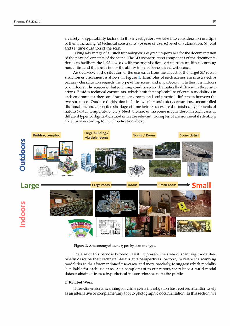
An overview of the situation of the use-cases from the aspect of the target 3D recon-struction environment is shown in Figure 1. Examples of such scenes are illustrated. Aprimary classification regards the type of the scene, and in particular, whether it is indoorsor outdoors. The reason is that scanning conditions are dramatically different in these situ-ations. Besides technical constraints, which limit the applicability of certain modalities ineach environment, there are dramatic environmental and practical differences between thetwo situations. Outdoor digitisation includes weather and safety constraints, uncontrolledillumination, and a possible shortage of time before traces are diminished by elements ofnature (water, temperature, etc.). Next, the size of the scene is considered in each case, asdifferent types of digitisation modalities are relevant. Examples of environmental situationsare shown according to the classification above.
Ind
oo
rsO
utd
oo
rs
Large Small
Building complexLarge building /Multiple rooms
Scene / Room Scene detail
Large room Room Small room
Figure 1. A taxonomyof scene types by size and type.
The aim of this work is twofold. First, to present the state of scanning modalities,briefly describe their technical details and perspectives. Second, to relate the scanningmodalities to the aforementioned use-cases, and more precisely, to suggest which modalityis suitable for each use-case. As a complement to our report, we release a multi-modaldataset obtained from a hypothetical indoor crime scene to the public.
2. Related Work
Three-dimensional scanning for crime scene investigation has received attention latelyas an alternative or complementary tool to photographic documentation. In this section, we
Forensic. Sci. 2021, 1 58
present some recent efforts on the topic. We classify the methods according to digitizationtechnology.
Conventional RGB cameras, such as DSLRs, have been employed as indirect mea-surement modalities as the base of photogrammetry methodology in a wide range ofapplications. For example, in [1], the scope of the 3D reconstruction is an entire traffic acci-dent scene. A more specific case is considered in [2], where human skin and a hairbrush arereconstructed to determine if abrasions on the skin are from being hit with the hairbrush.
Direct measurement devices are also popular since they offer comparably more precisereconstructions and faster scanning times. These range from inexpensive RGB-D sensorsto high-end scanners. In [3], a Kinect v2 RGB-D sensor is utilised for reconstructing acrime scene taking part in a small room. Several scans of the room were aligned into asingle 3D mesh and imported along with virtual objects into a scene that was constructedwith the Unity 3D game engine. In other works, 3D scanning is achieved using higher-end devices. In [4], a FARO Focus LS120 scanner is utilised for scanning walls for bloodpattern analysis. In [5], the scope is to document and measure bullet trajectories as they hitdrywall panels from various angles. For this purpose, they utilised a FARO Focus S350.To specify which tool caused a wound, the authors in [6] scanned several household toolsand their corresponding “wounds” on a watermelon as a rough simulation of the humanskin. The objects were scanned using Gom ATOS Compact Scan 5M, a structured-lightscanner. General-purpose 3D scanners are the most adopted ones; however, devices forspecialised tasks do exist. For example, TopMatch-3D, an in-lab scanner specialised forfirearm forensics is utilised in [7].
To compensate for the technical drawbacks, most approaches utilise more than onescanning device/modality, e.g., pairing photogrammetry with laser scanning, or handheldwith terrestrial laser scanning. Such an approach is followed by [8], where the scope isto compare different scanning technologies for a variety of objects of interest, includingfurniture and shoe prints. Their toolset is composed of a handheld structured light device(Go!Scan 50) and two terrestrial laser scanners: Leica P40 and Z + F Imager 5010X. Theoutcome is that the scanning accuracy is related to object properties, such as size andsurface characteristics, and the distance of the scanner from the object. They also report thatthe real accuracy of distance measurements on the scan is much lower than the one declaredby the scanners’ manufacturers. In a more specific domain, the authors in [9] study theutilisation of 3D scanning of fingerprint impressions as encountered on different materialscompared to traditional 2D photography. They utilised two scanners, an inEos X5, whichis a tabletop device, specialised for dental use, and a handheld structured light scanner(Artec Space Spider). Their experiments on fingerprint identification showed that the 3Dmethods outperformed the 2D counterpart and also enabled new domains of fingerprintanalysis, such as finger curvature. In [10], 3D scanning is utilised as an investigation toolfor identifying the source of an explosion, i.e., accidental or malicious and blast dynamicssimulation in general. Three scanning modalities are compared; two low-cost structuredlight devices, a Kinect v1 and a custom large-format DLP, and one expensive laser scanner(FARO Focus3Dx130). The authors stated that low-cost devices for that particular taskare limited and concluded that they would further focus on expensive equipment. Thestudy conducted in [11] considers outdoor crime scene scenarios. Their simulated sceneinvolved vehicles with a varying degree of damage to body parts, including bullet holesin windshields, fenders, doors, etc. For the 3D scanning, they considered both aerialphotogrammetry using 7 UAVs of variable specifications and terrestrial laser scanning(FARO Focus S70). The outcome of their study was that terrestrial scanner resulted inhigher accuracy, more specifically, 2.6 mm versus 33.2 mm as averaged from all the UAVs.UAVs with larger sensors, e.g., 20MP, performed better. Their future work includes anexamination of drones equipped with LIDAR for better comparison to the terrestrial laserscanner. In [12], photogrammetry is combined with post-mortem computed tomography(PMCT) to investigate how a wound was produced by a knife. In particular, the knifeis scanned using photogrammetry and a person’s thorax using photogrammetry and
Forensic. Sci. 2021, 1 59
CT. In [13], a comparative analysis of the accuracy and precision of 3D scanners andphotogrammetric reconstructions was conducted under the scope of forensic incidentscene documentation. Multiple scanners, both terrestrial and close-range, along withphotogrammetric reconstruction are evaluated. The outcome is that photogrammetry iscomparable to laser scanning at close ranges, while at medium and far ranges, terrestriallaser scanners are the most appropriate modality.
In crime scene investigation, a domain of high interest is that of precise examinationof blood patterns. As such, it is also approached using 3D scanning methodologies. In [14],a structured-light device (DotProduct DPI-8) and photogrammetry-based scanning arecompared in this domain. The scans were imported in FARO Zone 3D software for thispurpose. Both modalities proved acceptable for the area of origin of bloodstains, thoughphotogrammetry achieved better precision in cm. We note that the particular structuredlight scanner is employed with a pretty old sensor, similar to Kinect-v1; therefore, lowerprecision was somewhat expected. Blood pattern analysis is also considered in [15], wherea high-end scanner (FARO Focus 3D) is combined with high-resolution photographyprovided by a DSLR. The photos were stitched to the scan using the Faro Zone 3D software.Three experts were asked to conduct manual analysis as a comparison to the analysisin the 3D software. The outcome of the study is that using the 3D software packageaccuracy of the area of origin estimates is improved as compared to manual trigonometricmethods. The authors also state that the 3D scanning approach permits reduced physicalinteraction with blood at a crime scene and less manual work; therefore, it has a positiveimpact on the health and well-being of the practitioners. The authors in [16] developed acustom rig capable of carrying common crime objects to create cast-off blood strains withcontrolled parameters, e.g., constant path, constant area of blood deposition and limitedvariation in the velocity of swing. They scanned the blood patterns using a combinationof high-resolution photography and laser scanning (FARO S350) to analyse trajectories ofbloodstains in FARO Zone 3D software.
Usually, 3D representations of crime scenes are inspected in ordinary monitors, how-ever, the presentation in a virtual reality environment enhances the experience and permitsimmersive interactions. VR itself has been shown as an interesting modality able to en-gage non-experts for crime scene inspections [17,18]. Under these considerations, a lineof works utilised VR in their pipelines. In [19,20], a VR-based system implemented inUnity3D is proposed that allows for a virtual incident scene walk-through. The authors donot utilise specific scanning equipment but state that multimodal scanning is required tocompensate for the drawbacks of each modality. More interestingly, they mention scanningusing Virtobot 2.0 [21], a set of robotic arms capable of high-precision medical scanning.Although such modality is useful for examining internal or external wounds, it is solelyin-lab; therefore, its applicability is limited. In [22], a hypothetical indoor crime scene wasreconstructed using a combination of FARO Focus 3D X 330 and a FARO Freestyle 3Dhandheld scanner. The scene comprised of a common room and an office with a desk inside.A handbag containing a tablet was left on the desk. An experiment was conducted wheresome users acted as suspects; they were asked to follow some steps to steal the tablet. Dur-ing investigation, their responses were measured in terms of a Concealed Information Test(CIT), a measure for lie detection. The outcome of the experiment was that the detectionof concealed recognition increased by over 25% when participants viewed crime items inVR compared to 2D images. In [23], and in contrast to most presented works, a real crimescene is considered. The complete 3D model of the crime scene, covering three rooms,was created by 7 overall laser scans (Faro Focus3D S120), 23 structured light scans (Go!Scan50, Go! Scan20) and high-resolution photography. Structured light scans were usedfor the bodies and the details. Bloodstain pattern analysis was conducted with Faro Zone3D, using high-resolution photos and point clouds as aligned with the help of registrationtargets. Footprint analysis was conducted by a forensic podiatrist in Vxmodel software.Matching injuries to injury-inflicting tools was conducted in Meshlab. VR presentation,
Forensic. Sci. 2021, 1 60
in which operators could measure or take screenshots of the virtual world, was in HTCVIVE Pro.
In most of the above examples, the 3D scanning equipment is discussed solely con-cerning the applicability for several use-cases. However, the most deterrent aspect of suchhigh-quality scanning equipment is their increased cost. In [24], a cost-benefit analysis isconducted, determining which social conditions must hold such that purchasing expen-sive equipment by LEAs is worthwhile. The outline of the analysis is that worthiness ispositively related to the amount of crime in a specific area.
Our review of existing works is not exhaustive but aims to be indicative of theprospects of 3D digitisation as a valuable part of CSI. Most importantly, we presented thata variety of modalities are utilised for a variety of tasks from very broad to very specific.For further reading, we point to some recent insights in the topic [25,26] and some recentsurveys [27,28].
In this work, we aim to present a study on a range of scanning modalities, suitablefor preventive forensics, crime investigation and education of LEAs. We utilised a set ofscanning modalities, larger than any of the aforementioned works and conclude to a set ofguidelines depending on the application.
3. Scanning Modalities
In this work, we consider a variety of scanning modalities. A scanning modality isprimarily described by a sensing technology, i.e., the technology that captures real-worldscenes and objects to corresponding digital assets, and varies from plain web cameras tosophisticated laser scanners. Another key perspective of each modality is its portability,i.e., whether it is stationary, handheld or aerial. The following paragraphs will presentscanning modalities based on these and additional aspects.
3.1. Laser Scanner
A terrestrial laser scanner is a special device suited to scan its surrounding environ-ment by properly emitting laser beams and calculating the distance by taking into accountthe reflected signal. Three-dimensional scanners of this category are manufactured byArtec [29], FARO [30], Leica [31–33] and others [34–37].
The advantage of laser scanning for scanning environments is that it is a very efficient,accurate and robust modality. It provides a direct point measurement on the line of sight ofevery radius within its view sphere at a configurable resolution and an angular breadth ofapproximately 270 degrees of solid angle. Another significant advantage is that each scantakes place automatically and at a reasonable temporal duration (approx. 20 min). Laserscanning has been utilised for over 20 years, and significant experience can be retrievedfrom the literature in the form of guidelines, while a range of software products exists thatfacilitates the registration of partial scans. It is limited by highly absorbent (dark) surfaces,which do not reflect enough sensor radiance for the time-of-flight measurement to succeed.Another limitation is that there is no real-time feedback available; hence, a preparatoryscan is typically required to find the locations that the scanner should be placed.
The main disadvantage of laser scanning is the price of this modality: a reliable unitof medium accuracy (2–3 mm) with a scan range of about 70 m is in the order of EUR30,000. In addition, a reliable unit weighs at least 7–8 kg. Moreover, a laser scanner at theground has no line of sight to the top of a building, which is out of its range. Airbornelaser scanning exists but awaits advances regarding the payload of the laser scanner andflight velocity. Another disadvantage is that occlusions give rise to the requirement ofseveral scans to cover the surfaces of a scene; this is particularly pronounced in indoorenvironments that are usually cluttered with furniture.
The acquired partial scans have to be combined, or registered, at a later stage. Theregistration procedure is not necessarily automatic, particularly for complex environments.To increase automation of the procedure, the placement of markers in the scene is required.

Forensic. Sci. 2021, 1 61
This is essential if high accuracy is required. Depending on the scale and complexity of thescene, full coverage can be very challenging.
In the outdoors, the operation of a laser scanner may be hindered by bright sunlight asit interferes with the radiation emitted from the scanner. Assuming proper water insulation,a laser scanner will not produce results as accurate as its specifications in the presence ofbad weather (rain, haze) because it has been calibrated for single-phase media (air) and nottwo-phase dynamic media.
In general, laser scanning is a very useful tool, particularly in terms of accuracy. Itis especially useful in textureless environments where photogrammetry becomes moretedious or requires or unreliable. It can methodically automate scanning wide areas fromterrestrial viewpoints. As such, it can complement aerial scans and systematise acquisitionof broad spatial environments for the case of mission planning.
A wide range of terrestrial laser scanners are available in the market from manufac-turers that are specialised in this domain. Table 1 presents some existing scanners andsome common characteristics of them. A strict comparison of devices is difficult becausemanufacturers do not report scanning characteristics, such as ranging error/accuracy, in acommon way. For example, ranging error is defined by Faro as “a systematic measurementerror at around 10 m and 25 m”. However, others do not report how they obtained theirmeasurements. In general, a scanner might be better at shorter ranges than another, whilea common property is that the accuracy drops at longer ranges and for different surfaces,such as white vs. black. Detailed comparisons and product lists can be examined inspecialised search engines [38].
Table 1. Terrestrial Laser scanners overview. *: Depends on the model and/or scanning configuration.
Model Min. Distance Max. Distance Ranging Error/Accuracy
Artec Ray 3D Scanner [29] 1 m 110 m <0.70 mm at 15 m
Faro Focus Series M and Series S [30] 0.6 m 70–350 m ±1 mm (model M70), ±1 mm (rest mod-els) at 10–25 m
Leica ScanStation P series [31,32] 0.4 m 80–1000+ m * 1.2 mm
Leica RTC360 [33] 0.5 m 130 m 1.0 mm
Z + F IMAGER 5010X [34] 0.3 m 187.3 m ±1 mm
Teledyne Optech Polaris HD [35] 1.5 m 1700 m 5 mm at 100 m
Trimble X7/TX6/TX8 [36] 0.6 m 80–340 m * ≤2 mm *
Riegle VZ-Series [37] 0.5–5 m * 800–6000m * 5–15 mm *
3.2. Photogrammetry
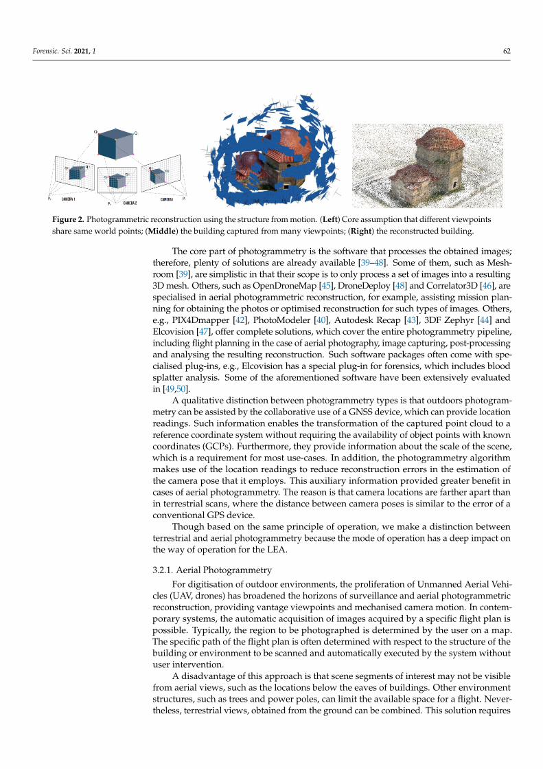
Photogrammetric reconstruction requires significant computational time to obtainresults because it is not based on direct measurements of spatial structure (such as thelaser scanner) but is rather an algorithm that computationally infers structure from implicitmeasurements (images). The main advantages of photogrammetry lie in the relativelylow cost of the required equipment and the wide range of environments in which itcan be applied. Decent results can be obtained using low-end sensors, e.g., a mobilephone and relevant free/open-source photogrammetry software, such as Meshroom [39].However, high-end optics provides images of high definition and, consequently, moreaccurate reconstructions. Another advantage of photogrammetry is texture realism, as laserscanning tends to provide low-resolution texture information that looks unrealistic whenused in first-person VR applications, even though the geometry may be more accurate.Therefore, while a laser-only scan is probably advantageous for preserving a crime scene,it is not necessarily the best choice for a VR-training use-case. Figure 2 depicts a typicalphotogrammetric workflow using the structure from the motion algorithm.
Forensic. Sci. 2021, 1 62
Figure 2. Photogrammetric reconstruction using the structure from motion. (Left) Core assumption that different viewpointsshare same world points; (Middle) the building captured from many viewpoints; (Right) the reconstructed building.
The core part of photogrammetry is the software that processes the obtained images;therefore, plenty of solutions are already available [39–48]. Some of them, such as Mesh-room [39], are simplistic in that their scope is to only process a set of images into a resulting3D mesh. Others, such as OpenDroneMap [45], DroneDeploy [48] and Correlator3D [46], arespecialised in aerial photogrammetric reconstruction, for example, assisting mission plan-ning for obtaining the photos or optimised reconstruction for such types of images. Others,e.g., PIX4Dmapper [42], PhotoModeler [40], Autodesk Recap [43], 3DF Zephyr [44] andElcovision [47], offer complete solutions, which cover the entire photogrammetry pipeline,including flight planning in the case of aerial photography, image capturing, post-processingand analysing the resulting reconstruction. Such software packages often come with spe-cialised plug-ins, e.g., Elcovision has a special plug-in for forensics, which includes bloodsplatter analysis. Some of the aforementioned software have been extensively evaluatedin [49,50].
A qualitative distinction between photogrammetry types is that outdoors photogram-metry can be assisted by the collaborative use of a GNSS device, which can provide locationreadings. Such information enables the transformation of the captured point cloud to areference coordinate system without requiring the availability of object points with knowncoordinates (GCPs). Furthermore, they provide information about the scale of the scene,which is a requirement for most use-cases. In addition, the photogrammetry algorithmmakes use of the location readings to reduce reconstruction errors in the estimation ofthe camera pose that it employs. This auxiliary information provided greater benefit incases of aerial photogrammetry. The reason is that camera locations are farther apart thanin terrestrial scans, where the distance between camera poses is similar to the error of aconventional GPS device.
Though based on the same principle of operation, we make a distinction betweenterrestrial and aerial photogrammetry because the mode of operation has a deep impact onthe way of operation for the LEA.
3.2.1. Aerial Photogrammetry
For digitisation of outdoor environments, the proliferation of Unmanned Aerial Vehi-cles (UAV, drones) has broadened the horizons of surveillance and aerial photogrammetricreconstruction, providing vantage viewpoints and mechanised camera motion. In contem-porary systems, the automatic acquisition of images acquired by a specific flight plan ispossible. Typically, the region to be photographed is determined by the user on a map.The specific path of the flight plan is often determined with respect to the structure of thebuilding or environment to be scanned and automatically executed by the system withoutuser intervention.
A disadvantage of this approach is that scene segments of interest may not be visiblefrom aerial views, such as the locations below the eaves of buildings. Other environmentstructures, such as trees and power poles, can limit the available space for a flight. Never-theless, terrestrial views, obtained from the ground can be combined. This solution requires

Forensic. Sci. 2021, 1 63
at least two scanning processes: one aerial and one or more terrestrial, depending on thecomplexity of the scene.
UAVs with descent camera capabilities and consumer-grade GPS cost around EUR1500. Higher-end models are more expensive because they carry better cameras and/orGPS sensors, e.g., a drone with a GPS of centimetre-accuracy costs around EUR 6600 [51].
3.2.2. Terrestrial Photogrammetry
Terrestrial photogrammetry regards both indoors and outdoors. Usually, it involvesthe acquisition of images by a person using a handheld camera. These images must beacquired through a systematic protocol for the photogrammetric reconstruction algorithmto succeed. This protocol mainly dictates the occurrence of significant overlap betweenimages acquired at neighbouring poses. In aerial photogrammetry, little training is neededbecause this protocol is implemented by the system. However, in terrestrial photogram-metry, some training is required for the protocol to be followed by the person acquiringthe images.
As such, terrestrial photogrammetric reconstruction of wide areas (e.g., a room ora concert hall) exhibits the disadvantage that it becomes tedious. In particular, for largeindoor regions, the following difficulties are often encountered:
• A lack of sufficient illumination.• A lack of visual texture often encountered on walls and ceilings. This is a problem
because photogrammetric algorithms are based on the detection and establishmentof point correspondences across the acquired images. When there is a lack of texture,no key points exist in the acquired images, making the results of photogrammetryunreliable.
• Surfaces of high reflectance, which exhibit illumination specularities when directlyilluminated, such as metallic and glass objects, often found in indoor environments.
• A large number of occlusions due to the structure of human-made indoor rooms and fur-niture.
Some of these difficulties are treatable with direct steps. For example, the lack oftexture is treatable by the introduction of markers and the lack of illumination by theintroduction of a light source. Nevertheless, complex structures, particularly in small,indoor environments, are difficult to scan even with the use of the above mitigationmeasures. A common reason is the difficulty of treating dynamic shadows due to theoperator of the camera and luminous specularities in the environment.
A decent DSLR or mirrorless camera costs around EUR 500–1500 depending onthe model and additional kit lenses. Additional equipment, such as a tripod or otherstabilization gear, may be required for better shots; however, scanning time will be increasedsignificantly due to the extra effort of the operator. Cameras with low light capabilitiesand stabilization (sensor or lens) are a good all-around option for not requiring specialequipment.
3.2.3. Photogrammetry Using Mobile Phones
Recent advances in mobile phone development resulted in the emergence of devicesthat are capable of real-time processing of input from the camera along with motion features(from other sensors) to provide augmented reality (AR) experiences. AR, for example, ispresent in the popular ARKit developed by Apple and supported by recent Apple mobilephones. Such technology can be utilised as a complement cue for real-time feedback duringthe scanning of an object (taking photos) with the phone. An application of this is foundin the Trnio 3D scanner mobile application [52]. As the authors of the application state,“Trnio will use the ARKit to know when to take pictures”. Therefore, it utilises both thetechnology for user feedback and judging optimal views for the photogrammetry pipeline.The actual 3D reconstruction runs in the cloud, i.e., images are uploaded to the vendor’sserver. This is either because the computation capabilities of the phones are limited or thepiece of software that runs the computation cannot be distributed to the clients.

Forensic. Sci. 2021, 1 64
Upcoming versions of the Trnio application will also benefit from the LiDAR sensor,which is included in the high-end models, such as iPhone 12 Pro/Pro Max. As the authorsstate, “depth maps from the LiDAR sensor for faster alignment, and to fill gaps”. This is atrue combination of photogrammetry and direct measurement technology and is expectedto be a breakthrough for small-scale reconstructions.
At its current version, we consider that Trnio and other similar applications are on parwith ordinary photogrammetry, in terms of scanning resolution, user effort and drawbacks,with few advantages. First, a mobile phone is a versatile omnipresent device with muchmore uses than a digital photo camera or other special equipment. Cameras on mobilephones have seen great advances recently, matching professional-grade counterparts forspecific applications. Moreover, the AR capability of mobile phones is a useful guideduring object scanning. A disadvantage of mobile phones is that the camera sensor is verysmall, which decreases the performance in low light conditions. The cloud-based nature ofthe application is both an advantage and disadvantage. On the one hand, no powerful PCis required to run the photogrammetry software. On the other hand, privacy issues mayarise due to uploading photos that may contain sensitive information to the cloud.
3.2.4. Discussion
In general, photogrammetric reconstruction is less accurate than laser scanning, but itis particularly useful for photorealistic reconstructions and practical usage in the coverageof wide areas. Photorealism is achieved for small-scale reconstruction, where the cameracaptures the scene or objects of interest with higher resolution, or equivalently, the subjectis represented by the image sensor at a scale close to its real-world size. Photorealism isof less interest for wide outdoor areas, which, however, can be quickly captured usingUAVs. Limitations of aerial photogrammetry due to occlusions can be compensated withthe addition of terrestrial views.
3.3. RGB-D Scanning
During the last 10 years, the proliferation of imperceptible, active illumination sensors(RGB-D cameras) has played a significant role in the development of new ComputerVision approaches and attracted new interest to older works in the domain of 3D-surfacereconstruction that was hindered by the limitations of binocular or multi-view stereo. Oneof these approaches is the Simultaneous Localization and Mapping (SLAM) [53], which wasreinforced by RGB-D sensors due to the additional depth information that they provide.
In a comparison with photogrammetry, it falls short, particularly due to the limitationsof sensor hardware as it is off-the-shelf available. The most important limitation is therange within which it is reliable: 0.5–1.5 m. This distance, in combination with the relativelylow definition of the RGB camera, produces less realistic textures. Moreover, the sensor ismainly designed for indoor use. To operate outdoors, very careful illumination insulationand engineering are required. Very low levels of (sun) light are required so that they do notovercome the intensity of the active illumination component. At the same time, a controlledlight source is required so that there is sufficient light for adequate texture from the RGBcomponent of the sensor. The digitisation modality is more resistant to a lack of texturedue to the use of active illumination. Nevertheless, it inherits the disadvantage of SLAM,which requires correspondences across images to retain camera tracking.
On the other hand, it exhibits the following advantages. The sensor cost is relativelylow, in the order of EUR 300. The sensor is light-weight and handheld, though it requiresa laptop or tablet attached because the sensor is available “as is” and not bundled withan image-recording module. The scanning procedure is simpler than photogrammetricimage acquisition because active illumination allows for a higher degree of affinity inthe trajectory of the handheld sensor. In comparison with photogrammetry, it exhibitsthe advantage of simpler camera manipulation in cluttered environments. It therebycould comprise a handy and cost-efficient tool for cases where a simple scan suffices therequirements of documentation. In the context of our investigation with digitisation tools,
Forensic. Sci. 2021, 1 65
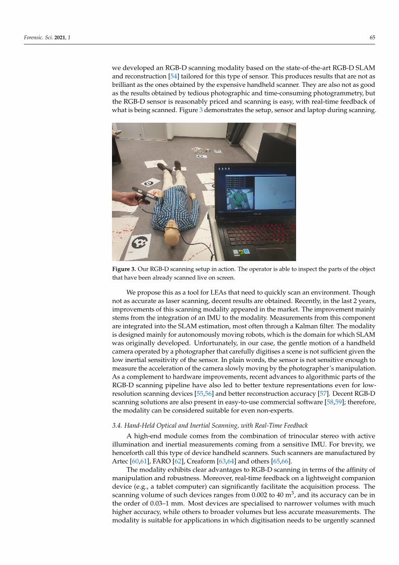
we developed an RGB-D scanning modality based on the state-of-the-art RGB-D SLAMand reconstruction [54] tailored for this type of sensor. This produces results that are not asbrilliant as the ones obtained by the expensive handheld scanner. They are also not as goodas the results obtained by tedious photographic and time-consuming photogrammetry, butthe RGB-D sensor is reasonably priced and scanning is easy, with real-time feedback ofwhat is being scanned. Figure 3 demonstrates the setup, sensor and laptop during scanning.
Figure 3. Our RGB-D scanning setup in action. The operator is able to inspect the parts of the objectthat have been already scanned live on screen.
We propose this as a tool for LEAs that need to quickly scan an environment. Thoughnot as accurate as laser scanning, decent results are obtained. Recently, in the last 2 years,improvements of this scanning modality appeared in the market. The improvement mainlystems from the integration of an IMU to the modality. Measurements from this componentare integrated into the SLAM estimation, most often through a Kalman filter. The modalityis designed mainly for autonomously moving robots, which is the domain for which SLAMwas originally developed. Unfortunately, in our case, the gentle motion of a handheldcamera operated by a photographer that carefully digitises a scene is not sufficient given thelow inertial sensitivity of the sensor. In plain words, the sensor is not sensitive enough tomeasure the acceleration of the camera slowly moving by the photographer’s manipulation.As a complement to hardware improvements, recent advances to algorithmic parts of theRGB-D scanning pipeline have also led to better texture representations even for low-resolution scanning devices [55,56] and better reconstruction accuracy [57]. Decent RGB-Dscanning solutions are also present in easy-to-use commercial software [58,59]; therefore,the modality can be considered suitable for even non-experts.
3.4. Hand-Held Optical and Inertial Scanning, with Real-Time Feedback
A high-end module comes from the combination of trinocular stereo with activeillumination and inertial measurements coming from a sensitive IMU. For brevity, wehenceforth call this type of device handheld scanners. Such scanners are manufactured byArtec [60,61], FARO [62], Creaform [63,64] and others [65,66].
The modality exhibits clear advantages to RGB-D scanning in terms of the affinity ofmanipulation and robustness. Moreover, real-time feedback on a lightweight companiondevice (e.g., a tablet computer) can significantly facilitate the acquisition process. Thescanning volume of such devices ranges from 0.002 to 40 m3, and its accuracy can be inthe order of 0.03–1 mm. Most devices are specialised to narrower volumes with muchhigher accuracy, while others to broader volumes but less accurate measurements. Themodality is suitable for applications in which digitisation needs to be urgently scanned
Forensic. Sci. 2021, 1 66
from various perspectives. Similar to any optical method, it is dependent on texture andexhibits limitations in shiny objects. The main disadvantage of pertinent devices is theirhigh cost, which is in the order of EUR 20,000–40,000.
The scope of this modality is both indoors and outdoors, though its accuracy isreduced under bright sunlight. The reason is the same as the RGB-D sensors, that is, theintensity of sunlight is more intense than the structured illumination radiated by the sensor.As such, the emitted structured light is no longer visible to the sensors.
The high cost of these devices is an investment to be considered as it saves significantquantities of image acquisition and computation time, compared to photogrammetry.On the other hand, its texture resolution is inferior compared to photogrammetricallyreconstructed texture. Corresponding devices are also simple to use with very little training.In addition, such devices are typically accompanied by a real-time feedback module (e.g., atablet computer) that indicates un-scanned areas of the environment to the user.
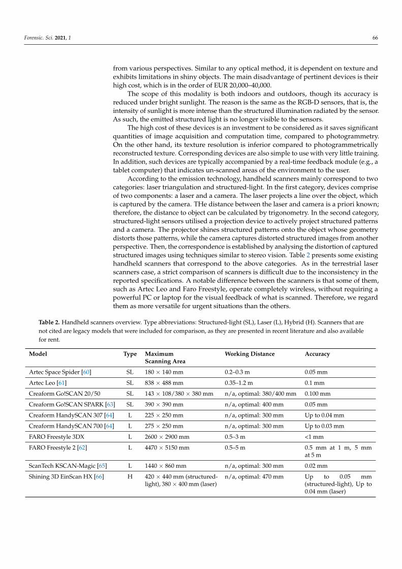
According to the emission technology, handheld scanners mainly correspond to twocategories: laser triangulation and structured-light. In the first category, devices compriseof two components: a laser and a camera. The laser projects a line over the object, whichis captured by the camera. THe distance between the laser and camera is a priori known;therefore, the distance to object can be calculated by trigonometry. In the second category,structured-light sensors utilised a projection device to actively project structured patternsand a camera. The projector shines structured patterns onto the object whose geometrydistorts those patterns, while the camera captures distorted structured images from anotherperspective. Then, the correspondence is established by analysing the distortion of capturedstructured images using techniques similar to stereo vision. Table 2 presents some existinghandheld scanners that correspond to the above categories. As in the terrestrial laserscanners case, a strict comparison of scanners is difficult due to the inconsistency in thereported specifications. A notable difference between the scanners is that some of them,such as Artec Leo and Faro Freestyle, operate completely wireless, without requiring apowerful PC or laptop for the visual feedback of what is scanned. Therefore, we regardthem as more versatile for urgent situations than the others.
Table 2. Handheld scanners overview. Type abbreviations: Structured-light (SL), Laser (L), Hybrid (H). Scanners that arenot cited are legacy models that were included for comparison, as they are presented in recent literature and also availablefor rent.
Model Type MaximumScanning Area
Working Distance Accuracy
Artec Space Spider [60] SL 180 × 140 mm 0.2–0.3 m 0.05 mm
Artec Leo [61] SL 838 × 488 mm 0.35–1.2 m 0.1 mm
Creaform Go!SCAN 20/50 SL 143 × 108/380 × 380 mm n/a, optimal: 380/400 mm 0.100 mm
Creaform Go!SCAN SPARK [63] SL 390 × 390 mm n/a, optimal: 400 mm 0.05 mm
Creaform HandySCAN 307 [64] L 225 × 250 mm n/a, optimal: 300 mm Up to 0.04 mm
Creaform HandySCAN 700 [64] L 275 × 250 mm n/a, optimal: 300 mm Up to 0.03 mm
FARO Freestyle 3DX L 2600 × 2900 mm 0.5–3 m <1 mm
FARO Freestyle 2 [62] L 4470 × 5150 mm 0.5–5 m 0.5 mm at 1 m, 5 mmat 5 m
ScanTech KSCAN-Magic [65] L 1440 × 860 mm n/a, optimal: 300 mm 0.02 mm
Shining 3D EinScan HX [66] H 420 × 440 mm (structured-light), 380 × 400 mm (laser)
n/a, optimal: 470 mm Up to 0.05 mm(structured-light), Up to0.04 mm (laser)
Forensic. Sci. 2021, 1 67
3.5. Discussion
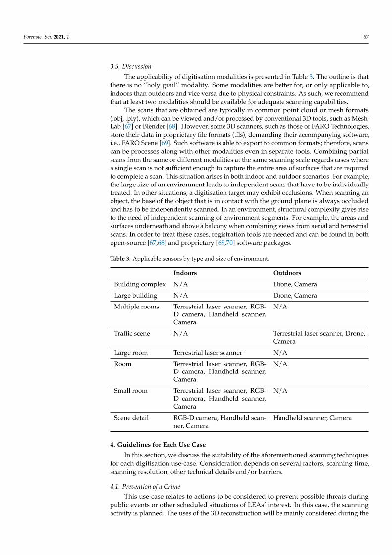
The applicability of digitisation modalities is presented in Table 3. The outline is thatthere is no “holy grail” modality. Some modalities are better for, or only applicable to,indoors than outdoors and vice versa due to physical constraints. As such, we recommendthat at least two modalities should be available for adequate scanning capabilities.
The scans that are obtained are typically in common point cloud or mesh formats(.obj, .ply), which can be viewed and/or processed by conventional 3D tools, such as Mesh-Lab [67] or Blender [68]. However, some 3D scanners, such as those of FARO Technologies,store their data in proprietary file formats (.fls), demanding their accompanying software,i.e., FARO Scene [69]. Such software is able to export to common formats; therefore, scanscan be processes along with other modalities even in separate tools. Combining partialscans from the same or different modalities at the same scanning scale regards cases wherea single scan is not sufficient enough to capture the entire area of surfaces that are requiredto complete a scan. This situation arises in both indoor and outdoor scenarios. For example,the large size of an environment leads to independent scans that have to be individuallytreated. In other situations, a digitisation target may exhibit occlusions. When scanning anobject, the base of the object that is in contact with the ground plane is always occludedand has to be independently scanned. In an environment, structural complexity gives riseto the need of independent scanning of environment segments. For example, the areas andsurfaces underneath and above a balcony when combining views from aerial and terrestrialscans. In order to treat these cases, registration tools are needed and can be found in bothopen-source [67,68] and proprietary [69,70] software packages.
Table 3. Applicable sensors by type and size of environment.
Indoors Outdoors
Building complex N/A Drone, Camera
Large building N/A Drone, Camera
Multiple rooms Terrestrial laser scanner, RGB-D camera, Handheld scanner,Camera
N/A
Traffic scene N/A Terrestrial laser scanner, Drone,Camera
Large room Terrestrial laser scanner N/A
Room Terrestrial laser scanner, RGB-D camera, Handheld scanner,Camera
N/A
Small room Terrestrial laser scanner, RGB-D camera, Handheld scanner,Camera
N/A
Scene detail RGB-D camera, Handheld scan-ner, Camera
Handheld scanner, Camera
4. Guidelines for Each Use Case
In this section, we discuss the suitability of the aforementioned scanning techniquesfor each digitisation use-case. Consideration depends on several factors, scanning time,scanning resolution, other technical details and/or barriers.
4.1. Prevention of a Crime
This use-case relates to actions to be considered to prevent possible threats duringpublic events or other scheduled situations of LEAs’ interest. In this case, the scanningactivity is planned. The uses of the 3D reconstruction will be mainly considered during the
Forensic. Sci. 2021, 1 68
mission planning phase, as well as the emission monitoring. In addition, 3D reconstructionmay be required for mission reporting.
The time that is available during mission planning is usually ample; hence, it isassumed that it is sufficient for each type of scan. For example, in outdoor scenarios,it might be also possible to wait for the appropriate weather to use drone photography,which significantly simplifies the 3D reconstruction by the provision of airborne overviewimages. Correspondingly, the most appropriate equipment is likely to be available. Inthe case that multiple LEA agencies share equipment, appropriate planning increases thepossibility of the availability of pertinent scanning modalities. In addition, the availabilityof maps and possibly CAD models can compensate for a lack of data due to bad weatheror unavailability of a critical scanning modality, such as a drone or a laser scanner.
Given that time and modalities are ample before the event of interest, we recommendtheir use and, if possible, the multiple scans of critical areas by more than one scanningmodality for both outdoor and indoor places. Outdoor use-cases typically regard a widearea, such as a city square or a stadium, while indoor environments refer typically towide-area rooms that can accommodate a large number of persons. For mission monitoringand reporting, the available time is usually much less; therefore, convenient devices, suchas handheld laser scanner or mobile photography, are the most appropriate for quicklyscanning appropriate smaller areas and objects of interest.
In outdoor use-cases, using aerial photogrammetry is often the only way to obtain a3D reconstruction of the top of a building. For indoor environments, laser scanning is apractical and efficient way to obtain a 3D reconstruction of a wide-area indoor scene. Theprocedure is automatic, and the obtained reconstruction exhibits high accuracy. Complexenvironments may call for several scans. This requires little effort, as the only user actionrequired is to place the scanner at a new position. An understanding of what is the FOV ofthe scanner is required by the operator to avoid leaving parts of the scene uncovered.
In wide-area indoor environments, photogrammetry can be particularly challeng-ing, as these environments are abundant in textureless and glossy surfaces (e.g., walls,floors etc.). Photogrammetry is not the optimal modality for the treatment of such scenes.However, in case that it is the only modality available, the use of markers is highly recom-mended. Marker placement has been confirmed to be allowed by LEAs at the time of 3Dscene reconstruction, as it does not interfere with their processing protocol. In addition, par-tial scanning of the environment is recommended to reduce errors due to camera-trackingdrift. The partial reconstruction can be registered at a later stage.
Though the use-case is preventive, special regions of the scene may be of particularinterest for the preparation of a situation. Such can be, for example, a particular locationwhere a LEA can be placed to better observe the scene. In another scenario, a particularplace in the scene may be needed to be realistically presented in a mission preparationstage, e.g., a particular piece of machinery situated in that environment. As such, theirdetailed reconstruction may be required.
For this purpose, photogrammetry and handheld scanning are two reliable candidates,with the better of them being the handheld scanner. Nevertheless, decent and insightfulresults can be obtained with careful (and tedious to achieve) photogrammetric settings.In indoor environments, an RGB-D scanning modality can be used for scene details,though with inferior results regarding texture reconstruction (typically due to the mediumresolution of the RGB component of such sensors).
Registration is a very important part of this use-case. As discussed in Section 3, it isrelevant to the combination of multiple scans from the same or different modalities at thesame or different scales of observation.
Finally, this use-case requires that the reconstruction is georeferenced, such that itis associated with the location of LEAs and their vehicles (e.g., provided by their mobilephones). This is usually straightforward as both aerial and terrestrial cameras containGPS information. If this is not available, an external GPS device can be utilised. Forexample, some DSLR cameras do not incorporate GPS modules; however, geolocation
Forensic. Sci. 2021, 1 69
information can be provided either using specialised modules [71], a mobile phone andrelevant application for receiving the location over a Bluetooth connection or simplyassociating photos and GPS logs at a later stage as soon as clocks on both devices aresynchronized.
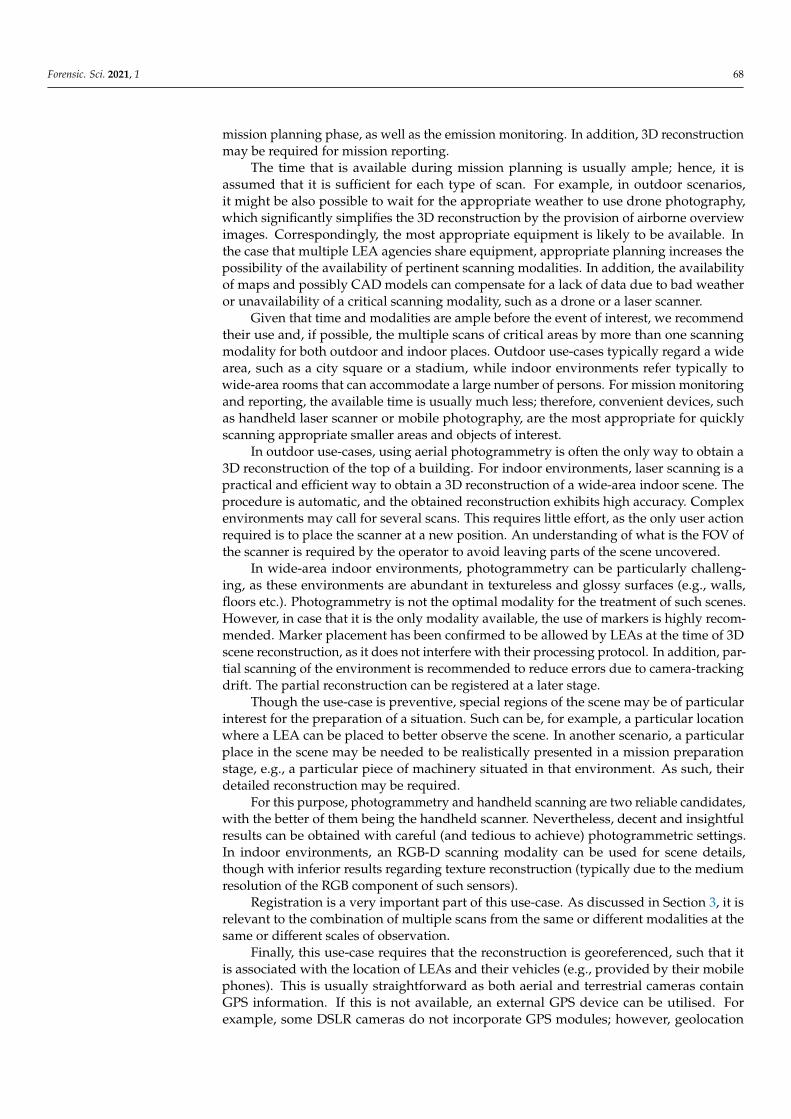
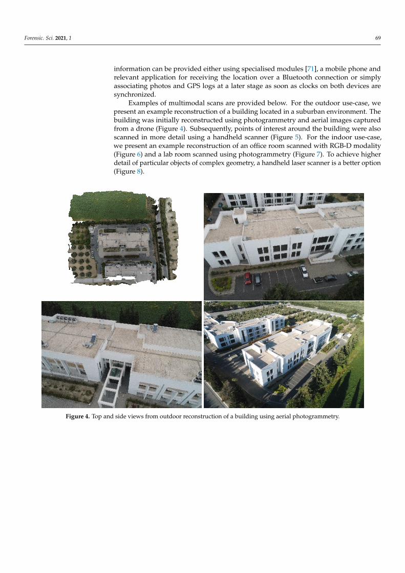
Examples of multimodal scans are provided below. For the outdoor use-case, wepresent an example reconstruction of a building located in a suburban environment. Thebuilding was initially reconstructed using photogrammetry and aerial images capturedfrom a drone (Figure 4). Subsequently, points of interest around the building were alsoscanned in more detail using a handheld scanner (Figure 5). For the indoor use-case,we present an example reconstruction of an office room scanned with RGB-D modality(Figure 6) and a lab room scanned using photogrammetry (Figure 7). To achieve higherdetail of particular objects of complex geometry, a handheld laser scanner is a better option(Figure 8).
Figure 4. Top and side views from outdoor reconstruction of a building using aerial photogrammetry.

Forensic. Sci. 2021, 1 70
Figure 5. Detailed scans of particular points of interest with different modalities, i.e., a staircase (handheld scanner) andA/C units (terrestrial photogrammetry).
Figure 6. (Left) Top view of the reconstruction of a lab room using an RGB-D scanner. (Right) Side view of the same room.
Figure 7. (Left) Overview of a photogrammetric reconstruction of a lab room. (Right) Close-up at a specific point ofthe room.
Forensic. Sci. 2021, 1 71
Figure 8. Highly detailed reconstruction of the geometry of machines using a handheld laser scanner.
4.2. Analysis of a Crime Scene
This use-case regards post-event actions beyond a crime, simultaneously requiringplenty of accurate scene information and taking into account that acquisition time maybe critical. Its goal is the acquisition of as much information from the scene, accuratelymeasured and precisely localised, in the time and hardware resources available.
Spatial accuracy plays an important role in the hypothetical investigation of the sceneand the evidence-based verification of the rejection of hypotheses. Moreover, a detailedscanning can digitise evidence, which may be studied afterwards.
Time criticality mainly pertains to outdoor cases of this scenario and, in particular,the case where event traces (i.e., footprints, tire marks) are only temporarily available, asthey can be eroded by the weather. In some other cases, rapid acquisition of images andmeasurements may be required because the target of reconstruction must be removedfrom the event location (i.e., cars obstructing traffic). The uses of the correspondingreconstructions are to be used in the documentation of evidence, crime investigation andeducational scenarios of cases of specific interest.
The spatial range of this type of reconstruction is relatively smaller than missionplanning because the crime event has already occurred at a specific location. Hence, theregion is smaller, which makes the detailed reconstruction of the scene more feasible.
In contrast to mission planning, accuracy is more important in this case, as it regardsthe documentation of potential evidence. Moreover, accurate measurements can be of im-portance to the interpretation of the acquired data; for example, the accurate measurementof the size of a footprint is relevant to the information to be obtained from its analysis.Moreover, in contrast to mission planning, the suitability of weather conditions or theavailability of basic infrastructures (i.e., supply of electricity) is essential. Finally, as thisreconstruction is not planned, the higher-end equipment may not be available.
Crime scene processing and documentation is not an instantaneous process but rathercontains stages. Though existing LEA protocols already contain state-of-the-art photo-graphic documentation (e.g., 360 deg panoramic photographs), the inclusion of 3D scanningis not yet widely integrated into the standard operating procedure of processing teams.Furthermore, in contrast to photographic documentation that can be acquired without

Forensic. Sci. 2021, 1 72
entering the scene and can be performed by LEAs, detailed and metrically accurate 3Dscanning still requires expertise and may require the inclusion of markers.
As such, scanning the scene is not possible anytime during scene processing, and thus,we should find solutions towards this end. To achieve this, we will use existing LEA docu-mentation and investigation hypothesis tools that (a) utilise photographic documentationacquired from LEAs and (b) facilitate the formulation of 3D hypotheses on how the scenecould be at multiple time instants before the arrival of the CSI team.
The proposed approach is based on LEA requirements and is as follows. First, anoverview of the scene is required. This can be provided by a range of means from a singlephotograph to a detailed 3D reconstruction of the area. Photographic documentation isnecessary, even if a reconstruction of the scene is performed later on. Initial photographsmay document the scene at an earlier state than when the scene is available for scanning.In that state, the victim may have been removed from the scene. In addition, LEAsmay determine as necessary the removal of scene elements (i.e., furniture) to uncoverinaccessible parts of the scene. As such, the initial photographic documentation is valuablebecause it provides a record of the scene in that earlier state. This documentation can beused later on to simulate the scene as found, e.g., including the victim and furniture.
Utilizing 3D scanning for crime scene documentation may require preparation beforescanning, e.g., to address the time-related factors mostly pertaining to outdoor scenes.For example, to retain event traces (e.g., footprints, tire marks) that may deteriorate dueto weather, rapid documentation is required. Otherwise, a tent is recommended for thepreservation of pertinent traces until they are digitised. This type of protection can extendthe time that pertinent traces exist and provide the opportunity for their scan.
Laser scanning is a practical and efficient way to obtain a 3D overview of the scene.This type of input provides the possibility of documenting the scene without interventionand from a distance. More importantly, the procedure is automatic, and the obtainedreconstruction exhibits high accuracy. Nevertheless, in complex environments, severalscans might be required. This requires little effort, as the only user action required is toplace the scanner at a new position. However, an understanding of what is the FOV of thescanner is required by the operator to avoid leaving parts of the scene uncovered. Suchskill is easy to acquire during training sessions at various locations before the utilisation ofthe scanner for the event of interest.
The partial scans obtained from the scene can be semi- or fully automatically reassem-bled later on, sometimes without the need of marker placement.If the structure of the sceneis rich and contains definite structures (e.g., planes, edges, corners), such as in indoor andhuman-made outdoor environments, then point clouds can be only registered based ontheir structure. However, in cases of poor structure, e.g., outdoor fields, the placement ofmarkers is recommended to compensate for the lack of structure.
Laser scanning will capture scene details with accuracy but is not necessarily theoptimal way to reconstruct traces on the ground. The reason is that due to the obliqueness ofview and self-occlusions they are usually not fully visible in the standard tripod placementof the scanner.
In indoor environments, the absence of a laser scanner can be compensated by theuse of an RGB-D scanning modality but results in scans of inferior detail and accuracy. Inaddition, the procedure is not automatic and demands user effort.
Photogrammetryfinds application in this use-case in several ways. In outdoor scenes,aerial photogrammetry is an efficient way to obtain an overview of the scene. The signifi-cance of this view is denoted by the corresponding term, “bird’s eye view”. Even if thescene is small, aerial photogrammetry is an efficient way to acquire a scene overview with-out intervention. Handheld photogrammetry of the same scene exhibits the disadvantageof requiring person effort and, in addition, that this person would have to walk withinthe scene. Moreover, if the scene contains important elements that are higher than humanreach, these may not be able to be scanned from above, unless a drone is utilised.
Forensic. Sci. 2021, 1 73
In indoor environments, photogrammetry can be particularly challenging, mainlybecause very often the environment:
• contains surfaces that are poor in structure, e.g., white walls;• is cluttered, giving rise to occlusions and increasing the difficulty of the scanning process;• contains shiny surfaces, e.g., the floor and polished surfaces.
A light source and an illumination diffuser are necessary for almost every indoorsituation. In the aforementioned conditions, photogrammetry does not typically suffice totreat wide-area indoor scenes, such as a large room or a concert hall. If photogrammetry isthe only modality available to 3D scan the entire scene, the use of markers is recommended.Marker placement has been confirmed to be allowed by LEAs at the time of 3D scenereconstruction, as it does not interfere with their processing protocol.
Photogrammetry is a time and cost-efficient way to reconstruct a portion of a scenein higher than overview detail. Such details are well reconstructed with texture realism.They provide a very clear way to inspect the portion of the scene in photorealistic quality.Outdoor scenes are usually rich in texture due to the presence of soil, pebbles, leaves, etc.However, in some cases, the use of markers may be required to compensate for lack oftexture, e.g., in the presence of snow.
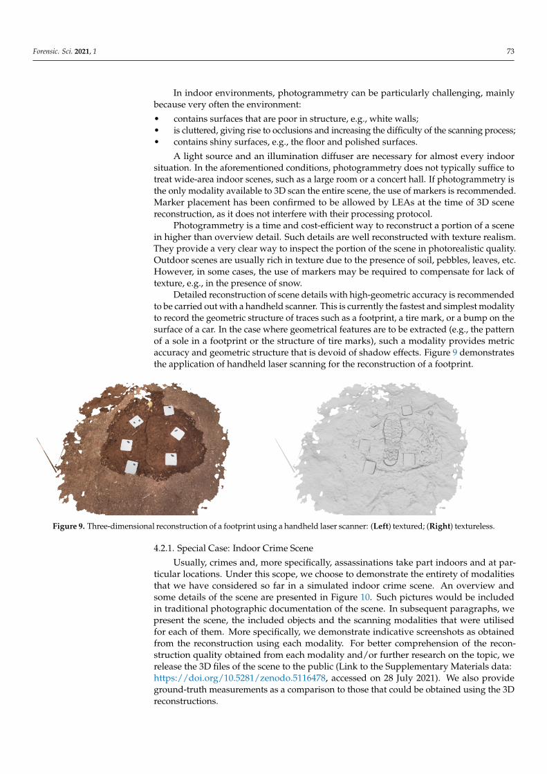
Detailed reconstruction of scene details with high-geometric accuracy is recommendedto be carried out with a handheld scanner. This is currently the fastest and simplest modalityto record the geometric structure of traces such as a footprint, a tire mark, or a bump on thesurface of a car. In the case where geometrical features are to be extracted (e.g., the patternof a sole in a footprint or the structure of tire marks), such a modality provides metricaccuracy and geometric structure that is devoid of shadow effects. Figure 9 demonstratesthe application of handheld laser scanning for the reconstruction of a footprint.
Figure 9. Three-dimensional reconstruction of a footprint using a handheld laser scanner: (Left) textured; (Right) textureless.
4.2.1. Special Case: Indoor Crime Scene
Usually, crimes and, more specifically, assassinations take part indoors and at par-ticular locations. Under this scope, we choose to demonstrate the entirety of modalitiesthat we have considered so far in a simulated indoor crime scene. An overview andsome details of the scene are presented in Figure 10. Such pictures would be includedin traditional photographic documentation of the scene. In subsequent paragraphs, wepresent the scene, the included objects and the scanning modalities that were utilisedfor each of them. More specifically, we demonstrate indicative screenshots as obtainedfrom the reconstruction using each modality. For better comprehension of the recon-struction quality obtained from each modality and/or further research on the topic, werelease the 3D files of the scene to the public (Link to the Supplementary Materials data:https://doi.org/10.5281/zenodo.5116478, accessed on 28 July 2021). We also provideground-truth measurements as a comparison to those that could be obtained using the 3Dreconstructions.
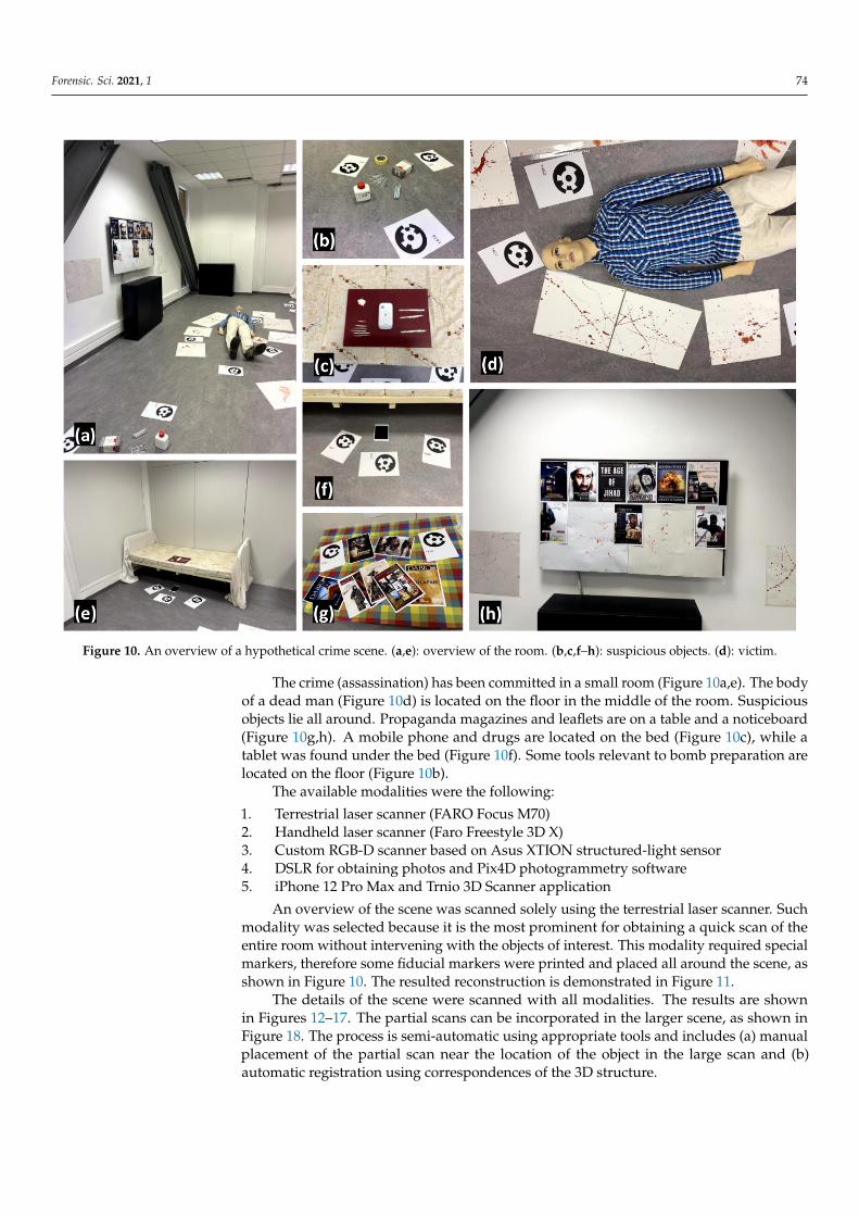
Forensic. Sci. 2021, 1 74
Figure 10. An overview of a hypothetical crime scene. (a,e): overview of the room. (b,c,f–h): suspicious objects. (d): victim.
The crime (assassination) has been committed in a small room (Figure 10a,e). The bodyof a dead man (Figure 10d) is located on the floor in the middle of the room. Suspiciousobjects lie all around. Propaganda magazines and leaflets are on a table and a noticeboard(Figure 10g,h). A mobile phone and drugs are located on the bed (Figure 10c), while atablet was found under the bed (Figure 10f). Some tools relevant to bomb preparation arelocated on the floor (Figure 10b).
The available modalities were the following:
1. Terrestrial laser scanner (FARO Focus M70)2. Handheld laser scanner (Faro Freestyle 3D X)3. Custom RGB-D scanner based on Asus XTION structured-light sensor4. DSLR for obtaining photos and Pix4D photogrammetry software5. iPhone 12 Pro Max and Trnio 3D Scanner application
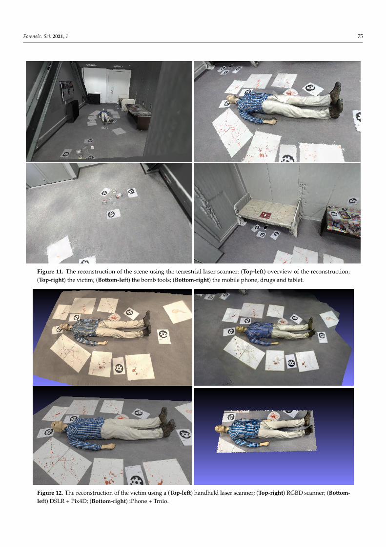
An overview of the scene was scanned solely using the terrestrial laser scanner. Suchmodality was selected because it is the most prominent for obtaining a quick scan of theentire room without intervening with the objects of interest. This modality required specialmarkers, therefore some fiducial markers were printed and placed all around the scene, asshown in Figure 10. The resulted reconstruction is demonstrated in Figure 11.
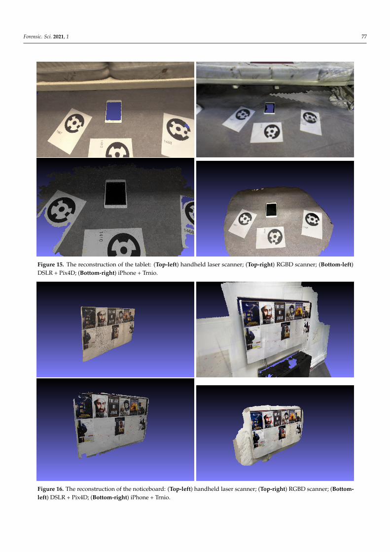
The details of the scene were scanned with all modalities. The results are shownin Figures 12–17. The partial scans can be incorporated in the larger scene, as shown inFigure 18. The process is semi-automatic using appropriate tools and includes (a) manualplacement of the partial scan near the location of the object in the large scan and (b)automatic registration using correspondences of the 3D structure.
Forensic. Sci. 2021, 1 75
Figure 11. The reconstruction of the scene using the terrestrial laser scanner; (Top-left) overview of the reconstruction;(Top-right) the victim; (Bottom-left) the bomb tools; (Bottom-right) the mobile phone, drugs and tablet.
Figure 12. The reconstruction of the victim using a (Top-left) handheld laser scanner; (Top-right) RGBD scanner; (Bottom-left) DSLR + Pix4D; (Bottom-right) iPhone + Trnio.

Forensic. Sci. 2021, 1 76
Figure 13. The reconstruction of the bomb tools using a (Top-left) handheld laser scanner; (Top-right) RGBD scanner;(Bottom-left) DSLR + Pix4D; (Bottom-right) iPhone + Trnio.
Figure 14. The reconstruction of the mobile phone and drugs using a (Top-left) handheld laser scanner; (Top-right) RGBDscanner; (Bottom-left) DSLR + Pix4D; (Bottom-right) iPhone + Trnio.
Forensic. Sci. 2021, 1 77
Figure 15. The reconstruction of the tablet: (Top-left) handheld laser scanner; (Top-right) RGBD scanner; (Bottom-left)DSLR + Pix4D; (Bottom-right) iPhone + Trnio.
Figure 16. The reconstruction of the noticeboard: (Top-left) handheld laser scanner; (Top-right) RGBD scanner; (Bottom-left) DSLR + Pix4D; (Bottom-right) iPhone + Trnio.

Forensic. Sci. 2021, 1 78
Figure 17. The reconstruction of the table with leaflets and newspapers: (Top-left) handheld laser scanner; (Top-right)RGBD scanner; (Bottom-left) DSLR + Pix4D; (Bottom-right) iPhone + Trnio.
Figure 18. Details of the scene as obtained with the handheld laser scanner (top-left of Figures 12–17) and incorporatedwithin the overview of the scene as it was captured by the terrestrial laser scanner (Figure 11).
In order to obtain a better indication about the measurement accuracy for each 3Dscanning modality, we conducted an indicative quantitative analysis. The analysis wasconducted on the basis of comparison of all modalities; therefore, the scope is in somesmall and medium-sized objects, with corresponding sizes in the order of a few millimetresup to a few centimetres. Ground-truth measurements were obtained using a digital meterand, where possible, confirmed from the manufacturers specifications. We note thatin the case of photogrammetrical reconstruction, the resulting mesh is not in real scalebecause there is no direct measurement of distances rather than relative. To get the realscale, we used the A4 papers with markers that were present in the scene since suchobject is of known dimensions. Table 4 illustrates the ground-truth and corresponding

Forensic. Sci. 2021, 1 79
measurements obtained in Meshlab. For each object, an average of five measurements isreported in order to compensate for errors while using the corresponding tool. For somemodalities, the corresponding objects were not reconstructed well; therefore, measurementwas not possible.
Table 4. Quantitative analysis of 3D scanning modalities. Measurements are in millimetres. The closest to ground-truthmeasurement is annotated in each case.
Object (Dimension) GT Faro FocusM70
FAROFreestyle 3DX
RGB-D DSLR +Pix4D
iPhone +Trnio
Bomb tools/big screw (length) 107.16 n/a 109.11 n/a 107.64 106.35
Bomb tools/paper box (topcover length)
95.32 90.01 94.48 88.39 94.36 92.55
Victim/lips (length) 50.55 43.42 51.58 46.60 49.23 47.69
Victim/shirt button (diameter) 11.75 n/a 11.59 n/a 11.67 11.16
Tablet (width) 134.67 135.25 133.29 134.56 132.61 133.19
First of all, we observe that measurements obtained from the reconstructions of theterrestrial laser scanner were significantly diverse from corresponding real sizes. Thisconfirms that the scope of such a scanner is not ideal for small objects but rather forbig objects and structures. For the other modalities, we observe that the handheld laserscanner and the DSLR + Pix4D were comparable, while iPhone + Trnio was close tothem. The measurements from the RGB-D modality were either significantly diverse orcorresponding reconstructions where inappropriate for measurements in almost all cases.More specifically, we observe that the handheld laser scanner performed according to itsspecification (1 mm accuracy), except in the case of the measurement of the screw. Weregard that such shortcoming is due to the reflective surface of the screw, which is a knowndisadvantage for laser scanners in general. As stated above, photogrammetrical modalitiesrequired the utilisation of an object of known size (control object) for obtaining the realscale of the reconstruction. On the one hand, this extra step may have negatively affectedthe final measurement due to propagation of the error. On the other hand, placing a controlobject before scanning may be a hard requirement during an urgent situation. Overall,we propose that the handheld laser scanner is the most appropriate tool for crime sceneanalysis due to its versatility and consistency in measurements. If the provided time forscanning is ample, the photogrammetry-based techniques are also appropriate alternatives.Finally, we regard that the RGB-D modality is appropriate for only a rough reconstruction oflarger objects, and it is not reliable for smaller ones, especially for obtaining measurements.
4.3. Education of Stakeholders through VR Representation
This use-case regards the education of LEAs through the virtual presentation ofrealistic crime scenes. Therefore, the uses of the corresponding reconstructions are toprovide content for the VR components of education. In this context, the digitisation ofindividual objects and traces to be incorporated in the reconstructed environments is alsoincluded. The particular use-case does not depend on time constraints; thus, it is possibleto gather all of the required equipment, wait for suitable weather, arrange for optimalillumination conditions, etc.
The typical use of reconstructions of this use-case regards a wide or small area. Thisarea is intended to be scanned in detail. In this way, a person can navigate in VR andlook at any region of the reconstruction in detail to inspect it and assess the importance ofeach one.
The main challenges in this use-case are the requirements for texture realism and thescene completeness, so that trained LEAs can navigate in a complete environment withoutholes and artefacts. This means, on the one hand, that the reconstructed environment
Forensic. Sci. 2021, 1 80
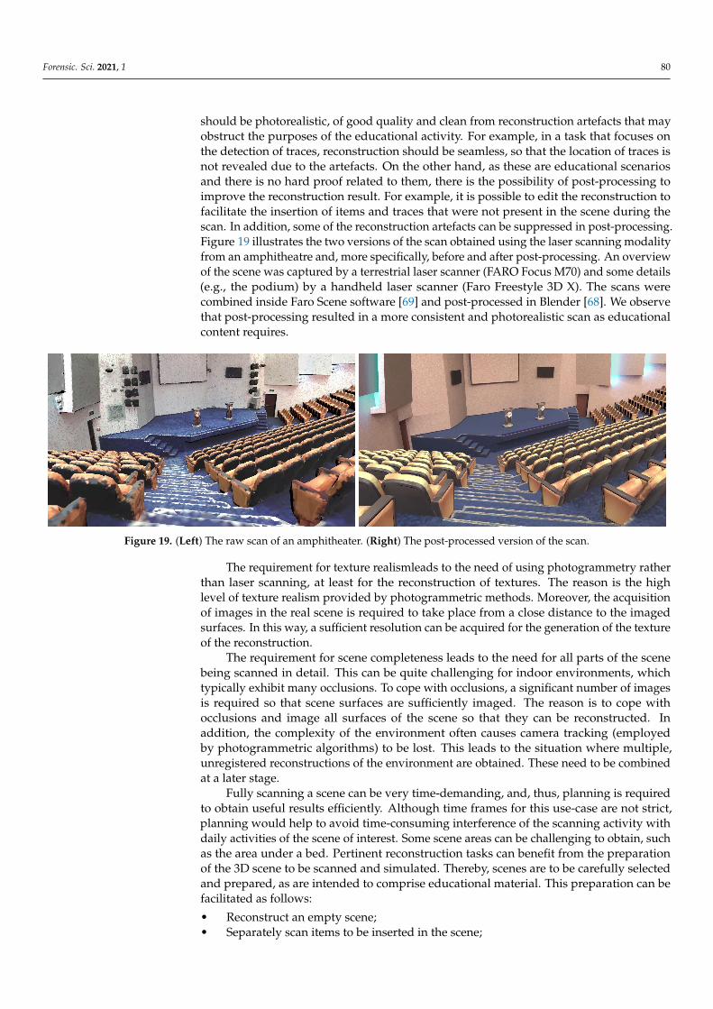
should be photorealistic, of good quality and clean from reconstruction artefacts that mayobstruct the purposes of the educational activity. For example, in a task that focuses onthe detection of traces, reconstruction should be seamless, so that the location of traces isnot revealed due to the artefacts. On the other hand, as these are educational scenariosand there is no hard proof related to them, there is the possibility of post-processing toimprove the reconstruction result. For example, it is possible to edit the reconstruction tofacilitate the insertion of items and traces that were not present in the scene during thescan. In addition, some of the reconstruction artefacts can be suppressed in post-processing.Figure 19 illustrates the two versions of the scan obtained using the laser scanning modalityfrom an amphitheatre and, more specifically, before and after post-processing. An overviewof the scene was captured by a terrestrial laser scanner (FARO Focus M70) and some details(e.g., the podium) by a handheld laser scanner (Faro Freestyle 3D X). The scans werecombined inside Faro Scene software [69] and post-processed in Blender [68]. We observethat post-processing resulted in a more consistent and photorealistic scan as educationalcontent requires.
Figure 19. (Left) The raw scan of an amphitheater. (Right) The post-processed version of the scan.
The requirement for texture realismleads to the need of using photogrammetry ratherthan laser scanning, at least for the reconstruction of textures. The reason is the highlevel of texture realism provided by photogrammetric methods. Moreover, the acquisitionof images in the real scene is required to take place from a close distance to the imagedsurfaces. In this way, a sufficient resolution can be acquired for the generation of the textureof the reconstruction.
The requirement for scene completeness leads to the need for all parts of the scenebeing scanned in detail. This can be quite challenging for indoor environments, whichtypically exhibit many occlusions. To cope with occlusions, a significant number of imagesis required so that scene surfaces are sufficiently imaged. The reason is to cope withocclusions and image all surfaces of the scene so that they can be reconstructed. Inaddition, the complexity of the environment often causes camera tracking (employedby photogrammetric algorithms) to be lost. This leads to the situation where multiple,unregistered reconstructions of the environment are obtained. These need to be combinedat a later stage.
Fully scanning a scene can be very time-demanding, and, thus, planning is requiredto obtain useful results efficiently. Although time frames for this use-case are not strict,planning would help to avoid time-consuming interference of the scanning activity withdaily activities of the scene of interest. Some scene areas can be challenging to obtain, suchas the area under a bed. Pertinent reconstruction tasks can benefit from the preparationof the 3D scene to be scanned and simulated. Thereby, scenes are to be carefully selectedand prepared, as are intended to comprise educational material. This preparation can befacilitated as follows:
• Reconstruct an empty scene;• Separately scan items to be inserted in the scene;
Forensic. Sci. 2021, 1 81
• Assemble individual scans into a curated educational scene.
This way, the application should allow the trainee to look for traces there, just as in areal environment. Moreover, using this approach, models of environments and objects canbe combined in multiple ways. In this way, multiple educational scenarios can be coveredby reusing the repository of digital assets.
As an effect, this design provides flexibility to the corresponding educational appli-cations. For example, one of the end-user requirements is that the trainer should be ableto change the occurrence and locations of different objects and traces in the simulatedenvironment. Having objects independently scanned from the environment permits theplacement of a simulated object at any location in the 3D scene. In contrast, if objects werescanned along with the environment, then moving an object would create a hole in thereconstruction.
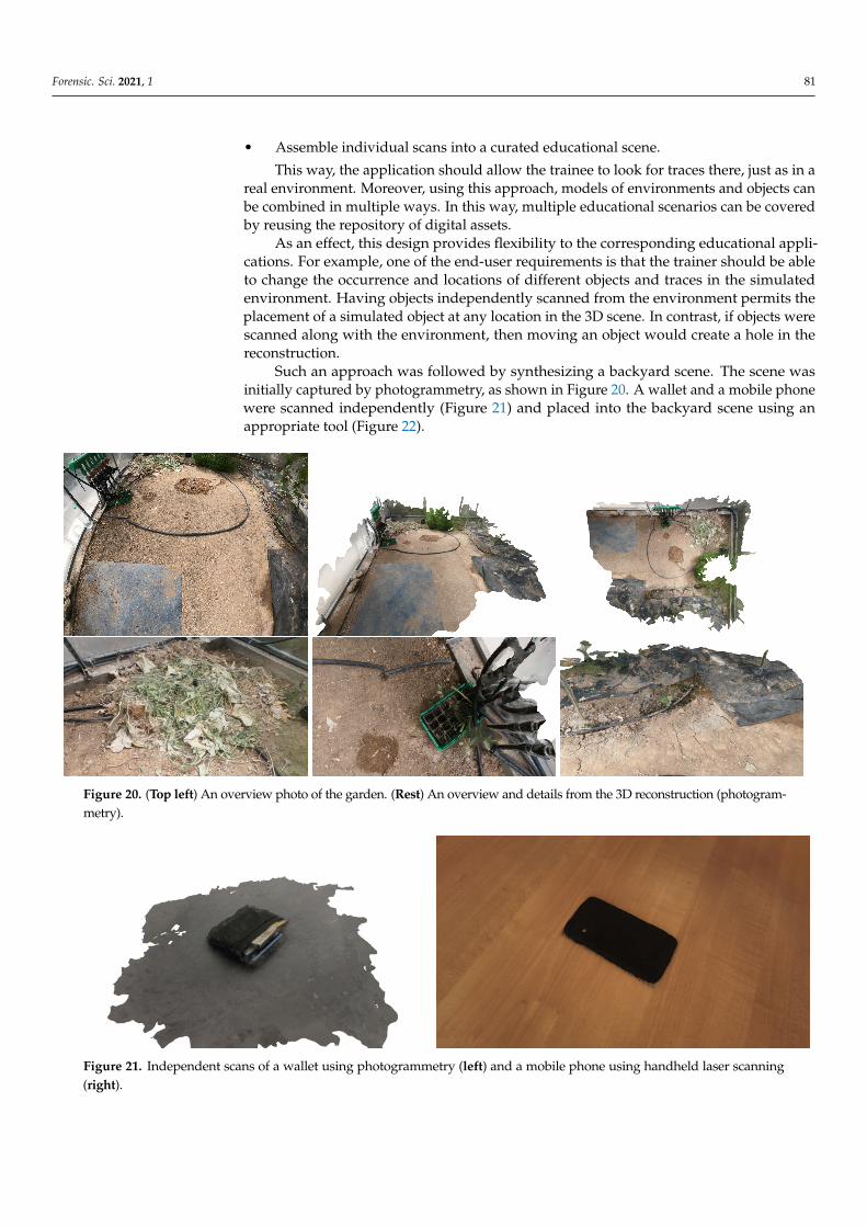
Such an approach was followed by synthesizing a backyard scene. The scene wasinitially captured by photogrammetry, as shown in Figure 20. A wallet and a mobile phonewere scanned independently (Figure 21) and placed into the backyard scene using anappropriate tool (Figure 22).
Figure 20. (Top left) An overview photo of the garden. (Rest) An overview and details from the 3D reconstruction (photogram-metry).
Figure 21. Independent scans of a wallet using photogrammetry (left) and a mobile phone using handheld laser scanning(right).
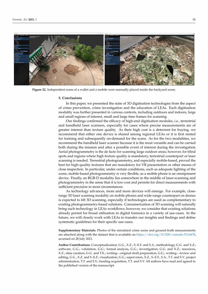
Forensic. Sci. 2021, 1 82
Figure 22. Independent scans of a wallet and a mobile were manually placed inside the backyard scene.
5. Conclusions
In this paper, we presented the state of 3D digitisation technologies from the aspectof crime prevention, crime investigation and the education of LEAs. Each digitisationmodality was further presented in various contexts, including outdoors and indoors, largeand small regions of interest, small and large time frames for scanning.
Our findings confirmed the efficacy of high-end digitisation modules, i.e., terrestrialand handheld laser scanners, especially for cases where precise measurements are ofgreater interest than texture quality. As their high cost is a deterrent for buying, werecommend that either one device is shared among regional LEAs or it is first rentedfor training and subsequently on-demand for the scans. As for the two modalities, werecommend the handheld laser scanner because it is the most versatile and can be carriedboth during the mission and after a possible event of interest during the investigation.Aerial photogrammetry is the de facto for scanning large outdoor areas; however, for blindspots and regions where high texture quality is mandatory, terrestrial counterpart or laserscanning is needed. Terrestrial photogrammetry, and especially mobile-based, proved thebest for high-quality textures that are mandatory for VR presentation or other means ofclose inspection. In particular, under certain conditions, such as adequate lighting of thescene, mobile-based photogrammetry is very flexible, as a mobile phone is an omnipresentdevice. Finally, an RGB-D modality lies somewhere in the middle of laser-scanning andphotogrammetry in the sense that it is low-cost and permits for direct measurements withsufficient precision in most circumstances.
As technology advances, more and more devices will emerge. For example, close-range 3D laser scanning modality on mobile phones and wide-range counterpart on dronesis expected to lift 3D scanning, especially if technologies are used as complementary toexisting photogrammetry-based solutions. Consumerization of 3D scanning will naturallybring such technology in LEAs workflows; however, we consider that existing solutionsalready permit for broad utilisation in digital forensics in a variety of use-cases. In thefuture, we will closely work with LEAs to transfer our insights and findings and definesystematic guidelines for their specific use-cases.
Supplementary Materials: Photos of the simulated crime scene and ground-truth measurementsare attached along with the dataset that is available on https://doi.org/10.5281/zenodo.5116478,accessed on 28 July 2021.
Author Contributions: Conceptualization, G.G., X.Z., S.-E.F. and S.A.; methodology, G.G. and X.Z.;software, G.G.; validation, G.G.; formal analysis, G.G.; investigation, G.G. and X.Z.; resources,X.Z.; data curation, G.G. and T.E.; writing—original draft preparation, G.G.; writing—review andediting, G.G., X.Z. and S.-E.F.; visualization, G.G.; supervision, X.Z., S.-E.F., S.A., T.T. and S.V.; projectadministration, T.T. and S.V.; funding acquisition, T.T. and S.V. All authors have read and agreed tothe published version of the manuscript.

Forensic. Sci. 2021, 1 83
Funding: This research has received funding from the European Union’s CONNEXIONs, Horizon2020 research and innovation program, under grant agreement No 786731.
Institutional Review Board Statement: Not applicable.
Informed Consent Statement: Not applicable.
Data Availability Statement: The multi-modal dataset that was described and briefly presented inthe text is available at https://doi.org/10.5281/zenodo.5116478, accessed on 28 July 2021.
Acknowledgments: The facilities for the creation of the dataset were provided by the FORTH-ICSinternal RTD Programme ’Ambient Intelligence and Smart Environments’. The authors would alsolike to thank Panagiotis Koutlemanis for their contribution to the creation of the dataset.
Conflicts of Interest: The authors declare no conflict of interest.
AbbreviationsThe following abbreviations are used in this manuscript:
AR Augmented realityCAD Computer-aided designCSI Crime scene investigationDSLR Digital single-lens reflex cameraIMU Inertial measurement unitFOV Field of viewGCP Ground control pointGIS Geographic information systemGNSS Global navigation satellite systemGPS Global positioning systemLEA Law enforcement agencyRGB RGB color model (from red, green and blue components)SLAM Simultaneous localization and mappingVR Virtual reality
References1. Osman, M.R.; Tahar, K.N. 3D accident reconstruction using low-cost imaging technique. Adv. Eng. Softw. 2016, 100, 231–237.
[CrossRef]2. Kreul, D.; Thali, M.; Schweitzer, W. Case report: Forensic 3D-match of hair brush and scalp abrasions revealing dynamic brush
deformation. J. Forensic Radiol. Imaging 2019, 16, 34–37. [CrossRef]3. Amamra, A.; Amara, Y.; Boumaza, K.; Benayad, A. Crime Scene Reconstruction with RGB-D Sensors. In Proceedings of the
2019 Federated Conference on Computer Science and Information Systems (FedCSIS), Leipzig, Germany, 1–4 September 2019;pp. 391–396.
4. Le, Q.; Liscio, E. A comparative study between FARO Scene and FARO Zone 3D for area of origin analysis. Forensic Sci. Int. 2019,301, 166–173. [CrossRef]
5. Liscio, E.; Le, Q.; Guryn, H. Accuracy and reproducibility of bullet trajectories in FARO zone 3D. J. Forensic Sci. 2020, 65, 214–220.[CrossRef] [PubMed]
6. Fahrni, S.; Delémont, O.; Campana, L.; Grabherr, S. An exploratory study toward the contribution of 3D surface scanning forassociation of an injury with its causing instrument. Int. J. Leg. Med. 2019, 133, 1167–1176. [CrossRef] [PubMed]
7. Forensic Technology Center of Excellence. In Success Story: Advancing 3D Virtual Microscopy for Firearm Forensics; ForensicTechnology Center of Excellence: Research Triangle Park, NC, USA, 2019
8. Wieczorek, T.; Przyłucki, R.; Lisok, J.; Smagór, A. Analysis of the Accuracy of Crime Scene Mapping Using 3D Laser Scanners. InInternational Workshop on Modeling Social Media; Springer: Cham, Swizerland, 2018; pp. 406–415.
9. Zhang, W.; Kosiorek, D.A.; Brodeur, A.N. Application of Structured-Light 3-D Scanning to the Documentation of PlasticFingerprint Impressions: A Quality Comparison with Traditional Photography. J. Forensic Sci. 2019, 65, 784–790. [CrossRef]
10. Whelan, D.; Weggel, D.; Moss, J.; Howe, A. Post-Blast Investigative Tools for Structural Forensics by 3D Scene Reconstructionand Advanced Simulation. Natl. Crim. Justice Ref. Serv. 2019, 19, 252954.
11. Cerreta, J.S.; Burgess, S.S.; Coleman, J. UAS for Public Safety Operations: A Comparison of UAS Point Clouds to TerrestrialLIDAR Point Cloud Data using a FARO Scanner. Int. J. Aviat. Aeronaut. Aerosp. 2020, 7, 6. [CrossRef]
12. Villa, C.; Jacobsen, C. The Application of Photogrammetry for Forensic 3D Recording of Crime Scenes, Evidence and People. InEssentials of Autopsy Practice: Reviews, Updates and Advances; Springer International Publishing: Cham, Swizerland, 2019; pp. 1–18.[CrossRef]

Forensic. Sci. 2021, 1 84
13. Luchowski, L.; Pojda, D.; Tomaka, A.A.; Skabek, K.; Kowalski, P. Multimodal Imagery in Forensic Incident Scene Documentation.Sensors 2021, 21, 1407. [CrossRef]
14. Le, Q.; Liscio, E. FARO Zone 3D Area of Origin Tools with Handheld 3D Data. J. Assoc. Crime Scene Reconstr. 2019, 23, 1–10.15. Esaias, O.; Noonan, G.W.; Everist, S.; Roberts, M.; Thompson, C.; Krosch, M.N. Improved Area of Origin Estimation for Bloodstain
Pattern Analysis Using 3D Scanning. J. Forensic Sci. 2019, 65, 722–728. [CrossRef]16. Liscio, E.; Bozek, P.; Guryn, H.; Le, Q. Observations and 3D Analysis of Controlled Cast-Off Stains. J. Forensic Sci. 2020, 65,
1128–1140. [CrossRef]17. Süncksen, M.; Teistler, M.; Hamester, F.; Ebert, L.C. Preparing and guiding forensic crime scene inspections in virtual reality. In
Proceedings of the Mensch und Computer, Hamburg, Germany, 8–11 September 2019; pp. 755–758.18. Mach, V.; Valouch, J.; Adámek, M.; Ševcík, J. Virtual reality–level of immersion within the crime investigation. In MATEC Web of
Conferences; EDP Sciences: Les Ulis Cedex A, France, 2019; Volume 292, p. 01031.19. Sieberth, T.; Dobay, A.; Affolter, R.; Ebert, L.C. Applying virtual reality in forensics–a virtual scene walkthrough. Forensic Sci.
Med. Pathol. 2019, 15, 41–47. [CrossRef]20. Sieberth, T.; Dobay, A.; Affolter, R.; Ebert, L. A toolbox for the rapid prototyping of crime scene reconstructions in virtual reality.
Forensic Sci. Int. 2019, 305, 110006. [CrossRef] [PubMed]21. Ebert, L.C.; Ptacek, W.; Breitbeck, R.; Fürst, M.; Kronreif, G.; Martinez, R.M.; Thali, M.; Flach, P.M. Virtobot 2.0: The future
of automated surface documentation and CT-guided needle placement in forensic medicine. Forensic Sci. Med. Pathol. 2014,10, 179–186. [CrossRef] [PubMed]
22. Norman, D.G.; Wade, K.A.; Williams, M.A.; Watson, D.G. Caught Virtually Lying—Crime Scenes in Virtual Reality Help toExpose Suspects’ Concealed Recognition. J. Appl. Res. Mem. Cogn. 2020, 9, 118–127. [CrossRef]
23. Wang, J.; Li, Z.; Hu, W.; Shao, Y.; Wang, L.; Wu, R.; Ma, K.; Zou, D.; Chen, Y. Virtual reality and integrated crime scene scanningfor immersive and heterogeneous crime scene reconstruction. Forensic Sci. Int. 2019, 303, 109943. [CrossRef]
24. Tredinnick, R.; Smith, S.; Ponto, K. A cost-benefit analysis of 3D scanning technology for crime scene investigation. Forensic Sci.Int. Rep. 2019, 1, 100025. [CrossRef]
25. Liu, S. Three-dimension Point Cloud Technology and Intelligent Extraction of Trace Evidence at the Scene of Crime. In Journal ofPhysics: Conference Series; IOP Publishing: Bristol, UK, 2019; Volume 1237, p. 042027.
26. Johnson, A.; Pandey, A. Three-dimensional scanning-A futuristic technology in forensic anthropology. J. Indian Acad. ForensicMed. 2019, 41, 128–131. [CrossRef]
27. Bahirat, K.; Prabhakaran, B. A study on lidar data forensics. In Proceedings of the 2017 IEEE International Conference onMultimedia and Expo (ICME), Hong Kong, China, 10–14 July 2017; pp. 679–684.
28. Berezowski, V.; Mallett, X.; Moffat, I. Geomatic techniques in forensic science: A review. Sci. Justice 2020, 60, 99–107. [CrossRef]29. Artec Europe. Artec Ray Laser Scanner. Available online: https://www.artec3d.com/portable-3d-scanners/laser-ray-v2
(accessed on 6 July 2021).30. FARO Technologies. FARO Focus Laser Scanners. Available online: https://www.faro.com/en/Products/Hardware/Focus-
Laser-Scanners (accessed on 6 July 2021).31. Leica Geosystems AG. Leica ScanStation P40/P30—High-Definition 3D Laser Scanning Solution. Available online: https:
//leica-geosystems.com/products/laser-scanners/scanners/leica-scanstation-p40--p30 (accessed on 6 July 2021).32. Leica Geosystems AG. Leica ScanStation P50—Long Range 3D Terrestrial Laser Scanner. Available online: https://leica-
geosystems.com/products/laser-scanners/scanners/leica-scanstation-p50 (accessed on 6 July 2021).33. Leica Geosystems AG. Leica RTC360 3D Laser Scanner. Available online: https://leica-geosystems.com/products/laser-
scanners/scanners/leica-rtc360 (accessed on 6 July 2021).34. Zoller + Fröhlich GmbH. Z + F IMAGER® 5010X, 3D Laser Scanner. Available online: https://www.zf-laser.com/Z-F-IMAGER-
R-5010X.3d_laser_scanner.0.html?&L=1 (accessed on 6 July 2021).35. Teledyne Optech. Polaris Terrestrial Laser Scanner (TLS) Series. Available online: https://www.teledyneoptech.com/en/
products/static-3d-survey/polaris/ (accessed on 6 July 2021).36. Trimble Inc. Trimble Laser Scanning Solutions. Available online: https://geospatial.trimble.com/products-and-solutions/laser-
scanning (accessed on 6 July 2021).37. RIEGL Laser Measurement Systems GmbH. RIEGL Terrestrial Laser Scanners. Available online: http://www.riegl.com/nc/
products/terrestrial-scanning/ (accessed on 6 July 2021).38. Aniwaa Pte. Ltd. Aniwaa 3D Scanner Comparison Engine. Available online: https://www.aniwaa.com/comparison/3d-scanners
(accessed on 6 July 2021).39. AliceVision. Meshroom: A 3D Reconstruction Software. Available online: https://github.com/alicevision/meshroom (accessed
on 25 May 2021).40. PhotoModeler Technologies. PhotoModeler Photogrammetry Software. Available online: https://www.photomodeler.com
(accessed on 6 July 2021).41. Agisoft LLC. Agisoft Metashape. Available online: https://www.agisoft.com (accessed on 6 July 2021).42. Pix4D SA. PIX4Dmapper. Available online: https://www.pix4d.com/product/pix4dmapper-photogrammetry-software
(accessed on 6 July 2021).43. Autodesk Inc. Recap Pro. Available online: https://www.autodesk.com/products/recap (accessed on 6 July 2021).

Forensic. Sci. 2021, 1 85
44. 3Dflow SRL. 3DF Zephyr. Available online: https://www.3dflow.net/3df-zephyr-photogrammetry-software (accessed on6 July 2021).
45. OpenDroneMap Authors. ODM—A Command Line Toolkit to Generate Maps, Point Clouds, 3D Models and DEMs from Drone,Balloon or Kite Images. Available online: https://opendronemap.org (accessed on 6 July 2021).
46. SimActive Inc. Correlator3D. Available online: https://www.simactive.com/correlator3d-mapping-software-features.html(accessed on 6 July 2021).
47. PMS AG. Elcovision 10. Available online: https://en.elcovision.com/ (accessed on 6 July 2021).48. DroneDeploy. DroneDeploy. Available online: https://www.dronedeploy.com (accessed on 6 July 2021).49. Mezhenin, A.; Polyakov, V.; Prishhepa, A.; Izvozchikova, V.; Zykov, A. Using Virtual Scenes for Comparison of Photogrammetry
Software. In Advances in Intelligent Systems, Computer Science and Digital Economics II; Hu, Z., Petoukhov, S., He, M., Eds.; SpringerInternational Publishing: Cham, Swizerland, 2021; pp. 57–65.
50. Kingsland, K. Comparative analysis of digital photogrammetry software for cultural heritage. Digit. Appl. Archaeol. Cult. Herit.2020, 18, e00157. [CrossRef]
51. DJI. Phantom 4 RTK. Available online: https://www.dji.com/gr/phantom-4-rtk (accessed on 25 May 2021).52. Trnio, Inc. Trnio 3D Scanner. Available online: https://www.trnio.com/ (accessed on 25 May 2021).53. Durrant-Whyte, H.; Bailey, T. Simultaneous localization and mapping: Part I. IEEE Robot. Autom. Mag. 2006, 13, 99–110.
[CrossRef]54. Mur-Artal, R.; Tardós, J.D. Orb-slam2: An open-source slam system for monocular, stereo, and rgb-d cameras. IEEE Trans. Robot.
2017, 33, 1255–1262. [CrossRef]55. Lee, J.H.; Ha, H.; Dong, Y.; Tong, X.; Kim, M.H. Texturefusion: High-quality texture acquisition for real-time rgb-d scanning.
In Proceedings of the IEEE/CVF Conference on Computer Vision and Pattern Recognition, Seattle, WA, USA, 13–19 June 2020;pp. 1272–1280.
56. Ha, H.; Lee, J.H.; Meuleman, A.; Kim, M.H. NormalFusion: Real-Time Acquisition of Surface Normals for High-ResolutionRGB-D Scanning. In Proceedings of the IEEE/CVF Conference on Computer Vision and Pattern Recognition, Nashville, TN,USA, 21–24 June 2021; pp. 15970–15979.
57. Xu, Y.; Zhou, L.; Tang, H.; Wu, Q.; Xie, Q.; Chen, H.; Wang, J. Robust and Accurate RGB-D Reconstruction with Line FeatureConstraints. IEEE Robot. Autom. Lett. 2021, 6, 6561–6568. [CrossRef]
58. ImFusion GmbH. RecFusion Website. Available online: https://www.recfusion.net (accessed on 6 July 2021).59. DotProduct LLC. Dot3D Pro Website. Available online: https://www.dotproduct3d.com/dot3dpro.html (accessed on 6 July 2021).60. Artec Europe. Artec Spider Handheld Scanner. Available online: https://www.artec3d.com/portable-3d-scanners/artec-spider
(accessed on 6 July 2021).61. Artec Europe. Artec Leo Handheld Scanner. Available online: https://www.artec3d.com/portable-3d-scanners/artec-leo
(accessed on 6 July 2021).62. FARO Technologies. FARO Freestyle 2 Handheld Scanner. Available online: https://www.faro.com/en/Products/Hardware/
Freestyle-2-Handheld-Scanner (accessed on 6 July 2021).63. Creaform. Go!SCAN SPARK Handheld Scanner. Available online: https://www.creaform3d.com/en/handheld-portable-3d-
scanner-goscan-3d (accessed on 6 July 2021).64. Creaform. HandySCAN 3D Handheld Scanner, SILVER Series. Available online: https://www.creaform3d.com/en/handyscan-
3d-silver-series-professional-3d (accessed on 6 July 2021).65. Scantech (Hangzhou) Co. Ltd. KSCAN-Magic Composite 3D Scanner. Available online: https://www.3d-scantech.com/
product/kscan-magic-composite-3d-scanner (accessed on 6 July 2021).66. SHINING 3D. EinScan HX, Hybrid Blue Laser & LED Light Source Handheld 3D Scanner. Available online: https://www.
einscan.com/handheld-3d-scanner/einscan-hx (accessed on 6 July 2021).67. Cignoni, P.; Corsini, M.; Ranzuglia, G. MeshLab: An Open-Source 3D Mesh Processing System. ERCIM News 2008, 2008, 129–136.68. Community, B.O. Blender—A 3D Modelling and Rendering Package; Blender Foundation, Stichting Blender Foundation: Amsterdam,
The Netherlands, 2018.69. FARO Technologies. FARO SCENE Software Website. Available online: https://www.faro.com/en/Products/Software/SCENE-
Software (accessed on 6 July 2021).70. Leica Geosystems AG. Leica Cyclone REGISTER. Available online: https://leica-geosystems.com/products/laser-scanners/
software/leica-cyclone/leica-cyclone-register (accessed on 6 July 2021).71. Canon. GPS Receiver GP-E2. Available online: https://www.usa.canon.com/internet/portal/us/home/products/details/
cameras/gps-receivers/gps-receiver-gp-e2 (accessed on 6 July 2021).