A relocation-based initialization scheme to improve track-forecasting of tropical cyclones
10
ADVANCES IN ATMOSPHERICSCIENCES, VOL. 31, JANUARY 2014, 27–36 A Relocation-based Initialization Scheme to Improve Track-forecasting of Tropical Cyclones GAO Feng ∗1,2 , Peter P. CHILDS 3 , Xiang-Yu HUANG 2 , Neil A. JACOBS 3 , and Jinzhong MIN 1,4 1 Nanjing University of Information Science & Technology, Nanjing 210044 2 National Center for Atmospheric Research, Boulder, Colorado, USA 80307 3 Panasonic Avionics Corporation Morrisville, North Carolina, USA 4 Key Laboratory of Meteorological Disaster of the Ministry of Education, Nanjing 210044 (Received 10 October 2012; revised 19 December 2012; accepted 5 February 2013) ABSTRACT A relocation procedure to initialize tropical cyclones was developed to improve the representation of the initial conditions and the track forecast for Panasonic Weather Solutions Tropical Operational Forecasts. This scheme separates the vortex perturbation and environment field from the first guess, then relocates the initial vortex perturbations to the observed position by merging them with the environment field. The relationships of wind vector components with stream function and velocity potential are used for separating the vortex disturbance from first guess. For the separation of scalars, a low-pass Barnes filter is employed. The irregular-shaped relocation area corresponding to the specific initial conditions is determined by mapping the edge of the vortex radius in 36 directions.Then, the non-vortex perturbations in the relocation area are removed by a two-pass Barnes filter to retain the vortex perturbations, while the variable fields outside the perimeter of the modified vortex are kept identical to the original first guess. The potential impacts of this scheme on track forecasts were examined for three hurricane cases in the 2011–12 hurricane season. The experimental results demonstrate that the initialization scheme is able to effectively separate the vortex field from the environment field and maintain a relatively balanced and accurate relocated first guess. As the initial track error is reduced, the following track forecasts are considerably improved. The 72-h average track forecast error was reduced by 32.6% for the cold-start cases, and by 38.4% when using the full-cycling data assimilation because of the accumulated improvements from the initialization scheme. Key words: tropical cyclone, vortex relocation, data assimilation, Barnes filtering Citation: Gao, F., P. P. Childs, X.-Y. Huang, N. A. Jacobs, and J. Z. Min, 2014: A relocation-based initialization scheme to improve track-forecasting of tropical cyclones. Adv. Atmos. Sci., 31(1), 27–36, doi:10.1007/s00376-013-2254-5. 1. Introduction Numerical weather prediction (NWP) of tropical cy- clones (TCs) often relies on a short-term forecast of less than 6 h as a first guess of the background field, which typically originates from either a high-resolution limited-area model or a lower resolution global model. In both situations, the ability of the first guess to accurately resolve the center of the storm is limited by either forecast error or too few grid points to properly resolve the vortex structure, especially within weak circulations (Kurihara et al., 1993, 1995; Rappaport et al., 2009). As a result of erratic movement during the initial stages of prediction, the skill of the subsequent track fore- casts is significantly degraded. Some past studies have done a good job at addressing ∗ Corresponding Author: Feng GAO E-mail: [email protected] initialization schemes to improve the representation of the vortex, mainly through the use of nonconventional observa- tions and “bogus” techniques. Zhu et al. (2002) and Weng et al. (2007) reported improved representation of temperature, humidity and wind fields around the vortex core by verifying the potential impacts of microwave observations. Whereas, since the impact is a function of flow-dependent observation information from the definite satellite track and time (Pan et al., 2011), radiance observations alone are unable to revise the track forecast at the assimilation and analysis time. As a further practical technique, some studies have focused on the initialization of the vortex by generating bogus observations that meet the TC empirical structure. To construct this classic TC structure, there are two conventional methods that are typ- ically employed. The first directly introduces the new vortex (e.g., Kurihara et al., 1990; Lord, 1991; Low-Nam and Davis, 2001); while the second, called the Bogus Data Assimilation (BDA) method, utilizes a variational framework (Xiao et al., © Institute of Atmospheric Physics/Chinese Academy of Sciences, and Science Press and Springer-Verlag Berlin Heidelberg 2014
Transcript of A relocation-based initialization scheme to improve track-forecasting of tropical cyclones
ADVANCES IN ATMOSPHERIC SCIENCES, VOL. 31, JANUARY 2014, 27–36
A Relocation-based Initialization Scheme to Improve Track-forecasting of
Tropical Cyclones
GAO Feng∗1,2, Peter P. CHILDS3, Xiang-Yu HUANG2, Neil A. JACOBS3, and Jinzhong MIN1,4
1Nanjing University of Information Science & Technology, Nanjing 2100442National Center for Atmospheric Research, Boulder, Colorado, USA 80307
3Panasonic Avionics Corporation Morrisville, North Carolina, USA4Key Laboratory of Meteorological Disaster of the Ministry of Education, Nanjing 210044
(Received 10 October 2012; revised 19 December 2012; accepted 5 February 2013)
ABSTRACT
A relocation procedure to initialize tropical cyclones wasdeveloped to improve the representation of the initial conditionsand the track forecast for Panasonic Weather Solutions Tropical Operational Forecasts. This scheme separates the vortexperturbation and environment field from the first guess, thenrelocates the initial vortex perturbations to the observedpositionby merging them with the environment field.
The relationships of wind vector components with stream function and velocity potential are used for separating thevortex disturbance from first guess. For the separation of scalars, a low-pass Barnes filter is employed. The irregular-shapedrelocation area corresponding to the specific initial conditions is determined by mapping the edge of the vortex radius in36 directions.Then, the non-vortex perturbations in the relocation area are removed by a two-pass Barnes filter to retain thevortex perturbations, while the variable fields outside theperimeter of the modified vortex are kept identical to the originalfirst guess.
The potential impacts of this scheme on track forecasts wereexamined for three hurricane cases in the 2011–12 hurricaneseason. The experimental results demonstrate that the initialization scheme is able to effectively separate the vortex field fromthe environment field and maintain a relatively balanced andaccurate relocated first guess. As the initial track error isreduced,the following track forecasts are considerably improved. The 72-h average track forecast error was reduced by 32.6% forthecold-start cases, and by 38.4% when using the full-cycling data assimilation because of the accumulated improvements fromthe initialization scheme.
Key words: tropical cyclone, vortex relocation, data assimilation,Barnes filtering
Citation: Gao, F., P. P. Childs, X.-Y. Huang, N. A. Jacobs, and J. Z. Min, 2014: A relocation-based initialization scheme toimprove track-forecasting of tropical cyclones.Adv. Atmos. Sci., 31(1), 27–36, doi:10.1007/s00376-013-2254-5.
1. Introduction
Numerical weather prediction (NWP) of tropical cy-clones (TCs) often relies on a short-term forecast of less than6 h as a first guess of the background field, which typicallyoriginates from either a high-resolution limited-area model ora lower resolution global model. In both situations, the abilityof the first guess to accurately resolve the center of the stormis limited by either forecast error or too few grid points toproperly resolve the vortex structure, especially within weakcirculations (Kurihara et al., 1993, 1995; Rappaport et al.,2009). As a result of erratic movement during the initialstages of prediction, the skill of the subsequent track fore-casts is significantly degraded.
Some past studies have done a good job at addressing
∗ Corresponding Author: Feng GAOE-mail: [email protected]
initialization schemes to improve the representation of thevortex, mainly through the use of nonconventional observa-tions and “bogus” techniques. Zhu et al. (2002) and Weng etal. (2007) reported improved representation of temperature,humidity and wind fields around the vortex core by verifyingthe potential impacts of microwave observations. Whereas,since the impact is a function of flow-dependent observationinformation from the definite satellite track and time (Pan etal., 2011), radiance observations alone are unable to revisethe track forecast at the assimilation and analysis time. Asafurther practical technique, some studies have focused on theinitialization of the vortex by generating bogus observationsthat meet the TC empirical structure. To construct this classicTC structure, there are two conventional methods that are typ-ically employed. The first directly introduces the new vortex(e.g., Kurihara et al., 1990; Lord, 1991; Low-Nam and Davis,2001); while the second, called the Bogus Data Assimilation(BDA) method, utilizes a variational framework (Xiao et al.,
© Institute of Atmospheric Physics/Chinese Academy of Sciences, and Science Press and Springer-Verlag Berlin Heidelberg 2014

28 A RELOCATION SCHEME TO IMPROVE TROPICAL CYCLONES TRACK FORECASTS VOLUME 31
2000; Pu and Braun, 2001; Zhang et al., 2003).In the Low-Nam method (Low-Nam and Davis, 2001),
the splitting process of the initial vortex meets the dynamicand thermodynamics balance relationship. Since only the bo-gus axis-symmetry structure of the wind, mass and humidityfields are presented, this scheme is largely used for testing,and rarely for real-time operational forecasts. Kurihara et al.(1990) and Lord (1991) specified a bogus vortex includingboth axisymmetric and asymmetric components. A criticalissue in such an approach is the continuity of the vortex withthe properties of the prediction model (Mathur, 1991). Xiaoet al. (2000), Pu and Braun (2001) and Zhang et al. (2003)addressed this issue by using 3D/4D variational assimilationmethods to insert bogus sea-level pressure and wind data, de-rived from empirical functions, into the first guess. One ofthe advantages in this minimization procedure is that the syn-thetic vortex structure is introduced gradually into the ini-tial conditions, which objectively satisfies the dynamic andphysical constraints for the model atmosphere. However, alimitation is that the bogus data are generated by empiricalfunctions. These could be limited in their scope of suitabilityacross types and stages of TC systems and the surroundingcirculation structure—considering that the changeable asym-metric radius of maximum wind (RMW) in reality is a sensi-tive parameter (Xiao et al., 2000).
Although the position of the TC center is not typicallyrecognized by Global Forecast System (GFS) analysis, andthe intensity quite often becomes weaker because of the in-ability to resolve subgrid-scale convection with parameter-ized physics, the model can still capture the general flowaround the TC in the first-guess field. Using these consid-erations, a practical method was developed by Kurihara etal. (1993), at the Geophysical Fluid Dynamics Laboratory(GFDL), to reconstruct the initial vortex. In their study, theinitial vortex in the GFS analysis was filtered out to derivethe asymmetric wind components. The axisymmetric vortexcame from the time integration of the axisymmetric hurricaneprediction model, where the variables meet the dynamic andthermal constraints dependent on the background during thespin-up phase. Then, the symmetric and asymmetric flowswere implanted into the environment field at the observed po-sition. This technique ensures a smooth transition betweenthe environment and the structural consistency of the gener-ated vortex. During the initial phase, the environment fielddoes not always capture features related to TC growth andvortex intensity. Likewise, when the TC itself is weak, it canalso lead to a less accurate prediction (Kurihara et al., 1995).
To overcome this limitation, Kurihara et al. (1995) fur-ther improved the scheme by revising the environment fieldto minimize the removal of important non-TC features nearthe storm region. This enabled the environment field to moreaccurately resolve irregular patterns that are inherent inde-veloping TC storm structure, which substantially improvedthe ability to forecast the TC track. More recently, a simi-lar vortex relocation technique, based on the Kurihara et al.(1995) vortex separation method, was developed and imple-mented in the National Centers for Environmental Prediction
(NCEP) GFS (Liu et al., 2000). Instead of inserting a spun-up vortex, this relocation method fetched the model-predictedvortex and directly moved it to the observed position. This re-duced the false spin-up problems typically caused by incon-sistencies between the initial conditions and the model dy-namics and physics.
This TC vortex relocation method was also implementedin the Weather Research and Forecasting model (WRF)-Advanced Research WRF (ARW) system at the Taiwan Cen-tral Weather Bureau (Hsiao et al., 2010), where the processto filter out the non-hurricane perturbations employed a two-pass Barnes filter. Results indicated that the variable transi-tioned smoothly at the vortex edges, and the track forecastssteadily improved during the operational implementation.
In summary, the vortex separation method in Kuriharaet al. (1995) has played a crucial role in track forecasting,and many operational centers presently use variations of thisscheme. In this paper, an updated TC relocation scheme isintroduced to improve the representation of the initial condi-tions and TC forecast accuracy for Panasonic Weather Solu-tions Tropical Operational Forecasts. The relocation schemeis based on a combination of the Kurihara et al. (1995) andLow-Nam and Davis (2001) separation methods, the Liu etal. (2000) method for extracting the vortex structure from thefirst guess, and the non-vortex perturbation filtering methodof Hsiao et al. (2010). The revised details are presented inthis paper. In addition, the GFDL conditions have been re-vised to adapt the scheme to cases surrounded by topography.
The remainder of the paper is arranged as follows. In sec-tion 2, the implementation of the initialization methodologyis presented in detail. Section 3 sets out the experimentalconfiguration, and then the experimental results, includinginformation on the process of relocation and track forecaststatistics, are presented in section 4. Finally, conclusions andplans for future work are discussed in section 5.
2. Vortex initializationThe vortex initialization process can briefly be summa-
rized by the following steps:(1) Split a first guess into a basic field and a disturbance
field that includes vortex circulation related to TC struc-ture and non-vortex circulation consisting of noise at variouswavelengths. The sum of the basic field and non-vortex cir-culation is called the “environmental field”.
(2) Filter out the vortex circulation within the irregular-shaped area corresponding to the specific environment bymapping the radius of the vortex edges in 36 directions.
(3) Generate the environment field.(4) Relocate the vortex to the observed location, and
merge it with the environment field.
2.1. Splitting of the disturbance field
According to the vortex separation method of Kurihara etal. (1995), a variableV can be split into the basic field (Vb)and the disturbance field (Vd):
V = Vb +Vd . (1)

JANUARY 2014 GAO ET AL. 29
The disturbance consists of the vortex circulationVtc and thenon-vortex circulationVnon-tc, which mainly consists of noisewith various wavelengths:
Vd = Vtc +Vnon-tc . (2)
Thus, the environment fieldVe is expressed as
Ve = V −Vtc = Vb +Vnon-tc . (3)
In this study, the Low-Nam method (Low-Nam and Davis,2001) is used to split the disturbance field of wind vectorcomponents. Considering the relationship between wind vec-tor components and the stream function, the equations aregiven as
∇2ψ = ζ , (4)
vψ = k̂×∇ψ , (5)
wherekk̂ is base vector,ψ is the stream function,ζ is relativevorticity, andvψ is the non-divergent wind.
The computation of the divergent wind is similar to Eqs.(4) and (5):
∇2χ = δ , (6)
vχ = ∇χ , (7)
whereχ is the velocity potential,δ is the divergence, andvχis the divergent wind. As shown above, the disturbance fields(Vd) of vector components are obtained from Eqs. (4)–(7).
In the calculation of non-vortex perturbations (Vnon-tc),two-pass Barnes filtering is employed, while scalar filteringuses a Barnes low-pass filter (Barnes, 1994), as the first esti-mate for Eq. (8). The first estimate of the two-pass Barnesfilter is expressed as
F (1)i, j =
N∑
n=1wnFin, jn
N∑
n=1wn
, (8)
whereFin, jn is the variable field filtered,F (1)i, j is the first esti-
mate field, andN is the number of grid points calculated. Theweighting function,wn, is
wn = e−
r2n
R2 , (9)
wherer is the distance between the calculated and estimatedgrid point, and the constantR is chosen to fit a particular ap-plication of the scheme. In the second estimate, the final gridpoint values are given by Eq. (10), and the updated weightingfunction is expressed in Eq. (11):
F(2)i, j = F(1)
i, j +
N∑
n=1w′
nDin, jn
N∑
n=1w′
n
, (10)
w′
n = e−
r2n
0.3R2 , (11)
where Din, jn = Fin, jn − F (1)in, jn
is the difference between thevariable field and the first estimate.
The disturbance fields for scalars are obtained by sub-tracting the first estimate from the first guess. The coefficientR is defined as 1000. In the process of dealing with the non-vortex perturbations,R is defined as 300.
2.2. Determination of the vortex perturbation
The isolation of the vortex perturbationVtc from the dis-turbance fieldVd is accomplished by mapping the radial edgeof the vortex perturbation. Kurihara et al. (1995) give anempirical condition to determine the vortex edge radius inGFDL, which is based on the assumption that the disturbancewind is strong in the region of the storm.
Generally, one or more indices, such as maximum vortic-ity, minimum radial wind magnitude, geopotential height at850 hPa, 700 hPa, or sea-level pressure, are typically used toascertain the TC center position and track (Liu et al., 2000;Low-Nam and Davis, 2001; Hsiao et al., 2010). Although theweighted center is sufficient for relocation, it is not neces-sary to be the point of minimum radial wind magnitude whenconsidering the different phase positions of TC structure inthe vertical profile. This can result in an inaccurate calcu-lation of the maximum wind radius and vortex perturbationedges, especially for the weaker TC systems.
In this study, for the process of defining vortex edges, the850-hPa minimum radial wind magnitude is considered thecenter for outward calculations of the radius of maximum ra-dial wind magnitude. Furthermore, the tracker applicationa
developed by the Development Testbed Center (DTC) in theHurricane Weather Research and Forecasting (HWRF) modelis used to obtain the hurricane center by weighting certainindices—in the first guess for the computation of relocationdistance and in the forecasts for track computation.
Considering the impacts of terrain and a weak TC sys-tem, a revised condition is used in this study. The revisedGFDL condition is that of radial wind magnitudeVedge andits gradient as follows:
Vedge< 5.0 m s−1 , (12)
−∂Vedge/∂ r < 4×10⁻⁶ s−1 . (13)
At 850 hPa, the condition is checked outward from theradius of maximum wind magnitude along 36 directions (onepoint per 10◦) at an incremental resolution of 15 km. On thethird occasion this condition is met, orVedge< 3 m s−1, theradius is assumed to contain the major portion of the vor-tex circulation, and the relocation area is then defined by theedges. It is worth noting that Eq. (12) is a reasonable but notoptimal criterion for all terrain cases, which should be basedon long-term statistical results.
2.3. Relocation of the vortex circulation
After defining the relocation area, the vortex perturbationVtc, including theu andv components, temperature, specifichumidity, and sea-level pressure, is separated by removing
ahttp://www.dtcenter.org/HurrWRF/users/docs/usersguide/HWRFUG v3.4a.pdf
30 A RELOCATION SCHEME TO IMPROVE TROPICAL CYCLONES TRACK FORECASTS VOLUME 31
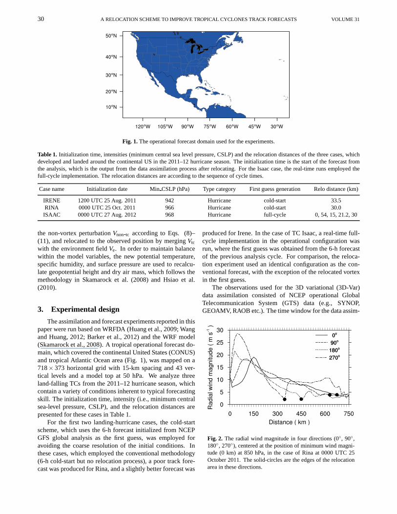
Fig. 1. The operational forecast domain used for the experiments.
Table 1. Initialization time, intensities (minimum central sea level pressure, CSLP) and the relocation distances of the threecases, whichdeveloped and landed around the continental US in the 2011–12 hurricane season. The initialization time is the start of the forecast fromthe analysis, which is the output from the data assimilationprocess after relocating. For the Isaac case, the real-timeruns employed thefull-cycle implementation. The relocation distances are according to the sequence of cycle times.
Case name Initialization date MinCSLP (hPa) Type category First guess generation Relo distance (km)
IRENE 1200 UTC 25 Aug. 2011 942 Hurricane cold-start 33.5RINA 0000 UTC 25 Oct. 2011 966 Hurricane cold-start 30.0ISAAC 0000 UTC 27 Aug. 2012 968 Hurricane full-cycle 0, 54, 15, 21.2, 30
the non-vortex perturbationVnon-tc according to Eqs. (8)–(11), and relocated to the observed position by mergingVtc
with the environment fieldVe. In order to maintain balancewithin the model variables, the new potential temperature,specific humidity, and surface pressure are used to recalcu-late geopotential height and dry air mass, which follows themethodology in Skamarock et al. (2008) and Hsiao et al.(2010).
3. Experimental design
The assimilation and forecast experiments reported in thispaper were run based on WRFDA (Huang et al., 2009; Wangand Huang, 2012; Barker et al., 2012) and the WRF model(Skamarock et al., 2008). A tropical operational forecast do-main, which covered the continental United States (CONUS)and tropical Atlantic Ocean area (Fig. 1), was mapped on a718× 373 horizontal grid with 15-km spacing and 43 ver-tical levels and a model top at 50 hPa. We analyze threeland-falling TCs from the 2011–12 hurricane season, whichcontain a variety of conditions inherent to typical forecastingskill. The initialization time, intensity (i.e., minimum centralsea-level pressure, CSLP), and the relocation distances arepresented for these cases in Table 1.
For the first two landing-hurricane cases, the cold-startscheme, which uses the 6-h forecast initialized from NCEPGFS global analysis as the first guess, was employed foravoiding the coarse resolution of the initial conditions. Inthese cases, which employed the conventional methodology(6-h cold-start but no relocation process), a poor track fore-cast was produced for Rina, and a slightly better forecast was
produced for Irene. In the case of TC Isaac, a real-time full-cycle implementation in the operational configuration wasrun, where the first guess was obtained from the 6-h forecastof the previous analysis cycle. For comparison, the reloca-tion experiment used an identical configuration as the con-ventional forecast, with the exception of the relocated vortexin the first guess.
The observations used for the 3D variational (3D-Var)data assimilation consisted of NCEP operational GlobalTelecommunication System (GTS) data (e.g., SYNOP,GEOAMV, RAOB etc.). The time window for the data assim-
Fig. 2. The radial wind magnitude in four directions (0◦, 90◦,180◦, 270◦), centered at the position of minimum wind magni-tude (0 km) at 850 hPa, in the case of Rina at 0000 UTC 25October 2011. The solid-circles are the edges of the relocationarea in these directions.
JANUARY 2014 GAO ET AL. 31
ilation was 2 h on either side of the analysis time. Althoughthe assimilation variables for the conventional wind observa-tions are not directly observed variables (Gao et al., 2012;Huang et al., 2013), the corresponding observation errors areestimated in the default WRFDA table by long-term statistics(Kalnay et al., 1996). The NMC method (Parrish and Der-ber, 1992) was employed to generate the background errorcovariance by using past monthly statistics of differencesbe-tween 24- and 12-h daily forecasts. The lateral boundary con-ditions for the model forecasts were provided by the NCEPGFS global forecasts. The Kain-Fritsch cumulus parameter-ization scheme was employed along with the Goddard cloudmicrophysics scheme, and the Yonsei University (YSU) plan-etary boundary layer parameterization scheme. Finally, itshould be noted that an inherent requirement of the initial-ization scheme is that the grid spacing must be less than therelocation distance (i.e., subgrid-scale relocations arenot re-solvable).
4. Results
4.1. Implementation of relocation
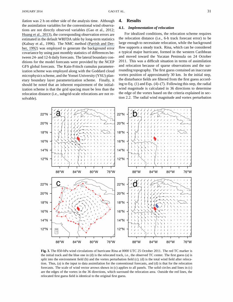
For idealized conditions, the relocation scheme requiresthe relocation distance (i.e., 6-h track forecast error) tobelarge enough to necessitate relocation, while the backgroundflow supports a steady track. Rina, which can be considereda typical major hurricane, formed in the western Caribbeanand moved toward the Yucatan Peninsula on 24 October2011. This was a difficult situation in terms of assimilationand relocation because of sparse observations and the sur-rounding topography. The first guess contained an inaccuratevortex position of approximately 30 km. In the initial step,the disturbance fields are filtered from the first guess accord-ing to Eq. (1) and Eqs. (4)–(7). Following this step, the radialwind magnitude is calculated in 36 directions to determinethe edge of the vortex based on the criteria explained in sec-tion 2.2. The radial wind magnitude and vortex perturbation
Fig. 3. The 850-hPa wind circulations of hurricane Rina at 0000 UTC 25 October 2011. The red TC marker isthe initial track and the blue one in (d) is the relocated track, i.e., the observed TC center. The first guess (a) issplit into the environment field (b) and the vortex perturbation field (c); (d) is the total wind field after reloca-tion. Thus, (a) is the input to data assimilation for the conventional forecasts, and (d) is that for the relocationforecasts. The scale of wind vector arrows shown in (c) applies to all panels. The solid circles and lines in (c)are the edges of the vortex in the 36 directions, which surround the relocation area. Outside the red lines, therelocated first guess field is identical to the original first guess.

32 A RELOCATION SCHEME TO IMPROVE TROPICAL CYCLONES TRACK FORECASTS VOLUME 31
Fig. 4. The response function of low-, first- and second-passBarnes filtering for separating the temperature, specific humid-ity and surface pressure disturbance and vortex fields from thefirst guess.
edges from four of these 36 directions (i.e., 0, 90◦, 180◦ and270◦) are shown in Fig. 2.
At most operational centers (Liu et al., 2000; Hsiao et al.,2010), this case would be rejected for relocation because ofthe close proximity of the terrain, where the isolated vortexstructure could miss key vortex perturbation components dueto the friction force interaction. The influence of the terrainon the wind circulation and vortex intensity is evident in the180◦ and 270◦ transects, where the edges are more than 200km closer to the vortex center when compared to the otherdirections of 0 and 90◦ (Fig. 2). To mitigate this situation,the revised GFDL criteria were applied to reduce the risk ofmissing the vortex perturbation. The following experimental
Fig. 5. The 850-hPa temperature (upper) and relative humidity (bottom) field of hurricane Rina at 0000 UTC25 October 2011. The left column is the relocated first guess,used as the input to data assimilation for therelocation forecasts; the right column is the original firstguess. The blue TC marker is the relocated track, i.e.,the observed TC center, and the red one is the initial track inthe first guess.

JANUARY 2014 GAO ET AL. 33
results support the hypothesis that the relocation scheme re-mains effective in its ability to improve the track forecastforthese cases.
The 850-hPa vortex circulation of hurricane Rina, validat 0000 UTC 25 October 2011, is shown in Fig. 3. The firstguess (Fig. 3a) is separated into the environment field (Fig.3b) and vortex perturbation field (Fig. 3c). The solid circlesand lines in Fig. 3c are the edges of the vortex along 36 direc-tions, which defines the relocation area. With the exceptionof the vortex region, the relocated first guess field is identi-cal to the original first guess. The two-pass Barnes filteringproduces a smooth transition and diffuse gradient around theedges in the new first guess. Figure 3d contains the first guesswith the relocated vortex, which is used in the data assimila-tion. It is also apparent that, in this initialization scheme, thestorm intensity has no visible changes.
For the scalar variables (i.e., temperature, humidity andsurface pressure), low-pass Barnes filtering was employed forseparating the disturbance field from the first guess, and thenthe non-vortex perturbations over the vortex circulation do-main, as a part of environment field, were filtered out from thedisturbance field by two-pass Barnes filtering. The responsesof the Barnes filtering of 850-hPa temperature and relativehumidity in hurricane Rina are shown in Fig. 4. In order tolimit the noise from non-vortex-relative perturbations whilestill retaining all perturbations relative to the vortex, wave-lengths smaller than 1200 km were first removed through thelow-pass filtering process. The disturbance field, which in-cludes the vortex perturbation, was the only difference be-tween the first guess and the filtered (basic) field. Whereas,for filtering out the non-vortex perturbations along the edgesof the vortex in 36 directions, a two-pass filtering was usedby decreasing the coefficientR in Eq. (10), which was ableto calculate the localized (by the second-pass filter, whichre-covers some perturbations with the shorter wavelengths) butrelatively smooth (by the first-pass filter) non-vortex pertur-bations. After this process of removing the non-vortex pertur-bations is complete, the vortex is relocated to the best trackposition.
The original and relocated first guess fields of 850-hPatemperature and relative humidity for hurricane Rina, validat 0000 UTC 25 October 2011, are shown in Fig. 5. Themajor parts related to the vortex in the first guess were suc-cessfully relocated to the observed TC location, especially forspecific humidity with a smooth gradient distributed aroundthe topography. Whereas for temperature (Fig. 5a), an ex-treme heat along the topography was created from the corre-sponding position in the original first guess. Actually, it is notnecessary for the heat center in the original first guess, whichcould have been influenced by local factors, to be related tothe vortex, and therefore should not be relocated. However,further studies are needed to address this kind of problem.
4.2. Track forecasts
The conventional 6-h track forecast error from the GFSanalysis for Rina, as shown in Table 1, is 30 km. As statedabove, the relocation distance is required to be greater than
Fig. 6. The 72-h track forecasts from the conventional predic-tion (blue line, crosses) and the relocation scheme (black line,circles), as well as the best track (red line, squares). The up-per panel (a) is initialized at 0000 UTC 25 October 2011 forRina, where the skill of conventional forecasts is lacking.Thebottom one (b) is initialized at 1200 UTC 25 August 2011 forIrene, where conventional forecasts do sufficiently well intermsof the landing position and track.
the grid spacing. The background flow supports a parallelmotion to the best track (Fig. 6), which suggests that theprediction model could produce a better track forecast if itisprovided with an accurate initial location.
The 72-h track forecast from the conventional predictionand the relocation scheme, as well as the observed track (i.e.,best track) for Rina and Irene are shown in Fig. 6. ForRina, the relocation forecast uses the best track in the firstguess, which also provides an accurate location estimate forthe following cycle in the operational implementation. Thisproduces an average improvement in track forecast of 58 km(39.46%) over 72 h. The new scheme also improves the trackforecast by 25.78% for Irene, which was fairly well fore-casted by the conventional method, despite the boundary con-ditions and background flow causing the tracks to converge inthe longer-range forecast.
Although the same dataset and methodology were used,the first guess relocation is closer to the true state of atmo-
34 A RELOCATION SCHEME TO IMPROVE TROPICAL CYCLONES TRACK FORECASTS VOLUME 31
sphere, so the defined observation errors will better representthe real errors in the area of observation influence. In thissense, a more accurate relocation has a positive effect on thegeneral data assimilation process. For Rina, the landfall posi-tion error was also likely a function of the very sparse obser-vations over this region of Mexico. The forward speed andunder-forecasted intensity may have also influenced the trackslightly. It is expected that nonconventional data would mit-igate this issue (Zhu et al., 2002; Weng et al., 2007), but thisis beyond the scope of the present paper.
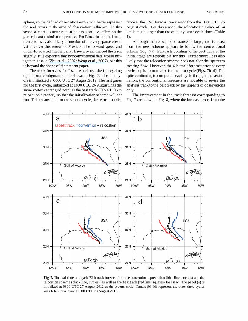
The track forecasts for Issac, which use the full-cyclingoperational configuration, are shown in Fig. 7. The first cy-cle is initialized at 0000 UTC 27 August 2012. The first guessfor the first cycle, initialized at 1800 UTC 26 August, has thesame vortex center grid point as the best track (Table 1; 0 kmrelocation distance), so that the initialization scheme will notrun. This means that, for the second cycle, the relocation dis-
tance is the 12-h forecast track error from the 1800 UTC 26August cycle. For this reason, the relocation distance of 54km is much larger than those at any other cycle times (Table1).
Although the relocation distance is large, the forecastfrom the new scheme appears to follow the conventionalscheme (Fig. 7a). Forecasts pointing to the best track at theinitial stage are responsible for this. Furthermore, it is alsolikely that the relocation scheme does not alter the upstreamsteering flow. However, the 6-h track forecast error at everycycle step is accumulated for the next cycle (Figs. 7b–d). De-spite continuing to compound each cycle through data assim-ilation, the conventional forecasts are not able to revise theanalysis track to the best track by the impacts of observationsonly.
The improvement in the track forecast corresponding toFig. 7 are shown in Fig. 8, where the forecast errors from the
Fig. 7. The real-time full-cycle 72-h track forecast from the conventional prediction (blue line, crosses) and therelocation scheme (black line, circles), as well as the besttrack (red line, squares) for Isaac. The panel (a) isinitialized at 0600 UTC 27 August 2012 as the second cycle. Panels (b)–(d) represent the other three cycleswith 6-h intervals until 0000 UTC 28 August 2012.

JANUARY 2014 GAO ET AL. 35
Fig. 8. The improvement of 72-h track forecast errors for Isaac corresponding toFig. 7, calculated by subtracting the track error in the new scheme from that inthe conventional forecast. The initialization times in theformat (UTC HH/DD)are indicated. The solid line (Aver) is the average improvement from the fourcycles.
relocation scheme for hurricane Isaac are subtracted from theconventional forecast errors. Since the error is not fully com-pounded with each cycle, as stated above for the conventionalmethod, the improvements by relocation increase with eachcycle step from 28.23% to 49.08%. The average improve-ment before 36 h is around 50 km, after which the improve-ment increases significantly. However, given the study onlyused operational Global Telecommunication System (GTS)data for assimilation, caution is warranted when extrapolat-ing these significant improvements to real operational appli-cations where some types of nonconventional observationsare generally employed.
5. Conclusions and outlook
Accurate track forecasting of TCs is one of the most im-portant aspects of providing early warning for this type ofpublic disaster. It is crucial for TC prediction to preciselyrepresent the initial conditions, including location, becauselarge track forecast sensitivities exist around the vortexcen-ter (Wang et al., 2011). Despite the initial inaccuracy of theTC center, the first guess models the real-time circulation sur-rounding the vortex, which plays an important role in the de-velopment and motion of the system. For this reason, an ini-tialization scheme by vortex relocation was developed.
We tested three typical TC cases in the 2011–12 hurricaneseason to assess the scheme within the WRF and WRFDA.The initialization scheme considers any stage of the TC. Thecalculated vortex perturbation area is irregular in a specificpattern depending on the real-time wind circulation, whichenables the ability to filter out an accurate vortex relativetothe real-time developing TC system. In order to deal with theboundary transition of the vortex, the filter function is usedalong the edge computation, while the field outside the main
vortex is left unaltered. This action allows for better stabilityin the new first guess because it produces a smooth gradientat the edges.
The vortex in the first guess being relocated to the ob-served position can also provide a more accurate first guess(6-h forecast) for the following cycle. This has the addedbenefit of enabling better data assimilation of observations inthe vicinity of the storm, but unrelated to the observed vor-tex position. The information accumulated over each cyclehelps the new scheme improve track forecasts significantly.However, the track forecast is still subject to the limitationsof the background flow and boundary conditions. As demon-strated in the full-cycle runs for Isaac, the relocation distanceincreases with the number of cycles, and the landing posi-tions are similar, which, in this case, suggested that the up-stream steering current became a dominate factor later in theforecast period. The assimilation of additional observations,especially nonconventional observation types with betterrep-resentativeness, should improve the environmental flow andthe core intensity. This initialization scheme focuses on refin-ing the position accuracy of the vortex center and the stabilityof the variable fields. Subsequent work will look at mergingthe relocation scheme with an intensity-fitting scheme, andwill be tested in the operational configuration.
Acknowledgements. This research has been jointly supportedby National Center for Atmospheric Research (NCAR) and Pana-sonic Avionics Corporation, and National Natural Science Foun-dation of China (NSFC) under Grant No. 40975068, the NationalBasic Research Program of China (973 Program) under Grand No.2013CB430102 and Jiangsu province colleges and universities nat-ural science major basic research projects. Computing timeis pro-vided by NCAR bluefire and Panasonic Weather Solutions Clustermachines.
36 A RELOCATION SCHEME TO IMPROVE TROPICAL CYCLONES TRACK FORECASTS VOLUME 31
REFERENCES
Barker, D., and Coauthors, 2012: The Weather Research and Fore-casting (WRF) model’s community variational/ensemble dataassimilation system: WRFDA.Bull. Amer. Meteor. Soc., 93,831–843.
Barnes, S. L., 1994: Application of the Barnes objective analysisscheme. Part I: Effects of undersampling, wave position, andstation randomness.J. Atmos. Oceanic Technol., 11, 1433–1448.
Gao, F., X. Y. Zhang, N. A. Jacobs, X. Y. Huang, X. Zhang, and P.P. Childs, 2012: Estimation of TAMDAR observational errorand assimilation experiments.Wea. Forecasting, 27, 856–877.
Hsiao, L. F., C. S. Liou, T. C. Yeh, Y. R. Guo, D. S. Chen, K.N. Huang, C. T. Terng, and J. H. Chen, 2010: A vortex relo-cation scheme for tropical cyclone initialization in advancedresearch WRF.Mon. Wea. Rev., 138, 3298–3315.
Huang, X. Y., and Coauthors, 2009: Four-dimensional variationaldata assimilation for WRF: Formulation and preliminary re-sults.Mon. Wea. Rev., 137, 299–314.
Huang, X. Y., F. Gao, N. Jacobs, and H. Wang, 2013: Assimilationof wind speed and direction observations: A new formulationand results from idealized experiments.Tellus A, 65, 19936,http://dx.doi.org/10.3402/tellusa.v65i0.19936.
Kalnay, E., and Coauthors, 1996: The NCEP/NCAR 40-Year Re-analysis Project.Bull. Amer. Meteor. Soc., 77, 437–471.
Kurihara, Y., M. A. Bender, R. E. Tuleya, and R. J. Ross, 1990:Prediction experiments of Hurricane Gloria (1985) using amultiply nested movable mesh model.Mon. Wea. Rev., 118,2185–2198.
Kurihara, Y., M. A. Bender, and R. J. Ross, 1993: An initial-ization scheme of hurricane models by vortex specification.Mon. Wea. Rev., 121, 2030–2045.
Kurihara, Y., M. A. Bender, R. E. Tuleya, and R. J. Ross, 1995:Im-provements in the GFDL hurricane prediction system.Mon.Wea. Rev., 123, 2791–2801.
Liu, Q. F., T. Marchok, H. L. Pan, M. Bender, and S. Lord, 2000:Improvements in hurricane initialization and forecastingatNCEP with global and regional (GFDL) models. NOAATechnical Procedures Bulletin 472, 7 pp. [Available onlinefrom http://www.nws.noaa.gov/om/tpb/472.pdf]
Lord, S. J., 1991: A bogussing system for vortex circulations inthe National Meteorological Center Global Forecast Model.Preprints,19th Conf. On Hurricanes and Tropical Meteorol-ogy, Miami, FL, Amer. Meteor. Soc., 328–330.
Low-Nam, S., and C. Davis, 2001: Development of a tropi-
cal cyclone bogussing scheme for the MM5 system. 11thPSU/NCAR Mesoscale Model Users’ Workshop, Boulder,CO, NCAR. [Available online from http://www.mmm.ucar.edu/mm5/workshop/ws01/lownam.pdf]
Mathur, M. B., 1991: The national meteorological center’s quasi-Lagrangian model for hurricane prediction.Mon. Wea. Rev.,119, 1419–1447.
Pan, W. Y., L. G. Wu, and C. L. Shie., 2011: Influence of the Saha-ran Air Layer on Atlantic Tropical Cyclone Formation duringthe Period 1-12 September 2003.Adv. Atmos. Sci., 28, 16–32,doi:10.1007/s00376-010-9165-5.
Parrish, D. F., and J. C. Derber, 1992: The National Meteorologi-cal Center’s spectral statistical interpolation analysissystem.Mon. Wea. Rev., 120, 1747–1763.
Pu, Z. X., and S. A. Braun, 2001: Evaluation of bogus vortextechniques with four-dimensional variational data assimila-tion. Mon. Wea. Rev., 122, 2023–2039.
Rappaport, E. N., and Coauthors, 2009: Advances and challengesat the National Hurricane Center.Wea. Forecasting, 24, 395–419.
Skamarock, W. C., and Coauthors, 2008: A descriptionof the Advanced Research WRF Version 3. NCARTech. Note, 2008. NCAR/TN–475+STR. [Available Online athttp://www. mmm.ucar.edu/wrf/users/docs/arwv3.pdf]
Wang, H. L., M. Mu, X. Y. Huang, 2011: Application of con-ditional non-linear optimal perturbations to tropical cycloneadaptive observation using the Weather Research Forecasting(WRF) model.Tellus A, 63A, 939–957.
Wang, H. L., and X. Y. Huang, 2012: TAMDAR observation as-similation in WRF 3D-Var and its impact on Hurricane Ike(2008) forecast.Atmos. Oceanic Sci. Lett., 5(3), 206–211.
Weng, F. Z., T. Zhu, and B. H. Yan, 2007: Satellite data assimi-lation in numerical weather prediction models. Part II: Usesof rain-affected radiances from microwave observations forhurricane vortex analysis.J. Atmos. Sci., 64(Special), 3910–3925.
Xiao, Q. N., X. L. Zou, and B. Wang, 2000: Initialization and sim-ulation of a landfalling hurricane using a variational bogusdata assimilation scheme.Mon. Wea. Rev., 128, 2252–2269.
Zhang, X. Y., B. Wang, Z. Z. Ji, Q. N. Xiao, and X. Zhang,2003: Initialization and simulation of a typhoon using 4-dimentional variational data assimilation—Research on Ty-phoon Herb (1996).Adv. Atmos. Sci., 20, 612–622.
Zhu, T., D. L. Zhang, and F. Z. Weng, 2002: Impact of advancedmicrowave sounding unit measurements on hurricane predic-tion. Mon. Wea. Rev., 130, 2416–2432.