A rapid field procedure for screening trace elements in polluted soil using portable X-ray...
7
A rapid field procedure for screening trace elements in polluted soil using portable X-ray fluorescence (PXRF) F. Martín Peinado a, ⁎, S. Morales Ruano b,d , M.G. Bagur González c , C. Estepa Molina d a Department of Soil Science, Faculty of Sciences, University of Granada, Spain b Andalusian Institute of Earth Sciences, University of Granada-CSIC, Faculty of Sciences, Spain c Department of Analytical Chemistry, Faculty of Sciences, University of Granada, Spain d Department of Mineralogy and Petrology, Faculty of Sciences, University of Granada, Spain abstract article info Article history: Received 16 December 2009 Received in revised form 31 May 2010 Accepted 27 June 2010 Available online 4 August 2010 Keywords: Portable X-ray fluorescence Polluted soils Screening In this work, the potential soil contamination in the abandoned mining area of Rodalquilar (SE, Spain) is studied using portable X-ray fluorescence (PXRF). Measurements were made in situ, and data were statistically treated to study the spatial distribution of the anomalous values of trace elements. The elements exceeding the background values of the soils in the area were As, Pb, Zn, and Cu. Intervention levels both for agricultural as well as natural use in the area were exceeded by As concentrations, with 89% and 67% of the samples above these limits, respectively. The field observations and the spatial distribution of the data after the statistical treatment imply that the main mechanism of dispersion of the trace elements in soils of the area were water and wind erosion. PXRF is a useful tool for screening and assessing contaminated areas for quick and easy in situ determination of trace-element concentrations. After this study, the mobility and bioavailability of main potentially pollutant element (As) together with toxicity bioassays are necessary to estimate the potential environmental risk of the soils of the area. © 2010 Elsevier B.V. All rights reserved. 1. Introduction Environmental pollution by trace elements has become a great concern in recent decades, with increasing research involving control and clean-up operations of polluted sites. Field portable X-ray fluorescence (PXRF) analysers, being a useful tool for screening and assessing contaminated areas, allow in situ trace-element concentra- tions to be determined both rapidly and easily. The detection limits of PXRF are higher than in other techniques used in these types of studies (atomic absorption, inductively coupled plasma, etc.), but these limits are below the regulatory toxicity level for the most common elements (US EPA, 1998). In this technique, radiation from an electrically excited X-ray tube is used to generate characteristic X-ray emissions from an element in a sample. Several sources of interference are described in PXRF which need to be taken into consideration when soil and sediment samples are analysed (US EPA, 1998): physical-matrix effects such as particle size, homogeneity and surface conditions are a common source of error in the measurement; moisture content affects the accuracy of the analysis, although contents between 5 and 20% have a minimal overall error; chemical-matrix effects cause differences in content between interfering elements (e.g.: the presence of iron reduces Cu but enhances Cr measurements; overlaps occur involving arsenic (As) Kα/lead (Pb) Lα and sulphur (S) Kα/Pb Mα). Therefore, variables affecting sample heterogeneity, contaminant-concentration variabil- ity, sample preparation, and analytical variability should be consid- ered and minimized as much as possible. Trace elements are present in low quantities in the environment, but high concentrations of these elements in soils occur both by natural as well as by anthropogenic processes. Such elements as Zn, V, Se, Mo, Cu, Co, and As are essential to plants or beneficial to animals (Pais and Benton, 1997), but they become toxic when present in high concentrations. Pollution sources can be classified as local or diffuse, and the study of large areas with large numbers of samples is usually required in order to characterize the distribution of the pollution both on the surface as well as in the subsurface. One of the main sources of trace-element contamination in soils is related to metal mining and smelting/extraction operations (Alloway, 1995). Mine abandonment can result in a degradation of the sites where the wastes are accumulated (dumps, holding ponds, etc.), when potentially pollutant particles are transported by wind or water, contaminating not only soils surrounding the mines but also alluvial soils downstream. The abandoned mining area of Rodalquilar (SE Spain) provided different metal bearing minerals (Au, Pb, Zn, Cu, and Mn), mainly in the form of sulphides or native elements, during different periods (Hernández, 2005). Au was the main ore mined in the zone (since 1864 up 1990) with different methods over time, from in situ Geoderma 159 (2010) 76–82 ⁎ Corresponding author. Tel.: + 34 958 243233; fax: + 34 958 244160. E-mail address: [email protected] (F.M. Peinado). 0016-7061/$ – see front matter © 2010 Elsevier B.V. All rights reserved. doi:10.1016/j.geoderma.2010.06.019 Contents lists available at ScienceDirect Geoderma journal homepage: www.elsevier.com/locate/geoderma
-
Upload
independent -
Category
Documents
-
view
0 -
download
0
Transcript of A rapid field procedure for screening trace elements in polluted soil using portable X-ray...
Geoderma 159 (2010) 76–82
Contents lists available at ScienceDirect
Geoderma
j ourna l homepage: www.e lsev ie r.com/ locate /geoderma
A rapid field procedure for screening trace elements in polluted soil using portableX-ray fluorescence (PXRF)
F. Martín Peinado a,⁎, S. Morales Ruano b,d, M.G. Bagur González c, C. Estepa Molina d
a Department of Soil Science, Faculty of Sciences, University of Granada, Spainb Andalusian Institute of Earth Sciences, University of Granada-CSIC, Faculty of Sciences, Spainc Department of Analytical Chemistry, Faculty of Sciences, University of Granada, Spaind Department of Mineralogy and Petrology, Faculty of Sciences, University of Granada, Spain
⁎ Corresponding author. Tel.: +34 958 243233; fax:E-mail address: [email protected] (F.M. Peinado).
0016-7061/$ – see front matter © 2010 Elsevier B.V. Adoi:10.1016/j.geoderma.2010.06.019
a b s t r a c t
a r t i c l e i n f oArticle history:Received 16 December 2009Received in revised form 31 May 2010Accepted 27 June 2010Available online 4 August 2010
Keywords:Portable X-ray fluorescencePolluted soilsScreening
In this work, the potential soil contamination in the abandoned mining area of Rodalquilar (SE, Spain) isstudied using portable X-ray fluorescence (PXRF). Measurements were made in situ, and data werestatistically treated to study the spatial distribution of the anomalous values of trace elements. The elementsexceeding the background values of the soils in the area were As, Pb, Zn, and Cu. Intervention levels both foragricultural as well as natural use in the area were exceeded by As concentrations, with 89% and 67% of thesamples above these limits, respectively. The field observations and the spatial distribution of the data afterthe statistical treatment imply that the main mechanism of dispersion of the trace elements in soils of thearea were water and wind erosion. PXRF is a useful tool for screening and assessing contaminated areas forquick and easy in situ determination of trace-element concentrations. After this study, the mobility andbioavailability of main potentially pollutant element (As) together with toxicity bioassays are necessary toestimate the potential environmental risk of the soils of the area.
+34 958 244160.
ll rights reserved.
© 2010 Elsevier B.V. All rights reserved.
1. Introduction
Environmental pollution by trace elements has become a greatconcern in recent decades, with increasing research involving controland clean-up operations of polluted sites. Field portable X-rayfluorescence (PXRF) analysers, being a useful tool for screening andassessing contaminated areas, allow in situ trace-element concentra-tions to be determined both rapidly and easily. The detection limits ofPXRF are higher than in other techniques used in these types ofstudies (atomic absorption, inductively coupled plasma, etc.), butthese limits are below the regulatory toxicity level for the mostcommon elements (US EPA, 1998).
In this technique, radiation from an electrically excited X-ray tubeis used to generate characteristic X-ray emissions from an element ina sample. Several sources of interference are described in PXRF whichneed to be taken into consideration when soil and sediment samplesare analysed (US EPA, 1998): physical-matrix effects such as particlesize, homogeneity and surface conditions are a common source oferror in the measurement; moisture content affects the accuracy ofthe analysis, although contents between 5 and 20% have a minimaloverall error; chemical-matrix effects cause differences in contentbetween interfering elements (e.g.: the presence of iron reduces Cu
but enhances Cr measurements; overlaps occur involving arsenic (As)Kα/lead (Pb) Lα and sulphur (S) Kα/Pb Mα). Therefore, variablesaffecting sample heterogeneity, contaminant-concentration variabil-ity, sample preparation, and analytical variability should be consid-ered and minimized as much as possible.
Trace elements are present in low quantities in the environment,but high concentrations of these elements in soils occur both bynatural as well as by anthropogenic processes. Such elements as Zn, V,Se, Mo, Cu, Co, and As are essential to plants or beneficial to animals(Pais and Benton, 1997), but they become toxic when present in highconcentrations. Pollution sources can be classified as local or diffuse,and the study of large areas with large numbers of samples is usuallyrequired in order to characterize the distribution of the pollution bothon the surface as well as in the subsurface.
One of the main sources of trace-element contamination in soils isrelated to metal mining and smelting/extraction operations (Alloway,1995). Mine abandonment can result in a degradation of the siteswhere the wastes are accumulated (dumps, holding ponds, etc.),when potentially pollutant particles are transported bywind or water,contaminating not only soils surrounding the mines but also alluvialsoils downstream.
The abandoned mining area of Rodalquilar (SE Spain) provideddifferent metal bearing minerals (Au, Pb, Zn, Cu, and Mn), mainly inthe form of sulphides or native elements, during different periods(Hernández, 2005). Au was the main ore mined in the zone (since1864 up 1990) with different methods over time, from in situ
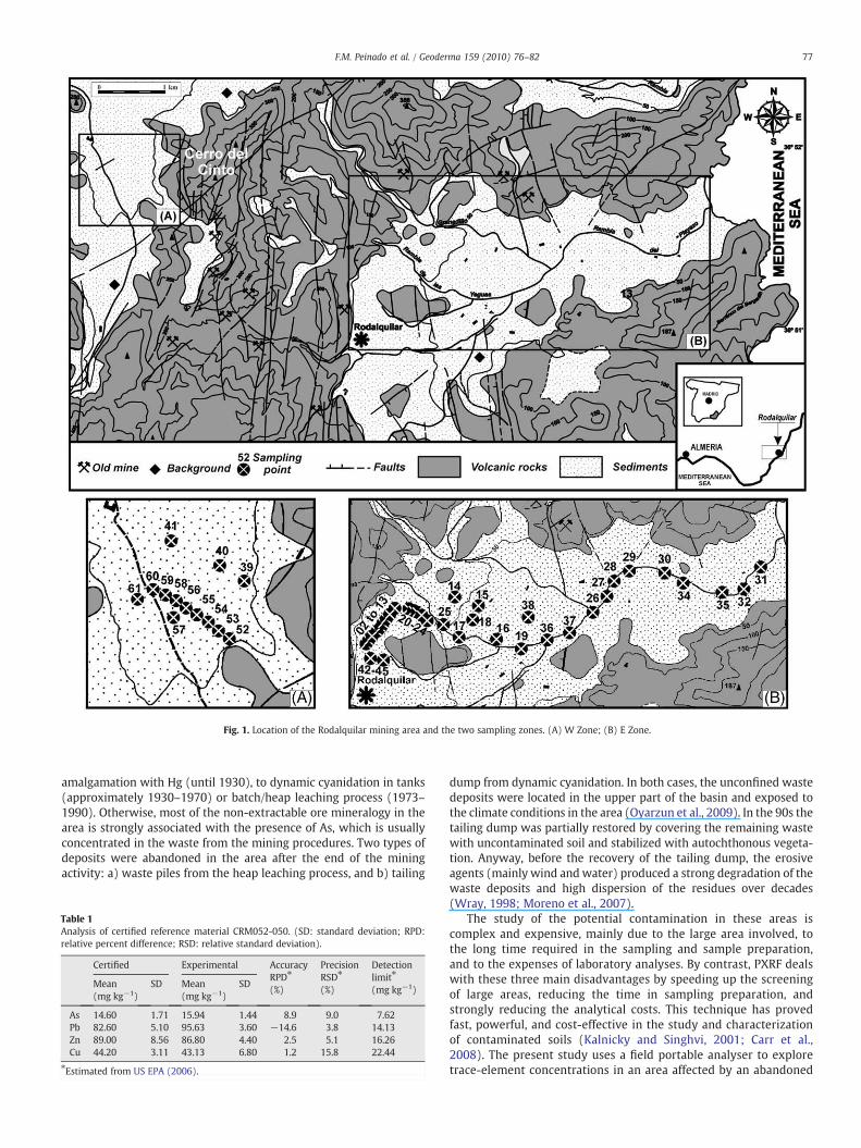
Fig. 1. Location of the Rodalquilar mining area and the two sampling zones. (A) W Zone; (B) E Zone.
77F.M. Peinado et al. / Geoderma 159 (2010) 76–82
amalgamation with Hg (until 1930), to dynamic cyanidation in tanks(approximately 1930–1970) or batch/heap leaching process (1973–1990). Otherwise, most of the non-extractable ore mineralogy in thearea is strongly associated with the presence of As, which is usuallyconcentrated in the waste from the mining procedures. Two types ofdeposits were abandoned in the area after the end of the miningactivity: a) waste piles from the heap leaching process, and b) tailing
Table 1Analysis of certified reference material CRM052-050. (SD: standard deviation; RPD:relative percent difference; RSD: relative standard deviation).
Certified Experimental AccuracyRPD⁎
(%)
PrecisionRSD⁎
(%)
Detectionlimit⁎
(mg kg−1)Mean(mg kg−1)
SD Mean(mg kg−1)
SD
As 14.60 1.71 15.94 1.44 8.9 9.0 7.62Pb 82.60 5.10 95.63 3.60 −14.6 3.8 14.13Zn 89.00 8.56 86.80 4.40 2.5 5.1 16.26Cu 44.20 3.11 43.13 6.80 1.2 15.8 22.44
⁎Estimated from US EPA (2006).
dump from dynamic cyanidation. In both cases, the unconfined wastedeposits were located in the upper part of the basin and exposed tothe climate conditions in the area (Oyarzun et al., 2009). In the 90s thetailing dump was partially restored by covering the remaining wastewith uncontaminated soil and stabilized with autochthonous vegeta-tion. Anyway, before the recovery of the tailing dump, the erosiveagents (mainly wind andwater) produced a strong degradation of thewaste deposits and high dispersion of the residues over decades(Wray, 1998; Moreno et al., 2007).
The study of the potential contamination in these areas iscomplex and expensive, mainly due to the large area involved, tothe long time required in the sampling and sample preparation,and to the expenses of laboratory analyses. By contrast, PXRF dealswith these three main disadvantages by speeding up the screeningof large areas, reducing the time in sampling preparation, andstrongly reducing the analytical costs. This technique has provedfast, powerful, and cost-effective in the study and characterizationof contaminated soils (Kalnicky and Singhvi, 2001; Carr et al.,2008). The present study uses a field portable analyser to exploretrace-element concentrations in an area affected by an abandoned
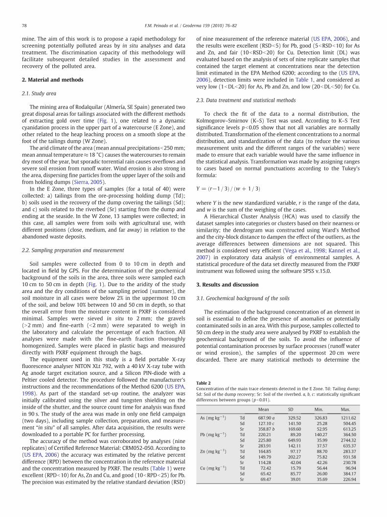
Table 2Concentration of the main trace elements detected in the E Zone. Td: Tailing dump;Sd: Soil of the dump recovery; Sr: Soil of the riverbed. a, b, c: statistically significantdifferences between groups (pb0.01).
Mean SD Min. Max.
As (mg kg−1) Td 687.90 a 329.52 326.83 1211.62Sd 127.10 c 141.50 25.28 504.45Sr 358.87 b 169.60 52.95 613.25
Pb (mg kg−1) Td 220.21 89.20 140.27 364.50Sd 225.80 649.93 35.99 2744.32Sr 283.91 142.11 37.57 635.37
Zn (mg kg−1) Td 164.85 97.17 88.70 283.37Sd 149.79 202.27 75.82 931.58Sr 114.28 42.04 42.26 230.78
Cu (mg kg−1) Td 72.42 15.79 56.44 96.94Sd 65.42 85.77 26.00 384.17Sr 69.47 39.01 35.69 226.94
78 F.M. Peinado et al. / Geoderma 159 (2010) 76–82
mine. The aim of this work is to propose a rapid methodology forscreening potentially polluted areas by in situ analyses and datatreatment. The discrimination capacity of this methodology willfacilitate subsequent detailed studies in the assessment andrecovery of the polluted area.
2. Material and methods
2.1. Study area
The mining area of Rodalquilar (Almería, SE Spain) generated twogreat disposal areas for tailings associated with the different methodsof extracting gold over time (Fig. 1), one related to a dynamiccyanidation process in the upper part of a watercourse (E Zone), andother related to the heap leaching process on a smooth slope at thefoot of the tailings dump (W Zone).
The arid climate of the area (mean annual precipitationsb250 mm;mean annual temperature≈18 °C) causes thewatercourses to remaindry most of the year, but sporadic torrential rain causes overflows andsevere soil erosion from runoff water. Wind erosion is also strong inthe area, dispersing fine particles from the upper layer of the soils andfrom holding dumps (Sierra, 2005).
In the E Zone, three types of samples (for a total of 40) werecollected: a) tailings from the ore-processing holding dump (Td);b) soils used in the recovery of the dump covering the tailings (Sd);and c) soils related to the riverbed (Sr) starting from the dump andending at the seaside. In the W Zone, 13 samples were collected; inthis case, all samples were from soils with agricultural use, withdifferent positions (close, medium, and far away) in relation to theabandoned waste deposits.
2.2. Sampling preparation and measurement
Soil samples were collected from 0 to 10 cm in depth andlocated in field by GPS. For the determination of the geochemicalbackground of the soils in the area, three soils were sampled each10 cm to 50 cm in depth (Fig. 1). Due to the aridity of the studyarea and the dry conditions of the sampling period (summer), thesoil moisture in all cases were below 2% in the uppermost 10 cmof the soil, and below 10% between 10 and 50 cm in depth, so thatthe overall error from the moisture content in PXRF is consideredminimal. Samples were sieved in situ to 2 mm; the gravels(N2 mm) and fine-earth (b2 mm) were separated to weigh inthe laboratory and calculate the percentage of each fraction. Allanalyses were made with the fine-earth fraction thoroughlyhomogenized. Samples were placed in plastic bags and measureddirectly with PXRF equipment through the bags.
The equipment used in this study is a field portable X-rayfluorescence analyser NITON XLt 792, with a 40 kV X-ray tube withAg anode target excitation source, and a Silicon PIN-diode with aPeltier cooled detector. The procedure followed the manufacturer'sinstructions and the recommendations of the Method 6200 (US EPA,1998). As part of the standard set-up routine, the analyzer wasinitially calibrated using the silver and tungsten shielding on theinside of the shutter, and the source count time for analysis was fixedin 90 s. The study of the area was made in only one field campaign(two days), including sample collection, preparation, and measure-ment “in situ” of all samples. After data acquisition, the results weredownloaded to a portable PC for further processing.
The accuracy of the method was corroborated by analyses (ninereplicates) of Certified ReferenceMaterial: CRM052-050. According to(US EPA, 2006) the accuracy was estimated by the relative percentdifference (RPD) between the concentration in the reference materialand the concentration measured by PXRF. The results (Table 1) wereexcellent (RPDb10) for As, Zn and Cu, and good (10bRPDb25) for Pb.The precision was estimated by the relative standard deviation (RSD)
of nine measurement of the reference material (US EPA, 2006), andthe results were excellent (RSDb5) for Pb, good (5bRSDb10) for Asand Zn, and fair (10bRSDb20) for Cu. Detection limit (DL) wasevaluated based on the analysis of sets of nine replicate samples thatcontained the target element at concentrations near the detectionlimit estimated in the EPA Method 6200; according to the (US EPA,2006), detection limits were included in Table 1, and considered asvery low (1bDLb20) for As, Pb and Zn, and low (20bDLb50) for Cu.
2.3. Data treatment and statistical methods
To check the fit of the data to a normal distribution, theKolmogorov–Smirnov (K–S) Test was used. According to K–S Testsignificance levels pb0.05 show that not all variables are normallydistributed. Transformation of the element concentrations to a normaldistribution, and standardization of the data (to reduce the variousmeasurement units and the different ranges of the variables) weremade to ensure that each variable would have the same influence inthe statistical analysis. Transformation was made by assigning rangesto cases based on normal punctuations according to the Tukey'sformula:
Y = r−1 = 3ð Þ= w + 1= 3ð Þ
where Y is the new standardized variable, r is the range of the data,and w is the sum of the weighing of the cases.
A Hierarchical Cluster Analysis (HCA) was used to classify thedataset samples into categories or clusters based on their nearness orsimilarity; the dendrogram was constructed using Ward's Methodand the city-block distance to dampen the effect of the outliers, as theaverage differences between dimensions are not squared. Thismethod is considered very efficient (Vega et al., 1998; Kannel et al.,2007) in exploratory data analysis of environmental samples. Astatistical procedure of the data set directly measured from the PXRFinstrument was followed using the software SPSS v.15.0.
3. Results and discussion
3.1. Geochemical background of the soils
The estimation of the background concentration of an element insoil is essential to define the presence of anomalies or potentiallycontaminated soils in an area. With this purpose, samples collected to50 cm deep in the study area were analysed by PXRF to establish thegeochemical background of the soils. To avoid the influence ofpotential contamination processes by surface processes (runoff wateror wind erosion), the samples of the uppermost 20 cm werediscarded. There are many statistical methods to determine the
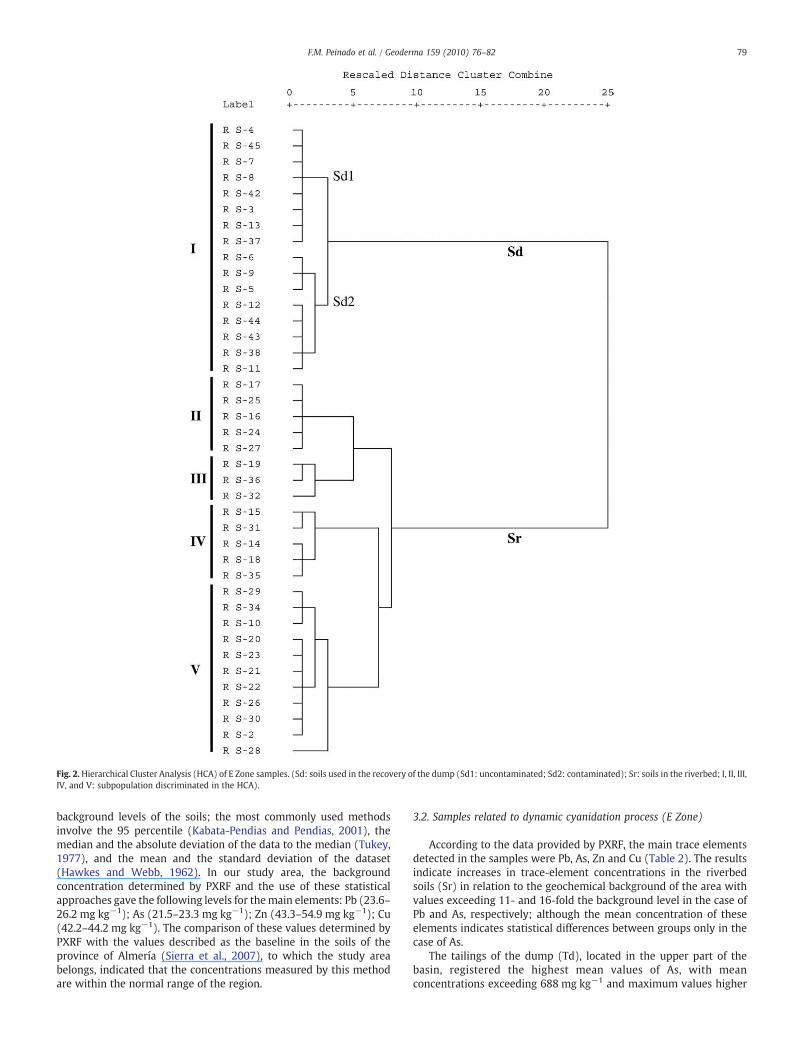
Fig. 2.Hierarchical Cluster Analysis (HCA) of E Zone samples. (Sd: soils used in the recovery of the dump (Sd1: uncontaminated; Sd2: contaminated); Sr: soils in the riverbed; I, II, III,IV, and V: subpopulation discriminated in the HCA).
79F.M. Peinado et al. / Geoderma 159 (2010) 76–82
background levels of the soils; the most commonly used methodsinvolve the 95 percentile (Kabata-Pendias and Pendias, 2001), themedian and the absolute deviation of the data to the median (Tukey,1977), and the mean and the standard deviation of the dataset(Hawkes and Webb, 1962). In our study area, the backgroundconcentration determined by PXRF and the use of these statisticalapproaches gave the following levels for themain elements: Pb (23.6–26.2 mg kg−1); As (21.5–23.3 mg kg−1); Zn (43.3–54.9 mg kg−1); Cu(42.2–44.2 mg kg−1). The comparison of these values determined byPXRF with the values described as the baseline in the soils of theprovince of Almería (Sierra et al., 2007), to which the study areabelongs, indicated that the concentrations measured by this methodare within the normal range of the region.
3.2. Samples related to dynamic cyanidation process (E Zone)
According to the data provided by PXRF, the main trace elementsdetected in the samples were Pb, As, Zn and Cu (Table 2). The resultsindicate increases in trace-element concentrations in the riverbedsoils (Sr) in relation to the geochemical background of the area withvalues exceeding 11- and 16-fold the background level in the case ofPb and As, respectively; although the mean concentration of theseelements indicates statistical differences between groups only in thecase of As.
The tailings of the dump (Td), located in the upper part of thebasin, registered the highest mean values of As, with meanconcentrations exceeding 688 mg kg−1 and maximum values higher
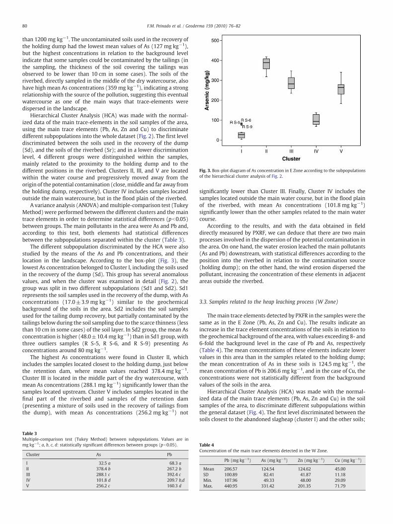
Fig. 3. Box-plot diagram of As concentration in E Zone according to the subpopulationsof the hierarchical cluster analysis of Fig. 2.
80 F.M. Peinado et al. / Geoderma 159 (2010) 76–82
than 1200 mg kg−1. The uncontaminated soils used in the recovery ofthe holding dump had the lowest mean values of As (127 mg kg−1),but the highest concentrations in relation to the background levelindicate that some samples could be contaminated by the tailings (inthe sampling, the thickness of the soil covering the tailings wasobserved to be lower than 10 cm in some cases). The soils of theriverbed, directly sampled in the middle of the dry watercourse, alsohave high mean As concentrations (359 mg kg−1), indicating a strongrelationship with the source of the pollution, suggesting this eventualwatercourse as one of the main ways that trace-elements weredispersed in the landscape.
Hierarchical Cluster Analysis (HCA) was made with the normal-ized data of the main trace-elements in the soil samples of the area,using the main trace elements (Pb, As, Zn and Cu) to discriminatedifferent subpopulations into the whole dataset (Fig. 2). The first leveldiscriminated between the soils used in the recovery of the dump(Sd), and the soils of the riverbed (Sr); and in a lower discriminationlevel, 4 different groups were distinguished within the samples,mainly related to the proximity to the holding dump and to thedifferent positions in the riverbed. Clusters II, III, and V are locatedwithin the water course and progressively moved away from theorigin of the potential contamination (close, middle and far away fromthe holding dump, respectively). Cluster IV includes samples locatedoutside the main watercourse, but in the flood plain of the riverbed.
A variance analysis (ANOVA) andmultiple-comparison test (TukeyMethod) were performed between the different clusters and the maintrace elements in order to determine statistical differences (pb0.05)between groups. The main pollutants in the area were As and Pb and,according to this test, both elements had statistical differencesbetween the subpopulations separated within the cluster (Table 3).
The different subpopulation discriminated by the HCA were alsostudied by the means of the As and Pb concentrations, and theirlocation in the landscape. According to the box-plot (Fig. 3), thelowest As concentration belonged to Cluster I, including the soils usedin the recovery of the dump (Sd). This group has several anomalousvalues, and when the cluster was examined in detail (Fig. 2), thegroup was split in two different subpopulations (Sd1 and Sd2). Sd1represents the soil samples used in the recovery of the dump, with Asconcentrations (17.0±3.9 mg kg−1) similar to the geochemicalbackground of the soils in the area. Sd2 includes the soil samplesused for the tailing dump recovery, but partially contaminated by thetailings below during the soil sampling due to the scarce thinness (lessthan 10 cm in some cases) of the soil layer. In Sd2 group, the mean Asconcentration is higher (48.0±10.4 mg kg−1) than in Sd1 group, withthree outliers samples (R S-5, R S-6, and R S-9) presenting Asconcentrations around 80 mg kg−1.
The highest As concentrations were found in Cluster II, whichincludes the samples located closest to the holding dump, just belowthe retention dam, where mean values reached 378.4 mg kg−1.Cluster III is located in the middle part of the dry watercourse, withmean As concentrations (288.1 mg kg−1) significantly lower than thesamples located upstream. Cluster V includes samples located in thefinal part of the riverbed and samples of the retention dam(presenting a mixture of soils used in the recovery of tailings fromthe dump), with mean As concentrations (256.2 mg kg−1) not
Table 3Multiple-comparison test (Tukey Method) between subpopulations. Values are inmg kg−1; a, b, c, d: statistically significant differences between groups (pb0.05).
Cluster As Pb
I 32.5 a 68.3 aII 378.4 b 267.2 bIII 288.1 c 392.4 cIV 101.8 d 209.7 b,dV 256.2 c 160.3 d
significantly lower than Cluster III. Finally, Cluster IV includes thesamples located outside the main water course, but in the flood plainof the riverbed, with mean As concentrations (101.8 mg kg−1)significantly lower than the other samples related to the main watercourse.
According to the results, and with the data obtained in fielddirectly measured by PXRF, we can deduce that there are two mainprocesses involved in the dispersion of the potential contamination inthe area. On one hand, the water erosion leached the main pollutants(As and Pb) downstream, with statistical differences according to theposition into the riverbed in relation to the contamination source(holding dump); on the other hand, the wind erosion dispersed thepollutant, increasing the concentration of these elements in adjacentareas outside the riverbed.
3.3. Samples related to the heap leaching process (W Zone)
Themain trace elements detected by PXFR in the samples were thesame as in the E Zone (Pb, As, Zn and Cu). The results indicate anincrease in the trace element concentrations of the soils in relation tothe geochemical background of the area, with values exceeding 8- and6-fold the background level in the case of Pb and As, respectively(Table 4). The mean concentrations of these elements indicate lowervalues in this area than in the samples related to the holding dump;the mean concentration of As in these soils is 124.5 mg kg−1, themean concentration of Pb is 206.6 mg kg−1, and in the case of Cu, theconcentrations were not statistically different from the backgroundvalues of the soils in the area.
Hierarchical Cluster Analysis (HCA) was made with the normal-ized data of the main trace elements (Pb, As, Zn and Cu) in the soilsamples of the area, to discriminate different subpopulations withinthe general dataset (Fig. 4). The first level discriminated between thesoils closest to the abandoned slagheap (cluster I) and the other soils;
Table 4Concentration of the main trace elements detected in the W Zone.
Pb (mg kg−1) As (mg kg−1) Zn (mg kg−1) Cu (mg kg−1)
Mean 206.57 124.54 124.62 45.00SD 100.89 82.41 41.87 11.18Min. 107.96 49.33 48.00 29.09Max. 440.95 331.42 201.35 71.79
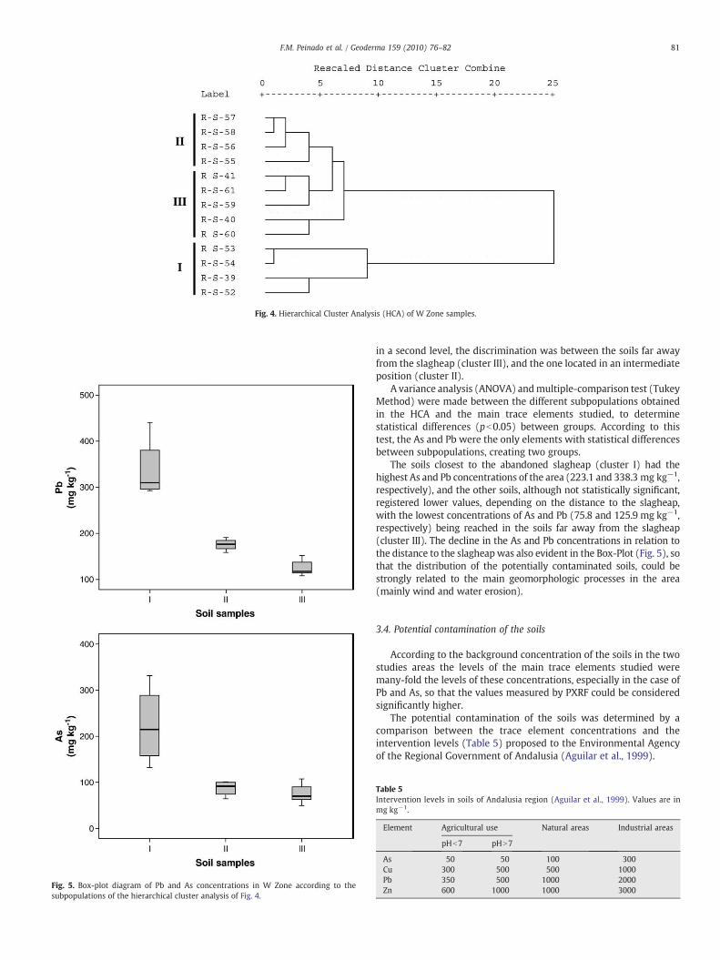
Fig. 4. Hierarchical Cluster Analysis (HCA) of W Zone samples.
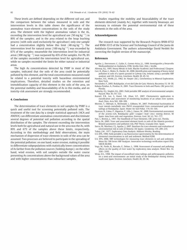
Fig. 5. Box-plot diagram of Pb and As concentrations in W Zone according to thesubpopulations of the hierarchical cluster analysis of Fig. 4.
81F.M. Peinado et al. / Geoderma 159 (2010) 76–82
in a second level, the discrimination was between the soils far awayfrom the slagheap (cluster III), and the one located in an intermediateposition (cluster II).
A variance analysis (ANOVA) andmultiple-comparison test (TukeyMethod) were made between the different subpopulations obtainedin the HCA and the main trace elements studied, to determinestatistical differences (pb0.05) between groups. According to thistest, the As and Pb were the only elements with statistical differencesbetween subpopulations, creating two groups.
The soils closest to the abandoned slagheap (cluster I) had thehighest As and Pb concentrations of the area (223.1 and 338.3 mg kg−1,respectively), and the other soils, although not statistically significant,registered lower values, depending on the distance to the slagheap,with the lowest concentrations of As and Pb (75.8 and 125.9 mg kg−1,respectively) being reached in the soils far away from the slagheap(cluster III). The decline in the As and Pb concentrations in relation tothe distance to the slagheapwas also evident in the Box-Plot (Fig. 5), sothat the distribution of the potentially contaminated soils, could bestrongly related to the main geomorphologic processes in the area(mainly wind and water erosion).
3.4. Potential contamination of the soils
According to the background concentration of the soils in the twostudies areas the levels of the main trace elements studied weremany-fold the levels of these concentrations, especially in the case ofPb and As, so that the values measured by PXRF could be consideredsignificantly higher.
The potential contamination of the soils was determined by acomparison between the trace element concentrations and theintervention levels (Table 5) proposed to the Environmental Agencyof the Regional Government of Andalusia (Aguilar et al., 1999).
Table 5Intervention levels in soils of Andalusia region (Aguilar et al., 1999). Values are inmg kg−1.
Element Agricultural use Natural areas Industrial areas
pHb7 pHN7
As 50 50 100 300Cu 300 500 500 1000Pb 350 500 1000 2000Zn 600 1000 1000 3000
82 F.M. Peinado et al. / Geoderma 159 (2010) 76–82
These levels are defined depending on the different soil use, andthe comparison between the values measured in soils and theintervention levels in this table shows the significance of theanomalous trace-element concentrations in the soils of the studyarea. The element with the highest anomalous values is the As,exceeding the intervention level for agricultural use (50 mg kg−1) in89% of the samples; and in the area related to the heap leachingprocess (with soils used exclusively for agriculture) only one samplehad a concentration slightly below this limit (48 mg kg−1). Theintervention level for natural areas (100 mg kg−1) was exceeded by67% of the samples; meanwhile the intervention level for industrialareas (300 mg kg−1) was surpassed by 43% of the samples. For Pb, 8%of the samples exceeded the intervention level for agricultural use,while no samples exceeded the limits for either natural or industrialareas.
The high As concentrations detected by PXRF in most of thesamples, indicated that the soils of the area could be potentiallypolluted by this element, and the total concentrations measured couldbe related to a potential toxicity with hazardous environmentalimplications. Therefore, detailed studies on the retention andimmobilization capacity of this element in the soils of the area, onthe potential mobility and bioavailability of As in this media, and ontoxicity-risk assessment are strongly recommended.
4. Conclusions
The determination of trace elements in soil samples by PXRF is aquick and useful tool for screening potentially polluted soils. Thetreatment of the raw data by a simple statistical approach (HCA andANOVA) can differentiate anomalous concentrations and discriminateseveral degrees of potential soil pollution according to the spatialdistribution of the samples. The element exceeding the interventionlevels both for agricultural and natural use in the areawas the As, with89% and 67% of the samples above these limits, respectively.According to this methodology and field observations, the mainmechanism of dispersion of trace elements in soils of the area can beassumed. Two processes are believed to participate in the spreading ofthe potential pollution: on one hand, water erosion, making it possibleto differentiate subpopulations with statistically lower concentrationsof As farther from the pollution sources (holding dumps); on the otherhand, wind erosion, with soil samples outside the water coursepresenting As concentrations above the background values of the areaand with higher concentrations than subsurface samples.
Studies regarding the mobility and bioavailability of the traceelements detected (mainly As), together with toxicity bioassays, arenecessary to estimate the potential environmental risk of theseelements in the soils of the area.
Acknowledgments
The research was supported by the Research Projects RNM-0732and RNM-3315 of the Science and Technology Council of the Junta deAndalusia Government. The authors acknowledge David Nesbitt forcorrecting the English version of the manuscript.
References
Aguilar, J., Dorronsoro, C., Galán, E., Gomez-Ariza, J.L., 1999. Investigación y DesarrolloMedioambiental en Andalucía, OTRI, Sevilla Univ (Eds.), Seville.
Alloway, B.J., 1995. Heavy Metals in Soils. Blackie Academic and Professional, Glasgow.Carr, R., Zhan, C., Moles, N., Harder, M., 2008. Identification andmapping of heavy metal
pollution in soils of a sports ground in Galway City, Ireland, using a portable XRFanalyser and GIS. Environ. Geochem. Health 30, 45–52.
Hawkes, H.E., Webb, J.S., 1962. In: Harper (Ed.), Geochemisry in Mineral Exploration.New York.
Hernández, F., 2005. Rodalquilar, el oro del Cabo de Gata: Historia. Bocamina 15, 18–30.Kabata-Pendias, A., Pendias, H., 2001. Trace Elements in Soils and Plants. CRC press LLC,
Florida.Kalnicky, D.J., Singhvi, R.J., 2001. Field portable XRF analysis of environmental samples.
Hazard. Mat. 83, 93–122.Kannel, P.R., Lee, S., Kanel, S.R., Khan, S.P., 2007. Chemometric application in
classification and assessment of monitoring locations of an urban river system.Anal. Chim. Acta 582, 390–399.
Moreno, T., Oldroyd, A., McDonald, I., Gibbons, W., 2007. Preferential fractionation oftrace metals–metalloids into PM10 resuspended from contaminated gold minetailings at Rodalquilar, Spain. Water Air Soil Pollut. 179, 93–105.
Oyarzun, R., Cubas, P., Higueras, P., Lillo, J., Llanos, W., 2009. Environmental assessmentof the arsenic-rich, Rodalquilar gold−(copper−lead−zinc) mining district, SESpain: data from soils and vegetation. Environ. Geol. 58 (4), 761–777.
Pais, I., Benton, J., 1997. The Handbook of Trace Elements. CRC press LLC, Florida.Sierra, M., 2005. Trace and associated element levels in soils of the Almería province:
Related parameters and pollution risk, PhD Thesis, Granada Univ. Spain.Sierra, M., Martínez, F.J., Aguilar, J., 2007. Baselines for trace elements and evaluation of
environmental risk in soils of Almería (SE Spain). Geoderma 139, 209–219.Tukey, J.W., 1977. Exploratory Data Analysis. Addison-Wesley, Reading.U.S. EPA, 1998. Field portable x-ray fluorescence spectrometry for the determination of
elemental concentrations in soil and sediment. Method 6200.U.S. EPA, 2006. XRF technologies for measuring trace elements in soil and sediment.
Niton XLt 700 Series XRF Analyzer. Innovative technology verification report EPA/540/R-06/004.
Vega, M., Pardo, R., Barrado, E., Deban, L., 1998. Assessment of seasonal and pollutingeffects on the quality of river water by exploratory data analysis. Water Res. 32,3581–3592.
Wray, D.S., 1998. The impact of unconfined mine tailings and anthropogenic pollutionon a semi-arid environment—an initial study of the Rodalquilar mining district,south east Spain. Environ. Geochem. Health 20, 29–38.