A preliminary analysis of in situ and remotely sensed environmental variables in the coastal region...
10
Chemistry and Ecology Vol. 24, No. S1, June 2008, 57–66 A preliminary analysis of in situ and remotely sensed environmental variables in the coastal region of the Portofino Marine Protected Area M. Manca Zeichen a *, M.G. Finoia a , M. Locritani b , N. Ruggeri c , L. Tunesi a , G.P. Gasparini d , M. Bassetti e , V. Grandi e , R. Cattaneo-Vietti c and P. Povero c a Central Institute for Marine Research (ICRAM), Rome; b INGV Portovenere, Fezzano di Portovenere (SP); c University of Genoa, Dip.Te.Ris, Genoa; d CNR ISMAR, La Spezia Section, Forte SantaTeresa, Pozzuolo di Lerici (SP); e ETD Dept., Nato Undersea Research Centre, La Spezia, Italy (Received 11 July 2007; final version received 15 January 2008 ) Coastal marine environment is a complex system and its management requires adequate information. Marine Protected Areas (MPAs) are considered pilot sites useful to define innovative tools for the Inte- grated Coastal Zone Management (ICZM). Their management however requires acquaintance with the relationships between the protected site and the status of the coastal neighbouring areas in order to assess mutual effects and influences. There is the need of monitoring systems capable of highlighting physical and biological phenomena, and possible oceanographic anomalies at local scale, to assess possible exist- ing differences between MPAs and their neighbouring unprotected zones. The present study proposes an integrated analysis of data sets coming from in situ and remote-sensing data to evaluate the reliability of satellite sensors for coastal zone monitoring and to better understand the short-term environmental dynamics on a coastal area centred on the Portofino MPA (Ligurian Sea). Keywords: remote sensing; monitoring; Portofino MPA 1. Introduction The study area encompasses the National Portofino MPA and the neighbouring stretches of coast (Tigullio gulf to the east and Paradise gulf to the west) (Figure 1a and b). This area is particularly relevant both for its environmental valence and for its tourist economical value. The Portofino promontory, characterised by a very low population density, is placed just in the middle of one the most densely-populated stretches of coast of the North-western Mediter- ranean, characterised by many activities such as shipbuilding industries, mariculture, fishing and nautical and underwater tourism [1]. For these characteristics the Portofino MPA could be con- sidered a pilot area to define tools useful to acquire the knowledge of the existing relationships between the protected site and the neighbouring coastal areas, in order to assess mutual effects and influences. Moreover, the MPA management body needs useful information to improve the *Corresponding author. Email: [email protected] ISSN 0275-7540 print/ISSN 1029-0370 online © 2008 Taylor & Francis DOI: 10.1080/02757540801966488 http://www.informaworld.com
-
Upload
independent -
Category
Documents
-
view
5 -
download
0
Transcript of A preliminary analysis of in situ and remotely sensed environmental variables in the coastal region...

Chemistry and EcologyVol. 24, No. S1, June 2008, 57–66
A preliminary analysis of in situ and remotely sensedenvironmental variables in the coastal region of the Portofino
Marine Protected Area
M. Manca Zeichena*, M.G. Finoiaa, M. Locritanib, N. Ruggeric, L. Tunesia, G.P. Gasparinid,M. Bassettie, V. Grandie, R. Cattaneo-Viettic and P. Poveroc
aCentral Institute for Marine Research (ICRAM), Rome; bINGV Portovenere, Fezzano di Portovenere(SP); cUniversity of Genoa, Dip.Te.Ris, Genoa; dCNR ISMAR, La Spezia Section, Forte Santa Teresa,
Pozzuolo di Lerici (SP); eETD Dept., Nato Undersea Research Centre, La Spezia, Italy
(Received 11 July 2007; final version received 15 January 2008 )
Coastal marine environment is a complex system and its management requires adequate information.Marine Protected Areas (MPAs) are considered pilot sites useful to define innovative tools for the Inte-grated Coastal Zone Management (ICZM). Their management however requires acquaintance with therelationships between the protected site and the status of the coastal neighbouring areas in order to assessmutual effects and influences. There is the need of monitoring systems capable of highlighting physicaland biological phenomena, and possible oceanographic anomalies at local scale, to assess possible exist-ing differences between MPAs and their neighbouring unprotected zones. The present study proposes anintegrated analysis of data sets coming from in situ and remote-sensing data to evaluate the reliabilityof satellite sensors for coastal zone monitoring and to better understand the short-term environmentaldynamics on a coastal area centred on the Portofino MPA (Ligurian Sea).
Keywords: remote sensing; monitoring; Portofino MPA
1. Introduction
The study area encompasses the National Portofino MPA and the neighbouring stretches of coast(Tigullio gulf to the east and Paradise gulf to the west) (Figure 1a and b). This area is particularlyrelevant both for its environmental valence and for its tourist economical value.
The Portofino promontory, characterised by a very low population density, is placed just inthe middle of one the most densely-populated stretches of coast of the North-western Mediter-ranean, characterised by many activities such as shipbuilding industries, mariculture, fishing andnautical and underwater tourism [1]. For these characteristics the Portofino MPA could be con-sidered a pilot area to define tools useful to acquire the knowledge of the existing relationshipsbetween the protected site and the neighbouring coastal areas, in order to assess mutual effectsand influences. Moreover, the MPA management body needs useful information to improve the
*Corresponding author. Email: [email protected]
ISSN 0275-7540 print/ISSN 1029-0370 online© 2008 Taylor & FrancisDOI: 10.1080/02757540801966488http://www.informaworld.com

58 M. Manca Zeichen et al.
Figure 1. (a) The study area in the Ligurian Sea. (b) The Portofino Promontory and the sampling stations performed bythe hydrographic cruises in November 2004.
marine environmental quality and to evaluate the efficacy of the management within the MPA’sboundaries [2].
From an oceanographic point of view the Portofino MPA lies within the Ligurian current, whichmoves from east to west. The very narrow continental shelf, in correspondence with the Portofinopromontory (Figure 1b), produces a tunnel effect of the coastal current, that significantly increasesthe dynamic of the area. Furthermore, for the same reason, the deep sea dynamic can easily interactwith the coastal current. The water masses present in the area, besides being influenced by thepresence of the coast, are deeply modified by the open sea conditions [3].
The present study proposes an integrated analysis of data sets coming from in situ and remote-sensing data to evaluate the reliability of satellite sensors for coastal zone monitoring and to betterunderstand the short-term environmental dynamics on a coastal area centred on the pilot area ofthe Portofino MPA.
2. Materials and methods
2.1. In situ sampling
In 2004 a hydrographical cruise was carried out along the Portofino region on 17 November. Insitu samplings were carried out along six transects perpendicular to the coast from 5 m to 100 mdepth (approximately 35 stations) and covering an area of about 50 km2 (Figure1b). The wholewater column was investigated using a multiparametric probe (Idronaut Ocean Seven 301). Theparameters measured were: sea temperature, salinity, dissolved oxygen, pH and chlorophyll (chl)-a concentration. In situ data were later interpolated in order to create Sea Surface Temperature(SST) at 0 m and chl-a maps at 0 m.
2.2. Remotely sensed data and processing
The methodological approach applied has foreseen the analysis of the geophysical parameterretrievable from satellite sensors such as SST skin and bio-optical parameters such as chl-likepigment concentration. SST skin was retrieved by means of the National Oceanic andAtmosphericAdministration (NOAA)-Advanced Very High Resolution Radiometer (AVHRR) thermal sensor.

Chemistry and Ecology 59
Chl-like pigment concentration was retrieved by the ESA (European Space Agency) MediumResolution Imaging Spectrometer (MERIS) sensor.
NOAA-AVHRR map (on 17 November) at a spatial resolution of 1.1 km was downloaded fromthe German Remote Sensing Data Centre (DLR) [4], whereas MERIS images were kindly suppliedby ESA. The algorithm used for retrieving SST skin is based on the brightness temperatures ofAVHRR channels 4 and 5 (T4, T5) and it is described by McClain et al. [5]. As far as AVHRR dataare concerned, only the 17 November 2004 map was not corrupted by clouds. On the contrary,both MERIS maps (16 and 17 November) were analysed.
Regarding the optical sensor, both MERIS Full Resolution (MER_FR) data at a spatial resolu-tion of 300 m and MERIS Reduced Resolution (MER_RR) at 1100 m were analysed. Data wereacquired at processing level 2 (L2) chl product (concentration of chl-like pigment in mg m−3 ofwater). Two different types of ocean colour algorithms were developed by the ENVISAT project:algal_1 (alg-1) and algal_2 (alg-2) respectively.
Those calculate differently chl-like pigment concentration with respect to the different types ofwater considered. Alg-1 was developed for offshore waters (case 1 water according to Morel [6])where only phytoplankton pigments and associated substances affect the water leaving radiancespectrum. Alg-1 is based on a semi-analytical model using two colour band ratio (R(445)/R(555))for chl <2 mg m−3 [7]. On the other hand Alg-2 was developed for coastal waters (case 2 water),with multiple independent components, i.e. phytoplankton pigments, total suspended matter andyellow substance.
Alg-2 is based on an artificial Neural Network (aNN) inversion procedure. This relates direc-tional water leaving radiance reflectance (Rrs) with the Inherent Optical Properties (IOPs) such asabsorption and scattering coefficients or concentrations of different constituents present in coastalwaters [8–10].
Both daily AVHRR and MERIS imagery were geo-registered and projected using the func-tionality of respectively ENVI (ITT Visual Information Solutions) [11] and BEAM (BrockmannConsult) [12] software. Images were re-mapped on a geographical projection (ellipsoid WGS-84).Two sub areas were extracted: the first covering the North-Western Mediterranean basin and inparticular the Ligurian Sea, and the second smaller area encompassing Portofino MPA and theneighbouring stretches of coast (Figure 1a and b).
2.3. Statistical analysis
Correlation between SST skin satellite data and in situ collected data was not performed due tothe high (0.01◦C) precision of the SST skin data retrieved by the AVHRR sensor and also becauseof their reduced spatial resolution.
Geo-registered alg-1 and alg-2 chl (mg m−3) data on 16 November (MER_FR) and 17 November(MER_RR) were extracted from the images, exported into text format and later imported intoRGUI statistical free software [13].
In order to correlate in situ discrete chl-a data with the satellite chl-like pigment concentration,an interval of 0.002 degrees of latitude and longitude was chosen due to the reduced distanceamong the sampling stations. Thus a pixel square surrounding the discrete in situ sampling stationwithout overlapping to the next one was considered. The comparison for MER_FR and in situ chl-a was performed by analysing all the sampling stations, whereas the relationship with MER_RRand chl -a was calculated by analysing only a reduced number of sampling stations due to thereduced spatial resolution of the former.
Relationships with in situ chlorophyll (averaged between 0 and 1 m) and chlorophyll estimatedby alg-1 and alg-2 algorithms were quantified using linear regression analysis. The statistical

60 M. Manca Zeichen et al.
significance (p value) of the most highly correlated variable was then determined as predictor ofthe best performing algorithm.
3. Results
Figure 2 shows the AVHRR SST skin map obtained from the data collected on the 17 November2004. On the wider satellite imagery it is possible to notice a cold front located on the northwestern area of the Ligurian Sea with SST skin ranging between 16 and 17◦C (Figure 2a). Awarm thermal front moving west and reaching peaks of about 19◦C contoured the PortofinoPromontory (Figure 2b). In particular the Tigullio Gulf showed SST values around 18.2◦C andoffshore around 19.2◦C whereas Paradise Gulf showed temperatures between 17.6 and 18.2◦C(Figure 2b).
The interpolated in situ map on the 17 November 2004 shows warmer water far from the coast,also if the maximum gradient between coastal and deep temperature is very reduced (0.1–0.2◦C)(Figure 3). The comparison with AVHRR map agrees to indicate warmer water far from the coast,while specific details are more difficult to compare.
Figure 4a and c show the chlorophyll content maps estimated by the alg-1 algorithm on the 16(FR) and 17 November 2004 (RR) images respectively. The Ligurian Sea was interested by thestart of a bloom moving westwards, visible on the image on the 17 November (Figure 4c). Thehighest chl values were recorded along Tigullio gulf and Paradise gulf (Figure 4d).
It is possible to note the inverse correspondence between satellite SST features and satellite chlfeatures along the coast in the Portofino region images (Figures 2b and 4d).
Figure 5 shows the interpolated map of the chl -a surface concentration obtained in situ. Thechlorophyll concentration evidences high values (0.45 mg m−3), especially within the ParadiseGulf.
Table 1 shows the mean and standard deviations of the chl-a values calculated for each samplingstation. In Tables 2 and 3 the stations used for the comparison between the in situ chlorophyll
Figure 2. AVHRR SST skin maps highlighting Ligurian Sea and Portofino area respectively. (a) AVHRR SST skin mapfor 17 November 2004. (b) Portofino AVHRR SST skin map for 17 November 2004.

Chemistry and Ecology 61
Figure 3. Interpolated SST surface maps retrieved from in situ data on the 17 November 2004.
Figure 4. Chlorophyll maps calculated by alg-1 algorithm highlighting Ligurian Sea and Portofino area respectively.(a) Ligurian Sea MERIS Full resolution (FR) for 16 November 2004. (b) Portofino area MERIS FR for 16 November2004. (c) Ligurian Sea MERIS Reduced Resolution (RR) for 17 November 2004. (d) Portofino area MERIS RR for 17November 2004.

62 M. Manca Zeichen et al.
and MERIS alg-1 and 2 data for 16 and 17 November respectively are presented. The fewpoints considered on 17 November are due to the reduced spatial resolution of the availableimage.
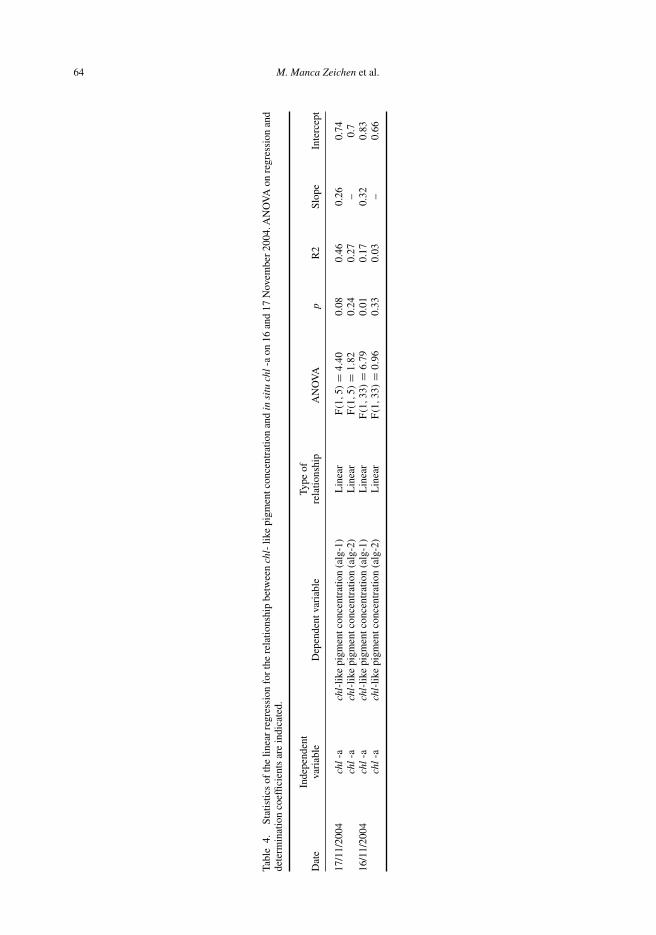
Linear regression calculated for in situ chl-a data with MERIS alg-1 on 17 November 2004reported a slope of 0.26 and an intercept of 0.74. The model did not achieve significant levels(p = 0.08). The regression statistics calculated over the in situ data collected on the 17 Novem-ber 2004 and the Alg-2 algorithm for the same day were not significant, showing a R2 = 0.27(p = 0.24). The inter-correlations between in situ chl-a and Alg-1 for 16 November 2004 gavesignificant linear relationship (p = 0.01, R2 = 0.17) (Table 4).
Figure 5. Surface chlorophyll-a concentration interpolated within the study area on the 17 November 2004.
Table 1. Mean and standard deviation (SD) of chl -a concentrations in situ samplingstations (0–1 m).
Code Lat (N) Lon (E) X̄ (0-1 m) (mg m−3) N SD
T1A 44.368 9.102 0.263 5 0.009T1B 44.363 9.100 0.240 3 0.017T1C 44.360 9.097 0.274 5 0.027T1D 44.354 9.093 0.506 5 0.131T1E 44.343 9.087 0.338 6 0.222T1F 44.334 9.080 0.260 1T1G 44.323 9.074 0.260 3 0.122T2A 44.360 9.127 0.510 4 0.429T2B 44.356 9.125 0.515 4 0.193T2C 44.353 9.122 0.150 5 0.017T2D 44.347 9.118 0.148 4 0.015T2E 44.336 9.111 0.440 3 0.520T2F 44.326 9.105 0.186 8 0.013T2G 44.315 9.097 0.137 3 0.006T3A 44.350 9.149 0.248 5 0.236T3B 44.346 9.146 0.513 3 0.155T3C 44.341 9.143 0.393 6 0.255T3D 44.335 9.138 0.794 8 0.274T3E 44.325 9.133 0.708 4 0.101T3F 44.316 9.127 0.170 4 0.012T3G 44.308 9.121 0.442 5 0.346
(continued)

Chemistry and Ecology 63
Table 1. Continued.
Code Lat (N) Lon (E) X̄ (0-1 m) (mg m−3) N SD
T4A 44.318 9.143 0.445 2 0.115T4B 44.310 9.138 0.390 6 0.338T4C 44.303 9.134 0.064 8 0.005T5A 44.313 9.161 0.148 4 0.115T5B 44.305 9.157 0.076 5 0.009T5C 44.298 9.153 0.077 3 0.006T6A 44.295 9.217 0.293 4 0.385T6B 44.291 9.213 0.470 3 0.275T6C 44.286 9.210 0.475 2 0.078T6D 44.281 9.207 0.860 2 0.028T7A 44.300 9.217 0.515 4 0.323T7B 44.296 9.231 0.155 4 0.005T8A 44.309 9.215 0.134 5 0.009T8B 44.305 9.228 0.125 4 0.010
N = number of records
Table 2. Sampling stations considered for statistical analysis between in situ chlorophyll on 17November 2004 and chl retrieved by alg-1 and alg-2 MER−FR image on 16 November 2004.
Stations a b c d e f g
T1 X X X X X X XT2 X X X X X X XT3 X X X X X X XT4 X X XT5 X X XT6 X X X XT7 X XT8 X X
Table 3. Sampling stations considered for statistical analysis between in situ chlorophyll on 17November 2004 and chl retrieved by alg-1 and alg-2 MER−RR image on 17 November 2004.
Stations a b c d e f g
T1 X XT2T3 X XT4T5 XT6 X XT7T8
4. Discussion
The above analyses demonstrate so far the reliability of satellite sensors also for coastal zonemonitoring. SST skin data retrieved by thermal sensor (AVHRR) are particularly useful to monitorthe regional scale phenomena and to encapsulate local scale processes. In this study we analysedboth reduced and full resolution imagery obtained by MERIS sensor. RR at 1.1 km was particularlyuseful in characterising the oceanographic features occurring at a regional scale within the Ligurianbasin. However, the FR at 300 m resulted the most useful at local scale to the inter-comparison
64 M. Manca Zeichen et al.
Tabl
e4.
Stat
istic
sof
the
linea
rre
gres
sion
for
the
rela
tions
hip
betw
een
chl-
like
pigm
entc
once
ntra
tion
and
insi
tuch
l-a
on16
and
17N
ovem
ber
2004
.AN
OV
Aon
regr
essi
onan
dde
term
inat
ion
coef
ficie
nts
are
indi
cate
d.
Inde
pend
ent
Type
ofD
ate
vari
able
Dep
ende
ntva
riab
lere
latio
nshi
pA
NO
VA
pR
2Sl
ope
Inte
rcep
t
17/1
1/20
04ch
l-a
chl-
like
pigm
entc
once
ntra
tion
(alg
-1)
Lin
ear
F(1
,5)
=4.
400.
080.
460.
260.
74ch
l-a
chl-
like
pigm
entc
once
ntra
tion
(alg
-2)
Lin
ear
F(1
,5)
=1.
820.
240.
27–
0.7
16/1
1/20
04ch
l-a
chl-
like
pigm
entc
once
ntra
tion
(alg
-1)
Lin
ear
F(1
,33
)=
6.79
0.01
0.17
0.32
0.83
chl
-ach
l-lik
epi
gmen
tcon
cent
ratio
n(a
lg-2
)L
inea
rF(1
,33
)=
0.96
0.33
0.03
–0.
66

Chemistry and Ecology 65
for in situ and satellite chlorophyll. This is clearly explainable with the reduced spatial extensionof the study area.
Both MERIS algorithms (alg-1 and alg-2) were tested over the study area. Despite the rela-tionship of in situ chlorophyll on the 17 November with satellite chlorophyll (alg-1) on the samedate did not achieve statistically significant levels (p = 0.08), alg-1 algorithm showed a lineardependency with in situ chlorophyll. Moreover the number of points considered was low due tothe reduced spatial resolution of the image considered. On the other hand alg-2 did not show alinear relationship with in situ chlorophyll data.
Inter-comparison between in situ chlorophyll and alg-1 for 16 November 2004 wassignificant.
Despite the reduced dataset used, statistical analysis confirmed that alg-1 algorithm should beused while monitoring the Portofino area. This could be explained by the presence along the studyarea of almost ‘pelagic’ waters due to the narrow continental shelf that characterises this stretchof coast. There is the tendency to a high dynamic exchange between coastal and pelagic watermasses. By observing, on the satellite chlorophyll maps the mesoscale dynamic structures withinthe Ligurian basin, it is possible to note that, during the considered periods, these are similarto the mesoscale ones along the Portofino area. This tendancy should be verified further on;however it is evident that the offshore circulation appears to contour the Portofino promontory.There is not a transition region between coastal and pelagic zone. Moreover it is possible tohypothesise that the south-western (Paradise gulf) Portofino area hosts case-1 waters (offshorewaters), whereas the waters along the eastern side are more influenced by the Entella river run-off, which flows into Tigullio gulf. However in situ data within this gulf were not available. Inorder to validate this last hypothesis further in situ sampling campaigns within Tigullio gulf areneeded.
This study presents a preliminary approach to the integration of different data sets and method-ologies to increase the use of satellite sensors for the continuous monitoring of coastal areas. Theuse of satellite imagery in addition to the instruments already used within the Portofino MPAwaters revealed to be extremely useful in order to obtain more information on the main physicaland biological phenomena. The experience acquired so far suggests a further improvement ofthe knowledge in this field to define standardised approaches useful to build-up a national mon-itoring system based on the coupling of data collected in situ, in specific pilot areas by meansof profilers working in continuous, and those supplied by remote sensing. This kind of systemcould supply crucial information on the dynamics of the main environmental variables within thenational coastal waters useful both to the Italian Ministry of the Environment and to the MPA man-agers, optimising the in situ sampling effort with the integration of specific information comingfrom satellite imagery.
Acknowledgements
The authors wish to thank the European Space Agency for providing MERIS images.
References
[1] L. Tunesi and G. Diviacco, Environmental and socio-economic criteria for the establishment of marine coastalparks, Int. J. Environ. Stud. 43 (1993), pp. 253–259.
[2] R. Cattaneo-Vietti and L. Tunesi, Le aree marine protette in Italia -Problemi e prospettive. ARACNE editrice S.r.l.,Roma, 2007.
[3] A.M. Doglioli, A. Griffa, and M. G. Magaldi, Numerical study of a coastal current on a steep slope in presence of acape: the case of the Promontorio of Portofino, J. Geophys. Res. 109 (2004), C12033, doi:10.1029/2004JC002422.
[4] Deutsches Zentrum fûr Luft - und Raumfahrt (DLR) available at http://eoweb.dlr.de:8080/data-service.[5] E.P. McClain, W.G. Pichel, and C.C. Walton, Comparative performance of AVHRR-based multichannel sea surface
temperatures, J. Geophys. Res. 90 (1985), pp. 11587–11601.

66 M. Manca Zeichen et al.
[6] A. Morel, Optical modelling of the upper ocean in relation to its biogenous matter content (case 1 waters), J. Geophys.Res. 93 (1988), pp. 10749–10768.
[7] A. Morel and D. Antoine, Pigment Index Retrieval in Case I Waters, ESA Document PO-TN-MEL-GS-0005, (2000),pp. 1–26.
[8] R. Doerffer, K. Heymann, and H. Schiller, Case 2 water algorithm for the medium resolution imaging spectrometer(MERIS) on ENVISAT, in Proceedings of the workshop‘ENVISAT validation’, 9–13 December, ESA report, 2002.
[9] H Schiller and R. Doerffer, Improved determination of coastal water constituent concentrations from MERIS data,IEEE Trans. Geosci. Remote Sens. 43 (2005), pp. 1585–1591.
[10] R. Doerffer and H. Schiller, The MERIS Case 2 water algorithm, Int. J. Remote Sens. 28 (2007), pp. 517–535.[11] ENVI, Available at http://www.ittvis.com/envi/[12] BEAM, Available at http://www.brockmann-consult.de/beam.[13] R Development Core Team, R: A language and environment for statistical computing. R Foundation for Statistical
Computing, Vienna, Austria, ISBN 3-900051-07-0 (2004), URL http://www.R-project.org