A Pan-African gneissic dome in the central Eastern Desert, E
15
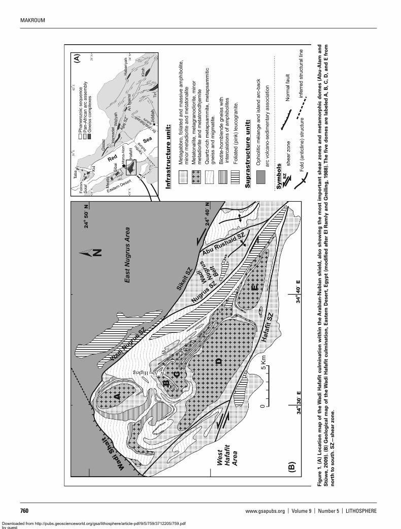
759 RESEARCH Structural interpretation of the Wadi Hafafit culmination: A Pan-African gneissic dome in the central Eastern Desert, Egypt Farid Makroum* GEOLOGY DEPARTMENT, FACULTY OF SCIENCE, MANSOURA UNIVERSITY, MANSOURA 35516, EGYPT ABSTRACT The emplacement and exhumation of gneissic domes of continental lithospheric fragments within the Pan-African oceanic crust in the Arabian-Nubian shield have been subjects of debate in the recent literature. The Wadi Hafafit culmination is one of the largest metamorphic dome complexes, not only in the Eastern Desert, but also in the Arabian-Nubian shield. The culmination forms a northwest-trending folded belt including five individual gneissic domes that show complex interference fold patterns, bounded by northwest- to west-northwest–trend- ing marginal shear zones (the Nugrus and Hafafit shear zones), which belong to the late Proterozoic Najd fault system in the Eastern Desert of Egypt. The Hafafit metamorphic dome forms a positive flower structure that is characterized by a vertical stretch in the central part with subvertical foliation at the individual dome peripheries, subhorizontal flattening in the roof, and near simple shear at the complex margins defined by the Nugrus and Hafafit shear zones. This study presents arguments concerning the folding pattern and exhumation of the culmi- nation and its relation to sinistral, transpressional kinematics along the branches of the Najd fault system. The folded axial surfaces of the gneissic domes are interpreted in terms of interference of two fold generations: (1) an early fold generation that developed east-northeast– trending axial surfaces, which may have formed during late Pan-African northwestward nappe stacking, and (2) a late fold generation that developed north-south—trending fold axes that deformed the axial surfaces of the first fold generation, and probably associated with sinistral shearing on the Nugrus and Hafafit shear zones.The fold interference patterns associated with exhumation of the Hafafit gneissic domes are consistent with published geochronological data and the tectonic evolution of the Arabian-Nubian shield. LITHOSPHERE; v. 9; no. 5; p. 759–773 | Published online 9 August 2017 https://doi.org/10.1130/L645.1 INTRODUCTION The Neoproterozoic Arabian-Nubian shield consists of a collage of ophiolites and juvenile island arcs (Abdelsalam and Stern, 1996). This rock assembly evolved and cratonized during the Pan-African orogeny (900–550 Ma) through oblique convergence of post-Rodinia continental masses (Stern, 1994; Fritz et al., 2013). The Eastern Desert of Egypt represents the northern arc terrane of this shield (Fig. 1A). There, rocks are grouped into two major tectono-stratigraphic units, infrastructural and suprastructural units (El Gaby et al., 1990), and their tectonic rela- tionship is the subject of this paper. The suprastructural units involve a low-grade rock assembly that is dissected into a series of stacked nappes. The infrastructural units involve gneisses that underwent amphibolite- facies metamorphic conditions (Fritz et al., 1996; Neumayr et al., 1998) and are exposed within cores of antiforms that are tectonically sepa- rated from the suprastructure units. Some 20 such metamorphic domes are known throughout the Arabian-Nubian shield across Saudi Arabia, Yemen, and the Eastern Desert of Egypt (Fig. 1A). The Wadi Hafafit culmination is the southernmost, the largest, and the most remote meta- morphic dome of Egypt (Fowler and Osman, 2001). The culmination is located between latitudes 24°33′N and 24°50′N and longitudes 34°24′E and 34°48′E, southwest of Marsa Alam at the Red Sea coast in a remote part of the Eastern Desert region. The origin and tectonic evolution of these metamorphic domes in the Arabian-Nubian shield have been debated for some time (El Gaby et al., 1984; Fritz et al., 1996; Genna et al., 2002; Johnson and Woldehaimanot, 2003) and remain a subject of interest (Meyer et al., 2014; Abu-Alam et al., 2014). Geochronological age data for the gneissic domes cluster around 750 and 600 Ma, and zircon crystals typically show no older cores (Kröner et al., 1994). Therefore, the gneissic domes appear to be juvenile continental crust formed during the Pan-African orogeny, and informa- tion about their structural relationship to the overlying suprastructure may help to clarify their original position. Based on recent studies of the Feiran-Solaf complex in Sinai, the Baladiyah complex in Saudi Arabia, and a literature review of all gneissic domes of the shield, Abu-Alam and Stüwe (2009) and Abu-Alam et al. (2014) concluded that there is probably no unifying exhumation mecha- nism for the entire group of metamorphic domes in the Arabian-Nubian shield. However, there is a general consensus that most of the domes were exhumed in connection with the activity of the Najd fault system at the end of the Pan-African orogeny. This paper presents an alternative interpretation of the Wadi Hafafit culmination in the Eastern Desert of Egypt with the aim of clarifying the role of the Najd fault system in the development of its complex fold pat- terns and finally gneissic dome exhumation. Earlier studies have variably © 2017 Geological Society of America. For permission to copy, contact [email protected] Farid Makroum http://orcid.org/0000-0003-0034-3436 *[email protected] Downloaded from http://pubs.geoscienceworld.org/gsa/lithosphere/article-pdf/9/5/759/3712205/759.pdf by guest on 10 August 2022
-
Upload
khangminh22 -
Category
Documents
-
view
4 -
download
0
Transcript of A Pan-African gneissic dome in the central Eastern Desert, E

LITHOSPHERE | Volume 9 | Number 5 | www.gsapubs.org 759
RESEARCH
Structural interpretation of the Wadi Hafafit culmination: A Pan-African gneissic dome in the central Eastern Desert, Egypt
Farid Makroum*GEOLOGY DEPARTMENT, FACULTY OF SCIENCE, MANSOURA UNIVERSITY, MANSOURA 35516, EGYPT
ABSTRACT
The emplacement and exhumation of gneissic domes of continental lithospheric fragments within the Pan-African oceanic crust in the Arabian-Nubian shield have been subjects of debate in the recent literature. The Wadi Hafafit culmination is one of the largest metamorphic dome complexes, not only in the Eastern Desert, but also in the Arabian-Nubian shield. The culmination forms a northwest-trending folded belt including five individual gneissic domes that show complex interference fold patterns, bounded by northwest- to west-northwest–trend-ing marginal shear zones (the Nugrus and Hafafit shear zones), which belong to the late Proterozoic Najd fault system in the Eastern Desert of Egypt. The Hafafit metamorphic dome forms a positive flower structure that is characterized by a vertical stretch in the central part with subvertical foliation at the individual dome peripheries, subhorizontal flattening in the roof, and near simple shear at the complex margins defined by the Nugrus and Hafafit shear zones. This study presents arguments concerning the folding pattern and exhumation of the culmi-nation and its relation to sinistral, transpressional kinematics along the branches of the Najd fault system. The folded axial surfaces of the gneissic domes are interpreted in terms of interference of two fold generations: (1) an early fold generation that developed east-northeast–trending axial surfaces, which may have formed during late Pan-African northwestward nappe stacking, and (2) a late fold generation that developed north-south—trending fold axes that deformed the axial surfaces of the first fold generation, and probably associated with sinistral shearing on the Nugrus and Hafafit shear zones. The fold interference patterns associated with exhumation of the Hafafit gneissic domes are consistent with published geochronological data and the tectonic evolution of the Arabian-Nubian shield.
LITHOSPHERE; v. 9; no. 5; p. 759–773 | Published online 9 August 2017 https://doi.org/10.1130/L645.1
INTRODUCTION
The Neoproterozoic Arabian-Nubian shield consists of a collage of ophiolites and juvenile island arcs (Abdelsalam and Stern, 1996). This rock assembly evolved and cratonized during the Pan-African orogeny (900–550 Ma) through oblique convergence of post-Rodinia continental masses (Stern, 1994; Fritz et al., 2013). The Eastern Desert of Egypt represents the northern arc terrane of this shield (Fig. 1A). There, rocks are grouped into two major tectono-stratigraphic units, infrastructural and suprastructural units (El Gaby et al., 1990), and their tectonic rela-tionship is the subject of this paper. The suprastructural units involve a low-grade rock assembly that is dissected into a series of stacked nappes. The infrastructural units involve gneisses that underwent amphibolite-facies metamorphic conditions (Fritz et al., 1996; Neumayr et al., 1998) and are exposed within cores of antiforms that are tectonically sepa-rated from the suprastructure units. Some 20 such metamorphic domes are known throughout the Arabian-Nubian shield across Saudi Arabia, Yemen, and the Eastern Desert of Egypt (Fig. 1A). The Wadi Hafafit culmination is the southernmost, the largest, and the most remote meta-morphic dome of Egypt (Fowler and Osman, 2001). The culmination is located between latitudes 24°33′N and 24°50′N and longitudes 34°24′E
and 34°48′E, southwest of Marsa Alam at the Red Sea coast in a remote part of the Eastern Desert region.
The origin and tectonic evolution of these metamorphic domes in the Arabian-Nubian shield have been debated for some time (El Gaby et al., 1984; Fritz et al., 1996; Genna et al., 2002; Johnson and Woldehaimanot, 2003) and remain a subject of interest (Meyer et al., 2014; Abu-Alam et al., 2014). Geochronological age data for the gneissic domes cluster around 750 and 600 Ma, and zircon crystals typically show no older cores (Kröner et al., 1994). Therefore, the gneissic domes appear to be juvenile continental crust formed during the Pan-African orogeny, and informa-tion about their structural relationship to the overlying suprastructure may help to clarify their original position.
Based on recent studies of the Feiran-Solaf complex in Sinai, the Baladiyah complex in Saudi Arabia, and a literature review of all gneissic domes of the shield, Abu-Alam and Stüwe (2009) and Abu-Alam et al. (2014) concluded that there is probably no unifying exhumation mecha-nism for the entire group of metamorphic domes in the Arabian-Nubian shield. However, there is a general consensus that most of the domes were exhumed in connection with the activity of the Najd fault system at the end of the Pan-African orogeny.
This paper presents an alternative interpretation of the Wadi Hafafit culmination in the Eastern Desert of Egypt with the aim of clarifying the role of the Najd fault system in the development of its complex fold pat-terns and finally gneissic dome exhumation. Earlier studies have variably
© 2017 Geological Society of America. For permission to copy, contact [email protected]
Farid Makroum http://orcid.org/0000-0003-0034-3436*[email protected]
Downloaded from http://pubs.geoscienceworld.org/gsa/lithosphere/article-pdf/9/5/759/3712205/759.pdfby gueston 10 August 2022
MAKROUM
760 www.gsapubs.org | Volume 9 | Number 5 | LITHOSPHERE
Fig
ure
1. (
A)
Loca
tio
n m
ap o
f th
e W
adi
Haf
afit
culm
inat
ion
wit
hin
th
e A
rab
ian
-Nu
bia
n s
hie
ld, a
lso
sh
ow
ing
th
e m
ost
im
po
rtan
t sh
ear
zon
es a
nd
met
amo
rph
ic d
om
es (
Ab
u-A
lam
an
d
Stü
we,
200
9). (
B)
Geo
log
ical
map
of
the
Wad
i H
afafi
t cu
lmin
atio
n, E
aste
rn D
eser
t, E
gyp
t (m
od
ified
aft
er E
l R
amly
an
d G
reili
ng
, 198
8). T
he
five
do
mes
are
lab
eled
A, B
, C, D
, an
d E
fro
m
no
rth
to
so
uth
. SZ
—sh
ear
zon
e.
Downloaded from http://pubs.geoscienceworld.org/gsa/lithosphere/article-pdf/9/5/759/3712205/759.pdfby gueston 10 August 2022

LITHOSPHERE | Volume 9 | Number 5 | www.gsapubs.org 761
Structural interpretation of the Wadi Hafafit gneiss dome | RESEARCH
inferred that the geometry and exhumation of the Wadi Hafafit meta-morphic domes formed due to fold interference (Fowler and El Kalioubi, 2002) or due to sinistral wrenching (Shalaby, 2010), but the relation-ship between the observed deformation phases relative to the Najd fault system has not yet been interpreted. Here, we present new structural data, mapping results, and Landsat imagery for the Hafafit region, and its relationship to the bounding shear zones is discussed. This study also presents interpretation of the Wadi Hafafit fold patterns in terms of a more simple history involving deformation of northwest-verging thrust-related fabric by transpressive left-lateral shearing of the Najd fault system in the Arabian-Nubian shield.
ARABIAN-NUBIAN SHIELD IN THE EASTERN DESERT OF EGYPT
In a brief review, the geological buildup of the Arabian-Nubian shield can be described quite simply: The metamorphic domes (referred to as the infrastructure in Egypt) occupy the lowermost structural level. This level is represented by high- to medium-grade metamorphic rocks including amphibolite, granite gneiss, and schists that were typically metamor-phosed between 6 and 12 kbar and at 650 °C to 700 °C (Neumayr et al., 1998; Abd El-Naby et al., 2008; Abu-Alam and Stüwe, 2009). The most important domes of the northern part of the shield are the Meatiq, Sibai, and Hafafit domes in the Eastern Desert of Egypt, the Feiran-Solaf, Kid, and Taba belts of Sinai, and the Qazaz, Hamadat, Baladiyah, and Wajiyah metamorphic complexes of Saudi Arabia (Fig. 1A). The suprastructure is composed of Pan-African cover nappe rocks, including dismembered ophiolites, island-arc–back-arc volcano-sedimentary associations, and tectonic mélange (El Gaby et al., 1990). These rocks were accreted in the Neoproterozoic during the collision of East and West Gondwana, forming a series of thin-skinned nappes (e.g., Stern, 1994; Kröner et al., 1994).
In the late stages of the Pan-African orogeny, the entire sequence was dissected by the northwest-southeast–trending Najd fault system. This sinistral shear zone system strikes from Egypt across the Red Sea into Saudi Arabia and continues into Yemen and has been referred to as the largest Proterozoic shear zone on Earth (Stern, 1985). The activity of this
shear zone constrained the exhumation of the Meatiq and Sebai domes in the Eastern Desert of Egypt (Fritz et al., 2002). Based on restoration of the Arabian-Nubian shield about the Red Sea coasts, Shalaby (2010) suggested that the Wadi Hafafit culmination was exhumed in a wrench-ing continuation of the Ajjaj shear zone. The latter is one of the largest branches of the Najd fault system in Saudi Arabia.
During the Pan-African orogeny, the Arabian-Nubian shield was inten-sively intruded by large volumes of pre- to syn- and post-tectonic granitoids. These granitoid intrusions often obliterate the margins of the metamor-phic domes, so that shear zone boundaries are imprecisely mappable. For example, the Feiran-Solaf belt of Sinai is of particular interest, because it records the highest pressures of any of the belts, but its exhumation mechanisms can only be studied indirectly because all of its margins have been completely obliterated by late-stage granites. In contrast, the margins of the Hafafit culmination are well exposed, making it a prime target for the investigation presented here.
At the end of the Pan-African orogeny, the Arabian-Nubian shield was covered with molasse-type terrestrial sedimentary rocks. During its Phanerozoic evolution, these sedimentary rocks were largely removed by erosion, but they are preserved in small molasse basins that are often conspicuously linked to the metamorphic domes (Fritz and Messner, 1999; Abd El-Wahed, 2010). Conglomerates in these basins are occasion-ally highly deformed, but overall these sedimentary rocks are partially deformed and largely unmetamorphosed. In the Eastern Desert of Egypt, these basins include the Hammamat, Kareim, Igla, and El Mayah Basins.
SOUTHERN PART OF THE CENTRAL EASTERN DESERT REGION
The geological map of the Wadi Hafafit culmination shows map-scale shear zones bounding the culmination to the northeast, southwest, and northwest along the trunk streams of Wadi Nugrus, Wadi Hafafit, and Wadi Shait, respectively (Figs. 1B and 2A). The Nugrus and Hafafit bounding shear zones merge southward at a pivot, where the culmination tapers. The Shait structural line extends roughly in an east-northeast direction further north and juxtaposes the culmination against the low-grade cover
Figure 2. Three-dimensional cartoon showing the envisaged geometry of the Wadi Hafafit culmination (no scale). (A) The Wadi Hafafit culmination is bordered by three main shear zones, the Nugrus, Hafafit, and Shait shear zones. (B) Imbricate fan structure in the cover nappe rocks of the east Nugrus area. (C) En-echelon arrangement of the north-south–trending fold set constituting the Nugrus strike-slip duplex.
Downloaded from http://pubs.geoscienceworld.org/gsa/lithosphere/article-pdf/9/5/759/3712205/759.pdfby gueston 10 August 2022

MAKROUM
762 www.gsapubs.org | Volume 9 | Number 5 | LITHOSPHERE
nappe northward (Fig. 2A). The bounding shear zones separate the Wadi Hafafit culmination from three distinct structural provinces northeast, southwest, and northwest of the culmination.
To the northeast, there is the East Nugrus area, extending from the Nugrus shear zone to the Red Sea coast. It is dominated by northwest-verging thrust packages of low-grade suprastructural nappes, forming an imbricate fan structure (Makroum, 2003; Abd El-Wahed et al., 2016). The fan geometry is delimited to the north by a northeast-striking thrust-related frontal ramp and to the west by a northwest-trending sinistral-dominated transpressional lateral ramp that is oriented parallel to the Nugrus shear zone (Fig. 2B). Lenticular masses of serpentinite and talc-carbonate rock assemblage mark fronts of northwestward-verging and east-north-east–trending thrusts that are warped in a southwest direction along the
Nugrus shear zone. Mica and talc schists frequently delineate thrust and shear contacts. The top-to-the-northwest tectonic transport direction is clearly indicated by drag folds of the mica schist, asymmetric pressure shadows, and S-C shear bands at talc-carbonate the overthrust (Fig. 3A). The foliation is formed by flattened rock fragments and is penetrative in distinct bands as bedding plane–parallel schistosity. The foliation strikes in a northwest direction and dips mostly shallowly to the southwest and northeast, implying macroscopic northwest-trending fold axes.
The Wadi Nugrus belt is the region between the East Nugrus area and the Wadi Hafafit culmination. It involves three main contiguous fish-shaped sigmoidal blocks of map-scale metasedimentary rock assem-blages. These blocks occur between two main northwest-trending mar-ginal shears that run through the trunks of Wadi Sikeit and Wadi Nugrus.
B
C D
E F
A
SE NW
SE NW SE NW
Figure 3. Field photos of representative rock types and structures of the Wadi Hafafit region. (A) S-C structure of the talc carbonate suprastructural rocks indicating a top-to-the-northwest tectonic transport direction. (B) Rotated rock fragment mantled by asymmetrical pressure shadows indicating sinistral shearing sense of the Nugrus shear zone. (C) Sheets of con-tinental Dokhan volcanics unconformably overlying the infrastructural gneisses. (D) Boudinage structure of the pegmatite veins manifesting northwest crustal extension along the Shait structural line. (E) Rhythmic layering of the granite gneiss. (F) Deformed xenolithic rock fragment within the granite gneiss.
Downloaded from http://pubs.geoscienceworld.org/gsa/lithosphere/article-pdf/9/5/759/3712205/759.pdfby gueston 10 August 2022

LITHOSPHERE | Volume 9 | Number 5 | www.gsapubs.org 763
Structural interpretation of the Wadi Hafafit gneiss dome | RESEARCH
The eastern Sikeit marginal shear juxtaposes the low-grade nappe rock assemblage of the east Nugrus area against the Nugrus-Sikeit metasedi-mentary rocks. The Nugrus-Sikeit rock assemblage, in turn, juxtaposes the gneissic domes of the Wadi Hafafit culmination along the western Nugrus marginal shear (Figs. 1B and 2A). These two marginal shears merge to the northwest and southeast at pivots and are bridged by transpressive Riedel shear arrays along Wadi Sikeit and Wadi Abu Roushaid. The sigmoidal blocks exhibit shear-related en-echelon arrangement of north-south fold patterns, and the individual blocks are separated by transpressive Riedel shears showing strike-slip duplex geometry (Fig. 2C; Makroum, 2003). Fabric asymmetry about boudins indicates that the Nugrus and Sikeit shear zones are left-lateral–dominated transpressional shear zones (Fig. 3B). Far from these shear zones, the northwest-trending stretching linea-tions on southward-dipping foliations within the wrench corridor and the monoclinic asymmetry of many strain fabrics (Fowler and El Kalioubi, 2002; Makroum, 2003; Shalaby, 2010) indicate that the serpentinite-rich volcano-sedimentary associations of the cover nappe assemblage were stacked northwest onto the Nugrus-Sikeit metasedimentary rocks.
The West Hafafit area, located to the west of Wadi Hafafit, is dominated by associations of orthogneisses and paragneisses that are stacked by the Pan-African cover nappes at higher structural levels. Fabric asymmetry, including drag folds, asymmetric pressure shadows, and S-C shear band cleavages, indicates that the West Hafafit belt is sinistrally displaced against the core gneisses of the Wadi Hafafit culmination (Shalaby, 2010). The north-northwest–trending Riedel shear arrays linking the Hafafit master shear enclose trails of southward-plunging folds. The Hafafit gneisses at the extreme northwestern corner are unconformably overlain by sheets of the continental Dokhan volcanics (Fig. 3C). These volcanics are mainly rhyolitic in composition, showing well-developed columnar jointing. These volcanic sheets are tilted concordantly with the regional structure of the area, implying late Pan-African northwest crustal extension.
The Wadi Shait area is the region northwest of the Wadi Shait structural line, and it represents the northern limit of the Wadi Hafafit culmination and juxtaposes the Wadi Hafafit infrastructural gneiss along a normal fault against the low-grade cover nappe units to the northwest (Fig. 1B; Fowler and Osman, 2009; Shalaby, 2010). Boudinaged pegmatite veins cutting the infrastructural gneiss at the northern culmination boundary (Fig. 3D) indicate late Pan-African ductile extension that is overprinted by the brittle normal faulting along the Wadi Shait structural line. Molasse-type sedi-mentary rocks are rarely recorded northwest of the Hafafit domes, while a huge exposure is represented by Wadi Igla Basin near the Red Sea coast.
WADI HAFAFIT CULMINATION
The Wadi Hafafit culmination is bounded by the Nugrus, Hafafit, and Shait shear zones, which separate it from the provinces discussed in the previous section. The culmination includes five separate gneissic-cored domes that are labeled A, B, C, D, and E, from north to south (El Ramly and Greiling, 1988). The orientation of the axial trace of the gneissic domes A, D, and E shifts gradually from the north-northwest to north-west directions, while domes B and C display complex fold interference patterns that will be discussed separately later.
Rock Types
Lithologically, the Wadi Hafafit culmination represents a spectacular zonal arrangement of a series of rock units, including: (1) medium- to high-grade gneiss at the core of the domal structures; (2) amphibolite and metagabbro constituting mafic rims surrounding the core gneisses; and (3) psammitic gneisses of the Wadi Sikeit metasedimentary rock
assemblage (Fig. 1B). This sequence is intruded by granite protolith (which now constitutes the granite gneiss infrastructure), and it is over-thrust by the low-metamorphic-grade cover nappe (Makroum, 2003).
The core gneisses commonly display low-lying topography against the surrounding Pan-African cover nappes, exhibiting different map-view geometries ranging from oval to crescent shapes. They are heterogeneous in composition, at the scale of few centimeters up to several meters, where the gneisses exhibit strong foliation with well-developed gneissic banding of felsic- and mafic-rich alternating bands (Fig. 3E). The core gneiss has deformed intrusive contacts with the surrounding amphibolites, while the deformed amphibolite xenoliths and enclaves supported its magmatic protolith (Fig. 3F). The gneisses are invaded by numerous pegmatitic dikes and veinlets, which in some places contain garnet (Fig. 3D).
The banded amphibolites are pervasive, with dark tones and strong foliation, and with alternating bands of metamorphic biotite- and horn-blende-gneisses of amphibolitic metamorphic facies (Rashwan, 1991; El Ramly et al., 1993; Abd El-Naby and Frisch, 2006). The amphibolites form a series of isoclinal upright folds with steeply inclined limbs occu-pying the structural lows between the granite gneissic domes (Fig. 4A). They are locally associated with sheared metagabbro, and both rocks probably belong to the calc-alkaline metagabbros associated with the Hafafit gneiss (El Ramly et al., 1993).
The Wadi Sikeit metasedimentary rock unit (Fig. 1) forms northwest-verging thrust sheets overriding both the orthogneisses and amphibolites (Fig. 4B). This unit consists of an interlayered sequence of garnet-bearing metapelites and metapsammites. The psammitic gneiss is characterized by its pervasive red color and forms the highest peaks in the Wadi Hafafit culmination overlooking the low-lying core gneisses. The psammitic gneiss consists essentially of bands of quartz and feldspars with minor amphiboles and biotite. Garnet crystals reach up to 1.5 cm in diameter and exhibit synkinematic growth, as indicated by spiral-shape patterns (Fig. 4C). The psammitic gneiss locally contains discrete irregular lenses of highly deformed and locally migmatized garnet-rich metasediments. The Wadi Sikeit unit itself is overthrust by serpentinite and talc schist pertaining to the low-grade suprastructural nappes.
Geometry of the Hafafit Gneissic Domes
The five gneissic domes of the Wadi Hafafit culmination display differ-ent geometries due to fold superpositions (Fowler and El Kalioubi, 2002) and have a long-term exhumation history since the Pan-African nappe accretion and formation of the Najd fault system (Shalaby, 2010). Dome A has an elliptical form that is rimmed by amphibolite bands (Fig. 1B). The concentric zonation pattern of amphibolite around the dome is narrower to the east of the core gneiss than to the west, indicating asymmetric fold-ing of dome A around NNW-SSE–trending fold axis. Domes B and C are sandwiched between domes A and D, and their cores are also occupied by granite gneisses that are surrounded by thick amphibolite and mafic bands. Both domes B and C show an unlikely folding pattern, with axial planes dipping roughly to the south-southeast, crosscutting the northwest-trending fabric of the culmination. The two domes are separated by an east-north-east–trending synform that is occupied by banded amphibolites. Dome B is folded around dome C at the extreme eastern parts, indicating that their axial surfaces may be refolded about the north-south axial trace that runs along the main stream of Wadi Abu Higleig. This north-south axial trace extends northward, affecting the amphibolite rocks occupying the structural low between domes A and B. Foliation trajectories indicate that the eastern limb of the Abu Higleig fold is constituted of a folded interlayered sequence of granite gneiss and banded amphibolite, while its fold axis plunges south-east. Dome D is the largest dome in the Wadi Hafafit culmination, and it
Downloaded from http://pubs.geoscienceworld.org/gsa/lithosphere/article-pdf/9/5/759/3712205/759.pdfby gueston 10 August 2022

MAKROUM
764 www.gsapubs.org | Volume 9 | Number 5 | LITHOSPHERE
exhibits a rectangular form in general; however, its northern part, toward its western side, becomes narrow and extends like an outstretched finger from a fist. The sinuous-shaped gap behind its northern extension is occupied by the western parts of domes B and C. The southernmost dome E has an oval shape bounded by the Nugrus and Hafafit shear zones.
The zonal pattern of lithological compositions is reflected clearly in the color band ratio images for the Wadi Hafafit culmination (Fig. 5). The color ratio images across the gneissic domes constituting the culmination imply that the core of dome A is comparable with that surrounding the central part of dome D, while the color ratios of the cores of domes B and C are comparable to the outer rims surrounding the cores of domes D and E. Moreover, the central part of dome E shows randomly arranged granitic fractures rimmed by concentric foliation of the granite gneiss, which may imply intrusion of less-deformed granitoids at the core of dome E (Fig. 6).
Structural Data
The geological map of Greiling and El Ramly (1990), the structural data of Fowler and El Kalioubi (2002), and the data presented here show
that the foliation trajectories at the eastern and western boundaries of the culmination strike in northwest direction parallel to the bounding shear zones, while they show a concentric pattern at cores of the gneissic domes of the culmination (Fig. 7). In the central part of the domes (Fig. 4D), they are flat-lying, while they are gradually inclined more steeply at the dome margins. The amphibolite bands surrounding the core gneiss are oriented in northwest-southeast direction and dip subvertically (Fig. 4E). At the Wadi Nugrus area, the foliation (S
1) trends generally northwest and dips
at various angles, either to the southwest or northeast. Poles-to-foliation planes are clustered along a northeast-trending fold girdle and reflect folding around a northwest-plunging fold axis (Fig. 7). The foliation of dome A dips moderately north-northwest and south-southeast at the northern and southern parts, respectively. It dips steeply to the northeast in the eastern part and shallowly to the southwest in the western part of the dome, as indicated by the apparent thickness variation of the sur-rounding amphibolite, since its outcrop pattern is thick on the western limb relative to the eastern limb. The poles-to-foliation planes at dome A accumulate along two great circles dipping south-southeast and northeast, which imply folding around two north-northwest– and southwest-plunging
NW SE
NNW SSE
N
A
D
E
B
CS
Figure 4. Field photos of representative rock types and structures of the Wadi Hafafit culmination. (A) Amphibo-lite rocks are highly folded and occupy the structural low between the granite gneissic cores of the domes. (B) Metasedimentary rocks represented by metapsammite overthrust the amphibolite infrastructure. (C) Garnet-bearing psammitic gneiss at Wadi Sikeit area. (D) Flat foliation and boudinaged structure manifesting flattening at the central part of the Wadi Hafafit domes. (E) Boudi-naged structure suggesting vertical extension along isoclinally folded amphibolite at the dome margins.
Downloaded from http://pubs.geoscienceworld.org/gsa/lithosphere/article-pdf/9/5/759/3712205/759.pdfby gueston 10 August 2022

LITHOSPHERE | Volume 9 | Number 5 | www.gsapubs.org 765
Structural interpretation of the Wadi Hafafit gneiss dome | RESEARCH
fold axes, respectively. At domes B and C, the foliations dip mainly in the south-southeast and north-northwest directions, implying that the gneissic foliations of both domes B and C are folded around an east-northeast–trending axial surface. The area between the two gneiss cores represents a structural low, occupied by folded and steeply foliated amphibolite. The gneissic foliation of dome D dips shallowly to the southwest and southeast, which indicates folding in a north-south direction. The foliation pattern developed in dome E shows concentric trajectories. However, at the eastern and western margins, the foliation trends in the northwest to west-northwest directions, parallel to the orientations of the Nugrus and Hafafit shear zones, respectively.
The stretching lineations (L1) at the Wadi Hafafit culmination plunge
mostly to the northwest and southwest, following the main tectonic fabrics of Precambrian domal structures in the Eastern Desert (Fig. 7). In the Wadi Nugrus area, the stretching lineation plunges shallowly to the northwest. In dome A, the contour diagram reveals two trends for the stretched mineral lineation: The first plunges subhorizontally to the north-northwest, and the second plunges moderately to the southwest. This contour pattern reflects that the gneissic foliation of dome A is folded around an east-northeast axial surface. In contrast, the stretched mineral lineation at domes B, C, and D shows that they plunge, with a symmetrical distribution, to
the southwest and southeast, implying folding of their gneissic foliation around a north-south–trending axial surface. At dome E, the stretched mineral lineation plunges subhorizontally toward the northwest.
Despite the two general northwest and southwest stretching lineations, there is no evidence of southwest thrusting. Many shear sense indicators, including the monoclinic asymmetry of pressure shadows coating rotated fragmental fabrics, S-C fabric, and asymmetric parasitic folds, indicate that the area of the Wadi Hafafit culmination, like many areas elsewhere in the Pan-African orogenic belt in the Eastern Desert of Egypt, has experienced top-to-the-northwest tectonic transport. The tectonic nature of certain shear planes depends on their attitude relative to the general transport direction in the Wadi Hafafit area. The steeply inclined foliation of the Nugrus and Hafafit shear zones carries a subhorizontal northwest stretching mineral lineation with sinistral shear sense indicators (Fig. 3B). However, far from the shear zones and close to the core of the gneissic domes, the foliation is flat or gently dips southeastward. It carries a north-west stretching lineation, while the shear sense indicators manifest a top-to-the-northwest tectonic transport direction. The northern boundary of the Wadi Hafafit culmination is characterized by northwest-dipping foliation, northwest-plunging mineral lineation, and a top-to-the-northwest sense of motion along a normal shear zone. This downdip transport direction
34 40`Eo
24o
50`N
A
BC
D
EHafafit shear zone
Nugrus shear zone
24o
40`N
34 30`Eo
D
34 40`Eo34 30`Eo
24o
50`N
A
BC
D
EHafafit shear zone
Nugrus shear zone
24o
40`N
B
34 40`Eo
24o
50`N
A
B C
D
EHafafit shear zone
Nugrus shear zone24o
40`N
34 30`Eo
C
34 40`Eo34 30`Eo
A
BC
D
EHafafit shear zone
Nugrus shear zone
A
24o
50`N
24o
40`N
NN
N N
0 5 Km
0 5 Km0 5 Km
0 5 Km
Figure 5. Remote-sensing image analysis in red-green-blue (RGB) of the Wadi Hafafit culmination: (A) Principal component Enhanced Thematic Mapper Plus (ETM+) images (PC3, PC2, and PC4), (B) Landsat Thematic Mapper (TM) ratio image (1/4, 1/7, and 3/5), (C) Landsat TM ratio image (1/4, 3/5, and 4/7), and (D) Landsat TM ratio image (5/7, 5/1, and 5/4*4/3) after Sultan et al. (1988).
Downloaded from http://pubs.geoscienceworld.org/gsa/lithosphere/article-pdf/9/5/759/3712205/759.pdfby gueston 10 August 2022

MAKROUM
766 www.gsapubs.org | Volume 9 | Number 5 | LITHOSPHERE
predated the normal brittle faulting along the Shait structural line (Fowler and Osman, 2009; Shalaby, 2010).
DISCUSSION
Different mechanisms have been proposed to explain the tectonics and exhumation history of the Wadi Hafafit culmination, including: (1) buoyancy-driven exhumation and diapirism within a scissor-like sinistral wrench system pertaining to the Najd shear zone (Shalaby, 2010), (2) antiformal stacking, where the Wadi Nugrus roof thrust juxtaposes the low-grade cover nappe against the infrastructural gneiss (Greiling et al., 1988; El Ramly et al., 1993), (3) orogen-parallel crustal extension and exhumation as core complexes (Fritz et al., 1996), and (4) fold interfer-ence patterns involving multiply deformed sheath folds (Fowler and El Kalioubi, 2002). However, the role of the Najd fault system in the struc-tural evolution of the different fold generations remains unclear.
Interpretation of Wadi Hafafit Culmination as the Product of Fold Interference
The Wadi Hafafit culmination displays a complex pattern of fold geom-etry where the fold axes trend northwest-southeast, east-west, and north-south. Moreover, mesoscopic folds exhibit complex mushroom, crescent, and dome geometries, sometimes with undulating axial surfaces, which are interpreted as type 1, 2, and 3 interference fold patterns (Fig. 8; Ramsay and Huber, 1987). These mesoscopic folds display geometrical patterns
similar to that of the Wadi Hafafit domes, which may support the inter-pretation of the Wadi Hafafit culmination on the basis of superposition of two fold generations. Two scenarios are proposed: The first postulates superposition of early northwest-trending folds by a later north-south–trending fold generation; the second is the superposition of an early east-northeast–trending fold by a later north-south–oriented fold generation.
The first scenario might be true if the first generation of folds, formerly oriented in a northwest-southeast direction, developed in an en-echelon arrangement of a southeast-plunging fold set, namely, A, B, C, D, and E from north to south, within a north-south–oriented dextral wrench corridor (Fig. 9). Subsequent left-lateral shearing along the Nugrus and Hafafit marginal shears would have resulted in refolding of the early northwest-trending fold generations across north-south axial surfaces. The data pre-sented here reveal the absence of any evidence that may support an early north-south dextral shearing that predated the activity of the northwest left-lateral shearing at the Wadi Hafafit culmination, and so the first sce-nario does not appear to be supported by the evidence.
In the second more likely scenario, dome A is interpreted as an asym-metrical doubly-plunging fold, since its fold axis plunges gently southeast at the southern part and moderately to steeply northwest at the northern part. The axial surface trends north-northwest and dips subvertically in the west-southwest direction. The northwest- and southwest-plunging stretching lineation at dome A is likely related to refolding around a gently plunging, east-northeast-trending fold axis or northeast monoclinal flex-ing due to northwest-southeast shortening (Shalaby, 2010; Fowler and El Kalioubi, 2002). As a consequence, the geometry of dome A can be interpreted as a type 1 interference pattern of two perpendicular fold gen-erations with subvertical axial planes (Fig. 10A). The transport direction of the second generation runs parallel to the axial surface of the first one, while the first-generation fold axis trends perpendicular to the second-generation axial plane. Type 1 interference is represented by the dome and basin structures (Ramsay and Huber, 1987): The geometry of dome A is established by an eastern dome of cored granitic gneiss mantled by dark-green amphibolite bands and a western basin constituted of inter-layered thick amphibolite and mafic bands (Fig. 10A).
Domes B and C commonly develop northeast-oriented S-shaped fold geometries, cored by granite gneiss and rimmed by amphibolite on the fold limbs (Fig. 10B). This geometry can easily be interpreted in terms of refolding of an early east-northeast–trending fold generation (F
1) about
two north-south–striking axial surfaces (F2). It possesses two sinuous-
shaped geometrical spaces: The northward-facing sinuous space fringes the southern extreme of dome A, while the southward-facing one is occu-pied by the central part of dome D. The western parts of domes B and C, dominated by a folded amphibolite carapace, partially occupy the sinuous-shaped space lifted behind the northern narrow segment of dome D and form a northwest-plunging fold belt. On the other hand, the central parts of domes B and C trend east-northeast, where their cores are occupied by granite gneiss. Dome B is refolded around the eastern end of dome C, while the folded amphibolite carapace extends further south, fringing the eastern limb of dome D, where its fold axis plunges southeast. The hinge-line geometry of domes B and C matches an S-fold pattern of drag folds developed within a northwest-trending left-lateral wrench corridor.
Dome D is geometrically mapped as a northward-facing crescent shape that converges southeast and wings to the northwest. The crescent geom-etry of dome D is interpreted as the interference of two fold generations through superposition of the east-northeast–trending by the northward-trending axial surfaces of the early (F
1) and late (F
2) fold generations,
respectively. The western limb of the dome D crescent geometry extends likely northward as an arm of a northwest-plunging anticline, while the eastern limb is poorly developed, possibly either due to the asymmetry
34 45`Eo34 40`Eo
24o
34`N
24o
38`N N
A
AmphibolitesMetapsammites Shear zone
0 3 KmGranite gneissFoliated (pink) leucogranite.
Less deformed granite Anticlinal fold
Dome E
Wadi Hafafit
Wadi Nugrus34 45`Eo
34 40`Eo
24 34`No
24 38`No
B
Figure 6. (A) Landsat imagery of dome E shows concentric gneissic folia-tion intruded by less-deformed fractured granite at the dome center. (B) Simplified geological map of dome E. (C) Geological map of dome E.
Downloaded from http://pubs.geoscienceworld.org/gsa/lithosphere/article-pdf/9/5/759/3712205/759.pdfby gueston 10 August 2022

LITHOSPHERE | Volume 9 | Number 5 | www.gsapubs.org 767
Structural interpretation of the Wadi Hafafit gneiss dome | RESEARCH
of the second generation fold (F2) about the north-south–trending axial
surface or due to its subsurface protuberance underneath both domes B and C (Fig. 10C). On the other hand, the banded amphibolite, occupy-ing the structural low between domes D and E, shows an S-shaped fold geometry. This S-shaped pattern, like the interference patterns of domes B and C, is folded around two north-south–trending axial surfaces (F
2),
since the northwest foliation of the amphibolite to the east of dome E is folded to trend east-northeast at the structural low separating domes E and D and then is refolded again to the northwest parallel to the western limb of dome D (Fig. 6). Consequently, the southwestern corner of dome D and northeastern corner of dome E acquired their rounded outlines. The
symmetrical distributions of the stretching lineation at domes B, C, and D about a north-south axial surface, and their consistent patterns with the traced foliation trajectories at the Wadi Hafafit culmination indicate a reasonable type 2 interference pattern for domes B, C, and D by early east-northeast–trending axial surfaces and lately north-south–oriented fold generations.
Consequently, the following observations suggest an interference pat-tern due to the superposition of the early east-northeast and late north-south fold generations:
(1) There is a remarkable lithologic zonation in the Hafafit domes, varying from low-grade rocks at the rim (particularly at dome A) to banded
O34 40` E
Wadi Shait
Hafafit SZ
Nugrus SZ
A
BC
DO24 40` N
Sikeit SZ
Abu Rushaid SZ
Wadi
Nugrus
Belt
N
A
E
Lineations
Lineations
Lineations
Lineations
Foliations
Foliations
Foliations
Foliations
0 5 Km
Foliations
Lineations
Foliations
Lineations
O34 30` E
Figure 7. Structural data from the Wadi Hafafit culmination collected for this study (rock symbols are as in Fig. 1). SZ—shear zone.
Downloaded from http://pubs.geoscienceworld.org/gsa/lithosphere/article-pdf/9/5/759/3712205/759.pdfby gueston 10 August 2022

MAKROUM
768 www.gsapubs.org | Volume 9 | Number 5 | LITHOSPHERE
amphibolites and granite gneisses at the core. The entire sequence shows similar structural fabrics, indicating that these rocks were subjected to the same deformation history subsequent to the Pan-African nappe accre-tion. The total radial pattern of the stretched mineral lineation at the Wadi Hafafit culmination supports the up-doming of the culmination after the accretion of the Pan-African nappe assemblage.
(2) The fold geometry of domes B and C trending in the east-northeast direction, crosscutting the northwest orientation of the Wadi Hafafit culmi-nation, reveals that both domes were possibly reoriented as drag folds due to sinistral shearing at the Nugrus and Hafafit marginal shears (Fig. 1B).
(3) The oblique convergence, in a scissor-like wrench corridor (Shalaby, 2010), during northwestward tectonic escape of the Pan-African cover nappe was responsible for the development of the northwest-verging fold
system of domes A, B, C, and D. The northwest stretched mineral linea-tion at dome A was deformed by folding about an east-northeast axial surface; however, the symmetric distribution of the mineral lineation at domes B, C, and D (Fig. 7) suggests reorientation and folding around north-south–trending axial surfaces (F
2).
This scenario is not only more likely, it is also more consistent with the interference history suggested by Fowler and El Kalioubi (2002), who suggested that the domes of the Wadi Hafafit culmination formed due to four folding events, the first three of which were largely associated with northward transport, and the last one of which was related to northeast-southwest compression. In this way, it can easily be postulated that the last folding event was related to transpressive sinistral shearing of the Najd fault system.
Type IIIType I Type II
B
A
C
D E
F1
F2 F1
F2
F1
F2
F Fold axis
1
F Fold axis
2
F a
xial
sur
face
2
F1 axial surface
Figure 8. (A) Types I, II, and III superimposed fold patterns of two fold generations (modified after Ramsay and Huber, 1987). (B–E) Interference pattern fold geometries of mesoscopic folds at Wadi Hafafit area: (B) type I dome-shaped interference pattern, (C) type I mushroom-shaped interference fold pattern, (D) type II crescent-shaped interference pattern, and (E) type III refolded axial surface of the first fold generation.
Downloaded from http://pubs.geoscienceworld.org/gsa/lithosphere/article-pdf/9/5/759/3712205/759.pdfby gueston 10 August 2022

LITHOSPHERE | Volume 9 | Number 5 | www.gsapubs.org 769
Structural interpretation of the Wadi Hafafit gneiss dome | RESEARCH
Megascale Positive Flower Structure in the Najd Fault System
Three main aspects led Fowler and El Kalioubi (2002) to suggest a sheath fold interference model to interpret the tectonic setting of the Wadi Hafafit culmination. These were: (1) The radial distribution of the stretched mineral lineation was interpreted as being related to outward migration of the stretching lineation toward the hinge lines of sheath folds; (2) no basin structures are evident in the Wadi Hafafit culmination, since the domes are well developed; and (3) the domes of the Wadi Hafafit culmination are concentrated in a narrow northwest- to north-northwest–trending zone, rather than forming a uniformly distributed set of struc-tures. The present study reveals that the radial distribution pattern of the stretching lineation can possibly be interpreted in terms of superposition of two fold generations and extrusion of the gneissic domes eventually postdating the northwestward accretion of the Pan-African cover nappes, since the fabrics of both gneissic domes and the overlying nappe cara-pace display uniform patterns. With respect to the second aspect, the amphibolite rocks rimming the gneissic cores form isoclinal synforms occupying the structural lows between these gneissic domes. The third aspect relates to the narrow folded belt of the Wadi Hafafit culmination, which tapers southeast, suggesting that the tectonic setting of the Wadi Hafafit culmination is related to the Nugrus and Hafafit transpressive marginal shear zones.
The Nugrus and Hafafit marginal shears bordering the Wadi Hafafit culmination trend in the northwest and west-northwest directions, respec-tively, and are parts of the Najd fault system in the Eastern Desert of Egypt (Fritz et al., 1996; Makroum, 2003; Shalaby, 2010). These marginal shears merge southward into one single shear zone that seemingly represents the northern continuation of the Ajjaj shear zone in Saudi Arabia (Sultan et al., 1988; Hassan et al., 2016). It is suggested here that the marginal shears
also merge northward into one single shear within the downthrown block northwest of the Shait normal fault (Figs. 2A and 10D). The up-doming of the Wadi Hafafit culmination and vertical extrusion of its core gneisses were accommodated by horizontal shortening partitioning left-lateral–dominated transpression at the Nugrus and Hafafit marginal shears, which might sole deeply into a single fault. As such, the geometry of the Wadi Hafafit culmination is that of a positive flower structure (Fig. 10D). The flat and steep foliation with subhorizontal mineral lineation that characterizes the central and peripheral parts of the individual gneissic domes, respec-tively, formed coeval with extensional fabrics parallel to the lineations. This indicates a pronounced lateral compression at the time of vertical extrusion of the granite gneiss–cored domes. This geometry led Shalaby (2010) to suggest that the culmination developed by oblique convergence in a scissor-like wrench corridor along the Najd fault system. Left-lateral shearing on the Nugrus and Hafafit shear zones has resulted in refolding of the east-northeast first fold generation (F
1) about the north-south axial
surfaces (F2), as well as northwest reorientation of the earlier-formed
structural elements. The positive megascale flower structure extended laterally to involve the Wadi Nugrus domain eastward, and this explains the en-echelon arrangement of the sigmoidal folded horses (Fig. 2C). Further north, the geometry of the flower structure of the Wadi Hafafit culmination is abruptly terminated on the northwestward-dipping Shait normal fault (Fowler and Osman, 2009), which juxtaposes the gneissic domes of the culmination south of the fault with the nappe assemblage to the north. The Shait normal fault is oriented in an east-northeast direction parallel to the first fold generation and crosscuts the northward-striking axial surfaces of the second fold generation of the Wadi Hafafit culmina-tion. This implies that activity on the normal fault occurred subsequent to up-doming of the Wadi Hafafit culmination. The extension parallel to the foliation at the northern margin of the Wadi Hafafit culmination
Dome A
Dome B
Dome C
F1
F2
B
C
Dome A
Dome B
Dome D
F1
F2
F1 F2
A
Dome D
Dome E
F1
F2
Wadi Hafafit
Wadi Nugrus
Dome A
N
Dome E
D
Figure 9. Sketch diagram showing how the interference patterns of the Wadi Hafafit culmination can be formed by superposition of northwest en echelon fold set by north-south fold generation (no scale). (A) Earlier-formed northwest-southeast–trending fold genera-tion. (B) Left-lateral shearing and development of north-south–trending second fold generation. (C) Interference pattern of the two fold generations. (D) Interpretation of the Wadi Hafafit culmination as interference patterns of superposed folding.
Downloaded from http://pubs.geoscienceworld.org/gsa/lithosphere/article-pdf/9/5/759/3712205/759.pdfby gueston 10 August 2022

MAKROUM
770 www.gsapubs.org | Volume 9 | Number 5 | LITHOSPHERE
Figure 10. Three-dimensional cartoon illustrating the geometry of the Wadi Hafafit domes as interference patterns of two super-posed east-northeast– and north-south–trending fold generations: (A) dome A, (B) dome B and C, and (C) dome D. (D) Sketch diagram showing the Wadi Hafafit positive flower structure, characterized by subvertical foliation at the margins and subhorizontal foliation near the center of the individual domes. Rock symbols are as in Figure 1. SZ—shear zone.
Downloaded from http://pubs.geoscienceworld.org/gsa/lithosphere/article-pdf/9/5/759/3712205/759.pdfby gueston 10 August 2022

LITHOSPHERE | Volume 9 | Number 5 | www.gsapubs.org 771
Structural interpretation of the Wadi Hafafit gneiss dome | RESEARCH
expressed by boudinaged pegmatite veins supports a phase of ductile northwest crustal extension that predated the low-angle normal faulting along the Wadi Shait line.
Wadi Hafafit Culmination in a Regional Context
The Wadi Hafafit culmination represents one of the largest metamor-phic domes in the Eastern Desert of Egypt. This culmination and nearly more than 20 domes in the Arabian-Nubian shield are located within the Najd fault system, where its activity triggered their emplacement and exhumation (Abu-Alam and Stüwe, 2009). Among them, the Hafafit, Shaloul, Sibai, and Meatiq gneissic dome complexes are located in the Eastern Desert; the Feiran-Solaf, Sa’al, Kid, and Taba belts are located in the Sinai Peninsula, Egypt; and the Hamadat, Qazzaz, Baladiyah, and Wajiyah complexes are located in Saudi Arabia (Fig. 11). The structural setting of the metamorphic domes has recorded the magmatic-tectonic history of the Pan-African orogeny from oblique convergence of post-Rodinia continental masses to cratonization of the Mozambique oce-anic belt (Stern, 1994; Loizenbauer et al., 2001). These tectonic events are portrayed by two major Precambrian structures, the northeast arc sutures and the northwest Najd fault system, which extends across the Arabian-Nubian shield in Saudi Arabia and the Eastern Desert of Egypt and explains the superposition of both accretion and shear-related struc-tures (Abdelsalam and Stern, 1996; Johnson and Woldehaimanot, 2003). The Pan-African arc sutures represent the first (890–710 Ma) accretion stage (Fritz et al., 2013), comprising the Barka-Ad Damm, Nakasib-Bir Umq, and Allaq–Haiani–Onib–Sol Hamed–Yanbu sutures from south to north (Johnson and Woldehaimanot, 2003).
The Najd fault system is a northwest-directed anastomosing network of sinistral ductile shears. It is up to 400 km wide and >1000 km long and was developed during the interval 620–540 Ma (Stern, 1985). The Najd fault system in Saudi Arabia extends northwest in the central Eastern Desert of Egypt, affecting the area between the Hamrawin (Duwi) shear zone to the north and the Kharit-Hodein shear zone to the south. Three main shear zones are correlated between Saudi Arabia and the Eastern Desert of Egypt. These are the Hamrawin (Duwi)-Duba, Sibai-Muwaylih, and Hafafit–Al Wajh shear zones (Sultan et al., 1993). These shear zones deform and sinistrally dislocate the earlier-formed Pan-African sutures, and the imbricated fan structures may represent disconnected arc sutures (e.g., East Hafafit and Wadi Mubarak imbricate fan structures; Makroum, 2001, 2003). The emplacement and exhumation mechanisms of the core complexes during the Pan-African activity of the Najd fault system can be interpreted in terms of the orientation of the complexes relative to the trend of the bounding shear zones and the changes in the kinematics of the shear zones with time:
(1) The obliquity of the core complexes relative to the trend of the bounding shear zones can be illustrated in terms of depth of emplacement within transpressive or transtensional tectonic regimes. Exhumation of the gneissic domes within a transpressive regime is favored if the dome trends perpendicular to the maximum principal stress axis and is bounded by two transpressive marginal shears (e.g., Feiran-Solaf and Baladiyah core complexes; Abu Alam and Stüwe, 2009; Abu Alam et al., 2014; Hassan et al., 2016). In contrast, those exhumed within a transtensional regime are oriented orthogonally to the minimum principal stress axis, while the marginal shears are linked by low-angle normal faults. This setting is favored by the development of molasse sedimentary basins (e.g., Sibai core complex and Kareim Basin; Fritz et al., 1996; Bregar et al., 2002). In Saudi Arabia, the Wajiyah core complex bounds the Hadiyah Basin to the north, while the Talbah Basin is located northwest of the Baladiyah complex and to the west of the Qazaz complex (Davies 1985; Genna et al., 2002).
(2) The tectonic evolution of the shear zone may involve a change in the shear kinematics from transpressive to transtensional through time. A close relationship between shear tectonics and active magmatism defines the exhumation history of the magmatic core complex in the Arabian-Nubian shield (Fritz et al., 1996). Subduction-related calc-alkaline gran-itoid at the Sibai core complex was emplaced at 690–670 Ma within an island-arc setting, while transpression- and transtension-related granitoids were emplaced at 655 and 645 Ma, respectively (Bregar et al., 2002). These ages coincide with those of granite gneiss protoliths at the Wadi Hafafit dome, which gave ages of 712 and 654 Ma, respectively, and were intruded at 33 km depth in the midcrust, as shown by pressure-temperature paths (Abu El-Enen et al., 2016).
From this discussion, the Wadi Hafafit dome can be interpreted in terms of two pervasive deformation phases followed by an extensional event, as required from the dome geometry of the culmination and the complicated distribution of stretching lineations. These deformation phases were: (1) an early foliation- and lineation-forming event due to northward transport that may have been related to oblique convergence and island-arc accre-tions; (2) a transpressive event due to sinistral shearing along the bounding shear zones, exhuming the culmination as a flower structure; and (3) an extensional event that offset the positive flower structure along the Shait normal fault. This interpretation fits well into the established geological history of the Arabian-Nubian shield.
This northward thrusting was likely to related to late Pan-African oblique convergence, tectonic escape, and accretion of the Pan-African nappe onto juvenile crust northwestward, while evidence of a southwest tectonic transport direction is entirely absent. This event involved devel-opment of the east-northeast, asymmetric, northwest-verging fold system (Makroum, 2001, 2003). The first event corresponds to the first three folding phases of Fowler and El Kalioubi (2002). Khudeir et al. (2008) has argued that an older crust was involved in this early deformation.
The late Pan-African oblique convergence of post-Rodinia continental masses involved bulk east-west compression, which commonly deformed the Arabian-Nubian shield and developed left-lateral displacement on the Najd fault system (Stern, 1994). This constrained the exhumation of the gneissic domes in the Eastern Desert of Egypt (Fritz et al., 1996). The east-west shortening across the Wadi Hafafit culmination induced left-lateral displacements on the Nugrus and Hafafit marginal shears, which resulted in refolding of the early east-northeast fold generations about the north-south axial surfaces.
CONCLUSIONS
The Wadi Hafafit culmination represents a tectonic window dominated by infrastructural high- to medium-grade metamorphic rocks surrounded by suprastructural low-grade cover nappes. The similarity of the structural elements indicates that both the infrastructural and the suprastructural rocks were subjected to folding and up-doming postdating the accretion of the Pan-African oceanic and island-arc terranes. The culmination is bounded by the Nugrus and Hafafit marginal shears that merge southward into one single shear zone pertaining to the Najd fault system, and rep-resents the northern continuation of the Ajjaj shear zone in Saudi Arabia. The Wadi Hafafit culmination is interpreted as a megascale positive flower structure and consists of complex fold patterns of five cored gneissic domes. These fold patterns are attributed to superposition of east-north-east– and north-south–directed fold generations. The early east-northeast fold generation (F
1) was tectonically related to oceanic and island-arc
accretion northwestward onto Pan-African juvenile crust, while the second north-south fold generation (F
2) is attributed to transpressive left-lateral
shearing along the Nugrus and Hafafit marginal shear zones. Superposition
Downloaded from http://pubs.geoscienceworld.org/gsa/lithosphere/article-pdf/9/5/759/3712205/759.pdfby gueston 10 August 2022

MAKROUM
772 www.gsapubs.org | Volume 9 | Number 5 | LITHOSPHERE
Kirsh C
Habariyah C
Ar Rika SzNile
Kharit-Hodein Sz
Atmur-Delgo S.
Keraf S.
Oko Sz
Ham
isan
a Sz
Asmara
Bark
a Sz
Ha`il
Bir TuluhahOphiolite
Halaban-Zarghat Sz
Ad Damm Sz
Bir Umq Sz
Onib-S
ol Ham
ed-
Yanb
u S
Nakasib Sz
Nile
????
25 No
20 No
40 Eo
20 No
40 Eo
25 No
45 Eo
15 No
35 Eo
.S r
am
AlA
Hulayfah-Ad Dafinah
-Ruwah S.
zS
hati
baN
Tabalah-Tarj Sz
Feiran-Solaf Sa`alTaba
KidHamrawin (Duwi) Sz
Meatiq C
Sibai C
Tin C
An Nakhil C
Wajiyah C
Hamadat C
Qazaz C
Barud
Baramiyah
Hafafit C
Allaqi-Heiani S
Sz Shear zoneS Suture
C Metamorphic dome complexesOphiolitic rocks
300 Km
Figure 11. Pan-African structural trends of the Afro-Arabian shield, including major sutures, shears, and fault zones. Metamor-phic dome complexes and ultramafic rock bodies are well shown. The map was compiled from various sources, including Sultan et al. (1993); Abdelsalam and Stern (1996); and Johnson and Woldehaimanot (2003). Sz—shear zone.
Downloaded from http://pubs.geoscienceworld.org/gsa/lithosphere/article-pdf/9/5/759/3712205/759.pdfby gueston 10 August 2022

LITHOSPHERE | Volume 9 | Number 5 | www.gsapubs.org 773
Structural interpretation of the Wadi Hafafit gneiss dome | RESEARCH
of these fold generations explains the dome and basin geometry of dome A, the S-shaped pattern of domes B and C, and the crescent-shaped pattern of dome D. Moreover, mesoscopic mushroom, dome, and crescent-shaped fold patterns are also recorded, as well as refolded axial surfaces of the earlier fold generation. This megascale positive flower structure is faulted along the Shait low-angle normal fault, where the Wadi Hafafit culmina-tion juxtaposes the low-grade cover nappe northwestward.
ACKNOWLEDGMENTSField work for this paper was undertaken during a number of field trips from 2005 to 2010. A. Shalaby and M. Abu El-Enen are thanked for logistic field support and critical scientific dis-cussion. E. Hassan is thanked for his help with remote-sensing satellite image interpretation. K. Stüwe is thanked for a review of a presubmission version of this manuscript. S. El Bialy is thanked for linguistic revision of the manuscript.
REFERENCES CITEDAbd El-Naby, H., and Frisch, W., 2006, Geochemical constraints from the Hafafit metamorphic
complex (HMC): Evidence of Neoproterozoic back-arc basin development in the central Eastern Desert of Egypt: Journal of African Earth Sciences, v. 45, p. 173–186, doi: 10 .1016 /j .jafrearsci .2006 .02 .006.
Abd El-Naby, H., Frisch, W., and Siebel, W., 2008, Tectono-metamorphic evolution of the Wadi Hafafit culminations (central Eastern Desert, Egypt): Implication for Neoproterozoic core complex exhumation in NE Africa: Geologica Acta, v. 6, no. 4, p. 293–312.
Abdelsalam, M.G., and Stern, R.J., 1996, Sutures and shear zones in the Arabian–Nubian shield: Journal of African Earth Sciences, v. 23, p. 289–310, doi: 10 .1016 /S0899 -5362 (97)00003 -1.
Abd El-Wahed, M., 2010, The role of the Najd fault system in the tectonic evolution of the Hammamat molasse sediments, Eastern Desert, Egypt: Arabian Journal of Geosciences, v. 3, p. 1–26, doi: 10 .1007 /s12517 -008 -0030 -0.
Abd El-Wahed, M.A., Harraz, H.Z., and El Behairy, M.H., 2016, Transpressional imbricate thrust zones controlling gold mineralization in the central Eastern Desert of Egypt: Ore Geology Reviews, v. 78, p. 424–446, doi: 10 .1016 /j .oregeorev .2016 .03 .022.
Abu-Alam, T.S., and Stüwe, K., 2009, Exhumation during oblique transpression: The Feiran-Solaf region, Egypt: Journal of Metamorphic Geology, v. 27, p. 439–459, doi: 10 .1111 /j
.1525 -1314 .2009 .00827 .x.Abu-Alam, T.S., Hassan, M., Stüwe, K., Meyer, S., and Passchier, C., 2014, Multistage tectonism
during Gondwana collision: Baladiyah complex, Saudi Arabia: Journal of Petrology, v. 55, p. 1941–1964, doi: 10 .1093 /petrology /egu046.
Abu El-Enen, M., Abu-Alam, T., Whitehouse, M., Ali, K. and Okrusch, M., 2016, P-T path and tim-ing of crustal thickening during amalgamation of East and West Gondwana: A case study from the Hafafit metamorphic complex, Eastern Desert of Egypt: Lithos, v. 263, p. 213–238.
Bregar, M., Bauernhofer, A., Pelz, K., Kloetzli, U., Fritz, H., and Neumayr, P., 2002, A late Neo-proterozoic magmatic core complex in the Eastern Desert of Egypt; emplacement of granitoids in a wrench-tectonic setting: Precambrian Research, v. 118, p. 59–82, doi: 10 .1016 /S0301 -9268 (02)00062 -1.
Davies, F.B., 1985, Geological Map of the Al-Wajh Quadrangle, Sheet 26B, Kingdom of Saudi Arabia: Saudi Arabian Deputy Ministry for Mineral Resources Geoscience Map GM 83, scale 1:250,000, 27 p.
El Gaby, S., El Nady, O., and Khudeir, A., 1984, Tectonic evolution of the basement complex in the central Eastern Desert of Egypt: Geologische Rundschau, v. 73, p. 1019–1036, doi: 10 .1007 /BF01820886.
El Gaby, S., List, F.K., and Tehrani, R., 1990, The basement complex of the Eastern Desert and Sinai, in Said., R., ed., The Geology of Egypt: Rotterdam, Netherlands, Balkema, p. 175–184.
El Ramly, M.F., and Greiling, R., 1988, Wadi Hafafit Area Geology Map: Berlin, Technische Fachhochschule, scale 1:100,000.
El Ramly, M.F., Greiling, R.O., Rashwan, A.A., and Ramsy, A.H., 1993, Explanatory note to accompany the geological and structural maps of Wadi Hafafit area, Eastern Desert of Egypt: Annals of the Geological Survey of Egypt, v. 9, p. 1–53.
Fowler, A., and El Kalioubi, B., 2002, The Migif-Hafafit gneissic complex of the Egyptian East-ern Desert: Fold interference patterns involving multiply deformed sheath folds: Tecto-nophysics, v. 346, p. 247–275, doi: 10 .1016 /S0040 -1951 (01)00259 -1.
Fowler, A., and Osman, A.F., 2001, Gneiss-cored interference dome associated with two phases of late Pan-African thrusting in the central Eastern Desert, Egypt: Precambrian Research, v. 108, p. 17–43, doi: 10 .1016 /S0301 -9268 (00)00146 -7.
Fowler, T.J., and Osman, A.F., 2009, The Sha’it-Nugrus shear zone separating central and south Eastern Deserts, Egypt: A post-arc collision low-angle normal ductile shear zone: Journal of African Earth Sciences, v. 53, p. 16–32, doi: 10 .1016 /j .jafrearsci .2008 .07 .006.
Fritz, H., and Messner, M., 1999, Intermontane basin formation during oblique convergence in the Eastern Desert of Egypt: Magmatically versus tectonically induced subsidence: Tectonophysics, v. 315, p. 145–162, doi: 10 .1016 /S0040 -1951 (99)00284 -X.
Fritz, H., Wallbrecher, E., Khudeir, A.A., Abu, E.L., Ela, F., and Dallmeyer, D.R., 1996, Formation of Neoproterozoic core complexes during oblique convergence (Eastern Desert, Egypt): Journal of African Earth Sciences, v. 23, p. 311–329, doi: 10 .1016 /S0899 -5362 (97)00004 -3.
Fritz, H., Dallmeyer, D.R., Wallberecher, E., Loizenbauer, J., Hoinkes, G., Neumayr, P., and Khu-deir, A.A., 2002, Neoproterozoic tectonothermal evolution of the central Eastern Desert, Egypt: A slow velocity tectonic process of core complex exhumation: Journal of African Earth Sciences, v. 34, p. 137–155, doi: 10 .1016 /S0899 -5362 (02)00014 -3.
Fritz, H., Abdelsalam, M., Ali, K.A., Bingen, B., Collins, A.S., Fowler, A.R., Ghebreab, W., Hauzen-berger, C.A., Johnson, P.R., Kusky, T.M., Macey, P., Muhongo, S., and Stern, R.J.G., 2013, Orogen styles in the East African orogen: A review of the Neoproterozoic to Cambrian tec-tonic evolution: Journal of African Earth Sciences, v. 86, p. 65–106, doi: 10 .1016 /j .jafrearsci
.2013 .06 .004.Genna, A., Nehlig, P., Le Goff, E., Guerrot, C., Shanti, M., 2002, Proterozoic tectonism of the
Arabian shield: Precambrian Research, v. 117, no. 1/2, p. 21–40.Greiling, R.O., and El Ramly, M.F., 1990, Wadi Hafafit Area—Structural Geology: Berlin, Tech-
nische Fachhochschule, scale 1:100,000.Greiling, R.O., Kröner, A., El Ramly, M.F., and Rashwan, A.A., 1988, Structural relations between
the southern and central parts of the Eastern Desert of Egypt: Details of a fold and thrust belt, in El Gaby, S., and Greiling, R., eds., The Pan-African Belt of NE Africa and Adjacent Areas: Tectonic Evolution and Economic Aspects: Wiesbaden, Germany, Friedrich Vieweg & Sohn, Braunschweig, p. 121–145.
Hassan, M., Stüwe, K.T.S., Abu-Alam, T.S., Klötzli, U., and Tiepolo, M., 2016, Time constraints on deformation of the Ajjaj branch of one of the largest Proterozoic shear zones on Earth: The Najd fault system: Gondwana Research, v. 34, p. 346–362, doi: 10 .1016 /j .gr .2015 .04 .009.
Johnson, P.R., and Woldehaimanot, B., 2003, Development of the Arabian-Nubian shield: Perspectives on accretion and deformation in the northern East African orogen and the assembly of Gondwana, in Yoshida, M., Windley, B.F., and Dasgupta, S., eds., Proterozoic East Gondwana: Supercontinent Assembly and Breakup: Geological Society, London, Special Publication 206, p. 289–325, doi: 10 .1144 /GSL .SP .2003 .206 .01 .15.
Khudeir, A., Abu El-Rus, M., El-Gaby, S., El-Nady, O., and Bishara, W., 2008, Sr-Nd isotopes and geochemistry of the infrastructural rocks in the Meatiq and Hafafit core complexes, Eastern Desert, Egypt: Evidence for involvement of pre-Neoproterozoic crust in the 695 growth of Arabian-Nubian shield: The Island Arc, v. 17, p. 90–108, doi: 10 .1111 /j .1440 -1738 .2007 .00599 .x.
Kröner, A., Krüger, J., and Rashwan, A.A., 1994, Age and tectonic setting of granitoid gneisses in the Eastern Desert of Egypt and southwest Sinai: Geologische Rundschau, v. 83, p. 502–513, doi: 10 .1007 /BF01083223.
Loizenbauer, L., Wallbrecher, E., Fritz, H., Neumayr, P., Khudeir, A.A., and Kloetzli, U., 2001, Structural geology, single zircon ages and fluid inclusion studies of the Meatiq meta-morphic core complex: Implications for Neoproterozoic tectonics in the Eastern Desert of Egypt: Precambrian Research, v. 110, p. 357–383, doi: 10 .1016 /S0301 -9268 (01)00176 -0.
Makroum, F., 2001, Pan-African tectonic evolution of the Wadi El Mayit area and its environs, central Eastern Desert, Egypt, in Proceedings of the Second International Conference on the Geology of Africa: Assiut, Egypt, Assiut University, v. 2, p. 219–233.
Makroum, F., 2003, Lattice preferred orientation (LPO) study of the orogeny parallel Wadi Nugrus and Wadi Um Nar shears, Eastern Desert, Egypt, using EBSD technique, in Pro-ceedings of the Second International Conference on the Geology of Africa: Egypt: Assiut, Egypt, Assiut University, v. 1, p. 213–232.
Meyer, S.E., Passchier, C., Abu-Alam, T.S., and Stüwe, K., 2014, A strike-slip core complex from the Najd fault system, Arabian shield: Terra Nova, v. 26, p. 387–394, doi: 10 .1111 /ter .12111.
Neumayr, P., Hoinkes, G., Puhl, J., Mogessie, A., and Khudier, A.A., 1998, The Meatiq dome (Eastern Desert, Egypt), a Precambrian metamorphic core complex: Petrological and geological evidence: Journal of Metamorphic Geology, v. 16, p. 259–279, doi: 10 .1111 /j .1525 -1314 .1998 .00132 .x.
Ramsay, J., and Huber, M., 1987, The Techniques of Modern Structural Geology: Volume 2, Folds and Fractures: London, Academic Press Limited, 700 p.
Rashwan, A.A., 1991, Petrography, Geochemistry and Petrogenesis of the Migif–Hafafit Gneisses at Hafafit Mine Area, Egypt: Science Series International Bureau 5: Jülich, Ger-many, Forschungszentrum Jülich, 359 p.
Shalaby, A., 2010, The northern dome of Wadi Hafafit culminations, Eastern Desert, Egypt: Structural setting on tectonic framework of a scissor-like wrench corridor: Journal of Af-rican Earth Sciences, v. 57, p. 227–241, doi: 10 .1016 /j .jafrearsci .2009 .08 .003.
Stern, R.J., 1985, The Najd fault system, Saudi Arabia and Egypt: A late Precambrian rift related transform system?: Tectonics, v. 4, p. 497–511, doi: 10 .1029 /TC004i005p00497.
Stern, R.J., 1994, Arc assembly and continental collision in the Neoproterozoic east African orogen: Implication for the consolidation of Gondwanaland: Annual Review of Earth and Planetary Sciences, v. 22, p. 319–351, doi: 10 .1146 /annurev .ea .22 .050194 .001535.
Sultan, M., Arvidson, R.E., Duncan, I.J., Stern, R., and El Kaliouby, B., 1988, Extension of the Najd shear system from Saudi Arabia to the central Eastern Desert of Egypt based on integrated field and Landsat observations: Tectonics, v. 7, p. 1291–1306, doi: 10 .1029 /TC007i006p01291.
Sultan, M, Becker, R, Arvidson, R., Shore, P., Stern, R., El Alfy, Z., and Attia, I., 1993, New constraints on Red Sea rifting from correlations of Arabian and Nubian Neoproterozoic outcrops: Tectonics, v. 12, no. 6, p. 1303–1319, doi: 10 .1029 /93TC00819.
MANUSCRIPT RECEIVED 4 JANUARY 2017 REVISED MANUSCRIPT RECEIVED 8 MAY 2017 MANUSCRIPT ACCEPTED 6 JUNE 2017
Printed in the USA
Downloaded from http://pubs.geoscienceworld.org/gsa/lithosphere/article-pdf/9/5/759/3712205/759.pdfby gueston 10 August 2022