
A Multi-View Framework to Assess SDIs - CiteSeerX - Penn ...
418
-
Upload
khangminh22 -
Category
Documents
-
view
0 -
download
0
Transcript of A Multi-View Framework to Assess SDIs - CiteSeerX - Penn ...


A Multi-View Framework to Assess SDIs
Edited by
Joep Crompvoets, Abbas Rajabifard Bastiaan van Loenen,
Tatiana Delgado Fernández

Joep Crompvoets, Abbas Rajabifard, Bastiaan van Loenen and Tatiana Delgado Fernández, Editors
Copyright © 2008 Space for Geo-Information (RGI), Wageningen University
Permission enquiries: Joep Crompvoets, Centre for Geo-information, Wageningen University. [email protected]
Published jointly by Space for Geo-Information (RGI), Wageningen University and Centre for SDIs and Land Administration, Department of Geomatics, The University of Melbourne
Cover design by Steven Bunton Design
All rights reserved
ISBN 978-0-7325-1623-9 Printed by Digital Print Centre, The University of Melbourne, Australia

iii
Acknowledgments
The editors and authors want to thank the many people who have contributed to and supported the publication of this book. Of particular note are the presenters and participants from the international workshop “Multi-view framework to assess (National) Spatial Data Infrastructures” which was held at Wageningen University, The Netherlands, on 23-25 May 2007.
We particularly wish to acknowledge the Dutch innovation program “Space for Geo-Information (Ruimte voor Geo-Informatie)”, the Iberian-American program of Science and Technology for Development (CYTED), the C.T. de Wit Graduate School for Production Ecology and Resource Conservation of Wageningen University and the Belgian Institute for the promotion of Innovation by Science and Technology in Flanders (IWT) for sponsoring the workshop and providing financial and in-kind support for the preparation of this book.
The authors of the various chapters wish to thank and acknowledge the following who have assisted them in the research and writing of the respective chapters: Wiebe Aans, Ruby Beltman, Aldo Bergsma, Floris de Bree, Sytze de Bruin, Jandirk Bulens, Watse Castelein, Max Craglia, Nicola Ferré, Gerard Heuvelink, Jerry Johnson, Peter Laarakker, Rebecca Last, Martin van de Lindt, Roger Longhorn, El-Sayed Omran, Pepijn van Oort, Yvette Pluijmers, Christopher Pollitt, Paula Rojas, Jan Cees Venema, Wies Vullings, Tamme van der Wal, Frederika Welle Donker, Jaap Zevenbergen, Geonovum, Geoconnections Secretariat, GSDI Association, INSPIRE Drafting team Monitoring and Reporting, and the NSDI-coordinators of Anguilla, Argentina, Barbados, Bermuda, Brazil, Canada, Chile, Colombia, Cuba, Denmark, Dominica, Dominican Republic, Ecuador, Grenada, Guyana, Jamaica, Malaysia, Mexico, Nepal, The Netherlands, Norway, Poland, Serbia, Spain, St. Lucia, St. Vincent, Trinidad and Tobago, Turkey and Uruguay.
The Editors also want to thank all the members of SPATIALIST (Geert Bouckaert, Ezra Dessers, Jos Dumortier, Katleen Janssen, Glenn Vancauwenberghe and Danny Vandenbroucke, Geert Van Hootegem, Jos Van Orshoven of K.U. Leuven, and Tessa Geudens, Cathy Macharis and Frank Plastria of Vrije Universiteit Brussel), CYTED IDEDES, Centre for Spatial Data Infrastructures and Land

iv
Administration in the Department of Geomatics (The University of Melbourne) and Centre for Geo-Information (Wageningen University) for encouragement and support. We also thank Dionne Eagleson, Serryn Eagleson and Payam Ghadirian for editorial assistance. Lastly, we want to thank Arnold Bregt and Lukasz Grus for their ongoing support and organization, without which the book would not have been possible.
The Editors Joep Crompvoets, Abbas Rajabifard
Bastiaan van Loenen, Tatiana Delgado Fernández
November 2008

v
Contents
Acknowledgments ........................................................................................ iii Contents ......................................................................................................... v Contributors ................................................................................................ vii Forewords ..................................................................................................... xi Introduction................................................................................................... 1 Notes on Editors ............................................................................................ 7 PART ONE - Theoretical background and framework to assess SDIs .... 9
Chapter 1. Spatial Data Infrastructure for a Spatially Enabled Government and Society ...................................................................... 11 Chapter 2. The multi-faceted nature of SDIs and their assessment - dealing with dilemmas.......................................................................... 23 Chapter 3. SDI for public governance - implications for evaluation research................................................................................................. 51 Chapter 4. SDI evaluation and budgeting processes: linkages and lessons .................................................................................................. 69 Chapter 5. Theoretical introduction to the Multi-view Framework to assess SDIs ........................................................................................... 93
PART TWO - Approaches to assess SDIs............................................... 115 Chapter 6. The Spatial Data Infrastructure Readiness model and its worldwide application ........................................................................ 117 Chapter 7. Clearinghouse suitability index ....................................... 135 Chapter 8. INSPIRE State of Play: Generic approach to assess the status of NSDIs ............................................................................. 145 Chapter 9. Assessment of Spatial Data Infrastructures From an Organisational Perspective ................................................................. 173 Chapter 10. Evaluation and Performance Indicators to Assess Spatial Data Infrastructure Initiatives ................................................. 193 Chapter 11. A Framework for Designing Performance Indicators for Spatial Data Infrastructure Assessment ........................................ 211 Chapter 12. Assessing the organisational aspects of SDI: metaphors matter ................................................................................ 235

vi
Chapter 13. A legal approach to assessing Spatial Data Infrastructures..................................................................................... 255 Chapter 14. SDI Effectiveness from the User Perspective................ 273
PART THREE – SDI-assessment in practice ......................................... 305 Chapter 15. Towards key variables to assess National Spatial Data Infrastructures (NSDIs) in developing countries........................ 307 Chapter 16. INSPIRE Directive: Specific requirements to monitor its implementation .............................................................................. 327 Chapter 17. Changing demands for Spatial Data Infrastructure assessment: experience from The Netherlands ................................... 357 Chapter 18. Applying the Multi-view Spatial Data Infrastructure Assessment Framework in several American countries and The Netherlands......................................................................................... 371
PART FOUR - Future view to SDI assessment ...................................... 383 Chapter 19. Future directions for Spatial Data Infrastructure Assessment ......................................................................................... 385
Authorts’ Short Biography....................................................................... 399

vii
Contributors
Andrade, Rafael Espín Polytechnic University of Havana, CUJAE, Havana, Cuba [email protected] Chapter: 6 Bregt, Arnold K. Centre for Geo-information, Wageningen University, The Netherlands [email protected] Chapter: 5, 7, 17, 18 Budhathoki, Nama Raj University of Illinois, Urbana-Champaign, USA [email protected] Chapter: 14 Castelein, Watse T. Geonovum, Amersfoort, The Netherlands [email protected] Chapter: 17 Crompvoets, Joep Katholieke Universiteit Leuven, Belgium [email protected] and Centre for Geo-information, Wageningen University, The Netherlands [email protected] Chapter: 5,7,15,16,17,18, 19
Delgado Fernández, Mercedes Polytechnic University of Havana, CUJAE, Havana, Cuba [email protected] Chapter: 6 Delgado Fernández, Tatiana National Commission of the SDI of the Republic of Cuba, Havana, Cuba [email protected] Chapter: 6, 18, 19 De Man, W.H. Erik International Institute for Geo-information Science and Earth Observation (ITC), Enschede, The Netherlands [email protected] Chapter: 2, 15 Dufourmont, Hans Agency for Geographic Information Flanders (AGIV), Gent, Belgium [email protected] Chapter: 16 Eelderink, Lyande International Institute for Geo-information Science and Earth Observation (ITC), Enschede, The Netherlands [email protected] Chapter: 15

viii
Georgiadou, Yola International Institute for Geo-information Science and Earth Observation (ITC), Enschede, The Netherlands [email protected] Chapter: 3 Giff, Garfield OTB Research Institute for Housing, Urban and Mobility Studies, Delft University of Technology, Delft, The Netherlands [email protected] Chapter: 11 Grus, Lukasz Centre for Geo-information, Wageningen University, The Netherlands [email protected] Chapter: 5, 17, 18 Janssen, Katleen Interdisciplinary Centre for Law and ICT (ICRI), Katholieke Universiteit Leuven, Leuven, Belgium [email protected] Chapter: 8, 13 Koerten, Henk OTB Research Institute for Housing, Urban and Mobility Studies, Delft University of Technology, Delft, The Netherlands [email protected] Chapter: 12
Lance, Kate International Institute for Geo-information Science and Earth Observation (ITC), Enschede, The Netherlands [email protected] Chapter: 4 Meerkerk, Jacqueline Space for Geo-Information, Amersfoort, The Netherlands [email protected] Chapter: 17 Nedović-Budić, Zorica University of Illinois, Urbana-Champaign, USA [email protected] Chapter: 14 Pinto, Jeffrey K. Penn State, Erie, USA [email protected] Chapter: 14 Rajabifard, Abbas Centre for Spatial Data Infrastructures and Land Administration, Department of Geomatics, University of Melbourne, Australia [email protected] Chapter: 1, 10, 19 Steudler, Daniel SwissTopo, Federal Office of Topography, Swiss Federal Directorate of Cadastral Surveying, Wabern, Switzerland [email protected] Chapter: 10

ix
Stoter, Jantien International Institute for Geo-information Science and Earth Observation (ITC), Enschede, The Netherlands [email protected] Chapter: 3 Vandenbroucke, Danny Spatial Applications Division (SADL), Katholieke Universiteit Leuven, Leuven, Belgium [email protected] Chapter: 8, 16 Van Loenen, Bastiaan Delft University of Technology, OTB Research Institute for Housing, Urban and Mobility Studies, The Netherlands [email protected] Chapter: 9, 18, 19 Van Orshoven, Jos Spatial Applications Division (SADL), Katholieke Universiteit Leuven, Leuven, Belgium [email protected] Chapter: 8
Van Rij, Evelien Delft University of Technology, OTB Research Institute for Housing, Urban and Mobility Studies, The Netherlands [email protected] Chapter: 9 Williamson, Ian Centre for Spatial Data Infrastructures and Land Administration, Department of Geomatics, University of Melbourne, Australia [email protected] Chapter: 10 Zambon, Marie-Louise Institut Géographique National de France (IGN France), Paris, France [email protected] Chapter: 16

x

xi
Foreword
There is growing interest internationally in the role that Spatial Data Infrastructures SDIs play as key tools in supporting sustainable development. SDIs, as defined in the context of this book, are network-based national solutions to provide easy, consistent and effective access to geographic information and services by public agencies and others. The intention is for SDIs to support of political, economic, social and personal development and include the technology, policies, standards, human resources, and related activities necessary to support its goals. Many jurisdictions are investing in distributed, interconnected SDIs that will enable their stakeholders to work better together and make better decisions. However, every nation implements and uses SDIs in different ways. They are expensive to create in terms of financial and human resources and need to continually adapt to meet changing societal and technological conditions. Both developed and developing countries accept the need to evaluate SDIs to help identify areas of improvement and whether their systems are capable of addressing future needs. Countries are continually re-engineering and implementing various aspects of SDIs, comparing systems and trying to identify best practices within and among nations.
The hierarchical nature of SDIs means that in order for local to national to global effectiveness and interoperability to be achieved, some form of SDI comparison, evaluation and assessment is needed at all levels and among the approaches being pursued. Appropriate technologies are a necessary but insufficient prerequisite for effective SDIs. Comparisons among technological implementations are important but research has found that frameworks for establishing a spatial infrastructure need to also comprehensively address operational, organisational and legal issues. It is these constraints that if met enable the infrastructure to be readily useable and available to all stakeholders. Nations and jurisdictions at all levels need rational means to assess and monitor the development and performance of these aspects of their infrastructures.
The development of SDIs involves a wide cross section of partners from government, industry and academia, each with different perspectives relative to how well an SDI is meeting its needs. Therefore, societal sectors and individuals within those sectors also have different perspectives in regard to how an SDI should be

xii
assessed. Private industry may look for an infrastructure they can build upon to create useable products and services that may be sold for commercial profit. Government agencies may be most concerned with increasing efficiencies and effectiveness to meet government needs, or in creating services desired by citizens directly from government. Academia and non-profit organisations may be most interested in gaining access to government data to pursue their own processing and analysis for education, research or other social goals. Well designed and implemented SDIs support effective applications and value adding activities by, and for, broad constituencies that are both internal and external to government.
To find those SDI models that best balance the needs of the many involved constituencies requires a multi-view approach and an ongoing evaluation and assessment of SDIs. While previous SDI assessment initiatives have provided useful and valuable outcomes and concepts upon which to build, the authors in this volume have focused on developing a framework to accommodate multiple views as a key cornerstone of the assessment process. The book provides a comprehensive assessment framework for SDIs, taking into account the different views and perspectives from which SDIs may be assessed. It is an important and welcome addition to sharing knowledge and practice in regard to assessing SDIs.
Professor Harlan Onsrud University of Maine
USA

xiii
Foreword
Spatial Data Infrastructures (SDIs) have been developed in many, if not most, countries world wide and are now accepted as an essential infrastructure in a modern society. Their original focus, on improving access and sharing of spatial data, is now being expanded to support the broader function of spatially enabling society. However, SDIs are still an evolving concept that provides the spatial or geographic base underpinning a state or a country's economic, environmental and social activities. The concept involves a complex digital environment including a wide range of spatial data bases and is concerned with standards, institutional structures and technologies including the World Wide Web (WWW) and the Wireless Application Protocol (WAP). SDIs increasingly underpin an information society and enable a society to become spatially enabled.
While much has been achieved globally to better understand the development of SDIs, there are still many issues and challenges that need to be overcome in order to have a fully functioning SDI. How do we know that the SDIs we are creating are fulfilling the needs of users and governments worldwide? How do we know that the SDI we create is at the cutting edge of technical and policy development? As a result creating a framework to assess SDIs is important to assist with answering these questions and in turn, creating more efficient and effective SDIs.
This book is a welcome and timely contribution to the theory and practice of SDIs, promoting a better understanding of SDI assessment by providing the concepts, demands and implications of SDI assessment. The book explores practical examples to assist practitioners to develop a more comprehensive understanding of assessment of SDIs from a wide range of perspectives.
The book builds on the results of an international workshop on ‘A multi-view framework to assess National Spatial Data Infrastructures’ held in Wageningen, The Netherlands in May 2007. This workshop aimed to support the development of a multi-view SDI assessment framework to take into account the multi-faceted, dynamic and complex nature of SDIs. The book provides both a theoretical background as well as an approach to developing a framework to assess SDIs. Case studies, surveys, key informants and document

xiv
studies are all used in this approach, resulting in the generation of a comprehensive and realistic perspective.
The book also provides a discussion on future directions for SDI assessment. It needs to be acknowledged that new data base management software and technology promises to change the way that data is stored and the underlying technology that will support and drive the development of SDIs in general. The benefits of such technology are already being seen in the development of the Geocoded National Address File (GNAF) in Australia, the concept of virtual libraries, the emerging GRID computing technologies and super servers throughout the world. This continuing change in the development of technology calls for the continuing assessment of SDIs, with technology being only one of the views in which they can be assessed.
The community of practitioners involved in SDI development is constantly growing, with SDIs becoming multi-disciplinary. As a result this book should prove useful to SDI practitioners and researchers around the world who wish to better understand and build more effective and efficient SDIs. The book offers a variety of experiences and approaches, thereby making a useful contribution to the evolving concept of SDI assessment.
Professor Ian Williamson The University of Melbourne
Australia

1
Introduction
Over the last few years development of Spatial Data Infrastructures (SDIs) have become an important subject and platform in Geo-Information Science to facilitate and coordinate the exchange and sharing of spatial data between stakeholders in the spatial data community. Its significance was demonstrated by numerous initiatives all over the world at different jurisdictional levels (global, regional, national and local levels). Large sums of money have been invested in SDI initiatives over the last few years. Worldwide around €120 million each year is spent just on clearinghouse management (Crompvoets, 2006). The investment requirements for an Infrastructure for Spatial Information in the European Community (INSPIRE) at the European, national, regional and local levels is estimated to be from €202 to €273 million each year (INSPIRE, 2003). Given this expenditure and society’s interest in the proper and effective use of public funds, it is imperative that these SDI initiatives should be assessed. The assessment of SDIs can help to better understand the issues, to find best practice for certain tasks and to improve the system as a whole. SDIs therefore play a crucial role in the management of our spatial data and that pertaining to the administration of our societies. In addition, SDI assessment is increasingly attracting the attention of both public sector bureaucrats seeking justification for providing public sources to SDI and SDI practitioners requiring a measure of success of their SDI strategy. For example, implementing the European directive to establish an Infrastructure for Spatial Information in the European Community requires monitoring and regular reporting (European Commission, 2007).
However, the assessment and evaluation of SDI initiatives is difficult due to a number of reasons. Even within the SDI community there are differences in the understanding of SDI and its potential benefits. Craglia and Nowak (2006) raise this issue when reporting on the key findings of the International Workshop on SDI’s Cost-Benefit. Many researchers have tried to assess SDIs (Crompvoets, 2006; Delgado-Fernandez and Crompvoets, 2007; Delgado-Fernandez et al., 2005; Kok and van Loenen, 2005; Masser, 1999; Onsrud, 1998; Rodriguez-Pabon, 2005; Steudler et al., 2004). All these attempts, however useful and valuable, either concentrate on one aspect of SDI

2
or are bounded by one region, or describe SDI development in few particular countries, or are still conceptual in nature.
There is much confusion as a result of a lack of an agreed definition of an SDI, its components and the relationships between them. Moreover, different studies on SDI assessment identify different benefits and assign them to different categories. Similar conclusions were also reported at the international workshop ‘Exploring Spatial Data Infrastructures’ (Grus et al. 2007). This divergence makes it difficult to identify uniform criteria of merit for SDI inputs, utility, outputs and outcomes. An SDI is also difficult to assess because of its complex, dynamic, multi-faceted and constantly evolving nature, and vaguely defined objectives. SDIs also differ between countries as the same implementing rules may cause different results. For example, at the European level, the INSPIRE directive lays down general rules for establishing an SDI for the European Community (European Commission, 2007). Nevertheless, despite the fact that SDIs in the Member States will behave and operate in a similarly general way, as indicated by the directive, they will never be the same and will sometimes differ considerably depending on political, economic and cultural national circumstances.
With this in mind, this book attempts to arrive at a comprehensive assessment framework for SDIs, taking into account that assessments can be made for many specific reasons, for example to measure and account for the results and efficiency of public policies and programs, or to gain explanatory insights into social and other public problems, or to reform governments through the free flow of assessment information. Further to this, four possible assessment reasons/orientations to view SDI assessment efforts can also be considered, as distinguished by Georgiadou et al. (2006): SDI control assessment; SDI learning assessment; SDI sense-making assessment and SDI exploratory assessment.
This book is mainly based on the result of the international workshop ‘Multi-view framework to assess National Spatial Data Infrastructures’ held in Wageningen, The Netherlands, in May 2007 where contributions were solicited. The three day workshop formed part of the project extension of project ‘Development of framework to assess National SDIs (RGI-005)’ funded by the Dutch innovation program ‘Space for Geo-Information’ (Ruimte voor Geo-Information)’ and project collaboration between this Dutch project and project ‘Evaluating and strengthening Spatial Data Infrastructures
3
for sustainable development in Latin-America and the Caribbean’ funded by Iberian-American program of Science and Technology for Development (CYTED IDEDES). The main objective of the workshop was to support the development of the multi-view SDI assessment framework taking into account the multi-faceted, dynamic and complex nature of SDIs and different views to assess SDIs. In order to achieve this objective a selected international SDI experts and SDI assessment practitioners were invited to present their SDI assessment approach, experience and/or demands. The results of this workshop are anchored by publishing this book.
The objective of this book is to promote a better understanding of SDI assessment by providing the concepts, demands and implications of SDI assessments, a compilation of existing approaches to assess SDIs and examples in practices in order to assist practitioners to develop more comprehensive and better evaluations that fits the assessment demands. The book is designed to be a professional resource to help build information resource management capacity in the context of SDI assessment. Although directed at spatial scientists, professionals, managers, policy makers and researchers, the book will have broader applications for other disciplines as the concept of SDI continues to adapt in response to the user needs in different societies. As summarised below, the book is divided into four parts with each comprising a number of chapters.
Part One ─ Theoretical background and framework to assess SDIs
The first part presents the theoretical background of the multi-view framework to assess SDIs necessary to understand the concepts behind it. The chapters of this part address the need for a broad understanding of the objectivity, complexity, multi-faceted nature and dynamics of SDIs in the context of SDI assessment, the demands for SDI assessments and the implications for developing a framework to assess SDIs. From all this, it appears that assessing SDIs remain problematic. The difficulty is that SDI is an evolving concept that sustains various perspectives or views depending on the user’s interest and its role within the broader SDI community. Before proposing an appropriate assessment framework for SDIs, it is also necessary to address the different orientations to view SDI assessment, each with a specific purpose in mind. On the basis of all the background presented, the multi-view framework is introduced.

4
Part two ─ Approaches to assess SDIs
The second part presents nine approaches to assess SDIs: SDI-Readiness; clearinghouse suitability; INSPIRE State of Play; organisational; evaluation areas for SDI; performance based management; metaphor organisation; legal and effectiveness from a user’s perspective. Each approach treats SDI from a different view and with a different objective in mind. Moreover, each approach covers at least one of the assessment reasons/orientations as mentioned above. In addition, each approach makes use of specific assessment methods such as case studies, surveys, key informants, and document studies. The combination of multiple approaches and their related methods generate more complete, more realistic and less biased assessment results.
Part three ─ SDI-assessment in practice
The third part presents practical examples of SDI assessment at different administrative levels (Developing world, European Union and The Netherlands). These examples represent real actions taken, and are partly based on our understanding of the knowledge and context for assessing SDIs.
Part four ─ Future view to SDI assessment
The book concludes with a discussion on future directions for SDI assessment. It is clear that SDI assessment is still in its infancy, and that assessment practices beyond the SDI domain should be strongly examined.
The SDI assessment community is multi-disciplinary and draws on a wide range of experiences from the geographic information systems, computer science, mathematics, land administration, geography, spatial planning, surveying and mapping, sociology, economics, legal and public administration disciplines. The editors are very grateful for the cooperation and input of authors from these disciplines to both individual chapters and to the overall concept of the book. It is hoped that the book achieves its objective of providing an introduction to the evolving domain of SDI assessment.
The Editors Joep Crompvoets, Abbas Rajabifard
Bastiaan van Loenen and Tatiana Delgado Fernández

5
REFERENCES Craglia, M. and J. Nowak (2006). Report of the International Workshop on
Spatial Data Infrastructures’ Cost-Benefit/Return on Investment, 12–13 January 2006, Ispra, Italy: Joint Research Centre (European Commission).
Crompvoets, J., (2006). National Spatial Data Clearinghouses, worldwide development and impact. Wageningen, PhD thesis, Wageningen Universiteit.
Delgado-Fernández, T. and J. Crompvoets (2007). Infraestructuras de Datos Espaciales en Iberoamerica y el Caribe, Habana, Cuba: IDICT. (in Spanish).
Delgado-Fernández, T., Lance, K., Buck, M. and H. J. Onsrud (2005). Assessing SDI readiness index, Proceedings From the Pharaohs to Geoinformatics, FIG Working Week 2005 and 8th International Conference on Global Spatial Data Infrastructure, April 2005, Egypt, Cairo.
European Commission (2007). Directive of the European Parliament and the Council establishing an Infrastructure for Spatial Information in the European Community (INSPIRE).
Georgiadou, Y., Rodriguez-Pabón, O. and K.T. Lance (2006). SDI and e-Governance: A quest for appropriate evaluation approaches, URISA Journal: Journal of the Urban and Regional Information Systems Association 18(2).
Grus, L., Crompvoets, J. and A.K. Bregt (2007). Multi-view SDI Assessment Framework. International Journal of Spatial Data Infrastructures Research 2: 33-53.
INSPIRE, (2003). Contribution to the extended impact assessment of INSPIRE, Environment agency for England and Wales, at http://inspire.jrc.it/reports/fds_report.pdf, [accessed 16 February 2007].
Kok, B. and B. van Loenen (2005). How to assess the success of National Spatial Data Infrastructures? Computers, Environment and Urban Systems 29: 699–717.
Masser, I. (1999). All shapes and sizes: The first generation of national spatial data infrastructures, International Journal of Geographical Information Science 13(1): 67–84.

6
Onsrud, H. J. (1998). Compiled Responses by Questions for Selected Questions. Survey of national and regional spatial data infrastructure activity around the globe. Global Spatial Data Infrastructure, at http://www.spatial.maine.edu/~onsrud/GSDI.htm, [accessed 16 February 2007].
Rodriguez-Pabon, O. (2005). Cadre theorique pour l’evaluation des infrastructures dínformation geospatiale. Centre de recherché en geomatique, Departement des sciences geomatiques. These de doctorat, University of Laval, Canada. (in French).
Steudler, D., Rajabifard, A. and I. Williamson, (2004). Evaluation of land administration systems, Land Use Policy 21(4): 371–380.

7
Notes on Editors
Dr Joep Crompvoets is an Associate Professor at the Public Management Institute of Katholieke Universiteit Leuven (Belgium) and lecturer at the Centre for Geo-Information of Wageningen University (The Netherlands). He holds two MSc (1993-1997) and a PhD from Wageningen University (2006). His PhD concerned ‘National Spatial Data Clearinghouses, Worldwide Development and Impact’. From 1993-1995, he worked as soil scientist for research institute IRNA-CSIC, Seville, Spain. Since 1997, he has been involved in lecturing, tutoring, course development and research in the fields of GIS and SDI at Wageningen University and Katholieke Universiteit Leuven. He coordinates the project ‘Development of Framework to Assess National Spatial Data Infrastructures worldwide (RGI-005)’ funded by the Dutch Innovation Programme ‘Space for Geo-information’ (2005-2008). In addition, he also coordinates the interdisciplinary project SPATIALIST: Spatial Data Infrastructures and Public Sector Innovation in Flanders, Belgium, funded by the Institute for the promotion of Innovation by Science and Technology in Flanders (2007-2011). His ongoing research interests are in the development, evaluation and utility of SDI and E-government. Finally, he was member of the EU INSPIRE Impact Analysis Working Group (2000-2003) and Drafting Team Monitoring and Reporting (2007-2008).
Dr Abbas Rajabifard is an Associate Professor and Director of the Centre for SDIs and Land Administration at the Department of Geomatics, The University of Melbourne, Australia. He holds PhD (Melb), MSc (ITC), Postgrad-Dipl (ITC), and BSurv (KNT). He is President Elect of the GSDI Association, Vice Chair of Spatially Enabled Government Working Group of the UN sponsored Permanent Committee on GIS Infrastructure for Asia and the Pacific (PCGIAP), Member of Victorian Spatial Council and a member of ICA-Spatial Data Standard Commission. He has published broadly on SDI, GIS, land administration and spatial data management. In recent years he has focused more on the design and development of SDIs, spatially enabled platforms and virtual jurisdictions such as Virtual Australia. Dr Rajabifard has over fifteen years of teaching, research and management experience in different areas of the spatial data disciplines. He has supervised many successful PhD and Masters

8
students and has assessed PhD and MSc thesis internationally. In addition, a key focus of his effort has been to build the research capacity across different disciplines and has successfully managed and coordinated many research projects. He has also been consulted widely on SDI, GIS applications and spatial data management to many national and international government agencies.
Dr Bastiaan van Loenen is a Senior Researcher at OTB Research Institute, Delft Univesity of Technology, the Netherlnads. He holds a PhD. from Delft University of Technology (2006) and a MSc. from both The University of Maine (US) and Delft University of Technology. His PhD concerned 'Developing geographic information infrastructures; the role of information policies'. In addition to access policies, his research focuses on geographic information infrastructure assessment, geo-portals, location privacy, and land administration throughout Europe. He is co-editor of the GSDI publication "SDI and policy development in Europe and the United States" and has published on a variety of other legal and policy related topics including: the role of access policies in the development of SDIs, the impact of data policies for scientific research, development and assessment of SDIs. His publications can be access online through http://www.bastiaanvanloenen.nl. He participates the GSDI legal and economic working group and has created a searchable database with SDI-related and freely accessible literature (www.otb.tudelft.nl/NGII).
Dr Tatiana Delgado Fernández is Informatics Engineer (1989) and holds a MSc. in Optimization and Decision Making of the Polytechnic University CUJAE (1997, Havana, Cuba) and a PhD (2005, Havana, Cuba). Her PhD concerned ‘Spatial Data Infrastructure in countries with low technological development’. She is the head of the SDI Coordination Department of the National Office of Hydrography and Geodesy and the executive secretary of the National Commission of the SDI in the Republic of Cuba (CIDERC). Moreover, she is the president of the National (Cuban) Standardization Committee of Geographical Information. From 2001, she is member of the Spatial Data Standardization Commission of the International Cartographic Association. In addition, she coordinates the international project entitled “Evaluating and strengthening SDIs for sustainable development in Latin-America and the Caribbean” (2006-2009) funded by Iberian-American program of Science and Technology for Development (CYTED IDEDES). Her research interests include SDI-Readiness, SDI-semantics, Standardization, and SDI modelling.

9
PART ONE
Theoretical background and framework to assess SDIs

10

11
Chapter 1
A Spatial Data Infrastructure for a Spatially Enabled Government and Society
Abbas Rajabifard Centre for Spatial Data Infrastructures and Land Administration, Department of Geomatics, University of Melbourne, Australia. Email: [email protected]
Abstract. Meeting sustainable development objectives is a complex and temporal process that involves multiple stakeholders. The creation of economic wealth, social stability and environmental protection can be achieved through developing products and services that are based on spatial information collected by all levels of government. These objectives can be facilitated by developing a spatially enabled government and society where spatial information is regarded as common goods made available to citizens and businesses to encourage creativity and product development. To do so requires data to be accessible and accurate, well-maintained and sufficiently reliable for use by the majority of society who are not spatially aware.
With this in mind Spatial Data Infrastructures (SDIs) are being developed by many countries as an enabling platform to improve access, sharing and to integrate spatial data and services. However there are still many challenges to overcome in order to have a fully functioning SDI and to guarantee the investment in its development. Furthermore, in order to deliver this SDI, there needs to be a mechanism of assessment that uses a set of agreed indicators to measure the progress of its development and delivery of its services. In this regard, the assessment of SDIs is an important component in any SDI design and development and needs to be part of an SDI

Chapter 1. An SDI for a Spatially Enabled Government and Society
12
support strategy. This assessment can help to better understand the issues, to find best practice for certain tasks and to also improve the system as a whole.
This chapter aims to introduce and discuss various challenges and issues associated in re-engineering current SDI design to support the new vision of a spatially enabled government and society. It also discusses the central role that an SDI plays as the enabling platform. In order to support this, the chapter also discusses the importance of having an SDI assessment mechanism or strategy as part of the SDI to measure the success and delivery of SDI services aligned with the objectives of SDI development. The chapter then highlights a range of activities and processes to be created across all jurisdictional levels to facilitate SDI design and assessment, including aspects of its design, creation and the processes involved in its development, particularly governance of an SDI platform and the overall relations between different challenges and the SDI assessment process.
1.1 INTRODUCTION
SDI is a dynamic, hierarchic and multi-disciplinary concept that includes people, data, access networks, institutional policy, technical standards and human resource dimensions. SDIs were initially developed as a mechanism to facilitate access and the sharing of spatial data to use within a GIS environment. However the role that SDI initiatives are playing within society is now changing. Users now require the ability to gain access to precise spatial information in real time about real world objects, to support more effective cross-jurisdictional and inter-agency decision making in priority areas including emergency management, disaster relief, natural resource management and water rights. The ability to gain access to information and services has moved well beyond the domain of single organisations and SDIs now require an enabling platform to support the chaining of services across participating organisations.
The ability to generate solutions to cross-jurisdictional issues has become a national priority for countries such as Australia that has a federated state system, and as a result, developing effective decision-making tools is a major area of business for the spatial information industry. Much of the technology needed to create these solutions already exists however it also depends on an institutional and cultural willingness to share outside of the immediate work group. As a result, jurisdictional governance and inter-agency collaborative arrangements

A Multi-View Framework to Assess SDIs
13
are necessary in order to bring together both information and users to facilitate the realisation of spatially enabled society.
This chapter discusses various challenges and issues associated in reengineering the current SDI design to facilitate SDI development, monitoring and their assessments. The chapter outlines the role of the SDI to create more effective decision-making processes to deal with cross-jurisdictional issues by creating an enabling platform that links services and information across jurisdictions and organisations. In support of this process, SDI assessment will be discussed as an important mechanism to facilitate this role. SDI assessment is also important for the new vision on spatially enabled government and society and would support a knowledge base for accessing information that is derived from a model of integrated datasets with different perspectives.
1.2 SDI-VISION
Many countries around the world are developing SDIs as a way to better manage and utilise their spatial data assets as such information is one of the most critical elements that underpin decision making across many disciplines. An SDI is about facilitating and coordinating the exchange and sharing of spatial data. It is described as the underlying infrastructure, often in the form of policies, standards and access networks that allows data to be shared between and within organisations, states or countries (Figure 1.1). The success of these systems depends on collaboration between all parties and that their design supports the efficient access, retrieval and delivery of spatial information.
Figure 1.1: SDI nature and Components

Chapter 1. An SDI for a Spatially Enabled Government and Society
14
The steps to develop an SDI model vary depending on the background and needs of each country. It is however important that countries develop and follow a roadmap for implementing an SDI. Aspects identified in developing an SDI roadmap include the vision, the improvements required in terms of national capacity, the integration of different spatial datasets, the establishment of partnerships as well as the financial support for an SDI. A vision within the SDI initiative is essential for sectors involved within the project as well as for the general public. The SDI vision helps people to understand the government’s objectives and to work towards achieving these objectives.
1.3 DESIGN SDI AS AN ENABLING PLATFORM
SDI as an enabling platform is an integrated, multi-levelled hierarchy of interconnected SDIs based on partnerships at corporate, local, state/provincial, national, multi-national (regional) and global levels. The SDI enables users to save resources, time and effort when trying to acquire new datasets by avoiding duplication and the expense associated with the generation and maintenance of data and its integration with other datasets. However SDIs are an evolving concept and can be viewed as an enabling platform that link data producers, providers and value adders to data users. With this in mind, many nations and jurisdictions are investing in developing such platforms and infrastructures to enable their stakeholders to work together in a more mutual approach and to create distributed virtual systems that support better decision-making. At the same time, these nations and jurisdictions need a system to assess and monitor the development and performance of the platform.
SDIs aim to facilitate and coordinate the sharing of spatial data between stakeholders, based on a dynamic and multi-hierarchical concept that encompasses the policies, organisational remits, data, technologies, standards, delivery mechanisms and financial and human resources necessary to ensure that those working at the appropriate (global, regional, national, local) scale are not impeded in meeting their objectives (GSDI, 1997). This in turn supports decision making at different scales for multiple purposes and enables users to save both time and money in accessing and acquiring new datasets by avoiding the duplication of expenditure and effort associated with the generation and maintenance of spatial data (Rajabifard et al., 2006a).

A Multi-View Framework to Assess SDIs
15
However, effective use of spatial information requires the optimisation of SDIs to support the design of the spatial information system, its applications and subsequent business uses. Finding optimal SDI models, reflecting current social, cultural and business systems, requires ongoing research as the measured benefits of building SDIs have not been as forthcoming as projected. To achieve this, the concept of an SDI is moving to a new business model where the SDI promotes partnerships of spatial information organisations (public/private) to allow access to a wider scope of data and services, of greater size and complexity than they could provide individually. The SDI as an enabling platform can be viewed as an infrastructure linking people to data (Rajabifard et al., 2006b) by linking data users and providers on the basis of the common goal of data sharing (Figure 1.2).
Figure 1.2: SDI connecting people to data
The development of an SDI as an enabling platform for a country or a jurisdiction will enhance the capability of government, the private sector and the general community to engage in systems based, integrated and holistic decision making about the future of that jurisdiction. Applications, tools, and different sorts of information would be available through the platform in order to build a view, respond to queries and allow decisions to be based on both the built and natural environments. There is however a need to move beyond a simple understanding of the SDI and to create a common rail gauge to support initiatives aimed at solving cross-jurisdictional and national issues.
This SDI will be the main gateway through to discovering, accessing and communicating spatially enabled data and information about the jurisdiction. Such an entity can be enhanced so that it is

Chapter 1. An SDI for a Spatially Enabled Government and Society
16
possible to share, in addition to data, business goals, strategies, processes, operations and value-added products. In this environment all types of organisations participating (including governments, industries, and academia) can gain access to a wider share of the information market. Greater access is achieved by organisations providing access to their own spatial data and services, thereby becoming a contributor, and hence gaining access to the next generation of different and complex services. The vision is to facilitate the integration of existing government spatial data initiatives to access and deliver data and/or information. This integration would be based on common standards and business understanding which combines distributed functions that are provided by participating organisations to deliver services which are structured and managed a way they are seen by third parties as a single enterprise. The benefits of such an environment will be more than just the representation of feature based structures of the world. The benefits would also include the administration and institutional aspects of such features, where both technical and institutional aspects are incorporated into decision-making (Rajabifard et al., 2006b).
The creation of an enabling platform would lower barriers to access and the use of spatial data for government and the wider community within any jurisdiction, particularly for the spatial information industry. If barriers are minimised, then entities would be able to pursue their core business objectives with greater efficiency and effectiveness. In particular, industry would be able to reduce their costs, which would encourage investments in capacity to generate and deliver a wider range of spatial information products and services to a wider market. However, to develop a successful and functioning platform requires a set of concepts and principles to enable the design of an integration platform that facilitates interoperability and the inter-working of functional entities within a heterogeneous environment. Further, these concepts and principles can be used as indicators to assess the performance of SDIs.
1.4 SPATIALLY ENABLED SOCIETY
Societies can be regarded as spatially enabled “where location and spatial information are regarded as common goods made available to citizens and businesses to encourage creativity and product development” (Wallace et al., 2006). In this regard, the vast majority of the public are users, either knowingly or unknowingly, of spatial

A Multi-View Framework to Assess SDIs
17
information. With these considerations in mind Masser et al. (2007) highlighted the challenges that must be overcome to make existing SDIs more appropriate for spatially enabling government and society. It addresses four strategic challenges arising out of this new environment.
The first is the need for more inclusive models of governance given that SDI formulation and implementation involves a very large number of stakeholders from all levels of government as well as the private sector and academia. The second concerns the promotion of data sharing between different kinds of organisations. In some cases this may require new forms of an organisation to carry out these tasks. The third challenge relates to the establishment of enabling platforms for accessing spatial data and to deliver data related services. The fourth challenge arises from the changes that are taking place in the nature of spatial information users in recent years. In place of the spatial professionals who have pioneered these developments is an increasing number of end users who will require some training in spatial thinking to become more literate users. As a consequence, there are a number of new capacity building tasks to be undertaken in order to create a fully spatially enabled government. In addition to these four challenges there should also be an ensuring mechanism that measures and monitors the progress and response to each challenge in designing and developing an SDI and also for the ongoing support of its services. The mechanism would be an SDI assessment process as illustrated in Figure 1.3. As part of the process for this assessment, all the challenges need to be identified, analysed, monitored and fed back to the overall system in such a way that improves the development and management of the implementation plan and ongoing support work. Further, a spatially enabled government is one that plans to achieve three broad goals:
1. More effective and more transparent coordination, where voters are able to access the spatial information they require to evaluate the choices made by elected decision makers;
2. The creation of economic wealth through the development of products and services based on spatial information collected by all levels of government; and
3. The maintenance of environmental sustainability, through the regular and repeated monitoring of a wide range of spatial indicators distributed throughout the country.

Chapter 1. An SDI for a Spatially Enabled Government and Society
18
Figure 1.3: Strategic Challenges and SDI Assessment Process (Modified from Masser et al., 2006)
Realising this vision of a spatially enabled society is dependent on the developing appropriate mechanisms that facilitate the delivery of data and services. In addition, developing or adopting an SDI assessment mechanism, or approach as part of the development process and SDI strategic plan, would be an important step in realising a spatially enabled society that uses an SDI as an enabling platform. The SDI assessment will therefore come to play a crucial role in the managing our SDI initiative and that pertaining to the administration of our societies. In this context, identifying critical factors and processes in the acquisition, implementation and utilisation of an SDI assessment approach can facilitate the management of diversity among different components of SDI models. As part of this process, and by identifying key human and technical factors for SDI assessment within classes of potential users, SDI coordinating agencies will then be able to better define and develop their strategies to achieve their objectives. An important decision that has to be taken beforehand relates to how the assessment has to be carried out and this will vary between different assessment approaches as described in the other chapters of this book.

A Multi-View Framework to Assess SDIs
19
1.5 FUTURE DIRECTIONS
In order to facilitate the realisation of a spatially enabled society and governments, there are many aspects which need to be considered, including the need for a service-oriented infrastructure on which citizens and organisations can rely for the appropriate provision of required services, going beyond what has been described as the first and second generation of SDI development of a data discovery and retrieval nature (Rajabifard et al., 2003). Further, there needs to be a focus for spatial information managers to deliver a virtual world which facilitates decision making at a community level and within a national context. There is also the need to develop institutional practices to make existing and future technology more effective. Research has found that very few jurisdictions have developed a framework for establishing a spatial infrastructure that addresses comprehensively operational., organisational and legal issues. It is these processes that will enable the infrastructure to be readily useable and available to all stakeholders. In addition to this assessment, framework and selection of an assessment approach for SDI assessment is also another element necessary for the support of a spatially enabled government and society which uses an SDI platform.
This translates into the future focus for spatial information managers to deliver a virtual world which facilitates decision making at a community level and within a national context. The focus requires integrating natural and built environmental data sets and the need for a spatial data infrastructure that facilitates this integration. The technology exists to create this virtual world but this is not enough in itself without the sustained input of both data producers and users.
The benefits of a virtual world will include the representation of feature-based structures, as well as the administration and institutional aspects of such features, for enabling both technical and institutional (eg. policies) aspects to be incorporated into decision-making. It is this structural aspect of research that is often identified as more challenging than complex technical issues.
The vision of a virtual world however is overly simplistic and presents many challenges. One of the major challenges is the creation of an SDI to support the vision. While most SDI authorities will agree that SDIs should be user driven, there is little discussion on the spatial information vision for each country or what sort of ICT enabled society that is aspired. Unless an agreement on a spatial information

Chapter 1. An SDI for a Spatially Enabled Government and Society
20
vision for each country (or jurisdiction) is made however, it is almost impossible to create an appropriate SDI vision. Therefore the first challenge is to clearly describe and articulate the type of society an SDI should support. Some other challenging questions for future SDI development are posed by the need for a high level of multilevel stakeholder participation in SDI implementation. Another element would be selecting an SDI assessment approach. Its selection would be an important strategic element as part of designing and managing the SDI initiative.
Further, the development of SDI initiatives, that are driven more by sub-national governments, differ from the top-down approach that is implied by the development of national led SDIs, implicit in much of the current SDI literature. This new bottom-up sub-national view is important as it highlights the importance of diversity and heterogeneity given the different aspirations of various stakeholders. Consequently, the challenge to those involved in SDI development is to find ways of ensuring some measure of standardisation and uniformity while recognising the diversity and heterogeneity of various stakeholders which can be done by the proper selection of an SDI assessment approach. The use of open standards and an interoperable enabling platform will allow functions and services that meet business needs to be brought together at a sub-national and application level, reducing the duplication of effort and furthering the development of a spatially enabled society. The ability to implement spatial enablement however, requires a range of activities and processes to be created across all jurisdictional levels (Rajabifard, 2007). These include:
• an enabling platform comprising institutional, collaborative framework, governance, legal and technical tools for data sharing as part of ICT, e-government and information sharing strategies;
• building on NSDI and related initiatives;
• using geo-codes and “place” related information, such as national geo-coded street address files;
• facilitating the use of legal land parcels and legal property objects to better manage all rights, restrictions and responsibilities relating to land;
• developing more holistic data models to integrate separate land administration data silos where they exist;

A Multi-View Framework to Assess SDIs
21
• maintaining complete and optimally continually updated national cadastral maps of legal parcels, properties and legal objects, as part of the NSDI;
• often re-engineering the institutions of government;
• increasingly legal frameworks to facilitate integration and management;
• activities on spatial data standards, interoperability and integration;
• development of authoritative registers of key spatial information;
• research and development; and
• growth in capacity at societal, institutional and individual levels.
1.6 CONCLUSIONS
Developing a spatially enabled government and society is ongoing and multi-disciplinary. Achieving the vision will draw on a wide range of experiences and disciplines from surveying and mapping, land administration, GIS, information and communications technology, computer science, legal and public administration and many more. In this regard this chapter has addressed four strategic challenges and ensuring an SDI assessment mechanism that needs to be considered when implementing SDIs to spatially enable society. This SDI assessment is an important element to measure and monitor the progress and also to show the potential areas for improvement which is the main objective of this book. The first assessment indicates the need for new and more inclusive models of governance to enable the very large number of stakeholders, from all levels of government as well as the private sector and academia, to participate in the management of the processes of SDI implementation. The second challenge considered the strategic questions associated with data sharing between different kinds of organisation. The third challenge relates to the establishment of enabling platforms to facilitate access to spatial data and delivering data related services. It can be viewed as an infrastructure linking people to data by linking data users and providers on the basis of the common goal of data sharing. Further, this infrastructure would be a vehicle from which both textual and spatial data are utilised to form a range of supportive functions for

Chapter 1. An SDI for a Spatially Enabled Government and Society
22
those within the industry as well as for non-spatial and non-technical user groups. The fourth challenge related to the capacity building issue of which tasks need to be undertaken in order to create a fully spatially enabled society. In order to facilitate the response to these challenges the needs of an SDI assessment mechanism is also highlighted.
Further, the ability to implement spatial enablement requires a range of activities and processes to be created across all jurisdictional levels.
REFERENCES Global Spatial Data Infrastructure association (1997). Global Spatial Data
Infrastructure conference findings and resolutions, Chapel Hill, North Carolina, at http://www.gsdi.org/docs1997/97_gsdi97r.html, [accessed September 2008].
Masser, I., Rajabifard, A. and I.P. Williamson (2007). Spatially Enabling Governments through SDI implementation, International Journal of GIS, 21(July): 1-16.
Rajabifard, A. (Ed). (2007). Towards a Spatially Enabled Society, The University of Melbourne.
Rajabifard, A., Binns, A., Masser, I. and I.P. Williamson (2006a). The Role of Sub-national Government and the Private Sector in Future SDIs, International Journal of GIS, 20(7): 727-741.
Rajabifard, A., Binns, A. and I. Williamson (2006b). Virtual Australia – an enabling platform to improve opportunities in the spatial information industry, Journal of Spatial Science, Special Edition, 51(1).
Rajabifard, A, Feeney, M.-E.F., Williamson, I.P. and I. Masser (2003). Chapter 6, National SDI Initiatives, in Williamson, I, Rajabifard, A. and M.-E.F. Feeney (Eds). Development of Spatial Data Infrastructures: from Concept to Reality, London: Taylor & Francis, pp. 95-109.
Wallace, J., Rajabifard, A. and I. Williamson (2006). Spatial information opportunities for Government, Journal of Spatial Science, 51(1).

23
Chapter 2
The multi-faceted nature of SDIs and their assessment - dealing with dilemmas
W.H. Erik de Man International Institute for Geo-information Science and Earth Observation (ITC), Enschede, The Netherlands. Email: [email protected]
Abstract. The proliferation of concrete SDI initiatives has brought with it the demand to assess what is going on, to learn from the developments and their impacts, and to see whether things can be done better. The process however, is problematic for various reasons. First, the concept is ambiguous and its understanding is still in its infancy and needs trans-disciplinary research. Moreover, SDI is multi-faceted and has a reciprocal relationship with the social context. Finally, assessment itself – including that of SDIs – is non-trivial and problematic as it follows not only that SDI is about situations at risk but that the development of concrete SDI initiatives itself is to cope with risks. Assessment of SDIs must reflect the evolving learning process of their development and should emphasise discussion and dialogue between practitioners and researchers in understanding and scoping an SDI. This chapter therefore proposes that assessment be around dilemmas that surround a concrete SDI initiative rather than follow a pre-given, general framework. Assessment in this way will challenge conventional approaches and paradigms that still dominate much of the contemporary SDI literature; notably that of techno-science, of hierarchical structure and of avoiding redundancy. This

Chapter 2. The multi-faceted nature of SDIs and their assessment - dealing with dilemmas
24
chapter sketches possible ways to address the challenges that come with the assessment of SDIs by drawing on literature of concepts and practice that may fruitfully enrich the current SDI discourse.
2.1 INTRODUCTION
The last ten to fifteen years have witnessed an impressive diffusion and continuous development of the Spatial Data Infrastructure (SDI) concept worldwide which is reflected by a marked growth of professional and scholarly activities. It is beyond the scope of this chapter to even attempt to do justice to the vast literature that accompanies these developments. [Reference to the volumes by Groot and McLaughlin (2000), Williamson et al. (2003), and Masser (2005), as well as the Global Spatial Data Infrastructure Association (www.gsdi.org) may suffice here.]
The proliferation of concrete SDI initiatives has stimulated an undeniable demand for ‘stocktaking’ – a critical reflection on what is going on. There is the obvious need to learn from these developments and their impacts and to see whether things can be done better. There is also the question of whether control and regulation is needed. This chapter argues that the assessment of SDIs, however, is non-trivial for a number of reasons. First, the concept is ambiguous, as the literature shows, and its understanding needs cross-disciplinary research. Moreover, SDIs are multi-faceted and have a reciprocal (dual) relationship with their (societal) context. Finally, assessment itself, including that of SDIs, is non-trivial as the general evaluation and assessment discourse clearly demonstrates that the development of concrete SDI initiatives has to cope with risk (see also Axelrod, 2003). This chapter therefore proposes that the assessment of SDIs be around dilemmas that surround a concrete SDI initiative rather than follow a pre-given, general framework. In this respect, the chapter draws on literature that may fruitfully enrich the current SDI discourse.
SDI is a relatively new phenomenon. Masser (2005) suspects that many of the countries’ claims of being involved in some form of SDI development must be treated with some caution as there may be an element of wishful thinking in some of them. Masser also stresses the need to rigorously examine claims that SDIs will promote economic growth, better government, and improved environmental sustainability and that more attention should be given to possible negative impacts.

A Multi-View Framework to Assess SDIs
25
2.1.1 The ambiguity of the SDI concept
The demand to reflect drives the evaluation and assessment of SDI initiatives. Examples are Crompvoets (2006); Crompvoets et al. (2004), Delgado et al. (2005), Eelderink (2006) and Steudler (2003). Reflecting however, is problematic for at least two reasons. First, evaluation would presume clear and specific objectives for concrete SDI initiatives that are generally lacking and second, the concept of SDI is, at present, ambiguously understood which is reflected by the different ways SDI is described in the literature. For example, Crompvoets et al. (2004) view SDI as about facilitation and coordination of the exchange and sharing of spatial data. Williamson (2003) speaks of SDI both as an initiative and as a concept. Nevertheless, he also speaks in terms of ‘building SDIs’. Groot and McLaughlin (2000) refer to SDIs as of certain activities and Rajabifard et al. (2002) recognise an emerging approach to SDI development as oriented towards the management of information assets instead of the linkage of available databases only.
2.1.2 Understanding SDI needs transdisciplinary research
Various factors contribute to the present ambiguity of the SDI concept. Understanding SDI is still in its infancy with many open questions. For example, the question whether or not SDIs are special and fundamentally different from other kinds of information infrastructure has only recently received wider attention in the SDI discourse (For instance, Bernard et al., 2005 and De Man, 2007a). Moreover, questions regarding the disciplinary framing of research in the SDI field have not been resolved yet. When SDI is understood as an essentially socio-technical assembly, such research must go beyond the scope of any one discipline and beyond the realm of traditional positivism (De Man, 2007b). Probably what is needed is integrative and participative, or trans-disciplinary research that also involves stakeholders who are not academics (see also Winder, 2003). Trans-disciplinary research acknowledges multiple realities, or as Nicolescu (2002 and 2007) puts it, different levels of multidimensional reality. The question whether research in the field of SDI would qualify as a legitimate discipline in its own right or might best be served by trans-disciplinary is relevant beyond academic politics and other scholarly interests. In the final analysis what matters is whether reflective, scientific work contributes to a practice of SDI that has a positive and societal value.

Chapter 2. The multi-faceted nature of SDIs and their assessment - dealing with dilemmas
26
2.1.3 SDIs are multi-faceted
A second and more fundamental reason for the apparent ambiguity of the SDI concept is its multi-faceted nature. As different perspectives are possible, the SDI concept can mean quite different things to different people. These facets and perspectives may bring conflicts between different requirements, interests and values. Consequently, understanding concrete SDI initiatives requires a multi-faceted viewing approach that goes beyond only objective-oriented performance indicators to revolving around these dilemmas (De Man, 2006). This chapter groups the various facets of SDI into three categories. The first relates to different facets that are generally embodied in SDIs – independent of time and place, and is titled ‘Functionality of SDI’. The second relates to the content of any SDI: data about spatial objects, situations and processes. Because the resulting information matters in the final analysis only when risk is involved and beyond uncertainty, this category of facets is labelled ‘SDI in risk management’. The third is labelled ‘Beyond SDI’ and refers to its transformational rather than generational dynamics. SDI may lose its distinctiveness and its spatial functionalities may become an integral part of the information infrastructure in general. Moreover, information infrastructures, including SDIs, may become an institutional property of governance beyond the narrow and traditional limits of the state (see also De Man, 2007b).
2.1.4 Duality of SDI – a ‘moving target’
Assessing SDIs is problematic because they generally do not follow a straight and well-established development trajectory. On the one hand the development of a concrete SDI initiative is strongly influenced by the characteristics of the particular social system in which it is embedded (Rajabifard et al., 2002) and each SDI initiative is therefore unique to some extent. On the other, the emerging SDI has an impact on social practice at the same time (viz. on the exchange, sharing, accessibility, and use of spatial data). This ‘duality’ of being shaped takes place in a continuous process of negotiation and re-negotiation between many heterogeneous actors. In addition, ‘space’ – the ultimate object of any SDI – is socially produced as well (see also Lefebvre, 1991 and Smith, 2001). This double helix not only means that any SDI initiative will never be finished (a ‘moving target’) but also that its ongoing design is inevitably dominated by uncertainty from within and outside. Consequently, the ever-continuing development process itself requires a form of risk management if the

A Multi-View Framework to Assess SDIs
27
initiative is to produce a viable SDI that is flexible enough to adapt to changing and evolving circumstances, yet robust enough not to break down. (The chapter returns to this issue in a later section.)
2.1.5 Assessment of SDI is non-trivial
The inherent complexity of SDIs makes their evaluation and assessment non-trivial yet SDI initiatives are not unique in this complexity. For instance, Berghout and Remenyi (2005) eviewed literature on the evaluation of information technology (IT) in general and conclude that this is a very complex and wide ranging field. In a similar vein, Bannister (2005) suggests that IT evaluation be more engaged with current thinking in decision sciences and risk analysis. Hedman and Borell (2005) recognise the potential with narratives in information systems evaluation, in terms of their ability to convey meanings, interpretations, and knowledge about the system which can be used for further action. This parallels the view of Star (2002) that ethnographic practices offer the opportunity to examine both the formal and information aspects of communication and to understand the changes in the social orderings that are brought about by IT, along with reading the invisible layers of controlling and accessing information. Nevertheless, Brown (2005) concludes that IT evaluation in practice is slow to adopt new methodologies.
The apparent complexity in evaluating and assessing SDI initiatives, and other IT for that matter, corresponds with developments in the general evaluation field itself. Guba and Lincoln (1989 and 2001) describe the historical evolution of evaluation practice as four generations with increasing complexity: the first generation focus effort on measurement, the second on description, the third on judgment and the fourth on negotiation between the different stakeholders in its evaluation. This ‘fourth generation evaluation’ is responsive and constructivist in methodology. Guba and Lincoln (1989) argue that such evaluation addresses the major problems of the first three generations: the tendency toward ‘managerialism’ that favours the point of view of a limited number of powerful stakeholders, disempowering others, failing to accommodate value-pluralism, and is overcommitted to the positivist (‘scientific’) paradigm of inquiry. They admit, however, that constructivist evaluation is a difficult model to adopt (1989) as it is ever-recursive, case specific and in a sense never finished. On the other side of this coin, Guba and Lincoln argue (1989 and 2001) that ‘fourth generation evaluation’ is the best way to address viability and acceptability

Chapter 2. The multi-faceted nature of SDIs and their assessment - dealing with dilemmas
28
claims, concerns and widely felt issues. In short, it is one of the more realistic and socially, and politically, sensitive approaches to performing useful, and utilised, evaluations. This chapter argues that evaluation and assessment of concrete SDI initiatives demands a ‘fourth generational’ approach that revolves around challenges and dilemmas that come with these complex and multi-faceted, socio-technical assemblies with a distinct societal dimension of governance.
The remainder of this chapter sketches the multi-faceted nature of the SDI concept. This property will be paramount in developing an assessment methodology for deliberative and reflective inquiry, if at all possible. Complexities are then explored to develop viable SDIs against the backdrop of double risk management. SDIs not only are to address situations at risk, but the development process itself is also a form of risk management in pursuing SDIs that are flexible enough to adapt to changing and evolving circumstances but robust enough not to break down. Complexity would not only challenge SDI development but may also be viewed as a necessary condition for its robustness.
Finally, the chapter will discuss the dilemmas in assessing concrete SDI initiatives, particularly whether dilemmas rather than any a prior framework will provide the basis of assessment.
2.2 SDI: A MULTI-FACETED CONCEPT
A major complexity in assessing SDIs is their multi-faceted nature. This section briefly portrays these facets and the challenges. Critical issues, and possibly dilemmas, can be borrowed from a series of perspectives in the literature that (it is assumed here) surrounds the concept of SDI (see also De Man, 2006 and 2007a). These facets will be grouped into three categories regarding the functionality of SDIs independent of time and place, the provision of information about situations at risk, and the transformational dynamics, or ‘beyond SDI,’ respectively. The institutionalisation of effective SDIs within their respective society appears as a recurrent theme.
2.2.1 Different facets of SDI functionality
SDIs generally share similar functionalities that are independent of their occurrence in time and place. First, SDI is about communication and the sharing of data and information. The ability to communicate is what SDI has in common with language. The politico-sociology of

A Multi-View Framework to Assess SDIs
29
language (e.g. De Swaan, 2001) helps to understand how means of communication can be perverted by powerful elites into exclusion and the continuous domination of others. Similarly, SDIs face similar conditions and barriers for communication and exchange, notably power positions. Second, SDIs share the characteristics of networked infrastructures generally and would have ‘network externalities’ where all users benefit when a new user joins the network (Monteiro et al., 1995 and North, 1990). However like other infrastructures, SDIs could also have fragmenting, discriminating, and exclusionary effects (Graham et al., 2001). This perspective calls attention to two opposite forces within SDIs ─ towards growth and towards collapse. Third, SDIs encompass both technical and social elements and are therefore socio-technical assemblies. The question of whether technology is primarily technical or social has been dealt with extensively in literature. For instance, from the perspective of socially constructing technology, it is primarily a product of human action under prevailing social conditions (see for instance Bijker, 1995; Bijker et al., 1992; Latour et al., 1979). The actor network theory views the process of developing networked assemblies as an interplay between heterogeneous actors ─ technical and non-technical elements tied together in actor networks (see for instance Callon, 1980; 1986; Latour, 1999; 2005; Law, 1992; 2000; 2002; 2003). As most actors pursue their own interests, actor networks develop in the potentially unstable process of negotiating and aligning various interests and expectations. The duality of technology perspective views technology as both the product of human action and providing the structure for human action (Orlikowski, 1992). These perspectives call attention to the dilemma of how to navigate between the needed authority and some form of central control and active involvement (participation) in developing SDI initiatives. Fourth, SDIs are supposed to support a wide group of stakeholders in the communication and sharing of spatial data. SDI can therefore also be viewed in terms of ‘commons’. Problems of abuse and misuse of common resources and possible solutions are dealt with by the tradition of ‘coping with tragedies of the commons’ (see for instance Ostrom, 1990; 1999; 2000; 2005). This perspective provides a repertoire of concepts and approaches to identify critical factors for the success and failure of SDIs. For example, the notion of ‘co-production’ would draw attention to the potential of synergy within SDIs. The notion of ‘polycentricity’ (Ostrom, 2005) may help in viewing SDIs as complex adaptive systems and in identifying conditions for sustainability. This perspective suggests that SDIs need a broader scope of analysis than

Chapter 2. The multi-faceted nature of SDIs and their assessment - dealing with dilemmas
30
the one limited to narrowly define economic issues such as monopoly, markets and privatisation, (Onsrud, 1998). Fifth, SDIs generally operate within unstable environments. As a result the ability to adapt may be critical to their success and viability as adaptation to evolving circumstances, in turn, requires not only the ability to learn but also the ability of how to learn, in the sense of ‘double-loop learning’ (Argyris et al., 1978). This situated learning is essentially a social process and comes largely from day-to-day practice; in other words, participating in a ‘community of practice’ (Lave et al., 1991 and Lesser et al., 2001). Finally, SDIs may develop institutionalised properties in the ability to communicate, connect, and share between stakeholders once implemented. The institutionalisation perspective may help in understanding the conditions for viable SDIs and addressing the problems of obsolescence and irrelevance. [For institutionalization of geographic information technologies, see De Man (2000; 2003; 2006). For institutionalisation of IT in general, see Orlikowsi (1992)].
In summary, all SDIs face similar challenges that come from the different facets of their functionality. Challenges include exclusion (access denial), fragmentation, technocracy (techno-centricity), isolation (from use), and discontinuity (obsolescence). As a result, the assessment of SDIs must address these different challenges.
2.2.2 SDI in situations at risk
Like any technology SDI implies context. Broadly speaking, SDIs are to facilitate the provision of spatial data that ultimately supports spatial decision making under uncertainty. Examples include urban and regional management, flood hazard management and transport management. Of prime importance are those uncertainties where “things can go badly wrong”; in other words, situations at risk. The main idea of (spatial) risk management is that agents can improve their performance by defusing risk in two ways ─ by changing the environment or by changing their opinions of it (Kostov et al., 2003). Risk is not just subjectively perceived but is rather socially constructed (see for instance Blaikie et al., 1994; Hilhorst, 2004; Kostov et al., 2003; Slovic, 2003). Therefore risky environments are conceived of differently by different actors, particularly at different social levels (like home, neighbourhood, community, and city). Various arguments can be found in the literature to support the view of differentiated conceptions of (risky) space. [For a review of some of the literature see De Man (2007a and 2007b)]. In short, the

A Multi-View Framework to Assess SDIs
31
argument is that firstly, space is subjectively conceived of as space (or environment) and activities (or behaviour) are intertwined into ‘physical-behavioural units’ (Smith, 2001). Secondly, space tends to be more integrated into wholes at higher spatial levels whereas behavioural conditions tend to be more specialised and fragmented at those levels. Moreover, physical-behavioural units tend to be less intimately connected to human and social conditions and values at, what can be conveniently called higher socio-spatial levels than at the local level. For example, managing various risks, like flooding, earthquakes, health hazards, and unemployment, seem to be integrated with livelihoods at the community level (Heijmans, 2004), whereas such risks are generally dealt with separately through specialised agencies at higher administrative levels. Thirdly, space is generally shared with others and is therefore a setting for social life. The intensity of social encounters and social life in general, can be characterised by the degree of ‘social capital’ (Putnam, 1995 and 2000). Social capital appears as either ‘bonding’ a network together (strong ties) or ‘bridging’ across networks (weak ties; see also Granovetter, 1973; Pigg et al., 2004; Woolcock et al., 2000). To the extent that social capital has a differentiated behavioural impact at different socio-spatial levels, space will be structured and conceived of differently at each level. Consequently, SDIs are likely to be different in terms of their contents, role and complexity. This would also challenge the hierarchical structure as the only possible, or most desirable, model for the SDI concept [as in Rajabifard et al. (2003) and De Man (2006 and 2007a)].
The provision of (spatial) data and the subsequent use of it however are problematic and may bring its own risk. For example, the storing of data inevitably implies choice and selection as with the definition and observation of data ─ what data is ignored and what is actually stored. However such selection may cause the generation of simplified, if not distorted, images of reality. The resulting information is confined to the assumptions and beliefs of how the data was collected and stored. It is the ‘danger of self-evident truths” as Ostrom (2000) would have put it and, similarly, as Scott (1998) argues the modern statecraft inevitably relies on simplification by rationalisation and standardisation – “seeing like a state”. However if simplification becomes a distorted perception of spatial reality, it would lead to a potentially dangerous situation in public decision making – counterproductive measures that “make things even worse”. Scott therefore makes a case for the indispensable role of practical and

Chapter 2. The multi-faceted nature of SDIs and their assessment - dealing with dilemmas
32
local knowledge, informal processes and improvisation in the face of unpredictability (Scott, 1998) to counteract these dangers. In order to do so would require specialised approaches that adequately capture such local, indigenous knowledge rather than taking refuge in only more advanced technology. SDI is therefore not only about situations at risk but that it is functioning and performance brings risk as well (this has SDI in common with literally all technologies; if not all human activity). In short, SDI is about double-risk management and this, in turn, has profound implications for its assessment. Above all, it can be argued that to be effective in risk management, SDIs need to be squarely located within the concerned ‘risk communities’.
Finally, if SDI is about risk management it must be embedded within the locus of societal risk defusing operators. Kostov and Lingard (2003) argue that societal risk defusing operators is assembly of the institutional, organisational and network structures of society where different societal views and interests are coordinated. As a result, it means that the SDI initiative would gain an institutional (structural) property within the ‘risk community’ and will be different at different socio-spatial levels. (The chapter returns to the issue of risk management in the next section.)
2.2.3 Beyond SDI
Viable SDIs are flexible and able to learn and to adapt to ever changing circumstances. Masser (2005) distinguishes between the short-term processes needed to initially adapt the notion of an SDI to the existing context, and the processes that are involved in its evolution to respond to changing political, institutional, and technological circumstances. Given the extent to which SDIs can be expected to change, Masser also urges the establishment of research procedures that monitors their progress systematically (Masser, 2005). The SDI concept itself, however, is dynamic. For example, the last decade has witnessed an evolution from a ‘product-based’ approach to a ‘process-based’ approach in SDI development (Rajabifard et al., 2002). These and similar changes are generational, that is the SDI concept evolves but not fundamentally. Transformational dynamics are when the concept evolves ‘beyond SDI’ and at least analytically two stages can be distinguished (De Man, 2007b). First, SDI may loose its distinctiveness so its spatial functionalities become an integral part of the general information infrastructure. For instance, after impressive developments in specialised and complex tools for handling spatial data, over the past three decades or so, Reeve and

A Multi-View Framework to Assess SDIs
33
Petch (1999) assume that the convergence of computing towards open systems and interoperability may now lessen the justification for a separate status of GI technologies. Some attribute the convergence of geographic information technology and other ICTs to the widespread availability of the internet and the emergence of location-based services (e.g. Jiang et al., 2004). However this convergence is not clearly visible in the present geo-information discourse. As Reeve and Petch (1999) noticed almost a decade ago GIS has formed its own community and interactions with the broader sphere of information systems seem not to have always been strong. Indeed there seems to be a real danger of intellectual isolation for the professional and academic communities in the field of spatial information technology and of re-inventing the wheel. It would follow that the SDI community must engage itself in cross-pollination and learning with other relevant communities (Bernard et al., 2005).
The second stage of transformational dynamics is when information infrastructures, including SDIs, become an institutional property of governance that are beyond the narrow and traditional limits of the state. In short, the argument is that like any technology, information infrastructures would be the product of human agency under prevailing structural, institutional, properties within social systems and the assuming structural properties. Once applied technology tends to become refined and institutionalised (see also De Man, 2000; 2006; 2007a; 2007b; Orlikowski, 1992). The duality coin has therefore two sides. On the one hand information infrastructures emerge out of an unruly and inherently unstable process of continuous negotiations between heterogeneous actors that have diverse and often mutually conflicting interests. On the other hand the institutionalisation process would provide for some minimum stability and viability of the information structure. In the case of SDI, duality of the institutionalisation process means that it shapes behaviour regarding the exchange, sharing, accessibility, and use of spatial data within the spatial data community, and at the same time, this institutional property is developed by stakeholders continuously putting this behaviour recurrently and effectively into practice. Because IT in general, and information infrastructure in particular, is relevant to governing and decision making in society, it would follow that over time, effective information infrastructures tend to become an integral and characteristic part of the institutional aspects of the governance system in which they are implicated. A governance

Chapter 2. The multi-faceted nature of SDIs and their assessment - dealing with dilemmas
34
system, in turn, is an institutional property of societal decision-making and governing beyond government.
2.3 SDI AS RISK MANAGEMENT ─ UNCERTAINTY, COMPLEXITY, AND ROBUSTNESS
SDIs are complex beyond just being complicated and difficult. This section argues that complexity is both a factor in the generation and management of risk. The uncertainties that surround the development of SDI greatly contribute to its complexity; specifically those in the never-finished social structuration process (in the sense of Giddens, 1984; and 'duality of technology' of Orlikowski, 1992). Design and implementation under uncertainty requires both flexibility and adaptation to changing circumstances along with robustness so as to not break down. This is a delicate balance because too much flexibility and adaptation may lead to chaos and robustness may easily degenerate into inflexibility. Developing viable SDIs is therefore a form of risk management to find a safe middle ground between various threads and is, as has been mentioned before, common to any technology. The remainder of this section briefly discusses complexity as a quality in its own right and not just ‘complexified’ simplicity (De Man, 2006). Furthermore this section proposes that, complexity as robustness is a major contribution to developing reliable and viable SDIs. In other words that such an SDI be embedded in its own social system with the very processes of its design and implementation.
2.3.1 Complexity, robustness and redundancy
The chapter understands complexity as “things relate but do not add up” and as “more than one and less than many” (Mol et al., 2002). Complexity does not necessarily develop into stability and higher-order unity, but must be viewed as a reciprocal reference of individual actors (Kwa, 2002). Instead of capturing and controlling complexity, the challenge then becomes to acknowledge multiple realities shaped by different and heterogeneous, reflective actors (Hilhorst, 2004). Often complexity can be associated with uncertainty and unpredictability, so it is difficult to manage. Under certain conditions, however, complexity will increase the reliability of systems subject to uncertainty – though within certain limits (Carlson et al., 2002). For instance, where older automobiles were simpler, new vehicles have elaborate control systems that make them safer, more robust, and require less maintenance. Nevertheless, these and similar systems can be catastrophically disabled by unforeseen circumstances and by

A Multi-View Framework to Assess SDIs
35
cascading failures initiated by tiny perturbations. Carlson and Doyle (2002) refer to this as to “robust, yet fragile”.
Complexity therefore must not be seen as “only a mask for simplicity” because of redundancy (Simon, 1981). To the contrary, redundancy and overlap may provide an essential contribution to diminishing uncertainty and maximising its reliability (Landau 1969). Functional redundancy provides reserve and security but above all, is the facilitator of change (Caiden et al., 1974). However some redundancy can be harmful. For example the suppression of redundancy in data collection frequently advocated in the literature, (the ‘collect-it-once-use-it-many-times’ principle) points to the possible waste of scarce resources. The point is to understand, however, that efficiency inevitably comes at some cost as with data collection.
2.3.2 Redundancy and robustness as risk management in developing SDIs
A major dilemma in designing and implementing socio-technical assemblies like an SDI is the conflict between an uncertain and complex reality and the conflicting views and interpretations that comes with it; and the need for simple decision-making criteria. Kostov and Lingard (2003) suggest that risk management proposes a way out of such a dilemma. The social capital paradigm can provide tools, specifically actor networks and institutions, to coordinate different views and interests and therefore contributing to manage conflicts and defusing risk. In any design process where there is substantial probability of error, built-in redundancy has been shown to have considerable advantage (Ostrom, 2005) or, as Landau (1973) has put it, the introduction of sufficient and appropriate redundancy makes any system “more reliable, more effective, more responsive, more able to withstand shock and damage than any of its parts”. In contrast to this, mainstream thinking in SDI and ICT in general, seems to be more concerned with diminishing and avoiding redundancy, admittedly in the guise of duplication (e.g. Crompvoets et al., 2004 and Nebert, 2004). Though some duplication in spatial data handling may certainly be avoided as was mentioned before, the lack of almost any positive connotation of redundancy in the SDI discourse is at least remarkable. [One of the few examples known to the author is the recent MSc thesis of Beatrice Nyemera (2008).]
The design and implementation of SDI is an ongoing process of negotiation between heterogeneous actors with diverse and often

Chapter 2. The multi-faceted nature of SDIs and their assessment - dealing with dilemmas
36
conflicting views and interests. Moreover, the problems and desire justifying an SDI initiative arise from the current stage and form of a societal organisation and will certainly change. It follows that uncertainty is not just because of lack of information or cognitive ability to anticipate future developments but that these developments are literally hidden in the future and shaped by the possible future acts of others. These challenges are at the heart of the planning discourse over the last four decades and planning under uncertainty (e.g. Rosenhead, 1980a and 1980b). The future comes with new risks and uncertainties, adding to the ones which were perceived and where strategies, plans and designs were formulated (Hough, 2000). Uncertainty requires flexibility and changes the objective from one of performance maximisation to survival as put forward by Rosenheads (1980a). Planning under uncertainty is about accepting the uncertainty of future states and attempting to keep options open (Rosenhead, 1980b). Therefore the fundamental question designing and implementing information systems is therefore which decisions must be taken now and which decisions could be left open to permit more confident choices in the future (De Man, 1988). [This paradigm is also the essence of the so-called Strategic Choice Approach (Friend et al., 1987)].
The design and implementation of SDI must be ‘robust’ in the sense that it does not break down even if some of the underlying assumptions were to change quite drastically over time (see also Rosenhead, 1980a). Built-in redundancy contributes to robust and viable SDIs but the implementation of decisions, or options, which preserve as much useful flexibility as possible for the uncertain future will also contribute to its robustness. [The ‘robustness’ of an initial decision is the proportion of all acceptable system states which will still be attainable after the implementation of that decision (Rosenhead, 1980a)]. The necessary robustness in the design and implementation of an SDI clearly increases its complexity. The other side of the ‘risk coin’ is, as we have seen before, that embedding SDIs in their societal context will draw upon available social capital. Specifically, its institutionalisation within existing actor networks and institutional conditions will provide for redundancy and a robustness that contributes to a viable SDI (see also De Man, 2006). As Perri 6 (2003) points out, viable sets of institutions are not necessarily static but need to have the capability for being sustained within their dynamic environment through modest adaptation. Institutional viability, then, is a settlement of rival pressures for institutional

A Multi-View Framework to Assess SDIs
37
similarity and tolerance of dissimilarity (6, 2003) and will provide the locus of societal risk defusing operators (see also Kostov et al., 2003).
2.4 MULTI-FACETED ASSESSMENT OF SDIs ─ DEALING WITH DILEMMAS
The preceding sections suggest that the assessment of SDIs is about a ‘moving target’ in that it is multi-faceted – different things at the same time, dynamic and transformational, and constituted in a never-finished social process of negotiation. In turn, it would follow that the assessment of SDIs is also multi-faceted and that it must be responsive, deliberative and reflective. The assessment of SDIs, like any assessment, faces at least two major challenges. First, that the assessment is influenced by the choice of criteria. Or, as Mol (2002) states, “what we call success depends on the parameters of success”. Second is that when different phenomena are assessed as instances of a particular concept (viz. the SDI concept) it is necessary to maintain stability and an unambiguous meaning. It is however of equal importance to distinguish between a concepts and those phenomena which are conceptualised (see also Landau, 1973). In short, the assessment of SDIs is non-trivial and problematic.
This chapter has argued that the assessment of SDIs and other socio-technical assemblies is essentially a joint, collaborative and learning process amidst different and often conflicting values and interests that has unpredictable outcomes, and is emergent rather than following an a priori framework (see also Guba et al., 1989). Such infrequent and unruly processes generally tend to be convulsive and revolve around dilemmas, as pointed out by Argyris and Schön (1974). Dilemmas indicate and reflect value conflicts that are inherent in the design and implementation of SDI initiatives and bring with them the need for multi-faceted, if not multi-method, assessment. Different approaches with different underlying philosophies of inquiry can offer insightful perspectives on SDIs in this respect as, what is required is that the differentiated implications are understood (see also Chua, 1986 and Orlikowski et al., 1991). This final section therefore briefly explores some of the dilemmas that surround the assessment of SDIs. It must be understood, however, that this exploration is not exhaustive and the dilemmas are not, necessarily, mutually exclusive. As a consequence, the assessment of multi-faceted SDIs will not only be multi-faceted but may need an essentially multi-method approach. This final section remains somewhat open ended in that it does not

Chapter 2. The multi-faceted nature of SDIs and their assessment - dealing with dilemmas
38
provide clear recipes instead it sketches possible ways to address the challenges that come with the assessment of SDIs by drawing on the literature of concepts and practice that, it is believed, may enrich the current SDI discourse.
2.4.1 Breadth versus depth in assessment of SDIs
An initial dilemma that faces any assessment of SDIs is the breadth and depth of the inquiry. Comparative studies of SDI initiatives require conceptual consistency and stability, often resulting in a framework of key indicators. However the alleged ambiguity of the SDI concept makes this problematic. Further, SDI initiatives are ‘wicked’ as Rittel and Webber (1973) would have put it as the problems which justify them are intertwined with the ‘solution’ that will be offered by the very initiative.. In other words, the never-finished development process of an SDI initiative inevitably adds its own problems, and, because every wicked problem is essentially unique (Rittel et al., 1973) it would follow that every SDI initiative is also to some extent unique.
In-depth case-studies may help to understand concrete SDI initiatives within their specific context, especially when the boundaries between the two are not clear as Yin (1994) would have put it. As the number of SDI case studies grows, one may attempt to integrate the various studies in order to deal with the inevitable limitation of its one-shot nature and, in this respect, case study research is exploratory (see also Frankfort-Nachmias et al., 1996).
2.4.2 Diffusion of SDI versus ‘translation’ and negotiation
The proliferation of SDIs indicates the viability of the concept and must therefore be an important aspect in assessing SDI development (see also Masser, 2005). The proliferation of technology is an undeniable social process while it is also a technical matter (Rogers, 1995). In the literature two alternative interpretations of the proliferation process can be found. First, some see SDI proliferation as the rate of adopting an innovation through a social system (e.g. Masser, 2005 and Nedovic-Budic, 1998). This view is based on Rogers’ diffusion of the innovation model (Rogers, 1995). The rate of adoption would depend on the characteristics of the innovation itself and on the differentiated innovativeness and the communication channels within the social system. This ‘pro innovation’ view, however, does not acknowledge that differentiated power relations also determine the proliferation of technology through a social system quite independent from its characteristics.

A Multi-View Framework to Assess SDIs
39
An alternative view on the proliferation of SDI, or any technology for that matter, is that it emerges out of the interplay between human and non-human actors with different and generally conflicting interests. As Brey (1997) suggests, different social actors engage in strategies to win over the opposition and to shape technology according to their own plan. Technological change like SDI development therefore arises from technological controversies, disagreements, and difficulties that involve different actors (individuals or groups). Or, in terms of actor network theory, proliferation and adoption of SDI is ‘translated’ between these actors (see also the preceding section 2.1). Tatnall and Gilding (1999) contend that the actor network theory can be especially useful for IT studies where interaction of the social, technological and political are regarded as particularly important (see also Tatnall et al., 2001). This is not to say however that both views on the proliferation of SDI are necessarily opposing and mutually exclusive. For instance, Câmara et al. (2006) use Rogers’ diffusion of innovations model to study how GIS technology was introduced in Brazil and as GIS technology is non-neutral, they also use the actor network theory to explain the roles and importance of each of the main actors.
2.4.3 Generalisation versus particularisation
SDI assessment will inevitably face the question of whether the inquiry is about generalisations on the basis of the individual SDI cases or their particularities; in other words, the question whether the inquiry is about the SDI concept or about the individual SDI initiatives, about commonalities or about fringes and nuances – its uniqueness. This dilemma also brings the choice between different paradigms that would underpin the assessment: the choice between positivist and interpretive philosophies of IT research (e.g. Klein et al., 1999; Myers, 1997; Orlikowski et al., 1991). In brief, IT research can be classified as positivist if there is evidence of formal propositions and hypothesis testing. Such studies primarily attempt to increase the predictive understanding of phenomena as they are instantiations of an overarching concept. Interpretive studies assume that people create and associate their own subjective and inter-subjective meanings as they interact with the world around them.
Although the widely held shortcomings of the positivist approach to IT research, in particular its belief that the world operates according to immutable laws, by the end of the day many decision makers want to control developments by designing and implementing (policy)

Chapter 2. The multi-faceted nature of SDIs and their assessment - dealing with dilemmas
40
instruments and measures. The underlying rationale of most of these interventions is the assumption that they target patterned and law-like behaviour. The point here is that this positivist assumption of decision making still exists, rather than whether it is correct. However it is not only that practice generally lags behind enlightened methodologies and theoretical insights (see also Brown, 2005), the dilemma is also because of different and conflicting rationalities. For instance, the tension between, as Ciborra (1999) would have put it, procedures and plans as abstract and distant though often necessary constructs on the one hand, and improvisation that is real and delivers on the other.
2.4.4 A single, dominant view versus multiple realities
A central tenet in the chapter is that SDIs are about double risk management. SDIs are not only about situations at risk but their development itself also has to cope with risk. Dealing with risk brings its own dilemmas, particularly the conflict between complex multidimensional reality and the need for simple decision-making criteria. Kostov and Lingard (2003) as we have seen, propose that the social capital paradigm offers a way out of this dilemma as it helps to coordinate different views and interests and therefore contributes to managing conflicts and defusing risk. In their view, social capital addresses the presence of heterogeneity and hinges on networks, institutions and synergy. Heterogeneity may bring the possibility that societal actors belong to different social domains at the same time. In disaster management, for example, scientists, managers, bureaucrats, politicians, local producers and vulnerable people have their own distinct stake with different domains of knowledge and action, and thereby constitute multiple realities (Hilhorst, 2004). The two forms of social capital – bonding and bridging (Pigg et al., 2004 and Woolcock et al., 2000) – are relevant here as bonding social capital within each social and knowledge domain may reinforce strong ties within each domain and develop parochial tendencies. Bridging social capital however may reinforce weak ties across domains and therefore stimulating synergy.
Risk in the development of socio-technical assemblies like SDIs may be reduced by built-in redundancy and robustness (see also Carlson et al., 2002). Embedding SDIs in their societal context, specifically their institutionalisation within existing actor networks and institutional conditions, will draw upon available social capital and will provide for redundancy and robustness that contributes to a viable SDI (see also De Man, 2006). It would follow that a viable SDI

A Multi-View Framework to Assess SDIs
41
is relevant both to the proponents of an SDI initiative and to other societal actors with otherwise diverse and often conflicting interests and values. A viable SDI, therefore, needs to balance a needed diversity in its contents and functioning on the one hand with an equally needed standardisation for technical, organisational and efficiency reasons on the other.
2.4.5 Objective (thin) observations versus rich insights - ethnography
Focus on the individual case alone does not necessarily specify a particular paradigm of inquiry, that is a positivist, interpretive or critical paradigm (following the classification of research epistemologies by Chua (1986); see also Orlikowski et al. (1991). Critical studies aim at a social critique whereby the restrictive and alienating conditions of the status quo are brought to light. Case studies, for example, can be positivist as well as interpretive (Klein et al., 1999 and Walsham, 1995). Positivist studies assume the existence of a priori of fixed and law-like relationships within phenomena which are typically investigated with structured instrumentation. Interpretive studies attempt to understand phenomena by accessing the meanings that participants assign to them. Generalisation from the setting is not sought; rather the intent is to understand the deeper structure of a phenomenon which it is believed can then be used to inform other settings (Orlikowski et al., 1991). In discussing the emerging field of interpretive case studies in IS research, Walsham (1995) relates its philosophical basis to the ethnographic research tradition (see also Myers, 1999).
Star (2002) argues for the relevance of ethnographic practices when studying information infrastructures. Ethnographic fieldwork focuses attention on fringes and nuances as well as the practical materialities (concreteness) of infrastructures. It helps to read the invisible layers of control and access and to understand the changes in the social ordering that result. Its strength is that it is capable of surfacing silenced voices, juggling disparate meanings and understanding the gap between words and deeds (Star, 1999). Myers (1999) contends that ethnography often challenges what we “take for granted” and provides IS researchers with the opportunity to get close to “the action”.
One of the distinguishing features of ethnographic research is participant observation. For example, in her study on the employment of computer-aided software engineering (CASE) tools in a large

Chapter 2. The multi-faceted nature of SDIs and their assessment - dealing with dilemmas
42
consulting firm, Orlikowski used ethnographic techniques such as the observation of participants, researcher interaction with, and study of CASE tools, documentation review, social contact as well as unstructured and semi-structured interviews. The study was executed over eight months full-time within the firm, and in client sites where project teams were building application systems. Orlikowski employed a theoretical framework which focused her questions and observations; however, she used no structured instrumentation and conducted no statistical inference testing to analyse the data (Orlikowski et al., 1991). Hedman and Borell propose the use of narratives in IT evaluation because narratives can grasp the complexity of information systems better than traditional post-evaluation approaches (Hedman and Borell, 2005). Four features characterise a text or discourse as ‘narratives’ ─ the sequence in time, focal actor(s), an identifiable narrative voice, that they embody a sense of what is right and wrong, appropriate or inappropriate, and so on (see also Pentland, 1999). Narratives can be the stories told by actors that were, and are, involved in SDI development but Star (1999) understands that most information infrastructures themselves will also have an inscribed narrative. The task would then be its assessment to identify and surface the master and subsidiary narratives.
REFERENCES 6, P. (2003). Institutional viability: a neo-Durkheimian theory, Innovation:
the European Journal of Social Science Research, 16(4): 395-415.
Argyris, C. and D.A. Schön (1974). Theory in practice: Increasing professional effectiveness, San Fransisco CA: Jossey-Bass.
Argyris, C. and D.A. Schön. (1978). Organizational learning: A theory of action perspective, Reading MA: Addison-Wesley.
Axelrod, R. (2003). Risk in Networked Information Systems, Gerald R. Ford School of Public Policy, University of Michigan, Ann Arbor, MI 48109.
Bannister, F. (2005). When Paradigms Shift: IT Evaluation in a Brave New World, The Electronic Journal of Information Systems Evaluation, 8(1): 21-30.
Berghout, E. and D. Remenyi (2005). The Eleven Years of the European Conference on IT Evaluation: Retrospectives and Perspectives for Possible Future Research, Electronic Journal of Information Systems Evaluation 8(2): 81-98.

A Multi-View Framework to Assess SDIs
43
Bernard, L., Georgiadou, Y. and A. Wytzisk (2005). Report on First Research Workshop on Cross-learning on Spatial Data Infrastructures (SDI) and Information Infrastructures (II), March 31 and April 1, 2005 at ITC, the Netherlands, at http://www.ec-gis.org/sdi/ws/crosslearning/index.cfm.
Bijker, W.E. (1995). Of bicycles, bakelites, and bulbs: towards a theory of sociotechnical change, Cambridge MA: The MIT Press.
Bijker, W.E. and J. Law (1992). Shaping technology/building society; studies in sociotechnical change, Cambridge MA: The MIT Press.
Blaikie, P., Cannon, T., Davis, I. and B. Wisner (1994). At Risk: Natural Hazards, People's Vulnerability and Disasters, (2nd ed.) Routledge: London.
Brey, P. (1997). Philosophy of Technology meets Social Constructivism, Society of Philosophy & Technology, 2(3-4), 56-79.
Brown, A. (2005). IS Evaluation in Practice, The Electronic Journal of Information Systems Evaluation, 8(3), 169-178.
Caiden, N. and A. Wildavsky (1974). Planning and budgeting in poor countries, New York: Wiley.
Callon, M. (1980). Struggles and Negotiations to define what is Problematic and what is not: the Sociology of Translation, in Knorr, K.D. Krohn, R. and R.D. Whitley (Eds). The Social Process of Scientific Investigation. 4th version, Dordrecht and Boston MA: Reidel, pp. 197-219.
Callon, M. (1986). Some Elements of a Sociology of Translation: Domestication of the Scallops and the Fishermen of Saint Brieuc Bay, in Law, J. (Ed). Power, Action and Belief: a new Sociology of Knowledge? 32nd ed. London: Routledge, pp. 196-233.
Câmara, G., Fonseca, F., Monteiro, A.M. and H. Onsrud (2006). Networks of innovation and the establishment of a spatial data infrastructure in Brazil, Information Technology for Development, 12(4): 255-72.
Carlson, J.M. and J. Doyle (2002). Complexity and Robustness, PNAS, 99, Suppl. 1, 2538-45.
Chua, W.F. (1986). Radical Developments in Accounting Thought, The Accounting Review, 61(4), 601-32.
Ciborra, C.U. (1999). Notes on improvisation and time in organizations, Accounting, Management and Information Technologies, 9, 77–94.
Crompvoets, J. (2006). National Spatial Clearinghouses - worldwide development and impact, Wageningen, The Netherlands, Wageningen University.

Chapter 2. The multi-faceted nature of SDIs and their assessment - dealing with dilemmas
44
Crompvoets, J., Bregt, A., Rajabifard, A. and I. Williamson (2004). Assessing the worldwide developments of national spatial data clearinghouses, International. Journal of GIS, 18(7): 665-89.
De Man, W.H.E. (1988). Establishing a geographical information system in relation to its use; a process of strategic choices, International Journal of GIS, 2(3): 245-61.
De Man, W.H.E. (2000). Institutionalization of geographic information technologies: unifying concept? Cartography and GIS, 27 (2): 139-51.
De Man, W.H.E. (2003). Cultural and institutional conditions for using geographic information: Access and participation, URISA Journal, 15(APA2): 23-27.
De Man, W.H.E. (2006). Understanding SDI; complexity and institutionalization, International Journal of GIS, 20(3): 329-43.
De Man, W.H.E. (2007a). Are Spatial Data Infrastructures Special?, in Onsrud, H.J. (Ed). Research and Theory in Advancing Spatial Data Infrastructure Concepts. Redlands CA: ESRI, pp. 33-54.
De Man, W.H.E. (2007b). Beyond Spatial Data Infrastructures there are no SDIs – so what, International Journal of Spatial Data Infrastructures Research, 2: 1-23.
De Swaan, A. (2001). Words of the world: The global language system, Cambridge/Oxford, Polity Press/Blackwell Publishers.
Delgado Fernández, T., Lance, K., Buck, M. and H.J. Onsrud (2005). Assessing an SDI Readiness Index, Proceedings From Pharaohs to Geoinformatics, FIG Working Week 2005 and 8th International Conference on Global Spatial Data Infrastructures (GSDI-8), Cairo, Egypt April 16 – 21, 2005.
Eelderink, L. (2006). Towards key variables to assess National Spatial Data Infrastructures (NSDIs) in developing countries.
Frankfort-Nachmias, C. and D. Nachmias (1996). Research methods in the social sciences, 5th ed., St. Martin, New York.
Friend, J. and A. Hickling (1987). Planning under pressure. The Strategic Choice Approach, Oxford, UK: Pergamon Press.
Giddens, A. (1984). The constitution of society: outline of the theory of structuration, Berkeley CA: University of California Press.
Graham, S. and S. Marvin (2001). Splintering urbanism: Networked infrastructures, technological mobilities and the urban condition, London: Routledge.
Granovetter, M.S. (1973). The Strength of Weak Ties, The American Journal of Sociology, 78(6), 1360-80.

A Multi-View Framework to Assess SDIs
45
Groot, R. and J. McLaughlin (2000). Geospatial data infrastructure: Concepts, cases and good practice, Oxford, Oxford University Press.
Guba, E. and Y. Lincoln (1989). Fourth Generation Evaluation, Beverly Hills, CA, Sage.
Guba, E.G. and Y.S. Lincoln (2001). Guidelines and Checklist for Constructivist (a.k.a. Fourth Generation) Evaluation, at http://www.wmich.edu/evalctr/checklists/constructivisteval.htm
Hedman, J. and A. Borell (2005). Broadening Information Systems Evaluation Through Narratives, The Electronic Journal of Information Systems Evaluation, 8(2): 115-22.
Heijmans, A. (2004). From vulnerability to empowerment, in Bankoff, G., Frerks, G. and D. Hilhorst (Eds). Mapping vulnerability: Disasters, development and people. London: Earthscan, pp. 115-27.
Hilhorst, D. (2004). Chapter 4 Complexity and Diversity: Unlocking Social Domains of Disaster Response, in Bankoff, G., Frerks, G. and D. Hilhorst (Eds). Mapping vulnerability; disasters, development and people. London: Earthscan, pp. 52-66.
Hough, J. (2000). Commentary on Rosenhead JV (1978): An Education in Robustness, The Journal of the Operational Research Society, 51(11), 1217.
Jiang, B. and A. Zipf (2004). An introduction to the special issue on LBS and GIS. (Special issue on LBS and ubiquitous GIS), Journal. of Geographic Information Science (CPGIS: Berkeley), 10(2): 89-91.
Klein, H.K. and M.D. Myers (1999). A Set of Principles for Conducting and evaluating Interpretetive Field Studies in Information Systems, Management Information Systems Quarterly, 23(1): 67-94.
Kostov, P. and J. Lingard (2003). Risk management: a general framework for rural development, Journal of Rural Studies 19: 463-76.
Kwa, C. (2002). Romantic and Baroque Conceptions of Complex Wholes in the Sciences, in Law, J. and A. Mol (Eds). Complexities; Social Studies of Knowledge Practices. Durham: Duke University Press, pp. 23-52.
Landau, M. (1969). Redundancy and the problem of duplication and overlap, Public Administration Review, 29, (4): 346-58.
Landau, M. (1973). Federalism, Redundancy and System Reliability, Publius, 3(2): 173-96.
Latour, B. (1999). On recalling ANT. in Law, L. and J. Hassard (Eds). Actor Network Theory and After. Oxford: Blackwell Publishers, pp. 15-25.

Chapter 2. The multi-faceted nature of SDIs and their assessment - dealing with dilemmas
46
Latour, B. (2005). Reassembling the Social: An Introduction to Actor-Network-Theory, Oxford: Oxford University Press.
Latour, B. and S. Woolgar (1979). Laboratory life: The social construction of scientific facts, Beverly Hills CA, Sage.
Lave, J. and E. Wenger (1991). Situated learning: legitimate peripheral participation, Cambridge: Cambridge University Press.
Law, J. (1992). Notes on the Theory of the Actor-Network: Ordering, Strategy and Heterogeneity, Systemic Practice & Action Research, 5(4): 379-93.
Law, J. (2000). Networks, Relations, Cyborgs: on the Social Study of Technology, Lancaster, Lancaster University.
Law, J. (2002). And if the Global Were Small and Non-coherent? Method, Complexity and the Baroque, Lancaster University Lancaster.
Law, J. (2003). Notes on the Theory of the Actor Network: Ordering, Strategy and Heterogeneity.
Lefebvre, H. (1991). The production of space, Malden MA: Blackwell Publishers.
Lesser, E.L. and J. Storck (2001). Communities of practice and organizational performance, IBM Systems Journal, 40(4): 831-41.
Masser, I. (2005). GIS Worlds: Creating Spatial Data Infrastructures, Redlands, CA: ESRI Press.
Mol, A. (2002). Cutting Surgeons, Walking Patients: Some Complexities Involved in Comparing, in Law, J. and A. Mol (Eds).Complexities; Social Studies of Knowledge Practices. Durham: Duke University Press, pp. 218-57.
Mol, A. and J. Law (2002). Complexities: An Introduction, in Law, J. and A. Mol (Eds). Complexities; Social Studies of Knowledge Practices, Durham: Duke University Press, pp. 1-22.
Monteiro, E. and O. Hanseth (1995). Social shaping of Information Infrastructure: on being specific about technology, in Orlikowski, W, Walsham, G., Jones, M. and J. DeGross (Eds). Information technology and changes in organisational work, London, Chapman and Hall, pp. 325-43.
Myers, M.D. (1997). Qualitative Research in Information Systems, MIS Quarterly, 21(2): 241-42.
Myers, M.D. (1999). Investigating Information Systems with Ethnographic Research, Communications of the Association for Information Systems, 2(23): 1-20.

A Multi-View Framework to Assess SDIs
47
Nebert, D.D. (2004). Developing spatial data infrastructures: The SDI Cookbook. Global Spatial Data Infrastructure Association.
Nedovic-Budic, Z. (1998). The Likelihood of Becoming a GIS User, URISA Journal, 10(2): 6-21.
Nicolescu, B. (2002). Manifesto of Transdisciplinarity, K.-C. Voss translator, Albany NY: State University of New York Press.
Nicolescu, B. (2007). Transdisciplinarity – past, present and future, in Haverkort, B. and C. Reijntjes (Eds). Moving Worldviews: Reshaping sciences, policies and practices for endogenous sustainable development. Leusden, Netherlands: ETC/Compas, pp. 142-66.
North, D. (1990). Institutions, institutional change, and economic performance, London: Cambridge University Press.
Nyemera, B.W. (2008). Evaluation of redundancy in the geo-information community in Uganda, International Institute for Geo-Information Science and Earth Observation (ITC), Enschede.
Onsrud, H.J. (1998). The tragedy of the information commons, in Fraser Taylor, D.R. (Ed). Policy issues in modern cartography. Oxford: Pergamon, pp. 141-58.
Orlikowski, W.J. (1992). The duality of technology: rethinking the concept of technology in organizations, Organization Science, 3(3): 398-427.
Orlikowski, W.J. and J.J. Baroudi (1991). Studying lnformation Technology in Organizations: Research Approaches and Assumptions, Information Systems Research, 2(1): 1-28.
Ostrom, E. (1990). Governing the commons: The evolution of institutions for collective action, London: Cambridge University Press.
Ostrom, E. (1999). Coping with tragedies of the commons, Annual Review of Political Science, 2: 493-535.
Ostrom, E. (2000). The danger of self-evident truths, PS: Political Science and Politics, 33(March): 33-44.
Ostrom, E. (2005). Understanding institutional diversity, Princeton NJ: Princeton University Press.
Pentland, B.T. (1999). Narrative Methods in Collaborative Systems Research, 32 Annual Hawaii International Conference on System Sciences, IEEE, 1035.
Pigg, K.E. and L.D. Crank (2004). Building Community Social Capital: The Potential and Promise of Information and Communications Technologies, The Journal of Community Informatics, 1(1), 58-73.

Chapter 2. The multi-faceted nature of SDIs and their assessment - dealing with dilemmas
48
Putnam, R.D. (1995). Bowling alone: America’s declining social capital, Journal of Democracy, 6(1): 65-78.
Putnam, R.D. (2000). Bowling alone: The collapse and revival of American community, New York: Simon and Schuster.
Rajabifard, A., Feeney, M.-E.F. and I. Williamson (2002). Future directions for SDI development. International Journal of Appied. Earth Observation and Geoinformatics, 4: 11-22.
Rajabifard, A., Feeney, M.-E.F. and I. Williamson (2003). Chapter Two: Spatial data infrastructures – concepts, nature and SDI hierarchy, In Williamson, I., Rajabifard, A. and M.-E.F. Feeney (Eds). Developing spatial data infrastructures: from concept to reality. London: Taylor & Francis, pp. 17-40.
Reeve, D. and J. Petch (1999). GIS organisations and people; a socio-technical approach, London: Taylor & Francis.
Rittel, H.W.J. and M.M. Webber (1973). Dilemmas in a general theory of planning, Policy Sciences, 4(4): 155-69.
Rogers, E.M. (1995). Diffusion of Innovations, 4th ed., New York: The Free Press.
Rosenhead, J. (1980a). Planning Under Uncertainty: 1. The Inflexibility of Methodologies, The Journal of the Operational Research Society, 31(3): 209-16.
Rosenhead, J. (1980b). Planning Under Uncertainty: II. A Methodology for Robustness Analysis, The Journal of the Operational Research Society, 31(4): 331-41.
Scott, J. (1998). Seeing like a state: how certain schemes to improve the human condition have failed, New Haven: Yale University Press.
Simon, H.A. (1981). The sciences of the articicial, Cambridge: MA, MIT Press.
Slovic, P. (2003). Going Beyond the Red Book: The Sociopolitics of Risk, Human and Ecological Risk Assessment, 9(5): 1-10.
Smith, B. (2001). Objects and their environments: from Aristotle to ecological ontology, In Frank, A., Raper, J. and J. P. Cheylan (Eds). The life and motion of socio-economic units. London: Taylor & Francis, pp. 79-97
Star, S.L. (1999). The ethnography of infrastructure, American Behavioral Scientist, 43(3): 377-91.
Star, S.L. (2002). Infrastructure and ethnographic practice: Working on the fringes, Scandinavian Journal of Information Systems, 14(2): 107-22.

A Multi-View Framework to Assess SDIs
49
Steudler, D. (2003). Chapter 14: Developing evaluation and performance indicators for SDIs, in Williamson, I., Rajabifard, A. and M.-E.F. Feeney (Eds). Developing spatial data infrastructures: From concept to reality. London: Taylor & Francis, pp. 235-46.
Tatnall, A. and B. Davey (2001). How Visual Basic entered the curriculum at an Australian University: An account informed by innovation translation, Proceedings of the Informing Science Conference, Krakow.
Tatnall, A. and A. Gilding (1999). Actor-Network Theory and Information Systems Research, 10th Australasian Conference on Information Systems (ACIS), Wellington.
Walsham, G. (1995). Interpretive Case Studies in Is Research: Nature and Method, European Journal of lnforrnation Systerns, 4(2): 74-81.
Williamson, I. (2003). Chapter 1: SDIs: Setting the scene, in Williamson, I., Rajabifard, A. and M.-E.F. Feeney (Eds). Developing spatial data infrastructures: From concept to reality. London: Taylor & Francis, pp. 3-16.
Williamson, I., Rajabifard, A. and M.-E.-F. Feeney (2003). Developing spatial data infrastructures: From concept to reality. London: Taylor & Francis.
Winder, N. (2003). Successes and problems when conducting interdisciplinary or transdisciplinary (= integrative) research, in Tress, B., Tress, G., Van der Valk, A. and G. Fry (Eds).Interdisciplinary and Transdisciplinary Landscape Studies: Potential and Limitations. Wageningen: Alterra Green Research, pp. 74-90.
Woolcock, M. and D. Narayan (2000). Social capital: Implications for development theory, research and policy, The World Bank Research Observer, 15(2): 225-49.
Yin, R.K. (1994). Case Study Research. Design and Methods. 2nd ed.,Thousand Oaks, CA: Sage.

50

51
Chapter 3
SDI for public governance - implications for evaluation research
Yola Georgiadou, Jantien Stoter International Institute for Geo-information Science and Earth Observation (ITC), Enschede, The Netherlands. Email: [email protected] , [email protected] Abstract. What implications are there for SDI evaluation research when the focus is on ‘geoICT in use’ in public governance rather than on the potential of geoICT to provide solutions to general geoinformation processing problems? To explore this question, we first contrast the beliefs within the geographic community regarding the potential of geoICT to improve governance and the empirical evidence of actual geoICT use in governance. The cleavage between the two prompts us to explore the challenges perceived by the much broader public administration research community, who are concerned with implications of ICT implementation in the public sector. To this end, we find that research focused on geoICT use in public governance is tantamount to empirically and theoretically sound SDI evaluation, from a governance perspective. In order to give directions for SDI evaluation research, we articulate research questions pertinent to the actual use of geoICT in governance. We suggest that exploratory evaluation and an interpretive research approach may be more suitable to tackle the research questions that arise from a governance perspective in SDI evaluation rather than design oriented research originating from GI Science.

Chapter 3. SDI for public governance ─ implications for evaluation research
52
3.1 INTRODUCTION
Geographic information systems (GIS) are considered crucial for engaging citizens in policy formulation, coordinating information flows across multiple government levels and for providing information and services to citizens as much of the information underpinning these governance processes is related to space. For example, the question “where I am allowed to do what?” is a key issue for citizens, while spatial planning and environmental sustainability by monitoring a wide range of spatial indicators are main government tasks (Masser et al., 2007). Geographic information and communication technology (geoICT) innovation is evident in the rapid and continuing growth of the market for GIS products and solutions, in the growing literature, in the expanding conferences and seminars and in the adopting GIS within disciplinary areas well beyond geography and geoinformatics. Indeed spatial data infrastructures (SDIs) may be viewed as one of the widest manifestations of GIS, where geo-information forms an underpinning information base for wider government strategies and initiatives such as electronic public governance (e-governance).
In public administration research, the debate around the benefits of (Information and Communication Technology) ICT, in general and in public organisations, is still inconclusive. ICT does not necessarily mean improvements for everyone. ICT often strengthens existing frames of reference, power relations and positions within a policy sector. The introduction of ICT in the public sector (a process usually referred to as informatisation) is a social intervention to a policy and organisational network which influences the position, interests, values and domains of the actors involved (Bekkers and Homburg, 2007). Public administration scholars warn against a simplistic causal relationship between ICT and improvement of public governance as they argue that autonomous political, legal, economic and professional developments “…in and around public administration, and the changes in ideas and ideals for that matter, are as important for the effects of ICT applications on public administration as the technological developments themselves (van de Donk and Snellen, 1998, p.11).” There is also a concern of whether governance processes are actually being improved when underpinned by (geo)ICT to bring about more openness, participation, accountability, effectiveness and coherence.

A Multi-View Framework to Assess SDIs
53
In this chapter we argue that a better understanding of the implications of geoICT in public governance is crucial to eventually improve governance processes. Such knowledge may be gained when SDIs are evaluated from a governance perspective and less from the point of view of ‘data’ or ‘applications.’ Evaluation that is based on whether, and how, user requirements are met by geoICT is not adequate when seeking to understand the interplay of complex and dynamic governance processes with geoICT. More pertinent questions are “how is geoICT actually used in public governance processes?” and “what are the implications for SDI evaluation research when the focus is on ‘geoICT in use’ within actual governance processes?”. In this chapter we attempt to answer these questions. The empirical base of our analysis is seminar discussions with senior managers of national mapping organisations (NMO) at the International Institute for Geo-information Science and Earth Observation (ITC) in Enschede, The Netherlands during December 2006. Participants were NMO executives from Bangladesh, Burkina Faso, Chile, Ghana, Indonesia, Kenya, Malawi, Nepal, Peru, Senegal, Sri Lanka, Tanzania, Zimbabwe, Zambia and Pakistan participated in the seminar. Invited speakers from western and non-western nations presented cases on the actual use of geoICT in public governance processes used in Belgium, India, Kuwait, the Netherlands, Nigeria, Rwanda and Spain (Stoter and Georgiadou, 2006; Lemmens et al., 2007).
The rest of the chapter consists of the following sections. In section 3.2 we focus on the actual use of geoICT in public governance processes and highlight some uncertainties in e-governance research. In section 3.3 we present a taxonomy of different orientations in information systems evaluation and classify the existing SDI evaluation research by using this taxonomy. In section 3.4 we pose a number of relevant research questions and suggest a direction to further research SDI evaluation.
3.2 GEOICT IN USE IN GOVERNANCE PROCESSES
Public governance refers to the processes, rules and rationalities that affect the way power is exercised at different jurisdictional levels, particularly in terms of openness, participation, accountability, effectiveness and coherence1. Strategies to improve public governance focus on bridging the perceived cleavage between citizens and 1 European Commission: Governance in the EU: A white paper, http://ec.europa.eu/governance/index_en.htm
Chapter 3. SDI for public governance ─ implications for evaluation research
54
government. These strategies rely heavily on geoICT. When public governance is mediated by flexible information infrastructures it becomes electronic governance (e-governance). In the geo-community, spatial data infrastructures properly embedded within the overall information infrastructure are assumed to be crucial to improve governance processes, such as policy formulation and implementation, inter-governmental operations and the provision of information services to citizens.
3.2.1 SDI in policy formulation
A popular belief in the geographic community is that the relationship between high quality geo-information and public policy is unproblematic, linear and direct. We often assume that research either leads policy and thereby policy is evidence-driven or that research follows policy and thereby research is policy-driven (Faloudi and Waterhout, 2006). However high quality geo-information and spatial research appear to have at most an indirect, even an ad hoc, impact on public policy. In many cases, the formation of public policy requires geo-information that is not available, at least not in the necessary timeframe to be relevant and resolve the issues of the day. Further, policy problems require a particular kind of evidence that typically is not immediately available. The policy-making process and the information generation process have quite different dynamics. While generating high quality information has a relatively long gestation period, the formulation of policy formulation tends to be less predictable and is often heavily influenced by events of the day (Davoudi, 2006). In addition, policymakers do not always know the best way to access high quality geo-information. Although high quality spatial research and geo-information do feed into the formulation of public policy in western liberal democracies, science-based politics is an illusion (van der Wouden et al., 2006). Political arguments remain more important than scientific arguments in choosing between public policy options. Spatial research, usually provided by spatial research think tanks in western nations, has only an 'enlightenment' function for policy makers; it makes the values, goals and instruments of policy makers more clear (see e.g. Davoudi, 2006).
3.2.2 SDI in inter-governmental processes
Another popular belief in the geographic community is that with an SDI geo-information will be available to people who need it, when they need it and in a form that they can use to make decisions (ECA,

A Multi-View Framework to Assess SDIs
55
2001). However building an SDI assumes the alignment of government organisations (e.g. national mapping agencies, cadastres and other geo-information providers) with national e-government strategies, national ICT policies and supra-national directives (e.g. INSPIRE in the European Union) as well as with each other, across organisational (and sometimes also national) boundaries.
Figure 3.1: Alignment of business and technology across agencies implementing SDI, adapted from Henderson and Venkatraman (1993) by Laarakker (2006)
Even within a single government agency, the task of aligning the agency’s business with technology strategy has been proven to be daunting, fraught with difficulties (e.g. van der Molen and Lemmen, 2003) and sometimes failures (Der Spiegel, 2007; Trouw, 2007). We use a ‘business-technology alignment’ schema to help us visualise how business strategy, business processes, technology strategy and systems relate to each other within a single agency (Henderson and Venkatraman, 1993). This schema has been extended to include the relations of these four aspects across several government agencies (Laarakker, 2006), as can be seen in Figure 3.1. The schema shows that aligning multiple government agencies, each with different business model, different workflows, and diverse technology strategies and systems, mean harmonising their business models, integrating workflows, and making their systems and services interoperable which is a complex process.
3.2.3 SDI, information services to citizens and citizen empowerment
SDIs are widely promoted as crucial to fulfill the geo-information needs of citizens. Despite the record of SDI initiatives in the developing world failing to provide relevant geo-information services

Chapter 3. SDI for public governance ─ implications for evaluation research
56
to citizens, some SDIs are considered successes (Rajasekhar, 2006). A case in point is the Bhoomi (meaning land) land records information infrastructure that was implemented in the southern state of Karnataka in India in 2001. By October 2004, over 22 million farmers had accessed Bhoomi. Copies of land records can be obtained by paying approximately 30 US cents and without long waiting periods or the need to make several visits (or without ‘unofficial payments’ to the intermediaries) at decentralised locations (kiosks) where operators run and maintain the system at a local level. The operators authenticate themselves, upon the farmers’ request, with bio-logon metrics at Indian-made machines that look a lot like ATM machines and are easy to use. The Bhoomi project improved the quality of service to citizens, rendered land record administration easier, achieved financial sustainability and curbed corruption. It has been deemed so successful that other Indian states decided to replicate it (ibid.). Citizens, as consumers of geo-information are well served, but are they also empowered politically and socially through access to information? It seems not. Bhoomi seems to have failed to increase the political freedom of citizens, to enhance their security and to increase transparency when dealing with government (De', 2005; 2006; 2007). Bhoomi shows that the choice of an approach to evaluation is critical when evaluating an SDI from a public governance perspective. From an ICT perspective a project might be considered as successful but when considering other criteria (i.e. empowerment of citizens) the same project might be a failure.
3.2.4 Uncertainties in e-governance research
The previous sections clearly show a cleavage between the widespread beliefs of the potential of geoICT and its actual use in public governance processes. A similar cleavage between rhetoric and reality is also present in the e-governance domain (e.g. Bekkers and Homburg, 2007). What is even more pertinent is the lack of full blown, generalised theories of the implications of ICT implementation in public organisations (van de Donk and Snellen, 1998) in both domains.
The paucity of theory is linked to two uncertainties in e-governance research. The first uncertainty relates to the attainability of the objectives for electronic public governance. There is debate as to whether governance processes are actually being improved, when underpinned by ICT to bring about more openness, participation, accountability, effectiveness and coherence. Scholars have argued that

A Multi-View Framework to Assess SDIs
57
when public governance becomes e-governance, in other words when the full range of governance processes are made available electronically, the power and position of the actors involved may change dramatically (Margetts and Dunleavy, 2002; Margetts, 2003), while their values and interests may clash. The hyper-modernists argue that the electronic revolution will take government to new levels of rationality, bring a new civilization peopled by information workers in intelligent buildings full of electronic offices that are organised in networks rather than formal hierarchies. The anti-modernists agree with the hyper modernists’ view of the transformative role of technology but emphasise the malign consequences, with technology becoming an instrument of social control (ibid.). Despite good intentions to bring about more openness, participation, accountability, effectiveness and coherence, information used by the public sector is characterised by ‘unanticipated effects’ (Walsham, 1993), and ‘drift’ (Ciborra et al., 2000) that reflects the inability to fully anticipate future events.
The second uncertainty relates to cause and effect in e-governance. For example, the causality between ICT trends and the emergence of inter-organisational relations has been subject to discussions (e.g. Homburg, 1999). The ICT literature takes the stand of the ‘technological imperative’ and assumes that new technology drives organisational change. Organisational literature follows the ‘organisational imperative’, in which the use of new technology is determined by organisations or changes to organisational parameters. Another strand of literature takes the ‘emergent view’, where the organisational structure and ICT are equal aspects of organisation with no one-way causal relation between the aspects.
A research focus on geoICT used in public governance is tantamount to empirically and theoretically sound SDI evaluation. SDI evaluation research has received considerable attention recently, although the methodologies, implicit & explicit assumptions as well the ability to generalise from the evaluative frameworks, and the importance of contextual factors in future SDI evaluation efforts, are still unclear (JRC, 2006). More integrative approaches are needed that explain whether, and how, governance objectives are attained while understanding the social context, the actual use of geoICT and how they relate to each other instead of searching for the elusive dependent and independent variables (Sahay, 1997). This is where we will concentrate our attention in the following section.

Chapter 3. SDI for public governance ─ implications for evaluation research
58
3.3 TAXONOMY OF SDI EVALUATION
Evaluation is a natural activity for human beings. Most people are inclined to consider carefully before deciding on a course of action and often individuals and organisations need to demonstrate that the decisions made were rational. Information System (IS) evaluation is the ‘process of establishing by quantitative and/or qualitative techniques the worth (or value) of IS projects to the organisation’ (Doherty and King, 2004; Walter and Spitta, 2004; Willcocks, 1992). Initially, IS evaluation attempts have sought to measure how efficiently and accurately the proposed solutions, once they were adopted, met or did not meet the anticipated needs of the organisation for which the system or technology was being developed. The complexity of present assessments is directly related to the fact that they must take into consideration the different contexts where an adopted IS solution originates.
Each context is conditioned by its own set of rules and characteristics and by a unique social and/or organisational culture (Lundell and Lings, 2003; Serafeimidis and Smithson, 2003). IS evaluation approaches can be classified as based on two main aspects: the degree of certainty or the attainability of objectives of the IS to be evaluated (or of the evaluation itself) and the degree of clarity, or certainty, regarding its potential impact (Farbey et al., 1999; Serafeimidis and Smithson, 2003). The certainty of IS objectives can vary from a consensual situation where objectives are clear and widely accepted (e.g. when a system for a specific task is developed within a single department), to a non-consensual situation that is characterised by multiple interests and ambiguity. The clarity of the potential impact on the organisation of the anticipated investment can vary (Serafeimidis and Smithson, 2003).
Depending on the level of uncertainty as to the objectives and potential impact, four possible evaluation orientations can be distinguished: control evaluation, evaluation as learning, as sense-making and exploratory evaluation, and are shown in Table 3.1. These are further characterised by their nature (as answer, learning, dialogue and idea machine), their purpose (goal monitoring, experimenting, consensus building and exploration), as well as the role of the evaluator in the process (auditor, knowledge creator, facilitator, catalyst).
The taxonomy of IS evaluation orientations is a useful lens to view SDI evaluation efforts. SDI evaluation has matured with a steady

A Multi-View Framework to Assess SDIs
59
increase in research instruments, from questionnaires (e.g. Onsrud, 1998) to case studies (Masser, 1999; 2000), to the use of theoretical grounding (e.g. Rodriguez, 2005). In this section we classify SDI evaluation research based on the level of uncertainty regarding the attainability of objectives and the perceived uncertainty in terms of cause and effect (more details can be found in (Georgiadou et al., 2006).
Table 3.1: Orientations of evaluation adapted from Farbey et al. (1999, p. 208) and Serafeimidis and Smithson (2003)
Uncertainty as to cause and effect
Low High
Low
Evaluation as control Nature: answer machine Purpose: goal monitoring Evaluator role: auditor
Evaluation as learning Nature: learning machine Purpose: experiment Evaluator role: knowledge creator
Uncertainty as to objectives
High
Evaluation as sense-making Nature: dialogue machine Purpose: consensus Evaluator role: facilitator
Exploratory evaluation Nature: idea machine Purpose: exploration Evaluator role: catalyst
3.3.1 SDI control evaluation
MetroGIS (2004) is an exemplar for SDI control evaluation. MetroGIS is a regional initiative serving the Minneapolis-St. Paul (Minnesota) metropolitan area. MetroGIS is a voluntary collaboration of local and regional governments and has partners in state and federal government, academic institutions, non-profit organisations and businesses. The aim is to facilitate the widespread sharing of geospatial data. The annual evaluation is based on the automatic registration of specific and mostly easily quantifiable outcomes that include visits to a DataFinder, the volume of data downloaded, frequently downloaded datasets, identification of entities downloading data and the number of DataFinder publishers. Performance measures to understand the benefits to data producers have not yet been quantified although non quantitative instruments, such as testimonials, are expected to gauge clear outcomes including improved decision making and a better service to the public (ibid.). Performance results are reported annually by MetroGIS staff to the MetroGIS Policy Board, with the board acting as the auditor. The objective of the MetroGIS (2004) is to annually measure performance in order to continually revise the program. The cause-effect relationship is clearly articulated and the relationship between allocated resources and

Chapter 3. SDI for public governance ─ implications for evaluation research
60
outcomes, the latter codified as ten performance measures, is equally clear. Other examples are (partly) Crompvoets et al. (2004), Delgado et al. (2005), Vandenbroucke (2005) and Kok and van Loenen (2005).
3.3.2 SDI learning evaluation
The cost-benefit analysis of The National Map, carried out on behalf of the United States Geological Survey, is an exemplar for learning about evaluating the SDI (Halsing et al., 2006). The objective of the National Map is clear ─ to provide public access to high-quality, geospatial data and information from multiple partners in order to help support the decision making of resource managers and the public. The lack of precedents for this kind of analysis necessitated a novel computational model that simulated the number of users, application innovations and the diffusion, as well as changes, in the net benefits of implementing spatial data applications that use The National Map. Total costs and benefits of The National Map were based on the projected implementation time, development and maintenance costs, the rates of data inclusion and integration, expected usage levels over time and a benefits estimation model. However the lack of data to populate the economic model and the lack of literature on the value of spatial data in real-world applications, resulted in an uncertain cause-effect relationship “because…a full accounting of the likely costs and benefits was not feasible” (ibid. p. 14). The purpose was to experiment as the evaluator played the role of knowledge creator. Other examples are Giff and Coleman (2003), Masser (2003) and Weiss (1998).
3.3.3 SDI sense-making evaluation
The first ever global SDI survey conducted by Onsrud (1998) is exemplary for evaluating SDI sense-making. The survey was spurned on by the recognition that knowledge was lacking in the approaches pursued by each nation along with the elements and characteristics that appear to be foundational and common in most SDI efforts. The purpose of the evaluation was to decrease this uncertainty and to articulate common approaches and characteristics that were shared across as many nations as possible across the globe. The method was soliciting official and unofficial responses from individuals within each nation to provide a platform for sharing differing views and for building consensus as to the SDI scope, nature and extent; in other words, a consensus related to identifying a minimum set of SDI objectives. The cause-effect relationship was one of high certainty, as the intent was to encourage the library-like widespread sharing of spatial data. The purpose was to build consensus in the SDI

A Multi-View Framework to Assess SDIs
61
community, while the evaluator played the role of a facilitator. Further examples are Kuhn et al., (2000) and Giff (2005).
3.3.4 SDI exploratory evaluation
The interpretive study by Rodriguez (2005) is exemplary of an exploratory SDI evaluation. Rodriguez’s structured theoretical tool for assessing SDI initiatives is based on a participative, formative, transformative process that empowers all stakeholders of the social construction of spatial data infrastructures while, at the same time, changing the schemata of stakeholders and the assumptions of influence. Rodriguez’s conceptual framework examines data/systems-centred efficiency and services-centred effectiveness but above all it takes into account the interplay of social contexts with the technical implementation process of geographic information infrastructures. Both objectives and the cause-effect relationships regarding the SDI initiatives that Rodriguez studied were not yet well understood and the reason why an exploratory evaluation was needed.
In conclusion, most SDI evaluation efforts assume certainty in the attainability of objectives, in cause and effect or in both of these dimensions while there is little attention on exploratory evaluation. This lack of attention is not surprising given that an SDI still draws upon concepts from GIS where the focus is on data and applications with objectives and cause-effect relationships that are perceived to be clear and certain. However, as we move towards a governance perspective of SDI evaluation, exploratory evaluation may be the wisest approach, at least in the first instance, since the use of geoICT in governance processes is complex and not straightforward. This complexity was evident in section 3.2 and needs first to be better understood.
3.4 IMPLICATIONS FOR SDI EVALUATION RESEARCH
A governance perspective of SDI evaluation should focus on how geoICT is actually used in practice against the complex background of public governance, to receive more insight as to whether, and how, governance objectives are attained while understanding the social context, the actual use of geoICT and how these relate to each other. The implications of a governance perspective in SDI evaluation research are two-fold.
Firstly research questions pertinent to the governance processes need to be articulated in order to guide the evaluation process. A

Chapter 3. SDI for public governance ─ implications for evaluation research
62
preliminary list of such research questions that are designed to address the uncertainties in e-governance research and pertaining to SDI and policy formulation, SDI and inter-governmental processes and last but not least, SDI information services and citizen empowerment, is presented in Table 3.2.
Table 3.2: Research questions for SDI in governance processes SDI and governance
processes Research questions
SDI and policy formulation
How exactly do policy makers use geo-information and spatial research? Do ‘policy maps’ require a different cartographic language than traditional maps, a language that can deal with the fuzziness, the vague borders and intentions of policy makers? What happens in nations lacking spatial research think tanks, nations with younger democratic traditions, more resource constraints, less equitable welfare distribution and less available factual evidence? Can civil society be empowered with geo-information and play a role in public policy formulation?
SDI and inter-governmental
processes
How do these harmonisation and integration processes evolve over time? How do human agents strike a dynamic, often precarious, balance between global uniformity and local conditions? How do large-scale and densely interconnected geoICT artefacts co-evolve with the various social institutions and communities (both local and global) that develop, regulate, use, and change them? How do we understand information flows between governmental organisations? How, exactly, is the SDI in a specific country now different from that of the 1990s, how do these differences shape contemporary uses of the SDI, and what do they bode for the future in that same country? (Orlikowski and Iacono, 2001)
SDI, information services to citizens
and citizen empowerment
How is power redistributed between actors when building a SDI? Who pays sometimes invisible costs and who benefits? How to assess SDI analysing the needs of all stakeholders, also of those whose situation deteriorates because of the SDI? Do SDIs automate the status quo, freezing organisations into patterns of behaviour and operations that are difficult to change once they have been computerised?
Secondly, an appropriate evaluation approach should be chosen. Given the uncertainty regarding the attainability of the objectives of e-governance and the lack of clarity with respect to cause and effect, the obvious choice of approach is exploratory evaluation, as was argued at the end of section 3.3. Exploratory evaluation requires a substantial shift in the emphasis of SDI evaluation research as control evaluation appears to be the approach most used to date, and most favoured by SDI practitioners (Lance et al., 2006). Control evaluation emphasises operations, supports rationalistic investment decisions and efficiency analysis, and is typically based on measures such as ratios, percentages, and indexes (ibid.).
Exploratory and control evaluation stand at opposite ends of the spectrum. Exploratory evaluation is underpinned by an interpretative

A Multi-View Framework to Assess SDIs
63
research paradigm, while positivism informs control evaluation. The assumptions of the two evaluation orientations ─ ontology, epistemology and methods ─ are compared in Table 3.3.
Table 3.3: Positivist and interpretive research paradigms for SDI evaluation, adapted from Khazanchi and Munkvold (2003)
Research paradigms SDI evaluation
Positivist Interpretive
Ontology The true nature of reality can be obtained by testing theories about actual objects, processes and structures in the real world.
The world is produced and reinforced by humans through their action and interaction
Epistemology Verification of hypotheses through rigorous empirical testing. Search for universal laws and principles. Tight coupling among explanation, prediction and control.
Understanding of the phenomenon from the participants’ perspective, in its natural setting, through interpretation of their meanings and actions.
Methods Formal propositions, quantifiable measures of variables, hypothesis testing, drawing inferences from a sample to a stated population.
In-depth case studies and ethnographies.
The power of interpretive approaches has been established both theoretically and empirically in the information systems literature (Walsham, 1993), in GIS implementation in organisations (Petch and Reeve, 1999) as well as in understanding the implementation dynamics of information infrastructures that span numerous contexts across the globe (Ciborra et al., 2000). Exploratory, governance-centric SDI evaluation would involve understanding, through in-depth case studies and ethnographies, the interwoven, dynamic relationship between the social context and geoICT in use, by the interpretation of meanings, interests and the actions of participants and stakeholders. For further research, we propose to conduct longitudinal, interpretive, in-depth case studies to enrich the theory and practice of exploratory SDI evaluation. The questions as to how to establish inter-disciplinary teams to conduct such research, what kind of longitudinal designs are

Chapter 3. SDI for public governance ─ implications for evaluation research
64
appropriate to study and evaluate the dynamics of SDI implementation and how to operationalise an interpretive research philosophy in practical terms and to conduct empirical SDI evaluation research are all areas for further exploration.
Acknowledgements
We are grateful to all participants of the 4th NMO executive seminar at ITC on ‘geo-information technology within a public e-governance context’ for the fruitful discussions. In particular, we wish to thank Dr Ries van der Wouden, Dr Sudarshana, Peter Laarakker, Ingrid vanden Berghe, David Kanamugire, Dr Jordi Guimet, Prof. Rahul De' and Dr Olajide Kufoniyi for their insightful presentations.
REFERENCES Bekkers, V. and V. Homburg (2007). The Myths of E-Government: Looking
Beyond the Assumptions of a New and Better Government, The Information Society, 23(5), 373-382.
Ciborra, C. and Associates (2000). From control to drift: The Dynamics of corporate information infrastructures, New York: Oxford University Press.
Crompvoets, J. Bregt, A. Rajabifard, A. and I. Williamson (2004). Assessing the worldwide developments of national spatial data clearinghouses, International Journal of Geographical Information Science, 18(7): 665-689.
De', R. (2005). E-Government systems in developing countries: Stakeholders and conflict, Proceedings of EGOV05: International Conference on E-Government, 22-26 August, 2005, Copenhagen. pp. 26-37. Berlin: Springer Verlag, 3591.
De', R. (2006). Evaluation of E-Government Systems: Project Assessment vs Development Assessment, Proceedings of the Electronic Government 5th International Conference, EGOV September 4-8, 2006, Krakow, Poland, pp 317-328, Berlin: Springer Verlag, 4084.
De', R. (2007). Antecedents of Corruption and the Role of E-Government Systems in Developing Countries, Proceedings of the Electronic Government 6th International Conference, EGOV 2007, September 3-7, 2007, Regensburg, Germany.
Delgado Fernández, T., Lance, K., Buck, M. and H.J. Onsrud (2005). Assessing an SDI Readiness Index, From Pharaohs to Geoinformatics,

A Multi-View Framework to Assess SDIs
65
FIG Working Week 2005 and 8th International Conference on Global Spatial Data Infrastructure. Cairo, Egypt.
Davoudi, S. (2006). Evidence-based planning: Rhetoric and reality, DISP, 165(2): 14-24.
DER SPIEGEL (2007). Behörden: Fass ohne Boden- 06.08.2007 (7367 Zeichen).
Doherty, N. and M. King (2004). The Treatment of Organisational Issues in Systems Development Projects: The Implications for the Evaluation of Information Technology Investments, Electronic Journal of Information Systems Evaluation, 4(1), at http://www.iteva.rug.nl/, [accessed 7 April 2006].
Economic Commission for Africa (ECA) (2001). The Future Orientation of Geoinformation Activities in Africa: A Position paper, ECA/DISD/GEOINFO/DOC/01, Endorsed by the Second Meeting of the Committee on Development Information, Development Information Services Division (DISD), United Nations Economic Commission for Africa, September 2001.
Faloudi, A. and B. Waterhout (2006). Debating evidence-based planning, DISP, 165, 2/2006: 4-13
Farbey, B., Land, F. and D. Targett (1999). Evaluating Investments in IT: Findings and a Framework, in Willcocks, L.P. and S. Lester (Eds). Beyond the IT Productivity Paradox. Wiley Series, pp. 183-215.
Georgiadou, P.Y., Rodriquez-Pabón, O. and K.T. Lance (2006). SDI and e - governance: a quest for appropriate evaluation approaches, URISA journal, 18(2): 43-55.
Giff, G. and D.J. Coleman (2003). Spatial Data Infrastructures Developments in Europe: A Comparative Analysis with Canada. GeoConnections Secretariat, Natural Resources Canada. Geodesy and Geomatics Engineering, University of New Brunswick.
Giff, G. (2005). Conceptual Funding Models for Spatial Data Infrastructure Implementation. Ph.D thesis, University of New Brunswick.
Halsing, D., Theissen, K. and R. Bernknopf (2006). A cost-benefit analysis of The National Map, U.S. Department of the Interior, U.S. Geological Survey, Circular 1271, at http://pubs.usgs.gov/circ/2004/1271/, [accessed 7 April 2006].
Henderson, J.C. and N. Venkatraman (1993). Strategic Alignment: Leveraging Information Technology for Transforming Organizations, IBM Systems Journal, 32:1/
Homburg, V.M.F. (1999). The Political Economy of Information Management. Ph.D. thesis, University of Groningen.

Chapter 3. SDI for public governance ─ implications for evaluation research
66
JRC (2006). International Workshop on Spatial Data Infrastructures' Cost-Benefit/Return on Investment, Joint Research Centre, 12th - 13th January 2006, Ispra, Italy, at http://sdi.jrc.it/ws/costbenefit2006/presentations.cfm, [accessed 7 April 2006].
Khazanchi, D. and B.E. Munkvold (2003). On the rhetoric and relevance of IS research paradigms: A conceptual framework and some propositions, Proceedings of the 36th Hawaii International Conference on Information Systems.
Kok, B. and B. van Loenen (2005). How to assess the success of National Spatial Data Infrastructures? Computers, Environment and Urban Systems, 29(2005): 699-717.
Kuhn, W., Basedow, S., Brox, C., Riedemann, C. Rossol, H. Senkler, K. and K. Zens (2000). Reference model 3.0 Draft, Geospatial Data Infrastructure (GDI) Northrhine-Westfalia.
Laarakker, P. (2006). lignment of business and technology, within and across public agencies, 4th executive seminar for national mapping organisations, 13-15 December 2006, Enschede, The Netherlands..
Lance, K.T., Georgiadou, P.Y. and A. Bregt (2006).Understanding how and why practitioners evaluate SDI performance, International journal of spatial data infrastructures research, 1(2006): 65-104.
Lemmens, M. (2007). First the proper questions: GIM international interviews Drs. Yola Georgiadou and Jantien Stoter, ITC, Enschede, The Netherlands, GIM international, 21(8): 7-9.
Lundell, B. and B. Ling (2003). The 2G method for doubly grounding evaluation frameworks, Info Systems Journal, 13(4): 375-398.
Margetts, H. and P. Dunleavy (2002). Cultural barriers to e-government , in National Audit Office. Support of Better Public Services Through E-Government. London.
Margetts, H. (2003). Electronic Government: Method or Madness, School of Public Policy Working Paper Series, 3. London.
Masser, I. (1999). All shapes and sizes: the first generation of national spatial data infrastructures, International Journal of Geographical Information Science, 13(1): 67-84.
Masser, I. (2000). Spatial Data Infrastructures in Europe , Proceedings of the International Conference - Quo Vadis Surveying of the 21st Century, FIG Working Week 2000, 22-26 May 2000, Prague, Czech Republic, 9 p.

A Multi-View Framework to Assess SDIs
67
Masser, I. (2003). International Comparison, in Craglia, M., Annoni, A. Klopfer, M. Corbin, C., Hecht, L., Pichler, G. and P. Smits (Eds). GINIE: Geographic Information Network in Europe. GINIE Deliverable 6.5.1.
Masser, I., Rajabifard, A. and I. Williamson (2007). Spatially enabling governments through SDI implementation, International Journal of Geographical Information Science, 21: 1-16
MetroGIS (2004). MetroGIS Performance Measurement Report, MetroGIS Staff, at http://www.state.mn.us/intergov/metrogis/, [accessed 7 April 7 2006]
Onsrud, H.J. (1998). A global survey of national spatial data infrastructure activities, at http://www.spatial.maine.edu/~onsrud/gsdi/surveysum.htm, [accessed 7 April 2006)
Orlikowski, W.J. and C.S Iacono (2001). Research Commentary: Desperately Seeking the IT. IT Research - A Call to Theorizing the IT Artefact, Information Systems Research, 12(2): 121-134.
Petch, J. and D. Reeve (1999). GIS Organisations and People: A Socio-technical approach. London: Taylor & Francis.
Rajasekhar, P.V. (2006). Bhoomi: An e-Conveyancing System for Karnataka State India, GIM International, Volume 20, November 2006.
Rodriguez-Pabon, O. (2005). Cadre théorique pour l’évaluation des infrastructures d’information géospatiale. Ph.D thesis Université Laval, at http://www.theses.ulaval.ca/2005/23114/23114.html, [7 April 7 2006].
Sahay, S. (1997). Implementation of Information Technology: A time-space perspective, Organisational Studies, 18(2): 229-260.
Serafeimidis, V. and S. Smithson (2003). Information systems evaluation as an organizational institution – experience from a case study, Info Systems Journal, 13(3): 251-274.
Stoter, J.E. and Y. Georgiadou, Y. (Eds). (2006). Geo - information technology within an e – governance context : final report of the 4th executive seminar for national mapping organisations : 13-15 December 2006, Enschede, The Netherlands.
Trouw (2007). Overheid / ‘Automatiseringsramp lijkt onvermijdelijk’, hetNieuws, economie, 04-06-2007.

Chapter 3. SDI for public governance ─ implications for evaluation research
68
Vandenbroucke, D. (2005). Spatial Data Infrastructures in Europe: State of play Spring 2005, Summary report of Activity 5 of a study commissioned by the EC (EUROSTAT & DGENV) in the framework of the INSPIRE initiative, at http://inspire.jrc.it/reports/stateofplay2005/rpact05v42.pdf, [8 April 2006].
Van de Donk, W. and I. Snellen (1998). Towards a theory of public administration in an information age?, in Van de Donk, W. (Ed). Public administration in an information age. Amsterdam: Elsevier.
Van der Molen, P. and C. Lemmen (2003). Strategies for renewal of information systems and information technology for land registry and cadastre, Proceedings of a symposium held by FIG Commission 7, May 7-8, 2003, ITC, The Netherlands. International Federation of Surveyors.
Van der Wouden, R., Dammers, E. and N. van Ravesteyn (2006). Knowledge and Policy in the Netherlands, The role of the Netherlands Institute for Spatial Research, DISP, 165, 2/2006: 34-42.
Walsham, G. (1993). Interpreting information systems in organizations, Chichester: John Wiley & Sons.
Walsham, G. (1999). Interpretive Evaluation Design for Information Systems, Willcocks, L.P. and S. Lester (Eds). Beyond the IT Productivity Paradox. Wiley Series.
Walter, S.G. and T. Spitta (2004). Approaches to the Ex-ante Evaluation of Investments into Information Systems, WIRTSCHAFTSINFORMATIK, WI – State-of-the-Art, 46(3): 171-180.
Weiss, L.S. (1998). Report of the National Spatial Data Infrastructure: Measures of Progress Workshop. US Army Research Office.
Willcocks, L.. (1992). Evaluating Information Technology Investments: Research Findings and Reappraisal, Journal of Information Systems, 2(3): 243-268.

69
Chapter 4
SDI evaluation and budgeting processes: linkages and lessons
Kate Lance International Institute for Geo-information Science and Earth Observation (ITC), Enschede, The Netherlands. Email: [email protected] Abstract. Despite the number of SDI initiatives underway worldwide, routine SDI evaluation by public managers is limited. To explore the puzzling gap in SDI evaluation, this chapter examines the institutional arrangements governing the demand for evaluation (internal, external) and the content (inputs, outputs, outcomes). Examples of SDI evaluation practice were identified and analysed and among the examples found, budgeting processes appear to be a primary evaluation driver. Evaluation is used as a management control tool, supporting accountability, rationalistic investment decisions and efficiency analysis based on quantitative measures. Some information on inputs is available, while the emphasis is largely on outputs. Broader social outcomes and intangible benefits are seldom taken into account, however SDI evaluation practice is evolving and there is an active research community exploring evaluation approaches. In time, the way in which public managers adopt and implement evaluation could be a useful indicator of SDI development.
4.1 INTRODUCTION – SDI EVALUATION STATUS QUO
Over 100 national spatial data infrastructure (SDI) initiatives are said to exist (Crompvoets et al., 2004; Maguire and Longley, 2005). This

Chapter 4. SDI evaluation and budgeting processes: linkages and lessons
70
number may be an over-estimate depending on how one defines an SDI initiative, but most would agree that governments worldwide are making use of geospatial technologies and are in the process of developing and delivering an array of geospatial services. Given the ubiquitous investment in SDI, it is curious that so few government ministries or agencies have instituted basic evaluation processes to assess the public effort in this area. This low level of evaluation is even more striking in light of prevalent New Public Management reforms that have put a heavy emphasis on the rationalisation of public service delivery and the use of performance measurement to improve efficiency and accountability (see Osborne and Gaebler, 1992; Hood, 1995). Also, some authors consider evaluation as inherently associated with the success and failure of information systems, since “it is only through effective evaluation that an organisation may develop an effective knowledge base on which to found[er] successful development practice (Beynon-Davies et al., 2000, p.2).” This benefit is another reason why one would expect to see evaluation as a routine, institutionalised process.
Given the puzzling gap in SDI evaluation, this chapter explores the institutional arrangements governing evaluation. These arrangements influence the nature and role of evaluation (which in turn inform the selection of appropriate methods). My work builds upon the growing body of research focusing on organisational and contextual factors that foster the adoption and implementation of evaluation in the public sector (van Dooren, 2006; Cavalluzzo and Ittner, 2004; Behn, 2003; de Lancer Julnes and Holzer, 2001; Modell, 2001; Lawton et al., 2000). Research has shown that evaluation may depend on the power relationship between a public agency and its constituents (Modell, 2001). Some researchers, looking specifically at the evaluation of information systems and technology have indicated that specific ‘push factors’ are important in overcoming evaluation inhibitors (Gwillim et al., 2005; Seddon et al., 2002) otherwise evaluation may not take place. Oliver (1991) emphasised that when an organisation is faced with external pressures, its response depends on why the pressures are exerted; who is exerting them and by what means they are exerted.
I sought examples in which public managers ‘on the ground’ have begun to evaluate their ‘own’ SDI efforts. I omitted studies conducted by authors for research purposes, since these reflect an academic demand for evaluation rather than signals from within the public sector. My focus differs from researchers who are
A Multi-View Framework to Assess SDIs
71
contemplating the evaluation ‘production process’ (i.e. determining what to measure and the indicators and methods to use) (i.e. Giff, 2006; Delgado et al., 2005; Steudler, 2003), since it is not a given that public managers will evaluate an SDI initiative. Instead, by first illuminating the demand for evaluation, I potentially avoid putting the proverbial cart before the horse.
In the next section, I discuss the institutional arrangements surrounding evaluation within the public sector. I draw upon public management literature and observations derived from institutional theory to develop a conceptual framework of evaluation demand. In the third section, I present examples of SDI evaluation which are followed by an analysis in section four. Before concluding, I briefly explore the possibility of using evaluation practice as an indicator of SDI development.
4.2 CONCEPTUAL FRAMEWORK 4.2.1 Evaluation Demand / Institutional Arrangements for Evaluation in the Public Sector
Substantive demand for evaluation is a prerequisite to the institutionalisation of monitoring and evaluating systems (MacKay, 2006). Institutionalisation is the process by which a significant new structure or practice is incorporated into a system of existing structures and practices. Evaluation demand, as enumerated by Hatry (1999), can come from public managers’ need to: first, respond to elected officials’ and the public’s demands for accountability; second, make budget requests; three, do internal budgeting; four, trigger in-depth examinations of performance problems and possible corrections; five, motivate; six, contract; seven, evaluate; eight, support strategic planning; nine, communicate better with the public to build public trust; and finally ten, improve. Hatry stressed that most of these demands, which are internal in nature (i.e., conducted by and for program managers), are intended to make program improvements that lead to improved results (ibid). Behn (2003) and Poister and Streib (1999) also indicated that a public manager’s over-arching purpose for evaluation is to improve performance (or better decision making), an internal demand.
However, two of Hatry’s reasons for evaluation – improving public accountability and making budget requests – point to an external demand for evaluation. For instance, social pressure from

Chapter 4. SDI evaluation and budgeting processes: linkages and lessons
72
stakeholders, who are not directly involved in managing what is being evaluated, may elicit a response. Alternatively, public managers may also need to comply with a mandate from an agency that is one-step removed from operations (i.e. an arm’s length away), such as a budget agency or a regulatory body. For both of these external demands, there is an organisational (relational) distance between the demand for evaluation and the supply of evaluation results.
Some authors have noted that the distinction between internal and external determinants for evaluation is too simplistic and should be elaborated further in order to understand interrelations between various internal and external drivers (Forbes and Lynn, 2005). However, in this chapter, for initial exploratory inquiry, I use the internal-external dichotomy. My intention is to differentiate evaluation that is initiated from within, by managers themselves, and evaluation that is formally required.
In earlier work I had a slightly different interpretation of internal and external demand. For instance I indicated that demand from a management board of an autonomous agency was internal, since the management board has a role in steering operations (Lance et al., 2006). However, since there is a relational distance between a management board and public managers who are implementing activities, in this chapter I have characterised a management board’s demand for evaluation as external. The distinction is akin to the differentiation that Law and Callon (1992) made between global and local networks (resource providers and implementers). The global network is that set of relations which “generates a space, a period of time and a set of resources in which innovation takes place (p.21).” The global network therefore enables the local network through the provision of money, expertise, and political support and can be seen as ‘outside’ of where work is being performed. The local network is the set of relations “necessary to the successful production of any working devise (p.22).”
Previous empirical studies have indicated that when evaluation is done for an internal requirement, it is more likely to be adopted and has the necessary buy-in to be effective (de Lancer Julnes and Holzer, 2001; Modell, 2001). However, Lawton et al., (2000) found that legislation or a central government directive (both external) was the most important source of impetus for introducting evaluation. If public managers anticipate that conformity to an external demand will enhance the organisation’s social or economic fitness, they are likely

A Multi-View Framework to Assess SDIs
73
to acquiesce (Oliver, 1991). Similarly, acquiescence is expected if the demand is entrenched in a legal or regulatory apparatus (ibid). Several other institutional factors may reinforce conformity to external pressures, such as: economic gain; goal consistency; coercion; uncertainty; and financial dependence. Given that external pressure for evaluation is prevalent, authors have expressed concern that conformity to this pressure may lead only to superficial compliance (Cavalluzzo and Ittner, 2004; de Lancer Julnes and Holzer, 2001), or organisations may separate (de-couple) their internal evaluation activities from the externally focused symbolic evaluation systems (Modell, 2001).
4.2.2 Budgetary Demand for SDI Evaluation
The previous section makes it clear that evaluation occurs within a social context. It is often a fundamental part of government budgetary processes and is meant to assist with the control of organisational funding and functions. Figure 4.1, adapted from Ramasubramanian (1999), depicts the relationship between budgeting and evaluating and shows how the SDI is embedded within the politico-administrative framework (Lance, 2005).
Figure 4.1: SDI evaluation embedded in budgetary (politico-administrative)
processes (adapted from Ramasubramanian, 1999)
National policies or programmatic goals provide the ‘business model’ for SDI (the policy base) [1]. These goals are translated into project or programmatic investments [2], which means that resources (budget, people) are allocated to appropriate agencies (ministries). The investments support activities that agencies design and implement to fulfill program goals [3]. SDI implementation is a series of activities, largely dealing with information content, and these activities must

Chapter 4. SDI evaluation and budgeting processes: linkages and lessons
74
take into account a range of influencing factors. The activities are designed to achieve results [4] that can be measured and reported on internally, within the implementing agency, or externally, to an oversight or regulatory body (and to citizens) [5].
4.2.3 Evaluation Content - Inputs, Outputs, Outcomes
Evaluation can have different orientations (Georgiadou et al., 2006). Figure 4.2, adapted from van Dooren (2006), emphasises the difference between evaluation that is for control (accountability, goal monitoring), and evaluation that may be for knowledge creation or exploration. For control evaluation, inputs (2) and outputs (4) can be quantified; they are under direct management controls, along with objectives (1) and activities (3). The control aspect is denoted by the box shaded in grey (5).
Figure 4.2: Analytical framework for control evaluation in the public sector
If the emphasis is on inputs and meeting the financial budget, the evaluation method is referred to an as an audit. If the emphasis is on achieving defined outputs and/or assessing the ratio of inputs to outputs ─ which is the definition of efficiency (6), the method is termed as performance measurement. Other types of evaluation, such as impact assessment, are needed to explore a program’s outcomes (7, 8): outcomes typically cannot be controlled, are not easily quantified,

A Multi-View Framework to Assess SDIs
75
and largely depend on the impulses of society (9). Effectiveness (10) is the ratio of outputs to outcomes, and in the same vane as impact assessment, it is influenced by societal conditions. Effectiveness, too, requires evaluation that is qualitative in nature, is sensitive to ambiguities and social transformation.
When it comes to content of the evaluation, the focus (i.e., inputs, outputs, or outcomes) can reveal the intentions and priorities that public managers have with respect to evaluation. There is growing concern that too much emphasis is put on performance measurement, especially when the effects of interventions tend to be ambiguous (i.e. transformation processes are poorly understood). In such instances, evaluation should focus more on understanding how programs shape societal conditions, and vice versa (Georgiadou et al., 2006). At the same time, authors have stressed that more detail is needed when it comes to inputs, particularly for jointly implemented projects or programs. This is important because the inputs influence the power-relationship between agencies, as well as the accountabilities (Pitsis et al., 2004). Successful cross-sector collaboration is most likely to occur when accountability systems track inputs, outputs and outcomes, and when a variety of methods are used to gather and interpret results (Bryson et al., 2006).
4.3 EXAMPLES OF SDI EVALUATION DEMAND
Between February and April 2006, I conducted a global review of websites, searching for evidence of SDI evaluations conducted by public managers. In particular, I looked for information on evaluation demand and evaluation content (e.g. inputs, outputs, outcomes). The search was conducted in English but key words in Spanish and French also were used. In addition, I corresponded with SDI experts worldwide to assist with identifying examples. Once examples were found, I reviewed the available evaluation materials and relied on e-interviews with managers of SDI initiatives for some qualitative perspective. The complete findings were previously published in Lance et al., (2006a). Below I present an abbreviated description of evaluations of nine SDI initiatives from five countries: Western Australian Land Information System (WALIS), Spatial Data Warehouse Ltd. (SDW)/ AltaLIS) (Canada), MetroGIS (USA), National Geo-data Repository of The Netherlands (DINO), Public Sector Mapping Agencies Limited (Australia), Spatial Data Policy Executive (Australia), Geospatial One Stop (USA), The National Map

Chapter 4. SDI evaluation and budgeting processes: linkages and lessons
76
(USA), and GeoConnections (Canada). The examples also are summarised in Table 4.1 at the end of the section. Some changes or additions were made as part of the update for this chapter.
4.3.1 Western Australian Land Information System (WALIS)
WALIS is a land information system (LIS)-geographical information system (GIS), cooperative arrangement, designed to enable the sharing of information and improve information usefulness and accessibility. WALIS’s offices are situated within the Department of Land Information (DLI) and DLI is a lead agency in WALIS. DLI is legally required to submit to Parliament an annual report (Department of Land Information, 2005) and the Auditor General independently audits the report. Although performance indicators are in place, the process is more of a formality for accountability purposes than a tool for improving service delivery (e-interview with Genevieve Gongora-Mesas, May 30, 2006). However now that the Shared Land Information Platform (SLIP) has become operational, performance measurement is likely to be more rigorous (ibid). The SLIP governance arrangements include the development of a cross-government reporting framework.
In addition to the required annual report, in 2004 WALIS underwent an independent assessment to identify the value contributed by WALIS to both users and producers of spatial data, as represented by efficiency savings and willingness to pay (ACIL Tasman, 2004). The valuation was seen as important to the program’s effectiveness. The results of the evaluation study were used for educational and promotional material to advance the wider appreciation and use of WALIS (ibid, p.vii).
4.3.2 Spatial Data Warehouse Ltd./AltaLIS (Alberta, Canada)
The Spatial Data Warehouse (SDW) is a self-financing, not-for-profit organisation that maintains and promotes the distribution of provincial digital mapping to meet the needs of the Alberta market place. SDW has a Board of Directors with representatives from provincial government and local utility and communications companies. In 1998 AltaLIS Ltd. (“AltaLIS”), a joint-venture company, signed a long-term contract with SDW for the management, marketing and distribution of Alberta's base mapping, property mapping and terrain information. AltaLIS keeps statistics on its performance, as well as accounting records, which are audited by SDW annually. AltaLIS provides SDW with detailed monthly production reporting and invoicing on work completed. SDW's role is to monitor performance,

A Multi-View Framework to Assess SDIs
77
costs, and profit to ensure all contract agreement terms are met (Schlachter, 1999). The performance statistics are for AltaLIS and SDW internal use only and are communicated through a management committee.
4.3.3 MetroGIS (Minneapolis/St. Paul, Minnesota, USA)
MetroGIS is a voluntary regional geographic information systems initiative serving the seven-county Minneapolis-St. Paul (Minnesota) metropolitan area. Its primary sponsor is the Metropolitan Council. Each year MetroGIS must prepare an annual report to accompany its annual funding request to the Council. The report must outline how MetroGIS’s efforts are beneficial to Council.
In addition to this budgetary demand for evaluation, MetroGIS established a performance measurement plan to clearly state accomplishments to all stakeholders, including the Council. As the MetroGIS manager explained, “To sustain continued support for MetroGIS’s collaborative environment, we believed that a systematic mechanism was needed to demonstrate progress. The MetroGIS Policy Board concurred and authorised the creation of the current performance measurement program (e-interview with Randall Johnson, July 5, 2006).” Since 2003 performance results have been reported annually by MetroGIS staff to the MetroGIS Policy Board and the Policy Board has acted as auditor. The focus is on what the organisation delivers in terms of products and services (outputs), rather than what resources are allocated or expended (inputs).
4.3.4 National Geo-data Repository of The Netherlands - DINO (The Netherlands)
The Netherlands Institute of Applied Geoscience (TNO) is the central geoscience institute in the Netherlands for information and research to promote the sustainable management and use of the subsurface and its natural resources. Five ministries provide financial support, and public and private agencies are obligated to provide their data to TNO. The national geo-data repository (Dutch acronym: DINO), which is managed by TNO, is meant to contain all relevant data and information of the subsurface of the Netherlands. To ensure the continued financial support to DINO, its manager proactively established a balanced scorecard with measurable targets with which to assess performance, many of which are automated (Kuipers, 2005). In turn, this scorecard created the current internal demand from the participating ministries for performance information. In addition, DINO submits an accounting of its costs. TNO also gathers

Chapter 4. SDI evaluation and budgeting processes: linkages and lessons
78
information from users via interviews and questionnaires and then reports back to users (Users Advisory Council) on the findings. In 2003, the broad benefits of DINO to the economy were evaluated to demonstrate that the repository promotes investment in the country.
4.3.5 PSMA Australia Limited (formerly known as Public Sector Mapping Agencies)
PSMA Australia (formerly known as Public Sector Mapping Agencies) is a public company wholly owned by the state, territory and Australian governments. It combines spatial data from agencies of different jurisdictions to create national-level datasets. The company constitution requires the company each year to prepare an annual program and deliver the program to the shareholders, prior to the commencement of the financial year. The shareholders must unanimously approve the program. The degree of completion of the previous year’s annual program, along with responses to opportunities and circumstances during the course of the year, constitutes the primary measures of success. This is reflected in the annual report (Public Sector Mapping Agencies, 2005), which also is required for the company under corporation law. More analytical measures are also made at the Board level to assist with strategic planning but these measures are not in the public domain.
PSMA Australia is not profit driven despite being a commercial entity, so revenue is not a key measure per se. Instead, PSMA measures how broadly the datasets built and maintained by the company are being used. However, since PSMA uses Value Added Resellers for data distribution, and the Resellers are profit driven, returns to PSMA Australia are a surrogate for measuring success so the annual report does include these inputs.
4.3.6 Spatial Data Policy Executive (SPDE) (Australia)
The Spatial Data Policy Executive (SDPE) is a Secretary-level committee of Australian Government agencies involved in spatial data production or use. SPDE reports annually to the Parliamentary Secretary for Industry, Tourism and Resources (Office of Spatial Data Management, 2007). The Office of Spatial Data Management (OSDM) supports SDPE by collecting performance information through an annual survey of spatial data management in Australian government agencies. OSDM developed a database to store information about the schedule of spatial data production activities by the Australian government, resulting in the more effective and efficient management of this information (ibid). The 2005-2006 SPDE

A Multi-View Framework to Assess SDIs
79
Annual Report provides itemised costs of spatial data management of 29 agencies, broken down by agency and by costs associated with the production and acquisition of spatial datasets, related software and salaries.
4.3.7 Geospatial One Stop (GOS) (USA)
Geospatial One-Stop (GOS) is a geographic information system (GIS) portal that serves as a public gateway for improving access to geospatial information and data. GOS is one of 24 e-government initiatives sponsored by the federal Office of Management and Budget (OMB) to enhance government efficiency and to improve citizen services. A number of agencies contribute to GOS and each is required to report annually to the Office of Management and Budget, as established through the OMB Circular A-11. The agencies must identify performance measures, which are used for evaluation upon completion of activities.
Government agencies have begun discussing a joint budgeting and reporting process that would be broader than just GOS. It is part of the new Geospatial Lines of Business initiative focusing on shared resources under a service-oriented architecture. The GOS Technical Lead contemplates that in due time, “A shared funding algorithm will have to be developed and agreed to by the partners, as well as a shared performance measurement process (e-interview with Robert Dollison, May, 31, 2006).”
4.3.8 The National Map (USA) The United States Geological Survey (USGS) conducted a cost-benefit analysis of The National Map in order to experiment with how the creation of The National Map relates to the effort and investment involved (Halsing et al., 2006). The National Map is an online, interactive map service that provides access to geospatial data and information from multiple partners. The analysis was a supporting document to accompany USGS’s reporting to OMB, in accordance with Circular A-11. A full accounting of the likely costs and benefits was not feasible. Instead, a novel computational model was developed that simulated the number of users, application innovation, and diffusion, as well as changes in the net benefits. While reporting was required, USGS broadened the scope of the analysis and arguably went beyond what was necessary. USGS developed a system with which to estimate and analyse the costs involved in building,

Chapter 4. SDI evaluation and budgeting processes: linkages and lessons
80
maintaining, and distributing The National Map and the various benefits streams expected from its existence.
4.3.9 GeoConnections (Canada)
GeoConnections is a national initiative to provide Canadians with geospatial information over the internet. The initiative was established as a sunset program, which is a budgeting mechanism that gives an automatic termination date unless the program is expressly reauthorised. From the onset, GeoConnections managers knew that they would have to achieve the outcomes proposed or risk having the program abolished. After the first phase of the program, they underwent a rigorous review that was performed by the Treasury Board Secretariat.
In addition to the comprehensive sunset evaluation requirement for continued programmatic funding, the Treasury Board Secretariat also introduced in 2001 a Results-based Management Accountability Framework. Every Government of Canada program is required to submit a blueprint to ensure its management is results-based. The blueprint must contain a program logic model that maps out how program activities relate to business processes (for example, public health, public safety, Aboriginal matters, environment and sustainable development). The blueprint must also contain a performance measurement framework and timetable. This sets performance targets, both quantitative to be measured annually, and qualitative to be measured in the mid-term and at the tail end of the program (Stewart, 2006). To assist with managing information (inputs, outputs, and outcomes) for evaluations, GeoConnections established a Value Management Office (VMO). The VMO coordinates internal government financial, accountability, and parliamentary reporting (vertical); reporting to stakeholders (horizontal) and handles all project contracting and contribution agreements.
4.4 DISCUSSION
SDI evaluation that is internally driven is less common, but it does occur. WALIS initiated an evaluation (proactively) to inform stakeholders and therefore garner their support. The evaluation was not obligatory. The cost-benefit analysis of The National Map, though it supported an external demand, was an internal effort to experiment on the investment and benefits of creating The National Map. For most of the examples though, the demand does not come from within. Rather, it is external, and the evaluation is routinely required as part of

A Multi-View Framework to Assess SDIs
81
budgetary processes. Evaluation is used as a management control tool, supporting accountability, rationalistic investment decisions, and efficiency analysis based on quantitative measures. Some information on inputs is available while the emphasis largely is on outputs. Broader social outcomes and intangible benefits seldom are taken into account.
In the face of external demand for evaluation, public managers potentially could try to minimise the degree to which they are scrutinised, or they could establish symbolic procedures to give the appearance of compliance. Yet, in the SDI examples in this chapter, it appears as though the evaluation demand is compatible with the managers’ own internal goals (i.e. goal consistency), or it is in the managers’ political self-interest to evaluate (i.e. potential for economic gain). Most SDI initiatives face high budgetary uncertainty and have a high degree of financial dependence on the evaluation demand source which gives the demand source the means to coerce evaluation compliance and managers acquiesce. These factors for conformity are consistent with observations from institutional theory (Oliver, 1991).

Chapter 4. SDI evaluation and budgeting processes: linkages and lessons
82
Table 4.1: Summary of SDI evaluation demand and content SDI Initiative Source of Demand Evaluation
content Evaluation formality, periodicity
Internal (service managers) Outputs One-time independent assessment to identify for stakeholders the value contributed by WALIS
Western Australian Land Information System (WALIS)
External (parliament) Inputs Outputs
Legally required annual reporting to Parliament with independent audit by the Auditor General.
Spatial Data Warehouse Ltd./AltaLIS (Alberta, Canada)
External (principal/funder) Inputs Outputs
Annual reporting and financial audit under terms of contract.
External (principal/funder) Inputs Outputs
Obligatory annual report to Metropolitan Council as part of budget request.
MetroGIS (Minneapolis/St. Paul, Minnesota, USA) External (policy board) Outputs Annual reporting to
MetroGIS Policy Board & stakeholders, with Policy Board auditing results.
External (principals/funders)
Inputs Outputs
Annual reporting and financial audit.
External (principals/funders)
Outcomes One-time assessment of benefits of DINO to the economy.
National Geo-data Repository of The Netherlands (DINO)
External (stakeholders) Outputs Regular reporting to Users Advisory Council.
Public Sector Mapping Agencies (PSMA) Australia Limited
External (management board)
Inputs Outputs
Annual reporting to shareholders, required under corporation law.
Spatial Data Policy Executive (SPDE) (Australia)
External (parliamentary secretary)
Inputs Outputs
Annual reporting to Parliamentary Secretary for Industry, Tourism and Resources.
Geospatial One Stop (GOS) (USA)
External (central budget agency)
Inputs Outputs
Mandated annual reporting to OMB and on-demand web-based reporting to stakeholders.
The National Map (USA)
Internal (service managers) / External (central budget agency)
Inputs Outputs
Experimental assessment of investment and benefits of The National Map; support to mandated annual reporting to OMB.
GeoConnections (Canada)
External (central budget agency)
Inputs Outputs Outcomes
Treasury Board Secretariat sunset evaluation & required blueprint of Results-based Management Accountability Framework.

A Multi-View Framework to Assess SDIs
83
4.4.1 Budgetary Demand for SDI Evaluation
For MetroGIS and DINO, the demand initially was internal, but became external. For both SDI initiatives, managers, motivated by the uncertainty of budgetary decisions, sought (pre-emptively) to demonstrate the utility of their respective service to ensure that funding would be continued. The respective management structures appreciated the evaluation results and recognised that evaluation would validate activities in the future, so they sanctioned the routine use of the practice. Performance measurement has since become a standard operating procedure for both initiatives and both are obliged to conduct evaluations. In effect, public managers’ supply of performance information created a formal demand and stimulated a stronger accountability relationship between SDI managers and funding bodies.
In three examples, WALIS, GOS, and GeoConnections, the external demand came from a central agency. In these cases the demand is enforced through administrative policy. Sunset legislation management is the basis for the Geoconnections’ evaluation, requiring evaluation by the Treasury Board in order to justify the continuation of the program. Performance audits of GOS and WALIS are required by the central agencies responsible for budgetary oversight. Irrespective of whether the demand is internal or external, my findings are consistent with assertions by authors emphasising the importance of specific push-factors in overcoming evaluation inhibitors (Gwillim et al., 2005; Seddon et al., 2002). According to public management literature, evaluation “works best if it is a centrally driven initiative of a powerful finance ministry [and] linked closely to its main area of influence, the annual budget process (Carin and Good, 2004, p.8).” Boyle (2003) similarly indicated that evaluation should have strong central support from central government bodies. Central agencies should “provide an oversight and coordination role and also provide guidance and advice (ibid).”
Although PSMA is not under the oversight of a finance ministry or parliament, it is run as a business with conventional structures for oversight. AltaLIS, too, has a similar business orientation which dictates tight monitoring of inputs and outputs and reporting to a Board of Directors. The oversight role of a central agency can be compared to the Board of Directors oversight of PSMA and AltaLIS.

Chapter 4. SDI evaluation and budgeting processes: linkages and lessons
84
4.4.2 Other Demands for SDI Evaluation
Evaluation in most of the examples is an external requirement and a function of budgeting processes. An external requirement for evaluation can also come from legislators or political appointees, as in the case of Australia’s Spatial Data Policy Executive. An upsurge of evaluation from this kind of demand in Europe can be anticipated in years to come. The recently approved European Union INSPIRE Directive requires member states to monitor the implementation and use of their infrastructures (European Commission, 2007). The results of this monitoring should be accessible to the Commission and to the public on a permanent basis. As European countries transpose the INPIRE Directive nationally, monitoring and reporting is meant to become an institutionalised SDI component, along with the components that most associate with an SDI, such as metadata, data specifications, network services and interoperability, data and service sharing (see Tuchyna, 2006).
Internally driven evaluation could also increase but through separate processes than INSPIRE’s coercive mechanism. As more SDI initiatives evaluate, an institutional expectation for SDI evaluation could evolve with SDI evaluation potentially achieving a ‘norm’ status. This status would diffuse evaluation practices. Further, SDI managers, through imitation, may try what others have done and have found to work. These diffusion processes are consistent with DiMaggio and Powell’s (1983) normative and mimetic mechanisms of organisational conformity.
4.4.3 Evaluation Demand (and Practice) as an SDI Indicator
Since budgeting is a routine administrative process, when SDI evaluation is part of the budget cycle, SDI performance information is likely to be consistently available. However, most SDI initiatives are not explicitly budgeted, and SDI evaluation remains at a low level. Even though each public agency involved in SDI implementation is linked to the government budget in the form of staff time and annual appropriations, their activities are often treated as a programmatic function and not identified as ‘geospatial.’ It is possible that as governments increasingly invest in the development of geospatial services, they may begin to put more emphasis on accountability for the use of these funds. The inputs and activities would become more transparent and outputs would be expected. This investment would elevate the SDI initiative from an obscure technical pursuit of agency

A Multi-View Framework to Assess SDIs
85
professionals and technicians to a primary management objective with line manager involvement. The demand for evaluation, therefore, could be used as an indicator of the legitimacy of the SDI initiative.
When the Botswana National GIS Coordination Committee was established, the terms of reference for the Committee recognised the need to measure the success of the NSDI initiative (Sandgren, 2003). However, the establishment of indicators was seen as an activity in the future, not something explored at the onset of the initiative. The South African Spatial Information Bill specifies that the “Committee for Spatial Information must, within three months after the end of each financial year, submit a report to the Minister and the Director-General, stating the activities of the Committee and its sub-committees, and any recommendations from the Committee aimed at improving its functioning or the functioning of the South Africa SDI (National Spatial Information Framework, 2003, p.15).” Though annual reports are a useful first step to improve accountability, the Committee this far is not required to synthesise financial information or assess its outcomes according to agreed-upon performance measures. If evaluation were used as an indicator of SDI development, both of these initiatives could be viewed as being in quite an early stage of SDI development.
In contrast to the Botswana and South African SDI initiatives, the United Nations Spatial Data Infrastructure initiative appears to be taking a more rigorous approach to evaluation. This indicates that it has recognised the role that investment management and accountability plays in SDI development. The UNSDI will be set-up as a Project with specific and time-bound deliverables (outputs), based on available resources, so that it is “realistic and quantified (United Nations Geographic Information Working Group, 2007, p.4).” Those involved in establishing the Project recognise that the implementation of UNSDI is as much about changing how people understand and appreciate geospatial information as it is about project expenditure. To support accountability within the UN system, it is proposed that the UNSDI Project produce an Annual Report and be subject to an independent evaluation and audit (ibid).
In Table 4.2 I expand upon the idea of using evaluation as an indicator of SDI development. In addition to the type of demand for evaluation, other aspects of evaluation reveal dimensions of the SDI initiative. Each of the SDI examples presented in this chapter provide lessons as to useful practice.

Chapter 4. SDI evaluation and budgeting processes: linkages and lessons
86
One could devise an evaluation maturity model based on the practices currently being used (see for example Lance, 2006b). Establishing evaluation practices is not a one-time challenge rather, it evolves and benefits from revision. Methods should be under constant, incremental improvement or refinement, and the validity of evaluation data should be subject to steadily more sophisticated checks. To capture SDI development in all its complexity, a variety of evaluation approaches should be used, particularly those that enable cross-agency input specificity and outcome (or impact) assessment.
4.5 CONCLUSIONS
This chapter contributes to SDI evaluation research by highlighting the role that institutional arrangements play in fostering evaluation adoption and implementation. External demand for evaluation, especially when it is a component of budgetary processes, appears to be largely responsible for the current use of evaluation by SDI public managers. It has stimulated public managers to ask ‘who is paying for what, who is accountable to whom, and how do we measure the results?’ The way in which evaluation is done could fundamentally affect how agencies interact with each other. Evaluation practices also could help distinguish dimensions of an SDI initiative, such as governance mechanisms, strategy for value management, and user orientation. However, for most SDI initiatives, a ‘disconnect’ still exists between the public geospatial efforts and the politico-administrative mechanisms that foster evaluation. A key problem is that government geospatial investments are seldom categorised as ‘geospatial,’ so they elude routine evaluation processes. It is possible, though, for public managers to use evaluation as a means to stimulate awareness among those who hold the purse strings and therefore bring SDI to the forefront.
Table 4.2: Insights on SDI from evaluation demand (and practice) Evaluation practice Illustrative Example SDI Dimension
Revealed Demand for evaluation all Nature of accountability;
legitimacy of SDI Evaluation consequences GeoConnections – sunset
evaluation (renewal of funding dependent on evaluation results)
Use of governance mechanisms (incentives, sanctions, guidance)

A Multi-View Framework to Assess SDIs
87
Extent to which resources have been committed to evaluation
MetroGIS – explicit plan for performance measurement
Demonstrated value for evaluation function in SDI implementation
Investment analysis and planning
The National Map – cost-benefit analysis
Ex-ante consideration of relationship between investment, effort, and benefits
Investment tracking Spatial Data Policy Executive – itemization of inputs of multiple agencies for a collective program
Clarity of cross-agency interdependencies
Balanced use of output measures
PSMA – indicators not only of platform developments, by also operations, finances, beneficiaries, and future options
Existence of balanced conceptualization of SDI benefits
Individual agency and joint benefit assessment (vertical and horizontal)
GeoConnections –Value Management Office, individual project accounting and overall program value management linked
Degree of fiscal discipline; use of management information systems
Communication of results to stakeholders
WALIS – assessment of WALIS value
User orientation – degree of engagement with stakeholders
Use of evaluation results DINO – regular meetings with Users Advisory Council
Continuous learning – incorporation of user advice back into service planning/delivery
Logical evaluation framework
GeoConnections - Results-based Management Accountability blueprint
Ex-ante strategy for value management
Joint evaluation Geospatial One Stop - joint budgeting and reporting process (expanded through Geospatial Lines of Business)
Shared investment & accountability
Outcome assessment DINO – 2003 assessment of benefits of DINO to the economy
Effort to understand relationship between SDI, policy, and society at large
Use of various evaluation approaches/methods
GeoConnections – financial audit, performance measurement, impact assessment
Inquiring and analytical approach to SDI

Chapter 4. SDI evaluation and budgeting processes: linkages and lessons
88
REFERENCES ACIL Tasman (2004). Value of the Western Australian Land Information
System: An assessment of the value contributed by WALIS to the WA Geographic Data Infrastructure, Western Australian Land Information System, Western Australia Department of Land Information.
Behn, R.D. (2003). Why Measure Performance? Different Purposes Require Different Measures, Public Administration Review, 63(5): 586-606.
Beynon-Davies, P., Owens, I. and M.Lloyd-Williams (2000). Melding Information Systems Evaluation with the Information Systems Development Life-Cycle, Proceedings 8th European Conference on Information Systems, Trends in Information and Communication Systems for the 21st Century, ECIS 2000, July 3-5, 2000, Vienna, Austria.
Boyle, R. (2003). Building Effective Evaluation Capacity: Some Lessons from International Practice, Proceedings IDEA seminar, October 24, 2003, Rome, Italy, based on Boyle, R. and D. Lemaire (Eds) (1999). Building Effective Evaluation Capacity: Lessons from Practice. New Brunswick, NJ: Transaction Publishers.
Bryson, J.M., Crosby, B.C. and M.M. Stone (2006). The Design and Implementation of Cross-Sector Collaborations: Propositions from the Literature, Public Administration Review, 66(s1): 44-54.
Carin, B. and D.A. Good (2004). Evaluating Efficiency and Effectiveness in Public Sector Delivery, Proceedings Kaliningrad Workshop, July 24-25, 2004. Association of Universities and Colleges of Canada (AUCC).
Cavalluzzo, K.S. and C.D. Ittner (2004). Implementing Performance Measurement Innovations: Evidence from Government, Accounting, Organizations and Society, 29(3-4): 243-267.
Crompvoets, J., Bregt, A., Rajabifard, A. and I. Williamson (2004). Assessing the Worldwide Developments of National Spatial Data Clearinghouses, International Journal Geographical Information Science, 18(7): 665-89.
de Lancer Julnes, P. and M. Holzer (2001). Promoting the Utilization of Performance Measures in Public Organizations: An Empirical Study of Factors Affecting Adoption and Implementation, Public Administration Review, 61(6): 693-708.
Delgado, T., Lance K., Buck, M. and H. Onsrud (2005). Assessing an SDI Readiness Index, Proceedings FIG Working Week 2005 & 8th International Conference on Global Spatial Data Infrastructure, April 16-21, 2005, Cairo, Egypt.

A Multi-View Framework to Assess SDIs
89
Department of Land Information (2005). Annual Report 2004-2005, Perth: Department of Land Information.
DiMaggio, P.J. and W.W. Powell (1983). The Iron Cage Revisited: Institutional Isomorphism and Collective Rationality in Organizational Fields, American Sociological Review, 48: 147-160.
European Commission (2007). Directive of the European Parliament and the Council establishing an Infrastructure for Spatial Information in the European Community (INSPIRE).
Forbes, M. and Lynn, L.E., Jr. (2005). How Does Public Management Affect Government Performance? Findings from International Research, Journal Public Administration Research and Theory, 15(4): 559-584.
Georgiadou, Y., Rodriguez-Pabón, O. and K.T. Lance (2006). SDI and e-Governance: A quest for appropriate evaluation approaches, URISA Journal: Journal of the Urban and Regional Information Systems Association, 18(2): 43-55.
Giff, G. (2006). The Value of Performance Indicators to Spatial Data Infrastructure Development, Proceedings GSDI-9 Conference, November 6-10, 2006, Santiago, Chile.
Gwillim, D., Dovey, K. and B. Wieder (2005). The Politics of Post-Implementation Reviews, Information Systems Journal, 15: 307-319.
Halsing, D., Theissen, K. and R. Bernknopf (2006). A Cost-Benefit Analysis of The National Map, Circular 1271, Reston, Virginia: U.S. Geological Survey.
Hatry, H.P. (1999). Performance Measurement: Getting Results, Washington, DC: Urban Institute.
Hood, C. (1995). The ‘New Public Management’ in the 1980s: Variations on A Theme, Accounting,Organisations and Society, 20(2/3): 93-109.
Kuipers, T. (2005). Country Report of the Netherlands, Proceedings Sixth National Data Repository Conference, September 19-22, 2005, Utrecht, The Netherlands.
Lance, K.T., Georgiadou, P.Y. and Bregt, A. (2006a). Understanding How and Why Practitioners Evaluate SDI Performance, International Journal of Spatial Data Infrastructures Research, 1: 65-104.
Lance, K.T. (2006b). Inter-agency Geospatial Investment Coordination (slide 34), Proceedings International Workshop on Spatial Data Infrastructures' Cost-Benefit-Return-on-Investment, 12-13 January 2006, Ispra, Italy, at http://www.ec-gis.org/sdi//ws/costbenefit2006/presentations/lance.pdf, [accessed 1October 2007].

Chapter 4. SDI evaluation and budgeting processes: linkages and lessons
90
Lance, K.T. (2005). Cross-agency alignment of geospatial investments for spatial data infrastructure development, in Jiang, J. (Ed). Proceedings, ISPRS 2005 : workshop on service and application of spatial data infrastructure, October 14-16, 2005, Hangzhou, China, Volume XXXVI, Part 4/W6, pp. 17-28.
Law, J. and M. Callon (1992). The life and death of an aircraft: a network analysis of technology change, in Bijker, W.E. and J. Law (Eds). Shaping Technology/Building Society: Studies in Sociotechnical Change. Cambridge, MA: MIT Press, pp 21-52.
Lawton, A., McKevitt, D. and M. Millar (2000). Coping with Ambiguity: Reconciling External Legitimacy and Organizational Implementation in Performance Measurement, Public Money and Management, 20(3): 13-20.
MacKay, S. (2006). Institutionalisation of monitoring and evaluation systems to improve public sector management, No. 15, Evaluation Capacity Development Working Paper Series, Washington, DC. : Independent Evaluation Group & the Thematic Group for Poverty Analysis, Monitoring and Impact Evaluation, The World Bank.
Maguire, D.J. and P.A. Longley (2005). The Emergence of Geoportals and Their Role in Spatial Data Infrastructures, Computers, Environment and Urban Systems, 29(1): 3-14.
Modell, S. (2001). Performance Measurement and Institutional Processes: A Study of Managerial Responses to Public Sector Reform, Management Accounting Research, 12: 437-464.
National Spatial Information Framework (NSIF) (2003). South Africa Spatial Information Bill, May 13, 2003, Pretoria: Ministry of Land Affairs.
Office of Spatial Data Management (2007). Spatial Data Policy Executive Annual Report 2005-2006, Canberra: GeoScience Australia.
Osborne, D. and Gaebler, T. (1992). Reinventing Government: How the Entrepreneurial Spirit is Transforming the Public Sector. Reading, MA: Addison-Wesley.
Oliver, C. (1991). Strategic Responses to Institutional Processes, Academy of Management Review, 16(1): 145-79.
Pitsis, T.S., Kornberger, M. and S. Clegg (2004). The Art of Managing Relationships in Interorganizational Collaborations, M@n@gement, 7(3): 47-67.
Poister, T.H. and G. Streib (1999). Performance Measurement in Municipal Government: Assessing the State of the Practice, Public Administration Review, 59 (4): 325-335.

A Multi-View Framework to Assess SDIs
91
Public Sector Mapping Agencies (PSMA) (2005). PSMA Annual Report 2005-2006.
Ramasubramanian, L. (1999). GIS Implementation in Developing Countries: Learning From Organisational Theory and Reflective Practice, Transactions in GIS, 3(4): 359-380.
Sandgren, U. (2003). Terms of Reference for the National GIS Coordination Committee of Botswana, Gaborone: Swedesurvey.
Schlachter, R.A. (1999). AltaLIS SDW Update, September, at http://www.altalis.com/downloadables/news1999_09_00.pdf, [accessed 15 January 2006].
Seddon, P., Graeser, V. and L. Willcocks (2002). Measuring organizational IS effectiveness: an overview and update of senior management perspectives, Data Base for Advances in Information Systems, 33(2): 11-28.
Steudler D. (2003). Developing evaluation and performance indicators for SDI, in Williamson, I.P., Rajabifard, A. and M.F. (Eds). Developing Spatial Data Infrastructures: From Concept to Reality. London: Taylor&Francis, pp. 235-245.
Stewart, C. (2006). Results-based Management Accountability Framework (RMAF), Proceedings GeoConnections Management Board Summer Workshop.
Tuchyna, M. (2006). Establishment of Spatial Data Infrastructure Within the Environmental Sector in Slovak Republic, Environmental Modelling & Software, 21(11): 1517-1630.
United Nations Geographic Information Working Group (2007). UNSDI Governance Framework (Draft, v.07).
Van Dooren W. (2006). Performance Measurement in the Flemish Public Sector: A Supply and Demand Approach. PhD. Thesis. Faculteit Sociale Wetenschappen, Katholieke Universiteit Leuven, Belgium.

92

93
Chapter 5
Theoretical introduction to the Multi-view Framework to assess SDIs
Lukasz Grus1, Joep Crompvoets1 2, Arnold K. Bregt1 ¹Centre for Geo-information, Wageningen University, The Netherlands ²Public Management Institute, Katholieke Universiteit Leuven Email: [email protected], [email protected], [email protected]
Abstract. The task of assessing SDI is difficult due to their complex, dynamic and constantly evolving nature. However as an SDI can be treated as a Complex Adaptive System, the assessment should include strategies for evaluating those kinds of systems. One such strategy is to use multiple assessment approaches and methods. We present the multi-view framework for assessing SDI initiatives around the world and argue that the strength of this assessment design lies in its flexibility, the multidisciplinary view on SDI and a reduced bias in the assessment results. The multi-view framework contains methods that not only evaluate SDI performance but also deepen our knowledge about SDI functioning, and may assist in its development. This chapter presents the assessment framework and describes its theoretical grounding in complexity theory and evaluation research. The application of the framework however is beyond the scope of this paper.

Chapter 5. Theoretical introduction to the Multi-view Framework to assess SDIs
94
5.1 INTRODUCTION
When developing Spatial Data Infrastructure (SDI) initiatives it is increasingly important to assess their outcomes so as to justify the resources that are spent on the infrastructure. However assessing SDIs, especially by worldwide comparison or benchmarking studies is complicated and rather challenging. The reason for this issue may be the nature of SDIs, particularly their multifaceted and dynamic nature, complexity and vaguely defined objectives. Hansen (2005) stresses that the nature of the object being evaluated determines what type of evaluation model are chosen. Therefore an assessment framework that is going to be proposed must be based on proper understanding of SDI nature and recognising its key features.
In this chapter we try to build a coherent SDI assessment framework that acknowledges its complex and dynamic nature. First we identify and analyse the key SDI characteristics that underlie the dilemmas affecting the assessment strategy. To deal with these dilemmas we examine SDI through the lens of Complex Adaptive Systems (CAS) (Grus et al., 2006b). From this analysis we construct an assessment framework that is based on the principles of evaluating Complex Adaptive Systems (Eoyang and Berkas, 1998; Cilliers, 1998; De Man, 2006b) that apply multiple evaluation approaches to evaluate SDI from different perspectives and for different purposes. The general evaluation theory, research and experience provide additional motives for adopting such a multi-view framework. For the proposed framework we use multiple existing SDI assessment approaches.
In section 5.2 we introduce the key characteristics of SDIs that influence the way in which an SDI should be evaluated ─ multi-definitions, multi-objectives, complexity and dynamism are the issues of interest. Section 5.3 presents the theory of CAS and its assessment issues, along with a discussion on the issue of using multiple approach strategy in general evaluation practice. Section 5.4 presents the prototype evaluation framework for SDI infrastructures. The chapter closes with a discussion, conclusions and recommendations, particularly on the potential difficulties in applying the framework. We do not discuss the drawbacks or benefits of the particular approaches as these will become evident after the framework is applied.

A Multi-View Framework to Assess SDIs
95
In this chapter we use several terms regarding the evaluation domain. For clarity the following terms used in the text are explained below:
- SDI assessment framework ─ a construct of various assessment approaches and methods built around CAS assessment principles and general assessment theory to structure and organise SDI evaluation.
- Assessment purpose ─ one of three main purposes of performing an assessment: accountability, knowledge and development.
- Assessment approach ─ whole methodology of assessing particular SDIs from a certain viewpoint, e.g. SDI development, clearinghouse, or performance.
- Assessment view ─ use of assessment approach or approaches for a specific assessment purpose; and
- Assessment methods ─ the techniques used in SDI assessment approaches to collect indicators. They include different types of surveys such as questionnaires and web surveys, document studies such as country reports, key informants having unique knowledge related to the issue being evaluated, such as SDI coordinators, and case studies (Frechtling and Sharp, 1997).
Whenever the terms ‘evaluation’ and ‘assessment’ are used, they both refer to the characterisation and judgement of the merits of SDI.
5.2 SDI NATURE AND ASSESSMENT ISSUES
In the first step of developing the SDI assessment framework it is necessary to explore the key characteristics of the SDI in more detail to justify the choice of the assessment strategy.
An SDI is defined in multiple ways. For example, Chan (2001) collected the 11 most popular SDI definitions by different organisations and authors in different parts of the world at different times. Each of these definitions describes SDI from slightly different aspects and none of them describe an SDI completely. The variety of ways in which an SDI is defined reflects its multifaceted character (De Man, 2006). Rajabifard et al. (2002) claims that some SDIs may be treated as products while others as processes which raises fundamental questions about SDI evaluation. Van Loenen (2006) argues that each SDI will need a hybrid approach to address both the products and processes. To be able to assess and compare the objects of the evaluation, an agreement must be reached on a single definition of the objects and about the criteria and values of merit. Referring back to

Chapter 5. Theoretical introduction to the Multi-view Framework to assess SDIs
96
Rajabifard’s classification, as to whether we assess SDIs as products in terms of their structure or the processes they should facilitate or whether we assess both products and processes,, the criteria and values of merit may therefore depend on how we understand the SDI concept.
It can be stated that the conceptual objective of the SDI is to enhance the access to, and the sharing of, spatial data needed by the user community. The principal purpose of SDIs may be defined in different ways for example, “let geographic information promote economic development, improve our stewardship of natural resources, and protect the environment” (Clinton, 1994); “to help avoid fragmentation, gaps in availability of GI, duplication of data collection and problems of identifying, accessing or using the available data” (SADL, 2003); and “to support information discovery, access, and use of geographical information for example in crime management, business development, flood mitigation, environmental restoration, community land use assessment and disaster recovery” (Nebert, 2004). Different countries do not define the objectives of their SDI in the same way. Some stakeholders may only accept the SDI role as facilitating data exchange where others may see an SDI only as a facility for spatial data production and storage. To allow the worldwide benchmarking of SDI, we will need a uniform definition of the objectives of an SDI, but the variety of interpretations of what SDIs are suggest that it will not be possible to find a single SDI definition that everybody will agree on. This means that the framework should be able to incorporate different understandings and views on the objectives of SDIs.
During the workshop on Exploring SDIs held in Wageningen in January 2006, SDI complexity was indicated as being one of the main obstacles and challenges to its evaluation (Grus et al., 2006a). The complexity of SDIs is due to the dynamic and non-linear interactions between its entangled components. Chan and Williamson (1999) state that its functionality becomes more complex over time as new SDI requirements emerge and are adopted by its users. As an SDI model moves from being data-centric to service-centric, complexity increases and its identification and measurement benefits become more problematic (Georgiadou et al., 2006). As a result the nature of an SDI and the interactions between its components cannot be described in a simple and uniform way. Moreover, each SDI has a different character and works in different ways in different parts of the world. This complexity makes it difficult to implement an particular SDI in

A Multi-View Framework to Assess SDIs
97
diverse environments in the same way and with the same results, which in turn makes assessment difficult because of the problems in attributing its success or failure of implementing an SDI to one or more concrete factors. In other words, because SDIs are complex it is difficult to track cause-and-effect relationships (Rodriguez-Pabón, 2005).
The dynamic nature of SDIs is reflected in the intensive flow of information between data producers and users (Masser, 2005). According to Rajabifard et al. (2003b) and Chan (2001) this nature of SDIs is reflected in changes in SDI technology, people and their needs. As SDI requirements and expectations change, the mediation of rights, restrictions and responsibilities between people may also change. Such changes imply that the behaviour of the system is unpredictable, which presents a challenge for assessment practice. The assessment framework should allow assessment practitioners to detect and analyse the predictable, as well as the unpredictable, changes. Another aspect of the dynamic nature of SDIs is its evolving nature. Most assessment practices measure SDIs at one moment in time but the SDI assessment framework should also be able to describe its evolution over time, for example through longitudinal assessment approaches.
5.3 TOWARDS THE ASSESSMENT FRAMEWORK
There is strong evidence that SDIs behave like CAS (Grus et al., 2006b), and the principle of evaluating CAS (Eoyang and Berkas, 1998) underpins the design of the SDI assessment framework. CAS are open systems where different elements interact dynamically to exchange information, self-organise and create many different feedback loops, in which relationships between causes and effects are non-linear, and where the system as a whole has emerging properties that cannot be understood by referring to the component’s parts (Barnes et al., 2003). Analyses of the structure and behaviour of Dutch, Australian and Polish SDIs indicate that the SDIs share the same behavioural characteristics as CAS (Grus et al., 2006b). We therefore decided to use the principles of evaluating CAS for SDI assessment. These principles specify that the framework should be flexible and have a structure that permits frequent reconsideration and redesign as the baseline (understanding, definition, and objectives) of CAS (and also SDIs) is constantly changing. The assessment programme should concentrate on both the expected and unexpected
Chapter 5. Theoretical introduction to the Multi-view Framework to assess SDIs
98
system behaviour. It should also capture long-term and short-term outcomes from both close and distant points of view by containing more general, regional or cross-national comparisons (distant view) as well as more detailed case study analyses of national or local SDIs (close view). At national and regional levels, the SDI scale dramatically affects the amount of detail that can be accommodated in the assessment. Wider national or transnational initiatives (e.g. worldwide assessment of benchmarking) require the involvement of a much broader stakeholder network, many more assumptions (not all of which will be accepted by all stakeholders) and much less specificity than local initiatives. Because of the complex interconnections, assessment programmes should include multiple strategies and approaches, including those for linear systems, and a variety of data should be collected to reflect the variability and complexity of the system. The assessment framework should also contain methods that can capture the patterns of causal relationships. However, as these patterns of causation can change in CAS (SDIs) it is essential to capture the baseline, or reference point, of these causal relationships (Eoyang, 1998). For example, it may be helpful to describe the relations between the five standard SDI components (people, standards, technology, policy and data) and then observe the emergent patterns, changes and evolution of these relationships. Detailed analyses of case studies may help to reveal these interactions and rules of causation.
The recommendations for assessing complexity that are given above are in line with Cilliers’ (1998) analysis arguing that truly complex problems can only be investigated using complex resources. In the same way, the SDI assessment strategy must also be complex if it is to represent the system’s variability and richness in information which is important from the assessment perspective. Accordingly, different assessment approaches and methods must be used simultaneously which is also in line with De Man (2006b), who states that a multifaceted view is needed to understand concrete SDI initiative. The assessment framework should not try to capture and control complexity but acknowledge multiple SDI realities shaped by heterogeneous and reflective actors.
If we agree that SDIs are complex systems, the discussion above, implying the use of rather complex and multiple assessment approaches and methods, would be a valid strategy to assessing or analysing these complex systems (see Eoyang and Berkas, 1998; Cilliers, 1998; De Man, 2006b). We may then analyse the experience

A Multi-View Framework to Assess SDIs
99
and practice of evaluation theory and research with multi-approach and multi-method assessment models. In other words: what does evaluation/assessment research says about multi-method assessment?
Scriven (1983) stresses that “evaluation is a multiplicity of multiplies” in a number of ways: Evaluation is multifield, [that is] concerned with programs, products, proposals, personnel, plans, and potentials; multidisciplinary; with multidimensionality of criteria of merit; needing multiple perspectives before synthesis is done; multilevel in the “wide range of levels of validity/cost/credibility among which a choice must be made in order to remain within the resources of time and budget” and in the different levels of analysis, evidential support, and documentation that is appropriate in different circumstances; using multiple methodologies, multiple functions, multiple impacts, multiple reporting formats: “Evaluation is multiplicity of multiples” (Scriven, 1983).This multiplicity of evaluation is in line with the characteristics of SDIs mentioned above in terms of its multifaceted nature, the multiple purposes of evaluation, multiple definitions and multiple objectives. Datta (1997) confirms moderately high to high acceptance of mixed methods, analysis and data in evaluation practice, but the difficulty of defining the quality of such multimethod studies should be recognised. Using multiple analyses (descriptive analysis and various statistics within one evaluation) is highly acceptable, although the need to deal with the biases inherent in different techniques is borne in mind. Using multiple data is also highly acceptable, as long as due consideration is given to the weighting of different data sources. Based on Datta’s evaluation experience, the benefits of using multimethod analysis seem to be depth, methodological equity and transparent findings from all methods.
Assessing the multiple dimensions of the assessed object is also epistemologically motivated. The more vantage points taken, the better picture of truth is constructed. For example, the reality might be that one particular SDI has a very well developed clearinghouse but an inadequate legal framework for access policy. In such cases, assessing only the access network (clearinghouse) of this particular SDI would draw an incomplete picture of reality. Using multiple evaluation models also reduces potential biases in evaluation (Shadish et al., 1991) in case some methods generate considerably different results than others.

Chapter 5. Theoretical introduction to the Multi-view Framework to assess SDIs
100
Assessments are made for many specific reasons, for example to measure and account for the results and efficiency of public policies and programmes, or to gain explanatory insights into social and other public problems, or to reform governments through the free flow of evaluative information (Chelimsky, 1997). Chelimsky (1997) distinguishes three general classes of evaluation purposes that cover all of the specific purposes: the accountability purpose, the developmental purpose and the knowledge purpose of evaluation. Accountability evaluation measures the results of the programme by asking cause-and-effects questions. The developmental class comprises strategies to measure and recommend changes in organisational activities and to monitor how projects are being implemented across a number of different sites. The purpose of knowledge evaluation is to generate a better explanation of the programme or to acquire a more profound understanding in some specific area or field (Chelimsky, 1997). These three classes of purposes are not mutually exclusive with regard to methods, but they may be needed at different times. For example, evaluation for knowledge or evaluation for development may be needed before evaluation for accountability. Georgiadou et al. (2006) presents a different taxonomy of evaluation purposes. They classify existing SDI evaluation approaches through a taxonomical lens from information systems evaluation research and explore four types of evaluation approaches: control, learning, sense-making and exploratory approaches. In principal, Chelimsky’s and Georgiadou’s classifications are comparable. Control evaluation and Chelimsky’s accountability approach asks questions about achieving the goals of the programme. Georgiadou’s learning and exploratory evaluation and Chelimsky’s knowledge approach both set out to learn and create knowledge about the assessed phenomena. Furthermore, both Georgiadou’s sense-making evaluation and Chelimsky’s developmental evaluation aim to modify and improve the evaluated phenomena.
For the purpose of this paper we will use Chelimsky’s three classes: accountability, knowledge and developmental, as they originate from the evaluation theorists and appear more generic. All the purposes of evaluation described above are valid for SDI assessment. There is a demand for accountability evaluation (Lance et al., 2006) to justify and monitor in a systematic way the relations between the investments in SDI initiatives and the results obtained. The assessment approaches that fall into the accountability class may help to answer questions such as did the use of spatial data increase as a result of implementing a more liberal access policy to spatial data, and what is the impact of

A Multi-View Framework to Assess SDIs
101
implementation of new SDI agenda on stakeholders’ activities? Questions about the efficiency and effectiveness of various SDI activities are also valid for accountability approaches. Developmental evaluation is needed to monitor the transitions of SDI initiatives, such as the transition through generations described by Rajabifard et al., (2003a). The analysis of the development, transitions and changes of SDI may help to capture and better understand its dynamic nature, and in monitoring whether SDI is being implemented according to the intended direction and recommend ways of SDI development. The primary functions of the developmental assessment should be to measure and recommend changes in SDI activities and development, to monitor in a continuous way how SDIs are being implemented across many countries and to find out whether SDI implementation is being realised according to the agenda. Knowledge evaluation is crucial to better understand the mechanisms and forces behind the SDI. A better understanding of the mechanisms and rules behind SDI frameworks allows action to be taken to improve them as “…once one understands the nature of the evaluand (evaluand = object of the assessment), one will often understand rather fully what it takes to be a better and a worse instance of that type of evaluand. To exemplify, understanding what a watch is leads automatically to understanding what the dimensions of merit for one are [being] – time-keeping, accuracy, legibility, sturdiness, etc.” (Scriven, 1980). SDI assessment could therefore contribute significantly to increasing our knowledge about its key qualities. The need to better understand the ideas and mechanisms behind SDI is also stressed by Georgiadou et al. (2006), who argue that more attention should be paid to conducting exploratory SDI evaluations.
The remainder of this paper focuses on the presentation and description of the prototype framework. The prototype framework acknowledges and deals with the SDI assessment issues discussed above.
5.4 MULTI-VIEW SDI ASSESSMENT FRAMEWORK
The previous chapters justified the use of multiple assessment approaches, considering the multifaceted and complex nature of SDI. This section presents the assessment framework to potentially fulfil all of the requirements mentioned in the previous paragraphs. A multi-view framework is proposed in order to assess SDIs. Figure 5.1 presents the conceptual model of the framework. The main idea behind the framework is that it covers all three purposes of assessing

Chapter 5. Theoretical introduction to the Multi-view Framework to assess SDIs
102
SDIs ─ accountability, knowledge and development. It also acknowledges the multifaceted character of SDIs.
Figure 5.1: Multi-view SDI assessment framework
The core of the proposed assessment framework is represented by the multiple assessment approaches that focus on different aspects (facets) of the SDI. To overcome the problem of multiple definitions, SDIs are treated here as a complex system with multiple facets. As we concentrate here on SDI assessment, the facets are related to the assessment approaches included in the framework. Each approach treats

A Multi-View Framework to Assess SDIs
103
SDIs from a different perspective. Principally we concentrate only on the specific objectives of each approach that SDIs should meet. For example, the Clearinghouse assessment approach concentrates only on the SDI’s data access facility; for this approach the objectives of an SDI are related only to data access technology. The essence of the multi-view framework is that it accepts the multiple facets of an SDI and therefore accepts its complexity in terms of multiple definitions. Moreover, each assessment approach covers at least one of the three purposes of the assessment ─ accountability, knowledge and development. All approaches use one or more assessment methods, such as case studies, surveys, document analysis to evaluate SDIs. The proposed assessment methods are both qualitative and quantitative.
The SDI-Readiness assessment approach is an existing model that assesses whether a country is ready to embrace SDI development (Delgado Fernández et al., 2005; Delgado Fernández and Crompvoets, 2007). When building an SDI readiness index, various factors like organisation, information, access network, people and financial resources are taken into account. Each of these factors consists of numerous indicators that can be quantitatively measured. This model falls within the knowledge and developmental evaluation purpose. The results can be used to answer questions about comparing the progress made with implementing SDIs by different countries. It also helps to identify obstacles in SDI programmes implementations. SDI-readiness is measured by collecting and analysing predefined indicators that are based on surveys. Chapter 6 describes this approach is more detail.
The Clearinghouse Suitability assessment is based on research by Crompvoets et al. (2004) into measuring and assessing the development of National Spatial Data Clearinghouses worldwide. A method for measuring a specific set of quantitative indicators of clearinghouse portals can be applied as a continuation of longitudinal studies started in 2000. This knowledge and developmental assessment aims at exploring and showing the advances and trends in the development of clearinghouses (and web portals). This assessment approach uses survey (website visits) and contacting key informants to measure indicators for developing clearinghouse and web portals. Chapter 7 describes this approach in more detail.
The State of Play assessment approach is a study covering the period from mid 2002 to 2007 in order to describe, monitor and analyse activities related to National Spatial Data Infrastructures in 32 European countries ─ 25 EU member states, 3 Candidate Countries
Chapter 5. Theoretical introduction to the Multi-view Framework to assess SDIs
104
and 4 EFTA countries. The major activity of this study is to collect and structure all the relevant information on the status of the six building blocks that together, according to this approach, constitute an SDI ─ the legal framework and funding, reference data and core thematic data, metadata, access and other services, standards along with the thematic environment (SADL, 2005). The same approach and methods can be used as a component of the multi-view framework, also in regions of the world outside Europe. Document studies (country reports), surveys (website visits) and contacting key informants (ie. national SDI experts) are the methods used in this approach. Chapter 8 describes this approach in more detail.
The Organisational (Institutional) assessment approach is based on Kok and van Loenen’s (2004) research into the assessment of the different stages of development of geographic information infrastructures, when viewed from the institutional (organisational) perspective. This approach focuses on measuring the development of the following GII (SDI) aspects: vision, leadership, communication, self-organising ability, awareness, financial sustainability and status of delivery mechanism. This approach falls into the developmental perspective of evaluation as it measures SDI development from an organisational (or institutional) perspective. So far, the authors of this approach have measured and analysed the development of five SDIs using the case study method (van Loenen, 2006). This approach has also been successfully applied to assess SDIs in developing countries (Eelderink, 2006) and in Dutch municipalities (De Graaf, 2006). Chapter 9 describes this approach in more detail.
The legal assessment approach (see Chapter 13) concentrates on assessing the legal framework that underpins the functioning of an SDI. This approach consists of three levels of assessment: 1) compliance – assessing how an SDI complies with an existing legislation; 2) coherence – assessing the interaction between all the laws that make an SDI legal framework; 3) quality – assessing whether the legal framework of an SDI stimulates its development.
The Performance-Based assessment approach (see Chapter 11) uses the Performance-Based Management (PBM) technique to evaluate, demonstrate and improve the performance of an SDI (Giff, 2006). This approach is based on the assumption that an SDI is an infrastructure and that methods like PBM normally used for assessing the performance of infrastructure can be used for assessing an SDI. This method aims to develop performance indicators based on the specific objectives of an

A Multi-View Framework to Assess SDIs
105
SDI that are used to measure its effectiveness, efficiency and reliability. This approach is still in the conceptual stage and specific indicators and methods for their measurement are yet to be developed. The approach falls under the purpose of evaluation for accountability as it mainly seeks to answers questions about SDI efficiency and results.
The Cadastral assessment approach (see Chapter 10) was originally developed as a land administration evaluation framework by Steudler et al. (2004). It presents a number of indicators for five areas in evaluating Land Administration Systems (LAS): the policy level, the management level, the operational level, influencing factors and assessing performance. The reason for including this approach in the SDI assessment framework is that there are significant similarities between efficient and effective SDIs and Land Administration Systems and therefore there is a strong ground for using LAS evaluation and performance indicators for SDIs (Steudler, 2003). This approach however is still a conceptual one and has not even been used for evaluating LAS. Therefore the approach still needs to be developed and operationalised in order to apply in practice. If applied it may give us answers about the performance of SDIs as it contains a number of performance assessment indicators (accountability purpose of evaluation). Furthermore, its application would increase our knowledge about the policy, management and operational levels of SDIs (knowledge purpose of evaluation). The survey method will be used to measure predefined indicators on a worldwide scale.
The aim of the user’s perspective assessment approach is to measure the effectiveness of an SDI from the user’s perspective (see Chapter 14). It derives measures mainly from information systems that are based on concepts such as: usefulness, effective use, information and organizational effectiveness. This assessment approach focuses on identifying its existing and potential users, and also investigating how useful SDI-‘products’ are for meeting their particular needs.
The Metaphorical assessment approach (or Organisational assessment approach as discussed in Chapter 12) analyses the relationship between an SDI and its organisational aspects. A framework based on organisational metaphors and paradigms has been developed to provide an overview of possible approaches for organisational analysis and to analyse existing literature on the organisational aspects of an SDI. This kind of assessment provides a basis to deepen the existing knowledge about SDI theories and might

Chapter 5. Theoretical introduction to the Multi-view Framework to assess SDIs
106
be the starting point to intervene in practice. This approach falls into Chelimsky’s ‘knowledge’ assessment purpose.
Table 5.1 summarises the attributes of all the evaluation approaches proposed for the multi-view framework. Some of the approaches presented exist only as theoretical constructs and need to be elaborated on further in order to develop application methods. These approaches include the Cadastral, Performance-Based, Legal, Metaphorical and Users’ perspective. The SDI-Readiness, Clearinghouse Suitability, Organisational and State of play approaches can be applied to the framework in a straightforward manner as the methodologies and application practices already exist. The variety of assessment methods guarantee that a wide range of data on SDIs can be collected. The set of views constituting the framework also cover all three classes of evaluation purposes presented by Chelimsky (1997) ─ accountability, knowledge and developmental purposes.
Table 5.1: Summary of assessment approaches proposed for the multi-view assessment framework
Assessment approach
Goal Description Method Applicability Assessment purpose class
SDI-Readiness To assess if the country is ready to embrace the SDI development
Survey Applicable Developmental Knowledge
Cadastral To measure five evaluation areas of LAS
Survey Needs improvement
Knowledge Accountability
Organisational To measure the SDI development from the institutional perspective
Case study Applicable Developmental
Performance-Based
To measure the SDI’s effectiveness, efficiency and reliability
Not available Needs improvement
Accountability
Clearinghouse Suitability
To measure the development and impact of SDI clearinghouses worldwide
Survey, key informants
Applicable Developmental Knowledge
State of Play To measure the status and development of SDIs
Document study, survey, key informants
Applicable Developmental Accountability
User’s perspective
To measure the SDI’s effectiveness from the user’s perspective
Case study Needs development
Accountability, Knowledge
Metaphorical To analyse organisational and management aspects of the SDI
Literature review
Needs development
Knowledge
Legal To measure compliance, coherence and quality of the SDI legal framework
Case studies Needs improvement
Knowledge
The application component of the assessment framework focuses on measuring the indicators of each assessment approach. The selection

A Multi-View Framework to Assess SDIs
107
criteria for these indicators are the criteria of merit ─ the descriptors of an evaluand that reflect its capacity to meet needs (Shadish et al., 1991). For example, if interoperability is the criteria of merit of an SDI, it should be measured with an indicator that best reflects the level of interoperability. The scale of the measure should be defined to allow comparison and ranking of the values measured. The result of the measuring selected data forms the basis to assess a particular SDI. The best assessment approach and method can be chosen according to the purpose of the evaluating the SDI (ie. accountability, development or knowledge).
The result part of the framework has two functions: (1) evaluating the SDI and (2) evaluating each approach and the whole assessment framework. The first is the primary function as the main purpose of the research is to assess SDIs. The evaluator makes a judgement of an SDI, taking into account the standard of merit determined for each criterion of merit for the particular assessment approach. For example, if interoperability is being measured, each value measured should be placed on a defined scale to make it possible to assess (or evaluate) and compare the value of interoperability, either between countries or as a reference to some standard value (to benchmark). A more holistic and less biased picture of specific SDI initiatives can be obtained by interpreting the assessment results for those SDIs from different viewpoints. This interpretation will enhance our understanding and the assessment of SDIs.
The second function of the result component is assessing the evaluation approaches and the whole framework itself, or meta-evaluation, in order to ensure that they are acceptable to stakeholders. Meta-evaluation refers to a variety of activities intended to evaluate the technical quality of evaluations and the conclusions drawn from them. Its purpose is to identify any potential bias that there might be in an evaluation and, using a variety of methods, to estimate their importance (Straw and Cook, 1990). Meta-evaluation can also provide information about the impact of evaluation activities. Several models of meta-evaluation exist (Cook and Gruder, 1978), however at this early stage in the development of the multi-view assessment model it is difficult to choose the model that is most suitable. Nevertheless the meta-evaluation must be performed, especially by the users of the framework, and must follow the application of the multi-view framework. However, given that the principal feature of the proposed framework is the use of multiple views, the same indicators can be used for different assessment views and methods. Coming to similar conclusions about the value of

Chapter 5. Theoretical introduction to the Multi-view Framework to assess SDIs
108
one particular SDI using multiple assessment views would therefore confirm the validity of the whole assessment framework. This design is in fact a kind of built-in self-evaluation mechanism ─ the use of multiple, independent views and methods used by a number of evaluators guarantees SDI assessment results that accurately reflect reality and have a low bias. The potential overlap between the methods used for different assessment approaches may help to validate the approaches themselves. Moreover, the design of this assessment framework relates to the triangulation research methodology which applies, and combines, several research methodologies in the study of the same phenomenon. Triangulation is the preferred line of research in the social sciences because combining multiple observers, theories, methods and data sources can overcome the intrinsic bias inevitable in single-method, single observer and single-theory investigation (Denzin, 1990). Evaluating the assessment framework, and its approaches, is crucial to ensuring their future usability as stakeholders will only use its results to improve an SDI’s performance if they accept the framework.
5.5 DISCUSSION
The objective of this paper was to present the conceptual model of the SDI assessment framework. The multi-view assessment strategy was based on the principles of assessing CAS and general evaluation research. A combination of multiple approaches and methods generates more complete, more realistic and less biased assessment results. Multiple assessment methods, case studies, surveys, key informants and document studies, capture the multifaceted and complex character of SDIs. They guarantee a diversity of data, which in turn can reflect the complexity of the SDI. The framework is flexible because it permits evaluation approaches and indicators to be added, removed or corrected ─ an especially important feature when the framework is applied iteratively and refined successively. The relative complexity of the assessment framework presented here also meets the requirement that such systems should be explored and understood with complex methods to properly reflect reality. The aim of the proposed framework is not only to assess an SDI’s performance, but also to deepen our knowledge about the mechanisms of an SDI and to support its development.
Some obstacles and difficulties may be encountered when applying the assessment framework. The issue of timing is the first important consideration, especially in such a dynamic and constantly

A Multi-View Framework to Assess SDIs
109
evolving environment like SDIs. The simultaneous use of several assessment approaches will generate more realistic results than if assessments are conducted sequentially. Therefore the intervals between data collections for various approaches should be as short as possible to allow the application of multiple assessment approaches to be synchronised. The next consideration is the difference in data availability between various assessment approaches and methods. Because the SDI concept is still very young, some countries may not produce reports or any other data that could be used in the assessment analysis. For some assessment approaches and their methods it may be impossible to collect reliable and complete data, such as reports on SDI finances, expenditure or revenues figures, and there may be no internal self-assessment reports available. The last consideration is concerned with integrating multiple approaches. The intended outcome of integrating all the assessment approaches included in the framework is to give tangible information on the merits of the SDIs. It is possible, though, that the findings of several assessment views will present different pictures of an SDI. These differences must be reported so future investigators can build on such observations (Denzin, 1990).
5.6 CONCLUSIONS
In this paper we have argued that the SDI assessment framework should be based on the principles of assessing CAS by using multiple assessment strategies, a flexible framework and a multi-perspective view of the assessed object. We argued that the application of the proposed framework would lead to a more complete, realistic and less biased assessment of SDIs. We proposed a number of applicable, and not yet-applicable, SDI assessment views as building blocks for the framework. We also discussed issues relating to the application of the framework in future research. Despite the fact that the multi-view assessment framework is strongly supported in complexity theory and evaluation practice, and its application results are promising for evaluating SDIs worldwide, we also suggest that the issues of harmonising the different approaches at one point in time, and the difficulties of collecting data for all views and for all countries, should be examined critically during the future application of the assessment framework.

Chapter 5. Theoretical introduction to the Multi-view Framework to assess SDIs
110
REFERENCES
Barnes, M., Matka, E. and H. Sullivan (2003). Evidence, Understanding and Complexity: Evaluation in Non-linear Systems, Evaluation 9(3): 265–284.
Chan T.O. (2001). The dynamic nature of spatial data infrastructure: A method of descriptive classification, Geomatica, 55(1).
Chan T.O. and I.P. Williamson (1999). Spatial data infrastructure management: lessons from corporate GIS development, Proceedings of AURISA '99, November 1999, Blue Mountains, NSW. AURISA 99: CD-ROM.
Chelimsky, E. (1997). The Coming Transformations in Evaluation, in Chelimsky, E and W.R. Shadish (Eds). Evaluation for the 21st century: A handbook. Sage Publications, pp. 1–29.
Cilliers, P. (1998). Complexity and Postmodernism, Understanding complex systems, London and New York: Routledge.
Clinton, W. (1994). Coordinating geographical data acquisition and access to the National Spatial Data Infrastructure. Executive Order 12906, Federal Register 59, 17671-4, Washington DC, US.
Cook, T.D. and C.L. Gruder (1978). Metaevaluation Research, Evaluation Review 2(1): 5–51.
Craglia, M. and J. Nowak (2006). Report of the International Workshop on Spatial Data Infrastructures’ Cost-Benefit/Return on Investment, 12–13 January 2006, Ispra, Italy. Joint Research Centre (European Commission).
Crompvoets, J., (2006). National Spatial Data Clearinghouses. Worldwide development and impact. PhD thesis, Wageningen Universiteit, The Netherlands.
Crompvoets, J., Bregt, A., Rajabifard, A. and I. Williamson (2004). Assessing the worldwide developments of national spatial data clearinghouses, International Journal of Geographical Information Science, 18(7): 665–689.
Datta, L. (1997). Multimethod Evaluation: Using Case Studies Together With Other Methods, in Chelimsky, E. and W.R. Shadish (Eds). Evaluation for the 21st century: A handbook. Sage Publications, pp. 344–359.
De Graaf, P. (2006). Geographic information infrastructure and local land use plans; Research at the development of GII and DURP, and their mutual relation within Dutch municipal organizations. MSc. thesis, GIMA, The Netherlands.

A Multi-View Framework to Assess SDIs
111
Delgado Fernández, T. and J. Crompvoets (2007). Infraestructuras de Datos Espaciales en Iberoamerica y el Caribe, Habana, Cuba: IDICT.
Delgado Fernández, T., Lance, K., Buck, M. and H.J. Onsrud (2005). Assessing SDI readiness index, Proceedings From the Pharaohs to Geoinformatics, FIG Working Week 2005 and 8th International Conference on Global Spatial Data Infrastructure, April 2005, Egypt, Cairo.
Denzin, N.K. (1990). Triangulation, in Walberg, H. and G. Haertel (Eds). The International encyclopedia of educational evaluation. Toronto, ON: Pergamon Press, pp. 58–60.
De Man, W.H.E. (2006). Understanding SDI; Complexity and Institutionalization, International Journal of Geographical Information Science, 20(3): 329– 343.
De Man, W.H.E. (2006b). Are SDI special?, Proceedings GSDI-9 Conference, 6–10 November 2006, Santiago, Chile.
Eelderink, L. (2006). Towards key variables to assess National Spatial Data Infrastructures (NSDIs) in developing countries. MSc. thesis, GIMA, The Netherlands
European Commission (2007). Directive of the European Parliament and the Council establishing an Infrastructure for Spatial Information in the European Community (INSPIRE).
Eoyang, G.H. and T.H. Berkas (1998). Evaluation in a Complex Adaptive System, in: Lissac, M. and H. Gunz (Eds). Managing Complexity in Organizations. Westport, Conn: Quorum Books.
Frechtling, J. and L. Sharp (1997). User-friendly Handbook for Mixed Methods Evaluations, Westat, Inc.
Georgiadou, Y., Rodriguez-Pabón, O. and K.T. Lance (2006). SDI and e-Governance: A quest for appropriate evaluation approaches, URISA Journal: Journal of the Urban and Regional Information Systems Association, 18(2).
Giff, G. (2006). The Value of Performance Indicators to Spatial Data Infrastructure Development, Proceedings GSDI-9 Conference, 6–10 November 2006, Santiago, Chile.
Grus, L., Bregt, A. and J. Crompvoets (2006a). Workshop Exploring Spatial Data Infrastructures Report, 19-20 January 2006, Wageningen, the Netherlands, at http://www.grs.wur.nl/UK/Workshops/Exploring+Spatial+Data+Infrastructures/Program/, [accessed 28 August 2008].

Chapter 5. Theoretical introduction to the Multi-view Framework to assess SDIs
112
Grus, L., Bregt, A. and J. Crompvoets (2006b). Defining National Spatial Data Infrastructures as Complex Adaptive Systems, Proceedings GSDI-9 Conference, 6–10 November 2006, Santiago, Chile.
Hansen, H.F. (2005). Choosing evaluation model. A discussion on evaluation design, Evaluation, 11(4): 447-462.
INSPIRE (2003). Contribution to the extended impact assessment of INSPIRE, Environment agency for England and Wales, at http://inspire.jrc.it/reports/ fds_report.pdf, [accessed 16 February 2007].
Kok, B. and B. van Loenen (2005). How to assess the success of National Spatial Data Infrastructures? Computers, Environment and Urban Systems, 29: 699–717.
Lance, K.T., Georgiadou, Y. and A. Bregt (2006). Understanding how and why practicioners evaluate SDI performance, International Journal of Spatial Data Infrastructure Research, 1: 65–104.
Masser, I. (1999). All shapes and sizes: The first generation of national spatial data infrastructures, International Journal of Geographical Information Science, 13(1): 67–84.
Masser, I. (2005). GIS Worlds, Creating Spatial Data Infrastructures, Redlands, California: ESRI Press.
Nebert, D.D. (2004). Developing Spatial Data Infrastructures: The SDI Cookbook, Version 2.0, GSDI-Technical Working Group.
Onsrud, H.J. (1998). Compiled Responses by Questions for Selected Questions. Survey of national and regional spatial data infrastructure activity around the globe. Global Spatial Data Infrastructure, at http://www.spatial.maine.edu/~onsrud/ GSDI.htm, [accessed 16 February 2007].
Rajabifard A., Feeney, M. E. F. and I. P. Williamson, (2002). Future directions for SDI development, International Journal of Applied Earth Observation and Geoinformation, 4(1): 11–22.
Rajabifard, A., Feeney, M.-E.F., Williamson, I.P. and I. Masser (2003a). National SDI Initiatives, in Williamson I.P., Rajabifard, A. and M.-E.F. Feeney (Eds). Developing Spatial Data Infrastructures: From Concept to Reality, London, UK: Taylor & Francis, pp. 95–109.
Rajabifard, A., Feeney, M.-E.F. and I. Williamson (2003b). Spatial Data Infrastructures: Concept, Nature and SDI Hierarchy, in Williamson, I., Rajabifard, A. and M.-E.F. Feeney (Eds). Developing Spatial Data Infrastructures: From Concept to Reality. London, UK: Taylor & Francis, pp. 17–40.

A Multi-View Framework to Assess SDIs
113
Rodriguez-Pabon, O. (2005). Cadre theorique pour l’evaluation des infrastructures d’ínformation geospatiale. PhD thesis, University of Laval, Canada.
Scriven, M. (1980). The logic of evaluation, Inverness, CA: Edgepress.
Scriven, M. (1983). Evaluation Ideologies, in Madaus, G.F. and D.L. Stufflebeam (Eds). Evaluation models. Viewpoints on Educational and Human Services Evaluation. Boston, USA: Kluwer-Nijhoff, pp.229–260.
Shadish, W.R., Cook, T.D. and L.C. Leviton (1991). Foundations of Program Evaluation: theories of practice, Newbury Park, CA: Sage Publications.
Spatial Application Division (SADL) of Catholic University of Leuven (2003). Spatial Data Infrastructure in Europe: state of play during 2003, Summary report.
Spatial Application Division (SADL) of Catholic University of Leuven (2005). Spatial Data Infrastructure in Europe: state of play during 2005, Summary report.
Steudler, D. (2003). Developing Evaluation and Performance Indicators for SDIs, in Williamson, I., Rajabifard, A. and M.-E.F. Feeney (Eds). Developing Spatial Data Infrastructures: From concept to reality. Taylor & Francis, pp. 235–246.
Steudler, D., Rajabifard, A. and I. Williamson, (2004). Evaluation of land administration systems, Land Use Policy, 21(4): 371–380.
Straw R.B. and T.D. Cook (1990). Meta-evaluation, in Walberg, H. and G. Haertel (Eds). The International encyclopedia of educational evaluation. Toronto, ON: Pergamon Press, pp. 58–60.
Van Loenen, B. (2006). Developing geographic information infrastructures. The role of information policies. PhD thesis, Delft University of Technology, The Netherlands.
Worthen, B.R. (1990). Program Evaluation, in Walberg, H. and G. Haertel (Eds). The International encyclopedia of educational evaluation. Toronto, ON: Pergamon Press, pp. 42–47.

114

115
PART TWO
Approaches to assess SDIs

116

117
Chapter 6
The Spatial Data Infrastructure Readiness model and its worldwide application
Tatiana Delgado Fernández1, Mercedes Delgado Fernández2, Rafael Espín Andrade2 1National Commission of the SDI of the Republic of Cuba, Havana, Cuba 2Polytechnic University of Havana, CUJAE, Havana, Cuba Email: [email protected] , [email protected] , [email protected]
Abstract. Since the Spatial Data Infrastructure (SDI) is strongly dependent on pre-existing infrastructures, it is necessary to understand some characteristics of these older infrastructures in order to understand SDIs. Another important issue for the SDI is its complexity, so sustainable SDIs can be developed when social, organisational and culture issues are resolved in harmony with the technological ones. With this in mind, the SDI readiness model has been developed, based on the assessment of some intrinsic issues of pre-existing infrastructures (WWW and communication infrastructure) and the analysis of other social, organisational and culture factors. This chapter focuses on methodological issues of the SDI readiness model and answers the questions of why, what and how this model has been developed. The second part presents the SDI readiness model application for 27 selected countries of different parts in the world. In addition, a hierarchical cluster analysis to identify relative homogeneous groups of countries is applied, using the values of SDI readiness indices. The results depict the main strengths and

Chapter 6. The SDI Readiness model and its worldwide application
118
weaknesses of the countries analysed, opening the possibilities to focus on the obstacles existing in the SDI initiatives worldwide. Finally, the main strengths and weaknesses of the SDI readiness model are presented and future works for improving the model are introduced.
6.1 INTRODUCTION
Spatial Data Infrastructure is a global phenomenon, evolving from inertia to necessity, especially in developing countries. So far, several SDI assessments have been conducted to measure the state or effectiveness of the SDI worldwide (Giff and Coleman, 2002; Hyman et al., 2003; Kok and van Loenen, 2004; Crompvoets et al., 2004). However, all these studies focus on assessing the performance or operational status, without taking into account the basic or pre-existing conditions to undertake an SDI in the countries assessed, or at least do not refer to this important issue.
From a historical point of view, SDI is a specialised manifestation of ‘virtual infrastructures,’ building on the top of pre-existing infrastructures. One of these is the Web, which, at the same time, depends strongly on older infrastructures that underlie it (Edwards et al., 2007).
Viewing National SDIs as an evolution of pre-existing infrastructures, it is necessary to evaluate the actual conditions of countries to design and implement effective SDIs at the national level. This approach argues the need to assess SDI readiness, or a composite index of the capacity and willingness of countries to use SDIs.
A first attempt to assess the SDI readiness approach was presented by Delgado et al. (2005) during the GSDI 8 Conference in Egypt. This presentation was limited to one case study to compare the progress of SDI readiness in one country ─ Cuba. The second attempt was the undertaking by Delgado and Delgado (2007) as part of an Iberian-American survey and assessed the SDI readiness of 15 countries.
At present, there is an initiative to integrate several approaches to assess SDI in order to create a continuum and monitoring evaluation system of SDI evaluation worldwide. In this new context, the approach of an SDI readiness index could contribute to:
- presenting a snapshot of the current status of SDI readiness in a selected number of countries in the world;

A Multi-View Framework to Assess SDIs
119
- providing a comparative assessment of the willingness and capacity of countries to undertake SDI; and
- providing a benchmarking tool for monitoring the progress of countries in their efforts to build SDI at a national level.
This chapter focuses on the SDI readiness methodology and the answers to the questions why, what and how the SDI readiness model has been developed. Finally, the chapter presents and discusses the main results of the last worldwide SDI readiness application, dealing with 27 countries around the world.
In addition, analysing a hierarchical cluster to identify relative homogeneous groups of countries is applied to the values of SDI readiness indices. This result depicts that best practices around the world cannot necessarily be applied equally in countries due to the differences (organisational, informational, technological, financial etc) among them. This result is also interesting as it highlights the main strengthens and weakness of the countries analysed, opening the possibilities to focus on the obstacles that exist with SDI initiatives worldwide. 6.2 THE SDI-READINESS MODEL In order to obtain an index to measure SDI readiness, primary questions should be ‘why’, ‘what’ and ‘how’.
6.2.1 ‘Why’ in measuring SDI Readiness
The application of the SDI readiness model can contribute to identifying critical factors to undertake an SDI (Delgado et al., 2005). The knowledge about the level of these factors in each country could support coordinators and policy makers in developing successful strategies for establishing and maintaining national SDIs. Therefore the SDI readiness model could contribute to the enhancement of national SDIs in many countries.
An assessment of SDI readiness is meant to serve as an advisory tool and aims at:
- raising awareness in order to assure a reasonable basis for success in the SDI development process;
- discovering the main weaknesses of the environment in which SDI development takes place, as well the strengths;
- comparing levels of SDI readiness among countries or initiatives; and

Chapter 6. The SDI Readiness model and its worldwide application
120
- providing a monitoring and evaluation tool to assess the evolution of the conditions in a same country as well as the comparison of different countries regarding SDI development.
6.2.2 ‘What’ in measuring SDI readiness
The SDI readiness index can be defined as a composite measurement of the capacity and willingness of countries to use SDIs. The index incorporates organisational, informational, human resources, technological and financial resources factors and the determination of the index value is based on a survey that only authorised experts of a country are able to complete.
Most of the factors that are included in the SDI readiness model are qualitative rather than quantitative. A basic seven tier classification system is used — from Extremely High to Extremely Low. The application of this classification is sufficient for obtaining the national data in the context of SDI readiness. The following are distinguished:
- Extremely High - Very High - High - Medium - Low - Very Low - Extremely Low
As already mentioned, the SDI index is built on the organisational, information, human resources, technology and financial resources indices.
Organisation Index
The ‘organisation index’ is a composite score consisting of three primary factors: politicians’ SDI vision, institutional leadership and legal framework. The SDI vision deals with the awareness of politicians on the importance and development of a National SDI. Institutional leadership can be expressed as the coordination by one or more institutions of the national agenda regarding SDI. The legal framework considers the existence of any kind of national legal instrument (law, policy, directive, or agreement) to partly or completely support the development of the SDI.

A Multi-View Framework to Assess SDIs
121
Information Index
The ‘information index’ focuses of the availability of core spatial data sets (for example geodesy, elevation, cadastral, administrative boundaries, hydrography, transport, ortho-images and place names) as well as metadata.
Human Resources Index
The ‘human resources index’ is a composite score that incorporates the: human capital index, culture/education on SDI and individual leadership.
The human capital index itself is a composite score taken by the UN Report of e-Government Readiness (UNDESA, 2008) and is derived from the United Nations Development Program (UNDP) education index, comprising the adult literacy rate and the combined primary, secondary and tertiary gross enrolment ratio. It is a quantitative index.
The culture/education on SDI refers to the capacity building and the awareness of the impact of spatial data on the well-functioning of society. Businesses, public entities and academic institutions may ease the efforts to participate in the SDI and to acquire funding for SDI development. Investment of significant resources to build capacity and to raise community awareness of spatial data and technologies such as courses, workshops and seminars are important in realising the full potential of SDIs.
A critical issue for SDI development is individual leadership. An SDI needs one or more champions who lead its development. This kind of leader has to initiate an agenda building process and start to bring the community together. A leader can be appointed by a formal mandate, often a political support, or could act in an ad hoc way. A leader can also emerge from existing coordination activities, or from the achievements and enthusiasm of respected individuals, but for the sustainability of the SDI initiative this leadership should be institutionalised in some way.
Financial Resources Index
The ‘financial resources index’ is a crucial index that focuses on the sources of funding in order to develop an SDI. Funding is needed to finance, for example, the SDI-management and coordination costs, institutional framework, legal environment, hardware, (commercial) software, capacity building, metadata preparation and data collection.

Chapter 6. The SDI Readiness model and its worldwide application
122
Funding is a complex issue which includes many stakeholders and different funding arrangements. In this study, the financial resources measurement includes: governmental funding, cost recovery and private funding.
Technology Index
The access networks and technologies are critical from a technological perspective to facilitate the use of data and services from SDIs. They seek to facilitate access to relevant data sources and spatial information services by anyone, anywhere, in a ubiquitous environment.
The ‘technology index’ is composed by the communication infrastructure, the Web connectivity, the availability of commercial or in-house spatially-related software and the use of open source resources related to SDI.
The Web connectivity index is also taken by the UN Report of e-Government Readiness (UNDESA, 2008) and constitutes a score derived from a quantitative analysis of the national web presence of the 191 member states. The research team used a survey instrument with more than 200 indicators to assess the national government websites (at least one and in many instances two national websites/portals were identified and assessed for each country) along with five ministry sites which align with the UN Millennium Development Goals (these ministries include education, health, labour, social welfare and economic development/finance).
The availability of commercial, or in-house spatially-related software, is a measurement of existing basic software platforms to develop SDIs.
The measurement of the use of open source software is particularly important in developing countries as it is a key factor of technological sustainability, particularly when the financial scenarios change.
6.2.3 ‘How’ in measuring SDI Readiness
Depending on the qualitative nature for the majority of the decision criteria, a fuzzy-based model, supported by a new multivalent logic system called Compensatory Logic (Espin et al., 2004), was chosen. According to the Compensatory Logic, the core of the SDI Readiness Model is a propositional system generated by SDI experts.

A Multi-View Framework to Assess SDIs
123
A proposition set was assumed in an iterative process to define SDI readiness and also each SDI readiness factor (see Table 6.1).
Then, the SDI readiness index, based on fuzzy logic, was formalised by means of the following disaggregated model:
SDI readiness = (Ov ∧Ol ∧Oa) ∧ (Ic ∧ Im) ∧
(Pc ∧ Ps ∧ Pl) ∧ (Fg ∨ Fp ∨ F) ∧ (At ∧ Aw ∧ (As ∨ Ad ∨ Ao)) 0.5
The compensatory logic was applied, where the conjunction was solved by:
c(x1,x2,…,xn) = (x1*x2*…xn) 1/n
and the disjunction by:
d(x1,x2,…,xn) = 1- ( (1-x1)* (1-x2)*… (1-xn)) 1/n
Finally, the following expression was obtained:
SDI readiness = (Ov * Ol * Oa)1/3 * (Ic * Im) ½ * (Pc * Ps * Pl) 1/3
* (1-((1- Fg) * (1- Fp) * (1- Fr)) 1/3) * ((At*Aw*(1-((1-As) * (1-Ad) * (1-Ao)) 1/3))1/3)1/2

Chapter 6. The SDI Readiness model and its worldwide application
124
Table 6.1: SDI Readiness propositions set based on fuzzy-compensatory logic Factors of readiness
Proposition Logical model
Organisation
A country has an appropriate level of organisation (O) to undertake SDI if and only if it has an appropriate level of: vision on SDI (Ov), institutional leadership (Ol) and legal framework (Oa)
Ov ∧Ol ∧Oa
Information A country has an appropriate level of information (I) to undertake SDI if and only if there is availability of digital cartography (Ic) and metadata (Im) ¹
I = Ic ∧ Im
Human Resources
A country has an appropriate level of human resources (P) to undertake SDI if and only if there is an appropriate level of: national human capital (Pc), SDI-culture (Ps) and individual leadership (Pl)
Pc ∧ Ps ∧ Pl
Financial Resources
A country has an appropriate level of financial resources (F) to undertake SDI if and only if there is an appropriate level of funding from the Government (Fg), or from the private sector (Fp), or an high level of return on investment (fr) from the geospatial industry
Fg ∨ Fp ∨ Fr
Technology A country has an appropriate level of technology to undertake SDI if and only if there is an appropriate level of technological infrastructure, web connectivity and availability of geospatial software, or own geo-informatics development, or open source culture
At ∧ Aw ∧ (As ∨ Ad ∨ Ao)
SDI A country is ready to undertake an SDI if, and only if, it has an appropriated level of the general factors: Organisational, Informational, People and Financial Resources, and any level of Access Network
O ∧I ∧P ∧F∧A0.5
¹ The Information readiness proposition has been redefined from Delgado et al. (2005), weighting digital cartography and metadata at the same level.
6.3 ASSESSING SDI-READINESS IN SELECTED COUNTRIES
In this study, 27 countries from Latin-America, The Caribbean, Europe, Asia and North-America were analysed thanks to the ‘Multi-view framework to assess National Spatial Data Infrastructures’ survey that was undertaken by the project consortia ‘Development of Framework to Assess National Spatial Data Infrastructures’ of Dutch program ‘Space for Geo-information’ and ‘Evaluating and strengthening Spatial Data Infrastructures for sustainable development

A Multi-View Framework to Assess SDIs
125
in Latin-America and the Caribbean’ of Iberian-American program of Science and Technology for Development (CYTED IDEDES).
The countries integrally studied are Argentina, Barbados, Brazil, Canada, Chile, Colombia, Cuba, Denmark, Dominica, Dominican Republic, Ecuador, Granada, Guyana, Jamaica, Malaysia, Mexico, The Netherlands, Nepal, Norway, Poland, Serbia, St. Lucia, St. Vincent, Spain, Trinidad & Tobago, Turkey and Uruguay.
The following Figures (6.1 Organisation Index; 6.2 Information Index; 6.3 Human Resources Index; 6.4 Financial Resources Index; 6.5 Technology Index) show the behaviour of the factors in the countries analysed using the fuzzy-compensatory model described.
0,00 0,10 0,20 0,30 0,40 0,50 0,60 0,70 0,80
Argentina
Barbados
Brazil
Canada
Chile
Colombia
Cuba
Denmark
Dominica
Dominican Rep
Ecuador
Grenada
Guyana
Jamaica
Malaysia
Mexico
Nepal
Netherlands
Norway
Poland
Serbia
Spain
St. Vincent
St. Lucia
Trinidad &Tobago
Turkey
Uruguay
Organization Index
Figure 6.1: Organisation Indexes for countries selected

Chapter 6. The SDI Readiness model and its worldwide application
126
0,00 0,10 0,20 0,30 0,40 0,50 0,60 0,70 0,80
Argentina
Barbados
Brazil
Canada
Chile
Colombia
Cuba
Denmark
Dominica
Dominican Rep
Ecuador
Grenada
Guyana
Jamaica
Malaysia
Mexico
Nepal
Netherlands
Norway
Poland
Serbia
Spain
St. Vincent
St. Lucia
Trinidad &Tobago
Turkey
Uruguay
Information Index
Figure 6.2: Information Indexes for countries selected
0,00 0,10 0,20 0,30 0,40 0,50 0,60 0,70 0,80 0,90
Argentina
Barbados
Brazil
Canada
Chile
Colombia
Cuba
Denmark
Dominica
Dominican Rep
Ecuador
Grenada
Guyana
Jamaica
Malaysia
Mexico
Nepal
Netherlands
Norway
Poland
Serbia
Spain
St. Vincent
St. Lucia
Trinidad &Tobago
Turkey
Uruguay
Human Resources
Figure 6.3: Human Resources Indexes for countries selected

A Multi-View Framework to Assess SDIs
127
0,00 0,10 0,20 0,30 0,40 0,50 0,60 0,70
Argentina
Barbados
Brazil
Canada
Chile
Colombia
Cuba
Denmark
Dominica
Dominican Rep
Ecuador
Grenada
Guyana
Jamaica
Malaysia
Mexico
Nepal
Netherlands
Norway
Poland
Serbia
Spain
St. Vincent
St. Lucia
Trinidad &Tobago
Turkey
Uruguay
Financial Resources
Figure 6.4: Financial Resources Indexes for countries selected
0,00 0,10 0,20 0,30 0,40 0,50 0,60 0,70 0,80 0,90
Argentina
Barbados
Brazil
Canada
Chile
Colombia
Cuba
Denmark
Dominica
Dominican Rep
Ecuador
Grenada
Guyana
Jamaica
Malaysia
Mexico
Nepal
Netherlands
Norway
Poland
Serbia
Spain
St. Vincent
St. Lucia
Trinidad &Tobago
Turkey
Uruguay
Technology
Figure 6.5: Technology Indexes for countries selected

Chapter 6. The SDI Readiness model and its worldwide application
128
As Figures 6.1, 6.2, 6.3, 6.4 and 6.5 indicate, there is a high dispersion of the behaviour between the different factors. The figures depict SDI as not a simple phenomenon but rather it should be seen like a multi-criteria problem strongly based on the combination of different factors. For instance, the technology behaviour seems to be related to income, in opposition with the organisational factor which has a very different behaviour regarding incomes. This difference demonstrates the importance of taking into account SDI readiness, not only technological issues, but also organisational, informational, financial and human factors into a composite integrator readiness index. Once again, it is important to highlight the organisation (and others as human and financial factors) as key to the success of an SDI, supported by the theory (Edwards et al., 2007) that infrastructures are basically coordination-based in opposition with systems that are basically control-based. A stronger legal framework aims to strengthen the coordination role so a more powerful and sustainable SDI is developed.
The following top countries, per factor, were identified at the moment of this research:
- Organisation ─ Colombia, Cuba - Information ─ Canada, Norway - Human Resources ─ Norway - Financial Resources ─ Spain - Technology ─ Norway
A more detailed discussion on the SDI readiness results, as a composite index which integrates all the factors into a model, is presented in the next section.
6.3.1 SDI Readiness and Cluster Classification
As the last step in the methodology, the SDI readiness index was calculated for each country obtaining the ranking as expressed in the Figure 6.6.
Comparing this one with the last evaluations based on SDI readiness (Delgado and Delgado, 2007), the majority of countries analysed are putting in place new systems and processes to strengthen their capacities and provide better service delivery through enhanced Spatial Data Infrastructure initiatives.
Finally, a hierarchical cluster analysis to identify relative homogeneous groups of countries was applied to the values of SDI readiness, resulting in several classes as shown in Figure 6.7.

A Multi-View Framework to Assess SDIs
129
0,158
0,179
0,3470,376
0,390
0,413
0,416
0,426
0,423
0,438
0,444
0,452
0,492
0,537
0,547
0,549
0,553
0,568
0,572
0,592
0,598
0,602
0,680
0,683
0,695
0,739
0,743
0,000 0,100 0,200 0,300 0,400 0,500 0,600 0,700 0,800
Grenada
Dominica
Nepal
Trinidad &Tobago
Malaysia
Guyana
Turkey
Barbados
St. Lucia
Ecuador
Dominican Rep
Serbia
Poland
Argentina
St. Vincent
Cuba
Jamaica
Uruguay
Brazil
Mexico
Chile
Netherlands
Denmark
Colombia
Norway
Canada
Spain
SDI Readiness Index
Figure 6.6: SDI Readiness Indexes for countries selected
From Figure 6.7, it is possible to identify four classes with relative homogeneous behaviour as follows:
- Class A: Spain, Canada, Colombia, Norway and Denmark - Class B: Chile, The Netherlands, Mexico, Argentina, St.
Vincent, Uruguay, Jamaica, Cuba and Brazil. - Class C: St. Lucia, Turkey, Trinidad & Tobago, Nepal,
Barbados, Guyana, Malaysia, Ecuador, Dominican Republic, Serbia and Poland.
- Class D: Dominica and Grenada.

Chapter 6. The SDI Readiness model and its worldwide application
130
Figure 6.7: Hierarchical cluster diagram of SDI readiness
SDI Readiness Class A
In the top of the ranking list are Spain and Canada. The evolution reached by Spain in the last years deserves special attention. Recently, Spain has undertaken interesting initiatives which demonstrate its strong SDI strategy. The IDEE (Spanish SDI) is strengthening their legal framework by approving the following two documents in the last months:
- The Ministry Order 956/2008 on Data Diffusion Policy of IGN-CNIG (Ministerio de Fomento, 2008); and
- The Royal Decree 1545/2007 defining the National Cartographic System (Ministerio de la Presidencia, 2007)

A Multi-View Framework to Assess SDIs
131
An IDEE blog has been operating (http://www.blog-IDEE .blogspot.com) to increase the participation and communication of the initiative. This action forms part of the collaborative approach established into the framework of IDEE that is based on cooperation among National Government Ministries, Autonomous Communities, Local Governments, Universities, Companies, individual collaborators and citizens.
Other top countries of this class, such as Norway, Colombia and Denmark, also present a long term strategy and strong collaborative agreements to underpin their SDI initiatives, which can be an indicator of the importance of the organisational factor. As Figures 6.1-6.5 show, the countries of Class A lead in most of the factors justifying their high SDI readiness as an integrator indicator.
SDI Readiness Class B
This class is possibly the most interesting as it groups countries with different performance regarding incomes or other traditional indicators to compare general society development. However the countries have relative homogeneous characteristics according to the SDI readiness. In general, these countries exhibit high values in some factors, but they have also some low values in the other ones. Class B includes countries of almost all regions analysed. In this same class, there are countries classified with relatively high technological indices such as The Netherlands, Chile, Mexico or Brazil, and others with less developed technological infrastructures such as Cuba or St. Vincent.
SDI Readiness Class C
The same as for class B, this group includes countries with some SDI readiness strengths in contraposition with weaknesses, but have lower values in SDI readiness. This is the group that contain the highest number of countries at eleven countries. It is notable that most of the countries are included into Classes B and C, in a middle interval whit an average behaviour.
SDI Readiness Class D
This class corresponds obviously with the two countries (Dominic and Granada) that have the lowest values. The determinants in this are the low values obtained by them for the organisation, human and financial resources factors. This result is very important for these countries. In the first place, they demonstrate their interest to improve their SDI initiatives by the fact that they completed the SDI-readiness survey. On the other hand, they can now take advantage of the best practices
Chapter 6. The SDI Readiness model and its worldwide application
132
of other SDIs, once they have identified their main weaknesses, and their awareness of the situation has been raised.
6.4 LIMITATIONS AND STRENGTHENS OF THE SDI READINESS MODEL
This chapter shows the main strengths of the SDI readiness model based on a fuzzy-compensatory logic, summarised by the following characteristics:
(1) possibility to integrate qualitative and quantitative factors;
(2) simplicity of model to the decision makers due to the semi-natural language used to express the propositions; and
(3) flexibility and adaptability to possible changes of the propositional model without affecting the primary values of factors.
Moreover, the application with this model has demonstrated the need to improve it, based on the following facts or limitations:
(1) propositional system should be collegiate by a broader SDI international group of experts;
(2) factors should be analysed in the context of new ongoing research based on the multiple perspectives to evaluate SDIs; and
(3) necessity to minimise the subjectivity of the answers by designing better questionnaires and applying decision making group techniques.
These limitations should be taken into account in future works improving the SDI readiness model.
6.5 CONCLUSIONS
The multi-factorial analysis carried out in this chapter demonstrated that SDI readiness is not a simple phenomenon; rather it should be seen like a multi-criteria problem strongly based on the combination of different factors. The results confirm the importance to take into account in ‘SDI readiness’ and not only technological issues but also organisational, informational, financial and human factors into a composite integrator readiness index.

A Multi-View Framework to Assess SDIs
133
An interesting finding is that SDI readiness can not be replaced by incomes or other global indicators, due to the multi-criteria nature of SDI readiness and its strong relation with organisational and co-ordination issues.
Despite the different SDI readiness behaviours of the countries analysed, the majority of these are putting in place new systems and processes to strengthen their capacities and provide better service delivery through enhanced SDI initiatives.
Finally, it is strongly recommended: to improve the SDI readiness model by redefining the propositional model and the factors involved; to continue the monitoring the SDI readiness and compare more countries worldwide.
Acknowledgement
The authors also acknowledge the support of the authorised SDI-experts of the 27 countries who completed the SDI-Readiness questionnaire. Without their support this research would not have been feasible.
REFERENCES Crompvoets, J., Bregt, A., Rajabifard, A. and I. Williamson (2004).
Assessing the worldwide developments of national spatial data clearinghouses, International Journal of Geographical Information Science, 18(7): 665-689.
Delgado Fernández, T. (2005). Spatial Data Infrastructure in countries with low technological development: Implementation in Cuba. Ph.D thesis. ITM, Cuba.
Delgado Fernández, T., Lance, K., Buck, M. and H.J. Onsrud (2005). Assessing an SDI Readiness Index, From Pharaohs to Geoinformatics, FIG Working Week 2005 and 8th International Conference on Global Spatial Data Infrastructure, April 2005, Cairo, Egypt.
Delgado Fernández, T. and M. Delgado Fernández (2007). Evaluación del Índice de Alistamiento de IDEs en Iberoamérica y el Caribe a partir de un modelo de lógica difusa compensatoria, in Delgado Fernández, T. and J. Crompvoets (Eds). Infraestructuras de Datos Espaciales en Iberoamérica y el Caribe. Havana, IDICT, pp. 41-58.
Edwards, P., Jackson, S., Bowker, G. and C. Knobel (2007). Understanding infrastructure: dynamics, tensions and design. Report of a Workshop

Chapter 6. The SDI Readiness model and its worldwide application
134
on History & theory of Infrastructure: Lessons for New Scientific Cyberinfrastructures, Office of Cyberinfrastructure.
Espín, R., Fernández, E., Mazcorro, G., Marx-Gomez, J. and M.I. Lecich (2004). Compensatory logic: A fuzzy approach to decision making. International Congress NAISO, June 2004, Portugal.
Giff, G. and D. Coleman (2002). Spatial Data Infrastructure Funding Models: A necessity for the success of SDI in Emerging Countries, FIG XXII International Congress, April 19-26 2002, Washington D.C., USA.
Hyman, G., Perea, C., Rey, D. and K. Lance (2003). Survey of the Development of National Spatial Data Infrastructures in Latin America and the Caribbean, Proceedings of ESRI User’s Conference, July 2003, San Diego, CA.
Kok, B. and B. van Loenen (2005). How to assess the success of National Spatial Data Infrastructures? Computers, Environment and Urban Systems, 29(2005): 699-717.
Ministerio de Fomento, (BOE 85 de 8/4/2008), ORDEN FOM/956/2008, sobre Políticas de Difusión de Datos del IGN-CNIG, España, disponible en el sitio web http://www.boe.es/g/es/bases_datos/doc.php? coleccion=indilex&id=2008/06229&txtlen=1000.
Ministerio de la Presidencia (BOE n. 287 de 30/11/2007), REAL DECRETO 1545/2007, de 23 de noviembre, por el que se regula el Sistema Cartográfico Nacional. Referencia 2007-20556, España.
UNDESA, 2008. United Nations Global E-Government Readiness Report 2008: From E-Government to E-Inclusion, at http://www.unpan.org/egovernment8.asp, accessed August 2008].

135
Chapter 7
Clearinghouse suitability index
Joep Crompvoets1 2, Arnold Bregt1 ¹Centre for Geo-Information, Wageningen UR, Wageningen, The Netherlands ² Public Management Institute, Katholieke Universiteit Leuven, Leuven, Belgium Email: [email protected], [email protected] Abstract. One of the key features of a national SDI is a national clearinghouse for spatial data, which can be regarded as a network facilitating access to spatial data and services. In order to provide a measure of the quality and performance of a national clearinghouse, a clearinghouse suitability index was developed. This chapter presents the results from developing and application results of this index (for April 2005 and 2008). Monitoring these indices in time identifies the performance of clearinghouses which could support clearinghouse managers in developing successful strategies to implement their national clearinghouses. In this way, the application of the clearinghouse suitability index can contribute to enhancing national clearinghouses and national SDIs in many countries. 7.1 INTRODUCTION
A key feature of a national SDI is the national spatial data clearinghouse (Crompvoets and Bregt, 2003), which can be defined as an electronic facility for searching, viewing, transferring, ordering, advertising and/or disseminating spatial data from numerous sources via the Internet. Such a facility usually consists of a number of servers

Chapter 7. Clearinghouse suitability index
136
which contain information (metadata) about available digital data (Crompvoets, 2006). The facility provides complementary services and improves the exchange and sharing of spatial data between suppliers and users.
The concept of a clearinghouse originated in the financial world (Crompvoets and Bregt, 2007). With respect to financial transactions between banks, the clearinghouse keeps the data on mutual debts and at the end of each day banks are informed about the final amounts to be transferred between banks. Everyday there is a “clearing” between these banks (Bogaerts et al., 1997). The first clearinghouse was the London Banker’s Clearinghouse, which was established in 1773. The New York Clearinghouse Association described its clearinghouse role in 1853 as simplifying the chaotic exchange between New York City banks (The Clearinghouse Payments Company, 2005) and considers itself the place where payments meet, mix, and move expeditiously to their destination.
In 1994, the U.S. Federal Geographic Data Committee (FGDC) established the National Geospatial Data Clearinghouse, aimed at facilitating efficient access to the overwhelming quantity of spatial data (from federal agencies) and coordinates its exchange. The objective is to minimise duplication (in the collection of expensive spatial data) and assist partnerships where common needs exist (Rhind, 1999; FGDC, 2000; Crompvoets et al., 2004).
A national clearinghouse for spatial data can be considered as the access network (or window) of a national spatial data infrastructure. Focusing on the facilitation of spatial discovery, access, and related services, it is not a national repository where datasets are simply stored. A national clearinghouse for spatial data can be seen as a one-stop for all national spatial data sourced from governmental agencies and/or industrial bodies (Crompvoets et al., 2004).
The implementation of a national clearinghouse can vary enormously. The way in which the clearinghouse is established depends on technological, legal, economic, institutional, and cultural situation of the country. A national clearinghouse also differs from local, state, international, and global clearinghouses in that it is embedded in a national spatial data infrastructure. At present, many national clearinghouses are established on the Internet. Examples include MIDAS (MetaInformacni Databazovy System) in the Czech Republic, Geodata-info.dk in Denmark, India NSDI portal, Spatial Data Catalogue in Malawi, Russian GIS Resources, Geocat.ch in

A Multi-View Framework to Assess SDIs
137
Switzerland, and the Clearinghouse Nacional de Datos Geograficos in Uruguay. However, only a few clearinghouses are highly functional, in the sense that they provide efficient facilities for spatial data/service discovery and are accessible as well as effective facilities for data/service use and its dissemination (Crompvoets and Bregt, 2007).
National clearinghouses are evolving worldwide in tandem with national spatial data infrastructures. A body of literature has been compiled on national experiences (e.g , Spatial Application Division of Catholic University of Leuven 2003-2007 and papers of Global Spatial Data Infrastructure Association from 2002 tot 2008). So far, the majority of this literature does not take into account the evolutionary nature of these electronic facilities. It is important to have a longitudinal perspective in mind when establishing and maintaining clearinghouses. A detailed study of the developments of all national clearinghouses worldwide could be an appropriate starting point. This study could identify the critical factors behind the success of a clearinghouse and the knowledge obtained could be applied to future implementation strategies. However, it is worth noting that simply consolidating the best practices of a few well-operating national clearinghouses gives no guarantee of the sustainability for other clearinghouses. Such best practices cannot necessarily be applied equally in other countries due to societal differences (Crompvoets and Kossen, 2002; Delgado et al., 2005; Crompvoets and Bregt, 2007).
This chapter focuses on the development of the clearinghouse suitability index to measure the success of implementing a national clearinghouse, along with and its application, in 2005 and 2008. Applying such an index could contribute to identifying critical factors which might support clearinghouse coordinators and policy makers in setting up successful strategies for future clearinghouses.
7.2 INDEXING SUITABILITY 7.2.1 Clearinghouse characteristics
A Clearinghouse Suitability Index was developed in order to indicate a measure for the quality and performance of a national clearinghouse by using the 15 clearinghouse characteristics as described by Crompvoets et al. (2004). The selection of these characteristics was based on the following criteria: ease of measurement, objective character and clear presentation of the people (suppliers, end-users),

Chapter 7. Clearinghouse suitability index
138
spatial data, technology, policy and the standards of national clearinghouses. The following characteristics were selected:
1. number of suppliers; 2. monthly number of visitors; 3. number of web references; 4. languages used; 5. frequency of web updates; 6. level of (meta)data accessibility; 7. number of datasets; 8. most recently produced dataset; 9. decentralised network architecture; 10. availability of view services; 11. number of mechanisms (alternatives) for searching; 12. use of maps for searching; 13. registration-only access; 14. funding continuity; and 15. metadata-standard applied.
It is assumed that these characteristics represent the key variables for determining the suitability of the national clearinghouse to facilitate the spatial data/service discovery, accessibility, use and dissemination.
7.2.2 Survey to determine characteristic weights
A survey was undertaken in 2005 to determine weights to indicate the importance of each characteristic for evaluating the clearinghouse suitability. A questionnaire was distributed to ± 500 European representatives of the GI-community (e.g. ministries, municipalities, mapping agencies, cadastres, universities, public/private institutions, utilities, etc). This questionnaire was strongly supported by the INSPIRE expert group (a group composed of representatives of the European Commission, and member states’ Environmental and GI-communities) and EUROGI (the umbrella organisation that represents the European GI-community). The representatives were asked to determine a weight between 0.00 and 1.00 for each clearinghouse characteristic. The sum of the 15 characteristic weights together should have been 1.00. The resulted weight values were averaged by the number of responders and the representatives were also asked to classify the domains of each characteristic into three classes taking into account that the lowest suitability class should have a class weight of 0.00 and that the middle class should have a class weight half of the determined characteristic weight (see Table 7.1). For the

A Multi-View Framework to Assess SDIs
139
quantitative characteristics, the median values of the classified borders were used to distinguish the classes since the median is less sensitive to extremes than the mean; for the nominal characteristics the most frequently mentioned answers were used. A description of each characteristic as presented in Crompvoets et al. (2004) was enclosed with the questionnaire.
Of the 500 European practitioners representing mainly mapping agencies, universities, (non)governmental organisations and public/private organisations surveyed 126 responded, which is approximately 25% of the population. This percentage is in line with responses to similar types of surveys (Hamilton, 2003). The main limitation of this weighting is that only European representatives were approached. Approaching clearinghouse practitioners from other continents could have improved the quality of the weighting. The main results of the survey are the characteristic weights and the domain classifications. Table 7.1 presents the description of the three classes, and their corresponding class weights of each clearinghouse characteristic. It is important to note that the class weight of class 1 is the same as the characteristic weight. It appears that the Number of mechanisms (alternatives) for searching, availability of view services, level of (meta)data accessibility and frequency of web updates have the highest weights; while monthly number of visitors, most recently produced dataset, and funding continuity have the lowest. One reason for these differences might be that the meanings of services for searching, viewing or downloading are much more transparent and visible. This element could have made the practitioners more aware of the need for these characteristics or, alternatively, the suitability of services may simply have been easier to evaluate.
7.2.3 Clearinghouse suitability index
To determine the suitability of the national clearinghouses worldwide, a web survey was undertaken in April 2005 which consisted of an inventory of all existing national clearinghouses on the Internet and measured the above-mentioned characteristics. All the data measured during this web survey was classified by characteristic and assigned the respective weight. The result of the sum of the 15 class weights together formed the Clearinghouse Suitability Index (CSI) ranging between 0.00 and 1.00; 0.00 meaning that the national clearinghouse is not suitable and 1.00 meaning very suitable.
In addition, the web survey was also undertaken in April 2008 for a selected number of clearinghouses in order to assess the current

Chapter 7. Clearinghouse suitability index
140
developments. Besides comparing national clearinghouses to each other, monitoring the developments in time is another way to identify the performance of national clearinghouses.
The main limitation of using CSIs is that the scores only indicate the overall suitability of national clearinghouses and do not directly support clearinghouse coordinators and practitioners by some specific recommendations for improvement.
7.3 APPLICATION
The suitability indices for a total of 83 national clearinghouses that existed in April 2005 were calculated. Table 7.2 presents the suitability indices of the national clearinghouses by increasing CSI-values. From this table, it appears that in 2005 the national clearinghouses of the United States of America, Canada, Australia, Germany, Malaysia, Indonesia and Japan were the most suitable facilities (Crompvoets and Bregt, 2007).
The low values of the mean (38) and median (36) of the CSI indicate that the suitability of the clearinghouses in April 2005 was still not high. These low values are in line with the findings of Crompvoets et al (2004) in that the functional capabilities of clearinghouses in December 2002 did not fit the expectations of the practitioners. Practitioners expected more web services to have been provided and more user-friendly interfaces.

A Multi-View Framework to Assess SDIs
141
Table 7.1: Description of the 3 classes and their corresponding class weights of each clearinghouse characteristic.
Clearinghouse Characteristic
Class 1 Class 1 weight*
Class 2 Class 2 weight
Class 3 Class 3 weight
Number of suppliers
> 16 0.08 2 - 16 0.04 1 0.00
Monthly number of visitors
> 4000 0.02 150 - 4000 0.01 < 150 0.00
Number of web references
> 250 0.04 20 - 250 0.02 < 20 0.00
Languages used
Multilingual including the national language
0.06 Monolingual using the national language
0.03 Monolingual using no national language
0.00
Frequency of web updates (in days)
< 4 0.10 4 - 365 0.05 > 365 0.00
Level of (meta) data accessibility
Data + standardised metadata
0.10 Standardised metadata
0.05 Non-standardised metadata
0.00
Number of datasets
> 1500 0.08 50 - 1500 0.04 < 50 0.00
Most recently produced dataset (in months)
< 2 0.02 2 - 60 0.01 > 60 0.00
Decentralised network architect.
Yes 0.08 Hybrid 0.04 No 0.00
Availability of view services
Yes 0.10 Prototype 0.05 No 0.00
Number of mecha-nisms (alternatives) for searching
> 5 0.18 2 - 5 0.09 1 0.00
Use of maps for searching
Yes, by locating an area of interest
0.04 Yes, by clicking on an area with predefined boundaries
0.02 No 0.00
Registration-only access
No 0.02 Partly 0.01 Yes 0.00
Funding continuity
Continuously funded
0.01 Piecemeal funded
0.01 Never funded 0.00
Metadata-standard applied
ISO/FGDC/CEN
0.07 National 0.03 No standard 0.00
* The same as the Characteristic weight
The diversity in values of the CSI is high. It is important to be aware of the differences between countries such as Denmark, Iceland, Ireland, The Netherlands and Uruguay. From a technical perspective the clearinghouses of these countries are similar (e.g. have similar network architectures and searching mechanisms), however, their suitability was evaluated differently due to differences in the other non-technical characteristics. Since these non-technical characteristics appear to be influenced by prevailing societal conditions, it is argued that the main reason for such CSI diversity is probably due to the fact that these clearinghouses were embedded within different societies and each with unique conditions.

Chapter 7. Clearinghouse suitability index
142
Table 7.2: Clearinghouse Suitability Indices (CSI) of April 2005 by increasing CSI-values.
Country CSI Country CSI Country CSI Country CSI Panama 4 Ghana 21 Hungary 37 Singapore 54 Greece 5 Senegal 21 Netherlands 37 Estonia 56 Ecuador 7 Barbados 22 Thailand 39 Spain 57 Luxembourg 7 Trinidad 22 Czech Rep. 42 Uruguay 59 Cambodia 8 Belgium 24 Namibia 42 Brazil 60 Burkina Faso 10 Dominican R. 24 Slovakia 42 Norway 60 Peru 12 Bolivia 26 Sweden 42 Slovenia 61 Togo 12 Botswana 26 Venezuela 43 South Africa 61 United Arab E. 12 Honduras 26 Afghanistan 44 South Korea 61 Uganda 13 Malawi 26 Italy 44 Denmark 62 Belarus 17 Philippines 26 Mexico 44 Finland 62 Iran 17 Austria 29 China 47 United
Kingdom 66
Oman 17 Turkey 29 Cuba 48 Switzerland 68 France 18 Costa Rica 30 Colombia 48 Japan 71 Guyana 18 Dominica 31 India 48 Indonesia 72 Israel 18 Ireland 31 Portugal 48 Germany 74 Yemen 18 Nicaragua 31 Chile 49 Malaysia 74 Argentina 19 Iceland 34 Russia 51 Australia 76 Nepal 19 Ethiopia 35 Qatar 52 Canada 91 Brunei 21 Guatemala 35 Madagascar 53 United States 97 Croatia 21 El Salvador 36 New
Zealand 54
Mean 38 Median 36
In addition, the indices were also calculated for 22 selected clearinghouses in 2008. The selection was mainly based on the result of the survey distributed to test the validity of the multi-view framework (see Chapter 18). Table 7.3 also presents the suitability indices by increasing CSI-values and the differences between April 2005 and 2008. This table indicates that the clearinghouse development is very dynamic which is reflected by the high ‘difference’ values. Between April 2005 and 2008, seven CSI-values decreased, 14 CSI-values increased, and one CSI-value remained unchanged. In this time Poland and Jamaica both established a national clearinghouse, and meanwhile the Dutch, Guyanese, and Turkish clearinghouses became non-operational. Nevertheless, developments in the number of well-operating clearinghouses look positive.

A Multi-View Framework to Assess SDIs
143
Table 7.3: Clearinghouse suitability indices (CSI) of April 2008 and differences with April 2005
Country CSI Difference Country CSI Difference Guyana 0 -18 Sweden 50 +8 Netherlands 0 -37 Uruguay 52 -7 Turkey 0 -29 Cuba 60 +12 Ecuador 34 +27 Malaysia 67 -7 Poland 36 +36 Mexico 75 +31 Brazil 38 -22 Colombia 76 +28 Denmark 38 -24 Norway 77 +17 Argentina 43 +24 Germany 94 +20 Jamaica 46 +46 USA 97 0 Nepal 49 +30 Canada 100 +9 Chile 50 +1 Spain 100 +43
Acknowledgement The authors also acknowledge the financial support by the Bsik innovation programme ‘Space for Geo-Information’.
REFERENCES Bogaerts, T.J.M., Aalders, H.J.G.L. and J. Gazdicki. Components of geo-
information infrastructure. Proceedings ELIS’97. Prague.
Crompvoets, J. (2006). National spatial data clearinghouses, worldwide developments and impact. Ph.D. Thesis, Wageningen University, The Netherlands.
Crompvoets, J. and H. Kossen (2002). The impact of culture on national spatial data clearinghouses, GISDECO-conference, Governance and the use of GIS in Developing Countries, Enschede, The Netherlands, pp. 9.1–9.3.
Crompvoets, J. and A. Bregt (2003). World status of National Spatial Data Clearinghouses, URISA Journal, Special Issue on Public Participation GIS, 15, APA I: 43-50.
Crompvoets, J., Bregt, A., Rajabifard, A. and I. Williamson (2004). Assessing the worldwide developments of national spatial data clearinghouses, International Journal of Geographical Information Science, 18(7): 665-689.
Crompvoets, J. and A. Bregt (2007). National spatial data clearinghouses, 2000 – 2005, in: Onsrud H.J. (Ed). Research and Theory in Advancing Spatial Data Infrastructure Concepts. Redlands: ESRI Press, pp. 141-154.

Chapter 7. Clearinghouse suitability index
144
Delgado Fernández, T., Lance, K., Buck, M. and H.J. Onsrud (2005). Assessing an SDI Readiness Index, From Pharaohs to Geoinformatics, FIG Working Week 2005 and 8th International Conference on Global Spatial Data Infrastructure. April, Cairo, Egypt.
FGDC (2000). Questions and answers about clearinghouses. Washington DC, Federal Geographic Data Committee.
Hamilton, M. (2003). Online Survey Response Rates, at http://www.supersurvey.com/papers/supersurvey_white_paper_response_rates.htm, [accessed 18 December 2007].
Rhind, D. (1999). National and internal geospatial data policies, in: Longley, P., Goodchild, M., Maguire, D. and D. Rhind (Eds). Geographical Information Systems: Principles, Techniques, Management and Application. New York: John Wiley & Sons, pp. 767-87.
The Clearinghouse Payments Company (2003). New York Clearinghouse: Historical perspective.
145
Chapter 8
INSPIRE State of Play: Generic approach to assess the status of NSDIs
Danny Vandenbroucke1, Katleen Janssen2 , Jos Van Orshoven1 1 Spatial Applications Division (SADL), Katholieke Universiteit Leuven, Leuven, Belgium 2 Interdisciplinary Centre for Law and ICT (ICRI), Katholieke Universiteit Leuven, Leuven, Belgium Email: [email protected] , [email protected], [email protected] Abstract. The European Commission launched the INSPIRE initiative in 2001. With this initiative the European Union wanted to contribute to developing a European SDI. The aim of this infrastructure is to allow public sector users at the European, national and sub-national level, to easily share spatial data from a wide range of sources in an interoperable way so as to execute a variety of public tasks. In order to have a common legal basis throughout Europe, in 2004 the European Commission drafted a proposal for a Directive of: “Establishing an infrastructure for spatial information in the Community (INSPIRE)”. After intensive discussions between the Commission, the Parliament and the Council, the final directive was adopted on 25 April 2007.
From the very beginning it was recognised that INSPIRE should build upon the existing components of the emerging SDIs at a national and sub-national level. To have a better view on the status and development of these SDIs, in 2002 the Commission launched a study known as INSPIRE State of Play. The study collected information on 32 National SDIs in Europe according to the components as described

Chapter 8. INSPIRE State of Play: Generic approach to assess the status of NSDIs
146
in the GSDI cookbook. A list of 30 indicators was established to assess the SDIs at organisational, legal, funding and technical level. From this perspective, the State of Play follows a generic approach.
While most of the indicators are not quantitative, they allow to ‘measure’ the ‘distance-to-target’, that is the degree of development as compared to the ‘ideal’ situation described in the GSDI cookbook. On the other hand, some indicators are not meant to measure, but rather classify the SDIs according to the organisational approach. Between 2002 and 2006, the State of Play was repeated to make an assessment of the European situation over time. In 2006, the approach was reviewed in light of the INSPIRE Directive.
This chapter focuses on the methodology elaborated in 2002 and applied up until 2006. It discusses how the results can be read and used and gives the most important conclusions from the assessment itself. This chapter also outlines the strengths and weaknesses of the approach, and compared with other approaches. Finally, this chapter presents ideas to enhance the methodology in order to improve the assessment of SDIs at the European level.
8.1 INTRODUCTION
Environmental policy is one of the key policy areas in Europe and has certainly gained importance over the last decades. Environmental policy aims to preserve our environment and therefore needs to monitor and report on the status of different sectors including water, biodiversity, air quality, land use and climate change. Environmental policy involves all levels of government: from global to European, national, sub-national and down to the local level. However environmental policy also requires a cross-border approach to tackle phenomena that do not stop at national borders, such as flooding. In addition, other policy sectors need to consider environmental aspects including agriculture, transport, health and regional policy. In order to prepare, monitor and evaluate measures that protect our environment, all stakeholders involved should have ready access to a lot of data ─ statistical and scientific information, in situ measurements and spatial data. The latter are critical to assess the status of our environment in a well balanced way. In practice a lot of barriers exist which make the access to, and use of, spatial data very difficult.
The aim of INSPIRE is exactly to overcome the barriers that inhibit the widespread use of spatial information in Europe (Annoni and Craglia, 2005; European Commission, 2002). These barriers are

A Multi-View Framework to Assess SDIs
147
technological as well as organisational. Organisational barriers relate to coordination and cooperation, legal aspects as well as funding and pricing. Important barriers that can be mentioned are:
• important gaps exist in spatial data availability at national and European level; at the same time the same data sets are often duplicated, even within organisations;
• spatial data are not always harmonised, making it difficult to combine and to integrate in applications;
• a lack of documentation and metadata, or data about the data, making it difficult for potential users to assess whether the data are ‘fit for use’;
• data is difficult to find and not easy to access, often with many and complex procedures and agreements to be established before access is given or before data is obtained;
• spatial data is often expensive; • sharing and (re)using of data is often not allowed, or the use
of the data itself is limited with particular conditions in place.
In a first step the INSPIRE vision and principles were elaborated in a Memorandum of Understanding signed by three Commissioners ─ Margot Wallstrôm, Environment; Pedro Solbes Mira, Economy and Monetary Affairs and Philippe Busquin, Research (European Commission, 2002). It was the first time that, at the highest political level, the importance of Geographic Information (GI) and the need for a European Spatial Information Infrastructure was recognised. Previous attempts like GI2000 (European Commission, 1998) did not succeed due to, amongst others, the lack of political support.
It was agreed upon that, in order to be successful, INSPIRE needs to have a legal basis so it was decided to prepare a Directive. Before doing so, the Commission, with the help of national stakeholders, prepared the so called ‘position papers’ to clarify the scope and content of the future directive. In 2002 five working groups were established to on elaborate five position papers: reference data and metadata, architecture and standards, environmental thematic user needs, data policy and legal issues as well as implementing structures and funding (European Commission, 2002). In addition, an expert group, with two representatives of each member State, was established to monitor and guide the process and reach consensus (Annoni and Craglia, 2005). This process, of consultation and cooperation with all relevant stakeholders, has been pursued throughout the whole INSPIRE process and will also be key to implementing the Directive

Chapter 8. INSPIRE State of Play: Generic approach to assess the status of NSDIs
148
by the Member States in the coming years (Craglia and Annoni, 2007).
In 2003 a broad public consultation took place to receive feedback and input from the broader GI and environmental community. Also in 2003, an extensive impact assessment took place (Craglia, 2003). Both initiatives were meant to give INSPIRE the necessary foundation within the Member States and helped to define the scope of INSPIRE. For example, it was decided to focus INSPIRE on spatial data that can be used for environmental policies, and specific policies that have a direct or indirect impact on the environment. In Mid 2004, the proposal for a directive of the European Parliament and of the Council ─ Establishing an infrastructure for spatial information in the Community (INSPIRE) ─ saw light (European Commission, 2004). After intensive discussions within and amongst the member States, the European Parliament and the European Commission, a joint text was agreed upon and published in the Official Journal on 25 April 2007 and was entered into force on 15 May 2007. From this date member States have two years to transpose the European legislation into national legislation, the so called transposition phase. In the meantime, five drafting teams, with a total of 75 experts, were established to elaborate on implementing rules for data specifications, metadata, services, data sharing and monitoring and reporting. These implementing rules will be published as decisions once approved by the INSPIRE Committee, a body of representatives from Member States. While the Directive itself gives the general principles, the implementing rules will define how member States must implement these principles.
One of the key aims of the INSPIRE Directive is not to start from scratch but to build on the existing (components of the) European NSDI. This aim was recognised from the very start and is explicitly mentioned in the Directive ─ Inspire should be based on the infrastructures for spatial information that are created by the Member States (European Commission, 2007). However in 2001 there was not a complete view of what existed in the member States. As a result the commission decided to initiate a study, the so called INSPIRE State of Play, which aimed at assessing the status and development of 32 European NSDI (27 Member States, 4 EFTA countries and Turkey). The study started in 2002 and is still ongoing with annual updates. The aim is to replace the study with a monitoring and reporting system based on the implementing rules that will be published as a decision, to be applied by the member States.

A Multi-View Framework to Assess SDIs
149
8.2 SDI STUDIES AND ASSESSMENTS
Since SDI initiatives emerged in the nineties, there has been an attempt to describe them and, in a few cases, to monitor their development. These attempts however have been very diverse and with different goals in mind. Lucasz Grus describes these different approaches (see chapter 5) as assessments which concentrate on one aspect of SDI, or focus on one region/particular countries, or those that are restricted to conceptual models. Grus states that assessments and SDI evaluation initiatives are difficult because of differences in understanding what SDIs are or should be, and due to the fact that SDIs are complex and by their nature very dynamic (Grus et al., 2007). Grus argues that SDIs should be treated as Complex Adaptive Systems (Grus et al., 2006) and therefore proposes a multi-view framework for assessing SDIs around the globe in order to have a more flexible choice, depending on the objectives of the assessment and the goals to reach.
There are several researchers and other people that have described existing SDI initiatives and the approaches are indeed very different, particularly because they had, or have, different goals. Some authors focused on the qualitative description of SDI initiatives or parts thereof (Onsrud, 1998; Masser, 1999; Craglia et al., 2002; Van Orshoven et al., 2003-2004; Vandenbroucke and Janssen, 2005-2006; Delgado-Fernández and Crompvoets, 2007), where others paid more attention to the methodology with, sometimes, particular cases or countries studied (Steudler, 2003; Delgado-Fernandez et al., 2005; Kok and Van Loenen, 2004; Van Loenen, 2006; Rodriguez-Pabon, 2005; Grus, 2006-2007). What can be noticed is that besides the attempts from Onsrud and Masser, most attempts are quite recent. Almost all the approaches are descriptive and try to compare NSDI or classify them.
Besides the scientific world, some SDI organisations also tried to monitor and/or assess their activities. However these approaches are also quite diverse. The sub-national SDI of the Flemish region in Belgium (called GIS-Vlaanderen), which was set up in 1994, developed a system of indicators to describe the progress of the SDI as compared to the objectives set out in their five year strategic and implementation plans (GIS-Vlaanderen, 2001). More recently Spain decided to establish an observatory to monitor the status and development of IDEE , the Spanish SDI (IDEE, 2006). The Norwegian SDI has implemented a more advanced system of

Chapter 8. INSPIRE State of Play: Generic approach to assess the status of NSDIs
150
indicators to evaluate the status of their National SDI (Vandenbroucke, 2008a). Importantly the idea of a specific body for observing and monitoring at the European level was already described by Annoni and Salvemini in 2003 (Annoni et al., 2003).
At the time the INSPIRE State of Play (2002) was initiated, there was no clear and ‘ready-to-use’ framework available for assessing an SDI. Therefore a pragmatic and more generic approach was proposed. The study team first looked in more detail into similar studies performed in other regions in the world, for example Australia and New Zealand (ANZLIC, 1996; 2000), Canada (Geoconnections, 2002) and the US (FGDC, 1996; 2002). For Europe, the Geographic Information Network in Europe (GINIE) provided a good starting point (Craglia et al., 2002; 2003).
8.3 METHODOLOGY
As we discussed in the previous section, methodologies for assessing an SDI should differ depending on the goals of the assessment. Questions such as, do we want to know more about the status of the SDI; where does our SDI stand (eventually as compared to defined objectives)? Do we want to know its characteristics; which type of SDI do we have? What is its development; how does our SDI change over time? Or do we even want to know its (potential) impacts; what is its economical impact, what is its societal impact? (See also Grus et al., 2007; Georgiadou et al., 2006; Giff, 2006; Lance et al., 2006)
In case of the INSPIRE State of Play, the European Commission wanted to know the status of the NSDI and its development over time. They wanted to know if we can speak about different types of SDIs in the European context. Based on these objectives, an approach and methodology was elaborated. It was then decided to collect and structure information on the five components of the GSDI Cookbook and take the description of the ‘ideal SDI’ in the Cookbook as a type of baseline (Nebert et al., 2000; 2004).
8.3.1 General Approach
Furthermore, it was decided not to work with a questionnaire or survey but to apply a desktop study in a step-by-step manner. The reason for this approach was the assumption that the richness and variety of the NSDI development could be better captured through a desktop study rather than doing this through a rather static survey. We were not interested only in ‘what’, but also in ‘how’ people,

A Multi-View Framework to Assess SDIs
151
organisations, a state, …, is doing things, and therefore partially capturing the cultural and social aspects to better understand the process. The following steps were adhered to (see Figure 8.1 for a schematic overview of the approach):
In late 2002 an exhaustive list of items, according to how the SDI could be described, was compiled. This list was based on the reference characteristics of the five components of an SDI (Legal Framework and Funding Mechanism, Geographic data – that is: Reference and Core Thematic Data, Thematic Environmental Data ─, Metadata, Access Services, Standards) as identified in the final version of the position papers from five of the INSPIRE working groups (European Commission, 2002). These agreed characteristics resulted in a check-list for which the relevant elements could be extracted from the consulted information sources. After rearranging, the list was used as the template for the description of the SDI in the reports on each of the studied countries.
The description of the status of the NSDI was performed in two stages. In the first stage (September to December 2002), the country reports compiled were based on the consultation of various web sites, documents and project references that were readily accessible. Most resources were gathered from the internet. At that time 294 documents could be detected along with numerous web site pages. However, since at that time, for some countries, almost no information could be found in this way, some key persons were contacted. Unfortunately this level of contact could not be achieved for all countries in the limited time and budgetary frame. In addition, a list of information sources was sent to all INSPIRE Working Group members to receive feedback about its completeness and sporadically new data sources could be identified. This process resulted in 31 country reports (Switzerland and Liechtenstein were combined in 1 report) beginning of 2003 and means that in every country at least one NSDI, or NSDI-related initiative, was found. In each initiative the consulted information sources were listed in the last chapter of the country report.
In the second stage (April to June 2003), the country reports were submitted to experts in each of the 32 countries. The experts were identified through the INSPIRE Expert Committee (for information on this Committee see Annoni and Craglia, 2005). In some countries, the report was handed over to other organisations and persons for further

Chapter 8. INSPIRE State of Play: Generic approach to assess the status of NSDIs
152
updating. In this way, for most of the reports, corrections and updates were provided.
It was decided to visit nine countries ─ Belgium, The Netherlands, Germany, France, Finland, Hungary, Italy, Switzerland and the United Kingdom ─ to obtain more detailed information on how the NSDI was working, the problems encountered, plans and visions (see Figure 8.1). These visits were also meant to validate the information gathered through on-line sources, documents and experts. Through these visits some extra information could be collected which, where relevant, was added to the country reports of Spring 2003. In 2006, three other countries ─ Spain, Sweden and the Czech Republic ─ were visited to evaluate the progress in more detail.
The resulting country reports were used as a basis for the 2004 update which in turn was used to produce the 2005 and 2006 update. For each update additional information was gathered through the experts from the INSPIRE expert committee, visiting relevant websites, reading strategic and other relevant SDI documents and through information collected during workshops and SDI related activities (e.g. EC GI&GIS workshops, currently called INSPIRE conferences). In the meantime, spontaneously, several stakeholders from different countries also sent new information. For each update the previous version of the report was modified with important changes highlighted (in a change table and in the text itself).
The next step of the assessment was interpreting the results in the country reports (see Figure 8.1). It was decided to work with indicators in order to translate the structured information of the reports into structured information in the form of matrices. The input is from the countries studied, while the processing, or interpretation, and assessment is done at the EU level.

A Multi-View Framework to Assess SDIs
153
Figure 8.1: Assessment work flow for the INSPIRE SoP
8.3.2 Defining 30 indicators
Based on the country reports, a methodology was developed to asses the status of the NSDI and to compare them. The presented items in the reports relate to a number of organisational issues and to the five generic components of an SDI, as valid for the period studied (Nebert et al., 2000; 2004). The components can be considered as the building blocks of the SDI under study. The items, or building blocks, are expressed as statements or indicators (see Table 8.1 and 8.2) and the assessment of the SDI-initiative studied has been made in terms of whether: (1) it is in full agreement with the statement, (2) in partial agreement, (3) not in agreement or (4) there is insufficient information available for assessing the level of agreement. From the 30 indicators, seven describe the organisational aspects, nine describe the legal framework and funding, six relate to reference and thematic data, three to metadata, three to access services and one to standards and environmental issues respectively. The assessment was then carried out by interpreting the resulting matrices and describing the major conclusions in a summary report (Van Orshoven et al., 2003-2004; Vandenbroucke et al., 2005-2006).
The assessment was carried out annually between 2003 and 2007 and resulted in an assessment matrix for each year that provides the results for all 32 countries and the 30 indicators studied. Change matrices have been elaborated in additional tables highlighting the new or corrected information which has been collected and the progress some countries have made in developing their NSDI. Change

Chapter 8. INSPIRE State of Play: Generic approach to assess the status of NSDIs
154
matrices exist for 2004-2003, 2005-2004, 2006-2005, 2007-2003, 2005-2003, 2006-2003 and 2007-2003. In section 8.3.4, we discuss the results of this analysis.
In 2006 the indicators were reviewed to bring them more in line with the ongoing developments of INSPIRE and to improve the clarity of some of the statements used. Two indicators were added, regarding network services since at the time of the start of the study. There was no mention made of transforming and invoking services (as is the case in the INSPIRE Directive) although this did not have an impact on the assessment exercise itself. We discuss monitoring and reporting under the INSPIRE Directive in more detail in chapter 16 of this book: “INSPIRE Directive: Specific requirements to monitor its implementation” (Vandenbroucke et al., 2008).
Although one can not say that in 2003 fully operational NSDIs existed in Europe, in each country at least one SDI-initiative ─ with one or more of its components in place or under construction ─ could be assessed. In several countries, including Belgium, Germany and Spain, significant sub-national initiatives were also deployed and, where relevant, they were described in the country reports in addition to describing the initiative(s) at the national level. In other words, the assessment at the national level took into account these sub-national developments. Until 2005 a national assessment for Belgium was missing since only three sub-national SDIs existed in parallel.
8.3.3 Typology of countries
The primary goal of the typology, as elaborated for the 2003 report and repeated each year, is to recognise the different types of SDI for assessment and their potential contribution to developing and implementing a successful European SDI. In the typology we emphasised the matters of coordination, since coordination is tackled in different ways according to the political and administrative organisation of the country. The way an SDI-initiative is coordinated is undoubtedly one of its most pertinent characteristics (see also Burrough and Masser, 1998; Masser 1999; 2005). A distinction was made between those NSDIs that were led by National Data Producers (NDP) and those where this was led by an important user or users association. This is the first level of the typology.

A Multi-View Framework to Assess SDIs
155
Table 8.1: Indicators for organizational, legal and funding aspects of the NSDI I. Organisational issues
Level of SDI 1 The approach and territorial coverage of the SDI is truly national
Degree of operationally
2 One or more components of the SDI have reached a significant level of operationally
3 The officially recognised or de facto coordinating body of the SDI is a National Data Producer, i.e. a National Mapping Agency or a comparable organisation (Cadastral or Land Survey Agency, i.e. a major producer of GI)
4 The officially recognised or de facto coordinating body for the SDI is an organisation controlled by data users
Coordination
5 An organisation of the type ‘national GI-association’ is involved in the coordination of the SDI
6 Producers and users of spatial data are participating in the SDI Participants
7 Only public sector actors are participating in the SDI
II. Legal issues and funding
Legal framework 8 There is a legal instrument or framework determining the SDI-strategy or development
Public-private partnerships (PPP)
9 There are true PPP’s or other co-financing mechanisms between public and private sector bodies with respect to the development and operation of the SDI-related projects
Policy and legislation on access to public sector information (PSI)
10 There is a freedom of information (FOI) Act containing specific FOI legislation for the GI-sector
Legal protection of Geographic Information (GI) by intellectual property rights
11 GI can specifically be protected by copyright
Restricted access to GI further to the legal protection of privacy
12 Privacy laws are actively being taken into account by the holders of GI
13 There is a framework or policy for sharing GI between public institutions
Data licensing
14 There are simplified and standardised licenses for personal use
15 The long-term financial security of the SDI-initiative is secured Funding model for the SDI and pricing policy 16 There is a pricing framework for trading, using and/or commercialising
GI

Chapter 8. INSPIRE State of Play: Generic approach to assess the status of NSDIs
156
Table 8.2: Indicators for technical aspects of the NSDI III. Reference Data & Core Thematic Data
Scale and resolution 17 Geodatasets exist which provide a basis for contributing to the coverage of pan-Europe for the INSPIRE-selected data themes and components
Geodetic reference systems and projections
18 The geodetic reference system and projection systems are standardised, documented and interconvertable
Quality of reference data & core thematic data
19 There is a documented data quality control procedure applied at the level of the SDI
Interoperability 20 Concern for interoperability goes beyond conversion between different data formats
21 The national language is the operational language of the SDI Language and culture
22 English is used as secondary language
IV. Metadata for reference data and core thematic data
Availability of metadata
23 Metadata are produced for a significant fraction of geodatasets of reference data and core thematic data
Metadata catalogue availability + standard
24 One or more standardised metadata catalogues are available covering more than one data producing agency
Metadata implementation
25 There is a coordinating authority for metadata implementation at the level of the SDI
V. Access and other services for reference data, core thematic data and their metadata
Metadata 26 There are one or more on-line access services for metadata on reference data and core thematic data
Data 27 There are one ore more on-line access services for reference data and core thematic data
Web mapping 28 There are one or more web mapping services available for reference data and core thematic data
VI. Standards
Standards 29 The SDI-initiative is devoting significant attention to standardisation issues
VII. Thematic environmental data
Thematic Environmental data
30 Thematic environmental data are covered by the described SDI-initiative or there is an independent thematic environmental SDI

A Multi-View Framework to Assess SDIs
157
SDI led by National Data Producers (NDP). From the more complete description of the status of SDI for 2003, it was obvious that in almost every European country one organisation of the NDP type (NMA, Land Survey Service, Cadastral Agency) is present and having the formal mandate to, amongst others, maintain the national geodetic reference system, produce topographic reference data and often coordinate data production and dissemination with other players. As a result the NDP has an implicit mandate to set up an SDI, albeit mainly from the producers’ perspective and we considered this as the most basic level of SDI. At the second level of the typology the involvement of the users was assessed. User communities may or may not be active in steering committees and/or advisory boards for the NDP and NSDI. A GI-association may or may not exist, be active or not be active.
Table 8.3: Discriminating factors for building the typology of the SoP Level I Level II Level III
Operational Partially operational
Users involved
Not operational Operational Partially operational
Led by a National Data Producer (NDP)
Users not involved
Not operational Operational Partially operational
Formal mandate
Not operational Operational Partially operational
Not led by a National Data Producer (NDP)
No formal mandate
Not operational SDI not led by National Data Producers (NDP). We distinguished countries with NDP type of GI-coordination from those where, of course NDP are also present, but where the NMA or another traditional data producer is not the main coordinator of the NSDI. In those countries the SDI is rather driven by a council of Ministries or administrative departments, a GI-association or another type of partnership of, mainly, data users. Fundamental to this type of SDI-initiative is that the participants are willing to share each other’s spatial data and those acquired from third parties, and to also remove the obstacles that prevent this sharing. From this perspective, participants are mainly users of GI which is acquired from the data

Chapter 8. INSPIRE State of Play: Generic approach to assess the status of NSDIs
158
producers. The initiative may result in a joint framework for negotiation of SDI-participants with the data providers for optimal conditions including data characteristics, conditions or licenses for use and re-use, price and access. Such partnerships may be based on: (1) a formal mandate or law and (2) no formal mandate (mostly voluntary contributions or ad hoc agreements). Given this basis the existence or absence of a formal mandate is considered at the second level of the typology.
In order to make the typology also useful for monitoring purposes, the degree to which the SDI is operational, is taken into account and is the third level of the typology. The latter is a rather subjective (overall) assessment of the degree of development of the NSDI, which is based on the assessment of the building blocks of the SDI as described in the assessment tables (i.e. technological as well as organisational). It does not mean that all components of an ‘ideal’ SDI are in place. It rather means that the production of GI is coordinated, at least to a certain extent, and that users of GI are supported in finding and re-using GI through SDI-mechanisms. It also means that at least parts of the technical components are in place (data, metadata and services).
By comparing the classification of the NSDI of 2003-2006, major changes in the characteristics of the NSDI could be easily identified as shifts between classes of the typology. It was obvious however that the simple and broad nature of the typology could not lead to the detection of subtle changes.
8.3.4 Results of the assessment
For a detailed discussion on the results of the assessment and the status of the NSDI in the 32 European countries studied we refer to the paper “INSPIRE SoP: Development of the NSDI in 32 European countries between 2002 and 2007”, presented at GSDI-10, St Augustine, Trinidad (Vandenbroucke, 2008b). We only explain here how the matrices and country reports were used to draw major conclusions which are given in summary at the end of this section. As an example, the assessment matrix for 2005 is provided (see Figure 8.2), along with the change matrix for 2003-2005 (see Figure 8.3). From 2006 onwards, the matrices are slightly different because of reviewing the indicators in light of implementing the INSPIRE Directive (see section 8.4).
How do we to read the assessment matrix? The matrix for a particular year gives an instant overview of the overall development of

A Multi-View Framework to Assess SDIs
159
the NSDI in the 32 countries. One can easily see the indicators for which there is no information or for which information does not allow for conclusions to be drawn, that is that the information is unclear. For organisational and technological indicators this lack of clarity is less the case. It is, for example, clear that for legal and funding indicators a lot of information is missing or the information does not allow an assessment. Other conclusions might also be drawn. In almost all countries (29 of 32), the “approach and territorial coverage of the SDI is truly national” (I.1) and in 2 of the 3 countries “one or more components of the SDI have reached a significant level of operationally” (I.2). In 20 of the 32 of the cases, it is a NDP agency that is leading the NSDI (I.3), while only in 5 countries a national GI-association is involved (I.5). Another striking conclusion is that in 21/32 countries, the long-term financial security of the SDI initiative is not secured at all (I.15).
At the technical level, one can see a good development of reference and thematic data sets, metadata and access services, especially in the former EU-15. On the other hand, only in 10 out of 32 countries the “concern for interoperability goes beyond conversion between different data formats” (I.20). Most SDI initiatives devote significant attention to standardisation issues (I.29) and in almost half of the countries thematic environmental data is covered by the SDI initiative (I.30). Therefore conclusions can be drawn from reading the whole matrix (overall view), or by reading the indicators separately. Conclusions can also be drawn by comparing countries or groups of countries, or by reading the scoring of the indicators for particular countries. In general, the EU-15 seems to have more developed SDIs although the differences with the 10 Member States that joined the EU in 2004 are less important. There are more important differences with the new Member States Romania and Bulgaria which joined the EU in 2007. Even if the indicators ‘indicate’ a certain state of development, one has to be careful to draw ‘hard’ conclusions at the country level since some of the indicators are not expressing a ‘good’ or ‘bad’ situation (for example the way the NSDI is coordinated) but are rather used to classify the country (its typology). In order to be able to ‘score’ the individual countries, the reviewed methodology (2006) foresees a more quantified approach for one of the indicators that is for I.2 (see section 8.4).
The change matrices give information about the changes over time. From the change matrix 2003-2005 (see Figure 8.3) one can see that (not taking into account the Belgian federal level) in not less than
Chapter 8. INSPIRE State of Play: Generic approach to assess the status of NSDIs
160
143 cases, a score could be given to the indicator because more information or clearer information became available. For 55 indicators, scoring ‘improved’ (more in agreement than before). In a few exceptional cases the score was in less agreement which is the case for Portugal where the organisation leading the NSDI changed in 2004 (the NMA is leading the NSDI since then). However this change does not mean that the situation in Portugal is worse than before. Also here, we should interpret the scoring on organisational set-ups very carefully as it is also evident that changes occurred for all the components, but especially with regard to the access services (I.26-I.27) and the overall maturity of the NSDI initiatives (I.1-I.2). The change matrix also allows analysing the changes per country and for this we refer to the article of GSDI-10 (Vandenbroucke, 2008b).
In the same article a detailed description is given on the status of the NSDI development. We only list here the major conclusions regarding the developments between 2003 and 2006 (also based on the content of the country reports).
In 2003 a fully developed NSDI with all components (organisation, legislation and funding; data; metadata; access services; standards; environmental information) did not exist. In 2007 the situation has changed, influenced by the INSPIRE initiative. The NSDI are becoming more and more mature.
In the beginning, the degree of coordination and the intensity of cooperation were rather weak. In 2007, the regional and local levels are more and more involved and there is more cooperation among stakeholders.
Only in a few exceptions, we see private sector involvement in 2002-2003. It is therefore mainly the public sector that drives NSDI development, such as the modernisation of government and e-government initiatives. In 2007 the private sector starts wondering what will be the implications of INSPIRE (if any) and if SDI development will see new market opportunities for them.
In 2003, there were, with only a few exceptions, no legal initiatives and almost no specific SDI funding was foreseen. While all countries started preparing the transposition of INSPIRE into national legislation in 2007, there is still limited attention for funding which is confirmed by a survey of EuroGeographics (EuroGeographics, 2007).

A Multi-View Framework to Assess SDIs
161
While in 2003 there are still important data gaps, data harmonisation is weak and (standardised) metadata is not common at all, we see in 2006-2007 that data and metadata are becoming more and more available, and that standards are introduced progressively. Harmonisation remains an important issue.
In 2003 the number of access services in Europe (discovery services, mapping services, etc) is rather limited and most of `them are web mapping services (WMS type of services). By the end of 2007 we see a spectacular development of web mapping services and more and more web feature services.
The analysis of websites, geo-portals, documents and experts input, revealed that components of the NSDI live in isolation from mainstream ICT and even from other GI activities in the beginning. This integration, or uptake of the infrastructure in the day-to-day (existing) work processes and the GI data flows, is still weak in 2007.
It is clear that the implementation of the INSPIRE Directive, which started in 2007 and which will take at least until 2013, will influence to a large extent the further development of the NSDI, as well as of the sub-national SDIs.

INSPIRE State of Play: Generic approach to assess the status of NSDIs
162
Figure 8.2: Assessment matrix of 32 European NSDI for 2005
Country
Standards (VI)
Environmental data
(VII)
Country
1 2 3 4 5 6 7 8 9 10 11 12 13 14 15 16 17 18 19 20 21 22 23 24 25 26 27 28 29 30AT ATBE BEBE-V BE-V
BE-W BE-W
DE DEDK DKES ESFI FIFR FRGR GRIE IEIT ITLU LUNL NLPT PTSE SEUK UK
CY CYCZ CZEE EEHU HULT LTLV LVMT MTPL PLSI SISK SK
BG BGRO ROTR TR
CH CHIS ISLI LINO NO
Organisational issues (I) Access services (V)Legal issues and funding (II)Reference data & core thematic data
(III) Metadata (IV)
In agreementIn partial agreementNot in agreementUnknown

A Multi-View Framework to Assess SDIs
163
Figure 8.3: Change matrix for 32 European Countries between 2002 and 2005
In much better agreement than in 2003In better agreement than in 2003In less agreement than in 2003Change due to removal of 'unknown', error correction or second opinionTwice changed due to removal of 'unknown', error correction or second No change compared to 2003
Country
Standard s
(VI)
Environm
e
ntal data
(VII)
Country
1 2 3 4 5 6 7 8 9 10 11 12 13 14 15 16 17 18 19 20 21 22 23 24 25 26 27 28 29 30AT ATBE BEBE-V BE-V
BE-W BE-W
DE DEDK DKES ESFI FIFR FRGR GRIE IEIT ITLU LUNL NLPT PTSE SEUK UK
CY CYCZ CZEE EEHU HULT LTLV LVMT MTPL PLSI SISK SK
BG BGRO ROTR TR
CH CHIS ISLI LINO NO
Organisational issues (I) Access services (V)Legal issues and funding (II) Reference data & core thematic data (III) Metadata (IV)

INSPIRE State of Play: Generic approach to assess the status of NSDIs
164
8.4 STRENGTHS AND WEAKNESSES OF THE APPROACH, REVISED METHODOLOGY
As explained in section 8.3, the approach and methodology applied in the INSPIRE SoP study is based on pragmatic considerations, taking into account the feasibility for carrying out the study in an operational way over several years, with a limited budget and burden for participating countries. The use of indicators is meant to structure and arrange the (already structured) information in the country reports in a format that allows for a straightforward assessment of the results. In this section we discuss the strengths and weaknesses of the original approach, as well as the revision that took place in 2006 to bring the approach more into line with the INSPIRE Directive.
8.4.1 Strengths and weaknesses
Table 8.4 gives the most important strengths and weaknesses as we have analysed during the review of the methodology in 2006 (Vandenbroucke, 2006).
Table 8.4Overview of strengths and weaknesses in the SoP approach Strengths Weaknesses
Overall view on the status of the SDIs
Need for interpretation of the ‘raw’ information
Comparability of NSDI development at European level
No quantification (not at indicator level, not in the assessment)
Detection of changes over time Thresholds for agreeing with a certain indicator are rather low
The approach made the study useful during the whole phase during the preparation of the INSPIRE Directive. The approach is also useful for the implementing the Directive which started in 2007 (European Commission, 2007). Countries collected information that is needed for monitoring their NSDI, they can, and do, compare with other countries and learn from them, they can see the ‘weak points’ and aspects to reinforce or consolidate etc. At the same time, at the European level, the SoP approach gives at least an overview of where we stand in Europe in relation to NSDI development. Although it is not meant to ‘score’ countries against each other, it gives an idea of where each country stands on the European scene.
One of the most important difficulties in the approach is that the system requires an interpretation in two steps, as illustrated in Figure 8.1. First the information from the countries is organised in the reports

A Multi-View Framework to Assess SDIs
165
according to a fixed template, but it is then necessary to interpret and translate the information into the 30 indicators. Second, the indicators are interpreted as well to assess the status at the European level, to make some conclusions and to prepare the recommendations for the INSPIRE implementation. Another problem lies in the fact that the indicators are not quantitative, but rather qualitative. Also the assessment itself is qualitative. Finally some of the indicators are using thresholds which leave room for interpretation or were set very low because in 2003, the NSDI was not very well developed yet (e.g. “There are one or more web mapping services available for reference data and core thematic data” (I.28), which means that we agreed with the indicator when one service existed).
Finally, the most important remark on the methodology is that it does not assess the NSDI from the point of view of the users of the infrastructure. On the one hand the methodology was not really meant to assess the NSDI, since the study aimed principally at getting an insight in the components of the infrastructure itself. Since the situation was, and still is very different in the 32 countries, it would have been very difficult to monitor the use of the infrastructure. In addition, very limited information was, and still is, available on the use of data, services etc. It is clear that more focused surveys like the study of Joep Crompvoets on the worldwide clearinghouses (Crompvoets, 2006) give more concrete information on the use of (part of) the infrastructures. In the INSPIRE SoP study information on the use of the SDI was requested through the reports, but very limited and useable information was obtained. It is also not so clear how you can easily capture this type of information in an operational way, that is on a permanent basis for all the countries and all the components of the SDI. Use cases will probably be the best approach although the INSPIRE Drafting Team for monitoring and reporting also tried to define an indicator which can provide this information in a more systematic way (see chapter 16 of this book).
8.4.2 Review of the approach and methodology
Based on this Strength/Weaknesses analysis, it was decided to revise the approach and methodology in light of the ongoing INSPIRE process. It was decided to review the reporting part and the indicators without changing the overall approach, especially to keep its comparability over time. The assessment and typology remains based on a system of indicators. These indicators are in their turn based on reports which contain all the basic information, and much more

Chapter 8. INSPIRE State of Play: Generic approach to assess the status of NSDIs
166
detailed information on the way the NSDI is built, maintained and, to a certain extent, used. It also became clear that the reports by country should always be used in combination with the indicators, in other words that indicators alone will never give the whole picture. Reports make it possible to give examples of good practices, explaining in more detail what can not be captured by the indicators. It also remains important to have regular field visits to see the organisations and people behind the NSDI in person. These visits allow the capturing of how things are done, how people cooperate with each other, what type of problems are encountered etc.
When revising the methodology, several aspects were taken into account. First of all the terminology was brought into line with the terminology used in the INSPIRE Directive (for example, speaking about themes of the three annexes rather than about core reference and thematic data). Second, certain indicators were quantified to make the assessment more reliable, such as indicating a figure between one and six for the degree of operationality (with a score for each of the six components, that is the five as described by the GSDI Cookbook and the environmental component). In the third place, the method for interpreting the indicators was made more explicit. Finally two more indicators were added in order to cover all the types of network services as described in the Directive (discovery, view, download, transformation and invoking services).
We end this section on reviewing the approach in 2006 by giving some examples of indicators that were revised in order to make interpretation easier:
“One or more components of the SDI have reached a significant level of operationality” (I.2). In the original approach this indicator is fully agreed with if one of the components, as described by the GSDI cookbook, is in place (Nebert et al., 2000; 2004). As a result a distinction was not made between an SDI with all of the components in place and those that had only one component in place. It was decided to add a figure between one and six to indicate the number of components for which the SDI is well developed (organisational issues, data, metadata, access services, standards and environmental data, the majority of the indicators being in agreement).
“There is a legal instrument or framework determining the SDI-strategy or –development” (I.8). Unfortunately it would

A Multi-View Framework to Assess SDIs
167
have been better to have an indication of whether a clear strategy document existed. Except for a few cases, the legal instrument did not exist at the time the study was launched. This is also normal since the transposition of the INSPIRE Directive will fill this gap and so the indicator narrows down to whether or not a strategic document for the implementation of a NSDI exists.
“Geodatasets exist which provide a basis for contributing to the coverage of pan-Europe for the INSPIRE-selected data themes and components” (I.17). The problem with this indicator is that it is not quantified. The fact that ‘geodatasets exist’ is too vague. What is important to know is the territorial coverage (and eventually the per scale level). It was therefore proposed to start working with a table where data sets for each of the themes of the three annexes of the INSPIRE Directive are listed with their territorial coverage. This table will then be used as input to assess the indicator. This change however was not yet implemented in 2006.
“Metadata are produced for a significant fraction of geodatasets of reference data and core thematic data” (I.23). The notion “… for a significant fraction …” of the data is too vague. It is proposed to have a quantified threshold since data without metadata is difficult to use within an SDI environment. The threshold could be set at 90% however the only way to asses this is to collect information for all the relevant datasets, of all the themes of the annexes, of the Directive. Besides non existence of metadata for a dataset, it could be indicated if ISO or another standard is being used (for example coding of zero, one and two).
Besides the two additional indicators, for seven more indicators the collection of information is based on more precise or detailed information, and/or additional questions are to be answered in order to make the assessment more precise. We give one example to illustrate improving the precision through this method. There are three indicators that describe the way the coordination is tackled (see table 8.1: I3, I4, I5), however they do not clearly indicate whether one or more organisations, or a coordinating body/structure have a mandate to do so. Important questions to be answered when assessing the indicators are: “is there a platform where on a regular basis the planning/work of the SDI is discussed with all the relevant

Chapter 8. INSPIRE State of Play: Generic approach to assess the status of NSDIs
168
stakeholders?” and “is coordination a permanent activity?” Therefore the indicators are left as they are, but these questions are taken into account during the assessment.
8.5 CONCLUSIONS
The INSPIRE SoP study has been initiated to support a political process, that is to guide the preparation and implementation of the INSPIRE Directive which aims to build a European Spatial Data Infrastructure. Since INSPIRE wants to build upon components of the NSDI, it was and is of utmost importance to know the status of their development. The INSPIRE SoP therefore differs (partially) from other assessment approaches which focus on (the potential) social and economic impacts, the benefits for its users or the scientific understanding behind the processes.
The INSPIRE SoP has proven to be a useful framework for making general assessments to receive the overall picture in regions such as Europe; to detect different approaches in the way of working in different countries and especially to see the development of the NSDI over time. It has also shown major drawbacks. Since the indicators are not quantified they need to be interpreted (and leaving room for this interpretation), while thresholds were originally set originally very low reflecting their underdeveloped status. Because of its specific objectives, it did not focus on assessing the usage of the NSDI.
Since 2006, the methodology has been fine-tuned to be more consistent with the requirements of the INSPIRE Directive. Some of the indicators are now quantified. It could be useful to also look into the quantification of the assessment itself, as has been done already by Tatiana Delgado for countries in Latin and Central America (Delgado et al., 2005; 2007). The reports remain very important, as are regular field visits. Reports are not only containers of information. The reports not only provide information on what, but also on how things are done. Field visits on the other hand give a clearer picture and understanding on why things are done and put the NSDI in perspective.
The INSPIRE State of Play is currently updated for 2007, but will gradually be replaced by a monitoring and reporting mechanism as defined by the INSPIRE Drafting Team for Monitoring and Reporting.

A Multi-View Framework to Assess SDIs
169
REFERENCES Annoni, A. and M. Craglia (2005). Towards a Directive Establishing an
Infrastructure for Spatial Information in Europe (INSPIRE), Proceedings From the Pharaohs to Geoinformatics, FIG Working Week 2005 and 8th International Conference on Global Spatial Data Infrastructure, April 2005, Egypt, Cairo.
Annoni, A., Di Donato, P., Salvemini, M. and D. Gentili (2003). Towards an observatory on GI and GIS use and development in European local authorities, Proceedings of the 6th Agile Conference, Lyon, France.
ANZLIC (1996). Spatial data infrastructure for Australia and New Zealand, Canberra: Australia and New Zealand Land Information Council.
ANZLIC (2000). Strategic plan for 2000-2005, Canberra: Australia and New Zealand Land Information Council.
Burrough, P. and I. Masser (Eds.) (1998). European Geographic Information Infrastructures: opportunities and pitfalls, London: Taylor & Francis.
Craglia, M. and A. Annoni (2007). INSPIRE: An Innovative Approach to the Development of Spatial Data Infrastructures in Europe, in Onsrud H. (Ed). Research and Theory in Advancing Spatial Data Infrastructure Concepts, Redlands: ESRI Press, pp. 93-105.
Craglia, M., Annoni, A., Klopfer, M, Corbin, C., Hecht, L., Pichler, G. and P. Smits (Eds.)(2003). Geographic Information in the Wider Europe. GINIE Report 6.5.1, European Commission, Joint Research Centre, Ispra.
Craglia, M. (2003). Contribution to the extended impact assessment of INSPIRE, at http://www.ec-gis.org/inspire/reports/fds_report.pdf, [accessed 4 January 2008].
Craglia, M., Annoni, A., Smith, R.S. and P. Smits (2002). Spatial Data Infrastructures: Country Reports 2002. GINIE Report 5.3.2(b), European Commission, Joint Research Centre, Ispra.
Crompvoets, J., (2006). National Spatial Data Clearinghouses: Worldwide development and impact. PhD thesis, Wageningen University, The Netherlands.
Delegado-Fernandez, T. and J. Crompvoets (Eds).(2007). Infraestructuras de Datos Espaciales en Iberoamerica y el Caribe, Habana, Cuba: IDICT.
Delgado Fernández, T., Lance, K., Buck, M. and H.J. Onsrud (2005). Assessing SDI readiness index, Proceedings From the Pharaohs to Geoinformatics, FIG Working Week 2005 and 8th International Conference on Global Spatial Data Infrastructure, April 2005, Egypt, Cairo.

Chapter 8. INSPIRE State of Play: Generic approach to assess the status of NSDIs
170
EuroGeographics (2007). On line survey: the current state of national preparations for INSPIRE, at http://www.eurogeographics.org/eng/Inspirepreparations.htm, [accessed 3 March 2008].
European Commission (2007). Directive 2007/2/EC of the European Parliament and of the Council of 14 March 2007 establishing an Infrastructure for Spatial Information in the European Community (INSPIRE).
European Commission (2004). Proposal for a Directive of the European Parliament and of the Council - Establishing an infrastructure for spatial information in the Community (INSPIRE).
European Commission (2002). Infrastructure for Spatial Information in Europe (INSPIRE): Memorandum of Understanding between Commissioners Wallstróm, Solbes and Busquin including the annex INSPIRE, a new Commission initiative to contribute to sound knowledge for good governance through a European Spatial Information Infrastructure.
European Commission (1998). GI 2000 - Geographic Information in Europe: a discussion document,at http://www.ec-gis.org/copygi2000/gi2000/discussion98_.html, [accessed 3 March 2008].
FGDC (2002). 2002 Reports on NSDI Implementation, at http://www.fgdc.gov, [accessed 3 March 2008].
FGDC (1996). A strategy for the National Spatial Data Infrastructure, at http://www.fgdc.gov, [accessed 3 March 2008]
Geoconnections (2002). About the Canadian Geospatial Data Infrastructure (CGDI), at http://www.geoconnections.org, [accessed 3 March 2008].
Georgiadou, P.Y., Rodriquez-Pabón, O. and K.T. Lance (2006). SDI and e - governance: a quest for appropriate evaluation approaches, URISA journal, 18(2): 43-55.
Giff, G. (2006). The Value of Performance Indicators to Spatial Data Infrastructure Development, Proceedings GSDI-9 Conference, November 6-10 2006, Santiago, Chile.
GIS-Vlaanderen (2001). GIS-Vlaanderen Plan 2001-2005: Het strategisch plandocument voor het samenwerkingsverband GIS-Vlaanderen, Brussels.
Grus, L., Crompvoets, J., and A.K. Bregt (2007). Multi-view SDI Assessment Framework, International Journal of Spatial Data Infrastructures Research, 2: 33-53.

A Multi-View Framework to Assess SDIs
171
Grus, L., Bregt, A. and J. Crompvoets (2006). Defining National Spatial Data Infrastructures as Complex Adaptive Systems, Proceedings GSDI-9 Conference, November 6-10 2006, Santiago, Chile.
IDEE (2006). Infraestructura de Datos Espaciales de España, at http://www.idee.es, [accessed 3 March 2008].
Kok, B. and B. van Loenen (2004). How to assess the success of National Spatial Data Infrastructures? Computers, Environment and Urban Systems, 29: 699–717.
Lance, K.T., Georgiadou, Y. and A. Bregt (2006). Understanding how and why practitioners evaluate SDI performance, International Journal of Spatial Data Infrastructure Research, 1: 65–104.
Masser, I. (2007). Building European Spatial Data Infrastructures, Redlands: ESRI Press.
Masser, I. (2005). GIS Worlds, Creating Spatial Data Infrastructures, Redlands: ESRI Press.
Masser, I. (1999). All shapes and sizes: The first generation of national spatial data infrastructures, International Journal of Geographical Information Science, 13(1): 67–84.
Nebert, D. D. (Ed.) (2000). Developing Spatial Data Infrastructures: The SDI Cookbook, version 1.0, at http://www.gsdi.org/pubs/cookbook/Default.htm, [accessed 3 March 2008].
Nebert, D. D. (Ed.) (2004). Developing Spatial Data Infrastructures: The SDI Cookbook, version 2.0, at http://www.gsdi.org/docs2004/Cookbook/cookbookV2.0.pdf, [accessed 3 March 2008].
Onsrud, H.J. (1998). Compiled Responses by Questions for Selected Questions. Survey of national and regional spatial data infrastructure activity around the globe. Global Spatial Data Infrastructure association, at http://www.spatial.maine.edu/~onsrud/GSDI.htm, [accessed 3 March 2008].
Rodriguez-Pabón, O. (2005). Cadre theorique pour l’evaluation des infrastructures dínformation geospatiale, PhD thesis, University of Laval, Canada.
Steudler, D. (2003). Developing Evaluation and Performance Indicators for SDIs, in Williamson, I., Rajabifard, A. and M.-E.F. Feeney (Eds). Developing Spatial Data Infrastructures: From concept to reality. London: Taylor & Francis, pp. 235–246.

Chapter 8. INSPIRE State of Play: Generic approach to assess the status of NSDIs
172
Vandenbroucke, D. and K. Janssen (2008a). Spatial Data Infrastructures in Europe: State of Play 2007. Summary report by the Spatial Applications Division, K.U.Leuven R&D.
Vandenbroucke, D., K. Janssen and J. Van Orshoven (2008b). INSPIRE State of Play: Development of the NSDI in 32 European countries between 2002 and 2007, Proceedings 10th GSDI Conference, February 26-29 2008, St Augustine, Trinidad and Tobago.
Vandenbroucke, D., Zambon, M.-L., Crompvoets, J. and H. Dufourmont (2008). INSPIRE Directive: Specific requirements to monitor its implementation,in Crompvoets J., Rajabifard, A., Van Loenen, B. and T. Delgado Fernández (Eds). Multi-view framework to assess National Spatial Data Infrastructures (NSDI). Melbourne: Melbourne University Press.
Vandenbroucke, D. and K. Janssen (2006). Spatial Data Infrastructures in Europe: State of Play 2006. Summary report by the Spatial Applications Division, K.U.Leuven R&D, at http://www.ec-gis.org/inspire/reports/stateofplay2006/INSPIRE-SoP-2006 v4.2.pdf, [accessed 3 March 2008].
Vandenbroucke, D. (2005). Spatial Data Infrastructures in Europe: State of Play Spring 2005. Summary report by the Spatial Applications Division, K.U.Leuven R&D, at http://www.ec-gis.org/inspire/reports/stateofplay2005/rpact05v42.pdf, [accessed 3 March 2008].
Van Loenen, B. (2006). Developing geographic information infrastructures. The role of information policies. PhD thesis, Delft University of Technology, The Netherlands.
Van Orshoven, J., Janssen, K., Bamps, C. and D. Vandenbroucke (2004). Spatial Data Infrastructures in Europe: State of Play Spring 2004. Summary report by the Spatial Applications Division, K.U.Leuven, at http://www.ec-gis.org/inspire/reports/stateofplay2004/SUR04/rpact4v2.pdf, [accessed 3 March 2008].
Van Orshoven, J., Beusen, P., Hall, M. Bamps, C., Vandenbroucke, D. and K. Janssen (2003). Spatial Data Infrastructures in Europe: State of Play Spring 2003. Summary report by the Spatial Applications Division, K.U.Leuven R&D, at http://www.ec-gis.org/inspire/reports/stateofplay/ rpact3v4.pdf, [accessed 3 March 2008].
Williamson, I., Rajabifard, A. and Feeney, M.E. (Eds). (2003). Developing Spatia Data Infrastructures: From Concept to Reality, London: Taylor & Francis.

173
Chapter 9
Assessment of Spatial Data Infrastructures From an Organisational Perspective
Bastiaan van Loenen, Evelien van Rij OTB Research Institute for Housing, Urban and Mobility Studies, Delft University of Technology, Delft, The Netherlands Email: [email protected] , [email protected] Abstract. The development of a Spatial Data Infrastructure (SDI) not only has to address technical and non-technical data issues but the organisational component is also relevant, to the extent that the SDI is able to address societal challenges. This chapter elaborates on different stages of SDI development from an organisational perspective which has been modelled within an SDI maturity matrix. The chapter identifies four stages of SDI development and provides key factors for the organisational development of an SDI. However, this model gives the impression that developing an SDI that is as ‘mature’ as possible should be aimed at. On the basis of the theoretical framework on telecommunication networks evolution, this is put in perspective.
9.l INTRODUCTION
A spatial data infrastructure (SDI) develops gradually. Step by step the components needed are improved and the most pressing issues are addressed. It may be argued that this may ultimately result in an ideal situation.

Chapter 9. Assessment of SDI From an Organisational Perspective
174
However, Chan argues that because of internal and external dynamics, it will never be possible to specify the ideal SDI (Chan et al., 2001). As the SDI develops, the environment in which this development occurs also changes. Innovations result by introducing new technology, and products, which may change the way an SDI performs, or the role it plays in society, among others. This context implies that the needs of communities change overtime and that, therefore, the ideal will change accordingly. Organisational conditions are relevant to developing a mature and sustainable SDI. These conditions need to change with the changing requirements for the SDI. This process never ends.
This chapter elaborates on the different stages of SDI development from an organisational perspective. The chapter builds on the work presented in Van Loenen (2006) and Kok and Van Loenen (2005). First, this chapter explains four stages of SDI development (Stand alone, Exchange/standardisation, Intermediary and Network) and key factors for the organisational SDI’s development are provided which, together, they present an SDI maturity matrix. The chapter then reviews the maturity model. An institutional and economic theoretical framework on the evolution of telecommunication networks is used to discuss why it is not self-evident that an SDI should develop into more ‘mature’ stages.
9.2 THE SPATIAL DATA INFRASTRUCTURE
An appropriate definition of an SDI is: a framework continuously facilitating the efficient and effective generation, dissemination, and use of needed geographic information within a community or between communities (after Kelley, 1993). This definition describes the facilitating function of the SDI, provides its components (the framework), and the focus on the needed geographic information presupposes the interaction between users and suppliers, addressing the dynamic nature of the SDI. The framework consists of seven inter-depending components being datasets and framework datasets, institutional framework, policies, technology, standards, financial resources and human resources.
Datasets with an infrastructural status, the framework datasets, are datasets that are commonly used as a base dataset upon which other datasets can be placed (Phillips et al., 1999), datasets commonly referred to, or a sufficient reference for most geo-located datasets (Luzet et al., 2000). Framework datasets may refer to the fewest

A Multi-View Framework to Assess SDIs
175
number of features and characteristics required to represent a given information theme. Framework datasets are the foundation on which the SDI builds. Common framework datasets are topographic datasets, administrative boundary datasets and land ownership datasets (Onsrud, 1998). Framework datasets can be used as a base for thematic datasets, the business systems. Specific thematic datasets, or themes, are added to the framework dataset. In this way they build on framework datasets and in some instances the thematic layer may become a basic layer for other themes. We would call this new framework layer a ‘second order’ framework layer, a sectoral framework layer (see Chan et al., 2001). In the view of infrastructure and business systems, it may be that some datasets we consider application datasets (business systems) today, will become framework datasets (infrastructure) tomorrow (see also Chan and Williamson, 1999). In this chapter we focus on the network of the organisations responsible for the framework data sets ─ SDI’s inner circle (see Figure 9.1).
FD3
FD5
FD4
FD2
FD1
FD6
TD
TD
TD
TD
TD
TD
TD
TD
TD
TDTDTD
The GIIs' outer circle: thematic data sets
Figure 9.1: The SDI’s inner and outer circle (FD= framework data set; TD=
thematic data set) 9.3 STAGES OF SDI DEVELOPMENT
In the following paragraphs four stages of SDI development ─ Stand-alone, Exchange, Intermediary and the Network stage are identified (see Figure 9.2). The description of the stages of the model builds on

Chapter 9. Assessment of SDI From an Organisational Perspective
176
the work of Camarinha-Matos and Afsarmanesh (2005), Layne and Lee (2001), Van Kerkhoff et al. (1999), Watson et al. (2001), Bemelmans (1999), Bemelmans and Matthijsse (1995), Graafland (1993; 1997; 1999), Hopstaken and Kranendonk (1991), Nolan (1973 and 1979), Greiner (1972), Kok and Van Loenen (2005), and Van Loenen (2006). These models may be captured under the concept of system integration, even if they are called different names. Camarinha-Matos and Afsarmanesh (2005) clarify that systems integration can be addressed and initiated at different levels of complexity and abstraction. They distinguish the cell-level, the shop-floor level, the intra-enterprise level and the inter-enterprise level. At the cell-level the work of several robots may be integrated into one robot. At the shop-floor level the subsystems within a department may be merged into one system. At the intra-enterprise level the objective is to integrate all areas of the enterprise, which may be a municipality. Further, the inter-enterprise level envisions cooperation among various organisations. Together these organisations can be considered a virtual organisation - a network of collaborating enterprises in which each node of the network contributes some value to the value chain (Camarinha-Matos and Afsarmanesh, 2005). Finally, they foresee integration at the global level. The SDI would be categorised as an inter-enterprise organisation. An inter-enterprise organisation is a more stable, though not static, group of organisational entities that have developed preparedness to cooperate in the case of a specific task (Kürümlüoglu et al., 2005; see also Oosterwijk, 1995), developing the SDI. The SDI concerns a network of organisations, in which individual organisations become a component of an inter-depending network of organisations.
According to Graafland (1999) each stage of organisational development requires a specific organisational setting. Between stages, the organisations may need to change their structure and culture to further develop. Organisational culture can be regarded as one of its potential barriers (Rezgui et al., 2005). In accomplishing successful organisational change, the organisational theoretical framework of Boonstra (2000; see also Bennebroek Gravenhorst et al., 2003; Boonstra, 2004) can be used to identify the characteristics of the stakeholders in an organisation, or community, in a certain stage of developing the change process. Boonstra’s theory aims to fit a single organisational context. Although the multi-organisational setting of an SDI may be more complicated than a single organisational environment, conceptually the issues are similar (see Oosterwijk,

A Multi-View Framework to Assess SDIs
177
1995). Therefore, the model has been assessed as useful to include in the stages of SDI development model. The stage model aims to explain how the SDI may evolve from several ‘stand-alone’ organisations to an institutionalised network of collaborating organisations.
stand alone
exchange interme-diary
networkstand alone
exchange interme-diary
network Stage of SDIdevelopment
Level of cooperation
Figure 9.2: Stages of SDI development
9.3.1 Stage I: Stand-alone
The first stage is named stand-alone because of the different organisations that build their own infrastructure. According to Bemelmans and Matthijsse (1995), these islands of infrastructures may find a commonality in the slumps, which lack infrastructural facilities such as a road network. Everybody is concerned with surviving the slump and nobody recognises the need to invest in common interests: leadership is lacking. Although at an individual level this may be adequate and inexpensive for some (e.g, owners of four wheel drives), at the general level (society) it is not only expensive, but especially ineffective (Bemelmans and Matthijsse, 1995). In this stage, every organisation, builds its own ‘infrastructure’ with organisation specific data models, and standards, among others. Further, the organisation’s database is filled by the own organisation’s source system (see Watson et al., 2001; Graafland, 1993 and 1999). Information collection and the organisation’s performance are independent of other organisations (Edwards et al., 2007): therefore individual organisations may have organisational visions but there is no common vision for the SDI.

Chapter 9. Assessment of SDI From an Organisational Perspective
178
The internal focus of the (public) organisation results in using the information for a single, or a few, subject areas (Watson et al., 2001) which may be limited to predefined and legislated tasks. The internalism or departmentalism of the organisations is synonym to a passive attitude towards new questions that arise from society. The ability of the geo-information sector to organise itself to address pressing issues that require different approaches (e.g., multidisciplinary, inter-organisational) is non-existent because of a lack of awareness of the existence of others and consequently the unawareness of the opportunities of cooperation in a geographic information network. For example, a Cadastral authority may collect independently from others all information that is necessary to execute its task, and relies on this information. Therefore, ownership transfers are registered with personal information such as name and address. The cadastral map includes physical objects to identify real property at ease. This information is only updated after a new transaction is registered. Other institutions, which build on the cadastral database, for example municipalities or the national revenue service, may have difficulty in linking their more up-to-date systems to the information provided by the cadastre. This difficulty results in redundancies, inconsistencies, and duplicate information collection efforts. As a result the integration of systems is difficult if not impossible.
In this stage, only a few understand the potential value of the SDI concept, but they lack the means to convince potential key players of the need to participate in the SDI. The SDI is not a priority of the individual organisations, but rather another development that is followed, but not considered as relevant for the organisation. Communication between organisations is not open and top management does not feel the need to change the internalism of organisation towards a more externally focused one.
Boonsta (2000) characterises this organisations in such stages as ‘cynical’ (Boonstra, 2000). In a cynical organisational context the individual organisations that are potentially participating in the SDI do not experience any bottlenecks. Change is considered unnecessary and almost no support will exist for change. The culture within organisations is conservative, pursuing their own interests, and the willingness to change is lacking. In these instances, external developments, such as new legislation, new personnel, or technological developments may stimulate change (see, for example, De Graaf et al., 2007).

A Multi-View Framework to Assess SDIs
179
9.3.2 Stage II: Exchange and standardisation on technical level
In the exchange stage, external developments drive the change of organisations: the increased pressures for organisations to operate efficiently and new technology. In addition, organisations may become aware that the greater use of other organisations’ information resources may be more efficient and effective than the internally supplied information (cf. Williamson, 1975). ‘Outsourcing’ some information supply allows the organisation to concentrate on its core activities, and to rely on other organisations for subordinate information. Outsourcing results in a dependency on other organisations is the first step towards a network of organisations. According to Watson et al. (2001), cooperation may also be a way to address the increasing pressure to reduce costs, especially in an economic climate of recession.
In addition, according to Rezgui et al. (2005), the challenges faced by society require solutions that go beyond the specific focus and capabilities of organisations. Several factors “have forced business and industry to adapt to new challenges triggered by an ever sophisticated society characterised by an increasing demand for customised and high quality services and products”. Also government entities may feel external pressure from citizens (Van Kerkhoff et al., 1999). Citizens are increasingly accustomed to the technological advances and demand on-line services instead of having to go to a specific location to complete paperwork (Layne and Lee, 2001). Simple transactions such as renew licenses and pay fines or taxes are beginning to emerge. These applications, however, are localised and fragmented (Layne and Lee, 2001). The demands of citizens and the subsequent changes in society may require the “integration of underlying processes not only across different levels of government, but also different functions of government[…]also, from the viewpoint of all levels of government, this could eliminate redundancies and inconsistencies in their information bases for citizens” (Layne and Lee, 2001). Cooperation between departments and between organisations is required to provide the required multidisciplinary solutions, and integrating scattered systems at different levels is required (Layne and Lee, 2001), the framework datasets need to be integrated to be the real basis on which society can build. Awareness is growing that an SDI may address this issue.
In this stage, for the further development of an SDI, support from the actors is considered important, especially when a clear hierarchy

Chapter 9. Assessment of SDI From an Organisational Perspective
180
between the participants does not exist. Then, according to Bemelmans and Matthijsse (1995), a common goal and the recognition of a (potential) win-win situation are critical, (see also Hopstaken and Kranendonk, 1991; Rezgui et al., 2005) and required to reach the intended synergies (Bemelmans and Matthijsse, 1995). Agreeing on a common goal is further important since ultimately the actors become interdependent (Bemelmans and Matthijsse, 1995). In addition, the reasons for organisations to cooperate do not need to be identical as this may lead to different expectations on all sides of the partners. Therefore, agreement on the goal of the SDI is essential to guarantee involvement of the relevant organisations (Kürümlüoglu et al., 2005).
In this stage, the SDI as a concept gains momentum but is still fragile. Individual information producers start to experiment with exchanging information. Within these organisations, the difficulties experienced increase the awareness for the need of an SDI. The first steps of SDI development are the start of coordination activities in informal settings with voluntary participation. Focus is on informing each other, recognising bottlenecks, exploring potential solutions and ways to cooperate. The recognised bottlenecks are accompanied by acknowledging the difficulty to solve all barriers at once ─ problems are prioritised. Organisations or communities start to think along common lines, which may result in a sense of community and the development of trust between participants.
At the end of this stage, a first vision is created and priorities set (Watson et al., 2001). The dominant role of the information producers in these SDIs results in the primary focus on standardisation, digitisation (see Graafland, 1993), information integration and reducing duplication; the product-based strategies (see Rajabifard et al., 2003; Rajabifard et al., 2002). The strategy includes agreements on the content and quality of the framework datasets (Schepers et al., 2001). Further, the definition of an architecture to reference for the cooperation process is required and the development of a support infrastructure, including the protocols and services for information exchange, communication and cooperation (Camarinho-Matos and Afsarmanesh, 2005). Significant investments are made to create a framework data set for an entire jurisdiction, either by integrating existing data sets, or through new information collection. Developing datasets and continuing the existence of the datasets are the key drivers for SDI development (cf. Rajabifard et al., 2002; Rajabifard et al., 2003; Masser, 1999 and 2000). Therefore, a product-based

A Multi-View Framework to Assess SDIs
181
strategy is typically discussed and agreed upon: the SDI is going to be built.
In the beginning of this stage, the cadastral dataset is difficult to exchange in order to incorporate in another organisations’ system: each of the organisations uses unique exchange formats and data specifications and supposed identical information is different (for example the address of owner of real property). This stage ends if agreement about the responsibility for framework information exists: for example, the cadastre for ownership information and the national address register for address information. Further, by that time agreement must be made about the exchange formats and protocols to exchange information. Discussion remains about implementing the agreements and whether they should be institutionalised.
From an organisational perspective, Boonstra (2000) describes this stage as the “sceptical stage” ─ there is sufficient dissatisfaction about the current situation and/or organisations desire a new situation (see also Hopstaken and Kranendonk, 1991). Some concern exists about the change process but change is supported. In this stage, the existing organisational structures which focus on the internal organisation can change into a structure supporting a more external focus; stimulating cooperation and information exchange (see also Graafland, 1999). According to Boonstra (2000) parties might encounter resistance to safeguard their position (see Boonstra, 2000). Another reason why an organisation might not be willing to contribute is the risk a change might impose on the current effective and efficient operations. A proposed change might also imply that one organisation will become more ‘visible’ than another or that benefits are distributed in another way. However, if the organisation is aware of the need to change and alternative strategies are lacking, change will find little resistance (Boonstra, 2000).
9.3.3 Stage III: Intermediary
The intermediary stage is the stage between that of problem identification and the envisioned situation. Central in this stage is implementing the vision developed in the previous stages. Several components of the visions have been implemented, others still need to be addressed or further developed.
In this stage the islands of organisations are becoming a network of organisations. This network is considered to be led by an accepted non-threatening leader, for example an independent coordination body. This leader initiates activities, supervises SDI development,

Chapter 9. Assessment of SDI From an Organisational Perspective
182
informs the network with relevant developments outside the sector and performs the function of the SDI communication channel where stakeholders, both producers and users, are stimulated to discuss, comment on, suggest improvements for, and implement the SDI strategy.
The key organisations have changed from internally centred towards organisations more open to external developments. To a certain extent, each organisation’s strategies align with the SDI vision without sacrificing their own core business. The responsibilities of organisations and their roles in the SDI are made explicit. Participation in the SDI is less voluntary and results in a formal distribution of tasks or responsibilities for information management and system management (Bemelmans and Matthijsse, 1995). The distribution of tasks is aimed at the more efficient allocation of the sector’s limited resources, allowing the sector to grow through coordination (Greiner, 1972).
The potential of new technology gains awareness and new applications emerge. The availability of information used in multiple subject areas makes participants in the SDI start to realise the potential of the network (cf. Watson et al., 2001). Consequently, the strategy is not only focusing on information creation and exchange but also aims to address the SDI from a broader society perspective. Capacity building, coordination and meeting user needs are central to these SDIs, the so-called process model (see second generation in Rajabifard et al., 2002). The driving forces behind the process model are the desire to reuse data collected by a wide range of agencies for a great diversity of purposes and a shift from centralised structures to the distributed networks of the internet (Masser, 2007; Van Loenen, 2006). Especially, the existence of interoperable web services and other information applications are regarded as one of the main technological drivers or indicators because “such services are partly able to fulfil the needs of users and improve the use of data” (Crompvoets et al., 2004; see also Rajabifard et al., 2003). In this stage the SDI objectives are formulated in terms of fulfilling the needs of users.
The data perspective focuses on fulfilling the initial vision and starts the process to institutionalise the SDI framework datasets. This process may be aimed at legislation for framework datasets, specifying at varying levels of detail, the custodian, content, quality, and use arrangements. The user part addresses user issues such a

A Multi-View Framework to Assess SDIs
183
barriers for using framework datasets. These barriers may be technical of nature, but also non-technical issues of use will be addressed.
The coordination body is not only the communication channel for the parties within the SDI, it also seeks recognition of the SDI outside the sector, especially with politicians and high-level bureaucrats. It informs these decisions-makers about the potential of the SDI, its needs and raises issues critical for SDI development. Through influencing the external channels, the SDI may obtain high-level support, which may help further SDI development.
The hybrid approach, incorporating both the data-centric and process-based strategy, may allow for interoperable datasets, awareness for the SDI at many levels also outside the sector and financial resources specifically dedicated to SDI development. In this stage, the distribution of tasks, and the requirement of organisations to focus on their core tasks, results in far-reaching interdependencies between organisations. For example, a cadastral database can, instead of being filled with information from the own organisation, be directly linked to the database of more up-to-date national registrations of people, enterprises and to the topographic data of the national mapping agency. This ensures that the cadastral database contents current information, which is nation-wide consistent within government. Similarly, governmental organisations depending on the information of the cadastre may have direct access to the cadastral system(s). However users outside this network lack the same level of service.
The intermediary stage has the characteristics of Boonstra’s (2000) ‘desiring context’. In his model, in the desiring context many bottlenecks exist in the organisation. Therefore the organisation desires a new and better situation. The need for change is then evident and support for change is high but has to be communicated effectively, for example through best practice examples. According to Graafland (1999), the extent to which organisations are willing to cooperate with each other and the powers of top management to steer the development are critical factors in this stage.
9.3.4 Stage IV: Network
In the network stage, the SDI has become a network organisation with players that respect each other’s position, have a clear vision and operate pro-actively (Van Kerkhoff et al., 1999). The organisations involved are depending on each other because of shared responsibilities for the SDI. This uncertainty has been addressed by
Chapter 9. Assessment of SDI From an Organisational Perspective
184
the institutionalisation of the network and its relations (cf. Oosterwijk, 1995).
The SDI has become a ‘multipurpose system’ with clear distribution of responsibilities and shared leadership. It includes well-integrated information from multiple systems and sources (Watson et al., 2001). Information is maintained at the source which implies that information is only collected at the largest scale needed, and the consistent framework datasets are generalised to smaller scales. Further, the dependencies require comprehensive metadata documentation (Watson et al., 2001). Standardisation has shifted from supplier or product specific to adherence, then to international standards that are supplier independent (Bemelmans and Matthijsse, 1995).
The SDI concept is not challenged, but exploited and enjoys broad support since it provides the foundation for the information society. Many virtual organisations, a temporary consortium of partners from different organisations established to fulfill a value added task (see Kürümlüoglu et al., 2005), temporarily build on the framework the SDI provides. Experiments in new applications are promoted through the ease of access to multiple systems and encouraged by the SDI (cf. Greiner, 1972). The consortia innovate the SDI through applications or solutions for specific needs (see Amit and Zott, 2001), which are commonly found and vary widely. For example, the cadastral map might be available for location based services, which allows one to find a nice field (without an address) along a pool, to contact the owner without obtaining his/her personal information and obtain directly permission to camp on his/her land. The automated note further informs the hiker that the water quality monitor for yesterday revealed that the quality of the water in the pool is okay for swimming.
Kok and Van Loenen (2005) related this network stage to Boonstra’s ‘innovative context’. According to Boonstra’s model, in such a stage few organisational bottlenecks exist and the change process is driven by innovative motives:
“The goals of the change process are clear and there is broad support for them. Technological change can easily be realised and the process does not cause tensions within and between organisations. Top managers are actively involved in the process and are stimulating full support from all organisation members. Members of the

A Multi-View Framework to Assess SDIs
185
organisations have positive expectations regarding the development and outcome of the change process, believe that change is necessary and want to contribute to the change process” (Bennebroek Gravenhorst et al., 2003).
At the end of this stage an SDI has been developed and the mission completed. However, new challenges may arise with extra complexity and new dimensions. An example may be the European spatial information infrastructure (see INSPIRE, 2007), which builds on national SDIs with each of their own SDI organisation, culture, data specifications and priorities. A further step may be to develop a true global spatial data infrastructure. The development of these new SDIs may follow a similar path, from several stand-alone national SDIs to mature networks of national SDIs.
Although in an SDI context this view might be considered unrealistic, it may translate in an SDI context into open communication channels with healthy discussions on the future direction and strategies which result in broad support for the SDI vision and is continuously reviewed by various stakeholders. Periodically, the development of the SDI is reflected upon. In this stage a proactive community is increasingly working together on innovative solutions for societal problems if this is considered to be justified by their tasks.
9.4 ORGANISATIONAL MATURITY MATRIC
The above results are evident in an SDI maturity matrix (see also Van Loenen, 2006; Kok and Van Loenen, 2005). This matrix describes the way a vision, leadership, communication channels and the ability of the geographic information community for self-organisation are present or perform in an SDI depends on the stage of development (see Table 9.1).
The SDI maturity matrix consists of four stages of SDI development. In the network stage, ultimate, most advanced stage, it is commonly understood what an SDI consists of and what its objectives and ideal are. In this idealistic view, leadership, open communication channels and a pro-active geographic information sector have resulted in a capacity that is such that the SDI enjoys broad support at all levels, resulting in sustainable funding for SDI development.
The organisational maturity matrix has been used to assess the coherence of the geo-information community. From that perspective,

Chapter 9. Assessment of SDI From an Organisational Perspective
186
the more coherent the community was said to lead to more successful SDI development. Successful implies in this view a network, a ‘multipurpose system’ with a clear distribution of responsibilities and shared leadership (Kok and Van Loenen, 2005). In other words, a more ‘mature’ SDI in terms of the model was regarded as a more successful SDI.
Table 9.1: Maturity of SDI from an Organisational Perspective
9.5 DISCUSSION: TOWARDS ONE IDEAL SDI?
The application of the theory discussed in the first part of this chapter might give the impression that establishing a wide single interoperable network, as discussed in section 9.3, is a goal that does not have to be questioned. It is considered to better service the public needs and to be more efficient. The fact that such a network has not been established yet is attributed to a lack of vision, leadership, communication, the ability of the geographic information community for self-organisation and limited awareness for SDI.
However, this analysis ignores other aspects that influence the formation of networks, such as technological, social and economic aspects. Research on the evolution of telecommunication networks has shown that an evolutionary economic approach is especially useful (Noam, 1994). The analysis falsified the presumption that the further

A Multi-View Framework to Assess SDIs
187
development of a network is always economically preferred. It distinguishes good reasons for integration as well as centrifugation ─ bigger is not always better.
Like network advantages, network disadvantages also exist. According to Noam (1994), at some point in the evolution of networks, the average costs of a network, the total cost of the network divided by the number of subscribers, can increase. This may be due to congestion, growing complexity of the network and the different characteristics of early and later subscribers of the network. Another reason to form a new network is to reduce risk since large networks are more complex and therefore more likely to be unstable. Compared to later subscribers, early subscribers are often large-scale consumers for which the development of connecting infrastructure per transferred piece of data is relatively inexpensive. For the large-scale users, it can be attractive to develop their own network and not to share all the network costs with other subscribers with different, more expensive, requirements.
The lesson for the SDI may be that the size of the network is not dominant over its efficiency and functionality ─ bigger is not always better and might be counter-productive. A first focus on the framework datasets may not necessarily be extended with a same level of exchange or formal cooperation between the inner core and the outer circles. A major size network may require significant coordination efforts and be characterised by slow decision-making processes. This approach may be against the interests of innovative solutions on a specific theme that are evolving in a highly competitive market. It may very well be that a loose relation of several Thematic Datasets (TDs) with a single Framework Dataset (FD) is more beneficial than linking a single TD with the complete inner circle of FDs, even if the resulting service is similar.
The presented model may suggest that a network stage is the ideal, the thing to strive for. However one size does not fit all. One must realise that the context of an SDI is decisive for its ability to develop. Each SDI is unique in terms of, for example the institutional setting, key stakeholders, financial and human resources and FDs with a wide variety of needed non-technical and technical characteristics. Consequently, each SDI may have unique (short-term) objectives and strategies to arrive at the objectives. Since the success of an SDI is directly related to meeting its objectives, the provided model should not be regarded as the assessment of an SDI compared to other SDIs.

Chapter 9. Assessment of SDI From an Organisational Perspective
188
Each SDI is unique with regard to needs and priorities. Similarly, stakeholders have their own agenda which may not always align with the SDI. The presented maturity model may suggest that individual organisations that remain focused on their own business model have a negative effect on well-intended SDI initiatives around the globe. It should be noted that an organisations’ willingness to contribute to the SDI, or to embrace the concept, depends to a major extent on the net benefits to participate, in both financial and non-financial (credits, image, outreach, public-relations, visibility) terms. Organisations might invest in the SDI if the concept fits the organisations’ own agenda. Why should organisations contribute, what should be their role and function in the development, who are the other participants and how will the promised benefits and credits be distributed? These may be relevant questions. From a political-economic perspective, even the resistance of organisations may be felt due to a conflict between the SDI vision and an organisation’s business model. The development of an SDI may then be seen as a threat to individual organisations instead of an opportunity for society. This, however, does not automatically imply an undeveloped SDI.
The model might give the impression that a more ‘mature’ SDI, in terms of the model, was regarded as a more successful SDI. By using insights provided by institutional economic theory developed in the field of telecommunication networks evolution, this can be questioned; more ‘mature’ stages do not necessarily have to be economically more optimal stages. However the model was not developed with the idea that for each SDI a trend from stand-alone towards network will be observed. In fact, in the original model, presented in Kok and Van Loenen (2005), the Dutch SDI was assessed to be somewhere between the third and fourth stage. In Van Loenen (2006) the Dutch SDI was back to the third stage and for some aspects even assessed to be in the second stage. Similar developments can be found in Portugal and the UK, for example. Therefore, it should be noted that the SDI maturity matrix is a pattern to assist SDI practitioners to develop their strategies for SDI development. It helps to roughly identify the status of several organisational SDI aspects. The model has been assessed to function well for the assessment of the organisational aspects of several SDIs in developing countries (Eelderink, 2006), municipalities (De Graaf, 2006) and organisations active in the nature domain (Huisman van Zijp, 2008) in the Netherlands. However, we believe that further developing the model
A Multi-View Framework to Assess SDIs
189
(‘s indicators) is required to better support SDI practitioners in their efforts to address organisational issues in their SDI.
REFERENCES Amit, R. and C. Zott (2001). Value Creation in E-business, Strategic
Management Journal, 22(6-7): 493-520.
Bemelmans, T.M.A. (1999). Bestuurlijke informatiesystemen en automatisering, Kluwer bedrijfsinformatie.
Bemelmans, T.M.A. and R.P.H.M. Matthijsse (1995). Informatie-Infrastructuren, Informatie en informatiebeleid, 13(2): 57 - 66.
Bennebroek Gravenhorst, K.M., Werkman, R.M. and J.J. Boonstra (2003). The change capacity of organizations: general assessment and five configurations, Applied Psychology: An International Review, 52(1): 83 - 105.
Boonstra, J. (2004). Introduction––Dynamics of organizational change and learning, in Boonstra J. (Ed.). Dynamics in Organizational Change and Learning. Chichester: John Wiley & Sons Inc.
Boonstra, J.J. (2000). Lopen over water; Over dynamiek van organiseren, vernieuwen en leren, Amsterdam: Vossiuspers.
Camarinha-Matos, L.M. and H. Afsarmanesh (2005). Brief Historical Perspective for Virtual Organizations, in Camarinha-Matos, L.M., Afsarmanesh, H. and M. Ollus (Eds). Virtual Organizations; Systems and Practices. Springer, pp. 3-10.
Chan, T.O., Feeney, M.-E.F., Rajabifard, A. and I. Williamson (2001). The Dynamic Nature of Spatial Data Infrastructures: A Method of Descriptive Classification, GEOMATICA, 55(1): 65-72.
Chan, T.O. and I.P. Williamson (1999). Spatial Data Infrastructure Management: lessons from corporate GIS development, Proceedings of the 27th Annual Conference of AURISA. Blue Mountains, New South Wales, Australia.
Crompvoets, J., Bregt, A., Rajabifard, A. and I. Williamson (2004). Assessing the Worldwide Status of National Spatial Data Clearinghouses, International Journal of Geographical Information Science, 18(7): 665-689.
De Graaf, P. and B. van Loenen (2007). De voortgang van DURP laat zich slecht voorspellen, VI Matrix, 15(2): 30-32.

Chapter 9. Assessment of SDI From an Organisational Perspective
190
De Graaf, P. (2006). Geographic information infrastructure and local land use plans; Research at the development of GII and DURP, and their mutual relation within Dutch municipal organizations, MSc thesis GIMA.
Edwards, P.N., Jackson, S.J., Bowker, G.C. and C.P. Knobel (2007). Understanding Infrastructure: Dynamics, Tensions, and Design, Report of a Workshop on History & Theory of Infrastructure: Lessons for New Scientific Cyberinfrastructures.
Eelderink, L. (2006). Towards key variables to assess National Spatial Data Infrastructures (NSDIs) in developing countries, MSc thesis GIMA.
Graafland, A. (1993). Geo-informatievoorziening in Nederlandse gemeenten, Delft: Delftse Universitaire Pers.
Graafland, A. (1997). Gemeentelijke geo-informatievoorziening, Delft: Technische Universiteit Delft.
Graafland, A. (1999). Integrale geo-informatievoorziening kan niet zonder organisatieverandering, VI Matrix, 49: 14 - 17.
Greiner, L. E. (1972). Evolution and Revolution as Organizations Grow, Harvard Business Review, 50(4): 37-46.
Hopstaken, B. and A. Kranendonk (1991). Informatieplanning; puzzelen met beleid en plan, Deventer: Kluwer bedrijfswetenschapen/ Stenfert Kroese Uitgevers.
Huisman van Zijp, A. (2008). De invloed van organisatie en cultuur op een geo-informatie infrastructuur. MSc thesis Delft University of Technology, the Netherlands.
INSPIRE (2007). Directive of the European Parliament and of the Council establishing an Infrastructure for Spatial Information in the European Community (INSPIRE). PE-CONS 3685/06.
Kok, B. and B. van Loenen (2005). How to assess the success of National Spatial Data Infrastructures? Computers, Environment and Urban Systems, 29(2005): 699-717.
Kelley, P.C. (1993). A National Spatial Information Infrastructure, Proceedings of the 1993 Conference of the Australasian Urban and Regional Information Systems Association (AURISA), Adelaide, South Australia, Australia.
Kürümlüoglu, M., Nøstdal, R. and I. Karvonen. Base Concepts, in Camarinha-Matos, L. M., Afsarmanesh, H. and M. Ollus (Eds). Virtual Organizations; Systems and Practices. Springer, pp. 11 - 28.

A Multi-View Framework to Assess SDIs
191
Layne, K. and J. Lee (2001). Developing fully functional E-government: A four stage model, Government Information Quarterly, 18(2): 122 -136.
Luzet, C., Murakami, H. and U.S. FGDC (2000). Geospatial Data Development: Building Data for Multiple Uses, in Nebert, D.D. (Ed). Developing Spatial Data Infrastructures: The SDI Cookbook. pp. 13 - 23.
Masser, I. (1999). All shapes and sizes: the first generation of national spatial data infrastructures, Int. J. Geographical Science, 3(1): 67-84.
Masser, I. (2000). What is a spatial data infrastructure? 4th Global Spatial Data Infrastructure conference (GSDI4). Cape Town, South Africa.
Masser, I. (2007). Building European Spatial Data Infrastructures. Redlands, California: ESRI Press.
Noam, E. (1994), The Three Stages of Network Evolution, in Noam, E., Komatsuzaki, S. and D.A. Conn (Eds). Telecommunications in the Pacific Basin; An Evolutionary Approach. Oxford/ New York: Oxford University Press, pp. 17-31.
Nolan, R.L. (1973). Managing the computer resource: a stage hypothesis, Communications of the ACM, 16(7): 399-405.
Nolan, R.L. (1979). Managing the crisis in dataprocessing, Harvard Business Review, 57(2): 115-126.
Onsrud, H.J. (1998). Survey of national and regional spatial data infrastructures activities around the globe, Third Global Spatial Data Infrastructure Conference. Canberra, Australia.
Oosterwijk, H.G.M. (1995). Netwerken voor Organisaties; Hulpmiddelen bij het bestuderen en ontwerpen van netwerken in een interorganisationele omgeving, Utrecht: LEMMA BV.
Phillips, A., Williamson, I. and C. Ezigbalike (1999). Spatial Data Infrastructure Concepts, The Australian Surveyor, 44(1): 20-28.
Rajabifard, A., Feeney, M.-E.F. and I.P. Williamson (2002). Directions for the Future of SDI Development, International Journal of Applied Earth Observation and Geoinformation, 4(2002): 11-22.
Rajabifard, A., Feeney, M-E.F. Williamson, I. and I. Masser (2003). National SDI Initiatives, in Williamson, I., Rajabifard, A. and M.-E.F. Feeney (Eds). Developing Spatial Data Infrastructures: From Concept to Reality. London: Taylor and Francis, pp. 95-110.
Rezgui, Y., Wilson, I., Olphert, W. and L. Damodaran (2005). Socio-Organizational Issues, in Camarinha-Matos, L.M., Afsarmanesh, H.

Chapter 9. Assessment of SDI From an Organisational Perspective
192
and M. Ollus (Eds). Virtual Organizations; Systems and Practices. Springer, pp. 187 - 98.
Schepers, P., van den Bosch, F. and A. Graafland (2001). Integrale (Geo)Informatie-Infrastructuur Past Alleen Bij Omgevingsgerichte Gemeente, VI Matrix, Juni (2001): 30-33.
van Kerkhoff, J., Grootelaar, H.B.A. and R. Wielenga (1999). Sturen, Besturen En Gestuurd Worden, Zeist: A-D Druk.
van Loenen, B. (2006). Developing geographic information infrastructures; The role of information policies, Delft: DUP Science.
Watson, H., Ariyachandra, T. and R.J. Matyska Jr. (2001). Data Warehousing Stages of Growth, Information Systems Management, Summer: 42-50.
Williamson, O.E. (1975). Markets and Hierarchies, analysis and Antitrust Implications: A study in the Economics of Internal Organization, New York: Free Press.

193
Chapter 10
Evaluation and Performance Indicators to Assess Spatial Data Infrastructure Initiatives
Daniel Steudler1, Abbas Rajabifard2, Ian Williamson2
1SwissTopo, Federal Office of Topography, Swiss Federal Directorate of Cadastral Surveying, Wabern, Switzerland 2Centre for Spatial Data Infrastructures and Land Administration, Department of Geomatics, University of Melbourne, Australia Email: [email protected] , [email protected] , [email protected] Abstract. Many countries are developing Spatial Data Infrastructures (SDIs) to improve access, sharing and the integration of spatial data and services. However the challenge of designing, building and managing an SDI draws on many different disciplines and requires the examination of a large number of factors and issues. In this regard, the comparison and evaluation of SDIs can help to better understand the issues, to find best practice for certain tasks and to improve the system as a whole. Evaluating and comparing public and private administration systems can be significant in terms of improving processes and institutional structures. The application of these principles to the development of SDIs will therefore come to play a crucial role in the management of our spatial data and that pertaining to the administration of our societies.
This chapter therefore aims to introduce the role and value of evaluation and performance indicators for assessing and comparing SDIs by using experiences in the field of land administration systems. Evaluation involves assessing the strengths and weaknesses of

Chapter 10. Evaluation and Performance Indicators to Assess SDI Initiatives
194
programs, policies, personnel, products and organisations to improve their effectiveness. The evaluation is about finding answers to questions such as 'are we doing the right thing' and 'are we doing things right'. These are prominent questions for SDIs, the development of which has been very dynamic over the last decade and has involved significant learning from other national or local initiatives.
The commonalities between SDIs and the objectives of efficient and effective land administration systems provide strong grounds for deriving evaluation and performance indicators for SDIs from land administration principles. Key issues include sustaining a culture of sharing, establishing a common language and maintaining reliable financial support. To achieve this, the chapter first presents and discusses major classes of factors which influence, or contribute to, the development of an SDI initiative followed by a reviewing key components of land administration systems and SDIs. It is then proposed that a general evaluation framework which can be applied to SDI and its different components be developed before drawing some conclusions.
10.1 INTRODUCTION
The comparison and evaluation of SDIs can help to better understand the issues, to find best practice for certain tasks and to improve the system as a whole. In keeping with this line, this chapter aims to introduce the role and value of evaluation and performance indicators for SDIs. Evaluation involves assessing the strengths and weaknesses of programs, policies, personnel, products and organisations to improve their effectiveness. It is about finding answers to questions such as 'are we doing the right thing' and 'are we doing things right'. These are prominent questions for SDIs, the development of which has been very dynamic over the last decade and has involved a lot of learning from other national or local initiatives.
Evaluating and comparing public and private administration systems can be significant in terms of improving processes and institutional structures. The application of these principles to the development of SDIs will therefore come to play a crucial role in managing our land information and that pertaining to the administration of our societies.
The field of land administration is one where evaluation principles are being developed, with much of these principles relevant

A Multi-View Framework to Assess SDIs
195
to SDIs. Land administration systems are essential parts of countries' national infrastructures (UN-FIG, 1999) as they are concerned with the administration of land and land resources and therefore also with land-related, spatial data.
Spatial data is required for managing and locating land issues, land resources and other land related phenomena. Within national administrations, spatial data is often acquired and maintained by different organisations, resulting in problems such as datasets not being compatible with each other and data not being shared across organisations, leading to inefficiencies and the duplication of effort. The common objectives of different organisations have resulted in the development of the SDI concept at different political and administrative levels in regard to the facilitating and coordinating the exchange and sharing of spatial data between stakeholders (Rajabifard et al., 2002).
The commonalities between SDIs and the objectives of efficient and effective land administration systems provide strong grounds for deriving evaluation and performance indicators for SDIs from land administration principles. To achieve this, the chapter first presents and discusses major classes of factors which influence, or contribute to the development of an SDI initiative followed by a review on the key components of land administration systems and SDIs. The chapter then presents a general evaluation framework, which can be applied to SDI and its different components before drawing some conclusions.
10.2 INFLUENCING FACTORS FOR SDI DEVELOPMENT
The SDI is fundamentally a concept about facilitating and coordinating the exchange and sharing of spatial data between stakeholders from different jurisdictional levels in the spatial data community. The concept is well explained as an integrated, multi-levelled hierarchy of interconnected SDIs based on partnerships at corporate, local, state/provincial, national, regional (multi-national) and global (GSDI) levels. Therefore, it is essential that SDI practitioners understand the significance of human and community issues, as much as technical issues, as they determine the long running success of an SDI development. SDIs, therefore, can no longer be regarded, or taught, primarily as just a technical matter.
Developing a successful SDI initiative depends at least as much on issues such as political support, clarifying the business objectives which the SDI is expected to achieve, sustaining a culture of sharing,

Chapter 10. Evaluation and Performance Indicators to Assess SDI Initiatives
196
maintaining reliable financial support and enlisting the cooperation of all members of the community; as on technical issues relating to spatial data access, networking and standards. Therefore the argument is that developing a successful SDI at a jurisdictional level must be seen as a socio-technical, rather than a purely technical, exercise; and. the communities concerned are expecting to reap benefits from their investment in the SDI in terms of improved corporate performances and cooperation. For example, based on the participation rate in the regional SDI development of the Asia-Pacific, as part of activities the UN sponsored Permanent Committee on GIS Infrastructure for Asia and the Pacific (PCGIAP), remains an innovative concept among its 56 member nations. This innovation is due to the region having a complex social and political environment that is typified by competing and often conflicting priorities and motivations. Every case in this region is unique because of its national context, language and characteristics (such as size, population, political systems, varied infrastructures and skills), the national traditional and cultural attitudes, along with the people who participate, develop and use SDIs. Therefore in order to develop a functioning regional SDI efficiently for this region, the coordinating agency must manage such diversity to gain the support necessary to meet their objectives. Identifying critical social factors and processes in the acquisition, implementation and utilisation of a technology can facilitate the management of such diversity. It is expected that the decision-making responses of individual nations, groups and regional organisations may be predicted and therefore may also be accommodated or redirected through prescriptive strategies.
By identifying key human and technical factors within classes of potential users, SDI coordinating agencies will be able to better define and develop strategies to achieve their objectives. For example Rajabifard (2002) has identified three major classes of factors which are influencing, or contributing, to the development of the Asia-Pacific regional SDI initiative. These classes of factors are Environmental Factors, Capacity Factors, and SDI Organisation Factors, as illustrated in Figure 10.1. According to this figure, the three classes of factors together affect the participation rate.

A Multi-View Framework to Assess SDIs
197
Figure 10.1: Factors influencing the development of a regional SDI A. Environmental Factors
The environment is the overall structure within which the social system operates and is characterised by internal and external factors. Therefore the different characteristics of social systems, or communities, adopting the SDI concept can be attributed to a number of environmental factors, including the different cultures of the communities, political factors and development issues. External factors are those factors outside the border of the social system which affect, or could potentially affect, the performance of an organisation. These factors impinge more on the levels of management. Internal factors are those factors inside the border and affect both management and member levels. Therefore, determining an appropriate social border for the study and analysis of a social system is very important.
Some examples of external factors are Globalisation (such as the global market, global economics and other global initiatives); the GSDI initiative and the global environment. In terms of internal factors, examples include the political climate; political structure and procedures; relationships with regional organisations; technological pressure; financial stability of each member nation; organisational structure of the coordinating agency (one of the most important factors) and the degree of culture of data sharing.
In terms of the effectiveness of factors, the effects of cultural factors on regional SDI development can be extremely high. The social dynamics of national relations can cause enormous effects on

Chapter 10. Evaluation and Performance Indicators to Assess SDI Initiatives
198
cooperation and costs within the business environment as well as poor decision-making. By examining the social dynamics of cultural differences within jurisdictions it would be possible to understand why a high proportion of capabilities of member nations are hidden or not functioning. Regional SDI coordinating agencies must therefore assess the impact of cultural factors in SDI development. If the risk of these factors is seen to be too high then the strategy for its development can be redesigned.
B. Capacity Factors
Capacity building may refer to improvements in the ability of institutions and (government and non-government) organisations to conduct their functions and achieve desired results over time. It may also refer to the provision of foundation data, metadata standards, clearinghouse functionalities and a facilitating environment for decentralising the GIS application to manageable application domains within the SDI concept. Therefore, capacity building for an SDI, in a broad sense, may refer to improvements in the ability of all involved parties to perform appropriate tasks within the broad set of principles of that particular SDI initiative. With this in mind, capacity factors are those that cover technology, economic factors, partnerships, and human factors, therefore encompassing technological capacity, human capacity and financial capacity. Some examples of capacity factors are: the level of awareness of values of SDIs; the state of infrastructure and communications; technology pressures; the economic and financial stability of each member nation (including the ability to cover participation expenses); the necessity for long-term investment plans; regional market pressures (the state of regional markets and proximity to other markets); the availability of resources (a lack of funding can be a stimulus for building partnerships, however, there should be a stable source of funding) and the continued building of business processes.
C. SDI Organisation Factors
Organisation factors are related to the way that an SDI is defined, designed and implemented. These factors mainly include all core components of the SDI including technical and institutional issues such as access policies, access networks, technical standards and the SDI as a conceptual model. Some examples of SDI organisation factors are: the suitability and degree of complexity of the SDI conceptual model; the availability of spatial data and metadata; the integration and inter-flow of datasets from different parties (this has

A Multi-View Framework to Assess SDIs
199
important implications for the ownership and control of information); access networks and multiple trusted data sources.
10.3 LAND ADMINISTRATION SYSTEMS AND THE ROLE OF SDIS
The UN-ECE (1996) defines land administration as "the processes of determining, recording and disseminating information about the tenure, value and use of land when implementing land management policies. It is considered to include land registration, cadastral surveying and mapping, fiscal, legal and multi-purpose cadastres and land information systems".
Dale and McLaughlin (1999) define land administration as "the process of regulating land and property development and the use and conservation of the land, the gathering of revenues from the land through sales, leasing, and taxation, and the resolving of conflicts concerning the ownership and use of the land." They continue that the basic building block in any land administration system is the cadastral parcel and that land administration functions can be divided into four functions: juridical; regulatory; fiscal and information management. The first three functions are traditionally organised around three sets of organisations while the latter, information management, is integral to the other three components.
Along with progress in information technology, the information management function has been developed considerably over the last few decades, as there have been many efforts to establish information systems dealing with land information that is based on the cadastral parcel. Within national administrations, spatial data is however often acquired and maintained by different organisations, resulting in problems such as datasets not being compatible with each other and data not being shared across organisations, leading to inefficiencies and duplications of effort.
The SDI is an initiative attempting to overcome these shortcomings and to create an environment where all stakeholders in spatial data can co-operate and interact with technology to better achieve their objectives at different political and administrative levels. SDIs have become important in determining the way in which spatial data is used by an organisation, a nation, different regions and the world. By reducing duplication and facilitating integration, along with developing new and innovative business applications, SDIs can produce significant human and resource savings and returns.

Chapter 10. Evaluation and Performance Indicators to Assess SDI Initiatives
200
Regardless of the fact that different interest groups view SDIs differently, researchers have identified a number of core components that are common to all SDI implementations (Coleman and McLaughlin, 1998; Rajabifard et al., 2002): people; access networks; policy; technical standards and datasets. All components are strongly related to each other which results in an interrelated infrastructure.
While land administration systems are fore mostly concerned with supporting the management of land issues ─ ownership, use, value ─ and land resources, the focus of the SDI is mainly on the data and information about the land. As such, SDI is the underlying infrastructure for operating land information systems (Dale and McLaughlin, 1999) which by themselves are underpinning the land administration process.
It is this interaction between SDIs and land administration systems that is crucial for both parts. The interaction can be investigated and understanding fostered by searching for 'best practice' and for evaluation methods that look at those specific issues through qualitative and quantitative indicators which describe the relationships between them.
10.4 EVALUATION AND A FRAMEWORK FOR EVALUATION
Evaluation is mainly concerned with questions such as: are we doing the right thing, are we doing things right, what lessons can we draw from experiences and what can we learn from similar situations. Such questions are an integral part of the steering and management tasks for programs and projects which can be formulated, and partly answered, by an evaluation (SDC, 2000). The objectives of an evaluation can be to verify the impacts, the objectives, or the efficiency of a project or a system, to find answers to specific questions associated with the project or system context, to prepare information for reporting or to draw lessons for future phases.
An important decision that has to be taken into account beforehand relates to how the evaluation has to be conducted. For the purpose of better being able to handle and understand large projects or systems, an evaluation needs to be broken down and divided into comprehensible subclasses. In a World Bank Seminar about ‘Public Sector Performance ─ The Critical Role of Evaluation’, Baird (1998) emphasised four elements that are central in how to evaluating the performance of an organisation or system:

A Multi-View Framework to Assess SDIs
201
a) well-defined OBJECTIVES (to know where to go to): - define the targets for the whole system; - might involve historical and social aspects, the cultural
heritage as well as the political, legal, and economic basis; b) clear STRATEGY (to know how to get there):
- defines the way forward to reach and satisfy the objectives (institutions, organisations, finances, activities);
c) OUTCOMES and INDICATORS for monitoring (to know if on
track): - outcomes are the results of the activities arising from the
objectives and strategies; - indicators must be able to be monitored and relevant for
feedback to objectives and strategies; and d) ASSESSMENT OF PERFORMANCE (to gain input for
improvements): - the process which takes the outcomes and indicators into
account in order to evaluate and review the objectives and strategies on a regular basis;
- looks at the performance and reliability of the system and how the initial objectives and strategies are satisfied.
These four evaluation elements must be thought of as a cyclical process, allowing a regular assessment of the performance and a review of the initial objectives and strategies. The review cycle can, for example, be conducted annually for the strategies whereas the objectives might be reviewed only every four years (Figure 10.2).
Figure 10.2: Basic Evaluation Elements and Cycle of Assessments

Chapter 10. Evaluation and Performance Indicators to Assess SDI Initiatives
202
In order to fill the elements with content, they would also have to be brought into context with the relevant stakeholders. For that purpose, the organisational pyramid with the three organisational levels can provide a valuable basis. Any organisation is structured into different divisions, subdivisions and sometimes even external units, each with separate functions. Regardless of the organisation, the three levels of the organisational pyramid can, in general, be distinguished to represent the different organisational tasks and responsibilities. The three levels are the policy level, the management level and the operational level.
The organisational levels can be correlated with the evaluation elements introduced in Figure 10.2 as well as with the stakeholders. The policy level can be related with defining the objectives, for which the government or the executive board is responsible. The management level includes the definition of the strategy, for which the administration or management of the organisation is responsible. The operations required for the outcomes are handled in the operational level, for which the operational units are responsible (Figure 10.3).
Figure 10.3: The relationship between Evaluation Elements and Organisational Levels
The organisational levels provide the basis for defining the actual fields or areas of evaluation. For evaluating an administration system as a whole, however, another two areas would also need to be considered. Firstly is the assessment of a performance area that focuses on how the whole system performs and how the objectives and strategies are satisfied. Secondly, there are other influencing factors that have an impact on all three organisational levels, such as human resources, capacity building, or technology. All factors
Policy Level
Management Level
Operational Level
Government/Executive Board
Administration / Management
Operational Units
Objectives
Strategies
Outcomes
Responsibility Evaluation Elements
Organisational Levels

A Multi-View Framework to Assess SDIs
203
influence the organisational levels in one way or another and also need to be addressed (Figure 10.4).
Figure 10.4: Areas for Evaluating an Administration System
These areas for evaluation provide the basis of the evaluation framework where each area is evaluated separately, while maintaining a holistic perspective and respecting the overall purpose of the system. For the evaluation, the areas need to be broken down into smaller units which are supported by performance indicators, measuring the performance of key variables such as quality, time and cost. The evaluation of the areas and indicators can then be done on the basis of the predefined ‘good practice’ criteria representing a presumed ‘ideal’ system. The criteria of this ideal system are based on the actual objectives and strategies of the system, the results of previous lesson-learning and comparison projects, or ideally on both.
Table 10.1 illustrates a generalised evaluation framework where the evaluation areas are further expanded with the possible aspects, indicators and good practice criteria.
10.5 EVALUATION OF SDIS
Masser (1998) used an analytical framework to compare first generation national SDIs. The framework considered the main criteria of the geographic and historic context, main data providers, institutional context, and national geographic information strategy elements.

Chapter 10. Evaluation and Performance Indicators to Assess SDI Initiatives
204
Table 10.1: Evaluation Framework with Possible Aspects, Indicators and Good Practice for Each Area
The evaluation framework that was developed in the previous
section, however, attempts to take a more comprehensive approach and to also consider issues such as the different stakeholders in the organisational pyramid, and the recurring and regular review of the objectives and strategies through performance assessment. If an SDI is evaluated through the general evaluation framework that has been developed (Table 10.1), the SDI components as highlighted by Rajabifard et al. (2002) as policies, standards, access networks, people as well as data can be mapped into the evaluation areas mentioned in Figure 4. The policy component can obviously be associated with the policy level and the standards component of the management level; while the access network and data components are attributed to the operational level. The access network component may have to be considered in both management and operational levels given the varying maturity of SDI developments that have been established over the last decade. The people component has an influence on all three organisational levels and is therefore associated with the other influencing factors area. The result is shown in Figure 10.5.

A Multi-View Framework to Assess SDIs
205
Figure 10.5: Evaluation Areas for the SDI
If the evaluation areas for SDIs are further expanded according to the suggested framework in Table 10.1, each area would need to be specified in terms of ASPECTS, INDICATORS, and GOOD PRACTICE. For the SDI, the evaluation framework may consider the following aspects according to Steudler (2003): (a) Policy Level
Policy: One aspect to be considered for the policy component is the geographic, historic and social context of the country. A second aspect is how the government handles the overall policy regarding the collection, dissemination and legal protection of spatial data; for example the issues such as intellectual property rights, privacy issues and pricing. Indicators might be the existence of a government policy regarding the mentioned issues and how the issues are dealt with. Good practice is when the government has taken actions for an SDI and when issues have been handled in a comprehensive and satisfying way in relation to the geographic, historic and social context of the country. (b) Management Level
Standards: The evaluation of the standards component includes how the government administration is dealing with organisational arrangements for the coordination of spatial data. This component may include the assessment of government agencies involved in providing spatial data for land titles, for large- and small-scale

Chapter 10. Evaluation and Performance Indicators to Assess SDI Initiatives
206
mapping, and for socio-economic statistics. The evaluation has to consider standardisation issues like the definition of core datasets, data modelling practices and interoperability at the national level. Indicators for the management level might be a list and the size of government agencies involved in spatial data, their size and activities and how they communicate and cooperate with each other. In order to permit comparisons with other countries, indicators might point out the definitions of the core datasets, the data modelling techniques used for defining spatial datasets and the standardisation decisions for the access networks.
Access Networks: The evaluation of the access networks component may include issues like the definition of data summaries, formats of available data, delivery mechanisms for the data, whether access will have associated costs and whether data-access privileges will be defined for different user groups. Indicators might point out access pricing, access delivery mechanisms and procedures, whether access is defined by privileges or is open to all users, as well as whether there are inter-institutional links for data access, or value-adding arrangements established with the private sector. (c) Operational Level
Access Network: The responsibility for the operational level is with the government's operational units that have to make things happen in terms of access network and data provision. The access network component is to be evaluated by considering the type of available network and its capacity and reliability. Indicators might be the data volume and response time and good practice would be when the network can handle a large data volume reliable with a short response time.
Data: The data component can be evaluated by assessing the data models of the spatial datasets of the different agencies, the creation of a national core dataset, the data formats, data capture methods, data maintenance as well as data quality and accuracy. Good practice might be when data is defined in clear and transparent ways (content, quality, accuracy) so that they can easily and readily be shared among the different agencies and users. (d) Influencing Factors
People: The evaluation of the people or human resources component has to take the three groups into account which have been identified as relevant in the SDI context: end-users; data integrators respectively

A Multi-View Framework to Assess SDIs
207
value adders and data providers. The evaluation will have to assess the situation within these three groups in terms of personnel, opportunities for training and capacity building and the market situation for spatial data. Good practice will be when end-users are easily and readily getting the data product that they are looking for, when integrators can operate and prosper in favourable market situations and when data providers are able to deliver the data in efficient and effective ways. (e) Assessment of Performance
This aspect has not significantly been addressed in SDI research papers so far, but is equally important for the overall assessment of national infrastructures. The assessment might include the review of objectives, strategies, performance and the reliability of the system, as well as user satisfaction. Indicators can be the adoption of SDI principles, its use and diffusion of spatial data and user satisfaction surveys. Good practice can be considered as when all SDI principles are adopted, when there is large use and diffusion of spatial datasets and when users indicate satisfaction about the products and services offered.
The areas and possible indicators suggested in Table 10.2 are only a general framework for evaluating SDIs but are nonetheless useful for providing a first-order evaluation of an SDI and eliciting valuable indicators. An example of the indicators that can emerge from such an application is summarised as a strength-weakness-opportunity-threat (SWOT) matrix in Table 10.3, which is based on a state-level SDI analysis in Australia as presented by Steudler (2003). The five evaluation areas were reviewed for the State SDIs with the main findings being fed into the SWOT matrix. The insights provided from this first-order evaluation indicate the value that may be derived from more in-depth applications of the evaluation areas and further developing the indicators and criteria specific to the SDI being evaluated. It must be emphasised that the areas and possible indicators suggested in Table 10.2 are only a general framework for evaluating SDIs and would require further development in order to optimise the benefit of an evaluation.

Chapter 10. Evaluation and Performance Indicators to Assess SDI Initiatives
208
Table 10.2: Possible Indicators for Evaluating SDIs
Area Possible Indicators Policy Level – Policy
• existence of a government policy for SDI • handling of intellectual property rights, privacy issues, pricing • objectives for acquisition and use of spatial data
Management Level – Standards
• standardisation arrangements for data dissemination and access network • institutional arrangements of agencies involved in providing spatial data • organisational arrangements for coordination of spatial data • definition of core datasets • data modelling • interoperability
Management Level – Access Network
• access pricing • delivery mechanism and procedure • access privileges • value-adding arrangements
Operational Level – Access Network
• type of network • data volume • response time
Operational Level – Data
• data format • data capture method • definition of core datasets • data maintenance • data quality and accuracy
Other Influencing Factors – People
• number of organisations and people involved • opportunities for training • market situation for data providers, data integrators, and end-users
Performance Assessment
• degree of satisfying the objectives and strategies • user satisfaction • diffusion and use of spatial data and information • turnover and reliability
Table 10.3: SWOT Matrix Summarising a General (first-order) Evaluation of a State SDI
Strengths: • Comprehensive review of land information
strategy takes place on a regular basis • One government department is responsible for
spatial data, which is favourable for strong leadership and decision-making
• Strong academic sector • Good cooperation between public-private-
academic sectors
Weaknesses: • Strategy does not consider the cadastral
issues to their full merits • No promotion of data modelling and
interoperability and hence freedom of systems and methods
• No independent board which could promote and coordinate spatial information
Opportunities: • Vision of spatial information being crucial for
good governance • Strengthen political support
Threats: • Not being able to bring the diverging
interest groups together • Losing political support

A Multi-View Framework to Assess SDIs
209
10.6 CONCLUSIONS
This chapter sets out a broad strategy for evaluating SDIs. It presented three major classes of factors namely Environmental Factors, Capacity Factors and SDI Organisation Factors. The chapter argued that these classes of factors are influencing the development of an SDI, and together they can affect the participation rate. The chapter then suggested an evaluation framework based on an approach originally developed for evaluating land administration systems. This framework attempts to accommodate the well-recognised SDI components namely people, access network, policy, standards and data, which may be considered as the main evaluation areas within the suggested framework. However, the main evaluation areas need to be complemented by the additional evaluation area of performance assessment which evaluates the progress towards objectives and strategies that were initially defined. In this respect, the framework mainly assesses the effectiveness and efficiency of SDIs.
There is a substantial amount in common between land administration systems and SDIs, especially at the state level where cadastres are a main component of both. Therefore, while the SDI evaluation strategy is still evolving, much can be learned from systems being developed that evaluate land administration and where a number of benefits have been identified such as:
• standardised benchmarking provides an unbiased way of comparing systems;
• standardised benchmarking procedures can improve productivity, efficiency, and performance;
• cross-jurisdiction or cross-country comparisons can help better understand one's own system;
• benchmarking and evaluation can help identify categories of processes and systems;
• they provide a basis for comparisons over time; abd • they provide help to demonstrate strengths and weaknesses.
The main innovation that the suggested framework provides is incorporating performance assessment as an evaluation area. The SDI field is still under development and the body of knowledge is still growing, yet there is already considerable attention given to its development, while not specifically relating to its quantification and qualification. Therefore, for the further developing SDI evaluation, greater emphasis must be placed on the recurring and regular review of objectives and strategies.

Chapter 10. Evaluation and Performance Indicators to Assess SDI Initiatives
210
The most important benefit from evaluating and comparing SDIs with each other will be the lessons learnt and identifying good practices. Performance indicators that measure the performance of key variables will provide the basis for this approach. The broad framework presented in this chapter is strongly related to land administration but suggests a way forward for SDI evaluation.
REFERENCES Baird, M. (1998). The Role of Evaluation, in Mackay, K. (Ed). World Bank
Operations Evaluation Department, Evaluation Capacity Development. Washington D.C., pp. 7-12.
Coleman, D.J. and J.D. McLaughlin (1998). Defining Global Geospatial Data Infrastructure (GGDI): Components, Stakeholders and Interfaces, Geomatica, 52(2): 129-143.
Dale, P. and J.D. McLaughlin (1999). Land Administration Systems, Oxford: Oxford University Press.
Masser, I. (1998). Governments and Geographic Information, London: Taylor & Francis.
Rajabifard, A. and I.P. Williamson (2001). Spatial Data Infrastructures: Concept, SDI Hierarchy and Future Directions Geomatics'80 Conference, Iran.
Rajabifard, A., Feeney, M.-E.F. and I.P. Williamson (2002). Future Directions for the Development of Spatial Data Infrastructure, Journal of the International Institute for Aerospace Survey and Earth Sciences, 4(1): 11-22.
SDC (2000). External Evaluation - Part 1. Working Instruments for planning, evaluation, monitoring and transference into Action (PEMT). Swiss Agency for Development and Cooperation.
Steudler, D. (2003). Chapter 14, Developing Evaluation and Performance Indicators for SDIs, in Williamson, I., Rajabifard, A. and M.-E.F. Feeney (Eds). Development of Spatial Data Infrastructures: from Concept to Reality. London: Taylor & Francis.
UN-ECE (1996). Land Administration Guidelines, Meeting of Officials on Land Administration, UN Economic Commission for Europe.
UN-FIG (1999). The Bathurst Declaration on Land Administration for Sustainable Development, UN-FIG Workshop on Land Tenure and Cadastral Infrastructures for Sustainable Development, October 18-22 1999, Bathurst, NSW, Australia.

211
Chapter 11
A Framework for Designing Performance Indicators for Spatial Data Infrastructure Assessment
Garfield Giff OTB Research Institute for Housing, Urban and Mobility Studies, Delft University of Technology, Delft, The Netherlands Email [email protected] Abstract. This chapter introduces the approach of performance-based management for assessing the Spatial Data Infrastructure (SDI). It also presents and explores the paradigm of a guide for aiding the SDI community in the design of Performance Indicators (PIs) as a metric to measure performance when conducting an accountability assessment of an SDI. Within this paradigm the following notions are discussed and analysed: the need for accountability assessment of an SDI; the continuous assessment of an SDI and the methodologies to facilitate it; the application of PIs to SDI assessment; factors affecting the design of PIs and the development and application of a framework to serve as a guide in the design of PIs. 11.1 INTRODUCTION
Chapter 5 highlighted the need for a Multi-view Framework for assessing SDIs and discussed the need for the application of different assessment techniques based on the purpose of the assessment, along with the complex nature of an SDI. In support of this concept, the author researched specialised techniques to aid in the assessment of SDIs for recapitalisation and reengineering purposes (that is for assessing accountability). Specialised techniques are required for assessing SDIs, within the realms of reengineering and

Chapter 11. A Framework for Designing Performance Indicators for SDI Assessment
212
recapitalisation, because the performance of an SDI cannot simply be measured in terms of profitability or its generic financial viability. In their current format, these generic tools are not suitable for SDI assessment because SDIs are in nature complex with monopolistic tendencies and therefore, will have complex performances (Lawrence, 1998; Rajabifard, 2002; Giff and Coleman, 2003b; De Man, 2006).
The solution to this problem may be applying a technique ─ widely used in infrastructure evaluation ─ of assessing performance through the relationship amongst inputs, outputs and outcomes (Lawrence, 1998). This relationship can be illustrated with the help of Performance Indicators (PIs); that is, the application of metrics to a program in order to provide performance information pertaining to its outputs, outcomes and impact with respect to its inputs and objectives. However, for SDI assessment these PIs must be customised in order to capture and represent the complex and intriguing performance of an SDI.
Exploring the above concept further, the author developed a framework to guide the SDI community in designing PIs specifically for SDIs. The concept behind the development of the framework, its implementation within a performance based management style and its application to the design of PIs for GeoConnections program is presented in this Chapter. It is expected that presenting this information will increase the awareness of the application of PIs as a capable tool for supporting the assessment of SDIs.
11.2 APPLICATION OF PERFORMANCE BASED MANAGEMENT TO SDI ASSESSMENT
Assessing the performance of an organisation is one of the most systematic means of differentiating success from failure, and therefore identifying the strengths and weaknesses of the organisation. In the context of an infrastructure, this implies that the activities of an infrastructure must be assessed and managed if it is to operate at an optimum level (CMIIP, 1995). Performance Based Management (PBM) is one technique that facilitates infrastructure managers to operate an infrastructure in such a manner that its strengths and weaknesses are constantly identified, analysed and managed (GSA, 2000). PBM SIG (2001a) defines Performance Based Management (PBM) as:
“…a systematic approach to performance improvement through an ongoing process of establishing strategic performance objectives; measuring performance; collecting,

A Multi-View Framework to Assess SDIs
213
analysing, reviewing, and reporting performance data; and using that data to drive performance improvement.”
To achieve this, PBM uses management processes that translate business strategies into actions at the operational level (where they can be assessed for best value), develop and apply measuring tools, analyse and report the results and apply these results to improve performance (Blalock, 1999 and GSA, 2000). These characteristics make the PBM style an ideal tool for managing an SDI in a manner that facilitates regular assessment of its components, as well as supporting effective and efficient implementation of these components. For additional information on the PBM style and its application to infrastructure management, see Hale, 2003; PBM SIG, 2001a; GSA, 2000; McNamara, 1999; and NPR, 1997.
11.2.1 Processes of the PBM Style
The PBM style is an iterative operation that involves at least six key processes capable of facilitating the monitoring of ─ strengths and weaknesses ─ an infrastructure in a systematic manner (Environment Canada, 2000) (Figure 11.1). The information gained from processes is then used to constantly improve the quality of the program, as well as justifying continuous investment in the program. That is, the PBM style provides the information to support reengineering and recapitalisation.
Figure11.1 illustrates the six key processes involved in applying the PBM style to the operation of an organisation or project. Of importance to this Chapter is the third process where what should be measured, and how it is to be measured, is decided. A key output of this phase ─ the primary focus of this chapter ─ is metrics to provide information that will assist in the determining the success or failure of the project. Based on extensive research and case studies on infrastructure assessment, the author selected Performance Indicators (PIs) as the most suitable metrics to support the assessment of SDIs.

Chapter 11. A Framework for Designing Performance Indicators for SDI Assessment
214
Figure 11.1: Six Key Processes of the PBM Style (Adopted from NPR, 1997 and
PBM SIG, 2001a) 11.3 THE CONCEPT OF SDI ACCOUNTABILITY ASSESSMENT
The different reasons for assessing SDIs were comprehensively discussed in Chapters three and five however, for the purpose of this chapter; SDI assessment will be viewed within the context of accountability. An assessment for accountability (such as mainly for recapitalisation and reengineering) is very significant today because the majority of what Masser 1998 defined as first generation SDIs are now nearing the completion stage. The consequence of this fact is that these SDIs now require reengineered, and therefore recapitalisation, in order to be transformed into the next generation of SDIs capable of providing the services and products demanded by current and future users. Recapitalisation and reengineering of these first generation SDIs in today’s stringent economic and political climate will require assessment, in terms of both efficiency and effectiveness. An assessment of efficiency refers to measuring of an SDI to determine if it is achieving its objectives in the most economical manner (input versus output). On the other hand, an effectiveness assessment (output versus outcome/impact) refers to the measuring of n SDI to determine if it is achieving its goals (that is the desired outcome), along with having the predicted impact on society.
11.3.1 SDI Assessment for Reengineering
A reengineering assessment is an evaluation that mainly focuses on the effectiveness of the SDI. That is the assessment focuses on the performance levels of outputs, outcomes and impacts. A reengineering

A Multi-View Framework to Assess SDIs
215
assessment is important as it informs the stakeholders of whether or not SDIs are achieving what they set out to do, as well as demonstrating their relevance to society.
Again, the transformation of current SDI initiatives towards the next generation of SDIs will require assessment for reengineering. Information from this type of assessment will provide stakeholders with a schema of what aspects of the SDI need to be redesigned to cope with expected demands from the spatial information community. This type of information can also satisfy the demand of the present political climate requiring SDI program coordinators to clearly illustrate to the public that SDIs are providing the services they promised (Stewart, 2006).
A reengineering exercise will require the support of additional investment (such as recapitalisation) and therefore, the challenge is not only for SDI stakeholders to identify the strengths and weaknesses of their SDI to improve on performance, but to also adequately report this performance to the financiers and the public where applicable.
11.3.2 SDI Assessment for Recapitalisation
The first generation of SDIs were funded from the budgets of National Mapping Agencies or through one-time grants from quasi-government agencies and special projects (Rhind 2000; Giff and Coleman, 2003a; and Giff and Coleman, 2003b). However this type of funding arrangement will be inadequate for implementing and maintaining future generations of SDIs (Giff and Coleman, 2002; Giff, 2005). The next generation of SDIs will require structured long-term funding arrangements, which is expected to be provided by mainly the public sector, supported by public-private sector partnership with wholly private sector funding playing a lesser role (Giff, 2005).
To access these structured long-term funding arrangements in today’s economic climate, SDI program coordinators must provide information on the performance of the first generation of SDIs; as well as have metrics in place to measure the performance of the next generation of SDIs. This type of information is necessary since both the public and private sectors are now moving towards funding more performance-based initiatives (CMII, 1995; OAG, 1995; PSMO, 1997). Therefore, if the next generation of SDIs are to receive any significant (structured) funding from both sectors they must be capable of measuring and reporting their levels of efficiency and effectiveness, and therefore the need for performance indicators.

Chapter 11. A Framework for Designing Performance Indicators for SDI Assessment
216
11.4 THE APPLICATION OF PIs TO SDI ASSESSMENT
The previous sections introduced the concept of assessing an SDI using indicators as a yardstick to measure performance. Indicators of this nature, used to assess efficiency and effectiveness, are referred to as Performance Indicators (PIs) (WHO, 2000). OPM, 1990 defined a PI as:
“…the measurement of a piece of important and useful information about the performance of a program expressed as a percentage, index, rate or other comparison which is monitored at regular intervals and is compared to one or more criterion.”
PIs are usually designed with respect to the organisation’s goals and or objectives and can be either a quantitative or a qualitative measure (Environment Canada, 2000; WHO, 2000). This is in support of the outputs, outcomes and impacts of an organisation, particularly infrastructures which can be either quantitative or qualitative in nature.
Quantitative PIs are composed of numeric values and a unit of measure. The numeric value provides the PI with magnitude (how much), while the unit of measure gives the numeric value meaning (TRADE, 1995). In addition, a quantitative PI can be a single dimensional unit (for instance meters or dollars) or it can be a multidimensional unit of measure (for example a ratio). Single dimensional unit PIs are usually used to compare or track very basic functions of an organisation, while for more complex information collection, multidimensional PIs are used.
Qualitative PIs are usually used to measure the socio-political outcomes or impact of an organisation (such as the user’s satisfaction). However, although the outcomes or impact of infrastructures are usually qualitative, it is quantitative information that is required by governments and funding agencies in order to ensure that cognitive decisions are made regarding investment (CMIIP, 1995; WHO, 2000). That is, PIs are normally required for a comparative purpose and therefore, researchers recommend that where possible a quantitative value be placed on a qualitative PI (CMIIP, 1995; Lawrence, 1998). This value is an important aspect for SDI assessment since a significant number of the outcomes and impacts of an SDI are qualitative in nature. The transformation of a qualitative PI to a quantitative PI is an intricate task, even more so in SDI

A Multi-View Framework to Assess SDIs
217
assessment, which is very dependent on the process or processes to be measured.
Other characteristics PIs should have if they are to be considered as proficient PIs are as follows (PSMO, 1997; WHO, 2000; CHN, 2001; Jolette and Manning, 2001):
• Specific ─ Clearly define and easy to understand • Measurable ─ Should be quantifiable in order to facilitate
comparison with other data • Attainable/Feasible ─ Practical, achievable, and cost-effective
to implement • Relevant ─ True representation of the functions they intend to
measure. Should be capable of providing factual, timely and easy understandable information about the function(s)
• Timely and Free of Bias ─ Information collected should be available within a reasonable time-frame, impartially gathered, and impartially reported
• Verifiable and Statistically Valid ─ Should be scientifically sound with possibilities to check the accuracies of the information produced based on sample size
• Unambiguous ─ A change in an indicator should result in clear and unambiguous interpretation. For example, it should be clear whether or not an increase in the value of PI represent an improvement or reduction in the item measured
• Comparable ─ Information should show changes in process over time or changes between processes. This may require quantification of the PI
PIs with the majority of the above characteristics ─ specifically SMART ─ are referred to as robust, proficient indicators and are therefore more likely to be intelligible for their intended use (Audit Commission, 2000). See highlighted letters in the list above for the definition of SMART. However, in real life situations it may be difficult to create PIs that precisely fulfil all the criteria listed above, therefore a trade-off may be necessary when designing PIs. Although trade-offs are expected, PIs can still be effective if they are developed within the organisation’s mission, goals and management style.
In general, SMART PIs that are designed to measure key processes or functions within an organisation are classified as Key Performance Indicators (KPIs) (OAGA, 1999; PBM SIG, 2001b). KPIs are those PIs used to measure the critical success factors of an organisation (PSMO, 1997; Reh, 2005). They provide comprehensive

Chapter 11. A Framework for Designing Performance Indicators for SDI Assessment
218
information about strategic or key areas of an organisation and are vital to decision-makers when it come to recapitalisation and reengineering.
Although PIs (from here on the term PIs refers to both general PIs and KPIs) may have their drawbacks, when it comes to measuring the qualitative aspect of an SDI their other useful qualities makes them applicable to SDI assessment. However, for PIs to have any significant impact on SDI assessment their design must ultimately be based on the complexity of an SDI and not be simply implanted from other industries.
11.5 DESIGNING PIs FOR SDI ASSESSMENT
Increasingly the financiers of SDIs are demanding that PIs are included in the business plan of an SDI. PIs have now become one of the main criteria for leveraging funds for SDIs from both public and private sectors (Giff, 2006). However the designing of PIs for SDI accountability assessment is proving to be an ominous task due to the nature of the performance of an SDI. That is, an SDI is a complex integration of socio-technical components and therefore produces outputs, outcomes, and impacts that are, in turn, complicated to measure. For more details on the complexity of an SDI, and infrastructures in general, see Cilliers, 1998; Eoyang, 1996; Coleman and McLaughlin, 1997 and 1998; Rajabifard et al., 1999; Chan, 2001; Rajabifard, 2002; Williamson, 2002; Giff, 2005; van Loenen, 2006; De Man, 2006; Grus, 2006.
Therefore the challenge for the SDI community is to design PIs that are capable of measuring the complicated performance of an SDI. These PIs must be capable of measuring the direct qualitative and quantitative performance of an SDI, as well as the externalities (qualitative or quantitative) produced. Consequently, PIs to assist in the comprehensive assessment of an SDI must incorporate in their design the variables that contribute, and affect, the complexity of an SDI’s performance.
11.5.1 A Conceptual Framework for Designing PIs for SDIs
Working on the paradigm that designing PIs for SDI assessment is an intricate task, the Netherlands’ research group on SDI assessment ‘RGI-005’ agreed that there should be in place a guide to assist members of the SDI community when designing PIs. The author is of the opinion that this guide should be in the form of a framework that provides clear, concise steps for designing PIs that are capable of

A Multi-View Framework to Assess SDIs
219
effectively measuring an SDI’s intricate and complicated performance.
The creation of a framework of this nature will require methodologies that use clearly designed, logical steps. These logical steps can be viewed as a series of flow models tailored to capture the key functions and activities that relate to the purpose of the assessment (GSA, 2000). That being said, this framework would be in part high-level (conceptual) and would require fine-tuning by an individual organisation before its actual execution.
When applying the above theory to SDIs, the author explored the hypothesis that by using analogies from infrastructures and organisations producing public goods a conceptual framework for the design of PIs for SDI assessment (here after referred to as The Framework) can be formulated. Research into this hypothesis indicates that applying this concept to an SDI will not be as straightforward as it is for other sectors due to the complex nature of an SDI. The research also indicated that the methodology(s) selected for including in The Framework must be capable of encompassing knowledge of the complexity of an SDI; that is, the frameworks used in other sectors require customisation to cope with the complicated and long-term performance of an SDI. This particular methodology can be achieved by injecting knowledge of the complexity of an SDI, its complicated performance and the implementation environment into the selected generic framework(s) at appropriate points. The use of this knowledge will ensure that the PIs produced are sensitive to the complicated performance of an SDI.
Using the results of the investigation into the hypothesis as a base, the author developed a framework to aid in the design of SDI PIs, which is presented in the next section. It should be noted that the framework was developed within the broader context of the PBM style.
The Framework
The framework was developed mainly to support the design of PIs in order to measure the efficiency and effectiveness of an SDI. In researching the design methodologies of these types of PIs, the author identifies a key tool that ought to be included in the design procedure. This tool, a logic model, serves the purpose of connecting an organisation’s activities with its performance and should be created

Chapter 11. A Framework for Designing Performance Indicators for SDI Assessment
220
before embarking on the actual design of PIs of this nature (Innovation Network, 2005; Taylor-Powell, 2005).
In summary, a logic model is a graphic representation of the theory of change of an organisation, so far as it illustrates how the inputs and activities connect to the results (Taylor-Powell, 2005; Coffman, 1999); that is, this visual schema conveys explicitly the assumed relationships (activities and interactions) amongst inputs, outputs, outcomes and impacts (Schmitz and Parsons, 1999). These relationships are conveyed by using boxes, connecting lines, arrows (double directional is some cases), feedback loops and other visual metaphors (Schmitz and Parsons, 1999). See Figure 11.2.
Once the logic model is completed then PIs to measure the critical success areas of an organisation, identified by the logic model, can be designed (Coffman, 1999). Applying this concept to assessing the accountability of the SDI resulted in the identifying three categories of PIs for this type of assessment. The formulation of the three categories was based on the accountability relationships among an SDI’s inputs, outputs; outcomes and the expected impact, as illustrated by the logic model (see Figure 11.2).
Figure 11.2: Example of a Logic Model of a Component of an SDI
With reference to Figure 11.2, the efficiency relationship that is illustrated by the logic model gives rise to the need for a set of PIs (referred to as PIs1) to measure this aspect of performance. Similarly, the two sets of effectiveness relationships, key to assessment of this nature, promote the need for two additional categories of PIs referred to in the Chapter as PIs2 (output vs. outcomes) and PIs3 (outcomes vs.

A Multi-View Framework to Assess SDIs
221
impacts) respectively. Analysis of a number of logic models produced for SDI assessment lends to the conclusion that a framework for designing accountability PIs should be capable of addressing at least these three categories of PIs.
The framework developed to assist in the design of the three categories of PIs mention above consisted of ten fundamental steps all aimed at capturing the unique relationships amongst the inputs, outputs, outcomes, and impact of an SDI (see Figure 11.3). It should be noted that the steps recommended by the author (listed below) are not linear but represent iterative or circular processes that require regular revisiting (see Figure 11.3). The ten customised steps in the framework for abetting the design of PIs for assessing the efficiency and effectiveness of an SDI are:
1. Based on the objectives, (program level and strategic) and the purpose of the assessment, create a logic model to assist in identifying key performance areas (that is critical aspects of the program to be measured).
2. With the aid of logic models, identify inputs and the main activities/functions of the critical areas of the program.
3. Clearly define, in operational and measurable terms, the expected outputs, outcomes and where possible impacts. At this stage decisions on milestone targets and measures can also be made.
4. Identify factors (internal and external) that are likely to influence the outputs, outcomes and impacts and therefore affect the assessment. These factors should then be encapsulated in the PIs.
5. Design a set of efficiency indicators (PIs1) based on the expected outputs. The aim of this step is to determine whether the program is operating at its optimal level. The PIs in this category should be capable of capturing the amount of input units that are involved in the production of a specified output. In terms of an SDI, some of the challenges in developing this category of PIs are defining inputs in monetary terms and defining what is to be classified as output. For example, are the components of an SDI outputs, or are the datasets facilitated by the components the output?
6. Select KPIs from the list of efficiency PIs developed in the previous step. Again the logic model(s) and the SMART concept can be used to assist in the selection of the KPIs. That is, relate the KPIs to the logic model(s) to determine

Chapter 11. A Framework for Designing Performance Indicators for SDI Assessment
222
whether or not they are providing information pertaining to critical success areas.
7. Design a set of effectiveness indicators (PIs2 and PIs3). Effectiveness represents the influence outputs are having on the users and to a lesser extent its impact on the wider community. For an SDI it is expected that the PIs in this category will be more qualitative than quantitative. An example of a quantitative PI for an outcome is the percentage of users that were capable of efficiently using the datasets from the SDI in their decision-making process. A qualitative PI for outcome could be the level of satisfaction a user derives from the metadata provided by a data supplier. However the development of PIs in this category will require extensive investigation into the medium to long-term effects of an SDI on the society, the inclusion of a number of external variables and the possible quantification of qualitative PIs.
8. Select KPIs from the list of effectiveness PIs developed in the previous step (see step 6 for details).
9. Analyse KPIs to determine for example, if they pass the SMART test, are cost effective to implement, data is readily available for these PIs, personnel are in place to collect and analyse the required data and that they will actually measuring the performance of critical success areas of the SDI.
10. Combine the sets of KPIs capable of measuring and reporting the performance of the critical success areas (or desired areas) of the SDI.
The above ten steps components of the framework only serve the purpose of providing a skeleton for the design of PIs. That is the steps are conceptual (they do not provide, in detail the handling of a number of the variables that affect the design of PIs) and will therefore require greater analysis of variables specific to the particular SDI to be assessed. Therefore the application of the above ten steps to the design of PIs (in particular PIs2 and PIs3) may require the inclusion of additional variables to facilitate the capturing of assessment features specific to the SDI in question. These variables will be predominantly external to the SDI and largely dependent on the implementation environment.
Figure 11.3 is a schematic representation of the application of the framework that clearly shows the iterative processes involved in the

A Multi-View Framework to Assess SDIs
223
design of PIs. To assist with the application of the framework the author recommends the usage of tables. The application of tables, in support of the framework, provides users with a schematic aide to the design process. In addition, using tables is important as they facilitate the collection and structuring of decisive information on the design variables, as well as the PIs themselves. Therefore an analysis of the tables should provide PI designers with information that will greatly enhance their ability to produce good quality SMART PIs.
Figure 11.3: Flow Diagram of the Ten Steps Involved in Designing PIs for SDI Assessment
11.6 IMPLEMENTATION OF THE FRAMEWORK
To determine the suitability of the framework, it was applied and analysed within three case studies on PI development for Geomatics organisations in Canada (The GeoConnections Secretariat, The

Chapter 11. A Framework for Designing Performance Indicators for SDI Assessment
224
GEOIDE Network and Land Information Ontario). The case studies involved the investigation of performance related activities of these organisations, the usage of PIs in measuring performance, the methodology(s) used to design PIs and the problems encountered when designing PIs to name a few. All three organisations investigated were well aware of the need to measure performance and the advantages of using PIs when assessing performance. Also of significance to the research was that these organisations had PI design as a key focus of their assessment activities.
This section presents examples of the applying the framework to assess selected areas of the GeoConnections Secretariat program. GeoConnections is the Federal Government organisation responsible for coordinating the implementation of the Canadian Geo-spatial Data Infrastructure (CGDI). GeoConnections was chosen for the examples as of the three agencies investigated, it was the only one performing its assessment activities within a management style similar to the PBM and, during the time of the case study, GeoConnections was at the stage of actually designing PIs. Another criteria considered was that GeoConnections was using a logic model ─ a tool recommended by the author for the design of PIs ─ in their assessment activities.
The GeoConnections’ logic model identified four critical areas of the program that required assessment (such as User Capacity, Content, Standard and Technical Infrastructure, and Policy and Coordination). That is, analysing the program, with the aid of the logic model, indicated that these four areas were critical to the success or failure of the program and therefore, their performances should be evaluated when assessing the program. The logic model also identified three categories of PIs for assessing the critical areas; these categories are similar to those recommended by the author previously (including PIs 1, PIs 2 and PIs 3) (see Appendix A). For User Capacity, 22 sets of category PIs1 were required to assess the quality of its deliverables. Similarly, for Standard and Technical Infrastructure 20 sets of category PIs2 were required to assess this aspect of the program. For Policy and Coordination, the logic model indicated that there should be four sets of category PIs3 to assist with measuring the performance of this section (see Appendix A).
Therefore the test for the framework was applying it to the design of the 46 sets of PIs (22 outputs, 20 outcomes, and four impacts) required for measuring the critical areas of the GeoConnections’ program. Applying the framework to this task would assist the author

A Multi-View Framework to Assess SDIs
225
to determine its suitability (by analysing its strengths and weakness) when employed in the design of PIs of this nature.
The application of the framework using the iterative concept, to assist in the design of PIs for the GeoConnections’ program, was carried out as recommended using tables. The design process was divided into two segments. Firstly, the designing of efficiency PIs (PIs1) by including in the framework factors affecting the measurement of efficiency (Table 11.1). Secondly, the designing of effectiveness PIs (PIs2 and PIs3) through the analysis of variables specific to measuring the effectiveness levels of the program’s performance (Table 11.2).
Table 11.1: A Snapshot of the Activities Involved in the Development of Efficiency PIs
Variables used in the development of PIs to Measure efficiency Goals/Objectives Inputs Outputs Efficiency PIs
To increase user capacity by creating an environment where Geo-Information is easily accessible for reuse
Datasets with metadata, standards, web portals, awareness activities, policies, etc.
New applications that use Geomatics and the CGDI to meet user requirements
1.The number of new applications that uses the CGDI datasets 2.The number of new applications using CGDI datasets that satisfies users’ requirements
Second Iteration Outputs User
Communities Externalities Efficiency PIs
New applications that use Geomatics and the CGDI to meet user requirements
Knowledge of the users’ demands (e.g., type and quality of products)
Product information from application developers and their willingness to participate
The number of new relevant applications that uses the CGDI datasets
Table 11.1 illustrates the iterative processes involved in applying the framework to the design of PIs for the GeoConnections program. The first iteration involves including in the tables the objectives of the component to be assessed, all the inputs used to achieve the objectives, the outputs of the component and all the possible PIs that could be used to measure the efficiency of the outputs. The PIs are then refined, based on internal and external influences. This process is repeated with each iteration, reducing the number of PIs. The n-1 and nth iterations then address the cost and expertise required to used these PIs in the assessment process. The ultimate and penultimate iterations will further customise the PIs based on their economic effectiveness. Using Table 1 as an example, from the table it is evident that the

Chapter 11. A Framework for Designing Performance Indicators for SDI Assessment
226
initial application tracked the effects of goals, inputs and outputs on the design of efficiency PIs. In the second iteration, other influential factors are considered and the PIs subsequently refined. The iterative process repeats this procedure until the most feasible PIs (measurable, cost effective KPIs) are designed.
Table 11.2 illustrates a similar concept to that of Table 11.1 however, in Table 11.2 the aim is to design effectiveness PIs and therefore factors influencing these PIs are included in the table. A similar iterative process is applied, as in Table 11.1, with each iteration resulting in a more specific definition of the PIs.
Table 11.2: A Snapshot of the Activities Involved in the Development of Effectiveness PIs
Variables used in the development of PIs to Measure effectiveness
Outputs Outcomes Effectiveness PIs Authoritative, highly available technical infrastructure for data discovery, data access, data exchange and security (e.g., Discovery portal, data access portals, web services, etc.)
Stakeholders are able to achieve operational efficiencies resulting from using the evolving infrastructure services
1. Percentage changes (-ive or +ive) in the cost of production/collection of datasets or specific applications when using the services of the CGDI.
2. The number of stakeholders that reports positive changes (greater efficiency) in their business operations due to the services of the technical infrastructure
3. The number and types of changes demanded by stakeholders that will facilitate them operating at an optimal level that were implemented
Second Iteration Outcomes Stakeholders Externalities Effectiveness PIs
Stakeholders are able to achieve operational efficiencies resulting from using the evolving infrastructure services
Stakeholders’ activities (e.g., CGDI awareness, retooling, partnerships, benefits of geo-information in decision-making, application development, etc.)
Status of the supporting infrastructure, quality and availability of provincial and local datasets, different access policies of CGDI datasets
1. Percentage changes (-ive or +ive) in the cost of datasets for specific applications when using the services of the CGDI.
2. Percentage changes (-ive or +ive) in the time it take to acquire datasets when using the services of the technical infrastructure

A Multi-View Framework to Assess SDIs
227
Results of the Implementation
Applying the framework to the design of PIs for the four critical areas of the GeoConnections’ program resulted in the production of SMART PIs to assist with measuring the programs’ performance. The first iterative process produced an average of ten PIs for each activity assessed. At the end of subsequent iteration, the number of PIs was reduced. PIs were eliminated if the influence of one or more variables in the table renders them unverifiable or difficult to validate. The iterative process is stopped when an activity has a maximum of two SMART, scientifically sound, PIs. An example of the final set of PIs designed for an outcome using the framework in an iterative manner is seen at Table 11.3.
Table 11.3: Sample Results of the Application The Framework to the Design of PIs for the GeoConnections Program
Outcomes Possible Performance Indicators (PI)
Data Collection Methodologies
Stakeholders are able to achieve operational efficiencies resulting from use or existing and evolving technical infrastructure services
1. Percentage changes (-ive or +ive) in the cost of datasets for specific applications when using the services of the CGDI.
2. Percentage changes (-ive or
+ive) in the time it take to acquire datasets when using the services of the technical infrastructure
Measuring these PIs will require case studies of selected (key) stakeholders to determine how they benefit form the technical infrastructure services. This can be supported by short surveys of the wider community.
11.7 CONCLUSIONS
This chapter presented the concept of assessing an SDI to justify the expenditure on its implementation, and to determine whether it is achieving its objectives. Within this concept, the author recommended the use of the PBM style as a means to facilitate continuous and a more efficient assessment of SDIs. In addition, assessing an SDI requires the usage of metrics to assist with measuring performance and the author recommends PIs as the metrics to measure the performance of an SDI. However the most efficient and effective application of PIs to SDI assessment requires that there is in place a guide to aid in their design.
In support of this, the chapter presented a framework as a guide for designing PIs for SDI assessment. Although the framework is in part conceptual, its application in the case studies indicates that it is a suitable guide to design PIs for the SDIs investigated. This conclusion is formed on the basis that the PIs produced generally met the

Chapter 11. A Framework for Designing Performance Indicators for SDI Assessment
228
requirements of the public sector funding agencies of these SDIs. The case studies also indicated that the framework served the purpose of providing the SDI community with an insight into the steps and intricacies involved designing PIs for evaluating SDIs.
In concluding, the author recommends additional testing of the framework across a wider cross-section of SDIs to determine its suitability to assist with designing PIs for different classifications of SDIs. In addition, more in-depth studies into some of the key/common variables that contribute to the complexity of designing PIs would greatly assist with developing a more comprehensive framework to act as a guide for designing PIs to abet in the assessment of current and future generations of SDIs.
Acknowledgements
The author would like to acknowledge the following persons for their editorial contributions to the chapter: Joep Crompvoets of Wageningen University/Katholieke Universiteit Leuven, Bastiaan van Loenen and Jaap Zevenbergen of Delft University of Technology. The author also expresses acknowledgement to the following organisations for their contribution and participation in the research: OTB Research Centre, Delft University of Technology, the Dutch Bsik Programme ‘Space for Geo-Information (RGI-005)’, GeoConnections Secretariat (Canada), GEOIDE Network (Canada), and Land Information Ontario (Canada).
REFERENCES Audit Commission (2000). On Target: the practice of Performance
Indicators, London, UK: Audit Commission – Bookpoint.
Blalock, A.B. (1999). Evaluation research and the performance management movement, Evaluation, 5(2): 245–258.
(CHN) Child Health Network for greater Toronto (2001). A Performance Evaluation Framework for the Child Health Network: Background discussion Paper, Toronto, Ontario, Canada: CHN.
(CMIIP) The Committee On Measuring and Improving Infrastructure Performance (1995). Measuring and Improving Infrastructure Performance, Washington D.C.: National Academy Press.
Chan, T. (2001). The Dynamic Nature of Spatial Data Infrastructure: A Method of Descriptive Classification, Geomatica, 55(1): 65-72.

A Multi-View Framework to Assess SDIs
229
Cilliers, P. (1998). Complexity and Postmodernism, Understanding complex systems, London,UK: Routledge.
Coffman, J. (1999). Learning from Logic Models: An Example of a Family/School Partnership Program, Cambridge, MA: Harvard Family Research.
Coleman, D. and J. McLaughlin (1997). Defining Global Geospatial Data Infrastructure (GGDI): Components, Stakeholders and Interfaces. Proceedings of GSDI 2, 20-21 October 1997, Chapel Hill, USA.
Coleman, D.J. and J.D. McLaughlin (1998). Defining Global Geospatial Data Infrastructure (GGDI): Components, Stakeholders and Interfaces, Geomatica, 52(2): 129-143.
De Man, Erik, W.H. (2006). Understanding SDI: complexity and Institutionalization, International Journal of Geographical Information Science, 20(3): 329-343.
Environment Canada (2000). Manager’s Guide to Implementing Performance-based Management, Ottawa, Ontario, Canada: Environment Canada.
Eoyang, G.H. (1996). A Brief Introduction to Complexity in Organizations, Circle Pines, MN: Chaos Limited, at http://www.chaoslimited.com/A Brief Introduction to Complexity in Organizations.pdf, [accessed August 2006].
(GSA) General Services Administration Office of Government wide Policy (2000). Performance-Based Management: Eight Steps To Develop and Use Information Technology Performance Measures Effectively, Washington, DC, USA: General Services Administration Office of Government wide Policy.
Giff, G. (2005). Conceptual Funding Models for Spatial Data Infrastructure Implementation, Ph.D. Thesis, University of New Brunswick, Fredericton, New Brunswick, Canada.
Giff, G. (2006). The Value of Performance Indicators to Spatial Data Infrastructure Development, Proceedings of GSDI9 conference, 6-10 November 2006, Santiago, Chile.
Giff, G. and D. Coleman (2002). Funding Models for SDI Implementation: from Local to Global, Proceedings of GSDI6 conference on SDI, Sept. 2002,Budapest, Hungary.
Giff, G and D. Coleman (2003a). Spatial Data Infrastructure Developments in Europe:A Comparative Analysis with Canada, Ottawa, ON, Canada: GeoConnections.
Giff, G and D. Coleman (2003b). Financing Spatial Data Infrastructure Development: Examining Alternative Funding Models, in Williamson

Chapter 11. A Framework for Designing Performance Indicators for SDI Assessment
230
I., Rajabifard, A. and M.-E.F. Feeney (Eds). Developing Spatial Data Infrastructures: from concept to reality. London, UK: Taylor & Francis, pp. 211-233.
Grus, L. (2006). National Spatial Data Infrastructures as Complex Adaptive Systems, The first step into assessment framework. MSc. Thesis, Wageningen Univertsity, The Netherlands.
Hale, J. (2003). Performance-Based Management: What Every Manager Should Do to Get Results, Pfeiffer.
Innovation Network (2005). Logic Model Workbook, Washington D.C.: Innovation Network Inc, at http://www.innonet.org/client_docs/File/logic_model_workbook.doc, [accessed November 2007].
Jolette, D. and T. Manning (2001). Developing Performance Indicators for Reporting Collective Results, Treasury Board of Canada Secretariat, at http://www.tbs sct.gc.ca/ rma/eppi-ibdrp/hrs-ceh/4/DPI-EIR_e.asp, [accessed November 2007].
Lawrence, D. (1998). Benchmarking Infrastructure Enterprises, in Australian Competition and Consumer Commission and the Public Utilities Research Centre (Eds). Infrastructure Regulation and Market Reform, Canberra: AGPS.
Masser, I. (1998). The first Generation of National Geographic Information Strategies, Selected Conference Papers, 3rd GSDI Conference, 17-19 November 1998, Canberra, Australia, at http://www.eurogi.org/gsdi/canberra/masser.html, [accessed 15 November 2004].
McNamara, C. (1999). Performance Management: Performance Plan, Free Management Library, at http://www.mapnp.org/library/perf_mng/prf_plan.htm, [accessed November 2007].
(NPR) National Partnership for Reinventing Government (1997). Serving the American Public: Best Practices in Customer-Driven Strategic Planning, at http://www.orau.gov/pbm/documents/ documents.html, [accessed November 2007].
(OAG) The Canadian Office of the Auditor General (1995). The 1995 Report of the Auditor General of Canada, Chapter 14, Ottawa, Canada.
(OAGA) (1999). OAG Audit Standard: The Audit Of Performance Indicators, West Perth, Australia: OPM, at http://www.audit.wa.gov.au/pubs/ASD_2-99_PI_98-99.pdf, [accessed November 2007].

A Multi-View Framework to Assess SDIs
231
(OPM) Office of Public management New South Wales (1990). Health Improvement/Health Service Planning Kit, New South Wales, Australia: OPM, at http://www.swsahs.nsw.gov.au/planning/plans/executive/planning kit final document.pdf, [accessed November 2007].
(PBM SIG) Performance-Based Management Special Interest Group (2001a). The Performance-Based Management Handbook Volume 1: Establishing and Maintaining a Performance-Based Management Program, U.S. Department of Energy and Oak Ridge Associated Universities.
(PBM SIG) Performance-Based Management Special Interest Group (2001b). The Performance-Based Management Handbook Volume 2: Establishing an Integrated Performance Measuring System, U.S. Department of Energy and Oak Ridge Associated Universities.
(PSMO) Public Sector Management Office Western Australia (1997). Preparing Performance Indicators: A Practical Guide, Perth, Western Australia: Public Sector Management Office publication, at http://www.audit.wa.gov.au/reports/performanceindicators.html, [accessed November 2007].
Rajabifard, A., Chan, T.O. and I.P. Williamson (1999). The Nature of Regional Spatial Data Infrastructures, Proceedings of AURISA 99, Blue Mountains, NSW, Australia.
Rajabifard, A. (2002). Diffusion of Regional Data Infrastructures: with Particular Reference to Asia Pacific, Ph.D. Thesis, The University of Melbourne, Australia.
Reh, J. (2005). Key Performance Indicators must be key to organizational success, at http://management.about.com/cs/generalmanagement/a/keyperfindic_2.htm, [accessed December 2007].
Rhind, D. (2000). Funding an NGDI, in Groot, R. and J. McLaughlin (Eds). Geospatial Data Infrastructure Concepts, Cases and Good Practice, New York, NY: Oxford UniversityPress, pp39-55.
Schmitz, C. and B.A. Parsons (1999). Everything You Ever Wanted to Know about Logic Models But Were Afraid to Ask, W.K. Kellogg Foundation, at http://www.insites.org/documents/logmod.pdf, [accessed November 2007].
Stewart, C. (2006). Results-based Management Accountability Framework, GEOIDE/GeoConnections Workshop on Value/Evaluating Spatial Data Infrastructures. Ottawa, Ontario, Canada.

Chapter 11. A Framework for Designing Performance Indicators for SDI Assessment
232
(TRADE) Training Resources and Data Exchange (1995). How to Measure Performance: A Handbook of Techniques and Tools. Oak Ridge, TN: Oak Ridge Associated Universities.
Taylor-Powell, E. (2005). Logic Models to Enhance Program Performance, University of Wisconsin-Extension Lecture notes, at http://www.uwex.edu/ces/lmcourse, [accessed November 2007].
Van Loenen, B. (2006). Developing geographic information infrastructure: the role of information policies. Ph.D. Thesis, Delft University of Technology, The Netherlands.
Williamson, I. (2002). Land Administration and Spatial Data Infrastructures Trends and Developments, proceedings of Implementation Models of Asia and the Pacific Spatial Data Infrastructure (APSDI) Clearinghouse Seminar, Negara Brunei Darussalam.
(WHO) World Health Organization (2000). Tools for assessing the O&M status of water supply and sanitation in developing countries, Geneva, Switzerland: World Health Organization.

A Multi-View Framework to Assess SDIs
233
Appendix A
Critical Areas of the GeoConnections Program and the Categories of PIs used to Assess Them

Chapter 11. A Framework for Designing Performance Indicators for SDI Assessment
234

235
Chapter 12
Assessing the organisational aspects of SDI: metaphors matter
Henk Koerten OTB Research Institute for Housing, Urban and Mobility Studies, Delft University of Technology, Delft, The Netherlands Email [email protected] Abstract. It is often mentioned that organisational aspects should be incorporated in SDI assessments, yet an assessment instrument is still lacking. In this chapter an approach for assessing organisational aspects of a Spatial Data Infrastructure (SDI) will be developed and used on literature covering management aspects of Geographical Information Systems (GIS) and SDIs. Organisational aspects will be analysed by using a multi-view approach that is based on organising metaphors. The implicitly underlying metaphors and paradigms of organisational theory are categorised and provide both a framework for analysis and a basis for intervention.
12.1 INTRODUCTION
Organisational aspects are often overlooked in SDI assessments. SDI assessment criteria are mostly shaped by technical, financial, economic and governance aspects (Crompvoets, 2006, Crompvoets and Grus, 2007). Organisational aspects are considered as important but seem hard to conceptualise. When some successful SDI implementation is celebrated as a success, technical features are mentioned yet organisational issues are not incorporated in the analysis. However when the implementation is proclaimed as a failure, organisational factors are mostly blamed. This dynamic is a

Chapter 12. Assessing the organisational aspects of SDI: metaphors matter
236
clear signal that a better understanding of organising is needed and that organisational aspects should be incorporated in SDI assessments.
In managing geo-information two concepts are dominant: GIS and SDIs. Generally speaking, GIS is the concept used for managing geo-information within organisations and SDI is the concept mostly used for sharing spatial data between organisations. Implementation processes focus mainly on technology and (spatial) data. SDI policy advisors are, most of the time, aware of organisational aspects but do not consider them as important, let alone treating them as manageable phenomena (Georgiadou et al., 2005). The development of a GIS or SDI is often treated as an implementation process that stands apart from, rather than being part of, organisational change. Of course, every now and then implementation projects have their delays, disappointments, pitfalls and setbacks but in the end they are delivered and operational. Again, when GIS and SDI implementations are considered as a success, it is depicted in a technical way and organisational aspects are ignored most of the time.
The myth that the needs of the user can be fulfilled without any limitation still seems to be alive. Implementation specialists give us the impression that all problems can be solved with technology. When this line of thinking is followed, the post-implementation period (when a GIS or SDI gets its real life test) is treated as a blind spot. This blind spot makes implementers insensitive to organisational consequences and a relationship between the implementation of a GIS or SDI and organisational change is not perceived. Organisational structures, modes of cooperation and work relations are subjects that the SDI implementer pays rare attention.
However developments over the last fifteen years suggest a slow but steadily growing inclination to take organisational aspects into account. Consequently, researchers have gained interest in studying the relationship between GIS or SDI and the organisations that are involved. The main focus of the research however, remains on the implementation process; that is the effort to get hardware and software up and running in order to share data. ideas, theory, and models to guide the implementation are borrowed from political science, the economy and the management information systems (MIS)-discipline among others. While these theories are of great value to GIS and SDI implementation, they ignore the post-implementation period.
The advancement of SDI, considered here as a GIS moving across organisational borders, has made implementation processes

A Multi-View Framework to Assess SDIs
237
more complex. Probably due to the very fact that SDIs move across organisational boundaries, appealing projects take longer than expected, are delayed or sometimes even cancelled. The most striking fact is that while explaining setbacks and failures practitioners point at organisational impediments, but do not know how to deal with them.
This chapter will focus on how GIS and SDI relate to organising theory. First, a framework for the assessment of organising aspects of GIS and SDI will be provided. Next, an enumeration of literature that deals with organising in the realm of GIS and SDI will be given. It will become clear that the selection of organising theories used to guide GIS and SDI implementation has been rather one sided, using mainly conservative theories. Finally, a conclusion is given with suggestions for practitioners.
The topic of this chapter emerged while the author monitored the development of the Dutch Geoportal Network (for a detailed description see Zevenbergen et al., 2006). During meetings and discussions of the coordination board, individual members were willing to advocate a more organisational approach but had no idea how to do so. While studying relevant literature, it became clear that there is no consistent line of thinking as far as organisational aspects of GIS and SDI are concerned. This observation has lead to the analysis which forms the body of this chapter.
Like technological developments, organising theories are not developing in a one-way, straightforward manner. Organising theories are part of a process of developing and expanding a world of thoughts, ideas and paradigms and trying to anticipate on current organisational problems. The framework provided helps to make sense of that process and can be used as a metaphor-based tool to analyse GIS and SDI literature on the organising aspects.
12.2 METAPHORS AS AN ORGANISING-THEORY INVESTIGATING TOOL
Man has always been busy organising life. Even in early history complex organisations were to be found. In the 19th Century organising became a subject of scientific investigation and the development of theories concerning organising started.
Over the years attempts have been made to describe the development of organising theory (in order to make sense of it) by using different scientific perspectives (Ritzer, 1975; Donaldson, 1985;

Chapter 12. Assessing the organisational aspects of SDI: metaphors matter
238
Burrell and Morgan, 1979; Hassard, 1993). Gareth Morgan wrote a more practitioners-oriented book (Morgan, 1986) where Morgan connected specific organising theories with a worldview, or paradigm, of the person inventing it by using metaphors. The metaphor was, in this respect, a connection between a paradigm and a particular organising theory. Morgan used metaphors like machines, organisms, cultures and brains to make sense of all the different organising theories invented over time.
To demonstrate the relationship between theories, metaphors, and paradigms, we can make a reference to the founding fathers of organising science. Fayol, Taylor and Weber were the first organisational theorists to gain recognition and impact, each developing specific organisational theories. They unconsciously and implicitly viewed the world as if it was a machine. Organisations, like machines, could in their view be designed and tuned towards an optimum. The machine metaphor depicts the pursuit of rationality within organisational boundaries, of which the theories of Fayol, Taylor and Weber are clear examples (Hofstede 2004).
Another example is the sociologist Herbert Spencer, who already in 1873 referred to an organisation as an organised body. An organism needs nutrition and is of benefit to its surroundings. This relationship with its environment is central to this metaphor, as is the ability of the organism to adapt to its environment. For instance, a crocodile would not survive on the North Pole. Like animals, organisations adapt themselves to their environment. Organisations and the environment are dependent on each other; therefore organisations are looking for resources to produce, and customers to buy, their product (Lawrence and Lorsch 1967).
Organising theories do not exist in isolation; they are related to the world and time of its inventor. The concept of metaphor can be seen as a hinge between the broad view of the paradigm of the originator, of a specific theory and the theory itself. Figure 12.1 shows how paradigms, metaphors and theories relate to each other. More than one metaphor can be a representation of a paradigm and multiple theories can be identified as belonging to a metaphor.

A Multi-View Framework to Assess SDIs
239
Paradigm
Metaphors
Theories
Figure 12.1: The relationship between paradigms metaphors and theories (adapted from Morgan, 1980)
The argument that a theory is based upon a certain worldview is thoroughly elaborated by Burrell and Morgan (1979). They described all metaphors and categorised them into four paradigms (Figure 12.2.) The categorisation of paradigms is based upon two dimensions: the objective-subjective dimension and the regulation-radical change dimension. Objective paradigms presume that humans know the real world, while the subjective paradigms consider this as impossible as humans ‘construct’ their reality. On the other dimension, radical action paradigms consider organising as leading to chaos, while regulative paradigms treat organising as movement towards harmony. The paradigms in the four boxes of Figure 12.2 reflect corresponding schools of thought that can be connected to different metaphors.

Chapter 12. Assessing the organisational aspects of SDI: metaphors matter
240
Subjective Objective
Sociology ofregulation
Sociology ofRadical action
Radical humanistparadigm
Radical structuralistparadigm
Interprativeparadigm
Functionalistparadigm
Culture
TextLanguage game
Enacted sensemaking
theatre Political system
Loosly coupled system
Cybernetic system
Population ecology
Organism
Machine
Catastrophy
Schismatic
Instrument of domination
Psychic prison
Figure 12.2: Paradigms and metaphors (adapted from Burrell and Morgan, 1979)
The functionalist paradigm treats society as a concrete, real world with a systemic character. Behaviour is bounded in that real world of tangible relationships.
The interpretive paradigm assumes that the social reality does not exist; it is the product of subjective experience. The world can be understood through the eyes of the participant, rather than that of the observer.
The radical-humanist paradigm emphasises that reality is socially created. Yet while reality is constructed, at the same time human beings become part of it and they feel as if they are imprisoned by it. In that sense reality, like for example capitalism, is viewed as ideological domination, moulding technology, logic, science, etc.
The radical structuralist paradigm focuses on society as a real and concrete dominating force. It is concerned with the way those in power seek to maintain their position.
The framework discussed in this section will be used for analysing organisational literature concerning GIS and SDI. Every publication will be scanned and connected to a metaphor, which is in

A Multi-View Framework to Assess SDIs
241
turn connected to a paradigm. Sometimes this process can be done because a specific organising theory is mentioned. In most cases, however, this must be done by analysing the content of the text. To shed some light on this procedure, each piece of literature added to the analysis is introduced briefly in the next section, depicting the metaphor used in this chapter.
12.3 ORGANISATION IN SDI LITERATURE
Every implementation of an information system includes organisational impacts. Projects need to be managed and future users prepared for their new job and role. It is a complex and demanding operation that will seriously affect the organisation at stake. From literature it can be determined how the (international) geo-information world thinks about organising. Handbooks and research articles are examined in order to assess the organisational mindset offered to the GIS and SDI community.
The time frame we are looking at is roughly between 1990 and now, covering a period of increasing organisational awareness. All literature known and available was used, including international and local, both ‘cookbooks’ and research. In Table 12.1 all reviewed literature is summarised and categorised according to paradigm and metaphor.
12.3.1 Literature Based on the Functionalist paradigm
This section summarises all literature labelled as functionalist, meaning that it is focusing on ‘real’ structures, in most cases these are the (geo) information systems in an organisation.
The Machine Metaphor
The scope of the machine metaphor is internal, focusing on literature that is aimed at rationalising the organisation from an internal perspective.
Aronoff provides a view on implementing GIS that focuses on a variety of aspects concerning the introduction and management of GIS, including organisational aspects (Aronoff, 1989). Aronoff states that GIS will affect the way things are done in an organisation, but does not make clear what will change and how. Aronoff’s focus is on the internal database management system (DBMS) and all management activities are in some way related to that concept.

Chapter 12. Assessing the organisational aspects of SDI: metaphors matter
242
Table 12.1 List of paradigms, metaphors, author(s), and year of publication.
Author(s) Paradigm Metaphor Year Aronoff Functionalist Machine 1989 Grimshaw Functionalist Machine 1991 Obermeyer and Pinto Functionalist Machine 1994 Assimakopoulos Functionalist Machine 1997 Higgs Functionalist Machine 1999 Nedovic-Budic Functionalist Machine 1999 Rajabifard and Williamson Functionalist Machine 2001 Fox Functionalist Organism 1991 Huxhold Functionalist Organism 1993 Pinto and Onsrud Functionalist Organism 1995 Meredith Functionalist Organism 1995 Azad and Wiggins Functionalist Organism 1995 Nedovic-Budic Functionalist Organism 1996 Reeve and Petch Functionalist Organism 1999 Walsham and Sahay Functionalist Organism 1999 Van den Toorn and de Man Functionalist Organism 2000 Harvey Functionalist Organism 2001 Rajabifard and Williamson Functionalist Organism 2002 Rajabifard, Feeney and Williamson Functionalist Organism 2002 Rajabifard and Williamson Functionalist Organism 2003 Nedovic-Budic, Pinto and Warnecke Functionalist Organism 2004 Craig Functionalist Organism 2005 De Bree and Rajabifard Functionalist Organism 2005 Obermeyer Radical
Structuralist Domination 1995
Campbell and Masser Interpretive Culture 1995 Georgiadou Interpretive ? 2005
Drawing upon insights from information-strategy theory, Grimshaw connects information-strategy with GIS (Grimshaw, 1991). In order to do so, Grimshaw comes with an implementation model that addresses questions that should be asked in order to develop an information system and to connect it with organisational aspects. Only internal features of that system are considered here.
Obermeyer and Pinto provide a management definition based on a study by classic organisation theorist Henri Fayol. This study provides five primary roles of management: planning, organising, supervising, staffing and controlling (Obermeyer and Pinto, 1994). According to Obermeyer and Pinto, a management information system (MIS) is meant to satisfy a manager’s need for information in

A Multi-View Framework to Assess SDIs
243
respect to the roles mentioned. Therefore a MIS needs to enhance the effectiveness of the decision and provide managers at all levels in an organisation with the right information. A MIS is seen as the hub in the wheel, surrounded by subsystems for geography, finance, and human resources which represent the spokes.
Assimakopoulos uses the method of social network analysis to provide a description of the Greek GIS community (Assimakopoulos, 1997). This research shows that land surveying is the dominating professional group here and it is a possible explanation for the technical orientation, expressed by emphasising geometry, data quality and digital map production. The object of research is the GIS community and no external relationships are perceived, making the applied theory internal oriented.
Higgs describes the use of geo-information in the Water project in Wales (Higgs, 1999). Organisational problems are mentioned and explicated, but do not play a role in the discussion and conclusions of information structures. The guiding perspective is internal.
In 1999 Nedović-Budić attempts to build a conceptual framework for managing GIS activities that is based upon a brief review of relevant literature and stems from multiple schools of thought (Nedović-Budić and Pinto, 1999b). The focus is on the organisation, with coordination mechanisms like structure, process and policies. In another article this concept is broadened with notions about standardisation, interoperability, cost-of-coordination and mechanisms for GIS-sharing (Nedović-Budić and Pinto, 1999a).
While pointing to the role of people and data in SDI, Rajabifard and Williamson see data as the main organising factor (Rajabifard and Williamson, 2001). As data has different levels of aggregation, these differences dictate the way organising takes place. The perspective is again internal because the SDI environment is the object of analysis.
The Organism Metaphor
The organism metaphor sees organisations as rationalising themselves, with a focus on external relationships.
In Metz Fox’s analysis of institutional issues of spatial information in Asia, contingent, external factors affecting the internal organisation, such as social, economical and political factors (Metz Fox, 1991) are identified.

Chapter 12. Assessing the organisational aspects of SDI: metaphors matter
244
Huxhold explores the relationship between information systems and GIS (Huxhold, 1993; Huxhold and Levinsohn, 1995). He asserts that theories used in information systems research can be applied in GIS research without restrictions. In that respect he develops a framework where the source of control (Information Systems department, user department or top management) determines the state of development of a GIS. With a traceable influence of Nolan’s stage model, Huxhold hints at exploring the relationship between the involvement of management and GIS usage. There is, based on management literature from Moss Kanter, Peters and Waterman, Schein and others, a suggestion about organisational change (Huxhold and Levinsohn, 1995). While environmental factors play a role it is a minor one.
Pinto and Onsrud deliver a model based on the process of information sharing (Pinto and Onsrud, 1995). By using concepts of political science and organisation science, they identify a set of facilitators and some benefits that are both internal and external.
Meredith quotes public administration theorists Thompson, March and Olsen and notes that an organisation is complex, interdependent and needs coordination (Meredith, 1995). According to Meredith, the inter-organisational context should be incorporated in this framework. Rational organisations seek structure and coordination while rapid changing technology, which is the case in a GIS environment, is challenging this process. Because decisions are often made under ambiguous conditions, Meredith tries to identify internal and external conditions for participation, eventually collated in a framework.
Azad and Wiggins consider geographic data sharing as an inter-organisational aspect (Azad and Wiggins, 1995). In their view, based on research by organisation theorists Pressman and Wildavsky, an inter-organisational relation has implications for autonomy and a three step model is suggested. Geographic data sharing, treated as an inter-organisational relation, moves from collaboration to cooperation and eventually to coordination.
Nedović-Budić and Godschalk investigated the adoption of GIS in local government agencies (Nedovic-Budic and Godschalk, 1996). They come with some external factors influencing GIS adoption and try to assess whether they play a role.
Reeve and Petch are aware of the lack of organisational attention (Reeve and Petch, 1999). In their book they promote a socio-technical

A Multi-View Framework to Assess SDIs
245
approach, with the main message to put people first. In a narrative way they make their point that implementing GIS technology is a success-factor, depending on the way people work with it and how it is managed. They draw a picture of GIS users, formerly constrained in their relation to technology by analysts and programmers but now with unmediated access to technology. Expectations about information systems consequently shifted from plain cost effectiveness to strategic advantages. These notions are used to develop a GIS Systems Development Methodology.
While mentioning literature on structure (Giddens, 1984) and that the social construction of technology (Bijker, 1995) is influential, Walsham and Sahay adhere to actor-network theory on an inter-organisational level when investigating GIS in district-level administration in India (Walsham and Sahay, 1999).
Using a cultural approach, which suggests an interpretationist propensity, van den Toorn and de Man describe cultural factors influencing organisational structural factors (Van den Toorn and de Man, 2000). Because they focus on (national) culture that influences the internal (objective) structure, their approach must be treated as representative of the organism metaphor.
Harvey puts the actor network of the professional GIS-user in the centre of the technology proliferation process (Harvey, 2001). Harvey’s approach must be distinguished from social network theory because it incorporates all network activities, including the technological ones. Based on research in Switzerland, Harvey asserts that actor networks and technology, in this case GIS-technology, affect one another. Data exchange stimulates the emergence of effective inter-organisational de facto standards. They help to maintain actor networks, while prescribed standards do not work and will consequently not have an impact.
Rajabifard, Feeney and Williamson see cultural and social factors as contingent to developing the SDI (Rajabifard et al., 2002; Rajabifard and Williamson, 2002; Rajabifard and Williamson, 2003). Contrary to the cultural metaphor as mentioned in section 2, culture is used here as an external influence together with political, technological and economical factors.
An article by Nedović-Budić, Pinto and Warnecke presents research on both internal cooperation and external cooperation with the development and exchange of geo-information between organisations (Nedović-Budić et al., 2004). Saving resources is the

Chapter 12. Assessing the organisational aspects of SDI: metaphors matter
246
main driving force which leads to simple relationships with locally developed standards. External and internal relationships are different in nature. External relationships are more formalised, less intensive, more externally standardised according to recognised standards, fee-based, financially motivated and legally encapsulated compared to internal relationships.
Craig asserts that structure is not as much a success factor for GIS implementation as is the motivation and role of key individuals (Craig, 2005). Craig depicts a few cases where individuals in his view were the enablers and driving forces of successfully implementing GIS.
Focusing on the wider community, De Bree and Rajabifard propose the use of mass communication to let users become more aware of SDIs (De Bree and Rajabifard, 2005).
12.3.2 Literature based on the Radical Structuralist Paradigm
This paradigm considers organisations that have chaotic aspects and that eventually organisations will collapse due to internal properties.
The Instrument of Domination Metaphor
Nancy Obermeyer offers in ‘The Hidden GIS Technocracy’ a perspective on GIS with both centralising and decentralising tendencies (Obermeyer, 1995). The proliferation of GIS makes spatial data available at more places and will enhance democracy. On the other hand, standardisation causes more centralised control of data and metadata. She argues that ultimately the centralising developments will prevail, causing a domination of technology, which moves power away from user organisations.
12.3.3 Literature based on the Interpretative Paradigm
Georgiadou, Puri and Sahay propose to move away from traditional ways of looking at SDI research (Georgiadou et al., 2005). According to them, revenues from SDI development are not as big as they should be and they name a few fallacies in traditional reasoning when it comes to SDI development. When proposing an alternative they focus on questions concerning dynamics, process and scope and research regarding SDI development. This line of reasoning is elaborated on further by trying to learn from the available body of knowledge regarding National Information Infrastructures (Georgiadou, 2006).

A Multi-View Framework to Assess SDIs
247
The Culture Metaphor
Campbell and Masser address the topic of organisation and technology (Campbell and Masser, 1995) by mentioning two different cultural frameworks. One based on Greek Gods by Charles Handy (Handy, 1985) and one based on a systemic analysis by Paul Frissen (Frissen, 1986). With these organisational and cultural frameworks in mind, they distinguish different roles and styles of culture, influencing SDI.
12.3.4 Analysis
Figure 12.3 and Figure 12.4 give an impression of which paradigms and metaphors are mostly used. It becomes clear that the functionalist paradigm and the machine and organism metaphor are guiding thoughts on applying organisation theories to GIS and SDI.
Conservative organising theories, stemming from conservative metaphors, guide management perspectives on GIS and SDI. Theorists including Weber, Fayol and Taylor, who developed their ideas approximately a Century ago, attempt to structure the prevailing 19th Century anarchy within organisations, are still applied today in organisational business cases. These theories stress central control (Fayol), structure (Weber) and efficiency (Taylor) and are useful for placing contemporary theories on organising in their context. However these theories are not ready-to-use explanatory concepts for consulting and research (Hofstede, 2004; Morgan, 1980).
FunctionalistInterpretiveRadical structuralistRadical humanist
Figure 12.3: Division of paradigms (N=26)
The literature reviewed hardly gives notions about what strategy has been followed. Of course, some thoughts are shared about efficiency, but basic assumptions about how GIS or SDI can be used in organisations and how this affects the way things are done is

Chapter 12. Assessing the organisational aspects of SDI: metaphors matter
248
absent. Most authors give us the impression that after organisations implement a GIS, or when an SDI is promoted, organisational aspects can be ignored. Just to name a few ‘functionalist’ aspects: task structure, organisation structure, customer profiles or strategy are not mentioned. In this perspective GIS or SDI implementation is considered as a project, not an ongoing process.
Within the functionalist paradigm, only machine and organism metaphors are found. Studies using the machine metaphor focus on internal features, looking only for internal explanations, to explain the performance of organisations. Authors moving within the organism metaphor connect the environment explicitly and seek explanations on the interaction between the organising entity and its environment, focusing on real structures. The relationship of organisations with their environment is focusing on users, stakeholders, government and the like.
The Radical Structural Paradigm focuses on deteriorating aspects of organisation structures that can be found in the Instrument of Domination Metaphor, of which the article by Obermeyer (1995) is a perfect example.
Literature originating from the interpretationist paradigm tries to look at the world from a participant perspective. To them, there is no real world that can be observed but only interpretations of reality. Campbell and Masser (1995) offer a cultural approach by summing up some cultural theories and Georgiadou et al. (2005) are working on an interpretationist perspective, borrowing from insights developed in information systems theory. Both articles propose to move away from the ‘classic’ systems approach and give some hints for alternative research strategies, but also lack a focus, let alone a research agenda of some kind.
Organism Machine
Domination Culture
?
Figure 12.4: Division of metaphors (N=26)

A Multi-View Framework to Assess SDIs
249
12.4 SUMMARY AND CONCLUSIONS
In search of an organisational assessment tool for GIS and SDI, this chapter developed a method of analysis, using metaphors. This method served as a tool to analyse all the literature known and available from the last two decades on organising theory and geo-information. The theoretical perspective was based on an adapted approach, using paradigms and metaphors, as developed by Morgan (Morgan, 1986). We found that in literature on analysing and explaining organisational issues concerning GIS and SDI, most theories are based on the functionalist paradigm, either using the metaphor of organisations as machines or organisations as organisms. Theories within this realm adhere to the assumption that the organisation behind a GIS or SDI is a real object with a systemic character, and interventions should be implemented accordingly.
While during the last few decades organisational theorising is moving towards other paradigms as described by Burrell and Morgan (Burrell and Morgan, 1979; Hassard, 1993), SDI and GIS are almost exclusively studied from the functionalist paradigm. The two contributions in the interpretationist paradigm could represent the dawning of a new paradigm, but with only two publications within a ten year interval it is doubtful if that is the case. Meanwhile, in the interpretive paradigm, particular cultural approaches have gained significant attention (Alvesson, 2002; Martin, 2002).
Organising aspects of GIS and SDI deserve better theories, based on alternative metaphors and paradigms. Improvement can be achieved in two ways. First, new approaches can be developed within the functionalist paradigm, using alternative metaphors like political, cybernetic and theatrics ones. Second, research can be guided by other paradigms, using metaphors like culture, language game, psychic prison and catastrophe. In order to learn more about how geo-information and how organisations affect one another, both lines of research need to be developed.
Innovative research on GIS and SDI will generate new insights that spawn new approaches. The adventurous and uncertain way of doing research guided by other paradigms might not be an argument to refrain from blazing new trails. Inspiration can be drawn from information systems research, where terra incognita was investigated in a similar way (Walsham, 1991). That scholars from other disciplines are able to do groundbreaking research in a technical

Chapter 12. Assessing the organisational aspects of SDI: metaphors matter
250
environment is convincingly demonstrated by the anthropological study of a technical culture by Kunda (1992), and the narrative analysis of complex infrastructural projects by Berendse et al (2006).
Looking at perceived problems in GIS and SDI practice, theory advancement in organisational GIS and SDI research is needed. Still little is known about how the use of geo-information and how the implementation of GIS and SDI affect the way organisations behave. Further, the relationship with users and user groups needs to be investigated. There is a lot to be learned about the interplay between flexible organisations and rigorous data structures through focusing on people’s perceptions, motives and expectations, rather than simply looking at what design of organisational structure is most effective.
The use of alternative organisational metaphors can be beneficial to both practitioners and researchers. It enlarges the palette of theories and approaches to choose from when it comes to explaining organisational behaviour and developing geo-information management strategies. Researchers may be challenged to use theories stemming from alternative metaphors and paradigms. Because researchers with a background in organising are scarce in SDI research, they have to be invited from disciplines like sociology, anthropology, psychology and public administration. Practitioners can benefit from the window of opportunity offered by a revolutionary paradigm. A given business case that has a certain problem can be analysed with theories stemming from contradicting metaphors, leading to alternative and challenging conclusions, preferably offering hints for new strategies. Consultants in charge of such processes must be able to apply different metaphors, leading to the ultimate business strategy.
Acknowledgement
The author wishes to acknowledge the financial assistance of the project Geoportal Network (Geoloketten), funded by the program Space for Geo-information (Ruimte voor Geo Informatie) from the Dutch government. The program is intended to contribute to establishing a national spatial data infrastructure in the Netherlands. This chapter was prepared as a preliminary result of scientific research conducted as part of the project.

A Multi-View Framework to Assess SDIs
251
REFERENCES
Alvesson, M. (2002). Understanding Organizational Culture, London, Sage Publications.
Aronoff, S. (1989). Geographic Information Systems: a Management Perspective, Ottawa, WDL Publications.
Assimakopoulos, D. (1997). Social networks and GIS diffusion in Greece: disciplinary heterogeneity and constructed advantage within the Greek GIS community, in Capineri, C. and P. Rietveld (Eds.) Networks in Transport & Communications. Aldershot, UK, Ashgate publishing.
Azad, B. and L. Wiggins (1995). Dynamics of Inter-organizational Geographic data Sharing: A Conceptual Framework for Research, in Onsrud, H. and G. Rushton (Eds.) Sharing Geographic Information. New Brunswick, New Jersey, Center for Urban Policy Research.
Berendse, M., Duijnhoven, H. and M. Veenswijk (2006). Editing narratives of change. Identity and legitimacy in complex innovative infrastructure organizations, Intervention Research, : 73-89.
Bijker, W. (1995). Of Bicycles, Bakelites, and Bulbs, Toward a Theory of Sociotechnical Change, Cambridge, The MIT Press.
De Bree, F. and A. Rajabifard (2005). Involving Users in the Process of Using and Sharing Geo-information within the Context of SDI Initiatives, Proceedings From Pharaohs to Geoinformatics, FIG Working Week 2005 and 8th International Conference on Global Spatial Data Infrastructures (GSDI-8), Cairo, Egypt, April 16 – 21, 2005.
Burrell, G. and G. Morgan (1979). Sociological paradigms and organisational analysis, London, Heinemann.
Campbell, H. and I. Masser (1995). GIS and Organizations, London, Taylor & Francis.
Craig, W. (2005). White Knights of spatial data Infrastructure: The Role and Motivation of Key Individuals, URISA Journal, 16(1): 5-13.
Crompvoets, J. (2006). National Spatial Data Clearinghouses, Worldwide development and Impact, Wageningen, Wageningen Universiteit.
Crompvoets, J. and L. Grus (2007). Workshop Report 'Multi-view framework to assess (National) Spatial data Infrastructures (N)SDI's' 23-25 may 2007 Wageningen, the Netherlands, Wageningen, Wageningen University.
Donaldson, L. (1985). In Defence of Organization Theory: A Reply to the Critics, Cambridge, UK, Cambridge University Press.

Chapter 12. Assessing the organisational aspects of SDI: metaphors matter
252
Frissen, P. (1986). Organisatiecultuur: een overzicht van benaderingen, Management en Organisatie, 6: 532-544.
Georgiadou, Y. (2006). SDI ontology and implications for research in the developing world, International Journal of Spatial Data Infrastructures Research, 1: 51-64.
Georgiadou, Y., Puri, S.K. and S. Sahay (2005). Towards a potential research agenda to guide the implementation of Spatial Data Infrastructures—A case study from India, International Journal of Geographical Information Science, 19(10): 1113-1130.
Giddens, A. (1984). The constitution of Society, Outline of the Theory of Structuration, Cambridge, UK, Polity Press.
Grimshaw, D. (1991). Geographical Information Systems as Part of the Corporate Information Strategy, International Journal of Information Management, 11: 292-297.
Handy, C. (1985). Understanding Organizations, Harmondsworth, UK, Penguin Books.
Harvey, F. (2001). Constructing GIS: Actor Networks of Collaboration, URISA Journal, 13(1): 29-37.
Hassard, J. (1993). Sociology and organization theory: positivism, paradigms and postmodernity, Cambridge, UK, Cambridge University Press.
Higgs, G. (1999). Sharing environmental data across organizational boundaries: Lessons from the rural Wales terrestrial database project, The Annals of Regional science, 33: 233-249.
Hofstede, G. (2004). Cultures and Organizations: Software for the Mind, McGraw-Hill.
Huxhold, W. (1993). The application of research and development from the information systems field to GIS implementation in local government: some theories on successful adoption and use of GIS technology, Proceedings NATO Advanced Research Workshop on Modelling the diffusion and Use of Gegraphic Information Technologies. Sounion, Greece, Kluwer Academic Publishers.
Huxhold, W. and A. Levinsohn (1995). Managing Geographic Information System Projects, New York, Oxford University Press.
Kunda, G. (1992). Engineering culture: culture and control in a high-tech organization, Philadelphia, Temple University Press.
Lawrence, P. and J. Lorsch (1967). Organizations and Environment, Boston, MA, Harvard Business School Press.
Martin, J. (2002). Organizational Culture: Mapping the Terrain, Thousand Oaks, Sage Publications.

A Multi-View Framework to Assess SDIs
253
Meredith, P. (1995). Distributed GIS: If its time is now, why is it Resisted? in Onsrud, H. and G. Rushton (Eds). Sharing Geographic Information, New Brunswick, New Jersey, Center of Urban Policy Research.
Metz Fox, J. (1991). Spatial information for resource management in Asia: a review of institutional issues, International Journal of Geographical Information Systems, 5(1): 59-72.
Morgan, G. (1980). Paradigms, Metaphors, and Puzzle Solving in Organization Theory, Administrative Science Quarterly, 25(4): 605-622.
Morgan, G. (1986). Images of organization, New York, Sage Thousand Oaks.
Nedovic-Budic, Z. and D. Godschalk (1996). Human Factors in Adoption of Geographic Information Systems: A Local Government Study, Public Administration Review, 56(6): 554-567.
Nedović-Budić, Z. and J. Pinto (1999a). Interorganizational GIS: Issues and prospects, The Annals of Regional science.
Nedović-Budić, Z. and J. Pinto (1999b). Understanding Interorganizational GIS Activities: A Conceptual Framework, URISA Journal, 11(1): 53-64.
Nedović-Budić, Z., Pinto, J. and L. Warnecke (2004). GIS Database Development and Exchange: Interaction Mechanisms and Motivations, URISA Journal, 16(1): 15- 29.
Obermeyer, N. (1995). The Hidden GIS Technocracy, Cartography and GIS, 22(1): 78-83.
Obermeyer, N. and J. Pinto (1994). Managing Geographic Information Systems, New York, The Guilford Press.
Pinto, J. and H. Onsrud (1995). Sharing Geographic Information Across Organizational Boundaries: A Research Framework, in Onsrud, H. and G. Rushton (Eds). Sharing geographic Information, New Brunswick, New Jersey, Center for Urban Policy Research.
Rajabifard, A., M. Feeney, and I. Williamson (2002). The Cultural Aspects of Sharing and Dynamic Partnerships within an SDI Hierarchy, Cartography Journal, 31(1).
Rajabifard, A. and I. Williamson (2001). Spatial Data Infrastructures: concept, SDI Hierarchy and Future Directions, Geomatics '80, Tehran, Iran.
Rajabifard, A. and I. Williamson (2002). Key Factors Influencing Regional SDI Development and Relevance to Global and other Levels, 6th Global Spatial Data Infrastructure Conference, Budapest, Hungary.

Chapter 12. Assessing the organisational aspects of SDI: metaphors matter
254
Rajabifard, A. and I. Williamson (2003). Anticipating the cultural aspects of sharing for SDI development, Spatial Sciences, September.
Reeve, D. and J. Petch (1999). GIS Organisations and People A Socio-technical Approach. London, Taylor & Francis Ltd.
Ritzer, G. (1975). Sociology: A Multiple Paradigm Science.
Van den Toorn, W. and E. de Man (2000). Anticipating cultural factors of GDI, in Groot, R. and J. McLauglin (Eds). Geospatial Data Infrastructure: Concepts, cases and good practice, Oxford, Oxford University Press.
Walsham, G. (1991). Organizational metaphors and information systems research, European Journal of Information Systems, 1(2): 83-94.
Walsham, G. and S. Sahay (1999). GIS for District-Level Administration in India: Problems and Opportunities, MIS Quarterly, 23(1): 39-66.
Zevenbergen, J., Hoogerwerf, M., Vermeij, B., Kuyper, M., Kooijman, J. and M. Jellema (2006). Connecting the Dutch Geo-Information Network–Liberty United, UDMS conference. Aalborg, Denmark.

255
Chapter 13
A legal approach to assessing Spatial Data Infrastructures
Katleen Janssen ICRI – K.U.Leuven – IBBT, Leuven, Belgium
Email [email protected] Abstract. A good legal framework is vital for the development of a well-functioning Spatial Data Infrastructure (SDI). This chapter describes the tools offered by legal scholarship to assess an SDI and describes three levels of assessment. The first level is of compliance and describes whether specific elements of the SDI obey the law. The second is coherence which looks at the interaction between all the rules making up the legal framework for the SDI. Finally there is the quality level which attempts to determine whether the legal framework reaches its goal of stimulating the development of the SDI.
13.1 INTRODUCTION
In the debate on SDI assessment increasing attention is being given to the ‘human’ factors of success or failure, including the legal conditions (see e.g. Onsrud et al., 2004; Masser 2006). Legal aspects are often linked with organisational, institutional or policy indicators for SDI assessment. This aspect has the benefit that law is not treated as an isolated event, but addressed in combination with political or socio-economic influences. However, there is also a drawback ─ the specific characteristics of a legal approach to SDI assessment remain

Chapter 13. A legal approach to assessing Spatial Data Infrastructures
256
non-explicit and unfamiliar, holding the danger of the SDI community either over or underestimating their importance.
Understanding how an SDI is assessed from a legal point of view requires an insight into a lawyer’s or researcher’s approach to legal issues or questions. In the assessment of an SDI from the legal point of view, one can generally distinguish between three levels of assessment. On the first level, the compliance of the SDI with existing legislation is examined. Secondly the assessor looks at the coherence of several laws, regulations and practices that apply to an existing situation or phenomenon, in this case an SDI. On the third level, and finally, an evaluation of the legal framework underpinning the SDI will be conducted and which, aims to determine whether the SDI reaches the goals that have been set for it. These three levels of assessment will be addressed in the following sections of this chapter. First, however, the chapter takes a short look at the concepts of legal research and methodology.
13.2 A LEGAL APPROACH – WHAT IS THAT?
The debate on the specific characteristics and scientific value of law is quite old and it is complicated by the fact that the term law is used in two different meanings. On the one hand, it is the schooling in, or the study of, a subject consisting of legislation and legal practice; while on the other hand ‘the law’ is also the subject itself of that study. The latter type of study is usually referred to under the term jurisprudence. This jurisprudence has a peculiar position in that it is not only the science of law, but also a source of law for legal practitioners (Gutwirth, 2007).
What does a legal researcher do more than just describing existing legislation and occasionally choosing between different possible interpretations of that legislation (Van Hoecke, 1996)? While some may doubt it, law can actually be considered as a science, a corpus of knowledge, and not just a craft (Van Hoecke, 1996; Ulen, 2002; on the contrary see Balkin, 2006). Next to legal practice there is activity aimed at developing a body of reliable and robust knowledge of the law. Of course this legal science differs greatly from experimental science with its tests and tubes, or earth science with its field research, or even social sciences, where methods of statistical and qualitative research are essential. Each of these sciences has its own rules of truth and validation which is no different for law. The work of a legal researcher or scientist typically consists of creating a
A Multi-View Framework to Assess SDIs
257
systematic state of the art of important and pertinent legal developments, followed by an analysis of these developments and the possible consequences and perspectives to inform future legislation or case law. However, it is only fairly recent that legal scholarship has moved towards a more science-like discipline. The reason for this shift is twofold. First, the traditional idea that legal systems are national and cannot be compared is slowly giving way to general theories of law that apply across boundaries and that can be put up for validation by the entire scientific community, such as law and economics or ‘contractarianism’. Secondly, empirical work is increasingly considered a vital part of legal science, due to the view that the consequences of a law should form part of evaluating the worthiness of the law. If the effectiveness of a law is a criterion for its worth, then the effects of the law have to be measured (Ulen, 2002).
This position can be linked to Holmes Jr’s view that legal science is, or should be, intrinsically linked to the developments and needs of society. As Holmes Jr states in The path of the law, “[i]t is revolting to have no better reason for a rule of law than that so it was laid down in the time of Henry IV. It is still more revolting if the grounds upon which it was laid down have vanished long since, and the rule simply persists from blind imitation of the past” (Holmes Jr., 1897). In other words law, and the study of, should not be seen as separate from its societal goals and its consequences on reality. However, when the study of the law in its context leads the legal researcher to take a normative standpoint on how the law should be interpreted, there should be an awareness that this is not a scientific thesis but a socio-political choice that may be, but is not always, grounded on empirical or any other evidence, but sometimes merely on deductive reasoning (Van Hoecke, 1996; Ulen, 2002).
If law is a science, does this entail that it has its own methodology? Few lawyers will be found to reject the notion that law has a distinctive methodology, as to do so “would remove any rationale for the de facto institutional monopoly that lawyers enjoy in trying cases and representing clients for large sums of money” (Balkin, 2006, p. 158). Balkin distinguishes between an ‘internalist’ and an ‘externalist’ approach to law. The former implies that on the one hand there is a set of arguments, approaches, skills and forms of knowledge distinctive to law; and on the other hand that these arguments, approaches, skills and forms of knowledge are more or less sufficient by themselves to decide legal questions. The externalist approach argues that discussions of law are incomplete without the

Chapter 13. A legal approach to assessing Spatial Data Infrastructures
258
knowledge and skills of other disciplines, such as natural and social sciences and humanities. Even though Balkin only explicitly refers to legal practice, this approach can be extended to legal research or theory (Balkin, 2006, p. 161-162).
Van Hoecke uses another categorisation, stating that legal methodology consists of a description and a classification of currently valid law. A description also includes determining which rules are currently in force, and whether they conflict with a rule that is on a higher hierarchical level. Any description inevitably implies an interpretation of the law, whether it is an unconscious, commonly accepted interpretation or ─ exceptionally ─ a new, original interpretation. Secondly, a classification of law holds a number of aspects: 1) the technical systemising of legislation to obtain a coherent unit based on a number of general principles; 2) including this legislation in a larger system containing case law, jurisprudence and basic principles of law; 3) demarcating between different legal systems and determining which legal system is applicable and 4) the adaptation of the legal system to its social goals, technical developments and changes in the political views of society. Acceptance of these descriptions, interpretations and classifications is not based on objective certainties or evidence, but on a subjective consensus, or more or less generally accepted personal opinions. This acceptance should always be determined by the social context in which the legal system is functioning (Van Hoecke, 1996).
The categorisation that is used in this chapter includes Van Hoecke’s point of view, but argues that a legal study or assessment includes not only a study of the law itself but also links to how that law is applied in reality. The approach is explained in the light of the legal assessment of an SDI.
13.3 A LEGAL APPROACH TO SDI ASSESSMENT
A distinction can be made between three levels of legal assessment of an SDI, based on different criteria: compliance, coherence and quality. The object of the assessment depends on the level and the criterion that is being applied. On the compliance level, the legal researcher looks at an existing phenomenon, or the behaviour of people or organisations, and how these can be classified under an existing law or regulation. This review includes Van Hoecke’s first step of describing the law and determining whether it is currently in force. Coherence assesses the relationships between different laws and regulations,

A Multi-View Framework to Assess SDIs
259
referring to the hierarchy of norms and rules of preference between the applicable legislation (what Van Hoecke referred to as the “technical systemisation of legislation to obtain a coherent unit”, p. 406-407). Finally, quality looks at the legal system applicable to the SDI in its entirety, and attempts to determine whether it reaches its goal, that is facilitating and supporting the implementation and use of the SDI, which in its turn can contribute to any number of policy goals relating to environment, emergency response, housing, transport, economy, health care etc.
13.3.1. Compliance
Essentially compliance assesses whether a certain situation, behaviour or fact follows the rules that are applicable to its operation. The SDI as a whole is not the object of this assessment, but only its separate elements. These elements are weighed against the law and either considered as in line or in contradiction with it, entailing that the situation or behaviour is considered illegal and needs to be changed to comply with the law. To determine whether such a situation or behaviour complies with the law, a clear description of this law and its consequences is needed. As was mentioned above, such a description automatically includes an interpretation of the rule. Whether compliance is reached therefore, also depends on the interpretation given to the law. Normally, this interpretation is straightforward and compliance is easy to determine. However, in some cases the law may be unclear and lead to different possible interpretations which complicate the compliance assessment process. Often this complication is due to developments in science and technology that were not or could not have been foreseen at the time the legislation was drafted. For instance, the European directive on public access to environmental information distinguishes in its charging policy between the consultation and the supply of information. At the time of the directive’s conception it only addressed the consultation of documents on site and viewing services on the Internet were not considered. Does this therefore mean that the use of an internet viewing service is a consultation or a supply of environmental information? If one uses a teleological interpretation, or interprets the term in its everyday meaning, consultation implies that the user can learn the content of a document, but not obtain his or her own physical copy that can be consulted afterwards. Therefore a viewing service would imply the consultation of environmental information (Janssen and Dumortier, 2007). Comparable problems occurred when applying intellectual property rights in the information society (should a

Chapter 13. A legal approach to assessing Spatial Data Infrastructures
260
website be considered as a reproduction or a publication under copyright legislation?), new developments in media (is a blogger a journalist?), telecommunications (is on-demand TV a broadcasting service or a telecommunications service?) etc.
When assessing elements of an SDI on their compliance with the law, there are three types of law that need to be taken into account. First, there are laws, regulations and other binding rules that refer directly to SDIs, geographic information infrastructures, spatial data etc. A prime example is the INSPIRE directive (Directive 2007/2/EC of 14 March 2007 establishing an Infrastructure for Spatial Information in the European Community) and its transposing legislation to the Member States. These laws and regulations are embedded in a legal framework containing rules that will apply to the SDI – not as such, but because it or its elements also fall under a different category of facts, situations or behaviours to which other existing legislation applies. The first type of legislation applies to data or information in general, and it may also be applicable to spatial data, if it fits the criteria. For instance, if spatial data falls under the definition of government information, it is subject to freedom of information or access legislation. If spatial data is sufficiently original to be considered a copyrightable work, it will be protected by copyright. If a spatial database shows a substantial investment in the obtaining, presentation or verification of its contents, it will fall under the sui generis database right (Janssen and Dumortier, 2006). If spatial data is also considered personal data because it regards an identified or identifiable person (for instance an address), its collection and use will have to comply with the European and national rules on the processing of personal data and the protection of privacy. Numerous other examples can be imagined. The second type of legislation is even more general. Some legislation will apply to an SDI because it may relate to any interaction between people, or any situation in everyday life. Ready examples concern liability, contract or torts law, procedure, competition law etc.
Each element of the SDI has to comply with all the laws and regulations that are applicable to the SDI. Problems will not exist if the lawmaker, when developing new rules, has taken account of all existing legislation and has fitted these new rules seamlessly into that existing framework. However, this coherence is not always the case. An element of the SDI may be subject to laws and regulations that contradict each other or, at the other end of the spectrum; it may not be subject to any rule at all because there is a gap in the law. These

A Multi-View Framework to Assess SDIs
261
types of situations are addressed by the level of assessment that deals with coherence.
13.3.2. Coherence
The second level of the legal assessment of the SDI deals with the coherence between all the different rules that are applicable to that SDI. Therefore the coherence criterion is not used to assess the SDI itself, or facts, situations or behaviours that are part of the SDI, but it deals with the assessment of the legal framework in its entirety underpinning the SDI.
The question that needs to be asked when determining the coherence of the legal framework underpinning the SDI is simple: do the applicable laws complement or contradict each other? Answering this question is a two-step process. First, one needs to have an oversight of all the laws and regulations that are in force and that apply to the SDI. The second step is to assess whether these laws and regulations complement or contradict each other. This assessment includes applying basic rules of legal interpretation to the legal framework.
The first step: an overview of the applicable legislation. In order to assess whether the legal framework is coherent, one needs to have an overview of all the components of the framework. For an SDI, the set of laws and regulations can be very wide and diverse, involving rules on data, coordination, standards, software etc. In addition, these rules and regulations can take many different forms: legal acts adopted by parliament, executive orders or decisions, cooperation agreements, memoranda of understanding, informal arrangements etc. Therefore the applicable legal framework can be considered from many different points of view and moreover, the definition of an SDI and its objectives will also influence the legal framework that is applicable. If a broad definition is adopted, it may entail an increase in the number of rules that need to be taken into account. For this chapter, a data-centric point of view is adopted, because this is a good example of the applicability of multiple rules at the same time.
From the point of view of an SDI as an infrastructure of which the main purpose is to make data available, a distinction can generally be made between two types of laws and regulations: on the one hand, there are laws and regulations (as part of a wider category of policy, which also include decisions and strategies that are not embedded in formal legislation) that promote the availability of spatial data in an

Chapter 13. A legal approach to assessing Spatial Data Infrastructures
262
SDI, while on the other hand a number of rules hinder this availability of spatial data (Janssen and Dumortier, 2007). Underlying these two types of legislation are rules that are more related to the procedural aspects in the relationships between different elements or stakeholders of an SDI, for example legislation regarding competition or cooperation. Such cooperation may include rules on coordinating bodies or structures, or procedures for cooperation agreements etc. The following figure is a simple representation of the legal framework for an SDI, from a data-centric point of view. The figure does not encapsulate all rules that will apply, as listing these would go beyond the scope and purpose of this chapter, so it only refers to the laws that come into play on most occasions.
Figure 13.1: Legislation affecting an SDI (adapted from Janssen and Dumortier, 2007)
The rules that promote the availability of spatial data in an SDI can be divided into three categories: laws providing access, laws allowing re-use and laws that organise data sharing. The distinction between these three categories lies in the purpose of its use. First, if a natural or legal person intends to obtain a document or information in order to exercise his democratic rights or obligations, we consider this is as access. Therefore access mainly involves democratic or political purposes, and is generally laid down in national freedom of information or access legislation (Janssen and Dumortier, 2007). On an international level examples of such access are the 1998 Aarhus Convention on access to information, public participation in decision-making and access to justice in environmental matters, or the 2003 European Directive on public access to environmental information (Directive 2003/4/EC on public access to environmental information).

A Multi-View Framework to Assess SDIs
263
Second, the authors’ concept of re-use is based on the definition in the PSI directive ─ use for commercial or non-commercial purposes outside of the public task (Directive 2003/98/EC on the re-use of Public Sector Information). This re-use entails a purpose that goes beyond the democratic purpose of ‘checking up’ on an elected government representing the citizens and could be considered ‘economic’ rather than political or democratic. Third, we use the term data sharing for the delivery, and obtaining of, spatial data for the purpose of performing a public task. Generally sharing will involve the exchange of data between public bodies. However, if private companies are entrusted with the provision of a public service, some of their dissemination or the obtaining of data may also fall under the concept of data sharing (Janssen and Dumortier, 2007).
In the category of laws that limit the availability of spatial data in an SDI, at least the following rules should be mentioned. First, the privacy of the individual has to be protected against the publicity of personal information or of data about his/her whereabouts or location. European examples of legislation protecting privacy are article 8 of the 1950 European Convention on Human Rights and Fundamental Freedoms (ECHR), the 1995 European Directive on the processing of personal data (Directive 95/46/EC on the processing on the protection of individuals with regard to the processing of personal data and on the free movement of such data), and the European directive of 2002 on privacy and electronic communications (Directive 2002/58/EC concerning the processing of personal data and the protection of privacy in the electronic communications sector). Second, the security of the nation may also be at stake if data on the location of so-called ‘critical infrastructures,’ or data on environmental hazards or emergencies, are made available to the wrong parties. Rules that address these issues can be found in the exceptions to the national freedom of information legislation or in secrecy acts. Third, liability worries bring the spatial data providers to very strictly controlling what happens with their data as their concern is not only for deliberate misuse of their data for illegal purposes, but also for users basing decisions on this data, while the accuracy or fitness for the purpose cannot be fully guaranteed. The rules for liability and the possible waivers thereof are laid down in national contract or tort law. A fourth limitation can be found in intellectual property rights. The goal of intellectual property rights (IPR) is to stimulate innovation and the dissemination of information, by rewarding authors who create original works for their effort and to enable them to control the

Chapter 13. A legal approach to assessing Spatial Data Infrastructures
264
exploitation and use of their work (Laddie et al., 2000, Janssen and Dumortier,2006). This control and the financial benefits it may bring lead the holders of the intellectual property rights to keep a very close eye on who can use their spatial data. The rules of these rights can be found in international copyright treaties, such as the 1886 Berne Convention for the Protection of Literary and Artistic Works, and the 1996 Agreement on Trade Related Aspects of IPR (TRIPS), and in European directives on copyright and database rights (for example the Directive 2001/29/EC on the harmonisation of certain aspects of copyright and related rights in the information society; Directive 96/9/EC on the legal protection of databases) and in national IPR legislation.
The second step: assessing the relationship between the applicable legislations. When the first step of identifying the rules that are applicable to the SDI is completed, the second step is to determine whether there is any contradiction between these rules. If there is no contradiction, the legal framework is coherent. If contradictions are found, the assessment needs to be continued to determine the elements causing the incoherence of the framework.
Contradictions can exist on different levels. First, they can appear in the wording of the laws and regulations that are being examined, but there may also be contradictions relating more to the spirit of the law rather than the actual wording, which can be harder to detect. Such contradictions may also be more challenging to change than a literal or textual alteration as they represent different points of view that have grown through discussion between different stakeholders at a certain point in time. Second, some contradictions between rules may not be black or white. Especially when there are contradictions as to the spirit of the law, there may be ‘grey zones’ which depend strongly on interpretation and circumstances. Lastly, problems of incoherence may also be caused by gaps in the legislation, rather than contradictions.
In any case, the fact that contradiction exists between two or more rules applicable to the SDI does not automatically mean that the legal framework is incoherent. A number of basic principles of law attempt to provide a solution for situations where two rules have to compete with each other to apply. The following rules are most important:
The first basic principle deals with the hierarchy of norms. This hierarchy may be determined explicitly in the constitution, but in most

A Multi-View Framework to Assess SDIs
265
systems of law it is based on the particular type of source from which the norms derive (Shelton, 2006). For instance, the constitution, which represents fundamental values of society, is a higher norm in the hierarchy than a law voted by a parliamentary assembly. In its turn, such a law is a higher norm than administrative orders, which can take the form of Executive Orders, Royal Decrees etc. This hierarchy has two consequences. On the one hand, the norms that are lower in the hierarchy have to be interpreted in accordance with the higher ones. On the other hand, if such conformity through interpretation is not possible, and there is a conflict between the norms, the higher level rule will prevail: the constitution over the law, the law over the implementing orders, etc. With regard to the relationship between European Community law and the national law, the European Court of Justice has established the basic conflict rule in the milestone case Costa v. E.N.E.L (1964) ECR 585: whenever a national rule conflicts with a rule of Community law, the rule of Community law has precedence, irrespective of the status of the rule of national law in the national legal order and irrespective of whether the Community rule is one of primary or secondary law (Lenaerts and Corthaut, 2006). However, not all constitutional courts of the Member States have accepted this approach without a fight (see e.g. Bell, 2005; O’Neill, 2002).
In some cases, however, the assessment of the legal framework for an SDI will involve rules from the same level of the hierarchy. In these situations there are two other principles of precedence that may be of assistance. The first principle, lex specialis derogat legi generali, entails that the rule with the smaller field of application to precede the rule with the wider field of application. Therefore, a law that specifically addresses spatial data held by the public sector will have precedence over a law that is directed to public sector information in general. Following the second principle, lex posterior derogat legi priori, a recent rule has precedence over an older rule with the same field of application. If the legislator makes a new rule that applies to a situation where there already was a rule in place, it is assumed that he/she implicitly means to abolish this older rule and replace it by the new one. Using these two principles a certain level of coherence of the legal framework can already be safeguarded.
Unfortunately, the principles of precedence that were mentioned above cannot ensure, however, the full coherence of the legal framework for an SDI. They have exceptions and no rule establishes when to apply the principle and when to apply the exceptions

Chapter 13. A legal approach to assessing Spatial Data Infrastructures
266
(Shelton, 2006). Moreover, while it is clear which law is the more recent one of two, it is not always easy to determine which law or regulation is the lex specialis and which is the lex generalis. For example, the European directive on public access to environmental information is applicable to environmental information, while the INSPIRE directive applies to spatial data. Both contain rules on access of the citizen to information held by public authorities. Considering the wide definition of environmental information on the one hand, and the general description of spatial data and the large number of categories of spatial data that are subject to the INSPIRE directive on the other hand, the question rises of which category is the narrower one. While not all the categories of spatial data listed in the INSPIRE directive seem to immediately qualify as environmental information, the fact that they are considered necessary for public authorities to perform their public tasks relating to the environment indicates that most of them should be considered environmental information. However, the definition of environmental information also covers laws, treaties, conventions etc. that relate to the environment, or policies or cost-benefit analyses regarding the environment, which cannot directly be considered spatial data under the INSPIRE directive. Therefore the two definitions overlap, but one does not encompass the other completely and, as a result, there is no real relationship of lex specialis and lex generalis.
Assessing the coherence of the legal framework for an SDI is not always clear cut and has an impact on the level of compliance. If the legal framework is not coherent, it is impossible for any situation or behaviour to be fully compliant. If it is subject to different rules that contradict each other, obeying one rule will imply breaking the other. This entails that the person or organisation responsible for compliance will have to decide which rule it prefers to comply with. This decision will depend on the priorities of the organisation, but also on the enforcement procedures and the penalties for non-compliance. Towards the third level, whether or not a framework is coherent does not always provide guarantees of its quality. Even though the legal framework may be fully coherent, therefore without any contradictions between all the applicable rules, this coherence does not mean that the framework fulfils its purpose, that is facilitating the development and use of the SDI.

A Multi-View Framework to Assess SDIs
267
13.3.3 Quality
The third level of assessment of an SDI lies on the borderline between law and policy. This third level assesses the quality of an SDI. Put very simply, quality refers to whether an SDI reaches the goals that have been set for it, or more specifically, whether the legal framework underpinning the SDI contributes to reaching its goals. These goals may be defined by the assessor in terms of efficiency, effectiveness, social benefits, a wider exchange and use of spatial data, improved policy making etc. The quality of the legal framework, and hence of the SDI, will increase when it gets closer to reaching these goals. Determining these goals and assessing whether or not the legal framework has a beneficial or detrimental effect on them, is an evaluation that strictly goes beyond the current tools and methodology of a legal researcher. However, as ULEN points out, recently legal scholars have been exploring empirical social inquiries, and the number of law schools devoting attention to training students to understand and perform quantitative empirical or experimental work is rising (Ulen, 2002).
Moreover, the legal scholar is not completely without tools derived from the law itself. Even though the values that are considered important in society are usually translated into political decisions taken by those elected to represent these values, some values are considered to be so fundamental and widely accepted that they are translated into fundamental, or human, rights. These human rights are generally considered to be universal, that is they belong to each of us regardless of ethnicity, race, gender, sexuality, age, religion, political conviction, or type of government (O’Byrne, 2003). Any assessment of the SDI and the legal framework that supports it will have to consider whether they contribute to the safeguarding of these human rights. Therefore, the protection of these rights and freedoms will precede the protection of other rights and interests that are considered less fundamental to the human nature.
Two basic human rights mainly come to mind when discussing the legal framework for an SDI: the right to privacy and freedom of information. The right of the indivisual to privacy is acknowledged in article 8 of the ECHR, which recognises the right to respect one’s private and family life. The most important aspect of privacy with respect to an SDI is the so-called ‘informational privacy’, that is the right of the individual to know and control what happens with information relating to his or her person. On the European Union

Chapter 13. A legal approach to assessing Spatial Data Infrastructures
268
level, this informational privacy is protected by the European Directive on the processing of personal data and its transposing legislation. Freedom of information is guaranteed as an inherent part of freedom of expression in article 10 of the ECHR. However, it is only very recently that the European Court of Human Rights has been hinting that this freedom of information might include a right of access to state-held information (Hins and Voorhoof, 2007). Until this line of reasoning is developed fully by the Court, access to public sector information, one of the main issues in an SDI, in many European Member States is still based on the constitution. Therefore, accessing public sector information may not be a ‘human right’ recognised by the ECHR, it is still deemed sufficiently fundamental to be a constitutional right.
While the fact that many of these fundamental rights are incorporated in international treaties or national constitutions automatically make them a priority, due to their place in the hierarchy of norms, they also represent a view on what is most important in society and what should be treasured by any law or policy maker. Therefore, even though these rights may be considered as universal, their content and scope evolves according to changing goals and influences in society. This scope relates to one of the most common critiques on the idea of human rights ─ while pretending to be universal, they ignore social and cultural differences and reflect a Western and individualist bias (O’Byrne, 2003). Moreover, their scope may, in some cases, be limited for legitimate reasons. Judging the legitimacy of these reasons is not purely a legal matter, it is also a political or ethical one. For instance, the right to privacy laid down in article 8 ECHR is not absolute. It may be restricted in accordance with national law, in order to protect a limited number of interests, but only if the restriction is necessary in a democratic society. This protection involves showing that the action taken is in response to a pressing social need, and that the interference with the rights protected is no greater than is necessary to address that pressing social need. It is therefore highly dependent on the context (Ovey and White, 2002), opinions of different socio-political groups in society and personal opinions of the people judging the necessity of the restriction.
Therefore, while a legal assessment is being performed on the basis of European Treaties or national constitutions, it cannot be seen separately from political and socio-economic evaluations. For instance, the question can be asked whether an SDI stimulates access to public sector information (and the goals that are assumed to be

A Multi-View Framework to Assess SDIs
269
served by this access), or how this access can be improved by legislative measures. It must also be considered whether the privacy of the individual is harmed by sharing spatial data (for example cadastral parcels or addresses) and whether his or her privacy should be considered more important than the purpose of collecting and sharing this spatial data. The first part of the question may be a legal one, the latter lies on the edge of law and policy.
13.4 CONCLUSION
The legal assessment of an SDI has a different starting point and methodology than many other types of assessment. This is mainly due to the specific characteristics of legal research ─ its main object is not the SDI but the legal framework itself. In addition, the assessment is not based on empirical evidence as it is perceived by natural or applied sciences, but mostly makes use of legislation, case law and jurisprudence. This lack of empirical data may hamper the value of the assessment, in that it is difficult to determine whether or not it rings true. In addition, the value of the law itself, in developing and using an SDI, can also be questioned. Is the existence of legislation really necessary for the well-functioning of an SDI? Is not an SDI more dependent on political goodwill and a general culture change?
While good political, social and cultural conditions are vital for the development of an SDI, the legal framework certainly has a contribution to make, in at least two ways. First, it formalises these political, social and cultural conditions into a binding framework that provides a minimum set of rights and obligations for the parties that are available to everyone and that do not depend on personal or situational circumstances. Essentially the framework provides legal certainty. In addition, it provides the means for responding to problems that arise between different stakeholders in the SDI. Rather than being dependent on goodwill and circumstances, the stakeholders have rights that can be enforced, making the people and organisations involved in the SDI accountable for their actions, beyond the mere political accountability of elections.
Therefore, a legal framework that helps reach the goals of the SDI is important for it to function efficiently. Establishing such a framework should not be done without lawyers keeping a close eye on the coherence, but it also should not be left just to the lawyers, as they cannot fully evaluate the quality of the framework. In the true spirit of

Chapter 13. A legal approach to assessing Spatial Data Infrastructures
270
an SDI, sharing information and knowledge between all the stakeholders is indispensable.
REFERENCES Balkin, J.M. (2006). Law and the humanities: an uneasy relationship, Yale
Journal of Law and the Humanities, 18: 155-186.
Bell, J. (2005). French Constitutional Council and European Law, International & Comparative Law Quarterly, 54: 735-743.
Berne Convention (1886). Convention of 9 September 1886 for the Protection of Literary and Artistic Works, at http://www.wipo.int/treaties/en/ip/berne/ [accessed 24 January 2008].
Council of Europe (1950). Convention for the Protection of Human Rights and Fundamental Freedoms, at http://conventions.coe.int/Treaty/en/Treaties/Html/005.html [accessed 24 January 2008].
European Parliament and Council of the European Union (1995). Directive 95/46/EC of 24 October 1995 on the processing on the protection of individuals with regard to the processing of personal data and on the free movement of such data, OJ L 281: 31-39.
European Parliament and Council of the European Union (1996). Directive 96/9/EC of 11 March 1996 on the legal protection of databases, OJ L 77: 20-28. European Parliament and Council of the European Union (2001). Directive 2001/29/EC of 22 May 2001 on the harmonisation of certain aspects of copyright and related rights in the information society, OJ L 167: 10-19.
European Parliament and Council of the European Union (2002). Directive 2002/58/EC of 12 July 2002 concerning the processing of personal data and the protection of privacy in the electronic communications sector, OJ L 201, 37-47.
European Parliament and Council of the European Union (2003). Directive 2003/4/EC of 28 January 2003 on public access to environmental information and repealing Council Directive 90/313/EEC, OJ L 41:26-32.
European Parliament and Council of the European Union (2003). Directive 2003/98/EC of 17 November 2003 on the re-use of public sector information, OJ L 345: 90-96.

A Multi-View Framework to Assess SDIs
271
European Parliament and Council of the European Union (2007). Directive 2007/2/EC of 14 March 2007 establishing an Infrastructure for Spatial Information in the European Community, OJ L 108: 1-14.
Gutwirth, S. (2007). Evaluatie rechtswetenschappelijk onderzoek, Nieuw Juridisch Weekblad, 168: 674-678.
Hins, W. and D. Voorhoof (2007). Access to State-Held Information as a Fundamental Right under the European Convention on Human Rights, European Constitutional Law Review, 3: 114-126.
Holmes Jr., O.W. (1897). The path of the law, Harvard Law Review, 10: 457-478. Janssen, K. and J. Dumortier. (2006). The Protection of Maps and Spatial Databases in Europe and the United States by Copyright and the Sui Generis Right, John Marshall Journal of Computer and Information Law, 24(2): 195-225.
Janssen, K. and J. Dumortier (2007). Legal Framework for a European Union Spatial Data Infrastructure: Uncrossing the Wires, in Onsrud, H. (Ed). Research and Theory in Advancing Spatial Data Infrastructure Concepts. Redlands, CA: ESRI Press, pp. 231-244.
Laddie, H., Prescott, P. and M. Vitoria (2000). The modern Law of Copyright and Designs, Vol. 1, London: Butterworths.
Lenaerts, K. and T. Corthaut (2006). Of birds and hedges: the role of primacy in invoking norms of EU law, European Law Review, 31(3): 287-315.
Masser, I. (2006). What’s Special about SDI Related Research?, International Journal of Spatial Data Infrastructures Research, 1: 14-23.
O’Byrne, D.J. (2003). Human Rights. An introduction, Harlow: Pearson Education Limited.
O’Neill, A. (2002). Fundamental rights and the constitutional supremacy of community law in the United Kingdom after devolution and the Human Rights Act, Public Law, Win: 724-742.
Onsrud, H. Poore, B. Rugg, R.Taupier, R. and L. Wiggins (2004). The future of the Spatial Information Infrastructure, in McMaster R.B. and E. Lynn Usery (Eds). A Research Agenda for Geographic Information Science. Boca Raton/ CRC Press, pp. 225-255.
Ovey, C. and R. White (2002). Jacobs and White. The European Convention on Human Rights, Oxford: Clarendon.
Shelton, D. (2006). Normative hierarchy in international law, American Journal of International Law, 100: 291-323.
Ulen, T.S. (2002). A Nobel Prize in Legal Science: Theory, Empirical Work, and the Scientific Method in the Study of Law, University of Illinois Law Review, 4: 875-920.

Chapter 13. A legal approach to assessing Spatial Data Infrastructures
272
United Nations Economic Committee for Europe. (1998). Convention on access to information, public participation in decision-making and access to justice in environmental matters, at http://www.unece.org/env/pp/documents/cep43e.pdf [accessed 24 January 2008].
Van Hoecke, M. (1996). Wat is rechtswetenschap? De methodologie van het juridisch-wetenschappelijk onderzoek, in Fleerackers, F. (Ed). Mens en Recht. Liber amicorum Jan Broekman. Leuven: Peeters, pp. 403-412.
World Trade Organisation (1996). Agreement on Trade-Related Aspects of Intellectual Property Rights, at http://www.wto.org/english/docs_e/legal_e/27-trips_01_e.htm [accessed 24 January 2008].

273
Chapter 14
SDI Effectiveness from the User Perspective
Zorica Nedović-Budić1, Jeffrey K. Pinto2, Nama Raj Budhathoki1 1University of Illinois, Urbana-Champaign, USA 2Penn State, Erie, USA Email [email protected], [email protected], [email protected]
Abstract. Definitions of spatial data infrastructure (SDI), and claims about its value, emphasise applications that solve real societal issues as the ultimate benefit. While it may be premature to expect that those benefits show up in many SDIs (if in any, by now), preparing for systematic evaluation is timely. Initiatives like the Spatial Data Interest Community on Monitoring and Reporting, in conjunction with the implementation of the Infrastructure for Spatial Information in Europe (INSPIRE) and the project Multi-view Framework to Assess National Spatial Data Infrastructures (NSDIs) funded by the Dutch innovation program Space for Geo-Information, are contributing to this goal. Drawing mainly from the information systems literature, we discuss possible measures of SDI effectiveness and present empirical results of a national survey of inter-organisational geographic information systems (GIS) in the United States. We model the measures of GIS effectiveness and other user-based perceptions of benefits against factors that tell us about possible determinants of inter-organisational GIS success that are potentially applicable to SDIs as well. Understanding the significance of those factors could help us move towards more useful and effective SDIs.

Chapter 14. SDI Effectiveness from the User Perspective
274
14.1 USER PERSPECTIVE ON SDI
Most definitions of spatial data infrastructure (SDI) include the notion of geographic information or database sharing, access and use (Groot and McLaughlin, 2000). Spatial data discovery and access are the necessary initial steps in SDI use which are facilitated through metadata catalogues (Craglia and Masser, 2002; Smith et al., 2004; Craig, 2005) and rely on metadata standards (Kim, 1999). However, the true demonstration of the value of an SDI (and return on substantial investment made world wide, as per Onsrud et al., 2004) is in its support in responding to perennial problems of poverty, disasters, urbanisation, healthcare, utilities and the environment, among others (Williamson, 2003; Masser, 2005). In Craglia and Johnston’s (2004) words:
Many of the main challenges of contemporary society, such as protecting the environment, increased security, better transport, ‘socially just’ or ‘sustainable’ development, and enhanced services to citizens, require decision-makers to identify where need is greatest. To effectively target intervention, monitor outcomes, and assess impacts, access to geographic information (GI) is crucial. Ideally it should be easy to identify who owns GI, whether it is fit for the purpose in hand, how it can be accessed and integrated with other information. (p. 17)
SDI evaluations that would tell us if it meets these expectations are still sporadic. Several studies discuss geo-portals as gateways to SDI. For example, Bernard et al. (2005), Maguire and Longley (2005), and Tait (2005) explore the capabilities of the second generation geo-portals in order to access spatial data and services. The most common measure of access is by counting portal hits, as in Tait’s (2005) assessment of the Geography Network that receives 300,000 hits by estimated 50,000 users per day. Preliminary research on SDI use suggests that contemporary SDIs do not fulfill their purpose and expectations. Nedović-Budić et al. (2004), in their evaluation of the use of SDIs in the context of local planning in Victoria, Australia and Illinois, USA, conclude that state level SDIs do not effectively serve local needs. Based on Harvey and Tulloch’s (2006) study in 2002, most of local governments in the United States are either unaware of or do not take the SDI concept as relevant to them.
A few studies go into the context and reasons for the performance of the SDI, such as Tulloch and Fuld’s (2001) finding about the

A Multi-View Framework to Assess SDIs
275
technical challenges of various data formats and accuracy levels and institutional challenges due to data producers’ unwillingness to share data. These results are reinforced by a national scale survey conducted by Knaap and Nedović-Budić (2003) who find that integration and use of regional spatial data in an SDI environment is difficult. Nedović-Budić et al. (2004) trace the insufficient utility of Victoria and Illinois SDIs to their inadequate contents and data scales and suggest the importance of the institutional setup of data collection and production. Van Loenen and De Jong (2007) also emphasise the role of institutions in the realisation of SDIs. Crompvoets et al. (2004) report that an unfriendly user interface and the discipline-specific nature of metadata and clearinghouses are among the primary reasons for the slightly declining trend of using clearinghouses. Askew et al. (2005) and Beaumont et al. (2005) share the UK’s experience in building an SDI on the government’s Information and Communication Technology (ICT) investments and assert the difficulties in developing geo-portal related partnerships due to varying levels of technological experience and differing goals and expectations among the partners. Interestingly, similar obstacles are encountered in the Asian context. Georgiadou et al. (2005) attribute the slow progress of Indian SDIs to its data-centric implementation. Puri (2006) adds the differing perceptions and expectations of various stakeholder groups as a reason for the delayed progress. Similarly, the deficiency in requisite human skills and technical infrastructure of participating agencies disrupt the Nepalese efforts to develop SDIs (Budhathoki and Chhatkuli, 2003).
When summarising the experience with SDIs worldwide, Masser (2005) alerts that “some formidable challenges lie ahead and the task of sustaining the momentum that has been built up in creating SDIs in recent years will not be easy” (p. 273). These challenges require a critical examination of the purpose and application of SDIs. The ongoing evaluation research is still more concerned with access to spatial data than with use and utility of the infrastructure. There is no clear evidence about who are the users, what they use the information for and how well they are served by geo-portals (Askew et al., 2005). Access is a necessary but insufficient condition for ‘use,’ and the ‘use’ which follows access, determines the success of an SDI. Unfortunately SDI research to date has neglected the use and user aspects, and only recently have researchers started to call for user-centred SDIs (Williamson, 2003; Masser, 2005; Puri, 2006; Rajabifard et al., 2006; Budhathoki and Nedović-Budić, 2007).

Chapter 14. SDI Effectiveness from the User Perspective
276
This chapter focuses on SDI effectiveness by first reviewing relevant conceptual developments and illustrating them by presenting US-based empirical assessment of the benefits derived from inter-organisational sharing of geographic information. The chapter complements the ongoing efforts in establishing SDI evaluation frameworks and measures (Craglia and Nowak, 2006; Grus et al., 2006; Lance et al., 2006).
14.2 CONSTRUCTING THE AFFECTIVE USER
The term ‘user study’ is focused on the ‘user’ and not the ‘system,’ first appeared in the field of information science in 1965 (Wilson, 1994), yet only becomes established in the 1980s (Dervin and Nilan, 1986; Wilson, 2000). The fundamental premises of these studies are that: a) better service to the user increases the utility of information systems; b) user needs and uses are the focal point of information system development; c) there needs to be openness to redesigning the system in order to more effectively serve users; d) capitalisation on technological advances ought to be used for the benefit of users; and e) system designers are accountable to users.
Based on the unit of analysis ─ individual or organisational user ─ and on the intensity of their information seeking behaviour and information use ─ passive or active ─ we identify the following four basic user types: individual as passive recipient of information, individual as active information agent, organisation as passive information user and organisation as active information agent. There is also a gradation of types between these four basic categories and several other criteria, such as social units (group, community, etc.), demographic characteristics (sex, age, profession, etc.) and mode of use (home, office, etc.) that could be used to modify the types. We cogitate that both individual and organisational users who passively receive and use information are unlikely to engage in the system building process. Consequently, such users exert little influence on the development of an information system and its applications. On the other hand, users who play the role of information actors and provide insights and ideas to designers actually engage in the process of designing and building of information systems.2 This is the mode where individual and organisational learning comes into play.
2 There are other possible categorisations of users; for example, based on the extent to which data is required for execution of the tasks; the extent to which data is being

A Multi-View Framework to Assess SDIs
277
Previous research suggests that learning and information use are connected. Both individuals and organisations with minor (or so called ‘single-loop’) learning characteristics are likely to make less use of information (Argyris, 1976; 1999). On the other hand, if users are more engaged (or ‘double-loop’ learners), that is if they question designers’ assumptions about the information system, they get the designers to probe their real information needs and uses leading toward more useful and effective systems. A system which addresses the user’s information needs also advances their learning.
In reality, very few users are ‘double-loop learners’ and, therefore, it is often difficult to establish the relationship between users and designers. Different strategies need to be deployed in the design, implementation and use of information systems to fit each of the user categories and to achieve effective use of the systems. In information system building, including SDI developments, it is often too easy to adopt a standardised approach regardless of the type of user or user organisation, even though individualised and contextualised approaches are called for. Therefore exploring intended users and uses before the actual system building would lead to potentially more useful systems. The users should be prepared to be involved if the design is to benefit from their action, and if they are to benefit from the particular design.
A useful model in understanding the use (or non-use) of innovation is concern-based adoption model (CBAM) (Newhouse, 2001). The CBAM consists of three dimensions: stages of concern, levels of use and innovation configuration. Concern in CBAM, according to Hord et al. (1987), is defined as feelings, reactions and thoughts that the users have about the innovation that affects their life (Table 14.1). They group these concerns into three categories: self task and impact. Knowing the users’ concerns is vital to designing effective interventions by aiding their movement through the stages of these concerns. For instance, if intended users are unaware of the innovation, an improved user interface will not generate much impact. Similarly, if the concern of the majority of intended users is in the ‘self’ stage, it is useless to assess the impact of an innovation.
used in line with the purpose it was collected for; use vs. re-use of information; distinction between public, private and non-profit sectors, academic institutions, and individual citizens as users; direct and indirect users ─ the latter using information prepared by others; etc.

Chapter 14. SDI Effectiveness from the User Perspective
278
Another important dimension of CBAM is the level of use. Hord et al. (1987) dissect the use of an innovation as: non-use, orientation (learning), preparation (plans to begin), mechanical use, routine (established pattern), refinement (introducing changes), integration (coordination with other users), and renewal (seeking alternative uses). The authors note that we often seek to measure effectiveness of an innovation without ever examining its use. They suggest deferring the evaluation of outcomes if a significant percentage of users have not reached the level defined as routine use. Finally, CBAM also anticipates that at least some part of the innovation will be used by various users differently from the designer’s intentions. Innovation configuration means that the users appropriate certain components of innovation. Therefore, knowledge about the configuration of an innovation is also important for measuring the level of use, and ultimately, the effectiveness of the innovation.
Table 14.1: Typical Expressions of Concerns about an Innovation (After Hord et al., 1987; Loucks-Horsley, 1996)
Stages of Concern Expressions of Concern 6. Refocusing (I) I have some idea about something that would work even
better 5. Collaboration (I) How can I relate what I am doing to what others are doing? 4. Consequences (I) How is my use affecting learners? How can I refine it to
have more impact? 3. Management (T) I seem to be spending all my time getting materials ready 2. Personal (S) How will using it affect me? 1. Informational (S) I would like to learn more about it 0. Awareness (S) I am not concerned about it
Category: S = self, T = task, I = impact
The user typology presented above is congruent with CBAM. Passive users are likely to remain (or spend more time) at lower levels of use and are unlikely to engage in configuring a system. Their concerns will also likely be limited to ‘self’ and ‘task’ stages. Higher level users are more likely to be active, to pursue the so-called ‘double-loop’ learning and generate impact.
User concerns and the level of use of an innovation, however, do not exist in a vacuum. Information needs and use goals arise from the users’ situational gap that leads to information needs (Dervin and Nilan, 1986). Accordingly, a (mis)match between users’ information needs and the capabilities of an information system affect the user’s use of the information system. Further, the way the user engages in seeking and using information system depends on whether it is an

A Multi-View Framework to Assess SDIs
279
individual or organisation, an active or passive information user, along with other cognitive factors. Complementing this recognition is a trend of viewing users as innovators, ‘sense makers’ and ‘domesticators’ of information technologies and systems (Dervin, 1989; Williams, 1997; Bruce and Hogan, 1998; Griffith, 1999; Stewart and Williams, 2005). The central tenet of the domestication and its associated concept of idealisation-realisation technology (Bruce, 1993) is that technology gets appropriated and its meaning is constructed by where the use is situated. By implication, the designers can not design the system and can only invoke the design process. It is through the users’ continued appropriation that an information system and services become useful. This process is also likely to underlie the effectiveness of existing and prospective SDIs.
14.3 CONSTRUCTING AND MEASURING EFFECTIVENESS OF INFORMATION
We review the construct of information effectiveness from several disciplinary streams: ICT, conceptualisations, Information Systems (IS) literature, geographic/land information systems (GIS/LIS) and the recent SDI works.
14.3.1 ICT Definitions
From the broad ICT perspective Blomberg et al. (1994) define usability as “the general intelligibility of systems, particularly at the interface” (p. 190). From usability they differentiate usefulness, which “means that a system’s functionality actually makes sense and adds value in relation to a particular work setting” (p. 190). The concept of effective use subsumes both usability and usefulness. The effective use of ICTs, according to Gurstein (2003), is “the capacity and opportunity to successfully integrate these technologies to achieve the users’ self- or collaboratively-defined goals.” We argue that the effective use of ICT requires: carriage facilities (that is, appropriate communication infrastructure), input/output devices, tools and supports, content services, service access/provision, social facilitation (for example, network, leadership and training) and governance (Table 14.2).

Chapter 14. SDI Effectiveness from the User Perspective
280
Table 14.2: Conditions of effective ICT use (After Gurstein, 2003) Carriage Facilities Appropriate communication infrastructure (eg. broadband,
dial-up, WiFi, satellite ) to carry the task at hand Input/Output Devices Physical devices such as computers, PDAs, printers Tools and Supports Software, physical supports, protocols, service supports etc. Content Services Content that is relevant and suitable to solve particular
problems. Some of the content related issues are language, design, literacy level, localisation of references, links etc.
Service Access/Provision
Organisational infrastructure, locally available support service
Social Facilitation Social infrastructure such as conducive social network, local leadership, training
Governance Financial, policy or regulatory regime 14.3.2 Information System Definitions
In the Information System (IS) realm, DeLone and McLean (1992) suggest the amount and duration of use (for examples, the number of functions performed, reports generated, charges and frequency of access), and nature and level of use, are objective measures of information system use. Questions about who uses the system, motivations and willingness for use, and the purpose and nature of system use are also relevant. Measuring the effect of an information system, in terms of information use, assumes that the effect of a technology is proportionate to its use in supporting organisational functions, tasks, and projects.
Moving towards the information impact, the authors reference it with respect to individual and organisational effects. The former are recognised if information influence decisions and the latter are manifested through improvements of organisational performance and better understanding of the decision context. Information systems may influence the behaviour of individuals who rely on these systems for information, expertise and decisions. A good system may improve individual performance by facilitating better understanding of the decision factors and by increasing decision-makers’ productivity and confidence (DeLone and McLean, 1992). A good system may also affect the course of action taken by decision-makers and ultimately change their perceptions of the value of a particular information system, althouh capturing decision-making and decision support effects is challenging.
Efficiency and effectiveness are the criteria commonly used to evaluate how information systems affect organisational performance (Mundel, 1983). Efficiency is defined as the ratio of outputs to inputs. Efficient systems either minimise the use of the financial, staff, space,

A Multi-View Framework to Assess SDIs
281
and time resources needed to produce the same level of output, or increase productivity using the same level of input. Therefore, efficiency can be expressed as cost savings, cost avoidance, or productivity gains. Beyond the efficiency, system effectiveness means generating a product of better quality or accomplishing an intended purpose. Heffron (1989) notes the multi-dimensionality and difficulty of measuring the concept of effectiveness. Organisational effects are frequently evaluated using cost-benefit analysis, despite its limited utility. Alternative evaluative approaches, such as cost-effectiveness, conjoint (value) analysis and measures of organisational goal achievement and productivity, are devised to deal with the shortcomings of the traditional cost-benefit method (Nedović-Budić, 1999).
Information science also considers user satisfaction as one of the most prominent measures of system performance and effectiveness. User satisfaction has to do with what users want, as opposed to usefulness which relates to their true functional needs. In fact, Gelderman (1998) provides evidence that user satisfaction is the “most appropriate measure for information system success available” (p. 11). User satisfaction affects the achievement of information system goals, employees’ quality of work life and system’s use (Torkzadeh and Doll, 1991). In the decades-long attempts to model information system success, DeLone and McLean (1992; 2003) define user satisfaction as a way in which those who receive information react to the output generated by an information system.
Management information system researchers have also asserted the superiority of the user satisfaction approach over objective measures of system use and performance (Raymond, 1987). The premise of the user satisfaction approach is that “a ‘good’ information system perceived by its users as a ‘poor’ system is a poor system” (Ives et al., 1983, p. 786). The authors advocate employing user information satisfaction as a surrogate measure of information systems’ utility in decision making. Examples of other measurement approaches include: Torkzadeh and Doll’s (1991) differentiation between general and satisfaction with specific applications; Baroudi and Orlikowski’s (1988) psychometric evaluation of electronic data-processing staff and services and of user knowledge and involvement; and Davis’ (1989) correlation of perceived usefulness and perceived ease of use with the actual system use. User satisfaction with the information, and ultimately the system’s implementation success, are affected by a variety of factors, such as user attitudes (DeLone and

Chapter 14. SDI Effectiveness from the User Perspective
282
McLean, 1992), differences between the users’ and designers’ cognition (Griffith and Northcraft, 1996), as well as the mutual and individual expectations regarding the technology that is introduced.
Finally, a comprehensive approach to information system performance is offered by Chang and King (2005). They devise an Information Systems Functional Scorecard (ISFS) and validate its components using factor analysis and structural equation modelling. The ISFS relates to the business process and organisational performance with three dimensions and eighteen uni-dimensional factors. The dimensions include: system performance, information effectiveness and service performance. System performance addresses the technical aspects, and direct impacts, on work of any information system used by the regular organisational users; service performance deals with quality and flexibility of services; information effectiveness “[a]assesses the quality of information in terms of the design, operation, use and value provided by information as well as the effects of the information on the user's job” (p. 90). Factors of information effectiveness are: intrinsic quality, reliability, contextual quality, presentational quality, accessibility, flexibility and the usefulness of information.
14.3.3 GIS/LIS Definitions
GIS/LIS research also offers some suggestions toward the evaluation framework and its criteria. For instance, borrowing from Jordan and Sutherland’s (1979) program evaluation framework for assessing public expenditures on land information systems, Clapp et al. (1989) identifies: a) operational effectiveness, which considers program outputs and includes information availability, and public and private understanding; and (b) program effectiveness, which focuses on program effects such as enhanced decision making and timely problem recognition. These program and decision-making dimensions of effectiveness primarily represent the individual effects.
Antenucci et al. (1991) distinguish between five types of GIS benefits: (1) quantifiable efficiencies and improvements in existing practices; (2) quantifiable expanded or added capabilities; (3) quantifiable unpredictable events; (4) intangible benefits and advantages and (5) quantifiable sales of information and resulting service benefits. They also classify benefits as direct and indirect. Direct benefits accrue to the organisation or unit sponsoring the GIS; indirect benefits accrue to other individuals and agencies. Initial benefits often accrue as organisational efficiencies and may also

A Multi-View Framework to Assess SDIs
283
result in the generation of revenue (Huxhold, 1991). For evaluating a GIS in a local government setting, Worrall (1994) adds to the list of efficiency-related benefits: better service; improved regulatory functions; more accurate referencing of property, land, and infrastructure along with improved consistency. According to Antenucci et al.(1991), the benefits of GIS effectiveness can occur at the operational, management or strategic level.
Calkins and Obermeyer (1991) offer a taxonomy of use and value of geographic information that is also intended to stimulate the further development of evaluation methods. They loosely group twenty-four issues into six categories of relevant questions to ask about the use and value of geographic information. These categories attend to: the use of geographic information; the effectiveness and benefits of geographic information use; the measurement of benefits associated with information use; the characteristics of geographic data and spatial analysis and the characteristics of the organisation. The basic premise of individual effects is that information has value only if it is used and influences decisions. Improved decisions, in turn, assume that the content and amount of supporting information are changed and that value is added to it.
Tulloch (1999) goes one step further in systematically defining a set of constructs that can be used in the assessment of GIS technology. Building on their study of modernising land records and developing Multipurpose Land Information Systems (MPLIS) in local governments, the authors propose efficiency, effectiveness and equity as the criteria for determining the usefulness of an MPLIS. Efficiency benefits are expected at the record-keeping stage of MPLIS development and usually occur within a single agency. Effectiveness benefits accrue across local government agencies once a MPLIS is used for analysis. Finally, equity is achieved during the democratisation stage, when the benefits from an MPLIS are distributed throughout the community.
Zwart (1991), who also focuses on decision making, proposes a method that relies on two criteria that can be applied to measuring the value of land information systems. These criteria are the degree to which information generated by a land information system is used and the level of importance of decisions affected by such information. With respect to the degree of use, information is classified as: not even referred to, used to support values or decisions, or used to change values or decisions; with respect to the level of importance the

Chapter 14. SDI Effectiveness from the User Perspective
284
decisions are classified as: important or not so important. Agumya and Hunter (1996) attempt to enhance this method by introducing the measurement of risk associated with the use of information that is of uncertain quality. They define risk as “the probability that an adverse event will result from a decision, multiplied by the cost of that event” (p. 349).3
14.3.4 SDI Definitions
SDI research has only begun to address the evaluation issues. Georgiadou et al. (2006a) apply Clement and Shade’s (2000) ‘rainbow’ metaphor to SDI. The metaphor includes the following elements: carriage, devices, software, content, provision, literacy and governance. With some differences, this metaphor substantially overlaps with Gurstein’s (2003) framework and derives from the same source. The authors associate each element with a set of policy questions. Governance, in particular, brings about the issues of community involvement in decision-making and impact assessment. Georgiadou et al. (2006b) also suggest a variety of methodologically rigorous evaluation approaches suited to progressively complex focus on data, services and E-governance. Again, the reference to governance bears direct relevance to the decision-making process and leads us to the individual and often, by implication, the organisational effectiveness of information.
Among the sporadic empirical works, a study by Lance et al. (2006) reviews evaluation activities of practitioners involved in SDI developments. The authors find that the practitioners favor the ‘control’ evaluation method for assessing their success. This method is quantitative in nature, and is primarily focused on examining the efficiency and rationality of investment decisions. The authors rely on the concepts of ‘timing’, ‘perspective’, ‘formal demand’, ‘use’, and ‘input specificity’ and discover that “the most comprehensive
3 Before estimating how a GIS (or SDI) affects decisions, it is important to
understand the ways information is used in the decision-making process. Dickinson (1990) reviews methods for modelling the decision process, including critical path and Program Evaluation and Review Technique (PERT) methods, data flow diagrams, decision trees, entity-relationship diagrams, flow charts, Markov chains and Petri Nets. Petri Nets method is suggested for applying to the analysis of decisions that are based on spatial information. Nets can represent complex decision-making systems that consist of asynchronous and concurrent subsystems and are therefore particularly suitable for representing the flow of control and information in organisational systems.

A Multi-View Framework to Assess SDIs
285
practices have resulted when ‘control’ evaluations have been in compliance with a demand from an executive agency, such as a central budget agency, and when there has been specificity of inputs” (p. 65).
Another empirical study of socio-economic impacts of Catalonian SDI (Craglia et al., 2008), identifies significant efficiency benefits at the level of local public administration and effectiveness benefits accrued to the public and to companies dealing with public administration. The authors employ a theoretically grounded framework on benefits from e-government services developed by the European Commission’s e-Government Economics Project (eGEP, Codagnone et al., 2006). Out of the 90 proposed indicators, the Catalonian study uses a subset that is suited to the local context. In exploring the wider socio-economic impacts in qualitative terms, the study shows that smaller local authorities are the key beneficiaries of web-based spatial services which are narrowing their digital divide with larger ones.
14.3.5 Summary
The diverse sources reviewed above point toward decision-making benefits as the centre piece in achieving a system’s effectiveness (Table 14.3). Such effectiveness is manifested primarily through an individual level and perceptions. Cumulatively, those decisions affect organisational performance and governance. The constructs and measurement criteria presented are derived primarily from information systems literature and their applicability to SDIs is still not clear. The criteria may, however, offer some insight about relevant elements and factors to consider in constructing a coherent and pragmatic SDI evaluation framework.

Chapter 14. SDI Effectiveness from the User Perspective
286
Table 14.3: Summary of Concepts and Measures of Information Effectiveness SOURCE
(Literature) CONCEPT DEFINITION MEASURE
Blomberg et al. (1994) (ICT)
Usefulness System’s functionality actually makes sense and adds value in relation to a particular work setting
Gurstein (2003) (ICT)
Effective use Capacity and opportunity to successfully integrate ICTs to achieve users’ self- or collaboratively defined goals
Goal achievement
DeLone and McLean (1992) (IS)
Use Individual effects Organisational effects
Duration, amount, nature and level of use Information value if use influences decisions Improvement in organisational performance including better understanding of decision context
Number of functions performed Reports generated Charges for system use Frequency of access Use for intended purpose Type of information used Information understanding, learning, awareness, problem identification, decision effectiveness Productivity Return on investment Product quality
Chang and King (2005) (IS)
Information effectiveness
Quality of information in terms of the design, operation, use, and value provided by information Effects of the information on the user's job of information.
Intrinsic quality Reliability Contextual quality Presentational quality Accessibility Flexibility Usefulness
Torkzadeh and Doll (1991) (IS) Davis (1989) (IS)
User satisfaction How those who receive information react to the output generated by an information system Perceived usefulness (performance) Perceived ease of use (effort)
General satisfaction Satisfaction with specific applications Employees’ ability to work more quickly, productively, and effectively Employees’ overall job performance Easing of employees’ jobs Control, clarity and understandability Flexibility and ease of learning system skills
Mundel (1983) (IS)
Organisational effectiveness
Organisational performance Improves product quality Accomplishes an intended purpose

A Multi-View Framework to Assess SDIs
287
Clapp et al. (1989) (LIS)
Operational effectiveness Program effectiveness
Program outputs that include information availability and public and private understanding Effects in terms of timely problem recognition and enhanced decision making
Accuracy of positional and attribute data Availability of current data Data collection time Accessibility of maps and tabular data Time needed to make decisions Explicitness of decisions Identification and clarification of conflicts Communication and interpretation of information Confidence in analyses
Calkins and Obermeyer (1991) (GIS)
Use and value of GI Improvement in decision-making through the use of geographic information
Assumptions questioned Decision alternatives evaluated Decisions modified/changed
Tulloch (1999) (LIS)
Effectiveness of multipurpose LIS (MPLIS)
Effectiveness benefits accrue across local government agencies once an MPLIS is used for analysis
Conflict over resource decisions reduced Environmental quality improved Ability to assess cost of land regulations improved Tax assessment improved Private property right protected
Antenucci (1991), Huxhold (1991) (GIS) Worrall (1994) (GIS)
GIS benefits Direct and indirect Effectiveness benefits
Quantifiable efficiencies and improvements in existing practices Quantifiable expanded or added capabilities Quantifiable unpredictable events Intangible benefits and advantages Quantifiable sales of information and resulting service benefits Operational, management or strategic level
Savings of time, staff, space Cost savings Generation of revenue Better service Improved regulatory functions More accurate referencing of property, land and infrastructure Improved consistency
Zwart (1991) (LIS)
Value of LIS Degree to which information generated by a system is used and the level of importance of decisions
Decisions: Not even referred to Used to support values or decisions Used to change values or decisions Importance: important and not so important
Georgiadou et al. (2006b) (SDI) Lance et al. (2006) (SDI)
SDI effectiveness SDI performance
E-governance Efficiency, effectiveness and output; SDI practitioners focused on efficiency and return on investment
Community involvement in decision-making Quantitative-efficiency: ratios, percentages, indexes (based on ‘control’ evaluation method)
Codagnone et al. (2006)
Efficiency, effectiveness, democracy
Financial, organisational, political, and constituency value of e-government services.
Efficiency: Cashable financial gains Better empowered employees Better organisational and IT architectures Effectiveness: Reduced administrative burden Increased user value and satisfaction More inclusive public services Democracy: Openness Transparency and accountability Participation

Chapter 14. SDI Effectiveness from the User Perspective
288
14.4. ILLUSTRATING THE MEASURES: US-BASED SURVEY OF INTER-ORGANISATIONAL GIS
14.4.1 SDI and Inter-organisational GIS
Inter-organisational Geographic Information Systems (GIS) constitute an installed base and building blocks of spatial data infrastructures. The connection between inter-organisational systems and Information Infrastructures (IIs) is suggested in research literature. For example, Hanseth and Monteiro (2005) claim that some of the II characteristics may be present in certain Information Systems (IS), especially in Inter-Organisational Systems (IOS) or Distributed Information System (DIS) and, therefore, some commonalities and overlapping characteristics exist between IS and II.
When geospatial technologies and information resources are distributed across organisational boundaries to include multiple local governments and nonprofit groups, or to involve private sector partners, they form an inter-organisational GIS (O’Looney, 1997). These systems draw on existing interdependencies, but are at the same time challenged by their complexities (Nedović-Budić and Pinto, 1999b; Nedović-Budić et al., 2004) . Important factors to achieve inter-organisational development and the use of geospatial technologies are the sharing of, and easy access to, geospatial information. Sharing geospatial information is believed to promote more effective uses of organisational resources and cooperation among involved organisational entities (Brown et al., 1998; Nedović-Budić and Pinto, 1999b). However the obstacles to data sharing are numerous and include technical and non-technical issues. On the data side, for example, it is very hard to resolve the varying needs for scales and accuracy that users located in the same region may have. All of needs are the same factors and issues that SDIs are established to facilitate, by introducing a mechanism for diverse sets of data producers and users to interact in an open networked environment.
This section presents the findings from a national survey on inter-organisational sharing of geographic information in the United States. While the survey does not explicitly evaluate the U.S. NSDI, it identifies the factors that facilitate the utility of SDIs at the local and regional level and improves the process of building useful SDIs. The presentation focuses on the coordination and implementation of regional systems and on the indicators of effectiveness and other benefits expected from inter-organisational systems. The presentation

A Multi-View Framework to Assess SDIs
289
also models the outcomes against various system implementation factors.
14.4.2 Methodology
Inter-organisational GIS was conceptualised as dependent on a number of factors and processes, including geographic data (GD) sharing mechanisms and motivations, background of involved organisations, GIS/GD related interactions, and implementation of shared GIS (Figure 14.1). The specific constructs were based on literature review and the results of a multiple case study that related the measures of GD sharing effectiveness to contextual, structural and process factors (Nedović-Budić and Pinto, 1999b; 1999a; 2000). To validate the relationships proposed by the conceptual model we conducted a national survey of municipal and county governments, regional entities and other related public and private organisations that engage in data sharing activities. The survey data was collected in 1999 and 2000.
Figure 14.1: Research Conceptual Framework
The survey instrument consisted of seven pages and 61 multiple choice, open-ended and 5-point Likert scale questions (see http://www.urban.uiuc.edu/faculty/budic/W-NSF-2.html). After pre-testing, the questionnaires were distributed to a non-random, purposive sample of representatives from local and regional governments and other organisations involved in inter-organisational data sharing relationships. Because the unit of analysis for this research was based on each organisational entity from a sharing consortium or 'cluster,’ we targeted 107 clusters of organisations that use and share GIS across all 50 states. A total of 529 questionnaires were mailed out following the Dilman’s (1978) Total Design Method
Chapter 14. SDI Effectiveness from the User Perspective
290
for mail survey administration. The letter of invitation was addressed to the contact person that had been identified in the screening process. The final sample yielded 245 responses, for a response rate of 46 per cent. However, for a cluster to be included in the analysis a minimum of two members of the inter-organisational sharing cluster had to respond to ensure that each cluster was represented by at least two entities. As a result the final dataset comprised of 228 responses.
The majority of the responses came from organisations in the South (30.7%), which was partly due to the fact that many states in this region were large and, therefore had more sharing clusters included in the sampling frame. The other regions, however, were also well represented and balanced. Almost half of the responses (44.3%) were from organisations which operated in counties between 250,001 and one million inhabitants, followed by responses from counties with populations between 50,001 and 250,000 (35.5%). The majority of the responses came from city and county governments, (39.9% and 29.8%, respectively) followed by regional organisations (14.5%). Approximately 40 percent of the respondents worked for operational units that were either official or unofficial GIS/IT offices.4 Cooperation on completing the survey instrument was sought from employees in GIS management positions.
The analysis of survey data presented here includes the outcome measures as dependent variables and organisational background, the inter-organisational GIS/GD relationship and the implementation of shared GIS/GD as independent variables. Many of the variables are integrated as indexes of multiple questions that are selected through factor analysis (Table 14.4). The outcome variables relate to several aspects of effective decision-making effectiveness, organisational performance, coordination as well as relationships; and a few efficiency-based measures dealing with data, returns on investment and technical compatibilities. Most of these measures are reviewed in the literature review section.
4 Chi-Square tests (cross-tabulation analysis) performed on the type of respondent organisation was statistically significant with respect to some of the independent variables. These results are available at: http://www.urban.uiuc.edu/faculty/budic/W-NSF-2.html.

A Multi-View Framework to Assess SDIs
291
Table 14.4: Dependent and Independent Variables GENERAL CONCEPT VARIABLE
TYPE NAME
Improved decisions (a) Enhanced decision-making process (b) Improved capability to analyse local problems (c) Better coordination with organisations in the region (d) Better communication (e) Better performance accountability (f) Improved program delivery (g)
Categorical Likert scale 1-5
Improved public service (h) Index CA=0.9328* EFFECTIVENESS / organisational performance
(all above except d) Categorical SATISFACTION (with relationships) Categorical RETURNS (relative to contributions) Index CA=0.7796 RELATIONSHIP (quality improvement,
coordination, collaboration) Index CA=0.7942 EFFICIENCY (cost and time savings, reduced
duplication of data) Index CA=0.8775 DATA (availability, quality, accuracy,
resolution, currency)
D E P E N D E N T
Outcome
Index CA=0.9088 COMPATIBILITY (formats, hardware, software)
Index CA=0.4460 RESSCALE – resources (IT funding, fiscal crisis)
Index CA=0.7148 COOSCALE – cooperation (open policy, willingness to share, history of sharing, benefit from joint projects, collaboration)
Organizational background
Index CA=0.3918 STASCALE – stability (staff turnover, restructuring)
Index * CA=0.8982
ACCSCALE – access (shared data, hardware, software, space/facilities, personnel, applications, regardless of contributions)
Interorganizational Interaction
Index CA=0.617 PROCESS all 21 variables Index CA=0.8392 LEASCALE – leadership and management
(defined goals, personalities, attitudes, communication of expectations, politics)
I N D E P E N D E N T Implementation of
shared GIS/GD
Index CA=0.6900 CAPSCALE – implementation capacity (staffing, technical capacity, continuous funding)
* Cronbach’s Alpha is a statistical test of reliability and internal validity of an index by measuring correlation between multiple items that are intended to measure the same concept. The higher the correlation between the items, the higher (or closer to 1) is the value of Cronbach’s Alpha. 14.4.3 Results
The distribution of frequency of responses to questions about outcomes (Figure 14.2) shows that, in general terms, the majority of entities involved in inter-organisational GIS find the set-up to be effective. The perceptions, however, vary slightly across different dimensions. A positive impact on performance accountability and program delivery is recognised approximately by only half of respondents and one third was neutral about each. This result is not surprising given that these perceptions are expected as long-term benefits that are difficult to achieve and measure. Improvements in

Chapter 14. SDI Effectiveness from the User Perspective
292
communication and coordination are also somewhat lower, while the dimensions that are related to analysis, decisions and public service are more easily identified. However, the perception-based measures do not assure that the actions, projects and policies resulting from local decisions are better relative to established decision criteria and objectives. In fact, previous research shows that the decision-making benefits of GIS are slower to demonstrate than efficiency-related impact (Nedović-Budić, 1998).
0%10%20%30%40%50%60%70%80%90%
100%
Overal
l Effe
ctive
ness
Decisi
ons
Decisi
on Pr
ocess
Analys
is of
Prob
lems
Coord
inatio
n
Commun
icatio
n
Accou
ntabil
ity
Prog
ram D
elive
ry
Publi
c Serv
ice
Agree
Neutral
Disagree
Figure 14.2: Perception of Improvements in the Dimensions of Information
Effectiveness and the Overall Effectiveness
(Note: Responses ‘disagree’ and ‘strongly disagree’ are grouped into ‘Disagree’ Responses ‘agree’ and ‘strongly agree’ are grouped into ‘Agree’)
To understand the factors which are associated with inter-organisational GIS benefits, we model5 seven outcome variables against seven independent variables dealing with organisational background (stability, resources and cooperation), inter-organisational interaction (process and access) and implementation of shared GIS/GD (management/leadership and implementation capacity). The outcome variables include overall returns (relative to contributions), the quality of established relationships, efficiency, data, compatibility, effectiveness and satisfaction with the GIS/GD interactions. Table 14.5 displays the statistical significance levels (p-values) for each independent variable. P-value that is smaller than 0.05 (or 5%) denotes a significant relationship between the specific dependent and independent variable, that is, indicates that the outcome varies with the value of the particular index variable. 5 SAS proc mix regression procedure was used to account for the nested nature of the sample (i.e., clusters within counties, states and census regions).

A Multi-View Framework to Assess SDIs
293
The results show that, clearly, it is all about the process of sharing, as it affects six out of seven outcome variables (all except for compatibility). This means that the higher the quality of the sharing process will likely lead to improved outcomes. Similarly, management and leadership follow by their importance in five out of seven outcomes (Table 14.5). The R value is the model coefficient that measures how much of the behaviour of each of the dependent (outcome) variable is explained by the independent factors (index) variables. The independent variables included in the model contribute the most to explaining the relationship and satisfaction-related outcomes that is they explain 60% of their values. The explanatory power of those variables for the other dependent variables is lower, but still significant. These findings are consistent with previous work on GIS sharing (Nedović-Budić and Pinto, 2000).
Table14. 5: Model Results with All Independent Variables (Indexes)
As the most significant index variable, the process of inter-
organisational GIS/GD interaction was broken down to, and assessed with, twenty one variables. These are modelled against each of the seven outcome variables. In Table 14.6 we highlight the statistically significant relationships (with p-value smaller than 0.05) and indicate the direction of the relationship (negative or positive). For instance, perceived effectiveness is associated with persistence, extensive communications, investment of time and other resources toward shared objectives and with well defined roles and responsibilities. These four factors are prominent across most of the outcomes, along

Chapter 14. SDI Effectiveness from the User Perspective
294
with several additional important but less persisting factors related to the capacity to adjust and understanding of the needs and priorities of others. On the negative side, only a few factors are statistically significant, but they generally have to do with unbalanced and unfair participation. Finally, the significance of access to people and facilities makes sense as a requisite of a successful networked system. The bottom line, however, is the coordination process itself is a major expense of time and effort (Kumar and Dissel, 1996). Table 14.6: Model Results with Inter-organizational GIS/GD Interaction Process
Variables

A Multi-View Framework to Assess SDIs
295
14.5 CONCLUSIONS
Replaying the evolution of information systems research from technologically constrained to user-centered (Eason, 1988; Wilson, 2000; Lamb and Kling; 2003; Bates, 2005), SDI studies ought to shift toward socio-technical approaches and user-oriented questions: How do people and organisations seek spatial information? How is spatial information put to use? How do spatial information needs and activities change over time? Also following the example of information science research, SDI studies could include both individual and organisational levels of analysis (Attfield and Dowell, 2003; Leckie et al., 1996) and move away from the pre-conception of passive users as relevant but not substantially influential and powerful participants. This approach would break the negative expectation that “users of the SDI will be most discussed but least involved” (McLaughlin and Nichols, 1994). Active and involved users are also likely to enhance the SDI effectiveness.
The evaluation framework focusing on the effective use of SDI is a reality check for SDI developers ─ technicians, managers and administrators. The infrastructure is only as good as it serves the broad set of potential users at various levels and the users in local settings, in particular. The assessment would focus on identifying the current and potential users and finding out how useful is (or would be) the SDI-supplied data and services for their particular needs. The ultimate criterion is the contribution of SDI to achieving individual and/or organisational goals. The assessment results could serve as feedback that would help with further SDI developments and improvements. For example, the findings of the survey presented above would lead SDI participants to pay more attention to managing the SDI process, communicating on a regular basis, persisting in their efforts and ensuring equitable and fair contributions. The findings also point to factors that are crucial for a particular type of outcome. For instance, if the organisation is focused on data-related benefits, in addition to the factors mentioned above, it would minimise self-centered behaviour but also secure resources to back up new database responsibilities.
For future research efforts, we suggest that the evaluations are carried out in conjunction with contextual factors and determinants of outcomes, the so called intervening variables, in particular. While people and their behavior are often difficult to change, these variables represent processes and elements that can be manipulated to guide and

Chapter 14. SDI Effectiveness from the User Perspective
296
support SDI use and usefulness. Finally, it is the user’s perspective that matters the most and that will ensure the successful application and use of SDI products and services.
REFERENCES Agumya, A. and G.J. Hunter (1996). Assessing fitness for use of spatial
information: Information usage and decision uncertainty, Proceedings GIS/LIS proceedings, American Society for Photogrammetry and Remote Sensing. Bethesda, MD.
Antenucci, J.C., Brown, K., Croswell, P.L. and M.J. Kevany (1991). Geographic information systems: A guide to the technology, New York: Van Nostrand Reinhold.
Argyris, C. (1976). Single-Loop and Double-Loop Learning in Research on Decision Making, Administrative Science Quarterly, 21(3).
Argyris, C. (1999). On Organizational Learning: Blackwell.
Askew, D., Evans, S., Matthews, R. and P. Swanton (2005). MAGIC: a geoportal for the English countryside, Computers, Environment and Urban Systems, 29(1): 71-85.
Attfield, S. and J. Dowell (2003). Information seeking and use by newspaper journalists, Journal of Documentation, 59(2): 187-204.
Baroudi, J.J. and W.J. Orlikowski (1988). A short-form measure of user information satisfaction: A psychometric evaluation and notes on use Systems, Journal of Management Information, 4(4): 44-59.
Bates, M.J. (2005). An introduction to metatheories, theories, and models, in Fisher, K.E., Erdelez, S. and L.E.F. McKechnie (Eds). Theories of Information Behavior, ASIST Monograph Series. pp. 1-24.
Beaumont, P., Longley, P.A. and D.J. Maguire (2005). Geographic information portals––a UK perspective, Computers, Environment and Urban Systems, 29(1): 49-69.
Bernard, L., Kanellopoulos, L., Annoni, A. and P. Smits (2005). The European geoportal––one step towards the establishment of a European Spatial Data Infrastructure, Computers, Environment and Urban Systems, 29(1): 15-31.
Blomberg, J., Suchman, L. and R. Trigg (1994). Reflections on a Work-Oriented Design Project, Proceedings Participatory Design Conference (PDC'94). Chapel Hill, North Carolina.

A Multi-View Framework to Assess SDIs
297
Brown, M.M., O’Toole, L.J.J. and J. L. Brudney (1998). Implementing Information Technology in Government: An Empirical Assessment of the Role of Local Partnerships, Journal of Public Administration Research and Theory.
Bruce, B.C. (1993). Innovation and Social Change, in Bruce, B.C., Peyton, J.K. and T.W. Batson (Eds). Network-based classrooms: Promises and realities. NY: Cambridge University Press, pp. 9-32.
Bruce, B.C., and M.P. Hogan (1998). The Disappearance of Technology: Toward an Ecological Model of Literacy, in Reinking, D., McKenna, M.C., Labbo, L.D. and R.D. Kieffer (Eds). Handbook of literacy and technology: Transformations in a post-typographic world. Hillsdale, NJ: Erlbaum, pp. 269-281.
Budhathoki, N.R. and R.R. Chhatkuli (2003). Building Geographic Information Infrastructure at National Level: Nepalese Experience, Proceedings 7th Global Spatial Data Infrastructure Conference. Bangalore, India.
Budhathoki, N.R. and Z. Nedović-Budić (2007). Expanding the SDI Knowledge Base, in Onsrud, H. (Ed). Research and Theory in Advancing Spatial Data Infrastructure. Redlands: ESRI Press.
Calkins, H.W. and N.J. Obermeyer (1991). Taxonomy for surveying the use and value of geographical information, International Journal of Geographical Information Systems, 5(3): 341-351.
Chang, J. C.-J. and W.R. King (2005). Measuring the Performance of Information Systems: A Functional Scorecard, Journal of Management Information Systems, 22(1): 85-115.
Clapp, J.L., McLaughlin, J.D., Sullivan, J.G. and A.P. Vonderohe (1989). Toward a method for the evaluation of multipurpose land information systems, Journal of the Urban and Regional Information Systems Association, 1(1): 39-45.
Clement, A. and L.R. Shade (2000). The Access Rainbow: Conceptualizing Universal Access to the Information/Communication Infrastructure. in Gurstein, M. (Ed). In Community Informatics: Enabling Communities with Information and Communication Technologies. Hershey, PA: Idea Group pp. 32-51.
Codagnone C., Boccardelli P. and M.I. Leone (2006). eGovernment Economics Project: Measurement Framework Final Version. eGovernment Unit, DG Information Society, European Commission, at http://217.59.60.50/eGEP/Static/Contents/final/ D.2.4_Measurement_Framework_final_version.pdf, [accessed August 2008].

Chapter 14. SDI Effectiveness from the User Perspective
298
Craglia, M. and A. Johnston (2004). Assessing the Impacts of Spatial Data Infrastructures: Methods and Gaps, Proceedings 7th AGILE Conference on Geographic Information Science. Heraklion, Greece.
Craglia, M. and I. Masser (2002). Geographic Information and the Enlargement of the European Union: Four National Case Studies, Journal of the Urban and Regional Information System Association, 14(2): 43-52.
Craglia, M. and J. Nowak (2006). Assessing the impact of Spatial Data Infrastructures, Report of the International Workshop on Spatial Data Infrastructures' Cost-Benefit/Return on Investment, 12-13 January 2006, Ispra, Italy: Luxembourg: Office for Official Publications of the European Communities EUR 22294EN, at http://sdi.jrc.it/ws/costbenefit2006/, [accessed 15 January 2007].
Craglia, M. (Ed.), Garcia Almirall, P., Moix Bergadà, M., and P. Queraltó Ros (2008). The Socio-Economic Impact of the Spatial Data Infrastructure of Catalonia. Ispra, Italy: European Commission Joint Research Centre, Institute for Environment and Sustainability.
Craig, W.J. (2005). White Knights of Spatial Data Infrastructure: The Role and Motivation of Key Individuals, Journal of the Urban and Regional Information System Association, 16(2): 5-13.
Crompvoets, J., Bregt, A., Rajabifard, A. and I. Williamson (2004). Assessing the worldwide developments of national spatial data clearinghouses, International Journal of Geographical Information Science, 18(7): 665-689.
Davis, F.D. (1989). Perceived usefulness, perceived ease of use, and user acceptance of information technology, MIS Quarterly, 13, (3): 319-339.
DeLone, W.H. and E.R. McLean (1992). Information systems success: The quest for the dependent variable, Information Systems Research, 3(1): 60-95.
Delone, W.H., and E.R. McLean (2003). The DeLone and McLean Model of Information Systems Success: A Ten-Year Update, Journal of Management Information Systems, 19 (4): 9-30.
Dervin, B. (1989). Users as Research Inventions: How Research Categories Perpetuate Inequities, Journal of Communication, 39 (Summer): 216-232.

A Multi-View Framework to Assess SDIs
299
Dervin, B. and M. Nilan (1986). Information Needs and Uses, Annual Review of Information Science and Technology (ARIST), 21: 3-33.
Dickinson, H.J. (1990). Deriving a method for evaluating the use of geographic information in decision making: Santa Barbara, CA: National Center for Geographic Information and Analysis.
Dilman, D.A. (1978). Mail and Telephone Surveys: The Total Design Method, New York: Wiley-Interscience.
Eason, K. (1988). Information technology and organizational change, London: Taylor & Francis.
Gelderman, M. (1998). The relation between user satisfaction, usage of information systems and performance, Information and Management, 34: 11-18.
Georgiadou, Y., Puri, S. and S. Sahay (2006a). The Rainbow Metaphor: Spatial Data Infrastructure Organization and Implementation in India, International Studies of Management and Organization, 35(4): 48-70.
Georgiadou, Y., Puri, S.K. and S. Sahay (2005). Towards a potential research agenda to guide the implementation of Spatial Data Infrastructures—A case study from India, International Journal of Geographical Information Science, 19(10): 1113-1130.
Georgiadou, Y., Rodriguez-Pabón, O. and K.T. Lance (2006b). Spatial Data Infrastructure (SDI) and E-governance: A Quest For Appropriate Evaluation Approaches, Journal of the Urban and Regional Information Systems Association, 18(2).
Griffith, T.L. (1999). Technology Features as Triggers for Sensemaking, Academy of Management Review, 24(3): 472-488.
Griffith, T.L. and G.B. Northcraft (1996). Cognitive elements in the implementation of new technology: Can less information provide more benefits? MIS Quarterly, 20(1): 99-110.
Groot, R. and J. McLaughlin (2000). Introduction, in Groot, R. and J. McLaughlin (Eds). Geospatial data infrastructure: Concepts, cases, and good practice. UK: Cambridge University Press, pp. 1-12.
Grus L., Bregt A. and J. Crompvoets (2006). Report of the Workshop Exploring Spatial Data Infrastructures, 19-20 January 2006, Wageningen, the Netherlands: Wageningen University.
Gurstein, M. (2003). Effective use: A community informatics strategy beyond the digital divide, First Monday, 8(12). (November), at http://firstmonday.org/issues/issue8_12/ gurstein/index.html, [accessed 20 November 2007].

Chapter 14. SDI Effectiveness from the User Perspective
300
Harvey, F. and D. Tulloch (2006). Local-government data sharing: Evaluating the foundations of spatial data infrastructures, International Journal of Geographical Information Science, 20(7): 743–768.
Heffron, F. (1989). Organizational theory and public organizations: The political connectio,: Englewood Cliffs, NJ: Prentice Hall.
Hord, S.M., Rutherford, W.L., Huling-Austin, L. and G.E. Hall (1987). Taking Charge of Change: Southeast Educational Development Laboratory.
Huxhold, W.E. (1991). Introduction to urban geographic information systems, New York: Oxford University Press.
Ives, B., Olson, M.H. and J.J. Baroudi (1983). The measurement of user information satisfaction, Communications of the ACM, 26 (10): 785-793.
Jordan, J.M. and S.L. Sutherland (1979). Assessing the results of public expenditures, Canadian Public Administration, 22(4): 581-604.
Kim, T.J. (1999). Metadata for geo-spatial data sharing: A comparative analysis, The Annals of Regional Science, 33(2): 171-181.
Knaap, G. and Z. Nedović-Budić (2003). Assessment of Regional GIS Capacity for Transportation and Land Use Planning. Report to Lincoln Institute for Land Policy, HUD, and U.S. DOT. University of Maryland and University of Illinois, Urbana-Champaign, at http://www.urban.uiuc.edu/faculty/budic/W-metroGIS.htm, [accessed 5 November 2007].
Kumar, S. and H.G. van Dissel (1996). Sustainable collaboration: Managing conflict and cooperation in interorganizational systems, MIS Quarterly, 20: 279-300.
Lamb, R. and R. Kling (2003). Reconceptualizing users as social actors in information systems research, MIS Quarterly, 27(2): 197-235.
Lance, K.T., Georgiadou, Y. and A. Bregt (2006). Understanding how and why practitioners evaluate SDI performance. International Journal of Spatial Data Infrastructures Research, 1: 65-104.
Leckie, G.J., Pettigrew, K. and C. Sylvain (1996). Modelling the information-seeking of professionals: a general model derived from research on engineers, health care professionals and lawyers, Library Quarterly, 66(2): 162-193.
Loucks-Horsley, S. (1996). Professional Development for Science Education: A Critical and Immediate Challenge, in Bybee, R. (Ed). National Standards and the Science Curriculum.

A Multi-View Framework to Assess SDIs
301
Maguire, D.J. and P.A. Longley (2005). The emergence of geoportals and their role in spatial data infrastructures, Computers, Environment and Urban Systems, 29(1): 3-14.
Masser, I. (2005). GIS Worlds: Creating Spatial Data Infrastructures, Redlands: ESRI Press.
McLaughlin, J. and S. Nichols (1994). Developing a National Spatial Data Infrastructure, Journal of Surveying Engineering, 120(2): 62-76.
Mundel, M.E. (1983). Improving productivity and effectiveness, Englewood Cliffs, NJ: Prentice Hall.
Nedović-Budić, Z. (1998). The Impact of GIS Technology, Environment and Planning B: Planning and Design, 25: 681-692.
Nedović-Budić, Z. (1999). Evaluating the Effects of GIS Technology: Review of Methods, Journal of Planning Literature, 13(3).
Nedović-Budić, Z., Feeney, M.-E.F., Rajabifard, A. and I. Williamson (2004). Are SDIs serving the needs of local planning? Case study of Victoria, Australia and Illinois, USA, Computers, Environment and Urban Systems, 28(4): 329-351.
Nedović-Budić, Z. and J.K. Pinto (1999a). Interorganizational GIS: Issues and prospects, The Annals of Regional Science, 33(2): 183-195.
Nedović-Budić, Z. and J.K. Pinto (1999b). Understanding Interorganizational GIS Activities: A Conceptual Framework, Journal of the Urban and Regional Information System Association, 11(1): 53-64.
Nedović-Budić, Z. and J.K. Pinto (2000). Information Sharing in an Interorganizational GIS Environment, Environment and Planning B: Planning and Design, 27(3): 455-474.
Nedović-Budić, Z., Pinto, J.K. and L. Warnecke (2004). GIS Database Development and Exchange: Interaction Mechanisms and Motivations, Journal of the Urban and Regional Information System Association, 16(1): 15-29.
Newhouse, C.P. (2001). Applying the Concerns-Based Adoption Model to Research on Computers in Classrooms, Journal of Research on Computing in Education, 33(5).
O’Looney, J. (1997). Beyond Maps: GIS and Decision making in Local Government, Washington, D.C.: International City Management Association.
Onsrud, H., Poore, B.R., Rugg, T.R. and L. Wiggins (2004). The Future of the Spatial Information Infrastructure, in McMaster, I.R.B. and E.L. Usery (Eds). A Research Agenda for Geographic Information Science. Boca Raton: CRC Press pp. 225-255.

Chapter 14. SDI Effectiveness from the User Perspective
302
Puri, S.K. (2006). Technological Frames of Stakeholders Shaping the SDI Implementation: A Case Study from India, Information Technology for Development, 12(4): 311-331.
Rajabifard, A., Binns, A., Masser, I. and I. Williamson (2006). The role of sub-national government and the private sector in future spatial data infrastructures, International Journal of Geographical Information Science, 20(7): 727-741.
Raymond, L. (1987). Validating and applying user satisfaction as a measure of MIS success in small organizations, Information and Management, 12(4): 173-179.
Smith, J., Mackaness, W., Kealy, A. and I. Williamson (2004). Spatial Data Infrastructure Requirements for Mobile Location Based Journey Planning, Transactions in GIS, 8(1): 23-44.
Stewart, J. and R. Williams (2005). The Wrong Trousers? Beyond the Design Fallacy: Social Learning and the User, in Rohracher, H. and Profil-Verlag (Eds). User involvement in innovation processes. Strategies and limitations from a socio-technical perspective, Munich.
Tait, M.G. (2005). Implementing geoportals: applications of distributed GIS, Computers, Environment and Urban Systems, 29(1): 33-47.
Torkzadeh, G. and W.J. Doll (1991). Test-retest reliability of the end-user computing satisfaction instrument, Decision Sciences, 22(1): 26-37.
Tulloch, D. and J. Fuld (2001). Exploring County-level Production of Framework Data: Analysis of the National Framework Data Survey, The Journal of Urban and Regional Information Systems, 13(2): 11-21.
Tulloch, D.L. (1999). Theoretical Model of Multipurpose Land Information Systems Development, Transactions in GIS, 3(3).
Van Loenen, B. and J. De Jong. (2007). Institutions Matter, in Onsrud, H. (Ed.). Research and Theory in Advancing Spatial Data Infrastructure Concepts. Redlands: ESRI Press, pp. 215-229.
Williams, R. (1997). The Social Shaping of Information and Communications Technologies.
Williamson, I. (2003). SDIs-Setting the Scene, in Williamson, I. Rajabifard, A. and M.-E.F. Feeney (Eds). Developing Spatial Data Infrastructures: From Concept to reality. CRC Press, pp. 3-16.
Wilson, T.D. (1994). Information needs and uses: Fifty years of progress? In Fifty Years of Progress, Proceedings A Journal of Documentation Review.

A Multi-View Framework to Assess SDIs
303
Wilson, T.D. (2000). Human Information Behavior, Informing Science, 3(2): 49-55.
Worrall, L. (1994). The role of GIS-based spatial analysis in strategic management in local management, Computers, Environment and Urban Systems, 18(5): 323-332.
Zwart, P. (1991). Some indicators to measure the impact of land information systems in decision making, Proceedings of Urban and Regional Information Systems Association Conference, Washington, DC: URISA.

304

305
PART THREE
SDI-assessment in practice

306

307
Chapter 15
Towards key variables to assess National Spatial Data Infrastructures (NSDIs) in developing countries
Lyande Eelderink1, Joep Crompvoets2, W.H. Erik de Man1 ¹ International Institute for Geo-information Science and Earth Observation (ITC), Enschede, The Netherlands 2 Katholieke Universiteit Leuven, Leuven, Belgium Email [email protected], [email protected], [email protected]
Abstract. This research explores how to select a common set of measurable key variables that can be utilised to assess National Spatial Data Infrastructures (NSDIs) in developing countries. The research is based on NSDI case studies of six different developing countries (Colombia, Cuba, Nepal, Indonesia, Nigeria and Ethiopia) and from three different continents (Latin America, Asia and Africa).
A critical review of already existing assessment frameworks, as described in literature, identifies a considerable number of initial variables that can be utilised to assess NSDIs (94 identified variables). The specific, measurable, attainable and traceable variables were filtered out of a list of identified variables to progress to the so-called ‘feasible variables’ (49 variables). Following on from the review of the NSDI initiatives in the three continents, and the critical analysis and comparison of the case study countries, a set of common and relevant case study variables was derived (29 case study variables). Subsequently, a selected group of SDI experts was consulted to provide their opinion on the most important variables for assessing

Chapter 15. Towards key variables to assess NSDIs in developing countries
308
NSDIs in developing countries. These expert variables were compared and matched with the earlier defined case study variables.
Resulting from the comparison, a set of 14 key variables for NSDI assessment in developing countries could finally be selected as key variables: (1) availability of digital data; (2) capacity building; (3) willingness to share; (4) human capital; (5) SDI awareness; (6) access mechanism; (7) funding; (8) leadership; (9) vision; (10) institutional arrangements; (11) socio-political stability; (12) interoperability; (13) metadata (availability) and (14) initiatives connected to SDI in the respective country. The research was conducted in early 2006.
15.1 INTRODUCTION
Spatial Data Infrastructures (SDIs) are developed by many countries to better manage and utilise spatial datasets (Rajabifard et al., 2003). Although many countries claim that they are involved in SDI development, Masser (2005) asserts that these claims need to be treated with caution. Engaging in SDI development does not necessarily mean that the initiative will translate into a fully operational SDI over time. Nevertheless, during the last few years, considerable resources have been spent creating optimal SDIs (Crompvoets et al., 2004).
Developing countries are initiating projects for NSDI development as well. The main difficulties when establishing and implementing NSDIs in developing countries are likely to be related to the lack of appreciation, the lack of resources and trained personnel, inefficient bureaucratic processes and the lack of data (Rajabifard and Williamson, 2003). Up until now efforts to develop NSDIs have not been audited or systematically evaluated (Crompvoets, 2004). To address this gap, the Wageningen University and Research Centre, Delft University of Technology, and the University of Melbourne in Australia, have embarked on a project to develop a framework for the worldwide assessment of NSDIs. The application of such a framework would support the establishment and implementation of efficient, effective and coherent NSDIs in both developed and developing countries.
Since each country is unique in historical, legal, economic, technological, cultural and institutional terms, the benefits gained and bottlenecks expected for the establishing and implementing NSDIs are also likely to be different. Therefore, not only are effective strategies for establishing and implementing NSDIs be potentially country-

A Multi-View Framework to Assess SDIs
309
specific, but NSDIs themselves may be different for each country. In order to interpret such differences, this research assumes that a common set of measurable key variables to assess NSDIs is needed. The purpose of determining key variables is to support effectiveness throughout the process of planning, implementation, monitoring, reporting and evaluating ─ that is, throughout the full spectrum of results-based management (UNDP, 2006). The research problem is, therefore, how to define the set of measurable key variables to assess NSDIs.
The key variables to be selected for the assessment can also be used to enhance and innovate NSDIs in a more strategic and operational way. The determination of a common set of measurable key variables to assess NSDIs could also support the development of the framework for the worldwide assessment of NSDIs as described previously.
Investigating NSDI programmes of six different developing countries, (Colombia, Cuba, Nepal, Indonesia, Nigeria and Ethiopia) from three different continents (Latin America, Asia and Africa) support this research. The selection of the key variables comprises a number of research steps which are explained in the following paragraphs.
15.2 RESEARCH METHODOLOGY The selection of the key variables comprises a number of research steps. These research steps can be visualised with the following flow chart in Figure 15.1 and the details shall be explained in the following paragraphs.
Critically reviewing existing frameworks as described in literature identifies a considerable number of initial variables that can be used to assess NSDIs. To progress to the feasible variables, those variables that are not measurable are to be removed from the initial list of identified variables. This removal is done after thoroughly describing the identified variables of each of the six selected case study countries.

Chapter 15. Towards key variables to assess NSDIs in developing countries
310
Figure 15.1: Flowchart of the research methodology
The World Bank (2006) has listed all the selected case study countries (Colombia, Cuba, Nepal, Indonesia, Nigeria and Ethiopia) as developing countries. The reason to focus on complementary case study countries during this research is to take into account the business requirements and driving forces that have shaped the purpose, scope, design, implementation and technical aspects of NSDIs. An appreciation of these business requirements and driving forces could assist in improving the establishment and implementation of NSDIs.
Ethiopia was selected as the first African country for further investigation. The United Nations Economic Commission of Africa (UNECA) has been strongly promoting the development of the Ethiopian NSDI. As described by Lance (2003), in many cases foreign

A Multi-View Framework to Assess SDIs
311
donors drive the initiatives in developing countries instead of the respective governments. The second African country, Nigeria, has been working hard on the NSDI initiative and a policy document was recently submitted to the government for acceptance.
Colombia has played an important role in promoting SDIs in the region; for example, Colombia did play a role in setting up the Cuban NSDI ─ a workshop on SDI principles was organised in Cuba by the Colombians. Next to Colombia, Cuba was selected as the second Latin country for further investigation. Cuba has recently launched a portal and appears to be speeding up its NSDI development considerably.
Indonesia has been selected as the first country from the Asian continent for further investigation. This developing country started very early with the NSDI initiative. Nepal, the second Asian country, only started the NSDI initiative in 2002 and had the support of the European Commission (EC) during the first three years.
Following on from the review of the NSDI initiatives in the three continents, and the critical analysis and comparison of the case study countries, a set of common case study variables is being derived. Subsequently, a selected group of SDI experts were consulted for their opinion on the most important variables for assessing NSDIs in developing countries, out of the list of feasible variables. These expert variables are compared and matched with the earlier defined case study variables. Resulting from the comparison, a set of key variables for NSDI assessment in developing countries is selected.
15.3 INITIALLY IDENTIFIED VARIABLES
As described by De Man (2006), SDIs require a multi-faceted way of monitoring and evaluation. Therefore, several assessment frameworks describing different evaluation aspects have been investigated.
The work of Abdel-Salam et al. (2005), Crompvoets et al. (2004; 2006), Delgado et al. (2005), Georgiadou (2005), Kok and Van Loenen (2004), Masser (1999; 2005), Onsrud (1998), Orshoven Van (2003), Steudler et al. (2004), and Rodriguez-Pabon (2005) contributed to the identification of 94 variables. The reviewed articles all give indications of variables to be investigated and to be taken into consideration when evaluating a NSDI. Articles describing situations in both developing and developed countries have been taken into consideration in order to identify initial variables. The table 15.1 below presents 94 identified variables to assess NSDIs. The table

Chapter 15. Towards key variables to assess NSDIs in developing countries
312
follows the five dynamic components of the SDI: data, people, access network, policy and standards (Rajabifard et al., 2003). One extra item, called ‘other’, has been added to the table. This item mentions those variables that do not fit in one of the five ‘traditional’ SDI components as defined by Rajabifard et al. (2003). 15.4 FEASIBLE VARIABLES
This research attempts to define a common set of measurable key variables however not all 94 identified variables are easily measurable. The criteria for selecting key variables is assumed to be similar to selecting indicators as described by the United Nations Development Programme (UNDP, 2006); as in they should be Specific, Measurable, Attainable, Relevant and Trackable (acronym ‘SMART’).
During this research a case study approach is used. As explained by Van Loenen (2006), case study research allows for a more complete understanding of NSDIs by examining behaviour in context (Yin, 1994). In this stage of the research, literature is consulted intensively to fill out the tables with identified variables of the six case study countries. The purpose of the case study research is twofold; (1) to identify the feasible variables and (2) to identify the case study variables (see Figure 15.1). Not all required information on the identified variables can be found in literature and/or the Internet. Interviews with the national SDI coordinators (phone, e-mail) have been a good option to retrieve further information on the NSDIs of the case study countries.

A Multi-View Framework to Assess SDIs
313
Table 15.1: Variables to assess NSDIs based on existing assessment frameworks Data component People component Core data sets Driving forces (data acquisition, SDI) Data format Definition of core data sets Maintenance Language Quality Number and type of suppliers Accuracy Number and type of users Updating – adding of new data Number of participating institutes in network Resolution Capacity building Language Education (type, availability) Availability of digital data SDI (GIS) related conferences/journals/ stakeholders Relevance Research (to support NSDI) Reliability User satisfaction (SDI & approach) Data content User involvement Uniformity (country reference system) Private/commercial participation SDI awareness Human capital SDI culture Involvement professional organisations (NGOs etc.) Size of user involvement Willingness to share Uncertainty avoidance Access network component Policy component Access mechanism (avaability, search, procedures) Executing coordinating body Network architecture (type, telecom, Internet) SDI directive (existence) Data volume / data sets SDI directive (freedom of info act / copyright) Response time Funding (source) Number of visitors Funding (amount) Number of web references Funding (model) Number of language(s) used Funding (stability) Frequency of web updates Intellectual property Status Privacy Preview possibility Pricing (data & access to services) Implementing body Institutional arrangements E-business Access privileges Performance (usefulness) Legal arrangement Reliability Leadership (who, power) Vision (political, long-term) Partnership arrangements Public/private partnerships Data collection body Member of regional organisation Liability Commercialisation of data Policy of preview Nature of spatial information market E-government existence Socio-political stability Standards component Others component Data transfer SDI coverage (local, global) Metadata (availability) Status Type and use of metadata standard (ISO, CEN, FGDC)
Development approach (bottom-up, top-down)
Services Decentralisation/centralisation Interoperability Communication channels WMS SDI complexity WFS Hierarchy (vertical & horizontal relationships) WPS SDI maturity, SDI history (years of existence) WCS SDI impact visibility Initiatives connected to SDI (country’s activity) NSDI definition (goal)
IDE
NT
IFIE
D V
AR
IAB
LE
S
IDE
NT
IFIE
D V
AR
IAB
LE
S
Main challenge (e.g. implementation or maintenance)

Chapter 15. Towards key variables to assess NSDIs in developing countries
314
The following set of rules has been applied to reduce the list of initially identified variables: (1) for some of the variables no information is available ─ even after consultation with the national coordinators, the variable appears to be not measurable; (2) some of the variables appear to be sub-variables of a larger variable ─ sub-variables can be removed and, furthermore, (3) some of the respective countries have already arranged a number of the variables ─ no differentiations can be noticed or are to be expected. The resulting list of feasible variables is Specific, Measurable, Attainable and Trackable.
In summary, based on investigating all the identified variables of the six case study countries, and applying the rules as explained in the previous paragraph, the initial list of identified variables can be reduced to a smaller list of 49 variables, which are called the feasible variables in this research. Table 15.2 presents the list of feasible variables.
15.5 CASE STUDY VARIABLES
The list of feasible variables is still very extensive, (49 variables) and is therefore not very operational. This research attempts to select a common set of key variables with the challenge in selecting the key variables being to find measures that can meaningfully capture key changes (UNDP, 2006). Therefore, to identify the common variables, all the feasible variables of the six case study countries have to be compared with each other.
It might very well be that the three continents require different sets of key variables to be effectively assessed. Accordingly, based on a literature review, the NSDI developments in the three continents under investigation (Latin America, Asia and Africa) are being reviewed. By reviewing the developments in the continents, important variables might become apparent and the criteria for selecting key assessment variables can already be identified.
As summarised by Masser (2005), the driving forces behind the initiatives in the three continents are, in general, similar, that is: promoting economic development, stimulating better government and fostering environmental sustainability. Primarily in Africa, driving forces are related to modernisation and environmental management. In the developing world, international donors are playing an important role in implementing (N)SDIs and, in several cases, the donor drives the initiative instead of the respective government (Lance, 2003).

A Multi-View Framework to Assess SDIs
315
Table15. 2: Feasible variables Data component People component Data format Driving forces (data acquisition, SDI) Maintenance Language Quality Number and type of suppliers Updating ─ adding of new data Number and type of users Language Capacity building Availability digital data Education (type, availability) Research (to support NSDI) User satisfaction User involvement Private /commercial participation SDI awareness Human capital SDI culture Willingness to share Access network component Policy component Access mechanism SDI directive (existence) Response time Funding Number of visitors Institutional arrangements Number of language(s) used Legal arrangement Preview possibility Leadership E-business Vision (political, long-term) Performance (usefulness) Partnership arrangements Reliability Public/private partnerships E-government existence Socio-political stability Standards component Others component Data transfer Development approach (bottom-up, top-down) Metadata (availability) Decentralisation / centralisation Services Communication channels Interoperability SDI complexity SDI maturity SDI impact visibility
FEA
SIB
LE
VA
RIA
BL
ES
FEA
SIB
LE
VA
RIA
BL
ES
Initiatives connected to SDI (country’s activity)
In Latin America most data is available in digital format but the lack of standardisation and harmonisation is often a barrier. The main obstacles are institutional rather than technical in nature (Masser, 2005). In Asia, next to the absence of standards, a lack of culture to share data exists. Not all data is available digitally yet (Rajabifard, 2003). In Africa, the absence of widespread telecommunication and Internet access, and the lack of digital data, are still limiting NSDI developments. Main challenges with respect to NSDI development are related to political support, legal status and leadership (Lance, 2003). Although many African countries have NSDI initiatives, it is not prominent on the political agenda due to more critical issues such as poverty, HIV/AIDS, drought, flooding etc. (Lance, 2003). From research carried out by Crompvoets (2006) on implementing clearinghouses, it can be concluded that Latin America has considerably more clearinghouse initiatives (implementation plus initiatives) than Asia and Africa.
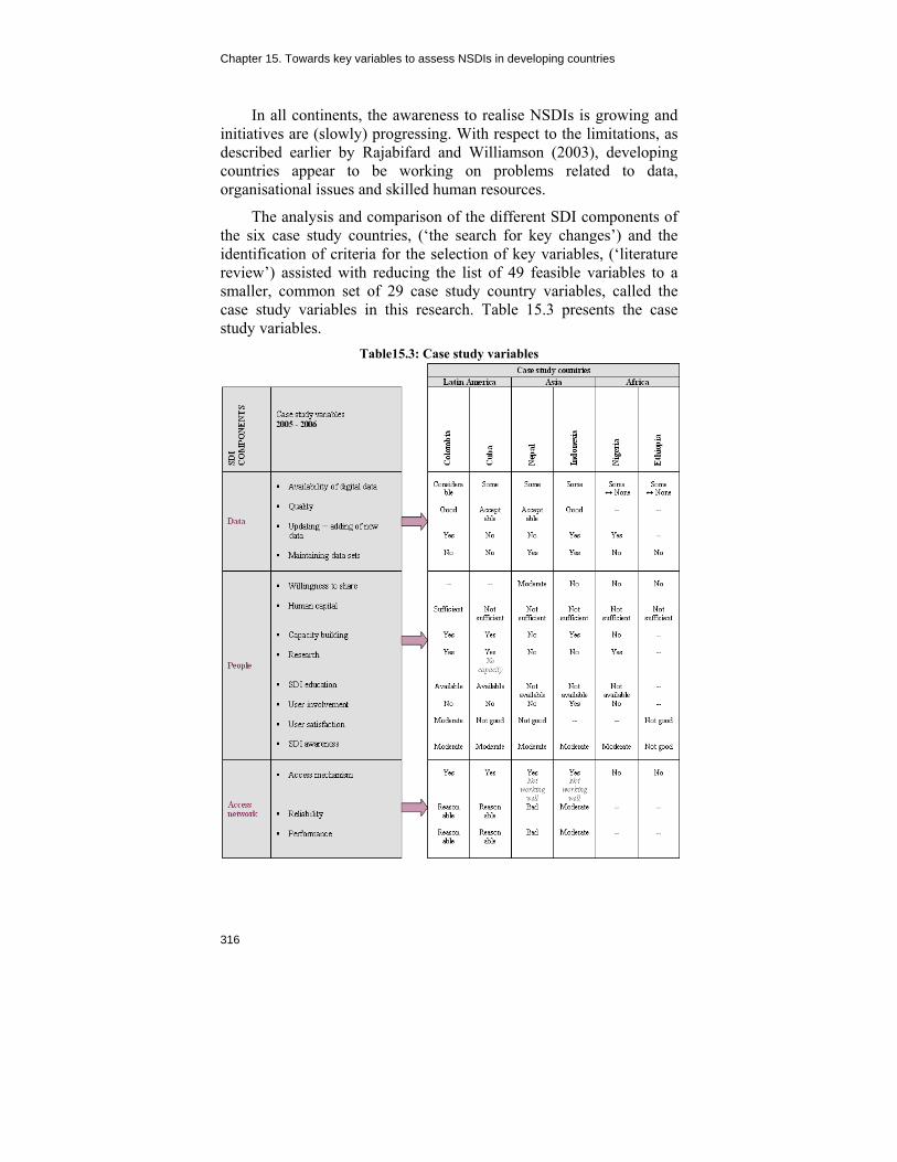
Chapter 15. Towards key variables to assess NSDIs in developing countries
316
In all continents, the awareness to realise NSDIs is growing and initiatives are (slowly) progressing. With respect to the limitations, as described earlier by Rajabifard and Williamson (2003), developing countries appear to be working on problems related to data, organisational issues and skilled human resources.
The analysis and comparison of the different SDI components of the six case study countries, (‘the search for key changes’) and the identification of criteria for the selection of key variables, (‘literature review’) assisted with reducing the list of 49 feasible variables to a smaller, common set of 29 case study country variables, called the case study variables in this research. Table 15.3 presents the case study variables.
Table15.3: Case study variables

A Multi-View Framework to Assess SDIs
317
5.6 EXPERT VARIABLES In order to validate the resulting list of case study variables, in March 2006 twenty-six SDI experts were asked to give their opinion on the ten most important key variables for assessing NSDIs in developing countries (out of the list of feasible variables). Twenty-two experts responded to the question (a response of 85%). The opinions of the experts have been compared with each other and ranked.
The following Figure 15.2 presents the selection of the SDI experts.
When reviewing Figure 15.2, three groups of expert variables can be noticed: (1) the group with the most frequently selected variables (selected between 15 and 7 times – indicated by the red box); (2) the group with an average selection (selected between 6 and 4 times) and (3) the group with variables only selected three, two or one time(s). The boundary limits were selected by looking at the breaking points.
The variables of the first group (most often selected variables) may be qualified as the most important for assessment of NSDIs in developing countries and are called the expert variables in this research.

Chapter 15. Towards key variables to assess NSDIs in developing countries
318
0
2
4
6
8
10
12
14
16
Ava
ilabi
lity
digi
tald
ata
sets
Fun
ding
Cap
acity
build
ing
Lead
ers
hip
Vis
ion
Willi
ngne
ss to
shar
eIn
stitu
tiona
larr
ange
men
tsH
uman
capi
tal
Inte
rope
rabi
lity
Del
iver
ym
echa
nism
Met
adat
a(a
vaila
bilit
y)A
war
enes
sIn
itiat
ives
conn
ecte
d to
SD
IS
ocio
-pol
itica
lsta
bilit
yR
elia
bilit
y(a
cces
sne
twor
k)D
ata
tran
sfer
Com
mun
icat
ion
chan
nels
Nr
and
type
ofus
ers
SD
Idire
ctiv
e(e
xist
ence
)Le
gala
rran
gem
ents
Qua
lity
(dat
a)P
erfo
rman
ce(u
sefu
lnes
s)U
pdat
ing
-ad
ding
ofne
wda
taP
artn
ersh
ipar
rang
emen
tsS
DI's
impa
ctvi
sibi
lity
Use
rin
volv
emen
tS
DIc
ultu
reD
ecen
tral
izat
ion
/cen
tral
izat
ion
Mai
nten
ance
(dat
a)N
r.an
d ty
peof
supp
liers
Priv
ate
/com
mer
cial
part
icip
atio
nP
ublic
/priv
ate
part
ners
hips
E-g
over
nmen
texi
sten
ceD
rivin
g fo
rces
(dat
aac
quis
ition
Edu
catio
n(t
ype,
avai
labi
lity)
Ser
vice
sD
evel
opm
enta
ppro
ach
Use
rsa
tisfa
ctio
n(S
DI&
appr
oach
)D
ata
form
atR
esea
rch
(to
supp
ortN
SD
I)
Variables
Nu
mb
ero
fti
mes
sele
cted
Figure 15.2: Key variables to assess NSDIs in developing countries – SDI expert opinion
15.7 KEY VARIABLES FOR DEVELOPING COUNTRIES
The common set of the measurable key variables selected were based on the comparison and matching the case study variables with the expert variables (see also Figure 15.1) and it was checked if the expert variables are part of the case study variables. As demonstrated in Table 15.4, the most frequently selected expert variables that are part of the case study variables were selected as the key variables.
Specific for developing countries
Fourteen key variables for assessing NSDIs in developing countries have now been selected. In the following sections, whether or not the key variables for assessing NSDIs in developing countries are different from those of developed countries are checked and described.

A Multi-View Framework to Assess SDIs
319
Table 15.4: Selection of key variables
15.7.1 Availability of digital data
From the case study research the conclusion could be drawn that all six countries have difficulties with the availability of digital data. The African case study countries are particularly struggling with the availability of digital data with both case study countries (Nigeria and Ethiopia) are undergoing major efforts to convert their analogue data to digital data. One may assume that the ’availability of digital data’ variable specifically counts for developing countries. Developed countries (mostly) have their data available in digital format.
15.7.2 Willingness to share
Rajabifard (2003) described a lack of culture to share data in Asia. The challenges related to the willingness to share spatial data can be noticed in both developed and developing countries.

Chapter 15. Towards key variables to assess NSDIs in developing countries
320
15.7.3 Human capital
With the exception of Colombia, all national coordinators have mentioned the lack of well-trained human resources. The ‘human capital’ variable is specifically valid for developing countries. One may assume that in developed countries sufficient well-trained human resources are available.
15.7.4 Capacity building
Masser (2005) described that the need for capacity building activities to be developed in parallel with the processes of NSDI implementation is often underestimated. This is particularly important in developing countries where implementing NSDI initiatives are often dependent on a limited number of staff that have the necessary geographic information management skills. With the exception of Nepal and Nigeria (on Ethiopia no information is available), the case study countries are carrying out capacity building activities (such as short courses, workshops etc.). Nevertheless, a lack of human capital (resources) is mentioned by almost all national coordinators (with exception of Colombia).
Although developed countries also require capacity building activities, the GSDI Cookbook (2004) rightly states that capacity building activities can be used to foster the implementation of an SDI. One may assume that the ‘capacity building’ variable specifically counts for developing countries.
15.7.5 SDI awareness
Understanding and being aware of the concepts and benefits of a (N)SDI is very important before and during its implementation and establishment. For example, looking at the NSDI initiative in Ethiopia, the concepts were not well understood when the initiative started in 2002. It was believed that a NSDI was just a ‘tool’ to prevent data duplication ─ people were not aware of, and did not understand, other SDI components and principles.
The level of awareness needs to improve in all case study countries and that the ‘awareness’ variable is very important in developing countries.

A Multi-View Framework to Assess SDIs
321
15.7.6 Access mechanism
The access network is one of the key features of an NSDI (Crompvoets, 2006). This variable is important in both developed and developing countries.
The discovery and access mechanism in the case study countries all require improvement. Through the portals of Colombia and Cuba, data of only one provider can be retrieved (‘product portals’). The portal of Nepal is almost never operational and the portal of Indonesia is rather slow. Nigeria and Ethiopia do not yet have established discovery and access mechanisms.
15.7.7 Funding
To secure funding is a relevant issue not only in developing countries as NSDIs require constant accomplishments and financial input over a long period of time. However, chances to obtain funding for an SDI is limited in developing countries. Although many countries have NSDI initiatives, it is not prominent on the political agenda due to other critical issues. The stability of the variable ‘funding’ is particularly important in developing countries. Mostly, stability cannot be guaranteed.
15.7.8 Vision
In the dynamic NSDI environment, a long-term strategic vision is considered as very relevant. From the case study countries, only Indonesia has developed a long-term, political vision towards (future) NSDI development. The ‘vision’ variable is considered very important for developing countries.
15.7.9 Institutional arrangements
Almost all national coordinators have mentioned the institutional arrangements as challenges. This variable is challenging and important in both developed and developing countries.
15.7.10 Leadership
In terms of leadership for example, in Africa one of the main problems facing SDI development is leadership. While the national mapping agencies are the key contributors to SDI development, other entities have the political influence and funding that drives the initiatives. In Colombia, NSDI leadership is not well defined, which

Chapter 15. Towards key variables to assess NSDIs in developing countries
322
slows down the progress. In Ethiopia, SDI principles might not be well understood by the leader. The ‘leadership’ variable seems to be very important in developing countries.
15.7.11 Socio-political stability
A continued political, administrative and technological commitment is needed to develop a NSDI. It is not always easy to maintain policy continuity in a developing country. This variable seems particularly important in these countries with almost all national coordinators mentioning the social-political instability.
15.7.12 Metadata (availability)
One of the challenges faced by users of data is the lack of information about information sources that might be relevant to their needs. Appropriate metadata services can help them to find this information. Although this variable is not specific for developing countries, the use of metadata services needs to be encouraged in almost all case study countries.
15.7.13 Interoperability
The ability to successfully understand and share various data, software and hardware across a broad spectrum of organisations and users is relevant for any SDI. Therefore, this variable is not specifically important for developing countries ─ it is a challenge for all countries.
15.7.14 Initiatives connected to SDI (country’s activity)
If countries undertake actions to increase SDI understanding, a greater willingness to participate in the initiative might be achieved. This variable is specifically important in developing countries. Most developing countries do organise activities supporting the NSDI initiative. 15.8 CONCLUSIONS
Based on a number of research steps as visualised in Figure 15.1, a set of 14 key variables for NSDI assessment in developing countries was selected in 2006. These variables are: (1) availability of digital data; (2) capacity building; (3) willingness to share; (4) human capital; (5) SDI awareness; (6) access mechanism; (7) funding; (8) leadership; (9) vision; (10) institutional arrangements; (11) socio-political stability;

A Multi-View Framework to Assess SDIs
323
(12) interoperability; (13) metadata (availability) and (14) initiatives connected to SDIs in the respective country. Almost all of the variables are specifically important for developing countries.
The purpose of determining key variables is to support effectiveness throughout the processes of planning, implementing, monitoring, reporting and evaluating ─ that is, throughout the full spectrum of results-based management (UNDP, 2006). Looking at the selected set of key variables one may conclude that the selected ones are crucial for the enhancement and innovation of NSDIs in developing countries that is in a more strategic and operational way.
NSDI coordinators in developing countries are suggested to take the key variables for assessment into consideration when initiating and developing their national SDIs.
REFERENCES
Abdel-Salam, M. and M. Mostafa (2005). Development of a Unified Spatial
Infrastructure Status Index for Developing Nations, Proceedings From Pharaohs to Geoinformatics, FIG Working Week 2005 and 8th International Conference on Global Spatial Data Infrastructures (GSDI-8), Cairo, Egypt, April 16 – 21, 2005.
Crompvoets, J. (2006). National Spatial Clearinghouses – worldwide development and impact, PhD thesis, Wageningen University, The Netherlands.
Crompvoets, J. (2004). Development of Framework to Assess National Spatial Data Infrastructures, BSIK project proposal.
Crompvoets, J., Bregt, A., Rajabifard, A. and I. Williamson (2004). Assessing the worldwide developments of national spatial data clearinghouses. International Journal of Geographic Information Science 18(7): 665 – 689.
Delgado Fernández, T., Lance, K., Buck, M. and H.J. Onsrud (2005). Assessing an SDI Readiness Index, Proceedings From Pharaohs to Geoinformatics, FIG Working Week 2005 and 8th International Conference on Global Spatial Data Infrastructures (GSDI- 8), Cairo, Egypt, April 16 – 21, 2005.
De Man, W.H.E. (2006). Understanding SDI; complexity and institutionalization. International Journal of Geographical Information Science, 20(3), 329–343.

Chapter 15. Towards key variables to assess NSDIs in developing countries
324
Georgiadou, P.Y. (2005). Capacity development indicators for spatial data infrastructures in Africa, Proceedings United Nations Economic Commission for Africa, CODI-IV, April 23 – 28, 2005. Geoinformation Subcommittee.
Kok, B. and B. van Loenen (2005). How to assess the success of National Spatial Data Infrastructures? Computers, environment and urban systems, 19: 699 – 717.
Lance, K. (2003). Spatial Data Infrastructure in Africa. Spotting the elephant behind trees. GIS@development: the Asian GIS monthly, 7 (2003)7: 35-41.
Masser, I. (2005). The future of Spatial Data Infrastructures, Proceedings ISPRS Workshop on Service and Application of Spatial Data Infrastructure, XXXVI (4/W6), October 14 – 16, 2005, Hangzhou, China.
Masser, I. (2005). GIS Worlds: Creating Spatial Data Infrastructures, ESRI Press, Redlands, California, 2005.
Masser, I. (2005). Some priorities for SDI related research, Proceedings From Pharaohs to Geoinformatics, FIG Working Week 2005 and 8th International Conference on Global Spatial Data Infrastructures (GSDI-8), Cairo, Egypt, April 16 – 21, 2005.
Masser, I. (1999). All shapes and sizes: The first generation of national spatial data infrastructures. International Journal of Geographical Information Science, 13(1): 67-84.
Nebert, D.D. (Ed). (2004). Developing Spatial Data Infrastructures: The SDI Cookbook, Version 2.0. GSDI-Technical Working Group, at http://www.gsdi.org/docs2004/Cookbook/cookbookV2.0.pdf, [accessed March 2006].
Onsrud, H.J. (1998). Compiled responses by question for selected questions, Survey of national and regional spatial data infrastructure activities around the globe, at http://www.spatial.maine.edu/~onsrud/GSDI.htm, [accessed September 2006].
Rajabifard, A., Feeney, M.-E.F. and I. Williamson (2003). Spatial Data Infrastructures: Concept, Nature and SDI hierarchy, in: Williamson, I., Rajabifard, A., and Feeney, M.-E.F. (Eds.). Developing Spatial Data Infrastructures: From Concept to reality. London: Taylor & Francis, pp. 17-40.
Rajabifard, A., and I. Williamson (2003). Asia-Pacific region and SDI activities. GIS@development: the Asian GIS monthly, 7(2003)7.
Rodriguez-Pabon, O. (2005). Theoretical framework for Spatial Data Infrastructure Evaluation, PhD thesis, University of Laval, Canada.

A Multi-View Framework to Assess SDIs
325
Steudler, D. (2003). Developing Evaluation and Performance Indicators for SDI, in: Williamson, I., Rajabifard, A., and Feeney, M.-E.F. (Eds.). Developing Spatial Data Infrastructures: From Concept to reality. London: Taylor & Francis.
United Nations Development Programme (2006). RBM in UNDP: Selecting Indicators, at www.undp.org/eo/documents/methodology/rbm/Indicators-Paperl.doc, [accessed March 2006].
Van Loenen, B. (2006). Developing geographic information infrastructures, PhD thesis, Delft University of Technology, The Netherlands.
Van Orshoven, J. (2004). Spatial Data Infrastructures in Europe: State of Play. Summary report of Activity 4 of a study commissioned by the EC.
Yin, R.K. (1994). Case Study research; Design and Methods, second edition, London, Sage Publications.

326

327
Chapter 16
INSPIRE Directive: Specific requirements to monitor its implementation
Danny Vandenbroucke1, Marie-Louise Zambon2, Joep Crompvoets3, Hans Dufourmont4 1Spatial Applications Division (SADL), Katholieke Universiteit Leuven, Belgium 2Institut Géographique National de France (IGN France), Paris, France 3Public Management Institute, Katholieke Universiteit Leuven, Belgium 4Agency for Geographic Information Flanders (AGIV), Gent, Belgium
Email: [email protected], [email protected], [email protected], [email protected]
Abstract. Directive 2007/2/EC of the European Parliament and of the Council of 14 March 2007 that established an Infrastructure for Spatial Information in the European Community (INSPIRE) was published in the Official Journal of the EU on 25 April 2007. This Directive was entered in force on 15 May 2007 and the transposition phase, during which Member States transpose the Directive into national legislation, lasts until 14 May 2009. In the meantime, the INSPIRE Drafting Teams are elaborating on Implementing Rules to define how the Member States must implement the Directive. One of these Drafting Teams is working on a monitoring and reporting mechanism.
According to the Directive, Member States shall organise “a continuous monitoring of the implementation progress with respect to the targets set out by INSPIRE” and provide “a three yearly report to the Commission to describe the approach applied by the Member

Chapter 16. INSPIRE Directive: Specific requirements to monitor its implementation
328
States to translate the requirements set out by INSPIRE into concrete measures and describe the developments of its SDI”. Member States will provide the results of the monitoring and reporting to the Commission and make them accessible to the public.
The monitoring and reporting mechanism of INSPIRE is not aiming to make an overall assessment of the NSDI as such. The mechanism assesses progress as compared to the rules and requirements set out in the Directive and its Implementing Rules. This means that what is not covered by the Directive will not be monitored. In addition, since Member States themselves are responsible for monitoring and reporting (as is the case for all European Directives), the monitoring mechanism should be kept simple and be automated as much as possible. The Drafting Team on monitoring and reporting elaborated on an approach that focuses on monitoring the progress made in regards to metadata, data interoperability and service development. After many discussions, the monitoring of data sharing and coordination mechanisms were not considered anymore, but integrated into part of the reporting. Other issues including the use, costs and impact of the SDI will also be covered through standardised reporting mechanisms.
This chapter focuses on the approach followed by the Drafting Team, the way the indicators were defined and how they are composed. It describes the feasibility testing by some of the Member States as well as the results of testing some indicators during the State of Play update of 2007. Finally, the chapter addresses the problems encountered to find good indicators that monitor data sharing and are easily implemented by the Member States.
16.1 INTRODUCTION: THE WORK OF THE INSPIRE DRAFTING TEAMS
The aim of INSPIRE is to contribute to the development of a true European SDI. There is agreement amongst all stakeholders that INSPIRE should be based on (the components of) the national and sub-national SDI created by the Member States. Those SDIs should be designed “to ensure that spatial data are stored, made available and maintained at the most appropriate level; that it is possible to combine spatial data from different sources across the Community in a consistent way and share them between several users and applications; that it is possible for spatial data collected at one level of public authority to be shared between other public authorities; that

A Multi-View Framework to Assess SDIs
329
spatial data are made available under conditions which do not unduly restrict their extensive use; that it is easy to discover available spatial data, to evaluate their suitability for the purpose and to know the conditions applicable to their use.” (European Commission, 2007; Zambon et al., 2007).
The Directive focuses in particular on five key areas: metadata; the harmonisation and interoperability of spatial data and services for selected themes (as described in Annexes I, II, III of the Directive); network services and technologies; measures for sharing spatial data and services as well as coordination and monitoring measures (European Commission, 2007).
To ensure that the spatial data infrastructures of the Member States are compatible and usable in a Community and trans-boundary context, the Directive requires that common Implementing Rules (IR) are defined for a number of specific areas (the Directive indicates for which parts IR are required). The process for establishing the IR is complex with many stakeholders involved (see Figure 16.1). The IR are adopted as Commission Decisions or Regulations and are binding in their entirety. This means that, once adopted, the IR are entered into force without the need to transpose them into specific national legislation. The Commission is assisted in the process of adopting the IR by a regulatory committee composed by representatives of the Member States and chaired by a representative of the Commission. This process is known as the Comitology procedure (European Commission, 2005a; Janssen, 2008). The preparation of the IR started in October 2005, while the INSPIRE committee was established in July 2007.

Chapter 16. INSPIRE Directive: Specific requirements to monitor its implementation
330
Figure 16.1: Process for developing INSPIRE implementing Rules (European
Commission, 2005a)
In order to prepare the IR, several teams of international experts were setup already in October 2005. The experts were nominated by Spatial Data Interest Communities, called SDIC (typically thematic communities, universities, national and sub-national SDI, etc.) and by Legally Mandated Organisations, called LMO (typically Mapping Agencies, Cadastral organisations, etc.) and selected together with the European Commission (see also Craglia and Annoni, 2007). There are a total of 75 experts in five groups called Drafting Teams: metadata; data specifications; network services; data and service sharing as well as monitoring and reporting. The Drafting Teams have the mandate to:
analyse and review the reference material provided by the SDIC and LMO (for example, existing standards);
demand further input from SDIC and LMO if required; write the draft INSPIRE Implementing Rules; provide recommendations to the Commission in case of
conflicting technical specifications or issues; and to provide suggestions to the Commission regarding the
testing of any proposed technical specification.

A Multi-View Framework to Assess SDIs
331
A Drafting Team is not involved in procedural aspects, the development of new specifications, resolving conflicts or maintaining the specifications (European Commission, 2005a).
The first release of an IR is discussed and commented in a first round by the experts from the different Drafting Teams and Commission staff. In a second round, the modified version is discussed and commented by SDIC and LMO and in a third round by the broader public and stakeholder community. Each time the Drafting Teams analyse the received comments, reject or accept them and review the IR. The reviewed IR is then transmitted to the Commission
The Commission will make a proposal for IR to the INSPIRE committee (based on the last version of the Drafting Teams) which has three months to deliver its opinion. If the committee agrees with the proposal, the IR is adopted. If the committee does not agree, or does not deliver an opinion, then the Commission needs to submit the proposal to the Council and inform the European Parliament. If the Parliament considers that the proposal submitted by the Commission exceeds the implementing powers provided by the INSPIRE Directive, it informs the Council of its position. The Council votes by a qualified majority on the proposal. If the Council agrees with the proposal or does not oppose the measure, the IR is adopted by the Commission. If however the Council opposes the measure, the Commission will have to submit a revised proposal.
16.2 THE NEED TO MONITOR AND REPORT EUROPEAN
DIRECTIVES
The need to monitor and assess the impact of implementing the European Directives is not new. Already in the White Paper on Governance it is stressed that monitoring, impact assessment, etc are key for each Governmental action (European Commission, 2001). The White Paper states that five principles underpin good governance: openness; participation; accountability; effectiveness and coherence. It says that “Policies must be effective and timely, delivering what is needed on the basis of clear objectives, an evaluation of future impact and, where available, of past experience.” (p.10). However the White Paper also argues that “The Treaty currently provides for both committees (Committee of the Regions and Economic and Social Committee) to give their opinion after, rather than before, proposals have been transmitted to the legislature, which minimises their impact.” (p.15). Finally, the White Paper states that ultimately, the

Chapter 16. INSPIRE Directive: Specific requirements to monitor its implementation
332
impact of EU rules “depends on the willingness and capacity of Member State authorities to ensure that they are transposed and enforced effectively, fully and on time” (p.25).
During the EU summit in Laeken in 2001, it was therefore decided that a new integrated method to assess the impact of European Policy on European citizens be developed. In Göteborg, also in 2001, the Member States had already made the commitment to establish a tool for assessing its sustainable impact. Furthermore, in the GMES and 6th Environmental Action Programmes, it was underlined that it is essential to regular monitor and report the process of sectoral integration. So it is clear that each decision of the Commission (and thus each proposal of a Directive) should be based on a sound analysis of the potential impact on society and on a balanced appraisal of the various policy instruments available. It is also important that once Directives are approved, their implementation and the real impact is monitored and assessed, and if necessary be reviewed.
With these general developments in mind, in 2003 the European Commission decided to conduct an extended impact assessment to attempt to estimate the (future) effects of developing the European SDI and INSPIRE in particular (see Craglia, 2003). The effects relate not only to the economical dimension, but also ─ and maybe even more importantly ─ to the environmental, social and societal impacts. The objective of the INSPIRE impact assessment was to assess ex ante the potential impact of the proposal for an INSPIRE Directive (European Commission, 2004). On the other hand, it was also decided to foresee a monitoring and reporting mechanism that assesses the implementation of INSPIRE and its impact once implemented, that is, an ex post evaluation. The task of the Drafting Team is to elaborate the rules for such an evaluation.
The need for monitoring and reporting the implementation of the INSPIRE Directive is defined as follows: “Preparatory work for decisions concerning the implementation of this Directive and for the future evolution of INSPIRE requires continuous monitoring of the implementation of the Directive and regular reporting.” (recital 34) (European Commission, 2004; 2007). More precisely, the chapter ‘Final provisions’ contains one article defining the monitoring and reporting obligations of Member States (see Table 16.1).

A Multi-View Framework to Assess SDIs
333
Table 16.1: monitoring and reporting obligations according to the INSPIRE Directive (European Commission, 2007)
Article 21 (INSPIRE Directive, 2007)
1. Member States shall monitor the implementation and use of their infrastructures for spatial information. They shall make the results of this monitoring accessible to the Commission and to the public on a permanent basis. 2. No later than 15 May 2010 Member States shall send to the Commission a report including summary descriptions of:
(a) How public sector providers and users of spatial data sets and services and intermediary bodies are coordinated, and of the relationship with the third parties and of the organisation of quality assurance;
(b) The contribution made by public authorities or third parties to the functioning and coordination of the infrastructure for spatial information;
(c) Information on the use of the infrastructure for spatial information;
(d) Data-sharing agreements between public authorities; (e) The costs and benefits of implementing this Directive.
3. Every three years, and starting no later than 15 May 2013, Member States shall send to the Commission a report providing updated information in relation to the items referred to in paragraph 2. 4. Detailed rules for the implementation of this Article shall be adopted in accordance with the regulatory procedure referred to in Article 22(2). 16.3 APPROACH AND METHODOLOGY
In the previous section we referred to the importance of the need to assess the impact of European Directives, as is the case for INSPIRE. When starting the work of the INSPIRE Drafting Team on monitoring and reporting, a general approach and methodology had to be elaborated in view of defining the Implementing Rules for monitoring and reporting. For this work, the Drafting Team was guided by the European Commission (see also European Commission, 2005b; 2005c). In a first stage all the similar set-ups and experiences were analysed. In a second stage a methodology appropriate for specific INSPIRE objectives was defined.

Chapter 16. INSPIRE Directive: Specific requirements to monitor its implementation
334
16.3.1 General approach
As indicated before, the major objective of monitoring and reporting within the framework of the INSPIRE Directive is to assess its implementation by the respective Member States. As a starting point, the Directive has been analysed to understand all the requirements as described in the recitals and the articles defining the infrastructure for spatial information (spatial data sets, metadata, network services, data and service sharing etc.). The result of the analysis was an improved knowledge of the Directive and its requirements. However at the time the Directive was analysed the exact definition of the different components, as well as the Implementing Rules for them, were not yet known. The preparation of the IR had to take this into account. As a consequence, the rules had to be very generic and could only rely on the (draft) outputs of the other Drafting Teams at the time of writing.
The Drafting Team on monitoring and reporting analysed several documents and assessment approaches before developing its own approach. The most important ones are the INSPIRE State of Play study (Jos Van Orshoven at al., 2003-2004; Vandenbroucke and Janssen, 2005-2006) and the reporting experience of IGN France (French Ministry of the Economy, Finance and Industry, 2004).
The approach of the INSPIRE SoP study is described in chapter 8. The lessons learnt from this extensive exercise were taken into account during the work of the Drafting Team. Although the approach of the INSPIRE State of Play is an important reference for the work of the Drafting Team on monitoring and reporting, the way the implementation of the Directive will be assessed is quite different from the set-up of the State of Play which is illustrated in Figure 16.2. While the INSPIRE State of Play collects information from various stakeholders, interprets the information and translates it into indicators in order to assess it; the implementing rules require Members States to collect information, use it as input for the indicators in view of reporting to the European Commission. The EU will then assess the results ─ both indicators and reports ─ in order to obtain a clear picture of the status of the INSPIRE development at the European level.

A Multi-View Framework to Assess SDIs
335
Figure 16.2: Assessment work flow of the Member States within the framework
of the INSPIRE Directive
In France the National Mapping Agency (IGN-France) is monitoring and reporting its activities to the French Parliament. Monitoring the performance of activities of Public Authorities and related Institutes became mandatory with the budget reform and the modernisation of the State. The monitoring resulted in a clear view on what to monitor (strategies, objectives, indicators, targets) and how to do it (methodology). Since the French approach seemed to work well, being already operational for several years, the Drafting Team on monitoring and reporting decided to use the general framework and templates to describe the proposed indicators (French Ministry of the Economy, Finance and Industry, 2004).
The Drafting Team also looked into scientific literature (see for overview of assessment methods Grus et al., 2007; Georgiadou et al., 2006) and e-Government initiatives (SIBIS, 2002). The Drafting Team provided improved knowledge and insight, yet there was a lack of information on how to establish a system of indicators in an operational environment. Complementary studies were collected through Drafting Team members’ expertise and workshops (see also SDIC MORE, 2006). The reference material proposed by SDIC and LMO is listed and analysed in one of the Deliverables of the Drafting Team, i.e. D5.2 - INSPIRE Monitoring Indicators (Zambon et al., 2007).
16.3.2 Principles for defining indicators
The indicators were defined with four principles in mind: (1) the requirements of the Directive are the basis; (2) there are different

Chapter 16. INSPIRE Directive: Specific requirements to monitor its implementation
336
types of users of the monitoring and reporting mechanisms; (3) the basic characteristics of good indicators should be applied and (4) there are several levels of authority involved in the monitoring.
The Drafting Team analysed all the requirements of the Directive and, more specifically, the requirements of each chapter (General provisions, Metadata, Interoperability of spatial data sets and services, Network services, Data-sharing, Coordination and complementary measures, and Final provisions). From there, the Drafting Team established a list of Directive’s major objectives. The formulation of these objectives is based on an interpretation (‘translation’) of the analysed requirements. For example, in the chapter on metadata the Directive says “Member States shall ensure that metadata are created for the spatial data sets and services corresponding to the themes listed in Annexes I, II and III, and that those metadata are kept up to date (...). Member States shall take the necessary measures to ensure that metadata are complete and of a quality sufficient to (…)”. (European Commission, 2007). After ‘translation’ this becomes: “Metadata of sufficient quality are available, complete and up-to-date for all the spatial data sets and services corresponding to the themes of the annexes of the Directive.” (Zambon et al., 2007).
There are three user types of the INSPIRE monitoring and reporting results. First of all, the indicators and three-yearly reports are required by the European Commission to assess the implementation of the Directive and to evaluate if the key objective of the Directive is achieved, that is to make more and better spatial data available by improving sharing practices. Secondly, Member States and their SDI stakeholders are also interested as Member States do not only monitor and report because it is an obligation to do so, but also as they want to know the status of their NSDI, especially how it compares to developments in other Member States. Finally, the results should also be made public as citizens have the right to be informed about European policies.

A Multi-View Framework to Assess SDIs
337
Figure 16.3: The three levels involved in monitoring and reporting (Zambon et
al., 2007)
Although monitoring and reporting is a task for the national level, it is clear that all levels of authority are involved and each has their own role. There are three major levels concerned (see Figure 16.3). SDIC, LMO and other INSPIRE stakeholders will provide the data that is needed to calculate the indicators. Member States’ level will collect the data, calculate the indicators and prepare the reports. Finally, the European Commission will assess the progress of the implementation of the INSPIRE Directive at the European level. The work of the Drafting Team focuses on the second level, which is the level of the Member States. This level defines the indicators to be used by the Member States, how they should be calculated and how reporting is to be conducted. Since the monitoring and reporting of the Directive will need to involve many organisations, it is clear that the procedures should be kept simple. Tools and/or templates will be provided by the Commission to the Member States for this purpose and can help automatic collection of raw data needed as input for the indicators using web (services), or guide the Member States to provide the information which will then be stored as a central repository of indicators.
There exists a large amount of literature on the use and characteristics of indicators. They are of different types (for example, physical and policy indicators) and applied in different sectors (such as the environment and economy). Indicators are simple facts that

Chapter 16. INSPIRE Directive: Specific requirements to monitor its implementation
338
show progress (or lack of it) toward a set of pre-determined goals (Young, 1995; Kuik and Verbruggen, 1991). An indicator has to be ‘SMART’ ─ Specific, Measurable, Achievable, Relevant and Time bound. Translating these principles for monitoring the implementation of INSPIRE, the Drafting Team decided to: focus each indicator on specific aspects of the Directive (finding a balance between global/too detailed indicators); use quantitative indicators based on measurements (not predictions); make them simple, ‘easy’ to provide (cost of indicators/usefulness of information) and be understood by all the Member States; measure the main goals of the Directive, and to select only indicators both useful for the European Commission and the Member States as well as defining indicators that show progress over time (Zambon et al., 2007).
Table 16.2 provides an overview of how each of the indicators has been described. As explained previously, this table is based on the system used by IGN-France for its reporting to the French parliament.
The table allows the defining of each indicator in a standardised way and enforces a motivated choice that is related to the SMART characteristics. The link to the specific objective of the Directive is made clear, and its calculation method is fixed. If there is a target set (for example, each spatial data set should have metadata), the date and target value are defined (such as 100% metadata for data sets of annex I and II, two years after adopting the IR on metadata, that is in 2010). The method also foresees in defining the so called ‘sub-indicators’ (or detailed indicators), an allowance to make a distinction between obtained results, (for instance, per annex of the Directive). The table also enforces a description by which data needs to be collected. The calculation method defines how this data is used to calculate the indicator (and detailed indicators) itself. Since at the time of defining the list of indicators there were still many open issues, these could also be described through the table (For example, what are the minimal criteria in order to be able to speak about metadata; are readme files considered metadata?).

A Multi-View Framework to Assess SDIs
339
Table 16.2: Generic indicator description table used by the Drafting Team on monitoring and reporting
Indicator name and definition
Definition Definition of the indicator
Chapter of the INSPIRE Directive
Title of the chapter of the INSPIRE Directive to which the indicator refers to; articles and paragraphs
Performance Objective A short description to explain which part of the INSPIRE objectives the indicator refers to
Rationale Description of why the indicator is proposed and why it is useful for the EC, the Member States and other stakeholders
Description of the indicator
Detailed indicators List of indicators, such as name and definition
Unit of measurement %, number etc.
Measurement period Frequency of calculation of the indicator and moment of publication
Target set Date (year) Value to obtain
Drawing up the indicator
Nature of the raw data Raw data needed as an input to calculate the indicator. Raw data can be an aggregation of data from several stakeholders
Raw data collection Method used for collecting the raw data: automated, manual counts, surveys etc.
Calculation method The way in which the indicator is calculated from the raw data (formula, identification of variables)
Interpreting the indicator
Known limitations and bias
Description of the known limitations and bias of the indicator and justification of the choice of the indicator despite its limitations
Interpretation methods The significance and ways of reading and understanding the indicator
Creation and improving the indicator
Start date Year the indicator is scheduled to start
Open issues Unsolved problems regarding the raw data, calculation or interpretation

Chapter 16. INSPIRE Directive: Specific requirements to monitor its implementation
340
16.4 RESULTS: 14 INITIAL INDICATORS DEFINED
Fourteen indicators were initially defined which was based on the methodology described in the previous section and Figure 16.4 presents an overview of these. The indicators were first discussed with four selected Member States in a feasibility test and some were tested during the State of Play, update 2007 (Vandenbroucke and Janssen, 2008).
All services
Discovery Service
NS i1-Accessibility
View–Download–Transformation Service
Com
plia
nce
with
IR
:
Metadata for Data and Services
INSPIRE Metadata for Data and Services
INSPIRE Service
DS i1-Existence DS i2-Harmonisation
DS i3-Interoperability
DS i4-Consistency
NS i3-Performance
NS i4-Use
NS i2-Existence and compliance with IR
MD i1-Existence MD i2-Compliance with IR
INSPIRE Spatial data set
Transformation to be done to reach INSPIRE requirements or IR (may be « on-the-fly »)
Dependency
Provider resources INSPIRE components
Spatial data set
INSPIRE Data sharing
DSS i1-Level of sharing
DSS i2-Usability
INSPIRE Coordination and Cooperation
CO i1-Coordination
CO i2-Cooperation
Figure 16.4: Overview of initial set of indicators for monitoring INSPIRE
implementation (Zambon et al., 2007)

A Multi-View Framework to Assess SDIs
341
16.4.1 Initial list of indicators
This initial list of 14 indicators was established and based on an analysis of the requirements of the Directive (which objectives should be reached), keeping in mind the existing components of the infrastructure in the Member States. Therefore, the list of indicators was elaborated on and based on four principles. Indicators should:
1) Give a clear picture of existing components of the infrastructure in the Member States: data sets; metadata and network services. This picture is very important since the Directive states that INSPIRE should build upon existing (components of) the NSDI. The dark grey in Figure 16.4 refers to these components and two indicators are linked to it; that is existence of data sets and metadata (DSi1 and MDi1).
2) Measure the distance to target of the (components of) the infrastructure, such as how much of the existing infrastructure is in line with the Implementing Rules of the INSPIRE Directive. There were five of the initial indicators that measured this: harmonisation (DSi2), interoperability (DSi3) and consistency (DSi4) which together make data sets compliant or not; compliancy of the metadata with the implementing rules (MDi2) and existence and compliancy of the network services (NSi2).
3) Measure the use and performance of the infrastructure (through its services), both which provide an indication of the usefulness for the users. Two indicators were dedicated to this aim (NSi3 and NSi4).
4) Describe the ‘soft’ components of the infrastructure that is data sharing, coordination and cooperation. These ‘soft’ components (see hatched boxes in Figure 16.4) are important to a quality functioning of the SDI and for reaching the overall objectives of INSPIRE. Four indicators were initially defined, two regarding coordination and two regarding data and service sharing (DSSi1, DSSi2, COi1, COi2).
The indicators, ‘existence of spatial data sets’ and ‘existence of metadata for data sets and services’, provide information about the initial status in the Member States. Both indicators describe the existence of electronic data and metadata, but not whether they are compliant with the IR as this is measured by the indicators reflecting

Chapter 16. INSPIRE Directive: Specific requirements to monitor its implementation
342
the compliancy with the IR. By comparing part of the infrastructure that is compliant with the total infrastructure, one can see the level of compliancy of the NSDI.
As a side note, it should be stressed that the interoperability of data sets (as used above) can, according to INSPIRE, be achieved in two ways: data sets can be harmonised according to a common data model (creating new physical data sets) or by transforming, using transformation services (mapping from one data model to another). Existing metadata can only be brought in line with the IR by changing them according to these IR.
The 14 initial indicators would allow answering questions such as:
What is the part of the existing infrastructure that is compliant with INSPIRE (for example x% of the data sets have metadata that are compliant with the IR)?
Are the data accessible, that is can they be discovered through one or more discovery services, and can their characteristics be listed (for example x% of the spatial data sets can be discovered through at least one discovery service)?
Can data sets be viewed, (partially) downloaded and transformed?
What is the use of the data sets through the different type of services (for example the number of service requests)?
What is the performance of the infrastructure, in casu the services (such as response times or availability)?
What is the level of sharing based on the complexity of arrangements to be made and the cost model in place?
What is the usability of the data sets, based on the existence of at least one free viewing service for each data set and limitations regarding the use of the data set?
Is coordination in place (is there a coordinating body and a National Contact Point)?
Is there cooperation amongst the stakeholders (how many stakeholders are involved)?
A Multi-View Framework to Assess SDIs
343
16.4.2 Feasibility test and testing in an operational environment
The 14 initial indicators were tested in three steps. Testing was needed in order to know if the indicators could be implemented by the Member States, if they were understood and if they work in an operational environment.
Step 1: Internal test by members of the Drafting Team amongst a limited number of stakeholders (LMO, SDIC). This test revealed a first series of questions and problems encountered, For instance, how can a stakeholder know which data sets to consider/not consider as part of INSPIRE?
Step 2: Feasibility test by a selected number of Member States. Member States could become a candidate on a voluntary basis. There were four countries willing to participate: Italy; Germany; The Netherlands and Spain. The aim of this test was to verify a common understanding of the indicators and an approach to their implementation (for example the definitions used) and to cross-check the feasibility and complexity of the proposed indicators and set-up. This test revealed that indicators had to be better defined, that some were too complex to understand and implement, that guidelines were needed in any case and that tools for automated data collection and calculating indicators are essential.
Step 3: Testing a selection of the indicators with material collected during the State of Play 2007 (see also Vandenbroucke and Janssen, 2008a). In order to do so, a small survey was established during the State of Play update of 2007 for collecting detailed information on the data sets and services from the 32 countries studied. Countries were asked to list all INSPIRE relevant data sets (spatial data sets that are to be used in environmental policies and policies with a direct or indirect impact on the environment) indicating whether or not they have metadata (ISO compliant or not), and whether or not for those data sets a discovery, view and/or download service existed. Secondly, countries were asked to list all INSPIRE relevant services indicating whether or not they have metadata, the type of service (discover, view, download, transformation, invoking) and whether or not the service is public and free of use.
By the end of March 2008, 21 countries sent in their information regarding data sets and 20 (of these) regarding services. This information allowed the calculation of selected indicators. A total of 1,635 data sets covering the 34 themes of the INSPIRE annexes were described, representing 1,384 unique data sets (some data sets were

Chapter 16. INSPIRE Directive: Specific requirements to monitor its implementation
344
reported for different themes). In total 738 network services were also described. From all the reported data sets and services, 66.7 per cent have metadata, but only 35.5 per cent are reported to be ISO compliant (ISO 19115 and 19119). Metadata availability for data sets and services varies between 0 per cent (6 countries) and 100.0 per cent (Portugal). However, for Portugal it is known that they reported only that part of the infrastructure (data sets and services) that is considered to be ‘INSPIRE compliant’ and therefore the results have to be used with caution. Figure 16.5 provides the results per country, that is for the existence of metadata for data sets and services (Figure 16.5a) and for the compliancy with the ISO norm (Figure 16.5b).
Similar results were obtained for the indicators measuring the accessibility of the infrastructure. From the 1635 data sets 1095 (67.0 per cent) can be discovered, viewed or downloaded which means that at least one of such services exist for the data set. However only 362 of these (22.1 per cent) can be discovered viewed and downloaded. For the 21 countries for which information was collected, 55.7 per cent of the data sets can be discovered, 49.2 per cent can be viewed, while 27.2 per cent can be downloaded (or parts thereof, for instance through WFS).
The test not only showed that the results should be treated carefully (there were no extensive guidelines on how to provide the information), but also that it is very important to establish the list of data sets and services carefully (including all the INSPIRE relevant data sets and services, but at the same time not limiting the data sets and services to those that are considered to be already ‘INSPIRE compliant’). Once this process is complete, the collection of its characteristics and the calculation of the indicators seem to be straightforward.
16.5 DISCUSSION AND FINAL DRAFT IMPLEMENTING RULES
In this section we discuss the results of developing indicators and the corresponding Implementing Rules for monitoring and reporting. First we describe some general issues, then we discuss in more detail the problems related to the definition of indicators on data and service sharing.

A Multi-View Framework to Assess SDIs
345
0,010,020,030,040,050,060,070,080,090,0
100,0
PT
NO CZ LT LU IT AT
FRA
LL-2
1E
SE
EC
YH
US
E SI
BE
SK NL IS PL FI LI
0,010,020,030,040,050,060,070,080,090,0
100,0
PT
NO CZ
ES
BE FR
ALL
-21 SI IT N
LP
L FI EE
SE AT
LU CY
HU LT SK IS LI
Figure 16.5 a and 16.5 b: (a) % of the reported data sets and services for which metadata exist and (b) % of the reported data sets and services for which ISO
metadata exist (Vandenbroucke and Janssen, 2008) 16.5.1. General Issues
From the discussions within the Drafting Team monitoring and reporting, with other Drafting Teams and the European Commission and from the different tests, we could draw some conclusions regarding monitoring the implementation of the INSPIRE Directive.
First of all, the discussions revealed the need to have simple indicators. The basic idea is not to cause too much burden for the Member States when implementing, monitoring and reporting. Therefore, each of the indicators was again examined to evaluate

Chapter 16. INSPIRE Directive: Specific requirements to monitor its implementation
346
whether it is really needed and adding value for monitoring the implementation of the Directive. With this in mind, the indicators on coordination and cooperation were removed. The fact of having a National Contact Point and a coordinating body or structure (or not) is easy to capture and does not really need an indicator: it is not something to be ‘calculated’ and it is not expected to change significantly over time. Therefore, it can easily be reported in the three yearly reports. For the same reason of simplifying, it was also decided to group the three indicators on data compliancy into one indicator that reflects overall compliancy with the IR (data interoperability).
Furthermore, it was also decided not to use composed indicators and to therefore also remove some of the sub-indicators. Calculations themselves were limited to simple ratios, without complex weighting. From the feasibility test it also became obvious that some terminology had to be clarified and streamlined with the work of the other Drafting Teams. It was decided to establish technical guidelines and it was proposed to the Commission to develop tools/templates to assist Member States with collecting data/information to calculate the indicators, and for the calculations itself (for example, by establishing a portal for monitoring and reporting).
Even with this simplification to the technical guidelines and the tools/templates, it became clear from the test during the INSPIRE State of Play survey of 2007 that the most difficult part for the Member States was to establish the list of data sets and services that should be considered part of the INSPIRE infrastructure. On the one hand, it should not be necessary for Member States to list all the existing spatial data sets and services (but only those that will be used for environmental policy and for policies that have an impact on the environment; also data sets and services from private companies should not be listed etc.). On the other hand, Member States should list more than only those data sets and services that are already INSPIRE compliant. The reason why this seemed to be difficult is three-fold:
(1) To establish those lists, coordinating bodies of the NSDI should have relationships with all stakeholders and jointly agree on these lists (sometimes National Mapping Agencies, which often lead the NSDI, do not necessarily know the stakeholders involved in the collection and maintenance of the data sets of Annex III, such as the specific environmental themes);

A Multi-View Framework to Assess SDIs
347
(2) It appears more appealing to list, describe and therefore monitor components of the infrastructure that are compliant (for example those available according to standards);
(3) It is not yet clear which level of detail, data sets and services should be included. If going down to the level of the municipalities, this poses major problems since the number of data sets and services could grow exponentially.
The second important discussion related to the automatic monitoring and compliance testing. When establishing the list of indicators (Zambon et al., 2007) specific attention was given to the issue of automatically generating indicators. There are two aspects to this problem: (1) automating the way to collect the data for calculating the indicators and (2) the calculation itself. The first aspect is not obvious at all as the collection of data on the use of services, their performance and compliance testing of data sets, metadata and services could ‘easily’ be automated. Establishing the list of data sets and services, and the collection of some other data/information are more difficult to be automated (for instance Member States could establish registers for data sets and services, but this is not done automatically).
The compliance testing itself is also a difficult, though crucial issue. Although there are existing frameworks developed by ISO and OGC (see on-going initiatives such as the Open Geospatial Consortium Web Services, Phase 4; existing framework, concepts, and methodology such as ISO 19105; and existing languages such as the UML Testing Profile), there is not yet an operational and consistent approach for compliancy and interoperability testing. The Joint Research Centre of the European Commission has therefore initiated several studies to describe the State of Play of compliance testing and interoperability checking (see Viganó, 2008a; 2008b; 2008c). Each of the Drafting Teams which deals with the technical aspects of INSPIRE, such as metadata, data and network services will define which IR tests should succeed before reaching compliancy.
16.5.2 The problem of monitoring data and service sharing
The initial attempts to define one or more indicators for monitoring the progress of data and service sharing focused on the idea of the level of complexity of sharing arrangements as a type of threshold hampering the operational sharing of data and services between public authorities. In this approach a typology of sharing arrangements formed the basis for the indicators: varying from single overarching

Chapter 16. INSPIRE Directive: Specific requirements to monitor its implementation
348
framework agreements over specific arrangements for either a subgroup of stakeholders within the totality of public authorities, or specific bilateral arrangements but for a larger group of datasets out of the annexes; down to the individual case by case arrangements to be negotiated on an ad hoc basis and ultimately the non-accessibility to spatial data and services.
Although it was felt within the Drafting Team that such indicators could yield an estimate of the actual sharing, this approach was criticised due to the lack of scientific underpinning: basically the criticism was on the fact that composed indicators were used whereby the independency between the individual sub-indicators was insufficiently guaranteed. The feasibility of collecting such a huge amount of basic information was also questioned. In a next phase, the Drafting Team shifted focus and tried to define sharing indicators taking the individual datasets as a basis for monitoring. A simple addition and conversion from absolute to relative values would then yield an impression on the actual sharing. However this approach did not stand either. Indeed, also at data set level, the variation of agreements can be important, depending largely on the type of users and the type of use. The collection of the information would become very complex and the calculation being not at all straightforward.
Looking closer into the problem, one could argue that the heterogeneity of sharing arrangements throughout the Member States of the EU will inevitably cause incompatibility with whatever monitoring indicator one could imagine. As opposed to the technically oriented IRs, there is no single framework description (for example an ISO standard or an OGC specification) available that could serve as a kind of reference for measuring the actual sharing of spatial data and services.
As an alternative, some other approaches were suggested:
1. Establishing a register containing basic information on sharing arrangements that are being set up in the Member States. This register could then, in a second phase, be used as a basis for further analysis of the sharing aspects. However this approach showed some serious drawbacks as well: for a start, it creates an additional burden on the Member States who have to establish and somehow feed the register. Secondly, either the full implementation of the agreements registration would generate a disproportionate amount of work (implying the notification of any data sharing agreement between any administration, down to local ones), or a major part of the agreements

A Multi-View Framework to Assess SDIs
349
would be missed, especially when it comes to the local level of public authorities, due to simple ignorance or a lack of resources to follow this up.
2. Indirectly measuring sharing: measuring the notified cases of trouble in sharing spatial data and services could provide an indirect way of measuring how well sharing functions (for instance complaints). This approach could be compared with the way traffic safety (positive goal) is measured by the number of accidents or ‘black points’ (negative occurrences), and whereby the evolution of the cases of trouble, when made relative to the volume of traffic, provides some insight in actual traffic safety/person-kilometre. The drawback of this approach is that it is unclear to which extent the INSPIRE Directive provides sufficient leverage to establish such a system. However the advantage of this approach is that it does not have to be considered as too much of a burden (there is no systematic inventory at several levels needed); it suffices to set up a central register (for example at the National Contact Point level) to which public authorities can notify sharing problems. The obligation would be limited to a clear communication of the existence of such a reporting board throughout the Member States’ public authorities.
Based on these considerations, a last attempt was made to define some indicators. The SDI-literature was screened again, searching for potential data sharing indicators (Abdel-Salam et al., 2005; Delgado et al., 2005; Georgiadou et al., 2006; Kok and van Loenen, 2004; Masser, 1999; 2005; Onsrud, 1998; Van Orshoven et al., 2003; Steudler, 2004 and Rodriguez-Pabón, 2005) and 11 experts were also contacted. The list of indicators suggested by the literature and experts that might be used for data sharing amongst stakeholders within an SDI is summarised in Table 16.3.
The proposed indicators were assessed against three important criteria: (1) the ease or difficulty to interpret/apply it; (2) the ease or difficulty to collect the data for calculating the indicator and (3) the ease or difficulty to calculate the indicator. From the table we can read that most of the (potential) indicators are too fuzzy or need complex interpretations which make them unsuitable for operational set-ups. For example the number of suppliers or number of participating agencies are not giving a clear indication on data sharing practices since they depend on very different historical and organisational set-ups in countries which do not allow the making of a positive or

Chapter 16. INSPIRE Directive: Specific requirements to monitor its implementation
350
negative conclusion with this regard; and how can one define ‘willingness to share’?
Table 16.3: evaluation grid of some potential data sharing indicators Potential data sharing
indicators Interpretation /
fuzziness Data
collection Calculation
Number of suppliers -- + ++
Number of participating agencies
-- + ++
Number of organizations willing to share
-- -- ++
Existing legal arrangements between agencies
-- -- +
Number of Public Private Partnerships
-- - +
Number of restrictions on use of the data
- ++ ++
Number of free downloadable data sets
- ++ ++
Number of data sharing problems or complaints to be solved
+/- + +
Time to access/download all the data sets of INSPIRE
+ -- --
Money to be spent to access/download all the data sets of INSPIRE
+ -- -
On the other hand, several of the proposed indicators are very difficult to calculate, or the collection of the necessary data for doing so is cumbersome. This is, for example, the case for the time needed and money spent to access/download all the data sets of INSPIRE. Although these indicators would give a good view on data sharing from the perspective of the users, they are very difficult to implement. The information on the number of arrangements between agencies is also very difficult to collect as we saw earlier. The only feasible solution appeared to be collecting information on data sharing problems or complaints regarding data sharing. This would give an (indirect) indication on data sharing, be feasible to collect and to calculate, but would contain some bias in regard to how one can

A Multi-View Framework to Assess SDIs
351
interpret the information. It is a ‘negative’ indicator on the one hand, while it leaves too much room for subjectivity, for instance by collecting many complaints from a few stakeholders.
After an intense debate, it was decided not to withhold any of the proposed indicators. It is not worthwhile setting up too complex a system from which in the end only a limited amount of information would be derived. On the other hand, it goes without saying that the sharing aspects are at the core of the INSPIRE directive. As a conclusion, data and service sharing was limited to a chapter on sharing in the three-yearly reporting. While this minimal approach may miss important information on how well the sharing between public authorities within and across Member States actually works, it seems the only way to evaluate data and service sharing within an operational environment. It is clear that there is still a lot of room for research in this field.
16.6 CONCLUSIONS
The objective of monitoring and reporting within INSPIRE is to assess the implementation of the Directive and the use of the spatial data infrastructures in the Member States of the European Union. It is focused on how the policy regarding spatial data sharing is applied and should leave room for reviewing such policy, such as by changing the Implementing Rules over time. Monitoring and reporting will be done by the Member States based on information from LMO and SDIC, while the European Union will use the results to assess the situation at the European level. The citizens will also have access to the results.
In an initial stage, the Drafting Team on monitoring and reporting established a list of 14 indicators covering the technical and organisational (soft) aspects of the NSDI. After a series of tests, including a feasibility test with four Member States, it was agreed to reduce, and simply where possible, the list of indicators. The coordination and cooperation indicators were removed since this information could easily be provided through the reporting mechanisms (not changing too much over time). The tests during the update of the INSPIRE State of Play revealed that it is possible to gather information for the indicators that measure the development of the technical parts of the infrastructure and to calculate them. Nevertheless, it still seems a difficult task for Member States because

Chapter 16. INSPIRE Directive: Specific requirements to monitor its implementation
352
often many stakeholders are involved and it is not always clear which data sets and services belong to the INSPIRE infrastructure.
Particular problems were encountered to define one or more indicators that can measure data sharing practices. Although, data sharing is the essence of the INSPIRE Directive, all the indicators proposed within the Drafting Team, as well as those suggested by 11 experts and the literature, revealed that they are very difficult to implement: some of them being to fuzzy (leaving room for interpretation); while for others gathering raw data and/or calculating them seem to become far too complex (causing additional burden for the Member States). It was therefore decided to foresee a specific part on data and service sharing in the three-yearly reporting. This reporting will become equally important and will give additional information on the use of the NSDI, the costs and benefits and how the NSDI is working in practice.
The work of the Drafting Team has also revealed that it is necessary to carry out more research on how to evaluate an SDI. In particular, there is scope for more work to investigate operational set-ups for monitoring and reporting, as well as how results from monitoring can be better interpreted and understood.
REFERENCES Abdel-Salam, S. and M. Mostafa (2005). Development of a Unified Spatial
Infrastructure Status Index for Developing Nations, Proceedings From the Pharaohs to Geoinformatics, FIG Working Week 2005 and 8th International Conference on Global Spatial Data Infrastructure, April 2005, Egypt, Cairo.
Craglia, M. and A. Annoni (2007). INSPIRE: An Innovative Approach to the Development of Spatial Data Infrastructures in Europe, in Onsrud H. (Ed). Research and Theory in Advancing Spatial Data Infrastructure Concepts, Redlands: ESRI Press, pp. 93-105.
Craglia, M. and J. Nowak (2006). Report of the International Workshop on Spatial Data Infrastructures’ Cost-Benefit/Return on Investment, 12–13 January 2006, Ispra, Italy: Joint Research Centre (European Commission).
Craglia, M. (2003). Contribution to the extended impact assessment of INSPIRE, at http://www.ec- gis.org/inspire/reports/fds_report.pdf, [accessed 4 January 2008].

A Multi-View Framework to Assess SDIs
353
Delgado Fernández, T., Lance, K., Buck, M. and H. J. Onsrud (2005). Assessing SDI readiness index, Proceedings From the Pharaohs to Geoinformatics, FIG Working Week 2005 and 8th International Conference on Global Spatial Data Infrastructure, April 2005, Egypt, Cairo.
Di Donato P., Salvemini, M., and D. Vandenbroucke (2005). MORE: an SDIC on Monitoring and Reporting, 11th EC GI & GIS Workshop, 29 June - 1 July 2005, Alghero Italy.
European Commission (2007). Directive 2007/2/EC of the European Parliament and of the Council of 14 March 2007 establishing an Infrastructure for Spatial Information in the European Community (INSPIRE).
European Commission (2005a). INSPIRE Work Programme Preparatory Phase 2005-2006, at http://www.ec-gis.org/inspire/reports/rhd040705WP4A_v4.5.3_final-2.pdf, [accessed 3 March 2008].
European Commission (2005b). Draft Guidelines for the Development of the INSPIRE Implementing Rules, at http://www.ec-gis.org/inspire/reports/dt/ir_draft_guidelines.pdf, [accessed 3 March 2008].
European Commission (2005c). Requirements for the Definition of the INSPIRE Implementing Rules for Monitoring and Reporting, at http://www.ec-gis.org/inspire/reports/dt/ ir_dev_process_monitoring.pdf, [accessed 3 March 2008].
European Commission (2004). Proposal for a Directive of the European Parliament and of the Council - Establishing an infrastructure for spatial information in the Community (INSPIRE).
European Commission (2001). White Paper on European Governance, COM(2001),at http://ec.europa.eu/governance/white_paper/index_en.htm, [accessed 3 March 2008].
French Ministry of the Economy, Finance and Industry (2004). The Performance-Based approach: strategy, objectives, indicators - A methodological guide for applying the Constitutional bylaw of August 1st, 2001 on budget acts, Paris, France.
Georgiadou, P.Y., Rodriquez-Pabón, O. and K.T. Lance (2006). SDI and e - governance: a quest for appropriate evaluation approaches, URISA journal, 18(2): 43-55.
Grus, L., Crompvoets, J. and A.K. Bregt (2007). Multi-view SDI Assessment Framework, International Journal of Spatial Data Infrastructures Research, 2: 33-53.

Chapter 16. INSPIRE Directive: Specific requirements to monitor its implementation
354
Janssen K. (2008). Juridisch. INSPIRE (3), de implementing rules, Geoplatform, 3(1): 31.
Kok, B. and B. van Loenen (2004). How to assess the success of National Spatial Data Infrastructures? Computers, Environment and Urban Systems, 29: 699–717.
Kuik, O.J. and H. Verbruggen (Eds).(1991). In Search of indicators of sustainable development, Dordrecht, The Netherlands: Kluwer Academic Publishers.
Masser, I. (2005). GIS Worlds, Creating Spatial Data Infrastructures, Redlands: ESRI Press.
Masser, I. (1999). All shapes and sizes: The first generation of national spatial data infrastructures, International Journal of Geographical Information Science, 13(1): 67–84.
Onsrud, H.J. (1998). Compiled Responses by Questions for Selected Questions. Survey of national and regional spatial data infrastructure activity around the globe. Global Spatial Data Infrastructure association, at http://www.spatial.maine.edu/~onsrud/GSDI.htm, [accessed 3 March 2008].
Rodriguez-Pabón, O. (2005). Cadre theorique pour l’evaluation des infrastructures dínformation geospatiale, PhD thesis, University of Laval, Canada.
SDIC MORE (2006). SDIC MORE, Monitoring and Reporting the INSPIRE Implementation, at http://www.sdic-more.org, [accessed 3 March 2008].
SIBIS (2002). SIBIS - D1.2 - Update of eEurope Benchmarking Framework (Statistical Indicators Benchmarking the Information Society), Luxembourg.
Steudler, D., Rajabifard, A. and I. Williamson (2004). Evaluation of land administration systems, Land Use Policy, 21(4): 371–380.
Vandenbroucke, D. and K. Janssen (2008a). Spatial Data Infrastructures in Europe: State of Play 2007. Summary report by the Spatial Applications Division, K.U.Leuven R&D.
Vandenbroucke, D., Janssen, K. and J. Van Orshoven (2008b). INSPIRE State of Play: Generic approach to assess the status of NSDIs, in Crompvoets J., Rajabifard, A., Van Loenen, B. and T. Delgado Fernández (Eds). Multi-view framework to assess National Spatial Data Infrastructures (NSDI). Melbourne: Melbourne University Press.
Vandenbroucke, D. and K. Janssen (2006). Spatial Data Infrastructures in Europe: State of Play 2006. Summary report by the Spatial Applications Division, K.U.Leuven R&D, at http://www.ec-

A Multi-View Framework to Assess SDIs
355
gis.org/inspire/reports/stateofplay2006/INSPIRE-SoP-2006 v4.2.pdf, [accessed 3 March 2008].
Vandenbroucke, D. (2005). Spatial Data Infrastructures in Europe: State of Play Spring 2005. Summary report by the Spatial Applications Division, K.U.Leuven R&D, at http://www.ec-gis.org/inspire/reports/stateofplay2005/rpact05v42.pdf, [accessed 3 March 2008].
Van Orshoven, J., Janssen, K., Bamps, C. and D. Vandenbroucke (2004). Spatial Data Infrastructures in Europe: State of Play Spring 2004. Summary report by the Spatial Applications Division, K.U.Leuven R&D, at http://www.ec-gis.org/inspire/reports/stateofplay2004/SUR04/ rpact4v2.pdf, [accessed 3 March 2008].
Van Orshoven, J., Beusen, P., Hall, M., Bamps, C., Vandenbroucke, D. and K. Janssen (2003). Spatial Data Infrastructures in Europe: State of Play Spring 2003. Summary report by the Spatial Applications Division, K.U.Leuven R&D, at http://www.ec-gis.org/inspire/reports/stateofplay/ rpact3v4.pdf, [accessed 3 March 2008].
Viganó S. (2008a). Compliance Testing and Interoperability Checking: Metadata State of Play. Ispra, Italy: Joint Research Centre (European Commission), JRC Scientific and Technical Reports.
Viganó S. (2008b). Compliance Testing and Interoperability Checking: Data State of Play. Ispra, Italy: Joint Research Centre (European Commission), JRC Scientific and Technical Reports.
Viganó S. (2008c). Compliance Testing and Interoperability Checking: Services State of Play. Ispra, Italy: Joint Research Centre (European Commission), JRC Scientific and Technical Reports.
Young, M.D. and S.A. Ryan (1995). Using environmental indicators to promote environmentally, ecologically and socially-sustainable resource use: a policy oriented methodology.
Zambon, M.L., Vandenbroucke, D., Dauert, U., Delattre, N., Dello Buono, D., Muro Medrano, P.R.and M. Tammilehto Luode (2007). INSPIRE Monitoring Indicators (D5.2), INSPIRE Drafting Team Monitoring and Reporting, Luxembourg.
Zambon, M.L., Vandenbroucke, D., Crompvoets, J., Dauert, U., Delattre, N, Dello Buono, D., Dufourmont, H., Muro Medrano P.R., Probert, M. and M. Tammilehto Luode (2008). INSPIRE Draft Monitoring and Reporting Implementing Rule (D5.5), INSPIRE Drafting Team Monitoring and Reporting, Luxembourg.

356

357
Chapter 17
Changing demands for Spatial Data Infrastructure assessment: experience from The Netherlands
Arnold K. Bregt1 4, Lukasz Grus1, Joep Crompvoets1 2, Watse T. Castelein3, Jacqueline Meerkerk4
1 Centre for Geo-Information, Wageningen University, Wageningen, The Netherlands 2 Public Management Institute, Katholieke Universiteit Leuven, Leuven, Belgium 3 Geonovum, Amersfoort, The Netherlands 4 Space for Geo-Information, Amersfoort, The Netherlands Email: [email protected], [email protected], [email protected], [email protected], [email protected]
Abstract. The Spatial Data infrastructure (SDI) is an emerging phenomenon world-wide. With their growth also has the demand for assessment approaches to evaluate their development and progress. The early approaches were developed by scientists and were mainly curiosity driven. With the increasing involvement of government officials and policy makers over the years the assessment demands have also changed. Current demands focus on measuring implementation progress and the use of SDIs. SDI assessment developments in The Netherlands follow this overall generic trend and it is a challenge for scientists to contribute to these trends in which they are no longer leaders but contributors.

Chapter 17. Changing demands for SDI assessment: experience from The Netherlands
358
17.1 INTRODUCTION
The SDI is an emerging phenomenon world-wide (Masser, 2005). From a niche activity, it has developed into the backbone of today’s geo-data provision. With the growth of SDIs, the number of stakeholders has also increased, and in some countries (for example India, USA, Chile and Canada) it has become a topic for policy makers on different levels of government. With this increasing popularity, the quest for a more systematic description and evaluation of the phenomena has also increased. Policy makers show an increasing interest in a systematic evaluation of SDIs. For instance this interest resulted, on the European level, with the initiation of the ‘State of Play’ studies (SADL, 2005) which describes the SDI status in the different countries in Europe. The assessment of SDIs also starts to attract the attention of scientists. Various scientists formulate approaches for the assessing (parts of) SDIs. Delgado-Fernández et al. (2005) designed the SDI-readiness approach, which measures the degree to which a country is prepared to deliver its geographical information to the community. Crompvoets et al. (2004) propose the clearinghouse assessment approach which examines the developments of the existing national spatial data clearinghouses around the world. Furthermore, Kok and van Loenen (2005), formulated the organisational assessment approach, which identifies, describes and compares the current status of the organisational aspects of the NSDI.
The main emphasis of all these publications is on developing methodologies and selecting indicators. The underlying demands for developing a particular assessment methodology are, however, not very well documented. In this chapter SDI assessment is discussed from a demand point of view. Are there really clear demands for SDI assessment? What are the developments in assessment demands over time and how might they change in the future? What is the development in changing assessment demands in The Netherlands? These questions will be discussed in the following sections: section 17.2 presents assessment in general; section 17.3 discusses the underlying demands for some existing assessment approaches are discussed and is finalised in section 17.4 by providing some practical experience about the changing assessment demands of the Dutch SDI.
17.2 ASSESSMENT
Assessment is a fundamental activity in nature and for human beings. We continuously assess our environment and take actions on the basis

A Multi-View Framework to Assess SDIs
359
of these assessments. For example when driving a bike we observe our environment, evaluate the observed information and make decisions. This assessment process is fast, almost autonomous and operates without explicit mental reasoning. The assessment can be classified as an intuitive or subjective assessment and is fundamental for the survival of animals and humans on our planet. In contrast to an intuitive assessment a more rational or objective assessment can also be distinguished. This type of assessment starts with formulating the goal of the assessment, followed by identifying the relevant variables, the establishment of an assessment framework, the actual measurement of the values of the variables and finally the evaluation. In this chapter this form of assessment is called rational assessment. Rational assessment plays a central role in decision making in our society. Evaluating the state of our environment, economy, school system and employees are increasingly based on rational assessments. Many countries in the world have institutionalised aspects of rational assessments. Statistics agencies play a central role in collecting base data for all kind of assessments, while national planning offices are performing evaluations for the government. In The Netherlands, for instance, three national assessment bodies exist: The Netherlands Bureau for Economic Policy Analysis for the economy; The Netherlands Environmental assessment Agency for nature and environment and the Social and Cultural Planning office for social developments. On the European and world level similar institutions can be found. Examples of well known international assessments are the publications of the IPCC on climate (IPCC, 2007), the global competitiveness report by the World Economic Forum (2008) and university rankings (Times Higher Education, 2007).
In practice, combinations of the two assessment approaches can be found. For instance the global competitiveness of countries is presented as a rational assessment, while in reality some of the underlying variables are estimated in a rather intuitive way. Also, the selection of relevant variables for a rational assessment is often based on intuition. It is our notion that rational assessment is considered to be superior to intuitive assessment, but lately, due to research in psychology field, intuitive assessment has gained appreciation. In reality there are a number of factors that influence the choice of assessment type. Table 17.1 presents some of the key factors.

Chapter 17. Changing demands for SDI assessment: experience from The Netherlands
360
Table 17:1 Key factors influencing the choice of the two assessment types Key factors Intuitive Assessment Rational Assessment Knowledge of phenomena
Limited Developed
Audience Person or limited community
Large community, country, world
Number of stakeholders
Few Many
Purpose Development, knowledge
Accountability, development Knowledge
Type of results Qualitative Qualitative and Quantitative
Time involved Seconds to days Weeks, months and years.
Although there is some overlap in factor values, some differences between the two assessment types can be found. Intuitive assessment is more applicable where there is limited knowledge of the phenomena, when fast decisions are required and/or the audience is limited; while rational assessment is more applicable in the case of clearly understanding the phenomena, accountability purposes with quantitative results and/or a large audience. Intuitive and rational assessments are two broad types of approaches. The selection of a particular assessment methodology is determined by a) the demand for the assessment and b) the nature of the object or phenomena to be assessed (see Figure 17.1).
Figure 17:1: Main factors influencing the selection of an assessment
methodology
Nature of phenomena
Demand for assessment
Assessment methodology

A Multi-View Framework to Assess SDIs
361
17.3 DEMANDS FOR SDI ASSESSMENT
In this section the possible demands for existing and emerging SDI assessment approaches are discussed. In Part one and two of this book, the following five SDI assessment approaches and methods were (among others) introduced and described: the SDI readiness approach, the clearinghouse suitability, the organisational approach, Multi-view SDI assessment and INSPIRE State of play.
If we take a look at the origins of the SDI readiness, clearinghouse suitability and organisational approaches, they were initiated in an academic environment. All three approaches were developed as part of PhD research (Delgado Fernández, 2005; Crompvoets, 2006; van Loenen, 2006) and there was no formal demand for these three studies. The studies originated from the need of the scientific community to explore and build knowledge about the SDI data access facility and its organisational aspects. The multi-view SDI assessment framework is also a result of PhD research, funded by the Dutch innovation program ‘Space for Geo-information (RGI)’. However the demand to develop the multi-view SDI assessment framework is not only coming from academia but also from SDI practitioners who have interest in assessing SDIs and is one of the results of the innovation program, the space for geo-information (RGI). The INSPIRE State of Play assessment methodology was developed as a result of the process of establishing an infrastructure for spatial information in the European community (INSPIRE). In 2002 European Commission initiated a study to describe, monitor and analyse the activities relating to the national SDIs of 32 European countries. The study covered the period between 2002 and 2007 (Vandenbroucke and Janssen, 2008). The demand for the INSPIRE State of Play assessment approach came from policy makers (European Commission) who were particularly interested in assessing the state-of-play of SDI-efforts in the European Union. This last approach is developed by academics of Katholieke Universiteit Leuven.
As SDIs develop in various countries and regions, they tend to take on a more formal character. Official implementation strategy documents and visions are being written and come into force with a good example of these developments being INSPIRE, the directive to establish an Infrastructure for Spatial Information in the European Community.

Chapter 17. Changing demands for SDI assessment: experience from The Netherlands
362
The INSPIRE directive also defines, in a formal way, the demand for monitoring infrastructure for spatial information (see previous chapter 16). Article 21 states that:
“Member States shall monitor the implementation and use of their infrastructures for spatial information. They shall make the results of this monitoring accessible to the Commission and to the public on a permanent basis…”
The INSPIRE Drafting team for monitoring and reporting is responsible for developing rules to monitor the implementation of the directive and use of the spatial information infrastructure.
Based on the INSPIRE example and personal observations from trends in other countries, it might be suggested that the demands for SDI assessment are evolving and becoming more formalised. In the initial stage of SDI development the demand for its assessment was primarily coming from the academic environment to build knowledge and understand the processes and mechanisms behind SDIs. However, with the progress of SDIs development, more formal demands for assessing SDIs are emerging. New demands tend to mainly come from policy makers and politicians who expect to relate the current SDI activities to concrete objectives that they expect to achieve. The development of SDI assessment in The Netherlands provides a nice example of this generic trend.
17.4 EXPERIENCE FROM THE NETHERLANDS
The development in the assessment of the Dutch SDI follows an increased understanding and awareness of the SDI phenomena and changing demands. From an assessment point of view, roughly four different development phases of the Dutch SDI can be distinguished:
1. initiation phase; 2. awareness phase; 3. RGI phase; and 4. GIDEON phase.
17.4.1 Initiation phase 1990-1998
The development of Dutch NSDI dates back to 1990 when RAVI, a network organisation for geo-information, was established. Initially RAVI was an official advisory committee on land information for the Ministry of Spatial Planning and Environment (VROM). In 1993 RAVI changed its status to an independent consultative body for geo-

A Multi-View Framework to Assess SDIs
363
information, comprising representatives of various public sectors. RAVI’s missions, with respect to the Dutch NSDI, were to organise and promote the provision of geo-information required for the performance of public tasks at a minimum cost for society as a whole. VROM recognises itself as the formal geo-coordinator however the NSDI initiative has always been left to self-regulation by the GI-sector which has no formal powers to compel public agencies to participate in the Dutch NSDI.
In 1992 RAVI presented a structure plan for land information that soon turned out to be a vision of the Dutch NSDI. The vision’s idea was to arrange agreements between authorities to better stimulate the exchange of core registers. In 1995 several organisations initiated in a bottom-up manner the process of building the Dutch NSDI clearinghouse (NCGI) and in 1996 it was launched on the Internet (Bregt, 2000).
The assessment of the Dutch SDI in this phase was. in parts, not systematic and highly intuitive. The number of people that were aware of the SDI concept was limited and among professionals no clear common perception of the nature of the SDI existed. One of the early assessment approaches developed was the so-called clearinghouse maturity model (Bregt, 2000). This model ranks organisations (on a scale of five) of their ability to participate in the Dutch National Clearinghouse. The purpose of the model was to evaluate and potentially advise organisations of their (potential) participation in the Dutch National Clearinghouse. The clearinghouse maturity model was developed in ‘brainwave’ for a limited audience. The model produced qualitative results, was easy to apply and was a typical example of an intuitive assessment type.
17.4.2 Awareness phase (1998-2003)
Over the years the attention for SDI has increased as a result of both national and international developments. On the national level there was quite some discussion about the development and direction of the national clearinghouse for Geo-information, and the development of authentic registrations. On the European level, the discussion on the development of a European Spatial Data infrastructure commenced (Masser, 2007).
Assessment demands in The Netherlands during this period focused on identifying the problem, creating awareness and (political) agenda setting. The assessment approach used for assessing the SDI in this phase used the well known SWOT analysis methodology. This

Chapter 17. Changing demands for SDI assessment: experience from The Netherlands
364
generic assessment methodology produces qualitative statements of the Strengths, Weaknesses, Opportunities and Threats of a particular phenomenon. The SWOT analysis methodology is used worldwide and particularly popular among managers and policy makers. Its success is based on the simplicity of the methodology and its ease of interpretation. In Table 17.2 the SWOT analysis of the Dutch SDI is presented, reflecting the opinion around the year of 2001/2002.
Table 17.2: SWOT analysis of the Dutch SDI (RAVI, 2003). Strengths Weaknesses
• Internationally perceived, The Netherlands is a geodata-rich country and is potentially equipped to convert this into geo-information wealth
• It has commanded a strong position in the field of geo-information from time immemorial
• Strong networks of parties who work collaboratively and exchange knowledge on geo-information, joined together in various interdisiplinary organisations with RAVI as umbrella organisation
• The hallmark of the sector is its soundness
• Extensive and sturdily growing geo-work field
• Presence of abundant knowledge and experience in the field of satellite observations
• The geo-information facility set up is sectoral and has no coherent concept. Problems lie with: exchange, duplication of data collection, integration of files and data, standardisation and accessibility
• Dissemination of geo-data is very supply-oriented and many organisations are extremely reticent about making data available
• There is little awareness of the concept of the NGII and it has been insufficiently unmasked
• The sector is introvert and the exchange of does not function well
Opportunities Drawbacks
• Space in The Netherlands is scarce; there is need of multifunctional and high-quality use of space. There is an Increasing need of integration and linking of geo-information to support spatial decisions.
• The growing need of open and transparent policy-making demands the direct accessibility of geo-information
• New ICT developments offers the geo-industry new opportunities and brings technologies to consumers (e.g. GPS) and mobile
• The ambition of the Dutch cabinet to make information available for innovative purposes
• It is the ambition of The Netherlands to be among the leaders of Europe in the field of knowledge and information economy
• The ad-hoc demand for geo-information creates a new structural demand
• The digital era has altered map use into dynamic models and has paved the way for new applications such as virtual reality
• Integral solutions for social problems with the help of geo-information hardly gets off the ground
• Inability to take advantage of international social issues and international legislation
• Education and research are lagging behind because the sector is not appealing enough
• Companies lack sufficient innovative power • Risk of large disinvestments in the
infrastructure components because of the lack of a coherent NGII concept
• The old coordination-oriented approach is no longer enough; powerful steering is needed

A Multi-View Framework to Assess SDIs
365
The SWOT analysis presented in Table 17.2 has a high intuitive character and the most of the claims are not backed by a solid systematic analysis of the underlying issue. However, the general feeling was that the SWOT was more or less correct and it proved to be a good starting point for further investment in the Dutch SDI. In 2003 the Dutch government funded the innovation program “Space for Geo-information” (Bregt and Meerkerk, 2007).
17.4.3 ‘Space for Geo-information’ phase (2003-2009)
The Space for Geo-Information (RGI) program started with a budget of 20 Million Euro. Its mission statement was: “[…]the enhancement and innovation of the geo-information infrastructure and the geo-knowledge community in The Netherlands towards sound and efficient public administration and a robust business”. As can be seen from the mission, the innovation of the National Geo-Information Infrastructure (NGII) played a central role. A large number of projects started with RGI funding to boost the NGII development and innovation. All components of the NGII (spatial data, standards, technology, people and policy) received attention in one or more projects. For instance one project focused on the innovation and test beds for geo-portals; one project on analysing GI-access and licensing policy; one project on standards and another project on the culture of the GI sector and the impact on innovation and data sharing. Within this phase the demand for assessment changed from a qualitative description of the situation to a more quantitative analysis. A simple SWOT analysis was not enough and the program supervisors of the government wanted a more rational assessment approach with a clear description of the SDI phenomena and directions for the future. At that time such a robust and well established assessment method did not exist, but the demand triggered scientific research in order to develop one. The project ‘Development of a framework to assess SDIs worldwide’ started. This project resulted in the insight that an SDI can be considered as complex adaptive system (Grus et al., 2006), and as a consequence its assessment is also complex. The resulting multi-view assessment framework is described by Grus et al. (2007). Another description of the framework can be found in Chapter 5 and Chapter 18 presents a first application of this framework
The RGI program also triggers a country wide debate among professionals and policy makers about the vision and future of the SDI in The Netherlands. After intensive discussions, a common vision for the future was formulated ─ the GIDEON strategy. In 2008 this vision

Chapter 17. Changing demands for SDI assessment: experience from The Netherlands
366
was accepted by the Dutch Cabinet and Parliament as the vision for the future. With this new vision the demands for assessment also changed.
17.4.4 GIDEON phase (2008- )
GIDEON is the policy of the Dutch government to further develop the SDI in The Netherlands (VROM, 2008). The document has been developed in close cooperation with the stakeholders and formulates the following objectives for the Dutch SDI:
• the public and businesses will be able to retrieve and use all relevant geo-information about any location; • businesses will be able to add economic value to all relevant government-provided geo-information; • the government will use the information available for each location in its work processes and services; and • the government, businesses, universities and knowledge institutes will collaborate closely on the continuing.
Various parties are working together on GIDEON. To realise the GIDEON policy seven implementation strategies have been formulated. Jointly these strategies will lead to the creation of a key geo-facility for The Netherlands. The seven strategies are to:
1. give geo-information a prominent place within e-services;
2. encourage the use of the existing four key geo-registers, and to set up two new ones;
3. embed the INSPIRE Directive into Dutch legislation and to implement the technical infrastructure;
4. optimise supply by forming a government-wide geo-information facility, which is to include geo-data standardization, new infrastructure, and collaborative maintenance;
5. encourage the use of geo-information in numerous government policy and implementation chains, such as safety, sustainable living environment, mobility, and area development;
6. create a favorable climate for adding economic value to available public authority geo-information; and
7. encourage collaboration in knowledge, innovation and education, for the permanent development and renewal of the key geo-information facility for The Netherlands.

A Multi-View Framework to Assess SDIs
367
With the formulation of the GIDEON objectives and the associated implementation strategies, the demand for assessment also changed. The national government requested an assessment approach that focuses on the progress of monitoring and reporting. A reporting format and associated assessment approach, based on milestones defined in GIDEON, is currently being developed. These activities will result in an annual report informing stakeholders about the progress of implementing GIDEON and will be the basis to progress monitoring for the Dutch parliament as part of the national e-service strategy. It is likely that the future GIDEON assessment approach will be more rational than those of previous phases.
17.5 CONCLUSIONS
The demands for SDI assessment have changed over the years. In the early period of SDI development the assessment demands were not clearly formulated. The assessment activities in this period started mainly as an academic exercise and were driven by curiosity. Later, with the increasing attention for SDI from government officials and policy makers, the demands for assessment also changed. Formal progress reports on implementing and using SDIs are needed. In other words, a shift can be observed from a more intuitive to a more rational assessment of SDIs. It is a challenge for academia to follow the changing assessment demands by developing scientifically sound and policy relevant assessment approaches.
REFERENCES Bregt, A.K. and J. Meerkerk (2007). Space for geo-information: network for
geo-innovation in The Netherlands, in 10th AGILE International Conference on Geographic Information Science 2007, Aalborg University, Denmark.
Bregt, A.K. (2000). The Dutch clearinghouse for geospatial information: cornerstone of the national geospatial data infrastructure (Chapter 15.4), in: Groot, R. and J. McLaughlin (Eds). Geospatial Data Infrastructure. Concept, cases, and good practice. New York: Oxford University Press, pp. 262-268.
Crompvoets, J., Bregt, A., Rajabifard, A. and I. Williamson (2004). Assessing the worldwide developments of national spatial data clearinghouses, International Journal of Geographical Information Science, 18(7): 665-689.

Chapter 17. Changing demands for SDI assessment: experience from The Netherlands
368
Crompvoets, J. (2006). National spatial data clearinghouses, worldwide developments and impact. Ph.D. Thesis, Wageningen University, The Netherlands.
Crompvoets, J. and A. Bregt (2007). National spatial data clearinghouses, 2000 – 2005, in: Onsrud H.J. (Ed). Research and Theory in Advancing Spatial Data Infrastructure Concepts. Redlands: ESRI Press, pp. 141-154.
Delgado Fernández, T. (2005). Spatial Data Infrastructure in countries with low technological development: Implementation in Cuba. Ph.D thesis. ITM, Cuba.
Delgado Fernández, T., Lance, K., Buck, M. and H.J. Onsrud (2005). Assessing an SDI Readiness Index, From Pharaohs to Geoinformatics, FIG Working Week 2005 and 8th International Conference on Global Spatial Data Infrastructure. April, Cairo, Egypt.
Grus, L., Bregt, A. and J. Crompvoets (2006). Defining National Spatial Data Infrastructures as Complex Adaptive Systems, Proceedings GSDI-9 Conference, 6–10 November 2006, Santiago, Chile.
Grus, L., Crompvoets, J. and A.,K., Bregt (2007). Multi-view SDI assessment framework, International Journal of Spatial Data Infrastructures Research, 2, 33-53.
IPCC (2007). Climate Change 2007: Synthesis Report. Summary for Policymakers. IPCC, Switzerland.
Kok, B. and B. van Loenen (2005). How to assess the success of National Spatial Data Infrastructures? Computers, Environment and Urban Systems, 29(2005): 699-717.
Spatial Application Division Catholic University of Leuven (SADL), (2005). Spatial Data Infrastructure in Europe: state of play during 2005, Summary report.
Times Higher Education (2007). World University Rankings 2007. United Kingdom.
Masser, I. (2007). Building European Spatial Data Infrastructures, Redlands: ESRI Press.
Masser, I. (2005). GIS Worlds, Creating Spatial Data Infrastructures, Redlands: ESRI Press.
Vandenbroucke, D. and K. Janssen (2008). Spatial Data Infrastructures in Europe: State of Play 2007. Summary report by the Spatial Applications Division, K.U.Leuven R&D.

A Multi-View Framework to Assess SDIs
369
Van Loenen, B. (2006). Developing geographic information infrastructures. The role of information policies. PhD thesis, Delft University of Technology, The Netherlands.
VROM (2008). GIDEON – Key geo-information facility for the Netherlands. VROM, The Netherlands.
World Economic Forum (2008). The Global Competitiveness Report 2007-2008. World Economic Forum, Switzerland.

370

371
Chapter 18
Applying the Multi-view Spatial Data Infrastructure Assessment Framework in several American countries and The Netherlands
Lukasz Grus1, Joep Crompvoets1 2, Arnold Bregt1, Bastiaan van Loenen3, Tatiana Delegado Fernandez4 1Wageningen University, Centre for Geo-Information, The Netherlands ²Public Management Institute, Katholieke Universiteit Leuven, Leuven, Belgium 3Delft University of Technology, OTB Research Institute for Housing, Urban and Mobility Studies, The Netherlands 4National Commission of the SDI of the Republic of Cuba Email: [email protected], [email protected], [email protected], [email protected], [email protected] Abstract Chapter five focused on the theoretical bases to assess the Spatial Data Infrastructure (SDI) and presented a Multi-view SDI assessment framework. The framework needs to be tested in order to evaluate its applicability to assess SDIs. Testing will also indicate the strengths and weaknesses of the framework. In this chapter we present the results of applying the framework to assess 11 National Spatial Data Infrastructures in American countries and The Netherlands by using the SDI-Readiness approach, clearinghouse suitability, the INSPIRE state of play and the organisational approach. The simultaneous application of four assessment approaches instead of one result in a more complete and more objective SDI assessment result. The results show that the Canadian, Colombian and Mexican SDIs score, on average, relatively higher than the other National SDIs analysed.

Chapter 18. Applying the Multi-view SDI Assessment Framework in several American countries and The Netherlands
372
18.1 INTRODUCTION
The multi-view assessment framework is intended to facilitate the evaluation of SDIs. The multi-view framework consists of a number of assessment approaches that are applied simultaneously. The framework has a flexible structure that is it allows the adding of new assessment approaches. Moreover, the multi-view assessment framework allows the evaluator to assess an SDI from the viewpoint that fits the user’s assessment purpose best, for example knowledge, development and accountability assessment purpose (Grus et al., 2006).
The framework has to be tested to become fully operational. The aim of the testing phase is to check the applicability of the framework for assessing SDIs. The results of this test should identify the potential strengths and weaknesses of the framework design and methods used.
This chapter is structured as follows: section 18.2 describes the methodology that has been used in order to apply and test the framework; section 18.3 presents and discusses the results of the framework application and is followed by section 18.4 that contains the conclusions of this study.
18.2 METHODOLOGY
The multi-view assessment framework was applied to 10 National SDIs in the Americas, being Argentina, Brazil, Guyana, Canada, Chile, Colombia, Cuba, Ecuador, Mexico and Uruguay and one European National SDI, The Netherlands. This set of countries was chosen to illustrate the application of the framework, since all the needed data was collected in the same period of time that is between February and June 2008. The Dutch National Spatial Data Infrastructure (NSDI) was included in the sample set, because the project to set up and test the multi-view SDI assessment framework originated from the Dutch Program ‘Space for Geo-Information’.
The simultaneous application of multiple assessment approaches is important because of the dynamic and constantly evolving nature of SDI. Moreover, a simultaneous measurement with several assessment approaches guarantees that the results of the assessment can easily be related and compared. At the time of measurement four assessment approaches were operational and were applied at the same moment in time: SDI-readiness approach, clearinghouse suitability approach, INSPIRE state of play approach and the organisational approach. The

A Multi-View Framework to Assess SDIs
373
SDI-readiness approach (Delgado-Fernández, 2005) aims to measure the degree to which a country is prepared to deliver its geographical information to the community. This approach focuses on measuring the following aspects of SDI readiness: organisational, information, access network, human resources and financial resources (see Chapter six for a more detailed description of this approach). The clearinghouse suitability approach examines the status of the existing national spatial data clearinghouses around the world. The approach focuses on the systematic description of 15 clearinghouse characteristics described by Crompvoets et al. (2004) (see Chapter seven for more information about this approach). The INSPIRE state of play assessment approach is an adapted version of an approach to measure the status of NSDIs in the European Community (SADL, 2006). This approach measures a number of organisational issues and seven generic SDI-components: organisational aspects; the legal and funding framework; spatial data; metadata; access and other services; standards and thematic environmental data (see chapter 8). The organisational assessment approach (Kok and Van Loenen, 2005) identifies, describes and compares the current status of the organisational aspects of the NSDI. This approach assesses the following organisational components: leadership; vision; communication channels and the self-organising ability of the sector. Based on the assessment of those organisational components, the country can be assigned to one of the four stages of institutional development: stand-alone; exchange; intermediary and network (see Chapter nine for more information on this approach).
The collection of data describing each NSDI was performed by means of a survey. The survey consisted of questions which related to the four assessment approaches used in this measurement. The questions could be answered by indicating one of the predefined answers, by giving a short answer to a specific question, by stating yes or no or by expressing an opinion by typing a free text. The survey was sent to SDI coordinators in each country. SDI coordinators were considered the appropriate persons to answer the survey questions because they answered survey questions on behalf of an authorised SDI institution. Furthermore, they have the broadest and most complete knowledge about SDI activities in the country. The SDI coordinators were contacted by e-mail.
The total scores of each assessment approach are presented as a percentage of the maximum possible score. The reason for presenting the scores as percentage values is to make the assessment results of

Chapter 18. Applying the Multi-view SDI Assessment Framework in several American countries and The Netherlands
374
different approaches easily comparable with each other. Furthermore, the measurement scales of each assessment approach have different range so normalising the results to percentage values makes the results more understandable. The maximum score possible to get in each assessment approach is treated as 100 per cent. It is important to mention that for the purpose of this study we translated the four stages of the organisational approach into percentage values. The scores of 25, 50, 75 and 100 per cent indicate respectively the following stages: stand-alone; exchange; intermediary and network. Additionally, we calculated an average percentage score for each approach’s assessment results to give a simple reference value to judge if the country is below, or above, the sample average.
SDI coordinators might be biased in their judgments of their SDI because they can have an interest in showing the better picture of the SDI. It is therefore important to test the biasness of the coordinators’ answers. For this purpose we used the clearinghouse suitability approach and 15 national clearinghouse characteristics, the same as in the survey, were measured in an independent way, which is the person who collected the information did not know the answers of the coordinators. The collection of data describing each national clearinghouse was performed by visiting clearinghouses websites. The results of this test were correlated with the results obtained from the SDI coordinators answers.
The assessment approaches were used in this research, and that is part of multi-view assessment framework, are supposed to measure different SDI aspects. However there might be some overlap of indicators among several approaches. Overlapping indicators may measure the same SDI aspects which may cause unnecessary effort and a redundancy of information. It is therefore recommended to check how far the four assessment approaches correspond with each other. The correlation coefficient is a measure of the relationship between two variables (Isaaks and Srivastava, 1989). We therefore regard measuring the correlation coefficient between the assessment results of each assessment approach pair as a proper way to verify how far each of the two assessment approaches correspond with each other. A weak relationship between assessments approaches would means low redundancy in what is being measured.
18.3 RESULTS AND DISCUSSION
The intention of applying the multi-view assessment framework was to test its applicability to assess NSDIs. Figures 18.1, 18.2, 18.3 and

A Multi-View Framework to Assess SDIs
375
18.4 present the assessment results of the 11 NSDI by using the four assessment approaches mentioned before: SDI-readiness, clearinghouse, state of play and organisational.
53
56
41
64
59
66
53
42
58
59
55
55
0 10 20 30 40 50 60 70 80 90 100
Argentina
Brazil
Guyana
Canada
Chile
Colombia
Cuba
Ecuador
Mexico
Netherlands
Uruguay
Average per sample
Figure 18.1: SDI readiness approach scores per measured countries (in %)
Figure 18.1 presents the assessment results of the 11 SDIs using the SDI-readiness approach. The results show that Canada and Colombia are above the sample average and score respectively 64% and 66%. The Guyana and Ecuador scores indicate that these two countries are the least prepared to deliver its geospatial data to the community. All the other countries do not deviate much from the sample average.
Figure 18.2 shows the assessment result of the 11 SDIs using the clearinghouse suitability approach. From the clearinghouse implementation perspective, the Canadian, Colombian and Mexican national clearinghouses are the most advanced. On the other hand, Brazil, Guyana and the Netherlands score the lowest (0%). The reason for the zero value is that the clearinghouses of these countries were not operational at the time of measurement.

Chapter 18. Applying the Multi-view SDI Assessment Framework in several American countries and The Netherlands
376
49
0
0
100
50
76
60
47
75
0
52
46
0 10 20 30 40 50 60 70 80 90 100
Argentina
Brazil
Guyana
Canada
Chile
Colombia
Cuba
Ecuador
Mexico
Netherlands
Uruguay
Average per sample
Figure 18.2: Clearinghouse suitability approach scores per measured countries
(in %)
52
50
27
74
50
76
59
59
73
59
52
57
0 10 20 30 40 50 60 70 80 90 100
Argentina
Brazil
Guyana
Canada
Chile
Colombia
Cuba
Ecuador
Mexico
Netherlands
Uruguay
Average per sample
Figure 18.3: INSPIRE State of Play approach scores per all measured countries
(in %)
Figure 18.3 presents the assessment results of the 11 SDIs using the INSPIRE state of play approach. From the INSPIRE State of Play assessment approach perspective three countries, that is Canada (74%), Colombia (76%) and Mexico (73%) score relatively higher

A Multi-View Framework to Assess SDIs
377
than the other countries. Guyana has the lowest score of 27%. The other countries score close around the sample average i.e. 57%.
50
75
50
100
75
100
75
75
75
75
50
73
0 10 20 30 40 50 60 70 80 90 100
Argentina
Brazil
Guyana
Canada
Chile
Colombia
Cuba
Ecuador
Mexico
Netherlands
Uruguay
Average per sample
Figure 18.4: Organisational approach scores per all measured countries (in %)
Figure 18.4 presents the assessment results of the 11 SDIs using the organisational assessment approach. The results of applying the organisational assessment approach shows that only Canada and Colombia are currently in the most advanced organisational stage called, according to the authors of this assessment approach, the ‘network’ stage (Kok and Van Loenen, 2005). Argentina, Guyana and Uruguay are at the ‘exchange’ (equal to the score 50%) stage and all the other countries are at the ‘Intermediary’ (equal to the score 75%) stage.
Figure 18.5 presents the final results of the application of multi-view SDI assessment framework as a ranking of countries. The ranking was based on the average scores of all four approaches applied per each country. Canada, which scores on average in all approaches 85%, is the leader in SDI development among the measured countries. Colombia and Mexico also score in each assessment approach on average higher than the other countries. At the moment of measurement The Netherlands did not have an operational national clearinghouse. Therefore, because of the lowest score in Clearinghouse suitability approach, the Dutch SDI’s overall score is below the sample average. It has to be mentioned however that a new version of the Dutch clearinghouse is likely to be available

Chapter 18. Applying the Multi-view SDI Assessment Framework in several American countries and The Netherlands
378
at the end of 2008. Guyana’s SDI scored the lowest in all four assessment approach and is evident in Guyana’s last place in the ranking of countries overall. This ranking may help people working at the strategic level of SDI implementation, to compare their SDIs with those from other countries.
85
79
70
62
58
58
56
52
51
48
45
29
0 10 20 30 40 50 60 70 80 90
Canada
Colombia
Mexico
Cuba
Chile
Average per sample
Ecuador
Uruguay
Argentina
Netherlands
Brazil
Guyana
Figure 18.5: Average results in percentages from all assessment approaches
The simultaneous use of four assessment approaches allows for seeing a much broader and more complete picture of SDIs, which is of particular importance when assessing complex phenomenon such as SDIs. In that way the assessment is more objective because the evaluator is not limited to one view on an SDI. Furthermore using multiple assessment approaches allows for the identification of those SDI aspects that require more attention than others. For example, in the case of the Dutch SDI, it is necessary to put much more effort on developing and improving its national clearinghouse.
The results of independent measurement compared with those given by SDI coordinators correspond closely with each other (see Table 18.1). The correlation coefficient between the two datasets is 0, 93. In the case of Argentina and Ecuador the independent measurement shows lower values (Argentina 43 and Ecuador 34) than the values given by the SDI coordinators (49 and 47 respectively). On the other hand the Brazilian NSDI coordinator reported that Brazil has no operational clearinghouse while our independent measurement shows that the clearinghouse exists and scores 38 points. For all other countries the scores were exactly the same.

A Multi-View Framework to Assess SDIs
379
Table 18.1: Comparison of the Clearinghouse suitability results between the SDI coordinators answers and independent measurement
Country Score obtained by the SDI coordinators
Score obtained by the independent measurement
Argentina 49 43 Brazil 0 38 British Guyana 0 0 Canada 100 100 Chile 50 50 Colombia 76 76 Cuba 60 60 Ecuador 47 34 Mexico 75 75 Netherlands 0 0 Uruguay 52 52
The key difference between the four assessment approaches is that they address different aspects of the SDI. The SDI readiness approach focuses mainly on the pre-SDI aspects of the country’s preparedness to embrace SDI. The three other approaches measure the actual aspects of an SDI. The clearinghouse suitability and organisational approach measure an SDI from two different perspectives: the first focuses on evaluating the national SDI data access facility and the second focuses on evaluating the organisational maturity of the SDI arrangements. On the other hand, the INSPIRE state of play approach evaluates several aspects of the SDI that are related to the INSPIRE directive.
Besides the differences, the assessment approaches are also to some extent similar. For example the clearinghouse approach, the INSPIRE state of play’s access services component and technology components of the SDI-Readiness contain indicators that all relate to SDI access facility. Furthermore, an overlap may also exist between the organisational approach and organisational aspects of INSPIRE state of play and the SDI-readiness approach. It is highly probable that two or more assessment approaches contain similar indicators.
In order to verify potential similarities between approaches, we correlated each assessment approach in pairs. Table 18.2 shows the correlation coefficient between those pairs. The correlation of the assessment results between the assessment results of pairs one, three, four and five is relatively moderate or low. This might indicate that they measure different NSDI aspects and that there is not much

Chapter 18. Applying the Multi-view SDI Assessment Framework in several American countries and The Netherlands
380
overlap in the collected information. In case of pair two and six the correlation coefficient is higher than the others and is equal to respectively: 0,75 and 0,81. The reason for this could be that, in the case of pair two, some indicators of the clearinghouse suitability approach and the INSPIRE state of play access service components that measure the same SDI aspects. Similarly, in case of pair six, the INSPIRE state of play assessment approach probably contains indicators that are similar to those from organisational assessment approach.
Table 18:2 Correlation coefficients between each assessment approach pair Pair no.
Assessment approaches pairs Correlation coefficient
1 Clearinghouse vs. Readiness approach 0,49
2 Clearinghouse vs. State of play approach 0,75
3 Clearinghouse vs. Organisational approach 0,58
4 Readiness vs. INSPIRE State of play approach 0,72
5 Readiness vs. Organisational approach 0,70
6 State of Play vs. Organisational approach 0,81
For further research it is recommended that the correlation between similar indicators or groups of indicators from different assessment approaches be calculated. For example, correlations between the clearinghouse suitability approach and the INSPIRE state of play approach’s access facility component, along with the SDI-readiness technology component be calculated as there is a high chance that those components use the same indicators. In such a case the number of indicators used by the multi-view assessment framework could be reduced, which would simplify the framework’s application.
18.4 CONCLUSIONS
The objective or this study was to apply the multi-view framework to assess national SDIs. The results confirm the applicability of the multi-view assessment framework to assess NSDIs. The assessment results show a broader and more complete picture of the ten American

A Multi-View Framework to Assess SDIs
381
and one Dutch SDI. The simultaneous use of the four assessment approaches allows for the identification of underdeveloped components of each SDI. The high correlation between results obtained from the SDI coordinators and those obtained by an independent measurement support a relatively high reliability of the data collection method used in the assessment. The results suggest that in some cases the assessment approaches overlap by measuring the same or similar SDI aspects. We therefore recommend the conduct of further study on the multi-view SDI assessment framework to diminish this overlap. We believe that the results presented provide some indication of the status of the SDIs. This belief is additionally confirmed by the similarity in findings of the different assessment approaches, that is there is no such SDI that would score very high in one approach and very low in another.
Acknowledgements
The authors of this study would like to acknowledge Space for Geo-information (RGI) ─ Dutch innovation program, for providing necessary resources to conduct this research.
REFERENCES Crompvoets, J., Bregt, A., Rajabifard, A. and I. Williamson (2004).
Assessing the worldwide developments of national spatial data clearinghouses, International Journal of Geographical Information Science, 18(7), 665-689.
Crompvoets, J., (2006). National Spatial Data Clearinghouses. Worldwide development and impact. Wageningen, Ph.D thesis, Wageningen Universiteit, The Netherlands.
Crompvoets, J. and A.K. Bregt (2007). National Spatial Data Clearinhouses, 2000 to 2005, in Onsrud, H.J. (Ed). Research and Theory in Advancing Spatial Data Infrastructure Concepts, Redlands: ESRI Press.
Delgado Fernández, T., Lance, K., Buck, M. and H.J. Onsrud (2005). Assessing an SDI Readiness Index, From Pharaohs to Geoinformatics, FIG Working Week 2005 and 8th International Conference on Global Spatial Data Infrastructure. April, Cairo, Egypt.
Grus, L., Crompvoets, J. and A.K. Bregt (2007). Multi-view SDI assessment framework, International Journal of Spatial Data Infrastructures Research, 2, 33-53.

Chapter 18. Applying the Multi-view SDI Assessment Framework in several American countries and The Netherlands
382
Isaaks, E.H. and R.M. Srivastava (1989). Applied Geostatistics, New York: Oxford University Press.
Kok, B. and B. van Loenen (2005). How to assess the success of National Spatial Data Infrastructures?, Computers, Environment and Urban Systems, 29: 699-717.
Spatial Application Division of Catholic University of Leuven (SADL) (2006). Spatial Data Infrastructure in Europe: state of play during 2005, Summary report.

383
PART FOUR
Future view to SDI assessment

384

385
Chapter 19
Future directions for Spatial Data Infrastructure Assessment
Joep Crompvoets1, Abbas Rajabifard2, Bastiaan van Loenen3 Tatiana Delgado Fernández4 1 Public Management Institute, Katholieke Universiteit Leuven, Leuven, Belgium 2 Centre for Spatial Data Infrastructures and Land Administration, Department of Geomatics, University of Melbourne ³ Delft University of Technology, OTB Research Institute for Housing, Urban and Mobility Studies 4 National Commission of the SDI of the Republic of Cuba Email: [email protected], [email protected], [email protected], [email protected] 19.1 INTRODUCTION
The objective of this book is to promote a better understanding of Spatial Data Infrastructure (SDI) assessment by providing the concepts, demands and implications of SDI assessments, a compilation of existing approaches to assess SDIs and examples to assist practitioners to develop more comprehensive and appropriate evaluations that fit the assessment demands. It is expected that the book contributes to the growing body of knowledge concerned with the spatial information discipline in general and SDI assessment in particular and, as such, is also useful for professionals in the SDI domain. In writing the book we aimed to cover many, if not all, of the key issues of SDI development and assessment. While we are satisfied that the book addresses many of the current issues, the editors also recognise that there are some current and evolving issues and

Chapter 19. Future directions for Spatial Data Infrastructure Assessment
386
challenges which have not been addressed. Therefore, these evolving issues and challenges will be identified and addressed in this chapter.
The chapter first summarises the context and achievements of other chapters. Then, the issues raised will be discussed. The discussion will address a number of future issues derived from literature as well as experiences on performance management in the public sector in domains that have a much longer history of managing performance (public health and social security). The chapter then finalises with the main conclusions of future SDI assessment.
19.2 COVERING THE SDI-ASSESSMENT LANDSCAPE
The book comprises 19 chapters divided into four parts. The chapters of Part One form the theoretical backbone of the multi-view framework to assess SDIs. These chapters address the need for a broad understanding of the objectives, complexity, multi-faceted nature, dynamics and the current use of SDI in the context of SDI assessment, the demands for SDI assessments and the implications for developing a framework to assess SDIs.
Part One begins with a brief introduction of the SDI concept as an enabling platform to improve access, sharing and integration of spatial data and services in Chapter One. This chapter introduces and discusses various challenges and issues associated with current and future SDI development to support the vision of a spatially enabled government and society where location and spatial information are regarded as common goods made available to all public administrations, citizens and businesses to enhance the capability of government, and to encourage creativity and product development. Based on this, the chapter also provides a justification of the need for, and the important role of, SDI assessment.
With this in mind, Chapter Two recognises the need for SDI-assessment to support this vision but also argues that this assessment might be problematic for various reasons. First, the SDI concept is ambiguous and its understanding needs cross-disciplinary research. Other reasons are that SDIs are multi-faceted and have moving targets. The final reason is the assessment itself (including that of SDIs) is non-trivial and follows by highlighting that the development of SDIs is to cope with risks. SDI assessments must reflect the evolving learning process of their development and should emphasise discussion and dialogue between practitioners and researchers when understanding and scoping an SDI to overcome the challenges and

A Multi-View Framework to Assess SDIs
387
dilemmas that come with these complex, dynamic and multi-faceted initiatives.
Chapter Three also recognises the need for SDI assessment but argues that SDI assessment is problematic when there is not a thorough understanding of the implications for currently using the SDI. This chapter focuses on the implications of SDI use in the context of public governance and emphasises the necessity for a better understanding of the implications of SDI use to improve governance processes. Being aware of these implications justifies the need to have specific assessment approaches for the different assessment contexts; for example an assessment approach fully focusing on governance processes in the context of public governance. The chapter also presents a taxonomy system for SDI assessment, taking into account that each context (for instance public governance) is conditioned by its own set of rules and characteristics and by a unique social and organisational culture. It appears that SDI assessment approaches can be classified based on two main aspects: the degree of certainty or attainability of objectives of the SDI to be assessed and the degree of clarity (or certainty) of its potential impact. Depending on the level of uncertainty about its objectives and potential impact four possible assessment orientations can be distinguished: control assessment, assessment as learning, assessment as sense-making and exploratory assessment.
Chapter Four focuses on the current demands for assessing SDIs. It appears that routine SDI assessment is still limited despite the number of SDI initiatives that are underway worldwide. In order to explore the gap in SDI assessment, this chapter examines the institutional arrangements governing assessment demands (internal/external) and content (inputs/outputs/outcomes). On the basis of SDI assessment examples identified, this chapter suggests that budget processes are the primary assessment driver. A key reason for the gap might be that government spatial investments are seldomly categorised as ‘spatial’ so they escape routine assessment processes.
In Chapter Five the multi-view framework to assess SDIs is introduced. This framework acknowledges the difficult task of assessing SDIs due to their complex, multi-facted, dynamic and constantly evolving nature, unclear objectives and poor knowledge about the implications of the current SDI-use and the current demands. Since SDIs can be treated as Complex Adaptive Systems, the assessment includes strategies for assessing those kinds of

Chapter 19. Future directions for Spatial Data Infrastructure Assessment
388
systems. One such strategy is that these systems can be assessed from different views by using multiple assessment orientations, approaches and methods. It is argued that the main strengths of this assessment design lie in its wider scope, flexibility, multi-disciplinary and reduced bias in the assessment results.
Part Two is a compilation of nine approaches to assess SDIs of which the first four are currently operational to assess National SDIs. Each chapter describes one specific approach. Each approach treats SDI from a different view and context and so with a different purpose in mind.
The first approach is the SDI Readiness (Chapter Six). This approach strongly focuses on pre-existing conditions to undertake SDIs in the countries assessed and makes use of a fuzzy-based model supported by a multivalent logic system. The resulting SDI Readiness Index is defined as a composite assessment of the capacity and willingness of countries to use SDIs considering the following key SDI-factors: organisation, information, human resources, technology, and financial resources.
The second approach is the clearinghouse suitability (Chapter Seven). This approach focuses on national spatial data clearinghouses which can be considered as one of the key features of a national SDI. The resulted suitability index is defined as a measurement of the quality and performance of this electronic facility.
The third approach is the INSPIRE State of Play (Chapter Eight). This approach has been initiated to support a political process, that is to guide the preparation and implementation of the INSPIRE Directive which aims at building a European SDI. It focuses on key SDI components in the context of INSPIRE directive (organisation, legal framework and funding mechanism, geographic data, metadata, access services and standards) with the use of indicators. The main results are (change) assessment matrices with indicator results and country reports.
The fourth approach is assessing the SDI from an organisational perspective by using different maturity stages (Chapter Nine). This approach focuses on the classification of SDIs into the four stages of SDI development from an organisational perspective: stand alone/initiation, exchange/standardisation, intermediary and network. This classification is based on the presentation or performance of the following SDI characteristics: vision, leadership, communication channels and self-organising ability.

A Multi-View Framework to Assess SDIs
389
The fifth approach is assessing the SDI based on a framework originally developed for land administration systems (Chapter Ten). This approach focuses strongly on measuring indicators determined for five assessment areas: policy level, management level, operational level, other influencing factors and assessment of performance. The SDI components of policies, standards, access networks, people and data are mapped into the assessment areas mentioned. In order to make this approach for SDI effectiveness and efficiency operational, it is recommended to do more in-depth applications of the assessment areas and further develop the indicators specific to the SDI being assessed.
The sixth approach is SDI Performance Based Management (Chapter 11). This systematic approach is based on one technique that facilitates infrastructure practitioners to operate an infrastructure in such a manner that its strengths and weaknesses are constantly identified, analysed and managed. It is an approach to performance improvement through an ongoing process of establishing strategic performance objectives and measuring performance using indicators. It is, in potential, a good tool for managing an SDI in a manner that facilitates regular assessments of its components as well as supporting the effective and efficient implementation of the components. In order to make this approach operational, developing a framework for key performance indicators is recommended.
The seventh approach is assessing the SDI from an organisational perspective using metaphors (Chapter 12). This approach focuses on classifying SDI organisations into paradigms (functionalist, interpretative, radical structuralist, radical humanist) and metaphors (organism, machine, domination, culture). This classification is based on organisational theories.
The eighth approach is the legal approach to assess SDIs (Chapter 13). This approach focuses on the legal framework necessary for developing a well-functioning SDI. The assessment is not based on empirical evidence but makes use mainly of legislation, case law and jurisprudence. The assessment distinguishes three levels of legal assessment: compliance, coherence and quality.
The ninth approach is SDI effectiveness from a user perspective (Chapter 14). This approach focuses on the effective use of SDIs by identifying the current and potential users and finding out how useful is the SDI supplied data and services for their particular needs. It can be considered to be a kind of reality check for SDI developers to be
Chapter 19. Future directions for Spatial Data Infrastructure Assessment
390
aware that an infrastructure is only as good as it serves the broad set of (potential) users at various levels. In order to make this assessment approach operational it is strongly recommended to determine contextual factors and outcomes. Those variables represent processes and elements that can be changed to support furthering of SDI use and usefulness.
Part Three is a compilation of three practical examples of SDI assessment initiatives at different administrative levels, each developed for a specific demand and the results of the first attempt to apply the multi-view framework to assess SDIs. The examples represent actions taken partly on the basis of our understanding of the knowledge and context for SDI assessment and further show that the demand for SDI assessment is growing and as scope widens, many practitioners struggle to find the right indicators.
The first example is the National SDI (NSDI) assessment for developing countries (Chapter 15). Being aware that many developing countries are also initiating NSDIs, so far their efforts are not assessed systematically. To address this gap, an SDI assessment project was initiated which selected a common set of measurable key variables using case studies, literature and expert knowledge. The final result is a set of 14 key variables for NSDI assessment in developing countries.
The second example is the INSPIRE Implementing Rule for Monitoring and Reporting (Chapter 16). According to the INSPIRE Directive, Member States shall organise the continuous monitoring of the implementation progress with respect to the targets set out by INSPIRE. One drafting team is working to develop an operational monitoring mechanism for Member States using literature, workshops, expert knowledge, feasibility tests and stakeholder consultations. The final result is an implementation rule that defines how Member States must provide the results of the monitoring to the Commission and make them accessible to the public.
The third example is the Dutch initiatives for assessing SDIs (Chapter 17). This example clearly illustrates the changing demands influencing SDI assessment. In The Netherlands a trend can be observed from a more intuitive to rational assessment, reflecting the improved understanding of SDI over the years.
Chapter 18 then presents the results of the first attempt to apply the multi-view framework to assess SDIs. The four operational approaches (SDI readiness, clearinghouse suitability, INSPIRE State of Play and SDI assessment from an organisational perspective using

A Multi-View Framework to Assess SDIs
391
different maturity stages) were applied to assess 11 NSDIs. The results of this assessment were analysed in order to test the validity of the developed multi-view framework. The results confirm the validity of assessing NSDIs from multiple views, however more detailed research is strongly needed.
Part Four (Chapter 19 being this chapter) reviews all the chapters of the book, highlights many issues facing the development of SDI assessments and concludes with a discussion on the future directions for assessing SDIs.
By exploring the current SDI assessment landscape, we can conclude that the SDI assessment is still in its infancy in the sense that it is still difficult to examine how it develops over time. So far, we are not able to see that certain temporal patterns or sequences are common or not. What we can see is that the approaches become more extensive, comprehensive, user-oriented, demand-driven, diverse and more closely tied to explicit targets.
19.3 SDI ASSESSMENT ISSUES
In SDI assessment, three critical questions should be asked before starting the actual assessment. The first question concerns the user of the SDI assessment. A policy-maker is interested, and requires, different information from an assessment than a politician responsible for an SDI. A distinction needs to be made between those operating at the strategic, management or operational level (see Figure 19.1).
Strategic
Management
Operational
Scope of decisionand
informationLevel of
detail and quantity
of information
Figure 19.1: Relation between organisational tier, the accompanying scope of
decision and information, and the detail of necessary information (see Bemelmans 1994)

Chapter 19. Future directions for Spatial Data Infrastructure Assessment
392
The second critical question will be about what is going to be assessed. Closely related is the third question which concerns the level of SDI that is being assessed. It is evident that a decision-maker at a global level requires different assessment methods than one operating at the local level.
Depending on the user, the use and the level of SDI, the SDI assessment approach needs to be selected. This approach may very well be one of the approaches presented in this book.
An assessment may be to compare different SDIs at a certain level and is what the monitoring of INSPIRE will partly focus on. At a national level, such an approach may also beneficial for policy makers responsible for their NSDI, for example to use it as a promotion for their SDI (for instance, ‘we are number one’), or to use it as a tool to convince decision-makers to invest in their SDI (such as ‘we are even worse than country X’).
At a lower level, SDI assessment should not focus so much on the strategic issues but much more on the operational levels ─ what should be done to further stimulate SDI development. In this respect, the assessment should be accomplished relative to the objectives that were agreed upon by the stakeholders and for this SDI.
Each of these aspects is of critical importance when choosing the SDI assessment instrument and for the outcome of the assessment.
19.4 SDI ASSESSMENT DEVELOPMENT ISSUES
As individual chapters have identified, there are a number of important issues related to SDI-assessment; from conceptual, technical, socio-technical, political, legal, institutional and financial perspectives. Following are some future issues that practitioners may need to consider when assessing SDIs in the long-term in order to achieve the sustainable and ongoing development of SDIs. These issues are mainly derived from a body of knowledge and experiences relating to performance assessment activities in the public sector (for example public health and social security) which already has some history. From this it appears that certain temporal patterns, or sequences, are quite common and might be also applicable when assessing SDIs.
It is likely that SDI assessment will become ‘performance’ focused for public management and policy. However, the way in which SDI assessment will be performed is uncertain. For instance,

A Multi-View Framework to Assess SDIs
393
Will there be a way that is the most dominant? How are the strategies in the different countries evolving? According to Ingraham et al. (2000) ‘performance must become a way of life and a critical part of the culture’ of the public sector in the future. On the other hand, the question is not how useful is SDI-assessment? The research has become: how tenable is the management cycle that underlies the management by assessing SDI-development? In any case, implementing assessment approaches requires time for ‘building a track record’ (Broom, 1995). It appears that several performance challenges (mixed responsibilities, varied objectives and indicators) and implementation problems have resulted in considerable suspicion about performance as a driver for public management (Bouckaert and Halligan, 2007).
If we consider SDI assessments as just another new example of performance management, then we can expect the following based on Pollitt (2007):
- the community of SDI assessors will be bigger; - the growing SDI assessment community will include a wide
range of disciplinary approaches. The community of discourse will contain inter alia spatial scientists, political scientists, generic management specialists, sociologists, economists, statisticians and public administration scientists;
- the foci of the specific interest will broaden. The SDI assessment will range from high level studies of how politicians use the results, through to middle level accounts of how managers address frameworks of assessment indicators to detailed studies of how staff may game and pervert or suffer stress and alienation from indicators. The SDI assessments will also stretch from rather prescriptive advice on ‘how to do it better’ to highly detached academic interpretations and deconstructions. It will be very difficult for any single individual to command expertise right across this tremendous panorama of literature;
- information and communication technologies will support and sometimes shape the assessments. For example, there are studies of how new ICTs may facilitate the collection and dissemination of SDI assessment information (Viganó and Millot, 2008a;b;c);
- the current assessment studies will be complemented with field studies of how the assessment approaches are used (or not used) by practitioners;

Chapter 19. Future directions for Spatial Data Infrastructure Assessment
394
- the need of SDI assessment should be closely coupled to significant community incentives (rewards and/or punishments) before it will have much effect on operational decision-making;
- the community continues to focus on better approaches that are more valid and reliable. Another important topic that the assessment community will deal with is the need to shift from input and process assessment to output assessment, and beyond that, to outcome assessment, and to citizens’ reaction to those outcomes in the form of satisfaction and/or trust (Bouckaert, 2006). The community will also worry about the preserve incentives which assessment approaches can inadvertently create, and the political environment which take place around these approaches; and
- it remains difficult to demonstrate that investments in SDI assessment improve the SDI development. This does not mean that SDI assessment will fail to generate improvement rather it suggests that many of the investments in SDI assessment will be acts of faith rather than rational calculations.
So far the chapter looked at how the SDI assessment community is expected to develop over time; the next question is how the SDI-assessment approaches are expected to evolve. On the basis of literature (Pollitt, 2008; Pollitt et al., 2008; Bouckaert and Halligan, 2007) and experiences relating to performance management activities in the public sector, we might expect both cycles (issues which go round and round, or alternate) and arrows (issues which fly forward on a particular trajectory), or might expect some quite stable paths but also sudden punctuations or windows of opportunity. In short, various combinations of all of the following can be expected:
• Culturally-shaped ‘paths’. The administrative culture may shape how assessments are used or indeed whether they are used at all. In countries such as Australia, Canada, USA SDI assessments are widespread and aggressively used linked to various types of incentives and sanctions (see examples of chapter four), meanwhile in other countries they do not exist.
• Steady, incremental development. This refers to gradual assessment shifts of focus on inputs and processes to outputs and finally outcomes. The Geo-connections Logic Model (Canada) is one of the first SDI assessment examples that

A Multi-View Framework to Assess SDIs
395
already include outcomes in the assessment (see chapter four and 11).
• Patterned alternations. This refers mainly to regular changes within the indicator sets of the approach. Sometimes the changes are small (the technical definition of an indicator is changed slightly) or bigger (indicators are dropped altogether and new ones introduced). Either way, such changes degrade the possibility for time series. An example of this change happened in the INSPIRE State of Play approach which introduced two new indicators in 2006: Transformation services and Middleware services.
It will be no surprise that future SDI-approaches will change their indicators, since there are a number of reasons why indicators may be altered. One good reason is that the experts learn from their attempts to assess, and frequently want to replace an existing indicator with one that is more comprehensive. Another reason is that shifts in public and political attention may lead to indicators being added. A third reason is that new procedures or technologies are introduced which require new measures for assessment (web services were not being assessed in the 1990s). A fourth is that an indicator just becomes irrelevant, is altered or dropped. Future examples of this might be the legal indicators of the INSPIRE State of Play. A fifth is that there may be a tendency to cycle from many indicators to few. As assessment approaches become increasingly sophisticated more and more indicators are added, in an attempt to capture the full (extent of the) infrastructure. However then the whole of the approach becomes very complex and opaque and reformers will appear to simplify to a few key (complex and composite) indicators.
19.5 CONCLUSIONS AND FINAL REMARKS
This chapter has summarised the main conclusions of the book and identified some key issues which need to be considered in future SDI assessments.
However what does the book contribute to our understanding of SDI-assessment? We believe this contribution is highlighted by three themes that are reflected in the book. These are (1) the discussions surrounding the concept of SDI-assessment; (2) the existing research associated with the SDI-assessment and (3) on how theory can contribute to SDI-assessment in practice.

Chapter 19. Future directions for Spatial Data Infrastructure Assessment
396
The book adopts a broad scope of assessing SDIs, recognising the many views of SDI assessment and that SDI assessment is evolving. It has identified potential drivers and dilemmas which are currently influencing the development of SDI assessment and explores in depth the importance of a user focus, recognising what happens in practice. While SDI assessment is challenging to SDI developers, the book has attempted to provide some support to better understand SDI assessment.
It appears that what is valid for performance management in other public domains is likely to be applicable for SDI assessment as well. It is also likely to be shaped by prevailing cultures, by accidents and scandals and other foreseen events.
SDI assessment is likely to have developmental trajectories over time. Some approaches and their indicators will wear out, or become obsolete, for a whole variety of reasons. Behaviours will adapt to the presence of particular assessment regimes, not only to game with them, but also by learning to live with them.
In virtually every case, however, we observe that SDI assessment regimes cannot stand still. The assessments are subject to endogenous and exogenous pressures which lead to change. Sometimes this is incremental, sometimes transformational. Accordingly, also the objectives of the SDI and, the relevant indicators of SDI assessment, may change.
It should be noted that the objectives of the SDI, and the purpose and user of the assessment, are key to the selection of the SDI assessment method(ology). The design of the multi-view framework, as presented in this book, is such that it is flexible to different future views, strategies, approaches, developmental trajectories and assessment regimes; and that it might be applicable in different cultures. It is likely that the results of multi-view framework applications continue to be more comprehensive, realistic and less biased.

A Multi-View Framework to Assess SDIs
397
REFERENCES Bemelmans, T.M.A. (1994). Bestuurlijke informatiesystemen en
automatisering, Deventer: Kluwer bedrijfswetenschappen.
Bouckaert, G. (2006). The public sector in the 21st century: renewing public sector performance measurement, Köz-Gazsaság, I:1, pp. 63-79.
Bouckaert, G. and J. Halligan (2007). Managing performance: international comparisons, London, Routledge/Taylor & Francis.
Broom, C.A. (1995). Performance-Based Government Models: Building a Track Record, Public Budgeting & Finance, 15(4): 3-17.
Ingraham, P., Coleman, S.S. and D.P. Moynihan (2000). People and Performance: Challenges for the Future Public Service, The Report from the Wye Rive Conference, Public Administration Review, 60: 54-60.
Pollitt, C. (2007). Who are we, what are we doing, where are we going? A perspective on the academic performance management community, Köz-Gazsaság, II:1, pp. 73-82.
Pollitt, C. (2008). Time, policy, management: governing with the past, Oxford, Oxford University Press.
Pollitt, C., Harrison, S. Dowswell, G., Bal, R. and S. Jerak-Zuiderent (2008). Performance indicators: a logic of escalation, Proceedings European Group for Public Administration Conference, September, Rotterdam.
Viganó S. and M. Millot (2008a). Compliance Testing and Interoperability Checking: Metadata State of Play. Ispra, Italy: Joint Research Centre (European Commission), JRC Scientific and Technical Reports.
Viganó S. and M. Millot (2008b). Compliance Testing and Interoperability Checking: Data State of Play. Ispra, Italy: Joint Research Centre (European Commission), JRC Scientific and Technical Reports.
Viganó S. and M. Millot (2008c). Compliance Testing and Interoperability Checking: Services State of Play. Ispra, Italy: Joint Research Centre (European Commission), JRC Scientific and Technical Reports.

398

399
Authorts’ Short Biography Andrade, Rafael Espín, PhD. is Titular Professor of the Technological Management Studies Centre in the Polytechnic University Jose Antonio Echeverria – CUJAE. Coordinator of the Iberian American Network of Knowledge Discovering Eureka Iberoamerica and Representative of Cuba in Association for Advancement of Modelling & Simulation in Enterprises (AMSE) Board. He is graduated in Mathematics from the Havana University, Master in Optimization and Decision Theory from CUJAE, PhD in Industrial Engineering from CUJAE and has made Postdoctoral Studies about Business Informatics in the Otto von Guerick University of Magdeburg, Germany.
Bregt, Arnold K. is Professor of Geo-information Science at the Wageningen University in The Netherlands. Since 2006 he is also scientific director of the “space foe geo-information” innovation program. Following more than 20 years of experience in the field of GIS research and applications, his current areas of interest are spatial data quality, dynamic modeling of land use change and spatial data infrastructures. He holds a MSc and a PhD degree from the Wageningen University.
Budhathoki, Nama Raj is a doctoral student at the University of Illinois at Urbana-Champaign. His research interests lie in socio-technical aspects of geographic information systems and infrastructures. These interests are rooted in several years of his wok experience in building and implementing information systems prior joining to the doctoral program. For the doctoral dissertation, he is studying the recent phenomenon of volunteered geographic information (VGI) to understand its potentials in augmenting the spatial data infrastructures.
Castelein, Watse T. holds a degree in environmental planning and design and Geoinformation Science both from Wageningen University. His professional career started in 2003 at the European Commission where he worked on the preparation of the INSPIRE directive. From 2005 he is working for Wageningen University, Centre for Geo-information as researcher in the agri-evironmental and SDI domain. Since 2007 he is seconded as SDI expert to Geonovum and is working on the development and monitoring of the Dutch SDI and the implementation of the INSPIRE directive in the Netherlands.
Delgado Fernández, Mercedes, PhD. She is Titular Professor, Head of the Industrial Engineering Faculty, Chair of the Industrial Career in the Polytechnic University CUJAE and member of the Industrial Engineering National Tribunal staff. She has a PhD in Quality Management in Industrial Engineering. She has coordinated several international projects on Applied Statistics in the last 10 years for the European Union and Spain.
De Man, W.H. Erik. Dr. de Man (1943) recently retired from the International Institute for Geo-information Science and Earth Observation

Authorts’ Short Biography
400
(ITC), Enschede, The Netherlands. After pioneering the GIS field over three decades ago he gradually focused his research on socio-technical approaches to GI technology, including cultural and institutional aspects, and GI management in multi-level governance. He holds a PhD degree in public administration.
Dufourmont, Hans. With a master in Geography, Hans Dufourmont joined the Belgian Science Policy Office in 1985, in order to set up a national R&D program for satellite remote sensing. In 1997, he joined GIS-Flanders, where he became responsible for GI-policy development, which yielded one of the early legislative frameworks for a Regional Spatial Data Infrastructure. In 2003, he joined the Eurostat GISCO team in order to help preparing the INSPIRE directive.
Eelderink, Lyande is currently working as a project officer at the International Institute for Geo-information Science and Earth Observation (ITC) in The Netherlands. As a project officer at ITC, she deals with many international and national projects in the field of GIS and Remote Sensing. She successfully finished the GIMA MSc in 2006. Her MSc thesis focused on key variables to evaluate SDI's in developing countries.
Georgiadou, Yola is Professor of geo-information for governance at the international institute for geo-information science and earth observation (ITC), The Netherlands. Her research interests are geospatial coordination in government, social implications of spatial data infrastructures and the use of geo-information in policy processes.
Giff, Garfield is a Geo-Information Management Consultant who specializes in the socio-political and economic issues associated with geo-information collection, maintenance and distribution. Dr. Giff is a well published author on the subjects of SDI/GIS justification (ROI and performance indicators), access policies on geo-information, geo-information pricing policies and the funding of the implementation and maintenance of SDIs and GISs.
Grus, Lukasz has graduated in Land-use planning at Warsaw University of Life Sciences in Poland and in Geo-information Science at Wageningen University in The Netherlands. Lukasz is currently a PhD candidate at the Centre for Geo-information, Wageningen University in The Netherlands. The aim of his research is to develop a framework to assess National SDIs.
Janssen, Katleen is a legal researcher at the Interdisciplinary Centre for Law and ICT of the Katholieke Universiteit Leuven in Belgium. She specialises in legal matters regarding public sector information and spatial data, including access, re-use, intellectual property rights, etc. She is a frequent speaker on PSI and SDI matters on national and international conferences. She is co-chair of the INSPIRE drafting team for the implementing rules on data and service sharing.

A Multi-View Framework to Assess SDIs
401
Koerten, Henk is a PhD Candidate at Delft University of Technology. Having a background in organization sociology, he is preparing a dissertation on the organizational aspects of the Dutch geoinformation community.
Lance, Kate holds a master's degree in Forestry from Yale University and is currently working on her PhD at the International Institute for Geo-information Science and Earth Observation (ITC) and Wageningen University, Centre for Geo-Information in The Netherlands. The focus of her research is on cross-agency alignment and evaluation of geospatial investments. She draws upon her work experience supporting spatial data infrastructure (SDI) in Central America, the Caribbean, and Africa.
Meerkerk, Jacqueline. Since May 2004 Jacqueline Meerkerk is programme director of the innovation programme Space for Geo-Information (Ruimte voor Geo-Informatie, RGI). The mission of the RGI programme is: ‘to improve and innovate the geo-information infrastructure so that it can be adequately and efficiently managed and so that it can empower the business community’. Before these she has been working at two management consultancy companies where she was involved in several geoinformation projects.
Nedović-Budić, Zorica is a Professor of urban planning and geographic information systems (GIS) at the University of Illinois at Urbana-Champaign, Department of Urban and Regional Planning. Her ongoing research interests are in the development and utility of SDI and comparative planning practice and urban development in transitional societies and post-communist cities. She has published extensively in referred journals and books and has recently co-edited a book Urban Mosaic of Post-socialist Cities (Springer, 2006). Dr. Nedovic-Budic served on the Board of Directors of the Urban and Regional Information Systems Association (JURISA) and University Consortium of Geographic Information Science, and as a co-editor of the Journal of the American Planning Association book reviews. She is currently an editorial board member for the International Journal of SDI Research, URISA Journal, and Territorium.
Pinto, Jeffrey K. is the Andrew Morrow and Elizabeth Lee Black Chair in Management of Technology at the Sam and Irene Black School of Business, Penn State Erie. His primary research interests are in the fields of the management and diffusion of innovation, and project management. Dr. Pinto is the author of 23 books and numerous research papers and presentations. His most recent work includes the second edition of Managing Geographic Information Systems (Guilford Press, 2008), co-authored with Nancy Obermeyer and the forthcoming Oxford Handbook on the Management of Projects (Oxford University Press), co-edited with Peter Morris and Jonas Soderlund. He is a department editor for IEEE Transactions on Engineering Management and serves on the editorial board of URISA Journal.

Authorts’ Short Biography
402
Steudler, Daniel graduated from the Swiss Federal Institute of Technology (ETH) in Zurich in 1983, earned the Swiss license for land surveyor in 1985, and completed a MSc Eng. degree at the University of New Brunswick, Canada in 1991. Since 1991, he is working with the Swiss Federal Directorate of Cadastral Surveying with the responsibilities of supervising and consulting Swiss Cantons in organizational, financial, technical, and operational matters in cadastral surveying. Since 1994, he is involved in the activities of FIG-Commission 7 as a working group secretary until 2002. He was co-author of the publications "Cadastre 2014" and "Benchmarking Cadastral Systems". He became the official Swiss delegate to Commission 7 in 2003. Daniel completed a PhD at the University of Melbourne, Australia in 2004 and then joined again the Swiss Federal Directorate for Cadastral Surveying and is since responsible for a national address data project and the development of international cooperation. He is currently chair of the working group "Application of Innovative Technology in Land Administration" within FIG-Commission 7 and chair of the working group "Cadastral surveying - response to relevant European legislation" of the EuroGeographics Expert Group on Cadastre and Land Registry.
Stoter, Jantien graduated in Physical Geography at Utrecht University in 1995. She started her work as a GIS specialist at various organisations. Stoter's university career started in 1999 as an Assistant Professor in GIS applications, Delft University of Technology. In 2004 she finished her PhD on ‘3D cadastre’ in Delft and started as Assistant Professor at the Geo-Information Processing department of ITC, Enschede. Since January 2006 she holds the position of Associate Professor at ITC. Her main research and education responsibilities are usability, data integration, generalisation, multi-scale databases and 3D.
Vandenbroucke, Danny is Senior Research Associate and Phd at the Spatial Applications Division of the Katholieke Universiteit Leuven. He is involved in the INSPIRE implementation process: as senior consultant and project leader of the INSPIRE State of Play project and as Co-chair of the INSPIRE Drafting Team on monitoring and reporting. Danny Vandenbroucke is also elected member of the Council and Secretary of the Association of Geographic Information Laboratories in Europe (2005-2009, AGILE).
Van Orshoven, Jos is associate professor in geographic information science and technology (GI S&T) at the Department of Earth and Environmental Sciences of the Katholieke Universiteit Leuven in Belgium. His research deals with GI S&T for natural resources assessment and agricultural monitoring. A special focus is on Spatial Decision Support Systems and Spatial Data Infrastructures. From 2002 onwards, his SDI-related research was fostered by involvement in the EC’s INSPIRE-state-of-play studies.
Van Rij, Evelien (MSC, LL M) studied Dutch Law at Leiden University, and Systems Engineering, Policy Analysis & Management at Delft University of Technology. In 2004, she started her PhD research on

A Multi-View Framework to Assess SDIs
403
institutions for internalizing landscape values in urban-rural interplay processes at the OTB Research Institute of Delft University of Technology. In December 2008 she will defend her PhD and then start to work as an assistant professor in law at the faculty of Technology, Policy and Management of the Delft University of Technology.
Williamson, Ian is Professor in Surveying and Land Information, and a member of the Centre for Spatial Data Infrastructures and Land Administration. He is Chair, Working Group 3 (Spatially Enabled Government) of the United Nations sponsored Permanent Committee on GIS Infrastructure for Asia and Pacific (PCGIAP). He was Chairman of Commission 7 (Cadastre and Land Management) of the International Federation of Surveyors (FIG) 1994-98 and Director, United Nations Liaison 1998-2002. His teaching and research interests are concerned with designing, building and managing land administration, cadastral, and land and geographic information systems in both developed and developing countries. He has consulted and published widely within these areas.
Zambon, Marie-Louise joined IGN-France (the National Mapping Agency) in 1989. Between 1999 and 2007 she was the Quality Management Expert at IGN and member of the Expert Group on Quality of EuroGeographics. Since 2005 she is the chair of the INSPIRE Drafting Team on Monitoring and Reporting.