A location-based personal task reminder for mobile users Chi ...
14
1 23 Personal and Ubiquitous Computing ISSN 1617-4909 Pers Ubiquit Comput DOI 10.1007/s00779-013-0646-2 A location-based personal task reminder for mobile users Chi-Yi Lin & Ming-Tze Hung brought to you by CORE View metadata, citation and similar papers at core.ac.uk provided by Tamkang University Institutional Repository
-
Upload
khangminh22 -
Category
Documents
-
view
0 -
download
0
Transcript of A location-based personal task reminder for mobile users Chi ...

1 23
Personal and Ubiquitous Computing ISSN 1617-4909 Pers Ubiquit ComputDOI 10.1007/s00779-013-0646-2
A location-based personal task reminder formobile users
Chi-Yi Lin & Ming-Tze Hung
brought to you by COREView metadata, citation and similar papers at core.ac.uk
provided by Tamkang University Institutional Repository

1 23
Your article is protected by copyright and
all rights are held exclusively by Springer-
Verlag London. This e-offprint is for personal
use only and shall not be self-archived in
electronic repositories. If you wish to self-
archive your work, please use the accepted
author’s version for posting to your own
website or your institution’s repository. You
may further deposit the accepted author’s
version on a funder’s repository at a funder’s
request, provided it is not made publicly
available until 12 months after publication.

ORIGINAL ARTICLE
A location-based personal task reminder for mobile users
Chi-Yi Lin • Ming-Tze Hung
Received: 24 October 2012 / Accepted: 31 January 2013
� Springer-Verlag London 2013
Abstract Personal task reminders have been indispens-
able for modern people, in order to remind them of their
tasks at specific circumstances. Traditional paper-based
reminders are still useful, but they cannot be organized
efficiently. Electronic reminders based on the calendar in
cell phones are more efficient and gaining popularity, but
such reminders are mostly triggered by time. In many sit-
uations, tasks are only meaningful to be performed at a
specific location, so it would be useful if reminders for
those tasks can be triggered only when the person to be
reminded is physically near or located at that location.
Therefore, in this research, we develop a location-based
personal task reminder for Android-based smartphones and
tablets. To distinguish our work from existing ones that
rely solely on the GPS technology, we take advantage of
the ubiquity of IEEE 802.11 WLAN infrastructure to
compliment the ‘‘blind spots’’ of GPS location sensing.
Combining the two technologies makes it possible for the
personal task reminder to be effective in both indoor and
outdoor environments. We also propose two operating
models for the personal task reminder to boost the usability
of the application. Furthermore, as long as the WLAN
infrastructure is available, our work as a foundation of
location-based services can easily be extended to be used in
many other scenarios, such as guiding in public transpor-
tation systems or tourist attractions, location-based learn-
ing, and even caring of the Dementia residents.
Keywords Location-based services � GPS � Wi-Fi �Locationing
1 Introduction
In contemporary society, many people are overwhelmed by
numerous tasks waiting to be done. Tasks are of a wide
variety, ranging from daily tasks such as meetings at work
to non-daily tasks such as buying groceries after work. To
help remind ourselves of these tasks, common practices are
to take notes on the paper-based day planners or Post-it and
to use personal task manager software on computers and/or
cell phones so as to take notes electronically. The latter,
which is getting more and more popular in recent years,
benefits by the trend of increasing penetration of smart-
phones. According to [1], in 2013, smartphone shipments
will rise to account for more than half of all cell phones for
the first time. Tablet PCs such as Apple iPad and Google
Android-based tablets also boost the use of personal task
management applications in our daily life.
In general, tasks can be broadly classified into two
categories: (1) time-based tasks, (2) location-based tasks. If
a task is time-based, we mean that the task should be
carried out at a specific time. For example, taking medicine
at 9 p.m. every day is a time-based task. To remind our-
selves of this kind of tasks, we can set an alarm in the
personal task manager to make a ‘‘just-in-time’’ prompt.
On the other hand, if a task is location-based, we mean that
the task should be performed at a specific location, such as
to buy a bottle of milk at the convenient store nearest to
your home. In this case, setting an alarm triggered by time
may not be appropriate if you are not sure when you will be
passing by the convenient store. This motivates us to
design a location-based personal task reminder, which can
provide a ‘‘just-in-place’’ prompt to users. That is, in the
above scenario, we would like the alarm to beep and show
a reminder when you are getting close to the convenient
store. It is noteworthy that a task can be both time-based
C.-Y. Lin (&) � M.-T. Hung
Department of Computer Science and Information Engineering,
Tamkang University, Taipei, Taiwan, ROC
e-mail: [email protected]
123
Pers Ubiquit Comput
DOI 10.1007/s00779-013-0646-2
Author's personal copy

and location-based; however, in this research, we empha-
size on designing a reminder application for the location-
based tasks. With the capability of locationing sensing, the
reminder application can be extended to support both
conditions easily.
It is for sure that the concept of a location-based
reminder is not brand new, which is merely one of the
examples of the location-based services [2]. Nevertheless,
we found that most existing location-based reminders rely
solely on the Global Positioning System (GPS) technology
to do location sensing, which limits the effectiveness of
such applications. Specifically, GPS technology uses line
of sight to satellites, so it does not work when a user is
indoors or in other circumstances when the line of sight is
obscured. Although Assisted GPS (A-GPS) can help to
some extent, it requires the support from the infrastructure
of cellular operators. Therefore, we choose another tech-
nology, IEEE 802.11 WLAN, to complement the ‘‘blind
spots’’ of GPS location sensing.
The IEEE 802.11 WLAN technology, also known as
‘‘Wi-Fi,’’ has been massively deployed around the globe.
Take the municipal wireless networks (also called muni-
cipal Wi-Fi) as an example, more than 100 cities own such
networks operated by the city governments or ISPs. Take
Taiwan as another example, airports, MRT/train stations,
museums, homes, hotels, campuses, restaurants, convenient
stores, offices, and shopping areas are mostly deployed
with Wi-Fi hotspots. The ubiquity of Wi-Fi infrastructure is
therefore without a doubt. Moreover, on the Wi-Fi client
side, the hardware specification of built-in WLAN interface
and GPS receiver becomes the de facto standard on the
latest smartphones and tablets. Based on these observa-
tions, we find it feasible to implement a location-based task
reminder in smartphones and tablets, which combines the
GPS and the WLAN technologies for location sensing.
The main features of our location-based reminder are as
follows. First, it can be used to remind the users of the tasks
in both indoor and outdoor environments, with the aid of
the built-in GPS receiver and WLAN interface in smart-
phones/tablets. Second, it gives users a unified user expe-
rience because all the established personal-meaningful
locations can be displayed and managed on the Google
Maps UI [3], regardless of the location types. Last but not
least, it can become a value-added service for telecom
operators with WLAN infrastructure. We believe that the
reminder application we developed can contribute to the
promotion of individual well-being.
The rest of this paper is organized as follows. In Sect. 2,
we will describe the related works. The design of our
location-based personal task reminder is shown in Sect. 3.
The implementation and experimental study of this appli-
cation are then shown in Sect. 4. In Sect. 5, we propose two
operating models of the location-based reminder to
increase the usability of this application. The conclusions
and future work are presented in Sect. 6.
2 Related works
In this section, we review some related technologies and
previous works on the topic of location-based reminders.
Geolocationing is the first step to providing location-
based services. Common locationing technologies include
GPS, Wi-Fi, Cellular, Bluetooth, Infrared, and Radio Fre-
quency Identification (RFID), to name a few. The appli-
cable environment for these technologies varies, and their
locationing accuracy also varies, so there has been a great
deal of researches aiming at improving the two factors.
Using a single locationing technology, Ni et al. [4]
improved the locationing accuracy of RFID by deploying
reference tags in the field. Locationing accuracy can also
be improved by combining two or more locationing tech-
nologies. For instance, [5] and [6] use both GPS and Wi-Fi,
and [7] uses RFID, GPS, and Cell-ID. However, Bhasker
et al. [8] took a different approach by employing user
feedback to correct system geolocations with low compu-
tation overhead, and their experimental results show very
good accuracy in indoor environments. In terms of the
applicability of locationing technologies, our previous
work [9] combines GPS and RFID to make a logistics
management application applicable for an entire itinerary
consisting of both outdoor and indoor environments.
Sohn et al. [10] designed a location-based reminder
application named ‘‘Place-Its,’’ running on the Symbian S60
mobile phones. They emphasized that compared with Post-it
notes or PDAs, mobile phones are a convenient and truly
ubiquitous platform to deliver reminders. Through their
experiments, they found that using one’s location to trigger
reminders is a valuable piece of context to improve the way
people use reminders, regardless of the fact that the loca-
tioning accuracy of mobile phones is relatively low. They
also observed that location was widely used as a cue for other
contextual information which is difficult to be detected by
any system, inferring the merit of location-based reminders.
A similar work can be found in [11], where Ludford et al.
developed a location-based reminder system named
‘‘PlaceMail.’’ Their field study shows the usefulness of such
a system and also discovers that effective delivery of
reminders depends on people’s moving patterns and the
geographic layout of the space. Location-based reminders
can also be used for advertisements. Instead of pushing the
advertisements unsolicitedly to mobile phone users, the
work proposed by Li et al. [12] triggers reminders based on
previous settings (interested products) by the user oneself.
Based on the findings of [10], we are motivated to
improve the location sensing capabilities of mobile
Pers Ubiquit Comput
123
Author's personal copy

devices, so as to make location-based personal task
reminder more viable in our daily life. It is apparent that
the daily schedule for most people includes both indoor and
outdoor environments. Therefore, a practical location-
based reminder should support location sensing in both
environments. Moreover, the user study in [10] pointed out
that the ‘‘Place-Its’’ reminders triggered on departure were
not satisfactory; the reminders came to users’ attention
several kilometers away from where the reminders were
needed. Furthermore, a number of location-based reminder
applications available at the Google Play [14] such as
‘‘Location Alert’’ [15] and ‘‘Location Based Task Remin-
der’’ [16] also suffer from the same problem, because they
are unable to sense the location information in the indoor
environment. If we can make the location sensing more
accurate, this kind of reminders can become more useful.
3 The proposed location-based personal task reminder
application
3.1 System architecture
The schematic diagram of our location-based personal task
reminder application is shown in Fig. 1. This application
employs four hardware/software components in the smart-
phone, described as follows. The smartphone is built-in
with both a GPS receiver and a Wi-Fi network interface
card, which can receive radio signals from GPS satellites
and Wi-Fi APs, respectively. Based on the GPS readings
and the information from the Wi-Fi APs, the application can
perform geolocationing to estimate the current location of
the user. The database is designed to store personal-mean-
ingful locations and location-based tasks, which are stored
in separate tables. If a location-based task exists in the
database, then the application will compare the currently
sensed location with the location associated with the task.
When the user is physically close to the predefined location,
the reminder then will be triggered to remind the user of his/
her task.
3.2 Indoor locationing
As described in Sect. 1, the deployment of Wi-Fi infra-
structure is essentially ubiquitous nowadays. By taking
advantage of the Wi-Fi infrastructure, indoor locationing is
handily achievable by sensing the existence of some spe-
cific Wi-Fi APs’ wireless signals. That is, sensing a specific
Wi-Fi AP’s wireless signal conceptually means that the
user is in vicinity of the location at which the Wi-Fi AP is
deployed. Specifically, every AP will broadcast beacon
frames periodically, which contain the MAC address
of its Wi-Fi interface and its service set identification.
Accordingly, a Wi-Fi client device can scan for the beacon
frames to acquire the MAC address of the AP in vicinity
and then associate the discovered MAC address with a
personal-meaningful location. By personal-meaningful
locations, we mean that the locations to be saved in the
location database can be named according to users’ own
will. For example, one can name a location ‘‘My Office’’,
which needs not be meaningful to other people. Also, we
would like emphasize that a Wi-Fi client device can do
Wi-Fi scanning even when APs are running the Wi-Fi
Protected Access (WPA) security protocols, because we
only need to receive the beacon frames rather than establish
a Wi-Fi connection with the WPA-enabled AP.
It is possible that a Wi-Fi client device can discover a
number of APs simultaneously when scanning for Wi-Fi
connections. This is very common especially in urban
areas. Therefore, in our implementation, we allow multiple
APs to be associated with one location, to increase the
success rate of indoor locationing. In addition, in our
application, the indoor personal-meaningful locations
should be pre-visited by the user before they are used in the
reminders. More precisely, the user should be physically
located at the location, scan the Wi-Fi APs, and then save
the location into the application database. With this pre-
requisite setting, the users may create reminders and then
associate them with the pre-established locations.
3.3 Outdoor locationing
For outdoor locationing, we also utilize the most popular
locationing technology—GPS. To ease adding a personal-
meaningful location into the database, we use Google Maps
Fig. 1 Schematic diagram of the proposed location-based personal
task reminder application
Pers Ubiquit Comput
123
Author's personal copy

as the user interface in our application. That is, by clicking
at a specific location on the Google Maps, users can add
that location into the database and then use it in location-
based reminders. As noted in Sect. 3.2, in the location
database, indoor locations are associated with the discov-
ered MAC addresses of the Wi-Fi APs, so the indoor
locations should be pre-visited by the users. However,
outdoor locations are treated differently—we associate
outdoor locations with their GPS coordinates. Most
importantly, since the GPS coordinates of the outdoor
personal-meaningful locations can be obtained from the
Google Maps API, the users are not required to be physi-
cally located at those locations before using them in the
reminders.
3.4 Flow of operation
Using the location-based reminder application is straight-
forward. Basically, the flow of operation follows three
steps:
1. Users establish personal-meaningful locations
2. Users create location-based reminders
3. The application triggers the reminder when user is at
the predefined location
The detailed flows of the three steps are shown in
Figs. 2, 3, and 4, respectively. Figure 2 depicts the flow of
establishing personal-meaningful locations. First, the user
manually selects to establish an indoor or outdoor location.
We can see that establishing indoor and outdoor locations
follows different procedures. As described in Sect. 3.2,
indoor locations can be associated with the discovered Wi-
Fi APs. However, in our implementation, we chose to
associate each indoor location not only with the Wi-Fi AP
(MAC address), but also with the GPS coordinates of the
indoor location. We can see from Fig. 2 that once the user
decides to establish an indoor location, our application will
first get the current GPS coordinates and then scan for Wi-
Fi APs. We will explain why this is needed later in this
section. After the Wi-Fi APs scanning is completed, we
may select some of the discovered Wi-Fi AP(s) to be
associated with the indoor location and then input the
location name for this indoor location. The mechanism of
selecting appropriate Wi-Fi APs to be associated with an
indoor location will be discussed in Sect. 4.1. Each saved
Wi-Fi AP in the AP table will be assigned a unique AP
Identifier (AP_ID), and each pair of the saved GPS coor-
dinates in the OUTDOOR table will also be assigned a
unique Outdoor Identifier (OUTDOOR_ID). The location
name along with AP_ID and OUTDOOR_ID is then
saved in the INDOOR table of the location database,
which ends the process of establishing an indoor location.
It is simpler to establish an outdoor location—as long as
the user manually pinpoints a location on the Google Maps
UI, the GPS coordinates of this location along with the
user-supplied location name can be saved in the OUT-
DOOR table in the location database. After a location is
established, it can be used in setting up a location-based
reminder.
As shown in Fig. 3, creating a location-based reminder
is fairly straightforward: choose a location, edit the event
name and details, done. During the process, the Location
Identifier (LOC_ID) of the location along with the event
name and details, and the Location Type (LOC_Type, i.e.,
Indoor or Outdoor) are saved in the EVENT table. After
reminders are created, the application follows the process
shown in Fig. 4 to trigger the reminders. First of all, the
application keeps reading the GPS signal and comparing
the current GPS coordinates with those in the OUTDOOR
table. Once a match is found and the LOC_Type of the
matched record is ‘‘Indoor’’, then the application scans for
Wi-Fi APs and tries to find a match in the INDOOR table.
If a match is found and there is at least one event (i.e.,
reminder) associated with the matched indoor location,
then the application triggers the reminder immediately. If
the above-mentioned LOC_Type of the matched record is
‘‘Outdoor’’, then the application checks the EVENT table
directly to determine whether to trigger a reminder. The
design of OUTDOOR table, INDOOR table, AP table,
and EVENT table is shown in Fig. 5.
Now we would like to elaborate on our design of
associating indoor locations with both the Wi-Fi APs and
the corresponding GPS coordinates. From the INDOOR
table, we can see that there is an ‘‘Outdoor’’ field, which
corresponds to one of the entries in the OUTDOOR table,
where the LOC_Type is Indoor. That is, if an entry in the
OUTDOOR table has the LOC_Type of Indoor, this entry
keeps the record of the GPS coordinates of an indoor
location. This kind of entries will be established automat-
ically at the end of establishing an indoor location. Spe-
cifically, when establishing an indoor location, the latest
obtained GPS coordinates serve as the outdoor location for
this indoor location. Although the GPS coordinates may
not reflect the accurate indoor location, it normally will be
around the indoor location, such as the entrance to a
building.
Therefore, associating an indoor location to both the Wi-
Fi APs and the corresponding GPS coordinates brings a
twofold benefit. First, indoor locations with the GPS
coordinates can be pinpointed on the Google Maps UI,
from which users can visualize the locations and events
they have already created. It also gives users a unified user
experience, no matter the event is associated with an indoor
or an outdoor location. Second, if an indoor location is only
associated with the Wi-Fi AP information, the application
needs to scan the APs all the time for indoor location
Pers Ubiquit Comput
123
Author's personal copy

sensing, which may incur considerable power consumption
to smartphones and tablets. With the GPS coordinates of
the indoor locations, only the GPS receiver needs to be
always on, because the function of Wi-Fi scanning will not
be enabled until a location match in the OUTDOOR table
is found.
4 Implementation and experimental study
In this section, we describe the implementation and
experimental study of the proposed location-based task
reminder application and then discuss the implementation
issues we have encountered. Finally, we compare our work
with the existing location-based reminders on the loca-
tioning technologies.
4.1 Implementation
We developed the location-based task reminder application
using the Eclipse IDE with Android Development Tools
plugin and tested it on an ASUS Eee Pad Transformer TF101
with Android version 4.0.3. In the following, we briefly
introduce some important features of our implementation.
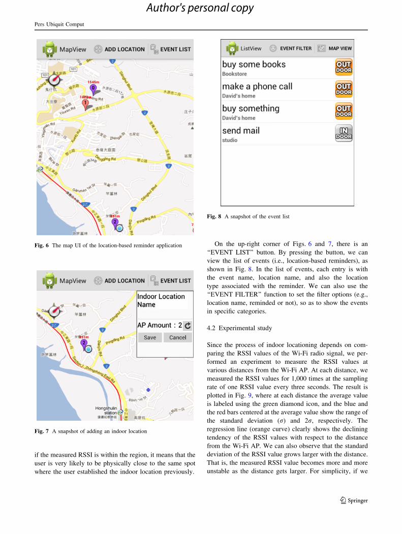
Figure 6 shows a snapshot of the Google Maps-based
user interface, in which we can see three pin icons. Red and
purple pin icons indicate the established outdoor and
indoor locations, respectively, and the digit labeled inside
the pin icons indicates the number of events associated
with that specific location. Beside the purple pin icon
labeled 2, there is a light blue circle, which indicates the
current location of the user. As we pointed out in Sect. 3.4,
since indoor locations are also associated with their GPS
START
Pinpoint a location on
Google Maps
Get GPS coordinates
Save location with GPS coordinates
into table
END
Input location name
Indoor or Outdoor ?
Scan for Wi-Fi APs
Select Wi-Fi AP(s)
Input location name
Save Wi-Fi AP(s) into AP table
Save GPS coordinates into
table
Save location with and
into table
Get GPS coordinates
Indoor Outdoor
Fig. 2 Flow chart for
establishing personal-
meaningful locations
START
Select location
Get from INDOOR or OUTDOOR
table
Input Event Name and Event Detail
Save , Event Name, Event Detail, and Type into
EVENT table
END
Fig. 3 Flow chart for creating location-based reminders
Pers Ubiquit Comput
123
Author's personal copy

coordinates, they can be pinpointed on the map. Therefore,
regardless of the location types, users are able to see the
established locations through the map UI.
By pressing the ‘‘ADD LOCATION’’ button in Fig. 6,
we can establish an indoor or outdoor location (manually
selected by the user). Figure 7 shows a snapshot of adding
an indoor location. The message box over the up-right
corner displays the number of detected Wi-Fi APs at the
location. After the user enters the name of the indoor
location and presses the ‘‘Save’’ button, this location is then
established in the INDOOR table. Note that during this
process, users are not hassled by the problem of selecting
appropriate Wi-Fi APs to be associated with the current
location—the application will do it automatically. When
doing Wi-Fi AP scanning, we will measure the received
signal strength indicator (RSSI) of each Wi-Fi AP, which
is a measurement of the power present in the received radio
signal. In our current implementation, the measured RSSI
of the Wi-Fi AP must be over -70 dBm to be eligible for
being associated with an indoor location. The reason is
that if the measured RSSI of a Wi-Fi AP is lower than
-70 dBm, it normally means that the AP is far away from
the Wi-Fi client (i.e., the user), and in this case, the mea-
sured RSSI can fluctuate severely. For this reason, we only
associate those APs that are closer to the user, so the
measured RSSI will typically be more stable. We have also
measured the behavior of RSSI versus distance, which will
be shown later in Sect. 4.2.
Furthermore, in order to make indoor locationing more
accurate, the measured RSSI values of the selected Wi-Fi
APs during the location establishment procedure are saved
in the AP table of the database (shown in Fig. 5c). When
performing location sensing, a specific Wi-Fi AP is
declared to be matched only when the measured RSSI
value of this AP falls into the zone of ‘‘saved RSSI ± d’’.
For simplicity, currently we use a fixed d value of 5 dBm.
The concept of this methodology resembles that of the
location fingerprinting approach [13], which utilizes a radio
map built in the offline phase to assist locationing. That is,
START
Get GPS coordinates
Lookup in
table
N
Location type?
Y
Trigger reminder
Any event associated with this
location?
Lookup in
table
OutdoorScan for Wi-Fi
APsIndoor
Lookup in
table
Location matched? N
N Y
Y
Location matched?
Fig. 4 Flow chart for triggering location-based reminders
(a)
(b)
(c)
(d)
Fig. 5 The design of tables in
the location database:
a OUTDOOR table,
b INDOOR table, c AP table,
d EVENT table
Pers Ubiquit Comput
123
Author's personal copy
if the measured RSSI is within the region, it means that the
user is very likely to be physically close to the same spot
where the user established the indoor location previously.
On the up-right corner of Figs. 6 and 7, there is an
‘‘EVENT LIST’’ button. By pressing the button, we can
view the list of events (i.e., location-based reminders), as
shown in Fig. 8. In the list of events, each entry is with
the event name, location name, and also the location
type associated with the reminder. We can also use the
‘‘EVENT FILTER’’ function to set the filter options (e.g.,
location name, reminded or not), so as to show the events
in specific categories.
4.2 Experimental study
Since the process of indoor locationing depends on com-
paring the RSSI values of the Wi-Fi radio signal, we per-
formed an experiment to measure the RSSI values at
various distances from the Wi-Fi AP. At each distance, we
measured the RSSI values for 1,000 times at the sampling
rate of one RSSI value every three seconds. The result is
plotted in Fig. 9, where at each distance the average value
is labeled using the green diamond icon, and the blue and
the red bars centered at the average value show the range of
the standard deviation (r) and 2r, respectively. The
regression line (orange curve) clearly shows the declining
tendency of the RSSI values with respect to the distance
from the Wi-Fi AP. We can also observe that the standard
deviation of the RSSI value grows larger with the distance.
That is, the measured RSSI value becomes more and more
unstable as the distance gets larger. For simplicity, if we
Fig. 6 The map UI of the location-based reminder application
Fig. 7 A snapshot of adding an indoor location
Fig. 8 A snapshot of the event list
Pers Ubiquit Comput
123
Author's personal copy

only need to tell whether the user is in the proximity of the
Wi-Fi AP, it suffices to use the measured RSSI value as a
clue, just as we did in our application.
4.3 Implementation issues
In this section, we discuss some requirements and imple-
mentation issues of our reminder application.
4.3.1 Indoor locations should be pre-visited before being
used in reminders
As described in Sect. 3.2, our application requires that the
indoor personal-meaningful locations should be pre-visited
by the users prior to using these locations in the reminders.
Otherwise, our application has no way of knowing the
Wi-Fi AP information at those locations. Although this
requirement seems to be a weakness in usability, it may not
be an issue if the indoor locations are those visited by the
users on a daily or frequent basis, such as users’ homes,
offices, and the nearby convenient stores. In Sect. 5, we
will propose two operating models to cope with this
usability problem.
4.3.2 RSSI as a measure of distance is disputable
It is noteworthy that use of RSSI as a measure of distance
has been disputable in the research community. For
example, the evaluation results of [17] show that the RSSI
for a given link has very small variation over time, and the
packet reception rate is at least 85 % when the RSSI is
above the sensitivity threshold (about -87 dBm). The
work in [18] gives the conclusion that indoor locationing
based on signal strength should be feasible if we can
construct a sound method for signal propagation in the
indoor environment. However, in [19], the experimental
results show that even under ideal conditions, the RSSI
cannot be used to determine inter-nodal distances in
wireless sensor networks. Nevertheless, in our location-
based reminder application, we do not have to determine
the exact distance; knowing that the user is in the proximity
of the Wi-Fi AP suffices our application.
4.3.3 Dynamic RSSI range for more flexible locationing
Regarding the d value used in Wi-Fi AP matching, we
mentioned in Sect. 4.1 that it is currently a fixed value.
From the experimental result shown in Fig. 9, we find it a
viable solution to make the d value equal to 2r, given that
the measured RSSI values follow the normal distribution
[20, 21]. Doing so, we can make the indoor location
sensing more flexible. That is, the d value can change with
the distance, which will be useful especially for locations
that are slightly far from the Wi-Fi AP, with the measured
RSSI values fluctuate severely. However, this requires
extra work to be done during the establishment of an indoor
location—monitoring the RSSI for a longer period of time
in order to compute the r value.
4.3.4 Associating multiple Wi-Fi APs for more accurate
locationing
As we pointed out in Sect. 3.2, a location can be associated
with multiple Wi-Fi APs to increase the accuracy of indoor
locationing. Specifically, an implementation issue arises in
this circumstance. If a location is associated with multiple
Wi-Fi APs, in location matching, we can set the criterion to
be either ‘‘match any of these APs’’ or ‘‘match all of these
APs’’. Using the former criterion can make location
matching easier and quicker because a location match can
be declared as soon as any of the APs associated with the
location is sensed. In contrast to this, using the latter cri-
terion can make location matching more accurate, because
intuitively it will require the user to be physically close to
the spot where he/she established this location previously
in the reminder application. However, doing so can
sometimes make location matching difficult if one of the
APs is removed from the location.
4.3.5 Issues regarding power consumption
in smartphones/tablets
A location-based reminder application is useful only if it
can sense the current location information within a rea-
sonable delay time, which inevitably will lead to sub-
stantial power consumption in the smartphones/tablets. For
example, with the average walking speed of 4.85 ft/s
(1.478 m/s) for younger pedestrians [22], it takes about 7 s
for a young person to walk 10 m. It means that choosing a
strategy such as doing location sensing once 10 s to save
energy is unrealistic. In our implementation, we set the
Fig. 9 Measured RSSI versus distance from the Wi-Fi AP
Pers Ubiquit Comput
123
Author's personal copy

period of location sensing to 3 s to achieve the balance of
power consumption and response time. Another solution to
saving the energy can be doing location sensing only when
the user is moving. This can be accomplished by using the
built-in accelerometer of the mobile device to detect the
movement of users.
4.4 Comparison
Table 1 compares the locationing technologies used in our
application and the related works described in Sect. 2.
‘‘Place-Its’’ [10] and ‘‘PlaceMail’’ [11] use Bluetooth and
AGPS for indoor locationing, respectively. The main
problems of using Bluetooth for location sensing are its
limited communication range and the limited ubiquity of
stationary Bluetooth devices. Wi-Fi APs, however, are
ubiquitous and stationary, which are more handily avail-
able for location sensing than using Bluetooth. AGPS can
achieve acceptable locationing accuracy in indoor envi-
ronments, but it requires the support from both the infra-
structure of cellular operators and the cell phones.
Deploying Wi-Fi APs is easier since anyone can set up an
AP to be used in their premises, including in the basement
of a building which is not covered by the cellular network.
Both ‘‘Location Alert’’ [15] and ‘‘Location Based Task
Reminder’’ [16] use the LocationProvider Android API
[23] to support outdoor locationing and indoor locationing.
The accuracy of indoor locationing using the Location-
Provider API depends on the density of Wi-Fi AP infor-
mation collected by Google. In our work, the users can
scan the Wi-Fi AP information at the desired indoor
locations, which can be either a public location or a private
location. In the case of a private indoor location such as a
user’s office or bedroom, Google may not have the Wi-Fi
AP information at that location. Therefore, using our
approach can certainly be more accurate in indoor loca-
tioning, which leads to better user satisfaction.
5 Operating models
As mentioned previously, the current version of our loca-
tion-based reminder requires that the personal-meaningful
locations should be pre-visited by the users. However, this
restriction can be lifted in some ways. In this section, we
propose two operating models to solve this problem: tele-
com-assisted locationing and social-assisted locationing.
Both models can largely boost the usability of the location-
based reminder application.
5.1 Telecom-assisted locationing
As described in Sect. 1, many telecom and/or broadband
operators have deployed Wi-Fi APs extensively in urban
areas. This effort not only facilities Internet access of their
subscribers, but also alleviates the burden of the increasing
data traffic over 3G cellular networks. Take Taiwan’s
largest telecom operator—Chunghwa Telecom (CHT) as
an example, it has deployed more than 36 thousands Wi-Fi
hotspots around the island [24]. Subscribers of CHT can
use the ‘‘CHT Wi-Fi’’ Android application [25] (snapshot
shown in Fig. 10) to search the CHT-operated Wi-Fi hot-
spots (the red pins) around them (the blue pin).
In this operating model, these telecom-operated APs
play a crucial role for indoor locationing. Specifically,
telecom operators not only own these Wi-Fi APs, but also
Table 1 Locationing technologies used in various location-based
reminders
Location-based
reminders
Outdoor
locationing
Indoor
locationing
Place-its [10] GSM cell tower Bluetooth
PlaceMail [11] GPS AGPS
Location alert [15] LocationProvider
API in Android
SDK
LocationProvider
API in Android
SDK
Location based task
reminder [16]
LocationProvider
API in Android
SDK
LocationProvider
API in Android
SDK
The proposed
location-based
reminder
GPS Wi-Fi
Fig. 10 A snapshot of the ‘‘CHT Wi-Fi’’ Android application
Pers Ubiquit Comput
123
Author's personal copy

have the knowledge of the MAC address associated with
each Wi-Fi interface and the location information at which
every AP is deployed. That is, this database with all the
Wi-Fi MAC addresses and the associated location infor-
mation is exactly the asset that telecom operators can take
full advantage of. In other words, various location-based
services can be supported by the telecom-assisted loca-
tioning service.
Therefore, as long as telecom operators establish the
Wi-Fi AP database, within which each entry is a pair of a
MAC address and a location, smartphones can follow the
flow of operations to do locationing (shown in Fig. 11):
1. User’s smartphone receives the beacon frames of a
specific Wi-Fi AP
2. The smartphone queries the database with the sensed
MAC address
3. The database returns the location information associ-
ated with the Wi-Fi AP
5.2 Social-assisted locationing
With the emergence and popularity of social networking,
people are able to share all sorts of information such as
photos and videos with others in various social groups. In
this operating model, location information is made share-
able among the social groups. The idea is similar to the
check-in functionality of Facebook [26], by which Face-
book users are able to share his/her current location. When
a Facebook user presses the check-in button, the nearby
landmarks will show up in a list to be selected by the user.
If the user’s current location is not included in the list, he/
she can create a new one by himself/herself. This newly
created location information will be saved in the location
database of Facebook, which then can be used for other
Facebook users.
In our proposed social-assisted operating model, indoor
locations established (visited and then AP-scanned) by a
user can be uploaded to a location database server if the
user decided that the location information is safe to be
shared with his/her social group. As a consequence, users
of the same social group can download the shared location
information to their smartphones and use them for future
locationing. It should be noted that in this operating model,
those locations to be shared require a unified naming
scheme. Otherwise, a location name such as ‘‘My office’’ is
meaningless for other social members. For simplicity and
ease of management, it is feasible to design the user
interface that forces the creator of a location to pin-point
the location on the Google Maps. Therefore, the GPS
coordinates of the location can be saved in the location
database, just like the way we handle indoor locations as
described in Sect. 3.4. The flow of operation of this oper-
ating model is shown in Fig. 12. Assume that User A and
User B are of the same social group. User A acquires the
Wi-Fi AP information by sensing the beacon frame and
then saves this indoor location into the local INDOOR
table. When establishing this indoor location, User
Fig. 11 Flow of operation in
the telecom-assisted operating
model
Pers Ubiquit Comput
123
Author's personal copy

A decides to make this location shareable, so this indoor
location information is uploaded to the remote location
database server automatically. User B, as User A’s friend,
may check the location database server and find that his/her
friend A has established an indoor location. If B is inter-
ested in this location information, he/she then can down-
load the indoor location information to be used in his/her
location-based reminders.
6 Conclusions and future work
In this research, we implemented a location-based task
reminder application for Android-based smartphones and
tablets. Compared with the existing works, our application
takes full advantage of the ubiquitous WLAN infrastructure to
achieve better accuracy in indoor locationing. Furthermore,
our application gives users a unified user experience because
all the established personal-meaningful locations can be dis-
played on the Google Maps UI, regardless of the location
types. Although the current version requires that indoor
locations should be pre-visited by the users, this restriction
can be easily lifted by incorporating the proposed operating
models—telecom-assisted locationing and social-assisted
locationing. With the telecom-assisted locationing operating
model, the locationing service can become a value-added
service for telecom operators with WLAN infrastructure.
Furthermore, our work as a foundation of location-based
services can be further extended to be used in many other
scenarios which comprise both indoor and outdoor environ-
ments. We believe that the reminder application we developed
can contribute to the promotion of individual well-being.
Currently, we are developing a new software version by
incorporating the social-assisted operating model to boost the
usability of our reminder application. At the same time, we
will try to lower the power consumption of executing the
reminder application. As described in Sect. 4.3, it is a viable
solution to use the built-in accelerometer of the mobile device
to detect the movement of users, so the application will do
location sensing only when the user is moving. Finally, after
the new version is completed, we will evaluate the usability of
our system through the questionnaire on the users.
Acknowledgments This research is supported in part by the
National Science Council, Taiwan, R.O.C., under grant number NSC
99-2221-E-032-030-MY3.
References
1. Lam W (2012) Samsung Overtakes Nokia for Cellphone Lead.
Press release of iSuppli, April 26, 2012, http://www.isuppli.com/
Mobile-and-Wireless-Communications/News/Pages/Samsung-
Overtakes-Nokia-for-Cellphone-Lead.aspx. Accessed Sept 2012
2. Rao B, Minakakis L (2003) Evolution of mobile location-based
services. Commun ACM 46:61–65
3. Google Maps (2012) http://maps.google.com/. Accessed Sept
2012
4. Ni LM, Liu Y, Lau YC, Patil AP (2004) LANDMARC: indoor
location sensing using active RFID. Wireless Netw 10(6):701–770
5. Hansen R, Wind R, Jensen CS, Thomsen B (2009) Seamless
indoor/outdoor positioning handover for location-based services
in Streamspin. In: Proceedings of the 10th international confer-
ence on mobile data management: systems, services and mid-
dleware (Taipei, Taiwan, 18–20 May 2009) (MDM’09)
6. Bahl P, Padmanabhan VN (2000) RADAR: an in-building RF-
based user location and tracking system. In: Proceedings of the
9th annual joint conference of the IEEE computer and commu-
nications societies (Tel Aviv, Israel, 26–30 Mar. 2000)
(INFOCOM’00)
7. Chen X, Yu D, Wang H (2008) Design and implementation of
logistics information terminal positioning technology. In: Pro-
ceedings of the 4th international conference on wireless com-
munications, networking and mobile computing (Dalian, China,
12–14 Oct. 2008) (WiCOM’08)
8. Bhasker ES, Brown SW, Griswold WG (2004) Employing user
feedback for fast, accurate, low-maintenance geolocationing. In:
Proceedings of the 2nd IEEE international conference on perva-
sive computing and communications (Orlando, Florida, 14–17
March 2004) (PerCom’04)
Fig. 12 Flow of operation in
the social-assisted operating
model
Pers Ubiquit Comput
123
Author's personal copy

9. Lin CY, Cheng WT, Wang SC (2011) An end-to-end logistics
management application over heterogeneous location systems.
Wireless Pers Commun 59(1):5–16
10. Sohn T, Li KA, Lee G, Smith I, Scott J, Griswold WG (2005)
Place-its: a study of location-based reminders on mobile phones.
Lect Notes Comput Sci 3660:232–250
11. Ludford PJ, Frankowski D, Reily K, Wilms K, Terveen L (2006)
Because I carry my cell phone anyway: functional location-based
reminder applications. In: Proceedings of the ACM SIGCHI
conference on human factors in computing systems (Montreal,
Canada, 22–27 Apr. 2006) (CHI’06)
12. Li Y, Guo A, Liu S, Gao Y, Zheng YT (2010) A location based
reminder system for advertisement. In: Proceedings of the 18th
ACM international conference on multimedia (Firenze, Italy,
25–29 Oct. 2010) (MM’10)
13. Bahl P, Padmanabhan VN (2000) RADAR: an in-building RF-
based user location and tracking system. In: Proceedings of the
9th annual joint conference of the IEEE computer and commu-
nications societies (Tel Aviv, Israel, 26–30 March 2000)
(INFOCOM’00)
14. Google Play (2012) https://play.google.com/store. Accessed Sept
2012
15. Location Alert (Android Apps on Google Play) (2012) https://
play.google.com/store/apps/details?id=com.mofirst.locationalert.
Accessed Sept 2012
16. Location Based Task Reminder (Android Apps on Google Play)
(2012) https://play.google.com/store/apps/details?id=com.lbtr.
taskreminder. Accessed Sept 2012
17. Srinivasan K, Levis P (2006) RSSI is under appreciated. In:
Proceedings of the 3rd workshop on embedded networked sen-
sors, Cambridge, MA, USA, May 2006 (EmNets’06)
18. Chen Y, Kobayashi H (2002) Signal strength based indoor geo-
locations. In: Proceedings of the 2002 IEEE international con-
ference on communications. New York City, NY, USA, 28 Apr–2
May 2002 (ICC’02)
19. Parameswaran AT, Husain MI, Upadhyaya S (2009) Is RSSI a
reliable parameter in sensor localization algorithms—an experi-
mental study. In: Proceedings of the field failure data analysis
workshop, Niagara Falls, New York, USA, pp 27–30 Sept 2009
(F2DA’09)
20. Bose A, Foh CH (2007) A practical path loss model for indoor
WiFi positioning enhancement. In: Proceedings of the 6th inter-
national conference on information, communications and signal
processing. Singapore, 10–13 Dec. 2007 (ICICS’07)
21. Small J, Smailagic A, Siewiorek DP (2000) Determining user
location for context aware computing through the use of a
wireless LAN infrastructure. Carnegie Mellon University. http://
www.ices.cmu.edu/reports/040201.pdf. Accessed Sept 2012
22. Carey N (2012) Establishing pedestrian walking speeds. Portland
State University. http://www.westernite.org/datacollectionfund/
2005/psu_ped_summary.pdf. Accessed Sept 2012
23. LocationProvider Android API (2012). http://developer.android.
com/reference/android/location/LocationProvider.html. Accessed
Sept 2012
24. Chunghwa Telecom Wi-Fi service (2012) http://wifi.hinet.net/
pwlan. Accessed Sept 2012
25. CHT Wi-Fi (Android Apps on Google Play) (2012) https://play.
google.com/store/apps/details?id=com.cht.tl334.chtwifi. Accessed
Sept 2012
26. Add a location to your posts, Facebook (2012) https://www.
facebook.com/about/location. Accessed Sept 2012
Pers Ubiquit Comput
123
Author's personal copy