
A Cellular Approach to Net-Zero Energy Cities - Adalidda
17
energies Article A Cellular Approach to Net-Zero Energy Cities Miguel Amado 1, * ID , Francesca Poggi 2 ID , António Ribeiro Amado 3 and Sílvia Breu 4 1 CERIS Civil Engineering Research and Innovation for Sustainability, Instituto Superior Técnico, Universidade de Lisboa, Av. Rovisco Pais 1, 1049-001 Lisbon, Portugal 2 CICS.NOVA—Interdisciplinary Center of Social Sciences, Faculdade de Ciências Sociais e Humanas, Universidade NOVA de Lisboa, Av. de Berna, 26-C, 1069-061 Lisbon, Portugal; [email protected] 3 CIAUD Centro de Investigação em Arquitectura, Urbanismo e Design, Faculdade de Arquitectura, Universidade de Lisboa, R. Sá Nogueira, 1349-063 Lisbon, Portugal; [email protected] 4 Municipal Development Office, 2784-214 Oeiras Municipality, Portugal; [email protected] * Correspondence: [email protected]; Tel.: +351-218-418349 Received: 6 October 2017; Accepted: 5 November 2017; Published: 10 November 2017 Abstract: Recent growth in the use of photovoltaic technology and a rapid reduction in its cost confirms the potential of solar power on a large scale. In this context, planning for the deployment of smart grids is among the most important challenges to support the increased penetration of solar energy in urban areas and to ensure the resilience of the electricity system. As part this effort, the present paper describes a cellular approach to a Net-Zero energy concept, based on the balance between the potential solar energy supply and the existing consumption patterns at the urban unit scale. To do that, the Geographical Urban Units Delimitation model (GUUD) has been developed and tested on a case study. By applying the GUUD model, which combines Geographic Information Systems (GIS), parametric modelling, and solar dynamic analysis, the whole area of the city was divided into urban cells, categorized as solar producers and energy consumers. The discussion around three theoretical scenarios permits us to explore how smart grids can be approached and promoted from an urban planning perspective. The paper provides insights into how urban planning can be a driver to optimize and manage energy balance across the city if the deployment of smart grids is correctly integrated in its operative process. Keywords: Net-Zero; energy balance; solar energy; smart grid; urban cell; GIS 1. Introduction Today, almost 80% of the global energy supply is consumed in cities [1], and, according to International Energy Agency (IEA) predictions, energy use will grow by 56% between 2010 and 2040 [2]. Considering factors like the urbanization processes, unsustainable lifestyles, and global consumption patterns followed by each society [3], the relationship between energy and city is one of the biggest challenges that urban planners have to face around the world. The aforementioned framework leads to a discussion on the growing interest in nearly-Zero Energy Buildings (nZEB) [4], which produce as much energy as they use, and the difficulties of their implementation [5]. In such pathway, reducing the energy load of cities, by means of renewable energies, is essential to achieve the nZEB goal and provide a significant contribution to a sustainable energy portfolio in the present and future world [6]. The recent growth in the use of photovoltaic technology and the rapid reduction in its cost confirms the potential of solar power on a large scale [7]. However, the share of energy supply in such a decentralized system requires an effective approach to energy flow management, making full use of smart grids and technologies [8,9]. Looking beyond the single building, the Net-Zero energy concept requires the elaboration of urban models with a widespread installation of photovoltaic systems and smart grid technologies [10]. Energies 2017, 10, 1826; doi:10.3390/en10111826 www.mdpi.com/journal/energies
-
Upload
khangminh22 -
Category
Documents
-
view
1 -
download
0
Transcript of A Cellular Approach to Net-Zero Energy Cities - Adalidda

energies
Article
A Cellular Approach to Net-Zero Energy Cities
Miguel Amado 1,* ID , Francesca Poggi 2 ID , António Ribeiro Amado 3 and Sílvia Breu 4
1 CERIS Civil Engineering Research and Innovation for Sustainability, Instituto Superior Técnico,Universidade de Lisboa, Av. Rovisco Pais 1, 1049-001 Lisbon, Portugal
2 CICS.NOVA—Interdisciplinary Center of Social Sciences, Faculdade de Ciências Sociais e Humanas,Universidade NOVA de Lisboa, Av. de Berna, 26-C, 1069-061 Lisbon, Portugal; [email protected]
3 CIAUD Centro de Investigação em Arquitectura, Urbanismo e Design, Faculdade de Arquitectura,Universidade de Lisboa, R. Sá Nogueira, 1349-063 Lisbon, Portugal; [email protected]
4 Municipal Development Office, 2784-214 Oeiras Municipality, Portugal; [email protected]* Correspondence: [email protected]; Tel.: +351-218-418349
Received: 6 October 2017; Accepted: 5 November 2017; Published: 10 November 2017
Abstract: Recent growth in the use of photovoltaic technology and a rapid reduction in its costconfirms the potential of solar power on a large scale. In this context, planning for the deploymentof smart grids is among the most important challenges to support the increased penetration ofsolar energy in urban areas and to ensure the resilience of the electricity system. As part this effort,the present paper describes a cellular approach to a Net-Zero energy concept, based on the balancebetween the potential solar energy supply and the existing consumption patterns at the urban unitscale. To do that, the Geographical Urban Units Delimitation model (GUUD) has been developedand tested on a case study. By applying the GUUD model, which combines Geographic InformationSystems (GIS), parametric modelling, and solar dynamic analysis, the whole area of the city wasdivided into urban cells, categorized as solar producers and energy consumers. The discussionaround three theoretical scenarios permits us to explore how smart grids can be approached andpromoted from an urban planning perspective. The paper provides insights into how urban planningcan be a driver to optimize and manage energy balance across the city if the deployment of smartgrids is correctly integrated in its operative process.
Keywords: Net-Zero; energy balance; solar energy; smart grid; urban cell; GIS
1. Introduction
Today, almost 80% of the global energy supply is consumed in cities [1], and, according toInternational Energy Agency (IEA) predictions, energy use will grow by 56% between 2010 and2040 [2]. Considering factors like the urbanization processes, unsustainable lifestyles, and globalconsumption patterns followed by each society [3], the relationship between energy and city is oneof the biggest challenges that urban planners have to face around the world. The aforementionedframework leads to a discussion on the growing interest in nearly-Zero Energy Buildings (nZEB) [4],which produce as much energy as they use, and the difficulties of their implementation [5]. In suchpathway, reducing the energy load of cities, by means of renewable energies, is essential to achieve thenZEB goal and provide a significant contribution to a sustainable energy portfolio in the present andfuture world [6].
The recent growth in the use of photovoltaic technology and the rapid reduction in its costconfirms the potential of solar power on a large scale [7]. However, the share of energy supply in sucha decentralized system requires an effective approach to energy flow management, making full use ofsmart grids and technologies [8,9].
Looking beyond the single building, the Net-Zero energy concept requires the elaboration ofurban models with a widespread installation of photovoltaic systems and smart grid technologies [10].
Energies 2017, 10, 1826; doi:10.3390/en10111826 www.mdpi.com/journal/energies
Energies 2017, 10, 1826 2 of 17
It is important to note that developing synergies between several buildings, which are not necessarilynZEB as singles but as a whole, is useful to identify physical boundaries, which are called ‘on site’generation systems [11].
Here, three important issues are involved in this more comprehensive approach to nZEB. The firstis related to how solar potential in urban areas can be evaluated in order to be efficiently capitalizedon by the installation of photovoltaic system in building [12]. The second is what kind of delimitationcriteria can be considered to identify urban cells as independent systems in which the energybalance results from the differential between the solar energy supply and the building’s energyconsumption [13]. The third is focused on the important role of smart grid technologies to managethe energy balance between power supply and demand in the system and from the microscale of theurban cells to the macroscale of the whole city [14]. In response to the aforementioned framework,this paper presents a cellular approach to Net-Zero, which aims to promote energy efficient cities,considering the different spatial scales, urban complexities, and technological challenges associatedwith sustainable energy planning.
2. Background
The scope of this study is to promote solar energy integration and smart grid deploymentto support Net-Zero energy cities. In this way, the research framework addresses three maincomplementary domains:
• Physical-geographical approaches to urban form and land use analysis;• Estimation of solar potential and energy consumption patterns in urban areas;• Integration of smart grids in urban planning practice.
Physical-geographical approaches to the urban form and land use analysis are key to dealing withthe complexity of cities [15]. Many of these approaches are used to analyse different aspects of urbandevelopment at a macro spatial scale such as urban shape [16], city size distribution [17], or populationdensity [18], involving an array of interrelated methods and tools [19].
Increasingly, the widespread use of geographic information systems (GIS) has shifted the emphasisto new forms of analysis and planning at a fine spatial scale. One of the most effective methods isto employ urban models, based on the principles of Cellular Automata (CA) [16]. The concept ofCA was introduced in the 60 s by Von Neumann as formal model of self-reproducing biologicalsystems. Later, computer science, mathematics, and physics began to study CA for modelling theirrespective domains [20]. In 1979, Tobler introduced the concept of CA to geography and made the firstapplication in the study of urban systems [21]. During the next two decades, these models continuedto be developed, focusing on a wide range of phenomena related to urban studies [21]. For example,Clarke (1995) created a land use change model called SLEUTH (slope, land use map, excluded area,urban area, transportation map, and hillside area model) that simulates the urban growth process,showing the real value of planning and GIS application [22]. In this way, the SLEUTH model is capableof modelling complex urban growth dynamics and land use system changes, providing a set of spatialvariables such as topographic slope, road networks, and land use maps [23].
Other CA-based models incorporating analyses of the linear dimension of urban infrastructures,the number of buildings, the density, and the possible uses with the number of years and populationgrowth have also been proposed. The MURBANDY (Monitoring Urban Dynamics) model [24], is basedon the concept of potential transition that takes into account factors such as suitability, accessibility,zoning, and neighbourhood effect.
Related to these issues, the MOLAND (Monitoring Land Use/Cover Dynamics) model [25] hasbeen applied to European cities to assist spatial planners and policy makers to analyse a wide rangeof spatial policies and their associated spatial patterns. Nevertheless, this model does not have thecapacity to simulate urban growth, and a new model called DUEM (Dynamic Urban Evolutionary

Energies 2017, 10, 1826 3 of 17
Model) has emerged to demonstrate how urban simulations can be developed to great effect usingpowerful methods of visualization built around GIS [26].
In this framework, the implementation of different CA models has shown several deficiencies,in part consequence of the difficulty in the delimitation of geographical areas through the rudeexpression of spatial divisions. On the other hand, the use of the cellular approach provides anopportunity to deal with the modelling requirements of the informatics tools in the aggregationand disaggregation of information, shifting urban model analysis from a large-scale perspective tomicro-simulation [21].
In this regard, the cellular approach is the recognition of an alignment between the urbancomplexity and its study by means of spatial units that are conceived as the smallest urban unitsavailable: the cells [27]. Santé et al. (2010) relates that a formal CA can assume a cell space representedby a regular grid usually composed of square cells, although some authors have proposed usinghexagonal cells in order to obtain a more homogeneous neighbourhood [28]. White (1997) reportsthat, at the latter scale, cells may represent cadastral units (i.e., actual land lots), which may have anyshape [29]. In this frame, then, the application of CA models supports the transition from macro-scaleto micro-scale and offers more and better data to understand the relationships between a range of keyaspects such as urban form, built environment, land-uses, densities, and infrastructures across the city.However, while applying these analytical approaches to an urban system, the relationship betweensolar potential and energy consumption patterns can be effectively explored. Indeed, this is the lessonfrom the ample literature concerning the analysis of urban solar potential, with particular attention toGIS tools [30,31], parametric modelling [10,32,33] and new methodologies for solar urban planning [34]and design [35]. On the other hand, the relationships between the effect of urban geometry and energyconsumption are illustrated by Ratti, Baker, and Steemers (2005) [36]. In that regard, Rode et al.’s (2014)work addresses in detail the relationship between morphological urban parameters and theoreticalheat-energy efficiencies created by the spatial configuration of cities [37]. Indeed, the common themerunning throughout global approaches to cities and energy revolves around the evidence that solarpotential in urban areas is enormous [38] and that PV-generation and its penetration into the grid arecentral challenges to optimize energy savings, self-consumption, and costs [39]. In this context, smartgrid technologies emerge as a solution to enhance every facet of the electric delivery system, includinggeneration, transmission, distribution, and consumption [40]. In principle, smart grids promise a rangeof benefits but require domains of research that include the following conditions:
• Consider energy delivery solutions to the public network or their use in micro distributionnetworks at the scale of the neighbourhood [41];
• Assess the capacity of low-voltage networks to integrate additional and reverse power flows andprevent future impacts on their stability [42];
• Consider that data on energy flows require networks to be dynamic and have constantcommunication between supplier and consumer, which is the use of Information andCommunications Technologies (ICTs) together with the decentralized production of energy,a fundamental and effective solution [43].
These three conditions are core in making the electrical system more reliable and efficient bymeans of intelligent devices that reduce electricity losses and detect and solve energy necessitiesmore quickly.
At the building level, smart grid technologies can play a dual role: first, they support users thatproduce energy and sell it back to the grid, and, second, they help consumers to keep track of currentelectricity usage and/or predict future electricity demand [44]. These two functions deliver significantbenefits to consumers, who can use electricity more efficiently and reduce their energy consumptionand bill. Smart meters devices installed in buildings provide companies in the energy sector withthe ability to monitor, for example, when a part of the city is using more electricity than expectedor to detect problems on their systems and operate them more efficiently [40]. Moreover, with the

Energies 2017, 10, 1826 4 of 17
integration of electric vehicles within the grid, there is the need to meet the stationary load demandin parallel and its associated diurnal requirements [44,45]. Through a long-term vision, aspects suchas locations for electric vehicle parking and charging and park-time length for a particular land use,will be essential urban planning parameters. Nonetheless, there is a need for the implementation ofpilot projects to establish which smart grid models are more adequate to be adopted [46], supportingthe vision of intelligent infrastructure and intelligent cities [47]. Indeed, smart grid deployment isa complex task [48], which interacts within a complex system, the city. In this sense, the large-scaleapproach and multidisciplinary nature of urban planning, coupled with solar energy smart gridintegration, can lead to the more integrated and comprehensive energy management of cities. It is theclosing of this presumption that this work aims to contribute by studying a single urban cell to shift,in a systematized way, at the macroscale within the ‘Net-Zero Energy’ balance scenarios developed atthe city level.
3. Methodology
According to the literature, the Geographical Urban Units Delimitation (GUUD) model has beendeveloped, dealing with a cellular approach to the urban form, land use analysis, and solar potentialand energy consumption estimation. The present section of the paper describes the GUUD model andthe methodology that supports its practical application to solar energy and smart grid integration in acase study: the city of Oeiras in Portugal. The GUUD is a model that operates at the city macroscalelevel by defining a simplest set of urban units that, like cells, can be considered negative, positive,or neutral in accordance with the differential between their respective potential of solar energy supplyand existing energy consumption patterns (Figure 1).
Energies 2017, 10, 1826 4 of 17
integration of electric vehicles within the grid, there is the need to meet the stationary load demand in parallel and its associated diurnal requirements [44,45]. Through a long-term vision, aspects such as locations for electric vehicle parking and charging and park-time length for a particular land use, will be essential urban planning parameters. Nonetheless, there is a need for the implementation of pilot projects to establish which smart grid models are more adequate to be adopted [46], supporting the vision of intelligent infrastructure and intelligent cities [47]. Indeed, smart grid deployment is a complex task [48], which interacts within a complex system, the city. In this sense, the large-scale approach and multidisciplinary nature of urban planning, coupled with solar energy smart grid integration, can lead to the more integrated and comprehensive energy management of cities. It is the closing of this presumption that this work aims to contribute by studying a single urban cell to shift, in a systematized way, at the macroscale within the ‘Net-Zero Energy’ balance scenarios developed at the city level.
3. Methodology
According to the literature, the Geographical Urban Units Delimitation (GUUD) model has been developed, dealing with a cellular approach to the urban form, land use analysis, and solar potential and energy consumption estimation. The present section of the paper describes the GUUD model and the methodology that supports its practical application to solar energy and smart grid integration in a case study: the city of Oeiras in Portugal. The GUUD is a model that operates at the city macroscale level by defining a simplest set of urban units that, like cells, can be considered negative, positive, or neutral in accordance with the differential between their respective potential of solar energy supply and existing energy consumption patterns (Figure 1).
Figure 1. Geographical Urban Units Delimitation (GUUD) model: cellular approach concept.
This approach, inspired by cellular automata theory, permits us to interrelate within GIS a variety of determinants such as urban compactness [35], morphology [36], street patterns [49], buildings orientation [50], density [51], and land use [10], which have great influence on solar energy production and consumption. The statistical subsections joined to the ‘information reference geographical database’ released by the National Institute of Statistics (2011) [52] have been adopted as the starting point for the urban unit delimitation (Table 1).
Figure 1. Geographical Urban Units Delimitation (GUUD) model: cellular approach concept.
This approach, inspired by cellular automata theory, permits us to interrelate within GIS a varietyof determinants such as urban compactness [35], morphology [36], street patterns [49], buildingsorientation [50], density [51], and land use [10], which have great influence on solar energy productionand consumption. The statistical subsections joined to the ‘information reference geographical database’released by the National Institute of Statistics (2011) [52] have been adopted as the starting point forthe urban unit delimitation (Table 1).

Energies 2017, 10, 1826 5 of 17
Table 1. Examples of urban units based on statistical subsection delimitation across the city.
Energies 2017, 10, 1826 5 of 17
Table 1. Examples of urban units based on statistical subsection delimitation across the city.
LINEAR CELL PUNCTUAL CELL NON-ORTHOGONAL CELL
RADIAL CELL ORGANIC CELL ORTHOGONAL CELL
INDUSTRIAL CELLS
The identification of morphological cells assumes knowledge of the parts of the form and the way they structure themselves in the different identified sub statistical sections and makes sure that its implementation is replicable to other cities in European Union. Indeed, the use of such a statistical, geo-referenced grid allows urban planners to work with several levels of quantitative information, including official administrative boundaries, residential buildings, population census, households, and dwellings that can be interrelated to the physical components of the urban system; that is, buildings, streets, and infrastructure.
From within this geo-referenced grid, the GUUD model is calibrated by means of four delimitation criteria: construction timeline, population density, urban morphology, and land-use patterns. This framework permits us to filter the global database with specific parameters (Table 2).
As result, the concept of the urban unit emerges as an operational element, which aggregates a set of statistical subsections, which are characterized by relations of proximity, neighbourhood, and common characteristics defined according to the spatial-time evolution of the urban model.
LINEAR CELL PUNCTUAL CELL NON-ORTHOGONAL CELL
Energies 2017, 10, 1826 5 of 17
Table 1. Examples of urban units based on statistical subsection delimitation across the city.
LINEAR CELL PUNCTUAL CELL NON-ORTHOGONAL CELL
RADIAL CELL ORGANIC CELL ORTHOGONAL CELL
INDUSTRIAL CELLS
The identification of morphological cells assumes knowledge of the parts of the form and the way they structure themselves in the different identified sub statistical sections and makes sure that its implementation is replicable to other cities in European Union. Indeed, the use of such a statistical, geo-referenced grid allows urban planners to work with several levels of quantitative information, including official administrative boundaries, residential buildings, population census, households, and dwellings that can be interrelated to the physical components of the urban system; that is, buildings, streets, and infrastructure.
From within this geo-referenced grid, the GUUD model is calibrated by means of four delimitation criteria: construction timeline, population density, urban morphology, and land-use patterns. This framework permits us to filter the global database with specific parameters (Table 2).
As result, the concept of the urban unit emerges as an operational element, which aggregates a set of statistical subsections, which are characterized by relations of proximity, neighbourhood, and common characteristics defined according to the spatial-time evolution of the urban model.
RADIAL CELL ORGANIC CELL ORTHOGONAL CELL
Energies 2017, 10, 1826 5 of 17
Table 1. Examples of urban units based on statistical subsection delimitation across the city.
LINEAR CELL PUNCTUAL CELL NON-ORTHOGONAL CELL
RADIAL CELL ORGANIC CELL ORTHOGONAL CELL
INDUSTRIAL CELLS
The identification of morphological cells assumes knowledge of the parts of the form and the way they structure themselves in the different identified sub statistical sections and makes sure that its implementation is replicable to other cities in European Union. Indeed, the use of such a statistical, geo-referenced grid allows urban planners to work with several levels of quantitative information, including official administrative boundaries, residential buildings, population census, households, and dwellings that can be interrelated to the physical components of the urban system; that is, buildings, streets, and infrastructure.
From within this geo-referenced grid, the GUUD model is calibrated by means of four delimitation criteria: construction timeline, population density, urban morphology, and land-use patterns. This framework permits us to filter the global database with specific parameters (Table 2).
As result, the concept of the urban unit emerges as an operational element, which aggregates a set of statistical subsections, which are characterized by relations of proximity, neighbourhood, and common characteristics defined according to the spatial-time evolution of the urban model.
INDUSTRIAL CELLS
The identification of morphological cells assumes knowledge of the parts of the form and theway they structure themselves in the different identified sub statistical sections and makes surethat its implementation is replicable to other cities in European Union. Indeed, the use of such astatistical, geo-referenced grid allows urban planners to work with several levels of quantitativeinformation, including official administrative boundaries, residential buildings, population census,households, and dwellings that can be interrelated to the physical components of the urban system;that is, buildings, streets, and infrastructure.
From within this geo-referenced grid, the GUUD model is calibrated by means of four delimitationcriteria: construction timeline, population density, urban morphology, and land-use patterns.This framework permits us to filter the global database with specific parameters (Table 2).
As result, the concept of the urban unit emerges as an operational element, which aggregatesa set of statistical subsections, which are characterized by relations of proximity, neighbourhood,and common characteristics defined according to the spatial-time evolution of the urban model.

Energies 2017, 10, 1826 6 of 17
Table 2. Delimitation criteria of the urban unit.
Energies 2017, 10, 1826 6 of 17
Table 2. Delimitation criteria of the urban unit.
Period of Construction years
Resident Population N°
Buildings Block and Street Pattern
Orthogonal Warped Parallel
Organic Linear and Loops
Residential Building Types
Multifamily low-mid-high rise
Single family attached— detached
Roof Typology Pitched
Flat
Zoning
Residential Parks and Recreation
Commercial Service
Industrial Public facility
Land-Use Coverage System
Buildings covered area Open space area
Street covered area
The Net-Zero energy concept is thus shifted form the building to the urban unit, developing synergies between several buildings, which are not necessarily nZEB but, by integrating photovoltaic systems and smart grid technologies, can be turned into energy balanced cells or solar energy exporter cells. At an operative level, the cellular approach is supported by an interactive workflow, which combines a large amount of vector data, satellite imagery, and tables, which are included in the GIS with parametric modelling and solar dynamic analysis (Figure 2).
Figure 2. Interactive workflow.
4. Case Study
This section describes the application of the methodology to Oeiras, a medium sized city located in the Lisbon Metropolitan Area in Portugal. The city covers 651 hectares and is delimited by a statistical grid with 1.916 subsections.
Period of Construction years
Resident Population N◦
Buildings Block and Street Pattern
Orthogonal
Warped Parallel
Organic
Linear and Loops
Residential Building Types Multifamily low-mid-high rise
Single family attached—detached
Roof Typology Pitched
Flat
Zoning
Residential Parks and Recreation
Commercial Service
Industrial Public facility
Land-Use Coverage SystemBuildings covered area
Open space area
Street covered area
The Net-Zero energy concept is thus shifted form the building to the urban unit, developingsynergies between several buildings, which are not necessarily nZEB but, by integrating photovoltaicsystems and smart grid technologies, can be turned into energy balanced cells or solar energyexporter cells. At an operative level, the cellular approach is supported by an interactive workflow,which combines a large amount of vector data, satellite imagery, and tables, which are included in theGIS with parametric modelling and solar dynamic analysis (Figure 2).
Energies 2017, 10, 1826 6 of 17
Table 2. Delimitation criteria of the urban unit.
Period of Construction years
Resident Population N°
Buildings Block and Street Pattern
Orthogonal Warped Parallel
Organic Linear and Loops
Residential Building Types
Multifamily low-mid-high rise
Single family attached— detached
Roof Typology Pitched
Flat
Zoning
Residential Parks and Recreation
Commercial Service
Industrial Public facility
Land-Use Coverage System
Buildings covered area Open space area
Street covered area
The Net-Zero energy concept is thus shifted form the building to the urban unit, developing synergies between several buildings, which are not necessarily nZEB but, by integrating photovoltaic systems and smart grid technologies, can be turned into energy balanced cells or solar energy exporter cells. At an operative level, the cellular approach is supported by an interactive workflow, which combines a large amount of vector data, satellite imagery, and tables, which are included in the GIS with parametric modelling and solar dynamic analysis (Figure 2).
Figure 2. Interactive workflow.
4. Case Study
This section describes the application of the methodology to Oeiras, a medium sized city located in the Lisbon Metropolitan Area in Portugal. The city covers 651 hectares and is delimited by a statistical grid with 1.916 subsections.
Figure 2. Interactive workflow.
4. Case Study
This section describes the application of the methodology to Oeiras, a medium sized city located inthe Lisbon Metropolitan Area in Portugal. The city covers 651 hectares and is delimited by a statisticalgrid with 1.916 subsections.
4.1. Urban Unit Delimitation
The cellular approach application at the city scale is obtained by analysing the large amount ofvector data, satellite imagery, and tables, which describe the urban system within a GIS [13].
Table 3 shows an example of an urban unit that has been delimited, according to the four criteriaof the GUUD model.

Energies 2017, 10, 1826 7 of 17
Table 3. Urban unit selected for validation. (Reproduced with permission of Elsevier).
Building Types Façade Orientation
Energies 2017, 10, 1826 7 of 17
4.1. Urban Unit Delimitation
The cellular approach application at the city scale is obtained by analysing the large amount of vector data, satellite imagery, and tables, which describe the urban system within a GIS [13].
Table 3 shows an example of an urban unit that has been delimited, according to the four criteria of the GUUD model.
Table 3. Urban unit selected for validation. (Reproduced with permission of Elsevier)
Building Types Façade Orientation
Multifamily low/mid-rise
Morphology Land Use Pattern Land-Use Coverage System
Street Pattern Roof Typology Period of Construction
Organic
1960-70
Resident Population
842
The urban unit is characterized by an area of 8.2 ha, a density of 102 inhab/ha, typical multifamily low/mid-rise buildings from the 60 s and 70 s, and an organic street pattern. The land use patterns show the prevalence of residential land uses, some existing mixed use buildings, and a primary school.
The urban form offers a great percent of open space area and, thus, fewer shading effects from the surrounding buildings. According to the geographic location and solar access conditions in Portugal, the best building roof and façade orientation for PV systems is south [53]. Considering this factor and the analysis of Table 3, it is possible to verify that the ratio between buildings with
Multifamily low/mid-rise
Energies 2017, 10, 1826 7 of 17
4.1. Urban Unit Delimitation
The cellular approach application at the city scale is obtained by analysing the large amount of vector data, satellite imagery, and tables, which describe the urban system within a GIS [13].
Table 3 shows an example of an urban unit that has been delimited, according to the four criteria of the GUUD model.
Table 3. Urban unit selected for validation. (Reproduced with permission of Elsevier)
Building Types Façade Orientation
Multifamily low/mid-rise
Morphology Land Use Pattern Land-Use Coverage System
Street Pattern Roof Typology Period of Construction
Organic
1960-70
Resident Population
842
The urban unit is characterized by an area of 8.2 ha, a density of 102 inhab/ha, typical multifamily low/mid-rise buildings from the 60 s and 70 s, and an organic street pattern. The land use patterns show the prevalence of residential land uses, some existing mixed use buildings, and a primary school.
The urban form offers a great percent of open space area and, thus, fewer shading effects from the surrounding buildings. According to the geographic location and solar access conditions in Portugal, the best building roof and façade orientation for PV systems is south [53]. Considering this factor and the analysis of Table 3, it is possible to verify that the ratio between buildings with
Morphology Land Use Pattern Land-Use Coverage System
Energies 2017, 10, 1826 7 of 17
4.1. Urban Unit Delimitation
The cellular approach application at the city scale is obtained by analysing the large amount of vector data, satellite imagery, and tables, which describe the urban system within a GIS [13].
Table 3 shows an example of an urban unit that has been delimited, according to the four criteria of the GUUD model.
Table 3. Urban unit selected for validation. (Reproduced with permission of Elsevier)
Building Types Façade Orientation
Multifamily low/mid-rise
Morphology Land Use Pattern Land-Use Coverage System
Street Pattern Roof Typology Period of Construction
Organic
1960-70
Resident Population
842
The urban unit is characterized by an area of 8.2 ha, a density of 102 inhab/ha, typical multifamily low/mid-rise buildings from the 60 s and 70 s, and an organic street pattern. The land use patterns show the prevalence of residential land uses, some existing mixed use buildings, and a primary school.
The urban form offers a great percent of open space area and, thus, fewer shading effects from the surrounding buildings. According to the geographic location and solar access conditions in Portugal, the best building roof and façade orientation for PV systems is south [53]. Considering this factor and the analysis of Table 3, it is possible to verify that the ratio between buildings with
Street Pattern Roof Typology Period of Construction
Energies 2017, 10, 1826 7 of 17
4.1. Urban Unit Delimitation
The cellular approach application at the city scale is obtained by analysing the large amount of vector data, satellite imagery, and tables, which describe the urban system within a GIS [13].
Table 3 shows an example of an urban unit that has been delimited, according to the four criteria of the GUUD model.
Table 3. Urban unit selected for validation. (Reproduced with permission of Elsevier)
Building Types Façade Orientation
Multifamily low/mid-rise
Morphology Land Use Pattern Land-Use Coverage System
Street Pattern Roof Typology Period of Construction
Organic
1960-70
Resident Population
842
The urban unit is characterized by an area of 8.2 ha, a density of 102 inhab/ha, typical multifamily low/mid-rise buildings from the 60 s and 70 s, and an organic street pattern. The land use patterns show the prevalence of residential land uses, some existing mixed use buildings, and a primary school.
The urban form offers a great percent of open space area and, thus, fewer shading effects from the surrounding buildings. According to the geographic location and solar access conditions in Portugal, the best building roof and façade orientation for PV systems is south [53]. Considering this factor and the analysis of Table 3, it is possible to verify that the ratio between buildings with
Organic
Energies 2017, 10, 1826 7 of 17
4.1. Urban Unit Delimitation
The cellular approach application at the city scale is obtained by analysing the large amount of vector data, satellite imagery, and tables, which describe the urban system within a GIS [13].
Table 3 shows an example of an urban unit that has been delimited, according to the four criteria of the GUUD model.
Table 3. Urban unit selected for validation. (Reproduced with permission of Elsevier)
Building Types Façade Orientation
Multifamily low/mid-rise
Morphology Land Use Pattern Land-Use Coverage System
Street Pattern Roof Typology Period of Construction
Organic
1960-70
Resident Population
842
The urban unit is characterized by an area of 8.2 ha, a density of 102 inhab/ha, typical multifamily low/mid-rise buildings from the 60 s and 70 s, and an organic street pattern. The land use patterns show the prevalence of residential land uses, some existing mixed use buildings, and a primary school.
The urban form offers a great percent of open space area and, thus, fewer shading effects from the surrounding buildings. According to the geographic location and solar access conditions in Portugal, the best building roof and façade orientation for PV systems is south [53]. Considering this factor and the analysis of Table 3, it is possible to verify that the ratio between buildings with
1960-70
Resident Population
842
The urban unit is characterized by an area of 8.2 ha, a density of 102 inhab/ha, typical multifamilylow/mid-rise buildings from the 60 s and 70 s, and an organic street pattern. The land use patternsshow the prevalence of residential land uses, some existing mixed use buildings, and a primary school.
The urban form offers a great percent of open space area and, thus, fewer shading effects fromthe surrounding buildings. According to the geographic location and solar access conditions inPortugal, the best building roof and façade orientation for PV systems is south [53]. Consideringthis factor and the analysis of Table 3, it is possible to verify that the ratio between buildings withpredominantly south facing orientations and with mixed flat and pitched roof typologies providesgood conditions for solar potential implementation. On the other hand, the year of construction isdeterminant for understanding the quality of the materials, design, and state of preservation of thebuildings, constituting an important parameter that affects the energy consumption.
All these aspects are confirmed by the results of the following table that shows how the energysupply from the potential installation of photovoltaic systems in the rooftop can reach theoreticalpenetration levels between 20% and 65%. The annual PV-generation has been calculated by adoptingAmado and Poggi’s methodology (2012), which permits an approximate estimation of solar potentialfor urban planning and design [53].

Energies 2017, 10, 1826 8 of 17
The energy consumption has been estimated by computing the relationship between the numberof inhabitants and the statistical data about the annual electricity consumption per capita in the city ofOeiras, which accounts for 1.398 kWh (Table 4).
Table 4. Urban unit energy performances.
i. Solar Radiation Simulation Obtained from Diva
Energies 2017, 10, 1826 8 of 17
predominantly south facing orientations and with mixed flat and pitched roof typologies provides good conditions for solar potential implementation. On the other hand, the year of construction is determinant for understanding the quality of the materials, design, and state of preservation of the buildings, constituting an important parameter that affects the energy consumption.
All these aspects are confirmed by the results of the following table that shows how the energy supply from the potential installation of photovoltaic systems in the rooftop can reach theoretical penetration levels between 20% and 65%. The annual PV-generation has been calculated by adopting Amado and Poggi’s methodology (2012), which permits an approximate estimation of solar potential for urban planning and design [53].
The energy consumption has been estimated by computing the relationship between the number of inhabitants and the statistical data about the annual electricity consumption per capita in the city of Oeiras, which accounts for 1.398 kWh (Table 4).
Table 4. Urban unit energy performances.
i. Solar Radiation Simulation Obtained from Diva
ii. Predicted Annual Yield for PV Systems on Available Roof Area (kWh) 1.576.178
iii. Average Annual Electricity Consumption for Each Subsection of the Urban Unit (kWh/year)
ii. Predicted Annual Yield for PV Systems on Available Roof Area (kWh) 1.576.178
iii. Average Annual Electricity Consumption for Each Subsection of the Urban Unit (kWh/year)
Energies 2017, 10, 1826 8 of 17
predominantly south facing orientations and with mixed flat and pitched roof typologies provides good conditions for solar potential implementation. On the other hand, the year of construction is determinant for understanding the quality of the materials, design, and state of preservation of the buildings, constituting an important parameter that affects the energy consumption.
All these aspects are confirmed by the results of the following table that shows how the energy supply from the potential installation of photovoltaic systems in the rooftop can reach theoretical penetration levels between 20% and 65%. The annual PV-generation has been calculated by adopting Amado and Poggi’s methodology (2012), which permits an approximate estimation of solar potential for urban planning and design [53].
The energy consumption has been estimated by computing the relationship between the number of inhabitants and the statistical data about the annual electricity consumption per capita in the city of Oeiras, which accounts for 1.398 kWh (Table 4).
Table 4. Urban unit energy performances.
i. Solar Radiation Simulation Obtained from Diva
ii. Predicted Annual Yield for PV Systems on Available Roof Area (kWh) 1.576.178
iii. Average Annual Electricity Consumption for Each Subsection of the Urban Unit (kWh/year)
iv. Average Annual Electricity Consumption of the Urban Unit (kWh/year) 984.192
v. Differential between Energy Production and Consumption 62%Positive
38%Negative
4.2. Smart Grid Scenarios
Over the past few years, there has been an increased interest in pilot projects of the deploymentof smart grids [46,54], smart meters and communication infrastructure [9,54], renewable energies [55],and alternative vehicle integration [56]. Planning for smart grids in cities is a task that must consider alarge number of components in a system acting and interacting in time and space.
In this sense, the work of Niemi et al. shows the need to view the city simultaneously as a platformfor local energy production and a sink of energy [43]. Nevertheless, this approach does not includeimportant aspects such as urban morphology, land-use patterns, building typologies, or materials.Indeed, one must get behind the single technical aspects of smart grids in order to develop scenarios forthe complex urban environment of the city and, thus, improve the coherent relationship between urbanplanning and energy management. Our simulation results for the selected urban unit show that thepotential supply from a PV system on the roofs can satisfy 62% of the current electricity consumption.In this way, the urban unit provides a chance to explore and discuss a set of schematic scenarios ofsmart grids that can be developed by considering the spatial and temporal urban planning perspective.

Energies 2017, 10, 1826 9 of 17
4.2.1. ‘Produces and Sells’ Scenario
The first proposed scenario, is the ‘Produces and Sells’ scenario and promotes the installationof PV micro-generation systems on the suitable roof areas of all the buildings, in line with the newPortuguese legislation on PV generation for self-consumption [57]. For this purpose, the scenarioenables small-scale PV system owners to consume the electricity produced or to sell the excessgenerated power to the grid at market prices.
Figure 3 shows the layout of the ‘Produces and Sells’ scenario, which is characterized by theexisting low voltage network and a set of connection nodes for managing the solar supply from the PVmicro generation systems across the urban unit.
Energies 2017, 10, 1826 9 of 17
iv. Average Annual Electricity Consumption of the Urban Unit (kWh/year) 984.192
v. Differential between Energy Production and Consumption 62% Positive
38% Negative
4.2. Smart Grid Scenarios
Over the past few years, there has been an increased interest in pilot projects of the deployment of smart grids [46,54], smart meters and communication infrastructure [9,54], renewable energies [55], and alternative vehicle integration [56]. Planning for smart grids in cities is a task that must consider a large number of components in a system acting and interacting in time and space.
In this sense, the work of Niemi et al. shows the need to view the city simultaneously as a platform for local energy production and a sink of energy [43]. Nevertheless, this approach does not include important aspects such as urban morphology, land-use patterns, building typologies, or materials. Indeed, one must get behind the single technical aspects of smart grids in order to develop scenarios for the complex urban environment of the city and, thus, improve the coherent relationship between urban planning and energy management. Our simulation results for the selected urban unit show that the potential supply from a PV system on the roofs can satisfy 62% of the current electricity consumption. In this way, the urban unit provides a chance to explore and discuss a set of schematic scenarios of smart grids that can be developed by considering the spatial and temporal urban planning perspective.
4.2.1. ‘Produces and Sells’ Scenario
The first proposed scenario, is the ‘Produces and Sells’ scenario and promotes the installation of PV micro-generation systems on the suitable roof areas of all the buildings, in line with the new Portuguese legislation on PV generation for self-consumption [57]. For this purpose, the scenario enables small-scale PV system owners to consume the electricity produced or to sell the excess generated power to the grid at market prices.
Figure 3 shows the layout of the ‘Produces and Sells’ scenario, which is characterized by the existing low voltage network and a set of connection nodes for managing the solar supply from the PV micro generation systems across the urban unit.
Figure 3. Layout of the ‘Produces and Sells’ scenario.
In line with Niemi (2012), the ‘Produces and Sells’ scenario assumes the adoption of a set of intelligent systems, namely [43]:
Figure 3. Layout of the ‘Produces and Sells’ scenario.
In line with Niemi (2012), the ‘Produces and Sells’ scenario assumes the adoption of a set ofintelligent systems, namely [43]:
• Consumer smart meters that are installed in each dwelling to collect data on energy consumptionand transmit this to the collective smart meter located in the building;
• A collective smart meter installed in each building constitutes the central server for the collectionof data on energy consumption from all the consumer smart meters and data on energy productionfrom PV micro generation systems. It manages the daily, monthly, and annual balance betweenproduction and consumption;
• A connection node is installed on the public distribution network and provides communicationwith the collective smart meter. It supports the management, monitoring, and optimization ofenergy flows produced on site and those supplied by the public distribution network.
From an urban planning perspective, the suggestions that emerge relate to energy efficiency, solarenergy promotion, and regulation. In this sense, the hierarchy of smart meters, from buildings to thepublic distribution network, can allow a holistic enhancement of energy efficiency, covering threedifferent levels: the consumer, the building, and the city. Furthermore, the consumer smart meter,controlling electricity costs, informs the consumer about how their energy is used, the efficiency oftheir electrical appliances, and how to improve it. On the other hand, the collective smart meter,controlling the energy performance of the building, allows the identification and evaluation of theglobal energy efficiency at the urban unit scale.

Energies 2017, 10, 1826 10 of 17
4.2.2. ‘Produces and Shares’ Scenario
The possibility of creating a system of interconnected networks is the basis of the ‘Produces andShares’ scenario, in which the total PV supply from the urban unit is sold to the public network andthe gains of this sale are shared between the producers in a weighted manner.
In this sense, the ‘Produces and Shares’ scenario differs from ‘Produces and Sells’, in terms ofthe economic mechanism, which is based on the differential between the costs and gains from theconsumed energy and the produced energy.
The layout of the ‘Produces and Shares’ scenario is implemented on the principle of a microgridin a grid-connected model [58], which collects the solar PV supply inside the limits of the urban unitand injects it to a public distribution network by means of an aggregation and control node (Figure 4).The aggregation and control node provides metering and management of profit rights that is processedaccording to the different energy consumption patterns of each consumer/producer.
Energies 2017, 10, 1826 10 of 17
• Consumer smart meters that are installed in each dwelling to collect data on energy consumption and transmit this to the collective smart meter located in the building;
• A collective smart meter installed in each building constitutes the central server for the collection of data on energy consumption from all the consumer smart meters and data on energy production from PV micro generation systems. It manages the daily, monthly, and annual balance between production and consumption;
• A connection node is installed on the public distribution network and provides communication with the collective smart meter. It supports the management, monitoring, and optimization of energy flows produced on site and those supplied by the public distribution network.
From an urban planning perspective, the suggestions that emerge relate to energy efficiency, solar energy promotion, and regulation. In this sense, the hierarchy of smart meters, from buildings to the public distribution network, can allow a holistic enhancement of energy efficiency, covering three different levels: the consumer, the building, and the city. Furthermore, the consumer smart meter, controlling electricity costs, informs the consumer about how their energy is used, the efficiency of their electrical appliances, and how to improve it. On the other hand, the collective smart meter, controlling the energy performance of the building, allows the identification and evaluation of the global energy efficiency at the urban unit scale.
4.2.2. ‘Produces and Shares’ Scenario
The possibility of creating a system of interconnected networks is the basis of the ‘Produces and Shares’ scenario, in which the total PV supply from the urban unit is sold to the public network and the gains of this sale are shared between the producers in a weighted manner.
In this sense, the ‘Produces and Shares’ scenario differs from ‘Produces and Sells’, in terms of the economic mechanism, which is based on the differential between the costs and gains from the consumed energy and the produced energy.
The layout of the ‘Produces and Shares’ scenario is implemented on the principle of a microgrid in a grid-connected model [58], which collects the solar PV supply inside the limits of the urban unit and injects it to a public distribution network by means of an aggregation and control node (Figure 4). The aggregation and control node provides metering and management of profit rights that is processed according to the different energy consumption patterns of each consumer/producer.
Figure 4. Layout of ‘Produces and Shares’ scenario.
The ‘Produces and Shares’ scenario is based on the concept that solar energy is a common resource of the urban cell. As such, the economic factor is associated with the social responsibility of monitoring energy consumption and promoting energy efficiency behaviours. Here, the key-
Figure 4. Layout of ‘Produces and Shares’ scenario.
The ‘Produces and Shares’ scenario is based on the concept that solar energy is a common resourceof the urban cell. As such, the economic factor is associated with the social responsibility of monitoringenergy consumption and promoting energy efficiency behaviours. Here, the key-mechanism is thatthe tenant that improves their energy performance in the dwelling will have a higher economic returnfrom the sale of the electricity, generated by the photovoltaics installed in all the buildings of the urbanunit, than the tenant who shows consumption patterns higher than the average values.
In this way, the consumer smart meters and collective meters collect a large pool of data related tothe energy performance of each building, which are made available to the policy makers and techniciansresponsible for planning and urban management, systematizing and standardizing information tomodel, and comparing and testing energy balance scenarios across the city.
However, this scenario also reflects another important issue: the lack of grid capacity associatedwith renewable energy supply. In fact, the increase in renewable energy will certainly have (if notalready) deep consequences in terms of the structure of both the grids and the cities. Here, it isimportant to highlight the strategic scope of this scenario that promotes the concept of energy balanceas way to create an efficient connection between urban cells, where energy production and consumptionflows are balanced by smart grids according to the negative, positive, and neutral performances ofeach urban unit across the city.
Energies 2017, 10, 1826 11 of 17
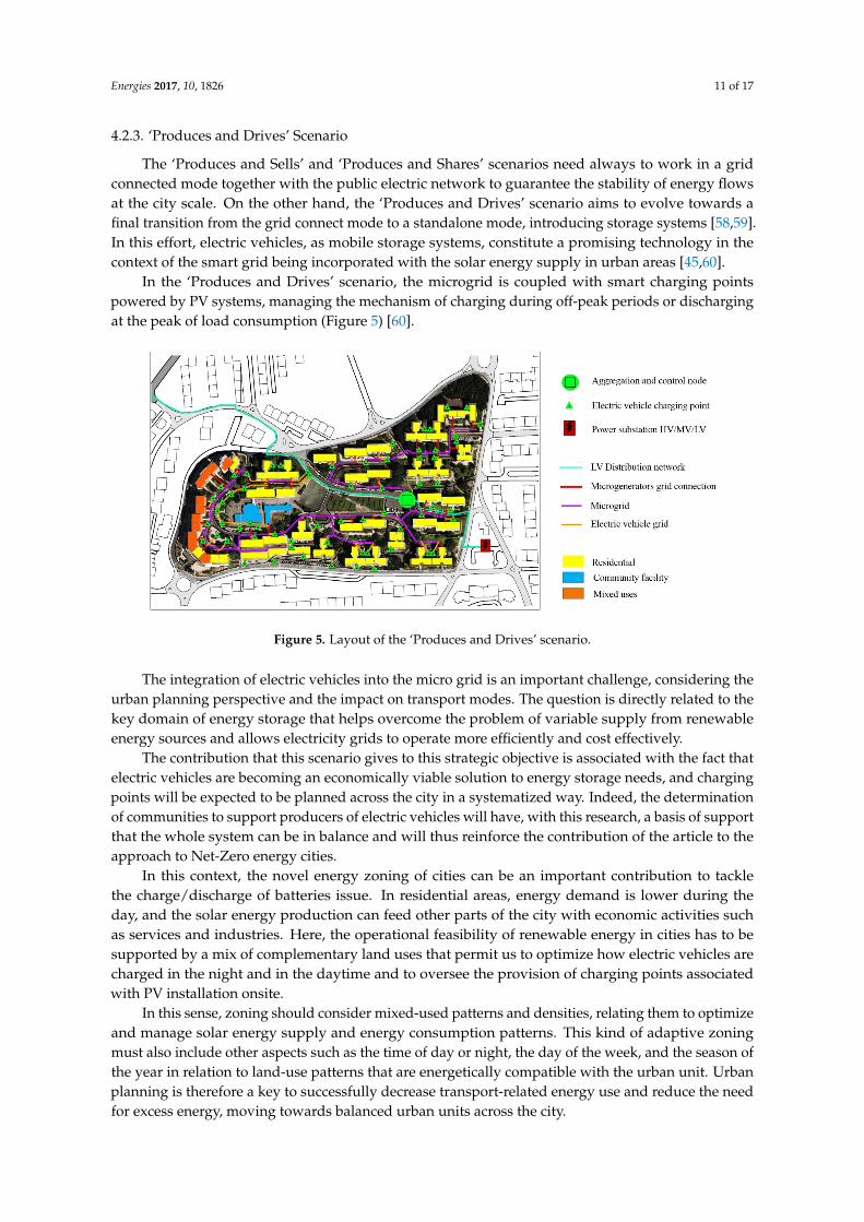
4.2.3. ‘Produces and Drives’ Scenario
The ‘Produces and Sells’ and ‘Produces and Shares’ scenarios need always to work in a gridconnected mode together with the public electric network to guarantee the stability of energy flowsat the city scale. On the other hand, the ‘Produces and Drives’ scenario aims to evolve towards afinal transition from the grid connect mode to a standalone mode, introducing storage systems [58,59].In this effort, electric vehicles, as mobile storage systems, constitute a promising technology in thecontext of the smart grid being incorporated with the solar energy supply in urban areas [45,60].
In the ‘Produces and Drives’ scenario, the microgrid is coupled with smart charging pointspowered by PV systems, managing the mechanism of charging during off-peak periods or dischargingat the peak of load consumption (Figure 5) [60].
Energies 2017, 10, 1826 11 of 17
mechanism is that the tenant that improves their energy performance in the dwelling will have a higher economic return from the sale of the electricity, generated by the photovoltaics installed in all the buildings of the urban unit, than the tenant who shows consumption patterns higher than the average values.
In this way, the consumer smart meters and collective meters collect a large pool of data related to the energy performance of each building, which are made available to the policy makers and technicians responsible for planning and urban management, systematizing and standardizing information to model, and comparing and testing energy balance scenarios across the city.
However, this scenario also reflects another important issue: the lack of grid capacity associated with renewable energy supply. In fact, the increase in renewable energy will certainly have (if not already) deep consequences in terms of the structure of both the grids and the cities. Here, it is important to highlight the strategic scope of this scenario that promotes the concept of energy balance as way to create an efficient connection between urban cells, where energy production and consumption flows are balanced by smart grids according to the negative, positive, and neutral performances of each urban unit across the city.
4.2.3. ‘Produces and Drives’ Scenario
The ‘Produces and Sells’ and ‘Produces and Shares’ scenarios need always to work in a grid connected mode together with the public electric network to guarantee the stability of energy flows at the city scale. On the other hand, the ‘Produces and Drives’ scenario aims to evolve towards a final transition from the grid connect mode to a standalone mode, introducing storage systems [58,59]. In this effort, electric vehicles, as mobile storage systems, constitute a promising technology in the context of the smart grid being incorporated with the solar energy supply in urban areas [45,60].
In the ‘Produces and Drives’ scenario, the microgrid is coupled with smart charging points powered by PV systems, managing the mechanism of charging during off-peak periods or discharging at the peak of load consumption (Figure 5) [60].
Figure 5. Layout of the ‘Produces and Drives’ scenario.
The integration of electric vehicles into the micro grid is an important challenge, considering the urban planning perspective and the impact on transport modes. The question is directly related to the key domain of energy storage that helps overcome the problem of variable supply from renewable energy sources and allows electricity grids to operate more efficiently and cost effectively.
The contribution that this scenario gives to this strategic objective is associated with the fact that electric vehicles are becoming an economically viable solution to energy storage needs, and charging
Figure 5. Layout of the ‘Produces and Drives’ scenario.
The integration of electric vehicles into the micro grid is an important challenge, considering theurban planning perspective and the impact on transport modes. The question is directly related to thekey domain of energy storage that helps overcome the problem of variable supply from renewableenergy sources and allows electricity grids to operate more efficiently and cost effectively.
The contribution that this scenario gives to this strategic objective is associated with the fact thatelectric vehicles are becoming an economically viable solution to energy storage needs, and chargingpoints will be expected to be planned across the city in a systematized way. Indeed, the determinationof communities to support producers of electric vehicles will have, with this research, a basis of supportthat the whole system can be in balance and will thus reinforce the contribution of the article to theapproach to Net-Zero energy cities.
In this context, the novel energy zoning of cities can be an important contribution to tacklethe charge/discharge of batteries issue. In residential areas, energy demand is lower during theday, and the solar energy production can feed other parts of the city with economic activities suchas services and industries. Here, the operational feasibility of renewable energy in cities has to besupported by a mix of complementary land uses that permit us to optimize how electric vehicles arecharged in the night and in the daytime and to oversee the provision of charging points associatedwith PV installation onsite.
In this sense, zoning should consider mixed-used patterns and densities, relating them to optimizeand manage solar energy supply and energy consumption patterns. This kind of adaptive zoningmust also include other aspects such as the time of day or night, the day of the week, and the season ofthe year in relation to land-use patterns that are energetically compatible with the urban unit. Urbanplanning is therefore a key to successfully decrease transport-related energy use and reduce the needfor excess energy, moving towards balanced urban units across the city.

Energies 2017, 10, 1826 12 of 17
5. Results and Discussion
The management and optimization of energy flows in cities is fully dependent on solar energyand smart grid integration. In this context, the present study aims to shift the Net-Zero energy conceptfrom the building to the city scale. The overall hypothesis is to predict future deployment modelsof smart grids that connect urban cells with solar energy surpluses and urban cells in which energyconsumption needs are not covered by the local supply.
A case study has been utilized to show the practical application of such a cellular approach, basedon the delimitation of an urban unit, according to four specific criteria to simulate and quantify theexisting and potential energy performances.
Three scenarios have been presented to pave theoretical ways to implement the upgrade ofexisting electric networks, together with solar energy and smart grid integration.
The first scenario is a short-term planning exercise that promotes energy self-consumption, sellingthe excess to the grid. Smart metering systems emerge as a key aspect to better integrate PV supplyinto the grid and provide useful information on real-time consumption to consumers, encouragingthem to adopt more energy efficient behaviours.
The second scenario provides a novel economic mechanism to achieve higher outcomes in thepromotion of PV supply and energy efficiency. The consumers that live in buildings with PV systemson the roof are, at the same time, producers, and all the energy produced by the urban unit is sold to thepublic network. The gains of the PV generation sale are shared between the producers based on theirenergy consumption behaviours so that investments in energy efficiency and energy saving lead torelevant economic benefits for consumers. In doing so, this scenario also supports the implementationof a platform to monitor and manage the energy production and consumption flows of urban unitsand across the whole city.
Finally, the third scenario explores the integration of storage systems in the city, with a focuson electric vehicles and PV generation. In this framework, zoning is a crucial issue to define mixedland-use patterns and densities that are energetically compatible with the charging needs of electricvehicle users.
The result of this approach is to move from a static urban planning process to a proactive approach,based on a scenario method to inform and integrate urban planners and policy makers in the designand monitoring of solutions that can make urban areas more energy efficient.
Tackling this affirmation, a comparison with other theoretical and practical approaches that arecurrently related to the task of integrating the deployment of smart grids in urban planning andpromoting the concept of the Net-Zero Energy City has been developed. The review process wasbased on an analysis of peer-reviewed research published between 2003 and 2017 and indexed by theScopus and ISI Web of Knowledge databases. According to an inductive approach, the selection ofrelevant research covered the following keywords: ‘smart grids’, ‘urban planning’, ‘energy zoning’,and ‘Net-Zero Energy City’.
According to Zhang et al. (2017) [61], although studies on smart grids have been conductedfrom the perspectives of technologies, stakeholders, pilot projects, processes and outcomes, and risksand vulnerabilities, most work focused only on one aspect of smart grids. The work of these authorspermits us to understand that smart grid deployment is not actually articulated with a territorial basisas cities are.
In their review article on Smart Grids, Ponce-Jara et al. (2017) [62] claim that the U.S. andEurope focus their efforts on energy efficiency, the deployment of renewable energies, and improving,strengthening, and expanding interconnections between countries and states. This review is proof ofthe importance and interest that the integration of the deployment of smart grids in urban planningraises at the fine-scale scales of the city, neighbourhood, and buildings.
The needs for a large, interconnected grid with strengthened local power transmission lines,the implementation of local or regional energy storage, and demand-side management, i.e., smartcontrol of flexible, energy consuming devices, represent essential adjustments to the energy system

Energies 2017, 10, 1826 13 of 17
to solve unbalances between generation and demand [63]. In this study, the authors conclude thatthe choice of an approach requires a holistic analysis and vision of the future energy system of anurban region.
On the other hand, the concept of the Net-Zero Energy City is a novel vision that can be associatedwith the project of Masdar City [64]. Nevertheless, the case of Masdar City is a scenario-zero asit benefits from the lack of existing reality and consolidated dynamics, allowing for more radicalinterventions to be implemented. Indeed, existing cities call for different approaches. In this context,Li et al. (2017) [65] propose an approach based on the Net-Zero building cluster, within which smartgrids, distributed power generation, and storage devices can freely share energy resources locally andglobally, and the entire cluster will achieve maximum energy efficiency. However, this model limits itsapplication to building clusters as autonomous and adaptive systems without any mutual interaction.
Overall, the integration of smart grids in urban planning and the concept of the Net-ZeroEnergy City emerge as topics that arouse the interest of planners and researchers but still lack properframeworks and clearly defined methodologies to inform the territorial and city management andpromote integrated decision-making. From this perspective, to predict solutions for smart grids andenergy flow control systems in association with the design stages of the urban planning process isessential to coordinate the amount of infrastructural interventions that have to be processed togetherat the urban dimension. Indeed, energy planning is a real revolution for the cities of tomorrow, and thechallenge we are launching in this research is the construction, today, of a proactive approach in thebelief that cities can be moved toward a Net-Zero energy balance, which is a cross-cutting issue thatinvolves solar energy, smart grids, and urban planning.
6. Conclusions
This study aims to understand the complexity that characterizes the relation between energy andcity, developing a cellular approach based on the delimitation of urban units according to specificcriteria that support a systematized comprehension of their physical components. Overall, the objectiveof the article is twofold. First, we discuss the novel concept of Net-Zero Energy Cities, supportedby the balance between solar energy production and consumption. For this, it is considered thaturban planning plays a key-role as it determines the evolutionary dynamics of cities and defines theirstructural components, including densities, land use, morphologies, building forms, and road patterns,which influence the energy performance at any spatial level. Second, we discuss that urban planningis a process that has to involve the deployment smart grids to guarantee that the energy flows andconnectivity system support the balance at the city scale. As energy in cities asks for a transitiontoward solar energy and smart grid integration, urban planners, public administration/governance,and stakeholders need to better understand how to integrate these domains in the decision-makingprocess and then effectively implement them into existing and new urban areas. In this way,the development of scenarios is an important step to test new models and support the elaboration ofadequate policies and regulations.
To this purpose, the adoption of the proposed cellular approach provides a comprehensive viewon energy performances at the scale of urban units, turning the whole city into a more workableframework for planning solar energy and smart grids. Through this, it is possible to guarantee that thegrid, with its set of smart meters, is a viable solution that suits the efforts of the public and privatesector in carrying out its activity and enables the energy and economic efficiency of energy productionand consumption in urban areas.
The results of this study make clear that the deployment of smart grids is an essential step in themanagement of a city’s energy, which has to be developed from an urban planning perspective.
This paper promotes the need to reformulate urban planning and update it with broader concernssuch as solar energy and smart grid integration, which are essential to achieve the transition towardsmore sustainable cities. The integration of electric vehicles into the grids also emerges as an important

Energies 2017, 10, 1826 14 of 17
challenge from the perspective of urban planning that should consider charging areas and microgridsaccording to PV supply, economic activities, public facilities, or residential energy use.
Acknowledgments: This research was funded by European Commission Funds-FEDER No. 2012-267/9002—LISBOA-01-0527-FEDER-000739 in the framework of the PTQREN/267-9002/2012) leaded by the OeirasMunicipality & GEOTPU.LAB—Group of Study on Spatial Territory and Urban Planning at FCT-UNL. The secondand third author thank the Portuguese Fundação para a Ciência e Tecnologia (FCT) for the financial supportthrough the PhD Fellowship.
Author Contributions: All the authors conceived and designed the smart grids scenarios; Miguel Amado was thecoordinator of the research project within the GEOTPU.LAB; Francesca Poggi was responsible for the parametricmodeling and solar simulations; António Ribeiro Amado analyzed the relation between urban morphology andenergy consumption and Sílvia Breu was the advisor of the project and paper within the Oeiras Municipality.
Conflicts of Interest: The authors declare no conflict of interest.
Abbreviations
CA cellular automataDUEM dynamic urban evolutionary modelGIS geographic information systemsGUUD geographical urban unit’s delimitationMURBANDY monitoring urban dynamicsMOLAND monitoring land use/cover dynamicsnZEB nearly zero energy buildingsPV photovoltaicSLEUTH slope, land use map, excluded area, urban area, transportation map, and hillside area model
References
1. Hoornweg, D.; Freire, M.; Lee, M.J.; Bhada-Tata, P.; Yuen, B. Cities and Climate Change: Responding to an UrgentAgenda; The World Bank: Washington, DC, USA, 2011.
2. IEA. World Energy Outlook 2013; Organisation for Economic Co-Operation and Development: Paris, France,2013, ISBN 978-92-64-20130-9.
3. Backhaus, J.; Breukers, S.; Mont, O.; Paukovic, M.; Mourik, R. Sustainable Lifestyles: Today’s Facts andTomorrow’s Trends; About Spread Sustainable Lifestyles 2050; Centre on Sustainable Consumption andProduction: Wuppertal, Germany, 2012; p. 160.
4. Li, D.H.W.; Yang, L.; Lam, J.C. Zero energy buildings and sustainable development implications—A review.Energy 2013, 54, 1–10. [CrossRef]
5. Crawley, D.; Pless, S.; Torcellini, P. Getting to Net Zero. ASHRAE J. 2009, 51, 18–25.6. Edenhofer, O.; Pichs Madruga, R.; Sokona, Y. (Eds.) Renewable Energy Sources and Climate Change Mitigation:
Special Report of the Intergovernmental Panel on Climate Change; Cambridge University Press: New York, NY,USA, 2012.
7. Nelson, J.; Gambhir, A.; Ekins-Daukes, N. Solar Power for CO2 Mitigation; Grantham Institute for ClimateChange, Imperial College London: London, UK, 2014; p. 16.
8. Kempener, R.; Komor, P.; Hoke, A. Smart Grids and Renewables. A Guide for Effective Deployment; InternationalRenewable Energy Association (IRENA): Abu Dhabi, UAE, 2013; p. 47.
9. Thomsen, J.; Saad Hussein, N.; Senkpiel, C.; Hartmann, N.; Schlegl, T. An optimized energy systemplanning and operation on distribution grid level—The Decentralized Market Agent as a novel approach.Sustain. Energy Grids Netw. 2017, 12, 40–56. [CrossRef]
10. Amado, M.; Poggi, F. Solar Urban Planning: A Parametric Approach. Energy Procedia 2014, 48, 1539–1548.[CrossRef]
11. Sartori, I.; Napolitano, A.; Voss, K. Net zero energy buildings: A consistent definition framework.Energy Build. 2012, 48, 220–232. [CrossRef]
12. Byrne, J.; Taminiau, J.; Kurdgelashvili, L.; Kim, K.N. A review of the solar city concept and methods to assessrooftop solar electric potential, with an illustrative application to the city of Seoul. Renew. Sustain. Energy Rev.2015, 41, 830–844. [CrossRef]

Energies 2017, 10, 1826 15 of 17
13. Amado, M.; Poggi, F. Solar Energy Integration in Urban Planning: GUUD Model. Energy Procedia 2014, 50,277–284. [CrossRef]
14. Larsen, G.K.H.; van Foreest, N.D.; Scherpen, J.M.A. Power supply–demand balance in a Smart Grid:An information sharing model for a market mechanism. Appl. Math. Model. 2014, 38, 3350–3360. [CrossRef]
15. Batty, M. Building a science of cities. Cities 2012, 29, S9–S16. [CrossRef]16. Shpuza, E. Urban Shapes and Urban Grids: A Comparative Study of Adriatic and Ionian Coastal Cities.
Available online: http://www.spacesyntaxistanbul.itu.edu.tr/papers/longpapers/009%20-%20Shpuza.pdf(accessed on 10 November 2017).
17. Berry, B.J.L.; Okulicz-Kozaryn, A. The city size distribution debate: Resolution for US urban regions andmegalopolitan areas. Cities 2012, 29 (Suppl. 1), S17–S23. [CrossRef]
18. Jia, P.; Qiu, Y.; Gaughan, A.E. A fine-scale spatial population distribution on the High-resolution GriddedPopulation Surface and application in Alachua County, Florida. Appl. Geogr. 2014, 50, 99–107. [CrossRef]
19. Besussi, E.; Chin, N.; Batty, M.; Longley, P. The Structure and Form of Urban Settlements. In Remote Sensingof Urban and Suburban Areas; Rashed, T., Jürgens, C., Eds.; Springer: Dordrecht, The Netherlands, 2010;Volume 10, pp. 13–31.
20. Sarkar, P. A Brief History of Cellular Automata. ACM Comput. Surv. 2000, 32, 80–107. [CrossRef]21. Pinto, N.N.; Antunes, A.P. Cellular automata and urban studies: A literature survey. ACE Archit. City Environ.
2007, 1, 368–399.22. Clarke, K.C.; Hoppen, S.; Gaydos, L. A self-modifying cellular automaton model of historical urbanization
in the San Francisco Bay area. Environ. Plan. B Plan. Des. 1997, 24, 247–261. [CrossRef]23. Clarke, K.C.; Gaydos, L.J. Loose-coupling a cellular automaton model and GIS: Long-term urban growth
prediction for San Francisco and Washington/Baltimore. Int. J. Geogr. Inf. Sci. IJGIS 1998, 12, 699–714.[CrossRef] [PubMed]
24. White, R.; Engelen, G.; Uljee, I. The use of constrained cellular automata for high-resolution modelling ofurban land-use dynamics. Environ. Plan. B Plan. Des. 1997, 24, 323–343. [CrossRef]
25. Lavalle, C.; Barredo, J.; MC Cormick, N.; White, R.; Uljee, I. The MOLAND Model for Urban and RegionalGrowth Forecast: A Tool for the Definition of Sustainable Development Paths. Available online: http://plurel.ait.ac.at/plurel_fs_data/429/EUR_report_2004_Moland_model.pdf (accessed on 10 November 2017).
26. Batty, M.; Xie, Y.; Sun, Z. Modeling urban dynamics through GIS-based cellular automata. Comput. Environ.Urban Syst. 1999, 23, 205–233. [CrossRef]
27. Lagarias, A. Urban sprawl simulation linking macro-scale processes to micro-dynamics through cellularautomata, an application in Thessaloniki, Greece. Appl. Geogr. 2012, 34, 146–160. [CrossRef]
28. Santé, I.; García, A.M.; Miranda, D.; Crecente, R. Cellular automata models for the simulation of real-worldurban processes: A review and analysis. Landsc. Urban Plan. 2010, 96, 108–122. [CrossRef]
29. White, R. Cities and cellular automata. Discret. Dyn. Nat. Soc. 1998, 2, 111–125. [CrossRef]30. Santos, T.; Gomes, N.; Freire, S.; Brito, M.C.; Santos, L.; Tenedório, J.A. Applications of solar mapping in the
urban environment. Appl. Geogr. 2014, 51, 48–57. [CrossRef]31. Theodoridou, I.; Karteris, M.; Mallinis, G.; Papadopoulos, A.M.; Hegger, M. Assessment of retrofitting
measures and solar systems’ potential in urban areas using Geographical Information Systems: Applicationto a Mediterranean city. Renew. Sustain. Energy Rev. 2012, 16, 6239–6261. [CrossRef]
32. Ratti, C.; Raydan, D.; Steemers, K. Building form and environmental performance: Archetypes, analysis andan arid climate. Energy Build. 2003, 35, 49–59. [CrossRef]
33. Robinson, D. Urban morphology and indicators of radiation availability. Sol. Energy 2006, 80, 1643–1648.[CrossRef]
34. Rylatt, M.; Gadsden, S.; Lomas, K. GIS-based decision support for solar energy planning in urbanenvironments. Comput. Environ. Urban Syst. 2001, 25, 579–603. [CrossRef]
35. Lobaccaro, G.; Frontini, F. Solar Energy in Urban Environment: How Urban Densification Affects ExistingBuildings. Energy Procedia 2014, 48, 1559–1569. [CrossRef]
36. Ratti, C.; Baker, N.; Steemers, K. Energy consumption and urban texture. Energy Build. 2005, 37, 762–776.[CrossRef]
37. Rode, P.; Keim, C.; Robazza, G.; Viejo, P.; Schofield, J. Cities and energy: Urban morphology and residentialheat-energy demand. Environ. Plan. B Plan. Des. 2014, 41, 138–162. [CrossRef]

Energies 2017, 10, 1826 16 of 17
38. Sarralde, J.J.; Quinn, D.; Wiesmann, D. Urban modelling for resource performance analysis: Estimatingcities’ renewable energy potential. In Proceedings of the Building Simulation, Sydney, Australia,14–16 November 2011; pp. 1370–1377.
39. Ciabattoni, L.; Grisostomi, M.; Ippoliti, G.; Longhi, S. Fuzzy logic home energy consumption modeling forresidential photovoltaic plant sizing in the new Italian scenario. Energy 2014, 74, 359–367. [CrossRef]
40. U.S. Department of Energy. The Smart Grid: An Introduction; How a Smarter Grid Works as an EnablingEngine for Our Economy, Our Environment and Our Future. Available online: https://www.smartgrid.gov/files/sg_introduction.pdf (accessed on 7 November 2017).
41. Walker, G. What are the barriers and incentives for community-owned means of energy production and use?Energy Policy 2008, 36, 4401–4405. [CrossRef]
42. Von Appen, J.; Braun, M.; Stetz, T.; Diwold, K.; Geibel, D. Time in the Sun: The Challenge of High PVPenetration in the German Electric Grid. IEEE Power Energy Mag. 2013, 11, 55–64. [CrossRef]
43. Niemi, R.; Mikkola, J.; Lund, P.D. Urban energy systems with smart multi-carrier energy networks andrenewable energy generation. Renew. Energy 2012, 48, 524–536. [CrossRef]
44. Gans, W.; Alberini, A.; Longo, A. Smart meter devices and the effect of feedback on residential electricityconsumption: Evidence from a natural experiment in Northern Ireland. Energy Econ. 2013, 36, 729–743.[CrossRef]
45. Figueiredo, R.; Nunes, P.; Brito, M.C. The feasibility of solar parking lots for electric vehicles. Energy 2017,140, 1182–1197. [CrossRef]
46. Rhodes, J.D.; Upshaw, C.R.; Harris, C.B.; Meehan, C.M.; Walling, D.A.; Navrátil, P.A.; Beck, A.L.;Nagasawa, K.; Fares, R.L.; Cole, W.J.; et al. Experimental and data collection methods for a large-scale smartgrid deployment: Methods and first results. Energy 2014, 65, 462–471. [CrossRef]
47. World Economic Forum & Accenture. Accelerating Successful Smart Grid Pilots; World Economic Forum:Geneva, Switzerland, 2010; p. 48.
48. Personal, E.; Guerrero, J.I.; Garcia, A.; Peña, M.; Leon, C. Key performance indicators: A useful tool to assessSmart Grid goals. Energy 2014, 76, 976–988. [CrossRef]
49. Southworth, M.; Ben-Joseph, E. Streets and the Shaping of Towns and Cities; Island Press: Washington, DC,USA, 2003, ISBN 978-1-55963-916-3.
50. Christensen, C.; Horowitz, S. Orienting the Neighborhood: A Subdivision Energy Analysis Tool; NationalRenewable Energy Laboratory: Pacific Grove, CA, USA, 2008; pp. 1–13.
51. Cheng, V.; Steemers, K.; Montavon, M.; Compagnon, R. Urban form, density and solar potential.In Proceedings of the PLEA 2006, Geneva, Switzerland, 6–9 September 2006; pp. 701–706.
52. Instituto Nacional de Estatística, Information Reference Geographical Base (BGRI). Available online:http://www.ine.pt/xportal/xmain?xpid=INE&xpgid=ine_main (accessed on 4 September 2014).
53. Amado, M.; Poggi, F. Towards Solar Urban Planning: A New Step for Better Energy Performance.Energy Procedia 2012, 30, 1261–1273. [CrossRef]
54. Coppo, M.; Pelacchi, P.; Pilo, F.; Pisano, G.; Soma, G.G.; Turri, R. The Italian smart grid pilot projects: Selectionand assessment of the test beds for the regulation of smart electricity distribution. Electr. Power Syst. Res.2015, 120, 136–149. [CrossRef]
55. Kaygusuz, A.; Keles, C.; Alagoz, B.B.; Karabiber, A. Renewable energy integration for smart sites.Energy Build. 2013, 64, 456–462. [CrossRef]
56. Tarroja, B.; Shaffer, B.; Samuelsen, S. The importance of grid integration for achievable greenhouse gasemissions reductions from alternative vehicle technologies. Energy 2015, 87, 504–519. [CrossRef]
57. Ministério do Ambiente, Ordenamento do Território e Energia. Available online: http://www.oern.pt/documentos/legislacao/d_dl_dr/DL66_2014.pdf (accessed on 7 November 2017).
58. Jiang, Q.; Xue, M.; Geng, G. Energy Management of Microgrid in Grid-Connected and Stand-Alone Modes.IEEE Trans. Power Syst. 2013, 28, 3380–3389. [CrossRef]
59. Lin, W.-M.; Tu, C.-S.; Tsai, M.-T. Energy Management Strategy for Microgrids by Using Enhanced Bee ColonyOptimization. Energies 2015, 9, 5. [CrossRef]
60. Haidar, A.M.A.; Muttaqi, K.M.; Sutanto, D. Technical challenges for electric power industries due togrid-integrated electric vehicles in low voltage distributions: A review. Energy Convers. Manag. 2014,86, 689–700. [CrossRef]

Energies 2017, 10, 1826 17 of 17
61. Zhang, Y.; Chen, W.; Gao, W. A survey on the development status and challenges of smart grids in maindriver countries. Renew. Sustain. Energy Rev. 2017, 79, 137–147. [CrossRef]
62. Ponce-Jara, M.A.; Ruiz, E.; Gil, R.; Sancristóbal, E.; Pérez-Molina, C.; Castro, M. Smart Grid: Assessment ofthe past and present in developed and developing countries. Energy Strategy Rev. 2017, 18, 38–52. [CrossRef]
63. Van Leeuwen, R.P.; de Wit, J.B.; Smit, G.J.M. Review of urban energy transition in the Netherlands and therole of smart energy management. Energy Convers. Manag. 2017, 150, 941–948. [CrossRef]
64. Lee, S.E.; Braithwaite, P.; Leach, J.M.; Rogers, C.D.F. A comparison of energy systems in Birmingham, UK,with Masdar City, an embryonic city in Abu Dhabi Emirate. Renew. Sustain. Energy Rev. 2016, 65, 1299–1309.[CrossRef]
65. Li, X.; Wen, J. Net-zero energy building clusters emulator for energy planning and operation evaluation.Comput. Environ. Urban Syst. 2017, 62, 168–181. [CrossRef]
© 2017 by the authors. Licensee MDPI, Basel, Switzerland. This article is an open accessarticle distributed under the terms and conditions of the Creative Commons Attribution(CC BY) license (http://creativecommons.org/licenses/by/4.0/).