
A 94GHz Cloud Radar System on a NASA High-Altitude ER2 Aircraft
11
1378 VOLUME 21 JOURNAL OF ATMOSPHERIC AND OCEANIC TECHNOLOGY q 2004 American Meteorological Society A 94-GHz Cloud Radar System on a NASA High-Altitude ER-2 Aircraft LIHUA LI Goddard Earth Sciences and Technology Center, University of Maryland, Baltimore County, Baltimore, Maryland GERALD M. HEYMSFIELD AND PAUL E. RACETTE NASA Goddard Space Flight Center, Greenbelt, Maryland LIN TIAN Goddard Earth Sciences and Technology Center, University of Maryland, Baltimore County, Baltimore, Maryland ED ZENKER Science Systems and Applications, Inc., Greenbelt, Maryland (Manuscript received 16 October 2003, in final form 19 March 2004) ABSTRACT The 94-GHz (W band) Cloud Radar System (CRS) has been developed and flown on a NASA ER-2 high- altitude (20 km) aircraft. The CRS is a fully coherent, polarimetric Doppler radar that is capable of detecting clouds and precipitation from the surface up to the aircraft altitude in the lower stratosphere. The radar is especially well suited for cirrus cloud studies because of its high sensitivity and fine spatial resolution. This paper describes the CRS motivation, instrument design, specifications, calibration, and preliminary data from NASA’s Cirrus Regional Study of Tropical Anvils and Cirrus Layers–Florida Area Cirrus Experiment (CRYS- TAL–FACE) field campaign. The unique combination of CRS with other sensors on the ER-2 provides an unprecedented opportunity to study cloud radiative effects on the global energy budget. CRS observations are being used to improve our knowledge of atmospheric scattering and attenuation characteristics at 94 GHz, and to provide datasets for algorithm implementation and validation for the upcoming NASA CloudSat mission that will use a 94-GHz spaceborne cloud radar to provide the first direct global survey of the vertical structure of cloud systems. 1. Introduction Clouds are a key element in the global hydrological cycle, and they have a significant role in the earth’s energy budget through its influence on radiation bud- gets. Climate model simulations have demonstrated the importance of clouds in moderating and forcing the global energy budget (Houghton et al. 1995; Stephens et al. 1990). Despite the crucial role of clouds in climate and the breadth of our current knowledge, there are still many unanswered details (Stephens et al. 2002). An improved understanding of the radiative impact of clouds on the climate system requires a comprehensive view of clouds that includes their physical dimensions, vertical and horizontal spatial distribution, detailed mi- crophysical properties, and the dynamical processes pro- Corresponding author address: Lihua Li, NASA Goddard Space Flight Center, Code 912, Building 33, Room C426, Greenbelt, MD 20771. E-mail: [email protected] ducing them. However, the lack of finescale cloud data is apparent in current climate model simulations (Houghton et al. 1995; Stephens et al. 1990). Clouds have been studied with various remote sensing methodologies, and it is recognized that no single active or passive sensor (optical or microwave) can measure all radiatively important clouds. Millimeter-wave radars at W band have been used over the past decade to pro- vide finescale cloud information. These radars offer sig- nificant advantages over lidars and lower-frequency ra- dars (Lhermitte 1987; Mead et al. 1994; Sekelsky and McIntosh 1996; Clothiaux et al. 1995; Hogan and Il- lingworth 1999). The high scattering efficiency and short wavelengths at millimeter-wave frequencies pro- vide high sensitivity for cloud detection, and enable construction of compact, low-power consumption radars for use in airborne (Pazmany et al. 1994; Sadowy et al. 1997; Racette et al. 2003) and spaceborne (Li et al. 1994; Stephens et al. 2002) applications. The National Aeronautics and Space Administration’s CloudSat mis- sion, with a 2005 launch date, will employ a 94-GHz
-
Upload
independent -
Category
Documents
-
view
1 -
download
0
Transcript of A 94GHz Cloud Radar System on a NASA High-Altitude ER2 Aircraft

1378 VOLUME 21J O U R N A L O F A T M O S P H E R I C A N D O C E A N I C T E C H N O L O G Y
q 2004 American Meteorological Society
A 94-GHz Cloud Radar System on a NASA High-Altitude ER-2 Aircraft
LIHUA LI
Goddard Earth Sciences and Technology Center, University of Maryland, Baltimore County, Baltimore, Maryland
GERALD M. HEYMSFIELD AND PAUL E. RACETTE
NASA Goddard Space Flight Center, Greenbelt, Maryland
LIN TIAN
Goddard Earth Sciences and Technology Center, University of Maryland, Baltimore County, Baltimore, Maryland
ED ZENKER
Science Systems and Applications, Inc., Greenbelt, Maryland
(Manuscript received 16 October 2003, in final form 19 March 2004)
ABSTRACT
The 94-GHz (W band) Cloud Radar System (CRS) has been developed and flown on a NASA ER-2 high-altitude (20 km) aircraft. The CRS is a fully coherent, polarimetric Doppler radar that is capable of detectingclouds and precipitation from the surface up to the aircraft altitude in the lower stratosphere. The radar isespecially well suited for cirrus cloud studies because of its high sensitivity and fine spatial resolution. Thispaper describes the CRS motivation, instrument design, specifications, calibration, and preliminary data fromNASA’s Cirrus Regional Study of Tropical Anvils and Cirrus Layers–Florida Area Cirrus Experiment (CRYS-TAL–FACE) field campaign. The unique combination of CRS with other sensors on the ER-2 provides anunprecedented opportunity to study cloud radiative effects on the global energy budget. CRS observations arebeing used to improve our knowledge of atmospheric scattering and attenuation characteristics at 94 GHz, andto provide datasets for algorithm implementation and validation for the upcoming NASA CloudSat mission thatwill use a 94-GHz spaceborne cloud radar to provide the first direct global survey of the vertical structure ofcloud systems.
1. Introduction
Clouds are a key element in the global hydrologicalcycle, and they have a significant role in the earth’senergy budget through its influence on radiation bud-gets. Climate model simulations have demonstrated theimportance of clouds in moderating and forcing theglobal energy budget (Houghton et al. 1995; Stephenset al. 1990). Despite the crucial role of clouds in climateand the breadth of our current knowledge, there are stillmany unanswered details (Stephens et al. 2002). Animproved understanding of the radiative impact ofclouds on the climate system requires a comprehensiveview of clouds that includes their physical dimensions,vertical and horizontal spatial distribution, detailed mi-crophysical properties, and the dynamical processes pro-
Corresponding author address: Lihua Li, NASA Goddard SpaceFlight Center, Code 912, Building 33, Room C426, Greenbelt, MD20771.E-mail: [email protected]
ducing them. However, the lack of finescale cloud datais apparent in current climate model simulations(Houghton et al. 1995; Stephens et al. 1990).
Clouds have been studied with various remote sensingmethodologies, and it is recognized that no single activeor passive sensor (optical or microwave) can measureall radiatively important clouds. Millimeter-wave radarsat W band have been used over the past decade to pro-vide finescale cloud information. These radars offer sig-nificant advantages over lidars and lower-frequency ra-dars (Lhermitte 1987; Mead et al. 1994; Sekelsky andMcIntosh 1996; Clothiaux et al. 1995; Hogan and Il-lingworth 1999). The high scattering efficiency andshort wavelengths at millimeter-wave frequencies pro-vide high sensitivity for cloud detection, and enableconstruction of compact, low-power consumption radarsfor use in airborne (Pazmany et al. 1994; Sadowy et al.1997; Racette et al. 2003) and spaceborne (Li et al.1994; Stephens et al. 2002) applications. The NationalAeronautics and Space Administration’s CloudSat mis-sion, with a 2005 launch date, will employ a 94-GHz

SEPTEMBER 2004 1379L I E T A L .
TABLE 1. CRS system specifications.
Frequency (GHz)IF frequency (MHz)Peak power (kW)Duty cyclePRF (kHz)
94.15559.861.7
0.01 max0.5–20
Pulse width (ms)Transmit polarizationReceive polarizationNoise figure (dB)Receiver bandwidth (MHz)
0.25–2.0V or HV and H10.01, 2, 4
Antenna beamwidth (8)
Antenna gain (dB)
Sensitivity (dBZe)*
0.6 3 0.8 (Airborne)0.3 (Ground based)46.4 (Airborne, measured)55 (Ground based)229 (Airborne, from flight data)246.9 (Ground based)
* At 10-km range, 150-m range resolution, and 1-s averaging.
spaceborne radar to measure vertical distribution ofclouds globally (Stephens et al. 2002). Also, the jointJapanese/European Earth Cloud, Aerosol and RadiationExplorer (EarthCARE) mission has proposed a space-borne W-band cloud radar (European Space Agency2001). Data provided by these spaceborne cloud radarswill improve our cloud detection capabilities on a globalscale.
The original motivation for a nadir-pointing cloudradar on the ER-2 was to fill a gap in the detection ofa broad range of clouds with the existing active ER-2sensors. The ER-2 Cloud Physics Lidar (CPL), whichhas flown for a number of years, is ideally suited forcirrus clouds because of its high sensitivity (McGill etal. 2002); however, lidars are subject to severe attenu-ation in thick cirrus and may not penetrate through mul-tiple layer clouds. The ER-2 Doppler Radar (EDOP), aprecipitation radar at 9.6 GHz, will penetrate the mostintense thunderstorms without complete attenuation be-fore reaching the surface, but it is generally not as sen-sitive to clouds (Heymsfield et al. 1996). A W-bandcloud radar not only fills the gap between a lidar andprecipitation radar, but the overlap between the mea-surements can be useful in multiwavelength micro-physics retrievals.
There is also a significant advantage of taking mea-surements from high altitudes above essentially allclouds. High-altitude cirrus clouds are extremely im-portant in producing a net warming of the climate sys-tem, and ground-based cloud radar and lidar systemsmust look up through a substantial portion of the at-mosphere, which can result in significant attenuation ofthe signal if intervening cloud layers are present and/or the lower atmosphere is extremely moist. Not onlydoes this attenuation degrade the sensitivity of an up-ward-looking ground-based cloud radar at high alti-tudes, but it also results in an uncertainty in the radarreflectivity measurements. Downward-looking 94-GHzradar observations of cirrus and other clouds are clearlyadvantageous over comparable ground-based radar mea-surements that have to deal with strong water vapor andoxygen absorption in the boundary layer. Since the ER-2 flies at 20 km above the surface, a downward-lookingcloud radar would be in closer proximity to the highcirrus clouds, so the radar sensitivity would be higherthan a ground-based cloud radar with the same systemparameters due to the inversed range-squared depen-dence of minimum detectable reflectivity. This has beenan important issue when studying cirrus anvils, for ex-ample.
The NASA 94-GHz (W band) Cloud Radar System(CRS) was initiated in the early 1990s to provide cloudprofiling capability on the ER-2, but it was completedin 2002 for flight on the ER-2. Since there were severalexisting remote and passive sensors on the ER-2 [CPL,EDOP, the Conical Scanning Submillimeter wave Im-aging Radiometer (CoSSIR), the Moderate ResolutionImaging Spectrometer (MODIS) Airborne Simulator
(MAS; King et al. 1996), as well as other sensors], theCRS was an important addition for cloud studies. TheER-2 ensemble of instruments including the CRS pro-vides the unprecedented capability of studying variousproperties of clouds. Having all these instruments sideby side provides the opportunity to compare them andthus determine the limitations of each sensor for cloudremote sensing.
The CRS is a Doppler, polarimetric radar (Racette etal. 2003) developed for autonomous operation on theER-2 and for ground-based operation. In this paper, weprovide an overview of the CRS system in section 3,with emphasis on its specifications and design of itsradio frequency (RF), intermediate frequency (IF), anddigital receiver subsystems. Section 4 discusses CRScalibration, which is essential for quantitative use of thereflectivity data, and minimum detectable reflectivity(MDR), which is important for cloud detectibility. Sec-tion 5 presents reflectivity and Doppler observationsfrom the first CRS operational deployment duringNASA’s Cirrus Regional Study of Tropical Anvils andCirrus Layers–Florida Area Cirrus Experiment (CRYS-TAL–FACE) field campaign (Jensen et al. 2003, per-sonal communication).
2. System overview
The design of the CRS involved a compromise inorder to address the scientific requirements that demandhigh sensitivity and high spatial and temporal resolution,and hardware limitations imposed by the size, power,and weight constraints of the ER-2 platform. Brown etal. (1995) suggested that cloud radar should have anMDR of 230 dBZe (equivalent radar reflectivity) in or-der to detect 99% (92% in the Tropics) of radiativelysignificant clouds in midlatitudes. The design goal ofCRS MDR at a 10-km range was 230 dBZe after pos-taveraging to reduce the noise. With the parametersshown in Table 1, the CRS system noise floor for usinga 1-MHz receiver bandwidth is 2106 dBm. On the other

1380 VOLUME 21J O U R N A L O F A T M O S P H E R I C A N D O C E A N I C T E C H N O L O G Y
FIG. 1. CRS installation in ER-2 right wing pod. The CRS datasystem is installed in the pressurized middle body of the ER-2 wingpod, while the radar RF/IF subsystems and antenna are installed inthe tail cone. The radar beam is pointed to nadir through an openwindow.
hand, CRS should also be able to measure strong returnsfrom intense targets such as the ocean surface. For theER-2 flight altitude of 20 km, the ocean surface returnpower level in the CRS receiver is ;240 dBm. There-fore, a receiver dynamic range larger than 70 dB isrequired to observe both the strong and weak signalswithout receiver saturation. Depending on the particularscientific objective, the spatial and vertical resolutionrequirements for radar measurements of clouds are typ-ically less than 1 km spatial and 100 m vertical. Theseresolutions may not be required for global satellite mea-surements, but they are highly desirable for processstudies that occur during typical field campaigns. Theserequirements can be easily achieved for a 94-GHz radartransmitting a short RF pulse with an antenna aperturesize of approximately 0.3 m.
The ER-2 is a single-pilot aircraft thus requiring thatCRS operates completely unattended over a typical8-h flight. The entire radar system must have the ca-pability to operate in a ‘‘turnkey’’ mode with internalmonitoring of any faults that may occur in the trans-mitter or data system, and the capability to reset thesystem automatically in the event that a recoverablesystem failure is detected. The pilot has only two switch-es and fault indicator lights available for each instru-ment. In addition, the ER-2 imposed other engineeringchallenges for the CRS, including harsh environmentaloperating conditions at the surface and during flight(2608 to 1508C, 40 to 1000 hPa), limitations on sizeand weight, large data rates and data storage, and largerange–Doppler ambiguities. The CRS was initially de-signed to meet these airborne requirements, but it canalso be operated as a ground-based instrument with alarger antenna and higher sensitivity. The following dis-cussion will describe the implementation of these re-quirements.
3. The CRS subsystems
The CRS consists of four subsystems including a 1)the RF/IF subsystem with high-voltage power supplyand control electronics; 2) the antenna; 3) the data sys-tem/digital receiver, which performs data acquisition,processing, and storage; and 4) the environmental en-closure. The parameters characterizing CRS perfor-mance are listed in Table 1. Because of the other existinginstruments on the ER-2, the CRS was installed in thetail cone of an ER-2 ‘‘superpod’’ located in the mid-section of a wing. The layout of the CRS in this su-perpod is shown in Fig. 1. The RF/IF and antenna sub-systems are mounted in the tail cone of the right ER-2superpod. The radar beam is pointed to nadir throughan opening in the tail cone of the pod, which is opento the ambient environment so as to eliminate trans-mission effects of a radome. The digital receiver/datasystem is located in the midbody of the superpod, whichis maintained at ;340-hPa pressure and temperaturesabove 08C. In the ground-based configuration, the CRS
mounts on a mobile cart that has a two-axis gimbaledpositioner for scanning. A precision stepper motor con-trols the antenna elevation axis and enables range–height indicator (RHI) scanning with a higher-gainground-based antenna. Figure 2 shows pictures of theground-based and airborne CRS configurations.
a. RF/IF subsystems
Figure 3 shows a block diagram of the CRS. Thecustom-made RF subsystem, including the transmitterand RF receiver, was developed by former Pulse Tech-nology, Inc., Marietta, Georgia, under the NASA SmallBusiness Innovative Research (SBIR) program. It uti-lizes an Extended Interaction Amplifier (EIA; Com-munications and Power Industries, Canada) tube thattransmits 1.7-kW peak power at 94 GHz. This subsys-tem also includes a novel power supply, EIA modulator,and timing control unit designed for ER-2 autonomousoperation. The power supply uses three-phase 400-Hzpower and includes active noise suppression.1 The EIAmodulator is capable of transmitting a wide variety ofmodulation schemes with range pulse widths between0.25 and 3.0 ms at pulse repetition frequencies (PRFs)up to 20 kHz (limited to 1% duty cycle), and with thecapability to perform multiple PRFs. The transmit pulsetiming can be generated internally using 32 prepro-grammed PRF–pulse width pairs or from an externallogic signal. The entire radar system is referenced to ashock-mounted ultrastable oscillator that generates fivecoherent frequencies. Among these five frequencies, the9.976-MHz frequency from a crystal oscillator (phasenoise at 10 kHz off from the center frequency is 175dB down from the peak at the center frequency) servesas the phase reference to the other four. In the transmitter
1 To achieve stability, a dual-loop high-voltage regulator is used.The first loop provides dc regulation to the EIA cathode with a linearregulator on the primary of the high-voltage transformers. The solidstate, linear primary regulator circuit controls the peak 400-Hz three-phase voltage to the beam voltage rectifier in the high-voltage dcunit. A second loop uses a high-voltage capacitor to couple senseand error voltage to the cathode ac regulator at ground to reduce theac ripple voltage on the EIA cathode.

SEPTEMBER 2004 1381L I E T A L .
FIG. 2. CRS hardware: (a) CRS setup in laboratory with the airborne antenna, (b) CRS data system installed in themiddle body of ER-2 right wing pod, (c) CRS antenna and the canister housing the RF/IF subsystem installed in tailcone of ER-2 right wing pod, (d) CRS with the ground-based antenna mounted on the dual-axes gimbaled mobile cart.
chain, a phase-locked oscillator and six-time multiplierassembly generates the 94.155-GHz RF frequency andserves as the input of the transmitter. A second phase-locked oscillator and six-time multiplier assembly pro-duces a signal that is 59.85 MHz lower than the RFsignal and functions as the local oscillator signal for RFdownconversion in the receiver. The network of latchingcirculators and isolators protects the receiver during thehigh-power pulse transmission and allows the switchingof transmit polarization and simultaneous reception ofco- and cross-polarization for the measurements of lin-ear depolarization ratio (LDR) and differential reflec-tivity (ZDR). Following the switch network in the re-ceiver chain is a mixer–amplifier assembly made by
Spacek Labs, Inc., California. This assembly has a sin-gle sideband noise figure of 7.5 dB. A noise diode isused as a calibrated source to monitor the gain and noisefigure changes in the radar receivers. The average trans-mit power is monitored by a detector diode. Timing andcontrol boards provide logic for the radar operation,monitor various fault conditions, and report these faultsto the data system in the event of a system malfunction.All system status data, including fault conditions tem-peratures at the EIA and receiver hot points, voltageand current of the power supplies, etc., are multiplexedand sent to the data system for recording.
Ambient conditions of about 2608C and 40-hPa pres-sure at the ER-2 cruising altitude required special con-

1382 VOLUME 21J O U R N A L O F A T M O S P H E R I C A N D O C E A N I C T E C H N O L O G Y
FIG. 3. Block diagram of 94-GHz CRS.
sideration in the development of the CRS. Under theseconditions, failures will occur in the EIA transmitter,which uses high voltages (;17 kV) in the power supply/modulator and other electric components (e.g., electro-lytic capacitors) normally operated at low altitudes.Therefore, the entire CRS RF/IF subsystem is housedin a pressure canister, which is sealed by a V-band clampand can be easily opened for routine maintenance. Dur-ing normal flight, the pressure canister maintains a con-stant pressure (;1000 hPa) at flight level, and a pressurerelief valve is included as a safety feature to preventimplosion should the canister lose pressure during flight.Since the superpod has an open window to the envi-ronment, convective cooling caused by laminar airflowacross this window results in significant heat lossthrough the wall of the canister. Heaters inside the can-ister and a NOMEX insulating blanket covering the out-er body of the canister stabilize the instrument temper-ature during flight. The internal pressure and tempera-ture of the vessel are constantly monitored. Should thepressure and temperature readings exceed the normaloperation range, the radar will shut down automaticallyin order to protect key components.
The radar operates using one of two antennas (groundbased or airborne) designed specifically for the CRS.Both antennas are novel designs utilizing Flat ParabolicSurface (FLAPS) technology and were developed byMalibu Research in Calabasas, California, under theNASA SBIR program. The ground-based Cassegrainantenna with a ;1 m ‘‘square’’ aperture, has ;55-dBigain and can fold up for storage to ;0.5 m. The airborneantenna designed for installation on the ER-2 is an offset
parabolic reflector antenna with a pencil beam and 47-dBi gain. This antenna has two linearly polarized fixed-position feedhorns. The primary reflector is mounted toa two-axis gimbal with the capability to scan 6208across track and 658 along track for pitch correction.Motion control for automated positioning of the primaryreflector is not yet implemented.
b. Digital receiver, data acquisition, and signalprocessing system
The data system is similar to the most recent imple-mentation on the EDOP system (Heymsfield et al. 1996).It is based on the Versa Module Eurocard (VME) buswith a host computer that runs the VxWorks operatingsystem and provides basic control and initialization ofthe system. Radar operation parameters can be modifiedthrough this host computer and preloaded into the datasystem before flight. The host computer also sends pro-cessed radar returns and aircraft navigation data to a2.6-GB solid-state data recorder, which provides the im-proved reliability against vibration that is necessary forER-2 operation.
The data system performs real-time processing frombandpass filtering of the IF signal to calculation of theinterpulse covariance products. At the heart of the radardata system are the digital signal processing (DSP)boards designed by the National Center for AtmosphericResearch (NCAR) in Boulder, Colorado. The NCARboards include a digital receiver that ingests the 59.85-MHz IF signals from the radar RF receiver. Timing ofthe data processing is phase locked to the 9.96-MHz
SEPTEMBER 2004 1383L I E T A L .
stable reference from the radar RF/IF subsystem. Thedigital receiver has a 90-dB dynamic range that isachieved using two 12-bit analog-to-digital convertersoperating in parallel. Within the digital receiver, the IFis digitized into the in-phase (I) and quadrature (Q) sig-nal components that are then match filtered. The datasystem also provides a timing signal for switching thetransmit polarization for measurement of ZDR.
For Doppler processing on the ER-2, the range–Dopp-ler ambiguity at 94 GHz necessitates using a dual-PRF(4 and 5 kHz) approach (Doviak and Zrnic 1993) toextend the unambiguous range and Nyquist interval. The4-/5-kHz dual-PRF mode allows unambiguous Dopplermeasurements up to 6 15.9 m s21 and an unambig-uous range of 30 km. The Doppler processing is per-formed using an autocovariance estimator (pulse pair)on 720 gates. The integration time is programmable; forairborne operation the integration time is set to 0.5 s.The pulse-pair estimator greatly reduces the computa-tional requirement over frequency domain (spectral)processing. The zeroth-, first-, and second-lag autoco-variance products (real and imaginary components) foreach gate are stored in the solid-state recorder; the meanDoppler and spectral width are estimated in postpro-cessing. In addition to the radar signal processing andstatus data, the data system captures low-rate (1 s) andhigh-rate (up to 64 Hz) aircraft attitude and navigationdata from a Litton LTN-92 ring-laser inertial navigationsystem. The high-speed navigation data allow estima-tion of the aircraft motion corrections to Doppler ve-locities similar to that presented in Heymsfield et al.(1996). The first-order corrections are mainly due topitch angle excursions and the vertical aircraft velocity.The latter quantity is estimated from integration of air-craft vertical velocity in a third-order feedback loop withGPS altitude. This provides vertical aircraft velocity es-timates to better than 0.5 m s21 in an absolute sense.
4. System calibration and minimum detectablereflectivity
Radar calibration is an important issue for millimeter-wave cloud radars since errors in radar-reflectivity mea-surements have a direct impact on the retrieval of cloudmicrophysical properties. For instant, ice water content(IWC) can be estimated from radar reflectivity using anempirical relationship. If Brown et al.’s (1995) IWC ver-sus radar-reflectivity relationship IWC 5 0.153 is0.74Z e
used, then a 1-dB error in the radar reflectivity mea-surement will result in a 16% uncertainty in the IWCretrieval. However, the calibration of millimeter-wave ra-dars is not simple (Li et al. 2001; Sekelsky 2002). Thedelicate nature of millimeter-wave components and theharsh environment in which they operate may cause un-detected performance changes unless a regular systemcalibration is performed.
Millimeter-wave radar calibration is complicated bythe difficulty in configuring the radar for calibration,
and the lack of absolute standards from which to es-tablish calibration. To this end, we have applied differentapproaches to ensure the accuracy and stability of theCRS calibration. The CRS has an internal noise injectionloop that monitors the gain and the front-end noise figureof the receivers. The average transmit power is contin-uously monitored through a diode detector and integra-tion circuit. These measurements provide in-flight mon-itoring of the transmitter stability. In addition, the entirereceiver path with the exception of the antenna wascalibrated by injecting a W-band signal into the receiverport to provide an end-to-end (excluding the antenna)reference for the system. With measurements of the an-tenna gain and estimates of losses, the radar-system con-stant was estimated. However, uncertainties in lossesand reflections of interconnected components requirefurther consistency checks using external calibrationmeasurements.
External calibration was performed using a trihedralcorner reflector similar to that used for other W-bandsystems (Li et al. 2001; Sekelsky 2002). During thiscalibration, a 25.4-mm corner reflector was mounted ontop of an 8-m-high, zenith-pointing pole tower. To re-duce the clutter effect of the tower, the pole was madeof low-reflection fiberglass and was further covered withabsorbent materials. The tower was tilted a few degreesfrom zenith toward the radar in order to minimize speck-le reflections. In addition to this target calibration, aradar intercomparison was performed at the Universityof Massachusetts (UMass), Amherst. The CRS was setup alongside the UMass ground-based Cloud ProfilingRadar System (CPRS) 95-GHz cloud radar (Sekelskyand McIntosh 1996), which has been well maintainedand calibrated over the past decade. Intercomparisonmeasurements between the CRS and CPRS for similarcloud volumes were conducted during autumn 2002.During the 3-day intercomparison, both low-altitudestratus and midaltitude cirrus clouds were measured si-multaneously by CPRS 95-GHz radar and CRS. Mea-surements were then compared for different cloud typesand different collection times. The analyses demonstrat-ed consistency between the two instruments to betterthan 1 dB. This result also agrees with the intercom-parison between CRS and EDOP using measurementsat cloud top, where the particle sizes are small and Ray-leigh scattering is valid. EDOP has been well-calibratedfrom intercomparisons with the Tropical Rainfall Mea-suring Mission (TRMM) precipitation radar (PR), andfrom analysis of the ocean surface return (Heymsfieldet al. 1996, 2000).
The ocean surface has been used to calibrate airborneand spaceborne radars (Meneghini and Kozu 1990; Dur-den et al. 1994) and has been proposed as a calibrationreference for CloudSat (Stephens et al. 2002). We haveinvestigated the potential for using ocean surface scat-tering to validate CRS calibration (Li et al. 2003). Ingeneral, the scattering cross section, so, is a functionof radar frequency, radar beam incidence angle, and

1384 VOLUME 21J O U R N A L O F A T M O S P H E R I C A N D O C E A N I C T E C H N O L O G Y
FIG. 4. CRS system MDR using 1-s averaging. The solid line showsthe actual CRS minimum detectable reflectivity using 1.0-ms pulsewidth during CRYSTAL–FACE.
ocean surface wind speed, as well as wind direction andpolarization. During the calibration, so was estimatedusing surface return at low incidence and quasi-specularscattering theory (Valenzuela 1978). It is worth notingthat at 94 GHz, the attenuation caused by water vaporand oxygen absorption in the lower troposphere is sig-nificant (Clothiaux et al. 1995; Li et al. 2001). The datafrom CRYSTAL–FACE show that the averaged two-way integrated water vapor and oxygen absorption isabout 5.8 dB with a standard deviation of 0.65 dB (Liet al. 2003). It is therefore necessary to correct thisattenuation to ensure the accuracy of the so estimate.This attenuation is calculated using meteorological dataprofiles, including temperature, pressure, and relativehumidity obtained from ER-2-launched dropsondes andthe Liebe (1985) millimeter-wave propagation model.Meanwhile, the dropsondes also provided measurementsof near-surface wind conditions that are required to cal-culate so using the quasi-specular scattering model. Theanalysis shows that the other CRS calibration results(i.e., using a corner reflector) agree with calculated so
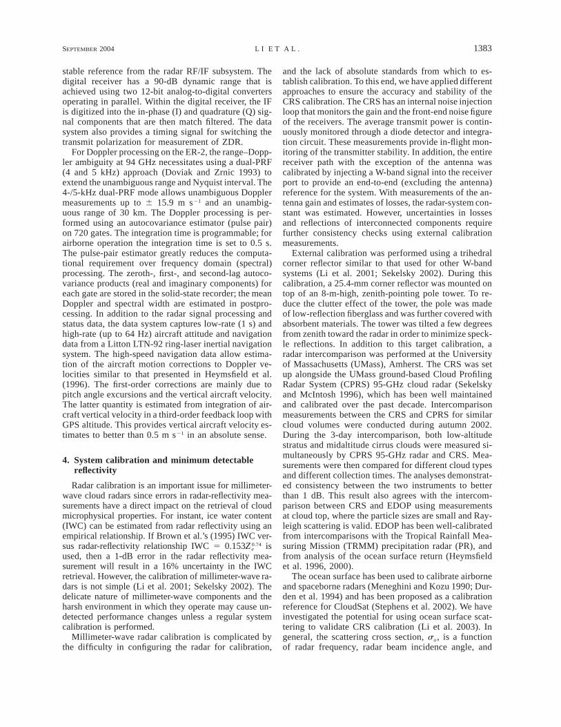
to better than 1 dB as well.The MDR of the CRS is estimated from the minimum
detectable signal determined by the radar system noiselevel (Skolnik 1980). The mean noise power Pn is cal-culated using Pn 5 kToBFn, where k is the Boltzman’sconstant, To is the reference temperature of 290 K, andFn is the system noise figure. The CRS receiver noisefigure including losses in the antenna, waveguide, andswitch network is ;10 dB. For a 1.0-ms RF pulse(150-m range resolution) with a 1-MHz matched filter,the CRS single-pulse MDR at a 10-km range is 211.7dBZe with the airborne antenna and 228.9 dBZe withthe ground-based antenna. Noise averaging and noisesubtraction is necessary to detect weak cloud signals.The typical CRS operation mode on the ER-2 is 4/5kHz in the dual-PRF mode, resulting in an effective PRFof 4.444 kHz. For 1-s averaging and noise subtraction,the CRS MDR at a 10-km range is 229.7 dBZe withthe airborne antenna. The actual MDR during CRYS-TAL–FACE was 229 dBZe (150-m range resolution, 1-s time average). For ground-based operation, the cor-responding MDR at a 10-km range is 246.9 dBZe. Fig-ure 4 shows the CRS ground-based and ER-2 MDR fora 1-s averaging time and 1-ms pulse width; the theo-retical curve for 0.5-ms pulse width is also shown. Notethat for upper-tropospheric cirrus located at 15-km al-titude (5 km from the radar), the MDR for the ER-2 is;235 dBZe for the flight data.
5. CRS measurements from CRYSTAL–FACE
Tropical maritime thunderstorms are a significant pro-ducer of ice particles that are carried aloft and then exitinto high-altitude anvils to be carried far from the gen-erating thunderstorm. Quantifying the radiative, micro-physical, and spatial properties of these thunderstorm-generated cirrus clouds and their evolution with time
was one of the key goals of the CRYSTAL–FACE cam-paign during July 2002 (more information available on-line at http://cloud1.arc.nasa.gov/crystalface/, also Jen-sen et al. 2003, personal communication). As one of thesix aircraft operated during CRYSTAL–FACE, the ER-2 carried a full suite of sensors, including EDOP, CPL,CoSSIR, MAS, dropsondes, and other instruments. TheER-2 was based at Key West Naval Air Station, Florida,and conducted 11 scientific flights during the experi-ment. The CRS collected its first datasets from cirrusand thunderstorms, and it operated successfully duringall the flights. In the following, we will show severaldata examples. Detailed analyses of combined CRS,EDOP, and CPL data from CRYSTAL–FACE will bediscussed in separate papers (e.g., McGill et al. 2004).
On 9 July 2002, the ER-2 flew a ‘‘deep south’’ mis-sion to remotely sense cirrus along with the WB-57aircraft that sampled the tropical tropopause layer. TheER-2 flew to the south of the Gulf of Mexico throughthe Yucatan Channel, then flew across a thunderstorm-generated cirrus region off the east coast of Nicaraguaand Honduras. Figure 5 shows CRS height–time sec-tions of radar reflectivity (Fig. 5a) and Doppler velocity(Fig. 5b) for a flight leg between 1730 and 1748 UTC.The geographic coordinates of the start and end pointsare shown at the bottom of the plots. The CRS was ableto penetrate through this thick cloud and light rain layerto detect the ocean surface. The ER-2 GPS altitude(nominally 20 km) was used to reference radar rangeto the surface, and the strong surface return is observedclose to zero altitude, as expected. The measured Dopp-ler velocities must be corrected for aircraft motions be-fore they represent hydrometeor motions that are of sci-entific interest. In the absence of vertical air motions,these hydrometeor motions represent reflectivity-weighted hydrometeor fall speeds. The aircraft correc-tions are estimated using the ER-2 navigation infor-mation along with an estimate of the antenna tilt angle,

SEPTEMBER 2004 1385L I E T A L .
FIG. 5. CRS measurements on 7 Jul 2002 show ER-2 pass across thick anvil cirrus with lightrain. (a) The equivalent radar reflectivity and (b) Doppler velocity corrected for aircraft motions(negative values are downward). The strong signal at zero altitude is the ocean surface return.
that is, the angle offset of the antenna along track(Heymsfield et al. 1996). This tilt angle was obtainedusing the Doppler velocity of the ocean surface, whichshould be 0 m s21 in a statistical sense. The tilt anglewas adjusted during the first few flights of the experi-ment in order to reduce the tilt angle to less than 18 asan average during flight (the ER-2 varies pitch angle byabout 28 during flight). The Doppler velocity data shownin Fig. 5 were corrected for aircraft motions using thisestimated tilt angle. The standard deviation of the meanvelocity is approximately 0.5 m s21, which is primarilydue to the uncertainty of ER-2 vertical motion. Thespectral widths of hydrometeor fall velocity after sub-tracting the broadening due to the ER-2 horizontal mo-tion (;0.8 m s21) are approximately 0.4 m s21 in iceclouds above 4.4-km altitude and 0.3–1.2 m s21 in pre-cipitation region below 4.4 km.
Several interesting features are noted in Fig. 5 whereCRS detected a thick (4.4–15-km altitude) deep ice-cloud layer with occasional light rain below it. The tran-sition from snow to rain typical for stratiform rain isclearly evident in this pass. The melting layer is ob-served at 4.4-km altitude from the sharp increase invelocity toward the surface below this altitude and be-low the band of lower reflectivity. These lower-reflec-tivity bands are due to Mie scattering by the large melt-ing snowflakes as they fall through the melting region.In order to improve reflectivity sensitivity at cloud top,
reflectivity data were postaveraged, noise subtracted,and thresholded by the minimum detectable power level.The Doppler velocities were not suitable for noise sub-traction since they were estimated using autocorrelationproducts based on measurements of phase shifts be-tween pulses. Therefore, the reflectivity image exhibitsseveral decibels better detectability of weak cloud thanthe velocity image.
The second case (Fig. 6) shows CRS measurementsfrom high-level thin cirrus clouds off the west coast ofFlorida on 16 July 2002 that were generated by a lo-calized convective storm. The CRS reflectivity and ve-locity between 2242 and 2248 UTC indicate that thecirrus extends between about 8 and 13.5 km. The cloudtop is at a 6.5-km range from the ER-2 where the CRSMDR is approximately 233 dBZe. Therefore, the CRSis able to detect weak cloud signals as low as 233 dBZe
at this altitude, which is difficult to achieve using azenith-pointing ground-based W-band radar.
On 29 July 2002, a convective anvil was generatedalong the west coast of Florida (Fig. 7), which producedmore significant rain (cf. Fig. 5). Figure 7a shows theCRS reflectivity from 2044 to 2101 UTC. The cloudtop was at ;14 km above the surface, while the meltinglayer in the raining region was at ;4-km altitude. TheCRS penetrated through the storm system and measuredthe ocean surface return most of the time during thisflight line. However, its signal experienced almost com-

1386 VOLUME 21J O U R N A L O F A T M O S P H E R I C A N D O C E A N I C T E C H N O L O G Y
FIG. 6. Thin cirrus clouds near the west coast of south Florida on 16 Jul 2002 presentedsimilarly as in Fig. 5.
plete attenuation in the region where it was raining (dis-tance of ;125 km or 2054 UTC). Figures 7b and 7cshow the ocean surface reflectivity and the two-waypath-integrated attenuation (PIA), respectively. For Fig.7c, the ocean surface return from the rain-free andcloud-free region in the early part of this flight line isused as a reference to determine the PIA, which is auseful constraint for rain-rate and cloud microphysicalproperty retrievals from airborne and spaceborne mea-surements (Meneghini et al. 1983). As is evident in Fig.7c, the maximum PIA is over 36 dB, or about 8 dBkm21 when averaged over the 4-km rain path. A veryrough estimate from Lhermitte (2002, his Fig. 4.10)indicates that this amount of attenuation is produced bya 10 mm h21 rain rate. It is worth noting that the surfacewinds are likely different within and outside the pre-cipitation regions. Also, the ocean surface roughness islikely different between rain and rain-free regions dueto the wave damping effects of rain drops. Our currentdatabase of CRS ocean surface measurements with mea-sured surface winds is quite limited because this wasnot a requirement in the first operational flights. Ad-ditional measurements will be made in future flights forstudying the ocean surface scattering mechanism underdifferent conditions.
6. ConclusionsThe CRS provides an important new tool for studying
clouds from a high-altitude, downward-looking vantage
point. It is capable of measuring most ice clouds andlight rain through the troposphere and lower stratosphere.For cirrus cloud detection, the CRS has several uniqueadvantages over ground-based millimeter-wave radars.First, because it operates in a downward-looking modefrom a high-altitude platform, CRS measurements of thehigher-altitude clouds are not affected by the water vaporand oxygen absorption, most of which is present at lowaltitudes. Second, radar sensitivity decreases with in-creasing range from the radar. Operating from on boardthe ER-2, the CRS is able to measure high-altitude cirrusclouds at a closer range than ground-based radars andupward-looking radars operated from mid- or low-alti-tude research aircrafts. Therefore, for some applicationssuch as high-level cirrus measurements, the CRS hasadvantages over ground-based radars, even though thesesystems have larger antennas and somewhat higher sen-sitivity near the radar. Third, the CRS is able to use theocean surface as a calibration reference to monitor systemperformance and to estimate total path attenuation, whichis valuable for understanding the physics of W-band mea-surements and for cloud microphysical properties andrain-rate retrievals. CRS system calibration has been per-formed using different methods, including an externaltrihedral corner-reflector calibration, the ocean surface,and intercomparison with the UMass ground-based CPRS95-GHz cloud radar. The results from all these methodsagree within 1 dB.
The CRS collected its first airborne data from the

SEPTEMBER 2004 1387L I E T A L .
FIG. 7. Thick cirrus with moderate rain on 29 Jul 2002 off the west coast of south Florida: (a)equivalent radar reflectivity, (b) ocean surface reflectivity, and (c) two-way path-integrated at-tenuation estimated using surface reference technique.
CRYSTAL–FACE experiment during July 2002. Itfunctioned exceptionally well during these flights, andongoing data analyses have indicated that the extensivedataset collected will contribute toward meeting the sci-entific objectives of the experiments. The present em-phasis is on further understanding W-band calibrationusing the ocean surface, and combining CRS, EDOP,CPL, and CoSSIR observations to improve cloud mi-crophysical property retrievals.
Acknowledgments. Dr. Don Anderson of the NASAAtmospheric Radiation Program at NASA Headquarters
supported the CRS instrument completion and its par-ticipation in CRYSTAL–FACE. The CRS was a jointeffort between the NASA Goddard Mesoscale Atmo-spheric Processes Branch, the Microwave SensorsBranch, and the Microwave Instrument TechnologyBranch. It has involved a variety of efforts that deservespecial recognition. Dr. Steve Bidwell has contributedsignificantly to the development of the radar RF/IF andthe data system. Mr. R. Aldridge has provided invalu-able technicial services for the radar. Thanks to Mr. Z.Zhang for his assistance on final RF/IF integration. Mr.Paul Weir is gratefully acknowledged for his design and

1388 VOLUME 21J O U R N A L O F A T M O S P H E R I C A N D O C E A N I C T E C H N O L O G Y
fabrication of the CRS canister and antenna-mountingstructures. The CRS data-processing boards were ob-tained from NCAR, and Eric Loew is acknowledged forhis help in implementing these boards. Former PulseTechnology of Marietta, Georgia, is appreciated for de-sign and fabrication of the radar RF/IF subsystem andfor technical support of the system tests. The NASAER-2 crew is appreciated for support during the CRSinstallation, test flight, and field experiment. Dr. JayMace provided valuable scientific advice and supportfor CRS. Many other individuals helped in many variedways.
REFERENCES
Brown, P. R., A. J. Illingworth, A. J. Heymsfield, G. M. McFarquhar,K. A. Browning, and M. Gosset, 1995: The role of spacebornemillimeter-wave radar in the global monitoring of ice clouds. J.Appl. Meteor., 34, 2346–2366.
Clothiaux, E., M. Miller, B. Albrecht, T. Ackerman, J. Verlinde, D.Babb, R. Peters, and W. Syrett, 1995: An evaluation of a 94-GHz radar for radar remote sensing of cloud properties. J. Atmos.Oceanic Technol., 12, 201–229.
Doviak, R. J., and D. S. Zrnic, 1993: Doppler Radar and WeatherObservations. Academic Press, 562 pp.
Durden, S. L., E. Im, F. K. Li, W. Ricketts, A. Tanner, and W. Wilson,1994: ARMAR: An airborne rain-mapping radar. J. Atmos. Oce-anic Technol., 11, 727–737.
European Space Agency, 2001: EarthCARE—Earth clouds, aerosolsand radiation explorer. Report for Assessment, The Five Can-didate Earth Explorer Core Missions, SP-1257(1), ESA Publi-cation Division, Noordwijk, Netherlands, 135 pp.
Heymsfield, G. M., and Coauthors, 1996: The EDOP radar systemon the high-altitude NASA ER-2 aircraft. J. Atmos. OceanicTechnol., 13, 795–809.
——, B. Geerts, and L. Tian, 2000: TRMM precipitation radar re-flectivity profiles as compared with high-resolution airborne andground-based radar measurements. J. Appl. Meteor., 39, 2080–2102.
Hogan, R. J., and A. J. Illingworth, 1999: The potential of spacebornedual-wavelength radar to make global measurements of cirrusclouds. J. Atmos. Oceanic Technol., 16, 518–531.
Houghton, J. T., L. G. Meira Filho, B. A. Callander, N. Harris, A.Katenberg, and K. Maskell, 1995: Climate Change 1995: TheScience of Climate Change. Cambridge University Press, 572pp.
King, M. D., and Coauthors, 1996: Airborne scanning spectrometerfor remote sensing of clouds, aerosol, water vapor, and surfaceproperties. J. Atmos. Oceanic Technol., 13, 777–794.
Lhermitte, R. M., 1987: A 94-GHz Doppler radar for cloud obser-vations. J. Atmos. Oceanic Technol., 4, 36–48.
——, 2002: Centimeter and Millimeter Wavelength Radars in Me-teorology. Lhermitte Publications, 550 pp.
Li, F., E. Im, S. Durden, and W. Wilson, 1994: Airborne and space-borne cloud radar designs. Proc. IGARSS 1994, Pasadena, CA,IEEE, Vol. 2, 672–674.
Li, L., and Coauthors, 2001: Retrieval of atmospheric attenuationusing combined ground-based and airborne 95-GHz cloud radarmeasurements. J. Atmos. Oceanic Technol., 18, 1345–1353.
——, G. M. Heymsfield, P. E. Racette, and L. Tian, 2003: Calibrationof a 94-GHz cloud radar using measurements from the oceansurface. Preprints, 31st Conf. on Radar Meteorology, Seattle,WA, Amer. Meteor. Soc., 204–206.
Liebe, H., 1985: An updated model for millimeter-wave propagationin moist air. Radio Sci., 20, 1069–1089.
McGill, M., D. Hlavka, W. Hart, V. S. Scott, J. Spinhirne, and B.Schmid, 2002: Cloud physics lidar: Instrument description andinitial measurements results. Appl. Opt., 41, 3725–3732.
——, and Coauthors, 2003: Combined lidar–radar remote sensing:Initial results from CRYSTAL-FACE. J. Geophys. Res., 109,D07203, doi: 10.1029/2003JD004030.
Mead, J., A. Pazmany, S. Sekelsky, and R. McIntosh, 1994: Milli-meter-wavelength radars for remotely sensing clouds and pre-cipitation. Proc. IEEE, 82, 1891–1906.
Meneghini, R., and T. Kozu, 1990: Spaceborne Weather Radar. Arc-tech House, 199 pp.
——, J. Eckerman, and D. Atlas, 1983: Determination of rain ratefrom a spaceborne radar using measurements of total attenuation.IEEE Trans. Geosci. Remote Sens., 21, 34–43.
Pazmany, A. L., R. E. McIntosh, R. Kelly, and G. Vali, 1994: Anairborne 95-GHz dual polarization radar for cloud studies. IEEETrans. Geosci. Remote Sens., 1, 731–739.
Racette, P. E., G. M. Heymsfield, L. Li, L. Tian, and E. Zenker, 2003:The cloud radar system. Preprints, 31st Conf. on Radar Mete-orology, Seattle, WA, Amer. Meteor. Soc., 237–240.
Sadowy, G., and Coauthors, 1997: The NASA DC-8 airborne cloudradar: Design and preliminary results. Proc. IGARSS 1997, Sin-gapore, IEEE, Vol. 4, 1466–1469.
Sekelsky, S. M., 2002: Near-field reflectivity and antenna boresightgain corrections for millimeter-wave atmospheric radars. J. At-mos. Oceanic Technol., 19, 468–477.
——, and R. E. McIntosh, 1996: Cloud observations with polarimetrc33 GHz and 95 GHz radar. Meteor. Atmos. Phys., 59, 123–140.
Skolnik, M. I., 1980: Introduction to Radar Systems. McGraw Hill,581 pp.
Stephens, G. L., S. C. Tsay, P. W. Stackhouse, and P. J. Flatau, 1990:The relevance of the microphysical and radiative properties ofcirrus clouds to climate and climate feedback. J. Atmos. Sci.,47, 1742–1752.
——, and Coauthors, 2002: The CloudSat mission and the A-train.Bull. Amer. Meteor. Soc., 83, 1771–1789.
Valenzuela, G. R., 1978: Theories for the interaction of electromag-netic and oceanic waves—A review. Bound.-Layer Meteor., 13,61–85.