80-1_Report.pdf - Arizona Auditor General
179
. STATE OF ARIZONA OFFICE OF THE AUDITOR GENERAL A PERFORMANCE AUDIT of THE ARIZONA RESOURCES INFORMATION SYSTEM MARCH 1980 A REPORT TO THE ARIZONA STATE LEGISLATURE REPORT 80-1
-
Upload
khangminh22 -
Category
Documents
-
view
0 -
download
0
Transcript of 80-1_Report.pdf - Arizona Auditor General

. STATE OF ARIZONA OFFICE OF THE
AUDITOR GENERAL
A PERFORMANCE AUDIT of
THE ARIZONA RESOURCES INFORMATION SYSTEM
MARCH 1980
A REPORT TO THE ARIZONA STATE LEGISLATURE
REPORT 80-1
DOUGLAS R. NORTON. CPA AUDITOR GENERAL
OFFICE O F THE
AUDITOR GENERAL
March 28, 1980
The Honorable Bruce B a b b i t t , Governor Members of t h e Arizona L e g i s l a t u r e M r . Joe T. F a l l i n i , S t a t e Land Commissioner
Transmit ted herewith is a r e p o r t o f t h e Auditor General , A Performance
Audit of t h e Arizona Resources Information System. This r e p o r t is i n
response t o a J u l y 19, 1979, r e s o l u t i o n of t h e J o i n t L e g i s l a t i v e Budget
Committee.
A summary o f t h i s r e p o r t is found on t h e b lue pages a t t h e f r o n t of t h e
r epo r t . A response t o t h i s r e p o r t by t h e S t a t e Land Commissioner is found
on the yellow pages preceding t h e appendices o f t he r e p o r t .
My s t a f f and I w i l l be happy t o meet wi th t h e a p p r o p r i a t e l e g i s l a t i v e
committees, i n d i v i d u a l l e g i s l a t o r s o r o t h e r s t a t e o f f i c i a l s t o d i s c u s s o r
c l a r i f y any items i n t h e r e p o r t o r t o f a c i l i t a t e t h e implementation o f t h e
recommendations.
Respec t fu l l y submit ted,
Douglas R. Norton Auditor General
S t a f f : Gerald A. S i l v a Coni R. Good Br ian C. Dalton James A. Sexton
I 1 2 NORTH CENTRAL AVENUE SUITE 6 0 0 PHOENIX, ARIZONA 85004 2 5 5 - 4 3 8 5

OFFICE OF THE AUDITOR GENERAL
A PERFORMANCE AUDIT OF
THE ARIZONA RESOURCES INFORMATION SYSTEM
REPORT TO THE
ARIZONA STATE LEGISLATURE
REPORT 80-1

TABLE OF CONTENTS
SUMMARY
INTRODUCTION AND BACKGROUND
FINDINGS
FINDING I
The h i s t o r y of t h e Arizona Resources Information System (ARIS) is r e p l e t e wi th improper o r nonexis ten t planning and unc l ea r purpose. A s a r e s u l t , as o f March 1 , 1980, ARIS r e p r e s e n t s a $1.5 m i l l i o n investment i n a e r i a l photographs and maps and a r e l a t i v e l y s o p h i s t i c a t e d computer system which performs only rudimentary record-keeping t a sks .
CONCLUSION
RECOMMENDATION
FINDING I1
Data process ing a c q u i s i t i o n s f o r t h e Arizona Resources Information System a r e a chronology of apparen t unauthorized expendi tures and improperly recorded expenses t h a t would r e p r e s e n t v i o l a t i o n s o f Arizona s t a t u t e s and t h e f i d u c i a r y r e s p o n s i b i l i t y of S t a t e o f f i c i a l s .
CONCLUSION
RECOMMEND AT I O N
FINDING I11
L e g i s l a t i o n is needed t o c l a r i f y t h e in tended purpose o f t he Information Resources Div is ion .
CONCLUSION
RECOMMENDATION
OTHER PERTINENT INFORMATION
Production and Use of Orthophotoquads Def in i t i ons of a Geographic o r Natura l Resources Information
System and Remote Sensing
WRITTEN REPONSE TO THE AUDITOR GENERAL'S REPORT

APPENDICES
APPENDIX I Arizona S t a t u t e s r ega rd ing ARIS and t h e Information Resources Div is ion of t h e S t a t e Land Department
APPENDIX I1 Off ice of t h e Auditor General survey of p o t e n t i a l agency u s e r s o f map, Landsat imagery and o the r ca r tog raph ic products
APPENDIX I11
APPENDIX I V
Report on t h e survey of requirements of t h e Arizona Resources Information System
October 9 , 1979, L e t t e r t o t h e S t a t e Automation Di r ec to r from I R D (ARIS) D i r ec to r
APPENDIX V
APPENDIX V I
October 17, 1979, L e t t e r t o I R D (ARIS) D i r ec to r from t h e S t a t e Automation Di r ec to r
Resume of t h e D i r ec to r of t h e Natura l Resources Information Systems P r o j e c t wi th t h e Nat ional Conference o f S t a t e L e g i s l a t u r e s
APPENDIX V I I F i n a l Report of t h e D i r ec to r of t h e Natural Resources Information Systems P r o j e c t w i th t h e Nat ional Conference of S t a t e L e g i s l a t u r e s
APPENDIX V I I I The Applied Remote Sensing Program a t t h e Univers i ty o f Arizona
APPENDIX I X
APPENDIX X
APPENDIX X I
APPENDIX X I 1
APPENDIX X I 1 1
March 5, 1980, L e g i s l a t i v e Council Memorandum
February 25, 1980, L e g i s l a t i v e Council Memorandum
February 29, 1980, L e g i s l a t i v e Council Memorandum
February 20, 1980, L e g i s l a t i v e Council Memorandum
November 26, 1979, L e t t e r t o t h e S t a t e Automation Di r ec to r from t h e S t a t e Land Department
APPENDIX X I V March 4 , 1980, L e g i s l a t i v e Council Memorandum

SUMMARY
The Arizona Resources Information System (ARIS) was c r e a t e d through t h e
a c t i o n s of t he Governor i n 1971 and i n i t i a l l y s t a f f was ass igned t o t h e
Department of Economic Planning and Development. I n e a r l y 1972, ARIS was
t r a n s f e r r e d t o t h e Department of Proper ty Valuat ion which was merged i n t o
t h e newly formed Department o f Revenue on J u l y 1 , 1974,
Through a j o i n t agreement wi th t h e U.S. Geological Survey and t h e Nat iona l
Aeronaut ics and Space Adminis t ra t ion , t h e S t a t e o f Arizona procured
h igh -a l t i t ude photographs and orthophotoquads (base maps a t a s t anda rd
s c a l e ) . ARIS s t a f f superv ised t h e a c q u i s i t i o n and s a l e of t h e s e maps and
conducted va r ious demonstrat ions concerning t h e p roces s ing and usage of
n a t u r a l resources da ta .
I n 1978, t h e L e g i s l a t u r e passed Sena te B i l l 1307 ( l a t e r c o d i f i e d as
Arizona Revised S t a t u t e s Sec t ions 37-171 through 176) t r a n s f e r r i n g ARIS t o
t h e S t a t e Land Department through t h e c r e a t i o n of t h e Informat ion
Resources Divis ion. The s t a t u t o r y d u t i e s f o r t h e D iv i s ion inc lude , among
o t h e r s , p rovid ing a d a t a bank f o r t h e S t a t e Land Department, producing
maps and r e l a t e d in format ion f o r geographic a r e a s and coo rd ina t ing
a c t i v i t i e s of S t a t e governmental agenc ies and p o l i t i c a l subd iv i s ions
regard ing use of s a t e l l i t e imagery.
ARIS and its a c t i v i t i e s have been funded p r imar i l y through t h e S t a t e
General Fund. S t a f f i n g has ranged from t h r e e t o f i v e fu l l - t ime equ iva l en t
p o s i t i o n s each year .
Our review of t h e Arizona Resources Information System revea led t h a t t h e
h i s t o r y o f ARIS is r e p l e t e wi th improper o r nonexis ten t planning and
unc lear purpose. A s a r e s u l t , as of March 1 , 1980, A R I S r ep re sen t ed a
$1.5 m i l l i o n investment i n a e r i a l photographs and maps and a r e l a t i v e l y
s o p h i s t i c a t e d computer system which performs only rudimentary
record-keeping t a sks . (page 12)
Our review a l s o revea led t h a t d a t a process ing a c q u i s i t i o n s f o r ARIS a r e a
chronology of apparent unauthorized expendi tures and improperly recorded
expenses t h a t would r ep re sen t v i o l a t i o n s of Arizona s t a t u t e s and t h e
f i d u c i a r y r e s p o n s i b i l i t y of S t a t e o f f i c i a l s . (page 30)
I n a d d i t i o n , our review d i sc lo sed l e g i s l a t i o n is needed t o c l a r i f y t h e
in tended purpose of t h e Information Resources Div is ion . (page 46)
The r e p o r t con ta in s information regard ing t h e va lue and usage o f
orthophotoquads. D e f i n i t i o n s of remote sens ing and geographic in format ion
systems a r e included. (page 51)
It is recommended t h a t cons ide ra t i on be given t h e fol lowing:
- The L e g i s l a t u r e app rop r i a t e funds f o r t h e 1980-81 f i s c a l year t o
a l low f o r a 12 month lease /purchase of t h e c e n t r a l p rocess ing
u n i t requested i n t h e Information Resources Div is ion 1980-81
budget reques t . Expenditure of such an a p p r o p r i a t i o n should be
cont ingent upon: 1 ) approval by t h e Data Process ing Div is ion o f
t h e Department of Adminis t ra t ion of t h e lease /purchase , and 2 )
t h e s ign ing of a formal lease /purchase agreement between t h e
S t a t e Land Department and t h e equipment vendor. (page 28)
The S t a t e Land Department, Department of Adminis t ra t ion ' s Data
Process ing Div is ion and t h e Nat ional Conference o f S t a t e
L e g i s l a t u r e s ' resource team should conduct a d e t a i l e d user-needs
s tudy and develop a system p lan by September 30, 1980.
Addi t iona l ARIS d a t a process ing equipment a c q u i s i t i o n s should be
cont ingent upon t h e p repa ra t i on of t h e user-needs s tudy and i t s
review and acceptance by t h e app rop r i a t e l e g i s l a t i v e committees.
(page 28)
- I f i t is determined t h a t such an information system is needed,
t h e L e g i s l a t u r e should c l e a r l y de f ine t h e scope, g o a l s and u s e r s
of t he system. (page 29)

- Future S t a t e Land Department r eques t s f o r ARIS-related d a t a
process ing equipment and approval of o t h e r expendi tures should be
based on user-needs surveys and system plans. (page 2 9 )
It is a l s o recommended t h a t :
- The S t a t e Land Department throughly review i t s i n t e r n a l
account ing c o n t r o l s over t h e use o f funds and t h e r e s u l t i n g
c l a s s i f i c a t i o n of expendi tures . This review should i nc lude a l l
sources of funds used by t h e Land Department and not be l i m i t e d
t o S ta te -appropr ia ted funds. (page 44)
- Following t h i s review, t h e S t a t e Land Department i n s t i t u t e t h e
necessary changes t o prevent f u t u r e unauthorized and i l l e g a l u se s
of funds. (page 45)
- When ques t i ons a r i s e r ega rd ing t h e c l a s s i f i c a t i o n o f
expendi tures , t h e account ing s t a f f of t h e S t a t e Land Department
consu l t w i th t he accounts and c o n t r o l s s e c t i o n of t h e D iv i s ion o f
Finance t o ensure proper c l a s s i f i c a t i o n . (page 45)
- The S t a t e Land Department i n s t i t u t e a procedure f o r t h e p e r i o d i c
review of insurance coverage provided by t h e Risk Management
Div is ion o f t he Department of Adminis t ra t ion and update t h i s
coverage on a t imely b a s i s . (page 45)
- The L e g i s l a t u r e amend Arizona Revised S t a t u t e s Sec t ion 37-173 i f
i t is determined t h e development of a computerized d a t a bank
should be continued. The s t a t u t e should exp re s s ly s t a t e t h e
types o f a d d i t i o n a l in format ion which may be c o l l e c t e d , t h e
s p e c i f i c needs of o t h e r i d e n t i f i e d S t a t e agenc ies f o r which d a t a
may be c o l l e c t e d , i f any, and t h e f i n a n c i a l o r o the r arrangements
which would apply t o such a l i a i s o n . (page 50)

INTRODUCTION AND BACKGROUND
I n response t o a June 19, 1979, r e s o l u t i o n o f t he J o i n t L e g i s l a t i v e Budget
Committee, t h e Of f i ce of t h e Auditor General has conducted a performance
a u d i t , i n accordance wi th Arizona Revised S t a t u t e s (A.R.S. ) 41-1279, o f
t h e Arizona Resources Informat ion System (ARIS) now l o c a t e d w i th in t h e
Information Resources Div is ion (IRD) o f t he S t a t e Land Department (SLD).
ARIS began a s a r e s u l t of two independent a c t i o n s of t h e Federa l and t h e
Arizona S t a t e governments i n 1969 and 1970.
I n 1969, t h e Nat iona l Aeronaut ics and Space Adminis t ra t ion (NASA) funded
r e sea rch p r o j e c t s i n Arizona t h a t r e s u l t e d i n t h e es tab l i shment of t h e
Arizona Regional Ecologica l Tes t i ng S i t e (ARETS) a s a j o i n t ven ture o f t h e
Univers i ty o f Arizona and t h e Department of t he I n t e r i o r , U.S. Geological
Survey (USGS). The purpose of t h e venture was t o c o n s o l i d a t e r e sea rch
designed t o t e s t and e v a l u a t e t h e u se s of subspace (U-2 p l anes ) and space
( s a t e l l i t e ) remote sensors*, t h e products from t h e s e s e n s o r s (photographs
and images of e a r t h ) , and t h e i r a p p l i c a t i o n t o t h e management o f
environmental and r e sou rces problems. The ARETS p r o j e c t photography was
scheduled t o encompass t h e southern t h i r d of Arizona.
I n November 1970, t h e Arizona Game and F i s h Department, i n conjunc t ion
wi th t h e Arizona Outdoor Recrea t ion Coordinat ing Commission (AORCC),
sponsored a seminar f o r i n t e r e s t e d S t a t e , l o c a l and Federa l o f f i c i a l s
concerning t h e Land Use Information System developed by Corne l l Univers i ty .
Af t e r t h e seminar, t h e Governor appointed a s t e e r i n g committee t o exp lo re
t h e p o s s i b i l i t i e s of developing a land-use inventory f o r Arizona. The
b committee i s sued a r e p o r t on J u l y 20, 1971, t o t h e Governor 's Of f i ce
s t a t i n g :
* For a d e s c r i p t i o n o f remote s ens ing and geographica l o r n a t u r a l r e sou rce in format ion systems, s e e page 56.

"Arizona is i n a unique p o s i t i o n t o develop a f i n e l and use inventory system from t h e s tandpoin t o f combining h igh a l t i t u d e photography, common base maps and t o expand a geode t i c coo rd ina t e system being e s t a b l i s h e d along roadways i n Arizona by t h e ALISS* program...
... after being b r i e f e d on NASA photography, many s t a t e agenc i e s expressed a need f o r having s ta te-wide a e r i a l coverage a t a s c a l e o f 1:120,000. A s a r e s u l t o f t h i s i n t e r e s t , usages f o r t h i s coverage were enumerated and a formal r eques t f o r s ta te-wide coverage have been forwarded t o NASA from t h e Governor 's Off ice ." (Emphasis added)
The committee a l s o recommended t h a t t h e Governor 's O f f i c e , r a t h e r than any
s i n g l e S t a t e agency, be r e spons ib l e f o r d i r e c t i n g t h e e f f o r t .
I n November 1971, a s t a f f d i r e c t o r f o r t h e Land Use Inventory P r o j e c t , as
ARIS was then c a l l e d , was ass igned t o t h e Governor's Of f i ce , Department of
Economic Planning and Development, from t h e Arizona Highway Department.
Three staff members f o r t h e p r o j e c t were h i r ed us ing Emergency Employment
Act funds.
I n a March 1 , 1972, news r e l e a s e , t h e Governor announced t h e name, goa l
and first o b j e c t i v e of t h e p r o j e c t .
The o r d e r l y growth and proper development o f Arizona, based on t h e most a p p r o p r i a t e u se s t o which t h e l and and r e sou rces can be p u t , i s t h e goa l of a new s t a t e organiza t ion . . ." " F i r s t o b j e c t i v e of t h e Arizona Resources Informat ion System, c r ea t ed a t t h e r eques t of Governor Williams, i s t o compile a s ta te -wide land use inventory.
A Po l icy Committee was e s t a b l i s h e d w i t h 12 members, r ep re sen t ing va r ious
agenc ies of S t a t e government, who would formulate po l i cy f o r ARIS and
commit r e sou rces a s needed from t h e i r departments. A Working Committee
was a l s o organized t o a t tempt t o ensure t h a t t h e system developed would
meet t h e needs of t h e agenc ies , be compatible wi th e x i s t i n g d a t a systems
and t o c a l l Po l i cy Committee meetings when needed.
* Accident Locat ion Information and Su rve i l l ance System (ALISS) is a geograph ica l ly based informat ion system developed by t h e Arizona Highway Department.

On March 24, 1972, t h e Governor t r a n s f e r r e d ARIS t o what was then t h e
Department o f Proper ty Valuat ion when i n h i s e s t i m a t i o n t h e o rgan iza t ion
and i n i t i a l d e t a i l s of t h e program had been e s t ab l i shed . On May 24, 1972,
t h e L e g i s l a t u r e passed House B i l l 2736 au tho r i z ing t h e D i r ec to r of t h e
Department of Proper ty Valuat ion t o acqu i r e NASA orthophoto base maps* f o r
use by a l l departments o f Arizona S t a t e government and o t h e r s i n need o f
such maps. House B i l l 2736 a l s o provided $408,700 t o t h e Governor t o fund
ARIS f o r t h e f i s c a l year beginning J u l y 1 , 1972, and t o enable t h e S t a t e
t o purchase or thophoto base maps.
On J u l y 10, 1972, t h e Governor s igned , as t h e Arizona r e p r e s e n t a t i v e , a
three-way agreement among t h e S t a t e of Arizona, USGS and NASA c r e a t i n g t h e
Arizona Land Use Experiment (ALUE). Through t h i s agreement: 1 ) NASA
would photograph t h e e n t i r e S t a t e us ing U-2 p l anes , 2 ) USGS would use t h e
photographs t o produce orthophotoquads*, and 3) t h e S t a t e o f Arizona
would t r a i n S t a t e agency personnel i n t h e use o f t h e s e maps and a c q u i r e
equipment t o enhance t h e i r i n t e r p r e t a t i o n .
The es t imated completion time f o r t h e product ion of orthophotoquads was
o r i g i n a l l y June 1974. However, t h e f i n a l s e t of orthophotoquads was no t
produced u n t i l 1975.
ARIS s t a f f planned p i l o t p r o j e c t s t o demonstrate how remote s ens ing d a t a
could be used i n conjunc t ion wi th o the r da t a sources . These p r o j e c t s were
intended t o demonstrate s t o r a g e , r e t r i e v a l , a n a l y s i s and d i s p l a y o f
l and - r e l a t ed information. I n January 1974, a computer committee was
e s t a b l i s h e d t o review and eva lua t e a v a i l a b l e computer sof tware systems.
I n October 1974, t h e committee r epo r t ed t h e r e s u l t s of t h e s e e v a l u a t i o n s
and recommended t h a t a s p e c i f i c computer system be used f o r t h e p i l o t
p r o j e c t . I n January 1976, t h e committee r epo r t ed t h e completion of t h e
p i l o t p r o j e c t us ing Santa Cruz County d a t a on pub l i c land: boundaries ,
land ownership, t r a n s p o r t a t i o n , n a t u r a l vege t a t i on , water , e levat ion and
land use. The p i l o t p r o j e c t demonstrated va r ious agency a p p l i c a t i o n s and
was shown t o 52 Fede ra l , S t a t e and l o c a l government agencies . The
committee a l s o recommended t h a t ARIS purchase t h e sof tware system used i n
t h e p i l o t p r o j e c t . The L e g i s l a t u r e , however, d id not approve funding f o r
t h e recommended sof tware system.
* For a d e s c r i p t i o n of or thophoto base maps (or thophotoquads) s e e page 51.
During t h e 1973 l e g i s l a t i v e s e s s i o n , Sena te B i l l 1019 was passed and
s igned by t h e Governor, which e s t a b l i s h e d t h e Department o f Revenue and
t r a n s f e r r e d t he powers and d u t i e s of t h e Department of Proper ty Valua t ion ,
i nc lud ing t h e ARIS program, i n t o t h e new Department a s o f Ju ly 1 , 1974.
It should be noted t h a t dur ing f i s c a l y e a r s 1973-74 and 1974-75, t h e
D i r ec to r o f ARIS a l s o se rved as Deputy D i r ec to r of t h e Environmental
Planning Off ice* and t h a t t h e ARIS s t a f f provided support t o t h e
Environmental Planning Commission* i n a number of a c t i v i t i e s such a s t h e
use of maps, meeting wi th Federa l agenc ies , coo rd ina t ing and p a r t i c i p a t i n g
a t publ ic hea r ings , and g e n e r a l conso l ida t ion and a n a l y s i s of information.
Major accomplishments of t he A R I S program during its first f o u r y e a r s , a s
o u t l i n e d i n an A R I S r e p o r t dated January 1976, were:
- Development of t he Arizona Land and Resource C l a s s i f i c a t i o n Code,
- Pub l i ca t i on o f Information Resources: Land and Natura l Resource
P lanning ( t o g e t h e r w i th t h e O f f i c e o f Economic Planning and
Development),
- Provid ing s e r v i c e s t o t h e p r i v a t e s e c t o r , and
- Development of a c e n t r a l i z e d system of photography, maps and
space imagery t oge the r wi th s p e c i a l i z e d viewing equipment.
The Pol icy Committee, which was e s t a b l i s h e d i n 1972 bu t which appa ren t ly
had not met s i n c e J u l y 1974, was r e a c t i v a t e d i n 1976 a t t h e behes t of a
l e g i s l a t i v e app rop r i a t i on subcommittee t o review t h e ARIS g o a l s and
d i r e c t i o n . A t an August 12, 1976, meeting, t h e Po l i cy Committee
reaf f i rmed t h e fo l lowing ARIS g o a l s a s o r i g i n a l l y developed i n 1973:
"ARIS w i l l coord ina te information systems r e l a t i n g t o l and and be a c e n t r a l bank f o r : a. Land S t a t u s Information (ownership) b. Land Use Data (u se ) c . Land information such as vege t a t i on , s o i l s ,
topography, s u r f a c e and sub-surface resources ( c h a r a c t e r i s t i c s )
d. Maps, orthophotoquads, photography.
* I n 1973 t h e Arizona Environmental Planning Commission was c r e a t e d and charged wi th t h e r e s p o n s i b i l i t y of developing a S t a t e land-use planning program f o r Arizona (A.R.S. 37-161 e t seq . ) . The a c t a l s o c r ea t ed an Off ice of Environmental Planning i n t h e Of f i ce of t h e Governor wi th t h e r e s p o n s i b i l i t y o f developing a comprehensive and coord ina ted land-use planning program.

"By provid ing t h e s e products and s t a t i s t i c s , ARIS w i l l s e r v e : a. S t a t e o p e r a t i o n a l information needs b. S t a t e r e sea rch p r o j e c t a s s i s t a n c e c . County and l o c a l government a s s i s t a n c e d. The publ ic ."
I n t h e 1976, 1977 and 1978 s e s s i o n s , t h e L e g i s l a t u r e considered s t a t u t o r y
r ecogn i t i on , f u t u r e d i r e c t i o n and a S t a t e agency l o c a t i o n f o r ARIS, whi le
funding and s t a f f were maintained a t a base o r reduced l e v e l . I n May
1978, Sena te B i l l 1307 ( l a t e r c o d i f i e d a s A.R.S. 37-171 through 1761%
passed the L e g i s l a t u r e and was signed by t h e Governor, t r a n s f e r r i n g t h e
ARIS program t o t h e SLD through t h e c r e a t i o n of t h e Resources D iv i s ion ,
p r e s e n t l y c a l l e d Information Resources Div is ion (IRD). The l e g i s l a t i o n
a l s o e s t a b l i s h e s s t a t u t o r y d u t i e s f o r I R D (ARIS)** inc luding:
- Provide a computerized information d a t a bank f o r t h e SLD,
- Provide c u r r e n t in format ion regard ing revenue-producing
a c t i v i t i e s and monitor changes over time by remote s ens ing
techniques,
- Produce maps and i n v e n t o r i e s a t s t anda rd s c a l e f o r any a r e a
def ined by its designated geographica l , governmental o r
j u r i s d i c t i o n a l boundaries t o inc lude combinations o f d a t a
elements,
- Provide maps, a e r i a l photographs and o t h e r remote s ens ing
techniques r e l a t e d t o S t a t e t r u s t l a n d s t o assist i n t h e
va lua t ion process .
- Function a s t h e Arizona a f f i l i a t e o f f i c e f o r t h e Nat iona l
Cartographic Informat ion Center ( N C I C ) .
- Coordinate t hose a c t i v i t i e s of S t a t e governmental agenc i e s and
S t a t e p o l i t i c a l subd iv i s ions wi th r e s p e c t t o t h e i r u t i l i z a t i o n of
t h e NASA Ear th Resources S a t e l l i t e Program, Landsat,*** i n
d i scharg ing t h e i r r e s p o n s i b i l i t i e s i n t h e f i e l d s of a g r i c u l t u r e ,
w i l d l i f e , f o r e s t r y , l and , minera l , water and o t h e r r e sou rce
management.
* Appendix I con ta in s a copy of t h e s e s t a t u t e s . ** See page 9 f o r an exp lana t ion of t h e nomenclature used when r e f e r r i n g
t o t he ARIS program a f t e r t h e c r e a t i o n of I R D . *** For a d e s c r i p t i o n o f Landsat and o ther remote s ens ing techniques , s e e
page 56.
For purposes of t h i s a u d i t , on ly t hose a c t i v i t i e s o r i g i n a l l y a s s o c i a t e d
wi th ARIS were examined. Therefore , t h e Engineering and Survey Sec t ion of
t h e I R D , w i t h i n t h e SLD, was no t w i th in t h e scope of t h i s a u d i t . I n t h e
i n t e r e s t of cons is tency and ease of read ing , t h e User S e r v i c e S e c t i o n and
Technology Appl ica t ion Sec t ion s e r v i c e s of t he I R D a r e r e f e r r e d t o as I R D
(ARIS) throughout t h e r e p o r t .
ARIS a c t u a l expendi tures and fu l l - t ime equiva len t employees (FTEs) f o r
f i s c a l y e a r s 1972-73 through 1978-79, and t h e f i r s t seven months o f f i s c a l
year 1979-80, a r e shown i n Table 1. These expendi tures were f inanced
through t h e S t a t e General Fund.
TABLE 1
SUMMARY OF STATE-FUNDED ARIS ACTUAL EXPENDITURES FROM FISCAL YEAR 1972-73
THROUGH FISCAL YEAR 1978-79 AND THE FIRST SEVEN MONTHS OF FISCAL YEAR 1979-80
F i r s t 7 Months
1976-77 1977-78 1978-79 1979-80** T o t a l
Number of FTEs
Persona l s e r v i c e s
Employee-related expendi tures
P ro fe s s iona l ou t s ide s e r v i c e s
Travel : In -S ta te P Out-of-State 0
Other ope ra t i ng expendi tures
C a p i t a l equipment
T o t a l expendi tures
* The expendi tures do not i nc lude t h e persona l s e r v i c e s and employee r e l a t e d c o s t s f o r p o s i t i o n s funded through Federa l monies (3.0 p o s i t i o n s i n f i s c a l year 1972-73) or f o r t h e P r o j e c t D i r ec to r p o s i t i o n on loan from what was t hen t h e Arizona Highway Department from November 1971 through J u l y 1976.
** The amounts shown f o r t h e f i r s t seven months of f i s c a l year 1979-80 inc lude a l l c la ims pa id through 1 /31/80 except t hose d i r e c t l y r e l a t e d t o t h r e e p o s i t i o n s (FTEs) t r a n s f e r r e d from t h e Land Use and Planning Div is ion of t h e S t a t e Land Department and c o n s t i t u t i n g t h e Engineer ing and Survey Sec t ion of t h e I R D .

The Of f i ce of t he Auditor General exp re s se s i t s g r a t i t u d e t o p re sen t and
former employees of t h e Arizona Resources Information System; t h e
Department of Revenue; t h e Department of T ranspo r t a t i on ; t h e S t a t e Land
Department; and M r . Pau l Tes sa r , D i r e c t o r , Natura l Resource Informat ion
System P r o j e c t , Nat iona l Conference of S t a t e L e g i s l a t u r e s , Denver,
Colorado, f o r t h e i r coopera t ion , a s s i s t a n c e and cons ide ra t i on dur ing t h e
course of our a u d i t .

FINDING I
THE HISTORY OF THE A R I Z O N A RESOURCES INFORMATION SYSTEM (ARIS) I S REPLETE
WITH IMPROPER OR NONEXISTENT PLANNING AND UNCLEAR PURPOSE. AS A RESULT,
AS OF MARCH 1 , 1980, ARIS REPRESENTS A $1.5 MILLION INVESTMENT I N AERIAL
F'HOTOGRAPHS AND MAPS AND A RELATIVELY SOPHISTICATED COMPUTER SYSTEM WHICH
PERFORMS ONLY RUDIMENTARY RECORD-KEEPING TASKS.
From its incep t ion i n 1972 u n t i l May 1978, many of t he s t a t e d purposes and
g o a l s of t h e Arizona Resource Information System (ARIS) as expressed by
t h e execut ive branch o f Arizona government never rece ived l e g i s l a t i v e
s a n c t i o n o r approval . I n May 1978, t h e Leg i s l a tu re : 1 ) t r a n s f e r r e d ARIS
personnel , p roper ty , funds and f u n c t i o n s t o t h e S t a t e Land Department
w i th in t h e newly formed Informat ion Resources Div is ion (IRD), and
2 ) e s t a b l i s h e d a s one of t he purposes of I R D (ARIS) t h e development of a
computer-oriented resource in format ion system. However, ARIS management
( p r i o r t o May 1978) and I R D management ( s i n c e May 1978) have c o n s i s t e n t l y
f a i l e d t o develop necessary in format ion system p l ans , user-need s t u d i e s o r
c o s t e s t i m a t e s t o f a c i l i t a t e t h e expansion of t h e I R D (ARIS) func t ion , i n
s p i t e of repea ted advisements and admonishments t o do so. A s o f March 1 ,
1980, approximately $1.5 m i l l i o n i n S t a t e funds have been spen t on a
resource information system t h a t is embryonic a s t o development, has
l i m i t e d u t i l i t y and t o a l a r g e degree provides s i m i l a r s e r v i c e s a s o t h e r
e n t i t i e s i n Arizona.
Lack o f L e g i s l a t i v e
Sanc t ion o r Approval
P r i o r t o 1978, ARIS was somewhat of an enigma i n Arizona S t a t e government
i n t h a t t h e only s t a t u t o r y d e s c r i p t i o n of ARIS was contained i n t h e
fo l lowing 1972 amendment t o t h e d u t i e s o f t he D i r ec to r o f t h e Department
of Proper ty Valuation:
" . . .acquires Nat iona l Aeronaut ics Space Adminis t ra t ion or thophoto base maps f o r use by a l l departments o f s t a t e government and o t h e r s i n need o f such maps, charge f o r d u p l i c a t i o n and s a l e and depos i t i n s t a t e g e n e r a l fund.
... s e l l con tac t p r i n t s o f Nat ional Aeronaut ics and Space Adminis t ra t ion or thophoto base maps acqui red by t h e D i r ec to r and depos i t such revenues i n s t a t e g e n e r a l fund." (Emphasis added)
To accomplish t h e purchase o f t h e or thophoto base maps, t h e 1972
L e g i s l a t u r e app rop r i a t ed $408,700 a s fol lows:
"The sum of four hundred e i g h t thousand seven hundred d o l l a r s is app rop r i a t ed t o t h e governor t o fund t h e Arizona r e sou rces in format ion system f o r t h e f i s c a l y e a r beginning J u l y 1 , 1972, and t o enable t h e s t a t e t o acqu i r e from t h e n a t i o n a l ae ronau t i c s and space admin i s t r a t i on or thophoto base maps of t h e e n t i r e state o f Arizona f o r use by a l l departments o f Arizona s t a t e government ." (Emphasis added)
The above s ta tements c o n s t i t u t e t h e sum and subs tance of expressed
l e g i s l a t i v e i n t e n t wi th regard t o ARIS from 1972 t o May 1978. Th i s
express ion of l e g i s l a t i v e i n t e n t regard ing t h e purpose o f ARIS is f a r
narrower t han t h a t expressed by t h e execut ive branch a s t h e fol lowing
s ta tements exemplify:
November 8 , 1971
I n a memorandum t o t he Governor an a s s i s t a n t explained t h a t a coord ina ted ,
multi-agency land-use inventory system was envis ioned:
"...The land use inventory system would develop a coord ina ted e f f o r t among s e v e r a l agenc ies i n t h e u se o f one system f o r t h e i r needs. This system w i l l provide a b a s i s f o r any informat ion used by any S t a t e Agencies which can be t i e d t o a p a r c e l of land. This system h a s a g r e a t dea l o f p o t e n t i a l f o r use by County and C i t y governmental u n i t s , and it is being designed wi th t h a t p rospec t i n mind.
By s t a r t i n g o u t wi th t h e Agencies c u r r e n t l y u s ing machines t o s t o r e in format ion concerning l and , we can add information and Agencies i n a l o g i c a l p rog re s s ive manner, and a s it is j u s t i f i e d . We w i l l be s t a r t i n g w i t h a manageable o rgan iza t ion and a manageable problem, which can be expanded a s t h e need d i c t a t e . " (Emphasis added)
March 1 , 1972
A g u b e r n a t o r i a l p r e s s r e l e a s e descr ibed t h e proposed ARIS as fol lows:
"This in format ion system w i l l be capable o f keeping t r a c k of any p i e c e of in format ion which can be r e l a t e d t o a p a r c e l o f land. Th i s would i nc lude land ownership, improvements on t h e land and census t r a c k information. . . . . . . . The system.. .will be a b l e t o keep a record o f any s i z e p a r c e l o f l and , ranging ... from 50 square feet t o 50,000 acres ." (Emphasis added)
March 10, 1972
A l e t t e r from the Governor t o t h e S e c r e t a r y o f I n t e r i o r summarized t h e
long-range g o a l s of ARIS a s fol lows:
"The system, known a s t he Arizona Resources Information System, w i l l i nc lude such f e a t u r e s as h igh a l t i t u d e NASA photography, a ca r tog raph ic q u a l i t y or thophoto base, thematic ove r l ays , a s tandard land c l a s s i f i c a t i o n system compatible wi th t h e Federa l system under development, computerized i n p u t and output c a p a b i l i t y & Pub l i c Lands Desc r ip t i on o r by a geode t i c coo rd ina t e system and a p rov i s ion t o accept f u t u r e in format ion which may be ob ta ined v i a s a t e l l i t e .
The above r e p r e s e n t g o a l s i n a long-range program ..." (Emphasis added)
A p r i l 25, 1973
A "Statement on t h e Funct ions of t h e Arizona Resources Informat ion Systemw
prepared by ARIS management expressed t h e purposes and g o a l s o f A R I S a s
fo l lows :
"ARIS w i l l be t h e p r i n c i p a l o rgan iza t ion f o r t h e c o l l e c t i o n and d issemina t ion of s p e c i f i c t ypes of information concerning some o f t h e phys i ca l r e sou rces of t h e S t a t e o f Arizona....ARIS w i l l coo rd ina t e in format ion systems r e l a t i n g t o land and be a c e n t r a l bank. . . -
(For land ownership, and c h a r a c t e r i s t i c s a s wel l a s maps, orthophotoquads
and photography) .
"...ARIS w i l l serve. . ."
( S t a t e agenc ies , r e sea rch p r o j e c t s , county and l o c a l governments and t h e
pub l i c ) . 14

"1. ARIS w i l l develop a c e n t r a l d a t a bank system...
2. ARIS w i l l s e r v e a s a c lear inghouse and l i b r a r y f o r a l l d a t a f a l l i n g w i th in i ts a r e a of r e s p o n s i b i l i t y , and w i l l maintain r e f e r e n c e s on l o c a t i o n , a c c e s s i b i l i t y , conten t o f d a t a developed and maintained by others . . .
3. ARIS w i l l develop and recommend t h e u se o f a s t anda rd land-use c l a s s i f i c a t i o n system, s t anda rd geographic l o c a t i o n system and s t anda rd maps and map s c a l e s . . .
4. ARIS w i l l be t h e p r i n c i p a l coo rd ina to r i n Arizona wi th Federa l , s t a t e , l o c a l and p r i v a t e agenc ies , i n s t i t u t i o n s and o rgan iza t ions developing o r u s i n g land r e sou rce and land use data...
5. ARIS w i l l be a s e r v i c e o rgan iza t ion and w i l l main ta in equipment f o r r ece iv ing and i n t e r p r e t i n g photographs, imagery, maps and o t h e r v i s u a l land-use information sources..." (Emphasis added)
It should be noted t h a t from f i s c a l year 1973-74 through 1975-76 numerous
A R I S management budget r e q u e s t s f o r s t a f f , equipment and o t h e r items
r e l a t e d t o e s t a b l i s h i n g a computer-information system w i t h i n ARIS were
cha rac t e r i zed a s being o u t s i d e of l e g i s l a t i v e i n t e n t i n budget a n a l y s i s
prepared f o r t h e L e g i s l a t u r e by t h e J o i n t L e g i s l a t i v e Budget Committee
staff.
F a i l u r e t o Develop Necessary
Information System Plans , User
Need S t u d i e s o r Cost Es t imates
The management of ARIS ( p r i o r t o May 1978) and I R D ( s i n c e May 1978) have
c o n s i s t e n t l y f a i l e d t o develop necessary in format ion system p l ans , u se r
need s t u d i e s o r c o s t e s t ima te s .
The need t o adequate ly p lan f o r ARIS and t o conduct u se r s t u d i e s was
recognized and enumerated even be fo re ARIS was i n i t i a t e d i n 1972.
However, i n t h e e i g h t years o f ARIS ex i s t ence , t h e s e pre l iminary processes
have never been performed a s is i l l u s t r a t e d i n t h e fo l lowing synops is of
advisements and admonishments t o ARIS management t o do so.

J u l y 20, 1971
An assessment of t h e development of a land-use inventory system f o r
Arizona was prepared upon t h e r eques t of a S p e c i a l A s s i s t a n t t o t h e
Governor, I n t h i s assessment , e lements f o r system success were i d e n t i f i e d
i nc lud ing t h e need f o r system planning.
" I n order t o l o g i c a l l y develop a land use system f o r t h e s t a t e , t h e prime elements t o be developed i n i t i a l l y a r e t h e u s e s which such an inventory system would f u l f i l l . By first l i s t i n g t h e needed ou tpu t , t h e source of i npu t in format ion can then be developed t o b e s t meet t h e s e needs....
From a t e c h n i c a l s t andpo in t it appears t h a t a e r i a l photography, maps, geode t i c coo rd ina t e s and d a t a process ing can be combined i n t o a func t ion ing system. The major i t ems t o cons ider a t t h i s time a re : Whether a d e f i n i t e need e x i s t s f o r a l and use inventory system, de te rmina t ion o f necessary l e g i s l a t i v e and f i n a n c i a l suppor t r equ i r ed , which agenc ies would i n p u t information and which agenc ies need informat ion from t h e d a t a bank." (Emphasis added)
The assessment a l s o noted t h e need to : 1) determine p r i o r i t i e s among d a t a
requirements , 2 ) develop agreements and l e g i s l a t i o n o u t l i n i n g t h e
r e s p o n s i b i l i t i e s of system p a r t i c i p a n t s , and 3 ) i d e n t i f y t h e t r a d e o f f
between c o s t s of i npu t d a t a and b e n e f i t s :
"If Arizona 's needs can be i temized and l e g i s l a t i v e and f i n a n c i a l suppor t developed, a system could be designed i n Arizona which would be t a i l o r e d t o t h e p r i o r i t y needs of t he s t a t e . . . . . . . . Such a system would n o t r e l y s o l e l y on aerial photography but would a l s o con ta in d a t a developed by f i e l d obse rva t ions and c e r t a i n recorded d a t a such as zoning, etc. J o i n t agreement w i l l be r equ i r ed among s t a t e agenc ies on type and q u a l i t y of d a t a needed.
I n t e r e s t i n a land use inventory i s g e n e r a l l y h igh , however, d e t a i l e d development o f such a system w i l l probably b r ing o u t l i m i t a t i o n s i n t h e a v a i l a b i l i t y i n personnel and funds t o develop a system ... Poss ib ly , l e g i s l a t i o n would be r equ i r ed i n t h e a r e a o f r e s p o n s i b i l i t y f o r p a r t i c i p a t i n g i n o r ope ra t i ng t h e system.

"The c o s t of a l and use inventory system could be high. It must be c a r e f u l l y planned t o i n s u r e t h a t t h e c o s t of i npu t d a t a is r e a l i z e d i n b e n e f i t s ( t i m e and o r money) wi thout c r e a t i n g t o o d e t a i l e d a system r e q u i r i n g high maintenance o f in format ion t o be current ." (Emphasis added)
January 11, 1973
A memorandum t o t h e Governor from an a s s i s t a n t dated January 11, 1973,
i d e n t i f i e d t h e absence of ARIS planning a s a problem:
"There is a problem wi th long term planning , b u t I t h i n k ( t h e P r o j e c t D i r e c t o r ) w i l l move t o c o r r e c t t h a t i n t h e near f u t u r e . (The P r o j e c t ~ i r e c t o r ) w i l l
--
organize t h e S t a t e agency working committee t o develop - ---
a f o u r o r f i v e yea r p l a n f o r t h i s p r o j e c t and then he lp each agency develop t h e i r own f u n c t i o n a l p l a n s t o f i t i n t o t h e o v e r a l l p i c tu re . " (Emphasis added)
Apr i l 21, 1978
A t t he r eques t of ARIS management, t h e Data Process ing Div is ion (DPD) of
t h e Department o f Adminis t ra t ion conducted a b r i e f survey* o f ARIS
automation needs. On Apr i l 21, 1978, t h e completed survey*" was
t r ansmi t t ed t o t h e Department o f Revenue, i n which ARIS was t hen loca t ed .
The Department of Adminis t ra t ion personnel noted i n t h e survey t h e
p o t e n t i a l t r a n s f e r of ARIS t o t h e S t a t e Land Department and at tempted t o
i nc lude in format ion f o r such an even tua l i t y . I n its survey, t h e Data
Process ing Div is ion i d e n t i f i e d aga in t h e need f o r ARIS u s e r s t o be def ined
and a system p lan developed.
The survey noted t h a t , a l though computer-aided mapping and d a t a
manipulat ion had been proposed r epea t ed ly f o r ARIS, a f u l l y o p e r a t i o n a l
system was never , a s of Apr i l 1978, developed:
* The Of f i ce of t h e Auditor General conducted a s i m i l a r survey o f S t a t e , Federa l and l o c a l resource agenc ies t o a s c e r t a i n u se s of and need f o r a e r i a l photographs, maps and a r e sou rce d a t a information system. O f t h e 32 agenc i e s surveyed, 24 s t a t e d t h a t they had used a t l e a s t one of t h e fo l lowing ARIS s e r v i c e s ; maps, Landsat imagery, o r o t h e r ca r tog raph ic products .
Fu r the r , o f t h e 32 agenc i e s surveyed, n ine i n d i c a t e d a d e s i r e f o r a resource d a t a in format ion system, bu t only seven s t a t e d t h a t they c u r r e n t l y had t h e a b i l i t i e s t o provide i npu t t o such a system. Appendix I1 is a summary of t h e survey r e s u l t s . ** Appendix I11 con ta in s a copy of t h i s survey.

"Budgetary c o n s t r a i n t s were c i t e d a s t h e primary reason f o r t h i s f a i l u r e . A s a r e s u l t , only r e l a t i v e l y unsoph i s t i ca t ed s e r v i c e s could be provided. Among t h e most important o f t h e s e has been t h e c o l l e c t i o n and d issemina t ion o f h igh a l t i t u d e aerial photographs and v a r i o u s maps genera ted f o r t h e most p a r t by f e d e r a l agencies . These have rece ived wide use i n t h e l and resource- re la ted a c t i v i t i e s of t h e S t a t e and w i l l probably cont inue t o be popular i n t h e fu ture . "
Conclusions of t he survey were:
"1) A demand f o r automated mapping and r e l a t e d s e r v i c e s e x i s t s among t h e u s e r s surveyed. (No a t tempt was made t o determine t h e a c t u a l l e v e l o f s e r v i c e s needed t o s a t i s f y t h e s e u se r s . )
2) ARIS equipment can be upgraded and a complete system provided.. . .
3 ) New technology, improved p r i c e s and growing demand f o r s e r v i c e argue f o r an e n t i r e new system. Because of t h e n e c e s s i t y t o do a thorough s tudy o f requirements , i n s t a l l a t i o n o f new hardware would be a t l e a s t a yea r from favo rab l e d e c i s i o n and budget a u t h o r i z a t i o n . The s tudy should cons ide r o t h e r a l t e r n a t i v e sou rces o f suppor t i nc lud ing o t h e r S t a t e d a t a cen te rs . " (Emphasis added)
The survey recommended both i n t e r i m and long-range a c t i o n f o r t h e
development of ARIS, among which was t h e immediate s tudy of u s e r needs and
a p lan t o meet t h e s e needs:
"These recommendations a r e based on t h e assumption t h a t those u s e r s who p r e s e n t l y have need f o r ARIS-type s e r v i c e s w i l l con t inue t o suppor t t h e program and c o n t r i b u t e r e sou rces a s requi red .
1. I f funds a r e a v a i l a b l e , ARIS should proceed now t o ( a ) acqu i r e t h e necessary hardware t o complete t h e i r p r e sen t system and ( b ) h i r e a f u l l y q u a l i f i e d programmer-analyst t o begin t a l k i n g t o u s e r s and t r a n s l a t i n g t h e i r requirements i n t o system c a p a b i l i t i e s . . ..Equipment should be l ea sed f o r one year i f p o s s i b l e ...."
(A list of equipment was a t t ached . )
"This would be an i n t e r i m s t e p t o enab le u s e r s t o begin t o r e c e i v e automated output a s qu i ck ly a s p o s s i b l e . . . .

"2. A committee o f A R I S s t a f f and u s e r s should i n i t i a t e (now) a d e t a i l e d s tudy o f u s e r needs and o b j e c t i v e s and develop a three-year p lan f o r meeting t h e s e needs. The p l an should make c l e a r commitments t o ach ieve o b j e c t i v e s i f funding is a v a i l a b l e . The h i s t o r y o f u n f u l f i l l e d o b j e c t i v e s is such t h a t nothing less than t h i s should be o f f e r ed . DPD w i l l a s s i s t w i th t h e planning i f requested.
3. A s soon as requirements are def ined i n #2 above and s p e c i f i c a t i o n can be d r a f t e d , o b t a i n b i d s f o r and o rde r a new hardware system t a i l o r e d t o t h e needs o f t h e u s e r s u n l e s s s e r v i c e is t o be ob ta ined from another source....
4. Af te r /I2 is complete, begin d e t a i l e d des ign o f a geograph ica l d a t a base t o meet u s e r s 1 needs. Th i s process w i l l r e q u i r e t h e a c t i v e p a r t i c i p a t i o n of a l l users. . .
After p lan is complete, a committee o f u s e r s and A R I S staff (and t h i s o f f i c e , i f reques ted) should e s t a b l i s h a formula f o r charg ing f o r t h e use o f ARIS se rv i ce s . " (Emphasis added)
October 1979
On October 9 , 1979," t h e I R D (ARIS) D i r e c t o r s e n t a l e t t e r t o t h e S t a t e
Automation Direc tor*" r eques t i ng review and approva l of s i x p i eces o f
computer hardware a t a purchase p r i c e of $48,600. This l e t t e r c i t e d t h e
Apr i l 1978 survey a s i d e n t i f y i n g and approving t h e equipment purchases.
"I b e l i e v e t h e s e replacement items are i d e n t i f i e d i n t h e o r i g i n a l system approval p r o j e c t r e p o r t provided by you and your s t a f f l a s t year."***
I n a r ep ly dated October 17, 1979,**** t h e S t a t e Automation D i r e c t o r noted
t h e r e p o r t d id no t approve equipment and had assumed system expansion
would be c o s t - j u s t i f i e d and based on u s e r s of t h e system o t h e r t han t h e
Land Department.
* Appendix I V c o n t a i n s a copy of t h i s l e t t e r . * The Department o f Adminis t ra t ion A s s i s t a n t D i r ec to r f o r Data
Process ing is t h e S t a t e Automation Di r ec to r . *** A review of t h e Apr i l 1978 survey r e p o r t r e v e a l s t h a t t h e s e p i e c e s
of equipment a r e no t included i n t h e list f o r replacement o r add i t i on . **** Appendix V c o n t a i n s a copy of t h i s rep ly .

"The o r i g i n a l system approval p r o j e c t r e p o r t r e f e r r e d t o i n t h e next t o t h e last paragraph of your l e t t e r is i n a c t u a l i t y a r e p o r t on a survey o f requirements of t h e Arizona Resources Informat ion System which was prepared by DPD and i s sued Apr i l 21, 1978. The r e p o r t conta ined recommendations bu t no approvals . The recommendations were based upon t h e system being u a by agenc ies o t h e r than j u s t t h e Land Department, and it was expected t h a t expansion o f t h e system beyond acqu i r ing t h e necessary hardware t o complete t h e p r e s e n t system (Recommendation 1-a) would be based upon c o s t j u s t i f y i n g t h e need f o r expansion.
We have n o t seen any evidence t h a t t h e va lue o r b e n e f i t s der ived from o r expected t o be der ived from t h e system have been i d e n t i f i e d and quant i f ied. . . ." (Emphasis added)
S t a t e Land Department Attempt
t o Document t h e Need f o r Data
Processing Equipment Purchases
On February 7 , 1980, t h e S t a t e Land Department s e n t an EDP Acqu i s i t i on
Report t o t h e Data Process ing Div is ion i n an a t tempt t o meet t h e
D iv i s ion ' s requirement t h a t t h e need f o r d a t a process ing equipment
a c q u i s i t i o n s be documented. This 30-page n a r r a t i v e r e p o r t prepared by t h e
Land Department cons i s t ed of former t r a n s m i t t a l s t o t h e Data P roces s ing
Div is ion , unacknowledged d i r e c t quo te s from n a t i o n a l p u b l i c a t i o n s and
genera l ized s ta tements regard ing t h e need f o r c e r t a i n n a t u r a l r e sou rces
information as is d e t a i l e d below:
7 pages d i r e c t unacknowledged quo te s from a n a t i o n a l p u b l i c a t i o n
10 pages p r i o r t r a n s m i t t a l s t o Data Process ing Div is ion
11 pages gene ra l i zed s t a t emen t s of need f o r in format ion
2 pages - S t a t e Land Department g o a l s and o b j e c t i v e s
30 pages - -

An example o f a gene ra l i zed s ta tement of need f o r water information a s
s t a t e d i n t h e Implementation Plan p o r t i o n of t h e r e p o r t , is:
"Water Supply - Surface water demands from u s e r s exceed t h e p re sen t supply p o t e n t i a l p a r t i c u l a r l y i n Arizona. I n Arizona, water demands a r e approximately 8 m i l l i o n ac re - f ee t and t h e p re sen t renewable supply is about 5 t o 6 m i l l i o n ac re - f ee t . The water d e f i c i t is being s a t i s f i e d through ground water dep le t ion . When s u r f a c e water s u p p l i e s a r e abundant during wet yea r s , s t o r a g e f a c i l i t i e s cannot r e t a i n a l l t h e product ion f o r use i n dry years .
Water A v a i l a b i l i t y - Because demand f o r water exceeds t h e supply, r i g h t s t o e x i s t i n g water a r e over-appropriated i n many a reas . Management p r a c t i c e s r e q u i r e t h e use and consumption of water t h a t may not be ava i l ab l e . "
It should be noted t h a t t h e r e p o r t d id no t i d e n t i f y amount of d a t a ,
s p e c i f i c d e s c r i p t i o n s o f da t a needed, da t a p r e s e n t l y a v a i l a b l e , source of
f u t u r e da t a , time frames f o r implementation o r s p e c i f i c d o l l a r c o s t s and
r e t u r n s f o r accumulation o f t h e da t a .
The r e p o r t prspared by t h e Land Department is p a r t i c u l a r l y d e f i c i e n t when
compared t o u se r needs s t u d i e s f o r n a t u r a l resource in format ion systems
prepared i n I l l i n o i s , Washington and Colorado. S t u d i e s prepared i n t h e s e
states t y p i c a l l y cons idered t h e fol lowing:
1. d a t a c o l l e c t e d and/or needed,
2. l o c a l and s t a t e u se s of d a t a ,
3 . p r i v a t e s e c t o r u se s ,
4. d a t a c o l l e c t i o n procedures ,
5. coverage needed,
6. frequency updates needed
7. s c a l e needed,
8. s t a t i s t i c a l r e p o r t s o r o t h e r products ,
9. s t o r age a t t h e agency, and
10. personnel and funds devoted t o d a t a accumulation.
Compared t o t h e s e s t u d i e s , t h e ARIS r e p o r t t o t h e Data Process ing Div i s ion
r e p r e s e n t s only gene ra l i zed s t a t emen t s of need wi thout s u f f i c i e n t
documentation.
ARIS is Embryonic i n Development,
Has Limited U t i l i t y and Provides S i m i l a r
S e r v i c e s a s Other E n t i t i e s i n Arizona
S ince f i s c a l year 1972-73, approximately $1.5 m i l l i o n i n S t a t e funds have
been dedicated t o t h e c r e a t i o n and development o f ARIS. The s t a t u s of t h e
ARIS system as of March 1, 1980, is:
1. A depos i to ry and/or index t o orthophotoquads, a e r i a l photographs
and maps of Arizona and t h e United S t a t e s p r i m a r i l y produced by
t h e Federa l government and o t h e r S t a t e agenc ies ,
2. S a l e of t h e s e maps and photographs t o t h e pub l i c and o t h e r
agenc ies ,
3. S t a f f a s s i s t a n c e i n t h e i n t e r p r e t a t i o n and use of such maps and
photographs, and
4. Rudimentary computer a p p l i c a t i o n s on s o p h i s t i c a t e d equipment
performing record-keeping t a s k s r e l a t e d t o a c t i v i t i e s w i t h i n t h e
Land Department. (See Appendix VII-4 through VII-8.)
Embryonic Development
and Limited U t i l i t y
A t t h e reques t of t h e o f f i c e o f t he Auditor General , t h e D i r ec to r* of t h e
Natura l Resources Informat ion Systems P r o j e c t w i th t h e Nat iona l Conference
of S t a t e Leg i s l a tu re sn* (NCSL) provided t e c h n i c a l a s s i s t a n c e and assessed
t h e o p e r a t i o n a l computer s t a t u s o f I R D (ARIS).
* The P r o j e c t D i r e c t o r ' s s e r v i c e s were provided a t no c o s t t o Arizona. Appendix V I c o n t a i n s a copy of t h e P r o j e c t D i r e c t o r ' s resume.
** The Nat ional Conference of S t a t e L e g i s l a t u r e s (NCSL) is an o rgan iza t ion funded by t h e s t a t e s and governed by a 43-member Execut ive Committee t o : 1 ) improve t h e q u a l i t y and e f f e c t i v e n e s s of s t a t e l e g i s l a t u r e s , 2 ) a s s u r e s t a t e s a s t rong , cohesive vo i ce i n t h e Federa l decision-making process , and 3 ) f o s t e r i n t e r s t a t e communication and coord ina t ion .

According t o t h e NCSL P r o j e c t D i r e c t o r , an o v e r a l l ARIS computer system
assessment a s of March 12, 1980, can be summarized* a s rudimentary,
developmental programs t h a t do no t j u s t i f y t h e use o f s o p h i s t i c a t e d
computer equipment. I n a r e p o r t t h e D i r ec to r s t a t e d :
"ARIS, through a v a r i e t y of c i rcumstances, has developed a f a i r l y s o p h i s t i c a t e d computer hardware con f igu ra t i on . System sof tware , however, is i n a rudimentary, developmental s t age . Curren t sof tware can, f o r t h e most p a r t , be cha rac t e r i zed a s s imple record-keeping r o u t i n e s .
Based on demonstrat ions observed, t h e r e c u r r e n t l y appears t o be l i t t l e sof tware o p e r a t i o n a l on t h e system.. . .I1
(F ive a p p l i c a t i o n s c u r r e n t l y are o p e r a t i o n a l ) .
"These a p p l i c a t i o n s do n o t j u s t i f y t h e c u r r e n t s o p h i s t i c a t e d con f igu ra t i on . They could be very e a s i l y supported on a t ime-share a d m i n i s t r a t i v e computer, a l though conversion t o another computer system might be expensive and t i m e consuming ...."
The f i v e c u r r e n t a p p l i c a t i o n s inc lude :
1. A water r i g h t s c la imants master record system t h a t answers
i n q u i r i e s and summarizes r e p o r t s of t h e 2,800 claims on f i l e ,
2. A f i re management system t h a t con ta in s l ists of f i r e - f i g h t i n g
equipment by r u r a l f i r e s t a t i o n s i n t h e S t a t e , bu t whose
incomplete f i l e s p revent f u l l y o p e r a t i o n a l use,
3. An urban f o r e s t r y d a t a f i l e t h a t lists i n d i v i d u a l t r e e s i n t h e
f i v e p a r t i c i p a t i n g m u n i c i p a l i t i e s ; however, l a c k o f funds and
s t a f f have rendered t h i s a p p l i c a t i o n nonoperable,
4. A f o r e s t r y tree s e e d l i n g management system t h a t lists trees
a v a i l a b l e by s p e c i e s and t r e e o r d e r s s i n c e 1976 f o r t r e e
inventory usage, d i s t r i b u t i o n of trees t o o r d e r e r s and management
r e p o r t s , and
5. An automated d r a f t i n g system t h a t a s s i s t s engineers i n t h e S t a t e
Land Department by automating t h e d r a f t i n g of some S t a t e T r u s t
Land maps.
* Appendix V I I con t a in s a complete copy of t h e P r o j e c t D i r e c t o r ' s r e p o r t .
Other a p p l i c a t i o n s i n vary ing s t a g e s of concep tua l i za t i on and development
i nc lude sof tware f o r manipulat ion of geographic in format ion (on ly t h e
automated mapping po r t i on c i t e d above is implemented), Landsat a n a l y s i s
( sof tware being developed by NASA), f o r e s t management ( sof tware being
developed by U.S. Fo re s t S e r v i c e ) , water use s imula t ion (no t c u r r e n t l y
u sed ) , range management model ( so f tware under development), and minera l s
system (p ro j ec t ed t o be developed i n 1981 1.
A s t o whether t h e p re sen t d a t a f i l e s r ep re sen t a n a t u r a l resource d a t a
bank o r information system, t h e NCSL P r o j e c t D i r ec to r commented:
"The gene ra l a p p l i c a b i l i t y of any geographic resource information system must rest upon a s o l i d foundat ion o f s p a t i a l da t a f i les. While t h e r e a r e s p a t i a l a t t r i b u t e s i n some o f t h e prev ious ly d i scussed f i l e s , ... they a r e no t geographica l ly based f i l e s .
Although t h e r e a r e many p l a n s t o develop a s p a t i a l d a t a base , and many promising a p p l i c a t i o n s o f such d a t a , t h e r e a r e c u r r e n t l y no sys t ema t i c , automated f i l e s on land cover , range r e sou rces and cond i t i ons , f o r e s t e d a r e a s , w i l d l i f e h a b i t a t a r e a s , minera l resources , water r e sou rces o r any o t h e r t o p i c s o f i n t e r e s t . . . .
A g r e a t d e a l o f work remains be fo re Arizona w i l l have a f u l l y o p e r a t i o n a l s t a t ewide geographic in format ion system. I f t h i s were Crea t ion , A R I S would be about a t 10:30 Monday morning ...." (Emphasis added)
Thus, a l though t h e concept of a computerized resource in format ion system
has been discussed s i n c e 1971 and s t a t u t o r i l y mandated f o r I R D (ARIS)
s i n c e 1978, I R D (ARIS) st i l l has "a long row t o hoen* be fo re Arizona w i l l
have a computer d a t a bank on n a t u r a l resources .
* It should a l s o be noted t h a t as of March 21, 1980, t h e programmer I1 p o s i t i o n ass igned t o I R D (ARIS) computer system development was vacant. This absence o f a Programmer I1 w i l l i n a l l p r o b a b i l i t y f u r t h e r impede t h e development of I R D (ARIS).

It should be noted a l s o t h a t , according t o t h e NCSL P r o j e c t D i r ec to r f o r
t h e Nat iona l Resource Information System p r o j e c t , up t o two weeks of NCSL
s t a f f time could be provided a t no charge t o t h e S t a t e to : 1 ) f u r t h e r
a s s i s t and p re sen t t h i s a u d i t , and 2 ) conduct a d e t a i l e d review of I R D
( ARIS) f o r recommendations on system-plan and us er-needs surveys.
Fu r the r , i n coopera t ion wi th t h e Council of S t a t e Planning Agencies
(CSPA), NCSL staff has proposed t o coo rd ina t e t h e formation of a resource
team of persons wi th backgrounds i n S t a t e geographic in format ion systems
t o redes ign and r e d i r e c t A R I S , a s reques ted , a t no charge t o t h e S t a t e .
The NCSL P r o j e c t D i r ec to r suggested a team of n ine persons a f f i l i a t e d w i th
va r ious Western s t a t e ' s governments, NASA and S t a t e u n i v e r s i t i e s .
Provides S i m i l a r Se rv i ce a s
Other E n t i t i e s i n Arizona
ARIS provides s i m i l a r s e r v i c e s a s a t l e a s t two o t h e r e n t i t i e s i n Arizona - t h e Un ive r s i t y of Arizona and t h e Arizona Department of Transpor ta t ion .
Univers i ty of Arizona
The Un ive r s i t y of Arizona was t h e r e c i p i e n t of a g r a n t i n 1970 t o manage
t h e Arizona Regional Ecologica l Tes t S i t e (ARETS) t o test t h e f e a s i b i l i t y
of remote s ens ing a p p l i c a t i o n s . A s an outgrowth, t h e Nat ional Aeronaut ics
and Space Adminis t ra t ion provided a cont inu ing g r a n t t o t h e Un ive r s i t y i n
1971 e n t i t l e d "Appl ica t ions of Remote Sensing t o S t a t e and Local
Government." The g r a n t is now p a r t of t h e Un ive r s i t y1 s Applied Remote
Sens ing Program, which e x i s t s f o r t h e i n t e r p r e t a t i o n o f h igh -a l t i t ude
photography and Landsat imagery.*
* Appendix V I I I con t a in s a d e s c r i p t i o n of t he equipment, procedures and p r o j e c t s of t h e Un ive r s i t y o f Arizona program.

According t o t h e Un ive r s i t y , t h e o b j e c t i v e of t h i s program is
serv ice-or ien ted and i t s i n t e n t is t o work j o i n t l y w i th l o c a l , s t a t e and
f e d e r a l agenc i e s r e spons ib l e f o r planning, zoning and environmental
monitor ing and assessment. Thus, remote s ens ing techniques are app l i ed t o
s p e c i f i e d agency problems and provide d a t a upon which p o l i c y dec i s ions a r e
based.
S ince January 1972, t h e Un ive r s i t y o f Arizona program has i n i t i a t e d 34 and
completed 26 p ro j ec t s . F ive of t h e s e p r o j e c t s were i n i t i a t e d i n f i s c a l
year 1978-79 -- two f o r Arizona S t a t e governmental agenc ies , one f o r an
Arizona c i t y , one f o r an Arizona county and Council o f Government and one
f o r a p r i v a t e s e c t o r o rgan iza t ion . Funding f o r t h e 1978-79 yea r is
included i n Table 2.
TABLE 2
FUNDING FOR APPLIED REMOTE SENSING PROGRAM AT THE UNIVERSITY OF ARIZONA, FISCAL YEAR 1978-79
Percent of Funds T o t a l
NASA Grant $100,000 57%
Other sources ( S t a t e , r e g i o n a l , p r i v a t e through c o n t r a c t s ) 76,305 - 43
A t t he r eques t of a l e g i s l a t i v e app rop r i a t i ons subcommittee i n 1976, t h e
A s s i s t a n t D i r ec to r of t h e O f f i c e of Arid Land S t u d i e s prepared a s ta tement
regard ing t h e U n i v e r s i t y ' s ope ra t i ons i n remote s ens ing as compared t o
ARIS s t a t e d goa ls . The A s s i s t a n t D i r ec to r concluded t h a t t h e Program a t
t h e Un ive r s i t y appeared t o ove r l ap ARIS o b j e c t i v e s i n c e r t a i n a r e a s
inc lud ing: 1 ) coo rd ina t ing remote s ens ing technology such a s t h e use of
s a t e l l i t e and a e r i a l imagery and photography, 2) a c t i n g a s a s e r v i c e
agency t o main ta in equipment f o r r ece iv ing and i n t e r p r e t i n g photographs,
maps, imagery and o t h e r v i s u a l land use information sou rces , 3 ) p repar ing
thematic ove r l ays of l and use and n a t u r a l resources f o r S t a t e agency
programs, and 4 ) t r a n s f e r r i n g technology t o county and c i t y governments.

Department of T ranspo r t a t i on
The Arizona Department of T ranspo r t a t i on (ADOT) main ta ins a e r i a l
photography, remote s ens ing and computer mapping c a p a b i l i t i e s f o r i ts own
use and t h a t of o t h e r agencies .
ADOT has t h e c a p a b i l i t y , through a e r i a l cameras and agency a i r c r a f t , t o
shoot low-to-medium a l t i t u d e photographs o f Arizona. A photographic
l a b o r a t o r y , d i g i t i z e r , p l o t t e r s and o t h e r equipment a r e used t o develop,
i n t e r p r e t and reproduce photographs, maps and d i g i t a l da ta . I n a d d i t i o n ,
f i e l d survey in s t rumen ta t i on and support a r e a v a i l a b l e , and d a t a
process ing remote l i nkage is maintained between t h e photogrametry s e c t i o n
and t h e ADOT d a t a process ing c e n t e r .
Ae r i a l photography s e r v i c e s and product ion of topographic and p lan imet r ic*
maps have been provided t o o t h e r agenc ies upon r eques t t o t h e ADOT
D i r ec to r . Agencies r e c e i v i n g such s e r v i c e s i nc lude t h e S t a t e Land
Department, Federa l Highway Adminis t ra t ion, Game and F i s h Department and
Department of Correc t ions .
ADOT o f f e r s a e r i a l photographs f o r s a l e from i ts ex t ens ive l i b r a r y . It
should be noted t h a t t h e equipment used t o develop and p r i n t t h e s e
photographs is a l s o used t o produce some a e r i a l photographs and a l l
orthophotoquads t h a t I R D (ARIS) s e l l s t o t h e publ ic .
* Topographic maps d i s p l a y p o s i t i o n and e l e v a t i o n of n a t u r a l and man-made f e a t u r e s whi le p l an ime t r i c maps d i sp l ay only pos i t i on .
CONCLUSION
Both h i s t o r i c a l l y and c u r r e n t l y t h e scope and g o a l s o f t h e Arizona
Resources Information System have been i n c o n s i s t e n t l y s t a t e d , accepted and
appl ied . Although i d e n t i f i e d a s e s s e n t i a l n ine yea r s ago and aga in i n
1978, ARIS has not documented j u s t i f i a b l e user-need f o r the system and
c u r r e n t l y has no p lan t o guide and coo rd ina t e system development, t o
de f ine da t a needs and uses , t o j u s t i f y equipment needs o r t o determine
p r i o r i t y o f system a p p l i c a t i o n s . The combination of unc l ea r g o a l s ,
u n i d e n t i f i e d u se r needs and t h e absence of a system p l an has r e s u l t e d i n
confusion i n t h e l e g i s l a t i v e and equipment-acquis i t ion processes wi th
r e s u l t i n g l a c k of l e g i s l a t i v e suppor t , i n d e f i n i t e system d i r e c t i o n and t h e
u n j u s t i f i a b l e use o f s o p h i s t i c a t e d computer equipment t o perform
rudimentary record-keeping t a s k s .
RECOMMENDATION
It is recommended t h a t cons ide ra t i on be given t o t h e fol lowing:
- The L e g i s l a t u r e a p p r o p r i a t e funds f o r t h e 1980-81 f i s c a l yea r t o
a l low fo r a 12 month lease /purchase of t h e c e n t r a l p rocess ing
u n i t reques ted i n t h e Information Resources Div is ion 1980-81
budget reques t . Expenditure of such an app rop r i a t i on should be
cont ingent upon: 1 ) approva l by t h e Data Process ing Div i s ion o f
t h e Department of Adminis t ra t ion o f t h e lease /purchase , and
2 ) t h e s ign ing of a formal lease /purchase agreement between t h e
S t a t e Land Department and t h e equipment vendor.
- The S t a t e Land Department, Department of Adminis t ra t ion ' s Data
Process ing Div is ion and t h e Nat iona l Conference o f S t a t e
L e g i s l a t u r e s 1 resource team conduct a d e t a i l e d user-needs s tudy
and develop a system p l an by September 30, 1980. Addi t iona l ARIS
da ta process ing equipment a c q u i s i t i o n s should be cont ingent upon
t h e p repa ra t i on of t h e user-needs s tudy and i ts review and
acceptance by t h e a p p r o p r i a t e l e g i s l a t i v e committeee.

- I f i t is determined t h a t such an in format ion system is
needed, t h e L e g i s l a t u r e should c l e a r l y d e f i n e t h e scope,
g o a l s and u s e r s of such a system. (See Finding 111, page
46
- Future S t a t e Land Department r eques t s f o r ARIS-related d a t a
process ing equipment and approval of o t h e r expendi tures be
based on user-needs surveys and system p lans .

FINDING I1
DATA PROCESSING ACQUISITIONS FOR THE ARIZONA RESOURCES INFORMATION SYSTEM
ARE A CHRONOLOGY OF APPARENT UNAUTHORIZED EXPENDITURES AND IMPROPERLY
RECORDED EXPENSES THAT WOULD REPRESENT VIOLATIONS OF ARIZONA STATUTES AND
THE FIDUCIARY RESPONSIBILITY OF STATE OFFICIALS.
S ince its incep t ion i n 1972, t h e ARIS program has been f r a u g h t w i th
apparen t unauthorized expendi tures and improperly recorded expenses
regard ing d a t a process ing a c q u i s i t i o n s . I n ob t a in ing da t a process ing
equipment, programs and s e r v i c e s , Department of Adminis t ra t ion s t anda rd
da t a process ing a c q u i s i t i o n procedures have been circumvented and
documents suppor t ing proposed equipment a c q u i s i t i o n s have been
inaccu ra t e . These p r a c t i c e s would c o n s t i t u t e v i o l a t i o n s o f t h e f i d u c i a r y
r e s p o n s i b i l i t y , which is incumbent upon S t a t e o f f i c i a l s , t o ensure t h a t :
1) expendi tures a r e p rope r ly au tho r i zed , 2) c o s t s are c o r r e c t l y
c l a s s i f i e d t o r e v e a l t h e t r u e and a c t u a l n a t u r e o f expendi tures , and 3 )
s tandard a c q u i s i t i o n procedures a r e no t circumvented.
F iduc ia ry R e s p o n s i b i l i t i e s
According t o Black ' s Law Dic t ionary , a f i d u c i a r y is def ined a s "a person
hold ing t h e c h a r a c t e r of a t r u s t ee . . . i n r e s p e c t t o t h e t r u s t and
confidence involved i n it and t h e sc rupulous good f a i t h and candor which
it requ i r e s . "
The f i d u c i a r y r e s p o n s i b i l i t i e s of S t a t e agency o f f i c i a l s a r e def ined i n
va r ious s e c t i o n s of t h e Arizona Revised S t a t u t e s (A.R.S.) and i n t h e S t a t e
account ing manual. These r e s p o n s i b i l i t i e s , among o t h e r s , inc lude :
approving expendi tures , ensur ing t h a t expenses are p rope r ly recorded and
adher ing t o r equ i r ed a c q u i s i t i o n procedures.
When reviewing proposed expendi tures f o r approva l , a r e spons ib l e S t a t e
o f f i c i a l must determine t h a t expendi tures a r e proper ly au tho r i zed as
descr ibed i n A.R.S. S e c t i o n 35-154:

"A. No person s h a l l i n c u r , o rde r o r v o t e f o r t h e incur rence of any o b l i g a t i o n a g a i n s t t h e s t a t e o r f o r any expendi ture n o t au tho r i zed by an app rop r i a t i on and an a l lo tment . Any o b l i g a t i o n incu r r ed i n con t r aven t ion of t h i s chap te r s h a l l n o t be binding upon t h e state and s h a l l be n u l l and void and incapable of r a t i f i c a t i o n by any execut ive a u t h o r i t y t o g i v e e f f e c t t h e r e t o a g a i n s t t h e state.
B. Every person incu r r ing , o r o rder ing o r vo t ing f o r t h e incur rence o f such o b l i g a t i o n s , and h i s bondsmen, s h a l l be j o i n t l y and s e v e r a l l y l i a b l e t he re fo r . Every payment made i n v i o l a t i o n o f t h e p r o v i s i o n s o f t h i s chap te r s h a l l be deemed i l l e g a l , and every o f f i c i a l a u t h o r i z i n g o r approving such payment, o r t ak ing p a r t t h e r e i n , and every person r e c e i v i n g such payment, o r any p a r t t h e r e o f , s h a l l be j o i n t l y and s e v e r a l l y l i a b l e t o t h e s t a t e f o r t h e f u l l amount s o pa id o r received." (Emphasis added)
Once an expense has been incu r r ed , an agency o f f i c i a l must ensure t h a t t h e
c o s t s a r e proper ly c l a s s i f i e d . A c l a s s i f i c a t i o n system is included i n t h e
S t a t e account ing manual i s sued by t h e DOA Div is ion o f Finance under t h e
a u t h o r i t y o f A.R.S. Sec t ion 35-131, which s t a t e s :
"A. I n accordance wi th g e n e r a l l y accepted governmental account ing p r i n c i p l e s , t h e a s s i s t a n t d i r e c t o r f o r f i nance o f t h e department of admin i s t r a t i on s h a l l develop and p r e s c r i b e f o r t h e use o f a l l budget u n i t s a uniform account ing system s o designed a s t o i n s u r e compliance with a l l l e g a l and c o n s t i t u t i o n a l requirements i nc lud ing respect ing, t h e r e c e i p t and expendi ture o f and t h e a c c o u n t a b i l i t y f o r p u b l i c funds.
E. The a s s i s t a n t d i r e c t o r f o r f inance s h a l l p r e s c r i b e uniform c l a s s i f i c a t i o n s f o r r e c e i p t s and expendi tures and forms f o r t h e p e r i o d i c r e p o r t i n g of f i n a n c i a l accounts , t r a n s a c t i o n s and o t h e r m a t t e r s by budget u n i t s compat ible w i th t h e r e p o r t s r equ i r ed o f t h e a s s i s t a n t d i r e c t o r f o r f inance under t h i s s e c t i o n . Addi t iona l r eco rds o r accounts may be maintained by budget u n i t s when r equ i r ed f o r r e p o r t i n g t o t h e f e d e r a l government o r o t h e r funding source." (Emphasis added)
Fur the r , A.R.S. Sec t ion 35-172 r e q u i r e s t h e Finance Div is ion t o subdiv ide
t h e gene ra l expendi ture c l a s s e s provided i n a p p r o p r i a t i o n s R. . . in such a
manner t h a t t h e t r u e and a c t u a l c o s t of each o b j e c t w i l l be r e f l e c t e d
p e r p e t u a l l y on t h e ( f i n a n c e ) d i v i s i o n ' s books."
F i n a l l y , A.R.S. Sec t ion 41-712 r e q u i r e s t h e Department o f Adminis t ra t ion ,
Data Process ing Div is ion t o develop, implement and main ta in a coord ina ted
s t a t ewide p lan f o r da t a process ing and d a t a communication systems.
Proposed d a t a process ing a c q u i s i t i o n s of S t a t e agenc ies must be reviewed
and approved by t h e Data Process ing Div i s ion t o ensure t h a t t h e new
a c q u i s i t i o n s w i l l conform w i t h t h e S t a t e p l a n ' f o r d a t a processing. Such
review and approval is a l s o p re sc r ibed by t h e S t a t e account ing manual.
Any a c q u i s i t i o n o f d a t a process ing equipment o r s e r v i c e s without t h e
r equ i r ed Data Process ing Div i s ion approva l c o n s t i t u t e s an unauthor ized
expendi ture by d e f i n i t i o n .
Apparent Unauthorized Expendi tures
A s p rev ious ly noted, one o f t h e primary f i d u c i a r y r e s p o n s i b i l i t i e s o f
S t a t e o f f i c i a l s is t o ensure t h a t funds app rop r i a t ed f o r a s p e c i f i c use
a r e not expended f o r o the r purposes. Our review revea led s e v e r a l ARIS
expendi tures f o r da ta process ing a c q u i s i t i o n s t h a t were appa ren t ly n o t
p roper ly appropr ia ted and as such would c o n s t i t u t e unauthorized
expendi tures . Such apparen t v i o l a t i o n s of f i d u c i a r y r e s p o n s i b i l i t y began
wi th t h e i n i t i a l ARIS budget i n f i s c a l year 1972-73 and cont inued through
t h e c u r r e n t f i s c a l yea r , 1979-80. These expendi tures a r e chronic led below.
Use of ARIS Funds t o Purchase
Computer Equipment Used by t h e
Department o f Proper ty Valuat ion
House B i l l 2376, passed dur ing t h e 1972 s e s s i o n , app rop r i a t ed funds t o t h e
Governor 's o f f i c e f o r t h e ARIS program. According t o t h i s b i l l :
"Sec. 2. Appropriat ion; purpose
A. The sum o f fou r hundred e i g h t thousand seven hundred d o l l a r s i s appropr ia ted t o t h e governor t o fund t h e Arizona resources in format ion system f o r t h e f i s c a l year beginning J u l y 1, 1972, and t o enable t h e s t a t e t o acqu i r e from t h e n a t i o n a l a e r o n a u t i c s and space admin i s t r a t i on or thophoto base maps of t h e e n t i r e s t a t e of Arizona f o r use by a l l departments o f Arizona s t a t e government.

"B. The funds appropr ia ted i n subsec t ion A are t o be a v a i l a b l e i n t h e amounts and f o r t h e purposes following:
Persona l s e r v i c e s Of f i ce space Equipment -
F u r n i t u r e Viewing
Travel- in and out -of -s ta te Suppl ies and photo reproduct ion Contingency Orthophoto base s h e e t s Equipment Outside s e r v i c e s
T o t a l
Sec. 3. Exemption
The app rop r i a t i on made by t h i s act is exempt from t h e p rov i s ions of s e c t i o n 35-190, Arizona Revised S t a t u t e s , r e l a t i n g t o l a p s i n g o f appropr ia t ions ."
ARIS r epo r t ed expending $185,900 dur ing f i s c a l year 1972-73 - $9,300 of
which was spen t on o f f i c e and viewing equipment. I n t h e fo l lowing year ,
s i n c e t h i s was a nonlapsing app rop r i a t i on , t h e fund balance o f $222,800
was t r a n s f e r r e d , w i th ARIS, t o t h e Department of Proper ty Valuat ion. ARIS
car ryover was not commingled wi th o the r departmental funds bu t was
maintained a s a s e p a r a t e account. Thus, expendi tures from t h e 1972-73
carryover funds a r e d i s t i n g u i s h a b l e from expendi tures o f t h e f i s c a l year
1973-74 and subsequent budget app rop r i a t i ons .
During f i s c a l year 1973-74, t h e Department o f Proper ty Valuat ion purchased
a Data General minicomputer system. The fo l lowing system components were
purchased wi th t h e 1972-73 car ryover funds from t h e o r i g i n a l ARIS
app rop r i a t i on :
Tape d r i v e Cen t r a l p rocess ing u n i t CRT d i s p l a y u n i t Disc memory u n i t Magnetic t a p e c o n t r o l l e r
T o t a l
Other system components were purchased f o r $35,610 us ing o the r Department
o f Proper ty Valuat ion funds. According t o t h e former D i r e c t o r of t h e ARIS
program, he n e i t h e r au thor ized nor was aware of t h e use o f ARIS funds f o r
t h e above purchases.

I n a d d i t i o n , t h e former D i r e c t o r s t a t e d t h a t t h e system components were
never t h e proper ty of nor used by t h e ARIS program dur ing h i s term as
program d i r e c t o r ( January 1972 through August 1976). F i n a l l y , t h e former
D i r ec to r s t a t e d t h a t it was t h e D i r e c t o r of t h e Department of Proper ty
Valuat ion who had f i n a l c o n t r o l over t h e use of ARIS funds.
According t o a L e g i s l a t i v e Council memorandum dated March 5 , 1980*, t h e
use of ARIS funds t o purchase equipment was ". . .unauthorized because
monies were taken from funds app rop r i a t ed t o one budget u n i t f o r a
s p e c i f i c purpose and used by another budget u n i t f o r a d i f f e r e n t purpose."
Computer Equipment Purchases
Not Authorized by t h e L e g i s l a t u r e
On June 30, 1975, ARIS funds were used t o purchase a d d i t i o n a l memory and
c i r c u i t r y boards f o r t h e same Data General minicomputer. However, t h e
A R I S f i s c a l year 1974-75 budget r eques t d id no t inc lude a p rov i s ion f o r
da t a process ing equipment. Fu r the r , t h e JLBC s t a f f recommendation f o r t h e
ARIS f i s c a l year 1974-75 budget made no mention o f funds f o r d a t a
process ing equipment. F i n a l l y , no a u t h o r i z a t i o n was rece ived from t h e
Ass i s t an t D i r ec to r f o r Finance t o t r a n s f e r funds from t h e ARIS program.
I n t h e March 5 , 1980, memorandum," t h e L e g i s l a t i v e Council noted t h a t
t h e s e purchases appeared t o be unauthorized . The L e g i s l a t i v e Council
s t a t e d :
"The 1974-75 f i s c a l year purchases appear t o be unauthorized under t h e f a c t s g iven s i n c e t h e a s s i s t a n t d i r e c t o r f o r f i nance d id no t approve t h e t r a n s f e r as requi red by Arizona Revised S t a t u t e s s e c t i o n 35-173. That s e c t i o n p r e s c r i b e s t h a t i f monies are app rop r i a t ed t o a budget u n i t by programs, as was t h e case i n t h e Laws 1974, chap te r 203 a p p r o p r i a t i o n , funds may be t r a n s f e r r e d between and wi th in programs only wi th t h e approval of t h e a s s i s t a n t d i r e c t o r f o r f i nance .I9
* Appendix I X con ta in s t h e f u l l t e x t of t h i s memorandum.
3 4

Computer Equipment Purchases I n
Excess o f Budget Author iza t ion and
Ques t ionab le Expendi ture o f
Groundwater T rans fe r Program Funds
I n February 1977, t h e Data General minicomputer system was t r a n s f e r r e d t o
t h e ARIS program. During t h e pe r iod from January 1977 through June 1978,
t h e ARIS program expended approximately $9,800 on d a t a process ing
a c q u i s i t i o n s of which $6,000 was spen t on t h e overhaul ing and upgrading of
t h e Data General computer.
I n 1978, t h e L e g i s l a t u r e t r a n s f e r r e d t h e ARIS program t o t h e S t a t e Land
Department and app rop r i a t ed $46,100 f o r equipment. According t o t h e
Appropriat ions Report, 1978-79, prepared by t h e JLBC, t h i s amount included:
"Equipment - The app rop r i a t i on provides $5,600 f o r one hard cop ie r and $40,500 f o r missing components o f a d i g i t a l computer system a s i temized below:
8K Memory Board E l e c t r i c a l Cabinet 10 Megabyte Disc wi th Software Line P r i n t e r D i g i t i z e r
TOTAL
However, during f i s c a l yea r 1978-79, I R D (ARIS) expended $82,398.7 1 * on
d a t a process ing equipment a s fol lows:
8~ memory 300LPM p r i n t e r 10MB d i s c d r i v e 6085-A console Mu1 t i p l e x o r 192MB d i s c d r i v e D i g i t i z i n g system E c l i p s e S/130 CPU (3-month r e n t a l )
T o t a l equipment a c q u i s i t i o n s
* An a d d i t i o n a l $42,074.49 was expended by ARIS f o r o t h e r d a t a process ing i tems such a s s u p p l i e s and maintenance dur ing f i s c a l year 1978-79
** I n August 1978, ARIS s t a f f requested and rece ived t h e r equ i r ed a u t h o r i z a t i o n from t h e Data Process ing Div is ion of t h e Department of Adminis t ra t ion f o r t h e a c q u i s i t i o n of t h i s item.

I R D (ARIS) funds were used t o pay f o r $49,246.25 of t h e above t o t a l . The
remaining $33,152.46 was funded wi th Groundwater T rans fe r Program monies
which were a l s o under t h e a u t h o r i t y of t h e S t a t e Land Department. The
$33,152.46 was used t o purchase t h e 192MB d i s c d r i v e shown i n t h e prev ious
list.
The f i s c a l year 1978-79 app rop r i a t i on f o r t h e Groundwater T rans fe r Program
does not provide expendi ture c l a s s e s ; t h u s , it is d i f f i c u l t t o determine
l e g i s l a t i v e i n t e n t wi th regard t o t h e Groundwater T rans fe r Program.
However, t h e Appropriat ions Report, 1978-79, which was prepared by t h e
JLBC, shows t h a t t h e o r i g i n a l b a s i s f o r t h e Groundwater T rans fe r Program
approp r i a t i on d id no t i n c l u d e any equipment purchases. Fu r the r , i n a
February 25, 1980, memorandum, t h e L e g i s l a t i v e Council s t a t e d :
"...we were unable t o determine whether p a r t of t h e groundwater t r a n s f e r app rop r i a t i on au thor ized by Laws 1977, chap te r 29 was in tended t o acqu i r e t h e d a t a process ing equipment which was purchased.
Assuming t h a t groundwater t r a n s f e r funds were au thor ized and p rope r ly expended t o purchase t h e d a t a process ing equipment, the r e t e n t i o n by t h e I R D of t h e equipment and d a t a is i n v i o l a t i o n o f Laws 1979, chap te r 139, s e c t i o n 80 , which r equ i r ed i n r e l e v e n t t e x t t h a t :
A. A l l pe rsonnel , equipment, r eco rds , f u rn i sh ings and o the r p rope r ty , and a l l funds remaining unexpended and unencumbered, and funds appropr ia ted f o r f i s c a l year 1979-80, of t h e water d i v i s i o n of t h e state land department a r e t r a n s f e r r e d t o t h e Arizona water commission on t h e e f f e c t i v e d a t e of t h i s a c t .
C. A l l d a t a and i n v e s t i g a t i o n a l f i nd ings of t h e water d i v i s i o n of t h e s t a t e land department a r e t r a n s f e r r e d t o t h e Arizona water commission on t h e e f f e c t i v e d a t e of t h i s act . . . .

"If t h e groundwater t r a n s f e r funds were n o t au tho r i zed t o purchase t h e descr ibed d a t a process ing equipment, use o f t h e funds t o purchase t h e equipment would be an unauthorized expendi ture of s t a t e monies and would s u b j e c t a person t o l i a b i l i t y under Arizona Revised S t a t u t e s , s e c t i o n 35-196 and t h e s t a t e could pursue a p p r o p r i a t e remedies under Arizona Revised S t a t u t e s t i t l e 35, chap te r 1 , a r t i c l e 6 t o recover s tate monies i l l e g a l l y paid." (Emphasis added) *
Thus, i t appears t h a t : 1 ) purchasing d a t a process ing equipment may not be
an au thor ized use o f Groundwater T rans fe r Program funds, and 2) t h e
r e t e n t i o n of t h e 192 MB d i s c d r i v e by t h e Information Resource Div is ion
was a s t a t u t o r y v io la t ion .**
I n August 1978, I R D (ARIS) included a r eques t f o r $28,000 i n t h e
Replacement Equipment po r t i on of i ts 1979-80 budget reques t . The funds
were t o be used t o r ep l ace t h e c e n t r a l p rocess ing u n i t (CPU) o f t h e I R D
(ARIS) minicomputer system. The L e g i s l a t u r e d id no t a p p r o p r i a t e funds t o
I R D (ARIS) f o r equipment purchases f o r f i s c a l year 1979-80.
I n June 1979, I R D (ARIS) began r e n t i n g t h e requested equipment, a Data
General E c l i p s e S/130 CPU. The i n s t a l l a t i o n charges and first t h r e e
q u a r t e r l y r e n t a l payments have been pa id o u t of va r ious funds a s is shown
i n the fo l lowing t a b l e :
* Appendix X con ta in s t he f u l l t e x t of t h i s memorandum. ** A s o f March 1, 1980, t h e d i s c d r i v e u n i t was l oca t ed a t t h e S t a t e Land
Department and was included i n t h e S t a t e Land Department 's inventory. I n a d d i t i o n , it should be noted t h a t t h e d i s c u n i t is not used i n t h e Groundwater T rans fe r Program.

TABLE 3
SUMMARY OF FUNDS USED TO PAY FOR CENTRAL PROCESSING UNIT RENTAL EXPENSES
Funds Used t o Pay For Equipment I n s t a l l a t i o n Charges and Renta l s
Information Cooperative* Timbers* Object Resources Div is ion F i r e Control Suspense
6/04/79 I n s t a l l a t i o n $3,600
6/04/79 Three months r e n t a l $4,650
9/18/79 Three months r e n t a l
12/18/79 Three months r e n t a l
It should be noted t h a t no approval was rece ived from t h e Department of
Adminis t ra t ion A s s i s t a n t D i r e c t o r f o r Finance f o r t h e t r a n s f e r o f monies
from t h e f i r e c o n t r o l o r t imber suspense funds a s requi red .
I n a d d i t i o n , according t o t h e I R D (ARIS) admin i s t r a to r and a
r e p r e s e n t a t i v e of t he equipment s u p p l i e r , no w r i t t e n agreement r ega rd ing
t h e terms o r l eng th o f t h e equipment r e n t a l e x i s t s .
Fu r the r , t h e Department of Adminis t ra t ion , Data Process ing Div i s ion , d i d
not approve t h i s EDP a c q u i s i t i o n and t h e r e n t a l agreement was no t
processed through t h e S t a t e Purchasing Of f i ce .
* The Cooperative F i r e Cont ro l Fund is a nonrever t ing fund i n which U.S. Fo re s t Se rv i ce reimbursements a r e deposi ted.
** The Timber Suspense Fund is a nonrever t ing fund i n which t h e revenues genera ted by t h e s a l e o f t imber from S t a t e t r u s t l a n d s are depos i ted .

I n a February 29, 1980, L e g i s l a t i v e Council memorandum, * t h e s t a t u s o f t h e
I R D (ARIS) CPU r e n t a l is explained:
"Arizona Revised S t a t u t e s s e c t i o n 41-712 r e q u i r e s t h e Department o f Adminis t ra t ion Data Process ing Div is ion t o develop, implement and maintain a coordinated s t a t ewide p lan f o r da t a process ing and d a t a communications systems. Review and approval by t h e d a t a process ing d i v i s i o n o f d a t a process inq a c q u i s i t i o n s by state budget u n i t s is necessary t o i n s u r e t h a t t h e proposed new equipment conforms wi th t h e state p l an f o r d a t a processing. Th i s approval is a l s o p re sc r ibed by t h e state account ing manual i s sued by t h e Department of Adminis t ra t ion D iv i s ion of Finance under t h e a u t h o r i t y of Arizona Revised S t a t u t e s s e c t i o n s 35-131 and 41-722. The s t a t e account ing manual a l s o r e q u i r e s equipment l e a s e s en t e r ed i n t o f o r t h e f i r s t t ime t o have t h e approval of t h e a t t o r n e y genera l . Use o f funds without t h e s p e c i f i e d approva l would be an unauthorized expendi ture o f s t a t e monies and would s u b j e c t a person t o l i a b i l i t y under Arizona Revised S t a t u e s s e c t i o n 35-196 and would c a l l i n t o p l ay t h e p rov i s ions o f Arizona Revised S t a t u t e s s e c t i o n t i t l e 35, chap te r 1 , a r t ic le 6 , concerning t h e recoverx of t h e s t a t e monies i l l e g a l l y paid." (Emphasis added)
It should be noted t h a t s e v e r a l o t h e r f i s c a l year 1978-79 d a t a process ing
a c q u i s i t i o n s a l s o appear t o be unauthorized expendi tures because s p e c i f i e d
DPD approval was no t received.
L e g i s l a t i v e Council a l s o noted problems regarding: 1 ) t h e u se o f funds
f o r t h e I R D (ARIS) program o the r than those funds app rop r i a t ed f o r I R D
(ARIS) , and 2 ) t h e l a c k o f a w r i t t e n r e n t a l agreement, s t a t i n g : * "A more s e r i o u s ques t i on a r i s e s regard ing t h e u se of monies from the coopera t ive f i r e c o n t r o l fund and t h e t imber suspense fund. Arizona Revised S t a t u t e s s e c t i o n 35-173, subsec t ion C r e q u i r e s a budget u n i t t o r e c e i v e t h e approval of t h e a s s i s t a n t d i r e c t o r f o r f inance t o " t r a n s f e r funds from one c l a s s o r subc l a s s t o anothert1 o r t o " t r a n s f e r funds between and w i t h i n programs i f funds a r e appropr ia ted t o t h e budget u n i t by programs1I. S ince no approval was r ece ived from t h e a s s i s t a n t d i r e c t o r f o r f i nance , t h e use o f monies from t h e two prev ious ly named funds f o r t h e September and December equipment r e n t a l payments would appear t o v i o l a t e Arizona Revised S t a t u t e s s e c t i o n 35-173 and c o n s t i t u t e a c l a s s 1 misdemeanor under Arizona Revised S t a t u t e s s e c t i o n 35-197. While monies a r e no t appropr ia ted t o t h e s e two funds, funds a r e appropr ia ted t o t h e land department by program and s o we b e l i e v e t h a t Arizona Revised S t a t u t e s s e c t i o n 35-173 i s app l i cab l e .
* Appendix X I con t a in s t he f u l l t e x t of t h i s memorandum.

"The s t a t e account ing manual s p e c i f i c a l l y r e q u i r e s d a t a process ing equipment l e a s e agreements t o be approved by t h e d a t a process ing d i v i s i o n and t h e a t t o r n e y gene ra l . Th i s procedure appears t o contemplate t h e e x i s t e n c e of a w r i t t e n agreement evidencing t h e l ea se . Add i t i ona l ly Arizona Revised S t a t u t e s s e c t i o n 35- 151 r e q u i r e s encumbrance documents t o be i s sued by budget u n i t s t o cover a l l s t a t e o b l i g a t i o n s . The d i v i s i o n o f f i nance i s r equ i r ed t o examine such documents t o determine i f t h e proposed expendi ture is f o r a v a l i d pub l i c purpose. F a i l u r e t o have a w r i t t e n r e n t a l agreement would s eve re ly handicap t h e f i nance d i v i s i o n ' s a b i l i t y t o determine t h e v a l i d i t y o f an expendi ture . Add i t i ona l ly , t h e l ack of a w r i t t e n agreement, cons ide r ing t h e amount of monies involved, is an example of extremely poor bus iness p r a c t i c e . Pub l i c a u t h o r i t i e s have a duty t o a c t i n good f a i t h and i n t h e b e s t i n t e r e s t s of t h e governmental agency involved. Hertz Drive-Ur-Self System v. Tucson Ai rpo r t Author i ty , 81 Ariz. 80, 85, 299 P.2d 1071, 1074 (1956). I n t h i s i n s t a n c e , t h a t duty would seem t o r e q u i r e a w r i t t e n r e n t a l agreement f o r t h e computer equipment." (Emphasis added)"
It should be noted t h a t t h e c i v i l l i a b i l i t y and c r imina l p rov i s ions
mentioned i n t h e L e g i s l a t i v e Council memorandum a r e a s fol lows:
A.R.S. s e c t i o n 35-154
"B. Every person i n c u r r i n g , o r o rde r ing o r vo t ing f o r t h e incur rence of such o b l i g a t i o n s , and h i s bondsmen, s h a l l be j o i n t l y and s e v e r a l l y l i a b l e t h e r e f o r . Every payment made i n v i o l a t i o n o f t h e p rov i s ions o f t h i s chap te r s h a l l be deemed i l l e g a l , and every o f f i c i a l a u t h o r i z i n g o r approving such payment, o r t ak ing p a r t t h e r e i n , and every person r e c e i v i n g such payment, o r any p a r t t h e r e o f , s h a l l be j o i n t l y and s e v e r a l l y l i a b l e t o t h e s t a t e f o r t h e f u l l amount s o paid o r received." (Emphasis added)
A.R.S. Sec t ion 35-196
"Any s t a t e o f f i c e r o r employee who i l l e g a l l y withholds , expends o r o therwise conve r t s any s t a t e money t o an unauthorized purpose s h a l l be l i a b l e , e i t h e r i n d i v i d u a l l y o r on h i s bond, f o r t h e amount of such money, p l u s a pena l sum o f twenty p e r c e n t t h e r e o f , and an a c t i o n may be i n s t i t u t e d by t h e a s s i s t a n t d i r e c t o r f o r t he d i v i s i o n of f inance o r t h e a t t o r n e y g e n e r a l immediately upon t h e d i scovery thereof . " (Emphasis added)
* Appendix X I con t a in s t he f u l l t e x t of t h i s memorandum.

A.R.S. Sec t ion 35-197
"Any o f f i c e r , agent o r employee of t h e s t a t e who knowingly f a i l s o r r e f u s e s t o comply wi th any o f t h e p rov i s ions of t h i s chap te r is g u i l t y o f a class 1 misdemeanor." (Emphasis added)
Improper C l a s s i f i c a t i o n
o f Expendi tures
I n a d d i t i o n t o t h e apparent unauthorized use o f funds and t h e
circumvention of s tandard d a t a process ing a c q u i s i t i o n procedures , t h e
r e n t a l charges of t h e CPU were improperly c l a s s i f i e d . The June 4 , 1979,
c la im s t a t e d :
"... 3 months r e n t a l on s p e c i a l custom equipment t o suppor t ECOSYM.*"
However, it should be noted t h a t t h e c la im does no t s t a t e t h e r e n t a l is
f o r d a t a process ing equipment.
Fu r the r , t h e $4,650 expendi ture was c l a s s i f i e d a s d a t a process ing
equipment - maintenance c o n t r a c t s . On t h e i nvo ice f o r t h e r e n t a l ,
immediately a f t e r t h e vendor 's d e s c r i p t i o n , is a handwri t ten i n s t r u c t i o n
t o record t h e expense a s "EDP Maint. 080-70, 72836."
I n t h e February 29, 1980, memorandum,** L e g i s l a t i v e Counci l addressed t h e
problem of improperly recorded expenses, s t a t i n g :
"An i n t e n t i o n a l improper c l a s s i f i c a t i o n o f an expendi ture on an encumbrance document would appear t o s u b j e c t a person t o t h e c i v i l l i a b i l i t y p rov i s ions of Arizona Revised S t a t u t e s s e c t i o n s 35-154 and 35-196 and t h e c r imina l p rov i s ions of s e c t i o n 35-197."
To determine t h e e x t e n t o f improper record ing of I R D (ARIS) d a t a
process ing a c q u i s i t i o n s , a review was made of a l l such expendi tures f o r
f i s c a l year 1978-79. Of 32 d a t a process ing- re la ted c la ims reviewed, 14
were improperly c l a s s i f i e d . The 14 c la ims t o t a l e d more than $25,730 and
included:
- Equipment i n s t a l l a t i o n recorded a s Maintenance c o n t r a c t
- Equipment overhaul recorded a s Maintenance c o n t r a c t
- Software purchases recorded a s Data process ing s u p p l i e s , no
o b j e c t code.
* ECOSYM is a group of f o r e s t r y modeling programs being developed j o i n t l y by t h e S t a t e Land Department and t h e U.S. F o r e s t Serv ice .
** Appendix X I con t a in s t h e f u l l t e x t of t h i s memorandum.

These c la ims were reviewed wi th t h e Chief Accountant f o r t h e Land
Department, who agreed t h a t t h e expenses were improperly c l a s s i f i e d . I n
h i s defense of t h e improper c l a s s i f i c a t i o n s , t h e Chief Accountant po in ted
ou t t h a t t he ARIS program (IRD) was a new a d d i t i o n t o t h e S t a t e Land
Department i n f i s c a l year 1978-79 and t h a t t h e Land Department account ing
s t a f f was not f a m i l i a r w i th ARIS expenses. A s a r e s u l t , t h e account ing
s t a f f r e l i e d on I R D (ARIS) s t a f f t o provide he lp on expense
c l a s s i f i c a t i o n s .
The Auditor Genera l ' s staff contac ted t h e D i r e c t o r o f t h e Accounts and
Cont ro ls Sec t ion of t h e D iv i s ion o f Finance r ega rd ing t h e c l a s s i f i c a t i o n
of d a t a process ing expendi tures . The D i r e c t o r no t on ly provided t h e
proper c l a s s i f i c a t i o n code but he a l s o expla ined t h e reasons f o r use o f
s p e c i f i c o b j e c t codes.
Misleading Statements
Documents suppor t ing proposed d a t a process ing a c q u i s i t i o n s have conta ined
i n a c c u r a t e s ta tements . I n two i n s t a n c e s , i nc lud ing t h e f i s c a l yea r
1979-80 budget r eques t , I R D (ARIS) documents have s t a t e d t h a t l e g i s l a t i o n
had au thor ized s p e c i f i c amounts f o r c a p i t a l expendi tures , wh i l e i n f a c t it
had not .
The f i r s t i n s t ance occurred on August 3, 1978, when I R D (ARIS) s e n t a
document e n t i t l e d "Arizona Land Department - Informat ion Resources
Div is ion - Arizona EDP Acquis i t ion Reportw t o t h e A s s i s t a n t D i r ec to r f o r
Data Process ing Div is ion ( S t a t e Automation ~ i r e c t o r ) . The document
s t a t e s , "This documentation is intended t o complete t h e formal func t ions
and a u t h o r i t y of t h e Arizona EDP a c q u i s i t i o n Process of t h e S t a t e Land
Department, Information Resources D iv i s ion , Map-oriented D i r ec to ry System
(MODS) . ''
The fo l lowing s ta tement was made on page seven of t h e document:
"The fo l lowing RFQ* f o r hardware, sof tware , p u b l i c a t i o n s and s e r v i c e s a r e a p p r o p r i a t e t o complete t h e S t a t e Land Department, Information Resources D iv i s ion , MODS i n t e r a c t i v e mapping/graphics and geographic da t a management system."
* Request f o r Quota t ion (RFQ) i s a p a r t of t he b idd ing process of t h e S t a t e Purchasing Of f i ce .

F u r t h e r , t h e fo l lowing s ta tement was made on t h e l a s t page of t h e document:
"ECONOMIC PROFILE
Authorized c a p i t a l expendi tures were provided by t h e l e g i s l a t u r e (S.B. 1307) & (S.B. 1391) J u l y 1 , 1978
Based on t h i s document, t h e DPD approved t h e reques ted a c q u i s i t i o n . I n
t h e approval l e t t e r , t h e A s s i s t a n t D i r e c t o r f o r Data Process ing Div is ion
s t a t e d :
"This recommendation is l i m i t e d t o t h i s s p e c i f i c reques t and t h e u se o f e x i s t i n g funds a l r eady a l loca ted ." (Emphasis added)
The second i n s t a n c e occurred i n August 1979 when I R D (ARIS) requested
$48,000 f o r t h e "...replacement and i n s t a l l a t i o n of a Data General S/130
c e n t r a l p rocess ing uni t t1 i n i t s f i s c a l year 1980-81 budget reques t . The
expendi ture j u s t i f i c a t i o n was t h a t "This is t h e second p a r t of a two
phase, two year r eques t au thor ized by S.B. 1307 of t h e 1978 l e g i s l a t i v e
session."
However, i t should be noted t h a t n e i t h e r of t h e s e b i l l s s p e c i f i c a l l y
au thor ized funds f o r da ta process ing a c q u i s i t i o n s . I n a memorandum dated
February 25, 1980*, L e g i s l a t i v e Council s t a t e d :
111977 Sena te B i l l 1391 and 1978 Sena te B i l l 1307, a s enac ted , d i d no t s p e c i f i c a l l y a u t h o r i z e t h e purchase o f da t a process ing equipment a s s t a t e d i n t h e I R D communication."
Inadequate Insurance Coverage
Our a u d i t of t h e ARIS Program included a review of t h e insurance coverage
provided by t h e Department o f Adminis t ra t ion , Div is ion of Risk Management
f o r t h e ARIS d a t a process ing equipment. This review revea led t h a t t h e
Data General E c l i p s e S/130 CPU c u r r e n t l y is no t insured . Fu r the r
i n v e s t i g a t i o n revea led that because DOA d a t a process ing a c q u i s i t i o n
procedures were circumvented when t h e Data General E c l i p s e S/130 CPU was
acqu i r ed , Risk Management was n o t p rope r ly n o t i f i e d of i ts e x i s t e n c e ,
p rec luding proper insurance coverage.
* See Appendix X f o r t h e f u l l t e x t of t h i s memorandum.

CONCLUSION
Data process ing a c q u i s i t i o n s of t h e ARIS program have r e s u l t e d i n apparen t
v i o l a t i o n s o f S t a t e laws and f i d u c i a r y r e s p o n s i b i l i t i e s . Such apparen t
v i o l a t i o n s include: 1 ) unauthorized expendi tures , 2 ) circumvention o f
s tandard a c q u i s i t i o n procedures , 3 ) i l l e g a l t r a n s f e r of funds, 4 )
f a i l u r e t o a c t i n t h e b e s t i n t e r e s t of t h e governmental agency, 5)
improper c l a s s i f i c a t i o n of expendi tures , and 6 ) inadequate insurance
coverage f o r d a t a process ing equipment.
RECOMMENDATIONS
It is recommended t h a t :
- The S t a t e Land Department thoroughly review i ts i n t e r n a l
account ing c o n t r o l s over t h e use o f funds and t h e r e s u l t i n g
c l a s s i f i c a t i o n o f expendi tures . This review should i nc lude a l l
sources of funds used by t h e Land Department and not be l i m i t e d
t o S ta te -appropr ia ted funds.
- Following t h i s review, t h e S t a t e Land Department i n s t i t u t e t h e
necessary changes t o prevent f u t u r e unauthorized and i l l e g a l u s e s
of funds.
- When ques t i ons a r i s e regard ing t h e c l a s s i f i c a t i o n of
expendi tures , t h e account ing s t a f f o f t h e S t a t e Land Department
c o n s u l t wi th t h e Accounts and Con t ro l s Sec t ion o f t h e D iv i s ion o f
Finance t o ensure proper c l a s s i f i c a t i o n .

- The S t a t e Land Department i n s t i t u t e a procedure f o r t h e p e r i o d i c
review of i n su rance coverage provided by t h e Risk Management
Div is ion o f t h e Department of Adminis t ra t ion and update t h i s
coverage on a t imely bas i s .

FINDING I11
LEGISLATION I S NEEDED TO CLARIFY THE INTENDED PURPOSE OF THE INFORMATION
RESOURCES DIVISION.
When the L e g i s l a t u r e t r a n s f e r r e d ARIS personnel , p roper ty and funds t o t h e
newly-formed Information Resources Div is ion (IRD) wi th in t h e S t a t e Land
Department i n May 1978, it s t i p u l a t e d t h a t t h e d u t i e s of I R D would i nc lude
providing t h e Land Department wi th an in format ion d a t a bank. Whether t h e
L e g i s l a t u r e intended t h a t I R D perform t h i s func t ion f o r o t h e r S t a t e
agenc ies is not c l e a r . A s a r e s u l t , l e g i s l a t i o n is needed t o c l a r i f y
l e g i s l a t i v e i n t e n t r ega rd ing t h e purpose of Informat ion Resources Div is ion .
I n t h e 1978 l e g i s l a t i v e s e s s i o n , Sena te B i l l 1307 was passed t o c r e a t e , by
t he t r a n s f e r of ARIS, t h e Information Resources Div is ion (IRD) w i t h i n t h e
S t a t e Land Department. The r e s u l t i n g Arizona Revised S t a t u t e s (A.R.S.)
37-173,s e f f e c t i v e May 18, 1978, def ined t h e d u t i e s of t h e I R D t o inc lude :
" 1 . Provide an in format ion d a t a bank f o r t h e s t a t e land department by computer compositing t h e d a t a from remote s ens ing technology w i t h o the r t e c h n i c a l information and t h e geographica l base r e s u l t i n g from t h e Arizona orthophotoquad program.
6. Coordinate t h e s e a c t i v i t i e s of s t a t e government agenc ies and s t a t e p o l i t i c a l subd iv i s ions wi th r e s p e c t t o any u t i l i z a t i o n by them of t h e (NASA) e a r t h r e sou rces s a t e l l i t e program, Landsat, i n d i scharg ing t h e i r r e s p o n s i b i l i t i e s i n t h e f i e l d s of . . . resource managementn (Emphasis added)
Fu r the r , A.R.S. 37-174 desc r ibes t h e powers of t h e I R D t o inc lude :
"The resources d i v i s i o n may:
1. E s t a b l i s h a l i a i s o n r e l a t i o n s h i p wi th p o l i t i c a l subd iv i s ions o f t h i s s t a t e f o r purposes of c o l l e c t i n g , compiling, p rocess ing and making a v a i l a b l e resource information." (Emphasis added)
* Appendix I con ta in s t h e f u l l t e x t of t h e s t a t u t e s regard ing ARIS and t h e Resources Div is ion .

It should be noted t h a t t h e s e s t a t u t e s s t a t e t h a t t h e I R D may a l low
p o l i t i c a l subd iv i s ions t o use t h e S t a t e Land Department information d a t a
bank but does not r e q u i r e I R D t o do so.
I n a l e t te r t o t h e S t a t e Automation D i r e c t o r , and i n i ts 1980-81 budget
r e q u e s t , t h e S t a t e Land Department s t a t e d t h a t t h e I R D computer
in format ion da ta bank was t o be used by o t h e r S t a t e agenc i e s a s w e l l a s
t h e S t a t e Land Department.
A November 26, 1979, let ter* t o t h e S t a t e Automation Di r ec to r from t h e
S t a t e Land Department:
"The Arizona S t a t e Land Department Information Resources D iv i s ion is r equ i r ed t o provide a computer in format ion d a t a bank o f n a t u r a l r e sou rces which can be used by v a r i o u s d i v i s i o n s w i th in t h e Department, i nc lud ing t h e f i e l d o f f i c e s .
The b e n e f i t s of t h i s system f o r t h e Department and o the r s a r e a s fo l l ows : . . .
5 ) Other agenc ies a r e prepar ing t o acces s t h e system f o r in format ion such a s t h e Game and F i s h Department, g r a p h i c a l a n a l y s i s of t h e Kaibab Nat ional Fo re s t f o r d a t a ove r l ays o f animal l o c a t i o n s i n a form of UTM coo rd ina t e s , deer d e n s i t i e s , e l e v a t i o n zones, vege t a t i on types. Parks and Recrea t ion want a geographica l d a t a base of t h e parks , vege t a t i on t ypes , t r a i l s . Water Commission h a s proposed a geographica l mappina; d a t a base f o r t h e f lood e a r l y warning system which w i l l a l s o be used by Emergency Serv ices . A r e c e n t r e q u e s t by t h e Governor t o suppor t t h e inventory and mapping needs of t h e Arizona Natura l Her i tage Program." (Emphasis added)
* Appendix X I 1 1 con t a in s t h e f u l l t e x t of t h i s le t ter .
The S t a t e Land Department 1980-81 budget reques t :
"...to cont inue development o f a c e n t r a l i z e d management information system f o r c o l l e c t i n g and d issemina t ing information concerning t h e land , water and n a t u r a l r e sou rces o f Arizona. Key components a r e t h e development and use o f s t anda rds i n terminology and format , t h e r e l a t i o n s h i p o f l and and resource d a t a t o a c c u r a t e geographical l o c a t i o n , e f f i c i e n t u t i l i z a t i o n of t h e l a t e s t a p p l i c a b l e technologies and t h e t imely a v a i l a b i l i t y o f in format ion t o t h e pub l i c and t h e S t a t e of Arizona and i ts agencies . (Emphasis added)
The c e n t r a l p rocess ing u n i t is r equ i r ed t o run a l l computer opera t ions . The resource in format ion system produces d a t a f i l es f o r t h e b e n e f i t o f l and , water , and n a t u r a l r e sou rces programs of t h e Arizona S t a t e Land Department and o t h e r s tate agencies." (Emphasis added)
I n a d d i t i o n , t h e g o a l s adopted by t h e Arizona S t a t e Land Department a s o f
January 1980 inc lude , w i th in t h e I R D , a goa l to :
"...develop n a t u r a l r e sou rce in format ion system f o r t h e Arizona S t a t e Land Department and o t h e r phys i ca l r e sou rce o r i e n t e d state agencies." (Emphasis added)
I n a memorandum dated February 20, 1980," t h e L e g i s l a t i v e Council reviewed
and i n t e r p r e t e d t he ARIS system parameters as expressed i n S t a t e l a w :
"1. T i t l e 37, chapter 1.2, Arizona Revised S t a t u t e s , r e q u i r e s that t h e r e sou rces d i v i s i o n develop an in format ion d a t a bank f o r t h e s t a t e land department that o t h e r p o l i t i c a l subd iv i s ions of t h i s s t a t e may use.
2. Arizona Revised S t a t u t e s s e c t i o n 37-173 r e q u i r e s t h a t t h e e n t i r e in format ion d a t a bank be computerized. "
* Appendix X I 1 con t a in s t h e complete t e x t of t h i s memorandum.
48

I n a r e l a t e d memorandum from t h e L e g i s l a t i v e Council dated March 4 , 1980, * t h e d e f i n i t i o n of a p o l i t i c a l subdiv is ion was provided and t h e exc lus ion
of S t a t e agencies from those named as p o s s i b l e l i a i s o n u s e r s was discussed:
" l ( a ) . ' P o l i t i c a l subdiv is ion ' means a subdiv is ion of t h e s t a t e which is defined by geographica l boundaries s e t by p o l i t i c a l a u t h o r i t y and having a s e p a r a t e p o l i t i c a l o rganiza t ion .
l ( b ) . It is not c l e a r whether t h e l e g i s l a t u r e d id not inc lude s t a t e agencies i n s e c t i o n 37-174, Arizona Revised S t a t u t e s , because it intended t o e x p l i c i t l y exclude s t a t e agencies o r because i t deemed t h a t t h e r e a l r eady was an inhe ren t implied power t o form l i a i s o n r e l a t i o n s h i p s wi th o t h e r s t a t e agencies .
2. The information resources d i v i s i o n does n o t have a u t h o r i t y t o develop a computer composited information d a t a bank which inc ludes d a t a f o r
- - - - -
t h e use of o t h e r s t a t e agencies o r which is designed t o meet t h e i r needs, except i f such d a t a over laps wi th d a t a r e l e v a n t t o t he needs of t h e s t a t e land department." (Emphasis added)
Therefore, according t o t h e L e g i s l a t i v e Council , t h e development of d a t a
bank f i l e s s p e c i f i c a l l y f o r t h e needs of agencies o the r than t h e S t a t e
Land Department would not be wi th in t h e parameters of S t a t e law un le s s
such da t a f i l e s a r e a l s o r e l evan t t o t h e Land Department.
Fu r the r , t h e L e g i s l a t i v e Council suggested c l a r i f i c a t i o n of t he law, i f it
is intended t h a t t h e da t a bank inc lude information u s e f u l t o S t a t e
agencies o the r than the S t a t e Land Department:
* Appendix X I V con ta ins t h e complete t e x t of t h i s memorandum.
4 9
"Since an a d m i n i s t r a t o r (who) may o therwise be sub jec t ed t o an i n f i n i t e v a r i e t y o f i s s u e s is seeking t o draw a l i n e between unauthorized r e l a t i o n s h i p s on one hand and merely i n a p p r o p r i a t e l y d i r e c t e d ones on t h e o t h e r , i f t h e l e g i s l a t u r e i n t e n d s t h e d a t a bank t o i nc lude information u s e f u l t o s t a t e agenc ies o t h e r t han t h e s t a t e land department, Arizona Revised S t a t u t e s s e c t i o n 37-173 should be amended. The s t a t u t e should exp re s s ly s t a t e t h e t ypes of a d d i t i o n a l in format ion which may be c o l l e c t e d , t h e s p e c i f i c needs of o t h e r i d e n t i f i e d s t a t e agenc i e s f o r which d a t a may be c o l l e c t e d and t h e f i n a n c i a l o r o the r arrangements which would apply t o such a l i a i s o n .
The s t a t u t e should a l s o be amended t o s t a t e t h e p r i o r i t i e s f o r in format ion t o be c o l l e c t e d by t h e resources d iv i s ion . The e x i s t i n g s t a t u t e provides no g u i d e l i n e f o r t h e r e s o l u t i o n of competing informat ion demands nor method f o r a l l o c a t i n g s e r v i c e s among competing c l i e n t s . "
CONCLUSION
L e g i s l a t i v e i n t e n t wi th regard t o t h e scope o f I R D s e r v i c e s is not c l e a r .
L e g i s l a t i o n is needed t o c l a r i f y whether o r no t I R D should provide an
information d a t a bank t o o t h e r S t a t e agenc ies a s well a s t h e S t a t e Land
Department.
RECOMMENDATION
It is recommended t h a t cons ide ra t i on be given t o t h e fol lowing:
The L e g i s l a t u r e amend A.R.S. 37-173 i f it is determined t h e
development of a computerized d a t a bank should be continued. The
s t a t u t e should exp re s s ly s t a t e t h e t ypes of a d d i t i o n a l in format ion
which may be c o l l e c t e d , t h e s p e c i f i c needs of o t h e r i d e n t i f i e d S t a t e
agenc ies f o r which d a t a may be c o l l e c t e d , and t h e f i n a n c i a l o r o t h e r
arrangements which would apply t o such a l i a i s o n .

OTHER PERTINENT INFORMATION
PRODUCTION AND USE OF ORTHOPHOTOQUADS
An orthophotoquad is a h igh -a l t i t ude photograph t h a t is geograph ica l ly
accu ra t e and c o n s i s t e n t wi th t h e U.S. Geological Survey (USGS) 1:24,000*
s c a l e topographic** map. The product ion of orthophotoquads i n Arizona is
t h e r e s u l t of a Federa l -S ta te coope ra t i ve agreement t o apply remote
s ens ing technology. Orthophotoquads have been used e x t e n s i v e l y by
Federa l , S t a t e , l o c a l and p r i v a t e land-use management e n t i t i e s w i t h i n
Arizona.
Product ion o f Orthophotoquads
During t h e l a te 1960s and e a r l y 1970s, s e v e r a l f a c t o r s in f luenced t h e
product ion of orthophotoquads i n Arizona. These f a c t o r s inc luded the : 1 )
need f o r a S ta tewide car tographics** base document, 2 ) w i l l i n g n e s s o f
Federa l and S t a t e o f f i c i a l s w i t h i n Arizona t o experiment w i t h
h igh -a l t i t ude photography a s a d a t a source , and 3 ) Nat iona l Aeronaut ics @ and Space Adminis t ra t ion ' s (NASA) g o a l t o apply remote s ens ing techniques
t o ope ra t i ona l uses i n S t a t e agencies .
I n t h e e a r l y 1970s USGS had no t completed topographic maps f o r
Arizona.**** This type of base map i s commonly used f o r l and management.
USGS product ion of orthophotoquads would r e s u l t i n a ca r tog raph ic base a t
a f r a c t i o n of t h e time and c o s t of f ie ld-surveyed and hand-drawn maps.
Therefore , USGS was amenable t o orthophotoquad product ion.
* Sca le is one inch equa l ing 24,000 feet of land measurement. ** According t o Webs te r t s New C o l l e g i a t e Dic t ionary , 1975, topographic
is def ined a s "o f , r e l a t i n g t o o r concerned with t h e a r t o r p r a c t i c e o f g r aph ic d e l i n e a t i o n , u s u a l l y on maps o r c h a r t s of n a t u r a l and man-made f e a t u r e s , of a p l ace o r reg ion e s p e c i a l l y i n a way t o show t h e i r r e l a t i v e p o s i t i o n s and e leva t ion ."
*** According t o Webs te r t s New C o l l e g i a t e Dic t ionary , 1975, ca r tog raph ic is defined a s r e l a t i n g t o " the s c i ence o r a r t of making maps."
**** USGS a t the time was l e s s than h a l f f i n i s h e d wi th t h e S ta tewide topographic series of maps, and es t imated f i n a l completion would t a k e t e n years o r more. A s of February 20, 1980, USGS had n o t completed t h i s s e r i e s .

Seve ra l S t a t e agenc ies , p a r t i c u l a r l y w h a t was then t h e Arizona Highway
Department, were i n t e r e s t e d i n p o s s i b l e a p p l i c a t i o n s o f remote s ens ing
technology t o t h e i r ope ra t i ons . NASA a l s o was i n t e r e s t e d i n demonstrat ing
t h e use of h i g h - a l t i t u d e remote s ens ing technology a s a forerunner t o
a p p l i c a t i o n s of space s a t e l l i t e da ta .
These i n t e r e s t s culminated i n 1972 i n t h e es tab l i shment of t h e Arizona
Land-Use Experiment (ALUE) which was a three-par ty agreement among t h e
U.S. Department of I n t e r i o r , NASA and t h e S t a t e of Arizona.
Objec t ives of t h e agreement were :
1. Acquire h igh -a l t i t ude photography f o r a ca r tog raph ic and themat ic
da t a base of t h e S t a t e of Arizona f o r experimental ana lyses by
S t a t e agenc ies ,
2. Reduce, ana lyze and anno ta t e t h e s e d a t a f o r comprehensive land
use ana lyses t h a t a r e d i r e c t l y r e l a t e d t o management
r e s p o n s i b i l i t i e s of t h e S t a t e of Arizona and o f t h e Department of
I n t e r i o r w i th in Arizona,
3. Incorpora te t h e land use information i n t o ongoing and new S t a t e
agency programs,
4. Document s o c i a l and economic b e n e f i t s ob ta ined through use of
t h e s e da t a sources ,
5. Prepare a manual that can be used by o t h e r s t a t e s i n apply ing
remote s ens ing methods i n t h e s o l u t i o n of management problems, and
6. Provide a p lan f o r f u t u r e requirements f o r updat ing land-use
in format ion us ing d a t a acqui red from s p a c e c r a f t , h i g h - a l t i t u d e
a i r c r a f t , low-a l t i tude a i r c r a f t and ground surveys.
The agreement inc luded p rov i s ions f o r t h e product ion and use of
orthophotoquads and o t h e r remote sensor da t a , and a l s o requi red t h a t p l a n s
be e s t a b l i s h e d f o r f u t u r e use of t h e d a t a i n Arizona and o the r s t a t e s .
Under t h e agreement, t h e U.S. Department o f I n t e r i o r would produce 50
orthophotoquads f o r experimental purposes a t no c o s t t o t h e S t a t e . I n May
1972, t h e S t a t e L e g i s l a t u r e approved $200,000 f o r purchase of h a l f t h e
orthophotoquads necessary t o record t h e topography o f Arizona. This sum
p l u s an a d d i t i o n a l $200,000 inc luded i n t h e f i s c a l year 1974-75 A R I S
app rop r i a t i on were used t o purchase a complete set of orthophotoquad
negat ives* and t o produce p o s i t i v e p r i n t s f o r s a l e by ARIS, now t h e
Information Resource D iv i s ion o f t h e S t a t e Land Department. Cost o f
reproduct ion as o f February 1980 was $9.50 per p r i n t ; t h e Informat ion
Resources Div is ion charges $12.50 per p r i n t provided t o a l l u s e r s ,
i nc lud ing o the r S t a t e agencies . S a l e s of orthophotoquads a r e summarized
i n Table 4.
TABLE 4
SALES OF ORTHOPHOTOQUADS FISCAL YEARS 1974-75 THROUGH 1978-79
F i s c a l Year 1974-75 1975-76 1976-77 1977-78 1978-79
Do l l a r s a l e s during t h e f i s c a l year $23,725 $29,096 $15,062 $21,150 $45,925
S a l e p r i c e per orthophotoquad $6.50 $8.50 $8.50 $12.50 $12.50
Number of orthophotoquads s o l d 3,650 3,423 1,772 1,692 3,674**
Use o f Orthophotoquads @ I n 1977, a p r i v a t e consu l t an t t o NASA A m e s Research Center publ ished a
r e p o r t e n t i t l e d Bene f i t and Impact o f t h e Arizona Land-Use Experiment. I n
Table 5 t h e primary u s e r s of orthophotoquads a r e l i s t e d a s w e l l as t h e
a p p l i c a t i o n s of t h e s e photographs.
* The topography o f t h e Grand Canyon is s o s eve re t h a t a c c u r a t e t e c h n i c a l c o r r e c t i o n s o f t h e orthophotoquads cannot be accomplished. Therefore , t h e Grand Canyon is not included i n t h e complete s e t .
** The Univers i ty o f Arizona purchased a complete set (1,474 orthophotoquads) i n June 1979.

TABLE 5
Users
P r i v a t e S e c t o r Federa l Government S t a t e Government Local Government U n i v e r s i t i e s I n d i v i d u a l s
To ta l
PRIMARY USERS AND THEIR APPLICATIONS OF ARIZONA ORTHOPHOTOQUADS
Percent* 0 f
Orders Appl ica t ions
Base Map Development Planning Ground Fea tu re s Vegetation/Geology Land Development S i t e Locat ions Mining Survey
T o t a l
Percent 0 f
Usage
Also l i s t e d i n t h e c o n s u l t a n t ' s r e p o r t were a p p l i c a t i o n s by Arizona S t a t e
governmental agencies . Table 6 summarizes t h e s e a p p l i c a t i o n s .
* The percentages were based on a l l purchases o f orthophotoquads dur ing a l i m i t e d per iod o f t i m e .

TABLE 6
APPLICATIONS OF ORTHOPHOTOQUADS BY ARIZONA STATE AGENCIES AS OF JANUARY 1977
Agency Appl ica t ions
Arizona Department of T ranspo r t a t i on Used i n a p r o j e c t t o a c c u r a t e l y i d e n t i f y roads i n Arizona. Also used i n t h e planning of new roads and highways.
Arizona S t a t e Land Department
Arizona Department of Revenue
Arizona Of f i ce o f Economic Planning and Development
Arizona Water Commission
Arizona O i l & Gas Conservat ion Commission/Arizona S o l a r Energy Research Commission
General ly used t o i d e n t i f y land use ; a l s o used i n one p r o j e c t done wi th t h e U n i v e r i s i t y of Arizona t o produce a map of geothermal r e s e r v o i r s i n southern Arizona.
Genera l ly used t o i d e n t i f y land use f o r assessment purposes. Th i s use diminishes as t h e orthophotoquads become o lde r .
Used i n review of t h e p o t e n t i a l environmental impact o f land-use changes o r i n d u s t r i a l development.
Used t o gene ra t e in format ion regard ing f l ood assessment and c o n t r o l , and water a v a i l a b i l i t y .
Used t o l o c a t e a r e a s o f p o t e n t i a l energy product ion.

Through in t e rv i ews with u s e r s of the orthophotoquads and r e l a t e d imagery,
t h e consu l t an t i d e n t i f i e d t h e fo l lowing shortcomings:
1. The use r d i d no t have enough t r a i n e d people t o f u l l y u t i l i z e t h e
in format ion , o r t h e u se r d id no t have s u f f i c i e n t time t o convert
ope ra t i ons t o use t h e new technology,
2. The time requ i r ed t o o b t a i n t h e imagery from t h e Ea r th Resources
Observat ion System (EROS) Data Center was t o o slow f o r
o p e r a t i o n a l use ,
3. Some o f t h e photographic images were of poor q u a l i t y , and
4. The informat ion was becoming outda ted because o f land-use changes
s i n c e t h e photographs were taken. Add i t i ona l ly , t h e consu l t an t
surveyed s e v e r a l e n t i t i e s t h a t seemingly could use
orthophotoquads, but had not done so , d i s cove r ing t h a t l a c k o f
knowledge about t h e orthophotoquads was t h e most f r equen t reason
f o r nonuse.
DEFINITIONS OF A GEOGRAPHIC OR
NATURAL RESOURCES INFORMATION
SYSTEM AND REMOTE SENSING
A geographic o r n a t u r a l resources in format ion system is an informat ion
system* which c o n t a i n s d a t a about t h e phys i ca l environment and i ts n a t u r a l
resources .
A s def ined i n Geographic Information Systems, Methods and Equipment f o r
Land Use, 1977, publ ished by t h e I n t e r n a t i o n a l Geographic Union, n a t u r a l
resources d a t a i nc ludes a means t o i d e n t i f y t h e exac t l o c a t i o n o f a
s p e c i f i c n a t u r a l resource , such as a f o r e s t o r l ake :
* An information system is a c losed loop o f s t e p s t h a t includes: 1 ) t h e observa t ion o r ga the r ing of d a t a , 2) d a t a handl ing t o convert d a t a s o i t can be analyzed i n 3 ) d a t a a n a l y s i s models and t h e r e s u l t s used i n 4) a decision-making process .

"Data d e s c r i p t i v e of t h e va r ious n a t u r a l and c u l t u r a l a s p e c t s o f t h e e a r t h ' s s u r f a c e f r equen t ly have a s p a t i a l component. That is t o s ay , d a t a d e s c r i b i n g o b j e c t s , e n t i t i e s o r cond i t i ons i nco rpo ra t e some i d e n t i f i e r t h a t p r e s c r i b e s where they are...They a r e l i nked t o ( a ) p l a c e by a l o c a t i o n i d e n t i f i e r such a s t h e coo rd ina t e s o f l a t i t u d e and long i tude , t h e i d e n t i f i e r o f a g r i d c a l l , o r t h e name o f an admin i s t r a t i ve area." (Emphasis added)
The t r a d i t i o n a l method, expla ined i n t h i s p u b l i c a t i o n , o f l i n k i n g a
n a t u r a l resource t o i t s geographic l o c a t i o n is through t h e use of a map:
"Many (such) s p a t i a l d a t a have t h e i r l o c a t i o n i d e n t i f i e d simply by being p l o t t e d on a map. The map i t s e l f is a framework of l a t i t u d e and long i tude coo rd ina t e s , and t h e p o s i t i o n of t h e items i n space is def ined by t h e i r p o s i t i o n s on t h e map w i t h i n t h a t coo rd ina t e framework."
A geographic o r n a t u r a l resource in format ion system can be e i t h e r manual
o r computer-aided. If such d a t a is t r a n s f e r r e d from a map t o a magnetic
t a p e o r d i s k on a computer, i t is even tua l ly converted t o a l o c a t i o n
i d e n t i f i e r code t o f a c i l i t a t e computer a n a l y s i s . Products from such a
system should be documents ( e i t h e r t a b u l a r o r g r aph ic ) t h a t a r e u sab l e f o r
decision-making, e i t h e r i n land-use planning o r o the r r e s p o n s i b i l i t i e s
concerned wi th n a t u r a l r e sou rce management. For example, an in format ion
system suppor t ing urban growth management would i nc lude , among o t h e r
i t ems , t h e fo l lowing da ta :
1 ) l and c u r r e n t l y i n urban use ,
2 ) l and capable of suppor t ing urban development, and
3 ) l and wi th a h igh c a p a b i l i t y f o r a g r i c u l t u r e .
I f d a t a f o r s e v e r a l yea r s were a v a i l a b l e i n t h e s e c a t e g o r i e s concerning a
p a r t i c u l a r reg ion , changes i n land use and t h e s u i t a b i l i t y f o r f u t u r e
urbaniza t ion o r prime a g r i c u l t u r a l development could be analyzed.
I) Products of such a system could inc lude :
1 ) t a b u l a t i o n s of t h e amount of land and its use ,
2 ) maps of a c t u a l use over t h e yea r s , and
3 ) maps o f urban and a g r i c u l t u r a l l ands b e s t s u i t e d f o r f u t u r e
development.

Data f o r such systems can be acquired through two sources:
1 ) independent i d e n t i f i c a t i o n and c o l l e c t i o n of d a t a , o r
2) a c q u i s i t i o n and combination of da t a c o l l e c t e d by o the r agenc ies .
Cons idera t ions i n choosing which d a t a source t o use inc lude :
1 ) a c c e s s i b i l i t y o f d a t a ,
2) funds a v a i l a b l e f o r d a t a ga the r ing ,
3 ) r e l i a b i l i t y and accuracy of d a t a ,
4 l e v e l o f d e t a i l and s p e c i f i c i t y ,
5) completeness and e x t e n t o f geographic coverage,
6 ) t i m e l i n e s s o f t h e d a t a being acqui red , and
7 ) frequency f o r updat ing t h e da ta .
The sources of d a t a independent ly i d e n t i f i e d and c o l l e c t e d inc lude : 1 )
ground surveys of r e sou rces through f i e l d i n s p e c t i o n s o r obse rva t ions ,
and 2 ) a e r i a l photography o r remote sensing.
The purpose o f ground surveys is t o record d a t a about t h e l o c a t i o n of
r e sou rces on t h e e a r t h ' s sur face . These l o c a t i o n s are e s t a b l i s h e d by
t a k i n g m u l t i p l e random o r r egu la r measurements and samples of t h e r e sou rce
being recorded. F l a t geographic r e p r e s e n t a t i o n s of t h e curved s u r f a c e o f
t h e e a r t h (maps) which p o r t r a y t h e l o c a t i o n of t h e resource are produced
through mathematics.
The major d i f f e r e n c e between t h e use of ground surveys and a e r i a l
photography o r remote s ens ing is t h a t , un l ike ground surveys ,
r e l a t i o n s h i p s a r e observed through photographs and only a few ground
obse rva t ions a r e needed f o r v e r i f i c a t i o n .
Three sources e x i s t f o r a e r i a l photographs o r remote sens ing :
1) commercial c o n t r a c t o r s , 2 ) va r ious governmental agenc ies , and
3 ) s a t e l l i t e imagery.

When acqu i r ing a e r i a l photography by c o n t r a c t , c o s t s of t h e d a t a vary
according t o type o f aircraft and photographic equipment used, whi le
accuracy of t h e da ta v a r i e s according t o equipment, f i l m and t h e a l t i t u d e
from which t h e photographs a r e taken.
When acqu i r ing e x i s t i n g a e r i a l photographs from governmental agenc i e s
( p r i m a r i l y USGS, NASA and t h e U.S. Department o f A g r i c u l t u r e ) , t h e c o s t s
of t he d a t a a r e l i m i t e d t o reproduct ion and handl ing c o s t s , whi le t h e
accuracy is determined by a i r c r a f t a l t i t u d e , cameras and type of f i l m used.
The major source of s a t e l l i t e photographs ( o r images) is Landsat e a r t h
o r b i t i n g s a t e l l i t e s which t r ansmi t a cons t an t stream of in format ion about
t h e e a r t h t o ground-based r e c e i v i n g s t a t i o n s .
According t o A L e g i s l a t o r ' s Guide t o Landsat , publ ished by t h e Nat iona l
Conference of S t a t e L e g i s l a t u r e s , Landsat o p e r a t e s through t h e use o f
remote sensor systems:
"Landsat o r b i t s t h e e a r t h 14 times each day a t an a l t i t u d e of about 560 miles. Each s a t e l l i t e r e t u r n s t o t h e same o r b i t every 18 days r eco rd ing t h e same series of images. There a r e two senso r systems on board. . . (one) which is b a s i c a l l y a t e l e v i s i o n senso r , and ( ano the r ) which r eco rds d i f f e r e n c e s i n sun r e f l e c t a n c e from ear th-sur face fea tures . " a
After record ing t h e images through s e n s o r s t h e Landsat s a t e l l i t e t r a n s m i t s
them t o e a r t h . According t o t h e gu ide publ ished by t h e Nat iona l
Conference of S t a t e L e g i s l a t u r e s :
" . . . i n t ens i t y l e v e l s a r e converted i n t o d i g i t a l form and are t r ansmi t t ed back t o ground r e c e i v i n g s t a t i o n s on e a r t h . Data f o r any p a r t of t h e United S t a t e s a r e t r ansmi t t ed t o one of t h r e e U. S. r e c e i v i n g s t a t i o n s . There a r e seven o t h e r s a t p r e sen t throughout t h e world, wi th s e v e r a l more being planned.

"From t h e r e c e i v i n g s t a t i o n s t he d a t a is re layed t o t h e Master Data Process ing F a c i l i t y a t Goddard Space F l i g h t Center i n Greenbel t , Maryland, where it is s t o r e d on computer-compatible t a p e s (CCTs). The d a t a can be converted from t h e t a p e format i n t o photograph-like images i n b lack and whi te o r co lo r . Reproducible nega t ives and computer t a p e s a r e then s e n t t o t h e Ea r th Resources Observat ion System (EROS) Data Center i n Sioux F a l l s , South Dakota, f o r s t o r a g e and d i s t r i b u t i o n . "
Landsat now c o n s i s t s of t h r e e s a t e l l i t e s launched dur ing t h e 1970s as
descr ibed i n A L e g i s l a t o r ' s Guide t o Landsat:
"The f i r s t Landsat ( t h e n c a l l e d ERTS-1) was launched by t h e Nat iona l Aeronaut ics and Space Adminis t ra t ion (NASA) i n J u l y 1972. Its purpose was t o demonstrate t h e va lue of cont inuous, worldwide d a t a g a t h e r i n g from an o r b i t a l platform. Landsat-2 was launched i n January, 1975, and its o r b i t was synchronized wi th t h a t of Landsat-1 s o t h a t t oge the r , cloud cover pe rmi t t i ng , they could provide almost complete g l o b a l coverage every n ine days. Landsat-1 , with an expected ' l i f e - span1 of one yea r , funct ioned u n t i l January, 1978. A t h i r d s a t e l l i t e , Landsat-3, was pu t i n t o o r b i t March 5, 1978, s o t h a t once aga in nine-day i n t e r v a l coverage was achieved."
Addi t iona l Landsat sa te l l i tes a r e expected t o be o p e r a t i o n a l f o r remote
s ens ing i n e a r l y 1982.
Products of t he Landsat images a r e e i t h e r a e r i a l photographs o r computer
t apes of t h e images i n d i g i t a l form. Procedures f o r i n t e r p r e t a t i o n of t h e
photographs a r e almost i d e n t i c a l t o those used i n i n t e r p r e t i n g photographs
from convent iona l a i r c r a f t . I n t e r p r e t a t i o n o f Landsat computer t a p e s is
more complex, bu t can y i e l d more d e t a i l e d information.
Whether t o ob t a in photographs from subspace a i r c r a f t o r s a t e l l i t e s is
dependent upon the use f o r t h e d a t a and the r e s u l t i n g l e v e l of accuracy
( or ground r e s o l u t i o n ) needed.

Table 7 con ta in s examples of sou rces f o r a e r i a l photographs and remotely
sensed images, t h e ground r e s o l u t i o n produced, t h e c a p a b i l i t i e s o f
i d e n t i f i c a t i o n wi th each source and a p p l i c a t i o n s f o r n a t u r a l r e sou rce
management.
TABLE 7
EXAMPLES* OF SOURCES FOR AERIAL PHOTOGRAPHS AND REMOTELY SENSED IMAGES, GROUND RESOLUTION PRODUCED,
IDENTIFICATION CAPABILITIES AND APPLICATIONS
Sample and I d e n t i f i c a t i o n Sample
Source Resolut ion C a p a b i l i t i e s Appl ica t ions
Low-altitude D i r t roads , Urban land use a e r i a l photography 1 - 10 f e e t i n d i v i d u a l trees,
very smal l o b j e c t s
Medium-altitude 10 - 20 f e e t Paved roads , Regional l and cover a e r i a l photography s t a n d s of trees,
s t r u c t u r e s
High-a l t i tude 20 - 50 f e e t Major roads , Regional land cover a e r i a l photography vege t a t i on a s soc i a -
t i o n s , l a r g e s t a n d s of t r e e s , l a r g e s t r u c t u r e s
Future Landsat 100 f e e t S t a t e highways, Regional l and cover s a t e l l i t e vege t a t i on a s soc i a -
t i o n s , l a r g e s t ands o f trees, very l a r g e s t r u c t u r e s
Current Landsat 260 f e e t I n t e r s t a t e highways, Regional l and cover s a t e l l i t e s vege t a t i on zones,
f o r e s t e d a r e a , c rop types , urbanized Resource inventory & a r e a s planning
* Source: Paul Tessar , P r o j e c t D i r e c t o r , Remote Sensing P r o j e c t , NCSL.
6 1

Bruce Babbitt Governor
1624 WEST ADAMS
PHOENIX. ARIZONA 85007
Joe T. Pal l in i Comissioner
March 27, 1980
Mr. Douglas R. Norton Auditor General 112 North Central, Suite 600 Phoenix, Arizona 85004
Dear Mr. Norton:
Enclosed is our written comments on the draft report of the performance audit of the Arizona Resources Information System which was received in this office on March 21, 1980. Some revisions of the draft report were made as a result of our discussion on March 25, 1980. In the short time available to respond, we are not able to submit detailed comments. We have however made the attached comments in the time frame available.
Sincerely,
1' Commissioner i
JTF: lr Enclosure

March 27, 1980
STATE LAND DEPARTMENT COMMENTS ON DRAFT REPORT OF THE AUDITOR GENERAL, ENTITLED:
"A PERFORMANCE AUDIT OF THE A R I Z O N A RESOURCES INFORMATION SYSTEM"
We have had inadequate time to respond in detail t o the Auditor General's
report on the Performance Audit of the Arizona Resources Information System.
In the limited time available, the following are our comments:
1. Comments on "introduction and Background"
Page 4 - The report appears to adequately summarize the history of
the ARIS program from 1971 to the present.
2. Comments on Finding I
Page 12 - The State Land Department agrees with th i s finding which s ta tes
that pr ior to 1978, the ARIS program had an unclear purpose, both from a
legis lat ive and administrative standpoint, and planning appears to have
been inadequate. Since 1978, we believe progress has been made in clarifying
the statutory role of ARIS. The law enacted in 1978 (A.R.S. 37-173, May 18, 1978)
defined, for the f i r s t time, the duties of ARIS which were, in short , (1) to
"Provide an information data bank for the State Land Department" and ( 2 ) to
"coordinate the ac t iv i t i e s of s t a t e government agencies and s t a t e pol i t ical sub-
divisions" in the use of the earth resources s a t e l l i t e program. This l a t t e r role
includes the authority to ac t as "liaison" with pol i t ica l subdivisions fo r the
purpose of collecting, compiling, processing and making available resources
information.
We are aware of the varying interpretations of the meaning of th i s s ta tu te .
The Land Department i s of the opinion that the legis lat ion establishes a primary
role for ARIS in supporting land use decision making (from both a mapping and
data standpoint within the Department and t o other users to the extent the
capabi 1 i ty and need exis ts . To th is end, i t has been, and wi 11 continue
to be, a very useful management tool , a lbe i t i t has not

< Page 2.
been used to i t s ful l e s t capabi 1 i ty . The Audi to r General apparently be1 i eves
the broader natural resource data coordinating role should be the predominant
role for the ARIS program. We believe th is i s the issue tha t needs c l a r i f i -
cation in the s t a tu t e and that a users needs study and more detailed planning
are necessary prior to such a legis lat ive change.
We do not agree with the statement made in the finding and in the body
of the chapter tha t the sophisticated ARIS equipment acquired over the years
"performs only rudimentary record-keeping tasks. The ARIS system provides
an extensive photographic mapping capabili ty tha t has been used extensively
in decisions regarding the leasing, sale and exchange of s t a t e lands and in the
management and surveillance of the 9.6 million acres of t r u s t land under the
jurisdiction of the State Land Department. In recent months several
important uses of the computer capability of ARIS have been developed and
are in varying stages of completion. These include a computerized f i r e
management system, agriculture lease auditing system, an innovative fores t
management system, and a capability to computerize information produced from
the range surveys, - establishing for the f i r s t time a current data base
on carrying capacity , range condi tions , vegetation and other range resource
information. A more detailed discussion of these and other proposed uses of
the system i s contained in Appendix VII of the report.
Considering the small f i e ld s t a f f of the Department, i t i s essential
that modern computer and mapping techniques be employed to a s s i s t in
management. On the ground survey capability i s severely limited and the
"eyes" of the ARIS program, i f properly used, can be useful i n offsett ing
the shortage in f i e l d s t a f f . We believe tha t the report ' s description of
the tasks of ARIS as "rudimentary record keeping" i s misleading and incorrect
and demonstrates a lack of understanding of the importance of the ARIS in
managing the t r u s t land resources.

Page 3.
3. Comments on Finding 11:
Page 30 - The accounting section of the Land Department has re-
viewed many of the IRD data processing claims and does agree t ha t some
e r rors have unintentionally been made in the c l a s s i f i c a t i on of the claims.
However, because of the technical terminology used, in some cases i t i s
d i f f i c u l t t o ascer ta in exactly what the data processing charge was f o r ,
as evidenced by the f a c t t h a t Accounts and Controls did not return any
encumbranceses or claims t o the Department f o r c l a r i f i c a t i on or correc-
t ion of the object code. I t a l so has been the pract ice of the Accounting
Section t o contact Accounts and Controls in the Department of Administra-
t ion in the past for ass is tance, a1 though i t was not done in these
i ns tances . Past reviews of the Land Department's accounting procedures by the
D Auditor General have s t a t ed , as appears in the one completed in December 1978,
t ha t "In our opinion, the f inancial statements referred to above, other than
the f inancial statement of the General Fixed Assets group of accounts, present
f a i r l y the f inancial posit ion of the various funds and account groups of the S ta te
of Arizona Land Department a t December 31, 1978 and the r e su l t s of operation of such
funds fo r the 18 months then ended, in conformity w i t h generally accepted account-
ing principles applied on a basis consis tent w i t h t h a t of the preceding year."
We believe i t would be inappropriate t o comment on the accuracy of the re-
port as i t pertains t o expenditures of funds p r io r t o May, 1979. However, we a r e
of the opinion t ha t l eg i s l a t i ve appropriations f o r ARIS s ince May 1979 have
been expended in accordance with l eg i s l a t i ve di rect ion. Furthermore, we do not
agree t h a t such expenditures have resul ted in viola t ions of s t a t e laws and
fiduciary respons ib i l i t i e s .
The e r rors made in the leasing of the Data Eclipse S130 computer demonstrate
a need to subs tan t ia l ly t ighten accounting controls with respect to expenditure
6 5

Page 4.
of funds f o r acquis i t ion of ARIS equipment and we have i n i t i a t e d such con-
t r o l s , including a prohibit ion on acquis i t ion of any equipment without the (I
expressed approval of the Data Processing Division of the Department of Administration.
The Commissioner and Deputy Commissioner have had extensive discussions within
the l a s t several months with the JLBC representa t ive , DOA o f f i c i a l s and Auditor (I
General's s t a f f in attempting t o c l e a r up t h i s matter. The Land Department i s
of the opinion t h a t any discrepancies in complying with accepted leasing and
accounting procedures were inadvertant and unintentional and t h a t the extensive
discussion under Finding I1 with respect t o "apparent v iola t ions of f iduciary
respons ib i l i t i e s" and s t a t e laws a re premature and unsubstantiated.
4. Comments on Finding 111:
The Land Department generally agrees with the finding and supporting
discussion in t h i s sect ion of the report .
5. Comments on "Summary":
Page 1 , paragraph 5 - The Land Department does not agree as explained
previously in comments on Finding I , t h a t the ARIS computer system performs
" redimentary record keepi ng tasks only. "
Page 2 , paragraph 1 - The Land Department does not agree as explained
previously in comments on Finding 11, t h a t the his tory of the ARIS equipment
acquis i t ions represents a chronology of unauthorized expenditures and improperly
recorded expenses. I t i s inappropriate f o r the Commissioner to comment on such
expendi tures p r i o r t o May, 1979. Whi l e we agree t h a t e r ro rs were made i n the
leasing of the 5130 computer, we do not believe they were in tent ional and do
agree t h a t any o f f i c i a l s f iduciary responsibi l i ty t o the agency nor any s t a t u t e s
have been violated as alledged i n the d r a f t report . As mentioned, the Com-
missioner has already taken s teps t o assure t h a t proper accounting procedures
wi l l be s t r i c t l y adhered t o in the future .
Pages 2 through 3 - The Land Department generally agrees with the remaining
f i ndi ngs and recommendations . 6 6

APPENDIX I
ARIZONA STATUTES REGARDING ARIS AND THE INFORMATION RESOURCES DIVISION OF THE
STATE LAND DEPARTMENT

Arizona S t a t u t e s c r e a t i n g t h e Informat ion
Resources Div is ion of t h e S t a t e Land Department
5 37-171. Definitions I n this chagtcr, llnless the contest other~vistr requires: 1. "Adn~inistrator" means the administrator of the resorlrcrs tlivision. 2. "Remote sensing" means the measurement and interpretation of both
conventional photography and imagery obtained by sensor systems tha t inter- ac t the electromagnetic radiation with sold, liquid and gaseous rnxtter and the instrr~ments a n d thei r platforms l~scd to ohtail1 ren~otc. sensing dnt:~.
. "Itc~note sensi~~:: tecl~niclrles" me:tns tllc procrssing of d a t : ~ to :~llo~\ ' thc interpreter to obtain the nli~xiriir1111 i n f o r n ~ ; ~ t i o l ~ frorn remote sensing devices.
4. "Resol~rces division" o r "division" mearks the resources divisiol~ of tile s ta te lnnd department. -4ddctl I.i~\vs 1978, Ch. 52, ji 1, eff. JI:iy 14, 1DiR.
1,aws 1978, Ch. 52, g 4 provides: hered funds of the Arizona resource in- "Transfer of personnel, equipment formation system."
and funds. 1978 Reviser's Note: "There are transferred to the s t a t e In paragraph 3. "remote" was sabst l -
land department on the effective d a t e of tuted for "remove" pursuant to antliori- this a c t all personnel, records, equiii- ty of section 41-1304.02. merit a n d unexperiilcrl and rlnencttm-
5 37-172. Resources division; administrator; employees; compensation
C. Tlie :rtIrnir~istr:ltor sh ;~ l l I ) ( > rt~sponsi1)lo for tltc! ;~d!ninistr:~tiw ~ I I I I ( . -
tions of t,lic> rc.sotlrcrs tlivisior~. D. The :~clmi~listr:ltor 1rl:ty o~nl)loy, wit11 t 1 ~ :~l)l)rov:tl of tile comulissiollrr,
tht' cn~y)loyecxs n~ t~ r sh i l ry to ('i~rry o r ~ t the ~)rovisions of th is rl~:rptclr.
E. (:o~nl)cl~s:itio~t for the. : t t ln~inistr;~tor : t ~ ~ t l ot ht>r emplo~.c~cbs of t h r r c s o ~ ~ r ( ~ . s tlivision s11:tll I)e c~st:~t~lisht~tl 1)clrsll:tnt to 1 :1S-011. iitltletl I,:I\\'s I!ITX, ('11. 6'2, $ 1, cff. J1;1y 14, 1978.
Cross References Cornr)ensation, see 8 38-611. Sta te Land Commissioner, see 37-
132.
§ 37-173. Duties The resources division shall: 1. Provide an information d a t a 1):tnk fo r the s ta te land department hy
conlp~rter con~positing tile da t a froni remote sensing technology with other technical information :tntf the geogr:lphical base resulting from the Arizona orthop1iotoqu:~d progrnni.
2. Provide current information regarding revenue proclncing i~ctivit ics and monitor ch:il~ges over time hy remote sensing tc'chniqlles.
3. Produce maps ant1 inve~~ to r i e s : ~ t s tandard scales for any a rea defined l)y i t s tlesignntect gcograpt~ical, governmental o r jurisdictional boundaries to inclutle cornbinations of da t a elements.

4. Provide nlaps, aerial photographs ant1 other remote sensing techniqr~rs related to s ta te t rus t lantls to : t ss~st in the v:~lr~:ltion proccss by determining location and description of the follo\\?ing classes of property:
(a) Producing mines, personal property nsed in such mines, improven:erits to such mines and mills and smelters operated in conjr~nction with such mines.
(b) Producing oil, gas and geothermal r e sourn interests.
(c) Gas. water and electric utilities and pipelines.
((I) C o ~ n n ~ r ~ n i t y antenn:~ television systems and rnicroivave services. (e) Forestry manajielnent lands reqniring born permits. ( f ) Real and personal propertg of railroad co~npanies.
( g ) Standing timber.
(11) Water ditches constructed for mining, ~nanufactur ing o r irrigating par- poses.
(i) Improven~er~ t s on rlnpatented land, mining c.lai~ns or s ta tc land.
3. Function ns the Arizon:~ affi l iate officp for the n n t i o ~ ~ n l cartographic in- formation center, ~ v i t h sril)pc)rt Prom the r n i t c d States geological surrey, to access archived map? and imagery da ta sources to assist thtb mapping, inven- torying anti da t a handlinq senne r~ t s of the tlivision.
6. Coordinnte thoce activities of s ta te governnlent :~gencies :~ntl s ta te political sribtlivisior~s Jvith respect to any r ~ t i l i z : ~ t i o ~ ~ hy them of the n:~tioni\l :teronalltics and sp;~ce :~tlnlinistri~tioi~, twrth resources satellite program. Lantls:it, in d i s c h n r g i ~ ~ g their resp011si1)ilities in the fields of agricnltrlre, n i ld- life, forestry, Innd, rn in~rn l , !v;rtcr ;\ntf other r c s o n r n in;~nngement. Acltlrc\ L:\ws 1978, <'h. 52, f 1, eff. . \ i ;~y 18, 1!)7R.
1978 Reviser's Note: ant1 the followinc: paragraphs were re- Pursuant to authority of sectlon 41- numhereti to conform. In renumhereci
1304.0?. the second sentence of pam- paragraph 4 , the spelling of "cleter~nin- graph 1 w a s numbered a s p a r a ~ r a p h 2 Ing" was corrected.
§ 37-174. Powers The rcsourcrs clivisiou Inrry: 1. b:st:~l~lisl~ i l 1i:tiso11 r ~ - l : ~ t i o ~ ~ s l ~ i l ~ wit11 politicit1 s~~I)clivisions of this
s ta te for l)llrlmstbs of col lcc t i~~g, c o n ~ ~ ~ i l i n g , ~ ~ r o t ~ e s s i n g :IIIII 111;iking : ~ v : ~ i l : t I ~ l ~ ~ rrbsourrc' infonnntion.
2. Ap1)Iy f,,r r~ntl :iccc,pt g r a ~ ~ t s , contri lu~tions i~ntl :~l~prollrintions for carry- ing ont the f ~ l n c t i o ~ ~ s of the t l iv is io~~.
3. Contr:~ct for j~rofessiol~al hervices if snch ~ v o r k or servicrx cannot Inh xntisfnctorily perfor~netl 1)y i ts e~nployec's o r 11y any other s tn te clgenry.
5. Correspontl, confer ancl represent i ts own interest or the interest of any politic:~l sul)tlivision upon request. iiddetl Lams 1978, Ch. 52, 9 1, eff. J Iay 18, 1978. 1978 Reviser's Note: "information" were transposed to follow
In paragraph 1, the words "with poiit- the word "relationship" pursuant to au- ical s u b d l v ~ s ~ o n s of this s tate" following t h o r ~ t y of sectlon 41-1304.03.
§ 37-175. Information; cost The rcsorirccs t l i v i s io~~ sh:~ll m:lke inforrnntior~ nvailtthlc to ally person re-
questing s ~ ~ c h information n t :1 nr~ifornl rate a d e q ~ ~ : ~ t e to corer the cost of provitling such infor~n:ltior~. Atldetl Laws 1978, Ch. .i2, 8 1, eff. .\lay 18, 1978.
§ 37-176. Deposit of monies; claims A. AIonies rccc?ivcd from :my source by the resources division shnll be
prornptly j)aid 11s the administrator to tlie sttite tre:lsurer :tnd shall IE tlr- ~josited to the cretlit of the s ta te l:l11(1 depart~nent.
8. Clainrs for rulienses shall Ile n1)provecI by the acln~ir~istr:~tor. Atlclecl IJ:~\vs 1978, Ch. 52, 5 1, cff. 11:ty 18, 1!)iN.
Arizona Statutes amending the powers of the Director
of the Department of Property Valuation
House Bill 2376
AN ACT
RELATING TO STATE GOVERNMENT; AUTFIORIZINC PURCHASE O F ORTHOPHOTO BASE MAPS FROM NATIONAL A E R O N A U T I C S A N D S P A C E ADMINISTRATION; AUTHORIZING DIRECTOR O F DEPARTMENT O F PROPERTY VALUATION TO CHARGE FOR DWLICATION AND SALE OF ORTIIOPHOTO BASE MAPS A I D DEPOSIT REVENUES IN GENERAL FUND; AhfENDING SECTION 42-13-3, ARIZONA REVISED STATUTES, AND MAKING AN APPROPRIATION.
Be it enacted by the Legislature of the State of Arizona:
Section 1. Section 42-123, Arizona Revised Statutes, is aincnded to read:
42-1 23. Powers and duties of director
A. The director shall:
1 . Exercise general supervision over county assessors in the adininistration of the state property tax laws of the state for the purpose of insuring that all property is uniformly valued for state property tax purposes.
2. Prescribe rules and regulat~ons relating t o the enforcelrlent of the powers and duties of the departnlent undcr the provisions of this t ~ t l e .
3. Require the use by thc county assessors of prescribed forms for the listing and valuing of property for tux purposes, the reporting of cluanges in valuations and for suclt other purposes as may be required by the director under the provisions of this title.
4. Require county assessors to maintain uniform lnaps and records.
5. Adopt standard appraisal methods and tecllniques for use by the department and county assesors in deterrnin~ng the valuation of property, and prepare and ma~ntain manuals and other necessary gu~clel~nes reflectins such methods and t e c t ~ n ~ q u e s In order to perpetuate a current inventory of all property subject to taxatlon and the valuatior~ ttiereof. In
the standard appraisal rnethods and techniques adopted current usage shall be included in the formula for reaching a determination o f full cash value and when the methods and techniq~les adopted prescribe the use of market data as an indication of market value, the price paid for future anticipated property value increments shall be excluded.
6. Require the county assessors to meet with the director a t the state capitol. or a t a place designated by him, at least twice a year for tile purpose of considering matters relating to property taxation. The traveling expenses of assessors in attending such meetings shall be paid by the respective counties.
7. Investigate propcrty valuations and any matters relating to property taxes and require the production of any private or public record relating t o such valuations or property taxes. The director or his agents may enter upon and examine any and all property within the state for the purpose of determining its full cash value and require any officer whose duties relate to the assessment o r collection o f taxes to report to him at such time and in such manner as he prescribes. In the event the owner or possessor of property refuses entrance to the director or his agents, the valuation of such property may be estimated by the director.
8. Require the use by county assessors of such a data processing systern as the director may prescribe. provided that any county assessor having a data proccssii~g systeln compatible with the system prescribed by the director may continue t o use his own system as long as it is coordinated with the systern prescribed by the director.
9. The director shall contract with the counties to furnish electronic data processing equipment in instances where the counties d o n o t 11:lve the equipment necessary to ~i ieet the req~~ircments of the director.
10. Furnish assistance to the county assessors in order to implement placement on the rolls o f the valuations determined under article 2.1 of this chapter and to assure a uniform valuation of a11 propcrty th ro i~gl~out the state for property tax purposes, including but not li~nited to the providing of services of department personnel to the counties, provided that subseqi~ent t o June 30, 1968 the cost of providing the services o f department personnel to the coi~nlies sllall be charged to the county served.
I 1. Furnish the state board with such information as it may request.
12. AT SUCH TIME AS THE STATE ACQUIRES FROM THE NATIONAL AERONAUTICS AND SPACE ADMINISTRATION ORTIIOPIIOTO BASE MAPS FOR USE BY ALL DEPARTMENTS OF AlilZONA STATE GOVERNMENT AND OTHERS IN NEED O F SUCH RIAPS, CHARGE FOR DUI'LICATION AND SALE O F THESE MAPS AND DEPOSIT SUCIl REVENUES IN THE STATE GENERAL FUND.
B. The director may:
I . Examine into all alleged violations of the provisions of this title relating t o the valuation of property and the assessment and collection of taxes and request the attorney general o r the county attorney in their respective counties to colnrncnce and prosecute actions and proceedings or to represent counties to commence and prosecute actions and proceedings or to represent the department in litigation to enforce the laws relating t o tax:~tion :uid orders, or the rules and regulations of the department. When in r l ~ c opinion of the director and in the opinion of the attorney general or
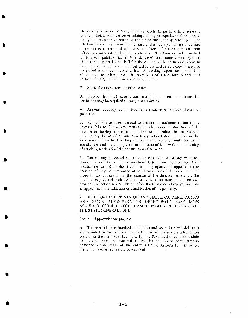
the county attorney of the county in which the public official serves, a pul~lic off'ici:~l, who perfol-ms valuing, taxing or equalizing functions, is guilty of official ~nisconduct or neglect of duty, the director shall take whatever steps are necessilry t o insure tliat co~nplaints are filed and prosecutions coniriienceci against s ~ ~ c l i officials for their removal from oflice. A complaint by tlie director charging official misconduct or neglect of duty of a public officer slirll be delivered to the county attorney or to the attorney general wlio sh:11I file the original with the superior court in the county in wliicll the public official serves and cause a copy thereof t o be sel-vcd upon sucii public official. Proceedings upon such coruplairits sll:~fI be in accordance wit11 the provisions of subsections B and C of section 38-34?, and sections 38-343 arid 38-345.
2. Study the tax systenis o f other states.
3. Employ technical experts and assistants and make contracts for services as tnay be required to carry out its duties.
4. Appoint advisory committees representative of various classes of property.
5. Request the attorney general t o initiate a mandamus action if any assessor fails to follow any regulation, rule, order or direction of the director or the department or if the director determines that an assessor, or a county board of equalization has practiced discrimination in the valuation of property. For the purposes of this section, county boards of equalization and the county assessors are state officers within the meani~ig of article 6, section 5 o f the constitution of Arizona.
6. Contest any proposed valuation or classification or any proposed change in valuations or classifications before any county board o f equalization or before the state board of property tax ap,peals. If any decision of any county board of equalization or of the state board of property tax appeals is, in the opinion of the director, erroneous, the director ;nay appeal such decision t o the superior court in the manner provided in section 42-1 5 1 , on or before the final date a taxpayer may file an appeal from tlie valuation or classification of his property.
7. SELL CONTACT PRINTS O F ANY NATIONAL AERONAUTICS AND SPACE ADMINISTRATION OIiTMOPHOTO BASE MAPS ACQUIRED BY TIIE DIRECTOR AND DEI'OSIT SUCII REVENUES IN THE STATE GENERAL FUND.
Sec. 2. Appropriation; purpose
A. The siltn of four I~undred eight thousand seven Iiundred dollars is appropriated to the governor to fund the Arizona resources information system for the fiscal year beginning July 1, 1972, and t o enable the state to acquire from the national aeron:~titics and sp;lce administration orthophoto base niaps of tlie entire state of Arizona for use by all departments o f Arizona state government.

B. The funds appropriated in subsection A arc to be available in tlie amounts and for the purposes following:
Personal services Office space Equiprncnt -
Furniture Viewing
Travel-in and out-of-state Supplies and photo reproduction Contingency Orthophoto base sheets Equipment Outside services
Total S40S,700.00
Sec. 3. Exemption
The appropriation made by this act is exempt iron1 the provisions of section 35-190, Arizona Revised Statutes, relatir~g t o lapsing of appropriations.
Sec. 4. Emergency
To preserve the public peace, health and safety it is necessary that this act become immediately operative. It is tllerefore declared t o be an emergency measure, to take effect as provided by law.
Approved by the Governor - May 24, 1972
Filcd in the Office o f the Secretary of State - May 24, 1072

APPENDIX I1
O F F I C E OF THE AUDITOR GENERAL SURVEY O F P O T E N T I A L AGENCY U S E R S O F Y A P S ,
LANDSAT IMAGERY AND OTHER CARTOGRAPHIC PRODUCTS

APPENDIX I1
OFFICE OF THE AUDITOR GENERAL SURVEY OF POTENTIAL AGENCY USERS OF MAPS,
LANDSAT IMAGERY AND OTHER CARTOGRAPHIC PRODUCTS
PART I: CARTOGRAPHIC SERVICES, EXCLUDING LANDSAT
1. Has your agency obta ined maps or o t h e r ca r tog raph ic in format ion from t h e Information Resources Div is ion o r ARIS?
S t a t e Local Federa l Agency Agency Agency T o t a l
Yes No
To ta l 15 - - 13 - - 4 - - 3 2 - -
2. What ca r tog raph ic products has your agency rece ived from t h e Div is ion?
S t a t e Local Federa l Agency Agency Agency T o t a l
Topographic maps 12 Land s t a t u s maps 8 Flood-prone a r e a maps 7 Urban s tudy maps 5 Orthophotoquads 11 A e r i a l photographs 10 -
T o t a l 5 3 - -
(Mul t ip le agency responses w i th in t o t a l s )
Other products mentioned: Vegetat ion cover maps (21, geo logic maps, s o i l maps, l and subsidence maps, Landsat imagery, land-use maps.
3. What was (were) t h e primary r ea son ( s ) f o r ob t a in ing t h e ca r tog raph ic product from t h e Div is ion?
S t a t e Local Federa l Agency Agency Agency T o t a l
Wide range o f p roducts 7 - - 7 Less expensive source 4 - - 4 Only known source 7 3 2 12 Timely source 9 - 1 - - 3 - 13
T o t a l 2 7 - - 4 - - 5 - - 3 6 - - (Mul t ip le agency responses w i th in t o t a l s )
Other reasons s t a t e d by t h e agenc ies : Convenient source ( 2 ) , unique products (21, "Of f i c i a l " Agency.

4. What o the r sources o f ca r tog raph ic products does your agency use and what p roducts do t h e s e sources supply? (Only those sou rces most f r equen t ly mentioned)
Source S t a t e Local Federa l
Type o f Products Agency Agency Agency T o t a l
U.S. Geological Survey Topographic maps, geo log ica l maps, orthophotoquads 8 7 4 19
Arizona Department Highway maps, a e r i a l photo- of T ranspo r t a t i on graphy , County c a d a s t r a l maps 4 6 - 10
Un ive r s i t y of Arizona, Vegetat ion maps, flood-hazard Of f i ce of Arid Land maps, w i l d l i f e h a b i t a t maps, S t u d i e s s a t e l l i t e imagery 2 3 - 5
U.S. S o i l Conservation S o i l maps, vege t a t i on a n a l y s i s Se rv i ce maps, f lood-p la in s tudy maps 2 5 1 8
Cities and coun t i e s P a r c e l maps, land-use maps, road maps, water information maps 1 4 - 5
P r i v a t e companies A e r i a l photographs and many o the r products 3 2 1 6
U.S. Fo re s t Se rv i ce Land-use p a t t e r n s i n Nat iona l F o r e s t s - 1 2 - - - 3 -
T o t a l - 2 1 - 29 - - 6 - 7
56 - - (Mul t ip le agency responses w i th in t o t a l s )
5. Of a l l t he ca r tog raph ic product sources , which one is t h e primary s u p p l i e r of your agency ' s product needs? (Only those agenc ies mentioned most f r equen t ly )
Source S t a t e Local Fede ra l
Agency Agency Agency T o t a l
U.S. Geological Survey 5 1 3 9
Information Resources Div is ion o r ARIS 6 1 - 7
Arizona Department of T ranspo r t a t i on 1 1 - 2
No response - 3 - 10 - 1 - 14 To ta l - 15 - 13 - - 4 - - 3 2 - -
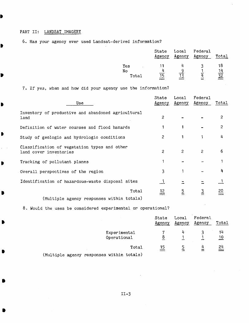
PART 11: LANDSAT IMAGERY
6. Has your agency ever used Landsat-derived information? D
S t a t e Local Federa l Agency Agency Agency T o t a l
Yes No
To ta l
7. I f yes , when and how d id your agency use t h e information?
Use S t a t e Local Federa l Agency Agency Agency T o t a l
Inventory of p roduct ive and abandoned a g r i c u l t u r a l land 2 - - 2
D e f i n i t i o n of water courses and f lood hazards 1 1 - 2
D Study o f geologic and hydrologic cond i t i ons 2 1 1 4
C l a s s i f i c a t i o n o f vege t a t i on types and o the r land cover i n v e n t o r i e s
# Tracking of p o l l u t a n t p lanes 1 - - 1
Overa l l pe r spec t ives of t h e reg ion 3 1 - 4
I d e n t i f i c a t i o n o f hazardous-waste d i s p o s a l s i t e s 1 - - - - - 1 -
T o t a l 12 - - 5 - - 3 - - 2 0 - (Mul t ip le agency responses w i t h i n t o t a l s )
8. Would t he uses be considered experimental o r ope ra t i ona l ?
S t a t e Local Fede ra l Agency Agency Agency T o t a l
Experimental Opera t iona l
T o t a l 15 - - 5 - - 4 - - 24 - - (Mul t ip le agency responses w i th in t o t a l s )

9. Of what b e n e f i t was t h e information t o your agency?
Almost no b e n e f i t 1 2
Limited b e n e f i t s 3 4
Except ional b e n e f i t s 5 No response
T o t a l
S t a t e Agency
Local Federa l Agency Agency T o t a l •
10. To what e x t e n t w i l l your agency use Landsat-derived informat ion i n t h e fu tu re? 4
S t a t e Local Federa l Agency Agency Agency To ta l
H e s i t a t e t o make f u t u r e use 1 - - - - 2 - - - -
Limited f u t u r e u se s 3 5 4 2 11 4 1 - - 1
Extensive f u t u r e u se s 5 5 - - - 1 - 6 - T o t a l 11 - - 4 - - 3 - - 18 -
11 . Do you have any major c r i t i c i s m s o f Landsat-derived information?
Major C r i t i c i s m s S t a t e d by Agencies: D i g i t a l and image r e s o l u t i o n not f i n e enough f o r ex t ens ive use i n resource management; Images a r e o f t e n d i s t o r t e d around t h e per iphery ; Image s c a l e is no t compat ible wi th USGS quadrangles; S p a t i a l r e s o l u t i o n is poor. a
12. One c r i t i c i s m of Landsat d a t a voiced by a t l e a s t two agenc i e s has been t h a t t h e product r e s o l u t i o n is o f u n s a t i s f a c t o r y q u a l i t y . I f t h e r e s o l u t i o n o f Landsat information could be upgraded, would your agency be a b l e t o make ope ra t i ona l use of t h e da ta?
S t a t e Local Federa l Agency Agency To ta l Agency
Yes 7 3 2 12 No 1 1 1 3 No response - 3 - - - - 3 -
T o t a l 11 - 4 - 3 - 18 -
Opera t iona l Uses S t a t e d by Agencies: C l a s s i f i c a t i o n s and mapping of land cover and land use; Symptomatic i n d i c a t i o n of popula t ion changes; Monitor and eva lua t ion of w i l d l i f e h a b i t a t s , vege t a t i on communities and a a g r i c u l t u r a l l ands ; Evaluat ion o f t he environmental e f f e c t s of p o l l u t i o n and hazardous-material d i s p o s a l s i t e s ; Review of environmental-impact s ta tements .

13. What e n t i t i e s , o t h e r than your agency, provided r e sou rces o r s e r v i c e s t o your Landsat-appl icat ion pro j e c t s ( s ) ?
S t a t e Local Federa l E n t i t x Resource o r Se rv i ce Agency Agency Agency T o t a l
Univers i ty o f Arizona, I n t e r p r e t a t i o n of imagery, Of f i ce of Arid Land product ion of maps, t r a i n i n g ,
B S t u d i e s f i e l d suppor t 1 3 - 4
NASA Imagery, i n t e r p r e t a t i o n of imagery, funds f o r a n a l y s i s - - 1 1
U.S. Geological Survey Imagery and d i g i t a l t a p e s ,
B i n t e r p r e t a t i o n of imagery 2 - 1 3
Information Resources Technical a s s i s t a n c e , use of Div is ion o r ARIS equipment, o t h e r s e r v i c e s 1 - - 1
Arizona S t a t e Research a s s i s t a n c e
D Univers i ty
U.S. Fo re s t Se rv i ce Information and s e r v i c e s 1 - - 1
U.S. Weather Se rv i ce Metero logica l d a t a - 1 - - - - - 1
T o t a l
(Mul t ip le agency responses w i th in t o t a l s )
14. I f t h e Information Resources Div is ion o r ARIS provided a resource o r s e r v i c e , o f what c o n t r i b u t i o n d i d t h e resource or s e r v i c e make t o t h e use o f Landsat imagery by your agency?
S t a t e Local Fede ra l Agency Agency Agency T o t a l
L i t t l e o r no c o n t r i b u t i o n 1 2 3 - 5 2 - - - -
Average c o n t r i b u t i o n 3 5 1 1 7 4 1 - - 1
Extensive c o n t r i b u t i o n 5 - 2 - - - - - 2
T o t a l - 10 - 4 - - 1 - - 15 - -

15. I n u s ing Landsat , what resources d id your agency apply t o t h e p r o j e c t ( s ) ?
Resource Provided by Agency S t a t e Local Federa l a Agency Agency_ Agency T o t a l
F i e l d support t o v e r i f y i n t e r p r e t e d r e s u l t s 3 1 1 5 S t a f f t o i n t e r p r e t and analyze da t a 3 - 1 4 Equipment t o i n t e r p r e t and ana lyze d a t a - - 1 1 Base maps and/or suppor t ing a e r i a l photography 2 - - - - 1 3 -
Tota l - 8 - 1 - - 4 - - 13 - - (Mul t ip le agency responses w i th in t o t a l )
16. Landsat imagery is sa t e l l i t e -p roduced imagery which can be used t o i d e n t i f y vege t a t i on cover and o the r land s t a t u s information. The imagery is a v a i l a b l e i n 4 e i t h e r computer-compatible d i g i t a l form o r 13,225 square-mile photographic scenes.
Has or w i l l your agency cons ider /cons idered us ing Landsat imagery i n t h e fu tu re? (Only f o r those agenc ies which have never used Landsat imagery i n t h e p a s t . See ques t i on 6.)
S t a t e Local Federa l Agency Agency Agency To ta l
Yes 4 5 1 10 No - 2 - 2 No response - - - 2 - - 2 -
Tota l - 4 - 9 - - 1 - - 14 - -
17. For what purpose has your agency considered us ing Landsat imagery? (Only t hose agenc i e s who answered Yes t o Ques t ion 16)
Uses Proposed by Agencies: Visual land s t a t u s pe r spec t ive ; S e l e c t i o n of p o t e n t i a l s i t e s f o r t h e a p p l i c a t i o n o f s o l a r energy; Measurement of s o l a r r a d i a t i o n ; Monitor and eva lua t ion of mining and g raz ing a c t i v i t y ; S t u d i e s of water q u a l i t y ; Land-use c l a s s i f i c a t i o n and a n a l y s i s .

PART 111: INFORMATION SYSTEM
I, 18. Has your agency had any con tac t wi th t h e Information Resources Div is ion of t h e S t a t e Land Department regard ing a n a t u r a l resource in format ion system?
S t a t e Local Federa l Agency Agencv Agency T o t a l
Yes 12 5 2 19 No 3 7 2 12 No response - - - 1 - - 1 -
T o t a l
B 19. What was t h e na tu re of t h e c o n t a c t wi th t h e Div is ion?
S t a t e Local Federa l Nature o f Contact S t a t e d by Agencies Agency Agency Agency T o t a l
Discussion of system c a p a b i l i t i e s and p o s s i b l e a p p l i c a t i o n s by agency 5 1 1 7
Informal communication concerning D i v i s i o n ' s o b j e c t i v e s and c a p a b i l i t i e s 4 2 - 6
Contact through S t a t e d a t a coord ina t ion network 2 - - 2
Addition of agency m a t e r i a l s t o e x i s t i n g ca r tog raph ic network managed by t h e Div is ion 1 - 1 2
No response - 2 - - - - 2 -
T o t a l - 12 5 - - 2 - - 19 - - (To ta l r e p r e s e n t s t hose agenc ies answering Yes t o Ques t ion 18.)
20. Has your agency been provided t h e oppor tun i ty t o express i t s d a t a process ing # needs t o t h e Information Resources Div is ion?
S t a t e Local Federa l Agency Agency Agency T o t a l
Yes 9 2 2 13 No 3 4 - 7 No response - 3 - 7 2 - 12 -
Tota l

21. What a r e your agency's p ro jec ted needs f o r an automated car tography system? Does your agency have access t o such a system a t t h i s t ime?
S t a t e Local Federa l P ro j ec t ed Needs S t a t e d by Agencies Agency Agency Agency T o t a l
Up-to-date maps and d i g i t a l a n a l y s i s f o r use i n planning and r e sea rch 3 - - 3
Up-to-date maps and d i g i t a l a n a l y s i s f o r r e c u r r i n g agency o p e r a t i o n s
D i g i t i z a t i o n of e x i s t i n g maps f o r p rocess ing a t t h e Arizona Department of Transpor ta t ion o r elsewhere
Have not p ro j ec t ed needs a t t h i s time
No s i g n i f i c a n t need a t t h i s t ime
No response
T o t a l
S t a t e Access t o System S t a t e d by Agencies Agency
Local Agency
Federa l Agency T o t a l il
Access t o Federa l computer systems wi th automated mapping - Limited o r no access t o such a system a t t h i s t ime 10
No response
T o t a l

22. What products would a n a t u r a l resource information system have t o provide i n order t o s a t i s f y your agency 's p ro j ec t ed da t a needs?
Natura l Resource Information System S t a t e Local Federa l Products Requested by Agencies Agency Agency Agency T o t a l
D ig i t i zed land r e l a t e d d a t a f o r s t a t i s t i c a l ana lys i s* 3 3 1 7
Updated land- re la ted d a t a i n map form* 9 5 3 17
Capab i l i t y o f g r a p h i c a l d i sp l ay o f l and- re la ted data*
Spec i a l equipment f o r image viewing 1 - - 1
Aer i a l photography
T o t a l - 17 - 10 - - 4 - - 3 1 - - (Mul t ip le agency responses w i th in t o t a l s )
23. A s i n any information system, d a t a must be a v a i l a b l e f o r t h i s system's success . The Di r ec to r of t h e Information Resources Div is ion has s t a t e d t h a t most o f t h e d a t a w i l l be obtained through Landsat o r u se r agencies . Does your agency have any land s t a t u s or r e l a t e d d a t a which could be used i n a n a t u r a l resource information system? What is t h i s da ta?
Agency Responses Included t h e Following Data Elements: Vegetat ion i n v e n t o r i e s ; w i l d l i f e and f i s h h a b i t a t i o n d a t a ; hydro logic and water q u a l i t y in format ion ; demographic da t a ; t a x assessment d a t a ; a rchaeologic and c u l t u r a l d a t a ; r e c r e a t i o n a r e a l o c a t i o n s ; highway system l o c a t i o n ; minera l , geo logic and mining da t a ; waste d i s p o s a l l o c a t i o n s ; a i r q u a l i t y da ta .
* Land-related d a t a r e f e r s t o many types of d a t a t h a t can be geographica l ly referenced. Examples of t h e s e da t a s t a t e d by agenc ies inc lude : l and use , l and cover , topographic , geo logic , hydrologic , meteoro logica l , vege t a t i on , water q u a l i t y , c l ima to log ic , r e c r e a t i o n a l a r e a s , a i r q u a l i t y , s o i l cond i t i ons and geothermal condi t ions .

24. Has t h e Information Resources Div is ion contac ted your agency concerning t h e (I capture of t h i s d a t a f o r t h e information system?
S t a t e Local Federa l Agency Agency Agency To ta l
Yes 4 1 1 6 No 9 11 3 23 No response - 2 1 - - - 3 -
T o t a l 15 - - 13 - - 4 - - 32 - -
25. Assuming t h a t da t a e n t r y w i l l be completed by t h e d a t a s u p p l i e r , w i l l your agency be a b l e t o supply d a t a t o t h e information system? When?
Agency A b i l i t y t o Supply Data S t a t e Local Federa l Agency Agency Agency To ta l
Cannot a s s e s s a b i l i t y t o i n p u t d a t a a t t h i s time* 4 3 - 7
Data is a v a i l a b l e and can be en te red i n t o t h e system** 5 - 2 7
Data is a v a i l a b l e , but agency is unable t o i n p u t d a t a a t t h i s t ime 3 1 1 5
Not a p p l i c a b l e o r no response 3 - 9 - 1 - - 13
T o t a l - 15 - 13 - - 4 - - 3 2 - -
26. Would your agency s u f f e r excess ive expenses o r undue hardsh ips i n supply ing t h i s da t a? Would a d d i t i o n a l s t a f f be needed?
S t a t e Local Federa l Agency Agency Agency To ta l
Unable t o make assessment a t t h i s t ime 4 1 - 5
Addi t iona l personnel would be needed or ' excess ive expenses would be i ncu r r ed 1 3 1 5
No hardsh ips o r expenses 5 - 2 7
Information c l a s s i f i e d a s c o n f i d e n t i a l might be dec la red unava i l ab l e 1 - - 1
Not a p p l i c a b l e or no response 4 - 9 - 1 - 14 -
T o t a l
* Seve ra l agenc ies i n d i c a t e d t h a t a d d i t i o n a l information concerning t h e da ta formats , reques ted volumes, e t c . would have t o be e s t a b l i s h e d p r i o r t o a s se s s ing t h e i r a b i l i t y t o i npu t da ta .
** Seve ra l agenc ies i nd i ca t ed t h a t d a t a e n t r y could be suppl ied i f t h e agency rece ived a d d i t i o n a l resources and/or t h e da t a was i n a format compatible t o en t ry i n t o t he information system.

27. What a l t e r n a t i v e s a r e a v a i l a b l e t o your agency i n ob t a in ing automated car tography and o the r da t a process ing se rv i ce s?"
S t a t e Local Federa l Agency Agency Agency T o t a l
P r i v a t e e n t e r p r i s e 3 - 2 5
Unive r s i t y of Arizona, Of f i ce of Arid Land S t u d i e s 1 2 - 3
Federa l agenc i e s 1 1 3 5
Developed i n t e r n a l l y o r wi th a c o n t r a c t i n g agency 3 1 - 4
None known a t t h i s time - 5 - 2 - - - 7
T o t a l - 13 - 6 - - 5 - - 24 - -
(Mul t ip le agency responses w i th in t o t a l s ) D
28. I f t h e Information Resources Div is ion d id complete a n a t u r a l resource d a t a base wi th automated mapping c a p a b i l i t i e s , would your agency use t h e D i v i s i o n ' s se rv ices?**
S t a t e Local Federa l Agency Agency Agency T o t a l
Yes 13 6 2 2 1 No 1 2 - 3 No responses - 1 - 5 - 2 - 8
T o t a l - 15 - 13 - - 4 - - 3 2 - -
* Seve ra l agenc ies have acces s t o gene ra l d a t a process ing s e r v i c e s and t h e
B compilat ion of t h e responses r e f e r s only t o a l t e r n a t i v e automated car tography s e r v i c e s . Addi t iona l ly , s e v e r a l respondents r e p l i e d t h a t t h e s t a t e d a l t e r n a t i v e s may be d u p l i c a t i v e o r exces s ive ly expensive, an i n d i c a t i o n t h a t t h e a l t e r n a t i v e may not be t h e b e s t so lu t ion .
** Seve ra l responses i nd i ca t ed t h a t ex t ens ive use of t h e information system would depend upon t h e d e t a i l and con ten t of t h e information and s e r v i c e s provided.

29. What o the r s e r v i c e s would you l i k e t o see t h e Div is ion supply?
Other Se rv i ce s Requested by Agencies:
1. Provide s p e c i f i c information about t h e products and s e r v i c e s a v a i l a b l e from a
t h e Div is ion and how they can be app l i ed by agenc ies .
2 . Provide information regard ing c u r r e n t remote-sensing and multi-agency geographic information system developments.
3. Provide geographic information system s e r v i c e s i n t h i s S t a t e and coord ina te those a c t i v i t i e s wi th o ther r e l a t e d geographic in format ion systems such a s t he Accident Locat ion and I d e n t i f i c a t i o n S u r v e i l l a n c e System (Arizona Department of rans sport at ion), and t h e Geographic Base F i le /Dual Independent Mapping Encoding (Maricopa Assoc ia t ion o f ~ o v e r n m e n t s ) .
4. Coordinate t h e D i v i s i o n ' s remote-sensing a c t i v i t i e s w i t h t hose a c t i v i t i e s a
c u r r e n t l y o p e r a t i o n a l a t the Un ive r s i t y of Arizona, O f f i c e of Arid Land S tud ie s .
5. Provide c lear inghouse and l i b r a r y s e r v i c e s f o r t h e use of c u r r e n t and h i s t o r i c a l maps, a e r i a l photography and o the r p u b l i c a t i o n s of n a t u r a l resource da t a . a
6. Provide t e c h n i c a l t r a i n i n g f o r technology t r a n s f e r and on - s i t e s e r v i c e s f o r t h e a p p l i c a t i o n of remote-sensing technology.
APPENDIX I11
REPORT ON THE SURVEY OF REQUIREMENTS O F THE ARIZONA RESOURCES INFORPIATION SYSTEM

REPORT ON THE
SURVEY O F REQUIREMENTS
OF THE
ARIZONA RESOURCES INFORMATION SYSTEM
Department of Administration
Data Processing Division
Jack Stanton
State Automation Director
April 1978

Introduction
The management of Arizona Resources Information System (ARIS)
requested that an independent survey of the automation needs of
their organization be made by the Data Processing Division (DPD)
of the Department of Administration. The survey is intended to
answer the following questions:
1. What demand exists within State 'agencies for services now
or potentially available from ARIS?
2. What modifications or enhancements to the existing hard-
ware configuration and software are required to make the
entire system functional at the originally chartered and
designed level?
Since pending legislation proposes that ARIS be transferred
from the Department of Revenue to the Land Department, an attempt
has been made here to provide information for the benefit of the
Land Department since it may, in the near future, become responsi-
ble for ARIS. Permission to conduct the survey \gas obtained
from the Director of the Department of Revenue.
Background
ARIS was created by the Governor in 1972 to serve as the cen-
tral source of land and other physical resource data in the State.
To achieve its objective, computer aided mapping and data manipu-
lation capabilities were proposed and a system of hardware and
software defined. To oversimplify the record, the components that
were installed were never integrated into a fully operational sys-
tem because several key elements were not acquired. Budgetary
constraints were cited as the primary reason for this failure.
As a result, only relatively unsophisticated services could be
provided. Among the most important of these has been the collec-
tion and dissemination of high altitude aerial photographs and

various maps generated for the most part by federal agencies. These
have received wide use in the land resource-related activities of 4 the State and will probably continue to be popular in the future.
Survey Approach
DPD has attempted to answer the questions posed above by first 4
assessing the demand for service from ARIS and then recommending
hardware, software and organizational resources to meet the demand.
It was accepted that there might be little or no demand in which
case no upward development of ARIS resources would be recommended. 4
To complete the first phase, interviews were conducted with
all identified user groups currently or potentially served by ARIS.
These included the following: ' 4
Departnlent of Revenue--Property and Special Taxes
Game and Fish Department--Planning
OEPAD--Planning
Department of Transportation--Planning
Land ~epartment--Planning, Natural Resources
Department of Economic Security--Planning
Oil and Gas Commission--Administration and Planning
Outdoor Recreation--Planning
Water commission--planning
Twenty-four managers and professional employees who attended (I
the various interview meetings were asked a standard set of ques-
tions which usually led to general discussion and additional ques-
tions. The basic questions were: (I
- What services do you presently receive from ARIS?
- What additional services do you need from ARIS?
- Is there another available source of these services?
- Would you be willing to pay for ARIS services?
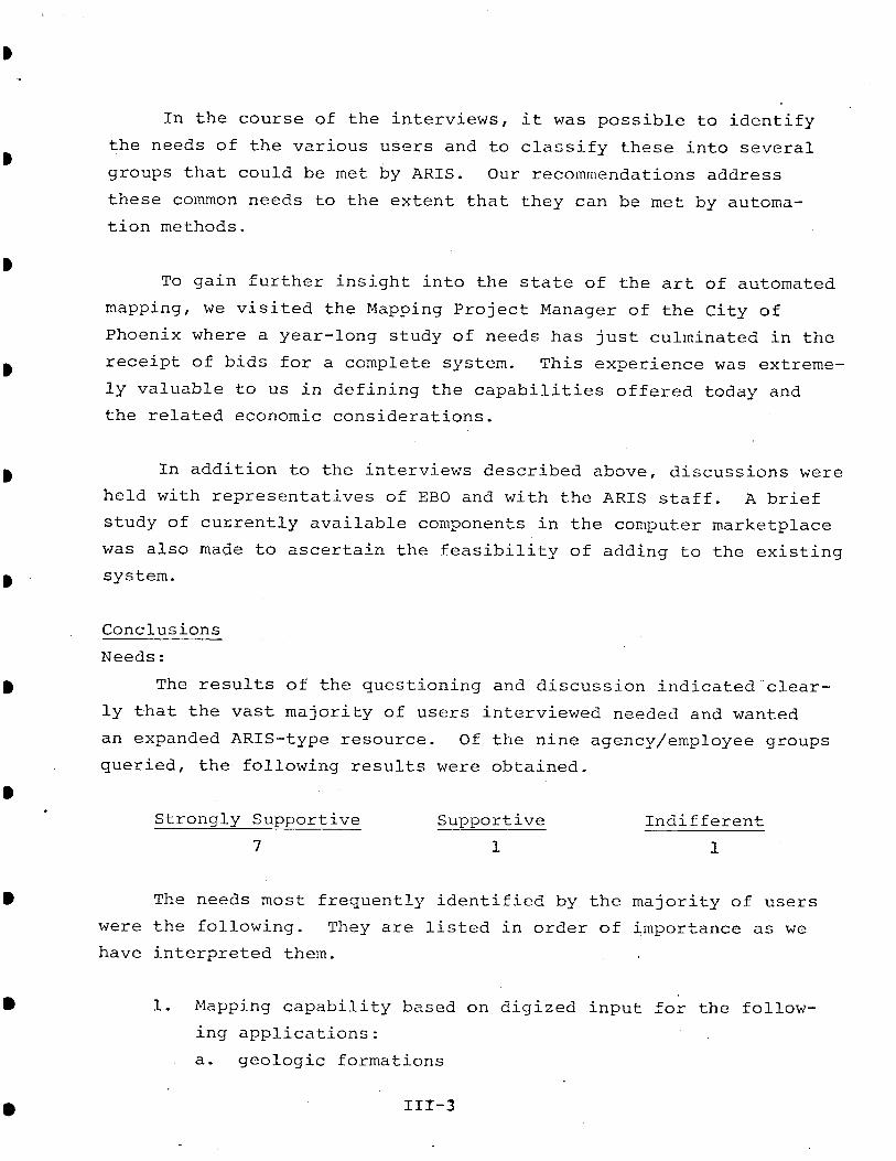
In the course of the interviews, it was possible to identify
the needs of the various users and to classify these into several
groups that could be met by ARIS. Our recommendations address
these common needs to the extent that they can be met by automa-
tion methods.
To gain further insight into the state of the art of automated
mapping, we visited the Mapping Project Manager of the City of
Phoenix where a year-long study of needs has just culminated in the
receipt of bids for a complete system. This experience was extreme-
ly valuable to us in defining the capabilities offered today and
the related economic considerations.
In addition to the interviews described above, discussions were
held with representatives of EBO and with the ARIS staff. A brief
study of cucrently available components in the computer marketplace
was also made to ascertain the feasibility of adding to the existing
system.
Conclusions
Needs :
The results of the questioning and discussion indicated clear-
ly that the vast majority of users interviewed needed and wanted
an expanded ARIS-type resource. Of the nine agency/employee groups
queried, the following results were obtained.
Strongly Supportive
7
Supportive
1
Indifferent
The needs most frequently identified by the majority of users
were the following. They are listed in order of importance as we
have interpreted them.
1. Mapping capability based on digized input for the follow-
ing applications:
a. geologic formations

b, mineral resources
c. water rights ownership
d. water resources, flood plains, etc.
e. surface boundaries--ownership (tax areas)
f. recreation areas
g. vegetation
h. transportation planning
i. wildlife and habitat
j. overall use planning
2. Development of physical features data base with flexible 4
output capabilities,to meet analysis, modeling and other
requirements for most areas indicated under #1 above.
3. Ability to inventory resource data with common location
characteristics for all categories identified in #1 above. a
4. Current aerial photographs with high resolution and at
scales compatible to user needs.
One may conclude that 1, 2, and 3 are all variations on the 4
same theme - a complete data base with mapping software. The reason
these are stated as separate needs is because some of those inter-
viewed felt that they could manage with only #1, Others who needed
#3 were interested in tabular or comparative digital data only a
instead of mapping capability, And there were a few who need only
photographs. It should be noted that a substantial number of users
did not have a clear understanding of the potential capabilities of a automated mapping even though they knew what their own needs were.
Equipment:
With respect to the existing configuration and software, the (I
conclusions drawn are based mainly on our interviews with ARIS
staff and from discussions with the City of Phoenix representative.
The equipment in place at ARIS was acquired from several vendors
approximately six years ago. Some of the principal components are
no longer manufactured. Thus, in addition to the problem of

multi-vendor maintenance responsibility for a single system, there
is a question of physical and technical obsolesence. It is possi-
ble, however, to add the components necessary to complete the sys-
tem, but the maintenance problem might get even worse if additional
manufacturers are represented. The purchase cost of needed compo-
nents is approximately $50,000.
New technology has evolved rapidly in the past six years and
during this time the cost of equipment has actually decreased
while performance has increased. The expanded capabilities and
cost advantage are a strong incentive to look at new hardware for
ARIS.
Sof tware:
Very little software exists at ARIS beyond the basic operating
system. his is due to the fact that no qualified programmer-ana-
lyst has worked on the ARIS staff since the very early years. The
required programming language to operate the present equipment is
Fortran, Contact was made with the DOA Data Center and they have
no one qualified to assist ARIS at present. The mapping field is
specialized but there should be no reasons other than budgetary
ones why a qualified programmer-analyst could not be hired. Sev-
eral valuable software products are available for purchase at
present.
The concPusions can be summarized as follows:
1. A demand for automated mapping and related services exists
at present among the users surveyed. (No attempt was made
to determine the actual level of services needed to satis-
fy these users. )
2. ARIS equipment can be upgraded and a complete system pro-
vided. Maintenance problems would continue. Software
development could begin but no programming capability
exists at present.

3. New technology, improved prices and growing demand for
service argue for an entire new system. Because of the 4 necessity to do a thorough study of requirements, in-
stallation of new hardware would be at least a year from
favorable decision and budget authorization. The study
should consider other alternative sources of support in- 4
cluding other State data centers.
Recommendations
These recommendations are based on the assumption that those 4
users who presently have need for ARIS-type services will continue
to support the program and contribute resources as required.
If funds are available, ARIS should proceed now to (a) ac- 4
quire the necessary hardware to complete their present sys-
tei and (b) hire a fully qualified programmer-analyst to
begin talking to users and translating their requirements
into system capabilities. If an equipment operator is a required, one should either be hired or a present staff
member trained. Equipment should be leased for one year
if possible. (See list and diagram) This would be an
interim step to enable users to begin to receive automated a
output as quickly as possible. The limiting factor would
be hiring the qualified programmer-analyst. Development
should be limited here with an eye to implementing #3
below.
2. A committee of ARIS staff and users should initiate (now)
a detailed study of user needs and objectives and develop
a three-year plan for meeting these needs. The plan should
make clear commitments to achieve objectives if funding is
available. The history of unfulfilled objectives is such
that nothing less than this should be offered. DPD will
assist with the planning if requested.
3. As soon as requirements are defined in 82 above and speci-
fications can be drafted, obtain bids for and order a new

hardware system tailored to the needs of the users unless
service is to be obtained from another source. Lease or
buy system on installment basis and plan to acquire at
least one additional programmer for software development.
Monthly equipment cost or external service will run
$6,000-$10,000. This new system, if selected, should
completely replace the existing system after an orderly
conversion period.
4. After # 2 is complete, begin detailed design of a geograph-
ical data base to meet users' needs. This process will
require the active participation of all users, both in the
design phase as well as in implementation.
5. After plan is complete, a committee of users and ARIS
staff (and this office, if requested) should establish a
formula for charging for the use of ARIS services.
It is very important that all those who will be affected by
the implementation of the above recommendations have a clear under-
standing of the benefits, costs, and time span involved. To ini-
tiate this type of communication, it might be advisable to invite
representatives of hardware manufacturers or their customers to
visit the Capitol for workshops or discussion meetings.
The effect of the transfer of ARIS and of these recommendations
upon the Land Department will be to add an additional management
responsibility and, depending on the wishes of the Legislature, a
possible added use of Land Department revenues. Users of automated
mapping services within Land, and there are several, should benefit
from the closer association. No direct benefit to or conflict with B current data processing functions of the Land Department should be
expected. It might be economical and efficient to combine these
functions under one capable D.P. Manager although it should be rec-
ognized that making ARIS a successful operation will be a heavy
responsibility in itself.

ARIS EQUIPMENT AND PROPOSED BASIC ADDITIONS
Installed ARIS computer equipment
Hardware :
CPU - Data General Nova 800 Jumbo, 24K memory, auto a program load feature
Tape - Wanco model 10A, 800 BPI, 9 track
Disc - 3 Data Disc model 8410, 1 MB each, fixed head
Terminals - 2 Tektronix CRT's model 4010-1 with graphic • capabilities. One modified for switch select-
able 110-9600 baud communications.
Plotter - Zeta Research model 3600
Current upgrades needed and available
Hardware: . 8 K core memory
10 MB disk
300 LPM printer
1600 BPI tape drive
Digitizer
Sof tware : RDOS operating system software #
Parcel mapping software
Georgia Tech software enhancements
Georgia Tech mapping data base (in township, range,
section and quarter section) a
CURRENT AND INTERIM C O N F I G U R A T I O N .

APPENDIX I V
OCTOBER 9 , 1 9 7 9 , LETTER TO THE STATE AUTOMATION DIRECTOR FROM I R D ( A R I S ) DIRECTOR

5 tn te ;Cali5 D r p a r h i r n t INFWMATION RESOURCES MVlSlON
1624 I*. AOAMS W P K X 3 l X . 4 2 BJOOl
1-1 2 n - a
October 9 , 1979
Mr. Jack S tan ton S t a t e Automation Di rec to r Data Process ing Oivis ion Department o f Administrat ion S t a t e Capi t o l l West Wing Phoenix, Arizona 85007
Dear Mr. S tan ton :
The Arizona S t a t e Land D e p a r t ~ e n t has completed the budget reques t f o r FY 80-81, which inc ludes the following computer hardware rep lace- ment i terns f o r y o u r review and approval .
1 . Data General Ec l ip se S/130 Computer >lode1 8611-NB 424,500 a . This Model inc ludes 256 KS b. Map board c . Ba t t e ry back-up d . E R C C
2 . Floa t ing Poin t Board Model 8613 2,020
3. 4 l i n e Po r t - ULH 5 boa rd - 2 e a c h ( 8 l i n e s t o t a l ) , 3,600
4 . Tape Drive Unit Model 6026 ( 9 t rack - 800/1600 14,500 s e l e c t a b l e )
5. Dasher T P I - terminal - Model 6081-A 3,050
TOTAL REQUESTED $48,600
I tern one w i 11 r ep l ace the present Nova 800 computer which w i 1 l a1 l o w the system t o be used in a time shar ing environment. The present Nova 800 computer i s a s i n g l e user system making i t very d i f f i c u l t t o continue program development and use r sys tern tifie toge ther . L a s t yea r the Nova 800 was maintained by the company on a type 11 l e v e l . It now i s becoming d i f f i c u l t t o ma in t a in , a n d provide se rv i ce to the users .
The p re sen t tape d r i v e i s a 800 BPI, 9 track u n i t bu t i t d o e s n ' t allow us t o process Landsat t a p e s , which a r e normally 1600 B P I , 9 t rack . The re- placement proposal wi 1 1 allow us t o use the 1600 BPI mode o r t r a n s f e r , for - mated da t a 800 B P I - tape u n i t one to tape u n i t two.
The Dasher T P I terminal w i 11 be added to the system, enabling i t to be used as a master input /output device , freein-g the present C R T to be used as a u se r t e rmina l .

. . - With the i n s t a l l a t i o n o f the E c l i p s e S/130 computer we w i l l use t he Data General Advanced Opera t ing Systerr; ( A O S ) al lowing time s h a r i n g , mul t i - l anguage use and i n c r e a s e d u s e r a v a i l a b i l i t y .
We a r e p r e s e n t l y under a Federa l g r a n t to t e s t a system c a l l e d "Ecosim" i n t e r a c t i v e F o r t r a n simul a t o r package f o r Fore s t ry management.
Under t h i s g r ~ n t we a r e r e n t i n g a Ec l i p se S/130 system t o t e s t t he F o r e s t r y pdckage, a \ lowing 1 inkage t o occur- between the Fo re s t ry o f f i c e i n F l a g s t a f f us ing a LA36 t enn ina l and the system. An a d d i t i o n a l bene- f i t o f t h i s t e s t i s t o i n s u r e t h e pr-oposttd replacement of the NOVA 800 w i th the Ec l i p se system i s t he most c o s t e f f e c t i v e move. We f e e l extremely s t r o n g about the r e s u l t s o f t h i s t e s t hdven proven t h e ease of t r a n s f e r from one o p e r a t i n g so f twa re t o ano the r w i t h no d i f f i cu l t y .
I b e l i e v e these replacenlent i tems a r e i d e n t i f i e d i n t h e o r i g i n a l system a p - proval p r o j e c t r e p o r t provided by you and your s t a f f l a s t y e a r .
We hope t he r eques t nieets your review a n d approval requ i rements . P lease c a l l nie i f you have any q u e s t i o n s .
S i n c e r e l y ,
M i c h a e l 5 . Cas t r o , Di r e c t o r infori7:ation Resources Divis ion A I - i z o n ~ S t a t e Land Department
c c : S h a f i q Jar:iali
NSC/be
IV- 2

APPENDIX V
OCTOBER 17, 1979, LETTER TO IRD (ARIS) DIRECTOR FROM THE STATE AUTOMATION DIRECTOR

STATE OF ARIZONA
MEMORANDUM:
TO : Michael S . C a s t r o
D E P A R T M E N T OF ADMiNlSTRATlON
D A T A P R O C E S S I N G D l V l S i O N
SUBJECT: Infor-mation Resources D i v i s i o n Budget Request f o r i Y 80-81 (Refe rence your \ e t t e r d a t e d 10/9/79)
The o r i g i n a l s y s t e m approva l p r o j e c t r e p o r t r e f e r r e d t o i n t h e n e x t t o t h e \ a s t pal-agr-aph o f y o u r l e t t e r i s i n a c t u a l i t y a r e p o r t on a survey of r equ i ref ients o f the Arizona Resources I n f o r n ~ a t i o n System which was pre- p a r e d by D P D and i s s u e d A p r i l 2 1 , 1978. T h e r e p o r t c o n t a i n e d recorru7lenda- t i o n s b u t no app l -ova l s . T h e reconniendations were based upon t h e sys tem b e i n g used by a g e n c i e s o t h e r than j u s t t h c Land Depar tment , and i t was ex- p e c t e d t h a t expans i o n o f t h e s y s tem beyond acqui r i n g t h e necessa ry hardware t o comple te t h e p r e s e n t s y s tern (Reconwnenda t i o n 1 - a . ) woul d be based upon c o s t j u s t i f y i n g t h e need f o r t h e e x p a n s i o n .
We have n o t s e e n any e v i d e n c e t h a t t h e v a l u e o r b e n e i f t s d e r i v e d from o r e x p e c t e d t o be d e r i v e d from t h e sys tem have been i d e n t i f i e d and q u a n t i f i e d . The p a r a g r a p h i rn iwdia te ly f o l l o w i n g t h e f i v e recommendations s t a t e s i n p a r t ,
" I t i s v e r y i m p o r t a n t t h a t a l l t h o s e who w i l l be a f f e c t e d by the imp1 ementa t i on o f t h e above recorrlrnenda t i o n s have a c l e a r under- s t a n d i n g o f t h e b e n e f i t s , c o s t s and t i m e span i n v o l v e d . . . "
Whi le we c o n t i n u e t o s u p p o r t t h e use of A R I S , w e cannot approve o r s u p p o r t t h e expans ion o f t h e sys tem based upon t h e m a t e r i a l we have r e c e i v e d t o d a t e .
3R: r o
c c : Don O l s o n , EBO Ron G a u t h i e r , SPO

APPENDIX V I
RESUME OF THE DIRECTOR OF THE NATURAL RESOURCES INFORMATION SYSTEMS PROJECT
WITH THE NATIONAL CONFERENCE OF STATE LEGISLATURES

RE S LJXE
P a u l A . Tessa r
EDUCATION:
Graduate : Masters of Urban P lanning -- S p e c i a l i z a t i o n i n Quanta t ive Flethods and Computer App l i ca t i ons (two-year program), May 1974, Un ive r s i t y of I l l i n o i s , Urbana, I l l i n o i s .
Undergraduate: B.A. w i t h Honors i n H i s to ry , June 1972, U n i v e r s i t y of I l l i n o i s , Urbana, I l l i n o i s .
AWARDS AND HONORS:
South Dakota S t a t e Government Employee of t h e Month, February 1976.
Un ive r s i t y of I l l ino is /Arner ican I n s t i t u t e of P l anne r s , S tuden t of t h e Year, 1974.
AREAS OF COWETANCE:
- Natu ra l Resource Informat ion System des ign , development, management and a d m i n i s t r a t i o n .
- Appl i ca t i on of new t echno log ie s i n n a t u r a l r e sou rce p l ann ing and management processes .
- Land u s e and n a t u r a l r e s s u r c e i n f o n a t i o n a n a l y s i s and a p p l i c a t i o z .
- D i g i t a l and manual remote s e n s i n g and a n a l y s i s t echniques .
- Land c a p a b i l i t y and s u i t a b i l i t y modeling.
- Development of i n t e r agency coope ra t i ve p r o j e c t s .
- Program Adminis t ra t ion , i nc lud ing budget p r e p a r a t i o n and a l l o c a t i o n ; work p lanning , implementation and e v a l u a t i o n ; c o n t r a c t n e g o t i a t i o n and execu t ion ; and pe r sonne l h i r i n g , s u p e r v i s i o n and eva lua t ion .
- S t a t i s t i c a l t o o l s and methodologies , i nc lud ing m u l t i v a r i a t e a n a l y s i s .
- Computer g r aph ic s and d a t a d i s p l a y .
- Use of FORTRAN and Assembly Language.
- Computerized modeling and p r o j e c t i o n .

Resume of Paul A. Tessar Page n.70
NORK EXPERIENCE :
2/78 t o P re sen t : N a t u r a l Resource Information Systems P r o j e c t D i r e c t o r , Na t iona l Conference of S t a t e L e g i s l a t u r e s . Responsible f o r conduct ing a n a t i o n a l communication and t e c h n i c a l a s s i s t a n c e program f o r s t a t e l e g i s l a t u r e s on Landsat and n a t u r a l r e sou rce in format ion systems' technology. S p e c i f i c t a s k s i n c l u d e p r e p a r a t i o n of a n a t i o n a l Remote Sensing n e w s l e t t e r focused on s t a t e a p p l i c a t i o n s of NRIS technology; a conduct of s t a t e l e v e l workshops and committee b r i e f i n g s on MRIS technology, a p p l i c a t i o n s , l i m i t a t i o n s and c o s t s ; p r o v i s i o n of t e c h n i c a l a s s i s t a n c e t o l e g i s l a t o r s , s t a f f o r l e g i s l a t i v e committees; development of A L e g i s l a t o r ' s Guide t o Na tu ra l Resource Infor inat ion Systems and r e l a t e d o r a l p r e s e n t a t i o n s ; s t a 5 f i n g of ECSL N a t u r a l Resource Informat ion 4 Systems Task Force; supe rv i s ion of s t a t e n a t u r a l r e sou rce l e g i s l a t i o n surveys ; p r e p a r a t i o n of a r e p o r t on S t a t e I n s t i t u t i o n a l and Technical Approaches t o Landsat U t i l i z a t i o n ; : and, a l i a s i o n wi th r e l e v a n t s t a t e and f e d e r a l agenc ies .
Q A s s i s t a n t Remote Sensing P r o j e c t D i r e c t o r , Na t iona l Conference of S t a t e L e g i s l a t u r e s . Responsible f o r a s s i s t a i n g i n t h e imple- menta t ion of a nat ionwide s a t e l l i t e remote s ens ing communica- t i o n s program designed t o acqua in t key s t a t e l e g i s l a t o r s and s t a f f w i th t h e c a ? a b i l i t i e s , app l j - ca t i ons , and l i m i t a t j o n s of Landsat technology. S p e c i f i c t a s k s i n c l u d e p repa ra t i on of a 4 remote s ens ing n e w s l e t t e r ; completion of a g e n e r a l brochure on Landsat geared t o non techn ica l r e a d e r s ; involvement i n t h e p lanning and conducting of a s e r i e s of f i v e r e g i o n a l workshops; development of A L e g i s l a t o r ' s Guide t o Landsat ; f r e q u e n t c o n t a c t s w i t h l e g i s l a t o r s and l e g i s l a t i v e and execu t ive s t a f f ; and, p rovid ing feedback t o NASA on technology t r a n s f e r e f f o r t s (I from a s t a t e pe r spec t ive .
2 /76 - 6/77 Head, P lanning Informat ion A s s i s t a n c e S e c t i o n , South Dakota S t a t e Planning Bureru. Responsible f o r a l l d a t a i d e n t i f i c a t i o n , g a t h e r i n g , a n a l y s i s , d i s p l a y , and a p p l i c a t i o n a c t i v i t i e s of (I
t h e South Dakota S t a t e Planning Bureau 's P lanning Informat ion System. S p e c i f i c r e s p o n s i b i l i t i e s i n c l u d e so f tware and da tabase development; p roduct ion of a 400-page s t a t i s t i c a l a b s t r a c t of South Dakota; a p p l i c a t i o n s a s s i s t a n c e t o in format ion u s e r s ; n e g o t i a t i o n of in te regency coope ra t i ve agreements; t e c h n i c a l a s s i s t a n c e t o land r e sou rce a n a l y s i s by l o c a l government; devel- a opment of c o n t r a c t s wi th Un ive r s i t y r e s e a r c h bureaus ; budget management and p r s p a r a t i o n ; work p lanning; i n t r a - and in t e r agency coo rd ina t ion ; i n f o m a t i o n systems development; p o l i c y r e sea rch and p roposa l ; o v e r a l l s e c t i o n a d m i n i s t r a t i o n ; and, supe rv i s ion of a p r o f e s s i o n a l s t a f f of seven.

Resume of P a u l A . Tessar Page Three
7/75 - 2/76 Superv isor , P lanning Data Analys i s and Product ion U n i t , South Dakota S t a t e P lanning Bureau. Responsible f o r a l l p lanning d a t a and a n a l y s i s a c t i v i t i e s of t h e S t a t e P lanning Bureau 's P lanning I n f o m a t i o n System. S p e c i f i c r e s p o n s i b i l i t i e s i nc luded da t abase des ign ; so f tware development; d a t a g a t h e r i n g and pro- duc t ion ; Landsat d i g i t a l d a t a a n a l y s i s ; l and s u i t a b i l i t y s t u d i e s ; t e c h n i c a l a s s i s t a n c e t o t h e a p p l i c a t i o n of ou tpu t p roduc t s i n t h e p lanning p roces s ; and, s u p e r v i s i o n o f a p r o f e s s i o n a l s t a f f o f f o u r .
Chief , Land Resource Informat ion System, South Dakota S t a t e P lanning Bureau. Primary r e s p o n s i b i l i t y f o r all a s p e c t s of a s t a t e w i d e Land Use and Na tu ra l Resource Inventory and In fo r - mation System, i nc lud ing c c n c e p t u a l i z a t i o n , p l a m i n g , devslop- ment, a n a l y s i s , documentation and o p e r a t i o n . Other respons i - b i l i t i e s inc luded development of machine proces ing techniques f o r d i g i t a l s a t e l l i t e d a t a ; s u p e r v i s i o n of an e n t r y l e v e l p l anne r ; c a t a l o g i n g of e x i s t i n g n a t u r a l r e s o u r c e d a t a f o r a s t a t e Resource Informat ion Center ; and, development of i n t e r - agency coope ra t i ve programs.
Research A s s i s t a n t , Departments of Geography and C i v i l Engineer ing, Un ive r s i t y of I l l i n o i s . Primary r e s p o n s i b i l i t i e s inc luded developnent of so f tware and a n a l y s i s t echniques f o r m u l t i s p e c t r a l d i g i t a l s a t e l l i t e imagery, and g e n e r a t i o n of l and cover c l a s s i f i c a t i o n s f o r use i n t h e p r e p a r a t i o n of a n environmental iinpact s t a t emen t f o r a proposed dam s i t e (112 t ime) .
Teaching and Research A s s i s t a n t , Department of Urban and Regional P lanning , Un ive r s i t y of I l l i n o i s . A s s i s t e d w i t h g radua t e cou r se s i n E fu l t i va r i a t e S t a t i s t i c a l Ana lys i s (Spring, 74) a d Q u a n t i t a t i v e Methods ( F a l l , 73); d i d pro- gramming on a computer-based e d u c a t i o n a l p o l i c y s i m u l a t i o n , and s t a t i s t i c a l a n a l y s i s f o r a t r a n s p o r t a t i o n s t u d y on t h e m o b i l i t y of t h e r u r a l e l d e r l y (Spr ing , 73); l e a d d i s c u s s i o n s e c t i o n s f o r an inc rcduc to ry Urban and Regional P lanning course ( F a l l , 72 ) . (Each 1 / 4 t ime) .
Programmer, Chmpaign County Land Use/Housing Survey, Champaign County Regional Planning Commission. Developed a n a l y s i s and e d i t i n g so f tware f o r a munic ipa l l a n d p a r c e l in format ion system.
PUBLICATIONS AND CONFERENCE PN?ERS
S t a t e I n s t i t u t i o n a l and Technica l Approaches t o Landsat U t i l i z a t i o n , P a u l A . Tessa r and Becca Smith, Nat iona l Conference of S t a t e L e g i s l a t u r e s , September, 1979.
A L e g i s l a t o r ' s Guide t o Landsat , P a u l A . Tessa r , Char les Palmer, and S a l l y Bay Cornwell , Nat iona l Conference of S t a t e L e g i s l a t u r e s , J u l y , 1978.

Resume of P a u l A. T e s s a r Page Four
I I Working P a p e r f o r Land Use P l a n n i n g \*Torking Group", P a u l A. T e s s a r , AIk4/",-?SA
Conference on Aerospace Technology T r a n s f e r t o t h e P u b l i c S e c t o r , C r y s t a l C i t y , V i r g i n i a , November, 1977. • " N a t u r a l Resource I n f o r m a t i o n Needs i n t h e S t a t e s " , P a u l A. T e s s a r and S a l l y Bay Cornwel l , P r o c e e d i n g s o f L e g i s l a t i v e Workshops on S t a t e Uses o f S a t e l l i t e Rexote S e n s i n g , November, 1977.
Landsa t : Down t o E a r t h Views From Space, P a u l A. T e s s a r and S a l l y Bay, K a t i o n a l a Conference o f S t a t e L e g i s l a t u r e s , June , 1977.
The Landsa t Imagery A n a l y s i s Package: User Documentation, The L a n d s a t Imagery A n a l y s i s Package: System Documentation, P a u l A. T e s s a r , Roger L. M i l l e r , . J e r r y S c h l e s i n g e r , and J e f f ' E idensh ink , Sou th Dakota S t a t e P l a n n i n g Bureau, January ,
The D i g i t a l T e r r a i n A n a l y s i s Packagz: User Documentation, The D i g i t a l T e r r z i n A n a l y s i s Package: System Documentation, P a u l A. T e s s a r and Roger L. M i l l e r , Sou th Dakota S t a t e P l a n n i n g Bureau, J z n u a r j , 1977.
"The Landsa t Imagery A n a l y s i s Package: Autoxated Land Use C l a s s i f i c a t i o n and M u l t i d i m e n s i o n a l Geographic Ana lys i s" , P a u l A. T e s s a r and J e f f C. E idensh ink , P r o c e e d i n g s o f t h e Second Annyal Wi l l i am T. Pecora Memorial Symposium, Sioux F a l l s , Sou th Dakota, Oc tober , 1976.
" A p p l i c a t i o n s o f D i g i t a l Remote Sens ing and N a t u r a l Resource I n f o r m a t i o n t o Land and Water Resource P l a n n i n g i n Sou th Dakota", P a u l A. T e s s a r , P r o c e e d i n g s of t h e a Conference on Rexote Sens ing f o r t h e South and Southwest , Texas A & M U n i v e r s i t y , C o l l e g e S t a t i o n , Texas, September, 1976.
h he S o u t h Dakota Land Resource A n a l y s i s Program", P a u l A. T e s s a r , I n n o v a t i o n s I n Land Use Management, U n i v e r s i t y o f S o r t h Dakota, Grand Forks , ND, J u n e , 1976.
(I I I Remote S e n s i n g and N a t u r a l Resource P lann ing : \Tr~i?i.-re Do 1Je Go From Here?" , P a u l A. T e s s a r , S t a t e P l a n n i n g I s s u e s , Vol. 1, No. 1, C o u n c i l o f S t a t e P l a n n i n g Agencies , Lexington, Kentucky, S p r i n g , 1976.
I' Xemote Sens ing : A New Tool f o r Environii isntal and N a t u r a l Resource Planning" , P a u l A. T e s s a r , P l a n n i n g and P u b l i c P o l i c y , Vol. 2 , No. 1, U n i v e r s i t y o f I l l i n o i s , Urbana, F e b r u a r y , 1976.
"Landsat: Space Technology i n N a t u r a l Resource P lann ing" , P a u l A. T e s s a r , C. Ken Player, 1aJilliam E l k i e r , and Nary Ver laque, P u b l i c A f f a i r s , No. 64, Univer- s i t y o f Sou th Dakota, V e r m i l l i o n , Sou th Dakota, February , 1976.
4 I t I n n o v a t i v e Methods f o r t h e Genera t ion of S t a t e and Regiona l Land U s e I n f o m a t i o n " , P a u l A. T e s s a r , and Oscar ?I. Lund, P roceed ings of t h e American I n s t i t u t e of P l a n n e r s Confer-i.n ' 75 , San Antonio , Texas, October , 1975.
I I The South Dakota C o o p e r a t i v e Land Use E f f o r t : A S t a t e Leve l Remote Sens in2 Demonstra t ion P r o j e c t " , P a u l A. T e s s a r , Dennis R. Hood and W i l l i a m J. Todd, P r o c e e d i n g s of t h e XASA E a r t h Resource Survey Symposium, IIouston, Texas , J m e , 1975.

Resume of P a u l A. T e s s a r Page F i v e
A Land Use and N a t u r a l Resource I n v e n t o r y Demonstra t ion P r o j e c t f o r Sou th Dakota, P a u l A. T e s s a r , Dennis R. Hood and Oscar M. Lund, South Dakota S t a t e P l a n n i n g Bureau, February , 1975.
I n t r o d u c t i o n t o t h e South Dakota Land Use I n v e n t o r y System, P a u l A. T e s s a r , South Dakota S t a t e P l a n n i n g Bureau, J a n u a r y , 1975.
Land use/Housing Survey -- Update P r o c e d u r e s , P a u l A. T e s s a r , C h a m p a i e County Reg iona l P l a n n i n g Commission, J u n e , 1973.
PROFESSION.4L REFERENCES
A v a i l a b l e from: Placement O f f i c e r Departinent o f Urban and Regiona l P l a n n i n g U n i v e r s i t y o f I l l i n o i s Urbana, I l l i n o i s 61801
S t e v e Mer r ick , Commissioner, Sou th Dakota S t a t e P l a n n i n g Bureau, S t a t e C a p i t o l , P i e r r e , SD 57501.
H a r l e y T. Duncan, Deputy Commissioner, South Dakota S t a t e P l a n n i n g Bureau, S t a t e C a p i t o l , P i e r r e , SD 57501.
Oscar M. Lund, North Dakota S t a t e P l a n n i n g D i v i s i o n , 4 t h Fl .oor, S t a t e C a p i t o l , Bismarck, ND 58501
James R. V i l l o n e , D i r e c t o r , C r i m i n a l J u s t i c e S t u d i e s Program, U n i v e r s i t y of Sou th Dakota, V e r m i l l i o n , SD 57069.
C a r l V. P a t t o n , Department o f Urban and Regiona l P l a n n i n g , U n i v e r s i t y o f I l l i n o i s , Urbana, I l l i n o i s , 61801.
A l b e r t Z. Gut tenberg , Department o f Urban and Regiona l P l a n n i n g , U n i v e r s i t y o f I l l i n o i s , Urbana, I l l i n o i s , 61801.
Michzel P. Brooks, Head, Department of Urban and Regiona l P l a r i i n g , U n i v e r s i t y of I l l i n o i s , Urbana, I l l i n o i s 61801.
APPENDIX VII
FINAL REPORT OF THE DIRECTOR OF THE NATURAL RESOURCES INFORMATION SYSTEMS PROJECT
WITH THE NATIONAL CONFERENCE OF STATE LEGISLATURES

TECHNICAL ANALYSIS OF THE C U R R E N T A N D PROPOSED A R I Z O N A RESOURCE INFORMATION SYSTEM (ARIS)
Final Report
Prepared by:
Paul A . Tessar, Director Natural Resource Information Systems Project
National Conference of S t a t e Legislatures 1405 Curt is S t r e e t
Su i te 2300 Denver, Colorado 80202

TABLE OF CONTENTS
ARIS Software, Data Files and Applications - - - - - - - - - - - 2 Syh t~m S o h a & - - - - - - - - - - - - - - - - - - 2 Syhkem Su~Awahe - Devdoprnejdd - - - - - - - - - - - - - - 6 Surnmahy 0.5 C m e j d Range od AppRicatiu~n - - - - - - - - - 7 fu ; tuheRangea~Appf ica t ioMn - - - - - - - - - - - - - - - 8 Fu;tuhe Range 0 6 Landhat Appf icat io~n - - - - - - - - - - - 9 Skcctun o ~ O k h w V c c t a f ~ ~ - - - - - - - - - - - - - - - - 11
Remote Sensing Applications - - - - - - - - - - - - - - - - - - 20 C m e d L i b f i d a - - - - - - - - - - - - - - - - - - - - - 20 CmevLt Rema;te Se~n ing A n d y n h C a p a b i U a - - - - - - - 20 FLLtunc Remo;te SeMning AnulyhA C a p a b U a - - - - - - - - 2 1
A Long Row to Hoe - - - - - - - - - - - - - - - - - - - - - - - 22 Range 06 ALt~nnativen Xu Ra;trtuotwte Pnagkcm - - - - - - - 23 TechvLicd haA;tance AvaieabRe ;to Ahizuna ko Reviav
and Syh;tmatize ARTS Syhkmh V a i g n - - - - - - - - - - -24
Appendix A: Characterization of Stages of GIs Development/ Sophistication - - - - - - - - - - - - - - - - - - 26
Appendix B: Definition of Technical Assistance Needs From NCSL - - - - - - - - - - - - - - - - - - - - - 28

BACKGROUND
The Arizona Auditor General's Office, Performance Audit Division, i s
currently performing a program audit of the Arizona Resource Information
System (ARIS). The ARIS program, formerly a division of the Department of
Revenue, i s being implemented by the Information Resources Division of the
State Land Department.
Staff from the Auditor General's Office requested technical assistance in
executing the program audit from the National Conference of State Legislature 's
Natural Resource Information Systems Project. This report i s intended to respond
to th i s request and address the specific technical assistance objectives of the
Auditor General ' s Office. (See Appendix B )
The focus of th i s report i s on the hardware, software and applications -
present and future - of ARIS. The National Cartoaraphic Information Center
(NCIC) local assistance function, the orthophotoquad program, and especial l y
the engineering section were not investigated in depth and are deal t with only
in a cursory fashion.
The findings in th i s report are based on two three-day v i s i t s t o Phoenix,
several interviews with ARIS s t a f f , numerous phone conversations, several
demonstrations of current ARIS capabi l i t ies and the expertise of the author in
implementing a similar program in the State of South Dakota over a three-year
period. All conclusions are those of the author and do not represent of f ic ia l
views of NCSL or any other organization.
NCSL would l ike to thank the Arizona Auditor General's Office for providing
th i s opportunity to supply technical assistance services to the Arizona
Legislature.
ARIS SOFTWARE, DATA FILES AND APPLICATIONS
ARIS, through a variety of circumstances, has developed a f a i r l y sophis- (I
t icated computer hardware configuration. System software, however, i s in a
rudimentary, developmental stage. Current software can, for the most part , be
characterized as simple record-keeping routines.
synx~m sa~AwcVr~ - Cunn~vLt
Based on demonstrations observed, there currently appears to be l i t t l e
software operational on the system. The software package ut i l ized for most (I
appl ica t i ons i s ADS/APS (Appl ications Definition System/Appl ications Processing
System). This package i s used for three basic purposes:
- compose CRT "screens" for data input, o n t o which a clerk superimposes the
desired inputs for archival ;
- compose CRT "screens" for data re t r ieva l , upon which data from the archives i s
displayed; and (I
- format hard copy reports and summaries of system f i l e s .
These applications do n o t jus t i fy the current sophisticated hardware configuration.
They could be very easily supported on a time-share mainframe administrative con- (I
puter although conversion to another computer system might be expensive and time
consuming. Current applications programs ut i l iz ing th is ADS/APS f a c i l i t y and
the i r present, near future and eventual uses include: (I
e Water Rights Claimant Master Record System. Contains 1 record for each
"statement of claimant" that has been f i led under the adjudication
process of the State Water Como~ission. Information stored will
include name of the claimant; date, amount and source of the claim;
and types, quantities and areas of permitted uses. There are currently
about 2,800 claims in the f i l e , with about 10,000 total claims expected •
upon completion of the two basins in the adjudication process. Current-
ly operational capabi l i t ies a re limited to inquiries and summary reports
a VII-4
of claims already entered into the system.
tlajor near future uses could include automation of adjudication
of claim disputes, provision of input data for water use models, and
evaluation of the impacts of applications for new claims. Accord-
ing t o ARIS s t a f f , some parts of the water use model are implemented
(for example, total water use by 50-square mile areas can be cal cu-
l a t ed ) , some are n o t ; a l l require a hydrologist 's s k i l l s to run, and
the model i s not currently used.
Eventual usage, in conjunction with Landsat data , could be t o monitor
i r r igat ion areas to assure that claimants ut i l ized no more water or
irrigated no more land than the i r permits allowed. This application
i s of in te res t t o the State Water Commission and the Agricultural
Appraisal Section of the SLD.
o Fire Management System. There are two major data f i l e s in th i s system.
The s tat ion f i l e contains information such as the s tat ion name, phone
numbers and location, and supervisor's name and home phone. The equip-
ment f i l e contains l i s t ings and descriptions of a l l equipment. Current
software a1 1 ows inquiries on ecui pnent and personnel by individual s ta t ions
and summary reports of a l l s ta t ions and equipment. Some s t a t e s ta t ions
(approximately 200 of the 2,000 exis t ing) and equipment (approximate1 y
1,500 pieces of 5,000 total ) are in the data f i l e s . Current procedures
are to manually locate stations near a f i r e on a map and use the software
and f i l e s to determine personnel and equipment available to a s s i s t the i r
dispatch in a timely fashion.
Major near future use will be t o automatically locate the three
stations nearest to a f i r e s i t e . A zone f i l e will be used to divide
the s t a t e into d i s t r i c t s for each s t a t ion ' s immediate range of
effective response. Federal rural f i r e s ta t ions and equipment wi l 1
also be added to the system. VII-5

I n two years, t h e i n f o r m a t i o n i n t h i s system w i l l be used t o h e l p
prepare t h e s t a t e f i r e management p lan. Even tua l l y , a f i r e f u e l
model w i l l a l s o be added t o t h e system. Th i s w i l l a l l o w f i r e
c o n t r o l personnel t o model t h e dynamics o f a w i l d f i r e so t h a t r e a l
t ime management dec i s i ons can be made, such as whether t o suppress
a f i r e , mere ly c o n t a i n it, o r a l l o w i t t o r u n i t s course.
o Urban F o r e s t r y Data F i l e . There a r e t h r e e types o f records i n t h i s
system. The f i r s t i s t h e Master Town F i l e which has a d m i n i s t r a t i v e
i n f o r m a t i o n on p a r t i c i p a t i n g m u n i c i p a l i t i e s (Phoenix, Sco t tsda le ,
Fredonia, Pima County Parks, Tuscon and South Tuscon). The second
i s t h e species f i l e , which con ta ins i n d i v i d u a l records of 105 species, (I
t h e i r va lue, e t c . The t h i r d t y p e i s t h e i n d i v i d u a l t r e e f i l e , which
con ta ins thousands o f records - one f o r each park and s t r e e t t r e e -
and i nc l udes i n f o r m a t i o n such as species, l o c a t i o n , c o n d i t i o n , value, (I
r e q u i r e d maintenance, e t c . The major appl i c a t i o n s (by o n l y Sco t t sda le
t o d a t e ) were schedu l ing o f t r e e maintenance, v a l u a t i o n of e x i s t i n g
munic ipa l ly -owned t r ees , a s s i s t i n g t h e budget process, and ass is tance (I
i n p l ann ing f u t u r e p l an t i ngs .
Th i s a p p l i c a t i o n system i s n o t c u r r e n t l y used. Most of t he user
agencies a r e no l onge r funded f o r t h i s program, and t h e S ta te Land
Department s t a f f person who knew how t o r u n t h e system and u t i l i z e t h e
r e s u l t s has l e f t f o r o t h e r employment. There a r e p lans t o h i r e a new
Urban Fo res te r i n t h e Fo res t r y D i v i s i o n o f SLD, and i t i s l i k e l y t h a t (I
Phoenix w i l l renew fund ing t o p a r t i c i p a t e i n t h e system a t t h a t t ime.
e Fores t r y Tree Seedl ing Management System. Th is system has two bas i c
types o f data f i l e s . The f i r s t , which con ta ins about 25 records, i s 0
t he seed1 i n g a v a i l a b i l i t y f i l e which l i s t s t h e number o f t r e e s a v a i l a b l e
by spec ies. The second, which con ta ins hundreds o f records , i s t h e

seed l i ng o rde r f i l e . Each p ickup o r m a i l o u t o r d e r i s l i s t e d on one
record, a long w i t h i n f o r m a t i o n on t h e o rde re r and o r d e r cos ts ,
sh ipp ing dates, and purpose o f t h e p l a n t i n g (e.g. windbreak) .
There a r e da ta i n t h e f i l e s on t r e e o rders back through 1976. Cur ren t
uses a r e t o schedule seed l i ng removal, keep t r a c k o f i n v e n t o r y s t i l l
a v a i l a b l e , coo rd ina te d i s t r i b u t i o n t o o rde re rs (by m a i l ) o r t o p ickup
cen te rs , and summarize program a c t i v i t i e s f o r management purposes.
These tasks were f o r m e r l y done w i t h manual f i l e s . They were automated
because of t h e d i f f i c u l t i e s o f s t o r i n g , o r g a n i z i n g and access ing
t h e da ta i n a manual system w i t h a s t a f f o f two c l e r k s . Th is s t a f f
i s now a b l e t o keep ahead o f t h e work load because o f t h e ass i s tance
o f t h e computer. The system i s operated remote ly f rom t h e F l a g s t a f f o f f i c e .
Near f u t u r e use, a f t e r so f tware development i s completed, w i l l be t o
s e l e c t a random sample o f customers a f t e r one- and f i v e - y e a r per iods
t o determine whether t h e t r e e s were p l a n t e d p r o p e r l y and t o document t h e i r
c u r r e n t cond i t i ons . S ta te law r e q u i r e s a l l o rders t o be checked on a f t e r
one- and f i v e - y e a r i n t e r v a l s , b u t l i m i t e d manpower makes t h i s imposs ib le .
e Automated D r a f t i n g System. Th i s system i s used t o a s s i s t t h e
eng ineer ing s e c t i o n by automat ing t h e d r a f t i n g o f maps of S t a t e T r u s t
Lands and l a n d s ta tus . P r o p r i e t a r y r o u t i n e s f rom ESCATEC, Engineer ing
Automation ( "Eagle" Package), Ta los d i g i t i z e r and Zeta p l o t t e r have
been combined i n t h i s system t o i n t e r f a c e t h e necessary hardware and
sof tware.
Rough, hand-drawn maps a r e i n p u t t o t h e system v i a t h e Talos d i g i -
t i z e r . Engineer ing c a l c u l a t i o n s (e.g., bea r i ng and range, areas, e t c . )
a r e performed w i t h i n t he system a u t o m a t i c a l l y . F i n a l o u t p u t maps
(each o f a 1-square m i l e a rea) a r e drawn on t h e Zeta p l o t t e r a t va ry i ng
sca l es.

An a d d i t i o n a l o p t i o n e x i s t s t o i n p u t s tandard l e g a l d e s c r i p t i o n s
r a t h e r than d i g i t i z e d nap data. Ca l cu la t i ons and o u t p u t a r e t he same •
as above.
Syh;tmn SvaAwwte - D e v e X v p m e ~ a l
A number o f software systems a r e c u r r e n t l y i n v a r y i n g stages o f develop- •
ment. These i n c l ude:
a ESCATEC - A general i z e d Geographic In fo rmat ion Systems (GIs) so f tware
package developed by a C a l i f o r n i a f i r m f o r Data General minicomputers. a
To date, o n l y those r o u t i n e s needed t o suppor t automated d r a f t i n g
appl i c a t i o n s by t h e eng ineer ing s e c t i o n have been imp1 emented (see
p reced ing s e c t i o n ) .
Implementat ion o f t h e rema in ing p o r t i o n s o f t h e package should a l l o w
more s o p h i s t i c a t e d geographic da ta en t r y , man ipu la t ion , a n a l y s i s and
ou tpu t .
e Landsat Ana l ys i s Sof tware - Several so f tware packages ( f rom Georgia
Tech, JPL and NASA/Ames) a r e a v a i l a b l e b u t have n o t y e t been implemented
due t o t i m e c o n s t r a i n t s .
r ECOSIM Model - An e c o l o g i c a l component s i m u l a t i o n f o r use i n f o r e s t
management. Vers ion 1 i s ava i 1 a b l e b u t non func t i ona l . Sof tware
modules developed by t h e Universi ty o f Ar izona d i d n o t f u n c t i o n and
were n o t p r o p e r l y documented. A f u n c t i o n i n g and documented Vers ion
2 i s c u r r e n t l y be ing developed by t he U.S. Fo res t Se rv i ce Range
Experiment S t a t i o n a t Ar izona S t a t e U n i v e r s i t y w i t h coopera t ion from
the F l a g s t a f f SLD o f f i c e , and w i l l be implemented by ARIS when complete.
r Water use s i m u l a t i o n model - W i l l use da ta from Water R igh t s f i l e
t o model su r f ace and groundwater usage and a q u i f e r d e p l e t i o n . Th i s
model i s n o t c u r r e n t l y used.

Range carrying capacity and herbage production model - !.Jill use data
from the Range Division and Landsat t o determine range carrying capa-
c i ty , occurrences of overgrazing , vegetation regenerati on e tc . , for
use in range model i ng and management, with a capabi'l i ty t o produce map
outputs. According t o ARIS s t a f f , 2/3's of the software i s ready t o
use, mapping i s jus t getting underway, and the software for the range
management model must s t i 11 be developed.
0 Minerals system - To be implemented during the next f i sca l year.
According t o ARIS s t a f f , engineering data on mine location, s ize and
dimensions will be entered to the system for baseline data to enforce
lease provisions in court. Eight thousand records of mineral and
mining operations, located a t three different s i t e s , will be entered,
centralized and streamlined.
The current system, once ongoing data entry and limited software development
are complete, will support the following missions:
e Systemize and automate water riqhts records to simplify adjudication
of competing claims and to a s s i s t allocation of new water r ights ;
0 Assist c i ty park departments in scheduling t ree maintenance and
monitoring t ree conditions (not currently used) ;
Assist State Forester in administering t r ee seedling program and
monitoring program resul ts and compliance; and
0 Automate the drafting of State Trust Lands and land s tatus maps.

fu;tune Rang Q o 6 A p p f i c d o ~
With the existing hardware, moderate software enhancement and expanded
automated data f i l e s , the system could supportthe following missions and
appl ications:
0 Automate f i r e station and equipment inventories to a s s i s t in timely
and adequate responses to wildfire emergencies;
0 Assist the assembly, input, preprocessing, analysis, comparison and
use of various types of mapped or imaged natural resource data (e.g. ,
land cover, hydrology, so i l s , topography, geology/oinerals, environ-
mental quality, development constraints, wildl i fe habitat , agricul-
tural productivity, climatic factors , e tc . ) ;
0 Produce output maps and s t a t i s t i c s to f a c i l i t a t e use 0-f quantitative
natural resource data factors and models in resource planning, manage-
ment and monitoring ;
0 Nonitor land and water cover and surface conditions on a monthly,
state-wide basis through the use of Landsat data;
0 Assist forest management of s t a t e lands through the use of ECOSIM
model ;
0 Analyze and quantify groundwater usage to a s s i s t in water resource
development and management; a
e flonitor water usage ( i r r iga t ion) to determine i f permitted water rights
are being observed through the use of Landsat and water r ights f i l e s ;
0 Monitor agricultural land usage (double or t r i p l e cropping) through the a
use of Landsat and a s t a t e lease provision f i l e , t o determine i f lease
provisions on state-owned lands a re being observed;
0 Assist the management of state-owned rangelands; and
0 Assist the enforcement of mineral leases on s t a t e lands.

Fu/tune Range 06 Land& App&ca;t iu~
Landsat i s one of the most promising applications technologies being in-
corporated in ARIS. In 1982, two new Landsats with a ground resolving power
of less than 109 f t . will be launched. rlany applications requiring f iner detail
than current s a t e l l i t e s can provide (260 f t . ) will become feasible. Given
Arizona's re lat ively cloud-free skies, repet i t ive, statewide coverage every
eight days should be available. Below i s a sampling of the types of applications
possible in Arizona with th i s next generation of Landsat.
e Water Resources
- Locating and mapping surface water bodies;
- Mapping the extent of snow cover to predict future
supplies and warn of potential flood conditions;
- Estimation of water usage by irrigated agriculture; and
- Monitoring of flood extent and damage.
o Agri cul ture
- Crop and cropland inventories;
- Estimation of yields;
- Monitoring of crop disease and insect infestat ions;
- Mapping and identification of irrigated crops; and
- Rangeland management.
e Forestry
- Timber inventories;
- Forest type mapping;
- Forest harvest monitoring; and
- Disease and s t r e s s detection.

o Routing and S i t ing
- Selection of transportat ionand transmission corridors;
- Analyzing environmental impacts of energy f a c i l i t y
development; and
- Location of potenti a1 resource development opportuni t i e s . o Wildlife Habitat Analysis
- Mapping of vegetation types;
- Monitoring urban encroachments on wi ld l i fe areas ; and
- Estimation of carrying capaci t ies .
o Geologic Applications
- Mineral exploration;
- Detection of geologic hazards ( f a u l t s , s l i d e zones, e t c . ) ; and
- Exploration fo r groundwater.
General Applications
- Mapping of urban and rural land cover;
- Land cover change detect ion;
- Location of f loodplain areas;
- Monitoring of surface mine expansion and reclamation; and
- Studying man's impact on the land.

SY&un 06 OZhm D m FaeA
The general appl icabi l i ty of any geographic resource information
system must r e s t upon a solid foundation of spatial data f i l e s . While
there are spatial a t t r ibutes in some of the previously discussed f i l e s
( i . e . , location of f i r e s ta t ions, water diversion points or wel l s ) , they
are n o t geographically based f i l e s .
Although there are many plans to develop a spat ia l data base, and many
promising applicationsofsuch data, there a re currently no systematic,
automated f i l e s on land cover, range resources and conditions, forested
areas, wildl i fe habitat areas, mineral resources, water resources or any
B other topics of interest . A state-wide digi ta l topographic f i l e i s currently
on order and, once the ESCATEC package i s r u n n i n s , will provide useful topo
and slope data.

ARIS HARDWARE
This section i s ra the r technical . Some readers may choose t o skip ahead
t o the next sect ion, Rmo;te Se~bL~1g A p p R i c d o ~ , beginning on Page 20.
CmeMR: flahhatte C o n & L g W a n
0 Data General Eclipse S130 Central Processing U n i t with 256K main memory
Data General Nova 800 CPU w i t h 32K memory
0 800 BPI tape dr ive
192 Megabyte ( M B ) removable disk pack
o 10 "egabyte removable disk pack
a 2.5 Megabyte disk pack
0 Three 1 rlegabyte disk packs (current ly inoperable)
0 300 l i ne s per minute l i n e p r in te r
Teletype Plodel 33 terminal w i t h paper tape reader
0 Dasher CRT master console
0 Communications hardware f o r dial-up user terminals
0 Dig i t i ze r Sta t ion
- Very large Talos graphic t a b l e t d i g i t i z e r t ab l e a
- CRT control s t a t i on (COPS-10)
- FSicroprocessor control
- Rear projection equipment t o use d i g i t i z e r as a "screen" f o r image data a
Graphics Sta t ion
- Zeta 36" 4 pen p lo t t e r
- Tektronics 4010 Graphics C R T
- ~~licroprocessor control
- Dasher CRT user terminal

National Cartographic Information Center Remote Inquiry Sta t ion (not interfaced with r e s t of system)
- Tektronics 4010 Graphics Terminal
- Dedicated phone l i n e and modem
Unen 0 6 f fandwan~
0 CPU's - S130 i s the hear t of the system. I t performs a l l data pro-
cessing except rout ine formatting and calcula t ions performed by
d i g i t i z e r and graphics microprocessors. The S130 i s a l s o used t o
"drive" a l l the r e s t of the system peripherals . Main memory of
256K Bytes i s barely adequate f o r current appl ica t ions .
- The Nova 800 CPU i s a v i r tua l "museum piece".
Unavailabil i ty of maintenance service along with extremely l imited
memory (32K), and inabi l i t y t o concurrently service mu1 t i p l e users
severely 1 imi t s capabi 1 i t i es on the 01 d CPU.
0 Data Storage Hardware - 800 BPI tape d r ive i s used f o r tape input and
output. Through the use of tape , l a rge data f i l e s can be s tored
"off - l ine" un t i l they a r e needed, t h u s minimizing the need f o r
"on-line" storage. The lack of a capab i l i ty t o read 1600 BPI tapes
presents a small, but not insurmountable, problem.
- 192 MB removable disk dr ive i s used f o r a l l "on-line" data storage
and r e t r i eva l . All systems and appl ica t ion software, a s well a s the
current small data f i l e s a r e housed on t h i s dr ive .
- The three 1 MB disk packs a r e current ly inoperable. They a r e dated,
outmoded, and t h e i r manufacturer has gone out of business.
Input/Output Peripherals - Teletype 33 i s used f o r systems console on
the Nova 800.
- Dasher Terminals. One i s used as a user work s t a t i on . The other i s
used as a systems console f o r the S130. Both a r e adequate alpha-
numeric terminals.

- Line Pr in te r i s used f o r alphanumeric hard copy l i s t i n g . The 300
l i ne s per minute output speed i s adequate f o r current and fu tu re
operations.
- Tektronics 4010 Graphics Terminals. One i s used a s an alpha-
numeric NCIC terminal. The other i s used as an alphanumeric control
terminal f o r the ZETA p lo t t e r . Neither a r e current ly used in graphic
mode.
- Talos d i g i t i z e r i s used t o t r an s l a t e mapped o r image data t o a
computer compatible format. This allows the data t o be processed
d i g i t a l l y . A COPS-10 terminal i s used i n conjunction with the Talos
a s a centra l u n i t .
- ZETA drum p lo t t e r i s used t o O u t p u t d i g i t a l data f i l e s i n a graphic
format.

Level 0 6 Equipme& U w z d o n - C m e d and Recamm~nd~d
e CPU's - The NOVA 800, Teletype 33 console, and 2.5 MB disk a re not
currently ut i l ized. The 800 should be surplused, the Teletype used
as e i ther the console for the S130 or as an additional user terminal,
and the 2.5 MB disk e i ther surplused or used on the S130 system.
- The Eclipse S130 i s currently very underutilized, b u t will be used
much more fu l ly in production mode. Use of a sophisticated Dasher
terminal as a systems console i s probably not necessary - the teletype
or another cheap ( $1000) terminal would be adequate for t h i s function.
CPU speed i s adequate for implementation of an operational system.
Memory may be adequate for i n i t i a l development phase, b u t will soon
need t o be expanded to 512K for any operational work.
e Data Storage Hardware - 800 BPI tape drive does not appear to be over-
ut i l ized. This single tape drive should be adequate, although uncom-
fortably, for systems development phase. A second 1600/800 BPI tape
drive will be required for a fu l ly operational system. For now, 1600
BPI tapes can be translated to 800 BPI format using the ADOT or
other large computers, and the 192 MB disk used for intermediate output
f i l e s with a copy step to tape for l a t e r archival. The l a t t e r i s
somewhat inconvenient and time consuming, b u t should n o t present
major problems.
- 192 rlB Disk Pack i s currently very underutilized. This s i tuat ion
will change as data f i l e s are f i l l e d , however.
- 10 MB Disk Pack i s used to s tore backup operating system and other
software. This pack should be used to s tore primary and applications
software and data f i l e s , such as the f i r e s ta t ion f i l e , which must be
accessible a t a l l times. This would allow multiple disks to be
mounted on the single 192 !4B drive sequentially. This would require

scheduling of users in some cases, b u t would greatly increase disk
storage capacity a t very 1 i t t l e cost ($50 per disk pack).
- 3 - 1MB disk packs are currently inoperable and should be surplused.
e Input/Qutput Peripherals - Dasher terminals should both be used as
user work s tat ions. I have no basis for judging amount of current
u t i l iza t ion .
- Teletype 33 i s not currently used. Could probably be used as a
systems console on S130 or user terminal.
- Line Printer i s somewhat underutilized a t present, b u t will be used
more extensively as more applications become operational.
- Tektronics 4010 terminals are not ut i l ized in graphics mode, b u t
should be. Using them as alphanumeric terminals u t i l i zes very l i t t l e
of the i r capabi l i t ies . Graphics terminals such as the 4020 have the
capabili ty to draw maps and other graphic data displays such as pie
charts, l ine plots and histograms. Alphanumeric terminals can only
display l e t t e r s and numbers in fixed rows and columns. Dashers or
other cheap alphanumeric terminals should be used as alphanumeric
work s ta t ions , with the 4010's being saved fo r use as graphic work
s tat ions.
- Talos d ig i t izer capabi l i t ies are underutilized, even i f the device 4
i s busy fu l l time. Current capabi l i t ies a re limited t o simple acreage
cal cul ations using microprocessor and support of automated drafting
applications on the S130. Both of these applications could be supported a
on a much smaller table. Input of map data (e .g . , a soi l survey) to
a polygnnal or grid data base would more fu l ly u t i l i z e the capabi l i t ies
of th i s sophisticated device. A Graphic CRT (e .g . , 4010) should be
interfaced with the Talos to allow real time previewing of digit izing
to f a c i l i t a t e error correction.

- Zeta p lo t t e r i s current ly very underutil ized. The only operational
applicat ion i s in support of automated d ra f t ing by the engineering
sect ion. W i t h the proper data base and software, t h i s p lo t t e r could
be a powerful tool t o output mult icolor source o r analyt ica l maps.
L h n m a ~ n 0 6 Exh;ting ffcutdwane
The current hardware configuration ( including the leased S130 C P U ) has
very few serious l imi ta t ions . The system cons t ra in t s have more t o do with
speed of processing, number of users who can concurrently u t i l i z e systems
resources, and t o t a l throughput than with actual level of c apab i l i t i e s
possi bl e . System cons t ra in t s and bottlenecks and suggested solut ions (addi - t i onal hardware) a r e out1 i ned be1 ow.
0 Need fo r the S130 CPU. The Nova 800 CPU i s obsolete and of l i t t l e
use. The S130 Eclipse i s a r e l i a b l e , powerful and cos t -e f fec t ive
replacement and should be retained unless the IRD i s t o be disbanded.
The current u n i t can be purchased f o r about $35,000 or rented f o r
about $18,00O/year (according t o IRD s t a f f ) .
Only 256K of memory on the Eclipse S130 CPU. This wil l l i m i t the
number of concurrent system users, and wil l not allow implementation
of upgraded operating systems. For approximately $8,000, an addi - t ional 256K of core can be i n s t a l l ed . This should be considered f o r
the 1981 f i s c a l year.
0 Only 1 - 800 BPI tape d r ive avai lable . I t wil l not be possible t o
read o r wri te 1600 BPI tapes. Most d igi ta1 data f i l e s ava i l ab le a r e
a t 1600 BPI. They can be reformatted t o 800 BPI elsewhere, however,
i n a few days' time. Also, because the re i s only 1 tape d r ive , i t wil l
be impossible t o read one tape, process the da ta , and wr i t e an output
tape. The large disk , however, can be used as an intermediate output
f i l e and l a t e r copied t o tape. This wil l reduce overall throughput
subs tan t ia l ly f o r Landsat data processing. Once throughput becomes a VII-19

problem, an addit ional 1600/800 BPI tape can be added f o r about $12,000.
Potent ia l ly inadequate number of user terminals. Two terminals a r e
not enough t o support systems development and mult iple appl ica t ions .
Uti 1 i zing the Teletype 33 or an inexpensive Decwri t e r (approximately
$1600) f o r the systems console wil l f r e e u p one Dasher terminal. In ter- 4 facing the NCIC terminal (Tektronics 4010 - about $100-200) with the
Eclipse wi l l bring the t o t a l t o four . I f t h i s i s inadequate, Dec-
wr i t e r s o r o ther inexpensive terminals can be added f o r $800 - $2,000
apiece.
e On-line storage may not be adequate i n the long range. As data bases
grow in s i z e and more sophis t ica ted users demand rapid access t o them, 9 i t may be necessary t o add a second or even t h i r d big disk . One
large disk would always be or?-l ine , and the other could be used in
swap mode. A 192 MB disk can be purchased f o r about $31,000.
e Lack of a color image display device. As Landsat appl ica t ions
increase, i t wil l probably be necessary t o add such a terminal t o
the system. This wi l l g rea t ly increase analyst productivi ty and
data throughput, and wi l l a l so provide f o r enhanced color output
capabi 1 i t i e s . Approximate cos t range i s $20,000 - 45,000.

R ~ q u , i h ~ d H c u r d w m ~ Upghade d o h B a i t CupubiXLtLa
With the exception of retention of the Eclipse S130 CPU and the addi-
tion of 256K memory, a l l of the above hardware additions can be delayed until
an adequate user base i s developed and demands on the system outs t r ip available
resources. A t that time, i t nay be feasible t o finance system upgrades through
user charges rather t h a n s t a t e appropriations.
The basic system (including the S130) i s quite powerful in terms of hard-
ware capabi l i t ies . All the applications described above will be possible in
development and limited operation mode. Every user will not be able to have
access t o the system on demand, b u t with a l i t t l e scheduling and adequate
f a c i l i t i e s management, every user will be able to get t he i r job done in a
f a i r ly timely manner. As bottlenecks and resource confl ic ts become serious,
steps can be taken to ameliorate them.

REMOTE SENSING APPLICATIONS
C w e d Lib t rah iu
ARIS currently has complete orthophotoquad coverage (1972-3 vintage) avail-
able statewide. ADOT provides reproduction services.
In addition, access to national airphoto and s a t e l l i t e l i b ra r i e s i s f a c i l i - (I
tated through a f f i l i q t ion with the National Cartographic Information Center.
Reproduction services are provided by the EROS Data Center and others.
ARIS currently has compl e t e Landsat photographic and digi ta l coverage (1977 II
vintage) avai lab1 e statewide. They are currently considering ordering complete
1978, 1979 and 1980 coverage. They should also consider ordering complete
coverage for 1972, 1973 or 1974, as th i s data (orany other Landsat data acquired
before 11/76) will no longer be available from the federal government a f t e r the
end of 1980.
C w e n t RemuXe S e ~ n i n c j A n d y ~ h C u p u b U u
ARIS s t a f f currently have the capabili ty to visually (or manually) interpret
aerial or s a t e l l i t e photos using standard photogrammetric techniques.
There i s also a capabili ty for semi-automated image interpretation of a i r - @
c ra f t or s a t e l l i t e photos. Using the rear projector, remote sensino data (in-
cluding niultiple images or maps) can be superimposed on the d ig i t i ze r , and
visual interpretations entered direct ly to the computer via the Talos d ig i t izer . e These are currently entered in plot conmand format, which does not allow area
calculations or permanent archival of the data. Future input by polygons will
get around these problems. II
The capabili ty to d ig i t a l ly interpret Landsat data i s in the early stages of
development. A program to make l ine pr inter maps of pre-categorized Landsat
data i s currently operational. The baseline hardware configuraticn will
support image processing applications.

FuZune RmoXe Seu~ilincj A n d y n h C a p a b U ~ n
Complete Landsat digi ta l interpretation capabi l i t ies will be developed
in the future. End t o end computer processing capabi l i t ies will have t o in-
cl ude the fol lowing procedures :
0 Data reformatting - t o p u t information in an easier-to-use format.
0 Geometric correction - to deskew and rotate the Landsat data so that i t
i s North-oriented and to scale.
0 Selection of sample data - to extract "training f i e lds" to teach the
computer to recognize various land cover types.
0 Categorization of large areas - t o c lassify the data for various sized
study areas.
Map preparation - to output the categorized data fo r varying areas, with
varying aggregations of categories , a t varying scales . 0 Map comparison - to f a c i l i t a t e analysis of changes in land cover over
time.

A LONG RON TO HOE
A great deal of work remains before Arizona wil l have a f u l l y operational
statewide geographic information system. I f t h i s were the Creation,AP,IS ~ o u l d
be about a t 10:30 Monday morning. Successful implementation wil l require the
fol 1 owing : a a Retention of the ex i s t ing leased Eclipse S130 w i t h 256 o r 512 K ($36,000 -
$44,000 purchase p r ice )
0 Two t o three calendar years
e Six t o nine person years
- two systems analys ts
- one manager/user l iason person
a Interagency and Interdivis ional Cooperation t o define:
- user needs (da ta , software, processi ng requi rements )
- system f i nanci ng ass is tance (once operational )
- ex is t ing data sources of general i n t e r e s t t o input t o data base
Landsat data processing wil l require the gathering of ground t r u t h o r
ground ver i f i ca t ion data. Approximately 1 t o 3 person months would be required I
t o gather one-time statewide ground t r u t h from USDA records and avai lable a i r -
photos f o r each date of Landsat coverage.
Range 06 ARtaMativen ;to Ren.txuctune. Pkognam
There are several alternatives available to restructure the ARIS program
should the legis lature wish to do so. The recommended level of service
should be based upon the resu l t s of a thorough user need study and the avail-
a b i l i t y of s taff and funding to provide such services. Potential options include:
A . Information reference center only - 1 FTE required (NcIC clerk)
1 . Maintain Orthophotoquad Collection and basic user assistance function.
2. Maintain NCIC a f f i l i a t e s ta tus t o a s s i s t users in locating and
ordering maps and remote sensor data
3 . Transfer engineering section to another division of SLD
B . Computer service center for State Land Department - 3 professional FTE's
required (Director, NCIC Clerk, Systems Analyst)
1 . Capabilities in A above to a l l s t a t e agency users
2. Basic computer services for State Land Department (capabi 1 i t i e s as
o u t 1 ined in A & B of Appendix A )
3 . Retain engineering section in IRD
C . Computer service center for s t a t e natural resource asencies - 4 professional
FTE's required (Director, NCIC Clerk, Systems Analyst, User Liaison s t a f f )
1 . Capabilities in A & B above to a l l users
2 . Capabilities as outlined in C of Appendix A for State Land Department
D. full state-wide asency-wide geoqraphic information system service
( a l l capabi l i t ies outlined above and in Appendix A )
5 professional FTE's required (Director, NCIC Clerk, Systems Analyst,
Systems Programmer, User Liaison s t a f f )

T e c h v ~ L c d AdnLs tunce Avccieub&e ;tu AtLizavlcr ;to R e v i u and Sq~Xemcc;t ize A R B Syh.temb VQAigvl
Fur the r NCSL Ass is tance
Up t o two weeks o f NCSL Natu ra l Resource I n f o r m a t i o n Systems P r o j e c t s t a f f a
t ime cou ld be p rov ided over t h e n e x t f i v e weeks a t no charge t o t h e s t a t e .
P o t e n t i a l a c t i v i t i e s i nc l ude :
0 F u r t h e r ass i s tance t o A u d i t o r Genera l ' s O f f i c e i n p r e p a r a t i o n
and p r e s e n t a t i o n o f t h e ARIS program a u d i t .
D e t a i l e d rev iew o f ARIS Systems Design w i t h recommendations as t o
f u r t h e r r e q u i r e d p lann ing and user needs survey elements.
Format ion o f a Resource Team
I n coopera t ion w i t h t h e Counci l o f S t a t e Planning Agencies (CSPA), NCSL
s t a f f cou ld coo rd ina te t h e f o rma t i on o f a " resource team" o f s t a t e geographic
i n f o r m a t i o n system exper ts . CSPA and NCSL cou ld fund t r a v e l and subs is tence
expenses f o r such a group f o r a one-week per iod . P o t e n t i a l areas o f e x p e r t i s e
and consu l t an t s are:
Coord inators : Paul Tessar, NCSL and Peggy Harwood, CSPA Hardware/Software: N ick Faust, Georgia Tech Sof tware Systems: N i l l i e Todd, NASA Ames User Needs Surveys: Frank Westerland, U n i v e r s i t y o f Washington Landsat A p p l i c a t i o n s : Sue Norman, NASA Ames I n s t i t u t i o n a l Arrangements: Dave Ferguson, Texas Natu ra l Resources
I n f o r m a t i o n System Graphic I n f o r m a t i o n Systems: Tom Dundas, Montana Geo-Data System
Ton Loveland, EROS Data Center
A d d i t i o n a l consu l t an t s cou ld be l o c a t e d as o t h e r areas o f e x p e r t i s e were
i d e n t i f i e d . Format ion o f such a resource team would a s s i s t i n t h e redes ign
and r e d i r e c t i o n o f t h e A R I S program, i f so des i red . S p e c i f i c tasks cou ld

be ident i f ied, and quantitative and qual i ta t ive performance c r i t e r i a established.
This approach could f a c i l i t a t e a follow-up program audit t o determine program
status a t a l a t e r date.
If the use of a resource team i s desired, a f a i r amount of planning and
scheduling would be required. Approximate timing and tasks are outlined below:
Task Time Required Cumulative Time
Assemble Team and get travel clearances
F i rs t working session Administer User Needs Survey Summarize survey resu l t s Develop f i nal Resource Team report and recommendations
3 weeks
1 week 2 weeks 1 week 3 weeks
3 weeks
4 weeks 6 weeks 7 weeks
10 weeks
If the final report and recommendations a re needed by July 1, i t would be
necessary t o request t h i s assistance by April 15.

APPENDIX A
Characterization of Stages of GIs Deve lopment /Sohp is t i ca t ion
A . Manual Capabi 1 i t i e s
1. Abi l i ty t o locate and apply mapped or imaged spa t i a l data
2. Abil i ty t o v isual ly in terpre t remotesensing data and manually produce maps
B. Rudimentary Computer Capabi 1 i t i es
1 . Abi l i ty t o i n p u t mapped spa t i a l data o r v i sua l ly in terpre ted remote
sensing data t o a data base (e.g. , ca lcu la te acreages)
2. Abili ty t o do simple s ing le fac to r manipulations
a . Translation of categories (e .g . , s o i l type tophysical property)
b . Aggregation of categories t o a higher level c l a s s i f i c a t i on
(e .g . , Residential o r Indust r ia l t o Urban)
c . Change of sca le ( l a rge r o r smaller than source da ta )
More Advanced Capabi l i t ies
1. Abili ty t o do more advanced s ing le f a c to r manipulations
a . Map derivation (e .g . , ca lcu la te slopes from elevation da ta )
b . Change analys is ( e . g . , land cover change using 1975 and 1980 da ta )
2. Abil i ty t o do two f ac to r compositing ( e . g . , croplands on s teep s lopes)
3 . Abili ty t o d i g i t a l l y i n t e rp r e t Landsat data
D . Full Compositing/!4odeling Capabi l i t ies
1 . Abi l i ty t o develop and solve complex spa t i a l models
a . Calculate expected so i l erosion by water based on land cover,
s lopes, physical propert ies of s o i l s , p rec ip i t a t ion , e t c . , f o r
1 -acre c e l l s .
b . Predict crop y ie lds based on crop type, potential so i l produc-
t i v i t y , preci pi t a t i on, crop condi t i on, e t c . , by quar ter s ec t i on.
c. e tc .

2. Ability to produce advanced output products
a. Line plotter maps
b. Color-coded maps
c. Detai 1 ed statistics (e .g . , 3-1 eve1 cross-tabu1 ati on such as crop type vs. slope vs. soil erodibility)
(I ..............................................................................
E. ARIS Current Capabilities
1. A1 1 manual capabilities
2. Computer capabilities - B.l only
F. ARIS Capabilities currently under development
1. Mear term - All through B.2 and C.3
2. Eventual - All--according to ARIS staff
APPENDIX B
DEFINITION OF TECHNICAL ASSISTANCE NEEDS FROtFl NCSL
By March 1, 1980
OBJECTIVE 1:
To determine s tatus of present "natural resource information system."
1. Yhat i s the equipment being ut i l ized and for what? 2 . What portion of equipment capabi l i t ies are being ut i l ized?
What i s not ut i l ized? 3. What are the programs/appl ications of the system (including
the i r s t a tus , who uses them and why)?
Includes, b u t not limited to , following system program/applications:
a. Water Rights Claimant Flaster Record System b. Urban Forestry Geo-master Data Fi le c . Forestry Tree Seedling Management System d . Ecosystem Component Simulation Models e. Water Interactive Simulation Model f . Rangeland, carry and herbage production simulator program.
4. What i s the s ta tus of f i l e s by type of "natural resource"? -- i . e . , range, minerals, habitat , water, e tc .
OBJECTIVE 2:
To determine capabi l i t ies and limitations of current system.
1. Utilizing resul ts of demos, document and note range of applications possible with existing equipment, software and f i l e s .
2. With additional software, what fur ther applications are possible? 3. What are limitations of existing system even with software additions? 4. What additional applications would be possible with minimal addi-
tional monies ($50,000 or l e s s )?
OBJECTIVE 3:
To determine capabili ty of using and usage of aer ial photography or other remote sensing methods.
1. Document current l ibrary of photos. 2 . Document usage and s ta f f capabili ty for interpretation.
OBJECTIVE 4:
To determine "how far" current systems s tatus i s from a state-wide geographic natural resource information system.
1. Compare current system capabi l i t ies (documented from Objectives 1 and 2 plus ARIS s ta f f capabi l i t ies ) to what i s needed to obtain fu l l state-wide system, including:

a. amount of additional equipment b . time t o develop system (calendar years) c. s t a f f time t o develop (man years) d . amount of inter-agency cooperation e . amount of ground verification needed
2. What would be capabi l i t ies and limitations of such a state-wide natural resources information system?
FINAL PRODUCT
Written analysis that answers questions outlined and resul ts in achievement of Objectives.
Oral analysis to be provided before leaving Phoenix.
Written analysis to be completed by February 2 2 , 1980.
Additional Documentation Requested Orally on 2/13
0 Characterization of stages of GIs development/sophistication, including analysis of where Arizona i s .
a
0 Range of alternatives to restructure program.
0 Potential Technical Assistance available to Arizona to system- a t i ca l ly and rigorously design ARIS.
APPENDIX V I I I
THE APPLIED REMOTE SENSING PROGRAM AT THE UNIVERSITY OF ARIZONA

APPENDIX V I I I
Applied Remote-Sensing Program
a t t h e Univers i ty o f Arizona
The Univers i ty o f Arizona has maintained s i n c e 1975 a Committee on Remote
Sensing composed o f 13 members, r ep re sen t ing s i x c o l l e g e s (Agr i cu l tu re ,
Business and Pub l i c Adminis t ra t ion , Ea r th Sc iences , Engineer ing, L i b e r a l
Arts and Mines), t h e O p t i c a l Sc iences Center and t h e Of f i ce o f Arid Land
S tud ie s . The purpose o f t he Committee is t o coo rd ina t e remote-sensing
a c t i v i t i e s a t t h e Un ive r s i t y , i nc lud ing t h e development o f an academic
program i n remote s ens ing and t h e coord ina t ion of m u l t i - d i s c i p l i n e
research on remote-sensing techniques and a p p l i c a t i o n s . The app l i ed
remote-sensing work i s conducted p r imar i l y through t h e Applied Remote
Sensing Program under t h e Of f i ce of Arid Land S tud ie s .
Univers i ty L i b r a r i e s , Labora to r i e s
and Equipment Usable f o r Remote-
Sensing Appl ica t ions
The Of f i ce of Arid Land S t u d i e s main ta ins a l i b r a r y of Landsat , Skylab,
Gemini and Apollo s p a c e c r a f t imagery and h i g h - a l t i t u d e a e r i a l
photography. Viewing and p h o t o i n t e r p r e t a t i o n equipment a r e a v a i l a b l e t o
analyze t h i s imagery. A l i b r a r y of microf i lm c a t a l o g s and microf i lm of
U.S. and f o r e i g n Landsat d a t a is maintained. According t o t h e Un ive r s i t y ,
a v a r i e t y of s p e c i a l i z e d maps is included i n t h e l i b r a r y . The Of f i ce a l s o
main ta ins a l a b o r a t o r y of computer-mapping programs, remote-sensing
imagery and va r ious equipment f o r imagery a n a l y s t s . Data can be
t r a n s f e r r e d t o a map o r t he computer f o r s t o r a g e and i n t e r p r e t a t i o n .
The Of f i ce c la ims computer programs t h a t perform d i g i t a l image process ing
and t ransformat ion o f map p ro j ec t i on . According t o Un ive r s i t y documents
t he se programs have s e v e r a l c a p a b i l i t i e s :

"The ma jo r i t y o f t h e programs d e a l w i t h manipulat ion and p o r t r a y a l o f c e l l u l a r d a t a o r i n t e r p r e t a t i o n of p o i n t d a t a t o cont inous d a t a su r f aces . Seve ra l programs al low da t a t o be p l o t t e d as three-dimensional f i g u r e s from any s e l e c t e d view-angle. Applicat ion o f t h i s l a b o r a t o r y ' s c a p a b i l i t i e s have inc luded opt imal t r a n s p o r t a t i o n c o r r i d o r i d e n t i f i c a t i o n , v i s u a l impact assessment and s i t i n g of energy f a c i l i t i e s . "
Equipment usab le f o r remote sens ing is a v a i l a b l e through the c o l l e g e s t h a t
a r e represen ted on t h e Committee on Remote Sensing. This equipment
i nc ludes devices f o r scanning photographic images, conver t ing image
samples t o d i g i t a l form and w r i t i n g t h e d i g i t a l va lue on magnetic t a p e f o r
computer a n a l y s i s ; a lower-resolut ion photographic d i sp l ay c o n s i s t i n g of a
minicomputer, t ape d r i v e and drum reco rde r ; a minicomputer and v i s u a l
d i s p l a y u n i t capable of handl ing i n t e r a c t i v e co lo r d i g i t a l image d i sp l ay ;
and a d i g i t a l a n a l y s i s l abo ra to ry w i th two minicomputers, scanning
microscopes and a v i s u a l d i s p l a y system. Seve ra l photographic process ing
l a b o r a t o r i e s a r e a v a i l a b l e a t t h e Univers i ty .
P r o j e c t s of t h e Applied
Remote-Sensing Program
Since i ts incep t ion i n 1972, t h e Applied Remote Sensing Program has
provided s e r v i c e i n remote-sensing i n t e r p r e t a t i o n p r o j e c t s f o r t e n S t a t e
agenc ies , i nc lud ing t h e Department of Proper ty Valuat ion, Aeronaut ics
Department, Game and F i s h Department, Water Commission, S t a t e Land
Department, O i l and Gas Conservation Commission, t h e Of f i ce o f Economic
Planning and Development, t h e Department of Pub l i c Sa fe ty and t h e
Department of T ranspo r t a t i on , a s wel l a s t h e Arizona S t a t e Senate .
Sub jec t s of t h e s e p r o j e c t s have included:

Mapping urban land use , d e s e r t s o i l and emergency landing si tes,
Assessing w i l d l i f e management p o t e n t i a l and s t a t u s ,
Del inea t ing geothermal r e s e r v o i r s i n southern Arizona,
Determining t h e l o c a t i o n of p o t e n t i a l g a s and o i l f i e l d s ,
Defining southern Arizona r i p a r i a n h a b i t a t s p a t i a l d i s t r i b u t i o n
and a n a l y s i s ,
Assessing impact o f water impoundment and d ive r s ion s t r u c t u r e s on
vege t a t i on i n southern Arizona,
Using thermal i n f r a r e d technology i n urban energy conserva t ion ,
and
Locat ing p o t e n t i a l s i t e s f o r d r i l l i n g water wells.
Funding f o r Univers i ty
Program
Funds t o opera te t he Applied Remote Sensing P r o j e c t a r e suppl ied through a
NASA g r a n t and c o n t r a c t u a l f ee s . The fol lowing t a b l e c o n t a i n s a schedule
of revenues s i n c e t he program's i ncep t ion i n f i s c a l year 1972-73 through
1978-79
REVENUE SOURCES FOR THE APPLIED REMOTE- SENSING PROGRAM
FISCAL YEARS 1972-73 THROUGH 1978-79
NASA g r a n t $50,000 $ 75,000 $100,000 $100,000 $100,000 $100,000 $100,000 Cont rac tua l f e e s -0- 26,790 33,000 18,950 71,559 237,343 76,305
T o t a l revenue $50,000 $101,790 $133,000 $118,950 $171,559 $337,343 $176,305
APPENDIX IX
MARCH 5, 1980, LEGISLATIVE COUNCIL MEMORANDUX

M E M O March 5, 1980
TO: Douglas R. Norton, Auditor General
FROM: Arizona Legislative Cou~lcil
RE: Request for Research and Statutory Interpretation (0-80-10)
This is in response to a request submitted on your behalf by Gerald A. Silva in a memo dated February 26, 1980. No input was received from the Attorney General concerning this request.
FACT SITUATION:
House Bill 2376, passed during the 1972 session as Laws 1972, chapter 214, appropriated funds to the governor's office for the ARIS program. According to this bill:
"Sec. 2. Appropriation; purpose
A. The sum of four hundred eight thousand seven hundred dollars is appropriated to the governor to fund the Arizona resources information system for the fiscal year beginning July 1, 1972, and to enable the state to acquire from the national aeronautics and space administration orthophoto base maps of the entire s ta te of ~ r G o n a for use by all departments of Arizona state government.
Sec. 3. Exemption
The appropriation made by this act is exempt from the provisions of section 35-190, Arizona Revised Statutes, relating to lapsing of appropriations."
During fiscal year 1973-74 when ARIS was located within the department of property valuation, the department purchased a Data General minicomputer system. The following components were purchased with the carryover funds from the original ARIS appropriation:
B Tape Drive $ 5,900.00 Central Processing Unit 9,858.01 CRT Display Unit 4,83 1.38 Disc Memory Unit 8,410.00 Magnetic Tape Controller 4,000.00
Total $ 32,999.39

The remaining system components, a t a cost of $35,610.00, were purchased with various other department of property valuation funds.
The former director of the ARIS program stated that he did not authorize and he was not aware of the use of ARIS funds for these ~urchases. He also stated that the equipment was not the property of or used by the ARIS program during his term as program director (January 1972 through August 1976).
On June 30, 1975, ARIS funds were again used to purchase additions to the department of revenue minicomputer system. At the time of this purchase, the minicomputer was not the property of or being utilized by the ARIS program.
The finance division did not authorize the transfer of funds for any of the above purchases.
QUESTIONS PRESENTED:
1. Do either the fiscal year 1973-74 or 1974-75 purchases constitute an unauthorized expenditure because the funds were not used for the authorized purposes (i.e., the ARIS program)?
2. Do either the fiscal year 1973-74 or 1974-75 purchases constitute an unauthorized use of funds because the division of finance did not authorize the transfer of funds from the ARIS program?
ANSWERS:
1. Article IX, section 5, Constitution of Arizona, provides, in relevant part:
No money shall be paid out of the State treasury, except in the manner provided by law.
The Arizona supreme court has interpreted this provision to mean that:
No money can be paid from the State treasury unless and except the legislature or the constitution itself has made an appropriation therefor, and i t can only be used then for the purposes specified by the appropriation. Webb v. Frohmiller, 52 Ariz. 128, 79 P. 2d 510 (1938).
Since the purpose of the appropriation enacted in Laws 1972, chapter 214 was explicitly stated (to fund the ARIS program and to acquire NASA maps) any other use of the money by the department of property valuation would be an unauthorized expenditure.
Arizona Revised Statutes section 35-152, in effect a t the time of the computer system purchase required that proposed expenditures be reviewed by the assistant director for finance to determine if they were authorized by an appropriation and if found to be unauthorized were required to be disallowed. Therefore under both the constitution and statutory law the use of the ARIS funds for the computer system should have been disallowed.
IX- 2

Laws 1974, chapter 203, section 1, subdivision 13 made a specific allocation of monies to the Arizona resources information system within the allocation to the department of property valuation. For the same reasons stated above, we believe that this money could not have been validly used for any other purpose by the department of property valuation.
2. The 1973-74 fiscal year purchases were unauthorized because monies were taken from funds appropriated to one budget unit for a specific purpose and used by another budget unit for a different purpose.
The 1974-75 fiscal year purchases appear to be unauthorized under the facts given since the assistant director for finance did not approve the transfer as required by Arizona Revised Statutes section 35-173. That section prescribes that if monies are appropriated to a budget unit by programs, as was the case in the Laws 1974, chapter 203 appropriation, funds may be transferred between and within programs only with the approval of the assistant director for finance.
cc: Gerald A. Silva Performance Audit Manager
IX- 3

APPENDIX X
FEBRUARY 25, 1980, LEGISLATIVE COUNCIL MEMORANDUM

M E M O February 25, 1980
TO: Douglas R. Norton, Auditor General
FROM: Arizona Legislative Council
R E: Request for Research and Statutory Interpretation (0-80-2)
This is in response t o a request submitted on your behalf by Gerald A. Silva in a memo dated January 28, 1980. No input was received from t h e off ice of the at torney general.
FACT SITUATION:
For the 1978-79 fiscal year the information resources division (IRD) of t he s t a t e land department received an appropriation t ha t included $46,100 for equipment.
On August 3, 1978 IRD sent a document entit led "Arizona Land Department - Information Resources Division - Arizona EDP Acquisition Report1' t o Mr. Jack Stanton, S ta te Automation Director. The document states, l t /7his documentation is intended to complete. t h e f ormai functions and authority of t h e Arizona EDP acquisition Process sf t h e S ta te Land Department, Information Resources Division, Maporiented Directory System."
The following s ta tement was made on page seven of t he document:
"The following RFQ for hardware, software, publications and services a r e appropriate t o complete t he S t a t e Land Department, Information Resources Division, MODS interact ive mapping/graphics and geographic da t e management system."
Further, t he following s ta tement was made on t h e las t page of the docum ent:
"ECONOMIC PROFILE
Authorized capital expenditures were provided by t h e legislature (S.B. 1307) & (S.B. 1391) July 1, 1978.
Based on this document, t h e da ta processing division approved t h e requested acquisition. In the approval l e t te r , Jack Stanton stated:

"This recommendation is limited t o this specific request and t h e - use of existing funds already allocated."
By April 16, 1979, t h e authorized equipment was installed for a to ta l price of $79,605. The Data General 192 MB disk drive ($33,152.46) was paid for with groundwater transfer program funds, fund account 1'11 2-740-702-50. The balance of t h e equipment was charged t o t he information resources division. fund account ~12-740-i30-70. ~ f f e c t y v e April 24, 1979, t h e functions of the state land department relating t o waters and water rights were transferred t o t h e Arizona - water commission, including responsibility >or the groundwater transfer funds. The equipment purchased with t h e Groundwater Transfer funds was not moved t o t he water commission. However, water commission da t a is stored currently on a small portion of the disk space.
QUESTIONS PRESENTED:
1. Does 1977 Senate Bill 1391 or 1978 Sena te Bill 1307 provide funds or specifically authorize t h e purchase of da ta processing equipment as s t a t ed in t he IRD communication?
2. Does t h e use of groundwater transfer funds and subsequent IRD retention of t h e equipment constitute an unauthorized use of funds? Should such equipment be t h e property and i ts usage t h e responsibility of t he water commission?
' 3. Under Arizona Revised Statutes , section 37-175, is IRD required t o charge t h e water commission for da ta processing services? Is a formal intergovernmental agreement required when one s t a t e agency provides services t o another? Are there any legal ramifications for not collecting f ee s if such collection is required (Arizona Revised Statutes section 35-143)?
ANSWERS:
1. 1977 Senate Bill 1391 was enacted as Laws 1977, chapter 29, an emergency measure effect ive May 2, 1977. That legislation included an appropriation of $490,000 t o t he s t a t e land department for expenses connected with the issuance of groundwater transfer cer t i f icates of exemption which t h e legislation had authorized. The Arizona Joint Legislative Budget Committee's Appropriations Report for 1977-78 indicates tha t a portion of the appropriation, $26,600, was for "equipmentIf. We did not locate a more specific description of the equipment. (As you indicated a f te r speaking with staff of the joint legislative budget commit tee , t h e Appropriations Reports of t he commit tee serve merely as guidelines.)
1978 Senate Bill 1307 was enacted as Laws 1978, chapter 52, an emergency measure effect ive May 18, 1978. This legislation established t h e Arizona Resources Information System as a division of t he state land department and transferred the functions from t h e department of revenue t o t h e land department. As introduced, 1978 Senate Bill 1307 contained an appropriation of $285,000 t o t he land department "to fund t h e operations of t he resources division established by this act."

One of the duties of the resources division specified in the bill was to:
1. Provide an information data bank for the s t a t e land department by computer compositing the data from remote sensing technology with other technical information and the geographical base resulting from the arizona orthophotoquad program.
The bill as enacted did not contain the appropriation, though the duties of the P resources division remained the same.
However, in Laws 1978, chapter 206, the general appropriations bill, $46,100 was appropriated t o the resources division of the land department. According t o the Arizona Joint Legislative Budget Committee's Appropriations Report of July, 1978, the resources information system was appropriated $40,500 of that amount . . . for missing
@ components of a digital computer system as itemized below:
8K Memory Board Electrical Cabinet 10 Megabyte Disc with Software Line Printer Digitizer -
Tot a1 $ 40,5001'
Report p.288
Therefore, while 1978 Senate Bill 1307 (Laws 1978, chapter 52) did not contain an appropriation, the resources information system did receive an appropriation for equipment in the 1978 general appropriations bill.
2. As noted above we were unable t o determine whether part of the groundwater
B transfer appropriation authorized by Laws 1977, chapter 29 was intended t o acquire the data processing equipment which was purchased.
Assuming tha t groundwater transfer funds were authorized and properly expended t o purchase the data processing equipment, the retention by the IRD of the equipment and data is in violation of Laws 1979, chapter 139, section 80, which required in relevent text
b that:
A. All personnel, equipment, records, furnishings and other property, and all funds remaining unexpended and unencumbered, and funds appropriated for fiscal year 1979-80, of the water division of the s t a t e land department are transferred t o t h e Arizona water commission on t h e effective date of this act.
C. All data and investigational findings of the water division of the s ta te land department a re transferred t o the Arizona water commission on the effective date of this act.

The act became effective on April 24, 1979.
If the groundwater transfer funds were not initially authorized t o purchase the data processing equipment, the approval of Mr. Jack Stanton, director of the data processing division of the department of administration, as indicated in the facts given would not authorize the expenditure of funds because Mr. Stantonfs approval was conditioned on the expenditure of funds "already a l l o ~ a t e d . ~ ~ He has no other authority t o authorize the expenditure of funds.
Review and approval by the data processing division of the department of administration of data processing acquisition by s ta te budget units is required t o implement the mandate of Arizona Revised Statutes section 41-712. That s tatute requires the department of administration, data processing division t o develop, implement and maintain a coordinated statewide plan for data processing and data communications system.
If the groundwater transfer funds were not authorized t o purchase the described data processing equipment, use of the funds t o purchase the equipment would be an unauthorized expenditure of s ta te monies and would subject a person t o liability under Arizona Revised Statutes, section 35-196 and the s ta te could pursue appropriate remedies under Arizona Revised Statutes title 35, chapter 1, article 6 t o recover s t a t e monies illegally paid.
W e recommend additional fac t research t o determine whether the groundwater transfer monies were authorized for expenditure for the data processing equipment described. If so, the equipment should be transferred t o the Arizona water commission. If not, the monies may be recovered in the manner provided for s ta te monies illegally paid.
3. Arizona Revised Statutes, section 37-175 provides:
The resources division shall make information available t o any person requesting such information a t a uniform ra te adequate t o cover the cost of providing such information.
"Personff is defined for general statutory use in section 1-215, Arizona Revised Statutes, which provides in pertinent part:
"Person" includes a corporation, company, partnership, firm, association or society, as well as a natural person. When the word "person" is used to designate the party whose property may be the subject of a criminal or public offense, the term includes the United States, this s tate , or any territory, s t a t e or country, or any political subdivision of this s t a t e which may lawfully own any property, or a public or private corporation, or partnership or association.
No more specific definition of "personf1 appears in Arizona Revised Statutes ti t le 37 or in chapter 1.2 of t i t le 37 which establishes the resources division in the s t a t e land department. A s t a t e agency is not generally considered a "personf1. Therefore, Arizona Revised Statutes section 37-175 does not specifically require payment by a s t a t e agency for obtaining data processing services.

For your information, Mr. Jack Stanton has indicated that for data processing services this s ta te is moving toward implementation of a policy which would require t'cost recovery" for all data processing services. This policy might eventually require an agency such as the water commission to pay for the services under your f ac t situation, although the policy is not applicable a t present.
Before considering whether a formal intergovernmental agreement is required between the resources division or the s ta te land department and the water commission, we believe i t is necessary t o determine whether any agreement is necessary. This involves determining whether the data processing services cited in the fac t situation must be provided by the division by statute, perhaps as required under Arizona Revised Statutes section 37-173, paragraph 6. W e are unable t o make that determination. If the data processing services are part of the services contemplated and mandated by Arizona Revised Statutes section 37-173, paragraph 6, we believe that no agreement is necessary. See 68 Op. Atty. Gen. 19-L (1968). ,
Arizona Revised Statutes ti t le 37, chapter 1.2 does not require or even authorize the s ta te land department or the resources division t o enter into an intergovernmental agreement to provide certain services to other s t a t e agencies. Arizona Revised Statutes section 37-174, paragraph 1 does authorize a "liaison relationshiprt between the resources division and political subdivisions. A brief review of the statutes establishing the s t a t e land department indicates tha t no general authorization for entering into intergovernmental contracts or agreements has been extended t o the department. This appears true for the Arizona water commission.
A recent opinion of the attorney general indicates that, if an agreement "for joint or cooperative action between public agencies" is entered into, the parties must comply with Arizona Revised Statutes section 11-951, et seq., thus a "formal" agreement is necessary (79 Op. Atty. Gen. 79 (1979)).
Arizona Revised Statutes section 11-952 concerns intergovernmental agreements and contracts and provides, in pertinent part:
A. If authorized by their legislative or other governing bodies, two or more public agencies by direct contract or agreement may contract for services, or jointly exercise any powers common t o the contracting parties and may enter into agreements with one another for joint or cooperative action . . . (Emphasis added)
Arizona Revised Statutes section 11-951 defines "public agency" t o include I t a l l departments, agencies, boards and commissions of this state".
W e believe a great deal of confusion exists as t o whether a formal intergovernmental agreement is required when one s ta te agency provides services t o another. The term "intergovernmentalt1 implies an agreement between governments, such as between a s tate agency and a school district. However, the statutes cited above, which the attorney general has determined apply to any agreement "for joint or cooperative action between public agencies," are applicable t o agreements between s t a t e agencies due t o the quoted definition of "public agency".
Confusion exists throughout the statutes. For example, Arizona Revised Statutes section 35-148 refers to "interagency service agreements" and provides in pertinent part:

Interagency service agreements entered into between budget units may provide fo r reimbursement f o r services performed o r advancement of funds for services t o b e performed.
W e a r e uncertain whether an "interagency service agreement" is t h e s a m e as a n "intergovernmental" c o n t r a c t o r agreement . Further, i t i s possible t h a t s t a t e agencies provide services t o e a c h o ther without enter ing in to any agreement or wi thout proper legislative authorization t o do so.
We recommend t h a t t h e re levant s t a t u t e s b e amended t o end t h e confusion existing on this subject.
If f e e s fo r information a r e not col lected as required by Arizona Revised S ta tu tes sect ion 37-175, Arizona Revised S ta tu tes sect ion 35-143 is cer ta inly applicable.
CONCLUSIONS:
1. 1977 Sena te Bill 1391 and 1978 Senate Bill 1307, as enacted, did not specifically author ize t h e purchase of d a t a processing equipment as s t a t e d in t h e IRD communication. S e e t e x t of opinion.
2. Use of groundwater t ransfer funds may be an unauthorized use of funds. The d a t a processing equipment should possibly be t r ans fe r red t o t h e Arizona wate r commission. See t e x t of opinion.
3. IRD is no t specifically required t o charge t h e w a t e r commission for da ta processing services. A fo rmal intergovernmental agreement may not be required. There a r e legal ramifications if f ees a r e no t collected as required by s ta tu te .
'see Arizona Revised S t a t u t e s section 32-2181, subsection F, paragraph 2.
cc: Gerald A. Silva Performance Audit Manager

APPENDIX XI
FEBRUARY 29, 1 9 8 0 , LEGISLATIVE COUNCIL MEMEORANDUM

M E M O February 29, 1980
TO: Doug1 as R . Norton, Auditor General
D FROM: Arizona Legislative Council
RE: Request for Research and Statutory Interpretation (0-80-8)
This i s in response to a request submitted on your behalf by Gerald Si lva
D in a memo dated January 28, 1980. No input was received from the attorney general concerning t h i s request.
FACT SITUATION:
In August 1978 the Information Resources Division (IRD) of the S ta te Land
B Department included a request fo r $28,000 in the "Rep1 acement Equipmentu port ion of the i r 1979-80 budget request. The funds were to be l jsed to replzce the central processing uni t (CPU) of IRD1s Data General mini-computer system. The Legislature did not appropriate any funds t o IRD fo r equipment purchases for F/Y 1973-80.
& In June 1979, IRD began renting the requested equipment, a Data General Eclipse S/130 CPU. The ins ta l la t ion charges and three quarterly rental payments have been paid out of the following accounts:
6 /4/ 79 Instal la t ion charges $3,600 12-740-30- 70 ( Information Resources Division - State ftinds)
6/4/79 Three months rental
9/18/79 Three months rental
$4,650 12-740-080-70 i Information Resources Division - State funds)
$4,650 12-740-801-00 (Cooperative Fire Cofitrol Fund - a joint Federal and State fundsd program)
12/18/79 Three months ren ta l /par t ia l $3,720 29-740-801-00 (Cooperative Fire Control Fund - a joint Federal and State funded program)
12/18/79 Three months rental /par t i a1 $ 930 39-740-901-00 (Timber Suspense Fund - a jo in t Federal and State funded program)

No approval was received for the transfer of monies from the fire control or timber suspense funds from the department of administration assistant director for finance.
According to Mike Castro, IRD administrator, and a representative of the equipment supplier, no written agreement regarding the terms or length of the equipment rental exists. As shown by the claims, the rental fees are billed on a quarterly basis.
According to Mr. Jack Stanton, State Automation Director, Department of Administration Data Processing Division, this EDP acquisition was not approved by his office. Further, according to Mr. Clifford Mader, Assistant Manager of Purchasing, the rental agreement was not processed through the State purchasing Off ice.
In August 1979, IRD once again requested funds, $48,000, for the ". . . /r/epl acement and instal l ation of a Data General S/130 central processing unit." -iii their F/Y 1980-81 budget request. The explanation for this equipment continued, "This is the second part of a two phase, two year request authorized by S.B. 1307 of the 1978 legislative session."
(I
QUESTIONS PRESENTED :
1. Do existing laws resulting from S.B. 1391 (1977) and S.B. 1307 (1978) automatically provide funds or authorize any particular amount of data . 4 processing equipment as stated in the 1980-81 budget request?
2. Are the requirements ( e . prior approval by DPD) outlined in Department of Administration EDP Acquisition Procedures binding on all state agencies? Are there any legal ramifications for use of funds without specified approval ?
3. Would EDP acquisitions, for which federal reimbursements were received, be exempt from the D.O.A. requirements?
4. Do the June, September and December 1979 EDP equipment rentals constitute an unauthorized use of funds since purchase of the equipment was not authorized by the legislature?
5. In order for a state agency to execute the rental of a computer as described, should a written rental agreement exist? Considering the sums involved, should it be a lease-purchase agreement? Should such an agreement be competitively bid?
6. Do the attached claims and vendor invoices violate any Arizona statutes, rules and regulations or other guidelines regarding complete and accurate descriptions of the products received on claims and/or invoices submitted to the State for payment? Are there any legal ramifications for such viol ations?
7. Are there any legal ramif ications for an agency improperly classifying an expenditure (object code) on an encumbrance document and/or claim (A.R.S. section 35-172)? For example, data processing equipment rental was reported as a data processing equipment maintenance contract (object code 72836). (See attached c1 aim dated 6/4/79.)
ANSWERS:
1. S.B. 1391 was enacted as Laws 1977. c h a ~ t e r 29 and mescribed procedures fo r groundwater t ransfers . ~ d d i t iona i ly , $490,000 was appropri ated to the State Land Department for expenses connected with the issuance of groundwater t ransfer ce r t i f i ca t e s of exemption. S.B. 1307 was passed as Laws 1978, chapter 52 and transferred the Arizona resource information system from the
C department of revenue to the land department as the resources division. While an appropriation was in S.B. 1307 as introduced, i t was deleted from the version that f i n a l l y passed. Neither chapter automatically provided funds nor authorized any particular amount of data processing equipment.
2. Arizona Revised Statutes section 41-712 requires the Department of D Administration Data Processing Division to develop, implement and maintain a
coordinated statewide p1 an fo r data processing and data communications systems. Review and approval by the data processing division of data processing acquisitions by s t a t e budget units i s necessary t o insure tha t the proposed new equipment conforms w i t h the s t a t e plan for data processing. This approval i s also prescribed by the s t a t e accounting manual issued by the Department of
C Administration Division of Finance under the authority of Arizona Revised Statutes sections 35-131 and 41-722. The s t a t e accounting manual also requires equipment leases entered into for the f i r s t time to have the approval of the attorney general. Use of funds without the specified approval would be an unauthorized expenditure of s t a t e monies and would subject a person t o l i a b i l i t y under Arizona Revised Statutes section 35-196 and would ca l l into play the
B provisions of Arizona Revised Statutes t i t l e 35, chapter 1, a r t i c l e 6, concerning the recovery of s t a t e monies i l l ega l ly paid.
3. We are unable to locate any exemption for the acquisition of EDP equipment using s t a t e monies tha t are l a t e r reimbursed by federal funds.
4. For the reasons stated in p o i n t 2, the EDP equipment rentals could constitute an unauthorized use of funds. However, while the refusal of the 1979 legis lature to appropriate monies spec i f ica l ly f o r equipment acquisition as requested i s a valid expression of leg is la t ive intent on the matter, monies f o r such equipment could probably legitimately come from monies appropriated to the
B division fo r "other operating expenses". Although, according to the 1979-80 Appropriations Report of the Joint Legislative Budget Committee ( J L B C m amount for other operating expenses was approved on the basis of the following expenditure items, t h i s category per se i n the appropriation in ac tua l i ty i s so broad that equipment replacement would probably f i t under i t . The basis f o r the appropriation was:

Rent (Dept. o f Admin i s t ra t i on ) Maintenance and Repairs O f f i c e and L i b r a r y Suppl ies Data Processing Suppl ies P r i n t i n g and Photographs Postage and M a i l i n g Costs Telephone Serv ice Reproduct ion Equipment Renta l Dues and Subscr ip t ions
TOTAL $80,000
Report, p. 316
A more ser ious quest ion a r i s e s regard ing the use o f monies f rom t h e coopera t ive f i r e c o n t r o l fund and t h e t imber suspense fund. Ar izona Revised Sta tu tes sec t i on 35-173, subsect ion C r e q u i r e s a budget u n i t t o r e c e i v e the approval o f the a s s i s t a n t d i r e c t o r f o r f i nance t o " t r a n s f e r funds f rom one c l a s s o r subclass t o another" o r t o " t r a n s f e r funds between and w i t h i n programs if funds are appropr iated t o t h e budget u n i t by programs". Since no approval was rece ived f rom t h e a s s i s t a n t d i r e c t o r f o r f inance, t he use o f monies f rom t h e two p r e v i o u s l y named funds f o r t h e September and December equipment r e n t a l payments would appear t o v i o l a t e Ar izona Revised Sta tu tes s e c t i o n 35-173 and c o n s t i t u t e a c lass 1 misdemeanor under Ar izona Revised Sta tu tes s e c t i o n 35-197. While monies are no t appropr iated t o these two funds, funds are appropr ia ted t o t h e land department by program and so we b e l i e v e t h a t Ar izona Revised S ta tu tes sec t i on 35-173 i s appl icable.
The use o f the coopera t ive f i r e c o n t r o l monies a l so appears t o v i o l a t e Ar izona Revised Sta tu tes sec t i on 37-624 which prescr ibes t h a t the fund i s t o be used " f o r t he purpose o f f i r e protect ioni i .
Monies i n the t imber account, as au thor ized i n Ar izona Revised Sta tu tes sec t i on 37-482, may be used o n l y f o r l e g i t i m a t e expenses connected w i t h t h e sa le o f t h 2 t imber. I t i s unc lear whether r e n t f o r t h e I R D equipment would be a l e g i t i m a t e expense. See 72 Op. Atty. Gen. 8-L(1972)
5. The s t a t e accounting manual s p e c i f i c a l l y requ i res data processing equipment lease agreements t o be approved by the data processing d i v i s i o n and t h e a t t o r n e y general. This procedure appears t o contemplate the ex is tence o f a w r i t t e n agreement ev idencing the lease. A d d i t i o n a l l y Ar izona Revised Sta tu tes sec t i on 35-151 requ i res encumbrance documents t o be issued by budget u n i t s t o cover a l l s t a t e o b l i g a t i o n s . The d i v i s i o n o f f i nance i s r e q u i r e d t o examine such documents t o determine i f the proposed expendi ture i s f o r a v a l i d p u b l i c purpose. F a i l u r e t o have a w r i t t e n r e n t a l agreement would severe ly handicap t h e f i nance d i v i s i o n ' s a b i l i t y t o determine the v a l i d i t y o f an expenditure. A d d i t i o n a l l y , t h e lack o f a w r i t t e n agreement, cons ider ing the amount o f monies involved, i s an

example of extremely poor business practice. Public authori t ies have a duty to act i n good fa i th and in the best in te res t s of the govermental agency involved. Hertz Drive-Ur-Self System v . Tucson Airport Authority, 81 Ariz. 80, 85, 299 P.2d 1071, 1074 (1956). In t h i s instance. that d u t y would seem t o reauire a written rental agreement for the computer equipment. "
We are unable t o determine the propriety of using a lease-purchase agreement rather than a rental agreement under the stated f a c t s i tuat ion. A lease-purchase agreement in many instances i s more favorable and advantageous fo r the s ta te .
I t i s unclear whether the rental of the computer equipment should have been competitively b i d . Arizona Revised Statutes section 41-730 refers t o purchases i n excess of f ive tho~isand dol lars per transaction. Certainly, f c r a f i s ca l year, the rent for the equipment would exceed f ive thousand dol lars ; however,'we are unable to determine i f the computer equipment rental could be characterized as a "purchase of contractual services" under section 41-730.
Y 6. While the descriptions on the claims and invoices you provided to us cer ta in ly a re br ief , we are unable to determine i f they are in violation of any s t a tu t e , regulation or procedure.
7. An intentional improper c lass i f ica t ion of an expenditure on an encumbrance document would appear to subject a person t o the c i v i l l i a b i l i t y
b provisions of Arizona Revised Statutes sections 35-154 and 35-196 and the criminal provisions of section 35-197.
cc: Gerald A. Silva Performance Audi t Manager

APPENDIX XI1
FEBURARY 20, 1980, LEG1 SLATIVE COUNCIL MEMORANDUP4

M E M O February 20, 1980
TO: Douglas R. Norton, Auditor General
FROM: Arizona Legislative Council
R E: Request for Research and Statutory Interpretation (0-80-3)
This is in response t o a request submitted on your behalf by Gerald A. Silva in a memo dated January 29, 1980. No input was received from t h e Attorney General concerning this request.
QUESTIONS PRESENTED:
1. Does Arizona Revised S ta tu tes title 37, chapter 1.2 mandate t h a t a n information da ta bank be developed t ha t is: a) a s ta tewide natural resources information system tha t should consider in i t s design and contain in i t s s torage t h e da ta needed by all agencies with resource management responsibilities or b) a system designed for S t a t e Land Department needs t ha t other agencies may use for their own responsibilities?
T. Does Arizona Revised S ta tu tes sect ion 37-173 mandate t h a t t h e en t i re "information data bank" b e computerized (as opposed t o a manual system) or do t h e s ta tu tes require t ha t computer compositing techniques be used only in t h e development of t h e "information da ta bank"?
3. Does "coordinate those act ivi t ies of S t a t e government agencies and S t a t e political subdivisions with respect t o any utilization by them" of NASA Landsat program mean tha t all agencies and subdivisions must uti l ize or notify t h e Division for each use of Landsat? If not, what activity does t h e word coordinate require?
ANSWERS:
1. I t is a clear rule of s ta tutory interpretation t h a t t h e word "shall" normally implies t ha t t o accomplish t h e purpose of t h e provision someone must act. Dickerson, - . ~ e g i s l a t i v e Drafting section 6.6. See ~ u t h e r l a n d , Statutory Construction, Vol. lA, 4 th ~ d : On the other hand, t h e t e rm "may" is used t o confer a right, privilege o r power. Dickerson, Legislative Drafting section 7.4. See Sutherland, ~ t s u t o r - ~ ~on&uct io-n , Vol. lA, 4th Ed. Applying these simple rules t o t h e provisions of Arizona Revised S ta tu tes t i t l e 37, chapter 1.2, sections 37-173 and 37-174, i t is c lear t ha t t h e s t a t e land
8 department is required t o develop an information da ta bank for i t s own use which o ther political subdivisions of this state may use for their own rela ted purposes.
Among other things, Arizona Revised S ta tu tes section 37-173 requires t h e resources division to "1. Provide an information d a t a bank for t h e s t a t e land department. . ." (emphasis added). However, Arizona Revised S ta tu tes section 37-174 allows t he resources division t o establish a liaison relationship with political subdivisions of this state for purposes of making available resource information. Lf t h e resources division en te rs into such a liaison relationship, and t o t he ex t en t t h e relationship involves

making available resource information, t h e resources division would have t o obtain and s tore t h a t information.
2 Arizona Revised Statutes section 37-173 states tha t l l /qhe resources division shall: 1. Provide an information data bank for t h e s t a t e land department by computer compositing t he da ta from remote sensing technology with other technical information and the geographical base resulting f rom t h e Arizona orthophotoquad program.. .". If language is plain and unambiguous i t must be given effect. Sutherland, Statutory Construction section 46.04, 4th Ed. Generally, t h e test of whether a s t a tu t e is clear and unambiguous is whether t h e s t a tu t e is not contradicted by other language in t h e s ame act. A review of Arizona Revised Statutes t i t l e 37, chapter 2.1 disclosed no contrary language t o indicate t h a t t h e legislature intended tha t t h e resources division computerize only part of t he information da ta bank. Therefore, t h e only reasonable conclusion t h a t can be drawn from Arizona Revised Statutes section 37-137 is tha t t he division has been d mandated to computer composite all t he da ta fo r t h e information da ta bank.
3. Under both s ta tutory and case law t h e terminology used in a s t a tu t e is given the ordinary and common meaning unless legislative intent is t o t h e contrary. Ross v. Industrial Commission, 112 Ariz. 253, 540 P. 2d 1234 (1975); Arizona Revised Statutes section 1-213. In seekinn such a plain meaninn, Webster's Third New International Dictionary s ta tes t ha t "coordinate" means t o bring into a common action, movement or condition: regulate and combine in harmonious action.
Coordinating those activit ies with respect t o t h e use by s t a t e agencies or political subdivisions of cer ta in information would seem t o imply t ha t t h e legislature intended the resources division t o be the central point f rom which t h e agencies and subdivisions would draw their information. The test as t o what side e f fec t s should be held t o flow from a s t a tu t e by way of inference is t ha t t he s t a tu t e embrace such consequential applications and effects as a r e necessary, essential, natural or proper. Sutherland, Statutory Construction, section 55.03, 4th Ed. Thus, requiring an agency or political subdivision of this s t a t e to use or notify t he division of each use of Landsat would be a proper procedure pursuant to legislative mandate. If this procedure is unnecessary or impractical, Arizona Revised Statutes section 37-173, paragraph 6 should be amended t o more closely parallel the practical use of t h e Landsat program.
CONCLUSION:
I. Title 37, chapter 1.2, Arizona Revised Statutes , requires t ha t the resources division develop an information data bank for t h e . state land department t ha t other political subdivisions of this state may use.
2. Arizona Revised Statutes section 37-173 requires tha t t h e en t i re information data bank be computerized.
3. Requiring an agency or political subdivision of this s t a t e t o use or notify the resources division of each use of Landsat would be a proper procedure pursuant t o Arizona Revised Statutes section 37- 173, paragraph 6.
cc: Gerald A. Silva Performance Audit Manager

APPENDIX X I 1 1
NOVEMBER 2 6 , 1 9 7 9 , LETTER TO THE STATE AUTOMATION DIRECTOR
FROM THE STATE LAND DEPARTMENT

November 2 6 , 1979
Mr. Jack Stan ton S t a t e Automation Di r e c t o r -.
# -. Data Process ing Div is ion Department of Adnii n i s t r a t i o n . _ - S t a t e Capi to1 , Nest Wing $ .
Phoeni x , Ari zona 85007 1 ; ; r ' ' a . , ' ,:ti
Dear Mr. S tan ton : - ,* * ( , -,,,,
The Ari zona S t a t e Land Department, In formati on Resources Divis ion i s requi red t o provide a computer information da t a bank of na tura l resources which can be used by var ious d i v i s i o n s wi th in the Department, inc luding the f i e l d o f f i c e s .
Under the p r e s e n t goa ls and o b j e c t i v e s of the Land Department i t i s important t h a t such a systern provide near r ea l - t ime information r e l a t e d t o the f i e l d s of na tu ra l resources t o improve the Department's a b i l i t y t o mnage the 9 . 5 mi 11 ion ac re s of Trust l ands .
I have des igna ted Mike Cas t ro t o r ep re sen t the Department on the i n t e r i m execu t ive comni t t e e of the Governor 's S t a t e Oata Coordination Net- work.
The i nter-department review conmi t t e e has recormended t h e fo1 lowi ng sys tern i t ens be rep1 aced dur ing FY 80-81.
A . The p r e s e n t Nova 800 computer be replaced f o r the fol lowing reasons :
1 Mu1 t i p l e users input -output (Phoenix based o r f i e l d o f f i c e based) cannot access t o the system during normal working hours .
2 ) No corriniuni ca t i on addi t i ons can be made t o provide d i r e c t f i e l d o f f i c e input o r ou tpu t .
3 ) The computer maintenance i s being phased out because i t i s consi dered obso le t e ' by the manufacture,
4 ) The presen t opera t ing sof tware does not provide time shar - i n g , m u l t i p l e language use of t he system.
5 ) Programing a c t i v i t i e s cannot be conducted while a s i n g l e in-house i s opera t ing the system.
B. The fol lowing equipment has been recommended a s the most c o s t e f f e c t i v e , non-d is rupt ive rep1 acement t o the present ope ra t i on sys tern.
1 ) Data General Ec l ipse S/130 Computer which w i l l el/iminate a l l of t he problems mentioned above.

#
Mr. Jack Stanton November 2 6 , 1979
2 ) Floating Point Board be provided t o support Fortran language users with high speed math use fo r fo res t ry nianagenlent niodel i nq, range rrianagement model i ng , agri c u l - ture management modeling , wd t e r management model i ng , en- gi neeri n g and mappi n q produci ng a c t i v i t i e s .
3 ) Tape dr ive un i t (600/1600 se lec tab le ) which was reconrnend- ed by your s t a f f ' s April 1978 survey of requirements.
4 ) Dasher-terminal t o be used as a master terminal t o the sys ten].
C . The benef i t s of t h i s sys tem for the Department and others are as follows:
1 ) 40% savings in man hours re la ted t o the range inventory process which a re t o be inspected once a year , 5 FTE range managers provide the Department wi t h the proper information required fo r bi 11 ing , carrying capabi 1i t i e s , and land man- ageliicrlt,
2 ) Geographical inventory i s ongoing in fo res t ry fo r the pro- t ec t ion of l i f e , property and natural resources from the t l~t -eat of damaging w i ld f i r e s , 46,000 acres of f i r e damage during 1979 . Special models of fuel type, f i r e danger, \~ea t t l e \ - , topography, f i re suppression forces needed and G equiprilent services in an elricrgency condition must be report- ed in real- t i tue.
3 ) The use of the agr icu l tu re inventory against a use-report wi 1 'l provide the Department with audi t capabi 1 i t i e s never used before. The s a t e l i t e image used with the present equip- a mcnt wi 1 1 provide a checking method to verify our agri cul- tut-e leases .
4 ) Napping requirements wi 1 1 improve 20% by increased volume which wi l l provide great ava i l ab i l i t y of p l a t maps used by control audi t and review personnel.
5 ) Other agencies are preparing to access the system for in- forn~at ion such as the Game and Fish Department, graphical analys is of the Kaibab National Forest f o r data overlays of ;~r\inul locations in a for111 of UTM coordinates, deer densi- t i c s , elevation zones, vegetation types. Parks a n d Recrea- t ion \$ant a geographical d ~ t a base of the parks, vegetation types, tt-ai 1s . Water Co~niissi on has proposed a geographical mapping d a t a base f o r the flood-early warning system which w i 11 a l so be used by Enlergency Services. A recent request by the Governor to support thc inventory and mapping needs of the Arizona Natural Heritage Program.
a \4e hope t h i s r-cquest meets your review and approval requirements. Please
ca l l me i f you have any addit ional questions.
JTF: rni Commissioner
APPENDIX XIV
MARCH 4, 1980, LEGISLATIVE COUNCIL MEMORANDUM

March 4, 1980
TO: Douglas R. Norton, Auditor General
FROM: Arizona Legislative Council
RE: Request for Research and Statutory Interpretation (0-80-9)
This is in response to a request submitted on your behalf by Gerald A. Silva in a memo dated February 26, 1980. No input was received from the Attorney General concerning this request.
QUESTIONS PRESENTED:
l(a). In Arizona Revised Statutes section 37-174, what does political subdivisions mean?
(b). Does i t (political subdivisions) include s ta te agencies?
2. If "political subdivisior,sn does not include s ta te agencies, does the Information Resources Division have the authority to develop a computer composited information data bank that includes the wants or needs or data of other state agencies, commissions, boards or departments? -
ANSWERS:
l(a). Arizona Revised Statutes section 37-174, paragraph 1 states:
The resources division may: 1. Establish a liaison relationship with political subdivisions of
this s tate for purposes of collecting, compiling, processing a.nd making available resource information. (Emphasis added.)
The legislature has not defined "political subdivision".
Under both statutory and case law the terminology used in a statute is to be given its ordinary and common me=ing unless legislative intent is tc the contrary, Ross v. Industrial Commission, 112 Ariz. 253, 540 P. 2d. 1234 (1975); Arizona Revised Statutes section 1-213.
In seeking such an ordinary and common meaning the dictionary defines a "political unit" as a "unit of territory defined by boundaries s e 5 by political authority and usually having a separate political organization". (Emphasis added.)
'webst er's Third New International Dictionary.
We believe that "political subdivision" as used in section 37-174, paragraph 1, Arizona Revised Statutes, has the same ordinary and common meaning as the dictionary meaning of "political unitn and means a political unit or subdivision with defined geographical boundaries.
I t is also a rule of statutory construction that, in the absence of a manifested intent to the contrary or other overriding evidence of a different meaning, legal terms in a statute are presumed to have been used in their legal sense, SUTHERLAND, STATUTES AND STATUTORY CONSTRUCTION section 4730 (1973).
The Arizona Supreme Court has interpreted "political subdivision" to include counties, cities, towns, school districts and irrigation, power, electrical, agricultural improvement, drainage and flood control districts, Hernandez v. Frohmiller, 68 Ariz. 242, 204 P. 2d 854 (1949).
Both the ordinary, common meaning and the legal meaning of "political subdivisionn indicate the legislature's intent to use the term to mean a unit or subdivision of the s ta te defined by geographical boundaries set by political authority and having a separate political organization. Counties, cities, towns and school districts are examples of political subdivisions.
Political subdivision implies a government a1 unit which is established by the will of the voters, administered by an elected board and is self-financing.
l(b). The legislature has not defined "state agency". The common and ordinary meaning of "agency" as defined in he dictionary is "the department or 2 other administrative unit of a government". (Emphasis added.)
From the above definition i t is clear that "political subdivision" and "state agency" are mutually exclusive terms.
That the legislature did not intend to include s ta te agencies within the meaning of political subdivision is further evidenced by Arizona Revised Statutes section 37-173, paragraph 6 which was enacted by the same act as section 37- 174, Arizona Revised Statutes. Section 37-173, paragraph 6, Arizona Revised Statutes, states:
The resources division shall . . . 6. Coordinate the activities of s ta te government agencies and
state political subdivisions. (Emphasis added.)
In reading together sections 37-173 and 37-174, Arizona Revised Statutes, it is clear that the legislature did not intend state agencies to be included in the meaning of political subdivisions in section 37-174 or the legislature would have added that term.

In construing the meaning of a statute the intent of the legislature must be found in the language of the statute, Automatic Registering Machine Co. v. Pima County, 36 Ariz. 367, 285 P. 1034 (1930).
Courts will not read into a statute something which is not within the manifested intention of the legislature as gathered from the statute itself, Town of Scottsdale v. State ex rel. Pickrell, 98 Ariz 382, 405 P. 2d 871 (1965).
In construing a statute it is presumed that what the legislature means, i t will say, Padilla v. Industrial Commission, 113 Ariz. 104, 546 P. 2d 1135 (1976).
We presume that if the legislature intended to include s ta te agencies in section 37-174, Arizona Revised Statutes, i t would have included the term "state agencies". Under this strict interpretation of the statute i t appears that the intent of the legislature was to authorize the resources division to establish liaison relationships with political subdivisions of the s ta te only and not to authorize liaison relationships with state agencies under section 37-174, Arizona Revised Statutes. However i t is also possible that s ta te agencies were not included in this provision because the legislature deemed that state agencies have an implied statutory authority to deal with one another whereas statutory authority is needed for dealings with other governmental units. Under such an interpretation the resources division could be deemed to have inherent powers to form liaison relationships with other state agencies.
2. In determining the authority of the resources division to develop a computer composited information data bank the pertinent statute is section 37-173, Arizona Revised Statutes, which provides:
37-173. Duties The resources division shall: 1. Provide an information data bank for the s ta te land
department by computer compositing the data from remote sensing technology with other technical information and the geographical base resulting from the Arizona orthophotoquad program.
2. Provide current information regarding revenue producing activities and monitor changes over time by remote sensing techniques.
3. Produce maps and inventories at standard scales for any area defined by its designated geographical, government a1 or jurisdicational boundaries to include combinations of data elements.
4. Provide maps, aerial photographs and other remote sensing techniques related to state trust lands to assist in the valuation process by determining location and description of the following classes of property:
(a) Producing mines, personal property used in such mines, improvements ,to such mines and mills and smelters operated in conjunction with such mines.

(b) Producing oil, gas and geothermal resource interests. (c) Gas, water and electric utilities and pipelines. (d) Community antenna television systems and microwave
services. (e) Forestry management lands requiring burn permits. (f) Real and personal property of railroad companies. (g) Standing timber. (h) Water ditches constructed for mining, manufacturing or
irrigating purposes. (i) Improvements on unpatented land, mining claims or state
land. 5. Function a s the Arizona affiliate office for the national
cartographic information center, with support from the United States geological survey, to access archived maps and imagery data sources to assist the mapping, inventorying and data handling segments of the division.
6. Coordinate those activities of state government agencies and state political subdivisions with respect to any utilization by them of the national aeronautics and space administration, earth resources satellite program, Landsat, in discharging their responsibilities in the fields of agriculture, wildlife, foreszry, land, mineral, water and other resource management.
The only stated authority of the resources division concerning other s t a te a ~ n c i e s is the duty prescribed by paragraph 6 of the above statute to "/c/oordinate - those activities of s ta te government agencies . . . ."
Under both statutory and case law the terminology used in a statute is given the ordinary and common meaning unless the legislative intent is contrary, Ross v. 1ndustrik Commission, 112 A&. 253, 540 P. 2d 1234 (1975); Arizona Revised Statutes section 1-213.
The legislature has not defined "coordinate".
The dictionary meaning of "coordinate" is "to bring into a common ac on, movement, or condition; i.e., to regulate and combine in harmonious action."
t3
The legislature has not defined "activitiesn.
The dictionary meaning of "activity" is "an organizational unit for performing a specific function; duties or functions. " 4
3 -bid. 4- bid.

The utilization of "national aeronautics and space administration, earth resources satellite program, Landsat" are apparently synonomous terms for the land satellite program. (Landsat)
Coordinating those activities with respect to the use by s ta te agencies of Landsat information would seem to imply that the legislature intended the resources division to be the central inform ation depository for the dissemination of Landsat data.
The authority of the resources division relating to the purpose for which the information data bank is to be developed is clearly stated in paragraph 1 of the above statutory provision which states in pertinent part that the resources division shall "provide an information data bank for the s ta te land department." (Emphasis added.) I t is clear from the above language that the legislature intended the data bank to be developed to meet the needs of the state land department.
Courts will not read into a statute something which is not within the manifested intention of the legislature as gathered from the statute itself, Town - of Scottsdale v. State ex rel. Pickrell, 98 Ariz. 382, 405 P. 2d 871 (1965).
We presume that if the legislature intended the data bank be developed to meet other state agencies' needs i t would have so stated.
It would appear that under section 37-173, Arizona Revised Statutes, the legislature intended that other s t a te agencies may have access to the data bank to assist them in discharging certain specified agency responsibilities, and the resources division is responsible for coordinating the dissemination of information from the data bank to these agencies.
Under paragraph 4 of section 37-174, Arizona Revised Statutes, the resources division may "utilize the advice and services of all . . . state . . . agencies." This provision would certainly authorize the division to collect the data of other state agencies.
CONCLUSIONS:
l(a). "Political subdivision" means a subdivision of the state which is defined by geographical boundaries set by political authority and having a separate political organization.
l(b). It is not clear whether the legislature did not include state agencies in section 37-174, Arizona Revised Statutes, because i t intended to explicitly exclude s ta te agencies or because i t deemed that there already was an inherent implied power to form liaison relationships with other state agencies.
2. The information resources division does not have authority to develop a computer composited information data bank which includes data for the use of other s ta te agencies or which is designed to meet their needs, except if such data overlaps with data relevant to the needs of the s ta te land department.
RECOMMENDATION:
Since an administrator may otherwise be subjected to an infinite variety of issues is seeking to draw a line between unauthorized relationships on one hand and merely inappropriately directed ones on the other, i f the legislature intends the data bank to include information useful to state agencies other than the state land department, Arizona Revised Statutes section 37-173 should be amended. The statute should expressly state the types of additional information which may be collected, the specific needs of other identified s ta te agencies for which data may be collected and the financial or other arrangements which would apply to such a liaison.
The statute should also be amended t o state the priorities for information to be collected by the resources division. The existing statute provides no guideline for the resolution of competing information demands nor method for allocating services amoDg competing clients.
cc: Gerald A. Silva Performance Audit Manager