8 March 2021 - IIS Windows Server
97
NOTICE OF AN APPLICATION FOR A PLANNING PERMIT The land affected by the application is located at: 4 Peters Street CANNONS CREEK VIC 3977 Lot 1 PS 747066C The application is for a permit to: Development of a Dwelling on Land Affected by an Environmental Significance, Significant Landscape and Bushfire Management Overlays The applicant for the permit is: C D Blair The application reference number is: PA20-0929 - (Grace Brooks) You may look at the application and any documents that support the application at the office of the Responsible Authority. City of Casey Bunjil Place 2 Patrick Northeast Drive NARRE WARREN This can be done during office hours and is free of charge. Documents can also be viewed on Council’s website: https://www.casey.vic.gov.au/view-planning-applications Any person who may be affected by the granting of the permit may object or make other submissions to the Responsible Authority. An objection must: * be made to the Responsible Authority in writing to, Manager Planning, P.O. Box 1000, Narre Warren 3805 or emailed to [email protected] * include the application number and site address * include the reasons for the objection, and * state how the objector would be affected. The Responsible Authority must make a copy of every objection available at its office for any person to inspect during office hours free of charge until the end of the period during which an application may be made for review of a decision on the application. The Responsible Authority will not decide on the application before: 8 March 2021 If you object, the Responsible Authority will advise you of its decision.
-
Upload
khangminh22 -
Category
Documents
-
view
0 -
download
0
Transcript of 8 March 2021 - IIS Windows Server

NOTICE OF AN APPLICATION FOR A PLANNING PERMIT
The land affected by the application is located at:
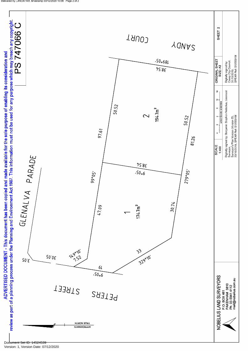
4 Peters Street CANNONS CREEK VIC 3977 Lot 1 PS 747066C
The application is for a permit to:
Development of a Dwelling on Land Affected by an Environmental Significance, Significant Landscape and Bushfire Management Overlays
The applicant for the permit is:
C D Blair
The application reference number is:
PA20-0929 - (Grace Brooks)
You may look at the application and any documents that support the application at the office of the Responsible Authority.
City of Casey Bunjil Place 2 Patrick Northeast Drive NARRE WARREN
This can be done during office hours and is free of charge.
Documents can also be viewed on Council’s website:
https://www.casey.vic.gov.au/view-planning-applications
Any person who may be affected by the granting of the permit may object or make other submissions to the Responsible Authority.
An objection must: * be made to the Responsible Authority in writing to, Manager Planning, P.O. Box 1000, Narre Warren 3805 or emailed to [email protected]
* include the application number and site address * include the reasons for the objection, and * state how the objector would be affected.
The Responsible Authority must make a copy of every objection available at its office for any person to inspect during office hours free of charge until the end of the period during which an application may be made for review of a decision on the application.
The Responsible Authority will not decide on the application before:
8 March 2021
If you object, the Responsible Authority will advise you of its decision.
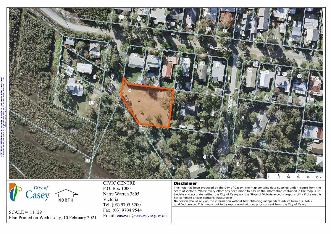
SCALE = 1:1129Plan Printed on Wednesday, 10 February 2021
CIVIC CENTREP.O. Box 1000Narre Warren 3805VictoriaTel: (03) 9705 5200Fax: (03) 9704 9544Email: [email protected]
This map has been produced by the City of Casey. The map contains data supplied under licence from the State of Victoria. Whilst every effort has been made to ensure the information contained in the map is up-to-date and accurate neither the City of Casey nor the State of Victoria accepts responsibility if the map is not complete and/or contains inaccuracies.No person should rely on the information without first obtaining independent advice from a suitably qualified person. This map is not to be reproduced without prior consent from the City of Casey.


Owner Details*Surname/Company: Blair First Name: Christopher DouglasSurname/Company: Blair First Name: Jennifer Ellen
Attachment Details
Applicant Declaration
I understand and declare that:
I am the owner or occupier of the property OR I am the applicant acting on behalf of the owner/occupier
All the information provided in this application is true and correct. It is against the law to provide false or misleading information, which could result in a heavy fine
and cancellation of the permit. Any material submitted with this application, including plans and personal information, will be made
available for public viewing, including electronically, and copies may be made for interested parties for the purpose of enabling consideration and review as part of a planning process under the Planning and Environment Act 1987.
I agree to the declaration terms*
Version: 1, Version Date: 17/12/2020Document Set ID: 14567984

VOLUME 12186 FOLIO 017 Security no : 124086929304E Produced 03/12/2020 10:05 AM
LAND DESCRIPTION
Lot 1 on Plan of Subdivision 747066C.PARENT TITLE Volume 09379 Folio 285Created by instrument PS747066C 08/02/2020
REGISTERED PROPRIETOR
Estate Fee SimpleJoint Proprietors CHRISTOPHER DOUGLAS BLAIR JENNIFER ELLEN BLAIR both of 5 PETERS STREET CANNONS CREEK VIC 3977 AT017084L 24/02/2020
ENCUMBRANCES, CAVEATS AND NOTICES
COVENANT PS747066C 08/02/2020
Any encumbrances created by Section 98 Transfer of Land Act 1958 or Section 24 Subdivision Act 1988 and any other encumbrances shown or entered on the plan set out under DIAGRAM LOCATION below.
DIAGRAM LOCATION
SEE PS747066C FOR FURTHER DETAILS AND BOUNDARIES
ACTIVITY IN THE LAST 125 DAYS
NIL
------------------------END OF REGISTER SEARCH STATEMENT------------------------
Additional information: (not part of the Register Search Statement)
Street Address: 4 PETERS STREET CANNONS CREEK VIC 3977
DOCUMENT END
Copyright State of Victoria. This publication is copyright. No part may be reproduced by any process except in accordance with the provisions of the Copyright Act 1968 (Cth) and for thepurposes of Section 32 of the Sale of Land Act 1962 (Vic) or pursuant to a written agreement. The information is only valid at the time and in the form obtained from the LANDATA REGDTM System. None of the State of Victoria, LANDATA REGD TM System, Victorian Land Registry Services Pty. Ltd. ABN 86 627 986 396 as trustee for the Victorian Land Registry ServicesTrust ABN 83 206 746 897 accept responsibility for any subsequent release, publication or reproduction of the information.
REGISTER SEARCH STATEMENT (Title Search) Transfer of Land Act 1958
Page 1 of 1
Title 12186/017 Page 1 of 1
Version: 1, Version Date: 07/12/2020Document Set ID: 14524545

Imaged Document Cover Sheet
The document following this cover sheet is an imaged document supplied by LANDATA®, Victorian Land Registry Services.
Document Type Plan
Document Identification PS747066C
Number of Pages
(excluding this cover sheet)
2
Document Assembled 03/12/2020 10:08
Copyright and disclaimer notice:© State of Victoria. This publication is copyright. No part may be reproduced by any process exceptin accordance with the provisions of the Copyright Act 1968 (Cth) and for the purposes of Section 32of the Sale of Land Act 1962 or pursuant to a written agreement. The information is only valid at thetime and in the form obtained from the LANDATA® System. None of the State of Victoria,LANDATA®, Victorian Land Registry Services Pty. Ltd. ABN 86 627 986 396 as trustee for theVictorian Land Registry Services Trust ABN 83 206 746 897 accept responsibility for anysubsequent release, publication or reproduction of the information.
The document is invalid if this cover sheet is removed or altered.
Version: 1, Version Date: 07/12/2020Document Set ID: 14524539

Version: 1, Version Date: 07/12/2020Document Set ID: 14524539
Version: 1, Version Date: 07/12/2020Document Set ID: 14524539

1
1
Tableofcontents:
Introduction 2
1. ExistingConditions 3
1.1 Locality 31.2 SubjectLand 31.3 AdjoiningandadjacentLand 6
2. Proposal 12
3. RelevantPlanningControlsandconsiderations
3.1 ZoningControls 123.2 OverlayControlsandAssessment 133.3 PlanningPolicyFramework 203.4 ParticularandGeneralProvisions 21
4. Conclusion 21Appendix1 ColoursandMaterialsAppendix2 Clause54-OnedwellingonalotAppendix3 BushfireManagementStatement
preparedbyKeystoneAllianceBushfireAssessments.
Appendix4 ArboriculturalImpactAssessmentpreparedbyPaulWhitingtonofAboriculturalMatters.
Appendix5 TreeManagementProtectionPlanpreparedbyPaulWhitingtonofAboriculturalMatters.
Appendix6 PetersStreetmaintainedextension.Appendix7 DetailedLandscapePlan&Design
ResponsePlan.Appendix8 LandscapePlanNotesandDetails.
Version: 1, Version Date: 07/12/2020Document Set ID: 14524467

2
2
Introductionandsummary
SubjectlandAddress 4PetersStreet,CannonsCreek,Vic3977LotSize 1747squaremetresExistingConditions VacantLandProposalBuilding/works Developmentofasingledwellingandassociated
worksVegetationremoval NonePlanningandrelatedregulationsPlanningScheme CityofCaseyZoning TownshipZone-ScheduleOverlays EnvironmentSignificanceOverlaySchedule1(ESO1)
SignificantLandscapeOverlaySchedule2(SLO2)LandSubjecttoInundationOverlay(LSIO)BushfireManagementOverlay(BMO)
Planningpermittriggers ESO1(Clause42.01)-buildings,worksandnative
vegetationremoval SLO2(Clause42.03)-buildingsandworks LSIO(Clause44.04)-buildingsandworks BMO(Clause44.06)-buildingsandworksKeyrelatedprovisionsandpoliciesLocalareacharacter SLO2,ESO1,Clause11.03-46,&Coastallandscape Clause12.02-1S, Clause12.05-2S,Clause13.01-2S,
Clause15.01-5S,Clause15.01-2SClause21.12,Clause21.07
Environment ESO1,SLO2,Clause12.05-2S
Clause12.01-2S,Clause15.02-1S,Clause21.04
Bushfirepronearea BMO,Clause13.02-1S,Clause53.02Landsubjecttoinundation LSIO,Clause13.012S
Version: 1, Version Date: 07/12/2020Document Set ID: 14524467

3
3
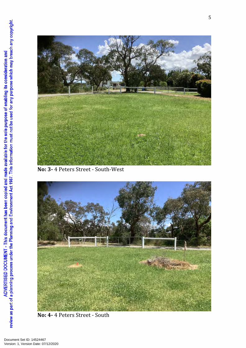
1. ExistingConditions1.1 LocalityThesubjectlandissituatedinthecoastalvillageofCannonsCreekwhichisidentifiedintheCaseyMunicipalStrategicStatementasaoneofthesmaller,serenecoastalvillages,locatedontheCaseyCoastontheshoresofWesternportBay(Clause21.12-1).ThelandislocatedinanestablishedresidentialareaandfallswithintheTownshipZone(TZ).Thepatternofdevelopmentintheareaisavarietyoflotsizesandshapes,howeverthemajorityoflotsaregenerallyintherangeof700-1000squaremetres.Landintheareaappearstobedevelopedwithsingledwellingsandusualoutbuildings.Thedistinctcharacterelementsoftheareaincludegravelroadsandnoinfrastructuresuchaskerbsorfootpaths.Thebuildformvariesgreatly,frommodesthardyplankcladsingleanddoublestoreyolderweekenderstylehomesofvaryingsetbacks,tonewerhomes,bothsingleanddoublestorey,ofvaryingsizes,claddingmaterialsandroofstyles.Propertylandscapingandmaintenancevariesgreatly.PropertiesthathaveaccesstoviewsofRutherfordInletandsurroundingwetlandsarepredominantlydoublestoreytotakeadvantageoftheviews.Thelocalpressureseweragesystem,reticulatedwaterandelectricityareavailableforconnectiontothesubjectsite.1.2 SubjectLandThesubjectlandcomprisesonelotbeingLot1PS747066.Theareaofthelandis1747squaremetresandisarelativelylevelsite.Thewestandsouth-westboundaryhaveroadfrontagetoPetersStreet.TheLandisvacantandcomprisesopengrassedareawiththreeestablishednativetreesandamaintainedhedgeofPhotiniaspeciesalongthedrivewayonthenorthernboundary.ThefrontagesofthelandtoPetersStreetarefencedbylowpostandwire.DetailstotheeasternandnorthernboundaryfencesaredocumentedinSection1.3below.Photosoftheexistingconditionsofthesubjectlandareprovidedno’s1-4below.
Version: 1, Version Date: 07/12/2020Document Set ID: 14524467

4
4
No:1-4PetersStreet
No:2-4PetersStreet-West
Version: 1, Version Date: 07/12/2020Document Set ID: 14524467
5
5
No:3-4PetersStreet-South-West
No:4-4PetersStreet-South
Version: 1, Version Date: 07/12/2020Document Set ID: 14524467

6
6
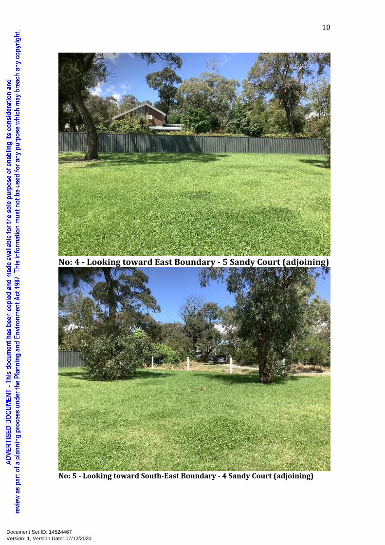
1.3 AdjoiningandadjacentlandNorth(adjoining)-58,60and62GlenalvaParade.Thesubjectlandadjoins3residentiallotstothenorthofthesitebeingknownas58GlenalvaParade,60GlenalvaParadeand62GlenalvaParade.58GlenalvaParade58GlenalvaParadeadjoinsthenorth-eastcornerofthenorthboundaryofthesubjectsite.Thelandhasanareaofapproximately663squaremetresandisdevelopedwithasinglestoreyblockandboardresidencewithapitchedtinroof,sitedcentrallyonthelandfacingGlenalvaParade.Thecommonboundaryfenceistimberpalingapproximately1.8metresinheight.Therearethreescreeningtreesplantedalongtheboundaryfenceline.60GlenalvaParade60GlenalvaParadeistothewestof58GlenalvaParade,andadjoinsthenorthboundaryofthesubjectsite.Thelandhasanareaofapproximately663squaremetresandisdevelopedwithadoublestoreyhardyplankresidencewithaskilliontinroof,sitedtothefrontofthelandfacingGlenalvaParade.Thecommonboundaryfenceiscorrugatedironapproximately1.7metresinheight.Thereisalargescreeningtreeandshedontheboundaryfenceline.62GlenalvaParade62GlenalvaParadeislocatedtothewestof60GlenalvaParadeonthecornerofGlenalvaParadeandPetersStreetandadjoinsthenorthboundaryofthesubjectsite.Thelandhasanareaofapproximately700squaremetresandisdevelopedwithasinglestoreyhardyplankresidencewithapitchedtinroof,sitedtothefrontofthelandfacingGlenalvaParade.Thecommonboundaryfenceisdefinedbylowwiremesh.Thereisanexistingmaintainedhedgeonthesubjectsitethatprovidesscreeningtothisproperty.East(adjoining)-5SandyCourtThesubjectlandadjoins1residentiallottotheeastofthesitebeing5SandyCourt.5SandyCourt5SandyCourtadjoinstheeastboundaryofthesubjectsite.Thelandhasanareaof1950squaremetresandisdevelopedwithadoublestoreybrickresidencewithapitchedtileroof,sitedtotherearoftheland.Thecommonboundaryfenceis
Version: 1, Version Date: 07/12/2020Document Set ID: 14524467

7
7
colourbondsteel1.8metresinheight.Thereisamaturenativetreelocatedtowardthenortherncorneroftheboundary.South-east(adjoining)-4SandyCourtThesubjectlandadjoins1residentiallottothesouth-eastofthesitebeingknownas4SandyCourt.4SandyCourt4SandyCourtadjoinsthesouth-eastboundaryofthesubjectsite.Thelandhasanareaofapproximately3800squaremetresandisdevelopedwithadoublestoreybrickandtimberresidencewithapitchedroof,sitedcentrallyontheland.Thecommonboundaryfenceislowpostandwire.Thelotiswellvegetatedandthedwellingonthelotisbarelyvisiblefromthesubjectsite.Adjacent-1,3and5-7PetersStreetThesubjectlandisadjacentto3residentiallotsbeingknownas1PetersStreet,3PetersStreetand5-7PetersStreet.North-west(adjacent)-1PetersStreetThesubjectlandislocatedadjacenttooneresidentiallottothenorth-westofthesitebeingknownas1PetersStreet.1PetersStreet1PetersStreetislocatedadjacentthefrontnorth-westboundaryofthesubjectsite.Thelandhasanareaofapproximately861squaremetresandisdevelopedwithasinglestoreybrickresidence.Thebuildingissetbackapproximately8.8metresfromtheboundarytoPetersStreet.ThereissignificantvegetationcoverlocatedontheroadreserveofPetersStreeteffectivelyscreeningviewsofthebuildingfromthesubjectland.West(adjacent)-3PetersStreetThesubjectlandislocatedadjacenttooneresidentiallottothewestofthesitebeingknownas3PetersStreet.3PetersStreet3PetersStreetislocatedadjacenttothewestboundaryofthesubjectsite.Thelandhasanareaofapproximately1000squaremetresandisdevelopedwithadoublestoreyhardyplankandbrickdwelling.Thebuildingsetbackisapproximately13.4metresfromtheboundarytoPetersStreet.Thefrontageofthelandisdefinedbyalowtimberpicketfence.
Version: 1, Version Date: 07/12/2020Document Set ID: 14524467

8
8
South-west(adjacent)-5-7PetersStreetThesubjectlandislocatedadjacenttooneresidentiallottothesouth-westofthesitebeingknownas5-7PetersStreet.5-7PetersStreet5-7PetersStreetislocatedtothesouth-westof3PetersStreetandisadjacenttothefrontsouth-westboundaryofthesubjectsite.Thelandhasanareaofapproximately1800squaremetresandisdevelopedwithadoublestoreytimbercladresidencewithacolourbondmetalpitchedroof.Thebuildingsetbackisapproximately20metresfromtheboundarytoPetersStreetAlowwirefencedefinesthefrontageoftheland.Representativephotosoftheadjoiningandadjacentpropertiesappearbelow.
No:1-LookingtowardNorthBoundary-58GlenalvaParade(adjoining)
Version: 1, Version Date: 07/12/2020Document Set ID: 14524467

9
9
No:2-LookingtowardNorthBoundary-60GlenalvaParade(adjoining)
No:3-LookingtowardNorthBoundary-62GlenalvaParade(adjoining)
Version: 1, Version Date: 07/12/2020Document Set ID: 14524467
10
10
No:4-LookingtowardEastBoundary-5SandyCourt(adjoining)
No:5-LookingtowardSouth-EastBoundary-4SandyCourt(adjoining)
Version: 1, Version Date: 07/12/2020Document Set ID: 14524467

11
11
No:6-LookingtowardWestBoundary-3PetersStreet(adjacent)
No:7-LookingtowardSouth-WestBoundary-5-7PetersStreet(adjacent)
Version: 1, Version Date: 07/12/2020Document Set ID: 14524467

12
12
2. TheproposalTheproposalinvolvesthedevelopmentofasingledwellingandassociatedworks.Inadditiontothedesignplanstheplanningapplicationisaccompaniedbythefollowingsupportingdocumentation:
• ColoursandMaterials(Appendix1)• Clause54-Onedwellingonalot-Assessment(Appendix2)• PhotosofPetersStreetroadextension(Appendix6)• LandscapePlanandDesignResponsePlan(Appendix7)• LandscapePlanNotesandDetails(Appendix8)
AnarboriculturalimpactassessmentreportpreparedbyArborist,PaulWhitingtonofAboriculturalMatters,addressingthefollowing:
• Adetailedsurveyofalltreeswithinproximitytotheproposedworks.• Provideinformationonidentification,species,dimensions,health,age,
andlandscapesignificance.• Assessthearboriculturalandretentionvalue.• Determinestructuralrootzonesandtreeprotectionzones.• Encroachmentpercentageforanyworkswithintreeprotectionzone.• Impactofdevelopmentonassessedtrees.• Suitabletreemanagementandprotectionrecommendationsfor
retainedtrees.(Appendix4&5)ABushfireManagementStatementandBushfireManagementPlanpreparedbyKeystoneAllianceBushfireAssessments(ReportNo:3098/1,datedNovember2020)addressingtherequirementsofClause44.06-3-ApplicationrequirementsandClause53.02-Bushfireplanning.(Appendix3)3 RelevantplanningcontrolsThefollowingprovidesanoverviewofthezoning,overlays,policiesandprovisionsthatarerelevanttotheplanningapplicationandhavebeenconsideredintheassessmentinsection3.2.3ofthereport.3.1 Zoning3.1.1 Clause32.05-TownshipZone-Schedule(TZ)ThesubjectlandislocatedintheTownshipZone(TZ)UndertheprovisionsofClause32.05-2-TableofusesSection1-permitnotrequired,theproposeddevelopmentdoesnotrequireapermittobuildadwellingprovidedtherequirementsofClause32.05-3-useforadwellingordependent
Version: 1, Version Date: 07/12/2020Document Set ID: 14524467

13
13
person’sunit,aremet,andunderClause32.05-6-Constructionandextensionofonedwellingonalot,thelandhasanareaexceeding300squaremetres.TheproposeddevelopmentsatisfiestheprovisionsofClause32.05-3andClause32.05-6.3.1.2 Clause32.05-11-MaximumbuildingheightrequirementforadwellingorresidentialbuildingBuildingheightiflandsubjecttoinundationIfthelandisinaSpecialBuildingOverlay,LandSubjecttoInundationOverlayorisliabletoinundationthemaximumbuildingheightspecifiedinthezoneorscheduletothezone,istheverticaldistancefromtheminimumfloorleveldeterminedbytherelevantdrainageauthorityorfloodplainmanagementauthoritytotherooforparapetatanypoint.ThescheduletoClause32.05-TownshipZone(TZ)doesnotspecifyanyvariationstotherequirementsofClause54.03-1-Buildingheightobjective.ThesiteissubjecttoClause44.04-LandSubjecttoInundationOverlay(LSIO)andinaccordancewithClause32.05-11themaximumbuildingheightoftheproposeddwellingwhenmeasuredfromminimumfloorlevelsatisfiestherequirementsofClause54.03-2.3.2 Overlays3.2.1 Clause42.01-EnvironmentalSignificanceOverlay-Schedule1(ESO1)Clause42.01-EnvironmentalSignificanceOverlay-Schedule2(ESO1-CoastalEnvirons)appliestothesubjectland.Planningapprovalisrequiredforbuildingsandworks,andfortheremoval,destructionorloppingofanyvegetation,includingdeadvegetation,butexcludingexoticvegetationandenvironmentalweedsaslistedinSchedule1toClause42.01.ESO1setsoutthefollowing‘Statementofenvironmentalsignificance’:WesternPortisnotedforitsecologicaldiversityintermsofterrestrialandmarinespecies,someofwhichareprotectedbyinternationalagreementstowhichAustraliaisaparty.Thesespeciesoccupyawiderangeofhabitatsincludingsaltmarshes,mangroves,inter-tidalmudflatsandseagrassbeds.WesternPortisalsonotedforitscoastallandscapesandextensiveareasofremnantcoastalvegetation.TheconservationofthesevaluesispromotedbytheMSS.Thiscanbeassistedbyplacingcontrolsontheexpansionofurbansettlements,theremovalofnativevegetation,thetreatmentofwastewaterandontheextentandappearanceofbuildingsandworksEnvironmentalobjectivetobeachieved
Version: 1, Version Date: 07/12/2020Document Set ID: 14524467

14
14
• ToconserveandenhancetheecologicalvaluesofenvironmentallysensitivelandfringingWesternPort.
• TomaintainandenhancetheruralcharacterofareasfringingWesternPort.
DecisionguidelinesBeforedecidingonanapplication,theresponsibleauthoritywillconsider:
• TheneedtoensurethatthesensitiveareasofopenspacealongtheedgeofWesternPortandtheenvironmentallysensitiveareasofthebayarenotcompromisedbytheuse.
• Thecapacityofthesoilandwatertoabsorbwastesandthedesignoftheeffluentdisposalsystem.
• Theimpactofplantlife,animalhabitatsandthelandscape.• Whetherthebuildingsorworkswillbedetrimentaltothenatural
physicalfeaturesorresourcesofthearea.• Thedesign,locationandcolourofproposedbuildingsandworksand
theirimpactonthelandscape.• Theextentofanypurposeofremovalofvegetationandinparticular:
o Thedesirabilityofretainingorestablishingabufferofnativevegetationadjoiningwatercoursesandnaturaldrainagelinesandanyexistingvegetationalongridges,roadandpropertyboundaries.
o Whetherthevegetationhasbeenidentifiedasbeingoflandscapeorenvironmentalsignificance.
• Thelocation,dimensions,andlevelsofanyexcavationsoralterations
tothenaturalsurfaceincludingdetailsorworkstostabilisebuffersinareasoffillorexcavation.Theworkstocontroldrainageandstormwaterrun-offfromallbuildings,accessroadsanddriveways.
• Theviews,ifany,oftheDepartmentofEnvironment,Land,WaterandPlanning.
• Whetherthelocationofbuildingsandworkstakeadvantageofthetopographyandlandscapingoftheareatoprovidescreeningfromadjoiningpropertiesandsurroundingareas.
3.2.2 Clause42.03-SignificantLandscapeOverlay-Schedule2(SLO2)Clause42.03-SignificantLandscapeOverlay-Schedule2(SLO2-WesternPortCoast)appliestothesubjectland.Planningapprovalisrequiredforbuildingandworks.SLO2setsoutthefollowing‘Statementofnatureandkeyelementsoflandscape’:TheWesternPortcoastalareaisoneof42sitesdeemedtobeaWetlandofInternationalSignificanceinAustralia.TheWesternPortcoastallandscapeisecologicallydiversesupportingavarietyoffaunaandfloraspecies.Thewetlandsconsistofswamps,saltmarshes,mangroves,mudflats,floodplains,deltas,inletsanddeepchannels.Inlandthereisamixofrurallandscapessomewithpocketsof
Version: 1, Version Date: 07/12/2020Document Set ID: 14524467

15
15
remnantvegetationwhichprovideanimportantpre-Europeansettlementlandscape.Therearetwositesofinternationalgeological/geomorphologicalsignificance,3ofnationalsignificance,27ofstatesignificanceand19ofregionalsignificancealongthecoast.ThequalityofWesternPort’slandscapeshavebeenrecordedasclassifiedbytheNationalTrustandbyinclusionofsomeontheRegisteroftheNationalEstate.Landscapecharacterobjectivestobeachieved
• Toconserveandenhancetheexistingpatternofvegetationtomaintainlandscapequalityandremainingnaturalecosystems.
• ToencouragedevelopmentthatisinharmonywiththecoastallandscapeofWesternPort.
• Toencouragelandmanagementpracticescompatiblewithlandscapeconservation.
• ToprotectthecoastalcharacteroflandsurroundingthesettlementsofBlindblight,CannonsCreek,TooradinandWarneet.
ApplicationrequirementsAnapplicationtoconstructabuildingshouldincludethefollowinginformation:
o Proposedexternalcolours,materialsandfinishes.o Anyvegetationtoberemoved.o Anyearthworkstobecarriedout.o Anyexistingbuildingsandworks.
DecisionguidelinesBeforedecidingonanapplication,theresponsibleauthoritywillconsider:
• Whetherthedevelopmentwillbedetrimentaltothenaturalphysicalfeaturesorresourcesofthearea.
• Whetherthedevelopmentwillrequiresignificantearthworks.• Whetherthedevelopmentwillbevisiblefrompublicroadsandother
vantagepoints.• Theimplantofplantlife,animalhabitatsandlandscapeofthecoastal
environment(terrestrialandmarine).
3.2.3 AssessmentClause32.05-TownshipZone-Schedule(TZ)Clause42.01-EnvironmentSignificanceOverlay-Schedule1(ESO1)Clause42.03-SignificantLandscapeOverlay-Schedule2(SLO2)
Version: 1, Version Date: 07/12/2020Document Set ID: 14524467

16
16
Theproposeddevelopmentwillbeconnectedtothelocalpressuresewersystem,andelectricityandwaterareavailableforconnectiontothesubjectsite.Theareaofthesubjectsiteisinexcessof300squaremetres.TheproposeddevelopmentwillhavenoimpactorcompromisetheuseofopenspaceandenvironmentallysensitiveareasalongtheedgeofWesternportBay.
Theproposeddevelopmentdoesnotrequirevegetationtoberemoved,andplantingsoflocalindigenousspecieshavebeenincludedintheLandscapePlantofurtherprovideanimalhabitatonthesubjectsite.Therewillbenoimpacttothelandscapeofthecoastalenvironment(terrestrialandmarine).
Theproposedbuildingsandworksdonotrequirevegetationremovalorexcavationthatwouldcausedetrimenttonaturalphysicalfeaturesorresourcesofthearea.TheAboriculturalAssessmenthasbeenconsideredinthesitingofthedwellingandbuildingstoretainandprotecttheexistingnativetreesonthesubjectsite,andinaccordance,theproposedgardenshedhasbeenmovedoutoftheTPZoftree9andthedrivewaywidthhasbeenreducedintheTPZoftrees1,2&3.Thedesignrespondstothesurroundingneighbourhoodcharacteristicswithadjoiningandadjacentproperties,beingpredominatelyoccupiedbydoublestoreydwellingsofvaryingroofdesignandexternalcladdings.Thecompactdoublestoreytraditionalweatherboardcoastalfarmhousedesign,respondstoboththecoastallandscapeandtheruralcharacterofareasfringingWesternPort.
Thefrontageofthedwellinghasbeenorientedtothesouth-westwhichisslightlyawayfromPetersStreetforthefollowingreasons:
AlthoughPlanningMapsshowPetersStreetterminatingatthesouthernendofthewestboundaryofthesubjectsite,afullymaintainedgravelroadfrontsthesouthandsouth-westboundary.(SeeAppendix6)Toprovideabetterresponsetothesite,thedwellinghasbeenlocatedwitharespectfulsetbackfromeachboundary,andissitedtoprovideprivacytotheprivateopenspaceareasandhabitableroomwindows,ofboththesurroundingpropertiesandtheproposeddwelling.Thesitingalsoencouragestheexistingmaturenativetreestoberetained.Theorientationandroofdesignalsoaffordsfulladvantageforuseofpassiveenergy.
ThematerialsandcolourschosenfortheproposeddevelopmentarethatofacolourbondroofinMonument(darkgrey-non-reflective),andweatherboardcladpaintedfinishinDuluxNaturalwhite(amutedwhite)SeeAppendix:1Thematerialandcolourselectionisconsistentwithbuildingsinthelocalarea,andtheuseofmutedwhiteandotherlightcoloursisnotuncommon.Themodestsizeandsitecoverageoftheproposeddwellingandassociatedworksensuresthatitsappearanceandextentwillnotdominatethesubjectsite.Therearemanybuildingsinthelocalareathathavesimilarorgreatermassandvisualimpactthantheproposeddwelling.
Version: 1, Version Date: 07/12/2020Document Set ID: 14524467

17
17
PetersStreetisanon-throughroad,andthesouth-westandsouthboundariesoftheproposeddevelopment,haveabufferofestablishednativevegetationandwetlandstothesouthofPetersStreetwhichensuresthebuildingsandworkswillnotbevisiblefromRutherfordInlet,oranyotherlocalvantagepoints.Thedevelopmentproposeswaterstoragetanksforstormwatercatchment,withoverflowfromallbuildingsdirectedtoexistinglegalpointofdischarge.
3.2.4 Clause44.04-LandSubjecttoInundationOverlay(LSIO)
Clause44.04-LandSubjecttoInundationOverlay-(SLIO)appliestothesubjectland.Planningapprovalisrequiredforbuildingsandworks.
TheScheduletoClause44.04-LandsubjecttoInundationOverlay-(LSIO)setsoutthefollowing‘Applicationrequirements’:
Anapplicationtoconstructabuildingorconstructorcarryoutworksmustbeaccompaniedbyfoursetsofplans,drawntoscale,whichshow:• Theboundariesanddimensionsofthesite.• Relevantgroundlevels,toAustralianHeightDatum,takenbyorunder
thedirectionorsupervisionofalicensedlandsurveyor.• Thelayoutofexistingandproposedbuildingworks.• Floorlevelsofanyexistingandproposedbuildings,toAustralianHeight
Datum,takenbyalicensedsurveyor.InaccordancewithClause2.0-Applicationrequirement,oftheScheduletoClause44.04-LandsubjecttoInundationOverlay(LSIO),plansshowingrequiredinformationaccompanythisapplication.
3.2.5 Clause44.06-BushfireManagementOverlay(BMO)Clause44.06-BushfireManagementOverlay(BMO)appliestothesubjectland.Planningapprovalisrequiredforbuildingandworks.3.2.6 Clause44.06-3-ApplicationrequirementsUnlessascheduletotheoverlayspecifiesdifferentrequirements,anapplicationmustbeaccompaniedby:
• Abushfirehazardsiteassessmentincludingaplanthatdescribesthebushfirehazardwithin150metresoftheproposeddevelopment.ThedescriptionofthehazardmustbepreparedinaccordancewithSection2.2.3to2.2.5ofAS3959:2009Constructionofbuildingsinbushfireproneareas(StandardsAustralia)excludingparagraph(a)ofsection2.2.3.2.Photographsorothertechniquesmaybeusedtoassistindescribingthebushfirehazard.
• Abushfirehazardlandscapeassessmentincludingaplanthatdescribesthebushfirehazardofthegenerallocalitymorethan150
Version: 1, Version Date: 07/12/2020Document Set ID: 14524467

18
18
metresfromthesite.Photographsorothertechniquesmaybeusedtoassistindescribingthebushfirehazard.ThisrequirementdoesnotapplytoadwellingthatincludesalloftheapprovedmeasuresinClause53.02-3.
• AbushfiremanagementstatementdescribinghowtheproposeddevelopmentrespondstotherequirementsinthisclauseandClause53.02.Iftheapplicationproposesanalternativemeasure,thebushfiremanagementstatementmustexplainhowthealternativemeasuremeetstherelevantobjective.
Ifintheopinionoftheresponsibleauthorityanypartoftheserequirementsisnotrelevanttotheassessmentofanapplication,theresponsibleauthoritymaywaive,varyorreducetherequirement.
3.2.7 Clause44.06-4-RequirementsofClause53.02AnapplicationmustmeettherequirementsofClause53.02unlesstheapplicationmeetsalloftherequirementsspecifiedinascheduletothisoverlay.Ascheduletothisoverlaymayspecifysubstituteapprovedmeasures,additionalalternativemeasuresandadditionalorsubstitutedecisionguidelinesforthepurposesofClause53.02.Inaccordance,theplanningapplicationisaccompaniedbyareportpreparedbyKeystoneAllianceBushfireAssessments(ReportNo:3098/1,datedNov20)addressingtherequirementsofClause44.06-3-Applicationrequirements.(Appendix3) AsthereisnoScheduletoClause44.06-BushfireManagementOverlay,Clause53.02applies.Clause53.02-BushfirePlanningClause53.02-1-ApplicationThisClauseappliestoanapplicationunderClause44.06-BushfireManagementOverly,unlesstheapplicationmeetsalloftherequirementsspecifiedinascheduletoClause44.06.Clause53.02-3appliestoanapplicationtoconstructasingledwellingorconstructorcarryoutworksassociatedwithasingledwellingifallofthefollowingrequirementsaremet:
• ThelandiszonedNeighbourhoodResidentialZone,GeneralResidentialZone,ResidentialGrowthZone,UrbanGrowthZone,LowDensityResidentialZone,TownshipZoneorRuralLivingZone.
• Thereisonlyonedwellingonthelot.• Theapplicationmeetsalloftheapprovedmeasurescontainedin
Clause53.02-3.
Version: 1, Version Date: 07/12/2020Document Set ID: 14524467

19
19
TheproposeddevelopmentmeetstheapplicationrequirementsofClause53.02-1.Clause53.02-3-Dwellingsinexistingsettlements-BushfireprotectionobjectiveTospecifybushfiredesignandconstructionmeasuresforasingledwellingoralterationandextensiontoanexistingdwellingthatreducestherisktolifeandpropertytoanacceptablelevel.ApprovedmeasuresAM1.1 Abuildingissitedtoensurethesitebestachievesthefollowing:
o Themaximumseparationdistancebetweenthebuildingandthebushfirehazard
o Thebuildingisincloseproximitytoapublicroad.o Accesscanbeprovidedtothebuildingforemergencyvehicles.
AM1.2 AbuildingprovidesthedefendablespaceinaccordancewithTable1
ColumnsA,B,C,DorEandTable6toClause53.02-5.Adjoininglandmaybeincludedasdefendablespacewherethereisareasonableassurancethatthelandwillremainorcontinuetoremainmanagedinthatconditionaspartofthedefendablespace.
Abuildingisconstructedtothebushfireattacklevel:
o ThatcorrespondstothedefendablespaceprovidedinaccordancewithTable1totheClause53.03-5,or
o ThenextlowerbushfireattacklevelthatcorrespondstothedefendablespaceprovidedinaccordancewithTable1toClause53.02-05whereallofthefollowingapply:
- Aprivatebushfireshelter(aClass10cbuildingwithinthemeaningoftheBuildingRegulations2006)isconstructedonthesamesiteasthedwelling.
- AminimumbushfireattacklevelofBAL12.5isprovidedinallcircumstances.
AM1.3Abuildingisprovidedwith:
o AstaticwatersupplyforfirefightingandpropertyprotectionpurposesspecifiedinTable4toClause53.02-5.Thewatersupplymaybeinthesametankasotherwatersuppliesprovidedthataseparateoutletisreservedforfirefightingwatersupplies.
o VehicleaccessthatisdesignedandconstructedasspecifiedinTable5toClause53.02-5.
AreportpreparedbyKeystoneAllianceBushfireAssessments(ReportNo:3098/1,datedNov20)isincludedinthisapplication.(Appendix3)
Version: 1, Version Date: 07/12/2020Document Set ID: 14524467

20
20
ApprovedmeasuresAM1.1,AM1.2,AM1.3havebeenincorporatedintotheapplication.3.3 PlanningPolicyFramework3.3.1 ThefollowingStatePlanningPolicieshavebeenconsidered Clause11.03-46-Coastalsettlement Clause12.01-2S-Nativevegetationmanagement Clause12.02-1S-ProtectionofCoastalareas Clause12.05-2S-Landscapes Clause13.02-1S-Bushfireplanning Clause15.01-2S-Buildingdesign
Clause15.01-5S-NeighbourhoodcharacterClause15.02-1S-Energyandresourceefficiency
3.3.2 ThefollowingLocalPlanningPolicieshavebeenconsidered. Clause21.02-KeyIssuesandStrategicVision Clause21.04-Environment Clause21.07-BuiltEnvironment Clause21.12-CaseyCoastWithconsiderationtotheaboveStateandLocalPlanningPolicyFramework,itissubmittedtheproposeddevelopmentwillcontributetoachievingtheobjectivesandstrategiesasfollows:Theproposeddevelopmentwillprovideahighquality,modest,sustainablefamilyhome,usingexternalmaterialsinkeepingwith,andsensitiveto,thelocalneighbourhoodcharacterandthecharacterofthecoastalsettlement.Thedwellinghasbeenrespectfullydesignedandsitedwithregardtotheadjoiningandadjacentproperties,toavoidanysignificantlossofamenity,andsitecoverageismodest.Thedwellingwillbeconnectedtothelocalpressuresewersystem,rainwatertankswillbeinstalledforstormwatercatchment,withexcessbeingdirectedtotheexistinglegalpointofdischarge,andsolarpanelswillbeincludedontheroofofthedwellingtoreducenon-renewableenergyconsumption.Thebuildingandworksrequirenoexcavationorvegetationremovalandtheproposedlandscapingincludesnativespeciesindigenoustothearea.Clause44.06-BushfireManagementOverlay(BMO)appliestothesubjectsiteandtheproposeddevelopmentaddressesrelevantBushfireplanningpoliciesandsatisfiesperformancemeasures.Clause44.04-LandSubjecttoInundationOverlay-(LSIO)appliestothesubjectsite.TheapplicationrequirementscontainedintheScheduletotheoverlayhavebeenmet.
Version: 1, Version Date: 07/12/2020Document Set ID: 14524467

21
21
3.4 Particular/GeneralProvisions Clause52.06-9-DesignstandardsforcarparkingTherelevantdesignstandardsforcarparkinginClause52.06-9havebeenmet.
4. ConclusionItissubmittedthattheproposeddevelopmentisconsistentwiththepolicyandprovisionsoftheCaseyPlanningSchemeandshouldreceivesupportforthefollowingreasons:
• Theproposalwilldeliveraqualityoutcomeforthesite,providingavalued,practical,highqualityandenergyefficienthomefortheownersoftheland.
• Theproposalshowsproperregardtothelocalneighbourhoodcharacter,andthecoloursandmaterialsaresympathetictothecoastallandscape.
• Thebuildingandworkshavebeendesignedandsitedtoavoidanysignificantlossofamenitytoanyperson,andtoretainexistingvegetation.
• TheproposalcomplieswiththeapplicableStandardsandtheObjectivesofClause54.
Version: 1, Version Date: 07/12/2020Document Set ID: 14524467

APPENDIX:2Clause54.02-NeighbourhoodcharacterObjective Standard Assessment
Clause54.02-Neighbourhoodcharacterobjective StandardA1 CompliesToensurethatthedesignrespectstheexisting Thedesignresponsemustbeappropriate Asdocumentedinsection3.2.3ofthereportneighbourhoodcharacterorcontributestoa totheneighbourhoodandthesite. thedesignresponseistoahighstandardandispreferredneighbourhoodcharacter. respectfulofthecoastallandscapeandtothe
Theproposeddesignmustrespectthe characterofthelocalneighbourhood,andtheToensurethatthedesignrespondstothefeatures existingorpreferredneighbourhoodcharacter featuresofthesite.ofthesiteandthesurroundingarea. andrespondtothefeaturesofthesite
Clause54.02-2-Integrationwiththestreet StandardA2 Compliesobjective ThedwellingisorientedtotheSouth-westto
Dwellingshouldbeorientedtofrontexisting provideacombinationofgreaterprivacytoTointegratethelayoutofdevelopmentwiththe orproposedstreets. neighboursfromhabitableroomwindows,street. betterprivacytothehomeownersprivateopen
Highfencinginfrontofdwellingsshouldbeavoided space,whilstmaintaininganacceptableifpracticable. orientationforenergysavingsolartechnologies
totheroofline.Refertodetailsinsection3.2.3Dwellingsshouldbedesignedtopromotethe ofthereport.observationofabuttingstreetsandanyabutting Thefencetothefrontofthedwellingislowinopenspaces heightandofpostandwire.
Clause54.03-SitelayoutandbuildingmassingObjective Standard Assessment
Clause54.03-1-Streetsetbackobjective StandardA3 CompliesWallsofbuildingsshouldbesetbackfromstreets: Theproposeddwellinghasafrontagesetback
Toensurethatthesetbacksofbuildingfroma *Atleastthedistancespecifiedinascheduleto inexcessof9metresmeetingboththestreetrespecttheexistingorpreferred thezone,or standardandobjective.neighbourhoodcharacterandmakeefficient *Ifnodistanceisspecifiedinascheduletotheuseofthesite zone,thedistancespecifiedinTableA1.
Porches,pergolasandverandahsarelessthan3.6metreshighandeavesmayencroachnotmorethan2.5metresintothesetbacksofthisstandard
Version: 1, Version Date: 07/12/2020Document Set ID: 14524491

Clause54.03-SitelayoutandbuildingmassingcontinuedObjective Standard Assessment
Clause54.03-2Buildingheightobjective StandardA4 CompliesNomaximumbuildingheightisspecifiedinthe
Toensurethattheheightofbuildingsrespectsthe Themaximumbuildingheightshouldnotexceedthe scheduletothezonethereforetheexistingorpreferredneighbourhoodcharacter. maximumheightspecifiedinthezone,scheduleto requirementslistedinthestandardapply.
thezoneoranoverlaythatappliestotheland.ThesubjectsiteisinaLandSubjectto
Ifnomaximumheightisspecifiedinthezone, InundationOverlay.Exceptionsapplyunderscheduletothezoneoranoverlay,themaximum Clause32.05-11-Buildingheightiflandsubjectbuildingheightshouldnotexceed9metres,unless toInundation.theslopeofthenaturalgroundlevelatanycross IfthelandisinaLandSubjecttoInundationsectionwiderthan8metresofthesiteofthe Overlay,themaximumbuildingheightbuildingis2.5degreesormore,inwhichcasethe istheverticaldistancefromtheminimummaximumbuildingheightshouldnotexceed10 floorleveldeterminedbytherelevantmetres. drainageauthorityorfloodplainmanagement
authoritytotherooforparapetatanypoint.Changesofbuildingheightbetweenexistingbuildingsshouldbegraduated. Thedesignplanscomply
Objective Standard AssessmentClause54.03-3-Sitecoverageobjective StandardA5 Complies
Toensurethatthesitecoveragerespectsthe Thesiteareacoveredbybuildingsshouldnot Thedesignplansshowthesitecoverageofexistingorpreferredneighbourhoodcharacterand exceed: theproposeddevelopmentis12.14%whichisrespondstothefeaturesofthesite. *Themaximumsitecoveragespecifiedinthe belowthe60%thresholdoftheStandardandis
scheduletothezone,or consistentwiththecharacterofthearea.*Inomaximumsitecoverageisspecifiedinascheduletothezone,60percent.
Version: 1, Version Date: 07/12/2020Document Set ID: 14524491

Clause54.03-SitelayoutandbuildingmassingcontinuedObjective Standard AssessmentClause54.03-4Permeabilityobjectives StandardA6 Complies
Toreducetheimpactofincreasedstormwater Thesiteareacoveredbypervioussurfacesshould Thepervioussurfaceareaofthesubjectrun-offonthedrainagesystem. beatleast: siteissubstantiallygreaterthanthe
*Theminimumareaspecifiedinascheduletothe minimumareaof20%specifiedTofacilitateon-sitestormwaterinfiltration. zone;or
*Ifnominimumareaisspecifiedinascheduletothezone,20percentofthesite
Objective Standard AssessmentClause54.03-5Energyefficiencyprotection StandardA7 Compliesobjectives
Buildingshouldbe: Theproposeddwellinghasnorth-westfacingToachieveandprotectenergyefficientdwellings. *Orientedtomakeappropriateuseofsolarenergy windowstobedroomsandupstairs
*Sitedanddesignedtoensurethattheenergy dining/livingareasToensureorientationandlayoutofdevelopment efficiencyofexistingdwellingsonajoininglotsisnotreducefossielfuelenergyuseandmake unreasonablyreduced. Thesizeoftheland,thesitingoftheappropriateuseofdaylightandsolarenergy. *Sitedanddesignedtoensurethatthe dwellingandthedistancefromneighbouring
performanceofexistingrooftopsolarenergy dwellingsensuresthereisnoimpactonthesystemsondwellingsonajoininglotsinaGeneral energyefficiencyoftheneighbouringResidentialZone,NeighbourhoodResidentialZone dwellings.orTownshipZonearenotunreasonablyreduced.Theexistingrooftopsolarenergysystemmustexistatthedatetheapplicationislodged.
Version: 1, Version Date: 07/12/2020Document Set ID: 14524491

Clause54.03-SitelayoutandbuildingmassingcontinuedObjective Standard Assessment
Clause54.03-6Significanttreesobjectives StandardA8 Complies
Toencouragedevelopmentthatrespectsthe Developmentshouldprovidefortheretentionor Theproposaldoesnotrequiretheremovaloflandscapecharacteroftheneighbourhood. plantingoftrees,wherethesearepartofthe anytrees.
neighbourhoodcharacter.Toencouragetheretentionofsignificanttreesonthesite Developmentshouldprovideforthereplacement Theapplicantisnotawareofanysignificant
ofanysignificanttreesthathavebeenremovedin treeshavingbeenremovedfromthesiteinthethe12monthspriortotheapplicationbeingmade. previous12months.
Clause54.04-AmenityimpactsObjective Standard AssessmentClause54.04-1Sideandrearsetbacksobjective StandardA10 Complies
Anewbuildingnotonorwithin200mmofaboundaryshouldbesetbackfromsideorrear Nodistanceisspecifiedinthescheduletothe
Toensurethattheheightandsetbackofabuilding boundaries: zonesotherequirementsofStandardA10fromaboundaryrespectstheexistingorpreferred *Atleastthedistancespecifiedinthescheduleto apply.neighbourhoodcharacterandlimitstheimpacton thezone,ortheamenityofexistingdwellings. *Ifnodistanceisspecifiedinascheduletothe Thesetbacksoftheproposeddwellingcomplies
zone,1metre,plus0.3metresforeverymetreof withtherequirementofStandardA10heightover3.6metresupto6.9metres,plus1metreforeverymetreofheightover6.9metres.
Sunblinds,verandahs,porches,eaves,facias,gutters,masonrychimneys,flues,pipes,domesticfuelorwatertanks,andheatingorcoolingequipmentorotherservicesmayencroachnotmorethat0.5metresintosetbacksofthisstandard.Landingshavinganareaofnotmorethan2squaremetresandlessthan1metrehigh,stairways,ramps,pergolas,shadesailsandcarportsmayencroachintothesetbacksofthisstandard.
Version: 1, Version Date: 07/12/2020Document Set ID: 14524491

Clause54.4-AmmenityimpactscontinuedObjective Standard AssessmentClause54.04-2-Wallsonboundariesobjective StandardA11 Complies
Toensurethatthelocation,lengthandheightofa anewwallconstructedonorwithin200mmofaside Nodistanceisspecifiedinthescheduletothewallonaboundaryrespectstheexistingor orrearboundaryofalotoracarportconstructedon zonethereforetherequirementsofStandardpreferredneighbourhoodcharactrandlimitsthe orwithin1metreofasideorrearboundaryofalot A11apply.impactontheamenityofexistingdwellings. shouldnotabuttheboundary:
*Foralengthmorethanthedistancespecifiedtothescheduletothezone. Therearenowallstobeconstructedonor*Ifnodistanceisspecifiedinascheduletothe within200mmofasideorrearboundaryandzone,foralengthofmorethan: thecarportisnotlocatedwithin1metreofa*10metresplus25percentoftheremaininglength sideorrearboundary.oftheboundaryofanajoininglotor*Wherethereareexistingorsimiltaneouslyconstructedwallsorcarportsabuttingtheboundaryonanabuttinglotthelengthoftheexistingorsimiltaneouslyconstructedwallsorcarports,whicheveristhegreater.
Anewwallorcarportmayfullyabutasideorrearboundarywheretheslopeandretainingwallsorfenceswouldresultintheeffectiveheightofthewallorcarportbeinglessthan2metresontheabuttingpropertyboundary
Abuildingonaboundaryincludesabuildingsetbackupto200mmfromaboundary.
Theheightofanewwallconstructedonorwithin200mmofasideboundaryoracarportonorwithin1metreofasideorrearboundaryshouldnotexceedanaverageof3.2metreswithnoparthigherthan3.6metresunlessabuttingahigherexistingorsimiltaneouslyconstructedwall
Version: 1, Version Date: 07/12/2020Document Set ID: 14524491

Clause54.4-AmmenityimpactscontinuedObjective Standard Assessment
Clause54.04-3Daylighttoexistingwindows StandardA12objective
Toallowadequatedaylightintoexistinghabitable Buildingsoppositeanexistinghabitableroomroomwindows windowshouldprovideforalightcourttothe
existingwindowthathasaminimumareaof3squaremetresandminimumdimensionof1metrecleartothesky.Thecalculationoftheareamayincludelandontheabuttinglot. Notapplicable
Wallsorcarportsmorethan3metresinheightoppositeanexistinghabitableroomwindowshouldbesetbackfromthewindowatleast50percentoftheheightofthenewwallifthewalliswithina55degreearcfromthecentreoftheexistingwindow.Thearcmaybeswungtowithin35degreesoftheplaneofthewallcontainingtheexistingwindow.
Objective Standard AssessmentClause54.04-4North-facingwindowobjective ScheduleA13
Toallowadequateaccesstoexistingnorth-facing Ifanorth-facinghabitableroomwindowofan Notapplicablehabitableroomwindows existingdwellingwithin3metresofaboundaryon
anabuttinglot,abuildingshouldbesetbackfromtheboundary1metre,plus0.6metreforeverymetreofheightover3.6metresupto6.9metres,plus1metreforeverymetreofheightover6.9metres,foradistanceof3metresfromtheedgeofeachsideofthewindow.Anorth-facingwindowisawindowwithanaxisperpendiculartoit'ssurfaceorientatednorth20degreeswesttonorth30degreeseast.
Version: 1, Version Date: 07/12/2020Document Set ID: 14524491

Clause54.4-AmmenityimpactscontinuedObjective Standard Assessment
Clause54.04-5Overshadowingopenspace StandardA14 Compliesobjective
Wheresunlighttothesecludedprivateopenspace AjoininglandislocatedtotheNorthandEastofToensurebuildingsdonotunreasonably ofanexistingdwellingisreduced,atleast75per thesubjectsiteandtheproposedbuildingswillovershadowexistingsecludedprivateopenspace. cent,or40squaremetreswithminimumof3metres havenoimpactonavailablesunlighttoexisting
whicheveristhelesserarea,ofthesecludedprivate dwellings.openspaceshouldreceiveaminimumoffivehoursofsunlightbetween9amand3pmon22September.
Ifexistingsunlighttothesecludedprivateopenspaceofanexistingdwellingislessthanthe Notapplicablerequirementsofthisstandard,theamountofsunlightshouldnotbefurtherreduced.
Objective Standard AssessmentClause54.04-6Overlookingobjective StandardA15 Complies
Tolimitviewsintoexistingprivateopenspaceand Ahabitableroomwindow,balcony,terrace,deckor Theproposeddwellinghasbeendesignedandhabitableroomwindows. patioshouldbelocatedanddesignedtoavoiddirect orientedtoavoidhabitableroomwindows
viewsintothesecludedprivateopenspaceand overlookingtheprivateopenspaceandhabitableroomwindowsofanexistingdwelling habitableroomwindowsofabuttingpropertieswithinahorizontaldistanceof9metres(measuredatgroundlevel)ofthewindow,balcony,terrace, Thereisvegetationscreeningtheboundariesdeckorpatio.Viewsshouldbemeasuredwithina ofallabuttingpropertiesandthehabitable45degreeanglefromtheplaneofthewindowor roomwindowsarelocatedbetween25-30perimeterofthebalcony,terrace,deckorpatio,and metresfromtheproposeddwelling.fromaheightof1.7metresabovefloorlevel.
Version: 1, Version Date: 07/12/2020Document Set ID: 14524491

Clause54.4-AmmenityimpactscontinuedObjective Standard AssessmentClause54.04-6Overlookingobjective StandardA15continued Compliescontinued Ahabitableroomwindow,balcony,terrace,deckorTolimitviewsintoexistingprivateopenspaceand patiowithadirectviewintoahabitableroom Theproposeddwellinghasnohabitableroomhabitableroomwindows. windowofexistingdwellingwithinahorizontalof9 window,balcony,terrace,deckorpatiowitha
metres(measuredatgroundlevel)ofthewindow, directviewintoahabitableroomwindoworbalcony,terrace,deckorpatioshouldbeeither: privateopenspaceofanexistingdwellingthat*Offsetaminimumof1.5metresfromtheedgeof iswithin9metrestheother,or*Havestillheightsofatleast1.7metresabovefloorlevel,or*Haveobscureglazinginanypartofthewindowbelow1.7metresabovefloorlevel,or*Havepermanentlyfixedexternalscreenstoatleast1.7metresabovefloorlevelandbenomorethan25percenttransparent.
Obscureglazinginanypartofthewindowbelow Notapplicable1.7metresabovefloorlevelmaybeopenableprovidedthattherearenodirectviewsasspecifiedinthisstandard.
Screensusedtoobscuretheviewshouldbe: Notapplicable*Perforatedpanelsortrelliswithamaximumof25percentopeningsorsolidtranslucentpanels.*Permanent,fixedanddurable.*Designedandcolouredtoblendinwiththedevelopment.Thisstandarddoesnotapplytoanewhabitableroomwindow,balcony,terrace,deckorpatiowhichfacesapropertyboundarywherethereisavisualbarrieratleast1.8metreshighandthefloorlevelofthehabitableroom,balcony,terrace,deckorpatioislessthat0.8metresabovegroundlevelatboundary.
Version: 1, Version Date: 07/12/2020Document Set ID: 14524491

Clause54.05-On-siteamenityandfacilitiesObjective Standard Assessment
Clause54.05-1Daylighttonewwindowobjective StandardA16 Complies
Toallowadequatedaylightintonewhabitable Awindowinahabitableroomshouldbelocatedto Thesitingoftheproposeddwellingensuresroomwindows. face: thattherequirementsofthisStandardare
*Anoutdoorspacecleartotheskyoralightcourt satisfied.withaminimumareaof3squaremetresandminimumdimensionof1metrecleartothesky,notincludinglandonanabuttinglot,or*Averandahprovideditisopenforatleastonethirdofitsperimeter,or*Acarportprovidedithastwoormoreopensidesandisopenforatleastonethirdofitsperimeter.
Objective Standard AssessmentClause54.05-2Privateopenspaceobjective StandardA17 Complies
Toprovideadequateprivateopenspaceforthe Adwellingshouldhaveprivateopenspaceofan Noareaordimensionsarespecifiedinthereasonablerecreationandserviceneedsofthe areaanddimensionsspecifiedinascheduletothe scheduletothezonethereforetheresidents. zone. requirementslistedinthestandardapply
Ifnoareaordimensionsisspecifiedintheschedule Thedesignplanshowsthattheverandahsandtothezone,adwellingshouldhaveprivateopen deckhaveacombinedareaof55squaremetresspaceconsistingofanareaof80squaremetresor andover1200squaremetresofopenspaceis20percentoftheareaofthelot,whicheveristhe maintained.lesser,butnotlessthat40squaremetres.Atleastonepartoftheprivateopenspaceshouldconsistofsecludedprivateopenspacewithaminimumareaof25squaremetresandaminimumdimensionof3metresatthesideorrearofthedwellingwithaconvenientaccessfromalivingroom.
Version: 1, Version Date: 07/12/2020Document Set ID: 14524491

Clause54.05-On-siteamenityandfacilitiescontinuedObjective Standard Assessment
Clause54.05-3Solaraccesstoopenspaceobjective StandardA18 Complies
Toallowsolaraccessintosecludedprivateopen Theprivateopenspaceshouldbelocatedonthe Asubstantialportionoftheopenspacehasaofanewdwelling. northsideofanewdwelling,ifpracticable. northernorientation.
Thesouthernboundaryofasecludedprivateopen Notapplicablespaceshouldbesetbackfromanywallonthenorthspaceatleast(2+0.9h)metres,where'h'istheheightofthewall.
Version: 1, Version Date: 07/12/2020Document Set ID: 14524491

Clause54.06-DetailedDesignObjective Standard Assessment
Clause54.06-1Designanddetailobjective StandardA19 Compliesthe
Toencouragedesignanddetailthatrespectsthe Thedesignofbuildings,including: Thedesign,styleanddetailingoftheproposedexistingorpreferredneighbourhoodcharacter. *Façadearticulationanddetailing, dwellingisconsistentwiththebuiltformand
*Windowanddoorproportions, characterofexistingdwellingsinthelocality,*Roofform, includingbutnotlimitedto,theuseofmaterials*Verandahs,eavesandparapets, andcolourfinishes,roofform,inclusionofshouldrespecttheexistingorpreferred verandahsandwindowanddoorproportions.neighbourhoodcharacter.
Garagesandcarportsshouldbevisuallycompatible Thecarportisvisuallycompatiblewiththewiththedevelopmentandtheexistingorpreferred proposeddwellingandwiththeexistingneighbourhoodcharacter. neighbourhoodcharacter.neighbourhood
Objective Standard AssessmentClause54.06-2Frontfencesobjective StandardA20 Complies
Toencouragefrontfencedesignthatrespectsthe Thedesignoffrontfencesshouldcomplimentthe Theexistinglowpost,railandwirefenceexistingorpreferredneighbourhoodcharacter designofthedwellingandanyfrontfenceson ismaintained
ajoiningproperties.
Afencewithin3metresofastreetshoudnotexceed: Notapplicable*themaximumheightspecifiedinascheduletothezone,or*Ifnomaximumheightisspecifiedinascheduletothezone,themaximumheightspecifiedinTableA2
Version: 1, Version Date: 07/12/2020Document Set ID: 14524491


Keystone Alliance Bushfire Assessments
4 Peters Street Cannons Creek 3977 M 0450 770 778 T 03 9478 8991 Email [email protected]
5
3.0 Site Description 3.1 Site shape, dimensions, size and planning controls
Local government: Casey City
Lot and Plan Number: Lot 1 PS747066
The shape of the site is: irregular
The dimensions of the site are: please refer at Figure 2 Site Dimensions
The site has a total area of: approximately 1,747m2
The zoning of the site is: TOWNSHIP ZONE (TZ) SCHEDULE TO THE TOWNSHIP ZONE (TZ)
The overlays that apply to the site are: Affected:
Bushfire Management Overlay , ESO, LSIO & SLO2 Areas of Aboriginal Cultural Heritage Sensitivity
Assessed by: Paul Apostolos Oikonomidis
Figure 2 Property’s dimensions QGIS data.vic.gov.au, google maps & nearmap
Version: 1, Version Date: 07/12/2020Document Set ID: 14524494

Keystone Alliance Bushfire Assessments
4 Peters Street Cannons Creek 3977 M 0450 770 778 T 03 9478 8991 Email [email protected]
6
4.0 Bushfire hazard site assessment 4.1 Hazard Assessment A vegetation hazard assessment was carried out within a 150m radius from the proposed development. Within this area our interest was directed on the type of vegetation surrounding the proposal the distance from the proposal and the effective slope it stood please refer Figure 3 below. The proposed development has been assessed under Victoria’s Planning Provisions Clause 44.06, 53.02 and AS 3959 – 2009 “Construction of buildings in bushfire prone areas.”
PB= property boundary An assessment of the site conditions has categorized this site as BAL-19 fire risk and a requirement of defendable space around the building is 19m or to property boundary, whichever is less.
Figure 3 Assessment Area QGIS nearmap, google maps & data.vic.gov.au
Plot Classified Vegetation Effective Slope (degrees)
Separation (m) BAL Defendable
Space (m) 1 Excludable – Clause 2.2.3.2(f) N/A N/A N/A BAL – LOW PB
2 Excludable – Clause 2.2.3.2(f) N/A N/A N/A BAL – LOW PB
3 Class D Scrub 0-5 flat/upslope 20 BAL – 19 19
4 Excludable – Clause 2.2.3.2(f) N/A N/A NA BAL – LOW PB
Plot3 Class D Scrub @20m on 0-5 O
flat/upslope
Plot4 Excludable – Clause
2.2.3.2(f)
Plot2 Excludable –
Clause 2.2.3.2(f)
Plot1 Excludable – Clause
2.2.3.2(f)
Version: 1, Version Date: 07/12/2020Document Set ID: 14524494

Keystone Alliance Bushfire Assessments
4 Peters Street Cannons Creek 3977 M 0450 770 778 T 03 9478 8991 Email [email protected]
7
4.2 Photos of Assessment Area
PHOTO 1 PLOT1 North Residential
PHOTO 2 PLOT2 East low threat vegetation residential
Version: 1, Version Date: 07/12/2020Document Set ID: 14524494

Keystone Alliance Bushfire Assessments
4 Peters Street Cannons Creek 3977 M 0450 770 778 T 03 9478 8991 Email [email protected]
8
PHOTO 3 PLOT3 Southern Scrub Vegetation
PHOTO 4 PLOT4 Western aspect from proposal residential low threat vegetation
Version: 1, Version Date: 07/12/2020Document Set ID: 14524494

Keystone Alliance Bushfire Assessments
4 Peters Street Cannons Creek 3977 M 0450 770 778 T 03 9478 8991 Email [email protected]
9
PHOTO 5 Southern driveway to adjacent lot part of the def. space
PHOTO 6 Southern driveway to adjacent lot
Version: 1, Version Date: 07/12/2020Document Set ID: 14524494

Keystone Alliance Bushfire Assessments
4 Peters Street Cannons Creek 3977 M 0450 770 778 T 03 9478 8991 Email [email protected]
10
4.3 Vegetation Vegetation on and around the site has been classified in accordance with the likely fire behaviour it may generate. Coastal Scrub is made up of a dense layer of sprawling and spreading shrubs, usually 2-5 m tall, interspersed with tussock grasses, herbs (some of which are succulent) tufted and rhizomatous grasses and robust sedges. The ecosystem becomes more of a grassland and herbland closer to the sea and grades into Banksia Woodland on the landward side. There is usually no single dominant species in Coastal Scrub but the Coast Tea-tree (Leptospermum laevigatum), Coast Wattle (Acacia longifolia subsp. sophorae), Seaberry Saltbush (Rhagodia candolleana) and Coast Beard-heath (Leucopogon parviflorus) are the most consistently recorded shrubs. The robust grasses Hairy Spinifex (Spinifex sericeus) and Coast Tussock-grass (Poa poiformis) are the principal species nearest to the coast while the large shrubs Moonah (Melaleuca lanceolata) or Boobialla (Myoporum insulare) may become dominant inland of secondary dunes. Low Threat Vegetation Excluded vegetation and non-vegetated areas Areas of low threat vegetation and non-vegetated areas have been excluded under one or more of the following AS 3959-2009 exclusion criteria (Standards Australia, 2009):
i. Vegetation more than 150m from the site. ii. Non-vegetated areas, including waterways, roads, footpaths, buildings and rocky outcrops.
iii. Low threat vegetation, including grassland managed in a minimal fuel condition, maintained lawns, golf courses, maintained public reserves and parklands, vineyards, orchards, cultivated gardens, commercial nurseries, nature strips and windbreaks.
Figure 4 Surrounding vegetation as in 2005 EVC's data.vic.gov.au, google maps & nearmap
Version: 1, Version Date: 07/12/2020Document Set ID: 14524494

Keystone Alliance Bushfire Assessments
4 Peters Street Cannons Creek 3977 M 0450 770 778 T 03 9478 8991 Email [email protected]
11
5.0 Bushfire Management Statement 5.1 Dwellings in existing settlements – Bushfire protection objective To specify bushfire design and construction measures for a single building or alteration and extension to an existing dwelling that reduces the risk to life and property to an acceptable level 5.1.1 Siting & Access (AM1.1) A building is sited to ensure the site best achieves the following:
• The maximum separation distance between the building and the bushfire hazard.
• The building is near a public road.
• Access can be provided to the building for emergency service vehicles.
Compliance with these objectives at Clause 53.02-3 is proposed via the following Approved measures. The site is a conventional residential lot with no opportunities for considering slope, aspect or orientation in lowering bushfire risk nevertheless, it is sufficiently distant to achieve BAL-19 defendable space. The building will be sufficiently distant from hazardous vegetation such that ‘Table 1’ to Clause 53.02-5 setbacks are achieved (see Map 3). The proposed development has vehicular access from a main public road, enabling access and egress in compliance with BMO requirements for emergency vehicles and occupants /visitors.
Version: 1, Version Date: 07/12/2020Document Set ID: 14524494

Keystone Alliance Bushfire Assessments
4 Peters Street Cannons Creek 3977 M 0450 770 778 T 03 9478 8991 Email [email protected]
12
5.1.2 Defendable Space (AM1.2) A building provides the defendable space in accordance with Column A, B, C, D or E of Table 1 to Clause 53.02-5. Adjoining land may be included as defendable space where there is a reasonable assurance that the land will remain or continue to be managed in that condition as part of the defendable space. A building is constructed to the bushfire attack level: • That corresponds to the defendable space provided in accordance with Table 1 to Clause 53.02-5 or • Adjoining land may be included as defendable space where there is a reasonable assurance that the land will
remain or continue to be managed in that condition as part of the defendable space. • The next lower bushfire attack level that corresponds to the defendable space provided in accordance with
Table 1 to Clause 53.02-5 where all the following apply: I. A private bushfire shelter (a Class 10c building within the meaning of the Building Regulations 2006) is
constructed on the same land as the dwelling. II. A minimum bushfire attack level of BAL12.5 is provided in all circumstances.
The building will be constructed to the BAL 19 ,corresponding to minimum separation 19m or to property boundary, whichever is less from classified vegetations detailed in Figure 3 (pgError! Bookmark not defined.)is in accordance with Clause 53.02-5 Table1, details of the required separation is provided in Figure 5 (below). 5.1.3 Defendable space adjoining property (AltM 3.3) Adjoining land may be included as defendable space where there is a reasonable assurance that the land will remain or continue to be managed in that condition as part of the defendable space. Required vegetation setback from all classified vegetation is 19m or to property boundary, whichever is less achieved within the subject’s property boundary and on an existing driveway where vegetation is maintained to low fuel levels as in Clause 53.02-5 Table 6 standards.
Version: 1, Version Date: 07/12/2020Document Set ID: 14524494

Keystone Alliance Bushfire Assessments
4 Peters Street Cannons Creek 3977
M 0450 770 778 T 03 9478 8991 Email [email protected] 13
i f d bl QG S G l d t i
Version: 1, Version Date: 07/12/2020Document Set ID: 14524494

Keystone Alliance Bushfire Assessments
4 Peters Street Cannons Creek 3977
M 0450 770 778 T 03 9478 8991 Email [email protected] 14
5.1.4 Access & Water (AM1.3) A building is provided with: • A static water supply for firefighting and property protection purposes specified in Table 4 to Clause 53.02-
5. The water supply may be in the same tank as other water supplies provided that a separate outlet is reserved for firefighting water supplies.
• Vehicle access that is designed and constructed as specified in Table 5 to Clause 53.02-5’.
It is proposed that a minimum total capacity of 10,000 litres be provided as a dedicated static water supply for firefighting. The subject site domestic and potable water will be stored in water storage tanks. The BMS proposes: -Non-Combustible water tank. -Static Water Supply of 10,000 litres reserve capacity of water dedicated solely to firefighting purposes Access All internal roads should provide access in accordance with the vehicle access design and construction specifications in Table 5 to Clause 53.02-5 (detail provided as Appendix 4).
Version: 1, Version Date: 07/12/2020Document Set ID: 14524494

Keystone Alliance Bushfire Assessments
4 Peters Street Cannons Creek 3977 M 0450 770 778 T 03 9478 8991 Email [email protected]
15
7.0 Clause 13.02-1S Bushfire Clause 13.02-1S Bushfire has the objective to “strengthen the resilience of settlements and communities to bushfire through risk-based planning that prioritises the protection of human life”. This clause applies to land within the Bushfire Prone Area (BPA), BMO or proposed to be used or developed in a way that may create a bushfire hazard. Clause 13.02-1S contains five strategies to meet the objective, being:
• Protection of human life;
• Bushfire hazard identification and assessment;
• Settlement planning;
• Areas of high biodiversity conservation value; and
• Use and development control in a BPA.
This development addresses the requirements of Clause 13.02-1S in several ways. It is considered that the development can appropriately prioritise the protection of human life by ensuring that the proposed building within the development will not be exposed to a radiant heat flux of more than 19 kilowatts/square metre, which is commensurate to a BAL 19 construction standard.
The lot is 1,747 m2 and is required to provide a minimum static water supply of 10,000 - litres as per Table 4 to Clause 53.02-5. Vehicles can easily access the development since its on a main public road.
This report identifies the bushfire hazard and applies the standard site assessment methodology used in AS3959-2018 and Clause 53.02, which is applied to developments in the BMO and is based on the best available science. The bushfire modelling inputs that form the basis for this methodology factor in vegetation type (e.g. Woodland, Grassland), potential fuel-loads in a long-unburnt vegetation community, weather conditions on higher bushfire risk days (e.g. wind speed, fuel moisture content, days since last rainfall) and the effect of slope gradient on the way fire travels through unmanaged vegetation. The site assessment process and desktop assessment using GIS software has determined the most appropriate vegetation type and commensurate slope category for each section/aspect of unmanaged vegetation.
Non-vegetated areas such as dwellings, roads, driveways and footpaths are considered part of a landscape in which a building would be rated as BAL-LOW (AS3959- 2018). Occupants will be able to move towards areas rated as BAL-LOW by travelling in a generally southern direction into a highly urbanised area, or at the more localised scale, directly south on Bluff Rd, leading to the beach.
The CFA specify that areas where development should not proceed could include:
• Isolated settlements where the size and/or configuration of the settlements will be insufficient to modify fire behaviour and provide protection from a bushfire.
• Where bushfire protection measures will not reduce the risk to an acceptable level.
• Where evacuation (access) is severely restricted.
• Where the extent and potential impact of required bushfire protection measures may be incompatible with other environmental objectives or issues, e.g. vegetation protection, land subject to erosion or landslip’ (CFA, 2015).
None of these criteria or characteristics are applicable to the area of the proposed
Version: 1, Version Date: 07/12/2020Document Set ID: 14524494

Keystone Alliance Bushfire Assessments
4 Peters Street Cannons Creek 3977 M 0450 770 778 T 03 9478 8991 Email [email protected]
16
8.0 Overall Conclusion The proposed development has been assessed under Clause 53.02 & AS 3959 – 2009.
An assessment of the site conditions & adjoining property has categorised this site as “BAL 19” fire risk, with Sections 3 & 6 utilised for the building construction under AS3959 and is subject to the recommendations outlined above.
The proposed development has been sited and designed to avoid on and off-site constraints. AS3959 2009’ Construction of buildings in a bushfire prone area’ describes risk category for:
• BAL – 12.5 as: “Ember Attack”
• BAL – 19 as: “Increasing levels of Ember Attack and burning debris ignited by wind borne embers
with increasing heat flux between 12.5-19KW”
• BAL – 29 as: “Increasing levels of Ember Attack and burning debris ignited by wind borne embers
with increasing heat flux between 19-29KW”
• BAL – 40 as: “Increasing levels of Ember Attack and burning debris ignited by wind borne embers
with increasing heat flux with the increased likelihood of exposure to flames.
• BAL – FZ as: Direct exposure to flames from fire front in addition to heat flux and ember attack.
The final categorization of this site is subject to the relevant fire authority (CFA/MFB) review and approval. Overall, the proposed development meets the requirements of the BMO and Clause 53.02– Bushfire Protection: Planning requirements.
Version: 1, Version Date: 07/12/2020Document Set ID: 14524494

Keystone Alliance Bushfire Assessments
4 Peters Street Cannons Creek 3977 M 0450 770 778 T 03 9478 8991 Email [email protected]
17
Appendix 1: BMO vegetation management standards
Clause 53.02.5 Table 6 Vegetation management requirement Vegetation management requirement Defendable space is provided and is managed in accordance with the following requirements: • Grass must be short cropped and maintained during the declared fire danger period. • All leaves and vegetation debris must be removed at regular intervals during the declared fire
danger period. • Within 10 metres of a building, flammable objects must not be located close to the vulnerable
parts of the building. • Plants greater than 10 centimetres in height must not be placed within 3 metres of a window or
glass feature of the building. • Shrubs must not be located under the canopy of trees. • Individual and clumps of shrubs must not exceed 5 square metres in area and must be separated
by at least 5 metres. • Trees must not overhang or touch any elements of the building. • The canopy of trees must be separated by at least 5 metres. • There must be a clearance of at least 2 metres between the lowest tree branches and ground
level. Unless specified in a schedule or otherwise agreed in writing to the satisfaction of the relevant fire authority.
Version: 1, Version Date: 07/12/2020Document Set ID: 14524494

Keystone Alliance Bushfire Assessments
4 Peters Street Cannons Creek 3977 M 0450 770 778 T 03 9478 8991 Email [email protected]
18
Appendix 2: BMO static water supply requirements Table 4 from Clause 53.02-5
Water tank requirements ‘The water supply should be stored in an above ground water tank constructed of concrete, steel or corrugated iron. The water supply should be identified. The water supply may be provided in the same water tank as other water supplies
provided they are separated with different outlets’. CFA Fittings (CFA, 2014b) 'If specified within Table 4 to Clause 53.02-5 (if fire brigade access to your water supply is required), CFA’s standard BMO permit conditions require the pipe work, fittings and tank outlet to be a minimum size of 64 mm. 65 mm BSP (British Standard Pipe) is the most common size available. A 65mm fitting is equivalent to the old 21/2 inch. A 65 mm BSP (21/2 inch) fitting exceeds CFA’s requirements and will therefore comply with CFA’s standard permit conditions for the BMO. Diagram1 below shows some common tank fittings available at most plumbing suppliers which meet the connection requirements. It includes a 65mm tank outlet, two 65 mm ball or gate valves with a 65mm male to 64 mm CFA 3 threads per inch male coupling. This is a special fitting which allows the CFA fire truck to connect to the water supply. An additional ball or gate valve will provide access to the water supply for the resident of the dwelling’ Conditions required for all applications
Version: 1, Version Date: 07/12/2020Document Set ID: 14524494

Keystone Alliance Bushfire Assessments
4 Peters Street Cannons Creek 3977 M 0450 770 778 T 03 9478 8991 Email [email protected]
19
'Show [xx litres] of effective water supply for firefighting purposes which meets the following requirements:
• Is stored in an above ground water tank constructed of concrete or metal. • All fixed above-ground water pipes and fittings required for firefighting purposes must be made of
corrosive resistant metal'. • Include a separate outlet for occupant use.
Additional conditions to apply if a 10,000-litre water tank is used and access is required 'The water supply must also –
• Be readily identifiable from the building or appropriate identification signage to the satisfaction of the relevant fire authority.
• Be located within 60 metres of the outer edge of the approved building. • The outlet/s of the water tank must be within 4 metres of the access way and unobstructed. • Incorporate a separate ball or gate valve (British Standard Pipe (BSP 65millimetre) and coupling (64-
millimetre CFA 3 thread per inch male fitting). • Any pipework and fittings must be a minimum of 65 millimetres (excluding the CFA coupling)
Diagram 1 CFA Standard permit conditions for water supply
Version: 1, Version Date: 07/12/2020Document Set ID: 14524494

Keystone Alliance Bushfire Assessments
4 Peters Street Cannons Creek 3977 M 0450 770 778 T 03 9478 8991 Email [email protected]
20
Appendix 3: BMO access requirements
Version: 1, Version Date: 07/12/2020Document Set ID: 14524494

Keystone Alliance Bushfire Assessments
4 Peters Street Cannons Creek 3977 M 0450 770 778 T 03 9478 8991 Email [email protected]
21
Appendix 4 BMP Habitable Building
Bushfire Protection Measures Mandatory Condition The bushfire protection measures forming part of this permit or shown on the endorsed plans, including those relating to construction standards, defendable space, water supply and access, must be maintained to the satisfaction of the responsible authority on a continuing basis. This condition continues to have force and effect after the development authorised by this permit has been completed a) Defendable Space Defendable space is provided for a distance around the dwelling 19m or to property boundary, whichever is less and managed in accordance with the following:
• Grass must be short cropped and maintained during the declared fire danger period.
• All leaves and vegetation debris must be removed at regular intervals during the declared fire danger period.
• Within 10 metres of a building, flammable objects must not be located close to the vulnerable parts of the building.
• Plants greater than 10 centimetres in height must not be placed within 3m of a window or glass feature of the building.
• Shrubs must not be located under the canopy of trees. • Individual and clumps of shrubs must not exceed 5 sq. metres in area and must be
separated by at least 5 metres. • Trees must not overhang or touch any elements of the building. • The canopy of trees must be separated by at least 5 meters • There must be a clearance of at least 2 metres between the lowest tree branches
and ground level. b) Construction Standard Building designed and constructed to a minimum Bushfire Attack Level of BAL 19 c) Water Supply The following requirements apply:
• An effective capacity of 10,000 litres • Be stored in an above ground water tank constructed of concrete or metal. • Have all fixed above ground water pipes and fittings required for firefighting
purposes made of corrosive resistant metal. • Include a separate outlet for occupant use. • Be readily identifiable from the building or appropriate identification signage to
the satisfaction of the relevant fire authority. • Be located within 60 metres of the outer edge of the approved building. • The outlet/s of the water tank must be within 4 metres of the accessway and
unobstructed. • Incorporate a separate ball or gate valve (British Standard Pipe (BSP 65
millimetre) and coupling (64-millimetre CFA 3 thread per inch male fitting). • Any pipework and fittings must be a minimum of 65 millimetres (excluding the CFA
coupling). d) Access Access Required: Yes The following design and construction requirements apply:
• All-weather construction. • A load limit of at least 15 tonnes. • Provide a minimum trafficable width of 3.5 metres. • Be clear of encroachments for at least 0.5 metres on each side and at least 4
metres vertically. • Curves must have a minimum inner radius of 10 metres. • The average grade must be no more than 1 in 7 (14.4%) (8.1°) with a maximum
grade of nom more than 1 in 5 (20%) (11.3°) for no more than 50 metres. • Dips must have no more than a 1 in 8 (12.5%) (7.10) entry and exit angle.
Bushfire Management Plan 4 Peters Street Cannons Creek 3977 Nov-2020 Ref# B3098\1
Version: 1, Version Date: 07/12/2020Document Set ID: 14524494


2 | P a g e
Contents: 1. Instructions that define the scope of the report P 3 2. Objective P 3 3. Procedure P 3 4. Information received from client and or architect P 3 5. Observations P 4 6. Summary P 4 7. Identification of the tree and data collection P 5 - 11 8. Tree Protection Management P 11 9. Actions required in Chronological Order P 12 10. Permeable Area’s P 12 11. Tree Protection Fencing P 13 12. Landscapers P 13 13. Tree Protection Measures P 13 14. Tree Protection Plan P 13 15. Tree Protection Certification by the Project Arborist P 14 16. Glossary P 16 – 21 A. Landscape Significance - Assessment Criteria B. Tree Health, Structure and Form C. Arboricultural Value D. Retention Value E. Visual Tree Assessment F. Useful Life Expectancy G. Age Class H. Diameter at 1.4m I. Australian Standards J. Council of Arboriculture K. Tree Protection Zone L. Variations to the TPZ M. Maintaining the TPZ N. Structural Root Zone (SRZ) O. Crown Protection P. Tree Protection Signs Q. Protective Fencing
Version: 1, Version Date: 07/12/2020Document Set ID: 14524524

3 | P a g e
Mr and Mrs Blair 23rd November 2020 4 Peters Street Cannons Creek Project address: - 4 Peters Street Cannons Creek Proposed development: Dwelling, Shedding and fencing Responsible Authority: - Casey City Council Reference No. Project Arborist: Not appointed at this stage Contact:
1. Instructions that define the scope of the report: This report, prepared under instruction from Mr and Mrs Blair
2. Objective: - To inspect the property and the trees in question, taking into consideration the following factors - The condition of the trees (health, structure, form) - Useful life expectancy, - Retention value - Make recommendations for the protection of the retained trees during design and construction.
3. Procedure: - A Visual Tree Assessment (VTA) completed on the 12th November 2020 at the project
address by Paul Whitington of Arboricultural Matters. - Time on site 1 pm until 4 pm - Part cloud 22° at 1 pm - Wind on-site at > 10 knots West South West Trees inspected from the ground Tree dimensions determined TPZ and SRZ calculated. Checked the tree positioning on the supplied plan and corrected as required. Data collected was analysed by Paul Whitington, translated into report format, and
recommendations formulated. This report, based on the Australian Standard: 4970 Protection of Trees on Building Sites
4. Information received from client/architect and Vic Plan: - Cad file received: 10th November 2020 - Cad file name: Blair Site Plan - Engineer's plans of the proposed foundations/footings have not been supplied to or sighted by, the
Arborist. - Drainage, Septic/Civil drawings have not been supplied to or sighted by, the Arborist.
- Zoning: Township Zone (TZ)
- Overlays: Overlays: Significant Landscape Overlay (SLO)
Significant Landscape Overlay Schedule 2 (SLO2) Environmental significance overlay (ESO) Environmental Significance overlay – Schedule 1 (ESO1) Bush Fire Management Overlay (BMO) Land Subject to inundation Overlay (LSIO)
Version: 1, Version Date: 07/12/2020Document Set ID: 14524524

4 | P a g e
5. Observations/Information: - The site, located in a residential area of Cannons Creek - The site is vacant - There is an existing fencing - The site is relatively level - The proposed development to be constructed on stumps
6. Summary:
Trees No. 1, 2 and 3 Existing driveway not to be widened within the TPZ Tree No 9 Neighbours Tree Proposed garden shed to be moved out of the TPZ Tree No. 12 TPZ surface area = 153.938m² Encroachment = .863m² Encroachment percentage = 0.56% Encroachment is acceptable being under 10% as per AS:4970 As part of this Arboricultural Impact Assessment, a Tree Management Protection Plan has been created and must be provided to the appropriate authority. Canopies have not been included in the Tree Management Protection Plan to avoid confusion.
Version: 1, Version Date: 07/12/2020Document Set ID: 14524524

5 | P a g e
7. Identification of the tree and data collection Code/Tree: T1 Street Tree Botanical name: Eucalyptus viminalis subsp. pryoriana Common name: Coast Manna Gum Origin: Native Useful life expectancy: Nil Age class: Senescent Height: 13.9m Canopy Width: N/S 8.5m E/W 12.2m Diameter at 1.4m: 70cm TPZ: 8.4m Diameter above basal flare: 84cm SRZ: 3m Health: Fair vigour Structure: Poor Form: Poor Landscape Value: Medium Arboricultural Value: Poor Retention Value: High - Habitat tree - Major die-back in the main leader - The tree is in decline
Code/Tree: T2 Street Tree Botanical name: Eucalyptus viminalis subsp. pryoriana Common name: Coast Manna Gum Origin: Native Useful life expectancy: > 10 years in the current situation Age class: Mature Height: 11.2m Canopy Width: N/S 8.3m E/W 8.5m Diameter at 1.4m: 36cm TPZ: 4.3m Diameter above basal flare: 47.5cm SRZ: 2.4m Health: Fair vigour Structure: Fair Form: Fair Landscape Value: Medium Arboricultural Value: Medium Retention Value: High - Dead-wood throughout canopy - The tree is in decline
Version: 1, Version Date: 07/12/2020Document Set ID: 14524524

6 | P a g e
Code/Tree: T3 Hedge 15 Trees Botanical name: Photinia robusta Common name: Photinia Origin: Exotic Useful life expectancy: > 20 years in the current situation Age class: Semi mature Height: 2.6m average Canopy Width: N/S 1.4m E/W 1.4m each Diameter at 1.4m: Not applicable shrub-like TPZ: 2m SRZ: 1.5m Health: Good vigour Structure: Good Form: Good Landscape Value: High Arboricultural Value: Medium Retention Value: Medium Code/Tree: T4 Neighbours Tree Botanical name: Betula pendula Common name: Birch Origin: Exotic Useful life expectancy: > 20 years in the current situation Age class: Mature Height: 9m Canopy Width: N/S 8m E/W 8.2m Diameter at 1.4m: 38cm TPZ: 4.5m Diameter above basal flare: 50cm SRZ: 2.4m Health: Good vigour Structure: Good Form: Good Landscape Value: High Arboricultural Value: High Retention Value: High
Version: 1, Version Date: 07/12/2020Document Set ID: 14524524

7 | P a g e
Code/Tree: T5 Botanical name: Ulmus procera Common name: English Elm Origin: Exotic Useful life expectancy: > 20 years in the current situation Age class: Semi mature Height: 7.9m Canopy Width: N/S 8.2m E/W 6.1m Diameter at 1.4m: 21.2cm TPZ: 2.5m Diameter above basal flare: 22cm SRZ: 1.7m Health: Good vigour Structure: Fair Form: Fair Landscape Value: High Arboricultural Value: Medium Retention Value: High - Co-dominant leaders with tight trunk junction - Signs of possum grazing
Code/Tree: T 6, 7, and 8 Neighbours Trees Botanical name: Alnus jorullensis Common name: Alder Origin: Exotic Useful life expectancy: > 20 years in the current situation Age class: Semi mature Height: 6.1m average Canopy Width: N/S 3.6m E/W 3.6m average Diameter at 1.4m: 12cm average TPZ: 2m Diameter above basal flare: 15cm average SRZ: 1.5m Health: Good vigour Structure: Good Form: Good Landscape Value: High Arboricultural Value: High Retention Value: High
Version: 1, Version Date: 07/12/2020Document Set ID: 14524524

8 | P a g e
Code/Tree: T9 Neighbours Tree Botanical name: Eucalyptus viminalis subsp. pryoriana Common name: Coast Manna Gum Origin: Native Useful life expectancy: > 20 years in the current situation Age class: Mature Height: 12.2m Canopy Width: N/S 11.6m E/W 12m Diameter at 1.4m: 56cm TPZ: 6.7m Diameter above basal flare: 72cm SRZ: 2.8m Health: Good vigour Structure: Good Form: Fair Landscape Value: High Arboricultural Value: Medium Retention Value: High - Some dead-wood - Previous pruning evident
Code/Tree: T10 Botanical name: Eucalyptus viminalis subsp. pryoriana Common name: Coast Manna Gum Origin: Native Useful life expectancy: > 20 years in the current situation Age class: Mature Height: 15.5m Canopy Width: N/S 14.2m E/W 13.5m Diameter at 1.4m: 66cm TPZ: 7.9m Diameter above basal flare: 82cm SRZ: 3m Health: Good vigour Structure: Good Form: Good Landscape Value: Arboricultural Value: Retention Value: High - A small amount of dead-wood
Version: 1, Version Date: 07/12/2020Document Set ID: 14524524

9 | P a g e
Code/Tree: T11 Botanical name: Eucalyptus viminalis subsp. pryoriana Common name: Coast Manna Gum Origin: Native Useful life expectancy: > 20 years in the current situation Age class: Mature Height: 16.7m Canopy Width: N/S 8.9m E/W 6.4m Diameter at 1.4m: 45cm TPZ: 5.4m Diameter above basal flare: 59cm SRZ: 2.6m Health: Good vigour Structure: Fair Form: Fair Landscape Value: High Arboricultural Value: Medium Retention Value: Medium - History of limb failure - Previous trunk removal - Epicormic growth off the stump
Code/Tree: T12 Botanical name: Eucalyptus viminalis subsp. pryoriana Common name: Coast Manna Gum Origin: Native Useful life expectancy: > 20 years in the current situation Age class: Mature Height: 11.9m Canopy Width: N/S 8.7m E/W 8.4m Diameter at 1.4m: 59cm TPZ: 7m Diameter above basal flare: 67cm SRZ: 2.7m Health: Fair vigour Structure: Fair Form: Fair Landscape Value: High Arboricultural Value: Medium Retention Value: Medium - Epicormic growth present - Previous pruning evident - Lesion at the base of the tree
Version: 1, Version Date: 07/12/2020Document Set ID: 14524524

10 | P a g e
Code/Tree: T13 Street Tree Botanical name: Eucalyptus viminalis subsp. pryoriana Common name: Coast Manna Gum Origin: Native Useful life expectancy: > 10 years in the current situation Age class: Mature Height: 8.7m Canopy Width: N/S 6m E/W 7.5m Diameter at 1.4m: 47cm TPZ: 5.6m Diameter above basal flare: 52cm SRZ: 2.5m Health: Good vigour Structure: Fair Form: Fair Landscape Value: High Arboricultural Value: Medium Retention Value: High - Dead-wood present - Lesion to the base, damaged root system - Structural integrity is questionable
Code/Tree: T14 Street Tree Botanical name: Eucalyptus viminalis subsp. pryoriana Common name: Coast Manna Gum Origin: Native Useful life expectancy: > 20 years in the current situation Age class: Mature Height: 9.4m Canopy Width: N/S 9.1m E/W 6.4m Diameter at 1.4m: 32cm TPZ: 3.8m Diameter above basal flare: 36cm SRZ: 2.1m Health: Good vigour Structure: Good Form: Fair Landscape Value: High Arboricultural Value: High Retention Value: High - Epicormic growth present - Slight lean to the South
Version: 1, Version Date: 07/12/2020Document Set ID: 14524524

11 | P a g e
Code/Tree: T15 Neighbours Tree Botanical name: Eucalyptus viminalis subsp. pryoriana Common name: Coast Manna Gum Origin: Native Useful life expectancy: > 15 years in the current situation Age class: Mature Height: 11.5m Canopy Width: N/S 9.7m E/W 8.9m Diameter at 1.4m: 54cm TPZ: 6.4m Diameter above basal flare: 62cm SRZ: 2.7m Health: Fair vigour Structure: Fair Form: Fair Landscape Value: High Arboricultural Value: Medium Retention Value: High - Dead-wood 30% - Lesion on the trunk above trunk junction
8. Tree Protection Management 8.1 The Tree Protection Management is based on the Australian Standards: 4970 Protection of Trees on
Development Sites 8.2 The Arboricultural Impact Assessment and the Tree Management Protection Plan be included in the
construction documentation and available on site before the commencement of and during works. 8.2 Protection measures and development works identified in the Arboricultural Impact Assessment
implemented and undertaken on the land must be conducted in accordance with the Tree Management Protection Plan.
8.3 The responsible authority must approve the Tree Protection Management and Plan before the commencement of any works including any demolition, levelling of the site, excavations, tree removal, delivery of building/construction materials and or temporary buildings.
8.4 Tree protection must be carried out in accordance with the Australian Standard AS 4970-2009 Protection of trees on development sites and the approved Tree Management plan to the satisfaction of the Responsible Authority.
8.5 Trees No. 1, 2 and 3 Existing driveway not to be widened within the TPZ
8.6 Tree No 9 Neighbours Tree Proposed garden shed to be moved out of the TPZ
8.7 Tree No. 12 TPZ surface area = 153.938m² Encroachment = .863m² Encroachment percentage = 0.56% Encroachment is acceptable being under 10% as per AS:4970
8.8 TPZs and SRZs must be recognised on-site as per plan. 8.9 Track mats or equivalent product to be installed in the vehicle/machinery operating areas during
construction to protect against soil compaction if traffic enters the TPZ or SRZ. 8.10 Ground protection to be installed outside the fenced area within the TPZ, foot traffic only, ply boards
or equivalent to be laid in traffic/work areas to protect roots from damage and compaction.
Version: 1, Version Date: 07/12/2020Document Set ID: 14524524

12 | P a g e
8.11 Key supervision and monitoring stages of the development/construction must take place by the project arborist and document as per the tree protection certification.
8.12 The Final Certification Report as required in the Tree Protection Management Plan completed and submitted to the satisfaction of the Responsible Authority before the occupation and or commencement of the use or a later date as is approved by the Responsible Authority in writing.
8.13 The trees on the subject site and neighbouring land must be protected from damage during development in compliance with the tree management process, tree protection zones and tree protection measures (including the erection of tree protection fencing) contained in Australian Standard AS 4970-2009 Protection of trees on development sites.
8.14 A qualified arborist must undertake pruning in compliance with the procedures and practices described in Australian Standard 4373-2007 pruning of amenity trees.
8.15 The location of services and works which require excavation not identified on the endorsed plans including water, power, drainage, and septic must be directed outside the TPZ of trees retained. Utilities which are not able to be positioned outside the TPZ, an acceptable manual method of excavation, or horizontal boring at a minimum of 60cm, or hydro excavation, must be utilised.
8.16 Soil levels not to change within the TPZ or SRZ of trees retained 8.17 No mechanical excavation or any works are to be undertaken within the Structural Root Zone (SRZ) of
any tree. 8.18 Excavation, for fence posts within the TPZ or SRZ, must be undertaken using manual means which is
non-destructive to tree roots. Should roots over 60mm in diameter be encountered, the location of the fence posts must be adjusted so that these tree roots are not damaged.
9. Actions required in Chronological Order
- Prior to Demolition/Construction: Tree Protection strategies to be implemented as per the Tree Management Protection Plan.
- TPZ's and SRZ's to be recognised on-site - Arboricultural Impact Assessment and Tree Management Protection Plan to be on-site and
presented to contractors. - Pre-demolition (Not Applicable) pre-construction stage certification to be completed by the project
Arborist During: Contractors of different stages of development to be presented with Arboricultural Impact
Assessment and Tree Management Protection Plan - Tree protection installations to be inspected - Mulching and soil moisture within TPZ's to be monitored - If applicable landscapers to be briefed on the tree protection - Construction stage certification to be completed by the project Arborist
Post Construction/Landscaping: Mulching and soil moisture within TPZ's to be monitored - Tree protection Fencing and root/soil protection not to be removed until this stage - Final certification to be completed by the project Arborist
10. Permeable Areas (Landscapers to note)
- Soil levels are not to change within the TPZ or SRZ, no mechanical excavation permitted. - The area must remain permeable, including base material. - Base preparation for the permeable product to be applied to existing soil level/ above grade. - Neighbours trees recognised as per the Tree Management Protection Plan
Version: 1, Version Date: 07/12/2020Document Set ID: 14524524

13 | P a g e
11. Tree Protection Fencing: - The trees on the subject site, nature strip, and neighbouring land are to be protected from damage
during demolition and construction in compliance with the tree management process, tree protection zones and tree protection measures, including the erection of tree protection fencing contained in Australian Standard AS 4970 - 2009 Protection of trees on development sites.
- Area to be fenced strictly as per Tree Management Protection Plan - The temporary fencing is to be 1.8m high, constructed using steel or timber posts fixed in the
ground, or to a concrete pad, side panels of cyclone mesh wire or similar. - Appropriate signage on the tree protection fencing prohibiting access, excavation, parking,
changes in soil level or any storage within the TPZ in accordance with AS: 4970, unless prior written consent and under the direct supervision from the project Arborist.
12. Landscapers (Stage 4 of the Tree Protection Certification)
- Landscapers to recognise the TPZs and SRZs on site - Rotary hoeing not permitted within the TPZ or SRZ of any tree retained including neighbouring
trees. - No mechanical trenching for irrigation is permitted within the TPZ and SRZ of any tree retained
including neighbouring trees. - Soil levels not to change with the TPZ and SRZ of any tree retained including neighbouring trees. - Soils and mulch must be to AS4454: - Australian Standard, Composts, soil conditioners, and
mulches. - Paths / paved areas to be constructed at or above grade and with permeable materials within the
TPZ's
13. Tree Protection Measures Activities not permitted within the TPZ • Machine excavation including trenching • Excavation for silt fencing • Cultivation • Storage • Preparation of chemicals, including preparation of cement products • Parking of vehicles and plant • Refuelling • Dumping of waste • Wash down and cleaning of equipment • Placement of fill • Lighting of fires • Soil level changes • Temporary or permanent installation of utilities and signs, and
physical damage to the tree.
14. Tree Management Protection Plan (Cad Drawing) A Tree Management Protection Plan (Cad) created by Arboricultural Matters and presented as part of this Arboricultural Impact Assessment, it includes: - TPZ and SRZ of the site and neighbouring trees - Tree Management Plan - Cautions on site for contractors - The proposed development - Plan to be printed out in size A1
Version: 1, Version Date: 07/12/2020Document Set ID: 14524524

14 | P a g e
15. Tree Protection Certification by the Project Arborist A Project Arborist to be appointed (Not necessarily the author of this report) to conduct site inspections at stages of the construction. - Pre-Demolition Stage (Not Applicable) - Pre-Construction Stage - Construction Stage - Post Construction Landscape Stage - Final certification
The documentation completed at each site visit and be presented as part of this report to the appropriate authority. Bibliography • Physiology of Woody Plants, Kramer and Kollowski. 1979 • Plant and Soil Water Relationships, A modern Synthesis; Paul J. Kramer. 1969 • Growing Media for ornamental plants and Turf, K. Handreck & N. Black. 1986 • Arboriculture, Integrated Management of Landscape Trees, Shrubs, and Vines, Richard W. Harris. 1992 • Plant Science, H. Hartmann, W. Flocker, A. Kofranek. 1981 • A New Tree Biology, A. Shigo. 1986 • Modern Arboriculture, A. Shigo. 1991 • A guide to Botanical Nomenclature, Royal Botanic Gardens, Melbourne 1990 • Primary Industries and Resources SA Article by Charlma Phillips • Institute of Australian Consulting Arboriculturists • Protection of Trees on Building sites Australian Standards: 4970 • VTA - Visual Tree Assessment, Visual Inspection according to Prof. Dr Claus Mattheck
Version: 1, Version Date: 07/12/2020Document Set ID: 14524524

15 | P a g e
Limitations of this report - The author of this report shall not be required to give testimony or attend court by reason of this
report unless subsequent contractual arrangements are made, including payment of an additional fee for such services.
- The author of this report is not automatically the project Arborist, subsequent contractual arrangements, including payment of additional fees, are required for such services.
- This report is not a risk assessment; it is an Arboricultural Impact Assessment in relation to the proposed development.
- Recommended construction methods in this report require verification and recommendation by a suitably qualified architect and a structural engineer as to adequacy and design.
The facts, matters, and assumptions on which the report proceeds - The author of this report assumes that the plan provided by the architect is accurate and is used as
the basis for the Tree Management Protection Plan.
Identity of the person who prepared this report - The author of this report, Paul Whitington, has visited the site and has undertaken a visual
assessment on the 12th November 2020.
Inaccuracies and additional matters - To my knowledge, there are no inaccuracies in this report or issues relating to the tree assessment. - This Arboricultural Impact Assessment is to be presented to the responsible authorities with
the Tree Management Protection Plan. If you have any questions, please do not hesitate to call.
PAUL WHITINGTON Qualified Arboriculturist Adv cert /Horticulturist Adv cert VCAH BURNLEY / MELB UNIVERSITY 1998 Diploma of Arboriculture ARBTRACK Australia 2019
Version: 1, Version Date: 07/12/2020Document Set ID: 14524524

16 | P a g e
Glossary A. Landscape Significance - Assessment Criteria
Institute of Australian Consulting Arboriculturists IACA Significance of a Tree, Assessment Rating System (STARS) The landscape significance of a tree is an essential criterion to establish the importance that a particular tree may have on a site. However, rating the importance of a tree becomes subjective and difficult to ascertain in a consistent and repetitive fashion due to assessor bias. It is, therefore, necessary to have a rating system utilising structured qualitative criteria to assist in determining the retention value for a tree. To assist this process, all definitions for terms used in the Tree Significance - Assessment Criteria and Tree Retention Value - Priority Matrix, are taken from the IACA Dictionary for Managing Trees in Urban Environments 2009. This rating system will assist in the planning processes for proposed works, above and below ground where trees are to be retained on or adjacent a development site. The system uses a scale of High, Medium and Low Significance in the landscape. Once the landscape significance of an individual tree has been defined, the retention value can be determined. High Significance in landscape/retention value • The tree is in good condition and good vigour. • The tree has a form typical for the species. • The tree is a remnant or is a planted locally indigenous specimen and/or is rare or uncommon in the
local area or of botanical interest or substantial age. • The tree is listed as a Heritage Item, Threatened Species or part of an Endangered ecological
community or listed on Councils Significant Tree Register. • The tree is visually prominent and visible from a considerable distance when viewed from most
directions within the landscape due to its size and scale. It makes a positive contribution to the local amenity.
• The tree supports social and cultural sentiments or spiritual associations, reflected by the broader population or community group or has commemorative values.
• The tree's growth is unrestricted by above and below ground influences, supporting its ability to reach dimensions typical for the taxa in situ - a tree is appropriate to the site conditions.
Medium Significance in landscape/retention value • The tree is in fair-good condition and good or low vigour. • The tree has form typical or atypical of the species. • The tree is a planted locally indigenous or a common species with its taxa commonly planted in the
local area. • The tree is visible from surrounding properties, although not visually prominent as partially
obstructed by other vegetation or buildings when viewed from the street. • The tree provides a fair contribution to the visual character and amenity of the local area. • The tree's growth is moderately restricted by above or below ground influences, reducing its ability
to reach dimensions typical for the taxa in situ.
Version: 1, Version Date: 07/12/2020Document Set ID: 14524524

17 | P a g e
Low Significance in landscape/retention value • The tree is in fair-poor condition and good or low vigour. • The tree has form atypical of the species. • The tree is not visible or is partly visible from surrounding properties as obstructed by other
vegetation or buildings. • The tree provides a minor contribution or has a negative impact on the visual character and amenity
of the local area. • The tree is a young specimen which may or may not have reached dimension to be protected by local
Tree Preservation orders or similar protection mechanisms and can easily be replaced with a suitable • The tree's growth is severely restricted by above or below ground influences, unlikely to reach
dimensions typical for the taxa in situ - a tree is inappropriate to the site conditions, • The tree is listed as exempt under the provisions of the local Council Tree Preservation Order or
similar protection mechanisms. • The tree has a wound or defect that has the potential to become structurally unsound.
Environmental Pest / Noxious Weed Species. • The tree is an Environmental Pest Species due to its invasiveness or poisonous/ allergenic properties. • The tree is a declared noxious weed by legislation. • Hazardous/Irreversible Decline. • The tree is structurally unsound and/or unstable and is considered potentially dangerous. • The tree is dead, or is in irreversible decline, or has the potential to fail or collapse in full or part in
the immediate to short term. • The assessment criteria are for individual trees only, however, can be applied to a monocultural
stand in its entirety. (Taxa meaning: - taxonomic category, as a species or genus)
B. Tree Health, Structure, and Form Good: - the tree has good vigour, no apparent faults and typical canopy shape. Fair: - the tree has fair vigour, minor faults and fair canopy shape. Poor: - the tree has poor vigour, major faults and poor canopy shape.
C. Arboricultural Value
The Arboricultural value is given according to the health, structure, form, and useful life expectancy. It only relates to the physical condition of the tree. Note that some trees may be given a low arboricultural value and a high retention value, located on an adjoining property or road reserve. • High Arboricultural Value
Good overall health/vigour and structure with a life expectancy greater than 20 years and will perform well within the landscape
• Medium Arboricultural Value Good overall health/vigour and structure with a life expectancy between 10 – 20 years and can improve with sound cultural practices.
• Low Arboricultural Value Poor overall health, vigour and structure with a life expectancy fewer than 10 years and will not improve with time.
Version: 1, Version Date: 07/12/2020Document Set ID: 14524524

18 | P a g e
D. Retention Value The retention value is determined based on the Arboricultural value, the ownership, the location of the tree, landscape/ecological/cultural heritage significance. The retention value also takes into consideration the current and future landscape and the current planning and local law legislation. • High Retention Value
Good overall health/vigour and structure with a life expectancy greater than 20 years and will perform well within the landscape. Having a high Arboricultural value a medium to high Landscape significance value and of mature age, but not senescent. Trees located on neighbouring land or road reserve are given a high retention value regardless of the condition, Landscape significance or Arboricultural Significance. High retention value will also be given to weed species within neighbouring land or road reserve but will be noted in the Arboricultural Impact Report.
• Medium Retention Value Fair overall health/vigour and structure with a life expectancy between 10 – 20 years and can improve with sound cultural practices. Having a medium to high Arboricultural value and a medium Landscape significance value and of semi-mature to mature. The development should consider retaining trees of medium retention value. Only trees within the site can be given a medium.
• Low Retention Value Poor overall health/vigour and structure with a life expectancy between 5 – 10 years Having a low Arboricultural value a medium to low Landscape significance value and of mature age and senescent.
E. Visual Tree Assessment (VTA)
Visual Inspection according to Professor Claus Mattheck The VTA method is an internationally spread and acknowledgement method for tree inspection, hazard symptoms are construed, defects are confirmed and measured, and criteria of failure are assessed. VTA helps to distinguish apparent hazardous trees from those that are hazardous. This way, safe trees are protected. VTA gives information about the body language and the mechanics of trees and instructs you in the correct use of our test and measuring instruments.
The partial stages of the VTA method: Inspection for detect symptoms • Body language of trees • Growth defects • The appearance of the bark • Crown and leaves • Fungal fruiting bodies and their body language • The local environment of the tree
Confirmation of defects and measurement • Drilling Resistance Measurement (IML-RESI Systems) • Sound velocity measurement (IML Micro Hammer) • The measure of the wood strength (Fractometer) • Annual ring analysis (IML Measuring Table)
Version: 1, Version Date: 07/12/2020Document Set ID: 14524524

19 | P a g e
Assessment of the defect • Criteria of failure for hollow or decayed trees • Criteria of failure for root damages • Criteria of failure for trees that are healthy but high trees (H/D ratio)
Determination of further actions • Pruning • Mechanical aid (crow securing system, stilts) • Replacement of the tree
Advantages of the VTA method: • The VTA method is applied all over the world. The VTA method focuses on the comprehension
of the body language of trees • Sound measurement and drilling techniques only are supposed to confirm, and dimension
detected defects. • Distinguishing between foreseeable and unforeseeable accidents, the VTA method makes its
contribution to law and order. Founded liability claims can be settled, and unfounded ones can be rejected.
• Therefore, the VTA method is neither pro-tree nor anti-tree. In the event of damage, this method makes it possible to obtain a suitable decision.
F. Useful life expectancy:
The approximate period the tree remains viable in its current environment before any development on the property in question or adjoining properties.
G. Age Class: Young, a newly planted tree which is less than 1.5m in height and no more than three years old Juvenile is a tree more than 1.5m in height and no more than twelve years old Semi-Mature established tree greater than 50% mass of the mature tree of the same species Mature, a tree which has reached its potential in its environment Senescent, ageing
H. Diameter at 1.4m: - trunk diameter measured at 1.4m above the ground. AS4970.
I. Australian Standards AS4970: - Australian Standard, Protection of trees on development sites. AS1319: - Australian Standard, Safety signs for the occupational environment. AS4687: - Australian Standard, Temporary fencing and hoardings. AS4454: - Australian Standard, Composts, soil conditioners, and mulches. AS4373: - Australian Standard, Pruning of amenity trees.
J. Council of Arboriculture Victoria Report completed to Council of Arboriculture Victoria: Arboricultural reporting – Guidelines for Developments, Draft April 2008.
Version: 1, Version Date: 07/12/2020Document Set ID: 14524524

20 | P a g e
K. Tree Protection Zone (TPZ) The TPZ is the principal means of protecting trees on developing sites; it is a combination of the root area and crown area requiring protection. It is an area isolated from construction disturbance, so that the tree remains viable, and measured as a radius The TPZ of palms other monocots, cycads, and tree ferns should not be less than 1m outside the crown projection. A TPZ should not be less than 2m nor greater than 15m (except where crown protection is required).
L. Variations to the TPZ General: - It may be possible to encroach into or make variations to the standard TPZ. Encroachment includes excavation, compacted fill and machine trenching. Minor encroachment: - If the proposed encroachment is less than 10% of the area of the TPZ and is outside the SRZ detailed root investigations should not be required. The area lost to this encroachment should be compensated for elsewhere and contiguous with the TPZ. Major encroachment: - If the proposed encroachment is greater than 10% of the TPZ or inside the SRZ the area lost to this encroachment should be compensated elsewhere and contiguous with the TPZ, this situation may require root investigation by non-destructive methods and consideration of relevant factors.
M. Maintaining the TPZ Mulching: - Area within the TPZ, mulch must be maintained at a depth of 50-100mm using a material that complies with AS 4454. Where the existing landscape within the TPZ is to remain, mulch may not be required. Watering: - Soil Moisture levels should be monitored Temporary irrigation or watering may be required within the TPZ
N. Structural Root Zone (SRZ)
The SRZ is the area required for tree Stability. A larger area is required to maintain a viable tree. The SRZ only needs to be calculated when higher encroachment into TPZ is proposed AS 4970. The SRZ to be measured as a radius NOTE: The SRZ for trees with trunk diameters less than 0.15 m will be 1.5 m
O. Crown Protection Tree Crowns may be injured by machinery such as drilling rigs, cranes, trucks, hoarding installation and scaffolding. The TPZ may need to include additional protection of the above-ground part of the tree. Where crown protection is required, it will usually be located at least one meter outside the perimeter of the crown.
Version: 1, Version Date: 07/12/2020Document Set ID: 14524524

21 | P a g e
P. Tree Protection Signs
Signs identifying the TPZ should be placed around the edge of the TPZ and be visible from within the development site. The lettering on the sign should comply with AS 1319
Chain wire mesh panels with shade cloth (if required) attached, held in place with concrete feet. Alternative plywood or wooden paling fence panels can be installed. Mulch installation across the surface of the TPZ and SRZ (at the discretion of the project arborist). No mechanical excavation, construction activity, grade changes, surface treatments or storage of materials of any kind permitted within the TPZ or SRZ.
Q. Protective Fencing Fencing is erected before machinery; materials are brought onto the site, and before the commencement of works including demolition. AS 4687 specifies applicable fencing requirements. Fence posts and supports should have a diameter greater than 20mm and be located clear of roots. Existing perimeter fencing and other structures may be suitable as part of the protective fencing. Fencing to remain in place until all works have been completed this is excluding landscaping
Version: 1, Version Date: 07/12/2020Document Set ID: 14524524

²
°
°
2m
/
//
///
/
/
/ /
8.8m
14.3m
15.6
m
11.9
m
17.2
m
20.3
m
12m
2m 2.5m
T1
T2
ExistingDriveway3.5mWide
TPZR8.4m
SRZR3m
T3
T3
T3 T3 T3
T4
T5
T6 T7 T8
T9
T10
T11T12
T13
T14T15
TPZR4.3mSRZR2.4m
TPZR4.5m
SRZR2.4m
TPZR2.5mSRZR1.7m TPZR2m
SRZR1.5m
TPZR6.7m
SRZR2.8m
TPZR7.9m
SRZR3m
TPZR5.4mSRZR2.6m
TPZR7m
SRZR2.7m
TPZR5.6mSRZR2.5m
TPZR3.8mSRZR2.1m
TPZ6.4mSRZR2.7m
TPZR2m
Scale 1: 200 when printed on paper size A1 uncontrolled when printed
2m Working Area
Encroachment
Ground/RootProtection Areaas per appendix 8:10
TreeProtectionFencing
TreeProtectionFencing
TreeProtectionFencing
TreeProtectionFencing
TreeProtectionFencing
TreeProtectionFencing
TreeProtectionFencing
Cad Work for the Tree Management Protection PlanCompleted by Paul Whitington of Arboricultural Matters
Tree Protection Zone
Structural Root Zone
Tree Protection Fencing
Trees Proposed to be Removed in Red Identification Number
Scale 1: 200 when printed on paper size A1 uncontrolled when printed
Tree Management Protection Plan4 Peters Street Cannons Creek
Date: 23rd November 2020
Tree Protection CertificationA Project Arborist to be appointed (Notnecessarily the author of the report) to conduct siteinspections at stages of the construction.1. Pre-Demolition Stage2. Pre-Construction Stage3. Construction Stage4. Post Construction Landscape Stage5. Final certificationDocumentation to be completed at each site visitand be presented as part of this report to theappropriate authority.
Tree Protection MeasuresActivities not permitted within the TPZ· Machine excavation/trenching· Excavation for silt fencing· Cultivation· Storage· Preparation of chemicals, including
preparation of cement products· Parking of vehicles and plant· Refueling· Dumping of waste· Wash down and cleaning of equipment· Placement of fill· Lighting of fires· Soil level changes· Temporary or permanent installation of
utilities and signs, andphysical damage to the tree.
Actions required in Chronological Order- Prior to Demolition/Construction: Tree Protection strategies to be implemented as per the Tree Management
Protection Plan.- TPZ's and SRZ's to be recognised on-site- Arboricultural Impact Assessment and Tree Management Protection Plan to be on-site and presented to
contractors.- Pre-demolition (Not Applicable) pre-construction stage certification to be completed by the project ArboristDuring: Contractors of different stages of development to be presented with Arboricultural Impact Assessment
and Tree Management Protection Plan- Tree protection installations to be inspected- Mulching and soil moisture within TPZ's to be monitored- If applicable landscapers to be briefed on the tree protection- Construction stage certification to be completed by the project ArboristPost Construction/Landscaping: Mulching and soil moisture within TPZ's to be monitored- Tree protection Fencing and root/soil protection not to be removed until this stage- Final certification to be completed by the project Arborist
Landscapers (Stage 4 of the Tree Protection Certification)- Landscapers to recognise the TPZs and SRZs on
site- Rotary hoeing not permitted within the TPZ or
SRZ of any tree retained including neighbouringtrees.
- No trenching for irrigation is permitted within theTPZ and SRZ of any tree retained includingneighbouring trees.
- Soil levels not to change with the TPZ and SRZ ofany tree retained including neighbouring trees.
- Soils and mulch must be to AS4454: - AustralianStandard, Composts, soil conditioners, andmulches.
- All Paths or paved areas are to be constructed at orabove gradeand of permeable materials within the TPZ ofTrees
Tree Protection Management8.1 The Tree Protection Management is based on the Australian Standards: 4970 Protection of Trees on Development Sites8.2 The Arboricultural Impact Assessment and the Tree Management Protection Plan be included in the construction documentation and available onsite before the commencement of and during works.8.2 Protection measures and development works identified in the Arboricultural Impact Assessment implemented and undertaken on the landmust be conducted in accordance with the Tree Management Protection Plan.8.3 The responsible authority must approve the Tree Protection Management and Plan before the commencement of any works including anydemolition, levelling of the site, excavations, tree removal, delivery of building/construction materials and or temporary buildings.8.4 Tree protection must be carried out in accordance with the Australian Standard AS 4970-2009 Protection of trees on development sites and theapproved Tree Management plan to the satisfaction of the Responsible Authority.8.5 Trees No. 1, 2 and 3Existing driveway not to be widened within the TPZ8.6 Tree No 9 Neighbours TreeProposed garden shed to be moved out of the TPZ8.7 Tree No. 12TPZ surface area = 153.938m²Encroachment = .863m²Encroachment percentage = 0.56%Encroachment is acceptable being under 10% as per AS:49708.8 TPZs and SRZs must be recognised on-site as per plan.8.9 Track mats or equivalent product to be installed in the vehicle/machinery operating areas during construction to protect against soilcompaction if traffic enters the TPZ or SRZ.8.10 Ground protection to be installed outside the fenced area within the TPZ, foot traffic only, ply boards or equivalent to be laid in traffic/workareas to protect roots from damage and compaction.8.11 Key supervision and monitoring stages of the development/construction must take place by the project arborist and document as per the treeprotection certification.8.12 The Final Certification Report as required in the Tree Protection Management Plan completed and submitted to the satisfaction of the ResponsibleAuthority before the occupation and or commencement of the use or a later date as is approved by the Responsible Authority in writing.8.13 The trees on the subject site and neighbouring land must be protected from damage during development in compliance with the treemanagement process, tree protection zones and tree protection measures (including the erection of tree protection fencing) contained in AustralianStandard AS 4970-2009 Protection of trees on development sites.8.14 A qualified arborist must undertake pruning in compliance with the procedures and practices described in Australian Standard 4373-2007 pruningof amenity trees.8.15 The location of services and works which require excavation not identified on the endorsed plans including water, power, drainage, and septic mustbe directed outside the TPZ of trees retained. Utilities which are not able to be positioned outside the TPZ, an acceptable manual method of excavation, orhorizontal boring at a minimum of 60cm, or hydro excavation, must be utilised.8.16 Soil levels not to change within the TPZ or SRZ of trees retained8.17 No mechanical excavation or any works are to be undertaken within the Structural Root Zone (SRZ) of any tree.8.18 Excavation, for fence posts within the TPZ or SRZ, must be undertaken using manual means which is non-destructive to tree roots. Should rootsover 60mm in diameter be encountered, the location of the fence posts must be adjusted so that these tree roots are not damaged.
Version: 1, Version Date: 07/12/2020Document Set ID: 14524527
AutoCAD SHX Text
PROPOSED TWO-STOREY WEATHERBOARD RESIDENCE
AutoCAD SHX Text
PROPOSED CARPORT
AutoCAD SHX Text
%%ULOT 1 (No. 4)
AutoCAD SHX Text
F.F.L 3.70
AutoCAD SHX Text
1747m²
AutoCAD SHX Text
RL:2.41m
AutoCAD SHX Text
TBM RIVET
AutoCAD SHX Text
(VACANT LOT)
AutoCAD SHX Text
EXISTING COLORBOND FENCE
AutoCAD SHX Text
9 05' 05' (38.54m)
AutoCAD SHX Text
149 10' 10' (7.52m)
AutoCAD SHX Text
PROPOSED GARDEN SHED
AutoCAD SHX Text
DECK
AutoCAD SHX Text
VERANDAH
AutoCAD SHX Text
PROPOSED 7,000L WATER TANK
AutoCAD SHX Text
PROPOSED 5m WIDE CRUSHED ROCK DRIVEWAY 1:4 GRADIENT (NO EXCAVATION REQUIRED)
AutoCAD SHX Text
2.51
AutoCAD SHX Text
2.84
AutoCAD SHX Text
2.83
AutoCAD SHX Text
2.83
AutoCAD SHX Text
2.81
AutoCAD SHX Text
2.84
AutoCAD SHX Text
2.53
AutoCAD SHX Text
2.39
AutoCAD SHX Text
2.69
AutoCAD SHX Text
2.72
AutoCAD SHX Text
2.52
AutoCAD SHX Text
2.75
AutoCAD SHX Text
2.60
AutoCAD SHX Text
2.72
AutoCAD SHX Text
2.65
AutoCAD SHX Text
2.21
AutoCAD SHX Text
POST & WIRE MESH
AutoCAD SHX Text
GRATE
AutoCAD SHX Text
ELEC.
AutoCAD SHX Text
PIT
AutoCAD SHX Text
GRASS
AutoCAD SHX Text
GRAVEL
AutoCAD SHX Text
5.57
AutoCAD SHX Text
8.69
AutoCAD SHX Text
6.63
AutoCAD SHX Text
5.01
AutoCAD SHX Text
5.67
AutoCAD SHX Text
8.05
AutoCAD SHX Text
9.66
AutoCAD SHX Text
GUTTER
AutoCAD SHX Text
GUTTER
AutoCAD SHX Text
GUTTER
AutoCAD SHX Text
RIDGE
AutoCAD SHX Text
GUTTER
AutoCAD SHX Text
GUTTER
AutoCAD SHX Text
RIDGE
AutoCAD SHX Text
STOREY
AutoCAD SHX Text
HOUSE
AutoCAD SHX Text
HARDY PLANK
AutoCAD SHX Text
P.O.S
AutoCAD SHX Text
P.O.S
AutoCAD SHX Text
P.O.S
AutoCAD SHX Text
P.O.S
AutoCAD SHX Text
P.O.S
AutoCAD SHX Text
PORCH
AutoCAD SHX Text
PORCH
AutoCAD SHX Text
PORCH
AutoCAD SHX Text
PORCH
AutoCAD SHX Text
PORCH
AutoCAD SHX Text
STOREY
AutoCAD SHX Text
HOUSE
AutoCAD SHX Text
HARDY PLANK
AutoCAD SHX Text
CARPORT
AutoCAD SHX Text
STOREY
AutoCAD SHX Text
HOUSE
AutoCAD SHX Text
BLOCK & BOARD
AutoCAD SHX Text
SINGLE
AutoCAD SHX Text
No.58
AutoCAD SHX Text
GLENALVA PARADE
AutoCAD SHX Text
STOREY
AutoCAD SHX Text
HOUSE
AutoCAD SHX Text
IRON
AutoCAD SHX Text
SINGLE
AutoCAD SHX Text
PORCH
AutoCAD SHX Text
SHED
AutoCAD SHX Text
SHED
AutoCAD SHX Text
TIN ROOF
AutoCAD SHX Text
PITCHED
AutoCAD SHX Text
TIN ROOF
AutoCAD SHX Text
PITCHED
AutoCAD SHX Text
TLE ROOF
AutoCAD SHX Text
PITCHED
AutoCAD SHX Text
TIN ROOF
AutoCAD SHX Text
SKILLION
AutoCAD SHX Text
POOL
AutoCAD SHX Text
STOREY
AutoCAD SHX Text
HOUSE
AutoCAD SHX Text
BRICK
AutoCAD SHX Text
DOUBLE
AutoCAD SHX Text
No.5
AutoCAD SHX Text
SANDY COURT
AutoCAD SHX Text
No.4
AutoCAD SHX Text
SANDY COURT
AutoCAD SHX Text
RESERVE
AutoCAD SHX Text
GRAVEL TRACK
AutoCAD SHX Text
2.6
AutoCAD SHX Text
2.8
AutoCAD SHX Text
PETERS STREET

APPENDIX6Maintainedgravelroadextensionalongthesouthandsouth-westboundaryof4PetersStreet
Version: 1, Version Date: 07/12/2020Document Set ID: 14524533

Version: 1, Version Date: 07/12/2020Document Set ID: 14524470

SCALE 1 : 100SOUTH WEST ELEVATION
Weathertex 'Shadowood'Weatherboard CladdingColour 'Dulux Natural White'
Decorative Timber Eave BracketsColour 'Dulux Natural White'
F.C.L 9.80
2750
300
3050
N.G.L
10m
O/A
LL H
EIGH
T
RIDGE RL 12.65
F.C.L 6.75
F.F.L 7.05
RL 2.69 RL 2.73
Selected C.G.I Roof at 35° PitchColour 'Colourbond Monument'
F.F.L 3.70
SCALE 1 : 100NORTH WEST ELEVATION
F.C.L 6.75
F.F.L 7.05
F.C.L 9.80
1040 min
RIDGE RL 12.65
2700
PORT
ICO
HH
2700
PORT
ICO
HH
RL 2.51 RL 2.69N.G.L
Timber'Victorian Ash' WindowsColour 'Dulux Natural White'
Design Pine FasciaColour 'Dulux Natural White'
112 x 112 Design Pine PostColour 'Dulux Natural White'
Base Boards (Hardies Scyonor Equivalent Boards)Colour 'Monument'
2750
300
3050
F.F.L 3.70
PROPOSED TWO - STOREY WEATHERBOARD RESIDENCE
AT LOT 1 (No. 4) PETERS STREET, CANNONS CREEK, VICFOR MR C. & MRS J.
DRAWN BY: J. UNG JOB No 531 1DWELLING 23 Nov 2020PLOT DATE :
IT IS THE RESPONSIBILITY OF THE CLIENT TOCONFIRM ALL DIMENSIONS AND LEVELS PRIORTO COMMENCING ANY WORK.
BLAIR
SHEET : of 6
NOTE:All Construction Methods to be in accordance withBAL - 19 A.S. 3959 - 2018 Construction ofBuildings in Bushfire Prone Areas, Local Counciland CFA requirements.
ALL PLANS, DESIGNS, DRAWINGS, ELEVATIONS AND SPECIFICATIONS SUPPLIEDBY HARKAWAY HOMES PTY. LTD. ARE, AND REMAIN THE INTELLECTUALPROPERTY OF HARKAWAY HOMES PTY. LTD.
COPYRIGHT HARKAWAY HOMESc
HARKAWAY HOMES EXPRESSLY PROHIBITS THE USE OF SUCH INTELLECTUALPROPERTY OTHER THAN IN ACCORDANCE WITH THE TERMS OF THE AGREEMENT,OR WITH PRIOR WRITTEN PERMISSION.
Harkaway Homes Pty LtdRegistration: CDB-U 49296
ABN 88 128 943 251 ACN 128 943 251
57 National AvenuePakenham Victoria 3810
Telephone (03) 5943 2388 226m2
Version: 1, Version Date: 07/12/2020Document Set ID: 14524483

SCALE 1 : 100NORTH EAST ELEVATION
F.F.L 3.70
F.C.L 6.75
F.F.L 7.05
F.C.L 9.80
N.G.L
10m
O/A
LL H
EIGH
T
RIDGE RL 12.65
2400
PORT
ICO
HH
RL 2.58 RL 2.51
3050
300
3050
SCALE 1 : 100SOUTH EAST ELEVATION
F.F.L 3.70
F.C.L 6.75
F.F.L 7.05
F.C.L 9.80
N.G.L
RIDGE RL 12.65
RL 2.73 RL 2.58
Timber'Victorian Ash' DoorsColour 'Dulux Natural White'
2750
300
3050
2SHEET : of 6
BLAIR
Version: 1, Version Date: 07/12/2020Document Set ID: 14524483

UPUP
UP
UP
UP
DECK F.F.L 3.60
820
CSD
820 CSD
450S.H.
450S.H.
2410 x 2390 O/AFRENCH DOORS
820
CSD
GROUND FLOOR PLANSCALE 1 : 100@A3
2560
x13
80 O
/A
NW
SW
SE
NE
200
200
1800
x90
0 D.
H.18
00 x
900
D.H.
1800
x90
0 D.
H.18
00 x
900
D.H.
1200 x900 D.H.
2110
x 86
8
1200 x 1500 D.H.
1900
x 18
30 S
.H.
2700
HEA
D
700S.H.
700S.H.
2410 x 3090 O/AFRENCH DOORS
185
x 42
F7 D
ESIG
N PI
NE F
ASCI
A BE
AMOV
ER 11
2 x 1
12 F
7 DE
SIGN
PIN
E PO
STS
tilesLIVING
t & gENTRY
820
carpetBED 1
tilesENS
carpetW.I.R
SHOW
ER
carpetBED 2
450S.H.
450S.H.
2410 x 2390 O/AFRENCH DOORS
820
720720
720
ROBE
2700
H
820
tilesL'DRY
2300 H
TRWM
tilesWC
L.O.
H72
0
2700
H90
0 W
B'HE
AD
SHOWER
E.F
E.F
t & g
SAFETY
SAFE
TY
S.D
S.D
1000
735
730
735
730
1300
900
1000
500
730
1500
925 255
UP
4000
2600910 4250 2600
903630
90520
90900SHR
901410
90
43009090
240090
424090
2000
901300LIFT
902850
906790
90
240090
2000
360090
110090
110090
90090
206090 90
221090
240090
11300
1140
2000
9015
00LI
FT11
0090
1000
SHR
9023
5090
3600
90
1800
9026
00
9016
00 W
C90
1750
90
9013
1021
3090
1030
9024
8090
9016
4090
4000
90
9040
0010
00
9047
3090
9021
4090
2500
90
9040
0090
3140
9090
090
1510
SHR
90
1000
018
00
1485
deckPORTICO
deckPORTICO
deck
VERA
NDAH
deck
PORT
ICO
F.F.L 3.60
F.F.
L 3
.60
F.F.
L 3
.60
820
F.F.L 3.70
2400
H24
00 H
2400
H24
00 H
EXHAUST FANSWITCHED WITHLIGHT
BATH
100
1800
F.F.L 3.60
2410 H
3
ALL PLANS, DESIGNS, DRAWINGS,ELEVATIONS AND SPECIFICATIONS SUPPLIEDBY HARKAWAY HOMES PTY. LTD. ARE, ANDREMAIN THE INTELLECTUAL PROPERTY OFHARKAWAY HOMES PTY. LTD.
HARKAWAY HOMES EXPRESSLY PROHIBITSTHE USE OF SUCH INTELLECTUAL PROPERTYOTHER THAN IN ACCORDANCE WITH THETERMS OF THE AGREEMENT, OR WITH PRIORWRITTEN PERMISSION.
NOTE: T. & G. STRIP FLOORING TO BEINSTALLED ON TOP OFPARTICLEBOARD SHEET FLOORING
SHEET : of 6
BLAIR
- ALL DIMENSIONS ARE IN MILLIMETRES UNLESS OTHERWISE NOTED- DO NOT SCALE DRAWINGS, WRITTEN DIMENSIONS TAKE PRECEDENCE -DENOTES SMOKE ALARM -DENOTES MECHANICAL VENTILATION (EXHAUST FAN) SWITCHED WITH LIGHT L.O.H -DENOTES LIFT OFF HINGES
S.A
E.F EXHAUST FAN
Version: 1, Version Date: 07/12/2020Document Set ID: 14524483
AutoCAD SHX Text
2.73
AutoCAD SHX Text
2.58
AutoCAD SHX Text
2.51
AutoCAD SHX Text
2.69
AutoCAD SHX Text
1
AutoCAD SHX Text
HANDRAIL
AutoCAD SHX Text
2
AutoCAD SHX Text
3
AutoCAD SHX Text
4
AutoCAD SHX Text
5
AutoCAD SHX Text
6
AutoCAD SHX Text
PROVISION FOR FUTURE LIFT

500
S.H.
500
S.H.
2110
x 26
90 O
/AFR
ENCH
DOO
RS
720 CSD
820
CSD
1800
x 15
00 F
IXED
500
S.H.
500
S.H.
2110
x 26
90 O
/AFR
ENCH
DOO
RS
1200
x 17
80 D
.H.
1500 x 1500 D.H.
1500 x 1500 D.H.
F.F.L 7.05
185
x 42
F7 D
ESIG
N PI
NE F
ASCI
A BE
AMOV
ER 11
2 x 1
12 F
7 DE
SIGN
PIN
E PO
STS
t & gLIVING
DN
carpetBED 3
carpetSTUDY
820 820
820
ROBE
2410 H
720720
720
720
CUP'
D
CUP'
D
820
REF
tile
sSC
ULLE
RY
t & g
KITC
HEN
t & g
tilesPDR
t & g
2410
H
2410
H
t & gDINING
1200 x900 D.H.2300 H
1200 x700 D.H.2300 H
1500 x 1780 D.H.
SAFE
TY12
00 x
700
D.H.
1020 x600 S.H.
S.F.H. FIREPLACE
1500 x 1500 D.H.
SELECTED FIREPLACE(SURROUND FRAMEDON SITE BY CLIENT)
STOV
E/R'
HOOD
SINK
BENC
H
BENC
H
785785
220
750 1585
735
735
735
deck
VERA
NDAH
F.F.
L 6
.95
S.D
903390
90
2200
905350
90
240090
2200
901100
90 902500
KITCHEN2850
DINING
90
901300LIFT
901900 PDR
907740
90
902200
90505
90505
901560 2970 STAIRS 3110
90
901190 1560 2970 STAIRS 3110
90
11300
9033
9090
52090
3000
90
1140
1500
LIFT
9014
10 P
DR
9090
1810
9011
0090
4000
90
9098
2090
9039
1090
1000
STA
IRS
9011
4090
3500
90
909062
3090
3500
90
1000
0
NW
SW
SE
NE
500
FIRST FLOOR PLANSCALE 1 : 100@A3
4
ALL PLANS, DESIGNS, DRAWINGS,ELEVATIONS AND SPECIFICATIONS SUPPLIEDBY HARKAWAY HOMES PTY. LTD. ARE, ANDREMAIN THE INTELLECTUAL PROPERTY OFHARKAWAY HOMES PTY. LTD.
HARKAWAY HOMES EXPRESSLY PROHIBITSTHE USE OF SUCH INTELLECTUAL PROPERTYOTHER THAN IN ACCORDANCE WITH THETERMS OF THE AGREEMENT, OR WITH PRIORWRITTEN PERMISSION.
NOTE: T. & G. STRIP FLOORING TO BEINSTALLED ON TOP OFPARTICLEBOARD SHEET FLOORING
SHEET : of 6
BLAIR
- ALL DIMENSIONS ARE IN MILLIMETRES UNLESS OTHERWISE NOTED- DO NOT SCALE DRAWINGS, WRITTEN DIMENSIONS TAKE PRECEDENCE -DENOTES SMOKE ALARM -DENOTES MECHANICAL VENTILATION (EXHAUST FAN) SWITCHED WITH LIGHT L.O.H -DENOTES LIFT OFF HINGES
S.A
E.F EXHAUST FAN
Version: 1, Version Date: 07/12/2020Document Set ID: 14524483
AutoCAD SHX Text
1040 BALUSTRADE
AutoCAD SHX Text
6
AutoCAD SHX Text
7
AutoCAD SHX Text
8
AutoCAD SHX Text
9
AutoCAD SHX Text
10
AutoCAD SHX Text
11
AutoCAD SHX Text
12
AutoCAD SHX Text
13
AutoCAD SHX Text
14
AutoCAD SHX Text
15
AutoCAD SHX Text
16
AutoCAD SHX Text
17
AutoCAD SHX Text
18
AutoCAD SHX Text
PROVISION FOR FUTURE LIFT

CARPORT
6000
CARPORT FLOOR PLANSCALE 1 : 100
W
S
E
N 7000
2.59
2.55
2.58
2.56 SCALE 1 : 100WEST ELEVATION
F.C.L 6.19
N.G.L
Selected C.G.I Roof at 35° Pitch
5.87
m O
/ALL
HEI
GHT
5750
RL 2.55 RL 2.56
RL 8.40
RL 2.53
SCALE 1 : 100SOUTH ELEVATION
N.G.L
F.C.L 6.19
3300
min
CLEA
RAN
CE
RL 2.58RL 2.56
5.86
m O
/ALL
HEI
GHT
RL 8.40
RL 2.54
SCALE 1 : 100EAST ELEVATION
F.C.L 6.19
N.G.L
RL 2.59RL 2.58
NORTH ELEVATIONSCALE 1 : 100
All Bracing toEngineers Design
N.G.L
F.C.L 6.19
RL 2.55RL 2.59
RL 8.40
5SHEET : of 6
BLAIR
Version: 1, Version Date: 07/12/2020Document Set ID: 14524483

PROPOSEDTWO-STOREYWEATHERBOARDRESIDENCE
PROPOSEDCARPORT
PROPOSED 10,000LDESIGNATED WATERTANK FOR FIREFIGHTING PURPOSES
LOT 1 (No. 4)
F.F.L 3.70
1747m²
SITE PLANSCALE 1 : 300
99° 05' (47.09m)
9° 0
5' (
38.5
4m
)
279° 05' (30.74m)
329° 10' (33m)
9° 0
5' (
19m
)
149° 10'
(7.52m)
2m
PROPOSEDGARDENSHED
DECK
VERANDAH
PORTICO
PORTICO
PORTICO
PROPOSED 7,000LWATER TANK
//
//
//
//
/
//
//
//
//
//
//
//
//
//
/
////////////////////////
//
/
/
/
/
/
/
/
/
/
/
/
/
/
/
/
/
/
/
/
/ / / / / / / / / / / / / /
8.8m
14.3m
15.6
m
11.9
m
17.2
m
20.3
mPETE
RS S
TREE
T
12.275m 24.465m
16.79m
12m
2.5m
2m
6SHEET : of 6
BLAIR
BEFORE YOU DIG
www.dialbeforeyoudig.com.au
DEVELOPMENT SUMMARY BOX SITE AREA 1747
GROUND FLOOR & VERANDAH 136.04
FIRST FLOOR & VERANDAH 136.04
PORTICOS 13.36
DECK 7.20
CARPORT 42.00
SHED 13.50
TOTAL IMPERVIOUS AREA 212.10
PERMEABILITY INDEX 87.86
SITE COVERAGE 12.14
%
m2
m2
m2
m2
%
m2
m2
m2
m2
SCHEDULE OF COLOURS AND MATERIALSCOMPONENTEXTERIOR WALLS
DESCRIPTION
ROOF
TRIM
Eave Brackets:
Window Frames:
Posts and Fascias:
DULUX NATURAL WHITE
MONUMENT COLORBONDMain and Verandah:
DULUX NATURAL WHITE
DULUX NATURAL WHITE
DULUX NATURAL WHITE
Version: 1, Version Date: 07/12/2020Document Set ID: 14524483
AutoCAD SHX Text
RL:2.41m
AutoCAD SHX Text
TBM RIVET
AutoCAD SHX Text
(VACANT LOT)
AutoCAD SHX Text
EXISTING COLORBOND FENCE
AutoCAD SHX Text
PROPOSED 1800H TIMBER PALING FENCE
AutoCAD SHX Text
PRPOSED 1800H PALING FENCE
AutoCAD SHX Text
EXISTING POST & WIRE MESH FENCE
AutoCAD SHX Text
PROPOSED 3.5m WIDE CRUSHED ROCK DRIVEWAY 1:4 GRADIENT (NO EXCAVATION REQUIRED)
AutoCAD SHX Text
2.40
AutoCAD SHX Text
2.51
AutoCAD SHX Text
2.69
AutoCAD SHX Text
2.73
AutoCAD SHX Text
2.58
AutoCAD SHX Text
2.83
AutoCAD SHX Text
2.84
AutoCAD SHX Text
2.83
AutoCAD SHX Text
2.83
AutoCAD SHX Text
2.85
AutoCAD SHX Text
2.59
AutoCAD SHX Text
2.58
AutoCAD SHX Text
2.75
AutoCAD SHX Text
2.75
AutoCAD SHX Text
2.81
AutoCAD SHX Text
2.84
AutoCAD SHX Text
2.72
AutoCAD SHX Text
2.53
AutoCAD SHX Text
2.39
AutoCAD SHX Text
2.69
AutoCAD SHX Text
2.72
AutoCAD SHX Text
2.67
AutoCAD SHX Text
2.57
AutoCAD SHX Text
2.52
AutoCAD SHX Text
2.48
AutoCAD SHX Text
2.49
AutoCAD SHX Text
2.52
AutoCAD SHX Text
2.75
AutoCAD SHX Text
2.60
AutoCAD SHX Text
2.72
AutoCAD SHX Text
2.65
AutoCAD SHX Text
2.48
AutoCAD SHX Text
2.41
AutoCAD SHX Text
2.39
AutoCAD SHX Text
2.65
AutoCAD SHX Text
2.63
AutoCAD SHX Text
2.21
AutoCAD SHX Text
PALING FENCE
AutoCAD SHX Text
POST & WIRE MESH
AutoCAD SHX Text
GRATE
AutoCAD SHX Text
ELEC.
AutoCAD SHX Text
PIT
AutoCAD SHX Text
GRASS
AutoCAD SHX Text
GRASS
AutoCAD SHX Text
GRAVEL
AutoCAD SHX Text
2.39
AutoCAD SHX Text
2.61
AutoCAD SHX Text
5.57
AutoCAD SHX Text
8.69
AutoCAD SHX Text
6.63
AutoCAD SHX Text
5.01
AutoCAD SHX Text
5.67
AutoCAD SHX Text
8.05
AutoCAD SHX Text
9.66
AutoCAD SHX Text
GUTTER
AutoCAD SHX Text
GUTTER
AutoCAD SHX Text
GUTTER
AutoCAD SHX Text
RIDGE
AutoCAD SHX Text
GUTTER
AutoCAD SHX Text
GUTTER
AutoCAD SHX Text
RIDGE
AutoCAD SHX Text
STOREY
AutoCAD SHX Text
HOUSE
AutoCAD SHX Text
HARDY PLANK
AutoCAD SHX Text
SINGLE
AutoCAD SHX Text
No.62
AutoCAD SHX Text
P.O.S
AutoCAD SHX Text
P.O.S
AutoCAD SHX Text
P.O.S
AutoCAD SHX Text
P.O.S
AutoCAD SHX Text
P.O.S
AutoCAD SHX Text
P.O.S
AutoCAD SHX Text
TIN ROOF
AutoCAD SHX Text
PITCHED
AutoCAD SHX Text
PORCH
AutoCAD SHX Text
PORCH
AutoCAD SHX Text
PORCH
AutoCAD SHX Text
PORCH
AutoCAD SHX Text
PORCH
AutoCAD SHX Text
STOREY
AutoCAD SHX Text
HOUSE
AutoCAD SHX Text
HARDY PLANK
AutoCAD SHX Text
DOUBLE
AutoCAD SHX Text
No.60
AutoCAD SHX Text
GLENALVA PARADE
AutoCAD SHX Text
GLENALVA PARADE
AutoCAD SHX Text
PORCH
AutoCAD SHX Text
CARPORT
AutoCAD SHX Text
CARPORT
AutoCAD SHX Text
GARAGE
AutoCAD SHX Text
STOREY
AutoCAD SHX Text
HOUSE
AutoCAD SHX Text
BLOCK & BOARD
AutoCAD SHX Text
SINGLE
AutoCAD SHX Text
No.58
AutoCAD SHX Text
GLENALVA PARADE
AutoCAD SHX Text
STOREY
AutoCAD SHX Text
HOUSE
AutoCAD SHX Text
IRON
AutoCAD SHX Text
SINGLE
AutoCAD SHX Text
No.56
AutoCAD SHX Text
GLENALVA PARADE
AutoCAD SHX Text
PORCH
AutoCAD SHX Text
SHED
AutoCAD SHX Text
SHED
AutoCAD SHX Text
SHED
AutoCAD SHX Text
TIN ROOF
AutoCAD SHX Text
PITCHED
AutoCAD SHX Text
TIN ROOF
AutoCAD SHX Text
PITCHED
AutoCAD SHX Text
TLE ROOF
AutoCAD SHX Text
PITCHED
AutoCAD SHX Text
TIN ROOF
AutoCAD SHX Text
SKILLION
AutoCAD SHX Text
POOL
AutoCAD SHX Text
STOREY
AutoCAD SHX Text
HOUSE
AutoCAD SHX Text
BRICK
AutoCAD SHX Text
DOUBLE
AutoCAD SHX Text
No.5
AutoCAD SHX Text
SANDY COURT
AutoCAD SHX Text
No.4
AutoCAD SHX Text
SANDY COURT
AutoCAD SHX Text
RESERVE
AutoCAD SHX Text
GRAVEL TRACK
AutoCAD SHX Text
IRON FENCE
AutoCAD SHX Text
IRON FENCE
AutoCAD SHX Text
2.6
AutoCAD SHX Text
2.8
AutoCAD SHX Text
AN UNDERGROUND SERVICES SEARCH SHOULD BE UNDERTAKEN PRIOR TO ANY EXCAVATION TAKING PLACE UPON THE SITE

APPENDIX:1
ColourbondColour:Monument ColourbondSteelRoof
ExternalWall&TrimColour:NaturalWhite
ExteranlColour:NaturalWhite ExternalCladding:WeathertexWeatherboard
Version: 1, Version Date: 07/12/2020Document Set ID: 14524490

Version: 1, Version Date: 07/12/2020Document Set ID: 14524537

1
1
4PETERSSTREET,CANNONSCREEKLANDSCAPEPLANNOTES(1/1) PROPOSEDDEVELOPMENT
1. Contractortoverifylocationofallundergroundservicespriortocommencementofwork.2. Removeweedsfromallareasshownonthedrawingsasgardenbedandlawn.Herbicidetobeusedsparingly.3. Gradesiteintogardenbeds,lawnorgravelareas.Adjustgradingaccordinglywhenwatertracksorpondingisapparent.4. DeterminepHofsoilusingpHkitavailableatnurseries.ThesoilshouldhaveapHslightlyacidictoneutral(pH5.5to7.0).Ifoutsidethis
rangeobtainadviseonimprovingpHlevel.PlanttoleranceofhighorlowpHvaries.5. Claysoilsshouldbecheckedforresponsivenesstogypsumwhichcanallowplantrootstopenetratethesoil.Ifrequired,addgypsum
accordingtomanufacturer’sdirections.6. Minimisecultivationofexistingsoilandimprovetheorganicmattersuchaswellrottedmanures,soilimproversorcompostpreparedto
AS.4454-2003.Topdressexistingsoilwiththismatterandcoverwithmulch.IfexistingtopsoilisnotavailablethenimportedtopsoilthatcomplieswithAS.4419-2003shouldbeused.
7. Plantselectionshallbeaspertheplantscheduleinlocationsshownonthedrawings.Plantsaretohavewelldevelopedrootsystemsandbefreeofpestsanddisease.
8. Adripwatersystemshouldbeinstalledtoallgardenbedsandconnectedtoatherainwatertank.9. Applyorganicmulchtoallgardenbedareastoadepthof75mmasperplantingdetails.Recommendedsourcesofmulchshouldbepine
orlocalcommonEucalyptus.RaretimberssuchasredgumorJarrahshouldnotbeused.10. Seasolisanidealfertilizertoapplyoninitialplantingasittargetrootsandpromoteshealthyandbalancedgrowth.Phostogenisanideal
liquidfertilizertobeappliedtogardeneverythreemonths.Individualplantspecieshavevaryingrequirements.Consultlocalnurseryforadvise.
11. Alltimberproductstobetreatedpine,recycledorplantationgrowth.Jarrah,RedgumorNative(white)CypressPine(Callitriscolumellaris)shouldnotbeusedunlessdemonstratedtheyarearecycledproduct.
12. Staketreesforonetotwoyearsasperdetail.Usetwoorthree38x38x1800HWstakespertreeandfastenwith50mmfabricties.13. 100mmCortenSteeledgingbetweenallgardenbeds,crushedrockdrivewayandlawnarea.Installationaspermanufacturer
instructions,flushwithfinishedgrade.14. Followupmaintenanceshouldbeundertakenevery4-6weeksfor2yearsfollowingestablishment.Deadordiseasedplantsshouldbe
replaced.Continuetomonitorforweedspeciesandremoveasrequired.Eradicateanypestanimalsorinsects.Continuetowaterplantsaccordingtoindividualspecies’moistureneeds,seasonalconditionsandasadvisedbyLocalWaterAuthority.Allplantsandtreestobemonitoredandprunedasrequired,accordingtoAA4373(PruningofAmenityTrees).Mulchtobereplenishedannuallyinspring.
Version: 1, Version Date: 07/12/2020Document Set ID: 14524538

2
2
LANDSCAPEPLANNOTES(sheet2/2) 4PETERSSTREET,CANNONSCREEK PROPOSEDDEVELOPMENT
TREEPLANTINGDETAIL SHRUBPLANTINGDETAIL
CRUSHEDROCKSURFACEDETAIL
Version: 1, Version Date: 07/12/2020Document Set ID: 14524538

Version: 1, Version Date: 07/12/2020Document Set ID: 14524537