3D Generalization Lenses for Interactive Focus + Context Visualization of Virtual City Models
6
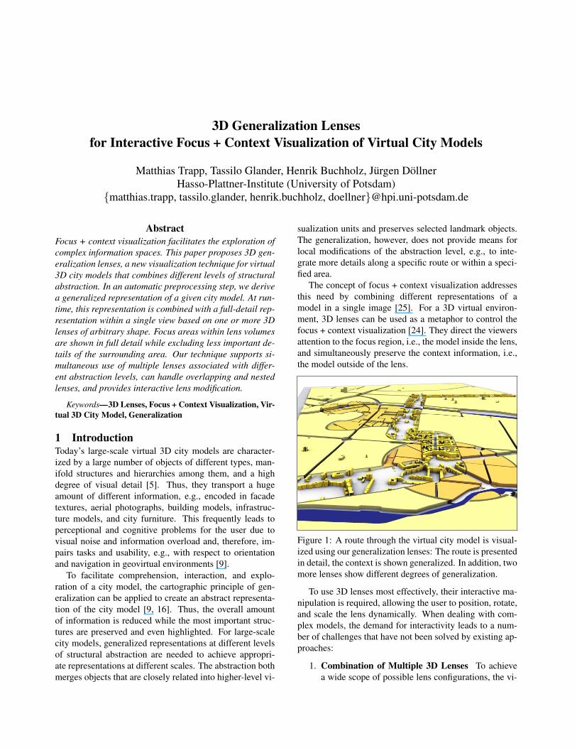
3D Generalization Lenses for Interactive Focus + Context Visualization of Virtual City Models Matthias Trapp, Tassilo Glander, Henrik Buchholz, J¨ urgen D¨ ollner Hasso-Plattner-Institute (University of Potsdam) {matthias.trapp, tassilo.glander, henrik.buchholz, doellner}@hpi.uni-potsdam.de Abstract Focus + context visualization facilitates the exploration of complex information spaces. This paper proposes 3D gen- eralization lenses, a new visualization technique for virtual 3D city models that combines different levels of structural abstraction. In an automatic preprocessing step, we derive a generalized representation of a given city model. At run- time, this representation is combined with a full-detail rep- resentation within a single view based on one or more 3D lenses of arbitrary shape. Focus areas within lens volumes are shown in full detail while excluding less important de- tails of the surrounding area. Our technique supports si- multaneous use of multiple lenses associated with differ- ent abstraction levels, can handle overlapping and nested lenses, and provides interactive lens modification. Keywords—3D Lenses, Focus + Context Visualization, Vir- tual 3D City Model, Generalization 1 Introduction Today’s large-scale virtual 3D city models are character- ized by a large number of objects of different types, man- ifold structures and hierarchies among them, and a high degree of visual detail [5]. Thus, they transport a huge amount of different information, e.g., encoded in facade textures, aerial photographs, building models, infrastruc- ture models, and city furniture. This frequently leads to perceptional and cognitive problems for the user due to visual noise and information overload and, therefore, im- pairs tasks and usability, e.g., with respect to orientation and navigation in geovirtual environments [9]. To facilitate comprehension, interaction, and explo- ration of a city model, the cartographic principle of gen- eralization can be applied to create an abstract representa- tion of the city model [9, 16]. Thus, the overall amount of information is reduced while the most important struc- tures are preserved and even highlighted. For large-scale city models, generalized representations at different levels of structural abstraction are needed to achieve appropri- ate representations at different scales. The abstraction both merges objects that are closely related into higher-level vi- sualization units and preserves selected landmark objects. The generalization, however, does not provide means for local modifications of the abstraction level, e.g., to inte- grate more details along a specific route or within a speci- fied area. The concept of focus + context visualization addresses this need by combining different representations of a model in a single image [25]. For a 3D virtual environ- ment, 3D lenses can be used as a metaphor to control the focus + context visualization [24]. They direct the viewers attention to the focus region, i.e., the model inside the lens, and simultaneously preserve the context information, i.e., the model outside of the lens. Figure 1: A route through the virtual city model is visual- ized using our generalization lenses: The route is presented in detail, the context is shown generalized. In addition, two more lenses show different degrees of generalization. To use 3D lenses most effectively, their interactive ma- nipulation is required, allowing the user to position, rotate, and scale the lens dynamically. When dealing with com- plex models, the demand for interactivity leads to a num- ber of challenges that have not been solved by existing ap- proaches: 1. Combination of Multiple 3D Lenses To achieve a wide scope of possible lens configurations, the vi-
Transcript of 3D Generalization Lenses for Interactive Focus + Context Visualization of Virtual City Models
3D Generalization Lensesfor Interactive Focus + Context Visualization of Virtual City Models
Matthias Trapp, Tassilo Glander, Henrik Buchholz, Jurgen DollnerHasso-Plattner-Institute (University of Potsdam)
{matthias.trapp, tassilo.glander, henrik.buchholz, doellner}@hpi.uni-potsdam.de
AbstractFocus + context visualization facilitates the exploration ofcomplex information spaces. This paper proposes 3D gen-eralization lenses, a new visualization technique for virtual3D city models that combines different levels of structuralabstraction. In an automatic preprocessing step, we derivea generalized representation of a given city model. At run-time, this representation is combined with a full-detail rep-resentation within a single view based on one or more 3Dlenses of arbitrary shape. Focus areas within lens volumesare shown in full detail while excluding less important de-tails of the surrounding area. Our technique supports si-multaneous use of multiple lenses associated with differ-ent abstraction levels, can handle overlapping and nestedlenses, and provides interactive lens modification.
Keywords—3D Lenses, Focus + Context Visualization, Vir-tual 3D City Model, Generalization
1 IntroductionToday’s large-scale virtual 3D city models are character-ized by a large number of objects of different types, man-ifold structures and hierarchies among them, and a highdegree of visual detail [5]. Thus, they transport a hugeamount of different information, e.g., encoded in facadetextures, aerial photographs, building models, infrastruc-ture models, and city furniture. This frequently leads toperceptional and cognitive problems for the user due tovisual noise and information overload and, therefore, im-pairs tasks and usability, e.g., with respect to orientationand navigation in geovirtual environments [9].
To facilitate comprehension, interaction, and explo-ration of a city model, the cartographic principle of gen-eralization can be applied to create an abstract representa-tion of the city model [9, 16]. Thus, the overall amountof information is reduced while the most important struc-tures are preserved and even highlighted. For large-scalecity models, generalized representations at different levelsof structural abstraction are needed to achieve appropri-ate representations at different scales. The abstraction bothmerges objects that are closely related into higher-level vi-
sualization units and preserves selected landmark objects.The generalization, however, does not provide means forlocal modifications of the abstraction level, e.g., to inte-grate more details along a specific route or within a speci-fied area.
The concept of focus + context visualization addressesthis need by combining different representations of amodel in a single image [25]. For a 3D virtual environ-ment, 3D lenses can be used as a metaphor to control thefocus + context visualization [24]. They direct the viewersattention to the focus region, i.e., the model inside the lens,and simultaneously preserve the context information, i.e.,the model outside of the lens.
Figure 1: A route through the virtual city model is visual-ized using our generalization lenses: The route is presentedin detail, the context is shown generalized. In addition, twomore lenses show different degrees of generalization.
To use 3D lenses most effectively, their interactive ma-nipulation is required, allowing the user to position, rotate,and scale the lens dynamically. When dealing with com-plex models, the demand for interactivity leads to a num-ber of challenges that have not been solved by existing ap-proaches:
1. Combination of Multiple 3D Lenses To achievea wide scope of possible lens configurations, the vi-

sualization should not be restricted to a single lens.Therefore, the visualization concept and techniquehave to deal with multiple, intersecting, overlappingand nested 3D lenses that can be freely combinedand moved independently. The behavior in thesecases should be configurable and consistent.
2. Arbitrary Lens Shapes In a given visualizationscenario, the core parts to be highlighted cannot beassumed to form a simple shape. Therefore, usersshould be able to customize the shape of the lensesto fit the actual core parts appropriately.
3. Data Complexity The underlying visualizationtechnique must work fast enough to cope with largeamounts of geometry and texture data and to supportrendering as well as lens manipulation in real-time.
As a matter of principle, existing techniques relyingon image-based multi-pass rendering usually have perfor-mance problems when applied to large scale 3D sceneswith multiple 3D lenses.
Addressing the challenges mentioned above, our workmakes the following contributions: We present Generaliza-tion Lenses, a concept and visualization technique that ex-tends the 3D generalization described in [9] based on Vol-umetric Depth Sprites (VDS) [23] to obtain a customizablevisualization, in which the local level of abstraction can beinteractively controlled. For this, we introduce a prioritybased mapping between lens volumes and lens content thathandles intersections and nested lenses.
Our interactive visualization technique supports multi-ple, dynamic, and arbitrarily shaped lens volumes. Figure 1shows a 3D lens containing a detailed version of a virtualcity model integrated into a generalized context.
This paper is structured as follows. Section 2 gives anoverview of the related work. Section 3 presents the basicconcepts and methods of our approach. Section 4 describesthe implementation of our visualization technique and Sec-tion 5 discusses the results. Finally, we present ideas forfuture work (Section 6) and conclude (Section 7).
2 Related WorkFocus + context visualization enables the user to accessboth, high-level context information and low-level details.Our technique can be seen as a 3D instance of the MagicLensTM[2, 24] metaphor. We use it to implement focus +context visualization applied to the structural scale [25] ofa virtual 3D city model. Only few authors address the ap-plication of these magic lenses on 3D geovisualization andvirtual 3D city models.
A 2D approach that is comparable with our work can befound in [13]: A generalized (chorematic) and an originalversion of a 2D map is combined to facilitate users orienta-tion and navigation. The combination and chorematization
cannot be done automatically. Texture lenses, presented in[4], enable the user to combine different texture layers ontop of a digital terrain model. This approach is limited to2D textures and cannot handle overlapping lenses.2.1 3D Lenses3D lenses were first introduced in [24], extending the ideaof lenses to three dimensional models and scenes.
In [19] an overview of focus + context visualizationwith 3D lenses and application examples is given. Basedon [18], they present an image-based multi-pass algorithmto separate focus from context regions. The algorithm sup-ports arbitrarily shaped lenses in real-time, but does nothandle overlapping or nested 3D lenses.
In [23], we presented a volumetric test that can be usedfor focus and context separation. Using depth peeling [3],the approach transforms arbitrarily shaped solids (convexand non-convex) into layered depth images [21] and per-forms ray-casting in 3D texture space to determine the par-ity of a 3D point to test. This test can be applied at vari-ous levels (vertex, primitive, fragment) within the render-ing pipeline.2.2 Generalization of 3D City ModelsIn cartography, the term generalization means to abstractmeaningful. It describes the process of reducing details ofthe depicted spatial information to a degree that is appro-priate to scale, task and viewer [10]. Due to the subjectivenature of this process, designing an automatic algorithm isa challenge. For the 2D case, solutions have been found,e.g., based on agents [6] or based on least squares adjust-ment [20].
For 3D building generalization, existing approachesconcentrate on the simplification of single buildings. Forthis, they remodel a building with a set of characteristicplanes [11], or split it along characteristic planes into aCSG tree representation [22]. Morphological operationshave also been applied to building generalization [7]. In[17], the generalization depends on line simplification per-formed on the projected walls [1].
The approaches described above are limited to singleobjects and disregard aggregation of multiple objects. Inan earlier work, we introduced a 3D generalization tech-nique that performs aggregation of multiple objects [8, 9].In this work, this technique is used as a preprocessing step.
3 ConceptThe data processing steps in our concept can be groupedinto a preprocessing phase and a rendering phase (Fig-ure 1).
Preprocessing Phase This step prepares all necessary ge-ometry for the rendering phase. This includes thegeneralization of city structures (Section 3.1) into asequence (LOA) of different levels of abstraction,

Preprocessing = generalization(CM)
Mapping FNC=( , C)Volumetric Depth Sprites
Generalization Data
Renderingrender(FNC)
ImageCity Model CM
Preprocessing = createVDS(S)
Mapping= map( , )
Solid Lens Volumes S
Preprocessing Phase Rendering Phase
Figure 2: Visualization pipeline of our concept. A preprocessing phase prepares 3D generalization geometry and the 3Dlens volumes for the rendering phase. The mapping of both can be specified dynamically at runtime.
the creation of volumetric depth sprites (Section 3.2)to represent the lens volumes (VDS), and an initialmapping M between both (Section 3.4).
Rendering Phase During runtime, the mapping M be-tween levels of generalized geometry LOA and 3Dvolumes (VDS) of the lenses can be specified andmodified by the user. The complete focus + contextmapping FNC is rendered in subsequent passes: Ineach pass we apply pixel-precise clipping against thelens volumes (Section 4.2). Every LOA geometry isrendered only once per frame.
3.1 Discrete Levels of GeneralizationsThe generalization technique creates a sequence of citymodel representations with increasing levels of abstraction.The generalization representation LOAi of level i gener-alizes LOAi−1. More specifically, one component fromLOAi aggregates a number of components from LOAi−1.As our generalization technique depends on weights givento the infrastructure, the number of generalization repre-sentations is the number of weight classes plus one.
Our technique focuses on aggregation, as it implicatesthe strongest abstraction compared to other generalizationoperators such as simplification. The number of single ob-jects is significantly decreased when turning to the nextlevel of abstraction. For example, the city model used inthis paper contains 10, 386 objects in LOA0. It is reducedto 468 objects in LOA1 and to 66 objects in LOA7. Toobtain a homogeneous visualization, no facade textures arekept in the generalized representations. Textures are onlyused to provide depth cues through a lighting texture [5].3.2 Volumetric Depth SpritesTo separate focus from context with per-pixel precision, weuse VDSs and a Volumetric Parity Test (VPT) introducedin [23]. The concept allows us to efficiently perform clip-ping against multiple, arbitrarily shaped volumes within asingle rendering pass. Depending on the parity of a VDS,the rendering algorithm clips either the geometry withinthe represented volume or its complement. The active stateindicates if this operation is performed.
3.3 3D Lens ShapesAt runtime, the lens shapes are stored as VDS representa-tions, and therefore, can be scaled, rotated and translatedwithin the scene. Our system supports the following meth-ods for the lens shape creation:
Derived Shapes Our framework can generate lens shapesfrom buffered 2D polygonal shapes and polylines.This allows us to derive complex lens shapes directlyfrom geo-referenced data.
Modeled Shapes Lens shapes can also be modeled explic-itly using 3D modeling software by importing thesethrough common interchange formats.
3.4 Mapping Lenses to Generalization LevelsThe mapping M = {Mi|i = 0 . . . n} between lens shapesV DSi ∈ VDS and generalization levels LOAi ∈ LOAcan be described as a tuple:
Mi := (V DSi, LOAi) (1)
Here, i denotes the priority of the mapping. This explicitorder upon generalization levels is necessary to handleoverlapping volumes correctly. V DSi represents the fo-cus volume whose content is defined by the generalizationlevel LOAi. A particular generalization level representsthe context C. The complete mapping in terms of focus +context visualization is defined as:
FNC := (M, C) (2)
4 ImplementationOur approach has been implemented based on OpenGL[15] in combination with GLSL [12] for rendering. We usethe Computational Geometry Algorithms Library (CGAL)to calculate the polygonal cells used during the generaliza-tion process [26].4.1 Generalization AlgorithmThe generalization is done as a preprocessing step. Inputfrom the city model are the infrastructure network and thebuilding geometry. The infrastructure network consists ofa number of weighted polylines, as provided by commer-cial (e.g. TeleAtlas R©) or non-commercial (e.g. Open-StreetMap) geo-data providers. The building models can

be separated into a large number of prismatic block build-ings and a small number of high detail CAD-based build-ings. Typically, important landmark buildings are modeledin high detail, while the majority of buildings are rela-tively simple, as they are automatically created using re-mote sensing technologies.
The preprocessing starts with the creation of polygo-nal cells by computing the arrangement of the polylines.Using cells defined by the streets can be argued with thecognitive importance of streets to structure the city [14].Then, the building geometry is mapped to the cells usingpoint-in-polygon tests. Then, for each cell a new heightis determined by calculating the mean height of all build-ings within one cell, thereby respecting the proportionatebuilding footprint’s area.
Important landmark buildings that are essential for ori-entation are preserved during block creation. We selectbuildings, of which the height surpasses the cell’s meanheight h by twice the standard deviation σ, that is, if abuilding b fulfills this condition:
height(b) > h + 2 · σ (3)
If a data set provides additional hints, these can also beused for landmark selection, e.g., for block models that areenriched by detailed 3D models for selected buildings. Inaddition, the set of preserved landmark buildings can beexplicitly adjusted.4.2 Rendering of 3D LensesTo render the mapping FNC, our technique performsmulti-pass rendering with one pass per level of abstraction.
render(FNC){Mi {VDS VDSi MisetActive(VDS, true)setParity(VDS, false)
}renderGeometry(C)i = || ||
while(i > 0){VDS VDSi MiLOA LOAi Miif(!culling(VDS){
setParity(VDS, true)renderGeometry(LOA)setActive(VDS, false)}
i = i-1}}
Figure 3: Pseudo code forrendering multiple levels ofgeneralizations.
Figure 3 shows thepseudo code for ren-dering the mapping de-scribed in Section 3.4.Starting with renderingthe context geometry C,our algorithm performspixel-precise clippingagainst all V DSi withina single rendering pass.After that, we render thegeometry of the gener-alization layers succes-sively. Beginning withthe lowest priority level,we swap the parity ofthe associated V DS,render the geometry LOA, and turn off the current V DS.This ensures that the geometry of lower priority does notinterfere with geometry of higher levels. This algorithm iseasy to implement and exploits the design of the VPT.
To increase runtime performance, we apply view-frustum culling to the 3D lenses. If no corner vertex of
the transformed bounding box of a V DS is inside the cur-rent view frustum, we set the active status of the respectiveV DS to false.
5 Results & DiscussionFigure 1 shows an application of our approach for the inter-active visualization of large scale virtual 3D city models.The used input dataset comprises the inner city of Berlinwith about 10, 386 generically textured buildings on top ofa digital terrain model.
Figure 5: Application example for a single, arbitrarilyshaped 3D lens. The focus preserves important detailsalong a specified route. The context region is generalized.
5.1 Usage ScenariosWe have tested our approach in different usage scenarios.
Single Focus is the standard use case for our lens visual-ization where the mapping is usually defined as:
FNC = ({(V DS0, LOAi)}, LOAj), j > i (4)
Figure 5 shows an example. It emphasizes a singleregion of interest.
Multiple Foci implicate the handling of disjunctive, over-lapping, and nested regions of interest. Figure 4.Aand B show examples of two overlapping regions ofinterest.
We implemented two types of lenses. As describedin [19] they can distinguished by the modification of thelens position during rendering with respect to the camera.Our visualization technique supports a mixture of both lenstypes:
Scene Lens The position of this lens type is independentfrom the user’s orientation. The lens position canbe fixed with respect to the virtual environment orattached to a moving object in the scene.

A B C
Figure 4: Application examples for 3D Generalization Lenses. Figure A and B show multiple overlapping lenses withdifferent mappings. Figure C shows two nested, camera lenses.
Camera Lens This lens type adapts it position with re-spect to the current user orientation. It can be usedto assure that potential foci are always visible (Fig-ure 4.C). This minimizes the effort for the user tosteer the lenses.
5.2 PerformanceOur test platform is an NVIDIA GeForce 8800 GTS with640 MB video memory and AthlonTM64 X2 Dual Core4200+ with 2.21 GHz and 2 GB of main memory at a view-port resolution of 1600x1200 pixel. The test applicationdoes not utilize the second CPU core.
All scenes depicted in this paper can be rendered at in-teractive frame rates. The rendering performance dependson the number and depth complexity of the VDS used,hence, from the number of samples the VPT has to per-form. Further, it is limited by the geometrical complexityof the generalization levels.
Pixel-precise clipping against multiple VDS is fill-ratebound. Consequently, the performance is proportional tothe distance between user and rendered geometry, i.e., itimproves with increasing distance to the lens.
5.3 LimitationsThe main conceptual limitation refers to the one-to-onemapping between generalizations levels and lens volumes.Therefore, it is currently not possible to assign multiplevolumes to a single generalization level.
Further, our concept is limited by the memory consump-tions of the LOA and VDS. The storage of high qualitygeneralization levels, e.g., with precomputed lighting tex-tures, exceeds easily the main memory size.
The main drawback concerns the rendering perfor-mance that depends on the number and depth complexityof the VDS. To reduce visual artifacts during clipping wecolorize the visible back faces. Therefore it is not possibleto apply back-face culling.
6 Future WorkCurrently, we are extending our implementation to elimi-nate rendering artifacts such as shading discontinuities forvisible back faces. We also research a loss-less compres-sion algorithm for volumetric depth sprites to minimizevideo memory consumptions and to optimize the numberof necessary texel fetches for the VPT. In addition, we wantto extend the mapping to facilitate the binding of multiplelens volumes to multiple generalization levels.
To further demonstrate the flexibility of our VDS ap-proach, we want to apply it to more usage scenarios suchas the visualization of statistic geo-referenced data andspatio-temporal data. Focus regions can then be high-lighted further by using different rendering styles such asnon-photorealistic rendering.
As city models are usually organized in a plane, gener-alization lenses do not exhaust the potential of the VDS ap-proach. Therefore, we plan to implement in-house lensesto give insight to complex structured interior space, e.g., tovisualize escape routes.
7 ConclusionsWe present an interactive focus + context visualizationtechnique that combines different levels of generalizationof a virtual 3D city model within a single image. Ourapproach is based on an automated generalization algo-rithm for virtual 3D city models and pixel-precise clippingagainst multiple, arbitrarily shaped, polygonal meshes,which act as 3D lenses. The presented 3D generaliza-tion lenses enable the implementation of interactive toolsthat allow users to flexibly combine different model LOAswithin the same visualization.
AcknowledgmentsThis work has been funded by the German FederalMinistry of Education and Research (BMBF) as partof the InnoProfile research group “3D Geoinformation”(www.3dgi.de).

References[1] K.-H. Anders. Level of Detail Generation of
3D Building Groups by Aggregation and Typifi-cation. Proceedings of 22nd International Carto-graphic Conference, La Corua, Spain, 2005.
[2] Eric A. Bier, Maureen C. Stone, Ken Pier, KenFishkin, Thomas Baudel, Matt Conway, WilliamBuxton, and Tony DeRose. Toolglass and MagicLenses: The see-Through Interface. In CHI ’94,pages 445–446, New York, NY, USA, 1994. ACMPress.
[3] Cass Everitt. Interactive Order-Independent Trans-parency. Technical report, NVIDIA Corporation,2001.
[4] Jurgen Dollner and Konstantin Baumann.Gelandetexturen als Mittel fur die Prasentation,Exploration und Analyse komplexer raumlicherInformationen in 3D-GIS. In V. Coors A. Zipf,editor, 3D-Geoinformationssysteme, pages 217–230.Wichmann Verlag, 2005.
[5] Jurgen Dollner, Henrik Buchholz, and Haik Lorenz.Ambient Occlusion - ein Schritt zur realistischenBeleuchtung von 3D-Stadtmodellen. GIS - Zeitschriftfur Geoinformatik, pages 7–13, November 2006.
[6] C. Duchene. Coordinative Agents for AutomatedGeneralisation of Rural Areas. Proceedings 5thWorkshop on Progress in Automated Map General-ization, 2003.
[7] A. Forberg. Generalization of 3D Building Databased on a Scale Space Approach. InternationalArchives of Photogrammetry, 35, 2004.
[8] Tassilo Glander and Jurgen Dollner. Cell-based Gen-eralization of 3D Building Groups with Outlier Man-agement. In GIS ’07: Proceedings of the 15th annualACMGIS, pages 1–4, New York, NY, USA, 2007.ACM.
[9] Tassilo Glander and Jurgen Dollner. Techniques forGeneralizing Building Geometry of Complex Vir-tual 3D City Models. In 2nd International Work-shop on 3D Geo-Information: Requirements, Ac-quisition, Modelling, Analysis, Visualisation, Delft,Netherlands, December 2007.
[10] G. Hake, D. Grunreich, and Liqiu Meng. Kartogra-phie. Walter de Gruyter, Berlin, New York, 8 edition,2002.
[11] M. Kada. 3D Building Generalisation. Proceedingsof 22nd International Cartographic Conference, LaCoruna, Spain, 2005.
[12] John Kessenich. The OpenGL Shading LanguageLanguage Version: 1.20 Document Revision: 8,September 2006.
[13] A. Klippel and K. Richter. Chorematic focus maps,2004.
[14] K. Lynch. The Image of the City. MIT Press, 1960.[15] Mark J. Kilgard. NVIDIA OpenGL Extension Spec-
ifications. Technical report, NVIDIA, November2006.
[16] L. Meng and Forberg A. 3D Building Generalization.In W. Mackaness, A. Ruas, and T. Sarjakoski, editors,Challenges in the Portrayal of Geographic Informa-tion: Issues of Generalisation and Multi Scale Rep-resentation, pages 211–232. 2006.
[17] Jiann-Yeou Rau, Liang-Chien Chen, Fuan Tsai, Kuo-Hsin Hsiao, and Wei-Chen Hsu. LOD Generation for3D Polyhedral Building Model. In Advances in Im-age and Video Technology, pages 44–53, Berlin Hei-delberg New York, 2006. Springer-Verlag.
[18] Timo Ropinski and Klaus Hinrichs. An Image-BasedAlgorithm for Interactive Rendering of 3D MagicLenses. Technical Report 03/04 - I, FB 10, Insti-tut fur Informatik, Westfalische Wilhelms-UniversitatMunster, 2004.
[19] Timo Ropinski, Klaus H. Hinrichs, and FrankSteinicke. A Solution for the Focus and ContextProblem in Geo-Virtual Environments. In Proceed-ings of the 4th ISPRS Workshop on Dynamic andMulti-dimensional GIS (DMGIS05), pages 144–149,2005.
[20] M. Sester. Generalization Based on Least SquaresAdjustment. International Archives of Photogram-metry and Remote Sensing, 33:931–938, 2000.
[21] Jonathan Shade, Steven Gortler, Li wei He, andRichard Szeliski. Layered Depth Images. In SIG-GRAPH ’98, pages 231–242, New York, NY, USA,1998. ACM.
[22] F. Thiemann and M. Sester. Segmentation of Build-ings for 3D-Generalisation. Proceedings of the ICAWorkshop on Generalisation and Multiple Represen-tation, Leicester, UK, 2004.
[23] Matthias Trapp and Jurgen Dollner. Real-Time Vol-umetric Tests Using Layered Depth Images. InE. Reinhard K. Mania, editor, Proceedings of Euro-graphics 2008. Eurographics, The Eurographics As-sociation, April 2008. to appear.
[24] John Viega, Matthew J. Conway, George Williams,and Randy Pausch. 3D Magic Lenses. In UIST’96, pages 51–58, New York, NY, USA, 1996. ACMPress.
[25] Colin Ware. Information Visualization: PerceptionFor Design. Morgan Kaufmann Publishers Inc., SanFrancisco, CA, USA, 2000.
[26] Ron Wein, Efi Fogel, Baruch Zukerman, and DanHalperin. 2D Arrangements. In CGAL EditorialBoard, editor, CGAL-3.2 User and Reference Man-ual. 2006.