309 FOREST UTILIZATION BY LOCAL PEOPLE IN VANG ...
21
309 FOREST UTILIZATION BY LOCAL PEOPLE IN VANG VIENG DISTRICT Khampha Chanthirath * Introduction The Lao P.D R. is rich in forest, water, biodiversity, mineral and land resources. However, although the country has significant unused land and inappropriate use of forest resources, the overall resource base is fragile, with the majority of land and forest susceptible to degradation and generally poor soils. Most land degradation in the Lao P.D.R., as is the case in the research site, is associated with shifting cultivation, particularly in the areas where population pressure has led to a significant decrease in the rotation period or where traditional farmers encroach on neighboring upland terrain. Villagers enjoy traditional usufruct rights to land, inheritable by the family and transferable to third parties, and access to the timber and a large amount of non-timber forest products for domestic consumption and sale. This paper describes the natural forest resources, socio-economic conditions and forest products utilization in the research areas, with some especially important information on geography, population administration and organization in Chapter I. Chapter 2 includes land categories by residents, soil categories, land tenure system by land category, including the distribution of the rights to forest and land within communities of forest users and among communities of forest users and usufruct of the trees, and motivation to set up communal forests. In Chapter 3 the present state of the utilization of forest products is surveyed in the research site. Then in Chapter 4 is a comparison of forest utilization in terms of the time needs to be analyzed and an evaluation of forest utilization by dwellers in the research site. CHAPTER I GENERAL DESCRIPTION OF THE RESEARCH SITE 1. Socio-economic conditions 1-1. Administration and organization The research site is under the jurisdiction the of Vang Vieng district, Vientiane province. It is hilly terrain with a total area of about 41,800 ha. It is located in the southeastern part of Vang Vieng district and shares boundaries with Namon sub-district to the north, Say Somboon special zone and Keo Oudom district to the east, Hin Heup and Fuang district to the south and the west. The roads No 13 A and No 13 B are the major transportation facilities of the area. One third of the research site consists of water and islands. So to communicate with other areas both car and boat are available the whole year. As mentioned above, this area is hilly land. There is no flat area suitable for permanent agriculture. Thus, about 85% of the farmers still practice shifting cultivation, and this is the main cause of forest degradation. Institutional arrangements in the district administration are similar to those at the central level. All district offices are present covering the fields of agriculture and forestry, communication , transportation, post and construction, industry-handicrafts, commerce, information and culture, education, labor and social welfare, etc. Under jurisdiction of the Vang Vieng district, there are five sub-districts and 72 villages. Although the sub-districts are administratively non-functional at present, relevant the district is divided into five sub-districts, i.e. Phatang (with 13 villages), Vang Vieng (22 villages), Namuang (13 villages), Namon (15 villages) and Somboon (9 villages). Each sub-district has one leader to take responsibility for rural development. These leaders were appointed by a district authority, * Forest Conservation and Afforestation Project(FORCAP), Vientiane Province Agricultural and Forestry Office, Vientiane Province, Lao P.D.R.
-
Upload
khangminh22 -
Category
Documents
-
view
0 -
download
0
Transcript of 309 FOREST UTILIZATION BY LOCAL PEOPLE IN VANG ...

309
FOREST UTILIZATION BY LOCAL PEOPLE IN VANG VIENG DISTRICT
Khampha Chanthirath∗
Introduction
The Lao P.D R. is rich in forest, water, biodiversity, mineral and land resources. However,although the country has significant unused land and inappropriate use of forest resources, theoverall resource base is fragile, with the majority of land and forest susceptible to degradation andgenerally poor soils.
Most land degradation in the Lao P.D.R., as is the case in the research site, is associatedwith shifting cultivation, particularly in the areas where population pressure has led to a significantdecrease in the rotation period or where traditional farmers encroach on neighboring upland terrain.Villagers enjoy traditional usufruct rights to land, inheritable by the family and transferable to thirdparties, and access to the timber and a large amount of non-timber forest products for domesticconsumption and sale. This paper describes the natural forest resources, socio-economic conditions and forestproducts utilization in the research areas, with some especially important information on geography,population administration and organization in Chapter I. Chapter 2 includes land categories byresidents, soil categories, land tenure system by land category, including the distribution of therights to forest and land within communities of forest users and among communities of forest usersand usufruct of the trees, and motivation to set up communal forests. In Chapter 3 the present stateof the utilization of forest products is surveyed in the research site. Then in Chapter 4 is acomparison of forest utilization in terms of the time needs to be analyzed and an evaluation of forestutilization by dwellers in the research site.
CHAPTER IGENERAL DESCRIPTION OF THE RESEARCH SITE
1. Socio-economic conditions 1-1. Administration and organization
The research site is under the jurisdiction the of Vang Vieng district, Vientiane province. Itis hilly terrain with a total area of about 41,800 ha. It is located in the southeastern part of VangVieng district and shares boundaries with Namon sub-district to the north, Say Somboon specialzone and Keo Oudom district to the east, Hin Heup and Fuang district to the south and the west.The roads No 13 A and No 13 B are the major transportation facilities of the area.
One third of the research site consists of water and islands. So to communicate with otherareas both car and boat are available the whole year. As mentioned above, this area is hilly land.There is no flat area suitable for permanent agriculture. Thus, about 85% of the farmers stillpractice shifting cultivation, and this is the main cause of forest degradation.
Institutional arrangements in the district administration are similar to those at the centrallevel. All district offices are present covering the fields of agriculture and forestry, communication ,transportation, post and construction, industry-handicrafts, commerce, information and culture,education, labor and social welfare, etc.
Under jurisdiction of the Vang Vieng district, there are five sub-districts and 72 villages.Although the sub-districts are administratively non-functional at present, relevant the district isdivided into five sub-districts, i.e. Phatang (with 13 villages), Vang Vieng (22 villages), Namuang(13 villages), Namon (15 villages) and Somboon (9 villages). Each sub-district has one leader totake responsibility for rural development. These leaders were appointed by a district authority,
∗ Forest Conservation and Afforestation Project(FORCAP), Vientiane Province Agricultural and ForestryOffice, Vientiane Province, Lao P.D.R.
310
mainly from the district party committee. In the case of Vang Vieng district, five party membersfrom the permanent committee will be appointed to be responsible for the five sub-districts
Six villages within FORCAP's pilot area were moved to a new district (Hin Heup district).These include Sivilay, Somsanook, Nampath, Vang Khi, Phone Thong and Taothan.
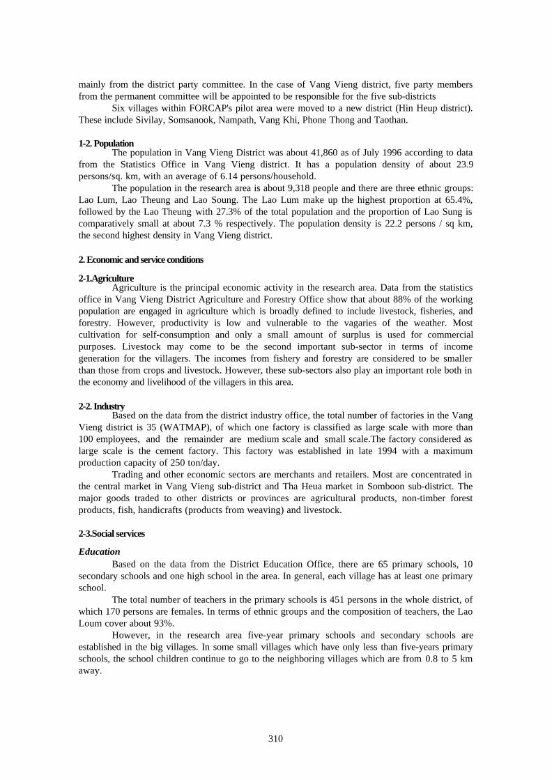
1-2. PopulationThe population in Vang Vieng District was about 41,860 as of July 1996 according to data
from the Statistics Office in Vang Vieng district. It has a population density of about 23.9persons/sq. km, with an average of 6.14 persons/household. The population in the research area is about 9,318 people and there are three ethnic groups:Lao Lum, Lao Theung and Lao Soung. The Lao Lum make up the highest proportion at 65.4%,followed by the Lao Theung with 27.3% of the total population and the proportion of Lao Sung iscomparatively small at about 7.3 % respectively. The population density is 22.2 persons / sq km,the second highest density in Vang Vieng district.
2. Economic and service conditions
2-1.AgricultureAgriculture is the principal economic activity in the research area. Data from the statistics
office in Vang Vieng District Agriculture and Forestry Office show that about 88% of the workingpopulation are engaged in agriculture which is broadly defined to include livestock, fisheries, andforestry. However, productivity is low and vulnerable to the vagaries of the weather. Mostcultivation for self-consumption and only a small amount of surplus is used for commercialpurposes. Livestock may come to be the second important sub-sector in terms of incomegeneration for the villagers. The incomes from fishery and forestry are considered to be smallerthan those from crops and livestock. However, these sub-sectors also play an important role both inthe economy and livelihood of the villagers in this area.
2-2. IndustryBased on the data from the district industry office, the total number of factories in the Vang
Vieng district is 35 (WATMAP), of which one factory is classified as large scale with more than100 employees, and the remainder are medium scale and small scale.The factory considered aslarge scale is the cement factory. This factory was established in late 1994 with a maximumproduction capacity of 250 ton/day.
Trading and other economic sectors are merchants and retailers. Most are concentrated inthe central market in Vang Vieng sub-district and Tha Heua market in Somboon sub-district. Themajor goods traded to other districts or provinces are agricultural products, non-timber forestproducts, fish, handicrafts (products from weaving) and livestock.
2-3.Social services
EducationBased on the data from the District Education Office, there are 65 primary schools, 10
secondary schools and one high school in the area. In general, each village has at least one primaryschool.
The total number of teachers in the primary schools is 451 persons in the whole district, ofwhich 170 persons are females. In terms of ethnic groups and the composition of teachers, the LaoLoum cover about 93%.
However, in the research area five-year primary schools and secondary schools areestablished in the big villages. In some small villages which have only less than five-years primaryschools, the school children continue to go to the neighboring villages which are from 0.8 to 5 kmaway.
311
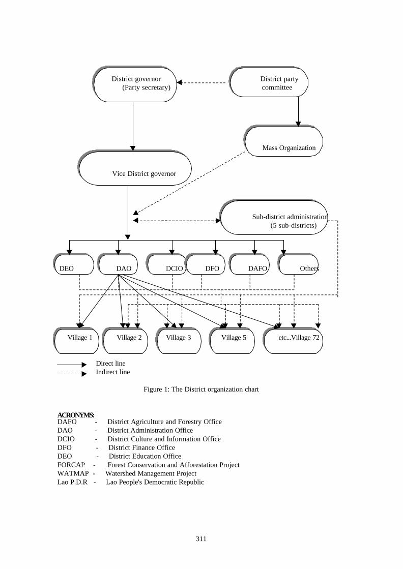
District governor District party (Party secretary) committee
Mass Organization
Vice District governor
Sub-district administration
(5 sub-districts)
DEO DAO DCIO DFO DAFO Others
Village 1 Village 2 Village 3 Village 5 etc...Village 72
Direct line Indirect line
Figure 1: The District organization chart
ACRONYMS:DAFO - District Agriculture and Forestry OfficeDAO - District Administration OfficeDCIO - District Culture and Information OfficeDFO - District Finance OfficeDEO - District Education OfficeFORCAP - Forest Conservation and Afforestation ProjectWATMAP - Watershed Management ProjectLao P.D.R - Lao People's Democratic Republic
312
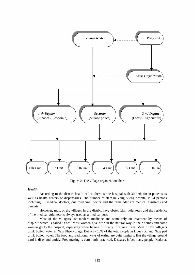
Village leader Party unit
Mass Organization
1 th Deputy Security 2 nd Deputy ( Finance / Economic) (Village police) (Forest / Agriculture)
1 th Unit 2 Unit 3 th Unit 4 Unit 5 Unit 6 th Unit
Figure 2. The village organization chart
HealthAccording to the district health office, there is one hospital with 30 beds for in-patients as
well as health centers or dispensaries. The number of staff in Vang Vieng hospital is 74 personsincluding 10 medical doctors, one medicinal doctor and the remainder are medical assistants anddentists.
However, most of the villages in the district have obstetrician volunteers and the residenceof the medical volunteer is always used as a medical post.
Most of the villagers use modern medicine and some rely on treatment by means ofa"spirit" which is called "Yao". Most women give birth in the natural way in their homes and somewomen go to the hospital, especially when having difficulty in giving birth. Most of the villagersdrink boiled water in Nam Phao village. But only 10% of the total people in Houay Xi and Nam paddrink boiled water. The food and traditional ways of eating are quite sanitary. But the village groundyard is dirty and untidy. Free grazing is commonly practiced. Diseases infect many people. Malaria,

313
lung-diseases, diarrhea, bladder-disease and stomachache were the major diseases found. About85% of the villagers sleep inside mosquito nets.
3. Geographical information
3-1. TopographyThe research site is situated in the upper part of the Nam Ngum reservoir and the average
elevation is quite high in the northern and western parts which are mountainous areas where thefigure varies between 1,000-2,000 m. In the central part of the research site is a hilly area with anelevation of 300-500 m. It is about 140 km from Vientiane Municipality on the way to the specialzone along with the road number 13 B. One third of the total land area is covered by water and it isthe very important part for the people who are living in this area.
Because of the specific geographic conditions of this area, located in the upper part of theNam Ngum reservoir, this is the main source of the people's income generation. However, fishing isinsufficient for consumption because of the rapidly decreasing number of fish in the Nam Ngumreservoir. So these people have turned to practicing slash and burn cultivation in the islands of NamNgum reservoir, to engage their lives, and this leads to those islands becoming bare land which isthe main cause of the soil sedimentation occuring in the Nam Ngum reservoir.
3-2. Climate.Vieng district, where the research site is located, belongs to the high rainfall area of central
Laos. According to the data provided by the Lao Meteorological and Hydrological Department, therecorded annual rainfall level for the period from 1989 to 1996 varied between 2,800 mm to 3,000mm in Vang Vieng. As the annual rainfall in Vientiane during the same period varied between 1,300mm to 2,000 mm, the annual rainfall level in Vang Vieng appears to be higher than that of Vientianeprovince.
The rainfall level is particularly high from July to August with a strong monsoon presenceresulting in monthly rainfall of around 700 mm. Ninety percent of the annual rainfall is concentratedin the five month period from June to October. The dry season with an extremely low rainfall levelis from November to April although mean monthly rainfall of 10-30 mm is still recorded in the dryseason.
The mean annual temperature of Vang Vieng is approximately 25 C. April is the hottestmonth near the end of the dry season with a mean temperature of around 28 C. The mean monthlytemperature drops to 21 C in December and January which is the most pleasant time of the year. 3-3. Vegetation
The remaining natural forest in the research site is almost all upper mixed deciduous forest(National Office of Forest Inventory and Planning, 1991). This forest is a degradation of the dryevergreen forest following either cutting or burning for agriculture. Some of this area of forestdeveloped on sandstone formation and is characterized by the presence of bamboo. Most of thedominant species are Dipterocarpus, Lagestroemia sp, Pterocarpus, Afzelia xylocarpa and others.
Bamboo forest is a pure forest or mixed with other species. Normally this bamboo forestoccurs over slash and burn area the first time or the second time. However, the quality of this kindof bamboo forest is not high.
Another forest type is the unstocked forest or fallow forest. The average tree diameter ofthis forest is less than 20 cm and the crown density is less than 20%. The main species are fastgrowing species such as Pelthorphorum sp, Clatoxylon sp, Mallotus sp, and Trema sp and these aresometimes mixed with bamboo and other species.
Grassland comes from from degradation of unstocked forest or bamboo forest due toseveral repetitions of slash and burn agriculture. The main species of cover are Imperata cylyndrica,(Nha Kha), Nha Khem and elephant grass (Nha lao). These grasses are fast spreading in a large area,especially after several incidences of forest fire. But sometimes growth occurs under degradedforest conditions, and it is a very good raw material for forest fires in the dry season.

314
CHAPTER IIMETHODOLOGY
1. Objectives of the study
The main objectives of the study of forest utilization by the forest dwellers of the studyarea are: -To make clear about forest utilization by the forest dwellers. -To study customary forest management system -To know the present state of the utilization of forest products -To study the changes in forest utilization in terms of timeFor such a study, forest areas were selected in degraded forests in some villages in Somboon sub-district where communities are playing a major role in utilization of forest products. Keeping all theobjectives of study in mind the following procedures and methods of study were adopted.
2. Sample
It is very necessary to define the sample of study of primary data. Three villages in theresearch site were taken as primary units of the field study. Heavy degraded forest surrounded all ofthese villages.
3. Questionnaire
For personal interviews, a questionnaire cum checklist was prepared. In this questionnaire,villages as well as villagers were covered with full attention. Covered were customary forestmanagement system, land tenure system, socio-economic conditions, dependency on forest andagriculture, soil type and forest category, reason for degradation of forest, conservation system,rules and functioning of village forest protection committees and also their organization.
4. Secondary data
To ensure that the report of this study is complete, secondary data needed to be used,especially on geographical, socio-economic and natural conditions data from the WatershedManagement Planning team (1997) and National Office of Forest Inventory and Planning, which isalready available in the research site.
5. Procedures of the study field
On the basis of primary and secondary data, the forest utilization by dwellers weredescribed and analyzed. In this regard the system of forest management was identified
CHAPTER IIICUSTOMARY FOREST MANAGEMENT SYSTEM IN DEGRADED LAND:
CASE STUDY IN THREE VILLAGES IN SOMBOON SUB-DISTRICT
1. History of the research site
The research site comprises mainly three ethnic groups : Lao Lum, Lao Theung andHmong or Lao Soung. Most of these villages have been established since 1970 and at that time theywere small villages. Each village has only about twenty to thirty households and most of thesepeople came from the northeast of the country within the period of the Indochina war. Most ofthem are engaged in shifting cultivation and fishing. Only a small portion is engaged in small shopkeeping.
In the past, this area was a dense forest and very rich in natural resources, especially forestresources such as timber, non-timber forest products, wild animals and aquatic animals.
315
Nowadays, after only two decades, all of these forest resources have quickly declined. The mainreasons are rapid deforestation, inappropriate systems used by both local people and local authorities.So, that means over extraction not only for self-consumption but also for commercial purposes,and a zoning system between agriculture land and forestland have not yet been introduced.Therefore, these resources follow a trend of growing seriously scarce year by year, and the trendwill continue unless both local government and local people devise a measure to counter thesenegative phenomena.
2. Land categories recognized by the residents of each ethnic group
2-1. Lao theung ethnic group (Khamu) in land classification.Normally the name of Lao Theung has a meaning that refers to the people who live at the
medium height of the mountains. Slash and burn cultivation is very common in this society. Huntingand forest product collection are their second occupation for subsistence. But nowadays,commercial trade is their main means of income generation. A long time ago, slash and burn did nothave so much negative impact on the forest resources because at that time the rotation of slash andburn was quite long (15 years to 20 years) and there was enough time for natural regeneration. Inrecent years, because of the accelerated increase of population and after the slash and burn rotationbecame shorter( 3 years to 4 years) land does not have the time for self fertility. Therefore, manypeople believe that slash and burn is the main factor bringing degraded land and poor soil. Peoplealways complain and blame the shifting cultivators as the major cause especially to upland people.
Based on the traditional use of the land and characteristics of the Lao theung society, landand forestland has been classified roughly into 6 categories:(1) Dense forest (Padong)(2) Old fallow (Patae reng kae in Lao theung)(3) Young fallow (Patae reng kha nhom in Lao theung)(4) Spiritual forest or sacred forest (Patae bree haksa in Lao theung)(5) Cemetery (Patae raman in Lao theung)(6) Utilization of forest (Patae som xay in Lao theung)
2-2. Lao Loum in land classificationAccording to the information collected in the field survey in three villages in the research
site, Lao Loum are the people who like to settle their villages in the low lands in the site along theriver, and Buddhism is their religion. Most of them engage in permanent agriculture and hunting,and non-timber forest products gathering is only for self-consumption. Slash and burn is not theirmain occupation. So if we compare them with the Lao Theung ethic groups they have somedifference of style in customary use of forest products. In terms of the forest classification thereare also some differences.
With the Lao Loum, mainly they follow the same classification of the forestry sector, butone thing different is that their classification includes cemetery and sacred forest. So, theclassification of the forest is: (1) Conservation forest (2) Production forest (3) Plantation (4) Cemetery (5) Protection forest (6) Sacred forest (7) Fallow forest
2-3. Hmong or Lao SoungThe Hmong ethnic group is the people who like freedom of agriculture practice at the tops
of the mountains. They will use up the land until the land is less fertile, then they will move to other
316
places. Most of them believe in the spiritual, and they follow the caste system which means that ineach village they will follow one person who is a powerful figure in the village. Hunting is veryactive in this society. If talking about forest classification, they will be classified the same as theLao Theung ethnic group.
2-4. Official land classificationHowever, in an official classification the land and forestland are quite different from the
traditional way. Thus, if based on an official classification it can be divided into categories asfollows:
Agriculture landThe agriculture land is divided into three kinds as follows :-Paddy field-Slash and burn cultivation and-Fruit tree gardens.
Construction landThe construction land is the land used for various infrastructure purposes, for example housebuilding, road and other construction
Forest landThe forestland includes land without forest cover. Based on the characteristic utilization it can bedivided into several categories as below :• Conservation forest
The conservation forest is the forest and forest land which is classified for the purpose ofprotecting and conserving wild animals, plant species, nature and various other things which havehistorical, cultural, tourist, environmental, educational and scientific research value.• Protection forest
Protection forest is forest and forest land classified for the protection of watershed areasand the prevention of soil erosion. It also includes areas of forestland significant for nationalsecurity, areas for protection against natural disaster and the protection of the environment andother areas.• Production forest
Production forest is forest and forest land classified for the purpose of satisfying therequirements of national economic and social development and of the people's livelihoods, fortimber and other forest products on a sustainable basis and without significant negativeenvironmental impacts.• Regeneration forest
Regeneration forest is a young fallow forest classified for the purpose of regeneration andmaintenance so that increases in maturity lead toward a state of natural equilibrium.• Degraded forest
Degraded forest is forest which has been heavily damaged such as land without forest onit or barren land classified for tree planting and / or allocated to individuals and organizations for treeplanting, permanent agriculture and livestock production, or for other purposes, in accordance withnational economic development plans.
3. Soil category
The geological formation of the research site consists of sedimentary rocks asconglomerate, sandstone, slate and limestone of the Triassic system of the Mesozoic Group.Outcrops and boulders of mainly sandstone are observed in eroded areas at summits and deepslopes and near the bottoms of the mountains.
The most widely distributed soil group in the mountains and hills in the research site isAcrisols, soils which are characterized by a yellow to yellowish brown color (see appendix 2). The
317
presence of a B-horizon with clay accumulation is a low cation exchange capacity due to the loss ofbases caused by strong leaching, a low degree of base saturation and a low pH value.
Most of the topsoil in the research site is very thin and lacking in nutrients due toinappropriate use of the land, especially at the tops of the mountains.
4. Land tenure and holding.
Since the government decreed the regulation of land use (No 117) in 1989 it is authorizedthat the land remains as the national community's property and the people have the right of usufructor the right to land use. By the government decree No 99 in 1992 and the land law of 1996, the landcould be inherited, transferred, leased or sold (the using right) to Lao national, all of which arelegitimately recognized by the state. Each village is to maintain a land registry book for individualholdings and submit this to the authority concerned.
The land taxation system was also changed in 1993 (Decree No 50). Before that the tax onpaddy land was imposed in kind on the basis of assessed potential yield. For the other crops anagricultural income tax was paid in cash. Under the new system, taxes are paid annually on all cropsin cash and the taxes apply to all categories of the land. A different tax schedule is applied to eachof four agricultural land types, i.e. paddy land (irrigated and rain fed), non-rice agricultural crops,for slash and burn cultivation and other land uses.
According to the results of the interview data from 60 households in three villages in theresearch site, no one had land certification. All just have the traditional right to use land recognizedin the traditional way. Therefore land allocation needs to be implemented in these villages, especiallythe slash and burn areas. After land allocation, these shifting cultivators / farmers will have anofficial right to use the land. At that time the land taxation system will be fully implemented and landcertification will be issued to the farmers / shifting cultivators. Finally each plot of the land will beused for its proper purpose. Then land and forest land will be protected and improved by theowners
5. Usufruct of trees
Based on forest law (article 30, 11 / 10 / 96) the customary use of the forest, forestlandand forest products has been practiced for a long period and is recognized by society and / or law.
Customary use includes the collection of non-prohibited wood for fences and fuel, thecollection of forest products, hunting and fishing of non-prohibited species for householdconsumption and other uses following custom. Customary use should not cause damage to forestand forest resources as affecting the rights or benefits of individuals or organizations.
The customary use of forest, forest products and forestland must be in accordance withvillage regulations on forest and forest land, which the village authority has determined.
If based on the Duties and Rights in managing forestry resources at the village level in articleNo 12, the villagers have the right to receive the following benefits:(1) The right to enter the forest to gather minor value forest products and trees for firewood and
support their living conditions. Any individual who wants to exploit forestry products classifiedin the list of the state for commercial purpose must be authorized by the district administrativeauthorities and regional forestry officials before taking action, and all rehabilitation fees must bepaid.
(2) The rights to cut trees for fire wood, wood charcoal, fencing and other uses within theirorchards.
(3) In case of necessity for poor families to cut 1 to 10 cubic meters of second class and thirdclass timber of controlled species for fencing and housing from village forest areas, they mustbe authorized by village administrative authorities.
(4) The right to hunt non-restricted animals and strictly ensure proper hunting, according to thedecree of the Council of Ministers No 118 / CCM on the management and protection of waterwildlife hunting and fishing.
318
- In case it is necessary to protect all water and wildlife in the areas of their villages, the villageadministrative authorities with the villagers have the right to establish the specific provisions.
However, uncontrolled and customary overuse of forest products in the research site isvery common. So that means uncontrolled logging and hand sawing of the timber for selling andunlimited practice of slash and burn cultivation is still expanding. So this is the main cause of thedeclination of the natural resources as well as soil degradation in the research site. Many peoples tillthink that the trees grow up by nature itself and everyone has the right to cut them without anypermission from the authorities or owners of that forest area. So freely cutting the small timber ofall types of the forest is still very common in the research site.
6. Motivation to set up communal forest
Since the first national forestry conference in 1989, the government has fully recognizedthat the participation of local people to manage forests is the priority need of the governmentpolicies. So several projects have been established to help the village institution to set up communityforestry in each village, especially in remote areas.
The data of the survey shows that these three villages have simple communal forests. Butthese communal forests seem to be not so well organized. This is just the basic and simplecommunal forestry not how to use forest resources together (for example no official rules andregulations to control and protect their forest resources), and also these communal forests still havemany gaps and some shortcomings. When the society changes in terms of the population numberand the demands of the society increase, this communal forestry needs to be well organized andwell developed to meet their important role for sustainable use of these natural forest resources aswell as to resolve the problems among the villagers involving conflicts over rights to use the forest.
7. Conflicts over land
Based on the results of the survey in three villages in the research site, it is shown that 58of 60 households report that many conflicts often occur, especially land overlapping among villagesand conflicts about the rights to use the forest products among villagers. But these are not bigproblems and most of the conflicts were resolved by themselves at family or village levels. Only afew cases needed to be brought to the district level to resolve them. If based on the laws andregulations, the conflicts between state and villagers are also important conflicts (i.e. villagersencroach state forests by illegal cutting of the timbers or unlimited collection of non timber forestproducts, or state allows some companies to harvest the dead logs in the village territory withoutthe acceptance of the village organization.)
Although the conflicts can be solved among themselves, or between the state and thevillagers, the negative impacts on natural forest resources always occurs. ( i.e. over exploitation,inappropriate harvesting methods, etc ). So it has led to unsustainable use of forest resources andespecially depletion of the forest as well as degradation of the land.
CHAPTER IVPRESENT STATE OF THE UTILIZATION OF FOREST PRODUCTS
1. Regulations for the use of forest products
According to the second set of data, in article 25 of the forestry laws it is mentioned thatthe exploitation of wood and forest derived products can be undertaken specifically in productionforests which have been surveyed and allocated for exploitation. Only in these areas has forestryexploitation been planned in order to ensure that the exploitation of the wood is continuous and thatexploitation can be repeated in the areas which have already been exploited.

319
The exploitation of wood must be performed according to the following principles andregulations:(1) Use of selective cutting; clear cutting is prohibited except in necessary cases(2) Cutting of pre-determined trees to ensure continuity of species(3) Cut trees must be collected to utilize for maximum value(4) Trees must be according to the technical standards(5) Trees must be by restricting of surrounding trees, ensuring that there will be no environmental
impacts(6) After cutting, the forest must be maintained and protected or reforested.
For the exploitation of non-timber forest products, i.e. mushrooms, roots, bulbs, vines, shoots,leaves, barks, oils, etc, this shall be performed according to specific regulations. However, in thecustomary use of forest products under article 30 in the forest laws, the government still allows thepeople who live around or inside the forest to have the right to use forest products for self-consumption.
But in practice, it is very difficult to control the cutting of timber as well as to controlhunting of wild animals. So, sometimes customary use by the local people is over done, and it canlead to unsustainable use of the forest.
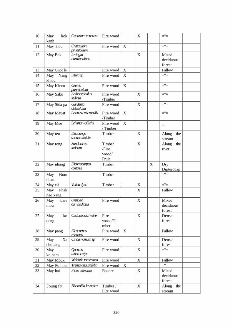
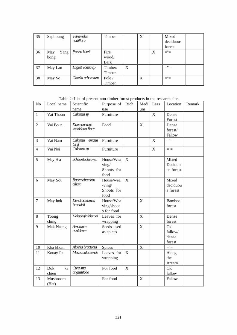
2. List of present forest products.
According to the characteristics of the utilization of each kind of forest products,they canbe divided into two groups:(1) Timber(2) Non-timber forest products
If we observe this list of non-timber forest products we can see that some kinds areabundant but some kinds have become scarce and some kind have already disappeared from thisarea. These non-timber forest products are used for food and medicine as well as for energy. Mostof them are also used for commercial purposes. Thus, they are important parts of the economy ofthis area, especially fire wood and some kinds of wild fruits.
Table:1 List of present timber in the research siteNo Local name Scientific name Purpose
of useRich Medi
umLess Location Remark
1 May khen Hopea odorata Timber X Drydipterocapforest
2 May Song Timber X ="=3 May
SaphangPelthophorumdasyrachis
Timber/Fuelwood
X Fallow
4 May Taekha
Afzelia xylocarpa Timber X Mixeddeciduousforest
5 May Dou Pterocarpusmacrocarpus
Timber X =’'=
6 May kok Spondiasmangifera
X =''=
7 May Makphay
Baccaurea sapida Fire wood X =’'=
8 May Makngeo
Xerospermumlaoticum
Fire wood X Fallow
9 May somphot
Rhus semialata Fire wood X Fallow
320
10 May kokkanh
Canarium venosum Fire wood X ="=
11 May Tiou Cratoxylonprunifolium
Fire wood X ="=
12 May Bok Invingiaharmandiana
X Mixeddeciduousforest
13 May Gnot le Fire wood X Fallow14 May Nang
khiouLitsea sp Fire wood X ="=
15 May Khom Grewiapanniculata
Fire wood X ="=
16 May Sako Anthocephalusindicus
Fire wood/Timber
X ="=
17 May Sida pa Gardeniaobtusifolia
Fire wood X ="=
18 May Meuat Aporosa microcalix Fire wood/Timber
X ="=
19 May Mee Schima wallichii Fire wood/ Timber
X="=
20 May ten Duabangasonneratioides
Timber X Along thestream
21 May tong Sandoricumindcum
Timber/Firewood/Fruit
X Along theriver
22 May nhang Dipterocarpuscostatus
Timber X DryDipterocap
23 May Nomnhan
Timber ="=
24 May xii Vatica dyeri Timber X ="=25 May Phak
nao xangX Fallow
26 May kheemou
Ormosiacambodiana
Fire wood X Mixeddeciduousforest
27 May kodeng
Castanopsis hystrix Firewood/Timber
X Denseforest
28 May pang Eleocarpusrobustus
Fire wood X Fallow
29 May Xachouang
Cinnamomum sp Fire wood X Denseforest
30 Mayko nam
Quercusmacrocalyx
Fire wood X ="=
31 May Mouk Wrightia tomentosa Fire wood X Fallow32 May Po hou Trema angustifolia Fire wood X ="=33 May hai Ficus altissima Fodder X Mixed
deciduousforest
34 Foung fat Bischoffia javanica Timber /Fire wood
X Along thestream
321
35 Saphoung Tetramelesnudiflora
Timber X Mixeddeciduousforest
36 May Yangbong
Persea kurzii Firewood/Bark
X ="=
37 May Lan Lagestreomia sp Timber/Timber
X ="=
38 May So Gmelia arboratum Pole /Timber
X ="=
Table 2: List of present non-timber forest products in the research siteNo Local name Scientific
namePurpose ofuse
Rich Medium
Less Location Remark
1 Vai Thoun Calamus sp Furniture X DenseForest
2 Vai Boun Daemonotopsschidtiana Becc
Food X Denseforest/Fallow
3 Vai Nam Calamus erectusGriff
Furniture X ="=
4 Vai Noi Calamus sp Furniture X ="=
5 May Hia Schizostachyu--m House/Weaving/Shoots forfood
X MixedDeciduous forest
6 May Sot Racemobambosciliata
House/wea-ving/Shoots forfood
X Mixeddeciduous forest
7 May hok Dendrocalamusbrandisii
House/Weaving/shoots for food
X Bambooforest
8 Toongching
Halopegia blumei Leaves forwrapping
X Denseforest
9 Mak Naeng Amomumovoideum
Seeds usedas spices
X Oldfallow/denseforest
10 Kha khom Alpinia bracteata Spices X ="=11 Kouay Pa Musa malaccensis Leaves for
wrappingX Along
thestream
12 Dok kachieu
Curcumaangustifolia
For food X Oldfallow
13 Mushroom(Het)
For food X Fallow
322
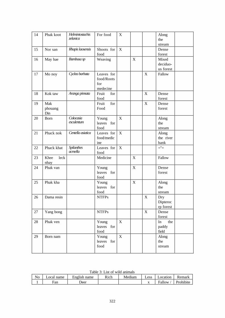
14 Phak koot Helmintostachiszelanica
For food X Alongthestream
15 Nor san Rhapis laosensis Shoots forfood
X Denseforest
16 May hae Bambusa sp Weaving X Mixeddeciduo-us forest
17 Mo noy Cyclea barbata Leaves forfood/Rootsformedecine
X Fallow
18 Kok taw Aranga pinnata Fruit forfood
X Denseforest
19 MakphouangDin
Fruit forFood
X Denseforest
20 Born Colocasiaesculentum
Youngleaves forfood
X Alongthestream
21 Phack nok Centella asiatica Leaves forfood/medicine
X Alongthe riverbank
22 Phack khat Spilanthesacmella
Leaves forfood
X ="=
23 Khee lecknhay
Medicine X Fallow
24 Phak van Youngleaves forfood
X Denseforest
25 Phak kha Youngleaves forfood
X Alongthestream
26 Dama resin NTFPs X DryDipterocrp forest
27 Yang bong NTFPs X Denseforest
28 Phak ven Youngleaves forfood
X In thepaddyfield
29 Born nam Youngleaves forfood
X Alongthestream
Table 3: List of wild animalsNo Local name English name Rich Medium Less Location Remark1 Fan Deer x Fallow / Prohibite

323
Grass-land
dhunting
2 Mou pa Wild boar X ="= Huntingis
allowed3 Menh Porcoupine x Dense
forest="=
4 Linh Pangolin x Fallow/Denseforest
Prohibited for
hunting5 Kahock Squirrel X Dense
forestHunting
isallowed
6 Ngoo Snake X Anywhere
="=
7 Onh Bamboo mouse X Bambooforest
="=
8 Nok Many kinds ofbirds
X Anywhere
="=
The list of the timber above shows that so many valuable species are there. But some ofthem have already become scarce or rare, and some of them have already disappeared from thisarea. In the future if the people in these villages do not have any strict measure to prevent this,decreasing of forest resources will continue.
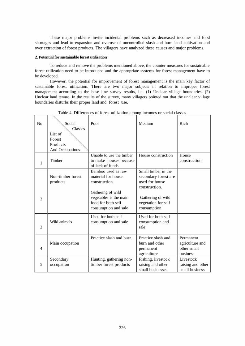
3. Difference of forest utilization among incomes or social classes
Based on the results of the interview data from 60 families in three villages, the families canbe divided into three classes as: rich family, medium family and poor family. This clasification isbased only on their annual incomes. About 4.2 % of the total families are classified as rich families,6.6 % are just self-sufficient in rice and the remaining 89 % are classified into the poor families.Most of the rich families are engaged in a variety of occupations such as taxi service, ricemill,livestock raising, permanent agriculture and running small shops. Their annual incomes are about 3to 5 million kips.
Medium families who have sufficiency in foodstuffs are mainly engaged in livestock raisingand slash and burn cultivation but they sometimes gather non-timber forest products, and fishingand hunting are also their second occupations. Their annual incomes are less than 3,000,000 kips.Poor families are people who engage in slash and burn cultivation, gathering of non-timber forestproducts and hunting. Their annual incomes are less then 300,000 kips. These groups of people areheavily dependent on the forest.
However, in terms of forest utilization, the Lao Theung, Lao Loum and Hmong ethnicgroups all have equality to use the products from the forest. From the above data it is shown that,only about 10 % are self sufficient in foodstuffs and the remainder are affected by rice shortages.So to resolve the problems these people base their livelihoods on the only natural resources that areavailable, forest products. Every member in the village has the right to cut timber for houseconstruction and to collect small timber and non-timber forest products as well as other forestproducts within their villages. But one difference is that the poor families are engaged in slash andburn cultivation as was mentioned above and will use the small timber or bamboo and grasses tomake their houses and roofs. The rich families construct their houses using the bigger timber.Otherwise gathering of non-timber forest products and hunting of wild animals are the mainoccupations of the poor people. So, the gaps between social levels always occur and becomeserious in rural society. However, if based on economic conditions, we can see that there are some
324
differences of occupations and forest utilization within social classes. The major differeces ofoccupations and forest utilization are shown in Table 4. 4. Differences of forest utilization among land or forest categories
According to the results of the interviews data it is shown that there are some differencesof forest utilization among forest categories. In the upper mixed deciduous forest the timber is cutfor house construction and non-timber forest products are collected for both consumption andcommercial purposes. Hunting of wild animals is very common in these forests, especially of largeanimals. In this forest type are included many forest categories in the research site.
The use of forest products in different forest categories is not so clarified, but it can besummarized as follows : In the fallow forest slash and burn is practiced, and small timber forhouse construction and house repairing are used. Non-timber forest products are collected e.g fuelwood, rattan shoots and other wild vegetables for both consumption and (some surpluses are alsoused for) commercial purposes. In production forests the small timber is used for houseconstruction by village members. The large timber is used only for common construction likeschools, pagodas and other public works. In the protection forests at the village level, the actualsituation is similar to that of production forests because only slash and burn and big tree felling isprohibited. The remainder of forest products are still allowed to be extracted. So for some it createsconfusion between production forests and protection forests. In terms of the conservation forest,timber cutting is prohibited. But non-timber forest products are still allowed to be gathered in thisforest category. It shows that the village rule is not strong enough to protect this forest category.
The strictly prohibited condition for any cutting or harvesting in the forest is only in thesacred forests and cemeteries because most of the people believe that, if someone encroaches inthis forest, the spiritual power will bring some bad happening to the village or the members of thevillage. If someone does something bad or goes against this tradition, they will be punished andfined by the village traditional rule. The level of fine depends on the real situation of the mistake ofthe encroacher. Unfortunately, this forest does not cover a large area.
CHAPTER VCHANGES IN FOREST UTILIZATION
1. Changes of forest in terms of the time and number of forest products
According to the data of the survey, there are significant changes in forest utilization in theresearch site as well as other areas in the whole country. But in the case of the research, thechanging of the forest utilization is quite fast. As mentioned above, 30 years ago this area wascovered by dense forest. A lot of valuable tree species like Diptercocarp sp, Pterocarpus macrocarpus, andAfzelia are found here.
Based on the above data it can be seen that in only three decades, the amount of the timberas well as non-timber forest products has been reduced quite quickly. Furthermore, if this situationcontinues, some kinds of valuable species will probably disappear in this area. At present if theshifting cultivator needs to collect non-timber forest products or timber, he needs to go far awayfrom his village and it takes at least 2-3 days. Nowadays people collect non-timber forest productsin the fallow forests and degraded forests in small amounts and in very limited scope in terms of thespecies as well as the number.
2. Some cases of the changes of forest utilization in terms of an area
If based on the data of present land use of WATMAP 1997, most village land in theresearch site is covered by fallow forest, degraded forest and grassland (i.e. in the case of Houay Xithe covered forest area is about 204 ha and the total village land is 2,868 ha, so only 7% is coveredby forest of the total village land area. In the case of Nam Phao the total village land area is about

325
2,255 ha and the total forest cover is 499 ha wich is about 22% of the total village lands . Most ofthe remainder parts are fallow, present shifting cultivation and water reservoir ).
If we compare this with 30 years ago these areas were covered by dry evergreen forestand were very rich in forest resources as well as wild animals. Therefore these shifting cultivatorsmust go to the state forest to collect non-timber forest products and extract the timber for bothself-consumption and sales to earn some income.
CHAPTER VIEVALUATION OF FORESTUTILIZATION FROM THE VIEWPOINT OF SUSTAINABILITY
As the objective of the study in the research site is to clarify the customary use of forestproducts of the local people in order to contribute to the improvement of natural forest resourcesand livelihood of the local people, it was thus expected to find out the alternatives to prevent forestdegradation and other negative impacts through these improvements.
TimeListOf forestProducts
At present 10 years ago 20 years ago 30 years ago
Timber I II III IV
NTFPs I II III IV
Wild animals I II III IV
Aquatic animals I II III IV
Figure 3 : Changes in forest utilization
Remark: I the number of the forest products is least II the number of the forest products is abundant III the number of the forest products is high IV the number of the forest products is very high
Based on this objective and on the results of the natural and socio-economic base linesurvey, the assessment of major problems of customary use of forest products by dwellers andtheir causes are firstly carried out in this subsection. Then, the potential and sustainable use offorest products will be determined.
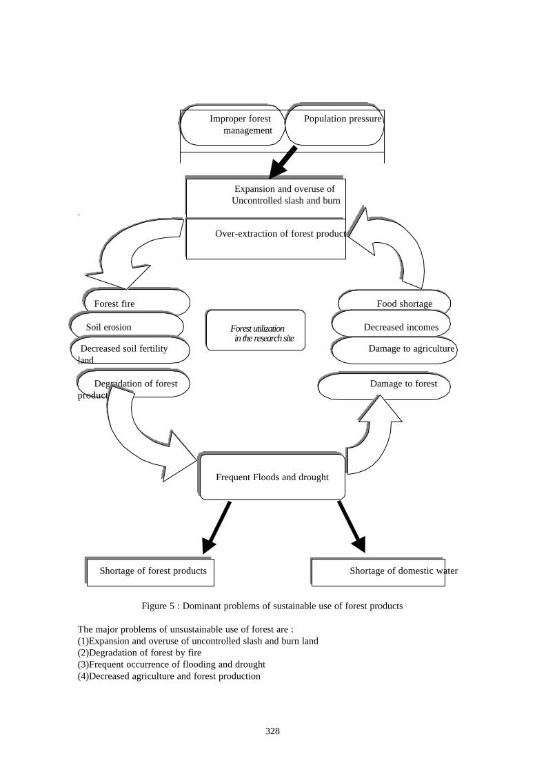
1. Problems in sustainable use of forest products and their causes
The dominant problems of sustainable use of forest products are simply illustrated in Figure5. These problems are considered to form a vicious cyrcle as seen in the above figure 5. Theoveruse of uncontrolled slash and burn land cultivation has caused incidental problems such asforest fires, soil erosion and other forms of forest degradation. Forest degradation in turn leads toincidental problems such as shortages of timber and non-timber forest products. Frequent floodingand draught always brings incidental problems such as lack of domestic water and damage toagricultural production as well as forest production.
326
These major problems invite incidental problems such as decreased incomes and foodshortages and lead to expansion and overuse of uncontrolled slash and burn land cultivation andover extraction of forest products. The villagers have analyzed these causes and major problems.
2. Potential for sustainable forest utilization
To reduce and remove the problems mentioned above, the counter measures for sustainableforest utilization need to be introduced and the appropriate systems for forest management have tobe developed.
However, the potential for improvement of forest management is the main key factor ofsustainable forest utilization. There are two major subjects in relation to improper forestmanagement according to the base line survey results, i.e. (1) Unclear village boundaries, (2)Unclear land tenure. In the results of the survey, many villagers pointed out that the unclear villageboundaries disturbs their proper land and forest use.
Table 4. Differences of forest utilization among incomes or social classes
No Social ClassesList ofForestProductsAnd Occupations
Poor Medium Rich
1 TimberUnable to use the timberto make houses becauseof lack of funds
House construction Houseconstruction
2
Non-timber forestproducts
Bamboo used as rawmaterial for houseconstruction.
Gathering of wildvegetables is the mainfood for both selfconsumption and sale
Small timber in thesecondary forest areused for houseconstruction.
Gathering of wildvegetation for selfconsumption
3Wild animals
Used for both selfconsumption and sale
Used for both selfconsumption andsale
4Main occupation
Practice slash and burn Practice slash andburn and otherpermanentagriculture
Permanentagriculture andother smallbusiness
5
Secondaryoccupation
Hunting, gathering non-timber forest products
Fishing, livestockraising and othersmall businesses
Livestockraising and othersmall business

327
Dry Evergreen Forest
Logging Shifting cultivation
Brushland
Moderate
Bamboo Break Mixed Deciduous Forest
Fire Shifting cultivation Bamboo break
Mixed deciduous Brushland
Fire Shifting cultivation
Degraded forest GRASS-LAND
Fire
Logging / Fire
Figure 4: Diagram showing change of forest types
In fact, many locations in the research site are overlapped areas, each of which is utilizedby two or three villages or by other organizations. Even though all the village boundaries wereconfirmed with the villagers, these have not been authorized yet by the local and central government.The pressure of the population on the forest and forestland will be increased in the future. So, forexecution of proper sustainable forest management, it is thus proposed to establish clear villageboundaries as well as implementing land allocation to the shifting cultivators.
328
Improper forest Population pressure
management
Expansion and overuse of Uncontrolled slash and burn.
Over-extraction of forest products
Forest fire Food shortage
Soil erosion Forest utilization Decreased incomes in the research site Decreased soil fertility Damage to agricultureland
Degradation of forest Damage to forestproducts
Frequent Floods and drought
Shortage of forest products Shortage of domestic water
Figure 5 : Dominant problems of sustainable use of forest products
The major problems of unsustainable use of forest are :(1)Expansion and overuse of uncontrolled slash and burn land(2)Degradation of forest by fire(3)Frequent occurrence of flooding and drought(4)Decreased agriculture and forest production
329
In addition the village boundaries and land tenure situation is unclear in the research site,particularly in the natural forest, where slash and burn is widely practiced. However, due to thepopulation increase, the arable land for slash and burn cultivation is very limited. Thus, in thissituation the conflicts about land use start to occur among villagers themselves as well as betweenvillages. Forests and forestland could not be well managed. Many caused frequent occurrences offorest fires and soil erosion.
Therefore, with full recognition of the above situation, the government of the Lao P.D.R.initiated the Land and Forestland Allocation Program. The aim of this program is to reduce and tostabilize slash and burn cultivation and to conserve the remainder of natural forest by allocation ofthe land and degraded forestland to households, communities and organizations. The land size to beallocated to each household or community depends on the availability of the land in each village andlabor force.
References
(1) The Lao P.D.R. National Assembly, the Forestry Law, No.01-96, 11/ 10 / 96(2) JAFTA) Final report of the study on watershed management plan for forest conservation in
Vang Vieng district, Vientiane province, September, 1998(2) DoF, Proposal for sustainable utilization of non-timber forest products 10 July 1992(3) JICA study team, Participatory rural appraisal village report, Ban Nam Phao, November 1997(4) JICA study team, Participatory rural appraisal village report, Ban Houay Xi November 1997(5) JICA study team, Participatory rural appraisal village report, Ban Nam Path November 1997(6) Canadian Agency for International Development, Reconnaissance surveys of low land forest in
Laos, Vientiane 1969.(7) NAMURA Takayuki, Catalogue survey in Houay Xi and Namon Neua villages, Vang Vieng
district, October 1998.(8) Ministerial Approval/Decision on customary rights and use of forest resources, March 1996(9) Ministry of Agriculture and Forestry, Village Forestry Regulations October 1997.(10) Priminister's Office, Instruction on implementing land management and land-forest allocation,
No 03 / PM.(11) Ministry of Agriculture and Forestry, Provision on the duties and rights in managing Forestry
resources at village level.(12) Ministry of Agriculture and Forestry, Recommendations on customary use of forest resources,
No 0377 / AF 17 / April / 1996.


![Transmission Distribution and Utilization [15EE52T]](https://static.fdokumen.com/doc/165x107/6328d58109048e4b7c061729/transmission-distribution-and-utilization-15ee52t.jpg)