Indian-Architect-and-Builder-Pg-18-to-25-s.pdf - Usman Haque
Upload
khangminh22Category
view
0download
0
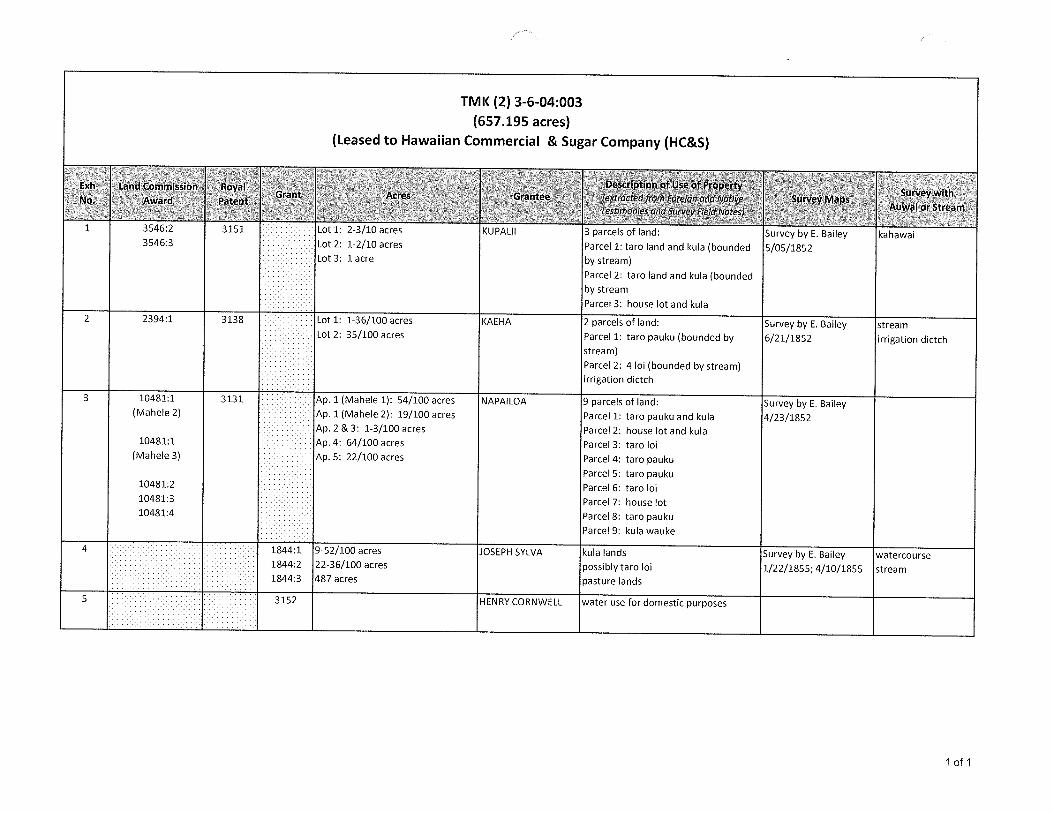
TMK (2) 3-6-04:003(657.195 acres)
(Leased to Hawaiian Commercial & Sugar Company (HC&S)
. . DescrIption of Use of PropertyExh Land Commission Royal Survey withGrant Acres Grantee (extracted from Foreign and Native Survey MapsNo. Award Patent AuwaiorStreamTestimonies and Survey Field Notes)
3546:2 3151 Lot 1: 2-3/10 acres KUPALII 3 parcels of land: Survey by E. Bailey kahawai3546:3 Lot 2: 1-2/10 acres Parcel 1: tare land and kula (bounded 5/05/1852
Lot 3: 1 acre by stream)Parcel 2: taro land and kula (boundedby stream
Parcel 3: house lot and kula2 2394:1 3138 Lot 1: 1-36/100 acres KAEHA 2 parcels of land: Survey by E. Bailey stream
Lot 2: 35/100 acres Parcel 1: taro pauku (bounded by 6/21/1852 irrigation dictchstream)
Parcel 2: 4 loi (bounded by stream)irrigation dictch
3 10481:1 3131 Ap. 1 (Mahele 1): 54/100 acres NAPAILOA 9 parcels of land: Survey byE. Bailey(Mahele 2) Ap. 1 (Mahele 2): 19/100 acres Parcel 1: taro pauku and kula 4/23/1852
Ap. 2 & 3: 1-3/100 acres Parcel 2: house lot and kula10481:1 Ap. 4: 64/100 acres Parcel 3: taro loi
(Mahele 3) Ap. 5: 22/100 acres Parcel 4: taro paukuParcelS: tare pauku
10481:2 Parcel 6: taro loi10481:3 Parcel 7: house lot10481:4 Parcel 8: taro pauku
Parcel 9: kula wauke
4 1844:1 9 52/100 acres JOSEPH SYLVA kula lands Survey by E. Bailey watercourse1844:2 22-36/100 acres possibly tare el 1/22/1855; 4/10/1855 stream1844:3 487 acres pasture lands
5 3152 HENRY CORNWELL water use for domestic purposes
1 of 1

EXHIBIT 1
LAND COMMISSION AWARD 3546 TO KUPALII
LCAwNo.: 3546:3Royal Patent No.: 3151Grantee: KUPALII
1. Exhibits
Exhibit 1-A: Copy of LCA 3546 (book 8, p.225) and translation
Exhibitl-B: Copy of RP 3151
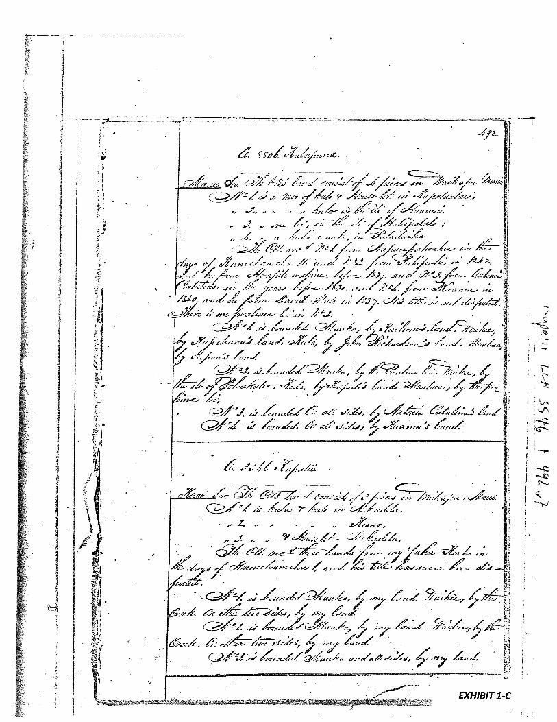
Exhibit 1-C: Foreign Testimony on LCA No. 3546 (v.7, p.492) indicates -
3 pieces of/and in Waikapu. “No. 1 is ku/a and kalo land in Mokaelelu(sp?). No. 2 is ku/a and kalo in Keana. No. 3 is ku/a and houselot inMokaelelu.”
Exhibit 1-D: Native Testimony on LCA No. 3546 (v.9, p.6’79) indicates —
“3 parcels in Waikapu. Parcel 1. Taro pauku at Noohona ill of Waikapu.Parcel 2. Two taro loi, Ohia iii of Waikapu. Parcel 3. Taro pauku andku/a at Pikooku ill of Waikapu. Parcel 4. Cultivated ku/a in Nohoana illof Waikapu.” Additionally, Parcels 2 is bounded by Ku/a stream andParcel 3 is bounded by Waihee stream.
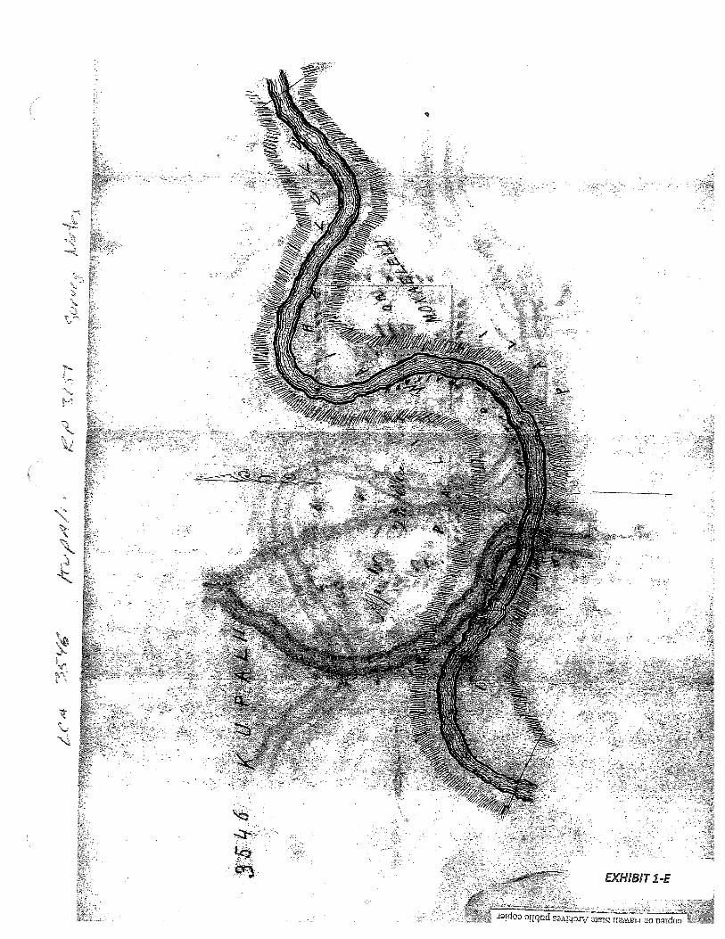
Exhibitl-E: Field Notes and Survey Diagram -
shows this to heAp. 1 (2-3/10 acres) with a stream (‘7(ahawai 0Waikapu’) flowing through the ill of Waihalulu and the stream boundsMokaelelu. There also seems to be other waterways or streamscrisscrossing the property. The second diagram showsAp. 2 at 1-2/10acres with a stream (Kahawai 0 Waikapu)Jlowing through theproperty.
2. Survey Maps
Survey by E. Bailey, dated May 5, 1852 (see Exhibit 5-A, copy of LCA 3546; andExhibit 5-E, Field Notes and Survey Diagram)
3. Mahele Use: Taro pauku, taro lois, kula, waterways, streams
Flow Requirements Source: Waikapu Stream

4. Photographs: None
5. 1800’s Tax Records: None
‘F4
‘—I
I.
Ifl.’/
•‘
“V
1’•
Ug
)-2
’159
‘
yy
;-t-K.-
r1
4/)t
1/4.
02
nh
r:’V
11
IØ“h’
(#7
”4
.7f//a
,‘;
a‘vi-vy.s
4t1
,a
‘v
’71l%
o,7,y
NV
411J
71//‘/)
#4114/ew
#1
f’J%
I’‘L
yil
11/
w””
7<’-’.1
/i’2’9“‘
4fl4
Fot4
FFU
/.
7J/’
7rn“42’,t
“/%
‘P
/7-v
y’
47
‘34)p
wi/V
t.
‘wtlr
“1’lflg
’)y
•-
‘
•2’” V
Py
“4
14
14
,.y
‘.i4
r
27
.Jy’A
b/
A)
‘#
°‘V
”i(4n
h‘)/
“7
7¶7t’
74/
‘*7:t>
4,1
”4I-’7iØ
y‘‘‘(?‘
71.4%
i.M
t’4”1
4fr/
7“‘4
’“V
’J’/
y‘“f(2
Y7’
/7t)
y‘v
-ni’
“13.’’ftY
‘u-’
yey
_a
t#
y’i,p
‘flf(ly/
7‘v
’’te’
/.v’hdt4ø
‘l’’V
)r9
Ad
,).)
“v6441’/’
1
,1ç.
“n#r
7r,r
7‘22
‘b”4k9
‘7pm‘7’7
‘v9v2
1Ø
4j7
1F
‘1V)
4’)t((
7)7
/fl/
i,]’
k9,7
,v/,,
27y’
3i’/r’
77
v,n
vfv
4
WI
•‘“#
c#
’’W
)2
H//
hr)”??
1‘‘2”/
‘b’1
47‘
;/-vp
‘9
‘øliP
“v’,y
4’414
4t
921j
flY
fl>
&’t/
‘r’
t’
.‘&y4i”fU
,y‘kt’W
7’f1
i‘7
fr”/
;.#
>y
A“i(
fl”
—4
‘A”
Jo’’)
J”)
1”;%
’‘4-H
’1
.’’>
1’‘4
1719
’V‘v37
-e‘-,n
,-.t,
4,0,•‘y
-zIn
c’?
)‘‘
‘r’
t%,r
.’,j,
;p‘
“C
fr/,-’’‘1
”‘?‘
-‘‘‘7t
‘Ic’J)y
)‘z-V3.4
-1i5’”fl’
‘.y,-n,-N9.
-W“tC
’414/4
144€’
-7,)
r’
ni’
‘l.#
.a)?F
/i/
Lit
“‘1
‘‘7
iV4
yF
/l)‘4/
4fO
’‘W
/i/j’/2’
WU
S
/
/,a
-F
-
-
I:
1,11
,_
lw
‘
V.
“%
,fl’“,-
i.
•V
t’
-r—’r
‘W
h-v
1li1
/2i&
,f.P/
‘ic-“4
V
iiii;’,/.
-,

*_
W”
.7)
:1’.
‘4,
V1)
r
r’
‘4/
•4
V—
VIn
l’IV
VV
p
S
/.v
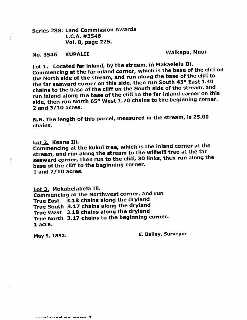
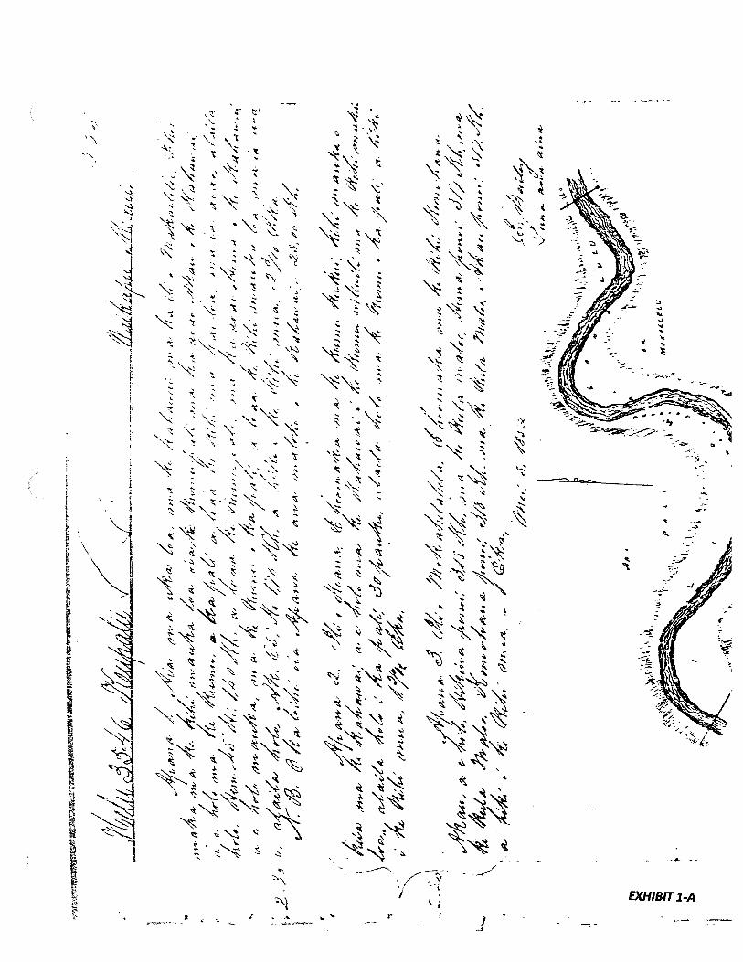
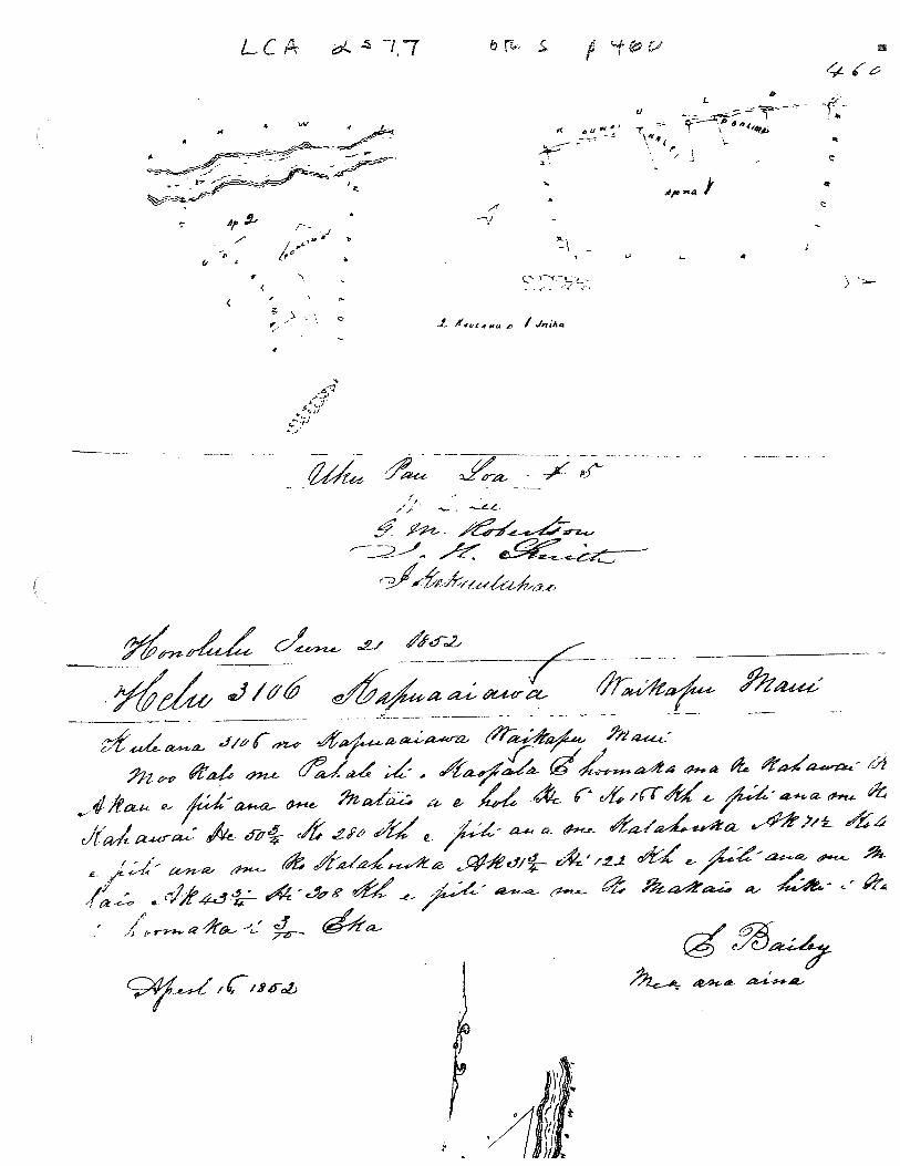
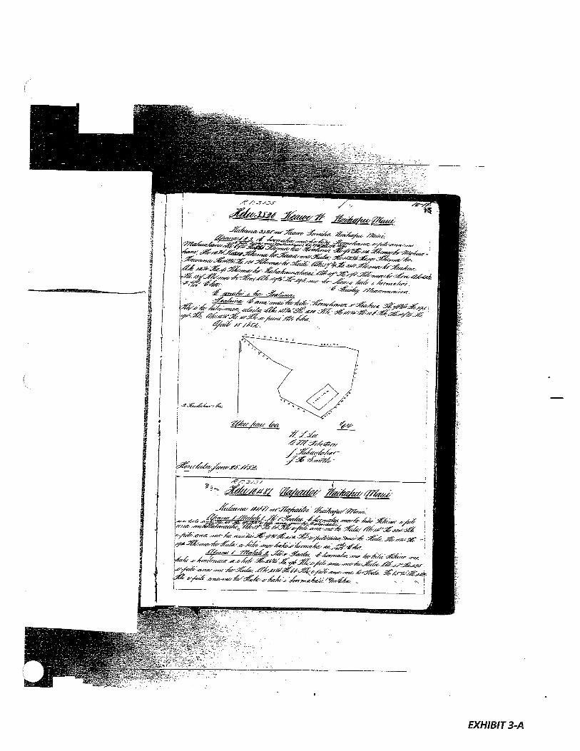
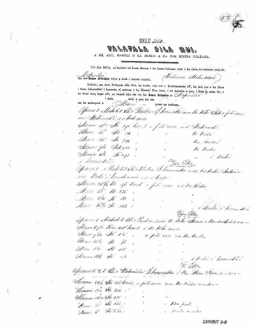
Series 288: Land Commission AwardsL..C.A #3546Vol. 8, page 225.
No. 3546 KUPALII Waikapu, Maui
Lot 1. Located far inland, by the stream, in Makaelelu Iii.
Commencing at the far inland corner, which is the base of the cliff on
the North side of the stream, and run along the base of the cliff to
the far seaward corner on this side, then run South 45° East 1.40
chains to the base of the cliff on the South side of the stream, and
run inland along the base of the cliff to the far inland corner on this
side, then run North 65° West 170 chains to the beginning corner.
2 and 3/10 acres.
N.B. The length of this parcel, measured in the stream, is 25.00
chains.
Lot 2. Keana Ili..Commencing at the kukul tree, which is the inland corner at the
stream, and run along the stream to the wiliwili tree at the far
seaward corner, then run to the cliff, 30 links, then run along the
base of the cliff to the beginning corner.
1 and 2/10 acres.
Lot 3.. Mokahelahela Ili.Commencing at the Northwest corner, and run
True East 3.18 chains along the dryland
True South 3.17 chains along the dryland
True West 3.18 chains along the dryland
True North 3.17 chains to the beginning corner.
1 acre.
May 5, 1852. E. Bailey, Surveyor
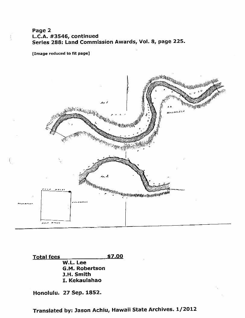
Page 2L.C.A. #3546, continuedSeries 288: Land Commission Awards, Vol. 8, page 225.
[Image reduced to fit page]
Total feesW.L. LeeG.M.. RobertsonIH.. SmithI. Kekaulahao
7.OO
Honolulu. 27 Sep. 1852.
Ap /
Ml KC C0
SLot
Translated by: Jason Achiu, Hawaii State Archives. 1/2012

c r - -‘ v
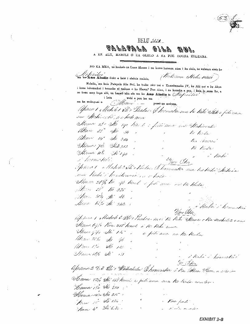
IJELU ‘
%\%1h I%\A tE ALit. MMULl 0 KA OLELO A KA POE BOONA KULEANA.
Nb KA MEA4 ua boubolo na Luna Uoona 1 na kuiuu ku)eanu ftina I ka ol.io be kuiean elate k.
mo a Lo Ah,dio iloko • kahi I olelma malalo.
Nolaila. ma keia Palapala Site Nui, ke hoike aku net e Kamehameba IV. ke Alit nut a k• Aks
I kon l.k.,tnaiki i hoonoho al melon.4 o ko Hawai’ Pee AIoa I ne k.naka e pan, I kale in none Iho, a
no kona wan hope •Iii, an haawü aku ma ma he Ane Alodi ta
I Ucla wahi a pan toe ma - /— /ma he mokupuai e / panel an
:-.- -
( ., /-, —,‘.-.,-/ •
-s.- // // -. /
J /--.- .ti’:;,M/-
-- -,
.-•-.- -1f,. ;:- ,:, ,.
‘7_• / /. -
F / fff• -- .-. - /‘-
- - -. , .4
• / /;,c’ - /• ,‘;-
,4 -.?/‘ It j’
‘1/ / :;
- %/4/ - f4 .42
-. .,
7L ?4
12/ —‘- , — ;_
. Jt /4-
Il____;- 4__--’_•’___
t -!‘ i--s-’
EXHIBIT 1-B
7h
4ih
c
.1
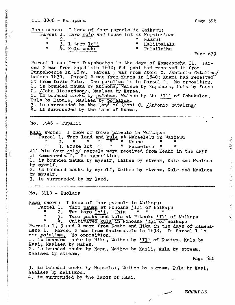
No, 8806 - Kalapuna Page 678
Manu sworn: I know of four parcels in Waikapu:Parcel 1. Taro mo’o and house lot at Kapalaalaea
2. “ “ Haanui3. 1 taro lo’i “ Haliipalaia4. Kula wauke “ Palailaiha
Page 679
Parcel 1 was from Puupahoehoe in the days of Kamehameha II, Pareel 2 was from Pupuhi :in 1842; Puhipuhi had received i fromPuupahoehoe in 1839. Parcel 3 was from Atoni C. /Antonio Catalina/before 1830. Parcel 4 was from Kuamu in 1840; Kuami had receivedit from David Malo. One po’alima is in Parcel 2. No opposition.1. is bounded mauka by Kuihone, Waihee by Kapehana, Kula by baneR. /John Richardson!, Maalaea by Kepaa.2. is bounded mauka by a’ahao, Waihee by the ‘111 of Pohakuloa,Kula by Kapule, Maalaea by po’alima.3. is surrounded by the land of Atoni C. /Antonio Cata1na/4. is surrounded by the land of Kuamu.
No, 3546 - Kupalli
Kaai sworn: I know of three parcels in Waikapu:Parcel 1. Taro land and kula at Makaelelu in Waikapu
2 • “ ‘ “ “ Iceana3. House lot “
“ Makaelelu 11
All his four L’W parcels were received from ICeaho in the daysof Kamehameha I. No opposition.1. is bounded mauka by myself, Waihee by stream, Kula and Maalaeaby myself.2. is bounded mauka by myself, Waihee by stream, Kula and Maalaeaby myself.3. is surrounded by my land,
No, 3110 Kuolala
Kaai sworn: I know of four parcels in Waikapu:Parcel 1. Taro pauku at Nohoana ‘Iii of Waikapu
2 • Two taro lo’ 1, Ohia H It
3. Taro pauku and kula at Pikooku ‘Iii of Waikapu4. Cu1tivatkula in Nohoana ‘Iii of Waikapu
Parcels 1, 3 and 4 were from Keaho and Hika in the days of Kameha—meha I. Parcel 2 was from Kaelemakule in 1838. In Parcel 1 isone ‘a1ima. No opposition.1. is bounded mauka by Hika, Waihee by ‘Ili of Kuaiwa, Kula byKaai, Maa].aea by Nahau.2. is bounded mauka by Manu, Waihee by Kaili, Kula by stream,Maalaea by stream,
Page 680
3. is bounded mauka by Napaeloi, Waihee by stream, Kula by Kaai,Maalaea by Keliikoa,4. is surrounded by the lands of Kaai.
EXHIBIT 1-D
1..
H
j•
••H•1
&i1¼
1‘N
”
:i’N’•
•4
•‘•
•‘,:,,
•.•
•,•-
Lii‘-IIto
‘N”•i
H.•[
•t:
,:“
H’
4N
••t*),‘,
aH
:
9/in
,
LJ
L’)’
1!t1dI11I
/X
(i(•1
°::‘
:
4I
c-c) ii 0
A
...
•*t
z
Lbr
*•,
EXHIBIT 2
LAND COMMISSION AWARD 2394 TO KAEHA
LCAwNo.: 2394:1Royal Patent No.: 3138Grantee: KAEHA
1. Exhibits
Exhibit2-A: Copy of LCA 2394 (book3, p.459-460) and translation
Exhibit2-B: Copy of RP 3138 (book 14, p.69)
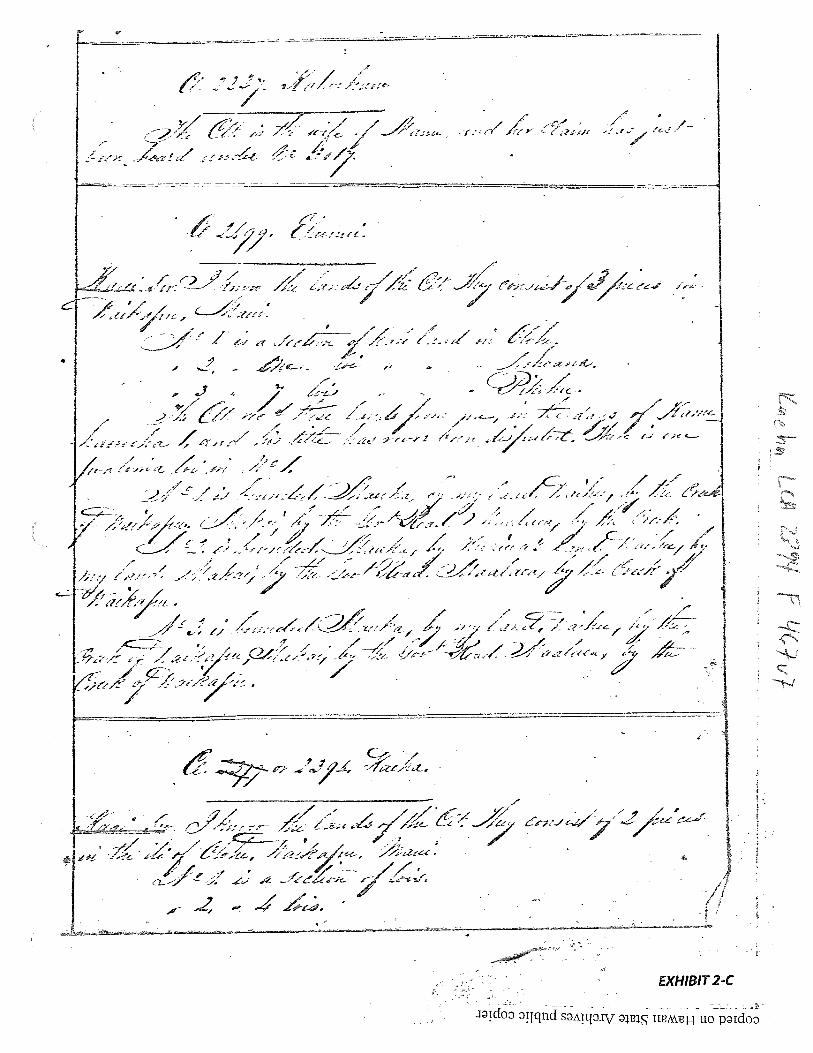
Exhibit 2-C: Foreign Testimony on LCA No. 2394 (v.7, p.467) indicates -
2 pieces of land, “No. 1 is a section oflois. No. 2 1s4 lois. Testimony alsoindicates that No. 1 and No. 2 are bounded... “Waihee, by creek”
Exhibit2-D: Native Testimony on LCA No. 2394 (v9, p.658) indicates —
“two parcels ofland in Waikapu. Parcel 1. Taro pauku in the ili ofOlohe. Parcel 2. 4 loi of taro in the ill ofOlohe.” Testimony alsoindicates Parcel 1 is bounded... “Waihee by stream” and Parcel 2 isbounded mauka by stream, Waihee, the same “.
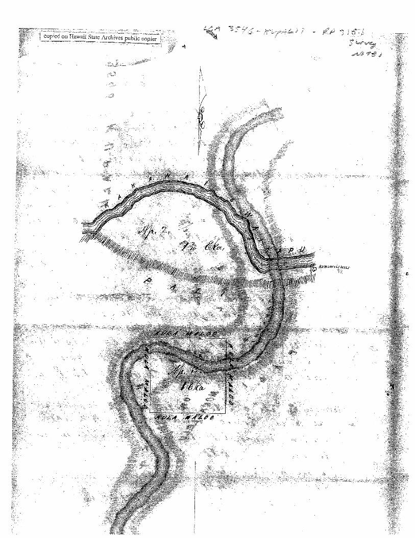
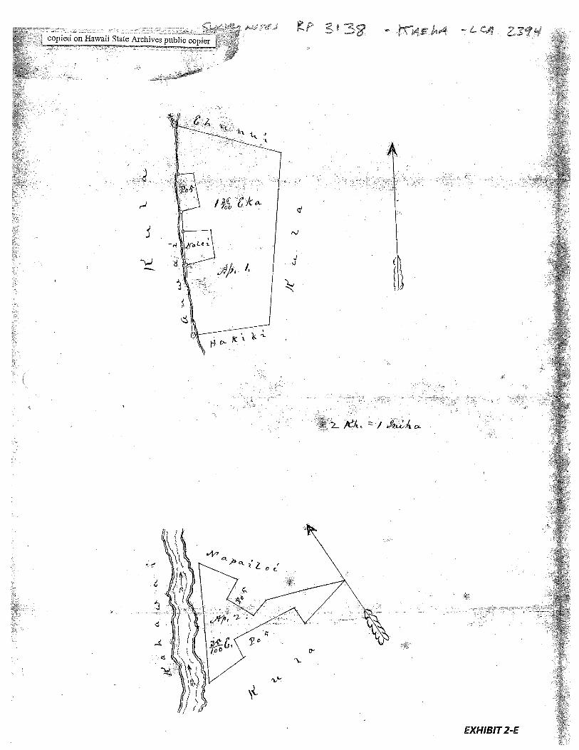
Exhibit2-E: Survey Field Notes and Diagram —
shows 2 pieces ofproperty. Ap. 1 is 1-36/100 acres and is bound on oneside by “auwai” Ap. 2 is 35/100 acres and bounded on one side by a“kahawai”
2. Survey Maps
Survey by E. Bailey, dated June 21, 1852 (see Exhibit 8-A, copy of LCA 2394; andExhibit 8-E, Survey Field Notes and Diagram)
3. Mahele Use: Taro pauku, taro lois
Flow Requirements Source: Waikapu Stream
4. Photographs: None
5. 1800’s Tax Records: None

‘
4
0 4::
4.‘
‘—
cS
S•S
-I
I’r
Q1
V
I’
t
L
‘k
ii’
N
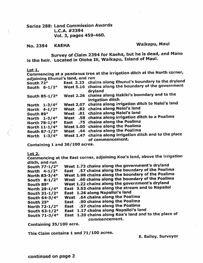
Series 288:
No. 2394
Land Commission Awards
L.C.A. #2394Vol. 3, pages 459-460.
KAEHA Waikapu, Maui
Survey of Claim 2394 for Kaeha, but he is dead, and Mano
is the heir. Located in Olohe Ill, Waikapu, Island of Maui.
Containing 1 and 36/100 acres.
Lot 2.Commencing atditch, and runSouth 77-1/2°North 4-1/2°North 83-3/4°South 8-1/2°South 89°North 29-1/4°South 31-1/2°South 64-3/4°South 25°North 72-1/2°South 63-1/2°South 71-3/4°
EastEastWestEastEastEastEast
irrigation ditchNalei’s landNalei’s landirrigation ditchthe Poalimathe Poalimathe Poalimairrigation ditch
Containing 35/ 100 acre.
This Claim contains 1 and 71/100 acres.E. Bailey, Surveyor
Lot 1.Commencing at a pandanus tree at the irrigation ditch at the North corner,
adjoining Ehunul’s land, and runSouth 72° East 3.23South 6-1/2° West 5.16
South 85-1/2° West 2.26
West 2.07NorthNorthSouthNorthNorthNorthSouthNorth
1-3/4°4-1/2°
89°1-3/4°
78-1/4°11-1/4°87-1/2°1-3/4°
WestWestWestEastWestWestWest
.82
.81
.58
.751.00.44
1.47
chains along Ehunui’s boundary to the dryland
chains along the boundary of the government
drylandchains along Hakiki’s boundary and to the
irrigation ditchchains alongchains alongchains alongchains alongchains alongchains alongchains alongchains along
to Nalel’s land
to a Poalima
and to the place
of commencement.
the East corner, adjoining Koa’s land, above the irrigation
West 1.73 chains along the government’s dryland
East .57 chains along the boundary of the Poalima
West 1.98 chains along the boundary of the Poalima
West .60 chains along the boundary of the Poalima
West 1.22 chains along the government’s dryland
3.53 chains along the stream and to Napailoi
1.26 along Napailol’s land.64 chains along the Poalima.90 chains along the Poalima.57 chains along the Poalima
1.17 chains along Napailoi’s land120 chains along Koa’s land and to the place of
commencement.
continued on page 2

•1’
4
0 0 .1 C CD N N
z
-i 0 CD U)C
-C
DiC
D
U)0
0
-zI,
c
—I
U) CD 0 ‘-I
U) 0 n C ci ci ci rP CD n CD U) f-I N 0 II N
N w 0 1, 0 C CD 0.
N
(l CD CD (I) N Ca ci 0.
O 0 U) U) 0 ci 0.
U) 0 w 0 ci CD U) U’
0
I’
)4
N
17,1

313g,
lIELtJZ/
KE ALH, MANLJL1 0 KA OLELO A A POE HOONA KULEA.NA
/7% o-
-
‘A /
. y4• z.,‘J:
-. •/: , JJ
/ •/.‘
No KA MEA uu hooholo na Luau Buena na kumu kulenan ama I k oI.Io l1 kuleaui ateta ha
Ina ku Ano lEodjo iloko • kuhi i olalois malalo.
Nolaila, inn knia PaLapala SiIn Nui, ke hoike aku ad o Eamehaoneb IV, ho Mit owl a k• Akua
j kona I.kournikai i hoonoho ai mulona o ko llawai’ Pae Ama, I ni kanaka a pau, I keia Ia aoaa iho, a
no kona mao hope CIii, on hauwu ako via ma he Ano Alodlo aa
I kola wahi a pow ba wa
ma he mokupuni a pea.l ua moku..
e.//.//,
_./“ a-;j:.,. .,
- /,‘ LAh
/, •‘ ‘i-. ‘
/ ./. j:.
_%, a4.4
,t •,.
j 4/
A4-: e’
-/ .j—r ‘
..‘ .4‘‘ ,:Z2.’4k’ 4’ :7i7
, ,, ,c
/4 /./ 4’1 ?
et(• //1
s_ 6.
6
f7 ,
•36.- &7::Lt4’
:— - - -
- . 641,’
&_-.- j.j_ ‘ ,, ,.
0
EXHIBIT 2-B
Vi’
-‘‘C
..i
4.
S
‘S
H.
‘S
‘/1%
,
F
N
I
N-
“,
N“.
‘aU‘a
1-4a
C)
C)
C)
cD 1-J
0 C) 0 C)
I/i
4
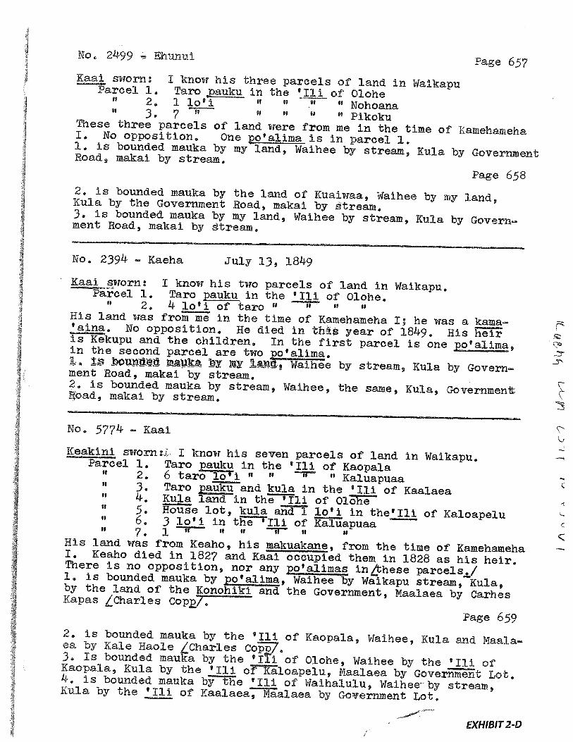
No. 2499 Ehunul Page 657Kaai sworn: I know his three parcels of land in WalkapuParcel 1. Taro ,,pauku in the ‘Iii of Olohe
2, 1 lo’i “ “ If Nohoanafl 3 7 ft “ “ Pikoku
These three parcels of land were from me in the time of NamehamehaI, No opposition. One o’aiima is in parcel 1,1, is bounded mauka by my land, Waihee by stream, Kula by GovernmentRoad, makal by stream.Page 658
2. is bounded mauka by the land of Kuaiwaa, Waihee by my land,Kula by the Government Road, makal by stream.3. is bounded mauka by my land, Waihee by stream, Kula by Government Road, makai by stream,
No. 2394 - Kaeha July 13, 1849
Kaai sworn: I know his two parcels of land in Waikapu,Parcel 1. Taro ku in the ‘Iii of Olohe.2. 4 lo’i of taro “ It
His land was from me in the time of Kamehameha I; he was a kama‘ama. No opposition. He died in this year of 1849. His heiris Kekupu and the children, In the first parcel is one ppealima,in the second parcel are two o’a1ima.1y i, Waihee by stream, Kula by Government Road, makal by stream.
2. is bounded mauka by stream, Waihee, the same, Kula, Government!,oad, makal by stream,
No, 5774 - Kaai
ICeakmni sworn:i. I know his seven parcels of land in Waikapu,Parcel 1. Taro ppku in the ‘ill of Kaopala2. 6 taro lo’i “ “ Kaluapuaa3. Taro pauku and kula in the ‘Iii of Kaalaea
II 4• Kula land in the ‘Ili of Olohe5, House lot, kula. and 1 lo’i in the’Ill of Kaloapelu6. 3 lo’i in the ‘Iii of Kaluapuaa7 1
II it H H U
His land was from Keaho, his makuakane, from the time of KamehamehaI. Keaho died, in 1827 and KaaI. oócupied them in 1828 as his heir.There is no opposition, nor any po’alimas in/these parcels.!1. is bounded mauka by po’alima, Waihee by Waikapu stream, Kula,by the land. of the Konohiki and the Government, Maalaea by CarhesKapas tC1arles Cop/.
Page 6592. is bounded mauka by the ‘Iii of Kaopala, Waihee, Kula and Maalaea by Kale Haoie /Charles co7.3. Is bounded mauka by the ‘Ili of Olohe, Waihee by the ‘Iii ofKaopaia, Kula by the ‘Ill of Kaloapelu, Maalaea by Government Lot.4. is bounded mauka by the ‘Ill of Waihalulu, Waihee by stream,Kula by the ‘Iii of Kaalaea, Maalaea by Government Lot.
EXHIBIT 2-D
copied on Hawaii State Archives public copier
U
t2A/ )
I
EXH1BIT2-E
J
.4,,

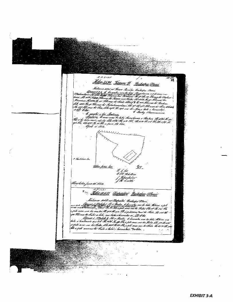
EXHIBIT 3
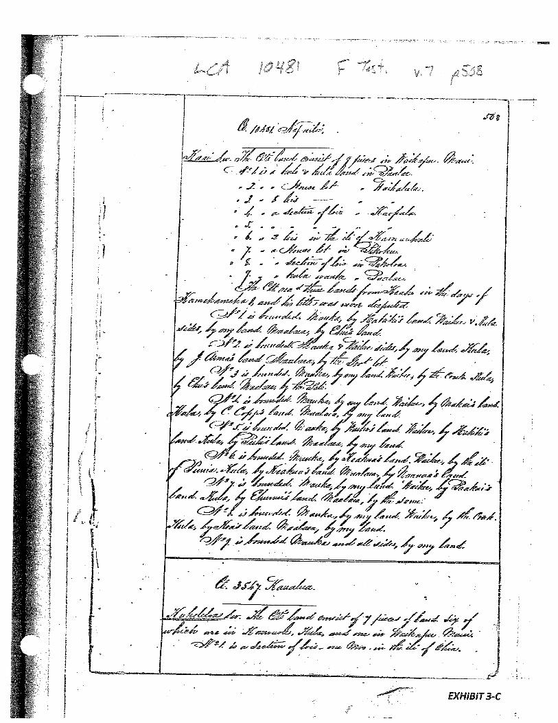
LAND COMMISSION AWARD 10481 TO NAPAILOI
LCAw No.: 10481:2, 10481:3Royal Patent No.: 3131Grantee: NAPAILOI
Exhibits
Exhibit3-A: Copy of LCA 10481
Exhibit3-B: Copy of RP 3131
Exhibit 3-C: Foreign Testimony on LCA No. 10481 (v.7, p.508) indicates -
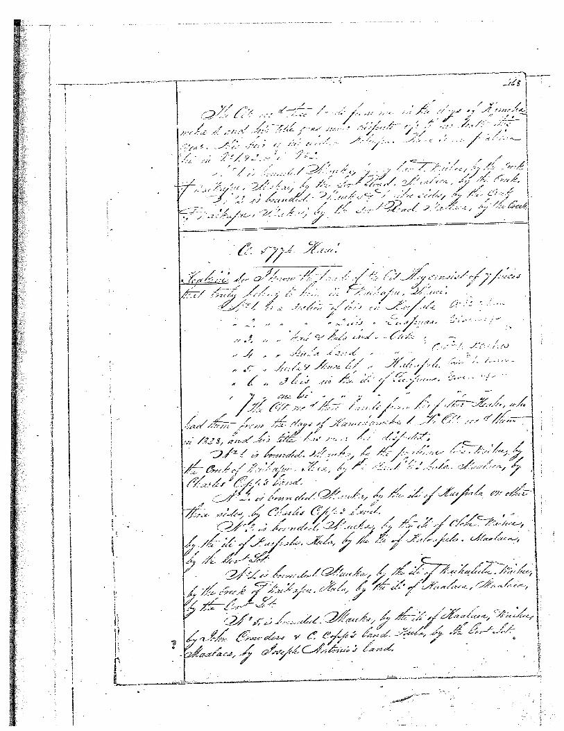
9 pieces of land with several lois, a kalo and kula land, a house lot and aku/a wauke. Parcel 1 is a kalo and ku/a land in Paalae. Parcel 2 is ahouse lot in Waihalulu. Parcel 3 is 8 lois in Waihalulu. Parcel 4 is asection oflois in Kaopa/a. Parcel 5 is a section oflois in Kaopala. Parcel6 1s2 lois in the i/i ofKamauhali. Parcel 7is a house lot in Pikoku.Parcel 8 is a section of lois in Pakoloa. Parcel 9 is a ku/a wauke inPaalae. Additionally, Parcel 3 and 8 are bounded... “Waihee by thecreek ofKu/a”.
Exhibit3-D: Native Testimony on LCA No. 10481 (v.9, p.692) indicates —
9 parcels in Waikapu with a total of3 taro pauku and 10 taro lois.Parcel 1. Taro pauku and ku/a at Paalae. Parcel 2 House lot and kula inWaihalulu. Parcel 3. 8 taro lol in Waihalulu. Parcel 4. Taro pauku inKaopa/a. Pare/S. Taro pauku in Kaopa/a. Parcel 6. 2 taro loi inKamauhali. Parcel 7. House lot in Pikooku. Parcel 8. Taro pauku inPakoloa. Parcel 9. Kula wauke in Paalae.
Additionally, Parcel 3 and 8 are bounded... “Waihee by stream”.
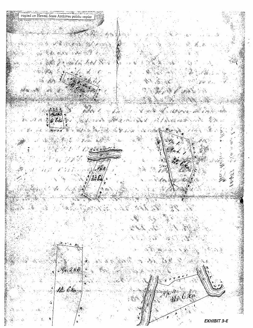
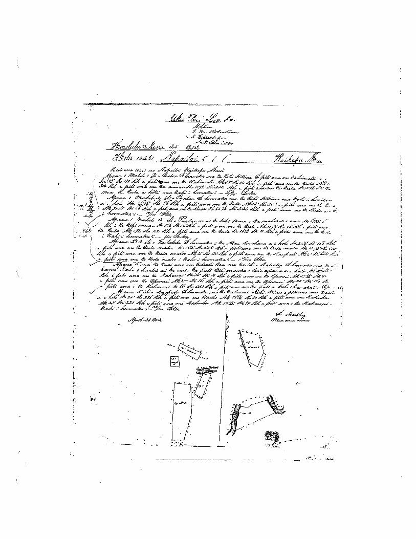
Exhibit 3-E: Survey Field Notes and Diagram -
shows several parcels ofproperty with kahawais or auwai boundingsome of the parcels.
2. Survey Maps
Survey by E. Bailey, dated April 23, 1852 (see Exhibit 16-A, copy of LCA 10481; seeExhibit 16-E, Survey Field Notes and Diagram)
3. Mahele Use: Taro pauku, lois, kalo and kula lands, house lot, kula wauke
Flow Requirements Source: Waikapu Stream
4. Photographs: None
5. 1800’s Tax Records: None
__zg,.
-.
i / AmW77 3,
/‘4_ .1a ,,
4a.i / _-. - a.tw ,‘ & — ‘ ‘4’ %aa. -a./-‘4-
__
4. - 7/.A/L/%/4a
, - ‘L a- a. a-a-- — --/ 4 6/
a./ a- A.- , Zaa-a.a. - _ 7
- -• --:•
/ a-a-. - a-a. -• __j / fr• a ‘- 4/) 4 zz
__
‘ - dXa- a—s
2 4, ,‘a%h ‘4a* a. %1 -4f 64/6i.. .A-‘ 4’4 A.-a--a.‘
a’—a.’--- 4 / -. i. t- — — a. - 4a- -.a• a- La. ia-/a4 a-a. - a. ‘I4:% -- xa--a- a.-1t)j- A/ó/
I/ 44/a.a - -ia. Aa.4a. ,Ia-4/‘ Aa. • a.-’a “%aéa a. a-4a
a. - ‘-2 - -IW 4’Az’ ‘/44-a.a. , a.-a.
—I.

kN
NN
\L
\
‘ 4’
‘\ ‘r\
ç\\>
Nc
c
\\\
cN
NN’
N
N
0 o 0 L0 0 1”
N V0 0 0 0 0 0
N2.
••
N)
0
fr
ij
o

Mai’lco a /a - - apena 2Eke0 ni iki aku a cmi iki mai paha. Ca koa nat i ka aupuni na mine minerata a ma on metela a. pan.No /
ni nina Ta i haawiia ma ka Silo ALODIO a no kona mao honilina, a ma kona waihona; Ut ili naka anhau a ka Poa Ahanlalo e kau like ai ma on ama alodin i kala manawa I kala manawa.
A i zeta a ikaa ai, ua kau wan i ko’u boa, a me ka Silt Not a La’Hawaii Pat Aba ma Honolulu i keia Ia {jC 7*47 asi.
%. A>
x %-/.. A-/. ,z /
:y/ z//. z / //2744 )/,
ii,’-
- ‘‘9/9
/•%- L/i /M >4 M’
it.J. 2-Z/t&zjPt z://
oI, >4 ,/
72t i %‘ ,,
7% it 7.
.//‘‘‘
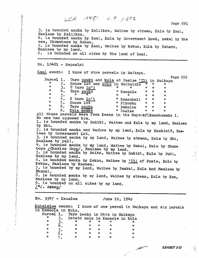
Page 691
3. is bounded mauka by Keliikoa, Wathee by stream, Kula by ICaai,Maalaea by Keliikoa.4. is bounded mauka by Kaai, Kula by Government Road, makal by thesea, Ukumehame by Nahau.5. is bounded mauka by Kaai, Waihee by Kekua, ICula by Pahanu,Maalaea by my land.6. is bounded on all sides by the land of Kaai.
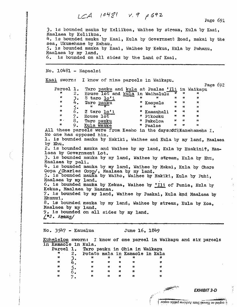
No. 10481 — Napaeloi
Kaai sworn: I know of nine parcels in Waikapu.Page 692
Parcel 1. Taro pauku and kula at Paalae ‘Ill in WaikapuII 2. House lot and kula in Waihalulu “ U
3. 8 taro lo’ 14. Taro pauk Kaopala “ “
5 . IS U H SI H H H
6. taro lo’ 1 “ Kainauhali “ “
7. House lot “ Pikooku “ ““ 8 • Taro pauku “ Pakoloa “ “
9, Kula wake “ PaalaeAU these parcels were from Keaho in the daysóT amehameha I.No one has opposed him.1, is bounded mauka by Hakiki, Waihee and. ICula by my land, Naalaeaby Ehu.2. is bounded mauka and Waihee by my land, Kula by Huakini, Maalaea by Government Lot.3. is bounded mauka by my land, Waihee by stream, Kula by Ehu,Maalaea by pali.4. is bounded mauka by my land, Waihee by Makai, ICula by ChareOopa Char1es Cop/, Maalaea by my land.5. is bounded mauka by Waiho, Waihee by Hakiki, Kula by Puhi,Maalaea by my land.6. is bounded mauka by Kekua, Waihee by ‘Iii of Punia, Kula byKekua, Maalaea by Naariaa.7. is bounded by my land, Waihee by Paakai, Kula and Maalaea byEhunui.8. is bounded mauka by my land, Waihee by stream, Kula by Koa,Maalaea by my land.9. is bounded on all sides by my land.L*J.
No. 3547 - Kaualua June 16, 1849
Kuheleloa sworn: I know of one parcel in Waikapu and six parcelsin Kamaole in ICula.
Parcel 1. Taro pauku in Ohia in Waikapu2. Potato mala in Kamaole in Kula
H 3 p p H H U
EXHIBIT3-D
I’ 1—
e
*9,;
439
‘0
1*
---r
9
U-
AL
‘9-
‘
00
1
*4.-
PD
,9,
‘a oH
•v
Sc*
C
9:
••
•‘A
•
••*
‘
J
EXHIBIT 4
GRANT 1844 TO JOSEPH SYLVA
Grant: 1844:1, 1844:2, 1844:3Grantee: JOSEPH SYLVA
1. Exhibits
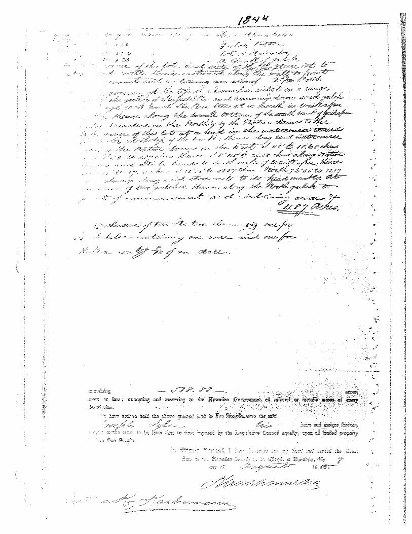
Exhibit 4-A: Copy of Grant 1844 -
indicates three properties at 22-36/100 acres; 9-59/100 acres and 487acresfor a total of51a88 acres
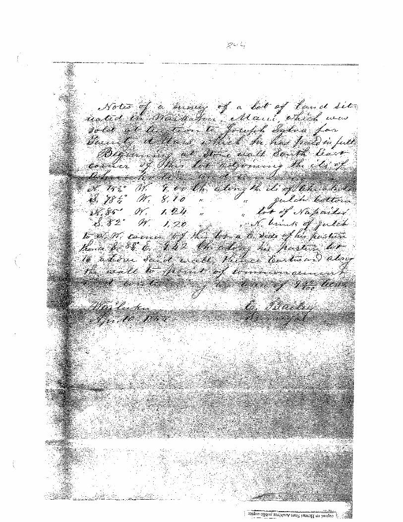
Exhibit 4-B: Survey Field Notes and Diagrams -
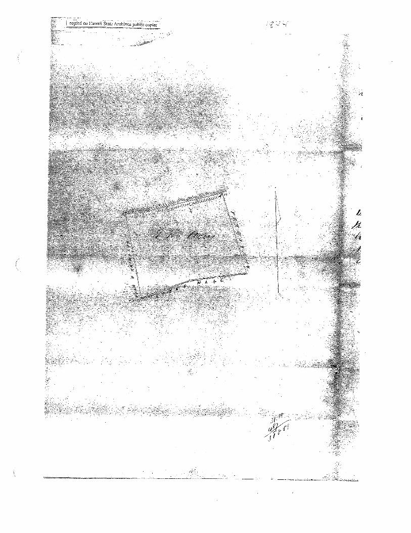
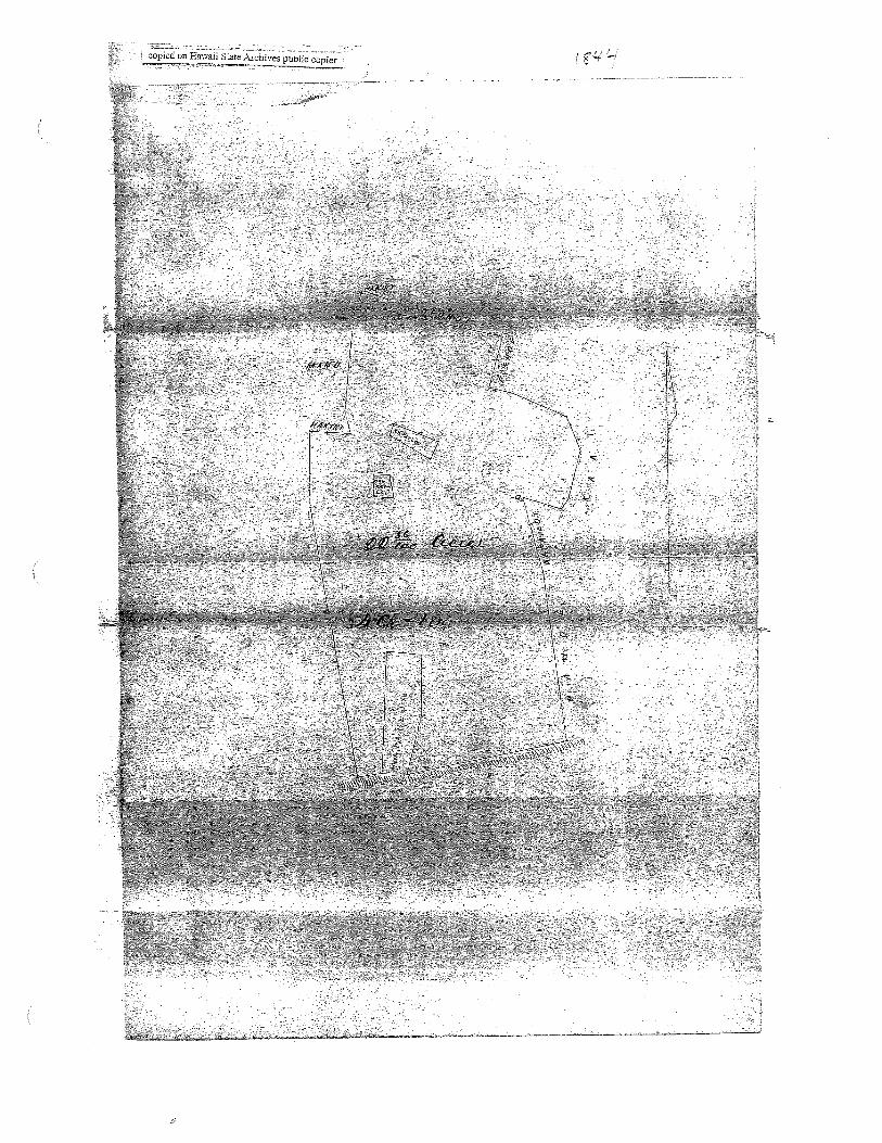
show three separate properties. One of the property (487 acres) isalong a gulch, “bounded on the North by the native claims to the NorthEast corner of this lot at a bend in the watercourse towards the South atthe top of the bank; thence along said watercourse,” and the attachedmap shows as ‘Auwai” running alongside. Two other diagrams ofproperties (9-52/100 acres and 22-36/100 acres) show designations ofparcels within the property, one being Na Pai Loi. These may beshowing kuleana plots and/or possibly taro loi.
2. Survey Maps
Survey by E. Bailey, dated April 10, 1855 (see Exhibit 18-B, copy of Survey FieldNotes and Diagrams)
3. Mahele Use: “native claims”, auwai, kuleana plots, possibly taro loi
Flow Requirements Source: Waikapu Stream
4. Photographs: None
5. 180 0’s Tax Records: None

:.
‘N
t•
.
‘7\‘
j.\ç
•4’
“N.I \
,‘ H
‘7
/H
c7,“
‘N
“7
— ‘1‘N
‘El
21q
‘V.4.
‘.
:C
•C
s‘‘
‘,
‘‘,
I__.“
i’s:;
II
‘
aL‘H
‘.\
‘\
‘“.
S“.‘
2“
.
jH’
N‘7
:‘
•%s
I.“7
,4
’
.5”
S”%
1cç
4.‘•
‘N‘‘
‘7’’,)
‘7‘
:C
,NN
.t’H
)
$7,
,
iii.
‘7
a
‘5H-
.‘
rr‘“‘—
‘.N
’n’—
—”-’
-‘I
‘*
.,
>‘
“N•.
.$4’
H
),•
7
‘
‘.
\.7
\N;
•,
N
4.•
,.
,
a-
‘a.
‘N‘‘H
.
\,•
I’..
,5•
-H
?i
A ‘fj ‘S
.I
I’
‘N
•
P1
H.7
%,
:t
$
t Lit
qC
0‘
S•
•4
*V
[j:II’:t{
\\
!‘
\\
II$
•‘
41‘ti1
.F‘s
i
?1N
\
:5
,
it5’
\

C, F
L
r
;-‘—
-
h
j•.
••)
•
Ii
L
11
44141
‘44
ç.:.
••
•:
U
‘4
f1,
‘:‘‘“
0.
0 0 Co Co 0 0
E
0
4
a 0
I—
I iiI
Y’—
III
II
H
•::
•
••
.:••••
A
—
S2
••
••4
•‘•
•II
•I
••
••,
••
——
1
•-•
••
•-:•
•••

J —---
!d00 Dqqnd sønpy ws tTMH UO P!d0
EXHIBIT 5
GRANT 3152 TO HENRY CORNWELL
Grant: 3152Grantee: HENRY CORNWELL
1. Exhibits
ExhibitS-A: Copy of Grant 3152-
Grant conveyed the ‘4hupuaa of Waikapu saving and excepting grantshitherto made within the saidAhupuaa by the Government or salesmade by the Board ofEducation.” Document indicates “Native rightsreserved”.
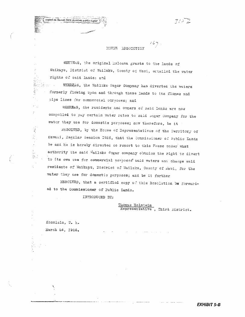
Exhibit 5-B: Copy of House Resolution 167 states that -
the original kuleana grants “entailed the water rights ofsaid lands,”that the Wailuku Sugar Company had diverted those waters and werecharging residents ofthe kuleana grantsfor the water, and charged theCommissioner ofPublic Lands with reporting “under what authority thesaid Wailuku Sugar company obtains the right to divert to its own usefor commercial purposes said waters and charge said residents..for thewater they usefor domestic purposes.”
Exhibit 5-C: April 1925 letter from the Commissioner of Public Lands states that -
“all the lands referred to and the watersflowing thereon are privatelyowned” and that “the adjudication of the rights involved does not comewithin the jurisdiction of this office.”
2. Survey Maps
None
3. Mahele Use: “native rights reserved”, use of water for domestic purposes
Flow Requirements Source: Waikapu Stream
4. Photographs: None
5. 180 0’s Tax Records: None
qH
$
K (Ic>
SIll
“
4]44
h I I 1!
0 Co ‘4$
NN
2. .4 Cs’
N’N’
. N’
‘-I
Vi
fl%
•&
•41
J.t
.
44 (0
1lcopiedon Hawaii State Archives public copier
ROUSE HESUSUTIOR
vHERES, the original kuleana orants to the lands of
ilaikapu, District of dailuku, County of uaL1, entailed the water
rights of said lands: and
?iSEREA-, the iailuku Sugar Oomoany has diverted the waters
formerly flowing u-con and through these lands to its flumes and
ripe lines for commercial ourooses; and
‘PfRES, the residents ann owners 01 asia lands are now
compelled to oay certain water rates to said ugar Company for the
water they use for domestic purposes; now therefore, be it
RESOLVED, by the House of Representatives of the Territory of
Hawaii, Regular Session 1925, tht the Commissioner of Public Lands
be and he is hereby directed to report to this Rouse under what
authority the said ailuku augar company obtains the right to divert
to its own use for commercial rurposes said waters anci charge said
residents of Waikapu, listrict of Railuku, County of Maui, for the
water they use for domestic purposes; and be it further
RESOLVED, that a certified copy of this Resolution bw forward
ed to the Commiseicmer of Public Lands.
IITIRODUCED BY:
Thomas HolsteinRepresentative , Third District.
Honolulu, 1. H.
March 24, 1925.
EXHIBIT 5-B
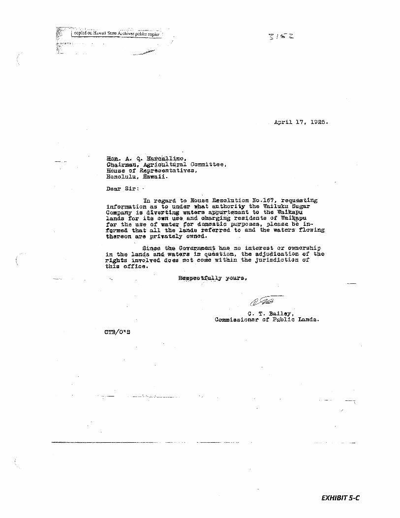
copdonHawaiiStaeArchvespthpje
April 17, 1925
Ko A. . grlljao,irman, AgrieLitural Coittee,
House of RepreeentauvesHonclu1IL, Eawaii.
Dear Sir:
reard to Rouse Re lution Ro.16?, requestinginmation as to under what authority the Wailuku SugarCo any is ertiing waters apwrtenaRt to the Walkapulands for its owli use end. charging residents of Waikapufor the use of water or domestic pirpoaea, please be informed tha all the lands referred to and the waters flowingthereon are privately owned..
Since the Government has no interest or ownershipin the lan4s and waters in question, the adJudi.catian. of therights involved do-es not come within the jurisdiotiorz ofthis office.
spectfuUy yours,
C. T. Bailey,Commissioner of 1ublic Lands.
EXHIBITS-C
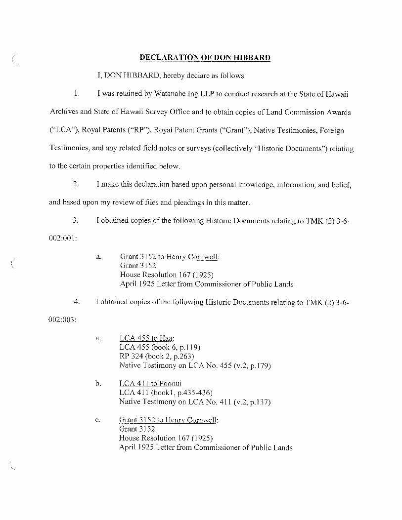
DECLARATION OF DON HIBBARD
I, DON HIBBARD, hereby declare as follows:
1. I was retained by Watanabe Ing LLP to conduct research at the State of Hawaii
Archives and State of Hawaii Survey Office and to obtain copies of Land Commission Awards
(“LCA”), Royal Patents (“RP”), Royal Patent Grants (“Grant”), Native Testimonies, Foreign
Testimonies, and any related field notes or surveys (collectively “Historic Documents”) relating
to the certain properties identified below.
2. I make this declaration based upon personal knowledge, information, and belief,
and based upon my review of files and pleadings in this matter.
3. I obtained copies of the following Historic Documents relating to TMK (2) 3-6-
002:001:
a. Grant 3152 to Henry Cornwell:Grant 3152House Resolution 167 (1925)April 1925 Letter from Commissioner of Public Lands
4. I obtained copies of the following Historic Documents relating to TMK (2) 3-6-
002:003:
a. LCA 455 to Haa:LCA 455 (book 6, p.1 19)RP 324 (book 2, p.263)Native Testimony on LCA No. 455 (v.2, p.1 79)
b. LCA4lltoPoonuiLCA 411 (booki, p.435-436)Native Testimony on LCA No. 411 (v.2, p.137)
c. Grant 3152 to Henry Cornwell:Grant 3152House Resolution 167 (1925)April 1925 Letter from Commissioner of Public Lands
d. Grant 2747 to Eugene Ball:Grant 2747Survey Field Notes and Diagram relating to Grant 2747
5. I obtained copies of the following Historic Documents relating to TMK (2) 3-6-
005-007:
a. LCA 23 6-I to Charles CoppLCA 236 (v.2, p.1295)Royal Patent 498Foreign Testimony on LCA No. 236 (v.8, p.34)Native Testimony on LCA No. 236 (v.5, p.299; 1849)
b. LCA 8874 to KaneaeLCA 8874 (v.8, P. 223)RP 3130 (bk.14, p.51)Foreign Testimony on LCA No. 8874 (v.7, p.504)Native Testimony on LCA No. 8874 (v.9, p!588)
c. LCA 432 to Anthony SilvaLCA 432 (book
, p.61 5-616)RP 102Native Testimony on LCA No. 432 (v.2, p.164)
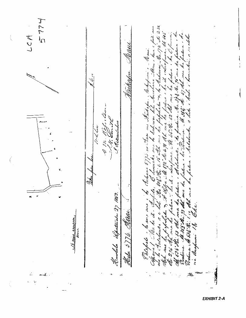
d. LCA 5774 to KaaiLCA 5774 (bookS, p. 391-392)RP 4014Foreign Testimony on LCA No. 5774 (v.7, p.468)Native Testimony on LCA No. 5774 (v.9, p.659)
e. LCA 491 to HaawahineLCA 491 (book 2, p. 899)RP 3139 (book 4, p.71)Foreign Testimony on LCA No. 491 (v.7, p.486)Native Testimony on LCA No. 491 (v.9, p.6’73)
f LCA 3527 to KamohaiLCA 3527 (book 8, p.231)RP 3156 (book 14, p.105)Foreign Testimony on LCA No. 3527 (v.7, p.502)Native Testimony on LCA No. 3527(v.9, p.686, 1849)
g. LCA462toMahukaLCA 462 (book 5, p.600)Native Testimony on LCA No. 462 (v.2, p.1 85. 1847)

h. LCA 5324 to KeakiniLCA 5324RP 6374Foreign Testimony on LCA No. 5324 (v.7, p.469)Native Testimony on LCA No. 5324 (v.9, p.660)
i. LCA 455 to HaaLCA 455 (book 6, p.’ 19)RP 324 (book 2, p.263)Native Testimony on LCA No. 455 (v.2, p.l’79)
j. LCA 416 to John CrowderLCA 416 (book 1, p.302)RP 41 (book 1, p.157)Foreign Testimony on LCA No. 416 (v.1, p.142)
k. LCA 10160 to MahoeLCA 10160RP 3148Foreign Testimony on LCA No. 10160 (v.7, p.506)Native Testimony on LCA No. 10160 (v.9, p.690)
1. Grant 2960 to J. BoardmanGrant 2960Survey Field Notes and Diagram
m. Grant 2069 to KaaiGrant 2069Survey Field Notes and Diagram
n. Grant 2904 to John CrowderGrant 2904Survey Field Notes and Diagram
o. Grant 3043 to J. BoardmanGrant 3043

p. Grant 3152 to Henry CornwellGrant 3152House Resolution 167 (1925)April 1925 Letter from Commissioner of Public Lands
q. Grant 2747 to Eugene BalGrant 2747Survey Field Notes and (2) Diagrams
r. Grant 1674 to E. W. GleasonGrant 1674Survey Field Notes and Diagram
s. Grant 2342 to E. BalGrant 2342Survey Field Notes and Diagram
t. Grant 1146 to Antonio SylvaGrant 1146Survey Field Notes and Diagram
6. I obtained copies of the following Historic Documents relating to TMK (2) 3-6-
006-036:
a. LCA 5551 toKeakuaLCA 5551 (book 8, p.10)Copy of RP 3150 (book 14, p.93)Foreign Testimony on LCA No. 5551 (v.7, p.47’7)Native Testimony on LCA No. 5551 (v.9, p.665)
b. LCA 2609 to PoepoeLCA 2609 (book 8, p.21.5)RP 3124 (book 14, p.39)Foreign Testimony on LCA No. 2609 (v.7, p.5O’7)Native Testimony on LCA No. 2609 (v.9, p.691)
c. LCA 5774 to KaaiLCA 5774 (bookS, p.391)RP 4014 (book 17. p.25)
4

Foreign Testimony on LCA No. 5774 (v.7, p.468)Native Testimony on LCA No. 5774 (v.9, p.659)
d. LCA 1704 to OpunuiGrant 1704Survey Field Notes and Diagram
e. LCA 1844 to Joseph SylvaGrant 1844Survey Field Notes and Diagrams
7. I obtained copies of the following Historic Documents relating to TMK (2) 3-6-
004-003:
a. LCA 23 6-I to Charles CoppLCA 236 (v.2, p.1295)Royal Patent 498Foreign Testimony on LCA No. 236 (v.8, p.34)Native Testimony on LCA No. 236 (v.5, p.299; 1849)
b. LCA 2609 to PoepoeLCA 2609 (book 8, p.215)RP 3124 (book 14, p.39)Foreign Testimony on LCA No. 2609 (v.7, p.5O’7)Native Testimony on LCA No. 2609 (v.9, p.691)
c. LCA 3223 to OpunuiLCA 3224 (book 8, p. 14-15)Copy of RP 4115Foreign Testimony on LCA No. 3224 (v.7, p.4’7.5)Native Testimony on LCA No. 3224 (v.7, p.663)Field Notes and Survey Diagram
d. LCA 3520 to KeaweLCA 3520 (book 8, p.10)RP 3135Foreign Testimony on LCA No. 3520 (v.7, p.481)Native Testimony on LCA No. 3520 (v.9, p.669)

e. LCA 3546 to KupaliiLCA 3546 (book 8, p.225)RP 3151Foreign Testimony on LCA No. 3546 (v.7, p.492)Native Testimony on LCA No. 3546 (v.9, p.&79)Field Notes and Survey Diagram
f. LCA 5551 to KeakuaLCA 5551 (book 8, p.10)Copy of RP 3150 (book 14, p.93)Foreign Testimony on LCA No. 5551 (v.7, p.477)Native Testimony on LCA No. 5551 (v.9, p.665)
g, LCA 5774 to KaaiLCA 5774 (book 5, p.391)RP 4014 (book 17, p.25)Foreign Testimony on LCA No. 5774 (v.7, p.468)Native Testimony on LCA No. 5774 (v.9, P. 659)
h. LCA 2394 to KaehaLCA 2394 (book 3, p.459-460)Copy of RP 3138 (book 14, p.69)Foreign Testimony on LCA No. 2394 (v.7, p.46’7)Native Testimony on LCA No. 2394 (v9, p.6S8)Survey Field Notes and Diagram
LCA 2499 to EhunuiLCA 2499RP 4070Foreign Testimony on LCA No. 2499 (v.7, P.467)Native Testimony on LCA No. 2499 (v.9, p.657)Survey Field Notes and Diagram
j. LCA 2522 to MakuakaneLCA 2522RP 3125Foreign Testimony on LCA No. 2522 (v.7, p.487)Native Testimony on LCA No. 2522 (v.9, p.674)
6

k. LCA 2577 to HakikiLCA 2577RP 4948Foreign Testimony on LCA No. 2577 (v.7, p.47’7)Native Testimony on LCA No. 2577 (v.9, p.666)
LCA 3020 to MataioLCA 3020RP 3140Foreign Testimony on LCA No. 3020 (v.7, p. 487)Native Testimony on LCA No. 3020 (v.9, p.675)
m. LCA3528toKoaLCA 3528RP 3155Foreign Testimony on LCA No. 3528 (v.7, p.4’72)Native Testimony on LCA No. 3528 (v.9, p.662)Survey Field Notes and Diagram
n. LCA 6385 to KamakaipoaaLCA 6385Foreign Testimony on LCA No. 6385 (v.7, p.482)Native Testimony on LCA No. 6385 (v.9, p.670)
o. LCA 10460 to NaleiLCA 10460Foreign Testimony on LCA No. 10460 (v.7, p.510)Native Testimony on LCA No. 10460 (v.9, p.694)
p. LCA 10481 toNapailoiLCA 10481rri I
I
Foreign Testimony on LCA No. 10481 (v.7, p.508)Native Testimony on LCA No. 10481 (v.9, p.692)Survey Field Notes and Diagram
q. LCA 3337 to NaanaaT r ALAfr\. ,)ii
RP 3136Foreign Testimony on LCA No. 3337 (v.7. p.476)
7

Native Testimony on LCA No. 3337 (v.9, p.665)
r. Grant 1844 to Joseph SylvaGrant 1844Survey Field Notes and Diagrams
s. Grant 3152 to Henry CornwellGrant 3152House Resolution 167
t. Grant 2109 to Joseph EnosGrant 2109Survey Field Notes and Diagram
u. Grant 1704 to OpunuiGrant 1704Survey Field Notes and Diagram
v. Grant l7O8toKoaGrant 1708Survey Field Notes and Diagram
w. Grant 1711 to MohomohoGrant 1711Survey Field Notes and Diagram
x. Grant 1712 to IhuGrant 1712Survey Field Notes and Diagram
8. I obtained copies of the following Historic Documents relating to TMK (2) 3-6-
004-006:
a. LCA236-I to Charles CoppLCA 236-I (v.2, p.1295)RP 498Foreign Testimony on LCA No. 236 (v.8, p.34)Native Testimony on LCA No. 236 (v.5, p.299; 1849)
8
b. LCA 5774 to KaaiLCA 5774 (v.5, p.391)RP 4014 (v.17, P.25)Foreign Testimony on LCA No. 5774 (v.7, p.468)Native Testimony on LCA No. 5774 (v.9, p.659)
c. LCA 10481 to NapailoiLCA 10481RP 3131Foreign Testimony on LCA No. 10481 (v.7, p.508)Native Testimony on LCA No. 10481 (v.9, p.692)Field Notes and Survey Diagram
d. LCA 8874 to KaneaeLCA 8874 (book 8, P. 223)RP 3130 (book 14, p.51)Foreign Testimony on LCA No. 8874 (v.7, p.688)Native Testimony on LCA No. 8874 (v.9, p.504)
e. LCA 10160 to MahoeLCA 10160RP 3148Foreign Testimony on LCA No. 10160 (v.7, p.506)Native Testimony on LCA No. 10160 (v.9, p.690)
f. LCA 11022 to WahinealiiLCA 11022RP 3142Survey Field Notes and Diagram
g. LCA 5324 to KeakiniLCA 5324RP 6374Foreign Testimony on LCA No. 5324 (v.7, p.469)Native Testimony on LCA No. 5324 (v.9, p.660)
h. LCA 3527 to KamohaiLCA 3527 (v.8, p.231)RP 3156 (v.14, p.105)Foreign Testimony on LCA No. 3527 (v.7, p.502)Native Testimony on LCA No. 3527 (v.9, p.686)
LCA 1844 to Joseph SylvaGrant 1844Survey Field Notes and Diagram
9
j. Grant 3152 to Henry CornwellGrant 3152House Resolution 167 (1925)April 1925 letter from the Commissioner of Public Lands
k. Grant 3043 to J. Boardman/‘jrant 3v’+i
1. Grant 2960 to J. BoardmanGrant 2960Survey Field Notes and Diagram
m. Grant 2069 to KaaiGrant 2069Survey Field Notes and Diagram
I DECLARE UNDER PENALTY OF LAW THAT THE FOREGOING IS TRUE
AND CORRECT.
DATED: Honolulu, Hawaii, February 2, 2012.
DO IBBARD
10
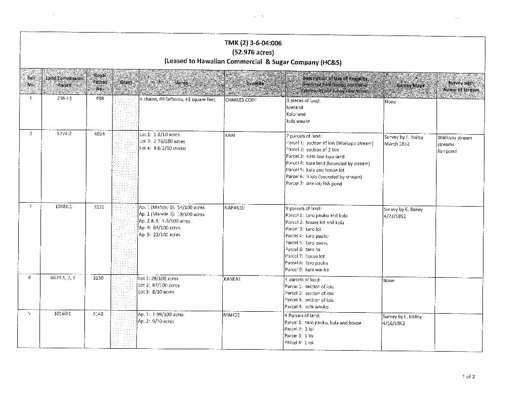
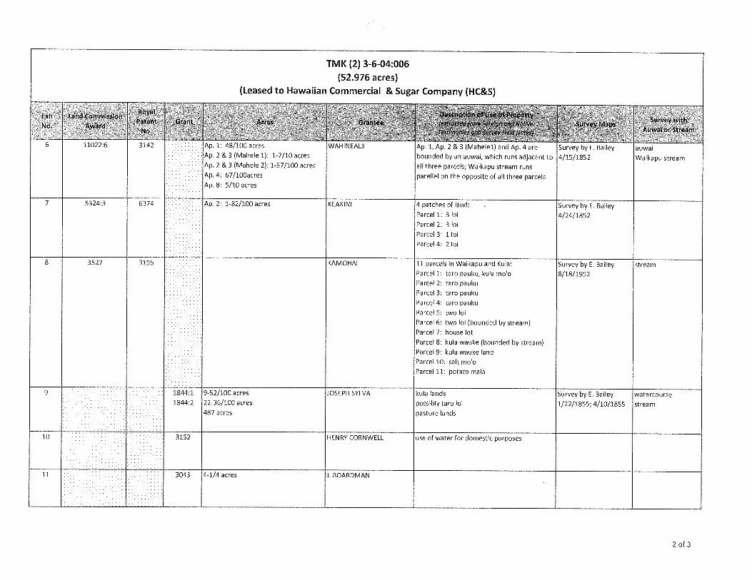
TMK (2) 3-6-04:006
(52.976 acres)(Leased to Hawaiian Commercial & Sugar Company (HC&S)
Exh Land commissionRoyal Descdptionof Use of Ptp&t
Survey wIthNo. Awar4Pat:nt Grant Acres Grante: Map:
Awai Stream
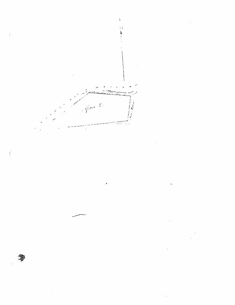
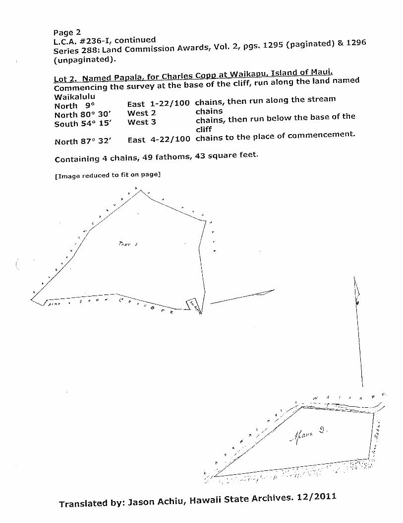
236-1:1 498 4 chains, 49 fathoms, 43 square feet CHARLES COPP 3 pieces of land: None: lowland
.
Kalo landkula wauke
2 5774:2 4014 Lot 1: 1-8/10 acres KAAI 7 parcels of land: Survey byE. Bailey Waikapu Stream• Lot 2: 2-76/100 acres Parcel 1: section of lois (Waikapu stream) March 1852 streams• Lot 4: 9 & 2/10 chains Parcel 2: section of 2 lois fish pond
: Parcel 3: Kalo and kula land.
Parcel 4: kula land (bounded by stream)Parcel 5: kula and house lotParcel 6: 3 lois (bounded by stream)
. Parcel 7: one loi; fish pond
3 10481:1 3131 Ap. 1 (Mahele 1): 54/100 acres NAPAILOI 9 parcels of land: Survey by E. BaileyAp. 1 (Mahele 2): 19/100 acres Parcel 1: taro pauku and kula 4/23/1852•Ap. 2 & 3: 1 3/100 acres Parcel 2: house lot and kula• Ap. 4: 64/100 acres Parcel 3: taro lolAp. 5: 22/100 acres Parcel 4: taro pauku
. Parcel 5: taropauku. Parcel 6: taroloi.
Parcel 7: house lot. Parcel 8: taro pauku
. Parcel 9: kula wauke
4 8874:1, 2, 3 3130 Lot 1: 29/100 acres KANEAE 4 parcels of land: NoneLot 2: 87/100 acres Parcel 1: section of lois
. Lot 3: 8/10 acres Parcel 2: section of lois: Parcel 3: section of lois
Parcel 4: kula wauke5 10150:1 3148 Ap. 1: 1-99/100 acres MAHOE 4 Parcels of land: Survey by E. Bailey
• Ap. 2: 9/10 acres Parcel 1: taro pauku, kula and house 4/16/1852.
Parcel 2: 3 loi. Parcel 3: 1 loi
.
Parcel 4: 1 loi
1 of 3
TMK (2) 3-6-04:006
(52.976 acres)(Leased to Hawaiian Commercial & Sugar Company (HC&S)
Elxh Land C:sonran
— I
MaPs—— .‘— ——.—
6 11022:6 3142 Ap. 1: 48/100 acres WAHINEALII Ap. 1, Ap. 2 & 3i l) and Ap. 4 are Survey byE. Bailey auwaiAp. 2 & 3 (Mahele 1): 1-7/10 acres bounded by an auwai, which runs adjacent to 4/15/1852 Waikapu streamAp. 2 & 3 (Mahele 2): 1-57/100 acres all three parcels; Waikapu stream runsAp. 4: 67/l00acres parellel on the opposite of all three parcelsAp. 8: 5/10 acres
7 5324:3 6374 Ap. 2: 1-82/100 acres KEAKINI 4 patches of land: Survey by E. Bailey. Parcel 1: 3 ni 4/24/1852
. Parcel 2: 3 niParcel 3: 1 Ini
. Parcel 4: 2 Ini
8 3527 3156 KAMOHAI 11 parcels in Waikapu and Kula: Survey by E. Bailey stream
Parcel 1: tarn pauku, kula moo 8/18/1952
• Parcel 2: tarn pauku
Parcel 3: tarn paukuParcel 4: tarn paukuParcel 5: two lol
Parcel 6: two Ini (bounded by stream). Parcel 7: house lot
. Parcel 8: kula wauke (bounded by stream). Parcel 9: kula wauke land
. Parcel 10: salt moo. Parcel 11: potato mala
9 1844:1 9-52/100 acres JOSEPH SYLVA kula lands Survey by E. Bailey watercourse1844:2 22-36/100 acres possibly tarn ni 1/22/1855; 4/10/1855 stream
.
487 acres pasture lands
10 3152 HENRY CORNWELL use of water for domestic purposes
LI 3043 4-1/4 acres i, BOARDMAN
2 of 3
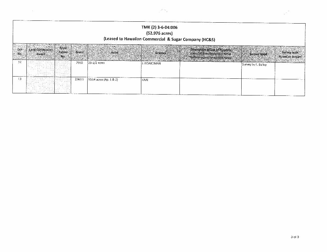
TMK (2) 3-6-04:006
(52.976 acres)(Leased to Hawaiian Commercial & Sugar Company (HC&S)
: Lafld ComrnksionAe
12 2960 23-1/2 acres i. BOARDMAN Survey byE. Bailey
13 * 2069:1 10.64 acres (Ap. 1 & 2) KAAI
3 of 3

EXHIBIT 1
LAND COMMISSION AWARD 236-I TO CHARLES COPP
LCAwNo.: 236-1:1Royal Patent No.: 498Grantee: CHARLES COPP
1. Exhibits
Exhibit 1-A Copy of LCA 236 (v.2, p.1295) and translation
Exhibit 1-B: Royal Patent 498
Exhibit 1-C: Foreign Testimony on LCA No. 236 (v.8, p.34) — indicates -
3 pieces of land, “one the lowland, one the kalo land in the valley, andthe third a kula wauke”. Only the low lands were surveyed.
Exhibit 1-D: Native Testimony on LCA No. 236 (v.5, p.299; 1849) indicates —
3 patches of land in the “ili ofKaluapuaa in Waikapu”.
2. Survey Maps
None
3. Mahele Use: kalo land, kula wauke
Flow Requirements Source: Waikapu Stream
4. Photographs: None
5. 1800’s Tax Records: None
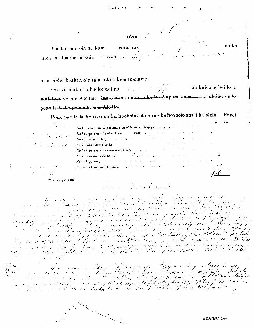
L_— c_— i
11a kol mat ola no kona
tnea ua baa ja ia keia
Ilcht
wahi ma
wahi — ;/-
‘I
‘4
-‘ /
114)
a ua noho keakea ole Ia fl Iiiki i keia tuanawa.
Oia ka makoU e ho-oko net no he kiatta lioi koIl:
ke ano Alo4lio. —-I- :t..,._. i .... I
A1o4i
Pouo nae Ia Ia ke uku no ka hookolokolo a me ka hooholo ana I ka olebo. Penei,
No La rut a c Ic pat ciaa i La 01<lu a La Ntqpa.
No Lc aja i La ok!u Lvuta ao4o -.
to & a paiapula Li -
- Lu ana t Lu Ia
?o i.e kcrp ana R oldo a X AaLLr, ; -
- ka aa aaa I La (a -. - .‘- ;- -. -
Nokck.peaia,.... -
La hooltjv aR/I I La u&tu, , - -- - - / -
1—
/ ---- /- - - - - — - - — - — /‘ — --:-C-s-. -‘ --.--t-_f’1_j -
--. -- ___/•_—/_- -, /__ /
t ). -_. .-•.-• . ---- •- ‘ ;--— -L--.-. -- /J-- -, .-‘,-‘-
-j
- - ‘--‘ ----.-. -- -. - - -,-.f ,.,:--/j/
- 1—
I/ / A A I
-/ /;;:-‘-- ./ ;? / . .‘/•/
I. // - ---. --- - F -, / //
M. -.m—-
- / -- - I -‘
-- I / I- - - _.
- I /;;
— - - - - - - — f - - — - , ,
- c—- - - - — - - --. - —- — - — -- — _f_ • ‘- -(
-‘ - .-‘:-- /6 . /1’;-
— .- — — - - —,, - -.- /1
- / - 1 —. A I
- - - I- - --
- -•
------‘:---
-‘‘ ---“‘--‘# _--_•/‘__-__-_/_-__
- - - -‘A - /- -., .mA / 111. - ‘ A’
-f,--’ .-/- / -I
I -‘ 7/. -C / /
,-( 2 F-
-:-.(A-.- - ‘‘‘ .‘.
-‘1’- -‘-.- ---I-’-’
/, , •-‘-- •!-i•!t4Ad
I / ,.I /
- ?“. / ‘// “
‘ •i;.---< _r2/’m
EXHIBIT 1-A
/ / — I ‘ - -
- /
Eta na p-alma.
kr
-(I C - - 1’-
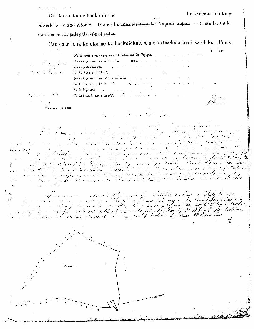
Oi ka niakoti 0 Itooko Ito kt,Ira,ta Itol kuzt:/ I.
tte.44k—.e- k ‘ a no A lad io IL a:*= LkaawurA} 4}k&14*U1fl ha4:r - -; -aIaitnrU:t 1% u
Porto nac ia Ia ice uku no ka hookolokolo a me ka hooholo aim i kit olelo. Penn,/
No La rwti a nc it pat ata a La ohIo na La ?Qxppa
/ -- No it k-opr a33.a z La oh-to Labia aoao, . -
- No La palapala Lii,
• • ‘Z No La !tafia a : hi La , -
No it 1311 aria t na olcio a na odr,..... - -
Y.’kaaaaan.aiiata .‘• ..
it h,pr asia. . . - . -
No La huohdn asia i La (ICio, .. - - ‘ - - 7 -
paicna. -
/ . .-•• x,
--I / -, -.-, - 1•- - - -•-.- _••••-•i •1 --:.5i-- f•-’..t;’
- I, . •-.r.“--- /,.-:-:.--
-- ‘• —• :•‘.. ‘.:- , :,:i-,:_. •.
- ./ / • • ‘- -‘ - . .
-7/ .
.
•-- ;.:./y.’ -...•. •d-.,.••.•/ •-
— / -
,K• • I •: . /- . ..-.. — 7. It4’ I.A/C -‘//14A ..
1
- fjr-4 ‘:- --: c.t--•t;t- . •a. ‘
.,
;. -‘-• ‘.- (CA ,-/-,jafzfr.’. ,r#•--•’
-/. /, .
•‘‘ -•i —• ‘7 • / / .,
• •/.:- ‘--c?4),/’//: 7L”-.- C--/c- Me ‘.-.4’
.../-i•‘e’ -4-
% 4
C. ..I .i-- 7. / . •< -:-.--..& 4-.-.- eg.tfr/’ ,7-• s’-— - t /7*
-! /L--%” -:..-
—.,%, ,j - _./ /•‘,‘ /, i(; i-L i€ -c t’ L.f /4/’F - / _/ I - ‘/- - / - F— . -F
Ar-i
/n- i’ct 4(-- I .-€ .f /j;; -i7 Y-L1flA jit’
-7- -/7
‘-V
• 2-
-
r
_
ken
I,
-
cI

41
N‘i
-i
(i
‘“‘/4
4I

Series 288: Land Commission Awards
L.CA. #236-IVol. 2, pages 1295 (paginated) & 1296 (unpaginated).
No. 236-I CHARLES COPP
He has claimed his lands at Waikapu, Island of Maui, whereas
he received these lands from Hoapili wahine in 1836 and has had
undisputed possession to the present time.
This is what we award to Charles Copp, an Estate in fee simple.
He must pay for the adjudication and decision, as follows:
W.L Lee For the room and publication in newspaper
G.M. Robertson For copying the claim, page3.11. Smith For the map
For the actionFor copying witnesses’ testimonyFor the surveying per day, 31 August 1849 $ 5.
bane Ii For engrossing the surveyI. Kekaulahao For the decision, 21 May 1851 iQ.
$15.
Here are the boundaries surveyed by bane Richardson.
Lot 1. Named LuaDuaa, for Charles Cppp at Waikapu, Island of Maui.
Commencing the survey at the side below a certain government patch
named Kaumuilio, and run along John Crowder’s land
South 7° 30’ West 1-54/100 chains
South 26° 28’ West 6-67/100 chains
South 6° 35’ West 8-17/100 chains
South 45° 30’ East 46/ 100 chains
South 36° 30’ West 1-1/2 chains to the land named Kaloapelu,
then run along Kaloapelu
North 36° 28’ West 7-15/ 100 chains
North 48° 25’ West 3-52/100 chains, then run along the land named
Kaalaea
North 29° West 7-40/100 chains to the lands named Kaopala,
then run along Kaopala
North 47° East 1-74/100 chains
North 34° 30’ East 6-12/100 chains
North 2° 40’ East 85/ 100 chains
South 66° East 3-53/100 chains
South 87° 30’ East 5-13/100 chains
South 69° 30’ East 2-42/100 chains
South 82° 30’ West 2 chains along Kaumuillo
South 15° 30’ East 1-25/100 chains along the inland side of
Kaumuilio, then run towards the
place of commencement
North 83° 45’ East 1-75/100 chains.
Containing 16-1/2 acres.
continued on page 2
Page 2L.C.A. #236-I, continued
Series 288: Land Commission Awards, Vol. 2, pgs. 1295 (paginated) & 1296
(unpaginated).
Lot 2. Named Papala, for Charles Copp at Waikapu, Island of Maui.
Commencing the survey at the base of the cliff, run along the land named
WaikaluluNorth 9° East 1-22/100 chains, then run along the stream
North 80° 30’ West 2 chains
South 54° 15’ West 3 chains, then run below the base of the
cliff
North 87° 32’ East 4-22/100 chains to the place of commencement.
Containing 4 chains, 49 fathoms, 43 square feet.
[Image reduced to fit on pagej
V
Translated by: Jason Achiu, Hawaii State Archives. 12/20 11
4,
0 K N
0
4 A P

‘ oil
A KE ALIt. MAMULIOKA OLELO A KA POE I{OONA KULEANA.
[:i nij, na hoob cia Luci Hoo*a i cia ornu kuleana ana I ka oIeIo1ko
-
/1 , .. -- ./g - 3/
cia ke IiZO tO(E3 itnkc Li11 nkln:a iE1]L1E,.
tlIfl k(9d I it pal ‘li 1Hl, ke Ii—ke aki, nel o Kameiainelia III., ke alil flui a ke Akua 1 konalOtsOutnIik4i i Ii onoho a in in. n k I I.ic Pac A cia, 1 ita kanaka a au, kela Ia nomi 1io, a uo konailiac ti(if)e alli ua iaoi ak,i cia ke Icia a Z
kId wali, a pau ba ma -‘
m:a ka rnokiipuni a -‘ ‘ - - peoel na mokuna,
.7 - , / . .1 ‘ /•11 / .. .— . /‘. -
/_/‘. .
- / .
I- , - 7 ,..- - “ S_A — i
- /) ja
- ‘ - / -,• /. . A ----, .
- ,
I
-
; )$a/
2 .‘ . ‘‘ --
-
14 ‘, O2’//
/-, ;- /-
/c’4 ../ . -
S 2 2 --
/3 -° ‘._/
/J
/L/ IJ It> A . /
/2
I?EXHIBIT 1-B

r / ,• -
- -J
- -.
j ‘J’ô ‘A - - - 2-
-
/ / Ac . /
zig.
4 9 4_ -‘
Maloko o ‘- ‘- spans --- / •-‘
a o ik aku, a ew iki mai Ui koc se i ke aupuni aS mine mneTeta a me na rnetela a
Na id.Un UjES In hawiia ma ke 2no ?1obio a oo knn. man boillna a me kona waifinna ua pill n.e ka auban
a ka Poe Ahuoleto kau tike ci ma 01 nina alodm i kela mana-a i keia manawa.
A I men a ikea 81 uS kau au I ka’u loan, a me kaib Sni a ko
Hawaii Pae Ama m Honolulu i kea in a
E’4
--7
(-(-t ) ,
-: : -
ej.. -;
z1 - - J e-
/ // Z
I
/47d), .-- -&-
2 f
“k
I
— I-4
• C

4!’
•‘‘
.,
4,
4,
‘
‘‘•4•’
4”’:
4‘‘‘‘
!44
•:
..““
‘•
•,•
•4:/
•:
•‘
?I
_
k4
,t-
,‘,
-i•‘
::‘
‘‘
4•‘“‘•
‘‘
:: ‘
-.
,:,T
,,,,
,‘
•‘!!‘•,‘
.‘!‘*•!•!
Z,..
41
44
44
A4
444
4:4
44
44
.•
‘—
W77
I

I.
b,
rb
•••“
,•,
•-_
bi,.,
b’-
-,L
h••
c)2
1D
7
No. )42814 G Kamaka July ‘27, 18)49
This interest has been clone with Wailukuts claim, it has no interest at Pauku—
kalo and Waiehu except for the interest at Waihee of 1 patch in the ili land
of Waipukiia.Kamanao sworn He has seen 1 patch in Waipukua iii in Waihee.
WAILPU AND KUIANamaka’ s land from Kahune in 1 8L5. Kahune’ s land from Kuakamauna.land from N. Kekuanaoa. No objections to Kamaka
Mauka Big ditchKahakuloa KalaaualaMakai PoalimaWailuku Keaka
No. 8882 Kekua July 27, 18L9
__________
House lot at AwahamanuI’IaukaWaiheeKulaMaalaea
_________
Taro pauku in NapalaalaeaMaukaWaiheeKula MooMaalaea
_________
Potato patch at Kamaole in Ku]aMauka and Honuaula KeaweMakaiMakawao
‘-I
No. 236 I Charles Copp July 27, 18L9
Z. Kaaj sworn He has seen 1 section, 2 sections he has not seen in the ili of
Kaluapuaa in Waikapu. Land from Mrs. Hoapili in 1836. He has not heard of
objections however Kaauwai has heard how Charles Copp had received this landfrom Nr.s Hoapili,Mr. Charles Copp was Lota’s friand, he was also Lota’s tailor and because ofthe hardships of living in Lahaina, Mrs. Hoapili gave him this land. He hasnot known whether Nalei has interest in Wailuku.This land has been surveyed, the map is on Oahu.iaazm He has seen Charles Oopp’s lands and Nalei’s land no. iOI6O. Nalei’s
patches are in Charles land and he had received it from Makole in 181i6. He hadnot wanted this land he had felt he would received the land of Kaluapuaa permanently which would leave the Poalima only for Charles. Charles disapproved ofthis and asked I’Talei to remain on his uwn interest.Nalei lived onhis own 114. patches atthe time Charles went to Hana and be workedL days at a time for the Poalima at the request of Kuihelani. Later Nalei livedunder that foreigaer 3. Lonzada. After I had left Joe , took my interest forCharles because he had felt, Nalei wanted all of the land for himself. Nalei hasno land at this time.William Humphreys sworn He has known this: Charles had come to Lahaina and beasked: me for a suitable land in Waikapu.
EXHIBIT1-Dp
Page 299Kuakamauna’ s
Keawe sworn He has seen 3 sections in the ilis of Waikapu and Kula. The firsttwo sections in Waikapu from William Makaena in 1820. Section 3 from Kamoa in18143. Kamoa’s land from Kalanao, no objection. 1 Poalima in section two atKapalaalaea.Section 1 —
Akoni Cakalina’ a landLand enclosureGovernment roadJ. Lonzada
NonohikiKuihono
Kohelaulau
Section 2 —
Section 3
KamalanaMamaki
mido3 njqnd siqoiy a iMgr so pmdo
No. 236 I Charles Copp (cant.)
Charles: Where is a good land in Waikapu here?
Humphreys; Palama is a good land.Charles: The land of a foreigner adjoins the Pala.ma, is it not?
Humphreys It adjoins Atom.’s landCharles: It is not separated by Wahapaa?
Hunphreys’ It turns until Kaluapuaa is reached. Go home and come back again
He did go back home and. had talked with Mrs. Hoapili. Wheh he returned,
Kaluapuaa was then convered to hin’
Waiehu to pg. 3h3 CLAThTS IN WAIEIIU,WAILUKU, July 17, 18149 Page 30
No. 21489 Kuhilanakea
Nuuhiwa sworn He has seen Ii ± 1 sections in the ilis at Waiehu.
First section from Kuhilanakea’s pents in 1835. Section 2 from Honokana and
his wife in 18145, they died in 18145 and land was bequested to Kuhilanakea.
Third section from Palehupo in 1838. There was betiest land from Kauka in 1839.
Section 5 from Kuhilanakea’s sister ICalili in 1835. 2 Poalimas in the first
section, 1 poaha in the section 2, no objections to ICuthilanakea.
Section 1 — 20 Patches in the iii of KumuiliuiliMauka KanehailuaWàihee Polea. —
Makaj. PaikalehoulaMaalaea Stream
Section 2 — Tare pauku at PoaiwaMauka and Waihee NuhiMakai PepehiMaalaea Nuuhiwa’ a land
Section 3 — 5 Tare patches at KalahapaMauka and Waihee PalehupoMakai ICapohuliNaalaea Stream
Section — 1 Taro patch at LualailuaMauka KapohuliWaihee, makai, maalaea Paikalehoula
Section — 2 Tare patches at PahapahawaleMauka KeaWaihee StreamMakai PoalimaMaalaea Makaflfli
No. 1499 Auwae July 17’, 18149
Keawe sworn He has seen 1 tare section with 14 patches in that section in theiii of Halelau of Polipoli ahupuaa. * Auwae’s 14 patches in Waiehu are from pg. 302
Kalahoouka in 18146, an old land from Kalahoouka’s parents, no objection.
Mauka C. ICanaina’ s land
Waihee and makai Khu
Maalaea. C. Kanaina’ s land
Auwae has no claim in Waikapu and Honuaula, he is an overseer only.
I
pdo3
EXHIBIT 2
LAND COMMISSION AWARD 5774 TO KAAI
LCAwNo.: 5774:2Royal Patent No.: 4014Grantee: KAAI
Exhibit2-A: Copy of LCA 5774 [v. 5, p.391) and translation
Exhibit 2-B: Copy of RP 4014 (v.17, P.25)
Exhibit 2-C: Foreign Testimony on LCA No. 5774 (v.7, p.468) indicates -
consist of7pieces...in Waikapu, MauL” No. 1 is a section oflois; No. 2 isa section of2 lois; No. 3 is a kalo and ku/a land; No. 4 is a ku/a land; No.
is ku/a and house lot; No. 6 is3 lois; No. 7is one loi. Testimony alsoindicates that No. 1 is and No. 4 is bounded... “Waihee, by the creek ofWaikapu.”
Exhibit2-D: Native Testimony on LCA No. 5774 (v.9, p.659) indicates -
seven parcels ofland in Waikapu. Parcel 1. Taro pauku in the Iii ofKaopala. Parcel 2. 6 taro loi in the Iii ofKaopala. Parcel 3. Taro paukuand ku/a in the Ili ofKaalaea.. Parcel 5. House Lot, kula and 1 loi in theI/i ofKaloapelu. Parcel 6. 3 lol in the Ill ofKaluapuaa. Parcel 7, 1 loi inthe Ill ofKaluapuaa.” Also indicates property is bound by Waikapustream and Waihee stream and that parcel 7was “made into afishpond.”
2. Survey Maps
Survey byE. Bailey, dated March 1852 (see Exhibit 2-A, copy of LCA 5774)
3. Mahele Use: Taro pauku, taro lois, house lot and kula
Flow Requirements Source: Waikapu Stream
4. Photographs: None
1800’s Tax Records: None
----
--
y,
;L
/
?(/
J7
7177
7,?
‘‘7V7V
f“1’P
/7
/:‘p’
-1
?-/v
y7
.’.(’
7Z.9
‘9
1é1
lu/F
7’7
Y““
‘/F
IY
‘7
Y“‘_
:‘‘
y,
‘‘
‘‘P
’/
2’W
72
y?12/
vi‘‘
•‘y
:‘
3777.‘
7‘2
/’J9;Y
‘?‘2
’)>
/%
2v
77717
7ZI7
pd
th
’-’
v’--(7/7
a’
()
J’l’’72
C/
‘97
7v7
/2’
7’717
7‘‘‘
‘3/’if
/r
/‘
721y
1-
‘it’“//5
7)2
,/,
72’U
)“
NI.
rnz-7e-
-
‘
‘?Z
17
•7c’.--..
‘V
/42V
.
,;zz
7?4•
;f/
-
•‘Iw
O,
VH
ö1
t*‘I4
’/
w
‘4

cC
,
•J32
.C
an
a2
%vS
i4
nA
,ntt
AL
øaánstv
,4.
£it
d-,
at.
34%
.:/1
4wt(
n,a
Ia./asa
-A1flt
‘42:
.site
3tA
’%
t/a4ta.
4ntt
’cz
/4,/adna
-t%
a/ttaa
1it
J/4
’tt-
o2
i4
/,,n
t*
AL
‘.4’
4L
?C
flt*
4tc
,,t
,flj
‘A.ft
a,4
/14
L,
,>4
a.,cra%
t.c_,
€.
44
e’E
’/Jrtt’
%/a%
tnt‘t,taac
tI
tiS
,L.
42.f
yt€7C
d/Ii
ia/a
/(cr
4tta
..4a&
eA
éfl
’o*
iTm
ala/ana-
,od
a%
;o
4f’
LcZ
i,449a4
’4y
.1ri
/n,a
Aa/a4
0
4ii
ict
..24t6
t(m
a.a
%vite%
J4
./,
Q47
,,,
/a-
/atn
a.
-
ato
Yd
IA’
.132
na
A/n
4ant
-t1,1Zt1
-‘tn
L,,c.%
L.7
2f;
,#“d
//
/a.s
.-cL
A
‘%nta&
&)%
‘4-/
/2di,
1tIt
,/44na
,,
./
,:,
•g;4
Aa
,/m
4
$iis4n.,v
cit
./i
t’%
(n
ia
•/a/a4i
ca.,
aSé
t,*
%/7
i.4
/,
a/
/a4
it
a-ta
a,4
aZa.
a.,
L÷
;ci
4S
”cL/a
d/
/s.ecj
..2
Fd
,//
/t/ah
ittia
e/e
_.
%/2
1.L
:i7Jt
t(.’
naJa
-/ta
ne
tcac/-t..
tJJ7tA
C4.
,‘a/n
o1,
.‘1t/t<
•6
Sj’O
Et’
a).
2A
/,,t
mzZ
/4o124
áa,4
iaa.,
c%
JJ/t,’
//i
/a
/aJn
ta
d’s
jt4—
/2/
at(
41
1..i
Irt/
4n
,1
z44i.
.t,
./,-
i”r-
t471
.%,6ft.
#1.
45/4/
..4,/aat
a.%
A.’
..nia14-1C
6Z
nta-tn
4ii/i
,v-j
7fe,t/n
oit
C4
t.1
’<
•;C
Xa
a).tf
aIa
.%
ca
4,
£1
14
.1/1fl.
-4
4tZ
44
,I1
ni.a
.n
a.aa
/4
’A
,iza
Zrrhitsc..
•1
//‘%
a..
t4/a
.&.
-.2
-C
’A>
;tt,
,z%
,,-4
a2
ks
1n
ia
It
/c&
a4
4.;
•e%
-t,.r/,,
0L4
t/
44-*
i..fltt
£1,aaL
ac
At
.4.-
a€1
4-
a1t/ara
-I
a.’
t/st
Scar
at J
e’(
47
•4z,
e,jt4c
f/li/ac&
.t
.4/4
>1.&
.a‘.
1/
1.641-4
6ii
42ln
.as.c
,3.la
?it
2ac
4’
i4.,,4
,j67
.4’/,
,,,
,.?
li//id
/I
CL
-?4ft//C
a4.,
ft
,JO
//4
CA
4C
I,L
’C
totc
w,42
titn
ZA
tC
tL
/t/1
Ct/u
?I/k
c5.c5>
fiiL
Zt4
rr
-
C/#&
/L
/t?
4,tt4
fltj,N
,
4é26a
II
•4
.1/u
It
(-.;/,
a1
/i/C
c,
I.z
3
tI’
44
:76
1’
•
°__.:‘
‘
‘I

JL, • 14” —
a.
t
1
S
‘1
I
‘S
I \
s
S
N
‘4
•
e0
t
C
e4-
4--

Series 288: Land Commission Awards
L.C.A. #5774
Vol. 5, pages 391-392.
No. 5774 KAAI Waikapu, Maui
Survey of Claim 5774 for Kaai at Waikapu, Island of Maui.
Lot 1. In Kaopala Iii.
Commencing at the stream at the Northwest corner adjoining Kalahouka’s
land, and runSouth 80-3/4° East 6.15 chains along the rock wall and stream
South 17-1/4° West 222 chains along the rock wall & A. Sylva
North 89-1/4° West 4.98 chains along the boundary of Luapuaa Iii
North 68-1/4° West 2.96 chains along the boundary of Luapuaa Iii
North 46° West .62 chains along Opunui
North 53-1/4° East .53 chains along Kalahouka to the Poalima
South 39-3/4°. East .95 chains along the Poalima
North 35-1/2° East .93 chains along the Poalirna
North 38-3/4° West .67 chains along the Poalima
North 53-3/4° East 1.00 chains along Kalahouka to the place of
cornmencement.
Containing 1 and 8/10 acres.
Lot 2. In Kaalaea Iii.
Commencing at the Northeast corner adjoining Opunui & the Poalima, run
South 36° East 1.84 chains along Opunui’s boundary
North 53-1/4° East .36 chains along Opunui to Luapuaa Ili boundary
South 3 1-1/4° East 6.20 chains along Luapuaa Ill to Haawahine
South 82-1/2° West .91 chains along Haawahine to Kaneae’s land
North 64-1/2° West 1.35 chains along Kaneae to Keakini’s land
North 23-1/2° East .75 chains along Keakini
North 65-1/2° West .56 chains along Keakini to Karnohai’s land
North 20-1/4° East .75 chains along Kamohai
North 53-1/2° West 246 chains along Kamohal
South 23° West 1.11 chains along Kamohal
South 62° East 2.32 chains along Kamohai to Keakini’s land
South 27-1/2° West .81 chains along Keakini to Kaneae’s land
North 76-1/2° West 1.12 chains along Kaneae to the Poalima
North 80° West .67 chains along the Poalima
South 15° West .89 chains along the Poalima
North 83-1/2° West 1.94 chains along Kaai to the government dryland
North 21° West 1.84 chains along the government dryland
North 64-1/2° West 2.86 chains along government dryland to Poepoe
North 12-1/2° East 1.93 chains along Poepoe’s land
South 66° East 3.87 chains along Poepoe to Opunul’s land
South 80-1/2° East .32 chains along Opunui
North 33-3/4° East 1.15 chains along Opunui
North 33° West 1.21 chains along Opunul to the Poalima
North 49-1/4° East 1.51 chains along the Poalima to the place of
commencement.
Containing 2 and 76/100 acres.
continued on page 2
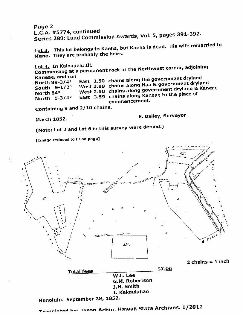
Page 2
L.C.A. #5774, continued
Series 288: Land Commission Awards, Vol. 5, pages 391-392.
Lot 3. This lot belongs to Kaeha, but Kaeha is dead. His wife remarried to
Ma no. They are probably the heirs.
Lot 4. In Kaloapelu Iii.
Commencing at a permanent rock at the Northwest corner, adjoining
Kaneae, and runNorth 89-3/4°South 5-1/2°North 84°North 5-3/4°
East 250 chains along the government dryland
West 3.88 chains along Haa & government dryland
West 2.50 chains along government dryland & Kaneae
East 359 chains along Kaneae to the place of
commencement.
Containing 9 and 2/10 chains.
March 1852. E. Bailey, Surveyor
(Note: Lot 2 and Lot 6 in this survey were denied.)
[Image reduced to fit on page)
Totai fees
Honolulu. September 28, 1852.
WI. LeeG.M. Robertson
.J.H. SmithI. Kekaulahao
0
(e —
t
L‘I A
p
I
p
S
4,
4
i4
4,
2 chains = 1 inch
-u-- ks,. ir Athiu Hawaii State Archives. 1/2012

c
14.
0 r
I-. a).
IF
1 S

No. 2499 — Ehunui Page 657
Kaai sworn: I know his three parcels of land in WaikapuParcel 1. Taro puku in the ‘Ill of Olohe
2. 1 lo’i “ “ “ Nohoana3 , 7 “ Plkoku
These three parcels of land were from me in the time of KamehamehaI. No opposition. One o’alima is in parcel 1.1. is bounded mauka by my land, Waihee by stream, Kula by GovernmenlRoad, makal by stream.
Page 658
2. is bounded mauka by the land of Kuaiwaa, Waihee by my land,Kula by the Government Road, makai by stream.3. is bounded mauka by my land, Waihee by stream, Kula by Government Road, makal by stream,
No.2394 - Kaeha July 13,1849
• Kaai sworn: I know his two parcels of land in Waikapu.Parcel 1. Taro pauku in the ‘Il]. of Olohe.
2. 4 lo’i of taro “ “ “
His land was from me in the time of Kamehameha I; he was a kama—‘ama. No opposition, He died in this year of 1849, His heiris Kekupu and the children, In the first parcel is one po’almma,in the second parcel are two oalima.
4i Y L’ Waihee by stream, Kula by Government Road, makai by stream.?. is bounded mauka by stream, Waihee, the same, Kula, Government!bad, makal by stream.
No. 5774 - Kaai
4 Keakini sworn:1 I know his seven parcels of land in Waikapu.Parcel 1, Taro pauku in the ‘Ill of Kaopala
2. 6 taro lo’i “ “ ‘ “ Kaluapuaa3. Taro pauku and kula in the Lii of Kaalaea4. Kula land in the ‘Iii of Olohe
U 5 House lot, kula and 1 1’i in the’Ili of Kaloapelu6. 3 lo’i in the ‘Ill of Kaluapuaa
ft 7 1 ft ii.1
His land was from Keaho, his makuakane, from the time of KamehamehaI. Keaho died in 1827 and Kaai occupied them in 1828 as his heir.There is no opposition, nor any po’alimas inLthese parcels./1. is bounded mauka by ‘a1ima, Waihee by Waikapu stream, Kula,by the land. of the IConohiki and the Government, Maalaea by CarhesKapas LCharles Cop/:j; Page 659
2. is bounded mauka by the ‘Ill of Kaopala, Waihee, Kula and Maalaea by Kale Haole LCharles co7.3. Is bounded mauka by the ‘Iii of Olohe, Waihee by the fli ofKaopala, Kula by the ‘Ili ofii1oape1u, Maalaea by Government Lot.4, is bounded mauka by the ‘Ill of Waihalulu, Waihee by stream,Kula by the 11i of Kaalaea, Maalaea by Government Lot.
LcA 577% EXHIBIT2D
cf V iido nqnd s&iqai-jg tij uo pdo
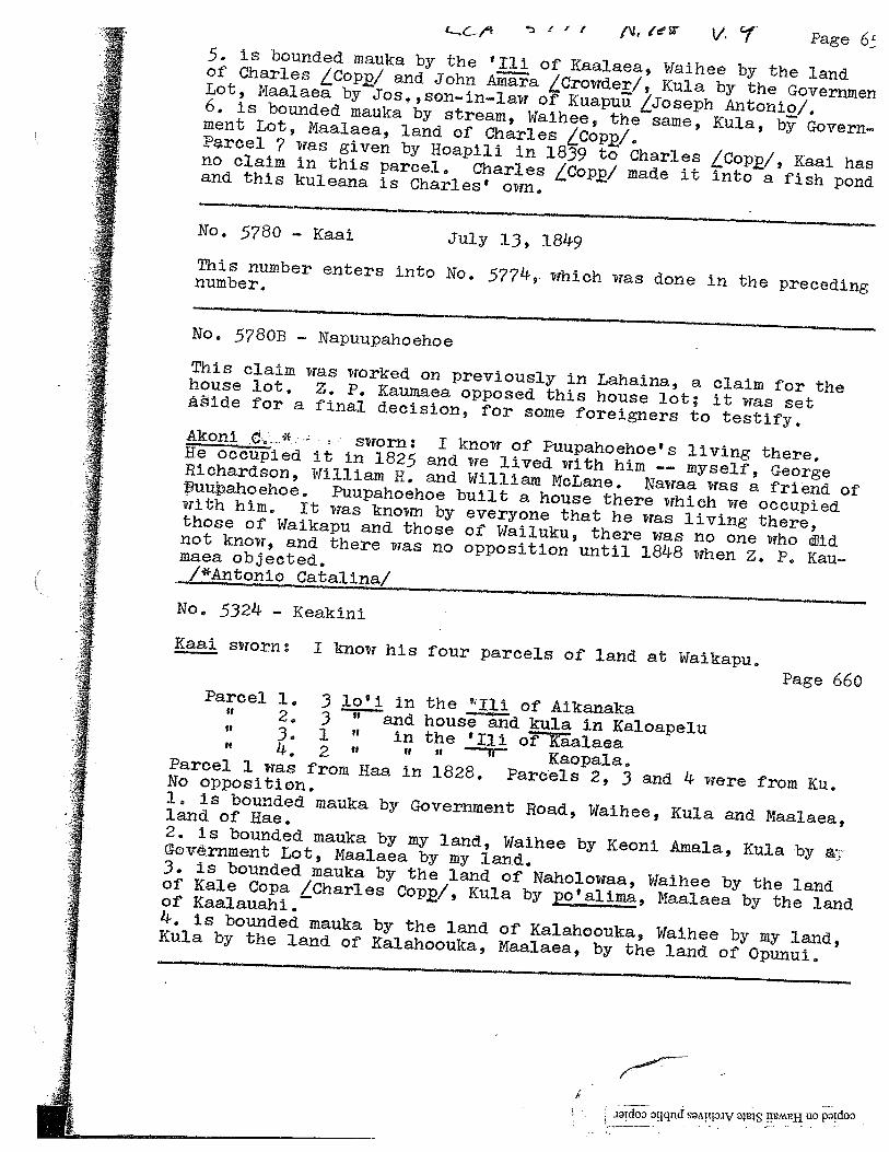
. ‘ ‘ , fJI (WPage 6
5. Is bounded mauka by the ‘Ill of Kaalaea, Waihee by the landof Charles Cop/ and John Aniara LCrowder/, Kula by the GovernmerjLot, Maalaea by Jos.,son-in—law of Kuapuu Joseph Antonio!.6. is bounded mauka by stream, Waihee, the same, Kula, by Government Lob, Maalaea, land of Charles LCop/.Proel 7 was given by Hoapili in 1839 to Charles LCoppj, Kaai hasno claim in this parcel. Charles LCopW made it into a fish pondand this kuleana is Charles’ own.
No. 5780 — Kaai July 13, 1849This number enters into No. 5774,. which was done in the precedingnumber.
No. 5780B - Napuupahoehoe
This claim was worked on previously in Lahaina, a claim for thehouse lot. Z. P. Kaumaea opposed this house lot; it was setide for a final decision, for some foreigners to testify.Akoni •d...*.: - - sworn: I know of Puupahoehoe’s living there,He oc led it in 1825 and we lived with him -— myself, GeorgeRichardson, William H. and William McLane. Nawaa was a friend ofuuahoehoe. Puupahoehoe built a house there which we occupiedwith him. It was known by everyone that he was living there,those of Waikapu and those of Wailuku, there was no one who idnot know, and there was no opposition until 1848 when Z. P. Kaumaea objected./*Antonio Cata11n/
No. 5324 — Keakini
Kaai sworn: I know his four parcels of land at Waikapu.Page 660
Parcel 1. 3 lo’i in the ‘l1i of Aikanaka2. 3 “ and house and kula in Icaloapelu3. 1 “ in the ‘Iii of Kaalaea4. 2 “ “ “ ft Kaopala.Parcel 1 was from Haa in 1828. Par6els 2, 3 and 4 were from Ku.No opposition.1, is bounded mauka by Government Road, Waihee, Kula and Maalaea,land of Rae.2. is bounded mauka by my land, Waihee by Keoni Amala, Kula by aGovernment Lot, Maalaea by my land.3. is bounded mauka by the land of Naholowaa, Waihee by the landof Kale Copa LCharles Cop/, Kula by po’allma, Maalaea by the landof Kaalauahi.4. is bounded mauka by the land of Kalahoouka, Waihee by my land,ICula by the land of Kalahoouka, Maalaea, by the land of Opunui.
.idootjqndsqv uo
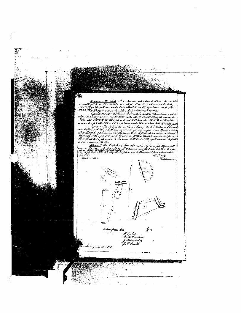
EXHIBIT 3
LAND COMMISSION AWARD 10481 TO NAPAILOI
LCAwNo.: 10481:1Royal Patent No.: 3131Grantee: NAPAILOI
Exhibits
Exhibit3-A: Copy of LCA 10481 and translation
Exhibit3-B: Copy of RP 3131
Exhibit 3-C: Foreign Testimony on LCA No. 10481 (v.7, p.508) indicates —
9 pieces ofland with several lois, a kalo and kula land, a house lot and akula wauke. Parcel 1 is a kalo and kula land in Paalae. Parcel 2 is ahouse lot in Waihalulu. Parcel 3 is 8 lois in Waihalulu. Parcel 4 is asection oflois in Kaopala. Parcel 5 is a section of lois in Kaopala. Parcel6 is 2 lois in the ill ofKamauhali. Parcel 7 is a house lot in Pikoku.Parcel 8 is a section oflois in Pakoloa. Parcel 9 is a kula wauke inPaalae. Additionally, Parcel 3 and 8 are bounded... “Waihee by thecreek ofKula’
Exhibit3-D: Native Testimony on LCA No. 10481 (v.9, p.692) indicates —
9 parcels in Waikapu with a total of3 taro pauku and 10 taro lois.Parcel 1. Taro pauku and kula at Paalae. Parcel 2 House lot and kula inWaihalulu. Parcel 3. 8 taro loi in Waihalulu. Parcel 4. Taro pauku inKaopala. Parel 5. Taro pauku in Kaopala. Parcel 6.2 taro loi inKamauhali. Parcel 7. House lot in Pikooku. Parcel 8. Taro pauku inPakoloa. Parcel 9. Kula wauke in Paalae.
Additionally, Parcel 3 and 8 are bounded... “Waihee by stream.”
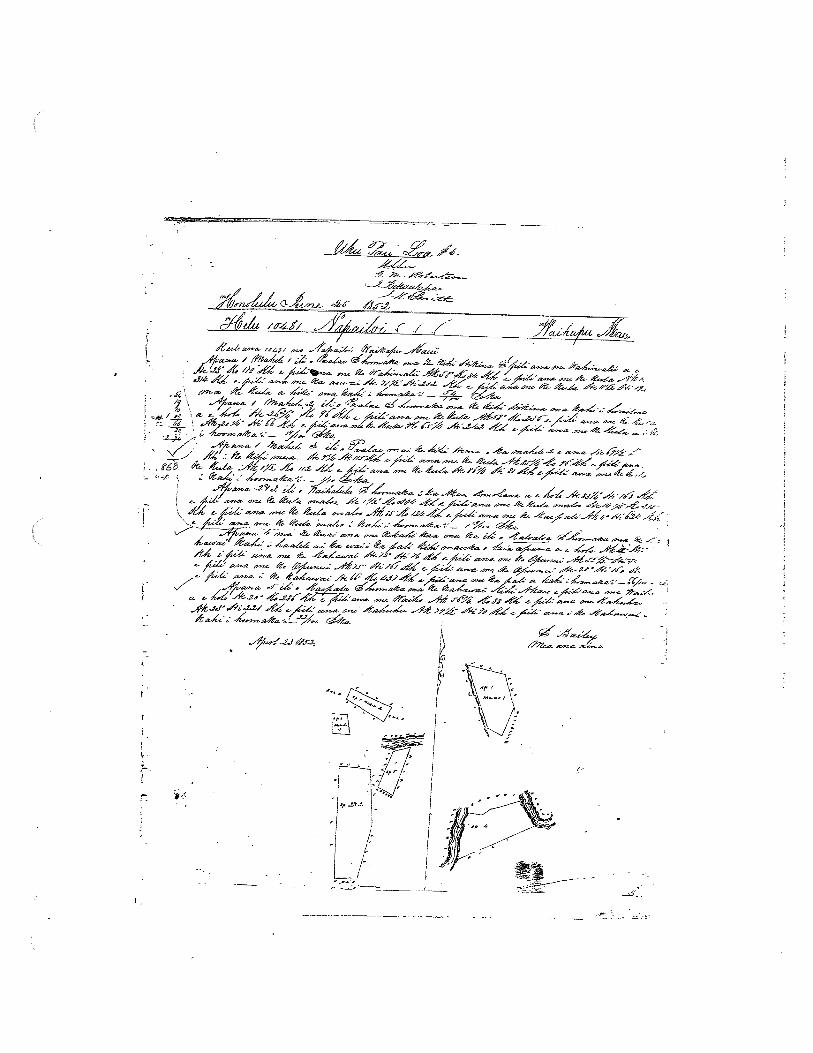
Exhibit 3-E: Survey Field Notes and Diagram —
show several parcels ofproperty with kahawais or auwai boundingsome ofthe parcels.
2. Survey Maps
Survey by E. Bailey, dated April 23, 1852 (see Exhibit 3-A, copy of LCA 10481; seeExhibit 3-E, Survey Field Notes and Diagram)

3. Mahele Use: Taro pauku, lois, kula, house lot
Flow Requirements Source: Waikapu Stream
4. Photographs: None
5. 1800’s Tax Records: None
ii
tLg
/ A —--tz ,,-r
14I/
,# — _4- —
A LW 1 ‘ s7ja’ -, __c_
J’4 .-cz - a.- -- ‘ .A --- a.
__
- •4 ,6/
/ .a. - %; —‘ - .Ei a.a. -a. t - -
- -:‘ ..
i4-__/_‘ _€- / i d_
‘aV- % .. a.•, / ft. 4
- . (68 61t £. 4 ,,.z
__
--ri —
I .4aa.a. 29
%... 4 S
,, —a.’.V
-
___
• ; — — ---. — - - .V V -laa’a. Aa.L - j-:V %, 6• 4• ,a .-1tAr A/di’s a.VV ç ‘6 .— p - Aa-a. ,,
V - -1a.,a. S4,
a- - %-4J’ , Jic_ -J, -‘ a.- -
V
JJ A’ a..a. -4%-- _-Q ‘j ..• %a%_ %•,-4 V
-
V

‘/lA(d7
ázar /7rn q# -
_________
_1._c;14
-i
‘I-4c;
f%rn-r / J,-r F ,,
-w -•
-
-
\ i$fl
\
\\
S’k
\‘ \ ‘ \ N \
I C S C C, C U’ U’ C
N r
\,
N
S
r C-
,— or
1—I
S
o iC
tiE C C U’’
C C C C PC C r C U’ C C C, U’,
C U’ “C PC Pr
0’ C S C C C ‘U’ U’ C ‘a 6 S Pr C
\N
5)
//
MaCho a- npnna 2
Ekea ci iki akQ a cmi iki mai paha. Ca koc aae I he aupuni na mine minerela a me an metnla a pan.No a 25; U
ci nina In i haawiia ma he ANO ALODIO a no kona mae hooihna, a me kona waihona; na pill taoha auhau a ha Pea Ahaoialo e han like ni ma an nina alodio I kela manawa I keia manawa.A i men a ikan ai, na han wan I ko’n lana, a ma ka Sila Nul o
Hawaii Pee Aloe ma Honolulu i kale Ia ,,frte ::/fS--6 ‘e
_x,; 4/:- fl/// / 7-- /r.7V
/-74/X/C//
/7 / / 7 --/ 7/ //;--
/7*: /z-fr:’ /7,
/Y--- yl 1e1’ 5
ywf 4j: /7
4t4./L. VL2/ -/ a / - 7*t?7t 34/%. 47
d
-si
,24i4: 7 1
/7%’’
/

;
ii
‘
th’
\}N
%\\
%\%
%.
\\
.
k •>
1.‘
—•..
..w
_,_
.....
.._•
I•
...
.....—
—.—
.,...
-V
1’H
1
Page691
3. is bounded mauka by Keliikoa, Waihee by stream, Kula by Kaai,j Maalaea by Keliikoa.
4. is bounded mauka by Kaai, Kula by Government Road, makai by thesea, Ukumehame by Nahau.5. is bounded mauka by Kaai, Waihee by Kekua, Kula by Pahanu,Maalaea by my land.6. is bounded on all sides by the land of Kaai.
No. 10481 - Napaeloi
Kaai sworn: I know of nine parcels in Waikapu.Page 692
Parcel 1. Taro pauku and kula at Paalae ‘Iii in Waikapu2. House lot and kula in Waihalulu ‘ “
3 . 8 taro lo I U
4. Taro paukii “ Kaopala “II 5 II I? I, ft II If
6: taro lo’i “ Kamauhali “
7. House lot “ Pikooku “ ““‘ 8. Taro pauku “ PaJ.coloa
9, Kula wake “ Paalae “ “
All these parcels were from Keaho in the daysfKamehameha I,No one has opposed him.1. is bounded mauka by Hakiki, Waihee and Kula by my land, Maalaeaby Ehu2. is bounded mauka and Waihee by my land, Kula by Huakini*, Máalaea by Government Lot.3. is bounded mauka by my land, Waihee by stream, Kula by Ehu,Maalaea by pali.4. is bounded mauka by my land, Waihee by Makal, Kula by ChareOopa Laharles Cop/, Maalaea by my land.5. is bounded mauka by Waiho, Waihee by Hakiki, Kula by Pulli,Maalaea by my land.6. is bounded mauka by Kekua, Waihee by ‘Ill of Punia, Kula byKekua, Maalaea by Naanaa.7,. is bounded by my land, Waihee by Paakai, Kula àid Maalaea byEhunul.8. is bounded mauka by my land, Waihee by stream, Kula by Koa,Maalaea by my land.9. is bounded on all sides by my land.L*J.
No. 3547 - Kaualua June 16, 1849
Ki.theleloa sworn: I know of one parcel in Waikapu and six parcelsin Kamaole in Kula.
Parcel 1. Taro pauku in Ohia in Waikapu2, Potato mala in Kamaole in Kula
U 3 ft I, ft ft ft
:: ;:
EXHIBIT 3-D
iidooqqnd sTtprJ img tIAHU0PTdO

1.
4.&
j,S
\S
S
I4
144
4+4k
I.3
j.
4,.
H4
+t
4*+
‘11+.—
4¼
+k
-..
4+
4+t
+-3
.
-4+
5+
,
c
;
H41’
.
.
0+4j2$
A).
41+
.:.$E..
A
4’,.5.,
,ø+
46.
M-
M
C)
iC
w.
-3N
4-.-
I
.3.,.
I4
-$
+*
425’
++
‘it
I‘
,
3
5,4+
2
S‘4_f
—_+
—.44+
—43
j,-’T
s.J
ts53
5,.,
+a
‘S4
—4-
4
EXHIBIT 4
LAND COMMISSION AWARD 8874 TO KANEAE
LCAw No.: 8874:1Royal Patent No.: 3130Grantee: KANEAE
1. Exhibits
Exhibit4-A: Copy of LCA 8874 (book 8, p. 223) and translation
Exhibit 4-B: Copy of RP 3130 (book 14, p.51)
Exhibit 4-C: Foreign Testimony on LCA No. 8874 (v.7, p.688) indicates —
4 pieces ofproperty in the iii ofKaloapelu, Waikapu. Nos. 1, 2, and 3 aresection oflois and No. 4 is a kula wauke.
Exhibit 4-D: Native Testimony on LCA No. 8874 (v.9, p.5O4) indicates —
four parcels in Kaloapelu, ill of Waikapu with Parcels 1,2 and3 beingTaro pauku and Parcel 4, Kula wauke.
2. Survey Maps
Survey by E. Bailey, dated August 26, 1852 (see Exhibit 4-A copy of LCA 8874)
3. Mahele Use: Lois, taro pauku and kula wauke
Flow Requirements Source: Waikapu Stream
4. Photographs: None
5. 1800’s Tax Records: None
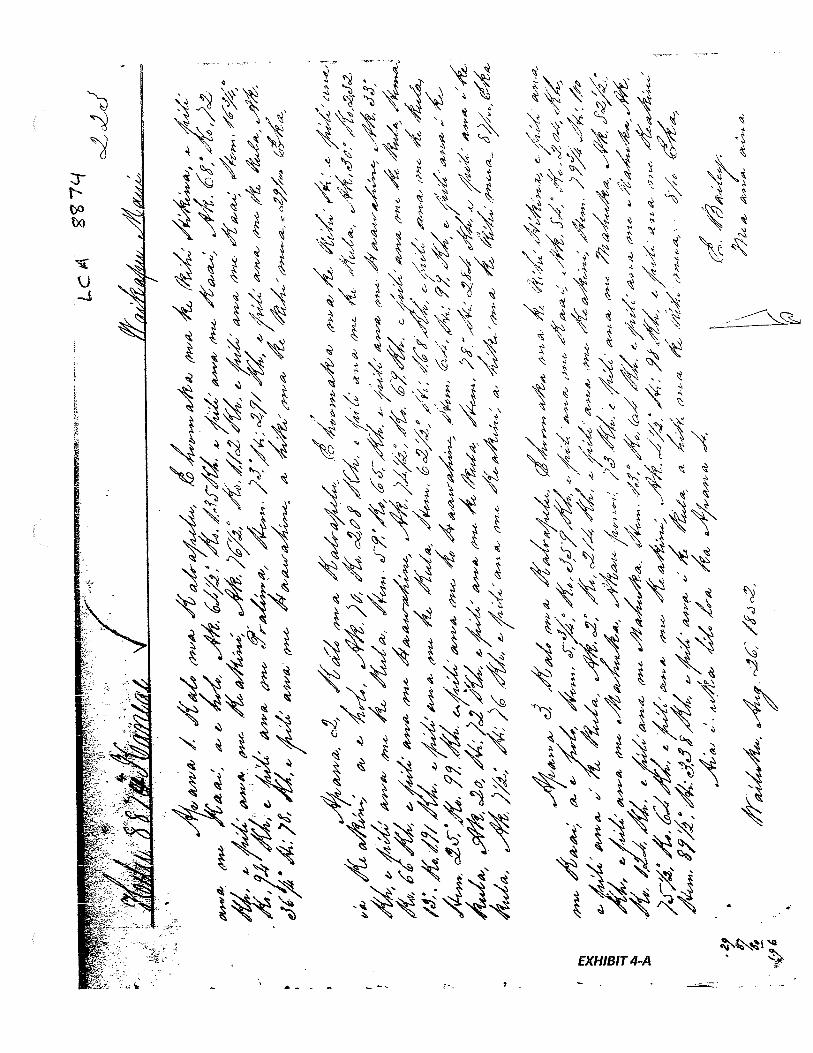
/-w-;‘
-
W-‘
47i4’
---
-
r
‘
2)/7
‘ic)
iy
‘‘%
o’g
,t6
-YX
/7
‘v4i/?
7,p
7,-y2‘
1”
72’
-,-
-,-
-) 7F
,7
V‘•-“
-‘vV,7
/?r
Vir
)4ø-
7D
/I
-‘‘7
-r
/‘r
Ø’
V7
‘
7?
y‘s
y2-
117
i-
‘777’
Y-
-7
LU
-
7,1
y-r
7p
y-
--W
z/
V‘‘
Wi*’
P’V
,
/r’
-‘
,
y7
‘2/pO4y
/‘
y4Z
>2
‘7
_v),f
//
-.
.r
‘-
?/
yi—7
-‘-‘,y
-Y’”’
5’
yrL
4?
‘1-U
41
44
‘r
y--
‘r‘
4V1
747-p/
-
47Z
),1/‘y
‘4i/,)
7V/
‘v
Vkh1371
-
V‘a
”’
__
-w
--
z,:5
?4/4
/‘7v7
—-v
-t41
71/
I
‘-:‘
I
//7,
,-
__
—
14
—;7A
_7•
27
-?-2
1A
fr*
-;4’
—//
141l77
/‘v
Vy
—
7’
/I—
,
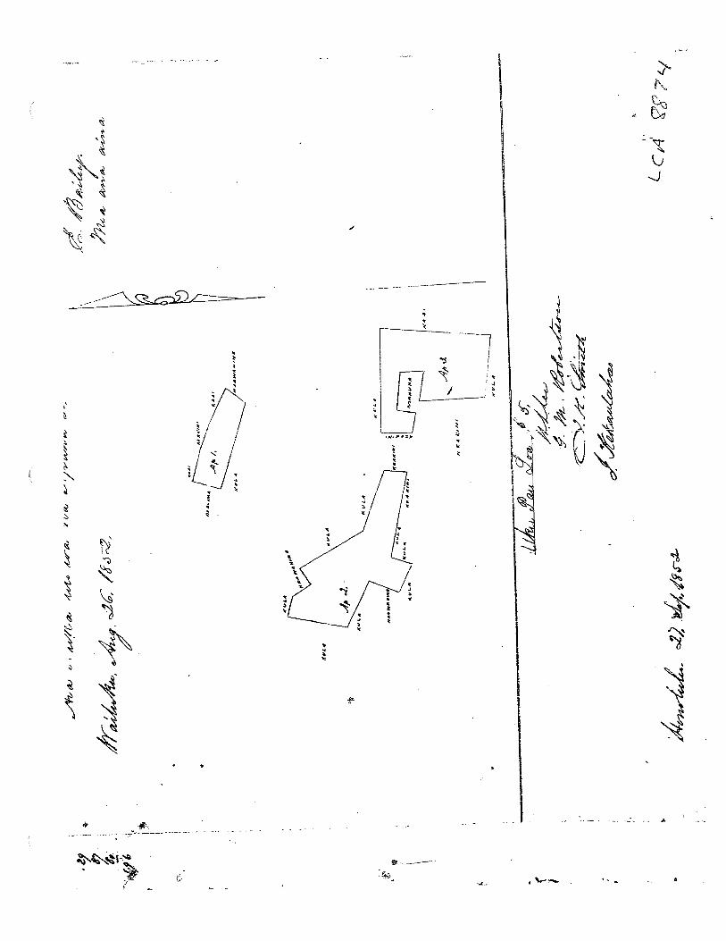
—1
-7:7
-
iq.
‘l7--$-2
fz’r4’
—,/,,
‘_.Y
y‘-1
1-
V-y-V
‘
‘4Vr7j
/77i
I,vy
p.
.744
Cl
4W
t
P.,,
V
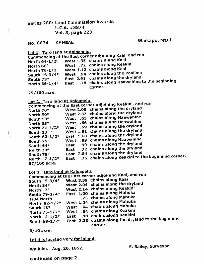
Series 288: Land Commission Awards
L.C.A. #8874Vol. 8, page 223.
No. 8874 KANEAE Waikapu, Maui
Lot 1. Tarp land at Kaloapelu.
Commencing at the East corner adjoining Kaai, and run
North 64-1/2° West 1.35 chains along Kaai
North 68° West 72 chains along Keakini
North 76-1/2° West 1.12 chains along Kaai
South 16-3/4° West .94 chains along the Poalima
South 73° East 2.91 chains along the dryland
North 36-1/4° East .78 chains along Haawahine to the beginning
corner.
29/100 acre.
Lot 2. Taro land at Kploapelu.
Commencing at the East corner adjoining Keakini, and run
North 70° West 2.08 chains along the dryland
North 30° West 232 chains along the dryland
South 59° West .65 chains along Haawahine
North 33° West 66 chains along Haawahine
North 74-1/2° West .69 chains along the dryland
South 13° West 1.91 chains along the dryland
South 62-1/2° East 168 chains along the dryland
South 25° West .99 chains along Haawahine
South 64° East .99 chains along the dryland
North 20° East .72 chains along the dryland
South 78° East 2.84 chains along the dryland
North 7-1/2° East .76 chains along Keakini to the beginning corner.
87/100 acre.
Lot 3. Tarp land at Kaloanelu.
Commencing at the East corner adjoining Kaai, and run
South 5-3/4° West 3.59 chains along Kaai
North 84° West 2.04 chains along the dryland
North 2° West 2.14 chains along Keakini
South 79-3/4° East 1.00 chains along Mahuka
True North .73 chains along Mahuka
North 82-1/2° West 1.24 chains along Mahuka
South 13° West .64 chains along Mahuka
North 75-1/2° West .64 chains along Keakini
North 4-1/2° East .98 chains along Keakini
South 89-1/2° East 3.38 chains along the dryland to the beginning
corner.
8/10 acre.
Lot4 is located very far inland.
Wailuku. Aug. 26, 1852. E. Bailey, Surveyor
continued on page 2

tAL ‘a
J /,
A
4’ £‘L 4
I ‘‘
I( 4 IV1
Total fees $5.00Wi. LeeGM RobertsonJ:H. SmithL Kekaulahao
Honolulu. 27 Sep. 1852.
Page2LC.A #8874, continuedSeries 288: Land Commission Awards, Vol. 8, page 223.
/
( L’ i_A
Translated by: Jason Achiu, Hawaii State Archives. 1/2012
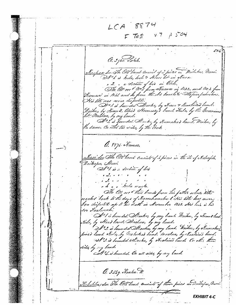

Page 6872. is bounded mauka by Kaai, Waihee by Kaai, Kula by Chare Oopa/Charles Cop/, Maalaea by Kaa:Lauahi,3, is bounded mauka by Kahakumakaai, Waihee by Kawana, Kula byKaai, lviaalaea by Ihuole,4. is bounded mauka by Keakua, Waihee by Kalli, Kula and Maalaeaby Kawana.5. is bounded mauka by Keliikoa, Waihee by Kawana, Hula and Maalaeaby Nakuakane,6, is bounded mauka by Waiho, Waihee and Hula by stream, Maalaeaby Kalahoouka.7, is bounded mauka by Keawe, Waihee by Hula by the‘Iii of Kaopala, Maalaea by Haa,R, is bounded ma,uka by Kamakaipooa, Waihee by p, Hula by stream,Maalaea by9. is bounded mauka by Kaaiauahi Waihee by pp.li, Hula by Kaalauahi, Maalaea by tali.
Page 68810. is bounded mauka by Kaai, Hula and. makal by Koahuwale, Ukumehame by Kaai.11. is bounded mauka by Keawe, Honuaula by Luukia, makai by Mahi,Nakawao by Ku ih ewa.
No, 3106 Kapuaaiawa July 16, 1849Karnakal sworn: I know of one parcel of taro mo’o with six lo’i,in Kaopala ‘Ill in Waikapu, It is combined with a house 1t. Hereceived it from Puhi in 1838. He died in June of this year of1849 and his widow., Kahoakuanui is his heir, No opposition,It is bounded mauka by Kahakumakaai, Waihee by stream, Hula byKoahuwale, Maalaea by Kalahoouka.
No. 2980 — Pakele
Kekuapaa sworn: I know of two parcels in these ‘ills in Walkapu;Parcel 1. Taro rno’o and house and kula ii KaThi.2. Taro pauku in the ‘Iii of Olohe.The first parcel was from Kaawa I832, and the second was fromKamai in 1841, Kamai received it from Puupahoehoe, The po’alimasare separate,1. is bounded mauka by Kaaua and Konehia’s land, Waihee by Komohaole /Heess/, Hula by Government Lot, Maalaea by my land.2. is bounded mauka and Waihee by Kmakea, thether two sides byWailpu stream,
No. 8874 Kaneae
Kaai sworn: I know of four parcels in Kaloapelu ‘Ill in Waikapu:Parcel 1, Taro pauku Parcel 3, Taro pauku“ 2.“ 4. HulaAl]. his parcels were from his makua.
EXHIBIT 4-D

/J7 qPage 689
This makua of Kaneae had received these places from Haa. Kaneaedied in48 and his heir is his keiki, Kaalauahi, There is noaima in these parcels and no opposition,1. is bounded mauka by my land, Wathee by Koma, Kula by Haa, Maaiaea by Kaai also.2. is bounded mauka by my land, Waihee by Kamakaipooa, Kula byMahuka, Maalaea by Keakini,3, is bounded mauka by Keakini, Waihee by my land, Kula, the same,Maalaea, the same,4, is bounded all around by my land.
No, 3549 Keaka July 16, 1849
Kuheleloa sworn: I know of three parcels in the ‘Iii of Puhau andthe ‘j of Olohe in Waikapu,
Parcel 1. Taro in Puhau
3, “ “ OloheParcels 1 and 2 were from Napuupahoehoe before the days of Kameha—meha II, Parcel 3 was from Keaho in the time of Kamehameha I,One I o ma1and the lo’i pahao is in the flrst parcel. Twolo’ippalima are In parcel 2. Three loLpp’a1ima are in parcel3. She has occupied these in peace, with no opposition from anyone.1, is bounded mauka by Kapule, Waihee by Kekua, Kula by Kepaa,Maalaea by Pepeiaopili and Wahlnealii,2. is bounded mauka by stream, Waihee by p, Kula by George Shaw,Maalaea by stream.3. is bounded mauka, Waihee and Kula by stream, Maalaea by
No. 5284 Kahuhu
Kaai sworn: I know of five parcels in the ‘Ills of Kaopala andKealia, in Waikapu,
Parcel I. Taro in Kaopaia2, 3tarolo’i3, 2 “
4, Salt mo’o in KealiaH 5 ft — U ft
Page 690
Parcels 1, 2, and 4 were from his mçuas, and his received them from Keaho in the days of Kamehameha I. Parcel 4 wasfrom Puupahoehoe in 1846. No opposition.1. is bounded mauka by Kaohi, Waihee by stream, Kula and Maalaeaby my land,2. is bounded mauka by Hakiki, Waihee by Kahoomacha, Kula by Kaohi, Maalaea by my land.3 is bounded mauka by my land, Waihee by Kahoomaeha, Kula andNaalaea by my land,4, is bounded mauka by my land, Kula by my land, makai by the sea,Ukumehame by Niaupio.5, is bounded mauka by Puupahoehoe, Kula by Puhi, makai by the sea,Ukumehame by Kaheemalu.
EXHIBIT 5
LAND COMMISSION AWARD 10160 TO MAHOE
LCAwNo.: 10160:1Royal Patent No.: 3148Grantee: MAHOE
1. Exhibits
Exhibit 5-A: Copy of LCA 10160 and translation
Exhibit 5-B: Copy of RP 3148
Exhibit 5-C: Foreign Testimony on LCA No. 10160 (v.7, p.506) indicates -
4 pieces ofproperty in Waikapu. No. 1 is a section oflois and kula inAhuakolea. No. 2 is 3 lois in the iii ofKanaka. No. 3 is 1 loi in the ill ofKikia. No. 4 is 1 loi in the iii ofKikia.
Exhibit 5-D: Native Testimony on LCA No. 10160 (v.9, p.690) indicates —
Four parcels in the ilis of Waikapu one parcel with a taro pauku andthree parcels with lois. Parcel 1. Taro pauku, kula and house inAhuakolea. Parcel 2. Three lol in the ili ofAikanaka. Parcel 3. One loi inthe ili ofKikia. Parcel 4. One loi in the iii ofKikia.
2. Survey Maps
Survey byE. Bailey, dated April 16, 1852 (see Exhibit 5-A, copy of LCA 10160)
3. Mahele Use: Taro lois, taro pauku, kula, house
Flow Requirements Source: Waikapu Stream
4. Photographs
None
5. 1800’s Tax Records
None
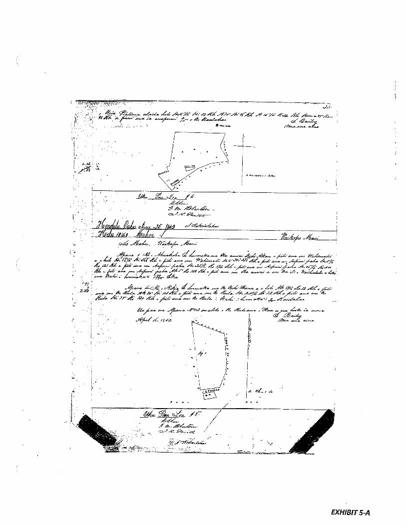
- . - ..C•. L/ _‘/.r>& 4a _ ‘a-trS- ft .t a - *
- 5 an.. aSna
a.•y: a.c-
.JA fzi o/e4aA
.Aa4. ityYitAaAa 4zc;
ttS.. .4Ln4’.4’n4f4C.... n.. Ft. L-4an- yCC —• L’ 44?. rr’ A’scT& nZ øn.s _c_/a. trjç£ £tI SC -/4a.t in— %a44 —4ss± %E.% .#(t/&an — fs7J,, -•1 f‘t17Z t&ff’ — — - — n- — m—.a a__
Aan £ct c4a — a 4na a •
at £( mt ;,- jnt 4 t4 t 2S>0CZ-— n.. it
I- Lu’ .4 fl’-dt /-O/at6z-.a an— 4 .4 - á.%
j<. ,Ca-. a—. .4Laa .S9’af ,n.a44 - at 4.tz-a.. - a.— n. :- a-/ •
•-
‘S rz I ana
EXHIBIT 5-A
hikd,g .SaJn /
r

:1

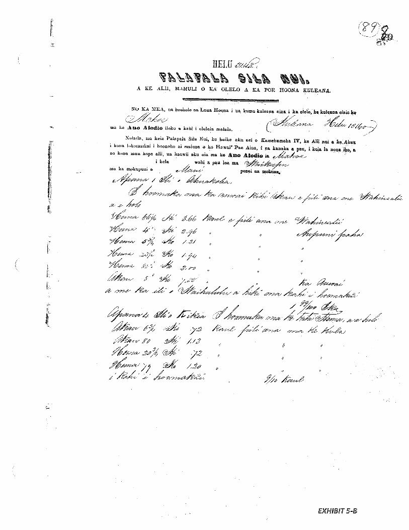
[
flELU
A KE ALU, MAMULI 0 KA OLELO A KA POE HOONA KilLEANL
/%
_/- ‘ ;;i2
‘ /9
- -
No KA MEA, us hoohølo as Luns Hoona i us kumu kuIean aiaa i ka o1e1o he kulçana oiaio k
ma ke Iodio iloko e kahi i oleloia malalo. LNolaia, ma keia Palapala Sila Nui, ke hoike aku nei o Kinehtmeh 1V he AliL am a keAkua
t kona lokoinaikai i hoonoha si maluna o ho Hawsi’ Faa Ama, I na kaaaka i pea, i kale 1 wia iho, ano kona man hope alii, us haawii sku oia ma he Ane Alodlo za
I kale wahi a pac tea mama ha mpkupuui o penal Se rnekuu,
J E’
__
j4‘
ij;-,- --
—
--
-2
2-’
f
0
EXHIBIT 5-B

Malcko oot-a. apana
Ekaa ci iki aku a cmi tin met paha Us kite nac i La aupum as mine minerela a me na metcla-a panNo
us ama Ia i haawna ma La ANO ALODIO a no kona mac houtlma a mc Lone waihona us pill useka auhan a La Poe Ahaolelo e kau like at ma as ama alodto z kela manawa i Lets manna.Aimeaetkeaai uaiauwauikouxnon amekaSilaNmoko
Hawaii Pee Ame ma Honolulu i kata Ia0 is6c-.
S / -
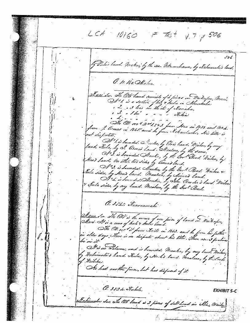
M:
I [%
\
.1‘
kiN
r(ç\
\c
s
‘‘
A
i.
.x
\N• 1
s•%
\‘
\%
‘i?
\
\\
‘ri’1
1. F’
? 4.
No. 10160 — Nahoe July 16, 1849 Page 690
Kaai sworn: I know his four parcels in these ‘llis in Waikapu:Parcel 1. Taro p.uku, kula and house in Ahuakolea
2. Three lo’i in the ‘Iii of Aikanaka3. One lo’i in the ‘Iii of Kikia
U 14. U U U li 1* II
The first parcel was from Huakini Paniolo Joaquin Spariiard’?*/,Parcels 2, 3 and 4 were from Haa in 1838. No opposition.1. is bounded mauka by &iu, Waihee by my land, Kula by Huakini *,
Maalaea, the same.2. is bounded mauka by Government Road, Waihee by Haa, Kula byNehi and Aiona Pake /Chinese/, Maalaea by Aiona Pake also.3. is bounded mauka by Government Road, Waihee and Kula by Haa,Maalaea by Alona Pake.4. is bounded mauka by John Amara LJohn Crowde/, Waihee and Kulaby my land, Maalaea by Government school house.L*See Foreign Testimony, Vol. 7, p. 506: J. Armas/
No. 3545 - Keaweamahi
Manu sworn: I know of one parcel, a taro mo’o and kula in PalamaT111 fl Waikapu. He received it from Kaili in 1843, who had received a very long time ago from my makuakane. Three lo’i po’alimaare in this parcel. No opposition. It is bounded mauka by my land,Waihee by Wahinealii, Kula by Eaole, Maalaea by stream.
No. 3524 — Kahele July 16, 1849 Page 691
Kahiewalu sworn: I know of two salt no’ o at Keal ia in Waikapu.He received thse parcels of salt land from the makuas of hiswahine in 1842. There is no opposition.1 • is bounded mauka by Napuupahoehoe, Kula by Kanakaloa, makai bythe sea, Ukumehame by my land.2. is bounded mauka by Napuupahoehoe, Kula by- Emelia, makai bythe sea, lJkumehame by Maka Piliwie, hapa haoie Lhalf foreigner!.
No. 2609 - Pbepoe
Napaeloi sworn: I know of six parcels in these ‘his of the Ahupua’a of Waikapu as follows:
Parcel 1. Taro pauku in the ‘Ili of Kaalaea2. No taro lo’i “ “ “ Olohe3. One “ U “ Pikooku4. House lot U Maalaea
11 5 Potato kula “ “ Kaalaea6. Kula wauke U H
All his parcels were from Keaho in the time of Kamehameha I. Poe-poe died in 1848 and his wahine, Ihuo].e, is his heir. These havebeen occupied in peace, with no opposition from anyone.1. is bounded mauka by Icekua, Waihee by Naanaa, Kula by Opunul,Maalaea by Pohanu.2. is bounded mauka by Kaai, Waihee by Kekuku, Kula by Kekuku,Naalaea by Peu.
EXHIBIT5-D
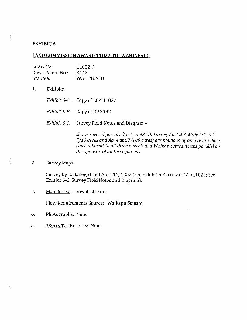
EXHIBIT 6
LAND COMMISSION AWARD 11022 TO WAHINEALII
LCAwNo.: 11022:6Royal Patent No.: 3142Grantee: WAHINEALII
1. Exhibits
Exhibit 6-A: Copy of LCA 11022
Exhibit 6-B: Copy of RP 3142
Exhibit 6-C: Survey Field Notes and Diagram —
shows several parcels (Ap. 1 at 48/100 acres, Ap 2 & 3, Mahele 1 at 1-7/10 acres andAp. 4 at 67/1 00 acres) are bounded by an auwal, whichruns adjacent to all three parcels and Waikapu stream runs parallel onthe opposite ofall three parcels.
2. Survey Maps
Survey byE. Bailey, dated April 15, 1852 (see Exhibit 6-A, copy of LCA11O22; SeeExhibit 6-C, Survey Field Notes and Diagram).
3. Mahele Use: auwai, stream
Flow Requirements Source: Waikapu Stream
4. Photographs: None
5. 1800’s Tax Records: None

liel,t 4Ua koi mal e no wahi m
€
74’mea, ua baa Ia kela keztwahi Ai- o’ 4.
a ua noho keakea ole ia a hiki I keia inanawa.
Ola ka maJou e hooko nei no
.ma4e ano Alodio Tn-p-nIni ni ni i kt ki’ AiipuuLhapa
ka pR1RpRIR-f4iIk Ahidiri.
Pono nae ía ía kenkuni ka hookolokobo a me ka hooholo ana I ka olelo. Pond,
F j4Z °‘ I -
Noi.op aiw,i ka oldo kaiouo wiao
Noka k laI
!ke.:::i’*1aanahaike,
: :1 IZ’1&iàAa
___
Eia na palen&, td t(z,..’ -
tZs co iØo€2e€e.&.. t:qDtw€ 4-6 Qizi 4/:
g iódo/7,I €2o ô.a’. a. 4 4, SJ—
4
.
.5’
-I..
1-.,3•.
I-. .
J.I
.
- .
Jizt44*
,,. -. 1..“1 -
‘F—’ .. -, -
-
- h9
• ::1aL...—-. • 2
2.J?O..O. ,
?2 .—-- - ,, . 2
.5F-—
.. /
-,
?OU,7 . •., 2
‘F-. , - : -, -• 4Lf. .-‘• . .
: ,— . *
14‘ ‘ /J1ZcL? -f-J / / . .
-. a .. , . .,
..
- r. .;*. . ••‘ -:
no ka
lie kulcana Ift;i
aIiiIt, uubr
‘li-n:
r ,
4. s
4.
-
iyi
e7 g•1?3g
/ñ’1
.-,
4:
.
- *s2gg/
•,
..-‘,
•.i ‘,:‘
‘.
EXHIBIT 6-A
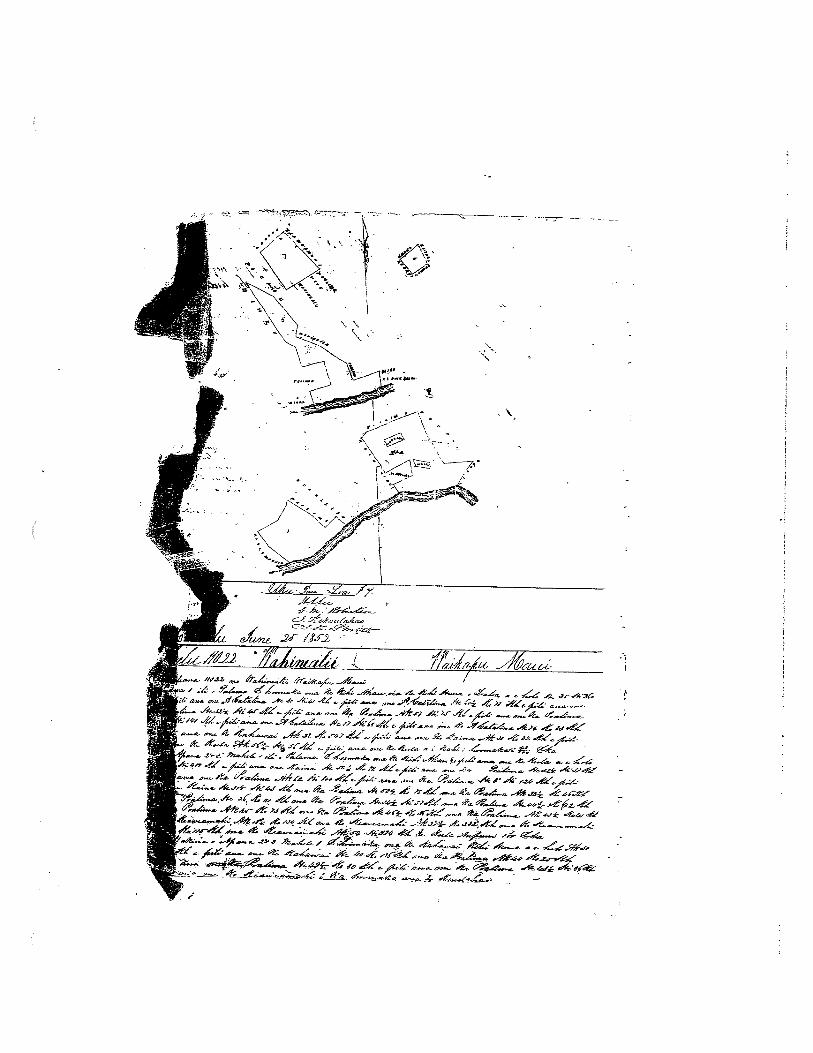
k‘á. 444 4.4
‘. % .‘,-,
A.Wx .4éi —
4 44 .-4ixt ... 4 4.A .rf’ .-I;€: t4:
- ,-. ‘- -‘ . — -4..— _1-___ 4 - ..t -‘.-- -‘4
4 4 .4j *‘ -24 - 7f 4
4’ , _4,- _1--,c’ -.-- €‘‘ .444 ‘J 4 4Z .-46- .4 4
t:q, ..e .4- . .ts’a 4.%, 4
.44 j-.E7.4 Pf-- s’..
__
.z4-
- —
- -- ..-—-.-- ------ —.--—-..-z----——- —-- - -
1
u1i2.
fl1Z1LWZát i%4t /i7/f
‘I
II

—,
•
_______
Ai& ):,fP .,/-‘2/fjf ••- )%/•
•
_____
v- rI•_J
(4- — t ref— —
- -2e .—‘ -.,,
[a 1k
_______
r•-•--% -e 9’e%’
,4,_ -‘% —f’ z,4/_- 3’i2 --
-t7 ‘‘
- ,ç 4_
.1
1•1
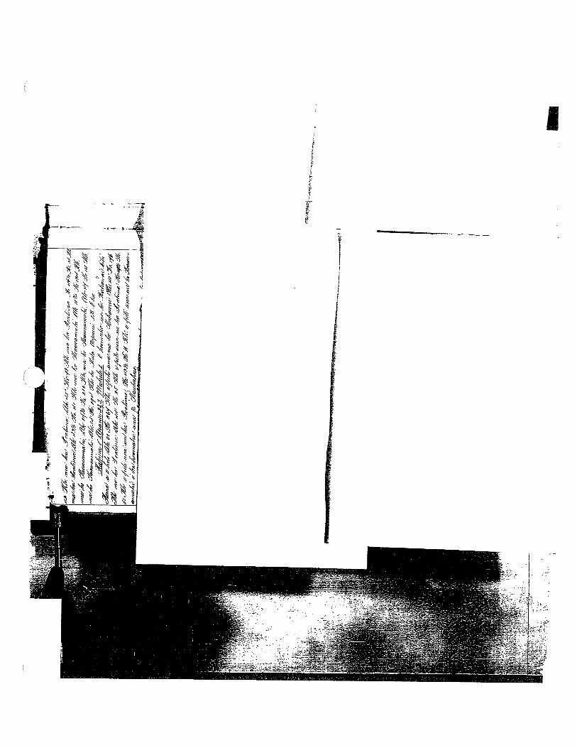
1.
//
4/%
‘i7%
./M
j;
,a’
4-‘‘L
’/f#
,,,,
4ç4i#
-
t7a%
%//“‘
A##t’
øi;
,ø’a
,Ø,,w
%/:r’/’
ftS4w
.%1H
->
-

4.-”k 4S 4
°*-4 4 6
-Aa* 4p..a 4.
a.a ant Seaw.4 .‘4nr ti:a’ at d,Lt.’.-4fli4 a A,-c... .Ai;’t t4fC C’anL4d cp4d ,a a’._4.d —4 a ta,a1 .sct, Ac Ct4t4-9tO4- -. &&naj tj._ S i’/c-a._.4‘--‘- -1 ta.& e• , - .• a t-a —- - -,Maa — eo’S- .t -w%c At.c2— ,4.nfl n..t -tn4 ..4as za a’ ant & -&aant- - - 4 tt—
-. 4 -• In
• IA
I:
ot-e %>
1”
I 4•St AI &
--
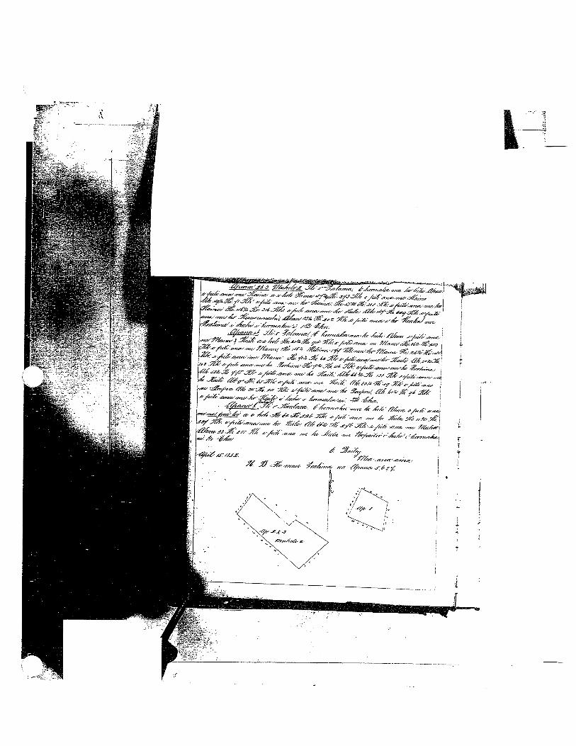
,rccn,a nrátmanI74t“‘-— --tC-o’ectnj .a,c.c,na%,IS .ndYS €a-S ItZt6ay
%2 ca.e.s,.na%i 4Sa’ 41S tStf St/<e a t’a’S&4/c- /7arnn/a ‘St%ann>t/ 14;r ,gi,f4crnazSzn,aS .Ja;fl%ac ann.tflLtfA’Ss/etana/.nr tflf&’affflSaZ,
cfrta.a-rnc-f/4er&’ eC s’fl
£,ts /4a4nX[,is 9ta/aX ana’-,a” eCS” ay tdana’.aczt £LdUsfzsyyrS c/atnzn .nc6 S€Z ,CakS‘;fSs/ofrtn eCea’ Yá/ae;0.aa cSyena a —‘s - n -.-‘- %h{-ai /‘%‘y iW
a rnsa%.wzjZttnavX XrcSretaea. Innrr%r -6 c?f a/at anc
L .lrá nr 4 545 -et- frsy52hcáZcnanea 4 54 eflZV& SZtyJ 5—S>/rM1-.wnz. ncSrn S -,46 4 5-4 J4c;e-56/t--5-flta42 j
4F
s-c .43anez- -,-€cj-/
I-
ft
S
1-
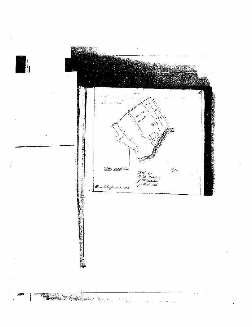
,—
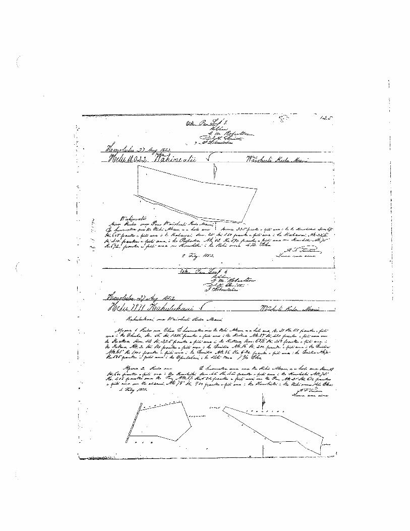
,
.A 4a ,,.. .‘Jb/ - £ £
j . — /:- /..--,t.4 f4 4Q’—-
-/ —“ - -
f —
— /‘
c--
iL ,>/// 47 Jdja,;
— -
/ %:_ — 6_., d%4,“ d/.4. L/. 4-. .JC 4; -
-.4%... _;L j. .
/.4. 4- 4-.-/ %-c .%_ 6.K .‘— — i,-4-
. f4 — —.--: .4.
‘ /‘-‘-/
/ -
LI/I7jJ, 4—-. --

0p3
0
ED P0 p p
.0 0 p.
C
3,‘
S
‘\
cr
%
%3
at V
t
*
\
‘4’
H
Ou
cri
11 °to
’}
.w_
f:s
isto -l Sn to
H
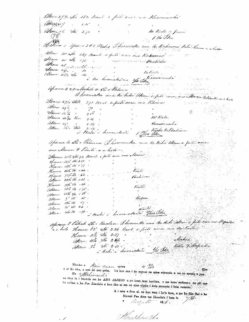
, p
I’
Q‘N
Pr
Pr
1;i*’
—r
w
1tr
ff!
\\
INtP
H‘&
‘\
‘N
‘‘N
c.
‘N“
‘‘
‘\\
‘\
‘.
•‘N“
‘N
‘‘
‘
‘.
:h’
“‘F
N\
L‘
;j
N‘:
N
‘\
\i c
FH.
‘jHi
.
‘NN
‘
.
NIL
0
?k
I (1
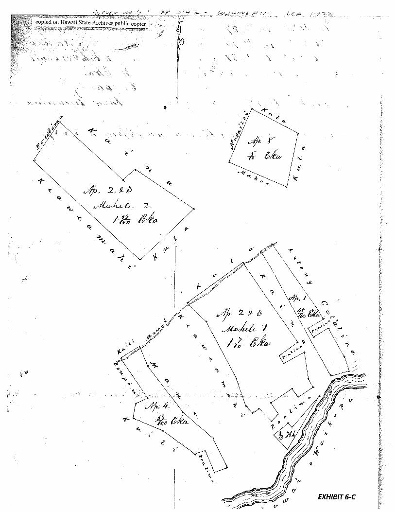
-
4-
-
.0
-F
C
to
c.)I.-.
,‘fr
A’
4
0’
0’,1
01
V
j
0’
k
EXHIBIT 7
LAND COMMISSION AWARD 5324 TO KEAKINI
LCAwNo.: 5324:3Royal Patent No.: 6374Grantee: KEAKINI
1. Exhibits
Exhibit 7-A: Copy of LCA 5324
Exhibit 7-B: Copy of RP 6374
Exhibit 7-C: Foreign Testimony on LCA No. 5324 (v.7, p.469) indicates -
4 pieces ofproperty. No. 1 is 3 lois in the iii ofAikanaka. No. 2 is3 loisand kula and house lot in Kaloapelu. No. 3 is one loi in the iii ofKaalaea.No. 4 is 2 lois in the ili ofKaopala.
Exhibit 7-D: Native Testimony on LCA No. 5324 (v.9, p.660) indicates —
4 parcels ofland with lois. Parcel 1. 3 loi in the ill ofAikanaka. Parcel 2.3 loi and house and kula in Kaloapelu. Parcel 3 is 1 loi in the iii ofKaalaea. Parcel 4. 2 loi in the ill ofKaopala.
2. Survey Maps
Survey byE. Bailey, dated April 24, 1852 (see Exhibit 7-A, copy of LCA 5324)
3. Mahele Use: Lois, house lot, kula
Flow Requirements Source: Waikapu Stream
4. Photographs: None
5. 180 0’s Tax Records: None

JJjJ
Fh
‘ / / M / / —
/ ‘7 -
‘/
£. ‘,-..-
_
--.- A.
,-,
. c -
4.-7t‘ _/4. - -(—- c -‘-
-,‘----,, — A./4-. ,‘j
it 4 -‘i’,. A. - -- .- 4’ r.r - d 44-i3r4 4P -
1j .% a — A - / -
L .— ‘. -- — - 14.
_
4’ a’. -
46S,’ -J/ —-— ‘—-- 4-, ‘.- —-- 4{- —. A- - —--
—-‘.-----
4 — A. - .4 - A.a- , — A.f-.
-“-“ —-—-- — ‘—--- -—‘ --1/— - ——- —‘-‘-A# - —. .a
L4 ‘‘-Z
4
./;__(_ _/‘
EXHIBIT 7-A

fry ci C C C C C C fri
ci
4.
%
Malcko o Apana 3 Eka
a oi iki aku, a emi iki mai paha. Ua koe nae i. ke A niniue minerela a me na metela a pau.
So
iia ama haa ia ma e Ano Alodio a no koa mau hooihna a me kona waLhona ua pl na ha auhau
a ha Poe Ahaolelo e kau like ai ma na ama alodie j kea manawa i keia manawa.
-
A I MEA IKE AI ua kau.au i ko’u inoa, a me ha Sila ui o ho Hawaii Pac
Ama ma Honolulu i keia l.a o 187a
,iA?
fff

1%
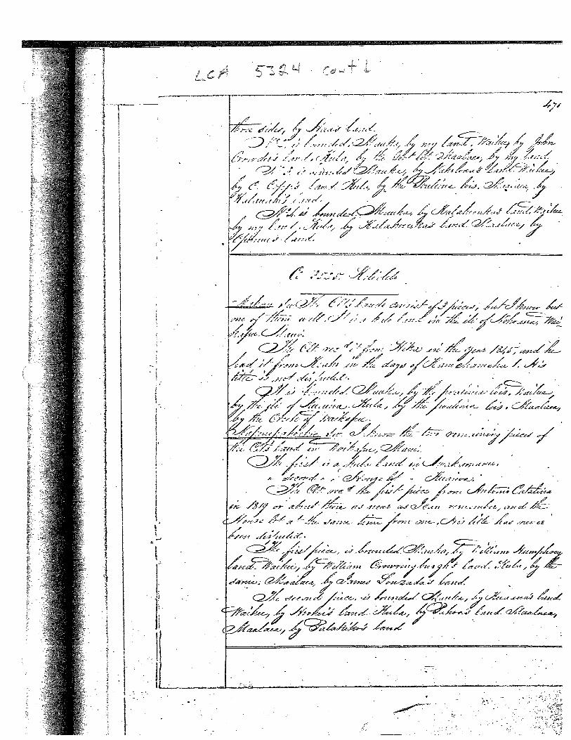
N
•.
Jfl’
.N
NN’
NX
flN
’¶f
l‘
V1W
‘N’
PC’ tJ*ç 9’ r

i’
Page 6595. is bounded mauka by the ‘Iii of Kaalaea, Waihee by the landof Charles Cop/ and John Amara tCrowder/, Kula by the GovernmentLot, Maalaea by Jos,,son-in-law of Kuapuu LJoseph Antonio!.6. is bounded mauka by stream, Waihee, the same, Kula, by Govern-merit Lot, Naalaea, land of Charles Cop2/.Parcel 7 was given by Hoapili in 1839 to Charles LCopp/, Kaai hasno claim in this parcel. Charles LC0pW made it into a fish pond,and this kuleana is Charles’ own.
No. 5780 - Kaai July 13, 1849
This number enters into No, 5774, which was done in the precedingnumber,
No. 5780B - Napuupahoehoe
This claim was worked on previously in Lahaina, a claim for thehouse lot. Z. P. Kaumaea opposed this house lot; it was setide for a final decision, for some foreigners to testify.Akoni *;- sworn: I know of Puupahoeho&s living there.He ocüpied it in 1825 and we lived with him —— myself, GeorgeRichardson, William H. and William McLane. Nawaa was a friend ofThiupahoehoe. Puupahoehoe built a house there which we occupiedwith him. It was known by everyone that he was living there,those of Waikapu and. those of Wailuku, there was no one who idnot know, and there was no opposition until 1848 vthen Z. P. Kaumaea objected./*AntOnlo Catalina!
No. 5324 - Keakini
Kaai sworn: I know his four parcels of land at Waikapu.Page 660
Parcel 1. 3 lo’i in the “Iii of Aikanaka2. 3 “ and house and kula in Kaloapelu3. 1 in the ‘ill ofKaalaea4. 2 “ “ “ H Kaopala.Parcel 1 was from Haa in 1828. Parcels 2, 3 and 4 were from Ku.No opposition.
1, is bounded mauka by Government Road, Waihee, Kula and Maalaea,land. of Hae.2, is bounded mauka by my land, Waihee by Keoni Amala, Kula by :Government Lot, Maalaea by my land.3. is bounded mauka by the land of Naholowaa, Waihee by the landof Kale Copa LCharles CopB/, Kula by po’alima, Maalaea by the landof Kaalauahi.4, is bounded mauka by the land of Kalahoouka, Waihee by my land,I Kula by the land of Kalahoouka, Naalaea, by the land of Opunui.
I
EXHIBIT 8
LAND COMMISSION AWARD 3527 TO KAMOHAI
LCAwNo.: 3527Royal Patent No.: 3156Grantee: KAMOHAI
Exhibits
Exhibit8-A: Copy of LCA 3527 (v.8, p.231)
Exhibit 8-B: Copy of RP 3156 (v.14, p.105)
Exhibit 8-C: Foreign Testimony on LCA No. 3527 (v.7, p.502) indicates -
11 pieces ofproperty. 10 ofwhich are in Waikapu and one in Kula. “No.1 is a section oflois and kula in Kaloapelu. No. 2 is a section oflois inKaalaea. No. 3 is a section oflois in Kaalaea. No. 4 is a section oflois inPunia. No. 5 is 2 lois in Punia. No. 6 is 2 lois and one kula in Kaopala.No. 7 is a house lot in Punia. No. 8 is a kula land in Kamauhali. No. 9 isa kula wauke in Kalaopelu. No. 10 is a moo ofsalt land in Alia. No. 11 isa kula in Kamaole, Kula.” Additionally, No. 6 is bounded by stream -
“Waihee by the creek and Kula, by the same”. No. 8 is bounded “Kula bythe creek’
Exhibit 8-D: Native Testimony on LCA No. 3527 (v.9, p.686) indicates —
a total of11 parcels, ten in Waikapu and one in Kula. Four parcels havetaro pauku and two with lois. “Parcel 1. Taro pauku and kula moo inKaloapelu. Parcel 2. Taro pauku in Kaalaea. Parcel 3. Taro pauku inKaalaea. Parcel 4. Taru pauku in Punia. Parcel 5. Two loi in Punia.Parcel 6. Two loi and kula in Kaopala. Parcel 7. House lot in Punia,Parcel 8. Kula wauke land in Kamauhali. Parcel 9. Kula wauke land inKaloapelu. Parcel 10. Salt moo in Kealia. Parcel 11. Potato mala inKamaole, Kula.” Additionally, Parcel 6 is bound ‘Waihee and Kula bystream” and Parcel 8 is bound “Kula by stream”.
2. Survey Maps
Survey by E. Bailey, dated August 18, 1852 (see Exhibit 8-A, copy of LCA 3527)

3. Mahele Use: Taro pauku, loi, kula moo, house lot, kula, kula wauke, salt moo,potato mala
Flow Requirements Source: Waikapu Stream
4. Photographs: None
5. 1800’s Tax Records: None
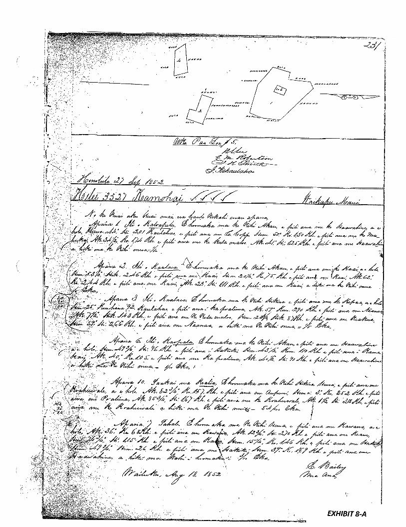
-—---———----—--.—
V-81181HX3
1rv7-.
-
-I 76L/•79?
fr_—977iY73’
_
7/7Yf//Y2ç7-<’;/\ --‘‘-)99yyp-.
7) )7V7D7f‘fr--
7’pf‘‘--7211YF
-71y---7/yI 73’/yJ23’i77 7d4P
E”V7jei/
/27/7’6y—‘---_7V-V/i7
__
-‘
-29-..--—-
,1l_-—
a”tL1-
MI -,
--W77V
7/)rc-p
“--
?7/I
7.v-.-4’
/.,-
I--
5/Vr---/7Wr _4
-
I-‘‘7/V
/fr V”O73?7/7//
y/AâW
--..-
__
-
/ve9--
/p-
_____
[T:
J4r

,
4..
7Ee1iz
.
Ua koi mal no ko t,wahi mf %c no kamea, ua baa ia’ia kzwahi % JL2Jf9..
a ua noho keakea ole in a hiki I keia inanawa.
Oia ka m4ou e hooko nei no he kuleana km ko.ma.wc ano Alodio 1naeiiknzinaiznk9ttpthPa phihçUWklF
ak
Pono na in in keukuno ka bookolokolo a Inc ka hooholo aim i ka olelo. Penci,
IckarumiamckPaianG kaoJdu4kc!qupq * . . -
inc,i ka ako koliw ac4oka iqpaia ku,
Noka honoi ka la .
___
Eia na patens, a-’a-f
•. di,
/1€V .4wq/4’a(so /g’
i(/L ah4 ae&,% 4-‘ %.. -- J
L /
- . ‘3-
-,, 4
1.* •
- j,.- ..2 ‘.. — .2.4’ -7. ..•
• •. , . ,.
.3, 1/ .2I
0 —“ •‘ - -.2
I,..
:
J- (423k’ Zh4.
/i’9q, ‘1’’.
- ‘ia4ahaa,.
,- 1-f ‘,(;‘ .a%a.d
.+
i.rng24/di .
• 5S3 ‘ . -7’-.
• fJ22 -a* .,.—
•. 88.
8iSi• !gag 4d
4a j&’aa’ ,—,,‘a2y- !a,L
• ug5—. ta*&a 44
‘1
4 7/5S.9:’ -i
4 /
- E’

I IN
(
4 ‘4

kAI
N
.“i,
•—
—_
“._
‘,4
’_
_a’,_—
_%
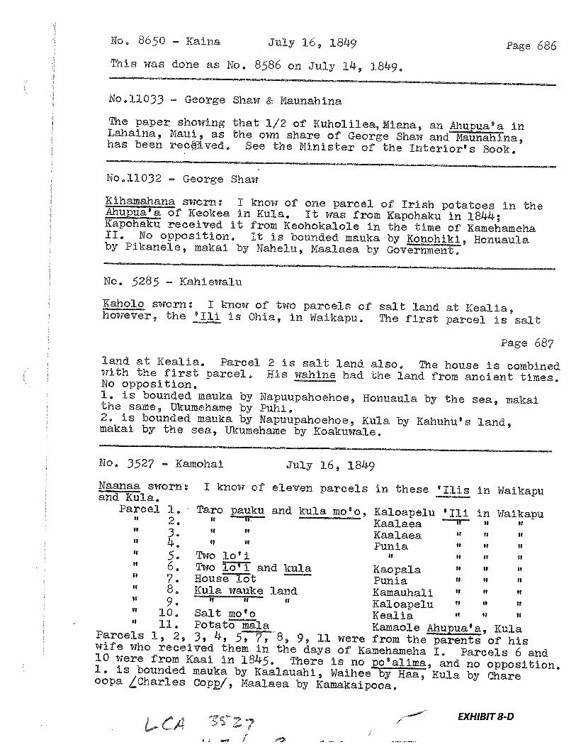
No. 8650 Kaina July 16, 1849 Page 686
This was done as No, 8586 on July 14, :1849,
No.11033 George Shaw & Maunahina
The paper showing that 1/2 of Kuholiiea,Niana, an Ahupua’a inLahaina, Maui, as the own share of George Shaw and Maunahina,has been recEived. See the Minister of the Interior’s Book.
No.11032 George Shaw
Kihamahana sworn: I know of one parcel of Irish potatoes in theupua of Keokea in Kula. It was from Kapohaku in 1844;Kapohaku received it from Keohokalole in the time of KamehamehaII. No opposition. It is bounded mauka by Konohiki, Honuauiaby Pikanele, makai by Nahelu, Maalaea by Government,
No, 5285 Kahiewalu
Kaholo sworn: I know of two parcels of salt land at Kealia,however, the ‘Iii is Ohia, in Waikapu, The first parcel is salt
Page 687
land at Kealia, Parcel 2 is salt land also. The house is combinedwith the first parcel, His wahine had the land from ancient times.No opposition.I. is bounded niauka by Napuupahoehoe, Honuaula by the sea, makalthe same, tikumehame by Puhi.2, is bounded mauka by Napuupahoehoe, Kula by Kahuhu’s land,makai by the sea, Ukumehame by Koakuwale.
No, 3527 Kamohal July 16, 1849
Naanaa sworn: I know of eleven parcels in these ‘us in Waikapuand Kula.Parcel 1. Taro pauku and kula rn&o, Kaloapelu ‘Iii in Waikapu
2. Kaalaea3 If If Kaalaea
II Punia11 5 . Two lo 1 II II
6. Two T3TT and kula Kaopala “
7. HousT3t Punia8. Kula wauke land Kamauhali “ “
9, Kaloapelu “
10. Salt mo’o Kealia “ “ H
“ 11. Potato la Kamaole ua’a, KulaParcels 1, 2, 3, 4, 5, 7,8, 9, 11 were from the parents of hiswife who received them in the days of Kamehameha I. Parcels 6 and10 were from Kaai in 1845. There is no pp’alima, and no opposition,I. is bounded mauka by Kaalauahi, Waihee by Haa, Kula by chareoopa Lcharies Cop/, Maalaea by Kamakaipooa.
EXHIBIT 8-D
j
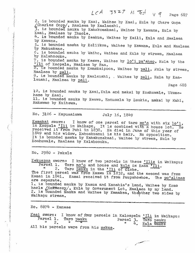
337V q Page 687
2. is bounded mauka by Kaai, Waihee by Kaai, Ku:La by Chare Oopa/Charies Copp/, Maaiaea by Kaalauahi.3. is bounded mauka by Kahakumakaai, Waihee by Kawana, Kula byKaai, Maalaea by Ihuole,4. is bounded mauka by Keakua, Waihee by Kaili, Kula and Maaiaeaby Kawana.5, is bounded inauka by Keliikoa, Waihee by Kawana, Kula and Maalaeaby Makuakane,6. is bounded mauka by Waiho, Waihee and Kula by stream, Maalaeaby Kalahoouka,7. is bounded mauka by Keawe, Waihee by aahao, Kula by the‘ill of Kaopaia, Maalaea by Haa.8, is bounded mauka by Kamakaipooa, Waihee by pj, Kula by stream,Maalaea by pali,9. is bounded mauka by Kaaiauahi, Waihee by Kula by Kaaiauahi, Maalaea by
Page 688
10, is bounded mauka by Kaai,KuLa and makai by Koahuwale, Ukumehame by Kaai,11. is bounded mauka by Keawe, Honuauia by Luukia, makal by Mahi,Makawao by Kuihewa,
No, 3106 - Kapuaaiawa July 16, 1849
Kamakai sworn: I know of one parcel of taro rno’o with six lo’i,in Kaopala ‘iii in Waikapu. lb is combined with a house 1t. Hereceived it from Puhi in 1838, He died in June of this year of1849 and his widow, Kahoakuanui is his heir. No opposition.it is bounded mauka by Kahakurnakaai, Waihee by stream, Kula byKoahuwale, Maalaea by Kaiahoouka.
No, 2980 Pakele
Kekuapaa sworn: I know of two parcels in these ‘his in Waikapu:Parcel 1. Taro mo’o and house and kula in Kaaa ‘Iii,
2, Taro pauku in the ‘Iii oohe. ——
The first parcel was from Kaawa in 1832, and the second was fromKamai in 1841. Kamai received it from Puupahoehoe. The po’alimasare separate.1,. is bounded mauka by Kaaua and Konohia’s land, Waihee by Komohaole LHet!ess/, Kula by Government Lot, Naalaea by my land,2, is bounded mauka and Waihee by Kinakea, thether two sides byWaikaou stream.
No. 8874 Kaneae
Kaai sworn: I know of fr parcels in Kaloapelu ‘Iii in Waikapu:Parcel 1. Taro auku Parcel 3. Taro pauku
“ 2. “ 4. Kula waukeAll his parcels were from his makua,
EXHIBIT 9
GRANT 1844 TO JOSEPH SYLVA
Grant No.: 1844:1 and 1844:2Grantee: JOSEPH SYLVA
1. Exhibits
Exhibit 9-A: Copy of Grant 1844 -
indicates three properties at 22-36/100 acres; 9-59/100 acres; and487 acres, totaling 518.88 acres.
Exhibit 9-B: Survey Field Notes and Diagram indicate —
show three separate properties. One of the property (487 acres) isalong a gulch, “bounded on the North by the native claims to the NorthEast corner of this lot at a bend in the watercourse towards the South atthe top of the bank; thence along said watercourse,” and the attachedmap shows as ‘Auwai” running alongside. Two other diagrams (9-52/100 acres and 22-36/100 acres) show designations ofparcels withinthe property, one being Na Pal Lol. These may be showing kuleana plotsand/or possibly taro loi.
2. Survey Maps
Survey by E. Bailey, dated April 10, 1855 (see Exhibit 9-B, Survey Field Notes andDiagram)
3. Mahele Use: watercourse, auwai, kuleana plots, possibly taro loi
Flow Requirements Source: Waikapu Stream
4. Photographs: None
5. 1800’s Tax Records: None
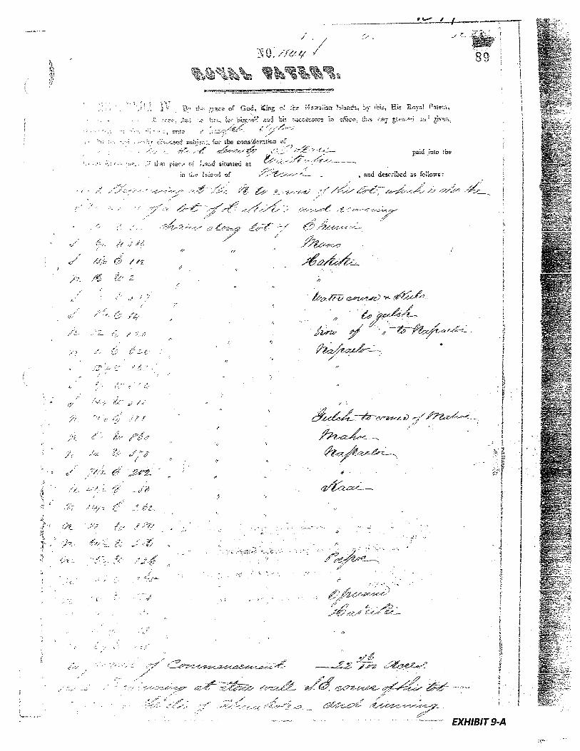
t.G.9
r!ttt2)3
,’.,
;6
.13-j
.I,,
Si03Z
SI,tJ-
00C43333
3..
3•3w3
I‘4
‘:
‘3.“
‘S
o!xoS
r0.
33’0it
-,.
--,.,.•-.
_.-‘••
flit
—.g
-.
...-.
¶I-.0’)
•1
00
w33’.
*
,A44
0
N1
:\\
‘4,
N(3
‘-3’
‘‘‘3
S
3--.
N•“3
•\c’
-“3-
‘..ç
3-
L
N,‘
-:
a-
-‘
‘.
3-.-
-‘
‘;
‘1‘‘
..
‘
A.\
\\
-
,
‘-3
“.,.
3s3
__
4
—,
“3
.-
3‘.3
-t
3-
.4‘3
’-3
‘•i•‘.,.
,.
--c•“N
‘‘
:-‘‘
“‘‘
.
i...
3.3’--;
.--..
•

•b
7‘,
.•0
V
[FPt
g0II0S4’74
t
•7
77
77
*7
1•7
7.
‘%\
\%•
4
*(0
004.1
“zi
N”
I
.7.”‘7
’,
Icr.
t:;II‘3p.
.i‘.‘
\
K
?-
w
I‘
-
•:‘
‘N‘
Lt‘U
‘‘I
N\
-.-
4

C
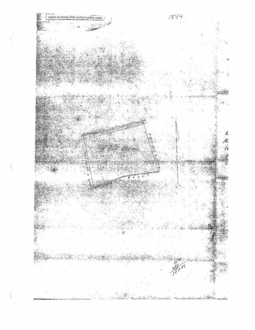
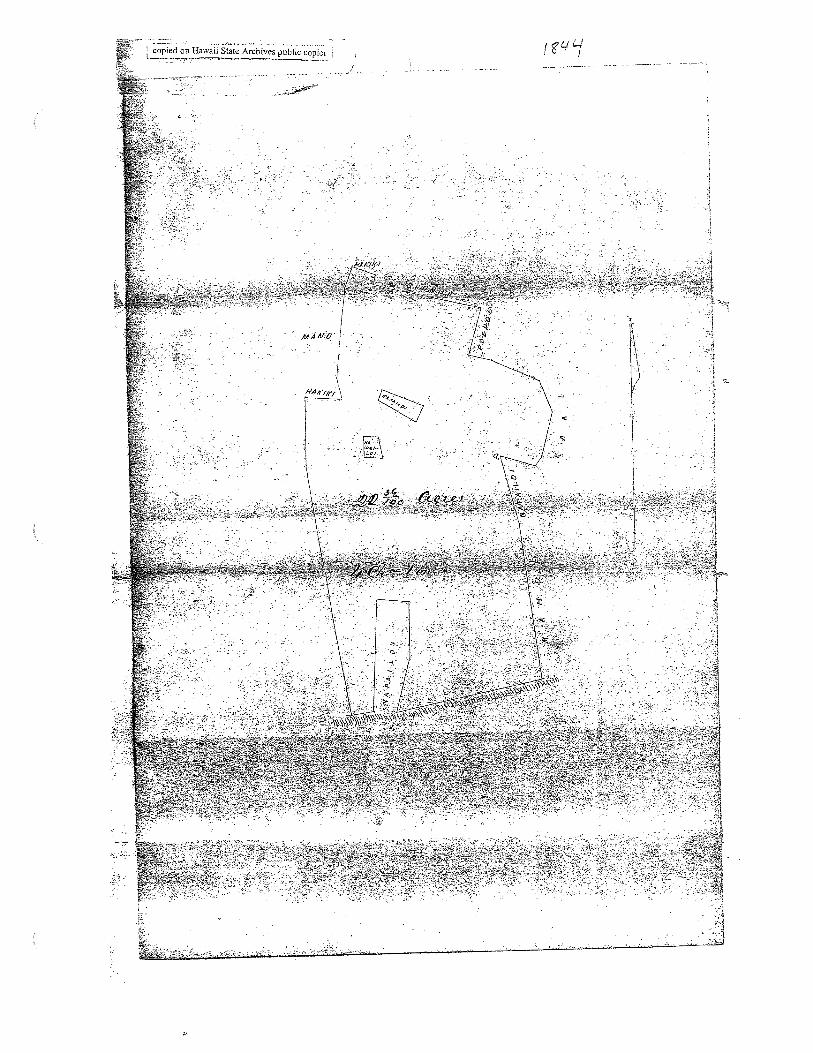
1,
----

.-
C

EXHIBIT 10
GRANT 3152 TO HENRY CORNWELL
Grant No.: 3152Grantee: HENRY CORNWELL
1. Exhibits
Exhibit 10-A: Copy of Grant 3152
Grant conveyed the ‘Ahupuaa of Waikapu saving and excepting grants
hitherto made within the saidAhupuaa by the Government orsales
made by the Board ofEducation.” Document also indicates “Native
rights reserved”.
Exhibit 10-B: House Resolution 167 (1925) states that—
the original kuleana grants “entailed the water rights ofsaid lands,”
that the Wailuku Sugar Company had diverted those waters and were
charging residents of the kuleana grantsfor the water, and charged the
Commissioner ofPublic Lands with reporting “under what authority the
said Wailuku Sugar company obtains the right to divert to its own use
for commercial purposes said waters and charge said residents...for the
water they usefor domestic purposes.”
Exhibit 10-C: April 1925 letter from the Commissioner of Public Lands stated that -
“all the lands referred to and the watersflowing thereon are privately
owned” and that “the adjudication of the rights involved does not come
within thejurisdiction ofthis office.”
2. Survey Maps
None
3. Mahele Use: “native rights reserved”, use of water for domestic purposes
Flow Requirements Source: Waikapu Stream
4. Photographs: None
5. 1800’s Tax Records: None
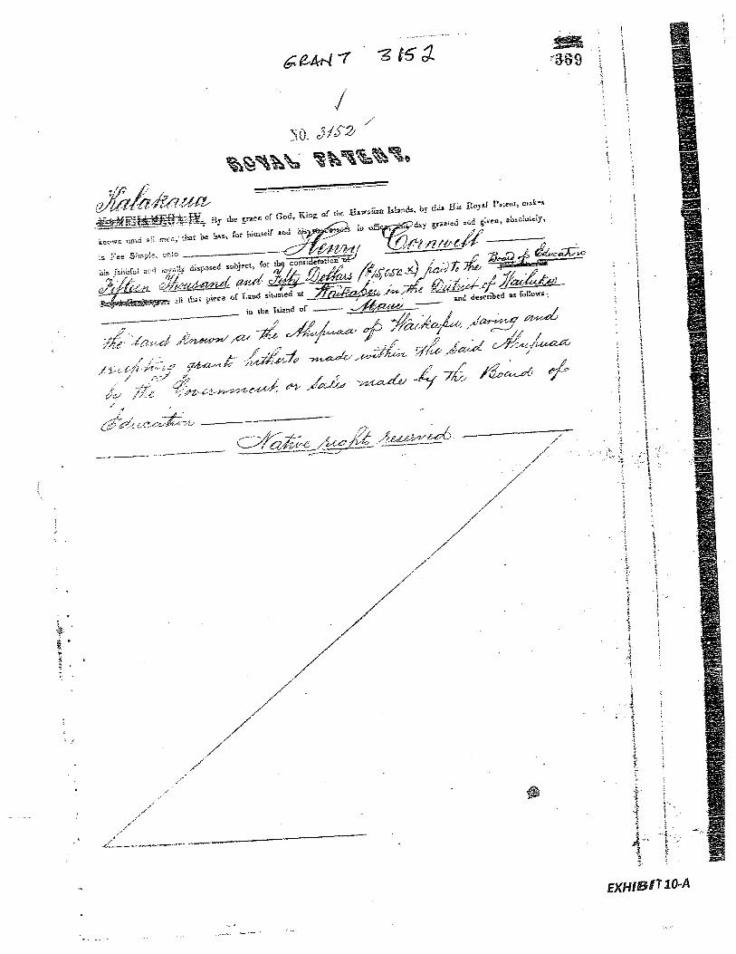
--
-
)—
-*
-—

-.

HOUSE EE3OLUT ION/
WHEREAS, the original kuleana grants to the lands of
• Waikar, District of Wailuku, County of Maui, entailed the water
rights of said lands: and
SEEELS, the Wiluku Sugar Gompany has diverted the waters
fcrnerly flowing upon and through these lands to its flumes and.
pipe lines for commercial ourposes; and
WREREAS, ths residents and owners of said lands are now
• compelled to pay certain water rates to said dugar Company for th
water they use for domestic purposes; now therefore, be it
RESOLVED, bI the Rouse of Representatives of the Territoy of
Hawaii, Hegular Session 1925, that the Commissioner of Public Lands
be and he is hereby directed to report to this House under what
authority the said ailuku 5ugar company obtains the right to divert
:th ts own u-se for commercial durpose said waters and charge said
residents of Waikapu, District of Wailuitu, County of Maui, for the
water they use for domestic purposes; and be it further
RESOLVED, that a certified copy of this Resolution b forward
ed to th Commiseinner of Public Lands.
- IETRODUC BY:
Thomas HolsteinRepresentative , Third District.
Honolulu, T.. H.
Marcia 24, 1925.
•1
____
- --•-- EXHIBIT 10-B
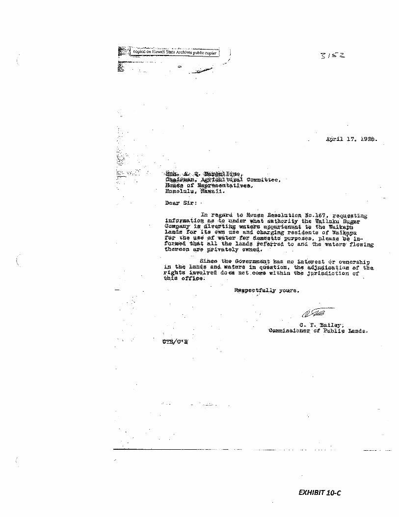
Archives pubhccopf Z / S
rfl 17, l92.
— fl 4.*rman Agflzld.tRral Oommittee.
Ilauaç of Ilepnaentatnes,honolulu, Rtwaii.
Dear Sir: -
In regard to Rouse $eselutton reqixeaflnginformation as to unäer what au4bority the Wailitku $StGoMpany is diflrting waten a;pnrtensat to the Waikawlands for S4s own use and charging residents of Waikapufor the nee -of water for tuacetto purposes1 please be La-’formed that all the lands veferre4 to arm the waters flowingthereon ate privately o*ned.
Since the Góyen it has no Lnteçeat or own-ershiin the lands anê waters In question, the adäuLU.eatioa of therights 4siv-olvei does not come witfln the Jurisdiction ofthai offtcè;
- Raspeetfuily 3-one,
C. T. Bailey;Commissioner otPuhltu nds.
EXHIBIT 10-C

EXHIBIT 11
GRANT 30431. BOARDMAN
Grant No: 3043Grantee: J. BOARDMAN
1. Exhibits
Exhibit 11-A: Copy of Grant 3043-
“land situated at Waikapu — between land owned by him and the publicroad”. Document also indicates “reserving native rights”.
2. Survey Maps
None
3. Mahele Use: Reserving native rights
Flow Requirements Source: Waikapu Stream
4. Photographs: None
5. 1800’s Tax Records: None

3&93
NO.
E’EHA. IY. B; the zrace c God, Kig of the Hawaiian Islands, by this His Royal Patent,Tosies known nmo all nen, that he has, for lii.jscif and his successors iu oce, this day granted and given,
Fee Simple, unto (-‘e&
v1!r dkpnsed subjcct, for the norisideramion of -
paid into the
w. all tint piece at Land situated at
_// it, mime Island of and described as Iollow:
/ 4
4’,’s,n?asiZ.5
.5
—i ._;_7 4Z
4 /i’’.4 —
c;:2./7
EXHIBIT 11-A

EXHIBIT 12
GRANT 2960 TO J. BOARDMAN
Grant No.: 2960Grantee: J. BOARDMAN
1. Exhibits
Exhibit 12-A: Copy of Grant 2960 -
Metes and bounds description. Document indicates land ‘situated atWaikapu iii ofAhuakolea in the Island ofMaui” and “containing 23-1/2acres ‘
Exhibit 12-B: Survey Field Notes and Diagram -
Metes and bounds description ofAhuakolea in Waikapu, Maui. Letterdated May 19, 1864 states “land known asAhuakolea an iii of WaikapuMaui containing 23-1/2 acres sold by the Board ofEducation to JohnBoardman.”
2. Survey Maps
Survey by E. Bailey (See Exhibit 12-B, Survey Field Notes and Diagram)
3. Mahele Use: Unknown
Flow Requirements Source: Waikapu Stream
4. Photographs: None
5. 1800’s Tax Records: None
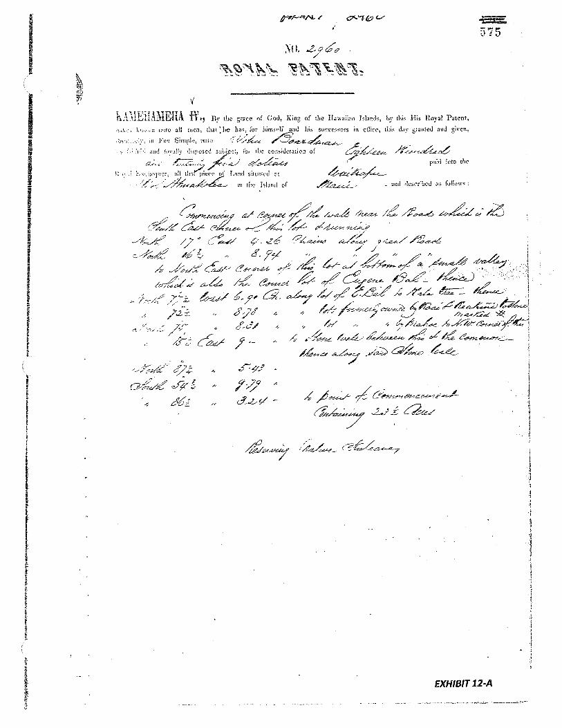
C81)CCCC)C))
—r3
f)
2)C
)
C—3
NI.-.
\4
NSI
N
4IN
U
0 Ut
2 t
,r
.j
.
.
N1
I..

tr
1,. .11:
:‘ (ID
U
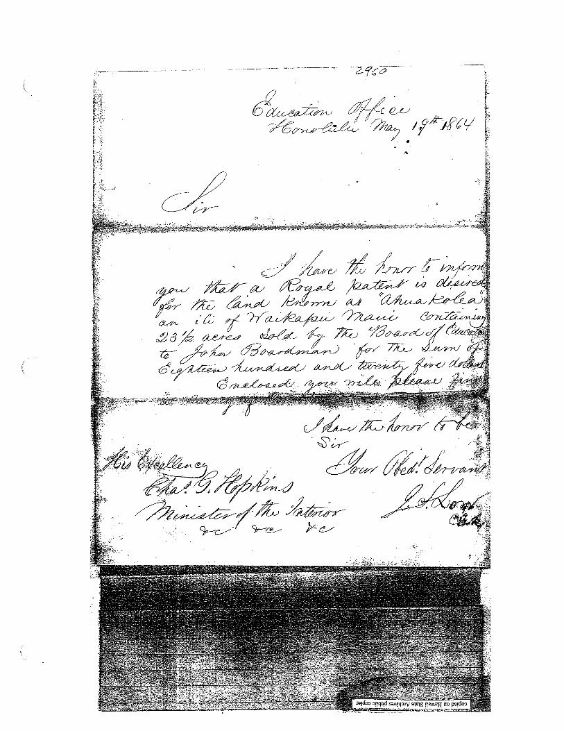
4.

EXHIBIT 13
GRANT 2069 TO KAAI
Grant No.: 2069:1Grantee: KAAI
1. Exhibits
Exhibit 13-A: Copy of Grant 2069-
Metes and bounds description. Document indicates land in Kaalaea,Waikapu; Two parcels, Ap. 1 (10.46 acres) andAp. 2 (0.18 acres), a totalof10.64 acres.
Exhibit 13-B: Survey Field Notes and Diagram indicate -
two parcels, “Apana 1 = $40.50 andAp. 2 = $.50”.
2. Survey Maps
None
3. Mahele Use: Unknown
Flow Requirements Source: Waikapu Stream
4. Photographs: None
5. 1800’s Tax Records: None

;‘
::L.;
iN
——
——
——
——
----
4,,4
Lu
•“
.•
iI
;L

I
[i
2.
¼-
.I
¼
E‘.
¼
aSCnC$
aL4,
I1
1
N
a
he
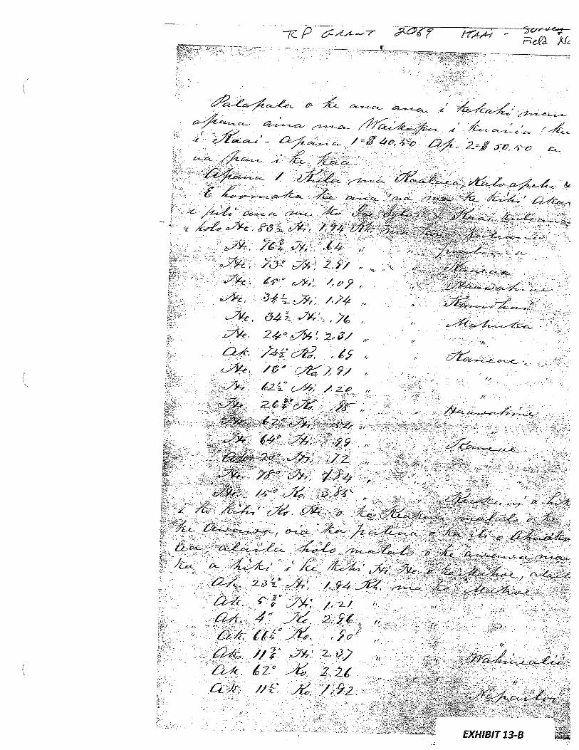
I-’
1 74 -1
-
‘Nti
‘q’h
3b
•tç
NN
N
•c
—
N-
‘.
4
ci
4’
F
NI
‘N

TMK (2) 3-6-002:003(62 1.400 Acres)
Exh LandAcres
____________________________AwaørStrem
1 455 324 Lot 1: 33-2/10 acres HAA patches of land for planting sugar cane Survey by lone Richardson•Lot 2: 1-8/10 acres 3/11/1850
2 411 None 3 acres POONUI house lot Survey byi. Richardson Waikapu Stream•kahawai
3 3152 HENRY CORNWELL water rights for domestic purposes
4 2747 124-8/10 acres EUGENE BAL kahawai Survey by E. Bailey Waikapu Stream3/12/1861

EXHIBIT 1
LAND COMMISSION AWARD 455 TO HAA
LCAwNo.: 455Royal Patent No.: 324Grantee: HAA
1. Exhibits
Exhibit 1-A: Copy of LCA 455 (book 6, p.119) and translation
Exhibit 1-B: Copy of RP 324 (book 2, p.263)
Exhibit 1-C: Native Testimony on LCA No. 455 (v.2, p.l79) indicates —
there were patches of/and usedfor planting sugar cane — “He has alease with Hoapili-wahine for acres oflandfor planting sugar cane.”
2. Survey Maps
See survey diagram (Exhibit 1-A, copy of LCA 455)
3. Mahele Use: sugar cane land
Flow Requirements Source: Waikapu Stream
4. Photographs: None
5. 1800’s Tax Records: None
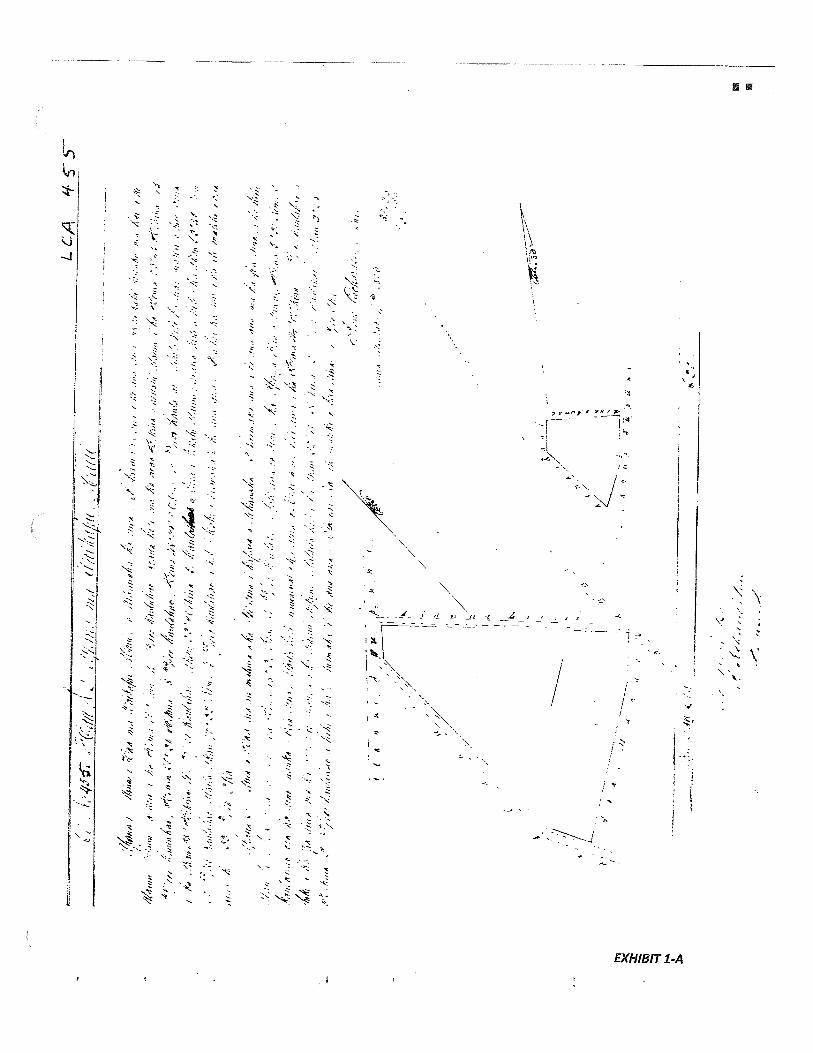
1“n
/P;..,J
‘ø
/1;
‘:‘
“‘::i’’E
Z
1k
‘:.±
,
Ii-
.
//
‘
/
//
‘:
,/,
1
//
‘‘I’’//
Qi’
,”’
•““‘
p-
31p
-
nu
Vi
k
1/A‘
‘j,/.7/)j
1(.’’
/A
g7’’
/W
1i.ç
‘/0
”’
—.‘,y
‘t’
n’;
P’
l/’i
V///’
tt//’1/
I1)/k
14
1/fl
,,JY
lIl1
,//‘‘1
/11(7
V’t’4
1‘
t,)g
‘o
’;,’’
;riii’j
‘,
117//I.
7’
fl’
//’I//7P
/)/)/’
i:y’
1/F
’,’.;‘.
‘u’’,’
‘1’;
...
:‘
f.wnm
h’
w/,/J
’,
“_
l’?//,)
/b//’//’
1’,’’!
‘‘“
1l/’
’;1
‘I’/%
7’’‘b
.,p
w/I
’J/i/”
?‘
‘‘/
/‘‘0
1/il?
;i
VI
IF
’.’//1
2.1
)
‘.2
‘‘“‘.:,—
‘“
‘,;
“F
’.,”r’/)/’’
9’‘
‘.1’),’
/1’
‘‘i’’:,?;
‘‘‘i;’
‘;‘
‘‘
1-’
[I
‘“1-
‘‘
‘‘
I
,,
‘
,‘,11
1//f
‘f’I
Vk’/’
/.,d/‘/‘
1/,
““i’”?
/“I//”k
j”I/f?•”/
(I
VI/fl/$
7’—
/n’’,’I’7
/l’
I/f
’I
17k
‘‘/1714/1
‘/0/1
/’L
’/
P1¼t’
41/:;’
l,
,
‘‘‘‘
-Ill’
jVu
fI//
/‘,‘
1il’”
,‘‘
1;”
‘/
“‘‘i’
‘.1,”
,‘
‘
H’”’’
‘
‘77/,‘/
/,t’
,/Iflh
I’;’
‘:.;‘.
In
‘-:,‘
‘“‘,‘
‘‘1‘
‘‘:“-‘
Ig”I/,’
y,’
’•
‘‘
7’.’•‘
‘I:’’
‘‘i.:’
•‘
•I;”
y:Y
:‘
‘97II(1.V
//)A
p.
‘i”’
;/‘:#1/fl:’7
‘,‘.
7’frlIIf.i
,;
?4
1tr’/
7,‘in.m
’;’
.,/
i;g/
.;.‘‘
0’
1IIl1
/t’/
,‘‘..
/f’,,k
/7/4
1‘flIyfIlA
//
ç’“f
yb
‘g
v’oç’
?(/1744’//f’7’
“/7
r/.1,
He’
‘““)
/1
I.’
fl’
;;’“(2/”
‘V
l////>
lU
ll’
I’M’
V/Il
‘jr’fl’
9)7u/,
7/fl
““I-’’
/‘
1/0
‘4d
‘/
//ç’’
/‘
‘lI//’
111fl/
//
/fry
“‘
“V
””’/l
‘114
‘I/;’”.fl’
7/
‘“0’
‘1//l/7)
V’tn
’ry
17/1
1/1
1/7
’:1
my;ç’’
“j’Iq,;
-“4’
V)
‘Itt7/
/
‘1’J’’’
‘V’7K
?’i”
1’/‘
‘
,S
hV
77
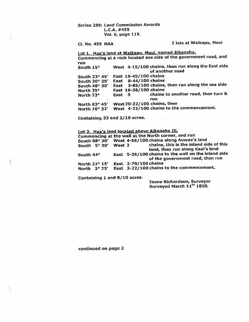
Series 288: Land Commission AwardsL.C.A. #455Vol. 6, page 119.
Cl. No. 455 HAA 2 lots at Waikapu, Maui
Lot 1. Haa’s land at Waikau, Maui, named Aikanaha.
Commencing at a rock located sea side of the government road, and
runSouth 15° West 4-15/100 chains, then run along the East side
of another road
South 23° 45’ East 15-45/100 chains
South 20° 25’ East 8-44/100 chains
South 48° 30’ East 3-85/100 chains, then run along the sea side
North 35° East 16-38/100 chains
North 23° East 5 chains to another road, then turn &run
North 63° 45’ West 20-22/100 chains, then
North 70° 32’ West 4-22/100 chains to the commencement.
Containing 33 and 2/10 acres.
Lot 2. Haa’s land located above Aikanaha Iii.
Commencing at the wall at the North corner, and run
South 88° 30’ West 4-65/100 chains along Auwae’s land
South 50 30’ West 2 chains, this is the inland side of thisland, then run along Kaai’s land
South 44° East 5-26/100 chains to the wall on the inland sideof the government road, then run
North 22° 15’ East 2-70/100 chains
North 3° 25’ East 3-22/100 chains to the commencement.
Containing 1 and 8/10 acres.bane Richardson, SurveyorSurveyed March 11th 1850.
continued on page 2

Page 2L.C.A. #455, continuedSeries 288: Land Commission Awards, VoL 6, page 119.
[Image reduced to fit on page)
Tntil feesG.M. RobertsonI. Kekaulahaobane Ii3.H. Smith
2O.OO
Honolulu. April 1, 1851.
/
/
I,
4.
‘I
4
Translated by: Jason Achiu, Hawaii State Archives. 1/2012
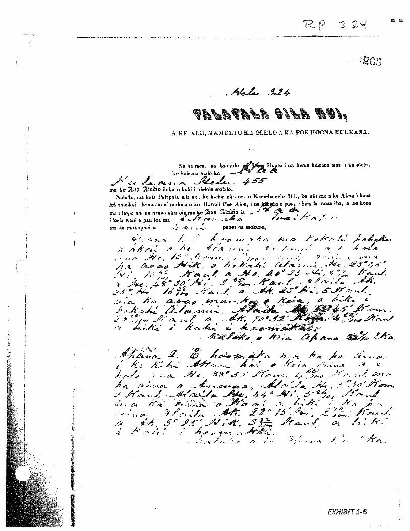
A4-L 5J
A KE AUI, MAMULIO KA OLELO A KA POE HUONA ULEANA.
No ka mea, na hooholo Haa I na kuau kuLeana aiaa i ka uLeio,
he kuhan3 oiuo ko
JY44 ,/1 46ma ke aQ ?1obio iIoto a klii i a4oa mahilo.
ma kia PhpeIa Ba nt, ke ‘Ike ku nd a Kamehametia IlL, ke alil nul a he Akua I knoa
lokouaIkl cmaho al rnulun a ka lhwalI Pe Ahia ua)a a I kéa h aoa ibo, a ao koaa
m2: ua haawi aku oIJa)e flO ?tjO sa- —
I ke wahi a pau ba ma “F7
ma ka mokupuni o pe*ei na mokue.,
* ! /e m. / : -‘ -r’ ;‘ ‘ ‘ M z , / / /, / ,‘ /‘ ‘F, i s. a ‘ /1 . /‘ 4’
m 4e / 4’ ,a, >,Á, ,:. s
: /.- L’ 2145Jñ ‘A4’, f ,/6 .%-/ . 4J”& 11.-/
-r . 2 c
AJ a -1 ‘
€..
sXt.2 A-ip’-* m,4i1L A ,4 --
A- A_’ 6 £‘-a’S-,* “
-4€. .f—a1l, /“t
,. , i •j jIr
‘A4’.1 a - .‘
2L/1/
/et -A 2’ /3’. 44 ,f3 ,f4- 53 3-j
z A— / :, & ‘
- r. / ‘,
EXHIBIT
1-B
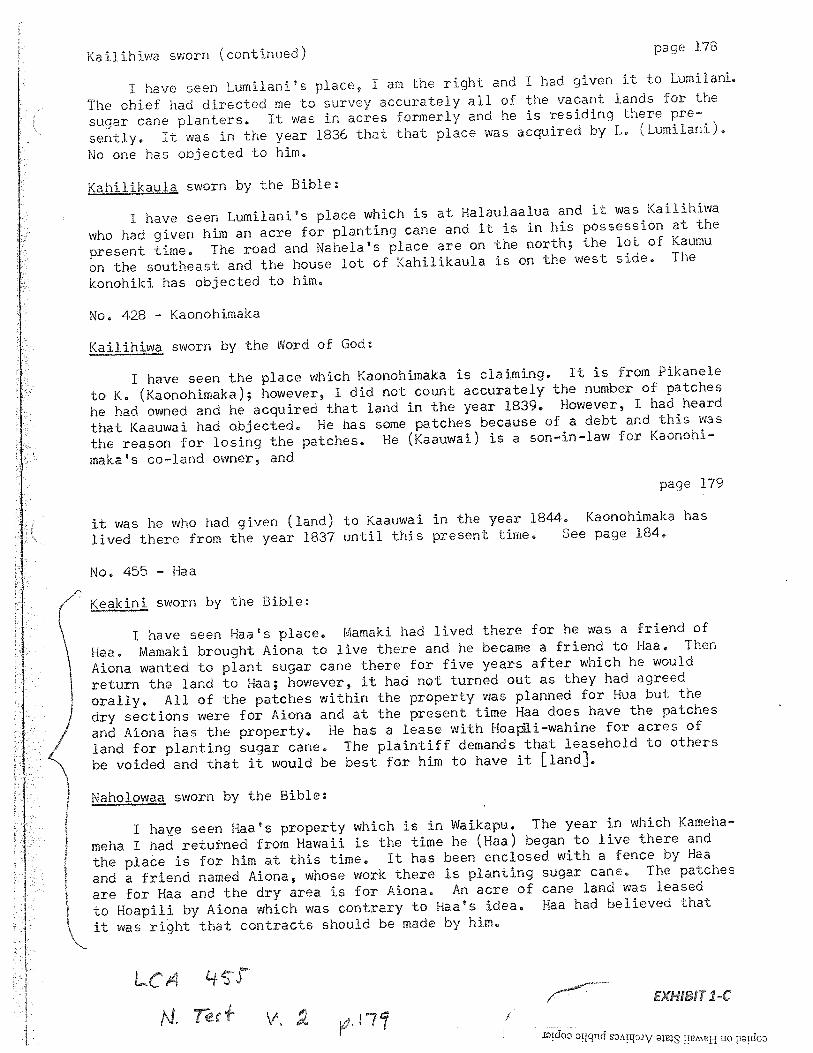
Kailihiwa sworn (continued) page 178
I have seen Lumilani’s place, I am the right and I had given it to Lumilani.
The chief had directed me to survey accurately all of the vacant lands for the
sugar cane planters. It was in acres formerly and he is residing there pre
sently. It was in the year 1836 that that place was acquired by L. (Lumilani).
No one has objected to him.
Kahilikaula sworn by the Bible:
I have seen Lumilani’s place which is at Halaulaalua and it was Kailihiwa
who had given him an acre for planting cane and it is in his possession at the
present time. The road and Nahela’s place are on the north; the lot of Kaumu
on the southeast and the house lot of Kahilikaula is on the west side, The
konohiki has objected to him.
No. 428 Kaonohimaka
Kailihiwa sworn by the Nord of God:
I have seen the place which Kaonohimaka is claiming. It is from Pikanele
to K. (Kaonohimaka); however, I did not count accurately the number of patches
he had owned and he acquired that land in the year 1839. However, I had heard
that Kaauwai had objected. He has some patches because of a debt and this was
the reason for losing the patches. He (Kaauwai) is a son—in—law for Kaonohi—
makas co—land owner, and
page 179
it was he who had given (land) to Kaauwai in the year 1844. Kaonohimaka has
lived there from the year 1837 until this present time, See page 184.
No. 455 - Haa
Keakini sworn by the Bible:
I have seen Haa’s place. Mamaki had lived there for he was a friend of
Haa. Mamaki brought Mona to live there and he became a friend to Haa. Then
Aiona wanted to plant sugar cane there for five years after which he would
return the land to Haa; however, it had not turned out as they had agreed
orally. All of the patches within the property was planned for Hua but the
dry sections were for Aiona and at the present time Haa does have the patches
and Aiona has the proper-by. He has a lease with Hoa1i—wahjne for acres of
land for planting sugar cane. The plaintiff demands that leasehold to others
be voided and that it would be best for him to have it [land].
Naholowaa sworn by the Bible:
I have seen Raas property which is in Waikapu. The year in which Kameha
meha I had retu±-ned from Hawaii is the time he (Haa) began to live there and
the plaàe is for him at this time. It has been enclosed with a fence by Haa
and a friend named Mona, whose work there is planting sugar cane. The patches
are for Haa and the dry area is for Mona. An acre of cane land was leased
to Hoapili by Aiona which was contrary to Haas idea, Hea had believed that
it was right that contracts should be made by him.
4iEXHIB!T1-C
idoo orqnd sArq3Jv uo ptdoo
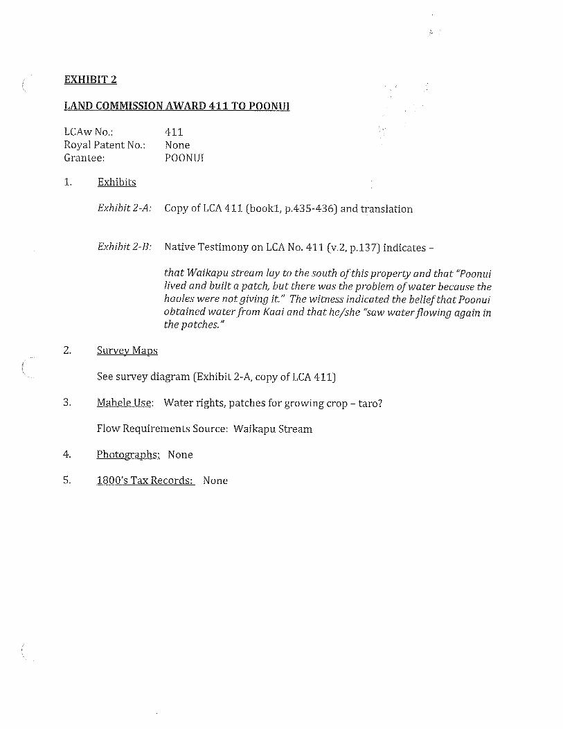
EXHIBIT 2
LAND COMMISSION AWARD 411 TO POONUI
LCAwNo.: 411Royal Patent No.: NoneGrantee: POONUI
1. Exhibits
Exhibit2-A: Copy of LCA 411 (booki, p.435-436) and translation
Exhibit 2-B: Native Testimony on LCA No. 411 (v.2, p.137) indicates —
that Waikapu stream lay to the south of this property and that “Poonuilived and built a patch, but there was the problem ofwater because thehaoles were not giving it.” The witness indicated the belief that Poonuiobtained waterfrom Kaai and that he/she ‘saw waterflowing again inthe patches.”
2. Survey Maps
See survey diagram (Exhibit 2-A, copy of LCA 411)
3. Mahele Use: Water rights, patches for growing crop — taro?
Flow Requirements Source: Waikapu Stream
4. Photographs: None
5. 180 0’s Tax Records: None
.5. 5..5 .
., %j
N5. $ S
5’
‘ ‘5
. r
.
‘
S
.‘
\\
55
.5
.
5’
c
H S
S
\S
‘ “ S
N
S
5’•S
S
\‘ -
‘-5iN
i S
‘
K ‘\JS
5.
5
5
\ .J
-5
\\S
S
‘S
S.
%
‘SS
.
N.
4 ‘S•
% \S\
L.\ ¶‘J
5“4c‘ \
S)
: (
55
EXHIBIT 2-A

r
(NiII./
.Ii -I 1?
•1f
C’,...’2/’,:4‘‘‘,‘, 2Y’C”9)
ftp
.‘n,lvy-C)1/
9$?
/
I
/
-fltfl>)’77/’1772‘&
f.—°--tt‘
/7/7
*‘7?2’‘.j’.V//.7?I,’/t’
%.‘C’2,74//1/1’
‘V2,,)‘4y
2.44111j’v,y“i’...’t‘fV.y
.11.1
Z2I$t271.7t12(’1’17,>1,7/11
77•./7-,/‘
riVI/r”
I__IF‘7l/ti’..‘;
fl/f7’
/I_1.u/
_47/,,/44
‘l.ft(
1.74’
FI‘411?.,,tlIZ
7/‘7
-,.,t..‘...‘./2./I’
1
/‘//4-‘IV
V4- jr“ft
./“-
//—
flFl-?74-/fljA’.7.19.7VI
,,‘/‘‘/‘-‘‘///.“/fl
.5474/7zy““74”7
177•‘?‘&
‘F-’,/‘2j/
I,y’,//,’•1/k.
.7—‘,4f//2’:.7V//I
7‘‘V“““7”f’/4.171yy’/i.
7ll?/ 47If4?f/
‘/“f,-‘q’
-a,/1/it*7
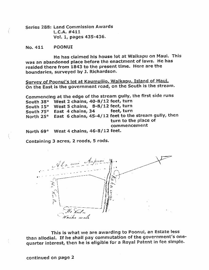
Series 288:
No. 411
Land Commission AwardsLC.A. #411Vol. 1, pages 435-436.
POONUI
He has claimed his house lot at Waikapu on Maui. This
was an abandoned place before the enactment of laws. He has
resided there from 1843 to the present time. Here are the
boundaries, surveyed by 3. Richardson.
Survey of Poonui’s lot at Kaumuilio, Waikapu, Island of Maui.
On the East is the government road, on the South is the stream.
Commencing at the edge of the stream gully, the first side runs
South 38° West 2 chains, 40-8/12 feet, turn
South 15° West 5 chains, 8-8/12 feet, turn
South 75° East 4 chains, 34 feet, turn
North 25° East 6 chains, 45-4/12 feet to the stream gully, thenturn to the place ofcommencement
North 69° West 4 chains, 46-8/12 feet.
Containing 3 acres, 2 roods, 5 rods.
This is what we are awarding to Poonui, an Estate less
than allodial. If he shall pay commutation of the government’s one
quarter interest, then he is eligible for a Royal Patent in fee simple.
continued on page 2
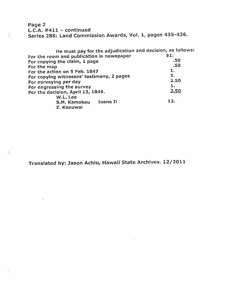
Page 2L.C.A. #411 — continuedSeries 288: Land Commission Awards, Vol. 1, pages 435-436.
He must pay for the adjudication and decision, as follows:
For the room and publication in newspaper $1.
For copying the claim, 1 page .50
For the map .50
For the action on 5 Feb. 1847 1.
For copying witnesses’ testimony, 2 pages 3.
For surveying per day 2.50
For engrossing the survey 1.
For the decision, April 13, 1849. 2.50
W.L. LeeS.M. Kamakau bane Ii 12.
Z. Kaauwai
Translated by: Jason Achiu, Hawaii State Archives, 12/2011
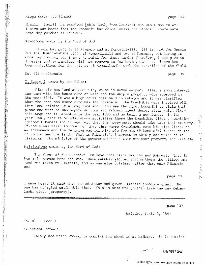
Kaupa sv;orn (continued) oage 134
Hawaii. Hawaii had received Lthis land] from Kauakahi who was a moo ruler,I have not heard that the konohiki has chide Hawaii nor Napela. There weresome dry patches at Kahawal.
iKawelohea sworn by the vVord of God
Napela has patches at Kamamao and at Kumuwiliwili. (It is) not for Napelabut for Hawaiiwahine patch at Kumuwiliwili and two at Kamamao, but living isunder my control for I am a Konohiki for these lands; therefore, I can give asI desire and my landlord will not reprove me for having done so, There hasbeen objections for the patches at Kumuwiliwili with the exception of the field.
No. 473 Pikanele page 135
aauai sworn by the Bible
Pikanele has land at Honucula, which is named Waipao. After a long interval,the land with the house site at Kaeo and the Waipie property were approved inthe year 1841, It was a high court case held in Lahaina and it was clarifiedthat the land and house site was for Pikanele. The konohikis were involved withthis land originally a long time ago. Ihu was the first konohiki to claim thatplace and when he was separated from it, Pahuwal lived there, after which Pikanele acquired it probably in the year 1836 and he built a new fence. In theyear 1840, because of adulterous activities there the konohikis filed a complaintagainst Pikanele and it was felt that the government should take back that property.Pikanele was taken to court at that time where Kekauluohi gave his side (land) toM, Kekaunaoa and the decision was for Pikanele for his (Pikaneles) losses on thehouse lot and the land. That is Pikanel&s interest on this place which he isclaiming. The minister of the government had authorized that property for Pikanele.
Na1pieho sworn by the Word of God
The first of the Konohiki to have that place was Ihu and Pahuwai, That ishow this person here has won, When Pahuwai stopped living there the village andland was taken by Pikanele, and no one else (claimed) after that only Pikaneleand
page 136
I have heard it said that the minister had given Pikanele absolute grant. Noone has objected until this time, This is absolute [grant] like the way Kekauluohi gives [property].
page 137
Wailuku, Sept, 3, 1847
No, 411 Poonui
Z, Kaauwai sworn:
This place which Poonui is complaining about is at Waikapu. it is outside
EXHIBIT 2-B
Itdo3 3qfld s !!H uo pidoo
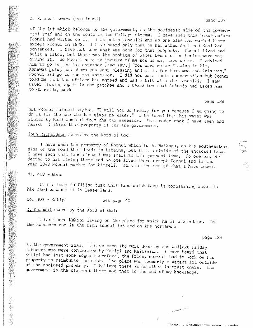
Z Kaauwai sworn (continued) page 137
of the lot which belongs to the government, on the southeast side of the government road and on the south is the Naikapu stream, I have seen this place beforePoonui had worked on it.0 I am not a konohiki and no one else has worked thereexcept Poonui in l843 I have heard Only that he had asked Kaci and Kaai hadconsented I have not seen what was done for that property, Poonui lived andbuilt a patch, but there was the problem of water because the haoles were notgiving it, So Poonui came to inquire of me how he may have water. I advisedhim to go to the tax assessor Land say,] HYou have water flowing to him,Kanawai Lsic] has shown you your blessing and it is for that man and this man,Poonui did go to the tax assessor. I did not hear their conversation but Pconuitold me that the officer had agreed and had a talk with the konohiki, I sawwater flowing again in the patches and I heard too -that Antonio had asked himto do Friday work
page 138
but Poonui refused saying, “I will not do Friday for you because I am going todo it for the one who has given me water. I believed that his water wasrouted by Kaai and not from the tax assessor0 That ended what I have seen andheard. I think that property is for the government.
hicadson sworn by the Word of God
I have seen the property of Poonui which is in Waikapu, on the southeasternside of the road that leads to Lahaina, but it is outside of the enclosed land.I have seen this land since I was small to this present time. No one has objected to his living there and no one lived there except Poonui and in theyear 1843 Poonul worked for himself0 That is -the end of what I have known0
No, 408 - Manu
It has been fulfilled that this land which Manu is complaining about ishis land because it is lease land,
No, 403 - Kekipi See page 40
Jaauwai sworn by the Word of God:
I have seen Kekipi living on the place for which he is protesting. Onthe southern end is the high school lot and on the northwest
page 139
is the government road, I have seen the work done by the Wailuku Fridaylaborers who were contracted by Kekipi and Kailihiwa, I have heard thatKekipi had lost some hogs; therefore, the Friday workers had to work on hisproperty to reimburse the debt. The place was formerly a vacant lot outsideof the enclosed property. I believe there is no other interest there. Thegovernment is the claimant there and that is the end of my knowledge.
icToo oijcind sArTJrw rnpic r, fl,0m
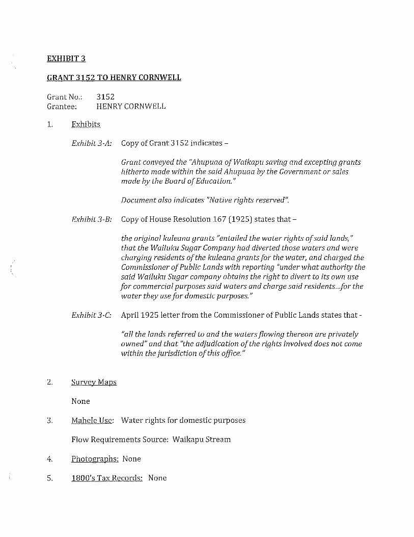
EXHIBIT 3
GRANT 3152 TO HENRY CORNWELL
Grant No.: 3152Grantee: HENRY CORNWELL
1. Exhibits
Exhibit3-A: Copy of Grant 3152 indicates —
Grant conveyed the ‘4hupuaa of Waikapu saving and excepting grantshitherto made within the saidAhupuaa by the Government or salesmade by the Board ofEducation.”
Document also indicates “Native rights reserved”.
Exhibit3-B: Copy of House Resolution 167 (1925) states that —
the original kuleana grants entailed the water rights ofsaid lands,”that the Wailuku Sugar Company had diverted those waters and werecharging residents ofthe kuleana grantsfor the water, and charged theCommissioner ofPublic Lands with reporting “under what authority thesaid Wailuku Sugar company obtains the right to divert to its own usefor commercial purposes said waters and charge said residents..for thewater they use for domestic purposes.”
Exhibit 3-C: April 1925 letter from the Commissioner of Public Lands states that -
“all the lands referred to and the watersflowing thereon are privatelyowned” and that “the adjudication of the rights involved does not comewithin the jurisdiction of this office.”
2. Survey Maps
None
3. Mahele Use: Water rights for domestic purposes
Flow Requirements Source: Waikapu Stream
4. Photographs: None
5. 1800’s Tax Records: None

llc
N
N‘r)
r
N>::
N‘S
.
N
N,

-.
-—
--.
-..
—-
—,---,-----.-
—
-.-.-.---—
--
8 0 I 0) 0-

-
HOUSE RESOLUTION
WHEREAS, the original kuleana grants to the lands of
Waikapu, District 0± Wailuku, County of Maui, entailed the water
rights of said lands and
wEE&z, the Wailuku Sugar COmpany has diverted the waters•rnery fioing upon arid through these lands to its flumes and
pip-e lines for commercial ourposee; and
WHEREAS, the residents and owners of said lands are now
compelled to oay certain water rates to said ugar Company for thewater they use for domestic purposes, nc therefore, be it
RESOLVED, by the House of Representatives of the Territory ofHawaii, Reguiar Session 1925, that the Commissioner of Public Landsbe and he is hereby directed to report to this House under whataut1ority the said Wailuku bugar company obtains the right to divert
its own uae for cOmmercial purpcsé said waters ann charge saidresi.&ents of Waikapu, District of Wailuku, County of Maui, for thewater they use for domestic purposes; and be it further
RESOLVED, that a certified copy qf this Resolution bw forwarded to the Comhiiesinar of Public Lands.
INTRODUCED BY
Thomas HolsteinRepresentative, Third District.
• Honolulu, H. H.
March £4, 1925.
EXHIBIT 3-B
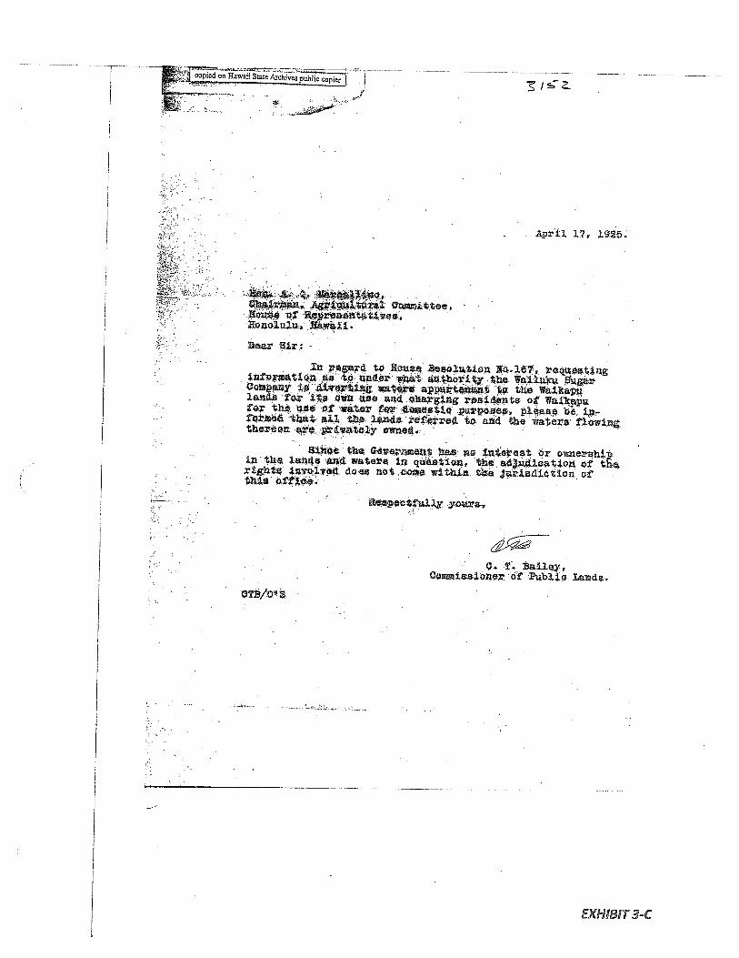
a
AaLtre2 Cemi.tteei:I
Dear Bir: -
n 2egard t4 oua eso1zUon Eo.167 requeatingnfprnUQflas tV &erat uory the Wai.ukupauy 6ierU wt* apturt,nzit W the Waikapuland8 or i2 Own aa6 .oaxging vezidents of Waikto th ue Øf
waeVçer d.oaesUc p1eae be. it4 U. tnd efe t arid the wates t.ewLutheéon aDa pivateiy owne..
amce he nuzet V no neet or ownexshiin th .aida and watera Ln ueation the.ctio f th,rigt8 *v*i*e(t cloaa not OC within the rLediatZOfl. of V
thia effl.c,e. V
V
ectfuir yrw,
EXHIBIT 3-C
VVVVV•.V
..prVi1 1i ig.
V
VT. Bailey,O.ozuiiasioner of b1io Lnde.
EXHIBIT 4
GRANT 2747 TO EUGENE BAL
Grant No.: 2747Grantee: EUGENE BAL
1. Exhibits
Exhibit 4-A: Copy of Grant 2747 indicates —
the property is in Waikapu, Maui. A diagram also shows a surveyedpiece ofproperty adjacent to a “kahawai”.
Exhibit 4-B: Survey Field Notes and Diagram indicates -
the property “twice crossing Waikapu stream “. The property contains124-8/10 acres.
2. Survey Maps
Survey by E. Bailey, dated March 12, 1861 [see Exhibit 4-C, Survey Field Notes andDiagram)
3. Mahele Use: Waikapu stream
Flow Requirements Source: Waikapu Stream
4. Photographs: None
5. 1800’s Tax Records: None

N‘:\
rfr-J\:
:
*‘

.4.
.I
4.
.
•1
\t
\s4£
4
rIijt
I,
‘P
tl
L’
IttI
1,.
.:
liflqpJd
r
tlkU
t
,t’.II
II,
N[‘I1nLi
ar
It.,)
1;I
It
II
“a
—I
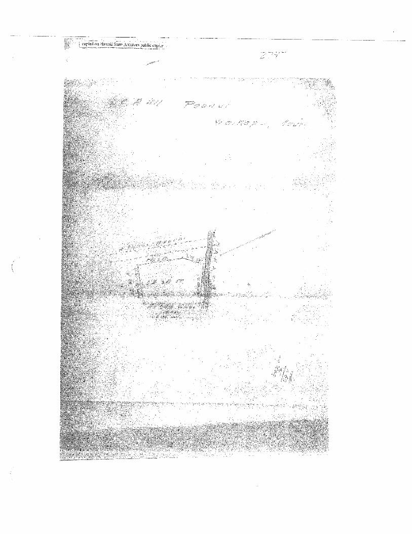
II1ih
h1”
¶t1
I
eHawaiiivespubIiccopjer.
n4J,7 a qI4cLr_ &i_ g4_
:i
O&C ?/- j
—
I4c
4i:4; 1,Jf
EXHIBIT 4-B
0
&
njdoo orqnd saAtqolv mMEH uo paidno
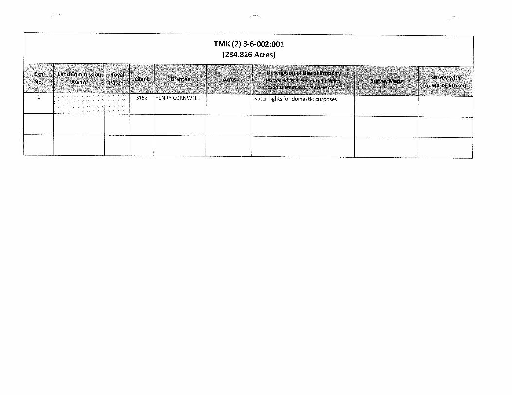
TMK (2) 3-6-002:001(284.826 Acres)
E,th Lid nimissIon Roya’No. Patent Grane 4cre
AtWaI oitram
1 3152 HENRY CORNWELL water rights for domestic purposes

EXHIBIT 1
GRANT 3152 TO HENRY CORNWELL
Grant No.: 3152Grantee: HENRY CORNWELL
1. Exhibits
Exhibitl-A: Copy of Grant 3152 indicates —
Grant conveyed the ‘Ahupuaa of Waikapu saving and excepting grantshitherto made within the said Ahupuaa by the Government or salesmade by the Board ofEducation.”
Document also indicates “Native rights reserved”.
Exhibitl-B: Copy of House Resolution 167 (1925) states that —
the original kuleana grants “entailed the water rights ofsaid lands/’that the Wailuku Sugar Company had diverted those waters and werecharging residents of the kuleana grantsfor the water, and charged theCommissioner ofPublic Lands with reporting “under what authority thesaid Wailuku Sugar company obtains the right to divert to its own usefor commercial purposes said waters and charge said residents ..for thewater they use for domestic purposes.”
Exhibit 1-C: April 1925 letter from the Commissioner of Public Lands states that -
“all the lands referred to and the watersflowing thereon are privatelyowned” and that “the adjudication of the rights in valved does not comewithin the jurisdiction of this office.”
2. Survey Maps None
3. Mahele Use: Water rights for domestic purposes
Flow Requirements Source: Waikapu Stream
4. Photographs: None
5. 1800’s Tax Records: None

N” N
NN
NN:
ia
Q)
N
F
NN
‘NN N
N: N
N
(0--
‘1

NN
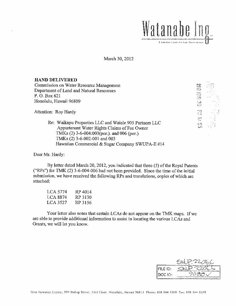
htallabe lug,,,A LIMITED LIABILITY La- PAI1TNFRSFIIP
March 30, 2012
HAND DELIVEREDCommission on Water Resource ManagementDepartment of Land and Natural ResourcesP. 0. Box 621Honolulu, Hawaii 96809
c—i
Attention: Roy Hardy
Re: Waikapu Properties LLC and Waiale 905 Partners LLCAppurtenant Water Rights Claims of Fee Owner
TMKs (2) 3-6-004:003(por.). and 006 (por.)TMKs (2) 3-6-002-00 1 and 003Hawaiian Commercial & Sugar Company SWUPA-E #14
Dear Mr. Hardy:
By letter dated March 20, 2012, you indicated that three (3) of the Royal Patents(“RPs”) for TMK (2) 3-6-004-006 had not been provided. Since the time of the initialsubmission, we have received the following RPs and translations, copies of which areattached:
LCA 5774 RP4014LCA 8874 RP3130LCA3527 RP3156
Your letter also notes that certain LCAs do not appear on the TMK maps. If weare able to provide additional information to assist in locating the various LCAs andGrants, we will let you know.
U?
DOCD
First Hawaiian Center, 999 Bishop Street, 33rd Floor, Honolulu, Hawaii 96813 Phone: 808544- 8300 Fax: 808-54-4 8399

Commission on Water Resource ManagementDepartment of Land and Natural ResourcesMarch 30, 2012Page 2 of 2
Please feel free to call us if you have any questions or require any additionalinformation.
Very truly yours,
WATANAB ING LLP
EMI M. IMULOA
Enclosurescc: Albert Boyce
454281v1

Series 289: Royal Patents, Upon Confirmation of the Land Commission.R.P. #4014Vol. 17, pages 25-26.
No. 4014Royal Patent,
Upon Confirmation of the Land Commission.
Whereas, the Board of Commissioners to Quiet Land Titles have by theirdecision awarded unto KAAI, L.C.A. #5774, an estate in Fee Simple, in and to theland hereafter described.
Therefore, Kamehameha IV, by the grace of God, King of the Hawaiian Islands,by this Royal Patent, makes known unto all men, that he has, for himself and hissuccessors in office, this day granted and given absolutely, in Fee Simple, untoKAAI, all that certain land situate at Waikapu, on the Island of Maui, anddescribed as follows:
Lot 1.Commencing at the stream at the Northwest corner adjoining Kahaleouka’s land,and runSouth 80-3/4° East 6.15 chains along the rock and streamSouth 17-1/4° West 2.22 chains along the rock & A. SylvaNorth 89-1/4° West 4.98 chains along Luapuaa IiiNorth 68-1/4° West 2.96 chains along Luapuaa IiiNorth 46° West .62 chains along OpunuiNorth 53-1/4° East .53 chains along Kalahouka, PoalimaSouth 39-3/4° East .95 chains along the PoalimaNorth 35-1/2° East .93 chains along the PoalimaNorth 38-3/4° West .67 chains along the PoalimaNorth 58-3/4° East 1.00 chains along Kalahouka to the place of
commencement.1 and 8/10 acres.
Lot 2.Commencing at the Northeast corner adjoining Opunui & the Poalima, runSouth 36° East 1.84 chains along OpunuiNorth 53-1/4° East .36 chains along LuapuaaSouth 31-1/4° East 6.20 chains along Kaawahine Esic]South 82-1/2° West .91 chains along KaneaeNorth 64-1/2° West 1.35 chains along KeakiniNorth 23-1/2° East .75 chains along KeakiniNorth 65-1/2° West .56 chains along KamohaiNorth 20-1/4° East .75 chains along KamohalNorth 53-1/2° West 2.46 chains along KamohaiSouth 23° West 1.11 chains along KamohaiSouth 62° East 2.32 chains along KeakiniSouth 27-1/2° West .81 chains along KaneaeNorth 76-1/2° West 1.12 chains along Kaneae’s boundary & PoalimaNorth 80° West .67 chains along Kaneae’s boundary & PoalimaSouth 15° West .89 chains along Kaneae’s boundary & Poalima
continued on page 2
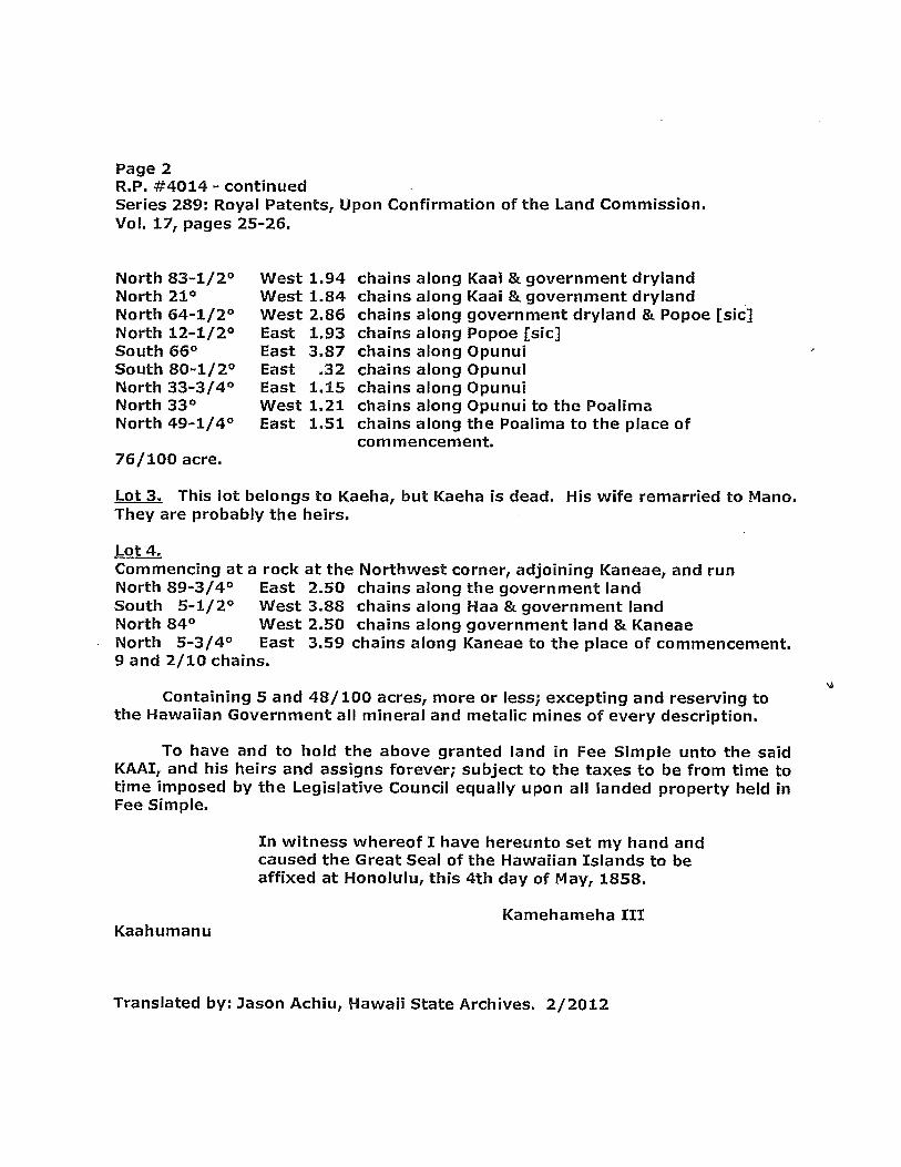
Page 2R.P. #4014 continuedSeries 289: Royal Patents, Upon Confirmation of the Land Commission.Vol. 17, pages 25-26.
North 83-1/2° West 1.94 chains along Kaai & government drylandNorth 21° West 1.84 chains along Kaai & government drylandNorth 64-1/2° West 2.86 chains along government dryland & Popoe [sic]North 12-1/2° East 1.93 chains along Popoe [sic)South 66° East 3.87 chains along OpunulSouth 80-1/2° East .32 chains along OpunuiNorth 33-3/4° East 1.15 chains along OpunulNorth 33° West 1.21 chains along Opunui to the PoalimaNorth 49-1/4° East 1.51 chains along the Poalima to the place of
corn mencement.76/100 acre.
Lot 3. This lot belongs to Kaeha, but Kaeha is dead. His wife remarried to Mano.They are probably the heirs.
Lot 4.Commencing at a rock at the Northwest corner, adjoining Kaneae, and runNorth 89-3/4° East 2.50 chains along the government landSouth 5-1/2° West 3.88 chains along Haa & government landNorth 84° West 2.50 chains along government land & KaneaeNorth 5-3/4° East 3.59 chains along Kaneae to the place of commencement.9 and 2/10 chains.
Containing 5 and 48/ 100 acres, more or less; excepting and reserving tothe Hawaiian Government all mineral and metalic mines of every description.
To have and to hold the above granted land in Fee Simple unto the saidKAAI, and his heirs and assigns forever; subject to the taxes to be from time totime imposed by the Legislative Council equally upon all landed property held inFee Simple.
In witness whereof I have hereunto set my hand andcaused the Great Seal of the Hawaiian Islands to beaffixed at Honolulu, this 4th day of May, 1858.
Kamehameha IIIKaahumanu
Translated by: Jason Achiu, Hawaii State Archives. 2/2012
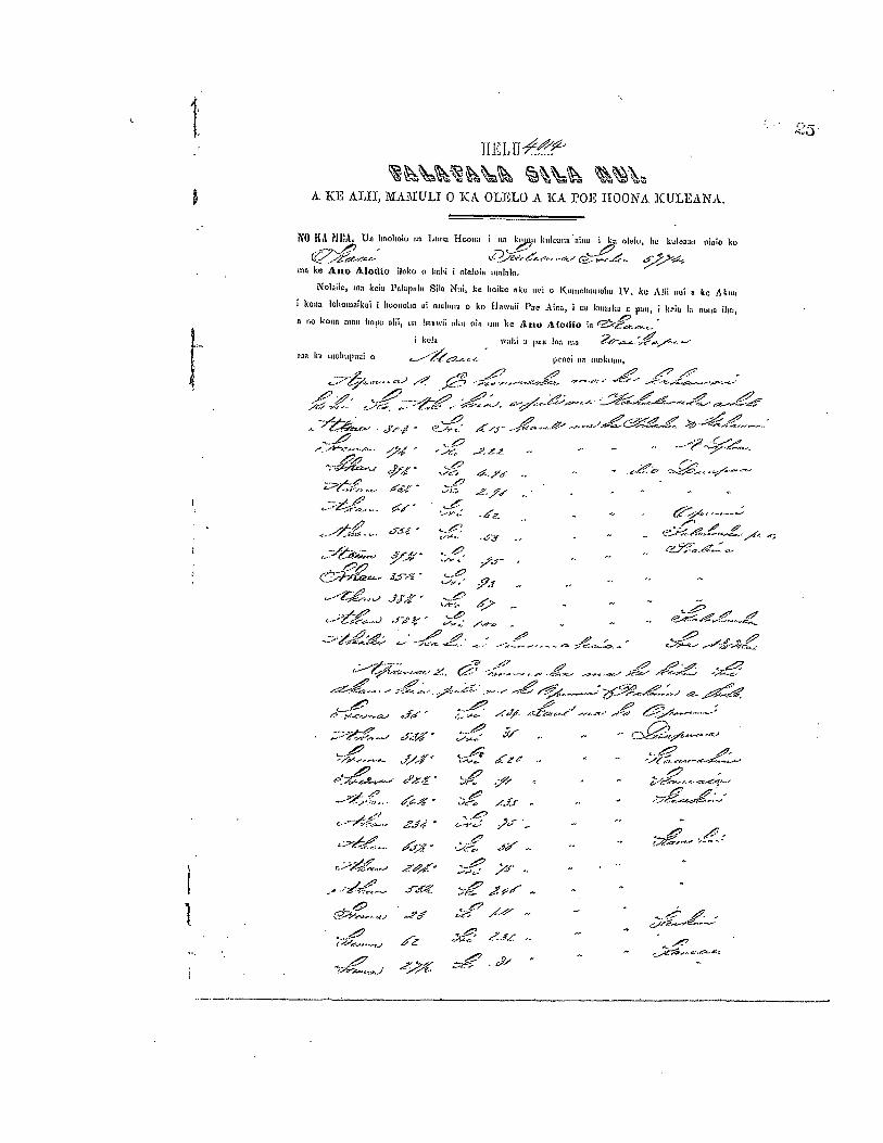
1IEIU
A TCE All, MAfULI 0 TC OLELO A. KA. ro IIOONA KULEANA.
O K L i1111L UIL 1LGOILLO1U 110 Ltiiia HoLILLO I ITO LI 1111100110 111111 I IIO (110111, 1w 110100110 laIn ku
--‘Gnma ke Aiio 4lodk, ilako 0 kohl olelolu linlohI.
no kela Polapiilo Silo Nai, he Loike eku al o K IIIIIUIILIIILOILLI I V. ke Iii aol 1w A kimkona IolloIoaikei I hoooolto ii nailto,a o hI H a oIl I’ac AIo, I no Inu kIl U pan I Iu’ie I;i 111110 0,
a mo hoeo 01011 110110 aIll, nil 1111111111 01111 00 TILL lIe A no 4(4,1)10 In
I kela wohi 1 LULL I ni
TOO kIt LLILOILIIIIIILII (1 p01101 00 IIII,kLIILLL,
.. ‘.
• Ji/ ,(—j-
-.• _-3z - --
- -. °‘ ‘
‘zr .. . - -.
-____o-
J.5-q - - -. —
2>
..: . -
,•,
.--- t’ - --‘---- €%...----..--
• ;;“, iLj_.-. - -
—-.- ,/_c- i:# 2•’- •• —
d” -
.c- j•r .. -. -.42
‘lf — ,
- -- .‘C
—r.-..o-,.. 0?’4
_pj —-
& 1 — ..___:;i-;:

26 [t4?( fr4—,.-
---it—
Sr
C—L4 //f -.
r119
s-fl.
2/
//t
—
CA —
1
it —
C2-//j 4,t*,.q. e/n/—- S
s-H-‘ -
- :. r- 7Cii. ‘ /sz -.
-. 67?
,
‘/
.7. cZ -4Z-- ytz- •_
dyAør s. - - .—a- o.n-a-o _ .. _- ‘-‘
°
?t--
H -‘ a;..— s;,.— -.., - __9
.n//’ r,2-..’-”” a--- c-.i4./ Cc-rr - V - ..n ..t’-,.... n.‘C
-, .—, -
::çg;. ¶Src_i
:;i ;,--
hlailuko e*’n9u-.-- apano_.. -cS7
— Ekea ol iki aku, a anal iki ma1 palm Un ken nat— a Ice ahapnln no mann linileralO IUQ no noble pail.
en nina It I Iioamji no Ice ANO ALODJO a no knno nm, hnniIinn, a ma anna meThane ; to pill nneko onlaoo a lao Poe Alioninlo e Icon IAn uI ma en alan. olodjo I kale macown kaio In000wn.
?{ i lilCut a 1k-co cii, am Icon won ko’e man, a me Ian Silo Nail a ka Hawaii PoeAla,a ace Ilonolalo I lucia Ia c— -
a 18 .fl
/

Series 289: Royal Patents, Upon Confirmation of the Land Commission.R.P. #3130Vol. 14, pages 51-52.
No. 3130Royal Patent,
Upon Confirmation of the Land Commission.
Whereas, the Board of Commissioners to Quiet Land Titles have by theirdecision awarded unto KANEAE, L.C.A. #8874, an estate in Fee Simple, in and tothe land hereafter described.
Therefore, Kamehameha IV, by the grace of God, King of the HawaiianIslands, by this Royal Patent, makes known unto all men, that he has, for himselfand his successors in office, this day granted and given absolutely, in Fee Simple,unto KANEAE, all that certain land situate at Waikapu, on the Island of Maui, anddescribed as follows:
Lot 1. Taro land at Kaloapelu.Commencing at the East corner adjoining Kaai, and runNorth 64-1/2° West 1.35 chains along KaaiNorth 68° West .72 chains along KeakiniNorth 76-1/2° West 1.12 chains along KaaiSouth 16-3/4° West .94 chains along the PoalimaSouth 73° East 2.91 chains along the drylandNorth 36-1/4° East .78 chains along Kaawahine [sic] to the corner of
corn mencernent.29/100 acre.
Lot 2. Taro land at Kaloapelu.Commencing at the East corner adjoining Keakini, and runNorth 70° West 2.08 chains along the drylandNorth 30° West 2.32 chains along the drylandSouth 59° West .65 chains along Kaawahine [sic]North 33° West .66 chains along Kaawahine [sic)North 74-1/2° West .69 chains along the drylandSouth 13° West 1.91 chains along the drylandSouth 62-1/2° East 1.68 chains along the drylandSouth 25° West .99 chains along Kaawahine [sic]South 64° East .99 chains along the drylandNorth 20° East .72 chains along the drylandSouth 78° East 2.84 chains along the drylandNorth 7-1/2° East .76 chains along Keakini to the corner of
corn mencement.87/100 acre.
continued on Page 2

Page 2R.P. #3130 - continuedSeries 289: Royal Patents, Upon Confirmation of the Land Commission.Vol. 14, pages 51-52.
Lot 3. Taro land at Kaloapelu.Commencing at the East corner adjoining Kaai, and runSouth 5-3/4° West 3.59 chains along KaaiNorth 84° West 2.04 chains along the drylandNorth 2° West 2.14 chains along KeakiniSouth 79-3/4° East 1.00 chains along MahukaTrue North .73 chains along MahukaNorth 82-1/2° West 1.24 chains along MahukaSouth 13° West .64 chains along MahukaNorth 75-1/2° West .64 chains along KeakiniNorth 4-1/2° East .98 chains along KeakiniSouth 89-1/2° East 3.38 chains along the dryland to the corner of
commencement.8/10 acres
Containing 1 and 96/ 100 acres, more or less; excepting and reserving tothe Hawaiian Government all mineral and metalic mines of every description.
To have and to hold the above granted land in Fee Simple unto the saidKANEAE, and his heirs and assigns forever; subject to the taxes to be from timeto time imposed by the Legislative Council equally upon all landed property heldin Fee Simple.
In witness whereof I have hereunto set my hand andcaused the Great Seal of the Hawaiian Islands to beaffixed at Honolulu, this 7th day of August, 1856.
KamehamehaKaahumanu
Translated by Jason Achiu, Hawaii State Archives. 2/2012
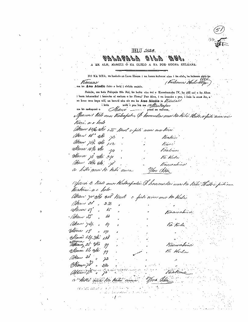
c
11ELU a1&4- V
V
A XE ALII, MAMULIV 0 KA OLELO A ICA POE HOONA KULEANA.
(1)
Vma ke Ano ifodlo iloko kah oleloin maCak.
,_-Lj“7’,
( ,7.c1Av’ ,y1cj /./:2
‘A•
V/
/1V
7’4V.
NO ICAVMEA, us hoolola no Luria Hoona I naVkunu kuI000a nina i ka olelo, he knlesna olelo ko
Nolaila, ma knia Palopain Silo Nul, ku hoike oku nd o Kemehameha 1V,ko All oni a ku AkuaV
I kona lokomaikal I honoho ai maluna o ko Hawai’ Fao Ama, i on kaunka a pau, i keja In nona iho, a ‘VV
V
kuna moo hope nIh, us henwil aku oin ma ke Ano Alodio ía VV
V
I kahn wahi a pan ma ma V V
V
V
nia ka mokupni o ___VV V pmiei 03 moIun;, V
V
V V
,/// (/7’?/X/
67 / .J V V
1.
/V•
,4/- •V
V
V
3VL’ %d./7%’V.N’ aIi” .,. —
J
,,
V
‘12’L’ J’/ ,,
/zQ) i’4çi.’ ,,
jQ/ V
%V7VA % VV
V
,V
V
V
VM
‘V
V
V
V
V
V V
:V
V V
V
V
V
/VVV /%V
V V
V
VV
VVVV VV• ‘V
V
VV
:.VV:V’VV.
V•
VV
2 L.: ;2z-’/’ A’
(V
,, a —
e. .. ‘.:.;i .I 71?41—J ti, ,M 249
4;-’ 9/5
424’ /“ ii ‘.:‘‘tc%4”” . .
,
I ,a4-t-- /o,.ffl-’.... .‘. 7t• ,,. .
.
: •- . “.
A;-.,a;. . . ,
‘-‘ /
/&r /fl/9/4/ 4L ,W ‘ /I // -
. .,. : .
.Tv <y/ A &,5t . .
.,&t cfl-’r-’- _A’k-, ..
P41k“77,, Ek.p ki ol,u n cmi mkp mat poba ha boo one m La timpani na amine mmuscela a me on mettle a peaNo
a I a In I bunt ma run La ANO ALODIO a no ken. mao hooilino n ma Lou. wambona na pzti aceho nub a a La Pan Abnohjo c Lao like am ma us ama alodie p kela amnonwa p kcma manawaIAmmeseikeasm uakauwarjpk0mae amekaSftaNepoI Hewemi Pa. Am. ma Honolulu m kite I.
Ip4 — ‘•: ::.:,‘
I. a
c.—’ 1flt --,.- am—
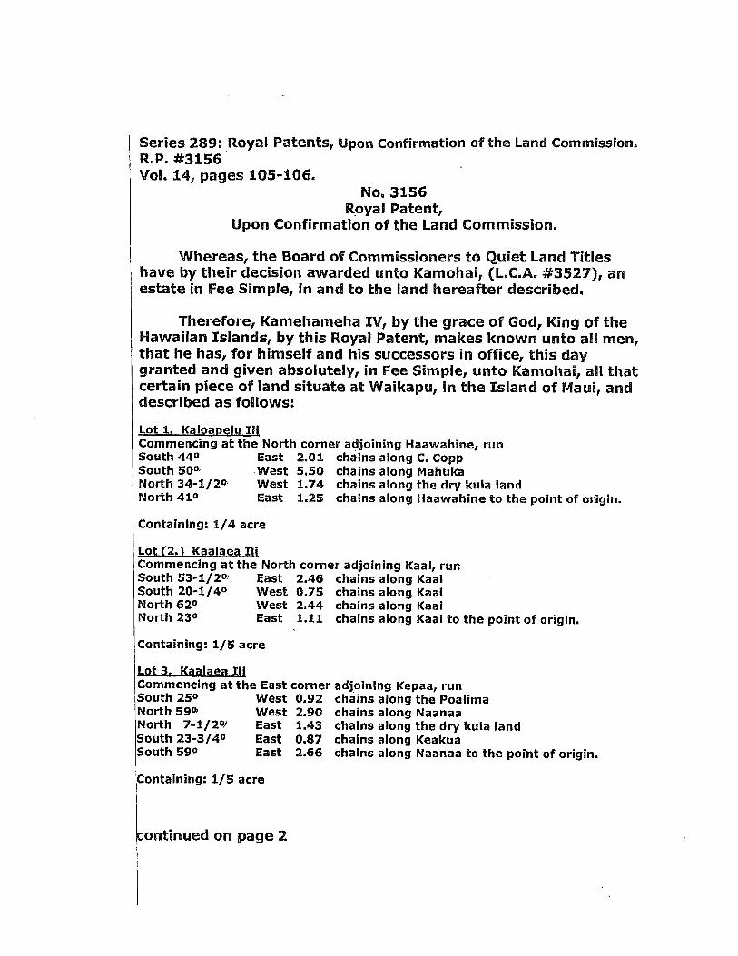
Series 289: Royal Patents, Upon Confirmation of the Land Commission.R..P. #3156Vol. 14, pages 105-106.
No. 3156Royal Patent,
Upon Confirmation of the Land Commission.
Whereas, the Board of Commissioners to Quiet Land Titleshave by their decision awarded unto Kamohal, (L.C.A.. #3527), anestate in Fee Simple, in and to the land hereafter described.
Therefore, Kamehameha IV, by the grace of God, King of theHawaiian Islands, by this Royal Patent, makes known unto all men,that he has, for himself and his successors in office, this daygranted and given absolutely, in Fee Simple, unto Kamohai, all thatcertain piece of land situate at Waikapu, in the Island of Maui, anddescribed as follows:
Lot 1. Kalparielu IllCommencing at the North corner adjoining Haawahine, runSouth 440 East 2.01. chaIns along C. CoppSouth 50° West 5.50 chains along MahukaNorth 34-1/2° West 1.74 chains along the dry kula landNorth 41° East 1.25 chains along Haawahine to the point of origin.
ContainIng: 1/4 acre
Lpt(2.1 Kapipep IiiCommencing at the North corner adjoining Kaai, runSouth 53-1/2° East 2.46 chains along KaaISouth 20-1/4° West 0.75 chains along KaaiNorth 62° West 2.44 chains along KaaiNorth 23° East 1.11 chains along Kaai to the point of origin.
Containing: 1/5 acre
Lot 3. Kpalaep IIICommencing at the East corner adjoining Kepaa, runSouth 25° West 0.92 chains along the PoalimaNorth 59°’ West 2.90 chains along NaanaaNorth 7-1/2W East 1.43 chaIns along the dry kula landSouth 23-3/4° East 0.87 chains along KeakuaSouth 59° East 2.66 chains along Naanaa to the point of origin.
Containing: 1/5 acre
:ontinued on page 2

Page 2RP. #3156 - continuedSeries 289: Royal Patents, Upon Confirmation of the Land Commission.Vol. 14, pages 105-106.
Lot6. KaoalCommencing at the North corner adjoining Haawahine, runSouth 49-3/4° East 0.96 chains along 1-lakikiSouth 43-1/2°’ West 1.10 chains along KamakalNorth 400 West 1.05 chains along the PoalimaNorth 40-1/2° East 0.90 chains along Haawahlne to the point of origin.Containing: 1/10 acre
Lot 10. Salt bed at KealfaCommencing at the Southeast corner adjoining Koaheewale, runNorth 82-3/4° West 1.57 chains along the GovernmentSouth 3°’ West 3.52 chains along the PoalimaNorth 85-3/4° East 1.67 chains along KekoaheewaleNorth 1-1/2°’ East 3.18 chains along Kekoaheewale to the point of origin.Containing: 54/100 acre
Lot 7. House lotCommencing at the South corner adjoining Kawana, runNorth 36°. West 0.68 chains along KawanaNorth 12-3/4° East 2.70 chains along KeaweSouth 74-3/4° East 1.15 chains along KaaaSouth 15-1/4° West 1.46 chains along KahikiSouth 49-3/4° East 0.26 chains along KahikiSouth 39° West 1.69 chaIns along Haawahlne to the point of origin.Containing: 3/10 acre
Containing 1-59/100 acres, more or less; excepting andreserving to the Hawaiian Government all mineral and metalic minesof every description.
To have and to hold the above granted land in Fee Simple untothe said Kamohal, and his heirs and assigns forever, subject to thetaxes to be from time to time imposed by the Legislative Councilequally upon all landed property held in Fee Simple.
In witness whereof I have hereunto set my hand andcaused the Great Seal of the Hawaiian Islands to beaffixed, this 7th day of August 1856.
Kaahumanu Kamehameha
Translated by: Jason Achiu, Hawaii State Archives, 10/2008.
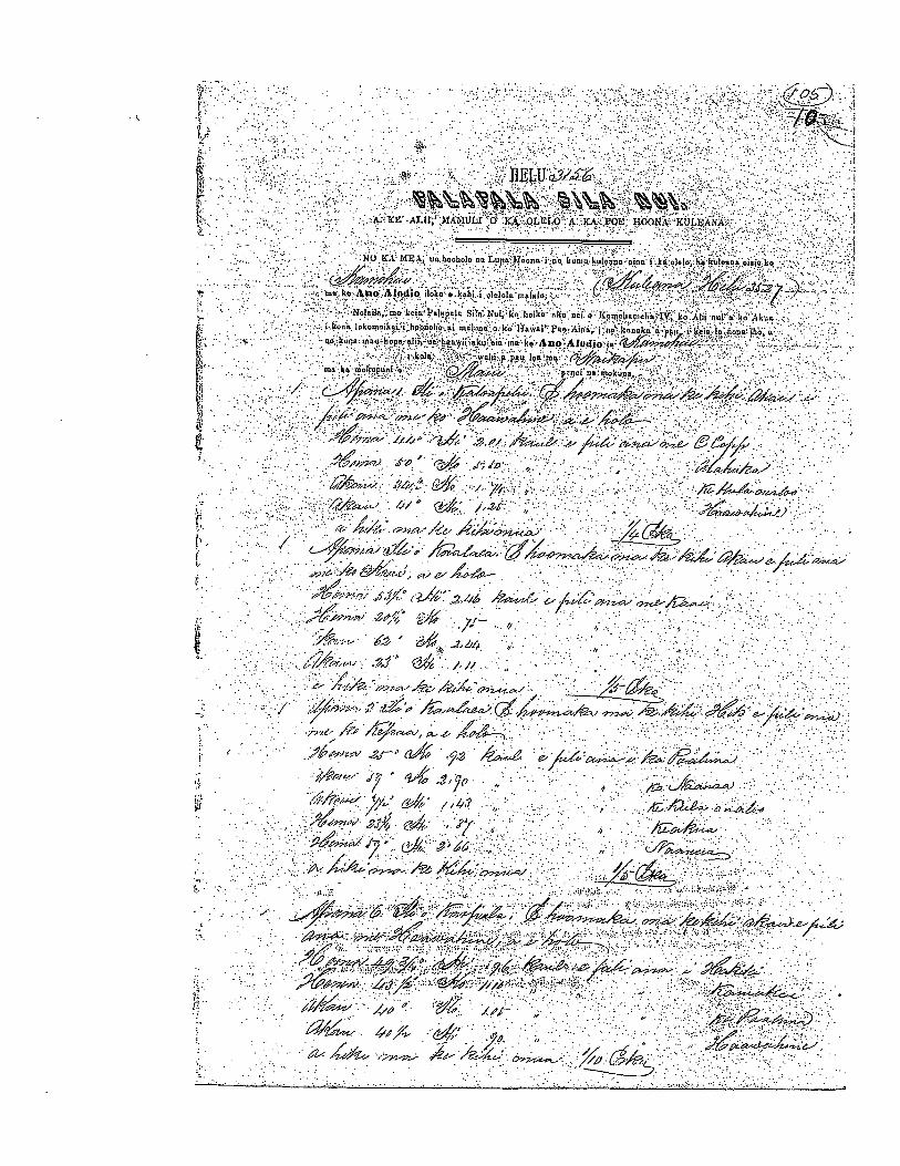
V:..- .,
flLLUYZ6%fl%a
A fl ALEI MAMULE 0 LA OLCLO . KA. POL MOON t KUL).ANA
NC) KA ME on hooholo en Lope 11 no a on han a. Ii tenon nine a ha nub ho bntlonn oin;a ho
g> ,.non he Sue Slodie iloan • haha a dcl a mnlnbn .
(Nobaila non heaa Pabapnba Sale h.ul ho hoaho nku DCL 0 ICnnnnhnnneha IY ho Alit nut a ha Akua
a honn I horn ak z i hoonoho na mnlnen a ho Ilnwaa Pan Ama a an hannka a ppu i born In anna abc ac k no moo hopo clii on han.waa nku cia ma ha Sue AIuale no
a Icpln wnlaa p pan Inn manon ha mokupona a c3Ekit.e’ pcnua no m boon
/ C4ø.’-n-’J i - AfrAo %mn%vo’n4AøL &aa/CH. . L$- ..
rdyia L .:..-. :•_,// ;-/h na-c-e.- //
j’ / ID c -.
‘-“ ‘kc: &% Y..4. -: . . .
‘?,4” “ ° 2t’ ,,g/t. .
.
•..
z4a ?a-
kfl / &6’Lt!, 2/4/
,‘p
2L’ .7 .‘1
/c:-r. sC c-&2.bI, .
%&frU: if°
- f/)%ol L. .7’. -
/ 7-& M6t4ta i1 t:n si .%r i4Zaa’, a_-c- it-cI--—--6-iin’ ‘
)/Im’-c--.tj ‘ ‘-i.t 3tfri
-, 42’s4’*’W1’ ),c’ _4 / /
. -,c ,4iS- n
4’’-’ M€L±4’ a I- cit
V 6 Wa %$L 1V44fl rn -_.
*a-
-
,, -.
tto *iL .‘ ,,,
- . £— % --- . .-

.4
Copyright © 2022 FDOKUMEN